PROCEEDINGS AND RESULTS
301
THE INTERNATIONAL ARCHIVES OF THE PHOTOGRAMMETRY, REMOTE SENSING AND SPATIAL INFORMATION SCIENCES ARCHIVES INTERNATIONALES DE PHOTOGRAMMÉTRIE, DE LA TÉLÉDÉTECTION ET DE L’INFORMATION SPATIALE INTERNATIONALES ARCHIV FÜR PHOTOGRAMMETRIE, FERNERKUNDUNG UND RAUMBEZOGENE INFORMATIONSWISSENSCHAFTEN . International Society for Photogrammetry and Remote Sensing Société Internationale de Photogrammétrie et de Télédétection Internationale Gesellschaft für Photogrammetrie und Fernerkundung XXIII rd Congress XXIII e Congrès XXIII. Kongress PROCEEDINGS AND RESULTS eISSN 2194-9034 VOLUME VOLUME BAND XLI PART TOME TEIL A Edited by: Lena HALOUNOVÁ, Christian HEIPKE, Annette RADTKE Published by International Society for Photogrammetry and Remote Sensing Publié par la Société Internationale de Photogrammétrie et de Télédétection Herausgegeben von der Internationalen Gesellschaft für Photogrammetrie und Fernerkundung July 12 – 19
-
Upload
khangminh22 -
Category
Documents
-
view
0 -
download
0
Transcript of PROCEEDINGS AND RESULTS

Mario Fondelli
THE INTERNATIONAL ARCHIVES OF THE PHOTOGRAMMETRY, REMOTE SENSING AND SPATIAL INFORMATION SCIENCES
ARCHIVES INTERNATIONALES DE PHOTOGRAMMÉTRIE, DE LA TÉLÉDÉTECTION ET DE L’INFORMATION SPATIALE
INTERNATIONALES ARCHIV FÜR PHOTOGRAMMETRIE, FERNERKUNDUNG UND RAUMBEZOGENE INFORMATIONSWISSENSCHAFTEN
.
International Society for Photogrammetry and Remote Sensing Société Internationale de Photogrammétrie et de Télédétection Internationale Gesellschaft für Photogrammetrie und Fernerkundung
XXIIIrd Congress XXIIIe Congrès XXIII. Kongress
PROCEEDINGS AND RESULTS
eISSN 2194-9034
VOLUME VOLUME BAND XLI PART
TOME TEIL A
Edited by: Lena HALOUNOVÁ, Christian HEIPKE, Annette RADTKE
Published by International Society for Photogrammetry and Remote Sensing Publié par la Société Internationale de Photogrammétrie et de Télédétection
Herausgegeben von der Internationalen Gesellschaft für Photogrammetrie und Fernerkundung
July 12 – 19

THE INTERNATIONAL ARCHIVES OF THE PHOTOGRAMMETRY, REMOTE SENSING AND SPATIAL INFORMATION SCIENCES
ARCHIVES INTERNATIONALES DE PHOTOGRAMMÉTRIE, DE LA TÉLÉDÉTECTION ET DE L’INFORMATION SPATIALE
INTERNATIONALES ARCHIV FÜR PHOTOGRAMMETRIE, FERNERKUNDUNG UND RAUMBEZOGENE INFORMATIONSWISSENSCHAFTEN
.
XXIIIrd Congress XXIIIe Congrès XXIII. Kongress
International Society for Photogrammetry and Remote Sensing Société Internationale de Photogrammétrie et de Télédétection Internationale Gesellschaft für Photogrammetrie und Fernerkundung
PROCEEDINGS AND RESULTS
eISSN 2194-9034
VOLUME VOLUME BAND XLI PART
TOME TEIL A
Edited by: Lena HALOUNOVÁ, Christian HEIPKE, Annette RADTKE
Published by International Society for Photogrammetry and Remote Sensing
Publié par la Société Internationale de Photogrammétrie et de Télédétection Herausgegeben von der Internationalen Gesellschaft für Photogrammetrie und Fernerkundung
ISPRS Council 2012-2016
President Chen Jun PR China Secretary General Christian Heipke Germany Congress Director Lena Halounová Czech Republic Treasurer Jonathan P.Mills United Kingdom First Vice President Orhan Altan Turkey Second Vice President Marguerite Madden USA
International Archives of Photogrammetry, Remote Sensing and Spatial Information Sciences (IAPRS&SIS) Founded by Eduard Doležal (Austria) in 1913
Volume XLI, Part A Proceedings and Results
Editorial Team
Editor, Design and Layout Lena Halounová Czech Republic Christian Heipke Germany Annette Radtke Germany
Copyright 2018 ISPRS and by each author for his/her part
The publisher is not responsible for any opinion or statement made in this text, nor can they be held responsible for any typing or content errors.

3
Table of Contents
WELCOME TO THE XXIII ISPRS CONGRESS .......................................................................................................................... 7 Welcome from Congress Director, Lena Halounová................................................................................................... 8 2012 – 2016 ......................................................................................................................................................................... 9 Council 2012-2016 .................................................................................................................................................... 10 Technical Commission Presidents 2012-2016 .......................................................................................................... 11 Financial Commission 2012-2016 ............................................................................................................................. 11 ISPRS Regional Representatives 2012-2016 ............................................................................................................. 12 Editors of ISPRS Publications 2012-2016 .................................................................................................................. 12 Associate Editors of ISPRS Journal of Photogrammetry and Remote Sensing 2012-2016 ....................................... 13 ISPRS Honorary Members 2012-2016 ...................................................................................................................... 14 ISPRS Fellows 2012-2016 .......................................................................................................................................... 14 Technical Commissions (TC) and Working Groups (WG) ......................................................................................... 15 2016-2020 ......................................................................................................................................................................... 44 Council 2016-2020 .................................................................................................................................................... 45 Technical Commission Presidents and Vice Presidents 2016-2020 .......................................................................... 46 Financial Commission 2016-2020 ............................................................................................................................. 46 ISPRS Regional Representatives 2016-2020 ............................................................................................................. 47 Editors of ISPRS Publications 2016-2020 .................................................................................................................. 47 Associate Editors of ISPRS Journal of Photogrammetry and Remote Sensing 2016-2020 ....................................... 48 ISPRS Honorary Members 2016-2020 ...................................................................................................................... 49 ISPRS Fellows 2016-2020 .......................................................................................................................................... 49 Ordinary Members (92*) .......................................................................................................................................... 50 Associate Members (16*) ......................................................................................................................................... 54 Regional Members (15*) .......................................................................................................................................... 55 Sustaining Members (58*) ........................................................................................................................................ 56 OPENING CEREMONY ........................................................................................................................................................ 59 Program .................................................................................................................................................................... 60 Opening Address by Congress Director, Lena Halounová ........................................................................................ 60 Welcome Address by ISPRS President, Chen Jun ...................................................................................................... 61 Awards Presented at the Opening Ceremony .......................................................................................................... 63 Keynote Speakers ..................................................................................................................................................... 65 ISPRS AWARDS 2016 ......................................................................................................................................................... 66 ISPRS Honorary Member .......................................................................................................................................... 67 ISPRS Fellowships ..................................................................................................................................................... 67 The Brock Gold Medal .............................................................................................................................................. 69 The Otto von Gruber Award ..................................................................................................................................... 70 The U.V. Helava Award ............................................................................................................................................. 70 The Samuel Gamble Award ...................................................................................................................................... 71 The Willem Schermerhorn Award ............................................................................................................................ 71 The Schwidefsky Medal ............................................................................................................................................ 72 The Eduard Doležal Award ....................................................................................................................................... 73 The Wang Zhizuo Award ........................................................................................................................................... 73 The Karl Kraus Medal ................................................................................................................................................ 73

4
The Frederick J. Doyle Award ................................................................................................................................... 74 The Giuseppe Inghilleri Award .................................................................................................................................. 75 Young Authors Awards ............................................................................................................................................. 75 President's Citations ................................................................................................................................................. 76 CATCON Award ......................................................................................................................................................... 76 Best Poster Awards ................................................................................................................................................... 77 Youth Forum Awards ................................................................................................................................................ 78 IGI Africa Ambassador Award 2016 .......................................................................................................................... 78 Certificates of Recognition for Excellence in Service to ISPRS during 2012 – 2016 .................................................. 79 The ISPRS Foundation and Congress Travel Grants .................................................................................................. 79 White Elephants’ "Kennert Torlegård Travel Grant” ................................................................................................ 80 GALA DINNER .................................................................................................................................................................... 81 OBITUARIES ....................................................................................................................................................................... 84 Enrico Clerici (1939-2012) ........................................................................................................................................ 85 Laurie Pentecost Adams (1925-2012) ....................................................................................................................... 85 Ákos Detreköi (1939-2012) ....................................................................................................................................... 87 Jüri Talts (1936-2013) ............................................................................................................................................... 87 Frederick F. Doyle (1920 –2013) ............................................................................................................................... 88 Dieter Klaus Zeuner (1937 – 2013) ........................................................................................................................... 89 John William Charles Gates (1922 – 2013) ............................................................................................................... 89 Kimberly A. Tilley (1953 - 2013) ................................................................................................................................ 91 Carolyn Merry (1950 - 2014) .................................................................................................................................... 91 Maurice Carbonnell (1923 – 2015) ........................................................................................................................... 92 Alef Ahmed El Sayed Elassal (1934 - 2015) ............................................................................................................... 93 Kennert Torlegård (1937‐2016) ................................................................................................................................ 94 GENERAL ASSEMBLIES ....................................................................................................................................................... 96
Ordinary Member Delegates and Advisers to ISPRS General Assembly .................................................................. 97 Associate Member Representatives to ISPRS General Assembly ............................................................................. 99 Regional Member Representatives to ISPRS General Assembly ............................................................................ 100 Agenda of ISPRS General Assemblies ..................................................................................................................... 101 Decisions of the General Assembly ........................................................................................................................ 102 Minutes of ISPRS General Assemblies .................................................................................................................... 104 Report of ISPRS President Chen Jun to the General Assembly for 2012-2016 ....................................................... 117 Report of ISPRS Secretary General Christian Heipke to the General Assembly for 2012-2016 ............................. 123 Report of ISPRS Treasurer Jon Mills to the General Assembly for 2012-2016 ....................................................... 139 Report of ISPRS Financial Commission Chair Marie-José Lefevre-Fonollosa to the General Assembly for 2012-2016 ......................................................................................................................................................... 150 Report of the Editors-in-Chief of the ISPRS Journal of Photogrammetry and Remote Sensing, Derek Lichti, Qihao Weng ....................................................................................................................................... 152 Report of the Editor-in-chief of the ISPRS International Journal of Geo-Information, Wolfgang Kainz ................. 161 Report of ISPRS Book Series Editor, Zhilin Li .......................................................................................................... 172 Report of ISPRS Webmaster, Markus Englich ........................................................................................................ 173 Report of TIF (The ISPRS Foundation) Chair, Board of Trustees, Dieter Fritsch ..................................................... 174 Report of IPAC (International Scientific Advisory Committee) by Chair, Gunter Schreier ..................................... 179 Report of ISAC (International Scientific Advisory Committee) by Chair, Ian Dowman .......................................... 184 Report of I2AC (ISPRS Industry Advisory Committee) by Chair, Franz Leberl ......................................................... 186 Report on ISPRS Regional Affairs in Africa by Hussein Farah ................................................................................. 195 Report on ISPRS Regional Affairs in South-East Asia by Nguyen Dinh Duong ........................................................ 196 Report on ISPRS Regional Affairs in Latin-American by Mario Hernandez ............................................................. 197 Report of ICORSE (International Committee on Remote Sensing of Environment) Chair, Lawrence Friedl .......... 198 Report of CIPA (International Committee for Documentation of Cultural Heritage) President, Andreas Georgopoulos ......................................................................................................................... 199 Report of the Student Consortium Chair, Urša Kanjir ............................................................................................ 200

5
SCIENTIFIC PROGRAM ..................................................................................................................................................... 206 Overall Program ..................................................................................................................................................... 207 Oral Presentations and Posters .............................................................................................................................. 208 Student Consortium ............................................................................................................................................... 213 Plenary Speakers .................................................................................................................................................... 214
EXHIBITION AND SOCIAL PROGRAMME .......................................................................................................................... 215
Exhibitors ................................................................................................................................................................ 216 Congress Social Programme ................................................................................................................................... 230
CLOSING CEREMONY ....................................................................................................................................................... 232 Congress Director’s Report at Closing Session, Lena Halounová ........................................................................... 233 Address of Outgoing President, Chen Jun .............................................................................................................. 234 Address of Incoming President, Christian Heipke .................................................................................................. 235 Address of Incoming Congress Director, Nicolas Paparoditis................................................................................. 237
RESOLUTIONS .................................................................................................................................................................. 239 HISTORY .......................................................................................................................................................................... 244
The International Archives of Photogrammetry, Remote Sensing and Spatial Information Science ..................... 245 The International Annals of Photogrammetry, Remote Sensing and Spatial Information Science ........................ 248 Chronology of ISPRS ............................................................................................................................................... 248 Chronology of TIF - The ISPRS Foundation ............................................................................................................. 254
ISPRS COMMITTEES ......................................................................................................................................................... 256
The International Policy Advisory Committee (IPAC) ............................................................................................. 257 The International Science Advisory Committee (ISAC) .......................................................................................... 257 International Industrial Advisory Committee (I²AC) ............................................................................................... 258 The International Committee on Remote Sensing of Environment (ICORSE) ........................................................ 259 International Committee for Architectural Photogrammetry (CIPA) ..................................................................... 259
LEGISLATIVE DOCUMENTS .............................................................................................................................................. 261
Statutes .................................................................................................................................................................. 262 Bylaws .................................................................................................................................................................... 266 Award Policy ........................................................................................................................................................... 277 The Brock Gold Medal Award ................................................................................................................................. 278 The Otto von Gruber Award ................................................................................................................................... 280 The Schwidefsky Medal .......................................................................................................................................... 281 The Schermerhorn Award ...................................................................................................................................... 282 The Samuel Gamble Award .................................................................................................................................... 283 The Eduard Doležal Award .................................................................................................................................... 283 The U.V. Helava Award ........................................................................................................................................... 284 The Gino Cassinis Award (2000 - 2008) .................................................................................................................. 287 The Giuseppe Inghilleri Award ............................................................................................................................... 288 The Wang Zhizhuo Award ...................................................................................................................................... 288 The President's Honorary Citation ......................................................................................................................... 289 ISPRS Best Young Author Award ............................................................................................................................ 290 ISPRS Best Poster Award ........................................................................................................................................ 291 ISPRS - CATCON Award ........................................................................................................................................... 293 The Karl Kraus Medal ............................................................................................................................................. 294 The Frederick J Doyle Award .................................................................................................................................. 295 Guidelines for Candidates for Members of Council ............................................................................................... 295 Guidelines for Members Planning to Host an ISPRS Congress ............................................................................... 296 Guidelines for Hosting a Technical Commission .................................................................................................... 297 Guidelines for Conducting a Working Group ......................................................................................................... 298 Guidelines for ISPRS Financial Commission ............................................................................................................ 299 Terms of Reference for Sustaining Members ......................................................................................................... 299

6

7
WELCOME TO THE XXIII ISPRS CONGRESS
Welcome from Congress Director Lena Halounová

8
Welcome from Congress Director It is my pleasure to write these words one month before the first day of the Prague XXIII ISPRS Congress. Authors from all over the world submitted nearly two thousand contributions. Submissions for the reviewing were twofold – abstracts and full papers.
Abstracts were peer-reviewed and after acceptance, authors were asked to submit a final paper to be
published in the ISPRS Archives. Full papers were double-blind re-viewed and the authors of accepted papers submitted their final papers to be published in the ISPRS Annals.
771 experts worked as reviewers and processed 3550
reviews in the period between 13 December and 1 February 2016.
Their reviews were constructive and encouraging. A considerable number of reviewers dealt with substantially more than 10 reviews. I would like to express my admiration for the work they did in their leisure time during quite a difficult period – from the end of 2015 to the beginning of 2016 – without any
reward. Since the review process was blind, authors cannot thank their reviewers for recommendations, new ideas and useful advice.
It is not possible to count the hours that all researchers, authors, Working Group Chairs, Technical Commission Presidents and members of the Local and International Program Committees spent in the preparation of the Congress, but I am sure that together all their effort and energy is equivalent to that spent in the construction of the Charles Bridge in Prague. We do not know the names of the people who worked on its construction; however, we still use the bridge today. Nevertheless, we do know the names of all authors of submissions, those which were and were not accepted to the Congress. We will be able to find them from 1 July 2016 in the XXIII ISPRS Congress publications at the ISPRS webpage.
I believe your “stones” to the development of photogrammetry, remote sensing and spatial sciences will forward our knowledge, to allow us and everyone who might need it, to continue our work – work which helps people, and benefits the Earth when it is used in the right way. It is far from trifle.
So, please, do not give up when you feel discouraged. Try to find a solution. We will appreciate it – maybe already during this Congress, maybe in the future.
Prague Castle and Charles Bridge

9
2012 – 2016
The ISPRS Council
Technical Commission Presidents
Financial Commission
ISPRS Regional Representatives
Editors of ISPRS Publications
ISPRS Honorary Members
ISPRS Fellows
Technical Commissions (TC) and Working Groups (WG)
10
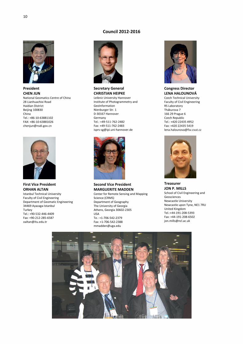
Council 2012-2016
President CHEN JUN National Geomatics Centre of China 28 Lianhuachixi Road Haidian District Beijing 100830 China Tel.: +86-10-63881102 FAX: +86-10-63881026 [email protected]
First Vice President ORHAN ALTAN Istanbul Technical University Faculty of Civil Engineering Department of Geomatic Engineering 34469 Ayazaga-Istanbul Turkey Tel.: +90-532-446-4409 Fax: +90-212-285-6587 [email protected]
Secretary General CHRISTIAN HEIPKE Leibniz University Hannover Institute of Photogrammetry and GeoInformation Nienburger Str. 1 D-30167 Hannover Germany Tel.: +49-511-762-2482 Fax: +49-511-762-2483 [email protected]
Second Vice President MARGUERITE MADDEN Center for Remote Sensing and Mapping Science (CRMS) Department of Geography The University of Georgia Athens, Georgia 30602-2305 USA Te.: +1-706-542-2379 Fax: +1-706-542-2388 [email protected]
Congress Director LENA HALOUNOVÁ Czech Technical University Faculty of Civil Engineering RS Laboratory Thákurova 7 166 29 Prague 6 Czech Republic Tel.: +420 22435 4952 Fax: +420 22435 5419 [email protected]
Treasurer JON P. MILLS School of Civil Engineering and Geosciences Newcastle University Newcastle upon Tyne, NE1 7RU United Kingdom Tel.:+44-191-208-5393 Fax: +44-191-208-6502 [email protected]

11
Technical Commission Presidents 2012-2016
Commission I CHARLES TOTH Department of Civil, Environmental and Geodetic Engineering The Ohio State University 470 Hitchcock Hall 2070 Neil Avenue Columbus, OH 43210 USA Tel.: +1-614-292-7681 Fax: +1-614-292-3780 [email protected]
Commission II SONGNIAN LI Geomatics Engineering Department of Civil Engineering Ryerson University 350 Victoria Street Toronto, Ontario, M5B 2K3 Canada Tel.: +1 416-979-5000 ext 6450 Fax: +1 416-979-5122 [email protected]
Commission III KONRAD SCHINDLER Photogrammetry and Remote Sensing ETH Zurich Wolfgang-Pauli-Strasse 15 CH-8093 Zurich Switzerland Tel.: +41 44 6333004 Fax: +41 44 6331101 [email protected]
Commission IV JIANG JIE National Geomatics Center of China 28 Lianhuachi West Road Beijing 100830 China Tel.: +86 10 63880323 Fax: +86 10 63880323 [email protected] [email protected]
Commission V FABIO REMONDINO 3D Optical Metrology Unit (3DOM) Bruno Kessler Foundation (FBK) Via Sommarive 18 38123 Trento Italy Tel.: +39 0461 314914 Fax: +39 0461 314340 [email protected]
Commission VI JIANYA GONG State Key Lab of Information Engineering in Surveying, Mapping and Remote Sensing Wuhan University 129 Luoyu Road Wuhan, Hubei, 430079 China Tel. +86 27 68778003 Fax: +86 27 68778003 [email protected]
Commission VII FILIZ SUNAR Istanbul Technical University (ITU) Civil Engineering Faculty Geomatics Department ITU Ayazağa Campus 34469 Maslak-Istanbul Turkey Tel.: +90 212 2853801 Fax: +90 212 2853801 [email protected]
Commission VIII VINAY K. DADHWAL National Remote Sensing Centre Indian Space Research Organisation Balanagar, Hyderabad India Tel.: +91 40 2387 8360 Fax: +91 40 2388 4424 [email protected]
Financial Commission 2012-2016
Chairperson MARIE-JOSÉ LEFÈVRE-FONOLLOSA French Space Agency CNES/DCT/DA/PA, 18 avenue Belin 31401 Toulouse Cedex 9 France Tel.: +33 (0)5 6127 4283 Fax: +33 (0)5 6127 4842 [email protected]
Member FULVIO DE RINAUDO Politecnico di Torino DITAG Corso Duca degli Abruzzi 24 10129 Torino Italy Tel.: +39 011 090 76 59 [email protected]
Member OLGA PIEDAD RUDAS Carrera 30 No. 48-51 Edificio ICAG-CIAF of. 212 Bogotá Colombia Tel.: +57 1 369 4096 Fax: +57 1 4809453 [email protected] [email protected]

12
ISPRS Regional Representatives 2012-2016
AFRICA HUSSEIN FARAH Director General Regional Centre for Mapping of Resources for Development Kasarani Road, P.O.Box 632-00618, Nairobi Kenya Tel: +254-20 8560227/+254 20 8561775 Fax: +254-20 8561673 [email protected]
SOUTH AMERICA MARIO HERNANDEZ 11 Route de la Gare 1295 Mies Switzerland Tel.: +33 145684052 Fax: +33 145685570 [email protected]
SOUTH EAST-ASIA NGUYEN DINH DUONG Department of Environmental Information Study and Analysis Institute of Geography, Vietnamese Academy of Science and Technology 18 Hoang Quoc Viet Rd, Cau Giay, Hanoi, Vietnam Tel: +84-04-37562417 Fax: +84-04-38361192 [email protected]
Editors of ISPRS Publications 2012-2016
ISPRS Journal of Photogrammetry and Remote Sensing, Editor-in-Chief DEREK D. LICHTI Department of Geomatics Engineering The University of Calgary 2500 University Dr NW Calgary AB Canada T2N 1N4 +1 403 210 9495 +1 403 284 1980 [email protected]
ISPRS Journal of Photogrammetry and Remote Sensing, Editor-in-Chief QIHAO WENG (2015-2016) Center for Urban and Environmental Change Indiana State University Terre Haute IN 47809 USA +1 812-237-2255/2290 +1 812-237-8029 [email protected]
ISPRS International Journal of Geo-Information, Editor-in-Chief WOLFGANG KAINZ Institut für Geographie und Regionalforschung Universität Wien Universitätsstr. 7/5 A-1010 Wien Austria Tel: +43-1-4277-48640 Fax: +43-1-4277-9531 [email protected]
ISPRS eBulletin, Editor CHRISTIAN HEIPKE Leibniz University Hannover Institute of Photogrammetry and GeoInformation, Nienburger Str. 1 D-30167 Hannover Germany Tel.: +49-511-762-2482 Fax: +49-511-762-2483 [email protected]
ISPRS Book Series, Editor ZHILIN LI Dept. of Land Surveying and Geo-Informatics Hong Kong Polytechnic University Hong Kong +852 2766 5960 +852 2330 2994 [email protected]
ISPRS Webmaster: MARKUS ENGLICH Geschwister-Scholl-Str. 24D Institute for Photogrammetry, Universität Stuttgart, D-70174 Stuttgart, Germany Tel: +49-711-685-83385 Fax: +49-711-685-83297 [email protected]

13
Associate Editors of ISPRS Journal of Photogrammetry and Remote Sensing 2012-2016
DANIEL L. CIVCO Department of Natural Resources and the Environment University of Connecticut, U-4087, 1376 Storrs Road Storrs, CT 06269-4087 USA Tel: (860) 486-0148 Fax: (860) 486-5408 [email protected]
EBERHARD GUELCH Hochschule für Technik Stuttgart Schellingstr. 24, 70174 Stuttgart Germany Tel: +49 (0)711 8926 2610 Fax: +49 (0)711 8926 2556 [email protected]
OLAF HELLWICH Technische Universität Berlin Computer Vision & Remote Sensing Sekr. MAR 6-5, Marchstr. 23 D-10587 Berlin Germany Tel: +49 (0)30 314-22796 Fax: +49 (0)30 314-21104 olaf.hellwichtu-berlin.de
SANNA KAASALAINEN Finnish Geodetic Institute Geodeetinrinne 2 FI-02430 Masala Finland Tel: +358 9 295 550 Fax: +358 9 2955 5200 [email protected]
LALIT KUMAR Natural Resources Building, University of New England Armidale, NSW, 2351 Australia Tel: +(61 2) 6773 2323 Fax: +(61 2) 6773 2769 [email protected]
KONRAD SCHINDLER Photogrammetry and Remote Sensing, ETH Zurich, Wolfgang-Pauli-Strasse 15 CH-8093 Zurich Switzerland Tel: +41 44 6333004 Fax: +41 44 6331101 [email protected]
QIHAO WENG (2012-2014) 600 Chestnut St. Science Building RM159 Indiana State University Terre Haute, IN 47809 USA Tel: (812)237-2255 Fax: (812)237-8029 [email protected]
ONISIMO MUTANGA University of KwaZulu Natal School of Agricultural, Earth and Environmental Sciences Office Off Carbis Road, Durban South Africa Tel: +27 (0) 31 260 5779 Fax: +27 (0)33 260 6094 [email protected]
CONGHE SONG Department of Geography The University of North Carolina at Chapel Hill CB# 3220, 205 Saunders Hall Chapel Hill, NC 27599 USA Tel: (919) 843-4764 Fax: (919) 962-1537 [email protected]
JAY GAO School of Environment, The University of Auckland, Private Bag 92019 Auckland New Zealand Tel: 64 9 373 7599 Fax: +64 9 373 7434 [email protected]
UWE SÖRGEL Institute of Photogrammetry and GeoInformation Leibniz Universität Hannover Nienburger Str.1 D-30167 Hannover Germany Tel: + 49 511 762 2981 Fax: + 49 511 762 2483 [email protected]
HANS-GERD MAAS Institute of Photogrammetry and Remote Sensing Dresden University of Technology, Helmholtzstr. 10, D-01069 Dresden Germany Tel: + 49 (0) 351 463 32859 Fax: + 49 (0) 351 463 37266 [email protected]

14
ISPRS Honorary Members 2012-2016
Frederick J. Doyle
(1984) USA (2013)
Aino Savolainen (1988) Finland
Gottfried Konecny
(1992) Germany
Friedrich Ackermann
(1996) Germany
Shunji Murai (2000) Japan
Lawrence W. Fritz
(2004) USA
Armin Grün
(2008) Switzerland
John C. Trinder (2008) Australia
Ian Dowman (2012) United Kingdom
Li Deren
(2012) China
ISPRS Fellows 2012-2016
Ivan Antipov (2010) Russia
Costas Armenakis
(2010) Canada
Manos Baltsavias (2010) Switzerland
Marcio Barbosa
(2010) Brazil
Klaas Jan Beek
(2010) The Netherlands
Wolfgang Förstner
(2010) Germany
Li Deren
(2010) China
Stan Morain (2010) USA
Klaus Szangolies (2010) Germany
Kennert Torlegård
(2010) Sweden
Roy Welch (2010) USA
George Zarzycki (2010) Canada
Dieter Fritsch
(2012) Germany
Martien Molenaar
(2012) The Netherlands
Paul Newby
(2012) UK
Heinz Ruether
(2012) South Africa
Shailesh Nayak
(2012) India

15
2012 – 2016 ISPRS Technical Commissions (TC) and Working Groups (WG)
Commission I - Sensors and Platforms for Remote Sensing
President Charles K Toth Department of Civil, Environmental and Geodetic Engineering The Ohio State University 470 Hitchcock Hall 2070 Neil Ave., Columbus, OH 43210 USA Tel: +1 614 292 7681 Fax: +1 614 292 3780 E-mail: [email protected] ceg.osu.edu/people/toth.2 Vice President Boris Jutzi Institute of Photogrammetry and Remote Sensing Karlsruhe Institute of Technology (KIT) Kaiserstr. 12 76128 Karlsruhe Germany Tel.: +49 721 608-46993 Fax: +49 721 608-48450 E-Mail: [email protected] www.ipf.kit.edu/
Commission I – Terms of Reference • Data acquisition and pre-
processing • On-board pre-processing of data
and autonomous systems • Systems and media for recording
sensor data, auxiliary data (time, position, attitude, etc.)
• Image technologies and data transfer standards
• Integration of various imaging sensors with other relevant systems
• Design and realization of digital aerial and spaceborne missions for Earth observation
• Design, construction, characterization, and installation of imaging and non-optical imaging sensors (including optical, IR, SAR, IfSAR, LiDAR, etc.)
• Standardization of definitions and measurements of active and passive imaging sensor parameters
• Geometric and radiometric properties, quality standards,
and factors affecting data quality
• Testing, calibration and evaluation of imaging and non-optical imaging sensors (including laboratory, in-flight /in-situ, inter-calibration and test fields)
• Integrated platform guidance, navigation, direct georeferencing (positioning and orientation) and integrated sensor orientation
WG I/1 - Standardization of Airborne Platform Interface Chair GUO Huadong Center for Earth Observation and Digital Earth, Chinese Academy of Sciences No.9 Dengzhuang South Road Haidian 100094 Beijing China Tel.: +86-10-82178000 Fax: +86-10-82178009 [email protected] http://www.ceode.cas.cn Co-Chair Randy T. Albertson NASA Dryden Flight Research Center Edwards, CA 93523-0273 USA Tel.: +1 661 276-7540 [email protected] Co-Chair Philip R.A. Brown EUFAR Scientific and Transnational Access Coordinator Fitzroy Road EXETER, EX1 3PB United Kingdom Tel.: +44 1392 886740 [email protected] http://www.metoffice.gov.uk/research/people/phil-brown Secretary HAN Chunming Center for Earth Observation and Digital Earth, Chinese Academy of Sciences No.9 Dengzhuang South Road Haidian 100094
Beijing China Tel.: +86-10-82178718 [email protected]
Key Support Personnel DOU Changyong Center for Earth Observation and Digital Earth, Chinese Academy of Sciences. No.9 Dengzhuang South Road Haidian 100094 Beijing China Tel.: +86-10-82178719 [email protected]
WG I/1 Terms of Reference • Discussion and coordination
with international partners (new or current) on activities which foster cooperation to include ways on improving transnational or interagency access
• How the working group standard formats, developed by the previous working group, are being implemented for use on their national airborne platforms and instrument operations; including suggested improvements or new standards to explore
• National airborne platform inventory of research science aircraft
• Promotion of education and outreach programs by their airborne science community
• The expert workshops (platform or instrument that they supported or established)
WG I/2 - LiDAR, SAR and Optical Sensors for Airborne and Spaceborne Platforms Chair Norbert Haala Institute for Photogrammetry University of Stuttgart Geschwister-Scholl-Str. 24D 70174 Stuttgart Germany Tel.: +49 711 685-83386 Fax: +49 711 685-83297

16
[email protected] http://www.ifp.uni-stuttgart.de/ Co-Chair Martin Kada Institute for Geoinformatics and Remote Sensing (IGF) University of Osnabrueck Barbarastr. 22b 49076 Osnabrueck Germany Tel.: +49 541 969-3619 Fax: +49 541 969-3939 [email protected] Co-Chair Franz Meyer Earth and Planetary Remote Sensing, Geophysical Institute University of Alaska Fairbanks 903 Koyukuk Dr., P.O. Box 757320 Fairbanks, Alaska 99775-7320 USA Tel.: +1 907 474 7767 Fax: +1 907 474 6441 [email protected] Secretary Dorota Iwaszczuk Photogrammetry and Remote Sensing, Institute of Photogrammetry and Cartography Technische Universitaet Muenchen Arcisstr. 21 80333 München Germany Tel.: +49 89 289 22637 Fax: +49 89 289 23202 [email protected] http://www.pf.bv.tum.de/en Key Support Personnel Timo Balz Associate Professor, State Key Laboratory of Information Engineering in Surveying, Mapping and Remote Sensing Wuhan University 129 Luoyu Road 430079 Wuhan China Tel.: +86 (0)27 68778395 [email protected] http://www.lmars.whu.edu.cn WG I/2 Terms of Reference • Assessment of active sensor
systems for airborne and spaceborne platforms
• Data quality and performance validation of SAR, LIDAR and
optical systems for DEM generation
• Investigation and evaluation of systems integrating LiDAR, SAR and optical data
• Evaluation of Multi-pulse and full-waveform LiDAR
• Address challenges in low-frequency spaceborne SAR system design and data processing
• Address challenges and applications of high-resolution spaceborne SAR systems (e.g. TerraSAR-X, TanDEM-X, Cosmo Skymed)
• Evaluation of Multi-frequency SAR, polarimetric InSAR systems
• Liaison with external groups such as CEOS, IGARSS and EuroSDR
• Associations to other professional societies:
• German Society for Photogrammetry, Remote Sensing and Geoinformation (DGPF), e.g. Working Group Sensors and Platforms
WG I/3 - Multi-Platform Multi-Sensor System Calibration Chair Ayman Habib Lyles School of Civil Engineering Purdue University 550 Stadium Mall Drive, HAMP 4108 West Lafayette, IN 47907 USA Tel.: +86 (592) 2580003 Fax: +86 (10) 80115555 EXT 706884 [email protected] http://chwang.xmu.edu.cn Co-Chair Cheng Wang Department of Computer Science School of Information Science and Technology Xiamen University Xiamen, Fujian, 361005 China Tel.: +1-719-264-5509, Mobile: +1-719-323-1529 Fax: +1-719-528-5093 [email protected] http://www.sanborn.com Co-Chair Mostafa Madani Sanborn 1935 Jamboree Drive, Suite 100
Colorado Springs, CO 80920-5358 USA Tel.: +1-719-264-5509, Mobile: +1-719-323-1529 Fax: +1-719-528-5093 [email protected] http://www.sanborn.com Secretary Chenglu Wen Department of Cognitive Science School of Information Science and Technology Xiamen University Xiamen, Fujian, 361005 China Tel.: +86 592-2580192-805 Fax: +86 592-2580 258 [email protected] http://ischool.xmu.edu.cn
WG I/3 Terms of Reference • System calibration of multi-
sensor data acquisition systems (sensor and inter-sensor calibration)
• System calibration of land-, air-, and space-borne imaging and ranging systems
• In-situ calibration of multi-unit mapping systems
• Stability analysis of system calibration parameters
• Standards for the QC of the system calibration and stability analysis
• Collaborate with EuroSDR in the development of commonly accepted standards procedures for multi-platform and multi–sensor system calibration and testing
• Liaison with EuroSDR COM I
WG I/4 - Geometric and Radiometric Modeling of Optical Airborne and Spaceborne Sensors Chair Peter Reinartz Department Head: Photogrammetry and Image Analysis, Remote Sensing Technology Institute German Aerospace Centre (DLR) Muenchnerstr. 20 82234 Wessling Germany Tel.: +49 8153 28-2757 Fax: +49 8153 28-28-1444 [email protected] http://www.DLR.de/eoc

17
Co-Chair Daniela Poli Terra Messflug GmbH Eichenweg 42 6460 Imst Austria Tel.: +43 5412 6930 Fax: +43 5412 6930 26 [email protected] http://www.terra-messflug.at Co-Chair Karsten Jacobsen Institute of Photogrammetry and Geoinformation Leibniz University Hannover Nienburger Str. 1 30167 Hannover Germany Tel.: +49 511 762 2485 Fax: +49 511 762 2483 [email protected] http://www.ipi.uni-hannover.de/ Secretary Mehdi Ravanbakhsh Cooperative Research Centre for Spatial Information University of Melbourne Level 5, 204 Lygon St. Carlton VIC 3053 Australia Tel.: +61 3 8344 9186 Fax: +61 3 9654 6515 [email protected] http://www.crcsi.com.au
Key Support Personnel Hüseyin Topan Dept. of Geomatics Engineering Engineering Faculty Bülent Ecevit University 67100 Zonguldak Turkey [email protected] http://geomatik.beun.edu.tr/topan/
WG I/4 Terms of Reference • Geometric/radiometric
calibration/evaluation of optical airborne and space borne sensors including laboratory and in-flight calibration activities (connections to CEOS working group IVOS)
• Comparison of existing and evolving algorithms for geometrical modeling of optical remote sensing images
• Analysis of available direct sensor orientation and modeling changes during sensor lifetime
• Evaluation of line sensors for DEM generation (cooperation with WG VII/x Digital Elevation Models by Radar)
WG I/5 - Satellite Systems for Earth Observation Chair Xinming Tang Satellite Surveying and Mapping Application Center, National Administration of Surveying, Mapping and Geoinformation No.28 Lianhuachi West Rd. Haidian District Beijing 100830 China Tel.: +86 10 63881366 Fax: +86 10 63881366 [email protected] http://www.sasmac.cn Co-Chair Ralf Reulke Institut für Informatik, Computer Vision Humboldt-Universität zu Berlin Unter den Linden 6 10099 Berlin Germany Tel.: +49 30 67055-518 Fax: +49 30 67055-385 [email protected] http://www2.informatik.hu-berlin.de/cv/ Secretary Mi Wang State Key LAB of Information Engineering in Surveying, Mapping and Remote Sensing, Wuhan University No. 129, Luoyu Rd Wuhan Hubei Province China Tel.: +86 27 68778969 Fax: +86 27 68778969 [email protected] http://www.lmars.whu.edu.cn
WG I/5 Terms of Reference
• Algorithmic aspects of direct georeferencing of active and passive sensors used in marine, land, airborne, and spaceborne environments
• Navigation technology and the methods of sensor orientation in urban, indoor and forested environments
• Co-registration of heterogeneous data sets for
integrated sensor navigation, orientation and calibration
• Georeferencing by integrated sensor orientation: models and adjustment procedures
• Investigate challenges and implementation issues of real-time georeferencing
• Navigation redundancy, robustness and reliability: impact of system integration
• Standards and protocols in direct georeferencing and sensor orientation.
ICWG I/Va - Mobile Scanning and Imaging Systems for 3D Surveying and Mapping Chair Jonathan Li Department of Geography [&] Environmental Management University of Waterloo 200 University Avenue West Waterloo, Ontario N2L 3G1 Canada Tel.: +1-519-888-4567, ext. 34504 Fax: +1-519-746-0658 [email protected] http://www.environment.uwaterloo.ca/research/rsgtl/ Co-Chair Antonio M. G. Tommaselli Department of Cartography São Paulo State University Rua Roberto Simonsen, 305 Presidente Prudente, São Paulo Brazil Tel.: +55-18-3229-5325 Fax: +55-18-3223-1534 [email protected] http://www.prudente.unesp.br Co-Chair Kai-Wei Chiang Department of Geomatics National Cheng Kung University 1 University Road Tainan City 701 Taiwan Tel.: +886-6-2870376, ext. 63829 [email protected] http://www.geomatics.ncku.edu.tw/staff-1.php?view=kwchiang[&]lang=en Secretary Alberto Guarnieri CIRGEO-Interdepartment Research Center for Geomatics University of Padova viale dell'Università 16

18
35020 Legnaro - Padova Italy Tel.: +39-049-8272756 Fax: +39-049-8272686 [email protected] http://www.cirgeo.unipd.it Secretary Stephan Nebiker School of Architecture, Civil Engineering and Geomatics Institute of Geomatics Engineering University of Applied Sciences and Arts Northwestern (FHNW) Gründenstrasse 40 Switzerland Tel.: +41 61 467 43 36 (direct) Fax: +41 61 467 42 42 (switchboard) [email protected] http://www.fhnw.ch/people/stephan-nebiker/ Key Support Personnel José Alberto Gonçalves Department of Geosciences Environment and Land Planning University of Porto Rua do Campo Alegre, 687 4169-007 Porto Portugal [email protected] http://www.fc.up.pt/pessoas/jagoncal/ Key Support Personnel Pedro Arias-Sánchez Department of Natural Resources Engineering, Cartographic Engineering Unit University of Vigo Mining School Maxwell street s/n. 36310 Spain Tel.: +34 986 813 645 / +34 647 343 276 Fax: +34 986 811 924 [email protected] http://webs.uvigo.es/grupotf1/ Key Support Personnel Bisheng Yang State Key Lab for Information Engineering in Surveying Mapping and Remote Sensing Wuhan University 129 Luoyu Road, Wuhan, Hubei 430079, China Tel.: +86 27 6877 8035 Fax: +86 27 6877 8229 [email protected] http://www.environment.uwaterloo.ca/research/rsgtl/YangBisheng_webpage.html
ICWG I/Va Terms of Reference • Exploration, development, and
demonstration of multi-sensor integrated scanning and imaging systems onboard land-based, waterborne and indoor mobile platforms for geospatial data collection with emphasis on the accuracy, reliability and standardization of orientation, calibration and georeferencing procedures;
• Development and evaluation of innovative algorithms and software tools towards real-time scanning and imaging data processing onboard mobile platforms;
• Development and evaluation of algorithms and software tools for automated extraction of spatial information from point clouds and images acquired by various mobile scanning and imaging systems;
• Development and evaluation of novel applications in 3D mapping of transportation infrastructure, open-pit mines, shorelines/waterways, heritage sites, and indoor scenes;
• Cooperation with ICA Commission on Mapping from Remote Sensor Imagery, IAG Commission 4 on Positioning and Applications, FIG Commission 4 on Hydrography, FIG Commission 5 on Positioning and Measurement, IEEE Geoscience and Remote Sensing Society, EuroSDR Commission 1 on Sensors, Primary Data Acquisition and Georeferencing, mainly for joint events, publications and reference data archives.
ICWG I/Vb - Unmanned Vehicle Systems (UVS): Sensors and Applications Chair Görres Grenzdörffer Chair for Geodesy and GeoInformatics Rostock University J.-Liebig Weg 6 18051 Rostock Germany Tel.: +49 381 498 3206 Fax: +49 381 498 3202 [email protected] http://www.auf-gg.uni-rostock.de/
Co-Chair Costas Armenakis Geomatics Engineering, Dept. of Earth [&] Space Science [&] Engineering York University 4700 Keele Str. Toronto, Ontario Canada Tel.: +1 416 736 2100, ext 55221 Fax: + +1 416 736 5817 [email protected] http://www.yorku.ca/esse Co-Chair Babak Ameri GEOSYS Technology Solutions Suite 200, 1000 W. 14th Street North Vancouver, BC V7P 3P3 Canada Tel.: +1 604 904-8807 Fax: +1 604 904-8809 [email protected] http://www.geosys.ca Secretary Francesco Nex 3D Optical Metrology Unit FBK - Fondazione Bruno Kessler Via Sommarive 18, 38123, Trento Italy Tel.: +39 0461 314615 Fax: +39 0461 314430 [email protected] http://3dom.fbk.eu/en/nex
ICWG I/Vb Terms of Reference
• UVS navigation and position/orientation determination in outdoor and indoor environments
• UVS platforms, payloads and instruments for photogrammetry and remote sensing
• UVS swarm formations and sensor fusion
• UVS as a tool for remote sensing instrument prototyping
• UVS as a tool for teaching all aspects of photogrammetry [&] remote sensing
• Document and compare UVS systems in photogrammetry and remote sensing, in terms of cost, performance, application and quality
• Remote sensing and photogrammetry applications of UVS (Scientific Research, Commercial, Defense)
• Liaison with Com III, VIII, EuroSDR and robotic mapping communities

19
Commission II - Theory and Concepts of Spatial Information Science
President Songnian Li Geomatics Engineering Department of Civil Engineering Ryerson University 350 Victoria St., Toronto Ontario, M5B 2 K3 Canada Tel.: +1 416 979 5000 ext 6450 Fax: +1 416 979 5122 [email protected] www.ryerson.ca/~snli Vice-President Suzana Dragicevic Simon Frasier University 8888 University Drive, Burnaby British Columbia, V5A 1S6 Canada Tel.: +1 778 782 4621 Fax: +1 778 782 5841 [email protected] www.sfu.ca/dragicevic/ Commission II Terms of Reference • Fundamentals of spatial
information science: spatio-temporal modeling, spatial data structures, spatio-temporal databases structure, spatio-temporal querying;
• Spatial analysis and spatial data mining;
• Spatial reasoning and spatial decision support systems;
• Spatial data and model quality; • Aggregation, generalization,
abstraction and rendering of field-based and object-based spatial data;
• Processing, analysis and modeling of multi-dimensional spatial data;
• Interoperability of heterogeneous spatial information systems and system integration;
• Semantic and geometric integration of heterogeneous spatial information.
• Communication, dissemination and visualization of spatial data;
• Geostatistics, computer graphics and cloud computing for spatial data and information.
WG II/1 - Spatio-temporal Modelling Chair Wenzhong (John) Shi Department of Land Surveying and Geo-Informatics
The Hong Kong Polytechnic University Hung Hom, Kowloon Hong Kong China Tel.: +852 2766 5975 Fax: +852 2330 2994 [email protected] http://www.lsgi.polyu.edu.hk/staff/John.Shi Co-Chair Bin Jiang Department of Technology and Built Environment University of Gävle, SE-801 76 Gävle Sweden Tel.: +46 26 64 8901 Fax: +46 26 64 8758 [email protected] http://fromto.hig.se/~bjg Co-Chair Jiangping Chen School of Remote Sensing and Information Engineering Wuhan University 129 Louyu Road, Wuhan, Hubei 430079 China Tel.: +86 27 6877 8546 Fax: +86 27 6877 8086 [email protected] Secretary Anshu Zhang Department of Land Surveying and Geo-Informatics The Hong Kong Polytechnic University Hung Hom, Kowloon Hong Kong China Tel.: +852 2766 5977 [email protected]
WG II/1 Terms of Reference
• Concept and theory of modelling dynamics
• Spatio-temporal data models and structures
• Dynamic data models and structure
• Spatio-temporal and dynamic topology and relationships
• Spatio-temporal data indexing and query for field- and object-based spatial data models
• Computational geometry for spatio-temporal modelling
• Modelling change detection
WG II/2 - Multiscale n-dimensional Spatial Data Representations, Data Structures and Algorithms Chair François Anton Department of Geodesy National Space Institute Technical University of Denmark (DTU SPACE), Elektrovej DK-2800 Kgs. Lyngby Denmark Tel.: +45 45 25 34 10 Fax: +45 45 25 95 75 [email protected] http://www.space.dtu.dk/English/Service/Phonebook.aspx?lg=showcommon&id=35751&type=person Co-Chair Eric Guilbert Office HJ725, Department of Land Surveying and Geo-Informatics The Hong Kong Polytechnic University Hung Hom, Kowloon Hong Kong China Tel.: +852 3400 3662 Fax: +852 2330 2994 [email protected] http://www.lsgi.polyu.edu.hk/staff/Eric.Guilbert/ Co-Chair Pawel Boguslawski Faculty of Geoinformation and Real Estate Universiti Teknologi Malaysia 81310 UTM Skudai Johor Malaysia Tel.: +60 75530989 Fax: +60 75566163 [email protected] http://www.voronoi.com/3DTopologyGroup/ Secretary Umit Isikdag Department of Software Engineering Beykent University Ayazaga Istanbul Turkey Tel.: +90 536 434 77 37 Fax: +90 312 266 00 62 [email protected] http://www.isikdag.com/

20
WG II/2 Terms of Reference • Topological and geometric data
structures for multi-scale data handling, analysis and generalization
• Topological and geometric data structures for representing, handling and analysing n-dimensional spatial data
• Multi-scale modeling and representation of image data- Algorithms for 2D/3D/nD spatial data analysis generalization at multiple scales
• Multiple scale representation: conceptual, logical and physical data modelling and database design, model generalization
• N-dimensional representation: conceptual, logical and physical data modelling and database design - Data enrichment for context aware generalization: extraction of topological structure and semantic information
• Continuous generalization: incremental streaming of multi-scale spatial data
• Multi-scale modeling and representation of image data
• Collaboration with other communities, such as computational geometry, databases, location-based services
WG II/3 - Spatial Analysis and Data Mining Chair Yaolin Liu School of Resource and Environmental Sciences Wuhan University No. 129 Luoyu Rd. Wuhan 430079 China Tel.: +86 27 68778650 Fax: +86 27 68778893 [email protected] Co-Chair Emmanuel Stefanakis Dept. of Geodesy and Geomatics Engineering, University of New Brunswick 15 Dineen Drive PO Box 4400 Fredericton, NB, E3B 5A3 Canada Tel.: +1-506-453-5137 Fax: +1-506-453-4943 [email protected]
http://gge.unb.ca/Personnel/Stefanakis/Stefanakis.html Secretary Guofeng Wu School of Resource and Environmental Sciences Wuhan University No. 129 Luoyu Rd. Wuhan 430079 China Tel.: +86 27 68778893 [email protected]
WG II/3 Terms of Reference • Spatial analysis models and
methods, and GIS modeling • Knowledge discovery from
spatial databases • Semantic enriched analysis and
mining in cooperation with ICWG II/IV
• Spatial analysis and data mining applications
• Spatial-temporal data analysis and mining
WG II/4 - Spatial Statistics and Uncertainty Modeling Chair Alfred Stein Faculty of geo-information science and earth observation University of Twente PO Box 215 7400 AE Enschede The Netherlands Tel.: +31-53-48743458 Fax: + +31-53-4874335 [email protected] http://www.itc.nl/about_itc/resumes/stein.aspx Co-Chair Xiaohua Tong College of Surveying and Geo-informatics Tongji University 1239 Siping Road Shanghai 200092 China Tel.: +86-21-65988851 Fax: +86-21-65981085 [email protected] Secretary Huan Xie College of Surveying and Geo-informatics Tongji University 1239 Siping Road Shanghai 200092 China Tel.: +86-21-65988851 Fax: +86-21-65981085 [email protected]
WG II/4 Terms of Reference • Understanding uncertainties in
spatial data collected with earth observation techniques and stored in information systems.
• Statistical quality assessment for spatio-temporal data
• Modeling error propagation in spatial analysis
• Issues of scale in spatial objects • Quality of deterministic model
output in space and time • Trust in spatial data and
modeling • Issues of sampling and
monitoring relate the quantified quality of the input to the fitness for use
WG II/5 - GeoComputation and GeoSimulation Chair Tao Cheng SpaceTimeLab, Department of Civil, Environmental & Geomatic Engineering University College London Gower St. WC1E 6BT London UK Tel.: +44 20 76 79 27 38 Fax: +44 20 73 80 04 53 [email protected] http://ucl.ac.uk/spacetimelab Co-Chair Mikhail Kanevski CRET research center University of Lausanne Geopolis building 1015 Lausanne Switzerland Tel.: +41 21 692 3531 Fax: +41 21 692 3535 [email protected] Secretary James Haworth SpaceTimeLab, Department of Civil, Environmental & Geomatic Engineering University College London Gower St. WC1E 6BT London UK Tel.: +44 20 76 79 72 24 Fax: +44 20 73 80 04 53 [email protected] http://ucl.ac.uk/spacetimelab WG II/5 Terms of Reference • Geocomputational methods and
algorithms for processing spatio-temporal data

21
• Machine learning methods (Neural networks, Statistical Learning Theory, Genetic algorithms, and Evolutionary computing, etc.)
• Agent-based simulation and cellular automata modeling
• Geostatistics and spatial econometrics
• High performance computation (cloud computing and grid computation)
• Applications in urban studies of geodemographics, health, criminology and transport; in environmental, ecological and biological modeling and analysis; and in modeling mobile, wireless, and location-based service networks
WG II/6 - Geovisualization and Virtual Reality Chair Chris Pettit City Futures Research Centre Built Environment, UNSW Australia UNSW Sydney NSW 2052 Australia Tel.: +61-2 9385 4826 [email protected] http://www.be.unsw.edu.au/research-centres-and-clusters/city-futures/ Co-Chair Arzu Coltekin Winterthurerstrasse 190 CH-8057, Zurich Switzerland Tel.: +41 44 635 5440 [email protected] http://www.geo.uzh.ch/~arzu/ Co-Chair Bo Wu The Department of Land Surveying and Geo-Informatics The Hong Kong Polytechnic University Hung Hom, Kowloon Hong Kong China Tel.: +852 2766 4335 [email protected] http://www.lsgi.polyu.edu.hk/staff/Bo.Wu/index.htm Secretary Victoria Rautenbach Centre for Geoinformation Science University of Pretoria
Pretoria South Africa Tel.: +27 12 420 3489 [email protected] WG II/6 Terms of Reference • Enhanced communication of
geographical data, information, and knowledge
• Geographical visualisation of multi-dimensional data
• Novel methods and tools for exploring and visualizing geographical decision spaces
• Geovisual analytics for usability testing and exploring big data
• Platforms to supporting geographical visualisation including the web and mobile devices
• Geographical visualisation of crowd sourced, social media, and government databases
• Development and application of immersive and semi-immersive virtual reality
• Virtual Reality and augmented reality representations of space, place and time.
WG II/7 - Intelligent Spatial Decision Support Chair Qing-Quan Li Shenzhen Key Laboratory of Spatial-temporal Smart Sensing and Services Shenzhen University China Tel.: +86-755-26536190 Fax: +86-755-26534462 [email protected] Co-Chair Giuseppina Vacca Dept. of Civil and Environmental Engineering and Architecture University of Cagliari Italy Tel.: +39 070 675 5442 Fax: +39 070 6755405 [email protected] http://people.unica.it/giuseppinavacca/ Co-Chair Shih-Lung Shaw Department of Geography University of Tennessee Knoxville, TN 37996-0925 USA Tel.: +1 865-974-6036 Fax: +1 865-974-6025 [email protected]
Secretary Yang Yue Shenzhen Key Laboratory of Spatial-temporal Smart Sensing and Services Shenzhen University China Tel.: +86-755-26536190 Fax: +86-755-26534462 [email protected]
WG II/7 Terms of Reference • Theory, concepts, design and
development of Spatial Planning Support Systems (SPSS) and Spatial Decision Support Systems (SDSS);
• Theory, concepts, design and development of Integrated Planning and Decision Support Systems (IPDSS);
• Design and development of Collaborative Spatial Decision Support Systems (CSDSS), considering various modelling techniques and requirements of different user-groups (style, functionality, etc.);
• Theory, concepts and application of Spatial Multiple Criteria Decision Analysis (SMCDA) in single and group environment;
• Multi-dimensional, multi-thematic and multi-resolution spatial information for spatial decision support systems;
• Spatial decision modeling, collaborative and exploratory data analysis, and decision visualization;
• GeoSocial networks, crowdsourcing and public participatory spatial decision support;
• Data-intensive computing and computational intelligence for spatial decision support;
• Web-based and cloud-based spatial decision support systems
WG II/8 - Mobility: Tracking, Analysis and Communication Chair Monika Sester Institute of Cartography and Geoinformatics Leibniz Universität Hannover Appelstr. 9a 30167 Hannover Germany Tel.: +49 511 762 3588

22
Fax: +49 511 762 2780 [email protected] http://www.ikg.uni-hannover.de/ Co-Chair Stephan Winter Department of Infrastructure Engineering The University of Melbourne Victoria 3010 Australia Tel.: +61 3 8344 7875 [email protected] http://www.ie.unimelb.edu.au/ Co-Chair XiaoGuang Zhou School of Geosciences and Info-Physics Central South University Changsha Hunan, 410083 China Tel.: +86 731 88877984 Fax: +86 731 88836153 [email protected] Secretary Bin Zou School of Geosciences and Info-Physics Central South University Changsha Hunan, 410083 China Tel.: +86 186 0731 2100 [email protected] http://www.hjgis.net/ WG II/8 Terms of Reference • Acquisition methods for tracking
moving objects • Spatio-temporal data modelling
and analysis of moving objects • Querying and reasoning about
movement data
• Generalizing movement data • Graphical and verbal
communication of movement data
• Applications in traffic or wildlife monitoring, emergency management including evacuation, and transportation
ICWG II/IV - Semantic Interoperability and Ontology for Geospatial Information Chair Mir Abolfazl Mostafavi Centre for research in Geomatics, Department of Geomatics Laval University Quebec City Qc, G1 K 7P4 Canada Tel.: +1-418 656-2131- 2750 Fax: +1-418 656-7411 [email protected] http://www.crg.ulaval.ca/ Co-Chair Christophe Claramunt Naval Academy Research Institute Lanvéoc-Poulmic BP 600 Brest naval France 9 [email protected] http://christophe.claramunt.free.fr/ Co-Chair Margarita Kokla School of Rural and Surveying Engineering, National Technical University of Athens 9 Iroon Politechniou str.
15780, ZografosCampus Athens Greece Tel.: +30 210 7722637 Fax: +30 210 7722734 [email protected] Secretary Krzysztof Janowicz Geography Department University of California, Santa Barbara Santa Barbara, CA USA Tel.: +805 880-2572 Fax: +805 893-2578 [email protected] http://geog.ucsb.edu/~jano/ ICWG II/IV Terms of Reference • Semantic interoperability of
geospatial databases • Knowledge representation and
formal languages for Geospatial ontologies
• Semantic mapping and semantic enrichment of geospatial concepts
• Semantic interoperability of web services
• Semantic interoperability in ad-hoc networks of geospatial databases
• Real-time semantic interoperability
• Geospatial semantic Web • Semantic sensor web and linked
data • Semantics of Volunteered
Geographic Information
Technical Commission III - Photogrammetric Computer Vision and Image Analysis
President Konrad Schindler Photogrammetry and Remote Sensing ETH Zurich Wolfgang-Pauli-Strasse 15 CH-8093 Zurich Switzerland +41 44 633 30 04 +41 44 633 11 01 [email protected] Vice-President Nicolas Paparoditis MATIS Laboratory Institut Géographique National 2-4 avenue Pasteur
94165 Saint-Mandé France +33 1 43 98 83 92 +33-1-43 98 85 81 [email protected] http://recherche.ign.fr/labos/matis Secretary Wilfried Hartmann Photogrammetry and Remote Sensing ETH Zurich Wolfgang-Pauli-Strasse 15 CH-8093 Zurich, Switzerland +41 44 633 61 45 +41 44 633 11 01 [email protected]
Terms of Reference • Algorithms for geometric analysis of
image data regardless of scale; • Geometric analyses of IR, SAR, IFSAR
and LIDAR; • Automated feature and attribute
extraction techniques and methodologies from multi-sensor, multi-resolution, multi-spectral, hyperspectral, and multi-temporal imagery;
• Fundamental research into image understanding for object detection, recognition, identification and reconstruction;

23
• DEM generation and integration of three-dimensional modeling concepts into image analysis processes;
• Integration of spatial information systems and object models for object recognition;
• Sensor pose determination (including auxiliary information);
• Projective and multi-view geometry; • Image sequence analysis; • Algorithms for including features in
the orientation processes; • Spatial, spectral and temporal
properties of natural and human-formed objects.
WG III/1 - Orientation and Surface Reconstruction Chair Helmut Mayer Bundeswehr University Munich Institute of Applied Computer Science 8557 Neubiberg Germany Tel.: +49 89 6004 3429 Fax: +49 89 6004 4090 [email protected] http://www.unibw.de/inf4 Co-Chair Andreas Wendel Google Inc. 1600 Amphitheatre Parkway Mountain View, CA 94043 USA [email protected] http://www.icg.tugraz.at/Members/wendel Co-Chair Heiko Hirschmüller German Aerospace Center (DLR) Robotics and Mechatronics Center Department of Perception and Cognition 82234 Wessling Germany Tel.: +49 8153 28 3316 Fax: +49 8153 28 1134 [email protected] http://www.robotic.dlr.de/Heiko.Hirschmueller Secretary Alain Giros Centre National d'Etudes Spatiales - CNES Toulouse Space Center 31401 Toulouse Cedex 4 France Tel.: +33 5 61 27 46 74 Fax: +33 5 61 28 31 09
[email protected] http://www.cnes.fr/web/CNES-en/7114-home-cnes.php
WG III/1 - Terms of Reference:
• Camera pose estimation • Calibration and orientation without
artificial targets • Multi-view matching and surface
reconstruction • Evaluation of performance,
reliability and generality of methods • Robustness of orientation and
matching
WG III/2 - 3D Point Cloud Processing Chair Sander Oude Elberink Faculty of Geo-Information Science and Earth Observation of the University of Twente P.O. Box 217 7500 AE Enschede The Netherlands Tel.: +31 53 48 74 350 Fax: +31 53 48 74 335 [email protected] Co-Chair Alexander Velizhev Hexagon Technology Center GmbH Heinrich-Wild-Strasse 201, 9435 Heerbrugg Switzerland [email protected] http://www.hexagon.com Co-Chair Florant Lafarge INRIA Sophia Antipolis 2004, route des Lucioles 06902 Sophia Antipolis Cedex France Tel.: +33 4 92 38 77 31 Fax: +33 4 97 15 53 95 [email protected] http://www-sop.inria.fr/members/Florent.Lafarge Secretary Ruisheng Wang Department of Geomatics Engineering, Schulich School of Engineering University of Calgary 2500 University Drive NW Calgary, Alberta Canada T2N 1N4 Tel.: +1 403 210 9509 Fax: +1 403 284 1980 [email protected]
WG III/2 - Terms of Reference: • Scene understanding from aerial,
mobile, terrestrial and indoor point cloud data
• Change detection and map updating using multi-temporal point clouds
• Information extraction from point clouds, including segmentation and classification
• Registration of point clouds • Machine learning algorithms in
point cloud processing • High performance computing for
massive point data processing and analysis
• Analysis of full-waveform lidar data WG III/3 - Image sequence analysis Chair Clément Mallet Institut National de l'Information Géographique et Forestière MATIS Laboratory 73 avenue de Paris 94160 Saint Mandé France Tel.: +33 1 43 98 84 36 Fax: +33 1 43 98 85 81 [email protected] http://recherche.ign.fr/labos/matis Co-Chair Alper Yilmaz The Ohio State University, Photogrammetric Computer Vision Lab 470 Hitchcock Hall 2070 Neil Avenue Columbus, OH 43210 USA Tel.: +1 614-247-4323 Fax: +1 614-292-3780 [email protected] http://pcvlab.ceegs.ohio-state.edu/ Co-Chair Yury Vizilter GosNIIAS - The Federal State Unitary Enterprise "State Research Institute of Aviation Systems" Moscow Viktorenko 7 Russian Federation [email protected] http://gosniias.ru Secretary Michael Ying Yang Leibniz Universität Hannover Institut für Informationsverarbeitung Appelstr. 9A 30167 Hannover Germany
24
Tel.: +49 511 762-5312 Fax: +49 511 762-5333 [email protected] http://www.tnt.uni-hannover.de/staff/yang/
WG III/3 - Terms of Reference:
• Camera and camera network calibration from image sequences including cameras with non-standard geometry and variable frame rates
• Models and methods to determine ego-motion, for navigation, geo-referencing and object reconstruction
• Detection, reconstruction, classification and tracking of single and multiple objects in image sequences
• Event reconstruction and analysis from image sequences, and from single and multiple video streams
• Quality assessment techniques for calibration, orientation and object detection from image sequences, including but not limited to time-series analysis at different epochs and resolutions
• Benchmarking of calibration, orientation and object detection with image sequences
• Change detection in time-series of images or 3D point clouds, including the analysis of landscape or object evolution
• of huge heterogeneous data sets
WG III/4 - 3D Scene Analysis Chair Franz Rottensteiner Institute of Photogrammetry and GeoInformation Leibniz University Hannover Nienburger Str.1 D-30167 Hannover Germany Tel.: +49 511 762 3893 Fax: +49 511 762 2483 [email protected] http://www.ipi.uni-hannover.de Co-Chair Gunho Sohn GEOICT York University Toronto, M3J 1P3 Canada Tel.: +1 416 650 8011 [email protected] http://www.geoict.net
Co-Chair Markus Gerke ITC Faculty of Geo-Information Science and Earth Observation of the University of Twente P.O. Box 217 7500 AE Enschede The Netherlands Tel.: +31 53 4874 522 Fax: +31 53 4874 335 [email protected] http://www.itc.nl Secretary Jan Dirk Wegner Institute of Geodesy and Photogrammetry, Swiss Federal Institute of Technology Zurich Wolfgang-Pauli-Strasse 15 8093 Zurich Switzerland Tel.: +41 44 633 68 08 Fax: +41 44 633 11 92 [email protected] http://www.igp.ethz.ch
WG III/4 - Terms of Reference:
• Models and techniques for extracting objects (buildings, roads, cars, vegetation etc.) from aerial, spaceborne and terrestrial image, laser, and (In)SAR data
• Generation and update of high-resolution 3D city models and road databases
• Interpretation of terrestrial, aerial and spaceborne sensor data, possibly together with information from traditional cartographic products, CAD models, and urban GIS.
• Tools and models for integrating information about multiple object classes and their relations within complex scenes.
• Automatic and semi-automatic generation of urban models with level-of-detail (LOD) and attributes
• Analysis of the trade-off between geometry and radiometry / texture for visualization
• Assessment of efficiency and quality, and of their dependence on the quality of the input data
WG III/5 - Computer Graphics and Remote Sensing
Chair Mathieu Brédif MATIS Laboratry
Institut Géographique National 2-4 avenue Pasteur 94165 Saint-Mandé France Tel.: +33 1 43 98 83 19 Fax: +33 1 43 98 85 81 [email protected] http://recherche.ign.fr/labos/matis
Co-Chair Martin Christen FHNW - University of Applied Sciences and Arts Northwestern Switzerland Institute of Geomatics Engineering Gründenstrasse 40 CH-4132 Muttenz, Switzerland Fax: +41 61 467 44 60 Tel.: +41 61 467 46 24 [email protected] http://www.fhnw.ch/habg/ivgi Co-Chair Elmar Eisemann Computer Graphics and Visualization TU Delft, EEMCS - Dept. Intelligent Systems P.O. Box 217 Mekelweg 4, 2628 CD, Delft The Netherlands Tel.: +31 15 27 82528 [email protected] http://graphics.tudelft.nl Secretary Fabien Coubard MATIS Laboratry Institut Géographique National 2-4 avenue Pasteur 94165 Saint-Mandé France Tel.: +33 1 43 98 80 00 + 71 39 Fax: +33 1 43 98 85 81 [email protected] http://recherche.ign.fr/labos/matis
WG III/5 - Terms of Reference: Rendering / Visualization: • Image-based rendering :
geolocalized and calibrated images as plenoptic function samples, with or without possibly uncertain 3D cues (3D-models, 3D point clouds...).
• Point-based rendering : Datastructures and processing
• Algorithms for Augmented Reality and Interactive Environments
• Algorithms for Web Visualization (e.g. HTML5 Canvas, WebGL)
• Out-of-Core rendering large 3D-scenes, large models, and point clouds
• Physical simulation of the radiative transfer involved in image or Lidar

25
acquisition (relighting, generation of synthetic datasets for analysis)
• Spatial data structures and geometric algorithms
Inverse Rendering / Analysis : • Reflectance estimation for physical
or non-physical image relighting (eg: shadow removal)
• Reflectance estimation as a material feature for subsequent analysis (eg: classification)
• Use of graphics hardware (GPU) for solving computationally expensive problems
ICWG III/I - Sensor Modeling for Integrated Orientation and Navigation Chair Jan Skaloud Swiss Federal Institute of Technology EPFL EPFL-TOPO Station 18 CH-1015 Lausanne Switzerland Tel.: +41 21 693 2753 Fax: +41 24 693 5740 [email protected] http://www.topo.epfl.ch Co-Chair Ismael Colomina GeoNumerics S.L. Av. Carl Friedrich Gauss, 11 08860 Castelldefels Catalonia - Spain Tel.: +34 93 1700 047 ext. 3 Fax: +34 607 070 047 [email protected] http://www.geonumerics.com Co-Chair Michael Cramer Institut für Photogrammetrie Universität Stuttgart Geschwister-Scholl-Str.24D D-70174 Stuttgart Germany Tel.: +49 711 685 84118 Fax: +49 711 685 83297 [email protected] http://www.ifp.uni-stuttgart.de
Secretary Craig Glennie University of Houston N107 Engineering Building 1 Houston, TX USA 77204-4003 Tel.: +1 832 842 8861 Fax: +1 713 743 0186 [email protected] http://www.cive.uh.edu/faculty/glennie-0
ICWG III/I - Terms of Reference:
• General rigorous modeling of positioning and attitude sensors.
• Modeling of MEMS sensors for photogrammetric orientation.
• Stochastic Differential Equations in orientation and calibration for photogrammetric applications.
• Spatial and temporal modeling of non-standard sensors (low-cost, new-geometry, combined-geometry configurations).
• Block adjustment-oriented modeling of hybrid orientation and calibration systems
• Photogrammetric/LiDAR orientation and calibration: measurement techniques and models.
ICWG III/VII - Pattern Analysis in Remote Sensing Chair Uwe Stilla Technische Universitaet Muenchen Photogrammetry [&] Remote Sensing Arcisstrasse 21 80333 Munich Germany Tel.: +49 89 289 22670 Fax: +49 89 289 23202 [email protected] http://www.pf.bv.tum.de
Co-Chair Stefan Hinz Karlsruhe Institute of Technology Photogrammetry [&] Remote Sensing Englerstrasse 7 76131 Karlsruhe Germany Tel.: + 49 721 608 42314 Fax: + 49 721 608 48450
[email protected] http://www.ipf.kit.edu
Co-Chair Jie Shan Purdue University School of Civil Engineering 550 Stadium Mall Drive West Lafayette, IN 47907-2051 USA Tel.: +1 765 494 2168 Fax: +1 765 496 7996 [email protected] https://engineering.purdue.edu/CE/JShan Secretary Ludwig Hoegner Technische Universitaet Muenchen Photogrammetry [&] Remote Sensing Arcisstrasse 21 80333 Muenchen Germany Tel.: +49 89 289 22680 Fax: +49 89 289 23202 [email protected] http://www.pf.bv.tum.de
ICWG III/VII - Terms of Reference: • Automatic identification and
learning of 2D and 3D patterns in uni-modal and multi-modal remote sensing data, e.g. multi-scale aerial and satellite data; multi- and hyperspectral data; SAR-, radargrammetric and SAR-tomography data
• Automatic identification and learning of temporal patterns in remote sensing data, e.g. image-based flow estimation and learning from InSAR data (traffic, glaciers, currents, etc.); analysis-by-synthesis approaches for motion and deformation modeling with passive and active sensors
Integration of radiometry and radiometric models into pattern recognition; radiometrically enhanced object models for range-intensity images and sequences; integration of SAR-simulation into SAR-image and analysis
Technical Commission IV - Geospatial Databases and Location Based Services
President JIANG Jie National Geomatics Center of China 28 Lianhuachi West Road
Beijing 100830 China +86 10 63881215 +86 10 63881219
[email protected] [email protected] www.ngcc.cn

26
Secretary Hongping ZHANG National Geomatics Center of China 28 Lianhuachi West Road Beijing 100830 China +86 10 63881266 +86 10 63881219 [email protected] [email protected] www.ngcc.cn Terms of Reference • Development, access, management
and retrieval of large-volume, spatio-temporal databases;
• Spatial data infrastructures and cyberinfrastructures;
• Image-based, point cloud and crowdsourced updating of geospatial databases;
• Access to remote data sources, including metadata and open source digital data standards;
• Web-based access, retrieval and dissemination of spatial data, including location-based services, dynamic phenomena and moving objects;
• Integration of spatial information systems and image analysis for GIS-driven
• change detection, data capture and updating;
• Dynamic spatial information systems, spatial data revision and versioning;
• Rapid mapping for disaster management;
• Interfacing urban and engineering 3D models with spatial information systems;
• Digital landscape and urbanscape modeling and visualization;
• Extraterrestrial spatial databases and spatial information systems;
• Analysis of systems and their components for automated and semi-automated digital mapping and geoinformation systems;
• Analysis of industry, government and social needs and design of systems for production and update of geospatial information.
WG IV/1 - Methods for the Update and Verification of Geospatial Databases Chair David Holland Ordnance Survey Adanac Drive Southampton
United Kingdom, SO16 0AS Tel.: + 44 (0) 23 8005 5767 [email protected] http://www.ordnancesurvey.co.uk/ Co-Chair Petra Helmholz Department of Spatial Sciences, Western Australian School of Mines Curtin University GPO Box U1987 Perth WA 6845 Australia Tel.: +61 8 9266 3369 Fax: +61 8 9266 2703 [email protected] http://www.spatial.curtin.edu.au/ Co-Chair Giorgio Agugiaro 3D Optical Metrology Unit FBK- Fondazione Bruno Kessler Via Sommarive 18 38122 Trento Italy Tel.: +39 0461 314 913 Fax: +39 0461 314 340 [email protected] http://www.fbk.eu/ Secretary Penglin ZHANG School of Remote Sensing and Information Engineering Wuhan University 129 LuoYu Road Wuhan China Tel.: +86 27 68771421 (O), Fax: +86 27 68778086 [email protected] WG IV/1 Terms of Reference • Development, access, management
and retrieval of large-volume, spatio-temporal databases;
• Spatial data infrastructures and cyberinfrastructures;
• Image-based, point cloud and crowdsourced updating of geospatial databases;
• Access to remote data sources, including metadata and open source digital data standards;
• Web-based access, retrieval and dissemination of spatial data, including location-based services, dynamic phenomena and moving objects;
• Integration of spatial information systems and image analysis for GIS-driven
• change detection, data capture and updating;
• Dynamic spatial information systems, spatial data revision and versioning;
• Rapid mapping for disaster management;
• Interfacing urban and engineering 3D models with spatial information systems;
• Digital landscape and urbanscape modeling and visualization;
• Extraterrestrial spatial databases and spatial information systems;
• Analysis of systems and their components for automated and semi-automated digital mapping and geoinformation systems;
• Analysis of industry, government and social needs and design of systems for production and update of geospatial information.
WG IV/2 - Global Status of Mapping and Geospatial Database Updating Chair Vladimir A. Seredovich Siberian State Academy of Geodesy 10, Plakhotnogo Str. Office 106 Novosibirsk, 630108 Russian Federation Tel.: +7 (383) 343 39 57, 361 00 92 [email protected] Co-Chair Gottfried Konecny Leibniz Universitaet Hannover Nienburger Str. 1 D-30167 Hannover Germany Tel.: +49 511 762 2487 Fax: +49 511 762 2483 [email protected] Co-Chair Jianjun LIU National Geomatics Center of China 28 Lianhuachi West Road Beijing 100830 China Tel.: +86 10 63880335 Fax: +86 10 63880332 [email protected] Secretary Argina Novitskaya Siberian State Academy of Geodesy 10, Plakhotnogo Str. Office 114 Novosibirsk, 630108 Russian Federation Tel.: +7 (383) 361 00 92 [email protected]
27
WG IV/2 Terms of Reference • To collect information on the global
status of mapping and its updating in databases. This is of particular importance for countries with large areas for which imagery has provided interim information.
• Investigate and eventually test potentials and possibilities for fast, efficient and accurate means to acquire global basic topographic map information at various scale levels and to maintain and updating it. This shall include governmental and industry efforts.
WG IV/3 - Global DEM Interoperability Chair Jan-Peter Muller Mullard Space Science Laboratory, Department of Space and Climate Physics University College London Holmbury St. Mary Dorking, Surrey,RH5 6NT UK Tel.: +44 1483 204151 Fax: +44 1483 278312 [email protected] http://www.ucl.ac.uk/mssl/imaging/people/jpm Co-Chair Dean Gesch U.S. Geological Survey Earth Resources Observation and Science Center 47914 252nd Street Sioux Falls, SD 57198-0001 USA Tel.: +1 605 594 6055 Fax: +1 605 594 6529 [email protected] http://topotools.cr.usgs.gov/ Co-Chair Takeo Tadono Earth Observation Research Center (EORC) Japan Aerospace Exploration Agency (JAXA) 2-1-1, Sengen, Tsukuba, Ibaraki 305-8505, Japan Tel.: + +81 29 868 3150 Fax: +81 29 868 2961 [email protected] http://www.eorc.jaxa.jp/ALOS/en/index.htm Secretary Ludovico Biagi Politecnico di Milano, DIIAR Laboratorio di Geomatica del Polo Territoriale di Como
Via Valleggio 11, 22100 Como Italy Tel.: +39 031 332 7562 Fax: +39 031 332 7519 [email protected] http://geomatica.como.polimi.it/
WG IV/3 Terms of Reference • Review technical progress on global
DEM data fusion methods and outcomes
• Review technical progress on creation of bathymetry of the Earth's continental shelves and data fusion with coastal zone co-ordinate systems, topography and shorelines from spaceborne EO data
• Discuss the temporal aspects of DEMs including per gridpoint time-tagging, change assessment (e.g. ice-sheets, open-cast mining, landslides, etc..)
• Discuss best methods for bare earth retrieval from Earth Observation-derived Global DEMs and subsequent assessment of global biomass (in association with the IC II/IV on Global land cover)
• Establishment of open source software for evaluation/validation of global DEMs
• Establishment of open source database for evaluation of global DEMs (e.g. Runways, CCPs (Canopy Control Points) ICESat from NASA-GSFC (waveform processed for retrieval of ToC (Top of Canopy) and Bare Earth (DTM)
• Discuss best methods for interoperability through OGC-compliant protocols
WG IV/4 - Geospatial Data Infrastructure Chair E. Pattabhi Rama Rao Indian National Centre for Ocean Information Services, Ministry of Earth Sciences, Govt. of India "Ocean Valley" Pragathi Nagar (BO) Nizampet(SO) Hyderabad-500 090 India Tel.: +91 40 23895008 / 23886008 Fax: +91 40 23892910 [email protected] http://www.incois.gov.in/ Co-Chair Michael P. Finn Center of Excellence for Geospatial Information Science, U.S. Geological Survey
Denver Federal Center Box 25046, Mail Stop 510 Denver, CO 80225 USA Tel.: +1 303 202 4544 Fax: +1-303-202-4020 [email protected] http://cegis.usgs.gov/ Co-Chair Dev Raj Paudyal Surveying and Spatial Science University of Southern Queensland West Street Toowoomba, Queensland Australia Tel.: +617 4631 2633 / +61432584455 Fax: +617 4631 2526 [email protected] http://www.usq.edu.au/ Secretary R. Venkata Shesu Indian National Centre for Ocean Information Services, Ministry of Earth Sciences, Govt. of India "Ocean Valley" Pragathi Nagar (BO) Nizampet(SO) Hyderabad-500 090 India Tel.: +91 40 23886069 Fax: +91 40 23892910 [email protected] http://www.incois.gov.in/ WG IV/4 Terms of Reference • Development and management of
multi-level (national, regional and global) geospatial databases
• Highly efficient data acquisition and processing from multi-sources, including field surveying, remote sensing, real-time sensors and crwodsourcing;
• Synchronization of disparate geospatial resources to provide a useful, usable, and enabling framework that can be integrated with environmental and socio-economic data for research, discovery and web services characterized by broad access and ″end-to-end″ coordination
• Methods, strategies and techniques for sustained, dynamic and incremental updating and versioning of the database. And maintain the consistence of multi-scale and multi-resolution datasets in the process of updating.
• Cooperation and liaison with international efforts (GEOSS, Digital Earth, UNSDI, INSPIRE and GMES),

28
and organizations (GSDI, WGISS, ICA, W3C, and EuroSDR)
• Cooperation with organizations working on interoperability standards and specifications, such as OGC and ISO. Contribution towards open source principles, metadata and open standards of service, system architectures, and geospatial information
WG IV/5 - Web and Cloud Based Geospatial Services and Applications Chair Bert Veenendaal Department of Spatial Sciences Curtin University GPO Box U1987 Perth Western Australia 6845 Australia Tel.: +61 8 9266 7565 [email protected] http://www.spatial.curtin.edu.au/
Co-Chair Maria Brovelli DIIAR Department Polytechnic of Milan, Como Campus Via Valleggio, 11 22100 Como Italy Tel.: + +39 031 332 7517 Fax: +39 031 332 7519 [email protected] Co-Chair Lixin Wu China University of Mining & Technology Xuzhou, Jiangsu, 221008 China Tel.: +86-0516-83899708 Fax: +86-0516-83899708 [email protected] Secretary Ashraf Dewan Department of Spatial Sciences Curtin University Perth Western, Australia 6845 Australia [email protected]
WG IV/5 Terms of Reference
• Design, development and evaluation of web and cloud based architectures, services and applications for intelligent mapping, multiple geospatial web services, geoweb semantics and ontologies, geospatial analytics, spatiotemporal analysis and online GIS
• Design and development of mobile and ubiquitous geospatial services and applications with adaptive and context-aware processing and multidimensional visualisation
• Design and development of virtual and collaborative geospatial environments and services for crowdsourced spatiotemporal data
• Integration of open source solutions and open standards/specifications
• Development and use of virtual globes for geospatial data integration, visualization and analysis
• Investigation of social and organizational issues related to web and cloud-based services and collaborative environments
• Research into novel online 3D/4D visualization and virtual reality technologies for representing and analysing dynamic phenomena to provide collaborative services in a web and cloud based environment。
• Cooperation with related working groups and organizations including ISPRS WG II/6 and WG II/7, ICA (Commission on Maps and the Internet, Commission on Geovisualization), WGISS, FIG, OSGeo, OGC, etc.
WG IV/6 - Sensor Web and Internet of Things Chair Lan Mu Department of Geography University of Georgia Athens, Georgia 20602 USA Tel.: +706-542-1058706-542-1058 Fax: +706-542-2388 [email protected] http://geography.uga.edu/directory/profile/mu-lan/ Co-Chair Steve H. L. Liang Dept. of Geomatics Engineering, Schulich School of Enginering University of Calgary 2500 University Drive NW Calgary, Alberta T2N 1N4 Canada Tel.: +1 403 220 4703 Fax: +1 403 284 1980 [email protected] http://sensorweb.geomatics.ucalgary.ca/ Co-Chair Wolfgang Kresse
Neubrandenburg University of Applied Sciences Faculty of Landscape Architecture, Geoinformatics, Geodesy and Civil Engineering Brodaer Strasse 2 17033 Neubrandenburg Germany Tel.: +49 (0) 395 5693 4106 Fax: +49 (0) 395 5693 4999 [email protected] Secretary Mingshu Wang Center for Geospatial Research Department of Geography University of Georgia Athens, Georgia 30602 USA Tel.: + 706-542-2374 Fax: + 706-542-2388 [email protected] http://www.cgr.uga.edu/ WG IV/6 Terms of Reference • Advance and evaluate interoperable
Sensor Web standards, algorithms, and system architecture
• Investigate efficient ways to connect, access, and task resource-constrained Internet of Things devices and sensors
• Advance sensor data stream processing algorithms and architecture
• Design, develop, and evaluate innovative Sensor Web and Internet of Things applications
• Design, develop, and benchmark implementation interfaces for the abstract ISO standards
• Collaborate with the large photogrammetric companies to develop and evaluate XML-definitions and software libraries
• Attend and collaborate with the related OGC working groups (e.g., SWE DWG, IoT SWG, etc.), ISO/TC-211 meetings as well as ISPRS WG II/8.
WG IV/7 - 3D Indoor Modelling and Navigation Chair S. Zlatanova OTB Research Institute for Housing, Urban and Mobility Studies TU Delft Jaffalaan 9 2628 BX Delft The Netherlands Tel.: +31 15 278 2714 Fax: +31 15 278 2745

29
[email protected] http://www.gdmc.nl/zlatanova Co-Chair George Sithole School of Architecture and Planning and Geomatics, Faculty of Engineering and the Built Environment University of Cape Town 7701 Rondebosch Cape Town South Africa Tel.: +27 21 650 3576 Fax: +27 21 650 3572 [email protected] Co-Chair Masafumi NAKAGAWA Department of Civil Engineering, College of Engineering Shibaura Institute of Technology 3-7-5, Toyosu, Koyo-ku Tokyo, 135-8548 Japan Tel.: +81 3 5859 8355 Fax: +81 3 5859 8401 [email protected]: Secretary Qing ZHU Faculty of Geosciences and Environmental Engineering Southwest Jiaotong University West Section, High-tech Zone Chengdu, 611756 China Tel.: +86 28 66367612 Fax: +86 28 66367612 [email protected]
WG IV/7 Terms of Reference • 3D reconstruction of indoor
environments integrating different types of sensors;
• 3D data structures, algorithms and standards for integration of BIM, CAD and GIS models for seamless (indoor/outdoor) navigation and evacuation.
• Automated semantic description of indoor environments.
• Automated 3D modelling of dynamic indoor environments
• Benchmarking of indoor reconstruction of and semantic algorithms.
• 3D data models for management of geo-sensor data and their integration with other 3D information.
• Data models allowing for efficient 3D visualization and assisted navigation of indoor models
• Promote integrated processing of dynamic sensor data and simulation model data for quick emergency response.
• Analysis of 3D disaster management and environmental modelling needs for production and updating of spatial information.
WG IV/8 - Planetary Mapping and Spatial Databases Chair Jürgen Oberst German Aerospace Center, Institute for Planetary Research Planetary Geodesy Rutherfordstrasse 2 D - 12489 Berlin Germany Tel.: + 49 30 67055 336 Fax: + 49 30 67055 402 [email protected] http://www.dlr.de/pf/ Co-Chair Kaichang DI Institute of Remote Sensing Applications, Chinese Academy of Sciences PO.Box 9718 Datun Road, Chaoyang District Beijing 100101 China Tel.: + 86 13601056819 (mobile) [email protected] Co-Chair Irina Karachevtseva Moscow University of Geodesy and Cartography (MIIGAiK) MIIGAiK Extraterrestrial Laboratory (MExLab) Gorokhovsky pereulok, 4 105064, Moscow Russian Federation Tel.: +7 499 267-35-13 Fax: +7 499 267-35-13 [email protected] http://www.miigaik.ru/eng Secretary Marita Wählisch German Aerospace Center, Institute of Planetary Research Planetary Geodesy Rutherfordstrasse 2 D - 12489 Berlin Germany Tel.: +49 30 67055 348 Fax: +49 30 67055 402 [email protected] http://www.dlr.de/pf/
WG IV/8 Terms of Reference • Development of advanced
techniques in data acquisition, processing, and analysis pertaining to the mapping of celestial bodies
• Definition or evaluation of reference systems, coordinate systems, map sheet definitions, etc. and their standardization
• Development of spatial information systems to support extraterrestrial exploration and science
• Web based delivery of extraterrestrial map products and GIS data
• Cooperation with related working groups viz. IAU, NASA, ESA, ISRO, JAXA and other space organisations and liaisons with the ICA Commission on Planetary Cartography
ICWG IV/II - Computing Optimization for Spatial Databases and Location based Services Chair Chaowei Phil Yang National Science Foundation (NSF) Center for Spatiotemporal Thinking, Computing and Applications George Mason University Fairfax, VA, 22030-4444 USA Tel.: +1 571 235 1827 Fax: + +1 301 880 1345 [email protected] http://cpgis.gmu.edu/homepage/ Co-Chair David McMeekin Curtin University of Technology Western Australia Australia Tel.: +61 0422302323 (Mobile) [email protected] Co-Chair Wei HUANG National Geomatics Center of China 28 Lianhuachi West Road Beijing 100830 China Tel.: +86 10 63880345 Fax: +86 10 63880251 [email protected] http://www.ngcc.cn/ Secretary Rui LI Wuhan University 129 Luoyu Road Wuhan Hubei China

30
Tel.: +86 13607168286 [email protected] http://www.lmars.whu.edu.cn/ ICWG IV/II Terms of Reference • Reduce the response time for SDB
and LBS given specific computing infrastructure
• Optimize Distributed Computing for Enabling Computability of Geosciences and Digital Earth
• Mining and Utilizing spatiotemporal principles to improve cloud computing and other new computing paradigms for SDB and LBS
• Modern hardware and software Accelerating Technologies for GIS
• Spatiotemporal Index for Geosciences and other science domains
ICWG IV/II/VIII - Global Land Cover Mapping and Services Chair Yifang BAN KTH Royal Institute of Technology Drottning Kristinas Väg 30 100 44 Stockholm
Sweden Tel.: +46 8 790 86 48 Fax: +46 8 790 85 80 [email protected] http://www.infra.kth.se/GIS/ Co-Chair Chandra GIRI USGS Earth Resources Observation and Science (EROS) Center 57198 Sioux Falls, SD USA Tel.: +1 605 594 2835 Fax: +1 605 5946529 [email protected] http://eros.usgs.gov/ Co-Chair Lijun CHEN National Geomatics Center of China 28 Lianhuachi West Road Beijing 100830 China Tel.: +86 10 63880377 Fax: +86 10 63880323 [email protected] http://www.ngcc.cn/ Secretary
Alexander JACOB KTH Royal Institute of Technology Drottning Kristinas Väg 30 100 44 Stockholm Sweden Tel.: +46 8 790 7345 Fax: +46 8 790 85 80 [email protected] http://http//www.infra.kth.se/GIS/ ICWG IV/II/VIII Terms of Reference • Identify scientific/technological/
application challenges related to GLC mapping and monitoring
• Utilize new sensor data, SAR data, and longer and denser time-series data for GLC mapping and monitoring
• Identify test sites and develop methods for the validation of GLC datasets at various spatial resolutions
• Develop web services for GLC data sharing, updating, processing and validation
• Collaborate with GEO tasks related to GLC (e.g., SB-02)
Technical Commission V - Close-Range Sensing: Analysis and Applications
President Fabio Remondino 3D Optical Metrology Unit (3DOM) Bruno Kessler Foundation (FBK) Via Sommarive 18 38123 Trento Italy +39 0461 314914 +39 0461 314340 [email protected] Secretary Fabio Menna 3D Optical Metrology Unit (3DOM) Bruno Kessler Foundation (FBK) Via Sommarive 18 38123 Trento Italy +39 0461 314446 +39 0461 314340 [email protected] Terms of Reference • Vision metrology systems for
industrial applications • Photogrammetric techniques for
architectural, archaeological and cultural heritage applications
• Systems and algorithms for real-time imaging and mobile mapping data processing
• Integration and fusion of multiple data sources for advanced automated object extraction, recognition and modeling
• Laser scanning, range imaging, low-cost gaming sensors and other active imaging techniques for 3-D representation of static and dynamic objects and scenes
• Vision-based techniques for visualization, simulation, robotics and animation
• Photogrammetric techniques for close range morphological measurements in earth sciences
• Photogrammetric techniques in biomedical engineering and human motion studies
• Functional algorithms for close range photogrammetric orientation and object modelling
WG V/1 - Vision Metrology Chair Mark Shortis School of Mathematical and Geospatial Sciences RMIT University Melbourne Australia
Tel.: +61 3 9925 9628 [email protected] http://www.rmit.edu.au/mathsgeo Co-Chair Stuart Robson Department of Civil, Environmental and Geomatic Engineering University College London London UK [email protected] http://www.cege.ucl.ac.uk/ Co-Chair Thomas Luhmann IAPG, Jade University of Applied Sciences Oldenburg Germany Tel.: +49 441 7708 3172 [email protected] http://www.jade-hs.de/iapg WG V/1 - Terms of Reference: • Performance evaluation of active
and passive systems • Definition of accuracy and best
practice • Contribution to international
standards

31
• System developments and industrial applications
• Very close range and large volume measurement applications
• Camera-controlled robot and machine guidance
• Strengthen co-operation and involvement of industrial partners in ISPRS activities
WG V/2 - Cultural Heritage Data Acquisition and Processing
Chair Fulvio Rinaudo DAD - Politecnico di Torino Viale A.Mattioli, 39 10125 Torino Italy Tel.: +39 090 7659 Fax: +39 090 6599 [email protected] http://www.polito.it/
Co-Chair Paul Bryan Geospatial Imaging Remote Sensing Team English Heritage York YO1 6WP UK Tel.: +44 1904 601959 Fax: +44 1904 601999 [email protected] http://www.english-heritage.org.uk/ Co-Chair Bharat Lohani Department of Civil Engineering IIT Kanpur Kanpur 208 016 India Tel.: +91 9450 3466 58 (mobil) Fax: +91-512-3927395 [email protected] http://home.iitk.ac.in/~blohani/ WG V/2 - Terms of Reference: • Development and promotion of
photogrammetric measurement techniques and spatial information systems applicable to cultural heritage
• Integration of measurement techniques supporting metric and remote sensing survey, monitoring and valorisation requirements of the archaeology, architecture, conservation, restoration and archiving communities
• Development and dissemination of best practice protocols to aid
appropriate application across related cultural heritage fields
• Development and promotion of low-cost, rapid, innovative, automated, commercial and open-source approaches for metric and remote sensing survey of heritage assets
• Close co-operation with related disciplines, national / international groups (e.g. CIPA) and other ISPRS working groups
WG V/3 - Terrestrial 3D Imaging and Sensors Chair Marco Scaioni Tongji University, College of Surveying and Geo-Informatics, Centre for Spatial Information Science and Sustainable Development Applications 1239 Siping Road 200092 Shanghai China Tel.: +86 21 6598 6012 Fax: +86 21 6598 5123 [email protected] Co-Chair Roderik Lindenbergh Delft University of Technology Department of Geoscience & Remote Sensing Stevinweg 1 2628 CN, Delft The Netherlands Tel.: +31 15 27 87649 [email protected] http://rs.tudelft.nl/~rlindenbergh/ Secretary Francesco Pirotti Università degli Studi di Padova CIRGEO via dell'Università 16 35020 Legnaro Italy Tel.: +33 1 43 98 84 36 Fax: +33 1 43 98 85 81 [email protected] http://www.cirgeo.unipd.it/fp
WG V/3 - Terms of Reference:
• Characterization (radiometric and geometric), calibration and evaluation of active and passive sensors for terrestrial applications
• Automated and robust methods for point cloud registration, feature extraction, object recognition, and scene classification (in cooperation with
WG III/2, WG V/4 and ICWGV/I on “Mobile Scanning and Imaging Systems for 3D Surveying and Mapping”)
• Evaluation of new 2D and 3D imaging sensors, including gaming and low-cost sensors
• Processing methods for 3D imaging sensors
• Integrated sensors and data fusion on static and kinematic platforms for surveying and 3D modeling applications (in coopeation with ICWG V/I and WG V/2, V/4, V/5)
• Involvement of system manufacturers, developers and service providers
WG V/4 - Terrestrial 3D Modelling: Algorithms and Methods Chair Jan Boehm University College London (UCL) Civil, Environmental and Geomatic Engineering London UK Tel.: +44 (0) 20 3108 1036 [email protected] http://www.cege.ucl.ac.uk/ Co-Chair Thomas Kersten HafenCity University Hamburg Lab for Photogrammetry & Laser Scanning Hamburg Germany Tel.: +49 (0)40 42827-5343 [email protected] http://www.hcu-hamburg.de/geomatik/kersten Co-Chair Takashi Fuse University of Tokyo Department of Civil Engineering Tokyo Japan Tel.: +81-3-5841-6129 [email protected] http://http//www-e.civil.t.u-tokyo.ac.jp
Secretary Diego Gonzalez-Aguilera University of Salamanca Department of Cartographic and Land Enginnering Avila Spain Tel.: +34 920353500 [email protected]

32
WG V/4 - Terms of Reference: • Stimulate the development of
algorithms and software tools for (automated) geometric and appearance modelling using different data sources
• Promote integrated processing of point clouds (in collaboration with WG V/2, WGV/3, ICWG I/V and WG III/2), image and video data for the generation of realistic 3D models usable in the heritage field and for virtual environments, animations, BIM, etc.
• Benchmark the quality of terrestrial 3D modelling methods and outputs as well as creation of best practice protocols and examples
• Seek co-operation and involvement in the BIM domain (in collaboration with WG IV/7)
WG V/5 - Close-range Measurements for Biomedical Sciences and Geosciences Chair Dirk Rieke-Zapp Aicon / Breuckmann Torenstr. 14 88709 Meersburg
Germany Tel.: +49 (0) 7532 43 46 0 [email protected] http://www.breuckmann.com/ Co-Chair Thomas Dewez BRGM - Direction des Risques et Prévention (DRP) Orleans la Source France Tel.: +33 238 644 606 [email protected] http://www.brgm.fr/ Co-Chair Vladimir Knyaz State Research Institute of Aviation System Moscow Russian Federation [email protected] http://www.gosniias.ru/
Secretary Jim Chandler Civil and Building Engineering Loughborough University UK [email protected] http://www-staff.lboro.ac.uk/~cvjhc/
WG V/5 - Terms of Reference: • Research and development in
close-range techniques and systems for 3D reconstruction in the fields of geomorphology, earth science, hydrology, glaciology, climatology, hazard monitoring, geology, medical imaging, body/sports measurement and modeling, etc.
• Identify and promote different camera geometries and networks suitable for different scales of enquiry
• Educate and inform “non-geomatics” users of the existence and benefits of involvement with ISPRS
• Involve Geomatics experts in organizations involved with bio- and geoscience
• Establish and make freely available “best-practice” guidelines for non-expert users of consumer grade digital cameras and terrestrial laser scanners
• Establish collaboration with TC VIII activities on hazard monitoring and forest biomass analyses
Technical Commission VI - Education, Technology Transfer and Capacity Development
President Jianya Gong State Key Laboratory of Information Engineering in Surveying Mapping and Remote Sensing Wuhan University 129 LuoYuRoad Wuhan Hubei,430079 China +86 27 68778003 +86 27 68778003 [email protected] [email protected] www.lmars.whu.edu.cn/en/
Vice President Tsehaie Woldai International Institute for Geo- Information Science and Earth Observation(ITC) PO Box 217 7500 AE Enschede The Netherlands +31 (0)53 4874279 +31 (0)53 4874336 [email protected]
Secretary Peng Yue State Key Laboratory of Information Engineering in Surveying Mapping and Remote Sensing Wuhan University 129 LuoYuRoad Wuhan Hubei,430079 China +86 27 68778003 +86 27 68778003 [email protected] Terms of Reference • Support, promote, and
stimulate education and training at fundamental, advanced and professional levels;
• Support, promote, and stimulate technology transfer, considering regional needs and resources;[nbsp][nbsp][nbsp][nbsp][nbsp][nbsp][nbsp][nbsp][nbsp][nbsp][nbsp][nbsp]
• Support, promote, stimulate, and initiate development and provision of computer - assisted
teaching training and distance learning methods and materials;
• Promote, support, and stimulate the ISPRS students consortium activities;
• Initiate, promote, and support • regional capacity development
activities; • Develop and support joint
activities with regional organizations;
• Stimulate and support regional and local initiatives for summer schools, courses, and workshops;
• Provide tutors and educational material and support;
• Organize, initiate, promote, support, and stimulate regional and international summer students schools or seminars, workshops and tutorials.
WG VI/1 - Web-based Resource Sharing for Education and Collaborative Research Chair

33
Huayi Wu State Key Laboratory of Information Engineering in Surveying Mapping and Remote Sensing Wuhan University 129 LuoYuRoad Wuhan Hubei, 430079 China Tel.: +86-27-68778309 Fax: +86-27-68778969 [email protected] Co-Chair Meixia Deng Center for Spatial Information Science and Systems George Mason University 4400 University Drive, MSN 6E1 George Mason University, Fairfax, VA 22030 USA Tel.: +1 703 993 6113 Fax: +1 703 993 6127 [email protected] Co-Chair Bastiaan van Loenen TU Delft The Netherlands Tel.: +31 (0) 15 278 25 54 [email protected]
Secretary Huiping Liu Beijing Normal University China Tel.: +86 10 58807455 1625 [email protected] WG VI/1 Terms of Reference Promote web-based sharing of geographic information resources for education, research and collaboration. The goal is to reinforce the capacity building to promote the sharing of various resources through Web Service technology within ISPRS and beyond. Resources for sharing include but not limited to: • Online or offline test data (RS
images, vector, statistic data, documents) ;
• Sensor Resources; • Online algorithms provided by
Web Services; • Geoprocessing knowledge
(Geoprocessing workflow model);
• Teaching materials including courseware for teaching;
• Open sources software (middle ware, tools);
• Others. Cooperative efforts and contributions are sought to establish and maintain such an education resource sharing platform. The platform supports user management. Users can register and form groups. Registered users can upload, search, collect, and manage online use resources shared in this platform.
WG VI/2 - E-Delivery of Education Services Chair Anjana Vyas Urban and Regional Planning Faculty of Planning and Public Policy CEPT University, Navrangpura Ahmedabad - 380009 India Tel.: +91 79 26302470 ext 132 Fax: +91 79 26302075 [email protected] Co-Chair Gerhard König Geodesy and Geoinformation Science Technical University Berlin Strasse des 17. Juni 135, H12 D-10623 Berlin Germany Tel.: +49 30 314 23 338 Fax: +49 30 314 28 991 [email protected] Co-Chair Y.V.N. Krishna Murthy Indian Institute of Remote Sensing, Indian Space Research Organisation, Dept. of Space, Govt. of India 4, Kalidas Road Dehradun - 248 001 India Tel.: +91 135 2524105 Fax: +91 135 2741987 [email protected] Secretary Sushil Kumar Srivastav Indian Institute of Remote Sensing (IIRS) Indian Space Research Orgamisation (ISRO) Dept. of Space, Govt. of India Dehradun - 248 001 India Tel.: +91-135-2524131 (office) [email protected]
WG VI/2 Terms of Reference Exchange information and expertise and stimulate the development of e-delivery of educational services with emphasis on the following topics: • Investigation of the role of e-
learning in modern education and training.
• Development, assessment, evaluation and recommendation of e-learning methodology in (or for) GeoInformatics.
• Denominate best e-learning practice examples.
• Organize e-learning contest CATCON for promotion and dissemination of educational resources.
• Collecting, uploading and sharing e-learning resources through web-based sharing platform maintained by WG VI/1
WG VI/3 - Promotion of International Collaborative Education Programs Chair Le Wang National Center for Geographic Information and Analysis, Department of Geography The State University of New York at Buffalo 110 Wilkerson Quad Buffalo, NY 14261 USA Tel.: +1-716-645-0474 Fax: +1-716-645-2329 [email protected] Co-Chair Maria Grazia D'Urso The University of Cassino and Southern Lazio Italy Tel.: +0776-2994309 [email protected] Co-Chair Henny Mills School of Civil Engineering & Geosciences Newcastle University Newcastle upon Tyne NE1 7RU United Kingdom Tel.: +44-191-222 5042 Fax: +44-191-222 6502 [email protected] http://www.ceg.ncl.ac.uk/ Secretary Zhenfeng Shao

34
State Key Laboratory of Information Engineering in Surveying Mapping and Remote Sensing Wuhan University 129 LuoYuRoad Wuhan Hubei,430079 China Tel.: +86-15827188114 Fax: +86-27-68778969 [email protected] WG VI/3 Terms of Reference Exchange information and expertise and stimulate the development of cross-border educational services with emphasis on the following topics: • Promote the inventory &
evaluation of joint educational programs (JEPs);
• Development of core curricula & educational modules;
• Multi-linguistic problems in JEPs; • Best practices for joint
education programs. WG VI/4 - Promotion of Regional Cooperation and Regional Capacity Development in Geoinformatics Chair Igor Musikhin Centre for International Education Siberian State Academy of Geodesy 10, Plakhotnogo Str. Novosibirsk, 630108 Russian Federation Tel.: +7 913 790 09 18 Fax: +7 383 343 25 39 [email protected] Co-Chair Wei Gong State Key Laboratory of Information Engineering in Surveying Mapping and Remote Sensing Wuhan University 129 LuoYuRoad Wuhan Hubei, 430079 China Tel.: +86 27 68778318 Fax: +86 27 68778969 [email protected] http://www.lmars.whu.edu.cn/ Secretary Ammatzia Peled University of Haifa Dept. of Geography and Environmental Studies
Haifa 31905 Israel Tel.: +972 48 240418 Fax: +972 48 249605 [email protected] Regional Coordinator Alexander Karpik SSGA Novosibirsk Russian Federation Tel.: +7 383 343 25 34 Fax: +7 383 344 30 60 [email protected] Regional Coordinator Andrey Mayorov MIIGAiK Moscow Russian Federation Tel.: +7 499 261 31 52 Fax: +7 499 267 4681 [email protected] Regional Coordinator Hui Lin Department of Geography and Resource Management The Chinese University of Hong Kong Shatin, NT, Hong Kong SAR China Tel.: +852 3943-6010 Fax: +852 2603-7470 [email protected] http://www.grm.cuhk.edu.hk/eng/people/ppl/fac_LinHui.html Regional Coordinator Manuel Limonta ICSU ROLAC Casa Tlalpan" Km. 23.5 Carretera Federal México - Cuernavaca Avenida Cipreses s/n, Colonia San Andrés Totoltepec Tlalpan, 14400 México, D.F. Mexico Tel.: + 52 55 58 49 20 32 Fax: + 52 55 58 49 51 08 [email protected] Regional Coordinator Ameenah Gurib-Fakim Centre for Phytotherapy Research Ebene Mauritius [email protected] WG VI/4 Terms of Reference • Further support existing ISPRS
initiated projects of capacity building and Technology transfer in the fields of Photogrammetry,
Remote Sensing, Spatial Information, EO and mapping at Universities in the Region;
• Support, promote, stimulate and initiate capacity building and knowledge dissemination efforts such as: Seminars, tutorials, workshops, symposia, e-bulletins and other mechanisms & tools, in various levels aiming for: Researchers, PhD, MA, Undergraduate, Engineers, Technicians and other professionals;
• Cooperate with other working groups within commission VI and other ISPRS commissions, on how to synchronize the efforts and how to cooperate in launching seminars and workshops ;
• Initiate and support: e-learning and remote teaching activities; development and integration of high-tech elements and tools in teaching and training;
• Cooperating with other Geo-societies on issues of: common themes and goals; mobilizing lecturers; adopting efficient ways for planning and running the seminars; and how to share and cut expenses;
• Cooperate with regional universities, organizations, and societies in order to stimulate them to cooperate, provide facilities, share local know how and offer a base for future further cooperation;
• To look for institutes and individuals that will reiterate the WG Seminars and other knowledge dissemination projects, in other regions.
WG VI/5 - Promotion of the Profession to Young People Chair Fuan Tsai Center for Space and Remote Sensing Research National Central University 300 Zhongda Road, Zhongli Taoyuan 320 Taiwan Tel.: +886-3-4227151 ext. 57619 Fax: +886-3-4254908 Co-Chair Krzysztof Sterenczak Department of Forest Management, Geomatics and

35
Forest Economics, Faculty of Forestry Warsaw University of Life Sciences (SGGW) 159 Nowoursynowska str. PL-02-776 Warszawa Poland Tel.: +48 22 59 38 217 Fax: +48 22 59 38 239 Co-Chair Rakesh Malhotra Department of Government and History Fayetteville State University Fayetteville, NC 28301 USA Tel.: +1-910-672-2628 Fax: +1-910-672-1090 Secretary Tee-Ann Teo Department of Civil Engineering National Chiao Tung University 1001 University Road Hsinchu 300 Taiwan Tel.: +886-3-5712121 ext. 54929 Fax: +886-3-5716257
Chair of The Student Consortium Ursa Kanjir Institute of Anthropological and Spatial Studies ZRC SAZU Novi trg 2 1000 Ljubljana Slovenia Tel.: +386 1 4706 501 [email protected] http://iaps.zrc-sazu.si/en/sodelavci/urša-kanjir-en#v WG VI/5 Terms of Reference To promote a healthy profession to young people: • Promote sharing and exchange
of the information of academic positions and the information of young scholars within ISPRS;
• Provide potential tutorial or skill training for young scholars in teaching or doing research work;
• Promotion of international mobility for young researchers, making use of international funding capabilities, like EU research programs, and encouragement of relevant organizations to facilitate international visitings;
• Create adequate conditions and platforms for broader and more efficient involvement of youth into ISPRS activities, including financial aspects, facilitating their ISPRS participation and activities, and support by sponsors;
• Promote and provide supervision to the Student Consortium (SC);
• Organize summer schools through cooperation with WG VI/4 and VI/6;
• Organize Youth Forum through cooperation with SC;
• Further develop the cooperation with the organizations for young professionals of ISPRS sister societies.
WG VI/6 - Technology Transfer and Capacity Development Chair Armin Grün Institute of Conservation and Building Research, Photogrammetry and Remote Sensing ETH Zurich Switzerland Tel.: +41 44 633 3038 Fax: +41 44 633 1192 [email protected]
Co-Chair Shunji Murai University of Tokyo Japan Tel.: +81 3 3815 5751
Fax: +81 3 5805 7507 [email protected] http://www.jsurvey.jp/ Co-Chair Li Deren Wuhan University China Tel.: +86 27 88567716 [email protected] WebMaster Zhenqiang Li State Key Laboratory of Information Engineering in Surveying Mapping and Remote Sensing Wuhan University 129 LuoYuRoad Wuhan Hubei, 430079 China Tel.: +13476840060 [email protected]
WG VI/6 Terms of Reference • Knowledge and technology
transfer by initiating and organizing seminars, tutorials and workshops with special consideration of the needs of under-developed and developing countries;
• Support of events with strong participation of young scientists and students;
• Knowledge transfer to the industrial and private sector, based on continuous professional development (CPD);
• Development of teaching material for mobile, caravan-type teaching and training projects;
• Solicitation of support from potential sponsors (system manufacturers, government agencies, NGO/NPOs, foundations etc.) for the projects and activities .
Technical Commission VII - Thematic Processing, Modeling and Analysis of Remotely Sensed Data
President Filiz Sunar Istanbul Technical University (ITU) Civil Engineering Faculty Geomatics Department ITU Ayazağa Campus 34469 Maslak-İstanbul
Turkey +90 212 2853801 +90 212 2856587 [email protected] web.itu.edu.tr/fsunar/
Vice President Malcolm Taberner
Plymouth Marine Laboratory Prospect Place The Hoe, Plymouth PL1 3DH United Kingdom +44 (0) 1752 633485 +44 (0) 1752 633101 [email protected]

36
rsgdev.pml.ac.uk/people/profile_Taberner.php
Secretary Ayda Akkartal Aktaş Istanbul Technical University (ITU) Informatics Institute ITU Ayazağa Campus 34469 Maslak-İstanbul Turkey +90 212 2857194 ext.146 +90 212 2857073 [email protected] www.be.itu.edu.tr/~ayda.aktas/
Terms of Reference • Relationship between spectral,
radiometric and temporal properties of objects and surfaces, their physical and chemical properties and their variabilities;
• Image classification and analysis methodologies;
• Analysis of characteristics of multi-spectral, hyperspectral, multi-sensor, microwave and multitemporal image data for extraction of attribute information;
• Methodologies of computer-assisted interpretation and analysis of remotely sensed data;
• Validation of data and information using laboratory and in-situ methodologies
• Improving atmospheric modeling for radiometric correction;
• Multi-source data fusion and integration techniques;
• Modeling of satellite data derived parameters
• Global databases and determination of indicators of change for global modeling, monitoring and sustainable development
• Integration of remote sensing and GIS techniques;
• Aerosol and particulate detection and identification.
WG VII/1 - Physical Modelling and Signatures in Remote Sensing Chair Mitsunori Yoshimura Remote Sensing Technology Center of Japan Roppongi First Bldg.12F, 1-9-9 Roppongi Minato-ku
Tokyo 106-0032 Japan Tel.: +81-3-5561-4538 Fax: +81-3-5574-8515 [email protected] http://www.restec.or.jp/top_e.html Co-Chair Dennis G. Dye Southwest Geographic Center U.S. Geological Survey 2255 N Gemini Dr. Flagstaff, AZ 86001 USA Tel.: +1-928-556-7029 Fax: +1-928-556-7169 [email protected] http://usgs.gov/ Secretary Junichi Susaki C1-1-206, Kyotodaigaku Katsura Nishikyo-ku Kyoto, 615-8540 Japan Tel.: +81-75-383-3300 Fax: +81-75-383-3300 [email protected] http://www.ce.t.kyoto-u.ac.jp/en WG VII/1 - Terms of Reference: • Study the relationship of
spectral, directional, temporal and polarimetric properties of objects, as well as their physical and chemical properties and variations
• Research on advanced quantitative, physical based retrieval of biophysical and biochemical parameters
• Research of methods based on full spectral signatures using assimilation and inversion
• Study spectrodirectional ('the combination of multiple view angles with imaginary spectrometers') data acquisition potential and subsequent retrieval methods
WG VII/2 - DEM Generation and Surface Deformation Monitoring from SAR Data Chair Uwe Soergel Institute of Photogrammetry and GeoInformation Leibniz Universitaet Hannover Nienburger Str.1 D-30167 Hannover Germany Tel.: +49 511 762 2981
Fax: +49 511 762 2483 [email protected] http://www.ipi.uni-hannover.de/ Co-Chair Mattia Crespi Area Geodesia e Geomatica, Palazzina Costruzioni Idrauliche e Geodesia - 3°p - St. 8 Dipartimento di Idraulica Trasporti e Strade, Facoltà di Ingegneria, Sapienza Università di Roma via Eudossiana, 18 00184 Roma Italy Tel.: +39-0644585097 Fax: +39-0644585515 [email protected] http://w3.uniroma1.it/mattia.crespi/ Co-Chair Michele Crosetto Active Remote Sensing Unit Institute of Geomatics Avinguda Gauss 11 E-08860 – Castelldefels, Barcelona Spain Tel.: +34-93-556-9294 Fax: +34-93-556-9292 [email protected] http://www.ideg.es/eng WG VII/2 - Terms of Reference: • Generation and accuracy
assessment of DEM from SAR imagery
• Object extraction from InSAR data
• Differential SAR Interferometry and Persistent Scatterer Interferometry
• Ground based SAR Interferometry
WG VII/3 - Information Extraction from Hyperspectral Data Chair Eyal Ben-Dor Remote Sensing Laboratory, The Geography and Human Environment Department Tel Aviv University P.O.Box 39040 Ramat Aviv 69978 Tel Aviv Israel Tel.: +972-3-6407049 Fax: +972-3-6406243 [email protected] http://www.tau.ac.il/~rslweb/ Co-Chair Xavier Briottet

37
ONERA, BP 74025 2 avenue Edouard BELIN BP74025 Toulouse Cedex 31055 France Tel.: +33 5 62 25 26 05 Fax: +33 5 62 25 25 88 [email protected] http://www.onera.fr/ Co-Chair Sabine Chabrillat Helmholtz Center Potsdam, GFZ German Research Center in Geosciences Section 1.4: Remote Sensing Telegrafenberg D-14473 Potsdam Germany Tel.: +49 331 288 2208 Fax: +49 331 288 1192 [email protected] http://www.gfz-potsdam.de/sec14 Secretary Cindy Ong CSIRO Earth Science and Resource Engineering 26 Dick Perry Avenue Kensington, Western Australia 6151 Australia Tel.: +61 08 64368677 Fax: +61 08 64368586 [email protected] http://www.csiro.au/ WG VII/3 - Terms of Reference: • Optical, NIR, SWIR and thermal
imaging spectroscopy for the retrieval of geo- and bio-physical parameters
• Ground based validation and radiometric calibration of hyperspectral data
• Atmospheric parameter retrieval and atmospheric corrections
• Operationalisation and standardization of (pre-)processing and methodological approaches
• Preparation for upcoming satellite missions: Simulation tools, multiscale analyses, predicted accuracies of thematic products
• Data and sensor fusion for improved parameter retrieval: combination with other remote sensing data (lidar, SAR, multi-angular, thermal) and a priori information
WG VII/4 - Methods for Image Classification Chair Julian Smit Division of Geomatics University of Cape Town Private Bag Rondebosch Cape Town 7701 South Africa Tel.: +27-21-6503573 Fax: +27-21-6503572 [email protected] http://www.geomatics.uct.ac.za/ Co-Chair Peijun Li Institute of Remote Sensing and GIS Peking University Beijing 100871 China Tel.: +86-10-62757364 Fax: +86-10-62757364 [email protected] http://www.pku.edu.cn/ Co-Chair Ahmed Shaker Abdelrahman Department of Civil Engineering, Faculty of Engineering, Architecture, and Science Ryerson University 350 Victoria Street Toronto, Ontario, M5B 2K3 Canada Tel.: +1 416 979-5000 (ext. 6458) Fax: +1 416 979-5122 [email protected] http://www.ryerson.ca/~ashaker WG VII/4 - Terms of Reference: • Image classification techniques
and new algorithms for the extraction of thematic information including pixel-based classification, object-based classification, and artificial intelligent based classification, and synergism between classification approaches
• Image analysis methodologies for thematic information extraction including context analysis, texture analysis, image segmentation, and other analysis
• Advanced and practical methodologies of Computer Assisted Interpretation (CAI) and analysis of remotely sensed data, including expert systems and knowledge based tools to
help the human interpretation of images
• Enhanced methodologies for thematic data extraction using emerging sensor data sources, multiple view sensors and thermal sensors
• New methodologies for classification quality assessment
WG VII/5 - Methods for Change Detection and Process Modelling Chair Georg Bareth Institute of Geography University of Cologne Albertus-Magnus-Platz 50923 Köln Germany Tel.: +49 221 4706552 Fax: +49 221 4704917 [email protected] http://www.geographie.uni-koeln.de/ Co-Chair Haigang Sui State Key Laboratory of Information Engineering in, Surveying, Mapping and Remote Sensing (LIESMARS) Wuhan University 129 Luoyu Road Wuhan, Hubei, 430079 China Tel.: +86-27-68778061 Fax: +86-27-68778229 [email protected] http://www.liesmars.wtusm.edu.cn/ Co-Chair Süha Berberoglu University of Cukurova Intitute of Basic and Applied Sciences Head of Remote Sensing and GIS Division Balcali 01330 Adana Turkey Tel.: +90 322 3386545 (121) Fax: +90 322 3386189 [email protected] Secretary Sebastian Brocks Institute of Geography University of Cologne Albertus-Magnus-Platz 50923 Köln Germany Tel.: +49 221 4706234 Fax: +49 221 4704917 [email protected]

38
http://www.geographie.uni-koeln.de/index.889.en.html WG VII/5 - Terms of Reference: • Analysis of the characteristics of
multitemporal data for extraction of attribute information
• Methodologies of computer assisted interpretation and analysis of multitemporal data
• Temporal pattern recognition and time series analysis and Modelling
• Methodologies for global monitoring, Modeling and prediction
• Methodologies for extracting essential climate variables from long-term satellite observations
• Algorithms and methods for monitoring and tracking changing objects
• Data integration and change detection for updating
WG VII/6 - Remote Sensing Data Fusion Chair Jixian Zhang Chinese Academy of Surveying and Mapping 28 Lianhuachixi Road Haidian District Beijing 100830 China Tel.: +86 10 63880888 Fax: +86 10 63880804 [email protected] http://casm.ac.cn/ Co-Chair Zhong Lu U.S. Geological Survey 1300 SE Cardinal Court Vancouver, WA 98683-9589 USA Tel.: +1 360 993 8911 Fax: +1 360 993 8981 [email protected] http://volcanoes.usgs.gov/activity/methods/insar/zhong.php
Secretary Yu Zheng Chinese Academy of Surveying and Mapping 28 Lianhuachixi Road Haidian District Beijing 100830 China Tel.: +86 10 88628818 Fax: +86 10 88217813 [email protected] http://casm.ac.cn/ WG VII/6 - Terms of Reference: • Automatic registration, error
assessment, or other geometric aspects of fusion with images from different spatial, spectral, and temporal resolutions, or acquisition modes
• Pixel-, feature- and decision-level fusion algorithms and methodologies
• Integration of images and products from satellite, airborne, and terrestrial sensor systems, as well as in-situ measurements
• Data fusion applications in the fields of mapping and monitoring natural resources, natural hazards, and environmental security
• High performance computing techniques in remote sensing data fusion
WG VII/7 - Synergy in Radar and LiDAR Chair Sanna Kaasalainen Remote Sensing and Photogrammetry Department, Finnish Geodetic Institute Geodeetinrinne 2 P.O. Box 15 02431 Masala Finland Tel.: +358 9 29555213 Fax: +358 9 29555200 [email protected] http://www.fgi.fi/ Co-Chair
Batuha Osmanoğlu University Space Research Association NASA Biospheric Sciences Laboratory Greenbelt , MD 20771 USA Tel.: +1 301 614 6691 [email protected] http://www.osmanoglu.org/ Co-Chair Guoxiang Liu Faculty of Geosciences and Environmental Engineering Southwest Jiaotong University Chengdu, Sichuan, 610031 China Tel.: +86-28-87601858 Fax: +86-28-87601545 [email protected] http://userweb.swjtu.edu.cn/Userweb/rsgxliu/english.htm Secretary Füsun Balık Şanlı Yıldız Technical University Civil Engineering Faculty Department of Geomatic Engineering 34220 Istanbul Turkey Tel.: +90 212 383 52 72 Fax: +90 212 383 52 74 [email protected] http://www.hrm.yildiz.edu.tr/en WG VII/7 - Terms of Reference: • Synergetic use of lidar and radar
for retrieval of geophysical parameters
• Experiments using both radar and lidar
• Multi-temporal radar and lidar remote sensing
• Terrestrial measurements for validation and calibration
• Upscaling and error processing in lidar and radar measurements
• Scaling in radar and lidar remote sensing
• Physical radar and lidar backscatter models
Technical Commission VIII - Remote Sensing Applications and Policies
President Vinay Kumar Dadhwal Remote Sensing National Remote Sensing Centre Indian Space Research Organisation Balanagar
Hyderabad India +91 40 2387 8360 +91 40 2388 4424 [email protected] www.nrsc.gov.in
Vice President MVR Sesha Sai Remote Sensing (Agriculture) National Remote Sensing Centre Indian Space Research Organisation Balanagar

39
Hyderabad India +91 40 2388 4212 +91 40 2388 4424 [email protected] www.nrsc.gov.in Secretary P.L.N. Raju Remote Sensing [&] Geoinformatics Indian Institute of Remote Sensing Indian Space Research Organisation 4 Kalidas Road, Dehradun Uttarakhand, Pin - 248 001 India +91 135 2524123 +91 135 2741987 [email protected] iirs.gov.in/P.L.N.Raju Technical Commission Webmaster A. Vijay Banu National Remote Sensing Centre Indian Space Research Organisation Balanagar, Hyderabad India +91 40 2388 4538 +91 40 23878868 [email protected] [email protected] Terms of Reference • Information support for disaster
and risk reduction: Early warning systems, impact assessment, monitoring, resilience and risk reduction
• Space based inputs for health services: disease epidemiology, predictive modelling and decision support systems
• Environmental pollution: assessment and impacts
• Improvements in space based geo-physical products: Radiative forcing, weather forecasting and climate change analyses
• Hydrologic modelling: Improved parameterization, scaling from river basin to micro-watershed, water and energy cycle, including interactions
• Integration of remotely sensed inputs on Geology, Geomorphology and Pedology with the Earth Science Applications
• Multi-scale crop monitoring for growth and stress for sustainable agricultural
production and Conservation agriculture
• Integration of spatio-temporal satellite data products for analyses on climate change / variation
• Global and regional dynamics of land use / land cover, bio-diversity, nexus of degradation, desertification and drought, bio-geo-chemical cycles
• Carbon fluxes in soils, vegetation and inland, coastal and ocean waters
• Physical and biological oceanographic parameters and assimilation in coupled models
• Geophysical products for Cryospheric studies: Status, response and trends
• Data Policies on sharing, access and outreach, Collaborate with GEO tasks and other select international programmes on the Earth observation applications, wherever applicable
WG VIII/1 - Disaster and Risk Reduction Chair T. Srinivasa Kumar ASG & In-charge, National Tsunami Warning Centre, Indian National Centre for Ocean Information Services (INCOIS) Ministry of Earth Sciences (MoES) "Ocean Valley", Pragathi Nagar (BO), Nizampet (SO) Hyderabad-500090 India Tel.: +91 40 23895006 / 23886006 Fax: +91 40 23892910 [email protected] http://www.incois.gov.in/ Co-Chair Cees Van Westen Earth Systems Analysis Department Faculty of Geo-Information Science and Earth Observation (ITC) PO Box 217 7500 AE Enschede The Netherlands Tel.: +31(0)53 4874263 Fax: +31(0)53 4874336 [email protected] http://www.itc.nl/about_itc/resumes/westen.aspx
Co-Chair Fabio Giulio Tonolo ITHACA - Information Technology for Humanitarian Assistance, Cooperation and Action Via Pier Carlo Boggio, 61 10138 - Torino Italy Tel.: +39 011 1975 1853 Fax: +39 011 1975 1122 [email protected] http://www.ithacaweb.org/ Secretary P.K. Champati Ray Geosciences and Geo-Hazards Department, Indian Institute of Remote Sensing Indian Space Research Organisation 4, Kalidas Road Dehradun- 248001 India Tel.: +91-135-2524153 Fax: +91-135-2741987 [email protected] WG VIII/1 - Terms of Reference: • Generation of vulnerability and
hazard zone maps for different type of disasters, such as forest fire, cyclone, floods, drought, volcano eruptions, earthquakes, landslides etc. and identification & assessment of potential risk zones
• Integrate remotely sensed observations and communication strategies with enhanced predictive modelling capabilities for disaster detection, early warning, monitoring, damage assessment and response
• Development of disaster management plans for pre, during and post disaster situations and enhance support for early warning systems, emergency events mitigation and decision making.
• Collaborate with ISPRS TC 1 & other relevant Working Groups as well as international bodies such as GEO, CEOS, IGOS & ICSMD
WG VIII/2 - Health Chair Fazlay S.S.Faruque GIS & Remote Sensing Program University of Mississippi Medical Ctr

40
2500 North State Street Jackson, MS 39110 USA Tel.: +1-601-815-9027 Fax: +1-601-815-9025 [email protected] http://gis.umc.edu/ Co-Chair David J. Lary University of Texas at Dallas 800 W Campbell Rd, Richardson, TX 75080 USA Tel.: +1-972-489-2059 [email protected] http://utdallas.edu/~david.lary/ Co-Chair Richard Kiang NASA - Goddard Space Flight Ctr 8800 Greenbelt Road Greenbelt, MD 20771 USA Tel.: +1-301-614-5375 Fax: +1-301-614-5268 [email protected] http://www.nasa.gov/centers/goddard Secretary Timi S. S.Vann NOAA - Western Regional Team Coordinator 2725 Montlake Blvd. East Seattle, WA 98112 USA Tel.: +1-206- 861-7618 Fax: +1-206-860-3217 [email protected] WG Webmaster Peggy Harper Office of Communications Mississippi Department of Health 570 Woodrow Wilson, Suite 100 Jackson, MS 39215-1700 USA Tel.: +1-601-576-7677 [email protected] Regional Coordinator Abdulkader A. Murad King Abdulaziz University P.O. Box 80210 Jeddah – 21589 Saudi Arabia Tel.: +966-02-6952247 [email protected] http://amurad.kau.edu.sa/ Regional Coordinator Yves M. Tourre Anewworld and CNES 21 Bd. Lazare Carnot
31000 Toulouse France Tel.: +33-531617200 [email protected] http://www.redgems.org/ Regional Coordinator Masami Onoda Fellow, Institute of Global Environmental Strategies (IGES) JAXA Ochanomizu Sola City 4-6 Kanda Surugadai Chiyoda-ku Tokyo 101-8008 Japan Tel.: +81 50 3362 4645 [email protected] WG VIII/2 - Terms of Reference: • Integrate Earth observation
products with predictive models for environmental health tracking and early warning, and for disease surveillance in cooperation with other international, national, and regional organizations and activities.
• Collaborate with the International Council of Scientific Unions (ICSU) to support initiatives of mutual interest.
• Contribute to the GEO Health Societal Benefit Area
• Bridge the Earth observing communities of practice and health communities of practice by including health professionals in ISPRS sanctioned technical sessions, workshops, and symposia
• Provide scholarly contributions to advance knowledge and practice of Earth observation for public health through collaboration among working group members
• Build capacity to enhance interdisciplinary research collaborations in the fields of remote sensing and public health.
WG VIII/3 - Weather, Atmosphere and Climate Studies Chair Dev Niyogi Purdue University and Department of Earth & Atmospheric Sciences LILY 2-420, 915 W. State St. W. Lafayette, IN 47906-2054
USA Tel.: +1 765-4189575 Fax: +1 765-496-2926 [email protected] http://www.iclimate.org/ WG VIII/3 - Terms of Reference: • Enhance retrieving and
monitoring status and effects of clouds and aerosols.
• Enhance retrieving and monitoring status and effects of atmospheric greenhouse gases, like carbon dioxide, methane, etc.
• Enhance retrieving and monitoring capabilities of atmospheric minor constituents and aerosols both in stratosphere and troposphere.
• Enhance the monitoring capabilities of atmospheric winds.
• Increase the accuracy of atmospheric radiative forcing to contribute to the climate models.
• Increase the knowledge of atmospheric processes to improve the climate models.
• Improve the quality of remote sensing data input to numerical weather forecast system to increase the accuracy of weather forecasting and now-casting.
• Collaborate with GEO and take part in GEO task where appropriate
WG VIII/4 - Water Chair Yann Kerr CESBIO (CNES/CNRS/UPS/IRD) 18, avenue Edouard Belin 31401 Toulouse Cedex 9 France Tel.: +33 5 61 55 85 22 Fax: +33 5 61 55 85 00 [email protected] http://www.cesbio.ups-tlse.fr/data_all/annuaire/kerr/HP_kerr.html Co-Chair Ad De Roo European Commission DG Joint Research Centre Unit H01 - Water Resources TP 261, 21027 Ispra Italy Tel.: +39 0332 786240

41
Fax: +39 0332 786653 [email protected] Co-Chair M. Sekhar Department of Civil Engineering Indian Institute of Science Bangalore - 560 012 India Tel.: +91-80-2293 2245 Fax: +91-80-23600404 [email protected] http://civil.iisc.ernet.in/~muddu Secretary Sat Kumar Tomer CESBIO, OMP 18, avenue Edouard Belin 31401 Toulouse Cedex 9 France [email protected] http://www.ambhas.com/ WG VIII/4 - Terms of Reference: • Early warning systems for
natural disaster like droughts and floods.
• Upscaling/Downscaling the soil moisture and latent heat retrieved from the satellites.
• Improvement in the hydrological/soil parameterization by using the satellite products.
• Global and regional dynamics of desertification and drought.
• Assimilation of satellite data into a crop/hydrological model.
• Collaborate with GEO and take part in GEO task where appropriate.
WG VIII/5 - Energy & Geological Applications Chair SM. Ramasamy Gandhigram Rural University Gandhigram - 624 302 Dindigul District Tamil Nadu India Tel.: +91 451 2452305, 451 2453845 Fax: +91 451 2454535 [email protected] http://www.ruraluniv.ac.in/ Co-Chair Sanjeevi Department of Geology Anna University Madras 600 025. India Tel.: +91 44 22358446 [email protected]
Secretary Saied Pirasteh Department of Geography & Environmental Management Interdisciplinary Centre on Climate Change, University of Waterloo Canada Tel.: +1 416 835 5930 [email protected] http://www.environment.uwaterloo.ca/ Regional coordinator (Europe) Derek Rust School of Earth and Environmental Sciences, University of Portsmouth Barnamy Building Barnamy road Ports mouth PO 1 3 QL United Kingdom [email protected] Regional coordinator (Asia) Rao Divi Dept of Earth & Environmental Sciences Kuwait University Kuwait Tel.: +965 2498 5962 [email protected] Regional coordinator (SEA and Australia) C.J. Kumanan Centre for Remote Sensing Bharathidasan University Tiruchirapalli -620 021 Tamil Nadu India Tel.: +91 9443841583 Fax: +91 451 2454535 [email protected] WG VIII/5 - Terms of Reference: • Generation of spectral library of
rock forming minerals, rock types, metaliferous host rocks and the alteration zones, integrating ground based spectral reflectance data and multi-sensor satellite data
• Adoption of multi- sensor, multi- resolution and hyper spectral remote sensing data and GIS based 3D visualization of deep seated mineral Deposits to the exploration of non Renewable Resources, radioactive and geothermal resources
• 3 dimensional visualization of probable hydro carbon / Gas bearing deep seated geological structures, growth faults
connecting such deep seated structures to the surface expressed active faults and detection of zones of degasification along such active faults using Digital elevation models of geophysical, bore hole lithological and surface topographical data.
• Elucidation of tectonic evolution offolded mountains using structural trends and the fractures interpreted from satellite stereo images and the shaded relief out puts
• Employ remotely sensed data, mapping lithological, tectonic, geomorphic and hydrologic Anomalies and construct post collision tectonic models and evaluation of their impacts and Control Over mineral, aquifer systems, hydrocarbon, natural disasters and the eco systems.
• Modeling of river basins with special reference to their life histories including erosional-depositional dynamics, catchment erosion /youthful stage behavior, delta building activity and deduction of interface dynamics between the river flow dynamics and the active tectonics, sea level changes, palaeo flood cycle, palaeo climate etc and finally evolve plans for soil conservation, flood rhythmicities and forecasting, secondary minerals, ground water targeting, recharge, command area development, Engineering geology projects etc.
• Remote sensing,analysis of ETOPO data and coastal morphotectonic and morphodynamic modeling Leading to natural resources based, ecosystem sustainable and disaster protective and predictive Developmental planning.
• Application of satellite stereo images, generation of shaded relief maps in mapping the fracture systems and spatio- linear modeling of fractured aquifer systems.
• Help facilitate the development of geological and geomorphological product standards and related error

42
assessment derived from remote sensing data
• Foster technology transfer through the sharing of convincing geological and geomorhological case histories derived from remote sensing data
• Collaboratewith other ICSU GeoUnions; collaborate with GEO and take part in GEO task where appropriate.
WG VIII/6 - Cryosphere Chair Josefino Comiso Cryospheric Sciences Branch, Code 614.1 NASA Goddard Space Flight Center Greenbelt, MD, 20771 USA Tel.: +1-301-614-5708 Fax: +1-301-614-5644 [email protected] Co-Chair Kohei Cho Research & Information Center Tokai University 2-28-4, Tomigaya, Shibuya-ku Tokyo, 151-0063 Japan Tel.: +813-3481-0611 Fax: +813-3481-0610 [email protected] http://www.yc.ycc.u-tokai.ac.jp/ns/cholab/cho_prof_e.htm Co-Chair Beata Csatho Department of Geology Univ. at Buffalo SUNY, 411 Cooke Hall Buffalo, NY, 14260-1350 USA Tel.: +1-716-645-4325/3921 Fax: +1-716-645-3999 [email protected] Regional Coordinator Snehmani Deputy Director, Snow & Avalanche Study Estt. (SASE) Research & Development Centre (RDC) Him Parisar, Plot No 1, Sector 37A Chandigarh - 160 036 (UT) India Tel.: +91-172-2699804, Extn: 270 (Office) Fax: +91-172-2699802 [email protected]
WG VIII/6 - Terms of Reference: • Develop remote sensing data for
assimilation in models of sea ice cover, glaciers, permafrost and ice sheets.
• Assess errors in the retrieval of satellite cryospheric parameters.
• Develop historical records of polar parameters and non-polar glaciers for trend studies.
• Assess glacier and ice sheet mass loss..
• Study the asymmetry in the changes of sea ice in the Arctic and Antarctic regions.
• Study trends and changes in albedo at high latitudes and relationships with changes in snow cover and melt patterns.
• Monitor surface temperature and snow cover changes in permafrost regions.
• Collaborate with GEO and take part in GEO task where appropriate.
WG VIII/7 - Forestry, Natural Ecosystems & Biodiversity Chair Y.A. (Yousif) Hussin International Institute for Geo-Information Science and Earth Observation (ITC) P.O. Box 6 7500 AA Enschede The Netherlands, Tel.: +31-53-4874297 Fax: +31-53-4874379 [email protected] http://www.itc.nl/ Co-Chair Guoqing Zhou Guangxi Key Laboratory for Spatial Information and Geomatics Guilin University of Technology Guilin China Tel.: +86 773 5896073 [email protected] http://en.glut.edu.cn/ Co-Chair Jaime Hernández Palma Geomatics and Landscape Ecology Lab Forestry and Nature Conservation Faculty Universidad de Chile Chile Tel.: +56 2 2 9785873 [email protected] http://www.gep.uchile.cl/
Secretary M.S.R. Murthy International Centre for Integrated Mountain Development G.P.O. Box 3226 Khumaltar Kathmandu Nepal Tel.: +977 1 5003222 Fax: +977 1 5003299 [email protected] http://www.icimod.org/ Regional Coordinator Ramakrishna Nemani Ecological Forecasting Laboratory NASA Ames Research Center MS 242-4, Moffett Field, CA 94035 USA Tel.: +1 650-604-6185 [email protected] http://www.nasa.gov/centers/ames WG VIII/7 - Terms of Reference: • Development of the Monitoring,
Recording and Verification (MRV) system for REDD using RS/GIS.
• VHRS images, Lidar and Photogrammetry 3D point cloud for modeling and mapping forest Biomass/Carbon stock.
• Modeling carbon emission from forest fire using RS/GIS
• Advanced Mapping and Monitoring Deforestation and Forest Degradation using latest Development of RS Sensor, Methods and Techniques.
WG VIII/8 - Land Cover and its Dynamics, Including Agricultural & Urban Land Use Chair Prasad S. Thenkabail U.S. Geological Survey 2255, N. Gemini Dr. Flagstaff, AZ 86001 USA Tel.: +1 928-556-7221 Fax: +1 928-556-7169 [email protected] http://profile.usgs.gov/pthenkabail/ Co-Chair Mutlu Ozdogan University of Wisconsin 1710 University Avenue Madison, WI 53726 USA Tel.: +1-608-262-0873

43
Fax: +1-608-265-4113 [email protected] Co-Chair Zeng Yongnian School of Geosciences and Info-Physics Central South University Changsha, 410083, Hunan China Tel.: +86 0731- 82539820 Fax: +86 0731- 82539820 [email protected] Regional Coordinator Barbara Koch Albert-Ludwigs-Universität Freiburg D-79085 Freiburg Germany Tel.: +49-761-203-3694 [email protected] http://www.felis.uni-freiburg.de/abteilung-en/mitarbeiter/Koch/ WG VIII/8 - Terms of Reference: • Advance remote sensing of land
cover land use change (LCLUC); • Develop methods, protocols,
and algorithms for remote sensing of global cropland monitoring, mapping, and modelling;
• Promote journal articles and special issues pertaining to global LCLUC, agriculture, and water issues;
• Conduct, promote, participate in remote sensing workshops and symposiums on issues pertaining to global LCLUC, agriculture, and water;
• Address issues pertaining to global food security through remote sensing data, products, models, and maps;
• Assessment and modelling of biodiversity by remote sensing methods;
• Modelling of renewable energy resources using remote sensing;
• Enhancement of remote sensing for LCLUC, agriculture, water knowledge and risk assessment through use of advanced tools: hyperspectral, hyperspatial, advanced multispectral, radar, Lidar, thermal, and a combination of these satellites and sensors;
• Collaborate with GEO, GEOSS, CEOS, GEOGLAM, and other International and National forums.
WG VIII/9 - Coastal and Ocean Applications Chair Samanta Lavender Pixalytics Ltd Tamar Science Park, 1 Davy Road Derriford, Plymouth, Devon, PL6 8BX UK Tel.: +44 1752 764407 Fax: +44 1752 772227 [email protected] http://www.pixalytics.com/ Co-Chair Prakash Chauhan Planetary Sciences and Marine Optics Division MPSG-EPSA Space Applications Centre (ISRO) Ahmedabad-380015 India Tel.: +91-79-26914140 (Office) Fax: +91-79-26915825 [email protected] Co-Chair Tim Liu Jet Propulsion Laboratory, California Institute of Technology MS 300-323, 4800 Oak Grove Drive Pasadena CA 91109 USA
Tel.: +1-818-354-2394 Fax: +1-818-393-6720 [email protected] http://airsea.jpl.nasa.gov/ WG VIII/9 - Terms of Reference: • Measure, characterize,
understand, and predict, the storage and transport of momentum, heat, water (salinity), and greenhouse gases in the ocean and the surface signatures (temperature, salinity, dynamic topography) of the ocean’s response to surface forcing (wind stress, fresh water, turbulent and radiative heat flux) from diurnal to decadal time scales, and from coastal to open oceans.
• Understand the ocean's role in the changes and interaction amongst the biological, chemical, and energy/water cycles in the oceans and their influence on terrestrial and cryospheric changes.
• Work towards an understanding of uncertainty in terms of the satellite data, ancillary data used in the processing and in-situ data used for validation.
• Aid in the coordination of present and future space missions related to ocean observations, and the calibration, validation, and dissemination of the resulting data.
Collaborate with international activities such as GEO, GHRSST, IOCCG etc and take part where appropriate.

44
2016-2020
The ISPRS Council
Technical Commission Presidents and Vice Presidents
Financial Commission
ISPRS Regional Representatives
Editors and Associate Editors of ISPRS Publications
ISPRS Honorary Members
ISPRS Fellows
Ordinary Members
Associate Members
Regional Members
Sustaining Members

45
Council 2016-2020
President CHRISTIAN HEIPKE Leibniz University Hannover Institute of Photogrammetry and GeoInformation Nienburger Str. 1 D-30167 Hannover Germany Tel.: +49 511 762 2482 Fax: +49 511 762 2483 [email protected]
First Vice President CHEN JUN National Geomatics Centre of China 28 Lianhuachixi Road Haidian District Beijing 100830 China Tel.: +86 10 63881102 Fax: +86 10 63881026 [email protected]
Secretary General LENA HALOUNOVÁ Czech Technical University Faculty of Civil Engineering Department of Geomatics Thákurova 7, 166 29 Prague 6 Czech Republic Tel: +420 22435 4952 Fax: +420 22435 5419 [email protected]
Second Vice President CHARLES TOTH Department of Civil, Environmental and Geodetic Engineering The Ohio State University 470 Hitchcock Hall2070 Neil Avenue Columbus, OH 43210-1275 USA Tel.: +1 614 292 7681 Fax: +1 614 292 3780 [email protected]
Congress Director NICOLAS PAPARODITIS IGN – ENSG 6-8 Avenue Blaise Pascal 77420 Champs-sur-Marne France Tel.: +331 4398 8392 (IGN) Fax: +331 6415 3107 [email protected]
Treasurer SONGNIAN LI Geomatics Engineering Department of Civil Engineering Ryerson University 350 Victoria Street Toronto, Ontario, M5B 2K3 Canada Tel.: +1 416 979 5000 ext 6450 Fax: +1 416 979 5122 [email protected]

46
Technical Commission Presidents and Vice Presidents 2016-2020
Commission I President: STEFAN HINZ KIT – Campus South Institute of Photogrammetry and Remote Sensing (IPF) 76128 Karlsruhe Germany Tel.: +49 721 608 42314 [email protected]
Vice President: Raul Queiroz Feitosa Pontifical Catholic University of Rio de Janeiro Department of Electrical Engineering r. Marquês de São Vicente, 225 22451-900 - Rio de Janeiro - RJ, Brazil Tel.: +55 21 3527 1212 Fax:+55 21 3527 1232 [email protected] [email protected]
Commission II President: FABIO REMONDINO 3D Optical Metrology unit (3DOM) Bruno Kessler Foundation (FBK) via Sommarive 18 38123 Trento Italy Tel.: +39 0461 314 914 [email protected]
Vice President: Takashi Fuse University of Tokyo Department of Civil Engineering Hongo7-3-1, Bunkyo-ku Tokyo Japan, 113-8656 Tel.: +81 3 5841 6129 [email protected] [email protected]
Commission III President: JIANG JIE National Geomatics Center of China 28 Lianhuachi West Road Beijing 100830 China Tel.: +86 10 6388 1215 Fax: +86 10 6388 1219 [email protected]
Vice President: Ahmed Shaker Department of Civil Engineering Faculty of Engineering and Architecture Science Ryerson University 350 Victoria Street, Toronto, Ontario, M5B 2K3 Canada Tel.: +1-416-831-9874 Fax: +1-416-979-5122 [email protected] [email protected]
Commission IV President: SISI ZLATANOVA 3D Geoinformation, Urbanism Architecture and the Built Environment Delft University of Technology Julianalaan 134 2628 BL, Delft The Netherlands Tel.: +31 152 782 714 [email protected]
Vice President: Suzana Dragicevic Spatial Analysis and Modeling Laboratory Department of Geography, Simon Fraser University 8888 University Drive, Burnaby, BC, V5A1S6, Canada Tel.:+1 778 782 4621 Fax: +1 778 782 5841 [email protected] [email protected]
Commission VI President: A. SENTHIL KUMAR Indian Institute of Remote Sensing Indian Space Research Organisation 4 Kalidas Road, Dehradun Uttarakhand, Pin - 248 001 India Tel:: +91 135 274 4583 Fax: +91 135 274 1987 [email protected]
Vice President: P.L.N. Raju North Eastern Space Applications Centre Department of Space, Government of India, Umiam, Shillong, Meghalaya India – 793103 Tel.: +91 364 2570140/141 Fax: +91 364 2570139 [email protected] [email protected]
Financial Commission 2016-2020
Chairperson JON MILLS School of Civil Engineering and Geosciences Newcastle University Newcastle upon Tyne, NE1 7RU United Kingdom Tel.: +44 191 208 5393 Fax: +44 191 208 6502 [email protected]
Member EMMANUEL BALTSAVIAS Institute of Geodesy and Photogrammetry ETH Zurich, Stefano-Franscini-Platz 5 CH-8093 Zürich Swıtzerland Tel.: +41 44 633 30 42 Fax: +41 44 6331101 [email protected]
Member GEORGE VOSSELMAN University of Twente Faculty of Geo-Information Science and Earth Observation (ITC) Hengelosestraat 99 7514 AE Enschede The Netherlands Tel.: +31 53 487 4344 Fax: +31 53 487 4335 [email protected]

47
ISPRS Regional Representatives 2016-2020
Regional Representative AFRICA HUSSEIN FARAH Director General Regional Centre for Mapping of Resources for Development Kasarani Road P.O. Box 632-00618 Nairobi, Kenya Tel: +254 20 8560227/+254 20 8561775 Fax: +254 20 8561673 [email protected]
Regional Representative LATIN AMERICA MARIO HERNANDEZ 11 Route de la Gare 1295 Mies Switzerland Tel: +33 1456 84052 Fax: +33 1456 85570 [email protected]
Regional Representative SOUTH EAST-ASIA LAL SAMARAKOON Geoinformatics Center Asian Institute of Technology P.O. Box 4, Klong Luang Pathumthani, 12120 Thailand Tel.: +66 2 524 6487 Fax: +66 2 524 6147 [email protected]
Regional Coordinator ARAB STATES MUHAMED ALRAJHI Assistant Deputy Minister Ministry of Municipal and Rural Affairs (MOMRA) P.O. Box 89936 11692 Riyadh Saudi Arabia Tel.: +966-1-456 9999 [email protected]
Editors of ISPRS Publications 2016-2020
ISPRS International Journal of Geo-Information Editor-in-Chief WOLFGANG KAINZ Institut für Geographie und Regionalforschung Universität Wien Universitätsstr. 7/5 A-1010 Wien Austria Tel: +43 1 4277 48640 Fax: +43 1 4277 9531 [email protected]
ISPRS eBulletin Editor LENA HALOUNOVÁ Czech Technical University Faculty of Civil Engineering RS Laboratory Thákurova 7 166 29 Prague 6 Czech Republic Tel.: +420 22435 4952 Fax: +420 22435 5419 [email protected]
ISPRS Book Series Editor ZHILIN LI Dept. of Land Surveying and Geo-Informatics Hong Kong Polytechnic University Hong Kong Tel: +852 2766 5960 Fax: +852 2330 2994 [email protected]
ISPRS Webmaster MARKUS ENGLICH Geschwister-Scholl-Str. 24D Institute for Photogrammetry Universitaet Stuttgart 70174 Stuttgart Germany Tel: +49 711 685 83385 Fax: +49 711 685 83297 [email protected]
ISPRS Journal of Photogrammetry and Remote Sensing Editor-in-Chief DEREK D. LICHTI Department of Geomatics Engineering The University of Calgary 2500 University Dr NW Calgary AB Canada T2N 1N4 Tel: +1 403 210 9495 Fax: +1 403 284 1980 [email protected]
ISPRS Journal of Photogrammetry and Remote Sensing Editor-in-Chief QIHAO WENG Center for Urban and Environmental Change Indiana State University Terre Haute, IN 47809, USA Tel.: +1 812-237-2255/2290 Fax: +1 812-237-8029 [email protected] http://qihaoweng.net/

48
Associate Editors of ISPRS Journal of Photogrammetry and Remote Sensing 2016-2020
CLÁUDIA MARIA DE ALMEIDA Division for Remote Sensing National Institute for Remote Sensing Av. dos Astronautas 1758 - SERE I, 12227-010 Sao Jose dos Campos SP - Brazil Tel: +55 12 3208 6428 Fax: +55 12 3208 6488 [email protected]
OLAF HELLWICH Technische Universität Berlin Sekr. MAR 6-5 Marchstr. 23 D-10587 Berlin Germany Tel: +49 30 314 22796 Fax: +49 30 314 21104 [email protected]
SAANA KAASALAINEN Finnish Geospatial Research Institute - FGI Department of Navigation and Positioning Geodeetinrinne 2 02431 Masala Finland Tel: +358 50 369 6806 [email protected]
EBERHARD GUELCH Hochschule für Technik Stuttgart Schellingstr. 24 70174 Stuttgart Germany Tel: +49 711 8926 2610 Fax: +49 711 8926 2556 [email protected]
KONRAD SCHINDLER Photogrammetry and Remote Sensing, ETH Zurich, Wolfgang-Pauli-Strasse 15 CH-8093 Zurich Switzerland Tel: +41 44 633 3004 Fax: +41 44 633 1101 [email protected]
LALIT KUMAR Natural Resources Building University of New England Armidale NSW 2351 Australia Tel: + 61 2 6773 2323 Fax: +61 2 6773 2769 [email protected]
XIN MIAO Associate Professor Department of Geography, Geology and Planning Missouri State University Springfield MO 65897 USA Tel: +1 417 836 5173 [email protected]
MINHO KIM Assistant Professor Department of Geography Sangmyung University 20 Hongjmun 2 Gil Jongno-gu, Seoul Republic of Korea 03016 Tel.: +82 2 781 7563 Fax: +82 2 2287 [email protected]
HANS-GERD MAAS Institute of Photogrammetry and Remote Sensing Dresden University of Technology, Helmholtzstr. 10 01069 Dresden Germany Tel: + 49 351 463 32859 Fax: + 49 351 463 37266 [email protected]
ONISIMO MUTANGA University of KwaZulu Natal School of Agricultural, Earth and Environmental Sciences Office Off Carbis Road Durban South Africa Tel: +27 31 260 5779 Fax: +27 33 260 6094 [email protected]
DANIEL L. CIVCO Department of Natural Resources and the Environment University of Connecticut U-4087 1376 Storrs Road Storrs CT 06269-4087 USA Tel: +1 860 486 0148 Fax: +1 860 486 5408 [email protected]
JAY GAO School of Environment The University of Auckland Private Bag 92019 Auckland New Zealand Tel: 64 9 373 7599 Fax: +64 9 373 7434 [email protected]
UWE SÖRGEL Institut für Photogrammetrie Universität Stuttgart Geschwister-Scholl-Str. 24D 70174 Stuttgart Germany Tel: +49 711 685 83336 Fax: +49-711 685 83297 [email protected]

49
ISPRS Honorary Members 2016-2020
Aino Savolainen
(1988) Finland
Gottfried Konecny
(1992) Germany
Friedrich
Ackermann (1996) Germany
Shunji Murai
(2000) Japan
Lawrence W. Fritz
(2004) USA
Armin Grün
(2008) Switzerland
John C. Trinder
(2008) Australia
Ian Dowman (2012) United Kingdom
Li Deren
(2012) China
Orhan Altan (2016) Turkey
ISPRS Fellows 2016-2020
Ivan Antipov
(2010) Russia
Costas Armenakis
(2010) Canada
Manos Baltsavias
(2010) Switzerland
Marcio Barbosa
(2010) Brazil
Klaas Jan Beek
(2010) The Netherlands
Wolfgang Förstner
(2010) Germany
Li Deren
(2010) China
Stan Morain
(2010) USA
Klaus Szangolies
(2010) Germany
Roy Welch
(2010) USA
Dieter Fritsch (2012) Germany
Martien Molenaar
(2012) The Netherlands
Shailesh Nayak
(2012) India
Paul Newby
(2012) UK
Heinz Ruether
(2012) South Africa
Alain Baudoin
(2016) France
Jiang Jie
(2016) China
Franz Leberl (2016) Austria
Petros Patias
(2016) Greece
Ammatzia Peled
(2016) Israel

50
Ordinary Members (92*)
Country Category Member Name
Algeria 3 Institut National de Cartographie et de Télédétection
Argentina 2 Instituto Geográfico Nacional
Australia 5 Surveying and Spatial Sciences Institute - Remote Sensing & Photogrammetry Commission
Austria 4 Österreichische Gesellschaft für Vermessung & GeoInformation
Azerbaijan 2 Azerbaijan representation of ISPRS - Baku State University
Bangladesh 1 Center for Environmental and Geographic Information Services
Belgium 3 VITO N.V.
Botswana 1 Dept. of Surveys & Mapping - Government of Botswana
Brazil 5 Brazilian Society of Cartography-1. Sociedade Brasileira de Cartografia
Brunei Darussalam 1 Survey Department, Ministry of Development
Bulgaria 2 Union of Surveyors & Land Managers in Bulgaria
Burkina Faso 1 Institut Geographique du Burkina
Cameroon 1 La Cameroon Geomat
Canada 8 Canadian Institute of Geomatics
Chile 1 Sociedad Chilena de Fotogrametria y Sensores Remotos
China 8 Chinese Society of Geodesy Photogrammetry & Cartography
China Taipei 4 Chinese Taipei Society of Photogrammetry & Remote Sensing
Colombia 2 Sociedad Latinoamericana de Especialistas Percepción Remota y Sistemas de Información Espacial
Cote D'Ivoire 1 Côte d’Ivoire Géomatique
Croatia 2 Croatian Geodetic Society - Sec. for Photogrammetry, RS and Geoinformations
Cuba 1 GEOCUBA
Cyprus 2 Department of Lands and Surveys
Czech Republic 2 Society for Photogrammetry and Remote Sensing
Denmark 3 Geoforum Danmark

51
Country Category Member Name
Egypt 2 Egyptian Committee of Surveying & Mapping
El Salvador 3 Instituto Geográfico y del Catastro Nacional
Ethiopia 1 Ethiopian Mapping Agency
Finland 3 Finnish Society of Photogrammetry & Remote Sensing
France 6 Société Française de Photogrammétrie et de Télédétection
Germany 8 Deutsche Gesellschaft für Photogrammetrie, Fernerkundung und Geoinformation e.V.
Ghana 1 The Society for Photogrammetry & Remote Sensing
Greece 2 Hellenic Society for Photogrammetry & Remote Sensing
Hong Kong 2 Hong Kong Institute of Surveyors
Hungary 3 Hungarian Society of Surveying, Mapping and Remote Sensing
India 8 Indian Society of Remote Sensing
Indonesia 1 Indonesian Surveyors Association
Iran 3 National Cartographic Center of Iran
Iraq 1 State Commission of Survey
Ireland 2 Irish Society of Surveying, Photogrammetry & Remote Sensing
Israel 2 Israeli Society of Photogrammetry & Remote Sensing
Italy 6 Societa’ Italiana di Fotogrammetria e Topografia
Japan 7 Japan Society of Photogrammetry & Remote Sensing
Jordan 4 Royal Jordanian Geographic Centre
Kenya 1 Kenya Nat'l Committee for Photogrammetry & Remote Sensing
Korea 2 Korean Society of Surveying, Geodesy, Photogrammetry and Cartography
Kuwait 2 Directorate of Survey Department - Kuwait Municipality
Latvia 1 Latvian Society of Geodesy & Photogrammetry
Libya 1 Surveying Department of Libya
Lithuania 1 Lithuanian Committee for Photogrammetry & Remote Sensing
Malawi 2 Surveys Department Malawi

52
Country Category Member Name
Malaysia 2 Department of Survey & Mapping Malaysia (JUPEM)
Mexico 2 National Institute of Statistics and Geography (INEGI)
Mongolia 1 Mongolian Nat'l Society for Photogrammetry & Remote Sensing
Morocco 3 Agence Nationale de la Conservation fonciere de Cadastre et de la Cartographie
Myanmar 2 Myanmar Survey Department
Namibia 1 Directorate of Survey & Mapping, Ministry of Lands and Resettlement
Nepal 1 Nepal Remote Sensing and Photogrammetric Society
Netherlands 4 Geo-Information Netherlands
New Zealand 2 Land Information New Zealand
Nigeria 1 Geoinformation Society of Nigeria
Norway 3 GeoForum
Oman 1 National Survey Authority, Ministry of Defence
Pakistan 1 Survey of Pakistan
Peru 1 Direccion General de Aerofotografia
Philippines 1 Philippine Geosciences and Remote Sensing Society
Poland 3 Polish Society for Photogrammetry and Remote Sensing
Portugal 2 Direção Geral do Território
Qatar 1 Qatar Center for GIS
Romania 2 Romanian Society for Photogrammetry & Remote Sensing
Russian Federation 8 Federal Service of State Registration, Cadastre and Cartography (Rosreestr)
Saudi Arabia 4 General Commission for Survey
Senegal 1 Centre de Suivi Ecologique
Slovak Republic 2 Slovak Society for Photogrammetry and Remote Sensing
Slovenia 1 Association of Slovenia Surveyors - Section of Photogrammetry & Remote Sensing
South Africa 3 South African Society for Photogrammetry and Remote Sensing
Spain 3 Spanish Society of Cartography, Photogrammetry & Remote Sensing (SECFT)

53
Country Category Member Name
Sri Lanka 3 Survey Department of Sri Lanka
Sweden 5 Kartografiska Sällskapet - Swedish Cartographic Society
Switzerland 4 Swiss Society of Photogrammetry and Remote Sensing
Syria 3 General Establishment of Surveying
Tanzania 1 Ministry of Lands & Human Settlements Development
Thailand 2 Royal Thai Survey Department
Turkey 4 Turkish National Society of Photogrammetry and Remote Sensing
Ukraine 3 Ukrainian Society of Photogrammetry and Remote Sensing
United Arab Emirates 6 Remote Sensing Center - Fac. of Science - Geology Dept.
United Kingdom 6 Remote Sensing and Photogrammetry Society
Uruguay 1 Servicio Geografico Militar(SGM)
USA 8 ASPRS
Uzbekistan 2 Center of Remote Sensing and GIS Technologies
Venezuela 2 Instituto Geográfico de Venezuela Simón Bolívar
Vietnam 1 Vietnam Academy of Science and Technology, Institute of Geography
Zimbabwe 1 Survey Institute of Zimbabwe
* Detailed and current information can be accessed on http://www.isprs.org/members/OrdinaryFull.aspx

54
Associate Members (16*)
Country Category Member Name
Azerbaijan 2 State Committee for Land and Cartography, State Aerogeodesy Corporation
Canada 2 Canadian Remote Sensing Society
Chile 2 Servicio Aerofotogramétrico – Fuerza Aérea de Chile
China Taipei 1 Chinese-Taipei Geoinformatics Society
Colombia 1 Agustin Codazzi Geographic Institute - Research and Development Center in Geographic Information
Cote D'Ivoire 1 Centre de Cartographie et de Télédétection
Iran 1 Iranian Space Center
Italy 3 Associazione Italiana di Telerilevamento – AIT
Korea 1 Korean Society of Remote Sensing
Korea 1 Korean Society for Geo-Spatial Info Systems
Morocco 1 Centre Royal de Télédétection Spatiale
Myanmar 1 Myanmar Peacebuilding and Dialogue Center
Pakistan 1 Pakistan Space & Upper Atmosphere Research Commission
Peru 1 Directorate of Hydrography and Navigation
Russian Federation 2 Society for Contributing Development of Photogrammetry and Remote Sensing
Thailand 1 Geo-Informatics and Space Technology Development Agency
* Detailed and current information can be accessed on http://www.isprs.org/members/AssociateFull.aspx

55
Regional Members (15*)
Member Name Country
AARS Asian Association on Remote Sensing Japan
AARSE AARSE - African Association of Remote Sensing of the Environment Nigeria
AGILE Association of Geographic Information Laboratories in Europe Netherlands
ARCSSTE-E African Regional Centre for Space Science and Technology Education – English Nigeria
CRTEAN Centre Régional de Télédétection des États de l’Afrique du Nord (CRTEAN) Tunisia
CSSTEAP Centre for Space Science and Technology Education in Asia and the Pacific India
EARSeL European Association of Remote Sensing Laborataries Germany
EIS Africa EIS Africa South Africa
EuroSDR EuroSDR Belgium
OACT African Association of Cartography & Remote Sensing (OACT) Algeria
PAIGH Cartography Commission, Pan American Institute for Geography and History Uruguay
RCMRD Regional Centre for Mapping of Resources for Development Kenya
RECTAS Regional Centre for Training in Aerospace Surveys (RECTAS) Nigeria
SELPER Sociedad Latinoamericana de Especialistas Percepción Remota y Sistemas de Información Espacial Argentina
SPC Geoscience Division
Secretariat of the Pacific Islands Community - Geoscience Division Fiji
* Detailed and current information can be accessed on http://www.isprs.org/members/RegionalFull.aspx

56
Sustaining Members (58*)
Country Category Member Name
Australia D Adam Technology
Austria C Vexcel Imaging GmbH
Brazil C Instituto Nacional de Pesquisas Espaciais
Bulgaria E Fac. of Geodesy, Univ. of Architecture, Civil Engineering and Geodesy - Sofia
Bulgaria C GeoCad 93 Ltdi.
Canada D Applanix Corporation
Canada E University of Calgary Department of Geomatics Engineering
Canada B Teledyne Optech Incorporated
China B Beijing GEOWAY Software Co., Ltd.
China C Shaanxi Tirain Technology Company Limited
Germany C German Aerospace Centre - DLR Oberpfaffenhofen
Germany E Institute of Photogrammetry - Stuttgart University
Germany D Hansa Luftbild
Germany D IGI Ingenieur-Gesellschaft für Interfaces mbH
Germany B Airbus DS Geo GmbH
Hong Kong D Geocarto International Centre
India D National Remote Sensing Centre
India D Nagaland Science & Technology Council
Iran E BASIR Remote Sensing Institute
Israel E Center for Spatial Information Systems Research (CSISR), University of Haifa
Israel C VisionMap
Italy E DICA -sez. Geodesy and Geomatics - Politecnico di Milano
Japan B Aero Asahi Corporation
Japan B Asia Air Survey Co. Ltd
Japan A Kokusai Kogyo Co. Ltd

57
Country Category Member Name
Japan A PASCO Corporation
Kenya D Ramani Geosystems
Malaysia E University Teknologi Malaysia, Faculty of Geoinformation and Real Estate
Netherlands D Geomares Publishing
Netherlands B University of Twente, ITC
Netherlands C CycloMedia Technology B.V.
Netherlands D Lead’Air, Inc.
Palestine D Good Shepherd Engineering
Portugal C GEOMETRAL, Tecnicas de Medição e Informática, SA
Russian Federation D RACURS
Russian Federation E Siberian State University of Geosystems and Technologies
Saudi Arabia C Ministry of Municipal and Rural Affairs
Sweden D Airborne Hydrography AB
Switzerland E ETH Zurich - Institute of Geodesy & Photogrammetry
Switzerland A Leica Geosystems AG
Switzerland D Foxel SA
Turkey E Yildiz Technical University, Division of Photogrammetry
Turkey D TÜBİTAK UZAY - Space Technologies Research Institute
United Arab Emirates C Dubai Municipality - GIS Department
United Kingdom D DSM Geodata Limited
United Kingdom E Newcastle University, School of Civil Engineering and Geosciences
United Kingdom E The University of Nottingham
United Kingdom D IIC Technologies Ltd
USA A esri
USA D Trimble
USA D International Center for Remote Sensing of Environment

58
Country Category Member Name
USA D Open Geospatial Consortium
USA A NASA Goddard Space Flight Center
USA B BAE Systems
USA E Earth Data Analysis Center
USA D LizardTech
USA D GeoCue Corporation
Vietnam E Vietnam Association of Geodesy, Cartography and Remote Sensing
* Detailed and current information can be accessed on http://www.isprs.org/members/SustainingFull.aspx

59
OPENING CEREMONY
Opening Address by Lena Halounová, Congress Director
Welcome Address by Chen Jun, ISPRS President
Awards Presented at the Opening Ceremony
Keynote Speakers

60
Opening Ceremony Program
Introductory Remarks and Welcome to Country
Opening Address by Congress Director, Lena
Halounová
Welcome Address by ISPRS President, Chen Jun
Address by representative of the Ministry of Transport,
Karel Dobeš
Address by Chair of the Czech Office of Survey,
Mapping and Cadastre, Karel Večeře
Presentation: Jürgen Dold: Digital Reality
Presentation: Nadia Magnenat-Thalmann: Automatic
Modelling of Virtual Humans
Presentation of Awards
• Presentation of Brock Gold Medal Award
• Presentation of Otto von Gruber Award
• Presentation of U.V. Helava Award
Proposal of the Fellows
Proposal for ISPRS Honorary Membership
Cultural Show
Opening of the XXIII Congress
Welcome Reception
Opening Address by Lena Halounová, Congress Director
Ladies and gentlemen, distinguished guests, friends, future friends and colleagues,
I am happy to have this opportunity to express my gratitude to you for deciding to write a paper, abstract, to buy an air ticket, to book a hotel, to pack your luggage and to do other necessary steps to be here.
You uploaded 1994 contributions, reviewers made 3570 reviews in six weeks and the International and Local Program committee, with the enormous support of Working Group Chairs decided on the acceptance or rejection of each contribution. That was the first step. The second one was to decide who will present orally and who will take part in the interactive sessions.
We encouraged all of you to deliver final papers of your submissions. Thank you very much.
For the first time, the Local Program Committee used a complex registration and paper handling system for the Congress. It was a test for both you and us, the organizers, which nevertheless, turned out to be a very good experience for both parties – or at least for us. We managed to process the reviewing with the great effort of 16 members of the Local Program Committee, 25 members of the International Program Committee, 8 Technical Commission Presidents, 60 Working Group
Chairs together with 663 reviewers. Out of 1994 submissions, one fourth were full papers which were reviewed by at least two reviewers. The process started on 13 December and was completed on 31 January; authors were notified about the acceptance on 21 February after a discussion with ISPRS WG Chairs and TC Presidents.
I dare to say that it is proof of our very successful joint efforts.
I must stress that the situation was complicated from the organizational perspective since many WG Chairs were also the authors of double blind papers. So, to preserve the double-blindness for them and the members of both committees was a huge challenge in which we succeeded. I would like to encourage future ISPRS event organizers to profit from our experience.
Nevertheless, the Congress is not only the presentation of many authors in parallel oral sessions.
I would like to highlight the importance of interactive sessions. They form a very important part of the Congress. Therefore, they are situated in the most beautiful place of the PCC – the balcony with a wonderful view of the city dominated by Prague Castle and the overview of the lower floor of the Congress Centre with the many exhibitors.
More than 50 % of papers will be presented within the interactive sessions. We really expect intensive discussions during them. You can find most of them them on the same days as the oral sessions of the respective Working Groups. We believe that it will bring both sides closer to each other, more so than oral presentations, since the Congress should be an
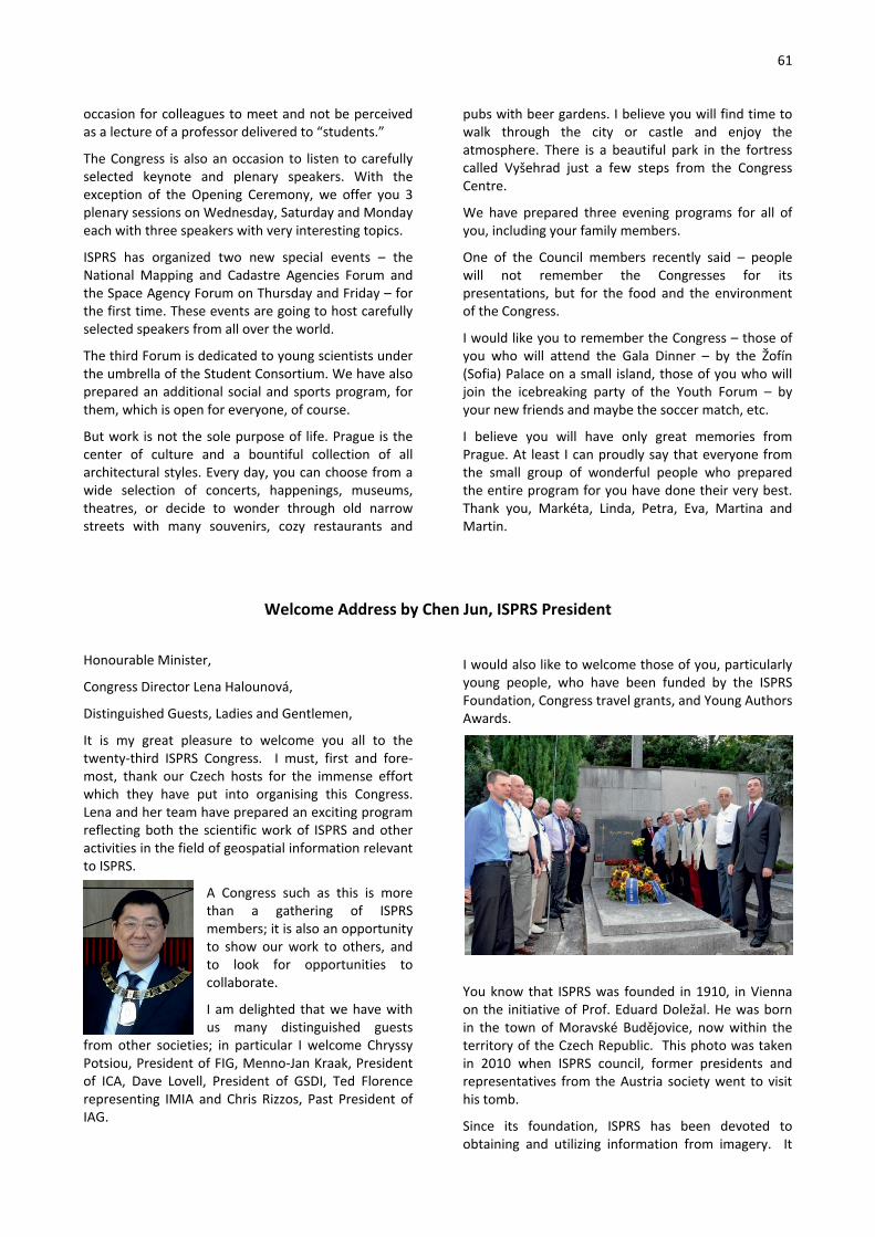
61
occasion for colleagues to meet and not be perceived as a lecture of a professor delivered to “students.”
The Congress is also an occasion to listen to carefully selected keynote and plenary speakers. With the exception of the Opening Ceremony, we offer you 3 plenary sessions on Wednesday, Saturday and Monday each with three speakers with very interesting topics.
ISPRS has organized two new special events – the National Mapping and Cadastre Agencies Forum and the Space Agency Forum on Thursday and Friday – for the first time. These events are going to host carefully selected speakers from all over the world.
The third Forum is dedicated to young scientists under the umbrella of the Student Consortium. We have also prepared an additional social and sports program, for them, which is open for everyone, of course.
But work is not the sole purpose of life. Prague is the center of culture and a bountiful collection of all architectural styles. Every day, you can choose from a wide selection of concerts, happenings, museums, theatres, or decide to wonder through old narrow streets with many souvenirs, cozy restaurants and
pubs with beer gardens. I believe you will find time to walk through the city or castle and enjoy the atmosphere. There is a beautiful park in the fortress called Vyšehrad just a few steps from the Congress Centre.
We have prepared three evening programs for all of you, including your family members.
One of the Council members recently said – people will not remember the Congresses for its presentations, but for the food and the environment of the Congress.
I would like you to remember the Congress – those of you who will attend the Gala Dinner – by the Žofín (Sofia) Palace on a small island, those of you who will join the icebreaking party of the Youth Forum – by your new friends and maybe the soccer match, etc.
I believe you will have only great memories from Prague. At least I can proudly say that everyone from the small group of wonderful people who prepared the entire program for you have done their very best. Thank you, Markéta, Linda, Petra, Eva, Martina and Martin.
Welcome Address by Chen Jun, ISPRS President
Honourable Minister,
Congress Director Lena Halounová,
Distinguished Guests, Ladies and Gentlemen,
It is my great pleasure to welcome you all to the twenty-third ISPRS Congress. I must, first and fore-most, thank our Czech hosts for the immense effort which they have put into organising this Congress. Lena and her team have prepared an exciting program reflecting both the scientific work of ISPRS and other activities in the field of geospatial information relevant to ISPRS.
A Congress such as this is more than a gathering of ISPRS members; it is also an opportunity to show our work to others, and to look for opportunities to collaborate.
I am delighted that we have with us many distinguished guests
from other societies; in particular I welcome Chryssy Potsiou, President of FIG, Menno-Jan Kraak, President of ICA, Dave Lovell, President of GSDI, Ted Florence representing IMIA and Chris Rizzos, Past President of IAG.
I would also like to welcome those of you, particularly young people, who have been funded by the ISPRS Foundation, Congress travel grants, and Young Authors Awards.
You know that ISPRS was founded in 1910, in Vienna on the initiative of Prof. Eduard Doležal. He was born in the town of Moravské Budějovice, now within the territory of the Czech Republic. This photo was taken in 2010 when ISPRS council, former presidents and representatives from the Austria society went to visit his tomb.
Since its foundation, ISPRS has been devoted to obtaining and utilizing information from imagery. It
62
was carried out through scientific research, technological development and operational applications. First of all, there are a number of basic scientific questions to be answered, (such as the mechanism of electromagnetic radiation and its interaction with the earth, the recognition of spatio-temporal patterns in images, as well as the modeling and representation of spatio-temporal phenomena and their relationships). New concepts, theories and algorithms need to be developed. Secondly, advanced tools and systems need to be designed, tested, fabricated, and commercialized to realize the image acquisition, information extraction and spatial information services. Thirdly, these science and technologies are applied for operational topographic mapping, civil engineering, heritage documentation, resource inventory, disaster monitoring, industrial measurement, medical imaging, and many other societal or domain needs. This leads to the development of technical standards, data collection and processing, education and outreach.
After one hundred and six year’s development, we are entering an era in which the application of imagery is ubiquitous, playing an important role in many aspects of life and work today. This has been accompanied with the increased availability of very high-resolution satellite imagery, terrain based imaging and participatory sensing, inexpensive platforms, and advanced information and communication technologies.
ISPRS is now a leading organization in this field, with a series of influential conferences, (Congress, Geospatial Week, and Symposia), a good collection of publications, awards and projects.
Today, we are facing grand challenges. Global change studies, location-based services, sustainable development and many other societal benefits areas have put forward new demands, such as providing higher quality information, enabling advanced geospatial computing, and supporting collaborative problem solving. Since the beginning of 2013, ISPRS council has led the preparation of a scientific vision paper. The motivation is to examine the major scientific challenges, and to set out a forward research agenda for the Society. This work has been supported by TCPs, ISAC, IPAC and many members.
The major development trends are summarized. For instances:
Sensing - Integrated sensors, citizen or participatory sensing, high-resolution imagery up to multiple times per day of every corner of the globe in near real-time; Processing: Integration of image matching, tracking and object extraction, and high geometric accuracy, coupled with the highest degree of automation
Modeling: Convergent cyber–physical world, integrated indoor and outdoor modeling, and navigate across space and time.
Service: From information provision to geospatial knowledge delivery, from change mapping to dynamic monitoring and the prediction of future trends.
Multidisciplinarity: more domain specific knowledge and principles into traditional geometry-dominant geospatial data processing and analysis.
The research topics to be tackled by ISPRS community were identified and followed the new commission structure. The details can be found in the vision paper. We hope to call upon and to mobilize all ISPRS scientists, practitioners and stakeholders to continue improving our understanding and capacity related to the generation of information from imagery, and to deliver geospatial knowledge that will enable humankind to confront the challenges ahead.
We have been looking forward to this congress since the end of the previous Congress. When we left Melbourne, we were full of enthusiasm for our society, with many ideas for new research, new activities and making new contacts and collaborations. Now we meet again to see whether these ambitions have been met. This eight day Congress offers us a unique occasion to evaluate the significant progress achieved in our disciplines and to discuss future R&D issues.
You will hear more ISPRS voices, such as the Prague declaration, which is our ISPRS statement, or ISPRS response, to the challenges facing. It has just been endorsed by the General Assembly and was released to the press this afternoon.
You will witness our member’s enthusiasm, such as interests in hosting the next congress, TC and council positions, new WGs, and so on.
I would like us to pause here for a moment to remember those of our number who, sadly, have passed away during the past four years, including two of our former presidents, F.F. Doyle and Kennert Torlegård. We will always remember their names and their contribution to ISPRS.
Finally, I would like to take this opportunity to thank my fellow council members, TCPs and ISPRS officers for the collaborative management of the society, along with JBGIS, ICSU-GeoUnions, and all sister organisations for their support and all participants for presenting at this opening and congress.
Dear Colleagues, in conclusion I urge you to take advantage of all of the opportunities which this Congress has to offer. I wish you all have a nice stay in Prague.

63
Address by the Deputy Minister of Transport, Karel Dobeš
Address by the Chair of the Czech Office of Survey, Mapping and Cadastre, Karel Večeře
Awards Presented at the Opening Ceremony
The Brock Gold Medal Award Awardee: Wolfgang Förstner
Charles Toth, Wolfgang Förstner, Chen Jun
The Otto von Gruber Award Awardee: Wai Yeung Yan
George Vosselman, Wai Yeung Yan, Christian Heipke

64
The U.V. Helava Award
Awardees: Devis Tuia, Rémi Flamary and Nicolas Courty:
Paper: “Multiclass feature learning for hyperspectral image classification: Sparse and hierarchical solutions” by.
Derek Lichti (Editor-in-Chief of IJPRS), Marije Hoog-strate (Elsevier), Rémi Flamary, Nicolas Courty, Helmut Rosengarten (Hexagon)
ISPRS Fellows Awardees:
Alain Baudoin (France) Jiang Jie (China) Franz Leberl (Austria) Petros Patias (Greece) Ammatzia Peled (Israel)
Chen Jun, Clément Mallet (on behalf of Alain Baudoin), Jiang Jie, Petros Patias, Ammatzia Peled, Franz Leberl (from left)
ISPRS Honorary Member Awardee: Orhan Altan
Orhan Altan and Chen Jun
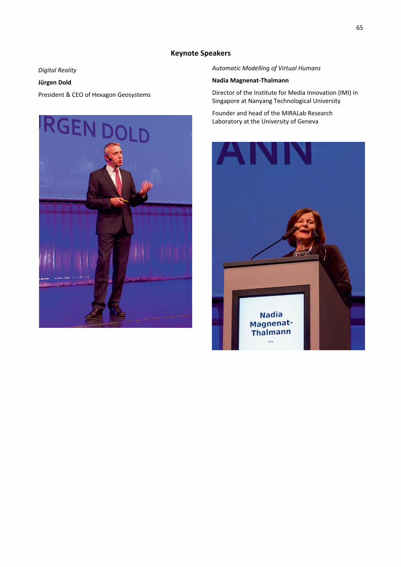
65
Keynote Speakers
Digital Reality
Jürgen Dold
President & CEO of Hexagon Geosystems
Automatic Modelling of Virtual Humans
Nadia Magnenat-Thalmann
Director of the Institute for Media Innovation (IMI) in Singapore at Nanyang Technological University
Founder and head of the MIRALab Research Laboratory at the University of Geneva

66
ISPRS AWARDS 2016
ISPRS Honorary Member ISPRS Fellowships
The Brock Gold Medal The Otto von Gruber Award
The U.V. Helava Award The Samuel Gamble Award
The Willem Schermerhorn Award The Schwidefsky Medal
The Eduard Doležal Award The Wang Zhizhuo Award
The Karl Kraus Medal The Frederick J. Doyle Award
The Giuseppe Inghilleri Award Young Authors Awards
President's Citations CATCON Award
Best Poster Papers Youth Forum Awards
IGI Ambassador Award 2016 Certificates of Recognition
The ISPRS Foundation and Congress Travel Grants White Elephants’ "Kennert Torlegård
Travel Grant”

67
ISPRS Awards 2016
ISPRS Honorary Member Orhan Altan (Turkey). An individual is elected as a Honorary Member in recognition of distinguished ser-vices to the ISPRS and its aims. Honorary Members shall be nominated by a committee, chaired by the most recent Honorary Member and composed of members from the current and three previous Councils, and elected by the Congress. There may not be more than ten living Honorary Members of the Society at any given time. The Committee has nominated Orhan Altan (Turkey) for election as Honorary Members of ISPRS.
Orhan Altan is nominated for Honorary Membership of ISPRS in recognition of his long and distinguished service to ISPRS and its aims. Orhan Altan first made his mark on ISPRS as Con-gress Director in 2004 and has since held many roles and re-sponsibilities within the Society including President from 2008-
2012. The year 2010 was the centennial anniversary of ISPRS and Orhan Altan played a major role in organising the celebration of this event. Orhan Altan has introduced a number of important initiatives into ISPRS including the establishment of the Student Consortium which laid the basis for attracting more young scientists into the society; he was instru-mental in setting up an agreement to have the ISPRS proceedings published in a professional way and has thus provided the necessary quality of these proceed-ings to be included into major indexing databases such as the Web of Science and SCOPUS; he has worked with the Joint Board of Geospatial Societies (JBGIS) and the UN Office of Outer Space Affairs to produce booklets on the value of geospatial information for disaster management.
Orhan Altan has represented ISPRS on many interna-tional bodies including the International Council for Science (ICSU) and has served on the Executive board of ICSU which has raised the recognition and standing of ISPRS internationally.
Orhan Altan’s contribution has been not only as an officer of the Society, he has also made a significant research contribution to ISPRS Commissions and Work-ing Groups throughout his career, which has covered major developments in both photogrammetry and remote sensing.
Outside of ISPRS, Orhan Altan has had a distinguished academic career as a professor of photogrammetry at
the Istanbul Technical University and has an extensive list of refereed publications and conference papers. Orhan Altan is fluent in English and German, as well as Turkish and this has enabled him to build bridges across Europe and Asia. His contribution to the development and long term sustainability of ISPRS and his distinguished academic achievements combined with his diplomacy and charm, make Orhan Altan a very deserving candidate for elec-tion as an ISPRS Honorary Member.
ISPRS Fellowships An ISPRS Fellow is elected by the Society in recognition of sustained, excellent service to the ISPRS and its aims. The following persons have been selected to receive ISPRS Fellowships in 2012 by the Fellowship Nomination Committee.
Alain Baudoin (France)
Educated at École Polytechnique (1966-1969) and at the École Nationale des Sciences Géographiqies (ENSG, 1969-1971) Alain Baudoin was a Geographical Engineer serving on the French Mapping Agency (IGN, 1971-1989) then on the French Space Agency (CNES, 1989-2005) and
lastly on the French Ministry of Environment and Sus-tainable Development (CGEDD, 2006-2010). Since 1972 he has been involved in research and devel-opment of remote sensing applications, using either airborne sensors or satellite imagery. From 1978 to 1985 he was the IGN Spot project manager, ensuring that the SPOT satellite, with its stereoscopic capabili-ties, could be used for mapping purposes. When joining CNES he participated, as “Mission Manager”, then “Program Manager” to CNES Earth Observation pro-grams, especially for SPOT 5 and Pléaides. Parallel to these activities Alain Baudoin was a teacher on image processing at ENSG. Since 1980, he has been involved in ISPRS activities, participating at all Congress from Hamburg to Mel-bourne. During the 1980 to 1984 period, he was the Secretary of Commission VII, before acting as President of Commission I from 2004 to 2008. He was also Chairman of the “Mapping from Space” Working Group (1984-1988) and after the launch of SPOT-5, in 2002, he proposed to ISPRS, a cooperation with CNES for assess-ing the quality and accuracy of DEM derived from the new HRS instrument. Results were presented at the Istanbul Congress in 2004.
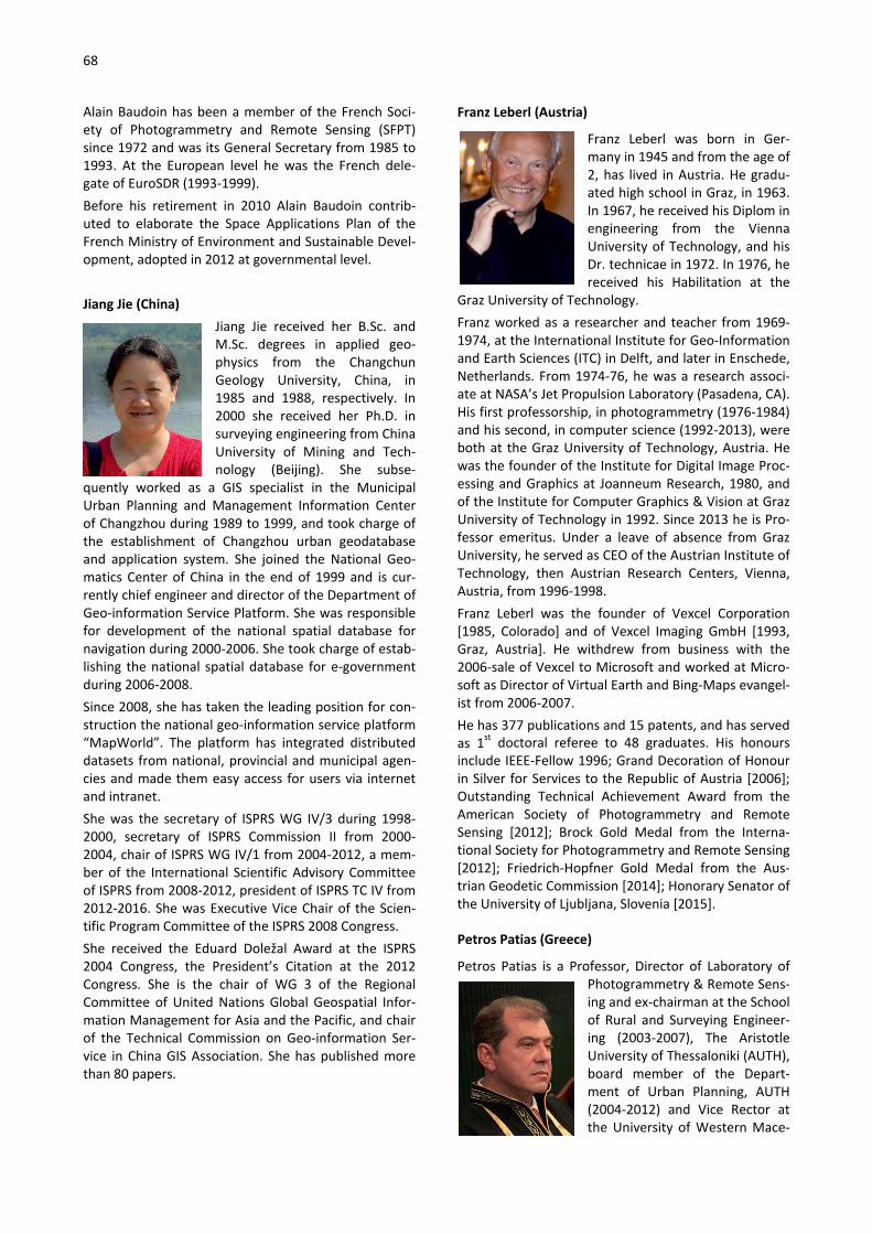
68
Alain Baudoin has been a member of the French Soci-ety of Photogrammetry and Remote Sensing (SFPT) since 1972 and was its General Secretary from 1985 to 1993. At the European level he was the French dele-gate of EuroSDR (1993-1999). Before his retirement in 2010 Alain Baudoin contrib-uted to elaborate the Space Applications Plan of the French Ministry of Environment and Sustainable Devel-opment, adopted in 2012 at governmental level. Jiang Jie (China)
Jiang Jie received her B.Sc. and M.Sc. degrees in applied geo-physics from the Changchun Geology University, China, in 1985 and 1988, respectively. In 2000 she received her Ph.D. in surveying engineering from China University of Mining and Tech-nology (Beijing). She subse-
quently worked as a GIS specialist in the Municipal Urban Planning and Management Information Center of Changzhou during 1989 to 1999, and took charge of the establishment of Changzhou urban geodatabase and application system. She joined the National Geo-matics Center of China in the end of 1999 and is cur-rently chief engineer and director of the Department of Geo-information Service Platform. She was responsible for development of the national spatial database for navigation during 2000-2006. She took charge of estab-lishing the national spatial database for e-government during 2006-2008. Since 2008, she has taken the leading position for con-struction the national geo-information service platform “MapWorld”. The platform has integrated distributed datasets from national, provincial and municipal agen-cies and made them easy access for users via internet and intranet. She was the secretary of ISPRS WG IV/3 during 1998-2000, secretary of ISPRS Commission II from 2000-2004, chair of ISPRS WG IV/1 from 2004-2012, a mem-ber of the International Scientific Advisory Committee of ISPRS from 2008-2012, president of ISPRS TC IV from 2012-2016. She was Executive Vice Chair of the Scien-tific Program Committee of the ISPRS 2008 Congress. She received the Eduard Doležal Award at the ISPRS 2004 Congress, the President’s Citation at the 2012 Congress. She is the chair of WG 3 of the Regional Committee of United Nations Global Geospatial Infor-mation Management for Asia and the Pacific, and chair of the Technical Commission on Geo-information Ser-vice in China GIS Association. She has published more than 80 papers.
Franz Leberl (Austria)
Franz Leberl was born in Ger-many in 1945 and from the age of 2, has lived in Austria. He gradu-ated high school in Graz, in 1963. In 1967, he received his Diplom in engineering from the Vienna University of Technology, and his Dr. technicae in 1972. In 1976, he received his Habilitation at the
Graz University of Technology. Franz worked as a researcher and teacher from 1969-1974, at the International Institute for Geo-Information and Earth Sciences (ITC) in Delft, and later in Enschede, Netherlands. From 1974-76, he was a research associ-ate at NASA’s Jet Propulsion Laboratory (Pasadena, CA). His first professorship, in photogrammetry (1976-1984) and his second, in computer science (1992-2013), were both at the Graz University of Technology, Austria. He was the founder of the Institute for Digital Image Proc-essing and Graphics at Joanneum Research, 1980, and of the Institute for Computer Graphics & Vision at Graz University of Technology in 1992. Since 2013 he is Pro-fessor emeritus. Under a leave of absence from Graz University, he served as CEO of the Austrian Institute of Technology, then Austrian Research Centers, Vienna, Austria, from 1996-1998. Franz Leberl was the founder of Vexcel Corporation [1985, Colorado] and of Vexcel Imaging GmbH [1993, Graz, Austria]. He withdrew from business with the 2006-sale of Vexcel to Microsoft and worked at Micro-soft as Director of Virtual Earth and Bing-Maps evangel-ist from 2006-2007. He has 377 publications and 15 patents, and has served as 1st doctoral referee to 48 graduates. His honours include IEEE-Fellow 1996; Grand Decoration of Honour in Silver for Services to the Republic of Austria [2006]; Outstanding Technical Achievement Award from the American Society of Photogrammetry and Remote Sensing [2012]; Brock Gold Medal from the Interna-tional Society for Photogrammetry and Remote Sensing [2012]; Friedrich-Hopfner Gold Medal from the Aus-trian Geodetic Commission [2014]; Honorary Senator of the University of Ljubljana, Slovenia [2015].
Petros Patias (Greece)
Petros Patias is a Professor, Director of Laboratory of Photogrammetry & Remote Sens-ing and ex-chairman at the School of Rural and Surveying Engineer-ing (2003-2007), The Aristotle University of Thessaloniki (AUTH), board member of the Depart-ment of Urban Planning, AUTH (2004-2012) and Vice Rector at the University of Western Mace-
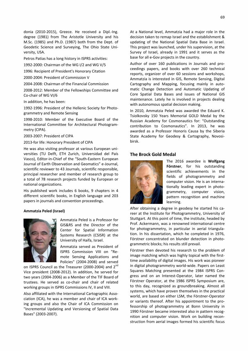
69
donia (2010-2015), Greece. He received a Dipl.-Ing. degree (1981) from The Aristotle University and his Μ.Sc. (1985) and Ph.D. (1987) both from the Dept. of Geodetic Science and Surveying, The Οhio State Uni-versity, USΑ. Petros Patias has a long history in ISPRS activities: 1992-2000: Chairman of the WG Ι/2 and WG V/5 1996: Recipient of President's Honorary Citation 2000-2004: President of Commission V 2004-2008: Chairman of the Financial Commission 2008-2012: Member of the Fellowships Committee and Co-chair of WG VI/6 In addition, he has been: 1992-1996: President of the Hellenic Society for Photo-grammetry and Remote Sensing 1998-2010: Member of the Executive Board of the International Committee for Architectural Photogram-metry (CIPA). 2003-2007: President of CIPA 2013-for life: Honorary President of CIPA He was also visiting professor at various European uni-versities (TU Delft, ETH Zurich, Universidad del País Vasco), Editor-in-Chief of the “South-Eastern European Journal of Earth Observation and Geomatics” e-Journal, scientific reviewer to 43 Journals, scientific responsible, principal researcher and member of research group to a total of 78 research projects funded by European or national organizations. His published work includes 6 books, 9 chapters in 4 different scientific books, in English language and 203 papers in journals and convention proceedings.
Ammatzia Peled (Israel)
Ammatzia Peled is a Professor for GIS&RS and the Director of the Center for Spatial Information Systems Research (CSISR) at the University of Haifa, Israel. Ammatzia served as President of ISPRS Commission VIII on "Re-mote Sensing Applications and Policies" (2004-2008) and served
on ISPRS Council as the Treasurer (2000-2004) and 2nd Vice president (2008-2012). In addition, he served for two years (2004-2006) as a Member of the TIF Board of trustees. He served as co-chair and chair of related working groups in ISPRS Commissions IV, II and VIII. Also affiliated with the International Cartographic Asso-ciation (ICA), he was a member and chair of ICA work-ing groups and also the Chair of ICA Commission on "Incremental Updating and Versioning of Spatial Data Bases" (2003-2007).
At a National level, Ammatzia had a major role in the decision taken to remap Israel and the establishment & updating of the National Spatial Data Base in Israel. This project was launched, under his supervision, at the Survey of Israel, already in 1991 and it serves as the base for all e-Gov projects in the country. Author of over 160 publications in Journals and pro-ceedings papers, and books with over 260 technical reports, organizer of over 60 sessions and workshops, Ammatzia is interested in GIS, Remote Sensing, Digital Cartography and Mapping, focusing mainly in auto-matic Change Detection and Automatic Updating of Core Spatial Data Bases and issues of National GIS maintenance. Lately he is involved in projects dealing with autonomous spatial decision making. In 2010, Ammatzia Peled was awarded the Eduard K. Tsiolkovsky 150 Years Memorial GOLD Medal by the Russian Academy for Cosmonautics for: “Outstanding contribution to Cosmonautics”. In 2013, he was awarded as a Professor Honoris Causa by the Siberia State Academy for Geodesy & Cartography, Novosi-birsk.
The Brock Gold Medal The 2016 awardee is Wolfgang Förstner, for his outstanding scientific achievements in the fields of photogrammetry and computer vision. He is an interna-tionally leading expert in photo-grammetry, computer vision, pattern recognition and machine learning.
After obtaining a degree in geodesy he started his ca-reer at the Institute for Photogrammetry, University of Stuttgart. At this point of time, the institute, headed by Prof. Ackermann, was a renowned international centre for photogrammetry, in particular in aerial triangula-tion. In his dissertation, which he completed in 1976, Förstner concentrated on blunder detection in photo-grammetric blocks; his results still prevail. Förstner then devoted his research to the problem of image matching which was highly topical with the first-time availability of digital images. His work was pioneer in digital photogrammetry world-wide. Papers on Least Squares Matching presented at the 1984 ISPRS Con-gress and on an Interest-Operator, later named the Förstner Operator, at the 1986 ISPRS Symposium are, to this day, recognized as groundbreaking. Almost all systems, which have proven themselves in the practical world, are based on either LSM, the Förstner-Operator or variants thereof. After his appointment to the pro-fessorship of photogrammetry at Bonn University in 1990 Förstner became interested also in pattern recog-nition and computer vision. Work on building recon-struction from aerial images formed his scientific focus

70
for the following years resulting in many scientific pub-lications but also in the commercial program system inJect. Many other areas of interest of Wolfgang Förstner and many more of his achievements could be mentioned. Suffice it to say that throughout his exemplary career of nearly 40 years as a researcher, inventor, innovator and educator, he has made exceptionally significant scien-tific contributions in many areas of Information from Imagery and mentored generations of mapping scien-tists and engineers. Although now formally retired since 2012, he continues his scientific activities.
The Otto von Gruber Award Wai Yeung Yan was born 1980 in Hong Kong. He received his B.Sc. (Hons) in Surveying and Geo-informatics at Hong Kong Polytechnic University in 2002 and M.Sc. in Business Information Technology at Middlesex University, London, in 2006. He later on moved to Toronto, Canada to pursue his
Ph.D. in the Department of Civil Engineering, Ryerson University in 2008. With his exceptional academic and research achievements, he was presented with the prestigious Governor’s General Academic Gold Medal during his graduation in 2012. He is currently a postdoctoral fellow at Ryerson, and continues to carries on research in LiDAR remote sensing. Wai Yeung Yan has proposed and developed radiometric correction and normalization models to improve the quality of airborne LiDAR intensity data. His models consider various system and environmental induced distortions, and adjust the radiometric misalignment found in the overlapping LiDAR data strips. His proposed algorithms can significantly improve the signal-to-noise ratio and reduce striping noises when mosaicking multiple LiDAR data strips. He has also demonstrated how the corrected and normalized LiDAR intensity data can aid in improving the classification accuracy in different land cover scenarios. His contribution, being interdisciplinary and of practical relevance, has laid a foundation for the next generation global land cover mapping, and can be seen as an essential pre-processing step prior to LiDAR data classification.
The series of papers for which Wai Yeung Yan received the award is given here:
Yan, W.Y., Shaker, A., Habib, A., Kersting, A.P. 2012. Improving classification accuracy of airborne LiDAR intensity data by geometric calibration and radiometric correction. ISPRS J. Ph&RS 67, 35-44.
Yan, W.Y., Shaker, A. 2014. Radiometric correction and normalization of airborne LiDAR intensity data for improving land cover classification. IEEE Transactions on Geoscience and Remote Sensing, 52(2), 7658-7673. Yan, W.Y., Shaker, A. 2015. Radiometric normalization of overlapping LiDAR intensity data for re-duction of line striping noise. Int. J. Dig. Earth. Published: Nov. 26, 2015.Yan, W.Y., Shaker, A., El-Ashmawy, N. 2015. Urban and cover classification using airborne LiDAR data: a review. Rem. Sens. of Environment, 158, 295-310.Yan, W.Y., Morsy, S., Shaker, A., Tulloch, M. 2015. Automatic extraction of highway light poles and towers from mobile LiDAR data. Optics & Laser Technology. Published: Sept. 26, 2015.
The U.V. Helava Award The U.V. Helava Award, sponsored by Elsevier B.V. and Hexagon Geosystems, was established to encourage and stimulate submission of high quality scientific pa-pers by individual authors or groups to the ISPRS Jour-nal of Photogrammetry and Remote Sensing, to pro-mote and advertise the Journal, and to honour the outstanding contributions of Dr. Uuno V. Helava to research and development in Photogrammetry and Remote Sensing. The award consists of a monetary grant of SFr. 10,000, certificates and a silver plaque, partly funded by the Institute of Photogrammetry and Remote Sensing, of the Aalto University, Finland. The plaque was designed by the 1980-88 ISPRS Technical Commission III President, Einari Kilpelä, previously Professor at the Helsinki University of Technology.
Devis Tuia
Switzerland Rémi Flamary
France Nicolas Courty
France A five-member jury, comprising experts of high scien-tific standing, whose expertise covers the main topics included in the scope of the Journal, evaluates the papers.. For each year of the four-year evaluation pe-riod, the Best Paper was selected and has been an-nounced in the ISPRS Journal, ISPRS eBulletin, and on the websites of ISPRS and Elsevier. The paper receiving the Helava Award was selected from these four papers. The 2012-2015 U.V. Helava Award is presented to “Multiclass feature learning for hyperspectral image classification: Sparse and hierarchical solutions” by Devis Tuia, Rémi Flamary and Nicolas Courty, pub-lished in vol. 105, July 2015, pp. 272-285.
Jury's rationale for the paper selection:

71
The winning paper addresses the problem of high di-mensionality in hyperspectral image classification. Presenting well the shortcomings of existing ap-proaches, the authors solve the problem of filter bank selection by choosing only those that contribute to improving land cover classification. Their work features a number of innovations including the use of multi-class logistic regression, group-lasso regularization that allows information sharing between thematic classes and automatic filter selection. Their new approach was tested thoroughly on both agricultural and urban scenes. The Jury was impressed by the authors’ innova-tive methodology, finding the performance-based fea-ture selection technique to be very novel yet still trac-table. They felt this well-written contribution repre-sents a genuine scientific advance in hyperspectral image classification and, therefore, very deserving of the U.V. Helava Award for 2012-2015. The Awardees of the three next-best papers during 2012-2015 are For 2012: "CityGML – Interoperable semantic 3D city models" by Gerhard Gröger, and Lutz Plümer Institute for Geodesy and Geoinformation, University of Bonn, Germany
For 2013: "Urban accessibility diagnosis from mobile laser scanning data" by Andrés Serna and Beatriz Marcotegui MINES ParisTech, CMM – Center for Mathematical Morphology, Fontainebleau, France
For 2014: "Indoor scene reconstruction using feature sensitive primitive extraction and graph-cut" by Sven Oesau, Florent Lafarge and Pierre Alliez Inria Sophia Antipolis – Méditerranée, Sophia Antipolis, France
The Samuel Gamble Award The Samuel Gamble Award is sponsored by the Cana-dian Institute of Geomatics in honour of Dr. Samuel G. Gamble, former President of ISPRS, and Director of the 1972 Congress. A recipient of the award shall be a person who, like Dr. Gamble, has contributed signifi-cantly to the development, organization or professional
activities of the photogram-metry, remote sensing and spa-tial information sciences, at the national or international level. The recipient of the Award is Naser El Sheimy in recognition of his role as a leading international researcher in Geomatics and Mobile Mapping.
Naser El Sheimy is Professor and former Head of the Department of Geomatics Engineering, the University of Calgary. He held a Tier-I Canada Research Chair (CRC) in Geomatics Multi-Sensor Systems and is the scientific director of TECTERRA Centre of Excellence for Com-mercialization and Research. His research expertise includes Geomatics multi-sensor systems, GPS/INS integration, and mobile mapping systems. Naser El-Sheimy published two books, 6 book chapters and over 450 papers in academic journals, conference and workshop proceedings, in which he has received over 30 national and international paper awards. He supervised and graduated over 65 Masters and Ph.D. students. He is the recipient of many national and in-ternational awards including the ASTech “Leadership in Alberta Technology” Award the Association of Profes-sional Engineers, Geologists, and Geophysicists of Al-berta (APEGGA) Educational Excellence.
From 2008-2012, El-Sheimy was the president of Com-mission I on "Sensors and Platforms" of ISPRS. He or-ganized and participated in organizing many national and international conferences and chaired many con-ferences such as the USA Institute of Navigation Global Navigation Satellite Systems (GNSS) and Mobile Map-ping Symposium.
Naser El-Sheimy is currently a member of the Editorial Board of the Journal of Survey Review, the Journal of Applied Geodesy, the MDPI Journal on Sensors and on Coordinates. He served as a member of the Alberta Geomatics Group Board of Directors, Geoide NCE Board of Directors and chaired many international working groups. He commercialized a number of multi-sensor systems technologies through the University of Calgary Commercialization office and is the founder of three successful companies on sensors and platforms for mapping and navigation applications.
The Willem Schermerhorn Award The Willem Schermerhorn Award (1988), sponsored by Geo-Information Netherlands is granted to a person who has most significantly contributed to the activities
of a Working Group of the ISPRS during the four-year Congress period. The award consists of a certificate and has been awarded to Uwe Stilla for organising ex-tremely worthwhile and success-ful scientific meetings of a very high level and in particular the PIA workshop series.
Uwe Stilla was born in Cologne, Germany, in 1957. He received the Diploma (Dipl.-Ing.) degree in electrical engineering from University of Paderborn, Germany, the Diploma (Dipl.-Ing.) in biomedical engineering and the Ph.D. (Doctor of Engineering) degree in pattern

72
recognition from the University of Karlsruhe, Germany, in 1980, 1987, and 1993, respectively. From 1990 to 2004, he was with the Research Institute of Optronics and Pattern Recognition (FGAN-FOM), Ettlingen, Ger-many. Since 2004, he is Professor with the Technische Univer-sität München, Germany, and the Head of the Depart-ment of Photogrammetry and Remote Sensing. He was the Vice Dean of the Faculty of Civil, Geo, and Environ-mental Engineering and is currently the Dean of Studies of the Bachelor’s and Master’s Programs Geodesy and Geoinformation, Earth Oriented Space Science and Technology (ESPACE) and Cartography. His research interests include image analysis in the field of photo-grammetry and remote sensing. The publication list of Uwe Stilla shows more than 350 entries. Uwe Stilla is the Chair of the ISPRS Working Group III/VII “Pattern Analysis in Remote Sensing”, is a Princi-pal Investigator of the International Graduate School of Science and Engineering (IGSSE), the Vice President of the German Society of Photogrammetry, Remote Sens-ing and Geoinformation (DGPF), a member of the Sci-entific Board of German Commission of Geodesy (DGK), and a member of Commission for Geodesy and Glaciol-ogy (KEG) of the Bavarian Academy of Science and Humanities, Munich, Germany. He has been the organ-izer and the chair of many ISPRS and IEEE conferences and events. This award also recognises the contribution of the other members of the Student Consortium Council.
The Schwidefsky Medal The Schwidefsky Medal is sponsored by Deutsche Ge-sellschaft für Photogrammetrie und Fernerkundung (DGPF), in memory of Professor Dr. rer. techn. Dr.-Ing.e.h. Kurt Schwidefsky, Honorary Member of the ISPRS. The Award is in the form of a medal made of porcelain. The recipients shall be persons who have made significant contributions to photogrammetry and remote sensing, either through the medium of publica-tion as author or editor, or in another form. The Schwidefsky Medal is awarded to Charles K. Toth for his significant contributions to the field of photogrammet-ric theory and practice in the last three decades and Clément Mallet for his many contributions to photo-grammetry and remote sensing as the editor of the Revue Française de Photogrammétrie et Télédétection and as Program Chair for the Geospatial Week 2015 in La Grande Motte.
Charles K. Toth is a Research Professor in the Depart-ment of Civil, Environmental and Geodetic Engineering, at The Ohio State University (OSU). He received a M.Sc. in Electrical Engineering and a Ph.D. in Electrical Engineering and Geo-Information Sciences from the Technical Univer-sity of Budapest, Hungary.
His research interest and exper-tise cover broad areas of spatial information sciences and systems, including photogrammetry, multi-sensor geospatial data acquisition systems, LiDAR, high-resolution imaging, surface extraction, mod-elling, integrating and calibrating multi-sensor systems, georefer-
encing and navigation, 2D/3D signal processing, and mobile mapping technologies. He has published over 300 peer-reviewed journal and proceedings papers, and is the recipient of numerous awards, including the 2009 APSRS Photogrammetric Award and the United States Geospatial Intelligence Foundation (USGIF) Academic Achievement Award 2015. Acknowledged internationally for his visionary contribu-tions to mobile mapping, he was a key architect of the concept development, and conducted significant re-search in areas of sensor georeferencing and digital imag-ing technologies. He is credited with the introduction of the term “direct and indirect georeferencing” in the photogrammetric community. He is very devoted to education and mentoring the next generation of the photogrammetric professionals, and has been a major contributor to annual Summer Schools on mobile mapping held internationally. Charles is highly respected across the international map-ping community and has held many senior leadership positions in national and international socie-ties. He is currently President of the American Society of Photo-grammetry and Remote Sensing, and served as the ISPRS Commission I President from 2012 to 2016.
Clément Mallet is a permanent researcher at the French National Institute of Geographic and Forest Information (IGN) since 2005, where he is responsible for the research team on scene interpreta-tion and reconstruction, with a focus on land-cover mapping. He received the Master of engineering
degree from École Nationale des Sciences Géographi-ques, France (2005), the M.Sc. degree in physics in re-mote sensing from Université Paris 6, France (2005), and the Ph.D. degree in image and signal processing from Telecom ParisTech, France (2010), on full-waveform lidar data processing. Clément served as Technical Commission III secretary (2008-2012), Chair of the ISPRS Working Group III/3 (Im-age Sequence Analysis, 2012-2016) and Program Chair of ISPRS Geospatial Week 2015. He co-organised ISPRS workshops in various conferences since 2010 and will be technical co-chair of JURSE 2017. He served as the Editor-in-Chief for the French Journal of Photogrammetry and Remote Sensing (RFPT) between 2011 and 2015. He now
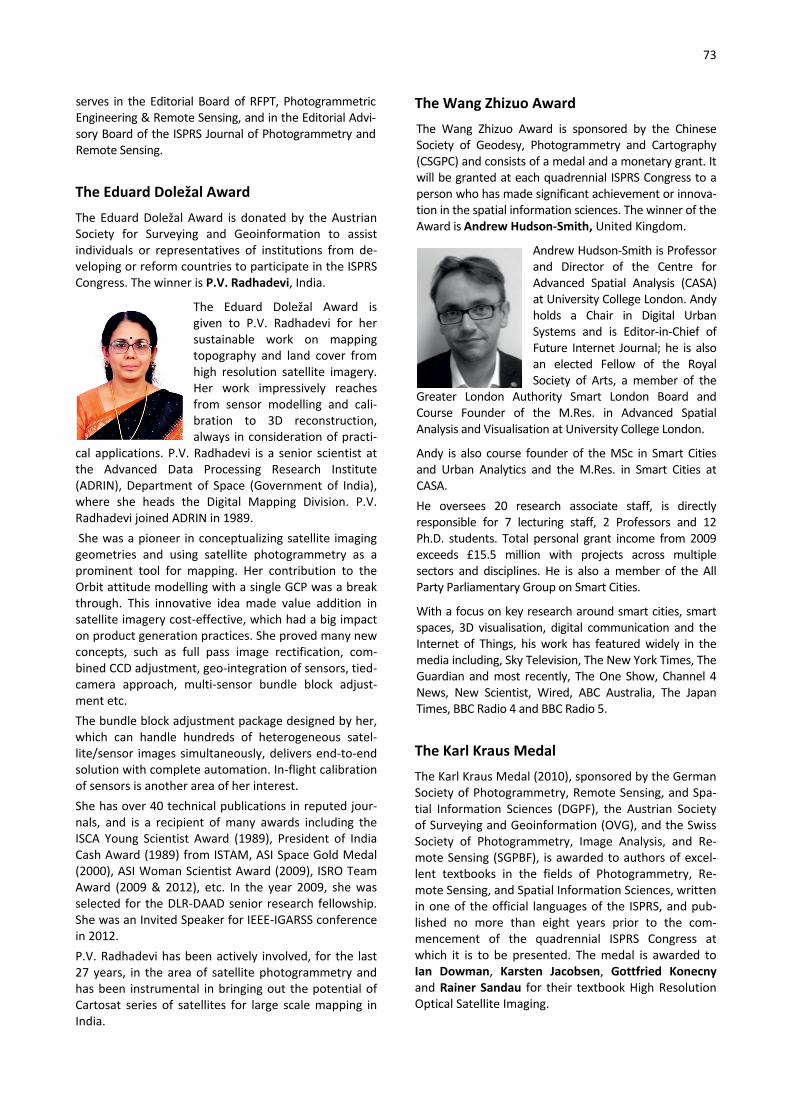
73
serves in the Editorial Board of RFPT, Photogrammetric Engineering & Remote Sensing, and in the Editorial Advi-sory Board of the ISPRS Journal of Photogrammetry and Remote Sensing.
The Eduard Doležal Award The Eduard Doležal Award is donated by the Austrian Society for Surveying and Geoinformation to assist individuals or representatives of institutions from de-veloping or reform countries to participate in the ISPRS Congress. The winner is P.V. Radhadevi, India.
The Eduard Doležal Award is given to P.V. Radhadevi for her sustainable work on mapping topography and land cover from high resolution satellite imagery. Her work impressively reaches from sensor modelling and cali-bration to 3D reconstruction, always in consideration of practi-
cal applications. P.V. Radhadevi is a senior scientist at the Advanced Data Processing Research Institute (ADRIN), Department of Space (Government of India), where she heads the Digital Mapping Division. P.V. Radhadevi joined ADRIN in 1989. She was a pioneer in conceptualizing satellite imaging geometries and using satellite photogrammetry as a prominent tool for mapping. Her contribution to the Orbit attitude modelling with a single GCP was a break through. This innovative idea made value addition in satellite imagery cost-effective, which had a big impact on product generation practices. She proved many new concepts, such as full pass image rectification, com-bined CCD adjustment, geo-integration of sensors, tied-camera approach, multi-sensor bundle block adjust-ment etc. The bundle block adjustment package designed by her, which can handle hundreds of heterogeneous satel-lite/sensor images simultaneously, delivers end-to-end solution with complete automation. In-flight calibration of sensors is another area of her interest. She has over 40 technical publications in reputed jour-nals, and is a recipient of many awards including the ISCA Young Scientist Award (1989), President of India Cash Award (1989) from ISTAM, ASI Space Gold Medal (2000), ASI Woman Scientist Award (2009), ISRO Team Award (2009 & 2012), etc. In the year 2009, she was selected for the DLR-DAAD senior research fellowship. She was an Invited Speaker for IEEE-IGARSS conference in 2012. P.V. Radhadevi has been actively involved, for the last 27 years, in the area of satellite photogrammetry and has been instrumental in bringing out the potential of Cartosat series of satellites for large scale mapping in India.
The Wang Zhizuo Award The Wang Zhizuo Award is sponsored by the Chinese Society of Geodesy, Photogrammetry and Cartography (CSGPC) and consists of a medal and a monetary grant. It will be granted at each quadrennial ISPRS Congress to a person who has made significant achievement or innova-tion in the spatial information sciences. The winner of the Award is Andrew Hudson-Smith, United Kingdom.
Andrew Hudson-Smith is Professor and Director of the Centre for Advanced Spatial Analysis (CASA) at University College London. Andy holds a Chair in Digital Urban Systems and is Editor-in-Chief of Future Internet Journal; he is also an elected Fellow of the Royal Society of Arts, a member of the
Greater London Authority Smart London Board and Course Founder of the M.Res. in Advanced Spatial Analysis and Visualisation at University College London.
Andy is also course founder of the MSc in Smart Cities and Urban Analytics and the M.Res. in Smart Cities at CASA. He oversees 20 research associate staff, is directly responsible for 7 lecturing staff, 2 Professors and 12 Ph.D. students. Total personal grant income from 2009 exceeds £15.5 million with projects across multiple sectors and disciplines. He is also a member of the All Party Parliamentary Group on Smart Cities.
With a focus on key research around smart cities, smart spaces, 3D visualisation, digital communication and the Internet of Things, his work has featured widely in the media including, Sky Television, The New York Times, The Guardian and most recently, The One Show, Channel 4 News, New Scientist, Wired, ABC Australia, The Japan Times, BBC Radio 4 and BBC Radio 5.
The Karl Kraus Medal The Karl Kraus Medal (2010), sponsored by the German Society of Photogrammetry, Remote Sensing, and Spa-tial Information Sciences (DGPF), the Austrian Society of Surveying and Geoinformation (OVG), and the Swiss Society of Photogrammetry, Image Analysis, and Re-mote Sensing (SGPBF), is awarded to authors of excel-lent textbooks in the fields of Photogrammetry, Re-mote Sensing, and Spatial Information Sciences, written in one of the official languages of the ISPRS, and pub-lished no more than eight years prior to the com-mencement of the quadrennial ISPRS Congress at which it is to be presented. The medal is awarded to Ian Dowman, Karsten Jacobsen, Gottfried Konecny and Rainer Sandau for their textbook High Resolution Optical Satellite Imaging.

74
Ian Dowman
From 1964 to 1967, Ian Dowman was employed as Photogrammet-rist at the Hydroelectric Commis-sion of Tasmania, Australia, and from 1967 to 1969, he worked as technical manager of Mapmakers, in Sydney. He then moved to London where he was Lecturer, Reader and Professor, at the University College London from
1970 to 2009. In 1981, Ian received his Ph.D. at the University of Lon-don, and in 1986 he became a Fellow of the Royal Insti-tution of Chartered Surveyors (FRICS). From 1997 to 1999 he was Dean of Engineering at the University College London. From 1996 to 2000 Ian Dowman was President of ISPRS Commission II, and from 2000-2012 ISPRS Council member and ISPRS President. Since 2012, he is an Hon-orary Member of the ISPRS. Ian Dowman is Emeritus Professor of Photogrammetry and Remote Sensing, University College London, since 2009.
Karsten Jacobsen In 1971, Karsten Jacobsen re-ceived his diploma in Surveying Engineering, and was employed at the University of Hannover, Institute of Photogrammetry and Geoinformation, from 1974. In 2009 Karsten retired as Academic Director, but he is still active in the field. His doctor thesis was on bundle
block adjustment, with his major topics of research in numerical photogrammetry, especially orientation and calibration of aerial and space imagery, DEM genera-tion and analysis, and mapping with aerial and space images. He is author of the program system BLUH. He has headed cooperation projects and given techni-cal courses in several countries, and has more than 300 publications. Karsten Jacobsen was Co-chair of WG I/4 “Geometric and Radiometric Modelling of Optical Spaceborne Sen-sors”, Co-chair of EARSeL Special Interest Group “3D-Remote Sensing”, Co-chair of the Working Group “Sen-sors and Platforms” of the German Society of Photo-grammetry and Remote Sensing and is an Honorary member of EARSeL.
Gottfried Konecny Educated as Surveying Engineer at the Technical Univer-sity of Munich, Germany, Gottfried Konecny continued his career as a Fulbright scholar at The Ohio State Univer-sity from 1954 to 1956. In 1959, he received his doctor-
ate at the Technical University Munich, and was employed by University of New Brunswick, Canada, where he launched the first English language program in Surveying Engineering. In 1971, he accepted a professorship at the University of Hannover, in Ger-many. In 1975, Konecny made the proposal to DLR and ESA to launch
a Zeiss Metric Camera on the First European Spacelab Mission. From 1984 to 1988 he was President of ISPRS and from 1993 to 1997 Chairman of EARSeL. Gottfried Konecny is author of several books: on Photo-grammetry 1984, in German, and on Geoinformation 2003 and 2014. He has four honorary doctorates and about 300 publi-cations, and is Emeritus Professor since 1998.
Rainer Sandau Retired from the German Aero-space Center (DLR), Rainer San-dau currently acts as adjunct Professor at Baylor University, Texas, USA, and Director of Satel-lites and Space Applications at the International Academy of Astronautics (IAA). During his career he held various positions, including Deputy Director of the
Institute of Space Research in Berlin, Germany, and Direc-tor R&D of LH Systems.
He has over 30 years of experience in airborne and spaceborne activities and has led and been involved in instrumentations of four space missions to Venus, Mars and Earth. His stereo camera, WAOSS (Wide-Angle Opto-electronic Stereo Scanner), developed for the Russian Mars 96 mission, also flies on DLR’s micro satellite BIRD and was also used as the basis for the technology transfer to develop Leica’s ADS 40. He has chaired the ISPRS In-ternational Advisory Committee (IPAC) and has repre-sented ISPRS at the UN COPUOS.
The Frederick J. Doyle Award The Frederick J. Doyle Award (2012) will be awarded to an individual who has made significant accomplish-ments in advancing the photogrammetry, remote sens-ing and spatial information sciences and technologies. A recipient of the award should typically be less than 50 years of age and have outstanding stature within the ISPRS community. The award consists of a silver medal and a monetary grant.
The Frederick J. Doyle Award 2016 goes to Wolfgang Wagner, TU Vienna, for his outstanding scientific con-tributions in active remote sensing, combined with his strong leadership role in science management, univer-

75
sity administration and in inter-national organisations. Wolfgang Wagner was born in 1969 in Wels, Austria. After studies in Physics, at TU Vienna, he received a Ph.D. de-gree in remote sensing in 1999. Following a short period at DLR, Germany, he was appointed to a professorship of remote sensing
at TU Vienna in 2001. From 2006-2011 he was Head of the Institute for Photogrammetry before moving to his current position as Department Head. Wolfgang Wagner is one of the leading scientists in physical modelling and geophysical parameter retrieval from remote sensing data, in particular radar and lidar measurements. He was coordinator of the Austrian Christian Doppler Laboratory for "Spatial Data from Laser Scanning and Remote Sensing" for 7 years, initi-ated the ESA Climate Change Initiative project on soil moisture in 2011, and serves on various advisory boards of international space projects. He was also a co-founder of the Earth Observation Data Centre for Water Resources Monitoring (EODC), acting as head of science since December 2014. Within ISPRS, Wolfgang Wagner was President of Tech-nical Commission VII from 2008-2012 and initiated a number of significant reforms and new activities within the society during that time, including the new open source International Journal for Geo-Information, the establishment of the ISPRS Archives and Annals as an open access series, and the establishment of manage-ment facilities for organisers of scientific meetings. Wolfgang Wagner was also instrumental in organising the 100th anniversary of ISPRS which took place in Vienna in 2010. Since 2012 he is an active member of the ISPRS Scientific Advisory Committee.
The Giuseppe Inghilleri Award The Giuseppe Inghilleri Award (2012), sponsored by the Italian Society for Surveying and Photogrammetry (SIFET)
is presented to a person who has significantly enhanced the applica-tions of photogrammetry, remote sensing or spatial information sciences in the 4 years preceding the Congress. The award consists of SFr 2,500 and a certificate. The winner of the award is Sander Oude Elberink, The Netherlands, for his high quality and innovative
research in 3D landscape modelling that has successfully been transferred to practice to serve the society.
Sander Oude Elberink graduated as Geodetic Engineer from Delft University of Technology in 2000, and fin-ished his Ph.D. on the Acquisition of 3D Topography in March 2010. After his master research on the classifica-tion of airborne laser scanner data, he joined the Sec-tion of Photogrammetry and Remote Sensing in Delft as researcher on 3D reconstruction from line scanner imagery.
From 2001 till 2005, he worked as research consultant and project manager at the Survey Department of Rijkswaterstaat, Ministry of Infrastructure and Envi-ronment. In September 2005, Oude Elberink started his Ph.D. research on "Acquisition of 3D Topography" at the Faculty of Geo-Information Science and Earth Ob-servation (ITC) at the University of Twente.
He received a young author's award for best papers at the ISPRS Congress in Beijing, China, in 2008. In 2009, Sander received the ITC research award for a journal paper on 3D road reconstruction, which was co-authored by George Vosselman and published in the Photogrammetric Record.
Since September 2009, Sander holds a position of assis-tant professor at the department of Earth Observation Science at ITC. His research interests focus on 3D mod-elling and information extraction from point clouds. From 2012 to 2016, Sander chaired ISPRS Working Group III-2 on Point Cloud Processing.
Young Authors Awards The prizes for Best Papers by Young Authors are spon-sored by donor organizations and by ISPRS to authors who are less than 35 years old and are the sole au-
thors of a high quality paper presented at the Con-gress.
TC Author, Country Paper
I Yuanxin Ye, China HOPC: a geometric structure similarity metric for automatic matching of mul-timodel remote sensing images
II Christian Kehl, Norway Direct image-to-geometry registration using mobile sensor data

76
III Andreas Ley, Germany Reconstructing white walls: multi-view, multi-shot 3D reconstruction of tex-tureless surfaces
IV Constantin-Ioan Nandra, Romania Defining earth data batch processing tasks by means of a flexible workflow description language
V Ana Djuricic, Austria 3D central line extraction of fossil oyster shells
VI Raechel Bianchetti, USA A cognitive approach to teaching a graduate level Geobia course
VII Benson Kipkemboi Kenduiywo, Ger-many
Mapping crops from a sequence of TerraSAR-X images with dynamic condi-tional random fields
VIII Katalin Kiss, Finland Comparison of high and low density airborne lidar data for forest road quality assessment
President's CitationsThe President's Honorary Citation is a certificate of recognition presented by the President of ISPRS to a chairperson, co-chairperson or member of a Working Group of each ISPRS Technical Commission. The cita-tion is to recognize special, personal and meritorious contributions to the operation of the relevant Techni-cal Commission's activities and advancement of its interests, during the quadrennial term of the Society. The 2016 recipients are:
Technical Commission I: Görres Grenzdörffer, Costas Armenakis for their outstanding leadership of Inter-Commission Working Group, ICWG, I/Vb on “Unmanned Vehicle Systems (UVS): Sensors and Applications” and for their invaluable assistance to and support for the objectives and mission of TC I. Technical Commission II: Monika Sester for her overall contribution to the operation of the Commission II's activities and advancement of its scien-tific goals, as well as her demonstrated leadership of WG II/8 on "Mobility: Tracking, Analysis and Communi-cation". Technical Commission III: Michael Yang for his effort to facilitate interaction and cross-fertilization between ISPRS and computer vision re-searchers.
Technical Commission IV: Sisi Zlatanova for her meritorious contributions to the operation of ISPRS Working Group IV/7 on “3D Indoor Modelling and Navigation”. Technical Commission V: Mark Shortis for his efforts in strengthening relationships with the metrological industrial community and for his overall contribution to the organization of scientific events related to vision metrology. Technical Commission VI: Anjana Vyas for her tireless efforts to support Commission VI goals and for her outstanding leadership of WG VI/2 on “E-Delivery of Education Services”. Technical Commission VII: Batuhan Osmanoğlu for his meritorious contributions to the Technical Commission VII's activities and its scientific goals, and in particular to WG VII/7 on “Synergy in Radar and Lidar”. Technical Commission VIII: Fazlay Faruque for his significant contributions to Technical Commis-sion VIII and invaluable leadership of WG VIII/2 on “Health”.
CATCON Award At the Congress, the CATCON Prizes (1996), a software Computer Assisted Teaching Contest, was organized by ISPRS Technical Commission VI and funded by The ISPRS Foundation. The main objective of the contest is to promote the development and dissemination of good, user-friendly software packages, www contents
and data sets for computer assisted teaching, which preferably are non-commercial and free. Typically, the prizes consist of a Gold Award (SFr. 3,000), Silver Award (SFr. 2,500), and Bronze Award (SFr. 1,500) and a certificate.

77
The seventh CATCON7 was organized at the XXIII ISPRS Congress, Prague, Czech Republic, on July 16, 2016.
The main objective of the contest is to promote the development and dissemination of effective, educa-tional and user-friendly –
• multimedia tutorials • simulations and virtual environments • information packages or data sets • application software
designed and used specifically for computer assisted teaching in photogrammetry, remote sensing or spatial information science.
In general, the CAT tutorial, software or data set is preferred to be non-commercial and provided to users without license charges or other fees for not-for-profit use. Since many ISPRS attendees have been interested in this contest at three previous Congresses, this is a very good opportunity to show the effectiveness and utility of your CAT product.
Award Contestant Entry
Gold CHF 3000
Thomas Luhmann
Learning Photogrammetry with Interactive Software Tool PhoX
Silver CHF 2500
Jorge Luís Nunes e Silva Brito, Irving da Silva Badolato, João Araújo Ribeiro, Orlando Bernardo Filho, Rodrigo Dacome Lima, Lia de Souza e Simões Figueiredo, Luiz Carlos Teixeira Coelho Filho, Marcelo Teixeira Silveira, Francisco José da Cunha Silveira, Patricia Farias Reolon, Guil-herme Lucio Abelha Mota, Rafael Alves de Aguiar, Paulo André Batista Pupin, Sarina Lustosa da Costa Santos, Jonas Ribeiro da Silva
The e-foto Software:
A Free, Digital Photogrammetric Work-station for Educational Purposes
Bronze
CHF 1500
Huayi Wu, Zhipeng Gui, Lan You, Kai Hu GeoSquare: a collaborative online geospatial information sharing and geoprocessing platform for education and research
Best Poster AwardsAt the Congress, a total of 16 Best Poster Papers Awards are sponsored by ISPRS. A jury for each of the eight ISPRS Commissions observes the poster presen-
tations and selects the two best Poster Papers of each Commission. The award consists of a gift and certifi-cate from the Congress Director.
TC Author Paper
I
Marinus Axel Boon, Richard Greenfield, Solomon Tesfamichael Wetland Assessment using Unmanned Aerial Vehicle (UAV) Photogrammetry
Junhua Kang, Fei Deng, Xinwei Li Automatic texture reconstruction of 3d city model from oblique images
II A. Zlinszky and A. Kania Visualization and accuracy evaluation of high-resolution fuzzy vegetation maps
A. Suhaibah, U. Uznir, F. Anton, D. Mioc, and A. A. Rahman
3D Nearest Neighbour Search Using a Clustered Hierarchical Tree Structure
III
William Nguatem, Martin Drauschke, Helmut Mayer
Automatic Generation of Building Models With Levels of Detail 1-3
Miloud Mezian, Bruno Vallet, Bahman Soheilian, Nicolas Paparoditis Uncertainty Propagation for Terrestrial Mobile Laser Scanner
IV
Ferruh Yildiz, Sitki Kulur, Osman Selcuk, Mehmet Alper Yildiz
The effect of pixel size on the accuracy of orthophoto production
Nishith Maheshwari A semantic model to define indoor space in context of emergency evacuation
78
V M. Mueller and T. Voegtle Determination of Steering Wheel Angles during Car Alignment by Image Analy-
sis Methods
Jinhu Wang, Roderik Lindenbergh, Yueqian Shen, and Massimo Menenti
Coarse Point Cloud Registration by EGI Matching of Voxel Clusters
VI Franz-Josef Behr A Framework for an Open Source Geospatial Certification Model
Anjillyn Mae C. Perez RS-based water resource inventory of the Philippines: capacity building efforts for nationwide implementation
VII Ruiqian Zhang S-CNN Based Ship Detection from High Resolution Remote Sensing Images
Aristides Vaiopoulos Robust Evaluation of High Performance Pan sharpening Algorithms on Modern Satellite Imagery
VIII M. Nishio and M. Mori Analysis of debris flow disaster due to heavy rain by X-band MP radar data
Cheng-Hao Lu Applying UAS and photogrammetry to monitor the morphological changes along the beach in Penghu islands
Youth Forum Awards
The best paper at the Youth Forum is selected from the papers of the Youth Forum Technical Sessions. The Youth
Forum Best Paper award consists of a certificate and a gift sponsored by Leica Geosystems, Switzerland.
Author Paper
Xinxin Liu, Huanfeng Shen, Qiangqiang Yuan, Liangpei Zhang, Qing Cheng
A novel removal method for dense stripes in remote sensing images
The Youth Forum Best Presentation Award, sponsored by Leica Geosystems with 1000 SFr., was selected by a jury.
Author Paper
Maarten Bassier, Maarten Vergauwen, Bjorn Van Genechten, Guido Kips
Standalone terrestrial laser scanning for efficiently capturing AEC build-ings for as-built BIM
IGI Africa Ambassador Award 2016
Ingenieurgesellschaft für Interfaces mbH (IGI), Kreuz-tal, Germany, generously initiated the IGI Ambassador Award via The ISPRS Foundation (TIF) to be offered to young scientists in photogrammetry and laser scan-ning coming from regionally under-represented Afri-can countries. The award consists of 2,500 Euros, visits at IGI‘s Central Office, Kreuztal, Germany to obtain hands-on training and active participation at ISPRS Workshops, Conferences, and Symposia. The first recipient of The ISPRS Foundation IGI Africa Ambassador Award for 2015-2016 was Ms Muna
Khamis Birra Ali, a Ph.D. Candidate in the field of Geoinformatics at the Sudan University for Science and Technology, Khartoum, Sudan. Ms Khamis Birra Ali holds a Master of Science in Computer Science and Information Technology from AlGezira University and a Bachelor of Civil Engineering from Khartoum Univer-sity, Sudan. She is currently the Head of the Depart-ment of Computer Science and Information Technol-ogy and Lecturer at Comboni College for Science and Technology in Sudan. Ms Khamis Birra Ali visited IGI in Kreuztal in March 2016.

79
Certificates of Recognition for Excellence in Service to ISPRS during 2012 – 2016
Besides the working group officers, the Technical Commission Presidents and Council Members there are many people who collectively contribute to the activities and the success of ISPRS. At the Congress a representative number of them are honoured for their dedicated and excellent work and service for the soci-ety. At the Prague Congress Certificates of Recognition go to: Ian Dowman Chair, ISAC Gunter Schreier Chair, IPAC Franz Leberl Chair, I2AC Lawrence Friedl Chair, ICORSE Andreas Georgopoulos Chair, CIPA Ursa Kanjir Chair, Student Consortium Dieter Fritsch Chair, Board of Trustees, TIF Marie-José Lefévre-Fonollosa
Chair, Financial Commission
Hussein Farah Regional Representative for Africa
Mario Hernandez Regional Representative for South America
Nguyen Dinh Duong Regional Representative for South-East Asia
Derek Lichti Editor-in-Chief, ISPRS Journal of Photogrammetry and Remote Sensing
Qihao Weng Editor-in-Chief, ISPRS Journal of Photogrammetry and Remote Sensing
Wolfgang Kainz Editor-in-Chief, ISPRS International Journal of Geo-Information
Zhilin Li Book Series Editor Markus Englich Web Master Uwe Stilla Social Media Editor Annette Radtke ISPRS Headquarters Uwe Breitkopf ISPRS Headquarters Michael Wright ISPRS Treasurer’s Office Dan Brooking-Coker ISPRS Treasurer’s Office Lindsey Earley ISPRS Treasurer’s Office Chen Chen ISPRS Beijing Office
The ISPRS Foundation and Congress Travel Grants
The ISPRS Foundation has allocated $US30, 000.00 for travel grants to assist students and young scientists to attend the ISPRS Congress. This support was gener-ously matched by the Congress Host by waiving a large number of registration fees. These grants represent a major part of the philanthropic activities of the Foun-dation. A total of 187 applicants for the travel grants were received. Approximately 50% of the applicants have received some financial support. The recipients for 2016 were (given are the names and the country of origin): Pedro Marco Achanccaray Diaz Peru Tri Dev Acharya Nepal Adedayo Adeleke Nigeria Mayank Agrawal India Irene Aicardi Italy Felicia Akinyemi Nigeria Abdullah Ali Indonesia Fatemeh Alidoost Iran Tungalag Amar Mongolia Reuma Arav Israel Nagihan Aslan Turkey Mohammed Amine Azzaoui Morocco Adilson Berveglieri Brazil Preeti Berwal India Zalak Bhavsar India Emily Burchfield USA Wen Cao China Xi Chen China Paulo Costa Brazil Sushma Reddy Devireddy India Patricia Duncan South Africa Nguyen Dinh Duong Vietnam Ramji Dwivedi India Hussein Farah Kenya Pedro Martínez Fernández Cuba Mohsen Ghamary Asl Iran Sajid Ghuffar Pakistan Salil Goel India Mehmet Gündüz Turkey Alexander Harvey Canada Shiran Havivi Israel Mario Hernandez Mexico Nalani Hetti Arachchige Sri Lanka Sahar Hosseinian Iran Henry Ibitolu Nigeria

80
Syed Irteza Pakistan Sivan Isaacson Israel Justyna Jeziorska Poland Jayren Kadamen South Africa Sid Ali Kalem Algeria Om Prakash Prasad Kalwar Nepal Ursa Kanjir Slovenia Candan Eylul Kilsedar Turkey Cemal Özgür Kivilcim Turkey Ferah Pırlanta Köksal Turkey Tarun Teja Kondraju India Julia Kravchenko Ukraine Amit Kumar Verma India Saket Kunwar Nepal Houda Latreche Algeria Maria Gabriela Lenzano Argentina Alexander Liss Russia Hope Koketsa Malema South Africa Shimrit Maman Israel Abhishek Manandhar Nepal Sina Mehrdad Iran Marco Minghini Italy Sultan Mohammed Ethiopia Indranil Mondal India Linda Moser Austria Thembani Moyo Zimbabwe Shaini Naha India Elnaz Neinavaz Iran Yogeswaran Nithiyanandam India Newton Nyapwere Zimbabwe Kyaw Sann Oo Myanmar Genelin Ruth Pamplona-James Philippines Miloš Pandžić Serbia Maria Papadomanolaki Greece Heema Patel India Tatiana Peremitina Russia Ni Made Pertiwi Jaya Indonesia Christos Platias Greece Gabriele Prestifilippo Italy Andrei Pushkarev Russia Alfiah Rizky Diana Putri Indonesia
Mahmudur Rahman Bangladesh Aji Rahmayudi Indonesia P L N Raju India Darshana Rawal India Caren Remillard USA Haval Sadeq Iraq Lal Samarakoon Thailand Suryakant Sawant India Roman Schultz Ukraine Vivek Sengar India Margarita Skamantzari Greece Julian Smit South Africa Vijaya Sunanda India Laxmi Thapa Nepal Hasan Tonbul Turkey Maria Vakalopoulou Greece Mikhail Vavulin Russia Alexandru Visan Romania Anjana Vyas India Huai Yu China Rongchun Zhang China Mayra Zurbarán Colombia
White Elephants’ "Kennert Torlegård Travel Grant”
A White Elephants’ "Kennert Torlegård Travel Grant” Fund has been established in The ISPRS Foundation to support young people to attend ISPRS events and especially the quadrennial ISPRS Congresses. This restricted grant category will be funded by senior members of ISPRS who are members of the White Elephants group, and who wish to demonstrate their continued commitment to the aims and goals of ISPRS. It is named after the late Prof. Dr. Kennert Torlegård, a great Swedish Photogrammetrist and ISPRS President 1988-1992.
Grant Recipients 2016
Ayda Akkartal Aktaş Turkey
Ivan Detchev Bulgaria
Sheryl Rose Reyes Philippines

81
GALA DINNER

82
CONGRESS GALA DINNER
The Congress Gala Dinner was held in Žofín (Sophia) Palace on 18 July. The Palace is situated on Střelecký ostrov island in the centre of Prague.
Žofín before the Garden Reception
Garden Reception
The Žofín Hall ready for the dinner
Gala Dinner Programme 19:30 Garden Toast 20:00 Invitation to the Palace 20:15 Appetizer 20:45 Culture Programme - dance of Gerhard Kemper and his partner 21:00 Main dish 21:30 Presentation of Awards:
• The Doyle Award presented to Wolfgang Wagner by Christian Heipke and Armin Grün
• The Inghilleri Award to Sander Oude Elberink by Jon Mills and Giuseppina Vacca
• Young Authors of Best Papers presented by Christian Heipke and Technical Commission Presidents to: Commission 1: Yuanxin Ye Commission 2: Christian Kehl Commission 3: Andreas Ley Commission 4: Constantin-Ioan Nandra, Commission 5: Ana Djuricic Commission 6: Raechel Bianchetti Commission 7: Benson Kipkemboi Kenduiywo Commission 8: Katalin Kiss
22:05 Dessert 22:30 Invitation to dance and enjoy

83
Culture Programme - Gerhard Kemper and his partner
Jon Mills, Henny Mills, Marguerite Madden, Ümit Altan, Orhan Altan, Lena Halounová, Radovan Haloun (from left)
Presentation of the Doyle Award to Wolfgang Wagner by Christian Heipke and Armin Grün
Presentation of the Inghilleri Award to Sander Oude- Elberink by Giuseppina Vacca and Jon Mills
Presentation of Best Papers by Young Author Awards by Christian Heipke
Žofín after the Gala Dinner

84
OBITUARIES
Enrico Clerici
Laurie Pentecost Adams
Ákos Detreköi
Jüri Talts
Frederick F. Doyle
Dieter Klaus Zeuner
John William Charles Gates
Kimberly A. Tilley
Carolyn Merry
Maurice Carbonnell
Alef Ahmed El Sayed Elassal
Kennert Torlegård

85
OBITUARIES
Enrico Clerici (1939-2012)
Dr.-Ing. Enrico Clerici (73) passed away on October 26, 2012 in his new home in Rivergaro / Italy after a long and serious illness. Only a close family circle attended the funeral at the family grave in the hills of the Northern Ap-ennine Mountains. Born in Milan on the 20th of Janu-
ary 1939 he started his career in Uganda before serv-ing in the merchant navy and in parallel studying land surveying by correspondence. In 1967, he started studying at the ITC and was awarded M.Sc. degree from ITC in 1972. In the Netherlands, he married his wife Jet and applied successfully for Dutch nationality. Between 1971 and 1975 he headed a project group for developing surveying and mapping software within the Department of Information Processing at Rijkswa-terstaat in The Hague. During this time, he consoli-dated his experience with sonar scanning which re-sulted, in 1976, with his PhD-thesis at the University of Hannover, Germany on the use of side scan sonar for mapping the sea bottom. In 1975 Enrico Clerici became Senior Lecturer at the Department of Surveying at the University of Queen-sland. After an intermezzo in Germany from 1981 to
1983 he became Head of the Department of Surveying at the Queensland University of Technology, as well as Director of the Australian Key Centre for Geographic Information Systems. At the same time, he started his involvement with CARL ZEISS and in 1986 he became the Regional Director (SEA) of the Geodetic and Pho-togrammetric Divison. In 2000, he became Managing Director of K2-PhotogrammEtry Pte. Ltd., Singapore for marketing, consulting and technical service of photogrammetric and mapping systems in Asia. Enrico was a self-educated person and his strength was the interaction of his ongoing theoretical interest in mathematics and physics with his broad practical experience. He was in particular demand for the com-plex integration of the various components into robust airborne systems. This combination of his curiosity in theoretical aspects coupled with his enjoyment of practical skills also showed in his hobbies as the pic-ture illustrates. Enrico Clerici was a good friend to international col-leagues and an esteemed and respected expert in eastern Asia, Japan and Australia. Together with his family we mourn his too early passing and we will always have good memories of him.
Dierk Hobbie, Königsbronn, 2012
Laurie Pentecost Adams (1925-2012)
BSc (Eng.), PhD, FRICS, Laurence Pentecost Adams died in a nursing home in Sherborne, Dorset on 10th December 2012 at the age of 87, just six weeks after his wife's death. They had been married for 56 years. Adams had a long and var-ied career in both photo-grammetry and surveying.
He was held in high regard by colleagues, students and professionals from many disciplines. Adams was born in Nairobi, Kenya on 16th March 1925. He was educated at home on his father's farm, Koru Farm, until the age of 10 and then went as a boarder to school in Nakuru, some 100 miles away. Aged 14, he moved to the Prince of Wales School in Nairobi. He left school at the end of 1942 at the age of 17 and volunteered for army service, joining the Kenya Regiment. After training, he went into the Artillery and was posted overseas to join the 11th East African Division of the 14th Army in Burma. He was sent back
to Kenya for officer training just before the end of the Second World War and left the Army in 1947 as a Second Lieutenant. His army duties involved the survey of gun positions and this led to an interest in land surveying. Being eligible for a university course paid for by the Colonial Government of Kenya, Adams decided to read the subject at the University of Witwatersrand, South Africa where he graduated B.Sc.(Eng.) in Land Survey-ing in 1951. He then joined the Survey of Kenya as a Staff Surveyor and rose to the position of Provincial Surveyor before leaving in 1963. During this period, he undertook surveys in many parts of the country with great care and attention to detail. These were the days of the last “real” land surveyors with month long field campaigns in the African bush living under canvas and hunting for the pot along the way. There was also the Mau Mau uprising and the resulting state of emer-gency to contend with and for a time he was recalled to the Army for map making work. On a brighter note, he did meet Kath during this time. She was an English nurse working at a hospital in Nyeri and they married in 1956.

86
In 1963, Adams went to the UK to study for the gradu-ate Diploma in Photogrammetry at University College London which he gained in 1964. This was to be the start of a career change to academe. After a brief spell as Lecturer in Surveying at Nottingham Regional Col-lege of Technology (now Nottingham Trent Univer-sity), he returned to an independent Kenya as Lecturer in the Department of Land Surveying at University College, Nairobi (a constituent college of the Univer-sity of East Africa which became the independent University of Nairobi in 1970) to teach mainly photo-grammetry and astronomy. He was promoted to Sen-ior Lecturer in 1966, Professor in 1970 and served as Head of Department from 1966 to 1972. The academic staff at this time was mainly expatriate and included a young Paul Cross, the late Bill Barnes and the late Robin Fursdon. As well as running the department, Adams found time to complete a doctoral thesis on The computation of aerial triangulation for the control of cadastral mapping in a high density agricultural area. The degree of Ph.D. was awarded by the Univer-sity of East Africa in 1969. Adams left Kenya for South Africa in 1972 on his ap-pointment as Professor of Photogrammetry and Sur-veying at the University of Cape Town (UCT). This was an established Department producing graduate land surveyors and, whilst he contributed to the teaching of land surveying, he never wanted to join survey camps as he had had enough of life under canvas. He set about expanding the teaching of photogrammetry and developing research interests. He served two periods as Head of Department and retired in 1990. An excel-lent teacher, Adams could always hold the interest of his students. This was most likely because, when you spoke with him about photogrammetry, you knew you were with a real professor, someone whose depth of knowledge of the subject was such that he could make the difficult concepts easy to understand. His knowl-edge of stereoscopy, and its history, was second to none. He could pick up any stereopair of photographs, whether aerial or close range, hold them apart and his trained eyes could, unaided, see the image stereo-scopically. Only someone very skilled and dedicated to his science can do that readily. Adams's main research interests now were in close range photogrammetry and particularly its application in medicine (biostereometrics). Very soon he made contact with members of the medical profession in-side and outside the university and he started inter-disciplinary research projects with them. He continued to work in retirement on such projects and was ap-pointed Head of the Biostereometrics Unit in the De-partment of Biomedical Engineering at UCT. He was always working on new ideas to apply his knowledge and measuring talents to unsolved problems and to new areas in medicine. Applications included the measurement of palatal casts using non-metric im-agery, the wear and tear and movement of hip re-
placement joints, and body surface motion during the breathing cycle of babies. Perhaps his greatest achievement involved his application of two dimen-sional and three-dimensional surveying transforma-tions to medical images such as brain scans. He de-vised some ingenious equipment which allowed neu-rosurgeons to accurately position and orient drilling and operating equipment into the heads of patients. His calculations allowed for the correspondence be-tween brain scans which showed reference targets placed around the heads of patients and the surveyed positions of those targets. The device was then fitted to the head of the patient and aligned such that the position and direction required for the surgeons to enter the skull could be accurately determined. The surgeons had confidence in his techniques and Adams had automated the process, giving the surgeons fur-ther confidence. The fact that his techniques were widely accepted by the medical profession was a per-sonal triumph for someone with what he himself would call “a humble surveying background”. The device, known as the Cape Town Stereotactic Pointer (Photogrammetric Record, 16(92): 259–270 (October 1998)) which won a South African Bureau of Stan-dards/Design Institute Award in 1997, has been pat-ented and is manufactured by a commercial firm. It is currently used in hospitals in Africa, India and Colom-bia. There are not many photogrammetrists or sur-veyors who can truly claim that their ideas and the application of basic principles have led to the saving of lives. Many of those operated on for brain tumours using these techniques have been children and he was very proud that his concept had reached fruition in the intense and life-saving atmosphere of the operating theatre. The life and work of Dr. H.G. Fourcade (1865–1948) was another of his great interests. On his death, Four-cade bequeathed his estate to the University of Cape Town and his collection of photographs, photogram-metric equipment, technical papers and correspon-dence went to the Department of Surveying. Adams discovered this treasure trove in the survey store and subsequently spent many long hours sifting through it. As a result, he became a strong advocate for the rela-tively unknown Fourcade to be recognised as one of the giants in the history and development of photo-grammetry, alongside Pulfrich and others. The en-couragement of Adams led C. D. Storrar to publish his biography, The Four Faces of Fourcade (Maskew Miller Longman, 1990). Adams was active in several professional organisations and learned societies. He was a member of the Survey-ing Board in Kenya for many years and President of the Kenya Branch of the Royal Institution of Chartered Surveyors in 1970. He was a member of the Photo-grammetric Society (and subsequently of the Remote Sensing and Photogrammetry Society) for 44 years from 1964, and served as President of the South Afri-

87
can Society for Photogrammetry, Remote Sensing and Cartography in 1980. He was a regular participant in International Society for Photogrammetry and Remote Sensing Congresses and Symposia and he chaired the Commission V WG V/4 (Photogrammetry for industrial construction and mensuration) from 1982 to 1984. It was always a pleasure to meet at these events and to hear about his latest developments. He and his wife, Kath, were marvelous hosts, whether at their own home or at the University. Many who read this tribute will have enjoyed their generous hospitality. He had a keen interest in sport, especially golf, cricket and rugby; he loved to travel and to solve the cryptic crossword every day until a few days be-fore his death! Keeping in touch with a family spread around the world was also very important to him. He was very disappointed when he had to leave his native
Africa, late in life, to re-settle in England in 1999, ini-tially in Nettleham, Lincolnshire but later in Yeovil, Somerset to be closer to family. He used to say how he missed the sunshine and the wonderful scenery of the Cape. Laurie Adams had a life well lived, full of rich experi-ences and justified rewards. He will be sadly missed by all who knew him and all who share a love of the magic of photography and the science of using photo-grammetry to extract useful information and turn it into knowledge. He is survived by his daughter, two sons and six grandchildren.
Photogrammetric Record
Ákos Detreköi (1939-2012)
Prof. Dr.-Ing., Dr. sc. techn. Ákos Detreköi, a prominent Hungarian photogram-metrist, had passed away on December 18, 2012. He was born at 27.11.1939 in Budapest (Hungary), studied at Technical Univer-sity Budapest, Surveying Engineering from 1958 till 1963 and he stayed at the
same university all his life. He was first assistant at the Institute of Geodesy at the same University. After obtaining a PhD degree in geodesy he was docent and later professor at the Institute of Theoretical Geodesy. From 1979 onwards he was the director of the Insti-tute of Photogrammetry (from 1999 Institute of Pho-togrammetry and Geoinformatics).
He was Dean of the Faculty of Civil Engineering and later Rector of the University. He received several awards, among others; Member of the Hungarian Academy of Science , Corresponding Member of the German Geodetic Commission at the Bavarian Acad-emy of Sciences, FIG bronze medal, Szent-Györgyi Albert Award, German Bundesverdienstkreuz 1. Klasse. He was an active member of ISPRS and participated in several Conferences, where he represented Hungary at the General Assemblies. Ákos was an exceptional individual. ISPRS owes him thanks for his contributions and respect for his lifetime achievement as a true professional of our discipline.
Orhan Altan, Istanbul, January 2013
Jüri Talts (1936-2013)
Jüri Talts, who worked for the National Land Survey of Sweden (Lantmäteriet) as a photo-grammetrist until his retirement in 2001 and represented Swe-den to ISPRS in several capaci-ties, passed away on February 1st, 2013 after a short illness. Jüri was awarded an MSc in 1962 in Surveying and Geodesy at the Royal Institute of Tech-
nology in Stockholm (KTH). He was a Research Assis-tant under Professor Hallert for a few years and then moved to the National Land Survey. He was appointed
Professor of Forestry Photogrammetry at the Agricul-tural University, between 1970 and 1976 and then returned to the National Land Survey. Jüri represented Sweden in OEEPE, for many years along with Kennert Torlegård from KTH. Jüri was president of Commission A, Aerotriangulation from 1977 - 1984; was Swedish delegate to OEEPE from1987 - 2001 and President from 1988- 1990. Jüri made a significant contribution to photogrammetry in Sweden, and to OEEPE; his direct opinion was valued in many discussions and activities. Jüri is survived by his wife, Else-Britt, and two sons.
Author unknown
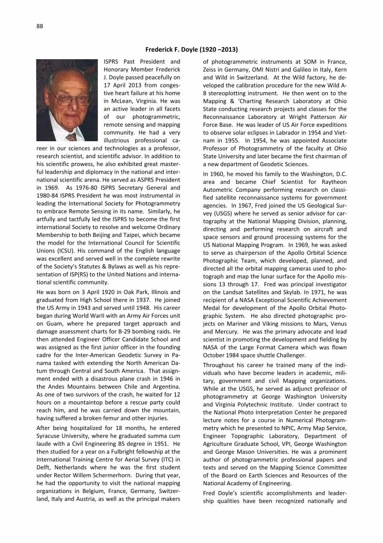
88
Frederick F. Doyle (1920 –2013)
ISPRS Past President and Honorary Member Frederick J. Doyle passed peacefully on 17 April 2013 from conges-tive heart failure at his home in McLean, Virginia. He was an active leader in all facets of our photogrammetric, remote sensing and mapping community. He had a very illustrious professional ca-
reer in our sciences and technologies as a professor, research scientist, and scientific advisor. In addition to his scientific prowess, he also exhibited great master-ful leadership and diplomacy in the national and inter-national scientific arena. He served as ASPRS President in 1969. As 1976-80 ISPRS Secretary General and 1980-84 ISPRS President he was most instrumental in leading the International Society for Photogrammetry to embrace Remote Sensing in its name. Similarly, he artfully and tactfully led the ISPRS to become the first international Society to resolve and welcome Ordinary Membership to both Beijing and Taipei, which became the model for the International Council for Scientific Unions (ICSU). His command of the English language was excellent and served well in the complete rewrite of the Society’s Statutes & Bylaws as well as his repre-sentation of ISP(RS) to the United Nations and interna-tional scientific community. He was born on 3 April 1920 in Oak Park, Illinois and graduated from High School there in 1937. He joined the US Army in 1943 and served until 1948. His career began during World WarII with an Army Air Forces unit on Guam, where he prepared target approach and damage assessment charts for B-29 bombing raids. He then attended Engineer Officer Candidate School and was assigned as the first junior officer in the founding cadre for the Inter-American Geodetic Survey in Pa-nama tasked with extending the North American Da-tum through Central and South America. That assign-ment ended with a disastrous plane crash in 1946 in the Andes Mountains between Chile and Argentina. As one of two survivors of the crash, he waited for 12 hours on a mountaintop before a rescue party could reach him, and he was carried down the mountain, having suffered a broken femur and other injuries. After being hospitalized for 18 months, he entered Syracuse University, where he graduated summa cum laude with a Civil Engineering BS degree in 1951. He then studied for a year on a Fulbright fellowship at the International Training Centre for Aerial Survey (ITC) in Delft, Netherlands where he was the first student under Rector Willem Schermerhorn. During that year, he had the opportunity to visit the national mapping organizations in Belgium, France, Germany, Switzer-land, Italy and Austria, as well as the principal makers
of photogrammetric instruments at SOM in France, Zeiss in Germany, OMI Nistri and Galileo in Italy, Kern and Wild in Switzerland. At the Wild factory, he de-veloped the calibration procedure for the new Wild A-8 stereoplotting instrument. He then went on to the Mapping & ‘Charting Research Laboratory at Ohio State conducting research projects and classes for the Reconnaissance Laboratory at Wright Patterson Air Force Base. He was leader of US Air Force expeditions to observe solar eclipses in Labrador in 1954 and Viet-nam in 1955. In 1954, he was appointed Associate Professor of Photogrammetry of the faculty at Ohio State University and later became the first chairman of a new department of Geodetic Sciences. In 1960, he moved his family to the Washington, D.C. area and became Chief Scientist for Raytheon Autometric Company performing research on classi-fied satellite reconnaissance systems for government agencies. In 1967, Fred joined the US Geological Sur-vey (USGS) where he served as senior advisor for car-tography at the National Mapping Division, planning, directing and performing research on aircraft and space sensors and ground processing systems for the US National Mapping Program. In 1969, he was asked to serve as chairperson of the Apollo Orbital Science Photographic Team, which developed, planned, and directed all the orbital mapping cameras used to pho-tograph and map the lunar surface for the Apollo mis-sions 13 through 17. Fred was principal investigator on the Landsat Satellites and Skylab. In 1971, he was recipient of a NASA Exceptional Scientific Achievement Medal for development of the Apollo Orbital Photo-graphic System. He also directed photographic pro-jects on Mariner and Viking missions to Mars, Venus and Mercury. He was the primary advocate and lead scientist in promoting the development and fielding by NASA of the Large Format Camera which was flown October 1984 space shuttle Challenger. Throughout his career he trained many of the indi-viduals who have become leaders in academic, mili-tary, government and civil Mapping organizations. While at the USGS, he served as adjunct professor of photogrammetry at George Washington University and Virginia Polytechnic Institute. Under contract to the National Photo Interpretation Center he prepared lecture notes for a course in Numerical Photogram-metry which he presented to NPIC, Army Map Service, Engineer Topographic Laboratory, Department of Agriculture Graduate School, VPI, George Washington and George Mason Universities. He was a prominent author of photogrammetric professional papers and texts and served on the Mapping Science Committee of the Board on Earth Sciences and Resources of the National Academy of Engineering. Fred Doyle’s scientific accomplishments and leader-ship qualities have been recognized nationally and

89
internationally. Heholds an Honorary Doctorate in Engineering from the Technical University of Han-nover, Germany; an Honorary Doctorate of Science from Ohio State University; Honorary Doctorates of Technology from the Royal Institute of Technology (KTH), Sweden and from the University of Bordeaux, France; is an Honorary Fellow at ITC, The Netherlands; and elected an Honorary Member of ASPRS and ISPRS. He received the Fairchild Photogrammetric Award (ASPRS-1968); Brock Gold Medal Award (ISPRS-1984); Meritorious and Distinguished Service Awards (US Department of Interior); and elected to the National Academy of Engineering (1989). In 2010, George Ma-son University established the “ASPRS Student Chapter
and Forum Dr. Frederick Doyle at GMU”. The first quadrennial “Frederick J. Doyle Award” was pre-sented, through the auspices of The ISPRS Foundation at the 2012 ISPRS Congress, to “Honor the exemplary career of Frederick J. Doyle as a role model to inspire followers and newcomers in the photogrammetry, remote sensing and spatial information sciences and technologies.” Fred is survived by his wife Mary, whom he married in 1955; four children, Fred Jr., Margaret Grant, Mary Ellen Slattery, and George; two brothers; a sister; and 10 grand-children.
Lawrence Fritz, May 2013
Dieter Klaus Zeuner (1937 – 2013)
Dieter Klaus Zeuner was born in 1939 in Sachsen, Germany. He obtained his engineering degree at the Technical University of Dres-den on February 1963. From March 1963 to August 1970, he worked for Carl Zeiss Jena in East Germany. From Septem-ber 1970 to March 1972, he worked in a managerial capac-ity at Jena Instruments Ltd. in Toronto, ON. Thereafter, he
joined Leica Canada Inc. in April of 1972 as the first manager of the Geodesy and Photogrammetry de-partment. Later in his career he was named Vice President of Leica’s Surveying Division. On December 10, 1991, Deieter became a member of the Associa-tion of Ontario Land Surveyors. On July 13, 1995 Dieter became a member of the AOLS Council. In 1999, he worked for Applanix Corporation. He retired in 2001, and passed away peacefully at the age of 74 on Sun-day, March 17, 2013 after a short illness.
Association of Ontario Land Surveyors, 2013
John William Charles Gates (1922 – 2013)
There will be many readers for whom the name John Gates will be associated with an extensive knowledge of both optics and photographic science. He died in hospital at the age of 90 on 10th July 2013.Born in London on the 11th December 1922, John William Charles Gates,
BSc, MSc, DSc, DIC, CPhys, HonFRPS, received his initial education at the Coopers’ Company School. He then attended the Sir John Cass Institute in the City of London until the outbreak of the Second World War in 1939. On leaving school in 1939, Gates worked briefly in the design office of an engineering company, John Dore & Co. Ltd., London. This was followed by two years of work in the physical laboratory of the sensitized materials manufacturer Ilford Limited, experience which gave him a scientific insight into how photographic materials responded to light and how their micro-image quality could be evaluated and improved. By dint of private study and some tuition
during the war, Gates achieved a BSc degree in General Mathematics in 1942. In the same year, he started work in the Royal Aircraft Establishment (RAE) at Farnborough, Hampshire. There he participated in the further development and application of photographic sensitometry for aerial reconnaissance and survey photography, this being regarded as a subject of high priority in the effort to gain maximum intelligence value from reconnaissance flights over enemy held areas. These activities at RAE required him to take some part in photographic trials among his other duties, flying as a member of the aircrew. While at RAE, Gates worked alongside G. C. Brock and F. J. Worton and had contact with R. W. Fish who worked in another division of RAE. Along with other scientific staff of the time at RAE, he became involved in photogrammetric matters. The work of this group further contributed significantly to a deeper understanding of the physical principles that are at the core of the image quality achievable in aerial photography. The benefits of the fundamental work undertaken by this group were to influence photographic science for many decades to come. As well as John Gates, the distinguished scientists named here were to become notable members and

90
contributors to the work of the Photogrammetric Society, with all four eventually becoming holders of the President’s Medal. It is of some historical interest to note that the building in which this group worked was later to become the National Remote Sensing Centre. In 1946, Gates commenced further studies at Imperial College of Science and Technology, where he was to gain a BSc degree in Physics, an MSc degree in Technical Optics and the Diploma of Imperial College. On leaving the College in 1949, he started work in the Light Division of the National Physical Laboratory (NPL) at Teddington, Middlesex where he continued to work until retirement on his sixtieth birthday in 1982. Initially, he was concerned with problems associated with direct measurement systems. The course of this work led him to a more detailed knowledge of fundamental physics. Among the tasks which he was given was the further development of aerial survey camera calibration, which led him into contact with many people established in photogrammetry for mapping and intelligence applications. In the course of his work at NPL, Gates produced more than 50 papers, mostly optical, which included 13 papers on basic optical processes, and 23 papers on other coherent optical processes. In addition, he wrote some 60 reviews and he is listed as producing six patents. The range of topics which his writing covered was extensive and included length measurement, optical fabrication, interferometry, dispersion, aplanatic zone plates, holography, laser systems and close range photogrammetry.
In addition to this published work, he was generous in his support for students on BSc degree courses at the Polytechnic of Central London (PCL) (later to become the University of Westminster). Industrial and scientific work experience was a pre-requisite for an honours degree there. The cross-fertilization established between academe and industry was positively supported by John Gates, to such an extent that Charles Horton, a lecturer in applied photographic science and photogrammetry at PCL, summarized the students’ reaction to Gates’s sessions at NPL as “if you want to learn, go to Teddington”. Gates was always keen to express the primacy of the lens in any camera system and he employed the graphic description of the role played by aperture size with a lens as its “light grasp”, to indicate the relationship that exists between this feature of a lens and the image quality to be expected. Put simply, this means more detail in an image requires a larger size diameter for the aperture of a lens. This kind of direct approach to describing the more technical aspects of photography was appreciated by both students and colleagues.
During the 1960s Gates had gained wider recognition, with his name appearing in the Directory of British
Scientists (Directory of British Scientists, 1966-67, Vol. 1 A – L, Ernest Benn Limited, London). However before this appeared, a significant recognition of John Gates’s knowledge and abilities had occurred in the early 1960s when Dr. Dow Smith, of the then major American reconnaissance satellite builder Itek Corporation, endeavoured to recruit him to their ranks of eminent scientists, together with G. C. Brock. Significantly at that time, Itek was engaged in the design and construction of the Corona photo-reconnaissance satellite programme. For his own reasons, Gates decided to continue his work in the UK. In 1971, Gates was appointed a Senior Principal Scientific Officer at NPL, on what is considered individual merit. In British Civil Service terms, individual merit can be regarded as disturbing original thought, and to be listed in a separate section. His colleagues gratefully acknowledged that many of the activities initiated by Gates in the Mechanical and Optical Metrology Division at NPL had a bearing on the Division’s work over many years. Dr. Richard Stevens, a colleague at NPL, recalls that in 1971 Gates was awarded the C.V. Boys Prize of the Institute of Physics, an award customarily made to younger physicists who had contributed to an innovative and practical solution to a given problem. This award was regarded at the time as recognition of particular merit by a mature physicist. The degree of Doctor of Science of the University of London was conferred on Gates in 1974.
In 1978, the work done by Gates at NPL and in photogrammetry led to him becoming Chairman of the Working Group of Commission V of the International Society for Photogrammetry and Remote Sensing (ISPRS) which was concerned with non-conventional imaging systems. This was a position that, given his very wide experience in applied physics, enabled him to appreciate the new opportunities then opening up. When, in 1980, the United Kingdom assumed responsibility for ISPRS Commission V for a four-year period, it was a logical choice for John Gates to then become President of that Commission. Gates presided over a most successful technical symposium of Commission V held at the University of York in 1982. The symposium had the theme “Precision and Speed in Close Range Photogammetry”.
Always an original thinker, Gates’s impatience with bureaucratic procedures was legendary. Rather less well known was his special technique for training scientific assistants. On the occasion of his retirement from NPL in 1982, it was observed retrospectively that “Having spent some years beating one assistant (Jean Dolphin) into shape, he decided the only way to ensure her continuing service was to marry her.” (NPL News, No. 357, Spring 1983). Following retirement from NPL, Gates was recruited by the United Nations Industrial Development

91
Organization to spread his expertise in optical instrumentation by a working visit to Chandigarh, India. This was followed in 1984 by his presiding over Commission V at the International Congress of Photogrammetry and Remote Sensing, held in Rio de Janeiro, Brazil. Further recognition of his abilities occurred in 1985 when he was appointed Visiting Professor in the Department of Photogrammetry and Surveying, University College London.
John Gates leaves his wife Jean and three children, Diane, Ruth, and Simon. He will be widely remembered as an engaging colleague and good friend.
First published in The Photogrammeric Record and reproduced with permission of the editor kindly offered for publication in eBulletin by Ian Dowman.
Kimberly A. Tilley (1953 - 2013)
It is with very deep sorrow and a tremendous sense of loss that we must inform you that Kimberly A. Tilley, Associate Executive Direc-tor and Director of Com-munications, passed away suddenly Friday evening, December 27, 2013 at her home in Bethesda, Mary-land.
Kim was a very critical resource to ASPRS, not only to her fellow staff members but to the Society’s leader-ship and the membership at large. As a colleague, she was an indispensable confidant and advisor to me, and I could not imagine how I would have effectively func-tioned as the Executive Director these past 16 years
without her help. Her contributions to the health of the Society have been numerous. Kim’s unending commitment and devotion to students in general, and specifically to the ASPRS student members, are well known. She was also the Executive Editor of PE&RS, where she was very instrumental in making the front part of the Journal of interest to the broadest audi-ence possible. However, many of her other most significant contribu-tions have occurred well below the radar screen and thus were mostly invisible to the membership. Never-theless, ASPRS would not be where it is without Kim’s untiring devotion; she truly cared for the Society, its members and its mission.
ASPRS Press Release, January, 2014
Carolyn Merry (1950 - 2014)
Merry Carolyn J. Merry, died unexpectedly on June 3, 2014. Carolyn was born in Union City, PA on September 18, 1950. She was preceded in death by her parents Mil-dred and Arthur Merry and brother Michael Merry. She is survived by her husband, Robert (Bob) Redfield of Hilliard; sister, Patricia Merry;
brothers, James Merry (Kim) and Donald Merry (Am-ber); nieces, Katie Kuhns Hughes (Kevin), Sara Kuhns Strong (Patrick), Rebecca and Rachel Merry; nephews, Michael and Read Merry and Cole and Ian Zink, and several great-nieces. Carolyn recently retired from her position as Professor and Chair of the Department of Civil, Environmental and Geodetic Engineering at The Ohio State University. She received a Ph.D. in Engi-neering, from the University of Maryland, College Park, Maryland in 1988, an M.A. in Geology, from Dartmouth College, Hanover, New Hampshire in 1977, and a B.S. in Geology, Edinboro State College, Edin-boro, Pennsylvania in 1972. She was the Valedictorian
of her graduating class at Wattsburg (PA) High School. She was a professor of Civil Engineering at The Ohio State University beginning in 1988 and taught several courses primarily in her specialty areas of remote sensing and geographic information science. She be-gan her career as a Research Physical Scientist and Geologist at the U.S. Army Cold Regions Research and Engineering Laboratory (USACRREL), Hanover, New Hampshire, from 1973 - 1988. She published over 160 papers in various forums and contributed four chap-ters in textbooks. She was active in several profes-sional organizations including the American Geophysi-cal Union, American Society of Civil Engineers, Ameri-can Society of Engineering Education, American Soci-ety of Photogrammetry and Remote Sensing, Interna-tional Association for Great Lakes Research, and the International Glaciological Society. She served in many elected and appointed positions in professional or-ganizations including President of the American Soci-ety of Photogrammetry and Remote Sensing, Presi-dent of the University Consortium for Geographic Information Science, and President of the Central Ohio Section of the American Society of Civil Engineers (ASCE). She was currently a member and Committee
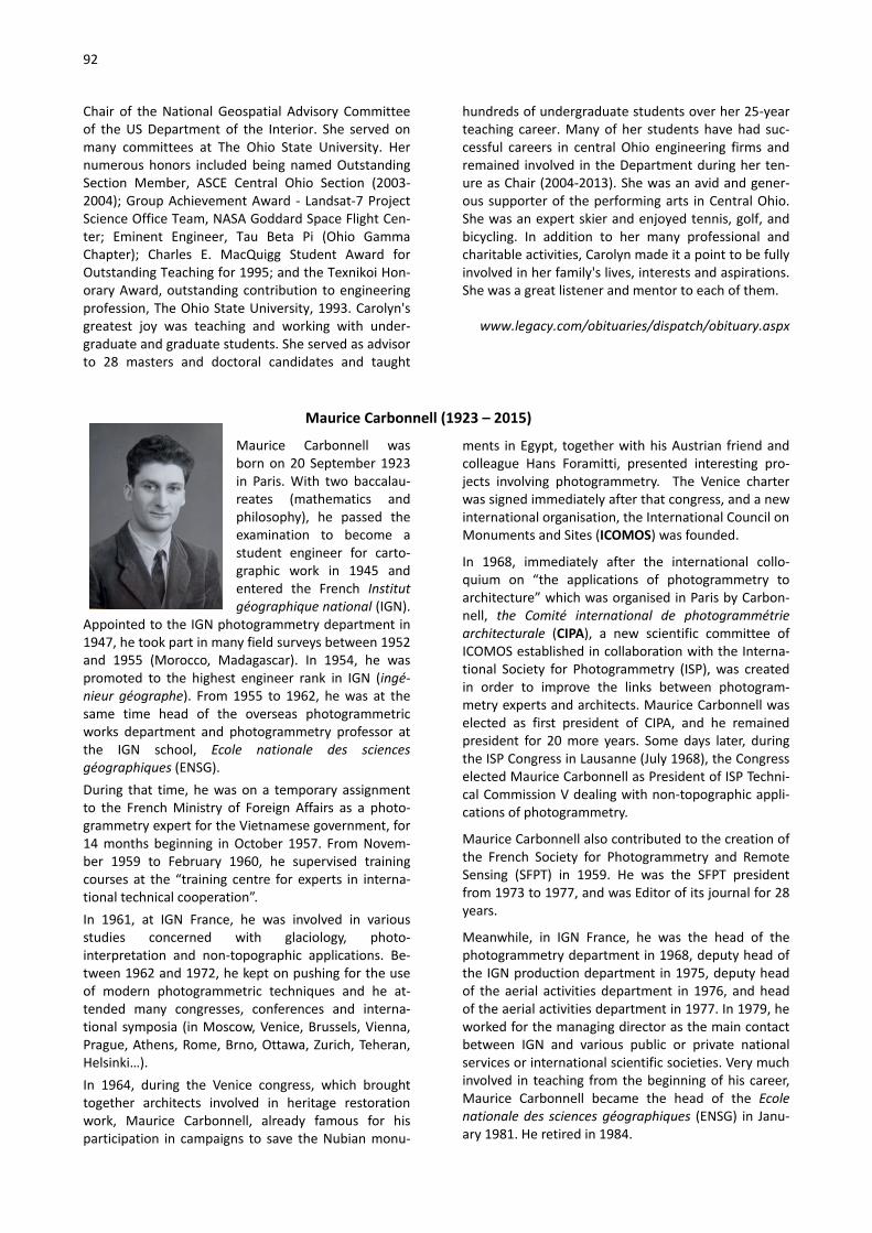
92
Chair of the National Geospatial Advisory Committee of the US Department of the Interior. She served on many committees at The Ohio State University. Her numerous honors included being named Outstanding Section Member, ASCE Central Ohio Section (2003-2004); Group Achievement Award - Landsat-7 Project Science Office Team, NASA Goddard Space Flight Cen-ter; Eminent Engineer, Tau Beta Pi (Ohio Gamma Chapter); Charles E. MacQuigg Student Award for Outstanding Teaching for 1995; and the Texnikoi Hon-orary Award, outstanding contribution to engineering profession, The Ohio State University, 1993. Carolyn's greatest joy was teaching and working with under-graduate and graduate students. She served as advisor to 28 masters and doctoral candidates and taught
hundreds of undergraduate students over her 25-year teaching career. Many of her students have had suc-cessful careers in central Ohio engineering firms and remained involved in the Department during her ten-ure as Chair (2004-2013). She was an avid and gener-ous supporter of the performing arts in Central Ohio. She was an expert skier and enjoyed tennis, golf, and bicycling. In addition to her many professional and charitable activities, Carolyn made it a point to be fully involved in her family's lives, interests and aspirations. She was a great listener and mentor to each of them.
www.legacy.com/obituaries/dispatch/obituary.aspx
Maurice Carbonnell (1923 – 2015)
Maurice Carbonnell was born on 20 September 1923 in Paris. With two baccalau-reates (mathematics and philosophy), he passed the examination to become a student engineer for carto-graphic work in 1945 and entered the French Institut géographique national (IGN).
Appointed to the IGN photogrammetry department in 1947, he took part in many field surveys between 1952 and 1955 (Morocco, Madagascar). In 1954, he was promoted to the highest engineer rank in IGN (ingé-nieur géographe). From 1955 to 1962, he was at the same time head of the overseas photogrammetric works department and photogrammetry professor at the IGN school, Ecole nationale des sciences géographiques (ENSG). During that time, he was on a temporary assignment to the French Ministry of Foreign Affairs as a photo-grammetry expert for the Vietnamese government, for 14 months beginning in October 1957. From Novem-ber 1959 to February 1960, he supervised training courses at the “training centre for experts in interna-tional technical cooperation”. In 1961, at IGN France, he was involved in various studies concerned with glaciology, photo-interpretation and non-topographic applications. Be-tween 1962 and 1972, he kept on pushing for the use of modern photogrammetric techniques and he at-tended many congresses, conferences and interna-tional symposia (in Moscow, Venice, Brussels, Vienna, Prague, Athens, Rome, Brno, Ottawa, Zurich, Teheran, Helsinki…). In 1964, during the Venice congress, which brought together architects involved in heritage restoration work, Maurice Carbonnell, already famous for his participation in campaigns to save the Nubian monu-
ments in Egypt, together with his Austrian friend and colleague Hans Foramitti, presented interesting pro-jects involving photogrammetry. The Venice charter was signed immediately after that congress, and a new international organisation, the International Council on Monuments and Sites (ICOMOS) was founded.
In 1968, immediately after the international collo-quium on “the applications of photogrammetry to architecture” which was organised in Paris by Carbon-nell, the Comité international de photogrammétrie architecturale (CIPA), a new scientific committee of ICOMOS established in collaboration with the Interna-tional Society for Photogrammetry (ISP), was created in order to improve the links between photogram-metry experts and architects. Maurice Carbonnell was elected as first president of CIPA, and he remained president for 20 more years. Some days later, during the ISP Congress in Lausanne (July 1968), the Congress elected Maurice Carbonnell as President of ISP Techni-cal Commission V dealing with non-topographic appli-cations of photogrammetry.
Maurice Carbonnell also contributed to the creation of the French Society for Photogrammetry and Remote Sensing (SFPT) in 1959. He was the SFPT president from 1973 to 1977, and was Editor of its journal for 28 years.
Meanwhile, in IGN France, he was the head of the photogrammetry department in 1968, deputy head of the IGN production department in 1975, deputy head of the aerial activities department in 1976, and head of the aerial activities department in 1977. In 1979, he worked for the managing director as the main contact between IGN and various public or private national services or international scientific societies. Very much involved in teaching from the beginning of his career, Maurice Carbonnell became the head of the Ecole nationale des sciences géographiques (ENSG) in Janu-ary 1981. He retired in 1984.

93
Maurice Carbonnell was an excellent engineer and communicator. He worked successfully in a number of positions. He was responsible for technical production in the field as well as in the office, in charge of studies and research related to photogrammetry, expert for a foreign government, head of a strategic IGN depart-ment, and president of national and international specialised scientific societies. He also wrote many high quality papers.
Finally, it is worthy of note that Maurice Carbonnell was officer of the French order of academic palms (1973) and chevalier (knight) of the French national order of merit (since 1969). He was also awarded the medal of research and technique of the French Acad-emy of Architecture (1976).
Raphaële Héno, Keith Atkinson, 2015
Alef Ahmed El Sayed Elassal (1934 - 2015)
Alef Ahmed El Sayed Elas-sal, 81, passed away on August 17, 2015 in Fort Myers, Florida. He was born in Egypt and com-pleted his engineering degree at the University of Cairo. He received his MS and PhD degrees in Photo-grammetry from the Uni-versity of Illinois in 1961
and 1963 respectively. Atef's dissertation was some of the earliest work in analytical aerial triangulation through simultaneous relative orientation of multiple cameras. Dr. Elassal began his career in private industry with Autometric Inc., a part of Raytheon Corporation, then entered government service with the U.S. Geological Survey (USGS). During the 1970's he worked at the USGS headquarters in the Office of Research and Technical Standard's Branch of Photogrammetry and, using his skills in photogrammetry and computer sci-ence, he introduced analytical photogrammetry tech-niques into the USGS's topographic mapping process. In 1979, Dr. Elassal was assigned to the Digital Applica-tions Team that was responsible for transforming the USGS analog mapping process to digital techniques. Dr. Elassal was responsible for establishing the initial data structures for both planimetric data and eleva-tion data through the Digital Line Graph (DLG) and Digital Elevation Model (DEM) formats and established the National Digital Cartographic Database for storing and distributing digital data. Dr. Elassal was active in ASPRS and was among the early pioneers in developing analytical aerotriangula-tion systems; notably the Multiple Station Analytical Triangulation (MUSAT) method. He was a member of the Birdeye Club through his donations to the ASPRS Foundation. Dr. Elassal was also active in ISPRS and served as Chair of Working Group II/5, Integrated Production Systems. He was responsible for develop-ing the General Integrated Analytical Triangulation Program (GIANT) used by USGS. In 1980, Dr. Elassal developed the Gen-eral Cartographic Transformation Package (GCTP)
which was an integrated set of programs to handle map projection computations for digital mapping ap-plications. GCTP was used by several government agencies as well as by private industry. Dr. Elassal received ASPRS's Photogrammetric Award (Fairchild) in 1977. A Google search will indicate that Dr. Elassal was the author of numerous papers and agency publications and he is referenced by many others. As the senior photogrammetrist at USGS, he provided technical assistance to many other federal agencies and private companies for both aerial and satellite applications. Many of these requests were new and novel tasks that required the expert application of analytical methods. One interesting project was his work in 1978 when the U.S. House of Representatives Select Committee on Assassinations requested USGS assistance in their investigation of the assassination of President John F. Kennedy. The assistance involved photogrammetric analyses of movie film and several snapshots. The snapshots were of Lee Harvey Oswald in the backyard of his home in Dallas in 1963, and the movie films were taken during the assassination by two separate bystanders. In the mid-1980's, Dr. Elassal was selected as the Chief of Photogrammetric Research at NOAA's National Ocean Service (NOS). While at NOAA he was responsi-ble for developing the Integrated Digital Photogram-metric Facility (IDPF) which was the underlying system that drove a network of photogrammetric devices using a common database. Dr. Elassal received the Department of Commerce's Silver Medal Award for scientific/engineering achievement in developing the IDPF system for the agency in 1989. He also received the Washington Academy of Sciences Mathematics and Computer Science award in 1989. Dr. Elassal retired from NOAA in 1995. He is survived by his wife Randi and their daughter, and also by two sons and a daughter from previous marriages and five grandchildren.
Photogrammetric Engineering & Remote Sensing, January 2016
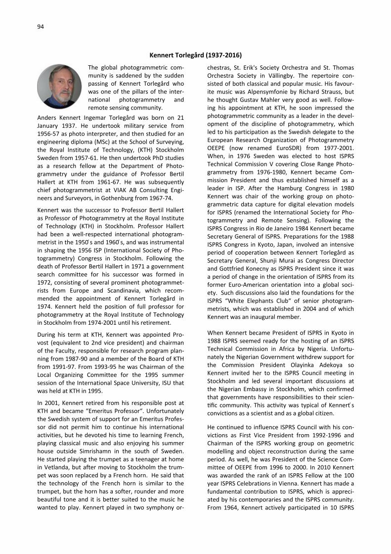
94
Kennert Torlegård (1937-2016)
The global photogrammetric com-munity is saddened by the sudden passing of Kennert Torlegård who was one of the pillars of the inter-national photogrammetry and remote sensing community.
Anders Kennert Ingemar Torlegård was born on 21 January 1937. He undertook military service from 1956-57 as photo interpreter, and then studied for an engineering diploma (MSc) at the School of Surveying, the Royal Institute of Technology, (KTH) Stockholm Sweden from 1957-61. He then undertook PhD studies as a research fellow at the Department of Photo-grammetry under the guidance of Professor Bertil Hallert at KTH from 1961-67. He was subsequently chief photogrammetrist at VIAK AB Consulting Engi-neers and Surveyors, in Gothenburg from 1967-74.
Kennert was the successor to Professor Bertil Hallert as Professor of Photogrammetry at the Royal Institute of Technology (KTH) in Stockholm. Professor Hallert had been a well-respected international photogram-metrist in the 1950 s and 1960 s, and was instrumental in shaping the 1956 ISP (International Society of Pho-togrammetry) Congress in Stockholm. Following the death of Professor Bertil Hallert in 1971 a government search committee for his successor was formed in 1972, consisting of several prominent photogrammet-rists from Europe and Scandinavia, which recom-mended the appointment of Kennert Torlegård in 1974. Kennert held the position of full professor for photogrammetry at the Royal Institute of Technology in Stockholm from 1974-2001 until his retirement.
During his term at KTH, Kennert was appointed Pro-vost (equivalent to 2nd vice president) and chairman of the Faculty, responsible for research program plan-ning from 1987-90 and a member of the Board of KTH from 1991-97. From 1993-95 he was Chairman of the Local Organizing Committee for the 1995 summer session of the International Space University, ISU that was held at KTH in 1995.
In 2001, Kennert retired from his responsible post at KTH and became “Emeritus Professor“. Unfortunately the Swedish system of support for an Emeritus Profes-sor did not permit him to continue his international activities, but he devoted his time to learning French, playing classical music and also enjoying his summer house outside Simrishamn in the south of Sweden. He started playing the trumpet as a teenager at home in Vetlanda, but after moving to Stockholm the trum-pet was soon replaced by a French horn. He said that the technology of the French horn is similar to the trumpet, but the horn has a softer, rounder and more beautiful tone and it is better suited to the music he wanted to play. Kennert played in two symphony or-
chestras, St. Erik's Society Orchestra and St. Thomas Orchestra Society in Vällingby. The repertoire con-sisted of both classical and popular music. His favour-ite music was Alpensymfonie by Richard Strauss, but he thought Gustav Mahler very good as well. Follow-ing his appointment at KTH, he soon impressed the photogrammetric community as a leader in the devel-opment of the discipline of photogrammetry, which led to his participation as the Swedish delegate to the European Research Organization of Photogrammetry OEEPE (now renamed EuroSDR) from 1977-2001. When, in 1976 Sweden was elected to host ISPRS Technical Commission V covering Close Range Photo-grammetry from 1976-1980, Kennert became Com-mission President and thus established himself as a leader in ISP. After the Hamburg Congress in 1980 Kennert was chair of the working group on photo-grammetric data capture for digital elevation models for ISPRS (renamed the International Society for Pho-togrammetry and Remote Sensing). Following the ISPRS Congress in Rio de Janeiro 1984 Kennert became Secretary General of ISPRS. Preparations for the 1988 ISPRS Congress in Kyoto, Japan, involved an intensive period of cooperation between Kennert Torlegård as Secretary General, Shunji Murai as Congress Director and Gottfried Konecny as ISPRS President since it was a period of change in the orientation of ISPRS from its former Euro-American orientation into a global soci-ety. Such discussions also laid the foundations for the ISPRS “White Elephants Club“ of senior photogram-metrists, which was established in 2004 and of which Kennert was an inaugural member.
When Kennert became President of ISPRS in Kyoto in 1988 ISPRS seemed ready for the hosting of an ISPRS Technical Commission in Africa by Nigeria. Unfortu-nately the Nigerian Government withdrew support for the Commission President Olayinka Adekoya so Kennert invited her to the ISPRS Council meeting in Stockholm and led several important discussions at the Nigerian Embassy in Stockholm, which confirmed that governments have responsibilities to their scien-�fic community. This ac�vity was typical of Kennert s convictions as a scientist and as a global citizen.
He continued to influence ISPRS Council with his con-victions as First Vice President from 1992-1996 and Chairman of the ISPRS working group on geometric modelling and object reconstruction during the same period. As well, he was President of the Science Com-mittee of OEEPE from 1996 to 2000. In 2010 Kennert was awarded the rank of an ISPRS Fellow at the 100 year ISPRS Celebrations in Vienna. Kennert has made a fundamental contribution to ISPRS, which is appreci-ated by his contemporaries and the ISPRS community. From 1964, Kennert actively participated in 10 ISPRS

95
Congresses, more than 30 ISPRS Symposia, seminars and workshops, 8 FIG Surveyors' Congresses and 5 ICA Cartographic Conferences. He will be missed at future ISPRS Congresses.
Asked why he became involved in ISPRS Kennert re-plied: “As a PhD student and a young photogrammet-rist in the 1960s and 70s I visited congresses and sym-posia so as to meet colleagues who worked with the same or similar problems and applications as I did, for discussions and exchange of experience and informa-tion. The way to contact them was to present a paper. It was also very interesting to visit the exhibition and see new instruments and products from manufactur-ers and vendors. Later when I became Professor there were other reasons for my involvement in ISPRS af-fairs; I wanted to find colleagues for joint projects in R&D; I used my international relations when supervis-ing my PhD students, i.e. through my contacts I knew who was doing what and where in R&D, or I could it find out. Then the students could make their own contacts.”
To the question on why he committed himself to a management role in ISPRS, he said the President of the Society Dr Fred Doyle had invited him to become Secretary General of ISPRS because he believed that I would be able to do the job, and he also said the he thought that it would be good for my career. Kennert replied “And so it was. My reward has been a lot of wonderful experiences and many good friends from all over the world”.
Kennert Torlegård was indeed a gentleman and an excellent scientist. While Secretary General, President and First Vice President of ISPRS he was totally com-mitted to the cause of ISPRS and did an outstanding job in advancing its future. His work for ISPRS is cele-brated by the whole community of ISPRS. His passing is a sad loss to his lovely wife Margaret, family, friends, colleagues, the ISPRS community and beyond.
John Trinder, Gottfried Konecny, February 2016

96
GENERAL ASSEMBLIES
Ordinary Member Delegates and Advisers to ISPRS General Assembly
Associate and Regional Member Representatives to ISPRS General Assembly Agenda of ISPRS General Assemblies Decisions of the General Assembly
Minutes of ISPRS General Assemblies Report of ISPRS President Chen Jun to the General Assembly for 2012-2016
Report of ISPRS Secretary General Christian Heipke to the General Assembly for 2012-2016
Report of ISPRS Treasurer Jon Mills to the General Assembly for 2012-2016 Report of ISPRS Financial Commission Chair Marie-José Lefevre-Fonollosa to the
General Assembly for 2012-2016 Report of the Editors-in-Chief of the ISPRS Journal of Photogrammetry and Remote
Sensing, Derek Lichti, Qihao Weng Report of the Editor-in-chief of the ISPRS International Journal of Geo-Information,
Wolfgang Kainz Report of ISPRS Book Series Editor, Zhilin Li Report of ISPRS Webmaster, Markus Englich
Report of TIF (The ISPRS Foundation) Chair, Board of Trustees, Dieter Fritsch Report of IPAC (International Scientific Advisory Committee) by Chair, Gunter
Schreier Report of ISAC (International Scientific Advisory Committee) by Chair, Ian Dowman
Report of I2AC (ISPRS Industry Advisory Committee) by Chair, Franz Leberl Report on ISPRS Regional Affairs in Africa by Hussein Farah
Report on ISPRS Regional Affairs in South-East Asia by Nguyen Dinh Duong Report on ISPRS Regional Affairs in Latin-American by Mario Hernandez
Report of ICORSE (International Committee on Remote Sensing of Environment) Chair, Lawrence Friedl
Report of CIPA (International Committee for Documentation of Cultural Heritage) President, Andreas Georgopoulos
Report of the Student Consortium Chair, Urša Kanjir

97
Ordinary Member Delegates and Advisers to ISPRS General Assembly
XXIII ISPRS Congress, Prague 2016
Country Cat. Delegate Adviser(s)
Algeria 3 Kesraoui Arezki Benahmed Daho Ali
Argentina 2
Australia 5 John Trinder
Austria 4 Julius Ernst Prof. Norbert Pfeifer
Azerbaijan 2 Magsad Gojamanov
Chingiz Gurbanov Camal Camalov
Bangladesh 1
Belgium 4 Eric Bayers
Botswana 1
Brazil 5
Brunei Darussalam 1
Bulgaria 2
Burkina Faso 1 Cameroon 1
Canada 8 Songian Li
Costas Armenakis Ahmed Shaker
Chile 1 Col. José Riquelme Muñoz Cpt. Juan Pablo Palacios Cergna
China 8 Zhang Jixian
Tnag Xinming Jiang Jie
China Taipei 4 Peter T. Y. Shih
Yi-Hsing Tseng Fuan Tsai
Colombia 2
Cote D'Ivoire 1
Croatia 2
Cuba 1 Pedro Martínez Fernández
Cyprus 2 Georgia Papathoma Economidou Dimitrios Skarlatos
Czech Republic 2 Karel Vach Václav Šafář Vladimír Kovařík
Denmark 3 John Kamper
Andrew Flatman Eskil Kjærshøj Nielsen
Egypt 2
El Salvador 3
Ethiopia 1
Finland 3 Dr. Petri Rönnholm
Dr. Ville Lehtola M.Sc. Arttu Julin
France 6 Marc Pierrot Deseilligny
Nicolas Paparoditis Clement Mallet Guests : Inez Burger, Eric Labergerie
Germany 8 Uwe Stilla
Hans-Gerd Maas Monika Sester
Ghana 1
Greece 2 Prof. Andreas Georgopoulos Prof. Petros Patias

98
Prof. Charalabos Ioannidis
Hong Kong 2 John Shi Wenzhong
Hungary 3 Arpad Barsi
India 6 Shailesh Nayak
VK Dadhwal PLN Raju
Indonesia 1
Iran 3
Iraq 1
Ireland 2 -
Israel 3 Ammatzia Peled
Italy 6 Giuseppina Vacca
Maria Antonia Brovelli Francesco Pirotti
Japan 7 Hirofumi CHIKATSU
Shunji Murai Takashi Fuse
Jordan 4 Brigadier General Dr. Eng. Awni Kasawneh
Eng. Nivin Hasan Jehad Hijazi
Kenya 1
Korea 2
Kuwait 2
Latvia 1
Libya 1
Lithuania 1
Malawi 2
Malaysia 2 nn
Mexico 2
Mongolia 1 M. Saandar Ochirhyuag
Morocco 3 Elgaaidi
Myanmar 2 Kyaw Sann Oo
Namibia 1
Nepal 1 Er. Laxmi Thapa
Netherlands 4 George Vosselman
Klaas van der Hoek Sisi Zlatanova
New Zealand 2
Nigeria 1
Norway 3 Ivar Maalen-Johansen
Pakistan 1 Mehar Ali Imtiaz Hassan
Peru 1
Philippines 1 Gay Jane Perez Josefino Comiso
Poland 3 Aleksandra Bujakiewicz
Krystian Pyka Zdzisław Kurczyński
Portugal 2
Qatar 1
Romania 2 Marin Alnitei Dragos Badea
Russian Federation 8 Denis Dudnikov

99
Saudi Arabia 4 Alotaibi Sattam
Alobeid Abdalla Almotairi Eid
Senegal 1
Slovak Republic 2 Marek Fraštia
Peter Barták Marko Paško
Slovenia 1 Mojca Kosmatin Fras
Dejan Grigillo Anka Lisec
South Africa 3 Julian Smit Patricia Duncan
Spain 6 Antonio Arozarena Villar
Guillermo Villa Alcázar Eduardo Núñez Maderal
Sri Lanka 3 P. Sangakkara Reynaldo R Aodrador K.R. Sarath
Sweden 5 Sara Wahlund Sara Wimanes
Switzerland 4 Francois Gervaix
Emmanuel Baltsavias Prof. Konrad Schindler
Syria 3
Tanzania 1
Thailand 2 Chaisit Preeyanupab Soontorn Romsaiyod
Turkey 4 Abdullah Okul
Ferruh Yildiz Altan Yilmaz
Ukraine 3 Khrystyna Burshtynska United Arab Emirates 6 Ahmed Murad
Nazmi Saleous Guest: Abdulla Rafia
United Kingdom 6 Ian Dowman Stuart Granshaw
Uruguay 1
USA 8 Charles Toth
Lynn E. Usery Michael Hauck
Uzbekistan 2
Venezuela 2
Vietnam 1 Nguyen Dinh Duong
Zimbabwe 1
Delegates and Advisers to ISPRS General Assembly
Associate Member Representatives to ISPRS General Assembly
XXIII ISPRS Congress, Prague 2016
Country Associate Member Name Cat. Representative
Azerbaijan State Comittee for Land and Cartography, State Aerogeodesy Corporation 2
Chile Servicio Aerofotogramétrico – Fuerza Aérea de Chile 2 Mauricio Sottolichio Oscar Hevia
China Taipei Chinese-Taipei Geoinformatics Society 1
Colombia Agustin Codazzi Geographic Institute - Research and 1

100
Developement Center in Geographic Information
Iran Iran Space Center 1 Farrokh Pourshakouri
Italy Associazione Italiana di Telerilevamento – AIT 3 Francesco Pirrotti
Korea Korean Society of Remote Sensing 1
Korea Korean Society for Geo-Spatial Info Systems 1
Morocco Centre Royal de Teledetection Spatiale 1
Pakistan Pakistan Space & Upper Atmosphere Research Commission 1
Peru Directorate of Hydrography and Navigation 1
Russian Federation
Society for Contributing Development of Photogrammetry and Remote Sensing 2 Zheltova
Thailand Geo-Informatics and Space Technology Development Agency 1
Regional Member Representatives to ISPRS General Assembly
XXIII ISPRS Congress, Prague 2016
RgM Regional Member Name Representative
AARS Asian Association on Remote Sensing Kohei Cho
AARSE AARSE - African Association of Remote Sensing of the Environment
AGILE Association of Geographic Information Laboratories in Europe
ARCSSTE-E African Regional Centre for Space Science and Technology Education – English
CRTEAN Centre Régional de Télédétection des États de l’Afrique du Nord (CRTEAN)
CSSTEAP Centre for Space Science and Technology Education in Asia and the Pacific
EARSeL European Association of Remote Sensing Laborataries
EIS Africa EIS Africa
EuroSDR EuroSDR
OACT African Association of Cartography & Remote Sensing (OACT)
PAIGH Cartography Commission, Pan American Institute for Geography and History
José Riquelme Munoz
Juan Pablo Palacios Cergna
RCMRD Regional Centre for Mapping of Resources for Development Hussein Farah
RECTAS Regional Centre for Training in Aerospace Surveys (RECTAS)

101
AGENDA OF ISPRS GENERAL ASSEMBLIES
XXIII ISPRS Congress, Prague 2016
GA I: Tuesday July 12, 09.30 - 16.00
01. Opening Address Introduction of Guests
02. Certification of Delegate Credentials Confirmation of Voting Rights
03. Approval of Agenda 04. Admission of New Members and Changes
of Category Since Last Congress 05. Approval of New Fellows 06. Ratification of Council Agreements 07. Member Proposals to Host Commissions
2016 - 2020 7.1.1 Com I – CIG, Canada 7.1.2 Com I – DGPF, Germany 7.2.1 Com II – ASPRS, USA 7.2.2 Com II – SIFET, Italy 7.3 Com III – CSSMG, China 7.4 Com IV – GIN, Netherlands 7.5.1 Com V – CTSPRS, Chinese Taipei 7.5.2 Com V – ISRS, India 08. Member Proposals to Host ISPRS Congress
in 2020 8.1 Candidate 1 – UAE 8.2 Candidate 2 – France 8.3 Candidate 3 – Canada 09. Report of Council (1) 9.1 Report of the President 9.2 Presentation and adoption of Prague
Declaration 10. Proposal of Amendments to the Statutes
and Bylaws
GA II: Wednesday July 13, 13.30 - 18.00 11. Roll Call, Election of Members to Host
Commissions 2016 - 2020 12. Report from the Regional Representatives 12.1 Africa 12.2 South-East Asia 12.3 Latin America 13. Report of Council (2) 9.3 Report of the 1st Vice President 13.1 Report of the Secretary General 13.2 Report of the Treasurer 14. Report of Financial Commission 32.1 IPAC - International Policy Advisory
Committee 18. Results of Commission Elections 15. Nominations for Council 16. Nominations for Financial Commission
2016 - 2020 17. Nominations for the Fellows Committee
19. Discussion of Amendments to Statutes and Bylaws
20. Report on ISPRS Journals 21. Report on Book Series 22. Report on Website 23. Item amended to 9.2 GA III: Saturday July 16, 13.30 - 18.00
24. Roll Call, Election of Member to Host the ISPRS Congress in 2020
25. Election of Council 25.4 Election of Second Vice President 25.5 Election of Treasurer 25.1 Election of President 25.2 Election of Secretary General 25.3 Election/Appointment of First Vice
President 26. Ratification of Congress Director 27. Election of Chair and Members of the
Financial Commission and Members of the Fellows Committee
28. Proposal and Ratification of Regional Representatives 2016 - 2020
in parallel to 24 - 28 31. Report on ISPRS Foundation 32. Reports from ISPRS Committees 32.3 I2AC - International Industry Advisory
Committee 32.2 ISAC - International Science Advisory
Committee 32.4 ICORSE - International Committee on
Remote Sensing of Environment 32.5 CIPA - Heritage Documentation 32.6 Student Consortium 04b. Admission of New Members and Changes
of Category Since Last Congress 29. Presentation of Resolutions 30. Decision on Amendments to Statutes and
Bylaws GA IV: Monday July 18, 13.30 - 18.00
33. Congress Director's Report 34. Approval of Resolutions for 2016 - 2020 Short announcement of Japan 35. Date of the Next General Assembly
July 12-19 June 28 - July 5 Aug 30 - Sept 6
36. Any Other Business 37. Close of General Assembly

102
Decisions of the General Assembly
The General Assembly:
Approved the Agenda
The General Assembly:
Approved the following new members which had been admitted since the Melbourne Congress:
3 new Ordinary Members:
⋅ Baku State University, Azerbaijan, category 2
⋅ Côte d’Ivoire Géomatique, Ivory Coast, category 1
⋅ Philippine Geosciences and Remote Sensing Society, Philippines, category 1
2 new Associate Members:
⋅ State Committee for Land and Cartography, State Aero-geodesy Corporation, Azerbaijan, category 2
⋅ Servicio Aerofotogramétrico del General Juan Soler Manfredini de la Fuerza Aérea de Chile, category 2
1 new Regional Member: ⋅ AGILE - Association of Geographic Information
Laboratories in Europe, Netherlands
6 new Sustaining Members:
⋅ NASTEC - Nagaland Science & Technology Council, India
⋅ BASIR - Remote Sensing Institute, Iran
⋅ VisionMap, Israel
⋅ Foxel SA, Switzerland
⋅ MOMRA - Ministry of Municipal and Rural Affairs, Saudia Arabia
⋅ Teledyne, Canada
The General Assembly:
Approved the following changes in membership category since the Melbourne Congress:
2 Sustaining Members:
⋅ VisionMap, Israel, B to C
⋅ Vietnam Association of Geodesy, Cartography and Remote Sensing, Vietnam, B to E
The General Assembly:
Approved the following changes in membership during Congress:
1 New Ordinary Member:
⋅ National Survey Authority, Ministry of Defence, Oman, category 1
3 Ordinary Member category changes:
⋅ Remote Sensing Center, UAE, from category 1 to 6
⋅ Israeli Society of Photogrammetry & Remote Sensing, from category 3 to 2
⋅ Spanish Society of Cartography, Photogrammetry & Remote Sensing, from category 6 to 3
1 Takeover of Membership:
⋅ Belgium Ordinary Member organisation changed from National Geographical Institute to VITO NV
3 new Associate Members:
⋅ Canadian Remote Sensing Society, Category 2
⋅ Myanmar Peacebuilding and Dialogue Center,
Category 1
⋅ Centre de Cartographie et de Télédétection (CCT)
Cote D'Ivoire, category 1
1 new Sustaining Member:
⋅ Good Shepherd Engineering, Palestine, Category D
The General Assembly:
Approved the appointment of the following Fellows:
⋅ Alain Baudoin (France)
⋅ Jiang Jie (China)
⋅ Franz Leberl (Austria)
⋅ Petros Patias (Greece)
⋅ Ammatzia Peled (Israel)
The General Assembly:
Ratified changes to MoUs and Contracts:
MOUs – new agreements with 3 professional
organisations:
⋅ OSGeo -Open Source Geospatial Foundation
⋅ EuroSDR
⋅ AGILE - Association for Geographic Information Laboratories in Europe
Seven contracts have been signed:

103
⋅ MDPI, Amendment I to the Journal Publishing Agreement from 8 August 2011
⋅ MDPI, Amendment II to the Journal Publishing Agreement from 8 August 2011
⋅ Elsevier BV, Journal Publishing Agreement
⋅ Copernicus GmbH, Publishing Agreement for Archives and Annals
⋅ Copernicus GmbH, Contract for Credit Card Payment System
⋅ Taylor and Francis, Memorandum of Agreement for ISPRS Book Series Publications
⋅ TIB Archive and Distribution Agreement
The General Assembly:
Elected the following Members to host Technical Commissions:
TC1: Germany/Brazil
TC2: Italy/Japan
TC3: China/Canada
TC4: The Netherlands/Canada
TC5: India
The General Assembly:
Ratified the appointment of:
Nicolas Paparoditis (France) as the Congress Director
Chen Jun (China) as First Vice President
The General Assembly:
Elected the following Members of Council:
Christian Heipke (Germany) as President
Lena Halounová (Czech Republic) as Secretary General
Charles Toth (USA) as Second Vice President
Songnian Li (Canada) as Treasurer
The General Assembly:
Elected as Members of the Financial Commission:
Jon Mills (UK)
Manos Baltsavias (Switzerland)
George Vosselman (The Netherlands)
The General Assembly:
Elected as members of the Fellows Committee:
Marie-José Lefèvre (France)
Eberhard Gülch (Germany)
The General Assembly:
Elected the following as Regional Representative to Council:
Africa: Hussein Farah
East Asia: Lal Samarakoon
Latin-America: Mario Hernandez
The General Assembly:
Ratified the amendments to the Status and Bylaws
The General Assembly:
Approved of the Resolutions of the Congress

104
MINUTES OF ISPRS GENERAL ASSEMBLIES
GA I - Tuesday, July 12, 9:30 - 16:00
1. Opening Address, Introduction of Invited Persons
ISPRS President Chen Jun opened the meeting at 9:30.am. Following his opening speech he introduced the invited guests:
• Chris Rizos - President - Joint Board of Geospatial Information Societies (JBGIS)
• Chryssy Alex. Potsiou - President, International Federation of Surveyors (FIG)
• Menno-Jan Kraak - President, International Cartographic Association (ICA)
• Dave Lovell, President-elect, Global Spatial Data Infrastructure Association (GSDI)
• Ron Lofton - President, International Map Industry Association (IMIA)
• Ted Florence - incoming President, IMIA, International Map Industry Association
• Barbara Ryan, Secretariat Director of the intergovernmental Group on Earth Observations (GEO)
Honorary Members and other former Council Members were also present as well as delegates or advisors.
2. Certification of Delegate Credentials, Explanation and Confirmation of Voting Rights
Delegate credentials were confirmed during GA registration. SG explained the voting rights.
3. Approval of Agenda
The agenda was approved.
4. Membership Development
New Ordinary Members
The following three Ordinary Members have been admitted since the Melbourne Congress:
ID Member Name Country Cat. Membership Date
10006 Baku State University Azerbaijan 2 26.10.2012
10113 Côte d’Ivoire Géomatique Ivory Coast 1 24.06.2015
10072 Philippine Geosciences and Remote Sensing Society Philippines 1 10.09.2015
Discontinued Ordinary Members
The following two Ordinary Members have cancelled membership since the Melbourne Congress:
ID Member Name Country Cat. Cancellation Date
10072 Philippine Society of P & RS Philippines 1 10.09.2015
10112 Chamber of authorized Architects and Engineers (of FYROM) Macedonia 2 07.12.2015
Change of Ordinary Member Category
The following Ordinary Member requested a change of category since the Melbourne Congress:
ID Member Name Category Date of Request
10095 Remote Sensing Center, UAE 1 to 6 23.01.2015 (request granted by Council)

105
New Associate Member Two Associate Members have been admitted since the Melbourne Congress, one additional application was received shortly before the Prague Congress:
ID Member Name Country Cat. Membership Date
20017 State Committee for Land and Cartography, State Aero-geodesy Corporation
Azerbaijan 2 12.12.2013
20018 Servicio Aerofotogramétrico del General Juan Soler Manfredini de la Fuerza Aérea de Chile
Chile 2 21.03.2016
New Regional Member The following Regional Member has been admitted since the Melbourne Congress:
ID Member Name Membership Date
30017 AGILE - Association of Geographic Information Laboratories in Europe, Netherlands 23.09.2014
New Sustaining Members The following six Sustaining Members have been admitted since the Melbourne Congress:
ID Name Country Cat. Membership Date
40123 NASTEC - Nagaland Science & Technology Council India D 22.10.2013
40124 BASIR - Remote Sensing Institute Iran E 22.10.2013
40125 VisionMap Israel B 05.05.2014
40126 Foxel SA Switzerland D 15.01.2015
40127 MOMRA - Ministry of Municipal and Rural Affairs Saudia Arabia C 24.02.2015
Discontinued Sustaining Members
The following 26 Sustaining Members have cancelled membership since the Melbourne Congress or have
been expelled by Council for lack of membership payment:
ID Name Country Cat. Cancellation Date
40069 ScanEx Research and Development Center Russia C 06.10.2012
40086 ITU Centre for Satellite Communications and Remote Sensing Turkey E 20.12.2012
40071 Mescioglu Engineering Turkey D 20.12.2012
40088 INTA SpaceTurk Turkey C 20.12.2012
40080 PROSIGCONSULT Romania D 24.01.2013
40024 SOVINFORMSPUTNIK Russia C 11.03.2013
40055 e-HD.com Korea D 03.06.2013
40083 Selcuk University Division of Photogrammetry Turkey E 05.06.2013

106
40063 Istanbul Technical University, Div. of Photogrammetry Turkey E 05.06.2013
40026 COWI A/S Denmark B 31.12.2013
40106 Geo:Connexion Ltd UK D 04.03.2014
40056 Seagate Nepal D 17.12.2014
40115 Gatewing NV Belgium D 11.02.2015
40118 Silver Data Spatial-GIS China B 11.02.2015
40054 INFOMAP Novi Grad d.o.o. Bosnia Herzegovina D 16.04.2015
40103 SENSON LTD Georgia D 16.04.2015
40105 Virtual Geomatics USA D 16.04.2015
40077 Global Scan Technologies UAE D 16.04.2015
40075 EMI Group Information Technologies Inc. Turkey C 09.06.2015
40101 Municipality of Istanbul-Mapping Department Turkey B 14.12.2015
40017 FM-International Oy FINNMAP Finland C 31.12.2015
40066 ImageSat International NV Israel D 10.07.2016
40087 METU, Department of Geodetic and Geographic Information Technol Turkey E 10.07.2016
40110 Nnamdi Azikiwe University, Department of Surveying and Geoinformatics Nigeria E 10.07.2016
40073 Société des Etudes de Projets et Réalisation des Travaux Morocco D 10.07.2016
40043 UCL, Department of Civil, Environmental and Geomatic Engineering United Kingdom E 10.07.2016
Change of Sustaining Member Category The following 2 Sustaining Members requested a change of category since the Melbourne Congress:
ID Name Country Cat. Date of Request
40125 VisionMap Israel B to C 26.01.2015
40114 Vietnam Association of Geodesy, Cartography and Remote Sensing Vietnam B to E 20.10.2015
During the Congress the following changes in membership were approved by the General Assembly:
Ordinary Members
New Member:
National Survey Authority, Ministry of Defence, Oman - Category 1
Category Change:
Israeli Society of Photogrammetry & Remote Sensing (ILSPRS) – from 3 to 2
Spanish Society of Cartography, Photogrammetry & Remote Sensing (SECFT) from 6 to 3

107
Takeover of Membership:
Belgium Ordinary Member organisation changed from National Geographical Institute to VITO NV
Associate Members
New Member:
Canadian Remote Sensing Society (CRSS) - Category 2
Myanmar Peacebuilding and Dialogue Center - Category 1
Centre de Cartographie et de Télédétection (CCT) Cote D'Ivoire – Category 1
Sustaining Members
New Member:
Good Shepherd Engineering, Palestine - Category D
The present membership is as follows:
Category 1 2 3 4 5 6 7 8 A B C D E Total
OdM 31 25 14 8 3 5 1 5
92
AsM 11 4 1
16
RgM 15
15
StM
5 7 10 22 14 58
Individual membership
Individual membership was introduced in 2014 and is based on a yearly renewal. For 2016, there were 363 Individual members as of July 12.
5. Approval of new Fellows
The General Assembly elected the following Fellows:
• Alain Baudoin (France)
• Jiang Jie (China)
• Franz Leberl (Austria)
• Petros Patias (Greece)
• Ammatzia Peled (Israel)
6. Ratification of Council Agreements
All of the following agreements and contracts were ratified by the General Assembly according to the documents.
Memoranda of Understanding between ISPRS and other Organisations
Name of Organisation Date Remarks
OSGeo -Open Source Geospatial Foundation October, 2014 Annual review and renewal
EuroSDR 11. Sept. 2013 6 month written termination by either party
AGILE - Association for Geographic Information Laboratories in Europe
05. June, 2014 6 month written termination by either party
ISPRS Contracts and Agreements 2012-16
Partner Title Validity (date of sign.) Remarks
1 MDPI Amendment I to the Journal Publishing Agreement from 8 August 2011
01.01.2015 - 31.12.2017 (08.12.2014)
For IJGI
2 MDPI Amendment II to the Journal Publishing Agreement from 8 August 2011
01.01.2016 - 31.12.2017 (25.11.2015)
For IJGI

108
3 Elsevier BV Journal Publishing Agreement 01.01.2016 - 31.12.2020 (25.01.2016)
For IJPRS. Automatic renewal for a four year period unless 18 months written notice given
4 Copernicus GmbH
Agreement 01.01.2015 - 31.12.2018 (10.09.2014)
For Archives and Annals and Service Package D Automatic renewal unless 12 months written notice given
5 Copernicus GmbH
Contract 01.01.2014 - Indefinite (11.11.2013)
For Credit Card Payment System Termination by either party with 3 months written notice
6 Taylor and Francis
Memorandum of Agreement for ISPRS Book Series Publications
02.03.2016 -indefinite (22.03.2016)
Termination by either party with 9 months written notice
7 TIB Archive and Distribution Agreement
21.05.2014 - 31.12.2014 (21.05.2014)
Automatic renewal unless 12 months written notice given
7. Member Proposals to host Commissions 2016-2021
The following members presented proposals to host the respective commissions:
7.1.1 Com I – CIG, Canada, with SASPRS, South Africa, for Vice Presidency
Candidate for TCP: Jonathan Li, Candidate for Vice-TCP: Julian Smit
7.1.2 Com I – DGPF, Germany, with Brazilian Society of Cartography for Vice Presidency
Candidate for TCP: Stefan Hinz, Candidate for Vice-TCP: Raul Feitosa
7.2.1 Com II – ASPRS, USA, with Geo- Information Netherlands for Vice Presidency
Candidate for TCP: Jie Shan, Candidate for Vice-TCP: Sander Oude Elberink
7.2.2 Com II – SIFET, Italy, with JSPRS, Japan, for Vice Presidency
Candidate for TCP: Fabio Remondino, Candidate for Vice-TCP: Takashi Fuse
7.3 Com III – CSSMG, China, with CIG, Canada, for Vice Presidency
Candidate for TCP: Jiang Jie, Candidate for Vice-TCP: Ahmed Shaker
7.4 Com IV – GIN, Netherlands, with CIG, Canada, for Vice Presidency
Candidate for TCP: Sisi Zlatanova, Candidate for Vice-TCP: Suzana Dragicevic
7.5.1 Com V – CTSPRS, Chinese Taipei with ASPRS, USA, for Vice Presidency
Candidate for TCP: Fuan Tsai, Candidate for Vice-TCP: Rakesh Malhotra
7.5.2 Com V – ISRS, India
Candidate for TCP: A. Senthi Kumar, Candidate for Vice-TCP: P.L.N. Raju
8. Member Proposals to host ISPRS Congress in 2020
The following proposals were presented:
8.1 Candidate 1 – United Arab Emirates - Dubai
Candidate Congress Director: Hussein M. Abdulmuttalib - Dubai Municipality
8.2 Candidate 2 – France - Nice
Candidate Congress Director: Nicolas Paparoditis - Institut national de l'information géographique et forestière (IGN)
8.3 Candidate 3 – Canada - Quebec
Candidate Congress Director: Bernier Monique, Institut national de la recherche scientifique
9. Report of Council
9.1 President's Report
Chen Jun reported on the challenges, achievements and events of the last four years.

109
9.2 Presentation of Prague Declaration
Following the presentation of the Prague Declaration, an intensive discussion took place before the paper was adopted with some changes.
The Swiss delegate, Armin Grün, and the Indian delegate, Shailesh Nayak, expressed their appreciation for the achievements made by Council in the past term.
Barbara Ryan, Secretariat Director of the inter-governmental Group on Earth Observations (GEO) also
expressed her appreciation for the collaboration between ISPRS and GEO.
10. Proposal of Amendments to the Statutes and Bylaws
The proposed amendments were discussed. It was established that further changes were needed and the
Agenda item would be revisited in GA II.
The meeting closed at 16:00.
GA II - Wednesday, July 13, 13:30 - 18:00
11. Roll Call, election of Members to host Commissions 2016-2020
Following the roll call, the election took place. The Swiss delegate, Armin Grün, and the Austrian delegate, Norbert Pfeifer, were elected by the General Assembly
to count the ballots, and Jon Mills from Council was appointed to observe the counting.
The following Ordinary Member delegates were present:
Country Cat. Ordinary Member Name Delegate, Advisers
Algeria 3 Institut National de Cartographie et de Teledetection Kesraoui Arezki Benahmed Daho Ali
Australia 5 Surveying and Spatial Sciences Institute - Remote Sensing & Photogrammetry Commission John Trinder
Austria 4 Österreichische Gesellschaft für Vermessung & GeoInformation
Julius Ernst Prof. Norbert Pfeifer
Azerbaijan 2 Azerbaijan representation of ISPRS - Baku State University
Magsad Gojamanov Chingiz Gurbanov Camal Camalov
Canada 8 Canadian Institute of Geomatics Songian Li Costas Armenakis Ahmed Shaker
Chile 1 Sociedad Chilena de Fotogrametria y Sensores Remotos
Col. José Riquelme Muñoz Cpt. Juan Pablo Palacios Cergna
China 8 Chinese Society of Geodesy Photogrammetry & Cartography
Zhang Jixian Tnag Xinming Jiang Jie
China Taipei 4 Chinese Taipei Society of Photogrammetry & Remote Sensing
Peter T. Y. Shih Yi-Hsing Tseng Fuan Tsai
Cuba 1 GEOCUBA Pedro Martínez Fernández
Cyprus 2 Department of Lands and Surveys Georgia Papathoma Economidou Dr Dimitrios Skarlatos
Czech Republic 2 Society for Photogrammetry and Remote Sensing
Karel Vach Václav Šafář Vladimír Kovařík
Denmark 3 Geoforum Danmark John Kamper Andrew Flatman Eskil Kjærshøj Nielsen

110
Finland 3 Finnish Society of Photogrammetry & Remote Sensing Dr. Petri Rönnholm Dr. Ville Lehtola M.Sc. Arttu Julin
France 6 Societe Francaise de Photogrammatrie et de Teledetection
Marc Pierrot Deseilligny Nicolas Paparoditis Clement Mallet Guests : Inez Burger, Eric Labergerie
Germany 8 Deutsche Gesellschaft für Photogrammetrie, Fernerkundung und Geoinformation e.V.
Uwe Stilla Hans-Gerd Maas Monika Sester
Greece 2 Hellenic Society for Photogrammetry & Remote Sensing
Prof. Andreas Georgopoulos Prof. Petros Patias Prof. Charalabos Ioannidis
Hong Kong 2 Hong Kong Institute of Surveyors Professor John Shi Wen-zhong
Hungary 3 Hungarian Society of Surveying, Mapping and Remote Sensing
Arpad Barsi 2 to be decided
India 6 Indian Society of Remote Sensing Dr. Shailesh Nayak Dr. VK Dadhwal PLN Raju
Israel 3 Israeli Society of Photogrammetry & Remote Sensing Ammatzia Peled
Italy 6 Societa’ Italiana di Fotogrammetria e Topografia Giuseppina Vacca Maria Antonia Brovelli Francesco Pirotti
Japan 7 Japan Society of Photogrammetry & Remote Sensing Hirofumi CHIKATSU Shunji MURAI Takashi FUSE
Jordan 4 Royal Jordanian Geographic Centre Brigadier General Dr.Eng.Awni Kasawneh Eng. Nivin Hasan
Mongolia 1 Mongolian Nat'l Society for Photogrammetry & Remote Sensing
Dr. M. Saandar Ochirhyuag
Nepal 1 Nepal Remote Sensing and Photogrammetric Society Er. Laxmi Thapa
Netherlands 4 Geo-Information Netherlands
George Vosselman Klaas van der Hoek Sisi Zlatanova
Norway 3 GeoForum Ivar Maalen-Johansen
Philippines 1 Philippine Geosciences and Remote Sensing Society Gay Jane Perez Dr. Josefino Comiso
Poland 3 Polish Society for Photogrammetry and Remote Sensing
Aleksandra Bujakiewicz Krystian Pyka Zdzisław Kurczyński
Romania 2 Romanian Society for Photogrammetry & Remote Sensing
Col.(ret)eng. Marin Alnitei Prof.dr.eng. Dragos Badea
Russian Federation 8 Federal Service of State Registration, Cadastre and
Cartography (Rosreestr) Denis Dudnikov
Slovak Republic 2 Slovak Society for Photogrammetry and Remote
Sensing
Marek Fraštia Peter Barták Marko Paško
Slovenia 1 Association of Slovenia Surveyors - Section of Photogrammetry & Remote Sensing
Mojca Kosmatin Fras Dejan Grigillo Anka Lisec

111
South Africa 3 South African Society for Photogrammetry and Remote Sensing
Dr Julian Smit Patricia Duncan
Sweden 5 Kartografiska Sällskapet - Swedish Cartographic Society
Sara Wahlund Sara Wimanes
Switzerland 4 Swiss Society of Photogrammetry and Remote Sensing
Francois Gervaix Dr. Emmanuel Baltsavias Prof. Dr. Konrad Schindler
Thailand 2 Royal Thai Survey Department Col. Chaisit Preeyanupab Col. Soontorn Romsaiyod
Turkey 4 Turkish National Society of Photogrammetry and Remote Sensing
Abdullah OKUL Prof.Dr.Ferruh YILDIZ Dr. Altan Yilmaz
United Arab Emirates 6 Remote Sensing Center - Fac. of Science - Geology
Dept.
Dr. Ahmed Murad Dr. Nazmi Saleous Guests: Mr. Abdulla Rafia
United Kingdom 6 Remote Sensing and Photogrammetry Society Ian Dowman
Stuart Granshaw
USA 8 ASPRS Charles Toth Lynn E. Usery Michael Hauck
Vietnam 1 Vietnam Academy of Science and Technology, Institute of Geography Nguyen Dinh Duong
12. Reports from the Regional Representatives
Reports were given from the Regional Representatives for the respective regions:
12.1 Africa - Hussein Farrah
12.2 South East Asia - Nguyen Dinh Duong
12.3 Latin America - Mario Hernandez
13. Reports of Council
The following Council members reported on the past
four year period:
9.3 1st Vice President
13.1 Secretary General
13.2 Treasurer
14. Report of Financial Commission
Marie-José Lefèvre-Fonollosa, Chair of the Financial
Commission presented the 2012-16 report.
32.1 Report of IPAC
Gunter Schreier, IPAC Chair, reported on the events of the past four year term of the committee.
15. Nominations for Council
The following nominations were received:
• Christian Heipke (Germany) for President
• Lena Halounová (Czech Republic) for Secretary General.
• Songnian Li, (Canada), Petros Patias, (Greece) and Charles Toth, (USA) for 2nd Vice President.
• Songnian Li, (Canada), and Charles Toth, (USA) for Treasurer.
The three candidates for the 2nd Vice Presidency gave a presentation on their views for the future direction of the society.
16. Nominations for Financial Commission
This item was revisited in GA III.
17. Nominations for the Fellows Committee
The UK delegate, Ian Dowman nominated Costas Armenakis (Canada), and the Swiss delegate, Francois Gervaix nominated Manos Baltsavias (Switzerland) for the Fellows Committee.
18. Results of Commission Elections
Secret elections for the hosts of the Technical

112
Commissions I, II and V were held. As there was only one application for Commissions III and IV, the candidates were voted in by acclamation.
The results of the elections were:
• Com. I Sensor Systems
Germany / Brazil (120 out of 160)
President: Stefan Hinz, Karlsruhe Institute of Technology, Germany
Vice President: Raul Feitosa, Universidade Católica of Rio de Janeiro, Brazil
• Com. II Photogrammetry
Italy / Japan (99 out of 160)
President: Fabio Remondino, Fondazione Bruno Kessler, Trento, Italy
Vice President: Takashi Fuse, University of Tokyo, Japan
• Com. III Remote Sensing
China / Canada
President: Jiang Jie, National Geomatics Center of China, China
Vice-president: Ahmed Shaker AbdElrahman, Ryerson University, Canada
• Com. IV Spatial Information Science
The Netherlands / Canada
President: Sisi Zlatanova, Delft University of Technology, The Netherlands
Vice President: Suzana Dragicevic, Simon Fraser University, Burnaby, Canada
• Com. V Education and Outreach
India / India (96 out of 160)
President: A. Senthil Kumar, Indian Institute of Remote Sensing, India
Vice President: P.L.N. Raju, North East Space Application Centre, India
19. Discussion of Amendments to Statutes and
Bylaws
The amendments were discussed.
20. Report on Journals
20.2 Derek Lichti, Editor-in-Chief, reported on the status of the ISPRS Journal of Photogrammetry and Remote Sensing.
20.1 Wolfgang Kainz, Editor-in-Chief, reported on the status of the ISPRS Journal of Geo-Information.
The Netherlands delegate and former editor-in-chief of the ISPRS Journal of Photogrammetry and Remote Sensing, George Vosselman, as well as Marguerite Madden and Chen Jun on behalf of Council, expressed their gratitude for the positive resonance achieved through the hard work of the Editors-in-Chief, Derek and Qihao Weng as well as Wolfgang Kainz, and their teams.
21. Report on Book Series
Zhilin Li, Editor of the Book Series reported on the Series.
Chris Gold presented his new Book Series publication: Spatial Context: An Introduction to Fundamental Computer Algorithms for Spatial Analysis.
22. Report on Website
The Web Master, Markus Englich, reported on the status of the web site.
Chen Jun expressed his thanks, on behalf of the ISPRS, to the Stuttgart University for the continuing support by hosting the Web Master and the server.
23. Item amended. See item 9.2
The meeting was closed at 18:00.
GA III - Saturday, July 16, 13:30 - 18:00
24. Roll Call and Election of Member to Host the ISPRS Congress in 2020
There were 47 members eligible to vote, with a total
of 171 possible votes. The absolute majority necessary to be elected was 86 votes.
The Swiss delegate, Armin Grün, and the Austrian

113
delegate, Norbert Pfeifer, were elected by the General Assembly to count the ballots, and Jon Mills from Council was appointed as observer.
The following Ordinary Member delegates were present:
Country Cat. Ordinary Member Name Delegate, Advisers
Algeria 3 Institut National de Cartographie et de Teledetection Kesraoui Arezki Benahmed Daho Ali
Australia 5 Surveying and Spatial Sciences Institute - Remote Sensing & Photogrammetry Commission John Trinder
Austria 4 Österreichische Gesellschaft für Vermessung & GeoInformation
Julius Ernst Prof. Norbert Pfeifer
Azerbaijan 2 Azerbaijan representation of ISPRS - Baku State University
Magsad Gojamanov Chingiz Gurbanov Camal Camalov
Canada 8 Canadian Institute of Geomatics Songian Li Costas Armenakis Ahmed Shaker
Chile 1 Sociedad Chilena de Fotogrametria y Sensores Remotos Col. José Riquelme Muñoz Cpt. Juan Pablo Palacios Cergna
China 8 Chinese Society of Geodesy Photogrammetry & Cartography
Zhang Jixian Tnag Xinming Jiang Jie
China Taipei 4 Chinese Taipei Society of Photogrammetry & Remote Sensing
Peter T. Y. Shih Yi-Hsing Tseng Fuan Tsai
Cuba 1 GEOCUBA Pedro Martínez Fernández
Cyprus 2 Department of Lands and Surveys Mrs Georgia Papathoma Economidou Dr Dimitrios Skarlatos
Czech Republic 2 Society for Photogrammetry and Remote Sensing
Karel Vach Václav Šafář Vladimír Kovařík
Denmark 3 Geoforum Danmark John Kamper Andrew Flatman Eskil Kjærshøj Nielsen
Finland 3 Finnish Society of Photogrammetry & Remote Sensing Dr. Petri Rönnholm Dr. Ville Lehtola M.Sc. Arttu Julin
France 6 Societe Francaise de Photogrammatrie et de Teledetection
Marc Pierrot Deseilligny Nicolas Paparoditis Clement Mallet Guests : Inez Burger, Eric Labergerie
Germany 8 Deutsche Gesellschaft für Photogrammetrie, Fernerkundung und Geoinformation e.V.
Uwe Stilla Hans-Gerd Maas Monika Sester
Greece 2 Hellenic Society for Photogrammetry & Remote Sensing Prof. Andreas Georgopoulos Prof. Petros Patias Prof. Charalabos Ioannidis

114
Hong Kong 2 Hong Kong Institute of Surveyors Professor John Shi Wenzhong
Hungary 3 Hungarian Society of Surveying, Mapping and Remote Sensing
Arpad Barsi 2 to be decided
India 6 Indian Society of Remote Sensing Dr. Shailesh Nayak Dr. VK Dadhwal PLN Raju
Israel 3 Israeli Society of Photogrammetry & Remote Sensing Ammatzia Peled
Italy 6 Societa’ Italiana di Fotogrammetria e Topografia Giuseppina Vacca Maria Antonia Brovelli Francesco Pirotti
Japan 7 Japan Society of Photogrammetry & Remote Sensing Hirofumi CHIKATSU Shunji MURAI Takashi FUSE
Jordan 4 Royal Jordanian Geographic Centre Brigadier General Dr.Eng.Awni Kasawneh Eng. Nivin Hasan
Mongolia 1 Mongolian Nat'l Society for Photogrammetry & Remote Sensing
Dr. M. Saandar Ochirhyuag
Nepal 1 Nepal Remote Sensing and Photogrammetric Society Er. Laxmi Thapa
Netherlands 4 Geo-Information Netherlands
George Vosselman Klaas van der Hoek Sisi Zlatanova
Norway 3 GeoForum Ivar Maalen-Johansen
Pakistan 1 Survey of Pakistan Mehar Ali Imtiaz Hassan
Philippines 1 Philippine Geosciences and Remote Sensing Society Gay Jane Perez Dr. Josefino Comiso
Poland 3 Polish Society for Photogrammetry and Remote Sensing Aleksandra Bujakiewicz Krystian Pyka Zdzisław Kurczyński
Romania 2 Romanian Society for Photogrammetry & Remote Sensing
Col.(ret)eng. Marin Alnitei Prof.dr.eng. Dragos Badea
Russian Federation 8 Federal Service of State Registration, Cadastre and
Cartography (Rosreestr) Denis Dudnikov
Saudi Arabia 4 General Commission for Survey
Alotaibi Sattam Alobeid Abdalla Almotairi Eid
Slovak Republic 2 Slovak Society for Photogrammetry and Remote
Sensing
Marek Fraštia Peter Barták Marko Paško
Slovenia 1 Association of Slovenia Surveyors - Section of Photogrammetry & Remote Sensing
Mojca Kosmatin Fras Dejan Grigillo Anka Lisec
South Africa 3 South African Society for Photogrammetry and Remote Sensing
Dr Julian Smit Patricia Duncan

115
Sri Lanka 3 Survey Department of Sri Lanka Reynaldo R/ Aodrador
Sweden 5 Kartografiska Sällskapet - Swedish Cartographic Society Sara Wahlund Sara Wimanes
Switzerland 4 Swiss Society of Photogrammetry and Remote Sensing Francois Gervaix Dr. Emmanuel Baltsavias Prof. Dr. Konrad Schindler
Thailand 2 Royal Thai Survey Department Col. Chaisit Preeyanupab Col. Soontorn Romsaiyod
Turkey 4 Turkish National Society of Photogrammetry and Remote Sensing
Abdullah OKUL Prof.Dr.Ferruh YILDIZ Dr. Altan Yilmaz
Ukraine 3 Ukrainian Society of Photogrammetry and Remote Sensing
Prof. Khrystyna Burshtynska
United Arab Emirates 6 Remote Sensing Center - Fac. of Science - Geology
Dept.
Dr. Ahmed Murad Dr. Nazmi Saleous Guests: Mr. Abdulla Rafia
United Kingdom 6 Remote Sensing and Photogrammetry Society Ian Dowman
Stuart Granshaw
USA 8 ASPRS Charles Toth Lynn E. Usery Michael Hauck
Vietnam 1 Vietnam Academy of Science and Technology, Institute of Geography Nguyen Dinh Duong
The results of the election were:
Dubai 64 of 171 possible votes
Nice 92 of 171 possible votes
Quebec 15 of 171 possible votes
As a result the XXIV ISPRS Congress 2020 will be held in Nice, France. On behalf of the French delegation, Nicolas Paparoditis thanked the General Assembly and accepted the vote.
25. Election of Council
25.1 Election of President
Christian Heipke was elected by acclamation and
accepted the new position.
25.2 Election of Secretary General
Lena Halounová was elected by acclamation and
accepted the new position.
25.3 Election/Appointment of First Vice President
Chen Jun was appointed and accepted the new
position.
25.4 Election of Second Vice President
The results of the election were:
Songnian Li (Canada) 50 of 171 possible votes
Petros Patias (Greece) 59 of 171 possible votes
Charles Toth (USA) 62 of 171 possible votes
As no candidate was elected with the absolute majority, a second round of voting was required between the two candidates with the highest votes, Petros Patias (Greece) and Charles Toth (USA).
25.4.1 2nd Vice-President, 2nd round
The results of the election were:
Petros Patias (Greece) 73 of 171 possible votes
Charles Toth (USA) 98 of 171 possible votes
As a result Charles Toth was elected as 2nd vice

116
president and accepted the new position. He then cancelled his nomination for Treasurer.
25.5 Election of Treasurer (Pres.)
Songnian Li was elected by acclamation and accepted the new position.
26. Ratification of Congress Director
Nicolas Paparoditis was ratified as Congress Director 2020 by the General assembly by acclamation.
27. Election of Chair and Members of the Financial Commission and Members of the Fellows Committee
Jon Mills was elected Chair of the Financial Commission, with Manos Baltsavias and George Vosselman as commission members.
The General Assembly then elected Marie-José Lefèvre (France) and Eberhard Gülch (Germany) to the Fellows Committee, and Council nominated Costas Armenakis (Canada) and Shailesh Nayak (India) to the Fellow Committee.
28. Proposal and Ratification of Regional Representatives 2016-2020
The following Regional Representatives were ratified:
Africa: Hussein Farah (2nd term)
S-E Asia: Lal Samarakoon (1st term)
L. America: Mario Hernandez (2nd term)
29. Presentation of Resolutions
Orhan Altan presented the resolutions to the General Assembly for discussion. After further amendments, the resolutions will be presented at the fourth GA for ratification.
30. Decision on Amendments to Statutes and Bylaws
The amended Statutes and Bylaws were presented by Marguerite Madden. The General Assembly ratified the amendments.
31. Report on ISPRS Foundation
Dieter Fritsch presented the TIF report.
32. Reports from ISPRS Committees
32.2 ISAC
Ian Dowman, ISAC Chair, presented the report.
32.3 IIAC
Franz Leberl reported on the instalment of the new International Industry Advisory Committee. He also introduced the new chair, Christian Hoffman from Trimble.
32.4 ICORSE
Lawrence Friedl, Chair, reported on the events of the past four year term.
32.5 CIPA
CIPA Chair, Andreas Georgopoulos, presented the
report.
32.6 Student Consortium
Ursa Kanjir, SC Chair reported on the achievements of the Student Consortium over the past term.
The meeting was closed at 17:30.
GA IV - Monday, July 18, 13:30 - 18:00
3. Congress Director's Report
Lena Halounová reported that of the 1994 submitted papers to Congress, 1819 were accepted, with 663 reviewers making 3750 reviews. 454 papers were submitted to Annals and 1540 to Archives. All Technical Commissions were active, and along with Special Sessions and others, a total of 897 oral presentations, 922 interactive presentations and 186
oral sessions took place. 710 submissions were delivered by young authors (under 30 years of age). A total of 2294 participants from 88 countries attended the Congress, the major groups coming from China, Germany, Czech Republic and USA. 77 exhibitors displayed over an area of 799 m2. The Congress used full digital infrastructure for the participants, including a daily Newsletter (printed and digital) and Congress

117
TV; every morning all participants received links to both with news of the previous day.
34. Approval of Resolutions for 2016-2020
The Resolutions were prepared by the Resolution Committee consisting of Orhan Altan, John Trinder, Wolfgang Wagner and John Shi.
The 1st Vice president presented the Resolutions to the Assembly where they were approved.
ISPRS congratulated the Czech Society, its president and the Congress Director Lena Halounová, the Technical Program Director, Václav Šafář , the Local Organizing Committee and the Congress PCO, Auletris, s.r.o., for their excellent work which has resulted in a very successful Congress.
35. Date of the next General Assembly
Possible dates for the next Congress are:
12-19 July,
28 June - 5 July, or
30 August - 6 September, 2020, in Nice, France
The final date is to be decided.
36. Any other business
No other business
37. Close of General Assembly
The outgoing President, Chen Jun, thanked the Members for their work and dedication to the ISPRS and closed the General Assembly at 15:00
REPORT OF ISPRS PRESIDENT CHEN JUN to the GENERAL ASSEMBLY for the TERM 2012–2016
Distinguished Delegates, Representatives, Advisors,
Guests, Ladies and Gentlemen,
During the past four years, I worked closely with ISPRS Council members, Technical Commission Presidents (TCPs) and all the other ISPRS officers, to serve our society. Efforts have been devoted to enhance ISPRS’s scientific leadership, to improve services for our members, and to strenthgn multi-disciplinary collaboration with other organizations. Now I am very pleased to present a summary report here.
Enhancing ISPRS Scientific Leadership
As a leading international society in the field of photogrammetry, remote sensing and spatial information sciences (P&RS&SIS), ISPRS is entering a new phase with more opportunities, big challenges and strong competitions. Following the ISPRS strategic plan adopted in 2010, several actions have been taken to increase the visibility and the impact of our discipline and of our society, such as the preparation of an overarching scientific vision paper and a declaration for Prague Congress, as well as the improvement of our scientific publications.
Publication of an ISPRS Scientific Vision Paper
ISPRS has a long tradition in developing and presenting scientific vision to its members and communities, such as the formulation of Congress resolutions and Technical Commission’s TORs. In December 2012, Council decided to prepare an overarching scientific
vision paper through close collaboration with TCPs, ISAC and IPAC. It was completed in the middle of 2015 and has been published as an original article with a title ‘Information from imagery: ISPRS scientific vision and research agenda’ in the ISPRS Journal of Photogrametry & Remote Sensing (May 2016, 115(3–21), doi:10.1016/j.isprsjprs.2015.09.008).
This final 19-page vision paper examines the significant challenges currently facing ISPRS and its communities, reviews the state-of-the-art in ISPRS related research, development and trends, and identifies the research topics for future work. At the same time, a special issue ‘The state-of-the-art of Photogrammetry and Remore Sensing’ with 10 review/overview papers has been prepared and published in the ISPRS Journal of Photogrammetry & Remote Sensing (Volume 115, May 2016). We hope that this scientific vision paper and the special issue will encourage more innovative research and development activities in this field, and also support the preparation of 2016 Congress Resolutions, TORs of Technical Commissions, and the formation of new working groups.
Preparation of Prague Declaration
Deriving scientific evidence from imagery in support of the United Nations Sustainable Development Goals (SDG) and ICSU’s Future Earth initiatives is a hot topic and has been discussed largely by international communities. Clearly, this requires not only technological innovations, but also a closer multi-disciplinary and cross-board collaboration within the

118
P&RS&SIS community and with other communities. To address this challenge, ISPRS council proposed to support Future Earth with global geo-information as a response or a voice from the P&RS&SIS community. The issues related to its concept, implementation and collaboration were discussed in an ISPRS workshop held in Beijing, June 9-10,2015 [ISPRS e-Bulletin, Issue No 3 – 2015].
On the basis of this workshop, an ISPRS declaration was drafted by Council and ISAC, and sent to JBGIS for comments. This declaration emphasizes the ISPRS commitment to realize the full potential of information from imagery through research and development, scientific networking, international co-operation, inter-disciplinary integration, education and training. It calls on international communities to work together towards providing reliable geospatial information to support societal transformations for global sustainability. In particular, this declaration proposes advancement of a global geospatial information framework to be formed through collaboration between ISPRS and international communities. This draft declaration will be presented to this ISPRS General Assembly in Prague for comments and approval.
Improvement of Scientific Publications
Maintaining and improving the quality of scientific publications (Journals, Book Series, Annals and Archives) is one of the strategic tasks for ISPRS Council. Firstly, the collaboration with the chief-editors of the two journals (ISPRS J. P&RS and ISPRS J. GIS) was enhanced during the last four years, especially on the preparation of the Strategic Plan for ISPRS Publications and the organization of special issues. The SCI impact factor of ISPRS J. P&RS has increased to 3.1 in 2015. ISPRS J. GIS has also been included in SCI index. Secondly, a transformation from edited books to authored books for the ISPRS Book Series was proposed and approved by Council, as the original function has been replaced by the newly created ISPRS Annals. As a result, the first authored book, “Spatial Context” authored by Prof. Chris Gold, has been published and will be presented to the Prague Congress. Thirdly, ISPRS Annals and Archives have both been included in the Web of Science which may encourage more submissions.
Improving Services to Members and the Community
ISPRS has a very good reputation in its services to members and the community, but is also facing some challenges nowadays. While maintaining those good traditions, a number of efforts have been devoted to improve the existing service or create new services.
The Re-structuring of Technical Commissions
ISPRS have eight Technical Commissions (TCs) responsible for the scientific and technologic activities of the society through their nominated Working Groups (WGs). Some ISPRS scientists and officers identified various problems of the current TC structure, such as publications between some TCs with a substantial amount of duplicated activities, minimal participation in some TC’s symposium, and difficulty to motivate more ordinary members for bidding for the TCs. The possibility of the re-structuring had been explored by Council since 2013 and ISPRS members were invited to contribute their ideas and opinions throughout 2014, especially at all the eight TC Symposia and with ISAC and IPAC. A new TC structure was proposed by the ISPRS Council and accepted by ISPRS Ordinary Members with an overwhelming majority through a postal ballot in early 2015. The new TC structure has five new TCs: Commission I- Sensor Systems, Commission II- Photogrammetry, Commission III- Remote Sensing, Commission IV- Spatial Information Science, Commission V-Education and Outreach. The TOR of the five new TCs are also formulated and will be presented to the General Assembly for discussion in Prague.
The New ISPRS Conference Structure
The former ISPRS conference structure during a four year period consists of a quadrennial congress (Year 1), mid-term symposia (Year 3), and a number of workshops and conferences in all the four years (Year 1 to Year 4). Council received some critic from ISPRS members, such as too many smaller conferences/workshops and no visible ISPRS annual conference in the odd years (Year 2 and Year 4). It was proposed to organized an ISPRS Geospatial Week (GSW) biennially in odd years with a bundle of different workshops held at the same time and at the same place. The first GSW was organized in 2013 by Filiz Sunar in Antalya, Turkey. The second one was held in 2015 by Nicolas Paparoditis in Montpellier, France. Both meetings attracted a large number of participants and provided high level scientific contributions. It seems that these GSWs have increased the possibility of communication between the different workshop communities and increased the visibility of ISPRS through a large event in odd years. This has led to a new ISPRS conference structure with an annual cycle of ISPRS events, i.e., Congress, GSW, Symposia, GSW, and Congress. The third GSW will be held in Wuhan, China from Sept. 18 to 22 in 2017.
Membership Development and Services
After lengthy discussions and the approval of Ordinary members by a postal ballot, the ISPRS Individual membership was implemented at the begining of 2014. The establishment of Corporate Sustaining Members and an International Industrial Advisory

119
Committee were also proposed to encourage more geospatial companies and industrial players joining ISPRS.
National Mapping and Cadastre Agencies (NMCA) are significant players in the field of P&RS&SIS and many of them are ISPRS Ordinary members. In order to highlight their important role and increase their visibility, the First ISPRS and UN-GGIM National Mapping Forum during Prague Congress was proposed. It will be organized in conjuction with a Space Agency Forum. This will provide NMCA a good platform to discuss scientific and technical issues in cadastral and topographic mapping with international colleagues, to share their experience in operational mapping and services, and to explore further collaborations with space agencies.
Scientific Initiative
During the autumn of 2013, ISPRS launched a call for participation in the Scientific Initiatives (SIs) with a 2014 budget of CHF 40,000 Swiss Francs. In order to benefit all ISPRS members, Working Group officers were invited to submit project ideas to support scientific and other initiatives with the aim to further improve the international status of ISPRS in the field of the photogrammetry, remote sensing and spatial information sciences. Eleven teams of researchers across six of the eight TCs submitted cases for support. Comment was sought from the relevant TCPs, and a sub-committee of three Council members was convened to independently review the proposals on the basis of scientific excellence. During the meeting in Antalya, six projects were selected and were funded at a maximum of CHF 10.000, per year. See www.isprs.org/news/announcements/131117-ISPRS-Scientific_Initiative-summaries.pdf
In October 2014, a new call for ISPRS SIs was issued and 11 researcher teams across all of the eight ISPRS TCs submitted applications. An ad-hoc committee with three members reviewed these applications and seven projects were funded to a total of CHF 33,000 Swiss Francs. Recently, ISAC gave a positive review of the results of these tendencies and suggested to continue the SIs with a few valuable recommendations. On the basis of the results, it is planned to continue issuing calls for the SIs in odd years, subject to availability of resources.
Strengthening Collaboration with other Organizations
During the last four years, we have strengthened the collaboration with other international and regional organizations through inter-disciplinary research, joint workshops and other activities of common interest. This responsibility was shared by council members and other ISPRS officers. Here, I mention GEO and UN-GGIM as examples. The collaboration with other
organizations will be reported by the Secretary Genreral and other council members.
Collaboration with GEO
As a participating organization, ISPRS has been collaborating with GEO on global land cover mapping and service which is a common interest. Three workshops and two side events at GEO plenaries were organized (Geneve, January 14, 2013; Beijing, April 24-26, 2013; Shanghai, June 6-7, 2015; Beijing, June 9-10, 2015; Mexico City, Nov.9, 2015). A theme issue on Global Land Cover Mapping and Monitoring was published in the 2015 May issue of ISPRS J. P&RS (www.sciencedirect.com/science/journal/09242716/103). A research initiative on Collaborative Global Land Information Platform was proposed and will be included as a GEO Initiative of 2017-2019.
Collaboration with UN-GGIM
As the representative of ISPRS to UN-GGIM, I attended the 3rd and 5th session of the UN-GGIM (Cambridge, July 24-26, 2013; New York, August 5-7, 2015) and the 3rd and 4th UN-GGIM High-level Forum (Beijing, Oct. 22-24, 2014; Addis Abeba, April 20-22, 2016 ). With UN-GGIM, two training workshops on GlobeLand30 and its applications were organized jointly for developing countries (Beijing, June29-July 2, 2015; Addis Abeba, April 18-19, 2016). The next joint event is the National Mapping Forum to be held from July 14 to 15 during the Prague Congress.
A UN-GGIM&ISPRS project "Global Status Of Mappıng" has been conducted by Gottfried Konecny and supported by Hannover University. The project started at the end of 2012 and was completed mid 2015. A questionnaire was sent out by the UN-GGIM Secretariat to the UN Member States requesting information on the current state of authoritative topographic mapping data at the scale ranges of 1:25 000, 1:50 000, 1:100 000 and 1:250 000 and the age of these datasets. Altogether, 115 from 193 UN member countries have answered the questionnaire. An assessment of the global coverage and the age of the data was completed and printed in a 64 page publication, which is available on the websites of UN-GGIM and ISPRS.
Administration and Operational Matters
Organizing ISPRS Business Meetings
With the strong support from the Secretary General and ISPRS Headquarters, more than ten council meetings/joint meetings and 6 tele-meetings were organized. Minutes of these formal meetings have been published on the ISPRS website. Details of the Council and Joint Meetings will be reported by the SG.

120
During the four year period, the eight TCPs have done excellent jobs organizing the scientific activities of ISPRS, including symposia, conferences, special issues
and benchmarking etc. Most working groups have organized at least one meeting.
Tabelle 1. ISPRS business meetings organized
No. Dates Council Meeting Joint
Meeting Tele- Meeting Venue ( Conference combined)
1 Sept. 2, 2012 √ √ Melbourne, Australia (ISPRS XXII Congress)
2 Oct. 9, 2012 √
3 Dec. 3-7, 2012 √ √ Chengdu, China
4 March 7, 2013 √
5 May 9-11, 2013 √ Hannover, Germany
6 August 6, 2013 √
7 Nov. 10-14, 2013 √ √ Antalya, Turkey
(ICSU GeoUnions Meeting)
8 Feb. 12, 2014 √
9 April 15-17, 2014 √ Novosibirsk, Russia (Interexpo Geosiberia 2014)
10 Dec. 8-11, 2014 √ √ Hyderabad, India
(ISPRS TC VIII Symposium)
11 March 30-April 2, 2015 √ Newcastle, UK
12 April 24, 2015 √
13 July 7-10, 2015 √ √ Prague, Czech Republic
14 Jan. 7-9, 2016 √ Beijing, China
15 Feb. 17, 2016 √ Munich, Germany
16 March 15-18, 2016 √ √ Dubai, UAE
Representing ISPRS at other Conferences
During the past four years, I have represented ISPRS at more than 40 conferences or meetings organized by ISPRS or other international organizations, as listed in
Table 2. It gave me a good opportunity to learn from our members and to meet representatives from other countries/organizations.
Table 2. Other conferences attended in the name of ISPRS (selection)
Dates Conferences Venue Role
Nov. 22-23, 2012 GEO-IX Plenary Session Foz de Iguacu, Brazil ISPRS Statement and Presentation
Nov. 26-30, 2012 ACRS 2012 Pattaya, Thailand Keynote Presentation
121
March 24-28, 2013 ASPRS Conference 2013 Baltimore, USA Greetings at the Opening
April 21-26, 2013 ISRSE Meeting Beijing, China Greetings at the Opening
May 14, 2013 Annual Conference of French Society Paris, France Greetings at the Opening and Keynote
Presentation
July 24-26, 2013 UN-GGIM Forum
(Cambridge conference) Cambridge, UK Presentation
Sept. 2-6, 2013 CIPA Conference Straßbourg, France Welcome Speech and Presentation
Sept. 9-13, 2013 54th Photogrammetric Week Stuttgart, Germany Welcome Speech
Sept. 20-22, 2013
23rd UN/IAF Workshop on Space Technology for Economic Development
Beijing, China Presentations
Nov. 11-17, 2013 ISPRS GeoSpatial Week Antalya, Turkey Welcome Speech and Plenary Presentation
Nov. 6-7, 2013 Symposium on Satellite
Mapping Technology and Application
Nanjing, China Welcome Speech and Plenary Presentation
Dec.5-6, 2013 ISPRS/ IGU/ICA Workshop on Borderlands Modelling
and Understanding Beijing, China Welcome Speech and Plenary
Presentation
Jan. 16-18, 2014 GEO-X Plenary Session and Ministerial Summit Geneva, Switzerland ISPRS Statement and Presentations at
side events
April 11-12, 2014 1st Union Commission on
Climatic and Environmental Change (CCEC) Workshop
Beijing, China Presentation
April 16, 2014 Interexpo GEO-Siberia Novosibirsk, Russia Welcome Speech and Presentation
May 14-16, 2014 ISPRS TC IV Symposium Suzhou, China Welcome Speech and Plenary Presentation
May 19-21, 2014 ISPRS TC VI Symposium Wuhan, China Welcome Speech and Keynote Presentation
July 1-3, 2014 AfricaGEO Cape Town,
South Africa Keynote Presentation
June 3, 2014 ICSU Workshop on Future Earth Beijing, China Presentation
Aug. 28-Sept. 3, 2014
31st ICSU General Assembly
Auckland,
New Zealand Statement
Sept. 5-7, 2014 ISPRS TC III Symposium Zurich, Switzerland Welcome Speech
Oct. 20-24, 2014 Racurs Conference 2014 Hainan, China Opening Speech and Keynote Presentation

122
Oct. 20-24, 2014 Third UN-GGIM High Level Forum Beijing, China Plenary Presentation
Oct. 27-31, 2014 ACRS 2014 Nay Pyi Taw, Myanmar
Welcome Speech and Keynote Presentation
Nov.1-5, 2014 12th ISPRS Student
Consortium and WG VI/5 Summer School
Nay Pyi Taw, Myanmar Welcome Speech and Lecture
Nov. 27-28, 2014
39th ISO/TC 211 plenary Shenzhen, Chin Presentation
Dec. 9-12, 2014 ISPRS TC VIII Symposium Hyderabad, India Welcome Speech and Keynote Presentation
May 25-29, 2015 Geospatial World Forum 2015 Lisbon, Portugal Oral Presentation
June 5-7, 2015 ISPRS/GEO/ICA workshop on Trust in Spatial Data Shanghai, China Welcome Speech and Keynote
Presentation
June 9-10, 2015 Workshop on Supporting Future Earth with Global
Geo-information Beijing, China Welcome Speech and Presentation
June 15-19, 2015 35th EARSeL symposium Stockholm, Sweden Plenary Presentation
August 5-7, 2015 Fifth session of
UN-GGIM New York, USA ISPRS Statement
Nov. 9-13, 2015 GEO-XII Plenary Session and Ministerial Summit Mexico City, Mexico Statement and Presentation
Dec. 5-6, 2015 ISPRS Workshop on
Mobility and Land Cover Change Mapping
Changsha, China Plenary Presentation
April 20-22, 2016 UN-GGIM Forum Addis Ababa, Ethiopia Giving Lectures at side event
May 23-27, 2016 Geospatial World Forum Rotterdam,
The Netherlands Presentations
Reporting to the Society through various Media
Reporting on the activities of the society through the ISPRS e-Bulletin and other media has been shared by Council members and other ISPRS officers. Table 3
gives some of the editorials and reports that I wrote in the last four years.
Table 3. Reports publicized in ISPRS e-Bulletin and other Media
Magazines Issue/Date Article Title
ISPRS e-Bulletin
Issue 5- Nov., 2012 Editorial: Stronger scientific voice and better service
Issue 1- Feb., 2015 Editorial: Supporting Future Earth with Global Geo-information
Issue 1- March, 2016 Editorial: Towards an Advanced Geospatial Computing Platform

123
GIM Page October, 2012 ISPRS under new Leadership
August, 2013 Supporting Future Earth with Global Land Cover Information
GIM International Business Guide 2016 – Interview questions
Geoinformatics Page
April, 2014 Global Land 30: first Global Land Cover data at 30 meters resolution
Geospatial World Feb. 2015 / 42-43 GlobeLand30 is a reliable dataset for Sustainable Development
Annual Report 2012-2013 Biennial Report Message from the President
2014-2015 Biennial Report Message from the President
PE&RS Nov., 2014 Letter from ISPRS President
Acknowledgements
The abovementioned achievements could not have been accomplished without the good team work of ISPRS officers, members and supporters. I would like to take this opportunity to express my sincere thanks to them.
First of all, I would like to thank my fellow council members, Secretary General Christian Heipke, 1st Vice President Orhan Altan, 2nd Vice President Marguerite Madden, Treasurer Jon Mills, and Congress Director Lena Halounová. They have not only provided me with brilliant ideas and strong support, but also made significant contributions to the areas where they take responsibility.
Secondly, I would thank all the TCPs, Working Group officers, ISAC, IPAC and the otehr committees, Journal and Book series editors, Regional Representatives, Web Master, Headquarter Staff, and all other ISPRS
officers. They have done excellent jobs, which supported the successful operation of the whole society.
Thirdly, I want to express my gratitude to our Ordinary Members, Honorary Members, Regional Members, Sustaining Members, Associate Members, Fellows and many others. They gave us generous support and valuable suggestions. Some of them have hosted ISPRS conferences, meetings, and / or provided support to other ISPRS related activities.
Finally, I should thank my own organization (National Administration of Surveying, Mapping and Geo-Information and National Geomatics Center of China) and Chinese Society of Geodesy Photogrammetry & Cartography. They have provided me with long-term financial and personnel support for my ISPRS related activities.
Chen Jun, President
REPORT OF ISPRS SECRETARY GENERAL CHRISTIAN HEIPKE to the GENERAL ASSEMBLY for the TERM 2012–2016
Distinguished Delegates, Ladies and Gentlemen,
It is my great pleasure to present my report on the activities of the Secretary General since the last Congress in Melbourne 2012. The past four years have been very busy. While ISPRS has further consolidated its role as an international society representing the areas of the photogrammetry, remote sensing and spatial information sciences, important changes were initiated, discussed and implemented with respect to raising its scientific profile, the commission structure, the meeting schedule, the society publications and the
membership structure. The Secretary General is responsible for the day to day business of the Society, and in particular for the management of Headquarters, internal and external communication, the coordination of business meetings, commission activities, ISPRS events and the related Archives and Annals proceedings series, and for membership management. I also attended a number of meetings on behalf of ISPRS and represented the Society on occasions in place of the President. In addition, I participated in shaping the future of the society in the scientific area, visible e.g. in the establishment and

124
publication of the research agenda and the launch of the Scientific Initiative, in the commission restructuring process, the introduction of the ISPRS Geospatial Week series in odd numbered years, and in helping to establish the new International Industry Advisory Committee (I2AC) to give industry a better voice in ISPRS.
I would like to note here, that managing the Society and running ISPRS Headquarters was significantly facilitated by a generous grant from the German Science Foundation, DFG (Deutsche Forschungsgemeinschaft), and was excellently carried out by Annette Radtke. Both, the DFG support and Annette's great work are gratefully acknowledged.
1. Communication
Communication, a core responsibility of ISPRS Headquarters, covers both, internal and external communication. Today, internal communication, i.e. communication with ISPRS members, with Technical Commission and Working Group officers and other society bodies (Committees etc.) is primarily done by e-mail. There is a non-negligible effort to keep the related addresses up-to-date, and Headquarters has conducted updates once a year as well as on an ad hoc basis when necessary. As a result, nearly all members and all individuals active in the society can be reached via e-mail.
Part of internal communication was the revision and publication of the Orange Book (Manual of operation of ISPRS Technical Commissions and Working Groups) and the Green Book (Respon-sibilities and Duties of Council Members). The information previously found in the Blue Book (Member Addresses) and the Silver Book (ISPRS Organisations and Programs) can now be found on the web. Consequently, publication of the Blue and the Silver Book is no longer required. Also, a number of Guidelines of the society for Candidates for members of the Council, Guidelines for members planning to host an ISPRS Congress, Guidelines for Regional Representatives, Guidelines for ISPRS Awards, the ISPRS Financial Policy, Guidelines for ISPRS Financial Commission, the ISPRS Spending Policy, the ISPRS Individual Membership Policy and the Strategic plan for ISPRS publications, have been collected and published on the web.
External communication comprises the maintenance of the ISPRS web pages - with the superb support of our web master, Markus Englich (the web of course also supports internal communication), publication of the electronic newsletter, the ISPRS eBulletin, every two months, preparation and distribution of the new Biennial
Report 2012-13 and 2014-15 as well as material describing and promoting the society such as the ISPRS Brochure, prepared with the help of Congress Director Lena Halounová, the ISPRS Profile and the ISPRS Awards Brochure, prepared by 1st Vice President Orhan Altan.
The biennial reports were sent to all ISPRS Members and officers and to a number of related organisations. Numerous copies of the two brochures were sent to organisers of ISPRS events to be distributed to all participants at the meeting. The profile was also distributed at numerous events. In addition, a banner was created and put into place on various occasions such as the Intergeo 2013, 2014 and 2015, where ISPRS had a stand, and with the help of Treasurer Jon Mills, a set of ISPRS slides was designed and made available to ISPRS officers to present the society at various events. The Secretary General also coordinated input to publish a monthly page of society news in the GIM magazine, and twice a year in Geoinformatics. Finally, external communication included correspondence with sister societies and other organisations such as ICSU, GEO, JBGIS and dealing with all requests which reached Headquarters.
2. Coordination of Business Meetings and ISPRS Events
Council and Joint Meetings with TCPs
During the last four years five council meetings, six joint meetings with Technical Commission Presidents (TCPs) as well as ten teleconferences and informal meetings were organised as listed in appendix 1, see also the President's report. Members of Council also met at international meetings, particularly the ISPRS Symposia, and held a number of ad hoc meetings. The Secretary General and Headquarters secretariat prepared working documents for these meetings with the guidance of the president and the help of other council members. All Minutes of Council & Joint Meetings are published on the web. A number of ISPRS members have assisted in and sponsored the organisation of these business meetings. Council is very grateful to all the organisations for their support.
ISPRS Events and ISPRS Co-sponsored Events
ISPRS Technical Commissions (TC) and Working Groups (WG) have organised a number of workshops, and other scientific meetings during the course of the last four years, most notably the Technical Commission Symposia in 2014, see Table 1.

125
TC Location, date (all 2014) Title
Total atten-dance
Papers in Archives/
Annals Partners
I Denver, US,
Nov 17-20 Sustaining Land Imaging: UAVs to satellites 480 66 / 10 ASPRS Pecora
19, IAG Com. 4
II Toronto, CAN,
Oct 6-8 Building Connections in GIScience for Future 150 38 / 13 IGU
III Zürich, CH,
Sep 5-7 Photogrammetric Computer Vision and Image Analysis 200 56 / 27 ECCV
IV Suzhou, PRC,
May 14-16 Geo-spatial Databases and Location based Services 319 68 / 15
V Riva, ITA,
Jun 23-25 Close-range Imaging, Ranging and Appli-cations 280 93 / 52
VI Wuhan, PRC,
May 19-21 Data, Information, and Knowledge Sharing for Geo-Education 300 24 / 3 ICA Com. on
Education
VII Istanbul, TUR,
Sep 29-Oct 2 Thematic Processing, Modeling and Analysis of Remotely Sensed Data 81 36 / 13
VIII Hyderabad, IND,Dec 9-14
Operational Remote Sensing Applications: Opportunities, Progress and Challenges 450 237 / 28
Table 1: ISPRS Technical Commission Symposia 2014
The ISPRS event of importance next to the Congress and the Symposia is the newly established ISPRS Geospatial Week (GSW). It is a combination of workshops organised biennially in odd numbered years by various ISPRS Working Groups and possibly other parties active in areas of interest of ISPRS, and is convened by the GSW Director at a common location.
The ISPRS Geospatial Week reduces the fragmentation of the scientific meeting calendar, increases the possibility of communication between different communities within ISPRS and beyond, increases the continuous visibility of ISPRS on a yearly basis and together with the Congress and the Commission Symposia, thus leads to larger impact for ISPRS activities and gives Sustaining Members a more attractive opportunity to participate in ISPRS events.
Two ISPRS Geospatial Weeks were held during 2012 - 2016:
• the ISPRS Geospatial Week 2013 in Antalya, Turkey, from 11-17 Nov. 2013, led by Filiz Sunar. A total of 176 participants representing all 5 continents participated in a general conference with the title "Serving Society with Geoinformation", in three
workshops and a sequence of sessions entitled "Earth Observation Data Policy and Data Sharing", organised by the ISPRS Policy Advisory Committee (IPAC).
• the ISPRS Geospatial Week 2015 in La Grande Motte, France on 28 Sept. - 2 Oct. 2015, led by Nicolas Paparoditis. GSW 2015 was composed of 11 individual workshops with more than 500 participants from 52 countries
and about 350 papers being presented. Some of the workshops are well-established within ISPRS, other are renowned non-ISPRS workshops.
Prior to the GSW 2015, a procedure for the Organisation and Bidding Process of GSW was developed. Based on this procedure the decision was taken in La Grande Motte to organise the next ISPRS Geospatial Week in Wuhan, China, on 18-22 September 2017.
In addition to Congress, Symposia and GSW, ISPRS runs so called ISPRS events, where the society, through its working groups, acts as main organiser and proceedings are published in the Archives /Annals series, and so called ISPRS co-sponsored events, where ISPRS is a co-organiser. For ISPRS co-

126
sponsored events, proceedings are not published in the Archives/Annals series. The Secretary General is responsible for approving applications for ISPRS events and co-sponsorship based on an Application form for ISPRS Events.
During 2012-2016, incl. the eight Symposia and the two Geospatial Weeks, 70 ISPRS events and co-sponsored events (40 with Archives/Annals proceedings) were approved and subsequently
organised by various working groups across the globe, see Fig. 1. As can be seen from the figure, there was more activity in some areas, e.g. in Europe and South East Asia, and significantly less in others. For instance, ISPRS did not succeed in organising a meeting in Africa during the last four years. Spreading its activities more equally across the globe remains a major challenge for the society.
Figure 1: ISPRS events (yellow) and ISPRS co-sponsored events (blue) organised during 2012 - 2016 across the
globe
3. Scientific Publications
Overview
ISPRS has a number of scientific publications:
• two journals, the ISPRS Journal of Photogrammetry and Remote Sensing (ISPRS J Ph&RS) and the open access ISPRS International Journal of Geo-Information (IJGI). The ISPRS J Ph&RS has been the flagship journal of the society for many years. Since April 2015, the open access IJ-GI is also indexed in the Web of Science and shows continuous growth, see agenda item 21 for reports on the two journals;
• the ISPRS Book series, see agenda item 22;
• The International Archives of the Photogrammetry, Remote Sensing and Spatial Information Sciences, which contain the abstract-reviewed proceedings and the scientific and technical presentations of all ISPRS Congresses, Symposia and selected
workshops. The series was established more than 100 years ago;
• the ISPRS Annals of the Photogrammetry, Remote Sensing and Spatial Information Sciences, which contain accepted full paper double-blind peer-reviewed scientific proceedings of ISPRS Congresses, Symposia and a number of workshops. The series was established in 2012.
During the last four years a Strategic Plan for ISPRS Publications was developed under the leadership of 2nd Vice President Marguerite Madden. This document provides a foundation of where ISPRS stands and where it wants to go with respect to scientific and non-scientific publications.
Indexing of Proceedings
Since May 2014, the Archives, and since April 2015 also the Annals have been included into the Thomson Reuters Conference Proceedings Citation Index (CPCI) of the Web of Science. Since about two years the Archives and the Annals are also listed in DOAJ, the Directory of Open Access

127
Journals. In addition, the Archives are part of SCOPUS, and an application to also include the Annals was submitted in late 2014. The decision is due shortly and will hopefully be positive. Finally, applications for inclusion into the Engineering Index EI have been submitted recently for both the Archives and the Annals.
All indexing of ISPRS proceedings was initiated with the help of the ISPRS proceedings publisher, Copernicus GmbH of Göttingen, Germany.
Proceedings Publications 2012 – 2016
Including the Symposia and the Geospatial Week, proceedings to a total of 41 Archives and 21 Annals volumes were published by Copernicus GmbH since the Melbourne Congress, all on the Internet
under the Creative Common Attribution 3.0 License. The distribution across commissions (see also Table 2; the table also contains the number of events without Archives/Annals proceedings) is not even. Besides many other factors, this fact also reflects the level of acceptance of different publication formats (abstract-reviewed vs. full paper double blind peer-reviewed) by the different areas of ISPRS.
In most cases where Archives and Annals were not produced, proceedings were published by other organisations, e.g. by another publisher or by the local host. In some cases proceedings were not published at all.
A list of all published proceedings is contained in Appendix 2.
TC Archives Annals Events without Archives/Annals
TC Archives Annals Events without Archives/Annals
I 6 2 5 V 9 4 2
II 5 3 3 VI 2 1 2
III 5 6 - VII 5 1 3
IV 8 3 10 VIII 1 1 5
Table 2: Number of Archives and Annals volumes published during 2012 - 2016 (incl. Symposium and GSW proceedings) and events without Archives/Annals proceedings
Repository and Scanning of Old Proceedings
For decades the physical ISPRS repository containing many of the old ISPRS proceedings and other society material, was hosted by ITC in the Netherlands. Following the integration of ITC into the University of Twente discussion started about whether it would be better to move the material to another place. In this situation the Technische Informationsbibliothek (Technical Information Library - TIB) of Leibniz Universität Hannover offered to not only host the ISPRS repository, but also to make the texts available on the internet. The move was carried out in summer 2014. The texts are now gradually being made available to the public, as all volumes are being digitised and integrated into the ISPRS web interface. TIB performs this task free of charge as a service to the Society and the spatial science community.
4. Membership Management
Currently, ISPRS has 91 Ordinary Members, 13 Associate Members, 15 Regional Members and 61 Sustaining Members. Since the Melbourne Congress three new Ordinary Members, two Associate Members, one Regional Member and five Sustaining Members have joint the society,
while two Ordinary Members cancelled their membership; one has asked to have its category lowered. In addition, 21 Sustaining Members have cancelled membership or were expelled by Council for lack of membership payment (see agenda item 04 for details).
During the XXII ISPRS Congress, held in August 2012 in Melbourne, Australia, the ISPRS General Assembly decided to introduce a new membership category for individuals. At the same time, the new ISPRS Council was tasked to develop a policy and an implementation procedure for this new membership category. In intensive discussions, in particular with its Ordinary Members, Council developed an ISPRS Individual Membership Policy. According to this policy Individual Membership is free of charge and must be reapplied for every year. The policy was favourably considered by the Ordinary Members in a postal vote in early 2014. Individual Membership in ISPRS thus started in May 2014. As of the end of 2015 ISPRS had 394 Individual Members. Most of them reapplied for 2016. As of May 31, 2016 the number of Individual Members stands at 356. Appendix 3 contains details of the Individual Members per country/region.
128
In order to improve the cooperation with Sustaining Members and to give them a better voice in ISPRS, Council has initiated a new ISPRS Committee called International Industry Advisory Committee (I2AC). Franz Leberl has agreed to take first steps towards establishing the new committee and has spent countless hours in setting up provisional terms of reference, providing a draft for a work plan and in contacting potential members, see also agenda item 32. It is suggested to formally establish I2AC as a permanent ISPRS Committee during the General Assembly in Prague.
5. Representation of ISPRS at Different International Meetings
Apart from participating in Council Meetings and all but one Commission Symposia in 2014, the Secretary General attended many international meetings to represent ISPRS during 2012 - 2016, was invited to deliver a number of key note presentations in the name of the society and has visited various members in order to learn about their specific needs, to present ISPRS and to discuss further possibilities of cooperation. The Secretary General has also met with companies and individuals and individual WG officers, often on more than one occasion. Furthermore, the Secretary General has been involved in each year’s INTERGEO Trade Fair, together with Congress Director Lena Halounová, and ISPRS had a booth there. A list of meetings attended and members visited is contained in appendices 4 and 5.
6. Acknowledgement
I would like to acknowledge the great support from many people during my time as Secretary General. In the first place I would like to mention my colleagues from IPI. Besides Annette Radtke, who runs the ISPRS Headquarters in an outstanding manner and keeps on top of all daily matters in a way second to none, I would like to thank our IT guru Uwe Breitkopf, who took over and solved technical problems in a perfect way whenever necessary.
The financial support for the salary of Annette Radtke, for travel and for consumables came from DFG - The German Science Foundation. Without their funding of 220,500€ over the four years, I would not have been able to carry out the job of ISPRS Secretary General virtually without the need
of funds from ISPRS. This very generous support is gratefully acknowledged.
I have also had excellent support from DGPF - the German Society of Photogrammetry, Remote Sen-sing and Geoinformation. DGPF supported ISPRS Headquarters with a considerable sum of 5,000€.
I would like to thank everybody within ISPRS who has interacted with me in one way or another, particularly all TCPs and WG officers and, of course, Council, with whom it was a real pleasure to cooperate in a spirit of real teamwork. I also need to mention Markus Englich, the ISPRS web master. I have never had the possibility to work with somebody so fast and reliable, so knowledgeable both in terms of ISPRS matters and technical implementation, and yet so modest and helpful. Without him the web would not be half of what it actually is. Last, but not least, I would like to acknowledge the advice of previous ISPRS presidents and Council members, in particular Gottfried Konecny, John Trinder and Ian Dowman, who always had the answer when a question arose - which it did many times.
There is a lot of effort involved in the job of Secretary General but the rewards from working with such a dedicated and stimulating group of people makes it all worthwhile, indeed. Finally, I would like to thank all members of the Society and the supporting organisations who have assisted me so willingly during the past four years. Without their help I could not have carried out the job.
Christian Heipke, Secretary General
List of Appendices
Appendix 1: Council and Joint Meetings with Technical Commission Presidents 2012 - 2016
Appendix 2: ISPRS Events and Published Proceedings 2012 - 2016
Appendix 3: ISPRS Individual Members per Country/Region as of May 31, 2016
Appendix 4: Events Attended by Secretary General 2012-16
Appendix 5: ISPRS Members Visited by Secretary General 2012-16

129
Appendix 1: ISPRS Council and Joint Meetings 2012-2016
Regular Meetings
No. Date Location Host (Meeting) Attendees
1 Sept. 2, 2012 Melbourne, AUS Congress Joint Meeting with TCPs
2 Dec. 3-7, 2012 Chengdu, China Southwest Jiaotong University
Joint Meeting with TCPs
3 May 9-11, 2013
Hannover, GER Leibniz Universität Hannover
Council
4 Nov. 10-14, 2013
Antalya, Turkey TU Istanbul (GSW 2013) Joint Meeting with TCPs
5 Apr. 15-17, 2014
Novosibirsk, RUS Siberian State Academy of Geodesy (Interexpo – GeoSIBIR)
Council
6 Dec. 8-12, 2014
Hyderabad, IND National Remote Sensing Centre (Com. VIII Symposium)
Joint Meeting with TCPs
7 Mar. 30-Apr. 2, 2015
Newcastle, UK Newcastle University Council,
Ian Dowman (ISAC), Gunter Schreier (IPAC)
8 July 7-10, 2015
Prague, CZ Congress Director Joint Meeting with TCPs,
George Vosselman (IPC), Franz Leberl (I2AC), Ian Dowman (ISAC), Ursa Kanjir (SC), Markus Englich (Webmaster)
9 Jan. 7-9, 2016 Beijing, China National Geomatics Centre of China (NCGG)
Council,
Hussein Farah, (African Reg. Rep), Mario Hernandez (Latin American Reg. Rep.)
10 Mar. 15-18, 2016
Dubai, UAE Dubai Municipality Joint Meeting with TCPs
11 July 9-10, 2016
Prague, CZ Congress Director Council
Teleconferences and Informal Meetings
No. Date Location Host Attendees
1 Oct. 9, 2012 Telecon Cnl
2 Mar 7, 2013 Telecon Cnl
3 Aug. 6, 2013 Telecon Cnl
4 Sept. 9, 2013 Stuttgart, GER Uni. Stgt. (Phowo) Cnl, 2nd VP via Telecon
5 Feb. 12, 2014 Vienna, AUT TU Vienna Cnl, Pres. and 2nd VP via Tel.
6 May 15, 2014 Suzhou, China NGCC (C IV Symp.) Cnl

130
7 Apr. 24, 2015 Telecon Cnl
8 Sept. 9, 2015 Stuttgart, GER Uni. Stgt. (Phowo) Cnl
9 Sep. 28, 2015 La Grande Motte, F
IGN (GSW 2015) Cnl, Pres. via Skype
10 Feb. 17, 2016 Munich, GER TU Munich Cnl, Pres. and 2nd VP via Tel.
Appendix 2: ISPRS Events and Publications 2012-2016
Event Date/Place Publication
WG V/4
3D-ARCH 2013 - 3D Virtual Reconstruction and Visualization of Complex Architectures
25-26 Feb. 2013
Trento, ITALY Archives Vol. XL-5/W1
WG V/3
The Role of Geomatics in Hydrogeological Risk
27-28 Feb. 2013 Padua, ITALY Archives Vol. XL-5/W3
ICWG IV/II/VIII The 3rd International Workshop on High Resolution
Global Land Cover Mapping
27-28 April 2013
Beijing, CHINA -
WG IV/2
ISPRS Workshop Global Geospatial Information
25 April 2013
Novosibirsk, RUSSIA -
WG I/4, III/4, IV/2, VII/2 ISPRS Hannover Workshop 2013 - High-Resolution Earth
Imaging for Geospatial Information 2013
21-24 May 2013
Hannover, GERMANY Archives Vol. XL-1/W1
WG III/4
VCM 2013 - ISPRS International Workshop on 3D Virtual City Modeling
28-31 May 2013
Regina, CANADA Annals Vol. II-3/W1
WG IV/7
UDMS 2013 - 29th Symposium of the Urban Data Management Society
29-31 May 2013
London, UK Archives Vol. XL-4/W1
WG II/1, II/2, II/4, II/6, IC WG II/IV
8th International Symposium on Spatial Data Quality
30 May - 1 June 2013
HONG KONG Archives Vol. XL-2/W1
WG II/7
Joint special session:
Spatial Approaches for Transportation Decision-Making
14 Aug. 2013
Shenzhen, CHINA -
WG VII/6 3rd International Workshop on Image and Data Fusion
20-22 Aug. 2013
Antu, CHINA Archives Vol. XL-7/W1
WG VIII/2
2nd Symposium on Advances in Geospatial
Technologies for Health
25-29 Aug. 2013
Arlington, Virginia, USA -

131
TC V
XXIVth CIPA Heritage Documentation Symposium
2-6 Sept. 2013
Strasbourg, FRANCE
Archives Vol. XL-5/W2
Annals Vol. II-5/W1
ICWG I/Vb
UAV-g
4-6 Sept. 2013
Rostock, GERMANY Archives Vol. XL-1/W2
WG VII/5
UAV-based Remote Sensing Methods for Monitoring Vegetation
09-10 Sept. 2013
Cologne, GERMANY -
WG VI/6
International Workshop on Advanced Geospatial Technologies for Sustainable Environment and Culture
12-13 Sept. 2013
Pokhara, NEPAL -
WG I/4, II/4
SMPR 2013 - 2nd International Conference on Sensors and Models in Photogrammetry and Remote Sensing
5-8 Oct. 2013
Tehran, IRAN Archives Vol. XL-1/W3
WG IV/8 Advances and Activities in Planetary Mapping and
Databases
11-12 Oct. 2013
Moscow, RUSSIA -
WG VII/1
Joint Workshop with ACRS
20-24 Oct. 2013
Bali, INDONESIA -
WG I/4, I/5
International Symposium on Satellite Mapping Technology and Application
6-8 Nov. 2013
Nanjing, CHINA -
WG IV/5 ISPRS WebMGS 2013 & DMGIS 2013
Topics: Global Spatial Grid & Cloud-based Services
11-12 Nov. 2013
Xuzhou, CHINA Archives Vol. XL-4/W2
Joint ISPRS Conference on Serving Society with Geoinformation
(Geospatial Week 2013) WG III/3 - Image Sequence Analysis for Object and
Change Detection WG V/3, I/2, I/3, III/2, V/2, VII/7, ICWG I/Va
Laser Scanning 2013 WG III/4, ICWG III/VII
CMRT13 - Object Extraction for 3D City Models, Road Databases and Traffic Monitoring
11-17 Nov. 2013
Antalya, TURKEY Archives Vol. XL-7/W2
11 Nov. 2013
Antalya, TURKEY Annals Vol. II-3/W2
11-13 Nov. 2013
Antalya, TURKEY Annals Vol. II-5/W2
12-13 Nov. 2013
Antalya, TURKEY Annals Vol. II-3/W3
WG VIII/1, IV/4 Geospatial Data for Disaster and Risk Reduction
21-22 Nov. 2013
Hyderabad, INDIA -
WG II/2
3D GeoInfo 2013 - 8th 3D GeoInfo Conference & WG II/2 Workshop on Advances in Multi-Scale and
Multi-Dimensional Modeling and Data Representation
27-29 Nov. 2013
Istanbul, TURKEY
Archives Vol. XL-2/W2
Annals Vol. II-2/W1
ICWG IV/II/VIII
ISPRS/IGU/ICA/GSC Joint Workshop 5-6 Dec. 2013 Archives Vol. XL-4/W3

132
Borderlands Modelling and Understanding
for Global Sustainability
Beijing, CHINA
WG VIII/7 Multi Scale Forest Biomass Assessment and
Monitoring of Hindu Kush-Himalayan Ecosystem using Geospatial Systems
9-10 Dec. 2013
Kathmandu, NEPAL -
TC V
Low-Cost 3D – Sensors, Algorithms, Applications
10-11 Dec. 2013
Berlin, GERMANY -
WG IV/7, WG I/2, ICWG II/IV, WG III/2, WG IV/6 ISPRS Acquisition and Modelling of Indoor and Enclosed
Environments 2013
11-13 Dec. 2013
Cape Town SOUTH AFRICA
Archives Vol. XL-4/W4
Annals Vol. II-4/W1
WG VI/2
Innovative Learning Tools 2013
Strategies for Earth Resources Management
20-21 Dec. 2013
Ahmedabad, INDIA -
ICWG III/I
EuroCOW 2014, the European Calibration and Orientation Workshop
12-14 Feb. 2014 Castelldefels, SPAIN Archives Vol. XL-3/W1
TC IV
ISPRS Technical Commission IV Symposium
14-16 May 2014 Suzhou, CHINA
Archives Vol. XL-4
Annals Vol. II-4
WG II/3
International Workshop on Spatial Analysis and Data Mining (SADM 2014)
17-18 May 2014
Wuhan, CHINA -
TC VI
ISPRS Technical Commission VI Symposium
19-21 May 2014 Wuhan, CHINA
Archives Vol. XL-6
Annals Vol. II-6
TC V
ISPRS Technical Commission V Symposium
23-25 June 2014 Riva del Garda, ITALY
Archives Vol. XL-5
Annals Vol. II-5
WG VIII/7
Int. Conf. on lntelligent Earth Observing and Applications
26-27 June 2014
Guilin, CHINA -
TC III
ISPRS Technical Commission III Symposium
5-7 Sept. 2014 Zurich, SWITZERLAND
Archives Vol. XL-3
Annals Vol. II-3
TC VII
ISPRS Technical Commission VII Symposium
29 Sept. - 2 Oct. 2014 Istanbul, TURKEY
Archives Vol. XL-7
Annals Vol. II-7
TC II
ISPRS Technical Commission II Symposium
6-8 Oct. 2014 Toronto, CANADA
Archives Vol. XL-2
Annals Vol. II-2
WG II/1, WG II/4, ICWG II/IV, WG IV/7
The 1st ISPRS International Conference on Geospatial Information Research
15-17 Nov. 2014 Tehran, IRAN Archives Vol. XL-2/W3

133
TC I
ISPRS Technical Commission I Symposium
17-20 Nov. 2014
Denver, Colorado, USA
Archives Vol. XL-1
Annals Vol. II-1
ICWG I/Va, WG I/3
The Second International Conference on Computer Vision in Remote Sensing (CVRS2014)
17-20 Nov. 2014
Denver, Colorado, USA -
TC V
Low Cost 3D (LC3D), Sensors, Algorithms, Applications
2-3 Dec. 2014
Berlin, GERMANY -
TC VIII
ISPRS Technical Commission VIII Symposium
9-12 Dec. 2014 Hyderabad, INDIA
Archives Vol. XL-8
Annals Vol. II-8
WG V/4, CIPA
3D-Arch 2015 – 3D Virtual Reconstruction and Visualization of Complex Architectures
25-27 Feb. 2015 Avila, SPAIN Archives Vol. XL-5/W4
WG VII/5, VII/7
Workshop on Laser Scanning Applications
16 March 2015
Cologne, GERMANY -
TC I, III
PIA15+HRIGI15 – Joint ISPRS conference
25-27 March 2015 Munich, GERMANY
Archives Vol. XL-3/W2
Annals Vol. II-3/W4
WG VIII/5
Energy and Geological Applications: Regional Symposium (Asia)
28-31 March 2015
KUWAIT -
TC V
CIPA, Underwater 3D Recording and Modeling
16-17 April 2015 Piano di Sorrento, ITALY Archives Vol. XL-5/W5
WG IV/2
Global Geospatial Information and Global Land Cover/Land Use Mapping
21 April, 2015
Novosibirsk, RUSSIA -
ICWG I/Va, WG I/3
The Third International Summer School on Mobile Mapping Technology (MMT 2015 Summer School)
26-30 April 2015
Xiamen, CHINA -
TC VII/3
36th International Symposium on Remote Sensing of Environment
11-15 May 2015 Berlin, GERMANY Archives Vol. XL-7/W3
WG IV/7, WG V/4
Indoor-Outdoor Seamless Modelling, Mapping and
Navigation
21-22 May 2015 Tokyo, JAPAN Archives Vol. XL-4/W5
WG V/5, WG III/3
Photogrammetric techniques for video surveillance, biometrics and biomedicine
25-27 May 2015 Moscow, RUSSIA Archives Vol. XL-5/W6
WG II/4
ISPRS Workshop on Trust in Spatial Data and Validation of Global Land Cover Mapping
5-7 June 2015
Shanghai, CHINA -
International Workgroup on Supporting Future Earth 9-10 June 2015 -

134
with Geo-information Beijing, CHINA
WG VI/1, WG VI/2 & WG VI/3 ISPRS Workshop of Commission VI 1-3, Advances in
Web-based Education Services
18-19 June 2015 Berlin, GERMANY Archives Vol. XL-6/W1
WG IV/5
WebMGS 2015
1-3 July 2015 Sardinia, ITALY Archives Vol. XL-4/W7
ICWG IV/II
ISPRS International Workshop on Spatiotemporal Computing
13-15 July 2015 Fairfax, Virginia, USA Annals Vol. II-4/W2
WG VII/6
International Workshop on Image and Data Fusion
21-23 July 2015 Kona, Hawaii, USA Archives Vol. XL-7/W4
ICWG I/Vb
ISPRS UAV-g2015
30 Aug. - 2 Sept. 2015 Toronto, CANADA
Archives Vol. XL-1/W4
Annals Vol. II-1/W1
TC V
25th International CIPA Symposium 2015
31 Aug. - 4 Sept. 2015 Taipei, TAIWAN
Archives Vol. XL-5/W7
Annals Vol. II-5/W3
WG IV/8
Planetary Mapping and Spatial Databases
24-25 Sept. 2015
Berlin, GERMANY -
ISPRS Geospatial Week 2015
LS15 - Laser Scanning 2015
ISSDQ15 - The 9th International Symposium on Spatial Data Quality
GeoUAV
GiD4M - The 10th International Conference on Geo-information for Disaster Management
GeoHyper15 - Image spectroscopy – Concepts, Algorithms, and Applications
CMRT15 - City Models, Roads and Traffic 2015
ISA15 - Image Sequence Analysis 2015
GeoBigData15 - Managing, Processing, and Rendering Remotely-Sensed Big Geospatial Data
GeoVIS15: Rendering and Cognition with Images and Hybrid Visualizations
28-30 Sept. 2015, La Grande Motte, FRANCE
Archives Vol. XL-3/W3
Annals Vol. II-3/W5
29-30 Sept. 2015, La Grande Motte, FRANCE
Archives Vol. XL-3/W3
Annals Vol. II-3/W5
1-2 Oct. 2015, La Grande Motte, FRANCE Archives Vol. XL-3/W3
1-2 Oct. 2015, La Grande Motte, FRANCE Archives Vol. XL-3/W3
1-2 Oct. 2015,La Grande Motte, FRANCE Archives Vol. XL-3/W3
1-2 Oct. 2015, La Grande Motte, FRANCE
Archives Vol. XL-3/W3
Annals Vol. II-3/W5
1 Oct. 2015, La Grande Motte, FRANCE Annals Vol. II-3/W5
1-2 Oct. 2015, La Grande Motte, FRANCE
Archives Vol. XL-3/W3
Annals Vol. II-3/W5
1 Oct. 2015, La Grande Motte, FRANCE
Archives Vol. XL-3/W3
Annals Vol. II-3/W5

135
ISPRS WG II/2
ISPRS Joint International Geoinformation Conference
28-30 Oct. 2015 Kuala Lumpur, MALAYSIA
Archives Vol. XL-2/W4
Annals Vol. II-2/W2
WG I/5 PSIVT2015 Workshop - Passive and Active Electro-
Optical Sensors for Aerial & Space Imaging
24 Nov. 2015
Auckland, NZ -
ISPRS WG I/4 SMPR 2015 - International Conference on Sensors and
Models in Photogrammetry and Remote Sensing
23-25 Nov. 2015 Kish Island, IRAN Archives Vol. XL-1/W5
WG IV/4 and FIG Commission 2
International Joint Workshop on Strengthening Opportunities for Professional Education and Spatial
Data Infrastructure Development
25-27 Nov. 2015
Kathmandu, NEPAL -
WG I/5
Low Cost 3D (LC3D), Sensors, Algorithms, Applications
1-5 Dec. 2015
Berlin, GERMANY -
WG II/8, ICWG IV/II/VIII ISPRS Joint Workshop on “Mobility and Land Cover
Change Mapping”
5-6 Dec. 2015
Changsha, CHINA -
WG VIII/1 Geospatial Technology for Disaster Management &
Weather Forecasting
16-18 Dec. 2015
Jaipur, INDIA -
ISPRS TC V LowCost3D (LC3D), Sensors, Algorithms, Applications
1-2 Dec. 2015 Berlin, GERMANY XL-5/W8
ICWG III/I EuroCOW 2016, the European Calibration and
Orientation Workshop
10-12 Feb. 2016 Lausanne, SWITZERLAND XL-3/W4
WG IV-3 Advances in global DEMs and Tools for assessing their
quality, usability and interoperability
14-16 March 2016
TAIWAN
International Summer School on Mobile Mapping Technology 2016
4-8 May 2016
Hanoi, VIETNAM

136
Appendix 3: ISPRS Individual Members per Country/Region as of May 31, 2016
Total members per country, May 31, 2016: 356
Afghanistan: 3 Algeria: 2 Australia: 8 Austria: 14 Argentina: 2 Azerbaijan: 2 Bangladesh: 5 Brazil: 3 Bulgaria: 2 Canada: 6 Chile: 1 China Taipei: 1 China: 5 Colombia: 7 Denmark: 1 Dominican Rep.: 1
Egypt: 2 Ethiopia: 2 Finland: 1 Germany: 8 Ghana: 1 Hungary: 3 India: 118 Indonesia: 4 Iran: 3 Israel: 1 Italy: 3 Jamaica: 4 Japan: 2 Jordan: 2 Kenya: 5 Malaysia: 9
Mexico: 1 Mongolia: 5 Morocco: 2 Nepal: 2 Netherlands: 4 Nigeria: 24 Oman: 2 Pakistan: 6 Philippines: 5 Romania: 1 Russia: 3 Saudi Arabia: 5 Serbia: 3 Slovenia: 1 South Africa: 2 Sudan: 3
Sweden: 2 Switzerland: 1 Turkey: 17 UAE: 2 United Kingdom: 5 USA: 28 Venezuela: 1 June 2014: 51 December 2014: 175 June 2015: 298 December 2015: 394

137
Appendix 4: Events Attended by Secretary General 2012-2016 No. Date Location Event Task
1 Nov. 6, 2012 Pattaya, Thailand ACRS 2012 Participation
2 Dec. 8-12, 2012 Jeddah, Saudi Arabia ISO TC 211 Key note
3 Mar. 18, 2013 Paris, France IAA Annual Day Participation
4 Mar. 24-28, 2013 Baltimore, USA ASPRS Annual Conference Participation
5 May 21-24, 2013 Hannover, Germany ISPRS Hannover Workshop ISPRS Greetings, Paper
6 April 24-26, 2013 Novosibirsk, Russia Interexpo GEO-Siber 2013 ISPRS Greetings, Paper
7 May 13-16, 2013 Rotterdam, NL Geospatial World Forum Participation
8 Aug. 25-30, 2013 Dresden, Germany Internat. Cartographic Conference ISPRS Greetings
9 Sept. 2-6, 2013 Potsdam, Germany IAG Scientific Assembly JBGIS Greetings
10 Sept. 2-5, 2013 Rostock, Germany uav_g ISPRS Greetings
11 Sept. 3, 2013 Vienna, Austria VALID Booklet Launch. UN-OOSA Participation
12 Sept. 9-13, 2013 Stuttgart, Germany Phowo 2013 Participation
13 Oct. 3-7, 2013 Tehran, Iran SMPR Key Note
14 Oct. 8-10, 2013 Essen, Germany Intergeo Sust. Member Meeting
15 Oct. 25, 2013 Gävle, Sweden EuroSDR Board Meeting Paper
16 Nov. 4-8, 2013 Addis Ababa, Ethiopia AfricaGIS 2013 Participation
17 Nov 13-16, 2013 Antalya, Turkey ISPRS Geospatial Week ISPRS Greetings
18 Nov 17-18, 2013 Antalya, Turkey ICSU GeoUnions Meeting Participation
19 Feb. 12, 2014 Vienna, Austria UN OOSA Participation
20 Mar 26-28, 2014 Hamburg, Germany DGPF Annual Meeting ISPRS Greetings
21 April 15-17, 2014 Novosibirsk, Russia Interexpo GeoSibir 2104 Paper
22 April 29, 2014 Istanbul, Turkey Intergeo Eurasia Key Note
23 May 14-16, 2014 Suzhou, China ISPRS Commission IV Symp. ISPRS Greetings, Paper
24 May 19-21, 2014 Wuhan, China ISPRS Commission VI Symp. ISPRS Greetings, Paper
25 June 5, 2014 Castellon, Spain AGILE Annual Conference Participation, MoU
26 June 6, 2014 Montpellier, France SFPT Workshop Paper
27 June 23-25, 2014 Riva, Italy ISPRS Commission V Symp. ISPRS Greetings
28 Aug 28-Sept 3, 14 Auckland, New Zealand ICSU General Assembly Participation
29 Sep 5-7, 2014 Zürich, Switzerland ISPRS Commission III Symp. ISPRS Greetings
30 Sep 29-Oct 2, 14 Istanbul, Turkey ISPRS Commission VII Symp. ISPRS Greet. Key Note
31 Oct. 3, 2014 Zagreb, Croatia Int. Cadastre Workshop ISPRS Presentation
32 Oct 7-9, 2014 Berlin, Germany Intergeo Sust. Member Meeting
33 Oct 27-31, 2014 Nay Pyi Taw, Myanmar ACRS 2014 Key Note
34 Nov 17-20, 2014 Denver, USA ISPRS Commission I Symp. ISPRS Greetings
35 Dec 9-14, 2014 Hyderabad, India ISPRS Commission VIII Symp. ISPRS Greetings
36 Feb. 16-17, 2015 Dubai, UAE GRASF 2015 Key Note
37 Mar 16-18, 2015 Cologne, Germany DGPF Annual Meeting ISPRS Greetings, Paper
38 Mar 25-27, 2015 Munich, Germany Phot. Image Analysis + HRIGI ISPRS Greetings, Paper

138
39 Apr 25-29, 2015 Joao Pessoa, Brazil Bras. Remote Sensing Symposium Key Note
40 May 11-13, 2015 Berlin, Germany 36th Int. Symposium of Remote Sensing of Environment (ISRSE)
ISPRS Greetings
41 May 12, 2015 Paris, France SFPT Annual Meeting Participation
42 May 25-29, 2015 Lisbon, Portugal Geospatial World Forum Presentation
43 Sept 7-11, 2015 Stuttgart, Germany Phowo 2015 ISPRS Greetings
44 Sep.15-17, 2015 Stuttgart, Germany Intergeo Sust. Member Meeting
45 Sep. 28-Oct. 2, 15 La Grande Motte, F ISPRS Geospatial Week 2015 ISPRS Greetings, Paper
46 Oct. 16, 2015 Hanoi, Vietnam Int. Seminar P&RS ISPRS Greet. Key Note
47 Oct. 19-23, 2015 Manila, Philippines ACRS 2015 ISPRS Greetings, Paper
48 Oct. 23-24, 2015 Guilin, China Int. Earth Observing and Appl. Symp. Key Note
49 Jan. 17-19, 2016 Rijadh, Saudi Arabia Int. Remote Sensing Conference Key Note
50 Mar 29–Apr 1, 16 Santiago de Chile LARS 2016 ISPRS Greetings
51 April 8, 2016 Stuttgart, Germany Seminar “50 Years ipf, Uni Stuttgart” ISPRS Greetings
52 April 11-15, 2016 Fort Worth, USA ASPRS Annual Conference ISPRS Greetings
53 May 24-25, 2016 Rotterdam, NL Geospatial World Forum Presentation
54 June 6-7, 2016 Geneva, CH IAF - ITU GLIS 2016 Presentation
55 June 7-9, 2016 Berne, CH Drei-Ländertagung (DGPF, OVG, SOGI)
Participation
Appendix 5: ISPRS Members Visited by Secretary General 2012-2016
No. Date Location Member
1 Oct. 5, 2013 Tehran, Iran Iran Space Center (Associate Member) and
Basir Remote Sensing Institute (Sustaining Member)
2 Oct. 25, 2013 Gävle, Sweden EuroSDR (Regional Member)
3 Nov. 2, 2013 Addis Ababa, Ethiopia EIS Africa (Regional Member)
4 Mar 28, 2013 Hamburg, Germany DGPF (Ordinary Member)
5 June 5, 2014 Castellon, Spain AGILE (Regional Member)
6 June 26, 2014 Montpellier, France SFPT (Ordinary Member)
7 Aug 15, 2014 Suva, Fiji SPC/SOPAC (Regional Member)
8 Aug 29, 2014 Auckland, New Zealand LINZ (Ordinary Member)
9 Dec. 12, 2015 Dubai, UAE University of UAE (Ordinary Member)
10 Mar 18, 2015 Cologne, Germany DGPF (Ordinary Member)
11 Apr 28, 2015 Joao Pessoa, Brazil INPE (Sustaining Member)
12 Apr 30, 2015 Montevideo, Uruguay SGM (Ordinary Member) and
IPGH (Regional Member)
13 May 7, 20105 Rio de Janeiro, Brazil SBC (Ordinary Member)
14 May 12, 2015 Paris, France SFPT (Ordinary Member)
15 Oct. 16, 2015 Hanoi, Vietnam VAST (ordinary Member) and
VGCR (Sustaining Member)

139
16 Oct. 20, 2015 Manila, Philippines PGRSS (Ordinary Member)
17 Mar 29, 2016 Santiago de Chile SAF (Associate Member)
18 Mar 30, 2016 Santiago de Chile IGM (Ordinary Member)
19 April 1, 2016 Bogotà, Colombia SELPER Colombia (Ordinary Member),
IGAC (Associate Member), and
SELPER International (Regional Member)
20 April 11, 2016 Fort Worth, USA ASPRS (Ordinary Member)
Report of ISPRS Treasurer Jon Mills to the General Assembly for the term 2012-2016
Introduction and background
Opening comments
It is my pleasure to present a financial summary for the last four years of ISPRS activity. In 2012, my predecessor opened his quadrennial report with the observation that the “2008 to 2012 Congress Period has been one of remarkable challenge due to the world economic problems with sustained progress for ISPRS goals.” Arguably the 2012 to 2016 Congress Period has been even more challenging, with financial austerity, tax issues and banking concerns commonplace across the globe. Despite the challenging global financial environment, I am pleased to report that it has once again been a largely successful quadrennial period for ISPRS economically.
In a slight departure to previous Treasurer Reports, this report focusses primarily on the four Financial Years prior to the Congress year (i.e. 2012, 13, 14 and 15, not 2013, 14, 15 and 16). The reason for this is that (a) these are the Financial Years that are formally annually reported by the incumbent ISPRS Treasurer to the
ISPRS Financial Commission as well as the State of Maryland where ISPRS is incorporated; (b) estimates for the Congress year in previous reports have been shown to be somewhat unreliable (being written well
ahead of the main event of the ISPRS calendar, the quadrennial Congress), and (c) such reports neglected to ever report properly on the prior Congress year (e.g. Financial Year 2008 in the 2012 report). To enable continuity with previous two Treasurer’s Reports, Appendix I includes the “cost of doing business” calculation of the 2008 and 2012 reports. Appendix II includes the 2016 budget and quarter one (1st January to 31st March) statement of income and expenditure for 2016.
Financial summary, 1st January 2012 to 31st December 2015
Income and expenditure, 2012-2015
Income and expenditure details for the four years from 1st January 2012 to 31st December 2015 are provided in Table 1. It can be seen that the Society incurred c. CHF 698k in expenses during this four year period, returning a small net operating surplus of c. CHF 31k. Corresponding figures for the previous four year period (2007-2011) showed CHF 779k expenditure with CHF 104k surplus, so whilst the Society has generally cost less to run (at least in terms of directly incurred costs) over the last four years, income has also reduced (from CHF 883k to CHF 730k). A number of reasons for this are explained in Section 4.
2012 2013 2014 2015 Total
Income (CHF) 202,409 228,751 154,513 144,103 729,776
Expenditure (CHF) 196,089 205,964 159,588 136,763 698,404
Net surplus (CHF) 6,320 22,787 (5,075) 7,340 31,372
Table 1: ISPRS income and expenditure, 2012 to 2015.
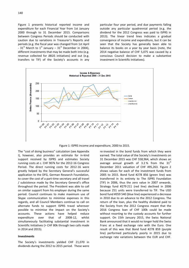
140
Figure 1 presents historical reported income and expenditure for each Financial Year from 1st January 2000 through to 31 December 2015. Comparisons between Congress Periods should be conducted with caution due to variations in Treasurer’s Reports and periods (e.g. the fiscal year was changed from 1st April - 31st March to 1st January – 31st December in 2004), different investments that may be made both into (e.g. revenue collected for JBGIS initiatives) and out (e.g. transfers to TIF) of the Society’s accounts in any
particular four year period, and due payments falling outside any particular quadrennial period (e.g. the dividend for the 2012 Congress was paid to ISPRS in 2013). The linear trend lines indicates a gradual convergence of income and expenditure, but it can be seen that the Society has generally been able to balance its books on a year by year basis (note, the 2014 negative balance of CHF 5,075 was caused by a conscious Council decision to make a substantive investment in Scientific Initiatives).
Figure 1: ISPRS income and expenditure, 2000 to 2015.
The “cost of doing business” calculation (see Appendix I), however, also provides an estimate for in-kind support received by ISPRS and estimates Society running costs at c. CHF 907k for the 2012-16 Congress Period. The direct running costs for 2012-16 were greatly helped by the Secretary General’s successful application to the DFG, German Research Foundation, to cover the cost of a part-time secretary and all travel / subsistence made by the Secretary General’s office throughout the period. The President was able to call on similar support from his employer during the same period. Council continues to make maximum use of Skype communication to minimise expenses in this regards, and all Council Members continue to call on alternate funds to support ISPRS travel wherever possible to minimise the impact on the Society’s accounts. These actions have helped reduce expenditure over that of 2008-12, whilst simultaneously facilitating substantial investment in Scientific Initiatives (> CHF 80k through two calls made in 2014 and 2015).
Investments
The Society’s investments yielded CHF 21,070 in dividends during the 2012 to 2015 period. These were
re-invested in the bond funds from which they were earned. The total value of the Society’s investments on 31 December 2015 was CHF 558,964, which shows an average annual growth of 3.2 % from the 31st December 2011 valuation of CHF 495,263. Figure 2 shows values for each of the investment funds from 2005 to 2015. Bond fund #278 856 (green line) was transferred in its entirety to The ISPRS Foundation (TIF) in 2006, thus the zero value in 2007 onwards. Strategy fund #279 211 (red line) declined in 2006 because 251 units were transferred to TIF. The USD bond fund #359 540 (blue line) experienced a decrease in 2010 due to an advance to the 2012 Congress. The return of the loan, plus the healthy dividend paid to the Society from the 2012 Congress meant that the 2016 Congress loan of CHF 100k could be made without resorting to the custody accounts for further support. On 15th January 2015, the Swiss National Bank announced that it would no longer hold the Swiss Franc at a fixed exchange rate with the Euro. One result of this was that Bond fund #278 859 (purple line) performed particularly poorly in 2015 due to exchange rate variations between the EUR and CHF.

141
Figure 2: Value of ISPRS investment funds, 2005-2015.
ISPRS net worth, 31st December 2015
Table 2 provides a summary of ISPRS assets as of 31st December 2015. The interest free loan to the Czech Republic was returned to ISPRS on 12 April 2016. The
Society’s net worth of CHF 718k is an increase of 7 % over that of 31st December 2011 and is roughly equivalent (c. 3% in excess) to the expenditure directly incurred in running the Society over the last four years.
ITEM Value Value (EUR, USD, CHF, GBP) (CHF) CASH Euro #.7EM 21,131.13 22,955.76 USD #.60C 22,605.29 22,598.96 CHF #.01E 9,219.21 9,219.21 Halifax local operating A/C 2,816.75 4,157.31 Total Cash 58,931.24 INVESTMENTS # 359540 Bonds [USD] 209,042.96 # 278859 Bonds [EUR] 202,649.62 # 1640534 Corp Bonds [USD] 123,590.17 # 279211 Strat Fund [CHF] 23,681.68 Total Investments 558,964.43 LOANS Loan to 2016 Congress 100,000.00 Total Loans 100,000.00 TOTAL ASSETS 717,895.67
Table 2: ISPRS assets, as of 31st December 2015.
Financial operations 2012-16
Accounting system
The ISPRS accounting system consists of a hybrid Microsoft Access database and Excel spreadsheets, with origins dating back to the 2000-2004 Congress Period. This system requires maintenance by both the
Secretary General and the Treasurer, and it contains functions that require time consuming “work-around” solutions. Several incremental developments have taken place in this Congress Period, including the streamlining of bank reconciliation / accounting spreadsheets in Excel via a macro, as well as the production of a weekly Treasurer’s report via a Python script to provide the Secretary General’s office with up-to-date information on membership subscriptions.

142
Incorporation
The Society’s incorporation in the state of Maryland, USA as a not-for-profit (that is, tax exempt) organization has worked reasonably well for a Treasurer not resident in the USA. It adds additional responsibility to the ISPRS Treasurer, and requires professional assistance in the USA to complete and submit annual financial and property forms, most notably the IRS-990 and the State of Maryland Personal Property forms. As with changes in banking regulations, there are changes in these forms each year that, if not submitted, can result in ISPRS being “out-of-compliance” and losing its tax-exempt status.
International banking
Day-to-day banking with the ISPRS bank, UBS in Zurich, has generally worked well throughout the Congress Period. E-banking is simple and efficient, helping to minimise the cost of transactions. However, high-profile publicity surrounding various tax scandals, and the subsequent response of governments towards offshore banking has created significant complications for the ISPRS relationship with UBS at various points over the last four years as international banking regulations have been increasingly restrictive. In particular, the lack of a permanent address for ISPRS Headquarters, the Society’s incorporation in the USA State of Maryland, and the nomadic movements of the ISPRS Treasurer every four years have proved problematic in establishing a stable banking basis in Switzerland. The situation is (at least temporarily) resolved though the recent transfer of ISPRS to the “Private Wealth” section of UBS, under the guidance of the bank’s UK client advisor (the incumbent Treasurer being resident in the UK).
Credit card payments
In 2008, Council authorized the adoption of credit card payments for annual member subscriptions. Because the Society has no official address in Switzerland this was implemented by the past-Treasurer through a Paypal account system, with payments allowed in USD
only. Transfer of the existing ISPRS USA Paypal account to a UK-based Treasurer in 2012 proved impossible to implement, and establishment of a new Paypal account meant that payments could only be accepted in GBP, which is not a recognised ISPRS currency. As a result, a new solution was implemented via Copernicus GmbH, which sets up a new record for ISPRS Members in December of each year. Credit card payments can be made on-line by all categories of member through a portal provided on the ISPRS website. It is currently used by a handful of members to pay their subscription fees on an annual basis.
Financial policy
In 2009 Council approved a formal Financial Policy for managing ISPRS finances, assets, and business practices. In lieu of an audit, the ISPRS Financial Commission reviews the Treasurer’s Annual Report and supporting spreadsheets which are then forwarded to the Society’s accountants in the USA for completion of the relevant annual financial and property forms. All policies were reviewed and updated during the most recent Congress Period, with the resultant documentation available from the Guidelines section of the ISPRS website.
Current ISPRS financial challenges and opportunities
Background
Core Society income is generated from four sources: membership subscriptions, revenue from key ISPRS meetings and from ISPRS publications, and dividends from ISPRS investments. The costs for ISPRS activities could also not be sustained without high levels of in-kind support from Ordinary and Sustaining members through the hosting of Council and Joint Meetings, award sponsorship, etc., and all contributors are to be heartily thanked for their support. Financial challenges and opportunities in the core source areas of ISPRS income are outlined below.
Membership subscription
Total members Paid up members (up to and including 2015)
Category No. Collectable fees
(CHF) No. No. as % of
total Fees collected
(CHF) Fees as % of
total
OM 91 81190 50 54.9 67045 82.6
AM 13 4485 6 46.2 3105 69.2
RM 15 1725 9 60.0 1035 60.0
SM 61 51630 43 70.5 43305 83.9
Total 180 139030 108 60.0 114490 82.3
Table 3: Summary of ISPRS members and status by category (report dated 19 April 2016).

143
Table 3 provides details of the current membership by category, and the status of payments received up to and including Financial Year 2015, as of 19 April 2016. As at the reporting date, 108 members (60% of the 180 members across all categories) are paid up-to-date, representing 82% of the CHF 139k membership fees that are collectable annually. There is some considerable variation in the different member categories, ranging from 46% of Associate Members paid up, compared to 71% of Sustaining Members by number, and from 60% of Regional Member fees to 84% of Sustaining Member fees. It is worthy of note that ISPRS Council can, and does, revoke membership of known-defunct and non-active Sustaining Members, but removal of other member types requires General Assembly approval.
Figure 3 shows the amount of in-year arrears that remain outstanding since 2000 (where the figure diminishes to zero) as a percentage of members and fees due in 2015. Despite the best efforts of Council, which have included in-country missions to visit members in arrears, and an “arrears amnesty” for selected members, there has been a visible rise in the number of members unable to
pay since around 2008, and a step change increase in the uncollected fees since around 2010. Whilst previous Treasurer’s Reports have recommended that “for annual budget planning purposes, Council should expect that only about half of the members will pay their subscriptions” (ref. 2008 report), thereby providing evidence that this is not a new trend, it would appear that the global financial difficulties encountered since 2008 are increasingly impacting on the ability of members to remain in good standing with the Society.
This appears to be affirmed by Figure 4, which shows the membership fees (including any arrears) that have been collected in-year over the same time period, 2000-2015. A rolling four year average is presented to remove the noise created by members paying large amounts of arrears, etc. in any one year. Following a rise from the turn of the Century, payment of membership fees peaked in the quadrennial period 2004-08 at around CHF 126k per annum (cf: CHF 139k annual collectable fees), since when there has been a relatively steady negative trend to the CHF 119k average that was collected over the last four years. The CHF 476k collected in membership fees over the last four years represents 66% of ISPRS income for the period, so membership fees remain the life blood of the Society. Critically, any inability to pay no longer appears to be restricted to members in lower membership categories, with evidence that several “larger” ISPRS members are now also experiencing difficulties. There is anecdotal historical evidence to suggest that members in arrears often pay in the run-up to the quadrennial Congress (Ordinary Members, for example, lose their voting privileges and may be expelled from the Society for not settling their accounts), so it may prove that by the time of the General Assembly a more positive picture can be painted. However, the income that has reduced most markedly over the period 2008 to 2015 is from the Sustaining Membership, which has witnessed a reduction in fees collected from CHF 62k in 2008 to CHF 49k in 2015. The recent formation of the International Industrial Advisory Committee (IIAC) in part aims to reverse this trend. Historical membership fee collections are recorded in tabular form in Appendix III.
Figure 3: Percentage of fees outstanding and members in arrears by year, 2000-2015.

144
Figure 4: ISPRS membership fees (inc. any arrear payments) collected in-year, 2000-2015.
Society meetings
Society income is boosted significantly by the organisation of successful scientific meetings, and in the last four years, ISPRS benefitted from revenue of CHF 82,441 received from the 2012 Melbourne Congress (down from CHF 94,320 received from the 2008 Beijing Congress) and CHF 36,090 from the eight Technical Commission symposia held in 2014 (down from CHF 53,379 in 2010). Whilst this income shows a 20% reduction on the preceding quadrennial period, doubtless also a function of the challenging global financial situation, it still amounts to 16 % of society income for the Congress Period. Going forwards, the introduction of the ISPRS Geospatial Week will see additional dividends returned to the Society in odd years as, now established, 10 % of registration fees will be levied on these meetings from 2017 onwards. Many thanks are due to all meeting organisers and their teams in organising successful financial, as well as scientific, symposia under difficult global financial conditions over the last four years.
Society publications
ISPRS has invested substantially in its publications over recent years. This investment, combined with the hard work and enthusiasm of the many editorial teams and others involved in their production, means that the Society can now boast a world-class flotilla of scientific publications. It is anticipated that a number of recent initiatives, described briefly below, will transform this sector of the Society’s business from an expense incurring activity to an income generating one from 2016 onwards.
• ISPRS Journal of Photogrammetry and Remote Sensing (Elsevier): A new agreement has been reached with Elsevier for the publication of the ISPRS Journal for the period 1st January 2016 to 31st December 2020. The new five year contract replaces the old agreement one year earlier than originally planned. Up until 2015, the revenue paid to the Society by Elsevier amounted to approximately CHF 10k per annum (equivalent to 3 % of journal revenue) and ISPRS were jointly responsible with Elsevier for the editorial costs of the journal, resulting in a net loss for the Society. Under the new agreement, Elsevier will now pay all editorial costs and 20 % of journal revenue directly to ISPRS.
• ISPRS International Journal of Geo-information (MDPI): With the amendment of the MDPI publishing agreement to increase the Article Processing Charge (APC) of submissions to this open access journal from CHF 150 to 900 in 2015, MDPI agreed to pay the society CHF 100 out of each article published with an APC of CHF 900. The first income from this source (CHF 560) was received from MDPI in April 2016.
• International Archives and Annals (Copernicus GmbH): A formal agreement is now in place with Copernicus to ensure the systematic production of the ISPRS Archives and Annals, a requisite to ensure the profile of the proceedings through scientific indexing.

145
In addition, an agreement with Curran Associates, Inc. (USA), http://www.proceedings.com/, now provides modest royalties to ISPRS from the on-demand printing of the Archives and Annals. CHF 288 was earned from this source in 2015.
• ISPRS Book Series (Taylor and Francis): The ISPRS Book Series has been largely dormant for the last few years, with the result that only modest revenue is now generated from royalties. The decision was therefore taken that royalties for future titles of the Book Series would be paid directly to authors to encourage future publications.
Return on investments
Fluctuations in currency value, and the continued precarious state of the global economy has had significant influence on the valuation of ISPRS investments over the last four years. The Treasurer visited UBS in Zurich in September 2015 where he was advised by the ISPRS Client Advisor to consider active fund management of the ISPRS custody accounts. Council discussed the issue at an ad hoc Council Meeting at the 2015 Geospatial Week in Montpelier and, given the fluctuating state of the global financial market and imminent change of Council within the next 12 months, decided against this at that time. Nevertheless, the under-performance of bonds due to ongoing quantitative easing by governments around the globe means that ISPRS assets are not performing to previous levels and income from this source remains a concern going forwards.
Conclusions and Recommendations
Summary
Overall the Society’s financial status continues to be generally healthy, despite a global economy that remains highly uncertain. The Society’s net worth at the end of 2015 is roughly equivalent to the expenditure incurred in running the Society for a period of four years, and with global financial uncertainty still prevalent, it would seem prudent to continue to uphold such a position. Nevertheless, whilst the global economy has undoubtedly squeezed existing income sources available to the Society, ongoing endeavours to collect outstanding membership fees, together with recent actions taken to generate additional income from new meetings and the Society’s journals, bode well for the future health of ISPRS finances. With a healthy dividend anticipated from the 2016 Congress, it would therefore seem timely to recommend strategic investments in initiatives of importance to ISPRS in 2016-20.
Recommendations
The following recommendations are made for the 2016-20 Congress Period:
• Membership fees: The last ISPRS membership fee increase occurred w.e.f. 1st January 2009 (when the base unit was raised from CHF 100 to CHF 115). Given the continuing difficulties in the global economy, and recognising the challenges this is placing on its members, ISPRS Council recommends holding membership fees fixed at the current rate (base unit subscription CHF 115) for the 2016-20 Congress Period.
• Members in arrears: The General Assembly should consider actions to be taken with members in all categories who are in deep arrears.
• Incorporation and compatibility with banking: The future Council are asked to consider the possible co-location of the Society’s incorporation with its banking activity, either through registering ISPRS as an entity in Switzerland, by transferring its banking operations to the USA, or by moving both to a mutually convenient location.
• Overhaul of accounting system: With a total of only 180 members in all categories, a much simpler and more efficient on-line method to record and manage member payments, etc. than is currently in operation should be feasible. The incoming Treasurer, together with the Secretary General’s office should consider the streamlining of the current practice to an appropriate on-line, off-the-shelf solution.
• Investment funds: Two possible recommendations are made in relation to protecting the Society’s assets:
o Active fund management: To maximise return from its custody accounts, the future Council are asked to consider the issue of active investment fund management;
o Transfer of funds to TIF: The future Council are asked to consider transferring a suitable portion of ISPRS’ investment funds to TIF, which has experienced declining resource over the last few years, for subsequent re-investment in an appropriate TIF strategic fund.

146
• Further strategic investments: Three further investment possibilities are recommended to enhance Society activity:
o Scientific Initiatives: The International Science Advisory Committee (ISAC) recently reviewed the 2014 and 2015 ISPRS Scientific Initiatives outcomes positively, and it is therefore recommended that the practice should be continued with repeat calls in 2017 and 2019;
o Student Consortium: Council, together with TIF, currently budgets for Student Consortium activities on an annual basis, providing funding for Summer Schools, etc. An enhanced budget to support Student Consortium operations should also be considered alongside this support;
o Ring-fenced funds for supporting regional meetings, as well as active participation in ISPRS events, for members in developing regions (most notably Africa and South America) could enhance the appeal of
ISPRS in regions where membership is currently disengaged.
Acknowledgements
I have benefited greatly from the valued assistance of Mr Dan Brooking-Coker, Mr Michael Wright, and Mrs Lindsey Earley, all of Newcastle University, throughout my four year term of office as ISPRS Treasurer. The immense help and patience of previous Treasurer, Mr Mike Renslow, and his assistant Ms Amelia Budge, also made picking up the reins of the Treasurer’s role relatively painless, and not to say even enjoyable. ISPRS Council has proved to be a source of wisdom on all matters, financial or otherwise, over the last four years and everyone involved has been a joy to work with. Finally, the support and dedication of the ISPRS Financial Commission, consisting of Marie-Jose LeFèvre-Fonollosa, Fulvio Rinaudo and Olga Piedad Rudas, is gratefully acknowledged.
Jon Mills, Treasurer

147
Appendices
Appendix I: Cost of doing business
Previous Treasurer’s reports have provided summary financial data from previous Congress periods to set context. Given that the current Congress period is
always incomplete in such analyses, this information has been demoted to the Appendices and is given in Table 4, below.
Item Approximate Values1 (CHF)
1993
-1996
1997
-2000
2001
-20042
2005
-2008
2008
-2012
2013
-20163
Total income 395,049 499,3854 629,570 735,511 855,165 ≈834,000
Investments5 273,8396 389,6307 619,908 548,061 526,123 ≈565,000
Total expenses 299,1948 429,548 441,502 601,833 782,535 ≈665,000
In-kind support9 ≈95,000 ≈100,000 N/A ≈115,000 ≈120,000 ≈242,000
Approx. cost of
doing business10
≈394,194 ≈529,548 >441,502 ≈716,833 ≈902,535 ≈907,000
Table 4: Cost of doing business for ISPRS.
1All values are approximate because there is no set format for the treasurer’s report. 2In 2004 the fiscal year was changed from April 1-March 31 to January 1-December 31. Values for 2004 are through December 31 so do not match the values presented in Istanbul. Values for 2004-08 are through 30 May, 2008.
32013-2016 estimate based on figures for three year period 2013, 14, 15, plus budgeted values for 2016 income and expenses (see Appendix II).
4In 2000, unpaid fees were considered to be deferred income. For consistency, these fees have been subtracted here from total income. The assets reported were CHF 580,710
5Values are given for the end of each Congress Period. 2016 figures based on evaluation as of 21/04/16.
6Based on a 12% increase between 1992 and 1996. Base (presumed) = 244,499.
7The increase of 12% in Swiss Bond income reported for the 1992-1996 period reportedly dropped 6% by 2000. Diversification into other investments helped to maintain value.
8No specific figure for expenses was given so the amount was derived by subtracting Net Cash Income (95,855) from Total Cash Income (395,049).
9In-kind support consists of estimated out-of-pocket expenses to host ISPRS Council Meetings
and Council administrative costs. 2012-2016 estimate is based on direct DFG secretariat support of EUR 177,600 (CHF 195k) plus estimated travel support of EUR 42,600 (c. CHF 47k) only.
10Total expenses plus estimated in-kind support.

148
Appendix II: 2016 budget and quarter one statement of income and expenditure

149
Appendix III: Historical record of membership fees collected
Member Type OM SM RM AM Total
Year CHF CHF CHF CHF CHF
1997 61,111 44,729 800 1,400 108,040
1998 52,763 31,863 200 1,300 86,126
1999 82,082 34,500 300 1,700 118,582
2000 65,918 28,294 1,577 1,200 96,989
2001 59,246 43,985 1,555 2,532 107,318
2002 55,659 40,426 364 3,200 99,649
2003 71,373 33,161 486 949 105,969
2004 75,513 42,662 1,944 6,238 126,357
2005 63,195 51,936 1,283 1,817 118,231
2006 74,070 58,945 1,462 3,207 137,684
2007 58,275 47,729 858 2,482 109,344
2008 71,510 62,473 1,110 2,382 137,476
2009 64,741 50,069 1,103 1,334 117,247
2010 81,386 48,679 1,555 2,683 134,303
2011 60,174 46,520 419 599 107,713
2012 65,271 50,924 2,437 6,198 124,831
2013 65,414 50,050 780 2,931 119,174
2014 72,647 38,917 1,060 1,278 113,901
2015 63,504 49,081 1,085 4,395 118,065
Table 5: Historical record of membership fees collected per year.

150
Note: Exchange rates between the USD and CHF and between the Euro and CHF were calculated for each year (1997 through 2003) per the exchange rate at the end of the fiscal year (31st December). These calculations were performed by previous ISPRS Treasurers. Exchange rates
between these currencies starting in 2004 were calculated throughout the year on the day of each transaction using a daily average rate provided online by x-rates.com (http://www.x-rates.com).
Report of ISPRS Financial Commission Chair Marie-José Lefèvre-Fonollosa to the General Assembly for the term 2012-2016
The Financial Commission of ISPRS 2012-2016 is composed by:
Chairperson : MARIE-JOSÉ LEFÈVRE-FONOLLOSA, French Space Agency, France Member : FULVIO DE RINAUDO, Politecnico di Torino, Italy Member: OLGA PIEDAD RUDAS, Directorio SELPER, Colombia
The Financial Commission of ISPRS examined accounts proposed each year by the Treasurer and submitted its findings to the council in four annually reports:
March 23 rd ,2013: Financial commission Comments 2013 (FY2012)
May 23 rd ,2014: Financial commission Comments 2014 (FY2013)
May 2nd ,2015: Financial commission Comments 2015 (FY2014)
April 10th ,2016: Financial commission Comments 2016 (FY2015)
At each fiscal year from 2012 to 2105, the Financial Commission examined with accuracy all accounts of the Society included in the Treasurer’s report; for one part, incomes and expenditures, and at the other hand the evolution of the assets (bonds), dividends and cash accounts (see figure below).
At first, we validated the exactitude of the accounts. This was possible because Treasurer’s reports were detailed, very well documented and easy to read. It provided in particular the tables of monthly statements which allowed a well understanding of the various flows at the different steps of the year, year by year. We would thanks Jon Mills and his team for their important work.
After a thorough check, the Financial Commission confirmed, that the 2012-to-2015 ISPRS accounts show no accounting errors.
Secondly, taking in consideration the Incomes, they were 717 685 CHF for the period (179 421CHF by year), with a specific increases in 2012 and in 2013 due to the Congress profits. Most important are the subscription's values. They were highest in 2012 (124 830 CHF) taking into account the Melbourne Congress

151
effect, and then relatively stable during the following years (119 174 CHF in 2013, 113 901 CHF in 2014 and 118 065 CHF in 2015). This very remarkable stability was due to the permanent effort of the council in recovering the chronic non-payment of the fees from 22% of members.
Thirdly, the Expenditures amounts during this period are 698 403 CHF (in mean 174 600 CHF by year), systematically under the predicted values and below the incomes; such that authorizes to made a reasonable profit (~5500 CHF /year) which were invested this last three years .
This very good management allowed not opening the saving invested in different assets. The global value of the assets were 558 965 CHF at December 31st, 2015 and generates regular dividends (17 000 CHF during the four years period).
We need also to notice the value of 58 931CHF of cash account.
In summary, Treasurer’s reports shows that the Society has a stable, well controlled and healthy management of its accounts, despite a financial erosion of 1%, principally due to money fluctuations between Euros, Swiss francs and Dollars during this period.
Given all these different factors, we considered that Treasurer’s reports are fully consistent with Financial ISPRS policy.
Therefore, the Financial Commission Chair cosigned with the Treasurer the annual budget, statement of receipts and payments and balance sheet by the end of May of each year and reported directly to the Council through the Secretary General.
The dates of visas are given:
Financial_Report_FY12_Submit: approved March 23rd, 2013
Financial_Report_FY13_Submit: approved May 23rd, 2014
Financial_Report_FY14_Submit: approved May 2nd, 2015
Financial_Report_FY15_Submit: approved April 10th, 2016
The financial Commission advised the Council, giving some analysis and recommendations both on expenditures and on the size of the reserve that appears too high for a non-profit Society.
In particular, we recommended:
FY 2012 : Two main recommendation:
Travel expenditure management:
It’s essential that Council members and other supports travel for their mission of coordination. Given the important amount of travels expenditures we suggest that ISPRS adopts a policy about the class for flights, stars for hotels and possible maximum amount for meals per day.
Scientific activities enhancement:
This was related to the very low level of science activities in the Society. If efforts are correct with respect to international collaborations, the amount is zero for scientific initiatives. In other part, the incomes for this activity is not so high, but the Society received dividends, royalties and sponsorships, so reserves exist. We suggested that part of the reserves or assets were committed to support science projects, for example through the creation of an annual call of tender.
FY 2015 : Increase aid to Developing Countries
Thanks to its excellent management, the financial situation of ISPRS is very comfortable (assets ~700 000CHF, i.e. more than 4 times the annual budget) and is increasing each year. This situation protects the society from economic difficulties, at short and medium term. Nevertheless, 22% of members are behind in their dues and a solution must be found to solve this problem. However, the resources of some of those societies are very low and, in fact, they cannot participate efficiently at ISPRS international activities.
Our recommendation at the ISPRS Council was to set up a special “Developing Country fund” that would allow members to be represented at the ISPRS congress, but also to elaborate some international collaboration including grants for young scientists.
The Financial Commission Chairperson, Marie-José Lefèvre-Fonollosa, was invited by the ISPRS Council once during its four-year term. This meeting was held in Antalya (Turkey) in November 2013 during the Laser Scanning week. It was an occasion to discuss about recommendations we done, in particular for some spending, and also about some new directions which could conduct to change partially the financial policies in the next years.

152
The Financial Commission noted in particular the decision of the Council to invest in a call to scientific projects in 2014 and 2015. Even if a slight deficit appears and reduces reserves, in our opinion, such this initiative presents a good direction for a non-profit society like ISPRS. Indeed, the financial commission remarked the fact that the association was making profits year after year; this situation seemed abnormal for a non-profit society, and we have recommended to invest a part of these benefits particularly in science initiatives.
The Financial Commission’s members were unfortunately unable to meet over the 4 years of his mandate. But discussions by email helped us to provide a common coordinated policy that could summarize as follows:
a) Reasonable reduction and/or diversification in Assets :
However, we must ask us again the question of the bank investments of the ISPRS profits; and this not only because it is a non-profit learned society which has capitalized substantial profits during its history, but also because these bonds are entrusted to UBS bank is now in a complicated legal situation and perhaps even risky. May be, we should make an audit of the Bonds legal status? and / or diversify
the vectors? These questions must be asked and/or seriously discuss in 2016.
b) Best investment in scientific activities: This was set up from 2014, under the name of “Scientific Initiative”. We would thank the board to have remarkably led this project without having had any impact on the fiscal balance of the society.
c) Help the mobility of young scientists from Developing Countries:
Our recommendation at the ISPRS Council is to elaborate some international collaboration including grants for young scientists
d) Reduce the problem of payment fees collection:
A closer, targeted and more frequent connection with the members would allow being clear on memberships fees. Some financial aids should be necessary; for example s to set up a special fund” that would allow members to be represented at the ISPRS congress.
Marie-José Lefevre-Fonollosa Financial Commission Chair
Report of the Editors-in-Chief of the ISPRS Journal Derek Lichti, Qihao Weng
Overview of Major Developments
The rapid growth first experienced by the ISPRS Journal of Photogrammetry and Remote Sensing in 2010 continued during the 2012-2015 reporting period. Since 2011, the number of submitted manuscripts has more than doubled but the growth seemed to plateau in 2015. Accordingly, the number of published volumes increased from eight to 12, and the editorial team doubled in size. In 2014 the Journal’s scope was re-examined and re-focused. This revision aimed at reflecting more accurately the activities of its contributors and capturing new and emerging trends in photogrammetry, remote sensing, spatial information systems, and computer vision. The impact factor has been steady around 3.0 from 2012-2014 with an expected strong increase in 2015, which indicates that the quality of the Journal continues to be very high. Article handling time has improved considerably, and author satisfaction is now positive in all evaluation categories. Several promotional/outreach activities were undertaken by the Editors-in-Chief to promote greater awareness of the Journal and to better inform
young researchers about the scientific publishing process. The winner of the U.V. Helava Award for the best paper during 2012-2015 period has been awarded to “Multiclass feature learning for hyperspectral image classification: Sparse and hierarchical solutions” by Devis Tuia, Rémi Flamary and Nicolas Courty.
Manuscript Handling
Manuscript Submissions
The Journal experienced significant growth in terms of the number of submitted manuscripts in 2012-2014, with 40% growth in 2013. The number of submissions stabilized in 2015 and, so far in 2016, the number of submissions is in line with 2015 numbers.

153
Year 2012 2013 2014 2015
# submitted manuscripts 370 517 653 658
% increase from previous year (318 in 2011) 16 40 26 1
Acceptance Rate
The acceptance rate in 2012-2014 kept around 30%, but decreased in 2015 to about 22%. Submitted papers are usually reviewed by at least two anonymous reviewers, though sometimes three or even four are used. Desk rejection (i.e. rejection
without peer review) is used for cases where the quality of the paper and/or the scientific contribution is deemed not sufficient to send it for review or where it is clearly outside the Journal’s scope.
Year 2012 2013 2014 2015
# final decisions 363 512 660 678
# accepted papers 108 159 190 152
# rejected papers 234 336 458 522
# withdrawn papers 21 17 12 4
Acceptance rate (%) 31.5 32.1 29.3 22.6
The CrossCheck tool was introduced into the Elsevier Editorial System (EES) in 2014. It uses the Ithenticate software to check submitted papers for similarity (percentage of overlapping) with a large database of publications. It is quite an effective tool that has, unfortunately, revealed many cases of plagiarism, for which the papers in question were rejected.
Handling Times
A persistent issue for the Journal over the years, as judged from anonymous author feedback surveys
conducted by Elsevier, has been the editorial handling time for articles. The editorial and publication times in the period of 2012-2015 has been substantially shortened, as can be seen in the table below. These improvements can likely be attributed to a number of factors including: the appointment of additional editors; the appointment of the Editorial Advisory Board; and weekly email reports about the status of each paper that are sent to editors.
2011 2012 2013 2014 2015
Editorial time (weeks) 44.2 42.2 40.9 30.3 29.4
Web publication time (weeks) 58.7 48.4 45 35.4 43.4
Print publication time (weeks) 61.3 56.7 52.7 41.5 45.1
Published Articles
Modes of Publishing
Two options are available for articles published in the Journal: open access and subscription. Open access articles are freely available to the public and
the cost of publication is borne by the author(s). Subscription articles are available to paid subscribers and some groups through Elsevier’s universal access programs. Authors of these articles pay no fees.

154
One featured paper per volume, identified by the EiCs, is granted promotional access. This article is made freely available to the public for a limited time. Once the time limit has elapsed, the article returns to the subscription model.
Number of Publications
In 2013 the number of volumes changed from 8 to 12. As can be seen in the table below, the number of published papers and the number of pages has increased every year. The largest changes were in 2013 due to the 50% increase in the number of volumes.
Year 2012 2013 2014 2015 # volumes 8 12 12 12 # papers 100 142 165 187 % increase from previous year (93 in 2011) 8 42 16 13 # pages 1194 1732 2140 2346 % increase from previous year (1050 in 2011) 14 45 24 10
Theme Issues/Sections
The table below summarizes the Theme Issues (TIs) and Theme Sections (TSs) published in the Journal for the 2012-2015 period plus early 2016. The
distinction between designations is on the basis of the number of accepted papers: a TI comprises 10 or more papers; a TS comprises less than 10 manuscripts.
Year Vol Title Guest Editors # papers TI/TS
2012
73 Innovative Applications of SAR Interferometry from modern Satellite Sensors
Uwe Soergel Rudiger Gens Michele Crosetto
11 TI
2013
76 Terrestrial 3D Modelling Fabio Remondino Jan Boehm
7 TS
2013
83 Towards Intelligent Geoprocessing on the Web Songnian Li Suzana Dragicevic Bert Veenendaal Maria Antonia Brovelli
5 TS
2014
93 Urban Object Detection and 3D Building Reconstruction
Franz Rottensteiner Gunho Sohn Markus Gerke Jan Dirk Wegner
8 TS
2015
100
High-Resolution Earth Imaging for Geospatial Information
Christian Heipke Uwe Soergel Franz Rottensteiner Boris Jutzi
11 TI
2015
103
Global Land Cover Mapping and Monitoring: Progress, Challenges, and Opportunities
Yifang Ban Peng Gong Chandra Giri
10 TI
2015
104
Integrated Imaging and Sensor Fusion for Rapid Response and Monitoring Applications
Naser El-Sheimy Charles Toth Steve Liang
5 TS
201 10 Photogrammetric Computer Vision 2014: Best Konrad Schindler 3 TS
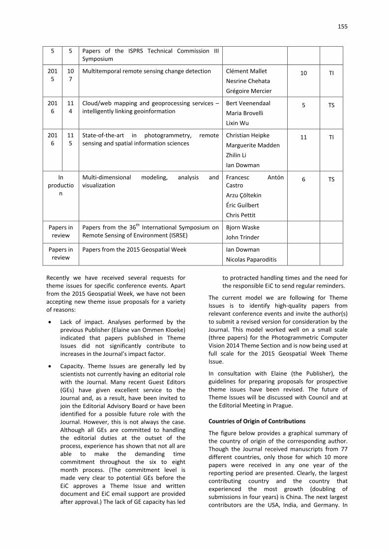
155
5 5 Papers of the ISPRS Technical Commission III Symposium
2015
107
Multitemporal remote sensing change detection Clément Mallet Nesrine Chehata Grégoire Mercier
10 TI
2016
114
Cloud/web mapping and geoprocessing services – intelligently linking geoinformation
Bert Veenendaal Maria Brovelli Lixin Wu
5 TS
2016
115
State-of-the-art in photogrammetry, remote sensing and spatial information sciences
Christian Heipke Marguerite Madden Zhilin Li Ian Dowman
11 TI
In productio
n
Multi-dimensional modeling, analysis and visualization
Francesc Antón Castro Arzu Çöltekin Éric Guilbert Chris Pettit
6 TS
Papers in review
Papers from the 36th International Symposium on Remote Sensing of Environment (ISRSE)
Bjorn Waske John Trinder
Papers in review
Papers from the 2015 Geospatial Week Ian Dowman Nicolas Paparoditis
Recently we have received several requests for theme issues for specific conference events. Apart from the 2015 Geospatial Week, we have not been accepting new theme issue proposals for a variety of reasons:
• Lack of impact. Analyses performed by the previous Publisher (Elaine van Ommen Kloeke) indicated that papers published in Theme Issues did not significantly contribute to increases in the Journal’s impact factor.
• Capacity. Theme Issues are generally led by scientists not currently having an editorial role with the Journal. Many recent Guest Editors (GEs) have given excellent service to the Journal and, as a result, have been invited to join the Editorial Advisory Board or have been identified for a possible future role with the Journal. However, this is not always the case. Although all GEs are committed to handling the editorial duties at the outset of the process, experience has shown that not all are able to make the demanding time commitment throughout the six to eight month process. (The commitment level is made very clear to potential GEs before the EiC approves a Theme Issue and written document and EiC email support are provided after approval.) The lack of GE capacity has led
to protracted handling times and the need for the responsible EiC to send regular reminders.
The current model we are following for Theme Issues is to identify high-quality papers from relevant conference events and invite the author(s) to submit a revised version for consideration by the Journal. This model worked well on a small scale (three papers) for the Photogrammetric Computer Vision 2014 Theme Section and is now being used at full scale for the 2015 Geospatial Week Theme Issue.
In consultation with Elaine (the Publisher), the guidelines for preparing proposals for prospective theme issues have been revised. The future of Theme Issues will be discussed with Council and at the Editorial Meeting in Prague.
Countries of Origin of Contributions
The figure below provides a graphical summary of the country of origin of the corresponding author. Though the Journal received manuscripts from 77 different countries, only those for which 10 more papers were received in any one year of the reporting period are presented. Clearly, the largest contributing country and the country that experienced the most growth (doubling of submissions in four years) is China. The next largest contributors are the USA, India, and Germany. In

156
terms of the number of accepted papers, the top three countries are China, the USA, and Germany.
Access to Articles
Paper Downloads from ScienceDirect
Papers are available on-line through the Elsevier website:
http://www.sciencedirect.com/science/journal/09242716/118.
As can be seen below, the number of downloads increased each year of the reporting period, though the largest increase was in 2014.
Year 2012 2013 2014 2015
# downloads 235520 275730 390320 453978
% increase from previous year (195887 in 2011) 20 17 42 16
Journal Web Page
In the past a website for the Journal has been maintained by the EiC. In early 2013 it was migrated to the ISPRS website (see http://www.isprs.org/isprsjournal/) as it was felt it should be independent of the EiC’s home institution.
Impact Factor
The impact factor (IF) is a two-year measure of Journal quality published annually in the Journal Citation Reports by Thomson ISI. Over the past four years the impact factor of the Journal was stable at around 3.0 with an expected strong increase in 2015. The IF increased slightly from 2.902 in 2013 to 3.132 in 2014; while the Journal’s five-year impact factor increased from 4.202 to 4.652. The 2015
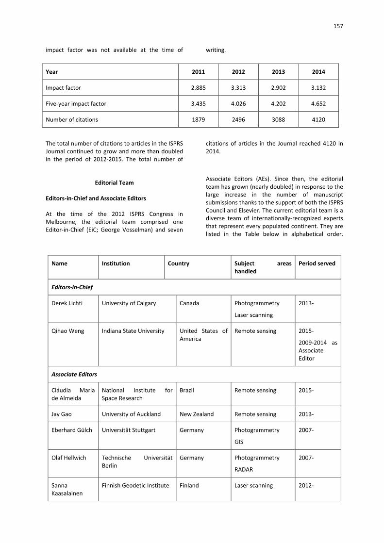
157
impact factor was not available at the time of writing.
Year 2011 2012 2013 2014
Impact factor 2.885 3.313 2.902 3.132
Five-year impact factor 3.435 4.026 4.202 4.652
Number of citations 1879 2496 3088 4120
The total number of citations to articles in the ISPRS Journal continued to grow and more than doubled in the period of 2012-2015. The total number of
citations of articles in the Journal reached 4120 in 2014.
Editorial Team
Editors-in-Chief and Associate Editors
At the time of the 2012 ISPRS Congress in Melbourne, the editorial team comprised one Editor-in-Chief (EiC; George Vosselman) and seven
Associate Editors (AEs). Since then, the editorial team has grown (nearly doubled) in response to the large increase in the number of manuscript submissions thanks to the support of both the ISPRS Council and Elsevier. The current editorial team is a diverse team of internationally-recognized experts that represent every populated continent. They are listed in the Table below in alphabetical order.
Name Institution Country Subject areas handled
Period served
Editors-in-Chief
Derek Lichti University of Calgary Canada Photogrammetry
Laser scanning
2013-
Qihao Weng Indiana State University United States of America
Remote sensing 2015-
2009-2014 as Associate Editor
Associate Editors
Cláudia Maria de Almeida
National Institute for Space Research
Brazil Remote sensing 2015-
Jay Gao University of Auckland New Zealand Remote sensing 2013-
Eberhard Gülch Universität Stuttgart Germany Photogrammetry
GIS
2007-
Olaf Hellwich Technische Universität Berlin
Germany Photogrammetry
RADAR
2007-
Sanna Kaasalainen
Finnish Geodetic Institute Finland Laser scanning 2012-

158
Minho Kim Sangmyung University Republic of Korea Remote sensing 2014-
Lalit Kumar University of New England Australia Remote sensing 2012-
Hans-Gerd Maas
Technische Universität Dresden
Germany Photogrammetry
Laser scanning
2013-
Xin Miao Missouri State University United States of America
2014-
Giorgos Mountrakis
State University of New York
United States of America
Remote sensing 2015-
Onisimo Mutanga
University of KwaZulu-Natal
South Africa Remote sensing 2013-
Konrad Schindler
Eidgenössische Technische Hochschule Zürich
Switzerland Computer vision 2011-
Uwe Sörgel Technische Universität Darmstadt
Germany RADAR 2013-
Dan Civco, who began as an AE in February 2009, stepped down at the end of December 2014. Dar Roberts, who began as an AE in January 2012, resigned at the end of December 2012. Conghe Song was as an AE appointed in early 2013 and resigned from his position in early 2014.
Editorial Advisory Board
The Journal’s Editorial Advisory Board (EAB) was formed in 2013. Comprising internationally-recognized scientists who have reliably served and/or contributed articles to the Journal, the EAB is primarily a reviewer resource for the editorial team. Each member is responsible for performing at least four reviews per year. Former AEs Dan Civco and Conghe Song were added during the three-year term. The new EAB term began in May 2016, consisting of 40 members appointed for a three-year term.
Elsevier
Staff changes
The EiCs have frequent contact with several Elsevier staff. Based in Amsterdam, the Publisher is responsible for the Journal and our main contact. The EiCs have regular contact with the Publisher through email and Skype meetings are held every two or three months. We have established a good working relationship with Elaine that has continued with Joy and now Lan. The Chennai-based Journal Manager is our contact for production matters as well as issues that arise with Elsevier’s online submission system EES. The Publishing Content Specialist, who is based in Beijing, is our contact for Theme Issues. The table below summarized the staff changes for the reporting period.
Name Service Period
Publisher
Gert-Jan Geraeds Until April 2013
Elaine van Ommen Kloeke April 2013-June 2015; November 2015-February 2016
Joy Idler June 2015-October 2015
Lan Song March 2016-
159
Journal Manager
Kreeti Saravanan Until June 2013
Bohnishikha Chakraborty June 2013-December 2015
Krupa Muthu December 2015-
Publishing Content Specialist
Jenny Wang Until May 2013
Angela Yuan May 2013-November 2014
Jia/Jessica Yang November 2014-
Contract
The contract renewal was handled by Jon Mills and Marguerite Madden with input from the EiCs.
The U.V. Helava Award
The award
The U.V. Helava Award, sponsored by Elsevier B.V. and Leica Geosystems AG, is a prestigious ISPRS Award, which was established in 1998 to encourage and stimulate submission of high quality scientific papers by individual authors or groups to the ISPRS Journal, to promote and advertise the Journal, and to honour the outstanding contributions of Dr. Uuno V. Helava to research and development in photogrammetry and remote sensing.
The Award is presented to authors of the best paper, written in English and published exclusively in the ISPRS Journal during the four-year period from January of a Congress year, to December of the year prior to the next Congress. The Award consists of a monetary grant of SFr. 10,000 and a plaque. A five-member Jury, comprising experts of high scientific standing, whose expertise covers the main topics included in the scope of the Journal, evaluates the papers. For each year of the four-year evaluation period, the best paper is selected, and among these four papers, the one to receive the U.V. Helava Award.
The Jury
The composition of the U.V. Helava Award Jury for the 2012-2015 evaluation period is summarized in the table below. All have done an excellent job serving the Journal and are thanked for the time they have devoted to award decision process.
Name Institute Country Evaluation Period Served
Pawel Boguslawski University of the West of England United Kingdom 2012-2015
Etienne Berthier Laboratoire d’Etudes en Géophysique et Océanographie Spatiales
France 2012-2013
Wolfgang Förstner Universität Bonn Germany 2012-2015
Carolyn Merry The Ohio State University U.S.A. 2012-2013
Uwe Stilla Technische Universität München Germany 2012-2015
Anjana Vyas CEPT University India 2014-2015
Bing Xu Tsinghua University of Beijing China 2014-2015

160
The Winners
The four best papers selected by the Jury are:
2012 CityGML – Interoperable semantic 3D city models by Gerhard Gröger and Lutz Plümer.
2013 Urban accessibility diagnosis from mobile laser scanning data by Andrés Serna and Beatriz Marcotegui
2014 Indoor scene reconstruction using feature sensitive primitive extraction and graph-cut by Sven Oesau, Florent Lafarge and Pierre Alliez
2015 Multiclass feature learning for hyperspectral image classification: Sparse and hierarchical solutions by Devis Tuia, Rémi Flamary and Nicolas Courty
The winner of the U.V. Helava Award for the 2012-2015 period as selected by the Jury is “Multiclass feature learning for hyperspectral image classification: Sparse and hierarchical solutions” by Devis Tuia, Rémi Flamary and Nicolas Courty, which was published in 2015.
Outreach and Education Activities
Outreach activities are important to promote the Journal and help potential authors, young scientists
in particular, understand the peer review and publication processes as well as publication ethics. To this end, we have engaged in a number of outreach/educational activities.
In June 2013, Derek participated in the International Editors-in-Chief Forum at the 7th International Conference on the Analysis of Multi-temporal Remote Sensing Images - MultiTemp 2013 in Banff, Canada. The EiCs of several other major remote sensing journals also participated. The format was a panel discussion of questions from the audience about current issues and trends relevant to all participants and was a good opportunity to promote the Journal. Derek and Elaine delivered the workshop “How to Get Published & Review” at the ISPRS Commission II Symposium in Toronto on 5 October 2014. The workshop was free to participants who registered for the Symposium. Additional publishing presentations given by Derek are summarized in the table below. Qihao gave a publishing presentation at Wuhan University in July 2015.
Qihao and Derek wrote an article about the state of the Journal that was published in GIM International in late 2015. The full reference is as follows:
Weng, Q. and Lichti, D. 2015. The ISPRS Journal of Photogrammetry and Remote Sensing – A Constant Source of Knowledge. GIM International 29(10): 49.
Location Date
University of Calgary February 2014
University of Calgary May 2015
Shenzhen University December 2014
University of Calgary February 2015
University of Calgary October 2015
University of Calgary December 2015
China University of Geosciences in Beijing December 2015
National Geomatics Centre of China December 2015
Beijing Architecture University December 2015
Wuhan University December 2015
Oregon State University April 2016
Publishing presentations on ISPRS Journal for Photogrammetry and Remote Sensing given by Derek Lichti
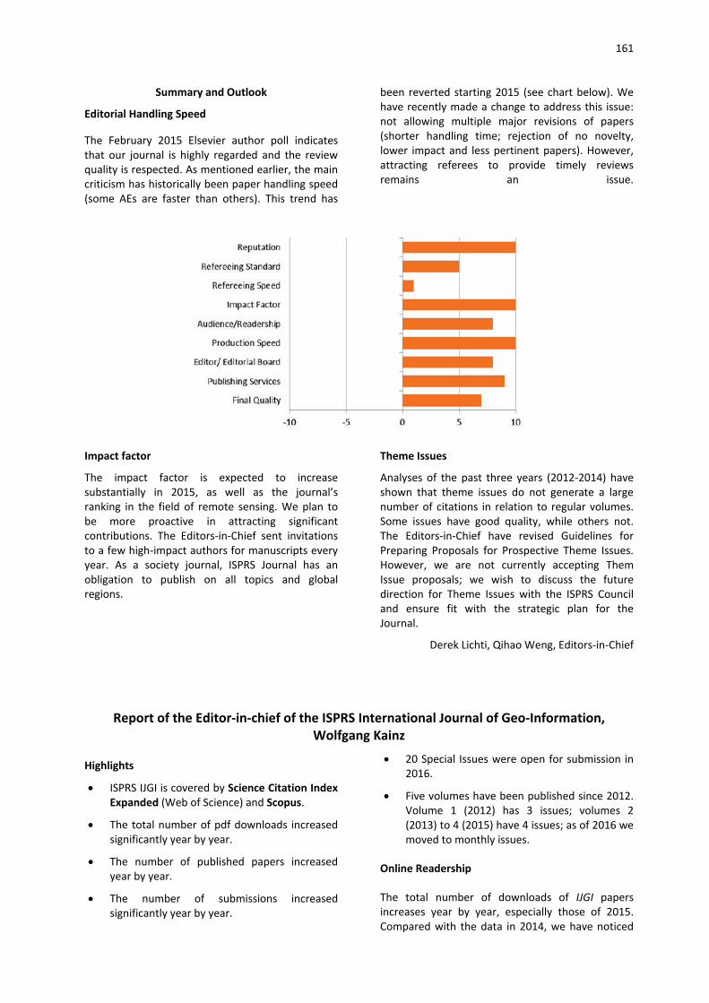
161
Summary and Outlook
Editorial Handling Speed
The February 2015 Elsevier author poll indicates that our journal is highly regarded and the review quality is respected. As mentioned earlier, the main criticism has historically been paper handling speed (some AEs are faster than others). This trend has
been reverted starting 2015 (see chart below). We have recently made a change to address this issue: not allowing multiple major revisions of papers (shorter handling time; rejection of no novelty, lower impact and less pertinent papers). However, attracting referees to provide timely reviews remains an issue.
Impact factor
The impact factor is expected to increase substantially in 2015, as well as the journal’s ranking in the field of remote sensing. We plan to be more proactive in attracting significant contributions. The Editors-in-Chief sent invitations to a few high-impact authors for manuscripts every year. As a society journal, ISPRS Journal has an obligation to publish on all topics and global regions.
Theme Issues
Analyses of the past three years (2012-2014) have shown that theme issues do not generate a large number of citations in relation to regular volumes. Some issues have good quality, while others not. The Editors-in-Chief have revised Guidelines for Preparing Proposals for Prospective Theme Issues. However, we are not currently accepting Them Issue proposals; we wish to discuss the future direction for Theme Issues with the ISPRS Council and ensure fit with the strategic plan for the Journal.
Derek Lichti, Qihao Weng, Editors-in-Chief
Report of the Editor-in-chief of the ISPRS International Journal of Geo-Information, Wolfgang Kainz
Highlights
• ISPRS IJGI is covered by Science Citation Index Expanded (Web of Science) and Scopus.
• The total number of pdf downloads increased significantly year by year.
• The number of published papers increased year by year.
• The number of submissions increased significantly year by year.
• 20 Special Issues were open for submission in 2016.
• Five volumes have been published since 2012. Volume 1 (2012) has 3 issues; volumes 2 (2013) to 4 (2015) have 4 issues; as of 2016 we moved to monthly issues.
Online Readership
The total number of downloads of IJGI papers increases year by year, especially those of 2015. Compared with the data in 2014, we have noticed

162
an increase by over 116% in 2015. The top ten downloaded papers during the last four years are
listed in Appendix 1.
Year 2012 (June to December) 2013 2014 2015 2016 (January to April)
Downloads 5,081 31,494 45,532 * 98,220 * 65,456
* The visits data was counted by Google Analytics (GA)
The country downloading the most IJGI articles during the past four years was United States with 25.3% of the total number of downloads. Please see
below information about top 10 accessing countries.
0
10000
20000
30000
40000
50000
60000
Downloads
The most downloaded article from 2012 till now was “GIS-Based Planning and Modeling for Renewable Energy: Challenges and Future Research Avenues” (http://www.mdpi.com/2220-9964/3/2/662) by Bernd Resch, Günther Sagl, Tobias Törnros, Andreas Bachmaier, Jan-Bleicke Eggers, Sebastian Herkel, Sattaya Narmsara and Hartmut Gündra, published in Volume 3, Issue 2 as part of the Special Issue “GIS for Renewable Energy”, and was downloaded 4,270 times. For a top 10 list of most downloaded articles published from 2012 to 2016, please see Appendix 1.
Publication Statistics
New Submissions Distribution
From June 2012 till now, we have received 955 submissions, 50% of which are special issue submissions and 50% are regular submissions.
Please see the figures below that show the yearly submission data and the average number of monthly submission data from 2012 to 2016.
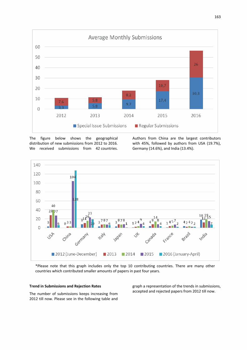
163
The figure below shows the geographical distribution of new submissions from 2012 to 2016. We received submissions from 42 countries.
Authors from China are the largest contributors with 45%, followed by authors from USA (19.7%), Germany (14.6%), and India (13.4%).
*Please note that this graph includes only the top 10 contributing countries. There are many other countries which contributed smaller amounts of papers in past four years.
Trend in Submissions and Rejection Rates
The number of submissions keeps increasing from 2012 till now. Please see in the following table and
graph a representation of the trends in submissions, accepted and rejected papers from 2012 till now.
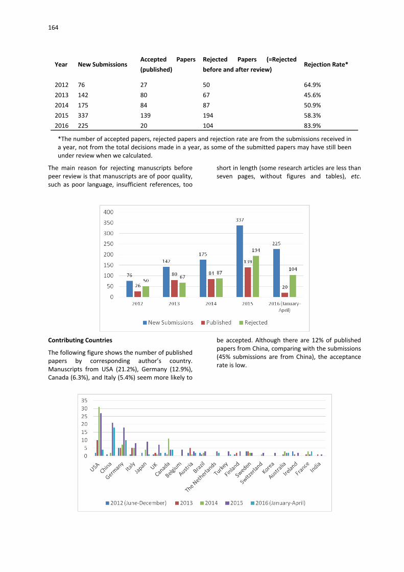
164
Year New Submissions Accepted Papers (published)
Rejected Papers (=Rejected before and after review)
Rejection Rate*
2012 76 27 50 64.9% 2013 142 80 67 45.6% 2014 175 84 87 50.9% 2015 337 139 194 58.3% 2016 225 20 104 83.9%
*The number of accepted papers, rejected papers and rejection rate are from the submissions received in a year, not from the total decisions made in a year, as some of the submitted papers may have still been under review when we calculated.
The main reason for rejecting manuscripts before peer review is that manuscripts are of poor quality, such as poor language, insufficient references, too
short in length (some research articles are less than seven pages, without figures and tables), etc.
Contributing Countries
The following figure shows the number of published papers by corresponding author’s country. Manuscripts from USA (21.2%), Germany (12.9%), Canada (6.3%), and Italy (5.4%) seem more likely to
be accepted. Although there are 12% of published papers from China, comparing with the submissions (45% submissions are from China), the acceptance rate is low.
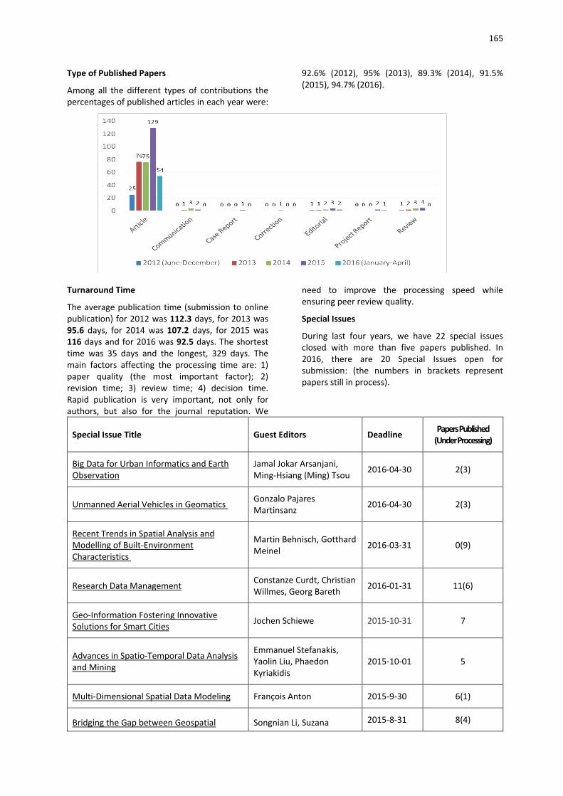
165
Type of Published Papers
Among all the different types of contributions the percentages of published articles in each year were:
92.6% (2012), 95% (2013), 89.3% (2014), 91.5% (2015), 94.7% (2016).
Turnaround Time
The average publication time (submission to online publication) for 2012 was 112.3 days, for 2013 was 95.6 days, for 2014 was 107.2 days, for 2015 was 116 days and for 2016 was 92.5 days. The shortest time was 35 days and the longest, 329 days. The main factors affecting the processing time are: 1) paper quality (the most important factor); 2) revision time; 3) review time; 4) decision time. Rapid publication is very important, not only for authors, but also for the journal reputation. We
need to improve the processing speed while ensuring peer review quality.
Special Issues
During last four years, we have 22 special issues closed with more than five papers published. In 2016, there are 20 Special Issues open for submission: (the numbers in brackets represent papers still in process).
Special Issue Title Guest Editors Deadline Papers Published (Under Processing)
Big Data for Urban Informatics and Earth Observation
Jamal Jokar Arsanjani, Ming-Hsiang (Ming) Tsou 2016-04-30 2(3)
Unmanned Aerial Vehicles in Geomatics Gonzalo Pajares Martinsanz 2016-04-30 2(3)
Recent Trends in Spatial Analysis and Modelling of Built-Environment Characteristics
Martin Behnisch, Gotthard Meinel 2016-03-31 0(9)
Research Data Management Constanze Curdt, Christian Willmes, Georg Bareth 2016-01-31 11(6)
Geo-Information Fostering Innovative Solutions for Smart Cities Jochen Schiewe 2015-10-31 7
Advances in Spatio-Temporal Data Analysis and Mining
Emmanuel Stefanakis, Yaolin Liu, Phaedon Kyriakidis
2015-10-01 5
Multi-Dimensional Spatial Data Modeling François Anton 2015-9-30 6(1)
Bridging the Gap between Geospatial Songnian Li, Suzana 2015-8-31 8(4)

166
Special Issue Title Guest Editors Deadline Papers Published (Under Processing)
Theory and Technology Dragicevic, Xiaohua Tong
Borderlands Modeling and Analysis Xiao-guang Zhou, Weihua Dong 2015-5-31 5
20 Years of OGC: Open Geo-Data, Software, and Standards
Steve H.L. Liang, Mohamed Bakillah 2015-4-30 7
Geoinformation for Disaster Risk Management Christoph Aubrecht 2015-4-30 17
Open Geospatial Science and Applications
Suchith Anand, Thierry Badard, Franz-Josef Behr, Serena Coetzee, Luciene Delzari, Barend Kobben
2015-1-30 9
Selected Papers from the ISPRS Tracking and Imaging Challenge 2014
Stephan Winter, Alper Yilmaz, Monika Sester 2015-1-15 5
Recent Developments in Cartography and Display Technologies Julia Siemer 2014-12-15 5
Spatial Analysis for Environmental Applications Linda See 2014-11-30 7
GIS for Sustainable Urban Transport Mark Zuidgeest, Martin van Maarseveen, Mark Brussel
2014-10-30 7
Remote Sensing and Geospatial Technologies in Public Health Fazlay S. Faruque 2014-7-30 15
Geoweb 2.0 Alexander Zipf, Bernd Resch 2014-7-18 5
Geographic Information Science and Remote Sensing Techniques for Sustainable Urban and Regional Planning
Beniamino Murgante, Giuseppe Borruso, Maurizio Pollino, Federico Martellozzo
2014-5-31 5
GIS for Renewable Energy Martin Raubal 2014-2-28 10
GIS in Public Health Stefania Bertazzon 2013-11-30 5
Coastal GIS Timothy Nyerges 2013-9-30 10
Indoor Positioning and Indoor Navigation Harald Sternberg 2013-3-31 7
Collaborative Mapping Linda See, Steffen Fritz, Jan De Leeuw 2013-4-30 7
Geospatial Monitoring and Modelling of Environmental Change Duccio Rocchini 2012-12-31 8

167
There are currently 21 Special issues open for submissions:
Special Issue Guest Editor Deadline
Spatial Ecology Duccio Rocchini 2016-05-31
Geographic Information Retrieval Kathleen Stewart, Alexander Klippel 2016-05-31
Mathematical Morphology in Geoinformatics Beatriz Marcotegui 2016-06-30
Location-Based Services Georg Gartner, Haosheng Huang 2016-06-30
Geosensor Networks and Sensor Web Silvia Nittel 2016-07-31
3D Indoor Modelling and Navigation Sisi Zlatanova, Kourosh Khoshelham, George Sithole 2016-08-31
Web/Cloud Based Mapping and Geoinformation
Bert Veenendaal, Maria Antonia Brovelli, Serena Coetzee, Peter Mooney 2015-09-30
Recent Advances in Geodesy & Its Applications Zhao-Liang Li, Jose A. Sobrino, Chao Ren 2015-09-30
Geospatial Semantics and Semantic Web E. Lynn Usery, Dalia Varanka 2016-09-30
Geospatial Big Data and Transport Bin Jiang, Constantinos Antoniou 2016-09-30
Advances and Innovations in Land Use/Cover Mapping Qiming Zhou, Zhilin Li 2016-10-31
Volunteered Geographic Information Alexander Zipf, David Jonietz, Vyron Antoniou, Linda See 2016-11-30
Advances in Geo-Information for Environmental Forensics and Environmental Risk Management in the Anthropocene
Jason K. Levy 2016-11-30
Analysis and Applications of Global Land Cover Data Jun Chen, Songnian Li, Shu Peng 2016-12-1
Intelligent Spatial Decision Support Shih-Lung Shaw, Qingquan Li, Yang Yue 2016-12-31
Frontiers in Spatial and Spatiotemporal Crime Analytics Marco Helbich, Michael Leitner 2016-12-31
Applications of Internet of Things Chi-Hua Chen, Kuen-Rong Lo 2016-12-31
Intelligent Spatial Decision Support Shih-Lung Shaw, Qingquan Li, Yang Yue 2016-12-31
Smart Solutions for Disaster Risk Reduction: Big Data Concepts for Disater Risk Reduction (DRR)
Milan Konecny 2017-1-31
Spatiotemporal Computing for Yichun Xie, Xinyue Ye 2017-2-28

168
Special Issue Guest Editor Deadline
Sustainable Ecosystem
Research and Development Progress in 3D Cadastral Systems Peter van Oosterom, Efi Dimopoulou 2017-03-31
Editorial Board
Changes in the Editorial Board
Dr. George P. Petropoulos, Dr. Jamal Jokar Arsanjani, Dr. Tanvir Islam and Dr. Tao Cheng joined the Editorial Board from 2014 till now. Dr. Martien Molenaar resigned because of retirement. The size of the board is now 31 members.
Editorial Board Members and Other ISPRS Members Contributions
Special Issues
Eight Editorial Board members and another 20 ISPRS members helped edit 21 special issues in past four years. They are: Sisi Zlatanova (Editorial Board member), Qiming Zhou (Editorial Board member), Josef Strobl (Editorial Board member), Michael Leitner (Editorial Board member), Milan Konecny (Editorial Board member), Bin Jiang (Editorial Board member), Christoph Aubrecht (Editorial Board
member), Monika Sester (Editorial Board member), Marguerite Madden, Stephan Winter, Alper Yilmaz, Suchith Anand, Steve H.L. Liang, Mohamed Bakillah, Xiao-Guang Zhou, Weihua Dong, Songnian Li, Suzana Dragicevic, Xiaohua Tong, François Anton, Emmanuel Stefanakis, Yaolin Liu, Maria Antonia Brovelli, Yang Yue, Jun Chen, Songnian Li.
Submission Contribution
13 Editorial Board members contributed manuscripts to IJGI in past four years.
Review
11 Editorial Board members reviewed manuscripts for IJGI in past four years.
Decision
14 Editorial Board members made decisions for IJGI in past four years. The detailed information can be found in following table:
First Name Last Name Submission Review Decision Special Issue Ozgun Akcay 2 0 2 0 Christoph Aubrecht 0 1 19 1 Emmanuel Baltsavias 0 0 0 0 Norbert Bartelme 0 1 2 0 Jun Chen 3 0 0 1 Tao Cheng 0 0 0 0 Mahmoud R. Delavar 4 2 1 0 Manfred Ehlers 0 0 0 0 Sérgio Freire 0 1 3 0 Chris Gold 1 0 0 0 Bin Jiang 4 0 4 1 Marinos Kavouras 0 0 1 0 Milan Konecny 0 1 0 1 Michael Leitner 1 2 2 1 Marguerite Madden 1 1 1 4 Ammatzia Peled 1 0 1 0 Monika Sester 1 0 0 1 Wenzhong Shi 0 0 0 0 Andrew Skidmore 0 0 0 0 Josef Strobl 2 1 1 0

169
Xinming Tang 0 0 0 0 Vladimir Tikunov 0 0 0 0 Wolfgang Wagner 1 1 0 0 Qiming Zhou 1 0 5 1 Sisi Zlatanova 3 0 4 2 Carlos Granell Canut 1 8 0 0 Jason K. Levy 0 0 0 1 George P. Petropoulos 0 0 0 0 Jamal Jokar Arsanjani 0 2 0 0 Tanvir Islam 0 0 1 0
Indexing
The journal has been covered by Science Citation Index Expanded (Web of Science) since
April 2015, the theoretical IF for 2015 is 0.9938. The journal also been covered by Scopus in 2016.
Journal Name:
ISPRS Internationa Journal of Geo-Information
(excluding corrections, retractions, editorials; query mdpi.com journal page)
Papers published 2013 79
Papers published 2014 81
Sum 160
Citations in 2015 to articles published in 2013 87
Citations in 2015 to articles published in 2014 72
Sum 159
Theoretical IF (2015) 0.9938
Please see Appendix 2 for the top 10 most cited papers published from 2016 till now.
Marketing and Promotions
From 2012 till now, 36 call-for-papers campaigns were carried out. We invited former authors and reviewers of IJGI and other potential authors to publish papers. ISPRS IJGI was promoted at conferences through various activities:
Name of the Conference Activity
ISPRS WG VIII/2-Health Symposium, 24–30 August 2013 Special issue promotion
ISPRS/IGU/ICA Joint Workshop on Borderlands Modeling and Understanding for Global Sustainability, 5–6 December 2013
Special issue promotion
PECORA 19, 17-20 November 2014 Journal flyers distributed

170
2014 ISPRS TC II Midterm Symposium, 6–8 October 2014 Special issue promotion
Data Management Workshop, 28–29 November 2014 Special issue promotion
International Land Use Symposium (ILUS) 2015, 11–13 November 2015
Sponsorship of "get together".
International Workshop on Image and Data Fusion (IWIDF 2015), 21–23 July 2015
EiC travel grant
XXIII ISPRS Congress, 12–19 July 2016 Booth and Editorial board member meeting
7. Conclusions and Areas for Development
IJGI had a very positive performance in the past four years, showing growth in all its performance indicators: number of published papers, submissions, number of pdf downloads. In 2016 we will continue to work towards further improving the quality of the papers published, reducing the processing speed, improving the number of
published papers, enhancing the brand of the journal, and increasing the readership of the journal. We will also promote among authors and at different venues the news about the forthcoming Impact Factor.
Wolfgang Kainz, Editor in Chief
Appendix 1
Top 10 of most downloaded articles published from 2012 till now:
# Title Author Name Downloads
1 GIS-Based Planning and Modeling for Renewable Energy: Challenges and Future Research Avenues
Bernd Resch, Günther Sagl, Tobias Törnros, Andreas Bachmaier, Jan-Bleicke Eggers, Sebastian Herkel, Sattaya Narmsara and Hartmut Gündra
4,270
2 Transport Accessibility Analysis Using GIS: Assessing Sustainable Transport in London
Alistair C. Ford, Stuart L. Barr, Richard J. Dawson and Philip James
4,149
3 An Analysis of Geospatial Technologies for Risk and Natural Disaster Management
Luiz A. Manfré, Eliane Hirata, Janaína B. Silva, Eduardo J. Shinohara, Mariana A. Giannotti, Ana Paula C. Larocca and José A. Quintanilha 3,342
4 GIS-Based Analytical Tools for Transport Planning: Spatial Regression Models for Transportation Demand Forecast
Simone Becker Lopes, Nair Cristina Margarido Brondino and Antônio Nélson Rodrigues da Silva 3,124
5 Indoor Positioning for Smartphones Using Asynchronous Ultrasound Trilateration
Viacheslav Filonenko, Charlie Cullen and James D. Carswell 2,551
6 Effects of Pansharpening on Vegetation Indices
Brian Johnson 2,358
7 Modeling Urban Land Cover Growth Dynamics Using Multi-Temporal Satellite Images: A Case Study of Dhaka, Bangladesh
Bayes Ahmed and Raquib Ahmed
2,253
8 A Conceptual Flash Flood Early Warning System for Africa, Based on Terrestrial Microwave Links and Flash Flood Guidance
Joost C. B. Hoedjes, André Kooiman, Ben H. P. Maathuis, Mohammed Y. Said, Robert Becht, Agnes Limo, Mark Mumo, Joseph Nduhiu-Mathenge, Ayub Shaka and Bob Su 2,174
171
9 Analyzing the Contributor Activity of a Volunteered Geographic Information Project—The Case of OpenStreetMap
Pascal Neis and Alexander Zipf
2,082
10 Pygrass: An Object Oriented Python Application Programming Interface (API) for Geographic Resources Analysis Support System (GRASS) Geographic Information System (GIS)
Pietro Zambelli, Sören Gebbert and Marco Ciolli
2,063
Appendix 2
Top 10 cited papers published from 2012 till now:
Authors Article Citations Publication Year
Pascal Neis and Alexander Zipf Analyzing the Contributor Activity of a Volunteered Geographic Information Project —The Case of OpenStreetMap
51 2012
Bayes Ahmed, and Raquib Ahmed Modeling Urban Land Cover Growth Dynamics Using Multi‑Temporal Satellite Images: A Case Study of Dhaka, Bangladesh
19 2012
Steven P. Jackson, William Mullen, Peggy Agouris, Andrew Crooks, Arie Croitoru and Anthony Stefanidis
Assessing Completeness and Spatial Error of Features in Volunteered Geographic Information
18 2013
Pascal Neis, Marcus Goetz and Alexander Zipf
Towards Automatic Vandalism Detection in OpenStreetMap
18 2012
Xinlian Liang, Juha Hyyppä, Harri Kaartinen, Markus Holopainen and Timo Melkas
Detecting Changes in Forest Structure over Time with Bi-Temporal Terrestrial Laser Scanning DataRole of Demographic, Infrastructure and Topo-Edaphic Factors
15 2012
Viacheslav Filonenko, Charlie Cullen and James D. Carswell
Indoor Positioning for Smartphones Using Asynchronous Ultrasound Trilateration
13 2013
David Fairbairn and Maythm Al-Bakri
Using Geometric Properties to Evaluate Possible Integration of Authoritative and Volunteered Geographic Information
11 2013
Jean-François Mas, Britaldo Soares Filho, Robert Gilmore Pontius, Michelle Farfán Gutiérrez and Hermann Rodrigues
A Suite of Tools for ROC Analysis of Spatial Models
9 2013
Sarah M. Lewis and Maggi Kelly Mapping the Potential for Biofuel Production on Marginal Lands: Differences in Definitions, Data and Models across Scales
9 2014
Robert Hecht, Carola Kunze and Stefan Hahmann
Measuring Completeness of Building Footprints in OpenStreetMap over Space and Time
9 2013
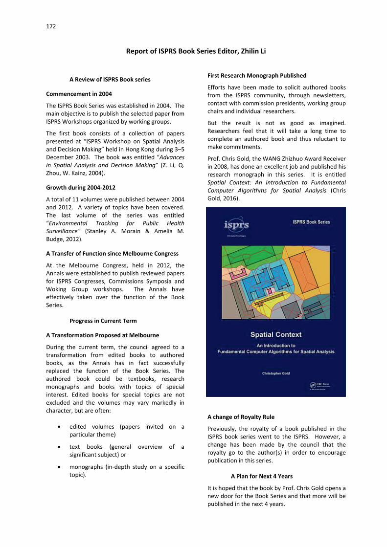
172
Report of ISPRS Book Series Editor, Zhilin Li
A Review of ISPRS Book series
Commencement in 2004
The ISPRS Book Series was established in 2004. The main objective is to publish the selected paper from ISPRS Workshops organized by working groups.
The first book consists of a collection of papers presented at “ISPRS Workshop on Spatial Analysis and Decision Making” held in Hong Kong during 3–5 December 2003. The book was entitled “Advances in Spatial Analysis and Decision Making” (Z. Li, Q. Zhou, W. Kainz, 2004).
Growth during 2004-2012
A total of 11 volumes were published between 2004 and 2012. A variety of topics have been covered. The last volume of the series was entitled “Environmental Tracking for Public Health Surveillance” (Stanley A. Morain & Amelia M. Budge, 2012).
A Transfer of Function since Melbourne Congress
At the Melbourne Congress, held in 2012, the Annals were established to publish reviewed papers for ISPRS Congresses, Commissions Symposia and Woking Group workshops. The Annals have effectively taken over the function of the Book Series.
Progress in Current Term
A Transformation Proposed at Melbourne
During the current term, the council agreed to a transformation from edited books to authored books, as the Annals has in fact successfully replaced the function of the Book Series. The authored book could be textbooks, research monographs and books with topics of special interest. Edited books for special topics are not excluded and the volumes may vary markedly in character, but are often:
• edited volumes (papers invited on a particular theme)
• text books (general overview of a significant subject) or
• monographs (in-depth study on a specific topic).
First Research Monograph Published
Efforts have been made to solicit authored books from the ISPRS community, through newsletters, contact with commission presidents, working group chairs and individual researchers.
But the result is not as good as imagined. Researchers feel that it will take a long time to complete an authored book and thus reluctant to make commitments.
Prof. Chris Gold, the WANG Zhizhuo Award Receiver in 2008, has done an excellent job and published his research monograph in this series. It is entitled Spatial Context: An Introduction to Fundamental Computer Algorithms for Spatial Analysis (Chris Gold, 2016).
A change of Royalty Rule
Previously, the royalty of a book published in the ISPRS book series went to the ISPRS. However, a change has been made by the council that the royalty go to the author(s) in order to encourage publication in this series.
A Plan for Next 4 Years
It is hoped that the book by Prof. Chris Gold opens a new door for the Book Series and that more will be published in the next 4 years.

173
A Book for 80th Anniversary of the ISPRS Journal
The Photogrammetria, now called ISPRS journal for Photogrammetry and Remote Sensing, was first published in 1938. The journal has undergone fast development over 80 years. Therefore, it is pertinent to have a close examination of the milestones in such a development. It is planned and agreed by the current
council members to produce a volume for the 80th Anniversary celebration. The volume may be named “Classics of Photogrammetry, Remote Sensing and Geo-information Sciences”, or “Milestones of Photogrammetry, Remote Sensing and Geo-information Sciences”. It should contain the papers
which have played key roles in the development of Photogrammetry, Remote Sensing and Geo-information sciences.
A working group, consisting of the book series editor, ISPRS journal editors, some council members and/or their representatives, should be formed to work on this book.
Other Plans
It is planned to
1 Solicit some ideas from active members on hot topics, e.g. global land cover mapping;
2 Solicit some ideas from retired members on some important topics; and
3 Solicit some books which are to be revised for new versions.
Zhilin Li, Editor in Chief
Report on the ISPRS Web Site, Markus Englich
1. Statistics
Currently, we host 1100 aspx files (main html files), about 3000 html files of older documents and more than 20000 PDFs, thereof more than 80% papers. The most visited areas have been publications, calendar, job opportunities and the blog about the revision of the ISPRS commission structure. The mean number of visitors per month increased in the last term from about 25000 to 35000.
The map shows were our visitors come from. The red stars mark the most active cities, dark blue circle cities with average activities and the small blue circle cities with lower activities. It shows that
the visitors come from around the world but with some concentrations in USA, Europe, and East Asia.
2. Second Web Server for TC and WG Websites
Since 2012, a second webserver with a Content Management System (CMS) has been available to host the TC and WG websites – in total 68. Each Group (TCs and WGs) has their own area with folders and rights which was prepared with a uniform structure and a common layout. They had to fill their pages with content themselves – by their own webmaster – but in case of problems, support was offered. In general, this service was used very well, but differences in usage and updating of these “websites” exist. Some symposium websites (TC II
174
and IV) were hosted on this server as well. A third one (TC I) was hosted on the main web server. On demand some extra services were offered, such as registration forms with possible download of the content in Excel sheets, newsletters and displaying bibtex lists on web pages. This server was also used to offer a blog to discuss the new ISPRS structure between the Council and the community.
3. Setup of Some New Features
Since this term a lot of data is stored in databases. The offered member data on the ISPRS website are synchronized once a day with the administrated member database of the ISPRS headquarters. Calendar data and job opportunities are now stored in a database, thereby these pages can be updated automatically and “old” entries are no longer offered. Autonomous procedures to subscribe and unsubscribe to the email list are now used and the list itself is stored in a database as well.
For the new Individual membership, a registration interface with verification, approval by the office of
the SG and automated generation of the member certificates was developed and installed. It also offers an automatic renewal procedure after a certain period (currently 1 year).
For Sustaining members, a protected area has been implemented where they can access the digital version of the ISPRS Journal at Elsevier. Sustaining members are now promoted with their logos on the ISPRS website (left column under the menu). The promotion is set randomly and weighted (higher member class brings higher visibility on the ISPRS website).
4. Misc
Since 2013, the ISPRS Journal page has been hosted on our main server. The communication and cooperation with the office of the SG is very fast and professional.
Markus English, Web Master
Report of TIF (The ISPRS Foundation) Chair, Board of Trustees, Dieter Fritsch
1. Introduction
The ISPRS Foundation Inc. is a non-profit entity, managed by a Board of Trustees, which responds to ISPRS grant needs that are identified by the ISPRS Council. The ISPRS Council will solicit proposals for grants and then collaborate with TIF Board to support worthy candidates. The Board of Trustees is responsible for fund raising, investment, management and approval for grants of Foundation funds. Day-to-day operations of the Foundation are managed by an Executive Committee (ExCom), comprising the Chair, Operations Officer and Finance Officer. Decisions requiring approval by the Board are made by electronic ballots. It is required that the Board meets regularly in conjunction with the ISPRS Congress or otherwise by teleconference.
The ISPRS Foundation (TIF) was legally established in August 2003 and the Board of Trustees, comprised of prominent professionals in the fields of ISPRS, were then appointed. TIF has as its aims to improve the ability of ISPRS to satisfy its philanthropic aims and objectives, by administering a broadly-based international program of fund-raising to provide grants to qualified individuals and organizations, pursuing and/or applying knowledge for advancing the sciences and technologies associated with the disciplines embodied by ISPRS.
The areas that are expected to be funded by The ISPRS Foundation include awards, awareness education, distance learning, exchange programs, fellowships, grants, international workshops, internships, preservation and archiving, research initiatives, scholarships, standards projects, tools and literature, and travel grants. It is contributing significantly to the efforts of ISPRS in capacity building, international cooperation and technology transfer. The Foundation has now been in operation for almost 13 years. The first grants were provided to participants to attend the Mid-term Symposia in 2006 and further grants have been awarded every year since then.
2. Summary of TIF BoT Decisions Melbourne 2012
During the last meeting of the TIF BoT at the ISPRS Melbourne Congress, 27 August 2012 the following decisions were made:
• Changes were recommended to the Bylaws to allow the Chair Dieter Fritsch to continue for a further term. These changes were implemented, so that Dieter Fritsch could extend his term till July 2016.

175
• Existing Officers were re-elected as listed below.
• Recommendations were made on future members of the Board and committees as listed below.
• Juergen Dold offered the assistance of Sara Vermeulen from Leica Geosystems, Heerbrugg, to review TIF’s marketing plan. Subsequently, recommendations were received from Sara Vermeulen, including the preparation of a newsletter on a quarterly basis. This newsletter is now incorporated into the ISPRS Bulletin.
• Regarding financial management:
o TIF should try to maintain its capital base and therefore increase its donations.
o Trustees should aim to boost capital by 5% per year after expenditure.
o TIF should not fund science initiatives in future.
o TIF should aim to allocate funds with max. $30,000 per year.
3. TIF Activities and Funding 2012-2016 (Travel Grants for 2013, 2014, 2015, 2016)
TIF provided funding for the following activities throughout the past 4 years:
2012 - Total USD 33,910.00
Travel Grants: USD 26,600.00
Partial travel grants were awarded for 11 participants to attend ISPRS Congress in Melbourne, Australia.
Congress Awards: USD 7,310.00
Wang Zhizhuo Award (CHF 2,500 or USD 2,560)
Frederick J. Doyle Award (USD 2,500)
CATCon (3) Awards (USD 2,250) of Gold (USD 1,000), Silver (USD 750) and Bronze (USD 500) for winners of software contest organized by ISPRS Commission VI Working Group 2, Computer Assisted Teaching and sponsored donor companies.
2013 – USD 20,649.79
International Workshops – USD 12,678.11
9th ISPRS Student Consortium and WG VI/5 Summer School, 25-30 October 2013, Bali, Indonesia (USD 4066.11)
10th ISPRS Student Consortium and WG VI/5 Summer School, 28 October – 1 November, 2013 at Addis Ababa, Ethiopia (USD 8,612.00)
Travel Grants: USD 7,971.68
ISPRS Hannover Workshop ‘High-Resolution Earth Imaging for Geospatial Information’, at Leibniz University Hannover Germany, from 21-24 May 2013 (USD 3,750)
ISPRS Conference on Serving Society with Geoinformatics –SSG-2013, Joint Meeting, 11-17 November 2013, Antalya, Turkey (USD 2,953.30)
Student Consortium Representative to ISPRS SC and WG VI/5 Summer School, Addis Ababa, 29 October to 2 November 2012, (USD 1,268.38)
2014 - Total USD 33,443.22
International Workshops – USD 4,952.22
ISPRS Student Consortium, 3S and WG VI/5 Summer School, Wuhan, China (USD 3,000.00)
Support, Student Consortium representative to attend SC/WG VI/5 Summer Schools (USD 1,952.22)
Travel Grants: USD 28,491.00
Partial travel grants were awarded for 29 participants from 16 countries to attend ISPRS Symposia for Commissions I to VIII.
2015 – USD 24,376.02
International workshops – USD 11,423.78
ISPRS Student Consortium and WG VI/5 Summer Schools at ACRS, Myanmar (1-5 November 2014) and Philippines (23-28 October 2015)
Students Summer School (3S), Moscow, Russia (13-16 August 2015)
Travel grants – USD 12,952.24
Photogrammetric Image Analysis (PIA) 2015 and HRIGI in Munich 25-27 March 2015 – USD 3,952.24
ISPRS Geospatial Week-2015 28 September – 3 October 2015, La Grande Motte, France – USD 9,000
2016 - (Estimated Total USD 53,462 with contribution from ISPRS of approximately USD 29,000)
Travel Grants for 63 grantees to attend the ISPRS Congress in Prague (USD 30,000)
International workshops – (Estimated USD 12,757)

176
IEEE-ISPRS Summer Schools in Curitiba, Brazil (29 October to 1 November 2015) and Sao Paulo, Brazil (19-21 October 2016)
ISPRS Student Consortium and WG VI/5 Summer School, Prague Congress (10 July 2016)
Congress Awards – (Estimated USD 10,705)
Wang Zhizhuo Award of CHF 2,500 or USD 2,560)
Frederick J. Doyle Award (USD 2,500) and medal (USD 720)
IGI Africa Ambassador Award (EUR 2,500 or USD 2,675)
CATCon (3) Awards (USD 2,250) of Gold (USD 1,000), Silver (USD 750) and Bronze (USD 500) for winners of software contest organized by ISPRS Commission VI Working Group 2, Computer Assisted Teaching and sponsored donor companies.
Total grants for the period 2012-2015 total USD 112,379 with an additional USD 53,462 expected to be granted in 2016.
4. TIF IGI Africa Ambassador Award
IGI has offered the IGI Ambassador Award, via The ISPRS Foundation (TIF) valued at €2,500 per year, to young scientists in photogrammetry and laser scanning coming from regionally under-represented African countries in the geospatial sciences and technology fields. The award allows for visits at IGI‘s Central Office, Kreuztal, Germany, and active participation at ISPRS Workshops, Conferences, and Symposia. The first recipient of this award was M.Sc. Muna Khamis Birra Ali, Khartoum, Sudan who
visited IGI in Kreuztal in March 2016 as well as the Institute for Photogrammetry at the University of Stuttgart, and nFrames in Stuttgart. A further award is available for 2016.
5. White Elephants Travel Grants
A White Elephants Restricted Travel Grant Fund has been established in The ISPRS Foundation to support young people to attend ISPRS events and especially the quadrennial ISPRS Congresses. The restricted grant category will be funded by senior members of ISPRS, who are members of the White Elephants, (a group of TIF former officers, TIF Honorary Members and Fellows) and who wish to demonstrate their continued commitment to the aims and goals of ISPRS. By supporting young outstanding scientists worldwide to attend ISPRS international scientific events, the White Elephants Travel Grants will demonstrate their commitment to the future of ISPRS. The support for these young people will encourage and equip them to take over the leadership of ISPRS in the future. The White Elephants Travel Grants are offered for the first time in 2016 for awardees to attend the ISPRS Congress in Prague.
6. Financial Statements (2012-2016)
The Bylaws were constructed in accordance with regulations to be exempt from Federal and other taxation. The Foundation’s net worth is expressed as Net Fair Market Value (NFMV). Over the past 4
years, the year-end NFMV in US$, the amount of grants, administrative costs, and investment earnings are listed in Table 1 below.
Table 1. TIF Net Fair Market Value (NFMV), Grants, Admin Costs, Earnings and Donations
General Comments:
• Donations from Leica Geosystems of USD 10,015 should be added to the NFMV for 2013 and 2014. Invoicing for these donations to
secure the payments was inadvertently omitted.
• Actions are solicited from Trustees, ISPRS Council and Delegates to the General Assembly to improve the number of donations
Year-end
NFMV Grants Distributed
Operating Cost
(% Admin Expense)
Investment Earnings
Donations
2012 $ 170,206.27 $ 34,905.54 $ 1,350.00 (0.79%) $ 10,041.60 $ 15,121.60
2013 $ 166,761.89 $ 20,649.79 $ 75.00 (0.04%) $ 7,235.18 $ 20,130.34
2014 $ 162,306.03 $ 33,443.22 $ 1,675.00 (1.00%) $ 4,259.06 $ 23,658.01
2015 $ 148,559.28 $ 24,376.02 $ 2,850.00 (1.92%) $ 4,622.30 $ 12,853.77
2016 TBD ~ $ 53,462.00 TBD TBD TBD
177
received by TIF. The level of donations is generally lower than required to satisfy the Board’s intention in 2012 of boosting capital by 5% per year and providing USD 30,000 per year in grants.
• The online donation capability using PayPal has been initiated with buttons providing options for donations in USD, CHF and Euro.
• Pledges to TIF by members of the White Elephants Club have been rejuvenated following the Melbourne Congress and the
• development of the White Elephants Travel Grant.
• Efforts to solicit new donations from TIF Sustaining Members are ongoing and assistance by Trustees and ISPRS Council is encouraged.
• Due low interest rates earnings have reduced over the past 4 years.
• Unrealized losses and gains are being experienced due to fluctuations in the market values of TIF’s investments.
Acknowledgement of Major Donors
• The annual generous donations by Leica Geosystems of CHF 5,000 per year (period 2012-2016) are acknowledged and gratefully received.
• A generous donation of USD 4,990 from Geoway, (China) is acknowledged and gratefully received.
• The donation of € 2,500 per year (period 2014-2016) for the IGI Ambassador Program from IGI Kreuztal, Germany, is acknowledged and gratefully received.
• ISPRS Council for continued financial support for TIF activities over the past 4 years.
Board of Trustees – 2012-2016
The Board of Trustees comprises 11 persons, who are appointed by ISPRS Council. Only two members of the Board of Trustees may be members of the existing Council of ISPRS. Trustees are leaders in fields of the photogrammetry, remote sensing and spatial information sciences, who have significant knowledge and experience in the needs of industry and governments. Membership of the Board reflects the international character and diversity of the Society. Trustees do not receive any salary or other compensation for their services.
Current Board Members Dieter Fritsch, Stuttgart University, Germany – Chair and ExCom Officer
John Trinder, University of New South Wales, Australia – Operations and ExCom Officer
Marguerite Madden, University of Georgia, Athens GA, USA – Finance and ExCom Officer
Chen Jun (China) – ISPRS COUNCIL REP
Jon Mills (UK) - ISPRS COUNCIL REP
Juergen Dold, President, Hexagon Geosystems, Heerbrugg, Switzerland
Lewis Graham – President/CTO GeoCue Group, Huntsville, USA
Mazlan Othman, Director UN Office of Outer Space Affairs (UN_OOSA), Vienna, Austria
Li Deren (China) – Wuhan, China, newly appointed September 2012
Mario Hernandez (Switzerland), newly appointed March 2014
Lawrie Jordan ESRI, Redlands, USA, newly appointed August 2014
Former Board Members
Akihiro Yamura (Japan) - Term ended in 2012
Lawrence Fritz – Term ended in July 2013
Vanessa Lawrence - Director General & Chief Executive Ordnance Survey (UK) – Term ended July 2013
Special thanks and acknowledgements are extended to all present and past Board members for their commitment and contributions to the work of The ISPRS Foundation.
Office Bearers – 2012-2016 Chair – Dieter Fritsch
Operations Officer –John Trinder
Finance Officer – Marguerite Madden
Board Meetings
A meeting of the TIF Board of Trustees was held on 27 August 2012 during the XXIInd ISPRS Congress, Melbourne, Australia, with 8 Board members in attendance.
A meeting will also be held in Prague during the XXIIIrd Congress on Sunday 17 July 2016.
Committees
The Board has established the following Committees to assist it in its operations. Members

178
of these Committees and Terms of Reference are given in the Appendix.
• Marketing and Promotions Committee
• Grants Evaluation Committee
• Large Grants Procurement Committee
• Audit Committee
Conclusions and Outlook
The continued need to provide assistance to young scientists to attend international workshops and ISPRS sponsored events has placed strong demands on TIF to attract funds. Nevertheless, TIF has been able to provide assistance to many young scientists from developing countries throughout the past 4 years.
The Net Fair Market Value (NFMV) has not increased to satisfy the Board’s resolutions in 2012 to boost capital by 5% per year and providing USD 30,000 per year in grants. However, despite the difficult financial times the NFMV has remained close to the same amount of approximately USD 170,000 given the generous support of major donors for which the Board are very much appreciative. (Note: Although the NFMV dipped slightly below USD 150,000 in 2015, it is expected to increase in 2016 due to some 2013 and 2014 and new 2016 donations, all being received in 2016.) All persons involved in ISPRS are urged to seek donors for the Foundation so that its very beneficial work can continue.
Dieter Fritsch, Chair
APPENDIX - TIF COMMITTEES
Grants Evaluation Committee
Terms of Reference
1. Make recommendations to the Board of Trustees on priorities for grants in any 12 month period.
2. Consider applications for grants and make recommendations to the Board of Trustees.
3. Generally advise the Board on matter relating to grants.
Members of Grants Evaluation Committee
Chair – Jon Mills (UK) Chair
Nguyen Dinh Duong (Vietnam)
Hussein Farah (Kenya)
Sisi Zlatanova (Netherlands)
Norbert Pfeiffer (Austria)
Large Grants Procurement Committee
Terms of Reference
Advise and support the Board of Trustees on:
International grant funding agencies/foundations, that would be sympathetic to the aims of The ISPRS Foundation and should be approached for financial support of The ISPRS Foundation
Procedures for publicizing the goals and aims of The ISPRS Foundation to international grant funding agencies/foundations
Appropriate procedures and points of contact for applying for grants from international agencies/foundations
Procedures for renewal/maintenance of annual grants from international agencies/foundations.
Members of Large Grants Procurement Committee
Trustee – Dieter Fritsch (Germany) (Chair)
Member – John van Genderen (The Netherlands)
Member – Clive Fraser – (Australia)
Member - Alex Hoffman (USA)
Audit Committee
Terms of Reference of Audit Committee
The responsibilities of the Audit Committee are to advise the Board of Trustees with its:
1. Submission of a report every February of its findings resulting from its independent examination and audit of all Foundation income and expenses of the preceding year.
2. Recommendations for improving the rules and procedures governing the receipt, anonymity

179
and investment of gifts and donations, consistent with Foundation Bylaws and with federal and state law.
3. Recommendations for improving the rules and procedures governing the disbursement of grants, consistent with Foundation Bylaws and with federal and state law.
4. Prompt review of all proposed Foundation contracts and agreements to ensure consistency with Foundation Bylaws, as may be deemed necessary to carry on the business of the Foundation.
5. The term of members of the Committee will be three (3) years, with the term of the Chair for
one (1) year, when it will be passed to another member of the Committee.
Members of Audit Committee Chair – Lewis Graham – President/CTO GeoCue Group (USA)
Trustee – John Trinder (Australia)
Member – Laurent Polidori (France)
Report of IPAC (International Scientific Advisory Committee) by Chair, Gunter Schreier
1. IPAC Chair, Members and Organisation
New IPAC Chair
In 2012, Mr. Gunter Schreier, deputy director of the German Remote Sensing Data Center at DLR in Oberpfaffenhofen, Germany, was appointed by the ISPRS Council as new Chair of the International Policy Advisory Committee (IPAC). The Council and all IPAC members thanked the outgoing chair, Mr. Rainer Sandau, for his excellent service for IPAC during the previous years.
New IPAC Members and Membership ToRs
One of the first tasks of IPAC, in 2012, was to review its structure and the membership composition of its committee. The ISPRS council accepted a proposal by the IPAC Chair which reviewed the IPAC membership. Therein, 5 members have finished their duties with IPAC and new members have been invited to join. The new members have been selected to better represent international organizations (such as GEO and space agencies), Earth observation companies, an increased representation from Africa and South America and more women. In total, the IPAC membership has been enlarged to now 16 members. The names of the IPAC members are displayed at the IPAC web site under:
http://www.isprs.org/structure/ipac.aspx .
The membership list is planned to be updated in 2016, as quite a few members have changed their affiliation.
Also, a revision of the terms of membership has been discussed. This aims for more flexibility and balance in the representation of groups and organizations involved in ISPRS and interested in ISPRS related policy issues.
IPAC Terms of Reference
The new IPAC also reviewed the IPAC ToRs. The general ToRs remained the same, while a specific expression “legal issues… in the context of ISPRS” has been added and the reference to specific international bodies has been generalized. The new ToRs are displayed at the IPAC web site.
IPAC Work Plan
In 2012, IPAC discussed a new work plan for the coming years. Apart from the standard duties to provide the ISPRS council with early warning of relevant international policy issues and the representation of ISPRS in international organizations and fora, the work plan proposed IPAC to be more active on establishing fora for exchange and publishing relevant papers and documents. Specifically, the work plan asked for the conduction of an IPAC specific workshop, addressing a variety of topics.
2. Representation at International Organizations
Amongst the duties of the IPAC chairs is the representation of ISPRS in selected international organizations. The IPAC Chair participated at the UNOOSA meetings in Vienna (Feb. 2013/Feb 2014).

180
Material from COSPAR was received, but no specific actions w.r.t. COSPAR were taken.
The IPAC Chair is also active as the Chairman of the Earth Observation Committee of the International Astronautical Federation (IAF) and therefore is looking for synergies between ISPRS and IAF.
With regards to Earth observation data policy, the IPAC chair and several IPAC members (e.g. from GEO, ESA, USGS) are deeply involved in defining policies for large scale Earth observation programs (e.g. Copernicus, Landsat-8). Within Copernicus (i.e. the Sentinel satellite series), one success for the international science community and value adding companies was the acceptance of a “free and open” data policy, which was officially announced by a representative of the European Commission during the IPAC workshop, November 15th,,2013. IPAC supports and welcomes this Copernicus data policy.
3. IPAC Support to the ISPRS Council
In late 2014 and early 2015, IPAC supported the ISPRS Council in the approach to restructure the ISPRS technical commissions. IPAC commented the draft documents and actively contributed to the corresponding blog. Comments and recommendations were specifically addressing IPAC issues, such as the inclusion of data policy and space law in the new structure of the technical commissions.
IPAC also commented the “Prague declaration”, which shall be approved by delegates at the XXXIII ISPRS Congress and calls on international communities to work together and promote multi-disciplinary collaboration towards providing reliable global geospatial information to support Future Earth. IPAC reviewed the text of the declaration and noted issues on sharing of resources, computing cloud providers and in general the consideration of the European Copernicus programme as a potential policy driver.
4. Workshops Organized by IPAC or Involvement of IPAC
IPAC workshop: Maximizing the Utility of Earth Observation Data in the Internet Age; Antalya, Turkey; November 11-17; 2013
IPAC was happy the accept the invitation of the local organizers of the ISPRS-2013 SSG conference, hosted from November 11-17, 2013 in Antalya, Turkey, to have the IPAC workshop included in the conference venue. The IPAC workshop was conducted one full day on November 15th. The IPAC workshop aimed to solicit expert opinions on EO data policy and data sharing in today’s age of internet computing and enhanced capabilities to manage and access large amounts of EO data and information.
Final discussion panel during the IPAC workshop in Antalya
The workshop solicited perspectives from local and national agencies, international organizations, and academia. Three sessions with 12 speakers, partly representing IPAC and partly invited members, focused on various aspects of data policy and the challenges and opportunities Earth observation, photogrammetry and image science is facing from
new internet based technologies. Hence, the final presentation was held by Google. The workshop was concluded by a round table discussion with active participation from the audience.
The presentations of the IPAC workshop can be found on the conference web page under: http://www.isprs2013-ssg.org/scientific-program/.

181
IPAC workshop: Maximizing the Utility of Earth Observation Data in the Internet Age;
Agenda and Speakers:
Morning Session 1: Programmatic Perspectives
Gunter Schreier DLR, ISPRS IPAC Chair
Astrid-Christine Koch EC Copernicus Office, Brussels
Thomas Beer ESA GMES office
Ali Baygeldi Directorate General of Aeronautics and Space Technologies
Morning Session 2: User Perspectives
ChenJun ISPRS, President
Barbara Ryan GEO, Director
John Murtagh ASTRIUM
Irmgard Niemeyer Forschungszentrum Jülich GmbH
Afternoon Session 3: Technological Perspectives
Sias Mostert Space Advisory Company
Ian Dowmann UCL, ISAC Chair
Peter Spruyt JRC, European Commission
Ed Parsons Google
Afternoon Session 4: ISPRSE IPAC Round Table
"Earth Observation Data in the Internet Age"
Moderator & selected panelists
IPAC Workshop during the ISRSE Conference in Berlin, Tuesday, May 12th, 2015
IPAC organized a meeting aside the International Symposium of Remote Sensing of Environment (ISRSE), May 12th, 2015 at the BCC in Berlin, Germany. Next to the IPAC Chair, eight participants (IPAC members and guests) attended the meeting.
The topics of the agenda focussed on the IPAC ToR, the IPAC Plans and actual initiatives. Specific presentations were given by Orhan Altan (on the ISPRS reform and on contribution of ISPRS on disaster management and working together in this domain with UN and other international players) and Lena Halounova (on the forthcoming ISPRS congress). On the latter, Lena Halounova reported on the Space Agency Forum and a National Mapping and Cadastral Agency Forum to be organized during the congress. IPAC agreed to
support specifically the Space Agency Forum (see below).
Barbara Ryan, GEO Chair reported on the GEO Plenary and ministerial summit being held in Mexico City during the week of 9-13 November, 2015.
Adam Keith, Euroconsult, gave a presentation on the status and overview on new Earth observation systems, specifically the new commercial ventures starting earth observation activities with new satellite systems and constellations.
Agenda for the IPAC Workshop May 12th, 2015, Berlin
- See relation to IAF and others
- ISRSE (ICORSE) Berlin conference
- IPAC Meeting during ISRSE in Berlin
- Support to ISPRS Commission restructuring
- Representing ISPRS at UNOOSA in Vienna
- Attending Newcastle Meeting
- IAA-ISPRS Space Agency Forum
Participants of the workshop
Gunter Schreier DLR, Chair IPAC
Josef Aschbacher ESA, member IPAC
Barbara Ryan GEO, member IPAC
George Cho Uni Canberra, member IPAC
Irmgard Niemeyer FZ Jülich, member IPAC
Orhan Altan TU Istanbul, member ISPRS council
Lena Halounová CTU Prague, member ISPRS council
Adam Keith Euroconsult, guest
36th International Symposium on Remote Sensing of Environment (ISRSE 36) May 11-15, 2015, Berlin, Germany
ISRSE is not exactly an ISPRS conference, however, ICORSE a Committee of ISPRS under the ISPRS council, is in charge to organise this bi-yearly event. Several ISPRS council members attended the conference. The IPAC Chair, Gunter Schreier, was the head of the international programme committee, supported by many others, especially from the ISPRS community.

182
In order to link the ISRSE more closely in the ISPRS series of documents, it was decided to add all ISRSE conference papers to the ISPRS archives. Hence the same “conference organizer” (Copernicus Conference Services) having a frame contract with ISPRS was contracted to the ISRSE to organize the web based abstract management and the ISPRS related review process was adopted to the ISRSE abstract review.
In addition, selected papers have been invited to be published in a special edition of the ISPRS journal. John Trinder and Björn Waske are acting as editors of this special edition. According to latest information (John Trinder, May 2016) 13 prospective authors proposed a paper and after about 10 months in the review process, 2 papers have been accepted with one further paper likely to be accepted soon. Therefore it is likely that the theme issue of the ISPRS Journal will include 3 papers. Quote John Trinder: “This result is disappointing, but it demonstrates the difference between papers submitted for a conference and those submitted for the journal”.
An ICORSE Committee meeting also took place during the conference. Therein, a new chair for ICORSE was appointed (Lawrence Friedl, NASA HQ) and the outgoing chair (Per Erik Skrovseth, Norwegian Space Center) was thanked for his service during the last years. A closer coordination between ICORSE and ISPRS council was also agreed,
with a prospective meeting during the ISPRS congress in Prague.
ISRSE-36 Summary:
The 36th International Symposium on Remotes Sensing of Environment (ISRSE36), was hosted by the German Aerospace Center DLR, from 11-15 May 2015 in Berlin, Germany. Key figures of the ISRSE36 include:
• 738 participants from 66 countries
• 415 oral presentations and 167 posters in 81 technical sessions across 12 themes
• 29 keynote contributions in 5 plenary sessions
• 7 special sessions
• 3 social events and 1 technical tour
ISRSE36 took place while other initiatives are addressing Earth Observation:
• The process to define the UN global development agenda post 2015 with its Sustainability Development Goals was finalized in 2015.
• The Future Earth initiative has been created as a global platform to deliver solution-orientated research for sustainability. Among its key challenges are innovative approaches to integrate knowledge systems (data, observation, modelling, etc.), including remote sensing of the environment.
• A second Hyogo Framework of Action with its goal to substantially reduce disaster losses was launched in 2015, where Earth observation approaches play an increasing role in making societies resilient to disasters.
• The global Group on Earth Observations (GEO), together with its partners, such as the Committee on Earth Observing Satellites (CEOS), addresses these political and scientific agendas while it currently prepares for its second implementation phase 2016-2025.
• International science organizations, such as the International Society of Photogrammetry and Remote Sensing (ISPRS) are adapting their structure to master the research and development included in these challenges.

183
ISRSE-36 was an excellent forum to present results from past and current scientific achievements related to such international developments, as well as to discuss future plans for them. It featured recent milestones in the development of Earth observation programmes addressing sustainable development, global environmental issues and resilience to disasters. It was an outstanding opportunity to learn about major EO programmes, such as the European Copernicus Programme or DLR’s missions, and their first results. It was an important forum to present applications based on these new missions and to exchange views on future directions of Earth Observation technology and geographic information management.
The Symposium included plenary and thematic sessions, poster sessions and special events on issues of interest to scientists, policy makers and resource managers in the public and private sectors. Its programme featured speakers from around the globe sharing their experiences and knowledge on Earth observation applications and programmes. By attending the ISRSE-36, practitioners, scientists, policy makers, system engineers and students were be able to get a full view of the current situation in Remote Sensing now deemed critical in the Earth’s sustainable management.
The ISRSE 37 is planned by the South African National Space Agency, the International Centre for Remote Sensing of Environment (ICRSE) and the International Committee on Remote Sensing of Environment (ICORSE) under the overarching theme of “Earth Observation for Development and Adaptation to a Changing World”.
It will take place at the CSIR International Convention Centre (CSIR ICC), Tshwane, South Africa, from 8 – 12 May, 2017.
ISPRS UN-GGIM National Mapping and Cadastre Agency (NMCAF) and ISPRS-IAA Space Agency (SAF) Forum, 14 – 15 July 2016, Prague
The International Society for Photogrammetry and Remote Sensing (ISPRS) together with United Nations Initiative on Global Geospatial Information Management (UN-GGIM) is proud to announce the First ISPRS – UN-GGIM National Mapping and Cadastral Agency Forum.
Sessions of these two for a will comprise invited and presented papers. One session of the Forum will be a joint session of the National Mapping and Cadastral Agencies and Space Agencies. It will be dedicated to two questions:
• How do NMCAs use satellite remote sensing data, what would they like to see improved, etc.?
• What are the plans of Space Agencies in the sphere of data for NMCAs, how can this cooperation be strengthened?
Ian Dowman and Gunter Schreier (supported by Lena Halounova and Christian Heipke) specifically contributed to the definition of the agenda and the invitation of the speakers for the Space Agency Forum.
As of May 2016, the four sessions dedicated to the Space Agency Forum feature the following invited speakers:
Perspectives on International Earth Observation Missions
- Lawrence Friedl, NASA - Volker Liebig, ESA - Haiyi Cao, CAST - Shizuo Yamamoto, JAXA
Remote sensing for environmental monitoring and societal benefit
- Barbara Ryan, GEO Secretariat; - Stephen Briggs, GCOS, - Hussein Farah, Regional Centre for
Mapping of Resources for Development, Kenya;
- Kyaw Sann Oo (ID 2220), Myanmar Peace Center
New Earth Observation technologies and applications: The commercial perspective
- Robbie Schingler, Planet Labs - Wade Larson UrtheCast - Wei Sun, 21Aerospace Technology, China - Geoff Sawyer, EARSC
Earth Observation Data Policy and long-term Data Continuity
- Pascale Ehrenfreund, DLR - Mario Hernandez, ISPRS Regional Coordinator for Latin America & Future Earth - Andreas Veispak, European Commission European Commission, DG GROW I3 - Peter Baumann, Jacobs University, Bremen The second day will be joint sessions with the National Mapping and Cadastral Agency Forum concluded by a round table discussion.
Gunter Schreier, IPAC Chair

184
Report of ISAC (International Scientific Advisory Committee) by Chair, Ian Dowman
1. Introduction
The International Science Advisory Committee (ISAC) has operated between 2012 and 2016 with the same terms of reference and the same membership. The committee has responded to Council requests and worked closely with Council on a number of issues. Terms of reference, membership and activities are set out below with some comments and recommendations for future action.
Terms of Reference
• Identify and prioritize scientific and technologic (S&T) trends which will impact the S&T activities of the Society and recommend actions to ISPRS Council.
• Facilitate excellence in scientific research and development and the use of proper and appropriate technology by evaluating and refining S&T Resolutions proposed in advance by ISPRS Member Organizations and Commissions for approval by the quadrennial ISPRS General Assembly.
• Collaborate with the ISPRS Council to formulate Resolutions for ISPRS General Assembly approval which will ensure that ISPRS is at the forefront of the S&T in the photogrammetry, remote sensing and spatial information sciences and covers the full breadth of the Society’s mission.
• Review proposed Working Groups Terms of Reference with Council and identify S&T gaps and overlaps and recommend corresponding fills and consolidations.
• Evaluate inputs recommended for changing the overall scope and direction of S&T activities in the Society and advise Council accordingly.
• Suggest collaborative S&T activities with other international societies and intergovernmental bodies to foster cooperation on the inter-disciplinary boundaries.
• Propose worthy candidates for recognition and awards.
Membership
ISAC Member Organisation Discipline
Ian Dowman
(ISAC Chair)
University College London, UK Photogrammetry and Remote Sensing
Kohei Cho Tokai University, Japan GI Science and remote sensing; education
Arup Dasgupta Geospatial Media and Communications, India
GI Science
Clive Fraser University of Melbourne, Australia Photogrammetry and Remote Sensing
Lawrence Friedl NASA, USA Remote Sensing
Menno Jan Kraak ITC, University of Twente, Netherlands GI Science
Nicholas Paparoditis IGN, France Photogrammetry
Michael Schaepman University of Zurich, Switzerland Remote Sensing
Monika Sester Leibniz University, Hannover, Germany GI Science

185
Jie Shan Purdue University, USA Photogrammetry
John Shi The Hong Kong Polytechnic University GI Science
Andrew Skidmore ITC, University of Twente, Netherlands Remote Sensing
George Vosselman ITC, University of Twente, Netherlands Photogrammetry
Wolfgang Wagner Vienna University of Technology, Austria Remote Sensing
Stuart Walker BAe Systems, USA Photogrammetry
Stefan Winter University of Melbourne, Australia GI Science and
photogrammetry
2. Activities
Terms of Reference of Working Groups
The Commission Presidents are charged with the task of forming working groups after the Congress and these are reviewed by Council with advice from ISAC. ISAC reviewed the proposals and the chair attended the joint meeting of Council and TCPs held in December 2012 at which the WG ToRs were discussed and agreed. Some general points were made relating to the interaction of WGs and joint activities. These were taken up by Council and resulted in new guidelines for meetings. ISAC also noted the importance of benchmarking projects and the provision of data which can be used by scientists for comparative testing.
Meeting structure
In an effort to make ISPRS activities more efficient, Council initiated a consultation on the ISPRS meeting structure. The thinking behind this was that more coordination of WG and TC meetings was necessary to avoid duplication and encourage collaboration. ISAC advised on this and this resulted in the introduction of the ISPRS Geospatial Week to be held in the odd years between the Congress and Commission Symposia.
Definitions
Council wished to revise the definitions of photogrammetry, remote sensing and spatial information science in order to bring them up to date and make them understood by the general public. This was done by generating a short definition covering all three aspects of ISPRS and supporting this with more comprehensive descriptions of photogrammetry, remote sensing and spatial information science. ISAC contributed to this process and the revised definition and
descriptions are now incorporated into the Statutes and Bylaws and used in other literature.
Restructuring of Technical Commissions
ISAC contributed to the consultation on the restructuring of the Technical Commissions which has now been incorporated into the Bylaws.
Review of Scientific Initiatives
Two calls for scientific initiatives were made by Council during the 2012 - 2016 period. ISAC was asked to give an independent view of the quality of the projects completed in 2015 to determine whether the scheme in its current form is producing high quality results and is achieving its aims. ISAC concluded that the projects are generally sound scientific studies which met the objectives set out in the proposal. Those resulting in high participation are thought to be the most successful and those resulting in data being made available to the community are also thought to be successful. ISAC also suggested that the main shortcoming of the projects is their lack of promotion of ISPRS and lack of information propagated.
Meetings and Collaboration
The ISAC chair has attended 6 Council meetings over the past 4 years and contributed to a number of issues besides those outlined above. The chairs of ISAC and IPAC have kept in contact and collaborated in a panel discussion at the Geospatial Week in 2013 and have jointly organised the Space Agency Forum to be held at the Prague Congress.
3. Comments and Conclusions
ISAC has advised Council on a number of important issues during the past four years and has satisfied
186
the terms of reference related to responding to Council. ISAC has not been proactive in identifying new trends within the scope of ISPRS, but has covered a number of issues in the responses made to Council and will do so in working towards formulating resolutions for the General Assembly in Prague.
It is recommended that ISAC continues with unchanged ToRs for the next four years and that the committee is more proactive in advising Council on developments which may not have been identified
by Council. ISAC should consider meeting on convenient occasions for discussion of such issues. The membership of the committee should be reviewed and new blood brought in, but the distribution of members amongst specialisations should remain.
Ian Dowman, ISAC Chair
Report of I2AC (ISPRS Industry Advisory Committee) by Chair, Franz Leberl 1. A Decision To Form The ISPRS Industry
Advisory Committee I2AC
The ISPRS Council communicated on 2 May 2015 its plan to improve the relationship with the Geo- Industry by means of an ISPRS Industrial Advisory Committee I2AC. The plan referred to the need to have a group of people who sympathize with the ISPRS and are willing to advise it in various matters. These include sustaining membership benefits, marketing of commercial exhibits, improving existing and inventing new ISPRS-events of interest to industry and business, perhaps installing a pool of international experts to speak at industry events or be available as referees | consultants should conflicts need to get resolved.
In short, the professorial “learned” Society wishes to reach out to industry.
The author of this report was invited to take initial action to get such a committee off the ground. This report reflects actions taken in preparation for a formal I2AC installation at the 23rd ISPRS-Congress in Prague.
2. The ISPRS-Relevant Geo-Industry
Preparation for the committee-work included a characterization of the industry that is to get represented and should get addressed by ISPRS. Table 1 is a preliminary summary of the industry-segments.
Of particular concern to the ISPRS is development of a rapport to not only large and mid-size, but also small businesses, and to reach businesses wherever they might be, thus also in the developing world.
Surprisingly, the geo-science businesses and industry occupy a high-dimensional space, considering the specializations, the size and the geographic diversity.
3. Review Of The Pre-Existing ISPRS
Sustaining Membership Program Number of Sustaining Members There exists an outreach program of the ISPRS to the industry by means of its sustaining membership program. It is not addressing industry specifically, but seeks the support from academia, governments as well as industry in one single monolithic program. That program seeks to classify membership by the size of the businesses, not by the size of the geo-science segments or geo-science staffing. Categories A and B are considered very large and large businesses, Categories C and D small and very small businesses. Table 2 is an overview of the current 2016 pre-congress situation.
SENSING Satellite remote sensing sensors and systems Aerial cameras Unmanned Aerial Vehicles and Sensors Laser scanning SAR and SONAR Sensor platforms
GEO-SCIENCE AND MAPPING SOFTWARE Data acquisition Photogrammetric software LiDAR processing 2D and 3D information extraction, classification Geographic information systems GIS software Geo-science applications software in the brown, green, white and black geosciences
MAPPING SERVICE PROVIDERS

187
Mapping companies Database and GIS companies Drone surveying Specialized geo-science applications providers
CLOSE RANGE SURVEYING Manufacturing support Site surveys Special applications in medicine, construction, deformation tracking
SPACE OPERATIONS Space agencies Aerospace industry Space research centers Extra-terrestrial operations
GEO-INDUSTRIAL JOURNALISM AND MARKETING For-profit journals and event management
Table 1. Segments of the ISPRS-relevant geo-industry and world of business
The data in Table 2 suggest that there is room for improvements in the interaction of the ISPRS with industry.
Number of sustaining members 64 Of those the number of industry members 27 Number of “large businesses” [member categories A&B] 8 Number of “small businesses [member categories C&D] 19 Number of countries from which these industries hail 23 Number of exhibitors at 22nd ISPRS congress in Melbourne in 2012 69 Of those 2012-exhibitors, number of sustaining Members 10 For comparison: Number of American Society for Photogrammetry and Remote Sensing sustaining members 74 Number of members of the MAPPS organization [US Geospatial lobbying association] 180 Number of ISPRS national member associations [countries represented by ISPRS] 92
Table 2: Key numbers characterizing the current ISPRS sustaining membership ISPRS Presentation of Current Benefits from Sustaining Membership Table 3 is taken from the ISPRS website to list the currently suggested benefits to sustaining members.
World-wide exposure for your company!
Preferential treatment and reduced Exhibitor rates in the ISPSR Congresses, Symposia and Workshop!
Free digital copy of the society's flagship journal, the ISPRS Journal of Photogrammetry and Remote Sensing
A company profile each year in the Society's electronic newsletter ISPRS eBulletin.
Receive bi-monthly electronic newsletter ISPRS eBulletin with news of ISPRS activities.
Notification of ISPRS opportunities - Working Groups, tutorials, seminars ......
Invitation to Sustaining Member meetings.
Entitlement to use ISPRS logo.
Publicity of Sustaining Member user group meeting in the ISPRS Event Calendar.
Table 3: From the ISPRS website at http://www.isprs.org/members/adv_of_sust.aspx. List of benefits of sustaining membership. Industry’s input may in the future help with an improved set of benefits to increase the participation in the sustaining membership program.
4. Defining The I2AC
A committee with 20 seats has been defined. The broad purpose of that committee, in the words of the Secretary General of the ISPRS, Prof. Christian Heipke, consists of the 5 ideas in Table 4.
The new entity’s name is to be the ISPRS Industrial Advisory Committee I2AC.
The committee chooses a Chairperson from its midst and that Chairperson interacts with the ISPRS Council via its Congress Director. At the current time this will be Prof. Lena Halounová [Prague].
One of the 20 seats will be reserved for the Chairperson of the ISPRS Foundation TIF.
Improve the benefits of its industrial sustaining membership program – simply provide industry with a better voice in ISPRS and thereby widen the base of ISPRS industrial sustaining members;
Advise Council in strategic matters regarding the cooperation of ISPRS industrial sustaining members with the society;
Enable an improved response to the incredible dynamics of the geo-industry;

188
Define requirements which should be fulfilled by ISPRS for companies of different sizes to participate in the exhibition of ISPRS events, and in particular in the quadrennial Congress exhibition;
Coordinate ideas and policies with other ISPRS committees [www.isprs.org/structure/committees].
Table 4: Five core ideas for the I2AC in the words of the ISPRS Secretary General
5. Issuing Invitations To Assume An I2AC-Seat
Of the 20 I2AC-seats, 2 are currently reserved for non-businesses [ISPRS TIF-Chairperson, and the initial I2AC-organizer]. Invitations went out to the 18 businesses listed in Table 5. At the time of writing, 9 of these businesses have accepted a seat and in 9 cases the decision-making process is still ongoing. They are meant to represent larger as well as smaller entities, various industry segments and a reasonable range of geographic regions.
Table 5: Entities who have received an invitation to assume one of the 20 seats on I2AC. 17 businesses had accepted the invitation at the time of this writing. Note that the organizer/reporter is not counted as a member.
6. Terms Of Reference And The Organization – A Draft
Attached is a statement regarding the organization and terms of reference of the I2AC.
Once the decisions by the I2AC invitees have been received and the I2AC can thus be called to order at its inaugural meeting, a first action item will be the review and approval of statement by the IIAC-members.
7. Sustaining Membership Program – A Draft
Also attached is a draft invitation to join the ranks of corporate sustaining ISPRS members. This represents a description of the sustaining membership program for businesses. It differs from a previous ISPRS-version since the program now is specific to industry and businesses.
Again, the I2AC will have to get called to order at its inaugural meeting for this second action item to get reviewed and approved.
8. I2AC Action Plan
A simple course of action needs to get followed:
a. Completion of the list of businesses accepting responsibility for a seat on I2AC, and clarification of the business’s representatives;
b. Presenting (1) the Terms of Reference and (2) the Corporate sustaining membership programs to the I2AC -members;
c. Collecting responses to the papers, and proposing a revised set for approval;
d. Inaugural meeting of the I2AC during the Prague-congress on the day of and prior to the Exhibitor reception with election of a 4-year I2AC-chairperson.
Franz Leberl, Chair

ISPRS INDUSTRIAL ADVISORY COMMITTEE I2AC
Prof. Franz Leberl Graz University of Technology
Institute of Computer Graphics and Vision Inffeldgasse 16, A‐8010 Graz, Austria
+43 664 390 6995; [email protected]; www.icg.tugraz.at
ADDRESS Date undefined Sponsorship of the International Society for Photogrammetry and Remote Sensing [ISPRS]
Ladies and Gentlemen:
This letter invites your company -- as a major geospatial player -- to provide sponsorship to the International Society for Photogrammetry and Remote Sensing (ISPRS). Sponsorship is being invited as a Corporate Sustaining Member of the Society. Depending on your organization’s scope, size and interests, different sustaining membership levels exist. This invitation presents to you the benefits of membership and seeks to persuade you that membership not only is a noble affair to further the geosciences and to ensure a steady flow of scientific and technical conferences with commercial exhibits. It also provides tangible economic advantages.
The ISPRS within the Wide Realm of the Geosciences
The ISPRS holds a very unique position in the family of geoscience’s learned societies, in terms of history, geography, constituencies, and discipline focus. Please check www.isprs.org for a full picture. A long history and global presence Unlike most geoscience-oriented learned societies, the ISPRS has served the Geoscience community for more than 100 years as an international association of national associations. It started off in 1910 and today boasts a membership of 92 National Societies and Mapping Agencies concerned with the geosciences. Your organization would join the current assembly of 64 Sustaining Members from 23 countries spanning the globe [status June 2016]. The ISPRS operates a contact network not only in the Industrial World, but one that is also very prominently represented in most developing countries.
A diverse constituency Very unlike many other learned societies, the ISPRS has a three-pronged constituency, namely not only in academia as many other learned societies do, and not only in industry as many commercially-oriented conference organizers do, but marrying academia with government agencies and industry.
Spatial data acquisition The focus of ISPRS is on information from imagery, especially for Geodata acquisition. In the geoscience food chain, the ISPRS represents the origin, the original data. Imagery may be obtained onboard many different platforms, be they satellites, airplanes, drones/UAVs, vehicles, ships and underwater vehicles, fixed stations or walking pedestrians. The source data may come from a wide variety of sensors, be they traditional cameras, radar systems, heat and multi- or hyperspectral and other radiation sensors, and LiDAR.
Spatial data applications With the growing role of remote sensing, the ISPRS has broadened its scope to a strong interest in Geodata applications, be they to the green vegetation and agricultural, the brown soil, geology and geomorphology, the blue hydrological, snow, water, ice and finally the black topographic and urban mapping geosciences. No other international organization has the deep commitment to 3D urban geographic information systems of the ISPRS.
26 Benefits of Sustaining Membership
The Invariably Noble and Smart Thing to Do Sustaining a learned society will always be a noble thing to do, since it will help advance science and innovation. Ensuring that a learned society is healthy is also a smart thing to do since it maintains a platform for a commercial entity’s marketing, sales, engineering, personnel management and innovation in good standing. However, there also exist significant tangible benefits as presented here.
Marketing Benefits 1. Worldwide exposure via ISPRS media in conference announcements, the ISPRS and its affiliate member’s
websites, conference programs, etc. 2. A company profile each year in the Society's electronic newsletter ISPRS eBulletin. 3. Press Releases - ISPRS publishes these if space is available in ISPRS-Media at no cost [currently in the
eBulletin].
DRAFT BY FRANZ LEBERLFOR SUBMISSION TO I2AC FOR REVIEW, CHANGE AND APPROVAL

4. Discounted ISPRS advertising rates – e.g. 50% discount for advertising in the ISPRS Journal. 5. Company sponsorship of awards and donations to The ISPRS Foundation provide exposure. Support at Commercial Exhibitions 6. Early and proactive notification of ISPRS conferences, Working Group meetings, tutorials, seminars. 7. Preferential treatment in the ISPRS Congresses, Symposia and Workshops, for example with exhibitor
spaces. 8. Publicity of Sustaining Member user group meeting in the ISPRS Events Calendar. 9. 10% discount for exhibitor booth rates at the quadrennial ISPRS Congress. 10. Special session(s) for Sustaining Member User Groups at Congress. 11. Exhibitor’s Show Case at Congress at reduced cost. 12. 10% discount for Exhibitor’s Show Case in extra rooms, 1 to 1.5 hours. 13. Free bookable room available at Congress for private interviews and meetings. 14. Opportunities for sponsored breakfast, refreshment breaks and social events to promote the member
organization. 15. Discounted registration fees at Congress. 16. Invited technical presentations for sponsoring members at Congress. 17. Connections of Sustaining Members with students for potential employment. Employment 18. Employment Opportunity -- Blast Emails directly to the desktops of all ISPRS members. 19. Access to Skilled Future Employees – Talented, intelligent and skilled students and young professionals
attend ISPRS conferences and approximately 2 Summer Schools per year. Media Subscriptions 19. Free digital copy of the society's flagship journal, the ISPRS Journal of Photogrammetry and Remote
Sensing. 20. Receive bi-monthly electronic newsletter ISPRS eBulletin with news of ISPRS activities. 21. Complimentary digital copy of ISPRS Conference Proceedings Conference Participations 22. ISPRS Conference and workshop registration fees reduced for designated employees. Continuing Education and Professional Certification 23. Free Summer School registration for designated employees 24. Int'l Professional Certification: discounted fees for designated employees (CHF 125 savings per
application) Other 25. Right to use the ISPRS logo
The detailed “deal” for a Corporate Sustaining Membership is listed in the attachment.
The Conference History
The quadrennial ISPRS Congresses are the flagship events of the society. They have a truly global attendance record from government agencies, industries and academia.
Year/Location # of Attendees
# of Nat'l Origins
# of papers # of Exhibitors
Main Sponsor(s)
1996 Vienna (Austria)
~ 3,000 104 ~ 800 95 Zeiss, Intergraph, Leica
2000 Amsterdam (Netherlands)
~ 3,000 100 ~ 1,100 104 BCRS (Policy Comm. f. RS); ITC; Kadaster, NL Society for RS and Geoinformation
2004 Istanbul (Turkey)
2,450 89 1,718 87 Leica, ESRI, Inter-Space Turk
2008 Beijing (China)
2,895 77 1,776 95 ESRI, Leica
2012 Melbourne (Australia)
1,941 74 1,079 84 ESRI, Leica

Other conferences have been the symposia of the individual technical commissions, at 2-year intervals in between the congresses. This is being complemented by a GeoSpatial Week, to be held bi-annually in odd years. The first GeoSpatial Week was held in Antalya [Turkey] in 2013, the second in Montpellier, France in 2015 with > 500 participants. The next GeoSpatial Week will be held in Wuhan [China] from 18th – 22nd of September, 2017.
People and Organizations in Attendance at ISPRS Events
Of course, academic organizations are very prominently represented at ISPRS events. They provide the majority of technical papers. But there are two factors that stand out in the ISPRS attendance record.
First is the fact that ISPRS congresses are being attended by government decision makers in the field of mapping, and this is especially the case for governments from the less developed regions of the world. This is a long standing tradition going back to the early years of the ISPRS.
Second is the role of industry via the very significant exhibition at the ISPRS congresses. Major innovations get showcased first at ISPRS congresses, and many major innovation cycles have been defined by the quadrennial schedule of ISPRS congresses.
Getting Representation by the ISPRS Industrial Advisory Committee
The upcoming 23rd Congress of the ISPRS in mid-July-2016 in Prague will see the inauguration of an ISPRS Industrial Advisory Committee I2AC. This 20-seat body of representatives from the geospatial industries of the World will shape this sustaining membership program and the initiatives by ISPRS to further the interests of industry. The decision by your organization to join the ranks of ISPRS Sustaining Members will no doubt strengthen the industry-representation within ISPRS and the role the ISPRS can play in the World.
We will be very grateful for your expression of interest and a dialogue about the specifics of your organization’s role as a new Sustaining Member of the ISPRS.
Best regards
NN Chair of the I2AC Attachments A and B

Attachment A ISPRS CORPORATE SUSTAINING MEMBERSHIP INFORMATION [See also http://www.isprs.org/documents/guidelines/tof_sust_mem.aspx | Pending] Corporate Sustaining Members are corporations and for-profit organizations who manufacture or distribute Geospatial software, instruments, equipment or supplies, or who operate or provide Geospatial services. Their sustaining membership contributes to the financial support of the Society. Sustaining Members pay an annual fee according to the invoice from the ISPRS Treasurer at the beginning of each calendar year. There exist 4 corporate sustaining membership categories as follows: Category Num. of Geo-Specialists Annual Subscription in Swiss Francs ------------------------------------------------------------------------------------------------------------------- A > 150 3,450 B 75-150 1,725 C 10-75 920 D < 10 460 Corporate Sustaining Members are entitled to the benefits provided by ISPRS, as communicated from time to time on the ISPRS website, and as enumerated in the above invitation letter. Quantification of these benefits is attempted in Attachment B. A Corporate Sustaining Member who is more than two years in arrears shall be dropped from the rolls. Before Corporate Sustaining Membership gets granted, the candidate corporation will file with the Secretary General a written statement (one single page or less) describing their Geospatial activities and explain the number of geo-specialists in innovation, engineering, sales and management at the corporation. This statement will be the basis for the membership category. Assignment of that category can be subject to a negotiation and review by the Chairperson of the I2AC. Candidate corporations shall commit to membership for a minimum of four years. The ISPRS leadership consists of a 6-person Council and liaises with the ISPRS Industrial Advisory Committee I2AC. This Council will have an opportunity to review the submitted material, consult with the I2AC and to register any objections. After such review the new Sustaining Membership will be awarded via a formal certificate by the Council. Corporate Sustaining Members have the right -- and are encouraged -- to indicate in their business and professional publications that they are Corporate Sustaining Members of ISPRS. A Corporate Sustaining Member will nominate a person as the ISPRS and also the I2AC point-of-contact. The Secretary General is the person on the Council to liaise with the corporate sustaining member. He/she will maintain a list of current Corporate Sustaining Members and the description of their activities. This information will be printed in all appropriate Society publications. A Corporate Sustaining Member may revise the description of its business whenever deemed necessary, and submit this to the Secretary General. Each ISPRS-congress is run by a Congress Director who also is a member of the 6-person Council. At an appropriate time before, and then towards the end of each quadrennial ISPRS-Congress, that Congress Director will liaise with the I2AC for a pre- as well as a post-Congress-meeting. Corporate Sustaining Members are encouraged to review the exhibit and other congress activities with the I2AC for a subsequent meeting with the current Congress Director or his/her representative. At the post-Congress meeting, the incoming Congress Director will be an observer.

Attachment B QUANTIFICATION OF BENEFTS - ISPRS CORPORATE SUSTAINING MEMBERSHIP

DRAFT BY FRANZ LEBERL | FOR REVIEW AND APPROVAL BY IIAC
I2AC ORGANIZATION AND TERMS OF REFERENCE Status May 2016, for review and approval by the I2AC inaugural meeting CREATION OF THE I2AC The I2AC has been established to support the ISPRS Council in its dealings with the Geospatial industry. Recognizing that the ISPRS is a learned society of academics, and also is strong in governmental mapping agencies, it needs to improve its interactions with the rapidly changing and evolving Geospatial industry as the driver of all global geospatial activities and innovations. The I2AC’s creation was by decisions of the ISPRS General Assembly at the 23rd international congress of the ISPRS [Prague, 2016]. It was installed with a membership of 18 businesses, each nominating a person to take one of the seats. Additionally, 1 seat was held for the Chairperson of The ISPRS Foundation TIF and 1 seat for the [non-business] organizer of the I2AC. MEMBERSHIP IN THE I2AC The membership of the I2AC is self-perpetuating. Should a person no longer represent a business, then this business will nominate a replacement. Should a business no longer want to hold a seat, then the I2AC will invite a replacement business. Continued inactivity of a seat holder may lead to a dialogue between the Chairperson and the business-representative to refresh the business-agent, or to vacate that seat. CHAIR OF THE I2AC It is the membership of the I2AC that votes with a simple majority on its chairperson. Every member can propose a chairperson. Voting will be organized by the outgoing Chairperson in two steps. Each candidate will collect votes in the first round. Then the two persons with the most votes will go through a run-off. The position will be held for 4 years or until the ISPRS Congress following the election, whatever is first. Renewal of the Chairpersonship will be during the quadrennial ISPRS Congress. DECISION MAKING Decisions by the committee will be taken upon a debate within the ranks of the committee, under the guidance of the Chairperson. If appropriate, decisions will get voted on with a simple majority. Each seat votes, each vote holds the same weight. Voting can be via physical presence at a meeting, or by electronic participation. ISPRS-COUNCIL AND THE I2AC The I2AC interacts with the ISPRS-Council via its Congress Director. That interaction will be informal, but will have a formal schedule within 12 months before the quadrennial international ISPRS Congress, and towards the end of each such congress. PURPOSE | TERMS OF REFERENCE The I2AC may address any topic it deems of interest, and bring its views to the attention of the point of contact on the ISPRS council. This may be as general as identifying and addressing important industry trends which impact the scope of the ISPRS Commissions and activities by ISPRS Working Groups. It may very specifically address the site choices of upcoming ISPRS-events. Broadly, activities of the I2AC are to Improve the benefits of its industrial sustaining membership program – simply provide industry with a
better voice in ISPRS and thereby widen the base of ISPRS industrial sustaining members; Advise Council in strategic matters regarding the cooperation of ISPRS industrial sustaining members
with the society; Enable an improved response to the incredible dynamics of the Geospatial industry; Define requirements which should be fulfilled by ISPRS for companies of different sizes to participate
in the exhibition of ISPRS events, and in particular in the quadrennial Congress exhibition; Coordinate ideas and policies with other ISPRS committees [www.isprs.org/structure/committees]. BUDGET | COSTS There will not be any costs associated with the activities of the I2AC. There is no budget for its activities.

195
Report on ISPRS Regional Affairs in Africa by Hussein Farah
The major activities during the reporting period were organizing and attending ISPRS events, workshops and conferences that support the objectives of ISPRS and membership drive. The details of the activities are as follows:
10th ISPRS WGVI/5 and Student Consortium Summer School The 10th ISPRS Student Consortium & WG VI/5 Summer School was successfully held from 29 October to 2 November, 2013, at the UN Economic Commission for Africa (UNECA) Headquarters in Addis Ababa, Ethiopia. The local organizing committee composed of personnel from the Regional Centre for Mapping of Resources for Development (RCMRD), Ethiopian Mapping Agency (EMA) and UNECA.
The summer School brought together 30 young scholars and scientists from 10 Countries; Rwanda, Uganda, Tanzania, Ethiopia, Nigeria, Kenya, Turkey, Slovenia, Switzerland and the United Kingdom. The main theme focused on ‘Geospatial Science for Monitoring of Environment for Sustainable Development’ and the following topics were covered:
Change Detection
Food Security
Agriculture Monitoring
Land Cover / Use
Disasters Monitoring
The training schedule comprised of lectures and practical sessions on the use of Synthetic Aperture Radar (SAR) data for various application, ENVI software for change detection and disaster monitoring using earth observation.
Participants enjoyed a technical visit to EMA, a visit to the National Museum of Ethiopia and a cultural night of Ethiopian delicacies and dances.
GSDI 14/AfricaGIS Conference The Global Spatial Data Infrastructure and AfricaGIS (GSDI 14/AfricaGIS2013) conferences were jointly held in Addis Ababa from 30 October to 4 November, 2013. The Secretary General of ISPRS and the ISPRS Regional Representative for Africa attended the conference.
During the AfricaGIS2013/GSDI14, AfriGEOSS was launched. AfriGEOSS is an initiative by the
intergovernmental Group on Earth Observations (GEO) aimed at building infrastructural capacities in Africa to benefit from geospatial data for sustainable development. AfriGEOSS is designed to support the continent’s efforts to bridge the digital divide and build a knowledge-based economy, by enhancing Africa’s capabilities for producing, managing and using earth observation data and information. The ISPRS Regional Representative for Africa is also the regional coordinator for AfriGEOSS in Eastern Africa.
The GEO Working Group on Land Cover for Africa was also launched during the Conference. The ISPRS Regional Representative for Africa was elected as the Chair of the executive board of the working group. The purpose of the working group is to contribute to the development of a land cover data product for the entire African continent at a 30 meter resolution for the African element of the Global Earth Observation System of Systems (AfriGEOSS). This will be established by building mutually beneficial partnerships with national and regional institutions to assess and develop their land cover needs, including products, while increasing their involvement in the Global Land Cover Database.
AARSE Conference 2014 The African Association of Remote Sensing of Environment (AARSE) was held in Johannesburg, South Africa from 27 to 31 October, 2014. The AARSE2014 conference focused on “Space Technologies for Societal Benefits in Africa”. This event is the largest and premier forum in the African continent for researchers on remote sensing technologies and geospatial information science, gathering leading scholars from the remote sensing and related communities.
The Second Vice President of ISPRS, Prof. Marguerite Madden gave a key note address titled Remote Sensing in a Changing World: Can we Serve Society from Local to Global Scales? The ISPRS Regional representative for Africa attended the conference and promoted the objectives and activities of ISPRS.
ISPRS Technical Commissions and Working Groups events ISPRS Technical Commissions and Working Groups are hereby encouraged to organize events (seminars, workshops, special sessions) in Africa.

196
These are best organized as special sessions, pre-conference or post-conference events during the biennial conference of the African Association of the Environment (AARSE) (October of even numbered years) or that of AfricaGIS (around October of odd numbered years). For more information, please contact the ISPRS Regional Representative for Africa.
International Workshop on Advanced Land Cover Information Technology and Applications In order to assist in capacity building on land related geospatial information and applications in developing countries, particularly in Africa, this 11/2 day workshop was held in Addis Ababa on 18-19 April 2016, as a side event of the Fourth High Level Forum on United Nations Global Geospatial Information Management (UN-GGIM). The workshop presented advanced land cover information technology and applications, and shared the latest development with the participants. Some advanced land cover information technologies developed from the production and application of GlobeLand30 and other land cover data products were presented. Thirty eight participants from twenty African countries participated in the workshop. The workshop was organized jointly by:
• Secretariat of the UN-GGIM
• National Administration of Surveying, Mapping and Geoinformation of China (NASG)
• International Society of Photogrammetry and Remote Sensing (ISPRS)
• Regional Centre for Mapping of Resources for Development (RCMRD)
• GEO Global Land Cover Working Group
Planned Events in 2016 RCMRD, together with its partners is organizing two training events on the use of SAR data and its applications in environmental monitoring and food security in Kenya and Rwanda. The objectives of the two events are to:
Expose university students and faculty to remote sensing applications
Impart more knowledge on remote sensing technology and applications
Develop professional connections and a platform to meet and interact with international and local experts in the field of remote sensing.
The Kenya event will be held at Kenyatta University from 22 to 26 August. The Rwanda event will be held from 25 to 29 September, 2016, at National University of Rwanda, Butare.
Hussein Farah
Report on ISPRS Regional Affairs in South-East Asia by Nguyen Dinh Duong
The Regional Representative for South-East Asia, in the period of 2012 - 2016, conducted various activities to promote ISPRS in the region. In the position of AARS Deputy General Secretary, the RR continuously supports ISPRS by arrangement of various meeting, seminars and summer schools.
Summer schools following the annual Asian Conference of Remote Sensing are an excellent example of collaboration between AARS and ISPRS, to promote ISPRS in Asia and SEA region. The 8th ISPRS Student Consortium and the WG VI/5 Summer School were organized from Nov. 30 to Dec. 4, 2012, at Burapha University, Chonburi, Thailand. The ISPRS – ACRS Summer School 2013 was organized in Werdhapura Village Center, Indonesia, from 25 to 30 October, 2013. The ISPRS-ACRS Summer School 2015 was organized at the University of the Philippines, Diliman, Quezon City, Philippines from 24 to 28 October, 2015.
The 9th International Conference on Geo-information for Disaster Management 2013 (GI4DM2013) was successfully held at the Institute of Geography, Vietnam Academy of Science and Technology, from 9 to 11 December, 2013. 90 participants from 18 countries participated in the conference.
In 2014, a scientific collaboration project between the Institute of Geography and the Swiss Federal Institute of Technology, ETH, Zurich, was initiated with the support of ISPRS, AARS and the Asian Institute of Technology, AIT. The project supported 9 participants from Vietnam, to attend the Asian Conference on Remote Sensing held in Manila, Philippines, from 18 to 23 October, 2015.
In the framework of this project, a workshop titled “Modern Trends of Photogrammetry and Remote Sensing” was organized in Hanoi on Oct. 16, 2015. 45 participants from Vietnam and Laos PDR participated in the workshop.

197
The regional representative has discussed with the Laos PDR representative about the possibility to become an Ordinary member of ISPRS.
Regional Representative’s recommendations to ISPRS: It is time to formulate separate policies for developing countries in general, and countries in SEA region in particular, to encourage scientists to join ISPRS’s activities. These policies should reflect the following points:
Low registration fee to attend workshops, seminars and conferences organized by ISPRS
Waiving of publication fee in ISPRS scientific journals
Capacity building through technology transfer workshops and pilot projects.
Nguyen Dinh Duong
Report on ISPRS Regional Affairs in Latin-American by Mario Hernandez
State of the Art of Remote Sensing and Photogrammetry in Latin America The Latin American Earth Observation (EO) area is undergoing significant expansion, brought about by growing demand for EO applications and therefore associated data and services. In this regard, the region is considered one of the most dynamic markets globally. Latin America EO capabilities are expected to increase substantially as further countries in the region are investing in the application, and current investing countries expand their satellite portfolios. Demand for EO data is also increasing significantly.
Main areas of application are the monitoring of natural resources (e.g. forest monitoring programs, especially in Brazil and Mexico), natural disasters, and land use cover. Recently, climate change related issues, as well as associated adaptation are beginning to gain importance.
In the area of remote sensing, the current trends in the region are:
Demand for applied remote sensing
Demand for capacity building
Demand for data access (as much as possible free access).
Recently, new emerging space agencies have started to strengthen the use of remote sensing in support of governmental demands. Countries such as Mexico, Peru, Ecuador, Colombia, Venezuela are now setting up national space agencies or do have specific governmental institutions devoted to Earth Observation. In parallel, INPE (Brazil) and CONAE (Argentina) have been increasing their associated EO capabilities.
In the area of photogrammetry, applications using UAVs and laser scanning are increasing. In general,
the users are making use of the various mapping and 3D algorithms provided with the sensor-device (UAM or Laser Scanner). Recently, Colombia has been elected as President of the Inter-American Commission for the Registry of Property and Survey (Cadastro). The main activity is now with the Institute Agustin Coddazi. This may be a good opportunity for ISPRS to showcase it's know-how in photogrammetry in the region. The main problem is to find the funds in order to organize a support workshop inviting technicians and decision makers of the region.
Based on this brief assessment, in relation to ISPRS in Latin America, (and without implicating that all other Commissions have no relevance), the following ISPRS Commissions have larger possibilities for action: Commissions IV, V, VI and VIII.
Promoting ISPRS among Latin American Institutions The Regional Representative participated in the following international meetings and promoted ISPRS:
International Symposium on Remote Sensing of Environment (ISRSE), Berlin, May 2015
GEO Ministerial meeting, 9-13 November, Mexico City
Bringing ISPRS to Latin America In Latin America the following activities were carried out to support ISPRS:
Workshops on Digital Documentation of Cultural Heritage: Advantages and Disadvantages, Mexico City, 27 April 2015 and Campeche, Mexico City, 30 April and 1 May, 2015, in association with the University of Ghent and UNESCO.

198
Workshop on Promoting the Use of Satellite Data to Support National Environmental and Climate Change Decision-making in the Caribbean, 3-5 December, Kingston, Jamaica, jointly with the University of Ghent and UNESCO-Kingston.
ISPRS involvement with ICSU-Future Earth
With ISPRS support, the Regional Representative was selected for the Future Earth Scientific Engagement Committee. Working as Ambassador of Remote Sensing and Photogrammetry, he has been able to convince Future Earth of the vital importance that the themes of ISPRS do have for Future Earth. Remote Sensing and Photogrammetry are now official themes of Future Earth and will be used in all Future Earth projects.
Recommendations to ISPRS While Latin America is actively teaching remote sensing and photogrammetry in universities, there are no incentives to encourage research in these areas. Therefore, most of the students emerging
from the universities begin working on applications in the various governmental institutions. In general, this poses the main problem for ISPRS: the region focuses more on applications, as compared to research. This does not mean that ISPRS does not have opportunities in Latin America, but that ISPRS has to have a presence in Latin America with experts showing the new trends of remote sensing and photogrammetry who mainly demonstrate how these new developments are being used in concrete applications.
Therefore it is suggested that ISPRS organize an event in Latin America every two years. The form of the event has still to be defined (e.g. a Geo-spatial Week).
Mario Hernandez
Report of ICORSE (International Committee on Remote Sensing of Environment) Chair, Lawrence Friedl
The International Committee on Remote Sensing of Environment (ICORSE) is a standing ISPRS subcommittee. The ICORSE membership is composed of representatives from Earth science, geospatial, and environmental agencies of countries represented in ISPRS. The ICORSE goal is to advance the use of remote sensing to address priority issues of the environment including scientific, policy, management, and other pursuits. The primary function of ICORSE is to oversee the biannual International Symposium on Remote Sensing of Environment, ISRSE.
The 36th International Symposium on Remote Sensing of Environment (ISRSE-36) took place on 11-15 May, 2015, in Berlin, Germany. The German Aerospace Center (DLR) hosted this highly successful and productive symposium. Highlights of the event included:
738 participants from 66 countries
81 technical sessions across 12 themes, incl. seven special sessions
415 oral presentations and 167 posters
29 keynote contributions in five plenary sessions
three social events and one technical tour.
Abstracts of all accepted submissions are available at the ISPRS website.
The ICORSE met on 12 May, 2015, in Berlin in association with ISRSE-36. Per-Erik Skrovseth (Norwegian Space Center) stepped down as ICORSE Chair, and the Committee elected Lawrence Friedl (NASA) as the new Chair. In addition to a review of ISRSE-36, the Committee addressed four primary topics. The Committee discussed three offers to host ISRSE-37 in 2017, and it accepted the offer of the South African National Space Agency (SANSA) to host the symposium at the Council for Scientific and Industrial Research (CSIR) in Tshwane (Pretoria). The Committee and SANSA decided to identify opportunities to co-locate other meetings with the symposium, particularly those of the Group on Earth Observation.
In addition, the Committee addressed the 2016 ISPRS Congress and General Assembly, including a discussion with Congress Chair Lena Halounová on ICORSE support for the planned Space Agency Forum. ICORSE agreed to develop a prospectus with ISRSE and distribute it to ICORSE member agencies. The Committee reviewed its terms of reference and decided to update them. Based on a

199
series of meetings in 2015 with ISPRS Executive Director, the Committee discussed the relationship of ICORSE and the symposium to ISPRS overall, looking to strengthen ties and mutual benefits.
In the coming years, the Committee will pursue additional members and consider the Symposium
as a venue to showcase the use of remote sensing in relation to the 2030 Agenda and the sustainable development goals.
Lawrence Friedl, Chair
Report of CIPA (International Committee for Documentation of Cultural Heritage) President, Andreas Georgopoulos
General CIPA has clearly defined missions:
to promote recording, documentation, information management and monitoring of cultural objects, monuments, groups of buildings and their environment, villages, towns, sites and cultural landscapes by the means and further development of applications of traditional surveying methods, photography, photogrammetry, laser scanning, remote sensing information technology and management, including and integrating related disciplines and techniques.
to actively pursue programs which define research needs, stimulate and support research activity, and increase exchange and dissemination of relevant information in order to promote a greater understanding in the discipline.
to actively pursue international co-operation in that domain with:
the Commissions and Members of ISPRS,
the other International Scientific and National Committees of ICOMOS, specially with respect to ICOMOS’ tasks and needs for UNESCO’s Cultural Heritage Division and World Heritage Centre, - other co-operation partners of ICOMOS, for example ICCROM, ICOM, IUCN, DOCOMOMO,
other international bodies.
As can be seen from previous reports, CIPA is one of the most active scientific committees in ICOMOS, with several volumes of publications and activities organized in the promotion and implementation of adequate scientific research and practice in the field of heritage documentation. For the upcoming plans, CIPA is involved in the publication and organization of activities internationally. Therefore, the executive board did not see the necessity to formulate a working programme.
Executive Board Activities The International Committee on Heritage Documentation (CIPA) held its annual meetings in Melbourne (2012) in conjunction with the ISPRS Congress, in Strasbourg (2013) in conjunction with the CIPA Symposium, in Riva del Garda (2014) at the time of the ISPRS Commission V Symposium and in Taiwan (2015) together with the CIPA Symposium. The decisions and deliberations of the meetings 2012-2014 were reported in previous reports. In Taiwan, the board held two meetings and discussed internal business, the restructuring of the EB, accepting three new Associate members in the place of members that stepped down, in order to (1) renew the webpage, (2) adapt the statutes and by-laws to the changes decided by ICOMOS and (3) form an “Emerging Experts Group” to attract younger members to the Committee. Workshops and summer schools are planned for 2016 in Leiden (Holland), Beijing (China) and Valencia (Spain). Financial planning, outreach activities, planning of future activities and joint events with other organizations and committees of ICOMOS and ISPRS have also been discussed. The activities concerning the next International CIPA Symposium, to be held in Ottawa, Canada in 2017, were discussed and presented by the Symposium Organizers.
Organized Events in 2015/2016 CIPA recently organized and/or embarked on the following events/activities:
ISPRS/CIPA 3D-ARCH'2015 “3D Virtual Reconstruction and Visualization of Complex Architectures”, February 2015, Avila (Spain)
ISPRS/CIPA workshop “Underwater 3D Recording and Modelling”, April 2015, Piano di Sorrento (Italy)
2nd CIPA Summer School, July 2015, Paestum (Italy)

200
The International CIPA Symposium, September 2015, Taipei (Taiwan)
CIPA Workshop on Protecting Cultural Heritage in Syria during the ICAANE Conference in Vienna, Austria, April 2016
CIPA Special Session at ISPRS Congress, July 2016, Prague, CZ Republic
CIPA provided also letters of support for European and international research programme proposals.
Planned Events for 2016/2017 CIPA will organize and/or support the following events/activities:
3rd International Symposium on Cultural Heritage Conservation and Digitization, July 2016, Beijing (China)
3rd CIPA Summer School “Cultural Heritage 3D Surveying and Modelling”, Aug.-Sep 2016, Valencia (Spain)
ARQUEOLÓGICA 2.0 - 8th International Congress on Archaeology, Computer Graphics, Cultural Heritage and Innovation, September 2016, Valencia (Spain).
6th EUROMED Conference, November 2016, Limassol (Cyprus)
3D-ARCH'2017 “3D Virtual Reconstruction and Visualization of Complex Architectures”, early 2017, TBD
26th CIPA Symposium, to be held in Ottawa, Canada, in August-September 2017
Recent Publications The 25th Symposium proceedings from Taipei, published as ISPRS Archives, can be downloaded free of charge from the CIPA website http://cipa.icomos.org/. They are also available from the ISPRS publications web page.
The CIPA Heritage Documentation movie can be found on the CIPA webpage.
CIPA is active on various social media.
The CIPA Newsletter appears every four months since 2014 and now it is in its 9th edition. It can be found on the CIPA web page.
Partners - Members The main cooperation is that with ISPRS. The cooperation is defined by the CIPA Statutes, controlled by Society Delegates. CIPA has the status of a permanent ISPRS Committee as well as of an International Scientific ICOMOS Committee. Historically, CIPA is also an ICOMOS International Scientific Committee with fruitful cooperation with its other ISCs. CIPA is always striving to attract Sustaining Members in order to support its activities. At this time CIPA has already 10 Sustaining Members, 45 Expert and 130 Regular members. Membership is free for the time being.
Andreas Georgopoulos, President
Report of the Student Consortium Chair, Urša Kanjir
The Student Consortium (SC) functions as a professional network for the exchange of information and creates opportunities for young researches to develop their career within the fields of photogrammetry, remote sensing, Geographical Information Systems (GIS), and other related geo-spatial sciences. It was established in 2004 at the ISPRS Congress in Istanbul, Turkey.
The main goal for the last four years was to encourage and continue to build a strong international community of young professionals in the field. The fact that the SC has continued to expand internationally can be seen through its membership growth, global summer school coverage, active presence in social media and the
cultural variety of articles published in the Student Consortium Newsletter.
The network
The ISPRS SC currently encompasses more than 1387 members from 100 countries across the entire world (see Figure 1).
The number of members frequently increases after summer schools, where participants connect with the SC board members in person and get informed about the organization and the team. Therefore the board presence or any kind of SC representative presentations on SC organized events or any similar student event is of great importance for the organization.

201
Figure 1. Membership density map.
Figure 2. Top ten countries with the highest number of members in 2016.
The membership has almost doubled since the beginning of the current mandate in 2012 (see Table 1).
Year No. of members No. of countries
with members
2010 380 68
2012 750 85
2014 1,100 93
2016 1,390 100
Table 1. Student Consortium membership growth.
Summer schools
The SC has continued organising summer schools (SS) in different countries in coordination with local institutions. For the past four years, five summer schools were hosted in Asia and one in in Africa. The exact locations of the SC summer schools in
the last four years are summarized in Table 2 and described in detail below.
Year Location
2012 Pattaya, Thailand
2013 Bali, Indonesia
Addis Ababa, Ethiopia
2014 Nay Pyi Taw, Myanmar
Wuhan, China
2015 Quezon City, Philippines
Table 2. Summary of the locations of the last six SC summer schools
Four summer schools were organised right after the annual Asian Conference on Remote Sensing (ACRS) with the cooperation and collaboration of the Asian Association on Remote Sensing (AARS) and its corresponding student organization, the AARS Student Group (ASG):
• In 2012, the SS was hosted at Burapha University, Chonburi, Thailand and was organised in coordination with the Geo-Informatics and Space Technology Development Agency (GISTDA) of Thailand. The lectures focused on topics about coastal zone monitoring and disaster management.
• In 2013, the SS was held in Bali, Indonesia and the theme concentrated on the use of remote sensing for environmental monitoring.
• In 2014, the SS was hosted by the University of Forestry in Yezin, Nay Pyi Taw, Myanmar (see Figure 3). These SS topics were dedicated primarily on the use of remote sensing and geospatial technologies in forestry and other related applications.
• In 2015 the Department of Geodetic Engineering and the Institute of Environmental Science and Meteorology of the University of the Philippines – Diliman, hosted the most recent SS in Asia (see Figure 4). The use of various geospatial tools and technologies for natural resources management were the focus of the discussions and practical exercises.

202
Figure 3. Group photo at the 2014 Myanmar summer school.
Figure 4. Group photo at the 2015 summer school in the Philippines.
Apart from the ACRS, two additional SS were organised. The first one occurred in Addis Ababa, Ethiopia in 2013 as a response of the SC to the growing need for further knowledge and education in remote sensing and other geospatial sciences in this country. This was an important SS for the SC since it signified the expanding reach of the organization. Through the assistance of local authorities in 2013 at the UN Economic Commission for Africa (UNECA) Headquarters in Addis Ababa, this SS was able to accommodate participants from six African countries (Rwanda, Uganda, Tanzania, Ethiopia, Nigeria, and Kenya).
The other SS was held in Wuhan, Hubei, China in 2014. This was a major event for the working groups within the ISPRS Technical Commission VI (Education, Technology Transfer and Capacity Development) and an integration of a number of activities specifically organised for students and young researchers. The organization of the SS was led by Wuhan University, the State Key Laboratory of Information Engineering in Surveying, Mapping and Remote Sensing (LIESMARS) in coordination with ISPRS SC, and working groups WG VI/4, WG VI/5 and WG VI/6 within the ISPRS Technical Commission VI. This SS was held as part of the activities of the ISPRS Technical Commission VI Mid-Term Symposium with the theme, “Data,
Information and Knowledge Sharing for Geo-Education.” This SS was integrated with the 2014 Geoinformatics Summer Camp and another ISPRS student-oriented activity – the 5th ISPRS 3S – Summer Students Seminar.
In the last four years, there was an overwhelming response to participate in the summer schools. Most of these SS hosted about 40 to 60 participants, comprised of both foreigners and locals. In addition, the current design of the SS proves to be an effective and efficient way of educating the participants in the latest advancements in remote sensing and geospatial sciences. The themes cover general or specific topics, the technical tours provide further knowledge on actual applications of remote sensing, and the social events foster relationships among the participants.
In addition, a Student Consortium SS will take place in Telč, Czech Republic in early July, 2016. Potentially, there also will be a SS organized in conjunction with the 2016 ACRS in Sri Lanka.
Youth Forum
The SC takes an active role at each ISPRS congress by organising variety of youth-specific events during the events. An entire day during the conference will be aimed at the young people in the SC. Namely, an event referred to as the Youth Forum will take place on Sunday, July 17, 2016 during the next ISPRS Congress in Prague. Youth forums are special sessions during ISPRS congresses that are dedicated to students. Young authors can have the chance to publish their work and present it in front of their peers. Three oral sessions with five presenters each will be organized during the 2016 Youth Forum. After the technical sessions, a panel discussion will take place. This public debate with the title “Industry/company or academia/science – where do I fit in after graduation?” will combine aspects from three speakers, each coming from the three different branches of the economy: the academic, private and public sectors. Last but not least, there will be a general assembly, where the new board members will be elected and any changes to the SC statutes will be voted on.
Newsletter
SC began publishing the SC Newsletter with the collaboration of students and young professionals aiming to announce SC activities and release interesting articles and interviews related to the society starting from 2007 onwards. Through its broadcasting life so far the Newsletter has fulfilled the needs of the organizations’ expanding and

203
various members while gaining more attention and raising awareness. It is attempted that the newsletter is attractive in content and design in order to be noticed, and to create a positive image with the young readers. In this time frame, some sections such as career building, student exchange experience articles, more technical articles from student studies were added among regular sections which are interviews by academics, articles from students, regular columns, etc.
The SC Newsletter requires continuous activity, and the SC board and regular members collaborate from the brainstorming to the distribution phase, under the coordination of the editor-in-chief. In the last four-year period, 57 different contributors from various countries submitted content base to the SC Newsletter either on a regular or a one-time basis. All contributions submitted to the newsletter are published online and are under the creative commons license. This could be considered a contribution on its own as simply distributing articles through social media and e-mail channels was not a viable option. Both the contributors and the SC board members put in a lot of effort in writing, collecting, editing, designing and typesetting the articles, so publishing under a license was essential in order for all the work to be protected.
In the last four-year period, 14 issues were published and two more issues are planned to be published before the ISPRS Congress in Prague. Three of these 14 issues were distributed at the ISPRS summer schools organized in Indonesia, Ethiopia, Myanmar, China and the Philippines. These issues were prepared with regards to the topics of the related summer schools. The hardcopy issues have a special place among the rest not only because they need more elaborative work but also due to their real-time influence and positive feedback ending up in more people realizing the power of the SC and thus joining in as members.
There were two special issue topics of Newsletter, one dedicated to women in science and engineering. Since the fields of photogrammetry, remote sensing, and the geospatial sciences are still strongly dominated by men, these special topic issues encouraged the female members of the SC to publish their work. Another one focused on free and/or open source software that could be used for research or studies by young scientists and students. Both special issues took a lot of interest from both the contributors and the newsletter readers.
Website
The SC website (http://www.isprs-sc.org/) offers online information and materials, people can register as members by providing some basic information on the website. The membership registration is linked to an e-mail service provided by MailChimp.
During the mandate of the current board members (2012-2016), there were a few improvements with the website:
Facebook buttons such as “Like” and “Share” were made functional on the announcement and information pages.
Google analytics was installed to collect access logs and analyse access trends for better insights on the information dissemination.
Material from the SS that were happening in this period was uploaded.
Minor typos were corrected, layout adjustments were made, and malfunctioning hyperlinks were fixed.
There were attempts to replace the current system with Drupal (http://www.drupal.org/), the most popular content management system (CMS) used for web administration. The required functions and appearances of the new system were discussed among the board members and some volunteers, and then documented for possible implementation. Although the new Drupal-based system was expected to enable better content management for more dynamic and attractive pages, it could not be launched because it needed much more effort than expected in transferring the database of the current system to the database of the new system. This problem may have to be addressed by the next SC board members.
Social media outreach
In addition to the Student Consortium Newsletter and website, there exist a number of social media outlets, which serve as platforms for information exchange between the members of the organization. The SC maintains a MailChimp e-mail list, Flickr photo albums, a Facebook public group page, and Twitter and LinkedIn accounts.
Mailing list
Since 2012, the ISPRS Student Consortium has been using the MailChimp mass e-mail service to send out announcements to its users. Announcements include links to newly published newsletter issues, reminders about submission deadlines for conferences, and information about

204
ISPRS student-related events such as summer schools, and opportunities for travel funding. The mailing list currently contains 1,104 subscribers with an average of 23% “opens” and 5.5% “clicks”. In the last two years, the “opens” ranged from 24% to 26%, which is substantially higher than the “industry” average of 16%. The MailChimp service is not ideal for the SC as it is provided by a third party, which is different than the provider for the website and the e-mail address of the organization. One issue is that the website membership and the MailChimp mailing list cannot be perfectly synchronized as users of the e-mail service can subscribe or unsubscribe at any time, which cannot be automatically reflected in the membership list. However, the MailChimp service only takes minimal maintenance, and it is free for the current number of Student Consortium subscribers.
Flickr
SC has a Flickr account, where anybody can browse through the photo albums of the organization and download any posted photos. The photos included in the albums are from ISPRS student-related events such as summer schools and conferences. The account was initiated in 2009. There currently are 245 total photos organized in eleven albums. The ISPRS SC Flickr albums can be seen at: https://www.flickr.com/photos/42199570@N03/sets
SC public group page on Facebook was launched in 2011. It was started so that SC members can freely interact with one another by posting job openings, opportunities for graduate studies, scholarships, and student-related event dates. While it is the most informal communication media for the society, it is also the most active one. Prior to the XXII ISPRS Congress in Melbourne, Australia in 2012 the public Facebook page had approximately 350 members, while prior to the 2014 mid-term symposium in Wuhan, China it had 2,528 members. The page currently has 4,670 members, which is more than 13-fold increase in the last four years, and a 184% increase in the last two years. The Web address for the Facebook page is: https://www.facebook.com/groups/isprssc/.
Twitter and LinkedIn
The Twitter and LinkedIn accounts for the SC were started in June 2012, before the Melbourne congress. Prior to the last mid-term symposium, there were 43 followers on Twitter and 63 members on LinkedIn. At the time of writing of this report (i.e., May 2016), there are 153 followers on Twitter and 118 LinkedIn members. The Twitter followers more than tripled and the LinkedIn ones almost doubled in the last two years. While the
absolute numbers cannot compare to the members on the Facebook public page, the stated increases still show solid growth. The Twitter and LinkedIn Web addresses can be found at: https://twitter.com/isprs_sc and https://www.linkedin.com/groups/4510838
Internal meetings
Numerous teleconferences and internal meetings took place between the members of the Student Consortium board and the WG VI/5 leaders since the 2012. Meetings took place on average once on every two months.
STRATEGIC PLAN FOR THE FUTURE
Building on its current activities the Student Consortium should focus its future work on the following topics/issues:
Bring the current website up to contemporary standards, i.e., it needs to be more dynamic and visually attractive.
Recruit new members for the society. For example, continue expanding in Africa, and encourage membership growth in Latin America (e.g., Brazil) and Eastern Europe (e.g., the Russian Federation). This could be done through public debates during conferences or through organizing summer schools in these regions.
Restructure the SC board and reduce the duration of certain SC board positions. These modifications will bring more balance in terms of the workload for the involved board members, and allow for more flexibility in both their appointment and resignation. Any changes made should be and will be included in the SC statutes.
Engage coordinators to promote the SC locally. Coordinators should have permanent positions (e.g., university instructors or professors) so that the network could be introduced to a constant flux of young professionals.
The organization should seek collaboration with student bodies from other interdisciplinary societies in order to complement its interests and gain more knowledge about related disciplines. Examples could be the International Geodetic Student Organization (IGSO) in Europe, the Student Advisory Council (SAC) part of the American Society for Photogrammetry and Remote Sensing (ASPRS), the Young Surveyors Network part of the International Federation of Surveyors (FIG).
Document procedures and archive reports on various SC engagements and activities in order to evaluate the current status of the organization and
205
to help in planning the future work of the society. This would also smoothen any transitions between SC board members. New SC board members could learn from the experiences of the previous members and they would not have to “reinvent the wheel.”
Conduct a survey in order to obtain knowledge about the current needs of the new generation of SC members. Likewise, get constructive feedback from student participants in summer schools and conferences in order to assist with the modification of current and the design of new activities.
Replace the word “student” in the name of the society, so graduate-level and post-doctoral researchers from any country would be comfortable joining. Likewise, rename the SC Newsletter as to encourage a larger volume of serious technical contributions.
Apart from the mentioned recommendations, the organization should strengthen further professional development opportunities for young professionals and continue to serve as a platform for information exchange.
The purpose of this report was to review the SC activities in the last four years. The SC has become more diverse in terms of its international membership pool (and its representation on the board), the locations of the organized events and
the general outlook of the society. With its activities the organization aims at strengthening the education and training experience for all young professionals no matter the stage of their career or background. A proof that the society has made visible progress and that it has had great impact on its members can be seen in its strong recognition over social media. For example, the activity of members and number of career opportunities for individuals on our social media platforms are constantly increasing.
It could be concluded that the progress and accomplishments achieved by the organization thus far are due to the careful planning of its current and past leadership. However, a lot has to still be done in the future to keep the society strong. The next four-year mandate will be an exciting time for the new board members and the members of the SC in general. The SC should continue to be a platform for inspiration, information exchange and networking between its members. Let us join efforts to make the Student Consortium an even better society - one which is respected world-wide and one of which the ISPRS should be proud of.
Written by the SC board members: Urša Kanjir, Ivan Detchev, Sheryl Rose Reyes, Hiroyuki
Miyazaki, and Ayda Aktas

206
SCIENTIFIC PROGRAM
Overall Program
Oral Presentations and Posters
Student Consortium
Plenary Speakers
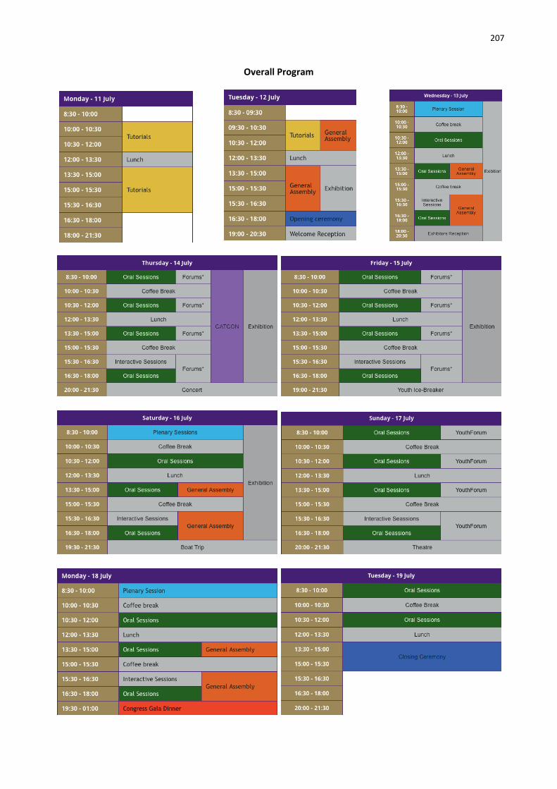
207
Overall Program

208
Oral Presentations and Posters Monday, 11 July, 2016
Time Location Session 08:30 - 12:00 Faculty of Civil Engineering Tutorials Full Day: Morning Session
13:30 - 16:30 Faculty of Civil Engineering Tutorial Full Day: Afternoon Session
Tuesday, 12 July, 2016 Time Location Session 08:30 - 12:00 Prague Congress Centre Tutorials Half Day: Morning Session (Prague Congress Centre)
Prague Congress Centre Fun Run (Starts from the Congress Centre)
16:30 - 18:30 Congress Hall Opening Ceremony
18:30 - 19:00 Media & Press Conference
19:00 - 21:00 Zoom Restaurant Welcome Reception
Wednesday, 13 July, 2016 Time Location Session 08:30 - 10:00 Congress Hall Plenary 1
10:30 - 12:00
North Hall Commercial session I
Club H I/2 - LiDAR, SAR and Optical Sensors for Airborne and Spaceborne Platforms 1
Club A II/1 - Spatio-temporal Modelling 1
Club B III/1 - Orientation and Surface Reconstruction 1
Club C IV/2 - Global Status of Mapping and Geospatial Database Updating
Club D IV/SpS 12 - EuroSDR: Innovative technologies and methodologies for NMCAs“ 1
Meeting Hall I A V/2 - Cultural Heritage Data Acquisition and Processing: 3D modeling strategies
Meeting Hall I B VII/5 - Methods for Change Detection and Process Modelling 1
Club E VIII/ThS 2 - Operational Remote Sensing Application Services 1
13:30 - 14:30 North Hall Commercial session II
13:30 - 15:00
Club B I/SpS 9 - GALILEO and COPERNICUS: geospatial and land applications and services
Small Halll I/Vb - Unmanned Vehicle System (UVS): Sensors and Applications 1
Club A II/1 - Spatio-temporal Modelling 2
Club H IV/1 - Methods for the Update and Verification of Geospatial Databases 1
Club E V/5 - Close-range Measurements for Biomedical Sciences and Geosciences 1
Club C VI/1 - Web-based Resource Sharing for Education and Collaborative Research
Meeting Hall I A VII/4 - Methods for Image Classification 1
Club D VIII/Ths 2 - Operational Remote Sensing Application Services 2
15:00 - 16:00 North Hall Commercial session III
15:00 - 16:30 Foyer 3rd Floor
Interactive session (I/2, I/Vb, II/1, III/1, III/3, IV/2, V/3, VII/5, ThS16) 16:30 - 17:30 North Hall Commercial IV: Blue Marble Geographics
16:30 - 18:00
Small Halll I/Vb - Unmanned Vehicle Systems (UVS): Sensors and Applications 2
Club B II/ThS 16 - Perceptual and cognitive experiments with imagery and 3D models
Club A III/3 - Image Sequence Analysis 1
Club C IV/SpS 12 - EuroSDR: Innovative technologies and methodologies for NMCAs“ 2
Club H V/3 - Terrestrial 3D Imaging and Sensors 1
Meeting Hall I A VII/4 - Methods for Image Classification 2
Meeting Hall I B VIII/1 - Disaster and Risk Reduction 1
Club D VIII/Ths 2 - Operational Remote Sensing Application Services 3

209
Thursday, 14 July, 2016 Time Location Session
08:30 - 10:00
Club A I/3 - Multi-Platform Multi-Sensor System Calibration 1
Club B I/ThS 11 - Unmanned Aerial Systems: The Roadmap from Research to Applications 1
Club C II/2 - Multiscale n-dimensional Spatial Data Representations, Data Structures and Algorithms 1
Meeting Hall IV III/2 - Point Cloud Processing 1
Club D IV/3 - Global DEM Interoperability 1
Meeting Hall I A SAF - SA1 Perspectives on International Earth Observation Missions
Meeting Hall I B NMCAF - SN1 Imagery for national tasks
Meeting Hall V VII/4 - Methods for Image Classification 3
Club E VIII/1 - Disaster and Risk Reduction 2
08:30 - 18:00 Meeting Room 2.2 CATCON
10:30 - 12:00
Club B I/3 - Multi-Platform Multi-Sensor System Calibration 2
Club C II/2 - Multiscale n-dimensional Spatial Data Representations, Data Structures and Algorithms 2
Club H III/4 - 3D Scene Analysis 1
Club D IV/4 - Geospatial Data Infrastructure 1
Meeting Hall I A SAF - SA2 Remote sensing for environmental monitoring and societal benefit
Meeting Hall I B NMCAF - SN2 3-dimensional geoinformation
Club E SpS13 - FIG’s contributions to the Geo-Spatial Society
Meeting Hall IV V/2 - Cultural Heritage Data Acquisition and Processing: Image based survey for CH
North Hall VII/4 - Methods for Image Classification 4
Meeting Hall V VIII/1 - Disaster and Risk Reduction 3
Club A VIII/2 - Health 1
13:30 - 15:00
Club H I/5 - Satellite Systems for Earth Observation 1
Club B I/ThS 11 - Unmanned Aerial Systems: The Roadmap from Research to Applications 2
Club C IV/7 - 3D Indoor Modelling and Navigation 1
Meeting Hall I A SAF - SA3 New Earth Observation technologies and applications: The commercial perspective
Meeting Hall I B NMCAF - SN3 Geospatial data infrastructures
Club A V/1 - Vision Metrology 1
Club D VI/2 - E-Delivery of Education Services
North Hall VII/6 - Remote Sensing Data Fusion 1
Meeting Hall IV VIII/1 - Disaster and Risk Reduction 4
Meeting Hall V VIII/2 - Health 2
15:00 - 16:30 Foyer 3rd Floor Interactive session (I/5, II/2, III/5, IV/8, V/1, V/2, VI/2, VIII/1, VIII/2, ThS11, ThS17, SpS13, SpS14)
15:30 - 17:00 Meeting Hall I A SAF - SA4 Earth Observation Data Policy and long-term Data Continuity
Meeting Hall I B NMCAF - SN4 Quality assessment of geoinformation
16:30 - 18:00
Club E I/2 - LiDAR, SAR and Optical Sensors for Airborne and Spaceborne Platforms 2
Club B II/ThS 17 - Smart Cities
Club C III/5 - Computer Graphics and Remote Sensing
Club H IV/8 - Planetary Mapping and Spatial Databases 1
Club D V/4 - Terrestrial 3D Modelling: Algorithms and Methods 1
North Hall VII/6 - Remote Sensing Data Fusion 2
Meeting Hall IV VIII/1 - Disaster and Risk Reduction 5

210
Friday, 15 July, 2016 Time Location Session
08:30 - 10:00
Meeting Hall IV Elsevier Session I
Small Halll I/Vb - Unmanned Vehicle Systems (UVS): Sensors and Applications 3
Club H II/3 - Spatial Analysis and Data Mining 1
Club A III/VII - Pattern Analysis in Remote Sensing
Club B IV/5 - Web and Cloud Based Geospatial Services and Applications 1
Club C IV/7 - 3D Indoor Modelling and Navigation 2
Meeting Hall I NMCAF+SAF - JS1 High-resolution satellite imaging for geospatial information
Club E V/5 - Close-range Measurements for Biomedical Sciences and Geosciences 2
Club D VII/ThS 15 - The quest for objects – does Geographic Object-based Image Analysis meet society’s needs?
10:30 - 12:00
Meeting Hall IV Elsevier Session II
Club H I/4 - Geometric and Radiometric Modeling of Optical Airborne and Spaceborne Sensors 1
Small Hall I I/Vb - Unmanned Vehicle Systems (UVS): Sensors and Applications 4
Club B II/5 - GeoComputation and GeoSimulation
Club A III/1 - Orientation and Surface Reconstruction 2
Meeting Hall I NMCAF+SAF - JS2 Challenges
Club C V/1 - Vision Metrology 2
Club D VI/3 - Promotion of International Collaborative Education Programs + VI/5 - Promotion of the Profession to Young People
Club E VII/3 - Information Extraction from Hyperspectral Data 1: Spectral based information for Thematic Mapping
Meeting Hall V VIII/3 - Weather, Atmosphere and Climate Studies
13:30 - 15:00
Small Halll I/Vb - Unmanned Vehicle Systems (UVS): Sensors and Applications 5
Club B II/6 - Geovisualization and Virtual Reality 1
Club A III/cloud - 3D Semantic Point Cloud Challenge
Club C IV/1 - Methods for the Update and Verification of Geospatial Databases 2
Club D IV/4 - Geospatial Data Infrastructure 2
Meeting Hall I NMCAF+SAF - JS3 Future prospects
Meeting Hall IV V/2 - Cultural Heritage Data Acquisition and Processing: Direct point cloud acquisition methods
Meeting Hall V VII/4 - Methods for Image Classification 5
Club E VIII/4 - Water Resources 1
15:00 - 16:30 Foyer 3rd Floor Interactive session (II/6, III/4, III/VII, IV/1, IV/4, IV/7, V/5, VI/3, VI/4, VI/5, VIII/3, VIII/4, VIII/5, ThS15)
16:30 - 18:00
Club H I/2 - LiDAR, SAR and Optical Sensors for Airborne and Spaceborne Platforms 3
Club B II/6 - Geovisualization and Virtual Reality 2
Club A III/4 - 3D Scene Analysis 2
Club C IV/3 - Global DEM Interoperability 2
Meeting Hall IV V/5 - Close-range Measurements for Biomedical Sciences and Geosciences 3
Club D VII/SpS 16 - EARSeL: Imaging Spectroscopy in environmental analyses
Meeting Hall V VIII/4 - Water Resources 2
Club E VIII/5 - Energy & Geological Applications
Meeting Hall I White Elephant Session

211
Saturday, 16 July, 2016 Time Location Session
08:30 - 10:00 Congress Hall Plenary 2
10.30 - 12:00
Club B I/3 - Multi-Platform Multi-Sensor System Calibration 3
Club H II/3 - Spatial Analysis and Data Mining 2
Club C III/3 - Image Sequence Analysis 2
Club A IV/8 - Planetary Mapping and Spatial Databases 2
Club E V/4 - Terrestrial 3D Modelling: Algorithms and Methods 2
Club D VII/2 - DEM Generation and Surface Deformation Monitoring from SAR Data + SpS 14 - IAG: Imaging Geodesy
Meeting Hall I B VIII/8 - Land Cover and its Dynamics, Including Agricultural & Urban Land Use 1
13:30 - 15:00
Club H I/2 - LiDAR, SAR and Optical Sensors for Airborne and Spaceborne Platforms 4
Club C II/4 - Spatial Statistics and Uncertainty Modeling
Club D II/ThS 12 - Location-based Social Media Data
Club A IV/5 - Web and Cloud Based Geospatial Services and Applications 2 + SpS 6 - ICA: LBS and ubiquitous cartography
Club B IV/II - Computing Optimization for Spatial Databases and Location based Services + IV/II/VIII - Global Land Cover Mapping and Services + IV/6 - Sensor Web and Internet of Things 1
Club E V/SpS 1 - CIPA: Geospatial Technology for Cultural Heritage
Meeting Hall I A VII/ThS 6 - Persistent Scatterer Interferometry
Meeting Hall I B VIII/6 - Cryosphere 1
15:00 - 16:30 Foyer 3rd Floor Interactive session (I/1, I/3, II/4, III/2, IV/5, IV/II, V/4, VII/2, VIII/6, ThS4, ThS7, ThS9, ThS12, SpS1)
16:30 - 18:00
Club B I/4 - Geometric and Radiometric Modeling of Optical Airborne and Spaceborne Sensors 2
Club H III/2 - Point Cloud Processing 2
Club A IV/8 - Planetary Mapping and Spatial Databases 3
Club C IV/ThS 9 - In-door and out-door seamless location and navigation
Club E V/3 - Terrestrial 3D Imaging and Sensors 2
Club D VII/ThS 7 - Information extraction from SAR imagery
Meeting Hall I A VIII/6 - Cryosphere 2
Meeting Hall I B VIII/8 - Land Cover and its Dynamics, Including Agricultural & Urban Land Use 2
Sunday, 17 July, 2016 Time Location Session
08:30 - 10:00
Small Halll I/Vb - Unmanned Vehicle Systems (UVS): Sensors and Applications 6
Meeting Hall I A II/3 - Spatial Analysis and Data Mining 3 + ICWG
Club B II/ThS 13 - Linked Geospatial Data + ICWG II/IV - Semantic Interoperability and Ontology for Geospatial Information
Club H III/1 - Orientation and Surface Reconstruction 3
Club C IV/SpS 18 - Advancing Geospatial Research into Standards: The ISPRS and OGC Coordination
Club A V/2 - Cultural Heritage Data Acquisition and Processing: Recent survey methods for CH documentation
Meeting Hall I B VII/4 - Methods for Image Classification 6
Club D VIII/7 - Forestry, Natural Ecosystems & Biodiversity 1 Club E Youth Forum 1

212
10:30 - 12:00
Small Halll I/Vb - Unmanned Vehicle Systems (UVS): Sensors and Applications 7
Club B II/7 - Intelligent Spatial Decision Support
Club A III/I - Sensor Modeling for Integrated Orientation and Navigation
Club D IV/ThS 8 - Recent mapping of small planetary satellites, asteroids and comets
Meeting Hall I A V/1 - Vision Metrology 3
Club C VII/4 - Methods for Image Classification 7
Meeting Hall I B VIII/7 - Forestry, Natural Ecosystems & Biodiversity 2
Club E Youth Forum 2
13:30 - 15:00
Club H I/4 - Geometric and Radiometric Modeling of Optical Airborne and Spaceborne Sensors 3
Club B II/8 - Mobility: Tracking, Analysis and Communication
Club A III/1 - Orientation and Surface Reconstruction 4 + III/4 - 3D Scene Analysis 3
Small Halll V/2 - Cultural Heritage Data Acquisition and Processing: UAV and Photogrammetry for CH survey
Club C VII/5 - Methods for Change Detection and Process Modelling 2
Club D VII/ThS 3 - Sentinel-I Radar
Meeting Hall I A VIII/7 - Forestry, Natural Ecosystems & Biodiversity 3 + ThS 10 - Spatial ecology and ecosystem services mapping using Essential Biodiversity Variables (EBVs)
Meeting Hall I B VIII/8 - Land Cover and its Dynamics, Including Agricultural & Urban Land Use 3
Club E Youth Forum 3
15:00 - 16:30 Foyer 3rd Floor Interactive session (II/3, II/7, II/8, III/I, VII/4, VIII/8, ThS1, ThS3, ThS13, ThS14, YF)
16:30 - 18:00
Club H I/4 - Geometric and Radiometric Modeling of Optical Airborne and Spaceborne Sensors 4
Club B II/ThS 14 - Recent Developments in Open Data
Club C IV/SpS 4 - ICA: Image maps- theory, methods, standards
Club A V/3 - Terrestrial 3D Imaging and Sensors 3
Club D VII/5 - Methods for Change Detection and Process Modelling 3
Meeting Hall I A VIII/7 - Forestry, Natural Ecosystems & Biodiversity 4
Meeting Hall I B VIII/8 - Land Cover and its Dynamics, Including Agricultural & Urban Land Use 4
Club E VIII/9 - Coastal and Ocean Applications 1
Monday, 18 July, 2016 Time Location Session
08:30 - 10:00 Congress Hall Plenary 3
10:30 - 12:00
Club H I/4 - Geometric and Radiometric Modeling of Optical Airborne and Spaceborne Sensors 5
Club A I/Va - Mobile Scanning and Imaging Systems for 3D Surveying and Mapping 1
Club D III/2 - Point Cloud Processing 3
Club B V/1 - Vision Metrology 4
Club C VI/6 - Technology Transfer and Capacity Development
Club E VII/6 - Remote Sensing Data Fusion 3
Meeting Hall I A VIII/8 - Land Cover and its Dynamics, Including Agricultural & Urban Land Use 5
Meeting Hall I B VIII/9 - Coastal and Ocean Applications 2
13:30 - 15:00 Club A I/Va - Mobile Scanning and Imaging Systems for 3D Surveying and Mapping 2

213
Club H V/2 - Cultural Heritage Data Acquisition and Processing
Club B VII/6 - Remote Sensing Data Fusion 4
Meeting Hall I A VIII/7 - Forestry, Natural Ecosystems & Biodiversity 5
Meeting Hall I B VIII/8 - Land Cover and its Dynamics, Including Agricultural & Urban Land Use 6
Club C VIII/SpS 7 - GEO: Earth Observation and Societal Benefits: Global issues and best practices
Club E VII/ThS 5 - 3D information extraction from SAR imagery + VII/ThS 4 - TanDEM-X
15:00 - 16:30 Foyer 3rd Floor Interactive session (I/4, I/Va, VI/6, VII/1, VII/3, VII/6, VII/7, VIII/7, VIII/9, ThS18, SpS8)
16:30 - 18:00
Club A I/Va - Mobile Scanning and Imaging Systems for 3D Surveying and Mapping 3
Club H V/5 - Close-range Measurements for Biomedical Sciences and Geosciences 4
Club D VII/3 - Information Extraction from Hyperspectral Data 2: Hyperspectral appliactions from Mars to Earth
Club E VII/4 - Methods for Image Classification 8
Meeting Hall I A VIII/7 - Forestry, Natural Ecosystems & Biodiversity 6
Meeting Hall I B VIII/8 - Land Cover and its Dynamics, Including Agricultural & Urban Land Use 7
Club B VIII/SpS 15 - URSI: Disaster and Risk Management
Tuesday, 19 July, 2016
Time Ti
Location Session
08:30 - 10:00
Club H I/5 - Satellite Systems for Earth Observation 2
Club E I/Va - Mobile Scanning and Imaging Systems for 3D Surveying and Mapping 4
Club A V/5 - Close-range Measurements for Biomedical Sciences and Geosciences 5
Club B VI/SpS8 - SSUGIT: Russian session - Advances in PH&RS&SIS in Russia 1
Club C VII/SpS 10 - FOSS4G: FOSS4G Session (coorganized with OSGeo) 1
Club D VIII/SpS 17 - GEO: Earth Observation from Global Land to Urban Systems
10:30 - 12:00
Club B VI/SpS 8 - SSUGIT: Russian session - Advances in PH&RS&SIS in Russia 2
Club C VII/5 - Methods for Change Detection and Process Modelling 4
Club A VII/SpS 10 - FOSS4G: FOSS4G Session (coorganized with OSGeo) 2
Club D VIII/ThS 18 - GlobeLand30
13:30 - 15:30 Congress Hall Closing Ceremony
Student Consortium Sunday
Time Location Session
08:30 - 10:00 Club E Youth Forum 1
10:30 - 12:00 Club E Youth Forum 2
13:30 - 15:00 Club E Youth Forum 3

214
Plenary Speakers Wednesday, 13 July, 2016.
08:30 Towards a Transformative Science for a Sustainable and Just World Heide Hackmann, ICSU, France
09:00 Knowledge Discovery for Global Sustainability Paul Arthur Berkman, Fletcher School of Law and Diplomacy, Tufts University, MA, USA
09:30 Earth Observations to Services: A Perspective Shailesh Nayak, Earth System Science Organisation, India
Heide Hackmann Saturday, 16 July, 2016 08:30 Flexible Navigation for Mobile Robots
Operating in the Real World Cyrill Stachniss, University of Bonn, Germany
09:00 3D Reconstruction from Photographs Tomas Pajdla, Czech Technical University in Prague, Czech Republic
09:30 Big Data in Photogrammetry and Remote Sensing Li Deren, Wuhan University, China
Cyrill Stachniss Tomáš Pajdla Monday, 18 July, 2016
08:30 A Vision for Spaceborne Synthetic Aperture Radar (SAR) Alberto Moreira, German Aeropace Center (DLR), Germany
09:00 The M.App of the Future is Now Mladen Stojic, Hexagon Geospatial
09:30 Sensing the Invisible and Mapping the Future: Use Social Media and Big Data to Monitor Human Dynamics Tsou Ming-Hsiang, San Diego State University, USA
Paul Arthur Berkman Mladen Stojic

215
EXHIBITION AND SOCIAL PROGRAMME
Exhibitors
Congress Social Programme

216
Exhibitors ACCUEARTH
Website: http://accuearth.eu/ Address: Sokolovská 49, 186 00, Praha 8, Czech Republic Contact: Paul Soares Email: [email protected] Telephone: +420 722 614 197 From our base in the heart of Europe, AccuEarth provides highly accurate GCPs and GIS products to our customers worldwide. AccuEarth’s global network of skilled professionals is continually collecting GCPs around the world to provide accurate coordinate data for an increasing variety of applications. We utilize accuracy and topoanalyst map accuracy software to verify and validate the spatial accuracy of aerial and satellite data as well as verify the accuracy of any pre-existing geospatial data sets. Our guaranteed and consistent quality of GCPs ensure that you can produce the most accurate enhanced imagery and GIS data sets for your projects. AERIAL PHOTOGRAMMETRY AND REMOTE SENSING GROUP CO., LTD. Website: www.arscmh.com Address: Jianxijie 3 Xi'an Shaanxi Province Contact: Mr. Fang Jushan Ms. Zhang Yan Email: [email protected] [email protected] Telephone: +86-13609248392 +86-13259413365 Established in 1965, Aerial Photogrammetry and Remote Sensing Group Co., LTD of China National Administration of Coal Geology (ARSC) remains a client focused geospatial services company, committed to producing quality, tailored products while providing costeffective solutions. As the leading enterprise in China’s geospatial industry, ARSC, the member unit of ISPRS committee, pays attention to technical quality, hand-picking personnel with high academic and professional credentials, and investing heavily in new technology, with total employees 1340. Our services range from Aerial Photography, Digital Surveying and Mapping, Application and Research of Remote Sensing, GIS Research and Construction, Underground Pipeline Networks Detection, to Development of Computer Information Technology. AIRBUS DEFENCE AND SPACE Website: www.intelligence-airbusds.com Address: Claude-Dornier-Str., 88090, Immenstaad, Germany Contact: Dr. George Vozikis Email: [email protected]
Telephone: +49 7545 8-2845 The Intelligence Business Cluster of Airbus Defence and Space is the supplier of choice for commercial satellite imagery, C2ISR systems and related services. Airbus Defence and Space has unrivalled expertise in satellite imagery acquisition, data processing, fusion, dissemination and intelligence extraction allied to significant command and control capabilities. The company is able to create a comprehensive situational awareness picture and deliver sophisticated end-to-end solutions across all commercial, institutional and defence markets. Based upon exclusive commercial access to Pléiades, SPOT, TerraSAR-X and TanDEM-X satellites, combined with broad applications experience, the company delivers an extensive portfolio spanning the entire geo-information value chain. ASIA AIR SURVEY CO., LTD. Website: http://www.ajiko.co.jp/en/ Address: Shinyuri 21 Building, 1-2-2 Manpukuji, Asao-ku, Kawasakishi, Kanagawa Prefecture 215-0004, Japan Contact: Mr. Has Baator Email: [email protected] Telephone: +81-44-967-6302 (direct), +81-44-967-6303, +81-80- 2337-3219 (cell phone) Asia Air Survey Co., Ltd. (AAS) is an engineering and consulting company specializing in geospatial data acquisition, data processing and system development, as well as providing services for disaster prevention & mitigation and environment. The company’s main clients are governments and the private sectors as well as multisectoral international funded projects. The headquarters of the company is located in Tokyo, has 45 local offices across Japan and two flight Centres in Tokyo and Osaka. More recently, addition to its joint company in Beijing, AAS established a regional office in Yangon, Myanmar. AAS has been operating since 1965, and as such has the experience to offer geospatial solutions and services to global clients. ATLAS LTD.
Website: www.atlasltd.cz Address: Na Krivce 50, 101 00 Praha 10, Czech Republic Contact: Petr Krizek Email: [email protected] Telephone: +420 272 766 085

217
ATLAS Ltd. was founded in 1990. It is a private company, based in Prague, with the main focus on developing a graphical software for 3D modeling and visualisation. The software Atlas DMT (Digital Terrain Model) can be used for creating terrain surface models from very large elevation data sets. The models are based on a triangulated irregular network and the system includes a graphical environment that offers CAD tools as well as specialized application modules. ATLAS Ltd. is also an authorized distributor of Gemalto/SafeNet products (digital rights management). AVENZA SYSTEMS Website: Avenza Systems Inc. Address: 124 Merton Street Suite 400, Toronto M4S2Z2 Canada Contact: Ted Florence Email: [email protected] Telephone: (416) 487-5116 Avenza is the producer of geospatial addons for Adobe Creative products, which add GIS functionality to the popular and widely-used Adobe environment, as well as the Avenza PDF Maps mobile application for mobile mapping on smart phones and tablets. MAPublisher provides a complete GIS and cartographic suite of tools and data format support for Adobe Illustrator to create great maps from GIS data. Geographic Imager ads powerful spatial imaging and geospatial data support to Adobe Photoshop. Avenza PDF Maps is a geospatial PDF, GeoPDF and GeoTIFF reader for smartphones and tablets. with an imbedded in-app iTunes-like distribution system that allows your GIS-made maps to be truly mobile and merchandised for offline use. BEIJING GEO-VISION TECH.CO., LTD. Website: http://www.jx4.com/en/ Address: Building 19, Block 11, ABP, No.188 NanSiHuanXiLu, Fengtai District, Beijing 100070, China Contact: Mr. Gang Zhang Email: [email protected] Telephone: 86-10-6822107986-13001278880 Founded in March1989, Beijng Geo-Vision Tech.co. Ltd. is a high-tech and software enterprise and a part of Chinese Academy of Surveying and mapping. The company is committed to develop modern high-tech production of surveying and mapping, provide the entire solution of the data acquisition, processing, application and display. According to the requirements of users, Beijing Geo – Vision Information has developed series of products with wide adaptability and domestic independent intellectual property rights.
BEIJING GEOWAY SOFTWARE CO., LTD. Website: http://english.geoway.com.cn/ Address: F16 Wanshang Plaza, 22 Shijingshan RD, 100043, Beijing, China Contact: Ms. Cui Yujia Email: [email protected] Telephone: +86-18801013271 GEOWAY is the leading provider of geomatic solutions in China, with a long history of research and development in the areas of multi-source remote sensing image processing and integrated geospatial information services. Excellent in software development, systém integration, data processing and information services, and integrated business applications, GEOWAY’s line of products include GIS, image processing and digital photogrammetry software, as well as core technologies of image matching and map production, providing solutions to urban, land and other important areas. BENTLEY SYSTEMS Website: www.bentley.com Address: Bentley Systems Polska sp. z o.o., Ul. Nowogrodzka 68, 02-014 Warszawa, Polska Contact: Mirosław Pawelec Email: [email protected] Telephone: +48 693807107 Bentley Systems is a global leader in providing architects, engineers, geospatial professionals, constructors, and owner-operators with comprehensive software solutions for advancingthe design, construction, and operations of infrastructure. Bentley users leverage information mobility across disciplines and throughout the infrastructure lifecycle to deliver better-performing projects and assets. Bentley solutions encompass MicroStation applications for information modeling, ProjectWisecollaboration Services to deliver integrated projects, and AssetWise operations services to achieve intelligent infrastructure– complemented by worldwide professional services and comprehensive managed services. BIMTAS Website: www.bimtas.istanbul Address: BIMTAS Inc., Evliya Celebi Mah., Mesrutiyet Cad. Eski, Tuyap Binasi No:50, Beyoglu, Istanbul / Turkey Contact: Dr. Gurcan Buyuksalih Email: [email protected] Telephone: +90 212 2459900 ext. 1190

218
BIMTAS has been providing engineering, consultancy and project services to affiliates of Istanbul Metropolitan Municipality, district municipalities, public and private institutions for the realization of infrastructure and superstructure investments as a matter of planned and healthy urbanization since 1997. Having accomplished several studies that changes the face of stanbul, a city progressing rapidly to be a global center, BIMTAS has been meeting the demands of local governments and private sector by providing services both domestically and abroad. BLUE MARBLE GEOGRAPHICS Website: www.bluemarblegeo.com Address: 22 Carriage Ln, Hallowell, Maine 04347, USA Contact: Myles LaBonte Email: [email protected] Telephone: (800) 616-2725 Since the early 1990s, Blue Marble Geographics has been a pioneer in the development of powerful and innovative geospatial software. Widely regarded for its expertise in coordinate conversion and file format support, Blue Marble’s products include Geographic Calculator, the paradigm for highly accurate spatial data conversion and advanced projection management; Global Mapper, a fully-functional and inexpensive GIS application; and the Global Mapper LiDAR Module, a suite of powerful point cloud processing tools. CANADIAN INSTITUTE OF GEOMATICS & CANADIAN REMOTE SENSING SOCIETY Website: http://www.cig-acsg.ca www.crss-sct.ca Address: 100 D–900 Dynes Road, Ottawa, Ontario Canada K2C 3L6 Regina, Saskatchewan, Canada Contact: Alex Giannelia, B.A.A, President Prof. Joe Piwowar Email: [email protected] [email protected] Telephone: +1.613.224.9851 +1.306.585.5273 The Canadian Institute of Geomatics – Association canadienne des sciences géomatiques (CIG-ACSG) has evolved to be a non-profit scientific and technical association and represents the largest and most influential geospatial knowledge network in Canada. Over 50% of its members are senior managers and researchers in government, private sector, academic and NGO organizations. The CIG has long been an active and the representing Canadian member of the ISPRS, ICA and the FIG. The genesis of remote sensing activities that led to the formation of the Canadian Remote Sensing Society – Société canadienne de télédétection (CRSS-SCT) began in the 1960’s. These activities encompassed
government, industry, and educational institutions. Since 1972 the CRSS-SCT has been running the world’s oldest on-going national symposium dedicated to remote sensing.
COMPASSDATA INC. Website: http://www.compassdatainc.com/ Address: 12353 East Easter Avenue, Suite 200, Centennial, Co 80112 Contact: LoAnn Crane Email: [email protected] Telephone: Office 303-999-3035 Cell 720-257-1787 CompassData, Inc., located in Centennial, Colorado, is the industry leader and supplier of current, accurate GPS based data collection and ground control survey. Since 1994, CompassData’s capacity to effectively perform work in locations ranging from dense urban settings to remote environments comes from experience addressing logistical and safety considerations inherent to survey situations. As the industry leader, CompassData has standardized, industry-accepted processes for collection, analysis and delivery of timely, concise, and user-friendly data. CompassData maintains the largest commercially available Ground Control Point archive in the world with over 40,000 points available today, and growing daily. CZECH OFFICE FOR SURVEYING, MAPPING AND CADASTRE (ČÚZK) Website: http://www.cuzk.cz/ Address: Pod sídlištěm 1800/9, 182 11 Praha 8 Contact: Office team Email: [email protected] Telephone: +420 284 041 111 Czech Office for Surveying, Mapping and Cadastre manages state administration of the cadastre of real estate in the Czech Republic and ensures performance of surveying activities in the public interest given by the law. The main tasks are: - Complete administration of the cadastre of real estate - Maintenance of geodetic control - State mapping of the Czech Republic - Creation and actualization of the Fundamental Base of Geographic Data - Maintenance and documentation of the state border - Development and maintenance of the Information System of Surveying, Mapping and Cadastre - Standardization of geographical names - Administration of the Central Archive of Surveying and Cadastre.

219
DAT/EM SYSTEMS INTERNATIONAL Website: www.datem.com Address: 2014 Merrill Field Drive, Anchorage, Alaska 99501 USA Contact: Stan Moll Email: [email protected] Telephone: +1.907.229.7041 DAT/EM Systems International develops software for the photogrammetric, engineering and GIS industries that enables the extraction of 3D vector features from stereo imagery and point clouds. DAT/EM’s suite of software solutions includes Summit EvolutionTM photogrammetric workstation, LandScapeTM point cloud viewing and editing toolkit, and complementary components CaptureTM, MapEditorTM, Ortho+MosaicTM, Airfield3DTM and Contour CreatorTM. New to the DAT/EM Photogrammetric Suite, Summit UASTM, provides a set of tools to easily analyze or compare UAS data by viewing, editing and defining features in stereo. Visit DAT/EM at geospatial events worldwide for a demo, or contact our worldwide network of resellers to learn more. DUBAI MUNICIPALITY – Gold Sponsor Website: www.dm.gov.ae Address: Dubai, Baniyas Road, UAE Contact: Anna Zih, Hussein M. Abdulmuttalib Email: [email protected] Telephone: +971564898599; +971555500452 The origin of Dubai Municipality was founded in 1954, commencing its activities with a cadre of sevenemployees undertaking simple tasks in cleaning the city. The first decree establishing the Municipality was on February 28, 1957, whereby 23 municipal council members had been appointed from the elders of the country and traders with limited powers, the most important of which was to take care of health and architectural affairs of the city as well as to organize construction and beautification of the city and provide constructive suggestions to the government. Dubai Municipality is regarded as one of the largest governmental institutions in terms of services rendered and projects executed. Thus the municipality is the leading driver of growth and evolution of the Emirate of Dubai. Dubai Municipality is the custodian of geospatial data for the Emirate of Dubai and has been instrumental in ensuring the application of these technologies across various government departments in Dubai. The Municipality also organizes the GIS and Remote Sensing Annual Scientific Forum (GRASF) in association with the Middle East Geospatial Forum. The Forum, which is held every year in Dubai, has quickly become the most sought after congregation of geospatial professionals
in the region and addresses various challenges faced by the technology implementers from across the region.
ELSEVIER – IJPRS Publisher Website: https://www.elsevier.com We help researchers make new discoveries, collaborate with their colleagues, and give them the knowledge they need to find funding. We help governments and universities evaluate and improve their research strategies. We help doctors save lives, providing insight for physicians to find the right clinical answers, and we support nurses and other healthcare professionals throughout their careers. Our goal is to expand the boundaries of knowledge for the benefit of humanity. EUCLIDEON EUROPE Website: www.euclideon.com Address: Linke Wienzeile 4 Contact: DI Dr Philipp Meixner Email: [email protected] Telephone: +43 1 587 96 16 Euclideon Europe offer a range of products including its ready-made Geoverse software, designed for users to instantly and effortlessly visualise 3D point cloud data in its geospatial context; its conversion software, which allows users to compress their point cloud data down to 5-20% of its original size for effortless storage, streaming and use in Geoverse; SOLIDSCAN converts a laser scan into a solid, photo realistic representation of the real world. There is no upper limit to the detail that can be reproduced using SOLIDSCAN. Incredibly, Euclideon’s SOLIDSCAN removes moving objects and 90 % of the background noise from laser scanned data – only static objects remain. Reflective surfaces like whiteboards and mirrors can now be laser scanned with photo-realisticmresults. SOLIDSCAN technology creates many new opportunities for scanning organizations.

220
ESRI Website: http://www.esri.com/industries/mapping-statistics-imagery/imagery-3d Address: 380 New York Street, Redlands, CA 92373, USA Contact: Kurt Schwoppe Email: [email protected] Telephone: +1 909 793 2853 extension 5108 Esri, the leader in GIS technology, offers innovative solutions for enterprise imagery management and web GIS. The amount of high resolution remotely sensed data and elevation data is expanding, while the cost is falling. The Esri ArcGIS platform provides the tools and capabilities to make imagery, lidar and elevation data relevant and valuable. Esri technology includes tools, workflows, and applications that can be quickly implemented within an organization to help you see your project, find the patterns and share the results with others. FRANCIS & TAYLOR GROUP– ISPRS Book Series Publisher Website: http://taylorandfrancis.com/journals/ Address: 2&4 Park Square, Milton Park, Abingdon, OX14 4RN, United Kingdom Email: [email protected] Telephone: +44 (0) 20 7017 6000 Taylor & Francis partners with world-class authors, from leading scientists and researchers, to scholars and professionals operating at the top of their fields. Together, we publish in all areas of the Humanities, Social Sciences, Behavioural Sciences, Science, Technology and Medicine sectors. We are one of the world’s leading publishers of scholarly journals, books, eBooks, text books and reference works. GEODYN Website: www.geodyn.com Address: 623, 6EA, DAFZ, Dubai, UAE Contact: Rolf Becker Email: [email protected], [email protected] Telephone: 00971 (0)4 214 6270 Geodyn has been set up with the leading personal from the former Maps Geosystems. They are those who have devised procedures that turned into standard operations in the mapping industry. GeoDyn today concentrates on aspects such as the introduction of temporal data attributes into GIS, and defining the relevance of applicable data layers. This leads to minimize data acquisition requirements which in turn shortens planning operations and reduces cost substantially. In view of the above GeoDyn developed
an Analogue to Digital conversion procedure that is by a magnitude faster than conventional procedures, thereby making important data accessible to a larger user community. GEOGIS Website: http://www.geogis.com.tr/Default_eng.aspx Address: Mutlukent Mah. 1920 Cad. No: 69 Umitkoy / Cankaya /Ankara / Turkey Contact: Tuncer Ozerbil Email: [email protected] Telephone: +90 312 236 4260 GEOGIS is a mapping company established in Ankara in TURKEY in 1997. The company has more than 60 engineers, consisting of surveyors, civil engineers, city planners, agriculture engineers, geologists, and that number reaches to 200 considering the technicians and field workers. GEOGIS implements photogrammetric projects by using its own airplane and 2 aerial cameras. Besides photogrammetric projects GEOGIS is one of the lead mapping company in Turkey at areas of core expertise below. - Geodetic and Photogrammetric Map Production - 3D City Modelling – Geographic Information Systems - Transportation Projects – Digital Map Production - Application of Development Plans - Infrastructural Services etc. GEOMARES PUBLISHING – Main Media Partner
Website: https://www.gim-international.com Address: P.O. Box 112, 8530 AC Lemmer Vuurtorenweg 18 B, 8531 HJ Lemmer The Netherlands Contact: Durk Haarsma Email: [email protected] Telephone: +31 (0) 514 56 18 54
GIM International is the independent and high-quality information source for everything the global geomatics industry has to offer, online and offline! We provide information about all the major topics in the business, such as mapping & surveying, geodesy, cartography, Lidar, GIS, photogrammetry, UAV/UAS, GNSS, remote sensing and more. The Articles section provides deeper insights, including interviews with geospatial experts, columns and topical overviews related to the geomatics industry. The print edition is distributed to thousands of professionals in 170 countries worldwide, every month. Each edition is likewise announced to thousands of our digital readers when published on the magazine page. GEOMETRY FACTORY
Website: www.geometryfactory.com Address: 1501 route des Dolines, Le Th.l.me, 06560 Valbonne,

221
Sophia Antipolis, France Contact: Andreas Fabri Email: [email protected] Telephone: +33 492.954.912
Geometry Factory provides flexible and robust geometric software components as well as expertise in geometric computing to more than 300 customers worldwide. We give development teams a head-start on building applications that solve business problems, increasing productivity and the ability to deliver products on time. We offer field-proven C++ components, which are part of CGAL, the Computational Geometry Algorithms Library. Our customers in the application area photogrammetry and GIS use 3D triangulations, Boolean operations on polygons and surface meshes, polyline simplification, and surface reconstruction from point clouds, to name but a few. GEOSENSE – CLEERIO
Website: https://www.cleerio.com/cs/kontakt/ Address: Sokolovská 352/215, 190 00 Praha 9, Czech Republic Contact: Durk Haarsma Email: [email protected] Telephone: +420 720 993 565
The CLEERIO family of products combines the clarity of the maps with the effectiveness of the information system. Represents a unique and unexpected view of asset management and management in the map. Provides a comprehensive overview for the efficient management of the premises, buildings, land and maximizes simplification of the transfer of information between the office, management, employees, administrators and third parties. GGS GMBH Website: www.ggs-speyer.de / www.aerotopol.de Address: GGS – Geotechnik, Geoinformatik & Service GmbH, Kaemmererstr. 14, 67346, Speyer, Germany Contact: Gerhard Kemper (CEO) Email: [email protected] Telephone: +49 6232 629271, Mobile: +49 171 3588546 GGS GmbH is a medium sized company that was founded in 1988. Since 2004, the main focus is on the aerial surveying market. Having 6 employees, GGS develops, integrates and supports systems for various aerial data acquisition. Aerial cameras as single or multisensor setups, oblique imager, thermal sensors, hyper-spectral scanners and Lidar are the sensors in our portfolio. Our additional instruments as gyro stabilized mounts, GNSSINS, power-supplies, onboard PC, pilot screens and shock mountings support a
proper installation of the sensors. We also offer mission planning and flight management software designed for a perfect interfacing with all of our components. That way we are able to deliver turnkey solutions. We assist in installation and offer onsite training. Besides that, we also integrate existing equipment and do user specific integration. GOOGLE EARTH ENGINE Website: www.earthengine.google.com Address: 2590 Pearl Street Boulder 80302, Colorado, USA Contact: Dusty Reid Email: [email protected] Telephone: 303-385-4953 Earth Engine is Google’s cloud platform for petabyte-scale analysis of satellite imagery and other geospatial data. Originally conceived in 2009 as a platform for global forest monitoring, today scientists, governments, and NGOs around the world are using Earth Engine in areas ranging from food and water security to disaster risk management, public health, biodiversity, and climate change adaptation. HEILONGJIANG SEASKY GEOMATICS TECHNOLOGY CO., LTD. Website: http://www.geo-seasky.com.cn/a/yingwen/ Address: 28 Lianhuachixi Road, Haidian District, Beijing 100830, China Contact: Mr. Chi Xiaoming Email: [email protected] Telephone: +86-0451-86653226 Heilongjiang Seasky Geomatics Technology Co., Ltd. founded in 2004, is a professional company for Photogrammetry and Remote Sensing. Affiliated to Heilongjiang Administration of Surveying, Mapping and Geoinformation, Seasky has national Grade A qualifications for Photogrammetry and Remote Sensing, Geographical Information System Engineering, Engineering Surveying, Real Estate Surveying and Mapping, Cartography. In 2012, Seasky passed the ISO 9001:2008 standard quality management system certifications. As an outsourcing service provider, Seasky is one of the largest production bases for international geo-informatic data processing in China. For aerial images, satellite images, LiDAR data and other multiple-source data, Seasky develops different technical solutions for data compilation, image processing, GIS database construction and application, 3D landscape products, thematic mapping products etc.

222
HERE Website: www.here.com Address: HERE Czech Republic, Klimentsk. 1216/46, 110 02 Praha 1, Czech Republic Contact: Martin Švec Email: [email protected] Telephone: +420777650183 HERE is a leader in mapping and location technology backed by a consortium of leading automotive companies Audi, BMW and Daimler. HERE has been mapping the world for 30 years, helping people and companies around the world answer the pressing questions they have. Every time you use the map in your car; every time you get a package delivered; every time you create an event map on your favorite social network, chances are HERE is behind it. Our mapping technology powers leading services on six continents. Today, we’re helping people in 1,000 cities catch their trains; we’re helping millions of people in 50 countries beat traffic; and we’re helping companies better route their fleets. HEXAGON GEOSPATIAL – Platinum Sponsor Website: www.hexagongeospatial.com Address: 5051 Peachtree Corners Circle Norcross, GA 30092 2500 USA Contact: Office team Email: [email protected] Telephone: +1 770 776 3400 Hexagon Geospatial helps you make sense of the dynamically changing world. Known globally as a maker of leading-edge technology, we enable our customers to easily transform their data into actionable information, shortening the lifecycle from the moment of change to action. Hexagon Geospatial provides the software products and platforms to a large variety of customers through direct sales, channel partners, and Hexagon businesses. For more information, visit hexagongeospatial.com or contact us at [email protected].
IGI Website: www.igi.eu Address: Langenauer Str. 46, 57223 Kreuztal, Germany Contact: Philipp Grimm Email: [email protected] Telephone: +49 2732 5525-0 IGI covers a wide variety of expertise in optics, electronics, mechanics, software development, and analytics through a team of highly qualified scientists, engineers and technicians. With more than 35 years of experience, IGI not only offers integration of various sensors, but also complete sensor systems for airborne + terrestrial survey missions. INSPACE CO., LTD. Website: www.inspace.re.kr Address: 96, Gajeongbuk-ro, Yuseong-gu, Daejeon, Rep of Korea Contact: Myungjin Choi, CEO Email: [email protected] Telephone: +82 42 862 2735 INSPACE Co., Ltd. Is a venture company specialized in research and development, spun off from the Korea Aerospace Research Institute (KARI) to keep up with the current trends of the convergence between Space Technology (ST) and Information Communication Technology (ICT). ITRES Website: www.itres.com Address: Unit 8 2121 29th Street NE, Calgary, AB Canada T1Y 7H8 Contact: JoAnne DeVries Email: [email protected] Telephone: +1 403-250-9944 ITRES (1979) provides airborne hyperspectral and thermal remote sensing imagers and surveys. Our custom sensors are used for applications in mineral & geology, heat loss, fire mapping, search and rescue, coastlines, water quality, and target detection among others. The TSR-1800 system features in-flight geocorrection and automated thermal anomaly detection, with high spatial/thermal resolution. Fly fast (up to 170-300 kts), with resolutions ranging from 5cm to 1 m and 0.05ÅãC thermal resolution. New to our performance hyperspectral sensor lineup are the integrated CASI-1500H (VNIR) and wide-swath SASI-1000A (200 channel, 1000 x-track imaging pixel SWIR imager). We have also launched our new UAV/Ground sensors: the μVNIR-1920, the μTIR-640 and the μSWIR-384.

223
LEADOR SPATIAL INFORMATION TECHNOLOGY CO., LTD. Website: www.leador.com.cn Address: Bldg.12, HUST Science Park Innovation Base, No33, Tangxunhu North Road, East Lake Dev. Zone, Wuhan, Hubei, China Contact: Kai Sun Ms. Wang Xiaohui Email: [email protected] [email protected] Telephone: 18627874686 +86-13971448223 Leador Spatial Information Technology Co., Ltd was founded in September 1999. The company is committed to promoting industrial upgrading and facilitating the use of geographic information by taking advantage of mobile mapping technology. The company currently employs more than 400 people, 30 % of them have master or doctoral degree. The R & D department, excellent at Multi-disciplinary design and complex systems integration, has technical talents from fields of optical, electronic, mechanical, automatic control, mapping, remote sensing, visual images, Internet etc. Through years of efforts and hard work, Leador has pioneered the concept of 3D image GIS and become the leading manufacturer of land-based Mobile Mapping Systems (MMS) in China, which is now widely used in digital city, city management, public security, emergency response, digital highway, digital railroad, LBS, etc. LEICA GEOSYSTEMS AG – Platinum Sponsor Website: Leica Geosystems AG Address: Heinrich-Wild-Strasse, 9435 Heerbrugg, Switzerland Contact: Wolfgang Hesse Email: [email protected] Telephone: +41 71 727 3656 With close to 200 years of pioneering solutions to measure the world, Leica Geosystems products and services are trusted by professionals worldwide to help them capture, analyze, and present spatial information. Leica Geosystems is best known for its broad array of products that capture accurately, model quickly, analyze easily, and visualize and present spatial information. Those who use Leica Geosystems products every day trust them for their dependability, the value they deliver, and the superior customer support. Based in Heerbrugg, Switzerland, Leica Geosystems is a global company with tens of thousands of customers supported by more than 3,500 employees in 28 countries and hundreds of partners located in more than 120 countries around the world. Leica Geosystems is part of Hexagon, Sweden.
MAP WORLD (TIANJIN) CO., LTD. Website: http://www.maptj.cn/guid/first.htm Address: Contact: Ms. Zhang Qian Email: [email protected] Telephone: +86-13920797667 Tianjin Binhai Geoinformation Innovation Park & Mapworld Global Data Service Base, is located in Tianjin High-Tech Area (also the National Innovation Demonstration Area), assembling Mapworld Tianjin National Data Base, Mapworld International Communication Centre, Mapworld Information Science Institute, Mapworld Zhongchuang Space Incubator, Mapworld International Conference Exhibition Centre, Map world(Tianjin) Co.,Itd., Tiandi Beidou (Tianjin) Navigation Technology Co.,Itd., and Mapworld Data & Multi-Language Manufacturing Base, etc. MDPI AG – IJGI Publisher
Website: http://www.mdpi.com Address: St. Alban-Anlage 66, 4052 Basel, Switzerland Email: [email protected] Telephone +41 61 683 77 34
MDPI (Multidisciplinary Digital Publishing Institute) is an academic open-access publisher with headquarters in Basel, Switzerland. Additional offices are located in Beijing and Wuhan (China), Barcelona (Spain) as well as in Belgrade (Serbia). MDPI publishes 188 diverse peer-reviewed, scientific, open access, electronic journals. MEIXNER IMAGING Website: www.meixnerimaging.com Address: Linke Wienzeile 4 Contact: DI Dr Philipp Meixner Email: [email protected] Telephone: +43 1 587 96 16 MEIXNER IMAGING is the Exklusive distributor forEuclideon’s readymade Geoverse products. Geoverse MDM and UnlimitedOrtho are revolutionary new geospatial software solutions that enable users to visualize, manipulate and interact with image and point cloud data – regardless of size – without loading times. This technology is able to handle the vast amounts of data and link it with external databases in a way previously unimaginable on normal computers and stream it over the web. Our latest solution Solidscan converts a laser scan into a solid, photo-realistic representation of the real world, with the same accuracy as LiDAR. Solidscan does not natively “interpolate” points – instead, Solidscan uses a new, patented technique to produce solid photo-realistic

224
point clouds with no holes. In combination with udWeb customer are able to share all their data with clients and partners around the world on e.g. their website. MESCIOGLU MÜHENDIŞLIK VE MÜŞAVIRLIK A.Ş. Website: www.mescioglu.com.tr Address: Mesciolu Plaza, Mutlukent Mah., 1920. Cadde No:65, 06810 Ümitköy – Çankaya/Ankara, Turkey Contact: Dr. Mustafa Önder Email: [email protected] Telephone: +90 312 235 20 00/137 Mescolu Engineering was founded by Ayhan Faruk Mesc in 1984 and has been offering services in mapping, engineering, surveying, photogrammetry and supervision and consultancy of infrastructural projects including railways and highways for more than 30 years in Turkey. Moreover, Mesciolu has also carried out transportation master planning and water resources management projects which are essential necessities of our country. 80 % of the workforce in photogrammetry services in Turkey has been undertaken by Mesciolu as of December 2015. As being the leading firm in the sector with our technical capabilities in our services, quality procedures and our corporate culture based on trust, our aim is to continue to accelerate our client satisfaction. MINISTRY OF MUNICIPAL AND RURAL AFFAIRS OF SAUDI ARABIA (MOMRA) - Bronze Sponsor Website: momra.gov.sa Address: Olaya Street Hay King Fahd, Saudi Arabia Contact: Afroz Khan Email: [email protected] Telephone: 00966-533433016 The Ministry of Municipal and Rural Affairs (MOMRA) is a government organization in the Kingdom of Saudi Arabia, established by Royal Decree in October, 1975 and assigned the responsibility for planning and developing urban and rural areas and the
administrative oversight of the management of more than 300 municipalities throughout the Kingdom of Saudi Arabia. MOSAICMILL Website: www.mosaicmill.com Address: Kultarikontie 1, Vantaa 01300, Finland Contact: ismo Hippi Email: [email protected] Telephone: +358 40 5965322 MosaicMill is developer of EnsoMOSAIC aerial survey system which comes with hyperspectral, multispectral or thermal cameras. MosaicMill is specialized in forestry and precision agriculture – EnsoMOSAIC Agri is a complete package with high-resolution NDVI sensor, reflectance targets and software for generation of NDVI and prescription maps. MosaicMill is also distributor of GeoDrone UAS and Terra software for automatic point cloud classification and vectorization. NATIONAL ADMINISTRATION OF SURVEYING, MAPPING AND GEOINFORMATION OF CHINA (NASG) Website: http://en.nasg.gov.cn/ Address: No.28 Lianhuachi West Road, Haidian District, Beijing, 100830, China Contact: Ms. Hao Minghui Email: [email protected] Telephone: +86-10-63881902 Established in 1956, National Administration of Surveying, Mapping and Geoinformation of China (NASG) is a central government agency responsible for surveying, mapping and geoinformation of the country. NASG has 18 sub-institutions and the total staff member accounts for more than 8,000, local surveying, mapping and geoinformation administrations were established in all China’s 31 provinces, autonomous regions and municipalities. In recent years, surveying, mapping and geoinformation developed rapidly and series of achievements were witnessed. On June 1, 2015, the Outline of Medium and Long-term Planning of National Fundamental Surveying and Mapping (2015-2030) was approved by the State Council, which was an important decision deployment of strengthening and promoting surveying, mapping and geoinformation in China and will better serve socio-economic development and people’s daily life in the future. NATIONAL ENGINEERING RESEARCH CENTER OF SURVEYING AND MAPPING Website: http://english.casm.ac.cn/

225
Address: 28 Lianhuachi West Road, Beijing, China Contact: Ms. Zang Yi Email: [email protected] Telephone: +86-10-63880812 National Engineering Research Center of Surveying and Mapping was established in 2009, and passed the acceptance test of the Ministry of Science and Technology of China in 2013. The Center is a subÅ Å division of the Chinese Academy of Surveying and Mapping and under the supervision of National Administration of Surveying, Mapping and Geoinformation of China (NASG). The aim of the center is to establish an industrialization research, development and service entity for surveying and mapping technology. Its main tasks include surveying and mapping industrialization application and engineering technology research, transformation of achievements, open services, and international cooperation. NATIONAL GEOMATICS CENTER OF CHINA Website: http://www.ngcc.cn/article/en/ Address: 28 Lianhuachi West Road, Beijing, China Contact: Ms. Du Guangyu Email: [email protected] Telephone: +86-10-63881109 National Geomatics Center of China (NGCC), also functioned as National Archives for Surveying and Mapping, is a government agency subordinated to National Administration of Surveying, Mapping and Geoinformation of China (NASG). The staff team consists of 150 members from 17 departments. NGCC fulfills the missions to construct, manage and distribute national fundamental data and archives; plan, design, organize and execute national major surveying and mapping projects; maintain surveying and mapping networks in China; develop applications of national fundamental geoinformation. NFRAMES Website: www.nframes.com Address: Nframes GmbH, Kornbergstrasse 36, 70176 Stuttgart, Germany Contact: Konrad Wenzel Email: [email protected] Telephone: +49 711 997 887 28 nFrames is a company developing software for 3D surface reconstruction from images. The core software product SURE is designed for professional mapping production. It is particularly focused on the derivation of precise point clouds, DSMs, True Orthophotos and textured meshes for projects with large scale such as country-wide airborne image datasets.
PANALYTICAL, ASD INC. Website: www.ASDI.com Address: 2555 55th Street, Boulder, CO USA Contact: Geoffrey Stein Email: [email protected] Telephone: 1 720 399 1874 As a part of PANalytical, ASD Inc. is the world’s leading supplier of precision field portable, fullrange (350-2500 nm) spectrometers and spectroradiometers. ASD’s ruggedized analytical instruments provide the freedom to rapidly collect high-quality spectra in the field for real-time lab quality results. When accuracy matters and success is measured in manometers, see why the world’s leading research institutions depend on ASD for data that can be trusted. PCI GEOMATICS Website: www.pcigeomatics.com Address: 90 Allstate Parkway, Suite 501, Markham, ON, L3R 6H3 Contact: Mr. Arnold Hougham Email: [email protected] Telephone: 905-764-0614 PCI Geomatics, founded in 1982, is the world leader in geo-imaging products and solutions. PCI Geomatics has set the standard in remote sensing and image processing tools offering customized solutions to the Geomatics community in over 135 countries. PCI Geomatics is the developer of Geomatica – a complete and integrated desktop software that features tools for remote sensing, digital photogrammetry, geospatial analysis, map production, mosaicking and more. Geomatica. software enables users to apply imagery in support of a wide range of applications such as the environment, agriculture, security and intelligence, defense, as well as in the oil and gas industries. PCI Geomatics is also the developer of the GeoImaging Accelerator (GXL), an automated, high performance, Graphics Processor (GPU) system for processing terabytes of imagery data. PCI Geomatics is a privately held Canadian corporation headquartered in Toronto, Ontario and Gatineau, Quebec with worldwide facilities located in the United States; Arlington and Beijing, China. PHASE ONE
Website: http://industrial.phaseone.com Address: Phase One, Roskildevej 39, Frederiksberg DK- 2000, Denmark Contact: Steve Cooper Email: [email protected] Telephone: +44 7482 324 013

226
Phase One Industrial is dedicated to research, development and manufacturing of medium format, metric cameras for aerial photography. Phase One cameras are known for their image quality, accuracy and easy integration with leading flight management systems, IMU/ GNSS receivers and all popular LIDAR systems. Phase One’s flagship camera series, the iXU 1000, incorporate a 100 MP CMOS sensor and offers large format coverage at medium format size and price. These cameras are distinguished by their high resolution, wide ISO range and fast capture rate. With a wide choice of lenses, Phase One offers solutions for everything from small UAVs up to large manned aircraft. PIX4D Website: www.pix4d.com Address: EPFL Innovation Park – D 1015 Lausanne – Switzerland Contact: Nikoleta Guetcheva Email: [email protected] Telephone: +41 (0) 21 552 05 90 Pix4D is the developer and producer of Pix4Dmapper, a software based on computer vision and photogrammetry. Pix4D mapper automatically processes both terrestrial and drone/aircraft-acquired imagery, converting it into highly accurate orthomosaics, surface models, point clouds, textured 3D and simplified CAD models. Pix4D, rapidly expanding since its founding in 2011, is headquartered in Lausanne, Switzerland, with local offices in Shanghai and San Francisco. PRIMIS Website: www.primis.cz Address: Slavíčkova 827/1a, 638 00 Brno, Czech Republic Contact: Patrik Meixner / Marta Meixnerová Email: [email protected]/ [email protected] Telephone: +420 724 013 013 / +420 733 188 823 PRIMIS – Professional Imaging and Mapping Solutions. Though we are still rather newly established company (2014) we benefit from the vast experience in the field of photogrammetry and remote sensing amassed by our key staff during past 23 years. Our services encompass flight planning, data acquisition by aerial sensors, photogrammetric data processing up to delivery of products in various forms and formats both of contemporary and historical data. Our sophisticated workflow ensures keeping the strictest quality control measures in order to satisfy the needs of our customers from diverse corners of the world.
RACURS Website: http://www.racurs.ru Address: Racurs, Yaroslavskaya Str., 13A, office 15, Moscow, Russia, 129366 Contact: Victor Adrov Email: [email protected] Telephone: +7 495 720 5127
Racurs company's business mission is to provide the world-wide geospatial community with advanced and cost-effective digital photogrammetry solutions and services for creation of wide range of output products from the available remote sensing data. Racurs company has 20 years long history of success on Russian and worldwide geoinformatics market. Since its foundation in 1993 our company has been developing an innovative digital mapping software for processing aerial, space and terrestrial imagery. Our flagship product PHOTOMOD was one of the first digital photogrammetric systems on the market that was designated for working on off-the-shelf PCs. Today PHOTOMOD is the most popular digital photogrammetric software in Russia and well known all over the world. RIEGL
Website: www.riegl.com Address: Riedenburgstrasse 48, 3580 Horn, Austria Contact: Sales team Email: [email protected], [email protected] Telephone: +43 2982 4211 RIEGL based in Austria is a performance leader in research, development and production of terrestrial, industrial, mobile, bathymetric, airborne and UAS-based laser scanning systems. RIEGL’s innovative hardand software provides powerful solutions for most application fields in surveying. Worldwide sales, training, support and services are delivered from RIEGL’s Austrian headquarters and its offices in Vienna, Salzburg, and Styria, main offices in the USA, Japan, and in China, and by a worldwide network of representatives covering Europe, North and South America, Asia, Australia and Africa. SENOP OY Website: www.rikola.fi Address: Kultarikontie 1, Vantaa 01300, Finland Contact: Jussi Soukkamaki Email: [email protected] Telephone: +358503583516 Senop OY offers a lightweight hyperspectral camera for UAVs. This product is a snapshot spectral system providing only true image pixels for up to 380 bands. No interpolation is used in image formation. The

227
frame based approach enables an easy image stitching for the mosaics with high resolution images. The solution doesn’t need IMU for its operations, which makes the system low cost and low weight. In addition, the camera enables handheld use with computers in laboratories, fields etc. Senop OY offers also OEM multichannel and LED-modules as well as miniature spectrometers. SATELLITE SURVEYING AND MAPPING APPLICATION CENTER, NASG
Website: http://en.nasg.gov.cn Address: 28 Lianhuachixi Road, Haidian District, Beijing 100830, China Contact: Hao Minghui Email: [email protected] Telephone: +86 10 63881902 Satellite Surveying and Mapping Application Center (SASMAC) is a technical institution under the National Administration of Surveying Mapping and Geoinformation of China. SASMAC is mainly responsible for development plans of satellite surveying and mapping application, surveying and mapping satellite application and operation system, and related scientific research. Presently, SASMAC is mainly engaged in the construction of application system of ZY-3 satellite, China’s first civilian stereo mapping satellite, research on key technology of satellite surveying and mapping application, application policies and specifications of ZY-3 satellite data, and development strategies and plans of surveying and mapping satellites, satellite application and emergency mapping. SBG SYSTEMS Website: www.sbg-systems.com Address: 3bis chemin de la jonch.re, 92500 Rueil-Malmaison, France Contact: Thibault Bonnevie Email: [email protected] Telephone: +33 1 80 88 45 00 SBG Systems is a supplier of miniature, high performance, and cost-effective motion sensors. It offers a complete line including Attitude and Heading Reference System (AHRS) and Inertial Navigation Systems with embedded GNSS receiver (INS/GNSS), etc. Our sensors are ideal for mobile mapping and remote sensing applications, for camera/ LiDAR stabilization and data georeferencing. SI IMAGING SERVICES (SIIS) Website: www.si-imaging.com Address: SI Imaging Services, 441 expo-ro, Yuseong-gu, Daejeon,
305-714, Republic of Korea Contact: Sales team Email: [email protected] Telephone: +82-42-341-0401 SI Imaging Services (SIIS) was founded in April 2014 as a subsidiary of Satrec Initiative (SI) with the mission of “Fair Access to Space”. SIIS, which is specialized company in satellite imaging services, is exclusive distributor of KOMPSAT-2 (1.0m optical), KOMPSAT-3 (0.55m optical), and KOMPSAT-5 (0.85m SAR) satellites imagery. SIIS has the global business network with more than 80 resellers and partners. In the capability of providing both optical and radar imagery as well as the collaborative business with worldwide network, SIIS offers better and fair imaging services to customers. SICHUAN BUREAU OF SURVEYING, MAPPING AND GEOINFORMATION Website: www.scgis.org, http://www.scbsm.com/ Address: ChengDu, JiuXing Road 7#, SiChuan Province Contact: Sun JingJie Email: [email protected] Telephone: +86 13808202787 SIMACTIVE Website: http://www.simactive.com/ Address: 465 St-Jean, Suite 701, Montreal (Quebec) H2Y 2R6 Canada Contact: Abdaal Mazhar Shafi Email: [email protected] Telephone: +1 514-288-2666 SimActive is the developer of Correlator3DTM software, a patented end-to-end photogrammetry solution for the generation of high-quality geospatial data from satellite and aerial imagery, including UAVs. Correlator3DTM performs aerial triangulation(AT) and produces dense digital surface models (DSM), digital terrain models (DTM), point clouds, orthomosaics and vectorized 3D features. Powered by GPU technology and multi-core CPUs, Correlator3DTM ensures matchless processing speed to support rapid production of large datasets. SimActive has been selling Correlator3DTM to leading mapping firms and government organizations around the world, offering cutting-edge photogrammetry software backed by exceptional customer support. SPHEREOPTICS GMBH Website: www.sphereoptics.de Address: Gewerbestr. 13, 82211 Herrsching, Germany Contact: Dr. Andreas Eisele Email: [email protected]

228
Telephone: +49 1755 210 994 Since our formation in 2003, our goal has been to be much more than just a supplier of advanced equipment. Our mission is to SERVE BETTER. Our technical experts are always standing-by when it comes to discussing standard or customer specific solutions in the areas of lighting technology, optical measurements service and remote sensing. STUDIO 727, S.R.O. Website: www.727.sk Address: Elektrarenska 1, 831 04 Bratislava, Slovakia Contact: Ladislav Dedik Email: [email protected] Telephone: mobile: 00421 905624540, tel: 00421 249107111 Studio specialises in digitization and digital objects post production. In a short span of only 2 years, they have successfully captured more than 20 million pictures and scans and digitised more than 100000 objects of national cultural heritage, ranging from small jewellery up to castles and whole historic city districts. TERRA MESSFLUG
Website: http://www.terra-messflug.at Address: Eichenweg 42, A - 6460 Imst, Austria E-Mail: [email protected] Telephone. +43 5412 6930 0 We are a leading company in the field of aerial survey and photogrammetry with more than 25 years of experience. Our services encompass consulting, flight planning, flight conduction and the production of a large variety of geodata. Our workflows and data processing chains are perfectly organised. As a result, customers’ orders are completed efficiently and with highest quality. All our customers (e.g. national and regional authorities, municipalities, infrastructure providers, energy suppliers, ski resorts and universities) benefit from our reliability and prompt data delivery. TOPOL SOFTWARE Website: www.topol.eu Address: Na Zlíchově 18, 152 00 Prague 5, Czech Republic Contact: Aleš Limpouch Email: [email protected] Telephone: +420 251 563 003, +420 603 877 999 TopoL Software, founded in 1999, is an independent developer of geospatial software technologies. We offer general desktop and mobile GIS software, digital photogrammetric workstation and custom solutions
for our partners and customers around the world. TopoL Software is the developer of PhoTopoL, a powerful photogrammetric workstation to proces photogrammetric and GIS data. It supports data input and management, digital aerial triangulation, stereo editing, orthophotos rectification and mosaicking with colour balancing. TopoL Software also develops TopoL xT, a fully-functional general desktop GIS software, which enables users to collect, update, manage, analyze and print spatial data in many industry-standard formats, and TopoL Mobile, an inexpensive mobile GIS solution for field data collection and navigation. TRACK’AIR BV, LEAD’AIR INC Website: www.trackair.com Address: Lead’Air, Inc.,113 S Hoagland Blvd., Kissimmee, FL, 34741-4529, USA Contact: Rudi Fischer Email: [email protected] Telephone: +1 407-343-7571 For over 20 years Lead’Air Inc./Track’Air BV has been at the vanguard of innovation in Professional Flight Management Systems and Oblique Imaging Systems. Over a decade has passed since the inception of the highly touted MIDAS 5 Camera Oblique/ Vertical Mapping System and literally 10’s of millions of images have been captured with more systems in operation than any other in the world. We offer a complete line of Flight Management Systems, IMU controlled Large and Small camera mounts for aerial LiDAR and Digital Acquisition as well as innovative new concept UAV Camera and Sensor Systems designed for all phases of professional photogrammetric applications. TRIMBLE Website: www.trimble.com Address: Am Prime Parc 11, 65479 Raunheim, Germany Contact: Office team Email: [email protected] Trimble applies technology to make field and mobile workers in businesses and government more productive. Solutions are focused on applications requiring position or location— including surveying, construction, agriculture, fleet and asset management, utilities, public safety and mapping. In addition to utilizing positioning technologies, such as GPS, lasers and optics, Trimble solutions include software content specific to the needs of the user. Wireless technologies are utilized to deliver the solution to the user and to ensure a tight coupling of the field and the back office. Founded in 1978, Trimble is

229
headquartered in Sunnyvale, California and has offices around the world. TWENTY FIRST CENTURY AEROSPACE TECHNOLOGY CO., LTD. Website: www.21at.com.cn/en/ Address: No. 26 Jiancaicheng East Road, Haidian District, Beijing, China 100096 Contact: Mr. Yin Hu Email: [email protected] Telephone: 0086 10 62929966-8004 Twenty First Century Aerospace Technology Co., Ltd. (21AT) is the only commercial EO satellite operator based in Beijing, China and has more than 300 employees. Since 2001, the company has been providing EO data and value added service in China. The company has the following EO satellite resources: 4m Beijing-1, launched in 2005 and three 1m identical satellite constellation—TripleSat Constellation, launched on 10 July 2015. 21AT had been providing Beijing-1 data to international customer through Disaster Monitoring Constellation (DMC) and disaster response through International Charter; and is providing TripleSat Constellation daily imaging service to worldwide customers. VEXCEL IMAGING Website: iFlyUltrCam.com Address: Anzengrubergasse 8, Graz 8010, Austria Contact: Silke Kemmer Email: [email protected] Telephone: +43316849066 Vexcel Imaging, based in Graz (Austria), taps into more than two decades of photogrammetry expertise
offering stateof-the-art digital sensor systems based on the latest and most-advanced technology. The comprehensive aerial camera portfolio provides a wide range of imaging capabilities from wide-area mapping (UltraCam Condor) to nadir (UltraCam Eagle & UltraCam Falcon) and oblique (UltraCam Osprey product line) camera systems. On the terrestrial side are the car-based mobile mapping system UltraCam Mustang and the UltraCam Panther portable 3D reality capture system (currently under redesign). The system family is complemented by the fully integrated processing software UltraMap delivering exceptional quality point clouds, DSMs and ortho imagery. VISIONMAP Website: www.visionmap.com Address: 19D Habarzel St., Tel Aviv, Israel 6971025 Contact: Dr. Yuri Raizman Email: [email protected] Telephone: +972-3-6091042 Founded in 2004, VisionMap is a leading manufacturer of state-of-the-art digital mapping systems VisionMap’s innovative data acquisition and automatic processing systems set a new standard for productivity in geospatial data production. Thanks to VisionMap’s proprietary imaging technology, the cameras are able to collect vertical and oblique imagery of an area simultaneously, and quickly cover vast areas in extremely high resolution. VisionMap’s systems support extremely large-scale projects thanks to their fast turnaround time. VisionMap’s systems collect complementary color and thermal images, and provide final products such as aerial triangulation, DSM, Orthophoto mosaic, stereo models and georeferenced oblique images in a seamless workflow

230
Congress Social Programme Fun Run Participants were able to join the fun run before the beginning of Congress. A fun run is a friendly race on either roads or cross-country and participation was purely for enjoyment rather than competition. The course around Vyšehrad area is not only nice to see, but it also offers a great view on Prague city centre, its river and castle. And maybe participants found it a perfect start to the day before the Congress, and then used the route for a morning run in their daily routine. Date: Tuesday 12 July 2016
Welcome Reception All participants, accompanying persons and exhibitors were invited to the Welcome Reception. It offered a great chance to see old friends and make new ones from all over the world. For all registered participants, accompanying persons, sponsors, exhibitors and single day participants the Welcome Reception was free of charge. Date: Tuesday 12 July 2016
Exhibitors’ Reception The Exhibitors kindly to invited all participants and accompanying persons to a reception in the Exhibition area. The Reception was free of charge for all registered participants, accompanying persons, sponsors, exhibitors and single day participants. Date: Wednesday 13 July 2016
Concert Evening A beautiful concert with mixture of professional and also young talented musicians took place in the glorious Bethlehem Chapel. Bethlehem Chapel is a place that brings to mind the personality of Jan Hus and the Hussite period of Czech history. The chapel is today a “NATIONAL CULTURAL MONUMENT”. Date: Thursday 14 July 2016
Theatre Evening Prague has many concert halls, theatres and restaurants with live music. Black theatre is different; the light is different and the dark is different. The intense darkness of black theatre is full of fantasy. Poetic pictures are approaching you from the mysterious and almost indefinite depth of a black cabinet. Date: Sunday 17 July 2017

231
Boat trip Views of the Prague City from the Vltava River are as unique as marvelous. A boat trip with dinner was prepared for registered participants and accompanying persons for an additional fee. The duration was approx. 2 hours and went through city centre. Date: Saturday 16 July 2016
Young Scientist Ice-Breaker Party All young scientists were invited to the Ice-Breaking Party. It offered a perfect way to meet new people and to make some new connections with other young people interested in the same field. Date: Friday 15 July 2016 Outdoor Soccer Match Everyone was welcome to join in a five-a-side soccer challenge. All participants were invited to come along and take part, whether they were after some competition or just a friendly game. Date: Saturday 16 July 2016
Congress Dinner The Gala Event was held at one of Pragues most unique venues, the Žofín Palace on Střelecký Island. Date: Monday 18 July 2016
¨

232
CLOSING CEREMONY
Congress Director’s Report at Closing Session,
Lena Halounová
Address of Outgoing President, Chen Jun
Address of Incoming President, Christian Heipke
Address of Incoming Congress Director, Nicolas Paparoditis

233
Congress Director’s Report at Closing Session Lena Halounová

234
Address of Outgoing President, Chen Jun

235
Address of Incoming President, Christian Heipke

236
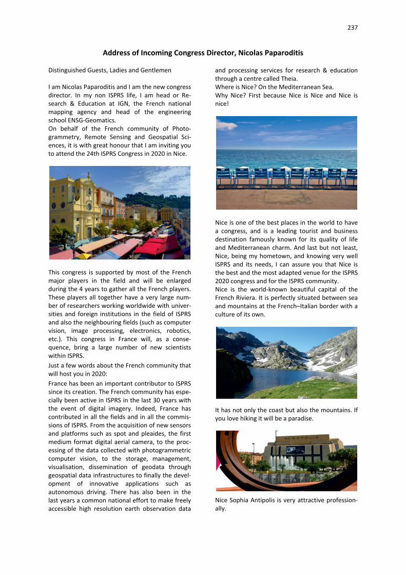
237
Address of Incoming Congress Director, Nicolas Paparoditis Distinguished Guests, Ladies and Gentlemen I am Nicolas Paparoditis and I am the new congress director. In my non ISPRS life, I am head or Re-search & Education at IGN, the French national mapping agency and head of the engineering school ENSG-Geomatics. On behalf of the French community of Photo-grammetry, Remote Sensing and Geospatial Sci-ences, it is with great honour that I am inviting you to attend the 24th ISPRS Congress in 2020 in Nice.
This congress is supported by most of the French major players in the field and will be enlarged during the 4 years to gather all the French players. These players all together have a very large num-ber of researchers working worldwide with univer-sities and foreign institutions in the field of ISPRS and also the neighbouring fields (such as computer vision, image processing, electronics, robotics, etc.). This congress in France will, as a conse-quence, bring a large number of new scientists within ISPRS. Just a few words about the French community that will host you in 2020: France has been an important contributor to ISPRS since its creation. The French community has espe-cially been active in ISPRS in the last 30 years with the event of digital imagery. Indeed, France has contributed in all the fields and in all the commis-sions of ISPRS. From the acquisition of new sensors and platforms such as spot and pleaides, the first medium format digital aerial camera, to the proc-essing of the data collected with photogrammetric computer vision, to the storage, management, visualisation, dissemination of geodata through geospatial data infrastructures to finally the devel-opment of innovative applications such as autonomous driving. There has also been in the last years a common national effort to make freely accessible high resolution earth observation data
and processing services for research & education through a centre called Theia. Where is Nice? On the Mediterranean Sea. Why Nice? First because Nice is Nice and Nice is nice!
Nice is one of the best places in the world to have a congress, and is a leading tourist and business destination famously known for its quality of life and Mediterranean charm. And last but not least, Nice, being my hometown, and knowing very well ISPRS and its needs, I can assure you that Nice is the best and the most adapted venue for the ISPRS 2020 congress and for the ISPRS community. Nice is the world-known beautiful capital of the French Riviera. It is perfectly situated between sea and mountains at the French–Italian border with a culture of its own.
It has not only the coast but also the mountains. If you love hiking it will be a paradise.
Nice Sophia Antipolis is very attractive profession-ally.

238
We have three possible time slots for the congress booked for you and we will choose the best one together with the council according to the needs of the ISPRS community.
In all cases, the outside temperature is between 22 to 28 °C with a very small probability of rain and the water temperature is between 24 to 27 °C. Difficult to do better than that…
Nice is a surprisingly affordable city, one can find food and drinks adapted to his budget…. and I hope you will be able to enjoy the sweetness of the Mediterranean way of life in 2020.
This candidature presented by the French society of Photogrammetry and remote Sensing (SFPT) is supported by the French community, carrying operational or research activities in Photogram-metry, Remote Sensing and Spatial Information Sciences and also neighbouring sciences such as computer vision and image processing. Indeed this candidature is fully supported by IGN, CNES, IRSTEA, IRD, INRIA, and CNRS which are spread over the whole French territory.
These institutions all together have a very large number of researchers working worldwide with universities and foreign institutions in the field of ISPRS and also the neighbouring fields (such as computer vision, image processing, electronics, robotics, etc.). Organising the 25th congress in Nice will as a consequence bring a large number of new scientists within ISPRS which are currently in neighbouring fields, and to keep them on board in the long term within ISPRS. I will do my best to serve the society on the long term.
239
RESOLUTIONS
Approved Resolutions of the XXIII ISPRS Congress
Prague 2016

240
Resolutions of ISPRS XXIII Congress
Resolution 0: Thanks to the Czech Society The Congress commends: To congratulate The Czech Society, its president and the Congress Director Lena Halounová, the Technical Program Director Václav Šafář , the Local Organizing Committee and the Congress PCO, Auletris, s.r.o., for their excellent work which has resulted in a very successful Congress
Technical Resolutions Resolution I.1: Sensor Systems for Indoor Navigation and Mapping The Congress Noting:
- the widespread availability and ubiquity of relatively low-cost 2D/3D sensors, including RGB and RGB-D cameras, laser scanners,
- the increasing advancement in smartphone technology, and
- the strong growth in the indoor geospatial application field
Recognising: - the need for rigorous yet highly automated
calibration, orientation and object recognition algorithms, and
- the demand for fast, accurate and robust software tools to identify patterns in point clouds acquired in indoor environments
Recommends: - investigation of the performance potential of
indoor mapping systems based on low-cost 3D sensors, automated algorithms and software tools to support object recognition from point clouds acquired either directly by such as laser sensing, or indirectly by photogrammetry to be carried out.
Resolution I.2: Crowdsensing and Cooperative Navigation The Congress Noting:
- the increasing importance of sensor georeferencing for mapping and navigation,
- the use of multi-sensor platforms, and
- the rapidly growing volumes of crowdsensed data from different platforms
Recognising: - the need for methods and solutions that can
support data acquired by multi-sensing platforms
Recommends: - the investigation of sensor orientation,
calibration and data fusion methods for multi-sensor platforms to be carried out
Resolution I.3 Small Satellites and Constellations The Congress Noting:
- the increasing development of small satellite systems for earth observation especially by the private sector
Recognising: - the availability of earth observation data
derived from small satellites for remote sensing applications
Recommends: - collaboration with the private sector on
widespread applications of earth observation data derived from small satellites to be initiated
Resolution II.1: Image Interpretation and Machine Learning The Congress Noting:
- the growing importance of automatic image interpretation and understanding for photogrammetric modeling and remote sensing, ranging from low-level feature extraction to high-level semantic interpretation
Recognising: - the contributions of ISPRS community to
analysis, segmentation and classification of image, point clouds and 3D model data
Recommends: - that the work on physical modeling and
machine learning, including recent advances in deep learning, for data interpretation and analysis should be strengthened.

241
Resolution II.2: New Sensor Data Modalities The Congress Noting:
- the growing importance of new sensors and sensor combinations, including RGB-D cameras, multi-spectral, hyperspectral and UAV-based lidar sensing, advances in GNSS and IMU technology, crowd-based and ad-hoc sensor networks
Recognising: - the contributions of ISPRS community to
sensor calibration, sensor integration and integrated data processing for geo-spatial applications
Recommends: - that analysis of new sensors and work on
calibration, data fusion and information extraction from new sensors and their combinations should be strengthened.
Resolution II.3: Photogrammetry in Mobile Robotics The Congress Noting:
- the rapid development of technology for autonomous robotics, aerial, land-based and swimming drones, self-driving vehicles, as well as hand-held and virtual/augmented reality devices
Recognising: - the contributions of the ISPRS community
regarding both real-time sensing and data analysis on mobile platforms, and the generation and maintenance of reliable environment maps
Recommends: - that the work on indoor and outdoor mapping;
real-time processing; control and obstacle avoidance; visual-inertial odometry; and dynamic scene understanding should be strengthened.
Resolution III.1 Multi-dimensional Remote Sensing Dataset and its Quality The Congress Noting:
- the increasing availability of complex and multi-dimensional, including multi-temporal, multi-resolution, multi-platform, multi-source sensors, for remote sensing of big datasets related to natural and/or man-made Earth
features; - the general lack of rigorous, harmonized,
optimized and accepted principles in terms of standards, quality, and error characterization of data and derived products
Recognising: - the contributions of ISPRS community to
develop innovative remote sensing techniques and tools combined with image processing algorithms for automated operational mapping;
- the difficulty and burden in developing and implementing appropriate, comprehensive, and generally accepted quality control techniques;
- the inchoate and rudimentary state of data quality standards
Recommends: - that the operational use of accepted and novel
techniques for the thematic mapping processes be strengthened;
- that those improvements should be accompanied by development and implementation of appropriate and comprehensive error characterization and data quality control techniques.
Resolution III.2: Remote Sensing Applications & Policies The Congress Noting:
- significant efforts towards realization of a myriad of applications of remote sensing by the research communities for sustainable development; scope for bridging the prevailing information gaps through the evolving scenarios of the Earth observation systems and analytical techniques;
- data policies on sharing, access and outreach of actionable and affordable information products for enabling appropriate decision making
Recognising: - the need for better understanding of the Earth
system for meeting the challenges of sustainable development goals;
- the benefits of automation in efficient generation of the standardized value added geospatial products and services;
- the merits of concerted and coordinated efforts by professional societies, industries, academia and research institutions, social media and other stakeholders for reaping societal benefits
242
Recommends: - improved technique development, exploring
the synergy of Earth observation systems for retrieval of parameters and their assimilation for predictive modelling;
- stronger emphasis on developing applications exploring the joint potential of different geospatial technologies on infrastructure, disaster resilience and natural resources management;
- more effective out-reach through sharing of data, algorithms and models, including capacity building;
- and ISPRS playing a pivotal role in integrating global efforts for policy decisions on sustainable development.
Resolution IV.1: Multi-dimensional data models and structures The Congress Noting:
- the increasing availability of huge, complex, multi-dimensional, multi-scale and potentially unstructured spatial data representing natural phenomena and man-made objects, above, below, on the surface, and indoor/outdoor
Recognising: - the contributions of ISPRS community to
representations, structures and algorithms for multi-scale, multi-dimensional and dynamic data, and modeling of data on moving objects
Recommends: - that work on spatial data structures, indexing,
and data fusion, and the use of functional programming and streaming algorithms be strengthened.
Resolution IV.2: Big spatial, VGI and Geosocial Media Data Integration, Visualization and Analysis The Congress Noting:
- the increasing availability of unprecedented amounts of big spatial data from traditional multi-sources to the internet of things and user-generated content, as well as planetary mapping, for sustainable development, smart cities and time-critical applications
Recognising: - the contributions of ISPRS community to
collection, processing, analysis, mining, simulation, visualization and quality assessment of moving and deformable object
data, trajectory data, geosocial media data, and image and video data
Recommends: - that work on open and real-time data, big data
analytics, data-driven geography, data interpretation, uncertainty modeling, privacy and security issues, as well as parallel and distributed processing paradigms and planetary mapping be strengthened.
Resolution IV.3: Information Services via Mobile and Cyber Infrastructure The Congress Noting:
- the rapid advancement of cloud computing, clusters and grids, high-performance computing, open source, geo-sensor networks, mobile technologies, web service technologies, new visualization devices, rising interest in human-centered design of technology, and open geospatial standards
Recognising: - the contributions of the ISPRS community to
web service architecture, semantics and ontologies, sensor web, visual analytics, online and offline 3D/4D visualization, standards in the context of mobile/web/cloud-based geospatial services, and usability concerns
Recommends: - that the work on dynamic geospatial services,
deep web, linked data, online multi-dimensional visualization considering usability, designs for mobile web, seamless indoor/outdoor location-based services, community-driven and participatory applications, and global information services be strengthened.
Resolution V.1 Cooperation with International Organizations and Sister Societies on Education and Capacity Building The Congress Noting:
- that the technology and societal conditions of Earth observation and spatial information applications are developing rapidly;
- that these developments have led to the establishment of new international organizations such as Group on Earth Observations (GEO) and United Nations Committee of Experts on Global Geospatial Information Management (UN-GGIM) for

243
coordination of earth observation and applications;
- that in many countries/regions the development of the Geo-information Sector is lagging behind and requires support to achieve global standards;
- that GI-organizations and professionals should continuously update and upgrade their knowledge
Recognising: - that educational and training capacity in Geo-
information are inadequate in many regions; - the complexity and wide coverage of the
domain and use of spatial information; - the growing need for professionals and
organizations working in the Geo-information fields
Recommends - that ISPRS work with the international
organisations to promote joint action programs for the provision of educational and training facilities;
- that ISPRS develop joint programs in Geo-information and share resources in education and training;
- that ISPRS encourage professional and academic participants to make their expertise available for knowledge transfer and exchange for capacity building.
- - Resolution V.2 Promotion of Web-based
Education and Collaborative Research - The Congress - Noting: - that the web-based technology is continuously
developing and is useful for education and training;
- that the education and research resources including MOOC, test data, and open source
software in Geo-informatics are rapidly increasing
Recognising: - the need to promote sharing of education and
research resources in the photogrammetry, remote sensing and spatial information sciences
Recommends: - ISPRS stimulate web-based sharing of
resources for education, research and collaboration; and
- promote online e-learning in Geo-information.
Resolution V.3 Promotion of the Profession to Students and Young Scientists The Congress Noting:
- that the numbers of students entering Geo-informatics programs are too low for the viability of the profession;
- the increasing possibilities for student mobility between institutions during their education and training
Recognising: - the need to promote the profession and recruit
young professionals for the Geo-informatics programs
Recommends: - the continuation of the active promotion of
ISPRS Youth Forum, Summer Schools, and the Student Consortium;
- to support cooperation with the ISPRS Youth Forum;
- encouragement of relevant organizations to facilitate international student exchange and technical training programs at all levels.
244
HISTORY
The International Archives of Photogrammetry, Remote Sensing
and Spatial Information Science
The ISPRS Annals of Photogrammetry, Remote Sensing and Spatial Information Science
Chronology of ISPRS
Chronology of TIF
245
The International Archives of the Photogrammetry, Remote Sensing and Spatial Information Sciences The International Archives of ISPRS were founded by Eduard Doležal in 1908 with the objective of collecting all photogrammetric and related know-how systematically. The volumes I-VII (1908/09, 1909/11, 1911/13, 1913/14, 1915/19, 1919/23, 1924/30) have or had their repository in Austria and Volume XI is in the USA. From 1939 to 1993, the publication and distribution was the responsibility of the hosting ISPRS Member organization. Some of these Archives are still available from the ISPRS Member of the respective country. A copy of all Archives resided in the International Training Centre (ITC) in The Netherlands for many years. In 2014 the repository was moved to the Technical Information Library (TIB) at Leibniz Universität Hannover, and is now gradually being made available to the public, as all volumes are being digitised and integrated into their web interface. TIB performs this task as a service to the Society and the spatial science community.
In 1993, ISPRS signed a contract with RIGS Books to serve as the official repository for post-Congress and post-Symposia sales of all Archives produced after 1993. This arrangement was designed to make the Archives more accessible from a single source without diverting revenues from the producing organizations. The Archives are now numbered 'odd' for the Congress Volumes and 'even' for Commission Symposia. Volume Parts are given the Commission number, if applicable, and are separate books. When a Volume or Part is composed of multiple books, the number of total books of the Volume or Parts is given in parentheses below. Parts for other ISPRS Conferences, Workshops or Tutorials have the Commission number followed by a C, W or T, respectively, and a sequence number.
Address: ISPRS Secretary General
LENA HALOUNOVÁ Czech Technical University in Prague Thakurova 7, Prague 6 CZECH REPUBLIC Tel.: +420 22435 4952 [email protected], www.cvut.cz
A. Congresses
Number Congress Venue Country Date Year Archive, Volume (Parts) 1 Vienna Austria 24.09.-26.09. 1913 2 Berlin Germany 21. 11. -26.11. 1926 3 Zurich Switzerland 05.09. -10.09. 1930 VII (1) 4 Paris France 26.11. -01. 12. 1934 VII (2) 5 Rome Italy 29.09.-06.10. 1938 IX (3) 6 The Hague The Netherlands 01.09.-10.09. 1948 X(2) 7 Washington USA 03.09.-16.09. 1952 XI (3) 8 Stockholm Sweden 17.07.-26.07. 1956 XII (4) 9 London UK 06.09.-16.09. 1960 XIII (6) 10 Lisbon Portugal 07.09.-19.09. 1964 XV (7) 11 Lausanne Switzerland 08.07.-20.07. 1968 XVII (10) 12 Ottawa Canada 24.07.-04.08. 1972 XIX (6) 13 Helsinki Finland 11.07.-23.07. 1976 XXI (13) 14 Hamburg Germany 13.07.-25-07. 1980 XXIII A, B (11) 15 Rio de Janeiro Brazil 17.06.~29.06. 1984 XXV A (8), B 16 Kyoto Japan 01.07.-10.07. 1988 XXVII A, B (13) 17 Washington USA 02.08.-14.08. 1992 XXIX A, B (7) 18 Vienna Austria 09.07.-19.07. 1996 XXXI A, B (7), J 19 Amsterdam The Netherlands 14.07.-26.07. 2000 XXXIII A, B (7) 20 Istanbul Turkey 12.07.-23.07. 2004 XXXV A, B (8) 21 Beijing China 14.07-25.07 2008 XXXVII A, B (8) 22 Melbourne Australia 25.08-01.09 2012 XXXIX A, B (8) 23 Prague Czech Republic 12.07-19.07 2016 XLI A, B (8)
Part A contains the proceedings and reports of the events. Part B contains the papers presented to the Congress. There is 1 exception from Rio de Janeiro Congress in 1984: part A contains papers, part B proceedings. Part J is an Index-Volume
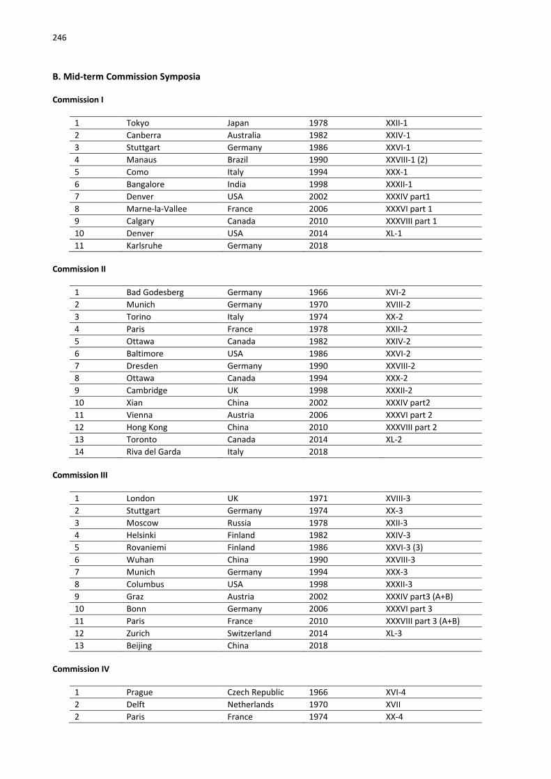
246
B. Mid-term Commission Symposia Commission I
1 Tokyo Japan 1978 XXII-1 2 Canberra Australia 1982 XXIV-1 3 Stuttgart Germany 1986 XXVI-1 4 Manaus Brazil 1990 XXVIII-1 (2) 5 Como Italy 1994 XXX-1 6 Bangalore India 1998 XXXII-1 7 Denver USA 2002 XXXIV part1 8 Marne-la-Vallee France 2006 XXXVI part 1 9 Calgary Canada 2010 XXXVIII part 1 10 Denver USA 2014 XL-1 11 Karlsruhe Germany 2018
Commission II
1 Bad Godesberg Germany 1966 XVI-2 2 Munich Germany 1970 XVIII-2 3 Torino Italy 1974 XX-2 4 Paris France 1978 XXII-2 5 Ottawa Canada 1982 XXIV-2 6 Baltimore USA 1986 XXVI-2 7 Dresden Germany 1990 XXVIII-2 8 Ottawa Canada 1994 XXX-2 9 Cambridge UK 1998 XXXII-2 10 Xian China 2002 XXXIV part2 11 Vienna Austria 2006 XXXVI part 2 12 Hong Kong China 2010 XXXVIII part 2 13 Toronto Canada 2014 XL-2 14 Riva del Garda Italy 2018
Commission III
1 London UK 1971 XVIII-3 2 Stuttgart Germany 1974 XX-3 3 Moscow Russia 1978 XXII-3 4 Helsinki Finland 1982 XXIV-3 5 Rovaniemi Finland 1986 XXVI-3 (3) 6 Wuhan China 1990 XXVIII-3 7 Munich Germany 1994 XXX-3 8 Columbus USA 1998 XXXII-3 9 Graz Austria 2002 XXXIV part3 (A+B) 10 Bonn Germany 2006 XXXVI part 3 11 Paris France 2010 XXXVIII part 3 (A+B) 12 Zurich Switzerland 2014 XL-3 13 Beijing China 2018
Commission IV
1 Prague Czech Republic 1966 XVI-4 2 Delft Netherlands 1970 XVII 2 Paris France 1974 XX-4

247
3 Ottawa Canada 1978 XXII-4 4 Washington USA 1982 XXIV-4 5 Edinburgh UK 1986 XXVI-4 6 Tokyo Japan 1990 XXVIII-4 7 Athens USA 1994 XXX-4 10 Stuttgart Germany 1998 XXXII-4 11 Ottawa Canada 2002 XXXIV part4 12 Goa India 2006 XXXVI part 4 13 Orlando USA 2010 XXXVIII part 4 14 Suzhou China 2014 XL-4 15 Delft The Netherlands 2018
Commission V
1 Tokyo Japan 1966 XVI-5 2 Paris France 1970 XVIII-5 3 Stockholm Sweden 1978 XXII-5 4 York UK 1982 XXIV-5 (2) 5 Ottawa Canada 1986 XXVI-5 6 Zurich Switzerland 1990 XXVIII-5 7 Melbourne Australia 1994 XXX-5 8 Hakodate Japan 1998 XXXII-5 9 Corfu Greece 2002 XXXIV part5 10 Dressden Germany 2006 XXXVI part 5 11 Newcastle upon Tyne UK 2010 XXXVIII part 5 12 Riva del Garda Italy 2014 XL-5 13 Dehradun India 2018
Commission VI
1 Krakow Poland 1978 XXII-6 2 Mainz Germany 1982 XXIV-6 3 Badagry Nigeria 1986 XXVI-6 4 Rhodes Greece 1990 XXVIII-6 5 Beijing China 1994 XXX-6 6 Bandung Indonesia 1998 XXXII-6 7 Sao Jose dos Campos Brazil 2002 XXXIV part6 8 Tokyo Japan 2006 XXXVI part 6 9 Enschede The Netherlands 2010 XXXVIII part 6 10 Wuhan China 2014 XL-6
Commission VII
1 Delft The Netherlands 1962 XIV-7 2 Paris France 1966 XVI-7 3 Dresden Germany 1970 XVIII-7 (2) 4 Banff Canada 1974 XX-7 (2) 5 Freiburg Germany 1978 XXII-7 (3) 6 Toulouse France 1982 XXIV-7 (2) 7 Enschede The Netherlands 1986 XXVI-7 (3) 8 Victoria Canada 1990 XXVIII-7 (2) 9 Rio de Janeiro Brazil 1994 XXX-7 10 Budapest Hungary 1998 XXXII-7 11 Hyderabad India 2002 XXXIV part7 (A+B)

248
12 Enschede The Netherlands 2006 XXXVIII part 7 (A+B) 13 Vienna Austria 2010 XXXVI part 7 14 Istanbul Turkey 2014 XL-7
Commission VIII
1 Kyoto Japan 2010 XXXVIII part 8 2 Hyderabad India 2014 XL-8
The ISPRS Annals of Photogrammetry, Remote Sensing and Spatial Information Science The ISPRS Annals of the Photogrammetry, Remote Sensing and Spatial Information Sciences (ISPRS Annals) contain selected full paper double-blind peer-reviewed scientific
contributions of ISPRS Congresses, Symposia and a number of Conferences and Workshops. The series was newly established in 2012.
Congresses: 22 Melbourne Australia 25.08-01.09 2012 I-2,3,4,7 A, B (4) 23 Prague Czech Republic 12.07-19.07 2016 III A, B (8) Symposia: 1 Commission I Denver USA 17.11.-20.11 2014 II-1 1 Commission II Toronto Canada 06.10.-08.10 2014 II-2 1 Commission III Zurich Switzerland 05.09.-07.09 2014 II-3 1 Commission IV Suzhou China 14.05-16.05 2014 II-4 1 Commission V Riva del Garda Italy 23.06.-25.06 2014 II-5 1 Commission VI Wuhan China 19.05.-21.05 2014 II-6 1 Commission VII Antalya Turkey 29.09.-02.10 2014 II-7 1 Commission VIII Hyderabad India 09.12.-12.12 2014 II-8
Chronology of ISPRS Compiled by G. Konecny, L. W. Fritz, P. Waldhäusl and J. Timmerman
Austrian Society for Photogrammetry founded May 3, 1907 German Society for Photogrammetry founded October 5, 1909 (officially certified 1911) International Society for Photogrammetry founded July 4, 1910 International Society for Photogrammetry and Remote Sensing renamed July 15, 1980
Presidents 1910 - 1913 E. Doležal, Austria 1913 - 1926 E. Doležal, Austria
1926 - 1930 O. Eggert, Germany 1930 - 1934 G. Perrier, France 1934 - 1938 G. Cassinis, Italy 1938 - 1948 W. Schermerhorn, The Netherlands 1948 - 1952 O. S. Reading, USA 1952 - 1956 P. Mogensen, Sweden 1956 - 1960 R. LI. Brown, Great Britain 1960 - 1964 A. Paes Clemente, Portugal 1964 - 1968 H. Harry, Switzerland 1968 - 1972 L. Solaini, Italy 1972 - 1976 S. G. Gamble, Canada 1976 - 1980 J. Cruset, France 1980 - 1984 F. J. Doyle, USA 1984 - 1988 G. Konecny, F. R. Germany 1988 - 1992 K. Torlegård, Sweden 1992 - 1996 S. Murai, Japan
249
1996 - 2000 L. W. Fritz, USA 2000 - 2004 J. Trinder, Australia 2004 - 2008 I. Dowman, UK 2008 - 2012 O. Altan, Turkey 2012 - 2016 Chen J., China 2016 - 2020 C. Heipke, Germany
Council 1910 - 1913 President: E. Doležal, Austria 1913 - 1926 President: E. Doležal, Austria 1926 - 1930 President: O. Eggert, Germany Honorary President: E. Doležal, Austria Secretary General: O. Korner, Germany Congress Director: F. Baeschlin, Switzerland 1930 - 1934 President: G. Perrier, France Honorary President: E. Doležal, Austria Secretary General: H. Roussilhe, France Treasurer: M. Labussiere, France Council Members: H. von Langendorff, Germany F. Baeschlin, Switzerland J. Torroja, Spain K. Buchholtz, Latvia 1934 - 1938 President: G. Cassinis, Italy Honorary President: E. Doležal, Austria Secretary General: M. Tucci, Italy Treasurer: P. Dore, Italy Council Members: H. von Langendorff, Germany J. Maury, Belgium G. Perrier, France K. Weigel, Poland 1938 - 1948 President: W. Schermerhorn, The Netherlands Secretary General: B. Scherpbier, The Netherlands Treasurer: C. A. von Frytag Drabbe, The Netherlands Council Members: G. Perrier, France H. von Langendorff, Germany O. S. Reading, USA G. Cassinis, Italy
1948 - 1952 President: O. S. Reading, USA Secretary General: E. S. Massie, Jr., USA Treasurer: W. C. Cude, USA Council Members: F. Baeschlin, Switzerland G. Cassinis, Italy R. Janicot, France W. Schermerhorn, The Netherlands 1952 - 1956 President: P. Mogensen, Sweden Secretary General: P. O. Fagerholm, Sweden Treasurer: S. G. Moeller, Sweden Council Members: R. LI. Brown, Great Britain R. Janicot, France O. S. Reading, USA W. Schermerhorn, The Netherlands 1956 - 1960 President: R. LI. Brown, Great Britain Secretary General: R. T. L. Rogers, Great Britain Treasurer: J. E. Odle, Great Britain Council Members: P. O. Fagerholm, Sweden R. Janicot, France O. S. Reading, USA W. Schermerhorn, The Netherlands 1960 - 1964 President: A. Paes Clemente, Portugal Secretary General: A. D. Calvario, Portugal (1960-1961) M. F. Alexandre, Portugal (1961-1964) Treasurer: A. Santos Silva, Portugal Vice President: R. LI. Brown, Great Britain Council Members: P. O. Fagerholm, Sweden H. Harry, Switzerland G. D. Whitmore, USA 1964 - 1968 President: H. Harry, Switzerland Secretary General: W. Bachmann, Switzerland Treasurer: E. Huber, Switzerland Vice President: P. O. Fagerholm, Sweden Council Members: A. Paes Clemente, Portugal S. G. Gamble, Canada L. Solaini, Italy 1968 - 1972 President: L. Solaini, Italy Secretary General: G. C. Tewinkel, USA Treasurer: S. G. Gamble, Canada Vice President: W. Bachmann, Switzerland Council Members: L. Skládal, Czechoslovakia R. S. Halonen, Finland
250
1972 - 1976 President: S. G. Gamble, Canada Secretary General: J. Cruset, France Congress Director: R. S. Halonen, Finland (1972- 1975) K. G. Lofstrom, Finland, (1975-1976) First Vice President: G. C. Tewinkel, USA Second Vice President: T. Maruyasu, Japan Treasurer: A.J. van der Weele, The Netherlands 1976 - 1980 President: J. Cruset, France Secretary General: F. Doyle, USA Congress Director: G. Konecny, F.R. Germany First Vice President: S. G. Gamble, Canada (1976- 1977) E. O. Dahle, Norway (1977 - 1980) Second Vice President: P. Fagundes, Brazil Treasurer: A. Savolainen, Finland 1980 - 1984 President: F. Doyle, USA Secretary General: G. Konecny, F. R. Germany Congress Director: P. Fagundes, Brazil First Vice President: G. Zarzycki, Canada Second Vice President: I. Antipov, Soviet Union Treasurer: H. Jerie, The Netherlands 1984 - 1988 President: G. Konecny, F. R. Germany Secretary General: K. Torlegård, Sweden Congress Director: S. Murai, Japan First Vice President: G. Zarzycki, Canada Second Vice President: J. Trinder, Australia Treasurer: A. J. van der Weele, The Netherlands 1988 - 1992 President: K. Torlegård, Sweden Secretary General: S. Murai, Japan Congress Director: L. W. Fritz, USA First Vice President: G. Konecny, Germany Second Vice President: I. Katzarsky, Bulgaria Treasurer: K. Atkinson, UK 1992 - 1996 President: S. Murai, Japan Secretary General: L. W. Fritz, USA Congress Director: K. Kraus, Austria First Vice President: K. Torlegård, Sweden Second Vice President: A. Grün, Switzerland Treasurer: J. Trinder, Australia 1996 - 2000 President: L. W. Fritz, USA
Secretary General: J. Trinder, Australia Congress Director: K. J. Beek, The Netherlands First Vice President: S. Murai, Japan Second Vice President: M. Barbosa, Brazil Treasurer: H. Rüther, South Africa 2000 - 2004 President: J. Trinder, Australia Secretary General: I. Dowman, UK Congress Director: O. Altan, Turkey First Vice President: L. W. Fritz, USA Second Vice President: G. Begni, France Treasurer: A. Peled, Israel 2004 - 2008 President: I. Dowman, UK Secretary General: O. Altan, Turkey Congress Director: Chen J., China First Vice President: J. Trinder, Australia Second Vice President: E. Baltsavias, Switzerland Treasurer: S. Morain, USA 2008 - 2012 President: O. Altan, Turkey Secretary General: Chen J., China Congress Director: C. Ogleby, Australia First Vice President: I. Dowman, UK Second Vice President: A. Peled, Israel Treasurer: M. Renslow, USA 2012 - 2016 President: Chen J., China Secretary General: C. Heipke, Germany Congress Director: L. Halounová, Czech Rep. First Vice President: O. Altan, Turkey Second Vice President: M. Madden, USA Treasurer: J. Mills, UK 2016 - 2020 President: C. Heipke, Germany Secretary General: L. Halounová, Czech Rep. Congress Director: N. Paparoditis, France First Vice President: Chen J., China Second Vice President: C. Toth, USA Treasurer: S. Li, Canada
Honorary President E. Doležal 1926-1955
Honorary Members E. von Orel Austria 1938 - 1941 G. Poivilliers France 1948 - 1968 F. Baeschlin Switzerland 1952 - 1961 U. Nistri Italy 1952 - 1962 0. S. Reading USA 1952 - 1984 E. Santoni Italy 1952 - 1970

251
W. Schermerhorn Netherlands 1952 - 1986 W. Bauersfeld Germany 1956 - 1959 G. Cassinis Italy 1956 - 1964 H. Harry Switzerland 1956 - 1973 L. Hurault France 1956 - 1973 P. Mogensen Sweden 1956 - 1969 R. LI. Brown Great Britain 1960 - 1983 K. Schwidefsky F.R. Germany 1972 - 1986 E. H. Thompson UK 1972 - 1976 G. de Masson d'Autume France 1976 - 2006 K. G. Lofstrom Finland 1976 - 1984 J. Cruset France 1980 - 1994 L. Solaini Italy 1980 - 1989 P. Fagundes Brazil 1984 - 1996 F. J. Doyle USA 1988 - 2013 A. Savolainen Finland 1988 - 2017 Wang Z. China 1988 - 2002 G. Konecny Germany 1992 F. Ackermann Germany 1996 S. Murai Japan 2000 L.W. Fritz USA 2004 A. Grün Switzerland 2008 J. Trinder Australia 2008 I. Dowman UK 2012 Li D. China 2012 O. Altan Turkey 2016
Fellows I. Antipov Russia 2010 C. Armenakis Canada 2010 M. Baltsavias Switzerland 2010 M. Barbosa Brazil 2010 K. J. Beek The Netherlands 2010 W. Förstner Germany 2010 Li D. China 2010 S. Morain USA 2010 K. Szangolies Germany 2010 K. Torlegård Sweden 2010 - 2016 R. Welch USA 2010 G. Zarzycki Canada 2010 - 2012 D. Fritsch Germany 2012 M. Molenaar The Netherlands 2012 S. Nayak India 2012 P. Newby UK 2012 H. Rüther South Africa 2012 A. Baudoin France 2016 Jiang J. China 2016 F. Leberl Austria 2016 P. Patias Greece 2016 A. Peled Israel 2016
Technical Commissions 1926 - 1930 Terrestrial Photogrammetry - H. Dock, Austria
Rectification - L. van Cost, Belgium Stereo-Aerial Photogrammetry - O. Eggert, Germany Aerial Triangulation - F. Baeschlin, Switzerland X-ray Measurements - A. Hasselwander, Germany Architectural and Engineering Photogrammetry - J. Torroya, Spain 6b. Photogrammetry for Flying Objects - Th. Ween, Norway Economy - A. Kruttschnitt, Hungary Instruments, Optics, Norms - G. Cassinis, Italy Plates and Films - A. von Odencrants, Sweden Education at Universities and Research Institutes A. Buchholtz, Latvia 10b.Training of Technical Personnel - A. Ivancianu, Romania Photographic Airplanes - K. Weigel, Poland 11b.Navigation - J. Petrik, Czechoslovakia 1930 - 1934 Terrestrial Photogrammetry - F. Baeschlin, Switzerland Aerial Photography - M. Labussiere, France Mapping - H. von Langendorff, Germany Various Applications - E. Doležal, Austria 4b. X-Ray Photogrammetry - A. Hasselwander, Germany Industrial Applications & Economy - K. Weigel & E. Warchalowski, Poland Education, Bibliography, Terminology - A. Medyev & K. v. Oltay, Hungary 1934 - 1938 Ground Photography - F. C. Baeschlin, Switzerland Air Photography - H. H. Blee, USA Aerial Triangulation - W. Schermerhorn, The Netherlands Plotting of Air Photographs - H. v. Langendorff, Germany Various Applications of Photogrammetry - E. Doležal, Austria X-ray Photogrammetry and Close-Up Photogrammetry - C. Sannie, France Industrial Organization of Photogrammetry and Sta-tistics of Works - G. Cassinis, Italy Teaching, Terminology, Bibliography - K. v. Oltay, Hungary 1938 - 1948 Ground Photogrammetry and its Applications - O. S. Reading, USA Air Photography - M. Zeller, Switzerland Preliminary Operations on the Ground for Aerial Pho-togrammetry - F. Baeschlin, Switzerland Plotting of Air Photographs - P. Tham, Sweden Geodetical Applications of Photogrammetry - G. Poivilliers, France Application of Photogrammetry to Biology and Med-icine - J. Didier & Coliez, France

252
Industrial Organization of Photogrammetry and Sta-tistics - G. Cassinis, Italy Teaching and Bibliography - G. Harding, USA 1948 - 1952 Photography & Navigation - L. E. Howlett, Canada Plotting Machines & Instruments - G. Poivilliers, France Aerial Triangulation - P. Wiser, Belgium Mapping from Photographs - G. Cassinis, Italy Special Applications of Photogrammetry - B. Hallert, Sweden Education, Terminology, Bibliography, History, Polyglot Dictionary - K. Lego, Austria - K. Neumaier Photo-Interpretation - R. N. Colwell, USA 1952 - 1956 Photography & Navigation - J. Cruset, France Plotting, Theory and Instruments - W. K. Bachmann, Switzerland Aerial Triangulation - P. Wiser, Belgium Mapping from Photographs - G. S. Andrews, Canada Non-Topographic Photogrammetry - G. Boaga, Italy Education, Terminology, Bibliography - K. Neumaier, Austria Photo Interpretation - C. G. Coleman, USA 1956 - 1960 Photography and Navigation - J. Cruset, France Plotting, Theory and Instruments - F. Vanderheyden, Belgium Aerial Triangulation - G. Cassinis, Italy Mapping from Photographs - H. Harry, Switzerland Special Applications of Photogrammetry - R. Burkhardt, F.R. Germany Education, Terminology and Bibliography - A. Barvir, Austria Photo Interpretation - C. G. Coleman, USA 1960 - 1964 Photography and Navigation - G. C. Brock, Great Britain Plotting, Theory and Instruments - A. L. Nowicki, USA Aerial Triangulation - G. de Masson d'Autume, France Mapping from Photographs - E. F. Gigas, F.R. Germany Special Applications of Photogrammetry - K. Hubeny, Austria Education, Terminology and Bibliography - R. S. Halonen, Finland Photo Interpretation - C.H. Edelman, The Netherlands 1964 - 1968 Photography and Navigation - R. W. Fish, Great Britain Theory, Methods, Instruments of Restitution - K. Schwidefsky, F.R. Germany Aerial Triangulation - G. C. Tewinkel, USA IV Mapping from Photographs - L. Skladal, Czechoslo-vakia Non-Topographic Photogrammetry - T. Maruyasu, Japan
Education, Terminology and Bibliography - W. Sztompke, Poland Photo Interpretation - R. Chevallier, France 1968 - 1972 Aerial Photography and Navigation - M. B. Scher, USA Plotting Theory, Methods and Instruments - H. Deker, F.R. Germany Aerial Triangulation - E. Thompson, Great Britain Application of Photogrammetry to the Earth Surface Representation - A. J. van der Weele, The Netherlands Special Applications of Photogrammetry - M. Carbonnell, France Bibliography, Teaching, Terminology - P Gal, Czechoslovakia Photo Interpretation - A. Reinhold, German D.R. 1972 - 1976 Primary Data Acquisition - E. Welander, Sweden Instrumentation for Data Reduction - G. Inghilleri, Italy Mathematical Analysis of Data - F. Ackermann, F.R. Germany Topographic and Cartographic Applications - G. Ducher, France Non-topographic Photogrammetry - H. M. Karara, USA Economic, Professional and Educational Aspects of Photogrammetry - W. Sztompke, Poland Interpretation of Data - L. Sayn-Wittgenstein, Canada 1976 - 1980 Primary Data Acquisition - I. Nakajima, Japan Instrumentation for Data Reduction - M. Baussart, France Mathematical Analysis of Data - I. Antipov, Soviet Union Topographic and Cartographic Applications - J. M. Zarzycki, Canada Non-Topographic Photogrammetry - K. Torlegård, Sweden Economic, Professional and Educational Aspects of Photogrammetry - Z. Sitek, Poland Interpretation of Data - G. Hildebrandt, F. R. Germany 1980 - 1984 Primary Data Acquisition - J. Trinder, Australia Instrumentation for Data Reduction - Z. Jaksic, Canada Mathematical Analysis of Data - E. Kilpelä, Finland Topographic and Cartographic Applications - R. Mullen, USA Non-Topographic Photogrammetry - J. W. Gates, UK Economic, Professional and Educational Aspects of Photogrammetry and Remote Sensing - J. Hothmer, F.R. Germany Interpretation of Data - L. Laidet, France 1984 - 1988 Primary Data Acquisition - P. Hartl, Germany

253
Instrumentation for Data Reduction and Analysis - L. W. Fritz, USA Mathematical Analysis of Data - E. Kilpelä, Finland Cartographic and Data Bank Applications of Pho-togrammetry and Remote Sensing - A. MacDonald, UK Other Non-Cartographic Applications of Photogram-metry and Remote Sensing - V. Kratky, Canada Economic, Professional and Educational Aspects of Photogrammetry and Remote Sensing - O. Adekoya, Nigeria Interpretation of Photographic and Remote Sensing Data - K. J. Beek, The Netherlands 1988 - 1992 Primary Data Acquisition - M. Barbosa, Brazil Systems for Data Processing and Analysis - K. Szangolies, German Dem. Rep. Mathematical Analysis of Data - Li D., China Cartographic and Data Base Applications of Photogrammetry and Remote Sensing - T. Hirai, Japan Close Range Photogrammetry and Machine Vision - A. Grün, Switzerland Economic, Professional and Educational Aspects of Photogrammetry & Remote Sensing - J. Badekas, Greece Interpretation of Photographic and Remote Sensing Data - F. Hegyi, Canada 1992 - 1996 Sensors, Platforms and Imagery - L. Mussio, Italy Systems for Data Processing, Analysis and Repre-sentation - M. Allam, Canada Theory and Algorithms - H. Ebner, Germany Mapping and Geographic Information Systems - R. Welch, USA Close-Range Techniques and Machine Vision - J. Fryer, Australia Economics, Professional Matters and Education - Li D., China Resource and Environmental Monitoring - R. P. Da Cunha, Brazil 1996 - 2000 Sensors, Platforms and Imagery - G. Joseph, India Systems for Data Processing, Analysis and Repre-sentation - I. Dowman, UK Theory and Algorithms - T. Schenk, USA Mapping and Geographic Information Systems - D. Fritsch, Germany Close-Range Techniques and Machine Vision - H. Chikatsu, Japan Education and Communications - K. Villanueva, Indonesia Resource and Environmental Monitoring - G. Remetey-Fülöpp, Hungary 2000 - 2004 Sensors, Platforms and Imagery - S. A. Morain, USA
Systems for Data Processing, Analysis and Repre-sentation - Chen J., China Theory and Algorithms - F. Leberl, Austria Mapping and Geographic Information Systems - C. Armenakis, Canada Close-Range Techniques and Machine Vision - P. Patias, Greece Education and Communications - T. M. Sausen, Brazil Resource and Environmental Monitoring - R. R. Navalgund, India 2004 - 2008 Image Data Acquisition - Sensors and Platforms - A. Baudoin, France Theory and Concepts of Spatio-Temporal Data Handling and Information - W. Kainz, Austria Photogrammetric Computer Vision and Image Analyses - W. Förstner, Germany Geo-Databases and Digital Mapping - S. Nayak, India Close-Range Sensing: Analyses and Applications - H. G. Maas, Germany Education and Outreach - K. Cho, Japan Thematic Processing, Modeling and Analysis of Remotely Sensed Data - J. L. van Genderen, The Netherlands Remote Sensing Applications and Policies - A. Peled, Israel 2008- 2012 Image Data Acquisition - Sensors and Platforms - N. El-Sheimy, Canada Theory and Concepts of Spatial Information Science - W. Shi, Hong Kong Photogrammetric Computer Vision and Image Analysis - N. Paparoditis, France Geodatabases and Digital Mapping - M. Madden, USA Close-Range Sensing: Analysis and Applications - J. P. Mills, UK Education and Outreach - M. Molenaar, The Netherlands Thematic Processing, Modeling and Analysis of Remotely Sensed Data - W. Wagner, Austria Remote Sensing Applications and Policies - H. Shimoda, Japan 2012 - 2016 Sensors and Platforms for Remote Sensing - C. Toth, USA Theory and Concepts of Spatial Information Science - S. Li, Canada Photogrammetric Computer Vision and Image Analysis - K. Schindler, Switzerland Geospatial Databases and Location Based Services - Jiang J., Chına Close-Range Imaging, Analysis and Applications - F. Remondino, Italy Education, Technology Transfer and Capacity Development - Gong J., Chına

254
Thematic Processing, Modeling and Analysis of Remotely Sensed Data - F. Sunar, Turkey Remote Sensing Applications and Policies, V. K. Dadhwal, India 2016 - 2020 Sensor Systems - Stefan Hinz, Germany, R. Q. Feitosa, Brazil
Photogrammetry - F. Remondino, Italy, T. Fuse, Japan Remote Sensing - Jiang J., China, A. Shaker, Canada Spatial Information Science - S. Zlatanova, The Netherlands, S. Dragicevic, Canada Education and Outreach - A. S. Kumar, India, P. L. N. Raju, India
Chronology of TIF - The ISPRS Foundation The ISPRS Foundation, Inc. (TIF) is an independently registered entity that has been established to provide financial assistance and in-kind support solely for benevolent purposes that are pursued by The International Society for Photogrammetry and Remote Sensing (ISPRS). TIF is a public charity formed to administer an extensive and broadly-based international program that through the raising of funds shall provide grants, scholarships, awards, training supplies and other forms of scientific assistance to qualified individuals and organizations who are pursuing and/or applying knowledge for advancing the sciences and technologies associated with the disciplines embodied by the ISPRS. Consideration is especially given to support those in developing countries and regions. Through the public promotion of its philanthropic efforts TIF aims to foster greater international awareness and use of the benefits that applications of the photogrammetry, remote sensing and spatial information sciences produce for public good and to the well-being of humanity and sustainability of the environment. The ISPRS Foundation solicits donations and provides grants in 12 Categories of benevolence. TIF is officially designated as a public charity formed for non-profit, educational and scientific purposes under section 501 (c) (3) of the USA Internal Revenue Code and is organized and operated exclusively for benevolent, charitable, scientific, research or educational purposes. TIF shall not pay any salaries or travel expenses for its Trustees and it is limited to spend less than 2% of donations for administrative expenses (office operation, publicity, postage, bank fees, etc.). The ISPRS Foundation was established at the initiative of First Vice President Lawrence Fritz, following an ISPRS Strategy meeting held by the ISPRS Council in 1998, in order to provide tax deduction incentives for donors to ISPRS for its charity initiatives. The ISPRS Foundation was officially inaugurated at its 1st Board of Trustees meeting on 31 March 2004 while its Bylaws were ratification by ISPRS General Assembly in July 2004. A cocktail event to celebrate the establishment of the Foundation was held during the ISPRS Congress in Istanbul, Turkey in July 2004.
Board meetings have been held in March and July 2004, July 2006, 23 July 2007, July 2010, August 2012 and July 2016. Executive meetings are held electronically when required. Officer Bearers
Chair John Trinder, Australia Dieter Fritsch, Germany Stewart Walker, USA
2004-2006 2006-2016 2016-present
Operations Officer Lawrence Fritz, USA John Trinder, Australia
2004-2006 2006-present
Finance Officer Ammatzia Peled, Israel Lawrence Fritz, USA Marguerite Madden, USA
2004-2006 2006-2011 2011-present
Current Trustees
Stewart Walker Chair Fmr Director, Product Initiatives Geospatial eXploitation Products, BAE Systems, USA
2016-present
John C. Trinder Operations Office University of New South Wales Australia
2004-present
Marguerite Madden Finance Officer Center for Geospatial Research (CGR) University of Georgia, USA
2011-present
Lewis Graham President and Chief Technical Officer of GeoCue Corporation, USA
2012-present
Lawrie Jordan Director of Imagery for Esri, USA
2014-present

255
Mario Hernandez Special Consultant for the United Nations Educational and Cultural Organization (UNESCO) Switzerland
2014-present
Mazlan Othman Deputy Director-General of the United Nations Office at Vienna (UNOV) Austria
2012-present
Christian Heipke ISPRS President Leibniz University Hannover Germany
2016-2020
Songnian Li ISPRS Treasurer Ryerson University Toronto, Ontario Canada
2016-2020
Li Deren State Key Laboratory of Information Engineering in Surveying, Mapping and Remote Sensing (LIESMARS) Wuhan University China
2012-present
Past Trustees Adigun A. Abiodun, Nigeria Ian Dowman, UK Hans Hess, Switzerland Peter Woodsford, UK Shunji Murai, Japan Jon P. Mills, UK Chen Jun, China Dieter Fritsch, Germany Terrence J. Keating, USA Martien Molenaar, The Netherlands Ammatzia Peled, Israel Jürgen Dold, Switzerland Lawrence W. Fritz, USA Vanessa Lawrence, UK Robert Moses, Canada Michael Renslow, USA Akihiro Yamaura, Japan
2004-2011 2004-2012 2004-2011 2004-2008 2004-2006 2012-2016 2012-2016 2006-2016 2004-2010 2004-2012 2004-2006 2010-2016 2004-2013 2010-2014 2006-2010 2008-2012 2004-2012
Compiled by J. Trinder

256
ISPRS COMMITTEES
The International Policy Advisory Committee (IPAC)
The International Science Advisory Committee (ISAC)
International Industrial Advisory Committee (I²AC)
The International Committee on Remote Sensing of Environment (ICORSE)
International Committee for Architectural Photogrammetry (CIPA)
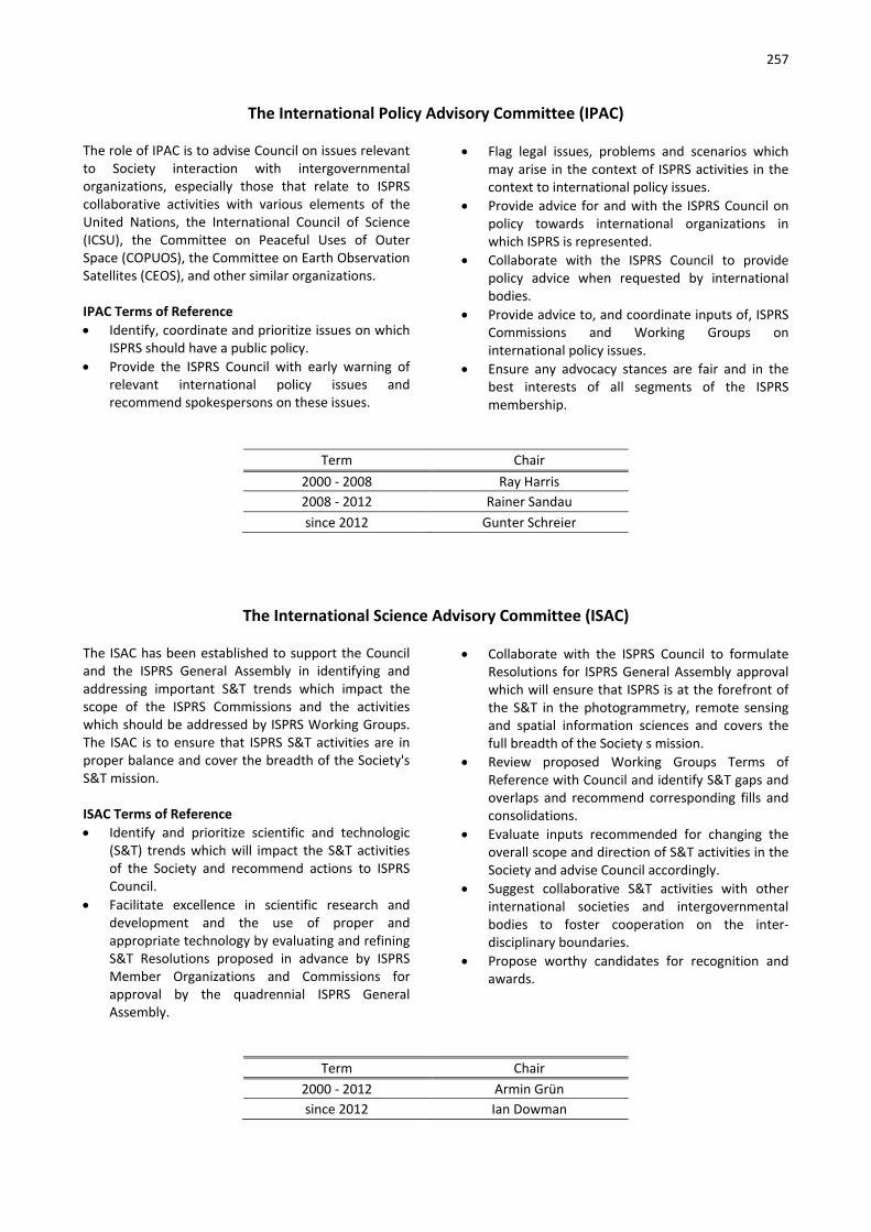
257
The International Policy Advisory Committee (IPAC) The role of IPAC is to advise Council on issues relevant to Society interaction with intergovernmental organizations, especially those that relate to ISPRS collaborative activities with various elements of the United Nations, the International Council of Science (ICSU), the Committee on Peaceful Uses of Outer Space (COPUOS), the Committee on Earth Observation Satellites (CEOS), and other similar organizations. IPAC Terms of Reference • Identify, coordinate and prioritize issues on which
ISPRS should have a public policy. • Provide the ISPRS Council with early warning of
relevant international policy issues and recommend spokespersons on these issues.
• Flag legal issues, problems and scenarios which may arise in the context of ISPRS activities in the context to international policy issues.
• Provide advice for and with the ISPRS Council on policy towards international organizations in which ISPRS is represented.
• Collaborate with the ISPRS Council to provide policy advice when requested by international bodies.
• Provide advice to, and coordinate inputs of, ISPRS Commissions and Working Groups on international policy issues.
• Ensure any advocacy stances are fair and in the best interests of all segments of the ISPRS membership.
Term Chair 2000 - 2008 Ray Harris 2008 - 2012 Rainer Sandau since 2012 Gunter Schreier
The International Science Advisory Committee (ISAC) The ISAC has been established to support the Council and the ISPRS General Assembly in identifying and addressing important S&T trends which impact the scope of the ISPRS Commissions and the activities which should be addressed by ISPRS Working Groups. The ISAC is to ensure that ISPRS S&T activities are in proper balance and cover the breadth of the Society's S&T mission. ISAC Terms of Reference • Identify and prioritize scientific and technologic
(S&T) trends which will impact the S&T activities of the Society and recommend actions to ISPRS Council.
• Facilitate excellence in scientific research and development and the use of proper and appropriate technology by evaluating and refining S&T Resolutions proposed in advance by ISPRS Member Organizations and Commissions for approval by the quadrennial ISPRS General Assembly.
• Collaborate with the ISPRS Council to formulate Resolutions for ISPRS General Assembly approval which will ensure that ISPRS is at the forefront of the S&T in the photogrammetry, remote sensing and spatial information sciences and covers the full breadth of the Society s mission.
• Review proposed Working Groups Terms of Reference with Council and identify S&T gaps and overlaps and recommend corresponding fills and consolidations.
• Evaluate inputs recommended for changing the overall scope and direction of S&T activities in the Society and advise Council accordingly.
• Suggest collaborative S&T activities with other international societies and intergovernmental bodies to foster cooperation on the inter-disciplinary boundaries.
• Propose worthy candidates for recognition and awards.
Term Chair 2000 - 2012 Armin Grün since 2012 Ian Dowman

258
International Industrial Advisory Committee (I²AC) I²AC Organization and Terms of Reference Approved by the I²AC inaugural meeting on 13-Jul-2016 Creation of the I²AC The I²AC has been established to support the ISPRS Council in its dealings with the Geospatial industry, with the aim of making the ISPRS more relevant to industry. Recognizing that the ISPRS is a learned society of academics, and also is strong in governmental mapping agencies, it needs to improve its interactions with the rapidly changing and evolving Geospatial industry as the driver of all global geospatial activities and innovations. The I²AC’s creation was by decisions of the ISPRS General Assembly at the 23rd international congress of the ISPRS [Prague, 2016]. It was installed with a membership of 19 businesses, each nominating a person to take one of the seats. Additionally, 1 seat was held for the Chairperson of The ISPRS Foundation TIF. Membership in the I²AC The membership of the I²AC is self-perpetuating. Should a person no longer represent a business, then this business will nominate a replacement. Should a business no longer want to hold a seat, then the I²AC will invite a replacement business. Continued inactivity of a seat holder may lead to a dialogue between the Chairperson and the business-representative to refresh the business-agent, or to vacate that seat. Chair of the I²AC It is the membership of the I²AC that votes with a simple majority on its chairperson. Every member can propose a chairperson. Voting will be organized by the outgoing Chairperson in two steps. Each candidate will collect votes in the first round. Then the two persons with the most votes will go through a run-off. The position will be held for 4 years or until the ISPRS Congress following the election, whatever is first. Renewal of the Chairpersonship will be during the [currently quadrennial] ISPRS Congress.
Decision Making Decisions by the committee will be taken upon a debate within the ranks of the committee, under the guidance of the Chairperson. If appropriate, decisions will get voted on with a simple majority. Each seat votes, each vote holds the same weight. Voting can be via physical presence at a meeting, or by electronic participation. ISPRS Council and the I²AC The I²AC interacts with the ISPRS-Council via its Secretary General. Purpose | Terms of Reference The I²AC may address any topic it deems of interest, and bring its views to the attention of the point of contact on the ISPRS council. This may be as general as identifying and addressing important industry trends which impact the scope of the ISPRS Commissions and activities by ISPRS Working Groups. It may very specifically address the site choices of upcoming ISPRS-events. Broadly, activities of theI²AC are to • Improve the benefits of its industrial sustaining
membership program – simply provide industry with a better voice in ISPRS and thereby widen the base of ISPRS industrial sustaining members;
• Advise Council in matters regarding the cooperation of industrial sustaining members with the society;
• Enable an improved response to the incredible dynamics of the Geospatial industry;
• Define requirements which should be fulfilled by ISPRS for companies of different sizes to participate in the exhibition of ISPRS events, and in particular in the [currently quadrennial] Congress exhibition;
• Coordinate ideas and policies with other ISPRS committees. [www.isprs.org/structure/committees]
Budget | Costs There will not be any costs associated with the activities of the I²AC. There is no budget for its activities.
Term Chair
2015 - 2016 Franz Leberl since 2016 Christian Hoffmann

259
The International Committee on Remote Sensing of Environment (ICORSE) The ICORSE has been established to foster the use of remote sensing to address priority issues of the environment. ICORSE will convene a biennial conference in alternating years with the ISPRS Commission Symposia. The conference will focus on remote sensing of the environment and will bring together scientists, technologists and environmental users of remotely sensed data. In conformance with ISPRS Guidelines, (a) the conference proceedings will be made available to the ISPRS community as part of the continuing series of the International Archives of The Photogrammetry, Remote Sensing and Spatial Information Sciences (IAPRSSIS), and (b) the committee will provide an annual report on the state of remote sensing of environment for publication in ISPRS eBulletin. ICORSE Terms of Reference • Identify issues and topics associated with
applications and scientific studies of the
environment and enlist leading spokespersons to organize sessions and/or workshops for the biannual International Symposium on Remote Sensing of Environment.
• Produce proceedings of the biannual conference and provide an annual written report on the state of remote sensing of environment.
• Propose Resolutions to the ISPRS Council regarding remote sensing of environment for approval by the ISPRS General Assembly.
• Collaborate closely with ISPRS Commissions to enhance remote sensing activities and coordinate event scheduling through mutual agreement.
• Nominate candidates for the Editorial Review Board and encourage submission of worthy papers for publication in the ISPRS Journal of Photogrammetry and Remote Sensing.
• Propose worthy candidates for recognition and awards.
Term Chair 2000 - 2004 Alexander Tuyahov 2004 - 2014 Per Erik Skrovseth since 2014 Lawrence Friedl
International Committee for Architectural Photogrammetry (CIPA) CIPA is one of the oldest International Scientific Committees of ICOMOS (International Council of Monuments and Sites), jointly founded in 1968 with ISPRS (International Society of Photogrammetry and Remote Sensing) to facilitate the transfer of technology from the measurements sciences into the heritage documentation and recording disciplines. CIPA originally stood for Comité International de la Photogrammétrie Architecturale (English: “Inter-national Committee of Architectural Photo-grammetry”). However, this old but well-known name no longer describes the full scope of CIPA activities, so CIPA Heritage Documentation was established. The CIPA mission Being the ICOMOS / ISPRS Committee for Documentation of Cultural Heritage, CIPA Heritage Documentation is now an international non-profit organisation that endeavours to transfer
technology from the measurement and visualisation sciences to the disciplines of cultural heritage recording, conservation and documentation. CIPA thus acts as a bridge between the producers of heritage documentation and the users of this information. CIPA’s mission is twofold: to encourage the development of principles and practices for the recording, documentation and information management for all aspects of cultural heritage; to support and encourage the development of specialised tools and techniques in support of these activities. The CIPA structure CIPA Heritage Documentation is structured with an Executive Board, various Sustaining Members and some Task Groups related to the diverse areas of interest of the heritage community:

260
- recording, documentation and information management;
- cultural heritage information systems; - digital image processing;
- surveying methods; - archaeological objects, monuments, sites and
landscapes.
Term President 1968 - 1973 Maurice Carbonnel 1973 - 1977 Maurice Carbonnel 1977 - 1981 Maurice Carbonnel 1981 - 1985 Maurice Carbonnel 1985 - 1989 Maurice Carbonnel 1989 - 1993 Mario Fondelli 1993 - 1997 John Badekas 1997 - 2003 Peter Waldhäusl 2003 - 2007 Petros Patias 2007 - 2011 Cliff Ogleby 2010 - 2015 Mario Santana Quintero since 2015 Andreas Georgopoulos

261
LEGISLATIVE DOCUMENTS
Statutes
Bylaws
Award Policy
The Brock Gold Medal Award The Otto von Gruber Award
The Schwidefsky Medal The Schermerhorn Award
The Samuel Gamble Award The Eduard Doležal Award
The U.V. Helava Award The Gino Cassinis Award
The Giuseppe Inghilleri Award The Wang Zhizhuo Award
The President's Honorary Citation ISPRS Best Young Author Award
ISPRS Best Poster Award ISPRS - CATCON Award The Karl Kraus Medal
The Frederick J Doyle Award
Guidelines - Candidates for Members of Council
Guidelines - Members Planning to Host an ISPRS Congress
Guidelines for Hosting a Technical Commission
Guidelines for Conducting a Working Group
Guidelines for ISPRS Financial Commission
Terms of Reference for Sustaining Members
262
Statutes STATUTE I - Name and Mission The International Society for Photogrammetry and Remote Sensing (hereinafter referred to as the Soci-ety) which was founded in Vienna, Austria in 1910 as 'Internationale Gesellschaft für Photogrammetrie', is a non-governmental international organization, devoted to the development of international cooperation for the advancement of knowledge, research, develop-ment, education and training in the photogrammetry, remote sensing and spatial information sciences, their integration and applications, to contribute to the well-being of humanity and the sustainability of the envi-ronment. STATUTE II - Definitions Photogrammetry is the science and technology of extracting reliable three-dimensional geometric and thematic information, often over time, of objects and scenes from image and range data. Remote sensing is the science and technology of cap-turing, processing and analysing imagery, in conjunc-tion with other physical data of the Earth and the planets, from sensors in space, in the air and on the ground. Spatial Information Science is concerned with the modelling, storage, processing, retrieval, application and communication of information with a spatial ref-erence. STATUTE III - Qualifications The Society pursues its aims without any discrimina-tion on grounds of politics, nationality, religion, race, or gender.
STATUTE IV - Activities To achieve its aims, the Society shall:
a. facilitate excellence in research and develop-ment and the proper use of appropriate technology in the photogrammetry, remote sensing and spatial information sciences, as well as the development of standards;
b. initiate and coordinate research in the fields of the photogrammetry, remote sensing and spatial information sciences by creating Technical Commissions and Working Groups concerned with pertinent aspects of the pho-togrammetry, remote sensing and spatial in-formation sciences;
c. convene international Congresses, symposia and other meetings, with lectures, communi-cations, discussions, and as appropriate, tuto-rials, exhibitions, technical visits, and social events;
d. ensure wide international circulation of the results of research and the records of discus-sion by the publication of The International
Archives and Annals of the Photogrammetry, Remote Sensing and Spatial Information Sci-ences, which shall form the record of Con-gresses and Symposia, and other scientific meetings of the Society;
e. publish and circulate international journals, a bulletin, and other communications relevant to the interest of the Society and the com-munity at large;
f. stimulate the formation of national and re-gional Societies of the photogrammetry, re-mote sensing and spatial information sci-ences and promote exchanges between such Societies;
g. encourage interaction of the Society and its members with the community at large, in-cluding the publication and exchange of sci-entific papers and journals by, and among, its national and regional Societies;
h. encourage recognition and administer awards to honour the achievements of individuals or groups.
i. represent the photogrammetry, remote sens-ing and spatial information sciences in rele-vant international forums;
j. promote and facilitate education, training, and technology transfer of the photogram-metry, remote sensing and spatial informa-tion sciences;
k. promote other appropriate actions to en-hance the Society's mission.
STATUTE V - Cooperation with Other International Organizations The Society should cooperate with:
a. international and regional institutions or or-ganizations concerned with photogrammetry, remote sensing, computer vision, spatial in-formation sciences, land survey, geodesy, car-tography, and other relevant disciplines;
b. inter-governmental bodies of the United Na-tions and other relevant, international policy-making organizations.
STATUTE VI - Membership The types of membership in the Society are:
Ordinary Members
Associate Members
Regional Members
Sustaining Members
Honorary Members
Fellows
Individual Members 1. An Ordinary Member shall be the single or-
ganization of a country, or a geographic re-gion thereof having an independent budget,

263
which should represent the whole community of photogrammetry, remote sensing and spa-tial information specialists in the country or region. a. An Ordinary Member shall be responsible
to the Society for the proper discharge of all the duties of membership including specifically:
participating in the scientific work of the Society, including active participation in Working Groups and Commissions;
prompt payment of Membership sub-scription fee;
actively participating in the decisions of the General Assembly;
striving to provide equitable national rep-resentation for all photogrammetric, re-mote sensing and spatial information specialists in its country or region;
serving as national focal point for distri-bution of ISPRS information to their members;
submitting periodic reports and news for publication in the Society's bulletin;
demonstrating active representation of the whole of their membership in their country or region;
encouraging interdisciplinary cooperation in scientific and technologic activities, and establishing links with relevant groups;
forming journals and registering them with the Secretary General.
b. Normally the Ordinary Member organiza-tion of a country shall be a national, for-mally constituted, representational Soci-ety. In the absence of such a Society the Ordinary Member may be:
an association of societies each having the advancement of the photogram-metry, remote sensing and spatial infor-mation sciences among its principal ob-jectives;
the principal Scientific Academy of a country or its National Research Council;
or failing these, any other institution or association of institutions whether gov-ernmental or non-governmental con-cerned with the sciences of photogram-metry, remote sensing and spatial infor-mation.
Different categories of Ordinary Mem-
bers shall be established to reflect the
use of the photogrammetry, remote
sensing and spatial information sciences,
and the number of specialists in the or-
ganization.
2. An Associate Member shall be an organiza-tion which represents a community of photo-grammetrists and/or remote sensing special-ists and/or spatial information specialists in a country, and which has a strong interest in participating in the Society's affairs, and which is not represented by the Ordinary Member organization of the country. An As-sociate Member shall be responsible to the Society for the proper discharge of all the du-ties of membership including specifically:
participating in the scientific work of the Society, including active participation in Working Groups and Commissions;
prompt payment of Membership sub-scription fee;
promoting ISPRS activities;
participating in the discussions of the General Assembly;
serving as a focal point for distribution of ISPRS information to their members;
submitting periodic reports and news for publication in the Society's bulletin;
stimulating the establishment of appro-priate means of communication.
3. A Regional Member shall be a multi-national association of photogrammetry and/or re-mote sensing and/or spatial information sci-ence organizations established for the pur-pose of considering questions of common in-terest, promoting regional cooperation, con-vening regional conferences, etc.
4. Sustaining Members contribute to the finan-cial support of the Society and shall be indi-viduals, organizations, institutions, or agen-cies who provide hardware, software, sys-tems and/or services, in the fields of photo-grammetry and/or remote sensing and/or spatial information, and/or who are engaged in research and/or education and training.
5. Honorary Members. In recognition of distin-guished services to the ISPRS and its aims, an individual may be elected an Honorary Mem-ber of the Society.
6. Fellows. In recognition of sustained, excellent service to the ISPRS and its aims, an individual may be elected as a Fellow of the Society.
7. Individual Members are persons with a quali-fication or studying for a qualification in the fields of photogrammetry and/or remote sensing and/or spatial information, who wish to be involved with the activities and mission of the Society.
STATUTE VII - Organization and Administration The direction and management of the Society, includ-ing the conduct of its technical and scientific program, shall be undertaken through the following compo-

264
nents: The Congress, the General Assembly, the Coun-cil, the Financial Commission, the Technical Commis-sions and the Committees of the Society. STATUTE VIII - Officers 1. The Officers of the Society shall be the President
of the Society, the other Members of the Council and the Presidents and Vice-Presidents of Techni-cal Commissions.
2. The Officers shall serve from the termination of the Congress at which they are elected or ap-pointed until the completion of the next ensuing Congress.
STATUTE IX - Congress 1. The Congress shall consist of all photogrammetry,
remote sensing and spatial information specialists in attendance.
2. The Congress shall normally meet every four years.
3. The Congress shall be convened in plenary session at least twice during the course of each Congress.
STATUTE X - General Assembly 1. The General Assembly shall be the supreme au-
thority of the Society for all decisions. It shall de-termine the general policy of the Society.
2. The General Assembly shall consist of the Dele-gates appointed by the Ordinary Members to rep-resent them, each Ordinary Member being repre-sented by one Delegate.
3. Delegates, Members of Council, Members of the Financial Commission, Honorary Members of the Society, the Regional Representatives, one Repre-sentative of the Associate Members, the Regional Members and the Sustaining Members, the Chair-persons of the permanent Committees, and two Advisors per Delegate shall have the right to at-tend the meetings of the General Assembly.
STATUTE XI - Council 1. The Council shall consist of six individuals:
The President of the Society and (in alpha-betical order)
The Director of the Congress
The First Vice-President
The Second Vice-President
The Secretary General
The Treasurer 2. The General Assembly may appoint up to three
Regional Representatives, from separate regions, to assist Council to coordinate activities in regions not already represented on the Council. The Re-gional Representatives shall be invited to attend Council Meetings as appropriate.
3. The Council shall conduct the affairs of the Society in the interval between meetings of the General Assembly in accordance with the Statutes and By-
laws and with the decisions and directives of the General Assembly and of Congress.
4. The Council shall be answerable to the General Assembly for management of Society affairs and shall guide the conduct of the General Assembly.
5. The Council shall assist the President to coordi-nate and guide the activities of the Technical Commissions.
6. Between meetings of the General Assembly the Council may consult Members by correspondence or otherwise.
7. The responsibilities of the members of Council are defined in the Bylaws.
STATUTE XII - Headquarters The headquarters of the Society shall be designated by the Council. STATUTE XIII - Technical Commissions 1. The scientific work of the Society shall be the
responsibility of its Technical Commissions and shall be guided by Resolutions approved by the General Assembly.
2. Responsibility for the work of each Technical Commission during the interval between two suc-cessive Congresses shall be entrusted by the Gen-eral Assembly to one of the Ordinary Members or to a number of Ordinary Members who have agreed to collaborate.
3. The work of each Commission should be con-ducted by the Commission Board consisting of:
The Commission President
The Commission Vice-President
The Commission Secretary/ies
The Working Group Chairpersons
Other officers as appointed STATUTE XIV - Financial Commission 1. At each Congress, the General Assembly shall
elect a Chairperson and two members of a Finan-cial Commission.
2. The role of the Financial Commission shall be advisory and consultative. It shall examine expen-diture of all kinds incurred by the Society and sug-gest to the General Assembly broad lines of finan-cial policy for the Society having regard to its sci-entific responsibilities.
3. Between Congresses the Financial Commission shall report directly to the Council through the Secretary General at least once a year after the annual balance sheet has been prepared and ex-amined. It shall be present in an advisory capacity at meetings of the General Assembly.
STATUTE XV - Finances 1. Each Ordinary Member and Associate Member
shall pay annually the subscription fee assigned to its category. The amount of subscription fee for

265
each category shall be determined by the General Assembly and may be altered by the General As-sembly only at one of its ordinary meetings held during the course of a Congress.
2. Regional Members and Sustaining Members shall pay an annual subscription fee established by Council.
3. The ISPRS Foundation shall be guided by the Soci-ety and maintained as an independent entity de-voted solely to support philanthropic activities of the Society.
STATUTE XVI - Voting 1. In plenary sessions of the Congress, decisions shall
be taken by a show of hands and by a simple ma-jority of votes passed.
2. Voting in the General Assembly shall be con-ducted as follows: a. Only Delegates shall have the right to vote. b. No Delegate shall represent or vote for any
Ordinary Member other than his/her own. c. Voting shall not be by proxy. d. If the President or any Delegate so requests,
the vote shall be taken by secret ballot. e. Each Delegate shall have a number of votes
equal to the category of the Ordinary Mem-ber which he/she represents.
f. The adoption of Resolutions concerning ad-mission of new Ordinary Members, Associate Members or Regional Members, cancellation of membership, alteration to the Statutes or the Bylaws, dissolution of the Society or its amalgamation with another international or-ganization, shall require at least three-quarters of the votes cast to be in favor of the Resolution. Decision on all other matters shall be approved by a simple majority of the votes cast.
g. Associate Members, Regional Members and Sustaining Members shall have observer status in the General Assembly with no voting rights, but with full discussion privileges.
3. Recourse to a vote by correspondence shall only be permitted in exceptional cases. This procedure shall be taken only when the Council considers it necessary to reach a decision without awaiting a meeting of the General Assembly.
STATUTE XVII - Regulations and Directives The Council shall be entitled to issue provisional Regu-lations and Directives to provide guidance in transitory
situations, and such shall be valid until considered at the next Congress. STATUTE XVIII - Languages 1. The official languages of the Society shall be Eng-
lish, French and German. 2. The English Text of the present Statutes and By-
laws shall be considered to be the definitive ver-sion.
STATUTE XIX - Dissolution and Amalgamation Only the General Assembly may approve a decision on dissolution of the Society or amalgamation of the Society with another international body. An extraordi-nary meeting must be specially called for that sole purpose. For such an extraordinary meeting three clear calendar months notice shall be given to all Ordi-nary Members in writing, requesting them to send Delegates thereto. STATUTE XX - Amendments to Statutes and Bylaws 1. Only the General Assembly has authority to
amend the Statutes and Bylaws. 2. The Statutes may be amended under the follow-
ing conditions: a. An amendment may be formulated in writing
by an Ordinary Member and addressed to the Secretary General not less than 10 months prior to the date fixed for the meeting of the General Assembly at which it is to be consid-ered. Such an amendment shall be supported by at least one other Ordinary Member.
b. Amendments may be formulated by the Council or a committee appointed by the Council. In such a case there shall be no ne-cessity for supporting these amendments by an Ordinary Member.
c. The Secretary General shall inform all Ordi-nary Members on the proposed amendments at least six months prior to the date fixed for the meeting of the General Assembly at which they are to be considered.
3. The Bylaws may be amended under the following conditions: a. At least 48 hours must be given Delegates
prior to discussing amendments to the Soci-ety Bylaws.
b. No Bylaw that contravenes the Statutes shall be valid.

266
Original Statutes adopted by the General Assembly of the 11th Congress, July 1968, at Lausanne, Switzerland. Statutes amended by the General Assembly of the 12th Congress, August 1972, at Ottawa, Canada. Statutes amended by the General Assembly of the 14th Congress, July 1980, at Hamburg, Federal Republic of Germany. Statutes amended by the General Assembly of the 15th Congress, June 1984, at Rio de Janeiro, Brazil. Statutes amended by the General Assembly of the 16th Congress, July 1988, at Kyoto Japan. Statutes amended by the General Assembly of the 18th Congress, July 1996, at Vienna, Austria. Statutes amended by the General Assembly of the 19th Congress, July 2000, at Amsterdam, The Netherlands. Statutes amended by the General Assembly of the 20th Congress, July 2004, at Istanbul, Turkey. Statutes amended by the General Assembly of the 21st Congress, July 2008, at Beijing, China. Statutes amended by the General Assembly of the 22nd Congress, August 2012, at Melbourne, Australia. Statutes amended by the General Assembly of the 23rd Congress, July 2016, at Prague, Czech Republic. President: Chen Jun (2012-2016) Secretary General: Christian Heipke (2012-2016)
Bylaws BYLAW I - Name and Mission The short title of the International Society for Photo-grammetry and Remote Sensing shall be ISPRS with the motto “Information from Imagery” and these initials and motto shall be used on all Society publica-tions and on flags, logos, stationery, etc. of the Society and its subordinate bodies. BYLAW II - Definitions The Society's scientific interests shall include the pho-togrammetry, remote sensing, and spatial information sciences and related disciplines. Photogrammetry is employed for image-based three-dimensional measurements in mapping, engineering, heritage recording, forensic analysis, robotics, driver assistance systems, medical applications, computer gaming and other fields, where it provides geometric and semantic object information for populating spatial databases and for creating virtual reality scenes with real-life textured models. Remotely sensed observations of the Earth from air-borne and space-borne sensors, in synergy with in-situ and hand-held measurements, provide the basis for mapping human and natural activities; for physical and empirically based process monitoring; for assessing and mitigating disasters; for identifying and assessing non-renewable resources; for monitoring temporal changes in weather, land and sea cover; and for many other applications. Spatial and semantic descriptions of objects, features and processes are derived from one-, two- and three-dimensional (3D) measurements, and the interpretation of their electromagnetic and acoustic signal attributes using active and passive optical, thermal and microwave instruments and sounding devices. Employing concepts and methods from spatial infor-mation science is an essential step in the process of obtaining useful information from images, since typi-cally the description and location of objects and proc-esses, as well as temporal relationships between these physical objects, need to be integrated with socio-
economic and other data for analysis, simulation, prediction and visualisation purposes. Spatial informa-tion science deals with, for example, spatial data min-ing, interoperability and data integration, visual ana-lytics, spatio-temporal perspectives on big data, visu-alisation and generalisation, the Internet of Things, social networks, and human-computer interaction. It is applied in transportation planning and management, urban and infrastructure planning, land and resource management, smart cities, disaster management, environmental monitoring, public health, security, and in understanding many other natural and anthropo-genic processes and phenomena. BYLAW III - Qualifications The Society subscribes to the declaration adopted in 1958 by the 8th General Assembly of the International Council for Science (ICSU), concerning non-discrimination on the basis of politics, nationality, religion, race, or gender. BYLAW IV - Activities In addition to the activities in Statute IV the Society may carry out all other activities incidental or condu-cive to the Society's aims, provided such acts do not contravene the Statutes or Bylaws of the Society or the laws of the country in which they are done, or the general principles to which the Society subscribes. BYLAW V - Cooperation with Other International Organizations In its policy of cooperation, the Society shall support consolidation of international societies committed to the promotion of the united profession of photo-grammetry, remote sensing, spatial information sci-ences, cartography, geodesy, and surveying, as well as affiliation with other relevant international organiza-tions. BYLAW VI - Membership 1. Ordinary Members

267
a. An application for Ordinary Membership in the Society shall be addressed to the Secre-tary General and be accompanied by a de-scription of the photogrammetric, remote sensing and spatial information science activi-ties in the country or geographic region thereof having an independent budget, and of the nature of the organization making ap-plication, including specifically its statutes, aims, standing in the country, relations with other organizations concerned with the pho-togrammetry, remote sensing and spatial in-formation sciences, and its administrative and financial structure.
b. The application shall state the category in which Ordinary Membership is requested. The category chosen should be broadly re-lated to the number of photogrammetrists and/or remote sensing and/or spatial infor-mation specialists represented by the appli-cant, and the uses made of the photogram-metry, remote sensing and spatial informa-tion sciences in the country concerned. The table below indicates the category to which an Ordinary Member should belong.
Number of Active Specialists Category
less than 26 26 to 50 51 to 150 151 to 250 251 to 400 401 to 600 601 to 800 more than 800
1 2 3 4 5 6 7 8
c. The Council shall review each application re-
ceived and if it estimates that the proposed category is inappropriate, the Secretary Gen-eral shall return the application. The Secre-tary General shall report every application re-ceived to all Members and shall inform them of the opinion of the Council thereon.
d. The admission of an Ordinary Member shall be decided by vote of the General Assembly, or with approval of Council, by a vote by cor-respondence. The Secretary General shall de-clare the result of the vote to all Members and to the organization seeking admission.
e. An Ordinary Member may at any time raise its category; it may not lower it without the pre-vious assent of the General Assembly.
f. To retain its good standing as Ordinary Mem-ber requires fulfilment of its responsibilities outlined in the Statutes.
g. The cancellation of Ordinary Membership may be declared by the General Assembly:
in the case of action manifestly contrary to the interests and objectives of the So-ciety;
in the case of repeated default in the payment of subscription fees in spite of a demand for payment which the Treasurer shall send to the defaulting Ordinary Member at least six months prior to the meeting of the General Assembly.
h. An Ordinary Member may resign from the So-ciety by a declaration in writing addressed to the Secretary General. The Council shall act upon the declaration and shall inform all Members as quickly as possible.
i. When an Ordinary Member leaves the Soci-ety, whether by resignation or by exclusion, it shall thereby forfeit all rights in the Society.
2. Associate Members
a. An application for Associate Membership in the Society shall be addressed to the Secre-tary General and be accompanied by a de-scription of the photogrammetry, remote sensing and spatial information science activi-ties in the country and of the nature of the organization making application, including specifically its statutes, aims, standing in the country, relations with other organizations concerned with photogrammetry, and/or re-mote sensing, and/or spatial information sci-ences, and its administrative and financial structure.
b. The application shall state the category in which Associate Membership is requested. The category chosen should be broadly re-lated to the number of photogrammetrists and/or remote sensing and/or spatial infor-mation specialists represented by the appli-cant, and the uses made of the photogram-metry, remote sensing and spatial informa-tion sciences in the country concerned. The table below indicates the category to which an Associate Member should belong.
Number of Active Specialists Category
less than 51 51 to 250 251 to 600 more than 600
1 2 3 4
c. The Council shall review each application re-
ceived and shall consult with the Ordinary Member of the country, and the Secretary General shall report every application re-ceived to all Members and shall inform them of the opinion of the Council thereon.

268
d. The admission of an Associate Member shall be decided by vote of the General Assembly, or with approval of Council, by a vote by cor-respondence. The Secretary General shall de-clare the result of the vote to all Members and to the organization seeking admission.
e. An Associate Member can upgrade its mem-bership to Ordinary Member:
at any time by uniting or cooperating with the Ordinary Member of its country, or
by vote of the General Assembly, after consultation by Council with the Ordinary Member and demonstration by appropri-ate documentation, of more active par-ticipation in areas of study of ISPRS and larger representation of the whole com-munity of specialists in the country, than the current Ordinary Member. The new category will be determined according to Bylaw VI.1.(b).
f. The cancellation of Associate Membership may be declared by the General Assembly:
in the case of action manifestly contrary to the interests and objectives of the So-ciety;
in the case of repeated default in the payment of subscription fees in spite of a demand for payment which the Treasurer shall send to the defaulting Associate Member at least six months prior to the meeting of the General Assembly.
g. An Associate Member may resign from the Society by a declaration in writing addressed to the Secretary General. The Council shall act upon the declaration and shall inform all Members as quickly as possible.
3. Regional Members
a. An application for Regional Membership shall be submitted to the Secretary General and shall include a full listing of the associated or-ganizations, the charter of the Regional Member, and names of current officers.
b. The Council shall assure that the charter of the Regional Member conforms to the Stat-utes and Bylaws of the Society. The Secretary General shall report every application re-ceived to all Members and shall inform them of the opinion of the Council.
c. The admission of Regional Members shall be decided by vote of the General Assembly, or with approval of Council, by a vote by corre-spondence.
d. The cancellation of Regional Membership may be declared by the General Assembly:
in the case of action manifestly contrary to the interests and objectives of the So-ciety;
in the case of repeated default in the payment of subscription fees in spite of a demand for payment which the Treas-urer shall send to the defaulting Regional Member at least six months prior to the meeting of the General Assembly.
e. A Regional Member may resign from the So-ciety by a declaration in writing addressed to the Secretary General. The Council shall act upon the declaration and shall inform all Members as quickly as possible.
4. Sustaining Members
a. An application for Sustaining Membership shall be addressed in writing to the Secretary General and shall include a full statement of the applicant's role in the fields of photo-grammetry and/or remote sensing and/or spatial information.
b. Council shall consider each application and make the final decision on admission of an applicant.
c. Sustaining Members may appoint a commit-tee called the International Industry Advisory Committee (IIAC) to represent the exhibitors in the planning and operation of scientific and technical exhibits sponsored by the Society. The recommendations of the IIAC are advi-sory to the Congress Director.
d. The IIAC Chair of the Society shall convene an IIAC meeting at least once during each Con-gress.
e. Council shall have the authority to cancel Sus-taining Membership:
in case of action manifestly contrary to the interests and objectives of the Soci-ety;
in case of repeated default in payment of subscription fees.
f. A Sustaining Member may resign from the Society by a declaration in writing addressed to the Secretary General. The Council shall act upon the declaration and shall inform all Members as quickly as possible.
5. Honorary Members a. There may not be more than ten living Hon-
orary Members of the Society at any given time.
b. Honorary Members are elected by the Con-gress in Plenary Session. A maximum of two Honorary Members may be elected at any Congress.
c. Candidates for Honorary Membership may be proposed by any of the Member organiza-

269
tions of the Society. Proposals shall summa-rize the accomplishments of the candidate and be submitted to the Secretary General at least one year before the next Congress.
d. Honorary Members shall be nominated by a seven-member committee appointed by the Council. The committee shall include three honorary members, three members from the three previous Councils plus one current Council member and shall be chaired by the most recent Honorary Member.
e. Honorary Members shall have the right to at-tend all meetings of the Society and its con-stituent parts except for Council meetings. They shall not be required to pay registration fees for any Society function.
6. Fellows
a. Candidates shall be nominated by any Mem-ber of the Society or by Council. The nomina-tion shall be considered by the Fellows Com-mittee, and recommendations for the award of Fellowship shall be made to the General Assembly which will elect the Fellows.
b. The Fellows Committee shall be composed of five members from Fellows selected by Coun-cil (2), an Honorary Member selected by the Honorary Members (1), and individuals elected by the General Assembly (2). The Committee shall select a Chair from amongst their number. Members of the Fellows Com-mittee are ineligible for nomination.
c. The maximum number of living Fellows at any one time shall be 30, excluding those Fellows subsequently elected as Honorary Members. Up to five Fellows may be elected in any one General Assembly.
7. Individual Members
a. An application for Individual Membership shall be addressed in writing to the Secretary General and shall include a full statement of the applicant's role in the fields of photo-grammetry and/or remote sensing and/or spatial information.
b. Council shall consider each application and make the final decision on admission of an applicant.
c. Council shall have the authority to cancel In-dividual Membership in case of action mani-festly contrary to the interests and objectives of the Society.
BYLAW VII - Organization and Administration 1. The Chairs of the Permanent Committees, the
Chair of the Finance Committee, the Editors in Chief of the ISPRS Journals, the Book Series Editor, the ISPRS Webmaster, the Editor of the eBulletin
and the Regional Representatives shall comprise the Advisory Board. The Advisory Board shall meet with Council at least once during the inter Congress period.
2. Committees may be appointed by the Council to report on special topics or to address issues in support of Council. The membership of a Commit-tee shall consist of a Chairperson appointed by the President. Additional members shall be se-lected by the Chairperson with the approval of the President. International representation among Committee Members shall be encouraged. A committee shall be instituted when the Terms of Reference for the Committee have been approved by Council. The term of an Ad-Hoc Committee shall coincide with the inter-congress period. The term of a Permanent Committee shall be indefi-nite and may only be dissolved at the end of an in-ter-Congress period by consensus of the Council. The Chairperson shall prepare a report on Com-mittee activities for presentation to each regular meeting of the General Assembly. Permanent Committees of the Society are:
International Committee on Remote Sensing of the Environment (ICORSE)
International Policy Advisory Committee (IPAC)
International Science Advisory Committee (ISAC)
International Industry Advisory Committee (IIAC)
BYLAW VIII - Officers 1. The President of the Society, the Second
Vice-President, the Secretary General and the Treasurer shall be elected by the General Assem-bly. Ordinary Members may submit nominations for members of Council to the Secretary General not later than four months prior to the meeting of the General Assembly at the time of a Congress. The Council will review the recommendations and submit nominations to the General Assembly.
2. In order to assist continuity the outgoing Presi-dent shall be appointed the incoming First Vice-President as of right without election. Should he/she decline the office it shall be offered suc-cessively in the following order to:
the outgoing Secretary General
the outgoing Vice-Presidents in turn, past Presidents excepted
the outgoing Treasurer
the outgoing Director of the Congress. Should all these decline the office, it shall be filled by election by the General Assembly. 3. The Director of the Congress shall be proposed by
the Ordinary Member organizing the Congress and shall be confirmed by the General Assembly.

270
4. The First Vice-President who has been appointed to that office without election and the Director of the Congress may be of any nationality. Of the remaining members of the Council no two shall be of the same nationality. In this context, nationality shall be that of the Ordinary Member which nominates the candidate.
5. No person shall hold the office of President for two consecutive terms. No person who has held the offices of President and First Vice-President consecutively in that order shall be eligible for a further consecutive term of office as President. The choice of person to become President shall not otherwise be restricted by virtue of any office in the Society which he/she holds or has held in the past.
6. No more than three Council members may remain on Council from one inter-Congress period to the next. An outgoing elected member of Council shall not be eligible for election to any office on the in-coming Council other than to that of President of the Society or Secretary General. After the lapse of one inter-congress period he/she shall again become eligible for election to the Council.
7. The Council shall fill by co-option all vacancies occurring through the death or long-term disabil-ity of any of its members other than the Presi-dent. When filling the post of Treasurer by co-option, the Council shall first consult all Ordinary Members, by correspondence or otherwise, and shall take account of the views expressed.
8. No member of Council shall be a member of the Financial Commission.
9. The Presidents and Vice-Presidents of Technical Commissions shall be nominated by the Ordinary Members seeking responsibility for Technical Commissions. The General Assembly selecting the Ordinary Member responsible for a Commission shall confirm the Commission President. In case of necessity a Commission President may be con-firmed by the Council.
BYLAW IX - Congress 1. The Congress site shall be selected by the General
Assembly from proposals made by Ordinary Members to the Secretary General not later than four months prior to the meeting of the General Assembly at which the decision is to be taken. Such proposals shall include the dates, physical facilities, preliminary financial plans, and the name of the proposed Congress Director.
2. The Ordinary Member organizing the Congress shall sign a contract with the Society and be re-sponsible for ensuring that adequate provisions are made for the Congress. The Ordinary Member shall obtain the necessary financial support for this purpose. The Ordinary Member shall be re-sponsible for financing the Congress, including the
preparation and publication of The International Archives and Annals of the Photogrammetry, Re-mote Sensing and Spatial Information Sciences re-lating to the Congress. For this purpose it shall have the cooperation of the Technical Commis-sions and of the Council.
3. The activities of the Congress shall be prepared and carried through by a Congress Committee and chaired by the Congress Director. All other mem-bers of the Congress Committee shall be ap-pointed by the Ordinary Member organizing the Congress. The Congress Committee shall have the responsibility for organizing the Congress on the administrative and financial levels.
4. Only persons in the following categories may take part in the activities of the Congress: a. Persons who are associated with a Member
and have paid the Congress fee; b. Honorary Members of the Society; c. Persons specially invited by the President ei-
ther on account of their personal standing or as representatives of other scientific organi-zations. They shall not be required to pay the Congress fee;
d. Persons who have received the general invi-tation and have paid the Congress fee.
5. Congress meeting in plenary session shall: a. review the decisions of the General Assem-
bly; b. witness the award of Medals and other dis-
tinctions of the Society; c. elect the Honorary Members of the Society.
6. The Technical Commissions shall meet during the Congress for the purpose of: a. reports by the Presidents on activities of the
Commissions during the inter-congress pe-riod;
b. presentation of technical papers, tutorials and/or poster sessions on topics covered by the Commissions in programmed technical sessions determined by Commission Presi-dents and the Council;
c. formulation of Resolutions. 7. Congress considerations for students.
a. Fees for students should be set at a level which will enable a good attendance by stu-dents and should be no more than 50% in general of the early registration fee.
b. The Congress should include appropriate ac-tivities proposed by the Student Consortium. These could include a Youth Forum during the Congress and a 'Summer School' before or af-ter the Congress.
BYLAW X - General Assembly 1. The President shall convene the General Assembly
to one or more meetings in the course of every Congress.

271
2. In the interval between Congresses the President may convene the General Assembly to an ex-traordinary meeting to discuss a single Resolution that has the support of at least two Ordinary Members. The Resolution in question shall be made available in writing to all Ordinary Mem-bers, Associate Members and Regional Members at least three calendar months in advance of the meeting. Whenever called upon in writing by not less than three-quarters of the Members, the President shall convene an extraordinary meeting.
3. Prior to every Congress and prior to every ex-traordinary meeting of the General Assembly each Ordinary Member shall appoint one Delegate to represent it at the General Assembly. Such ap-pointments shall have no permanency and shall be valid only for the duration of the Congress or of the extraordinary meeting. No member of the Council shall be appointed as a Delegate. Associ-ate Members and Regional Members may appoint Representatives to the General Assembly.
4. Each Ordinary Member Delegate authorized to vote at the General Assembly shall present his/her credentials to the Secretary General on his/her ar-rival at the Congress or at the extraordinary meet-ing. The Secretary General shall compile a list of Ordinary Members, their Delegate and two Advi-sors, their voting rights, their subscription fees paid or in default and shall report thereon in writ-ing to the President. Each Representative of an Associate Member and of a Regional Member shall present his/her credentials to the Secretary General on arrival at the Congress or the extraor-dinary meeting. The Secretary General shall pre-pare a list of Associate Members and Regional Members and their Representatives, their sub-scription fees paid or in default, and shall report thereon in writing to the President.
5. Each Delegate may be accompanied at the Gen-eral Assembly by not more than two Advisors. Only Delegates shall have the right to vote. An Advisor shall have the right to speak only upon the invitation of his/her own Delegate and with the permission of the President. If the appointed Delegate is unable to serve for any reason, one of the Advisors may serve as Delegate with permis-sion of the President.
6. An Ordinary Member that has not paid its sub-scription fees up to and including the year before the General Assembly shall have no voting rights at the General Assembly and shall not be entitled to bid for positions on the Council, the Financial Commission, or to host a Technical Commission.
7. Observers may be invited to attend the General Assembly only by the President.
8. The General Assembly shall:
a. review the implementation of directives adopted by the General Assembly and Con-gress;
b. review the decisions taken by the Council since the last Congress;
c. consider the reports and proposals of the Council and Financial Commission and Com-mittees;
d. define the policy to be pursued by the new Council;
e. decide upon the admission of new Ordinary Members, Associate Members and Regional Members;
f. decide upon the exclusion of Ordinary Mem-bers, Associate Members and Regional Mem-bers;
g. decide upon the transference of an Ordinary and/or Associate Member from one category to another;
h. determine the value of the subscription unit; i. elect the President, the elected members of
Council and the members of the Financial Commission;
j. choose the Ordinary Member to organize the next Congress;
k. confirm the Congress Director; l. choose the Ordinary Members and confirm
Commission Presidents to be responsible for the Technical Commissions during the next four-year period;
m. amend the Statutes and the Bylaws; n. approve Resolutions of the Technical Com-
missions, Members and Committees; o. ratify Memorandums of Understanding and
similar formal agreements with international organizations;
p. elect Fellows of the Society; q. appoint Regional Representatives
9. All items to be discussed at the General Assembly must be included in a preliminary agenda sent in advance to all Members. A matter or a candida-ture not appearing on the agenda of the General Assembly shall not be considered by the General Assembly unless, by direction of the Council and through the agency of the Secretary General, the matter has been brought to the notice of all Dele-gates at least 24 hours before the meeting and unless the General Assembly first pass a formal vote that it be considered.
BYLAW XI - Council 1. The Council shall constantly pursue the general
policy of the Society and maintain the Society in a state of continual scientific activity.
2. A Council meeting shall be held at least once dur-ing each calendar year. All Council members are expected to participate fully in these meetings

272
and to avoid representation by surrogates or proxy.
3. The Council may prepare Terms of Reference, and issue Guidelines and instructions as necessary to implement the directives of the General Assem-bly.
4. In exceptional circumstances the Council may act without approval of the General Assembly, and such actions shall be valid until considered at the next meeting of the General Assembly. But all questions relating to exclusion of an Ordinary Member, Associate Member or Regional Member, lowering of the category of an Ordinary Member, value of the unit of subscription, alteration of the Statutes or Bylaws, and dissolution of the Society or its amalgamation with another international organization must be referred to the General As-sembly and decisions thereon shall be taken only by the General Assembly.
5. Regional Representation. A maximum of three Regional Representatives may be appointed to as-sist Council to coordinate activities in regions not adequately represented on the Council. They shall be proposed by Council and be confirmed by the General Assembly. A Regional Representative may not serve in that capacity for more than two con-secutive inter-Congress periods. The Regional Representatives shall: a. Liaise with Members and potential members
within their region and represent the views of those members on Council.
b. Make best efforts to ensure that at least one ISPRS meeting is held within the region during the inter-Congress period.
c. Encourage members and organizations within their region to support the aims of ISPRS and become Members of ISPRS.
d. Attend national and regional activities within their region and promote the aims and activi-ties of ISPRS.
e. Attend meetings of the Council and Advisory Board when invited.
6. The President of the Society shall: a. convene and preside over the plenary ses-
sions of Congress, the General Assembly and the Council; he/she may, however, delegate the Director of the Congress to preside at Congress plenary sessions;
b. coordinate the activities of the Technical Commissions and Working Groups, according to the decisions and intentions of the General Assembly and the Congress;
c. represent the Society in its dealings with na-tional or international institutions or organi-zations whose activities are of interest to the Society;
d. cooperate with other international organiza-tions concerned with photogrammetry, re-
mote sensing, spatial information science, cartography, geodesy, surveying, and other similar disciplines;
e. communicate to Members: f. not less than twelve months in advance of the
Congress, the date and place of the next meeting of Congress;
g. not less than three months in advance of the Congress, the Agenda of the General Assem-bly, accompanied by an explanation of the purpose and importance of the items of the Agenda, especially those relating to the ad-mission or exclusion of an Ordinary Member, Associate Member or Regional Member, changes in value of unit of subscription and modifications to the Statutes;
h. not less than one month in advance of the Congress, the names of the Ordinary Mem-bers which have proposed to organize the next Congress;
i. not less than one month in advance of the Congress, the names of the Ordinary Mem-bers which have proposed to be responsible for each of the Technical Commissions for the next four-year period and the names of their proposed Commission Presidents and Vice-Presidents;
j. not less than one month in advance of the Congress, the nominations of members for Council, who have been proposed by Ordi-nary Members;
k. inform Members in writing of the decisions taken at extraordinary meetings of the Gen-eral Assembly.
7. The Congress Director shall: a. chair the Congress Committee; b. represent the Ordinary Member responsible
for the Congress in all matters relating to its organization;
c. correspond with Ordinary Members, Associ-ate Members, Regional Members, Technical Commissions, Working Groups, Committees and the Sustaining Members Committee con-cerning the scientific and social programs of the Congress;
d. report to the Council the measures being taken to assure the publication of The Inter-national Archives and Annals of the Photo-grammetry, Remote Sensing and Spatial In-formation Sciences relating to that Congress and shall be available for consultation on the planning of all matters related to the forth-coming Congress.
8. The First Vice-President shall: a. assist the President in his/her duties when
called upon by the President to do so;

273
b. act for the President should he/she be pre-vented by circumstances outside his/her con-trol from fulfilling his/her duties;
c. serve as the Chairperson of the Resolutions Committee to coordinate Resolutions from the Technical Commissions, Members and Committees for consideration by the General Assembly;
d. coordinate the proper and timely procedures for the awards.
9. The Second Vice-President shall: a. assist the President in any manner requested
by President; b. fulfil the responsibilities of the First Vice-
President should he/she be prevented from acting;
c. review, maintain and update the Statutes, By-laws and Guidelines.
10. The Secretary General shall: a. perform the duties of Secretary of the Gen-
eral Assembly, of the Council and of the Con-gress meeting in plenary session, arrange the meetings of these bodies, and draw and dis-tribute their agenda and minutes at the proper time;
b. at the request of the President, represent the Society in its dealings with national or inter-national institutions or organizations whose activities are of interest to the Society;
c. deal with the correspondence of the Society and ensure the keeping of the records, and distribute to Members relevant information and communication;
d. collate the reports of the Technical Commis-sions and distribute information concerning the Commissions;
e. collaborate with the Congress Committee and the Boards of the Technical Commissions concerning the recording and writing up of all proceedings and concerning the publication of the Archives and Annals (contents, presen-tation, distribution);
f. ensure timely preparation and dissemination of Society publications;
g. ensure that the decisions taken at Congresses are speedily carried out;
h. receive the credentials of Delegates, Advisors and Representatives appointed by Ordinary Members, Associate Members and Regional Members to represent them at the Congress and report in writing to the President on their voting rights.
i. coordinate the scheduling of all events of the Society.
11. The Treasurer shall: a. complete the accounts for hand over to the
new Treasurer, within two months of the end of the Congress. The new Treasurer shall re-
place the outgoing Treasurer on receipt of the final accounts;
b. issue annual invoices, one month before the upcoming fiscal year, in which the fee is due to Ordinary Members, Associate Members, Regional Members, and Sustaining Members and inform them of the proper procedures for remittance of subscription fees. The Treasurer shall send periodic reminders to those in arrears;
c. collect the funds of the Society and adminis-ter them in accordance with the decisions of the General Assembly and the instructions of the Council;
d. keep account of all financial transactions and submit a statement of accounts, at the end of each fiscal year, to the Financial Commission for audit;
e. assemble the complete accounts of the Soci-ety for the four-year term, at the end of the fiscal year prior to the Congress, and submit them to the Financial Commission for audit;
f. submit to the Secretary General, prior to the meeting of the General Assembly, a list of Or-dinary Members, Associate Members and Re-gional Members that have not yet paid their annual subscription fee up to and including the year prior to the General Assembly;
g. submit a financial statement to each Council meeting and a summary financial report to the General Assembly.
BYLAW XII - Headquarters Provided that the Statutes and Bylaws of the Society do not run counter to the laws pertaining to associa-tions in the country where the Secretary General is domiciled, the residence of the Secretary General shall be the headquarters of the Society, except when the Council decides for a more convenient alternative. BYLAW XIII - Technical Commissions 1. The main tasks of a Technical Commission shall
be: a. to follow the technical and scientific progress
within its field and report thereon to the Congress;
b. to provide initiative in technical and scientific progress, especially by establishing Working Groups, arranging International Symposia, and organizing experiments on research;
c. to identify the results of research and devel-opment in order to present them for discus-sion at the Congress;
d. to propose actions leading to the promotion and evaluation of the photogrammetry, re-mote sensing and spatial information sci-ences, and to assist the Council in defending these proposals to the authorities concerned;

274
e. to assist in international standardization ac-tivities in subject matters related to the pho-togrammetry, remote sensing and spatial in-formation sciences;
f. to promote continuing education by organiz-ing tutorials;
g. to report to Council on the implementation of their program in accordance with Bylaws and Technical Resolutions.
h. to submit a report as requested by Council on its areas of responsibility to the Society. The report should include activities and the state-of-the-art of the science and technology of the Commission and Working Groups.
2. Activities in the photogrammetry, remote sensing and spatial information sciences shall be divided into five areas of major interest and each area shall be entrusted to a Technical Commission. The areas of responsibility for the Technical Commissions shall be as follows: Commission I: Sensor systems Commission I is concerned with the design, con-struction, characterization, calibration and use of imaging sensors, sensor systems and sensor net-works for photogrammetry, remote sensing and spatial information science, such as air- and space-borne digital cameras (frame and video) and laser scanners, and thermal, hyperspectral and radar sensors. It investigates the different platforms for data acquisition, including, but not restricted to, UAS, mobile mapping systems, aircraft, satellites including small satellites and satellite constella-tions. Commission I also cooperates with the re-lated industry sector.
Commission II: Photogrammetry Commission II deals with the theory and method-ology for extracting and analysing spatio-temporal information of objects from terrestrial, aerial and satellite images, image sequences and point clouds, by using approaches from photogram-metry, image analysis and computer vision, with emphasis on accurate and reliable geometric in-formation. Applications include image-based 3D measurement in geospatial data acquisition, extra-terrestrial mapping, engineering and industrial me-trology, heritage recording, forensic analysis, ro-botics, driver assistance systems, surveillance, medical applications, gaming and movie industries, and other fields. Commission II cooperates with in-ternational societies in computer and machine vi-sion and related industry and is the point of con-tact for CIPA. Commission III: Remote sensing Commission III is concerned with research, devel-opment, investigation and operational use of methods and systems for the analysis of remotely sensed observations of the Earth from air- and space-borne sensors, in synergy with in-situ and
hand-held measurements. Examples include physi-cal modelling of electromagnetic radiation, the analysis of spectral signatures, image classification, data fusion and pattern recognition. Applications dealt with in Commission III include environmental monitoring for sustainable development and global change; mapping of human and natural activities including land cover, land use and biodiversity; physical and empirically based process monitoring; assessment and mitigation of disasters; identifica-tion and assessment of renewable and non-renewable resources; and the monitoring of tem-poral changes in weather and in land and sea cover. Commission III cooperates intensively with national Space Agencies and is the point of contact for ICORSE. Commission IV: Spatial Information Science Commission IV deals with theoretical and practical aspects of modelling, management, analysis, dis-semination and visualization of geospatial data, in-cluding interoperability, web services and geospa-tial data infrastructure. It is also concerned with applications and operational use of spatio-temporal information in areas such as environ-mental monitoring, disaster management, mobil-ity, 3D city models, Building Information Systems (BIM), social media, location-based services and health. Commission IV also provides links to inter-national bodies and to National Mapping and Ca-dastre Agencies.
Commission V: Education and Outreach Commission V deals with education, training, ca-pacity building and outreach in all areas related to ISPRS. It is also the home Commission for the ISPRS Student Consortium. In carrying out its tasks, Commission V cooperates intensively with Com-missions I - IV and with other international geospa-tial societies.
3. An Ordinary Member (or Ordinary Members) seek-ing responsibility for a Technical Commission shall submit to the Secretary General an application which includes the activities and the names of the proposed Commission President and Commission Vice-President. Ordinary Members are encouraged to consider proposing a Commission Vice-President from another Ordinary Member and seek the sup-port of this other Ordinary Member for the appli-cation to host a Commission. This application shall be submitted at least four months prior to the commencement date of the Congress.
4. In choosing the Ordinary Member or group of Or-dinary Members to be entrusted with the respon-sibility for the work of a Commission, the General Assembly shall take into consideration all relevant factors, including in particular:
the various Ordinary Members willing to un-dertake the responsibility;

275
the scientific and technical ability available to each candidate;
the professional standing and ability of the persons proposed as Commission President and Commission Vice-President;
the ability and willingness of each Ordinary Member and other organizations in its coun-try to support a Commission;
the program of Commission activities pro-posed by the Ordinary Members and in par-ticular the Working Groups, their chairper-sons and the events contemplated.
5. The Ordinary Member (or Ordinary Members) entrusted with a Technical Commission shall as-sume responsibility for the technical and financial management of the Commission. They shall pre-pare the Commission and Working Group reports and be responsible for production of the proceed-ings of its Symposium for publication in the Ar-chives and/or Annals.
6. A Technical Commission shall be autonomous in scientific matters but the Commission President shall keep the President of the Society and the Council fully and promptly informed of all its ac-tivities and the progress of its work. The Presi-dents of Commissions shall meet with the Council as and when necessary to coordinate the work of the Commissions.
7. Commissions I, II, III and IV are expected to organ-ize an International Symposium in the period be-tween two Congresses. Commission V is encour-aged to cooperate with the other Commissions and organize events during their Symposia and/or during other ISPRS events. Before arranging an In-ternational Symposium, the Commission shall ob-tain the consent of the Council. Ordinary Mem-bers organizing an International Symposium shall sign a contract with the Society and be responsi-ble for ensuring that adequate provisions are made for the Symposium. Such Symposia shall be devoted to the field of the Commission and preparation for the ensuing Congress. Two or more Technical Commissions may collaborate to organize a joint Symposium as a single event. The Symposium should include appropriate activities designed to attract students and the fee for stu-dents should be set at a level which will enable a good attendance by students and should be no more than 50% in general of the early registration fee.
8. The Commission President, in accordance with the Commission Vice-President, shall have the right to invite a limited but sufficient number of persons to join the Commission Board for a particular field of interest to the Commission. Board members shall be chosen entirely at the President's own discretion, for the special knowledge or facilities they may possess which will enable them to give
the assistance desired. They may be invited from any country and international representation shall be encouraged.
9. Each Ordinary Member and Associate Member shall be entitled to appoint one Correspondent to each Commission. It may change its Correspon-dent or appoint a substitute at any time.
10. The Commission Board shall review the Resolu-tions approved by the Congress and identify sub-jects requiring detailed study, trials or experimen-tal research. It shall establish Working Groups to undertake these investigations and it shall ensure that all measures outlined in the Resolutions are covered by Working Group activities. If, in this connection, important divergences of opinion should arise within or between Commissions, the Council shall determine the course of action. The terms of reference and duration of the Working Groups shall be clearly defined and must be ap-proved by Council.
11. The Working Group shall consist of:
the Chairperson of the Working Group;
optionally one or two Co-Chairpersons and one Working Group secretary;
a group of specialists chosen by the Chairper-son, not in consideration of country but of qualification and commitment;
other interested, competent specialists who have indicated a commitment to contribute and participate.
12. A Working Group may be established to study a subject pertinent to the fields of more than one Commission. It shall then be called an Inter-Commission Working Group. The President of the initiating Commission shall notify the Council of the intention and reach agreement with the Presidents of other Commissions concerned. The Council shall pronounce on the advisability of set-ting up such an Inter-Commission Working Group and designate the Commission which it most con-cerns and within which it shall make its report.
13. Each Working Group shall report annually to the Commission President concerned, in addition to reporting through the appropriate Commission at the Congress. When a Working Group has treated its subject sufficiently for the time being, or has been found to be inactive, the Council shall dis-solve the Working Group, normally on the initia-tive of the Chairperson of the Group or the Presi-dent of the Commission concerned.
14. At least six months in advance of a Congress, the President of each Technical Commission shall form a committee to prepare Resolutions for the Commission. This Committee shall identify the more important problems requiring solution and submit to Council Resolutions on the work needed to solve them, no later than three months in ad-vance of the Congress.

276
15. Prior to the Congress, the First Vice-President shall form the Resolutions Committee, which shall coordinate the Resolutions of all Technical Com-missions, Members and Committees with regard to practicality, shall ensure that they are set down in suitable standard form and are presented in at least one of the official languages of the Society.
16. During a Congress or Symposium all photogram-metric, remote sensing and spatial information specialists rightfully present shall be free to par-ticipate in all activities of a Technical Commission.
BYLAW XIV - Financial Commission 1. Each member of the Financial Commission shall
be of a different nationality. No member of the Financial Commission shall be of the same nation-ality as any member of Council. Delegates to the General Assembly shall not be excluded from serving as members of the Financial Commission. In this context, nationality shall be that of the Or-dinary Member which nominates the candidate.
2. The Financial Commission shall advise the Council on all financial matters at any time upon the re-quest of the Council.
3. The outgoing Financial Commission shall continue to serve after the Congress to ensure that the outgoing Treasurer hands over the accounts and funds of the Society to the new Treasurer within two months of the Congress. The new Financial Commission shall replace the outgoing Financial Commission at the same time as the changeover of Treasurers, and report to the Council that the changeover has been satisfactorily accomplished.
4. The Financial Commission shall examine and audit accounts of the Treasurer once every year, and submit its recommendations to the Council.
5. In the event that a member of the Financial Commission becomes unable to continue in office, on the advice of the remaining members of the Commission, the Council may approve a replace-ment.
BYLAW XV - Finances 1. The fiscal year of the Society shall be 1st January
to 31st December. All annual subscription fees of Ordinary Members, Associate Members, Regional Members and Sustaining Members shall be paid before the end of the fiscal year. If admission is established after June 30, the new member only has to pay 50% of the annual fee for that year.
2. The annual subscription fee paid by an Ordinary or Associate Member shall be defined through the number of units of subscription assigned to its category of Membership in accordance with the following table:
Category
1 2 3 4 5 6 7 8
Subscription Units
Ordinary Member 1 2 6 10 16 24 32 48
Associate Member 1 6 12 24
3. The value of the subscription unit shall be fixed by
the General Assembly. 4. The subscription fees of Individual Members,
Sustaining Members and Regional Members, es-tablished by the Council, shall be ratified by the General Assembly.
5. Bank accounts of the Society shall be held in the names of two persons, normally the President and the Treasurer.
6. Gifts and legacies offered to the Society may be accepted by The ISPRS Foundation Board of Trus-tees and ratified by the General Assembly.
7. Finances of the Society shall be controlled as fol-lows: a. An annual budget for revenues and expendi-
tures for each fiscal year shall be prepared by the Treasurer, examined in detail by the Fi-nancial Commission, and passed on to the Council for approval, one month prior to the end of the previous fiscal year.
b. Recommendations for grants to support phil-anthropic activities of the Society shall be prepared by the Council and forwarded to the Board of Trustees of The ISPRS Foundation for action.
c. Additional expenditures for routine opera-tions can be approved by the Treasurer. Ex-penditures for extraordinary items must re-ceive Council's approval.
BYLAW XVI - Voting 1. A quorum for convening a General Assembly shall
require that the Ordinary Member delegates rep-resenting fifty percent (50%) of the total sum of eligible votes be present at the commencement of the General Assembly at which the voting is taking place.
2. When a vote by correspondence is required, vot-ing papers shall be sent electronically or by airmail to every Ordinary Member eligible to vote. The fi-nal date for the return of the vote set at three months after the mailing, and the position of Council with respect to the vote will be included. All ballots not returned by the time limit set will be recorded as considered to be in support of the Council position.
3. Members who raise their category at a General Assembly shall receive voting rights at the higher category if they have paid their annual member-ship subscription fee at the higher category for the fiscal year of the General Assembly.

277
BYLAW XVII - Regulations and Directives 1. The decisions of the Plenary Session of a Congress
and the decisions of the General Assembly shall be made known to Members and Technical Com-missions of the Society without delay.
2. Except where specified otherwise a quorum of fifty percent (50%) of the total sum of eligible votes at the commencement of the General As-sembly at which voting is taking place, shall be re-quired for decisions at the General Assembly.
3. Decisions taken by the Council shall be promptly communicated to Members by the Secretary General.
4. Conflict of Interest. All individuals acting on behalf of ISPRS, whether they are on the Council, Techni-cal Commission Presidents, Working Group offi-cers, ISPRS Committee members, awards jury members or other individuals appointed by ISPRS to act on its behalf, shall disclose to the Council any duality of interest or possible conflict of inter-est, whenever the duality or conflict pertains to a matter for which this individual is required to make a decision. The Council shall decide on whether the individual can take part in further
discussion or vote on the item where duality or conflict occurs, or whether the individual should be replaced.
BYLAW XVIII - Languages During a Congress, or a Symposium of a Technical Commission, the host Ordinary Member may offer, entirely at its own expense, translation to the lan-guage of the host country. BYLAW XIX - Dissolution or Amalgamation In the instance of dissolution of the Society the funds shall be donated to a recognized international charita-ble organization selected by the Council and the Fi-nancial Commission. The records of the dissolution shall be deposited with the organization that has as-sumed responsibility for Archives and Annals. In the instance of amalgamation of the Society into a new organisation, the funds shall be donated to that new organisation. BYLAW XX - Amendments to Statutes and Bylaws Amendments to Statutes and Bylaws shall take effect at the times set by the General Assembly.
Original Bylaws adopted by the General Assembly of the 11th Congress, July 1968, at Lausanne, Switzerland. Bylaws amended by the General Assembly of the 12th Congress, August 1972, at Ottawa, Canada. Bylaws amended by the General Assembly of the 14th Congress, July 1980, at Hamburg, Federal Republic of Germany. Bylaws amended by the General Assembly of the 15th Congress, June 1984, at Rio de Janeiro, Brazil. Bylaws amended by the General Assembly of the 16th Congress, July 1988, at Kyoto, Japan. Bylaws amended by the General Assembly of the 17th Congress, August 1992, at Washington, D.C., USA. Bylaws amended by the General Assembly of the 18th Congress, July 1996, at Vienna, Austria. Bylaws amended by the General Assembly of the 19th Congress, July 2000, at Amsterdam, The Netherlands. Bylaws amended by the General Assembly of the 20th Congress, July 2004, at Istanbul, Turkey. Bylaws amended by the General Assembly of the 21st Congress, July 2008, at Beijing, China. Bylaws amended by the General Assembly of the 22nd Congress, August 2012, at Melbourne, Australia. Bylaws amended by postal vote, May 2014. Bylaws amended by postal vote, May 2015. Bylaws amended by the General Assembly of the 23rd Congress, July 2016, at Prague, Czech Republic. President: Chen Jun (2012-2016) Secretary General: Christian Heipke (2012-2016)
Award Policy In recognition of the value and prestige associated with ISPRS Awards, in 1998 the Council developed the following ISPRS Awards Policy, which was ratified by the ISPRS General Assembly in Amsterdam and revised in 2009 and in 2015. 1. ISPRS Awards shall recognize outstanding contri-
butions and achievements by an individual or in-dividuals in the pursuit of, or for a major realiza-tion of, the objectives of ISPRS.
2. The Terms of Reference of ISPRS Awards shall be in accordance with the Statutes and Bylaws of the Society.
3. The Terms of Reference of ISPRS Awards shall be specified in written form in the English language. They are subject to approval by Council.
4. The Terms of Reference and background shall be communicated to ISPRS members through official documents of the Society.
5. ISPRS Council shall appoint an Awards Nomination Committee which will ensure that the Awards are

278
well publicized and that at least two nominations are received for each Award for submission to the jury for each Award. The Nomination Committee may make nominations themselves.
6. All new ISPRS Awards shall consist of a reward of substantial monetary value, or an item of high in-trinsic value (a minimum of Swiss francs 2,500 or equivalent), together with a certificate or plaque of recognition.
7. In order to establish a new long-term award (for a minimum of 12 years), the sponsoring organiza-tion shall make a commitment for a minimum pe-riod of support of 12 years in the formal proposal for the award to the President of ISPRS, for ap-proval by Council.
8. The funding and preparation of ISPRS Awards shall be provided by the sponsoring organization(s) and
delivered to the Congress Director and Treasurer. after the Awardee(s) have been identified.
9. Each new ISPRS Award shall be granted for a spe-cific purpose, which shall not overlap significantly the purpose of another ISPRS Award.
10. Presentations of ISPRS Awards shall be made at an appropriate event, preferably a plenary session, General Assembly of the Congress, or Gala Dinner.
11. Amendment to the Terms of Reference of an ISPRS Award shall require agreement of Council with the Award sponsor. The sponsor shall then prepare the amended Terms of Reference in final form for Council approval.
12. It is expected that the recipient will attend the Congress to receive the award.
Awards Nomination Committee
Terms of Reference 1. The Awards Nomination Committee shall be ap-
pointed by Council and shall include 2 Council Members (SG and 1VP), 2 Honorary Members, a representative of the Editors in Chief of the two ISPRS journals and 2 other persons. The ISPRS First Vice President will chair the Committee.
2. The Committee shall, in cooperation with the Secretary General, ensure that information about the ISPRS Awards is widely disseminated amongst Members, academic institutions and other organi-sations involved the photogrammetry, remote sensing and spatial information sciences.
3. The Committee shall canvass Members, academic institutions and other organisations involved in the photogrammetry, remote sensing and spatial information sciences in an endeavour to ensure that all deserving candidates are considered for nomination for each Award, and that nominations are made for all awards. Nominations may be made by the Committee.
4. The Committee shall ensure that appropriate biographical information is compiled on each nominee, and made available for consideration by the jury for each Award.
Updated 10th June 2015
The Brock Gold Medal Award
Preamble The periodic Award of a gold medal was instituted in 1952 by the ISP to encourage the advancement of photogrammetry. The funds for the provision of med-als were given in memory of Arthur and Norman Brock. On 22nd May, 1954 and 25th March, 1955, the Council of the ISP adopted unanimously certain rules governing the Award of the medal and further re-solved that those rules should remain in force until altered by the unanimous vote of the Council which provision is still valid. On 8th May 1957, on 20th April 1999 and on 9th September 2009, the Council consid-ered alterations to the rules and subsequently by cor-respondence agreed by unanimous vote to alter them and rewrite them as follows:
Rules governing the award 1. The medal shall be known as the Brock Gold
Medal Award and shall be awarded at the sole
discretion of the Council of the ISPRS in accor-dance with the following rules.
2. The person to whom the Award is to be made shall be selected irrespective of nationality and solely in respect of contribution to the accom-plishment to be signalized by the Award.
3. The medal shall be awarded only in respect of an outstanding landmark in the evolution of the pho-togrammetry, remote sensing and spatial infor-mation sciences, which shall be a proven contri-bution to these sciences and technologies of whatever form, whether a major completed pro-ject or program, some fundamentally new equip-ment, system or fundamentally new technique, or other new departure.
4. The landmark in the evolution of the photogram-metry, remote sensing and spatial information sciences to be thus signalized by the Award of the medal shall have proven its worth as a contribu-tion to the advancement of these fields at least
279
two years prior to the Congress at which the Award is to be made and in general not more than some twelve years prior to the Congress.
5. Recommendations for the Award of the medal shall be made in accordance with the following rules: a. The Council shall, two years prior to each
Congress, invite the member societies to submit recommendations for recipients of the Award.
b. Every recommendation for the Award shall be made by two individuals who adhere to the ISPRS through any of the forms of member-ship and who are neither of the same nation-ality as their candidate nor of the same na-tionality as one another.
c. Recommendations shall be in respect of an individual and not of a group of individuals nor of any organization or commercial firm. However, as many advances in the photo-grammetry, remote sensing and spatial in-formation sciences, and in the execution of projects and programs, may be largely due to team work, it shall be allowable to recom-mend the leader or the leading spirit of a team of workers, or such person as the team itself may think has made the most important or outstanding or fundamental contribution to their work.
d. Every recommendation shall be made in writ-ing to the President of the ISPRS and shall be accompanied by documentation and an ex-planation of the grounds of the recommenda-tion that shall be sufficiently full to enable the Council to evaluate them.
e. The nominators may consult organizations or individuals of the country in which their can-didate has been working, who are involved in the photogrammetry, remote sensing and spatial information sciences, and if they do so, they must include in their documentation the advice they have received.
f. Recommendations shall be made only during the period between the close of one Congress and nine months before the opening of the next.
g. All recommendations made prior to one Con-gress shall lapse at the conclusion of that Congress, whether or not any medal was awarded at it. It is permissible to revive a rec-ommendation that has lapsed by making a fresh recommendation.
6. The selection of the person to receive the medal shall be made by the Council in accordance with the following rules: a. Any member of the Council who has been
recommended for the Award shall not, while their name remains one that can still be con-
sidered, take part in the proceedings of selec-tion or be counted as a member of Council for the purpose of calculating the proportion of votes cast under this rule.
b. Nine months before each Congress the Coun-cil shall begin to consider all recommenda-tions received to date, and may at the same time consider the merits of the work of any other person (except a member of Council) that the Council itself deems worthy of con-sideration for the Award. The Council shall complete its consideration and reach its con-clusion in sufficient time to permit the prepa-ration of the medal and its presentation at the Congress.
c. The Council may use whatever procedure it thinks fit to reach its conclusions, provided a final selection is made by vote. In such voting a Councillor of the same nationality as a can-didate not yet eliminated shall have no vote and a candidate to be successful must receive the votes of not less than two thirds of those entitled to vote. Votes may be cast in person or by post.
7. The Council shall normally expect to Award one medal at each Congress. It may abstain from awarding a medal at any particular Congress, in which case it may award an additional medal at the Congress next following but not later.
8. The name of the recipient of the medal shall be announced at the Congress, and the medal shall, whenever practicable, be presented in person at the Congress by the President.
9. The medal shall not be awarded posthumously, other than in the exceptional event of the candi-date dying after having been selected for the Award, in which case the Council shall decide whether to award the medal posthumously or not at all or to some other candidate.
10. The ASPRS Foundation, Inc. (the Foundation) shall establish a trust fund for providing the Brock Award medals. The terms of the trust deed and any modifications thereof shall be subject to the approval of the Foundation and the Council of the ISPRS. The trust fund established by the Founda-tion shall contain provisions for safeguarding the capital value of the assets and for all accrued in-terest to be used for the provision of medals. The Foundation Board of Trustees is appointed by the President of the American Society for Photo-grammetry and Remote Sensing, which Society shall be responsible to report periodically to the Council of the ISPRS for the proper conduct of the affairs of the trust.
Amendments approved by the ASPRS and the ISPRS Council on 9th September 2009

280
The winners of the award 1956 L. Bertele, Switzerland 1960 W. Schermerhorn, Netherlands 1968 H. Schmid, USA 1972 U.V. Helava, Canada 1976 F. Ackermann, Germany 1980 G. Hobrough, Canada 1984 F.J. Doyle, USA
1988 D. Brown, USA 1992 G. Brachet, France 1996 Y.S. Tjuflin, Russia 2000 J. Dangermond, USA 2004 K. Kasturirangan, India 2008 A. Grün, Switzerland 2012 F. Leberl, Austria 2016 W. Förstner, Germany
The Otto von Gruber Award
Preamble On the initiative of Dr. Ir. W. Schermerhorn, the Board of the ITC Founda-tion decided on 26th Sep-tember 1961 to set aside funds for the assignment of a periodic award in mem-ory of Otto von Gruber. In 2015 the responsibility for
the award was transferred to the Netherlands Center of Geodesy and Geo-informatics (NCG). The award will be made in accordance with the following amended regulations which have been approved by the Board of the NCG and the Council of the International Society for Photogrammetry and Remote Sensing.
Regulations
Article 1 The Award shall be known as the Otto von Gruber Award and consist of a medal and a monetary grant. It will be made every four years to the author of a paper of outstanding merit in the photogrammetry, remote sensing and spatial information sciences. A person may be given the Award only once.
Article 2 An applicant for the Award must meet the following requirements:
a. The Award will be made for one or more pa-pers appearing in published editions of a peer reviewed journal.
b. Submitted papers shall be written by the ap-plicant only, or, when the applicant is first au-thor of a multi authored paper, when evi-dence is received that the paper is primarily the work of the applicant.
c. The paper shall be published within the four years immediately preceding the year of the Congress of the International Society for Pho-togrammetry and Remote Sensing (ISPRS) at which the Award is to be presented.
d. The applicant should not be older than 40 years on the opening day of the Congress and should have an academic degree in one of the
disciplines relevant for scientific fields of ISPRS.
Article 3 An applicant for the Award shall submit the paper to the President of the ISPRS at least six months before the opening of the Congress. The paper may be writ-ten in any language, but must be submitted to the President in one of the official languages of ISPRS.
Article 4 A jury of individuals shall appraise the papers submit-ted to the President and, on the basis of a majority vote of the jury members, select the best paper, the author of which shall be the recipient of the Award. The jury shall be composed as follows:
a. The President of ISPRS (who will have no vote except in the event of a tied vote);
b. Three qualified individuals designated before each Award by the following authorities:
1. The Council of the Deutsche Gesellschaft für Photogrammetrie, Fernerkundung und Geoinformation e. V. (DGPF).
2. The Council of the United Kingdom Re-mote Sensing and Photogrammetry Soci-ety (RSPSoc).
3. The Chairman of the Netherlands Center of Geodesy and Geo-informatics (NCG).
c. If two of the jury members mentioned in para-graph b. wish to increase the number of members of the jury, the President of the ISPRS and the previous incumbent of the office each shall name a supplementary member who shall be of nation-alities different from each other and different from German and British.
d. No member of the jury, except the President of ISPRS, shall be from the same institution as any applicant for the Award.
Article 5 The jury is free to decide: a. to invite applications from persons who have not
submitted an application provided that the re-quirements stated in Article 2 are complied with;
b. that no Award be made when, in its judgment, there is no paper of sufficient merit;

281
c. that two Awards be made at one Congress when, in its judgment, the papers of two candidates are of equal merit.
Article 6 The decision of the jury is final.
Article 7 The result of the jury's decision shall be announced at a Plenary Session of the Congress and the Award shall then, whenever practicable, be presented to the re-cipient in person by the Secretary General or the President.
Article 8 In case any translation of the above regulations gives rise to ambiguity, the English text will be decisive. Amendments approved by the Board of Governors of the ITC Foundation on 23rd January, 1986 and the ISPRS Council on 16th April, 1987. Further amendments approved by the ITC Foundation, the UK RSPSoc and ISPRS Council on 17June 2004
Further amendments approved by the ITC Foundation, the UK RSPSoc and ISPRS Council on 9th September 2009. Further amendments approved by the Board of the NCG and ISPRS Council on July 08, 2015.
The winners of the award 1964 F. Ackermann, Germany 1972 H. Ebner and J. Höhle, Germany 1976 F. Leberl, Austria 1980 A. Grün, USA 1988 P. Curran, Great Britain 1992 C. Heipke, Germany 1996 H.G. Maas, Switzerland 2000 H. Mayer, Germany and M.G. Vosselman, The Netherlands 2004 S. Heuel, Switzerland 2008 M. Butenuth, Germany 2012 J.-H. Haunert, Germany 2016 W. Y. Yan, Canada
The Schwidefsky Medal
The Deutsche Gesellschaft für Photogrammetrie,
Fernerkund-ung und Geoin-formation (DGPF) decided to present an award in memory of Prof. Dr. rer. techn. Dr.-Ing. E.h. Kurt Schwidefsky, honorary member of the International Society for Photogrammetry and Re-mote Sensing (ISPRS), which
is called the (Schwidefsky Medal). This medal will be awarded according to the following conditions:
Rules governing the award This medal will be awarded according to the following conditions:
Article 1 Normally, the medal shall be awarded at each Con-gress of the International Society for Photogrammetry and Remote Sensing.
Article 2 At any Congress the medal may be awarded to no more than two candidates.
Article 3 The medal will be presented to the recipient together with a certificate issued by the Deutsche Gesellschaft für Photogrammetrie, Fernerkundung und Geoinfor-mation.
Article 4 Nominations shall be submitted to the ISPRS President no later than six months prior to the Congress at which it will be presented. Candidates may self nomi-nate.
Article 5 Recipients shall be persons who have made significant contributions to the photogrammetry, remote sensing and spatial information sciences, either through the medium of publication as author or editor, or in the preparation of educational or promotional material in any media, in the area of photogrammetry, remote sensing or spatial information science.
Article 6 The Award is decided on by a selection committee consisting of the President of the Deutsche Gesell-schaft für Photogrammetrie und Fernerkundung (Chair), the President of ISPRS and the Secretary Gen-eral of ISPRS.
Article 7 The medal will be awarded at an appropriate event of the Congress.
Bonn, November 1986 Amendments approved by the DGPF and the ISPRS Council on 1April 2004 Amendments approved by the DGPF and the ISPRS Council on 9th September 2009

282
The winners of the award 1988 K. Rinner, Austria
G. C. Tewinkel, USA 1992 K. Atkinson, United Kingdom W. Hofmann, Germany
1996 J. B. Case, USA A. P. Cracknell, United Kingdom 2000 G. Ducher, France L. R. A. Narayan, India
2004 E. Baltsavias, Switzerland Z. Li, Hong Kong 2008 G. Kemper, Germany K. Szangolies, Germany 2012 G. Vosselman, The Netherlands 2016 C. K. Toth, USA C. Mallet, France
The Schermerhorn Award
In 1988 the "Nederlandse Vereniging voor Fotogram-metrie" instituted the Schermerhorn Award in memory of Prof. Dr. Ir. Wil-lem Schermerhorn for the promotion of international activities in various areas of specialization of the photo-grammetry, remote sensing
and spatial information sciences.
Rules governing the award
Article 1 The scientific, technical and professional achievements of ISPRS depend to a very large extent on the results presented by working groups at symposia and con-gresses. Activities of working groups are the corner-stone of the functioning of ISPRS. The Schermerhorn Award will recognize contributions on the working group level and can be made to a Working Group Chair, Co-chair, Secretary or member of a working group.
Article 2 The Schermerhorn Award is granted to a member of a working group who, through his/her commitment, has achieved extremely worthwhile and successful scien-tific meeting(s) of a very high level, gaining sufficient interest (participation by a broad range of countries worldwide) and high level of reporting throughout the four year period up to an ISPRS Congress.
Article 3 The Schermerhorn Award shall consist of a plaque and monetary grant of 1,250 CHF provided by the Society "Geo-Information Netherlands."
Article 4 Normally, the award shall be presented to the winner at each quadrennial Congress of ISPRS.
Article 5 The Jury of five individuals is composed of the Presi-dent of ISPRS (Chair), a board member of Geo-Information Netherlands, the Rector of ITC, and a professor in the field of Photogrammetry, Remote Sensing and GIS of Wageningen University and Re-search Centre, and of Delft University of Technology.
Article 6 Nominations for the Award shall reach the President of ISPRS not later than six months prior to the Con-gress at which it will be presented. The Jury may itself nominate candidates. Candidates may not self nomi-nate.
Article 7 The Jury may decide not to present any award. Deci-sions are made by simple majority vote. In case of a tie, the vote of the Chairman shall be decisive. The decision of the Jury is final. Amendments approved by GIN and ISPRS Council in April and ratified by ISPRS GA in July 2004. Amendments approved by GIN and ISPRS Council in September 2009 and ratified by ISPRS GA in August 2012
The winners of the award 1988 G. Guyot, France 1992 I. Dowman, United Kingdom 1996 D. M. McKeown, USA 2000 T. Woldai, The Netherlands 2004 M. Madden, USA 2008 S. Zlatanova, Netherlands 2012 C. Ö. Kıvılcım, Turkey 2016 U. Stilla, Germany

283
The Samuel Gamble Award
Preamble In 1984 the Canadian Insti-tute of Surveying and Map-ping resolved to sponsor an award in honour of Dr. Samuel G. Gamble, former President of the Interna-tional Society for Photo-grammetry and Remote Sensing and Director of the
1972 Congress. Establishment of the award was ap-proved by the Council of the International Society for Photogrammetry and Remote Sensing in March 1985. The award is to be granted according to the following regulations:
Regulations
Article 1 The award shall be known as The Samuel Gamble Award, and it will be granted at each Congress of the International Society for Photogrammetry and Remote Sensing (ISPRS).
Article 2 Up to three awards may be made at each ISPRS Con-gress.
Article 3 A recipient of the award shall be a person who, like Dr. Gamble, has contributed significantly to the develop-ment, organization or professional activities of photo-grammetry and/or remote sensing, at the national or international level.
Article 4 The award shall consist of a certificate, issued by the Canadian Institute of Geomatics.
Article 5 The recipient(s) of the award shall be selected by a selection board consisting of the President of the Ca-nadian Institute of Geomatics, or his or her nominee, and two individuals appointed by the Council of ISPRS.
Article 6 No member of the Council of ISPRS shall be eligible to receive the award while serving on the Council.
Article 7 The award shall be presented during a General As-sembly of the ISPRS Congress.
The winners of the award 1988 O. Coker, Nigeria B.A. Sikilo, Kenya J. van der Weele, The Netherlands 1992 M. Carbonnell, France G. Hildebrandt, Germany S. Vibulsresth, Thailand 1996 P. Waldhäusl, Austria M. Araya Figueroa, Chile 2000 A. Abiodun, Nigeria B. Forster, Australia 2004 R. Harris, UK H. Nyalopa, Kenya V. Savinkykh, Russia 2008 W. K. Ottichilo, Kenya J. Kufoniyi, Nigeria Li D., China 2012 K. Cho, Japan 2016 N. El Sheimy, Canada
The Eduard Doležal Award
In memory of Prof. Dr. Edu-ard Doležal, the Austrian Society for Surveying and Geo-information in 1992 has established an award which will be presented according to the following regulations on the occasion of the Congress of the In-ternational Society for Pho-togrammetry and Remote Sensing, beginning with the 18th Congress in Vienna.
Prof. Dr. Eduard Doležal was born the son of a weaver on 2 March 1862 in Moravské Budějovice (Budwitz, Moravia), studied mathematics and physics in Vienna
and in 1889 became a teacher of mathematics at the Technical Secondary School in Sarajevo, Bosnia. In 1905, he was offered a chair in practical geometry at the Technical University in Vienna. Three years later, in 1908, he was elected president of the University. As early as 1896 he wrote a paper about "The Applica-tion of Photography to Practical Measuring Tasks". On 5 May 1907, he founded the Austrian and on 4 July 1910 the International Society for Photogrammetry. He served as first president of ISP until 1926. Doležal founded the International Archives for Photogram-metry and edited the first six volumes (1908 - 1923). He also organized the first International Congress for Photogrammetry (24 to 26 September 1913) in Vi-enna. He died, showered with honours, on 7 July 1955 in Baden near Vienna. Those who knew Doležal also

284
spoke highly of his social awareness, his visions, his methodical work, all of which aimed at international cooperation. Thus, it is fitting that this award, named after the founding father of ISP(RS), should acknowl-edge these qualities. The Eduard Doležal Award specifically encourages activities which in a well-organized way, permanently and effectively promote photogrammetry, remote sensing or GIS. His social awareness will be empha-sized by considering only candidates from developing and reform countries.
Regulations
Article 1 The Eduard Doležal Award is a grant for furtherance, aimed to assist individuals or representatives of insti-tutions, from developing or reform countries, to par-ticipate in the ISPRS Congress.
Article 2 The Eduard Doležal Award consists of a certificate provided to ISPRS by the Austrian Society for Survey-ing and Geoinformation, complimentary registration provided by the respective Congress organizer, and a limited travel and expense grant from the Eduard Doležal Fund. The grant is to cover travel and resi-dence expenses for at least one participant to attend the Congress. In the case of short distance journeys, two grants may be awarded.
Article 3 The Austrian Society for Surveying and Geoinforma-tion shall serve as trustee to the Eduard Doležal Fund. The amount of grant funds available for distribution will be communicated to ISPRS Secretary General nine months before each ISPRS Congress.
Article 4 Applications or nominations must include all the par-ticulars noted in Article 5 and must be filed with ISPRS Secretary General no later than seven months before the beginning of an ISPRS Congress.
Article 5 Candidates for the Eduard Doležal Award must meet the following requirements:
1. They shall have completed their studies in one of the branches represented by the ISPRS Commis-
sions, with the foundation of their education in the subjects covered by photogrammetry, remote sensing, and GIS.
2. They must present documentary evidence which demonstrates that they have permanently imple-mented a practical application of photogrammetry, remote sensing or GIS in an efficient manner; or which documents their outstanding success in a field that supports pho-togrammetry, remote sensing or GIS.
3. They must be citizens of a developing or reform country.
Article 6 If two Eduard Doležal Awards are granted, the winners must be of different citizenships.
Article 7 The jury for the Eduard Doležal Award shall consist of: 1. The President of ISPRS (head of jury). 2. The Secretary General of ISPRS. 3. The President of the Austrian Society for Survey-
ing and Geoinformation or its delegate to the ISPRS General Assembly.
4. A representative of the United Nations. The jury shall decide no later than five months before the beginning of an ISPRS Congress. Decisions will be made by a majority. In the case of a tie, the head of jury casts the deciding vote.
Article 8 The Eduard Doležal Award will be granted on the occa-sion of the ISPRS Congress by the President of ISPRS jointly with the delegate of the Austrian Society for Surveying and Geoinformation. The founding of ISPRS by Prof.Dr. mult. Eduard Doležal shall be called to mind during presentation of the Award.
The winners of the award 1996 K. Sukup (Czech Republic) 2000 P. Tarikhi (Iran), U.R. Rao (India) I. Katzarsky (Bulgaria) 2004 Jiang J. (China) 2008 N. Dinh Duong (Vietnam) 2012 G. Sithole (Zimbabwe) 2016 P. V. Radhadevi (India)
The U.V. Helava Award
Preamble The publisher of the ISPRS Journal of Photogram-metry and Remote Sensing (herein referred to as 'the Journal'), Elsevier B.V.,
and Leica Geosystems AG, have agreed to jointly present "The U.V. Helava Award"* to encourage and stimulate submission of high quality scientific papers by individual authors or groups to the Journal, to promote and advertise the Journal, and to honour the outstanding contributions of Dr. Uuno V. Helava to research and development in Photogrammetry and

285
Remote Sensing. The award will be made in accor-dance with the following regulations.
Regulations The award will be made in accordance with the fol-lowing regulations:
Article 1 The award, which consists of a plaque and a grant of SFr. 10,000, will be presented every four years to the author(s) of an outstanding paper on one of the top-ics included in the scope of the Journal. The recipi-ent(s) of the U.V. Helava Award shall receive the award only once.
Article 2 Candidates for the award shall be authors of a paper written in English, and published exclusively in the Journal during the four-year period from 1 January of a Congress year, to 31 December of the year prior to the next Congress (referred herein as 'the evaluation period'). For multiple authored papers, the grant shall be split equally among the authors; only one plaque will be given.
Article 3 A five-member jury of high scientific standing, whose expertise covers the main topics included in the scope of the Journal, comprising four experts pro-posed by the Editor-in-Chief of the Journal and one scientist proposed by Leica Geosystems AG, shall be appointed by the ISPRS Council. Jury members shall be designated by ISPRS Council at its last meeting of the year prior to the Congress, for the four-year evaluation period of the award. The Editor-in-Chief of the Journal shall serve as secretary of the jury, with-out voting rights.
Article 4 The Jury shall select the best paper published in the Journal for each year of the evaluation period (re-ferred to herein as 'best papers'). The author(s) of the best papers shall be announced annually in the Jour-nal, ISPRS eBulletin and ISPRS WEB site. Individuals may receive recognition as authors of best papers more than once. At the end of the four-year evalua-tion period, the Jury shall select the most outstanding paper of the four best papers of the evaluation pe-riod, for receipt of the U.V. Helava Award. The au-thors of the three runner-up best papers shall receive a certificate and a one-year free subscription to the Journal.
Article 5 Members of the Jury and the Editor-in-Chief shall not be eligible to receive the U.V. Helava Award or 'best paper' award.
Article 6 The Award shall be presented to the recipient(s) by the President of ISPRS and a representative of each sponsor at a plenary session of the Congress.
* The name "U.V. Helava" is used with kind permis-sion from Mrs. Inkeri Helava and Dr. Heikki Helava Amendments approved by the Award Sponsors and ISPRS Council on 5 April 2004. Amendments approved by the Award Sponsors and ISPRS Council on 9th September 2009.
The winners of the award
Period 2012-2015 The U. V. Helava Award 2012-2015 and Best Paper 2015
Multiclass feature learning for hyperspectral im-age classification: Sparse and hierarchical solu-tions by Devis Tuia - University of Zurich, Switzerland Rémi Flamary Université de Nice Sofia Antipolis, France, and Nicolas Courty Université de Bretagne Sud/IRISA, France
The Best Paper 2014 Indoor scene reconstruction using feature sensi-tive primitive extraction and graph-cut by Sven Oesau, Florent Lafarge and Pierre Alliez Inria Sophia Antipolis – Méditerranée, Sophia Antipolis, France
The Best Paper 2013 Urban accessibility diagnosis from mobile laser scanning data by Andrés Serna and Beatriz Marcotegui MINES ParisTech, CMM – Center for mathemati-cal morphology, Fontainebleau, France
The Best Paper 2012 CityGML – Interoperable semantic 3D city mod-els by Gerhard Gröger, and Lutz Plümer Institute for Geodesy and Geoinformation, Uni-versity of Bonn, Germany
Period 2008-2011 The U. V. Helava Award 2008-2011 and Best Paper 2010
Automatic detection and tracking of pedestrians from a moving stereo rig by Konrad Schindler Photogrammetry and Re-mote Sensing, ETH Zürich, Switzerland Andreas Ess Computer Vision Lab, ETH Zürich, Switzerland Bastian Leibe UMIC Research Centre, RWTH Aachen, Germany and Luc Van Gool ESAT/PSI–VISICS, IBBT, KU Leuven, Belgium
The Best Paper 2011 Modelling and analysing 3D buildings with a primal/dual data structure
286
by Pawel Boguslawski, Department of Geoin-formatics, Universiti Teknologi Malaysia, Malay-sia Christopher M. Gold, Department of Computing and Mathematics, University of Glamorgan, Wales, United Kingdom and Hugo Ledoux GIS technology group, Delft Uni-versity of Technology, The Netherlands
The Best Paper 2009 SPIRIT. SPOT 5 stereoscopic survey of Polar Ice: Reference Images and Topographies during the fourth International Polar Year (2007–2009) by Jérôme Korona1, Etienne Berthier2, Marc Bernard1, Frédérique Rémy2, Eric Thouvenot3 (1) Spot Image, 5 rue des Satellites, BP 14359, F31030 Toulouse Cedex 4, France (2) Université de Toulouse; UPS (OMP-PCA); LEGOS; 14 Avenue Edouard Belin, F-31400 Tou-louse, France and CNRS; LEGOS; 14 Avenue Ed. Belin, F-31400 Toulouse, France (3) CNES, 18 Avenue E. Belin, 31401 Toulouse Cedex 9, France
The Best Paper 2008 On-line boosting-based car detection from aerial images by Helmut Grabner, Computer Vision Labora-tory, ETH Zurich, Switzerland Thuy Thi Nguyen, Institute for Computer Graph-ics and Vision, University of Technology, Graz, Austria Barbara Gruber, VRVis Research Center for Vir-tual Reality and Visualization, Graz, Austria and Horst Bischof, Institute for Computer Graphics and Vision, University of Technology, Graz, Aus-tria
Period 2004-2007 The U. V. Helava Award 2004-2007 and Best Paper 2007
Time geography for ad-hoc shared-ride trip planning in mobile geosensor networks by Martin Raubal1,3, Stephan Winter2, Sven Teβmann3,4 and Christian Gaisbauer2 (1) Department of Geography, University of Cali-fornia at Santa Barbara, 5713 Ellison Hall, Santa Barbara, CA 93106-4060, U.S.A. (2) Department of Geomatics, The University of Melbourne, VIC 3010, Australia (3) Institute of Geoinformatics, University of Münster, 48149 Münster, Germany (4) German Remote Sensing Data Center (DFD), German Aerospace Center (DLR), 82234 Wessling, Germany
The Best Paper 2006 Range determination with waveform recording laser systems using a Wiener Filter
by Boris Jutzi, FGAN-FOM Research Institute for Optronics and Pattern Recognition, 76275 Et-tlingen, Germany and Uwe Stilla, Photogram-metry and Remote Sensing, Technical University Munich, 80290 Munich, Germany
The Best Paper 2005 Recent developments on direct relative orienta-tion by Henrik Stewénius, Christoph Engels, and David Nistér, Center for Visualization and Virtual Environments, Computer Science Department, University of Kentucky, U.S.A.
The Best Paper 2004 A layered stereo matching algorithm using im-age segmentation and global visibility con-straints by Michael Bleyer, Margrit Gelautz, Interactive Media Systems Group, Institute for Software Technology and Interactive Systems, Vienna University of Technology, Favoritenstrasse 9-11/188/2, A-1040 Vienna, Austria
Period 2000-2003 The U. V. Helava Award 2000-2003 and Best Paper 2003
Extraction, modelling, and use of linear features for restitution of airborne hyperspectral imagery by Changno Lee, Spatial Imagery Information Research Team, ETRI, 161 Gajeong-dong, Yuseong-gu, Daejeon, 305-350, South Korea James S. Bethel, Geomatic Engineering, 1284 Civil Engineering Building, Purdue University, West Lafayette, IN, USA
The Best Paper 2002 The shuttle radar topography mission - a new class of digital elevation models acquired by spaceborne radar by Bernhard Rabus, Michael Eineder, Achim Roth, Richard Bamler, German Aerospace Center (DLR), Oberpfaffenhofen, D-82234, Wessling, Germany
The Best Paper 2001 Seamline detection in colour orthoimage mo-saicking by use of twin snakes by Martin Kerschner, Institute of Photogram-metry and Remote Sensing, Vienna University of Technology, Gusshausstrasse 27-29, A-1040 Vi-enna, Austria
The Best Paper 2000 Fuzzy spatial objects and their dynamics by Martien Molenaar , International Institute for Geo-Information Science and Earth Observation (ITC), Enschede, Netherlands and Tao Cheng, Joint Laboratory for GeoInformation Science, The Chinese University of Hong Kong, Shatin, NT, Hong Kong, China

287
Period 1996-1999 The U. V. Helava Award 1996-1999 and Best Paper 1996
3D City Models for CAAD-Supported Analysis and Design of Urban Areas by Martina Sinning-Meister, Armin Grün, Hanbin Dan Institute of Geodesy and Photogrammetry, Swiss Federal Institute of Technology (ETH), Zu-rich
The Best Paper 1999 Automated Reconstruction of 3D Models from Real Environments by V. Sequeira 1 , K. Ng 2 , E. Wolfart 1 , J.G.M. Gonçalves 1 , D. Hogg 2 1 European Commission - Joint Research Centre, Ispra (VA), Italy
2 School of Computer Studies, University of Leeds, Leeds, UK
The Best Paper 1998 Errors and Accuracy Estimates of Laser Data Ac-quired by Various Laser Scanning Systems for Topographic Applications by E. Jeroen Huising , Luisa M. Gomes Pereira Ministry of Transport, Public Works and Water Management, Rijkswaterstaat, Survey Depart-ment, Delft, Netherlands
The Best Paper 1997 Automatic Aerotriangulation - Concept, Realiza-tion and Results by Liang Tang, Technical Consulting and Soft-ware Development for Photogrammetry, Re-mote Sensing and Geoinformatics, Munich, Josef Braun and Rasmus Debitsch, Carl Zeiss, Oberko-chen
The Gino Cassinis Award (2000 - 2008) Preamble In 1999 the Italian Society for Surveying and Photogrammetry (SIFET) established an award in honor of Professor Gino Cassinis and his school, students of which included Professors Luigi Solaini, Mariano Cunietti,
Giuseppe Inghilleri and Giovanna Togliatti, who also made a significant contribution to ISPRS. Gino Cassinis was teacher of Applied Mathematics, Geodesy and Photogrammetry at the University of Pisa and at the Technical University (TU) of Milan, from the 1920s to the 1960s. In Milan he was also the Rector of the TU and the Mayor of the city. The scientific work of Professor Gino Cassinis en-hanced the mathematical and statistical foundations of the surveying and mapping disciplines. He served as President of ISPRS from 1934 - 1938, Congress Direc-tor of the 5th ISPRS Congress (Rome, 1938), and as President of ISPRS Technical Commissions for four terms. Furthermore he was elected as an Honorary Member of ISPRS. Regulations
Article 1 The award shall be known as The Gino Cassinis Award and shall normally be granted at each Congress of the International Society for Photogrammetry and Remote Sensing (ISPRS).
Article 2 The Gino Cassinis Award shall consist of a certificate and SwF 2,500, from the Italian Society for Surveying and Photogrammetry. Presentation shall be made at
an appropriate event, preferably a plenary session or General Assembly of the Congress.
Article 3 The recipient shall be a person who has significantly enhanced the mathematical and statistical founda-tions of the photogrammetry, remote sensing or spa-tial information sciences in the 4 years preceding the Congress. All nominations shall be supported by ap-propriate documentary evidence of the candidate's work.
Article 4 Nominations for The Gino Cassinis Award shall reach the President of ISPRS not later than 6 months prior to the Congress at which it will be presented. Candidates may not self-nominate.
Article 5 The Jury of The Gino Cassinis Award shall consist of: The President of ISPRS (Chair of Jury) The Secretary General of ISPRS The President of SIFET or its nominee. The Jury shall decide no later than 4 months before the ISPRS Congress. The decision shall be made by simple majority. The Jury may decide not to present an award. The decision of the Jury shall be final.
Article 6 No Members of ISPRS Council or the Jury shall be eli-gible to receive the award. The winners of the award 2000 Wolfgang Förstner (Germany) 2004 Sherman S.C.Wu (USA) 2008 Zhilin Li (Hong Kong)

288
The Giuseppe Inghilleri Award
In 2008 the Italian Society for Surveying and Photo-grammetry (SIFET) estab-lished an award in honour of Professor Giuseppe Ing-hilleri. Giuseppe Inghilleri (1924-1982), full Professor of Geodesy and Photogram-metry, was Head of the
Institute of Geodesy at the Politecnico di Torino from 1962 until 1977. His scientific work greatly enhanced the mathematical and statistical foundations of pho-togrammetry, surveying and mapping science. In 1972, at the ISP Congress in Ottawa, he presented an inno-vative analytical stereo-plotter, produced in the fol-lowing years by Officine Galileo. He served as Presi-dent of the ISPRS Technical Commission II from 1972 – 1976 and President of the SIFET from 1979 to 1982.
Regulations
Article 1 The award shall be known as the "Giuseppe Inghilleri Award" and shall normally be granted at each Con-gress of the International Society for Photogrammetry and Remote Sensing (ISPRS).
Article 2 The Giuseppe Inghilleri Award shall consist of a certifi-cate and SwF 2,500, from the Italian Society for Sur-veying and Photogrammetry. Presentation shall be made at an appropriate event, preferably a plenary session or General Assembly of the Congress.
Article 3 The recipient shall be a person who has significantly enhanced the applications of photogrammetry, re-mote sensing or spatial information sciences in the 4 years preceding the Congress. All nominations shall be supported by appropriate documentary evidence of the candidate's work.
Article 4 Nominations for the "Giuseppe Inghilleri Award" shall reach the President of ISPRS not later than 6 months prior to the Congress at which it will be presented. Candidates may not self-nominate.
Article 5 The Jury of the "Giuseppe Inghilleri Award" shall con-sist of:
The President of ISPRS (Chair of Jury)
The Secretary General of ISPRS
The President of SIFET or its nominee. The Jury shall decide no later than 4 months before the ISPRS Congress. The decision shall be made by simple majority. The Jury may decide not to present an award. The decision of the Jury shall be final.
Article 6 No Members of ISPRS Council or the Jury shall be eli-gible to receive the award.
The winners of the award 2012 Yun Zhang, Canada 2016 Sander Oude Elberink, The Netherlands
The Wang Zhizhuo Award
Preamble The Chinese Society of Ge-odesy, Photogrammetry and Cartography (CSGPC) decided, in 2004, to present a periodic award for en-couraging advancement of the spatial information sciences in memory of Prof. Dr. Wang Zhizhuo, initiator of photogrammetry and
remote sensing in China, Professor and Honorary President of Wuhan Technical University of Surveying and Mapping, a senior Academician of the Chinese Academy of Science, and elected Honorary Member of the International Society for Photogrammetry and Remote Sensing (ISPRS) in 1988.
Regulations
Article 1 The award shall be known as The Wang Zhizhuo Award and shall consist of a medal and a monetary grant (SwF 2,500). It will be granted at each quadrennial ISPRS Congress to a person who has made significant achievement or innovation in the spatial information sciences.
Article 2 The significant achievement or innovation in the spa-tial information sciences shall be a proven contribu-tion of whatever form; whether a fundamentally new theory or algorithm, a major completed program or project, some or a fundamentally new application. The value of the achievement or innovation should be proven not less than two years or more than twelve

289
years prior to the Congress at which the award is to be presented.
Article 3 The ISPRS Council shall issue an invitation for nomina-tions of candidates to all Ordinary, Regional and Asso-ciate Members two years in advance of each Congress. Nominations are to be submitted in writing to the President of ISPRS at least six months in advance of the Congress and shall be accompanied by documen-tation describing the proven contribution in sufficient detail to enable full evaluation by the ISPRS Council. Candidates may not self nominate.
Article 4 The selection of the person to receive the award shall be decided by the ISPRS Council. The ISPRS Council
may use whatever procedure it thinks fit to reach its conclusion, provided the final selection is made by unanimous vote.
Article 5 The name of the recipient of the award shall be an-nounced at the Congress, and the award shall be pre-sented to the person at an appropriate event of the Congress by a member of Council of ISPRS and a rep-resentative of the CSGPC.
The winners of the award 2008 Christopher Gold, UK 2012 John Shi, Hong Kong 2016 Andrew Hudson-Smith, UK
The President's Honorary Citation Terms of Reference
1. Purpose The President's Honorary Citation is a certificate of recognition, presented by the President of the Interna-tional Society for Photogrammetry and Remote Sens-ing (ISPRS), to one or more officers (chairperson, co-chairperson or secretary) of one working group, from each ISPRS Technical Commission. The citation is to recognize special, personal and meritorious contribu-tions to the operation of the relevant Technical Com-mission's activities and advancement of its interests, during the quadrennial term of the Society.
2. Nomination Only Technical Commission Presidents have the right to nominate, and only officers of one single working group shall be nominated. Each individual may receive the citation only once. Neither, the Technical Commis-sion President, the Vice-President, nor the Secretary, is eligible for nomination. The nomination shall consist of a brief written citation, submitted to the ISPRS President by the Technical Commission President six months prior to the ISPRS Congress.
3. Decision The final decision of the recipients is made by the President of ISPRS, in consultation with the ISPRS Council.
4. Certificate The President's Honorary Citation is in the form of a certificate signed by the President and the Secretary General of the Society.
5. Presentation The President's Honorary Citation shall be presented by the President of the Society to the recipients at the closing Plenary Session of the Congress.
The winners of the award
1996 TC I: Petros Patias (Greece) TC II: Jeff Labonte (Canada) TC III: Ismael Colomina (Spain) TC IV: Ryutaro Tateishi (Japan) TC V: Mark Shortis (Australia) TC VI: Kohei Cho (Japan) TC VII: Gerard Guyot (France)
2000 TC I: Karsten Jacobsen (Germany) TC II: Christian Heipke (Germany) TC III: Bea Csatho (USA) TC IV: Emmanuel Baltsavias (Switzerland) TC V: Sabry El- Hakim (Canada) TC VI: Tanya Maria Sausen (Brazil) TC VII: Ake Rosenqvist (Sweden)
2004 TC I: Karsten Jacobsen (Germany) TC II: Christian Heipke (Germany) TC III: Helmut Mayer (Germany) TC IV: Monika Sester (Germany) TC V: Gabriele Fangi (Italy) TC VI: Manos Baltsavias (Switzerland) TC VII: Karl Staenz (Canada)
2008 TC I: Karsten Jacobsen (Germany) TC II: Monika Sester (Germany) TC III: Juha Hyyppa (Finland) and Volker Roderhort (Germany) TC IV: Christian Heipke (Germany) TC V: Derek Lichti (Australia) and Norbert Pfeiffer (Austria) TC VI: Mojca Fras (Slovenia) TC VII: Zhang Jixia (China) TC VIII: Piero Boccardo (Italy) and Amelia Budge (USA)

290
2012 TC I: Ayman Habib (Canada) TC II: Cheng Tao (UK) TC III: Franz Rottensteiner (Germany) TC IV: Jiang Jie (China) TC V: Fabio Remondino (Italy) TC VI: Manos Baltsavias (Switzerland) TC VII: Uwe Sörgel (Germany) TC VIII: Amelia Budge (USA)
2016 TC I: Görres Grenzdörffer (Germany) Costas Armenakis (Canada) TC II: Monika Sester (Germany) TC III: Michael Yang (Germany) TC IV: Sisi Zlatanova (The Netherlands) TC V: Mark Shortis (Australia) TC VI: Anyana Vyas (India) TC VII: Batuhan Osmanoğlu (USA) TC VIII: Fazlay Faruque (USA)
ISPRS Best Young Author Award Terms of Reference The ISPRS Best Young Author Award (est. 1988), spon-sored by donor organizations and ISPRS, recognizes authors who are less than 35 years old on the opening day of the Congress and are the sole or 1st author of a high quality paper accepted for oral presentation at the Congress. Typically, one award is presented for each ISPRS Commission. Each award consists of a cer-tificate and a SFr. 2,500 grant to enable the awardee to participate in the Congress. Potential awardees must submit their paper to the Congress Director by the deadline set for the respective Congress. One jury for each of the ISPRS Technical Commissions, each appointed by the respective Technical Commis-sion President, evaluates all submissions and selects the awardee for their commission based on the scien-tific merit of the contribution. The decision of the jury is final.
The winners of the award in 1992 Holger Zeilinski, Sweden Auke de Haan, Italy Elena M. Filipova, Russia Stuart L. Barr, UK Ilkka A. I. Niini, Finland Sun Lixin, China Werner Heckel, Germany Rongxing Li, USA The winners of the award in 1996 Xiuxiao Yuan, China Naser El-Sheimy, Canada Woosug Cho, USA Reda Ezzat Fayek, Canada Jefferey A.Shufelt, USA Christine Pohl, Netherlands Yingchun Zhou, USA Gaudenz Danuser, Switzerland Chuang Tao, Canada Xiaojun Yang, USA
The winners of the award in 2000 Babak Ameri, Germany Ansgar Brunn, Germany
Marc Honikel, Switzerland Jun Li, Canada Satya Priya, Japan Jochen Schiewe, Germany Garry Zalmanson, USA
The winners of the award in 2004 Devrim Akca, Switzerland Tinghua Ai, China Michele Crosetto, Spain Andrea Forberg, Germany P.-H. Hsu, China Taipei Derek D. Lichti, Australia Camillo Ressl, Austria Axel Wendt, Germany The winners of the award in 2008 Marta Blazquez, Spain Margarita Kokla, Greece Min Deng, Hong Kong, China Sander Oude Elberink, Netherlands Pengfeng Xiao, China David Belton, Australia Francesco Dell’Endice, Switzerland Long-Qi Zhang, China Yuan Li, China The winners of the award in 2012 Maryam Mohammadi, Germany Rongfu Tang, Germany Shun Hirose, Japan Gay Jane P Perez, Philippines Janja Avbelj, Germany Xiaoliang Meng, China The winners of the award in 2016 Yuanxin Ye, China Christian Kehl, Norway Andreas Ley, Germany Constantin-Ioan Nandra, Romania Ana Djuricic, Austria Raechel Bianchetti, USA Benson Kipkemboi Kenduiywo, Germany Katalin Kiss, Finland

291
ISPRS Best Poster Award Terms of Reference At the Congress a total of two awards per Technical Commission are sponsored by ISPRS. Each award con-sists of a certificate and a gift from the Congress Direc-tor. A nomination for this award is not possible and not necessary, as all presented posters will be consid-ered for the award.
A jury for each of the ISPRS Commissions, appointed by the respective Technical Commission President, evaluates the poster presentations and selects the two best posters from the Commission based on content and presentation of the posters. The decision of the jury is final. The awards are presented at the Closing Ceremony of the Congress.
The winners of the award in Kyoto, 1988
TC Name
I Neville, Gauthies, Schwarz and Till (Canada)
I G. Schreier, Kosmann and A. Roth (F.R.Germany)
III O. Kölbl (Switzerland)
III A. M. G. Tommaselli and J. B. Lugnani (Brazil)
III J. A. R. Blais and M. Boulianne (Canada)
III Li M. (Sweden)
III H. Sawada, M. Watanabe, K. Tomiyama and T. Fujiwara (Japan)
III M. Kuniyasu, A. lwashita, H. Watanabe, Y. Mizuochi and Y. Maruyama (Japan)
IV M. Michaelis (F.R.Germany)
IV P. Kasiwat, N. Hongstong and K. Edwards (Thai-land)
IV Liu C. (China)
V C. L. Ogleby, R. B. Grayson and R. D. Barling (Australia)
V E. Baj and G. Bozzolato ( Italy)
V K. Kimata (Japan)
V M. Kureya (Japan)
VII S. M. Berhe (U.K.)
VII A. Hoyano and Y. Komatsu (Japan)
VII R. M. Hofferand F. Lozano Garcia (USA)
VII H. Andrianasolo (France)
VII K. Tanaka, Y. Matsumoto, M. Takaba (Japan)
The winners of the award in Washington, 1992
TC Names
I I
R. C. Malhotra (USA) M. Schroeder (Germany)
II II
K. Novak (USA) Q. Zhou and A. H. Evans (Australia)
III III
R. Shibasaki (Japan) L. Bin-yi (China)
IV IV
A. G. Engberg and B. Malmström (Sweden) Huang Q., Huang R., Zhang X., Lai R. and Zhu H. (China)
V
V
R. Pallaske, W. Marten and L. Maueishagen (Germany) H.-G. Maas (Switzerland)
VI VI
K.-K. Artimo (Finland) J. R. Jensen and S. Narumalani (USA)
VII
VII
K. Dabrowska-Zielinska, A. Ciolkosz, M. Gruszczynska and S. Lewinski (Poland ) E. Shimizu (Japan)
The winners of the award in Vienna, 1996
TC Names
I W. Walcher
I M. Maresch (Co-Author: P. Duracher)
II F. Savopol
II A. Georgopoulos
III A. Krupnik
III U. Stilla (Co-Author: K. Jurkiewicz)
IV H. Hasegawa (Co-Authors: A. Okamoto, S. Hat-tori, T. Ono, K. Tachibana, M. Gildengorin)
IV M. O. Cherkaoui (Co Authors: F. Barkan, M. Gay)
V B. Pollak
V H. Schewe (Co-Authors: E. Moncrieff, L. Gründig)
VI B. Singh Chaudhary
VI H.-P. Bähr
VII J. R. dos Santos (Co Authors: D. R. Scales, M. Keil, H. J. H. Kux, M. S. P. Lacruz)
VII J. Clevers (Co-Authors: H. Kramer, H.J.C. van Leeuwen, D.H. Hoekman)
The winners of the award in Amsterdam, 2000
TC Names
I I
P.-H. Chen & l. Dowman (UK) S.-Y. Hong, K.-S. & I.-. Yo (Korea)
II II
H. Hild, N. Haala & D. Fritsch (Germany) J.F.C. Silva, P.O. Camargo, R.A. Oliveira, M.G. Guardia, M.L.L. Reiss & R.A.C. Silva (Brazil)
292
III III
H. Zhao (Japan) E. Michaelsen & U. Stilla (Germany)
IV IV
J. Delgado, J. Gardena & A. Gomez (Spain) L. Lehto & T. Kilpelainen (Finland)
V V
J. Hrabacek & F. van den Heuvel (Netherlands) Z. Ming (UK)
VI VI
J. Gardenal, J. Delgado & M. Torres (Spain) K. Cho, R. Matsumoto, H. Shimada & T. Sakata (Japan)
VII
VII
A. Wimmer, M. Scharelt, M. Ziegler, G. Ruppert, K. Granica, U. Schmidt, H. Gallaun & H. Hyyppa (Australia) J. H. M. Hakvoort, J . F . de Haan, R. Jordans, R. J. Vas, S. Peters & M. Rijkeboer (Netherlands)
The winners of the award in Istanbul, 2004
TC Names
I H. Raggam and K.H. Gutjahr
I C.H.Liu
II S. N. Mahapatra, V. K. Mahindru, A. K. Swain, A. Upadhyaya
II A. Habib, R. Al-Ruzouq
IV A. Hincq, M. Idrissa, V. Lacroix, H. Bruynseels, O. Swartenbroekx
IV M. F. Buchroithner, O. Waelder, B. Koenig, T. Gruendemann, G. Neukum, K. Habermann
V N. Watanahe
V D. Winterhalder
VI S. Phem, K. Grabmaier
VI C. Katterfeld, M. Sester
VII Y. Imai, M. Setojima, Y.Yamagishi, N. Fujiwara
The winners of the award in Beijing, 2008
TC Names
I W. Jung , J. S. Bethel
I L.-C. Chen, T.-A. Teo, C.-Y. Lo
II H. Chen, V. Walter, D. Fritsch
II O. Sojung, I. Lee, J. Hong
III T. A. Teo
III C. Wu, F. Fraundorfer, J.-M. Frahm, Jack Snoeyink, M. Pollefeys
IV T. Fuse, T. Wayama, E. Shimizu
IV A. Ajmar, F. Perez, O. Terzo
V T. Kakiuchi, H. Chikatsu
V S. Soudarissanane, R. Lindenbergh, B. Gorte
VI E. McGovern, A. Martin, R. Moore
VI J. L. Perez-Garcia, J. Delgado, J. Cardenal, M. A. Ureña
VII L. Ochirkhuyag, R. Tsolmon
VII S. Abdikan, F. Balik Sanli, F. Bektas Balcik, C. Goksel
VIII A. Ahmed, M. Nagai, C. Tianen, R. Shibasaki
VIII J. Hernández Palma
The winners of the award in Melbourne, 2012
TC Names I I
J. Kelcey and A. Lucieer M. Thiele
II II
J. Lesparre and B. Gorte J. Chen et al
III III
S. Külür, M. Temiz and S. Dogan A. Schmidt, F. Rottensteiner and U. Sörgel
IV IV
F. Menna, E. Nocerino and F. Remondino D. Buchmueller, M. Kroepfl and F. Leberl
V V
T.O. Chan and D. Lichti H. Hastedt and T. Luhmann
VII VII
M. U. Altin, E. Tari and L. Ge S. Kim, I. Lee and M. Lee
VIII VIII
E. M. Morse-McNabb N. Costa Penatti
The winners of the award in Prague, 2016
TC Names I I
M. A. Boon, R. Greenfield, S. Tesfamichael J. Kang, F. Deng, X. Li
II II
A. Zlinszky and A. Kania A. Suhaibah, U. Uznir, F. Anton, D. Mioc, and A. A. Rahman
III III
W. Nguatem, M. Drauschke, H. Mayer M. Mezian, B. Vallet, B. Soheilian, N. Paparoditis
IV IV
F. Yildiz N. Maheshwari
V V
M. Mueller and T. Voegtle J. Wang, R. Lindenbergh, Y. Shen, and M. Menenti
VI VI
F.-J. Behr A. M. C. Perez
VII VII
R. Zhang A. Vaiopoulos
VIII VIII
M. Nishio and M. Mori C.-H. Lu
293
ISPRS - CATCON Award Computer Assisted Teaching CONtest
Preamble CATCON, initiated by the Japan Society for Photo-grammetry and Remote Sensing, is the name of a software contest organized by ISPRS. The main objec-tive of the contest is to promote the development and dissemination of effective and user-friendly, open-source and preferably non-commercial software de-signed and used specifically for computer assisted teaching for
multimedia courses and tutorials for e-learning,
simulations and virtual environments,
web information packages or data sets, in one of the areas of interest of ISPRS. CATCON was first organised at the 1996 ISPRS Congress in Vienna, Austria.
Regulations
Article 1 The ISPRS computer assisted teaching contest shall be known as CATCON. The contest will be organised by an appropriate ISPRS working group at each ISPRS Con-gress. There are three prices: Gold award (3.000 SFr.), a Silver Award (2.500 SFr.) and a Bronze Award (1.500 SFr.) and a certificate. The award is sponsored by TIF - The ISPRS Foundation. A software, which was presented at one Congress, can only be presented again at another Congress after having undergone substantial changes.
Article 2 Any participant registered and admitted for an ISPRS Congress can submit a proposal and preliminary work for CATCON. The contest is open to individuals and teams. Each group can only submit one proposal. The proposal must be submitted in written form, ad-dressed to the ISPRS Congress Director. It should in-clude the name, affiliation, country and E-mail address of every team member. In addition, it should contain a title, details about the design concept and purpose, a brief description of functions and system require-ments, a URL where the material can be accessed (if available), and other helpful material. Applicants who have passed an initial evaluation of submitted proposals by the jury, will be asked to pre-sent their development in the contest held during the Congress. The contestants are required to bring suit-able hard- and software to demonstrate their materi-als.
Article 3 The jury is composed of the working group officers of the WG dealing with computer assisted teaching and the President of the corresponding ISPRS Technical Commission. The Technical Commission President can
delegate his responsibility to somebody else. The jury can ask additional individuals to help in the selection process.
Article 4 The jury will select the winners based on the following criteria: General usefulness and importance of output. User-friendliness. Scalability and elegance of design. Clarity, efficiency and portability of implementation. Originality. The decision of the jury is final.
Article 5 The result of the jury's decision shall be announced at the Closing Ceremony of the Congress and the Award shall, whenever practicable, be presented to the re-cipient in person by the Secretary General or the President during that ceremony.
Contest Place Gold Award Winner
CATCON 7 Prague 2016
Thomas Luhmann Germany Learning Photogrammetry with Interactive Software Tool PhoX
CATCON 6 Mel-bourne 2012
Mark P. Imhof, Mathew T. Cox, Wayne Harvey, G.E. Heemskerk, and Christopher J. Pettit Australia Landscape Visualisation on the Internet
CATCON 5 Beijing 2008
Robert Kaden Germany CityGML
CATCON 4 Tokyo 2006
Parvatham Venkatachalam India E-Tutot for GIS
CATCON 3 Istanbul 2004
Jonathan Haig Germany Integrated Sensor Orientation Module
CATCON 2 Amster-dam 2000
Pierre Grussenmeyer and Pierre Drap France ARPENTEUR
CATCON 1 Vienna 1996
Joachim Höhle Denmark LDIP and ORTHO

294
The Karl Kraus Medal
The "Karl Kraus Medal" is a prize to honour the author-ship of excellent textbooks in the scientific fields of Photogrammetry, Remote Sensing, and Spatial Infor-mation Sciences. The prize is dedicated to the memory of Professor Karl Kraus, a passionate teacher and author of a number of text-books.
Regulations
Article 1 The “Karl Kraus Medal” is awarded to authors of excel-lent textbooks in the fields of Photogrammetry, Re-mote Sensing, and Spatial Information Sciences, writ-ten in one of the official languages of the ISPRS, and published no more than eight years prior to the com-mencement of the ISPRS Congress at which the text-book is to be awarded. On each occasion a maximum of two prizes can be awarded.
Article 2 The prize shall consist of a medal and a certificate.
Article 3 The prize shall normally be awarded at each ISPRS Congress by the President of the ISPRS and a represen-tative from the donating organizations: the German Society of Photogrammetry, Remote Sensing, and Spatial Information Sciences (DGPF), the Austrian Society of Surveying and Geoinformation (OVG), and the Swiss Society of Photogrammetry, Image Analysis, and Remote Sensing (SGPBF).
Article 4 Nomination of authors of textbooks from an Ordinary Member of the ISPRS, or by authors themselves, to-gether with three copies of the nominated textbook, shall reach the General Secretary of ISPRS not later than six months prior the ISPRS Congress at which the textbook shall be awarded.
Article 5 The jury for the prize shall consist of:
1. a person, nominated by ISPRS Council and the President of the ISPRS Technical Commission, which is responsible for education in one of the areas of activity of ISPRS,
2. the chair of the Student Consortium of ISPRS, and
3. The chair, who shall be nominated by the three donating societies.
Article 6 The jury may consult experts prior making its decision, which shall be final. The jury is free to decide that no prize shall be made if there are no textbooks of suffi-cient merit.
The winners of the award
2010: The winner of the award for 2010 is Close Range Photogrammetry: Principles, Techniques and Appli-cations by Thomas Luhmann, (Institute of Applied Photogram-metry and Geoinformatics, University for Applied Sciences, Oldenburg, Ger-many), Stuart Robson, (University College London), Stephen Kyle, (Consultant; Hon. Research Fellow, University College London), and Ian Harley, (Emeritus Professor, University College London). Published by Whittles Publishing, Dunbeath, Scot-land.
2012: The winner of the award for 2012 is Airborne and Terrestrial Laser Scanning edited by George Vosselman, (ITC, University of Twente, The Netherlands), Hans-Gerd Maas, (Dresden University of Technology, Germany). Published by Whittles Publishing, Dunbeath, Scot-land.
2016: The winner of the award for 2016 is High Resolution Optical Satellite Imagery edited by Ian Dowman, (University College London, UK), Karsten Jacobsen, (Retired Academic Director at University of Hannover, Germany), Gottfried Konecny, (Emeritus Professor, University of Hannover, Germany), Rainer Sandau, (Retired from the German Aerospace Center (DLR), Adj. Professor at Baylor University, USA, Director of Satellites and Space Applications at IAA). Published by Whittles Publishing, Dunbeath, Scot-land.

295
The Frederick J. Doyle Award The ISPRS White Elephant “Knowledge Transfer” Committee and the ITC Foundation decided in 2010 to honour the exemplary career of Frederick J. Doyle as a role model to inspire followers and newcomers in the photogrammetry, re-mote sensing and spatial
information sciences and technologies. Highlights of Fred’s illustrious career included: As a Civil Engineer on a Fulbright Fellowship he attended the Interna-tional Training Center (ITC) for Aerial Survey as the first student of ITC under Rector Schermerhorn. He was Chairman of the Department of Geodetic Sciences at Ohio State University. He received the NASA Excep-tional Scientific Achievement Medal for the develop-ment of the Apollo Orbital Photo Science systems; was principal investigator on Landsat and Skylab; and led the scientific development and deployment of the Large Format Camera. As ISPRS President he diplo-matically led international cooperation and collabora-tion within ISPRS and with its sister societies. For his many outstanding achievements and articulative roles in the profession as university educator, industry ex-pert, government scientist, and professional society leader, he was granted Honorary Doctor Degrees in engineering, science and technology by four Universi-ties, elected Honorary Member by ASPRS and ISPRS, and Honorary Fellow by ITC.
Regulations
Article 1 The Award shall be known as The Frederick J. Doyle Award and shall consist of a silver medal and a mone-tary grant. It will be bestowed every four years to an individual who, like Fred Doyle, has exhibited out-standing and sustained qualities in the profession worthy of being emulated for inspiring new engineers and scientists to the ISPRS disciplines and has made significant accomplishments in advancing the photo-grammetry, remote sensing and spatial information
sciences and technologies. Inspirational qualifications should ideally include achievements in re-search/development and education/training. A recipi-ent of the award should typically be less than 50 years of age and have outstanding stature within the ISPRS community.
Article 2 Candidate nominations shall be made by an individual or organization adherent to the ISPRS. Every nomina-tion shall include a brief description of the inspira-tional qualifications that the candidate has exhibited to merit the award. Nominations shall be submitted to the ISPRS President at least six (6) months preceding the Congress at which the award will be presented. Candidates may not self-nominate.
Article 3 The jury for the Frederick J. Doyle Award shall consist of the President of ISPRS (head of jury), Chair of the ISPRS International Science Advisory Committee, and the President of the ISPRS Commission responsible for Education and Outreach. The jury shall select only one candidate to receive the Frederick J. Doyle Award at each ISPRS Congress.
Article 4 The donated funds have been entrusted in a restricted investment account which shall be maintained by The ISPRS Foundation. The award shall consist of a silver medal and US$ 2,500. As appropriate and with joint approval of Council and Foundation Trustees, the monetary grant may be increased in units of US$ 500 based on accrual of interest and further donations in accordance with conservative endowment principles.
Article 5 The Frederick J. Doyle Award shall be awarded during an appropriate event at each ISPRS Congress by the ISPRS President and an ISPRS Honorary Member.
The winners of the award 2012 Christian Heipke, Germany 2016 Wolfgang Wagner, Austria
Guidelines for Candidates for Members of Council Individuals from any Member organization are eligible for nomination and election to positions on Council, but there are some practical considerations which must be taken into account. 1. Service as a member of the ISPRS Council is con-
sidered an honour. That means that it does not provide any salary to the incumbent. It is also a time-consuming function. The President, the Sec-
retary General, and the Congress Director could easily spend full time on the tasks. However, realis-tically, one quarter to one half time is required by these positions. The two Vice Presidents and the Treasurer find that somewhat less time is required. Potential members of Council must be prepared to make these commitments of time.

296
2. It is essential that Council Members, particularly the President and Secretary General, are provided with secretarial assistance, preferably multilingual, but at a minimum, fluent in one of the official lan-guages of the Society - English, French and Ger-man. Experience has shown that about half time help is required. In general it has not been possible for the Society to pay salaries for secretarial assis-tance. Consequently it is necessary that the Mem-ber association or the Council member's employer is prepared to provide this amount of secretarial help.
3. Council members are required to attend a mini-mum of one Council meeting per year. These will usually rotate between the home locations of the officers. It is also desirable that Council members, particularly the President, Secretary General and Congress Director attend some or all of the inter-Congress Technical Commission symposia. This means that Council members must be free to un-dertake international travel.
4. The Society operates on a very limited financial basis. It is therefore very useful if the officer's Member association or employer is prepared to support the international travel expenses required. However, no worthy individual would be rejected
as a Council member because of inability to pro-vide his/her own travel expenses.
5. Financial arrangements for the Society's Congress are the total responsibility of the host member. The Congress Director's related expenses for travel, secretarial assistance, communications, etc. should be included in the Congress budget.
6. Annual assessments of Members to the Society are paid in Swiss francs. These funds are during the current administration deposited in a Swiss bank account. It may also be feasible to have a bank ac-count under the name of the Treasurer, and in his/her home location. Because the Society expen-ditures are international in scope, it is essential that the Treasurer be from a nation having freely convertible currency.
7. The IUSM Council (General Assembly) convenes approximately every three years. Members of ISPRS Council are delegates to this General Assem-bly and are expected to participate.
Members planning to nominate Council members should keep these considerations in mind. (27 Feb 1996, LWF)
Guidelines for Members Planning to Host an ISPRS Congress Member organizations willing to host a Congress of the International Society for Photogrammetry and Remote Sensing should consider the following items which are looked upon as prerequisite for a successful Congress operation: 1. The Member organization should designate an
individual to serve as Congress Director who will have final responsibility for all aspects of the Con-gress operation. The Congress Director will estab-lish a Congress committee which will organize the technical program, all financial aspects, the secre-tarial work, the scientific exhibit, the technical tours, the social events, the program for family members, and attend to special tasks such as press relations, travel bureau relations, etc.
2. The Member organization will have complete financial responsibility for all aspects of the Con-gress organization. The Society does not provide any funds for this purpose. Although budgeting arrangements will differ from one member to an-other, it has been customary that one-third of the Congress expenses is met by registration fees for individual participants, one-third by the fees paid by commercial exhibitors, and one-third by gov-ernment subsidies with a total budget of about 3.5 million Swiss Francs.
3. The Member organisation will be expected to attract funds from sponsoring organisations to support the attendance at the Congress of a sig-nificant number of participants from developing countries.
4. In order to accommodate the Congress, the fol-lowing physical facilities are required: a. Hotel accommodation and restaurant facili-
ties for approximately 2,000 persons with ac-cess to the meeting facility by public trans-port.
b. One large meeting room for the opening ceremonies and plenary sessions to accom-modate approximately 2,000 persons with simultaneous interpretation in the official languages of the Society.
c. At least two meeting rooms for technical ses-sions with a capacity of approximately 500 persons in each room, and with simultaneous interpretation capability for the official lan-guages of the Society.
d. One room with capacity of 200 to 300 and si-multaneous interpretation for the General Assembly. This room may also be used for technical commissions provided there is no time conflict.

297
e. Several smaller meeting rooms without simul-taneous interpretation for other technical commission meetings.
f. A small office for each of the seven Technical Commission presidents and secretaries.
g. Small meeting rooms or offices to conduct the business of the Council of ISPRS. Typing,
copying and clerical service for the President and Secretary General.
h. An exhibit hall to accommodate a net com-mercial exhibit of about 3000 m2.
i. Exhibit space of about 1000 m2 to accommo-date scientific exhibits and poster sessions. A poster size space should be provided without charge for each national and scientific exhibit.
Guidelines for Hosting a Technical Commission Ordinary Member organizations willing to host a Technical Commission should consider the following requirements.
1. The responsibilities and the main tasks of a Tech-nical Commission are well defined in Statute XIII and Bylaw XIII of ISPRS.
2. The Member organization will have complete financial responsibility for all expenses incurred by the work of the Commission. Before submitting an application to the Society for a Commission, the Member must ensure that the necessary re-sources are available.
3. Members wishing to host a Technical Commission for the next four-year period shall submit an ap-plication to the Secretary General. It shall contain the name of the proposed Technical Commission President (TCP) and a provisional plan for financial arrangements.
4. The TCP should be able to spend considerable time on Commission work, especially during the months prior to the Symposium and the next Congress. The tasks of the Commission Secretary should be undertaken by a person who can work in close cooperation with the TCP.
5. It is essential that the Commission Board be pro-vided with English speaking secretarial assistance. About 30 percent of the secretary's time will be needed for Commission affairs.
6. Technical Commissions are expected to host a Symposium in the second year between Con-gresses (See Appendix A.2 “Guidelines for Plan-ning ISPRS Symposia”). The subject matter is to be related to the field of the Commission. When a Symposium is convened in a developing country the topics of other Commissions may be included in the Symposium, if pre-approved by Council. The Member organization must accept full re-sponsibility for the financing of the Symposium. Registration fees may be charged as appropriate. A technical exhibit may be arranged, preferably within the scope of the Commission.
7. An ISPRS surcharge, the level of which will be determined by Council, will be imposed on all reg-istrations at Commission Symposia, to contribute towards the costs of running the Society and in-troducing new developments.
8. The TCPs must be free to undertake international travel. They will be expected to attend joint meet-ings with the Council of the Society annually be-tween Congresses. Also, it may be necessary to hold Commission Board meetings with Working Group Chairpersons. All travel expenses of the TCP must be financed by the host country.
9. ISPRS Council and Honorary Members, the Chair-person of the Financial Commission and the Editor of the ISPRS Journal are entitled to register at Commission Symposia and Working Group meet-ings free of charge. It is expected that free ac-commodation will be provided to Council during the Symposium.
10. One of the Technical Commissions is expected to invite Council and Technical Commission Presi-dents to Council and Joint Meetings (comprising Council and Technical Commission Presidents and Secretaries) in conjunction with its Symposium. These meetings are normally scheduled for the last Symposium in the year, and have a duration of three to four days. Reports on Symposia, as-sessment of the performance of the Commissions, and planning for the forthcoming Congress will be important items of consideration at the Joint Meeting.
11. Before the General Assembly of ISPRS decides to allocate a Commission to an Ordinary Member, the proposed TCP shall present to the General As-sembly the envisioned scientific and technical program for the Commission for the forthcoming four-year period.
12. The General Assembly will, in its election of Tech-nical Commission hosts, consider the merits and experience demonstrated by the proposed TCP in activities such as having been the Chairperson of a Working Group, author of an invited paper, etc.

298
13. The proceedings of each Commission Symposium shall be published in the prescribed format as a Part of the Volume of The International Archives of Photogrammetry and Remote Sensing.
14. The TCPs are asked to support the Editor of the ISPRS Journal, for example, in soliciting technical papers, and serving as a referee of papers.
15. The TCPs are required to prepare an Annual Re-port as outlined in Appendix B.5, and are to en-sure that summary reports of their Commission and WG events are submitted promptly for publi-cation in ISPRS eBulletin.
16. Furthermore, the TCPs are responsible for con-formance by Working Group Chairpersons to the "Guidelines for Conducting a Working Group".
17. The Technical Commission V President, or a Coun-cil designee, will be an ex-officio member of the CIPA Committee, and as such will be required to attend the biannual meetings of the CIPA Com-mittee.
18. Outgoing TCPs should be prepared to attend the post Congress Joint Meeting of Council and in-coming TCPs if deemed advantageous to the op-erations of the Commission.
http://www.isprs.org/documents/orangebook/tcprespons.aspx
Guidelines for Conducting a Working Group The President of a Technical Commission (TCP) and the Chairpersons of the Working Groups should consider the following requirements:
1. The TCP shall be fully responsible for organizing the Working Groups and selecting the Chairper-sons/Co-Chairpersons taking into consideration for the resolutions which have been approved by the General Assembly.
2. The TCP shall use his/her leadership to guide the Chairpersons/Co-Chairpersons in well defined di-rections with respect to the terms of reference.
3. The TCP shall suggest that the Chairpersons/Co-Chairpersons select active members of a Working Group after consideration of the talents and achievements of the members and the interna-tional balance of the group.
4. The Chairpersons/Co-Chairpersons shall be finan-cially capable of attending the mid-term sympo-sium of the relevant Technical Commission as well as the following Congress to report on Working Group activities.
5. Each WG Chair or Co-Chair shall organize one or more workshops, conferences or tutorials, pref-erably in odd-numbered years but at least four months from the mid-term symposia between the Congresses, in cooperation with the TCP. The dates for such meetings shall be approved by the Secretary General of the Society.
6. The Chairpersons/Co-Chairpersons shall recom-mend to the TCP candidates to present invited papers at the mid-term Symposium and/or the Congress.
7. The Chairpersons/Co-Chairpersons shall report annually to the TCP according to Bylaw XIII, 13. In addition, the Chairperson/Co-Chairpersons shall report on the WG activities at the mid-term Sym-posium and the Congress.
8. The TCP shall review and evaluate the activity of each Working Group and report to the Council annually.
9. The TCP may replace in consultation with the Council, any Chairperson who has not been active and who has not contributed to the work of the Commission.
10. The TCP may reorganize the Working Groups in consultation with Council.
11. The TCP shall communicate with the Ordinary Member correspondents concerning the Working Group activities of the Commission.
12. The TCP shall organize a Resolutions Committee in cooperation with Working Group Chairper-sons/Co-Chairpersons and prepare draft scientific and technologic Resolutions for consideration be-fore the last Joint Meeting of TCPs with Council. The Resolutions shall conform to the standard form of the “Guidelines for Proposing ISPRS Reso-lutions.” The TCP shall submit a final draft of Resolutions to the First Vice-President in due time for the Congress.
http://www.isprs.org/documents/orangebook/tcprespons.aspx

299
Guidelines for ISPRS Financial Commission The role of the Financial Commission of ISPRS shall be advisory and consultative, and shall involve the follow-ing responsibilities: 1. To annually examine and audit accounts of the
Treasurer and submit its findings in a report to Council no later than 31 May of each year.
2. To examine income and expenditures of the So-ciety, and suggest to the Council and the General Assembly guidelines of financial policy, having regard to the Society's scientific and administra-tive responsibilities.
3. To advise the Council on all financial matters, including placement of investments and size of reserve, at any time upon the request of the Council.
4. To advise Council of the appropriateness of the annual budget prepared by the Treasurer and approved by Council
5. To examine all accounts and claims submitted by Council members and others included in the
Treasurer's report, to verify their accuracy and ensure that they are consistent with ISPRS spend-ing policies.
6. To ensure reconciliation of accounting discrepan-cies and co-sign with the Treasurer the annual budget, statement of receipts and payments and balance sheet by the end of May of each year and report directly to the Council through the Secretary General.
7. To be present in an advisory capacity at meetings of the General Assembly.
8. To meet at least once during its four-year term to develop financial policies.
9. To advise Council on proposals for new expendi-tures or new proposals that incur additional ex-penditure by the Society.
Draft 6/99 JCT LWF edits 6/23/99 AG/HE Edits April/8/2000
Terms of Reference for Sustaining Members 1. Sustaining Members are individuals, organiza-
tions, institutions or agencies who manufacture or distribute instruments, equipment or supplies, or who operate or provides services in the fields of photogrammetry, remote sensing and/or GIS, or who are engaged in research and/or education, and who contribute to the financial support of the Society.
2. Sustaining Members shall pay an annual fee ac-cording to the invoice from the Treasurer at the beginning of each calendar year. There shall be 5 categories as follows:
Category No. Specialists Annual Fee (CHF) A > 750 employees 3450 B 100-750 employees 1725 C 25-100 employees 920 D 1- 25 employees 460 E Educational Institutes 250
Sustaining Members are encouraged to increase their contribution but such additional contribu-tions will not change the category of membership. A Sustaining Member who is more than two years in arrears shall be dropped from the rolls.
3. Applicants for status as Sustaining Members shall file with the Secretary General a written state-ment (less than 1000 words) describe their pho-togrammetric and/or remote sensing activities.
Applicants shall commit to membership for a minimum of four years. Application shall be ap-proved unless two or more members of Council submit objections in writing. Any such objections shall be forwarded to the applicant who shall have right of rebuttal.
4. The Secretary General will maintain a list of cur-rent Sustaining Members and the description of their activities. This information will be printed in appropriate Society publications. A Sustaining Member may revise the description of activities whenever it may be necessary.
5. At an appropriate time near the end of each Con-gress, the current Congress Director will schedule a meeting of the Sustaining Members to review the exhibit and other congress activities. The cur-rent Congress Director or his representative shall preside at this meeting. The incoming Congress Director will be an observer.
6. Approximately two years before each Congress, the Secretary General will schedule and invite to a meeting of the Sustaining Members at an appro-priate time and place. A preliminary agenda for the meeting will be attached to the invitation. A member of the ISPRS Council, preferably the Con-gress Director, shall preside at this meeting. Not less than 8 weeks before this meeting the Con-gress Director will distribute to the Sustaining

300
Members a written description of the plans for the next Congress.
7. Not less than 4 weeks before the inter-Congress scheduled Meeting, Sustaining Members shall in-form the Secretary General in writing of any items they wish included on the agenda and the name of their delegate. Voting by proxy shall be allowed provided it is designated in writing to the Secre-tary General in advance of the meeting. For the Congress meeting, designation of delegates and proxies may be made during the Congress.
8. At any meeting of the Sustaining Members, the number of votes will be determined by member-ship category as follows:
Category A B C D E Votes 8 4 2 1 1
In matters related to the Congress, deliberations of Sustaining Members shall be advisory only; the Congress Director has final authority for all Con-gress plans.
9. Sustaining Members will be provided with a suit-able Certificate and shall have the right to indicate in their business and professional publications that they are Sustaining Members of ISPRS.
10. Amendments to these Terms of Reference which do not result in conflict with articles in the Stat-utes and Bylaws may be adopted by majority vote at any meeting of the Sustaining Members.
11. The Council recommends that the Congress Direc-tor provide exhibition space at the Congress to Sustaining Members at a discount rate.
Approved by Sustaining Members Meeting at XVI ISPRS Congress in Kyoto, July 1988. Categories amended by General Assembly mail ballot, February, 1993. Amendments approved at Sustaining Members Meet-ing at XVIII ISPRS Congress in Vienna, July 1996. Amendments approved by the General Assembly at XX ISPRS Congress in Istanbul, July 2004.

![[Acronym] Proceedings - UFG](https://static.fdokumen.com/doc/165x107/631430486ebca169bd0abf4b/acronym-proceedings-ufg.jpg)