Probabilistic Seismic Hazard Assessment Along the Southeastern Coast of Vietnam
22
Natural Hazards 24: 53–74, 2001. © 2001 Kluwer Academic Publishers. Printed in the Netherlands. 53 Probabilistic Seismic Hazard Assessment Along the Southeastern Coast of Vietnam NGUYEN HONG PHUONG Hanoi Institute of Oceanography, Nghia Do, Tu Liem, Hanoi, Vietnam e-mail: [email protected] (Received: 20 January 1999; in final form: 17 April 2000) Abstract. On the basis of the analysis of geological, tectonic characteristics and earthquake manifestation features, a causative relation between geodynamic regime and seismicity has been established for the southeastern coastal zone and continental shelf of Vietnam. Probabilistic methods have been used to evaluate ground shaking effects at Nha Trang city as well as for the entire study area. Short, intermediate and long term predictions of ground shaking (in the form of peak ground acceleration maps) show high risks in the coastal zone of central Vietnam and in the southeastern continental shelf of the country. Key words: earthquake hazard, seismicity, seismotectonics, geodynamics Subject Classification: • I: Seismotectonics (E1), Structural Dynamics (E3); • II: Hazard Sciences (1.1 and 1.2), Data Analysis and Risk Assessment (3.4) 1. Introduction The continental shelf of Vietnam and its adjacent sea area have experienced a long history of geological and geophysical surveys. It has been described in many seismological research papers that the southeastern coastal zone and continental shelf of Vietnam is an area of high seismic activity. The results of geological and geophysical surveys also show evidence of an active geodynamic regime caused by highly differentiated geological structures, tectonic activity of the fault systems as well as contrasting characteristics of geophysical fields in this area (Bui Cong Que and Nguyen Hiep et al., 1991; Bui Cong Que and Nguyen Giao et al., 1990). However, up to now, seismicity and geodynamic regimes for this area have only been separately assessed, and no relationship between them has been examined. This study aims at a quantitative evaluation of the relation between seismicity and geodynamic regime in the southeastern coastal zone and continental shelf of Vietnam. Geo-structural and tectonic characteristics as well as the features of earth- quake manifestation have been studied for an area between the 9–15 ◦ N latitudes and the 107–112 ◦ E longitudes, stretching over the coastal zone and continental shelf of central and southeastern parts of Vietnam. Two variants of seismic source zones were proposed, and a set of probabilistic methods was used to calculate the
Transcript of Probabilistic Seismic Hazard Assessment Along the Southeastern Coast of Vietnam
Natural Hazards 24: 53–74, 2001.© 2001 Kluwer Academic Publishers. Printed in the Netherlands.
53
Probabilistic Seismic Hazard Assessment Along theSoutheastern Coast of Vietnam
NGUYEN HONG PHUONGHanoi Institute of Oceanography, Nghia Do, Tu Liem, Hanoi, Vietname-mail: [email protected]
(Received: 20 January 1999; in final form: 17 April 2000)
Abstract. On the basis of the analysis of geological, tectonic characteristics and earthquakemanifestation features, a causative relation between geodynamic regime and seismicity has beenestablished for the southeastern coastal zone and continental shelf of Vietnam. Probabilistic methodshave been used to evaluate ground shaking effects at Nha Trang city as well as for the entire studyarea. Short, intermediate and long term predictions of ground shaking (in the form of peak groundacceleration maps) show high risks in the coastal zone of central Vietnam and in the southeasterncontinental shelf of the country.
Key words: earthquake hazard, seismicity, seismotectonics, geodynamics
Subject Classification: • I: Seismotectonics (E1), Structural Dynamics (E3); • II: Hazard Sciences(1.1 and 1.2), Data Analysis and Risk Assessment (3.4)
1. Introduction
The continental shelf of Vietnam and its adjacent sea area have experienced along history of geological and geophysical surveys. It has been described in manyseismological research papers that the southeastern coastal zone and continentalshelf of Vietnam is an area of high seismic activity. The results of geological andgeophysical surveys also show evidence of an active geodynamic regime causedby highly differentiated geological structures, tectonic activity of the fault systemsas well as contrasting characteristics of geophysical fields in this area (Bui CongQue and Nguyen Hiep et al., 1991; Bui Cong Que and Nguyen Giao et al., 1990).However, up to now, seismicity and geodynamic regimes for this area have onlybeen separately assessed, and no relationship between them has been examined.
This study aims at a quantitative evaluation of the relation between seismicityand geodynamic regime in the southeastern coastal zone and continental shelf ofVietnam. Geo-structural and tectonic characteristics as well as the features of earth-quake manifestation have been studied for an area between the 9–15◦ N latitudesand the 107–112◦ E longitudes, stretching over the coastal zone and continentalshelf of central and southeastern parts of Vietnam. Two variants of seismic sourcezones were proposed, and a set of probabilistic methods was used to calculate the

54 NGUYEN HONG PHUONG
shaking effects from these sources to the coastal zone of Vietnam. The results ofseismic risk analysis are presented in terms of a ground shaking recurrence curve,calculated for Nha Trang city, and a set of ground shaking maps, predicting valuesof peak ground acceleration for the study area in different time periods.
2. Seismotectonic Background
The elements, which seem to be the original or direct manifestation of a geody-namic regime in the southeastern coastal zone and continental shelf of Vietnamcan be highlighted by analyzing the results of previous surveys. The analysis belowfocuses on the geo-structural and tectonic characteristics of the study area.
2.1. GEO-STRUCTURAL CHARACTERISTICS
The main structural characteristics of the southern part of Vietnam’s continentalshelf are shown in Figure 1. The geological structure of the area has been studiedby many authors (Do Minh Tiep, 1993; Ngo Thuong San et al., 1980; Parker et al.,1971). According to these studies, the shelf is separated from deep-sea basins by asystem of deep-seated faults known as the 1090 meridian – or West of East Sea faultsystem. The continental shelf itself is cut by local faults into smaller geoblocks.The main geoblocks located in the study shelf area are the Eastern Kontum, theThu Island, and the South Con Son geoblocks. Activities of these geoblocks arecomplicated and directly associated with the geological and tectonic regime of theadjacent continental parts. As the contribution of these geoblocks to geodynamicprocess in the study area is believed to be considerable, we will consider theirstructure in detail.
2.1.1. The Eastern Kontum Geoblock
Being located in the shelf of Central Vietnam and stretching from the 12◦20′ latit-ude northward, the Eastern Kontum geoblock is adjacent to the continental Kontumblock and has been associated with it throughout the whole development history.The Eastern Kontum geoblock is characterized by a Cenozoic bottom, which ishigher at the margins and partly sagged down, forming a curved surface with lowercenter area and higher margins. The geoblock has a converse structure.
2.1.2. The South Con Son Geoblock
This enlarged geoblock occupies the whole of the southern part of the Vietnamesecontinental shelf, stretching from the 11th parallel southwards. Its geostructure, asdescribed by many investigators (Ngo Thuong San et al., 1980; Pham Van Thom,1985), is characterized by continuous development of sediment layers from thecoast seawards, with the upper layers situated in an almost horizontal direction andcut by off-shore normal faults. The lower layers are the sediment wedges, also cut

PROBABILISTIC SEISMIC HAZARD ASSESSMENT 55
Figure 1. Main characteristics of relief in the southern part of the continental shelf of Vietnam(according to Trinh Phung et al., 1985).
by the normal faults but mainly in the inland area, forming jutted masses in theadjacent sediment basins. With these characteristics, the South Con Son geoblockhas the subsidence–superimposed structure which is developed continuously fromthe coast seawards.
2.1.3. The Thu Island Geoblock
Joining the two above described geoblocks, the Thu Island geoblock is locatedbetween the 11◦ and the 12◦20′ latitudes, characterized by a complicated and trans-formed from one type to another structure. From north to south, there is a cascadeof subsided and uplifted blocks elongated in the sub-meridian direction in the area.

56 NGUYEN HONG PHUONG
According to one of the investigators, on the whole, this is an uplift block of UpperMiocene age (Pham Van Thom, 1985). The uplift amplitude of this block is higherthan the two others, and particularly one can observe the structural transformationfrom the inverse slope with magma in the north, to the uplifted slope, covered bysediment layers and cut by normal faults in the south. In general, the Thu IslandGeoblock has a transform structure, changing from the inverse to the subsidence– superimpose character, or in other words, from the extended continental intooceanic crust. With this specific ‘junction’ character, the Thu Island geoblock isbelieved to play an important connecting role in the geodynamical processes in thecontinental shelf of Central Vietnam. This point will be confirmed in the discussionbelow.
From the deep structural point of view, the southeastern coastal zone andcontinental shelf of Vietnam have rather interesting geodynamical characteristics.According to Bui Cong Que (1995), the Earth’s crust in this area is characterized bysubsidence of the sea bottom relief, which is compensated for by a strong uplift ofthe Moho’s surface, both in a seaward direction, causing rapid decrease in thicknessof the Earth’s crust. The thickness of the Earth’s crust continuously decreases in aseaward direction, from 31–32 km on the coast, down to 17 km in the near coastoffshore area. These characteristics, coupled with the existence of the deep-seatedfault system, are the factors, which considerably affect the energy release processfrom inside the Earth and result in such hazard phenomenon as the earthquakes andvolcanoes in the study area.
2.2. TECTONIC CHARACTERISTICS
Talking of the tectonic movement in the southeastern continental shelf of Vietnam,one can never ignore a fault system, which plays a significant role in the geody-namic regime of the study area. This fault system, known under many differentnames, is often referred to in Vietnamese literature as “the 109◦ meridian deep-seated fault system” (Ngo Thuong San, 1976; Ngo Thuong San et al., 1980).Originating from the south Hainan island area, the major fault line trends south,passing through the whole of the East Vietnam continental shelf, then the westcoast of the Kalimantan island until it reaches the Sunda bay of Indonesia. Inthe Bac Bo gulf’s area, one of the largest fault systems of North Vietnam calledthe Red river – Chay river fault system, after drawing a parallel line with theshoreline, meets the 109◦ meridian fault system in the off shore area near QuangNgai province.
The 109◦ meridian fault system consists of a series of deep-seated faults, reach-ing to the top of the upper mantle, with a total length of 3000 km and width of 40km. According to Gatinski et al. (1984), this is a system of strike-slip faults witha left-lateral mechanism. In fact, the movement on this fault system is much morecomplicated, with quite different manifestations in its parts and segments. Thus,based on the fracturation analysis with marine geophysical data collected during

PROBABILISTIC SEISMIC HAZARD ASSESSMENT 57
the 1993 Ponaga cruise, Roque et al. (1994) indicate that the left lateral motion isobserved only down to the north of Danang high (the 16th parallel) as the resultsof the termination of the left-lateral Rao Nay and Red river fault zones, while thereis a strong evidence for right-lateral motion in the area off-shore Danang alongthe N–S trending margin of Vietnam and southward. These two distinct and partlycoeval events of the strike-slip faulting seem to have participated to the opening ofthe South China Sea.
By analyzing the marine geophysical data, the 109◦ meridian fault system isclearly defined in the continental shelf of Central and Southern Central Vietnam(Bui Cong Que et al., 1994; Bui Cong Que, 1995). It consists of at least 3 mainfault lines, which have a submeridianal direction and sink step by step into the sea.These faults slope westwards, down under the Kontum massif, with an angle of30–40◦ and depth of over 100 km. Their vertical displacement amplitude reaches10 km. Besides the major faults, there are many smaller ones, breaking throughthe Earth’s crust and appearing on the surface in the form of normal faults, whilein the lower part, they have a reverse form of faulting. Most of these faults reachup to the Middle-Upper Miocene layers, but many of them are seen on the recentshallow seismic profiles, offsetting the Quaternary sediment layers (Nguyen VanNhan, personal communication, 2000). In addition to the general pattern of tiltedblocks bounded by normal faults, the lower terrace is separated from the Nha Trangbasin by a narrow topographic high interpreted as a series of small volcanic edifices(Marquis et al., 1996).
Unfortunately, all offshore earthquakes have no focal mechanism solution.There are only two focal mechanism solutions for the Cau river earthquakes(13.94◦ N; 109.19◦ E and 13.57◦ N; 109.19◦ E), proving the left lateral mechanismof the inland segment of the N–S trending fault. However, there is much evid-ence, proving the presence of a major N–S trending shear zone along the Vietnamcontinental margin and the movement along it. This shear zone is blanketed byMiddle Miocene carbonates, and the dextral motion along this shear zone becameinsignificant in the region during the late Early Miocene (Roques et al., 1996).Based on new geophysical and bathymetric data from the Eastern Vietnam margin,Marquis et al. (1996) show that there is a N060◦ E striking extensional systembounded in the west by the N–S Vietnam scarp. The total amount of extension isof the order of 165 km and may have occurred between 26–29 and 20 Ma.
The important role of the 109◦ meridian fault system in controlling the geody-namic regime in the study area is that, on the one hand, it separates the continentalshelf from the deep sea basins, acting as a strike-slip fault, while on the otherhand, it creates a very differentiated multi-block structure, with combination ofthe horizontal interaction between the plates and vertical interaction between theblocks, in the study area.
A sketch map of main fault system superimposed by earthquake epicenters inthe continental shelf of Central and Southern Central Vietnam is shown in Figure2.

58 NGUYEN HONG PHUONG
Figure 2. Seismotectonic scheme of the continental shelf of southern central Vietnam.

PROBABILISTIC SEISMIC HAZARD ASSESSMENT 59
3. Seismicity
The study area is also characterized by a high level of seismic activity. This para-graph highlights some seismicity features related to the geodynamic regime of thearea.
3.1. EARTHQUAKE CATALOGUE
An earthquake catalogue has been compiled for the study area on the basis ofearthquake data recorded at the seismic stations in Vietnam and worldwide duringthe 1903–1993 period (Table I). There have been 64 earthquakes recorded withinthe study area, of which the earliest occurred in 1917 and the most recent is theearthquake of 1997.
As can be seen from Table I, among the earthquakes recorded, there is one shockwith a magnitude of 6.1 (all earthquake sizes are indicated in Richter magnitude),9 shocks with magnitudes ranging from 5.0 to 5.9, 31 shocks with magnitude rangeof 4.0–4.9, 12 shocks with magnitudes less than 4.0 and 11 shocks with magnitudesundefined (which are indicated by the values 0.0 in magnitude column). Also fromthe Table I, one can find that the majority of earthquakes have focal depths rangingfrom 10 to 20 km.
3.2. DISTRIBUTION OF EARTHQUAKE EPICENTERS
The seismotectonic scheme presented in Figure 2 clearly shows three zones ofclustered epicenters:
– The first epicenter zone spreads along coastal Central Vietnam, from the 11thlatitude to the 15th latitude, where mostly medium earthquakes, with mag-nitudes ranging from 4.5 to 5.5, and of tectonic origin occurred. The mosttypical are the two earthquakes of 1970 and 1972 observed in Song Cau, PhuKhanh province, both of which have magnitudes of 5.3 and focal depth of 13km.
– The second epicenter zone is located offshore southern central Vietnam. Themajority of earthquakes in this zone have medium magnitudes (M = 4.8). Oneof the distinguished feature of the zone is a very high concentration of earth-quake epicenters along the segment of the 109◦ meridian fault system passingthe area limited by the 10th and 12th latitudes. Comparing with the discussionin the previous paragraph on the ‘hinge’ role of the Thu Island geoblock, onecan find a reason for the high seismic activity of this fault segment. At thesame time, this fact affirms the close relationship between seismicity and thegeodynamic activity in the continental shelf of Southern Central Vietnam.
– The third epicenter zone is located in the southeastern area offshore southVietnam. In comparison with the two other zones, it has a lower concentrationof epicenters and zonation properties. Many earthquakes in this zone are ofvolcanic origin, the largest one of which is the Hon Tro earthquake with a

60 NGUYEN HONG PHUONG
Table I. Earthquake catalogue for the southeastern coastal zone and continental shelf of Vietnam,period 1903–1993
No. Year Month Day Hour Minute Second Lat. Long. Depth (km) Magnitude
1 1917 2 5 12 18 52 15.00 111.00 0 0.0
2 1918 8 16 7 22 20 9.00 110.00 0 5.0
3 1921 11 22 20 7 30 15.00 111.00 0 5.0
4 1923 2 15 0 0 0 10.10 109.00 17 6.1
5 1923 11 15 0 0 0 10.10 109.00 10 5.1
6 1924 12 26 23 40 30 14.00 109.00 0 5.0
7 1926 8 15 9 53 45 14.00 109.00 0 5.0
8 1935 2 20 18 1 0 10.00 111.00 0 0.0
9 1936 8 20 1 0 0 14.21 109.14 10 5.1
10 1936 8 24 15 3 0 14.26 109.01 13 4.0
11 1938 1 1 0 0 0 14.65 109.04 15 4.1
12 1950 3 25 6 53 50 13.10 109.30 15 4.8
13 1955 9 14 0 0 0 11.10 108.40 15 3.4
14 1957 3 1 21 0 0 14.50 108.50 15 4.8
15 1960 2 29 3 13 40 11.10 109.10 15 4.1
16 1960 7 3 8 17 5 9.10 108.30 10 5.1
17 1960 7 5 6 41 35 12.00 109.00 15 4.8
18 1960 8 22 3 35 15 11.90 109.80 15 4.8
19 1960 12 7 21 59 20 11.90 109.40 15 4.8
20 1962 8 16 3 21 32 12.20 109.10 15 4.0
21 1962 9 18 3 51 6 12.60 109.50 12 0.5
22 1962 11 24 3 52 25 12.30 109.20 9 0.1
23 1963 3 14 8 2 0 10.01 109.20 23 0.0
24 1963 5 7 6 17 42 11.40 109.60 6 3.9
25 1963 7 5 6 41 35 12.00 109.00 15 4.8
26 1963 8 22 3 25 15 12.20 109.26 11 4.5
27 1963 10 11 23 44 47 12.28 109.17 13 4.0
28 1963 10 29 20 2 49 12.25 109.20 6 4.0
29 1963 12 7 21 59 20 11.90 109.40 15 4.8
30 1964 2 2 18 0 6 11.60 109.30 0 0.0
31 1964 2 3 18 42 51 11.70 109.60 15 4.8
32 1964 2 4 1 1 25 11.60 109.60 15 4.8
33 1964 5 2 5 19 1 11.80 109.70 15 4.8
34 1964 8 3 3 1 49 11.20 109.60 15 4.8
35 1964 8 6 7 6 23 11.80 109.90 15 4.8
36 1964 8 7 5 54 46 11.10 109.60 15 4.8
37 1964 8 8 10 35 40 11.70 109.80 15 4.8
38 1964 9 12 22 52 16 11.40 109.60 15 4.8
39 1964 9 13 2 9 16 12.19 109.25 0 3.5
40 1964 9 19 8 38 17 10.80 109.60 15 4.8
41 1964 9 20 8 18 36 9.50 109.50 15 4.8
42 1964 9 21 8 4 36 9.27 109.28 0 0.0
43 1964 9 21 8 51 9 11.50 109.60 15 4.8
44 1964 9 21 8 57 9 12.59 109.26 5 0.0

PROBABILISTIC SEISMIC HAZARD ASSESSMENT 61
Table I. Continued
No. Year Month Day Hour Minute Second Lat. Long. Depth (km) Magnitude
45 1964 10 1 2 43 20 10.60 109.60 15 4.8
46 1964 10 5 9 59 9 9.60 108.90 15 4.8
47 1964 10 10 20 56 32 12.28 109.30 8 0.0
48 1964 10 25 2 48 58 12.20 109.20 15 0.0
49 1964 10 26 9 13 0 12.50 109.19 35 1.1
50 1964 11 29 7 47 58 12.26 109.21 10 0.0
51 1965 1 9 2 24 0 12.16 109.18 4 1.4
52 1965 1 17 1 49 47 11.80 109.80 15 4.8
53 1965 1 18 2 3 0 12.30 109.30 16 0.0
54 1965 1 24 5 22 26 9.90 108.90 15 4.8
55 1966 3 21 7 43 0 12.80 109.90 18 3.3
56 1966 3 22 7 27 0 12.80 109.90 16 3.3
57 1967 1 17 1 41 47 11.80 109.80 15 4.8
58 1967 3 13 6 16 20 12.00 108.70 15 4.0
59 1967 4 11 16 17 0 12.80 109.30 0 0.0
60 1968 8 27 0 0 0 12.19 109.19 5 0.4
61 1970 4 12 5 37 21 13.40 108.90 0 3.0
62 1970 4 12 6 0 0 13.39 109.19 13 5.3
63 1972 5 24 14 0 0 13.57 109.14 13 5.3
64 1977 5 15 21 0 0 10.60 108.30 15 2.7
magnitude of 6.1, occurring in 1923 during a volcanic eruption in the marinearea of Thuan Hai province.
3.3. SEISMIC ZONING MAPS
It is worth considering 3 seismic zoning schemes, established for the territory,which includes the study area.
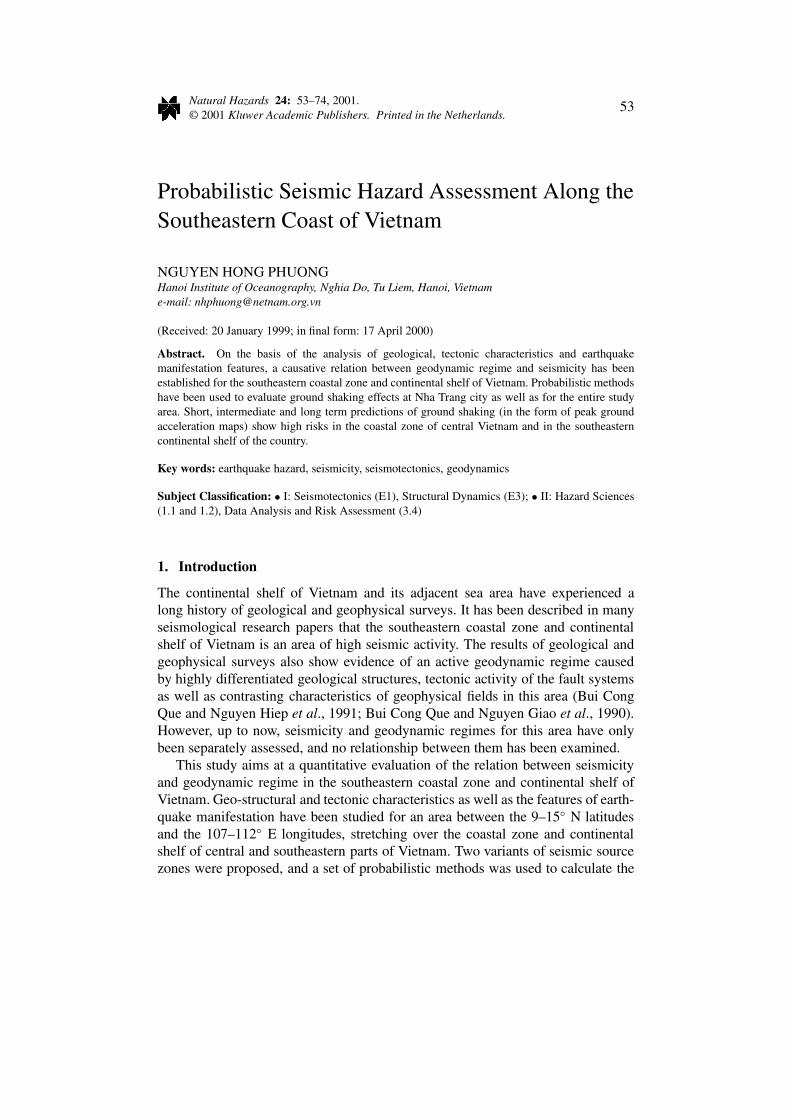
The first one is a seismic zoning map for the territory of south Vietnam, madeby Nguyen Khac Mao in 1975 and based on the two main principles: seismo-geotectonical and seismo-statistical (Nguyen Khac Mao, 1973). According to theauthor, in the whole territory of south Vietnam, there are no places which canproduce earthquakes with the intensity of the VII of the MSK-64 scale. Also byopinion of the author, a zone with highest intensity (VII of the MSK-64 scale),located along the shoreline from northern Nha Trang to southern Phan Thiet in thisscheme, is affected by strong offshore earthquakes. Thus, the effects of the Cauriver earthquakes, with intensity of VII (MSK-64 scale) in the coastal zone of PhuKhanh province have not been taken into account in this scheme.
Using the same methodology, Le Minh Triet et al. (1980) have published a moredetailed seismic zoning map of south Vietnam. The authors have carried out manyfield trips for researching and updating information on strong and felt earthquakes
62 NGUYEN HONG PHUONG
Figure 3. Seismic zoning map of south Vietnam according to Le Minh Triet et al., 1980.
as well as instrumentally recorded earthquake data from the Nha Trang seismo-graph station, and have recompiled a more complete earthquake catalogue for thewhole of south Vietnam. In the seismic zoning map established by Le Minh Triet etal., a zone with VII intensity of the MSK-64 scale has been depicted, including theterritory and marine area of central and southern central Vietnam, stretching fromnorth Tuy Hoa through Buon Me Thuot, Nha Trang, Phan Rang, Phan Thiet downto Ham Tan (Figure 3).
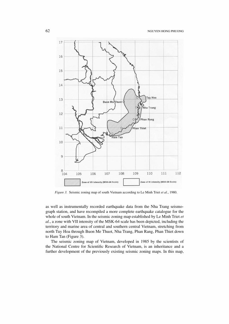
The seismic zoning map of Vietnam, developed in 1985 by the scientists ofthe National Centre for Scientific Research of Vietnam, is an inheritance and afurther development of the previously existing seismic zoning maps. In this map,

PROBABILISTIC SEISMIC HAZARD ASSESSMENT 63
not only the source zones, capable of originating strong earthquakes, but also thezones affected by the attenuation of shocks from neighboring areas are shown. Theparameters characterizing the seismic regime of each source zone as the maximummagnitude Mmax, the average focal depth h or earthquake return period T is alsoshown. The most recent version of this map is presented in Figure 4, showing thecoastline of the central Vietnam as a boundary of the zone of intensity VI, locatedinland, and the zone of intensity VII, located offshore central Vietnam. It shouldbe emphasized that in this map, the 109 meridian fault system is considered tobe a source zone, capable of originating shocks with intensities of VIII or more(Nguyen Dinh Xuyen, 1994).
Comparing 3 seismic zoning maps, compiled for the same area in different timeperiods (1974, 1980 and 1985), one can clearly acknowledge the fact that, for thesoutheastern coastal zone and continental shelf of Vietnam, although the predic-tion of earthquake hazard is quite spatially coincident, the difference in value isconsiderable. Each zoning scheme gives an intensity value of 1 unit higher than thecorresponding value at the same place of the previous scheme. The correction of thepredictive seismic zoning map requires further efforts, which include the applica-tion of advanced methodology and technology to earthquake hazard assessment ofthe study area.
4. Application of Probabilistic Models to Investigate the Relation betweenSeismicity and Geodynamics in the Southeastern Coastal Zone andContinental Shelf of Vietnam
4.1. METHOD USED
One of the advantages of the probabilistic approach for earthquake hazard as-sessment is that it allows the creation of maps predicting such ground motionparameters as peak ground acceleration, particle velocity or displacement. Theseparameters characterize the geodynamic regime of a region and play an importantrole in many applications as the input for the calculations of construction underseismic load, antiseismic design and insurance.
The standard methodology for probabilistic earthquake hazard assessmentincludes the following principal elements:(1) Seismic source identification;(2) Estimation of earthquake hazard parameters for each source zone;(3) Analysis of strong ground motion attenuation, and(4) Seismic hazard computation.
The seismic source zones are defined on the basis of the studied rules of earth-quake manifestation and their relationship with the geological structure and thetectonic movement evidence in the study area. As a rule, a seismic source zone isdefined along seismically active faults by summing all the possible rupture zonescaused by maximum earthquakes, which might occur within a given zone. In otherwords, this is the projection of tectonic fault plans counting from the deepest
64 NGUYEN HONG PHUONG
Figure 4. Seismic zoning map of Vietnam according to Nguyen Dinh Xuyen et al., 1994.

PROBABILISTIC SEISMIC HAZARD ASSESSMENT 65
active layer to the Earth’s surface. However, while delineating a seismic sourcezone boundary, this principle is rather flexible and sometimes extended, dependingon certain observed earthquake epicenter distributions, a set of faults or relatedvolcanic arcs, particularly in cases of scattered earthquake data. The acceptableboundary for a seismic source zone has to maintain all seismotectonic character-istics of the zone as a whole, namely the azimuthal location, direction of maingeological structures and cluster of earthquake epicenters.
The following earthquake hazard parameters, characterizing level of seismicity,were estimated for each seismic source zone:
• Expected maximum magnitude Mmax;• Constants a, b in the Gutenberg-Richter magnitude-frequency relation and
their deductive values λ, β;• Mean return period T (M) of the strong earthquakes with magnitude M.
In this paper, the least square and the maximum likelihood methods wereused for estimating the earthquake hazard parameters. Detail description of theestimation methods can be found in Nguyen Hong Phuong, (1991, 1994). Then,the well-known Cornell’s method and McGuire’s computer program, which arebased on assumptions of Poisson distribution of earthquake occurrence and double-truncated exponential distribution of magnitudes were used to assess the seismichazard for the study area (Cornel, 1968; McGuire, 1976).
4.2. SOURCE ZONES AND ATTENUATION FUNCTION
4.2.1. Two Variants of the Seismic Source Zones
In order to investigate the variation of shaking effects due to shape and size of aseismic source, two variants of the seismic source zone were chosen. In the firstvariant, presented in Figure 5, all of the 3 delineated source zones a1, b1, andc1 have a linear shape, which correspond to the assumption that all earthquakesoccurred within the study area were caused by tectonic faults, particularly twooffshore source zones are associated with the deep-seated 109th meridian faultsystem. The second variant assumes different origins of earthquake in the area: thea2 source zone encompasses the tectonic faults with different directions in the ter-ritory of central and south central Vietnam, while the b2 source zone includes onlythe most active segment of the 109th meridian fault system crossing the ‘hinge’Thu Island Geoblock, and the c2 source zone, with the shape of a large-bottomedpolygon, is assumed to be an area of volcanic activity. Both source variants wereused for analysis and computation of the earthquake hazard in the study area. Gridpoints chosen for calculation are also shown in these figures (Figure 6).
4.2.2. Attenuation Relationship
For quantitative evaluation of the geodynamic regime of the study area, the resultsare shown in terms of peak ground acceleration as the most practicable parameter

66 NGUYEN HONG PHUONG
Figure 5. Seismic source zones and the grid of calculation points (Variant 1).
for engineering purpose. Since strong motion records from earthquakes in Vietnamare not available, no local attenuation function has been developed. In this study, wechose the attenuation function developed by Chinese seismologists for the Yunnanregion, which is one of the nearest to Vietnam (Xiang Jianguang and Gao Dong,1994):
amax = 252.9 e0.5155M(R + 10)−1.1516 (1)
where amax is the peak ground acceleration in gals, M is the magnitude and R
is the hypocentral distance. It should be noted that the use of the Yunnan at-tenuation function for the study area is of tentative character. The development

PROBABILISTIC SEISMIC HAZARD ASSESSMENT 67
Figure 6. Seismic source zones and the grid of calculation points (Variant 2).
of suitable ground motion attenuation relationship remains a serious problem inseismic hazard analysis of Vietnam, but this problem is not addressed in this paper.
The parameters Mmax, β estimated for the seismic source zones and the paramet-ers, taken from attenuation function (1) were input to the computation and mappingof the earthquake hazard.

68 NGUYEN HONG PHUONG
4.3. RESULTS
4.3.1. The Earthquake Hazard Parameters
Earthquake data was grouped by source zones and treated by statistical proced-ures for completeness and homogeneity prior to the computation. In all discussedcases, a value of 4.0 was taken for the lower threshold magnitude. Results of theestimation of earthquake hazard parameters and the number of earthquakes, usedin calculating the parameters for two source variants are presented in Table II. Itshould be noted that, due to the data, for the b source zone, the parameters wereestimated by the least square method, while for the a and c source zones they wereobtained by means of the maximum likelihood method.
4.3.2. Return Period of Peak Ground Acceleration, Computed for Nha Trang City
The Nha Trang city, located in the coastal zone of central Vietnam, was choosen asa site for seismic risk analysis. The graphs presented in Figures 7(a) and 7(b) showthe return period of peak ground acceleration at Nha Trang site, calculated fromtwo source variants. As can be seen from these graphs, the results obtained fromthe two variants are quite equivalent, with a 10 year return period predicted for theamax value of approximately 0.1 gal.
4.3.3. Peak Ground Acceleration Maps
Figures 8 and 9 show two sets of peak ground acceleration maps, calculated fromthe two source variants and corresponding to the time periods of 10, 25, 50 and 200years, respectively. Following are some comments on the results obtained:
– There are two anomaly zones of amax observed on all maps. The first zoneis located offshore, near the south central Vietnam coast (the maximum an-omaly coordinates are 11◦ N–109.5◦ E). The second zone is located inland,in the territory of littoral central Vietnam, stretching from the latitude 12◦ Nto the latitude 14◦ N. It is clear from the maps that the first anomaly zone iscompletely superimposed on the seismically active fault segment of the 109thmeridian fault system, passing the Thu Island geoblock in the continental shelfof Vietnam, while the maximum amax value of the second anomaly zone isconcentrated in the epicentral zone of the Cau river earthquakes.
– The amax values, calculated from the two source variants are quite equivalentfor the second anomaly zone. In the first anomaly zone, the difference rangesfrom 0.03 to 0.05 gals. The corresponding values of peak ground acceleration,obtained from the two source variants are compared in Table III. As can beseen from the table, the application of different source models have little effecton the calculated earthquake hazard values.
– However, geometry variations of the sources can result in different shakingeffects. As can be seen on the maps of source variant 2, a small anomalyzone appears, also offshore and southeastwards from the first anomaly zone,

PROBABILISTIC SEISMIC HAZARD ASSESSMENT 69
Tabl
eII
.R
esul
tsof
the
esti
mat
ion
ofea
rthq
uake
haza
rdpa
ram
eter
s.N
-num
ber
ofea
rthq
uake
sus
edin
calc
ulat
ing
the
haza
rdpa
ram
eter
s
Sou
rce
Nλ
βb
Mm
ax
zone
Var
.1V
ar.2
Var
.1V
ar.2
Var
.1V
ar.2
Var
.1V
ar.2
Var
.1V
ar.2
A29
340.
39±
0.09
0.27
±0.
081.
11±
0.5
0.56
±0.
50.
47±
0.21
0.24
±0.
245.
8±
0.5
5.8
±0.
4
B18
17–
0.55
±0.
00.
23±
0.0
4.9
±0.
1
C7
130.
13±
0.06
0.11
±0.
040.
75±
0.6
0.59
±0.
50.
32±
0.29
0.25
±0.
246.
6±
0.6
6.6
±0.
5

70 NGUYEN HONG PHUONG
Figure 7. Recurrence curve of peak ground acceleration in Nha Trang, calculated from twosource variants.
where high volcanic activity is assumed. The amax value here is not very high incomparison with those of the two other zones, but can reach to a considerablyhigh value when the time period increases (amax = 0.0172 gals when T = 200years).
5. Conclusions
1. On the basis of the analysis of geological, tectonic characteristics and earth-quake manifestation features, a causative relation between geodynamic regime

PROBABILISTIC SEISMIC HAZARD ASSESSMENT 71
Figure 8. Distribution of Peak Ground Acceleration in the continental shelf of SouthernCentral Vietnam (Variant 1).
and seismicity has been established for the southeastern coastal zone andcontinental shelf of Vietnam.
2. Probabilistic methods were applied to two source variants to assess the earth-quake hazard for the study area. The results are presented in the form of therecurrence curves of ground acceleration for Nha Trang city and the maps

72 NGUYEN HONG PHUONG
Figure 9. Distribution of Peak Ground Acceleration in the continental shelf of southern centralVietnam (Variant 2).
describing ground shaking in terms of peak ground acceleration, predicted forthe whole study area with time periods of 10, 20, 50 and 200 years, respect-ively. High risk values are observed offshore south central Vietnam and in theterritory of littoral central Vietnam (Table III).

PROBABILISTIC SEISMIC HAZARD ASSESSMENT 73
Table III. The peak ground acceleration values in the anomaly zones (%gals)
Anomaly zone amax (T = 10) amax (T = 25) amax (T = 50) amax (T = 200)
Var. 1 Var. 2 Var. 1 Var. 2 Var. 1 Var. 2 Var. 1 Var. 2
1 9.9 9.6 12.1 11.8 14.1 13.7 18.4 17.9
2 9.2 9.2 11.5 11.5 13.3 13.3 17.4 17.6
3. The peak ground acceleration maps present the short-term, middle-term andlong-term evaluations of earthquake hazard in the southeastern coastal zoneand continental shelf of Vietnam.
References
Bui Cong Que, Nguyen Hiep, Nguyen Kim Lap, Hoang Minh Thai, Dang Van Hung: 1991, Charac-teristics of the geophysical fields in the continental shelf of Vietnam and the adjacent areas, FinalReport of National Research Project 48B-03-02, NCST, Hanoi, 191 pp.
Bui Cong Que, Nguyen Giao, Phaam Huy Tien, Ngo Van Dinh: 1996, Geology, geodynamics andmineral resource potential of the Vietnam sea areas, Final Report of National Research ProjectKT-03-02, NCST, Hanoi.
Bui Cong, Que: 1993, Some characteristics of deep crustal structure and the geodynamics in theterritory of Vietnam and neighboring sea area, Journal of Geology, Ser.B 1–2.
Cornell, C. A.: 1968, Engineering seismic risk analysis, Bull. Seim. Soc. Am. 58, 1583–1606.Do Minh Tiep: 1993, Geological structure of the surface layer of the continental shelf of South
Central Vietnam and adjacent area, Scientific Report, Nha Trang Inst. Of Oceanography (inVietnamese).
Gatinski, I. G., Zorina, I. G., Tsistiakov, A. A.: 1984, Tectonic characteristics of Indochina, Journalof Geotectonics 5, 73–82 (in Russian).
Ho Dac Hoai, Le Duy Bach, Trinh Phung, Le Van Truong: 1990, Geology of the continental shelfof Vietnam and adjacent areas, Final Report of National Research Project 48B-03-01, NCST,Hanoi, 208 pp.
Le Minh Triet, Vo Dinh Ngo, Dang Nam, Trung and Dang Mau, Phong: 1980, Seismic zoning ofSouth Vietnam, Contributions of Geophysics in 1979 (in Vietnamese).
Marquis, G., Roques, D., Huchon, P., Coulon, O., Chamot-Rooke, N., Rangin, C., and Le Pichon,X.: 1996, Amount and timing of extension along the continental margin off Central Vietnam,Bulletin de la Société géologique de France, submitted.
McGuire, R. K.: 1976, FORTRAN computer program for seismic risk analysis, U.S. Geol. Surveyopen – File Rept. 76-67, 89.
Ngo Thuong San: 1976, The tertiary sediment basins in southeast Asia: tectonic characteristics andthe oil and gas distribution, Report at the first Conference on Geology of Indochina, Ho Chi MinhCity.
Ngo Thuong San, Vo Duong, Nguyen Van Duc: 1980, Geological structure of the continental shelfof South Vietnam, Report at the Workshop dedicating 25 years of Geology of Vietnam (inVietnamese).
Nguyen Dinh Xuyen: 1994, Seismicity, seismotectonics and seismic zoning of the territory of Vi-etnam, Proceedings of the International Workshop on Seismotectonics and Seismic Hazard inSoutheast Asia, Hanoi, pp. 138–142.

74 NGUYEN HONG PHUONG
Nguyen Hong Phuong: 1991, Probabilistic assessment of earthquake hazard in Vietnam based onseismotectonic regionalization, Tectonophysics 198, 81–93,
Nguyen Hong Phuong: 1996, Probabilistic earthquake hazard assessment for the Spratly island area,Contrib. Marine Geol. Geophys. 2, 48–65 (in Vietnamese).
Nguyen Hong Phuong: 1997, Probabilistic earthquake hazard assessment for the territory of Vietnamand adjacent regions, Proceedings of the National Center for Science and Technology of Vietnam9(1), 115–130.
Nguyen Khac Mao: 1973, Focal mechanism and the occurrence of the large earthquake of 1961 inBac Giang, J. Biol. Geol. XI(1), 2, 57–66 (in Vietnamese).
Pham Van Thom: 1985, Some materials on geological structure and stratigraphy in the marine areaof South Central Vietnam, Report of National Research Project 48-06-04, Nha Trang institute ofOceanography, (in Vietnamese).
Parker, M. L. Jr., Emery, K. Q., Szymankiewicz, R., and Renolds, L. M.: 1971, Structural frameworkof continental margin in South China Sea, AAPG Bull. 55(5), 723–751.
Roques, D., Rangin, C., and Huchon, P.: 1996, Geometry and sense of motion along the Vietnamcontinental margin: onshore/offshore Da Nang area, Bulletin de la Société géologique de France,submitted.
Trinh Phung, Trinh The Hieu, Nguyen Huu Suu: 1985, The geological and geomorphologic studyof the continental shelf of Vietnam, Report of National Research Project 48-06-04, Nha Tranginstitute of Oceanography (in Vietnamese).
Xiang Jianguang and Gao Dong: 1994, The strong ground motion records obtained in Lancang-Gengma earthquake in 1988, China, and their application, Rept. at International Workshop onSeismotectonics and Seismic Hazard in Southeast Asia, Hanoi.