Landslides in the Polish Carpathians as the Potential Educational Geosites
Upload
unitedstatesgeologicalsurveyCategory
view
1download
0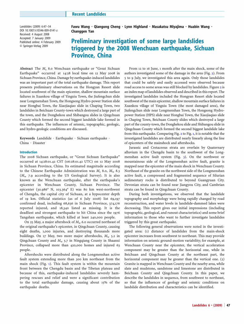
Landslides (2009) 6:47–54DOI 10.1007/s10346-009-0141-zReceived: 4 August 2008Accepted: 7 January 2009Published online: 4 February 2009© Springer-Verlag 2009
Fawu Wang . Qiangong Cheng . Lynn Highland . Masakatsu Miyajima . Huabin Wang .Changgen Yan
Preliminary investigation of some large landslidestriggered by the 2008 Wenchuan earthquake, SichuanProvince, China
Abstract The Ms 8.0 Wenchuan earthquake or “Great SichuanEarthquake” occurred at 14:28 local time on 12 May 2008 inSichuan Province, China. Damage by earthquake-induced landslideswas an important part of the total earthquake damage. This reportpresents preliminary observations on the Hongyan Resort slidelocated southwest of the main epicenter, shallow mountain surfacefailures in Xuankou village of Yingxiu Town, the Jiufengchun slidenear Longmenshan Town, the Hongsong Hydro-power Station slidenear Hongbai Town, the Xiaojiaqiao slide in Chaping Town, twolandslides in Beichuan County-town which destroyed a large part ofthe town, and the Donghekou and Shibangou slides in QingchuanCounty which formed the second biggest landslide lake formed inthis earthquake. The influences of seismic, topographic, geologic,and hydro-geologic conditions are discussed.
Keywords Landslide . Earthquake . Sichuan earthquake .
China . Disaster
IntroductionThe 2008 Sichuan earthquake, or “Great Sichuan Earthquake”occurred at 14:28:01.42 CST (06:28:01.42 UTC) on 12 May 2008in Sichuan Province, China. Its estimated magnitude accordingto the Chinese Earthquake Administration was Ms 8.0, Mw 8.3(Mw 7.9 according to the US Geological Survey). It is alsoknown as the Wenchuan earthquake, after the earthquake’sepicenter in Wenchuan County, Sichuan Province. Theepicenter (30.986° N, 103.364° E) was 80 km west-northwestof Chengdu, the capital city of Sichuan, at a hypocenter depthof 19 km. Official statistics (as of 6 July 2008) list 69,197confirmed dead, including 68,636 in Sichuan Province, 374,176reported injured, and 18,340 listed as missing. It is thedeadliest and strongest earthquake to hit China since the 1976Tangshan earthquake, which killed at least 240,000 people.
On 25 May, a major aftershock of Mw 6.0 occurred northeast ofthe original earthquake’s epicenter, in Qingchuan County, causingeight deaths, 1,000 injuries, and destroying thousands morebuildings. On 27 May, two more major aftershocks, Mw 5.2 inQingchuan County and Mw 5.7 in Ningqiang County in ShaanxiProvince, collapsed more than 420,000 homes and injured 63people.
Aftershocks were distributed along the Longmenshan activefault system extending more than 300 km northeast from themain shock (Fig. 1). This fault system is within the mountainfront between the Chengdu basin and the Tibetan plateau andbecause of this, earthquake-induced landslides severely ham-pering rescues and relief and were a significant contributionto the total earthquake damage, causing about 15% of theearthquake deaths.
From 12 to 16 June, 1 month after the main shock, some of theauthors investigated some of the damage in the area (Fig. 2). From5 to 9 July, we investigated this area again. Only those landslidesthat could be safely and easily accessed were observed becauseroad access to some areas was still blocked by landslides. Figure 2 isan indexmap of landslides observed and described in this report. Theinvestigated landslides included the Hongyan Resort slide locatedsouthwest of themain epicenter, shallowmountain surface failures inXuankou village of Yingxiu Town (the most damaged area), theJiufengchun slide near Longmenshan Town, the Hongsong Hydro-power Station (HPS) slide near Hongbai Town, the Xiaojiaqiao slidein Chaping Town, Beichuan County slides which destroyed a largepart of the county-town, the Donghekou slide and Shibangou slide inQingchuan County which formed the second biggest landslide lakefrom this earthquake. Comparing Fig. 2 to Fig. 1, it is notable that theinvestigated landslides are distributed nearly linearly along the lineof epicenters of the mainshock and aftershocks.
Jurassic and Cretaceous strata are overlain by Quaternaryalluvium in the Chengdu basin to the southwest of the Long-menshan active fault system (Fig. 3). On the northwest ormountainous side of the Longmenshan active fault, granite ismapped near the epicenter of the main shock inWenchuan County.Northeast of the granite on the northwest side of the Longmenshanactive fault, a compressed and fragmented sequence of Siluriansedimentary rocks is distributed to beyond Guangyuan City.Devonian strata can be found near Jiangyou City, and Cambrianstrata can be found in Qingchuan County.
During both investigations, we observed that the landslidetopography and morphology were being rapidly changed by roadreconstruction, and water levels in landslide-dammed lakes weredecreasing. This report gives our initial impressions (includingtopographic, geological, and runout characteristics) and some briefinformation to those who want to further investigate landslidestriggered by this great earthquake.
The following general observations were noted in the investi-gated area: (1) distance of landslides from the main-shockepicenter increases from southwest to northeast. This may provideinformation on seismic ground-motion variability; for example, atWenchuan County near the epicenter, the vertical accelerationcomponent may be greater than the horizontal one, while inBeichuan and Qingchuan County at the northeast part, thehorizontal component may be greater than the vertical one. (2)Granite is mapped in Wenchuan County and the nearby area, whileslate and mudstone, sandstone and limestone are distributed inBeichuan County and Qingchuan County. In this paper, wedescribe the landslides in sequence, from southwest to northeast,so that the influences of geology and seismic conditions onlandslide distribution and characteristics can be identified.
Recent Landslides
Landslides 6 • (2009) 47
Hongyan Resort slideHongyan Resort is in the southwest of Wenchuan County. It isassociated with Dujiangyan City, famous for the world-heritageDujiangyan Irrigation System (DIS). The DIS lies on the MinjiangRiver in the northwest part of Dujiangyan City. It was built around250 B.C. under the direction of Li Bing, the governor of the ShuPrefecture of the Qin State. Also, another beautiful world-heritagesite, “Mt. Qingchengshan,” lies on the east side of the HongyanResort. Because the temperature is lower here in summer than inChengdu City, Hongyan Resort is one of the more popular touristdestinations from Chengdu.
Figure 4 shows a landslide at 103.480° E, 30.919° N (GPScoordinates) which destroyed a local road at Hongyan Resort.The sliding mass was dry debris that originated fromweathered sandstone and conglomerate. The angle of reposeof the landslide deposits was about 30°. It is reported that thelandslide occurred almost simultaneously with the main shock.Forty-seven tourists from Chengdu Old Man Association andfour local people were buried by the sliding mass as theywalked along the road. The white dotted lines show theformer location of the road connecting to a bridge, before thelandslide buried it. Because the road was buried so deeply, it
was not slated for cleaning and rebuilding (at the time of ourinvestigation), and a new road had been built for localtransportation. From evidence seen around the gully where thelandslides occurred, such as landslide topography on thenearby mountain and the area around the gully itself, it wasrecognized that all of the area is associated with an ancientlandslide. Hongyan Resort is built on an ancient landslide.The long run-out debris of the old landslide provided gentleslopes that were easier to develop than the surroundingsteeper hill slopes. The ancient landslide may have beentriggered by a past great earthquake and formed a landslidedam. A gully with steep sides had formed through the formerlandslide dam by weathering and erosion over a long periodof time. During the main shock, both sides of this gullycollapsed, and the debris hit the tourist group.
Widespread shallow failures in Xuankou village of Yingxiu TownYingxiu Town was severely damaged in the main shock, with mostof the old buildings damaged. Xuankou village at 103.478° E,30.994° N, is located east of Yingxiu Town. Figure 5 illustrates themany mountain failures that were triggered by the earthquake. Allof the newly exposed areas on the mountains are landslides; this
Fig. 1 Epicenter distribution of themain shock (star) and aftershocks (size-coded circles) of the 2008 Sichuanearthquake. The map shows locationsof aftershocks that occurred through 28May 2008
Recent Landslides
Landslides 6 • (2009)48

area had a very good vegetation cover before the earthquake. Theblue roofs are rescue tents built after the earthquake. Some tentsand buildings are located at the bottom of a gully (right in thephoto). This location will be exposed to a high risk of damage inthe upcoming rainy season when debris from the collapsed slopesmay remobilize in debris flows.
Jiufengchun slideJiufengchun village is located between Longmenshan Town (nearthe Chengdu basin) and Yinchanggou Resort, a large resort valleyin the mountains. Figure 6 is a series of photos of a landslidecomposed of weathered granite at 103.848° E, 31.294° N, inJiufengchun village. Figure 6a is the front part of the slide whichcut local traffic from Longmenshan Town to Yinchanggou Resort.Before the earthquake, more than 17 families lived along the road.As soon as the earthquake occurred, the landslide ran out from themountain (top and center, Fig. 6b), burying more than 60 localpeople and 30 tourists. A witness said that all of this occurred inabout a minute. Fig. 6a shows debris (pillars and boards) fromdestroyed and displaced wooden houses. Figure 6b shows the slidetravel path. Landslide debris filled the valley bottom between two
Fig. 3 Geological map of the epicenter areas of the main shock and aftershocks.Q Quaternary system, J1-2 Lower and Middle of Jurassic system, J3 Upper layer ofJurassic system, K1 Lower layer of Cretaceous system, S Silurian system, γgranites. The complicated strata between S and K1 in the figure are fromCambrian system to Tertiary system
Fig. 4 The Hongyan Resort slide caused 51 casualties. The dotted lines indicate theformer location of a road
Fig. 2 Index image showing locationsof landslides investigated by theauthors
Landslides 6 • (2009) 49

mountain ridges and the debris surface was gently sloping,suggesting rapid movement. The lower valley walls were strippedof vegetation. The contact line between vegetation on the upperslopes and bare ground on the lower slopes may indicate themaximum height reached by the debris during movement. Figure 6cshows the central area of the debris from the toe of the landslide.The road (with cars passing by) was rebuilt after the earthquake.The width of the landslide at this part was about 300 m. Thedistance from the toe to the source area of the original failure (themountain at the end in Fig. 6b) was estimated to be about 1.5 km(the distance exceeded the ∼1 km range of our laser measuring
tool). Figure 6d shows the toe of the landslide which partiallydammed a river originating in Yinchanggou that flows into theChengdu basin. It is interesting that the landslide reached the riverbut did not block it.
Our questions at this landslide were: (1) why did the dryweathered granite (presumably it has a high permeability) move sorapidly and travel for such a long distance; (2) why did thelandslide just reach the river and stop? To answer the first, wesearched in the middle of the slide mass and found a groundwaterspring (seen in Fig. 6e). It suggested to us that while the slidingmass may have been dry, the sliding zone was probably saturated.When the original failure triggered by the strong main shockoccurred, the sliding mass perhaps loaded suddenly onto asaturated layer, and formed an undrained shear. It could nothave traveled further because the weathered granite has highpermeability and any excess pore pressure generated may havedissipated during runout. Such phenomenon can be explained bythe undrained loading model proposed by Sassa et al. (1996) whenlandslides triggered by the Hyogoken-Nanbu earthquake werestudied, but there may be other explanations.
For the second question, we examined the prior topography ofthe area recorded on a map made before the recent earthquake.Figure 6f shows that the original road was straight at the site of the2008 landslide, but the contours between the road and the riverindicate that the river may have been deflected and/or dammed atthis site in the past. Thus, based on the topography, it is estimatedthat the landslide may have recurred in the area of a past landslide,and the runout distance of the 2008 event corresponds well withthat of the previous landslide. Also, in Fig. 6f, a water line wasshown in the centre of the landslide area, indicating that at least the
Fig. 6 The Jiufengchun slide. (a) The front part of the slide cutting the local road;(b) view of the source area at the middle of the slide; (c) view of the rear part ofthe slide, looking from the toe; (d) the river was dammed by the slide, forming a
lake; (e) groundwater found at the middle of the slide; (f) map of the landslidearea before the earthquake
Fig. 5 Shallow surface failures on mountain slopes in Xuankou village of YingxiuTown
Recent Landslides
Landslides 6 • (2009)50

central area of the travel path could have been saturated before andat the time of the earthquake.
Hongsong Hydropower Station slideFigure 7 is an oblique view of the Hongsong HPS slide at104.017° E, 31.401° N, in Songlin Village, Hongbai Town. Achannel has been cut through the toe of this landslide tolower the water level in a landslide-dammed lake and allowthe river to resume normal flow. A local railway to aphosphate mine located upstream of the landslide has beenrebuilt over the landslide after the original track was buriedby the debris. In addition, this landslide destroyed a diversiondam and buildings associated with a now damaged hydro-power station. It was reported that the landslide killed sixpeople who operated the station when the earthquakeoccurred.
The material of the sliding mass transformed during failurefrom weathered slate to sandy and muddy debris. Shiningsurfaces of rock-mass defects can be seen in the head-scarp ofthe landslide. This slide occurred as a translational slide onthe upper slopes, and it is suggested that it transformed to arotational slide at the river side because of thicker colluviumthere.
Due to the long runout distance of this slide, we think thatthe steep slope angle at the source area and the thickcolluvium might have played a part in controlling of motion.With the steep slope angle at the rear part, the sliding massshould have had a high gravity potential, facilitating rapidmovement when the earthquake triggered the failure. Thesource area should have been in a relatively dry condition,while, at the lower part of the slope (consisting of thickcolluvium), water content should have been higher and somelayers in the colluvium may have been fully saturated due tothe lower permeability of the deposits. Therefore, when thelower part was pushed by the upper part, undrained slidingmay have occurred and resulted in long runout. Comparingthis case with the Jiufengchun slide, the differences in soilproperties between the material of the sliding mass (andsliding zone) should be emphasized. Generally, weatheredgranite has much smaller undrained shear strength than theweathered slate because the weathered granite can be classifiedas a sandy soil and the weathered slate classified as silt or clay.Grain crushing occurring in undrained shearing may causehigh excess pore pressure and result in high mobility (Sassa et
al. 1996; Wang 1999, Wang et al. 2000). The different motionstyles and their controlling factors should be studied furtherthrough more detailed investigation.
Xiaojiaqiao slide in Chaping TownThe Xiaojiaqiao slide (104.278° E, 31.647° N) is unique among thelandslides triggered by the earthquake because no trace ofgroundwater was found in or around the slide. The sliding massis weathered dolomite. Figure 8 is an annotated oblique view of theslide. At least 100 people were killed when the Xiaojiaqiao slideinundated the village. Immediately after failure, the landslidedebris infilled the valley between the upstream and downstreamside scarps of the landslide (Fig. 8) and a lake formed (XiaojiaqiaoLake) was flooding local buildings and infrastructure.
A channelwas cut through the landslide to stop the filling of the lake,allowing the river to flow over the landslide debris at a lower elevation.A road has been constructed over the landslide as a temporarythoroughfare as the original road was obliterated by the landslide.
There was a large gap evacuated between the main scarpand the head of the landslide debris. The distance between thetop of the main scarp and the top of the landslide debris wasapproximately 50 m. The sliding mass moved away from thesource area and reached to the opposite bank of the river.From observing the resting angle of the sliding masscombined with eye-witness accounts by local people, it iseasy to visualize how rapidly the landslide moved. A vast
Fig. 8 An oblique view of the Xiaojiaqiao slide
Fig. 7 The Hongsong Hydro-PowerStation slide
Landslides 6 • (2009) 51
sliding plane was exposed, and the secondary falling deposits,which may have been caused by aftershocks, covered part ofthe sliding plane. Also from the channel-cut surface along theriver, the debris was very dry. Information on seismic
parameters and geotechnical properties of the rock mass orrock mass defects are required to establish the initial cause ofthe failure. Fragmentation may explain the behavior of thedebris once failure had been initiated.
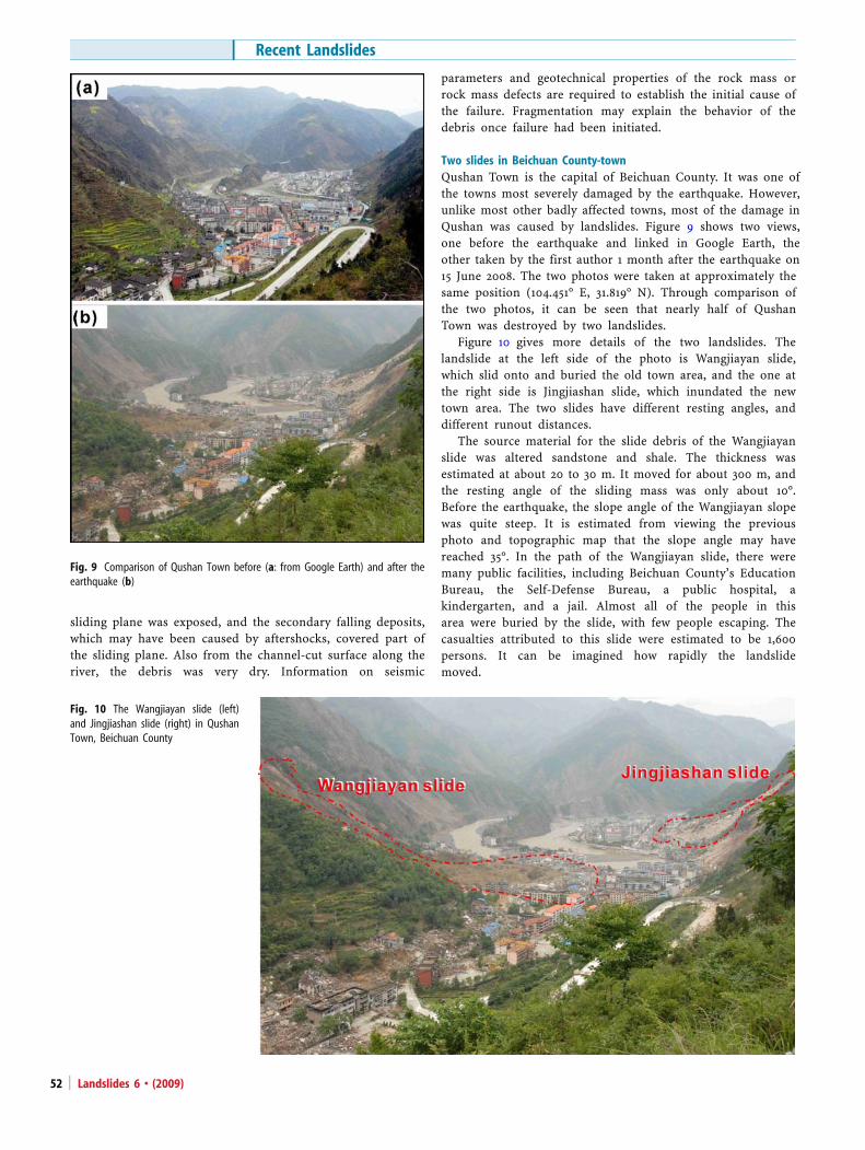
Two slides in Beichuan County-townQushan Town is the capital of Beichuan County. It was one ofthe towns most severely damaged by the earthquake. However,unlike most other badly affected towns, most of the damage inQushan was caused by landslides. Figure 9 shows two views,one before the earthquake and linked in Google Earth, theother taken by the first author 1 month after the earthquake on15 June 2008. The two photos were taken at approximately thesame position (104.451° E, 31.819° N). Through comparison ofthe two photos, it can be seen that nearly half of QushanTown was destroyed by two landslides.
Figure 10 gives more details of the two landslides. Thelandslide at the left side of the photo is Wangjiayan slide,which slid onto and buried the old town area, and the one atthe right side is Jingjiashan slide, which inundated the newtown area. The two slides have different resting angles, anddifferent runout distances.
The source material for the slide debris of the Wangjiayanslide was altered sandstone and shale. The thickness wasestimated at about 20 to 30 m. It moved for about 300 m, andthe resting angle of the sliding mass was only about 10°.Before the earthquake, the slope angle of the Wangjiayan slopewas quite steep. It is estimated from viewing the previousphoto and topographic map that the slope angle may havereached 35°. In the path of the Wangjiayan slide, there weremany public facilities, including Beichuan County’s EducationBureau, the Self-Defense Bureau, a public hospital, akindergarten, and a jail. Almost all of the people in thisarea were buried by the slide, with few people escaping. Thecasualties attributed to this slide were estimated to be 1,600persons. It can be imagined how rapidly the landslidemoved.
Fig. 10 The Wangjiayan slide (left)and Jingjiashan slide (right) in QushanTown, Beichuan County
Fig. 9 Comparison of Qushan Town before (a: from Google Earth) and after theearthquake (b)
Recent Landslides
Landslides 6 • (2009)52
In the path of the Jingjiashan slide, there was a high school. Whenthe earthquake occurred, all of the 400 students and teachers were inclassrooms at the school, and were killed by the slide. Because of aprohibition on outsiders entering the Qushan Town area, the exactresting slope angle could not be measured. From the photos, it isestimated that the slope angle of the slide after it buried the highschool is about 25°, and the runout distance was much shorter thanthat of the Wangjiayan slide. The slope angle before the earthquakewas about 35–40°; the slide-mass material is dolomite.
The difference in runout distance between the Wangjiayan andthe Jingjiashan slides may be due to a difference in the materialcontent. Generally, dolomite has large joints inside and has highpermeability. The slope failure style was likely like that of arockfall, showing a highly brittle nature, rather than sliding. Incomparison, the surficial material of the weathered sandstone andshale of the Wangjiayan slide may have a low permeability layerbeneath the weathered sandstone and shale. Even in a relatively dryseason, the lower permeability layer may retain water. Whentriggered by an earthquake, the mechanism of undrained shearingbehavior may occur in such a slope. This phenomenon is verysimilar to that occurred in the Hongsong HPS slide, as described inthe previous section.
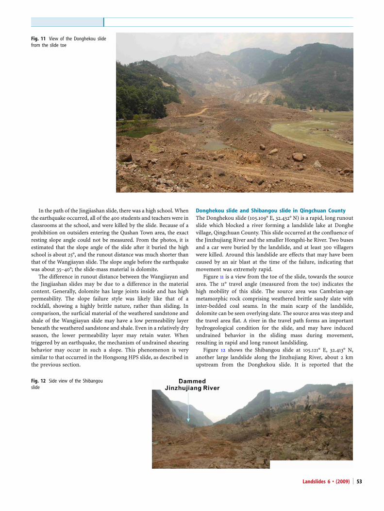
Donghekou slide and Shibangou slide in Qingchuan CountyThe Donghekou slide (105.109° E, 32.432° N) is a rapid, long runoutslide which blocked a river forming a landslide lake at Donghevillage, Qingchuan County. This slide occurred at the confluence ofthe Jinzhujiang River and the smaller Hongshi-he River. Two busesand a car were buried by the landslide, and at least 300 villagerswere killed. Around this landslide are effects that may have beencaused by an air blast at the time of the failure, indicating thatmovement was extremely rapid.
Figure 11 is a view from the toe of the slide, towards the sourcearea. The 11° travel angle (measured from the toe) indicates thehigh mobility of this slide. The source area was Cambrian-agemetamorphic rock comprising weathered brittle sandy slate withinter-bedded coal seams. In the main scarp of the landslide,dolomite can be seen overlying slate. The source area was steep andthe travel area flat. A river in the travel path forms an importanthydrogeological condition for the slide, and may have inducedundrained behavior in the sliding mass during movement,resulting in rapid and long runout landsliding.
Figure 12 shows the Shibangou slide at 105.121° E, 32.413° N,another large landslide along the Jinzhujiang River, about 2 kmupstream from the Donghekou slide. It is reported that the
Fig. 12 Side view of the Shibangouslide
Fig. 11 View of the Donghekou slidefrom the slide toe
Landslides 6 • (2009) 53

Shibangou landslide buried four villages: Chefutan, Majialiang,Zhoujia, and Shibangou, with estimated casualties of 300–400people. It formed the second biggest landslide lake from theearthquake.
Field observations suggest that the landslide may have cutacross bedding planes and moved as a rotational slide withone body. The geological structure is similar to that ofDonghekou slide, with dolomite overlying slate of Cambrianage. Trees on the slide mass are tilted, but remain standing ingroups. The slide debris ran up the opposite bank of the river,and the travel angle of the slide was measured at about 12°,indicating rapid movement.
Impressions and conclusionsWe draw the following conclusions from our observations ofthe landslides occurring as a result of the 2008 Wenchuanearthquake:
1. All of the slides, both those that moved for long distances,and for short distances, were extremely rapid. This causedmany casualties because evacuation was nearly impossibleduring the sudden, rapid, and massive movement of thesliding masses.
2. Among the landslides, long-runout mass movements occurredin slate, mudstone and shale, as illustrated by the Donghekouslide, Shibangou slide, Hongsong HPS slide, and Wangjiayanslide in Beichuan County. Large rockfalls occurred in dolomite,such as in the Jingjiashan slide in Beichuan County.
3. The hydrogeological conditions, especially, where there was asaturated loose layer formed by a river or gully in the travelpath, may have contributed to the rapid movement and longrunout distance. Deeply weathered granite moved as a debris-flow-like slide, possibly because of the saturated and undrainedbehavior at the sliding zone.
From the view point of geomorphology, we have the followingimpressions and conclusions:
1. Site accessibility is slowly improving as landslides are clearedfrom the roads, and damaged roads are rebuilt. There werethousands of smaller landslides, rockfalls, and subsequentdebris flows that blocked and damaged roads, adding to thedifficulty of access. These smaller events are still occurringsporadically, in unstable areas, and road maintenance will beongoing for many months or years to come.
2. The landslides are changing in character as intensive construc-tion takes place to mitigate their impact, for example, extensivegrading, removing of landslide material and debris, and asroads are constructed on and around the landslides.
3. The geographical extent and patterns of distribution oflandslides eventually will be mapped, adding to informationabout magnitude and intensity thresholds for earthquake-induced landslides.
AcknowledgementsThe first author acknowledges financial support from MEXTof Japan(No. 18403003, representative: F.W. Wang) for the first two investiga-tions in the disaster area caused by the 2008 Sichuan earthquake. On26 July to 3 August 2008, he made a third investigation with financialsupport from a scientific research fund for the Sudden-disasterinvestigation (Representative: K. Konagai) from MEXT of Japan. Thefinancial support from National Fundamental Research Program ofChina (973 Program) (NoF2008CB425801) was appreciated. Theauthors deeply appreciated discussions with Prof. K. Konagai ofUniversity of Tokyo, Prof. S. Tsuchiya of Shizuoka University, Japan,and Prof. X.Y. Wu of Southwest Jiaotong University, China. Theinformation from the local people who experienced the great disastersis extremely important for the report. Comments byMauriMcSaveneyand Grant Dellow were deeply appreciated.
References
Sassa K, Fukuoka H, Scarascia-Mugnozza G, Evans S (1996) Earthquake-induced-landslides:Distribution, motion and mechanisms. Soils and Foundations JAN:53–64 Special Issue
Wang FW (1999) An Experimental Study on Grain Crushing and Excess Pore PressureGeneration of Sandy Soils during Shearing –A Key Factor for Rapid Landslide Motion.Thesis submitted to the Graduate School of Science, Kyoto University in partialfulfilment of the requirements for the degree of Doctor of Science in the Division ofEarth and Planetary Science, Japan. 114 pp.
Wang FW, Sassa K, Fukuoka H (2000) Geotechnical simulation test for the Nikawa landslideinduced by 1995.1.17 Hyogoken-Nambu earthquake. Soils and Foundations 40(1):35–46
F. Wang ())Disaster Prevention Research Institute, Kyoto University,Gokasho, Uji, Kyoto 611-0011, Japane-mail: [email protected]
Q. ChengSchool of Civil Engineering, Southwest Jiaotong University,No. 111, North Part 1, Second Circle Road,Chengdu 610031, Chinae-mail: [email protected]
L. HighlandNational Landslide Information Center, US Geological Survey,MS 966, Box 25046, Denver Federal Center,Denver, CO 80225, USAe-mail: [email protected]
M. Miyajima . C. YanDepartment of Civil Engineering, Kanazawa University,Kakuma-machi, Kanazawa 920-1192, Japan
M. Miyajimae-mail: [email protected]
C. Yane-mail: [email protected]
H. WangSchool of Civil Engineering and Mechanics,Huazhong University of Science and Technology,No. 1037, Luoyu Road,Hongshan District, Wuhan 430074, Chinae-mail: [email protected]
Recent Landslides
Landslides 6 • (2009)54
Copyright © 2022 FDOKUMEN