National Contingency Plan for floods and landslides
47
1 REPUBLIC OF RWANDA MINISTRY OF DISASTER MANAGEMENT AND REFUGEE AFFAIRS NATIONAL CONTINGENCY PLAN FOR FLOODS AND LANDSLIDES Kigali, 2014
-
Upload
khangminh22 -
Category
Documents
-
view
0 -
download
0
Transcript of National Contingency Plan for floods and landslides
1
REPUBLIC OF RWANDA
MINISTRY OF DISASTER MANAGEMENT AND
REFUGEE AFFAIRS
NATIONAL CONTINGENCY PLAN FOR FLOODS AND
LANDSLIDES
Kigali, 2014
2
FOREWORD
This contingency plan covers the planned activities to be undertaken in any case of major
floods and landslide with scenarios for the likely occurrence based on the Rwanda risk profile
especially in prone areas. The previous rainfall forecast has revealed that most parts of the
country have received normal to above rainfall between October and December, and March to
May. However, it is anticipated that in the coming five years the whole country is expected to
receive normal to above normal rainfall. Based on previous experience, the occurrence of above
normal rainfall may precipitate the occurrence of excessive rainfall or flash floods in low lying
areas and landslides in the hilly topographic areas of the country.
The Contingency Plan draws on historical data and experiences of the occurrence of disasters
such as floods and landslides and comes up with planning assumptions and likely scenarios
should such hazards occurred during the 2011, 2012, 2013 rain season.
The overall objective of the Contingency Plan for floods and landslides (NCP) is to support the
timely, consistent and coordinated response to anticipated floods and landslides thus
effectively minimizing the impact of the floods and landslides on human population,
livelihoods, lifelines, properties and the environment. This will in turn help reduce the scale of
humanitarian needs to the affected population. Although the emphasis of the plan is on floods
and landslides, the plan has an in – built flexibility that allows it to embrace other hazards such
as drought, heavy winds and lightning should they occur anywhere in the country in
association with heavy rains.
The contingency plan shall be implemented at three stages i.e. before the emergency, during
and after. Preparedness activities before the emergency are informed by sector response plans
in. The sectors covered in the contingency plan are Human Settlement and Shelter, Health and
Nutrition, Water and Sanitation, Education, Agriculture and Food Security, Public
Infrastructure, Information Management and Emergency Communication. Scenario analysis
and assumptions are the main determining factors responsible for the scope and depth of the
contingency plan.
In order to ensure a coordinated response, guidance is provided on who should carry out rapid
assessments and later on disseminate the related information. In the same vein, participation
of all cooperating partners and stakeholders are maximised in the plan by encouraging them to
isolate activities whose implementation they are in a position to support.
MUKANTABANA Séraphine
Minister of Disaster Management and refugee affairs
3
ACKNOWLEDGMENT
This floods and landslides contingency plan was made for the Republic of Rwanda, with
technical support of the members of the National Platform for disaster Risk Reduction.
I wish to acknowledge and thank the following individuals, who were very resourceful during
the process of compiling this plan. In particular I thank resource persons at the Ministry of
Disaster Management and Refugee Affairs Mr URAMUTSE Gilbert, NSENGIYUMVA Jean
Baptiste and BUDEDERI Eric and the key informant the Ministry of Natural Resources Authority
especially Mr UWIZEYE Emmanuel.
I thank also the members of the national platform for disaster risk reduction for their
proofreading and technical validation.
I however reiterate the need of collaboration of all stakeholders as their support will also be
needed in reviewing and adapting this plan when necessary but more importantly to
implement it in order to mitigate floods and landslides risk, prepare and respond to and recover
from effects of the mentioned disasters if they occur.
Sincerely,
HABINSHUTI Philippe
Director of Disaster Response and Recovery Unit
Ministry of Disaster Management and refugee Affairs
4
LIST OF ABBREVIATIONS/ACCRONYMS
CP: Contingency Plan
DDMCs: District Disaster Management Committees
DDMOs: District Disaster Management Officers
EWSA: Energy, water and Sanitation Authority
JIMC: Joint Intervention Management Committee
MIDIMAR: Ministry of Disaster Management and Refugee Affairs
MINALOC: Ministry of Local Government
MINEDUC: Ministry of Education
MININFRA: Ministry of Infrastructure
MINIRENA: Ministry of Natural Resources
MoH: Ministry of Health
NDMEC: National Disaster Management Executive Committee
NDMTC: National Disaster management Technical Committee
NGOs: Non-Government Organizations
NPDRR: National Platform for Disaster Risk Reduction
RAB: Rwanda Agricultural Board
RBA: Rwanda Broadcasting Agency
RDF: Rwanda Defense Forces
RHA: Rwanda Housing Authority
RNP: Rwanda National Police
RRC: Rwanda Red Cross
RTDA: Rwanda Transport Development Agency
SDMCs: Sector Disaster Management Committees
UN: United Nations
UNDP: United Nations Development Programme
WFP: World Food Programme
WHO: World Health Organization
5
CONTENTS
Preamble -------------------------------------------------------------------------------------------------------- 2
I. INTRODUCTION ----------------------------------------------------------------------------------------- 7
II. FLOOD AND LANDSLIDE VULNERABILITY AND RISK ANALYSIS IN RWANDA ----------- 9
III. SCENARIOS AND PLANNING ASSUMPTIONS ----------------------------------------------- 19
3.1. Scenario development
IV. PREPAREDNESS, RESPONSE AND RECOVERY ACTIVITIES (SECTOR BY SECTOR) - 22
4.1.1. Objective ................................................................................................... 22
4.1.2. Strategy ........................................................................................................ 22
4.1.2.1. Capacity Building ........................................................................................ 22
4.1.2.2. Response plan ............................................................................................ 22
4.1.2.3. Early Warning/Information Flow .................................................................. 22
4.1.3. Guiding Principles .......................................................................................... 23
4.1.4. Management and Coordination Arrangements ................................................ 23
4.1.5. Key Responsible Institutions in case of floods and landslides Hazards/disasters . 24
4.1.5.1. Roles and Responsibilities --------------------------------------------------------------------- 24
4.1.6. RAPID ASSESSMENTS AND DISSEMINATION OF INFORMATION ....................29
4.2.1. Road Infrastructure Sector -------------------------------------------------------------------- 29
4.2.2. Human Settlement and Shelter Sector ------------------------------------------------------ 32
4.2.3. Health and Nutrition ---------------------------------------------------------------------------- 34
4.2.4. Water and Sanitation -------------------------------------------------------------------------- 36
4.2.5. Education ----------------------------------------------------------------------------------------- 38
4.2.6. Agriculture and Food Security Sector ------------------------------------------------------- 40
4.2.7. Information Management and Emergency Communications --------------------------- 41
4.3. Resources ...................................................................................................... 43
4.3.1. Required Resources ----------------------------------------------------------------------------- 43
4.3.2. Resource Mobilisation -------------------------------------------------------------------------- 44
4.4. Notification procedures ................................................................................. 44
4.5. Evacuation procedures .................................................................................. 44
4.6. Search and rescue procedures ......................................................................... 45
6
4.7. Damage assessment procedures ..................................................................... 45
7
INTRODUCTION
The frequency, intensity and impact of natural hazard events are growing and causing more
disasters with negative impacts on humans, economy and environment. Many areas in the
world are prone to one or several natural hazards. Hazard events result in disasters when risk
factors such as hazard, vulnerability and inadequate capacity (coping capacities) overlaps in
space and time. Avoiding or reducing the impact of disasters can be reached by reducing the
Disaster risks. Consequently, focusing on Disaster Risk Reduction is an issue at stake worldwide
(UNISDR, 2005). Natural hazards by themselves do not cause disasters. It is the combination of
an exposed, vulnerable and ill prepared population or community with a hazard event that
results in a disaster. Disasters undermine development achievements, impoverishing people
and nations and states. In the absence of combined efforts to address root causes, disasters
represent an increasingly serious obstacle to the achievement of the Millennium Development
Goals.
Floods and Landslides have been amongst the major disasters in Rwanda and have had a great
impact on human development, properties, infrastructures as well as environment. Floods and
landslide are key disasters that frequently affect localized areas of the country (MIDIMAR,
2001) and most of the affected people do not have efficient mechanisms to cope with natural
hazards. In addition, the hilly topography and high annual precipitation rates with
overexploitation of the natural environment such as deforestation, inappropriate farming and
poor housing techniques accelerate the disaster risks and hence result into losses of lives and
damages to property from the community exposed to these disaster risks.
In Rwanda, most vulnerable areas prone to landslides and floods are located in the North-
Western parts namely Nyabihu, Ngororero, Rubavu, and Musanze, Burera, Gakenke and many
others. This situation calls upon the Ministry of Disaster Management and Refugee (MIDIMAR)
together with other disaster management stakeholders to put in a place a contingency plan for
floods and landslides all over the country since this will contribute a lot in the process of
sustainable management, prevention, mitigation and response to disaster risks.
This contingency plan is developed with scenarios for the likely situation based on the risk and
hazard profile and on rainfall forecasts. The rainfall forecast has revealed that most parts of the
country currently receive normal to above normal rainfall between March to May and between
October and December every year. The Contingency Plan also draws on historical data and
experiences of the occurrence of disasters of floods and landslides as a building block for
coming up with planning assumptions and likely scenarios.
The overall objective of the Rwanda National Contingency Plan for floods and landslides is to
support the timely, efficient, consistent and coordinated response to anticipated floods and
landslides in the rainy season, thus effectively reducing the impacts on human population,
8
livelihoods, lifelines, infrastructure and the environment. This will in turn help reduce the scale
of humanitarian needs to the affected population.
1.1. Context
Rwanda is a landlocked country situated in the Great Lakes region of East Africa. It is bordered
by Uganda, Tanzania, Burundi and the Democratic Republic of Congo (DRC). It is a small
country with an area of 26,338 square kilometres and a population of about 12 million people;
Rwanda’s population density is considered amongst the highest in Africa.
Known as “the land of a thousand hills”, Rwanda is at high elevation, with a geography
dominated by mountains and hills, five volcanoes, twenty-three lakes throughout the country
and numerous rivers, some forming the source of the River Nile. The variety of the landscapes
in this green country is dominated to the north by volcanoes and bordered by Lake Kivu to the
west. Its vegetation ranges from dense equatorial forest in the north-west of the country to
tropical savannah in the east. There are also high altitude forests. The altitude of Rwanda is in
the ranges from 1000-4500m above sea level. The rainy seasons are from March to May and
from October to November with the average of 110-200 mm per month.
The country’s topography and its natural environment shape to a large extent the natural
hazards to which it is prone. Natural hazards in Rwanda are categorized as: (a) hydro-
meteorological, (b) geological, and (c) biological and technological. The country is vulnerable to
a wide range of natural hazards such as floods, flash floods, landslides/mudslides, drought,
storms, lightning, earthquake, volcanic eruption, fires and epidemics. Threats of secondary
hazards such as famine resulting from long droughts also remain a potential.
1.2. Plan Scope and Purpose
The Flood and landslide Contingency Plan primarily addresses the Rwanda Operational Area’s
planned response to floods and landslides situation affecting the County. This contingency
plan establishes detailed procedures for response to areas that have flooded and slided or
may be jeopardized by potential floods and landslides. The purpose of this Plan is to minimize
the loss of life and properties through an organized notification and evacuation process and to
provide for re-entry into areas that may have been evacuated and/or damaged.
The objectives the National Contingency Plan for floods and landslides are as follows:
i. To improve the management and coordination of preparedness, response and recovery
arrangements
ii. To improve early warning information sharing to ensure effective mitigation and response.
iii. To ensure timely resource mobilization and response
iv. To reduce the risk of secondary hazards,
9
v. To ascertain the sector based level of impact of floods
vi. To ascertain the type and quantities of assistance to be required as a result of the
emergency
vii. To identify and define roles and responsibilities of all partners involved in emergency
response
viii. To utilise emergency and recovery assistance as baselines towards building long term
interventions
1.3. Plan Authority and Activation
The National Contingency Plan for Floods and landslides will be implemented upon the
decision of the Ministry in charge of Disaster Management, the lead Ministry in charge of
floods and landslides.
1.4. Public Access to Plan
As a national and public document, this contingency Plan for floods and landslides and other
specific disaster events contingency plans are accessible via the Ministry in charge of disaster
management website (www.midimar.gov.rw), and the Ministry of Natural Resources website
(www.minirena.gov.rw).
I. FLOOD AND LANDSLIDE VULNERABILITY AND RISK ANALYSIS IN RWANDA
1.1. Floods and landslide vulnerability context
The vulnerability of Rwanda to floods and landslides is largely due to its topographic and
demographic characteristics. This is further exacerbated by the impacts of climate change such
as the increasing variability in rainfall frequencies and intensity causing climatic hazards such as
droughts, floods, extreme temperatures and prolonged dry spells.
According to the Baseline Information and Indicators for Rwanda, a report prepared in January
2012 commissioned by REMA, climate data for 1983 to 2005 shows a trend of declining overall
rainfall, interspersed with years of excessive rainfall as well as steadily increasing average
temperatures from 32.7 to 35.4 ˚C. More erratic climate conditions and extreme weather
events such as droughts and floods are becoming more frequent and intense in the country,
thereby increasing disaster risks. Socio-economic, cultural and physical vulnerabilities further
aggravate disaster risks. Despite record-high growth recorded by Rwanda over the past
decade, there still remains a high poverty incidence. The Third Integrated Household Living
Conditions Survey report prepared by MINECOFIN and the National Institute of Statistics
Rwanda (NISR) revealed that still about 45 percent of the country’s 10.7 million people remain
under the poverty line1.This poverty rate especially in rural areas embodies the country’s socio-
1 http://www.newtimes.co.rw/news/index.php?i=14894&a=49835
10
economic vulnerability, which contributes to disaster risks when challenged by occurrence of
natural hazards at an increasing frequency and intensity.
Poverty encapsulates the very core of socio-economic vulnerability of the Rwandan population
with detrimental effects on the population’s disaster resilience. It relegates the poorest of the
poor to subsistence livelihoods, poor housing conditions, settlements built in hazard-prone
areas such as steep slopes or along riverbanks and valleys, and oftentimes cause people’s lack
of access to social services and inadequate financial capacity to meet day-to-day living needs,
and not to mention the lack of capacity to cope when disaster strikes.
Cultural factors also worsen the already grim scenarios for the most vulnerable, like for
instance; families refuse to relocate to safer areas because they hold strong cultural or
traditional bond with their abode or communities where they belonged, lived and cherished all
their lives. Physical vulnerability is yet another key challenge in Rwanda. The EDPRS II and
several other documents have emphasized that land is the ‘scarcest resource’ in Rwanda. Due
to limited land, people tend to settle in steep slopes, saturated hillsides, flood plains or low-
lying valleys which are often catch basins of water flowing from upstream. Improper and
uncontrolled land use practices exacerbate physical vulnerabilities in the already rugged terrain
of most parts of the country.
Growth and rapid urbanization have also overtaken Rwanda’s land use planning foresight.
Urban settlements in the Capital Kigali, for instance, sprouted fast that it now challenges its
built-environment, land use, settlement and physical planning of the city. In the absence of a
disaster risk assessments and risk profiles, infrastructures are likely to be erected without DRR
considerations let alone compliance to disaster risk reduction standards (i.e. residential houses
are built in areas highly vulnerable to natural hazards).
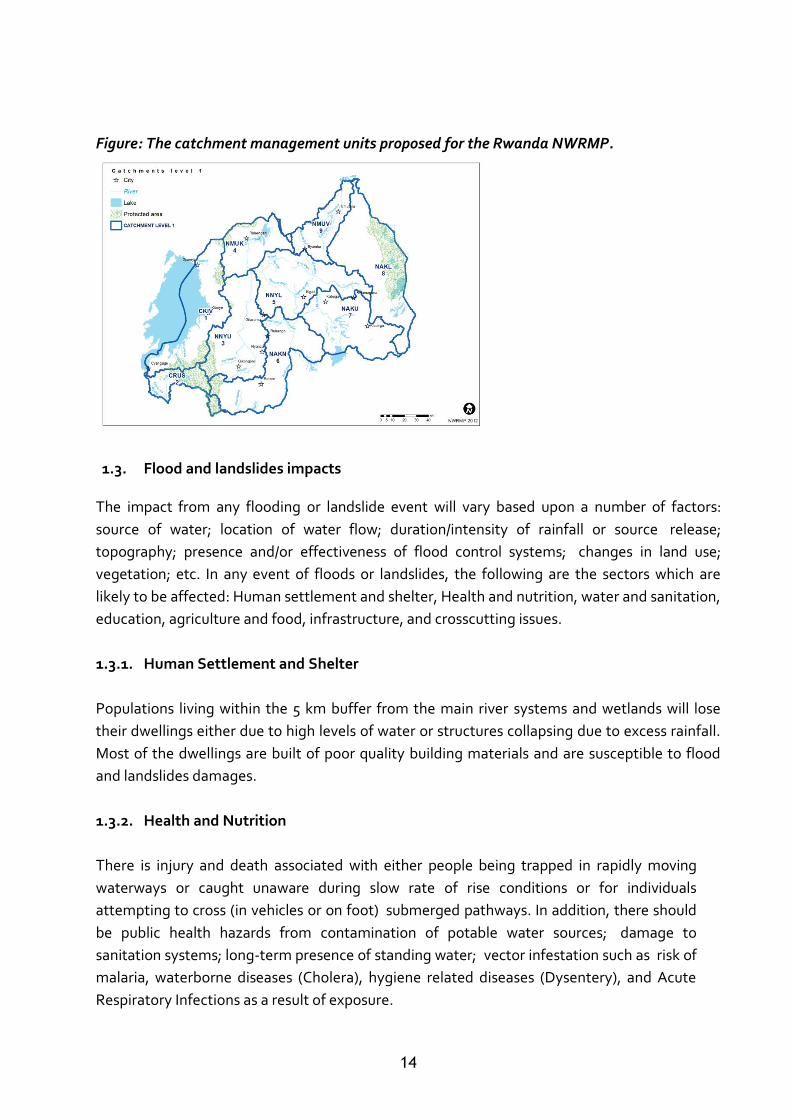
1.2. NATIONAL CATCHMENT BASINS/WATERSHEDS
The main catchment basins described below are those delineated taking into account the
better future management of water resources. Therefore, the country water resource is
subdivided into the following nine catchment basins:
1.2.1. CONGO RIVER BASIN, LAKE KIVU
It is an area of about 2,425 km² holding some control on the waters of Lake Kivu through the
numerous small catchment areas that drain into the lake. A smaller partitioning for reasons of
better access of stakeholders to the catchment area, would only compromise the already
limited control over the catchment water resources. It extends over four districts with Sebeya
River in the north in combination with the lava region from where no apparent surface drainage
takes place.
The Sebeya River has a major problem with its sediment load which has evidently increased
over the last decennium or so. Moreover, a series of minor catchments from Rubona (near
Gisenyi) to Rwamatamu (south of Kibuye) are all quite similar in nature in the sense of erosion
11
control and excessive population pressure leading to inappropriate agricultural practices from
the highlands down to the shores of Lake Kivu. The divide with the next downstream
catchment is located at the first Rusizi Hydropower Plant (Rusizi I) which constitutes a clear
separation between the lake and the Rusizi River.
1.2.2. CONGO RIVER BASIN, RUSIZI RIVER: CRUS
This 1,004.85 km² area is considered a single management unit that consists of Rusizi River on
the border between Rwanda and the DRC which is exploited for hydropower, Rubyiro River
which is extensively used for rice production; and Ruhwa River which originates in the Nyungwe
Forest and constitutes a natural border between Rwanda and Burundi. The upper reaches of
the Ruhwa River are subjected to artisanal gold mining activities with excessive erosion and
likely pollution (mercury) as a consequence. The outflow of the catchment is at the confluence
of the Rusizi and Ruhwa Rivers where the three nations Rwanda, DRC and Burundi share their
border.
1.2.3. NILE RIVER BASIN, NYABARONGO RIVER -UPSTREAM: NNYU
This catchment covers a surface area of 3,347.57 km². It is an elongated catchment area sloping
down from south to north with three main tributaries; Mwogo River which originates in the
south eastern corner of the catchment and becomes the Nyabarongo at its confluence with the
Mbirurume River; Rukarara River which originates in the south west in the Nyungwe forest
reserve. It features substantial potential for micro hydropower development and is claimed to
be the source of the river Nile. It falls in the Mwogo River at its downstream end; Mbirurume
River which also originates at high altitude near the Nyungwe forest reserve somewhat north of
the source of the Rukarara River and the upper Nyabarongo River itself. The Upper
Nyabarongo catchment has no dependency on any upstream catchments; hence water flow
and quality are defined within the catchment itself.
The outflow of the catchment is at the confluence of the Mukungwa and Upper Nyabarongo
Rivers where the Nyabarongo turns and takes a south easterly direction.
1.2.4. NILE RIVER BASIN, MUKUNGWA RIVER: NMUK
This catchment (1,887.1 km²) contains the volcanic lava region in the North-West and drains in
a southerly direction. The main characteristics of the catchment are: surface water flow from
the lava region these flows are important and interrelated with the groundwater flows from
this same region. It is characteristic for these surface flows that they ‘disappear’ entirely to
‘resurface’ at specific locations which may even change over time; groundwater reserves from
the lava region; they are known to be important but not well understood; and series of a large
wetland (Rugezi marshland) draining subsequently in Lake Bulera and then into Lake Ruhondo
from which outflow originates the Mukungwa. River that flows in a southern direction to its
confluence with the Nyabarongo River.
12
The Mukungwa catchment has no dependency on any upstream catchments; hence water flow
and quality are defined within the catchment itself.
The outflow of the catchment is at the confluence of the Mukangwa and Upper Nyabarongo
Rivers where the Nyabarongo turns and takes a south easterly direction.
1.2.5. NILE RIVER BASIN, LOWER NYABARONGO RIVER: NNYL
This 10,532 km² catchment receives part of its resources from the Mukungwa and upper
Nyabarongo rivers. Especially the latter seems to deliver a substantial sediment load due to
erosion. Seasonal distribution of flows is a combined regime of both major headwater basins.
This catchment receives the inflow from the upper Nyabarongo and the Mukungwa and
Conveys it in a south easterly direction. The main features of the catchment are: Nyabarongo
River that drains the entire western part of the catchment through a number of small and
rather steep secondary valleys. The wide valley of the Nyabarongo is extensively used for
agricultural production; Nyabugogo River that drains the entire eastern part of the catchment
partly through the Muhazi Lake (about 800 km² catchment) which functions as a flood buffer.
The Nyabugogo valley is extensively used for agricultural production throughout the year;
Muhazi Lake holds important potential for tourism which is currently exploited rather timidly at
some selected locations. With the policy of the 50 m protection zone around lakes (which is not
consistently applied for Muhazi Lake) there is limited agricultural use of the water resource
along the lake shores; major urban centre of Kigali with substantial demand for domestic and
industrial water supply mainly provided through groundwater abstraction at several locations
in the Nyabarongo valley.
The industrial activities and the high population density within the Kigali urban area are having
an impact on surface and groundwater quality; Notwithstanding the buffer function provided
by Lake Muhazi, the Nyabugogo is very prone to flooding with frequent and major problems in
the vicinity of Kigali where urban expansion and natural flooding of the valley bottom are
difficult to reconcile.
The outflow of the catchment is at the confluence of the Nyabarongo and Akanyaru rivers
where these waters continue their downstream journey as the Akagera River.
1.2.6. NILE RIVER BASIN, AKANYARU RIVER: NAKN
This catchment takes its source high in the Nyungwe Forest in south-western Rwanda from
where it follows a steep slope along the Rwanda – Burundi border in an easterly direction. Upon
reaching the south central area, the Akanyaru river changes dramatically from a rather steep
mountain stream into a river meandering in a very flat and wide valley and turning north along
the border to enter into Rwanda about 30 km prior to its confluence with the Nyabarongo. The
Akanyaru catchment has no dependency on any upstream catchments; hence water flow and
13
quality are defined within the catchment itself but a substantial part of this catchment is
located in Burundi.
The outflow of the catchment is at its confluence with the lower Nyabarongo from where the
Nyabarongo and Akanyaru continue as the Akagera River.
1.2.7. NILE RIVER BASIN, UPPER AKAGERA RIVER: NAKU
This catchment is the continuation of the Nyabarongo and Akanyaru rivers. The upper Akagera
River meanders through a wide and extremely flat valley in a south easterly direction until it
reaches the border between Rwanda and Burundi where it takes an easterly course until
reaching the Rusumo falls. The Upper Akagera catchment has inflow from Akanyaru and
Nyabarongo rivers with a substantial pollution risk from the Nyabarongo. The outflow of the
catchment is at Rusumo Falls to the lower Akagera.
1.2.8. NILE RIVER BASIN, LOWER AKAGERA RIVER: NAKL
This catchment drains the flow from the Upper Akagera and the Ruvubu rivers. The Lower
Akagera features the same hydro morphology of a river meandering through a wide and
extremely flat valley with numerous lakes that function as buffers during extreme flow or
otherwise drain into the river. The river forms the boundary between Rwanda and Tanzania for
its entire course to the North from where it takes a sharp turn East towards Lake Victoria. The
Lower Akagera catchment has inflow from the Upper Akagera and the Ruvubu rivers; hence
pollution and flow regime modifications of these watercourses will have a direct impact on the
Lower Akagera.
The outflow of the Lower Akagera is at the confluence with the Muvumba River from where the
Akagera takes an easterly course in the direction of Lake Victoria.
1.2.9. NILE RIVER BASIN, MUVUMBA RIVER.: NMUV
The South Western part of this catchment is drained by the Mulindi River that drains towards
the North to Kabala in Uganda where the river makes a U-turn and returns into Rwanda as the
Muvumba which follows a north easterly course towards its confluence with the Akagera River.
The outflow of the Muvumba / Kagitumba is at the confluence with the Akagera where it leaves
the Rwanda national territory following the border between Uganda and Tanzania in an
easterly direction towards Lake Victoria.
14
Figure: The catchment management units proposed for the Rwanda NWRMP.
1.3. Flood and landslides impacts
The impact from any flooding or landslide event will vary based upon a number of factors:
source of water; location of water flow; duration/intensity of rainfall or source release;
topography; presence and/or effectiveness of flood control systems; changes in land use;
vegetation; etc. In any event of floods or landslides, the following are the sectors which are
likely to be affected: Human settlement and shelter, Health and nutrition, water and sanitation,
education, agriculture and food, infrastructure, and crosscutting issues.
1.3.1. Human Settlement and Shelter
Populations living within the 5 km buffer from the main river systems and wetlands will lose
their dwellings either due to high levels of water or structures collapsing due to excess rainfall.
Most of the dwellings are built of poor quality building materials and are susceptible to flood
and landslides damages.
1.3.2. Health and Nutrition
There is injury and death associated with either people being trapped in rapidly moving
waterways or caught unaware during slow rate of rise conditions or for individuals
attempting to cross (in vehicles or on foot) submerged pathways. In addition, there should
be public health hazards from contamination of potable water sources; damage to
sanitation systems; long-term presence of standing water; vector infestation such as risk of
malaria, waterborne diseases (Cholera), hygiene related diseases (Dysentery), and Acute
Respiratory Infections as a result of exposure.
15
At last, snakes, rodents and other insects may retreat to the same dry areas as the human
population, resulting in further risk of snakebites, plague and other related risks.
Populations may have limited access to health facilities due to damages on road and health
infrastructure. This will to a larger extent affect stocking levels of medical supplies (e.g.
medicines, cold chains) and will particularly impact on important programmes. In addition,
there is risk of increased malnutrition among the under five children due to lack of food for
supplementary feeding
1.3.3. Water and Sanitation
There is a high risk of water contamination of drinking water due to flooding of sanitation
facilities such as latrines and septic tanks. Affected populations will therefore be rendered
susceptible to various water borne diseases i.e. cholera, dysentery and hygiene related diseases
(scabies and other skin diseases). There is also a high risk of lack of clean water for household
chores such as cooking and cleaning
1.3.4. Education
When floods and landslides occur and when the school calendar is just beginning or midway
through the first term, there is a risk of school children missing out on a major part of the
curriculum. There is also a likelihood of some pupils not being able to attend school as they
may be cut off due to floodwaters and damaged infrastructure. Pupils may also be cut off as a
result of the families being completely displaced due to damages to their habitations. In some
instances displaced populations, including school teachers, may occupy school buildings as
emergency shelter forcing temporary closure of the schools that might otherwise be on
highland and not directly affected by the emergency.
1.3.5. Agriculture and Food Security
Most of the food stocks for consumption are kept either in the dwellings or in grain bins that
may have been submerged or damaged by rainfall, flood waters and landslides. Existing
planted crops may be submerged or washed away resulting to total loss and/or decreased yield.
Flooding of crop fields may cause the farmers to plant new crops. This may result into reduced
yield due to loss of germ plasm of adapted traditional varieties as well as decreased soil
productivity due to loss of micronutrients that would have been washed away.
In addition to direct loss of livestock in flood affected areas, there is also a risk of an increase in
livestock diseases due to movement from the flood affected areas. There are at the same time
positive aspect, usually when flood water recedes as there is residual matter that is deposited.
16
1.3.6. Infrastructure
Flood and landslides affect critical infrastructure and essential services through inundation,
some areas becoming inaccessible due to basic support infrastructure such as boreholes,
culverts, bridges, sections of roads and other transportation structures being washed away.
There is also the risk of communication infrastructure either being submerged in mudslides or
in water, or damaged by hailstorms. There is also a potential of disrupting electricity supply
which may cause high voltage electrocution where the areas affected are near high voltage
electricity carrying pylons.
1.4. Historic Flood and landslide Records
Over the last two decades, the frequency and intensity of natural hazard-induced disasters,
particularly floods and landslides, have significantly increased (See table 1). These disasters
have caused the loss of lives, the displacement of affected population as well as damage to
infrastructures (roads, bridges, houses, schools, and other properties), crops and a serious
environmental degradation.
Floods and landslides usually originate from heavy rainfall, which causes rapid and
unpredictable surges in the flow of rivers downstream mainly in rain season (from March to
June). The two predominant types of floods are: (i) localised floods caused by exceptionally
heavy rains and run-offs; and (ii) widespread floods caused by overflowing rivers and their
tributaries. They also cause physical damage by washing away structures, crops, animals and
submerging human settlements.
Therefore, Landslide usually follows also heavy rainfall and high ground water flowing through
cracked bed rock and earthquakes and lead to the movement of soil or sediment. The most
vulnerable areas prone to landslides and floods include the Districts of North-western provinces
such as Nyabihu, Rubavu, Musanze, Burera and Gakenke. The table below shows the districts
affected by year.
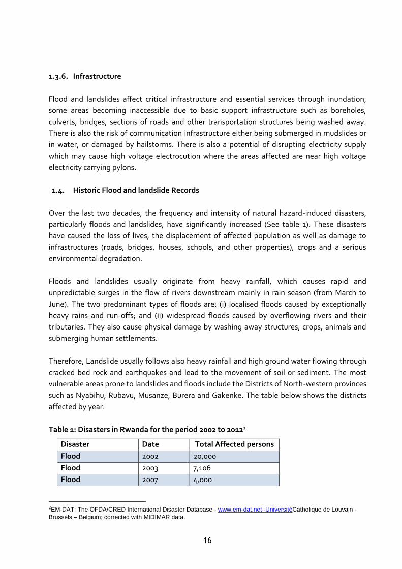
Table 1: Disasters in Rwanda for the period 2002 to 20122
2EM-DAT: The OFDA/CRED International Disaster Database - www.em-dat.net–UniversitéCatholique de Louvain -
Brussels – Belgium; corrected with MIDIMAR data.
Disaster Date Total Affected persons
Flood 2002 20,000
Flood 2003 7,106
Flood 2007 4,000
17
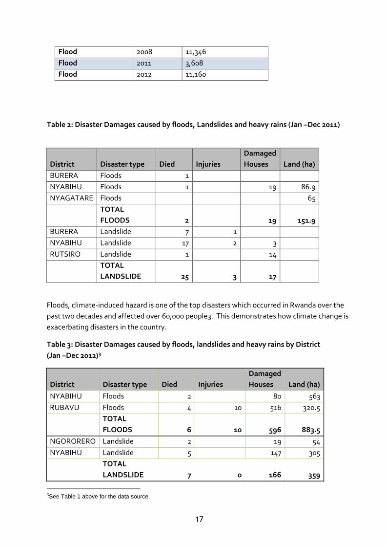
Table 2: Disaster Damages caused by floods, Landslides and heavy rains (Jan –Dec 2011)
District Disaster type Died Injuries
Damaged
Houses Land (ha)
BURERA Floods 1
NYABIHU Floods 1 19 86.9
NYAGATARE Floods 65
TOTAL
FLOODS 2
19 151.9
BURERA Landslide 7 1
NYABIHU Landslide 17 2 3
RUTSIRO Landslide 1 14
TOTAL
LANDSLIDE 25 3 17
Floods, climate-induced hazard is one of the top disasters which occurred in Rwanda over the
past two decades and affected over 60,000 people3. This demonstrates how climate change is
exacerbating disasters in the country.
Table 3: Disaster Damages caused by floods, landslides and heavy rains by District
(Jan –Dec 2012)3
District Disaster type Died Injuries
Damaged
Houses Land (ha)
NYABIHU Floods 2 80 563
RUBAVU Floods 4 10 516 320.5
TOTAL
FLOODS 6 10 596 883.5
NGORORERO Landslide 2 19 54
NYABIHU Landslide 5 147 305
TOTAL
LANDSLIDE 7 0 166 359
3See Table 1 above for the data source.
Flood 2008 11,346
Flood 2011 3,608
Flood 2012 11,160
18
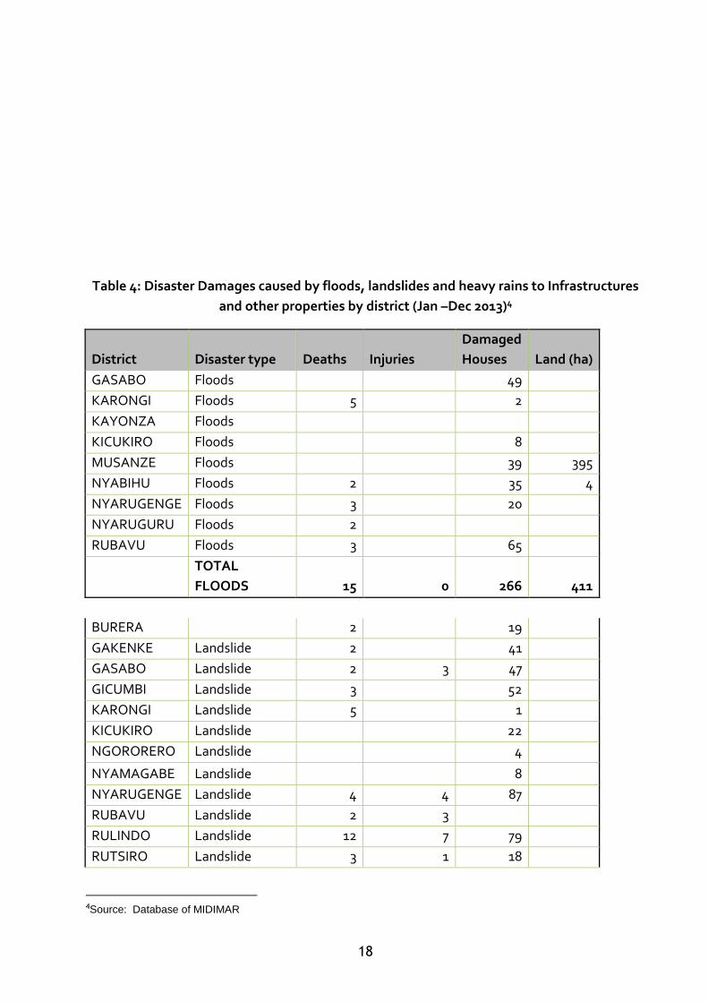
Table 4: Disaster Damages caused by floods, landslides and heavy rains to Infrastructures
and other properties by district (Jan –Dec 2013)4
District Disaster type Deaths Injuries
Damaged
Houses Land (ha)
GASABO Floods 49
KARONGI Floods 5 2
KAYONZA Floods
KICUKIRO Floods 8
MUSANZE Floods 39 395
NYABIHU Floods 2 35 4
NYARUGENGE Floods 3 20
NYARUGURU Floods 2
RUBAVU Floods 3 65
TOTAL
FLOODS 15 0 266 411
BURERA
2 19
GAKENKE Landslide 2 41
GASABO Landslide 2 3 47
GICUMBI Landslide 3 52
KARONGI Landslide 5 1
KICUKIRO Landslide 22
NGORORERO Landslide 4
NYAMAGABE Landslide 8
NYARUGENGE Landslide 4 4 87
RUBAVU Landslide 2 3
RULINDO Landslide 12 7 79
RUTSIRO Landslide 3 1 18
4Source: Database of MIDIMAR
19
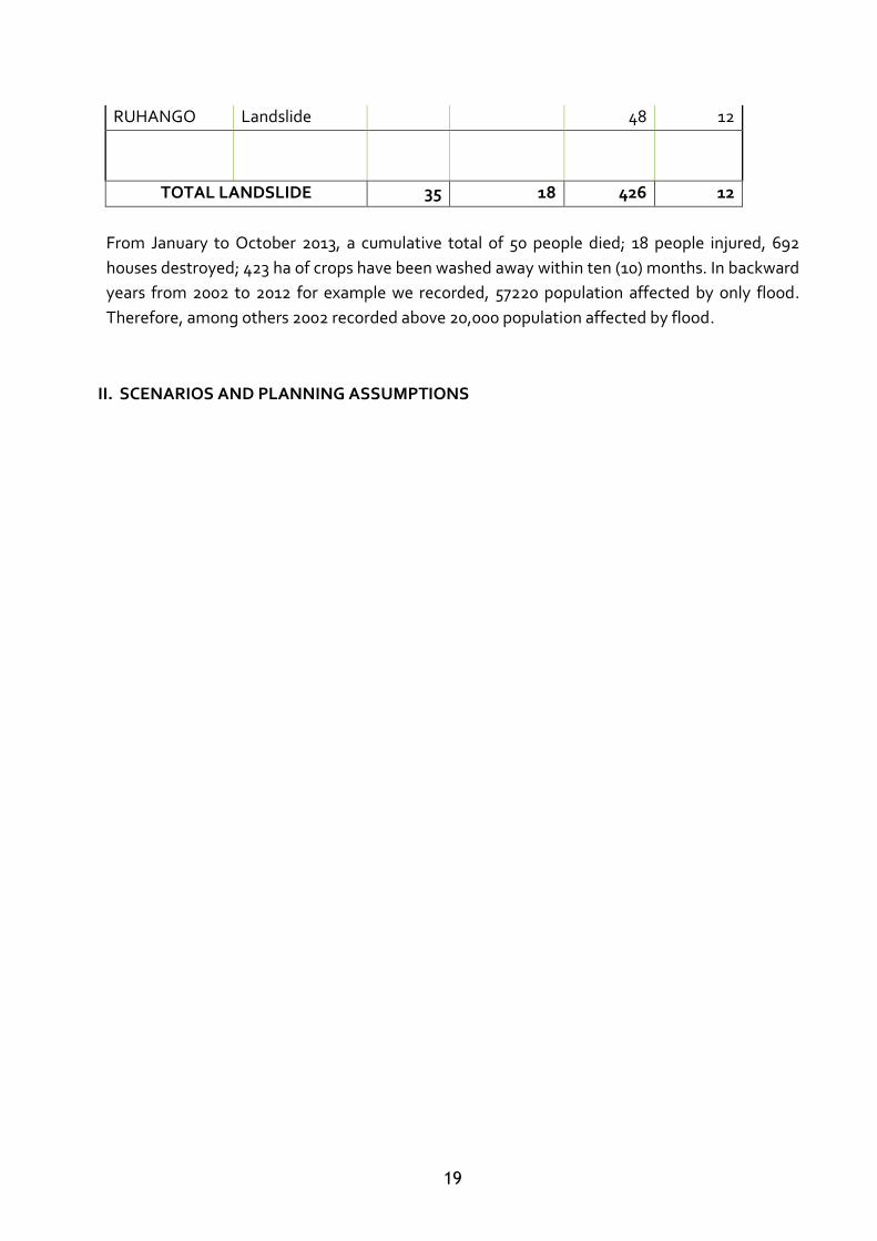
RUHANGO Landslide 48 12
TOTAL LANDSLIDE 35 18 426 12
From January to October 2013, a cumulative total of 50 people died; 18 people injured, 692
houses destroyed; 423 ha of crops have been washed away within ten (10) months. In backward
years from 2002 to 2012 for example we recorded, 57220 population affected by only flood.
Therefore, among others 2002 recorded above 20,000 population affected by flood.
II. SCENARIOS AND PLANNING ASSUMPTIONS
20
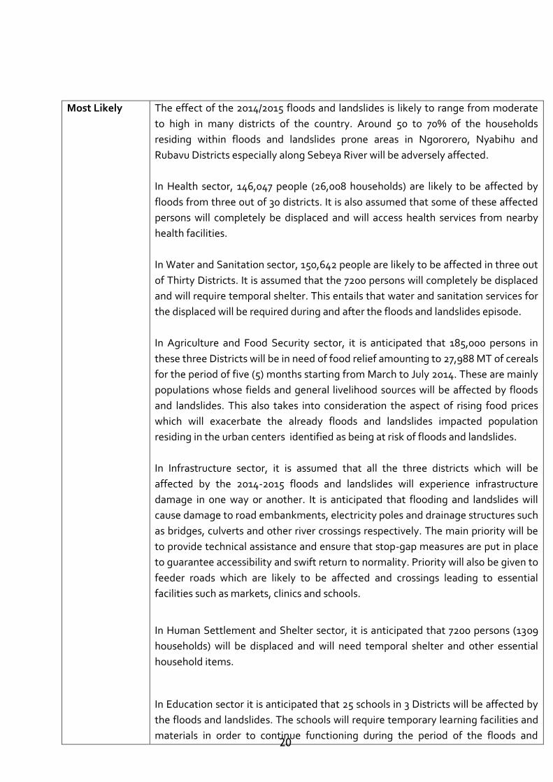
Most Likely The effect of the 2014/2015 floods and landslides is likely to range from moderate
to high in many districts of the country. Around 50 to 70% of the households
residing within floods and landslides prone areas in Ngororero, Nyabihu and
Rubavu Districts especially along Sebeya River will be adversely affected.
In Health sector, 146,047 people (26,008 households) are likely to be affected by
floods from three out of 30 districts. It is also assumed that some of these affected
persons will completely be displaced and will access health services from nearby
health facilities.
In Water and Sanitation sector, 150,642 people are likely to be affected in three out
of Thirty Districts. It is assumed that the 7200 persons will completely be displaced
and will require temporal shelter. This entails that water and sanitation services for
the displaced will be required during and after the floods and landslides episode.
In Agriculture and Food Security sector, it is anticipated that 185,000 persons in
these three Districts will be in need of food relief amounting to 27,988 MT of cereals
for the period of five (5) months starting from March to July 2014. These are mainly
populations whose fields and general livelihood sources will be affected by floods
and landslides. This also takes into consideration the aspect of rising food prices
which will exacerbate the already floods and landslides impacted population
residing in the urban centers identified as being at risk of floods and landslides.
In Infrastructure sector, it is assumed that all the three districts which will be
affected by the 2014-2015 floods and landslides will experience infrastructure
damage in one way or another. It is anticipated that flooding and landslides will
cause damage to road embankments, electricity poles and drainage structures such
as bridges, culverts and other river crossings respectively. The main priority will be
to provide technical assistance and ensure that stop-gap measures are put in place
to guarantee accessibility and swift return to normality. Priority will also be given to
feeder roads which are likely to be affected and crossings leading to essential
facilities such as markets, clinics and schools.
In Human Settlement and Shelter sector, it is anticipated that 7200 persons (1309
households) will be displaced and will need temporal shelter and other essential
household items.
In Education sector it is anticipated that 25 schools in 3 Districts will be affected by
the floods and landslides. The schools will require temporary learning facilities and
materials in order to continue functioning during the period of the floods and
21
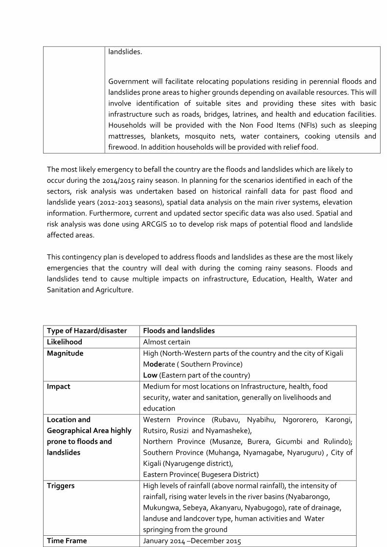
The most likely emergency to befall the country are the floods and landslides which are likely to
occur during the 2014/2015 rainy season. In planning for the scenarios identified in each of the
sectors, risk analysis was undertaken based on historical rainfall data for past flood and
landslide years (2012-2013 seasons), spatial data analysis on the main river systems, elevation
information. Furthermore, current and updated sector specific data was also used. Spatial and
risk analysis was done using ARCGIS 10 to develop risk maps of potential flood and landslide
affected areas.
This contingency plan is developed to address floods and landslides as these are the most likely
emergencies that the country will deal with during the coming rainy seasons. Floods and
landslides tend to cause multiple impacts on infrastructure, Education, Health, Water and
Sanitation and Agriculture.
landslides.
Government will facilitate relocating populations residing in perennial floods and
landslides prone areas to higher grounds depending on available resources. This will
involve identification of suitable sites and providing these sites with basic
infrastructure such as roads, bridges, latrines, and health and education facilities.
Households will be provided with the Non Food Items (NFIs) such as sleeping
mattresses, blankets, mosquito nets, water containers, cooking utensils and
firewood. In addition households will be provided with relief food.
Type of Hazard/disaster Floods and landslides
Likelihood Almost certain
Magnitude High (North-Western parts of the country and the city of Kigali
Moderate ( Southern Province)
Low (Eastern part of the country)
Impact Medium for most locations on Infrastructure, health, food
security, water and sanitation, generally on livelihoods and
education
Location and
Geographical Area highly
prone to floods and
landslides
Western Province (Rubavu, Nyabihu, Ngororero, Karongi,
Rutsiro, Rusizi and Nyamasheke),
Northern Province (Musanze, Burera, Gicumbi and Rulindo);
Southern Province (Muhanga, Nyamagabe, Nyaruguru) , City of
Kigali (Nyarugenge district),
Eastern Province( Bugesera District)
Triggers High levels of rainfall (above normal rainfall), the intensity of
rainfall, rising water levels in the river basins (Nyabarongo,
Mukungwa, Sebeya, Akanyaru, Nyabugogo), rate of drainage,
landuse and landcover type, human activities and Water
springing from the ground
Time Frame January 2014 –December 2015
22
2.1. Scenario development
Based on the spatial and risk analysis, the following was the most likely scenario to unfold
should floods and landslides occur during the coming rainy seasons:
III. PREPAREDNESS, RESPONSE AND RECOVERY ACTIVITIES (SECTOR BY SECTOR)
3.1. Strategies, Guiding principles, Roles and Responsibilities
3.1.1. Objective
The main objective of the National Contingency Plan for floods and landslides has been stated
in the introduction of this document and is reinforced by sectors based specific objectives i.e.
support the timely and coordinated response to anticipated floods and landslides in the 2014-
2015 heavy rainy seasons, thus effectively minimising the impacts of the floods and landslides
on human population, livelihoods, properties and the environment.
3.1.2. Strategy
Mobilize all available resources and deploy them in timely manner to flood and landslide
affected areas. This will involve implementation of activities in the following areas;
3.1.2.1. Capacity Building
As part of strengthening resilience among communities and strengthening the planning ability,
training on preparedness planning in selected flood and landslide prone districts will be carried
out. This training will focus on risk analysis, assessment and reporting as well as response and
recovery requirements.
3.1.2.2. Response plan
In terms of response, concrete sector response plans are developed stating categorically what
preparatory actions need to be carried out before, during and after the emergency with built in
flexibility to provide for changes in the situation. The response plans also identify gaps where
Government will require external support from cooperating partners.
3.1.2.3. Early Warning/Information Flow
The Ministry of Disaster management (MIDIMAR) will work closely with Rwanda Natural
Resources Authority (RNRA) and the Rwanda Meteorological Agency (RMA) among others, to
23
ensure that the situation is being monitored as it is unfolding. Regular bulletins preferably on
weekly basis generated by RMA will be circulated as a way of sharing information as the
triggers begin to show that the situation is getting worse. MIDIMAR which is a coordination
mechanism will be called regularly to update the stakeholders on the situation as well as
progress on disaster preparedness activities.
3.1.3. Guiding Principles
Humanitarian emergency response will be guided by the principles of neutrality, humanity and
impartiality. The response will do no harm and will be based on restoration of affected
populations to their former lifestyle without exaggerating and getting populations used to
lifestyles they cannot sustain after the emergency. As a guide therefore the government
through MIDIMAR will undertake to provide as much detailed information as possible regarding
the affected populations so that the correct amounts of assistance could be provided. The
assistance will also be guided by the fact that this is not development work but short term
assistance with possible early recovery programmes.
3.1.4. Management and Coordination Arrangements
The various coordination forums will continue their coordination activities under the usual
overall coordination of the Ministry of Disaster Management.
The Government through MIDIMAR shall coordinate the implementation of the
contingency plan in close collaboration with the National Disaster Management
Executive Committee (NDMEC) and other partners,
At national technical level, the national disaster management technical committee
(NDMTC) shall support technically in implementing the activities spelt out in the
Contingency Plan,
Within the UN System, the United Nations Agency in charge of disaster management
under the auspices of the UN Resident Coordinator will implement and coordinate the
activities among the UN Agencies before, during and after the disaster. This will be done
together with the National Platform for Disaster Risk Reduction members (NPDRR)
which includes the Red Cross movements and both international and national Non-
Governmental Organisations and MIDIMAR/UN Joint Intervention Management
Committee (JIMC) chaired by the Minister of Disaster Management and Refugee Affairs
and co-chaired by the representative of the United Nations in Rwanda.
District Disaster Management committees (DDMCs) in collaboration with District
Disaster Management Officers (DDMOs), Sector Disaster Management Committees
(SDMCs), Disaster First Responders Teams will conduct rapid assessments and
dissemination of related findings on floods and landslides. The Assessments and
24
dissemination should and shall be done within the framework of disaster management in
Rwanda.
The responsible Authority of incident command will be holding press briefings every
week to update the general public on the floods and landslides situation as it evolves
around the country as well as the measures being undertaken to address the situation.
3.1.5. Key Responsible Institutions in case of floods and landslides Hazards/disasters
This contingency plan will highlight the risk status and actions to be undertaken by each of the
responsible Institutions. In Disaster Management, Diplomatic Missions, the United Nations,
International Government and Non-Governmental Organizations are important actors in
preparing for, responding to and recovering from floods and landslides disaster. They are
involved, along with the civil society, at all level of Disaster Risk Management; their
implications is by definition multi-sectoral and are integrant part of the disaster management
mechanism for natural and man-made hazards.
3.1.5.1. Roles and Responsibilities
The overall responsibility of coordination shall be with the MIDIMAR in general. The District
and Sector Disaster Management Committees shall be the local coordination and
implementation bodies. There shall be no independent activities carried out by any
organization outside or without the knowledge of the named coordination and implementation
bodies.
The National Disaster Management Policy of 2012 places the responsibility of disaster
management on the “shoulders” of each one of concerned institutions, including the Disaster
floods and landslides victims themselves. It is with this in mind that all cooperating partners
such as the UN agencies, donors, non-governmental organisations both local and international
are called upon to provide assistance during the emergency of contingency plan.
25
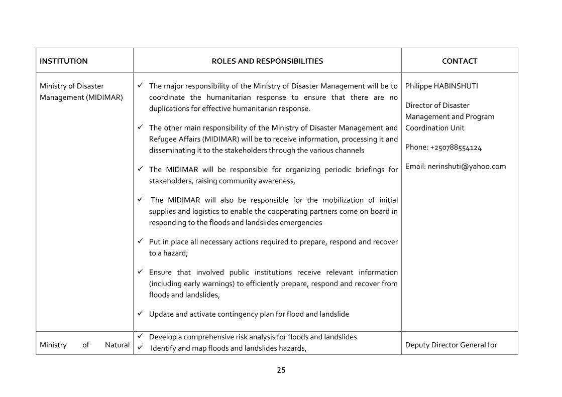
INSTITUTION ROLES AND RESPONSIBILITIES CONTACT
Ministry of Disaster
Management (MIDIMAR)
The major responsibility of the Ministry of Disaster Management will be to
coordinate the humanitarian response to ensure that there are no
duplications for effective humanitarian response.
The other main responsibility of the Ministry of Disaster Management and
Refugee Affairs (MIDIMAR) will be to receive information, processing it and
disseminating it to the stakeholders through the various channels
The MIDIMAR will be responsible for organizing periodic briefings for
stakeholders, raising community awareness,
The MIDIMAR will also be responsible for the mobilization of initial
supplies and logistics to enable the cooperating partners come on board in
responding to the floods and landslides emergencies
Put in place all necessary actions required to prepare, respond and recover
to a hazard;
Ensure that involved public institutions receive relevant information
(including early warnings) to efficiently prepare, respond and recover from
floods and landslides,
Update and activate contingency plan for flood and landslide
Philippe HABINSHUTI
Director of Disaster
Management and Program
Coordination Unit
Phone: +250788554124
Email: [email protected]
Ministry of Natural Develop a comprehensive risk analysis for floods and landslides
Identify and map floods and landslides hazards, Deputy Director General for
26
INSTITUTION ROLES AND RESPONSIBILITIES CONTACT
Resources (MINIRENA) Conduct vulnerability analysis and a capacity assessment for floods and
landslides;
Put in place all necessary actions required to prepare, respond and recover
to a hazard,
Work with all relevant public institutions to ensure that they are well
prepared to respond a disaster linked with a specific hazard including by
continuing to operate;
Allocate sufficient resources to achieve these goals
to assess, monitor and disseminate information related to a specific hazard
Ensure that Rwanda is well equipped to prepare, respond and recover from
floods and landslides
Gazette flood basins,
Integrated Water Resources
Management:
Kabalisa Vincent de Paul
Tel: +250785545307
National disaster
Management Technical
Committee (NDMEC and
NDMTC)
The various Ministries have the primary responsibility of providing goods
and services to the citizens with the emergency
The various ministries will therefore be required to continue to intervene in
the implementation of sector specific activities related to the prevention,
mitigation, humanitarian response and emergency in case of floods and
landslides
The NDMEC/NDMTC will take responsibility in collaborating with the
Ministry of Disaster Management and Refugee Affairs to monitor, assess,
respond and report on risk levels and actions being taken to minimize
adverse effects of floods and landslides,
Floods and Landslides response
management team (list in
annexes)
27
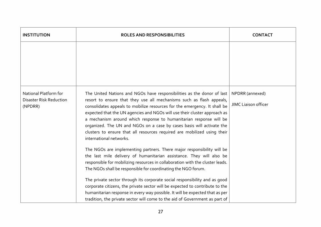
INSTITUTION ROLES AND RESPONSIBILITIES CONTACT
National Platform for
Disaster Risk Reduction
(NPDRR)
The United Nations and NGOs have responsibilities as the donor of last
resort to ensure that they use all mechanisms such as flash appeals,
consolidates appeals to mobilize resources for the emergency. It shall be
expected that the UN agencies and NGOs will use their cluster approach as
a mechanism around which response to humanitarian response will be
organized. The UN and NGOs on a case by cases basis will activate the
clusters to ensure that all resources required are mobilized using their
international networks.
The NGOs are implementing partners. There major responsibility will be
the last mile delivery of humanitarian assistance. They will also be
responsible for mobilizing resources in collaboration with the cluster leads.
The NGOs shall be responsible for coordinating the NGO forum.
The private sector through its corporate social responsibility and as good
corporate citizens, the private sector will be expected to contribute to the
humanitarian response in every way possible. It will be expected that as per
tradition, the private sector will come to the aid of Government as part of
NPDRR (annexed)
JIMC Liaison officer
28
INSTITUTION ROLES AND RESPONSIBILITIES CONTACT
their responsibility to the citizens of this country.
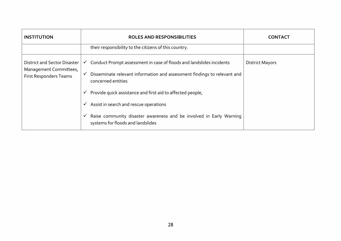
District and Sector Disaster
Management Committees,
First Responders Teams
Conduct Prompt assessment in case of floods and landslides incidents
Disseminate relevant information and assessment findings to relevant and
concerned entities
Provide quick assistance and first aid to affected people,
Assist in search and rescue operations
Raise community disaster awareness and be involved in Early Warning
systems for floods and landslides
District Mayors
29
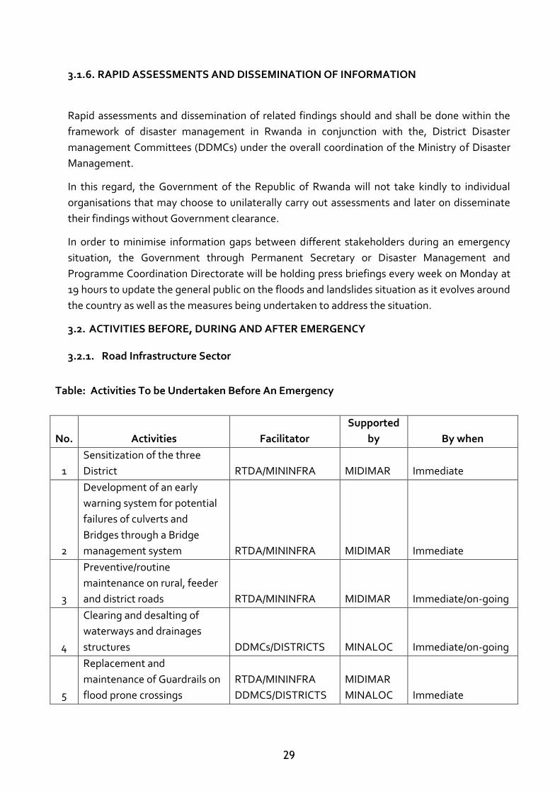
3.1.6. RAPID ASSESSMENTS AND DISSEMINATION OF INFORMATION
Rapid assessments and dissemination of related findings should and shall be done within the
framework of disaster management in Rwanda in conjunction with the, District Disaster
management Committees (DDMCs) under the overall coordination of the Ministry of Disaster
Management.
In this regard, the Government of the Republic of Rwanda will not take kindly to individual
organisations that may choose to unilaterally carry out assessments and later on disseminate
their findings without Government clearance.
In order to minimise information gaps between different stakeholders during an emergency
situation, the Government through Permanent Secretary or Disaster Management and
Programme Coordination Directorate will be holding press briefings every week on Monday at
19 hours to update the general public on the floods and landslides situation as it evolves around
the country as well as the measures being undertaken to address the situation.
3.2. ACTIVITIES BEFORE, DURING AND AFTER EMERGENCY
3.2.1. Road Infrastructure Sector
Table: Activities To be Undertaken Before An Emergency
No. Activities Facilitator
Supported
by By when
1
Sensitization of the three
District RTDA/MININFRA MIDIMAR Immediate
2
Development of an early
warning system for potential
failures of culverts and
Bridges through a Bridge
management system RTDA/MININFRA MIDIMAR Immediate
3
Preventive/routine
maintenance on rural, feeder
and district roads RTDA/MININFRA MIDIMAR Immediate/on-going
4
Clearing and desalting of
waterways and drainages
structures DDMCs/DISTRICTS MINALOC Immediate/on-going
5
Replacement and
maintenance of Guardrails on
flood prone crossings
RTDA/MININFRA
DDMCS/DISTRICTS
MIDIMAR
MINALOC Immediate
30
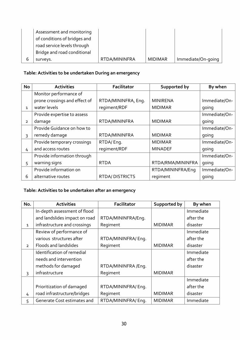
6
Assessment and monitoring
of conditions of bridges and
road service levels through
Bridge and road conditional
surveys. RTDA/MININFRA MIDIMAR Immediate/On-going
Table: Activities to be undertaken During an emergency
No Activities Facilitator Supported by By when
1
Monitor performance of
prone crossings and effect of
water levels
RTDA/MININFRA, Eng.
regiment/RDF
MINIRENA
MIDIMAR
Immediate/On-
going
2
Provide expertise to assess
damage RTDA/MININFRA MIDIMAR
Immediate/On-
going
3
Provide Guidance on how to
remedy damage RTDA/MININFRA MIDIMAR
Immediate/On-
going
4
Provide temporary crossings
and access routes
RTDA/ Eng.
regiment/RDF
MIDIMAR
MINADEF
Immediate/On-
going
5
Provide information through
warning signs RTDA RTDA/RMA/MININFRA
Immediate/On-
going
6
Provide information on
alternative routes RTDA/ DISTRICTS
RTDA/MININFRA/Eng
regiment
Immediate/On-
going
Table: Activities to be undertaken after an emergency
No. Activities Facilitator Supported by By when
1
In-depth assessment of flood
and landslides impact on road
infrastructure and crossings
RTDA/MININFRA/Eng.
Regiment MIDIMAR
Immediate
after the
disaster
2
Review of performance of
various structures after
Floods and landslides
RTDA/MININFRA/ Eng.
Regiment MIDIMAR
Immediate
after the
disaster
3
Identification of remedial
needs and intervention
methods for damaged
infrastructure
RTDA/MININFRA /Eng.
Regiment MIDIMAR
Immediate
after the
disaster
4
Prioritization of damaged
road infrastructure/bridges
RTDA/MININFRA/ Eng.
Regiment MIDIMAR
Immediate
after the
disaster
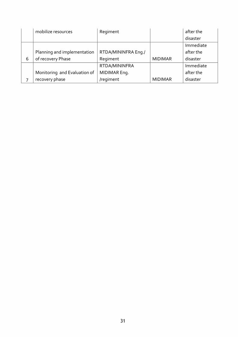
5 Generate Cost estimates and RTDA/MININFRA/ Eng. MIDIMAR Immediate
31
mobilize resources Regiment after the
disaster
6
Planning and implementation
of recovery Phase
RTDA/MININFRA Eng./
Regiment MIDIMAR
Immediate
after the
disaster
7
Monitoring and Evaluation of
recovery phase
RTDA/MININFRA
MIDIMAR Eng.
/regiment MIDIMAR
Immediate
after the
disaster
32
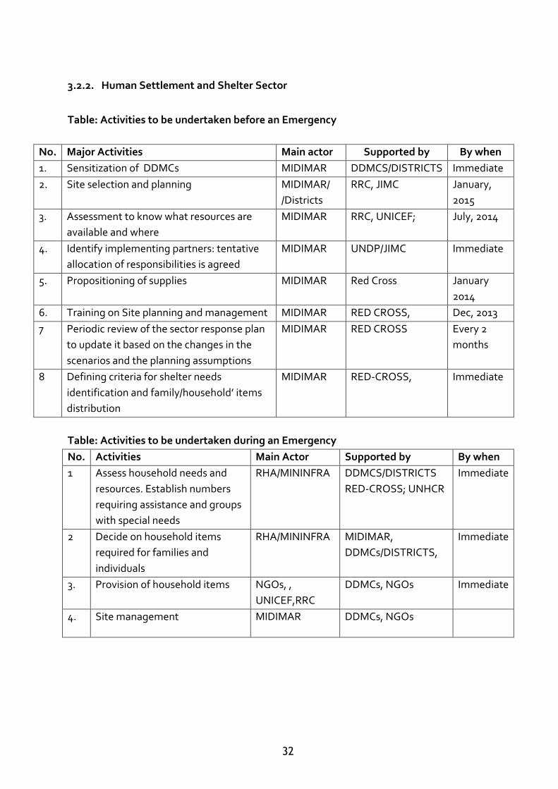
3.2.2. Human Settlement and Shelter Sector
Table: Activities to be undertaken before an Emergency
No. Major Activities Main actor Supported by By when
1. Sensitization of DDMCs MIDIMAR DDMCS/DISTRICTS Immediate
2. Site selection and planning MIDIMAR/
/Districts
RRC, JIMC January,
2015
3. Assessment to know what resources are
available and where
MIDIMAR RRC, UNICEF; July, 2014
4. Identify implementing partners: tentative
allocation of responsibilities is agreed
MIDIMAR UNDP/JIMC Immediate
5. Propositioning of supplies MIDIMAR Red Cross January
2014
6. Training on Site planning and management MIDIMAR RED CROSS, Dec, 2013
7 Periodic review of the sector response plan
to update it based on the changes in the
scenarios and the planning assumptions
MIDIMAR RED CROSS Every 2
months
8 Defining criteria for shelter needs
identification and family/household’ items
distribution
MIDIMAR RED-CROSS, Immediate
Table: Activities to be undertaken during an Emergency
No. Activities Main Actor Supported by By when
1 Assess household needs and
resources. Establish numbers
requiring assistance and groups
with special needs
RHA/MININFRA DDMCS/DISTRICTS
RED-CROSS; UNHCR
Immediate
2 Decide on household items
required for families and
individuals
RHA/MININFRA MIDIMAR,
DDMCs/DISTRICTS,
Immediate
3. Provision of household items NGOs, ,
UNICEF,RRC
DDMCs, NGOs
Immediate
4. Site management MIDIMAR DDMCs, NGOs
33
Table: Activities to be undertaken after the emergency
No. Activities Main Actor Supported by By when
1. In-depth assessment DISTRICTS MIDIMAR; NGOs/RRC After 2 month
2. Identification of
resettlement area
MIDIMAR
DISTICTS, NGOs After 2
months
3. Mobilise resources for
resettlement
MIDIMAR
DISTRICTS, NGOs After 2
months
4. Road Infrastructure
development in the newly
established settlements
RTDA/MININF
RA
MIDIMAR After 2
months
5. Evaluation of the
implementation of the
resettlement plan
MIDIMAR
DISTRICTS, NGOs After 6
months
34
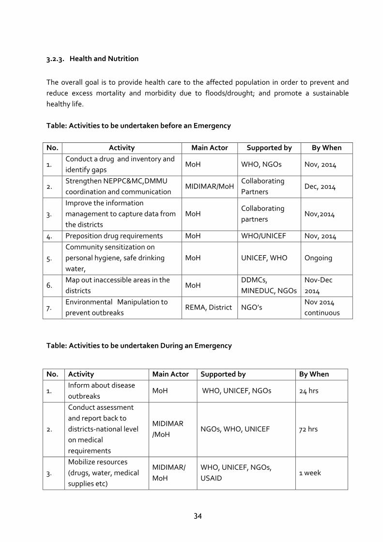
3.2.3. Health and Nutrition
The overall goal is to provide health care to the affected population in order to prevent and
reduce excess mortality and morbidity due to floods/drought; and promote a sustainable
healthy life.
Table: Activities to be undertaken before an Emergency
No. Activity Main Actor Supported by By When
1. Conduct a drug and inventory and
identify gaps MoH WHO, NGOs Nov, 2014
2. Strengthen NEPPC&MC,DMMU
coordination and communication MIDIMAR/MoH
Collaborating
Partners Dec, 2014
3.
Improve the information
management to capture data from
the districts
MoH Collaborating
partners Nov,2014
4. Preposition drug requirements MoH WHO/UNICEF Nov, 2014
5.
Community sensitization on
personal hygiene, safe drinking
water,
MoH UNICEF, WHO Ongoing
6. Map out inaccessible areas in the
districts MoH
DDMCs,
MINEDUC, NGOs
Nov-Dec
2014
7. Environmental Manipulation to
prevent outbreaks REMA, District NGO’s
Nov 2014
continuous
Table: Activities to be undertaken During an Emergency
No. Activity Main Actor Supported by By When
1. Inform about disease
outbreaks MoH WHO, UNICEF, NGOs 24 hrs
2.
Conduct assessment
and report back to
districts-national level
on medical
requirements
MIDIMAR
/MoH NGOs, WHO, UNICEF 72 hrs
3.
Mobilize resources
(drugs, water, medical
supplies etc)
MIDIMAR/
MoH
WHO, UNICEF, NGOs,
USAID 1 week
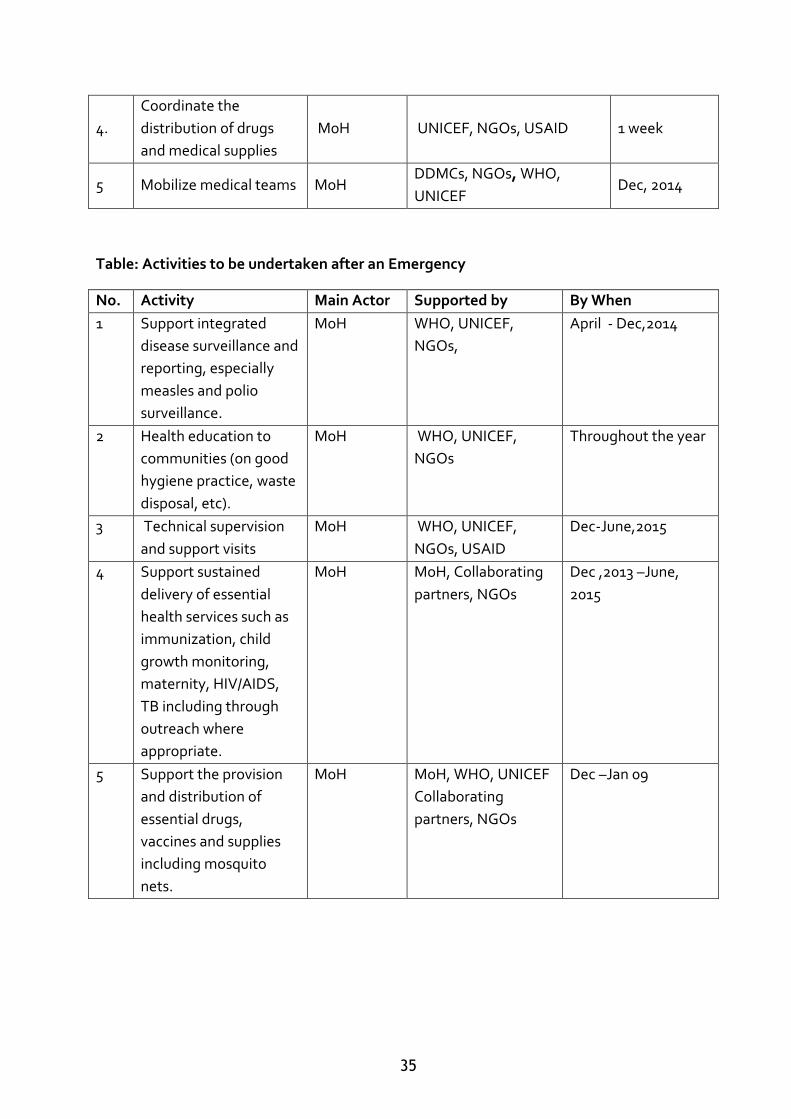
35
4.
Coordinate the
distribution of drugs
and medical supplies
MoH UNICEF, NGOs, USAID 1 week
5 Mobilize medical teams MoH DDMCs, NGOs, WHO,
UNICEF Dec, 2014
Table: Activities to be undertaken after an Emergency
No. Activity Main Actor Supported by By When
1 Support integrated
disease surveillance and
reporting, especially
measles and polio
surveillance.
MoH WHO, UNICEF,
NGOs,
April - Dec,2014
2 Health education to
communities (on good
hygiene practice, waste
disposal, etc).
MoH WHO, UNICEF,
NGOs
Throughout the year
3 Technical supervision
and support visits
MoH WHO, UNICEF,
NGOs, USAID
Dec-June,2015
4 Support sustained
delivery of essential
health services such as
immunization, child
growth monitoring,
maternity, HIV/AIDS,
TB including through
outreach where
appropriate.
MoH MoH, Collaborating
partners, NGOs
Dec ,2013 –June,
2015
5 Support the provision
and distribution of
essential drugs,
vaccines and supplies
including mosquito
nets.
MoH MoH, WHO, UNICEF
Collaborating
partners, NGOs
Dec –Jan 09
36
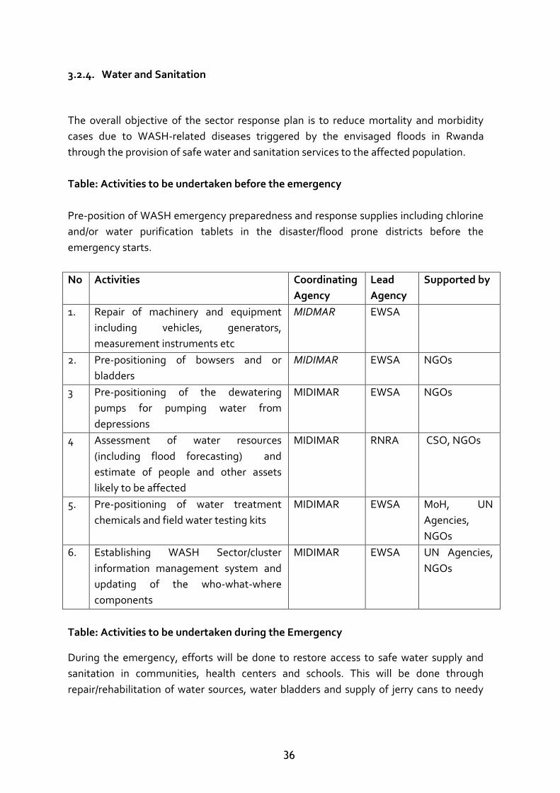
3.2.4. Water and Sanitation
The overall objective of the sector response plan is to reduce mortality and morbidity
cases due to WASH-related diseases triggered by the envisaged floods in Rwanda
through the provision of safe water and sanitation services to the affected population.
Table: Activities to be undertaken before the emergency
Pre-position of WASH emergency preparedness and response supplies including chlorine
and/or water purification tablets in the disaster/flood prone districts before the
emergency starts.
No Activities Coordinating
Agency
Lead
Agency
Supported by
1. Repair of machinery and equipment
including vehicles, generators,
measurement instruments etc
MIDMAR EWSA
2. Pre-positioning of bowsers and or
bladders
MIDIMAR EWSA NGOs
3 Pre-positioning of the dewatering
pumps for pumping water from
depressions
MIDIMAR EWSA NGOs
4 Assessment of water resources
(including flood forecasting) and
estimate of people and other assets
likely to be affected
MIDIMAR RNRA CSO, NGOs
5. Pre-positioning of water treatment
chemicals and field water testing kits
MIDIMAR EWSA MoH, UN
Agencies,
NGOs
6. Establishing WASH Sector/cluster
information management system and
updating of the who-what-where
components
MIDIMAR EWSA UN Agencies,
NGOs
Table: Activities to be undertaken during the Emergency
During the emergency, efforts will be done to restore access to safe water supply and
sanitation in communities, health centers and schools. This will be done through
repair/rehabilitation of water sources, water bladders and supply of jerry cans to needy
37
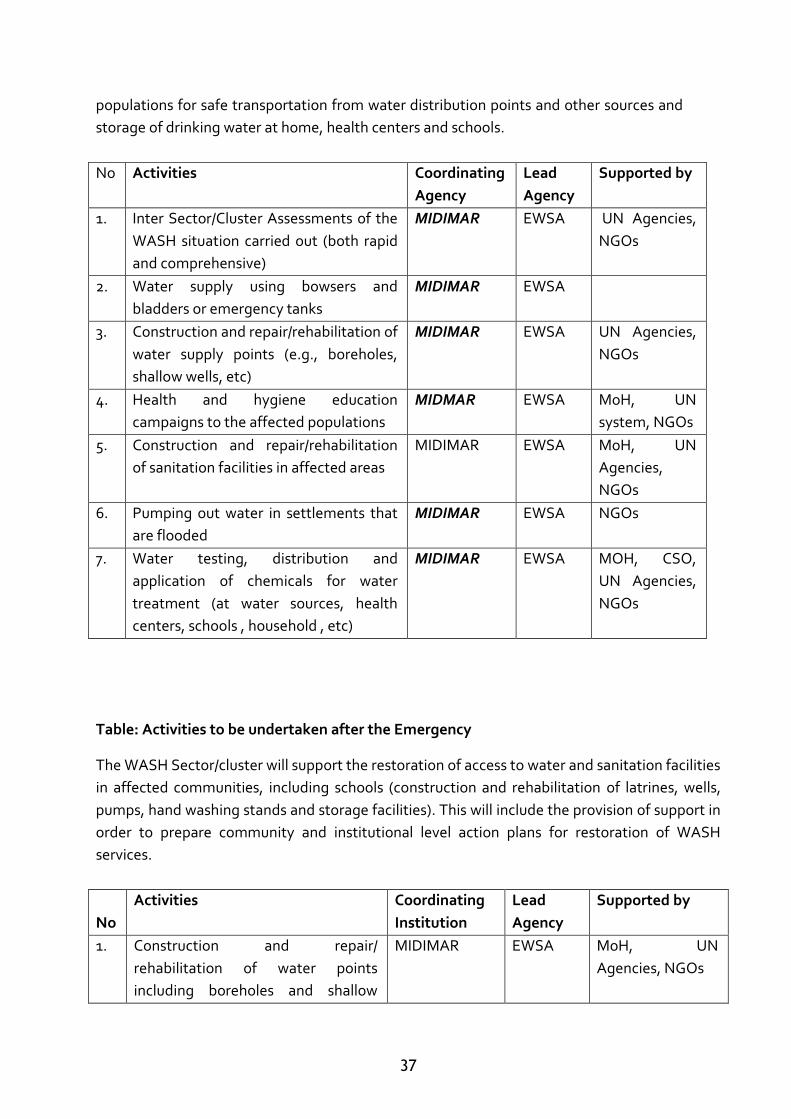
populations for safe transportation from water distribution points and other sources and
storage of drinking water at home, health centers and schools.
No Activities Coordinating
Agency
Lead
Agency
Supported by
1. Inter Sector/Cluster Assessments of the
WASH situation carried out (both rapid
and comprehensive)
MIDIMAR EWSA UN Agencies,
NGOs
2. Water supply using bowsers and
bladders or emergency tanks
MIDIMAR EWSA
3. Construction and repair/rehabilitation of
water supply points (e.g., boreholes,
shallow wells, etc)
MIDIMAR EWSA UN Agencies,
NGOs
4. Health and hygiene education
campaigns to the affected populations
MIDMAR EWSA MoH, UN
system, NGOs
5. Construction and repair/rehabilitation
of sanitation facilities in affected areas
MIDIMAR EWSA MoH, UN
Agencies,
NGOs
6. Pumping out water in settlements that
are flooded
MIDIMAR EWSA NGOs
7. Water testing, distribution and
application of chemicals for water
treatment (at water sources, health
centers, schools , household , etc)
MIDIMAR EWSA MOH, CSO,
UN Agencies,
NGOs
Table: Activities to be undertaken after the Emergency
The WASH Sector/cluster will support the restoration of access to water and sanitation facilities
in affected communities, including schools (construction and rehabilitation of latrines, wells,
pumps, hand washing stands and storage facilities). This will include the provision of support in
order to prepare community and institutional level action plans for restoration of WASH
services.
No
Activities Coordinating
Institution
Lead
Agency
Supported by
1. Construction and repair/
rehabilitation of water points
including boreholes and shallow
MIDIMAR EWSA MoH, UN
Agencies, NGOs
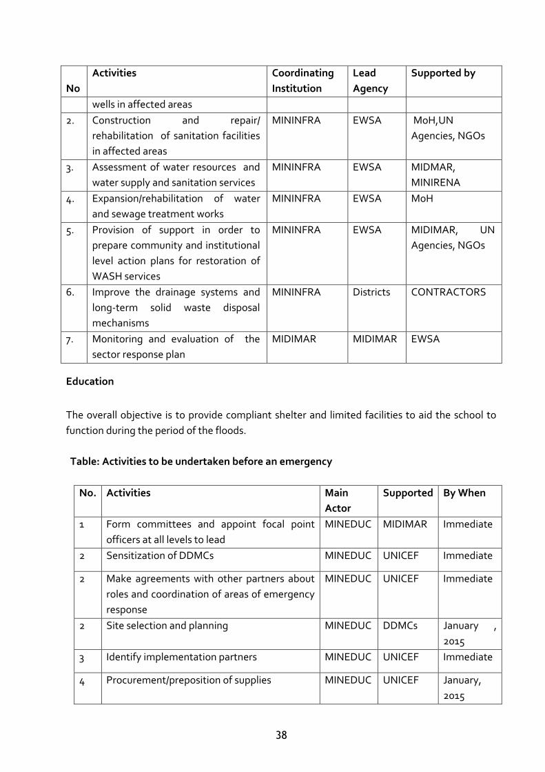
38
No
Activities Coordinating
Institution
Lead
Agency
Supported by
wells in affected areas
2. Construction and repair/
rehabilitation of sanitation facilities
in affected areas
MININFRA EWSA MoH,UN
Agencies, NGOs
3. Assessment of water resources and
water supply and sanitation services
MININFRA EWSA MIDMAR,
MINIRENA
4. Expansion/rehabilitation of water
and sewage treatment works
MININFRA EWSA MoH
5. Provision of support in order to
prepare community and institutional
level action plans for restoration of
WASH services
MININFRA EWSA MIDIMAR, UN
Agencies, NGOs
6. Improve the drainage systems and
long-term solid waste disposal
mechanisms
MININFRA Districts CONTRACTORS
7. Monitoring and evaluation of the
sector response plan
MIDIMAR MIDIMAR EWSA
Education
The overall objective is to provide compliant shelter and limited facilities to aid the school to
function during the period of the floods.
Table: Activities to be undertaken before an emergency
No. Activities Main
Actor
Supported By When
1 Form committees and appoint focal point
officers at all levels to lead
MINEDUC MIDIMAR Immediate
2 Sensitization of DDMCs MINEDUC UNICEF Immediate
2 Make agreements with other partners about
roles and coordination of areas of emergency
response
MINEDUC UNICEF Immediate
2 Site selection and planning MINEDUC DDMCs January ,
2015
3 Identify implementation partners MINEDUC UNICEF Immediate
4 Procurement/preposition of supplies MINEDUC UNICEF January,
2015
39
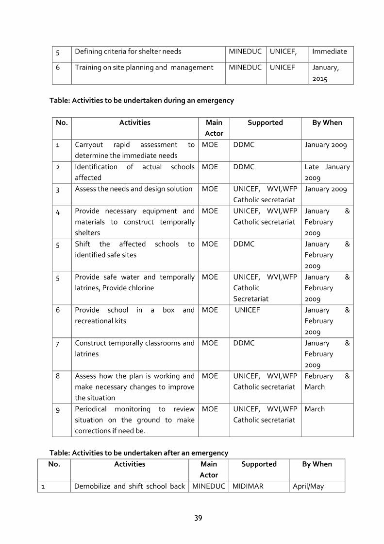
5 Defining criteria for shelter needs MINEDUC UNICEF, Immediate
6 Training on site planning and management MINEDUC UNICEF January,
2015
Table: Activities to be undertaken during an emergency
No. Activities Main
Actor
Supported By When
1 Carryout rapid assessment to
determine the immediate needs
MOE DDMC January 2009
2 Identification of actual schools
affected
MOE DDMC Late January
2009
3 Assess the needs and design solution MOE UNICEF, WVI,WFP
Catholic secretariat
January 2009
4 Provide necessary equipment and
materials to construct temporally
shelters
MOE UNICEF, WVI,WFP
Catholic secretariat
January &
February
2009
5 Shift the affected schools to
identified safe sites
MOE DDMC January &
February
2009
5 Provide safe water and temporally
latrines, Provide chlorine
MOE UNICEF, WVI,WFP
Catholic
Secretariat
January &
February
2009
6 Provide school in a box and
recreational kits
MOE UNICEF January &
February
2009
7 Construct temporally classrooms and
latrines
MOE DDMC January &
February
2009
8 Assess how the plan is working and
make necessary changes to improve
the situation
MOE UNICEF, WVI,WFP
Catholic secretariat
February &
March
9 Periodical monitoring to review
situation on the ground to make
corrections if need be.
MOE UNICEF, WVI,WFP
Catholic secretariat
March
Table: Activities to be undertaken after an emergency
No. Activities Main
Actor
Supported By When
1 Demobilize and shift school back MINEDUC MIDIMAR April/May
40
to original place
2 In-depth assessment MINEDUC UNICEF May
3 Evaluation of the implementation
plan.
MINEDUC UNICEF May 2014
4 Carryout rehabilitation works on
all school infrastructure damaged
by floods.
MINEDUC UNICEF May 2014
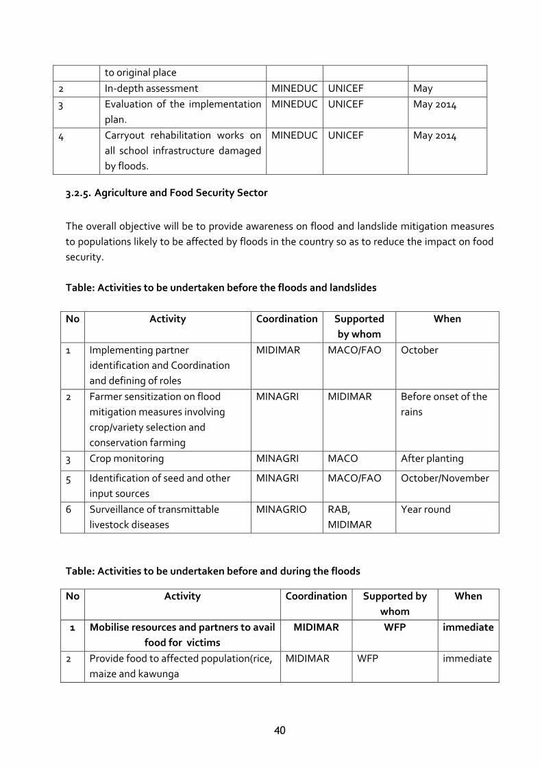
3.2.5. Agriculture and Food Security Sector
The overall objective will be to provide awareness on flood and landslide mitigation measures
to populations likely to be affected by floods in the country so as to reduce the impact on food
security.
Table: Activities to be undertaken before the floods and landslides
No Activity Coordination Supported
by whom
When
1 Implementing partner
identification and Coordination
and defining of roles
MIDIMAR MACO/FAO October
2 Farmer sensitization on flood
mitigation measures involving
crop/variety selection and
conservation farming
MINAGRI MIDIMAR Before onset of the
rains
3 Crop monitoring MINAGRI MACO After planting
5 Identification of seed and other
input sources
MINAGRI MACO/FAO October/November
6 Surveillance of transmittable
livestock diseases
MINAGRIO RAB,
MIDIMAR
Year round
Table: Activities to be undertaken before and during the floods
No Activity Coordination Supported by
whom
When
1 Mobilise resources and partners to avail
food for victims
MIDIMAR WFP immediate
2 Provide food to affected population(rice,
maize and kawunga
MIDIMAR WFP immediate
41
Table: Activities to be undertaken After the Emergency
No Activities
Coordination Supported by
whom
When
1
Rapid Food and landslides Security
Needs assessment and area
mapping
MIDIMAR After floods have
receded
2 Relief food operations MIDIMAR WFP/NGOs After floods
Beneficiary identification and
selection
MIDIMAR NGOs/WFP After floods have
receded
4 Support to conservation
Agriculture for 12,000 HHs to
enable cultivation of 0.25 Ha/HH
MINAGRI/RAB FAO/NGOs April,2014
5 Inputs distribution MIDIMAR NGOs/WFP April,2014
6 Survey of suspected livestock
disease outbreaks and mapping
MINAGRI/RAB MIDIMAR After the floods
have receded
7 Awareness creation among
livestock owners on disease
prevention and control measures in
affected districts
MINAGRI/RAB MIDMAR After survey
8 Procurement of vaccines and
antibiotics for 50,000 cattle in 3
districts
MINAGRI/RAB FAO/MACO After Diagnostic
survey
9 Livestock vaccinations and
treatment for cattle
MINAGRI/RAB MACO After survey
3.2.6. Information Management and Emergency Communications
The overall objective will be to provide an efficient and effective information management and
emergency communication mechanism for response.
3.2.6.1. Specific objectives
To determine the level of preparedness of communications authorities and service
providers through awareness activities on the impending floods to occur in 2014/15
season.
To determine the preparedness levels of the Government Ministries, NGOs both local
and international as well as UN agencies on the impending floods for the 2014/15
season.
42
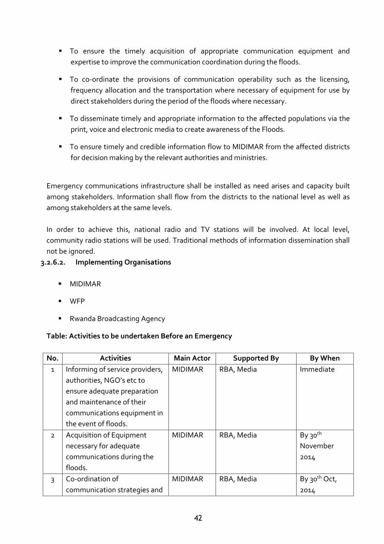
To ensure the timely acquisition of appropriate communication equipment and
expertise to improve the communication coordination during the floods.
To co-ordinate the provisions of communication operability such as the licensing,
frequency allocation and the transportation where necessary of equipment for use by
direct stakeholders during the period of the floods where necessary.
To disseminate timely and appropriate information to the affected populations via the
print, voice and electronic media to create awareness of the Floods.
To ensure timely and credible information flow to MIDIMAR from the affected districts
for decision making by the relevant authorities and ministries.
Emergency communications infrastructure shall be installed as need arises and capacity built
among stakeholders. Information shall flow from the districts to the national level as well as
among stakeholders at the same levels.
In order to achieve this, national radio and TV stations will be involved. At local level,
community radio stations will be used. Traditional methods of information dissemination shall
not be ignored.
3.2.6.2. Implementing Organisations
MIDIMAR
WFP
Rwanda Broadcasting Agency
Table: Activities to be undertaken Before an Emergency
No. Activities Main Actor Supported By By When
1 Informing of service providers,
authorities, NGO’s etc to
ensure adequate preparation
and maintenance of their
communications equipment in
the event of floods.
MIDIMAR RBA, Media Immediate
2 Acquisition of Equipment
necessary for adequate
communications during the
floods.
MIDIMAR RBA, Media By 30th
November
2014
3 Co-ordination of
communication strategies and
MIDIMAR RBA, Media By 30th Oct,
2014
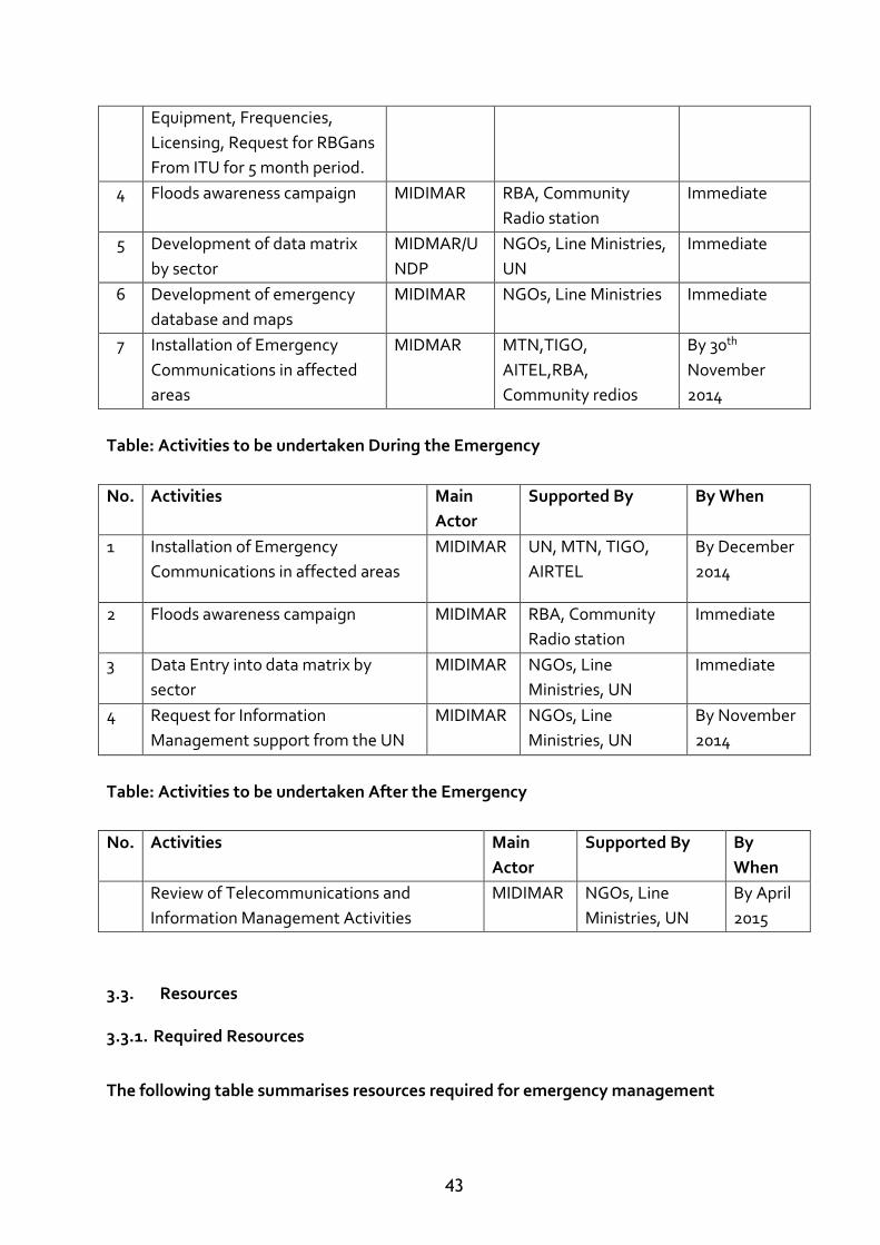
43
Equipment, Frequencies,
Licensing, Request for RBGans
From ITU for 5 month period.
4 Floods awareness campaign MIDIMAR RBA, Community
Radio station
Immediate
5 Development of data matrix
by sector
MIDMAR/U
NDP
NGOs, Line Ministries,
UN
Immediate
6 Development of emergency
database and maps
MIDIMAR NGOs, Line Ministries Immediate
7 Installation of Emergency
Communications in affected
areas
MIDMAR MTN,TIGO,
AITEL,RBA,
Community redios
By 30th
November
2014
Table: Activities to be undertaken During the Emergency
No. Activities Main
Actor
Supported By By When
1 Installation of Emergency
Communications in affected areas
MIDIMAR UN, MTN, TIGO,
AIRTEL
By December
2014
2 Floods awareness campaign MIDIMAR RBA, Community
Radio station
Immediate
3 Data Entry into data matrix by
sector
MIDIMAR NGOs, Line
Ministries, UN
Immediate
4 Request for Information
Management support from the UN
MIDIMAR NGOs, Line
Ministries, UN
By November
2014
Table: Activities to be undertaken After the Emergency
No. Activities Main
Actor
Supported By By
When
Review of Telecommunications and
Information Management Activities
MIDIMAR NGOs, Line
Ministries, UN
By April
2015
3.3. Resources
3.3.1. Required Resources
The following table summarises resources required for emergency management
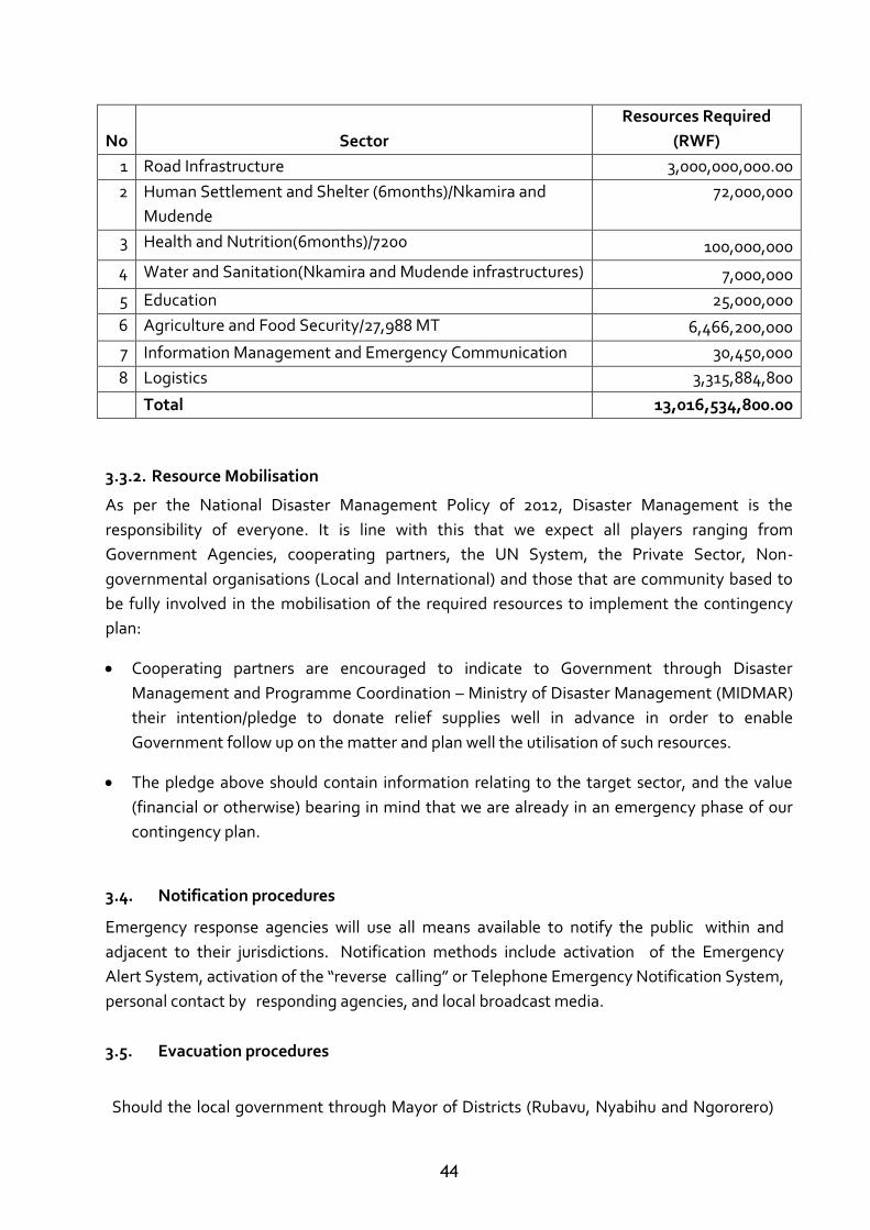
44
3.3.2. Resource Mobilisation
As per the National Disaster Management Policy of 2012, Disaster Management is the
responsibility of everyone. It is line with this that we expect all players ranging from
Government Agencies, cooperating partners, the UN System, the Private Sector, Non-
governmental organisations (Local and International) and those that are community based to
be fully involved in the mobilisation of the required resources to implement the contingency
plan:
Cooperating partners are encouraged to indicate to Government through Disaster
Management and Programme Coordination – Ministry of Disaster Management (MIDMAR)
their intention/pledge to donate relief supplies well in advance in order to enable
Government follow up on the matter and plan well the utilisation of such resources.
The pledge above should contain information relating to the target sector, and the value
(financial or otherwise) bearing in mind that we are already in an emergency phase of our
contingency plan.
3.4. Notification procedures
Emergency response agencies will use all means available to notify the public within and
adjacent to their jurisdictions. Notification methods include activation of the Emergency
Alert System, activation of the “reverse calling” or Telephone Emergency Notification System,
personal contact by responding agencies, and local broadcast media.
3.5. Evacuation procedures
Should the local government through Mayor of Districts (Rubavu, Nyabihu and Ngororero)
No Sector
Resources Required
(RWF)
1 Road Infrastructure 3,000,000,000.00
2 Human Settlement and Shelter (6months)/Nkamira and
Mudende
72,000,000
3 Health and Nutrition(6months)/7200 100,000,000
4 Water and Sanitation(Nkamira and Mudende infrastructures) 7,000,000
5 Education 25,000,000
6 Agriculture and Food Security/27,988 MT 6,466,200,000
7 Information Management and Emergency Communication 30,450,000
8 Logistics 3,315,884,800
Total 13,016,534,800.00
45
order an evacuation of persons from areas affected by flood and landslide in collaboration
with Army and Police in the region,
Operational Area (OA) response agencies shall coordinate their operations through the OA
Emergency Operations plan adapted to this contingency plan. All evacuation-related
actions will be in accordance with those procedures and activities set in this contingency
plan
3.6. Search and rescue procedures
All search and rescue operations shall be in accordance with the standard operating
procedures of the agency involved. All search and rescue operations shall be coordinated
with engineering regiment to ensure any required additional resource assignments are
prioritized and based on need.
3.7. Damage assessment procedures
All initial damage assessment operations shall be conducted by the agency responsible for
field notifications (DDMC, SDMC, First Responders Team) for those areas. Initial
assessment results shall be immediately communicated to the MIDIMAR for accounting
and for response prioritization planning.
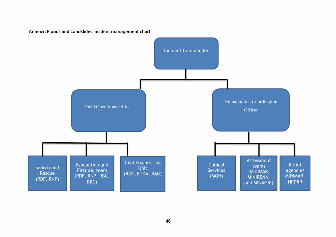
46
Annex1: Floods and Landslides incident management chart
Field Operations Officer
Incident Commander
Humanitarian Coordination
Officer
Search and Rescue
(RDF, RNP)
Civil Engineering Unit
(RDF, RTDA, RAB)
Assessment teams
(MIDIMAR, MINIRENA,
and MINAGRI)
Evacuation and First aid team
(RDF, RNP, RBC,
RRC)
Relief agencies MIDIMAR,
NPDRR
Clinical Services (MOH)

47