A geoarchaeological investigation of an historical gold mining site in northeast Alentjo, Portugal

lable at ScienceDirect
Journal of Archaeological Science 41 (2014) 759e771
Contents lists avai
Journal of Archaeological Science
journal homepage: http : / /www.elsevier .com/locate/ jas
Review
Prehistoric engineering and astronomy of the great Menga Dolmen(Málaga, Spain). A geometric and geoarchaeological analysis
José Antonio Lozano a,b,*, Gerardo Ruiz-Puertas b, Manuel Hódar-Correa b,Fernando Pérez-Valera c, Antonio Morgado d
aDepartamento de Petrología y mineralogía, Instituto Andaluz de Ciencias de la Tierra, Universidad de Granada, Avenida de las Palmeras 4, 18100 Armilla,Granada, Spainb Estudios Geológicos y Medioambientales S.L., 18110 Las Gabias, Granada, SpaincDepartamento de Geología, Facultad de Ciencias Experimentales, Universidad de Jaén, Campus de Las Lagunillas s/n, 23071 Jaén, SpaindDepartamento de Prehistoria y Arqueología, Universidad de Granada, 18071 Granada, Spain
a r t i c l e i n f o
Article history:Received 6 November 2012Received in revised form12 September 2013Accepted 5 October 2013
Keywords:Megalithic phenomenonGeoarchaeologyPrehistoric engineeringArchaeoastronomyDolmenIberian Peninsula
* Corresponding author. Departamento de PetroloAndaluz de Ciencias de la Tierra, Universidad de Gran4, 18100 Armilla, Granada, Spain. Tel./fax: þ34 95881
E-mail address: [email protected] (J.A. Lozano).
0305-4403/$ e see front matter � 2013 Elsevier Ltd.http://dx.doi.org/10.1016/j.jas.2013.10.010
a b s t r a c t
The Menga Dolmen in Antequera (Malaga province, Spain), measuring 27.5 m long and composed of 32large stones, is recognized as possibly the largest megalithic burial monument of Prehistory. However,until now, no studies of Menga have ever been internationally published. This article, while aiming to bethe first is also the first geoarchaeological and geometric analysis of this a monument of this kind. Thepurpose of this analysis is to combine the results of the geological study of Menga (identification anddescription of the rock used in its constructions) with those of the geometric design survey. The resultsshow a detailed understanding of the architecture and engineering among the dolmen builders, andwhat is most important, as well as novel, a clear and intentional asymmetry of the dolmen along itslongitudinal axis. This asymmetry has a cultural background, evidenced in other similar monuments andmay also be related to the orientation of Menga, traditionally set to a nearby geographical feature but alsooriented to a certain chamber lighting during the summer solstice.
� 2013 Elsevier Ltd. All rights reserved.
1. Introduction
The appearance of megalithic monuments is a pan-Europeanphenomenon that originated in early communities of farmers andherders. Its most remarkable expressions appeared during the 6thand 5th millennia cal. BP, with the development of the largemonuments, which often required the mobilization of an extensivelabour force, as well as the deployment of previously unseen en-gineering and architectural knowledge. The southern IberianPeninsula, particularly Spain, has a wide variety of megaliths thathave been investigated since the late 19th century. The best knownsites include individual monuments such as Soto (Trigueros,Huelva), Huerta Montero (Badajoz), and Alberite (Villamartín,Cádiz). Complex clusters of monuments associated with settle-ments such as Valencina de la Concepción (Seville), and Los Mill-ares (Almería), as well as extensive megalithic landscapes such as
gía y mineralogía, Institutoada, Avenida de las Palmeras0969.
All rights reserved.
Gorafe (Granada) or El Pozuelo (Huelva). (For recent reviews inEnglish, see Aguayo de Hoyos and García-Sanjuán, 2002; García-Sanjuán and Ruíz González, 2009; Wheatley et al., 2010). Of all ofthese, the Antequera Megalithic Complex is possibly the mostextraordinary.
The Antequera Megalithic Complex includes the Menga andViera dolmens and the El Romeral tholos. Prominent among thesethree monuments, Menga can be considered one of the world’smost significant expressions of themegalithic phenomenon, havinga long history of research.
The earliest known written reference appeared in the 16thcentury is when César Ricario, bishop of Malaga, wrote about the“Cave of Menga” in a document signed in 1530. Afterwards, otherreferences appeared from the 16th through the 18th centuries indifferent manuscripts about the history of Antequera, such as thosenoted by Agustin Tejada Páez in 1587, Alonso García de Yegros in1609, Francisco de Tejada y Nava and Francisco de Cabrera at thebeginning of the 17th century, and Rodrigo Méndez de Silva in 1675(Escalante Jiménez and Fernández Paradas, 2003). References tothis megalithic monument multiplied during the 19th century (forrecent reviews, see Sánchez-Cuenca López, 2012; García-Sanjuánand Lozano, 2013, and references therein).

Fig. 1. Location of the Antequera Megalithic Complex, in relation to abiotic resources of its environment.
J.A. Lozano et al. / Journal of Archaeological Science 41 (2014) 759e771760
However, despite this long history of research, the architecturaldesign of the Menga Dolmen has never been studied from a broadengineering perspective that analyzes its building materials, di-mensions, and geometry. The present study follows this approach,based on a systematic geoarchaeological, archaeometric, and sta-tistical analysis which, as discussed below, provides the basis for anew understanding of this extraordinary megalithic monument.
2. Description of the Antequera Megalithic Complex
2.1. Geographical and geological context
The Megalithic Complex of Antequera is located on the southernedge of the Antequera basin (Malaga province, Spain). Itsgeographic coordinates are latitude 37� 1031.6200 N, longitude 4�
32048.9700 W and it is situated at 500 m a.s.l. This area had a greatstrategic importance in southern Iberia, being themajor connectionpoint between the Guadalquivir valley and the Betic Cordillera. It isalso the region where Mediterranean and the Atlantic influencesmeet in the southern Iberian Peninsula (Fig. 1).
Geologically, the entire Antequera basin is characterized bymaterials from the so-called “Triassic of Antequera” (Sanz deGaldeano et al., 2008; Pérez-Valera et al., 2011), the Middle Sub-betic, and northern and southern Penibetic calcareous materials(Martín-Algarra, 1987). The Antequera basin is one of the post-orogenic basins of the Betic Cordillera. These basins started withcommon sea sediments, marls and diatoms in the Upper Burdiga-lianeMiddle Miocene. Subsequently, by the end of the Serravalian,a new tectonic stage separated the Antequera basin, which was stillunder the sea level. The hilly relief surrounding the basin provided

Fig. 3. A. Map of equidistance curves of Viera and Menga mounds. B. Menga Dolmen(cut A, A0): The orthostats of the chamber differ from the rest (antechamber andatrium).
J.A. Lozano et al. / Journal of Archaeological Science 41 (2014) 759e771 761
abundant detrital material, with a predominance of breccias, con-glomerates, calcirudites, and calcarenites, materials from the basinedges. However, in more remote areas of the basin, smaller sedi-ments with marls and sandy silts predominate. The Antequerabasin is a low subsidence area, with sediments of some 100 m deepin the areas of higher accumulation (Serrano, 1979). During theUpper Tortonian and the Messinian, new tectonic stages rose to searegressions that induced a continental-influenced regime in thebasin. In Plio-Quaternary, endorheic basins with lake environmentsof detrital, carbonate, and evaporitic sedimentation were gener-ated. During the Quaternary, alluvial fans developed on the edges ofthis basin, at the foot of the mountains. The alluvial fans frequentlymade contact with each other and they were anasthomosed untilthey generated glacis surfaces. Towards the centre of the basin,alluvial material accumulated, generating fluvial terraces.
The Menga Dolmen is located on top of detrital sedimentarymaterials from the Upper Tortonian (Serrano, 1979), with anabundance of sands, some lightly cemented, mostly uniform in sizeand subrounded. Varying thicknesses of polygenetic and hetero-genetic gravels, as well as a few rather large blocks are found inthese samematerials. Moreover, there are also layers of low-energyshales. These sequences came about due to landfill processes incanals with erosive bases and upward coursing, many of themimbricated, this being typical of deltaic facies.
The Menga Dolmen is located close to the Viera Dolmen on topof a low hill on the north-eastern outskirts of Antequera. Theentrance to the monument is oriented towards the north-east, witha panoramic view overlooking a large area that includes amountaincalled Peña de los Enamorados and an extensive area of the Ante-quera basin (Figs. 2 and 3).
2.2. Natural resources available
The area around the Antequera Megalithic Complex is excep-tionally rich in both biotic and abiotic resources. As a mineralresource, flint was of particular importance when the Antequeramegaliths were built during the Neolithic and Copper Age. This flintis abundant in the north-east of the basin, mixed among themarblelimestone materials of theMiddle Subbetic, where several outcrops
Fig. 2. Panoramic of Anteque
of flint mines have been documented (Milanos-type flint). Thesemines were worked during the Neolithic (Morgado and Roncal,2009; Morgado et al., 2011; Morgado and Lozano, 2011a). Thereare also areas exploited for Turon-type flint (Lozano et al., 2010;Rodríguez-Tovar et al., 2010a, 2010b) in the south of the basin, inthe Internal Betic Zones where they meet the Campo de GibraltarComplex. Other types of abiotic resources are the salts associatedwith Triassic diapiric materials in Fuente de Piedra and FuenteCamacho (Sanz De Galdeano et al., 2008) and the fibrolites of Ronda(Aguayo et al., 2004). In addition, the copper carbonates from the
ra Megalithic Complex.

Fig. 4. Menga Dolmen. A. Atrium. B. Interior chamber. C. View from the chamber towards the outside in summer solstice.
J.A. Lozano et al. / Journal of Archaeological Science 41 (2014) 759e771762
forest of Malaga were used in metallurgy (Rodríguez-Vinceiro andFernández Rodríguez, 1998), and the ophitic rocks from the“Triassic of Antequera”, used tomake polished lithic tools (Morgadoand Lozano, 2011b).
The detrital rocks used for the construction of Menga Dolmenand the other two Antequera megaliths were transported from notmore than 500 m away from the Antequera dolmens site (Ferrerand Marqués, 1993; Ferrer et al., 2004).
Also, the Antequera valley is one of the most fertile regions interms of biotic resources as well as one of thewidest intramountaindepressions of the Betic Cordillera. This area historically was andcontinues to be so potentially agriculturally rich that it presumablyplayed a key role in Prehistory (Figs. 1B and 2).
2.3. Chronology and cultural context
Menga Dolmen has been classified as a gallery dolmen becauseit has no inner structure. Menga is considered a megalithic struc-ture with a single aperture, even though there is a subtle, narrow,transition space leading into the chamber, something like a pseudo-passage or antechamber. The chamber is lined by fourteen ortho-stats (seven on each side) and only one backstone, all of whichtogether form a large space of 16.5 m long and 6 m wide at itsmaximumwidth. The roof is formed by five capstones supported bythe aforementioned orthostats and three large pillars axiallyaligned in the chamber. The antechamber has two walls with threeorthostats on each side and one capstone that today does not have
any supporting pillar (Fig. 4). The results from the latest excavationsconducted inside the dolmen show the possible existence of one oreven more orthostats in the atrium and one additional pillar. Thispillar would have been aligned with the above-mentioned ones,located between the rear of the chamber and the front of theantechamber.
Traditionally, the Antequera Megalithic Complex has been datedby indirect analysis from the cultural context as part of the mega-lithic phenomena of the southern Iberian Peninsula during the 5thmillennium BP (Leisner and Leisner, 1943; Cruz-Auñón, 1984;Ferrer, 1982, 1987, 1995; Cabrero, 1988). This dating being a con-stituent of the chronology of the Copper Age. The typologic di-versity of the three structures that form the Antequera MegalithicComplex aligns with the evolution in time of this necropolis.Therefore, we take the simplicity of the architectonic design as acharacteristic indicating the age of the dolmen age. Menga Dolmenis considered to be the most ancient dolmen in the AntequeraMegalithic Complex because it does not present a clear distinctionbetween the chamber and the corridor. This dolmen can beconsidered a transition between the simple structures of dolmenswithout a clear break in the internal space and dolmens that showawell-differentiated corridor and chamber. This dating system in-dicates that the Viera Dolmen was constructed after Menga giventhat it has a clear distinction between a long corridor and a smallfuneral chamber. Finally, the Romeral, a tholos, has been consideredthe most recent construction. It has its own architectonic structurethat differs from that of Menga and Viera.

Table 1Antequera Megalithic Complex. C14 radiometric dates.
Dolmen Reference Date (BP) Cal. 1s (BC) Cal. 2s (BC) Type Bibliography
Menga Ua-24582 4935 � 40 3760e3650 3790e3690 Charcoal, fossa of atrium Unpublisheda
Menga Ua-24583 4865 � 40 3700e3635 3760e3530 Charcoal, fossa of atrium Unpublisheda
Menga Ua-36216 4760 � 30 3634e3522 3639e3384 Charcoal, burial mound base Unpublisheda
Viera GrN-16067 4550 � 140 3510e3020 3650e2900 Charcoal, burial mound base Ferrer y Marqués 1993: 359
a Courtesy of the Conjunto Arqueológico de los Dólmenes de Antequera (CADA).
J.A. Lozano et al. / Journal of Archaeological Science 41 (2014) 759e771 763
However, the above-mentioned affirmations have not beenaccepted as absolutely reliable dating methods until recently. Theoldest dolmen in Andalucía, according to the datings, is the AlberiteDolmen (Cadiz) which has three construction dates, 5320 � 70,5110 � 140, and 5020 � 70 BP (Ramos Muñoz and Giles, 1996).These datings would seem to mean that megalithic building beganbetween the end of 7th millennium and the beginning of 6th mil-lennium cal. BP, even though most of the dates established for thestructures show that the megalithic phenomena was at its peakduring the Copper Age (c. 5200e4200 cal. BP) (Aguayo and García-Sanjuán, 2002; García-Sanjuán and Ruíz González, 2009).
Recent excavations by the Regional Andalusian GovernmentCouncil of Culture of the have, for the first time, enabled absolutedating of the Antequera Megalithic Complex. Table 1 presents thecarbon material analysed, its location, and its dating. The firstdating of the complex corresponds to a plant-charcoal fragmentlocated at the bottom of the tumulus from the Viera Dolmen (Ferrerand Marqués, 1993; Ferrer, 2003). Therefore, with a result of4550 � 140 years cal. BP, it is interpreted that this date correspondsat least to the time of the beginning of the construction of thetumulus.
From the 2005e2006 excavations of the Menga Dolmen,another three samples of plant charcoal were found, two from two
Table 2Types of rocks comprising the orthostats of Menga Dolmen. Based on the classification o
Type Rock Sedimentaryfacies
Grainsize (mm)
Mineralogicalcomposition
Skeletal grains
1 Bioclasticcalcirudite
Factory:Nodularbryozoan-bivalve facies
>2 70e80% Calcite30e20% Quartz
Main components:Bryozoans, bivalve(Clamys, pectinid).Other componentsEchinoids, corallinealgae, solitarycorals, benthicforaminifers(Amphisteginas,globigerinas),Brachiopods,balanids
2 Bioclasticcalcarenite
Factory:Coralline algalfacies
<2 70e80% Calcite30e20% Quartz
Main components:Coralline algae.Other componentsNodular andbranchingbryozoans,bivalves, solitarycorals, espinas deerizo.
3 Bioclasticcalcarenite
Foreshore <2 70e80% Calcite30e20% Quartz
Bivalves (Clamys,pectinid),brachiopods,espinas de erizo,Bryozoans,Echinoids
4 Calcareousbreccia
Foreshore:Beach Rocks
>2 70% Calcite15% Quartz10% Feldspar
Bivalves (pectinid),bryozoans,coralline algae
pits situated in the atrium and another from the base of thetumulus (García-Sanjuán and Lozano, 2013). These three datings(see Table 1) refer to the 6th millennium cal. BP, and thus theconstruction of the dolmen corresponds at least as early as the lateNeolithic (García-Sanjuán and Ruíz González, 2009).
Nevertheless, all the samples were found in the geologicalsubstrate under the dolmens, not inside them, indicating a terminuspost quem, i.e. the oldest date at which the construction of thedolmens could have started.
3. Methods
This presented Menga study seeks to explain its geometricdesign through the analysis of the lithologies, volumes, dimensions,and the weight of its orthostats. The analysis is broken down intothree specific levels: materials, geometry, and orientation.
The first level of the analysis concerns the stratigraphy andsedimentology of the orthostats forming the dolmen. For this, weconducted a detailed lithological mapping of its structural ele-ments. The analysis was performed by studying thin sections byoptical microscopy.
The second level of the analysis was the metric, volumetric, andgeometric study of the architectonic elements forming the dolmen
f Dunham (1962) for carbonate rocks.
Non-skeletal grains Matrix Microstructure andsedimentary structure
Texture
s
:
Intraclasts (limestone,quartz, iron oxides,feldspar andglauconite) pellets
Low spariteand absenceof micrite
Syndepositionalintergranular voids,parallel-laminated
Rudstones
:
Intraclasts (quartz, ironoxides, feldspar andglauconite), pellets
Containscarbonatemud
Syndepositionalintergranular voids,parallel-laminated
Packstoneerudstone,crusts arebindstones
Intraclasts (quartz, ironoxides, feldspar andglauconite), pellets
Low spariteand absenceof micrite
Syndepositionalintergranular voids,low-angle, parallellaminated, burrows
Grainstone
Dolomite, ooliticlimestones, iron oxides,(oncolites), marlylimestones, sandstoneand flint lesser extent,filositicatos, slates, coal
Containscarbonatemud
Synsedimentarycement, low-angle,parallel laminated,Overlapping edges
Rudstones

J.A. Lozano et al. / Journal of Archaeological Science 41 (2014) 759e771764
(Calter, 2000; Hardaker, 2001; Esquivel, 2008). On one hand, thedimensions of the orthostats of the left and right sides of thedolmen main axis were compared by using a two-sample analysis.Also, a mathematic analysis was made of the geometric design ofthe dolmen chamber. For this, the curvilinear morphology of eachside was modelled, obtaining an almost perfect curve throughpolynomial equations. To determine the height of the orthostats,the visible part wasmeasured and the non-visible part (foundation)was estimated. Since some of the edges are rounded, creating acertain lack in precision, the height and thickness of the orthostatswere estimated by making several measurements in each case andcalculating their mean value. The visible surface of each orthostatwas calculated from planimetric survey and 3D laser scan of thedolmen. To determine the volume, this surface area was multipliedby the estimated thickness; and for the weight, the volume wasmultiplied by the mean density of each orthostat according to itslithology. The architectural parts forming the dolmen denomina-tion were codified as follows: B(Backstone) ¼ head orthostat;R(right) ¼ orthostats located on the right (from the entrance
Fig. 5. Menga Dolmen. A. Representation of bioclasticfacies (microfacies) of the orthostats. BR: Right; P: Pillar; B: backslap).
towards the back); L(left) ¼ orthostats to the left (from theentrance), P(Pillar) ¼ pillar, and C(Capstone) ¼ capstone. Also, theMenga Dolmen’s orthostat variability on both sides has been ana-lysed applying a Z-Test (Martín Andrés and Luna del Castillo, 2004).
The third level of analysis concerns the orientation of the MengaDolmen in relation to the sun, comparing this with other largegallery dolmens preserved in the southern Iberian Peninsula(Pozuelo 4, Alberite, and Soto). This analysis was made by calcu-lating how the sunlight entered the dolmens during the equinoxesand the summer solstice. This part of the study is based onmodelling the natural illumination reaching the dolmen innerspaces by using the 3D Studio Max program. Thus, a virtualmodelling to scale of the dolmen was performed, simulating thetextures of the orthostats and the effects of the light reflection andshadows cast. Since almost all the capstones had to be eliminated tosee the inside of the dolmen, different photometric light had to befocused in strategic positions. All the parameters used in the virtualmodelling were based on real photographs of the summer solsticein order to guarantee that the simulated effects were realistic. The
. Plan of the dolmen with the distribution of the different types of microfacies (L: Left;

J.A. Lozano et al. / Journal of Archaeological Science 41 (2014) 759e771 765
results of this modelling of Menga were then compared withsimilar analyses carried out for the other three major megalithicmonuments mentioned above.
4. Level 1. Lithological characterization of the Menga Dolmen
At the end of the last century, it was established that the ma-terials of Menga Dolmen building were sandstones with a chemicalcomposition of calcite of 65e95%, 5e30% of quartz, and a very finemicritic fraction. The entire structure was held together by limitedsparitic post-depositional and crystallized foundations in the stoneempty spaces (Espinosa Gaitán, 1998).
Fig. 6. Diagram of a soft platform of temperate carbonates from Upper TortonianeMessinianthe Southeast of the Iberian Peninsula (Martín et al., 1996; Braga et al., 2001). a) Fan-deltas.facies. f) Fan-bedded zone.
In the lithologic thin-section study, rudstones and packstoneerudstone, crusts, and bindstones are derived from the so-called fac-tory facies and foreshore grainstone factories, a particular area of themarine platform with primary, biogenic production of carbonate,typical of temperate carbonates (Martín et al., 1996; Pomar andHallock, 2008). There were also rudstones in the form of calcareousbreccia from the foreshore environment (beach rocks) (Table 2). Thismeans that the rocks forming the structural elements of the dolmencanbebrokendown into four clearly differentiated groups (Fig. 5 andTable 2), each group corresponding to a particular depositionalenvironment characterized by facies that present a defined texturalcomposition and that are associated with specific structures.
of Antequera basin. Based on temperate carbonate platforms from the same period ofb) Foreshore facies. c) Beach rocks facies. d) Shoals facies. e) Nodular bryozoan-bivalves
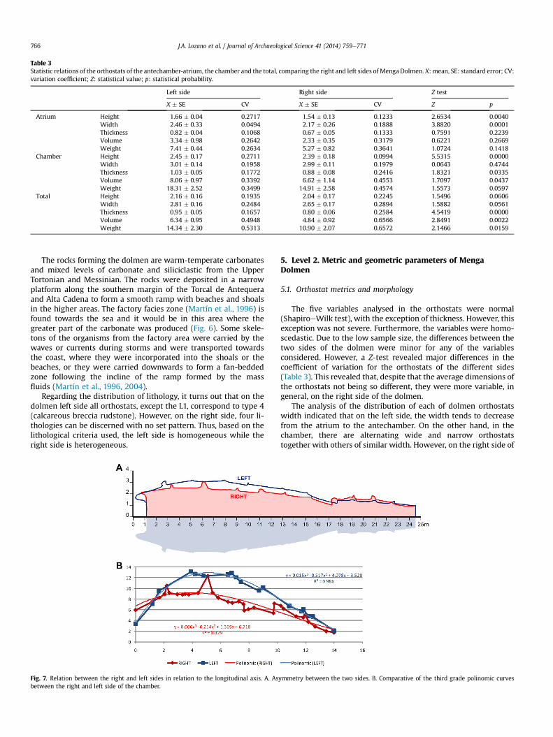
Table 3Statistic relations of the orthostats of the antechamber-atrium, the chamber and the total, comparing the right and left sides of Menga Dolmen. X: mean, SE: standard error; CV:variation coefficient; Z: statistical value; p: statistical probability.
Left side Right side Z test
X � SE CV X � SE CV Z p
Atrium Height 1.66 � 0.04 0.2717 1.54 � 0.13 0.1233 2.6534 0.0040Width 2.46 � 0.33 0.0494 2.17 � 0.26 0.1888 3.8820 0.0001Thickness 0.82 � 0.04 0.1068 0.67 � 0.05 0.1333 0.7591 0.2239Volume 3.34 � 0.98 0.2642 2.33 � 0.35 0.3179 0.6221 0.2669Weight 7.41 � 0.44 0.2634 5.27 � 0.82 0.3641 1.0724 0.1418
Chamber Height 2.45 � 0.17 0.2711 2.39 � 0.18 0.0994 5.5315 0.0000Width 3.01 � 0.14 0.1958 2.99 � 0.11 0.1979 0.0643 0.4744Thickness 1.03 � 0.05 0.1772 0.88 � 0.08 0.2416 1.8321 0.0335Volume 8.06 � 0.97 0.3392 6.62 � 1.14 0.4553 1.7097 0.0437Weight 18.31 � 2.52 0.3499 14.91 � 2.58 0.4574 1.5573 0.0597
Total Height 2.16 � 0.16 0.1935 2.04 � 0.17 0.2245 1.5496 0.0606Width 2.81 � 0.16 0.2484 2.65 � 0.17 0.2894 1.5882 0.0561Thickness 0.95 � 0.05 0.1657 0.80 � 0.06 0.2584 4.5419 0.0000Volume 6.34 � 0.95 0.4948 4.84 � 0.92 0.6566 2.8491 0.0022Weight 14.34 � 2.30 0.5313 10.90 � 2.07 0.6572 2.1466 0.0159
J.A. Lozano et al. / Journal of Archaeological Science 41 (2014) 759e771766
The rocks forming the dolmen are warm-temperate carbonatesand mixed levels of carbonate and siliciclastic from the UpperTortonian and Messinian. The rocks were deposited in a narrowplatform along the southern margin of the Torcal de Antequeraand Alta Cadena to form a smooth ramp with beaches and shoalsin the higher areas. The factory facies zone (Martín et al., 1996) isfound towards the sea and it would be in this area where thegreater part of the carbonate was produced (Fig. 6). Some skele-tons of the organisms from the factory area were carried by thewaves or currents during storms and were transported towardsthe coast, where they were incorporated into the shoals or thebeaches, or they were carried downwards to form a fan-beddedzone following the incline of the ramp formed by the massfluids (Martín et al., 1996, 2004).
Regarding the distribution of lithology, it turns out that on thedolmen left side all orthostats, except the L1, correspond to type 4(calcareous breccia rudstone). However, on the right side, four li-thologies can be discerned with no set pattern. Thus, based on thelithological criteria used, the left side is homogeneous while theright side is heterogeneous.
Fig. 7. Relation between the right and left sides in relation to the longitudinal axis. A. Asbetween the right and left side of the chamber.
5. Level 2. Metric and geometric parameters of MengaDolmen
5.1. Orthostat metrics and morphology
The five variables analysed in the orthostats were normal(ShapiroeWilk test), with the exception of thickness. However, thisexception was not severe. Furthermore, the variables were homo-scedastic. Due to the low sample size, the differences between thetwo sides of the dolmen were minor for any of the variablesconsidered. However, a Z-test revealed major differences in thecoefficient of variation for the orthostats of the different sides(Table 3). This revealed that, despite that the average dimensions ofthe orthostats not being so different, they were more variable, ingeneral, on the right side of the dolmen.
The analysis of the distribution of each of dolmen orthostatswidth indicated that on the left side, the width tends to decreasefrom the atrium to the antechamber. On the other hand, in thechamber, there are alternating wide and narrow orthostatstogether with others of similar width. However, on the right side of
ymmetry between the two sides. B. Comparative of the third grade polinomic curves

Fig. 8. Spacing between orthostats of the right and left sides.
J.A. Lozano et al. / Journal of Archaeological Science 41 (2014) 759e771 767
the dolmen, the atrium, and the antechamber, an alternatingpattern of wide and narrow orthostats appears, while in thechamber the widths of the orthostats vary randomly.
With respect to the thickness, neither side of the dolmen has adiscernible distribution pattern, even though the right side isclearly more heterogeneous than the left side (Fig. 7).
5.2. Spacing between orthostats
For the analysis of the spacing between orthostats, every jointbetween the upright stones was divided into five proportionalareas and each was then calculated. The analysis showed that onthe left side of the dolmen, the spacing between orthostats is highlyuniform, apart from two exceptions (Area 5 between R2 and R3between R5 and R6). These exceptions were caused by breakswhich occurred after the construction of the dolmen.
However, the right side has larger, more variable and morerepeated differences in the orthostat spacing, especially in area 1.The separations found between L9 and L10 are also due to subse-quent breaks in the uprights, and for this reason they should not betaken into account (Fig. 8).
Applying the Z-test, we found no statistically significant differ-ences despite the fact that the coefficients of variation proved
higher on the right side than on the left side (apart from the area 5)due to the anomalous spacing between orthostats L2 and L3, whichoccurred after the construction of the dolmen.
5.3. Curvature and distance to the main axis of the dolmen
The geometric distribution of the orthostats on the two sides ofthe chamber shows significant design differences with respect tothe axis of symmetry. From the curvatures that form the orthostatson each side of the chamber with respect to the main axis, thepolynomial equations that best fit each outline were calculated. Onthe left side, a third-degree curve was fitted with a tolerance of0.986 (perfect adjustment ¼ 1), while the right side showed atolerance of 0.829 (significantly lower; Fig. 9). This differenceshows how precisely designed the left side is with respect to theright. This feature can be observed in other large dolmens of thesouthern Iberian Peninsula.
6. Menga Dolmen orientation, other large-gallery southernIberian Peninsula dolmens and their astronomic implications
Geoarchaeological and metric analysis of the Menga Dolmenshows a clear intention for the dolmen to be asymmetrical with

Fig. 9. The largest gallery dolmens from the South of the Iberian Peninsula according to their summer equinox orientation. In yellow, the light at the moment of the solstice orequinox; in grey shades, the gloom generated inside; in black, the shadow. (For interpretation of the references to colour in this figure legend, the reader is referred to the webversion of this article.)
J.A. Lozano et al. / Journal of Archaeological Science 41 (2014) 759e771768
respect to the civil engineering most outstanding architectonicdesignmain axis. In other large-gallery dolmens in the same region,we find identical structural characteristics in terms of the highercurve on the left side of the chamber and the heterogeneity on the
Fig. 10. Elevation of Menga Dolmen with AutoCAD at the moment of summer solstice.To represent all possible, we have simulated the fourth pillar disappeared today.
right side (e.g. Pozuelo 4, Alberite, and Soto; Hoskin et al., 1994;Hoskin, 2001, 2002, 2008, 2009; González García and Belmonte,2010).
This characteristic of large-gallery Iberian dolmens appears to berelated to their astronomic orientation (Fig 10). As other authorshave already demonstrated, statistically the dolmens of the IberianPeninsulawere and are in theirmajority oriented to the east (Hoskinet al., 1994; Hoskin, 2001, 2002, 2008, 2009; González García andBelmonte, 2010). Likewise, the large dolmens studied here have apreferential orientation towards sunrise in the summer solstice(Menga and Alberite) or in the equinoxes (Soto and El Pozuelo 4). Itcan be considered that the asymmetry of the chamber laterals arerelated to the light, semi-darkness, and shadows generated whenthe sun rises and sunlight enters the chamber. Therefore,making theleft side more curved than the right means that semi-darkness andshadowsoccur on this side of the dolmen.As for the other side, beingless curved, the illumination is more even.
The dolmens of Pozuelo 4, Alberite, and Soto, are almostperfectly aligned with the sunrise. There are orthostats transversalto the dolmen axis to prevent the sunlight from coming directlyinto contact with the left side of the chamber. These screens or dark

J.A. Lozano et al. / Journal of Archaeological Science 41 (2014) 759e771 769
orthostats (dark slabs) allow dark spaces to be generated on themore curved left side.
The particularity of the orientation of the Menga Dolmenorientation is that, given the anthropomorphic profile of the Peña
Fig. 11. A. Digital terrain map with the location of the Menga Dolmen (position 1) and its oshow the direction of the sun at the sunrise on the summer solstice. The yellow hues on thede los Enamorados can be seen. The squared web in red, would include all the possible areasPosition 2 (and any other point on this yellow line that is within the red squared web) consiEnamorados and the summer solstice. Position 3 (and any other point on this yellow line thabe orientated to the Peña de los Enamorados, but in this case the only lit part is the left (orLighting inside the dolmen in the ideal position (position 2) (orientated to the Peña de los Esides of the ideal position. C. Neolithic sherds with carved suns motif, from the Pobladointerpretation of the references to colour in this figure legend, the reader is referred to the
de los Enamorados (resembling a gargantuan recumbent humanhead). In fact, many experts have repeatedly contended that itsorientation was designed taking into consideration the mountainPeña de los Enamorados, which has an imposing silhouette that
rientation to the Peña de los Enamorados, represented by a blue line. The yellow linesterrain are the sunlit areas at that time. The red hues are the areas fromwhich the Peñawhere the dolmen could have been placed, orientated to the Peña de los Enamorados.
st of the place or places where the dolmen would be orientated to both the Peña de lost is within the red squared web) consist of the place or places where the dolmen wouldperfect) side of the dolmen. This side is dark in the rest of the large gallery dolmens. B.namorados and the summer solstice) and in each of the symmetrical positions on bothde Campos de Cuevas de Almanzora, Almería (Martín Socas et al., 1982, 1986). (Forweb version of this article.)

J.A. Lozano et al. / Journal of Archaeological Science 41 (2014) 759e771770
stands out over the landscape (García-Sanjuán and Wheatley,2009, 2010). From a geometric point of view, a straight line canbe drawn from many different locations towards the Peña de losEnamorados, but only from some very specific locations are thelight and shadow effects appreciable in the dolmen. As shown inFig. 11(a and b), for position 3, the shadow would be cast onto theright side, breaking the pattern of all major dolmens in thesouthern Iberian Peninsula. Meanwhile, position 2 would require adark orthostat on the left side in order to cast this side in shadow.Finally, position 1 allows a precise orientation to the Peña de losEnamorados and the left side remains in shadow without any darkorthostats. With this orientation, 15� north at sunrise on thesummer solstice, the sunrays shine inside the chamber only ontohalf of the 18 orthostats on the right side of the structure. At thismoment, the contrast between the light, the semi-darkness andthe shadow generated by the design of the dolmen is analogous tothat of the other three dolmens, but in this case there is no need ofany traversal orthostats (Figs. 10 and 11). In addition, this geo-metric contention is not inconsistent with the cult of the sun,which is a common characteristic in the cultures of the time, asdemonstrated by the sun motifs in ceramics from Recent Prehis-tory found in southern Iberian Peninsula sites (i.e., Carrasco et al.,1982) (Fig. 11C).Therefore, this design appears to be a deliberatedecision, implying detailed knowledge of the annual cycles of thesun.
7. Conclusions
The megalithic structure of Menga Dolmen presents uniquearchitectonic characteristics in terms of its size, weight, volume,and lithology, all of which make it into one of the most importantcivil engineering and architectural works of European Prehistory.
However, this monumentality was designed using an irregulargeometry reflected in theweights, lengths, volumes, and lithologiesused on both sides of the longitudinal axis that divide the dolmenin two halves from the entrance to the back. The left side of thechamber can be considered uniform in all these characteristics,while the right side is not. Moreover, the geometric precision isgreater on the left side than on the right, the former almostperfectly fitting a third-degree polynomial curve. This does notappear to have happened by chance, since, when the dolmen wasconstructed, cultural factors influenced the design and led to thiscontrast in precision between the lineal geometry of the left sideand the fractality of the right side.
This cultural factor can be found not only in Menga Dolmen, butalso the other aforementioned large dolmens of the southern Ibe-rian Peninsula, such as Pozuelo 4, Alberite, and Soto, all of whichhave similar geometric patterns. Pozuelo is precisely oriented to thesummer solstice as are Alberite and Soto to the equinox. However,Menga Dolmen is slightly shifted with respect to the summer sol-stice. The location of Menga Dolmen can be explained both by itsorientation towards the Peña de Los Enamorados as well as itsorientation to sunrise during the summer solstice, as demonstratedby the intentionality of the shadows generated on the left side. Theabsence of dark orthostats in Menga Dolmen demonstrates the fullknowledge of the annual cycle of the sun and a profound symbolicsense of illumination of the chamber at sunrise in the summersolstice. This symbolic sense is repeated in Pozuelo 4, Alberite, andSoto.
These patterns, repeated in the four considered dolmens,demonstrates that both the dolmen geometry as well as theirorientation can be explained by a common cultural factor in whichthe imperfect right side is related to an uneven refraction of thelight, while the precise left side is related to an even distribution ofthe darkness.
Acknowledgements
Wewould like to thank Dr. José A. Esquivel and Dr. José A. Hódarfor their guidance on archaeological geometry. The authors alsosincerely thank the staff of the Conjunto Arqueológico de los Dól-menes de Antequera (CADA) for the facilities, information, C14 dates,and graphic support they have given to make this article possible.Also, we thank Dr. L. García-Sanjuán for his reading and comments,which have improved this paper and VickyWade for improving theEnglish version. Last, but not least, we would like also to thank thecompany Estudios Geológicos y Medioambientales S.L. (EGM) formaking all their resources available.
This study is part of the General Research Project: Societies,Territories and Landscapes in the Prehistory of Antequera (2012e2017), supported by the Regional Government of Andalusia.
References
Aguayo, P., García-Sanjuán, L., 2002. The megalithic phenomenon in Andalusia(Spain): an overview. In: Proceedings of the Colloquium Origin and Develop-ment of the Megalithic Phenomenon in Western Europe. Bougon, Francia,October 26the30th 2002, pp. 451e476.
Aguayo, P., Puga, E., Lozano, J.A., García Gonzalez, D., Carrión Méndez, F., 2004.Caracterización de fuentes de materias primas para la elaboración de herra-mientas de silimanita, de los yacimientos de la Depresión de Ronda, Durante laPrehistoria Reciente. In: Martínez Fernández, G., Morgado, A., Afonso Marrero,J.A. (Coords.), Sociedades Prehistóricas, recursos abióticos y territorio. Actas dela III Reunión de trabajo sobre aprovisionamiento de recursos abióticos en laPrehistoria, Granada, pp. 249e277.
Braga, J.C., Martín, J.M., Wood, J.L., 2001. Submarine lobes and feeder channelsof redeposited, temperate carbonate and mixed silicilastic-carbonate plat-form deposits (Vera Basin, Almería, southern Spain). Sedimentology 48,99e116.
Cabrero, R., 1988. El Fenómeno Megalítico en Andalucía Occidental. Phthesis. Uni-versidad de Sevilla, Sevilla.
Calter, P., 2000. Facade measurement by trigonometry. In: Gorini, C.A. (Ed.), Ge-ometry at Work. Papers in Applied Geometry, MAA 53. Mathematical Associ-ation of America, Washington, pp. 20e25.
Carrasco, J., Toro, I., Medina, J., Carrasco, E., Pachón, J.A., Castañeda, P., 1982. Laspinturas rupestres del Cerro del Piorno (Pinos Puente, Granada). Cuadernos deprehistoria y arqueología de la Universidad de Granada 7, 113e170.
Cruz-Auñón, R., 1984. Ensayo tipológico para los sepulcros eneolíticos andaluces.Pyrenae 19e20.
Dunham, R.J., 1962. Classification of carbonate rocks according to depositionaltexture. In: Ham, W.E. (Ed.), Classification of Carbonate Rocks, Am. Assoc. Pe-troleum Geologists Mem., vol. 1, pp. 108e121.
Escalante Jiménez, J., Fernández Paradas, M., 2003. Las historias de Antequera: unaaproximación a los orígenes de la historiografía antequerana (siglos XVIeXVII).Baetica 25, 683e696.
Esquivel, J.A., 2008. Metric and geometric methods applied to the analysis ofarchitectural design: urbanism changes and the emergence of mathematicalthinking. In: Suárez, A.R., Vásquez, M.N. (Eds.), Archaeology Research Trends.Nova Science Publishers, New York, pp. 101e120.
Espinosa Gaitán, J., 1998. Estudio petrográfico de los materiales de los Dólmenes deAntequera. PH, Boletín del Instituto Andaluz del Patrimonio Histórico 25, 80e88.
Ferrer, J.E., 1982. Consideraciones generales sobre el megalitismo en Andalucía.Baetica 5, 121e132.
Ferrer, J.E., 1987. El megalitismo en Andalucía Central. In: El megalitismo en laPenínsula Ibérica. Ministerio de Cultura, Subdirección General de Arqueología yEtnología, Madrid, pp. 9e29.
Ferrer, J.E., 1995. Aproximación al estudio actual de la investigación sobre el meg-alitismo en Andalucía. Trabajos de Antropología e Etnología 35 (1), 71e80.
Ferrer, J.E., 2003. El megalitismo en el sur de la Península Ibérica. Pliocénica 3, 228e235.
Ferrer, J.E., Marqués, I., 1993. Informe de las actuaciones realizadas en la necrópolismegalítica de Antequera (Málaga) durante 1991. In: Anuario Arqueológico deAndalucía, 1991, vol. III, pp. 358e360.
Ferrer, J.E., Marqués, I., Bardomero, A., Aguado, T., 2004. Estructuras tumu-lares y procesos de construcción en los sepulcros megalíticos de la pro-vincia de Málaga: la necrópolis megalítica de Antequera. Mainake 26,177e210.
García-Sanjuán, L., Lozano, J.A., 2014. Menga. Biografía de un monumento mega-lítico excepcional. In: GarcíaSanjuán, L. (Ed.), Antequera Milenaria, Historia deuna Tierra. La Prehistoria, vol. I. Real Academia de Nobles Artes de Antequera,Antequera (in press).
García-Sanjuán, L., Ruíz González, B., 2009. Las grandes piedras de la Prehistoria.Sitios y paisajes megalíticos de Andalucía. Junta de Andalucía, Sevilla.

J.A. Lozano et al. / Journal of Archaeological Science 41 (2014) 759e771 771
García-Sanjuán, L., Wheatley, D., 2009. El marco territorial de los dólmenes deAntequera: valoración preliminar de las primeras investigaciones. In: RuizGonzález, B. (Ed.), Dólmenes de Antequera. Tutela y Valoración Hoy. Junta deAndalucía, Sevilla, pp. 112e127.
García-Sanjuán, L., Wheatley, D., 2010. Natural substances, landscape forms, sym-bols and funerary monuments: elements of cultural memory among theNeolithic and Copper Age societies of Southern Spain. In: Lillios, K., Tsamis, V.(Eds.), Material Mnemonics. Everyday Memory in Prehistoric Europe. OxbowBooks, Oxford, pp. 10e39.
González García, A.C., Belmonte, J.A., 2010. Statistical analysis of megalithic tomborientations in the Iberian Peninsula and neighbouring regions. J. Hist. Astron.41 (2), 225e238.
Hardaker, C., 2001. The archaeology of geometry: great kiva design in Chaco canyon.In: Presented in the Bridges: Mathematical Connections in Art, Music, andScience Conference, July, pp. 27e29.
Hoskin, M., Allan, E., Gralewski, R., 1994. Studies in Iberian archaeoastronomy: (1)orientations of the megalithic Sepulchres of Almería, Granada and Málaga.J. Hist. Astron. Archaeoastronomy Suppl. 25, S55.
Hoskin, M., 2001. Studies in Iberian archaeoastronomy 8: orientations of mega-lithic and tholos tombs of Portugal and southwest Spain. J. Hist. Astron. 32,S45eS64.
Hoskin, M., 2002. Studies in Iberian archaeoastronomy 9: an overview. J. Hist.Astron. 33, S75eS82.
Hoskin, M., 2008. Orientations of dolmens of Western Europe: summary and con-clusions. J. Hist. Astron. 39 (4), 507e514.
Hoskin, M., 2009. Orientations of dolmen of Western Europe. Complutum 20 (2),165e175.
Leisner, G., Leisner, V., 1943. Die Megalithgraber der lberischen Halbinsel: ErsterTeil: Der Süden. Verlag von Walter de Gruyter & Co, Berlín.
Lozano, J.A., Morgado, A., Puga, E., Martín-Algarra, A., 2010. Explotaciones del Sílextipo “Turón” (Málaga, España). Localización y caracterización petrológica ygeoquímica. Geogaceta 48, 163e166.
Martín, J.M., Braga, J.C., Christian, B., Brachert, T., 1996. Sedimentary model andhigh-frequency cylicity in a Mediterranean, shallow-shelf, temperate-carbonateenvironment (uppermost Miocene, Agua Amarga Basin, Southern Spain).Sedimentology 43, 263e277.
Martín, J.M., Braga, J.C., Aguirre, J., Betzler, C., 2004. Contrasting models oftemperate carbonate sedimentation in a small Mediterranean embayment: thePliocene Carboneras Basin, SE Spain. J. Geol. Soc. Lond. 161, 387e399.
Martín Socas, D., Cámalich Massieu, M.D., 1982. La cerámica simbólica y suproblemática. In: Aproximación a través de los materiales de la Colección L.Siret, vol. VII. Cuadernos de Prehistoria de la Universidad de Granada,pp. 262e306.
Martín Socas, D., Camalich Massieu, M.D., González Quintero, P., MenesesFernández, M.D., Mederos Martín, A., 1986. El poblado de Campos (Cuevas delAlmanzora, Almería). In: Resultado de las campañas de excavación de 1985 y1986, vol. VI. Tabona, pp. 37e55.
Martín Andrés, A., Luna del Castillo, J.D., 2004. Bioestadística para las ciencias de laSalud. Capitel Ediciones, 672 pp.
Martín-Algarra, A., 1987. Evolución geológica alpina del contacto entre las ZonasInternas y las Zonas Externas de la Cordillera Bética. Unpublished thesis. Uni-versity of Granada, Granada.
Morgado, A., Lozano, J.A., 2011a. The impact of geological factors on flint mining andlarge blade production in the Betic Cordillera (Spain, 4the3rd mill. BC). In:Capote, M., Consuegra, S., Díaz-del-Río, P., Terradas, X. (Eds.), Proceedings of the2nd International Conference of the UISPP Commission on Flint Mining in Pre-and Protohistoric Times, British Archaeological Reports, International Series2260, Oxford, pp. 183e191.
Morgado, A., Lozano, J.A., 2011b. The prehistoric exploitation of rocky outcrops inthe eastern sector ophitic Trías de Antequera (Spain). A natural and culturalheritage to value and protect. In: I Congreso Internacional. El patrimonio Cul-tural y Natural como motor de desarrollo: Investigación e innovación.
Morgado, A., Roncal, E., 2009. Los últimos talladores de sílex. Fundación de estudiosy cooperación cultural ibn-al Jatib, Granada.
Morgado, A., Lozano, J.A., Pelegrin, J., 2011. The prehistoric flint exploitations of themilanos formation (Granada, Spain). Menga, J. Andalusian Prehistory 2, 135e155 and 261e269.
Pérez-Valera, F., Lozano, J.A., Pérez-Valera, L.A., 2011. On the origin of the meta-morphic exotic blocks located in the “Trías de Antequera” (S Spain). In: Sixièmereunion du Groupe Marocain du Permien et du Trias, Tetouan, Abstract book,pp. 36e37.
Pomar, L., Hallock, P., 2008. Carbonate factories: a conundrum in sedimentary ge-ology. Earth Sci. Rev. 87, 134e169.
Ramos Muñoz, J., Giles, F., 1996. El Dolmen de Alberite (Villamartín). Aportaciones alas formas económicas y sociales de las comunidades neolíticas en el norte deCádiz. Universidad de Cádiz, Cádiz.
Rodríguez-Tovar, F.J., Morgado, A., Lozano, J.A., 2010a. Using ichnofossils to char-acterize chert tools: a preliminary study from southern Iberia. Geoarchaeology25, 514e526.
Rodríguez-Tovar, F.J., Morgado, A., Lozano, J.A., 2010b. Ichnological analysis: a no-destructive tool in archaeology. Lethaia 43, 587e590.
Rodríguez-Vinceiro, F.J., Fernández Rodríguez, L.E., 1998. La explotación de recursosmineralógicos cupríferos durante la Prehistoria Reciente en el Bético de Málaga.In: Bernabeu, J., Orozco, T., Terradas, X. (Eds.), Los recursos abióticos en laPrehistoria. Caracterización, aprovisionamiento e intercambio. Universidad deValencia, Valencia, pp. 155e171.
Sánchez-Cuenca López, J., 2012. Menga in the 19th century. “The most beautiful andperfect of the known dolmens”. Menga: J. Andalusian Prehistory. Monograph n�
2. Consejería de Cultura, Junta de Andalucía, Seville, pp. 1e146.Sanz de Galdeano, C., Lozano, J.A., Puga Rodríguez, E., 2008. El Trías de Antequera:
Origen, estructura y posible significado. Revista de la Sociedad Geológica deEspaña 21 (3e4), 111e124.
Serrano, F., 1979. Los foraminíferos planctónicos del Mioceno Superior de la Cuencade Ronda y su comparación con los de otras áreas de la Cordillera Bética. Un-published thesis. University of Málaga, Málaga.
Wheatley, D., García Sanjuán, L., Murrieta Flores, P., Márquez Pérez, J., 2010. Themegalithic phenomenon in Southern Spain: approaching the landscapedimension. Oxford J. Archaeol. 29 (4), 387e405.
Copyright © 2022 FDOKUMEN