Developments in Geoarchaeological Research ... - HAL-SHS
22
HAL Id: halshs-03616455 https://halshs.archives-ouvertes.fr/halshs-03616455 Submitted on 30 Mar 2022 HAL is a multi-disciplinary open access archive for the deposit and dissemination of sci- entific research documents, whether they are pub- lished or not. The documents may come from teaching and research institutions in France or abroad, or from public or private research centers. L’archive ouverte pluridisciplinaire HAL, est destinée au dépôt et à la diffusion de documents scientifiques de niveau recherche, publiés ou non, émanant des établissements d’enseignement et de recherche français ou étrangers, des laboratoires publics ou privés. Developments in Geoarchaeological Research, Methodologies and Applications in Harbour Maritime Archaeology Jean-Philippe Goiran, Winnie May Chan, Christophe Benech, Quentin Vitale Vitale, Nicholas Riddick, Hugo Delile, Ferréol Salomon, Stoil Chapkanski, Christine Oberlin, Gilles y. Brocard, et al. To cite this version: Jean-Philippe Goiran, Winnie May Chan, Christophe Benech, Quentin Vitale Vitale, Nicholas Riddick, et al.. Developments in Geoarchaeological Research, Methodologies and Applications in Harbour Maritime Archaeology. Preiser-Kapeller, Johannes; Kolias, Taxiarchis G.; Daim, Falko. Seasides of Byzantium: Harbours and Anchorages of a Mediterranean Empire, Band 21, Propylaeum, pp.109-129, 2022, Byzanz zwischen Orient und Okzident, 10.11588/propylaeum.910.c12051. halshs-03616455
-
Upload
khangminh22 -
Category
Documents
-
view
3 -
download
0
Transcript of Developments in Geoarchaeological Research ... - HAL-SHS

HAL Id: halshs-03616455https://halshs.archives-ouvertes.fr/halshs-03616455
Submitted on 30 Mar 2022
HAL is a multi-disciplinary open accessarchive for the deposit and dissemination of sci-entific research documents, whether they are pub-lished or not. The documents may come fromteaching and research institutions in France orabroad, or from public or private research centers.
L’archive ouverte pluridisciplinaire HAL, estdestinée au dépôt et à la diffusion de documentsscientifiques de niveau recherche, publiés ou non,émanant des établissements d’enseignement et derecherche français ou étrangers, des laboratoirespublics ou privés.
Developments in Geoarchaeological Research,Methodologies and Applications in Harbour Maritime
ArchaeologyJean-Philippe Goiran, Winnie May Chan, Christophe Benech, Quentin Vitale
Vitale, Nicholas Riddick, Hugo Delile, Ferréol Salomon, Stoil Chapkanski,Christine Oberlin, Gilles y. Brocard, et al.
To cite this version:Jean-Philippe Goiran, Winnie May Chan, Christophe Benech, Quentin Vitale Vitale, Nicholas Riddick,et al.. Developments in Geoarchaeological Research, Methodologies and Applications in HarbourMaritime Archaeology. Preiser-Kapeller, Johannes; Kolias, Taxiarchis G.; Daim, Falko. Seasides ofByzantium: Harbours and Anchorages of a Mediterranean Empire, Band 21, Propylaeum, pp.109-129,2022, Byzanz zwischen Orient und Okzident, �10.11588/propylaeum.910.c12051�. �halshs-03616455�

109Developments in Geoarchaeological Research Methodologies | Jean-Philippe Goiran et al.
Overview
Geoarchaeology or archaeology geology 1 applies integra-tive concepts and methodologies from geosciences (e. g. geophysics, sedimentology, geomorphology, and pedology) to address archaeological questions. The objectives of ge-oarchaeological projects may include the reconstruction of an ancient landscape and / or environment, the dating of materials to establish a chronology, and determining site formation and the provenance of artefacts. Achieving these objects can provide insight into how a social group lived and how they responded to environmental changes. For example, geoscientific data may help archaeologists understand why Group X settled in Region Y or determine whether climate change caused or contributed to the demise of Group Z. Geoarchaeological applications were first introduced in the 19th century by Scottish geologist Sir Charles Lyell (1797-1875) in his book Geologic Evidences of the Antiquity Man, originally published in 1863, where he applied stratigraphic laws to understand the formation of Prehistoric sites 2. Tech-nological advancements during the 20th and 21st centuries led to improvements in field and lab techniques as well as new analytical equipment, such as high-resolution XRF core scan-ners 3 and Geographical Information Systems (GIS). As a result, geoarchaeological research is now being conducted all over the world in terrestrial, coastal, and aquatic environments.
Ancient Harbour Geoarchaeology
Maritime archaeology focuses on understanding the inter-action between ancient societies and the sea using material and cultural remains including, shipwrecks, harbour basins, and submerged infrastructure 4. The development of self-con-tained underwater breathing apparatus (SCUBA) during the
1900s allowed marine archaeologists to access the under-water world, and lead to major discoveries (e. g. the lost city of Heracleion in Egypt) 5. This development has also helped Earth scientists to better interpret the importance of sea level change and its impact on ancient coastal societies 6.
The integration of geoscientific methods in maritime ar-chaeology expanded in the 1980s around the Mediterranean, with reconstructing harbour basins being popular today 7. For example, Reinhardt et al. 8 and Goiran and Morhange 9 revolutionized Mediterranean maritime archaeology by ap-plying high resolution time-series sedimentary data, micro-pale ontology, and geochemistry to understand the environ-mental and anthropogenic influences that eventually led to the abandonment and destruction of ancient Mediterranean harbour cities. Reconstructing the functionality of ports and harbours is another important aspect of ancient harbour geoarchaeology.
Goiran et al. developed a model from sediment archives from Alexandria (Egypt), Avaris (Egypt), and Portus (Italy), to define the different types of harbours (fig. 1) 10. This model can be used to identify the type of harbour (i. e. protected, or semi-protected), the foundation and / or termination of the harbour, and it may also provide an overview of how the harbour was used when it was active (i. e., the type of boats that would enter, etc.). This model is divided into three units: (I) pre- limenic, (II) limenic, and (III) meta-limenic. The pre-li-menic unit, or pre-harbour phase, represents the deposi-tional environment before the construction of the harbour. This unit is important for revealing how harbour basins were initially excavated 11. For instance, pre-limenic and limenic units in stratigraphic continuity indicate that the basin was deep enough to support boats and that dredging was not required for harbour construction. The limenic unit contains harbour sediments when it was fully operational. The type of sediment found in this unit varies depending on the qual-
Jean-Philippe Goiran · Winnie May Chan · Christophe Benech · Quentin Vitale · Nicholas Riddick · Hugo Delile Ferréol Salomon · Stoil Chapkanski · Christine Oberlin · Gilles Brocard · Agathe Lisé-Pronovost · Cécile Vittori
Developments in Geoarchaeological Research, Methodologies and Applications in Harbour Maritime Archaeology
1 Hassan, Geoarchaeology: The Geologist and Archaeology 267.2 Pollard, Geoarchaeology: an introduction 8.3 Delile et al., the contribution of geochemistry to ancient harbour geoarchaeology
171.4 Gibbins / Adams, Shipwrecks and maritime archaeology 279.5 Goddio, Topography and Excavation of Heracleion-Thonis and East Canopus.
6 Benjamin et al., Late Quaternary sea-level changes and early human societies 42-45.
7 Raban, Harbour Archaeology. 8 Reinhardt et al., Caesarea Maritima. 9 Goiran / Morhange, Géoarchéologie.10 Goiran et al., The Geoarchaeology of ancient Mediterranean Harbours.11 Goiran et al., The Geoarchaeology of ancient Mediterranean Harbours 292.
In: Johannes Preiser-Kapeller · Taxiarchis G. Kolias · Falko Daim (eds), Seasides of Byzantium. Harbours and Anchorages of a Mediterranean Empire. Byzanz zwischen Orient und Okzident 21 (Mainz 2021). DOI: https://doi.org/10.11588/propylaeum.910.c12051

Developments in Geoarchaeological Research Methodologies | Jean-Philippe Goiran et al.110
also the deepest point of harbour dredging in the basin. The latter means the initial foundation level has been destroyed by several dredging phase(s). The mesolimenic limit, or the harbour bottom, is the boundary between the ancient har-bour deposits (i. e., the volume of sediment accumulated in the basin) and the water volume in the basin. It represents the upper part of sediment accumulation in the basin while the harbour was active. When the mesolimenic is closed (or reaches) the sea level, it implies that the harbour basin is infilled and near abandonment. For example, progressive abandonment is evident when there is a gradational change in facies between the limenic and meta-limenic units. A stratigraphical sharp contact implies that the abandonment process was quick (i. e., from floods, storm activity, destruc-tion, etc.). In a stable tectonic context, the ancient biological sea level is determined using the highest measured fixed infralittoral marine fauna found on harbour quays 13. The height of the water column (or referred to as accommo-dation space in geology) can be determined by comparing the depth of the mesolimenic limit and the biological sea level. This is useful for determining the precise depth of the harbour and can be used to construct a bathymetric profile of the basin. Once the depth of harbour is known, archae-ologists can also determine which boats had access to the quay by comparing the calculated basin depth with known ancient ship draughts 14.
ity of harbour infrastructure (i. e., whether the artificial basin is protected or semi-protected from marine or fluvial influ-ence). A well-protected harbour, for example, will have a limenic unit containing silt and clay sediments which is char-acteristic of a confined low energy environment. A sandy limenic unit indicates an open harbour basin or an entrance of the harbour 12. This unit may also reveal one or several dredging phases which is important for understanding how these harbours respond to various depositional environ-ments. It also helps researchers understand how ancient societies maintained the basin while the harbour was in function as the economical / trade heart of a coastal city. The meta-limenic unit, or the inactive / post harbour phase, is often identified by a sharp contact with the limenic unit. The meta-limenic facies contains coarser sediments (e. g. similar to exposed beach or dune environments) or fine-grained silt sediment due to fluvial floods and / or deltaic progradation. Analysing this unit can determine the cause of abandonment of the harbour (i. e., whether the causes were natural or anthropogenic). Furthermore, these harbour units are di-vided by three limits (or boundaries): (I) katolimenic, (II) me-so limenic, and (III) biological sea level.
The katolimenic limit is the contact between the pre-li-menic and limenic units. It is the initial limit of the harbour basin construction (i. e., the initial digging of the basin). The katolimenic unit can therefore be the foundation level or
12 Goiran et al., Paleoreconstruction of ancient harbours of Rome 3-13.13 Goiran et al., Découverte d’un niveau marin biologique 61. – Salomon et al.,
The Development and Characteristics of Ancient Harbours 7. – Vacchi et al., Multiproxy assessment of Holocene relative sea-level 177.
14 Goiran et al., High chrono-stratigraphical resolution of the harbour sequence 68-84.
Fig. 1 Modified version of the Active Harbour Basin model originally pub-lished in Goiran and Morhange (2003), showing a typical sequence stratigra-phy from a core sample.

111Developments in Geoarchaeological Research Methodologies | Jean-Philippe Goiran et al.
Geophysics
Site surveying is often conducted using advanced geophysi-cal methods for excavation purposes and to understand the geomorphological characteristics of a region. This involves mapping the archaeological site and identifying landscape changes. The significant development of technology in the last 20 years has made it possible to integrate geophysical methods into the geoarchaeological exploration of ancient harbours.
Geophysical methods and tools used to conduct both archaeological and environmental research depend on the type of landscape and the scale of the study area. The first step to an archaeological excavation on an ancient harbour is to conduct a geophysical survey to detect structures related to the harbour activities, such as quays and storage spaces, and to understand the context behind port infrastructures to its adjacent city. This includes understanding and identifying areas of access (i. e., traffic lanes) and / or locating site forti-fications. Geophysical surveys may also lead to the discovery of new neighbourhoods and the development of urban land-scapes. The technology required to conduct these surveys must be quick and detailed, as the study areas are typically thousands of square kilometres in size 20. Although various methods are used to detect infrastructures, magnetic surveys are considered the most suitable method for a wide range of possible structures and building materials, with a reasonable survey depth up to 2 m.
The electrical methods are used less often in coastal ge-oarchaeology because they are notably slower and more cumbersome to implement compared to systems that give results at a reasonable time 21. The ground penetrating ra-dar method (GPR) is a good alternative, as towed systems are used that considerably improve the performance of this instrument and allow a depth of investigation equivalent to the magnetic method or even higher, depending on the nature of the environment. However, it should be noted that the GPR is not suitable for use in environments where clay sediments are prevalent, which can be problematic in coastal areas. The penetration depth in such environments is no more than a few tens of centimetres, which in most cases is not sufficient to detect archaeological structures. Nonetheless, the GPR remains useful in an integrated approach with other geophysical data 22. Furthermore, there are only a few studies that use geophysical surveys and geomorphological drilling to understand the organisation of ancient harbours 23.
Geophysical methods provide additional information to contextualize the results of sediment cores and correlate them spatially to provide different scales. The magnetic method can
Methodologies in Geoarchaeological Research
Mapping and site surveying
The initial steps in geoarchaeological research involve site surveying and mapping for excavation purposes and the understanding of the geomorphological characteristics of the study area. This is often conducted using advanced geophysi-cal methods and spatial analysis tools such as Geographic In-formation Systems (GIS) and remote sensing. This section will summarize the technological developments of these methods and tools and how they are integrated into geoarchaeological research on ancient harbours.
GIS & Remote Sensing
Both GIS and remote sensing techniques are pivotal tools for spatial analysis in geoarchaeological research. Remote sensing techniques (e. g. aerial photography and satellite imagery) help researchers identify and monitor cultural and natural landscapes as well as reconstruct geomorphologi-cal changes over time 15. Advancements in remote sensing over the past few decades including Light Detection and Ranging (LiDAR) and Interferometric Synthetic Aperture Radar (IFSAR or InSAR) technologies provide higher resolution data and have the ability to detect archaeological structures that may be covered (e. g. by vegetation) 16. Furthermore, GIS is a computerized tool that is often used for site prospection, geo-statistics, and predictive modelling for geoarchaeological research. GIS models are used for determining research field strategies such as determining where to sample sediment cores) and for interpreting human behaviours influenced by the surrounding natural landscape by analysing the distribu-tion of cultural remains 17. Pourkerman et al., for example, created a model that monitors and tracks shoreline erosion in Siraf, an important port that served as one of the main hubs for trading goods (i. e., Chinese ceramics and silk) be-tween the Persian Gulf and Asia 18. This model enabled the re-searchers to localize where coastal erosions are occurring and determine the cause. These predictive models are produced through calculating, setting, and ranking various parameters based on scientific (e. g. paleo climate, geological, and hydro-logical data) and available historical literature describing past human behaviours. Another advantage to GIS is it is an effi-cient and cost-effective tool that can add significant value to geoarchaeological research especially when funding and / or accessibility of a region is an issue 19.
15 Holcomb / Shingiray, Imaging Radar 11.16 Maktav et al., Integration of remote sensing and GIS 1667.17 Nsanziyera et al., GIS and Remote Sensing Application 2-3.18 Pourkerman et al., Shoreline erosion. – Shen, The China-Abbasid Ceramics Trade.19 Nsanziyera et al., GIS and Remote Sensing Application 16.
20 Mozzi et al., The Roman City of Altinium 31-34.21 Campana / Dabas, Archaeological Impact Assessment 145-147.22 Neal / Roberts, Applications of ground-penetrating radar (GPR) 140-145.23 Marriner / Morhange, Geoscience of Ancient Marine Harbours 162-165.

Developments in Geoarchaeological Research Methodologies | Jean-Philippe Goiran et al.112
Sediment Core Analysis in Harbour Geoarchaeology
Sediment Analysis is important for (I) reconstructing the paleo environment and paleo climate to understand how the environment may have influenced the construction of a har-bour and (II) determining the foundation, dredging phases, and destruction / abandonment of an ancient port. Such anal-yses are carried out by taking surface samples or sediment cores. The research goals and the type of environment (i. e., deltaic, lacustrine, marine, etc.) determine the choice of cor-ing method: vibration, percussion, piston, and gravity cores, augers, and large coring rid. Coring devices are summarized in Table 1.
Once sediment cores are collected, various analyses are conducted, such as grain size, geochemistry, mineralogy, magnetic susceptibility, and micropaleo ntology. The exam-ination of bed-forms (e. g. ripples and dunes) and types of stratification is also used to determine the depositional envi-ronment. Sediment analyses helped geoarchaeologists recon-struct ancient harbours, such as identifying the foundation of the harbour (i. e., pre-limenic unit), how the basin was excavated (i. e., dredging phases) and used as identified in the limenic unit (fig. 1).
Micropaleo ntology
Micropaleo ntological analysis can be used for many applica-tions including biostratigraphy, paleo environmental recon-struction 33, paleo tempestology, tsunami / seismicity, pollution, and reservoir mapping. Reinhardt et al., for example, used micropaleo ntology (foraminifera) along with geochemical analysis (Sr isotopes) from sediment cores collected in Cae-sarea Maritima (Israel) to understand the harbour’s evolution from 1st c. BC to its destruction in 2nd c. AD 34. Microfauna is often used as a proxy for recording paleo climate and paleo-environmental changes because of their sensitivities to eco-logical changes. This section will focus on common groups of microfossils used in geoarchaeological research: I) Foraminif-era, II) Ostracods, (III) Diatoms, and (IV) Palynology.
Foraminifera Foraminifera (or forams for short) are single-celled proto-
zoans that produce their own tests (shells) through autoge-nous (i. e., secrete calcium carbonate) or xenogenous processes (i. e., agglutinating foreign detritus material) 35. Cal ca re ous
be useful for shallow / on surface formations, such as record-ing the evolution of banks or detection of paleo channels 24. For more detailed studies on stratigraphy, electrical resistivity to-mography (ERT) is the most widely used method. ERT provides large transects of vertical sections of the ground that can be directly correlated with the stratigraphic results obtained from sediment cores 25. Electromagnetic induction (EMI) measures both electrical conductivity and magnetic susceptibility. The former is useful for detecting paleo channels or the bounda-ries of ancient lagoons or coastlines 26. The latter detects the ferrimagnetic content in the top meter of the soil, which may be associated with human occupation and activities 27. The Portus project led by the British scholar Simon Keay (University of Southampton), used these methods to show interest in an interdisciplinary approach to integrate archaeology, geophys-ics, and geomorphology to reconstruct the organization and operation of the harbour from an archaeological and environ-mental perspective 28. Furthermore, geophysical methods can also provide insight into the evolution of harbours located in modern cities in a dense urban context.
Regarding an urban context, archaeological excavations can be achieved in the case of a temporary allotment (e. g. obtaining a permit from the government, private company, etc.) which can lead to complications in planning and ex-ecuting excavations. This means non-destructive tools are essential for understanding the complexities of these envi-ronments and their extensive history. Geophysical exploration will not be able to obtain the same degree of information as in a non-urbanized environment and locations are also subjected to modern urban constraints. The integrated ap-proach, however, remains an essential part of the study. It is essential to correlate findings to understand the exploration project. A »blind« prospection will lead to failure: a geo-physical prospection will be used to validate a preliminary hypothesis but will not provide meaning without using a multidisciplinary approach considering the complexities of the subsoil. From a methodological standpoint, it is the electro-static method 29 and GPR 30 that remain the two methods most adapted to the modern urban context. In an urban context, the depth of investigation of a geophysical method cannot be limited to the first meter and requires at least 2 m to detect surfaces undisturbed by modern occupation. The technical developments of electrostatic devices help with the range of methods that can work on the first 2 m 31. New electrostatic systems can reach a depth of 3 to 4 m: the resolution will as a result be lower, but such systems can detect larger structures including city walls 32.
24 Weston, Alluvium and Geophysical Prospection 266-270.25 Wunderlich et al., The river harbour of Ostia Antica 55-65.26 Verhegge et al., Preliminary results of an archaeological survey 166-168.27 Tabbagh, Electromagnetic Prospecting Method 186-190.28 Keay et al., The role of integrated geophysical survey methods 155-164.29 Tabbagh et al., Un outil de reconnaissance géophysique en milieu urbain 6-8.30 Conyers, Innovative ground-penetrating radar methods 139-140.31 Panissod et al., A novel mobile multipole system 983-984. – Panissod et al.,
Archaeological prospecting 240-242.
32 Benech et al., Revealing the topography of the Ancient Kition (Larnaka, Cyprus) 17-19.
33 van Hengstum et al., Thecamoebians (testate amoebae) and foraminifera 305-317. – Pilarczyk / Reinhardt, Testing foraminiferal taphonomy as a tsunami indi-cator 133-135.
34 Reinhardt et al., Caesarea Maritima.35 Scott et al., Monitoring in Coastal Environments 99.
113Developments in Geoarchaeological Research Methodologies | Jean-Philippe Goiran et al.
been proven to be a useful proxy for ancient harbour geoar-chaeology, beginning with Reinhardt et al. Study in Caesarea Maritima (Israel) 41. In a more recent study around the Medi-terranean, Seeliger et al. were able to use foraminifera con-cerning transgressive contact to reconstruct the Holocene sea level curve and determine the ancient sea level from the Bay of Elaia (Western Turkey), the home to Pergamum’s harbour dating to Hellenistic and Roman times 42.
Ostracods The ostracods (or ostracodes) are microcrustaceans that
are ubiquitous in marine and non-marine aquatic environ-ments (fig. 2, 1); additionally, there are some semi-terrestrial species 43. These organisms secrete a low-Mg calcium bivalved carapace typically 0.5 to 2.0 mm in size 44 and are well-pre-served in the sedimentological record 45. Ostracods are useful proxies commonly applied in ecological monitoring as well as in paleo environmental and paleo climate research 46. Similar to foraminifera, they are sensitive to variations in their biotope, such as changes in temperature, salinity, dissolved oxygen, hydrochemistry, water depth, substrate, and productivity 47. They are excellent bioindicators in brackish marginal marine environments 48, where they are more abundant and diversi-fied than foraminifera 49, and in freshwater ecosystems 50. The study of these microorganisms involves the analysis of the spe-cies assemblages of the samples, the population structure (i. e., age, sex, and valve ratio) of the species and the intraspecific morphological (i. e. size, shape, ornamentation) and chem-
foraminifera are either benthic or planktonic and are found in marine environments where the precipitation of calcium carbonate is possible 36. Those with agglutinated tests are found in marginal marine environments, such as estuaries and lagoons, where calcium carbonate production is limited. These microorganisms are typically collected from sediment cores and / or surface samples. They are later washed using a recommended 63 µm sieve to capture forams that are typi-cally 0.1 to 1.0 mm, but some species can grow >10 cm in size 37. Specimens can be observed and identified using a stereomicroscope with no less than 40× magnification and can be picked wet or dry onto a storage slide. Species assem-blages are identified based on test composition and its mor-phological structure including, the number of chambers, coiling, aperture, and ornamentation. Once processed, fora-minifera can be used for geochemical analysis and for quan-titative statistical analysis which commonly requires counting a minimum of 300 specimens per sample to calculate the relative fractional abundance of each species 38.
They are often used as proxies for monitoring or recon-structing ecological changes because of their sensitivity to environmental changes (e. g. pH, temperature, salinity, and dissolved oxygen), their preservation potential, and their abundance in the geological record (first in the early Cam-brian 39), as they are easy to collect and statistically analyse 40. For these reasons, micropaleo ntological analyses involving forams are commonly used in paleo environmental and pal-aeoceanographic (planktonic species) studies. They have also
36 Scott et al., Monitoring in Coastal Environments 3.37 Saraswati / Srinivasan, Micropaleontology 12-14. – Scott et al., Monitoring in
Coastal Environments 10-16.38 Patterson / Fishbein, Re-examination of the statistical method 245.39 Pawlowski et al., The evolution of early Foraminifera 11494-11498.40 Scott et al., Monitoring in Coastal Environments 3-4.41 Reinhardt et al., Caesarea Maritima.42 Seeliger et al., Foraminifera as markers of Holocene sea-level fluctuations.43 Smith et al., Class Ostracoda 769-770.44 Smith et al., Class Ostracoda 758. – Reeves, Ostracods 339.
45 Smith et al., Class Ostracoda 760.46 Boomer et al., Ostracods 164-167. – Reeves, Ostracods 347-350. 47 Boomer / Eisenhauer, Ostracod faunas as paleoenvironmetal indicators 137. –
Smith et al., Class Ostracoda 770-773. – Reeves, Ostracods 341. – Fren-zel / Boomer, The use of ostracods 74-82.
48 Boomer / Eisenhauer, Ostracod faunas as paleoenvironmetal indicators 135-142; Frenzel / Boomer, The use of ostracods.
49 Frenzel / Boomer, The use of ostracods 74. – Barbieri / Vaiani, Benthic foramin-ifera or ostracoda 217.
50 Ruiz et al., Freshwater ostracods as environmental indicators.
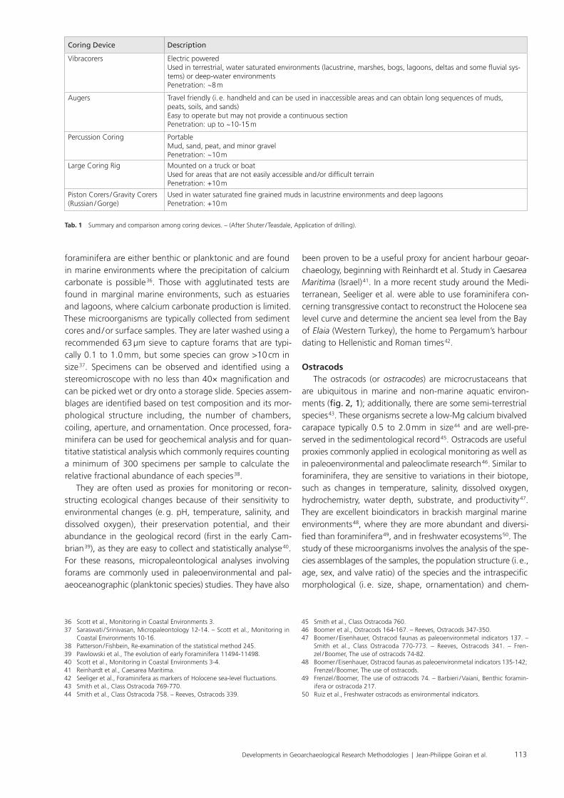
Coring Device Description
Vibracorers Electric powered Used in terrestrial, water saturated environments (lacustrine, marshes, bogs, lagoons, deltas and some fluvial sys-tems) or deep-water environments Penetration: ~8 m
Augers Travel friendly (i. e. handheld and can be used in inaccessible areas and can obtain long sequences of muds, peats, soils, and sands)Easy to operate but may not provide a continuous sectionPenetration: up to ~10-15 m
Percussion Coring Portable Mud, sand, peat, and minor gravel Penetration: ~10 m
Large Coring Rig Mounted on a truck or boat Used for areas that are not easily accessible and / or difficult terrainPenetration: +10 m
Piston Corers / Gravity Corers (Russian / Gorge)
Used in water saturated fine grained muds in lacustrine environments and deep lagoonsPenetration: +10 m
Tab. 1 Summary and comparison among coring devices. – (After Shuter / Teasdale, Application of drilling).

Developments in Geoarchaeological Research Methodologies | Jean-Philippe Goiran et al.114
As such, they are excellent proxies for ancient harbour geoar-chaeology in coastal (e. g. Portus in the Tiber Delta or Tyre in Lebanon), lagoon (e. g. Pisa in Tuscany), fluvial (e. g. Ostia in the Tiber Delta), or in limnological contexts (e. g. Magdala in Israel 56). In these studies, the ostracods are used to identify harbour deposits based on the degree of isolation (i. e., in relation to the sea, rivers, and lakes) of the biotopes 57 and salinity variations that could indicate a connection with the sea, freshwater or marine inputs or evaporation periods con-cerning harbour infrastructures and management activities 58.
DiatomsDiatoms are a diverse group of photosynthetic unicellular
microalgae (phytoplankton) with a resilient silica-rich (SiO²) cell wall called frustules 59. There are ~200 000 species of diatoms found in aquatic environments around the world ranging from freshwater, brackish, to photic zones of marine water as well as moist terrestrial environments including soils and plants 60. They come in many different shapes and sizes, from few micrometres to millimetres, and have two modes of life (i. e., benthic, living on the sea floor of submerged terrains or planktonic, floating in the photic zone) 61. Diatoms, for exam-ple, are often classified into three groups: acidobiontic (pH <7), acidophilus (pH~7), and alkaibionic 62. Their sensitivity to the pH of water makes them useful climate proxies in paleo-liminological studies. In a marine environment, diatoms thrive in the photic zone and high upwelling zones. Diatoms are excellent proxies and are often used in paleo environmental research because of their preservation potential, abundance in the sedimentological record, as well as sensitivity and rapid response to changes in the environment (i. e., changes in pH, nutrient, temperature, salinity, etc.) 63. The use of diatoms in geoarchaeological research is not a new phenomenon and has been practised for over 40 years 64.
PalynologyPalynology is the study of acid-resistant, organic-walled
microfossils (palynomorphs); pollen, fungal spores, acritarchs and the remains of organic-walled algae, such as dinoflagel-lates and desmids. Palynomorphs can be found in sediments collected from freshwater and marine environments and
ical valve variations 51. Commonly for core samples, only a few grams of dry sediment are processed using a 125 µm sieve or a finer 63 µm sieve to capture the smallest juvenile stage ostracods 52. The ostracods are later picked dry under a binocular microscope with a fine brush and placed onto a black slide with a grid for counting and identification 53. The most commonly used statistical threshold is 300 specimens per sample, but fewer individuals may suffice, especially for core samples requiring more samples to improve spatial and chronological resolution 54.
The ostracods are commonly used in archaeological and geoarchaeological research, especially to (1) determine the origin of ceramics and limestone and identify related quarries; to (2) reconstruct paleo climates near human settlements and to study their impact on environments (i. e., soils erosion, pollution); and to (3) study paleo environmental changes in wetlands, such as lakes, lagoons, estuaries, and river deltas 55.
51 Boomer et al., Ostracods 158-164. – Reeves, Ostracods 342-347.52 Horne / Siveter, Collecting and processing fossil ostracods 5. – Reeves, Ostracods
342. – Danielopol et al, Techniques for collection and study of ostracoda 72-73.53 Horne / Siveter, Collecting and processing fossil ostracods 5-6.54 Danielopol et al, Techniques for collection and study of ostracoda 75-77.55 Mazzini et al., Ostracodological studies in archaeological settings 326-327. –
Ruiz et al., Marine and brackish-water ostracods 94.56 Marriner et al., Coastal and ancient harbour geoarchaeology 23. – Mazzini
et al., Late Holocene palaeoenvironmental evolution of the Roman harbour of Portus 251-255. – Goiran et al., Paleoreconstruction of ancient harbours of Rome 10-12. – Mazzini et al., Ostracods in archaeological sites along the Mediterranean coastlines 134-138. – Goiran et al., Geoarchaeology confirms location of the ancient harbour basin of Ostia 395-397. – Rossi et al., New insights into the palaeoenvironmental evolution of Magdala ancient harbour 368-370.
57 Mazzini et al, Ostracods in archaeological sites along the Mediterranean coast-lines 134-138. – Rossi et al., New insights into the palaeoenvironmental evo-
lution of Magdala ancient harbour 368-369. – Marriner et al., Coastal and ancient harbour geoarchaeology 23.
58 Goiran et al., Paleoreconstruction of ancient harbours of Rome 12. – Mazzini et al., Late Holocene palaeoenvironmental evolution of the Roman harbour of Portus 255. – Goiran et al, Geoarchaeology confirms location of the ancient harbour basin of Ostia 395. – Rossi et al., New insights into the palaeoenviron-mental evolution of Magdala ancient harbour 369-370.
59 Smith / Flocks, Environmental investigations using Diatom 1. – Chepurnov et al., Experimental studies on sexual reproduction in diatoms 91-154.
60 Bathurst et al., Diatoms as bioindicators of site use 2920-2921. – Armbrust, The life of diatoms in the world’s oceans 185.
61 Bathurst et al., Diatoms as bioindicators of site use 2920. – Armbrust, The life of diatoms in the world’s oceans 185-187.
62 Saraswati / Srinivasan, Micropaleontology 128.63 Gasse et al., Diatom-inferred salinity in paleolakes 548.64 Ognjanova-Rumenova, Paleoenvironment and archaeology 293.
Fig. 2 Example of ostracod valves according to the ecological / environmental groups defined by Mazzini et al., Ostracods in archaeological sites along the Mediterranean coastlines 127-128 and table 1) for geoarchaeological studies: A shallow marine: Semicytherura sulcata, right valve, external view. – B brackish marine: Loxoconcha elliptica, male, right valve, external view. – C freshwater to low brackish: Ilyocypris gibba, left valve, external view. – D euryhaline: Cyprideis torosa, female, smooth valve, left valve, external view.

115Developments in Geoarchaeological Research Methodologies | Jean-Philippe Goiran et al.
inium ponticum (fig. 3), a species endemic to the Black Sea 72. This species has been observed several times, its first appear-ance coinciding with the Mithridatic Wars in the 1st century BCE, and has been taken as evidence of maritime trade. Recurrence of P. ponticum is thought to be due to repeated introduction into the harbour environment, the establishment of a population in the harbour, or both.
Geochemical applications
While harbour geoarchaeology emerged as a discipline at the beginning of the 1980s, geochemical methods were not applied until the mid-2000s. Its first application was to deter-mine human impact based on traces of ancient metal, such as lead (Pb), copper (Cu), nickel (Ni), silver (Ag), tin (Sn), etc. More specifically, anthropogenic impact using Pb isotopes as a tracer has been used extensively in the ancient harbours of Al-exandria 73, Sidon 74, Marseilles 75. Rome 76, Naples 77, Ephesus 78, Cala Francese 79, and Fréjus 80. Measuring Pb isotopes from sediment cores obtained in an ancient port, for example, help to solve archaeological questions including understanding human activities prior to the foundation of cities 81. Moreover, some studies have combined the study of Pb concentrations and isotopic compositions in harbour sediments to understand water supply systems (i. e., Pb pipes, sinter deposits taken from aqueduct channels). Results have shown that Pb constitutes a proxy for the evolution of drainage systems (e. g. extension vs. contraction), connectivity, and engineering during the active period of the ancient city (e. g. Rome 82, Naples 83, Ephesus 84). Anthropogenic Pb isotope signals trapped in harbour basins will be compared to those of known Pb ores supply sources (i. e., from mining resources), and insights into trade routes and sea roads from production centres (i. e., mining districts) to consumption centres (i. e., urban areas) can be deduced 85. More recently, geochemistry has been used in geoarchaeology for paleo environmental reconstructions.
In some cases, classic environmental markers cannot be used for paleo environmental reconstruction due to low quan-tity / abundance, hiatus in the sedimentary deposits, and / or the cost of analysis permit the production of high-resolution
repre sent a large group of organisms with varied environ-mental preferences (e. g. nutrient levels, acidities, salinities) and life modes (e. g. benthic, planktonic, autotrophic, het-erotrophic) 65. While providing information on terrestrial and aquatic environments, these microfossils can also yield insight into human activities. For example, the presence of cultivar pollen can infer agriculture / diet practices, increases in grass and other upland weed pollen may indicate land clearing by humans, and changes in aquatic palynomorph assem-blages may reflect human-induced eutrophication 66. Typical palynological processing involves the removal of non-organic constituents from a sample, usually with acids (hydrochloric to dissolve carbonates and hydrofluoric to dissolve silicates), and the addition of a known number of marker particles (e. g. Lycopodium spores; fig. 3 67). The remaining residue is the acid-resistant, organic component that can be mounted on microscope slides and analysed for palynomorphs.
The relationship between archaeology and palynology goes back nearly a century, before the advent of radiocar-bon dating, where pollen assemblages from archaeological sites were compared to the assemblages of nearby lakes and bogs 68. Marriner and Morhange state that the use of palynology for harbour geoarchaeology has been limited, despite the presence of fine-grained harbour mud being suitable for palynomorph preservation 69. They cite previous harbour studies where palynological analysis was inconclusive. Contamination caused by the transport of pollen in large wa-ter bodies is considered a limiting factor in harbour / coastal studies 70. Recent harbour geoarchaeological studies employ-ing palynology have been more successful. In studying the ancient Roman port of Ostia, Sadori et al. were able to infer phases of human impact and phases of increased siltation 71. Respectively, the palynological signatures included relatively high pollen concentration with the presence of cultivar pol-len (e. g. olive, cereals and grape) and relatively low pollen concentration with the presence of non-pollen palynomorphs like Glomus and Pseudoschizaea (fig. 3). More significantly, it was reported that algal remains were very scarce, and pollen was often poorly preserved in this study. Shumilovskikh et al., while completing a palynological analysis in the harbour of Elaia (Western Turkey), observed the dinoflagellate cyst Perid-
65 van Geel, Non-pollen palynomorphs. – de Vernal, Palynology.66 See Iversen, Landnam. – Krueger / McCarthy, Lagerstätten. – Sadori et al., Paly-
nology and ostracodology. – McCarthy et al., Algal palynomorphs.67 Fægri / Iversen, Textbook of pollen analysis 294.68 Bryant / Holloway, Archaeological palynology 913-917.69 Marriner / Morhange, Geoscience of ancient Mediterranean harbours.70 Marriner / Morhange, Geoscience of ancient Mediterranean harbours 171. – Sa-
dori et al., Palynology and ostracodology 1508.71 Sadori et al., Palynology and ostracodology.72 Shumilovskikh et al., The harbour of Elaia.73 Véron et al, Pollutant lead reveals the pre-Hellenistic occupation 1-3. – Véron et
al., A 6000-year geochemical record 141-143. – Stanley et al., Alexandria 5-8.74 Le Roux et al., Geochemical evidences 115-119.75 Le Roux et al., Lead pollution in the ancient harbours of Marseilles 31-35.76 Delile et al., Lead in ancient Rome’s city waters 6594-6599. – Delile et al.,
Rome’s urban history 1-6.
77 Delile et al., A lead isotope perspective on urban development in ancient Naples 3-6.
78 Delile et al., Demise of a harbour 205-211.79 Fagel et al., Record of human activities in the Pb isotopes 770-781.80 Véron et al., Fréjus, France 242-249.81 Le Roux et al., Geochemical evidences 115-119. – Véron et al, Pollutant lead
reveals the pre-Hellenistic occupation 1-4. – Véron et al., A 6000-year geo-chemical record 138-147.
82 Delile et al., Lead in ancient Rome’s city waters 6594-6599.83 Delile et al., A lead isotope perspective on urban development in ancient Naples
6148-6153.84 Delile et al., Demise of a harbour 202-213.85 Le Roux et al., Geochemical evidences 115-119. – Le Roux et al., Lead pollution
in the ancient harbours of Marseilles 31-35. – Delile et al., Lead in ancient Rome’s city waters 6594-6599. – Delile et al., A lead isotope perspective on urban development in ancient Naples 6148-6153. – Véron et al., A 6000-year geochemical record 138-147. – Véron et al., Fréjus, France 242-249.

Developments in Geoarchaeological Research Methodologies | Jean-Philippe Goiran et al.116
to its ability to offer high resolution semi-quantitative and qualitative elemental data, often with little preparation. The data produced by XRF analysis help researchers to inter-pret the provenance of material (archaeometry) and paleo-environmental reconstruction (relevant for geoarchaeological studies). There are many types of XRF including both labora-tory XRF and portable handheld XRF, the latter being useful for rapid analysis in the field 94. This section introduces and summarises two types of XRF techniques commonly used by archaeologists and geoarchaeologists: energy-dispersive XRF (EDXRF) and wavelength-dispersive XRF (WDXRF).
Each technique uses x-rays to excite and displace the electrons of the inner shell of the atom. The electrons from the outer shell then fill the void, which emits x-ray photons that can be counted to identify the elements present in the material and / or sediment core. Archaeologists commonly rely on these XRF techniques for obsidian studies and more recently, analysing archaeological basalts 95. The operating principle behind EDXRF and WDXRF are similar, however, WDXRF detects one element at a time and as a result, takes longer to process than EDXRF which is more efficient with the ability to detect groups of elements simultaneously and pro-cess within a few minutes. The spectral resolution of WDXRF is higher (i. e., ~5 eV to 20 eV) than EDXR (~150 eV-600 eV; this depends on the detector) which means there are fewer spectral overlaps of elemental data in WDXRF than in EDXRF.
results. To remedy these shortcomings, and to complement the more commonly used proxies, elemental geochemistry has been added to the toolkit of geoarchaeology. Only re-cently, research teams have used elemental geochemistry to improve the paleo environmental reconstructions in archaeo-logical contexts, as in Corinth (Greece) 86, Magdala (Israel) 87, Elaia (Turkey) 88, and Alkinoos (Greece) 89. This recent expan-sion of geochemistry into geoarchaeological research is a direct result of the widespread use of micro x-ray fluorescence (µXRF) core scanners during the last decade 90. To extract as much information as possible from the elementary geochem-istry data, it is recommended to link them to a factor analysis that can discriminate the main environmental factors leading to the formation of the harbour basin deposits 91. Based on five different ancient harbour deposits, a recent study by Delile et al. 92 classified these environmental variables in order of importance as (I) current velocity, (II) biogenic production, (III) water column ventilation, (IV) anthropogenic flux, and (V) seawater versus freshwater influence. The association and coupling of these control factors have demonstrated its robustness for detailed paleo environmental reconstructions in numerous cases 93.
X-Ray Fluorescence (XRF) Spectrometry XRF is a non-destructive analytical tool that has been
increasingly popular in archaeology and geosciences due
86 Hadler et al., Harbour of ancient Corinth (Peloponnese, Greece) 139-180.87 Rossi et al., New insights into the palaeoenvironmental evolution of Magdala
ancient harbour 356-373.88 Shumilovskikh et al., The harbour of Elaia 167-187.89 Finkler et al., Tracing the Alkinoos Harbour 24-42.90 Croudace / Rothwell, Ch. 1 Micro-XRF Studies of Sediment Cores 14-19.91 Delile et al., Geochemical investigation of a sediment core 34-45. – Delile et al.,
Demise of a harbour 202-213. – Delile et al., Neapolis harbour 84-97. – Delile et al., The contribution of geochemistry to ancient harbour geoarchaeology 170-187.
92 Delile et al., The contribution of geochemistry to ancient harbour geoarchaeol-ogy 170-187.
93 Delile et al., Geochemical investigation of a sediment core 34-45. – Delile et al., Demise of a harbour 202-213. – Delile et al., Neapolis harbour 84-97.
94 Shackley, Ch. 1 X-Ray Fluorescence Spectrometry 12-15.95 Shackley, Ch. 1 X-Ray Fluorescence Spectrometry 1-2. – Lunbald et al., Non-de-
structive EDXRF Analyses of Archaeological Basalts 65-77.
Fig. 3 Plate showing examples of Palynomorphs: A Lycopodium spore (photo by Andrea Krueger) which can be used as marker particle. – B-C Di-noflagellate cyst Peridinium ponticum (photo from Sadori et al., Palynology and ostracodology). – D-E Acritarch Pseudoschizaea circula (photo from Sadori et al., Palynology and ostraco-dology). – F cluster of fungal spore Glomus (photo modified from Revelles et al., Pollen and non-pollen palyno-morphs).
A B C
D E F
117Developments in Geoarchaeological Research Methodologies | Jean-Philippe Goiran et al.
materials. The principle behind 14C dating is simple: atmos-pheric carbon dioxide (CO²) contains small proportions of 14C, a naturally occurring radioactive element created in the upper atmosphere through the reaction of neutrons from cosmic rays and Nitrogen (14N) in the air. The 14C atom is rapidly oxidized to carbon dioxide (14CO²) and mixed with carbon dioxide in the atmosphere. This is passed from the atmosphere to oceans through dissolution or assimilation by plants via photosynthesis and enters the food chain, therefore marking all living organisms with carbon 14.
The production of atmospheric 14C is continuous without accumulation – it spontaneously disintegrates to provide a nitrogen atom. The production of 14C and its decay equili-brate around a low 14C content conferring natural radioac-tivity to the carbon dioxide of the atmosphere. As long as the organisms remain in exchange with this carbon dioxide, 14C is stored. Since 14C is unstable, it will decay over time when an organism dies and is no longer exchanging carbon with the biosphere or during the precipitation of carbonate min-erals. Age estimates can therefore be calculated by measur-ing the residual rate of 14C left in a carbon sample after its death.
All carbon materials less than 50 000 years old are the-oretically datable. The most common material used for this dating method is of vegetable origin (e. g. charcoal, wood, seeds, etc.) and bones. Marine organisms, such as fish, shells, and Posidonia, are special cases that will be discussed later. Samples must be treated to avoid contamination 100. There are two principal techniques for measuring residual 14C in a sample: 1) liquid scintillation counters and 2) counting the remaining 14C atoms using an Accelerator Mass Spectrometry (AMS). The choice of method depends on the sample mass. For example, the first technique requires a large sample mass weighing 20-300 g, depending on the nature of the sample, while AMS requires smaller samples weighing a few 10 µg to 5 g. 14C dates obtained using these tools are given in years B.P. (Before Present, i. e., before 1950) with a margin of un-certainty. A correction curve is used to convert these dates into a calendar date interval, depending on the accuracy of the measurement and the sequence of the calibration curve used, where the age of the dated sample has a confidence interval of 95 101.
In geoarchaeological studies, sampling is generally carried out by obtaining sediment cores from the study area. For this reason, samples that are selected for 14C is usually small, e. g. in plant macro-remains, diffuse organic matter, and / or ma-rine shells in coastal environments. The oceans receive 14C from atmospheric CO² and the deep ocean from radioactive decay occurring at these depths and mixing of surface wa-
The interpretation of the elemental compositions in sediment cores for geoarchaeological research is site-specific. Therfore, it is imperative to understand the geochemical properties related to the ecological setting of the study area. Mistakes are often made when elements are placed in relation with-out considering external parameters, such as the climatic, hydrologic, and geologic context of the region 96. Moreover, technological advancements in recent years, such as the de-velopment of micro-XRF (µXRF), can provide rapid and con-tinuous high spatial resolution elemental records (~200 µm) than conventional XRF 97.
µXRF core scanners, such as AVAATECH/CORTEX and ITRAX are the most popular instruments used in palaeocean-ography and paleo limnology studies today 98 and are becom-ing more widely used in geoarchaeology research for recon-structing paleo environments and paleo climates. For example, depending on sediment accumulation rates in the core, µXRF can identify seasonal to multi-decadal scale changes in geo-chemical signatures associated with environmental change over time. Some core scanners, such as the Cox Analytical ITRAX XRF scanner, can also produce radiographic and optical images that can be useful for studying spatial heterogeneities, sedimentary structures, and sediment accumulation from the recorded film density of the core 99.
Dating (Relative vs. Absolute dating)Dating is essential for geoarchaeologists to establish a
chronology of their research area. There are two different types of dating methods: I) Absolute dating and II) Relative dating. Absolute dating provides a fixed date set on a chron-ological scale (i. e., calendar years and calibrated years) and can be determined by referencing a known printed date (e. g. a coin) or using scientific methods, such as radiometric (e. g. radiocarbon, uranium series, and single-crystal laser fusion Argon-argon dating) and trapped charged dating (e. g. ther-mo-luminescence, cosmogenic exposure dating, and electron spin resonance). Relative dating is arbitrary where objects are put into chronological order and geologic time series are wiggle-matched to reference curves or using a point of refer-ence, such as an artefact or known event. Table 2 provides a summary of some of the most common absolute and relative dating methods used in geoarchaeology today. This section on dating methods will focus on the use of radiocarbon and cosmogenic isotopes (absolute dating), and palaeomagne-tism (relative dating).
Radiocarbon DatingRadiocarbon dating (14C) is the most used dating tech-
nique in archaeological studies to estimate the age of carbon
96 Delile et al., The contribution of geochemistry to ancient harbour geoarchaeol-ogy 171.
97 Croudace / Rothwell, Ch. 1 Micro-XRF Studies of Sediment Cores 24.98 Croudace / Rothwell, Ch. 1 Micro-XRF Studies of Sediment Cores 3.
99 Croudace / Rothwell, Ch. 1 Micro-XRF Studies of Sediment Cores viii. – Axels-son, The use of X-ray radiographic methods 65.
100 Brock et al., Current Pre-treatment methods for AMS Radiocarbon 103-112.101 Reimer et al., IntCal13 and Marine13 Radiocarbon Age Calibration Curves
1869-1887.

Developments in Geoarchaeological Research Methodologies | Jean-Philippe Goiran et al.118
produced. Those used in Earth Sciences are often radioactive with typical half-lives of several days to several millions of years. Meteoric cosmogenic isotopes are produced in the atmosphere and transferred to the ground through dry (e. g. dust, aerosols, gas) or wet (e. g. rain) deposition. The best known of these is 14C. Others, such as Beryllium (10Be), are used for their propensity to accumulate in soils by adsorption to organic matter, iron oxides and clays 105. Terrestrial in-situ produced cosmogenic isotopes are generated directly in the lattices of minerals, within the topmost few metres of the Earth’s surface. Average production rates have only been firmly calibrated for a few isotopes, in compositionally simple minerals, such as 10Be, 14C and 26Al in quartz, or 36Cl in calcite. In cases where such minerals are not available, more complex analyses can be conducted, for example on cosmogenic 21Ne and 3He in pyroxenes, olivine, and amphiboles.
The concentration produced by isotopes within mineral particles or adhering to their surface of ground particles can be used in three main ways: (I) to date the duration of expo-sure of a surface to cosmic rays or atmospheric fallout; (II) to quantify the rate at which a rock surface or soil is eroded, and (III) to date the burial and shielding of material from cosmic rays. Studies most commonly use one or some combination of these fundamental approaches.
Due to very low production rates (a few atoms per gram of mineral per year), measurements require the use of ac-celeration mass spectroscopy (AMS). Therefore, terrestrial cosmogenic isotopes initially found applications in geology, where time scales of a few thousand years to several million years allow concentrations to reach measurable levels 106. They
ters. Marine organisms absorb 14C dissolved in the water (as CO²). Seawater, however, contains less 14C compared to CO² in the atmosphere. Exchange between the surface of the ocean and the atmosphere is quicker than in deep waters. This is called the Marine Reservoir Effect which ages the esti-mated dates of marine organisms. This ageing (or apparent age) is estimated at 400 years 102. In addition, the magnitude of the marine reservoir effect varies depending on the marine species and environmental conditions 103. A marine calibration curve is used to calibrate the dates of these materials with regard to this correction 104. The dating of shells is not used to determine absolute dates but are used to serve as chrono-logical markers for geoarchaeological interpretation.
Incipient use of terrestrial cosmogenic isotopes in geoarchaeology
Absolute dating provides an estimated numerical age in sediments, rocks, and / or fossils. The most commonly used absolute dating method is radiometric dating, which uses the natural radioactive decay of some of Earth’s most dominant elements including carbon, uranium, and potassium. Cosmo-genic isotopes are produced through the interaction of high energy cosmic rays with atoms of the Earth’s atmosphere and land surface. Cosmic ray fluxes are composed predominantly of protons and muons emitted during supernova explosions. They are considerably more energetic than the most energetic sun rays – whereas sun rays can overcome chemical bonds and split molecules, cosmic rays can overcome atomic bonds and split atoms. The isotopes produced by these reactions can be stable, but many are radioactive and decay after being
102 Stuiver / Brazinius, Modelling atmospheric 14C influences and 14C ages 137-189.103 Marchand et al., Entre »effet reservoir« et »effet de plateau« 307-335.104 Reimer et al., IntCal13 and Marine13 Radiocarbon Age Calibration Curves
1869-1887.
105 Boschi / Willenbring, The effect of pH, organic ligand chemistry and mineral-ogy 711-722.
106 Granger et al., A cosmic trip: 25 years of cosmogenic nuclides in geology 1379-1402.
Tab. 2 Summary of common dating methods used in geoarchaeology (from Peppe / Deino, Dating rocks). – * Schwarcz, Uranium series dating 7-17. – ** Rink, Electron Spin Resonance 975-1025. – *** Skinner, Electron Spin Resonance.
Dating Method Age Range Materials Summary
Radiocarbon dating 1 - 50 000 years Organic material (e. g. bones, shells, charcoal, wood, and peat)
Measures the radioactive decay of 14C in carbon materials
Argon-Argon Ar-Ar
1000s - several billions of years
Volcanic material (e. g. igneous rocks) and early human artefacts
Measures the decay of the ratio 40Ar/ 39Ar in sedi-ments / rocks containing argon
Potassium- Argon K-Ar
1000s - several billions of years
Volcanic material (e. g. igneous rocks), early human artefacts
Measures the decay of 39K and 40Ar in sediments / rocks containing minerals with potassium
Uranium Series(U-Series)
Several thousand - 1 million years*
Minerals containing uranium (e. g. silicates and carbonates)
Measures the radioactive decay of 238U and 235U
Luminescence (OSL and TL)
1000 - several billions of years
Fired material (e. g. ceramics, pottery, burnt flint, etc.)
Measures radioactivity accumulated in the sediment and / or tool since the last time it was exposed to heat and / or light
Electron Spin Reso-nance (ESR)
1000 - 5 million years Tooth enamel, carbonates (e. g. speleo thems, shells, etc.), rocks / sedi-ment containing quartz, etc.**
Determines the age of burial via measuring the concentration of free radicals in the material due to exposure to natural radiation***
Tephrochronology 100 - few billion years Volcanic material / deposits Measures age of volcanic material to determine the age of stratigraphic material
Paleomagnetism Several hundreds - billions of years
Fired material (e. g. ceramics), sedi-ments, and rocks (sedimentary and igneous)
Measures the fossilized Earth’s magnetic field and compare to reference curves for relative dating

119Developments in Geoarchaeological Research Methodologies | Jean-Philippe Goiran et al.
(DRM) at the time of deposition. The typical sample size is 8 cm³ (8 mℓ) cubes or discrete cylinder samples for analysis in a spin-ner magnetometer or a cryogenic magnetometer. Sedimentary sequences can also be sampled with U-channels (core-length plastic boxes with cross-section 2 cm × 2 cm) and analysed using a cryogenic magnetometer for U-channels.
Data interpretation: The Paleoenvironmental Age-Depth Model
The Paleoenvironmental Age-Depth Model (PADM) is an in-terpretative chart created to characterise harbour potential and operability 118 (fig. 4). This chart provides a useful tool for reconstructing navigability, accessibility of a water body through time, but also for visualising the degree of closure of the palaeoenvironments considered. Based on a classic age-depth model, the PADM chart combines (I) stratigraphic and paleo environmental data, (II) sedimentation curve, (III) recon-structed relative local sea level curve, (IV) fully laden ancient ship or boat draughts – depending on the period and the culture considered, and (V) all relevant chronological and / or altitudinal data that can possibly be collected.
PADM was initially developed and applied for the interpre-tation of the canals of Portus 119. These navigable canals were excavated during the Roman period between the Imperial harbour of Rome and the Tiber River. It was then developed and improved in the context of the ERC-funded RoMP Por-tusLimen project to interpret different Roman harbours in coastal, lagoon or fluvial contexts in the same way 120. Addi-tionally, this chart was standardized for comparing different harbours and their suitability for ships and boats of varying sizes. In parallel, 2D interpretative cross-sections were built for visualising the evolution of the water column available over time with different ships 121. Finally, a similar diagram was also applied in the harbours of Halmyris 122 (Dobrogea, Roma-nia) and Elaia 123 (W. Turkey) using microfossil, foraminifera associations for reconstructing the water columns available over time.
To produce a PADM chart, a precise stratigraphic rep-resentation of the studied sequence is required. Paleo-environmental analyses have to be performed for recon-structing the degree of closure of a harbour in terms of the hydrodynamism (i. e., grain-size analysis and geochemical
have been used to date glacial landforms, river terraces, fault scarps, caves, paleo sols, and the natural rate of erosion of rocks and soils 107. The use of terrestrial cosmogenic isotopes in geoarchaeology as a dating technique has been hindered by the slow build-up of isotope concentrations 108, such that most successful applications have been obtained in the field of palaeoanthropology 109. The improvement of AMS detection limits, the strong momentum of this dating technique, and the use of novel minerals and isotopes will certainly soon result in breakthroughs in the field of geoarchaeology. Fluxes of atmos-pherically derived isotopes are higher, allowing for measure-ments over time-scales more relevant to geoarchaeology, but the mechanisms of accumulation / flushing of isotopes in soils are complex and poorly constrained, making interpretations less straightforward 110. Its highest current potential lies in the field of erosion rate measurements, in particular, to assess the effects of anthropogenic perturbation to background environ-ment levels 111, or as a tracer of sediment sources 112.
Palaeomagnetism The Earth’s magnetic field can be used for relative dating
of historical and archaeological sites. This is done by com-paring the fossilized magnetism in sediment or fired arte-facts to regional reference curves and magnetic field models. Paleomagnetic dating is based on the fact that the Earth’s magnetic field changes over time and that certain minerals can enclose the ambient magnetic field. The reference curves include measurements made by mariners 113, paleo records from well-dated geological and archaeological archives (e. g. MagIC database 114; GEOMAGIA50 database by Brown et al. 115, and geomagnetic field models (e. g. CALSxk by Korte and Consta-ble) 116. Paleo magnetic dating is most powerful when using the full magnetic vector (paleo intensity, inclination and declination), in a region and period a priori well-documented with quality reference curves, and as a part of a multiproxy dating strategy. Paleomagnetic dating has the potential to provide good pre-cision in periods of large radiocarbon calibration uncertainties, such as the Early Medieval Period 117. Sampling material for paleo magnetism includes: (I) Fired material such as hearths, ceramics, bricks, and iron sledge. The magnetic minerals record a thermal remnant magnetisation (TRM) at the time of cooling through their Curie temperature; (II) Sediment deposited in a natural (e. g. lake, sea) or artificial basin (e. g. harbours). The magnetic minerals encase a detrital remnant magnetisation
107 Brocard et al., Effects of a tectonically-triggered wave.108 Akçar et al., Cosmogenic 36Cl in limestone 533-540.109 Granger et al., New cosmogenic burial ages for Sterkfontein 85. – Philipps
et al., Maximum ages of the Côa valley 100. – Verri et al., Flint mining in prehistory 7880-7884.
110 Boschi / Willenbring, Beryllium desorption 52-58.111 Brown et al., Determination of predevelopment denudation rates 723-728.
Valette-Silver et al., Detection of erosion events using 10Be profiles 82-90.112 Reusser / Bierman, Using meteoric 10Be to track fluvial sand 47-50.113 Jonkers et al., Four centuries of geomagnetic data from historical records 2.114 https://Earthref.org/MagIC.115 Brown et al., GEOMAGIA50.v3: 1. Brown et al., GEOMAGIA50.v3: 2.116 Korte / Constable, Geomagnetic field.
117 Batt et al., Advances in archaeomagnetic dating in Britain 66.118 Salomon et al., The Development and Characteristics of Ancient Harbours 5-8.119 Salomon et al., The Canale di Comunicazione Traverso in Portus 84-87.
Lisé-Pronovost et al., Dredging and canal gate technologies in Portus.120 Salomon et al., The Development and Characteristics of Ancient Harbours
1. – Salomon et al., Un modèle âge-profondeur paléoenvironnemental 1.121 Salomon et al., A harbour–canal at Portus 31-49. – Goiran et al., High chro-
no-stratigraphical resolution of the harbour sequence of Ostia 68-84.122 Giaime et al., Halmyris: Geoarchaeology of a Fluvial Harbour on the Danube
Delta.123 Seeliger et al., Foraminifera as markers of Holocene sea-level fluctuations 21-
27.

Developments in Geoarchaeological Research Methodologies | Jean-Philippe Goiran et al.120
curve – interpretations relate to this axis (paleo geographical interpretation and operability of the harbour);
4. The reconstructed relative sea level curve is reported on the age-depth model – the area between the recon-structed sedimentation and the relative sea level curves correspond to the changing paleo -bathymetry;
5. The draught of a fully laden boat and ship at a given pe-riod and culture are compared to the paleo -bathymetries.Additional elements of control can be added to the PADM
chart such as complementary dates, or the reconstruction of the compaction correction. Alternatively, water depth can be inferred from bio-indicators trapped in the sediments, such as foraminifera. Multiple-core analysis and a combination of sediment curves provide a better understanding of the evo-lution of the different parts of the harbour 124. This method can be applied to sedimentary sequences in a built harbour as well as in any water body (e. g. coastal area, river, lake, palaeolagoon, etc.). Archaeological evidence enables better identification of the limits of a harbour area (i. e., moles, quays, settlement location, etc.).
analysis) and the water oxygenation, connection to the sea considering the marine / freshwater balance (bioindicators – macrofauna, ostracods, foraminifera, geochemical analyses etc.). In addition, a reliable chrono-stratigraphy based on radiocarbon dating, optically stimulated luminescence dating (OSL), and archaeological dating methods (i. e., ceramics) must be established. For the reconstruction of relative sea level, the PADM requires local or regional data. Draughts of fully laden ancient boats and ships, levels of archaeologically dated quays, historical data about the use of a harbour, its foundation etc. can allow the researcher to refine the PADM.
Successive steps are taken in the construction of the Paleo-environmental Age-Depth Model (PADM) chart:1. Construction of an age-depth model or sedimentation
curve based on absolute dates;2. The stratigraphic sequence, the hydrodynamism, and the
paleo ecological context are drawn on the vertical axis (Y-axis);
3. The stratigraphic layers are transposed on the horizon-tal axis (x-axis) through the reconstructed sedimentation
124 Salomon et al., The Development and Characteristics of Ancient Harbours 10.
Fig. 4 An example of a Palaeoenvironmental Age-Depth Model (PDAM) Chart used to characterise harbour potential and operability. – (From Salomon et al., The Devel-opment and Characteristics of Ancient Harbours).

121Developments in Geoarchaeological Research Methodologies | Jean-Philippe Goiran et al.
velopment followed the evolution of the coastline. During the geophysical survey, most of the methods were tested including Electrostatic, EMI, GPR, and seismic. Despite the extensive geophysical survey, the original structure of the Heptastadion could not be detected, but the surveys revealed and confirmed the location of the anchorage points of the ancient causeway and the evolution of the tombolo. The electrostatic survey provided the clearest results showing the evolution of the tombolo with decreasing resistivities towards the east. This decrease can be interpreted as the difference between a hard rock resistant infrastructure (the Heptastadion) and the progradation due to more conductive sediments. Despite the metallic disturbances due to the urban environment, the EMI survey successfully confirms the results obtained from the electrostatics.
Pyrgi (Italy)
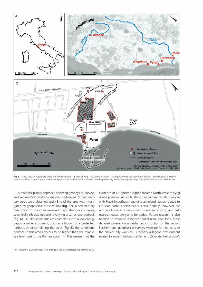
The Etruscans were an ancient civilization from the Italian Peninsula renowned for their wealth and urban development. Etruscan cities were established at the end of the Final Bronze Age (12th-10th c. BC) to the Early Iron Age (i. e., the Villanovian period from 10th-8th c. BC). In the 9th century BC, the Etrus-cans had occupied territories around the Tyrrhenian coast extending from modern-day Tuscany, Lazio, and Umbria. They were known for engineering extensive hydraulic structures in-cluding, canals for transport and drainage systems. According to ancient texts, the Etruscans were a Thalassocratic society since they relied on the use of commercial harbour basins and naval bases. However, despite numerous archaeological studies along the Tyrrhenian coastline, no evidence of Etrus-can harbour activity has been discovered 130. Benvento Frau (1989), an Italian archaeologist known for his research in ancient Etruscan ports of Tarquinia (Lazio, Italy), believed that Etruscan settlements in Pyrgi could have used former inland lagoons to support their waterway projects instead of large maritime harbour basins 131. This assumption was based on analysing aerial photographs of the region which appeared to reveal buried archaeological structures linked to the harbour activities (i. e., tower structures and jetties; fig. 5a) 132. To test Frau’s hypothesis, a geoarchaeological expedition in 2017 was conducted in the ancient city of Pyrgi (modern-day Santa Severa) located ca. 52 km north of Rome on the Lazio coast of Italy (fig. 5b). The purpose of this study is to identify the structures of the Etruscan harbour of Pyrgi and to verify the findings discussed by Frau 133.
Case Studies: Reconstructing Ancient Harbours
Alexandria (Egypt)
In 331 BC, Alexander the Great led his army to Northern Africa to defeat the Persians for their rule over Egypt and founded the ancient city of Alexandria behind the island of Pharos on the western margin of the Nile Delta. The Greek geographer Strabo described an approximately ca. 1300 m long Heptastadion (causeway) that connected the mainland to Pharos, where the famous lighthouse of Alexandria once stood. The connexion divided Alexandria’s coastline into two ports located on the east and west side of the Heptastadion. The eastern port of Alexandria, called Magnus Portus, was one of the busiest harbours in the ancient world and served as a one of the most important trading ports between Egypt and the Greco-Roman cities around the Mediterranean. The Magnus Portus was better protected than the western port (known as the Eunostos harbour) which was open to the sea and more susceptible to coastal processes such as strong winds and sea swells 125.
Alexandria is exposed to north-easterly winds in summer and north-westerly winds in winter. These intense seasonal wind patterns can produce storm waves with heights of ca. 1.2-2.1 m, with the strongest ocean swells occurring between June-August 126. The magnitude of these waves is predomi-nantly responsible for coastal erosion and sediment transpor-tation. Over time, sediment accumulated on both sides of the Heptastadion subsequently filling up the harbours and creat-ing a tombolo (sandbank). About the 15th and 16th centuries AD, the city expanded to the tombolo and is still a densely urbanized centre today. Consequently, urbanization on the tombolo has made it difficult for archaeologists to precisely locate the Heptastadion. Mahmoud El Falaki (1872) hypo-thesized that the Heptastadion was orientated NW/SE, which was widely accepted throughout most of the 21st century 127. However, this hypothesis was refuted in 1997 by Albert Hesse (CNRS, UMR 7619 Sisyphe) through geophysical analysis 128. Hesse argued that the Heptastadion continued the city’s an-cient road network. A multidisciplinary study combining geo-physical, archaeological, and geomorphological methods was later performed to understand the landscape evolution of Al-exandria’s coastline during the last 8000 years of the Holocene.
Hesse demonstrated how the tombolo was formed and proposed a new hypothesis for the location of the Heptasta-dion 129. The results from this study indicated that urban de-
125 Lotft / Badr, Long-term relief deformation and sediment characteristics 267-268.
126 Goiran et al., Geoarchaeology of Alexandria (Egypt) 730.127 Falakī / Ḥamdī, Mémoire sur l’antique Alexandrie. 128 Hesse, Arguments pour une nouvelle hypothèse 21-33.129 Hesse et al., L’Heptastade d’Alexandrie 191-273.130 Enei, Pyrgi sommersa. – Boitani, Il territorio: l’emporion di Gravisca 125-136. –
McCann, The Roman Port and Fishery of Cosa. – Keay / Paroli, Portus. – Goiran et al., Paleoreconstruction of ancient harbours of Rome 3-13. – Goiran et al.,
Geoarchaeology confirms location of the ancient harbour basin of Ostia 389-398.
131 Frau, I porti ceretani di Pyrgi e Castrum Novum 319-327.132 Enei, Pyrgi sommersa. – Boitani, Il territorio: l’emporion di Gravisca 125-136. –
McCann, The Roman Port and Fishery of Cosa. – Keay / Paroli, Portus. – Goiran et al., Paleoreconstruction of ancient harbours of Rome 3-13. – Goiran et al., Geoarchaeology confirms location of the ancient harbour basin of Ostia 389-398.
133 Frau, I porti ceretani di Pyrgi e Castrum Novum 319-327.
Developments in Geoarchaeological Research Methodologies | Jean-Philippe Goiran et al.122
existence of a Holocene lagoon located North-West of Pyrgi is not possible. As such, these preliminary results disagree with Frau’s hypothesis regarding an inland lagoon related to Etruscan harbour settlements. These findings, however, are not conclusive as it only covers one area of Pyrgi, and radi-ocarbon dates are yet to be added. Future research is also needed to establish a higher spatial resolution for a more detailed paleo environmental reconstruction of the region. Furthermore, geophysical surveys were performed outside the ancient city walls to 1) identify a lagoon environment related to ancient harbour settlement, 2) locate the harbour’s
A multidisciplinary approach involving geophysical surveys and sedimentological analysis was performed. Six sedimen-tary cores were obtained and >8 ha of the area was investi-gated by geophysical prospections (fig. 6c). A sedimentary description of the cores revealed major stratigraphic layers, specifically silt-clay deposits overlying a sandstone bedrock (fig. 6). Silt-clay sediments are characteristic of a low energy depositional environment, such as a lagoon or a protected harbour. After correlating the cores (fig. 6), the sandstone bedrock in this area appears to be higher than the relative sea level during the Roman epoch 134. This means that the
134 Rovere et al., Relative sea level change at the arcaehological site of Pyrgi 89-90.
Fig. 5 Study Area: A Pyrgi (Italy along the Tyrrhenian Sea. – B Map of Pyrgi. – C Coring locations. This figure reveals the hypothesis of Frau, I porti ceretani di Pyrgi e Castrum Novum, suggesting the harbour of Pyrgi as well as the locations of cores and the preliminary results of magnetic maps (C) – (After Goiran et al., Recherche).
A B
C

123Developments in Geoarchaeological Research Methodologies | Jean-Philippe Goiran et al.
however, the preliminary results presented in this section reveal promising information concerning the urban network and the ancient landscape of Pyrgi. Once the magnetic sur-vey and a number of complementary methods, including electrical resistivity tomography cross-sections, have been completed, it will be possible to fully reconstruct the geo-morphological landscape.
infrastructures, and 3) determine urban network outside the city walls (if applicable).
Magnetic surveys have been carried out in 2017 in the fields around the ancient city walls. Although the geophysical cover of the site contains several gaps and is yet to be com-pleted, it has revealed interesting preliminary results (fig. 7). The magnetic survey (i. e., mapping the local geomagnetic field variations) highlighted road elements and buildings fea-tures within the proximity of the ancient city walls, proving that the ancient urban network continues beyond known city limits. Thus, an access road to the northern city gate as well as what appears to be an eastern neighbourhood have been identified on the magnetic map. The geophysical survey, however, is not fully completed at this stage and no harbour structures have been identified in any of the geophysical maps thus far. The contrasting electrical resistivity makes it possible to follow the clay-sandstone interface in which the clay thickness can be estimated (data is not available at this stage). This clay thickness provides insight into the size and the evolution of the alluvial plain associated with the highlighted sedimentary deposits. More research is needed,
Fig. 6 Stratigraphic description of the cores in Pyrgi. Current and ancient sea-levels are marked in the figure. – (After Goiran et al., Recherche).
Fig. 7 Preliminary magnetic survey results for Pyrgi. – (After Goiran et al., Recherche).

Developments in Geoarchaeological Research Methodologies | Jean-Philippe Goiran et al.124
Conclusion
The application of geoscience provides a plethora of knowl-edge for harbour archaeological research. The technological advancements in geoscientific tools have made data collec-tion more efficient and cost-effective as manifested in the introduction of non-destructive and rapid geochemical anal-yses using µXRF core scanners and GIS for digital modelling and spatial analyses. Such innovations have permitted geoar-chaeologists to pursue further research questions and have broadened the interest in harbour maritime archaeology over-
all. As can be seen in Alexandria, multidisci plinary approaches have allowed researchers to gain insight into how ancient societies reacted to the natural landscape and coastal evolu-tion. There are, of course, limitations to the methods and tools summarized in this paper. Further technological innova-tion is therefore needed to overcome some of these obstacles. Nonetheless, geoarchaeological research helps to understand the past but also for monitoring and preparing for the future with the use of predictive modelling.
AcknowledgementsWe want to express gratitude to Dr. Flavio Enei and the team at Museo Civico del Mare e Della Navigazione Antica for supporting the research logistics at Pygri. We also like to thank Soprintendenza Archeologia, Belle Arti e Paesaggio per l’area metropolitana di Roma, la provincia di Viterbo e l’Etruria meridionale for authorising the prospecting of the project (Dr Rosella Zaccagnini). A huge thank you to the following projects and programs that helped fund our expe-dition: SMI project (CNRS InSHS), ANR LabCom Geo-Herit-
age (Archeorient (CNRS / Université Lyon2) – Eveha Interna-tional), CNRS antenna of Jalès (lab. Archeorient), MSH-LSE, IDEX-University of Lyon project, and LabEx IMU project (In-telligences des Mondes Urbains). A special thank you to the Plate-Forme OMEAA of the Campus Portes des Alpes of the University of Lyon 2 and to the CNRS antenna of Jalès. We are also grateful to Dr. Daniele d’Ottavio and the team at the coring company, UNIEGO, for their assistance on the project.
References
Akçar et al., Cosmogenic 36Cl in limestone: N. Akçar et al., First results on determination of cosmogenic 36Cl in limestone from the Yenicekale Complex in the Hittite capital of Hattusha (Turkey). Quaternary Geo-chronology 4(6), 2009, 533-540.
Armbrust, The life of diatoms in the world’s oceans: E. V. Armbrust, The life of diatoms in the world’s oceans. Nature 459, 2009, 185-192.
Axelsson, The use of X-ray radiographic methods: V. Axelsson, The use of X-ray radiograpbic methods in studying sedimentary properties and rates of accumulation. Hydrobiologia 103, 1983, 65-69.
Barbieri / Vaiani, Benthic foraminifera or ostracoda: G. Barbieri / S. C. Vaiani, Benthic foraminifera or Ostracoda? Comparing the accuracy of palaeo-environmental indicators from a Pleistocene lagoon of the Romagna coastal plain (Italy). Journal of Micropalaeontology 37, 2018, 203-230.
Bathurst et al., Diatoms as bioindicators of site use: R. R. Bathurst et al., Diatoms as bioindicators of site use: locating turf structures from the Vikings Age. Journal of Archaeological Science 37, 2010, 2920-2928.
Batt et al., Advances in archaeomagnetic dating in Britain: C. Batt et al., Advances in archaeomagnetic dating in Britain: New data, new approaches and a new calibration curve. Journal of Archaeological Science 85, 2017, 66-82.
Benech et al., Revealing the topography of the Ancient Kition (Larnaka, Cyprus): C. Benech et al., Revealing the topography of the Ancient Kition (Larnaka, Cyprus): an integrated approach. In: 12th International Conference of Archaeological Prospection (Oxford 2017) 17-19.
Benjamin et al., Late Quaternary sea-level changes and early human soci-eties: J. Benjamin et al., Late Quaternary sea-level changes and early
human societies in the central and eastern Mediterranean Basin: an
interdisciplinary review. Quaternary International 449, 2017, 29-57.
Boitani, Il territorio: l’emporion di Gravisca: F. Boitani (2001). Il territorio:
l’emporion di Gravisca. In: A. M. Sgubini Moretti (ed.), Tarquinia etru-
sca. Una nuova storia, Catalogo della Mostra (Tarquinia 2001) 136-140.
Boomer / Eisenhauer, Ostracod faunas as paleo environmetal indicators:
I. Boomer / G. Eisenhauer, Ostracod faunas as palaeoenvironmental
indicators in marginal marine environments. Geophysical Monograph
Series 131, 2002, 135-149.
Boomer et al., Ostracods: I. Boomer et al., The Use of Ostracods in Palaeo-
environmental Studies, or What can you do with an Ostracod Shell?
The Paleontological Society Papers 9, 2003, 153-180.
Boschi / Willenbring, Beryllium desorption: V. Boschi / J. K. Willenbring,
Beryllium desorption from minerals and organic ligands over time.
Chemical Geology 439, 2016, 52-58.
Boschi / Willenbring, The effect of pH, organic ligand chemistry and min-
eralogy: V. Boschi / J. K. Willenbring, The effect of pH, organic ligand
chemistry and mineralogy on the sorption of beryllium over time.
Environmental Chemistry 13(4), 2016, 711-722.
Brocard et al., Effects of a tectonically-triggered wave: G. Y. Brocard et al.,
Effects of a tectonically-triggered wave of incision on riverine exports
and soil mineralogy in the Luquillo Mountains of Puerto Rico. Applied
Geochemistry 63, 2015, 586-598.
Brock et al., Current Pre-treatment methods for AMS Radiocarbon: F. Brock
et al., Current Pretreatment Methods for AMS Radiocarbon Dating

125Developments in Geoarchaeological Research Methodologies | Jean-Philippe Goiran et al.
Enei, Pyrgi sommersa: F. Enei, Pyrgi Sommersa. Ricognizioni archeologiche subacquee nel porto dell’antica Caere (Viterbo 2013).
Fægri / Iversen, Textbook of pollen analysis: K. Fægri / J. Iversen, Textbook of pollen analysis (Copenhagen 1975).
Fagel et al., Record of human activities in the Pb isotopes: N. Fagel et al., Record of human activities in the Pb isotopes signatures of coastal sediments from the Roman archaeological site of Cala Francese, Cape Corsica (France). Journal of Archaeological Science: Reports 12, 2017, 770-781.
Falakī / Ḥamdī, Mémoire sur l’antique Alexandrie: M. A. Falakī / A. al-Ḥamdī, Mémoire sur l’antique Alexandrie, ses faubourgs et environs découverts par les fouilles, sondages, nivellements et autres recherches faits d’après les ordres de S. A. Ismaïl pacha, vice-roi d’Égypte (Copenhague 1872).
Finkler et al., Tracing the Alkinoos Harbour: C. Finkler et al., Tracing the Alkinoos Harbour of ancient Kerkyra, Greece, and reconstructing its paleo tsunami history. Geoarchaeology 33, 2018, 24-42.
Frau, I porti ceretani di Pyrgi e Castrum Novum: B. Frau, I porti ceretani di Pyrgi e Castrum Novum. In: A. Maffei / F. Nastasi (eds), Caere e il suo territorio. Da Agylla a Centumcellae (Roma 1990) 319-327.
Frenzel / Boomer, The use of ostracods: P. Frenzel / I. Boomer, The use of ostracods from marginal marine, brackish waters as bioindicators of modern and Quaternary environmental change. Paleogeography, Paleoclimatology, Paleoecology 225(1-4), 2005, 68-92.
Gasse et al., Diatom-inferred salinity in paleo lakes: F. Gasse et al., Dia-tom-inferred salinity in paleo lakes: an indirect tracer of climate change. Quaternary Science Reviews 16, 1997, 547-563.
Gibbins / Adams, Shipwrecks and maritime archaeology: D. Gibbins / J. Adams, Shipwrecks and maritime archaeology. World Archaeology 32(3), 2001, 279-291.
Giaime et al., Halmyris: M. Giaime et al., Geoarchaeology of a Fluvial Harbour on the Danube Delta (Dobrogea, Romania). The Holocene 29, 2018, 313-327.
Goddio, Topography and Excavation of Heracleion-Thonis and East Cano-pus: F. Goddio, Topography and Excavation of Heracleion-Thonis and East Canopus (1996-2006): Underwater Archaeology in the Canopic region in Egypt (London 2007).
Goiran / Morhange, Géoarchéologie: J.-Ph. Goiran / C. Morhange, Géo-archéologie des ports antiques de Méditerranée: problématiques et études de cas. Topoï 11, 2003, 647-669.
Goiran et al., Découverte d’un niveau marin biologique: J.-Ph. Goiran et al., Découverte d’un niveau marin biologique sur les quais de Portus: le port antique de Rome. Méditerranée 112, 2009, 59-67.
Geoarchaeology confirms location of the ancient harbour basin of Ostia: J.-Ph. Goiran et al., Geoarchaeology confirms location of the ancient harbour basin of Ostia (Italy). Journal of Archaeological Science 41, 2014, 389-398.
Geoarchaeology of Alexandria (Egypt): J.-Ph. Goiran et al., Geoar-chaeology of Alexandria (Egypt): 8,000 years of coastal evolution. In: S. Ladstätter / F. Pirson / Th. Schmidts (eds), Harbours and Harbour Cities in the Eastern Mediterranean from Antiquity to the Byzantine Period: Recent Discoveries and Current Approaches (Istanbul 2014) 727-743.
High chrono-stratigraphical resolution of the harbour sequence of Ostia: Goiran et al., High chrono-stratigraphical resolution of the harbour sequence: J.-Ph. Goiran et al., High chrono-stratigraphical
at the Oxford Radiocarbon Accelerator Unit (Orau). Radicarbon 52(1), 2010, 103-112.
Brown et al., Determination of predevelopment denudation rates: E. T. Brown et al., Determination of predevelopment denudation rates of an agricultural watershed (Cayaguas River, Puerto Rico) using in-situ-produced 10Be in river-borne quartz. Earth and Planetary Science Letters 160(3-4), 1998, 723-728.
GEOMAGIA50.v3: 1: M. C. Brown et al., GEOMAGIA50.v3: 1. General structure and modifications to the archeological and volcanic database. Earth Planets Space 67, 2015, 83.
GEOMAGIA50.v3: 2: M. C. Brown et al., GEOMAGIA50.v3: 2. A new paleo magnetic database for lake and marine sediments. Earth Planets Space 67, 2015, 70.
Bryant / Holloway, Archaeological palynology: V. M. Bryant / R. G. Hol-loway, Archaeological palynology. In: J. Jansonius / D. C. McGregor (eds), Palynology: Principles and Applications (Dallas 1996) 913-917.
Campana / Dabas, Archaeological Impact Assessment: S. Campana / M. Dabas, Archaeological Impact Assessment: The BREBEMI Project (Italy). Archaeology: Prospect. 18, 2011, 139-148.
Chepurnov et al., Experimental studies on sexual reproduction in diatoms: V. A. Chepurnov et al., Experimental studies on sexual reproduction in diatoms. International Review of Cytology 237, 2004, 91-154.
Conyers, Innovative ground-penetrating radar methods: L. B. Conyers, Innovative ground-penetrating radar methods for archaeological mapping. Archaeological Prospection 13, 2006, 139-141.
Croudace / Rothwell, Ch. 1 Micro-XRF Studies of Sediment Cores: I. W. Croudace / R. G. Rothway, Micro-XRF Studies of Sediment Cores: Applications of a non-destructive tool for the environmental sciences (New York, London 2015).
Delile et al., A lead isotope perspective on urban development in ancient Naples: H. Delile et al., A lead isotope perspective on urban devel-opment in ancient Naples. Proceedings of the National Academy of Sciences 113, 2016, 6148-6153.
Demise of a harbour: H. Delile et al., Demise of a harbour: A geo-chemical chronicle from Ephesus. Journal of Archaeological Science 53, 2015, 202-213.
Geochemical investigation of a sediment core: H. Delile et al., Geo-chemical investigation of a sediment core from the Trajan basin at Portus, the harbour of ancient Rome. Quaternary Science Reviews 87, 2014, 34-45.
Lead in ancient Rome’s city waters: H. Delile et al., Lead in ancient Rome’s city waters. Proceedings of the National Academy of Sciences 111, 2014, 6594-6599.
Neapolis harbour: H. Delile et al., A geochemical and sedimentological perspective of the life cycle of Neapolis harbour (Naples, southern Italy). Quaternary Science Reviews 150, 2016, 84-97.
Rome’s urban history: H. Delile et al., Rome’s urban history inferred from Pb-contaminated waters trapped in its ancient harbour basins. Proceedings of the National Academy of Sciences 114, 2017, 10059-10064.
The contribution of geochemistry to ancient harbour geoarchaeology: H. Delile et al., The contribution of geochemistry to ancient harbour geoarchaeology: The example of Ostia Antica. Quaternary Science Reviews 193, 2018, 170-187.

Developments in Geoarchaeological Research Methodologies | Jean-Philippe Goiran et al.126
ment of archaeological landscapes: the case of Portus. Archaeological Prospection 16, 2009, 154-166.
Korte / Constable, Geomagnetic field: M. Korte / C. Constable, Improving geomagnetic field reconstructions for 0-3 ka. Phys. Earth Planet. Int. 188, 2011, 247-259.
Krueger / McCarthy, Lagerstätten: A. M. Krueger / F. M. McCarthy, Great Canadian Lagerstätten 5. Crawford Lake–A Canadian Holocene Lacustrine Konservat-Lagerstätte with Two-Century-Old Viable Dino-flagellate Cysts. Geoscience Canada 43, 2016, 123-132.
Le Roux et al., Geochemical evidences: G. Le Roux et al., Geochemical evidences of early anthropogenic activity in harbour sediments from Sidon. Archaeology & history in Lebanon 18, 2003, 115-119.
Lead pollution in the ancient harbours of Marseilles: G. Le Roux et al., Lead pollution in the ancient harbours of Marseilles. Méditerranée, 2005, 31-35.
Lisé-Pronovost et al., Dredging and canal gate technologies in Portus: A. Lisé-Pronovost et al., Dredging and canal gate technologies in Portus, the ancient harbour of Rome, reconstructed from multi-proxy sediment analysis and event deposit stratigraphy. Quaternary Interna-tional 511, 2019, 78-93.
Lotft / Badr, Long-term relief deformation and sediment characteristics: M. F. Lotft / A. A. Badr, Long-term relief deformation and sediment characteristics of Alexandria Eastern Harbour, Egypt. Journal of Coastal Research 15(1), 1999, 266-271.
Lunbald et al., Non-destructive EDXRF Analyses of Archaeological Basalts: S. P. Lunbald et al., Non-destructuctive EDXRF Analyses of Archaeolog-ical Basalts. In: M. S. Shackley (ed.), X-Ray Fluorescence Spectrometry (XRF) in Geoarchaeology (New York 2011) 65-80.
Marriner et al., Coastal and ancient harbour geoarchaeology: N. Marriner et al., Coastal and ancient harbour geoarchaeology. Geology Today 26(1), 2010, 21-27.
Marriner / Morhange, Geoscience of ancient Mediterranean harbours: N. Marriner / C. Morhange, Geoscience of ancient Mediterranean harbours. Earth-Science Reviews 80, 2007, 137-194.
Maktav et al., Integration of remote sensing and GIS: D. Maktav et al., Integration of remote sensing and GIS for archaeological investigations. International Journal of Remote Sensing 30(7), 2009, 1663-1673.
Mazzini et al., Late Holocene palaeoenvironmental evolution of the Roman harbour of Portus: I. Mazzini et al., Late Holocene palaeoenvironmental evolution of the Roman harbour of Portus, Italy. Journal of Paleolim-nology 46(2), 2011, 243-256.
Ostracodological studies in archaeological settings: I. Mazzini et al., Ostracodological studies in archaeological settings: a review. Journal of Archaeological Science 54, 2015, 325-328.
Ostracods in archaeological sites along the Mediterranean coastlines: I. Mazzini et al., Ostracods in archaeological sites along the Mediter-ranean coastlines: three case studies from the Italian peninsula. In: M. Williams et al. (eds), The Archaeological and Forensic Applications of Microfossils: A Deeper Understanding of Human History (London 2017) 121-142.
Marchand et al., Entre »effet reservoir« et »effet de plateau«: G. Marchand et al., Entre « effet réservoir » et « effet de plateau »: la difficile datation du Mésolithique de Bretagne. In: Ph. Crombé et al. (eds), Chronology and Evolution in the Mesolithic of NW Europe, Proceedings of the
resolution of the harbour sequence of Ostia: palaeo-depth of the basin, ship drought and dredging. In: Fluvial Landscapes in the Roman World. Journal of Roman Archaeology Supplementary Series (Portsmouth RI 2017) 68-84.
Paleoreconstruction of ancient harbours of Rome: J.-Ph. Goiran et al., Palaeoenvironmental reconstruction of the ancient harbours of Rome: Claudius and Trajan’s marine harbours on the Tiber delta. Quaternary International 216(1-2), 2010, 3-13.
Recherche: J.-Ph. Goiran et al., À la recherche du port étrusque de Pyrgi (Santa Severa, Italie): la géoarchéologie infirme l’hypothèse d’un bassin portuaire au nord de la cité. Les Mélanges de l’École française de Rome – Antiquité (MEFRA) (in prep).
The Geoarchaeology of ancient Mediterranean Harbours: J.-Ph. Goiran et al., The geoarchaeology of ancient Mediterranean harbours in a deltaic context: Methodological approaches highlighted by three study cases from the Nile (Egypt) and Tiber (Italy) deltas. In: N. Cacaud / G. Ardnaud-Fassetta (eds), French Geoarchaeology in the 21st Century (Paris 2014) 291-300.
Granger et al., A cosmic trip: 25 years of cosmogenic nuclides in geology: D. E. Granger et al., A cosmic trip: 25 years of cosmogenic nuclides in geology. GSA Bulletin 125(9-10), 2013, 1379-1402.
New cosmogenic burial ages for Sterkfontein: D. E. Granger et al., New cosmogenic burial ages for Sterkfontein Member 2 Australopithecus and Member 5 oldowan. Nature 522(7554), 2015, 85.
Hadler et al., Harbour of ancient Corinth (Peloponnese, Greece): H. Hadler et al., Multiple late-Holocene tsunami landfall in the eastern Gulf of Corinth recorded in the palaeotsunami geo-archive at Lechaion, harbour of ancient Corinth (Peloponnese, Greece). Zeitschrift für Geomorphologie, Supplementary Issues 57, 2013, 139-180.
Hassan, Geoarchaeology: The Geologist and Archaeology: F. A. Hassan, Geoarchaeology: The Geologist and Archaeology. American Antiquity 44(2), 1979, 267-270.
Hesse, Arguments pour une nouvelle hypothèse: A. Hesse, Arguments pour une nouvelle hypothèse de localisation de l’Heptastade d’Alexan-drie. Études alexandrines 1, 1998, 21-33.
Hesse et al., L’Heptastade d’Alexandrie: A. Hesse et al., L’Heptastade d’Alexandrie (Egypte). Études alexandrines 6, 2002, 191-273.
Holcomb / Shingiray, Imaging Radar: D. W. Holcomb / I. L. Shingiray, IIm-aging Radar in Archaeological Investigations: An Image Processing Perspective. In: J. R. Wiseman / E.-B. Farouk (eds), Remote Sensing in Archaeology (New York 2007) 11-45.
Horne / Siveter, Collecting and processing fossil ostracods: D. J. Horne / D. J. Siveter, Collecting and Processing Fossil Ostracods. Journal of Crustacean Biology 36(6), 2016, 841-848.
Iversen, Landnam: J. Iversen, Landnam i Danmarks stenalder: land occu-pation in Denmark’s stone age. Danmarks Geologiske Undersgelse Ser. II 66, 1941, l-68.
Jonkers et al., Four centuries of geomagnetic data from historical records: A. R. T. Jonkers et al., Four centuries of geomagnetic data from histor-ical records. Reviews of Geophysics 41(2), 2003, 1-36.
Keay / Paroli, Portus: S. Keay / L. Paroli (eds), Portus and its Hinterland (London 2011).
Keay et al., The role of integrated geophysical survey methods: S. Keay et al., The role of integrated geophysical survey methods in the assess-

127Developments in Geoarchaeological Research Methodologies | Jean-Philippe Goiran et al.
Raban, Harbour Archaeology: A. Raban (ed.), Harbour Archaeology: Pro-ceedings of the first international workshop on ancient Mediterranean harbours. Caesarea Maritima (Haifa 1985).
Reeves, Ostracods: J. M. Reeves, Chapter 14: Ostracods as recorders of paleo environmental change in estuaries. In: K. Weckström et al. (eds), Applications of Paleoenvironmental Techniques n Esuarine Studies, Development in Paleoenvironmental Research 20 (Dordrecht 2017) 339-355.
Reimer et al., IntCal13 and Marine13 Radiocarbon Age Calibration Curves: P. J. Reimer et al., IntCal13 and Marine13 Radiocarbon Age Calibration Curves 0-50,000 Years cal BP. Radiocarbon 55(4), 2013, 1869-1887.
Reinhardt et al., Caesarea Maritima: E. G. Reinhardt et al., Paleoenviron-mental evolution of the inner basin of the ancient harbour at Caesarea Maritima, Israel; Foraminiferal and Sr isotopic evidence. Revue de Paleobiologie 17(1), 1998, 1-21.
Reusser / Bierman, Using meteoric 10Be to track fluvial sand: L. J. Reuss-er / P. R. Bierman, Using meteoric 10Be to track fluvial sand through the Waipaoa River basin, New Zealand. Geology 38(1), 2010, 47-50.
Revelles et al., Pollen and non-pollen palynomorphs: J. Revelles et al., Pol-len and non-pollen palynomorphs from the Early Neolithic settlement of La Draga (Girona, Spain). Review of Palaeobotany and Palynology 225, 2016, 1-20.
Rink, Electron Spin Resonance: J. W. Rink, Electron Spin Resonance (ESR) Dating and ESR Applications in Quaternary Science and Archaeometry. Radiation Measurements 27(5-6), 1997, 975-1025.
Rossi et al., New insights into the palaeoenvironmental evolution of Magdala ancient harbour: V. Rossi et al., New insights into the palae-oenvironmental evolution of Magdala ancient harbour (Sea of Galilee, Israel) from ostracod assemblages, geochemistry and sedimentology. Journal of Archaeological Science 54, 2015, 356-373.
Rovere et al., Relative sea level change at the archaeological site of Pyrgi: A. Rovere et al., Relative sea level change at the archaeological site of Pyrgi (Santa Severa, Rome) during the last seven millennia. Quaternary International 232(1-2), 2011, 82-91.
Ruiz et al., Freshwater ostracods as environmental indicators: F. Ruiz et al., Freshwater ostracods as environmental tracers. International Journal of Environmental Science and Technology 10(5), 2013, 1115-1128.
Marine and brackish-water ostracods: F. Ruiz et al., Marine and brackish-water ostracods as sentinels of anthropogenic impacts. Earth-Science Reviews 72(1-2), 2005, 89-111.
Sadori et al., Palynology and ostracodology: L. Sadori et al., Palynology and ostracodology at the Roman port of ancient Ostia (Rome, Italy). The Holocene 26, 2016, 1502-1512.
Salomon et al., A harbour-canal at Portus: F. Salomon et al., A harbour-ca-nal at Portus: a geoarchaeological approach to the Canale Romano: Tiber delta, Italy. Water History 6, 2014, 31-49.
The Canale di Comunicazione Traverso in Portus: F. Salomon et al., The Canale di Comunicazione Traverso in Portus: The Roman sea harbour under river influence (Tiber delta, Italy). Géomorphologie: relief, processus, environnement 2012, 75-90.
The Development and Characteristics of Ancient Harbours: F. Salomon et al., The Development and Characteristics of Ancient Harbours – Ap-plying the PADM Chart to the Case Studies of Ostia and Portus. PLOS ONE 12(1): e0170140. https://doi.org/10.1371/journal.pone.0170140.
international congress Brussels, May 30-June 1 2007 (Cambridge 2009) 307-335.
McCann, The Roman Port and Fishery of Cosa: A. M. McCann et al., The Roman port and fishery of Cosa. A center of ancient trade. The Journal of Roman Studies 80, 1990, 197.
McCarthy et al., Algal palynomorphs: F. M. McCarthy et al., Algal palyno-morphs as proxies of human impact on freshwater resources in the Great Lakes region. Anthropocene 21, 2018, 16-31.
Mozzi et al., The Roman City of Altinium: P. Mozzi et al., The Roman City of Altinum, Venice Lagoon, from Remote Sensing and Geophysical Prospection. Archaeol. Prospect 23, 2016, 27-44.
Neal / Roberts, Applications of ground-penetrating radar (GPR): A. Neal / C. L. Roberts, Applications of ground-penetrating radar (GPR) to sedimentological, geomorphological and geoarchaeological studies in coastal environments. Geological Society, London, Special Publications 175, 2000, 139-171.
Nsanziyera et al., GIS and Remote Sensing Application: A. F. Nsanziyera et al., GIS and Remote-Sensing Application in Archaeological Site Map-ping in the Awsard Area (Morocco). Geosciences 8(207), 2018, 1-21.
Ognjanova-Rumenova, Paleoenvironment and archaeology: N. Ognjano-va-Rumenova, Paleoenvironment and archaeology: the use of diatom analysis in archaeology. In: R. I. Kostov / B. Gaydarska / M. Gurova (eds), Geoarchaeology and Archominerology. Proceedings of the International Conference (Sofia 2008) 291-294.
Panissod et al., A novel mobile multipole system: C. Panissod et al., A novel mobile multipole system (MUCEP) for shallow (0-3 m) geoelectrical investigation: the »Vol-de-canards« array. Geophysical Prospecting 45, 1997, 983-1002.
Archaeological prospecting: C. Panissod et al., Archaeological pros-pecting using electric and electrostatic mobile arrays. Archaeology Prospect 5, 1998, 239-251.
Patterson / Fishbein, Re-examination of the statistical method: R. T. Patter-son / E. Fishbein, Re-examination of the statistical methods used to de-termine the number of point counts needed for micropaleo ntological quantitative research. Journal of Paleontology 63, 1989, 245-248.
Peppe / Deino, Dating rocks: D. J. Peppe / A. L. Deino, Dating rocks and fossils using the geologic record. Nature Education Knowledge 4(10), 2013, online: https://www.nature.com/scitable/knowledge/library/dating-rocks-and-fossils-using-geologic-methods-107924044/.
Philipps et al., Maximum ages of the Côa valley: F. M. Phillips et al., Max-imum ages of the Côa valley (Portugal) engravings measured with Chlorine-36. Antiquity 71(271), 1997, 100.
Pilarczyk / Reinhardt, Testing foraminiferal taphonomy as a tsunami indica-tor: J. E. Pilarczyk / E. G. Reinhardt, Testing foraminiferal taphonomy as a tsunami indicator in a shallow arid system lagoon: Sur, Sultanate of Oman. Marine Geology 295-298, 2012, 128-136.
Pollard, Geoarchaeology: an introduction: A. M. Pollard, Geoarchaeology: an introduction. Geological Society 165, 1999, 7-14.
Pourkerman et al., Shoreline erosion: M. Pourkerman et al., Tracking shoreline erosion of »at risk« coastal arcaheology: the example of ancient Siraf (Iran, Persian Gulf). Applied Geography 101, 2018, 45-55.
Pawlowski et al., The evolution of early Foraminifera: J. Pawlowski et al., The evolution of early Foraminifera. Proceedings of the National Academy of Sciences 100, 2003, 11494-11498.

Developments in Geoarchaeological Research Methodologies | Jean-Philippe Goiran et al.128
Tabbagh et al., Un outil de reconnaissance géophysique en milieu urbain: A. Tabbagh et al., Un outil de reconnaissance géophysique en milieu urbain: la prospection électrostatique. Revue Française de Géotech-nique 101, 2002, 3-10.
Vacchi et al., Multiproxy assessment of Holocene relative sea-level: M. Vac-chi et al., Multiproxy assessment of Holocene relative sea-level changes in the western Mediterranean: Sea-level variability and improvements in the definition of the isostatic signal. Earth-Science Reviews 155, 2016, 172-197.
Valette-Silver et al., Detection of erosion events using 10Be profiles: J. Val-ette-Silver et al., Detection of erosion events using10Be profiles: exam-ple of the impact of agriculture on soil erosion in the Chesapeake Bay area (USA). Earth and Planetary Science Letters 80(1-2), 1986, 82-90.
van Geel, Non-pollen palynomorphs: B. van Geel, Non-pollen palyno-morphs. In: J. P. Smol et al. (ed.), Tracking Change Using Lake Sediments. 3: Terrestrial, Algal, and Siliceous Indicators (Dordrecht 2001) 99-119.
van Hengstum et al., Thecamoebians (testate amoebae) and foraminifera: P. J. van Hengstum et al., Thecamoebians (testate amoebae) and foraminifera from three anchialine cenotes in Mexico: low salinity (1.5-4.5 psu) faunal transitions. Journal of Foraminiferal Research 38(4), 2008, 305-317.
Verhegge et al., Preliminary results of an archaeological survey: J. Verhegge et al., Preliminary results of an archaeological survey of the land-sea transition at Doelpolder Noord (prov. Of Antwerp, B.). Notae Praehis-toricae 32, 2012, 165-174.
de Vernal, Palynology: A. de Vernal, Palynology (Pollen, Spores, etc.). Encyclopedia of Marine Geosciences, 2014, 1-9.
Véron et al., A 6000-year geochemical record: A. J. Véron et al., A 6000-year geochemical record of human activities from Alexandria (Egypt). Quaternary Science Reviews 81, 2013, 138-147.
Fréjus, France: A. J. Véron et al., Geochemical markers of human oc-cupation in the lower Argens valley (Fréjus, France): from protohistory to Roman times. Journal of Archaeological Science: Reports 17, 2018, 242-249.
Pollutant lead reveals the pre-Hellenistic occupation: A. J. Véron et al., Pollutant lead reveals the pre-Hellenistic occupation and ancient growth of Alexandria, Egypt. Geophysical Research Letters 33, 2006, 1-4.
Verri et al., Flint mining in prehistory: G. Verri et al., Flint mining in pre-history recorded by in situ-produced cosmogenic 10Be. Proceedings of the National Academy of Sciences 101(21), 2004, 7880-7884.
Weston, Alluvium and Geophysical Prospection: D. G. Weston, Alluvium and geophysical prospection. Archaeological Prospection 8, 2001, 265-272.
Wunderlich et al., The river harbour of Ostia Antica: T. Wunderlich et al., The river harbour of Ostia Antica – stratigraphy, extent and harbour infrastructure from combined geophysical measurements and drillings. Quaternary International 473(A), 2018, 55-65.
Un modèle âge-profondeur paléoenvironnemental: F. Salomon et al., Un « modèle âge-profondeur paléoenvironnemental » pour interpréter les séquences sédimentaires en milieu portuaire (Portus, Italie). Qua-ternaire. Revue de l’Association française pour l’étude du Quaternaire 28/2, 2017, 167-172.
Saraswati / Srinivasan, Micropaleo ntology: P. K. Saraswati / M. S. Srinivasan, Micropaleo ntology: Principles and Applications (Cham 2016).
Schwarcz, Uranium series dating: H. P. Schwarcz, Uranium series dating of quaternary deposits. Quaternary International 1, 1989, 7-17.
Scott et al., Monitoring in Coastal Environments: D. B. Scott et al., Moni-toring in Coastal Environments Using Foraminifera and Thecamoebian Indicators (Cambridge 2001).
Seeliger et al., Foraminifera as markers of Holocene sea-level fluctuations: M. Seeliger, Foraminifera as markers of Holocene sea-level fluctuations and water depths of ancient harbours – A case study from the Bay of Elaia (W Turkey). Palaeogeography, Palaeoclimatology, Palaeoecology 482, 2017, 17-29.
Shackley, Ch. 1 X-Ray Fluorescence Spectrometry: M. S. Shackley (ed.), X-Ray Fluorescence Spectrometry (XRF) in Geoarchaeology (New York 2011).
Shen, The China-Abbasid Ceramics Trade: H.-M. Shen, Ch. 8 The Chi-na-Abbasid Ceramics Trade during the Ninth and Tenth Centuries: Chinese Ceramics Circulating in the Middle East. In: F. B. Flood / G. Necipoglu (eds), A Companion to Islamic Art and Architecture (Oxford 2017) 197-218.
Shumilovskikh et al., The harbour of Elaia: L. S. Shumilovskikh, The harbour of Elaia: A palynological archive for human environmental interactions during the last 7500 years. Quaternary Science Reviews 149, 2016, 167-187.
Shuter / Teasdale, Application of drilling: E. Shuter / W. E. Teasdale, Applica-tion of drilling, coring, and sampling techniques to test holes and wells. Techniques of Water-Resources Investigations 02-F1 (Denver 1989).
Skinner, Electron Spin Resonance: A. Skinner, Electron Spin Resonance (ESR) Dating, General Principles. In: W. Rink / J. Thompson (eds), Encyclopedia of Scientific Dating Methods (Dordrecht 2014), online: https://doi.org/10.1007/978-94-007-6304-3_6.
Smith et al., Class Ostracoda: A. J. Smith et al., Class Ostracoda. In: J. H. Thorp / D. C. Covich (eds), Freshwater Invertebrates (London 2015) 757-780.
Smith / Flocks, Environmental investigations using Diatom 1: K. E. L. Smith / J. Flocks, Environmental investigations using Diatom Microfossils. U.S. Geological Survey Fact Sheet 2010-3115, 2.
Stanley et al., Alexandria: J. D. Stanley et al., Alexandria, Egypt, before Alexander the Great: A multidisciplinary approach yields rich discov-eries. GSA Today 17, 2007, 4-10.
Stuiver / Brazinius, Modelling atmospheric 14C influences and 14C ages: M. Stuiver / T. F. Brazunias, Modeling atmospheric 14C influences and 14C ages of marine samples to 10 000 BC. Radiocarbon 35(1), 1993, 137-189.
Tabbagh, Electromagnetic Prospecting Method: A. Tabbagh, What Is the Best Coil Orientation in the Slingram Electromagnetic Prospecting Method? Archaeometry 28, 1986, 185-196.

129Developments in Geoarchaeological Research Methodologies | Jean-Philippe Goiran et al.
Entwicklungen von geoarchäologischen Forschungs methoden und -anwendungen in der HafenarchäologieDie maritime Archäologie ist eine wichtige Subdisziplin der archäologischen Forschung, deren Hauptaugenmerk auf dem Verständnis von Gesellschaften der Vergangenheit und ihrer Verbindung zum Meer liegt. Im Laufe der Jahre hat die Ein-beziehung geowissenschaftlicher Methoden und Analysen in diesem Bereich dazu beigetragen, einige der größten He-rausforderungen in der Archäologie zu lösen, einschließlich der Untersuchung der Auswirkungen der Umwelt auf das menschliche Verhalten und die Standortbildung. Der tech-nologische Fortschritt geowissenschaftlicher Werkzeuge im 20. Jahrhundert hat es Forschern ermöglicht, alte Häfen zu erkunden, indem eingestürzte Strukturen und / oder Land-veränderungen entdeckt wurden, wie etwa in der großen ägyptischen Stadt Alexandria. Dieser Beitrag bietet einen Überblick über gängige Methoden der heutigen maritimen Geoarchäologie, einschließlich verschiedener geophysikali-scher, räumlicher, sedimentologischer, geochemischer und mikro paläontologischer Analysen sowie relativer und abso-luter Datierungsmethoden. Der letzte Abschnitt konzentriert sich darauf, wie diese Methoden vor Ort und im Labor durch-geführt werden, basierend auf zwei Hafenstudien für die Antike, das berühmte Alexandria in Ägypten und den etruski-sche Hafen von Pyrgi an der tyrrhenischen Küste Italiens. Der Beitrag wurde gemeinsam von Forscherinnen und Forschern mit unterschiedlichen geowissenschaftlichen Hintergründen verfasst, die an geoarchäologischen Projekten in verschiede-nen Teilen der Welt arbeiten.
Summary / Zusammenfassung
Developments in Geoarchaeological Research Methodologies and Applications in Harbour Maritime ArchaeologyMaritime archaeology is a popular discipline in archaeologi-cal research with a primary focus on understanding ancient societies and their connection to the sea. Over the years, the inclusion of geoscientific methods and analyses in this field has helped solve some of the largest challenges in archaeol-ogy including investigating environmental impacts on human behaviours and site formation. Technological advancements of geoscientific tools in the 20th century have allowed re-searchers to uncover and explore ancient ports and harbours through the detection of collapsed structures and / or land alteration, such as those found in the great Egyptian city of Alexandria. This paper provides a review of common meth-ods used in harbour maritime geoarchaeology today includ-ing various geophysical, spatial modelling, sedimentological, geochemical, and micropaleo ntological analyses as well as relative and absolute dating methods. The last section of this review will focus on how these methods are executed in the field and in the laboratory based on two harbour studies from the ancient world including the famous Alexandria in Egypt and the Etruscan harbour of Pyrgi situated on Italy’s Tyrrhenian coastline. The paper is written collaboratively by researchers with various geoscientific backgrounds who are working on geoarchaeological projects in various parts of the world.