A MARINE GEOARCHAEOLOGICAL SURVEY, CAPE SOUNION, GREECE: PRELIMINARY RESULTS
15
Mediterranean Archaeology and Archaeometry, Vol. 14, No 1, pp. 357-371 Copyright © 2014 MAA Printed in Greece. All rights reserved. A MARINE GEOARCHAEOLOGICAL SURVEY, CAPE SOUNION, GREECE: PRELIMINARY RESULTS George Papatheodorou 1 , Maria Geraga 1 Dimitris Christodoulou 1 , Margarita Iatrou 1 , Elias Fakiris 1 , Stuart Heath 1 and Kalliopi Baika 2 1 Laboratory of Marine Geology and Physical Oceanography, Department of Geology, University of Patras, Greece 2 Ephorate of Underwater Antiquities, Greek Ministry of Culture Received: 06/05/2014 Accepted: 01/06/2014 Corresponding author: George Papatheodorou ([email protected]) ABSTRACT The present study presents the results of the preliminary marine geophysical survey conducted in 2006 at the gulf of Sounion, southern Attica, Greece. The site is of great archaeological importance since cape Sounion served as a navigational landmark and a naval fortress protecting the sea-lanes towards the metropolis of Athens and the silver mines of Lavreotiki during the Classical and Hellenistic periods. Parts of the coastal ancient installations are now submerged. The results of the collected geophysical data include the examination of the seafloor texture and stratigraphy. Therefore a geomorphological map of the gulf was constructed based on the configuration of the substrate and the seafloor stratigraphy. Archaeological remains lying on the seafloor have been detected on the sonographs and have been correlated with the results of previous studies. The development and the evolution of the gulf during the prehistoric period were evaluated via the sea floor stratigraphy and the prediction of sea level change in the area based on the eustatic and glacio-hydro-isostatic response. The sea level change during the historic period was examined and a relative sea level rise of at least 2,5-3,0 m was suggested for the last 2500 years based on the marine geophysical survey results. KEYWORDS: marine remote sensing techniques, relative sea level change, underwater archaeology, Sounion.
-
Upload
independent -
Category
Documents
-
view
1 -
download
0
Transcript of A MARINE GEOARCHAEOLOGICAL SURVEY, CAPE SOUNION, GREECE: PRELIMINARY RESULTS

Mediterranean Archaeology and Archaeometry, Vol. 14, No 1, pp. 357-371 Copyright © 2014 MAA
Printed in Greece. All rights reserved.
A MARINE GEOARCHAEOLOGICAL SURVEY, CAPE SOUNION, GREECE: PRELIMINARY RESULTS
George Papatheodorou 1, Maria Geraga 1 Dimitris Christodoulou1, Margarita Iatrou1, Elias Fakiris1, Stuart Heath1 and Kalliopi Baika2
1 Laboratory of Marine Geology and Physical Oceanography, Department of Geology, University of Patras, Greece
2Ephorate of Underwater Antiquities, Greek Ministry of Culture
Received: 06/05/2014 Accepted: 01/06/2014
Corresponding author: George Papatheodorou ([email protected])
ABSTRACT The present study presents the results of the preliminary marine geophysical survey
conducted in 2006 at the gulf of Sounion, southern Attica, Greece. The site is of great archaeological importance since cape Sounion served as a navigational landmark and a naval fortress protecting the sea-lanes towards the metropolis of Athens and the silver mines of Lavreotiki during the Classical and Hellenistic periods. Parts of the coastal ancient installations are now submerged. The results of the collected geophysical data include the examination of the seafloor texture and stratigraphy. Therefore a geomorphological map of the gulf was constructed based on the configuration of the substrate and the seafloor stratigraphy. Archaeological remains lying on the seafloor have been detected on the sonographs and have been correlated with the results of previous studies. The development and the evolution of the gulf during the prehistoric period were evaluated via the sea floor stratigraphy and the prediction of sea level change in the area based on the eustatic and glacio-hydro-isostatic response. The sea level change during the historic period was examined and a relative sea level rise of at least 2,5-3,0 m was suggested for the last 2500 years based on the marine geophysical survey results.
KEYWORDS: marine remote sensing techniques, relative sea level change, underwater archaeology, Sounion.

358 G.PAPATHEODOROU et al
1. INTRODUCTION
Cape Sounion is located at the southern end of Attica peninsula (Fig. 1). During the Classical and Hellenistic periods the Cape and the ancient harbour city of Sounion were of prime geostrategic importance located on the main maritime route surveying all traffic and enemy fleets towards the metropolis of Athens and the silver mines of Lavreotiki. On the Cape there are today visible important remains of the sanctuaries of Athena and Poseidon, the fortification circuit and the settlement of the promontory, and of a naval base. The naval base, built originally by the Athenians in the 5th century BC lies at the northwestern side of the cape and was incorporated in the fortress. It consisted of two rock-cut slipways intended to house light patrol ships (Baika 2012, 2013a, b with previous bibliography).
Figure 1 Map showing the side scan sonar (black colour) and the sub-bottom profiler (grey colour) tracklines conducted in the Gulf of Sounion. The index map shows the location of the study area. Today part of the ancient coastal zone
where the coastal settlement and the harbour installations used to stand is submerged. Despite the great importance of Cape Sounion in antiquity so far the underwater survey in the area is limited. In 2004 and 2006, Baika lead a systematic maritime archaeological survey using modern mapping techniques. Wall and rock-cut structures were located on the seabed in the western and northern side of the cape at a water depth of maximum 6m. Among the already known archaeological
remains of the double-shipshed complex, and a smaller rock cut slipway (Kenny 1947), other constructions, such as submerged ashlar walls of different dimensions were detected and mapped for the first time on the north part of the Cape. These most probably belong to the coastal ancient city of Sounion that has not yet been systematically surveyed or excavated underwater.
A marine geophysical survey was undertaken as part of this multidisciplinary study. The preliminary results of the underwater remote sensing survey using a subbottom profiler and a side scan sonar system are presented in this paper. The objective of the study was to shed light on the coastal palaeogeography of the Gulf of Sounion by examining the subbottom stratigraphy and the seafloor texture. Moreover, the marine geophysical survey was aimed at detecting targets of potential archaeological and historical interest previously unknown in the bay and wider area in order to estimate the extent of the submerged archaeological zone for all historical periods and proceed to the landscape reconstruction of the bay that served once as the ancient harbour of Sounion.
The study of the palaeogeographical evolution of the coast has been proved very informative as the coastal zone has been an important focus of human activity since the Paleolithic period (Bailey and Flemming, 2008). In the Mediterranean area multidisciplinary studies involving geoscientists and archaeologists examine the ancient harbours as sites of rich-preserved geoarchaeological records. These studies aim to the understanding of occupation histories, human use and abuse of the Mediterranean environment (i.e. Marriner and Morhange 2007 (and references within) and 2008, Marriner et al., 2008), the prediction of relative sea level changes involving the tectonic contribution (i.e. Flemming, 1996, Blackman, 2005), the response of the deltaic deposits to the coast (i.e. Vött 2007a) in association to the
MARINE GEOARCHAEOLOGICAL SURVEY, CAPE SOUNION, GREECE 359
climatic changes (Marriner et al., 2013) and the effects of natural hazards to the coastal zone (i.e. Vött 2007b).
Marine geophysical techniques have been widely used in underwater archaeological studies regarding the detection and investigation of archaeological sites such as ancient shipwrecks (Quinn et al., 2002, Papatheodorou et al., 2005, Sakellariou et al., 2007) due to the ability to investigate and map the seabed and subsurface features at high speeds and independently of the water depth and the visibility (Dellaporta et al., 2002). Furthermore, they have been widely used in studies focusing on the reconstruction of coastal palaeogeography at submerged sites of archaeological interest mainly by detecting and mapping the preserved palaeo-shorelines and by studying the local stratigraphy and Late Quaternary geology (i.e. Van Andel and Lianos, 1984, Belknap and Mart, 1999, Lafferty et al., 2006, Coleman and Ballard 2007, Papatheodorou et al., 2008, Chalari et al., 2009, Ferentinos et al., 2012).
2. METHODOLOGY
Side scan sonar and high resolution subbottom profiling data were collected in 2006. Side scan sonar produces acoustic images called sonographs which portray the seafloor texture and seafloor morphology. The interpretation of the sonographs (Blondel, 2009) is based on the acoustic reflectivity (i.e. the coarser sediment material returns stronger acoustic signal) and on specific acoustic criteria (i.e. the presence of acoustic shadow, the parameters controlling the shape and the acoustic signature). A subbottom profiling system provides an acoustic profile of a narrow section of the subbottom beneath the path over which the device is being towed. The signals are reflected off the seafloor surface, the interfaces between strata and specific features that maybe buried in the sediments (Darmuth, 1975). The strength of this reflection is governed
by the reflection coefficient. In the eastern Mediterranean Sea, side scan sonar together with 3,5kHz profiler have been used to detect the shipwreck remains of Navarino battle (1827) which took place at gulf of Pylos (Papatheodorou et al., 2005), at submerged archaeological sites of southern and western Black Sea (Coleman and Ballard, 2007), at Dokos island where an ancient shipwreck dated at Early Helladic II as discovered (Papatheodorou et al., 2008), at Alexandria (Chalari et al., 2009), at the site of the ancient and medieval harbour of Kyllini/Glarentza (Pakkanen et al., 2010) and in Zea and Mounychia ancient harbours (Papatheodrou et al., 2012) .
In the present study two acoustic systems were used: (i) a side scan sonar system consisting of a dual frequency (100 and 500 kHz) towfish 272TD and a digital recording unit Edgetech 4100P topside and (ii) a 3,5 kHz subbottom profiling system consisting of a Model 5430A GeoPulse Transmitter, a Model 5210A GeoPulse Receiver, a Model 1600 EPC “S” type Graphic Recorder and an O.R.E. Model 132A/132B over-the-side four transducers array. A Hemisphere V100 GPS system with accuracy of approximately 2,0 m was used for the navigation and the positioning of the vessel. Side scan sonar lines having a length of 30,7 km and covering a total area of 1,44 km2, were surveyed in Sounion bay (Fig. 1). The operational frequency was 100 kHz and in most tracklines, the slant range was 50m. The lane spacing provided a 50% range overlap. The towfish height above the seafloor ranged between 10% and 50% of the slant range. Sidescan-sonar data were processed using ISIS Sonar (Triton Elics) software and then were mosaicked with 0.5 meters resolution using DelphMap (Triton Elics) software.
A total length of 19,7 km of 3,5 kHz subbottom profiles were acquired (Fig. 1) using a time base of 0,1 s and a 0,1 ms pulse length providing a vertical resolution less than 0,5 m. Initially the acquired acoustic profiles were processed using the software SBP-Am-An (Fakiris et al., 2007).
360 G.PAPATHEODOROU et al
SBP-Am-An software georeferenced the profiles acquired and formatted them as SEG-Y files thus made them compatible for further processing. The combined SEG-Y files were further processed using the SB-Interpreter software. The results were imported and georeferenced in GIS environment.
3. GEOLOGY AND COASTAL GEOMORPHOLOGY
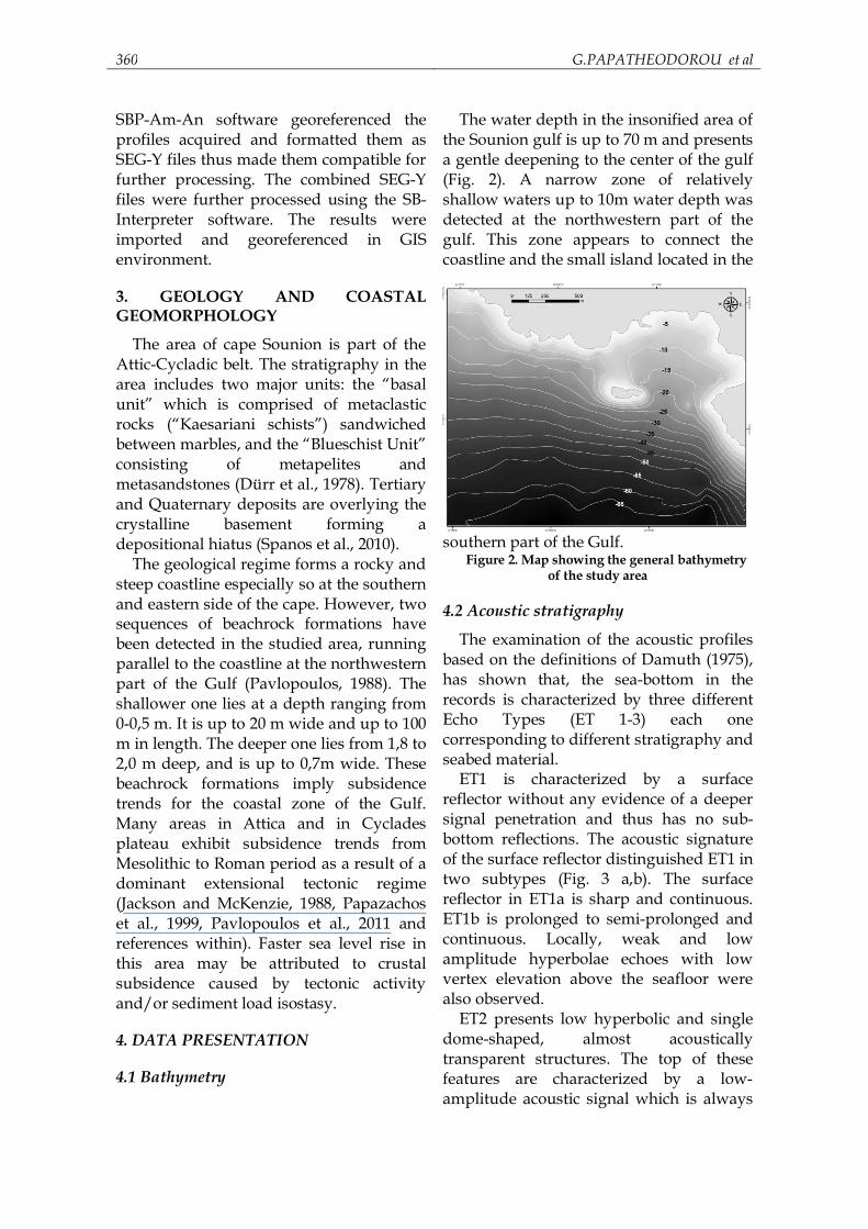
The area of cape Sounion is part of the Attic-Cycladic belt. The stratigraphy in the area includes two major units: the “basal unit” which is comprised of metaclastic rocks (“Kaesariani schists”) sandwiched between marbles, and the “Blueschist Unit” consisting of metapelites and metasandstones (Dürr et al., 1978). Tertiary and Quaternary deposits are overlying the crystalline basement forming a depositional hiatus (Spanos et al., 2010).
The geological regime forms a rocky and steep coastline especially so at the southern and eastern side of the cape. However, two sequences of beachrock formations have been detected in the studied area, running parallel to the coastline at the northwestern part of the Gulf (Pavlopoulos, 1988). The shallower one lies at a depth ranging from 0-0,5 m. It is up to 20 m wide and up to 100 m in length. The deeper one lies from 1,8 to 2,0 m deep, and is up to 0,7m wide. These beachrock formations imply subsidence trends for the coastal zone of the Gulf. Many areas in Attica and in Cyclades plateau exhibit subsidence trends from Mesolithic to Roman period as a result of a dominant extensional tectonic regime (Jackson and McKenzie, 1988, Papazachos et al., 1999, Pavlopoulos et al., 2011 and references within). Faster sea level rise in this area may be attributed to crustal subsidence caused by tectonic activity and/or sediment load isostasy.
4. DATA PRESENTATION
4.1 Bathymetry
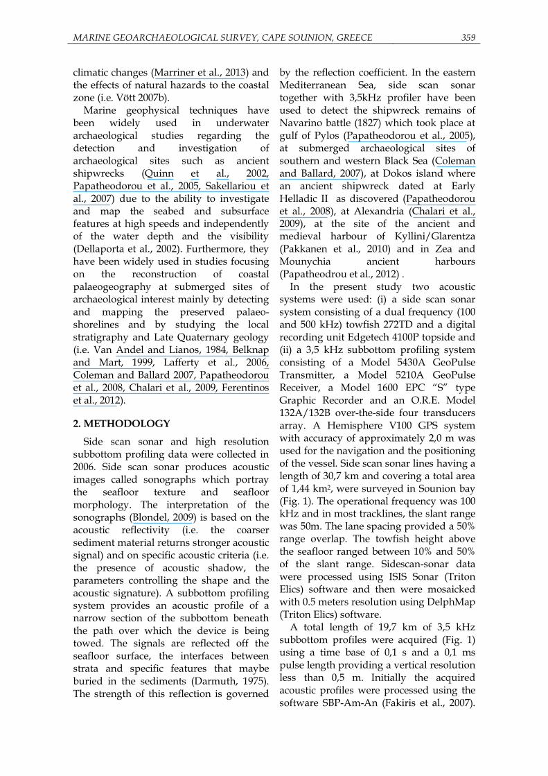
The water depth in the insonified area of the Sounion gulf is up to 70 m and presents a gentle deepening to the center of the gulf (Fig. 2). A narrow zone of relatively shallow waters up to 10m water depth was detected at the northwestern part of the gulf. This zone appears to connect the coastline and the small island located in the
southern part of the Gulf. Figure 2. Map showing the general bathymetry
of the study area
4.2 Acoustic stratigraphy
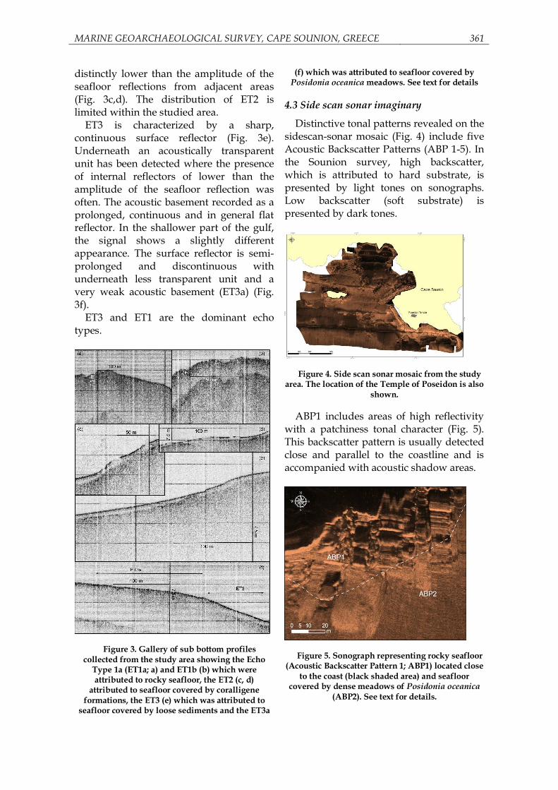
The examination of the acoustic profiles based on the definitions of Damuth (1975), has shown that, the sea-bottom in the records is characterized by three different Echo Types (ET 1-3) each one corresponding to different stratigraphy and seabed material.
ET1 is characterized by a surface reflector without any evidence of a deeper signal penetration and thus has no sub-bottom reflections. The acoustic signature of the surface reflector distinguished ET1 in two subtypes (Fig. 3 a,b). The surface reflector in ET1a is sharp and continuous. ET1b is prolonged to semi-prolonged and continuous. Locally, weak and low amplitude hyperbolae echoes with low vertex elevation above the seafloor were also observed.
ET2 presents low hyperbolic and single dome-shaped, almost acoustically transparent structures. The top of these features are characterized by a low-amplitude acoustic signal which is always
MARINE GEOARCHAEOLOGICAL SURVEY, CAPE SOUNION, GREECE 361
distinctly lower than the amplitude of the seafloor reflections from adjacent areas (Fig. 3c,d). The distribution of ET2 is limited within the studied area.
ET3 is characterized by a sharp, continuous surface reflector (Fig. 3e). Underneath an acoustically transparent unit has been detected where the presence of internal reflectors of lower than the amplitude of the seafloor reflection was often. The acoustic basement recorded as a prolonged, continuous and in general flat reflector. In the shallower part of the gulf, the signal shows a slightly different appearance. The surface reflector is semi-prolonged and discontinuous with underneath less transparent unit and a very weak acoustic basement (ET3a) (Fig. 3f).
ET3 and ET1 are the dominant echo types.
Figure 3. Gallery of sub bottom profiles collected from the study area showing the Echo
Type 1a (ET1a; a) and ET1b (b) which were attributed to rocky seafloor, the ET2 (c, d)
attributed to seafloor covered by coralligene formations, the ET3 (e) which was attributed to
seafloor covered by loose sediments and the ET3a
(f) which was attributed to seafloor covered by Posidonia oceanica meadows. See text for details
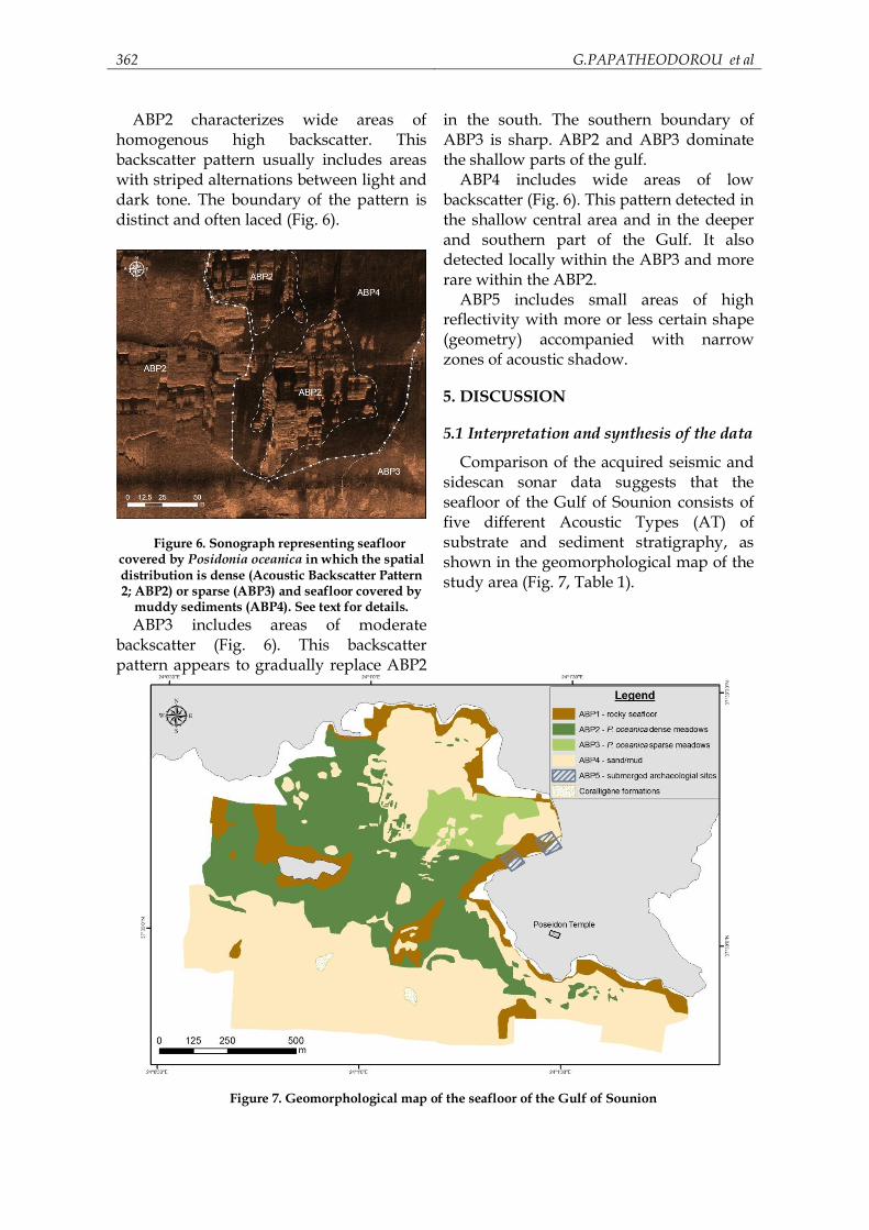
4.3 Side scan sonar imaginary
Distinctive tonal patterns revealed on the sidescan-sonar mosaic (Fig. 4) include five Acoustic Backscatter Patterns (ABP 1-5). In the Sounion survey, high backscatter, which is attributed to hard substrate, is presented by light tones on sonographs. Low backscatter (soft substrate) is presented by dark tones.
Figure 4. Side scan sonar mosaic from the study area. The location of the Temple of Poseidon is also
shown.
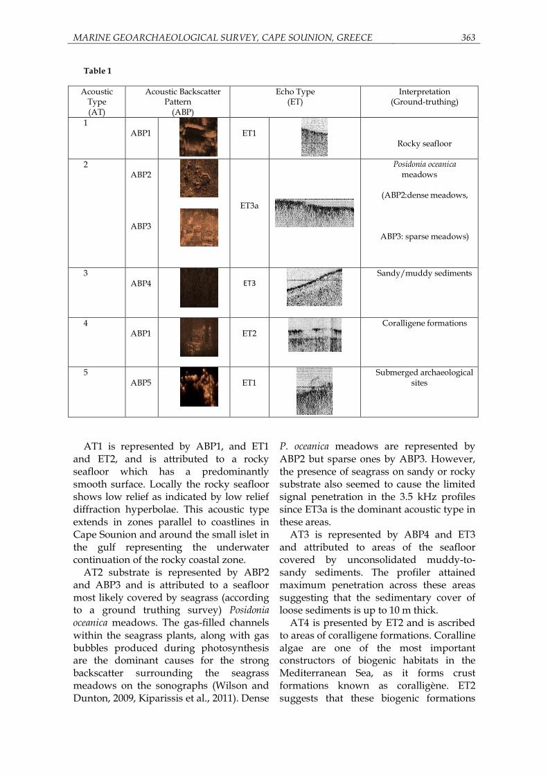
ABP1 includes areas of high reflectivity with a patchiness tonal character (Fig. 5). This backscatter pattern is usually detected close and parallel to the coastline and is accompanied with acoustic shadow areas.
Figure 5. Sonograph representing rocky seafloor
(Acoustic Backscatter Pattern 1; ABP1) located close to the coast (black shaded area) and seafloor
covered by dense meadows of Posidonia oceanica (ABP2). See text for details.
362 G.PAPATHEODOROU et al
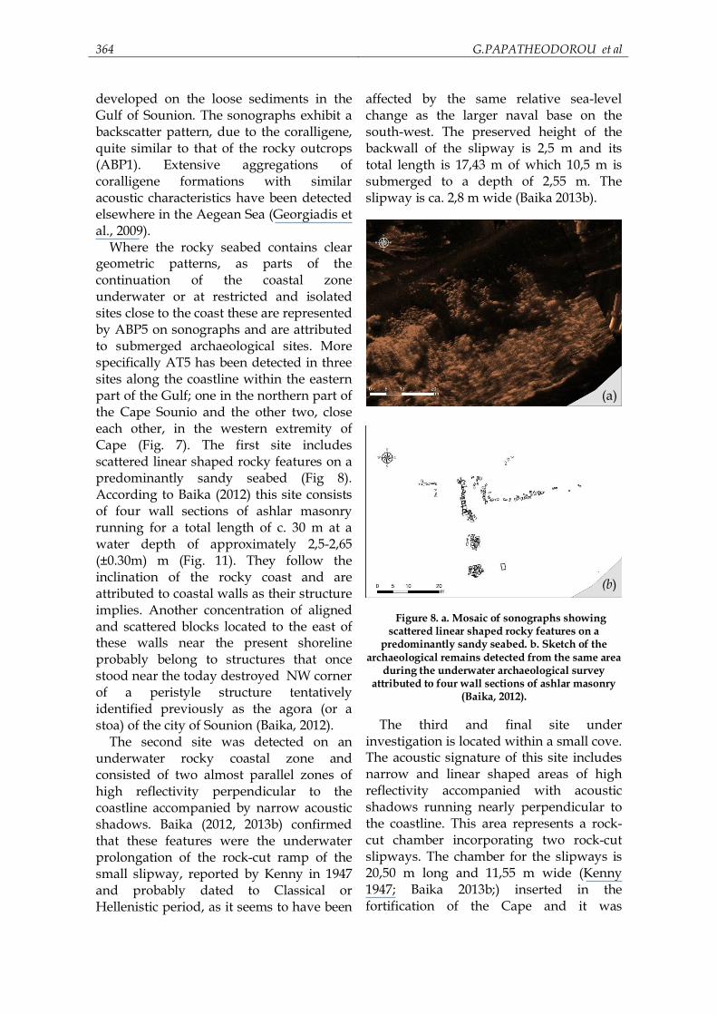
ABP2 characterizes wide areas of homogenous high backscatter. This backscatter pattern usually includes areas with striped alternations between light and dark tone. The boundary of the pattern is distinct and often laced (Fig. 6).
Figure 6. Sonograph representing seafloor covered by Posidonia oceanica in which the spatial distribution is dense (Acoustic Backscatter Pattern 2; ABP2) or sparse (ABP3) and seafloor covered by
muddy sediments (ABP4). See text for details. ABP3 includes areas of moderate
backscatter (Fig. 6). This backscatter pattern appears to gradually replace ABP2
in the south. The southern boundary of ABP3 is sharp. ABP2 and ABP3 dominate the shallow parts of the gulf.
ABP4 includes wide areas of low backscatter (Fig. 6). This pattern detected in the shallow central area and in the deeper and southern part of the Gulf. It also detected locally within the ABP3 and more rare within the ABP2.
ABP5 includes small areas of high reflectivity with more or less certain shape (geometry) accompanied with narrow zones of acoustic shadow.
5. DISCUSSION
5.1 Interpretation and synthesis of the data
Comparison of the acquired seismic and sidescan sonar data suggests that the seafloor of the Gulf of Sounion consists of five different Acoustic Types (AT) of substrate and sediment stratigraphy, as shown in the geomorphological map of the study area (Fig. 7, Table 1).
Figure 7. Geomorphological map of the seafloor of the Gulf of Sounion
MARINE GEOARCHAEOLOGICAL SURVEY, CAPE SOUNION, GREECE 363
Table 1
Acoustic Type (AT)
Acoustic Backscatter Pattern
(ABP)
Echo Type (ET)
Interpretation (Ground-truthing)
1
ABP1
ET1
Rocky seafloor
2 ABP2 ABP3
ET3a
Posidonia oceanica meadows
(ABP2:dense meadows,
ABP3: sparse meadows)
3 ABP4
ET3
Sandy/muddy sediments
4 ABP1
ET2
Coralligene formations
5 ABP5
ET1
Submerged archaeological sites
AT1 is represented by ABP1, and ET1
and ET2, and is attributed to a rocky seafloor which has a predominantly smooth surface. Locally the rocky seafloor shows low relief as indicated by low relief diffraction hyperbolae. This acoustic type extends in zones parallel to coastlines in Cape Sounion and around the small islet in the gulf representing the underwater continuation of the rocky coastal zone.
AT2 substrate is represented by ABP2 and ABP3 and is attributed to a seafloor most likely covered by seagrass (according to a ground truthing survey) Posidonia oceanica meadows. The gas-filled channels within the seagrass plants, along with gas bubbles produced during photosynthesis are the dominant causes for the strong backscatter surrounding the seagrass meadows on the sonographs (Wilson and Dunton, 2009, Kiparissis et al., 2011). Dense
P. oceanica meadows are represented by ABP2 but sparse ones by ABP3. However, the presence of seagrass on sandy or rocky substrate also seemed to cause the limited signal penetration in the 3.5 kHz profiles since ET3a is the dominant acoustic type in these areas.
AT3 is represented by ABP4 and ET3 and attributed to areas of the seafloor covered by unconsolidated muddy-to-sandy sediments. The profiler attained maximum penetration across these areas suggesting that the sedimentary cover of loose sediments is up to 10 m thick.
AT4 is presented by ET2 and is ascribed to areas of coralligene formations. Coralline algae are one of the most important constructors of biogenic habitats in the Mediterranean Sea, as it forms crust formations known as coralligène. ET2 suggests that these biogenic formations
364 G.PAPATHEODOROU et al
developed on the loose sediments in the Gulf of Sounion. The sonographs exhibit a backscatter pattern, due to the coralligene, quite similar to that of the rocky outcrops (ABP1). Extensive aggregations of coralligene formations with similar acoustic characteristics have been detected elsewhere in the Aegean Sea (Georgiadis et al., 2009).
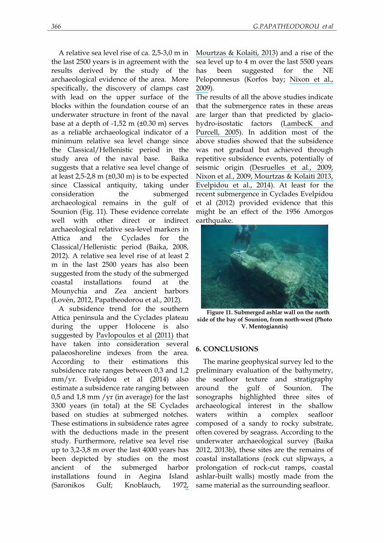
Where the rocky seabed contains clear geometric patterns, as parts of the continuation of the coastal zone underwater or at restricted and isolated sites close to the coast these are represented by ABP5 on sonographs and are attributed to submerged archaeological sites. More specifically AT5 has been detected in three sites along the coastline within the eastern part of the Gulf; one in the northern part of the Cape Sounio and the other two, close each other, in the western extremity of Cape (Fig. 7). The first site includes scattered linear shaped rocky features on a predominantly sandy seabed (Fig 8). According to Baika (2012) this site consists of four wall sections of ashlar masonry running for a total length of c. 30 m at a water depth of approximately 2,5-2,65 (±0.30m) m (Fig. 11). They follow the inclination of the rocky coast and are attributed to coastal walls as their structure implies. Another concentration of aligned and scattered blocks located to the east of these walls near the present shoreline probably belong to structures that once stood near the today destroyed NW corner of a peristyle structure tentatively identified previously as the agora (or a stoa) of the city of Sounion (Baika, 2012).
The second site was detected on an underwater rocky coastal zone and consisted of two almost parallel zones of high reflectivity perpendicular to the coastline accompanied by narrow acoustic shadows. Baika (2012, 2013b) confirmed that these features were the underwater prolongation of the rock-cut ramp of the small slipway, reported by Kenny in 1947 and probably dated to Classical or Hellenistic period, as it seems to have been
affected by the same relative sea-level change as the larger naval base on the south-west. The preserved height of the backwall of the slipway is 2,5 m and its total length is 17,43 m of which 10,5 m is submerged to a depth of 2,55 m. The slipway is ca. 2,8 m wide (Baika 2013b).
Figure 8. a. Mosaic of sonographs showing
scattered linear shaped rocky features on a predominantly sandy seabed. b. Sketch of the
archaeological remains detected from the same area during the underwater archaeological survey
attributed to four wall sections of ashlar masonry (Baika, 2012).
The third and final site under
investigation is located within a small cove. The acoustic signature of this site includes narrow and linear shaped areas of high reflectivity accompanied with acoustic shadows running nearly perpendicular to the coastline. This area represents a rock-cut chamber incorporating two rock-cut slipways. The chamber for the slipways is 20,50 m long and 11,55 m wide (Kenny 1947; Baika 2013b;) inserted in the fortification of the Cape and it was
(a)
(b)

MARINE GEOARCHAEOLOGICAL SURVEY, CAPE SOUNION, GREECE 365
protected at least in the Hellenistic times by a wall extension. This shipshed complex was part of the naval base, yet the dating of the first phase of its construction is still under discussion (Baika 2013b, with discussion).
In addition to these submerged archaeological sites (AT5), which are located along the coastline, a small number of targets which point out to artificial origin have been detected. The targets were identified on the basis of their shape and backscatter characteristics and were located within ABP2, ABP3 and mainly ABP4 zones. The targets remain unidentified as ground truthing has yet to be undertaken and it is difficult to link a specific backscatter and shape pattern to target origin.
5.2 Sea level changes implications
The configuration of the coastline is affected by the relative sea level change, earth surface processes (i.e. coastal erosion) and human activity. Relative sea levels have changed in the past in response to eustatic changes, to glacio-hydro-isostatic variations and to regional and local vertical displacements (Pirazzoli, 1991, Lambeck, 1996). These factors seem to have caused significant coastal paleogeographic changes in the study area.
According to the predicted sea level rise due to eustatic and glacio-hydro-isostatic effects for the area (Lambeck and Purcell, 2005) in collaboration to the depth occurrence of the acoustic basement and to the distribution of water depths as these obtained from the present study, the gulf of Sounion was land during the last glacial and late glacial periods (from 21 to 10ka BP; Fig. 9). The gulf started to form at the beginning of the Holocene when the sea level was about 25 m below the present level. At around 7 ka BP (when the sea level was ~ 10 m below the present level) the sea had flooded the majority of the area within the gulf with the exception of the northwestern corner where the islet was still connected to the mainland via a
narrow strip of land (Fig. 10). The continuous sea level rise during the Middle Holocene eventually flooded this part of the gulf forming the present morphology by the Late Holocene.
Figure 9. Schematic presentation of the
topography of the study area during the glacial and late glacial periods, where the area of the gulf of
Sounion was land. The solid black line represents the present shoreline and the dotted line the glacial
period palaeocoastline.
Figure 10. Schematic presentation of the topography of the study area between 10 and 7ka BP. The solid black line represents the present
shoreline and the dotted line the 10 ka BP palaeocoastline.
For more recent times, the signal of the
relative sea level changes can be more cohesive by supplemental information from the examination of sea level markers from this study area (Attica peninsula) and the adjacent coastal zone areas. The selected marine geophysical data from the present study detected coastal installations of Classical antiquity submerged and embayed from the coastline to the 2,5-3,0 m isobath.
(a)
(b)
366 G.PAPATHEODOROU et al
A relative sea level rise of ca. 2,5-3,0 m in the last 2500 years is in agreement with the results derived by the study of the archaeological evidence of the area. More specifically, the discovery of clamps cast with lead on the upper surface of the blocks within the foundation course of an underwater structure in front of the naval base at a depth of -1,52 m (±0.30 m) serves as a reliable archaeological indicator of a minimum relative sea level change since the Classical/Hellenistic period in the study area of the naval base. Baika suggests that a relative sea level change of at least 2,5-2,8 m (±0,30 m) is to be expected since Classical antiquity, taking under consideration the submerged archaeological remains in the gulf of Sounion (Fig. 11). These evidence correlate well with other direct or indirect archaeological relative sea-level markers in Attica and the Cyclades for the Classical/Hellenistic period (Baika, 2008, 2012). A relative sea level rise of at least 2 m in the last 2500 years has also been suggested from the study of the submerged coastal installations found at the Mounychia and Zea ancient harbors (Lovén, 2012, Papatheodorou et al., 2012).
A subsidence trend for the southern Attica peninsula and the Cyclades plateau during the upper Holocene is also suggested by Pavlopoulos et al (2011) that have taken into consideration several palaeoshoreline indexes from the area. According to their estimations this subsidence rate ranges between 0,3 and 1,2 mm/yr. Evelpidou et al (2014) also estimate a subsidence rate ranging between 0,5 and 1,8 mm /yr (in average) for the last 3300 years (in total) at the SE Cyclades based on studies at submerged notches. These estimations in subsidence rates agree with the deductions made in the present study. Furthermore, relative sea level rise up to 3,2-3,8 m over the last 4000 years has been depicted by studies on the most ancient of the submerged harbor installations found in Aegina Island (Saronikos Gulf; Knoblauch, 1972,
Mourtzas & Kolaiti, 2013) and a rise of the sea level up to 4 m over the last 5500 years has been suggested for the NE Peloponnesus (Korfos bay; Nixon et al., 2009). The results of all the above studies indicate that the submergence rates in these areas are larger than that predicted by glacio-hydro-isostatic factors (LambecK and Purcell, 2005). In addition most of the above studies showed that the subsidence was not gradual but achieved through repetitive subsidence events, potentially of seismic origin (Desruelles et al., 2009, Nixon et al., 2009, Mourtzas & Kolaiti 2013, Evelpidou et al., 2014). At least for the recent submergence in Cyclades Evelpidou et al (2012) provided evidence that this might be an effect of the 1956 Amorgos earthquake.
Figure 11. Submerged ashlar wall on the north
side of the bay of Sounion, from north-west (Photo V. Mentogiannis)
6. CONCLUSIONS
The marine geophysical survey led to the preliminary evaluation of the bathymetry, the seafloor texture and stratigraphy around the gulf of Sounion. The sonographs highlighted three sites of archaeological interest in the shallow waters within a complex seafloor composed of a sandy to rocky substrate, often covered by seagrass. According to the underwater archaeological survey (Baika 2012, 2013b), these sites are the remains of coastal installations (rock cut slipways, a prolongation of rock-cut ramps, coastal ashlar-built walls) mostly made from the same material as the surrounding seafloor.
MARINE GEOARCHAEOLOGICAL SURVEY, CAPE SOUNION, GREECE 367
The side scan sonar has provided reliable results and thus substantial support to marine archaeological surveys. In the current survey, the backscatter and shape characteristics in the acoustic signature of these sites proved to be a reliable criterion for the detection of the archaeological targets. However, the ground truth survey was essential to confirm the archaeological nature of these acoustic signatures.
The data retrieved from the seismic profiles allowed for a general evaluation of the coastal geomorphological evolution of the gulf since the last glacial period. It also raised once again the complexities regarding relative sea level changes in the area since antiquity. Due to the cultural significance of the site further underwater investigations are required. The detailed geophysical survey within the SASMAP project (EU funded; ENV.2012.6.2-6; GA: 308340) whose aim, among others, is to increase our understanding of the geological model which dominates the shelf of the southern Attica, is expected to contribute further more to the studies of the archaeological community.
ACKNOWLEDGEMENTS The authors would like to thank the two anonymous reviewers for their constructive comments. The interdisciplinary fieldwork campaigns were generously funded by I. Kostopoulos Foundation in the framework of the Project ‘Rock-cut slipways in Greece. Underwater survey of the naval installations’. The 2006 Sounion Survey was conducted by the Ephorate of Underwater Antiquities supervised by K. Baika. We would like to thank Katerina Dellaporta, then Ephor, for her kind support and for granting the publication rights for the 2006 survey. We would like to thank all colleagues, friends and students for their participation and help in the survey of 2006, namely the topographers Thanassis Psarogiannis and Menios Kalogeropoulos, the architect-diver Stella Nikolakaki, photographer-diver Vassilis Mentogiannis, archaeologists-divers Eirini Chrysocheris, Eva
Charalabidou, Dora Strinopoulou, Areti Chalkioti, Vassiliki Ivrou, Athina Boleti and Georgos Nomikos.
368 G.PAPATHEODOROU et al
REFERENCES
Baika K. (2008) Archaeological indicators of relative sea-level changes in the Attico-
Cycladic massif since Classical antiquity: Preliminary results. Bulletin of the Geological Society of Greece, vol. XLII/II, 33-48.
Baika K. (2012) Submerged archaeological remains at Cape Sounion, Attica, and implications for the study of relative sea-level changes since the Classical period in the Central Aegean, In Henderson, J.C. (ed.) Beyond Boundaries, The 3rd International Congress on Underwater Archaeology, IKUWA 3 London 2008, Nautical Archaeology Society/ Römisch-Germanische Kommission, Bonn, 277-286.
Baika, K. (2013a) Small-scale and rock-cut naval bases. In: Blackman, D., Rankov, B., Baika, K., Gerding, H., Pakkanen, Y., (eds) Shipsheds in the ancient Mediterranean. Cambridge University Press, 231-253.
Baika, K. (2013b) Sounion, In: Blackman, D., Rankov, B., Baika, K., Gerding, H., Pakkanen, Y., Shipsheds in the ancient Mediterranean. Cambridge University Press, 525-534.
Bailey, G.N. and Flemming N.C. (2008) Archaeology of the continental shelf: Marine resources, submerged landscapes and underwater archaeology. Quaternary Science Reviews, vol. 27, 2153–2165.
Belknap, D.F. and Mart, Y. (1999) Sea-level lowstand in the eastern Mediterranean: Late pleistocene coastal terraces offshore northern Israel. Journal of Coastal Research, vol.15 (2), 399-412.
Blackman, D.J. (2005) Archaeological evidence for sea level changes. Zeitschrift für Geomorphologie, vol. 137, 61–70.
Blondel, P. (2009) The Handbook of Sidescan Sonar ISBN 978-3-540-49886-5 Springer Praxis Books, p. 235.
Chalari, A., Papatheodorou, G., Geraga, M., Christodoulou, D. and Ferentinos, G. (2009) A marine geophysical survey illustrates Alexandria’s Hellenistic past. Zeitschrift fur Geomorphologie, vol. 53, 191-212.
Coleman D. F. and Ballard R.D. (2007) Submerged paleoshorelines in the southern and western Black Sea-Implications for inundated prehistoric archaeological sites. In V. Yanko-Hombach et al. (eds.), The Black Sea Flood Question, Springer, 671-696.
Damuth, J.E. (1975) Echo character of the western equatorial Atlantic floor and its relationships to the dispersal and distribution of terrigenous sediments. Marine Geology, vol. 18, 17-45.
Dellaporta, A.P., Evagelistis, and Kourkoumelis, D. (2002) New technologies and underwater archaeology. C.A.A Conference., Abstracts Book.
Desruelles, S., Fouache, E., Ciner, A., Dalongeville, R., Pavlopoulos, K., Kosun, E., Coquinot, Y. and Potdevin, J-L. (2009) Sea-level changes and shoreline reconstruction in the ancient city of Delos (Cyclades, Greece). Geodynamica Acta, vol. 20(4), 231–239.
Dürr, S., Altherr, R., Keller, J., Okrusch, M. and Seidel, E. (1978) The median Aegean crystalline belt: stratigraphy, structure, metamorphism, magmatism. In: Cloos, H., Roeder, D. & Schmidt, K. (eds.): Alps, Apennines, Hellenides. Schweizerbart, Stuttgart, 455–476.
Evelpidou, N., Melini, D., Pirazzoli, P.A. and Vassilopoulos A. (2012) Evidence of a recent rapid subsidence in the S–E Cyclades (Greece): An effect of the 1956 Amorgos earthquake? Continental Shelf Research, vol. 39–40, 27–40.
MARINE GEOARCHAEOLOGICAL SURVEY, CAPE SOUNION, GREECE 369
Evelpidou, N., Vassilopoulos, A., Melini, D. and Pirazzoli, P.A. (2014) Evidence of repeated late Holocene rapid subsidence in the SE Cyclades (Greece) deduced from submerged notches. Int J Earth Sci (Geol Rundsch), DOI 10.1007/s00531-013-0942-0.
Fakiris E., Chalari A. and Papatheodorou G. (2007) A convenient Matlab Graphical User Interface for the analysis of analog sub-bottom profiles. In proceedings of the 2nd International Conference & Exhibition on Underwater Acoustic Measurements: Technologies & Results, vol: I, 239-245.
Ferentinos, G., Gkioni, M., Geraga, M., Papatheodorou, G. (2012) Early seafaring activity in the southern Ionian Isalnds, Mediterranean Sea. Journal of Archaeological Science, vol. 39, 2167-2176.
Flemming, N.C. (1996) Sea level, neotectonics and changes in coastal settlements: threat and response. In: Rice, E.E. (Ed.): The Sea and History. Sutton, 23–52.
Georgiadis, M., Papatheodorou, G., Tzanatos, E., Geraga, M., Ramfos, A., Koutsikopoulos, C. and Ferentinos, G. (2009) Coralligène formations in the eastern Mediterranean Sea: Morphology, distribution, mapping and relation to fisheries in the southern Aegean Sea (Greece) based on high-resolution acoustics. Journal of Experimental Marine Biology and Ecology, vol. 368, 44-58.
Jackson J and McKenzie DP (1988) Rates of active deformation in the Aegean and surrounding areas. Basin Research, vol. 1, 121–128.
Kenny, E.J.A. (1947) The ancient docks on the promontory of Sounion. Annual of the British School at Athens, vol. 42, 194-200.
Kiparissis, S., Fakiris, E., Papatheodorou, G., Geraga, M., Kornaros, M., Kapareliotis, A. and Ferentinos, G. (2011) Illegal trawling and induced invasive algal spread as collaborative factors in a Posidonia oceanica meadow degradation. Biological Invasions doi10.1007/s10530-010-9858-9.
Knoblauch, P. (1972) Die Hafenanlagen der Stadt Ägina, Archaiologikon Deltion 27 A, 50–85 (publ. 1974).
Lafferty B., Quinn, R. and Breen, C. (2006) A side-scan sonar and high-resolution Chirp sub-bottom profile study of the natural and anthropogenic sedimentary record of Lower Lough Erne, northwestern Ireland. Journal of Archaeological Science, vol. 33, 756-766.
Lambeck, K. (1006 Sea-level change and shore-line evolution in Aegean Greece since Upper Palaeolithic time. Antiquity, vol 70, 588-611.
Lambeck, K. and Purcell, A. (2005) Sea-level change in the Mediterranean Sea since the LGM: Model predictions for tectonically stable areas. Quaternary Science Reviews, vol 24, 1969–1988.
Lovén, B. (2012) The Ancient Harbours of the Piraeus. Monographs of the Danish Institute at Athens, vol 15.2, ISBN 9788771240078 (Publ.) Aarhus University Press vol. I.1, 314.
Marriner, N. and Morhange, C. (2007) Geoscience of ancient Mediterranean harbours. Earth-Science Reviews, vol. 80 (3-4), 137-194.
Marriner, N. and Morhange, C. (2008) Preserving Lebanon's coastal archaeology: Beirut, Sidon and Tyre. Ocean and Coastal Management, vol. 51 (5), 430-441.
Marriner, N., Flaux, C., Morhange, C., Stanley, J-D. (2013) Tracking Nile Delta Vulnerability to Holocene Change. PLoS ONE, vol. 8 (7), e69195.
Mourtzas, N.D. and Kolaiti, E. (2013) Historical coastal evolution of the ancient harbor of Aegina in relation to the Upper Holocene relative sea level changes in the Saronic Gulf, Greece. Palaeogeography, Palaeoclimatology, Palaeoecology, vol. 392, 411–425.
370 G.PAPATHEODOROU et al
Nixon, F.C., Reinhardt, E.G. and Rothaus, R. (2009) Foraminifera and tidal notches: Dating Neotectonic events at Korphos, Greece. Marine Geology, vol 257, 41-53.
Pakkanen J., Baika K., Geraga M., Evangelistis, D., Fakiris E., Heath S., Christodoulou D., Iatrou M., Papatheodorou G. (2010) Archaeological topographical survey and marine geophysical investigation at ancient and medieval harbour of Kyllini/Glarentza (NW Peloponnese, Greece). XIX Congress of the Carpathian-Balkan Geological Association, Thessaloniki, Greece, Geologica Balcanica Abstracts Volume ISSN 0324-0894, pp. 283.
Papatheodorou, G., Geraga, M. and Ferentinos, G. (2005) The Navarino Naval Battle site, Greece – an integrated remote sensing survey and a rational management approach. International Journal of Nautical Archaeology , vol. 34, 95-109.
Papatheodorou, G., Geraga, M. and Ferentinos, G. (2008) The reconstruction of prehistoric shorelines in Dokos Island, Aegean Sea, using remote sensing techniques. British Archaeological Reports (BAR) International Series ISBN 978 1 4073 01884, vol.1746, 65-71.
Papatheodorou, G., Geraga, M., Christodoulou, D., Kordela, S., Prevenios, M. and Zoura, D. (2012) Marine remote sensing survey in Zea and Mounichia ancient harbours. 1st Interim Report, vol.1, .1-70, submitted to Zea Harbour Project.
Papazachos, B.C., Papaioannou, C.A., Papazachos, C.B. and Savvaidis A.S. (1999) Rupture zones in the Aegean region. Tectonophysics, vol.308, 205–221.
Pavlopoulos, K. (1988) Geomorphological evolution of South Attica. National and Kapodistrian University of Athens, p.390.
Pavlopoulos, K. (1992) Geomorphologic evolution of southern Attica. PhD Thesis, University of Athens.
Pavlopoulos, K., Kapsimalis, V., Theodorakopoulou K. and Panagiotopoulos, I. P. (2011) Vertical displacement trends in the Aegean coastal zone (NE Mediterranean) during the Holocene. The Holocene, doi: 10.1177/0959683611423683.
Pirazzoli P.A. (1991) World atlas of Holocene sea-level changes. Elsevier Oceanographic Series, vol. 58, Elsevier, Amsterdam, 300 pp., ISBN 444-89086-6.
Quinn, R., Breen, C., Forsythe, W., Barton, K., Rooney, S. and O'Hara, D. (2002) Integrated Geophysical Surveys of The French Frigate La Surveillante (1797), Bantry Bay, Co. Cork, Ireland. Journal of Archaeological Science, vol. 29, 413-22.
Sakellariou, D., Georgiou, P., Mallios, A., Kapsimalis, V., Kourkoumelis, D., Micha, P., Theodoulou, T. and Dellaporta, K. (2007) Searching for ancient shipwrecks in the Aegean Sea: The discovery of Chios and Kythnos Hellenistic wrecks with the use of marine geological-geophysical methods. International Journal of Nautical Archaeology, vol. 36,365-381.
Spanos, D., Koukouvelas, I., Kokkalas, S. and Xypolias, P. (2010) Patterns of Ductile deformation in Attico-Cycladic Massif. Bulletin of the Geological Society of Greece, Proceedings of the 12 Congress, vol. XLII ( 1), 368-378.
Van Andel, T.H. and Lianos, N. (1984) High Resolution seismic reflection profiles for the reconstruction of post-glacial trangressive shorelines: An example from Greece, Quaternary Research, vol. 22, 31-45.
Vött A. (2007a) Silting up Oiniadai’s harbours (Acheloos River delta, NW Greece). Geoarchaeological implications of late Holocene landscape changes. Geomorphologie : relief, processus, environnement, vol. 1, 19-36.
Vött A. (2007b) Relative sea level changes and regional tectonic evolution of seven coastal areas in NW Greece since the mid-Holocene. Quaternary Science Reviews, vol. 26, 894–919.

MARINE GEOARCHAEOLOGICAL SURVEY, CAPE SOUNION, GREECE 371
Wilson, P.S. and Dunton, K.H. (2009) Laboratory investigation of the acoustic response of seagrass tissue in the frequency band 0.5–2.5 kHz. J Acoust Soc Am, vol 125, 1951–1959. doi:10.1121/ 1.3086272.