Geoarchaeological issues of the Upper-Dnieper-Western Dvina river region (Western Russia): fieldtrip...
61
GEOMORPHIC PROCESSES AND GEOARCHAEOLOGY From Landscape Archaeology to Archaeotourism International conference August 20-24, 2012 GEOARCHAEOLOGICAL ISSUES OF THE UPPER DNIEPER – WESTERN DVINA RIVER REGION (WESTERN RUSSIA): FIELDTRIP GUIDE Moscow-Smolensk, Russia
Transcript of Geoarchaeological issues of the Upper-Dnieper-Western Dvina river region (Western Russia): fieldtrip...

GEOMORPHIC PROCESSES AND GEOARCHAEOLOGY From Landscape Archaeology to Archaeotourism
International conference
August 20-24, 2012
GEOARCHAEOLOGICAL ISSUES OF THE UPPER DNIEPER –
WESTERN DVINA RIVER REGION (WESTERN RUSSIA): FIELDTRIP GUIDE
Moscow-Smolensk, Russia

GEOMORPHIC PROCESSES AND GEOARCHAEOLOGY From Landscape Archaeology to Archaeotourism
International conference
August 20-24, 2012
GEOARCHAEOLOGICAL ISSUES OF THE UPPER DNIEPER –
WESTERN DVINA RIVER REGION (WESTERN RUSSIA): FIELDTRIP GUIDE
Moscow-Smolensk, Russia

ISBN 978-5- 91412-130-2 Geoarchaeological issues of the Upper Dnieper – Western Dvina river region (Western Russia): fieldtrip guide.
This is the guide of two field excursions that were held during the International conference "Geomorphic Processes and Geoarchaeology: from Landscape Archaeology to Archaeotourism" (Moscow-Smolensk, Russia, August 20-24, 2012) hosted by the Smolensk University for Humanities. Excursion to the Gnezdovo archaeological complex in the Dnieper River valley in the vicinity of the Smolensk city was managed by the cooperative team from Moscow University (Faculty of History and Faculty of Geography), State Historical Museum (Moscow) and Institute of Geography, Russian Academy of Sciences (Moscow). Excursion to the Serteya complex in the Western Dvina River region was conducted by the State Hermitage Museum (Saint Petersburg). Moscow-Smolensk. “Universum”. 2012. 105 p.
Geoarchaeological issues of the Upper Dnieper – Western Dvina river region (Western Russia)
3
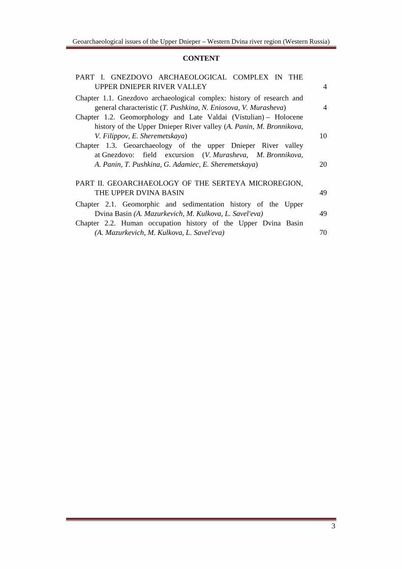
CONTENT
PART I. GNEZDOVO ARCHAEOLOGICAL COMPLEX IN THE UPPER DNIEPER RIVER VALLEY
4
Chapter 1.1. Gnezdovo archaeological complex: history of research and general characteristic (T. Pushkina, N. Eniosova, V. Murasheva)
4
Chapter 1.2. Geomorphology and Late Valdai (Vistulian) – Holocene history of the Upper Dnieper River valley (A. Panin, M. Bronnikova, V. Filippov, E. Sheremetskaya)
10 Chapter 1.3. Geoarchaeology of the upper Dnieper River valley
at Gnezdovo: field excursion (V. Murasheva, M. Bronnikova, A. Panin, T. Pushkina, G. Adamiec, E. Sheremetskaya)
20 PART II. GEOARCHAEOLOGY OF THE SERTEYA MICROREGION,
THE UPPER DVINA BASIN
49 Chapter 2.1. Geomorphic and sedimentation history of the Upper
Dvina Basin (A. Mazurkevich, M. Kulkova, L. Savel'eva)
49 Chapter 2.2. Human occupation history of the Upper Dvina Basin
(A. Mazurkevich, M. Kulkova, L. Savel'eva)
70
Geoarchaeological issues of the Upper Dnieper – Western Dvina river region (Western Russia)
49
PART II. GEOARCHAEOLOGY OF THE SERTEYA MICROREGION,
THE UPPER DVINA BASIN.
CHAPTER 2.1. GEOMORPHIC AND SEDIMENTATION HISTORY
OF THE UPPER DVINA BASIN
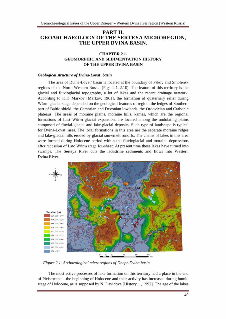
Geological structure of Dvina-Lovat’ basin The area of Dvina-Lovat’ basin is located at the boundary of Pskov and Smolensk
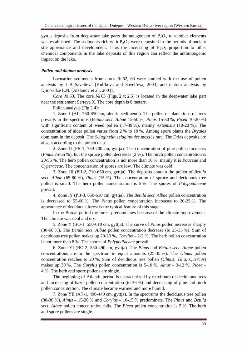
regions of the North-Western Russia (Figs. 2.1, 2.10). The feature of this territory is the glacial and fluvioglacial topography, a lot of lakes and the recent drainage network. According to K.K. Markov [Markov, 1961], the formation of quaternary relief during Wűrm glacial stage depended on the geological features of region: the ledges of Southern part of Baltic shield, the Cambrian and Devonian lowlands, the Ordovician and Carbonic plateaus. The areas of moraine plains, moraine hills, kames, which are the regional formations of Last Wűrm glacial expansion, are located among the undulating plains composed of fluvial-glacial and lake-glacial deposits. Such type of landscape is typical for Dvina-Lovat’ area. The local formations in this area are the separate moraine ridges and lake-glacial hills eroded by glacial snowmelt runoffs. The chains of lakes in this area were formed during Holocene period within the fluvioglacial and moraine depressions after recession of Late Wűrm stage Ice-sheet. At present time these lakes have turned into swamps. The Serteya River cuts the lacustrine sediments and flows into Western Dvina River.
Figure 2.1. Archaeological microregions of Dnepr-Dvina basin.
The most active processes of lake formation on this territory had a place in the end of Pleistocene – the beginning of Holocene and their activity has increased during humid stage of Holocene, as is supposed by N. Davidova [History…, 1992]. The age of the lakes

Geoarchaeological issues of the Upper Dnieper – Western Dvina river region (Western Russia)
50
was determined by the time of region deglaciation, the melting of buried ice. It was the time of beginning of the most lake formations. The climatic conditions of territory located in the humid zone of high precipitation were favored for lakes developments. The lake sediments were excavated in the bottom of numerous of peatbogs located in the North- Western Russia. These data reveals that small lakes turned into swamps during Holocene because of high deposit sedimentation.
The tectonic processes of the Fennoscandian shield had more influence on the development of drainage network on North-Western Russian plateau and the water fluctuations in the lake basins during Holocene than climatic changes. It was argued by many authors [Miettinen, 2002; Lak, 1975]. The isostatic elevations of the earth's crust in the study region were the most intensive right away after the degradation of icesheet. This process influenced the global fluctuations of Sea level because of the entry of great water volume. The eustatic variations of ancient Baltic Sea and drainage network of North-Western were connected with these events too. Therefore the changes of water level in the lakes of North-Western Russian plateau coincide with the transgressive-regressive stages of Baltic Sea. Depending on the rate of the land elevation the maximum of transgression stages in the lakes of different zones occurred at different time and had asynchronous character. So, the transgression in the basins has begun earlier in the zones of slow elevation of the land in comparison with the zones of fast elevation.
The important changes in the life of prehistoric people occurred in the Dvina–Lovat’ region during Holocene. Climatic fluctuations influenced the development of prehistoric societies. The Holocene period was one of the most favorable time in the history of humanity. Recent investigations, however, have showed that this period was characterized by global climatic fluctuations connected with solar activity (see Dergachev and van Geel, 2004; Dergachev et al., 2003; van Geel et al., 1998, 1999). They are characterized as very cold short phases. Many of these changes were sufficiently fast from the point of view of human civilization (i.e. a few hundred years and less) that they may be considered “rapid” [Mayewski et al., 2004]. According to numerous researches, the global episodes of fall temperature synchronous with a period of low solar activity after the Younger Dryas (12700-11500 cal BP) were recorded at 8200 cal BP (6200 cal BC) (Kofler
The transition to Atlantic period, beginning about 7500 cal BC is characterized by more warm and humid climate. The forests became more multifarious. The deciduous forests with oak, elm, linden and hazel are prevailed. On the Pazdur data, Atlantic period can be divided into four stages: АТ1 (7500-6480 cal ВС) – cool and dry stage; АТ2 (6480-5550 ВС) – warm and humid stage, АТ3 (5550-4900 cal ВС) – warm and humid
et al., 2005; Magny et al., 2003; Heiri et al., 2004), at 5800 cal BP (3850 cal BC) and 5300 cal BP (3350 cal BC) ( (Magny and Haas, 2004); around 4100 cal BP (2150 cal BC) (An et al., 2006; Chen et al., 2006); at 2800 cal BP (850 cal BC) (van Geel et al., 2004; van Geel and Beer, 2007); and around 300 cal BP (17-19 cc. AD).
Chotinskiy N.A. [Chotinskiy, 1978] and Pazdur A. [Pazdur et al., 2004] distinguish the following climatic periods for the humid zone in the North-Western Russia and Poland area during Holocene:
Preboreal period, dated about 10470-9900 cal BC is characterized by cool and dry conditions. In Poland area the interval of Preboreal stage was determined at 9550-8350 cal ВС.
Boreal period (8800-8250 cal BC) is characterized by rising of temperature in comparison with previous period. According to Pazdur, the Boreal period was warm and dry and it proceeded from 8350 to 7500 cal ВС.

Geoarchaeological issues of the Upper Dnieper – Western Dvina river region (Western Russia)
51
stage, АТ4 (4900-3800 ВС) – cool and humid stage. Aleshinskaya A.S. and Spiridonova E.A. [2000] note that the interval of 4900-2750 cal BC in the steppe zone of Russia was the time of late Atlantic climatic optimum, including the first half of Subboreal period. In this time the forests penetrated deep into Western regions of Eastern Europe and they were spread in the river valleys. The transitional Atlantic-Subboreal stage was about 3650-3350 cal BC. The transition to Early Subboreal cool stage has begun about 3350-2600 cal BC. The climate became drier. After 2750 cal BC the arid climate and decreasing of precipitation was recorded by Aleshinskaya A.S. The steppes extended on the Western part of Russia. The water level in the rivers and lakes has fallen in this period. The Middle Subboreal warming and decreasing of precipitation has begun at 2200 cal BC and its maximum is registered at 1700 cal ВC. The Late Subboreal fall of temperature and increasing of humidity was registered about 1450-600 cal BC. Such conditions proceeded during second half Subboreal period and first half of Subatlantic period. According to D.Van Geel et al. [1996] the sharp increasing of humidity and fall of temperature was registered at 850 cal BC in the Netherlands area. They found the data about such climatic change at 800 cal BC in another regions of the Earth too. This global climatic change could be due to the fact of solar activity variations in this period. On the territory of modern Poland the Subboreal 1 stage was noted at 3800-2850 cal ВС. It was warm and dry stage. The Subboreal 2 stage was at 2850-950 cal ВС and it is characterized by warm and humid climate.
The Subatlantic period has begun at about 800 cal BC. Its beginning can be characterized as cool and humid stage. According to A. Pazdur the beginning of the Subatlantic period was at 950 cal BC. Subatlantic 1 stage was at 950 cal ВС-150 cal AD – warm and humid stage. Subatlantic 2 stage was at 150 cal AD – 500 cal AD, warm and dry stage. Subatlantic 3 stage was at 500-1430 cal AD, the climate was cold and dry.
The present-day climate of Dnepr-Dvina basin is moderately continental, with mean temperatures of -8oC in January and 17–18o C in July, and the annual precipitation of 500–700 mm, mostly in summer. This area belongs to the East European mixed broadleaved-coniferous forests. Temperate deciduous formations consist of mixed oak forests, which are found mostly on the clayey soil of the morainic hills. Boreal evergreen conifer (mostly pine) forests cover the sandy outwash plain. Spruce forests are usually restricted to the lower levels of the morainic hills. An intensive felling of forests started in the XIII–XIVth centuries and much increased after the 1860s
Detailed reconstruction of climate is necessary for understanding the influence of landscape and paleoclimate conditions on ancient inhabitants. Use of different and independent natural scientific methods allow making detailed picture of regional and local climatic changes and their influence on ancient inhabitants. Such complex researches were conducted in Dvina-Lovat basin especially in Serteysky microregion [Mazurkevich, 2003, 2004; Mazurkevich et al., 2009; Dolukhanov et al., 2004; Kulkova and Savelieva, 2003; Zaitseva et al., 2003; Kulkova, 2005; Kulkova, 2006; Kulkova et al., 2001]. The two main lake valleys on the sides of which the ancient settlements were found can be distinguished in the modern landscape of Serteysky microregion. It is the Serteyskaya big lake valley and Nivnikovskaya small lake valley. The ancient lakes situated in chain were connected with each other by narrow neck of land which has been eroded during transgressive stages. Archaeological sites are situated on their shores and
. The woodland currently occupies less than 20 % of the originally forested area. The secondary forests consist of birch, and alder with shrubs. Bottomland floodplain meadows, bogs and mires occupy about 40 % of the total area. Agricultural plots take up the remaining 40 %. Main staple crops are rye, wheat and flax.

Geoarchaeological issues of the Upper Dnieper – Western Dvina river region (Western Russia)
52
inside of lake basins (Fig. 2.2). The variations of water level of these lakes mainly depended on the changes of Baltic Sea level. The influence of climatic changes on the transgression-regression stages was low. This factor could have the vital importance for prehistoric people which migrated during periods of climatic deteriorations when the most of water reservoirs of the forest-steppe zone became shallow.
Figure 2.2. Valley of Serteyka River.
Gyttja lake sediments from two lake depressions – Serteyskaya big lake depression and small Nivnikovskaya lake depression – were studied in order to reconstruct landscape-climatic conditions using methods of geochemical indications. The Serteyskaya lake depression consists of rust-red moraine loam. The Nivnikovskaya lake depression consists of fluvioglacial medium-grained laminated sands and siltstones of yellow and pink-yellow colors. The boarder of moraine deposits and fluvioglacial deposits is located in the Northern part of Serteyskaya valley. The mineralogical composition of deposits was determined by optical microscope and XR-diffraction analysis. The deposits consist of quartz, feldspars, amphibole, mica, from accessories minerals as carbonates, ilmenite, magnetite, rutile, tourmaline, zircon, garnet. The Holocene lake deposits can be differed into two types. The deepwater deposits consist of eight meter thickness of peat and gyttja. The shallow deposits of one meter thickness consist of laminated sands, siltstones and loams with organic components of light grey, yellow-grey colors.
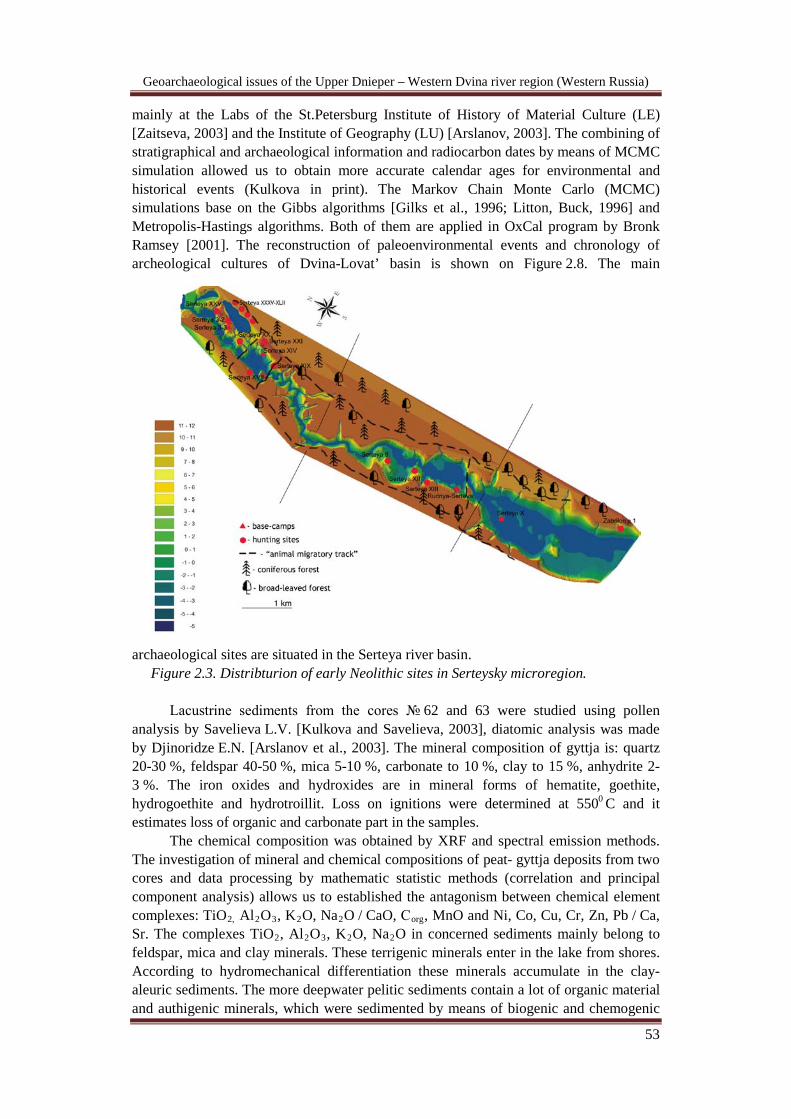
Holocene organogenic sediments – gyttja and peat – were studied in cores № 62, 72 (а), 63 (Figs. 2.3, 2.16) situated in deep-water parts of Serteyskaya and Nivnikovskaya lake depressions using hand “Russian” drill. The core № 63 is situated near archaeological site Serteya X, the core № 72 (a) – near the site Serteya XIV, the core № 62 – near the site Serteya II. Samples were taken from every layer, the age of sediments was determined using 14C dating. The radiocarbon measurements have been obtained for 96 samples of wood and charcoal from archaeological structures, as well as for organic samples from lacustrine deposits. These measurements were carried out
Geoarchaeological issues of the Upper Dnieper – Western Dvina river region (Western Russia)
53
mainly at the Labs of the St.Petersburg Institute of History of Material Culture (LE) [Zaitseva, 2003] and the Institute of Geography (LU) [Arslanov, 2003]. The combining of stratigraphical and archaeological information and radiocarbon dates by means of MCMC simulation allowed us to obtain more accurate calendar ages for environmental and historical events (Kulkova in print). The Markov Chain Monte Carlo (MCMC) simulations base on the Gibbs algorithms [Gilks et al., 1996; Litton, Buck, 1996] and Metropolis-Hastings algorithms. Both of them are applied in OxCal program by Bronk Ramsey [2001]. The reconstruction of paleoenvironmental events and chronology of archeological cultures of Dvina-Lovat’ basin is shown on Figure 2.8. The main
archaeological sites are situated in the Serteya river basin. Figure 2.3. Distribturion of early Neolithic sites in Serteysky microregion.
Lacustrine sediments from the cores № 62 and 63 were studied using pollen
analysis by Savelieva L.V. [Kulkova and Savelieva, 2003], diatomic analysis was made by Djinoridze E.N. [Arslanov et al., 2003]. The mineral composition of gyttja is: quartz 20-30 %, feldspar 40-50 %, mica 5-10 %, carbonate to 10 %, clay to 15 %, anhydrite 2-3 %. The iron oxides and hydroxides are in mineral forms of hematite, goethite, hydrogoethite and hydrotroillit. Loss on ignitions were determined at 5500
The chemical composition was obtained by XRF and spectral emission methods. The investigation of mineral and chemical compositions of peat- gyttja deposits from two cores and data processing by mathematic statistic methods (correlation and principal component analysis) allows us to established the antagonism between chemical element complexes: TiO
C and it estimates loss of organic and carbonate part in the samples.
2, Al2O3, K2O, Na2O / CaO, Сorg, MnO and Ni, Co, Cu, Cr, Zn, Pb / Ca, Sr. The complexes TiO2, Al2O3, K2O, Na2O in concerned sediments mainly belong to feldspar, mica and clay minerals. These terrigenic minerals enter in the lake from shores. According to hydromechanical differentiation these minerals accumulate in the clay- aleuric sediments. The more deepwater pelitic sediments contain a lot of organic material and authigenic minerals, which were sedimented by means of biogenic and chemogenic

Geoarchaeological issues of the Upper Dnieper – Western Dvina river region (Western Russia)
54
processes in the water column and near-bottom layers. These minerals contain MnO, CaO, Sr. Calcium and strontium were determined in the carbonate and sulphate composition. Manganese forms oxides and hydroxides. These data were compared with diatom analysis data. The increasing of concentration of TiO2, Al2O3, K2O, Na2O compounds and Ni, Co, Cu, Cr, Zn, Pb elements in the sediments correspond with the stages of lake level decreasing, but the increasing of CaO, Сorg, MnO, Sr concentrations correspond with the stages of lake level increasing. The ratios of complexes terrigenic to authigenic elements were used as the lake level marker.
The lake productivity depends on diatom development. The improving of climatic conditions, for example, high temperature and high humidity, intensive soil erosion favours the increasing of population of diatoms. As a result of hydromechanical differentiation the clay – aleuric sediments, containing clay, feldspar and biogenic silica deposited at the deepwater lake part, but quartz sedimented in the sand lacustrine deposits. Gavshin M., Chlistov O.M. [2000], Shimarev M.N. and Mizandronzev I.B. [2004] proposed to use for estimation of lake productivity the SiO2 / Al2O3 ratio, which mean the biogenic silica part in the deepwater organic deposits. This ratio was used for Serteya lake productivity estimation and it has good correlation with the quantitative estimation of planktonic diatoms.
According to Gerald A.G. [1984], Kalik S.A. and Mazilov V.N. [1998] for weathering intensity evaluation, which depends on the temperature variations, the following markers are used: (K2O+Na2O) / Al2O3; K2O / Na2O; CIA = Al2O3 / (Al2O3+CaO+Na2O+K2O). These markers were calculated for organic deposits of Serteya lake. The comparison with pollen analysis data allows establishing the most sensitive temperature geochemical marker. It is the Na2O / K2O ratio, which shows the grade of plagioclase weathering to the potassium feldspar. In conformity with Chen Yun et al. [2001] the plagioclase is more sensitive to weathering then the potassium feldspar.
In the humid climatic zone the precipitation prevails under evaporation and the oxidation and aquation processes are more intensive. Iron is the element, which sediments in these conditions. According to Makedonov A.V [1985], the high concentration of iron in the deposits is indicator of humid climatic conditions. The carbonate calcium is another indicator mineral, which characterizes the variation of humidity, as Bor-ming Jahn et al. [2001] notes. The increasing of humidity and therefore the increasing of СО2 concentration in the water solution is the cause of carbonate dilution. In Serteya lake deposits iron mainly compose the oxide and hydroxide. Calcium mainly compose the carbonate calcium. The Fe2O3 / CaO ratio variations in the organic lake deposits, marked the humidity changes, have a good agreement with the pollen data and the Fe2O3
The sediments in the Serteya basin deposited in the zone of intensive ancient settlement development during Holocene. The geological surrounding was the sphere of human influence. Therefore man’s impact on the sediment formation must not be ruled out. Finkl Ch. [1985] and Milton G. Nunez [1977] noted that calcium and phosphorous are the main components of teeth and bones and the carbonate-apatite is the initial source of soil phosphorous considerable proportion. According to these authors, in case of phosphorous accumulation in the deposits during human activity, the most part of phosphorous bounds with iron and aluminium and these compositions are stable to weathering during thousand years and they can not be take up by plants. The ancient settlements were found not only in the littoral lake parts but in the central lake parts. At this points the pile dwelling constructions were located. As a result of investigations of
/ CaO ratio was used for estimation of humidity.
Geoarchaeological issues of the Upper Dnieper – Western Dvina river region (Western Russia)
55
gyttja deposits from deepwater lake parts the antagonism of P2O5 to another elements was established. The sediments rich with P2O5 were deposited in the periods of ancient site appearance and development. Thus the increasing of P2O5 proportion to other chemical components in the lake deposits of this region can reflect the anthropogenic impact on the lake. Pollen and diatom analysis
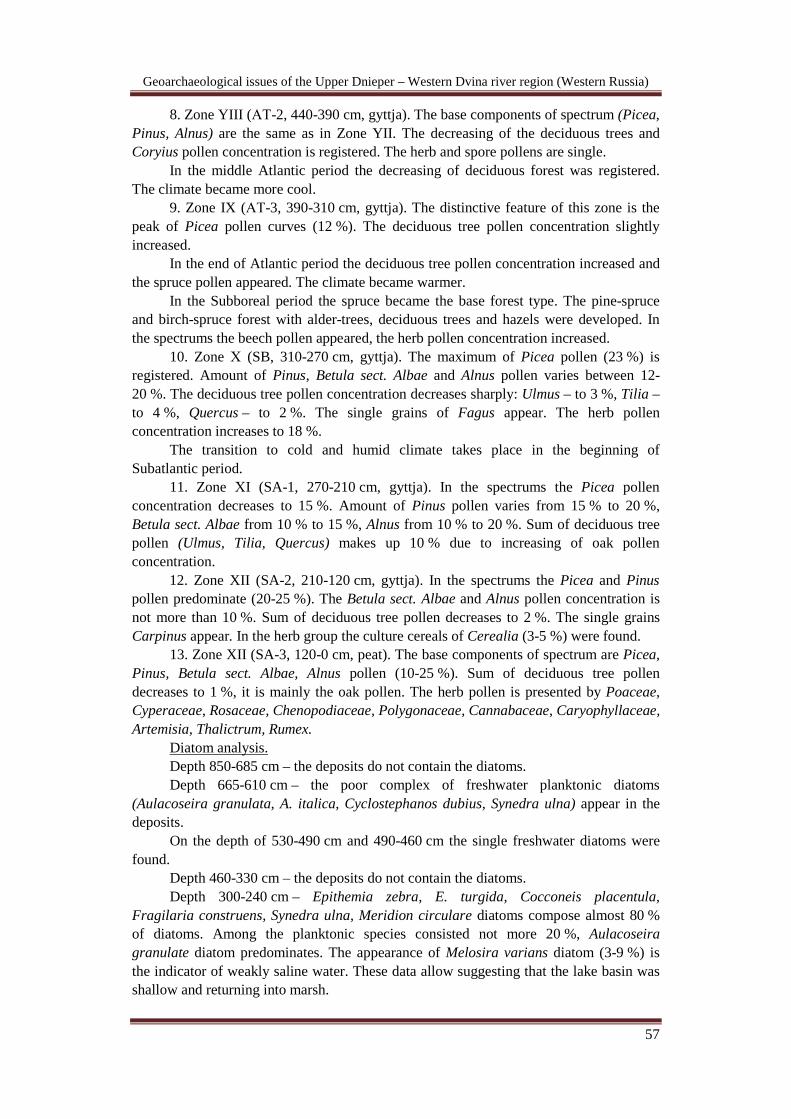
Lacustrine sediments from cores № 62, 63 were studied with the use of pollen analysis by L.B. Savelieva [Kul’kova and Savel’eva, 2003] and diatom analysis by Djinoridze E.N. [Arslanov et al., 2003].
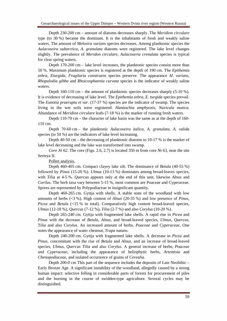
Core № 63. The core № 63 (Figs. 2.4; 2.5) is located in the deepwater lake part near the settlement Serteya X. The core depth is 8 meters.
Pollen analysis (Fig.2.4): 1. Zone I (АL, 750-850 cm, aleuric sediments). The pollen of plantations of trees
prevails in the spectrums (Betula sect. Albae 15-50 %, Pinus 15-30 %, Picea 10-20 %) with significant content of weed pollen (17-39 %), mainly Artemisia (10-20 %). The concentration of alder pollen varies from 2 % to 10 %. Among spore plants the Bryales dominant in the deposit. The Selaginella selaginoides moss is rare. The Drias deposits are absent according to the pollen data.
2. Zone II (РВ-1, 750-700 сm, gyttja). The concentration of pine pollen increases (Pinus 25-55 %), but the spruce pollen decreases (2 %). The birch pollen concentration is 20-55 %. The herb pollen concentration is not more than 10 %, mainly it is Poaceae and Cyperaceae. The concentration of spores are low. The climate was cold.
3. Zone III (РВ-2, 710-650 сm, gyttja). The deposits contain the pollen of Betula sect. Albae (65-80 %), Pinus (15 %). The concentration of spruce and deciduous tree pollen is small. The herb pollen concentration is 5 %. The spores of Polypodiaceae prevail.
4. Zone IY (РВ-3, 650-610 cm, gyttja). The Betula sect. Albae pollen concentration is decreased to 55-60 %. The Pinus pollen concentration increases to 20-25 %. The appearance of deciduous forest is the typical feature of this stage.
In the Boreal period the forest predominates because of the climate improvement. The climate was cool and dry.
5. Zone Y (ВО-1, 550-610 cm, gyttja). The curve of Pinus pollen increases sharply (30-60 %). The Betula sect. Albae pollen concentration decrease (to 25-35 %). Sum of deciduous tree pollen makes up 20-23 %, Corylus – 2-3 %. The herb pollen concentration is not more than 8 %. The spores of Polypodiaceae prevail.
6. Zone YI (ВО-2, 550-490 cm, gyttja). The Pinus and Betula sect. Albae pollen concentrations are in the spectrum in equal amounts (25-35 %). The Ulmus pollen concentration reaches to 20 %. Sum of deciduous tree pollen (Ulmus, Tilia, Quercus) makes up 30 %. The Corylus pollen concentration is 5-10 %, Alnus – 3-12 %, Picea – 4 %. The herb and spore pollens are single.
The beginning of Atlantic period is characterized by maximum of deciduous trees and increasing of hazel pollen concentration (to 36 %) and decreasing of pine and birch pollen concentration. The climate became warmer and more humid.
7. Zone YII (АТ-1, 490-440 cm, gyttja). In the spectrums the deciduous tree pollen (30-36 %), Alnus – 15-20 % and Corylus – 10-15 % predominate. The Pinus and Betula sect. Albae pollen concentration falls. The Picea pollen concentration is 5 %. The herb and spore pollens are single.

Geoarchaeological issues of the Upper Dnieper – Western Dvina river region (Western Russia)
56
Figu
re 2
.4. P
olle
n di
agra
m o
f the
cor
e №
63.
Geoarchaeological issues of the Upper Dnieper – Western Dvina river region (Western Russia)
57
8. Zone YIII (АТ-2, 440-390 cm, gyttja). The base components of spectrum (Picea, Pinus, Alnus) are the same as in Zone YII. The decreasing of the deciduous trees and Coryius pollen concentration is registered. The herb and spore pollens are single.
In the middle Atlantic period the decreasing of deciduous forest was registered. The climate became more cool.
9. Zone IX (АТ-3, 390-310 cm, gyttja). The distinctive feature of this zone is the peak of Picea pollen curves (12 %). The deciduous tree pollen concentration slightly increased.
In the end of Atlantic period the deciduous tree pollen concentration increased and the spruce pollen appeared. The climate became warmer.
In the Subboreal period the spruce became the base forest type. The pine-spruce and birch-spruce forest with alder-trees, deciduous trees and hazels were developed. In the spectrums the beech pollen appeared, the herb pollen concentration increased.
10. Zone Х (SB, 310-270 cm, gyttja). The maximum of Picea pollen (23 %) is registered. Amount of Pinus, Betula sect. Albae and Alnus pollen varies between 12-20 %. The deciduous tree pollen concentration decreases sharply: Ulmus – to 3 %, Tilia – to 4 %, Quercus – to 2 %. The single grains of Fagus appear. The herb pollen concentration increases to 18 %.
The transition to cold and humid climate takes place in the beginning of Subatlantic period.
11. Zone ХI (SA-1, 270-210 cm, gyttja). In the spectrums the Picea pollen concentration decreases to 15 %. Amount of Pinus pollen varies from 15 % to 20 %, Betula sect. Albae from 10 % to 15 %, Alnus from 10 % to 20 %. Sum of deciduous tree pollen (Ulmus, Tilia, Quercus) makes up 10 % due to increasing of oak pollen concentration.
12. Zone XII (SA-2, 210-120 cm, gyttja). In the spectrums the Picea and Pinus pollen predominate (20-25 %). The Betula sect. Albae and Alnus pollen concentration is not more than 10 %. Sum of deciduous tree pollen decreases to 2 %. The single grains Carpinus appear. In the herb group the culture cereals of Cerealia (3-5 %) were found.
13. Zone XII (SA-3, 120-0 cm, peat). The base components of spectrum are Picea, Pinus, Betula sect. Albae, Alnus pollen (10-25 %). Sum of deciduous tree pollen decreases to 1 %, it is mainly the oak pollen. The herb pollen is presented by Poaceae, Cyperaceae, Rosaceae, Chenopodiaceae, Polygonaceae, Cannabaceae, Caryophyllaceae, Artemisia, Thalictrum, Rumex.
Diatom analysis. Depth 850-685 cm – the deposits do not contain the diatoms. Depth 665-610 cm – the poor complex of freshwater planktonic diatoms
(Aulacoseira granulata, A. italica, Cyclostephanos dubius, Synedra ulna) appear in the deposits.
On the depth of 530-490 cm and 490-460 cm the single freshwater diatoms were found.
Depth 460-330 cm – the deposits do not contain the diatoms. Depth 300-240 cm – Epithemia zebra, E. turgida, Cocconeis placentula,
Fragilaria construens, Synedra ulna, Meridion circulare diatoms compose almost 80 % of diatoms. Among the planktonic species consisted not more 20 %, Aulacoseira granulate diatom predominates. The appearance of Melosira varians diatom (3-9 %) is the indicator of weakly saline water. These data allow suggesting that the lake basin was shallow and returning into marsh.

Geoarchaeological issues of the Upper Dnieper – Western Dvina river region (Western Russia)
58
Figu
re 2
.5. S
chem
e of
sedi
men
ts a
nd d
ata
of g
eoch
emic
al a
naly
sis o
f the
cor
e №
63.
Geoarchaeological issues of the Upper Dnieper – Western Dvina river region (Western Russia)
59
Depth 230-200 cm – amount of diatoms decreases sharply. The Meridion circulare type (to 30 %) became the dominant. It is the inhabitants of fresh and weakly saline waters. The amount of Melosira varians species decreases. Among planktonic species the Aulacoseira subarctica, A. granulata diatoms were registered. The lake level changes slightly. The prevalence of Meridon circulare, Aulacoseria crenulata species is typical for clear spring waters.
Depth 170-200 cm – lake level increases, the planktonic species consist more than 50 %. Maximum planktonic species is registered at the depth of 190 cm. The Epithemia zebra, Eturgida, Fragilaria construens species preserve. The appearance М. varians, Rhopalodia gibba and Rhoicosphaenia curvata species is the indicator of weakly saline waters.
Depth 160-110 cm – the amount of planktonic species decreases sharply (5-10 %). It is evidence of decreasing of lake level. The Epithemia zebra, E. turgida species prevail. The Eunotia praerupta et var. (17-37 %) species are the indicator of swamp. The species living in the wet soils were registered: Hantzschia amphyoxis, Navicula mutica. Abundance of Meridion circulare leafs (7-18 %) is the marker of running fresh waters.
Depth 110-70 cm – the character of lake basin was the same as at the depth of 160-110 cm.
Depth 70-60 cm – the planktonic Aulacoseira italica, A. granulata, A. valida species (to 50 %) are the indicators of lake level increasing.
Depth 40-50 cm – the decreasing of planktonic diatoms to 10-17 % is the marker of lake level decreasing and the lake was transformed into swamp.
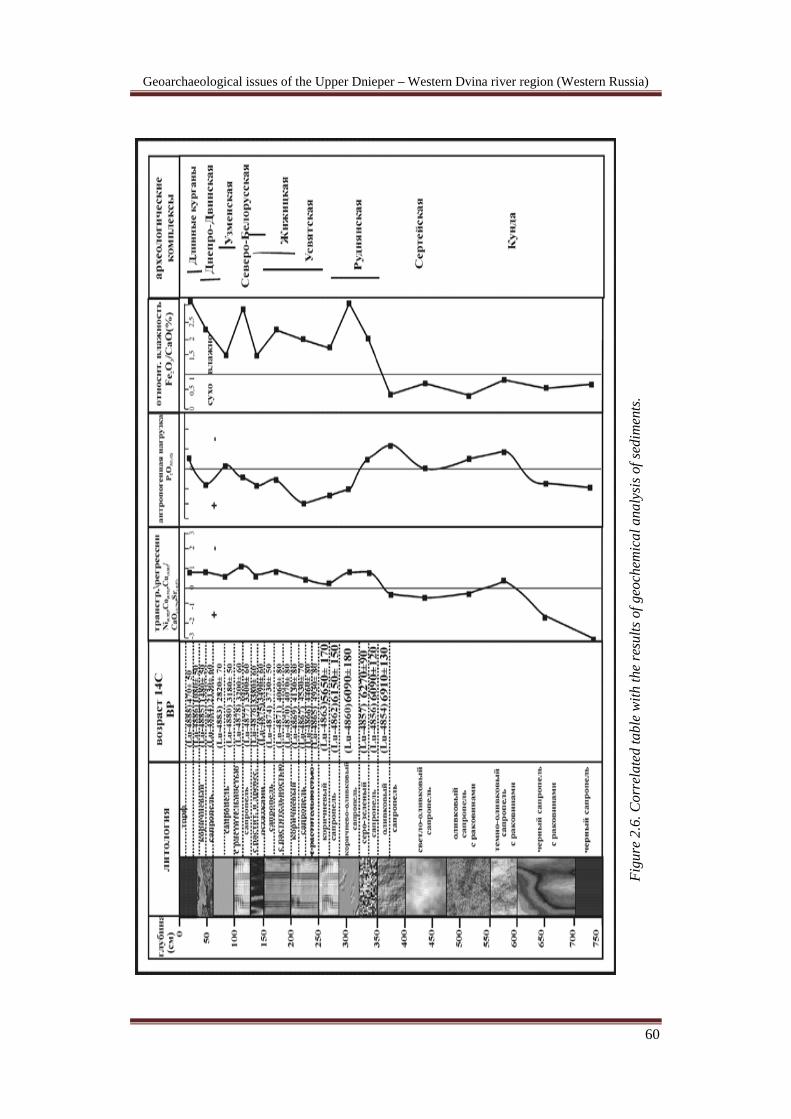
Core № 62. The core (Figs. 2.6, 2.7) is located 350 m from core № 63, near the site Serteya II.
Pollen analysis. Depth 460-405 cm. Compact clayey lake silt. The dominance of Betula (40-55 %)
followed by Pinus (15-20 %). Ulmus (10-13 %) dominates among broad-leaves species, with Tilia at 4-5 %. Quercus appears only at the end of this unit, likewise Alnus and Corilus. The herb taxa vary between 5-15 %, most common are Poaceae and Cyperaceae. Spores are represented by Polypodiaceae in insignificant quantity.
Depth 460-265 cm. Gyttja with shells. A stable state of the woodland with low amounts of herbs (<3 %). High content of Alnus (20-35 %) and low presence of Pinus, Picea and Betula (<15 % in total). Comparatively high content broad-leaved species, Ulmus (12-18 %), Quercus (7-12 %), Tilia (2-7 %) and also Corylus (10-20 %).
Depth 265-240 cm. Gyttja with fragmented lake shells. A rapid rise in Picea and Pinus with the decrease of Betula, Alnus, and broad-leaved species, Ulmus, Quercus, Tilia and also Corylus. An increased amount of herbs, Poaceae and Cyperaceae. One notes the appearance of water chestnut, Trapa natans.
Depth 240-200 cm. Gyttja with fragmented lake shells. A decrease in Picea and Pinus, concomitant with the rise of Betula and Alnus, and an increase of broad-leaved species, Ulmus, Quercus Tilia and also Corylus. A general increase of herbs, Poaceae and Cyperaceae, including the appearance of heliophytic herbs, Artemisia and Chenopodiaceae, and isolated occurrence of grains of Cerealia.
Depth 200-0 cm This part of the sequence includes the deposits of Late Neolithic – Early Bronze Age. A significant instability of the woodland, allegedly caused by a strong human impact: selective felling in considerable parts of forests for procurement of piles and the burning in the course of swidden-type agriculture. Several cycles may be distinguished.
Geoarchaeological issues of the Upper Dnieper – Western Dvina river region (Western Russia)
60
Figu
re 2
.6. C
orre
late
d ta
ble
with
the
resu
lts o
f geo
chem
ical
ana
lysi
s of s
edim
ents
.
Geoarchaeological issues of the Upper Dnieper – Western Dvina river region (Western Russia)
61
Depth 200-180 cm. Gyttja with fragmented lake shells. A increase in the amount of Picea and Pinus, and Betula. Decrease in Alnus,and an Ulmus, Quercus, Tilia and also Corylus. Increase in the content of herbs, Poaceae and Cyperaceae, heliophytic harbs, Artemisia and Chenopodiaceae. Isolated grains of Cerealia.
Depth 180-150 cm. Gyttja and archaeological deposits. Decreased content of Picea and Pinus, with the rise of Betula and Alnus (up to 40 %). Further fall in the rate of broad-leaved species, Ulmus, Quercus and also Corylus. Further increase of the content of herbs, Poaceae and Cyperaceae, Artemisia, Chenopodiaceae, Gramineae. One notes the appearance of Filipendula, Lythrum and Lamiaceae. Increased frequency of Cerealia.
Depth 150-90 cm. Gyttja and archaeological deposits. Rapid decrease of the content of Picea and slight increase of Pinus. A slight increase followed by a sharp increase of the content of Alnus (up to 40 %). Further reduction and quasi total disappearance of Ulmus, Quercus and also Corylus. General decline of the content of herbs, notably, Poaceae, Cyperaceae and Artemisia and Chenopodiaceae. The maximum frequency of Cerealia, and the appearance of weeds (notably, Plantago lanceolata) and apophytes or plants indicative of strong or modern human impact: Apiaceae, Rubiaceae and Rosaceae.
Depth 90-0 cm. Gyttja with plant detritus. Rapid reduction of forest which became dominated by Picea and Pinus. Vast expansion of open treeless species and wet meadows as indicated by a rapid increase of Cyperaceae and various herbs including Filipendula, Apiaceae and Carophyllaceae.
Diatom analysis. Depth 460-430 cm. The deposits contain rare finds of valves. Depth 430-390 cm. Concentration of valves varies from 15 to 50 thousand per 1 g
of dry sediment. Among the identified 49 taxa, epiphytic species form 65-80 %. The dominant species is Fragilaria construens, F. infanta and the planktonic species, Aulacoseria italica, and A. ambigua. The total amount of planktonic species is 7-16 %. Alkaliphilous taxa typical of moderately alkaline lakes make up 90-97 % of the total assemblage. Biogeographically indifferent species are in majority. The species adapted to boreal moderately warm conditions constitute 17-26 %. Cold water species are represented by those typical of Late Glacial and early Holocene lakes in Central Russia: Navicula scutelloides, Frgilaria inflata. Hence one may suggest the occurrence of a mesotrophic-modetately eutrophic lake, which included a body of free water and macrophyte coverage. The fall in productivity of planktonic species recorded at 410-390 cm, was supposedly due to the lowering of the lake level.
Depth 390-320 cm. Concentration of valves varies from 0.1 to 0.5 million per 1 g of dry sediment. The total number of taxa rises to 65, mostly due to boreal species (20-30 %). Fragilaria are the dominant species, with the subdominant remaining the same as in the lower unit. Fluctuation in the content of planktonic species (15-24 %) shows an instability of the lake level. The appearance of planktonic species such as Cyclostephanos dubius and Stephanodiscus hantzshii, is indicative of the lake’s increased trophic state. The abundance of alkaliphilous taxa (97-99 %) shows its eutrophic character.
Depth 320-300 cm. Planktonic species form 7-11 %. Productivity of benthic diatoms reaches 1-2.3 million per 1 g of dry sediment. The lake-level supposedly lowered.
Depth 300-240 cm. Productivity of diatoms reaches the highest value of 1.5-4.5 million per 1 g of dry sediment. The total number of taxa rises to 78. An increased rate

Geoarchaeological issues of the Upper Dnieper – Western Dvina river region (Western Russia)
62
Figu
re 2
.7. P
olle
n di
agra
m o
f the
cor
e №
62.
Geoarchaeological issues of the Upper Dnieper – Western Dvina river region (Western Russia)
63
of planktonic species (25-35 %) indicates a stable rise of lake-level. The dominant species include the peryphytic Fragilaria ssp, combined with the planktonic, Aulacoseria ambigua, A. italica, and A.granulata. The subdominants consist of the benthic and epiphyte species, Amphora ovalis, Gyrosigma attenuatum, Cocconeis placentula, Achnanthes ssp, Navicula benthic genius is represented by 10 taxa. The proportion of epiphytes diminishes to 60-72 %. The rise of lake-level led to the restriction of the macrophyte coverage. This combined with the improved light condition of the water column, was favourable for the development of planktonic and benthic species. Alkaliphilous taxa remain dominant (96-99 %). Cyclostephanos dubious being subdominant. One note also planktonic species of Steohanodiscus hantzschii (<1 %). At that time, the lake reached the maximum depth, while retaining its eutrophic character.
Depth 240-150 cm. Rapid decline in the rate of planktonic species (4-11 %). Productivity of diatoms varies in the range of 0.7-2.0 million per 1 g of dry sediment. The total number of taxa reaches 114, due to the appearance of benthic species: Pinnularia (11 taxa), Navicula (15 taxa), Gomphomena (9 taxa). In addition to Fragilaria, the dominant – subdominant group includes Cocconeis placentula, Amphora ovalis, Achnanthes ssp. The dominance of alkaliphilous taxa shows a moderately alkaline and eutrophic character of the lake. The lake-level was lower as in the preceding unit.
Depth 150-90 cm. High productivity of diatoms reach the values of 0,9-1,5 million per 1 g of dry sediment. High rate of planktonic species (39-42 %), markedly dropping at 90 cm. The dominant group consists of Aulacoseria ambigua and epiphyte Fragilaria ssp. The subdominants include the benthic species, Amphora ovalis, and Synedra ulna. Alkaliphilous taxa are dominant (88-90 %). The total proportion of epiphytes diminishes (41-67 %). Considerable rise of the lake-level reduced the macrophyte cover.
Depth 90-50 cm. Diatom productivity varies in the range of 0.2-1 million per 1 g of dry sediment. At the depth of 80-85 cm one notes the cells of the planktonic species, Aulacoseria ambigua, and a considerable amount of the spores of Aulacoseria ssp. The latter make up >50 % of the total amount of valves at the depth of 55-85 cm. The dominant-subdominant group includes the epiphytes and rheophilous species, adapted to small streams and spring rich in free oxygen: Gomphonema angustatum, Meridion circulare, Eunotia preaerupta. The rate of alkaliphilous taxa diminishes to 45-75 %. The increased rate of acidophilous taxa is indicative of the moderately acidic reaction. At the end of the unit the lake-level finally drops and the lake transform into low fen mire.
Depth 50-0 cm. Diatom productivity varies in the range of 0.06-0.2 million per 1 g of dry sediment. Benthic species are dominant, Eunotia preaerupta, Synedra ulna, Meridion circulare. Fragilaria ssp appears at 40-0 cm. One notes the occurrence of edaphic species adapted to soils and moist habitats: Pinnularis borealis, Navicula mutica. The diatoms of mire habitat show a wide diversity: Pinnularia (8 taxa), Eunotia (7 taxa); they are notmally found in organic-rich slighty acid (pH <7) water bodies. Acidophilous taxa form 13-26 % at then depth 30-50 cm. Their rate diminishes to 6 % at 20-0 cm. At the same depth, alkaliphilous taxa sharply increase, reaching 80-85 %. The rate of planktonic species increases in the same interval from 6 to 12 %. One notes the occurrence of species indicative of anthropogenous-related eutrophication: Cyclostephanos dubius, Stephanodiscus hantzschii.
Reconstruction of sedimentation conditions in the lakes during Holocene on the base of complex analysis.
The investigations allow us to reconstruct the follow sedimentation cycles in the Serteya lakes (Figs. 2.8, 2.9).

Geoarchaeological issues of the Upper Dnieper – Western Dvina river region (Western Russia)
64
Figu
re 2
.8. R
esul
ts o
а di
atom
ana
lysi
s of l
ake
sedi
men
ts o
f the
cor
e №
62.
Geoarchaeological issues of the Upper Dnieper – Western Dvina river region (Western Russia)
65
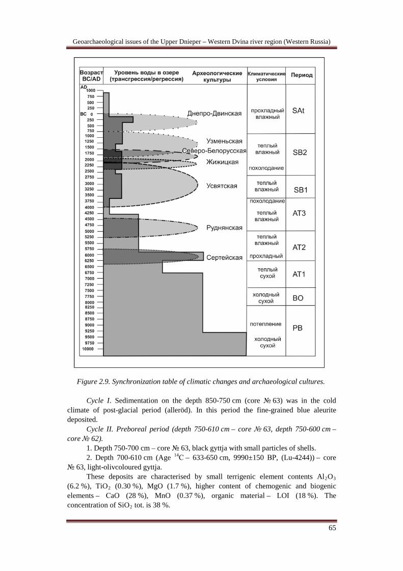
Figure 2.9. Synchronization table of climatic changes and archaeological cultures.
Cycle I. Sedimentation on the depth 850-750 cm (core № 63) was in the cold climate of post-glacial period (alleröd). In this period the fine-grained blue aleurite deposited.
Cycle II. Preboreal period (depth 750-610 cm – core № 63, depth 750-600 cm – core № 62).
1. Depth 750-700 cm – core № 63, black gyttja with small particles of shells. 2. Depth 700-610 cm (Age 14С – 633-650 cm, 9990±150 ВР, (Lu-4244)) – core
№ 63, light-olivcoloured gyttja. These deposits are characterised by small terrigenic element contents Al2O3
(6.2 %), TiO2 (0.30 %), MgO (1.7 %), higher content of chemogenic and biogenic elements – СaO (28 %), MnO (0.37 %), organic material – LOI (18 %). The concentration of SiO2 tot. is 38 %.

Geoarchaeological issues of the Upper Dnieper – Western Dvina river region (Western Russia)
66
The deposit sedimentation was in deepwater lake basin because the deposits content the small concentration of terrigenic elements and they enrichment by authigenic components. On the depth of 700-610 cm the increasing of productivity is registered (SiO2 biog. – 6.5 %). The climate was cold and dry, the lake conditions can be characterized as oxidizing and alkaline. The higher concentration of calcium carbonate, manganese oxide, high ratio of Na2O / K2O are the indicators of such environments. The deposits contain a rare finds of valves.
Cycle III. Boreal period (depth 610-490 cm – core № 63, depth 600-470 cm – core № 62).
3. Depths 610-550 cm (583-600 cm, 9520±140 ВР (Lu-4247)); (560-583 cm, 8590±150 ВР (Lu-4248)) – core № 63, 600-550 cm – core № 62, dark- olivacoloured gyttja with shells.
The concentration of terrigenic elements – Al2O3 12.1 %, TiO2 0.63 %, MgO 1.9 % increase. The concentration of biogenic and chemogenic elements – СaO 11.8 %, MnO 0.069 % and organic material – LOI 5.8 % decrease. The content of SiO2 tot. increases to 54.4 %.
The sharp increasing of terrigenic elements and minerals such as feldspar, clay is the indicator of lake level decreasing. The small content of biogenic silica (SiO2 biog.– 4.5 %) is characteristic of low productivity. The concentration of phosphorus (P2O5) increases from 0.22 to 0.27 %. That reflects anthropogenic impact on the lake. The regressive stage is fixed in the basin. Diatoms are absent in the deposits. The climate became more humid and warm, but the dry climate conditions still remain. The pollen data confirms this. The hydrochemical conditions are neutral and weakly reductive.
4. Depths 550-490 cm (500-516 cm, 8140±130 ВР (Lu-4252)) – core № 63, 550-470 cm – core № 62, olivacoloured gyttja with shells.
The decreasing of terrigenic element content – Al2O3 7.9 %, TiO2 0.40 %, MgO 1,6 % and increasing of chemogenic and biogenic element concentrations – СaO 21.0 %, MnO 0.13 %, organic material – LOI 14.2 % are fixed. The SiO2 tot. decreases to 45.1 %. The increasing of biogeneic and chemogenic element contents are marker of the lake transgressision. The high content of SiO2 biog. (5.7 %) indicates the growth of productivity. The deposits contain the rare finds of valves. The anthropogenic impact on the lake basin decreases. The P2O5 concentration decreases to 0.23 %. The climate became more dry.
Cycle IV. Atlantic period (depth 490-310 cm – core № 63, depth 470-250 cm- core № 62).
5. Depths 490-440 cm (466-483 cm, 7580±150 ВР (Lu-4254)) – core № 63, 470-400 cm, light- olivacoloured gyttja with shells.
The increasing of terrigenic elements– Al2O3 9.4 %, TiO2 0.45 %, MgO 2 % and small decreasing of chemogenic and biogenic element concentrations – СaO 0.2 %, MnO 0.087 %, organic material – LOI 12.8 % are registered. The concentration of SiO2 tot. is 42.0 %.
The small increasing of terrigenic element content indicates the low lake level. The concentration of SiO2 biog. – 4.5 % characterizes the law lake productivity. The anthropogenic element content increases, so the P2O5 increases to 0.30 %. The climate in this period at whole was dry and warm. The hydrochemical regime in the lake changes to decreasing of pH and reducing conditions. The concentration of iron hydroxides and sulphur increases in the deposits. In the layer the few in number of diatoms were found.
Geoarchaeological issues of the Upper Dnieper – Western Dvina river region (Western Russia)
67
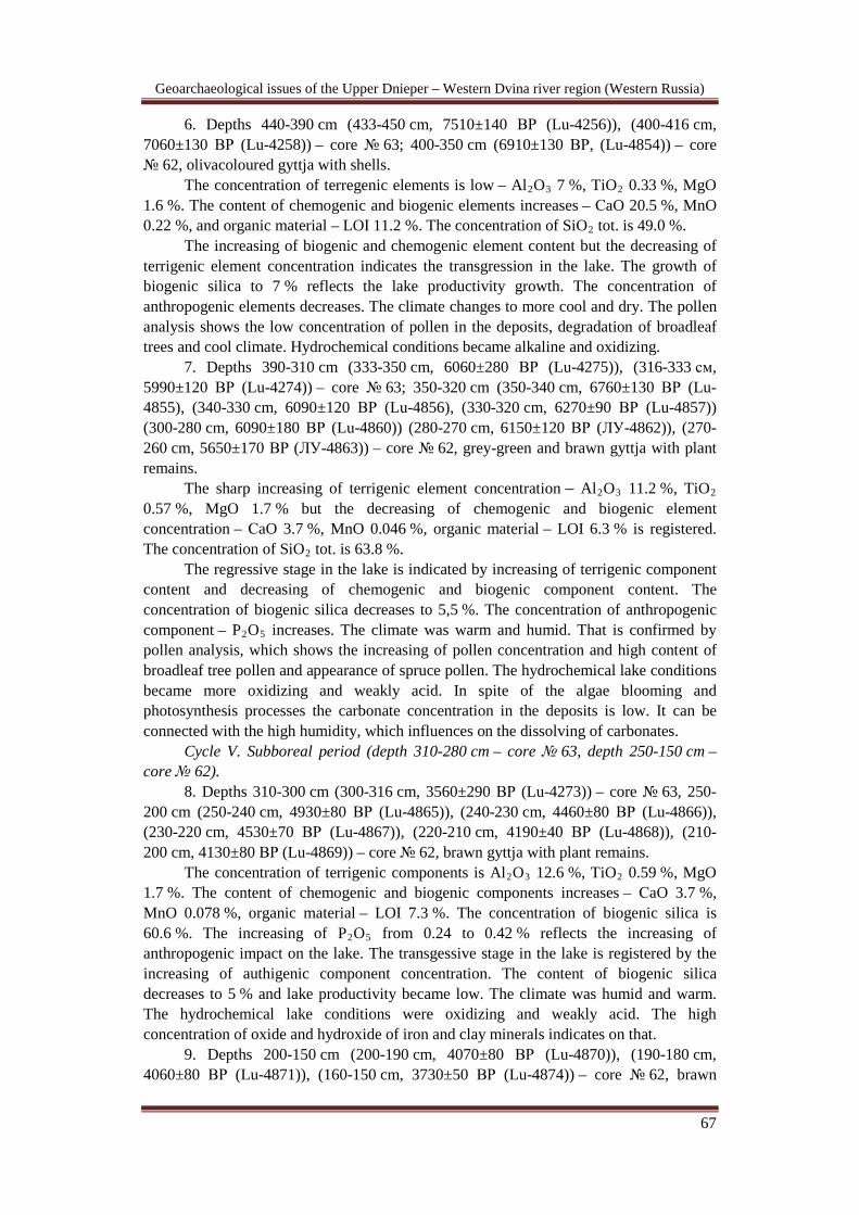
6. Depths 440-390 cm (433-450 cm, 7510±140 ВР (Lu-4256)), (400-416 cm, 7060±130 ВР (Lu-4258)) – core № 63; 400-350 cm (6910±130 ВР, (Lu-4854)) – core № 62, olivacoloured gyttja with shells.
The concentration of terregenic elements is low – Al2O3 7 %, TiO2 0.33 %, MgO 1.6 %. The content of chemogenic and biogenic elements increases – СaO 20.5 %, MnO 0.22 %, and organic material – LOI 11.2 %. The concentration of SiO2 tot. is 49.0 %.
The increasing of biogenic and chemogenic element content but the decreasing of terrigenic element concentration indicates the transgression in the lake. The growth of biogenic silica to 7 % reflects the lake productivity growth. The concentration of anthropogenic elements decreases. The climate changes to more cool and dry. The pollen analysis shows the low concentration of pollen in the deposits, degradation of broadleaf trees and cool climate. Hydrochemical conditions became alkaline and oxidizing.
7. Depths 390-310 cm (333-350 cm, 6060±280 ВР (Lu-4275)), (316-333 см, 5990±120 ВР (Lu-4274)) – core № 63; 350-320 cm (350-340 cm, 6760±130 ВР (Lu-4855), (340-330 cm, 6090±120 ВР (Lu-4856), (330-320 cm, 6270±90 ВР (Lu-4857)) (300-280 cm, 6090±180 ВР (Lu-4860)) (280-270 cm, 6150±120 ВР (ЛУ-4862)), (270-260 cm, 5650±170 ВР (ЛУ-4863)) – core № 62, grey-green and brawn gyttja with plant remains.
The sharp increasing of terrigenic element concentration – Al2O3 11.2 %, TiO2 0.57 %, MgO 1.7 % but the decreasing of chemogenic and biogenic element concentration – СaO 3.7 %, MnO 0.046 %, organic material – LOI 6.3 % is registered. The concentration of SiO2 tot. is 63.8 %.
The regressive stage in the lake is indicated by increasing of terrigenic component content and decreasing of chemogenic and biogenic component content. The concentration of biogenic silica decreases to 5,5 %. The concentration of anthropogenic component – P2O5 increases. The climate was warm and humid. That is confirmed by pollen analysis, which shows the increasing of pollen concentration and high content of broadleaf tree pollen and appearance of spruce pollen. The hydrochemical lake conditions became more oxidizing and weakly acid. In spite of the algae blooming and photosynthesis processes the carbonate concentration in the deposits is low. It can be connected with the high humidity, which influences on the dissolving of carbonates.
Cycle V. Subboreal period (depth 310-280 cm – core № 63, depth 250-150 cm – core № 62).
8. Depths 310-300 cm (300-316 cm, 3560±290 ВР (Lu-4273)) – core № 63, 250-200 cm (250-240 cm, 4930±80 ВР (Lu-4865)), (240-230 cm, 4460±80 ВР (Lu-4866)), (230-220 cm, 4530±70 ВР (Lu-4867)), (220-210 cm, 4190±40 ВР (Lu-4868)), (210-200 cm, 4130±80 ВР (Lu-4869)) – core № 62, brawn gyttja with plant remains.
The concentration of terrigenic components is Al2O3 12.6 %, TiO2 0.59 %, MgO 1.7 %. The content of chemogenic and biogenic components increases – СaO 3.7 %, MnO 0.078 %, organic material – LOI 7.3 %. The concentration of biogenic silica is 60.6 %. The increasing of P2O5
9. Depths 200-150 cm (200-190 cm, 4070±80 ВР (Lu-4870)), (190-180 cm, 4060±80 ВР (Lu-4871)), (160-150 cm, 3730±50 ВР (Lu-4874)) – core № 62, brawn
from 0.24 to 0.42 % reflects the increasing of anthropogenic impact on the lake. The transgessive stage in the lake is registered by the increasing of authigenic component concentration. The content of biogenic silica decreases to 5 % and lake productivity became low. The climate was humid and warm. The hydrochemical lake conditions were oxidizing and weakly acid. The high concentration of oxide and hydroxide of iron and clay minerals indicates on that.

Geoarchaeological issues of the Upper Dnieper – Western Dvina river region (Western Russia)
68
gyttja with plant remains. In the lake the regressive stage is registered. The precipitation decreased. The anthropogenic impact was high.
10. Depths 150-130 cm (150-140 cm, 3490±60 ВР (Lu-4875)), (140-130 cm, 3380±60 ВР (Lu-4876)) – core № 62, the brawn gyttja with plant and wood remains. The lake level increasing is registered. The climate was humid.
11. Depths 130-100 cm (130-120 cm, 3300±60 ВР (Lu -4877)), (120-110 cm, 3200±60 ВР (Lu -4878)), (110-100 cm, 3290±70 ВР (Lu -4879)) – core № 62, the brawn gyttja with plant remains. The regressive stage is registered in the lake. The climate was dry.
12. Depths 100-60 cm (100-90 cm, 3180±50 ВР (Lu У-4880)), (90-80 cm, 3050±80 ВР (Lu -4881)), (80-70 cm, 2940±70 ВР (Lu -4882)), (70-60 cm, 2820±70 ВР (Lu -4883)) – core № 62, the brawn gyttja with plant remains. The lake level increasing is registered. The climate was humid.
Cycle VI. Subatlantic period (depth 300-0 cm – core № 63, depth 250-200 cm – core № 62).
13. Depths 300-270 cm (283-300 cm, 2540±60 ВР (Lu-4272)) – core № 63, the brawn gyttja with plant and wood remains.
The increase of terrigenic component – Al2O3 14.7 %, TiO2 0.66 %, MgO 2.1 % reflects the low lake level and returning of lake into swamp. According to the diatom analysis the appearance of benthos species to 80 % indicates the shallow, obliterating basin. The concentrations of chemogenic and biogenic components increase – СaO 5.7 %, MnO 0.11 %, organic material – LOI (5.8 %). The content of SiO2 tot. is 56.6 %. The content of P2O5 is 0.61 %. The content of biogenic silica decreases to 3.7 %. The anthropogenic impact increases. The climate became more cool.
14. Depths 270-200 cm (266-283 cm, 2490±70 ВР (Lu-4271)), (250-266 cm, 2320±60 ВР (Lu-4270)), (233-250 cm, 2310±60 ВР (Lu-4269)), (216-233 cm, 2370±50 ВР (Lu-4260)), (200-216 cm, 2250±50 ВР (Lu-4259)) – core № 63, the brawn gyttja with plant remains.
The concentration of terrigenic components decreases – Al2O3 13.4 %, TiO2 0.61 %, MgO 1.8 %. The content of chemogenic and biogenic components is СaO 6.1 %, MnO 0.19 %, organic material – LOI 6.0 %. The concentration of SiO2 tot. is 57.3 %. The concentration of P2O5 is 0.72 %. The anthropogenic impact on the basin falls. The increasing of authigenic component proportion to terrigenic components reflects the small growth of lake level. That was confirmed by diatom analysis. The biogenic silica concentration increases to 4.5 %. The precipitation in that period increased. The climate became some warmer. According to pollen analysis the sum of broadleaf tree pollen rise to 10 %, owing to oak pollen increase.
15. Depths 200-170 cm (183-200 cm, 2280±66 ВР (Lu-4261)) – core № 63, dark-brawn gyttja with plant remains.
The lake level some increased. That is confirmed by diatom analysis, the planktonic species in the deposit consist more than 50 %. The anthropogenic impact increased. The appearance of poorly decayed macrofossils in the cool and humid condition results in the reducing and acidic indexes of aquatic environment. According to pollen analysis the amount of broadleaf tree pollen falls to 2 %.
16. Depths 170-120 cm (166-183 cm, 2150±40 ВР (Lu-4262)), (133-150 cm, 1790±70 ВР (Lu-4264)), (116-133 cm, 1560±90 ВР (Lu-4265)) – core № 63; 60-40 cm (60-50 cm, 2130±60 ВР (Lu-4884)), (50-40 cm, 1480±50 ВР (Lu-4885)) – core № 62, the brawn gyttja with plant and wood remains.
Geoarchaeological issues of the Upper Dnieper – Western Dvina river region (Western Russia)
69
The lake level decreases. According to diatom analysis on the depth of 160-110 cm amount of planktonic species sharply decrease to 5-10 %. That can be the marker of lake level drop. The climate was cold and the humidity decreases.
17. Depths 120-70 cm (116-100 cm, 1560±70 ВР (Lu-4266)), (100-83 cm, 1170±50 ВР (Lu-4267)) – core № 62, dark-brawn gyttja with plant remains.
18. Depths 70-50 cm (50-35 cm, 1170±60 ВР (Lu-4280)) – core № 63; 40-10 cm (40-30 cm, 1080±50 ВР (Lu-4886)), (30-20 cm, 930±60 ВР (Lu-4887)) – core № 62, dark-brawn gyttja with plant remains.
The concentration of terrigenic elements remains constant – Al2O3 13 %, TiO2
0.58 %, MgO 1.75 %. The concentration of chemogenic and biogenic elements is СaO 5.5 %, MnO 0.19 %, organic material– LOI 6 %. The content of SiO2 tot. is 60 %. The content of P2O5 is 0.80 %. The high concentration of terrigenic components is the characteristic of swamp condition. It confirms the diatom analysis data.
19. Depths 50-15 cm (20-35 см, 690±50 ВР (ЛУ-4281)) – core № 63; 20-10 cm, (470±50 ВР (Lu-4888)) – core № 62, poorly decomposed peat.
20. Depth 15-0 cm – core № 63, peat. The concentration of terrigenic components some increases Al2O3 14.3 %, TiO2
0.75 %, MgO 1.8 %. The concentration of chemogenic and biogenic elements decreases – СaO 4.9 %, MnO 0.12 %, organic material – LOI 3 %. The content of SiO2 tot. is 59.7 %. The content of P2O5 is 1 %.
Geoarchaeological issues of the Upper Dnieper – Western Dvina river region (Western Russia)
70
CHAPTER 2.2. HUMAN OCCUPATION HISTORY OF THE UPPER DVINA BASIN
Part of the territory of lake areas from Eastern Poland to Valday elevation was
inhabited about 10 mil BP. Rich natural resources of lake areas attracted all the time new groups of Neolithic hunters, fishers, gatherers, first forest farmers and cattle-breaders. It was a place of intersection of European cultures and people. Densely inhabited lake basins were divided by huge uninhabited areas which were slowly populated during early Iron age and early Middle ages. Most part of the lakes was overgrown and became peat-bogs and swamps till XIII-XIV c. due to different natural reasons. Peat-bogs covered remains of ancient settlements and cult places of stone age.
Natural complexes were not homogeneous here and their values for people were being changed through the time and consequently the system of settlement was being also changed [Dolukhanov et al., 1983; Miklyaev, 1995]. Ancient inhabitants chose different types of landscape at different periods in the past reasoning from the characteristics of their economical strategy, climatic conditions, hydrology and other natural and social factors.
Neolithic sites were situated along small-residual ice-dam lakes, occupying zones of fluvioglacial sediments, situated sometimes at the border of different types of landscape. Whereas the sites of early Iron age were disposed on the hills of morainic zone edges, the sites of middle-late Iron age and early Middle age occupied the eminences of lake-glacial plains. And place around lakes and mires, free of water due to very strong regression, was used for ploughed fields and meadows. With the appearance of plough inhabitants started to settle on the territory of Lovat aspirail with very fertile soils [Miklyaev, 1995].
The investigation of sites of this region from the beginning (the 1970s) was made in the course of scientific approach developed in Saint-Petersburg by A. Miklyaev that was named “archaeological geography”. The aim of “archaeological geography” was to study archaeological sites using all the appropriate methods of archaeology and the natural sciences, regarding the archaeological site and environment as one socio-biocenose. According to A. Miklyaev, “only the analysis of material culture and geographical data will allow us to understand the mechanism of interaction between man and environment in the past” [Miklyaev, 1984, P 127-130].
This approach appeared under the influence of one soviet scientific school existed at the end of the XIXth – beginning of the XXth century which investigated ancient people of Stone Age from a natural – scientific point of view. At the beginning of the XXth century this approach was developed into palaeoethnological school under the direction of F.K. Volkov– the disciple of G. de Mortillet, the founder of french palaeoethnological school. But the soviet-russian palaeoethnological school did not follow entirely the traditions of french palaeoethnological school. In contrast to the latter the main aim here was to compare archaeological data with geographical data and to understand relationships between human culture and environment [Platonova, 2008, P. 67-68]. But in 1929-1930 the soviet palaeoethnological school was almost destroyed as a result of repressions and ideological pressure of historical method in its Marxist-Leninist variant. However its conceptions and ideas were saved and were passed on from generation to generation of Leningrad archaeologists during the 1930-1980s. As a result main conceptions, developed by the soviet palaeoethnological school were reformulated in the 1970s in the approach named “archaeological geography”.
Geoarchaeological issues of the Upper Dnieper – Western Dvina river region (Western Russia)
71
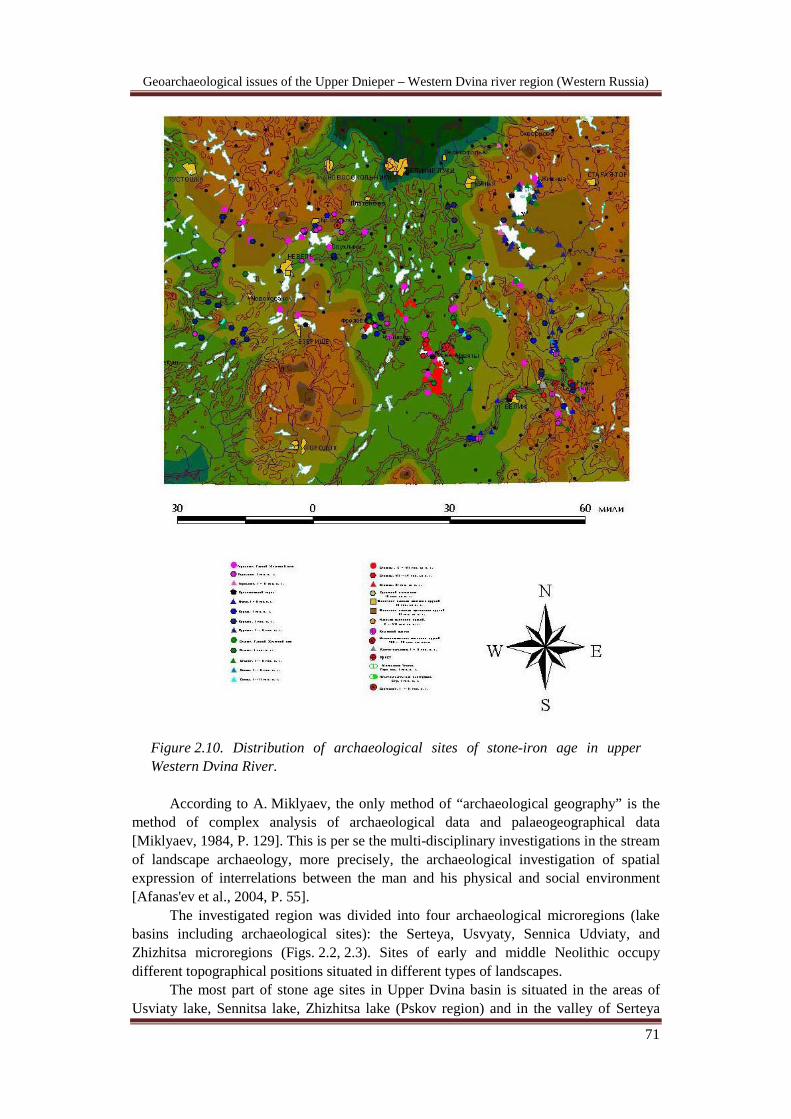
Figure 2.10. Distribution of archaeological sites of stone-iron age in upper Western Dvina River.
According to A. Miklyaev, the only method of “archaeological geography” is the
method of complex analysis of archaeological data and palaeogeographical data [Miklyaev, 1984, P. 129]. This is per se the multi-disciplinary investigations in the stream of landscape archaeology, more precisely, the archaeological investigation of spatial expression of interrelations between the man and his physical and social environment [Afanas'ev et al., 2004, P. 55].
The investigated region was divided into four archaeological microregions (lake basins including archaeological sites): the Serteya, Usvyaty, Sennica Udviaty, and Zhizhitsa microregions (Figs. 2.2, 2.3). Sites of early and middle Neolithic occupy different topographical positions situated in different types of landscapes.
The most part of stone age sites in Upper Dvina basin is situated in the areas of Usviaty lake, Sennitsa lake, Zhizhitsa lake (Pskov region) and in the valley of Serteya

Geoarchaeological issues of the Upper Dnieper – Western Dvina river region (Western Russia)
72
River – left confluent of Western Dvina River – which flows from the south to the north on the territory of Velizhsky district of Smolensk region. Sites from the epoch of early Paleolithic (140-70 mil BP) and final Paleolithic (12 mil BP) till the time of Old Russian state development were found here.
First information about archaeological sites was systematized by A.P. Sapunov at the end of XIX c. (1893) and E.R. Romanov In the second half of XX c. first information about stone age sites in river Serteyka valley were gained by E.A. Shcmidt. A.M. Mykljaev started his works here in the 1960s
In 1989 I.Y. Ivanova, the head of Velizhsky museum, showed me finds of
mamooth tusks and teeth which were found with very archaic flint tools (Fig. 2.11). We surveyed the place on the shore of Western Dvina River with schoolchildren who found these objects. We found other ancient tools dated to the epoch of early Paleolithic (140-70 mil BP) on the river gravel beach higher than Yastreb rapids [Miklyaev et al., 1995; Drevnosti …, 1995, P. 16-17].
. Early Paleolithic (№1).
Figure 2.11. Stone tools of Acheul-mustie from Yastreb and Klimovo sites.
In late Pleistocene warming and fall of temperature replaced each other repeatedly. At the end of middle Pleistocene – Mikuline interglacial – the territory of North-western Russia was full of lakes and covered by birch and pine forests and at the end of the period – by fir forests [San’ko, 1987]. It was at that time when ancient man appeared on the shores of lakes of modern Smolensk and may be in the south of Pskov regions. Finds of stone tools and performs of Achel-Mustie testify it. They are made in places where Western Dvina River cut through quaternary sediments and abut rock massif which

Geoarchaeological issues of the Upper Dnieper – Western Dvina river region (Western Russia)
73
served in the Past shores of lakes of Mikuline time and they have become now Yastreb and Klim rapids in the riverbed of Western Dvina River. Fall of temperature occurred 70 mil BP led to glaciation of the area of North-Western Russia. Epipaleolithic.
Favorable conditions of inhabitation on the territory of North-Western part of Russian plain appeared again only after final recession of glacier (16-15 mil BP) accompanied by recovery of vegetation and opening of depressions of future Holocene lakes. Thinned pine and birch forests and predominance of vegetation was typical for this time. Remains of ancient settlements are situated on sandy dunes near shores of late glacial lakes. All flint tools are simply lying on sandy and tilled fields and occupy large squares. Finds of stone tools extended on the distance of about 4 km near village Lukashenki along river Usviacha and near village Serteya– on 2.5 km (№ 2). Mesolithic.
The beginning of Holocene is the time of new epoch – mesolithic (X-VIII mil BP). Large changes of all elements of natural environment occurred in this epoch. Common warming led to disappearance of glacier caused changes of vegetation: forest appeared on the place of glacial steppes. Vegetation changes reflected animal world. Not less than ten representatives of mammoth fauna disappeared at the time of Pleistocene-Holocene border (about 12 mil BP). Areas of horse, bison, aurochs and red deer widespread in pleistocene decreased. At the same time population of elk, ducks, black grouse, fishes and sea animals increased. At this time man opened up all natural zones of Europe. Economy of this time was characterized by prevalence of hunter-gatherer economy and was based mostly on the use of natural resources of river valleys and lake depressions. Tribes with material culture coming from epipaleolithic cultures traditions (sviderian tradition) lived on these territories.
Underwater excavations of the site Dubokray VI situated on the bottom of the lake Sennica (Pskovskaya oblast’) revealed bone and flint tools that allowed us to suppose appearance of new inhabitants from Eastern Baltic region – bearers of kunda culture traditions - in middle Mesolithic. Some of the types of tools typical for this culture were found also on the site Serteya 1, Serteya X, Serteya XIV (№ 3). Non-numerous sites with flint materials of kunda culture are situated on the edges of depressions on dunes, at the end of the period – on lakes shores and islands. This culture appeared in Preboreal period (10200–9600 ВР). This period is characterized by common warming and changes in natural environment which led to disappearance of glacial flora and development of woodland landscapes. Pine and birch forests dominated, fir, rarely – alder could have occupied river valleys. Climate was relatively cool and dry. Geochemical analysis allowed us to suppose that lake productivity was relatively low, at the end of the period regression took place as well as warming, humidity increased. Appearance of elements-indicators of human influence on the ecosystem of ancient lakes can also be traced [Kulkova, Mazurkevich, Dolukhanov, 2001].
The beginning of Boreal period (9600—8000 ВР) is characterized by further warming and humidity increase. Mixed pine-birch forests with inclusions of broad-leaved species (elm and lime predominately) and hazel existed. Previous regression continued, productivity decreased and human influence on ecosystem of ancient lakes cannot be traced. At the middle-end of Boreal period moderate cooling and decrease of humidity as well as transgression and increase of lake productivity can be traced due to pollen and
Geoarchaeological issues of the Upper Dnieper – Western Dvina river region (Western Russia)
74
geochemical analysis. At the second half of Boreal period different types of forest appeared, thermophilic elements of flora started to penetrate actively onto this territory. Favorable climatic conditions stimulated increase of elm, lime, oak and hazel among birch-pine forests.
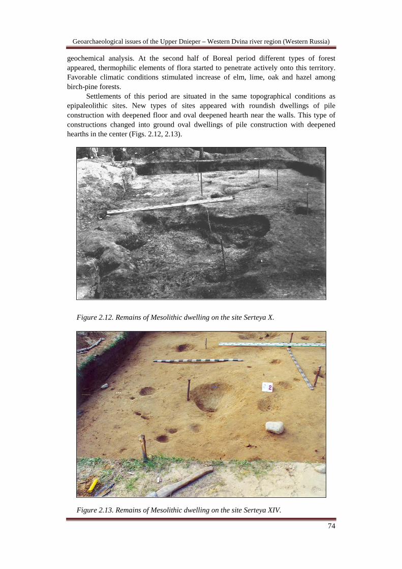
Settlements of this period are situated in the same topographical conditions as epipaleolithic sites. New types of sites appeared with roundish dwellings of pile construction with deepened floor and oval deepened hearth near the walls. This type of constructions changed into ground oval dwellings of pile construction with deepened hearths in the center (Figs. 2.12, 2.13).
Figure 2.12. Remains of Mesolithic dwelling on the site Serteya X.
Figure 2.13. Remains of Mesolithic dwelling on the site Serteya XIV.
Geoarchaeological issues of the Upper Dnieper – Western Dvina river region (Western Russia)
75
Early neolithic of Dnepr-Dvina basin and specificity of neolithisation of Eastern Europe (Figs. 2.3 2.14).
The beginning of the Neolithic era is connected with a complicated process of information accumulation, which led to discoveries that changed human history. It concerns gradual accumulation of knowledge, skills of animal and plant domestication that led to formation of complex economy. Concurrently changes in the ideological sphere took place that archaeologically fixed in appearance of the cult of the skull, figurines, first temple complexes that stimulated further development of productive economy. This process was long because productive economy served only for ideological sphere at this stage. These people were pioneers and could not estimate the advantages of a productive economy; they did not have to consider whether to appropriate this economy.
Gradual accumulation of positive experience that allowed people to estimate the attraction of a productive economy and connected with it processes of changes in social structure, culture and ideology in the Near East can be named neolithisation. Further process of diffusion of accumulated knowledge that is usually named “Neolithic packet” (productive economy, pottery, clay figurines, adobe architecture, stone vessels, idea of private property) differs not only by its models but more importantly – the meaning of this process.
All this packet or part of it was established on new territories, which was transported by new inhabitants that came once or repeatedly into territories inhabited by local Mesolithic societies (see Perlès 2004). Mesolithic inhabitants of Europe had a unique opportunity to observe life of newly-arrived people with productive economy living near them. Their way of life competed with the ideology of new inhabitants based on different principles of society organisation. What is important is that social structure of mesolithic inhabitants was in the process of formation and it was not stable and could have been destroyed or became degraded relatively simply under the influence of different cultural and ecological factors.
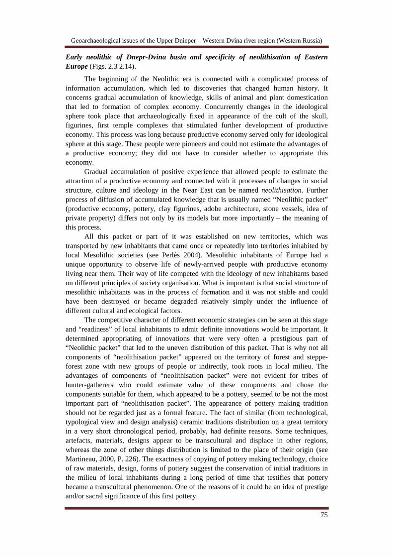
The competitive character of different economic strategies can be seen at this stage and “readiness” of local inhabitants to admit definite innovations would be important. It determined appropriating of innovations that were very often a prestigious part of “Neolithic packet” that led to the uneven distribution of this packet. That is why not all components of “neolithisation packet” appeared on the territory of forest and steppe-forest zone with new groups of people or indirectly, took roots in local milieu. The advantages of components of “neolithisation packet” were not evident for tribes of hunter-gatherers who could estimate value of these components and chose the components suitable for them, which appeared to be a pottery, seemed to be not the most important part of “neolithisation packet”. The appearance of pottery making tradition should not be regarded just as a formal feature. The fact of similar (from technological, typological view and design analysis) ceramic traditions distribution on a great territory in a very short chronological period, probably, had definite reasons. Some techniques, artefacts, materials, designs appear to be transcultural and displace in other regions, whereas the zone of other things distribution is limited to the place of their origin (see Martineau, 2000, P. 226). The exactness of copying of pottery making technology, choice of raw materials, design, forms of pottery suggest the conservation of initial traditions in the milieu of local inhabitants during a long period of time that testifies that pottery became a transcultural phenomenon. One of the reasons of it could be an idea of prestige and/or sacral significance of this first pottery.
Geoarchaeological issues of the Upper Dnieper – Western Dvina river region (Western Russia)
76
Figure 2.14. Scheme of early neolithic pottery development in Upper Western Dvina River.
Neolithic epoch began at different time on different territories of Eastern Europe.
One of the main features of Neolithic time of forest zone of the modern Russian plain is widespread distribution of pottery not known in the former period. Aridization that took place about 8 mil BP in modern steppe zones of Eastern Europe led to migrations to the north of small groups of ancient inhabitants from these territories. Distribution of traditions of pottery making in the local milieu can be connected with appearance of these people here. This process of Neolithic innovations distribution on the territory of Eastern

Geoarchaeological issues of the Upper Dnieper – Western Dvina river region (Western Russia)
77
Europe and part of the Western Europe due to its specificity was proposed to name “revolution of pottery making” [Mazurkevich et al., 2000, P. 20].
Detailed analysis of early-Neolithic pottery of Dnepr-Dvina basin allowed us to distinguish several ceramic traditions and to make hypothesis about material culture development and also reconstruct some historical processes. In 1987, the idea was suggested that Serteyskaya culture was included in the vast early-Neolithic community located from south of Russian valley to Valdai [Mikljaev et al., 1987, P. 170]. Analogies to another phase were found among materials of sites of Eastern Belorussia, Valdai Hills, Upper Volga and left-shore Ukraine [Mikljaev, 1994]. This idea suggested that existing ceramic impulses found its confirmation in materials of south-western territories, more precisely – in Bug-dnestr and Dnepr-donetsk cultures that influenced certain territories of Dnestr basin and Upper Dvina river.
Multiplicity of analogies that can be pointed for pottery of Upper Dvina and varieties of pottery-making traditions is the reflection of specificity of “Neolithic packet” distribution on the territory of Eastern Europe. Several independent centers in the steppe zone of Eastern Europe where “Neolithic packet” was distributed and where pottery making first appeared can be divided. Cultural impulses began to diffuse from these centers that are archaeologically fixed through pottery – “ceramic waves” – on the whole territory of the Eastern-European plain. One of these centers was formed in the Azov-Caspian region. Appearance of the most archaic pottery in this region on the site Rakushechny Yar can be linked, probably, with Near-Eastern influence. It is testified by special features in morphology and pottery making technology, fragments of vessels covered by ochre on the inner and outer surface, stone vessels, adobe architecture and appearance of productive economy. The most ancient pottery found on this sitу has flat bottoms with straight or slightly turned-out rims, with thick or thin walls, with traces of polishing by pebble, traces of “comb”, non-decorated or decorated by lines organized in net, triangular signs, roundish impressions. This tradition of pottery making can be observed among materials of sites situated in forest and steppe-forest zone of eastern Europe: the basin of Desna river, Volga-Oka, Low Volga, Southern Onega, in the basin of Sukhona river (sites like Tudozero V) [Ivanisheva, 2006; Cetlin, 2008; Smirnov, 1991; Vybornov, 2008] and on the territory of Dnepr-Dvina basin.
The tradition of pottery decorated by pin action formed triangular marks and by individual marks linked through one continuous stepped back drawn movement was formed in the same region (basin of Low Volga and Northern Caspy) [Vybornov, 2008]. Cultural impulse from this place is fixed on a great territory of forest-steppe and forest zone of Eastern Europe.
Probably, another “ceramic centre” was formed on south-western territories of Eastern Europe – in area of Bug-Dnestr culture [Danilenko, 1969; Kotova, 2002; Markevich, 1974]. Pottery of this culture is decorated by drawn-curvilinear design as well as with impressions of the tool in the form of shell or shell and “I” [Markevich, 1974] (pottery decorated in the latter manner was also found in the lowest layers of the site Rakushechny Yar). It can be presumed that the following territories were influenced by this culture– basin of Dnepr river, Desna river, Upper Dvina river. It is important to underline that traces of productive economy were found in these “initial centres” [Kotova, 2002; Krizhevskaya, 1992; Pashkevich et al., 2009; Motuzaite-Matuzeviciute et al., 2009]: people with several components of “neolithisation packet” moved here. The role of elshanian sites as a probable other “initial centre” is under discussion.
Distribution of “ceramic traditions” from these three centres, due to dates 14C [Timofeev et al., 2004], was realised during short period of time along main water-routes

Geoarchaeological issues of the Upper Dnieper – Western Dvina river region (Western Russia)
78
of Eastern Europe flowing in meridional direction. While rivers going in latitudinal directions became a natural barrier in this process of distribution of “ceramic traditions” at the first stage. Small groups of people moved and settled on different territories which traces are difficult to be seen archaeologically and they brought into the Mesolithic milieu innovations such as traditions of pottery making.
Due to ethnographic data, widespread uniformity of pottery styles must exist in communities of hunters-gatherers in the course of individuals displacement from one camp to another [Hodder, 1982]. This process can be named “migration of ideas” [Mazurkevich, 1994. P. 82] in the case when migration of people is almost elusive. Established on a new place these “centres” of innovations began to be secondary centres from which ceramic traditions began to diffuse and develop gradually among ancient inhabitants of surrounding territories. Thus, in Dnepr-Dvina region this process reflected in appearance here of Rakushechny Yar traditions at the first stage that did not find their further continuation and were not admitted by local inhabitants. Then triangular pin-holes decorative traditions and techniques of coil-modelling with the use of polishing and the comb-like-tool of Low Volga – North Caspian center appeared here. At this stage geographical proximity played more important role in diffusion of ceramic traditions than linguistic/historical [Gosselain, 2002].
Calibrated dates [Timofeev et al., 2004; Davison et al., 2009] prove that the beginning of Neolithic in steppe zone of Eastern Europe can be dated to the end of VIII – beginning of VII mil BC that is equable to dates of early Neolithic (ceramic) sites of Near East. At this time most ancient pottery making centers appeared on the territory of Eastern Europe, the origins of which were explained by Belanovskaya T.D. as the result of influence of Neolithic cultures of the Caucasus [Belanovskaya, 1995, P. 181–182]. In its turn the territory of Southern Caucasus was included in the zone of influence of Anatolian early-Neolithic cultures yet in the period PPNB [Kiguradze et al., 2004, P. 353]. More of it, based on the proximity of a range of features of material culture (similar forms of stone vessels [Belanovskaya 1995, Fig. XXVII-3; Kozlowski et al., 2005, Fig. 3.1.1], similar forms of pottery and similar technique of pottery making with the help of coils or short stretched coils/slabs, simplicity of pottery, rarity of design [Vandiver, 1987, P. 9-23; M. le Mière et al., 1999, P. 5-16; Nishiaki et al., 2005, P. 59-63; Voigt, 1983] and close 14
Early Neolithic began on the territory of Dnepr-Dvina basin on the border of Boreal and Atlantic periods – at the beginning of the VII mil calBC. Early Neolithic sites
C dates, direct infiltrations from territories of Near East and Anatolia to the territory of Low Don might be supposed. Influence of cultures of Balcanic peninsula on the territory of Bug-Dnestr can be suggested [Kotova, 2002]. The latter transmitted indirectly the tradition of pottery decoration using shell or tools that left very similar impressions.
Evidently, different models of neolithisation were realised in the territory of Eastern Europe. First one – “standard” –spread of “packet of innovations” that mark the beginning of Neolithic epoch: pottery making, productive economy, architecture, stone vessels and new social organization. Another model is “septentrional” (appearance of pottery making only). Appearance of skills of pottery making, their dispersed distribution and further expansion on the territory of Eastern Europe, their development are two different processes. We suggest that it is necessary to divide a process of “Neolithic packet” diffusion and further distribution of ceramic traditions in the Mesolithic milieu from other, secondary, centers situated in forest and steppe-forest zone. The end of development of the first early-Neolithic traditions might be regarded as the end of early Neolithic that happened in different territories at different times.

Geoarchaeological issues of the Upper Dnieper – Western Dvina river region (Western Russia)
79
are situated in different microregions. In the Serteya microregion – sites Rudnya Serteya (№ 4), Serteya 3–3, Serteya XXVII, Serteya XX, Serteya XIV, Serteya XXI, Serteya XXII, Serteya XXXVI, Serteya XXXVII, Serteya XLIX, Serteya L, Serteya 3–1, Serteya 3–2, Serteya XIX, Serteya XXIV, Serteya XXIII, Serteya 3–4, Serteya 3–5, Serteya 3–6, Serteya XXXV, Serteya XXXIX, field near Rudnya Serteya N3, Serteya XII, Serteya X; in Usviatsky microregion – site Uzmen’, Usviaty II, Romanovskoe, Lukashenki II, Udviaty I, Cyganovy Nivy, Poloneika, in Sennitsky microregion – Dubokray I, Dubokray V, Dubokray VIII, Froly I.
The Serteya microregion consists of a chain of small residual ice-dam lakes (dating from the late Valdai / Würm glacial) connected by rivers. All sites are located on the shores of confluences and lakes remote from the main waterway, the Western Dvina. The relatively modest occupation of the banks of the big rivers could be explained by insecurity of the main waterways in the past [Kalechic, 2003, P. 162]. Early Neolithic sites are situated in the northern and southern parts of the Serteya microregion, and are separated by an uninhabited area.
The prevalence of vessels in the middle phase of the Early Neolithic could be an indirect sign of an increase in population in the Middle Atlantic period (7.345-6200 BP). This supposition is also supported by a greater anthropogenic influence on the ecosystem and palaeo-lakes in comparison with the preceding Early Atlantic period (7.860-7.345 BP). The water level rose and amount of available food increased as well. It corresponds with a slight fall in temperature in the Middle Atlantic period that is shown by a decrease of pollen of deciduous trees by 1-3 %.
The sites situated on the shores of the southern palaeo-lake (Rudnya Serteya, the field above Rudnya Serteya No. 3, and Serteya XII) occupy a territory of fluvioglacial sediments, hence the zone of broadleaved-coniferous forests with birches. The site Serteya X is situated on the border of fluvioglacial and morainic sediments, i.e. the territory of spruce, birch and oak forests. The majority of the sites is situated on the shores at the confluence of the palaeolake and ancient streams, or – like Serteya X – on the island. These locations were suitable for fishing and hunting in broadleaved forests, i.e. in the summer habitats of animals. Thus, these sites might be places of summer settling, with a base camp at Serteya X, where traces of permanent constructions were found.
The sites situated in the northern part of the Serteya microregion (the district of the Nivniky lake basin) are found in a zone of sandy loam and yellow sand sediments. They have the same topographical position and are deep inside the zone of coniferous-birch forests. The 3D ancient relief reconstruction, taking into account geomagnetic survey and slope analysis, showed that sites located on the plateau along the boards of the lake basins were situated in small depressions, protected on the north side by ridges.
GIS modelling of the passage by water from the Western Dvina along the river Serteya showed that some of the sites that were occupying advantageous positions on the second terrace could control this water passage. The poor illumination, particularly in winter and the openness to strong northern winds made these places inconvenient for permanent habitation, but they could serve as places for fishing or as observation posts.
In the northern part of the Serteya region a group of sites situated on the capes of the boards of lake basins was discovered. All of them are found in a line on the periphery of the lake basins crossing an animal migratory track existing even now, occupying advantageous high-altitude positions. It is known that the migratory tracks of animals have not changed very much through time. Only debitage, scrapers, points and tiny calcined bones were found on these small sites, Some of the sites seem to be synchronous with sites with traces of substantial dwellings (found at Serteya 3–3 and Serteya XIV)
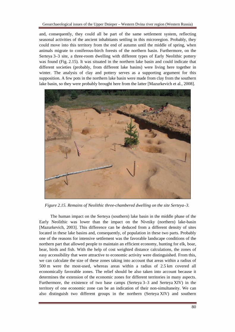
Geoarchaeological issues of the Upper Dnieper – Western Dvina river region (Western Russia)
80
and, consequently, they could all be part of the same settlement system, reflecting seasonal activities of the ancient inhabitants settling in this microregion. Probably, they could move into this territory from the end of autumn until the middle of spring, when animals migrate to coniferous-birch forests of the northern basin. Furthermore, on the Serteya 3–3 site, a three-room dwelling with different types of Early Neolithic pottery was found (Fig. 2.15). It was situated in the northern lake basin and could indicate that different societies (probably, from different lake basins) were living here together in winter. The analysis of clay and pottery serves as a supporting argument for this supposition. A few pots in the northern lake basin were made from clay from the southern lake basin, so they were probably brought here from the latter [Mazurkevich et al., 2008].
Figure 2.15. Remains of Neolithic three-chambered dwelling on the site Serteya–3.
The human impact on the Serteya (southern) lake basin in the middle phase of the Early Neolithic was lower than the impact on the Nivniky (northern) lake-basin [Mazurkevich, 2003]. This difference can be deduced from a different density of sites located in these lake basins and, consequently, of population in these two parts. Probably one of the reasons for intensive settlement was the favorable landscape conditions of the northern part that allowed people to maintain an efficient economy, hunting for elk, boar, bear, birds and fish. With the help of cost weighted distance calculations, the zones of easy accessibility that were attractive to economic activity were distinguished. From this, we can calculate the size of these zones taking into account that areas within a radius of 500 m were the most-used, whereas areas within a radius of 2.5 km covered all economically favorable zones. The relief should be also taken into account because it determines the extension of the economic zones for different territories in many aspects. Furthermore, the existence of two base camps (Serteya 3–3 and Serteya XIV) in the territory of one economic zone can be an indication of their non-simultaneity. We can also distinguish two different groups in the northern (Serteya XIV) and southern
Geoarchaeological issues of the Upper Dnieper – Western Dvina river region (Western Russia)
81
(Serteya X) parts of the microregion as is shown by the modelling of their economic activity zones.
This seasonal orientation of two parts of the Serteya microregion and the different economic orientation of various sites can also be illustrated by the analysis of aspect and illumination. It was not comfortable to live on the north-eastern and north-western slopes in winter. That is why the ancient inhabitants chose western or south-western slopes, whereas in summer they could also settle on the eastern slopes. Moreover, the illumination in winter was better in the northern part of the Serteya microregion. In contrast, all sites with traces of substantial dwellings (Serteya X, Serteya XIV and Serteya 3–3) are exposed to the south / south-west and are protected from the north by the border of lake depressions, terraces or higher elevations [Mazurkevich et al., 2003, P. 260-265].
In this way we have distinguished several specialised sites situated in specific parts of landscape – winter and summer camps, hunting sites situated along an animal migratory track, fishing spots, and possible observation posts which together formed the settlement system of the Early Neolithic from the 6th to the beginning of the 4th
Pile dwellings appeared at the Atlantic / Subboreal boundary (3700–3200 cal BC) when there was a regression stage of lakes. As shown by pollen analysis, the end of
millennium BC. This varied settlement system took into account the seasonal convenience of different places in order to use all the rich resources of the Holocene to their optimum, and took maximum control of the area that was used for the observation of the natural resources, or for guarding the territory.
In the middle of V mil calBC bearers of traditions of LBK culture, ancient farmers of Middle Europe, appeared in the basin of Western Dvina River. The remains of this culture were found on the bottom of lake Sennica on the site Dubokray V in the course of underwater excavations. Fragments of pottery decorated in linear-ribbon manner using drawn lines, drawn lines and impressions, incisions, clay attachment and its imitation made with pinching, bone and antler points, daggers, arrowheads and two flutes were found there. The latter are made from cortical bone of big waders and have four lateral holes (Fig. 2.39). One of them is decorated by round incisions, another – by complicated geometrical decoration. These flutes can be attributed to straight and oblique types but made basing on one musical standard that testifies accumulation of large theoretical and methodological experience. These flutes have scale that combines very narrow melodic interval with a wide one which can be correlated with ancient Greece enharmonic tonality. Also cylindrical amber pendant was found here – one of the earliest ornaments from Baltic amber in Eastern Europe. On the territory of Serteysky microregion (site Serteya XIV) stone axe, remains of long house and fragments of pottery attributed to this culture were found. Middle-late Neolithic.
Unique culture of pile-dwellings appeared at the second half of IV mil calBC in Western Dvina River region. The first pile dwellings, which belong to the Usvyatian Culture, existed between 3500 and 2550 cal BC. Their appearance marks a cultural discontinuity, and coincides with a major change in the environment. The pile dwellings reached their maximum size during the next stage, which included the Zhizhitsian (2550-2250 cal BC) and North Belorussian (2250–1950 cal BC) cultures. In middle Neolithic northern laake basin of Serteysky microregion (Figs. 2.5, 2.6, 2.16, 2.17) was not populated. Pile-dwellings were situated only in southern lake basin (sites Serteya I, II, X, XI – № 5).
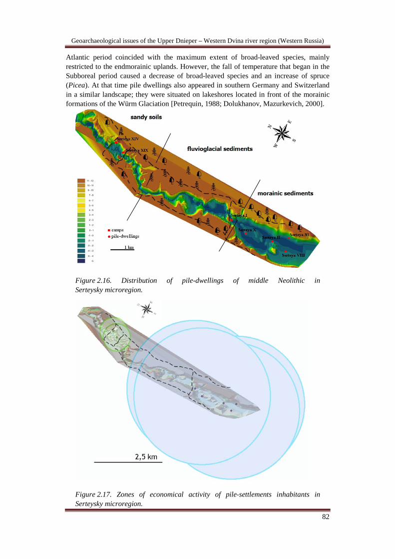
Geoarchaeological issues of the Upper Dnieper – Western Dvina river region (Western Russia)
82
Atlantic period coincided with the maximum extent of broad-leaved species, mainly restricted to the endmorainic uplands. However, the fall of temperature that began in the Subboreal period caused a decrease of broad-leaved species and an increase of spruce (Picea). At that time pile dwellings also appeared in southern Germany and Switzerland in a similar landscape; they were situated on lakeshores located in front of the morainic formations of the Würm Glaciation [Petrequin, 1988; Dolukhanov, Mazurkevich, 2000].
Figure 2.16. Distribution of pile-dwellings of middle Neolithic in Serteysky microregion.
Figure 2.17. Zones of economical activity of pile-settlements inhabitants in Serteysky microregion.

Geoarchaeological issues of the Upper Dnieper – Western Dvina river region (Western Russia)
83
Spatial analysis of lacustrine pile dwellings in the study area reveals a clear subsistence pattern based on catchment area, which limits foraging to a two-hour walking distance (c. 10 km) from the central hunting lodge [Zvelebil, 1996]. The settlement and the zone of economic activity are regarded as one natural-economic complex. It determines the boundaries of the economically favourable landscape surrounding the settlement, which allows us to estimate the extent and types of natural resources used by ancient people. It allows the reconstruction of the peculiarities of the economy and an estimation of the demographic situation of this area. The catchment area of the pile dwellings includes three distinct landscape types: (i) lake plus low-lying terraces and offshore mires; (ii) endmorainic formations with predominantly clayey soils covered by broad-leaved trees; and (iii) glaciofluvial outwash plains with sandy, podzolic soils covered with pine forests [Dolukhanov, Miklyaev, 1986]. The combination of these types of landscape made possible a productive hunter-gatherer economy and strongly contributed to the settlement system at this time [Dolukhanov, Miklyaev, 1986]. Only specific types of landscape were chosen for settlement, whereas the rest of the region was uninhabited. It also explains the long duration of pile dwellings in one place.
Interesting results have also been acquired from GIS-modelling of Lake Sennica (Pskov region) where sites are only situated on the western and northern side of the lake basin. Poor natural light on the eastern and southern shores, particularly in winter, as well as exposure to strong northerly winds and maximum remoteness from broad-leaved forests, all contributed to making these locations inconvenient for inhabitation. Furthermore, several former lake basins were made visible by remote sensing and analysis of sediments from boreholes made in the middle of these palaeolacustrine features. There are several ancient small lake basins joined by channels near the western and northern shores, which are separated from the central lakes by islands where the sites are situated [Mazurkevich et al., 2005].
The economy of the pile dwellers had a complex character; hunting prevailed over fishing and food gathering. Some boar (Sus scrofa fer.) caught in the course of hunting were not killed immediately but were being kept for some time on several sites and these animals were fed with fish. This is evident from the analysis of pig faeces containing small fish bones and scales, which were found in the base of cultural layers. Thus, we observe the apparent initial stage of pig domestication. This happened under the influence of the Globular Amphora and Funnel Beaker cultures, which can be clearly traced through the pottery typology of this time. Furthermore, bones of already domesticated pig (Sus scrofa dom.) and bones of a cow (Bos taurus) and a dog (Canis familiaris) have been found on the site of Usviaty IV dating to the end of 4th millennium cal BC [Sablin, Siromyatnikova, 2009, P. 155]. Teeth of a horse were found on the site of Serteya XI dating to the beginning of 3rd millennium cal BC. Their small size and thin, weak enamel indicate that these teeth belonged to an old domesticated horse (Equus caballus) [Kuz’mina, 2003, P. 305] (Fig. 2.18).
Traces of agriculture are observed in the early Subboreal (Sb-1) period. However, judging from the palynological data, this was not the first evidence of agriculture (Fig. 2.18). However, all previous “attempts” at farming had no continuity; agriculture was not adopted or was not continuously employed in the local environment. Thus, the first stable appearance of Cerealia in the pollen record is dated to the beginning of the Subboreal. A high content of grassy vegetation is shown in the pollen diagram for the same period, which marks the expansion of open spaces that could have been used by prehistoric people for agriculture and cattle herding. Ethnographic evidence shows that in northern Russia, Finland and Karelia “burn clearings” were cultivated on sloping and
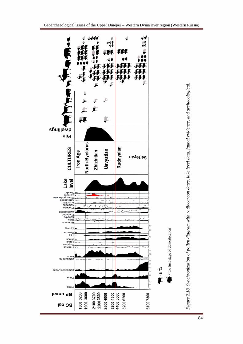
Geoarchaeological issues of the Upper Dnieper – Western Dvina river region (Western Russia)
84
Fi
gure
2.1
8. S
ynch
roni
zatio
n of
pol
len
diag
ram
with
radi
ocar
bon
date
s, la
ke le
vel d
ata,
faun
al e
vide
nce,
and
arc
haeo
logi
cal.

Geoarchaeological issues of the Upper Dnieper – Western Dvina river region (Western Russia)
85
hilly terrain [Petrov, 1968]. In the case of the Serteya River the corresponding terrain could be found along the steep slopes of the valley at a distance of less than 2 km from the site. “Swidden” farming was well suited to the natural renewal of forests. After the plots were abandoned, the area was populated by young birch, and later, by mixed forests dominated by deciduous trees. Analysis of the palaeolandscape suggests that at the beginning of the Subboreal fertile soils along the margins of the lakes were used as fields for crops and cattle herding Finds of agricultural implements (hoes and ploughs) also provide evidence for the existence of agriculture.
Figure 2.19. Fragment of plough from the site Dubokray I.
Pottery from the Usviatian Culture is represented by vessels with flared rims, forms that include characteristics of a cylinder plus a cone, low-volume vessels with turned-in rims and biconical forms, and vessels of simple conical form with rounded or flat bottoms. Wall thickness varies from 6 to 10 mm. Organic material or shell was used as temper; the latter was predominantly used during the early Usviatian Culture. During the last phase sand appeared as ceramic temper. The pots were made by coils that were joined together using the “S” technique. There are also traces of paddle and anvil, as well as polishing and comb-tool techniques. Decorations consisted of motifs made by impressions with straight-edged or denticulated tools; incisions and rounded-incisions are predominant, whereas comb-ornamentation is the third most frequently observed form of ornamentation. Also, there are decorative elements consisting of oval pits, lines, and cord impressions. Designs are arranged in zones and do not cover the entire vessel surface. Motifs consist of geometric figures, rows of impressions, and impressions placed at angles to one another. Additionally, there are triangle, rhombus and hexagon motifs, the last mentioned in the form of honeycombs with incisions, zigzags and nets of lines, and cord impressions. The decorative system was formed under the influence of the Funnel Beaker Culture, whereas the appearance of ‘honeycombs’ and impressions placed at angles to one another is the result of influence from the Globular Amphora Culture. Cord and line ornamentation reflects the successive influences of these two cultures. Comb ornamentation belongs to the local tradition, but the motifs used reflect foreign influences.
Geoarchaeological issues of the Upper Dnieper – Western Dvina river region (Western Russia)
86
Tools were made of high-quality black and grey flint of non-local origin. Flint implements are represented by “daggers”, small knives, tanged darts and arrowheads, quadrangular scrapers, end-scrapers on blades, knives on flakes, and massive scrapers. Most tools were found outside the perimeter of the living platforms. This suggests that activities such as flint knapping and butchering were done on the spot [Poplevko, 2007, P. 179, 186, Figs. 95–98]. Flint daggers made from long blades and daggers with short tangs appear at the beginning and middle of the 3rd
Pottery of the North Belorussian Culture was made using the “S” technique, sand and organic material was used as admixture, and the thickness of vessel walls varied from 5 to 6 mm. Unfortunately, owing to the conditions of preservation, the shape of the vessels cannot be reconstructed. Rims are straight with flat and mostly non-ornamented edges. Bases are round, though the occasional example is flat. The ornamentation system was similar to that of the preceding period but the amount of pottery with cord ornamentation increased two-fold. Raw material changed; yellow-grey flint replaced black flint as the predominant material. The change of raw material source can be explained either by flooding of former flint sources or the disruption of cultural contacts with regions from where the raw materials previously used were obtained. Tools were made from flakes. Scrapers with a rectangular working edge, T-formed scrapers, leaf-shaped arrowheads, tanged arrowheads, and arrowheads with a flat base or notch, are
millennium cal BC, respectively. The period of their occurrence coincides with the chronology of similar types of artefacts from Central Europe [Schlichtherle, 2005, Fig. 30].
Influences from the south, from the basins of the High Dnepr (Dnepr–Donets Culture) and Oka (Rhomb–Pit Culture), led to transformation of the local culture and formation of the Zhizhitsian Culture. Pottery from Zhizhitsian Culture is represented by vessels made in the “S” technique and also by slabs or coils. There are traces of polishing, smoothing, and use of a comb-tool. Sand, organic materials (including grass) and, more rarely, shell were used as temper. Pottery was fully decorated and the ornamental pattern was not determined by geography. Pottery was decorated with lines forming a net pattern, denticulate impressions, by cord made of bark, impressions of small knots, and elongated impressions of tools with flat edged or denticulated tools; it was organized in rows or staggered rows. There are also complex compositions made with different symbols and motifs. Vessels are of different forms compared to the Usviatian and Corded Ware cultures, and include small biconical, globular and cylindrical vessel forms with flat or pointed bottoms. Cord impressions and cylindrical and globular vessel forms typical of the middle Dnepr Culture reflect influences from the Corded Ware Culture. There are also vessels with flat bottoms, trays as well as their imitations, and a ladle with a clay hand (see Mazurkevich 2006, Fig. 92), but the most remarkable thing is the pintadera [Mazurkevich, 2006]. The pintadera which has a handle and a round surface, is 3.2 сm in diameter with three similar impressions along the edge of the surface. Analogues for this object can only be found in the archaeological cultures of the northern Balkans (see Makkay, 1984, Figs. III-7, XIII-6 and XVIII-XXI). The appearance of a copper awl found on the site of Usviaty IV likely is also connected to the influence of these foreign sources [Mazurkevich, 2007, P. 236-240].
During the time of the Zhizhitsian Culture inhabitants of the pile dwellings used local boulder flint. Tools that had worn out were reused after reshaping. Flint tools are represented by rectangular scrapers, flake scrapers with an arched or straight working edge, leaf-shaped arrowheads, tanged arrowheads, and triangular arrowheads with a flat base or notch. Flint wedged axes appeared, as well as stone scaphoid and tanged axes that reflect Corded Ware Culture influence [Mikljaev, Semenov, 1979, P. 13–15, Figs. 6-7].
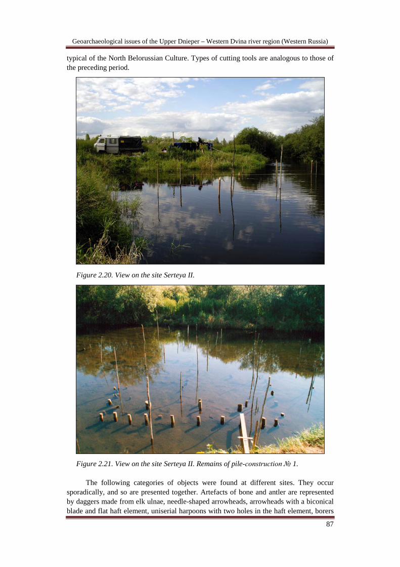
Geoarchaeological issues of the Upper Dnieper – Western Dvina river region (Western Russia)
87
typical of the North Belorussian Culture. Types of cutting tools are analogous to those of the preceding period.
Figure 2.20. View on the site Serteya II.
Figure 2.21. View on the site Serteya II. Remains of pile-construction № 1.
The following categories of objects were found at different sites. They occur sporadically, and so are presented together. Artefacts of bone and antler are represented by daggers made from elk ulnae, needle-shaped arrowheads, arrowheads with a biconical blade and flat haft element, uniserial harpoons with two holes in the haft element, borers
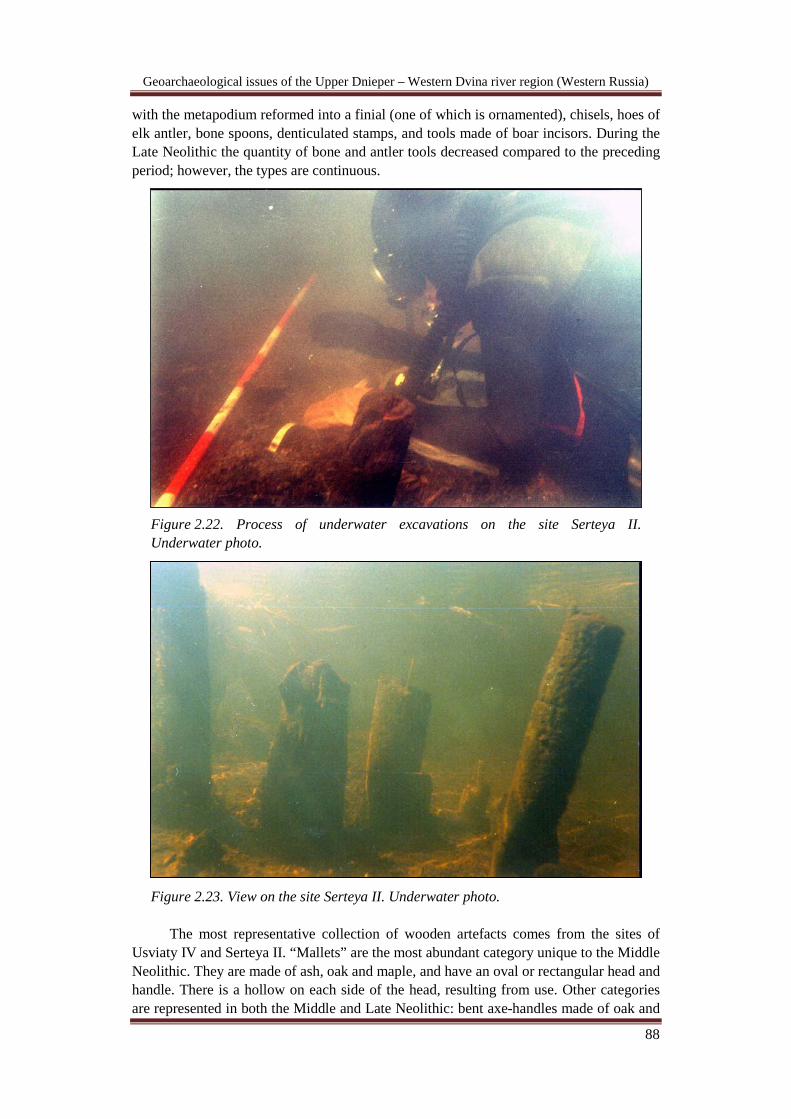
Geoarchaeological issues of the Upper Dnieper – Western Dvina river region (Western Russia)
88
with the metapodium reformed into a finial (one of which is ornamented), chisels, hoes of elk antler, bone spoons, denticulated stamps, and tools made of boar incisors. During the Late Neolithic the quantity of bone and antler tools decreased compared to the preceding period; however, the types are continuous.
Figure 2.22. Process of underwater excavations on the site Serteya II. Underwater photo.
Figure 2.23. View on the site Serteya II. Underwater photo.
The most representative collection of wooden artefacts comes from the sites of Usviaty IV and Serteya II. “Mallets” are the most abundant category unique to the Middle Neolithic. They are made of ash, oak and maple, and have an oval or rectangular head and handle. There is a hollow on each side of the head, resulting from use. Other categories are represented in both the Middle and Late Neolithic: bent axe-handles made of oak and
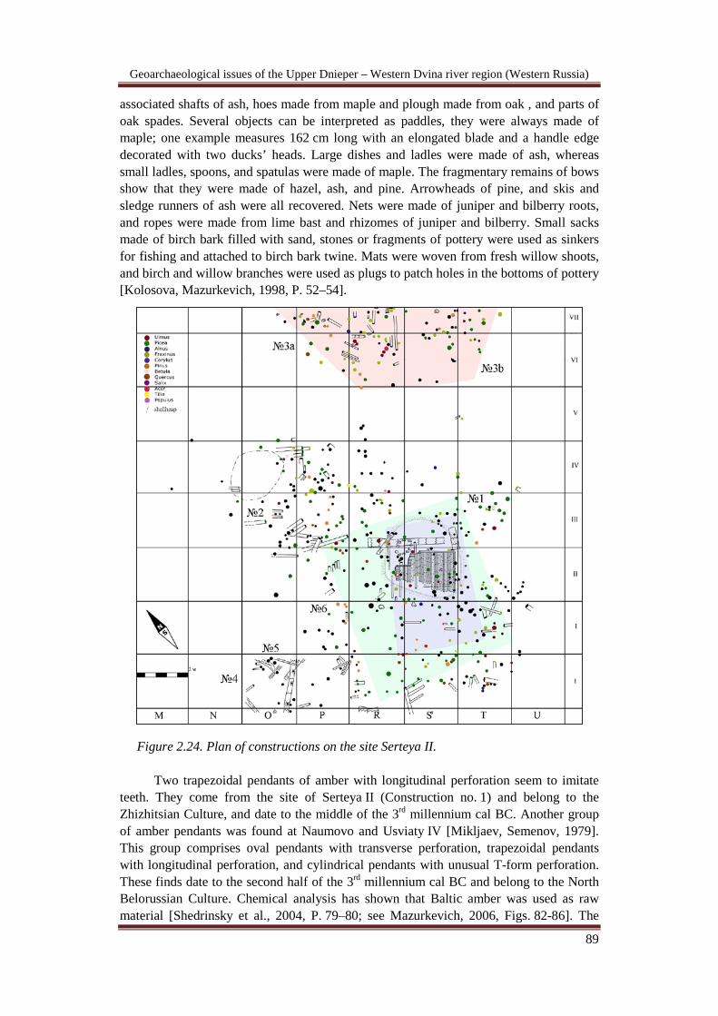
Geoarchaeological issues of the Upper Dnieper – Western Dvina river region (Western Russia)
89
associated shafts of ash, hoes made from maple and plough made from oak , and parts of oak spades. Several objects can be interpreted as paddles, they were always made of maple; one example measures 162 cm long with an elongated blade and a handle edge decorated with two ducks’ heads. Large dishes and ladles were made of ash, whereas small ladles, spoons, and spatulas were made of maple. The fragmentary remains of bows show that they were made of hazel, ash, and pine. Arrowheads of pine, and skis and sledge runners of ash were all recovered. Nets were made of juniper and bilberry roots, and ropes were made from lime bast and rhizomes of juniper and bilberry. Small sacks made of birch bark filled with sand, stones or fragments of pottery were used as sinkers for fishing and attached to birch bark twine. Mats were woven from fresh willow shoots, and birch and willow branches were used as plugs to patch holes in the bottoms of pottery [Kolosova, Mazurkevich, 1998, P. 52–54].
Figure 2.24. Plan of constructions on the site Serteya II.
Two trapezoidal pendants of amber with longitudinal perforation seem to imitate teeth. They come from the site of Serteya II (Construction no. 1) and belong to the Zhizhitsian Culture, and date to the middle of the 3rd millennium cal BC. Another group of amber pendants was found at Naumovo and Usviaty IV [Mikljaev, Semenov, 1979]. This group comprises oval pendants with transverse perforation, trapezoidal pendants with longitudinal perforation, and cylindrical pendants with unusual T-form perforation. These finds date to the second half of the 3rd millennium cal BC and belong to the North Belorussian Culture. Chemical analysis has shown that Baltic amber was used as raw material [Shedrinsky et al., 2004, P. 79–80; see Mazurkevich, 2006, Figs. 82-86]. The

Geoarchaeological issues of the Upper Dnieper – Western Dvina river region (Western Russia)
90
trapezoidal amber pendants are unlike the amber ornaments of the Globular Amphora Culture, or contemporaneous materials from the eastern Baltic [Czebreszuk, 2003; Loze, 2003] since, in contrast to the last mentioned, they imitate animal teeth. The oval and cylindrical amber ornaments have some parallels with examples from the Corded Ware Culture and contemporaneous sites in Latvia and Estonia [Loze, 2003]. The main differences between the local pendants and those of other regions are in the method of fabrication, the arrangement of the perforation for suspension, and the shape of the cross-section. The original fabrication technique, the shapes of the amber ornaments, and the discovery of raw amber on the site of Serteya X suggest that the raw material was transported from the eastern Baltic to the Upper Dvina region, and that the ornaments were made locally. Local inhabitants could compensate for the lack of raw amber in the area by active use of similar, available materials– resin resembled amber (evidenced from finds of a raw material field cut through by the Western Dvina river) [Shedrinsky et al., 2004б P. 75].
Certain categories of “art objects” may have been associated with the ritual activities of the inhabitants of the pile dwellings, interpreted here as a possible “ancestor cult” – they comprise clay pots with anthropomorphic figures or signs, an anthropomorphic spatula/spoon with undulating edges, sculptural images of humans and animals, a wooden ladle with the image of a bear filled with burnt bone, which was found near the spoon, a human mask, and a zoomorphic pendant [Mazurkevich, 2006, P. 28, Figs. 26-29, 42 and 44-46]. Functional and protective qualities of specific animals or ancestors may have been transferred onto the object (i.e. a paddle decorated with ducks’ heads) or onto the individual (i.e. a necklace of animal teeth, or imitations made of bone and amber) (see Mazurkevich, 2006, Figs. 85-86). However, finds of these types of artefacts are rare. The sculptural images of humans and animals have distinctive features – the accurate representation enabled us to identify the animals portrayed. Moreover, the absence of eyes, elaborated eye-sockets, cheek-bones, ears, chin, mouth and lips suggest an emotion or behavioural characteristic in the perception of the image. One example is the mimicry of human face from cultural layers in the site of Usviaty IV; this face may be associated with such emotions as tension and expectation, or with shouting. Another from Osovec II may show severity or depression, and the mask from Djazdica possibly shows severity or cruelty. The physical strength of male figures was represented by shoulder girdle muscles.
Almost all art objects from the Neolithic may be classified into two groups – sighted and eyeless figures. Most of the eyeless animals and humans come from burials or other ritual places. This fact allows us to suppose a connection between eyeless images and the semantic field of another world – the world of ancestors and the world of the dead. Usually, sighted figures are represented by animals, including birds, the eyes of which could have been inlaid, as suggested by the character of the eye sockets. Ochre may have been used as the material for encrustation; ochre was found in the eye sockets of some pendants that have the form of birds’ heads. These figures may concern another semantic field – that of resurgent or living creatures that played a guarding role.
Large vessels with anthropomorphic images are very important and may be evidence of feasting. Anthropomorphic graphical signs decorating the pots of the Usviatian Culture (at Usviaty IV) may represent coded signs of a genealogical tree and/or the social structure of the inhabitants of the pile dwellings, by comparison with ethnographic examples [Carpenter, 1986]. At the site of Usviaty IV traces of funeral feasting were found; the animal eaten during the feast was specifically collected in the ladle with the head of an eyeless bear and taken out to the perimeter of the living space –
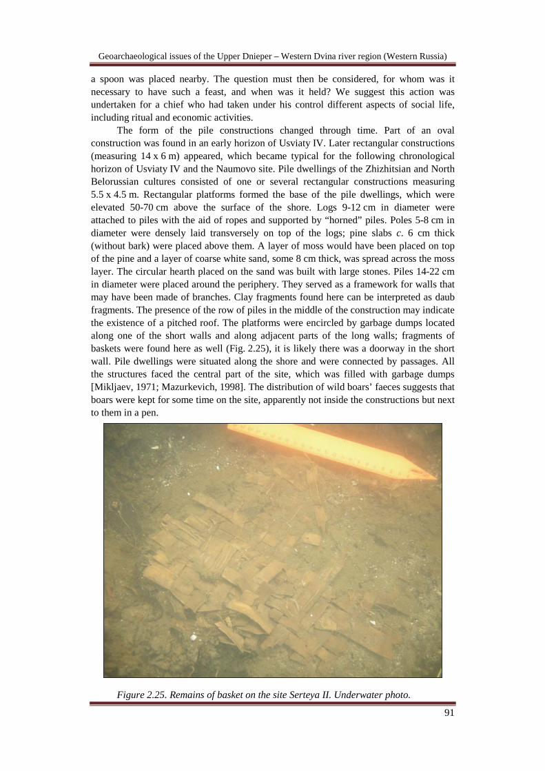
Geoarchaeological issues of the Upper Dnieper – Western Dvina river region (Western Russia)
91
a spoon was placed nearby. The question must then be considered, for whom was it necessary to have such a feast, and when was it held? We suggest this action was undertaken for a chief who had taken under his control different aspects of social life, including ritual and economic activities.
The form of the pile constructions changed through time. Part of an oval construction was found in an early horizon of Usviaty IV. Later rectangular constructions (measuring 14 х 6 m) appeared, which became typical for the following chronological horizon of Usviaty IV and the Naumovo site. Pile dwellings of the Zhizhitsian and North Belorussian cultures consisted of one or several rectangular constructions measuring 5.5 х 4.5 m. Rectangular platforms formed the base of the pile dwellings, which were elevated 50-70 cm above the surface of the shore. Logs 9-12 cm in diameter were attached to piles with the aid of ropes and supported by “horned” piles. Poles 5-8 cm in diameter were densely laid transversely on top of the logs; pine slabs c. 6 cm thick (without bark) were placed above them. A layer of moss would have been placed on top of the pine and a layer of coarse white sand, some 8 cm thick, was spread across the moss layer. The circular hearth placed on the sand was built with large stones. Piles 14-22 сm in diameter were placed around the periphery. They served as a framework for walls that may have been made of branches. Clay fragments found here can be interpreted as daub fragments. The presence of the row of piles in the middle of the construction may indicate the existence of a pitched roof. The platforms were encircled by garbage dumps located along one of the short walls and along adjacent parts of the long walls; fragments of baskets were found here as well (Fig. 2.25), it is likely there was a doorway in the short wall. Pile dwellings were situated along the shore and were connected by passages. All the structures faced the central part of the site, which was filled with garbage dumps [Mikljaev, 1971; Mazurkevich, 1998]. The distribution of wild boars’ faeces suggests that boars were kept for some time on the site, apparently not inside the constructions but next to them in a pen.
Figure 2.25. Remains of basket on the site Serteya II. Underwater photo.
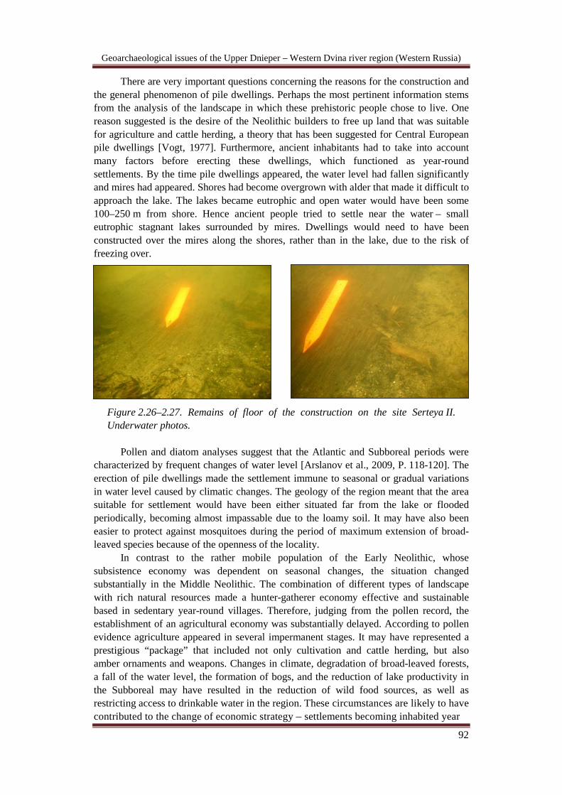
Geoarchaeological issues of the Upper Dnieper – Western Dvina river region (Western Russia)
92
There are very important questions concerning the reasons for the construction and the general phenomenon of pile dwellings. Perhaps the most pertinent information stems from the analysis of the landscape in which these prehistoric people chose to live. One reason suggested is the desire of the Neolithic builders to free up land that was suitable for agriculture and cattle herding, a theory that has been suggested for Central European pile dwellings [Vogt, 1977]. Furthermore, ancient inhabitants had to take into account many factors before erecting these dwellings, which functioned as year-round settlements. By the time pile dwellings appeared, the water level had fallen significantly and mires had appeared. Shores had become overgrown with alder that made it difficult to approach the lake. The lakes became eutrophic and open water would have been some 100–250 m from shore. Hence ancient people tried to settle near the water – small eutrophic stagnant lakes surrounded by mires. Dwellings would need to have been constructed over the mires along the shores, rather than in the lake, due to the risk of freezing over.
Figure 2.26–2.27. Remains of floor of the construction on the site Serteya II. Underwater photos.
Pollen and diatom analyses suggest that the Atlantic and Subboreal periods were
characterized by frequent changes of water level [Arslanov et al., 2009, P. 118-120]. The erection of pile dwellings made the settlement immune to seasonal or gradual variations in water level caused by climatic changes. The geology of the region meant that the area suitable for settlement would have been either situated far from the lake or flooded periodically, becoming almost impassable due to the loamy soil. It may have also been easier to protect against mosquitoes during the period of maximum extension of broad-leaved species because of the openness of the locality.
In contrast to the rather mobile population of the Early Neolithic, whose subsistence economy was dependent on seasonal changes, the situation changed substantially in the Middle Neolithic. The combination of different types of landscape with rich natural resources made a hunter-gatherer economy effective and sustainable based in sedentary year-round villages. Therefore, judging from the pollen record, the establishment of an agricultural economy was substantially delayed. According to pollen evidence agriculture appeared in several impermanent stages. It may have represented a prestigious “package” that included not only cultivation and cattle herding, but also amber ornaments and weapons. Changes in climate, degradation of broad-leaved forests, a fall of the water level, the formation of bogs, and the reduction of lake productivity in the Subboreal may have resulted in the reduction of wild food sources, as well as restricting access to drinkable water in the region. These circumstances are likely to have contributed to the change of economic strategy – settlements becoming inhabited year

Geoarchaeological issues of the Upper Dnieper – Western Dvina river region (Western Russia)
93
Figu
res 2
.28–
2.30
. Po
ttery
of t
he si
te
Sert
eya
II.

Geoarchaeological issues of the Upper Dnieper – Western Dvina river region (Western Russia)
94
round, and as the population became more settled, starting to store more food and water. At that time (the Atlantic / Subboreal transition) high-capacity vessels appear and the population increased. The subsistence economy and distribution system changed, which inevitably resulted in a change of social structure [Mazurkevich, 2003].
Figure 2.31. Bone workpieces of the site
Serteya II.
Figure 2.32. Wooden workpieces of the
site Serteya II.
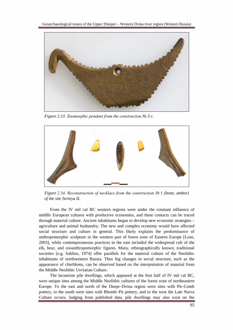
Geoarchaeological issues of the Upper Dnieper – Western Dvina river region (Western Russia)
95
Figure 2.33. Zoomorphic pendant from the construction № 3 c.
Figure 2.34. Reconstruction of necklace from the construction № 1 (bone, amber) of the site Serteya II.
From the IV mil cal BC western regions were under the constant influence of
middle European cultures with productive economies, and these contacts can be traced through material culture. Ancient inhabitants began to develop new economic strategies – agriculture and animal husbandry. The new and complex economy would have affected social structure and culture in general. This likely explains the predominance of anthropomorphic sculpture in the western part of forest zone of Eastern Europe [Loze, 2003], while contemporaneous practices in the east included the widespread cult of the elk, bear, and zooanthropomorphic figures. Many, ethnographically known, traditional societies [e.g. Sahlins, 1974] offer parallels for the material culture of the Neolithic inhabitants of northwestern Russia. Thus big changes in social structure, such as the appearance of chiefdoms, can be observed based on the interpretation of material from the Middle Neolithic Usviatian Culture.
The lacustrine pile dwellings, which appeared at the first half of IV mil cal BC, were unique sites among the Middle Neolithic cultures of the forest zone of northeastern Europe. To the east and north of the Dnepr–Dvina region were sites with Pit–Comb pottery, to the south were sites with Rhomb–Pit pottery, and to the west the Late Narva Culture occurs. Judging from published data, pile dwellings may also exist on the

Geoarchaeological issues of the Upper Dnieper – Western Dvina river region (Western Russia)
96
Figure 2.35. Man figure of the site Usviaty IV.
Figure 2.36. Vessel with anthropomorphic image of the site
Usviaty IV.
Figure 2.37. Raven figure of the site Usviaty IV.
northeastern Baltic shores of Sarnate and Shvjantoji. The territory of pile dwelling expansion includes the basin of the upper (Serteya II, Usviaty IV, and Dubokrai V).
At the beginning of Sb-3 huge transgression took place which led to ruin of pile-dwellings of North-Belorussian culture (3650±70 (ТА-634)). Climate became warmer and dryer, productivity of lakes increased. Inhabitants started to settle on the shores and islands of paleolakes creating base camps with long-term ground dwellings with several chambers with stakes with ground hearths in the same landscape conditions as in previous period (sites Serteya Х, II layer 2 – № 7). Parts of fluvioglacial landscapes started to be used intensively again that is testified by sites of Uzmen culture and finds of axes.
Our researches of recent years allowed us to distinguish new types of sites. The first one is fishing places with remains of constructions dated to IV mil cal BC and the middle of III mil cal BC (site Serteya I). Sites Serteya X (7300 ВР), Rydnya Serteya (5780 BP) and Serteya XIV (6500 ВР) can be attributed to the second type of sites interpreted as zones of shore activity where fishing facilities were left. They are situated near settlements (Serteya X, Serteya XIV) or remote from inhabited areas (Rydnya Serteya). One of the characteristic features of these sites is that their cultural layer continuer further in the nearby river. It made us to hold also underwater excavations which allowed often tracing lots of peculiarities of cultural layer that are very difficult to detect on the surface and uncovering objects in their almost original conditions.
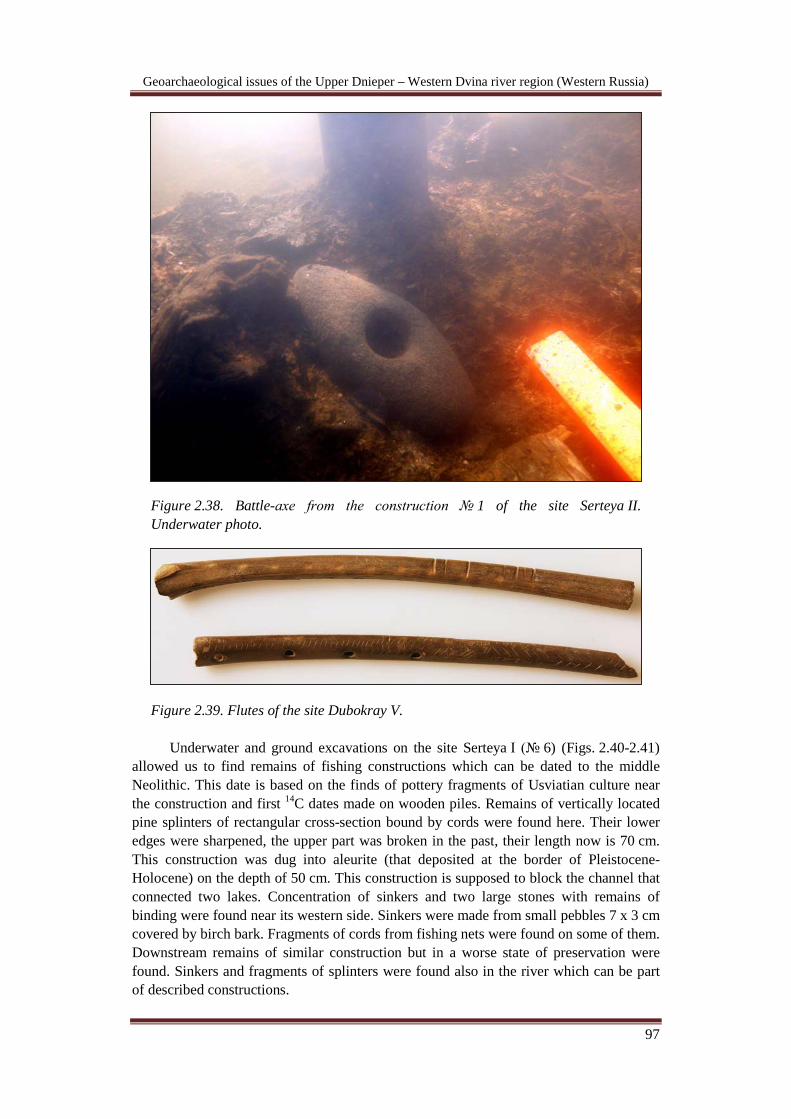
Geoarchaeological issues of the Upper Dnieper – Western Dvina river region (Western Russia)
97
Figure 2.38. Battle-axe from the construction № 1 of the site Serteya II. Underwater photo.
Figure 2.39. Flutes of the site Dubokray V. Underwater and ground excavations on the site Serteya I (№ 6) (Figs. 2.40-2.41)
allowed us to find remains of fishing constructions which can be dated to the middle Neolithic. This date is based on the finds of pottery fragments of Usviatian culture near the construction and first 14C dates made on wooden piles. Remains of vertically located pine splinters of rectangular cross-section bound by cords were found here. Their lower edges were sharpened, the upper part was broken in the past, their length now is 70 cm. This construction was dug into aleurite (that deposited at the border of Pleistocene-Holocene) on the depth of 50 cm. This construction is supposed to block the channel that connected two lakes. Concentration of sinkers and two large stones with remains of binding were found near its western side. Sinkers were made from small pebbles 7 x 3 cm covered by birch bark. Fragments of cords from fishing nets were found on some of them. Downstream remains of similar construction but in a worse state of preservation were found. Sinkers and fragments of splinters were found also in the river which can be part of described constructions.

Geoarchaeological issues of the Upper Dnieper – Western Dvina river region (Western Russia)
98
Figures 2.40–2.41. Remains of fishing-trap of the site Serteya I.
This place was used many times in the past as fishing place due to dates made on wooden piles and horizontal construction from splinters. Fragments of pottery of Usviatian culture of the IV mil calBC found in the layer of peat covering construction dated to the III mil calBC might testify the existence of settlement nearby that has been washing away.
Remains of analogical constructions were found on the sites Rudnya Serteya, Serteya X and Serteya XIV attributed to early Neolithic but in a worse state of preservation. Two rows of piles with poles, concentrations of hazel branches and
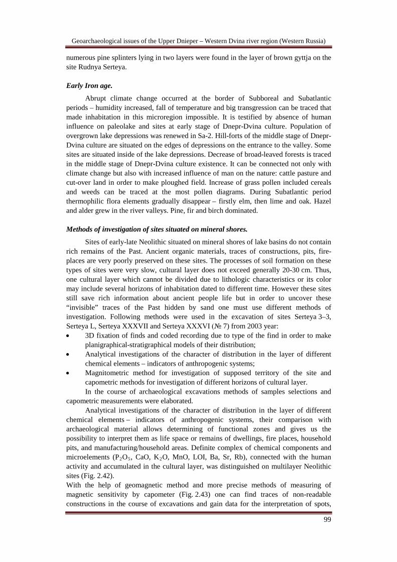
Geoarchaeological issues of the Upper Dnieper – Western Dvina river region (Western Russia)
99
numerous pine splinters lying in two layers were found in the layer of brown gyttja on the site Rudnya Serteya. Early Iron age.
Abrupt climate change occurred at the border of Subboreal and Subatlantic periods – humidity increased, fall of temperature and big transgression can be traced that made inhabitation in this microregion impossible. It is testified by absence of human influence on paleolake and sites at early stage of Dnepr-Dvina culture. Population of overgrown lake depressions was renewed in Sa-2. Hill-forts of the middle stage of Dnepr-Dvina culture are situated on the edges of depressions on the entrance to the valley. Some sites are situated inside of the lake depressions. Decrease of broad-leaved forests is traced in the middle stage of Dnepr-Dvina culture existence. It can be connected not only with climate change but also with increased influence of man on the nature: cattle pasture and cut-over land in order to make ploughed field. Increase of grass pollen included cereals and weeds can be traced at the most pollen diagrams. During Subatlantic period thermophilic flora elements gradually disappear – firstly elm, then lime and oak. Hazel and alder grew in the river valleys. Pine, fir and birch dominated. Methods of investigation of sites situated on mineral shores.
Sites of early-late Neolithic situated on mineral shores of lake basins do not contain rich remains of the Past. Ancient organic materials, traces of constructions, pits, fire-places are very poorly preserved on these sites. The processes of soil formation on these types of sites were very slow, cultural layer does not exceed generally 20-30 cm. Thus, one cultural layer which cannot be divided due to lithologic characteristics or its color may include several horizons of inhabitation dated to different time. However these sites still save rich information about ancient people life but in order to uncover these “invisible” traces of the Past hidden by sand one must use different methods of investigation. Following methods were used in the excavation of sites Serteya 3–3, Serteya L, Serteya XXXVII and Serteya XXXVI (№ 7) from 2003 year: • 3D fixation of finds and coded recording due to type of the find in order to make
planigraphical-stratigraphical models of their distribution; • Analytical investigations of the character of distribution in the layer of different
chemical elements – indicators of anthropogenic systems; • Magnitometric method for investigation of supposed territory of the site and
capometric methods for investigation of different horizons of cultural layer. In the course of archaeological excavations methods of samples selections and
capometric measurements were elaborated. Analytical investigations of the character of distribution in the layer of different
chemical elements – indicators of anthropogenic systems, their comparison with archaeological material allows determining of functional zones and gives us the possibility to interpret them as life space or remains of dwellings, fire places, household pits, and manufacturing/household areas. Definite complex of chemical components and microelements (P2O5, CaO, K2
With the help of geomagnetic method and more precise methods of measuring of magnetic sensitivity by capometer (Fig. 2.43) one can find traces of non-readable constructions in the course of excavations and gain data for the interpretation of spots,
O, MnO, LOI, Ba, Sr, Rb), connected with the human activity and accumulated in the cultural layer, was distinguished on multilayer Neolithic sites (Fig. 2.42).

Geoarchaeological issues of the Upper Dnieper – Western Dvina river region (Western Russia)
100
pits existed in the Past [Hookk et al., 2010]. More precise measurements with the help of capometer allows distinguishing several horizons with different traces of magnetic anomalies. This method allows distinguishing different anomalies from different layers fixed by magnetic prospection which could have appeared to be laid upon each other. Thus we can trace several horizons of one site inhabitation which are equal to different anomalies. Analyses of distribution of archaeological finds, pits, constructions including those which are reconstructed due to magnetic data, and their comparison with geochemical anomalies and data of capometer survey allows us to distinguish functional zones and probable function of different objects and to determine role which the territory of the site played in different time. This complex of methods gives the opportunity to create relative chronology of the past both of the site and while comparing different sites between each other.
Figure 2.42. Example of reconstruction of different zones of economical activity basing on geochemical analysis on the site Serteya 3–3.
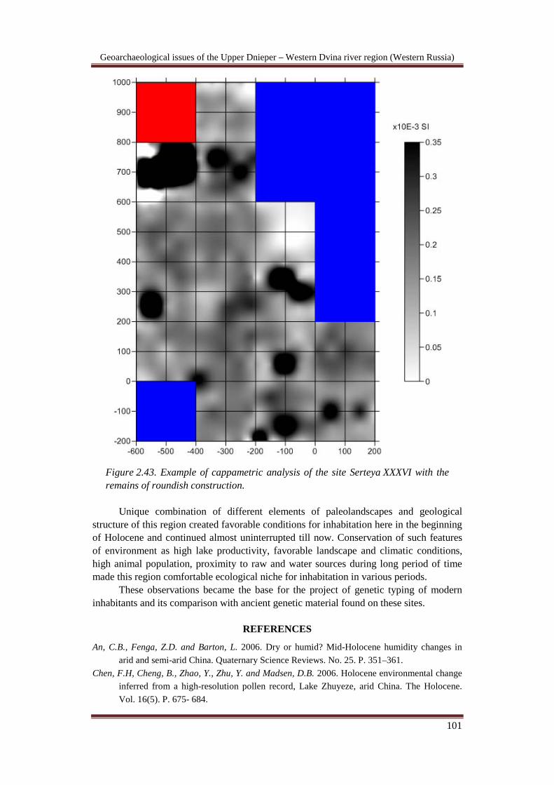
Geoarchaeological issues of the Upper Dnieper – Western Dvina river region (Western Russia)
101
Figure 2.43. Example of cappametric analysis of the site Serteya XXXVI with the remains of roundish construction.
Unique combination of different elements of paleolandscapes and geological
structure of this region created favorable conditions for inhabitation here in the beginning of Holocene and continued almost uninterrupted till now. Conservation of such features of environment as high lake productivity, favorable landscape and climatic conditions, high animal population, proximity to raw and water sources during long period of time made this region comfortable ecological niche for inhabitation in various periods.
These observations became the base for the project of genetic typing of modern inhabitants and its comparison with ancient genetic material found on these sites.
REFERENCES An, C.B., Fenga, Z.D. and Barton, L. 2006. Dry or humid? Mid-Holocene humidity changes in
arid and semi-arid China. Quaternary Science Reviews. No. 25. P. 351–361. Chen, F.H, Cheng, B., Zhao, Y., Zhu, Y. and Madsen, D.B. 2006. Holocene environmental change
inferred from a high-resolution pollen record, Lake Zhuyeze, arid China. The Holocene. Vol. 16(5). P. 675- 684.

Geoarchaeological issues of the Upper Dnieper – Western Dvina river region (Western Russia)
102
Bond, G., Showers, W., Cheseby, M., Lotti, R., Almasi, P., deMenocal, P., Priore, P., Cullen, H.M., Hajdas, I. and Bonani, G. 1997. A pervasive millennial-scale cycle in North Atlantic Holocene and glacial climates. Science. Vol. 278. P. 1257–1266.
Bronk Ramsey C. 2005. OxCal Program v 3.10. Oxford:University of Oxford Radiocarbon Unit. http://www.rlaha.ox.ac.uk/oxcal/oxcal.htm.
Bradley, R.S. 2000. Past global changes and their significance for the future. Quaternary Science Reviews.Vol. 19. P. 391-402.
Davison, K., Dolukhanov, P.M., Sarson, G.R., Shukurov, A. and Zaitseva, G.I. 2009. Multiple Sources of the European Neolithic: Mathematical Modelling Constrained by Radiocarbon Dates. The East European Plain on the Eve of Agriculture. BAR International Series 1964. Oxford.
Dean, W.E. 2000. The Sun and Climate. USGS Fact Sheet FS-095-00, August. deMenocal, P.B. 2001. Cultural Responses to Climate Change During the Late Holocene. Science.
Vol. 292. P. 667-673. Dolukhanov, P. and Mazurkevich, A. 2000. Sites lacustres neolithiques de Russie. Archeologia. No. 369. Dolukhanov, P.M. and Miklyayev, A.M. 1986. Prehistoric lacustrine pile-dwellings in the north-
western part of the USSR. Fennoscandia archaeological. Vol. III. Dolukhanov, P.M., Shukurov, A.M., Arslanov, Kh.A., Mazurkevich, A.N., Savel’eva, L.A.,
Dzinoridze, E.N., Kulkova, M.A. and Zaitseva, G.I. 2004. The Holocene Environment and Transition to Agriculture in Boreal Russia (Serteya Valley Case Study). Internet Archaeology 17. http://intarch.ac.uk/journal/issue17/dolukhanov_toc.html.
Heiri, O., Tinner, W. and Lotter, A.F. 2004. Evidence for cooler European summers during periods of changing meltwater flux to the North Atlantic. The Proceedings of the US National Academy of Sciences. Vol. 101(43). P. 15285-15288.
Hookk, D.Yu. and Mazurkevich, A.N. 2007. “Fuzzy logic and neolithic wood”. In: “Small samples – big objects”. May 9th. Munich.
Kofler, W., Krapf, V., Oberhuber, W. and Bortenschlager, S. 2005. Vegetation responses to the 8200 cal. BP cold event and to long-term climatic changes in the Eastern Alps: possible influence of solar activity and North Atlantic freshwater pulses. The Holocene. Vol. 15(6). P. 779-788.
Kulkova, M.A., Mazurkevich, A.N. and Dolukhanov, P.M. 2001. Chronology and Palaeoclimate of prehistoric sites in Western Dvina-Lovat’ area of North-Western Russia. Geochronometria. Journal on Methods and Applications of Absolute Chronology.Vol. 20. P. 87-94.
Kulkova, M. 2006. The geochemical indicators of paleoclimate of Holocene and their meaning for reconstruction of prehistory sites in Western Dvina-Lovat’ area of North-Western Russia. Proceeding from the 8th Nordic Conference on the Application of Scientific Methods in Archaeology. Archaeology and Environment, Umeе 21. P. 93-100.
Hodder, I. 1982. Symbols in action. London. Martineau, R. 2000. Poterie, techniques et sociйtй. Йtudes analytiques et expйrimentales а Chalain
et Clairveaux (Jura) entre 3200 et 2900 av. J.-C., Thиse de doctorat de l’Universitй de Franche-Comtй.
Mazurkevich, A.N. 2011. Del neolitico al bronce antigo en el are Forestal del Europa oriental (V – II milenios a.c.). Ermitage Tesoros de la Arqueologia rusa. Alicante. P. 53 – 65.
Mazurkevich, A.N., Dolukhanov, P.M., Shukurov, A.M. and Zaitseva, G.I. 2006. Pottery-making revolution in Northern Eurasia. International conference “Man and Environment in Pleistocene and Holocene: Evolution of Waterways and Early Settlement of Northern Europe”. SPb.
Mazurkevich, A.N., Korotkevich, B.N., Dolukhanov, P.M.,. Shukurov, A.M, Arslanov, Kh.A., Savel'eva, L.A., Dzinoridze, E.N., Kulkova, M.A. and Zaitseva, G.I. 2009. Climate,

Geoarchaeological issues of the Upper Dnieper – Western Dvina river region (Western Russia)
103
subsistence and human movements in the Western Dvina – Lovat River Basins. Quaternary International. Vol. 203(1-2). P. 52-66.
Mazurkevich, A., Hookk, D. and Fassbinder, J. 2009. Magnetometry and susceptibility prospection on neolithic-early Iron Age sites at Sertey, North-Western Russia. ArcheoSciences Reuue d’arheometrie, supplement. № 33. P. 81-85.
Mazurkevich, A., Hookk, D., Dolbunova, E. and Maigrot, Y. 2011. Results of underwater excavations of Serteya II and research of pile-dwellings in Northwest Russia. Archaeologia Baltica. №14, Р. 47-64.
Mazurkevich, A. and Dolbunova, E. 2011. Underwater investigations in Northwest Russia: archaeology of pile-dwellings. In: J. Benjamin, C. Bonsall, C. Pickard, A. Fischer. (eds.) Underwater Archaeology and the Submerged Prehistory of Europe. Oxbow Books.
Magny, M. and Haas, J.N. 2004. A major widespread climatic change around 5300 cal. yr. BP at the time of the Alpine Iceman. Journal of Quaternary Science. Vol. 19(5). P. 423-430.
Miettinen, A. 2002. Relative Sea Level Changes in the Eastern Part of the Gulf of Finland during the Last 8000 Years. Helsinki. Suomalainen Tiedeakatemia. P. 2-10.
Арсланов Х.А., Джиноридзе Е.Н., Максимов Ф.Е., Савельева Л.А., Тертычная Т.В., Чернов С.Б. 2003. Палинологические, диотомовые характеристики и возраст позднеледниковых и голоценовых осадков в верховьях Западной Двины. // Древности Подвинья: исторический аспект. Санкт-Петербург. С. 291-299.
Афанасьев Г.Е., Савенко С.Н., Коробов Д.С. 2004. Древности Кисловодской котловины. Москва. 240 с.
Выборнов А.А. 2008. Неолит Волго-Камья. Самара. 490 с. Даниленко В.Н. 1969. Неолит Украины. Главы древней истории Юго-восточной Европы.
Киев. 257 с. Долуханов П.М., Микляев А.М. 1983. Культурные ландшафты на Северо-западе Русской
равнины в голоцене. // Изыскания по мезолиту и неолиту СССР. Ленинград. Древности Северо-Западной России. 1995. Каталог выставки. Санкт-Петербург. Зайцева Г.И., Васильев С.С., Дергачев В.А., Мазуркевич А.Н., Семенцов А.А. 2003. Новые
исследования памятников бассейна Западной Двины и Ловати: распределение радиоуглеродных дат, корреляция с изменением природных процессов, применение математической статистики. // Древности Подвинья: исторический аспект. Санкт-Петербург. С. 140-154.
История озер Восточно-Европейской равнины: сборник научных трудов. Отв. ред. Давыдова Н.Н. 1992. СПб.: Наука. 122 с.
Калечиц Е.Г. 2003. Человек и среда обитания. Восточная Беларусь. 223 с. Котова Н.С. 2002. Неолитизация Украины. Луганск. Крижевская Л.Я. 1992. Начало неолита в степях Северного Причерноморья. Санкт-
Петербург. 177 с. Кузьмина С.А. 2003. Новые фаунистические данные по результатам раскопок
неолитических памятников Смоленской и Псковской областей. // Древности Подвинья: исторический памятник. Санкт-Петербург.
Кулькова М.А. 2005. Геохимическая индикация ландшафтно-палеоклиматических условий в голоцене в регионах Двинско-Ловатьского междуречья и Южной Сибири. // Автореферат диссертации. СПб.: 32 с.
Кулькова М.А., Савельева Л.А. 2003. Восстановление палеоклиматических условий голоцена в районе заболоченных озер в долине р.Сертейки в Велижском районе Смоленской обл. по данным сопряженного анализа. Древности Подвинья: исторический аспект. СПб.: С. 291-299.

Geoarchaeological issues of the Upper Dnieper – Western Dvina river region (Western Russia)
104
Лак Г.Ц. 1975. Диатомовая флора озерных отложений в котловине Ладожского озера. // История озер в голоцене.
Мазуркевич А.Н. 1994. О раннем неолите Ловатско-Двинского междуречья. // ПАВ. N 9. Мазуркевич А.Н. 2003. Первые свидетельства проявления производящего хозяйства на
Северо-Западе России. // Пушкаревский сборник. Вып. II. Санкт-Петербург. Мазуркевич А.Н., Долбунова Е.В., Полковникова М.Э., Кулькова М.А., Фассбиндер Й. 2011.
Комплексные исследования памятников Днепро-Двинского междуречья. // Труды III (XIX) Всероссийского археологического съезда. Великий Новгород – Старая Русса. Т. 1. СПб.–Москва–Великий Новгород. С. 138-139.
Мазуркевич А.Н., Долуханов П.М., Савельева Л.А., Арсланов Х.А., Зайцева Г.И., Кулькова М.А. 2003. Динамика заселения долины р. Сертейки (Смоленская обл.) в каменном – железном веке. // Чтения, посвященные 100-летию деятельности В.А. Городцова в Государственном Историческом музее. Тезисы конференции. Часть I. Москва.
Мазуркевич А.Н., Гук Д.Ю. 2007. Подводные исследования свайного поселения каменного века Сертея II (Смоленская область, Велижский р-н). // Сборник к 60-летию А.В. Виноградова. СПб.: С. 17-26.
Мазуркевич А.Н., Кулькова М.А., Полковникова М.Э., Савельева Л.А. 2003. Ранненеолитические памятники Ловатско-Двинского междуречья. // Неолит-энеолит юга и неолит севера Восточной Европы. СПб.: С. 260-268.
Мазуркевич А.Н., Короткевич Б.С., Полковникова М.Э., Кулькова М.А., Михайлов А.В. 2004. Исследования Северо-Западной археологической экспедиции в 2003 г. // Археологические экспедиции за 2003 год. СПб.: Гос. Эрмитаж. С. 3-15.
Мазуркевич А.Н, Микляев А.М. 1998. О раннем неолите междуречья Западной Двины и ловати. // Археологический сборник Государственного Эрмитажа – 33.
Маркевич В.И. 1974. Буго-днестровская культура на территории Молдавии. Кишинев. Микляев А.М. 1983. Археологическая география: предмет, задача, метод. // Л.: АСГЭ.
Вып. 25. С. 127-130 Микляев А.М. 1995. Каменный-железный век в междуречье Западной Двины и
Ловати. // ПАВ. № 9. Микляев А.М., Мазуркевич А.Н., Долуханов П.М.,.Зайцева Г.И. 1987. О раннем неолите
севера Смоленской и юга псковской областей. // Задачи советской археологии в свете решений XXVII съезда КПСС (Суздаль 1987). Москва.
Микляев А.М., Мазуркевич А.Н., Анисюткин Н.К.. 1995. Еще раз о находках архаичных кремневых изделий в верховьях Западной Двины. // Древности Северо-западной России. Сборник материалов. Санкт-Петербург.
Платонова Н.И. 2008. “Палеоэтнологическая парадигма” во французской и русской науке XIX – первой трети XX в. // Время и культура в археолого-этнографических исследованиях древних и современных обществ Западной Сибири и сопредельных территорий: проблемы интерпретации и реконструкцию. Томск.
Рельеф и стратиграфия четвертичных отложений Северо-Запада Русской равнины: сборник научных трудов. Отв. ред. К.К. Марков. 1961. М.: Изд-во АН СССР. С. 82-90.
Романов Е.Р. 1898. Материалы по исторической топографии Витебской губернии. Уезд Велижский. Могилев.
Санько А.Ф. 1987. Неоплейстоцен северо-восточной Белоруссии и смежных районов РСФСР. Минск. 176 c.
Сапунов А.П. 1983. Река Западная Двина. Витебск. Тимофеев В.И., Зайцева Г.И., Долуханов П.М., Шукуров А.М. 2004. Радиоуглеродная
хронология неолита Северной Евразии. СПб.: Теза. 158 с.

Geoarchaeological issues of the Upper Dnieper – Western Dvina river region (Western Russia)
105
FOR NOTES