Post-Disaster Communications: Enabling Technologies ... - arXiv
61
1 Post-Disaster Communications: Enabling Technologies, Architectures, and Open Challenges Maurilio Matracia, Student Member, IEEE, Nasir Saeed, Senior Member, IEEE, Mustafa A. Kishk, Member, IEEE, and Mohamed-Slim Alouini, Fellow, IEEE Abstract The number of disasters has increased over the past decade where these calamities significantly affect the functionality of communication networks. In the context of 6G, airborne and spaceborne networks offer hope in disaster recovery to serve the underserved and to be resilient in calamities. Therefore, our paper reviews the state-of-the-art literature on post-disaster wireless communication networks and provides insights for the future establishment of such networks. In particular, we first give an overview of the works investigating the general procedures and strategies for facing any large-scale disaster. Then, we present technological solutions for post-disaster communications, such as the recovery of the terrestrial infrastructure, installing aerial networks, and using spaceborne networks. Afterwards, we shed light on the technological aspects of post-disaster networks, primarily the physical and networking issues. We present the literature on channel modeling, coverage and capacity, radio resource management, localization, and energy efficiency in the physical layer part, and discuss the integrated space-air-ground architectures, routing, delay-tolerant/software-defined networks, and edge computing in the networking layer part. This paper also includes interesting simulation results which can provide practical guidelines about the deployment of ad hoc network architectures in emergency scenarios. Finally, we present several promising research directions, namely backhauling, cache-enabled and intelligent reflective surface- enabled networks, placement optimization of aerial base stations (ABSs), and the mobility-related aspects that come into play when deploying aerial networks, such as planning their trajectories and the consequent handovers (HOs). Maurilio Matracia and Mohamed-Slim Alouini are with the Computer, Electrical, and Mathematical Sciences and Engineering (CEMSE) Division at King Abdullah University of Science and Technology (KAUST), Thuwal 23955, Makkah, Kingdom of Saudi Arabia (email: maurilio.matracia; [email protected]); Nasir Saeed is with the Department of Electrical Engineering, National University of Technology (NUTECH), Islamabad, Pakistan (email: [email protected]). Mustafa Kishk was with KAUST, CEMSE Division during this work. Currently, he is with the Electronic Engineering Department at Maynooth University, Co Kildare, Ireland (email: [email protected]). arXiv:2203.13621v2 [cs.NI] 19 Jul 2022
-
Upload
khangminh22 -
Category
Documents
-
view
0 -
download
0
Transcript of Post-Disaster Communications: Enabling Technologies ... - arXiv

1
Post-Disaster Communications:
Enabling Technologies, Architectures,
and Open Challenges
Maurilio Matracia, Student Member, IEEE, Nasir Saeed, Senior Member, IEEE,
Mustafa A. Kishk, Member, IEEE, and Mohamed-Slim Alouini, Fellow, IEEE
Abstract
The number of disasters has increased over the past decade where these calamities significantly affect
the functionality of communication networks. In the context of 6G, airborne and spaceborne networks
offer hope in disaster recovery to serve the underserved and to be resilient in calamities. Therefore,
our paper reviews the state-of-the-art literature on post-disaster wireless communication networks and
provides insights for the future establishment of such networks. In particular, we first give an overview of
the works investigating the general procedures and strategies for facing any large-scale disaster. Then, we
present technological solutions for post-disaster communications, such as the recovery of the terrestrial
infrastructure, installing aerial networks, and using spaceborne networks. Afterwards, we shed light
on the technological aspects of post-disaster networks, primarily the physical and networking issues.
We present the literature on channel modeling, coverage and capacity, radio resource management,
localization, and energy efficiency in the physical layer part, and discuss the integrated space-air-ground
architectures, routing, delay-tolerant/software-defined networks, and edge computing in the networking
layer part. This paper also includes interesting simulation results which can provide practical guidelines
about the deployment of ad hoc network architectures in emergency scenarios. Finally, we present several
promising research directions, namely backhauling, cache-enabled and intelligent reflective surface-
enabled networks, placement optimization of aerial base stations (ABSs), and the mobility-related
aspects that come into play when deploying aerial networks, such as planning their trajectories and
the consequent handovers (HOs).
Maurilio Matracia and Mohamed-Slim Alouini are with the Computer, Electrical, and Mathematical Sciences and Engineering
(CEMSE) Division at King Abdullah University of Science and Technology (KAUST), Thuwal 23955, Makkah, Kingdom of
Saudi Arabia (email: maurilio.matracia; [email protected]);
Nasir Saeed is with the Department of Electrical Engineering, National University of Technology (NUTECH), Islamabad,
Pakistan (email: [email protected]).
Mustafa Kishk was with KAUST, CEMSE Division during this work. Currently, he is with the Electronic Engineering
Department at Maynooth University, Co Kildare, Ireland (email: [email protected]).
arX
iv:2
203.
1362
1v2
[cs
.NI]
19
Jul 2
022

2
Index Terms
Coverage, stochastic geometry, non-terrestrial networks, resilience, backhaul, 6G.
TABLE I
MAIN NOMENCLATURE
A2G Air-to-ground ABS Aerial base station
AI Artificial intelligence BER Bit error rate
CSI Channel state information D2D Device-to-device
DTN Delay-tolerant network FR First responder
FSO Free space optics HAP High-altitude platform
HO Handover HetNet Heterogeneous network
IoT Internet of things IP Internet protocol
IRS Intelligent reflective surface LAP Low-altitude platform
LEO Low Earth orbit LiFi Light fidelity
LoRa Long range LoS Line-of-sight
LTE Long term evolution MANET Mobile ad hoc network
MDRU Movable and deployable resource unit MEO Medium Earth orbit
MIMO Multiple-input-multiple-output NFV Network functions virtualization
NIB Network-in-a-box NLoS Non-LoS
PDC Post-disaster communication PPDR Public protection and disaster relief
PSO Particle swarm optimization QoS Quality of service
RAN Radio access network RF Radio frequency
S2G Space-to-ground SAGIN Space-air-ground integrated network
SDN Software-defined network SDR Software-defined radio
TBS Terrestrial base station UAV Unmanned aerial vehicle
VANET Vehicular ad hoc network VHetNet Vertical HetNet
WLAN Wireless local area network WSN Wireless sensor network

3
I. INTRODUCTION
While the story of wireless communications tells us the astonishing growth of the achievable
data rates over various mobile generations, the increasing research and business interests on the
idea of ubiquitous connectivity are much younger. Therefore, wireless communication experts
expect that 6G technology will be the first to pay special attention to unconnected and under-
connected environments such as low-income, remote, or disaster-struck regions. In this context,
many specialized researchers and entrepreneurs are trying to design and implement alternative
network architectures and strategies specifically meant to enhance the performances of the current
wireless communication systems, since they are particularly susceptible to calamities (see Fig. 1).
In 2021, almost one hundred million people have suffered from natural hazards. Therefore,
several organizations and companies have provided them with tangible support in such cir-
cumstances. For instance, Alphabet’s Project Loon, in collaboration with AT&T and T-Mobile,
provided connectivity to more than a hundred thousand Puerto Ricans after Hurricane Maria
destroyed the local network infrastructure. Although the balloons deployed by Alphabet enabled
just essential connectivity services, it was an impressive achievement to successfully control
their flight from Nevada by using machine learning algorithms [1]. Furthermore, right after the
earthquake in Haiti on August 14, 2021, International Telecommunication Union (ITU) and the
Emergency Telecommunications Cluster (ETC) collaborated in filling the consequent connectivity
gaps experienced by the suffered region. In particular, they assessed the status of the telecom
services via a mapping platform called Disaster Connectivity Map (DCM). Satellite phones
and Broadband Global Area Network (BGAN) terminals were provided by ITU to Haiti [2].
Finally, it is worth mentioning Elon Musk’s recent efforts in providing a reliable backup Starlink
satellite network to both the Kingdom of Tonga [3] and Ukraine [4], which experienced Internet
disruptions due to a tsunami and a conflict with Russia, respectively.
Spatial networks (SNs) including non-terrestrial nodes such as ABSs and/or satellites can
strongly contribute by providing coverage and capacity at relatively low costs and short de-
ployment times. In SNs, the ABSs and satellites operate at very different altitudes; therefore,
designing the physical and networking layer is quite challenging. For instance, different channel
models need to be investigated for characterizing the air-to-ground (A2G), air-to-air, space-
to-air, and space-to-ground (S2G) communication. Moreover, energy-related considerations for
high-altitude platforms (HAPs) and satellites should be considered since they are mostly solar-

4
powered.
Another crucial aspect to consider is that both power plants and transmission lines are usually
susceptible to large scale disasters. In this context, Ref. [5] developed and tested a prototype for
an autonomous anti-disaster solar-powered BS connected to the core network via satellite links.
Other interesting projects on developing post-disaster communication networks are project
Lantern [6], Baculus [7], and portable cell initiative [8]. Project Lantern is a platform based
on the long range (LoRa) protocol and aims to support disaster recovery efforts. It includes
a hardware that is able to autonomously provide WiFi, app-based services (essentially meant
to help finding supplies), and share useful data to all users through the cloud. Also, machine
learning (ML) is used to make a chatbot assist emergency responders (ERs) by sharing important
information. On the other hand, Baculus creates a WiFi mesh network, where the users are
equipped with a so-called divining rod (i.e., an antenna that guides them towards the closest WiFi
access point). The divining rods are continuously updated via satellites about the configuration
of the mesh network, in order to help more users to connect. Alternatively, the portable cell
initiative project builds portable and temporary systems acting as cell towers, to be deployed in
any unconnected environment. In particular, the so-called micro-cells come in a plug-and-play
fashion and are characterized by a high level of resilience. They can interconnect with each
other in order to create a mesh network which relies on satellite backhaul in order to provide
2G connectivity, even without new SIM cards.
In post-disaster scenarios, connectivity represents a challenging issue and therefore it has
gained importance in research over the last few years. One main reason for this is the difficulty
faced when assessing the damages, since a relatively long time is needed to identify the exact
zones that lost connectivity due to the calamity. Moreover, the disaster victims can be trapped in
the rubble, making it hard for emergency responders to locate and rescue them. Several paradigms
can be considered for re-establishing connectivity in post-disaster scenarios. Let us take wildfire
detection as an example: apart from conventional solutions such as satellite imaging and remote
camera-based sensing, which are slow and relatively unreliable, the Internet of things (IoT) can be
combined with unmanned aerial vehicles (UAVs) [9] or even being used in an infrastructure-less
manner. Indeed, IoT-enabled devices can communicate with each other and essentially create a
wireless sensor network (WSN) to inform the users about any significant perturbations on their
surrounding environment. To this extent, LoRa technology is often used in order to transfer
data over long distances with low power consumption, at the price of a quite limited capacity.

5
Moreover, novel drone-assisted mesh network architectures, such as the so-called UbiQNet [10],
are capable of combining image processing and deep learning in order to find the neighbouring
first responders (FR) nodes.
Some other interesting paradigms that have been explored in the literature in order to support
the networking layer are delay-tolerant networks (DTNs) and software-defined networks (SDNs).
The former rely on the Store and Forwarding routing mechanism for making up to the absence
of a direct path between source and destination [11]. SDNs, instead, are meant to decouple
forwarding devices’ data plane from control plane, in order to ease both the management and
the control of the network [12], [13]. These two paradigms can be conveniently combined in
emergency scenarios.
As connectivity is at the heart of humanitarian response in disaster situations, this paper aims
to solicit the up-to-date literature on the key aspects of wireless post-disaster communications
(PDCs), including both terrestrial and non-terrestrial technologies, as well as the consequent
issues involving the physical and the networking layers. Furthermore, the proposed work offers
relevant simulation results: these can be used by network operators and institutions affected by
a calamity in order to estimate the network’s performance depending on the considered setup
circumstances (essentially, the type and number of available nodes as well as the size of the
disaster area).
A. Related Surveys and Reviews
In order to properly describe the significance of information and communication (ICT) tech-
nologies in disaster scenarios, many survey papers have been recently published.
Authors in [15] proposed a systematic review on artificial intelligence (AI) applications
for analyzing and processing big data from social media platforms in emergency scenarios.
Similarly, [16] reviewed social-aware data dissemination approaches and their difference from
traditional data dissemination in disaster situations. In addition, the latest advances regarding the
Fog-Assisted Disaster Evacuation Service (FADE) architecture can be found in Ref. [17].
The work presented in [18] is an overview of non-image-based techniques for accurately
counting people in both indoor and outdoor environments in disaster scenarios. The authors
of [19] presented another exciting survey on the role of large-scale 3D networks such as
hybrid satellite-aerial-terrestrial networks in emergency scenarios, their architectures, trends, and
challenges. General applications of UAVs in disaster management systems have been extensively

6
Fig. 1. Disaster-struck cell tower [14].
reviewed and discussed in [20]. A more specific review on UAVs’ path planning in smart cities
affected by disasters has been recently proposed in [21], where several network security aspects
are also considered. Ref. [22], instead, surveyed UAV-enabled post-disaster assessment, with
a special focus on the PRISMA project, which targets developing and deploying robots and
autonomous systems that can monitor and intervene in real-time.
A comprehensive review on regulatory and standardization aspects of public safety networks
(PSNs) can be found in [23]. Furthermore, Ref. [24] reviewed emerging paradigms for PSNs,
primarily focusing on how to converge land mobile radio (LMR) and long term evolution (LTE)
technologies. Authors in [25] also compared LMR and LTE in PSNs, with a special focus on the
software environment needed for evaluating the key performance indicators (KPIs). In a recent
survey [26], the authors discussed future designs for PSNs to manage emergency settings, since
in the context of 5G and beyond networks it is required to exploit more advanced technologies
such as autonomous decision-making systems and to combine advanced technologies, such as
network functions virtualization (NFV) and software-defined networking.
Alternatively, [27] surveyed different multihop ad-hoc network paradigms, including mobile
ad hoc networks (MANETs), vehicular ad hoc networks (VANETs), and DTNs, and discussed
their importance in the context of disaster response. Reviews on routing and rescue entities’

7
mobility models for MANETs in disaster-struck areas can be found in [28] and [29], respectively.
Authors in [30] studied disaster recovery solutions from the perspective of users and network
solutions such as device-to-device (D2D) and dynamic wireless networks (DWNs), respectively.
Similarly, [31] presented an overview of the current state of the art of communication systems
for mitigating natural disasters, focusing on methods for achieving resilient routing, vulnerability
assessment, and reinforcement of existing networks.
For non-resilient infrastructures, Ref. [32] introduced the network-in-a-box (NIB) concept,
which consists in fitting all the required software and hardware modules in portable devices,
resulting in a dynamic and versatile architecture which can either self- or inter-operate. Authors
in [33] covered the resilience issue as well, showcasing various solutions, including D2D,
UAVs, and IoT. The latter technology is extensively discussed in [34], where IoT-enabled flood
search and rescue (SAR) systems are critically surveyed and a novel IoT-aided integrated flood
management framework based on water-ground-air networks is proposed.
Authors in [35] presented a tutorial-like overview of packet-switched networks by focusing on
their fast data-plane recovery mechanisms, from traditional layer-2 (i.e., data link layer) network
technologies to programmable network paradigms and protocols. Also, [36] presented a state-
of-the-art review, categorizing routing protocols for UAV-assisted VANETs based on design and
functionality. In Ref. [37], wireless technologies for disaster recovery and healthcare applications
were reviewed and compared based on bandwidth, range, and throughput. Contextually, authors
in [38] conducted a systematic review on the most recent technologies for emergency com-
munications. They also introduced a novel architecture, which combines UAV-based wireless
mesh networks and near vertical incidence skywave (NVIS) technologies, in order to enable
communications between moving agents in harsh environments. A summary of the above surveys
and reviews is presented in Table II.
B. Contributions
Based on the relevant surveys discussed above, and to the best of the authors’ knowledge,
there is no single survey that distinctly focuses on the updated communication technologies
and issues in post-disaster situations. Since communication is a prominent part of establishing
post-disaster networks, it is pertinent to analyze the connection between disaster situations and
communication technologies from various aspects, including technical issues, applications, and

8
TABLE II
RELEVANT SURVEYS AND REVIEWS
Year Main focus Ref.
2013 Regulations and standards [23]
2016Resilience, ad-hoc networks’ deployment, routing [31]
LMR-LTE convergence, push-to-talk over LTE [24]
2017Hybrid satellite-aerial-terrestrial networks [19]
Mobile social networks (MSNs),
D2D, data dissemination[16]
2018
Autonomous systems for post-disaster assessment [27]
MANETs, VANETs, DTN [27]
D2D, DWN [30]
NIB [32]
AI, big data analysis and processing [15]
Wireless technologies for
disaster recovery and healthcare[37]
2019
Indoor and outdoor non-image-based
people counting technologies[18]
LMR, LTE [25]
Routing, MANETs [28]
2020Autonomous decision-making systems, NFV, SDNs [26]
UAV-assisted VANETs, routing protocols [36]
2021
Wireless technologies for resilient networks [33]
Mobility models, MANETs [29]
Fog computing, disaster evacuation [17]
UAV path planning, network security [21]
IoT-enabled flood SAR systems [34]
Data-plane recovery mechanisms
for packet-switched networks[35]
2022
UAVs for disaster management [20]
Technologies for emergency communications [38]
Paradigms, physical and networking layers, challengesThis
paper
challenges. Therefore, this paper offers an overview of the main features of PDCs, with particular
attention to ad-hoc aerial networks. We can thus summarize our contributions as follows:
1) We provide an up-to-date review of PDCs to project the reader in the perspective of the 5G
and beyond generation of wireless communications. In particular, we extensively discuss

9
the most relevant research efforts done over the last decade to design powerful wireless
technologies for PDCs and try to solve recurrent physical and networking layer problems;
2) We present our stochastic-geometry-based simulation results for two realistic post-disaster
network setups, and consequently discuss how to achieve efficient network planning in
such scenarios;
3) Given the numerous aspects deserving further researchers’ attention, we discuss inherent
challenges and present what we believe are the most promising directions for future
research in the area of post-disaster wireless communications. In particular, our interest is
focused on: modulation and coding, backhauling, placement, trajectory and scheduling of
movable nodes, HO management, and content caching.
C. Organization
The rest of the paper is organized as follows. Sec. II discusses the most relevant wireless
technologies for disaster management and recovery. In Sec. III, we review the main physical layer
issues, with a particular focus on the most common channel models as well as the techniques for
improving energy efficiency in emergency scenarios. Nonetheless, other literature works referring
to inherent aspects such as coverage, capacity, radio resource management, and localization
are extensively discussed. In addition, the same section offers two realistic use cases about
wireless coverage in disaster environments and exploit a stochastic geometry approach for our
numerical simulations. On the other hand, Sec. IV provides an overview of some recent works on
the networking layer aspects of integrated space-air-ground architectures, routing, delay-tolerant
networking, and software-defined networking. Finally, Sec. VI shows the main future research
challenges, followed by our conclusions in Sec. VII.
The structure of this paper is schematically displayed in Fig. 2.
II. WIRELESS TECHNOLOGIES
In post-disaster situations, a timely counteraction is generally required. Therefore, many
wireless technologies have been specifically designed or even re-adapted for serving victims and
FRs. In this section, we discuss literature works that recently proposed solutions for improving
PDCs, and categorize them depending on the network architecture (namely terrestrial, aerial, or
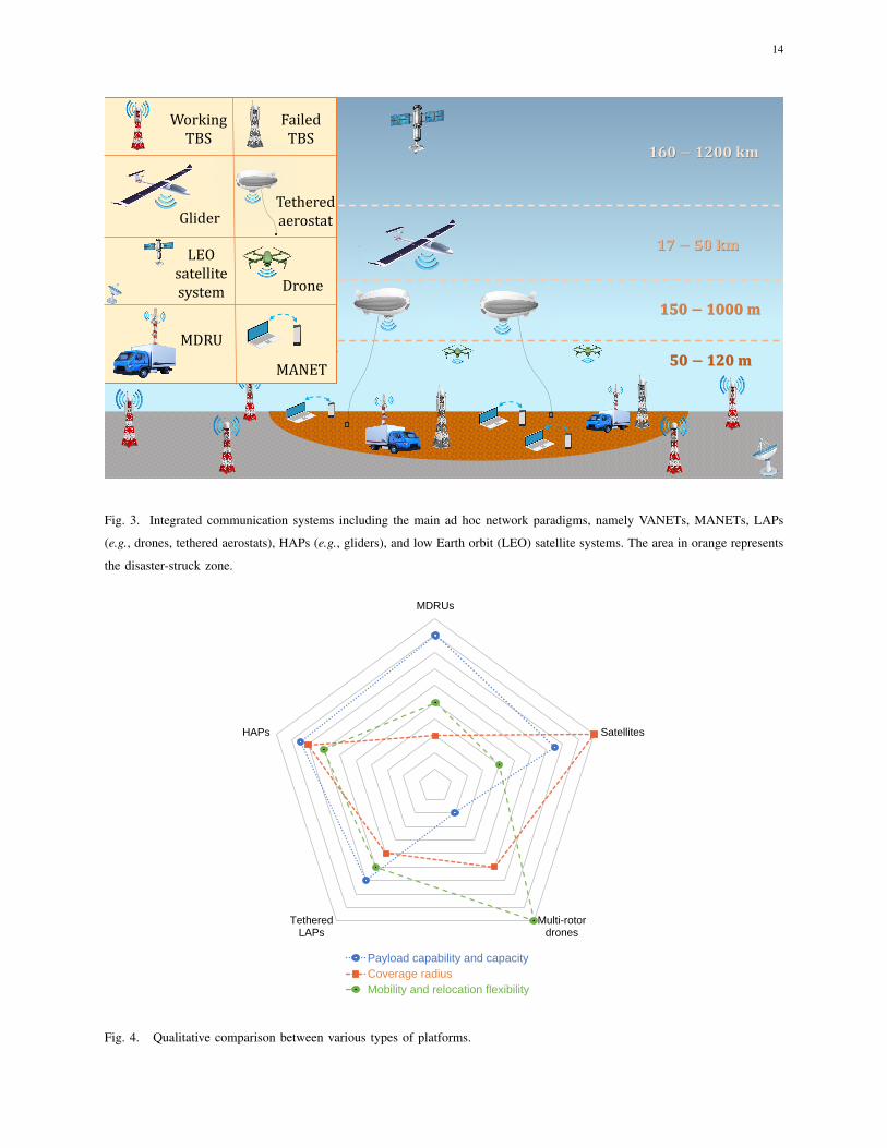
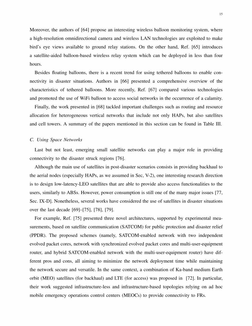
space enabled networks). A schematic view of a comprehensive network architecture for PDCs
is illustrated in Fig. 3, while Fig 4 compares various cellular paradigms.

10
Survey
Organization
I. Introduction
▪ Motivation
▪ Related surveys and reviews
▪ Contributions
III. Physical Layer Issues
▪ Channel modeling
▪ Coverage and capacity
▪ Radio resource management
▪ Localization
▪ Energy efficiency
II. Wireless Technologies
▪ Recovery of terrestrial networks
▪ Installation of aerial networks
▪ Using space networks
V. Proposed Use Cases
▪ Small Disasters
▪ Large Disasters
IV. Networking Layer Issues
▪ Integrated space-air-ground
architectures
▪ Routing
▪ DTNs
▪ Edge computingVI. Challenges and Research Directions
▪ Modulation and coding schemes
▪ Backhauling
▪ Optimal placement
▪ Optimal trajectory
▪ Scheduling
▪ HO management
▪ Content caching
▪ IRS-Enabled Networks
VII. Conclusion
▪ Summary
▪ Final remarks
Fig. 2. Structure of this paper.
A. Recovery of Terrestrial Networks
One main limitation of current network infrastructures is the lack of sufficient redundancy.
Moreover, the most recent occurrences of calamities have often demonstrated that wireless net-
works are very susceptible. Whenever the terrestrial infrastructure gets damaged, it is preferable
to consider repairing it before resorting to other ad-hoc solutions such as ABSs. However, it is
evident that several challenges may arise: tight time constraints, scarce availability of specialized
installers and respective equipment, and harsh environmental conditions are just few examples
of the difficulties to be potentially faced.
In this context, the authors of [39] have analyzed the recovery phase of a communication
network, evaluating the advantages of D2D and cellular communication systems operating in
underlay mode. Furthermore, Ref. [40] has investigated the three possible disaster-struck network

11
conditions, namely congested, partly functional, or fully isolated, including important consider-
ations on spectrum allocation. Contextually, authors in [41] have promoted RAPID TIMEER, a
system for recording and reporting (via texts, images, and voice) that works independently from
both power and telecommunication infrastructures.
The authors of [42] propose the use of cyber-physical systems, especially in public buses and
drones, to develop a mobile edge infrastructure, where the buses host as BSs, computation units,
and power resources, and are can thus support drones in covering hard-to-reach areas.
Park et al. [43] pushed the NIB concept forward by proposing their vision in the context of 6G,
and the consequent challenges to overcome. The authors also proposed an interesting case study
where NIB’s flexibility is exploited to maximize spectral efficiency in maritime communications.
Finally, Sakano et al. [44] suggested deploying so-called movable and deployable resource units
(MDRUs)1, which are essentially vehicle-mounted base stations, as a comprehensive solution
for satisfying the needs of users in disaster recovery situations. Some of the main advantages of
this solution are indeed represented by its agility, prompt installation, and carrier-free usability.
B. Installation of Aerial Networks
Since the recovery of terrestrial networks in disaster-affected regions is usually a long process,
many works focused on quicker solutions such as using aerial networks, with airborne platforms
(drones, balloons, gliders, airships, etc.) working as flying BSs. Depending on the height and
resources of the aerial BS, we can broadly categorize them as low-altitude platforms (LAPs) or
HAPs.
The main challenges associated to aerial networks in disaster scenarios are mostly related
to their deployment and operation. Indeed, advanced technologies are mostly required for:
timely moving and deploying the aerial nodes, controlling their trajectory (especially in case
of swarms of untethered drones, as will be further discussed in Sec. VI-D), ensuring sufficient
flight endurance (which relates to the problem of energy efficiency discussed in Sec. III-E).
Depending on the altitude of the aerial node, different types of aerial networks can be used for
various disaster management applications and use cases [45, Chapter 9].
1 Although these units are typically terrestrial base stations, in this paper the acronym ‘TBS’ exclusively refers to any node
of the fixed terrestrial infrastructure, such as a cell tower.
12
1) LAP-Based Solution: Due to their fast implementation, a large number of works discussed
LAPs usage in PDCs. For example, Ref. [46] reviewed disaster management applications and
challenges using UAV networks, especially when combined with WSNs and cellular networks.
Similarly, authors in [47] extensively discussed UAV-aided disaster-resilient networks from a 5G
perspective, including fruitful considerations on the simultaneous occurrence of UAV and D2D
communications and the power control strategies. Furthermore, [48] recently presented the main
topological elements to take into account when deploying ABSs, where various types of UAVs
are compared for typical post-disaster network setups. Authors in [49], instead, introduced a
distributed and scalable message-based system relying on electric vehicles (EVs) and UAVs that
allows to connect shelters by properly partitioning the suffered region (assuming it is sufficiently
large). Finally, the main targets of UAV-aided networks, namely ubiquitous coverage, relaying,
and information dissemination, were extensively discussed in [50] together with some design
considerations and performance-enhancing techniques.
A recent trend shows a considerable interest in using optimization tools for aerial networks-
assisted post-disaster communications. For example, authors in [51] used particle swarm opti-
mization (PSO) to adjust UAVs’ antenna altitude and beam angle for post-disaster networks. The
developed framework allows to effectively optimize coverage under the transmit power constraint.
Similarly, authors in [52] proposed another optimization-based work for UAV-aided disaster
communications (i.e., a macro BS supported by UAVs serving hard-to-reach clusters of users),
and validated their framework for ensuring high energy efficiency by jointly optimizing UAVs’
deployment and resource allocation. Then, Ref. [53] proposed a unified framework that considers
UAVs’ trajectory, scheduling, and transceiver design optimization in case of emergency. Similarly,
authors in [54] used a genetic algorithm (GA) to evaluate improvements in terms of throughput
when the flying BSs are optimally placed; in particular, the study showed that the performance of
the network can generally be improved by increasing the number of ABSs and decreasing their
altitude. Also, Ref. [55] recently presented a novel approach to rapidly detect users’ clusters
variations in a post-disaster situation, where data ferry UAVs’ path planning is contextually
optimized to connect the highest number of nodes in a reasonable amount of time. Furthermore,
authors in [56] proposed an integrated aerial-ground network for swift communication recovery
to maximize the time-weighted coverage (i.e., the integration over time of the coverage area
weighted by a time-dependent function) for a given deployment strategy.
The combined use of ABSs and D2D technologies can extend the coverage for PDCs. For

13
instance, authors in [57] proposed a linear programming algorithm for obtaining a suboptimal so-
lution for the problem of maximum rate and coverage of UAV-enabled networks with underlying
D2D communications. However, the latter work neglects the effects of both small-scale fading
and non-line-of-sight (NLoS) transmission. In the same context, [58] introduced two optimal
transceiver designs schemes and a shortest-path-routing algorithm to construct efficient multihop
D2D links in a post-disaster situation.
Besides the aforementioned physical layer issues, various works tackled the network layer
issues in PDCs. For example, [59] discussed the layout of the aerial emergency ad-hoc network
(EANET) for both ad-hoc on demand distance vector (AODV) and zone routing protocol (ZRP),
eventually promoting the latter since it generally leads to a higher packet delivery fraction (i.e.,
the ratio between the number of packets generated at the source and the number of packets
received at the destination). Furthermore, the study in [60] suggested a UAV-DTN based on a
decentralized near-cloud infrastructure with LoRa technology to provide low-power transmission
over long distances. The authors investigated the performances of the network (i.e., long-range
detection/messaging and detection under rubble) in both inside and outside environments, in
order to comprehensively test the proposed technology. Another work [61] recently introduced a
UAV-assisted DTN that takes into account the importance of UAVs’ altitude, since it impacts the
required number of nodes, delay time, and delivery ratio. This work is particularly interesting
because it takes into account also the type of environment (urban, suburban, or rural).
2) HAP-Based solution: HAPs can be either helikites, airships, gliders, or balloons operating
at higher altitudes than LAPs, and their characteristics are intermediate between drones and
satellites. Their main advantage is probably the much longer endurance, which implies they
could even support PDCs without being deployed after the occurrence of a calamity: HAPs can
indeed be aloft for several months, and provide coverage and capacity even in ordinary conditions
of the network, meaning that they are not necessarily an ad hoc solution. On the other hand,
the time they require for proper deployment and relocation (they generally lack a propulsion
system) might be excessive for most of the emergency situations.
Authors in [62] considered helikites to deploy 4G-LTE remote radio head (RRH) and provide
high capacity Internet services in case of emergency. Alternatively, other works use balloons
in disaster-struck areas (recall Google Loon in Puerto Rico) to quickly recover the networks.
For instance, the work presented in [63] proposed a novel network of balloons equipped with
light fidelity (LiFi) transceivers, with a particular focus on the physical design of the platforms.
14
𝟏𝟕 − 𝟓𝟎 𝐤𝐦
𝟏𝟔𝟎 − 𝟏𝟐𝟎𝟎 𝐤𝐦
𝟏𝟓𝟎 − 𝟏𝟎𝟎𝟎 𝐦
𝟓𝟎 − 𝟏𝟐𝟎𝐦
`
Working TBS
Drone
Failed TBS
LEO satellitesystem
GliderTethered aerostat
MDRU
MANET
Fig. 3. Integrated communication systems including the main ad hoc network paradigms, namely VANETs, MANETs, LAPs
(e.g., drones, tethered aerostats), HAPs (e.g., gliders), and low Earth orbit (LEO) satellite systems. The area in orange represents
the disaster-struck zone.
MDRUs
Satellites
Multi-rotordrones
TetheredLAPs
HAPs
Payload capability and capacity
Coverage radius
Mobility and relocation flexibility
Fig. 4. Qualitative comparison between various types of platforms.
15
Moreover, the authors of [64] propose an interesting wireless balloon monitoring system, where
a high-resolution omnidirectional camera and wireless LAN technologies are exploited to make
bird’s eye views available to ground relay stations. On the other hand, Ref. [65] introduces
a satellite-aided balloon-based wireless relay system which can be deployed in less than four
hours.
Besides floating balloons, there is a recent trend for using tethered balloons to enable con-
nectivity in disaster situations. Authors in [66] presented a comprehensive overview of the
characteristics of tethered balloons. More recently, Ref. [67] compared various technologies
and promoted the use of WiFi balloon to access social networks in the occurrence of a calamity.
Finally, the work presented in [68] tackled important challenges such as routing and resource
allocation for heterogeneous vertical networks that include not only HAPs, but also satellites
and cell towers. A summary of the papers mentioned in this section can be found in Table III.
C. Using Space Networks
Last but not least, emerging small satellite networks can play a major role in providing
connectivity to the disaster struck regions [76].
Although the main use of satellites in post-disaster scenarios consists in providing backhaul to
the aerial nodes (especially HAPs, as we assumed in Sec, V-2), one interesting research direction
is to design low-latency-LEO satellites that are able to provide also access functionalities to the
users, similarly to ABSs. However, power consumption is still one of the many major issues [77,
Sec. IX-D]. Nonetheless, several works have considered the use of satellites in disaster situations
over the last decade [69]–[75], [78], [79].
For example, Ref. [75] presented three novel architectures, supported by experimental mea-
surements, based on satellite communication (SATCOM) for public protection and disaster relief
(PPDR). The proposed schemes (namely, SATCOM-enabled network with two independent
evolved packet cores, network with synchronized evolved packet cores and multi-user-equipment
router, and hybrid SATCOM-enabled network with the multi-user-equipment router) have dif-
ferent pros and cons, all aiming to minimize the network deployment time while maintaining
the network secure and versatile. In the same context, a combination of Ka-band medium Earth
orbit (MEO) satellites (for backhaul) and LTE (for access) was proposed in [72]. In particular,
their work suggested infrastructure-less and infrastructure-based topologies relying on ad hoc
mobile emergency operations control centers (MEOCs) to provide connectivity to FRs.

16
TABLE III
SUMMARY OF THE RELEVANT PAPERS ON WIRELESS TECHNOLOGIES
Topic Year Main focus Ref.
Recovery of terrestrial networks
2016 MDRUs [44]
2017 Mobile edge infrastructure, cyber-physical systems [42]
2018 Disaster assessment, data inventory, field situation recording/reporting [41]
2019D2D and cellular systems [39]
4G-LTE, D2D, UAVs, MANETs, IoT [40]
2021 6G-NIB, maritime communications [43]
Installation of aerial networks
2013 Helikites, 4G-LTE RRH [62]
2014 Balloons, monitoring [64]
2015
EVs, UAVs, area partitioning [49]
DTN, topology, altitude [61]
Balloons, satellites, relaying, deployment time [65]
2016
Coverage, relaying, information dissemination [50]
UAVs, WSNs [46]
Optimal placement, throughput [54]
2017 EANET, AODV, ZRP [59]
2018
Balloons, LiFi [63]
Tethered balloons [66]
UAVs, resilience, D2D, power control [47]
Implementation of PSO algorithm [51]
2019
Trajectory, scheduling, transceiver design [53]
Transceiver design, routing, D2D [58]
Heterogeneous networks (HetNets), routing, resource allocation [68]
DTN, LoRa [60]
2020
Cluster localization, UAV path planning [55]
Swift communication recovery, time-weighted coverage [56]
Rate, coverage, D2D [57]
2021
WiFi balloons, social network [67]
Deployment, resource allocation [52]
Topological aspects, capacity, types of fleets [48]
Using space networks
2013
LTE-satellite and radio interface [69]
Satellite-gateway links and WINDS [70]
SDR-VSAT systems and coverage [71]
2015 Satellite-LTE integration for disaster recovery [72]
2019IoT and big data analytics [73]
Weather prediction and evacuation warning systems [74]
2021 Experimental field trials on novel satellite-based architectures [75]

17
Authors in [69] introduced the Chinese initiative called LTE-satellite and comprehensively
discussed its radio interface technology. Then, in [70], the authors presented an experimental work
based on Wideband Internetworking engineering test and Demonstration Satellite (WINDS),
showing several examples of satellite-earth station links. Due to the importance of geospatial data
for IoT-aided disaster management, Ref. [73] discussed the so-called City Geospatial Dashboard
which can be utilized for collecting, sharing, and visualizing geospatial big data.
Other interesting works such as [74] focused on the use of satellites in the context of natural
disasters, specifically for weather prediction and warnings for easier evacuation. Finally, [71]
discussed multi-mode software-defined radio (SDR) for very small aperture terminal (VSAT)
systems as a possible solution to provide cellular coverage in case of large scale disasters, such
as the great East Japan earthquake occured in early 2011.
D. Important Remarks
Assuming a moderate severity of the calamity, increased network redundancy (whenever
economically feasible) may be the best solution to prevent outages in post-disaster scenarios.
This is because if the infrastructure gets damaged it may be difficult to repair or support it in
a timely manner. Alternatively, there are solutions such as airborne and spaceborne networks;
despite they still present several techno-economic limitations, their deployment has been quite
effective in several cases. Other paradigms such as NIB and MDRU also have the potential to
overcome this issue, at least in case of small disasters.
Nonetheless, it is evident that disasters are often unpredictable and sometimes governments
and network operators are not prepared to face them. Therefore, important efforts are required
to improve at least the general emergency plans and ensure a decent level of network resilience:
while this might not lead to the optimal strategies, it will ensure timely counteractions to any
calamities since all wireless technologies can be helpful in challenging situations.
III. PHYSICAL LAYER ISSUES
In this section, we survey the main topics related to the physical layer of a post-disaster
network. We will mostly focus on the differences between the channel models used for terrestrial,
aerial, and space communications. However, to the best of our knowledge literature works
considering degradation of the environment, for example due to the smoke generated by a wildfire
or the debris brought by a tornado, are still missing.

18
Another important issue that will be covered in this section is related to coverage and capacity
in PDCs. These two performance metrics gain great importance in critical situations, since what
often saves trapped victims’ lives is being able to access emergency information as well as to
share their location to the outer rescuers, which explains why also the problem of localization
is included hereby.
A. Channel Modeling
Post-disaster environments can be particularly harsh because of the high degree of scattering
due to the presence of obstacles such as rubble, fallen trees, ash, etc. Therefore, channel modeling
is one of the major aspects of post-disaster communication networks, especially when considering
vertical heterogeneous networks (VHetNets) since the complexity of the network topology is
considerably high. Due to this, the general fading distributions (e.g., Rayleigh, Rician, and
Nakagami-m) are not always applicable in post-disaster scenarios [80]. In this subsection, we
survey the literature about PDCs’ channel modeling for non-terrestrial networks. A summary of
the reviewed papers can be found in Table IV.
1) LAPs: In [81] we can find an accurate mathematical model allowing us to estimate the
ABS’ altitude that maximizes the coverage area and a closed-form expression for computing the
line-of-sight (LoS) probability. Then, the authors of [82] provided a statistical propagation model
for predicting the A2G path loss between terrestrial and aerial nodes, given the urbanization level
of the environment and the ABS’ elevation angle. In the latter paper, reflections due to objects
and trees where neglected for simplicity, while the one due to buildings was modeled under the
assumption that their surface was made of concrete, which has considerable dielectric parameters
leading to strong reflection phenomena; also, the authors assumed knife-edges in order to evaluate
scattering in a deterministic manner, although this implies approximated results.
Furthermore, it should be noted that for urban environments a large percentage of the victims
is usually trapped inside buildings with multiple floors, which requires to use a tridimensional
model. Therefore, Ref. [83] compared the performances of various path loss models as well as the
impact of indoor and outdoor environments on both uplink and downlink, which in general are
not symmetrical. To model LoS propagation channels usually the Winner II and the free-space
pathloss models are used, whereas for the case NLoS propagation the majority of the works
relies on Winner II and two-ray models. Hence, the authors of [83] investigated the Winner II

19
pathloss model proposed in [84] with an extra blockage component (which refers to the indoor
part of the path), and found it to be the most accurate for urban environments.
Finally, a recent work [80] presented a novel framework to characterize the composite fading
channel and optimize both capacity and energy efficiency. In particular, the authors used the
Fisher-Snedecor F distribution to characterize the link between UAVs equipped with intelligent
reflective surfaces (IRSs) and trapped users, and proved the effectiveness of their resource
allocation scheme by means of selected simulation results.
2) HAPs: To the best of our knowledge, there are no works exclusively focusing on HAPs’
channel modeling for PDCs. However, several contributions can be extracted from relevant
references with a general validity, as discussed in what follows.
Ref. [85] assumed a Rician fading channel with K factor for analyzing capacity in HAP
networks. The choice of using the Rician fading channel model can be justified by noting that
HAPs have a wide elevation angle, which allows them to be almost always in LoS conditions with
the typical user within the same cell. Authors in [86] statistically modeled the HAP dual circularly
polarized 2×2 multiple-input-multiple-output (MIMO) propagation channel and applied the ray
tracing approach to the digital relief model to solve the problem of lacing measured data.
Furthermore, a theoretical 3D wideband model was introduced in [87] for HAP-MIMO channel.
Note that the tridimensional model was needed because of the considerable altitude of the flying
base station, which was assumed to be equipped with multiple transmit and receive antennas
aligned in different planes. In the latter work, the Chapman-Kolmogorov equations were applied
in order to derive the survival probabilities of scatterers. motivated by the absence of experimental
results in the literature, authors in [88] presented a novel statistical channel model of long-
distance Ka-band signal transmission via HAP and verified it via numerical simulations. Finally,
authors in [89] derived tractable closed-form statistical channel models for ground-to-HAP free-
space optics (FSO) links which also take into account the effects of atmospheric turbulence and
other relevant aspects of FSO communications.
3) Satellites: For space communications, it is still needed to model the S2G channel because
of the current lack of achievable standards. Indeed, even if some standards were established
by the Consultative Committee for Space Data Systems (CCSDS), they are often obstructed
by technological limitations [90]. The communication link could leverage either laser, radio
frequency (RF), or visible light communication (VLC). The critical aspect to take into account
is the energy consumption for each technique, since satellites essentially rely on solar energy.

20
The signal envelope is subjected to three main sources of variation, namely multipath fading,
LoS shadowing, and multiplicative shadow fading. The first one, which is usually modeled
by Rayleigh or Rice distributions, is generated by the combination of all the scattered NLoS
components along with a possible LOS ray, leading to rapid small-scale fluctuations. On the other
hand, LoS shadowing arises from a LoS obstruction due to objects (e.g., trees and buildings),
which implies slower fluctuations on a larger scale. Finally, the multiplicative shadow fading
phenomenon is responsible for random variations in the power of LoS multipath components.
Most of the famous models consider land-mobile-satellite communication systems, and can be
categorized as static (e.g., the ones developed by Loo [91], Corazza-Vatalaro [92], Hwang [93],
Patzold [94], Kourogiorgas [95], Abdi [96], and Saunders [97]) or dynamic (e.g., the ones
developed by Fontan [98], Scalise [99], Nikolaidis [100], and Lopez-Salamanca [101]).
Authors in [102] considered a dual-polarized MIMO channel, focusing on the models referred
to as Quasi Deterministic Radio channel Generator (QuaDRiGa) and Loo in order to capture
the ionospheric, tropospheric, and fading effects on a land mobile satellite (LMS) system. In
the same context, authors in [103] introduced an algorithm for modeling dual-polarized MIMO
channel while taking into account LoS shadowing, multipath effect, elevation angle, and other
relevant channel factors. Ref. [104] introduced a reliable channel model for taking into account
dynamic cloudy weather impairments, which impact on the Rician factor and signal propagation.
On the other side, a simplified fading channel model for describing received signals, multipath
fading, and shadowing effect has been analyzed by the authors of Ref. [105]. In [106], instead,
the so-called channel reservation strategy is promoted as a solution for improving access and HO
performances. Finally, authors in [107] presented an original channel model for 5G and beyond
which, based on atmospheric data, allows to predict channel attenuation at any time.
B. Coverage and Capacity
This subsection discusses two crucial aspects of PDCs, namely coverage and capacity. The
reviewed papers are summarized in Table V.
1) Coverage: In post-disaster scenarios, coverage can be compromised due to the failure
of one or multiple cell towers. Although several non-terrestrial technologies allow for restoring
connectivity, the main challenge is timely putting them in operation. Although these technologies
can quickly cover large areas (thanks to the higher altitude compared to cell towers), their oper-
ation can be complex and last for long periods. Nonetheless, their potential attracted academia

21
TABLE IV
SUMMARY OF THE RELEVANT PAPERS ON CHANNEL MODELING
Topic Year Main focus Ref.
LAPs
2014Altitude, LoS probability [81]
A2G path loss [82]
2018Resilience [47]
Path loss [83]
2021 Power allocation [80]
HAPs
2017
Rician fading channel, capacity [85]
MIMO, ray tracing [86]
MIMO, Chapman-Kolmogorov equations [87]
2020FSO [89]
Ka-band transmission [88]
Satellites
2014 Rician factor, signal propagation [104]
2016 Fading channel [105]
2017 Dual-polarized MIMO, LMS[102],
[103]
2019 Channel reservation strategy, HO [106]
2020 Channel attenuation [107]
and industry entities, leading to continuous technological improvements that partially solve the
challenges mentioned above.
D2D communication along with UAVs can be used to provide ubiquitous coverage in post-
disaster situations. Most of the existing works focus on using D2D for communicating in lack
of a functioning infrastructure [53], [108]–[111]. For instance, authors in [108] have proposed
an LTE-based D2D technology and evaluated its performances for a typical disaster scenario.
Authors in [53], instead, have proposed establishing multihop D2D links to extend the coverage
area of UAVs when there is a lack of functioning cell towers. Furthermore, Ref. [109] suggested
a hierarchical D2D architecture with a centralized SDN controller communicating with the cloud
head to minimize energy consumption. Also, authors in [110] considered deploying UAVs to
discover D2D devices in disaster-struck regions. Finally, authors in [111] provided an overview
of the use of ubiquitous mobile devices and applications in the context of 5G for post-disaster
communications. Ref. [39], instead, proposed to combine D2D and cellular technologies to
improve the coverage probability. The work proposed in [56] introduced a performance metric
called time-weighted coverage (since the behavior of the network is dynamic) to promote a novel

22
TABLE V
SUMMARY OF THE RELEVANT PAPERS ON COVERAGE AND CAPACITY
Topic Year Main focus Ref.
Coverage
2015
Optimal deployment, wireless gateways,
relay nodes[112]
D2D, SDR [111]
D2D, SDN [109]
2017 D2D, UAVs [110]
2018 D2D, LTE [108]
2019
D2D, multihop, UAVs [53]
D2D, 5G [39]
UAVs, IoT [58]
2020 Time-weighted coverage, HetNets [56]
Capacity2020 Satellites, cost, multiple-coverage [78]
2021 VHetNets [48]
3D networking architecture with both terrestrial and aerial nodes. The concept of coverage has
also been discussed in [58] since UAVs are proposed as an effective solution to make up for
the eventual loss of coverage for IoT applications. Authors in [112] studied via simulations the
optimal deployment of wireless gateways and relay nodes while considering its influence on
field commanders’ positions.
2) Capacity: Whenever there is a failure in the network infrastructure, not only coverage
but also capacity becomes a critical issue. In fact, cell towers cannot be entirely replaced by
ad hoc nodes since the latter relies on wireless backhaul links and can usually carry a much
smaller number of antennas while suffering delays due to their high altitude. Moreover, current
dedicated PPDR networks are usually based on terrestrial trunked radio (TETRA) and analog
private mobile radio (PMR), which are more suitable for advanced voice services rather than
data-intensive applications [72]. This is because the entire load has to be divided among only
the surviving BSs, leading to outages and low data rates. Also for this topic, very few relevant
research articles have been published recently and are mentioned in what follows. In [48], the
deployment of the best aerial fleet in order to maximize the capacity in the middle of the
disaster-struck area has been investigated. Ref. [78], instead, included design considerations
for a capacity-oriented LEO satellite constellation and implemented a multi-objective genetic
algorithm that optimizes a combination of constellation cost, capacity, and multiple-coverage.

23
C. Radio Resource Management
Radio resource management can be a critical issue in the context of PDCs. For example, in
an aerial network deployment with FSO links, the performance can be significantly degraded in
the case of polluted air (especially in the presence of smoke, fog, sand, or dust). A potential
solution to such a problem would be to introduce a complimentary wireless channel less affected
by such conditions as RF transmission, as suggested by the authors of Ref. [113]. Indeed, the
paper highlighted that commercial hybrid FSO/RF systems already combined millimeter wave
(mmWave) and laser-based FSO to serve large areas with at least one gigabit per second (Gbps)
of data transmission. Hence, developing novel spectrum management techniques is crucial to
overcoming the environmental effects in a post-disaster situation.
For instance, [40] discussed spectrum allocation strategies and future technologies for EMSs.
Ref. [114] introduced aerial network access and resource allocation scheme that optimizes
the number of human portable/wearable machine-type devices (HMTDs) that are transmitting
data. In the same context, authors in [115] proposed a radio resource management system
based on orthogonal frequency-division multiplexing (OFDM) using a novel resource allocation
technique for improving aerial networks’ data communications. Moreover, in [116], a novel
5G network architecture based on slicing is introduced for supporting FRs’ communications
by dynamically prioritizing their channels, depending on their need. The authors of Ref. [117],
instead, investigated the use of radio access network (RAN) slicing and introduced management
mechanisms that allow handling the slice reconfigurations.
For aerial networks, an autonomous spectrum management scheme based on spectrum sharing
has been introduced and validated via simulation results in [118]. Finally, authors in [119]
proposed a resource allocation scheme for UAV-enabled cellular networks as well as efficient
algorithms for clustering selection and resource allocation.
D. Localization
Humans affected by a disaster must be rescued within the so-called golden 72 hours after
the disaster. In this context, localization plays a major role in emergency scenarios, especially
when a considerable percentage of the victims are trapped [120]. It is evident that localizing the
victims becomes much more challenging if they are trapped under rubble in case of earthquakes
or covered by the smoke of a fire. To further complicate the situation, disasters generally modify

24
the environment, and thus existing maps might not be helpful anymore. This may require simul-
taneous localization and mapping (SLAM) techniques, which may overload the computational
capability of the systems (e.g., UAVs or other autonomous robots) and considerably increase their
power consumption. In order to perform SLAM tasks, UAVs should be equipped with sensors
such as a global positioning system (GPS) receiver, inertial measurement unit (IMU), ultrasonic
transceiver, light detection and ranging (LIDAR), radio detection and ranging (RADAR), and
various types of cameras (i.e., mono-, stereo-, infrared, and depth cameras). However, some of
these sensors have strong techno-economic limitations, as summarized in Fig. 5.
In general, localization techniques can be categorized as centralized (if the input data are
processed by the BS) or decentralized (if the input data are processed by the sensor nodes) [121].
Due to the susceptibility of cell towers as well as the limited availability of power in disaster
circumstances, our interest is mostly oriented towards decentralized localization techniques which
can be further distinguished as range-based and range-free techniques. Range based techniques
require accurate measures of distances or angles between the devices of the network, and therefore
they require an additional hardware as well as a stronger power supply when compared to range-
free techniques [122], which however are usually less precise. Authors in [123] introduced a
range-free scheme for localization in WSNs, which makes use of fuzzy logic to relate the received
signal strength (RSS) and the distance so that the location can be evaluated in sufficiently precise
manner. Following the same lines, the process of localization and the related procedures were
presented in [122] together with the taxonomy of range-free techniques, with a special focus on
the so-called DV-HOP algorithm. Furthermore, Ref. [124] implemented two WSN-based methods
to ensure the localization of vibration damage in tunnels. Finally, authors in [125] focused on
the estimation of both position and transmission orientation of a directional source in 3D WSNs.
In the specific context of PDCs, Ref. [126] provided an insightful overview of the existing
localization algorithms for post-disaster scenarios using WSNs. Authors in [127] proposed one
possible approach for localizing damages and humans in a disaster-struck region. Furthermore,
Khan et al. [128] devised a localization technique based on RSS measurements, where the relative
ground coordinates of users are computed using Isomap (that is, a nonlinear technique applied
for dimensionality reduction) and then transformed to the actual global coordinate system.
Alternatively, authors in [129] introduced a modeling and simulation method of the radio
channel for rescue purposes, which can be used to develop radio localization systems. In general,
the passive localization schemes that are developed in various works can be applied to post-

25
Infrared camera andRADAR
LIDAR
GPS, IMU, andultrasonic transceiver
Mono/stereo-camera
Depth camera
Cost
Weight and dimensions
Computational cost and power consumption
Fig. 5. Qualitative comparison between the common SLAM sensors for UAVs [22, Sec. 5]. Note that infrared is hereby
abbreviated as IR and RGB-D is a specific type of depth camera.
TABLE VI
SUMMARY OF THE RELEVANT PAPERS ON LOCALIZATION
Year Main focus Ref.
2013 WSNs, algorithms [126]
2014 PSO, path planning strategy [131]
2015Satellite stereo images [127]
Radio channel, rescue [129]
2016 Fuzzy logic, range-free localization, WSNs [123]
2017 Vibration damage, WSN [124]
2019 Range-free localization, taxonomy [122]
2020Gauss-Newton algorithm, accuracy, WSNs [130]
Directional source, 3D WSNs [125]
disaster situations. For instance, [130] recently discussed localization in a WSN for different
applications. In the same context, authors in [131] implemented their algorithm by using PSO
and promoted the path planning strategy based on a grid scan.

26
E. Energy Efficiency
Since the power infrastructure is also susceptible to calamities, emergency circumstances
require energy efficient systems [41], [51], [52], [113], [132]–[141]. The nodes in a post-disaster
network can rely on either renewable energy (especially photovoltaic panels), RF charging,
batteries, or laser power beaming, to name a few. However, these technologies are currently
unable to ensure a continuous and prolonged service. Nonetheless, many works have recently
devised techniques that reduce the overall power consumption of PDCs systems, which can be
summarized as follows.
Ref. [132] proposed a disaster-time system that makes use of a message ferry method to collect
and exchange information while improving DTNs’ energy efficiency; in particular, the authors
introduced a method that allows to relay the messages of mobile terminals with low battery
level to the terminals with higher battery level, avoiding the former to fully discharge. Inspired
by biological networks of living organisms, authors in [133] introduced an energy-efficient
disaster response network (DRN), called Bio-DRN, modeled via an integer linear programming
optimization problem. In the same work, the Bio-DRN was developed by means of a sub-optimal
heuristics and tested via simulation considering a real disaster-prone region in Nepal. Another
interesting work in [142], optimized the 3-D placement of a set of aerial access points for
energy-efficient uplink communications2.
Authors in [134] investigated the possibility of mounting solar panels on top of UAVs to
increase their autonomy while taking into account routing, data rate, and transmit power con-
straints. Evidently, the main issue with this solution is represented by the additional payload due
to the panels themselves. On the other hand, authors in [113] promoted a heterogeneous fleet
that includes untethered drones for cellular coverage, tethered drones for high-capacity backhaul-
ing, and untethered powering drones for charging. In [135] a novel beamforming architecture,
based on conditional time split-energy extraction (CT-EE) for enhancing nodes’ autonomy, was
presented and compared to conventional beamforming and other energy extraction methods.
Furthermore, to minimize both message overhead and energy consumption, [136] proposed a
hybrid solution for DTNs where the routing protocol is chosen depending on the mobility patterns
of each node. Works such as [137], instead, focused more on optimizing data traffic throughput.
In particular, the authors described the problem via mixed integer linear programming (MILP)
2The latter work is general and not limited to post-disaster scenarios.

27
and developed a traffic demand-aware off-line energy-efficient scheme for WMNs constituted
by renewable-energy-enabled base stations (REBSs). Moreover, in the context of WSNs for
disaster monitoring, Ref. [138] presented an energy-efficient data retrieval scheme based on
intelligent sleep scheduling. In addition, the authors mathematically proved that the proposed
scheme is capable to extend the longevity of the network, while contributing with traffic reduction
and load balancing. An interesting problem tackled with stochastic geometry is [139]. Here,
the authors used energy harvesting and transfer for the user equipment in D2D clustering
communications for disaster management; the required power would be captured from RF
signal via BS. Similarly Ref. [143] used the optimal cluster head (CH) technique to make
energy transfer more efficient in UAV-assisted D2D PDCs. The proposed results also showed
improvements in terms of network coverage and reliability. The novelty of the work presented
in [140], instead, consists in combining both spectrum and energy efficiencies (thus, a new
metric called spectrum-energy efficiency was defined) for renewable-energy-enabled gateways
and MDRUs deployed in disaster struck environments. In particular, the authors proposed a
topological scheme based on the top k spectrum-efficient paths and showed how to optimize the
value of k itself. Finally, authors in [141] developed an algorithm for network reconfiguration
in underwater communication systems that are capable of harvesting energy in case of disasters
occurring in the ocean, such as tsunamis.
F. Important Remarks
The presence of obstacles generated by the calamity (combined with the typical complexity
of ad hoc network architectures) makes channel modeling extremely challenging. Due to this,
accurate estimation of performance metrics such as joint access and backhaul coverage proba-
bility and capacity is not possible yet. This issue, together with the increased traffic demand and
limited bandwidth and energy resources, strongly affects also radio resource management and
energy efficiency (which is actually the most important requirement, since most devices are not
designed to operate for a long time without any power infrastructure’s energy supply).
IV. NETWORKING LAYER ISSUES
This section reviews various references on networking aspects including space-air-ground inte-
gration (from its architecture to its inherent complications), routing algorithms, and applications
of DTNs and edge computing in emergency scenarios.

28
TABLE VII
SUMMARY OF THE RELEVANT PAPERS ON ENERGY EFFICIENCY
Year Main focus Ref.
2014 MDRU, spectrum efficiency [140]
2015Mobility, DTN protocols [136]
Data traffic throughput [137]
2018
Energy harvesting, D2D [139]
Energy harvesting, underwater IoT [141]
Drones, battery, backhaul [113]
2019Temporary communication system, DTN [132]
Resilient networks [133]
2020
Optimal placement [142]
Solar powered UAVs [134]
Beamforming, MIMO [135]
2021 Data retrieval [138]
2021 Energy harvesting, UAV, D2D [143]
A. Integrated Space-Air-Ground Architectures
Space-air-ground integrated network (SAGIN) is an emerging paradigm that can be im-
plemented also in post-disaster scenarios as a solution for improving security and extending
coverage [77, Sec. IX-B]. The main idea behind this solution is to conveniently combine the
three said layers: in fact, terrestrial networks have the lowest delays and the highest capacity
(often without energy constraints), while satellites benefit from an extremely wide coverage
area and they are generally resilient to any disaster; aerial platforms, instead, have intermediate
characteristics between terrestrial and space nodes. For this paradigm, the space, air, and ground
segments can either inter-operate or be independent of each other. If they inter-operate, one
of the main challenges (essentially due to the different trajectories and velocities between the
nodes) consists in effectively harmonizing the flight of the aerial platforms (especially if both
HAPs and LAPs are present) so that the risk of getting them disconnected is minimized: to
achieve this, novel routing protocols taking into account the variety of the interconnections (e.g.,
hybrid RF/free space optics between HAPs and LAPs, and free-space optics among HAPs) need
to be designed [77, Sec. IX-B].
One typical example of SAGIN architecture is the so-called Global Information Grid (GIG),
which is made by four layers (i.e., ground, aerospace, near-space and satellite layers) embed-

29
ding the communication, sensor, and operation networks [144]. Generally speaking, the space
network may include geosynchronous equatorial orbit (GEO), MEO, and LEO satellites, with
the respective terrestrial infrastructures (e.g., ground stations and control centers). Note also that
the terrestrial layer is not limited to cell towers, but may also include MANETs, wireless local
area networks (WLANs), etc.
In Ref. [145], a novel cooperative communication scheme for UAV-aided satellite/terrestrial
integrated mobile communication systems (STICSs) is proposed as a means of interference
mitigation. Indeed, the UAVs act as relay stations and, according to the simulation results
obtained, allow to reduce the average bit error rate (BER) and boost the throughput of the system.
Authors in [146], on the other side, provided a framework for using Internet Protocol (IP) for
disaster management services within a SAGIN. The study simulated two disasters occurring
in Africa and North America, and showcased the additional services offered by the proposed
IP-based method.
B. Routing
Generally speaking, the problem of routing consists of finding the optimal path that effectively
transfers data among the network nodes. It is evident that post-disaster wireless environments
are incredibly unpredictable, and therefore routing cannot be planned as carefully as in ordinary
circumstances. As far as we are concerned, the main routing challenges brought by the occurrence
of a calamity are due to terrestrial nodes’ malfunction or failure, inaccurate placement of ad-hoc
nodes, unpredictable traffic demand and distribution, energy shortage, and harsh environmental
conditions (which may essentially affect the wireless communication channels and, for example,
reduce the ad-hoc nodes’ coverage radii). Since routing can tremendously impact on the
performances of the network (especially in terms of energy efficiency and delay), several works
have recently tackled this topic, as discussed in the rest of this section.
Authors in [147] have improved the multicast routing squirrel search algorithm (SSA) for
providing green communications and has experimentally shown the effectiveness of properly
balancing energy consumption and other quality of service (QoS) parameters. The study proposed
in [148], instead, relied on real-world maps and suggested several methods on access point
placement and routing in order to quickly connect users inside middle-size disasters. Moreover,
authors in [149] proposed a D2D-based framework to cluster users’ devices and optimize the
transmission power for each gateway. One of the most remarkable strategies consists in putting

30
the nodes within the damaged area in LISTEN mode and provide them the clustering instructions
from a functional area, thus saving valuable energy to the devices.
In the context of dual-channel-based MANETs, authors in [150] recently introduced an algo-
rithm for efficient routing, since each node is able to configure the routing table based on the
exchanged neighbor list. The main application suggested for this work is indoor communications
for firefighters, especially since previous works do not consider the mobility of the nodes properly,
and neglect the presence of potential obstacles in the environment. Another approach based
on routing table has been proposed in [151], where the concept of intercontact routing was
introduced to estimate delivery probabilities and route delays, as well as to find reliable routes
and consequently control message replication and forwarding. Furthermore, the authors enhanced
the energy efficiency of protocol by means of a differentiated message delivery service.
For UAV networks, instead, Ref. [152] suggested a location-aided delay-tolerant routing
(LADTR) protocol in order to exploit both store-carry-forward (SCF) technique and location-
aided forwarding. Indeed, this work improved the efficiency of SCF by introducing ferrying UAVs
into the network, and validated the LADTR protocol by numerically comparing it (in terms of
routing overhead, packet delivery ratio, and average delay) with other common protocols.
Authors in [153] focused on DTNs and introduced additional routing methods (e.g., Node
Selection by the evacuator’s territory, Data Triage by data priority, and Dynamic FEC controls
by the Jolly-Sobor model). In this work, field experiments were carried out for validating the
performances of the proposed routing methods. Morover, the authors of Ref. [136] suggested
hybrid DTN protocols for allowing nodes to apply different routing rules depending on their own
mobility patterns. Instead, authors in [154] introduced and analyzed a DTN routing protocol for
information-centric networks (ICNs) in disaster-struck areas, showing its advantages in terms of
delivery probability and overhead ratio. Finally, the D2D-based architecture proposed in [109]
uses a SDN controller which can conveniently enable multi-hop routing path between victims
and FRs.
To deepen this topic, the reader could also refer to [28], which surveyed routing protocols for
MANET-based architectures in disaster area networks (DANs).
C. DTNs
Whenever there is no way to ensure a reliable backhaul link to the core network, connectivity
is compromised. Since this situation is recurrent in emergency scenarios, DTNs can play a crucial

31
TABLE VIII
SUMMARY OF THE RELEVANT PAPERS ON ROUTING
Year Main focus Ref.
2013 Intercontact delay [151]
2015D2D, SDN [109]
Hybrid DTN protocols, mobility [136]
2017 Experiments on routing methods [153]
2018Routing protocol for UAV networks [152]
DTN routing protocol for ICNs [154]
2019SSA [147]
D2D transmit power optimization [149]
2020Access point placement [148]
Dual-channel-based MANETs [150]
role in the context of disaster management. Therefore, many researchers started investigating the
potential applications of DTNs in this area. However, it is evident that DTNs rarely operate in
real time, therefore devising novel and powerful routing algorithms is needed in order to ensure a
sufficient QoS (while meeting the energy and memory constraints of IoT devices) in emergency
situations. Moreover, routing protocols should use context information about traffic to influence
the relay selection depending on the user traffic needs [155].
In [156], the so-called IBR-DTN architecture (i.e., an implementation of the bundle protocol
RFC5050) has been shown to be effective when sending small size data such as text messages. On
the other side, if the connection is lost during the transmission then the entire file would need to be
sent again, which makes this architecture very inefficient for sending heavy files. Ref. [157] has
suggested to use delay-tolerant networking in a location-based mobility prediction scheme that
estimates the mobility pattern of the nodes (e.g., FRs or victims equipped with smart devices) and
enables to select the best forwarder. Another interesting work has been presented in [158], where
the authors promoted an infrastructure-less health data delivery process architecture capable of
automatically identify injured persons. In order to make up for the eventual unavailability of
cloud-based mapping services and data in post-disaster scenarios, authors in [159] have presented
DTN MapEx: a distributed computing system that generates and shares maps over a DTN. To do
this, users need to log the GPS traces of their routes and collect data about the disaster-struck
environment; then, pre-deployed computing nodes process the collected data to generate a map

32
TABLE IX
SUMMARY OF THE RELEVANT PAPERS ON DTNS
Topic Year Main focus Ref.
DTNs
2015
Mobility prediction [157]
Mapping [159]
Message delivery ratio [160]
2016Mobility [155]
Healthcare, identification [158]
2019Demand forecasting [161]
IBR-DTN [156]
2020Resource allocation [162]
Hybrid SDN-DTN,
message delivery rate, packet loss[11]
for the network. Ref. [160] devised a novel DTN-based message relay protocol that incorporates
message delivery into a specific type of shelter network called autonomous wireless network
construction package with intelligence (ANPI). This solution was tested via simulations, showing
its effectiveness in reducing redundant transmissions and improving the message delivery ratio.
The authors of [161] derived a principal component regression model and proposed an oppor-
tunistic demand sharing scheme for collecting and spreading resource demands to the control
station via a smartphone-enabled DTN. By means of selected case studies, this work also
illustrated to what extent DTNs can be useful for demand forecasting. More recently, the concept
of DTN has been applied also for post-disaster resource allocation, used in a novel opportunistic
knowledge sharing approach for gathering the resource needs in a utility-driven system [162];
simulations results showed that the proposed system is very competitive with the similar ones
proposed in literature, especially in a fully connected scenario. Ref. [155] used realistic traffic and
mobility data in order to evaluate various routing schemes for DTNs, and introduced the option of
combining dedicated DTN routing to additional aerial nodes. Finally, authors in [11] proposed a
four-layer architecture consisting of a combination of SDN and DTN in order to minimize packet
loss. Interestingly, the Mininet-WiFi simulation results suggested that the proposed architecture
can achieve a packet loss as low as 0.46%.
A quick summary of the aforementioned papers is proposed in Table IX.

33
D. Edge Computing
By definition, edge computing is an autonomous computing model that comprises many
distributed devices communicating with the network for several computing tasks [163]. In other
words, edge computing is a paradigm meant to move computational data, applications, and
services from the cloud servers to the edge network to minimize latency and maximize band-
width [164].
Apart for the evident need of low latency communications we recall that the problem of
bandwidth is also due to the susceptibility of FSO to harsh atmospheric conditions, as already
mentioned in Sec. III-C. Furthermore, UAV-enabled multi-access edge computing could provide
additional resources and effective low-latency services compared to traditional MEC architectures
(since UAVs can be easily moved closer to the sources of data generation). However, designing
efficient offloading and resource allocation strategies is difficult because of the heterogeneous
protocols and interfaces used in this context [165]. In line with these goals, the National Science
Foundation (NSF) announced the project AirEdge. The main idea is to use a swarm of UAVs
to carry mobile radio access points and edge servers, enabling on-demand edge computing and
networking services for anti-terrorism, disaster rescue, or public safety applications [166].
Ref. [167] devised Echo, an interesting edge-enabled framework for disaster rescue, relying
on computer vision to analyze and filter crowdsourced pictures to provide only relevant content
to FRs and preserve bandwidth. The authors also designed an adaptive photo detector to im-
prove the precision and recall rate. On the other hand, authors in [168] recently implemented
mobile edge computing (MEC) task management strategies by applying long-range wide-area
networking (LoRaWAN) to UAV-aided architectures. The presented simulation results promoted
this solution since it conveniently enables long-range MEC service. Another interesting work
has been presented in [169], where several PS-LTE enabling services were discussed in the
context of the current 3rd Generation Partnership Project (3GPP) standard releases. Moreover,
the authors proposed and evaluated a disaster-resilient edge architecture consisting of: SDN
layer (to enable centralized control), UAV cloudlet layer (to perform either edge computing or
enable emergency communications), and radio access layer. Another interesting paper is [170],
where a novel framework for drone-assisted and blockchain-enabled edge-cloud computing
networks (DBECNs) is presented. The authors devised an architecture (consisting of the terminal,
multifunctional drone, blockchain, edge, and cloud layers) where UAVs act as moving terminals

34
or BSs and proposed various use cases, including disaster relief and crowd monitoring. However,
important challenges related to AI-based algorithms, scalability and QoS, channel modeling,
as well as the integration of SAGINs and edge-computing-enabled networks are faced by the
proposed framework.
Authors in [171] proposed a data backup scheme to combine edge computing and blockchain
technologies for disaster scenarios: while the former processes big data coming from the mi-
crogrid, blockchain provides security to the equipment needed to perform edge computing.
However, the main challenge here is to deal with the trade-off between energy efficiency and
security. Moreover, authors in [172] designed and implemented a named-data-networking-based
support system over the edge computing platform KubeEdge. By doing this, this work showed
the effectiveness of the proposed solution in promoting efficient emergency communications
and responders’ mobility. Finally, authors in [173] studied resource allocation to enable latency-
intolerant tasks due to emergencies in oil fields. In particular, they devised a stochastic model that
captures end-to-end uncertainties within the proposed federated edge environment to estimate
the risk associated with each task and showed a performance improvement of almost 30 percent
compared to state-of-the-art solutions.
E. Important Remarks
Generally speaking, heterogeneity brings strengths and challenges at the same time. Integrating
different communication technologies and protocols in the same system requires innovative
research because each node type is designed to operate in specific environments and conditions
and may not be compatible with different types [20, Sec. 7]. Also, networking issues might
arise even in the case of simple multi-layered architectures, where any failed gateway node must
be rapidly detected and properly replaced by another node for timely recovery [174, Sec. 4].
Nonetheless, we believe that SAGIN architectures represent the most promising PDCs paradigm
compared to DTNs because they require more flexibility, which might be incompatible with
the tight time constraints characterizing emergencies. Besides, UAV-enabled edge computing
projects such as AirEdge could develop powerful technologies and expand networks’ resources.
Additionally, due to PDC networks’ ad hoc structure, robust routing protocols need to be devised.
Also, we believe that also security plays an important role, especially in the context of human-
made disasters (e.g., terrorism and wars), and therefore should not be overlooked.

35
TABLE X
MAIN SIMULATION PARAMETERS
Description Value
Number of system realizations 2×10⁴
Simulation radius rs =
rd+3 [km], for TBSs
hS , for satellites
Type of environment Urban [81]
TBS density λT = 10 TBSs/km2
Path loss exponents
αM = 3
αT = 2.9
αL = [2.5, 3], for [Los, NLoS]
αH = [2.2, 3], for [Los, NLoS]
αS = 2
LAP altitude hL = 0.2 km
Transmit powers
pT = pM = 10 W
pL = 3 W
pH = 20 W
pS = 1000 W
Nakagami-m shape parameters
mT = mM = 1
mL = 2
mH = mS = 3
SINR thresholds τ =
0.1, for access links
0.2, for backhaul links
Noise power σ2n = 10−12 W
V. PROPOSED USE CASES
In this section, we present two use cases referring to the problem of coverage in the event of
a disaster of either small or large scale. The main goal is to identify the optimal ad hoc network
architecture (made of terrestrial, aerial, and space nodes) in order to serve a multitude of users
inside the suffered region. Then, we extract valuable insights based on the proposed simulation
results.
Both the considered setups (each one referring to a specific use case) assume uniformly
distributed users and TBSs; however, inside the disaster area A0 (assumed circular with radius

36
𝒜0
𝑶[epicenter]
ℎL
𝑟𝑢
Disaster area (𝒜0)
Functioning TBS
Failed TBS
ABS Typical user
MDRU
Fig. 6. Proposed system setup for small disasters: one LAP hovering above the origin O and a given number of MDRUs (nM )
are deployed in order to strengthen the disaster-struck network infrastructure.
rd), the original infrastructure is nonfunctional, while outside it operates appropriately with a
reliable connection to the core network (e.g., by means of optical fiber links). All the other
backhaul links (except the one connecting the satellite to the ground station) are not ideal and
thus cannot guarantee reliable communications. The QoS is evaluated based on averaged coverage
probability experienced by the users inside the suffered region. A summary of the main system
parameters is presented in Table X, where h denotes the transceiver altitude and the subscripts
L, H , M , T , and S respectively refer to LAPs, HAPs, MDRUs, TBSs, and LEO satellites.
1) Small Disasters: In this scenario, we assume that rd is relatively small (i.e., from a hundred
meters to ten kilometers, as in most cases), and thus LAPs are generally preferred over HAPs [48].
As depicted in Fig. 6, we propose a simple strategy that consists in deploying one single LAP
above the disaster epicenter as well as a set of MDRUs (uniformly distributed over the disaster
area and fixed in number).
Therefore, the users can associate with any of the three types of BS (outer TBS, LAP, or
MDRU), but only TBSs have a direct connection to the core network. Hence, for each user served
by a LAP or an MDRU at least one additional non-ideal wireless backhaul link is needed, which

37
Fig. 7. Simulated coverage probability for the first setup. The markers highlight the maximum coverage probability for each
line.
implies a higher risk of outage. Based on the maximum average received power association
rule for each consecutive link and assuming MDRUs to have only access functionalities, the
possible paths are user–TBS, user–LAP, user–LAP–TBS, user–MDRU–TBS, and user–MDRU–
LAP–TBS.
The results displayed in Fig. 7 clearly show that the coverage probability strongly depends on
rd , and in particular, a larger disaster radius generally implies a lower QoS. Indeed, for large
values of rd the system suffers the fact that, given that the distance to the closest TBS often is
larger than the respective coverage radius, one single drone is not sufficient to provide reliable
backhaul for hundreds of MDRUs. Therefore, the backhaul link becomes the bottleneck of the
system.
Moving to more specific considerations, the simulated curves define two different cases:
(i) As long as rd does not exceed one kilometer (see the blue and the red lines), MDRUs are
unnecessary since the user can easily associate to either the LAP or the closest TBS;
(ii) For much larger disasters (see the yellow lines), the optimal number of MDRUs (n∗M ) jumps
to several hundreds, since average distance between the user and either the LAP or the closest
surviving TBS becomes excessive;

38
𝒜0
𝑶[epicenter]
ℎ𝐻
𝑟𝑢
ℎ𝑆
Functioning TBS
Failed TBS
Typical user
LEO satellite
HAP
Disaster area (𝒜0)
Fig. 8. Proposed system setup for large disasters: one HAP hovering above the origin O and one satellite around the area of
interest support the disaster-struck terrestrial infrastructure.
(iii) The value of n∗M always increases as rd increases. Moreover, if rd is sufficiently small,
the presence of a LAP reduces n∗M since a considerable percentage of users directly associates
to the aerial node and does not need further MDRUs; on the other hand, for rd = 10 km the
backhaul link offered by the LAP becomes vital and promotes the deployment of further ad hoc
nodes, which otherwise would mostly backfire because of their limitations in reaching the core
network.
2) Large Disasters: The simulation results regarding first setup have evidently shown the
limitations of the proposed strategy when rd exceeds a few kilometers. Therefore, we hereby
test a different network architecture that supports the surviving infrastructure by means of a
HAP above the disaster epicenter and a LEO satellite (see Fig. 8). For the HAP-satellite link,
the shadowed Rician fading channel is assumed according to [175].
For this setup, we recall that the satellite backhaul connection to the closest ground station
is assumed ideal. However, the user can exploit the satellite only for backhaul, by associating

39
Fig. 9. Simulated coverage probability for the second setup (n denotes the number of nodes).
to a HAP. Therefore, the set of possible communication paths consists of just three elements:
user–TBS, user–HAP–TBS, and user–HAP–satellite.
We can note that Fig. 9 is consistent with Fig. 7, meaning that, for rd = [1, 10] km, the blue
curve in the former matches with the initial values of the respective dotted lines in the latter.
Moreover, several insights can be extracted:
(i) It is evident that the satellite altitude hS does not have a considerable influence on the
coverage probability (the yellow and red markers match with the respective solid lines). This
suggests that, for any value of rd , the air-to-space backhaul link is not the bottleneck of the
system;
(ii) Despite its altitude is not relevant, the satellite starts playing a vital role as rd exceeds a
dozen kilometers;
(iii) For rd → 1 km, the proposed scheme cannot provide a strong support to the terrestrial
infrastructure (i.e., the coverage probability falls between 40% and 60%, no matter which of the
proposed strategies is implemented);
(iv) For any value of rd , the highest QoS can be achieved when a satellite is available and the
HAP is deployed at relatively low altitude, despite the lower LoS probability.

40
VI. CHALLENGES AND RESEARCH DIRECTIONS
Despite the research efforts discussed in the previous sections, there are still many open
problems to address. In particular, this section focuses on modulation and coding schemes, back-
hauling, optimal placement and trajectory/scheduling, and HO issues while suggesting possible
future research directions.
A. Modulation and Coding Schemes
Another crucial aspect for studying the physical layer in PDCs regards the modulation and
coding schemes to use. Unfortunately, this area has not been strongly tackled yet3, but nonetheless
insightful considerations have been presented for general applications. In PDCs, reliability should
be a priority in emergency scenarios. Therefore, we believe that modulation and coding schemes
that, given the bandwidth and energy constraints, ensure a low BER should be preferred over
those that try to optimize performance metrics such as rate, latency, and throughput. For example,
let us consider the waveform orthogonal frequency division multiplexing (OFDM): schemes
based on quadrature amplitude modulation (QAM) would be preferred over the ones based on
phase-shift keying (PSK) because of the larger distances among their adjacent constellation points
(although PSK can be more energy efficient). Moreover, it is worth recalling the importance of
the channel type: for example, compared to the additive white Gaussian noise (AWGN) channel,
in a Rayleigh channel, the BER is higher and less dependent on the SNR [176].
In the context of PDCs, the experimental results proposed in [177] showed that siren sounds
can be used in conjunction to complete complementary codes (CCCs) to embed messages that
can be visualized by means of an Android application. In this way, the information dissemination
would be more effective (especially for hearing-impaired people), but nonetheless powerful
error-correcting codes are needed whenever the bit rate exceeds roughly one thousand bits per
second. Authors in. [178] presented a secure and inexpensive gossiping method enabled by
reinforcement learning and game theory to mitigate the communication losses usually occurring
in disaster scenarios. Simulation experiments validated the benefits of this approach, compared
to other schemes from the literature, in terms of overhead, latency, reliability, security, and
energy efficiency. Furthermore, [63] presented the derivation of the mean co-channel interference
for one-dimensional and bidimensional LiFi balloon networks (LiBNets) that are distributed
3 Because of this, we include this topic in the list of challenges for PDCs.

41
according to a homogeneous Poisson point process (HPPP). Finally, the work presented in [79]
is a study about the mixed support of time division multiple access (TDMA) and single channel
per carrier (SCPC) transmission to improve the bandwidth utilization in satellite-aided disaster
communications. The authors considered four different scenarios in order to categorize the
formation of bandwidth assignment depending on the network’s characteristics.
B. Backhauling
One crucial functionality of cell towers is providing backhaul connections to mobile users.
Most of the ad-hoc solutions discussed above provide access only, meaning they still have to
rely on TBSs or satellites for backhaul connectivity. However, it is impossible to equip the
small devices (including drones [113]) with satellite transceiver equipment: to this extent, we
believe that, whenever their implementation is feasible, tethered backhaul UAVs [179] generally
represent an excellent solution to the problem. Apart from intelligent allocation of resources such
as bandwidth and energy [180], backhaul links also require the proper deployment of the network
nodes to be reliable and effective. Usually, heterogeneous networks have higher complexity;
meshed networks might be more convenient in emergency scenarios due to their higher level
of redundancy and versatility. However, the inherent challenge in deploying large-scale self-
organizing networks with UAVs is that the topology is subject to continuous modifications. Thus,
fast computational methods are needed for PDCs management. To this extent, novel solutions
are needed to make up for the potential failure of TBSs by ensuring reliable backhaul links for
any other node of the network.
Motivated by the frequent catastrophes that occurred in the Philippines, Ref. [181] devised a
solution to provide GSM access and backhaul in the aftermath of a disaster. The idea is essentially
to rapidly deploy a mini-cell tower and make it operate in IP protocol (e.g., via TVWS or WiFi
backhaul links) to serve FRs and victims. Then, [182] suggested using worldwide interoperability
for microwave access (WiMAX) technology to serve as backhaul to the WiFi network in disaster
recovery circumstances by integrating it with WLAN access points. In addition, the authors
implemented voice over IP (VoIP) services in order to assess the system’s capabilities.
Authors in [183] recently borrowed tools from stochastic geometry to estimate the effectiveness
of mmWave backhauling for ABS-aided terrestrial networks. In particular, an algorithm was
developed to maximize the throughput based on user association, UAV positioning, and resource
allocation. Furthermore, [184] jointly optimized resource allocation, user association, and UAV

42
positioning while taking into account both access and backhaul links, since the transmission
rate of the system is given by the minimum between access and backhaul transmission rates.
Ref. [113], instead, proposed a novel architecture relying on various types of drones, including
a backhaul drone, as already discussed in Sec. III-E. In particular, the authors considered the
backhaul drone to be connected via tether to an ad hoc truck operating as a satellite ground
station, while a hybrid FSO/RF link connects the former to an untethered drone (specifically
designed to provide access).
One of the main backhauling problems in post-disaster situations is to maximize the reliability
of backhaul links, which requires perfect aligning between the transmit and receive antennas,
given that mmWave systems are known for their high directivity. In the context of emergency
communications, splitting access and backhaul resources might be convenient since dynamic
algorithms can be used to adapt the network depending on the different phases of disaster
management; also, proper transmit power allocation combined with spatial multiplexing can
mitigate interference from the user side. However, accurate beam steering error models still need
to be investigated and, since UAVs are also used as relays without any queuing capabilities, it
also would be interesting to analyze spatio-temporal models with queuing for the ABSs [183].
C. Optimal Placement
Given the increasing interest in vertical heterogeneous networks and their utility in post-
disaster scenarios, it is essential to consider the optimal placement of ABSs because higher mo-
bility and relocation flexibility characterize aerial nodes differently compared to their terrestrial
counterparts. Moreover, it is evident that in emergency circumstances the problem of placement
should not be constrained by any regulation (for example, on the ABSs’ altitude) as long as it
is meant to mitigate the damages. This, in turn, brings the opportunity to optimize the aerial
nodes’ locations to obtain the best network’s performance either in terms of coverage, capacity,
or energy efficiency (or any combination of the three). However, once again, the uncertainties
in the network topology (e.g., regarding the availability of access and backhaul links, the traffic
distribution and intensity, etc.) can lead to very challenging optimization problems.
For instance, [185] devised an analytical model describing how survivors can place (by means
of a step-by-step guide in the form of mobile application) relay nodes such as mobile phones
to communicate over long distances. However, the main challenge is to improve the analytical
model since it can only describe the trend of the channel quality and it is generally impractical

43
to perform measurements in emergency scenarios. Moreover, Ref. [186] borrowed tools from
optimization theory to determine how to place (i.e., where and how many) edge-devices to
conveniently provide reliable connectivity to FRs.
In the context of aerial networks, the choice of optimal placement of the ABS can be based on
the study of several characteristics of the environment (e.g., shape and size of the disaster area,
QoR of the terrestrial network, load distribution, etc.) [48]. Knowing such information makes
it possible to minimize the aggregate interference and maximize the QoS for both the FRs and
the victims involved in the disaster. Successful deployment of ABSs strongly depends on the
assessment of the topology of the environment itself (which may take a relatively long time)
and the estimation of the channel. Hence, novel and efficient methods and algorithms need to
be devised to solve these issues.
For general situations, authors in [187] introduced a setup with multiple TBSs supported by
one single ABS, and optimized both the placement of the latter and the transmit power allocation
of the nodes for both uplink and downlink operations. Similarly, [188] proposed the K-means
and Q-learning assisted 3D ABS Placement and Power allocation algorithm (KQPP) for sum-
capacity maximization. In particular the optimization framework used the K-means and discrete
search algorithms for the ABS’ ground coordinates, the model-free Q-learning reinforcement
learning algorithm for power allocation (for varying ABSs’ altitudes). The convex optimization
framework introduced in Ref. [189] took into account also user scheduling and co-channel
interference, showing promising results when compared to conventional methods.
For emergency circumstances, the study presented in [190] focused on the impact of various
parameters, such as the size of the recovery area, the altitude and the number of nodes per
cluster, and the transmit power for backhaul on ABSs, while authors in [53] discussed the optimal
hovering positions of UAVs-based relaying systems. Moreover, works such as [54] and [113]
have quantitatively shown that how optimal placement of ABSs can contribute in terms of
throughput enhancement. Finally, [191] optimizes the positions of ABSs and the assigned users
to maximize spectral efficiency while keeping a sufficient QoS for the users. However, as the
authors remarked, even assuming to solve the problem of positioning the UAVs, other challenges
still need to be overcome, such as achieving sufficient self-organizing network capabilities, and
mitigating the co-channel interference due to the high percentage of LoS aerial links. Moreover,
developing effective trajectory planning and control mechanisms is required in order to deal with
the high mobility demands, as we will discuss in the following subsection.

44
TABLE XI
SUMMARY OF THE RELEVANT PAPERS ON OPTIMAL PLACEMENT
Year Main focus Ref.
2015 Long distance communications [185]
2016 Throughput [54]
2018Stochastic-geometry-based performance analysis [190]
Coordination [113]
2019 Relaying systems [53]
2020
Power allocation [187]
Scheduling, co-channel interference [189]
Edge-devices for FRs [186]
Spectral efficiency [191]
2021 Ergodic capacity [48]
2022 Sum capacity [188]
D. Optimal Trajectory
The research on optimizing ABSs’ trajectory for post-disaster networks is still in its infancy
and needs further investigation. Trajectory planning is critical when deploying ABSs, especially
those characterized by fixed wings because they cannot simply stay aloft in a specified position.
Therefore, the location of the aerial nodes should be adjusted in real-time, in order to avoid
collisions while following the movements of the load (e.g., users escaping from a building on
fire and moving towards a shelter). One possible direction in this domain consists in developing
powerful distributed algorithms that can identify optimal trajectories for a fleet of UAVs (which
can be needed in case of large disasters or high capacity needs) and a team of FRs or a group
of victims that need to be rescued. Further considerations on UAV trajectory optimization are
available in [47].
Authors in [192] recently studied the influence of obstacles on the status of road networks
and the speed of rescue vehicles to generate effective safe routes for FRs. In this work, the
authors mentioned several challenges to be overcome in the future, for example: (i) extending
the framework to the case with multiple vehicles and destinations; (ii) developing a routing
algorithm that takes into account not only the risks associated to routes, but also FRs’ time
constraints; (iii) developing a user interface that allows to adapt the routing parameters based
on real situations. Instead, [193] presented swarm-intelligence-based localization and clustering

45
algorithms for trajectory optimization in aerial emergency networks. According to the authors,
the next step would be to investigate bio-inspired AI techniques to improve the performances
of the algorithms. Another interesting work, presented in Ref. [110], aims to optimize the UAV
flying paths, in terms of both coverage area and energy efficiency, depending on the type of
disaster (e.g., earthquake, flood, wildfire, etc.). In addition, an extensive comparison between the
S-, O-, ZigZag-, and rectangular paths was discussed by the authors.
E. Scheduling
Another challenging aspect of PDCs is transmission scheduling, due to multiple issues. For
example, it would be impossible to perform opportunistic scheduling if the transmitter is not
able to continuously obtain the channel state information (CSI); evidently, this problem would
occur frequently given the current difficulties in identifying the proper channel model (see
Sec. III-A) and the actual network topology. Another open challenge consists in determining
priorities depending on the type of user (for instance, the ideal scheduling algorithm should
work so that trapped victims and first responders are better served than other types of users).
Works such as [53] jointly optimized UAVs’ trajectory and scheduling to connect ground devices
and surviving BSs in the most effective way. On the other hand, authors in [194] devised a
domain-specific memetic algorithm to solve broadcast scheduling problem in wireless mesh
networks. The effectiveness and efficiency of this algorithm were then validated via simulations.
Finally, [195] introduced a dynamic priority scheduling strategy for UAV-assisted MANETs. In
particular, the Gauss-Markov mobility model captures the nodes’ dynamics while the devised
priority assignment takes into account both the delay experienced by the packet and the effects
of such delay on the next transmissions.
F. HO Management
Another major challenge in PDCs is the HO management between the ABSs, especially in
terms of HO cost (i.e., the fraction of time that, on average, is spent for associating with another
ABS). Note that for the case of aerial networks, this does not depend only on the user’s velocity
but also on the velocity of the aerial nodes since, as extensively discussed in the previous
subsection, they are usually non-stationary. In addition, the emergency situation may easily lead
to an increased HO rate, since the users may be moving as fast as they can to save their lives

46
and the increased traffic demand may require considerable network densification. This, in turn,
would imply a decrease in terms of QoS and energy efficiency.
Authors in [196] devised an LTE-advanced (LTE-A) user-equipment-controlled and BS-assisted
handover scheme to prolong the network’s autonomy. Ref. [197] investigated the rate performance
of a UAV-aided three-tier downlink network by taking into account the effect of HO rates on
the user rate. In particular, [197] assumed two operating modes, namely conventional (where
all the BSs transmit data and control signals) and control/data split (where only UAVs provide
control signals but any BS can provide the data), showing that the latter generally reduces
the HO cost. To this extent, designing efficient HO schemes for integrated terrestrial-vertical
heterogeneous networks becomes very challenging. For a given situation, the main problem is,
indeed, to understand the optimal density of nodes so that the HO rate remains acceptable.
G. Content Caching
Content caching is an emerging area for data distribution where the content is provided to the
user from the closest servers [198]. In general, the potential benefits provided by edge caching
consist in: (i) caching popular contents to reduce the delay and load experienced by the BSs
(assuming that the edge nodes are placed close enough to the users), and (ii) minimizing traffic
through backhaul links (due to redundant data transmissions avoidance) [199]. On the downside,
if data are gathered from various sources (for example, sensors or social networks), then it is
necessary to bridge any discrepancy or error before sharing. Modern technologies can already
deal with this issue in ordinary occasions, but devising a similar framework for PDCs is much
more challenging [20, Sec. 7]. We recall that a recent review on fog computing can be found
in [17]. In emergency scenarios, we strongly believe that content caching can be an important
tool to timely share vital information such as safe routes, shelters, and specific safety guidelines.
Authors in [199] proposed an effective and secure caching scheme for ensuring backup in case
of disasters. This scheme was designed to serve mobile users in mobile social networks (MSNs)
with fog computing (i.e., one of the main aspects of edge computing) and secure encryption.
Instead, authors in [200] used edge caching, where a generic multiple UAV-enabled RAN (UAV-
RAN) is utilized for spectral efficiency enhancement. In particular, they assumed a stochastic
geometry-based setup and suggested dividing the caching contents into two sets with different
ranges of popularity: the most popular files would be stored at all ABSs, while the least ones
just at one ABS. The optimization problem consists in finding the proper popularity threshold

47
to define the two sets, and the authors derived the expression of the threshold based on Fenchel
duality. One major challenge for using content caching in post-disaster situations is optimizing
content distribution in cloud servers to reduce costs, latency, and resource consumption.
H. IRS-Enabled Networks
Two important challenges in emergency scenarios arise from the rich scattering (see Sec. III-A)
environment as well as the scarcity of surviving infrastructure. IRSs could play an important
role in overcoming these challenges, especially when combining their co-located and separated
operation mode. In fact, although the IRS is usually designed as a whole device, it is possible to
engineer detachable patches that, if necessary, can operate independently or even collaborate (if
they are not too far from each other). In this way, these elements can mitigate the effects of both
scattering and multipath propagation. Nonetheless, the inherent and tight constraints in terms of
memory, computational capability, and energy may prevent from applying this technology [201].
Another interesting application of IRSs derives from their installation on UAVs, as suggested
in [202]. The main related challenges for this technology derive from (i) the need of continuous
reconfiguration of the IRS in order to perform accurate channel estimation while the UAV is
moving and (ii) the limited payload capability of untethered UAVs.
Several contributions in this topic were proposed by the authors of Ref. [201], where IRS
technology was reviewed, discussed, and evaluated for various challenging environments (i.e.,
post-disaster, industrial, underwater, and underground). Moreover, authors in [203] discussed
IRS-assisted and IRS-equipped UAV PSNs, for which aerial surveillance and SAR applications
were respectively proposed.
For more general applications, the study presented in [204] focused on the use of an IRS-
assisted UAV for serving multiple ground users. The authors jointly optimized the UAV’s
trajectory and velocity, resource allocation strategy, and phase control at the IRS in order to
minimize the overall power consumption4. We also recall [80] in Sec. III-A1 for the problem of
characterizing the link between UAV-mounted IRSs and trapped users. The imperfection of CSI
can be captured by the framework proposed in [205], which focused on robust and secure IRS-
assisted multi-user multiple-input single-output (MISO) downlink communications. The authors
assumed self-sustainable IRSs (capable to simultaneously reflect and harvest energy from the
4The latter work is general and not limited to post-disaster scenarios.

48
received signals) and jointly designed beamformers, IRS phase shifts, and energy harvesting
schedule in order to maximize the system sum-rate.
VII. CONCLUSIONS
In this paper, we reviewed recent works on the development of post-disaster wireless com-
munication networks, which are envisioned as one of the most relevant aspects of 5G and
beyond connectivity. We showed that current research is highly focused on developing novel
algorithms, technologies, and architectures to improve the overall network performances in case
of emergency. Moreover, we discussed the main challenges and limitations these studies faced,
and linked them to future research directions, as well as the need to carry on practical experiments
and field tests. Finally, by numerical evaluation of the coverage probability in realistic post-
disaster scenarios, we proved the effectiveness of creating novel ad hoc architectures that properly
combine existing wireless technologies.
Therefore, by discussing relevant literature works, novel case studies, and current technological
challenges, we hope this work provides a valuable bird’s eye view for both academic and
industrial researchers who wants to explore the area of PDCs.
REFERENCES
[1] D. Lumb, “Project Loon delivers internet to 100,000 people in Puerto Rico,” Tech. Rep., 2017. Accessed: Oct. 12,
2021. [Online]. Available: https://www.engadget.com/2017-11-09-project-loon-delivers-internet-100-000-people-puerto-
rico.html.
[2] International Telecommunications Union, “ITU Disaster Response,” Tech. Rep., Geneva, Switzerland, 2021. Accessed:
Oct. 12, 2021. [Online]. Available: https://www.itu.int/en/ITU-D/Emergency-Telecommunications/Pages/Response.aspx.
[3] K. Needham, “Musk’s Starlink connects remote Tonga villages still cut off after tsunami,” Tech. Rep., 2022. Accessed: Mar.
4, 2022. [Online]. Available: https://www.reuters.com/world/asia-pacific/musks-starlink-connects-remote-tonga-villages-
still-cut-off-after-tsunami-2022-02-23/.
[4] C. Gohd, “SpaceX Starlink satellite internet terminals arrive in Ukraine,” Tech. Rep., 2022. Accessed: Mar. 5, 2022.
[Online]. Available: https://www.space.com/spacex-starlink-terminals-arrive-ukraine-elon-musk-russia.
[5] H. Yuze, S. Nabeta, and Y. Ito, “Development of autonomous anti-disaster base station by combination of satellite
and wireless networks,” in IEEE 29th International Conference on Advanced Information Networking and Applications
Workshops, Gwangiu, South Korea, 2015, pp. 524–528.
[6] Mozilla, “An Internet That Fits on Your Keychain,” Tech. Rep., 2018. Accessed: Nov. 9, 2021. [Online]. Available:
https://medium.com/read-write-participate/an-internet-that-fits-on-your-keychain-ae582d8bcd48.
[7] ——, “Internet in a backpack,” Tech. Rep., 2020. Accessed: Nov. 9, 2021. [Online video]. Available:
https://www.youtube.com/watch?v=1usHQX82btQ.

49
[8] USC Viterbi School of Engineering, “Portable Cell Initiative - Project proposal,” Tech. Rep.,
2017. Accessed: Nov. 9, 2021. [Online]. Available: https://github.com/kovesdy/portable-cell-
initiative/blob/master/documentation/Project%20Proposal.pdf.
[9] O. M. Bushnaq, A. Chaaban, and T. Y. Al-Naffouri, “The role of UAV-IoT networks in future wildfire detection,” IEEE
Internet of Things Journal, pp. 1–1, 2021.
[10] S. Ganesh, V. Gopalasamy, and N. B. Sai Shibu, “Architecture for drone assisted emergency ad-hoc network for disaster
rescue operations,” in 2021 International Conference on COMmunication Systems NETworkS (COMSNETS), Bangalore,
India, 2021, pp. 44–49.
[11] M. A. Hoque, M. Razu, T. Islam, and A. Amin, “SDN-DTN combined architecture in post disaster scenario – A new
way to start,” in 6th International Conference on Advanced Computing and Communication Systems (ICACCS). IEEE,
Coimbatore, India, 2020, pp. 230–235.
[12] R. Amin, M. Reisslein, and N. Shah, “Hybrid SDN networks: A survey of existing approaches,” IEEE Communications
Surveys Tutorials, vol. 20, no. 4, pp. 3259–3306, 2018.
[13] R. B. Lourenço, S. S. Savas, M. Tornatore, and B. Mukherjee, “Robust hierarchical control plane for transport software-
defined networks,” Optical Switching and Networking, vol. 30, pp. 10–22, 2018.
[14] Mihir Zaveri, Emily S. Rueb, “Tornadoes Kill at Least 23 in Alabama, Official Says,” Tech. Rep., 2019. Accessed: Mar.
6, 2022. [Online]. Available: https://www.nytimes.com/2019/03/03/us/tornado-alabama-georgia-deaths.html.
[15] V. Nunavath and M. Goodwin, “The role of artificial intelligence in social media big data analytics for disaster management
– Initial results of a systematic literature review,” in 5th International Conference on Information and Communication
Technologies for Disaster Management (ICT-DM). IEEE, Sendai, Japan, 2018, pp. 1–4.
[16] Y. Zhao and W. Song, “Survey on social-aware data dissemination over mobile wireless networks,” IEEE Access, vol. 5,
pp. 6049–6059, 2017.
[17] I. F. Kurniawan, A. T. Asyhari, F. He, and Y. Liu, “Mobile computing and communications-driven fog-assisted disaster
evacuation techniques for context-aware guidance support: A survey,” Computer Communications, vol. 179, pp. 195–216,
2021. [Online]. Available: https://www.sciencedirect.com/science/article/pii/S0140366421002802
[18] S. T. Kouyoumdjieva, P. Danielis, and G. Karlsson, “Survey of non-image-based approaches for counting people,” IEEE
Communications Surveys & Tutorials, vol. 22, no. 2, pp. 1305–1336, 2019.
[19] Y. Wang, Y. Xu, Y. Zhang, and P. Zhang, “Hybrid satellite-aerial-terrestrial networks in emergency scenarios: A survey,”
China Communications, vol. 14, no. 7, pp. 1–13, 2017.
[20] A. Khan, S. Gupta, and S. K. Gupta, “Emerging UAV technology for disaster detection, mitigation, response, and
preparedness,” Journal of Field Robotics, 2022.
[21] Z. Qadir, F. Ullah, H. S. Munawar, and F. Al-Turjman, “Addressing disasters in smart cities through UAVs path planning
and 5G communications: A systematic review,” Computer Communications, vol. 168, pp. 114–135, 2021. [Online].
Available: https://www.sciencedirect.com/science/article/pii/S0140366421000116
[22] C. T. Recchiuto and A. Sgorbissa, “Post-disaster assessment with unmanned aerial vehicles: A survey on practical
implementations and research approaches,” Journal of Field Robotics, vol. 35, no. 4, pp. 459–490, 2018.
[23] G. Baldini, S. Karanasios, D. Allen, and F. Vergari, “Survey of wireless communication technologies for public safety,”
IEEE Communications Surveys & Tutorials, vol. 16, no. 2, pp. 619–641, 2013.
[24] A. Kumbhar, F. Koohifar, I. Güvenç, and B. Mueller, “A survey on legacy and emerging technologies for public safety
communications,” IEEE Communications Surveys & Tutorials, vol. 19, no. 1, pp. 97–124, 2016.
[25] A. Jarwan, A. Sabbah, M. Ibnkahla, and O. Issa, “LTE-based public safety networks: A survey,” IEEE Communications
Surveys & Tutorials, vol. 21, no. 2, pp. 1165–1187, 2019.

50
[26] M. G. Pérez, A. Huertas Celdrán, F. J. García Clemente, and G. Martínez Pérez, “Review and open challenges
of public safety networks to manage emergency settings in 5G,” in 17th International Conference on Electrical
Engineering/Electronics, Computer, Telecommunications and Information Technology (ECTI-CON), Phuket, Thailand,
2020, pp. 555–558.
[27] C. J. Hwang, A. Kush, and A. Kumar, “Multihop ad hoc networks for disaster response scenarios,” in International
Conference on Computational Science and Computational Intelligence (CSCI). IEEE, Las Vegas, NV, USA, 2018, pp.
810–814.
[28] Y. Jahir, M. Atiquzzaman, H. Refai, A. Paranjothi, and P. G. LoPresti, “Routing protocols and architecture
for disaster area network: A survey,” Ad Hoc Networks, vol. 82, pp. 1–14, 2019. [Online]. Available:
https://www.sciencedirect.com/science/article/pii/S1570870518305626
[29] N. A. Mahiddin, F. F. M. Affandi, and Z. Mohamad, “A review on mobility models in disaster area scenario,” International
Journal of Advanced Technology and Engineering Exploration, vol. 8, no. 80, p. 848, 2021.
[30] W. Yu, H. Xu, J. Nguyen, E. Blasch, A. Hematian, and W. Gao, “Survey of public safety communications: User-side and
network-side solutions and future directions,” IEEE Access, vol. 6, pp. 70 397–70 425, 2018.
[31] T. Gomes, J. Tapolcai, C. Esposito, D. Hutchison, F. Kuipers, J. Rak, A. De Sousa, A. Iossifides, R. Travanca, J. André
et al., “A survey of strategies for communication networks to protect against large-scale natural disasters,” in 8th
international workshop on resilient networks design and modeling (RNDM). IEEE, Halmstad, Sweden, 2016, pp.
11–22.
[32] M. Pozza, A. Rao, H. Flinck, and S. Tarkoma, “Network-in-a-box: A survey about on-demand flexible networks,” IEEE
Communications Surveys & Tutorials, vol. 20, no. 3, pp. 2407–2428, 2018.
[33] K. Ali, H. X. Nguyen, Q.-T. Vien, P. Shah, M. Raza, V. V. Paranthaman, B. Er-Rahmadi, M. Awais, S. ul Islam, and J. J.
Rodrigues, “Review and implementation of resilient public safety networks: 5G, IoT, and emerging technologies,” IEEE
Network, vol. 35, no. 2, pp. 18–25, 2021.
[34] M. M. Hasan, M. A. Rahman, A. Sedigh, A. U. Khasanah, A. Taufiq Asyhari, H. Tao, and S. A. Bakar,
“Search and rescue operation in flooded areas: A survey on emerging sensor networking-enabled iot-oriented
technologies and applications,” Cognitive Systems Research, vol. 67, pp. 104–123, 2021. [Online]. Available:
https://www.sciencedirect.com/science/article/pii/S1389041720301145
[35] M. Chiesa, A. Kamisinski, J. Rak, G. Rétvári, and S. Schmid, “A survey of fast-recovery mechanisms in packet-switched
networks,” IEEE Communications Surveys & Tutorials, vol. 23, no. 2, pp. 1253–1301, 2021.
[36] R. A. Nazib and S. Moh, “Routing protocols for unmanned aerial vehicle-aided vehicular ad hoc networks: A survey,”
IEEE Access, vol. 8, pp. 77 535–77 560, 2020.
[37] F. Pervez, J. Qadir, M. Khalil, T. Yaqoob, U. Ashraf, and S. Younis, “Wireless technologies for emergency response: A
comprehensive review and some guidelines,” IEEE Access, vol. 6, pp. 71 814–71 838, 2018.
[38] A. Carreras-Coch, J. Navarro, C. Sans, and A. Zaballos, “Communication technologies in emergency situations,”
Electronics, vol. 11, no. 7, p. 1155, 2022.
[39] G. Deepak, A. Ladas, and C. Politis, “Robust device-to-device 5G cellular communication in the post-disaster scenario,”
in 16th IEEE Annual Consumer Communications Networking Conference (CCNC), 2019, pp. 1–6.
[40] G. Deepak, A. Ladas, Y. A. Sambo, H. Pervaiz, C. Politis, and M. A. Imran, “An overview of post-disaster emergency
communication systems in the future networks,” IEEE Wireless Communications, vol. 26, no. 6, pp. 132–139, 2019.
[41] Udrekh, Agustan, S. Yulianto, and O. B. Bintoro, “RAPID TIMEER: An alternative solution for post-disaster rapid
assessment,” in IEEE International Conference on Communication, Networks and Satellite (Comnetsat), Medan, Indonesia,
2018, pp. 24–27.

51
[42] M. Narang, W. Liu, J. Gutierrez, and L. Chiaraviglio, “A cyber physical buses-and-drones mobile edge infrastructure
for large scale disaster emergency communications,” in IEEE 37th International Conference on Distributed Computing
Systems Workshops (ICDCSW), 2017, pp. 53–60.
[43] K.-H. Park, M.-S. Alouini, and Y. Chen, “On-demand networking for ubiquitous connectivity and network resilience: A
network-in-a-box solution,” arXiv, 2021. Available online: https://arxiv.org/abs/2110.01726.
[44] T. Sakano, S. Kotabe, T. Komukai, T. Kumagai, Y. Shimizu, A. Takahara, T. Ngo, Z. M. Fadlullah, H. Nishiyama, and
N. Kato, “Bringing movable and deployable networks to disaster areas: Development and field test of MDRU,” IEEE
Network, vol. 30, no. 1, pp. 86–91, 2016.
[45] O. M. Bushnaq, D. Mishra, E. Natalizio, and I. F. Akyildiz, “Unmanned aerial vehicles (UAVs) for disaster management,”
pp. 159–183, 2022.
[46] M. Erdelj and E. Natalizio, “UAV-assisted disaster management: Applications and open issues,” in International
Conference on Computing, Networking and Communications (ICNC). IEEE, Kauai, Hawaii, USA, 2016, pp. 1–5.
[47] S. A. R. Naqvi, S. A. Hassan, H. Pervaiz, and Q. Ni, “Drone-aided communication as a key enabler for 5G and resilient
public safety networks,” IEEE Communications Magazine, vol. 56, no. 1, pp. 36–42, 2018.
[48] M. Matracia, M. Kishk, and M.-S. Alouini, “On the topological aspects of UAV-assisted post-disaster wireless
communication networks,” IEEE Communications Magazine, vol. 59, no. 11, pp. 59–64, 2021.
[49] K. Mase and H. Okada, “Message communication system using unmanned aerial vehicles under large-scale disaster
environments,” in IEEE 26th Annual International Symposium on Personal, Indoor, and Mobile Radio Communications
(PIMRC), Bologna, Italy, 2015, pp. 2171–2176.
[50] Y. Zeng, R. Zhang, and T. J. Lim, “Wireless communications with unmanned aerial vehicles: Opportunities and challenges,”
IEEE Communications Magazine, vol. 54, no. 5, pp. 36–42, 2016.
[51] B. Li, C. Chen, R. Zhang, H. Jiang, and X. Guo, “The energy-efficient UAV-based BS coverage in air-to-ground
communications,” in IEEE 10th Sensor Array and Multichannel Signal Processing Workshop (SAM), Sheffield, UK,
2018, pp. 578–581.
[52] T. Do-Duy, L. D. Nguyen, T. Q. Duong, S. Khosravirad, and H. Claussen, “Joint optimisation of real-time deployment
and resource allocation for UAV-aided disaster emergency communications,” IEEE Journal on Selected Areas in
Communications, pp. 3411–3424, 2021.
[53] N. Zhao, W. Lu, M. Sheng, Y. Chen, J. Tang, F. R. Yu, and K. Wong, “UAV-assisted emergency networks in disasters,”
IEEE Wireless Communications, vol. 26, no. 1, pp. 45–51, 2019.
[54] A. Merwaday, A. Tuncer, A. Kumbhar, and I. Guvenc, “Improved throughput coverage in natural disasters: Unmanned
aerial base stations for public-safety communications,” IEEE Vehicular Technology Magazine, vol. 11, no. 4, pp. 53–60,
2016.
[55] J. Zobel, B. Becker, R. Kundel, P. Lieser, and R. Steinmetz, “Topology-aware path planning for in-transit coverage of
aerial post-disaster communication assistance systems,” in IEEE 45th LCN Symposium on Emerging Topics in Networking
(LCN Symposium), Sydney, Australia, 2020, pp. 88–98.
[56] X. Xu and Y. Zeng, “Time-weighted coverage of integrated aerial and ground networks for post-disaster communications,”
in IEEE Wireless Communications and Networking Conference Workshops (WCNCW), [Virtual conference], 2020, pp.
1–6.
[57] J. Miao, Q. Liao, and Z. Zhao, “Joint rate and coverage design for UAV-enabled wireless networks with underlaid D2D
communications,” in IEEE 6th International Conference on Computer and Communications (ICCC), Chengdu, China,
2020, pp. 815–819.

52
[58] X. Liu, Z. Li, N. Zhao, W. Meng, G. Gui, Y. Chen, and F. Adachi, “Transceiver design and multihop D2D for UAV IoT
coverage in disasters,” IEEE Internet of Things Journal, vol. 6, no. 2, pp. 1803–1815, 2019.
[59] J. Grover, A. Jain, and N. S. Chaudhari, “Unmanned aerial vehicles operated emergency ad hoc networks,” in 7th
International Conference on Communication Systems and Network Technologies (CSNT), Nagpur, India, 2017, pp. 92–96.
[60] D. Solpico, M. I. Tan, E. J. Manalansan, F. A. Zagala, J. A. Leceta, D. F. Lanuza, J. Bernal, R. D. Ramos, R. J. Villareal,
X. M. Cruz, J. A. dela Cruz, D. J. Lagazo, J. L. Honrado, G. Abrajano, N. J. Libatique, and G. Tangonan, “Application
of the V-HUB standard using LoRa beacons, mobile cloud, UAVs, and DTN for disaster-resilient communications,” in
2019 IEEE Global Humanitarian Technology Conference (GHTC), Seattle, WA, USA, 2019, pp. 1–8.
[61] A. Mori, H. Okada, K. Kobayashi, M. Katayama, and K. Mase, “Construction of a node-combined wireless network for
large-scale disasters,” in 12th Annual IEEE Consumer Communications and Networking Conference (CCNC), Las Vegas,
NV, USA, 2015, pp. 219–224.
[62] K. Gomez, T. Rasheed, L. Reynaud, and I. Bucaille, “Realistic deployments of LTE-based hybrid aerial-terrestrial networks
for public safety,” in IEEE 18th International Workshop on Computer Aided Modeling and Design of Communication
Links and Networks (CAMAD), Berlin, Germany, 2013, pp. 233–237.
[63] A. Surampudi, S. S. Chapalgaonkar, and P. Arumugam, “Can balloons produce Li-Fi? A disaster management perspective,”
in Global LIFI Congress (GLC), Paris, France, 2018, pp. 1–5.
[64] S. Arimura, Y. Shibata, Y. Ohashi, and N. Uchida, “A new wireless micro-balloon network for disaster use,” in 28th
International Conference on Advanced Information Networking and Applications Workshops, Victoria, BC, Canada, 2014,
pp. 617–622.
[65] J. Nakajima, Y. Ohta, H. Miyajima, M. Tokunaga, Y. Sugita, H. Omote, H. Hayashi, and T. Fujii, “A balloon-based
wireless relay system for disaster response,” in IEEE 82nd Vehicular Technology Conference (VTC2015-Fall), Boston,
MA, USA, 2015, pp. 1–6.
[66] S. H. Alsamhi, M. S. Ansari, and N. S. Rajput, “Disaster coverage predication for the emerging tethered balloon
technology: Capability for preparedness, detection, mitigation, and response,” Disaster Medicine and Public Health
Preparedness, vol. 12, no. 2, pp. 222–231, 2018.
[67] P. Rengaraju, K. Sethuramalingam, and C.-H. Lung, “Providing internet access for post-disaster communications using
balloon networks,” in Proceedings of the 18th ACM Symposium on Performance Evaluation of Wireless Ad Hoc, Sensor,
& Ubiquitous Networks, 2021, pp. 111–117.
[68] S. Gharbi, N. Zangar, and N. Aitsaadi, “Overview: High altitude platform network for disaster and crises application,” in
International Conference on Information and Communication Technologies for Disaster Management (ICT-DM). IEEE,
Paris, France, 2019, pp. 1–2.
[69] L. Siyang, Q. Fei, G. Zhen, Z. Yuan, and H. Yizhou, “LTE-satellite: Chinese proposal for satellite component of IMT-
advanced system,” China Communications, vol. 10, no. 10, pp. 47–64, 2013.
[70] T. Takahashi, B. Jeong, M. Okawa, A. Akaishi, T. Asai, N. Katayama, M. Akioka, N. Yoshimura, M. Toyoshima,
R. Miura, and N. Kadowaki, “Disaster satellite communication experiments using WINDS and wireless mesh network,”
in 16th International Symposium on Wireless Personal Multimedia Communications (WPMC), Atlantic City, NJ, USA,
2013, pp. 1–4.
[71] N. Suematsu, H. Oguma, S. Eguchi, S. Kameda, M. Sasanuma, and K. Kuroda, “Multi-mode SDR VSAT against big
disasters,” in European Microwave Conference. IEEE, Nuremberg, Germany, 2013, pp. 842–845.
[72] M. Casoni, C. A. Grazia, M. Klapez, N. Patriciello, A. Amditis, and E. Sdongos, “Integration of satellite and LTE for
disaster recovery,” IEEE Communications Magazine, vol. 53, no. 3, pp. 47–53, 2015.
[73] K. K. Lwin, Y. Sekimoto, W. Takeuchi, and K. Zettsu, “City geospatial dashboard: IoT and big data analytics for geospatial

53
solutions provider in disaster management,” in International Conference on Information and Communication Technologies
for Disaster Management (ICT-DM). IEEE, Paris, France, 2019, pp. 1–4.
[74] R. Salvi, K. Shinde, J. Jadhav, S. Ubale, and J. Katkar, “Weather prediction and easy evacuation using satellite
communication,” in International Conference on Wireless Communications Signal Processing and Networking (WiSPNET).
IEEE, Chennai, India, 2019, pp. 66–68.
[75] F. Völk, R. T. Schwarz, M. Lorenz, and A. Knopp, “Emergency 5G communication on-the-move: Concept and field trial
of a mobile satellite backhaul for public protection and disaster relief,” International Journal of Satellite Communications
and Networking, vol. 39, no. 4, pp. 417–430, 2021.
[76] N. Saeed, H. Almorad, H. Dahrouj, T. Y. Al-Naffouri, J. S. Shamma, and M.-S. Alouini, “Point-to-Point communication in
integrated satellite-aerial 6G networks: State-of-the-art and future challenges,” IEEE Open Journal of the Communications
Society, vol. 2, pp. 1505–1525, 2021.
[77] O. Kodheli, E. Lagunas, N. Maturo, S. K. Sharma, B. Shankar, J. F. M. Montoya, J. C. M. Duncan, D. Spano,
S. Chatzinotas, S. Kisseleff, J. Querol, L. Lei, T. X. Vu, and G. Goussetis, “Satellite communications in the new space
era: A survey and future challenges,” IEEE Communications Surveys Tutorials, vol. 23, no. 1, pp. 70–109, 2021.
[78] C.-Q. Dai, T. Yu, and Q. Chen, “Capacity-oriented satellite constellation design in disaster emergency communication
network,” in International Conference on Wireless Communications and Signal Processing (WCSP). IEEE, Nanjing,
China, 2020, pp. 666–671.
[79] M.-S. Shin, J.-G. Ryu, and D.-G. Oh, “On the mixed support of TDMA and SCPC for satellite disaster communications
network,” in International Conference on Information and Communication Technology Convergence (ICTC), Jeju Island,
South Korea, 2017, pp. 1213–1215.
[80] Z. Yao, W. Cheng, W. Zhang, and H. Zhang, “Resource allocation for 5G-UAV-based emergency wireless communica-
tions,” IEEE Journal on Selected Areas in Communications, vol. 39, no. 11, pp. 3395–3410, 2021.
[81] A. Al-Hourani, S. Kandeepan, and S. Lardner, “Optimal LAP altitude for maximum coverage,” IEEE Wireless
Communications Letters, vol. 3, no. 6, pp. 569–572, 2014.
[82] A. Al-Hourani, S. Kandeepan, and A. Jamalipour, “Modeling air-to-ground path loss for low altitude platforms in urban
environments,” in IEEE Global Communications Conference (GLOBECOM), Austin, TX, USA, 2014, pp. 2898–2904.
[83] A. Ranjan, B. Panigrahi, H. K. Rath, P. Misra, A. Simha, and H. B. Sahu, “A study on pathloss model for UAV based
urban disaster and emergency communication systems,” in Twenty Fourth National Conference on Communications (NCC),
Hyderabad, India, 2018, pp. 1–6.
[84] J. Meinilä, P. Kyösti, T. Jämsä, and L. Hentilä, “WINNER II channel models,” in Radio Technologies and Concepts for
IMT-Advanced, 2009.
[85] Iskandart, S. Gratsia, and M. E. Ernawan, “LTE uplink cellular capacity analysis in a high altitude platforms (HAPS)
communication,” in 11th International Conference on Telecommunication Systems Services and Applications (TSSA).
IEEE, Lombok, Indonesia, 2017, pp. 1–5.
[86] M. Yang, S. Zhang, X. Shao, Q. Guo, and W. Tang, “Statistical modeling of the high altitude platform dual-polarized
mimo propagation channel,” China Communications, vol. 14, no. 3, pp. 43–54, 2017.
[87] Z. Lian, L. Jiang, and C. He, “A 3-D wideband model based on dynamic evolution of scatterers for HAP-MIMO channel,”
IEEE Communications Letters, vol. 21, no. 3, pp. 684–687, 2017.
[88] J. Zhao, Q. Wang, Y. Li, J. Zhou, and W. Zhou, “Ka-band based channel modeling and analysis in high altitude platform
(HAP) system,” in IEEE 91st Vehicular Technology Conference (VTC2020-Spring), Antwerp, Begium, 2020, pp. 1–5.
[89] H. Safi, A. Dargahi, J. Cheng, and M. Safari, “Analytical channel model and link design optimization for ground-to-HAP
free-space optical communications,” Journal of Lightwave Technology, vol. 38, no. 18, pp. 5036–5047, 2020.

54
[90] N. Saeed, A. Elzanaty, H. Almorad, H. Dahrouj, T. Y. Al-Naffouri, and M.-S. Alouini, “CubeSat communications: Recent
advances and future challenges,” IEEE Communications Surveys Tutorials, vol. 22, no. 3, pp. 1839–1862, 2020.
[91] C. Loo, “A statistical model for a land mobile satellite link,” IEEE Transactions on Vehicular Technology, vol. 34, no. 3,
pp. 122–127, 1985.
[92] G. E. Corazza and F. Vatalaro, “A statistical model for land mobile satellite channels and its application to nongeostationary
orbit systems,” IEEE Transactions on Vehicular Technology, vol. 43, no. 3, pp. 738–742, 1994.
[93] S.-H. Hwang, K.-J. Kim, J.-Y. Ahn, and K.-C. Whang, “A channel model for nongeostationary orbiting satellite system,”
in 47th Vehicular Technology Conference. Technology in Motion, vol. 1. IEEE, Phoenix, AZ, USA, 1997, pp. 41–45.
[94] M. Patzold, Y. Li, and F. Laue, “A study of a land mobile satellite channel model with asymmetrical doppler power
spectrum and lognormally distributed line-of-sight component,” IEEE Transactions on Vehicular Technology, vol. 47,
no. 1, pp. 297–310, 1998.
[95] C. Kourogiorgas, M. Kvicera, D. Skraparlis, T. Korinek, V. K. Sakarellos, A. D. Panagopoulos, and P. Pechac, “Modeling
of first-order statistics of the MIMO dual polarized channel at 2 GHz for land mobile satellite systems under tree
shadowing,” IEEE Transactions on Antennas and Propagation, vol. 62, no. 10, pp. 5410–5415, 2014.
[96] A. Abdi, W. C. Lau, M.-S. Alouini, and M. Kaveh, “A new simple model for land mobile satellite channels: First- and
second-order statistics,” IEEE Transactions on Wireless Communications, vol. 2, no. 3, pp. 519–528, 2003.
[97] S. Saunders and B. Evans, “Physical model of shadowing probability for land mobile satellite propagation,” Electronics
Letters, vol. 32, no. 17, pp. 1548–1549, 1996.
[98] F. P. Fontan, M. Vázquez-Castro, C. E. Cabado, J. P. Garcia, and E. Kubista, “Statistical modeling of the LMS channel,”
IEEE Transactions on Vehicular Technology, vol. 50, no. 6, pp. 1549–1567, 2001.
[99] S. Scalise, C. Alasseur, L. Husson, and H. Ernst, “SAT04-2: Accurate and novel modeling of the land mobile satellite
channel using reversible jump Markov chain Monte Carlo technique,” in IEEE Global Communications Conference
(GLOBECOM), San Francisco, CA, USA, 2006, pp. 1–6.
[100] V. Nikolaidis, N. Moraitis, and A. G. Kanatas, “Dual-polarized narrowband MIMO LMS channel measurements in urban
environments,” IEEE Transactions on Antennas and Propagation, vol. 65, no. 2, pp. 763–774, 2016.
[101] J. J. Lopez-Salamanca, L. O. Seman, M. D. Berejuck, and E. A. Bezerra, “Finite-state Markov chains channel model for
CubeSats communication uplink,” IEEE Transactions on Aerospace and Electronic Systems, vol. 56, no. 1, pp. 142–154,
2019.
[102] M. Aparna and S. Kirthiga, “Parametric analysis of channel models for land mobile satellite MIMO,” in International
Conference on Wireless Communications, Signal Processing and Networking (WiSPNET). IEEE, Chennai, India, 2017,
pp. 2466–2470.
[103] X. Wang and C. Qi, “Algorithm for modeling dual-polarized MIMO channel in land mobile satellite communications,”
in 9th International Conference on Wireless Communications and Signal Processing (WCSP). IEEE, Nanjing, China,
2017, pp. 1–6.
[104] A. M. Al-Saegh, A. Sali, A. Ismail, and J. S. Mandeep, “Analysis and modeling of the cloud impairments of satellite-to-
land mobile channel at Ku and Ka bands,” in 7th Advanced Satellite Multimedia Systems Conference and the 13th Signal
Processing for Space Communications Workshop (ASMS/SPSC). IEEE, Livorno, Italy, 2014, pp. 436–441.
[105] T. Liu, B. Sun, Z. Li, and Z. Dou, “Analysis of channel characteristics and channel model for satellite communication
system,” in IEEE International Conference on Electronic Information and Communication Technology (ICEICT), Harbin,
China, 2016, pp. 166–169.
[106] Q. Zou and L. Zhu, “Dynamic channel allocation strategy of satellite communication systems based on grey prediction,”

55
in 2019 International Symposium on Networks, Computers and Communications (ISNCC), Istanbul, Turkey, 2019, pp.
1–5.
[107] L. Bai, Q. Xu, S. Wu, S. Ventouras, and G. Goussetis, “A novel atmosphere-informed data-driven predictive channel
modeling for B5G/6G satellite-terrestrial wireless communication systems at Q-band,” IEEE Transactions on Vehicular
Technology, vol. 69, no. 12, pp. 14 225–14 237, 2020.
[108] V. Marttin, U. Yuzgec, C. Bayilmis, and K. Kucuk, “D2D communication and energy efficiency on LTE for public
safety networks,” in 3rd International Conference on Computer Science and Engineering (UBMK), Sarajevo, Bosnia and
Herzegovina, 2018, pp. 547–551.
[109] M. Usman, A. A. Gebremariam, U. Raza, and F. Granelli, “A software-defined device-to-device communication
architecture for public safety applications in 5G networks,” IEEE Access, vol. 3, pp. 1649–1654, 2015.
[110] E. Christy, R. P. Astuti, B. Syihabuddin, B. Narottama, O. Rhesa, and F. Rachmawati, “Optimum UAV flying path
for Device-to-Device communications in disaster area,” in International Conference on Signals and Systems (ICSigSys).
IEEE, Bali, Indonesia, 2017, pp. 318–322.
[111] P. Rawat, M. Haddad, and E. Altman, “Towards efficient disaster management: 5G and device to device communication,”
in 2nd International Conference on Information and Communication Technologies for Disaster Management (ICT-DM),
Rennes, France, 2015, pp. 79–87.
[112] T. Pfeiffenberger, P. Dorfinger, and F. von Tüllenburg, “Communication coverage awareness for self-aligning wireless
communication in disaster operations,” in IEEE International Conference on Pervasive Computing and Communication
Workshops (PerCom Workshops), St. Louis, MO, USA, 2015, pp. 481–486.
[113] M. Y. Selim and A. E. Kamal, “Post-disaster 4G/5G network rehabilitation using drones: Solving battery and backhaul
issues,” in IEEE Globecom Workshops (GC Wkshps), Abu Dhabi, UAE, 2018, pp. 1–6.
[114] X. Liu and N. Ansari, “Resource allocation in UAV-assisted M2M communications for disaster rescue,” IEEE Wireless
Communications Letters, vol. 8, no. 2, pp. 580–583, 2019.
[115] H. Nishiyama, Y. Kawamoto, and D. Takaishi, “On OFDM-based resource allocation in LTE radio management system
for unmanned aerial vehicles (UAVs),” in IEEE 86th Vehicular Technology Conference (VTC-Fall), 2017, pp. 1–5.
[116] K. Carlberg, E. W. Burger, and R. P. Jover, “Dynamic 5G network slicing for first responders,” in Principles, Systems
and Applications of IP Telecommunications (IPTComm). IEEE, 2019, pp. 1–4.
[117] J. Pérez-Romero, I. Vilá, O. Sallent, B. Blanco, A. Sanchoyerto, R. Solozábal, and F. Liberal, “Supporting mission
critical services through radio access network slicing,” in International Conference on Information and Communication
Technologies for Disaster Management (ICT-DM), 2019, pp. 1–8.
[118] A. Shamsoshoara, F. Afghah, A. Razi, S. Mousavi, J. Ashdown, and K. Turk, “An autonomous spectrum management
scheme for unmanned aerial vehicle networks in disaster relief operations,” IEEE Access, vol. 8, pp. 58 064–58 079, 2020.
[119] L. D. Nguyen, K. K. Nguyen, A. Kortun, and T. Q. Duong, “Real-time deployment and resource allocation for distributed
UAV systems in disaster relief,” in IEEE 20th International Workshop on Signal Processing Advances in Wireless
Communications (SPAWC), Cannes, France, 2019, pp. 1–5.
[120] R. A. Khalil, N. Saeed, and M. Almutiry, “UAVs-assisted passive source localization using robust TDOA ranging for
search and rescue,” ICT Express, 2022.
[121] N. Saeed, H. Nam, T. Y. Al-Naffouri, and M.-S. Alouini, “A state-of-the-art survey on multidimensional scaling-based
localization techniques,” IEEE Communications Surveys Tutorials, vol. 21, no. 4, pp. 3565–3583, 2019.
[122] R. Mehannaoui and K. N. Mouss, “A study with simulation of range free localization techniques in wireless sensors
networks,” in International Conference on Advanced Electrical Engineering (ICAEE). IEEE, Algiers, Algeria, 2019, pp.
1–4.
56
[123] S. Bhowmik, R. Kar, and C. Giri, “Fuzzy node localization in wireless sensor network,” in International Conference on
Wireless Communications, Signal Processing and Networking (WiSPNET). IEEE, Chennai, India, 2016, pp. 1112–1116.
[124] A. Zrelli and T. Ezzedine, “Localization of damage using wireless sensor networks for tunnel health monitoring,” in 13th
International Wireless Communications and Mobile Computing Conference (IWCMC). IEEE, Valencia, Spain, 2017, pp.
1161–1165.
[125] P. Zuo, T. Peng, H. Wu, K. You, H. Jing, W. Guo, and W. Wang, “Directional source localization based on RSS-AOA
combined measurements,” China Communications, vol. 17, no. 11, pp. 181–193, 2020.
[126] S. Gu, Y. Yue, C. Maple, C. Wu, and B. Liu, “Challenges in mobile localisation in wireless sensor networks for disaster
scenarios,” in 19th International Conference on Automation and Computing. IEEE, London, UK, 2013, pp. 1–6.
[127] R. F. Ahmad, A. S. Malik, A. Qayyum, and N. Kamel, “Disaster monitoring in urban and remote areas using satellite
stereo images: A depth estimation approach,” in IEEE 11th International Colloquium on Signal Processing Its Applications
(CSPA), Kuala Lumpur, Malaysia, 2015, pp. 150–155.
[128] M. A. Khan, N. Saeed, A. W. Ahmad, and C. Lee, “Location awareness in 5G networks using RSS measurements for
public safety applications,” IEEE Access, vol. 5, pp. 21 753–21 762, 2017.
[129] L.-S. Chai, J. He, and X.-C. Wei, “Radio channel modeling and measurement of a localization rescue system,” in 2013
Proceedings of the International Symposium on Antennas Propagation, vol. 02, 2013, pp. 1060–1063.
[130] A. Jahangiri, M. Mohammadi-Amin, and G. Kahe, “A parametric study on Gauss-Newton iterations for wireless sensor
network localization,” in 3rd West Asian Symposium on Optical and Millimeter-wave Wireless Communication (WASOWC).
IEEE, Tehran, Iran, 2020, pp. 1–4.
[131] X. Zhang, T. Wang, and J. Fang, “A node localization approach using particle swarm optimization in wireless sensor
networks,” in International Conference on Identification, Information and Knowledge in the Internet of Things. IEEE,
Beijing, China, 2014, pp. 84–87.
[132] Y. Nakamura, T. Kaneta, and O. Takahashi, “A temporary communication system using DTN for improving power
consumption of mobile terminals,” in International Conference on Computing, Networking and Communications (ICNC).
IEEE, Honolulu, HI, USA, 2019, pp. 235–239.
[133] V. K. Shah, S. Roy, S. Silvestri, and S. K. Das, “Bio-DRN: Robust and energy-efficient bio-inspired disaster response
networks,” in IEEE 16th International Conference on Mobile Ad Hoc and Sensor Systems (MASS), Monterey, CA, USA,
2019, pp. 326–334.
[134] S. Seng, G. Yang, X. Li, H. Ji, and C. Luo, “Energy-efficient communications in solar-powered unmanned aerial systems,”
in IEEE Global Communications Conference (GLOBECOM), Taipei, Taiwan, 2020, pp. 1–6.
[135] K. Ashok and T. Sudha, “Uninterrupted connectivity using conditional time split energy extraction with beamforming
system for disaster affected wireless networks,” IEEE Access, vol. 8, pp. 194 912–194 924, 2020.
[136] E. Rosas, F. Garay, N. Hidalgo, and O. Marin, “Mobility-aware DTN protocols for post-disaster scenarios,” in 2nd
International Conference on Information and Communication Technologies for Disaster Management (ICT-DM). IEEE,
Rennes, France, 2015, pp. 193–199.
[137] M. Li, H. Nishiyama, N. Kato, Y. Owada, and K. Hamaguchi, “On the energy-efficient of throughput-based scheme using
renewable energy for wireless mesh networks in disaster area,” IEEE Transactions on Emerging Topics in Computing,
vol. 3, no. 3, pp. 420–431, 2015.
[138] K. Kayiram, P. S. Reddy, A. Sharma, and R. Lalitha, “Energy efficient data retrieval in wireless sensor networks for
disaster monitoring applications,” in International Conference on Sustainable Energy and Future Electric Transportation
(SEFET). IEEE, Hyderabad, India, 2021, pp. 1–7.
57
[139] K. Ali, H. X. Nguyen, Q.-T. Vien, P. Shah, and Z. Chu, “Disaster management using D2D communication with power
transfer and clustering techniques,” IEEE Access, vol. 6, pp. 14 643–14 654, 2018.
[140] T. Ngo, H. Nishiyama, N. Kato, T. Sakano, and A. Takahara, “A spectrum- and energy-efficient scheme for improving
the utilization of MDRU-based disaster resilient networks,” IEEE Transactions on Vehicular Technology, vol. 63, no. 5,
pp. 2027–2037, 2014.
[141] H. H. Mahmoud, T. Ismail, and S. O. Abdellatif, “Energy efficient topology control algorithm and dynamic management
scheme for underwater IoT applications,” in IEEE Global Conference on Internet of Things (GCIoT), Alexandria, Egypt,
2018, pp. 1–5.
[142] N. Babu, C. B. Papadias, and P. Popovski, “Energy-efficient 3-D deployment of aerial access points in a UAV
communication system,” IEEE Communications Letters, vol. 24, no. 12, pp. 2883–2887, 2020.
[143] A. Saif, K. Dimyati, K. A. Noordin, G. Deepak, N. S. M. Shah, Q. Abdullah, and M. Mohamad, “An efficient energy
harvesting and optimal clustering technique for sustainable postdisaster emergency communication systems,” IEEE Access,
vol. 9, pp. 78 188–78 202, 2021.
[144] J. Liu, Y. Shi, Z. M. Fadlullah, and N. Kato, “Space-air-ground integrated network: A survey,” IEEE Communications
Surveys Tutorials, vol. 20, no. 4, pp. 2714–2741, 2018.
[145] T. Akiyoshi, E. Okamoto, H. Tsuji, and A. Miura, “Performance improvement of satellite/terrestrial integrated mobile
communication system using unmanned aerial vehicle cooperative communications,” in 2017 International Conference
on Information Networking (ICOIN). IEEE, Da Nang, Vietnam, 2017, pp. 417–422.
[146] S. J. H. Pirzada, M. Haris, M. N. Hasan, T. Xu, and L. Jianwei, “Detection and communication of disasters with space-
air-ground integrated network,” in IEEE 23rd International Multitopic Conference (INMIC), Bahawalpur, Pakistan, 2020,
pp. 1–6.
[147] R. Chaudhry, S. Tapaswi, and N. Kumar, “A green multicast routing algorithm for smart sensor networks in disaster
management,” IEEE Transactions on Green Communications and Networking, vol. 3, no. 1, pp. 215–226, 2019.
[148] J. Xu, K. Ota, and M. Dong, “Fast networking for disaster recovery,” IEEE Transactions on Emerging Topics in Computing,
vol. 8, no. 3, pp. 845–854, 2020.
[149] A. Masaracchia, L. D. Nguyen, T. Q. Duong, and M.-N. Nguyen, “An energy-efficient clustering and routing framework
for disaster relief network,” IEEE Access, vol. 7, pp. 56 520–56 532, 2019.
[150] N. Kim, W. Na, and S. Cho, “Dual-channel-based mobile ad hoc network routing technique for indoor disaster
environment,” IEEE Access, vol. 8, pp. 126 713–126 724, 2020.
[151] M. Y. S. Uddin, H. Ahmadi, T. Abdelzaher, and R. Kravets, “Intercontact routing for energy constrained disaster response
networks,” IEEE Transactions on Mobile Computing, vol. 12, no. 10, pp. 1986–1998, 2013.
[152] M. Y. Arafat and S. Moh, “Location-aided delay tolerant routing protocol in UAV networks for post-disaster operation,”
IEEE Access, vol. 6, pp. 59 891–59 906, 2018.
[153] N. Uchida, T. Shingai, T. Shigetome, and Y. Shibata, “Implementations of data triage methods for DTN based disaster
information networks,” in IEEE 8th International Conference on Awareness Science and Technology (iCAST), Taichung,
Taiwan, 2017, pp. 205–209.
[154] M. W. Kang and Y. Won Chung, “Performance analysis of a novel DTN routing protocol for ICN in disaster environments,”
in International Conference on Information and Communication Technology Convergence (ICTC), Jeju, South Korea, 2018,
pp. 1276–1278.
[155] S. Krug and J. Seitz, “Challenges of applying DTN routing protocols in realistic disaster scenarios,” in Eighth International
Conference on Ubiquitous and Future Networks (ICUFN), Vienna, Austria, 2016, pp. 784–789.

58
[156] M. Fauzan, T. W. Purboyo, and C. Setianingsih, “IBR-DTN to solve communication problem on post-disaster rescue
mission,” in International Seminar on Intelligent Technology and Its Applications (ISITIA), Surabaya, Indonesia, 2019,
pp. 24–28.
[157] S. Ganguly, S. Basu, S. Roy, and S. Mitra, “A location based mobility prediction scheme for post disaster communication
network using DTN,” in Applications and Innovations in Mobile Computing (AIMoC), Kolkata, India, 2015, pp. 25–28.
[158] A. Roy, S. Mahanta, M. Tripathy, S. Ghosh, and S. Bal, “Health condition identification of affected people in post
disaster area using DTN,” in IEEE 7th Annual Ubiquitous Computing, Electronics Mobile Communication Conference
(UEMCON), New York, NY, USA, 2016, pp. 1–3.
[159] E. M. Trono, Y. Arakawa, M. Tamai, and K. Yasumoto, “DTN MapEx: Disaster area mapping through distributed
computing over a delay tolerant network,” in Eighth International Conference on Mobile Computing and Ubiquitous
Networking (ICMU). IEEE, Hakodate, Japan, 2015, pp. 179–184.
[160] M. Kawamoto and T. Shigeyasu, “Message relay decision algorithm to improve message delivery ratio in DTN-based
wireless disaster information systems,” in IEEE 29th International Conference on Advanced Information Networking and
Applications, Gwangju, South Korea, 2015, pp. 822–828.
[161] S. Basu, S. Roy, and S. DasBit, “A post-disaster demand forecasting system using principal component regression analysis
and case-based reasoning over smartphone-based DTN,” IEEE Transactions on Engineering Management, vol. 66, no. 2,
pp. 224–239, 2019.
[162] S. Basu, S. Roy, S. Bandyopadhyay, and S. Das Bit, “A utility driven post disaster emergency resource allocation system
using DTN,” IEEE Transactions on Systems, Man, and Cybernetics: Systems, vol. 50, no. 7, pp. 2338–2350, 2020.
[163] L. M. Vaquero and L. Rodero-Merino, “Finding your way in the fog: Towards a comprehensive definition of fog
computing,” ACM SIGCOMM computer communication Review, vol. 44, no. 5, pp. 27–32, 2014.
[164] W. Z. Khan, E. Ahmed, S. Hakak, I. Yaqoob, and A. Ahmed, “Edge computing: A survey,” Future Generation Computer
Systems, vol. 97, pp. 219–235, 2019.
[165] N. Fatima, P. Saxena, and M. Gupta, “Integration of multi access edge computing with unmanned aerial vehicles: Current
techniques, open issues and research directions,” Physical Communication, vol. 52, p. 101641, 2022.
[166] N. S. Foundation, “AirEdge: Robust Airborne Wireless Edge Computing Network using Swarming UAVs,” 2020.
Accessed: Jun. 15, 2022. [Online]. Available: https://www.nsf.gov/awardsearch/showAward?AWD_ID=2008447&Hi
storicalAwards=false.
[167] F. Liu, Y. Guo, Z. Cai, N. Xiao, and Z. Zhao, “Edge-enabled disaster rescue: A case study of searching for missing
people,” ACM Trans. Intell. Syst. Technol., vol. 10, no. 6, dec 2019. [Online]. Available: https://doi.org/10.1145/3331146
[168] J. Xu, K. Ota, and M. Dong, “Big data on the fly: UAV-mounted mobile edge computing for disaster management,” IEEE
Transactions on Network Science and Engineering, vol. 7, no. 4, pp. 2620–2630, 2020.
[169] Z. Kaleem, M. Yousaf, A. Qamar, A. Ahmad, T. Q. Duong, W. Choi, and A. Jamalipour, “UAV-empowered disaster-
resilient edge architecture for delay-sensitive communication,” IEEE Network, vol. 33, no. 6, pp. 124–132, 2019.
[170] J. Du, H. Cao, A. Sun, G. Lu, M. H. Anisi, and A. Jindal, “Drone-assisted and blockchain-enabled edge-cloud computing
networks: Architecture design, case study, and future directions,” IEEE Internet of Things Magazine, vol. 4, no. 4, pp.
54–59, 2021.
[171] L. Zhang, Y. Cao, G. Zhang, Y. Huang, and C. Zheng, “A blockchain-based microgrid data disaster backup scheme in
edge computing,” Security and Communication Networks, 2021.
[172] M.-N. Tran and Y. Kim, “Named data networking based disaster response support system over edge computing
infrastructure,” Electronics, vol. 10, no. 3, 2021. [Online]. Available: https://www.mdpi.com/2079-9292/10/3/335

59
[173] R. F. Hussain, M. A. Salehi, A. Kovalenko, Y. Feng, and O. Semiari, “Federated edge computing for disaster
management in remote smart oil fields,” in 21st International Conference on High Performance Computing and
Communications; 17th International Conference on Smart City; 5th International Conference on Data Science and Systems
(HPCC/SmartCity/DSS). IEEE, Zhangjiajie, China, 2019, pp. 929–936.
[174] X. Chen, J. Tang, and S. Lao, “Review of unmanned aerial vehicle swarm communication architectures and routing
protocols,” Applied Sciences, vol. 10, no. 10, p. 3661, 2020.
[175] A. Talgat, M. A. Kishk, and M.-S. Alouini, “Stochastic geometry-based analysis of LEO satellite communication systems,”
IEEE Communications Letters, vol. 25, no. 8, pp. 2458–2462, 2021.
[176] H. Haboobi and M. R. Kadhum, “Impact study and evaluation of higher modulation schemes on physical layer of
upcoming wireless mobile networks,” (IJACSA) International Journal of Advanced Computer Science and Applications,
vol. 10, no. 5, 2019.
[177] T. Kojima, T. Tachikawa, A. Oizumi, Y. Yamaguchi, and U. Parampalli, “A disaster prevention broadcasting based on
data hiding scheme using complete complementary codes,” in International Symposium on Information Theory and its
Applications. IEEE, Melbourne, Australia, 2014, pp. 45–49.
[178] C. Esposito, Z. Zhao, and J. Rak, “Reinforced secure gossiping against dos attacks in post-disaster scenarios,” IEEE
Access, vol. 8, pp. 178 651–178 669, 2020.
[179] M. Kishk, A. Bader, and M.-S. Alouini, “Aerial base station deployment in 6G cellular networks using tethered drones:
The mobility and endurance tradeoff,” IEEE Vehicular Technology Magazine, vol. 15, no. 4, pp. 103–111, 2020.
[180] B. Tezergil and E. Onur, “Wireless backhaul in 5G and beyond: Issues, challenges and opportunities,” 2021. [Online]
Available: https://arxiv.org/abs/2103.08234.
[181] J. J. S. Marciano, P. R. Ramirez, P. Martinez, and M. C. Barela, “ROGER: Robust and rapidly deployable GSM base
station and backhaul for emergency response,” in IEEE Global Humanitarian Technology Conference (GHTC), Seattle,
WA, USA, 2016, pp. 128–135.
[182] H. M. T. Al-Hilfi, M. T. Mohammed Al Hashimi, and I. Marghescu, “WiMAX and WiFi network integration as
backhaul on emergency communications,” in 14th International Conference on Advanced Trends in Radioelecrtronics,
Telecommunications and Computer Engineering (TCSET). IEEE, Lviv-Slavske, Ukraine, 2018, pp. 1063–1068.
[183] N. Kouzayha, H. ElSawy, H. Dahrouj, K. Alshaikh, T. Y. Al-Naffouri, and M.-S. Alouini, “Stochastic geometry analysis
of hybrid aerial terrestrial networks with mmWave backhauling,” in IEEE International Conference on Communications
(ICC), Dublin, Ireland, 2020, pp. 1–7.
[184] X. Yuan, H. Tian, and G. Nie, “Joint access and backhaul link optimization in multiple UAV-assisted emergency network,”
in IEEE/CIC International Conference on Communications in China (ICCC), Chongqing, China, 2020, pp. 735–740.
[185] M. Herlich and S. Yamada, “Motivation for a step-by-step guide to set up wireless disaster recovery networks,” in 2nd
International Conference on Information and Communication Technologies for Disaster Management (ICT-DM). IEEE,
Rennes, France, 2015, pp. 64–70.
[186] G. Jowkar, M. Fotouhi, and W. Cheng, “Quick edge-device deployment for connecting first responders in public
safety networks,” in IEEE International Conference on Pervasive Computing and Communications Workshops (PerCom
Workshops), Austin, TX, USA, 2020, pp. 1–6.
[187] M. A. Ali and A. Jamalipour, “UAV placement and power allocation in uplink and downlink operations of cellular
network,” IEEE Transactions on Communications, vol. 68, no. 7, pp. 4383–4393, 2020.
[188] Z. Kaleem, W. Khalid, A. Muqaibel, A. A. Nasir, C. Yuen, and G. K. Karagiannidis, “Learning-aided UAV 3D placement
and power allocation for sum-capacity enhancement under varying altitudes,” IEEE Communications Letters, 2022.

60
[189] I. Valiulahi and C. Masouros, “Multi-UAV deployment for throughput maximization in the presence of co-channel
interference,” IEEE Internet of Things Journal, vol. 8, no. 5, pp. 3605–3618, 2020.
[190] A. M. Hayajneh, S. A. R. Zaidi, D. C. McLernon, M. Di Renzo, and M. Ghogho, “Performance analysis of UAV enabled
disaster recovery networks: A stochastic geometric framework based on cluster processes,” IEEE Access, vol. 6, pp.
26 215–26 230, 2018.
[191] H. Hydher, D. N. K. Jayakody, K. T. Hemachandra, and T. Samarasinghe, “Intelligent UAV deployment for a disaster-
resilient wireless network,” Sensors, vol. 20, no. 21, 2020.
[192] Z. Wang and S. Zlatanova, “Safe route determination for first responders in the presence of moving obstacles,” IEEE
Transactions on Intelligent Transportation Systems, vol. 21, no. 3, pp. 1044–1053, 2020.
[193] M. Y. Arafat and S. Moh, “Localization and clustering based on swarm intelligence in UAV networks for emergency
communications,” IEEE Internet of Things Journal, vol. 6, no. 5, pp. 8958–8976, 2019.
[194] D. Arivudainambi and D. Rekha, “Heuristic approach for broadcast scheduling, problem in wireless mesh networks,”
AEU-International Journal of Electronics and Communications, vol. 68, no. 6, pp. 489–495, 2014.
[195] M. Gao, B. Zhang, and L. Wang, “A dynamic priority packet scheduling scheme for post-disaster UAV-assisted mobile
ad hoc network,” in 2021 IEEE Wireless Communications and Networking Conference (WCNC). IEEE, 2021, pp. 1–6.
[196] S. K. Ray, N. I. Sarkar, D. Deka, and S. K. Ray, “LTE-advanced based handover mechanism for natural disaster situations,”
International Conference on Information Networking (ICOIN), pp. 165–170, Siem Reap, Cambodia, 2015.
[197] R. Arshad, L. Lampe, H. ElSawy, and M. J. Hossain, “Integrating UAVs into existing wireless networks: A stochastic
geometry approach,” in IEEE Globecom Workshops (GC Wkshps), Abu Dhabi, UAE, 2018, pp. 1–6.
[198] C. Bernardini, T. Silverston, and A. Vasilakos, “Caching strategies for information centric networking: Opportunities and
challenges,” 2016. [Online] Available: https://arxiv.org/abs/1606.07630.
[199] Z. Su, Q. Xu, J. Luo, H. Pu, Y. Peng, and R. Lu, “A secure content caching scheme for disaster backup in fog computing
enabled mobile social networks,” IEEE Transactions on Industrial Informatics, vol. 14, no. 10, pp. 4579–4589, 2018.
[200] F. Zhou, N. Wang, G. Luo, L. Fan, and W. Chen, “Edge caching in multi-UAV-enabled radio access networks: 3D
modeling and spectral efficiency optimization,” IEEE Transactions on Signal and Information Processing over Networks,
vol. 6, pp. 329–341, 2020.
[201] S. Kisseleff, S. Chatzinotas, and B. Ottersten, “Reconfigurable intelligent surfaces in challenging environments:
Underwater, underground, industrial and disaster,” IEEE Access, vol. 9, pp. 150 214–150 233, 2021.
[202] S. Alfattani, W. Jaafar, Y. Hmamouche, H. Yanikomeroglu, A. Yongaçoglu, N. D. Ðào, and P. Zhu, “Aerial platforms
with reconfigurable smart surfaces for 5G and beyond,” IEEE Communications Magazine, vol. 59, no. 1, pp. 96–102,
2021.
[203] W. Jaafar, L. Bariah, S. Muhaidat, and H. Yanikomeroglu, “Enhancing UAV-based public safety networks with
reconfigurable intelligent surfaces,” in Intelligent Unmanned Air Vehicles Communications for Public Safety Networks.
Springer, 2022, pp. 145–167.
[204] Y. Cai, Z. Wei, S. Hu, D. W. K. Ng, and J. Yuan, “Resource allocation for power-efficient IRS-assisted UAV
communications,” in International Conference on Communications Workshops (ICC Workshops), IEEE, Dublin, Ireland,
2020, pp. 1–7.
[205] S. Hu, Z. Wei, Y. Cai, C. Liu, D. W. K. Ng, and J. Yuan, “Robust and secure sum-rate maximization for multiuser MISO
downlink systems with self-sustainable IRS,” IEEE Transactions on Communications, vol. 69, no. 10, pp. 7032–7049,
2021.

61
Maurilio Matracia [S’21] is a Doctoral Student at the Communication Theory Lab (CTL), King Abdullah
University of Science and Technology (KAUST), Kingdom of Saudi Arabia (KSA). He received his M.Sc.
degree in Electrical Engineering from the University of Palermo (UNIPA), Italy, in 2019. His main research
interest regards rural and emergency communications.
Nasir Saeed [S’13 M’15 SM’19] received the Ph.D. degree in Electronics and Communication Engineering
from Hanyang University, Seoul, South Korea, in 2015. He is currently an Associate Professor with the De-
partment of Electrical Engineering, Northern Border University, Arar, KSA. His current research interests
include cognitive radio networks, underwater wireless communications, aerial networks, dimensionality
reduction, and localization.
Mustafa A. Kishk [S’16, M’18] is currently an Assistant Professor at the Electronic Engineering De-
partment, Maynooth University, Ireland. He received his B.Sc. and M.Sc. degree from Cairo University
in 2013 and 2015, respectively, and his Ph.D. degree from Virginia Tech in 2018. His research interests
include stochastic geometry, energy harvesting wireless networks, UAV-enabled communication systems,
and satellite communications.
Mohamed-Slim Alouini [S’94, M’98, SM’03, F’09] was born in Tunis, Tunisia. He received the Ph.D.
degree in Electrical Engineering from the California Institute of Technology (Caltech), Pasadena, USA, in
1998. He served as a faculty member in the University of Minnesota, Minneapolis, USA, and in the Texas
A&M University at Qatar, Doha, Qatar, before joining KAUST as a Professor of Electrical Engineering
in 2009. His current research interests include the modeling, design, and performance analysis of wireless
communication systems.