Plowshares and Power - DTIC
370
-
Upload
khangminh22 -
Category
Documents
-
view
1 -
download
0
Transcript of Plowshares and Power - DTIC


Cover photo: LANDSAT image of Saudi Arabia during the Gulf War showing staging areas of the "Hail Mary" flanking maneuver.

xmß msMMi. ms2m

Plowshares and
Power

Plowshares and
Power The Military Use of Civil Space
19960716 078 Bob Preston
321 PREiS
NATIONAL DEFENSE UNIVERSITY PRESS Fort Lesley J. McNair
Washington, DC
National Defense University Press Publications To increase general knowledge and inform discussion, the Institute for Na- tional Strategic Studies, through its publication arm the NDU Press, publishes McNair Papers; proceedings of University- and Institute-sponsored symposia; books relating to U.S. national security, especially to issues of joint, com- bined, or coalition warfare, peacekeeping operations, and national strategy; and a variety of briefer works designed to circulate contemporary comment and offer alternatives to current policy. The Press occasionally publishes out- of-print defense classics, historical works, and other especially timely or distinguished writing on national security.
Opinions, conclusions, and recommendations expressed or implied within are solely those of the authors, and do not necessarily represent the views of the National Defense University, the Department of Defense, or any other U.S. Government agency. Cleared for public release: distribution unlimited.
Portions of this book may be quoted or reprinted without permission, provided that a standard source credit line is included. NDU Press would appreciate a courtesy copy of reprints or reviews.
NDU Press publications are sold by the U.S. Government Printing Office. For ordering information, call (202) 783-3238 or write to the Superintendent of Documents, U.S. Government Printing Office, Washington, DC 20402.
Library of Congress Cataloguing in Publication Data Preston, Bob, 1951-
Plowshares and power: the military use of civil space / Bob Preston. p. cm.
Includes biobliographical references. 1. Astronautics, Military—United States. 2. Astronautics and
state—United States. I. Title. UG1523.P74 1994 358.8'4'0973—dc20 94-7959
CIP
For sale by the U.S. Government Printing Office Superintendent of Documents, Mail Stop: SSOP, Washington, DC 20402-9328
ISBN 0-16-051668-4
VI

Contents
Foreword ix Prefatory Note xi Acknowledgments xiii Introduction xv
I. Prologue 3 After the Storm 3 Export Controls 7
II. Remote Sensing From Space 17 Precedent 18 Land Remote Sensing and National Security 25 Civil Systems 54 Commercial Systems 66 National Security Systems 85 International Availability 88 Opportunity Costs 93 Alternative Reactions 101 Conclusions 110
III. Communications Satellites 123 Communications and Modern War 124 Legal Framework 144 Communications Institutions 151 Satellite Communications Marketplace 173 International Supplier Capabilities 202 Strategies . . . 206 Conclusions 221
IV. Satellite Navigation 235 Antecedents 236 Navigation Beacons in Space 248 Conclusions 297
vn
V. The Future 305 Navigation 309 Communications 310 Remote Sensing 311 Final Thoughts 312
Appendix A: Remote-Sensing Fundamentals 315 Appendix B: Communications Satellite Vulnerability . . 335 Appendix C: Global Positioning System 349 The Author 361
mit

Foreword
Since the wall dividing the Germanies came down, symbolically marking the end of the Cold War, three new movements have become clear in the strategic planning of the more powerful nations: (1) regional issues are supplanting global ones; (2) roles and missions for the armed forces are changing; (3) the balance between military and economic strength is shifting toward the economic. The United States is experiencing major changes in all three areas. With the third area in particular, U.S. planners urgently need new policies to exploit technological advantages in general, and the military uses of civil space in particular.
Plowshares and Power offers a framework for creating such policy alternatives. It examines future possibilities in three military applications of civil space: remote sensing, communication, and navigation. In suggesting a new mix of strategies for each application, it finds a single common basis rooted in the changing balance of strength between the military and the economic—namely, export controls of new technology. It offers a detailed model as a standard for a new technology policy—one that would help create technology advantage, preserve it, and maintain control over technology transfer.
Colonel Preston's work cuts through the complexities and uncertainties of the issues he addresses. His vision is to sustain our critical military advantage in advanced space technologies and, by so doing, maintain the powerful economic force of U.S. commercial growth in these technologies. He envisions a controlling strategy in which military power and economic power are not competitive with each other but synergistic. He offers an alternative to a long-standing policy of stringent control of the spread of space technologies through transfer, suggesting instead multilateral approaches that would strengthen the U.S. economy, control proliferation technology, and improve the overall security of the nation.
ERVIN J. ROKKE Lieutenant General, USAF President, National Defense University
IX

Prefatory Note
This is a book for presidents, politicians, and people everywhere. Colonel Bob Preston has given us all a profound lesson in policy, in academic excellence, and in detailed, powerful reasoning and communication. Its theme is today's clear and mounting dilemma between the military advantage available to the United States in our most advanced space technologies and our need to exploit these advantages for civil and commercial purposes. For if we don't exloit them, and neglect to carefully share them in the marketplace, others will, and in the end we will be surpassed and lose the very advantage that today remains one of our most critical military strengths.
This book is rich—in well-researched examples, conclusions backed with vital quotes, detailed military strategy and campaigns from history, national as well as corporate technical and business strategies, market projections, expositions of government policy and its consequences, thoughtful replays of battles, and provocative future scenarios. In all cases Col. Preston is profoundly aware of the universal "push" to acquire the benefits of these technologies for both military advantage and for commerce. He also presents a realistic view of the holes in our technology net and how powerful the force of commercial activity truly can be. I have seen both the best of our nation's military research and, for the last 5 years, the energy and focused creativity that comes from the commercial marketplace. I believe Col. Preston has created a balanced primer and a discriminating tour de force for space and technology policy makers and for the military, as well as anyone from industry, academia, or the general public who is interested in the vital arena of technology transfer.
At the same time, Col. Preston has implicitly provided a model for a much broader area of technology policy. I was there when the United States began to face the erosion of our monopoly (in the West) of space transportation capability. I competed with Ariane, using both the Space Shuttle and the
XI

Delta launch vehicle to maintain the U.S. advantage. For many tragic reasons, we lost. All these areas of technology advantage, preservation, and transfer are subtle national as well as commercial strategies, areas that are not for amateurs. Col. Preston has set a standard for examining technology policy; we should read this superb book, apply its conclusions, and use it as our guiding "flag of excellence" for many kinds of technology policy for the future of our nation's security and prosperity.
JAMES A. ABRAHAMSON Lt. General, U.S. Air Force (Retired) Chairman of the Board, Oracle Corporation
xn

Acknowledgments
Most authors acknowledge family contributions last, but I'd like to thank mine first. Jean, Robert, Jessica and Sarah put up with a great deal of preoccupation during my 10 months at the Industrial College. The whole family made the writing possible with their love and support. Even my mother, Gladys, and in- laws, Dick and Barbara Bacon, pitched in at the end. They helped get the household ready to move at the conclusion of the school. I finished the draft manuscript literally while the movers packed our household goods around me. Without the whole family's help I'd never have finished in time; without their love I'd never have started.
I owe the opportunity to write this book to the US Air Force for sending me to the Industrial College of the Armed Forces as a student and especially to my last supervisor, the Honorable Martin Faga (now at the Mitre Co.), for sponsoring my research. I hope the final product justifies his sponsorship.
The research required the help of a great many people. First among them is Fred Kiley of the National Defense University Research Directorate—both for his encouragement and his advice on writing. Second is the entire staff of the NDU Library; they were all tremendously helpful; Mary Quintero and Ansonia Hayes, in particular, went well beyond the call of duty in tracking down an incredible volume of inter-library loan requests. Third, for their help in editing a long and fairly technical manuscript into a (hopefully) more accessible and interesting book, I'd like to thank Jim Gaston, Jan Hietala, and Mary Sommerville. Finally, a number of individuals were kind enough to contribute valuable time and expertise to review early drafts of the major chapters of the manuscript. I'd like to acknowledge them all.
For contributions to the chapter on remote sensing satellites I'd like to acknowledge: Carl Schueler, of Hughes Santa Barbara Research Center, for technical review; Eric Kamenitzer, Stephen Land, and Mark Emmons of EOSAT Co., for providing
XIII

Landsat images (Landsat images on the front and back covers are reproduced by permission of Earth Observation Satellite Company, Lanham, Maryland); Paul Byerly and Velon Minshew of Central Trading Systems for Soyuzkarta imagery; Eric Byers and Claude Jung of Spot Image for providing Spot satellite images; Mark Brender of ABC News for contributions from a media perspective and for many referrals to other sources; Mickey Shubert of the Center for Military History and Ursula O'Donnell of the National Photographic Interpretation Center for help in locating ground photographs; Captain Mark Traylor of the Combined Arms Research Library for identifying Hail Mary units by location; and Peter Zimmerman of the Center for Strategic and International Studies, for empirical results on the utility of real, civil satellite imagery for military targets.
For contributions to the chapter on communications satellites I'd like to acknowledge: Jack Hannon and Jack Oslund of COMSAT Corporation, for review and referrals to other sources; John A. Johnson, retired from COMSAT, for insight into the founding of INTELSAT; Cynthia Clarke of INTELSAT, for a satellite communication service provider's perspective; and Pete Rensema of the State Department for insight into export control changes.
For contributions to the chapter on navigation satellites I'd like to acknowledge: Benjamin Remondi of the US Geodetic Survey; Jules McNeff of the Office of the Secretary of Defense; Doug Alsip of the Office of the Commandant, US Coast Guard; Dave Peterson, Joe Dorfler, and Dennis Cooper of the Federal Aviation Administration; Eric Anderson and Mike Kuhl of Ashtech Inc.; Kirk Maynard, Lee Ott, and Doug Miller of John Chance & Associates; and Russell Cykoski of General Research Co.
All of these have my sincere thanks for their help. I hope they all see their contributions in the finished product; I know I do. I hope that the book does justice to their contributions and that readers will find it helpful and illuminating.
xiv

Introduction This book began with an additional duty I assigned Colonel Bob Preston near the end of his tour as my military assistant. I had asked him to represent Air Force space interests in the Defense Department response to a Presidential initiative to reform export controls. Bob ended up formulating the DoD position and defending it in the interagency debate. That debate eventually resulted in liberalized export controls on space commodities pretty much as he had outlined them at the start. Although Bob's work on that project was the core of the military perspective, he felt the need for a broader point of view. When the Air Force identified the Industrial College as his next assignment, he recognized the opportunity to develop that broader point of view. In addition to the usual studies, he proposed a program of independent research on the military use of civil space.
In the last few years, our military use of space systems has matured rapidly. U.S. and allied forces made dramatic use of space systems in the Persian Gulf war to liberate Kuwait from Iraqi occupation. However, our understanding of the military use of space is still in its infancy. Even more so is our understanding of the military use of civil space. This book explores the subject in detail. It describes the historical context, current possibilities, and likely futures for military use of civil space systems for remote sensing, communication, and navigation and develops a framework of policy alternatives appropriate for each of those applications. It also recommends specific remedies for some dangers and illuminates the alternatives for all of the issues. I believe the book to be interesting and rewarding reading, a valuable treatise helpful to all working with these issues.
Martin C. Faga Assistant Secretary of the Air Force (Space)
1992
xv

Plowshares and
Power

I. Prologue
After the Storm In the early months of 1991, the United States and a coalition of allies fought a war in the Persian Gulf, a war with miraculously low casualties for the coalition forces. Among many causes contributing to the coalition's overwhelming success was a new factor in warfare: It was the first space war.1 Martin Faga, America's senior defense space official at the time2, summarized the war and its aftermath for space:
The forces were matched in size. Iraq's equipment was modern—the best that oil money could buy. But, among many differences—in personnel, equipment, training, leadership, and purpose—this one stands out. We went to war with space systems. Saddam did not. We could see, hear, and talk. After the first hours of the war, Iraq could not.3. . . In the past our preeminence in military space was quietly acknowledged by the few familiar with our capabilities, and often underestimated even by them. On numerous occasions during the war, senior military officers would stop me in the halls of the Pentagon. The gist of their comments was that they had known space was valuable but had never realized how much it would contribute and how critical it would be to performing the mission Now, after Desert Storm, the whole world is acutely aware, not only of our lead, but also of the fundamental importance of space in modern warfighting. ... With the world's attention focused on military space and its role in the Gulf, we can expect a growing trend of proliferation of space capability and development of countermeasures. The world watched and learned. Many ... will want and will eventually obtain their own space assets. . . adversaries will seek to dilute the effectiveness of ours.4
This perspective is not just American. The French Minister of

Plowshares and Power
Defense spoke twice after the war on the subject. He said first that it was a "great victory of soldiers and material, but above all of information, particularly that coming from the air and space." And again later, "The stakes in space go beyond the strict definition of defense. They are national. Not to possess this capacity would affect the very status of the nation."5 These are not empty words. The French have matched his words with their money. Although overall French defense spending would remain constant, their military space programs would increase by 18 percent in 1992, going from $516 million to $602 million.6 This was roughly equal to the French contribution to the European Space Agency for the year. The increase was more than double the 8 percent growth in their civil space program.7 It represents a commitment to a comprehensive military space capability.
Where the French lead, others will soon follow. Some of those followers could someday face U.S. or allied troops on the battlefield. When that day comes, U.S. and allied troops may no longer enjoy the overwhelming advantage that space assets give them now. That day may seem comfortably far off, if we survey the military space capabilities of potential opponents. Only the former Soviet Union had made the substantial investment in military space to be a credible opponent, and it seems less and less likely to be a military opponent. However, there may be an easy and inexpensive shortcut to military space using the peaceful implements of civil space for remote sensing, communication, and navigation. We'll see that the path from plowshare to military power can be quite short, unless the custodians of civil space take timely and concerted action. If they do not act, a regional power could exploit the world's investment in civil space systems and technology for military advantage.
Imagine a slightly different history of the Persian Gulf war the next time U.S. forces deploy against a regional power. Suppose the next opponent has invested in civil space systems a small fraction of the billions that Saddam Hussein put into hardened aircraft shelters, command and control bunkers, and

Prologue
uranium enrichment.
• U.S. air strikes that paralyzed Iraq's command and control would find no ready target among small mobile satellite terminals communicating through the sanctuary of INTELSAT transponders or satellite-carried cellular phone networks.
• With the unwitting help of U.S. navigation satellites, Scud missiles, or worse, stealthy cruise missiles adapted from fiberglass home-built designs, could find their way unerringly to window-sized targets, using the same communication satellites to distribute corrections to the navigation satellites' errors.
• Instead of the brilliant success of General Schwarzkopfs "Hail Mary" maneuver, another Hail Mary could die in the huddle as those missiles find their targets in the logistics bases and troop staging areas clearly visible in overhead satellite images purchased from unwitting French or American companies or diverted from university participants in global change research.
In the following pages, such possible futures for military uses of civil space are examined, the likelihood of those futures is judged, and the values and costs of policies intended to cope with them are weighed. In the balance we will consider the military benefits of advantage in timely reconnaissance, secure communications, and precise navigation; the economic benefits of revenues and services from space; and the diplomatic benefits of engaging the world community in cooperative space activities.
How might U.S. policy respond to prevent its advantage in space from eroding? In the past, U.S. policy would simply embargo space exports unilaterally. In the future, it will need cooperation from other countries in the civil space marketplace. Potential antagonists may not all have the technology or the

Plowshares and Power
resources to fly their own satellites. The several nations that do have the technology may find it to their financial advantage to pool resources under appropriate international authority and controls. They will certainly find it to their military advantage. Where they do cooperate, availability of service from an international authority may slow the proliferation of satellites with military application. It may be possible at reasonable cost to deny the military benefits of space to adversaries while retaining the civil and commercial benefits for legitimate users. Depending on the technology and the international capabilities, a number of strategies are available:
• Where the United States has a monopoly, it could try to preserve the monopoly with controls.
• Where the United States has a temporary advantage, it could encourage safe precedents as de facto standards in the commercial marketplace.
• Where it is one of several competitors, it could seek cooperation under international sanction, or pre-empt the marketplace with subsidized or protected safe solutions.
The succeeding chapters examine separately three major applications of civil space with military utility: remote sensing, communications, and navigation. The chapters look for overlaps in civil or commercial use and military utility of the systems; survey international capabilities and market trends to quantify and locate the sources of civil space capabilities that might pose a military danger to U.S. and allied forces; and examine candidate strategies for opportunities and pitfalls. For each of the three applications, a different mix of strategies is found appropriate.
For all of the strategies, export controls are the starting point. They are the status quo. In the wake of the Persian Gulf war, the OSD deputy for nonproliferation policy called for

Prologue
more stringent controls to combat the spread of space capabilities.8 Whether or not that policy was wise in the past, we will see that it is increasingly ineffective at preventing proliferation. Worse, it can undermine U.S. security by weakening the element of national power that is quickly becoming pre-eminent—economic strength. If they are to succeed and avoid economic damage from sales lost to other countries' space industries, U.S. efforts to control space technology will need multilateral support. To understand the limitations of both unilateral and multilateral controls, we'll need some background in the history, practice, and law of U.S. export control.
Export Controls The United States has long used export control to control the supply of dangerous commodities. It is the mechanism in place, limiting the proliferation of space capability. In light of the realignment from bipolar to multipolar world order and the emerging preeminence of economic strength in national security, we should question the utility, effectiveness, costs and institutional structures of export control for national security. These questions deserve a comprehensive treatment for all trade commodities and proliferation issues, but thaf s another book. Attention is concentrated on space technology, but to provide the background to understand the durability and utility of export controls for space technology, export controls are reviewed briefly in the broader context.
Right or Privilege U.S. law and implementing regulations treat export trade not as a right of the individual nor as a customary practice of business but as a privilege, which the federal government grants on a commodity by commodity, country by country basis. This practice may seem incongruous for a country founded on libertarian ideals and market economics. Austria, an illuminating counterpoint, with a longer history as a trading nation and a shorter heritage of democracy, treats trade as a

Plowshares and Power
right.9 With exports accounting for 35 percent of the Austrian economy, the Austrian point of view may be a pragmatic necessity. As the U.S. economy grows more dependent on trade, the U.S. point of view may need rethinking (figure 1).
History The American view of trade as privilege is a recent development, born in war. Before 1940, the government had no authority in law to restrict the peacetime export of products or information with military utility. As one of many extraordinary powers granted in conjunction with World War II, Congress gave the President that authority in 1940 in Public Law 703. The authority was to have expired in two years, but Pearl Harbor intervened, and Congress extended the authority four times through 1949. By then the perception that our trade with Japan had provided them the means to wage war caused Congress to extend the wartime measures to the looming Cold War with the Soviet Union.
In conjunction with the Export Control Act of 1949, the United States established an informal, international arrangement to coordinate Cold War export controls, the Coordinating Committee on Multilateral Export Controls (CoCom) in which the NATO countries (less Iceland) and Japan have cooperated to restrict exports to the Soviet Union and its clients.10
Export and technology controls became an integral element of Cold War strategy. The U.S. Joint Chiefs of Staff basic doctrine defines the tools of strategic logistics to include:
Trade policies to foster the acquisition of necessary foreign raw materials and finished products while controlling the export of material and technologt/ essential to national security; .. .Economic sanctions and aid to deprive opponents of economic strength on the one hand and to reinforce the economic underpinnings of allies and friends on the other.11 [emphasis added]

Prologue
Figure 1. Export contributions to the U.S. economy
US Exports as Fraction of GNP
14% i
12%
10%
8%
6% '
4% -
2% -
1940 1945 1950 1955 1960 1965 1970 1975 1980 1985 1990
Source: Economic Report of the President, 1991, 286-7.
Legal Framework The CoCom multilateral controls and two U.S. laws provide the existing framework for controlling proliferation of military space capability. The U.S. laws are the Arms Export Control Act12 administered by the Department of State with Department of Defense technical guidance and the Export Administration Act of 197913 administered by the Department of Commerce. Space exports have fallen under the jurisdiction of Arms Export controls. The Defense Production Act of 195014
defined "national defense" to mean "programs for military and atomic energy production or construction, military assistance to any foreign nation, stockpiling, space and directly related activity." [emphasis added] In combination, the two export control laws are universal in coverage, expensive in application, and questionable in effect.
Although there are many commodities for which U.S. exporters can effectively write their own export license, there is none over which the government cannot assert restrictions

Plowshares and Power
in the name of security. Further, it asserts those restrictions on the international purchasers of U.S. products, requiring them to seek license for re-export and often to certify end-use and destination.
Economic Impact In practice, the controls are as encompassing and as intrusive as they sound. For example, in 1985, when the National Academy of Sciences examined the scope and costs of export controls for national security, the government screened the export of forty percent of U.S. non-military manufactured goods in its attempt to impede Soviet acquisition of technology with potential military utility. Ninety percent of high technology exports were subject to explicit control.15 At two- to four-tenths of a percent of GNP, the estimated short-term losses to the overall U.S. economy were not a large share of the total. But, the losses in trade revenues could have made a substantial 10 percent dent in the immediate year's trade deücit.16
The long-term losses to U.S. trade and economy are difficult to quantify. The evidence is largely anecdotal, but the conclusion of substantial damage is inescapable. Foreign firms, including those of the CoCom partners, design U.S. components and technology out of their products. When competing head to head, they exploit the delays and uncertainties of the U.S. licensing processes and the extraterritorial reach of U.S. controls, to undercut U.S. firms,17
as an American communications satellite historian reported about the State Department Munitions Control:
Although it delayed nearly ninety-five percent of foreign requests for technical information, the Office of Munitions Control ultimately refused only two to three percent of these requests. Nevertheless, the imposition of these trade restrictions created some problems between the United States and its allies across the Atlantic, many of which questioned the national security justifications for the restrictions. In a number of cases European industry chose to develop the
10
Prologue
relevant electronic and aerospace technologies on its own, rather than waiting for the State Department to release the restricted information.18
Reforms For good reason, U.S. industry has urged and the U.S. government undertaken a series of studies and initiatives to liberalize export controls. The 1985 National Academy study was one. It concluded that the Western lead in technology was vital to security, but that the scope and administration of U.S. controls were counterproductive. It recommended a number of reforms and a greater balance between controls and economic vitality to maintain security.19 The Congressional committee review of the Academy's study was skeptical. The committee's report estimated independently the job loss impact of national security export controls as only 15 to 20 percent of the 188,000 jobs whose loss the study had attributed to export controls. In addition, the Committee complained that the Academy's study did not establish the relative cost benefits of export controls in savings of DoD defense spending.20
However, as the Soviet block crumbled, any security benefits from denying exports to the Soviets grew more and more illusory. In 1988 Congress tasked the Academy to update its conclusions after the fall of the Berlin Wall. Its 1991 report concluded that export controls still had a role to play in controlling proliferation but recommended a fundamental change from a regime based on denial to one assuming export approval subject to verifiable end-use of the exported commodity.21
In addition to the National Academy's studies, widely publicized revelations of U.S. industry's contributions to Iraq's war machine led to public calls to reform export controls.22
Throughout 1990 and 1991, in successive attempts to re- authorize the Export Administration Act of 1979, Congress proposed revisions to refocus controls on the proliferation of weapons of mass destruction .23 President Bush vetoed the first attempt because it imposed rigid sanctions which restricted his
11
Plowshares and Power
ability to conduct the foreign policy of the country.24 The second attempt stalled in the House of Representatives when Soviet reforms slowed and the European Community protested the bill's extraterritorial measures.25
With the continuing disintegration of the Soviet Union after the coup of August 1991 and the increasing importance of domestic and economic issues on the American political scene, we should expect continuing change in the structure of U.S. export controls. In his memorandum of veto for the 1990 bill, President Bush had already directed substantial changes in U.S. policy towards export licenses for dual-use (military and civil) commodities. He fundamentally changed the nature of controls on U.S. space products. Congress has proposed legislation since then to reform U.S. export controls, requiring a "sunset law" for the list of controlled items with biennial "sunset" reviews of the list.26
Until the 1990 veto, U.S. export controls treated all space commodities (except for civil satellite ground stations and some civil satellite navigation receivers) as munitions items, licensed by the Department of State under the International Traffic in Arms Regulations.27 The CoCom partners, on the other hand, treated space commodities as dual-use rather than munitions items. President Bush's veto memorandum directed that Co- COM dual-use commodities should be removed from U.S. unilateral munitions controls and transferred to the Commerce Department for control, unless there would be significant jeopardy to national security interests.
The Commerce Department's regulations and their negotiations with CoCom defined commodities in exhausting but not exhaustive detail. The Commerce regulations captured space items only sporadically. In general, they protected commodities containing technology in which the U.S. had or perceived a lead over the Soviet block countries. They did not address the military utility of the commodity, nor did they consider military jeopardy outside the Soviet block.
As a result of CoCom's blind spots where space and military utility are concerned, identifying significant jeopardy
12
Prologue
to national security was a slow process. The federal bureacracy had not even proposed rules by the President's June 1, 1991, deadline for completing the transfer. Unfortunately, when the transfer is complete, CoCom's controls will not slow the spread of military space capability. CoCom's orientation along East- West, high-technology lines controls the wrong commodities and targets the wrong destinations. Fortunately, U.S. policy has begun to re-orient CoCom along North-South, non-proliferation lines, inviting former East block countries in June 1992, to join CoCom, and changing the target of its controls from the Communist East to weapons proliferation from North to South.28
If export controls are to increase security, their structure and administration will need fundamental revision. The chapters to follow will identify which commodities and destinations might influence military space proliferation, and whose cooperation would be needed to enforce controls. Export controls, even if stringently enforced, cannot be a panacea. Attempts to identify critical chokepoint technologies run the real risk of controlling favorite technical solutions and ignoring alternatives. Export controls spend federal manpower on regulation and enforcement, impede trade, and sacrifice market share. While controls focus on one solution, the adversary's engineers or the market's responses to commercial demands may slip through their blindspots with alternative approaches to the problem. In general, export controls will have a limited, subsidiary role in practical strategies for response to the spread of military space. Fortunately, as we'll find in the chapters to follow, there are other approaches and institutions available for each of the three civil space applications.
Notes 1. General Thomas S. Moorman, quoted in Richard Saltus, "Air
Force says it might have won the war in 2 more weeks," Boston Globe, April 5,1991,10.
2. Assistant Secretary of the Air Force for Space. 3. Martin C. Faga, Remarks to the Seventh National Space
Symposium, April 11,1991, Colorado Springs, CO.
13

Plowshares and Power
4. Martin C. Faga, Keynote Remarks delivered to the National Space Outlook Conference, Tyson's Corner, VA, National Space Club, June 18,1991
5. Pierre Joxe, quoted in Space News. 6. The trend had continued.France's 1994 militaryspace budget
grew by 14 percent, while its overall defense budget grew by less than 2 percent. Space News, October 11-17, 1993, 2.
7. Defense News, November 4,1991, 3, 29. 8. Henry Sokolski, Deputy for Nonproliferation Policy, in
testimony before Subcommittee on Arms Control, International Security and Science of the House Committee on Foreign Affairs, July 11, 1990, 3-4, quoted in Thomas G. Mahnken, "Why Third World Space Systems Matter," Orbis, Fall 1991,563-79.
9. National Academy of Sciences, Panel on the Impact of National Security Controls on International Technology Transfer, Balancing the National Interest, U.S. National Security Export Controls and Global Economic Competition (Washington DC: National Academy Press, 1987,198.
10. Ibid., 70-73. 11. Joint Chiefs of Staff, Proposed Final Publication: Basic National
Defense Doctrine (Washington, DC: JCS, May 1991), II-7. 12. 22 U.S. Code 2778. 13. 50 U.S. Code App. 2401-2420. 14. Section 702 (d). 15. National Academy of Science, 251. 16. National Academy of Science, 267; Economic Report of the
President, 1991, 286, 308. 17. National Academy of Science, 153. 18. Delbert D. Smith, Communication via Satellite, A Vision in
Retrospect (Boston: Sijthoff-Leyden, 1976), 141-2, citing W. C. Wetmore, "U.S.-Europe Divided on Comsats," Aviation Week and Space Technology, July 15, 1968, 39-43.
19. National Academy of Science, 23-7. 20. U.S. Congress, House, Committee on Science, Space and
Technology, Staff Report: Summary and Analysis of Hearings on the National Academy of Sciences Report on National Security Export Controls, (Washington DC: GPO, February 1989), 13.
21. Roland W. Schmitt, Chairman, Panel on the Future Design and Implementation of U.S. National Security Export Controls, Committee on Science, Engineering and Public Policy, National Academy of Sciences, Finding Common Ground, U.S. Export Controls in
14

Prologue
a Changed Global Environment (Washington, DC: National Academy Press, 1991), 3-6.
22. Los Angeles Times, June 27,1991,14. 23. Omnibus Export Amendments Act of 1990, HR 4653; and
S320, February 20,1991. 24. White House Press Release, November 16,1990. 25. "Export Control Reform Bill Delayed in House by Fear of
Anti-Reform Backlash," Inside the White House, March 14,1991. 26. Representative Gejdenson, HR3489, Reauthorization of the
Export Administration Act of 1979, October 3,1991, Sections 102(b), 103, 11103); and Senator Riegle, Amendment 1472 to HR3489, Congressional Record, February 22,1992, S175-85.
27. "Amendments to the International Traffic in Arms Regulations (ITAR)" Notice of Proposed Rule Making," Federal Register, Thursday, vol. 57, no. 11, January 16,1992, 6,7,9.
28. Stuart Auerbach, "U.S., Germany Want to Expand Technology Unit," Washington Post, May 31, 1992, A28; "Cocom Eases Rules on Equipment Sales," Washington Post, June 3,1992,5. In June 1993, the Clinton administration proposed such a replacement for CoCom and began discussions with the G-7 nations. Japan Times, October 23, 1993,1.
15
II. Remote Sensing
From Space
Perhaps the most profound experience from our short history of spaceflight is the view of a planet without boundaries. Since those first and widely publicized images, science has replaced the astronaut's eye and hand-held camera with more sophisticated instruments that produce less familiar but much more revealing pictures. These instruments use every part of the electromagnetic spectrum that can be reflected, radiated, refracted or scattered to probe through the atmosphere. They see or even "smell"1 the earth and air below—without regard for boundary, for day and night or adverse weather or in some cases foliage or covering soil. They forecast weather and crop yields, find oil and minerals, manage land-use and water, and track fish in the sea and archaeological treasure in the sand.
Satellites and their pictures, once the province of a handful of scientists, are becoming commercial commodities.2 As they multiply and improve, their god-like vision will turn on troops in the field with consequences not seen since the early days of flight. Thanks to the happy coincidence of relaxing superpower rivalry, we have the chance to shape that future in ways not possible for our predecessors in atmospheric flight. And, as bi-polar tensions become multi-polar and the world a more dangerous place3, we'll have even greater reason to shape it for space flight. To understand why, we need a strategic vision of the uses and limitations of the technology; of the size, growth and elasticity of the marketplace; of the competition; and of the alternatives available to control or live with the consequences. This chapter provides a strategic vision without asserting prescriptions or defining absolutes. But, it may suggest fruitful ways to think about the possibilities.
17

Plowshares and Power
Precedent We're fortunate to have historical precedent to guide us as we analyze the broad issues of remote-sensing of terrestrial features from space. Weather satellite history can help us deal with such dangers as the widespread availability of sensitive information derived from the vantage point of space. The first national debate on military use of civil space came in the early sixties when the U.S. Weather Bureau proposed a national meteorological satellite system. That debate addressed the same issues that we're wrestling with here:
• Social benefits for the common good
• Economic or commercial gains derived from use of the information
• Loss of military advantage from exclusive or preferential access to the information.
Weather Satellites Today, accustomed as we are to seeing weather satellite pictures of tropical storms spinning across our television screens in time lapse photography on the nightly news, we should not be surprised that the first proposal to Congress for a national weather satellite program emphasized saving lives and property and creating opportunities for international cooperation. The program's authors estimated that the United States would realize annual savings due to improved storm warnings alone at a billion dollars per year, a tremendous return for the modest investment proposed—$29 million to begin and $60 million per year to sustain the program.4 The sponsors proposed from the outset to offer direct read-outs from the satellites to the international community, an offer consistent with the meteorological community's consensus that weather prediction required global inputs.5 The earth's atmosphere, after all, ignores national boundaries, so weather observations had long been treated as common property under
18

Remote Sensing Front Space
the auspices of the World Meteorological Organization (a UN organization whose antecedents date back to an international organization of the 19th century).6 The economic and public welfare benefits and costs were thus clear to the Congress. What might surprise us today is the concern that Congress expressed 30 years ago for the effects on the military of sharing satellite weather data with the world.
Weather War The importance of weather to the military dates back as far as we have records. Four hundred years before Christ, for example, Sun Tzu, in his seminal work on strategy, The Art of War, listed weather as second among five fundamental factors with which he claimed to be able to analyze and predict the outcome of any military conflict.7 And history since then is full of examples of how weather determined the outcome of battles. One famous example has given us the Japanese word kamikaze, which we associate with World War II suicide tactics, but which literally means "divine wind"—a reference to storm winds that destroyed a Mongol invasion fleet bent on the conquest of Japan in the thirteenth century.8 In World War II the military waged a decisive though little known weather campaign, based not on divine winds, but on weather divination. They fought for control of weather information.
In 1940 the Allies and the Germans began a long and brutal campaign in the North Atlantic ice to control weather forecasting. Unlike the famous "Battle of the Atlantic" to protect the shipping of food and war materiel from U-boat Wolfpack attacks at that time, this battle was over access to information—specifically the atmospheric observations needed to predict weather over Britain and the Continent. In the fury of that pivotal year, both sides devoted precious resources to the battle for weather information.
In 1940, the Germans had been sinking from 100,000 to 500,000 tons of British shipping a month in the North Atlantic.9
Indeed, Churchill was so alarmed at this threat to his trade route lifeline that he was willing to trade British territory for
19

Plowshares and Power
American destroyers to escort his cargo ships—he offered 99- year leases for bases at British islands throughout the Indies for 50 old, mothballed, U.S. World War I destroyers. Yet, in this period of serious scarcity of escort vessels for antisubmarine warfare, Britain was willing to send a task force of three cruisers and four destroyers after a few German "fishing" trawlers hiding in the North Atlantic ice pack as they transmitted meteorological observations.10 While still a neutral, the United States committed one of its first acts of war against Germany on September 13, 1941, by arresting a weather reporting trawler off Greenland. For the remainder of the war, U.S. Coast Guard patrols tracked and repelled repeated German attempts to establish a weather network in Greenland. At the peak of the weather war in the Greenland theater, the Coast Guard employed 38 ships, a squadron of patrol and bombing aircraft and a dog sled patrol with stations all along Greenland's Northeast coast.11 The battle over weather data in North Atlantic waters spilled over into the worlds of intelligence and deception, and even into diplomatic arenas throughout the world.12 On occasion the weather itself was a weapon. The Germans managed on at least one occasion to down allied aircraft by transmitting false weather information from Greenland, directing aircraft into bad weather.13
Was the information worth the effort? There are numerous examples of the military power provided by access to World War II weather information. The Germans enjoyed an early advantage in the weather war and achieved some notable successes as a result—for example in scheduling bombing raids on Britain and in extricating the battleships Scharnhorst and Gneisenau from Brest, France, under cover of fog to maneuver unmolested within 15 miles of the Dover coast.14 When the Allies eventually gained the upper hand in the weather war, the results were telling. Although it's hard to quantify such a judgment, certainly the relative advantage the Allies enjoyed as a result of the weather war helped them plan their operations more effectively, and the Germans, lacking it, were kept in the fog, figuratively and sometimes literally.
Perhaps the most dramatic result of this advantage was the
20

Remote Sensing Front Space
Allied achievement of tactical surprise in the Normandy invasion. Germany knew an invasion of the continent was imminent; only the precise location and timing were uncertain. The Allies went to extraordinary lengths to mislead the Germans on both counts. But, it was weather that helped achieve the final deception in the timing of the invasion. As D- Day approached, the Allies knew of a slight break coming in a prolonged period of bad weather; the Germans did not. Thinking invasion impossible in early June, the Germans granted leave to their officers. Several army and divisional commanders left the coast to attend a war game at Rennes. Even Rommel, the German commander responsible for repelling the invasion, left the coast at the critical moment because he thought the weather would keep the invasion fleet in port. Thus, Allied success in the weather war contributed substantially to tactical surprise at Normandy.15 "Stagg's [Group Captain J. M. Stagg, Eisenhower's chief meteorological officer] forecast was probably the most important weather prediction in history: a mistaken forecast for D-Day could turn the entire tide of the war in Europe against the Allies."16 Had the storm not lulled German defenses, the invasion would undoubtedly have been more costly, slower to advance, and possibly even repelled on at least some of the beaches. Had the Allies not had an accurate forecast, the invasion may have been delayed significantly, or worse, caught in the channel or swamped on the beaches by a "divine wind" as the Mongol fleet had been in 13th-century Japan. An aborted invasion would certainly have tipped the Allied hand and unravelled their elaborate precautions to deceive Germany about the intended invasion site.
Congressional Intent Weather's importance in World War II was fresh in the minds of Congress during hearings in 1961 and 1962 on the proposed weather satellite program. Congressman Randall of Missouri, for instance, reminisced "What little experience we had in World War II, the weather predictions were very 'lousy.' Out
21

Plowshares and Power
in the Pacific we would spend 2 or 3 days tying down, and then no hurricane. When we were ready to go on something, the weather would interfere."17 Lousy or not, weather predictions and the underlying data had been worth fighting for then and were worth protecting in authorizing a civil weather satellite system.
Aware of the World War II weather war triumph and enjoying an apparent technological lead over the Soviets in the 1960s, Congress greeted the proposal for weather satellites with vocal concern for national defense. The proposal was quite specific on its value for defense:
[The] armed forces . . . are particularly sensitive to environmental conditions. In the past, the lack of adequate weather information in a theater of military operations has all too frequently resulted in loss of life, loss of millions of dollars, crippling damage, disruption of plans, and the reduction of readiness and effectiveness. Adequate weather information of the type required is most difficult to obtain over inaccessible areas such as the vast oceans and certain land areas of the world. Satellites can be used to obtain much of this information, which would otherwise not be available and which can be the controlling factor in decisions of far-reaching importance.18
The proposal unfortunately was silent on the means intended to reserve this military advantage to the United States and its allies. Congress did not let the silence pass. In 1961 hearings Congressman Randall pressed a Department of Defense witness for plans to procure a dedicated military weather satellite system. When the DoD representative expressed no desire for a separate system, Randall called at least for means to deny the benefits of the civil system to the Soviets. Although conceding "It is fine to cooperate with the Russians on a world basis," he nevertheless asked for and received assurance that such means would be available "in time of conflict."19 In hearings the next year, Congressman Fulton of Pennsylvania questioned the director of the National Weather Satellite Center on the availability of "communications
22

Remote Sensing From Space
equipment that cannot be jammed, that cannot be intercepted or broken" to transmit weather data from the satellites.20 The witness assured him that secure communications were possible, but the assurance did not produce secure communications for the satellites to come.
Hindsight Despite such clearly expressed Congressional concern, President Kennedy proposed to the United Nations in 1961 and then to Chairman Khrushchev in March of 1962:
that the United States and the Soviet Union each launch a satellite to photograph cloud cover and provide other agreed meteorological service for all nations. The two satellites would be placed in near-polar orbits in planes approximately perpendicular to each other, thus providing regular coverage of all areas. This immensely valuable data would then be disseminated through normal international meteorological channels.21
Although this proposal was never accepted exactly in those terms, it did set the tone not only for the eventual development of the American civil meteorological satellite system but for the world's as well—international cooperation for the public good without concern for denial to adversaries in time of conflict. Some responsibility for this development rests with the Defense Department, because it chose to classify weather data only to the extent that it concerned a specific operation and revealed operational details.22 Was that decision short sighted? With respect to the Soviets—probably not, because they soon orbited their own weather satellites.
A more relevant recent example, in stark contrast to World War II's extensive and effective weather war, came during the Persian Gulf war to free Kuwait from Iraqi occupation.
During Operation Desert Storm, the weather in the Gulf was twice as bad as climatology had predicted, the worst it had been in 14 years—bad enough to cause the coalition to divert or cancel about half of all air sorties against Iraq.23 This is not
23

Plowshares and Power
to say that the coalition failed to predict the weather; it did so, with remarkable accuracy and timeliness, using both military and civil weather satellite data. Unfortunately Iraq had the same capability, allowing it to make effective use of the weather, for example, to hide mobile SCUD missile launcher operations. Hiding those launchers was about the only effective operation Iraq conducted during the war. If not for extraordinary diplomatic actions with Israel, the SCUD operations might have been decisive in their effect on the coalition's unity.
Although weather forecasting was obviously not decisive in the Gulf war, denying Iraq access to weather satellite data while preserving their own use of the information would clearly have helped the coalition forces. However, the widespread availability of such data and the coalition's own dependence on the same weather satellites made it impossible to deny access to Iraq without unacceptable impacts on the coalition's forces and on the international civil population. Because the world's civil weather satellites have no capability to encrypt the data they transmit to the ground, the only way to make the data unavailable to Iraq would have been to turn the satellites' transmissions off entirely when Iraq could receive them. This drastic measure would have required cooperation from the Soviet Union, China, a European consortium and the United States, all of whom operate civil weather satellites covering the area. Even the DoD's weather satellite, which has an encrypted downlink for real-time data in the area of coverage, could not have been denied to Iraq. The military satellite's data are publicly available with little delay, combined with the U.S. civil satellite's data, on an unsecure data transmission that the Commerce Department makes available in Suitland, MD.
Had the international cooperation been possible, shutting off civil weather satellite coverage to the area would have hit coalition forces nearly as hard as Iraq. The coalition's ground mobile forces and many of its ships used commercially procured satellite weather terminals that could process only the civil satellite's unencrypted data downlinks. Finally, the
24
Remote Sensing From Space
coalition couldn't deny Iraq use of the satellites merely by attacking its receiving terminals. Had the coalition forces destroyed all known terminals, they would have had no assurance that Iraq didn't have hidden mobile terminals. A capable amateur-radio hobbyist with a personal computer, a scanner or VHF radio, and a few hundred dollars worth of PVC pipe and wire can assemble a low data-rate weather satellite terminal in a weekend from designs published widely in amateur radio magazines. The low data-rate information is sufficient for weather forecasting.24
Was the Gulf War weather satellite experience inevitable, given the inextricable embedding of civil weather satellites into the daily life of the world? Not if we'd implemented the Congress's intent for civil weather satellites. But as long as the likely opponent in a conflict was the Soviet Union, able to deploy its own weather satellites, a lack of concern for data denial was reasonable. We couldn't deny them weather data.
Land Remote Sensing and National Security From a traditional military view of national security, the obvious reason to worry about sensing from space is the ability of adversaries to exploit intelligence from remote-sensing information to achieve military advantage on the battlefield. A broader perspective on national security would include economic benefit and foreign policy advantage. For example, the Joint Chiefs of Staff basic national defense doctrine includes psychological or informational powers in its list of the elements of national strategy.25
Remote sensing from space affects all of these: battlefield intelligence, economic strength, and diplomacy. The value of remote sensing depends on the nature and quality of the information sensed, on its timeliness and on its accessibility. For any particular remote-sensing application, the first three attributes of information—kind, quality, and timeliness—may determine potential application uses, both civil and military. They may allow us to draw dividing lines between civil and military use. To the degree that we can establish dividing
25

Plowshares and Power
lines, control of the last attribute, access, will influence the dangers and benefits to national security. For readers new to the subject, appendix A provides a short tutorial on remote- sensing from space and its military uses. The next section examines the critical parameters of resolution and timeliness of civil remote-sensing information to quantify the how and when of potential dividing lines.
Resolution Before suggesting controls on future civil remote sensing, we should review the current and projected systems to see how bad things are now. Comparison of military resolution requirements with the capabilities of typical civil remote- sensing satellites suggests a number of observations (table 1 lists current capabilities; appendix A tabulates the spatial resolution needed to see a variety of military targets):
• Most current and planned civil remote-sensing satellites pose little or no danger to individual military targets, because of their limited spatial resolution. However, they may reveal gross features of larger unit deployment and activity, particularly through monitoring change. This could provide some warning or cue other, more capable, intelligence sources to investigate in greater detail.
• The existing U.S. Landsat vehicles 4 and 5, pose limited danger to military forces in the field, because their relatively coarse resolution limits their detection ability to fairly large cultural features rather than individual military targets. In addition, anything they can see may be old news because of their infrequent revisit. (However, the aggregate activity of military units may be visible and, if timely, could provide decisive warning of intentions, as we will see in subsequent examples.
26

Remote Sensing Front Space
The French SPOT, Systeme Probatoire d'Observation de la Terre, with 10 meter resolution, three-day revisit and 60-80 kilometer swath begins to offer some fairly limited military utility in terms of ability to see individual targets. See, for example, figure 2, a pair of SPOT images of Baghdad, Iraq, during Operation Desert Storm with bridges over the Tigris River showing damage by coalition bombing. The inset shows a ground level view of a severed Tigris bridge.
The Russian KFA system reveals its origin as a reconnaissance system with its fairly high resolution, able to detect most interesting military targets and recognize a number of the larger targets. However, because it returns its pictures by de-orbiting film canisters occasionally, its tactical utility is limited. Its spatial resolution capability may be overstated. Early, independent attempts to use some of its commercially available images have found its delivered resolution in the range of 10 to 15 meters.26 More recent film of the Persian Gulf theater of conflict has demonstrated a resolution ranging from 5 to 7 meters.27
Figure 3 shows this higher resolution; individual jet- ways are visible in the image of the passenger terminal. For comparison, see the Spot image of a military airfield in Kuwait in figure 4. For a comparison of the resolution and spectral response of the KFA-1000 with Landsat's Multi-Spectral Scanner, see the two color images on the back cover of this book. They are comparable scenes of Iraqi defense along the Saudi- Kuwait border. The networks of black lines are oil- filled flame trenches and the distribution networks supply them with oil. The KFA-1000 image was taken in June 1991; the Landsat image in February 1991.
The Soviet Almaz, also developed originally for reconnaissance, begins to pose a more capable military threat, not so much because of its limited SPOT-like
27

Plowshares and Power
resolution and revisit but because it has a radar imaging sensor, able to see through darkness, smoke, clouds and even some foliage. Cloud coverage limits visible imaging opportunities about 75 percent of the time in the tropics and 30 to 50 percent of the time in the temperate zones.28
In addition to these general observations, there have been a number of detailed studies of the utility of existing civil remote-sensing systems for military uses. The Norwegian Institute of International Affairs reported using Landsat imagery of Soviet military facilities on the Kola peninsula. The image interpreters were a civilian security analyst (with no photointerpretation experience but with extensive knowledge of the Kola Peninsula) and a geoscientist with experience in remote-sensing for geological study. Using collateral information from open literature, they identified prepositioning of stocks for fighter aircraft, surface to air missile sites, hardened aircraft shelters, the reconstruction of a weapons depot, and details of ports. However, their analysis relied heavily on information from collateral sources.29 A recent Canadian study of Landsat and Spot attempted to use then- images for conventional arms control verification and peacekeeping activities (expeditionary military activity). It concluded that change detection comparison of SPOT images could identify activity, but the resolution was inadequate to discriminate the nature of the activity or the presence of ground forces if any attempt were made to conceal their presence. The author also judged the timeliness and frequency of data acquisition inadequate. He did concede the value of such imagery as a substitute for current maps which are seldom available for typical remote areas identified for short notice peace-keeping operations. Even if reasonably current maps are available, the overhead images reveal cultural activity seldom depicted on maps, and the near-infrared information can identify wet areas that might not support vehicle traffic. He also noted the potential of multispectral data to defeat camouflage subject to the limitations imposed by coarse
28

Remote Sensing From Space
Table 1. International Remote-sensing satellites
Launch Resol'n Revisit Swath Country/Satellite date (m) (days) (km)
USSR/KFA-1000 1980s 6 14 120
Canada/Radarsat 1992 8-30 3-24 55-500
Japan/ ADEOS 1995 8-16 80
France/ SPOT 1986 10-27 2.5-4 60-81
USSR/ Almaz 1991 10-15 1-4 45
US/ Landsat 6* 1991 15-120 16 185
Japan/ JERS-1 1991 18 30 100
Brazil/ CBERS 1993 20 3 120
ESA/ERS-1 1991 15-30 3 80
US/Landsat 4,5 1982,84 30-120 16 185
India/RS-1 1987 36-72 22
Japan/ MOS-1 1987 50 17
* Landsat 6 launched October 5,1993 but failed to achieve orbit (Space News, 11-17 October 1993, 20).
Sources: Mary Umberger in Michael Krepon, et al., eds., Commercial Observation Satellites and International Security (New York: St. Martin's Press, 1990), 2:11; Allen V. Banner, Overhead Imaging for Verification and Peacekeeping: Three Studies (Ottawa: The Arms Control and Disarmament Division, External Affiars and International Trade Canada, March 1991), 3-7; Kosta Tsipis, in David W. Hafemeister and Penny Janeway, eds., Arms Control Verfication, The Technologies That Make it Possible (Washington, DC: Pergamon Press, 1986), 79; LTC Brett Watterson (SAF/SX) private communication, November 6,1991; Frederick B> henderson, NASA Contract NAS13-315, PO P12-774, Commercial Objectives, Capabilities and Opportunities of International Earth Observation Programs (Norman, OK:HENDCO Services, February 22,1990), 1-11.
29

e «
1 IS a
•§» a
5Ü
E-1 o ft* to
:*>.:*:*.
o
QJ
PH
<
en
©
a) W) cö
e H o PH CD
0) o >H
3 O
0)
CO

Remote Sensing From Space
Figure 3. Russian KFA-WOO image of Kuwait International Airport, June 1991
P a**«*
;■&&■ 4t&--'.'£&■
^liSr' Source: Soyuzkarta and Central Trading Systems, Arlington, TX.
resolution.30 He's not the only one to notice the value of these systems for up to date maps. SPOT sold considerable imagery of the Persian Gulf to coalition forces for image maps.31
Attempts to apply Landsat or Spot images to nuclear arms control have met with a lack of success similar to those described for conventional arms monitoring. Leonard Spector, director of the Carnegie Endowment for International Peace's Nuclear Non-Proliferation Project, described attempts to analyze "known" nuclear sites (e.g., Dimona in Israel and Kahuta in Pakistan) using SPOT imagery. He concluded that, without extensive collateral information, the utility of SPOT imagery is principally in "concretizing public appreciation" for the scale of activity.32
In another study, two geologists used Spot and Landsat images to evaluate the utility of commercial remote-sensing for monitoring underground nuclear test sites. They concluded that the images allowed monitoring in a general way by monitoring test site development and observing surface evidence of underground explosions such as spalling or cratering of the surface. Their analysis relied on independent
31

Plowshares and Power
Figure 4. SPOT panchromatic image of airfield in Kuwait
Source: Spot Image Co., Reston, VA.
32

Remote Sensing From Space
information on the site's subsurface geology. They judged that to conclusively verify compliance in the face of countermeasures (such as hiding the tailings from drilling) they would need an imaging spectrometer with spatial resolution on the order of one meter to allow them to determine or confirm subsurface geology and more frequent coverage to monitor site development adequately.33
Spectral Resolution Another arms controller has suggested spectroscopy for arms control monitoring. He hoped to identify precisely the chemical composition of such things as the exterior coatings of objects and the effluents of industrial processes (manufacturing chemical or nuclear weapons materials, for example)34 In effect, this would add a very keen sense of "smell" to our eyes in space, a combination that treaty violators (or commanders in the field) would find hard to deceive or hide from. Imaging spectrometers with such high resolution are, however, to date more typically scientific instruments than operational sensors. They have flown occasionally for scientific research rather than routinely for extended periods to support operational users. (This may be due as much to the users' lack of experience with this kind of data as to the limitations of the instruments.) One has flown on the Space Shuttle as part of Spacelab-3.35 NASA plans to fly a similar instrument on one of its Earth Observing System (EOS) platforms. The sensors are usually severely limited in the area they can cover and the spatial resolution they can provide by the huge amount of data generated in making a high resolution spectrograph in each sample of each pixel. The EOS instrument, for example, requires 13.5 million bits per second of data transmission to communicate the spectra it measures in 32 pixels with a ground resolution of 5 by 0.5 kilometers each.36 Its finely tuned sense of smell may identify the scent, but only to a location a couple of kilometers square. In general, high spectral resolution could be useful for specialized arms control monitoring but is not needed for tactical military use. Nor, is it likely to endanger military
33

Plowshares and Power
forces in the field at the rate or resolution employed in civil scientific research. We need to note one crucial qualification! As an adjunct to a lower (spectral) resolution system, a high resolution civil system could provide valuable military intelligence. For example, a military intelligence user could operate the narrow field-of-view civil sensor in conjunction with other, wider field-of-view military systems. The lower spectral resolution wide field-of-view sensor would direct more detailed attention to suspect areas. The high resolution sensor's sense of smell could penetrate camouflage and deception, sniffing out the target's true nature. Similarly, for hardened targets where a conventional image might reveal only a small entrance hole made by a penetrating bomb, such a sensor could become valuable for assessing the extent of internal damage and possibly some indications of the content of the hardened structure by means of the chemical signature of effluents escaping from the bomb's entrance hole. Such utility suggests that even civil research sensors like NASA's imaging spectrometers might be worth commandeering in wartime.
Time In addition to quality, the other key measure of value for remote-sensing information is timeliness. As with resolution, the scale of concern for the military user depends on his command level and the type of target sensed. The goal at any level is to be able, in the words of Marine Brigadier General Neal in a Desert Storm press briefing, to "operate inside the enemy's decision cycle," that is, to receive, process, and act on information faster than the enemy can receive, process and act on indications of your actions. Typical time scales needed for the total decision cycle may vary over a wide range:
# Seconds to minutes for counter-battery fire against mobile artillery or missile launchers
• Minutes to hours for close air support
34

Remote Sensing From Space
• Days for air interdiction of bridges under repair or replacement by temporary pontoon-bridges or causeways
• A few weeks for relocation of corps-sized units conducting a major flanking maneuver.
Hail Mary The revisit cycle (temporal resolution) of current and projected civil remote-sensing satellites makes them unable to influence the first two of these examples. The last two are within resolution limits, but only the last example is potentially decisive. A well-known example of such a large unit maneuver is General Norman Schwarzkopfs "Hail Mary" relocation of the VII and XVIII Corps 300 to 500 miles to the west before the liberation of Kuwait. He deliberately postponed their movement until coalition air superiority assured that Iraq would not be able to observe the move and react. General Schwarzkopf described this in his news briefing summary of the campaign:
We knew that he [Saddam Hussein] had very, very limited reconnaissance means. Therefore, when we took out his air force, for all intents and purposes, we took out his ability to see what we were doing down here in Saudi Arabia. Once we had taken out his eyes, we did what could best be described as the "Hail Mary play" in football. . . . When we knew that he couldn't see us any more, we did a massive movement of troops all the way out to the west, to the extreme west ... So this was absolutely an extraordinary move. I must tell you, I can't recall any time in the annals of military history when this number of forces have moved over this distance to put themselves in a position to be able to attack . . . Not only did we move the troops out there, but we literally moved thousands and thousands of tons of fuel, of ammunition, of spare parts, of water, and of food . . . .37
Movement of the XVIII Airborne Corps and the VII Corps
35

Plowshares and Power
materiel began January 20, continued around the clock for 2 weeks, and concluded by February 3, well in advance of the attack on February 24. XVIII Corps moved more than 500 miles and VII Corps more than 330 miles to their respective jumping-off points. VII Corps alone had more than 7,000 tracked vehicles and more than 40,000 wheeled vehicles. The movement required almost 4,000 heavy vehicles of all types.38
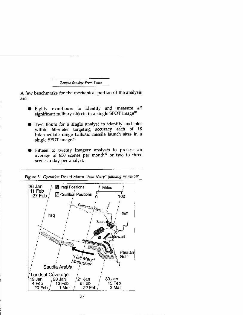
Considering the scale of the maneuver, General Schwarzkopfs concern for the visibility of his Hail Mary play was well founded. In the future, that concern must include visibility from space. Activity of so large a scale over so long a time and distance could easily be visible, weather permitting, even to a relatively coarse resolution sensor like Landsat's. Nor would it require heroic investment in large numbers of satellites to maintain a constant watch. Even a constellation with Landsat's relatively poor revisit rate would allow ample opportunity to discover the movement. Landsat overflew the two corps' original positions on January 21 and February 6; the VII Corps jumping-off point on January 28 and February 13; and the XVIII Corps jumping-off point on January 26 and February 11 (figure 5).39
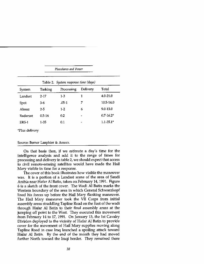
However, the satellite's contribution to decision cycle time includes not only the time to overfly its target, but also the time to task the satellite, the time to process the data into a useable image, and the time to deliver the resulting product to the user. Table 2 lists typical times for civil remote-sensing satellites. The processing and delivery times for SPOT and Landsat could be substantially shortened for a country with its own Landsat or Spot ground station.
After delivery of an image, the next contribution to the decision cycle time is the time needed for analysts to interpret the image, fuse the results with other elements of information, and turn them into useable intelligence. This time is perhaps the most difficult to estimate. It may include tasking additional observations by the satellite or other sensors. It certainly includes some uncertainty in the amount of time needed to exercise judgment based on the analyst's experience and collateral information.
36
Remote Sensing From Space
A few benchmarks for the mechanical portion of the analysis are:
Eighty man-hours to identify and measure all significant military objects in a single SPOT image40
Two hours for a single analyst to identify and plot within 50-meter targeting accuracy each of 18 intermediate range ballistic missile launch sites in a single SPOT image.41
Fifteen to twenty imagery analysts to process an average of 850 scenes per month42 or two to three scenes a day per analyst.
Figure 5. Operation Desert Storm "Hail Mary" flanking maneuver
26 Jan / g Iraqi Positions / Miles / 11 Feb / m / r+ .' 27Feb/ □ Coalition Positions Q ^Q
/ ' i t '
z / v^^^, Persian
/ / Maneuver I S i Saudia Arabia / / /. . ~' ' ' / Landsat Coverage: / / 19 Jan ,28 Jan '21 Jan / 30 Jan 4 Feb / 13 Feb / 6 Feb / 15 Feb
20 Feb/ 1 Mar / 22 Feb/ 3Mar
Plowshares and Power
Table 2. System response time (days)
System Tasking Processing Delivery Total
Landsat 2-17 1-3 1 4.0-21.0
Spot 3-6 .05-1 7 10.5-14.0
Almaz 2-5 1-2 6 9.0-13.0
Radarsat 0.5-16 0.2 - 0.7-16.2*
ERS-1 1-35 0.1 - 1.1-35.1*
*Plus delivery
Source: Bernei • Lanphier & Assocs.
On that basis then, if we estimate a day's time for the intelligence analysis and add it to the range of times for processing and delivery in table 2, we should expect that access to civil remote-sensing satellites would have made the Hail Mary visible in time for a response.
The cover of this book illustrates how visible the maneuver was. It is a portion of a Landsat scene of the area of Saudi Arabia near Hafar Al Batin, taken on February 14,1991. Figure 6 is a sketch of the front cover. The Wadi Al Batin marks the Western boundary of the area in which General Schwarzkopf lined his forces up before the Hail Mary flanking maneuver. The Hail Mary maneuver took the VII Corps from initial assembly areas straddling Tapline Road on the East of the wadi through Hafar Al Batin to their final assembly areas at the jumping off point to the West. They executed this movement from February 14 to 17,1991. On January 13, the 1st Cavalry Division deployed to the vicinity of Hafar Al Batin to provide cover for the movement of Hail Mary supplies moving along Tapline Road in case Iraq launched a spoiling attack toward Hafar Al Batin. By the end of the month they had moved further North toward the Iraqi border. They remained there
38

Remote Sensing From Space
until the start of the ground campaign on February 24,1991 .43
They are visible in the upper left-hand corner of the front cover as a series of fan-shaped scratch marks in the sand. Each fan is a battalion-sized task force. The ribs of the fan are the lines of communication between the battalion Tactical Operations Center and individual company positions at the open end of the fan. To locate some of the fans on the cover, refer to the schematic drawing in figure 6. The arrow labelled 2 in the figure points to a typical TOC; the arrow labelled 1 points to the corresponding company positions; that labelled 3 indicates the battalion logistics area to the rear of the TOC. The arrow labelled 4 points to a circular cluster of five or so relatively larger positions. Its configuration is typical of a brigade or larger unit TOC. Figure 7 shows a ground level view of such a position (unfortunately not the one on the cover.) The units in these positions are the 1st Brigade of the 1st Cavalry Division and supporting units, 1st Battalion 82nd Field Artillery, and 2nd Battalion, 29th Field Artillery. The two lines of small bright blue circles marked by the fifth arrow in the figure are distinctly not American units by the arrangement of their positions. They are possibly earlier positions of the Kuwaiti "Liberation" Brigade.44 Although the marks may look like faint chicken tracks in the small scale of the cover photo, they were immediately clear to the author's untrained (and unassisted) eye in a print enlarged to 4 feet square. A crude estimate of their positions measured with a yardstick and protractor relative to the airfield at Al Qaysumah was good enough to associate them unambiguously with their reported positions. There is undoubtedly more to be gleaned from the image, and especially from a series of them over time. However, this cursory inspection is enough to demonstrate a "smoking gun." Landsat quality imagery is good enough to see large (battalion or larger) unit positions and movement—in desert theaters at least.
Whether or not Landsat or Spot information would have come in time for Iraq to have influenced the outcome depends on several imponderables:
39

Plowshares and Power
How severely had coalition forces damaged Iraqi command and control, degrading their decision cycle time?
Was effective leadership available in the Iraqi chain of command to choose and direct an appropriate response to the Hail Mary maneuver?
In light of coalition air superiority and the continuing attrition of Iraqi forces did Iraq have any decisive means available to exercise in the time left after the situation could have become visible to them?
Figure 6. Schematic of cover illustration
40

Remote Sensing Front Space
Figure 7. MPs guarding bermed position typical of a brigade or larger TOC (Note inner berm in the background)
Source: Center for Military History
In hindsight, these questions allow for a broad range of speculation. We can envision effective Iraqi reactions possible in the time left to them in the decision cycle. They could perhaps have maneuvered the Republican Guard or other units to oppose the flanking maneuver or to break through the Saudi and Marine positions in the south and outflank the Hail Mary itself or penetrate into the coalition rear and attack the coalition airfields and supply lines. Judging by their failure to hold the town of Khafji in the face of coalition air supremacy and counterattacks, it's hard to believe they could have succeeded. Their decision cycle may not have allowed enough time for that large a maneuver by ground forces. A more ominous and rapid response, however, could have come in the form of chemical attack on the jumping-off points and supply depots using either SCUD missiles or a determined, massed assault by
41
Plowshares and Power
the many aircraft and helicopters they'd withheld from the battle. In either case, the final result would probably not have changed, but the miraculously low coalition casualties might have been much higher.
We should conclude from this example that access to civil remote-sensing satellites in their present state presents some concern for a theater commander. They may provide warning of maneuvers by large (division or corps level) ground forces, particularly those in vehicles whose movements are easier for the satellites to see. With their current level of resolution, civil satellites are suitable for targeting only large, fixed installations. Should their resolution approach a meter and their overall tasking, processing, delivery and analysis times approach a day, they could become a threat to lower levels of command and more mobile targets.
One observer, at least,45 has already sounded the alarm that a future Hail Mary might become impossible as regional powers obtain access to imaging from space. Before considering possible reactions to his alarm, we should examine the extent and the urgency of the danger. The extent is a question of what dangerous capabilities will come from current trends in the international interest in civil (and military) space. The urgency is a question not only of "how soon?" but of "so what?" How bad are the consequences of inaction or delay?
Palestine and Alamein To answer "so what?" it would help to be able to refer to cases when both sides in a conflict had access to satellite remote- sensing. Lacking that, we can find useful insights in conflicts when aerial remote-sensing was young.
Historians may argue with General Schwarzkopf whether the scope of his Hail Mary logistics was unprecedented "in the annals of military history." But, what may have been unprecedented was the opportunity to execute such a movement without fear of observation by the enemy. As that advantage erodes with the spread of observation from space, we'll see a parallel to the evolution of observation from the air.
42

Remote Sensing From Space
Fortunately, there are useful historical parallels to Desert Storm's Hail Mary in earlier desert wars where commanders executed similar maneuvers in the face of observation by the enemy. Their actions and judgments may suggest the nature of future battlefields in an evolving era of more widespread military sensing from space. Desert precedents are appropriate, not just because of the parallel with Desert Storm, but even more because desert terrain and weather provide the best opportunity for observation from above and, therefore, the most stressing case to judge the "so what" of space remote- sensing to the military. Some examples in Palestine and North Africa spanning World Wars I and II follow.
Beersheba In the summer and fall of 1917, British forces in Palestine under General Allenby faced Turkish and German forces along a line between Gaza on the coast and Beersheba about 30 miles inland (figure 8). Allenby chose to attack the Turkish flank at Beersheba, in part because the terrain approaching it was the least hospitable and attack would be least expected there. The area approaching Beersheba was farthest from the nearest railhead, almost completely without roads, and devoid of water. In concentrating his forces at the point of attack, Allenby planned to leave one corps at Gaza to conduct a feint and hold the Turkish forces there. He would send his two remaining corps to attack Beersheba and roll up the Turkish flank toward Gaza.
Maintaining surprise was a daunting task, however. The Turks and Germans had air superiority throughout the summer and were able to freely observe preparations for the attack from above. Their spies had ready access by land to the British rear. The British judged it impossible to conceal the fact of preparations against Beersheba, and tried instead to conceal only their size, extent, and purpose. They delayed movement until the last possible moment. In the interim, repeated cavalry reconnaissance of Beersheba gave the British familiarity with the terrain and accustomed the Turks to expect only minor
43
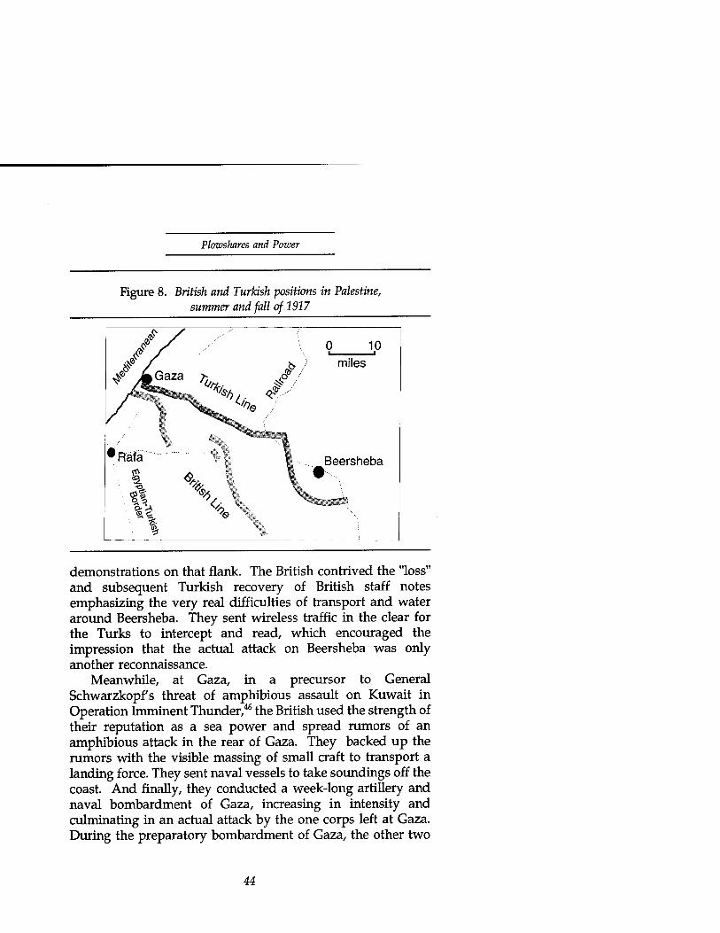
Plowshares and Power
Figure 8. British and Turkish positions in Palestine, summer and fall of 1917
10 miles
Beersheba
demonstrations on that flank. The British contrived the "loss" and subsequent Turkish recovery of British staff notes emphasizing the very real difficulties of transport and water around Beersheba. They sent wireless traffic in the clear for the Turks to intercept and read, which encouraged the impression that the actual attack on Beersheba was only another reconnaissance.
Meanwhile, at Gaza, in a precursor to General Schwarzkopfs threat of amphibious assault on Kuwait in Operation Imminent Thunder,46 the British used the strength of their reputation as a sea power and spread rumors of an amphibious attack in the rear of Gaza. They backed up the rumors with the visible massing of small craft to transport a landing force. They sent naval vessels to take soundings off the coast. And finally, they conducted a week-long artillery and naval bombardment of Gaza, increasing in intensity and culminating in an actual attack by the one corps left at Gaza. During the preparatory bombardment of Gaza, the other two
44
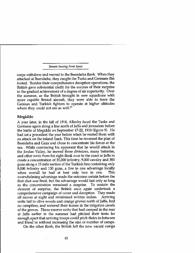
Remote Sensing Front Space
corps withdrew and moved to the Beersheba flank. When they attacked at Beersheba, they caught the Turks and Germans flat footed. Besides their comprehensive deception operations, the British gave substantial credit for the success of their surprise to the gradual achievement of a degree of air superiority. Over the summer, as the British brought in new squadrons with more capable Bristol aircraft, they were able to force the German and Turkish fighters to operate at higher altitudes where they could not see as well.47
Megiddo A year later, in the fall of 1918, Allenby faced the Turks and Germans again along a line north of Jaffa and Jerusalem before the battle of Megiddo on September 17-22,1918 (figure 9). He had set a precedent the year before when he routed them with an attack on the inland flank. This time he reversed the plan of Beersheba and Gaza and chose to concentrate his forces at the sea. While convincing his opponent that he would attack in the Jordan Valley, he moved three divisions, many batteries, and other units from his right flank over to the coast at Jaffa to create a concentration of 35,000 infantry, 9,000 cavalry and 383 guns along a 15 mile section of the Turkish line containing only 8,000 infantry and 130 guns, a five to one advantage locally when overall he had at best only two to one. This overwhelming advantage made the outcome certain before the first shot was fired, but the advantage would last only as long as the concentration remained a surprise. To sustain the element of surprise, the British once again undertook a comprehensive campaign of cover and deception. They made all moves at night and minimized written orders. Arriving units hid in olive woods and orange groves north of Jaffa, had no campfires, and watered their horses in the irrigation canals of the groves. Those reserve units that had camped in the rear at Jaffa earlier in the summer had pitched their tents far enough apart that arriving troops could pitch theirs in between and blend in without increasing the size or number of camps.
On the other flank, the British left the now vacant camps
45

Plowshares and Power
standing and erected new dummy camps. They tethered 15,000 dummy horses in those camps and dragged sleds through the sand to raise dust clouds, obscuring observation and simulating extensive activity. Battalions of troops would march ostentatiously from Jerusalem into the area in daylight and return surreptitiously by truck at night to repeat the action again the following day. Vacant headquarters continued transmitting radio traffic as if still occupied and active. Engineers erected additional bridges across the Jordan River to support the "impending" attack. British agents in Amman contracted extensively for forage to feed the dummy horses. British GHQ commandeered a hotel in Jerusalem and installed additional telephone lines to support a re-location of the army's headquarters to the inland flank they had no intention of making.48 Wavell described the effect of these extensive preparations during August and September in his biography of Allenby:
Even the local inhabitants were unaware of the great concentration. And our Air Force had gained so complete a mastery over the enemy that few hostile aeroplanes crossed our lines in September. That the enemy was unaware of Allenby's schemes was proved by an Intelligence map captured in the course of the operations. This was dated September 17, two days before the assault, and showed no suspicion of any great concentration on the coast; on the contrary, it indicated an increase of force in the Jordan valley.49
In both of these two decisive battles in the Palestine campaign, Allenby achieved surprise, and with it success, despite his opponent's ability to observe his preparations. He devoted meticulous attention to detail in controlling what could be observed and when. More importantly, he fostered an erroneous interpretation of his intent by a comprehensive program of deception, painting a false picture composed of the myriad small impressions that collectively corroborate each other and convince the opponent's intelligence analysts. In
46

Remote Sensing From Space
Figure 9. British and Turkish positions in Palestine, summer and fall of 1918
Tufa
•Nablus
•sh Line
r-^
lshUne ♦* 4T
both cases, the false picture was inherently plausible both at Gaza/Beersheba, because Beersheba was by far the more difficult target for the British while Gaza was vulnerable to traditional British strengths, and at Megiddo because the British had succeeded so well on the inland flank at Beersheba the year before. All three elements were essential to surprise:
Control of observables
• Comprehensive deceptive measures
• A plausible false alternative.
Only the first of these depends on the opponent's means of observation, and none requires denial of observation. Indeed, complete denial of an opponent's means of observation would make deception impossible. Surprise might still be possible
47
Plowshares and Power
without deception, but only if the opponent is content to operate in the blind and doesn't guess intent or stumble across an effective response by accident. More likely, in the absence of sources he trusts, the opponent would adopt alternative measures to determine or frustrate the unknown intent—such as probing raids to find troop dispositions or a spoiling attack to seize the initiative and force a response on more favorable terms before preparations are complete. Although Wavell credits the Air Force's continually improving control of the air with much of the surprise, its contribution was not to deny observation, but rather to degrade its accuracy and possibly to lend credence to the degraded information received. Had there been no attempt to prevent observation, the Turkish and German intelligence analysts should rightly have suspected information so readily received. Complete denial of the ability to observe is not necessarily a worthy goal, particularly during preparations for an assault. Its achievement may be counterproductive; a more useful ability is to be able to control observation and influence perception. A final historical example, from the next World War, when military aviation had matured considerably, illustrates a major maneuver successfully concealed under routine aerial surveillance—when the commander believed that denial of aerial surveillance might have been possible!
El Alamein In the first days of September 1942, Montgomery's Eighth Army had stopped Rommel's advance toward Cairo and the Suez canal in the soft sands of the Ragil Depression near Alam Haifa. (How they trapped him there is another story with a message for remote-sensing to be reviewed shortly.) Montgomery's forces faced Italian infantry deployed along a North-South line backed by Rommel's Afrikakorps (figure 10). Montgomery scheduled his attack, Operation Lightfoot, for the full moon on October 23, 1942. His original plan called for attacks on both northern and southern flanks. On October 6th, only 2 weeks before the planned attack, he changed the plan
48

Remote Sensing From Space
to a single penetration in the north. To conceal the intent of his plan, he employed deception and camouflage extensively in the time remaining to move his attack forces.50 Operation Bertram, the cover and deception operation for the attack, had to conceal a force of a 1,000 tanks, 1,000 guns, 81 battalions of infantry, several thousand vehicles and tens of thousands of tons of supplies. In all about 150,000 men and 10,000 vehicles moved to their attack positions within the space of 2 weeks in empty desert, a feat similar in scope to General Gus Pagonis's transport of VII and XVIII Corps in Desert Storm, but subject to continual German aerial reconnaissance.
Operation Bertram hid some activities from reconnaissance but deliberately displayed others. Bertram moved men and materiel at night, when aerial reconnaissance was not possible, and concealed supplies in trenches under tarpaulins and weapons under dummy structures and vehicles during the day. To mislead the Germans not only about the location of the assault but also the timing, Bertram faked the construction of a water pipeline and supply depots in the south. When German planes flew over the construction during the day, they saw workmen industriously digging a length of ditch with "pipe" (made of discarded tin cans) lying next to the ditch. At night, the British would shift the "pipe" down to the next position to the South and fill in the hole they'd dug during the day. They timed their progress to indicate completion for an attack in November. As a result of Bertram's extensive efforts, Lightfoot took Rommel by surprise.51
Although Montgomery allowed German aircraft to enjoy routine observation of the preparations for Lightfoot, he began its air operations on October 23 with an assault on the Axis airfields
... in order to finish off the opposing air forces, and particularly to prevent air reconnaissance. At zero hour the whole bomber effort was to be directed against the enemy artillery, and shortly before daylight on the twenty-fourth October I hoped the whole of the air effort would be available to co-operate intimately in the land battle, as our fighter ascendance by that time would be almost absolute.52
49

Plowshares and Power
Figure 10. Operation Lightfoot, the battle for El Alamein, September-October 1942
0 10 20 i i 1
miles
Mediterranean Sea
El Alamein
British 8th Army
J XIII Corps
50

Remote Sensing Front Space
We should note especially that he was confident he could achieve control of the air within 24 hours, but he did not make the attempt until the Germans had ample opportunity to observe his deception. Only when the wraps came off the deception and the fight began was it time to take out their eyes. Denial of aerial observation at the instant of attack maximized the confusion of the defense and the value of surprise.
This timing is in sharp contrast to General Schwarzkopfs in Desert Storm. Schwarzkopf would not begin his move until after he "had taken out [Hussein's] eyes." He then had to wait 2 weeks before his troops were in place and another 2 before he judged that the air campaign had adequately prepared the battlefield for the ground attack. Had the Iraqis not been prostrate under constant aerial bombardment and bankrupt leadership, they might have had time enough to grow curious about Schwarzkopfs plan and to interfere with his plan before the bombs rendered them incapable.
So What? What's the worst that could come from widespread military sensing from space? These historical analogies suggest that commanders will need one or more of the following:
• Decisive force everywhere
• Faster maneuver or effective deception to be able to concentrate decisive force where and when needed
• Denial of observation by their foes.
In an era of tight budgets and expeditionary forces, the first need will not be affordable. In the second need, a commander may enjoy the advantage in maneuver if he has the advantage in air forces, a point early air power advocates used in arguing for separate command of air forces:
51
Plowshares and Power
The inherent flexibility of air power is its greatest asset. This flexibility makes it possible to employ the whole weight of the available air power against selected areas in turn; such concentrated use of the air striking force is a battle winning factor of the first importance.53
Alternatively, the increasing reach and lethality of artillery rockets with submunitions provide a similar ability to concentrate force quickly. Both were elements of Desert Storm's success, air power arguably the more important since it achieved the third need as well. But, in an era of military sensing from space, until either air power, artillery missile, or space power is allowed to kill satellites, none will be able to satisfy that third need to deny observation. Even when air power, artillery rocket, or space power is allowed to do so, the prudent commander will still employ deception and reserve the blinding strike for the point of attack.
At a minimum, to employ deception while under observation by satellites, the commander will need both a detailed understanding of the capabilities of the satellites' sensors and timely warning of the satellites' overflight of his position. For civil remote sensing, both should be readily available. For military satellites, knowing capabilities will be very difficult; timely warning will require an effective and expensive space surveillance network. Because of the difficulty in establishing the opponent's ability to sense and because of the need to control the opponent's perceptions, there will be a natural growth of means to degrade or interfere with sensor performance.
Those means of interference may be subtle and insidious. The history of the Battle of Alam Haifa contains a warning of one such means. The Germans, compelled to attack by their deteriorating supply situation (especially a severe shortage of gasoline for their tanks), by their overestimate of the Allies' growing strength in the area and by Hitler's reluctance to concede ground at El Alamein, began their advance on the night of August 30, 1942. Axis armor units were to sweep around the southern flank to seize Alam Haifa ridge in the rear
52

Remote Sensing From Space
of the British Eighth Army. Their advance quickly bogged down in a British minefield that was deeper and better defended than expected. After a mauling by the covering force and RAF bombers, they continued on toward Alam Haifa ridge on the 31st, only to run into "very soft sand, which caused further delay and much expenditure of gasoline."54
British Intelligence had lured Rommel into the treacherous soft sands of the Ragil depression by planting a false map depicting hard sand on the corpse55 of Rommel's source of intelligence in British Headquarters.56 Von Mellenthin, on Rommel's staff at the time, wrote later, "I can confirm that this map was accepted as authentic and served its purpose in leading the Afrika Korps astray." By September 1, the Afrika Korps was out of gas and stranded at Alam Haifa under constant bombardment by artillery and aircraft, unable to retreat until September third. They left behind the remains of 50 tanks (of roughly 470 brought to the battle), 50 antitank and field guns, about 400 vehicles, and any hope of reaching Cairo. In von Mellenthin's words, it was "the turning point of the desert war, and the first of the long series of defeats on every front which foreshadowed the collapse of Germany."57
There are two messages for remote sensing in the Alam Haifa experience. The good news is that satellites with a capability like Landsat's multispectral sensing can warn of soft sand or other terrain obstacles. The bad news is that when those satellites are civil systems with little thought for the security of their data (as they are today), their unsecured data links or data bases may supply the means for a hostile agency to plant false indications—a means less dramatic than a corpse, but all the more effective even so.
What Next and When? In looking at the question "So what if regional powers can see from space?" there seems to be some cause for concern—enough cause to consider the opportunity costs of trying to delay the spread of military sensing from space. But there's not enough to warrant panic. As long as there are
53

Plowshares and Power
means at hand to manage the perceptions a regional power opponent might derive from the vantage of space (and possibly to deny him observation), commanders should not suffer unduly. However, to judge the feasibility of those means of deception or denial and to identify the opportunity costs, we'll need some idea of where the world of international remote- sensing is going and why. We'll find three broad categories of remote-sensing of interest: civil systems (under legitimate government sponsorship), commercial systems, and national security systems (either overt or covert under the illegitimate cover of civil or commercial activity).
Civil Systems Tables 1 and 2 list most of the world's recent, current and planned civil remote-sensing satellites. We've seen that their resolution and timeliness could present some difficulty for a theater level commander hoping to maneuver large ground forces unobserved and unopposed. In addition, they are adequate for targeting installations such as ports, bridges, airbases and logistics depots. However, their well-known technical capabilities and orbits leave the commander opportunities for camouflage and deception. Also, in most cases, their governments have already shown willingness or can reasonably be expected to control access to the satellites' products during a conflict in which they have an interest or the UN has imposed sanctions. But, we need more than statistical summaries and capabilities to judge intent. To project their current status into the future and to define the environment for policy alternatives that require international cooperation, we need some insight into the history and apparent motivations for at least some of these countries.
United States U.S. civil land remote-sensing consists of two distinctly different programs, Landsat and the Earth Observing System (EOS). Landsat is an operational program responding to DoD, commercial, and civil government needs. It emphasizes spatial
54

Remote Sensing From Space
resolution and coverage over spectral and radiometric performance. EOS, on the other hand, is a research-oriented program that emphasizes primarily spectral and radiometric performance over spatial resolution and coverage. Landsat serves a large community of operational users interested in coverage. EOS will serve a relatively smaller academic community developing new understanding and methods.
The Landsat program began in 1969 as an experimental NASA program, the Earth Resource Technology Satellite (ERTS), whose first launch occurred in 1972. The currently operating Landsat satellites (4 and 5) were launched in 1982 and 1984. The program's "open skies" nondiscriminatory access approach to data sales has resulted in widespread international participation in the program, with substantial direct benefit to the nations involved and considerable indirect benefit to U.S. foreign policy as a result. Fifteen nations operate Landsat ground stations and pay royalties for receipt of the data. Five more are under construction or negotiation.58
The UN's Regional Remote-sensing Program has identified remote-sensing education and services institutions in Vietnam, Bangladesh, Iran, South Korea, Sri Lanka, and Nepal, among others. The UN has trained Landsat image interpreters in virtually every African country. European and American schools offer such training to international students. Landsat value-added services and products are available from more than 150 vendors in 42 countries.59
In 1979 Carter Presidential Directive 54 transferred the program's management from NASA to NOAA, the Commerce Department's National Oceanic and Atmospheric Administration, to begin conversion from a research system under government funding and control to an operational system, for eventual transfer to the private sector. NOAA was already responsible for operating the country's civil weather satellites. In 1981 the Reagan administration accelerated Landsat's transition to the commercial sector. Congress set the terms for commercialization with the Land Remote-sensing Commercialization Act (PL 98-365) in 1984. A key principle in the terms was that access to data must remain
55
Plowshares and Power
nondiscriminatory.60 The winning contractor was to receive revenues from sales of unenhanced Landsat data, international ground station fees, and subsidy through 1992 for 95 percent of the development of the sixth Landsat satellite and operation of the existing satellites.61
Unfortunately, in January 1986 the Space Shuttle Challenger loss and NOAA failure to budget commercialization subsidy funds for FY87 began a series of continuing crises in the Landsat program. Currently the private business, Earth Observation Satellite (EOSAT) Company, operates two satellites (numbers 4 and 5, which are well beyond their designed life), and developed a single replacement satellite, Landsat 6.62 This was launched October 5, 1993, but failed to achieve orbit.63
Within 2 years of its beginning, the Landsat commercialization program was widely judged a failure at developing markets: 75 percent of sales were still to the U.S. Government, with only 9 percent to private companies, far lower than in other countries.64 Several studies for the Commerce Department in 1988 concluded that commercialization of a Landsat-type space segment was not realistic this century even under the most optimistic market projections.65 EOSAT proposed a broad range of alternatives for Landsat 7 to continue the series without a lapse in data collection. However, the administration failed to submit a budget for any of them or any other alternative in its budgets for fiscal years 1990,1991, and 1992.66
By 1991 Congress had become impatient with the delays in resolving Landsat's funding difficulties in time to prevent a gap in service. It introduced legislation to force the issue of a follow-on to Landsat 6. The bill's sponsor, Congressman Brown—Chairman of the House Science, Space, and Technology Committee, summarized the options remaining for Landsat 7:
• A sole-source clone of Landsat 6 to launch no sooner than February 1998 (8-month data gap expected)
56
Remote Sensing From Space
• A competed clone at lower cost but 12 to 18 months later (20-month gap)
• An advanced Landsat 7 (e.g., 5-meter resolution stereo) to launch around 2000 (3-year gap).67
In the interest of minimizing the gap in service, the bill proposed a Landsat 7 cloned from Landsat 6. In the interest of future opportunities it also included a 5-year advanced technology demonstration program. The program would report on the alternatives for use of the technology developed, to include:
• Private sector launch and operation
• An international consortium to fund and manage the program
• Launch and operation by the Federal government
• Cooperative government and private sector launch and operation of an operational system.
The goals of these options would be to:
• Serve civilian, military, commercial and foreign interests of the United States
• Maintain continuity with Landsat
• Improve responsiveness and lower cost to own
• Transfer responsibility to the private sector if the other goals could still be met.68
In trying to balance the competing interests of the first goal, the bill would continue the requirement for any U.S. private entity operating a remote-sensing system to obtain a license for
57

Plowshares and Power
its operation from the Secretary of Commerce. Licensees would have to comply with national security requirements determined by the Secretary of Defense and international obligations determined by the Secretary of State.69 In 1992, Senator Pressler introduced a Senate version of the bill that pronounced Landsat commercialization dead. It proposed:
. . .full commercialization of the Landsat program cannot be achieved within the foreseeable future, and thus should not serve as the near-term goal of national policy on land remote-sensing.70
It didn't entirely rule out commercial remote sensing but revised the licensing process for commercial operators. We'll see later that this licensing requirement is one of the principal obstacles to U.S. commercial efforts in remote-sensing satellites.
DoD has historically been Landsat's largest customer, but Congress has worried that DoD management of the system might compromise civil utility in the system's design and public access. It would certainly alter international perceptions of U.S. commitment to the peaceful use of space, and it might preclude eventual commercialization of the system. Because of these concerns, Congressman Brown's proposed legislation would transfer management from NOAA to a joint NASA/DoD program.71
While Landsat is the U.S. "operational" land remote-sensing system, EOS is a research program, the core of the country's Global Change Research Program. In the research arena, the United States is one among equals with Japan and Europe—and not first among them but the last to fly an advanced earth observing platform for global change research. EOS is easily an order of magnitude larger in scope than Landsat.72 Despite the disparity in size and purpose, the two are closely related. Congressman Brown, probably the staunchest supporter of both programs in the Congress, has described the relationship of Landsat to the EOS program as either "mother" (it pioneered the technology and the mission), "sibling" (both are essential contributors to the global change
58
Remote Sensing From Space
program), or "bastard child." He characterized Landsafs treatment in public policy as that of bastard child because of its premature commercialization, its inconsistent funding during the legislated commercialization period, and its bureaucratic assignment to NOAA, which has no use for its data.73
EOS, like most NASA science programs, has a deliberately discriminatory pricing structure intended to reward participation in research. NASA separates EOS users into research, operational agency, and commercial users:
• Researchers, including international affiliates, receive EOS data at the incremental cost of reproduction and delivery in exchange for signing a research agreement. The agreement certifies that they will publish their results and methods in open literature, use the data for bona fide research only, and share the data only with others covered by a research agreement.
• Operational agencies of the U.S. Government may have real-time access to EOS data through their own direct read-out of the satellites. Non real-time access is identical to that for researchers.
• Others (principally commercial users) may have access under terms consistent with the Land Remote-sensing Commercialization Act for commercial distribution on a non-discriminatory basis.74
Unlike Landsafs precedent of non-discriminatory access for the world community, EOS's data policy rewards countries with the resources to participate in its funding. Its insistence on sharing methods alienates potential commercial users. The new Landsat legislation would extend similar discriminatory pricing authority to Landsat for the first time. It would authorize a two tier public sector, commercial pricing scheme to "maximize the public's return on investment [in funding and launching a remote-sensing satellite system]."75 The new pricing policy is a step back from the position of generous emissary, but it's not
59
Plowshares and Power
a step toward commercial profitability. Instead, it's a step, with EOS, toward isolation of the system's data, utility, and advocacy within U.S. public sector users.
In summary, U.S. civil programs for land remote sensing no longer lead the world in technology, capability, or influence. Although it pioneered operational application of the technology to real world problems, the U.S. premature attempt to transfer the program to the private sector put progress in stasis and allowed the rest of the world to catch up. Like the weather satellites before them, the U.S. land remote-sensing satellites have been effective ambassadors of U.S. technology and good will. They've set a high standard of international cooperation. That high standard is now at risk in the interest of recovering past investment. As U.S. leadership is withdrawn, the international community is forging on independently. As it did with weather satellites, the rest of the industrialized world has begun to develop its own remote sensing.
Congress has changed the direction of the Landsat program away from complete commercialization and concentrated on preserving the public benefit of past investment in land remote-sensing.76 The proposed authorizing legislation would re-assert U.S. leadership in the technology, but budgets and appropriations may not support the assertion. The administration would support a NASA-DoD collaboration to clone Landsat 6 for Landsat 7, but future advanced technology alternatives are less certain.77 The likely trend under current budget constraints is a minimal program to preserve the government's interests in the status quo. In February and April 1992, the NASA/Air Force Landsat Program Office advertised its intent for the "acquisition of a LANDSAT 7 with capability at least equivalent to LANDSAT 6" while allowing optional proposals for enhanced performance within guidelines to be included in a forthcoming Request for Proposal.78 For more ambitious (or alarming) alternatives, we need to look to commercial efforts, or to Europe and Japan.
60

Remote Sensing From Space
Europe Europe's principal civil remote-sensing system is SPOT. Its counterpart to EOS in the global change research is the ERS-1 program listed in tables 1 and 2. The SPOT remote-sensing program began in 1977 as a joint French, Belgian and Swedish effort. SPOT Image was created as a private entity to develop markets for SPOT data in 1982. It is the exclusive distributor of SPOT satellite data. It is both the primary data supplier and a value-added reseller of enhanced data. The first SPOT satellite was launched in February 1986 and began commercial operations May 6,1986. In August 1986, SPOT Image signed an agreement with NOAA to supply image data to the U.S. National Satellite Land Remote-sensing Archive. The SPOT satellites belong to CNES, the French equivalent to NASA. In 1990 private sector ownership of SPOT Image grew to 35 percent, matching CNES equity. SPOT Image's goal is for the future marketplace value of data to generate sufficient revenues to cover the costs of acquiring and delivering data.79
Spot Image 1989 revenues of $20.8 million paid about half of all the ground segment costs (including its royalties to CNES). SPOT Image projections at the time indicated the ground segment would be self supporting by 1995 and that both space and ground segments would obtain 90 percent of their funding from commercial users by 2000 (CNES plans to subsidize the space segment through the 1999 launch of SPOT-4).80
If there is a role model for SPOT, it is probably the European commercial space launch program Ariane. The European Space Agency (ESA) subsidizes vehicle development and a mixed public-private enterprise (Arianespace) operates as a commercial provider to sell launch services competitively with the help of a captive marketplace from their government participants.81 A European witness, testifying on commercial participation in remote-sensing before a U.S. Senate Committee in 1984, cited earlier U.S. bars to European participation in NASA launch programs (the Shuttle Space Tug program and a commercial, McDonnell Douglas Delta launch capability in French Guiana) as contributing causes to the European
61
Plowshares and Power
development of the Ariane launch vehicle. On that basis he argued for open competition for commercial remote-sensing to forestall independent initiatives.82 However, by this time SPOT Image had already begun its marketing campaign, well in advance of the first launch in 1986, using simulated data collected by airborne sensors to familiarize their potential customers with the satellite data to come. By 1988, SPOT was firmly established on orbit, Landsat commercialization had failed to sustain progress and subsidy, and representatives of CNES and NOAA met to discuss the possibility of a joint venture. David Julyan, Executive Vice President of SPOT Image Corporation, testified later to the House Committee on Science, Space, and Technology that a French-U.S. joint venture might be interesting and attractive, but that SPOT'S aggressive efforts toward commercialization would continue independently.83
In summary, the European approach to remote sensing from space is one of industrial policy. As with Airbus and Ariane before it, SPOT enjoys the benefit of collaboration between government and industry with both direct and hidden subsidies maintained consistently over a long enough duration to establish a significant market share. Whether these subsidies benefit the people of Europe is arguable. At least one study of the Airbus subsidy indicates that the benefits to European industry and travelers were offset by the costs of the subsidy. U.S. aircraft manufacturers lost market share. The winners were the airlines of the rest of the world.84
In the case of remote sensing, the eventual benefits must be in either the revenues from sale of data or preferential access to it or in the indirect benefits to industry or national security systems of participating in the technology. The quantities of remote-sensing satellites (or similar satellites) needed are too small in comparison with either space boosters or airliners for revenues from satellite production to justify the investment. The most plausible explanation for European subsidy of remote-sensing is probably the desire to develop independent means for national security sensing from space as well as the prestige of a successful space program. Substantial revenues
62
Remote Sensing From Space
from data sales in the face of numerous international competitors seem unlikely. However, the high entry cost of developing and launching the satellites makes collection of remote-sensing information from space a natural monopoly, which the Europeans may hope someday to exploit.
Japan If the Europeans appear to be pursuing managed trade, what of Japan, infamous for MITI, the Ministry of International Trade and Industry with its industrial policy for managed trade? The director of NASDA's 0apan's NASA equivalent) Washington, D.C., office testified before the House Committee on Science Space and Technology in 1990 on NASDA's perspective of remote sensing:
We still believe that commercialization of satellite remote sensing is premature and will not become matured in the near future. Our experience shows us that the cost of receiving, processing, archiving, and distributing high spatial resolution data from MOS-1, SPOT-1, and Landsat-5 in Japan far exceeds the revenue received for the data. This cost even does not include satellite development and launch cost. . . .Our main purpose for utilizing satellite remote-sensing is to develop its technology and provide the data for the users who intend to develop and demonstrate the activities for the benefit to the public. To promote maximum benefit to the public by satellite remote-sensing activities, NASDA recognizes the importance of two basic principles of Earth observation, namely the Open Sky policy and Non-discriminatory Data Distribution, and NASDA will use its best effort to make the data from our satellites available to anyone in the world."85
Despite NASDA's assurance of open skies and non- discriminatory data distribution, the JERS-1 satellite is not entirely theirs. It is sponsored by MITI, on behalf of the Metal Mining Agency of Japan, the Japanese Petroleum Exploration Company, and others. NASDA has negotiated JERS-1 data
63
Plowshares and Power
reception by other countries' civil space agencies86, and maintains a Remote-sensing Technology Center (RESTEC) to distribute remote-sensing data to the academic and international communities. However, MITI maintains a separate Earth Resources Satellite Data Analysis Center to support Japanese industrial access to JERS-1 data.87 U.S. industry users of remote-sensing geological data remain concerned that MITFs data might not be so freely available or even that NASDA's nondiscriminatory dissemination methods might give Japanese prospectors a first look.88 If so, Japan's interest in remote-sensing might still be to support its industrial trade policy, not in satellite building but for the mining and petroleum industries and their contribution of raw materials and energy for the broader manufacturing sector.
Russia As difficult as it is to guess the right name (let alone political structure) for what's left of the Soviet Union, it might seem pointless to review Soviet remote-sensing. But, before its dissolution, the U.S.SR was the premier space-faring nation of the world, launching more satellites than the rest of the world combined—three times more than the next most active nation, dominating manned spaceflight with the world's only operational space station, and participating actively and effectively in every arena of military, civil, and scientific space application.89 The Soviets developed remote-sensing satellites for military rather than prestige, economic or trade purposes. But, even before its collapse, the Soviet Union was ready to sell data from the capable film and radar imaging satellites listed in table 1. It reportedly had much more capable military imaging satellites (with resolution as good as 0.3 meter and real-time electronic relay of images instead of film return) whose pictures might yet show up in the marketplace.90 The nationwide infrastructure necessary to produce, launch, and operate those space systems as commercial enterprises may well not survive the political restructuring and recriminations of the republics. But, the individual pieces and people of that
64

Remote Sensing From Space
infrastructure remain and represent one of very few exportable sources of hard currency for the republics. We should not be surprised to see either Soviet hardware or designs for remote- sensing satellites with any desired level of performance offered at bargain prices around the world.
Assessment Of all these civil systems, only the ex-Soviet programs appear to suggest a direct threat to military commanders in the field. Although they're clearly not in the same class with some of the other dangerous Soviet leftovers, they will bear watching and possibly some diplomatic efforts to contain. There is, though, a more subtle threat to U.S. security implied in this collection of civil initiatives. The basis for any military capability and the core of national power is a healthy economy. Attempts at managed trade in high technology cost the managers, but inevitably damage the more technologically advanced.
Paul Krugman, MIT's theorist in the economics of trade under imperfect competition, has modelled the relationship between technology and trade and examined the interaction of two countries, one more technologically advanced than the other. Technological progress in the more advanced country widens the gap between them but opens up opportunities for trade in the process and raises real income in both countries. When the less advanced country narrows the gap in technology, it reduces the leader's real income by eliminating the gains from trade. Viewed pessimistically this narrowing of the gap makes an economic case for protectionism. Viewed more optimistically, it's a prescription for continuous improvement. In conjunction with either nation's advance comes an increase in the technological intensity of its exports. Mistaking this symptom for the cause, countries subsidize high tech exports for prestige or the hope of economic advantage. In Krugman's words:
At present nearly every government in the industrial world plans to spur growth by promoting its high-prestige,
65

Plowshares and Power
high-technology industries. The result of this attempt at sympathetic magic will probably be the same as the result when steel and petrochemicals were the talismen of growth: excess capacity, and disappointment.91
The excess capacity will represent a direct threat to U.S. economic strength. The disappointment will sow the seeds for further discontent.
Commercial Systems Although several of the current civil remote-sensing systems listed above seek commercial support, their fates are more in the hands of government subsidy than in Adam Smith's invisible hand of the marketplace. As they exist today, they pose a manageable threat to military commanders. Should those governments tire of subsidy, leave a significant market niche unserviced, or succumb to growing market pressure, the invisible hand might yet fashion a comercial remote-sensing system capable of significant threat to U.S. forces. Should governments remain the principal players, they may respond to market demands if only to reduce the burden of subsidy. For this reason we should understand the sectors of the remote-sensing market in terms of:
• Economic viability, the rough magnitude and elasticity of a sector's demand relative to the costs of servicing its needs
• Technical requirements needed to service the market segment, i.e., sensor characteristics that might threaten security
• Political value, that might offset security concerns.
We can categorize the market for remote-sensing data into segments: earth resources (renewable and exploration), environmental monitoring or management, cartography or
66

Remote Sensing Front Space
geographic information systems, and the media. Figures 11 and 12 give a quantitative feel for the relative size and potential growth of these market segments based on optimistic growth assumptions, including aggressive stimulation of the existing market and introduction of more advanced sensing capability in the mid 1990's.92 They show market growth in inflation-adjusted, constant-year dollars. The following paragraphs provide some qualitative insight into these market segments.
Earth Resources The exploration portion of this market segment consists mainly of oil and mining companies. The major transnational oil companies use satellite remote-sensing data in basin-level exploration and environmental monitoring. For this level of exploration and for environmental monitoring at the regional level current sensor resolution is adequate. However, production related monitoring at the level of a few wells and site development require meter level resolution available currently only from aerial observation. Independent oil and gas companies are numerous, usually small explorers and holders of oil and gas production. Only about 5 percent of them employ satellite remote sensing, using photogeology to identify the surface expressions (such as drainage patterns, vegetation stress, differential soil compaction, topography, etc.) of subsurface features such as hydrocarbon accumulation. Few of these companies can afford their own photogeologists and rely on a few small value-added service companies.93 Of the civil users, this market segment's demand is probably the least elastic in response to price increase. However, the image of oil companies with deep pockets, able to afford the latest technology and satellite data, is largely an illusion. A look at their willingness to pay for data illustrates the relative weakness of this market segment. One market survey of these users (done for the Japanese JERS-1) priced a full data set at $3,600. An increase to only $4,800 significantly lowered
67

Plowshares and Power
Figure 11. Market projection by activity
300
oo O) o T— CM CO ■* in CO r>~ co o o co CO O) O) 05 O) 05 CD OS en O) o> o O) O) O) a> CO Oi CD Oi O) C» 05 O) Ü
CM
D Value Added Services
■ Data Sales
Source: The Analytic Sciences Corp, August 1988
projected sales—a decrease to $2,400 increased projected sales only slightly.94
The renewable resource portion of this market segment includes large agricultural and timber businesses as well as government agencies monitoring our own and other countries' agriculture. The Agriculture Department and the Agency for International Development use remote-sensing information to make development assistance and policy decisions.95 For gross crop monitoring, the coarse resolution, broad area coverage, and daily revisit of low altitude weather satellites are
68

CO c g CO c I—
03 C
o> c Q.
CD CO Q. Ü C CD O)
CO
CD c
CO
c P •a CD LL
OÖ
>< o CO CD CD C
*-• CO
3 3
CD n CD -a cn V "E o c CD c o O)
O Q LU ^ UJ LL <
D ■ 1 ■ ■ ■ D
e •S
8
i CN I-H
I
uonniAl Z8$
oo oo CTv
3
6 cn
.a
i
3 £
Plowshares and Power
preferable to land-sensing satellites. Landsat's sensors provide finer grain (80- and 30-meter resolution) data for detailed study. Eighty-meter resolution is 90 percent accurate in discriminating healthy from insect damaged forests. Ten- to thirty-meter resolution can identify and discriminate specific causes of plant stress and estimate crop yields.96 There appears to be no renewable resource demand for a combination of higher resolution and frequent revisit sufficient to threaten military operations.
Environmental Monitoring and Management In addition to the environmental monitoring that oil companies do as part of their development and production processes, several federal government agencies (e.g., Bureau of Mines, Bureau of Indian Affairs, Bureau of Land Management) use satellite remote sensing in planning, resource assessment, and environmental and administrative monitoring. Their ideal sensor would be a 5-meter resolution multispectral instrument similar to Landsat's but preserving the Landsat swath width. Their concern with smaller swath width is the increased cost and processing associated with multiple scene mosaics. Five- meter resolution satellite data would displace aerial photography and expand satellite data demand slightly. Typical aerial photography budgets for these agencies are about $250,000 to $500,000 per year. Typical expenditures for 10-meter resolution data are $20,000 to $50,000 per year.97
Cartography and Geographic Information Systems (GIS) We've seen earlier that the military is an eager customer for cartography products ranging from image maps to video simulations of the view from an airplane's cockpit. Its demand for these products is sporadic, depending on the locale of the crisis of the moment, but it can have substantial temporary impact on the remote-sensing market. For example, SPOT Image sales rose 35 percent in 1990 to $27 million, but a quarter of the increase was due to the Gulf crisis.98
Geographic Information Systems are a rapidly growing
70

Remote Sensing From Space
computer based tool for planners in local government and industries with geographically distributed capital plant or operations such as telephone, cable, and power companies. A GIS is a graphical data base built up in layers of map overlays describing demographics, resources, facilities, land use, and the like. Typical GIS customers are county or municipal governments or associations. The market drivers are principally environmental law compliance and planning for infrastructure such as water and sewer plants. The quality of imagery needed depends on the population density of the area. Urban areas typically need resolution of a meter or better, rural areas 10 to 20 meters, and suburban areas somewhere in between those extremes. Aerial photography supplies the higher resolution imagery currently. The need to update a GIS data base depends on the growth rate of the area. A typical low growth rate county like Gaffney County, NC, updates 20 percent of its area per year. Environmental compliance with wetlands preservation legislation is a typical source of demand in states like Maryland and Virginia. Two-thirds of Maryland's counties use satellite imagery to verify compliance now. Wetlands sensing requires multi-spectral, infrared data like Landsat's."
The GIS market may represent the best opportunity for substantial growth in demand for remote-sensing products. As the cost of GIS workstations comes down to the range of a few thousand dollars,100 many local government entities may be customers. The United States has:
• Over 3,000 county governments
• Over 19,000 municipal governments
• Over 6,000 natural resource special districts
• Over 5,000 fire protection special districts.
Each of these is a potential customer for a GIS if subscriptions to database updates are affordable. Eighty-seven
71

Plowshares and Power
percent of the counties have populations of less than 100,000 and so could likely use the "rural" 10- to 20-meter resolution satellite data available now.101 If, say, 15,000 of these potential customers paid between $1,000 and $10,000 a year for updates to their database, the annual revenues to the supplier could be in the neighborhood of $75 million dollars. SPOT Image has developed a product line, called SPOTViews, aimed specifically at the GIS market. The products include a scene, 37 miles on a side, for $3,000, and smaller sizes, covering areas a quarter and a sixteenth of the $3,000 size, for $2,000 and $950, respectively. SPOT Image estimated that the 1990 global GIS market for all hardware, software, and data was about $300 million, half of which was from U.S. users. The president of a California remote-sensing value-added firm has predicted a GIS market growth rate of 30 to 40 percent annually.102
Penetration of that market by satellite imagery will depend on improved resolution matching the scale of interest to the larger number of users.
The Media The press does not deserve special attention in this discussion because of the size of its segment of market demand; as figure 12 indicates, it's a negligible portion of the market. It deserves attention out of proportion to its size because of its special role in the Constitution and the quality and timeliness of images it would like to buy.
The Radio-Television News Directors Association's Remote- Sensing Task Force documented at least 29 occasions where the media used satellite remote-sensing images between April 1985 and February 1989. The stories covered a broad range of subjects: New York harbor during "Liberty Weekend"; Amazon rain forest deforestation; Yellowstone National Park forest fires; Iranian Silkworm missile sites; Soviet space launch facilities, submarine bases, and suspected laser research facilities; and most memorably, the Chernobyl nuclear reactor fire.103 In most of these cases, the images were not detailed enough to serve as a recognizable "smoking gun," providing only a tangible image
72
Remote Sensing From Space
to make the verbal assertions seem concrete. But, based on this initial experimentation with remote-sensing, the association has expressed growing interest in press use of satellite imagery of increasing quality and immediacy.
As a result of the interest in a Mediasat, the Congressional Office of Technology Assessment convened a panel of media and aerospace experts in 1987 to study the issue. They concluded that current satellites' resolution, timeliness, and assured access to data were suitable only for occasional experimentation and not adequate for routine media use. They denned acceptable resolution as that needed to allow viewers to judge the content of an image without expert aid from a photointerpreter. From the discussion of spatial resolution in the tutorial om appendix A, we can define the resolution of interest to the media as in the range of one to five meters. The OTA study estimated the cost of a 5-meter resolution satellite for media use (assuming 5-year life for the spacecraft, including costs for launch, data collection facilities and image processing facilities) at from $215 to $470 million non-recurring and $10 to $15 million per year operating cost. They judged that revenues from media use alone, consistent with other media production costs, were an order of magnitude too low to support private investment in such a system.104 From our tutorial discussion of orbits in appendix A, we can recall that a single satellite system would probably overfly a scene too infrequently to provide pictures of fast-breaking stories. If the satellite included off-axis scanning, its revisit could be as low as a few days, but the images' resolution would be degraded substantially except for small scan angles off nadir (less than 25 degrees.) With either more satellites or higher resolution optics to provide more timely revisit, the cost of a media satellite system would multiply even further.
The concern over assured access to a Mediasat's pictures arose from the possibility of conflict between a Mediasat and the conduct of foreign policy and national security affairs. Journalists in the panel discounted this difficulty based on experience with conventional sources in other crisis situations. However, they predicted that should the government attempt
73

Plowshares and Power
to limit access to a commercial Mediasat, the media would challenge the attempt on first amendment grounds. The authority to limit access exists in the licensing provisions of the 1984 Landsat Commercialization Act that require the Secretary of Commerce to ensure compliance with "international obligations and national security concerns of the United States." The panel predicted that the Act's restrictions would be challenged under the First Amendment as so vague as to constitute prior restraint on free speech.105 The courts have allowed prior restraint only to prevent "direct, immediate, and irreparable damage" to the nation or its people.106 It may not be "predicated on surmise or conjecture that untoward consequences may result."107 But, an alternative view could interpret the licensing provisions as a limitation on news gathering rather than free speech—the first amendment is not a Freedom of Information Act. As commercially available resolution steadily improves, this issue will certainly arise again. When it does, policy makers should be reluctant to test the issue in the courts. The courts have been rightfully protective of free speech; they would probably grant more latitude than an administration would be able to persuade the media to accept out of court.
Financial Viability We've identified a rough threshold of military concern for spatial resolution at a meter, which, as we've just seen, matches the desires of some segments of the commercial market. The OTA director of the Mediasat study later expressed the belief that 1-meter resolution would be standard for commercial remote sensing by the end of the century.108 To judge the accuracy of his prediction we should evaluate the business feasibility of a commercial system. Our purpose is not to make an investment decision for our own venture capital, but to gain a feel for the circumstances that might encourage others to finance entry into a segment of the remote-sensing market we would consider potentially dangerous to national security. We should not look for conditions that would guarantee a
74

Remote Sensing From Space
venture's success, only those that would generate sufficient investment interest to start a business. Indeed, a venture on the verge of failure might be more easily tempted to sell its products in dangerous ways.
The following are conditions that would influence a commercial decision to finance a remote-sensing satellite:
• The magnitude of potential return on investment (ROD, compared with alternative investment opportunities
• The perceived risks of achieving that ROI
• The type of financing, debt, or equity.
These three factors are not independent. Lenders are usually more conservative with respect to risk and less demanding in terms of return than are equity investors. The perception of alternative investment opportunities depends on the source of financing. External sources will compare the opportunity with the entire available market of ventures. An internal financing decision, say by a large aerospace firm with excess capacity due to shrinking defense budgets, could entertain much lower returns to support its large fixed costs and prior investments in capital plant and workforce. The sources of risk that would influence a financing decision in the remote-sensing case include:
Market risk, the understanding of the market and competition
Technical risk, the accuracy of cost and schedule estimates
Regulatory risk, the potential actions of the government that might change any of the conditions.
75

Plowshares and Power
Market Risk An early industry review of the potential for commercializing Landsat evaluated the rate of return required by investors at fifteen plus or minus five percent for a capital structure including a range of 0 to 50 percent government guaranteed debt. They suggested that lowering the risk by some form of market guarantee would lower the venture capitalisf s rate of return goal to 12 percent.109 In the same era, market projections were also optimistic. A federal government interagency task force projected that the remote-sensing market, then at about 5 million dollars a year in data sales and 38 million in equipment and services, would grow by 1990 to a total of 170 to 350 million dollars per year.110
By 1988, when the Department of Commerce commissioned three studies of an advanced commercial remote-sensing satellite, the market estimates and investment criteria were much more conservative. We've seen already in figures 11 and 12 that the most aggressive projections for the 1990 market were only around $100 million in 1987 dollars—about $110 million in 1990 dollars. In evaluating prospects for commercial viability of remote-sensing for one of these studies, the Egan Group described the risks as follows:
• Technical risks: well understood and manageable
• Market risks: constraining—"an extensive (and expensive) market development program is needed before a commercial venture could operate profitably"
• Competition risks: manageable—if a market niche could be found outside of government sponsored or subsidized international competitors
• Regulatory risks: significant.
Based on these judgments of risk, they estimated that equity investors would demand a potential return on
76
Remote Sensing From Space
investment greater than 50 percent with commitments from the market place for product and from the firm's principal suppliers for costs. They estimated that lenders would have a lower ROI requirement but would need risk assurances such as demonstrated pre-launch commitments for purchase of services covering about 90 percent of total projected costs. Based on these estimates, they concluded that government support of financing would be required for a commercial remote-sensing enterprise.111
The most optimistic of the Commerce Department's contractors suggested a path to a commercially viable enterprise by the early part of the next century. They proposed to increase raw data revenue by increasing the value of data in resolution, timeliness, format, and delivery, seeking a market niche distinct from and complementary to competing systems. They proposed a joint government-private venture progressing during the 1990s to a fully private entity. They assumed the venture could capture half of the domestic market for raw data and no more than a tenth of the domestic value added market. They ignored the international market, whose demand they judged as small and flat, except for ground station fees and royalties currently paid to Landsat. They identified the essential characteristic as a sophisticated sensor that could carve out a market niche, for example, four bands of multispectral data, five meter spatial resolution, full stereo capability for topographic measurements, off-nadir scanning for timely revisit and response (scanning the sensor to one side allows repeat coverage on succesive orbits), and data processing and distribution within 24 to 48 hours. They reported no technical barriers to successful commercialization. Their proposed strategy seems to be a fairly accurate
description of the apparent direction of the SPOT program. For that reason, it's doubtful that their proposal would find a market niche distinct from and complementary to competing systems. In search of an open niche, they considered also less capable, small satellite alternatives. In their 1988 judgment, a small satellite would not be commercially viable.112 However, with the passage of time, markets, technology, and profitability
77
Plowshares and Power
may change. To look further into the future we should try to quantify the technical (satellite) and market conditions that might open up an attractive market niche.
Technical Risk The key element of technical risk is finding a good match between the market demand and the cost drivers of satellite cost (and implicitly size), lifetime, and development schedule. A rough-order-of-magnitude financial analysis may direct our search for a profitable, niche-oriented satellite. Based on our qualitative discussion of market segments, let's hypothesize a relatively small satellite aimed at providing a modest amount of one meter resolution data in one visible and one near- infrared band. Summarized in table 3 are costs and weights for such a satellite based on the estimating models contained in Wert and Larson.113 These characteristics do not presume any dramatic breakthroughs in technology; they are fairly conservative estimates based on historical weights and costs, although for a substantially smaller satellite than the Landsat- sized vehicle in the OTA's Mediasat study. Let's stipulate for the sake of argument that this niche satellite would be able to capture all of the GIS and media and half of the DoD data sales markets as well as all of the media, half of the GIS, and a quarter of the DoD value-added markets shown in figure 12. If we project costs based on satellite replacement at 5-year intervals and a first vehicle development time of 3 years, and if we project revenues based on a 1 percent niche growth rate at the end of the Commerce Department study's prediction, the system could break even within 7 years of its first launch (10 years from first investment) and achieve eventually a return on investment in the neighborhood of twenty percent (figure 13).114 These numbers aren't likely to excite a venture capitalist, particularly one unfamiliar with space systems and markets. On the other hand they could appear quite attractive to an aerospace company, even during good times, when compared to dealing with the government on a typical defense contract. In times of shrinking defense spending, the attraction
78

Remote Sensing Front Space
is all the stronger. The investments required are substantial, but not out of reach for a major aerospace company.
Table 3. Niche satellite characteristics
Costs ($M FY 90) Weights (kg) Payload
Development 127 Payload 50 Aperture 0.36m
Production unit 47 Bus 200
Ground station 104 Propellant 25
Launch 12 Total 275
Operations/yr 3
Figure 13. Nichesat financial projection
25.0%
COOCM^-COCOOCM'fCOCOOCM^'COCOO COOJffiOJOJOJOOOOOi-i-i-i-i-CM 050505020J05OOOOOOOOOOO T-t-T-i-T-T-(MWNNWWOJN««N
As a cross-check to our quick-and-dirty financial analysis,
79

Plowshares and Power
we can compare our conclusion with a recent independent look at the remote-sensing marketplace. The accounting firm of KPMG Peat-Marwick updated its contribution to the 1988 Commerce Department study in early 1991. KPMG's update re-examined assumptions on system cost and market growth. KPMG's conclusion challenged the 1988 conventional wisdom that a commercial remote-sensing satellite could not be viable before the year 2000. KPMG based the challenge on a lower cost space segment (in the absence of government procurement standards and management) and on the actual raw data sales growth of 30% per year in the intervening years—double the most optimistic assumption in the 1988 study. As with our Niche Sat, the KPMG forecast relied on a growing GIS market, noting a possible global raw data market for GIS on the order of $300 million by the mid-1990's. KPMG identified prerequisites for a successful commercial mapping satellite:
• Exploit a spatial resolution niche and focus on that market
• Find financing with a hurdle rate (decision threshold for anticipated rate of return) on the order of 20 percent or lower
• Minimize cost (achieve satellite unit costs on the order of $80 million with 7-year lifetime)
• Aggressively market data to service information needs using vertical integration with value-added services.115
The Peat-Marwick conclusions, based on much more thorough financial analyses, agree well with our more qualitative observations.
Regulatory Risk The most likely bar to such a commercial initiative would be the perception of regulatory risk. A Department of Commerce
80

Remote Sensing From Space
study of financing for commercial space ventures identified the political and institutional risks of U.S. Government participation as the biggest hurdle for commercial financing of those enterprises. Investors are normally willing to finance the technical risks for other high technology-high risk ventures because the probability of success resides almost totally within the control of the enterprise itself. This is not the case when the U.S. Government is involved. A business plan with substantial government involvement requires "bankable" assurances that the government will honor its obligations to the enterprise.116
Only slightly less uncertain than government funding support is government permission to operate a commercial remote-sensing satellite. In March 1986 the Commerce Department proposed rules implementing Title IV of the Land Remote-Sensing Commercialization Act of 1984 The proposed rules delegated licensing authority down to the Assistant Administrator for the National Environmental Satellite, Data, and Information Service (NESDIS). They acknowledged inability to provide greater detail on national security considerations.
NESDIS recognizes that some prospective applicants may want greater certainty as to when NESDIS would deny or condition a license to protect national security or foreign policy interest. The relevant factors are reflected in the information requirements of section 960.6, but individual judgments are made in context affected by rapidly changing technology and must be made on a case-by-case basis.
In addition to U.S. citizenship of applicants, affiliates, and subsidiaries, Section 960.6 requires:
adequate operational information regarding the applicant's remote-sensing space system on which to base review to ensure compliance with national security and international requirements including,... date of intended commencement of operations and expected duration . . . range of orbits and altitudes ... range of spatial resolution or instantaneous field of view . . . spectral bands . . . applicant's intended data
81

Plowshares and Power
acquisition and distribution plans, [including method and scheduling of data distribution, location of outlets, reproduction policy, pricing policy, identity of parties marketing data on a contractual basis] . . . plans for value-added activities, agreements with foreign nations, entities or consortia, disposition of satellites.117
NOAA would forward a copy of applications to DoD, State, and any other federal agencies with substantial interest who are to comment within 60 days to recommend approval, disapproval or amendment or conditioning. The license, if approved, specifies effective date and duration, characteristics of the system, (including specifically: range of orbits and altitudes, range of spatial resolution, and spectral bands), and terms and conditions necessary to ensure "compliance with any national security concerns and any international obligations specified by the Departments of Defense and State respectively."118
Commerce published a final rule in July of 1987, 3 years after passage of the law.119 The published rule for licensing private land remote-sensing satellites is nearly identical to the proposed rule of the previous year. It added a suggestion to the applicant: "The applicant may wish to include information concerning the extent to which data to be acquired from the applicant's system could be acquired from foreign competitors who are not subject to these regulations."120 The rule also imposed several requirements on Defense and State:
• If they require any modifications or conditions for "national security concerns or international obligations", they must explain why.
• If they recommend disapproval they must identify amendments or conditions that would allow approval, and
• They must make their determinations and
82

Remote Sensing From Space
recommendations a part of the public record with annotation of any deletions of classified information.
Despite these softening words in the license application procedure, the rule retained draconian enforcement measures with vague criteria. Sanctions for failing to comply with license provisions include: modification, suspension, or termination of the license; civil penalties up to $10,000 per day of operation in violation; and seizure of materials. The administrator of NOAA may authorize seizure with probable cause of "any object, record, or report [that] was used, is being or is likely to be used in violation." [emphasis added] License termination for "substantial failure to comply" with the terms of license includes "any failure to comply with a material term or condition of a license which the Secretary of Defense determines clearly poses a threat to the national security or which the Secretary of State determines clearly poses a threat to international obligations of the United States."121
As worrisome as these licensing regulations might be to a potential investor, there remained a substantial loophole for the commercial operators of existing government satellites, Landsat 4 and 5. A real case involving that loophole illustrates the real consequences of regulatory risk. During the recent Persian Gulf conflict, EOSAT corporation had to initiate contact with the Defense Department to discuss controls on access to Landsat data during operations Desert Shield and Desert Storm. EOSAT had devised and implemented on its own a data review process to delay data release of sensitive images. The reviews cost EOSAT about $3 million in sales. In addition, EOSAT exposed itself to a much greater financial risk from a potential lawsuit by an American television network over discriminatory access to data, illegal under the Land Remote-Sensing Commercialization Act of 1984.122 Even when a company attempts to protect national interests at its own expense, the ambiguities in government regulation place it at additional financial risk that may be enough to discourage investors already uncertain over the market and technical risks.
In conjunction with the 1992 legislative initiative to rescue
83

Plowshares and Power
Landsat, Congress considered again the issues of licensing private remote-sensing satellites. Included in the bill were requirements to:
operate the system in such manner as to preserve and promote the national security of the United States and to observe and implement the international obligations of the United States . . . furnish . . . complete orbit and data collection characteristics of the system, obtain advance approval of any intended deviation from such characteristics and inform . . . immediately of any unintended deviation . . . notify of any "value added" activities . . . and provide ... a plan for compliance with the provisions of the Act concerning nondiscriminatory access.123 [emphasis added]
The requirements to promote national security and implement international obligations suggest a risk that government bureaucrats might force private investors in a remote-sensing satellite to implement government policy at the expense of private profit. They go well beyond responsibilities of good citizenship. The requirement for non-discriminatory access, applied for the first time to value-added products, is a severe handicap in competitive pricing. The requirements for notification and advance approval of changes in orbit and data collection characteristics seem only a prudent measure to assure that U.S. military forces receive warning of observation. However, to the news media marketplace, this sounds like prior restraint. All in all, the proposed legislation keeps a damper on commercial initiatives in space remote-sensing. Whether the damping is enough to prevent a viable commercial program remains to be seen.
Conclusions Current remote-sensing satellites crowd the marketplace with government-subsidized overcapacity relative to current market demand. However, the long development period of government sponsored satellites may create niches that a commercial operator could fill before the government or quasi-
84
Remote Sensing From Space
governmental competition could respond. The most likely niche to open appears to be in the higher spatial resolution boundary between current civil systems and national security systems like the European Helios we'll review in the next section. Based on the trend and potential in commercial remote-sensing markets, we should not be surprised if a capable satellite builder attempts to develop a commercial system with resolution and delivery characteristics we would consider alarming if access to its products is not subject to control. A commercial entity is more likely to respond more quickly to this market than any of the civil initiatives discussed in the previous section.
The best protection for U.S. security in this case is not a regulatory ban on entry to the market, which would leave the marketplace unambiguously open for international competitors that would likely be harder to control in operation. Nor is the present degree of regulatory ambiguity helpful; it serves only to delay the entry of U.S. companies into this market. More useful government options would at least clarify constraints at a minimum level or perhaps actively encourage the entry of U.S. companies by such actions as guaranteeing financing or committing to purchase some amount of product from commercial sources.
National Security Systems In the context of national security systems we find two types: Overt—those developed explicitly for national security—and covert—those developed "underground" or under cover of civil purposes. The second class of systems will prove to be more troublesome. We're likely to find diplomatic means stymied by denial of existence or intent, and less likely to understand the satellites' capabilities and vulnerabilities if the need to direct camouflage or deception at them arises. Both classes of system are legitimate objectives for any government with the wherewithal to buy them. As we've seen from the costs of our niche market commercial contender and from EOSAT's range of Landsat 7 alternatives, the costs are well within the means
85

Plowshares and Power
of any government with pretensions of regional power status.
Overt Developments Once again the Europeans provide the most prominent example of this class. A French, Italian, and Spanish collaboration is developing the Helios satellite, scheduled to launch in 1994, with one meter resolution, visible and near-infrared sensors, and near-realtime processing. Costs are estimated at $1.3 billion with the Italians supplying 15 percent, the Spanish 5 percent, and the French the remainder.124 After their experience in the Persian Gulf War, the French government accelerated plans to launch the second Helios satellite in 1995. Although they had originally intended it as a spare, they decided to launch early to improve the frequency of coverage. They plan to launch an infrared satellite in 1998 and a radar satellite (Osiris) between 2001 and 2003. Although overall French defense spending was to remain constant, their military space programs were to increase by 18 percent in 1992, going from $516 million to $602 million, roughly equal to their contribution to the European Space Agency for the year. This increase was more than double the 7.9 percent growth in the French civil space program. The French plan military satellite constellations that will include eventually six observation satellites and three radar imagers to assure continual coverage. They also plan to enhance the Syracuse military communications payload on their civil-military Telcom satellites for dissemination of Helios imagery to ground forces.125
This robust program would represent a substantial risk if it were not under responsible and friendly control. French leadership in the European Community suggests that it will remain under friendly control. The French precedent of curtailing access to their SPOT satellite's images during the Gulf War suggests that they may be as responsible again with Helios—particularly when their troops are involved.
As evidence that space remote sensing for military purposes is not the sole province of large and wealthy nations,
86

Remote Sensing From Space
consider Israel's rapid entry into space. Israel surprised the world recently with the launch on its own booster of its indigenously developed Ofeq experimental satellites. Haim Eshed, Director of the Ofeq satellite program reported that "the acquired knowledge and experience will enable development of satellites for various applications, including perhaps for remote-sensing." It should have come as no surprise then, when, after the Persian Gulf war, Minister of Defense Moshe Arens announced Israel's intent to develop military reconnaissance satellites.126
Covert Developments The earlier discussion of civil remote-sensing covered the military imaging satellites of the former Soviet Union. We need not repeat that discussion here. But, the warning to watch their residual capability bears repeating. Before the dissolution of the union, they were willing to sell film-based images of only non-socialist countries. Since the collapse of communism, that restriction is hardly limiting. As recently as April 24, 1991, representatives of the Research Institute of Machine Building from Kaliningrad District offered to sell ABC television a complete, turnkey constellation of remote-sensing satellites and near real-time ground processing equipment with one-meter resolution for $800 million.127 The price was too high for ABC News and is not competitive with Western sources. However, the high price probably indicates a lack of familiarity with the market and not a lack of ability to compete. At the lower end of the price range are so-called "lightsats." Science Applications International Corporation (SAIC) applied for an export license in 1991 to conduct a study for Spain of a small satellite imaging system for remote-sensing. The system would provide one-meter resolution, revisit times less than two hours, and a regional span of operational control of 5,000 km. SAIC proposed to provide such a capability within twenty-four months with a five-satellite system costing on the order of $16 million for the first satellite, ground station and launch with subsequent satellites costing four million each for a total price
87
Plowshares and Power
on the order of $68 million. Although the prices seem unrealistically low by conventional standards, SAIC based the estimate on existing hardware.128 Although described as a civil remote-sensing system, its resolution, real-time data delivery, rapid revisit, and transportable ground station all mark it as a military system. Since applying for the export license, SAIC has had inquiries about the proposal from many foreign countries including Israel, Egypt, Saudi Arabia, Turkey, Korea, and Thailand.129
International Availability To judge the feasibility of technology controls, either unilateral or multilateral, we need to identify the sources of supply for that technology. Widely available technologies, particularly those with extensive legitimate civil applications, may be controllable only at high cost or not at all. Those with limited commercial appeal and availability may provide chokepoints, whose control might be effective.
In 1991, the remote-sensing consultant company Bernor and Lanphier surveyed international industry capabilities in key remote-sensing technology for the Secretary of the Air Force's space policy office.130 They categorized individual companies' capabilities by the spatial resolution possible using their components. Their categories correspond roughly to our tentative threshold of concern at one meter resolution; they divided the companies into groups capable of sub-meter, one- to-five meter and five meter resolution. If we portray their findings by country and technology at the successive levels of performance, bands across technology with poor representation represent potential chokepoints; bands across countries represented in chokepoint technologies will identify countries with high leverage for multi-lateral controls. Figures 14 through 16 display the results in this fashion. Among the "other" countries not listed individually in these figures are the Netherlands for Phillips (visible and infrared detectors), Denmark for its Technical University (imaging radar), Italy for Selenia Spazio (imaging radar), Canada for Spar (Radarsat),

Remote Sensing From Space
and Norway for AME Space (radar modulators) and MDD Spar Norsk (processors).
Inspection of these figures suggests a number of conclusions. In general, sub-meter resolution capability appears to be a stretch for the international community; five- meter capability is widely available; and one- to five-meter capability (at the threshold of our concern) seems reasonably available with optical imaging but difficult for night and all- weather capable radar imaging. On-board bulk storage is probably the best candidate for a chokepoint technology, followed by processing. For either of these to be a true chokepoint, though, there must not be a work-around available using direct, real-time communications in place of on-board storage. Direct downlink of imagery to a ground station within line of sight of the imaging satellite is not especially difficult for any of these countries. A data relay satellite at high altitude is somewhat more demanding, but within the capability of any of the countries listed in the figures. But, the investment needed is substantial. The European Space Agency's program to fly an Italian-built data relay satellite by the end of the century is budgeted for a billion dollars, jointly funded by Italy, France and Germany.131
Another potential by-pass of the recording bottleneck is advancement in data compression. For example, integrated circuits that implement the Joint Photographic Experts Group (JPEG) compression algorithm have recently become available for the personal computer marketplace in boards that can compress and de-compress video images at the rate of thirty frames per second.132 The JPEG algorithm allows a tradeoff between compression and image degradation. Compression ratios up to twelve to one provide quality that is virtually indistinguishable from an original color image. Ratios up to 55-to-l lose a little of the quality, but typically less than the loss associated with printing the image.133 However, JPEG and related algorithms that degrade the image in compression are suitable only for the military uses of detecting and possibly identifying objects in a scene. Detailed analysis or reliable a newcomer to satellite building could develop a less capable,
89

Plowshares and Power
Figure 14. Companies with I-to 5-meter resolution capability
Electro-optic sensors Optics
Visible Detectors Infrared Detectors
Imaging Radar Pointing
Processing Wideband Recording
o c CO
* ~ co O CO
Source: Bernor and Lanphier
scientific analysis is not possible after JPEG has processed the data.
In summary, any effective controls on the proliferation of imaging satellites would require the cooperation of virtually all the western industrialized countries as well as the successor(s) of the Soviet Union. Such cooperation could inhibit proliferation of highly capable military imaging satellites, especially visibility over the satellite's horizon using on-board storage or data relay satellites and night or bad weather imaging using radar. However, by diverting commercially available, ground-based, optical and electronic components,
90
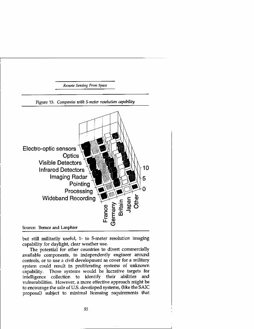
Remote Sensing From Space
Figure 15. Companies with 5-meter resolution capability
Electro-optic sensors Optics
Visible Detectors Infrared Detectors
Imaging Radar Pointing
Processing Wideband Recording
Source: Bernor and Lanphier
*o
but still militarily useful, 1- to 5-meter resolution imaging capability for daylight, clear weather use.
The potential for other countries to divert commercially available components, to independently engineer around controls, or to use a civil development as cover for a military system could result in proliferating systems of unknown capability. Those systems would be lucrative targets for intelligence collection to identify their abilities and vulnerabilities. However, a more effective approach might be to encourage the sale of U.S. developed systems, (like the SAIC proposal) subject to minimal licensing requirements that
91

Plowshares and Power
Figure 16. Companies with sub-meter resolution capability
Electro-optic sensors Optics
Visible Detectors Infrared Detectors
Imaging Radar Pointing
Processing Wideband Recording
Source: Bernor and Lanphier
LL <D
would limit their abilities within well-understood limits. Sale of complete, turn-key systems would reduce the uncertainty of intelligence collection against independently developed systems. It would also benefit the U.S. aerospace industry. The aerospace industry enjoys a temporary comparative advantage due to past investment and the U.S. Government business base. With its advantage it should be able to dominate the international market with relatively safe systems. However, the shrinking U.S. defense budget and subsidized foreign competitors will erode that advantage over time. Needlessly restrictive export controls could hasten the erosion and increase
92

Remote Sensing Front Space
the dangers of proliferation. Minimizing obstacles to the sale of well understood, limited capabilities would help preserve the advantage to American industry and forces in the field.
Opportunity Costs Our last task before describing and evaluating alternatives for response is a review of the competing issues having a stake in the outcome:
• Public good
• Economic gain
• Foreign policy influence
• Security of military forces in the field.
We'll summarize them here, as well as recap some of the observations scattered through the previous discussions and expand on the two covered only briefly.
Public Good The spokesmen for the issues of public good include the academic community, the press, and local governments. Restrictions on quality and kind of remote-sensing could mpede research into global environmental change. Needlessly expensive or scarce land use and resource information could deny local decision makers valuable insight into the consequences of their policies. Finally, institutionalizing restrictions on the press's ability to gather news erodes the fundamental check and balance security of a democratic society.
l
93

Plowshares and Power
Economic Benefit The most active spokesmen for economic issues in remote- sensing are likely to be industry associations representing the satellite builders and operators, value added processors, and resource-prospecting energy and mineral companies. Based on the market projections we examined, those spokesmen may not be compelling. However, there may be no vocal advocate for a greater impact on the broader economy. Let us, therefore, grant a little space here to the possibility that space remote- sensing may be a strategic industry for the United States.
Our earlier discussion of international trade competition with subsidized high technology industries suggested direct losses in U.S. real income to come from the resulting overcapacity. There are also indirect losses to future growth inherent in damage to a strategic industry. In contrast to traditional definitions related to scarce materials or crucial elements of weapons, Martin Libicki of the Institute for National Strategic Studies defines strategic industries in terms of their contribution to economic growth. He would encourage networks of informational and institutional relationships as a stimulant for economic growth. The nodes in the network learn from each other and stimulate business activity by exchanging opportunities to solve each others problems. To define a strategic industry he would ask:
Do improvements [in the strategic industry] . . . lead to problems that the domestic industry is best placed to work on and capable of answering? Can the answers be applied to problems in other sectors . . .? Can other users gain an edge in international competition by enjoying preferential access? ... It is the flow of challenges, not just business, that determines what linkages work ... In order for a nation to maintain an edge,... it needs to find activities that allow it to increase mastery continuously.
Supporting this view, he cites research by MIT's Eric von Hippel that the majority of an industry's new ideas comes from its users (60 percent for semiconductors and 70 percent for
94
Remote Sensing From Space
instrumentation). Libicki would place such information networks in areas of enduring competition and growth, but he cautions that "staying in such markets . . . requires that an economy's network learn faster than that of the competition."134
Is remote-sensing strategic in the sense that Libicki uses? It is clearly an information industry. It is highly networked, bridging across a diversity of using communities, each posing different problems. It challenges and depends on U.S. leadership in other information industries, computing, communications and display hardware, and software. It has spawned an entire industry of high-growth, entrepreneurial, value-added enterprises to solve those diverse problems. Perhaps most important are its ties with both the academic research and business communities.
A long-standing U.S. competitive advantage over Japan has been the U.S. ability to achieve breakthroughs in technology where Japan has focused more on incremental improvement. Japan has, in the past, lacked the quality of university scientific and engineering research, as well as the university infrastructure in libraries, laboratories and computation, and the ties between university and industry that the United States has enjoyed.135 Remote-sensing as an industry makes and strengthens ties with researchers and users for many industries. In balancing the economic impacts of alternative policies to reduce the military hazards of remote-sensing, we should weigh its indirect value as a strategic industry in the balance.
Foreign Policy Influence Our review of the Landsat program's history and markets noted the widespread influence that Landsafs non- discriminatory data policy has had in spreading remote- sensing's benefits and U.S. prestige and influence around the world. We might expect remote-sensing's foreign policy defenders to come from the ranks of State, Agriculture, and AID who use it in the conduct of their diplomacy and assistance. However, the Defense department, the press, conservationists, and arms controllers enjoy its foreign policy
95

Plowshares and Power
benefits as well. Remote-sensing's direct utility in foreign policy is the barter value of its data—to obtain access to other information or to compel compliance with agreement. However, U.S. remote-sensing policy has produced a more subtle and profound result from the general principles set by its example—an example of such American ideals as a free press, free exchange of scientific information, and open skies.
Defense owes the tacit acceptance of its use of space to past U.S. civil remote-sensing policy. Landsat's generous, open skies, nondiscriminatory access helped persuade the developing countries of the UN's Group of 77 to accept the principle of Res Communis for space. Res Communis holds that a commons area belongs to no state and denies exclusive access to any one. The Group of 77 would have preferred to codify that generosity with the more demanding Res Communis Humanitatus, which would treat space as the common heritage of mankind and require states using space to share the benefits with all mankind.136 If Defense had to share the benefits of its use with its adversaries, however, there'd be no benefit. The issue is by no means closed, although the UN Committee on Peaceful Use of Outer Space (COPUOS) did succeed in 1987 in gaining General Assembly approval of fifteen Principles of Remote-sensing in Resolution 41/65, which validated the legality of sensing from space subject to only modest obligations and responsibilities of sensing states with respect to the rights of the sensed states.137 The second of those principles requires that remote-sensing activities be carried out "for the benefit and interests of all countries." The more insecure of the Group of 77 would interpret that principle to require their consent before disseminating any data which might reveal security or economic vulnerability.138 Landsat's record has quieted their concern. A less generous or blatantly mercantile approach to civil remote-sensing could resurrect the issue. At worst, a hostile response could legitimize active interference with remote-sensing—and under that guise, any other space activity to which a nation might object.
Civil remote sensing could provide another, more immediate foreign policy benefit to the military. Modern wars
96

Remote Sensing Front Space
are decided not only on the battlefield but in the court of international public opinion. In the new world order we're most likely to fight coalition wars. Coalitions, like democracies, will not support wars they see as unjust. And the definition of "unjust" in the law of war is determined not in a courtroom but in the consensus formed by the international community. Belligerents have sought to inform (or misinform) that consensus with great success. In Vietnam, although U.S. forces consistently won on the battlefield, North Vietnam attacked the U.S. center of gravity in the living rooms of the American public, and they won. During that war, U.S. authorities used reconnaissance photographs from SR-71 aircraft to debunk North Vietnamese claims of indiscriminate bombing.139 In the Persian Gulf War, Saddam Hussein used Peter Arnett's CNN broadcasts from Baghdad to create the impression of widespread bombing of civilian targets. U.S. authorities had little convincing evidence to offer the public to demonstrate the truth. A moderately capable, civil remote- sensing satellite could provide a credible, impartial source of information to discredit such propaganda. Moderate capability in this context means resolution good enough for the untrained public to recognize a scene, or about five meters. A civil system would avoid the taint of association with the military; an international system would avoid the taint of association with a belligerent. Either one would avoid the risks of disclosing intelligence capabilities as the U.S. did when it published SR-71 photographs.
Conservationists, in and out of government, owe civil remote-sensing a debt for broader international awareness of global change and sensitivity to environmental damage. Arms controllers owe Landsat and SPOT, and press access to their images, for the weight of international public opinion and awareness which helped force the Soviet Union to acknowledge and dismantle the Krasnoyarsk radar ABM treaty violation.140
In addition to remote sensing's diplomatic value as currency for diplomatic barter and as ambassador of good will, optimistic observers have suggested that remote-sensing can be
97

Plowshares and Power
a force for peace in its own right. They offer the hope that increased transparency of international intentions due to the wider availability of commercial remote-sensing can act to reduce tensions in regional hotspots.141 Easily the most optimistic advocate of remote sensing for peace is Edward Teller. He has proposed a network of small sensing satellites under international auspices to provide continuous surveillance of the entire earth's surface for weather forecasting, environmental monitoring, and peace keeping. Teller predicts a peaceful Utopia based on eliminating the element of surprise in aggression:
Observers in space are available for one million dollars apiece; observers that from close quarters and with the help of lasers, can observe almost everything, day and night in good weather and bad; observers that can report to each other and, therefore, in a fraction of a second, transmit to us what they have found;... Those potentials will have a most profound influence on warfare. Their employment can be worked out in such a way that, given the united determination of nations, aggressive war could become practically impossible.142
Teller's cost estimates seem nearly as optimistic as his forecast of the obsolescence of war. But, surely we may forgive the Father of the Hydrogen Bomb a little enthusiasm in his quest for a peaceful mission for his laboratory in this era of peace dividends. Atoms and X-ray lasers for peace would be a tough sell today. More cautious observers would temper his optimism with concern.
Foreign Policy Limits The cautious observer's first concern should be the certainty that widely perceived capabilities for observation will invite more inventive approaches to camouflage and deception. In the face of worldwide concerns over nuclear proliferation, Iraq mounted a nuclear weapons development program on the scale of the Manhattan Project. After Israel destroyed Iraq's Osirak
98

Remote Sensing From Space
nuclear reactor in 1981, Iraq moved its nuclear weapons development program underground and managed to conceal the extent and much of the detail of its existence from the world until UN inspectors began on-site, intrusive investigations after Desert Storm. The program's scope included a budget between $4 and $8 billion. It employed about 20,000 technical workers, including 7,000 scientists and engineers, at a dozen facilities, many of which remained undetected. Iraq was meticulous and comprehensive in hiding the program. Key facilities were disguised as ordinary industrial parks. The extent of the deception testifies to the power of remote-sensing. The deception's success demonstrates its vulnerability, as report by UN inspectors:
Telltale power cables were buried beneath more innocent-looking power cables. An elaborate and costly air filtration system was installed at a Tarmiya building to prevent the escape of even minute particles of incriminating radioactivity. Key buildings at Sharqat, while designed to serve the same function as those at Tarmiya, were deliberately built in a different configuration in an apparent effort to fool reconnaissance.143
A second concern should be the likelihood of instability during the transition to a Utopia of universal awareness. Asymmetries in regional access to data or in ability to interpret it might distort perceptions and raise tensions.144 And, there is some cause for concern about asymmetries even now. Despite good intentions of non-discriminatory access, the uneven distribution and high cost (for many developing nations) of SPOT and Landsat ground stations provide some countries the opportunity for, and therefore the appearance of, preferential access. In addition, SPOT'S tasking policies favor larger customers over smaller ones to increase profits.145 The conflict between non-discriminatory access and profitability is one of the contributing causes for Landsat's commercial failure. We need to keep that conflict in mind also as we evaluate alternatives.
99
Plowshares and Power
We should clearly view Utopian goals for space remote- sensing cautiously—and through third world eyes as well as our own. At least one author from the developing world suggests that the role of commercial satellite imagery for peacekeeping in the developing world is overstated. Most developing-world violence occurs within a country and most often at too low a level for observation by commercial satellite. When preparations for conflicts have been observable by satellites (China-Viet Nam, Indo-Pakistani), they've also been observable by other means—intentions were no surprise to the parties involved. This third world spokesman grouped developing nations as follows:
• Those too small (about 80) to afford even commercial remote-sensing images who must rely on their neighbors observing international norms of behavior. The neighbors often don't have enough force to mobilize to be observable in any case.
• About a dozen that are aware of remote sensing's advantages, can't develop their own, and will want to buy,
• About 20 to 25 that either don't face cross-border threats or have more affordable or appropriate sources of information for their security (human spies, aerial reconnaissance, signals interception, or open sources),
• A handful (China, India, Brazil, Pakistan) that can and probably will develop their own remote-sensing satellites146
His points are worth taking. But, his accounting should be subject to periodic re-audit. The groupings will change as the price of remote-sensing drops—with advancing technology or in response to growing markets. Also, the scarcity of threats to developing nations will change as surplus arms and arms industries make the means available and the declining
100

Remote Sensing From Space
influence of superpower rivalry brings old regional rivalries to the fore again. A more multipolar world will have more, and more varied, sources of conflict. They will either increase the need for a stabilizing influence from remote-sensing for peace keeping, or they will certainly encourage regional capabilities in remote-sensing for war fighting. The former might be an opportunity; the latter would undoubtedly make the world a more dangerous place for U.S. forces.
Military Forces We discussed the battlefield implications of proliferated remote sensing at some length in earlier sections. We need repeat here only the admonition that commanders will need the means at least to manage the perceptions their opponents might derive from the vantage of space, and possibly the means to deny them observation for a time. With this warning we should also note with certainty that opponents will attempt to develop the same means themselves, whether we do or not.
Alternative Reactions We'll consider two classes of strategy for reacting to proliferating capabilities in remote sensing. The first attacks supply, the second demand. The first is export control or limits on technology transfer. The second is market preemption—deliberate action to satisfy demand with a safer alternative than the market might otherwise supply. There is an implicit third class. In the event the first two fail, U.S. forces should be prepared to defeat an adversary's remote- sensing with direct means: camouflage, concealment, deception, and attack of the means of sensing and dissemination.
Supply Side Existing controls on the supply of space remote-sensing technology are wholly inadequate to prevent or even detect possible misuse of remote-sensing technology. Their inadequacy is not for lack of regulation. Commerce Department
101
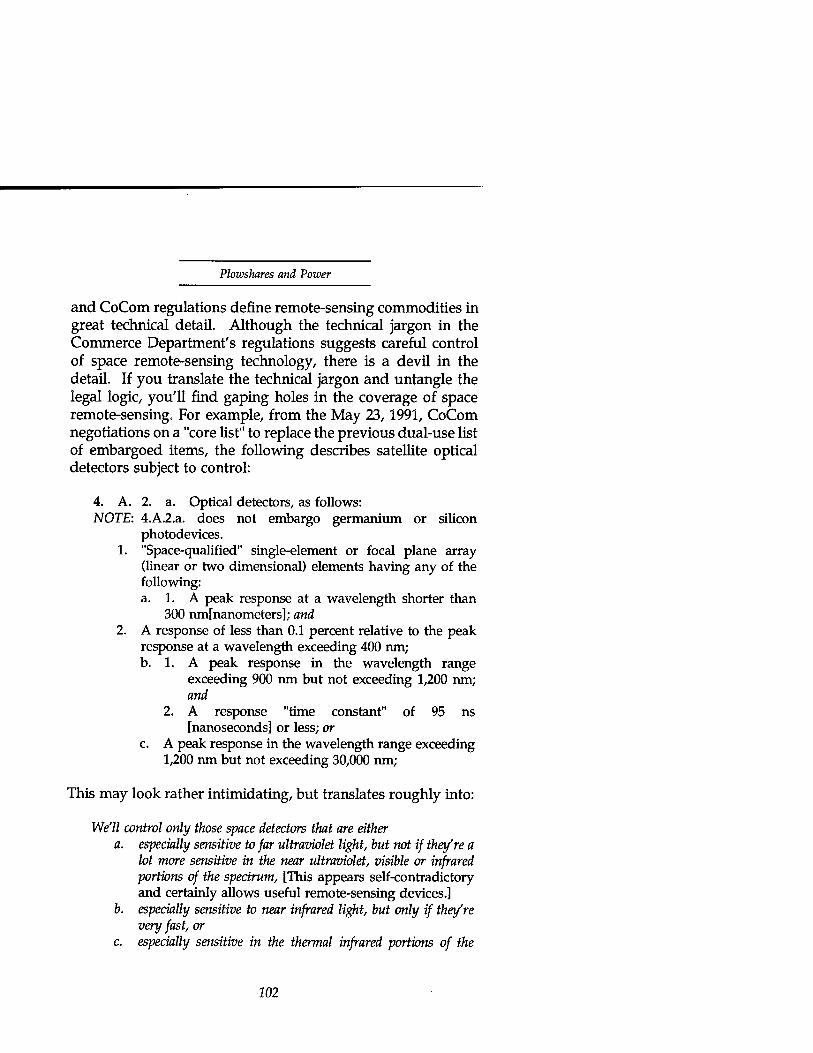
Plowshares and Power
and CoCom regulations define remote-sensing commodities in great technical detail. Although the technical jargon in the Commerce Department's regulations suggests careful control of space remote-sensing technology, there is a devil in the detail. If you translate the technical jargon and untangle the legal logic, you'll find gaping holes in the coverage of space remote-sensing. For example, from the May 23,1991, CoCom negotiations on a "core list" to replace the previous dual-use list of embargoed items, the following describes satellite optical detectors subject to control:
4. A. 2. a. Optical detectors, as follows: NOTE: 4.A.2.a. does not embargo germanium or silicon
photodevices. 1. "Space-qualified" single-element or focal plane array
(linear or two dimensional) elements having any of the following: a. 1. A peak response at a wavelength shorter than
300 nmfnanometers]; and 2. A response of less than 0.1 percent relative to the peak
response at a wavelength exceeding 400 nm; b. 1. A peak response in the wavelength range
exceeding 900 nm but not exceeding 1,200 nm; and
2. A response "time constant" of 95 ns [nanoseconds] or less; or
c. A peak response in the wavelength range exceeding 1,200 nm but not exceeding 30,000 nm;
This may look rather intimidating, but translates roughly into:
We'll control only those space detectors that are either a. especially sensitive to far ultraviolet light, but not if they're a
lot more sensitive in the near ultraviolet, visible or infrared portions of the spectrum, [This appears self-contradictory and certainly allows useful remote-sensing devices.]
b. especially sensitive to near infrared light, but only if they're very fast, or
c. especially sensitive in the thermal infrared portions of the
102

Remote Sensing From Syace
spectrum, and, oh by the way, if you use silicon or germanium [as do most of the Charge-Coupled Devices—CCD's—that appendix A describes], instead of more exotic materials, we won't control at all
These restrictions would allow the unrestricted sale of virtually any visible imaging capability and many infrared capabilities as well. They say nothing about visible wavelengths or spatial resolution at any wavelength. The restrictions on optical detectors represent a typical example. The Core List proposed similarly ineffective restrictions on non-space qualified components (which could be qualified for space use after sale), multi-spectral sensors, imaging cameras, and most of the other components of a space remote-sensing system. The regulations aim at the Soviets and embargo only the highest performance to preserve a lead over them. But the ultimate in technology is not necessary for effective remote-sensing, and the industrial East is a source of the dangerous technology, not the destination of concern.
What kind of controls might help? From our survey of critical remote-sensing technology, it's clear that effective controls will have to be multi-lateral, involving at a minimum cooperation with France, Germany, Japan, Canada, Britain, and whichever of the former Soviet republics retain abilities in space remote-sensing. If the United States has any unilateral leverage in chokepoint technology, it is probably in technology for satellite tape recorders and probably not enough to prevent alternate solutions using semi-conductor memory or data relay to the ground. Multi-lateral controls with those countries could interdict any or all of the technologies listed in figures 14 through 16. To be most effective and to minimize economic loss, they should avoid items traded on a large quantity "commodity" basis or widely available to public consumers. This includes optics and electronic or computer components sold to the consumer and business markets.
For multi-lateral controls to work, the participants would need adequate incentive to offset whatever political or economic losses they'd incur. In the case of remote-sensing,
103

Plowshares and Power
their opportunity costs do not appear to be all that high, yet. Remote-sensing satellites and components are not trade commodities in the sense of consumer electronics or personal computers. The market for satellites, as crowded as it looks, is small in both absolute numbers and dollars. The incentive for participation in multi-lateral controls is the self-interest that led France to embargo SPOT imagery of the Persian Gulf when its troops were deployed there. For rational actors that value the lives and effectiveness of their militaries, that self-interest should outweigh the opportunity costs.
If there were to be an unbearable opportunity cost to supply side controls, it would probably come from civil dependence on remote-sensing data products, similar to the dependence on civil weather satellites that made them available to Iraq during the Persian Gulf war. Such a dependence does not exist yet, but could develop if land remote-sensing satellites were to provide operational warning of geological (earthquake or mudslide) or fire danger in the same way that weather satellites do for storms. To prevent such an unhappy choice, operators of remote-sensing satellites must be able to embargo or delay dissemination (or, failing that, collection) of information in selected areas without harming operations for the rest of the world. There is precedent in the UN resolution on principles of remote-sensing to require this ability even of purely commercial remote- sensing operators. Principle 14 holds states explicitly responsible for the remote-sensing activities of their commercial entities.147 If we do nothing else to limit supply or demand for dangerous remote-sensing capability, we should encourage and practice positive control of data dissemination and collection on a geographically selective basis. Adequate technology to secure information is readily and cheaply available. The world applies it now to secure financial transactions. John Carroll and Lynda Robbins described the state of commercial encryption technology: "Any enterprise can obtain hardware or software capable of supporting private communications with any desired level of time-space-complexity resistance to cryptanalysis. This option is available to any business—big
104

Remote Sensing From Space
business, small business, bad business, or monkey business."148
Insuring against misuse of civil remote-sensing satellites is no monkey business. For the small numbers of remote-sensing satellites and ground stations, the costs to secure or delay data dissemination and assure tasking control are small. The price of failing to do so will be paid in the blood of soldiers.
Demand Side Our objective for these alternatives is pre-emptive market dominance. The method is to make readily available either safer or more controllable products that pre-empt more dangerous, less controllable, international developments that might otherwise respond to market demands. They would also, therefore, remove a potential cover for clandestine developments.
The means could be government, commercial, or mixed. For example, a government approach might accelerate and expand NASA's Mission to Planet Earth and make its data freely available in the international public interest, without preferential access to reward principal investigators or participating governments. Alternatively, it might provide a substantially enhanced Landsat follow-on under similarly generous data-sharing terms. A purely commercial approach might only need to clarify licensing requirements to reduce the perception of regulatory risk for a commercial venture. In a mixed approach government might try to reduce the perception of market risk for a commercial venture by supporting financing or by guaranteeing a government "anchor tenant" customer. The purely government approaches are the least cost efficient and probably the least effective in finding (and pre-empting more dangerous responses to) the marketplace's demand. If market entry costs are not too high, the purely commercial enterprises might be the most cost efficient and likely also the most effective, but they might not be quick enough to preempt international competitors. The intent of government assistance to a mixed strategy should be to speed market entry, not to support a marginal operation.
105
Plowshares and Power
The terms of support should support that goal.149
A variation on these unilateral approaches to market preemption would be multilateral cooperation. This could take any number of forms:
• Multi-national scientific cooperation
• An international commercial consortium
• An international civil remote-sensing service
• An international peace-keeping satellite network.
The International Space Year's Mission to Planet Earth could provide the basis for the first of these. Its Space Agency Forum (SAFISY) includes representatives from 23 countries. It is part of a two-decade plan of research on the global environment, that has standardized data formats and coordinated spacecraft plans.150 To be effective in restraining remote-sensing proliferation, the program's structure would have to change to broaden access and commercial utility as well as to secure data and tasking against misuse.
INTELSAT and INMARSAT, the international satellite communications consortia, provide a model for the second multilateral approach. Although both developed originally to share the high entry costs for satellite communications among many partners, they have since discouraged entry by independent commercial satellite operators. Their monopolies have cost the international communications customer much of the benefit of competition. But, for remote-sensing any eventual losses due to monopoly could be a small (and certainly a hidden) price to pay for the increase in security. At present, with so many countries vying to create an oversupply of data sources at taxpayer expense, a remote-sensing consortium would be a more efficient approach for society. In 1988, John McLucas, chairman of the U.S. International Space Year Association, proposed just such a consortium, modelled on Inmarsat, for both land remote-sensing and weather
106

Remote Sensing From Space
satellites. The goal was efficiency through cooperative effort. He pointed out then that participation in an "Envirosat" consortium would give the United States greater influence over potentially dangerous capabilities than would a continuing proliferation of national remote-sensing systems.151
The UN's World Meteorological Organization suggests the possibility of the third multilateral approach. We've already noted its success in standardizing weather satellite downlinks. It established the practice of open access to data and the principle of remote-sensing for the common good. It would seem only a small step to extend the practice and the principle to land remote-sensing. It might even be possible to combine the two, weather sensing and land sensing, under a single sponsorship and repair the historical error of failing to secure weather satellite data. The distinction from Envirosat is primarily in the source of funding.
Dr. Teller's Brilliant Eyes approach to Utopia is only one of many proposals for the last of these multilateral forms of market preemption—a space-based security system. Canadian Walter Dorn152 has chronicled a succession of proposals for peace-keeping satellites, beginning in the 1950's and continuing to more recent French, Canadian, and Soviet proposals for an International Satellite Monitoring Agency,153 PAXSAT,154 and a World Space Organization155 respectively.
Common to all of these multilateral mechanisms, whether scientific, civil, commercial, or security based, is the need to clearly vest control in a supra-national authority. The taint of any single nation's dominance, especially the last superpower's, would only encourage other countries to seek their own means. Similarly, the appearance of a remote-sensing cartel of wealthy nations would cause the same kind of distrust and encourage rather than discourage proliferation. Because of this need for its sponsors to surrender a degree of sovereignty, a security- oriented mechanism is the least attractive of these alternatives.
A security-oriented system would also of necessity have more dangerous capabilities in resolution, revisit, and timeliness than any of the other alternatives would need. Those capabilities under international supervision would quickly
107
Plowshares and Power
become internationally understood. Wider understanding would be its Achilles heel. We've noted in the example of Iraq's Manhattan Project that such understanding would lead to more widespread countermeasures: Camouflage, concealment, deception and possibly direct anti-satellite or anti- sensor attacks. As glamorous as space-based world peace might sound, it would be costly, vulnerable, and more likely to worsen the proliferation of military space. Far better, as Iraq's nuclear revelations have illustrated, is wider opportunity for knowledgeable people to come forward and the international community to respond. Satellites may look past closed borders, but they see only what is open to the sky, and they cannot see intentions. If a new world order based on the rule of law is to work, it will work more effectively and more cheaply by opening borders than by peering past them from the distance of orbital altitudes.
Of the remaining multilateral demand-side alternatives, any one or more could help. Their relative merits depend on the viewer's opinion of government versus market efficiency and reliability. Combination with a modest degree of supply-side restraint on proliferating remote-sensing technology could help without undue cost, if export controls are selective and minimal.
The most likely impediment to U.S. participation in an effective multilateral arrangement would be U.S. domination of the attempt. Consider this Congressional Committee report discussion of Landsat alternatives:
Although an international joint venture (either bilateral or multilateral) may at some point be appropriate, the Committee stresses that this option should be employed only after the U.S. has developed a stable long-term program. We should negotiate with any future international partners from a position of strength, not weakness. Moreover, any agreement should maintain the current U.S. technical leadership in spacecraft development.156
The past inability to sustain a stable Landsat program
108
Remote Sensing From Space
makes the United States seem an unreliable prospect for partnership in funding an international effort. Insistence on maintaining U.S. technical leadership ignores international progress that has already eroded that leadership. And, a U.S. position of strength, if ever achievable or even perceived, would undermine the effectiveness of the international cooperation.
If this example of Congressional sentiment is typical, a commercial consortium may be more likely to begin and more likely to succeed at restraining international demand for dangerous remote-sensing capabilities. It is already the model for the leader in civil and commercial remote-sensing, the European SPOT program. We might find it easier to broaden that consortium and influence its progress in responsible and safer directions than to compete with it.
If the U.S. Government desires, a consortium of one form or another is a realistic possibility. France approached NOAA representatives in 1988 at the Montreal Space Commerce Conference to gauge U.S. interest in a joint venture with SPOT. In response to the 1988 Congressional language that tasked the contractor studies of commercial Landsat alternatives we reviewed earlier, NOAA initiated informal contacts with Japanese and French government officials. At the time the Japanese were not interested in a cooperative venture. The French were—with an eye to a cooperative follow-on to then- Spot 4. Working level discussions followed to explore organizational structures that would combine government and commercial activities. The discussions assumed equal funding by the two countries with the possibility for other countries to join the consortium later. They did not get to the level of detail that would have defined means and circumstances for controlling the timing and extent of dissemination of data products to protect national security. The discussions lasted from early 1988 through May 1989 when a National Space Council decision committed the administration to maintaining Landsat data continuity with a U.S. system.157
109

Plowshares and Power
Conclusions Space remote-sensing is a powerful tool that cuts two ways—as a public service and a military force multiplier.
Civil space remote-sensing with increasing military utility (and risk to U.S. forces) is an international fact of life and quickly proliferating. Its proliferation is producing an oversupply of sensing systems for civil use, but leaving open the possibility of commercial enterprises filling niche markets with more dangerous capabilities.
International interest in military use of space remote sensing is similarly widespread and growing. Proliferating civil systems provide the technology, cover, and incentive to sell military capabilities to those interested.
The technology base for space remote sensing is spread throughout the world's industrialized nations, with notable capability in the United States, France, Germany, Japan, and Russia. Effective action to control proliferation will need all their participation. Dangerous capabilities do not require the most sophisticated technology.
The military impact of this proliferation is cause for concern, but not yet catastrophic. Potential military responses include improvements in concealment and deception, direct countermeasures, and force structures that emphasize speed and concentration of destructive power.
Existing U.S. export controls are ineffective, aimed at the wrong countries and commodities, and probably counterproductive both for proliferation control and for U.S. industry. Modest multilateral controls on chokepoint technology could help reduce the supply of dangerous remote sensing.
Existing and proposed law and regulation of U.S.
110
Remote Sensing From Space
commercial remote sensing discourage market entry and place U.S. operators at a distinct disadvantage in international competition.
In conjunction with multi-lateral technology controls, encouraging the sale of limited capability systems could reduce the likelihood of surprise by developments that circumvent controls. U.S. industry is well positioned now to dominate the market for such systems and thereby establish de facto standards for relatively safe, well understood remote-sensing systems. If continuing unilateral controls delay their entry into the international market for such systems, their comparative advantage will erode due to declining U.S. defense budgets and continuing foreign subsidies of their competitors.
Multilateral structures provide several interesting alternatives to reduce the demand for dangerous remote- sensing. Among them, an international civil or commercial consortium appears the best prospect. International space- based security structures are the least likely to succeed and pose a potentially greater danger than current proliferation.
At a minimum, the United States should encourage, in custom at least and in treaty where possible, the principle that a state's responsibility for its space remote-sensing activities includes the obligation to assure that it can embargo harmful use of the data without harm to legitimate users.
Notes 1. The sense of "smell" is provided through the identification of
chemical composition by sophisticated spectral sensing methods. 2. To a new observer concerned with the proliferation of
military utility, they are fast becoming commodities. A long-time worker in the field assures me they're slowly becoming commodities. Carl Schueler, Hughes Santa Barbara Research, June 8,1992.
113

Plowshares and Power
3. Events in the Persian Gulf, the Balkans, Georgia, Moldova, Azerbaijan, and Armenia illustrate the rise in violence accompanying the decline of superpower competition. The removal of a strong, monolithic foe with the means to destroy the United States is small cause for complacency. Its replacement is a disintegrating collection of economically devastated, smaller states still armed with nuclear weapons and exporting the expertise to develop them (if not the weapons themselves.)
4. Congress, House, Committee on Science and Astronautics, 87th Cong., Hearings on National Meteorological Satellite Program, July 25-27,1961 (Washington, DC: GPO,1961), 39.
5. Ibid., 19. 6. Ibid., 114. 7. Tao Hanzhang, Sun Tzu's Art of War (New York: Sterling
Publishing Co., 1990), 94. 8. Hatsuho Naito, Thunder Gods, The Kamikaze Pilots Tell Their
Story (New York: Kodansha International, 19890, 24. 9. Elmer B. Potter and Chester W. Nimitz, The Great Sea War
(Englewood Cliffs, NJ: Prentice-Hall), 76. 10. Anthony Cave Brown, Bodyguard of Lies (Bantam Books, NY:
1976), 263-276. 11. Malcolm F. Willoughby, The U.S. Coast Guard in World War
II (Annapolis, MD: Naval Institute Press, 1989), 95-100. 12. Brown, 263-266. 13. Willoughby, 100. 14. Willoughby, 95. 15. Brown, 639. 16. Carlo D'Este, Decision in Normandy (New York: Harper
Perennial, 1991), 109, 110, 147. D'Este also recorded a German assessment on the criticality of Rommel's absence: "Rommel's forceful presence on 6 June could substantially have changed events. One who believes this is General Siegfried Westphal, von Rundstedf s able and respected Chief-of-Staff, who has remarked: '[Rommel] would not have put up with the holding back of the Panzer divisions by the OKW in the hinterland, as was the case.
17. Hearings on National Meteorological Satellite Program, July 25-27, 1961, 101.
18. Ibid., 19. 19. Ibid., 103.
Ill
Remote Sensing From Space
20. Congress, House, Subcommittee on Applications and Tracking and Data Acquisition, Committee on Science and Astronautics, Hearings on Meteorological Satellites, August 28-30, 1962 (Washington, DC: GPO, 1962), 47.
21. Ibid., 290. 22. Ibid., 8. 23. USAF, Reaching Globally, Reaching Powerfully: The United States
Air Force in the Gulf War (Washington, DC: Department of the Air Force, September 1991), 23-4.
24. Colonel William Klein, Director, Environmental Intelligence, OSD/DDR&E, October 7,1991, private communication.
25. Joint Chiefs of Staff, Proposed Final Publication: Basic National Defense Doctrine (Washington, DC: JCS, May 1991), 2-11.
26. Peter D. Zimmerman in Michael Krepon et al. eds., Commercial Observation Satellites and International Security (New York, NY: St. Martin's Press, 1990), 19: 203.
27. Peter Zimmerman, CSIS, personal communication, March 8, 1992.
28. Tsipis, 68. 29. Ann M. Florini, "The Opening Skies: Third-Party Imaging
Satellites and U.S. Security," International Security 13, no. 2 (Fall 1988): 98-99.
30. Allen V. Banner, Overhead Imaging for Verification and Peacekeeping: Three Studies (Ottawa, The Arms Control and Disarmament Division, External Affairs and International Trade Canada, March 1991), 21-7.
31. Theresa Foley, "SPOT Markets New Products Commercially," Space News, June 24-July 7, 1991, 25.
32. Leonard Spector in Krepon, 130-1. 33. Leith and Simpson in Krepon, 12: 122. 34. Tsipis: 185-186. 35. KRS Remote-sensing, Study for an Advanced Civil Earth Remote-
sensing System, Landover, MD, August 1988, vol. Ill, appendix A, ATMOS.
36. Goddard Space Flight Center, 1990 Earth Observing System Reference Handbook (Washington, DC: NASA, 1990), 87-8.
37. Norman Schwarzkopf, "Central Command Briefing, Riyadh, Saudi Arabia, February 27,1991," Military Review, September 1991,97.
38. William G. Pagonis and Harold E. Raugh, Jr., "Good Logistics is Combat Power," Military Review, September 1991, 34-7.
113
Plowshares and Power
39. Vern Lanphier, "Proliferation of Space Technology," Briefing to Deputy for Non-Proliferation Policy, International Security Affairs, Office of the Secretary of Defense, Bernor & Lanphier, October 18, 1991.
40. Thomas E. Cremins, "Security in the Space Age," Space Policy, February 1990, 44.
41. William Kennedy and Mark Marshall in Krepon, 20: 209 42. "The Implications of Establishing an International Satellite
Monitoring Agency," Department for Disarmament Affairs, Report of the Secretary General (New York: United Nations, 1983), 44-6.
43. Peter S. Kindsvatter, "VII Corps in the Gulf War," Militari/ Review, January 1992, 14-15.
44. Verification of unit positions by Capt Mark Traylor, Combined Arms Research Library, U.S. Army Command & General Staff College, using 1st Cavalry Division Tactical Command Post logs and 2nd Battalion, 29th Field Artillery Combat Historical Summary. Capt Traylor was on the scene, assigned to the 1st Battalion of the 82nd Field Artillery, at the time of the image.
45. Thomas G. Mahnken, "Why Third World Space Systems Matter," Orbis (Fall 1991): 577.
46. Schwarzkopf, 97. 47. Colonel Archibald Percival Wavell, The Palestine Campaigns
(London, Constable and Co., 1928), 103-8. 48. Ibid., 200-201. 49. General Sir Archibald Wavell, Allenby: A Study in Greatness
(Oxford University Press, NY, 1941.), 270. 50. Bernard Law, Viscount Montgomery of Alamein, The Memoirs
of Field-Marshal the Viscount Montgomery of Alamein, K.G. (Cleveland: The World Publishing Company, 1958), 108-11.
51. Brown, 116-21. 52. Montgomery, 108-112. 53. War Department, War Department Field Manual FM 100-20,
Command and Employment of Air Power (Washington, DC: GPO, 1944), 3-4.
54. F. W. von Mellenthin, Panzer Battles, A Study of the Employment of Armor in the Second World War (New York, Ballantine Books, 1971), 175.
55. The source in Britain's Cairo GHQ was a major in the habit of taking his briefcase full of secrets to the houseboat where his mistress, Hekmeth Fahmy, lived. Fahmy, a leading belly dancer, was also an agent for the Muslim Brotherhood and Rommel's Condor spy
114
Remote Sensing Front Space
ring. While Fahmy entertained the major, Condor agents would read his papers. When British intelligence broke the Condor ring, they preserved its radio link to Rommel and used it to deceive the Germans about the timing of the attack on Alam Haifa. To deceive them about the location of the attack, they compelled the major to carry a false map of the Ragil Depression and drive a scout car in the vicinity of the German lines. They blew up the car and the major in sight of the Germans, who recovered the map from his corpse. Brown, 106-113.
56. Brown, 112-115. 57. von Mellenthin, 172. 58. David P. Radzanowski, 'The Future of Land Remote-sensing
Satellite System (Landsat)," CRS Report for Congress, 91-685 SPR, September 16,1991, 11.
59. Mary Umberger in Krepon, 2: 12. 60. Congress, Senate, Subcommittee on Science Technology, and
Space of the Committee on Commerce, Science and Transportation, Hearing on Landsat Commercialization, March 22,1984 (Washington, DC: GPO, 1984), 4-41.
61. David Moore, "Encouraging Private Investment in Space Activities" (Washington, DC, Congressional Budget Office, February 1991), 46.
62. Radzanowski, 2-16 63. Space News, October 11-17, 1993, 20. 64. Jeffrey K. Manber, "Running Landsat into the Ground," Across
the Board, June 1987,42-3. 65. KRS 1988, vol. II: 14-15. 66. Congress, House, Introduction of Landsat Continuity Act of
1991, H3615-3617, Congressional Record (May 23,1991). 67. Ibid. 68. Congress, House, National Land Remote-sensing Policy Act
of 1991, Discussion Draft, October 18,1991,18-19. 69. Ibid., 20-21. 70. Congress, Senate, Land Remote-sensing Policy Act of 1992,
S2576, Congressional Record (February 27,1992). 71. Since then, Landsat 7 began development under Air Force
contract for eventual NASA operation after launch (scheduled March 1998). The schedule includes development of a new 5-meter resolution sensor (Space News, October 11-17,1993, 20).
225

Plowshares and Power
72. Despite recent budget pressures EOS still dwarfs Landsat. NASA, responding to EOS budget reductions from $17 billion to $11 billion through the year 2000, deferred 13 of 30 instruments and revised plans for two large platforms to fly six satellites of varying sizes instead. James R. Asker, "NASA Reveals Scaled Back Plan for Six EOS Spacecraft," Aviation Week & Space Technolog}/, March 2,1992, 61,
73. Ibid., 2, 4-6. 74. Goddard Space Flight Center, 1990 Earth Observing System
Reference Handbook, 15-16. 75. Brown, 9. 76. Peter Didisheim, Deputy Chief of Staff, U.S. House of
Representatives, Committee on Science, Space and Technology, interview October 25,1990.
77. Colonel James Beale, National Space Council Staff, December 19, 1991.
78. Commerce Business Daily, Landsat 7 Spacecraft, February 25, 1992, Issue PSA-0538, Section 18 Space Vehicles Potential Sources Sought, and Landsat 7 Spacecraft, April 15, 1992, Issue PSA-0574, Section 18 Space Vehicles.
79. Testimony of David Julyan, Executive Vice President, SPOT Image Corporation, before Congrews, House, Committee on Science, Space and Technology, May 1990,11-31.
80. Frederick B. Henderson, Commercial Objectives, Capabilities and Opportunities of International Earth Observation Programs, NASA Contract NAS13-315, P.O. P12-774 (Norman, OK: HENDCO Services, February 22, 1990), 111-11,12.
81. David Moore, Encouraging Private Investment in Space Activities (Washington, DC, Congressional Budget Office, February 1991), 22-3.
82. Congress, Senate, Subcommittee on Science Technology, and Space of the Committee on Commerce, Science and Transportation, Hearing on Landsat Commercialization, March 22,1984 (Washington, DC: GPO, 1984), 86-88.
83. Julyan, 11-12. 84. Richard Baldwin and Paul Krugman, "Industrial policy and
international competition in wide-bodied aircraft," in Richard Baldwin, ed, Trade Policy Issues and Empirical Analysis (University of Chicago Press).
85. Hearing before Congress, House, Committee on Science, Space and Technology, May 1990, 43.
86. Ibid., 42.
116

Remote Sensing From Space
87. Henderson, 111-14 -15. 88. Frederick B. Henderson, The Geosat Committee News (Norman,
OK: The Geosat Committee, December 31,1990), 4. 89. Nicholas L. Johnson, The Soviet Year in Space, 1990 (Colorado
Springs, CO: Teledyne Brown Engineering, February 1991), 98-122. 90. Ibid., 28,36. Sovinformsputnik now offers 2-meter resolution
imagery for sale and promised imagery to match future offerings from the world's "enhanced observation systems and design concepts" (Space Liaison International Corp. advertisement in Space News, October 18, 1993,12).
91. Paul R. Krugman, Rethinking International Trade (The MIT Press: Cambridge, MA, 1990), 164.
92. KRS, 1988. 93. T. H. Lee Williams and Sally L. Gros, User Needs Study of an
Advanced Civil Earth Remote-sensing System for Energy Resource, (Norman, OK: Cooperative Institute for Applied Remote-sensing Energy Center, September 1988), 44-55.
94. Frederick B. Henderson, User Market Survey for Japanese Resources Satellite -1 (JERS-1) Satellite Data (Norman OK: HENDCO Services, April, 1990), 2.
95. KRS 1988, vol. II, 14-15, 20-25. 96. Congress, House, Subcommittee on Natural Resources,
Agriculture, Research and Environment of the Committee on Science, Space, and Technology, Hearing on "Proposed Termination of Landsat 4 and 5," March 7, 1989, no. 43 (Washington, DC: GPO, 1989), 5-6.
97. Williams and Gros, 36-42. 98. Theresa Foley, "SPOT Markets New Products Commercially,"
Space News, June 24-July 7,1991, 25. 99. Eric Moore, Ultimap Inc, Cherry, NC, Telephone
conversation, October 2,1991 100. Foley. 101. Statistical Abstract of the United States, 1990,110th Edition
(Washington, DC: Department of Commerce, Bureau of the Census), 291-2.
102. Renee Saunders, "Remote-sensing Firms Await Expected GIS Market Boom," Space News, November 25-December 1,1991,16.
103. MarkE. Brender, "High Resolution Remote-sensing by the News Media," Technology in Society, Vol. 11, 1989, 94-95.
117

Plowshares and Power
104. Richard DalBello, Ray A. Williamson, and Gordon Law, "Commercial Newsgathering From Space" (Washington, DC: Office of Technology Assessment, May 1987), 2-6.
105. Ibid. 106. New York Times v. United States, 403 U.S. 713,724, 1971,
Stewart and White concurring. 107. Ibid., Brennan concurring. 108. Hugh DeSantis, "Commercial Observation Satellites and
Their Military Implications: A Speculative Assessment," The Washington Quarterly (Summer 1989): 186-7.
109. Temple, Barker & Slain, "Economic Feasibility of Private Sector Participation" in Remote-sensing Satellite Systems (Lexington, MA: TBS Summary Report for NASA/DoC Presidential Task Force, 24 May 1979), 3.
110. 'Private Sector Involvement in Civil Space Remote-sensing" (Washington, DC: NASA, DoC/NOAA, Department of Interior, Department of Agriculture, DoD, EPA, Department of State, June 15, 1979), Appendix 7.
111. The Egan Group, "Study for Advanced Civil Earth Remote- sensing System," Study for DoC, NOAA, under NOAA Contract 50MANE800003 (Washington, DC: The Egan Group, August 1988), Executive Summary 2-4.
112. Arthur Bass et al., "A Study of an Advanced Civil Earth Remote-sensing System," Report T-5629-1, study conducted for DoC, NOAA, NESDIS under Contract 50MANE84002 (Reading, MA, The Analytic Sciences Corporation, August 1988), 1-9—1-14.
113. James R. Wert, Wiley J. Larson, eds., Space Mission Analysis and Design (Norwell, MA: Kluwer Academic Publishers, 1991).
114. The 20 percent return on investment is not terribly sensitive to the assumptions in the cost estimate. For example, if we were to inflate the $12 million launch cost (based on a Pegasus-class commercial launch) to $80 million, the return on investment drops only to 16 percent.
115. KPMG Peat Marwick, Mapsat Market Review (Washington, DC: February 1991), 5-6, 9 ,21, 28, 38.
116. Richard DalBello et al., "Commercial Space Ventures: A Financial Perspective" (Washington, DC: Department of Commerce, April 1990), 55.
117. PL 98-365, Title 15 U.S.C Section 2401 et seq. Proposed rules are in Department of Commerce, National Oceanic and Atmospheric Administration, Notice of proposed rulemaking: 15 CFR
118

Remote Sensing Front Space
Part 960, Licensing of Private Land Remote-Sensing Space Systems, Federal Register 51, no. 56, March 24,1986, 9971-9976.
118. Ibid., 9977. 119. Department of Commerce, National Oceanic and
Atmospheric Administration, Part 960 of 15 CFR, Licensing of Private Remote-Sensing Space Systems, July 6,1987, Federal Register 0uly 10, 1987), vol. 52, no. 132, 25970-4.
120. Ibid., 25971. 121. Ibid., 25974. 122. Eric Kamenitzer, EOSAT, interview January 16,1992. 123. Land Remote-sensing Policy Act of 1992, 2577. 124. Florini, 103-4. 125. Defense News, November 4,1991, 3, 29. 126. Scotty Fisher, "Iraqi Missile Attacks Spur Backing for Israel
Military Satellites," Armed Forces Journal International, April 1991,29. 127. Mark Brender, ABC News, interview October 28,1991. 128. Al Myers, Richard B. Colton, and John M. Papazian,
"Remote-sensing Small Satellite System," briefing given to Defense Technology Security Administration by SAIC, April 25, 1991,5-7.
129. Al Myers, SAIC, telephone conversation October 29,1991. 130. LtCol Brett Watterson, Office of the Deputy Assistant
Secretary of the Air Force for Space Plans and Policy, November 6, 1991.
131. Space News, October 27,1991, 20. 132. "JPEG Compression Board Does 30-Frames-per-Second
Video," PC Magazine, November 26,1991, 66. 133. M. David Stone, "Opta's MonaLisa: True Color Plus
Compression is Something to Smile About," PC Magazine, December 31,1991, 42.
134. Martin C. Libicki, "What Makes Industries Strategic?," McNair Paper Number 5, (Washington DC: Institute for National Strategic Studies, 1989), 23-33.
135. John Deutch, "The National Interest," Technology Review, November/December 1991, 73.
136. Carl Q. Christel, "Outer Space Exploitability, International Law and Developing Nations," Space Policy, May 1990,147.
137. Ibid., 151-3. 138. Bhupendra Jasani and Christer Larsson, "Security
Implications of Remote-sensing," Space Policy, February 1988,58-9. 139. Hays Parks, Chief, International Law Division, Office of the
Army Judge Advocate General, December 9,1991.
119
Plowshares and Power
140. Peter D. Zimmerman, "Remote sensing satellites, superpower relations, and public diplomacy," Space Policy, February 1990, 23.
141. Peter D. Zimmerman, "Remote-sensing satellites, superpower relations, and public diplomacy," Space Policy, February 1990, 31.
142. Edward Teller, Keynote Speech to 6th National Space Symposium Colorado Springs, CO, April 9,1990,11-17.
143. R. Jeffery Smith and Glenn Frankel, "Saddam's Nuclear-Weapons Dream: A Nightmare Come True," Washington Post, October 13, 1991, A44-5.
144. DeSantis, 186. 145. Leonard S. Spector, "Not-so-open Skies," Space Policy,
February 1990,11. 146. K. Subrahmanyam, in Krepon, 10:105-107 147. N. Jasentuliyana, "UN Principles on Remote-sensing, an
Agreement on Economic Relations," Space Policy, November 1988,282. 148. John M. Carroll and Lynda E. Robbins, "Using Binary
Derivatives to Test an Enhancement of DES" in Deavours, Cipher, et al, Cryptology: Machines, History & Methods (Norwood, MA: Artech House, 1989,) 260.
149. By November 1993 there has been some progress in this direction. The CIA director reportedly has spoken out in favor of a government policy allowing commercial sales of 1-meter resolution satellite imagery ("CIA Ends Opposition to Sale of Spy-quality Satellite Images," Japan Times, November 14,1991, 4).
150. Cremins, 35. 151. John L. McLucas and Paul M. Maughan, "The Case for
Envirosat," Space Policy, August 1988, 234-6. 152. Walter H. Dorn, Peace-Keeping Satellites: The Case for
International Surveillance (Dundas, Canada: Peace Research Institute, 1987), 86-117.
153. "The Implications of Establishing an International Satellite Monitoring Agency," Report of the Secretary General, Department for Disarmament Affairs (New York: United Nations, 1983).
154. F. R. Cleminson, "Paxsat and Progress in Arms Control," Space Policy, May 1988, 97-102.
155. A. S. Piradov, "Creating a World Space Organization," Space Policy, May 1988,112-114; Kyril B. Serafimov, "Achieving Worldwide Cooperation in Space," Space Policy, May 1989,111-116 .
120

Remote Sensing From Space
156. Congress, House, Committee on Science, Space, and Technology, Report 101-519, Part 2: Committee Report to Accompany H.R. 4115: National Oceanic and Atmospheric Administration Authorization Act of 1990 (Washington, DC: GPO, 1990), 25.
157. Interview with Mike Mignono and John Hussey of NESDIS, February 10,1992.
Ill

III. Communications Satellites
The first man-made objects in space sent simple signals back. At first, the signals were a curiosity, but then became a nuisance, as they had no off switch to remove what quickly became a source of unintended interference to terrestrial communications. When the two superpowers began their pell- mell race to the moon and world leadership, global communications via satellite became a subsidiary goal but one with far more pervasive and lasting impact than a flag and footsteps in the lunar dust. Communications satellites matured quickly from timid experiments to robust capabilities that challenged and eventually remade the existing order—of communications monopolies; of access to information, resource, and ideas; of currency controls and commerce; of news gathering and distribution; of cold war, and of peace. They've become essential to modern life. What could not be turned off in the beginning now dare not be. The communications they carry are too vital. Yet, in ironic turnabout, there looms now a terrestrial source of interference that could hold them at risk— the threat of misappropriation by military adventurers seeking sanctuary for the command and control of their forces.
Satellite communication's powerful influence is due in part to efficient delivery of information, independent of distance or terrain. But its influence is due even more to the fundamental nature of communications in the affairs of men and governments. Communications supply the marketplace for a commerce in ideas and information. A free market in ideas is the source of individual liberty. A free market in information safeguards that liberty. Governments have sought control of the communications marketplace as a means to power and security. The mechanism of control granted wealth through monopoly and distributed it through subsidy. This power of communications in political and economic life has created a
123

heritage of institutions and custom that have shaped the development of civil satellite communications. Those institutions still define the options available to rescue satellite communications held hostage by military misadventure.
This chapter develops these themes—of communications as means to power and security, of communications markets, law, and institutions—to quantify the threat, estimate its urgency, and propose countering strategies.
Communications and Modern War Communications are fundamental to warfare. Clausewitz coined the term friction to encompass all the accumulated effects of chance; error; enemy action; and mundane, petty, neglected detail on the waging of war. Clausewitz explained it: "Everything in war is very simple, but the simplest thing is difficult. The difficulties accumulate and end by producing a kind of friction that is inconceivable unless one has experienced war.... Friction... is the force that makes the apparently easy so difficult."1 Effective communications are essential to counteract friction. Poor communications, common in the turmoil of war, are one of its principal sources. Good communications are the lubricants that oil friction.
A disparity in the ability to communicate can mean the difference between well-oiled execution and grinding defeat. Where one side can communicate and prevent the other from doing the same, the second may as well be blind. However, success at denying communications is usually transitory. The opponent will inevitably fall back on alternate means when frustrated with his primary. So, even more effective than a temporary blindness can be the ability to control the opponent's means of communication, not only to deny as needed, but to listen in on his most private conversations and orders—to know his intent in time to frustrate it—while preserving one's own secure means of communication. There are vivid examples of this struggle and its rewards throughout the history of war and communications. Now satellite communications have brought a new dimension to the struggle. With the maturing of space communications, military command and control is coming of age. The coalition's use of
124
Communications Satellites
space in the recent Persian Gulf war was a rite of passage that will profoundly influence the future military use of space.
World War The most telling, and often the first, strokes in modern conflicts have aimed at communications. For good reason, they seldom receive the instant acclaim they deserve, but an accurate history must account for their effect. For example, David Kahn describes the first moments of the first World War:
Before dawn on the morning of August 5,1914, the first day of a world war that was to convulse country after country and to end the lives of millions, an equipment-laden ship slid quietly through the black and heaving waters of the North Sea. Off Emden, where the Dutch coast joins the German, she dropped some grappling gear overboard with a dull splash, and shortly there rose dripping from the sea great snakelike monsters, covered with mud and seaweed. Grunts of men, chopping sounds—and soon they were returned, severed and useless, to the depths. These were Germany's transatlantic cables, her chief communications lifelines to the world. . . . Germany was now forced to communicate with the world beyond the encircling Entente by radio or over cables controlled by her enemies. She thus delivered into the hands of her foes her most secret and confidential plans, provided only that they could remove the jacket of code and cipher in which Germany had encased them.2
Similarly, no history of the second World War can be complete or authoritative without including the overwhelming contributions of Ultra and Magic, which gave the Allies the ability to read intercepted Axis communications sent in code. The first, and ultimately decisive, actions of that war were in Poland, made not by the Stukas and Panzers of the Blitzkrieg but by a trio of young Polish mathematicians,3 who first penetrated the German Enigma encoding machine in 1932, and passed on their results to French and British intelligence on July 25, 1939, not quite three months before the Germans
225
Plowshares and Power
attacked.4 In one historian's view,
Of the two great secrets of World War II, the atomic bomb and Enigma decryptment. . . the second was incomparably the more important to the conduct of the war, since it played a crucial role throughout the duration, whereas the atomic bomb merely put the seal upon the foregone conclusion. . . It seems likely that future generations, in studying the history of World War II, will have to give at least as much attention to a handful of cryptologists ... as they will to the politicians and generals who have for so long held the limelight.5
Persian Gulf Communications War
While it's fresh in our minds, we can recall the recent experience of war in the Persian Gulf, highlight the role of communications, and see the beginnings of the future in the effects of space on the communications war.
The Air Campaign. In a more recent and higher tech episode of cable cutting than World War I grapnels and axes, the Persian Gulf war against Iraq began with air strikes designed
to destroy Saddam Hussein's ability to control his forces or, at the least, his ability to do so in a secure manner. From the opening night of the war, allied aircraft attacked Saddam Hussein's command centers and his communication relays. Saddam's main secure means of communicating with his southern group of forces in and around Basra was a multiple fiber optic link that crossed the Euphrates on the bridges over that river. By the eve of the ground offensive, all but two of the bridges had been dropped into the river, and consequently only two optical fibers were still usable. These fibers were destroyed by special forces as the ground offensive began. With the fibers gone, Saddam had no remaining fully secure communication. He was reduced to radio, which could be intercepted and jammed.6
126

Communications Satellites
Figures 17 and 18 show the results of those attacks on typical communications infrastructure targets in the Kuwaiti theater of operations. They were a satellite communications earth station and a radio relay tower. Their rubble foreshadows the fate of any fixed terrestrial communications facility in modern war. From the beginning, telecommunications have been pivotal in warfare—both as instrument of command and as target. Yet, as pervasive as communications warfare is, some still doubt the necessity and even question the legality of attacks on a nation's communications infrastructure. One observer of the Gulf War aftermath has challenged the coalition attacks on Iraq's communications. William Arkin, a former US Army intelligence officer, now an analyst with Greenpeace International, inspected 13 of 30 targeted leadership and communications bunkers and 49 of 170 command, control, and communications sites. He compared Air Force target lists with the damage actually inflicted and concluded that the strategic bombing of command, control, and communications, transportation and power infrastructure was "irrelevant to the defeat of the Iraqi army." He based this judgment largely on Iraqi disclosures that they had removed some of the equipment from targeted sites in anticipation of attack, causing the Allies to bomb empty buildings and bunkers.7
Yet, equipment removal was every bit as effective in disrupting the command and control as destruction would have been (with the added benefit of helping the United States with its goal of minimizing the long-term damage to the Iraqi infrastructure). Considering the difficulty of the Iraqi command and control target, Iraqi cooperation in dismantling equipment was no doubt welcome. In the judgment of coalition intelligence, Iraq's command and control system was a "damn hard (target)... duplicated, sophisticated, hardened, redundant."8 Forcing Iraq to forego its use served the intended goal, whether bombs hit empty shelters or full. The shelter strikes sent a clear and effective message. In the words of a military press briefing in Riyadh, "We could tell him that we knew where the bunkers were and we could strike them.
127

Plowshares and Power
Figures 17 and 18. Fixed terrestrial communications targets in the Kuwaiti theater of operations: top, satellite communications earth
station; bottom, radio relay tower.
:r^Ste%^.
mm it... np*—-=-*
Photography courtesy TSgt Kevin Smith, 3rd Space Surveillance Squadron, Misawa, Japan
128

Communications Satellites
[It] forced him to evacuate his best C3 spaces."9 Arkin contends that the reason the Iraqi army in the Kuwaiti theater of operations had no contact with its leadership in Baghdad was fear that US signal intelligence would locate the transmissions and have their sources bombed immediately.10 Again, the bombing compelled the desired effect, even if the mechanism was fear instead of shrapnel. However, the fear would not have been compelling if the bombs were not real and accurate. The true measure of the communications war's effectiveness
is not how much the bombs disrupted Iraqi communications but how much the disruption enabled the coalition's overwhelming victory. The bombs' effectiveness on all targets began with the disruption of communications. General Horner, air component commander, said of the air campaign's beginning, "The disruption of Iraq's command and control created confusion and chaos in a system that demands rigid adherence to centralized guidance."11 Homer's planes exploited and sustained that initial confusion to achieve their ultimate success. In General Homer's words:
The air war went much more smoothly than anyone imagined because Saddam Hussein was never able to coordinate his air force efforts in either the defense or offense. Several factors prevented his effective use of air power. First of all, we concentrated on his command and control; and once we had deprived him of that capability, he basically was isolated in Baghdad. . . . The Iraqis had a sophisticated and very capable air defense system, but they were able to shoot down only a total of forty-three allied aircraft. . . . Our decision to target their command and control capability and to go after it again and again until we were absolutely certain that it was not working was vital. Without his radars and his communications, Saddam could only defend against us with his antiaircraft artillery, and we simply could fly above that.12
General Homer's Air Tasking Order included specific objectives to "destroy/neutralize air defense command and control [and]. . . render ineffective national and military
129
Plowshares and Power
command, control and communications infrastructure."13 The two objectives—air defense and national command control—were inseparable. Iraq had one of the world's most advanced, integrated air defense systems. It consisted of overlapping layers of radars, fighters, missiles, and antiaircraft guns under central control. The layers overlapped so they could support each other in depth throughout the country, not just in a barrier around the perimeter that could be breached with concentrated force. The weak point of this integrated approach was not its perimeter but the communication needed to tie the elements together.
Once the coalition destroyed the communications and the control centers, the Iraqi radars, missiles, and fighters were useless. Worse, the Iraqi fighters were blind and helpless against the coalition's Airborne Warning and Control System (AWACS) ability to direct coalition fighters to intercept them.14
The result was a stunning success for the coalition air campaign. The air campaign's success with the dual objectives of communications for air defense and for national command laid the foundation for the ground war to follow.
The Ground Campaign. The ground campaign relied on the disruption of Iraqi communications as much as did the air campaign. Our earlier discussion of remote-sensing satellites in chapter two pointed out that during the Gulf War, General Schwarzkopfs famous Hail Mary flanking maneuver was visible to civil remote-sensing satellites. Those satellites were not the only threat to the element of surprise. The VII Corps movement from its tactical assembly area to its jumping off point west of the Wadi al Batin was visible to Bedouin herdsmen and civilian traffic (which almost certainly included Iraqi agents) on two major roads that had to be crossed. However, the corps commander felt that the air campaign's success in attacking the Iraqi communications capabilities had been so effective that this exposure to observation by Bedouins, civilians, or Iraqi agents was a tolerable risk. In his words—"by the time [anyone] called Baghdad, on their broken down communication system that the Air Force had destroyed, and got that to the field and they reacted to it, we'd be on
130
Communications Satellites
them."15
Space Communications and the Gulf. If Iraq had such extensive and essential (albeit vulnerable) command and control infrastructure, how did the coalition manage with its polyglot assembly of units and countries, cobbled together on short notice, far from their bases of support? Space was the answer. Although their weapons were concentrated in the Persian Gulf, many of the coalition's crucial support systems "were spread around the globe, many based in space and all netted together by space-based communications. . . .Combat forces from many nations were knitted together by a communications network of scope and complexity unknown in military history At some point in the journey, virtually all of that information flowed over US and allied communications satellites."16 Satellite communications allowed the coalition to assemble this unprecedented network in record time. The coalition re-allocated existing satellite traffic, leased commercial channels, even moved a residual Defense Satellite Communications System (DSCS) satellite from its station over the Pacific to support the Gulf theater. Because of the limited time and airlift available to deploy and install terrestrial communications systems, the coalition frequently used satellite communications in place of the terrestrial switching and trunking systems that would normally have wired the theater together. In some cases satellite signals made the 22,000-mile trip to and from geosynchronous orbit just "to cross runways or to reach a location only a few miles away."17
Substituting satellite communications for nonexistent terrestrial capabilities generated demand out of all proportion to past experience. As a result of the immediate need for communications, the Defense Satellite Communications System (DSCS) terminal population (ordinarily one or two for the theater commander) grew by leaps and bounds as forces arrived (figure 19). By the end of the war DSCS was providing 75 percent of the inter- and intratheater multichannel trunking. Its wideband, Super High Frequency (SHF) service provided more than 1,000 voice circuits or one for roughly every 500 soldiers, sailors and airmen in theater.18 Coalition forces also
131

Plowshares and Power
Figure 19. DSCS SHF Terminals in the Gulf
7/1/90 9/3/90 12/19/90 12/28/90 1/15/91
Source: Alan Campen, "Gulf War's Silent Warrior Bind U.S. Units Via Space," Signal, August 1991, 82.
deployed around 2,000 Ultra High Frequency (UHF) terminals in theater sharing 98 voice channels on a six-satellite constellation. Commercial satellite leases carried more than 22 percent of the wideband (data and imagery) traffic between the Gulf and the United States.19 Lieutenant General Alonzo Short, Director of the Defense Information Systems Agency, reported that during Desert Storm commercial satellites provided 20 to 25 percent of all satellite communications used by US forces in theater. General Short predicted that commanders' future needs for satellite communications would increase over time as they demanded increased transmission of imagery, graphics, and video.20
Satellite communications quickly adapted to unexpected roles. DSCS satellite terminals intended to support strategic forces or theater commanders provided direct support to mobile ground units, riding on flat bed trucks in the middle of tank columns, relocating more than 100 times during the 100- hour ground war.21 The intelligence community deployed a prototype satellite communications system to hook the theater into the backbone of national intelligence communications. The prototype used a small commercial satellite dish, data
132

Communications Satellites
switching equipment loaned by a contractor, and personal computers provided by the military—all quickly mounted in an Army S-250 shelter and a trailer. According to the Director of the Defense Intelligence Agency, General Harry Soyster, "For the first time, deployed commanders and intelligence officers had the same access to data previously available only in fixed facilities. They gained access without the huge logistical overhead required to deploy, operate and maintain large main- frame [computer] based intelligence data systems."22
The coalition's use of satellite communications was an ad hoc, learn-as-you-go experience. The VII Corps used its Hail Mary movement to its final jumping point west of the Wadi Al Batin to rehearse its battle formations and its command and control. The corps commander rode in his armored personnel carrier using FM radio communications, which he found "spotty at best. . .[but which would be] the key to C2
[command and control] during what he expected to be a swift-moving offensive campaign." As a result, he decided to abandon the vehicle and travel about the battlefield in a helicopter taking a portable TACSAT UHF satellite communications radio with him. In between helicopter trips, he would base himself at stationary forward command post locations remaining in constant touch via his satellite terminal.23 If U.S. forces learned the utility of satellite communications, both civil and military, for military operations, they also showed the rest of the world. In future conflicts, U.S. forces can expect that their opponents will have learned the lesson of space's contribution to command and control.
The commander in chief of U.S. space forces, General Kutyna, summarized the space communications contribution to the war in testimony to the Senate Armed Services Committee:
Effective command and control of U.S. and coalition forces simply would have been impossible without military satellite communication systems. Over ninety percent of the communications to and from the area of operations were carried over satellite systems.24
133
Plowshares and Power
Communications Satellites and National Security As we evaluate the Persian Gulf experience to judge the dangers of an opposing military's use of civil space, we should be careful to distinguish the hazardous from merely mundane uses of civil space. Although Saddam Hussein and other observers will have noted the advantage the coalition enjoyed by using space for communications, satellite communications are not necessarily secure or invulnerable. One observer has sounded the alarm (incorrectly) that possession of a dedicated communications satellite for military use or even military use of channels on a civilian satellite would "provide a regional power with a secure communications network that would be difficult for an opponent to monitor [or deny.]"25 With current generation civil communications satellites, his proposition is patently false. Iraq had three INTELSAT communications terminals at Dujail and one Intersputnik terminal in Baghdad. Those terminals were large, fixed, and readily targeted. The remains of one of the Dujail terminals is visible in figure 20 (For comparison, note the size and mobilility of the military satellite communications terminal in figure 21.) In addition, satellites are susceptible to jamming and interception of the signals they carry.
Lest we become complacent about ground terminal vulnerability, we should note that Iraq had some mobile satellite earth terminals during the war that operated throughout. Although they did not contribute to Iraqi command and control of forces in theater, they served both sides—the Iraqis as an information weapon to seek support from international public opinion—the coalition as a source of eyewitness intelligence. They were CNN's portable satellite terminals, brought in to support Peter Arnett's broadcasts from Baghdad. Arnett used a suitcase-sized INMARSAT Standard A portable telephone for many of his broadcasts. A CNN generator powered his satellite link when allied bombing knocked out Baghdad's power generation. Because the terminal provided only a voice circuit, a still picture of Arnett and his suitcase terminal outside the Al Rashid hotel became
134

Communications Satellites
Figure 20. Dujail INTELSAT terminal after air attack
1 \ ■*■'*
Photo permission of William Arkin
Figure 21. Military satellite communications terminal
a familiar sight on CNN's screens during his daily broadcasts. On January 28,1991, CNN drove a truck (clearly marked with large, red letters "CNN") containing a "fly-away unit" from Jordan to Baghdad and restored video transmissions.26 "Fly-
135

Plowshares and Power
away unit" is trade jargon for the portable truck or trailer mounted satellite television uplink stations that have become a part of the landscape at every major sporting event and news story. In this case, commercial demand supplied the mobility needed for survival before the Iraqi military realized it shared the demand. Coalition forces, on the other hand, had about two hundred of the INMARSAT terminals in theater. In their case mobility was likely a byproduct of deployment to an austere desert and organization for maneuver warfare, rather than a conscious improvement of their command and control survivability.27
In future conflicts, as others observe the Gulf war lessons, we should expect to see opponents relying more on mobile command and control assets and less on the hardened bunkers and land lines that were such lucrative and easy targets in Iraq. We should not expect to be able to disrupt satellite communications so easily by bombing satellite ground stations. In the absence of lethal alternatives, we should look for other measures that might eUminate the space sanctuary for an opponent's command and control communications. If the technical means exist, there may be administrative or political measures which could embargo commercially available satellite service. If not, or if the satellites either belong to the opponent or to an uncooperative entity, we should examine the possibility of electronic countermeasures. Inasmuch as cooperation may not always be forthcoming, we should expect to need to employ electronic countermeasures, and we should view with some concern any tendency for civil communications satellites to develop features that would decrease their susceptibility to jamming or interception.
Before seeking solutions to threatening military uses of civil communications satellites, we need to define which uses and which satellites are truly threatening. To weigh alternative solutions, we should include in the balance national security interests besides the purely military interests and national interests besides security. The succeeding sections will describe those interests and define the balance.
136

Communications Satellites
Why Satellites? It's only fair to ask/'Why single out satellite communications for special attention—what about terrestrial radio or cable communications?" There are two aspects of satellite communications that mark them for special consideration, sanctuary and entanglement.
Sanctuary. Space enjoys a degree of sanctuary status not shared by terrestrial installations. The sanctuary has both physical and political basis. Because access to space is fairly limited and because antisatellite (ASAT) weapons are difficult to develop and therefore expensive, satellites enjoy a degree of de facto, physical sanctuary that is not available to terrestrial systems. There are instances, however, when this physical sanctuary is not absolute:
• Where the space system includes a fixed, visible ground segment like the INTELSAT terminals at Dujail, the ground segment may be destroyed.
• If a techologically advanced country is willing to invest a few billion dollars, ASAT's are feasible. The United States developed, but did not deploy, a low altitude ASAT; the Soviet Union operated one. (Neither had a high-altitude ASAT needed to threaten most communications satellites.)
• Most civil communications satellites are susceptible to jamming to some degree, and jamming technology is readily and cheaply available. One author, at least, has already reported electronic interference by a "hostile Middle East power against a U.S. communications satellite."28
The primary basis of the sanctuary from ASATs is political. The U.S. Congress has consistently refused to allow deployment or even further testing of U.S. ASATs. The typical rationale offered has been that the United States had a greater
137

Plowshares and Power
dependence on space (arguable) and therefore more to lose from an exchange of ASAT attacks than a Soviet adversary would have. Ulterior motives may have included the desire to prevent a first step toward a strategic defense system or, perhaps, a wishful nostalgia for space with no military taint—which vanished with Sputnik. Whatever the motive may have been for sustaining a unilateral sanctuary status for an opponent's space systems, the issue deserves rethinking in a newly multipolar world.
Entanglement. If the sanctuary status of space seems tenuous, the second reason for singling out satellite from terrestrial communications is not. Space systems are inherently more likely to become indispensable regionally or globally. Cables and radio relays communicate point-to-point. If one of those points is in a hostile land, it can be cut off without tearing at the fabric of international society. Communications satellites are visible to large portions of the earth's surface. Their strength in competition is multi-point communications. Unless special technical and political measures are in place, satellites cannot cut off service to a hostile country without also harming essential services to others. That risk—of embedding a powerful and dangerous capability in an indispensable resource—is the main motivation for this chapter.
Military Interest From a purely military point of view, a dangerous communications satellite system, military or civil, is one that is hard to attack, either physically or electronically, and whose communications are hard to intercept. The two go hand in hand, and each is a concern individually as well. If an eavesdropper can't hear its signals, he will find that a satellite's receivers will be hard to jam. The signals may escape targeting altogether because the jammer presumes the satellite to be inactive. However, the military interest in hearing the signals doesn't stop at helping to direct jamming nor even at reading the contents of its communications. Even when encryption obscures the contents of the communications signals, the
138
Communications Satellites
signals can reveal useful details and patterns of traffic activity and, in some cases, location of the transmitting terminals.29 The features that make a communications satellite hard to attack and hard to overhear include:
• Ground terminal mobility
• Poor satellite visibility (line of sight)
• Spot beam, sharply tapered or nulling satellite antennas
• Cross-links (inter-satellite links)
• On-board signal processing.
We'll explore later to what extent future commercial marketplace trends may encourage some of these dangerous features. An explanation of what makes them dangerous is in appendix B.
Economic Value Beyond their potential use by military forces, communications satellites contribute to national security (and become indispensable to everyday life) by contributing to economic strength. They contribute substantial direct revenues in equipment sales and telecommunications services. They enable much greater indirect benefit by providing effective and economical communications infrastructure for other industry and development. Improved communications enable improvements in productivity for virtually all services, the last and least tractable target for productivity growth in post- industrial economies.
Direct Revenue. Communications satellites are the first, and so far the only, truly commercial use of space (in the sense of returning a profit on private investment.) In its study of commercial space, the Commerce Department projected domestic U.S. communication satellite transponder sales and
239
Plowshares and Power
lease revenue for 1987 at a billion dollars with expected annual growth of 7.5 to 10 percent. In the international market, it reported INTELSAT'S 1986 total revenues at $488 million, up 6.8 percent from $457 million in 1985, of which $126.8 million went to the U.S. member of the consortium, COMSAT.30
Worldwide billings for the space segment of satellite communications hardware were about a billion dollars in 1986 and 1987. U.S. manufacturers share was about half of that. In the ground segment market, U.S. domestic earth station sales have been in the neighborhood of $700 million to a billion dollars in the mid to late 1980s.31 The U.S. international market share for communications satellite earth terminals has been about 40 percent, with Japan accounting for about a quarter and France around 15 percent.32 In aggregate, the world's communications satellites represent a capital investment of about $20 billion earning annual revenues of about $6 billion.33
Industrial Infrastructure. Beyond their value as a source of direct revenues, satellite communications provide substantially greater indirect economic benefits. For example, INTELSAT carries over 60 percent of all overseas telecommunications services. It provides about two thirds of overseas telephone capacity.34 Those services have a value beyond their price to the user. A reasonable estimate of the average multiplier on the cost of communications satellite services to quantify the direct commercial value of those services to the end user is eighty to one. On that basis the annual value of worldwide satellite communication services to end users is conservatively $250 billion.35
In addition to the ordinary uses of communications in commerce, satellites deliver education and training for development. A 1990 survey put the count of educational satellite networks at 56 and growing. Typical uses include management seminars, engineering baccalaureate and masters degree programs and continuing education, retail training, and corporate communications with institutional investors. The cost of typical satellite education receiving equipment is about $14,000—of a complete educational system (equipment, installation, training, and fees—not including facility) about
140

Communications Satellites
$29,000—making them accessible to relatively small commercial enterprises and less developed countries.
Satellite communications provide powerful, essential, and inexpensive infrastructure for creating industry and commerce. In sparsely settled areas, they bring essential services efficiently to scattered population. For example, the Alaskan village satellite system provided telecommunications service and a medical network to remote villages. Providing the medical communications network via satellite, compared to the equivalent in travel and hospitalization expenses, saved at the rate of 21 to 1 in rural zones and more than 40 to 1 in remote areas.36
Trade in Services. As a natural outcome of accumulated productivity growth, first in agriculture then in manufacturing, an increasing proportion of the developed nations' populations works in the service sector. Figure 22 depicts the growing share of U.S. employment in the service sector. The service sector employed 76 percent of the U.S. workforce and accounted for 68 percent of the total U.S. GNP in 1988.37 In 1989 the United States ranked first in the world in service exports with over $100 billion. Services account for about 20 percent of the world's export earnings.38 Trade in services represents an opportunity for enormous benefit for the United States and other industrialized economies. The United States was the first country to raise services as a topic in GATT free trade negotiations. It is still a leading proponent despite rising pressure from sectors of the U.S. service industry for bilateral agreements tailored to exact concessions from specific trading partners.39 Among U.S. goals for the Uruguay round of multilateral trade negotiations are the definition of services and elimination of barriers to their trade. One of the key principles in eliminating structural barriers is "transparency," requiring the publication of all laws and regulations that affect trade in services.40 Where national security mandates controls on space communications (and the associated equipment and technology) some degree of transparency will almost certainly be lost. Transparently published controls imposed for security
141
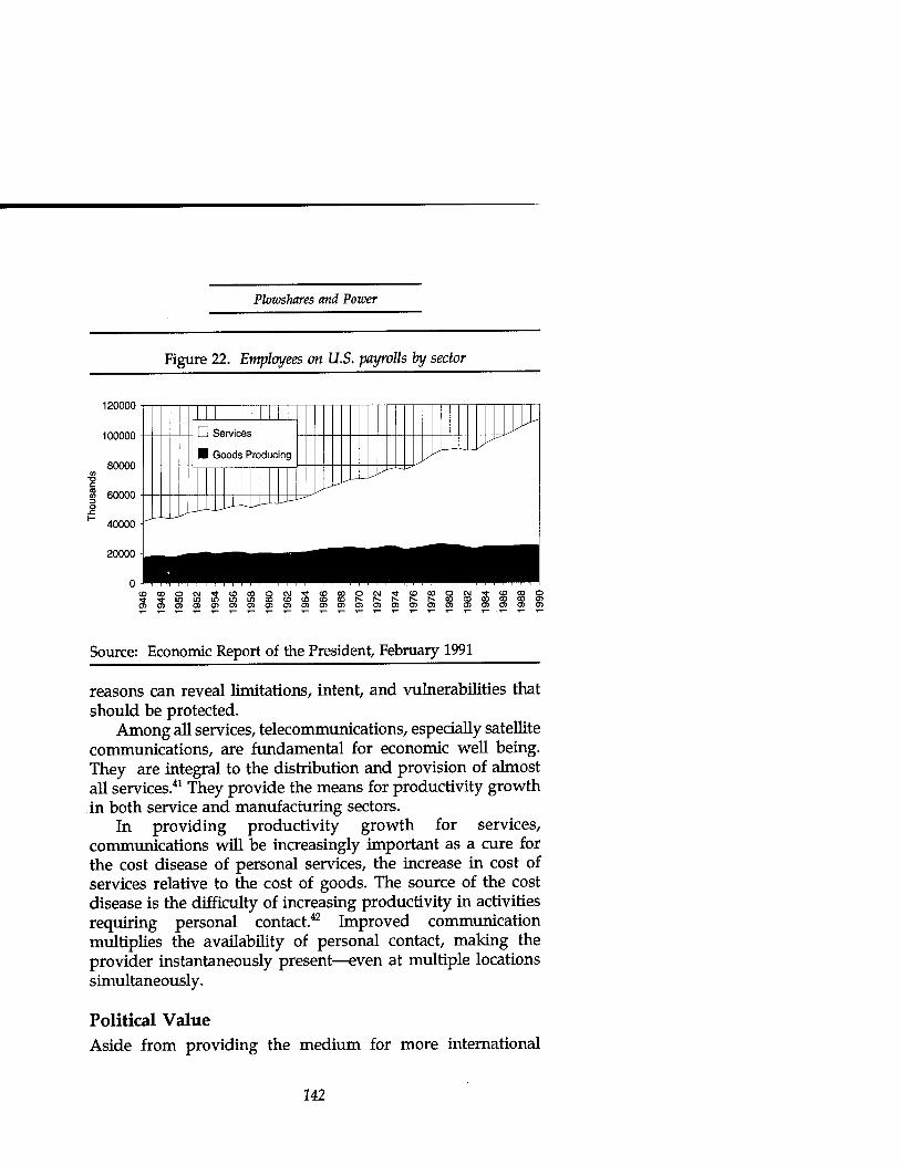
Plowshares and Power
120000
100000
80000
2 60000
40000
20000
Figure 22. Employees on U.S. payrolls by sector
IMMJIIII I F
■ Goods Producing JJ^U-LLl^
jjUJi^^
■^jj^^^M
CD 00 O -, -,_.,-..-.-.. _ ______ CO CO O 0)0)010}0)0)0)0)0}0)0)0)0)0)QO}0)0)0)010)0}0)
Source: Economic Report of the President, February 1991
reasons can reveal limitations, intent, and vulnerabilities that should be protected.
Among all services, telecommunications, especially satellite communications, are fundamental for economic well being. They are integral to the distribution and provision of almost all services.41 They provide the means for productivity growth in both service and manufacturing sectors.
In providing productivity growth for services, communications will be increasingly important as a cure for the cost disease of personal services, the increase in cost of services relative to the cost of goods. The source of the cost disease is the difficulty of increasing productivity in activities requiring personal contact.42 Improved communication multiplies the availability of personal contact, making the provider instantaneously present—even at multiple locations simultaneously.
Political Value Aside from providing the medium for more international
142
Communications Satellites
contact at all levels (and in unexpected ways, such as heads of state conducting crisis video diplomacy via CNN) satellite communications have been an effective tool of foreign policy. Today's international satellite communications consortia began with a Kennedy-era foreign policy initiative. That initiative was a deliberate decision to subsidize global coverage for developing nations and to provide them the necessary technical assistance. The immediate goal was to build a global communications system as soon as possible.43 The longer term result was worldwide U.S. influence, a victory for free enterprise and freedom.
The international satellite consortia themselves were an important arena of cold war competition. The Soviet Union financed a competing consortium, Intersputnik. The Soviets launched their first Molniya satellite only 17 days after NASA launched INTELSAT'S Early Bird synchronous communications satellite for INTELSAT on April 6, 1965.44 The Molniyas provided coverage for northern latitudes similar to Early Bird's coverage of the equatorial belt and mid-latitudes but more useful for Russia and Siberia.45 The Soviets negotiated their initiative in draft in 1968, signed it in 1971, and entered it into force in 1971,46 by which time INTELSAT had effectively captured the market with over 60 members.47 By 1987 INTELSAT had grown to 114 member countries—Intersputnik to only eighteen. As part of an overall strategy of containment, the formation of INTELSAT stands out as a brilliant stroke. It gathered the developing nations into intimate communications with the industrial West, gave them access to essential means for economic development, and provided them with immediate hard currency returns on a very modest investment.48 It wrapped the Iron Curtain in an Information Net.
In addition to the political value of leadership in sponsporing international efforts, satellite communications present an opportunity to prevent or exploit intelligence collection opportunities. If a country supplies critical nodes of an international communications network, it may be able to assure or prevent the chance for itself and its friends to eavesdrop on or disrupt communications. This opportunity
143
Plowshares and Power
has a dual nature. Its more Machiavellian use could be a liability as well as a benefit. On the benefit side is the direct value of intelligence gained—which may be crucial to survival. Secondarily, intelligence gained is political currency when shared selectively. On the liability side is the distrust generated if others perceive intent to exploit a system for intelligence or dependency. Such perceptions can quickly make the Machiavellian use self-limiting. This opportunity may be more perceived than real, and the perception could be more damaging than the reality would be beneficial.
Legal Framework Any discussion of alternatives in response to the potential misuse of satellite communications must acknowledge a long history of law, precedent, and institutions. The succeeding sections trace some of the history to define the context for the alternative strategies to follow.
Black Chambers—Sovereignty and Information Since governments began, they've needed to keep their own secrets and discover those of others. Modern European history of information law and sovereignty begins with the "Black Chambers" of the 17th and 18th centuries.
Historical Foundations—Reading the Mail. During the siege of Realmont in April 1628, the French royal army besieging the Huguenot forces captured a messenger with an encrypted message. Solution of the cryptogram by Antoine Rossignol revealed that the defenders were desperately in need of munitions despite appearances to the contrary. The French commander returned the solved cipher to the inhabitants of Realmont, who promptly surrendered. When Rossignol's feat came to Cardinal Richelieu's attention, Richelieu brought him to Paris and institutionalized his position as cryptanalyst and cryptographer, creating the first modern European black chamber.49
Throughout the 1700s, "black chambers" were common throughout Europe. These were government agencies
144

Communications Satellites
responsible for reading other people's mail—even when written in code; perhaps the most famous was in Vienna. Mail for embassies in Vienna would arrive at the Geheime Kabinets-Kanzlei at 7 a.m. to be opened, read, copied, resealed, and returned to the post office by 9:30. The same happened between 10 a.m. and 2 p.m. for mail passing through the city and between 4 p.m. and 6:30 p.m. for outgoing mail from the embassies. The 10-man office handled between 80 and 100 letters a day. Its carefully recruited personnel enjoyed a merit- based (on performance in decoding encrypted correspondence) civil service status unusual for the time.50
England also accorded special status to its cryptographers not only in personnel matters but in legal protection of the methods of their craft. When one testified before the House of Lords on treasonous (and encrypted, of course) correspondence of the Bishop of Atterbury in 1723, the Lords quashed the bishop's cross-examining of the witness, passing a resolution "that it is the Opinion of this House that it is not consistent with the public Safety, to ask the Decypherers any Questions, which may tend to discover the Art or Mystery of Decyphering." The cryptographers received their intercepted correspondence legally from the Post Office for both domestic and foreign mail. The 1657 statute that established the British postal service held that "the mails were the best means of discovering dangerous and wicked designs against the commonwealth." Government officials could open mail under warrants that they issued themselves.51
Reading others' secret mail played a pivotal role even in the founding of the United States. During the Revolutionary War, captured, deciphered messages revealed the British intent to relieve Cornwallis at Yorktown by sea between mid-October and mid-November of 1781 after Washington and Rochambeau's long trek from New York had trapped him there. The messages allowed Washington on October 20 to warn the French fleet under de Grasse, who maintained its blockade. Although Cornwallis had surrendered at Yorktown on October 19, the British fleet arrived October 30. However, de Grasse's ships scared them off and preserved Washington's
145
Plowshares and Power
conclusive victory at Yorktown.52
American ideals of openness have not always been comfortable with the European diplomatic tradition of black chambers. When Hoover's incoming Secretary of State, Henry Stimson, discovered in 1929 that his department had been funding an American black chamber, he dissolved it with the judgment that "Gentlemen do not read each others mail." He was more pragmatic in 1940 as Secretary of War, when he was the beneficiary of Magic decryptions of Axis messages.53
The Modern Era—Electronic Eavesdropping. By the mid-19th century, the European black chambers had fallen victim to public outcry. England discontinued its interception of correspondence in 1844; Austria and France did the same in 1848.54 However, the advent of technological improvements in communication by telegraph and wireless quickly brought back a modern version of the black chamber, the intercept service. Both France and Austria had effective cryptanalytic bureaus before World War I. The Germans quickly caught up, to the detriment of the Russians at the Battle of Tannenberg, "the first in history of man in which the interception of enemy radio traffic played a decisive role."55 The British intelligence service was effectively reading coded German diplomatic correspondence by the end of 1915. Their success was even more decisive, helping to bring the United States into the war with the publication of the famous Zimmerman telegrams, which revealed a German diplomatic initiative to bring Mexico into an alliance with Germany in exchange for areas of Texas, New Mexico and Arizona.56
Information Law and Sovereignty The military and diplomatic needs of states to eavesdrop on or interfere with communications creates a natural conflict with individual rights to privacy and freedom of communication. This conflict is evident in national and international law. From the era of the abuses and demise of black chambers comes the fundamental expression of the individual's rights in the French Declaration of the Rights of Man and of the Citizen (1789):
146

Communications Satellites
The unrestrained communication of thoughts or opinions being one of the most precious rights of man, every citizen may speak, write and publish freely, provided he be responsible for the abuse of this liberty, in the cases determined by law.
The First Amendment to the U.S. Constitution echoed this sentiment with a broad injunction against making any law "abridging the freedom of speech, or of the press." However, repeated attempts to formalize such broad protections for the free flow of information in international law have failed.57
Where protections exist, there are inevitably qualifications reserving the prerogatives of the state to protect its security, laws, and public order.
International Law. For example, the 1973 International Telecommunication Convention of Malaga-Torremolinos, recognizes the public right to correspond without priority or preference (Article 18) and agrees to "take all possible measures . . . with a view to ensuring the secrecy of international correspondence" but reserves the right of states "to communicate such correspondence to the competent authorities in order to ensure the application of their internal laws." (Article 22) Article 27 guarantees the right of governments to send telegrams in secret language but "Private telegrams in secret language may be admitted between all countries" (emphasis added) unless a country has notified the Secretary General otherwise. Even then, though, the country is obligated to allow transit of secret language private messages unless it has suspended service entirely.58
The European Human Rights Convention lists generally recognized elements of national sovereignty which restrict individual information rights:
The exercise of these freedoms . . . may be subject to such formalities, conditions, restrictions or penalties as are prescribed by law and are necessary in a democratic society, in the interests of national security, territorial integrity or public safety, for the prevention of disorder or crime, for the
147

Plowshares and Power
protection of health or morals, for the protection of the reputation or rights of others, for preventing the disclosure of information received in confidence or for maintaining the authority or impartiality of the judiciary. (Article 10, para 2)59
The most obvious of these elements of sovereignty is the military one—national security. The International Telecommunications Union explicitly exempts military applications from its registration requirements and any other controls.60
In addition to national security reasons, many countries impose restrictions on transborder information flows to protect privacy, preserve culture, assert sovereignty, or support their economies. Sweden, Austria, Canada, Denmark, France, Germany, Hungary, Iceland, Israel, Luxembourg, New Zealand, Norway and the United Kingdom have had privacy protection laws since the early 1970s. The first four countries protect corporations as well as individuals. Canada and Switzerland protect banking records. Some require a degree of processing of "national" data within the country's boundaries. The Reagan administration used such a restriction under the guise of export controls to forbid a U.S. gas pipeline company from providing data to a French subsidiary in an attempt to block the building of a Soviet natural gas pipeline to Western Europe.61 Many of these restrictions are only tenuously related to security. The security blanket covers a wealth of restrictions that are often deliberately imposed, thinly disguised, structural impediments to free trade. As such, they are more likely to harm the underlying economic source of national security than they are to protect critical resources or essential industry.
The legal status of the physical means of communication recognizes a belligerent's right to sever communications to an opponent. Submarine cables in time of war are generally legitimate targets of belligerents even if transiting a neutral's territory on its way to the opponent. The belligerent with the cutters may owe compensation to the innocent neutrals. The United States cut British Cable Companies cables connecting to
148
Communications Satellites
Cuba, Manila, and Puerto Rico during the Spanish American war. It refused compensation to the British companies and was upheld by a later tribunal because the cables were cut in the belligerent's territory or seas.62
United States Law. Not surprisingly, with its Constitutional heritage of limited government, U.S. law is weighted toward protecting individual rights rather than national sovereignty. To protect the privacy of communications, U.S. law imposes strict conditions on their interception. The Communications Act of 193463 prohibits anyone receiving or transmitting interstate or foreign communication from divulging without proper authorization "the existence, contents, substance, purport, effect, or meaning" of the communication. It prohibits the unauthorized interception of any radio communication (except for such things as unscrambled satellite cable programming for personal use.) In Section 801 of Public Law 90-351 Congress restricted eavesdropping by government law enforcement agencies:
Interception should be allowed only when authorized by a court of competent jurisdiction and should remain under the control and supervision of the authorizing court. . . [and] should further be limited to certain major types of offenses and specific categories of crime with assurances that the interception is justified and that the information obtained thereby will not be misused.
The law requires a sworn application in writing identifying the requesting and authorizing officers and containing a "full and complete statement of the facts and circumstances . . . including . . . details as to the particular offense,. . particular description of the nature and location of the faculties from which ... the communication is to be intercepted,. .. identity of person committing offense and whose communications are to be intercepted." The applicant must also identify what other procedures have been tried and failed or appear unlikely to succeed or too dangerous if attempted. Authorizations are for a limited period of time—no longer than necessary or greater
149

Plowshares and Power
than 30 days in any event. The law allows exceptions to the requirement for court order only for immediate danger of death or serious physical injury; conspiracy threatening national security interest; or conspiracy characteristic of organized crime.64
However, U.S. law and regulation reserve special national security prerogatives for communications. To assure the jurisdiction to be able to control the means of communication for national security, FCC regulations deny licenses to "any corporation of which any officer or director is an alien or of which more than one-fifth of the capital stock is owned of record or voted by aliens or their representatives or by a foreign country."65 Also, U.S. law66 alters the usual limitations on eavesdropping by national security activities to allow the government to intercept official communications for communications security monitoring; intercept radio communications between foreign powers or their agents; and access an electronic communication system used exclusively by a foreign power or its agent. Even these activities are subject to strict procedures (and Congressional oversight) to minimize collection of "nonpublicly available information concerning unconsenting United States persons."67
Where U.S. law holds individual information rights sovereign, international law makes national sovereignty paramount. The jurist Matte described the UN point of view: "Within the United Nations general opinion appears to be that the principles of freedom of information and of national sovereignty are not seen as having equal weight but rather that there is only one fundamental principle: that of state sovereignty."68
The thicket of national and international law affecting communications is only part of the backdrop needed to evaluate communications satellite policy. The remaining elements of the landscape are institutions, markets, and capabilities, which we'll discuss directly in that order.
150

Communications Satellites
Communications Institutions International telecommunications institutions date back to 1865, when Napoleon III called a meeting that founded the International Telegraph Union (ITU), later to become the International Telecommunications Union (also ITU).69 We'll review their history briefly to illustrate the pertinent nature of the institutions.
ITU, FCC, PTT's and Chosen Instruments Because communications are so fundamental to the power of states and because of the fundamental need to coordinate if communications are to avoid Babel's fate, the history of communications institutions is one of monopolies and regulation. The result of this history is an alphabet soup of agencies and peculiar quasigovernmental activities. We'll try to strain some of the more important alphabet out of the broth in the sections to follow.
International Telegraph Union. U.S. involvement with international communications institutions began with submarine telegraph cable, introduced commercially in 1866, when Cyrus Field laid a telegraph cable between Ireland and Newfoundland and the Congress passed the Post Roads Act "to aid in the construction of telegraph lines and to secure to the government the use of the same for postal, military and other purposes." The Act established an early U.S. precedent against government ownership of telecommunications and preference for private ownership.70
European powers dominated submarine telegraph cable during their colonial expansion. Early British domination of undersea telegraph cable resulted from ready access to Malayan gutta percha (used for waterproof insulation) and the British affiliation of cable company with cable manufacturer (assuring access to capital.) European powers used communications as instruments of empire. One observer of Germany's late entry into the imperial competition commented:
151

Plowshares and Power
The importance of the cable as an instrument of imperial expansion was firmly grasped by Germany as long ago as 1887, when she decided to free herself from the necessity of sending her messages to the United States through England, and to dispute the British cable hegemony in every part of the world where her interests were involved. Not only were cables a part of German machinery for acquiring a widespread empire, but they assisted in enabling her to obtain a position of economic and political influence in quarters where the acquisition of territorial possessions was not for the time being possible.71
The early U.S. telegraph industry, in contrast to European agents of empire, consisted largely of "wildcatters"—small independent entrepreneurs. The wildcatters confronted large, international monopolies that controlled the right to terminate cables in their countries. Two companies, Western Union and Postal Telegraph, eventually became dominant in the U.S. industry.
Continuing conflict with the European cable monopolies over landing rights brought about U.S. participation in the ITU. In reaction to European cable monopolies practices, President Grant proclaimed the "open shores" policy, in which cable landing rights on U.S. soil for any foreign country's cable depended on that country granting open access by U.S. companies to its shores.72 "Open shores" foreshadowed a future "open skies" telecommunications policy.
Radiotelegraph}/. In 1901, Marconi's experimental transmission of the letter "S" from England to Newfoundland heralded the coming of telegraphy unconstrained by cables. Commercial radio telegraph use followed in 1920 and voice in 1927. Having bypassed the cable monopolies, Marconi created a virtual monopoly of his own by refusing to inter-connect with non-Marconi systems.73 Attempts at maintaining the monopoly advantage caused incompatibility between networks. As a result of Prince Henry of Prussia's pique at being unable in 1902 to send a courtesy message to President Teddy Roosevelt from his ship, the German government convened a
152
Communications Satellites
Preliminary Conference on Wireless Telegraphy in Berlin in 1903, and the Berlin International Radio Conference in 1906 to create the first international radio regulations in 1906. They required ships and coastal radio stations to accept messages and established the convention of the SOS distress signal. The U.S. Senate ratified the agreement in 1912, and the U.S. became a member of the International Radiotelegraph Union (which merged with International Telegraph Union in 1932 to form International Telecommunications Union.) After the sinking of the Titanic in 1912 (due in part to poor radio communications) the first International Convention for the Safety of Life at Sea in 1914 required vessels carrying 50 or more passengers to carry a radio with a range of 100 nautical miles and obligated ships to monitor distress calls and mount a rescue in response to such calls.74 The Titanic's sinking made the British more sensitive to maritime safety, and they accepted mandatory interconnection. In 1915, Marconi tried another tack at monopoly and attempted to purchase exclusive rights to a high frequency alternator from General Electric. As a result, the U.S. government acted to prevent British dominance of radio in addition to cable. President Wilson (at FDR's instigation as Secretary of the Navy) intervened to create a "chosen instrument"—the Radio Corporation of America—out of Marconi's U.S. subsidiary and GE, both holders of critical patents.75 A similar "chosen instrument" would eventually represent the US international satellite communications interest.
Federal Communications Commission. With the Communications Act of 1934 Congress created the Federal Communications Commision (FCC) to regulate interstate and foreign commerce in wire and radio communications. The Act prohibited common ownership of cable and radio facilities to encourage technological development, hoping to prevent entrenched investment from squashing new development. This was in contrast to the British monopoly, Cable and Wireless, and is still so by comparison with European government Postal, Telegraph and Telephone (PTT) agencies. However, despite the prohibition on common ownership, the FCC acted to create and preserve monopolies in each medium, favoring
153
Plowshares and Power
exclusive routes for U.S. international record carriers, except temporarily during World War II. AT&T emerged as the U.S. international telephone monopoly in 1927 with radiotelephone service. It began international voice communication after World War II by adding repeaters to undersea cable. AT&T negotiated with the British Post Office in 1952 for a joint venture in transatlantic telephone cable, TAT-1, which became operational in 1956, less than a year before the Soviets launched Sputnik and ushered in the era of satellite communications.76
Postal, Telegraph and Telephone (PTT) Agencies. The institutions which have controlled international communications throughout much of the world have typically been monopolies, usually the government PTT agencies, operating as a cartel under the supervision of the ITU. The PTTs provide a complicated system of cross-subsidies within their service areas which form the basis for the political power that sustains their monopolies. Despite the classical economic instability of cartels caused by the differing discount rates (and hence profit goals) of their members, the PTT-ITU cartel has sustained long term stability thanks to a political coalition of households, postal and telephone labor unions, publishing and direct mail business, government finance ministries, the telephone monopolies and their equipment manufacturers.77
However, the recent example of U.S. domestic competition after the breakup of AT&T has spurred a trend toward increasing international competition. Among the major forces for reform of the monopoly regime were telecommunications equipment manufacturers and large business users of long distance communications. About 5 to 10 percent of all users generate half of the long-distance traffic in industrial countries. The international traffic is even more concentrated.78 The large users carry the clout of size, reinforced by the incentive to compete efficiently in global markets. Relaxing the monopoly's cross-subsidies has not hurt the previously subsidized households; competition has kept their rates low and globally competitive industry improves their standard of living.
In addition, technological advances have challenged the
154

Communications Satellites
monopolies. The regulatory distinctions used to award monopolies for specific kinds of communication (mail, telegrams, telephone) have blurred with the advent of digital voice, facsimile, and computer modems. The new technologies have provided companies and countries more efficient alternatives for communication and therefore competitive advantage. The production of telecommunication equipment has become a significant industry itself, worth encouraging by developing foreign markets through increased competition. As a result, the United States, with Britain, Japan, and Australia and others close behind, has lead the way in the recent trend away from national monopolies.79
Despite this trend, many PTTs and their governments have maintained a large degree of control by prohibiting connection to their public switched networks, banning independent transmission facilities, or requiring PTT equipment for the connections. The PTT-ITU cartel appears to have a life and agenda of its own. Considering the obvious competitive benefits available to a nation from participating in advancements in international communications, it's hard to believe that the strength and durability of the PTTs' resistance to changing the monopolies is due solely to entrenched bureaucratic and political power. Although seldom mentioned, another important influence is almost certainly the security value of control over (and assured access to) the means of command and control (to police agencies for internal security and to the military and intelligence agencies for external security.)
As more and more nations rediscover the security in economic growth and prosperity, the U.S. example is proving more and more alluring. Australia, Britain, Chile, Germany, Japan, Mexico, the Netherlands, and Venezuela are among a growing group of countries privatizing their public telecommunications monopolies to one degree or another. For developing countries, the World Bank provides strong incentive to privatize state operated enterprises. It began lending to encourage divestiture in 1981, escalated the number of operations sharply in 1984, and continued a steady increase
155
Plowshares and Power
ever since. Privatization has become an important part of the Bank's adjustment programs: about 70 percent of all structural adjustment loans and 40 percent of all sectoral adjustment loans support privatization. The allure is easy to see in the Bank's analysis of results. In 10 of 12 cases analyzed in Chile, Mexico, Malaysia, and the United Kingdom, productivity went up in eight and stayed level in the remainder. Expanded investment and diversification of production resulted in fast growth in many of the firms. The Chilean telephone company doubled its capacity in the 5 years after its sale to private interests. In England, British Telecommunications increased investment rapidly, adopted a more efficient and profit-maximizing pricing formula, and improved productivity by eliciting greater output from a reduced work force. Table 4 lists the telecommunications entities among the Bank's survey of the 30 largest privatization transactions in the last few years. Five of the thirty were telecommunications, which tied for the most often privatized industry. (Following in rank order were five in banking, four airlines, three mining, three steel, two pulp and paper, and a handful of miscellaneous leftovers.)80
Although this trend toward privatization is a good one for the economic welfare of all concerned, its freer market in communications means more opportunities for misuse of civil satellites or masquerade of military ones in civil clothes. We'll see safer alternatives in multi-lateral consortia like INTELSAT and INMARSAT.
INTELSAT INTELSAT is a large, powerful and important institution. It deserves thorough understanding. We will trace its history, characterize its structure and vulnerabilities and project its future.
Beginnings: Competition and Compromise. Against the economic background of entrenched cable monopolies and under the political and security pressure of the Russian Sputnik flight, INTELSAT was born of a U.S. initiative. Fourteen months after the 1957 launch of Sputnik, on December 15,1958,
156

Communications Satellites
the U.S. Department of Defense launched a successful Signal Communications Orbiting Relay Experiment. Congress called hearings the following spring and developed a
Table 4. PriviHzations with value over U.S. $100 million, 1988-91
Country Enterprise Date Value (US$M))
Venezuela CANTV 11/91 1,885
Mexico Telmex 12/90 1,760
Argentina ENTE1 11/90 1.244
Malaysia Telekom 10/90 861
Chile Compania de Telefonos
01/88 170
Source: The World Bank, Country Economics Dept, Privatization: The Lessons of Experience, April 1992, 9.
consensus that the technology was ready for a useful worldwide communication system based on satellites (subject to the availability of launch capability) and that the government should support development of such a capability for eventual transition to commercial operation.81 The United States initiated a civilian space program with the establishment of NASA in 1958, charged explicitly with "preservation of the role of the United States as a leader in aeronautical and space science and technology."82 An impending ITU Convention in 1959 and an ITU Extraordinary Adminstrative Radio Conference scheduled for 1963 forced the rapid development of U.S. space communications policy, merging the new space policy with traditional commercial communications policy.83
After the Soviet launch of the first man into orbit in April 1961, President Kennedy included communications satellite
257

Plowshares and Power
development in his first man-to-the-moon race with the Soviet Union for moral and technological leadership. The national communications satellite policy announced on July 24, 1961, proposed to develop a global communication satellite system at the earliest practical date, with private ownership of the U.S. portion, foreign participation through ownership, global coverage to developing nations, and technical assistance to developing nations in order to achieve a global system as soon as possible. On December 20,1961, the UN General Assembly endorsed the U.S. policy, resolving that "communications by means of satellite should be available to the nations of the world as soon as practicable on a global and nondiscriminatory basis."84
The implementation of U.S. policy on communications satellites previewed in microcosm the coming issues with other countries in establishing an international network. The protagonists were the existing cable carriers, aerospace equipment manufacturers, and on the government side: the FCC, Justice Department, and at least three Congressional factions. The issues were ownership and monopoly.
AT&T, the de facto cable and telephone monopoly, proposed a privately developed and owned, low altitude satellite system (50 satellites in polar, 3000 mile orbit). To preserve radio spectrum for satellite use, it had opposed FCC allocations of microwave frequency in 195785 and again in 1960. AT&T's Bell Labs began satellite development on its own funds in 1959. Concurrently, Hughes Aircraft Corporation proposed a three satellite geosynchronous active relay and approached NASA and DoD for support in 1959 and 1960. In March 1961, the Federal Communications Commission opened an inquiry into Commercially Operable Space Communications Systems.86
U.S. equipment manufacturers favored a "carriers' carrier" on antitrust grounds to avoid AT&T domination of a shared ownership by communications carriers. The FCC's first report, in May, decided to explore just such a joint venture by carriers. By October 21, its Ad Hoc Committee recommended a carrier- owned corporation. The Senate responded quickly with
158
Communications Satellites
concerns on monopoly. Russell Long, chair of the Senate Subcommittee on Monopoly, held hearings on the eighth and ninth of November and issued a negative opinion of the Ad Hoc Committee plan. In August 1961, Senators Humphrey, Kefauver, and Morse and thirty-two members of the House signed a letter to the President urging him not to award a monopoly. To allow complete debate on the topic, the administration proposed new legislation. In November 1961, President Kennedy asked the interagency Welsh committee to formulate draft legislation. The committee considered three options: government ownership, private ownership by carriers, and broad-based private ownership. It compromised on private, for-profit industry operation but with a broad base of ownership including the carriers. The legislative debate considered a total of 16 proposals—variations on the three different options the administration had considered:
• The Administration bill: broad-based private ownership
• The Kerr bill: carrier ownership of a private company
• The Kefauver bill: government ownership.
Senator Kerr quickly compromised on combined carrier and private ownership, but the Kefauver faction fought hard. Its argument had three components:
• Private ownership was inconsistent with anti-trust law
• Premature transfer to the private sector would result in an unsatisfactory, low altitude system and inhibit further technology develoment
• Taxpayer investment had developed the technology, and taxpayers should own the benefits—private stockholders should not benefit from public expense.
In response to these arguments there was ample and
159

Plowshares and Power
successful precedent in U.S. experience for private operation of government developments in aviation and for private operation of telecommunications utilities. Kefauver's resistance culminated in an August 1962 filibuster that resulted in the Senate's first vote to invoke cloture and end debate since 1927. The bill passed the Senate on August 17, the House on August 27, and President Kennedy signed it into law on August 31, 1962.87 The result was the creation of COMSAT corporation.
As the government's "chosen instrument," COMSAT was to develop an international satellite communications system consistent with the national policy of global, non- discriminatory access. The U.S. offer of direct, nondiscriminatory access to usage and ownership was a radical departure from past international (especially European) telecommunications policy. However, to be effective, the system would have to connect with the existing networks, and the offer would therefore have to accommodate the beneficiaries of past policy, the European PTTs.
In late 1962 preliminary negotiations with the Conference of European Postal Telecommunications Administrations over formation of INTELSAT demonstrated the PTT's preference for dealing directly without the aid of diplomats. The PIT-ITU cartel had developed an informal, functional alignment transcending national interests. However, the interests of other elements, such as aerospace industry and the diplomatic and defense establishments, assured broader political participation.88
In particular, the President viewed space as the key to world leadership, as the following dialogue from a 1964 NASA briefing to President Johnson by Dr. Pickering illustrates:
Johnson: This is really a battle for leadership and real existence in the world, isn't it?
Pickering agreed. Johnson: In effect, the British dominated the seas for
centuries and led the world, didn't they? Pickering: Yes, Sir.
160

Communications Satellites
Johnson: We have dominated the air with leadership, and I think unquestionably have been the leaders of the free world since we established that dominance, haven't we?
Pickering: Yes, Sir. Johnson: And the person that leads in space is going to
have an equivalent position, isn't that true?89
American technology gave U.S. policy a commanding position in the battle for leadership. European participation in INTELSAT was inevitable despite its PTTs' conflict with the U.S. policy. The British postmaster general described the situation: "The only way of preventing an American monopoly in this sphere [global communications] is to join a partnership with the United States and other countries and so secure the right to influence the course of events."90 The European PTTs found no ally in the American cable monopoly. AT&T expressed its support in a letter to COMSAT'S new chief operating officer:
The point can be stressed that we see a place, and a need, for both cable and satellite communications. . . . Diversity of routes and facility types is the best method of assuring service integrity and that is one of the major reasons for our interest in utilizing satellite circuits for overseas service as soon as possible. The high capacity cable will have many important applications but we see no basic reason why it should prevent satellite usage from reaching economical and profitable levels.91
Charter of the Institution. The Johnson administration, with COMSAT corporation handling the operating agreement, negotiated the original charter for the International Telecommunications Satellite consortium—INTELSAT. The U.S. government and its chosen instrument played a dominant role based on the U.S. lead in space technology, its status as the largest user, and its offer to launch at cost. The peculiar structure of the organization, with both a government and a commercial entity signatory for each country, reflects the U.S.
162

Plowshares and Power
heritage of commercial telecommunications operations, beginning with the original wildcatters and evolving through President Grant's open shores telegraphy policy and President Wilson's chosen-instrument radiotelegraphy policy.
In June and July, 1964, the original INTELSAT partners met to negotiate the terms of two "interim" agreements establishing the consortium (one among their governments and the other among their designated communications entities.) The negotiations had to overcome two significant obstacles—the appearance of a threat to the established PTT cable monopolies and the apparent domination of the United States as the procurement source. The agreements apportioned ownership according to the participants' contributions to the capital investment, which was allocated according to the anticipated usage. The formula assured a U.S. share of at least 50.6 percent and limited the developing countries to a maximum of 17 percent ownership. The allocation matched the distribution of telephones at the time.92
In February 1969, the United States convened a conference to establish a definitive charter to replace the interim agreements. The most contentious issues, were procurement based on best price and value (Europeans preferred to allocate contracts proportionately to a country's ownership contribution); the power of COMSAT; and U.S. domination of voting strength. The final agreement covered all these. It also created two new governing bodies based on one-nation, one-vote (Assembly of Parties and Meeting of Signatories) and established a Board of Governors responsible for design, development, construction, establishment and operation of the space segment. The Board's membership consisted of 20 signatories with voting in proportion to usage but not to exceed 40 percent for any single governor. The agreement provided for the eventual replacement of COMSAT as system manager by an executive branch of the consortium within six years after the definitive agreement entered into force in February 1973.93
INTELSAT'S initial charter turned out to be structurally more effective than the ITU's in preserving the PTT
162

Communications Satellites
monopolies. It allocated votes (and investment) according to usage rather than the ITU's one-nation, one-vote structure. Although the charter is probably not to blame, the system evolved along the lines of its cable monopoly ancestors. Based in part on the fact that its members were the communications monopolies but especially on the limitations of satellite technology of the time, INTELSAT structured its system architecture around large earth terminal gateways into the national PTT systems, which further entrenched the PTT's.94
INTELSAT'S early, low-powered satellites required large,95
expensive earth stations which were economical only for large numbers of phone connections. The designs hindered direct services to the user's premises and undid much of the benefit of the consortium's intended subsidy of thin routes for developing countries.96 As a result of sizing its transponder power output and ground station antenna size for bulk, point- to-point transoceanic traffic, the cost per half-circuit for earth station investment was twice as much for developing countries as for developed.97
This is not to say that developing countries did not benefit from INTELSAT. While providing a 14 percent return on investment to its members, INTELSAT drove down the annual cost of an international telephone circuit from $62,000 in 1965 to $9,000 in 1989.98 An economic analysis of INTELSAT'S first ten years concluded that its principal behavior had been to minimize costs. Secondary goals had been to increase capacity and broaden participation. Answering criticism that INTELSAT had not effectively pursued social welfare goals more directly, the analyst observed that "INTELSAT has functioned well precisely because it has functioned on an economic basis, and that it would have functioned less well if it had simultaneously been required to fulfill noncommercial purposes without subsidy."99
Despite an initial architecture that mimicked cable, INTELSAT soon became a revolutionary agent of change in international communications. Despite political opposition to a technical solution to the need for large earth stations, COMSAT Laboratory's John Puente developed a method to
163

Plowshares and Power
create a new foundation for its networks:
In the early days of INTELSAT, earth stations cost five, ten, fifteen million dollars. For these smaller countries with their low traffic, we had to come up with a system concept which was much lower cost—i.e., a million-dollar earth station. SPADE100 allowed you to use a smaller earth station and get sufficient traffic into your country to make you a partner, a real partner.101
Monopoly and Vulnerability. As though anticipating competition and the emergence of technology which could bypass the large gateways, INTELSAT'S final, permanent charter required its members to consult with INTELSAT before establishing separate international satellite communications facilities. Article XIV(d) of the agreement required that members:
Prior to the establishment, acquisition or utilization of such facilities, shall furnish all relevant information to and shall consult with the Assembly of Parties, through the Board of Governors, to ensure technical compatibility of such facilities and their operation with the use of the radio frequency spectrum and orbital space by the existing or planned INTELSAT space segment and to avoid significant economic harm to the global system of INTELSAT?0* [emphasis added.]
Article XIV(d) arose from a compromise with the European PTTs. They wanted to develop separate, regional systems for Europe, North Africa, and the Middle East to assure European sources of equipment to prevent the United States from creating a satellite analog to Britain's earlier monopoly on telegraphy. Europe pressed for the permissive aspects of XIV(d), the United States for its restrictive aspects. By 1984 their positions would reverse. As it turned out, INTELSAT didn't need the revenues from separate regional and national systems to remain profitable.103 Despite intensive consultation on the several occasions when signatories have invoked XIV(d), INTELSAT has never refused coordination on the grounds of
164
Communications Satellites
economic harm.104
The competition issue was not long in coming to the fore. The Nixon administration established a domestic "open skies" policy with an FCC report of March 20, 1970, which allowed any public or private entity to establish and operate domestic satellite facilites for its own needs so long as those facilities did not threaten the viability of INTELSAT (subject also to anti- trust and technical regulation to prevent interference). Eight applicants filed in immediate response.105 While the FCC deliberated a response to the filings, Canada introduced the first domestic communications satellite, Anik, in 1972. RCA began domestic U.S. satellite service in 1973. U.S. domestic satellite terrminals quickly grew from a few hundred in 1976 to over 100,000 by 1980 and passed the million mark by 1985 (many of which were small receive only television terminals for the home market.)106 The U.S. domestic satellite population grew to 30 satellites by 1988.107
The explosive growth of U.S. domestic satellites quickly began to impinge on INTELSAT'S monopoly. A satellite's coverage of border regions naturally overlaps to some degree into neighboring countries and opens up an international market. To regulate this effect on INTELSAT, the United States established a transborder services policy in 1981 requiring that such services not be economically or practically available from INTELSAT and requiring consultation with INTELSAT before initiating service. By 1988, 23 U.S. domestic satellites had completed INTELSAT consultation and been authorized to provide transborder services.108
Beyond the immediate border areas lie INTELSAT'S most lucrative transoceanic routes. In 1984, in an ironic role reversal with the Europeans, President Reagan announced a determination, required by the Communications Satellite Act of 1962, that U.S. international systems separate from INTELSAT were "in the national interest." U.S. satellite companies could operate international systems in competition with INTELSAT under the conditions that their services would be for long-term lease or sale of capacity; not connect with the public switched network; and be authorized by a foreign
165

Plowshares and Power
authority in consultation under the INTELSAT Agreement.109
In addition to U.S. filings for separate systems in the Caribbean and across the Atlantic, a variety of regional systems nibbled at INTELSAT'S monopoly—Eutelsat in Europe, Arabsat in the Middle East, and Palapa in Southeast Asia. They have not all been financial successes. Arabsat's use is very low; in 1986 only 130 of 900 available circuits were in use. (The Middle East has the highest VCR penetration and lowest satellite use. This suggests Arabsat's low revenues are due in part to its population dodging the censorship imposed by conservative Islamic governments.)110 Table 5 illustrates the revenues earned by international systems. Comparison of return on investment is not possible without an estimate of expenses. But, a comparison of revenues with investment shows Arabsat and Asiasat at a clear disadvantage. In aggregate, the regional systems, Arabsat, Asiasat, Astra, and Eutelsat account for significant lost revenue to INTELSAT. (INMARSAT is not a competitor for any of them; it provides mobile services.)
In their required consultation with INTELSAT, the regional systems used a variety of more or less disingenuous arguments to avoid the judgment of "significant economic harm."
• Only a small or negligible amount of traffic would be affected (Eutelsat and Arabsat).
• If a regional satellite system were disallowed, then they would use terrestrial links instead of INTELSAT (Eutelsat and Arabsat again)
• INTELSAT would never have carried the traffic due to special circumstances making it too expensive. (U.S.- Bermuda coordination).
• The transborder traffic was incidental to domestic service, i.e., a natural fringe of a domestic service area.
• The proposed separate facilities were the result of a
166
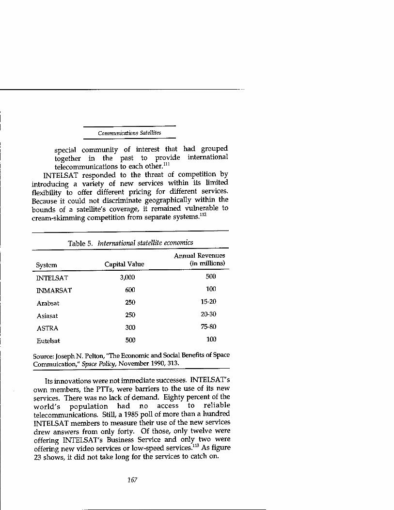
Communications Satellites
special community of interest that had grouped together in the past to provide international telecommunications to each other.111
INTELSAT responded to the threat of competition by introducing a variety of new services within its limited flexibility to offer different pricing for different services. Because it could not discriminate geographically within the bounds of a satellite's coverage, it remained vulnerable to cream-skimming competition from separate systems.112
Table 5. International statellite economics
System Capital Value Annual Revenues
(in millions)
INTELSAT 3,000 500
INMARSAT 600 100
Arabsat 250 15-20
Asiasat 250 20-30
ASTRA 300 75-80
Eutelsat 500 100
Source: Joseph N. Pelton, "The Economic and Social Benefits of Space Commuication," Space Policy, November 1990, 313.
Its innovations were not immediate successes. INTELSAT'S own members, the PTTs, were barriers to the use of its new services. There was no lack of demand. Eighty percent of the world's population had no access to reliable telecommunications. Still, a 1985 poll of more than a hundred INTELSAT members to measure their use of the new services drew answers from only forty. Of those, only twelve were offering INTELSAT'S Business Service and only two were offering new video services or low-speed services.113 As figure 23 shows, it did not take long for the services to catch on.
167

Plowshares and Power
In addition to competition from regional separate services, INTELSAT faces a threat from submarine cable. Cable is by its point-to-point nature inherently suited to "skim the cream" from INTELSAT'S lucrative high traffic density routes. Fortunately for INTELSAT, earlier generations of cable could not match satellites in capacity. Table 6 shows the history of INTELSAT'S horse race with trans Atlantic cable. INTELSAT has been able to maintain a slight lead in the past. However, the lack of a requirement to subsidize less dense routes can still make cable more profitable. INTELSAT has been able to
Figure 23. Intelsat business service growth
64 kbps equiv channels
12000 T
10000 | ^^H
8000 i ^^H ^^H
6000 I ^^H ^^H
4000 ^^^ ■ ^^H ^^H
1984 1985 1986 1987 1988 1989 1990
Source: Intelsat Annual Report, 1990-91.
offer higher reliability (historically 99.9 percent compared with submarine cable reliabilities of 93 to 95 percent.) The difficulty of repairing satellites in orbit made high reliability a necessity. As a result, cable service restoration is one of INTELSAT'S sources of revenue.114 However, we will see that INTELSAT'S lead in efficiency over undersea cable is rapidly becoming a thing of the past.
INTELSAT is one of the most important satellite communication institutions. Aside from its pioneering role andgiant stature, it remains the model for international
168

Communications Satellites
Table 6. Submarine cable and satellite capacity and efficiency
Year Generation Capacity (circuits)
Capital cost per installation
Life (yrs)
Capital cost per ckt per yr
1956 TAT-1 cable 74 $49.6M 24 $28,000
1968 INTELSAT-1 240 11.7M 1.5 32,500
1976 TAT-6 cable 4,000 191.4M 24 2,000
1976 INTELSAT IV-A
6,000 45M 7 1,100
Source: Joseph N. Pelton and Marcellus S. Snow, eds., Economic and Policy Problems in Satellite Communications (New York: Praeger, 1977), 112.
cooperation and, with its mobile counterpart INMARSAT, the most likely opportunity for imposing multilateral controls on the misuse of satellite communications. The next section will examine the shorter history of a similar consortium founded to provide communications to mobile users.
INMARSAT The history of international coordination of communications at sea began shortly after the invention of the telescope in 1608, when the Duke of York codified a set of line of sight visual signals, via flags, in 1665. International conventions on flag signals still exist, along with semaphores, flashing lights, lamps, sounds and finally wireless signals. The International Code of Signals is a product of the International Maritime Organization.115
History. The first maritime use of radio telecommunications began with Marconi's experiments in 1895. Radio began saving lives at sea in 1899.116 We've seen above in the ITU's history how maritime radio influenced the coordination and development of international radiotelegraphy. However, terrestrial radio suffered significant disadvantages in crowding
169
Plowshares and Power
of the spectrum, limited data rate capacity, and unreliable propagation due to ionospheric disturbances. Once INTELSAT established fixed satellite service, a mobile version for maritime users could not be far behind.
In February 1966, a year after INTELSAT'S Early Bird began operations across the Atlantic, the Intergovernmental Maritime Consultative Organization (later renamed the International Maritime Organization, IMO) decided to study maritime satellite communications. In 1971, the ITU's World Administrative Radio Conference for Space Telecommunications allocated L-band frequencies for maritime-mobile satellite service (1.5 to 1.6 Gigahertz.) In 1972 the IMO chartered a Panel of Experts to discuss technical, operational, administrative, and institutional aspects of a maritime satellite system. In the mid 1970's the U.S. Navy was investigating Ultra High Frequency satellite communications for the fleet. In response to both studies, COMSAT Corporation proposed the Marisat satellites to operate in both bands. The Navy accepted, and Marisat began service under Navy contract in February and June of 1976 over the Atlantic and Pacific respectively.117
The IMO convened intergovernmental meetings in 1975 and 1976 to draft the INMARSAT convention and operating agreement. The International Maritime Satellite consortium (INMARSAT) began its official existence on July 15,1979, with ratification of the convention. Initial proposals to extend INTELSAT to include maritime service in addition to its original charter for fixed service had run into difficulty with the mismatch of INTELSAT'S distribution of membership (and control). INTELSAT allocated voting shares according to non- maritime communications volume. The distribution of maritime industry, on the other hand, included several countries with substantial fleets but proportionately much smaller land-based communications. (Notable in this group were the Soviet Union and many developing countries.)
Charter. After extensive negotiations, the conferees modelled the final organization on INTELSAT but with ownership apportioned according to the shares listed in table
170

Communications Satellites
7. The charter shared key tenets with INTELSAT:
• Open access
• Participation and decision making proportional to use
• Finance and operations by governments or their designated entities
• Open, competitive procurements.
Table 7. Original INMARSAT shares
USA 17.0%
UK 12.0
USSR 11.0
Norway 9.5
Japan 8.45
Italy 4.37
France 3.5
WGermany 3.5
Greece 3.5
Holland 3.5
Canada 3.2
Spain 2.5
The owners ratified the convention in May 1979. The consortium's stated purpose was to establish by lease or purchase the space segment required to provide an improved system of maritime communications services for public correspondence, for radio determination, for distress and safety of life, for traffic services, and for the efficiency and management of ships.118 The charter did not rule out the possibility of future service to aircraft and land mobile users also. INMARSAT amended its convention in 1985 to provide aeronautical services and in 1989 to provide land-mobile service.119 INMARSAT'S aeronautical service agreement with the International Civil Aeronautical Organization (ICAO) allows INMARSAT to provide service on a nonexclusive basis.
As with INTELSAT, separate systems operated by the
171
Plowshares and Power
signatories are subject to coordination with the INMARSAT Council. The Council informs the Assembly on economic harm after which it has 9 months to express its opinion in a nonbinding recommendation. The convention grandfathered existing systems and excluded national security systems from coordination.120
Architecture. INMARSAT began service to a thousand ship terminals by leasing the Marisat satellites, later adding the European Marecs satellite and a maritime subsystem on INTELSAT-5 satellites. It started commercial operations on February 1, 1982. Its users grew at an average of about 1,000 per year, reaching between 8,000 and 10,000 stations by 1990 and mushrooming to more than 21,000 by early 1992.121
Like INTELSAT, INMARSAT'S architecture favors developed countries. Although the mobile terminals are relatively small and inexpensive, the satellites connect them to public switched telephone networks via large, relatively expensive earth stations. A full specification coastal earth station has a parabolic antenna of eleven to fourteen meters diameter and costs about five million dollars (not including the land line connections and switching)—too much for most developing countries. However, the suitcase-sized portable voice terminals have already found widespread use for disaster relief and business communications in remote areas. A look back at table 5 shows that INMARSAT has been able to generate the same l-to-6 ratio of annual revenue to capital invested that INTELSAT has. Again like INTELSAT, INMARSAT has been able to return 14 percent on investment to its members.122
We've seen that mobile satellite communications are the starting point for capabilities of real utility to military users. INMARSAT'S market penetration to date suggests the potential for significant military use. Its use in emergency communications is the kind of essential service that could not be easily interrupted—even in wartime. However, INMARSAT'S current architecture does not pose a significant threat. The satellites are not inherently jam resistant. But, future developments in response to market demands could
172

Communications Satellites
drive INMARSAT and its competitors toward more dangerous capabilities. The market survey in the next section will illustrate.
Satellite Communications Marketplace The satellite communications marketplace divides neatly into fixed service, mobile service and broadcast. We'll treat their market trends separately and then highlight the particularly worrisome directions.
Direct Broadcast The term Direct Broadcast Satellite (DBS) describes a class of satellite intended to provide television and data services directly to the home, bypassing cable distributors. The distinction from satellites broadcasting indirectly through cable distributors began with the belief that home users would not tolerate a large enough antenna to receive the signals from conventional satellites. Higher powered satellite transmitters (and usually higher frequency transmissions) would therefore be necessary. Not surprisingly, since mass market revenues and monopolies were at stake, the licensing of DBS services became a highly charged political and legal issue, raising concerns of sovereignty and control over information flow past terrestrial borders.123
However, advancing technology and impatient consumers passed the argument by. The American public out of reach of cable systems discovered the availability—at first from hobbyists and then from a mushrooming base of small vendors—of 2- to 3-meter antennas that could receive television signals directly from existing medium power satellites. These small, receive-only terminals quickly accounted for the bulk of satellite ground station sales. Their rapid growth caused premium cable channel distributors to scramble their satellite feeds. Congress granted those small terminal owners explicit protection in U.S. law—one of very few exceptions to a broad prohibition on electronic eavesdropping124 (which shows what kind of political clout a large number of free-riders can wield
173

Plowshares and Power
when their entertainment is threatened). Once consumers grew accustomed to a large selection of
channels on medium power satellites, a smaller selection on higher powered satellites even with smaller antennas was not enough to overcome the medium power lead. At launch in 1989, the French DBS satellite TDF-2 had commitments for only one of five high-powered transponders. The medium power Luxembourg satellite Astra had reservations for most of its 16 transponders.125 However, consumers may yet have the best of both worlds with the continuing improvement of technology. Thomson and Hughes plan a small antenna (half meter), 100- channel direct broadcast television system called DirecTV. They expect the consumer's equipment to cost about $700 compared with about $1,300 for typical, current, two meter systems.126 The excess capacity in high-power DBS satellites may present a short-cut opportunity for a military service to implement an inexpensive intelligence broadcast or command dissemination system. However, their architecture does not suggest any cause for alarm. They are vulnerable to ground- based jamming.
Fixed Service The fixed service market includes INTELSAT'S international monopoly, regional systems like Eutelsat, Arabsat, and Asiasat, and domestic national systems. For a quick overview of the trends in global capacity, figure 24 shows a market survey of the recent history of the world's communications satellites. (It does not include Russian or Chinese satellites. The Chinese are a recent and rather small market addition. The Russians have a history as long as any of these and significant capacity, but no history of market participation.) The tall columns and long history of INTELSAT and U.S. domestic satellites contain both the dominant market forces and its suppliers. However, there is equivalent technical capability in the European, Japanese and Canadian lines as well.
The respectably tall "rest of the world" stack hides ample demand for dangerous capabilities. If we limit controls to the
174
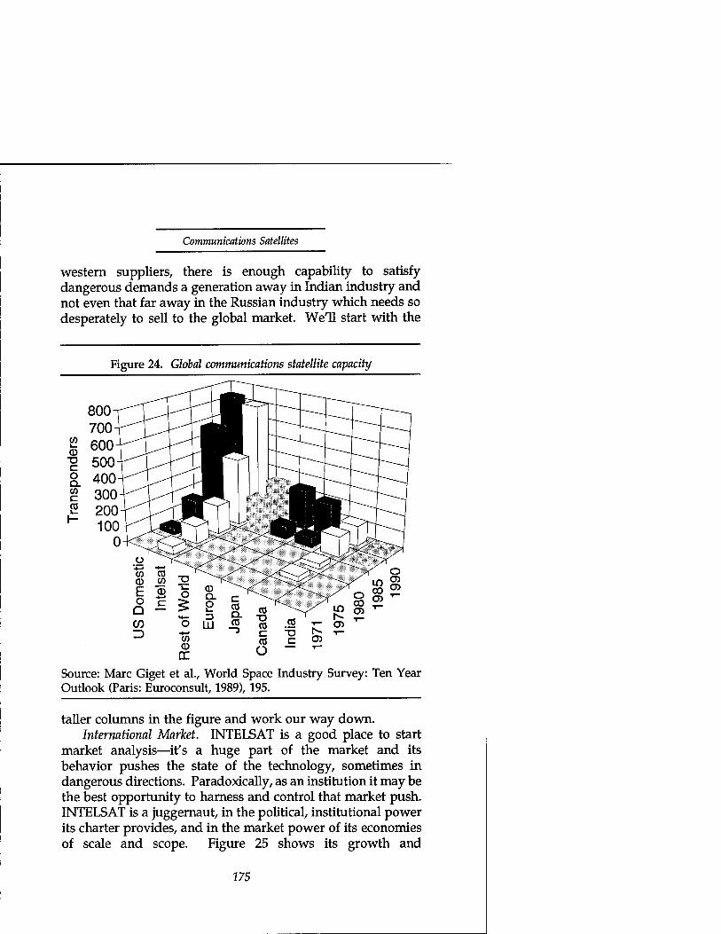
Communications Satellites
western suppliers, there is enough capability to satisfy dangerous demands a generation away in Indian industry and not even that far away in the Russian industry which needs so desperately to sell to the global market. We'll start with the
Figure 24. Global communications statellite capacity
800 700
"g 500 §. 400 £ 300 S 200 "" 100
0
<~> °° ;- Q o) -r-
1^ 1—
Is- T- CD
Source: Marc Giget et al., World Space Industry Survey: Ten Year Outlook (Paris: Euroconsult, 1989), 195.
taller columns in the figure and work our way down. International Market. INTELSAT is a good place to start
market analysis—it's a huge part of the market and its behavior pushes the state of the technology, sometimes in dangerous directions. Paradoxically, as an institution it may be the best opportunity to harness and control that market push. INTELSAT is a juggernaut, in the political, institutional power its charter provides, and in the market power of its economies of scale and scope. Figure 25 shows its growth and
175

Plowshares and Power
diversification through the decade of the eighties. By 1987, its 15 spacecraft (a $3 billion investment) handled two-thirds of the world's overseas telephone and data communications, and almost all of its live television transmission. INTELSAT'S annual traffic growth ranged from about 15 to 27 percent
Figure 25. INTELSAT revenue history
100% 700
600
500
400 |
I 300 w
200
100
Other
New Services
Domestic lease
Television
I I Telephone
—■— Total $ million
Source: Giget, 205, INTELSAT
throughout the decade of the 1970's, then slumped as low as 7 to 10 percent during the early 1980s before recovering in 1988.127 Although its growth rate slowed in that period from the twenties to about ten percent, INTELSAT still anticipated continuing robust traffic growth—in telephone traffic by a factor of five by the end of the century, in dedicated TV transponders by a factor of two, and in domestic service transponders leases and sales by two also.128 This growth projection might seem optimistic in light of the competition.
176
Communications Satellites
INTELSAT has two sources of competition—separate satellite services, unconstrained by pricing restrictions, and fiber optics. Of the two, fiber is the more formidable competitor and likely to fundamentally change the nature of the fixed-satellite service. There are two competitors in the sky for its most lucrative and dominant Atlantic routes, PanAmSat and Orion. They are both results of the Reagan administration certification of separate systems in the national interest.
PanAmSat, with a planned investment of $115 million, launched in June 1988 but managed to occupy only a quarter of its capacity by September 1989. On the surface that occupancy might not seem too much worse than INTELSAT'S. INTELSAT typically has twice the capacity that its major routes require.129 However INTELSAT manages to fill at least half of its remaining capacity with pre-emptible leases and thus keeps its overall occupancy rate at 75 to 80 percent.
Orion, the instigator of the Reagan decision, was slower to space than PanAmSat. It was to launch a two-satellite, $360 million investment in 1992. In the interim it planned to lease INTELSAT capacity to generate revenue. Its coordination with INTELSAT limits it to 33 transponders and prohibits connection with the public switched networks. It's clearly a small competitor, allowed on the playing field only at the sufferance of the INTELSAT monopoly.130 INTELSAT acted effectively to pre-empt the satellite competition:
• It increased its satellites' transmitted power, thus allowing smaller, less expensive terminals.
• It began selling as well as leasing transponder capacity.
• As Figure 26 illustrates, it strengthened its more innovative new services.
• It primed the pump with promotional efforts. For example, its Share program supplied free support for development aid from January 1985 to December 1987, after which INTELSAT began Project Access to
177

Plowshares and Power
stimulate service to rural and remote areas and develop follow-on commercial service. In March 1985, it established the INTELSAT Development Fund to provide funding and assistance for rural and developing areas to introduce or improve telecommunications service.131
And, notably, it decreased it rates in March 1989 after 8 years of stable rates.132
Figure 26. INTELSAT/Cable competition
Trans Atlantic Communications Capacity
90,000
80,000
70,000
= 60,000
Ö 50,000
J 40,000 Q.
■ffi 30,000 I-
20,000
10,000
0
1965
/ D Intelsat / ■ Cable /
/^
1968 1971 1972 1976 1979 1982
Source: Hatfield Assocs., Issues in International Telecommunications Pricing and Demand, November 1984, 23.
INTELSAT is not so able to influence its cable competition. Even before the advent of fiber optics, submarine cable was a significant competitor on INTELSAT'S profitable dense routes. Figure 26 shows the relative magnitudes of cable and INTELSAT capacity before the first trans-Atlantic use of fiber optics in TAT-8. Throughout this period, the FCC required the AT&T telephone monopoly to balance its use of INTELSAT with the transatlantic cables it owned. But, at COMSAT and AT&T's request, the FCC terminated the requirement in 1988, just in time for fiber optics to add their muscle to the cable competition.133 TAT-8 began operation in 1988 with an
178

Communications Satellites
investment of $355 million. TAT-8 added capacity for 37,800 voice circuits (280 million bits per second over a distance of 6714 km)—nearly as much again as all cable had in 1982—offering four times the capacity at a quarter of the cost of its immediate predecessor TAT-7. Even so, INTELSAT announced that its INTELSAT 6 cost per circuit was $504 compared with $1596 for TAT-8. And, INTELSAT'S excess capacity and high reliability made it a useful complement to cable. In 1988 INTELSAT provided restoration of service for 10,000 cable circuits following breakage. However complementary INTELSAT'S satellites might be, cable's advancing technology pushes it further to the fore. In 1991, TAT-9, for an investment of $400 million, added capacity for 80,000 more circuits. That amounts to a 57 percent improvement in capacity per dollar over its 3-year older sibling.134
As formidable as TAT-9 was, fiber optic technology has only begun to explore its potential for growth and efficiency. Current research in fiber optics is pursuing multiple avenues toward greatly increased capacity and lowered cost:
• Low loss fiber is reducing transmission losses by two orders of magnitude over current generation, silica-based fiber.135
• Fiber optic amplifiers136 have demonstrated potential transmission capacity on the order of a thousand times higher than current generation fiber over distances of thousands of kilometers.
• Coherent versus direct detection of optical signals can allow several hundred carrier signals in comparison with the few carried over a single fiber now.
• "Soliton" signal transmission modes combat the effects of chromatic dispersion and preserve signal quality over longer transmission distances. The combination with fiber optic amplifiers is especially powerful.137
179
Plowshares and Power
With its tremendous potential for efficient capacity, fiber allows the rapid development of surplus capacity. Cable owners have demonstrated the intent to create surplus capacity to preempt potential competition, both satellites and other cable initiatives.138 As a result, satellite manufacturers are ready to cede the point-to-point business to fiber, and satellite communications providers are retrenching.
Alan Parker, Chairman of Ford Aerospace Satellite Services Co., predicted in 1986 that "Between now and the end of the century, you're talking about fiber optics taking over the role of terrestrial microwave [radio] and satellites in essentially all heavy-route, point-to-point communications."139 COMSAT Laboratories compared future INTELSAT satellite options with fiber optics favorably in 1989.140 However, their analysis did not account for the fiber optic improvements listed above. In 1989, A. D. Wheelon (recently CEO of Hughes, the leading satellite supplier) predicted that most telephony and data would move to fiber on high traffic routes. He expected that INTELSAT would receive most of its future revenue from point to multi-point television broadcast, with some capacity retained for cable outage restoral service. He predicted, therefore, decreasing access charges and increasingly direct access to the INTELSAT system.141
In the same year, Dean Burch, Director General of INTELSAT, defined strategic objectives for the consortium. The first of nine included "enhance coexistence with fiber optic cables and strengthen competitiveness with separate satellite systems." [emphasis added] He recognized that thick route traffic is susceptible to diversion by fiber optic cable and separate systems and adopted pricing policies to incentivize long-term commitments and make cable restoration cost effective.142 The distinction between his objectives for fiber optics—coexistence—and separate satellite systems— competition—is significant. The best he can hope for with fiber optics is coexistence.
INTELSAT has for now a secure arena for coexistence. It consists of two roles made possible by the flexibility of satellites to re-route service to areas within their field of view.
180

Communications Satellites
Those roles are pathfinder and backup. Where a route is not quite thick enough to make cable installation profitable, INTELSAT can provide and develop service, opening markets that cable suppliers will usurp when the markets are large enough. Even after cable moves in on a route, INTELSAT can coexist on the route so long as it usefully provides restoration. It should be able to do that as long as it has enough other multi-point and thick-but-not-too-thick route business to support economies of scope. In the long run, though, with fiber's increasing cost efficiency, INTELSAT'S business must depend less and less on its traditionally dominant, thick route sources of revenue. Its coexistence with cable will be increasingly in distinct niches.
Domestic Markets. The same trends appear in domestic fixed service, only hastened by the lack of monopoly protection that INTELSAT enjoyed. Not only do domestic systems lack INTELSAT'S political protection and economies of scale and scope, they have been unable to match cable's capacity growth. In contrast to the dramatic leaps in fiber optics' productivity, communication satellite costs have nearly doubled for equivalent transponder capacity between the mid-1980s and 1990s (going from $63 to $137 million for GTE and $74 to $122 million for Hughes Galaxy.) The cost increase tracks fairly well with an inflation rate between 5 and 8 percent over the period.
The U.S. market dwarfs the rest of the world. It sets trends, standards, and prices. For these reasons it deserves our careful attention. In the United States, fixed satellite services are a combination of earlier C-band (6 GHz uplink/4 GHz downlink) and newer Ku-band (14 GHz uplink, 11-12 GHz downlink) transponders. C-band typically provides low to medium power, broad area coverage; its largest use is receive-only television broadcast. Its advantages over Ku band are a large installed user base and lower signal interference from weather. Ku-band service is more typically devoted to two-way data transmission and very small aperture terminal (VSAT) networks.
VSAT networks are ordinarily private telephone and data systems operated by companies to tie together widely scattered
181
Plowshares and Power
locations independently of (and at much lower cost than using) the public switched telephone network. They usually consist of a single large ground station communicating through a transponder with a large number of small (one- to two- meter diameter antenna) stations at outlying locations. For about the cost of a couple of desktop personal computers, a company can connect a location to its network, with no additional per-call or per-message charges beyond the lease of a fraction of a transponder dedicated to its network. If its needs are too small to justify a dedicated network and transponder bandwidth, it can purchase the service shared with others. Companies like Walmart have used VSAT networks with great success to tie together point-of-sale, inventory, warehouse, shipping, ordering, credit verification, and even suppliers for efficient, responsive, "just-in-time" management of their enterprise. For military users, the VSATs' small size makes them easily transportable, and, therefore, more survivable and more useful for mobile forces. Although defensive military forces often need mobility also, offensive forces invariably do. VSATs deserve some scrutiny for technology trends that might make them more survivable and therefore more dangerous from our point of view. We'll return to them in a later section isolating potentially dangerous technology trends.
Table 8 summarizes the late 1980s U.S. domestic communications satellite market. By the beginning of 1989, the population of transponders had grown to 634 (413 C-band, 216 Ku-band), and forty percent of them were idle. Satellites had saturated the television distribution market. Ninety-nine percent of the 1,000 commercial stations and 6,000 main cable distributors had terminals, and growth in the number of broadcast signals was slight. VSATs represented some opportunity for growth, but primarily in ground terminals, not in transponder capacity. Several thousand VSAT antennas in a single network can use a small portion of a transponder simultaneously. One network supported 4,000 small terminals within a quarter of a transponder. In 1989,92 private networks were operating with a total of 12,000 antennas for an investment of about $200 million.143
182

Communications Satellites
U.S. fixed-service providers operate about 30 satellites in orbit. In response to the increasing market penetration of fiber optic cable they have restructured to capitalize on satellite strengths: point-to-multipoint communication (in particular, video distribution,) newsgathering, and VSAT networks.144
Table 8. U.S. domestic market
Total transponder activity, October 1985 through July 19881
Segment
Scheduled television Occasional video Voice & data Inactive Total transponders
Share (%)
20-36 10-18 50-27 20-18
500-550
Mid-1988 Band Detail2
Segment
Scheduled televison Occasional video Voice & data Inactive
Ku-band (%)
23.4 18.0 34.4 24.2
C-band (%)
44.6 18.0 29.3
8.1
Source: Walter L. Morgan, "Transponder Supply and Demand," The 1989 World Satellite Directory (Potomac, MD: Phillips Publishings), 263. 2Source: Giget, 228. __^_
No other country has developed the domestic communications satellite market like the United States. Both Europe and Japan are more densely populated and well suited to penetration by cable. Japan, in particular, has population concentrated along its coasts—ideal for point-to-point connection by fiber optic cable. Also, Europe's communications are administered by government agencies more concerned with
183

Plowshares and Power
equity and distribution than with efficiency and less inclined to let market forces work.
Europe's multiple political jurisdictions within a small geographic area have made coordination of satellite services difficult. However, the recent maturing of the European Economic Communities appears to be improving the coordination. The EC published in November of 1990 a Green Paper on Satellite Communications in the European Community intended as the basis for a directive from its Commission that would propose:
• Liberalization of the space segment market, permitting satellite service providers such as INTELSAT and Eutelsat to market services directly to end-users rather than through PTT's.
• Unrestricted access to space segment capacity, allowing users to purchase directly from authorized satellite operators.
• Deregulation of the ground segment to allow easier ownership of earth stations.
• Standardization of satellite equipment regulations and mutual recognition of type approvals in keeping with the rest of the EC's initiatives for a unified market.145
These initiatives would go a long way toward opening up the European domestic market. Once open, however, fiber optic cable will crowd it at least as much as the American satellite market.
Many of the recent additions to the satellite population have been for developing nations with questionable, or at least prematurely expressed, needs for the quantity of service purchased. Many appear to seek their own systems as a matter of national pride (or perhaps fear of losing a place on the geosynchronous belt—which the 1988 Space WARC should have allayed when it reserved space and spectrum for them.)146
184
Communications Satellites
Mexico, for example, launched Morelos in 1985. Its 22 transponders were operating at less than half of capacity as late as 1990, with estimated losses of more than $20,000/day.147
Even Australia, whose large land area and scattered population are ideally suited for satellite communications and whose economy is hardly undeveloped, has had a hard time making a domestic satellite self-supporting. Its Aussät 1 launched in 1981 and had lost $100 million Australian through 1988. Some of the world's would-be owners, such as Spain and Turkey, plan systems to serve both civil and military users, a practice that France and Russia have long employed. Among the many with either their own satellites or announced plans for them are several with regional power aspirations: Iran, India, Pakistan, and Thailand for example.148
Fortunately for our concern about military use of civil communications satellites, there is an attractive alternative to owning a satellite. Much of the rest of the world uses transponders either leased or purchased from INTELSAT for their domestic satellite communications. Figure 27 illustrates the growing trend toward INTELSAT since the mid 1970's. From our point of view the trend is hopeful. This kind of INTELSAT service is unlikely to develop dangerous characteristics. In addition, INTELSAT is likely to respond to an international call to embargo the communications of an agressor nation. Encouraging this trend may be an attractive strategy for response to the proliferating military use of civil communications satellites.
Mobile Satellite Service Mobile satellite communications are most characteristic of military needs (especially offensive ones), more survivable than fixed services, and least susceptible to competition from alternate services. From our point of view, they are most likely to enable dangerous military use of civil satellites or technology.
We found competitors for fixed-service in terrestrial equivalents. The mobile service's terrestrial equivalents are
185
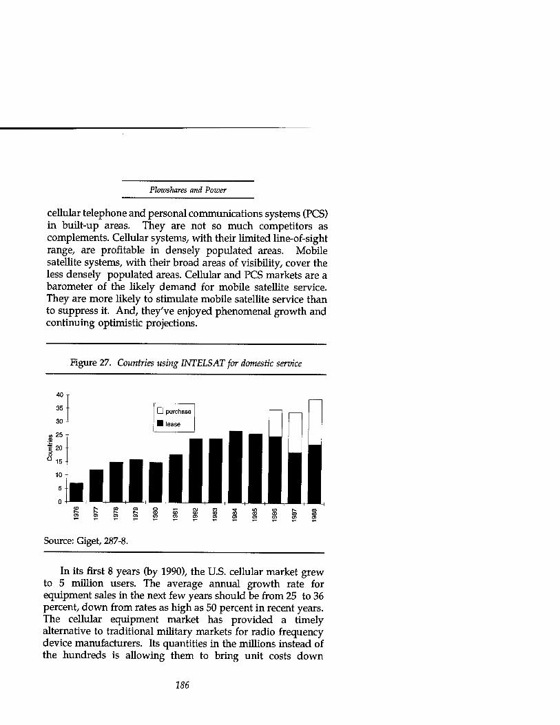
Plowshares and Power
cellular telephone and personal communications systems (PCS) in built-up areas. They are not so much competitors as complements. Cellular systems, with their limited line-of-sight range, are profitable in densely populated areas. Mobile satellite systems, with their broad areas of visibility, cover the less densely populated areas. Cellular and PCS markets are a barometer of the likely demand for mobile satellite service. They are more likely to stimulate mobile satellite service than to suppress it. And, they've enjoyed phenomenal growth and continuing optimistic projections.
Figure 27. Countries using INTELSAT for domestic service
40
35
30
en 25
I 20 o °15
10
5
0
D purchase
H lease
.llllllllllll SP£"£°P5Q',-c\jcoTtiw<orvco
Source: Giget, 287-8.
In its first 8 years (by 1990), the U.S. cellular market grew to 5 million users. The average annual growth rate for equipment sales in the next few years should be from 25 to 36 percent, down from rates as high as 50 percent in recent years. The cellular equipment market has provided a timely alternative to traditional military markets for radio frequency device manufacturers. Its quantities in the millions instead of the hundreds is allowing them to bring unit costs down
186

Communications Satellites
precipitously compared to their past military products. The fact that most cellular subscribers are selecting portable (rather than mobile) models supports predictions of large markets for personal communication systems. One source estimates the U.S. PCS market at 50 to 100 million users in the next 10 years. Another survey indicated over 42 million U.S. residences would buy systems within 3 to 5 years of availability. Subscription costs are projected at $40 to $50 per month within 10 years of coming on line. Annual revenues for service and equipment would be on the order of $40 billion.149 The size of these mobile markets guarantees rapid growth of satellite suppliers to provide service in less densely populated areas.
The mobile satellite service markets include traditional maritime service, recently defined RDSS (radio determination satellite service) locating and messaging service, and emerging aeronautical and land mobile services. INMARSAT is the entrenched power in the maritime area, but it's under increasing pressure from private initiatives in RDSS and land mobile services.
INMARSAT. INMARSAT began service to a thousand ship terminals. By the end of 1989, it had about 10,000 ship-borne terminals with growth rates for service as high as 45 percent for telephone and 20 percent for telex. Its potential market includes more than 75,000 vessels greater than 100 tons and about the same number of vessels between 25 and 100 tons.150
Figure 28 depicts the history of its revenue growth and the distribution of revenues from serving its current market. A quick look shows that the majority of its business has come from Atlantic ship-to-shore telephone conversations. To serve its market INMARSAT has relatively modest capacity on orbit and planned (table 9).
A Standard-A INMARSAT shipborne terminal is the original standard user equipment. It provides telephone and telex capability from an antenna about a meter in diameter and costs about $30,000. A double suitcase-sized portable version like Peter Arnetf s Baghdad-to-Atlanta link costs about $45,000. Either one provides a voice circuit for about $10 a minute. INMARSAT is introducing two briefcase-sized, less
387

Plowshares and Power
expensive (but less capable) standards:
• The Standard-C terminal—expected to cost about $5,000 in mass production and provide 600 bit per second (teletype speed) electronic mail
• The Standard-M—to provide digital voice communications in a briefcase-sized terminal beginning in 1993.151
Table 9. INMARSAT capacity
Source Satellites Channels each
ESAMarecs 2 50 Intelsat V lease 4 30
Marisat 3 10 (emergency backup)
Post 1990: Inmarsat 2 3 250
Post 1994: Inmarsat 3 3 -2000
Sources: Giget, 214; Mark Long, World Satellite Almanac, Second Edition (Indianapolis: Howard W. Sams & Co., 1987), 108-110; Neil Akroyd and Robert Lorimer, Global Navigation, A GPS User's Guide (London: Lloyd's of Londer Press, Ltd., 1990), 171-198.
Standard-C service is to cost about a dollar a kilobit; Standard-M is to begin at about $5.50 a minute and should decrease below $4.00 per minute. The International Maritime Organization has designated Standard-C as its standard for the global maritime distress and safety system. INMARSAT projects the Standard C terminal population to grow (figure 29).152
From the nature of its service and the projected dominance of land based terminals, INMARSAT clearly intends Standard C to compete for the RDSS market. Typical users of RDSS are fleets of vehicles and trains. The next section describes the RDSS market and competitors in more quantitative detail.
188
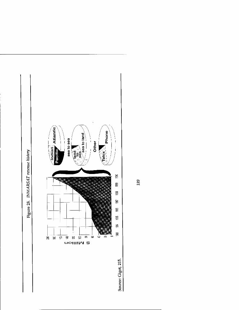
SS e
00
u
^^H ■^ö 1 ^
^ 1 UOüMI/M $
i—i CM
01
.SP U öj
O
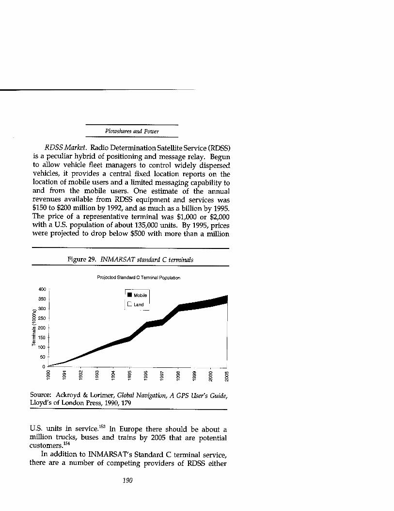
Plowshares and Power
RDSS Market. Radio Determination Satellite Service (RDSS) is a peculiar hybrid of positioning and message relay. Begun to allow vehicle fleet managers to control widely dispersed vehicles, it provides a central fixed location reports on the location of mobile users and a limited messaging capability to and from the mobile users. One estimate of the annual revenues available from RDSS equipment and services was $150 to $200 million by 1992, and as much as a billion by 1995. The price of a representative terminal was $1,000 or $2,000 with a U.S. population of about 135,000 units. By 1995, prices were projected to drop below $500 with more than a million
Figure 29. INMARSAT standard C terminals
Projected Standard C Terminal Population
Source: Ackroyd & Lorimer, Global Navigatwn, A GPS User's Guide, Lloyd's of London Press, 1990,179
U.S. units in service.153 In Europe there should be about a million trucks, buses and trains by 2005 that are potential customers.154
In addition to INMARSAT'S Standard C terminal service, there are a number of competing providers of RDSS either
190

Communications Satellites
operating or planning to begin operation. With one exception, they use high altitude satellites. The U.S. company Geostar originated the service with a proposal to determine position by simultaneously measuring the range from a transmitting user through three different satellites to a central facility. The transmissions allowed low capacity, one-way communications from the mobile users to the fixed central facility. The FCC licensed Geostar to operate in 1986 with a temporary allocation of L-band spectrum for the service, which the 1987 WARC confirmed. In 1987, Geostar ordered three satellites for 1992 launch. While waiting for launch of dedicated satellites, Geostar established its service first with ground based Loran-C positioning and satellite message relay through leased transponders. It licensed its technology to a European operator Locstar.155 In addition, the Arabsat regional consortium modified its third satellite to Geostar's specifications for a test period over the United States, after which the satellite would maneuver to its operational position and establish the same service for Africa and the middle East.156 Geostar went into Chapter 11 bankruptcy in 1991.
A similar system, Qualcomm's OmniTRACS, provides two- way data communications along with position reporting. It provides its service for a fee of $5 a day per unit, with user terminals costing from $3,000 to $4,000. The European consortium Eutelsat has leased transponders to Qualcomm for an OmniTRACS trial in Europe. The FCC granted it a license to operate its service in 1989 via Ku-band satellite transponders on a secondary basis, requiring non-interference with established fixed service users.157 Qualcomm's system achieves non-interference by using a spread-spectrum waveform to minimize interfering power. The spread-spectrum waveform is also a primary component of the positioning system. It provides the precision ranging.
The proposed low-altitude system is more of a data transmission service than a positioning system. Orbital Science's proposed OrbComm system would fly in 1993 a constellation of twenty-four satellites at low altitude to provide a store and forward service. (Because of their low altitude and
191
Plowshares and Power
lack of intersatellite relays, real-time communications would not be possible over the satellite's limited horizon.) Orbcomm proposes to provide service in various grades. The lowest is a "911" style emergency reporting system, costing from $50 to $150 per terminal. Its low price is aimed at the mass consumer market with such applications as an automobile accessory (which might transmit automatically when an airbag is deployed or on demand when a vehicle breaks down along an isolated stretch of highway.) The system would support about 20 million subscribers in the United States alone. A higher grade of service would come in a calculator-sized data communications unit costing from $250 to $400. The size and price would allow incorporation in remote reporting equipment for such applications as monitoring of pipelines, oil welk, and environmental sensors.158
Mobile Market. The land mobile communications market is the largest in mobile communications. In 1984 one report estimated the potential market at 365 million privately owned vehicles, 102 million commercial vehicles and 7 million buses. There were well over 5 million vehicles equipped with mobile communications (mostly cellular) even then.159
In addition to INMARSAT'S Standard M terminal, there are a number of private initiatives competing for the market not covered by cellular telephone. In 1985 the FCC announced the opportunity to apply for licenses to operate a North American land mobile satellite system. When 12 companies applied, the FCC forced a consolidation in 1988. The result was the American Mobile Satellite Corporation (AMSC), an eight- company consortium.160 AMSC and Telesat Mobile Inc. of Canada signed contracts to procure jointly two spacecraft for 1994 launch. Anticipated terminal costs are under $4,000 with a $50 per month and $2 per calling minute service charge. Because they operate in different frequency bands, a hand off from AMSC's system to a terrestrial cellular network would require the user to re-dial the call. Canadian market projections are for 130,000 to 160,000 terminals by 2000.161
The most ambitious of many competing mobile service proposals is Motorola's Iridium project. It is global rather than
192

Communications Satellites
regional in scope. Indium's license application proposes to target markets not currently served by mobile communications services, such as (1) sparsely populated locations where there is insufficient demand to justify constructing terrestrial telephone systems; (2) areas in many developing countries with no existing telephone service; and (3) small urban areas that do not now have a terrestrial mobile communications structure. Iridium will offer the full range of mobile services including RDSS, paging, messaging, voice, facsimile and data services. More than half of Indium's projected 6 million subscribers will use RDSS and ancillary paging and messaging services.162
Iridium's proposed constellation would consist of 77 satellites (7 in each of 11 orbital planes with some number of orbiting spares) at an altitude of 765 kilometers. The low altitude would allow a very small, low-power user terminal. The satellites would receive calls from handsets that look like hand-held cellular telephones. Handsets would cost about $4,500 to start but would reduce quickly to about $450, based on Motorola's experience with its MicroTac hand-held cellular phone. Iridium expects service charges to cost about $40 per month of service and $3 per minute of connection.163
In the overall network each satellite would act like a cellular base station does on the ground, handing callers off to neighboring base stations when the caller moves from one cell to another. In Iridium's case, the movement of the satellites over the earth would cause the cells to leave the callers behind. The caller by comparison would seem to be standing still. Although the perspective is inverted, the principle is the same as for tenestrial cellular telephones. The satellites would connect the calls to large gateway ground terminals which would verify the user's billing status and connect the call either into the public switched network or back through the satellites to another hand-held Iridium terminal. To provide real-time telephone connections over the horizon, Iridium's satellites are to have intersatellite communications links to the satellites ahead, behind and in neighboring orbit planes. Iridium's architecture can accommodate 250 independent gateways, but the system would begin with between five and twenty (of
293

Plowshares and Power
which two would be in the United States.)164
Motorola requested proposals for building the spacecraft in 1990, and selected the spacecraft contractor in 1991. Satellite construction is to begin in 1992. The first satellite should be launched in 1994, the last by 1996. Full service is to start in 1997.165
Despite its ambitious schedule and technical approach, the major barriers to Iridium are financial and political. Iridium requires a $3 billion investment before achieving full operational capability (see table 10 for details of the estimate). The political barriers are the entrenched interests of the government agencies and PTTs that might view Iridium as unwelcome competition for their monopolies. Monopoly under the supervision of the ITU-PTT cartel has long been the accepted—often legislated—regime for international telecommunications. However, the benefits of U.S. domestic competition have put increasing pressure on the cartel and opened up the possibility of replacing the cartel regime with international business alliances.166
Motorola has adopted the strategy of using a business alliance to dismantle both sets of barriers. It has sought an international consortium of investors—between six and ten major owners (with other categories of ownership available, such as secondary positions and minority ownership for a nominal value.) It has looked for owners among companies involved in telecommunications services, which would be most likely to wield political power in the communications regulatory arena. It formed an international corporation to develop and operate the system to avoid the threat of a single national company or country's domination.167 The first indication of its probable success with the political barriers came from the U.S. government.
The FCC has supported Motorola's and other competing innovative proposals. Chairman Sikes of the FCC, in public remarks on the 1992 World Administratrive Radio Conference, said that "all other things being equal, what the Communications Act directs is for the FCC to 'tilt' in the direction of technological advancements." He identified Iridium
194

£ Ov CM
Ov VO o 1—1
t-i
m i—i
00 ool §1
OV ON o
r-l CO
Ov
CM vo 31 S!
ON
CO 00 8 T—<1 vo
s
•«• VO
V0
Ov
in S CM CM
CM VO O CM i—l tv
CM K CM i—i in cpl O IT) Ov IC
CO ID i—i VO| CO
VO
ON
"43 5
!
in ON
CO CO CS CO
CO o\
CM T* COl *' cS
in
•3 •5 IC
CM o\
CM co co 00 8 ^s
t o\
o Ov
i OJ
O CO
CO 00
"*l in
o|
9 «3 O
§ «5
p
E2
o
01 u I-
§

Plowshares and Power
as "just such a new and innovative service worthy of encouragement by the Commission."168 As a result, the U.S. position at the 1992 WARC was consistent with Motorola's proposal, and the WARC granted substantially the allocation requested.169
Dangerous Trends. The preceding market surveys list a number of trends that could make military use of emerging civil satellite communications less vulnerable and more dangerous. They include low-altitude orbits and frequency re- use techniques that provide a degree of immunity to jamming.
Movement to Low Altitude. A Motorola promotional brochure describes the Iridium system as providing:
seamless global communications including both the oceans and airways up to 100 miles in altitude. Iridium will be a premium service targeted toward those who demand the ability to communicate important information instantly. Foreign news service correspondents will be able to make immediate contact with editors. Government officials will have uninterrupted lines of communication—no matter what the circumstances. Iridium will be a basic communications system for those areas of the world currently lacking wire lines or cellular capabilities, [emphasis added]
If the "government officials" belong to an opposing military's command and control structure and the area is "lacking wire lines or cellular" because of your attacks on them, Indium's promise would rightly cause you some concern. Alternatively, if the foreign news correspondents are in intimate contact with your forces as well as immediate contact with their editors, Iridium's promise would also cause you concern.170 Your alternatives would be to jam its satellites as they came in view; to attack the Iridium network's terrestrial gateways; or to persuade Iridium's operators to deny service to the areas in conflict.
If you chose to jam the satellites, you could expect to succeed when the satellites are in view—with only modestly sized jammers. If the jammer were in the same cell as the
196
Communications Satellites
victim handsets, the power needed to jam is no more than that of the handset times the number of channels in the cell. Thankfully, Iridium plans to employ no jam-resistant spread- spectrum modulation, and the jammer need compete in power only with a very small, low power handset. However, if the geography does not permit jammers to straddle the victim terminals, the satellites may not be in view of a jammer enough of the time for the jammers to be effective. Also, of the five low-altitude systems proposed to the 1992 WARC, all but Iridium plan to use more or less jam-resistant, spread-spectrum waveforms,171 which could present much more severe difficulties to the jammers, particularly if the satellites despread the signals on-board the spacecraft.
If you chose to attack the network's gateways, you might be able to isolate the network from the terrestrial switched network in the country involved (which you've no doubt already destroyed) but not from other Iridium handsets. Iridium's gateways are proliferated around the globe and back each other up in keeping the satellite network intact.
If you try to persuade Iridium's operators to deny service to the area, you may be in luck. Iridium's architecture can physically deny access on a cell by cell basis or on a subscriber by subscriber basis. The latter could be available by the same mechanism that checks to see if a user has paid his bill before allowing him to complete a call. Of the two means, the more selective is preferable. Because of their low price, small size and convenience, Iridium handsets will inevitably turn up in the unauthorized equipment lists of friendly forces. Despite all efforts to enforce reliance on purely military systems with assurable survival, inventive soldiers will quickly make Iridium an indispensable part of their operations. The expense and delay of fielding military systems will accelerate the trend. A decision to deny all users access to certain cells could be as painful for the friendly forces as for the foe. Should that be the only means available, it could still be useful for short periods at critical moments—particularly when the outage is part of a friendly plan and a surprise to the foe.
For either of the physical means to work, however, there
197

Plowshares and Power
will have to be software, procedures, and legal authority in place. Even then the members of Indium's consortium will need to reach consensus to comply with your request. These requirements should translate directly into conditions on license approvals and into diplomatic initiatives to provide the international legal framework. Clearly the movement of communications satellites from high-altitudes to low earth orbit raises the possibility of some degree of invulnerability from attack. The danger is most acute if the licensing of such low altitude systems does not provide the legal authority and enforce the software, procedures and modulation design to assure that jammers can interfere with the satellites.
Frequency Re-use. Independent of satellite altitude, a number of frequency re-use techniques may confer some degree of jamming protection—for example, spot beams, on- board processing, and spread-spectrum multiple access. How much protection depends on the specifics of the application: size and location of spot beams, geography of the service area and accessibility by potential jammers, form of modulation and synchronization for multiple access, degree of on-board processing, and visibility of the satellite's output signals. Blanket prescriptions for controls are difficult to formulate and unlikely to be more effective than they are economically damaging. However, competitive pressures on satellites to use more efficiently the limited frequency spectrum are already driving designs in more dangerous directions.
Fiber optic cable competition may drive INTELSAT eventually to emulate the competition—that is, to move to optical frequencies. Most of fiber's advantages come from the much higher signaling rates possible at optical wavelengths compared with radio frequency communications. The other major advantage is the ability to re-use that portion of the spectrum as many times as one is willing to lay separate strands of fiber. A radically different low-altitude satellite architecture could seek the same advantages by using laser communications, both as intersatellite links and as space- ground links.
On-going inter-satellite link developments are relatively low
198

Communications Satellites
capacity in comparison with terrestrial fiber, perhaps because they are intended for the longer distances from low earth orbit to geosynchronous orbit.172 If applied to the shorter distances of an Iridium-like constellation, the reduced diffusion of the beam should allow greater signalling rates. The narrow beamwidths of laser signals would also make such communication links virtually impossible to intercept or jam. From that perspective, satellite laser communications would be very attractive for military use.
The principal limitation on military utility of such a system for land forces would be dependence on clear weather. For reliable communications to and from the ground in temperate climates, fixed-site terminals would have to employ enough spatial diversity (distance between sites connected by land line) to ensure a cloud-free line of sight to a satellite. This limitation would be a fairly serious drawback for mobile forces, except, perhaps, for those in arid climates and for aircraft flying above the cloud cover. However, based only on the state of technology, we should be able to defer worry about optical links, at least relative to more immediate trends in INTELSAT'S quest for efficiency and capacity.
The INTELSAT VI spacecraft employ a form of multiple- user access called satellite-switched time division multiple acccess or TDMA. That mouthful means that the satellite continuously switches uplink and downlink beam connections (six uplinks and ten downlinks) according to a programmable pattern in order to time-share and space-share the frequency spectrum. The switching among beams creates brief, essentially private connections. The privacy limits the ability of eavesdroppers and jammers to participate effectively except in the beam positions they occupy.
Future development of this approach will lead to on-board demodulation of the uplink signals and recombination for transmission by scanning spot beams. In one proponent's words: "When this on-board digital sorting and distribution of signals is combined with a rapidly scanning antenna beam, the result can be a system solution of extraordinary capacity."173
The result is also a system of greatly improved protection from
199

Plowshares and Power
jamming, but, from a more optimistic point of view, one allowing greater precision in the ability to embargo communications to and from an area under international censure. Agile spot beams present some difficulty to jammers, especially in conjunction with on-board processing. If they are combined further with spread-spectrum processing, they can be nearly immune to jamming.
A competing architecture for Iridium's mobile marketplace proposes high altitude satellites employing spread-spectrum multiple access in combination with steerable mobile spot-beams for spatial re-use of frequencies. One proposed approach to forming the spot beams would electronically steer the beams to focus power and sensitivity on the mobile user. This particular architecture would synchronize the system by broadcasting a short length spread-spectrum code to all users. The mobile terminals' spread-spectrum signals all use the same (much longer) code offset in time from each other in order not to interfere with each other. The users signal their requests for code timing slot allocations with a short code similar to the timing broadcast signal.174 The long code, spread-spectrum signals would make synchronizing a jammer difficult if the jammer were unable to hear the timing slot allocation due to the spot beam shape. The spot beams would also attenuate the jammer's signal power if it were not in the same beam footprint. This particular architecture could have some vulnerabilities in its mechanism for supporting multiple users and in its broadcast timing signal:
• If the satellite could form only a limited number of beams due to hardware limitations, a jammer might masquerade as multiple users and hog the available beams.
• The jammer might be able to transmit an interfering synchronizing signal and disrupt the entire network at once, if it could overcome the attenuation of a spot beam focused on the control station.
200

Communications Satellites
• If the beam footprints allowed, the jammer might be able to synchronize jamming with an individual user's code timing slot.
The spot beam element of all these architectures is present already in many civil satellites to some degree. There is a natural economic incentive for the owners to concentrate the satellite's limited resources in the areas that have the paying customers, or to re-use limited frequencies in geographically separated areas. They also owe it to their neighbors to minimize interference with their use of the spectrum. But, use of the term spot beam may mislead. Common usage applies the term to almost any antenna coverage smaller than a hemisphere.
For example, the INTELSAT VI Ku-band spot on the east coast of the United States covers an area spanning the Carolinas and Virginia north to south and extending east to west from the coast past Illinois. Its corresponding spot beam on Europe, covers the area extending north-south from Denmark halfway down the Italian peninsula and from west to east all of France, Germany, and Eastern Europe well into the Ukraine.175 The domestic satellites of smaller countries and regional associations provide "spots" intended to concentrate on their countries and perhaps their friendly neighbors. However the geometry of a beam's projection on the surface of the earth practically guarantees some spillover on neighboring areas that would be accessible to a jammer in a regional conflict. The geometry depends on the size and shape of the country and its latitude. A country near the equator will find it easier to confine a beam's illumination within its borders from a longitude nearly overhead. India is able to keep its coverage confined to the sub-continent and its coastal waters in its more southern areas, but its beams spill over into Tibet and Pakistan in the North.176 Current generation spot beams confine the jammer's access to regional theaters of operation. The more ambitious scanning spot beams and laser links could exclude them entirely.
Clearly in all of these architectures, the degree of
201

Plowshares and Power
vulnerability depends greatly on specific features and parameters of the system design. Broadly formulated controls on particular items of technology can be of little or no help. If controls must be tailored specifically for each architecture, they will be easier to coordinate among a smaller number of players.
International Supplier Capabilities The distribution and development of communications-satellite equipment suppliers mirror the trends in satellite communications capacity (figure 24). American companies pioneered communications satellites and are still able to dominate price competitions based on their efficiency and economies of scale and scope. Three-fourths of the world's commercial communication satellites are the product of three American companies (one of which was recently purchased by a European consortium.)177 But, American industry now shares the marketplace with European, Japanese, and Canadian companies. Britain, France, Germany, Japan, Italy, and Canada all have one or more companies each that have demonstrated the ability to act as a prime contractor in integrating subsystems and components into successful communication satellites of roughly equivalent technology and capability.178
As a result, most communication satellites built today are the result of international collaborations. Some of those relationships began as deliberate technology transfers through offsets required as a condition of contract award. Over time they have evolved into supplier relationships beneficial to both sides. Some of the suppliers (Japanese semiconductor electronics for example) offer unique comparative advantage. In competitions for domestic U.S. satellites, U.S. prime contractors now routinely use international suppliers of components and major subsystems.179 Table 11 lists a fairly typical distribution of suppliers for the communication payload of an INTELSAT VI satellite.
In addition to a demonstrated ability to build state-of-the- art commercial communications satellites, most European
202
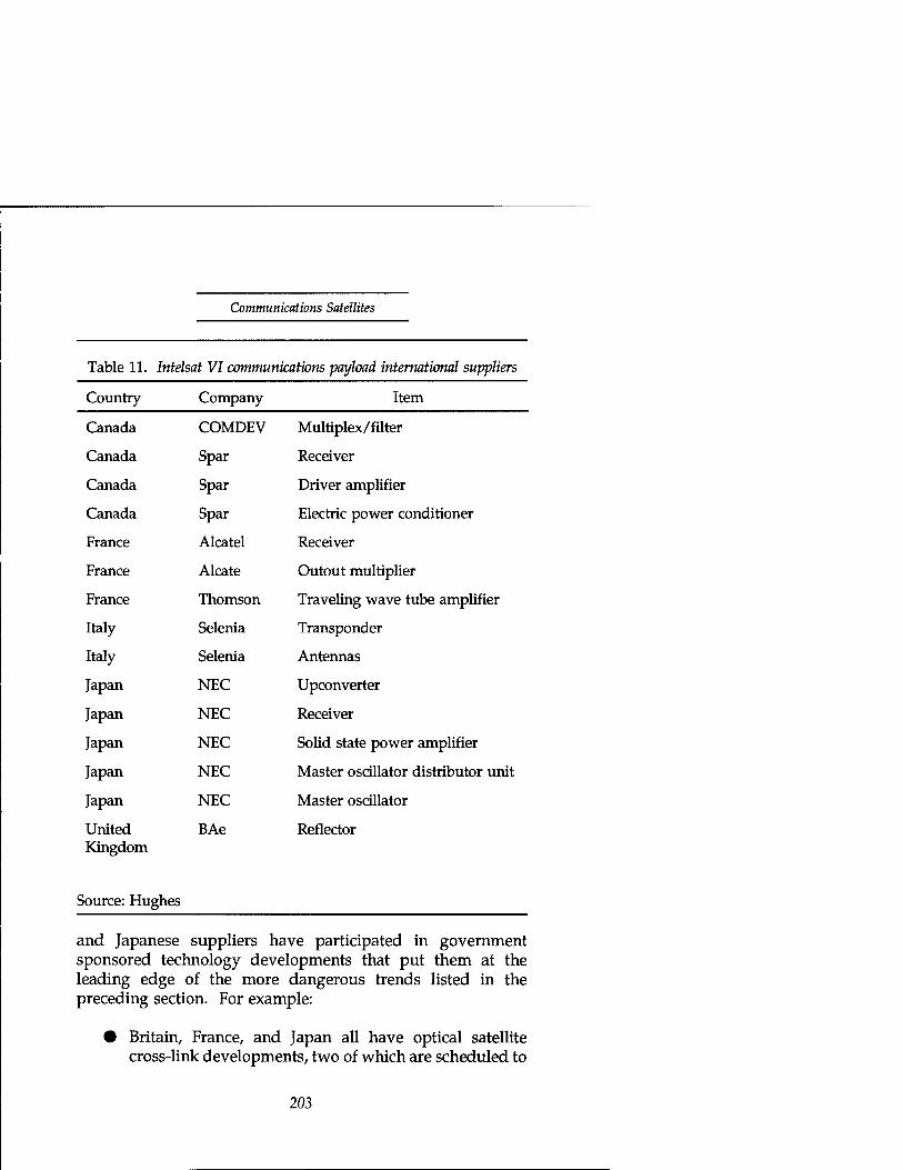
Communications Satellites
Table 11. Intelsat VI communications payload international suppliers
Country Company Item
Canada COMDEV Multiplex/filter
Canada Spar Receiver
Canada Spar Driver amplifier
Canada Spar Electric power conditioner
France Alcatel Receiver
France Alcate Outout multiplier
France Thomson Traveling wave tube amplifier
Italy Selenia Transponder
Italy Selenia Antennas
Japan NEC Upconverter
Japan NEC Receiver
Japan NEC Solid state power amplifier
Japan NEC Master oscillator distributor unit
Japan NEC Master oscillator
United BAe Reflector Kingdom
Source: Hughes
and Japanese suppliers have participated in government sponsored technology developments that put them at the leading edge of the more dangerous trends listed in the preceding section. For example:
• Britain, France, and Japan all have optical satellite cross-link developments, two of which are scheduled to
203

Plowshares and Power
fly in 1993 or 1994, 180
• The European Space Agency's 1989 launch of its Olympus-1 satellite included an experimental satellite switched agile spot-beam capability.181
• Italy's 1991 launch of Italsat carried a payload using on- board processing182 in conjunction with spot beams small enough that four covered the Italian peninsula and one each covered Sicily and Sardinia.183
• Japan conducted experiments in spread-spectrum multiple access through its experimental communication satellites in the early 1980's.184
Any of the major European, Canadian, or Japanese contractors could supply the technology for military satellite communications or militarily useful civil satellites. To illustrate the point, figure 30 shows the sources of France's second generation military communications satellite payload, Syracuse II. Its first generation, the Syracuse I flies two transponders on the Telecom 1 satellites with communications protected by encryption and spread-spectrum modulation using satellite- generated synchronization.185
Outside of western sources we should consider primarily Russia as a potential supplier. The Soviet Union had a long history of communications satellites in virtually all applications, their principal satellite systems being:
• Raduga (Rainbow): general purpose geostationary
• Gorizont (Horizon): general purpose geostationary
• Ekran (Screen): direct broadcast television
• Molniya (Lightning): high latitude general purpose communications.186
204

Communications Satellites
They had also existing or planned payloads on those satellites for other services:
• Loutch or Luch (meaning Ray, spelling depends on transliteration from the Cyrillic): Ku-band experimental transponder on Gorizont satellites
• Volna (Wave): UHF and L-Band aeronautical and maritime mobile service on Gorizont and Raduga spacecraft
• Morya (Seaman): maritime service at C- and L-band
9 Gals (Tack—X-band military transponder on Raduga spacecraft)187
Russia's principal communications satellite builder is the Production Organization for Applied Mechanics, Krasnoyarsk, Siberia, builders of Ekran, Luch, and Gorizont for more than twenty years. Despite their longevity in the business, their satellite designs are not competitive commercially with western practice. They use nitrogen pressurized satellites to simplify thermal control and testing where western builders design and test for the vacuum conditions of space.188 The pressure vessel designs must supply make-up gas to replenish the invariably leaky artificial atmosphere. As a result the satellites are much shorter lived than their western counterparts (typically a year or two compared with 10 to 15 years.)
205

Plowshares and Power
Figure 30. International contribution to France's Syracuse II
3.5%
7.5%
13.5%
Source: Alcatel
69.3%
D France
■ North America
1 Britain
SB Germany
D Japan
H Belgium
D Denmark
B Spain
Although unlikely to compete successfully for legitimate commercial applications, the Russians could easily be a source for someone trying to circumvent western export controls. In addition they've begun cooperative efforts with western companies which will inevitably transfer some western technology and design practice. For example, the German- Russian Romantis cooperative effort was to provide Ku-Band services (TV distribution, voice and data via VSAT) to Russian users with a Russian satellite carrying a German payload.189
Strategies The previous chapter on remote sensing divided its strategies into three classes, and we can do the same in response to military use of satellite communications:
• Supply side (export or technology control)
• Demand side (market pre-emption or international cooperation to supply safer alternatives)
206

Communications Satellites
• Direct action to counter the threats as needed.
Not surprisingly, we've found a similar distribution of satellite communications technology around the world as we did for remote sensing. However, a number of factors are significantly different for the communications problem. The law, institutions, and precedent are much more developed; alternatives are necessarily more constrained. Civil use is much more widespread and critical; market forces are much more compelling. But, fortunately, the threshold of capability that we might consider dangerous is not so readily accessible. And, as with remote sensing, there are direct military responses available—electronic countermeasures—for currently accessible capabilities. With modest controls, reasonable international cooperation, and prudent investment in countermeasures we should be able to deal with any remaining attempts to misuse civil communications satellites.
Supply Side—Export Controls Because of the widespread distribution of satellite communications technology, we should expect to need multilateral controls on military communications satellite equipment and civil equipment with similar characteristics. There is also a class of military satellite equipment for which the United States appears to enjoy a clear lead and for which unilateral controls can be effective (not only in limiting their proliferation, but in encouraging cooperation from allies in limiting the distribution of their military satellite equipment). Specifically, those are nulling antenna technology and EHF Milstar technology. Nulling antennas are able electronically to form a hole of reduced antenna gain in the direction of a jamming signal to reduce the effect of the jammer on the desired signal (appendix B). The U.S. military satellite communications program Milstar will operate at Extra High Frequency (EHF), compared with the Super High Frequency (SHF) used for commercial satellites. Its EHF frequencies are on the order of eight times higher than the SHF frequencies,
207

Plowshares and Power
which enable a proportionately wider communications bandwidth that can be devoted to proportionately higher jamming resistance by judicious selection of the waveform. In both these areas, U.S. industry enjoys a lead over other countries' satellite builders. However, in most commercial communication satellite technology, U.S. industry shares capability with the rest of the world. Although not as capable as Milstar, commercial satellite technology can still produce systems that would be difficult to jam. For commercial technology, export controls will have to be multilateral.
A minimum set of export controls will be essential to prevent civil communications satellites from becoming a sanctuary for an opponent's command and control. However, we've observed legitimate civil applications and growing legitimate market demand for features that border on being dangerous. Ambiguous controls could permit loopholes if too loose or encourage dangerous alternatives (either from uncontrolled suppliers or from the creativity of constrained suppliers) if too stringent.
Unilateral Controls. The Department of State published a Federal Register notice of proposed rule making on September 5,1991, proposing to revise the U.S. Munitions List by adding a new Category XV for spacecraft equipment to be controlled as munitions. The remainder were to transfer without further restrictions to the Commerce Department for export control as non-munitions commodities. The portion describing satellite communications equipment read as follows:
Communications satellites and their major systems and subsystems specifically designed or modified to provide secure anti-jam capability, includ[ing] (but not limited to) communications security (COMSEC) and transmission security (TRANSEC) equipment; interference cancellation devices; nulling or steerable spot-beam antennas; spread- spectrum or frequency agile signal generation!;] baseband processing equipment; equipment for satellite crosslinks]; and spacebome atomic clocks.190 [emphasis added]
208

Communications Satellites
The rationale for the italicized items in the text of this chapter and in appendix B should be clear. For some of them the wording of the proposed rule could be a little more precise. In aggregate, they are a reasonable first step toward an effective policy. However, some of the remaining terms may be unfamiliar and deserve brief explanation.
• Communications and Transmission Security. Not in italics are the terms COMSEC and TRANSEC. They refer repectively to equipment used to provide privacy through encryption for information (COMSEC) or for the modulation used to transmit it (TRANSEC.) The value of privacy for information content should be clear from our historical references. The value of privacy for the modulation is in denying a jammer the opportunity to emulate the modulation and make its jamming more effective against receivers designed to accept the correct modulation. TRANSEC also denies an observer the opportunity to observe traffic activity levels and patterns. A discussion of the technical means of providing and penetrating the resulting privacy is beyond the scope of this book. But, we have discussed the basis for controls on privacy and the need for limits on those controls.
In our discussion of U.S. communications law, we've observed the tension between privacy (free speech) and eavesdropping (national security and police investigation). We've also seen a workable compromise providing legal authority for necessary government eavesdropping subject to representative oversight of the process to guard against abuse of the privilege. Control of the technical means to assure private communications or modulation can confer or deny the ability to eavesdrop or interfere. We should have no difficulty accepting control of those technical means subject to the same kind of oversight.
209

Plowshares and Power
Baseband Processing. To avoid possible confusion with switching, equalizing, channelizing, frequency multiplexing,191 or other equipment normally present in a non-regenerative transponder, we could clarify the limitation on baseband processing to associate it directly with regenerative transponders. A non- regenerative transponder preserves a copy of all of the uplink signals present in the band of frequencies it transponds in its downlink. As a result, a jammer can see both the target signal and the interfering signal and adjust its interference to be more effective. A re- generative transponder de-modulates the desired uplink signal and re-generates a new version for the downlink. The jammer cannot see both signals in the downlink in order to make adjustments in timing, frequency, or power. The intent of the control on baseband processing is to assure that potentially interfering uplink signals are visible in a satellite's downlinks so that a jammer has the opportunity to evaluate and adjust its efforts.
Steerable Spot Beams. Restrictions on spot beams should not interfere with providing country-sized fixed beams for civil use (except to ensure that they be accessible to jammers in neighboring territory) nor with adjustable pointing of those beams to account for re-location or drift of the satellite from its nominal position. The restrictions should however limit the dynamics of those spot beams to control ownership of the jam-resistant, agile beams discussed earlier or of spot beams capable of tracking other satellites to form cross links. A rough idea of the maximum permitted rate might be on the order of a third of a degree per minute (based on the relative motions of low altitude and high altitude satellites.) The definition of a "country-sized" beam needs development to rule out say a Vatican sized spot for an Iraq. Whatever the definition it will need case- by-case application to account for the variation in a country's size with different satellite altitudes and
210

Communications Satellites
longitudes. An antenna beam acceptably large at geosynchronous altitude can be unacceptably small from an Iridium orbit. Conversely a beam too small when projected directly down from a position over the equator could be acceptably large when directed obliquely from an offset longtitude.
Spaceborne Atomic Clocks. As Appendix B discusses, one reason for the prohibition of ultra-stable clocks is to prevent the satellite from generating a means of synchronizing spread-spectrum communications. If generated on the ground and broadcast via transponder, synchronizing signals can provide the benefits of spread-spectrum to civil users and still allow a jammer to interfere if needed to prevent misuse in the event the satellite's owners are unable or unwilling to prevent it. Another, related reason is to prevent clock- based TRANSEC synchronization. However, clock stability rather than clock technology should be the basis for controls. Precise bounds on exportable stability should be set comfortably distant from the limits of countermeasures' ability to respond to avoid disclosing the limitations of one's available countermeasures.
Component Hardness. The language above neglects one element of existing munitions export controls that could be needlessly harmful to export of legitimate commercial satellites. That is a restriction on exporting electronic devices hardened to withstand the radiation effects of nuclear explosions. The natural environment of space contains a radiation environment produced by the sun's nuclear fusion. Commercially useful lifetimes of satellites in earth orbit will expose them to total doses of radiation equivalent to or greater than the military's specification for survivability of its electronic equipment. The natural earth-orbit environment will not produce the prompt effects of a near-by nuclear
211
Plowshares and Power
explosion such as high radiation dose rate and neutron flux. Components hardened or intrinsically hard relative to natural environments should not require special control. Department of Defense policy on export of radiation hardened parts identifies three classes of parts:
• Class 1: hardened against all nuclear effects • Class 2: hardened against one or more but not
all effects, explicitly includes commercial spacecraft parts.
• Class 3: not hardened or designed for hardness but exhibiting a degree of hardness to a subset of effects.192
The policy imposes munitions controls on both Classes 1 and 2. Clearly Class 2 parts do not belong on the same list. Then- control as munitions is likely to cause needless harm to legitimate civil exports. Revision of the munitions list to minimize controls on space equipment should explicitly exempt such parts.
After publication of the initial notice, the State Department released a revised version in January 1992 that withdrew the original language on communications satellites and left as a placeholder the word "reserved." By April, "reserved" had turned into a new version containing substantial elaboration of the original terms:
(2) Communications satellites (excluding ground stations and their associated equipment) and technical data not enumerated elsewhere in Section 121.1 with any of the following characteristics:
a. Anti-jam capability. Antennas and/or antenna systems with ability to respond to incoming interference by adaptively reducing antenna gain in the direction of the interference.
b. Antennas with: 1. Aperture (overall dimension of the radiating portions of
222
Communications Satellites
the antenna) greater than 30 feet; or 2. Sidelobes less than or equal to -35 dB; or 3. Antennas designed, modified, or configured to provide coverage area on the surface of the earth less than 200 ran in diameter, where "coverage area" is defined as that area on the surface of the earth that is illuminated by the main beam width of the antenna (which is the angular distance between half power points of the beam).
c. Designed, modified or configured for intersatellite data relay links that do not involve a ground relay terminal ("cross-links").
d. Spaceborne baseband processing equipment that uses any technique other than frequency translation which can be changed on a channel by channel basis among previously assigned fixed frequencies several times a day.
e. Employing any of the cryptographic items controlled under category XIII(b) of this section.
f. Employing radiation-hardened devices controlled elsewhere in section 121.1 that are not "embedded" in the satellite in such a way as to deny physical access. (Here "embedded" means that the device cannot feasibly either be removed from the satellite or be used for other purposes.)
g. Spacecraft having propulsion systems which permit aceleration of the satellite on-orbit (i.e., after orbit injection) at rates greater than 0.1 g.
h. Spacecraft having attitude control and determination systems designed to provide spacecraft pointing determination and control better than 0.02 degrees azimuth and elevation.
i. Spacecraft having orbit transfer engines ("kick-motors") which remain permanently with the spacecraft and are capable of providing acceleration greater than 1 g. (Orbit transfer engines which are not designed, built, and shipped as an integral part of the satellite are controlled under category IV of this section.)193
Comparing the later version with the original, the revision adds restrictions on maneuverability, and attitude control, and removes mention of on-board clocks, frequency agility and spread-spectrum signal generation. The on-board processing
213

Plowshares and Power
restrictions probably capture the latter two omissions. The additions cover survivability and possible weapons application, both hallmarks of a military satellite. Subparagraph a defines anti-jam capability too narrowly in terms of antenna systems alone. Jam resistance does not require an antenna designed to exclude interference, if on-board signal processing can reject the interference. The on-board baseband processing paragraph should capture some of that omission as well, with the exception of radio frequency or intermediate frequency processing. The antenna restrictions in subparagraph b include some ambiguities. For example, if the aperture size limit of thirty feet were expressed in wavelengths instead, it would specify an electrical size limit rather than a physical limit unrelated to performance. In any case, it is probably redundant in intent with the minimum ground footprint size and the intersatellite link restrictions. The sidelobe limit in paragraph (2)b.2. is ambiguous and possibly unreasonable until it identifies the order of the sidelobes (first, average, all?) constrained. On the whole, the revised rules are a reasonable effort to capture the spirit of the original language. Perhaps, the final rule will have corrected the minor deficiencies by the time this is published.
Multilateral Controls. Although Russian communications satellite technology is not competitive with western, it borders on the capability to provide the kind of dangerous, anti-jam communications we seek to limit in civil use. If possible, multilateral controls should include the Russians. In any event, effective controls must include the western COCOM countries. With the appropriate clarifications of the unilateral control language in the preceding section, they should all be willing to acknowledge the military nature of the controlled items and agree on the propriety of munitions controls for them.
The May 1991 CoCom consensus expressed in the draft CoCom Core List virtually ignores distinctions based on satellite application. Most of its restrictions on terrestrial equipment could not be justified by military necessity. They appear aimed at maintaining a technology lead in civil applications over eastern bloc countries. This aim seems so
224

Communications Satellites
quaintly at odds with the termination of the Cold War (even before the August coup) that it might be humorous if it weren't so counterproductive to providing the infrastructure needed to help defunct command economies become modern market economies. Clearly a complete review and re-direction of CoCom's purpose and membership and a complete revision of its list of controlled items were in order. A June 1992 CoCom initiative "to invite the newly independent states of the former Soviet empire to join in a global effort to control the spread of missile technology and nuclear, chemical and biological weapons to maverick Third World nations"194 may redirect CoCom toward more fruitful use. However, the Core List will need substantial revision.
The sections of the list relevant to satellite communications appear in Category 3a of the Core List covering "telecommunications transmission equipment, stored program controlled switching equipment, telecommunication management systems, optical fibres and optical cables, and active phased array antennas." Specifically, for example, it lists:
1. Any type of telecommunications equipment having any of the following characteristics, functions or features:
a. Equipment, other than equipment on board satellites, specially hardened to withstand gamma, neutron or ion radiation; [emphasis added]
b. Equipment specially designed to withstand transitory electronic effects or electromagnetic pulse arising from a nuclear explosion;
c. Electronic equipment, other than equipment on board satellites, specially designed to operate outside the temperature range from -54°C to +124°C. [emphasis added] . . .
A.2.i. Radio equipment employing "spread-spectrum" or "frequency agility" (frequency hopping) techniques having any of the following characteristics:
1. User programmable spreading codes;
215
Plowshares and Power
2. A total transmitted bandwidth which is 100 or more times greater than the bandwidth of any one information channel and in excess of 50 KHz;
*****
A.3.g. [Stored programme controlled switching equipment and related signalling systems] Designed for automatic hand-off of cellular radio calls to other cellular switches or automatic connection to a centralized subscriber data base common to more than one switch;
A. 6. Phased array antennas, operating above 10.5 GHz, containing active elements and distributed components and designed to permit electronic control of beam shaping and pointing, except for landing systems with instruments meeting ICAO standards (microwave landing systems (MLS));
The italics mark the only explicit mention of satellite equipment. Exemption of equipment designed for the space environment is not necessarily harmful. A slight clarification to differentiate hardening for the prompt effects of nuclear weapons would make the exemption consistent with the recommendation in the preceding section. However none of the restrictions imposed on spread-spectrum equipment, switching equipment, or phased array antennas would cover the issues of concern for space communications. The frequency limit on phased arrays would omit most space applications needing protection. The cellular telephone switching limitation and the spread-spectrum bandwidth limitations would needlessly restrict legitimate civil uses of space communications and ignore a very real concern with on-board satellite signal processing.
Any reorientation of CoCom from East-West to North- South should be careful not to forget space in its re-focusing on weapons of mass destruction. It could easily and beneficially scrap all the limits on terrestrial communications equipment listed above, but should re-cast them to cover the space items described in the previous section on unilateral controls.
216

Communications Satellites
Demand Side—Pre-emption and Cooperation The demand side strategies for communications are, in concept, the same as for remote sensing. However, the institutional opportunities for international cooperation are already well- established. They are available in INTELSAT and INMARSAT, but they are past the time when they could pre-empt the marketplace alone. Once the United States unleashed market forces on the telecommunications monopolies, there could be no turning back. Even if a return to monopolies were possible, the economic harm would not be worth the gain in security related controls. This is not to suggest that the international government consortia cannot contribute. INTELSAT is contributing already with the ready availability of transponders for lease and sale to domestic users. They will be around for a long time. A more attractive strategy than either pre-emption or cooperation is a combination of the two. For any of the strategies, there is, as with remote sensing, one crucial prerequisite. That is the need to establish, in custom at least and in treaty if possible, a principle of responsibility for civil space systems that requires them to be able to embargo their services selectively in response to international censure.
Market Pre-emption. The market segment most likely to develop uncontrolled dangerous capabilities is mobile service, both because mobility is the first prerequisite for military utility and because mobile service is the closest to uncontrolled competition. It needs prompt attention. While Iridium's design, for example, is relatively benign, some its competitors' may be significantly less so. If we wish to pre-empt dangerous solutions, we should remove artificial regulatory barriers, clarify minimum licensing requirements, and expedite access to the international marketplace. Appropriate licensing requirements should:
Impose the responsibility to supply the technical means to embargo service, as selectively as possible.
217

Plowshares and Power
• Assure the integrity of the system's control by responsible authority.
• Assure vulnerability to countermeasures to reduce the temptation to misuse.
• Avoid the appearance of domination by any single nation at the expense of users' sovereignty - not attempt to impose extraterritorial requirements or exploit for military or intelligence advantage.
• Encourage the rapid commercial success of the enterprise.
None of these requirements should suggest a policy to encourage a single competitor by granting monopoly where more than one can compete in the available radio frequency spectrum and orbital space. Those limited resources will naturally limit the number of enterprises physically possible. Our aim instead is to encourage commercial success and international acceptance. Competitive pressures are more likely than monopoly to produce the efficiency and quality of service essential to success.
International Cooperation. While the international government consortia remain viable, they should observe the same requirements listed above. In INTELSAT'S case, that is likely to be a long time. INMARSAT faces strong competition from new low-altitude market entries. However, its rapid growth of Standard C service suggests it may be able to pre- empt the newcomers or at least achieve a durable market share before the newcomers arrive. It has a distinct capability in higher data rate mobile services which may give it economies of scope in the competition. The two consortia may be the best means to pre-empt the market in the long term. In the short term, they are the best forum available for establishing the needed precedents to promote responsible development of civil space systems not susceptible to misuse.195
The utility of these two consortia for pre-emption rests on
218

Communications Satellites
the assumption that both will honor appropriate, international sanctions on a belligerent that may misuse their services or assets for military purposes. Their charters exclude provision of services for military use, but their business practices do not exclude military customers. Presumably the prohibition is for command and control of military forces, not for a soldier's calls to family at home or broadcast of football games to the troops. However, a careful scrutiny of military use of INTELSAT and INMARSAT services would probably find it hard to draw a clear line between administrative or morale uses and command and control. While a call home to loved ones is clearly not command and control, what about a personnel requisition? If a clear distinction were possible, unambiguous detection of the difference would be difficult and selective enforcement nearly impossible. A reasonable alternative would be embargo of domestic services to a belligerent under international sanction. International services would generally not be appropriate for embargo. Some degree of international service is essential to maintain dialogue.
Whether the consortia would honor such an embargo has never been tested. INTELSAT'S Assembly of Parties has the power "to determine that measures should be taken to prevent the activities of INTELSAT from conflicting with any general multilateral convention which is consistent with this Agreement and which is adhered to by at least two-thirds of the Parties"196 That authority suggests the Assembly as the forum for enforcing an embargo in INTELSAT'S case. The Assembly of Parties is not the most efficient forum for crisis response. It meets ordinarily every two years. Decisions on matters of substance require a two-thirds vote (one vote per member) of a quorum consisting of a majority of the members.197 Prudent diplomacy should not wait for a crisis to determine that INTELSAT'S service is in conflict with an embargo supported by the Parties. It should establish the principle clearly in advance.
Active Measures (ASAT or ECM). The final and essential element of balance in a combined strategy is the certainty of an effective, active response to misuse of civil communications by
219

Plowshares and Power
an opposing military. The other elements of market pre- emption and technology control are attempts to keep the problem tractable by reasonable active means and to minimize the damage to international civilization if active means are needed. Without those peaceful elements, the prevailing market trends could easily produce systems vulnerable only to destructive, hard-kill, anti-satellite weapons. With the peaceful elements, such destructive means should not be necessary. The synergism of a balanced strategy works in the other direction as well. The certainty of an effective ECM response should help deter misuse.
From our review of market trends, we can identify a few likely characteristics of effective ECM responses to civil communications satellites:
• The focusing of shaped beams on limited areas of coverage will require jammers able to operate from the fringes of coverage, sized for deployment into the footprint of the beam, rather than stand-off attack on whole-earth coverage antennas.
• The premium on mobility for physical survival of communications will translate into a mirror-image need for mobility for jammers.
• The diversity of frequency bands and modulation formats will put a premium on flexibility and smart jamming over brute force. Spread-spectrum modulation will be a common target.
If we fail to implement an effective strategy to limit the more dangerous attributes of civil communications satellites and the widespread development of military satellites, we should not expect jammers to deny their use. The problem quickly becomes too hard.
220

Communications Satellites
Conclusions Controls on communications are a fundamental prerogative of sovereign states and the foundation of liberty for their citizens. As a result they are surrounded by a complex structure of law and institutions. Market forces are beginning to re-shape the structure, but these forces are constrained by politics and the precedent of intrusive regulation.
Satellite communications have become an essential element of infrastructure for modern society. They are a powerful force for economic development and the free flow of information sustaining the development of democratic ideals.
Satellite communications offer unique attributes of mobility, security, and terrain independence with powerful advantages for military use.
After a convincing demonstration of the relative merits of terrestrial and space communications in the recent Persian Gulf war, international interest in military use of space communication will flourish.
Although the United States pioneered and still leads the technology, the technology base for militarily useful and dangerous satellite communications resides throughout the industrial west. Effective export controls will need to be multi-lateral.
Russia may not be able to compete on a commercial basis with western communications satellites, but it could offer dangerous systems to those willing to pay. Russia should be party to any multi-lateral controls.
Market trends in the highly lucrative and increasingly competitive telecommunications satellite services will
221

Plowshares and Power
produce dangerous capabilities.
• The military impact of this proliferation could quickly become intractable by reversible means (ECM), making destructive anti-satellite weapons a necessity. The civil impacts of ASAT use would make them a last resort, politically difficult to acquire or use.
• Past U.S. export controls were ineffective, and almost certainly counterproductive—both for proliferation and for U.S. industry. The State Department has a good start on revised unilateral controls; however, unilateral controls alone are not enough. Similar, multi-lateral controls involving European, Canadian, and Japanese industry are necessary as well.
• A balanced combination of strategies could reverse the trends toward military misuse of civil space communications and toward proliferating military space communications. The combination should include (1) multi- lateral technology controls, (2) market pre-emption by existing government consortia and commercial initiatives under minimal controls, and (3) certain vulnerability to soft-kill electronic countermeasures.
• The United States should encourage, in custom at least and in treaty where possible, the principle that responsibility for space communications includes the obligation to assure that service can be denied on as selective a basis as possible to those under international censure without harm to legitimate users.
Notes 1. Carl von Clausewitz, On War, Michael Howard and Peter
Paret, eds. (New Jersey: Princeton University Press, 1976), 119-21. 2. David Kahn, The Codebreakers: The Story of Secret Writing (New
York: MacMillan Co., 19670, 266.
222

Communications Satellites
3. Marian Rejewski, Christopher Kasparek, and Richard Woytak, eulogized in Cipher Deavours et al., eds., Cryptology: Machines, History & Methods (Norwood, MA: Artech House, 1989), 15-21.
4. Anthony Cave Brown, Bodyguard of Lies (New York: Bantam Books, 1976), 17-24; also see Deavours, 10-24.
5. Deavours, 20-21. 6. Norman Friedman, Desert Victory, The War for Kuwait, Naval Institute Press, Annapolis, MD, 1991,181.
7. William M. Arkin, "Defeat of Iraq Sparks Debate on Which Air Role Was Crucial," interview in Aviation Week, January 27,1992, 62.
8. Thomas B. Allen, F. Clifton Berry, and Norman Polmar, CNN War in the Gulf (Atlanta, GA: Turner Publishing), 136.
9. Ibid., 136-7. 10. Arkin, 62. 11. Charles A. Horner, "The Air Campaign," Military Review,
September 1991, 24. 12. Charles A. Horner, "Air Power in Desert Shield, Desert
Storm," Air Power History, Fall 1991, 7. 13. Horner, 21. 14. Friedman, 147-151. 15. Peter S. Kindsvatter, "VII Corps in the Gulf War," Military
Review, January 1992, 15. 16. Alan D. Campen, "Gulf War's Silent Warrior Bind U.S Units
Via Space," Signal, August 1991, 81. 17. Ibid., 83. 18. Ibid., 82. 19. Ibid., 83. 20. Vincent Kiernan and Neil Munro, "DoD to Stress Private
Satellite Links," Defense News, November 11, 1991, 3,44. 21. Campen, 84. 22. Harry E. Soyster, "System Extends Real-Time Intelligence to
Theater Level," Signal, September, 1991, 72. 23. Kindsvattter, 15-6. 24. Donald J. Kutyna, "The Military Space Program and Desert
Storm," The Space Times, July-August 1991, 4. 25. Thomas G. Mahnken, "Why Third World Space Systems
Matter," Orbis, Fall 1991, 566. 26. Allen, 154, 235. 27. Jack Hannon, COMSAT Mobile Communications, March 6,
1992.
223
Plowshares and Power
28. Hackett and Ranger, "Proliferating Satellites Drive U.S. ASAT Need," Signal, May 1990, 156: "In one recent case the interference continued for weeks. When the U.S. satellite changed to a different channel, the interference also changed channels, suggesting a deliberate attempt by a Third World country to jam a US. military communications satellite. The potential of radio interference is especially significant considering that the United States is dependent on satellites for 75 percent of its long-distance military communications."
29. Locating transmitters from their signals in a communications satellite transponder relies on tracking the Doppler shift in the transponded frequency. The shift results from the predictable motion of the satellite. The accuracy possible depends on the stability and duration of the transmitted signal and on the extent and rate of the satellite's motion relative to the transmitter on the ground. Unfortunately, for geosynchronous satellites, the satellite's relative motion is usually small.
30. Department of Commerce, Space Commerce, An Industry Assessment, May 1988, 43-4.
31. Ibid., 52-3. 32. The 1989 World Satellite Directory, 11th Annual Edition,
Potomac, MD: Phillips Publishing), 228. 33. Joseph N. Pelton, "The Economic and Social Benefits of Space
Communication," Space Policy, November 1990, 314. 34. Albert D. Wheelon, "Space Policy: How Technology,
Economics and Public Policy Intersect," Working Paper Number 5, Program in Science, Technology and Society, MIT, 1989, 9.
35. Pelton, 314. 36. Heather E. Hudson, Communication Satellites, Their
Development and Impact (New York: The Free Press, 1990), 60. 37. Vinod K Aggarwal, "The Political Economy of Service Sector
Negotiation in the Uruguay Round," The Fletcher Forum, Winter, 1992, 49-50.
38. George Bush, Economic Report of the President, 1991, (Washington, DC: GPO.February 1991), 249.
39. Aggarwal, 49-50. 40. Bush, 249. 41. Aggarwal, 43. 42. William J. Baumol and Alan S. Blinder, Economics, Principles
and Policy (Harcourt Brace Jovanovich, 1991), 625.
224

Communications Satellites
43. Jack Oslund in Joseph N. Pelton and Marcellus S. Snow, edsv
Economic and Policy Problems in Satellite Communications (New York: Praeger, 1977), 166.
44. Oslund, 169. 45. The Molniya 12-hour orbit requires at least three satellites to
provide hemispheric coverage compared with three for the all longitude coverage from Early Bird's 24-hour equatorial orbit. Molniya satellites also require a slightly more sophisticated tracking ground station antenna to follow the satellites' motion through the sky. However, the Russian Molniya satellite technology is readily adaptable to geosynchronous orbit. Although the Russians did not launch a geosynchronous communications satellite until 1974, their 1,600 kg, first-generation Molniya satellites are still in operation with typical lifetimes of about 3 years per satellite. There should be little doubt that the Soviet Union had the technical ability to provide a technically (if not economically) competitive international communications network at the same time as INTELSAT developed its network. When they finally did, Molniyas provided the original space segment. Nicholas L. Johnson, The Soviet Year in Space, 1990 (Colorado Springs, CO: Teledyne Brown Engineering, February 1991), 40-3, and Pelton and Hawkins.
46. Pelton and Howkins, 128-9. 47. John A. Johnson, Air Force General Counsel (Eisenhower
administration), first NASA General Counsel, first COMSAT Vice President - International, interview, June 6, 1992.
48. Johnson. Aside from a 14 percent return on membership contributions, developing member nations gained access to the benefits of a multi-billion dollar U.S. investment in space for the price of a $3 to $5 million ground station. At that price, they were half the cost of equivalent, noncompetitively supplied European stations. Immediate hard-currency net revenues resulted from the sharing arrangements between international carriers. The tariffs from international calls are split evenly between the countries at either end of the connection, but the caller pays. Because there has usually been more traffic generated from the larger, more developed nation than from the developing nation, the developing nation enjoys a net inflow of hard currency from the international calls.
49. Kahn, 157. 50. Kahn, 163-4. 51. Kahn, 171-2. 52. Kahn, 183-4.
225

Plowshares and Power
53. Kahn, 360. 54. Kahn, 188. 55. Wilhelm Flicke, War Secrets in the Ether, 1945, declassified by
Director, NSA, 30 Apr 77, SRH002,1-3. 56. Ibid., 45-58. 57. Edward W. Ploman, International Law Governing
Communications and Information, A collection of Basic Documents (Hartford, CT: Greenwood Press, 1982), 127-8.
58. Ibid., 238-9. 59. Marika Natasha Taishoff, State Responsibility and the Direct
Broadcast Satellite (London: Frances Pinter Publishers, 1987), 130. 60. Sara Fletcher Luther, The United States and the Direct Broadcast
Satellite, The Politics of International Broadcasting in Space (New York: Oxford University Press, 1988), 80.
61. Johathan David Aronson and Peter F. Cowhey, Wien Countries Talk: Intemattional Trade in Telecommunications Services (Cambridge, MA: Ballinger Publishing, 1988), 99-102.
62. John Colombos, The International Law of the Sea (New York: David McKay, 1967), 539.
63. 47 U.S.C 605. 64. 18 U.S.C 2518. 65. Luther, 100. 66. Public Law 99-508, Section 107. 67. 50 U.S.C 1801. 68. Taishoff, 135. 69. Stephen D. Krasner, "Global Communications and National
Power, Life on the Pareto Frontier," World Politics 43 (April 1991): 354. 70. Oslund, 146. 71. John Colombos, The International Law of the Sea (New York:
David McKay, 1967), 536-7. 72. Oslund, 148. 73. Oslund, 149. 74. Hideo Nagata and David Wright, "A short history of
maritime communications," Telecommunication Journal 57-11,117-120. 75. Oslund, 150-1. 76. Oslund, 151-2. 77. Aronson & Cowhey, 218-19. 78. Aronson & Cowhey, 27, 220. 79. Krasner, 354-360. Also for example, the government of
Australia advertised in the Spring of 1992 for applications for a third public mobile telecommunications service provider to compete with
226
Communications Satellites
two incumbents, the Australian and Overseas Telecommunications Corporation (AOTC) and Optus Communications. The new provider is to have to access to the incumbents' fixed networks. Department of Transport and Communications, GPO Box 594, Canberra ACT 2601, Australia.
80. The World Bank, Country Economics Department, Privatization: The Lessons of Experience, April 1992, vols. 9,11,13, 14. However, the path toward privatized PTT's is not uniformly smooth. The Economist compared the progress of recently privatised telephone companies in Britain and Japan. British Telecom's profits were unchanged; Nippon Telephone and Telegraph's were expected to be down by 22 to 42 percent. BT had achieved return on sales of 23 percent, with cash reserves of a billion pounds sterling. NTT's return on sales lagged behind at about 7 percent and with the need for some debt. The Economist attributed the difference in performance to differences in regulation. BT has 95 percent of the market and one small competitor, Cable & Wireless's Mercury subsidiary. BT NTT has three new competitors and has lost market share down to a level of 74 percent. The Japanese Ministry of Post and Telecommunications has not permitted it to raise the price of local calls, and NTT's competitors have been quick to match its more competitive new service offerings. According to The Economist both, "like most other formerly state-owned telephone companies ... are grossly overmanned." BT mined its efficiency by laying off tens of thousands of employees. NTT was unable to do the same with its tough union and paternalistic employment tradition. As a result of the poor performance, the Japanese government has had to revise its schedule for privatization. In 1987, when NTT first privatized, the government planned to sell off half of the firm in four equal annual increments. However, poor stock performance intervened and the government still owns 63 percent of the firm. In The Economist's opinion neither country can reap the full benefits of privatisation until they break up both companies as the United States did with AT&T. "Telecoms Deregulation, A tale of two telephone firms," The Economist, May 23-29,1992, 74.
81. Oslund, 158. 82. 42 U.S.C 2451, Section 102(c) (7). 83. Oslund, 156-7. 84. Resolution 1721 (XVI); Oslund, 164-7. 85. Docket 11866. 86. Docket 14024
227

Plowshares and Power
87. Delbert D. Smith, Communication via Satellite, A Vision in Retrospect, Sijthoff-Leyden, Boston, 1976, 59-60, 94-108.
88. Johathan F. Galloway, The Politics and Technology of Satellite Communications (Lexington, MA: Lexington Books, 1972), 93-4.
89. Galloway, 133. 90. Delbert Smith, 141. 91. Anthony Michael Tedeschi, Live Via Satellite (Washington, DC:
Acropolis Books, 1989), 21. 92. The United States had 57 percent, Europe, 30 percent; Asia,
6 percent; Latin America, 2 percent; and Africa, 1.4 percent of the world's telephones. Joseph N. Pelton, Global Communications Satellite Policy (Mt. Airy, MD: Lomond Books, 1974), 57-59.
93. Delbert Smith, 149-51. 94. Krasner, 354-360. 95. INTELSAT'S first satellite, Early Bird, was an 85-pound, 2-
foot tall "tuna can" producing only a 6-watt signal. To receive that whisper, its ground antenna in Andover, ME, was a 177-foot long, 94- foot high cornucopia with a mouth 68 feet in diameter. INTELSAT, "Early Bird, Revolutionizing the World's Communications," undated Pamphlet number 0/03/5484.
96. Aronson & Cowhey, 118-9. 97. Christopher J. Vizas, III, "The Reality of Change," in Donna
Demac, ed., Tracing New Orbits: Cooperation and Competition in Global Satellite Development (NY: Columbia University Press, 1986), 81-2.
98. Wheelon, 9. 99. Marcellus S. Snow, International Commercial Satellite
Communications, Economic and Political Issues of the First Decade of INTELSAT (New York: Praeger, 1976), 133-45.
100. SPADE—Single channel per carrier Pulse code modulation multiple Access Demand assignment Equipment.
101. Tedeschi, 80. 102. Agreement Relating to the International
Telecommunications Satellite Organization "INTELSAT," done at Washington, D.C, August 20, 1971, entered into force February 12, 1973.
103. John A. Johnson, interview, June 6,1992. 104. Nor is it likely to refuse coordination in the future in the
judgement of Cynthia Clarke, Senior Planner in INTELSAT'S Office of Strategic Planning.
105. Oslund, 172-3.
228
Communications Satellites
106. John E. Keigler and Charles E. Profera, "Domestic and Regional Satellite Systems," Proceedings of the IEEE, vol. 78, no. 7, July 90,1976.
107. Commerce Department,40. 108. Commerce Department, 39-53. 109. Commerce Department, 38-39. 110. Hudson, 186-188. 111. Colino, 138-141. 112. Francis Lyall, Law and Space Telecommunications (Hants,
England: Dartmouth Publishing, 1989), 90. 113. Hudson, 226, 232-3. 114. Hudson, 233; Dean Burch, "INTELSAT: The Tomorrow
Organization," in Pelton & Howkins, eds., Satellites International (Stockton Press, 1987), 27.
115. Nagato and Wright, 117. 116. Nagato and Wright, 118. 117. Nagata and Wright, 120-2. 118. Lyall, 228. 119. Nagata and Wright, 123-4. 120. Lyall, 236-238. 121. Ackroyd and Robert Lorimer, Global Navigation, A GPS
User's Guide (London: Lloyd's of London Press, Ltd., 1990), 171-98; Nagata and Wright, 121-2; Jack Hannon, COMSAT Mobile Co., April 21, 1992. The 1992 terminal population was 17,400 Standard A terminals (of which 4,000 were land-based), 3,500 Standard C (1300 land-based), and 125 aeronautical terminals.
122. Olof Lundberg, "INMARSAT on the Move," in Pelson and Howkins, 29.
123. See for example: Hasse, Luther, and Taishoff, or Ralph Negrine, ed., Satellite Broadcasting: The Politics and Implications of the New Media (London: Routledge, 1988).
124. Section 801, para. (4)(c) of PL 90-351. 125. Timothy J. Logue, "Increased Competition and Wider
Access to Space Set for 1989," The World Satellite Directory 1989, 257. 126. Bart Ziegler, 'Two Electronics Giants Plan Satellite TV
Broadcast System," Washington Post, February 5, 1992, D2. 127. Giget, 204-209. 128. Albert Wheelon and Barry Miller, "Trends in Satellite
Communications," Pelton and Howkins, 5. 129. Aronson and Cowhey, 118-9. 130. Giget, 210.
229
Plowshares and Power
131. INTELSAT, Bridging the Gap, A Guide to Telecommunications and Development, Washington, DC, 1990,10-11.
132. Giget, 211. 133. Lyall, 180-2, and Jack Hannon, COMSAT Mobile Co.,
interview April 23,1992. AT&T was by then no longer a monopoly. COMSAT and AT&T had negotiated a long-term agreement through mid-1995 with 10-year contracts for the circuits in use at that time. COMSAT concluded similar a agreement with MCI.
134. Giget, 211-213. 135. Chloride, fluoride, or halide-based fibers lower signal
losses are increasing the distance between repeaters—up to the limits of signal pulse distortion caused by the chromatic dispersion inherent in the fiber.
136. Erbium-doped, laser-pumped fibers acting as amplifiers. 137. Roger L. Freeman, Telecommunication Transmission Handbook
(New York: Wiley & Sons, 1991), 751-2. 138. Aronson and Cowhey, 134. 139. Richard Corrigan, "The Fiber Optics Future," National
Journal, June 7,1986, 1371. 140. COMSAT Corporation, Future Satellite Systems Study, 1989.
COMSAT identified satellite systems competitive with fiber optic cable for the period 1995-2005 as Ku band beam-hopping multibeam and C-band fixed-multibeam. Using existing gateway earth stations they estimated satellite costs at 45 percent and 27 percent lower than cable respectively. (4) Their projected cable technology for 1995 provided 60,000 64 kbps circuits capacity at a cost of $270M to $340M for a trans-Atlantic route with growth to 100,000 64 kbps circuit capacity for similar costs by 2000. (43-8) This appears to restrict future cable technology improvements only to a wavelength change into the mid-infrared, 2- to 6-micron range, using current 1.33 to 1.55 micron cable projection through 2000. Their fiscal analysis assumed a single new Atlantic cable installation during the period with 60,000- circuit capacity.
141. Wheelon, 11. 142. Dean Burch, "INTELSAT'S Strategic Plan: A Blueprint for
Action Through the 21st Century," INTELSAT News, vol. 5, no. 2, June 1989, 5.
143. Giget, 228-32. 144. Commerce Department, 40-44. 145. Katherine M. Gorove, "Satellite Communications in the
European Community," Journal of Space Law, vol. 19, no. 1, 1991, 78.
230

Communications Satellites
146. Dwayne Winseck and Marlene Cuthbert, "Space WARC: A new regulatory environment for communication satellites?", Gazette, vol. 47, 1991, 195-203.
147. Hudson, 190. 148. Giget, 273,287-8; Mark Long, World Satellite Almanac, Second
Edition (Indianapolis: Howard W. Sams & Co., 1987,133; "COMSATs: Civil Communication Satellites in Geosynchronous Orbit to 1 November 1989," Space Technolog}/ International: 1990 (Hong Kong: Cornhill Publications), 158-164.
149. Ron Schneiderman, "Cellular Wars: Market Grows, But Not Without Conflicts," Microwaves & RF, February 91, 33-34 and "Personal Communications, In Search of a New Market," Microwaves & RF, August 1991, 33-5.
150. Nagata and Wright, 120-122. 151. Jack Hannon, COMSAT Mobile, March 6,1992. 152. Judith Perera, "Mobile Satellite Networks," South, December
1989,54-6; Hannon. 153. Commerce Department, 47. 154. Nagata and Wright, 122-4. 155. Ackroyd, 3-25; Giget, 245. 156. Long, 125. 157. Giget, 246-7. 158. Gil Rye, Orbital Sciences Co., March 6,1992. 159. Perera, 51. 160. Hudson, 268. 161. 'Work Starts on North American Mobilesats," Interavia Space
Markets 2/1991, 6,8,10,11. 162. Application of Motorola Satellite Communications, Inc. for
Indium, A Low Earth Orbit Mobile Satellite Systems, before the Federal Communications Commission (Washington, DC: Motorola Satellite Communications Inc., December 1990), iv.
163. Dr. Pete Swan, Iridium, Inc., March 6,1992. 164. Motorola, 2,51. 165. Motorola, 112-113. 166. Aronson and Cowhey, 218-20. 167. Durrell Hillis, Motorola Co., "Crosstalk Interview,"
Microwaves and RF, August 1991,51-2. 168. Motorola, 8. 169. The allocation made Motorola's digital voice
communications primary in the uplink portion of the spectrum but secondary in the downlink portion, where Glonass had prior rights
231

Plowshares and Power
for radio determination services. Jack Hannon, April 23,1992. 170. The Gulf War previewed the implications of modern
communications technology for journalism and national security. BBC smuggled an INMARSAT terminal into Baghdad piece by piece without permission from. Iraqi authorities during the buildup to hostilities in the Gulf War. They planned to operate it if need be from a "secure location," possibly the British embassy. ITN smuggled one in also. Both offered them to CNN for exclusive pooling arrangements. Robert Wiener, Live from Baghdad: Gathering News at Ground Zero (New York: Doubleday, 1992), 224-6.
171. Edward E. Reinhart, "Mobile Communications," IEEE Spectrum, February 1992, 27-28. For a discussion of the jamming resistance of spread-spectrum communications, see appendix B.
172. David Robson, 'New Markets for Laser Networks," Space Technology International 1991 (Hong Kong: Cornhill Pubs.), 62-63.
173. Wheelon & Miller, 16-17. 174. Patrick O. Smith and Evaggelos A. Geraniotis, Evaluation
of CDMA System Capacity for Mobile Satellite System Applications, TECHNO-SCIENCES, Ine, Greenbelt, MD, N88-25740, 424-5.
175. Long, 227-8. 176. Long, 511-12. 177. Giget, 294. 178. "COMSATs: Civil Communication Satellites in
Geosynchronous Orbit to 1 November 1989," Space Technolog}/ International: 1990,158-64.
179. George Wolodkin, Hughes Aircraft Co., private communication.
180. Robson, 62-3. 181. Rene Collette, "Enter the Age of Euro-Media," Space
Technology International: 1991 (Hong Kong: Cornhill Publications, 1991), 52.
182. On-board de-multiplexing, (separating combinations of many signals into individual signals) and re-multiplexing (re- grouping in different combinations for re-transmission.)
183. Donald H. Martin, "Communications Satellites 1958-1992," Aerospace Co. Technical Report, El Segundo, CA, 1991, 231-4.
184. Tatsuro Masamura and Takeo Inoue, "Satellite Communication System Using TDM and SSMA," IEEE Transactions on Aerospace and Electronic Systems, vol. AES-19, no. 6, November 1983, 906-913.
232
Communications Satellites
185. Synchronization originated on-board the satellite is not vulnerable to ground-based jamming. Alcatel Espace, "Syracuse, Military Satellite Telecommunications System," information brochure, Courbevoie, France, undated (post 1987).
186. Long, 90-94. 187. Long, 96-7. 188. Erich Fellmann and Lothar Friederichs, "How Romantis
Became a Reality," Space Technology International: 1991 (Hong Kong: Cornhill Publications, 1991), 72-3.
189. Fellmann and Friederichs. 190. "Amendments to the International Traffic in Arms
Regulations (ITAR) Notice of Proposed Rule Making," Federal Register (January 16) vol. 57, no. 11.
191. Switching equipment routes the uplink signal, equalizing filters improve the fidelity of the transponder's reproduction of the uplink signals, channelizing filters remove signals outside of the intended transmission band, and frequency multiplexers merge multiple signals into a composite signal assembled with a separate, discrete band of frequencies used for each individual signal.
192. Department of Defense, Policy Regarding Domestic Transfer (Disclosure) and Intenational Transfer and Export Control of Radiation Hardening Technology, Products and Information, April 3,1989.
193. Federal Register (April 22) vol. 57, no. 78. 194. Stuart Auerbach, "Cocom Eases Rules on Equipment Sales,"
Washington Post, June 3, 1992, 5. See also Auerbach, "U.S., Germany Want to Expand Technology Unit," Washington Post, May 31, 1992, A28, for a preview of the CoCom meeting that produced the invitation to the ex-Soviet republics to join CoCom.
195. Unfortunately, INMARSAT'S response to competition from private sector competition from Iridium and other potential mobile satellite communications providers has been to begin transforming itself into a quasi-private company ("Inmarsat Takes Steps Toward Privatization," Space News, October 18-24,1993, 1, 34).
196. Agreement Relating to the International Telecommunications Satellite Organization "INTELSAT," done at Washington, D.C, August 20, 1971, entered into force February 12, 1973, Article VII (c) (ii).
197. Ibid., paragraph VII (d) through (f).
233

IV. Satellite Navigation
The heavens have always been mankind's frame of reference for time and location. The passage of sun and moon across the sky marked the hours and days. The beacons of the stars guided sailors out of sight of shore across the seas. Fiction's first artificial satellite was an aid to navigation. The Brick Moon, published as a serial in Atlantic Monthly in 1869-70, and later reprinted in 1899 in The Brick Moon and Other Stories, was to have been a navigational aid—its 200-foot diameter large enough to be seen by telescope—but was accidentally launched into orbit with its builders and their families inside where they lived during construction. The construction of the moon used brick instead of iron to withstand the heat of friction through the atmosphere—a prescient prediction of Space Shuttle thermal tiles.)1 Sputnik's first signals from space were a reminder to modern navigators that space was the natural element for aids to navigation. Scientists used them to position Sputnik in the sky, then quickly turned the problem on its head using satellite signals to locate positions on the earth. Navigation satellites would shortly showcase the advantages of space in global coverage, weather independence, and very long baselines between navigation beacons—independent of terrestrial, much less territorial, limits.
The U.S. military's development of a sophisticated, second generation, space-based global positioning system raised the state of the positioning art to unprecedented levels of precision and availability. Before the military could even complete the system's development, the commercial market for civil uses seized the lead in exploiting the system's signals. Navigation accuracy of a few meters became commonplace. Relative positioning to millimeter accuracy, once the province of a few radio-astronomers, became possible for virtually anyone.
When the Iraqi invasion of Kuwait took U.S. forces to war
235

in the Persian Gulf, the U.S. Department of Defense mobilized commercial production of navigation receivers to augment a handful of military systems and dazzled the world with an ad- hoc display of the military uses of satellite navigation. That lesson in modern military navigation aided by the commercial marketplace highlighted the tension between civil and military use of space. The policy debate over access to the signals since then provides the central issue of this chapter—how to balance civil and military use of a powerful space capability to the benefit of both.
Antecedents This chapter's message is urgent. In previous chapters, we've seen the value of sensing and communications to the commander. In this one we examine the value of navigation—measuring space and time. It's hard to express the value of so basic an element of warfighting. In any war of maneuver navigation is fundamental. Sun Tzu listed it first in his catalog of the elements of war:
Now, the elements of the art of war are first, the measurement of space; second, the estimation of quantities; third, calculations; fourth, comparisons; and fifth, chances of victory.2
Navigation is difficult in any terrain and especially in the presence of a determined foe in his own territory. But the ability to do it better than the enemy can be decisive. In Sun Tzu's judgment:
During the process from assembling the troops and mobilizing the people to blending the army into a harmonious entity and encamping it, nothing is more difficult than the art of maneuvering for advantageous position. ... In the tumult and uproar, the battle seems chaotic, but there must be no disorder in one's own troops. The battlefield may seem in confusion and chaos, but one's array must be in good order. That will be proof against defeat.3 [emphasis added]
236
Satellite Navigation
Sun Tzu deemed navigation aids essential to the commander. "If he fails to make use of native guides, he cannot gain the advantages of the ground."4 Navigation aids since his day have grown in scope, sophistication, and technology, providing service worldwide independent of weather and local conditions. Their military use has increased as well from guiding troops, ships, and vehicles to guiding individual weapons. However, their potential for deceit has changed little from the days of the native guide. Throughout the military history of navigation aids, antagonists have struggled to gain advantage in their use and to subvert their opponents' use. The modern history of that struggle begins with the World War II mobilization of science to wage a wizard war that saw the rapid development of inertial instruments, radar, and precision radio navigation. The foundation of that modern history and the framework for any solution is an older history of aids to navigation. That heritage stems from the early days of maritime trade when predatory wreckers lured ships to their deaths on dangerous coasts to loot salvage from their wrecks. It produced a background of law, custom, and institutions that any modern solution must build upon or replace. Before tracing the modern history of wizard wars, a few words are in order on the history, international law, and institutions of navigation.
Aids to Navigation and the Law In 1514, in response to the widespread practice of setting signal fires deliberately to lure ships onto England's coasts, Henry VIII granted a charter to Trinity House for the erection of lighthouses and beacons on the coast of England. Trinity House was the predecessor of all coast guards. It became the authority and legal judge of matters affecting safe navigation of British waters, from seamanship to signals.5 Britain's Trinity House was the beginning of the customary practice of national control of safety in territorial waters.
Over time, with the encouragement of seafaring nations, the customary practice took on an international tone, generating
237

Plowshares and Power
additional precedent for international law. In 1864, after a number of shipwrecks off Cape Spartel, Morocco, the foreign powers with representatives at Tangier sponsored the construction of a lighthouse at the cape. To clarify its legal position, fourteen nations signed a Convention in 1865 to place it under the sovereignty and ownership of the Sultan of Morocco but administered by an international commission in Tangier composed of representatives of the states signing the convention. They agreed also to respect the neutrality of the lighthouse. A few years later in 1892, they added a semaphore signalling station under a similar arrangement. Lloyd's of London administered it under the Moroccan flag. The addition of communications services required a clarification of the station's neutrality. The convention allowed any member nation to close the semaphore station in time of war.6 This precedent marks an important distinction for navigation aids from the communications services discussed in the last chapter. A belligerent's communications facilities, even if shared with neutrals, are legitimate targets in war. But the safety of the international travelling public is not.
The authority of a coastal nation over safety in its territorial waters evolved into automatic responsibility. A 1909 Permanent Court of Arbitration decision and the 1958 Territorial Sea Convention both extended sovereignty to territorial seas. A 1951 opinion in the Anglo-Norwegian Fisheries case held that "International law imposes upon a maritime State certain obligations and confers upon it certain rights arising out of the sovereignty which it exercises over its maritime territory. The possession of this territory is not optional, not dependent upon the will of the State, but compulsory."7 That sovereignty includes the obligation to aid safety of navigation. The 1958 Territorial Sea Convention and the Law of the Sea Convention required states to give notice of any danger to navigation they have knowledge of within their territorial seas and to provide basic navigational services such as lighthouses and rescue facilities. A 1973 opinion in the Fisheries Jurisdiction case held those responsibilities to include: "policing and maintaining order; buoying and marking
238

Satellite Navigation
channels and reefs, sandbanks and other obstacles; keeping navigable channels clear and giving notice of dangers to navigation; providing rescue services, lighthouses, lightship, bell-buoys, etc."8 The Safety of Life at Sea (SOLAS) Convention required states to "arrange for the establishment and maintenance of such aids to navigation, including radio beacons and electronic aids, as in their opinion, the volume of traffic justifies and the degree of risk requires."9 [emphasis added]
U.S. law accepts state responsibility for aids to navigation to the extent needed for its commerce and military. Title 14, section 81, of the U.S. Code authorizes the Coast Guard to establish:
—aids to maritime navigation required to serve the needs of the armed forces or of the commerce of the United States .. . and electronic aids to navigation systems
(a) required to serve the needs of the armed forces of the United States peculiar to warfare and primarily of military concern as determined by the Secretary of Defense or any department within the Department of Defense; or
(b) required to serve the needs of the maritime commerce of the United States; or
(c) required to serve the needs of the air commerce of the United States as requested by the Administrator of the Federal Aviation Administration.—
Section 83 makes this authority exclusive, forbidding any other "person, or public body, or instrumentality, excluding the armed services" to establish any aid to maritime navigation without Coast Guard authorization. The licensing of commercial radio location services in U.S. coastal waters has blurred this exclusive boundary some. In practice the distinction seems to be the free public availability of Coast Guard navigation aids compared with the restricted access of commercial services—limited to paying customers. When we
239

Plowshares and Power
examine pre-emptive measures in response to the proliferation of satellite navigation, we'll find both commercial and government services of interest. The challenge will be to balance military security, civil utility, commercial interests, and safety of navigation. The issues and the systems both trace their roots back to beginnings in World War II's Wizard War.
Wizard War Reginald Jones' book, aptly named Wizard War, describes the Allied discovery in World War II of a series of innovations in navigation that the Germans used to guide their bombers during the Blitz. The book is a fascinating account of the beginnings of modern technical intelligence, that is, scientific spying. It provides a unique perspective on the maturing of navigation aids for weapon delivery. Its story of measure and countermeasure, of temporary military advantage and enduring civil utility foreshadows the issues facing satellite navigation today.
The Germans had adapted a technique for sharpening the beams of radio navigation beacons, using crossed Lorentz radio beams to guide aircraft to the bomb release point. Lorentz beams, used in early instrument landing systems, overcame the broadening of a single beam by transmitting two beams with different modulations offset from each other by a very slight angle. An aircraft straying from the center point of the two beams would receive one of the two modulations more strongly than the other. The Germans would direct two pairs of beams from two widely separated sites to intersect over the target. A bomber would use one pair of beams to find its path toward the intended target and the other to time the release of its bombs over the target (figure 31). With a surprisingly careless attitude toward security, the Germans gave the system the descriptive name Knickebein, or "bent leg." In his first wartime evaluation of its performance, Dr. Jones attributed to it the ability to position a German aircraft over Britain with an accuracy of 400 yards. Translating into accuracy on target "in principle any German bomber flying on Knickebein ought to
240

Satellite Navigation
Figure 31. Knickebein "beam" blind bombing system
have been able to hit a target of about one mile square."10
With Dr. Jones' timely warning, the British devised effective countermeasures for the Knickebein "headache." One was the transmission of a jamming signal to overcome the German modulation. The British named the program Aspirin. Although Aspirin's intent was only to mislead and confuse the bombers, the confusion alone was sometimes enough to down aircraft flying at night on instruments. In one documented case of a bomber using Knickebein the Aspirin jamming caused the crew to panic, jettison its bombs, and abandon the aircraft, losing half the crew in the process. "That unfortunate aircraft was not shot down, or even shot at, the account contains all the classic symptoms of a pilot losing control through disorientation while blind-flying on instruments—a state of affairs precipitated initially by interference with the Knickebein beam."11
241

Plowshares and Power
The British used the Knickebein beams themselves to direct night fighters in the direction of incoming German bombers and to guide British bombers to the source of the beams. In 1940 Dr. Robert Cockburn of the British Telecommunications Research Establishment devised a countermeasure to the German Knickebein bombing aid that would receive the German transmissions, forward them to another location via telephone line and re-radiate them—effectively bending the beams. Despite widespread rumor to the contrary, the British never managed to bend the beams. When attempted in operation the telephone lines were pre-empted for other uses. The "Aspirin" jammers proved effective without the bending technique, but German crews and British bystanders alike continued to blame the jammers for bending the beams. The British commander of the jamming units wrote: "these bombs were scattered all over the country and they fell in some very awkward places. I remember on one occasion some fell in the grounds of Windsor Castle. Next morning I was rung up by the very irate Comptroller of the King's Household to ask why I had dared to bend the beams over the grounds of Windsor Castle."12
Twisting the crooked leg was not enough to counter German bomber targeting. With characteristic thoroughness, the Germans had two additional systems, named more cautiously X- and Y-Geraete (X and Y equipment.) By February 1941, the British had devised and implemented successful countermeasures to all three German blind bombing systems, Knickebein, X-Geraet, and Y-Geraet. The X-Geraet had been developed as early as 1937 and set up for the bombing of Warsaw in 1939, then transferred to the Eiffel for operations against France. Britain was able to develop timely countermeasures against all the systems, in Dr. Jones words, because the Germans had "made the classic military mistake, which we were later to repeat, of trying out devices on a small operational scale before depending on them for major efforts."13
As we will see later, this is a mistake that U.S. policy makers seem determined to repeat with military satellite navigation,
242

Satellite Navigation
and which the commercial market for navigation will likely exploit to the benefit of less well-intentioned users.
The Allied strategic bombing campaign against Germany faced similar problems in delivering weapons on target. However, the Allies were much slower to admit the problem and develop navigational aids. In the summer of 1940, because of navigational errors, less than 10 percent of the British bombers engaged in long-range, night bombing attacks on Germany even reached their intended targets. Worse, their scattered formations made easy prey for German night fighters, able to refuel between groups of stragglers. In response, a scientist from the British radar establishment, Dr. P. G. Dippy, proposed a radio navigational aid, Gee (similar to the present day American standard Loran but operating at higher frequencies). Gee went into operation starting August 1941. According to Bomber Command, it produced navigational accuracies of 0.7 to 0.8 miles at its extreme range of 350 miles for high altitude bombers. (Another source gives it credit for plus or minus two miles in 350.)14 By the spring of 1942, large Gee-equipped bomber raids were reaching their target areas with 80 percent of the formation intact. The improved navigation improved the bombers' survivability by concentrating them in time and saturating the German defenses.15
In parallel with Gee, the Allies adopted airborne radar as an aid to navigation and bombing through darkness and weather, independent of distance from British navigational beacons. Systems named H2S and H2X provided a crude radar image of ground features to locate bombing targets—and, unfortunately, a radio beacon announcing the bombers' approach and location to German defenders. Also, the radar bombing accuracy was substantially worse than that possible with Gee.
Gee was adequate for navigation but not for blind bombing. The British developed a system called Oboe (named after the sound made by the modulation of an early experimental version) which provided the pathfinder aircraft in bomber formations with a more precise release point than
243
Plowshares and Power
Gee could (figure 32). Like Knickebein, Oboe used two widely separated stations to control an airplane's flight path (but nowhere near as widely separated as is possible with satellites today). Unlike Knickebein, Oboe measured range from the station to the airplane rather than direction. The British referred to the two stations as Cat and Mouse. Cat transmitted a signal to the airplane which the plane echoed back to allow range measurement based on elapsed time. (Unfortunately, the aircraft's transmission could also warn and provide a homing beacon for the German defenders.) Cat transmitted correcting signals to the aircraft to keep it at the proper range. Mouse would send signals to the bomber to mark the correct bomb release point.
Oboe's first trials on a night-fighter sector headquarters in Belgium yielded an average error of 150 yards from the aim point for bombers flying at 30,000 ft at 300 mph. Scrutiny of figure 32 suggests that two factors limited Oboe's performance: a range limitation due to line of sight visibility between the aircraft and the Cat and Mouse; and a geometric limitation on precision set by the length of the baseline between the Cat and Mouse.
Under ideal operational conditions Oboe could achieve a circular bombing error under 400 yards from an altitude of 30,000 feet. (The best visual bombing performance of the day gave 300 yards. Radar bombing of the time gave delivery accuracies on the order of two thousand yards.) During its first year, Oboe dropped an average of 60 percent of all bombs within 3 miles of the aiming point.16 With Oboe instead of Gee for bomb aiming, bombs on target increased from 23 to 70 percent of those dropped.17 Figure 33 shows their bombing accuracy performance to scale with today's Global Positioning System satellite navigation accuracy superimposed. The two different GPS figures are for the Standard Positioning Service (SPS) and the Precise Positioning Service (PPS).
The navigational systems of both sides were usable (and often used) by the other. The/re broadly useful and difficult to deny to unintended users. They or their descendants have survived to the present day as civil radio navigation
244

Satellite Navigation
aids—Loran, Consol, Omega, and Decca. Inertial instruments have also survived and matured from early use as crude attitude indicators to provide long range navigation. They are now standard on large, civil airliners, although they still need periodic updates from external sources to correct for drift
Figure 32. Oboe blind bombing system
xBomb release
during long flights. However, the blind-bombing aids have not fared as well. Airborne radar survives in wide civil use, although less as a navigation aid than to warn of rough weather ahead. Both radar and inertial navigation remain in military use as bombing aids, although unable to supply the accuracy needed for today's standard of precision weapons delivery—one target/one weapon. Oboe and Knickebein have vanished. Like figures from Greek mythology, they have been transported into the heavens, their vulnerabilities and limitations overcome by the movement of ultraprecise navigation beacons into space. In space really long baselines are possible without territorial constraints, and line-of-sight visibility is not a problem.
245
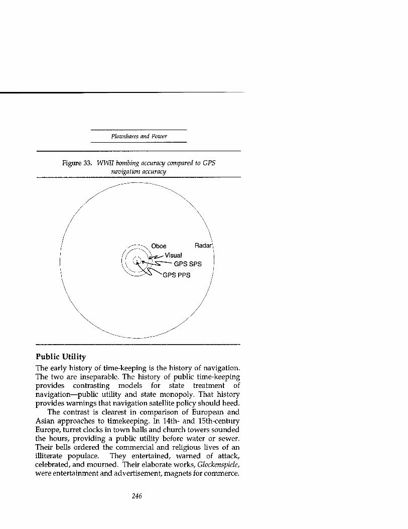
Plowshares and Power
Figure 33. WWII bombing accuracy compared to GPS navigation accuracy
Public Utility The early history of time-keeping is the history of navigation. The two are inseparable. The history of public time-keeping provides contrasting models for state treatment of navigation—public utility and state monopoly. That history provides warnings that navigation satellite policy should heed.
The contrast is clearest in comparison of European and Asian approaches to timekeeping. In 14th- and 15th-century Europe, turret clocks in town halls and church towers sounded the hours, providing a public utility before water or sewer. Their bells ordered the commercial and religious lives of an illiterate populace. They entertained, warned of attack, celebrated, and mourned. Their elaborate works, Glockenspiele, were entertainment and advertisement, magnets for commerce.
246

Satellite Navigation
For example, the citizens of Lyons, in a petition to their town council in 1481,
sorely felt the need for a great clock whose strokes could be heard by all citizens in all parts of the town. If such a clock were to be made, more merchants would come to the fairs, the citizens would be very consoled, cheerful and happy and would live a more orderly life, and the town would gain in decoration.18
In sharp distinction to the public utility of timekeeping in Europe, China reserved a monopoly on timekeeping, calendars, and astronomy to a royal hereditary guild. The calendar told the times for planting, irrigating, and even for selecting for the emperor from among the 121 candidates the appropriate combination and order of bed partners (empress, consorts, spouses and concubines of various ranks). Scheduling and recording his sleeping arrangements occupied a substantial civil service and was a source of considerable political power. The proper order and timing of procreation and preparation assured the combination of Yin and Yang to provide the "best" heir.19
Private calendar making was a threat to the emperor's power. Imperial edicts enforced state security for calendars and related sciences, astronomy and astrology. In AD 840, for example, when the unpredicted appearance of some comets had disturbed the empire, the Emperor ordered all observers in the imperial observatory to keep their business secret. "If we hear of any intercourse between the astronomical officials or their subordinates and officials of other government departments or miscellaneous common people, it will be regarded as a violation of security regulations which should be strictly adhered to. From now onwards, therefore, the astronomical officials are on no account to mix with civil servants and common people in general."20
This secretive Chinese attitude toward time-keeping caused them to lose advanced clock technology. In 1090 the civil servant Su Sung completed a 30-foot high, water-driven clock
247
Plowshares and Power
tower for the emperor. It was based on an entirely different, and more advanced, principle than the later European clock towers. When a new emperor came to power in 1094, he declared the previous emperor's calendar faulty and "Su Sung's Heavenly Clockwork became a quarry of bronze for vandals, and it dissolved from the memories of the learned." When Europeans brought mechanical clocks to the Chinese court 500 years later, they dazzled the Chinese scholars of the court who had long since forgotten Su Sung's earlier achievements.21 As old as the history of time-keeping and navigation is, satellite navigation's history is in its infancy. As we move from its history to the issues of the day, our goal will be to seek a better balance than China did in weighing navigation's public utility and state security.
Navigation Beacons in Space When the Russians launched Sputnik in 1957, observers at MIT's Lincoln Laboratory and Johns Hopkins' Applied Physics Laboratory tracked the doppler shift of its radio signal to measure its radial velocity and predict its next appearance.22
From measuring a satellite's position, it was only a small step to turn the problem around and use signals from known satellite positions to determine unknown positions of terrestrial users. Patent applications and satellite developments quickly followed.
Transit and Surface Navigation In 1960, Ira Smith submitted a patent application (granted in 1964, number 3,126,545) proposing satellite relay of a ground-based stable oscillator signal. That signal, combined with broadcast of the satellite's positions at points along the orbit, would form a long baseline for hyperbolic positioning like that used in the terrestrial systems, Loran and Omega.23
(See the discussion of phase measurement methods in appendix C for illustration.) The U.S. Navy shortly deployed just such a system with the ground-based oscillator moved on- board the satellite.
248

Satellite Navigation
The U.S. Navy contracted with Johns Hopkins Applied Physics Laboratory to develop a Navigation Satellite System, Project Transit, which began operation in January 1964. Satellites in polar orbit at about 600 nautical miles altitude broadcast their orbital parameters every two minutes along with a time reference. They use two frequencies, 150 and 400 MHz, to allow correction for ionospheric refraction (bending and retardation) of the signals. Each satellite is visible above the horizon enough to provide a navigational fix generally four times a day. The user navigates by comparing the received signal frequency with a stable local oscillator to measure doppler shift at a sequence of points along the satellite's orbit. Each doppler measurement provides a pseudo-range (containing errors due to frequency offset between the oscillators) from user to satellite. A series of pseudo-ranges from different points along the orbit allows an estimate of the user's position and the reference frequency offset. The entire process takes several minutes to complete a fix.24 A Transit satellite is visible to most users every hour and a half or so. The accuracy of a Transit navigational fix is about 250 meters or about as good as the World War II blind-bombing systems, Oboe and Knickebein. The Soviet Union operated an equivalent system named Tsicada (cricket) for its civil and military users.25 Although these systems' accuracy and coverage are adequate for navigating ships in open seas, they were not good enough for aircraft or terrestrial navigation—much less weapon delivery. The solution would be more satellites and more signals.
GPS and 3-D Positioning In 1970, Roger Easton submitted a patent application (granted in 1974, number 3,789,409) proposing satellite transmissions of signals generated from on-board clocks for phase comparison with similar signals.26 This is essentially the Navstar Global Positioning System (GPS), which began prototype development in the mid 1970's. (In April 1973, the Department of Defense combined the Navy "Timation" study of a follow-on to Transit
249

Plowshares and Power
and the Air Force System 621B study into the Defense Navigation Satellite System which became GPS.)27 Appendix C contains technical details of the system. However, one of its features deserves mention here. That feature is a deliberate intent to provide service at two levels of performance.
A standard service, somewhat better than Transit's but still unsuitable for weapons delivery, is available to anyone who can receive the signals. The full accuracy, precision positioning service, is intended to be available only to U.S. military and allied users. The Standard Positioning Service (SPS) guarantees no more than 100-meter error (2-drms—two-dimensional root mean square error) worldwide. The SPS figure of merit is for two dimensional navigation accuracy; its quality is suitable for civil applications like maritime enroute navigation and aeronautical departure, enroute navigation, and non-precision landing approach. The Precise Positioning Service (PPS) guarantees its users no worse than 16-meter spherical error probable restricted to military users and approved nonmilitary users when in the U.S. national interest.28 The PPS figure of merit is for three-dimensional navigation; it's good enough for non-precision weapons delivery. The accuracy is suitable for unhardened or area targets or handoff to a higher precision terminal homing system. Hardened targets, like the Iraqi command and control bunkers of the Gulf war, may have aim points such as ventilation shafts with dimensions on the order of a meter or less.
Exclusive use of the precision service is supposed to come from two additions to the basic navigation system design:
• Encrypting the precision navigation information (known as anti-spoofing or A-S because it prevents false broadcast of misleading information)
# Deliberately degrading the navigation information in the SPS broadcast and degrading (dithering) its clock signal to add range errors (known as Selective Availability or SA).29
250
Satellite Navigation
The second of these measures was a belated addition to the system when use of the developmental satellites' standard service proved ten times more accurate than the thirty meters originally predicted.30 Selective Availability is intended to guarantee that users of the standard navigation service can achieve no better than one hundred meters accuracy directly from the GPS signals without external corrections. The system's operators can increase the 100-meter figure in time of crisis if the President approves. The U.S. Department of Defense will establish the level of accuracy based on U.S. security interests.31
The weak point of these measures is their global application. They are too blunt a tool. If the full accuracy of GPS were routinely available, civil users could develop critical dependency on the highest accuracy GPS service. When needed to deny a military advantage to an opponent in a theater of conflict, activation of Selective Availability and Anti-Spoofing would require a decision to deny all the world's civil users the better performance. To forestall such a difficult decision, U.S. policy has been to activate them routinely in peacetime. This policy holds the entire world hostage to potential misuse by a military adventurer in one area.
But the world of navigation users has not been a passive hostage. In response to commercial market demand, the GPS industry has developed innovations which can nullify the effects of Selective Availability. We will find more attractive alternatives to the current policy in mechanisms that apply those innovations selectively by region or user. The overwhelming and much publicized success of GPS in the recent Persian Gulf war will make such an alternative urgent as well as attractive.
GPS in the Persian Gulf Although the GPS constellation was incomplete, providing much of its coverage with prototype satellites—one even resurrected after an attitude control failure to provide make- shift coverage over the Gulf—it did yeoman service in the Gulf.
251

Plowshares and Power
GPS anecdotes became standard fare for post-war speech makers. A few of them bear repetition here to illustrate the breadth as well as the depth of impact it had:32
From Specialist First Class Gary McDonald, 5th Special Forces Group: "GPS earns its way every single day ... when we cross the 'line in the sand' our GPS receivers will be the only piece of equipment everyone will double check to make sure if s with us when we go ... [it] may well save my life."
*****
From Lieutenant Larry Daikman, a mechanized infantry scout platoon leader: "The GPS system is worth its weight in gold here in the desert where terrain features are scarce."
*****
From Captain C.F. White, an air cavalry troop commander, using a GPS receiver daily for reconnaissance missions: "...we are very close to the enemy. Precise positioning is extremely important to our survival."
*****
From a sergeant named "Ski", an Army engineer who mapped over 400 water wells by following goat trails with a GPS receiver and who charted the 18th Airborne Corps supply route into Iraq, "If it could make coffee, I'd marry it." [This may be less of a compliment than it sounds. The sergeant withheld his full name for fear of attracting the attention of former spouses.]
*****
From a Royal Institute of Navigation conference "An army officer with a map has always been regarded with suspicion, but now he has a hand-held GPS, he's a positive liability."33
The Navy rushed a developmental precision guided weapon into service in the Gulf, the Stand-off Land Attack Missile (SLAM). The SLAM used GPS (PPS) navigation to fly within sight of its targets, find them with a nose-mounted video camera, and transmit the image back to the launching aircraft for terminal guidance. The results produced a dramatic television news clip in the early days of the air war from the
252

Satellite Navigation
nose cameras of two SLAM's flying in trail. The first blew the doors off a power plant, and the second flew through the resulting hole to destroy the equipment inside.
The U.S. Navy also used sea-launched Tomahawk cruise missiles in the Gulf to penetrate Iraqi air defenses. The Tomahawks did not carry GPS and had to rely on an early landfall to find a terrain profile matching a memorized flight path. The next block upgrade of Tomahawk will include a five-pound GPS receiver to lessen dependence on terrain matching for navigation en route to target. This should allow launching platforms to keep safely away from shore and reduce any difficulty the Tomahawks might have navigating when earlier strikes destroy landmarks or when sensors are impaired.34 It should also reduce the vulnerability of the individual Tomahawks which would otherwise be constrained to fly over a limited number of recognizable terrain features, where defenders would quickly learn to concentrate then- defenses. That vulnerability apparently contributed to mission failures for about half of the Tomahawks launched in the Gulf war. "The missiles became more vulnerable . . . because the Iraqis were able to predict some of their flight paths. The Tomahawks were guided primarily by terrain-matching radar, and as many as 40 were sent past a single navigational update point."35 GPS navigation will allow the selection of random flight paths for future Tomahawk missiles.
We've seen in earlier discussions the risks and contributions of remote sensing and communications to the surprise of General Schwarzkopf's Hail Mary left hook into Iraq. One Gulf War historian suggests another contributor. Norman Friedman speculated that Saddam Hussein and his forces doubted the ability of a large tank force either to travel so far or to navigate across trackless desert. Iraqi armored forces normally used heavy equipment transporters to move tanks over extensive road networks (which his engineers had quickly built within the Kuwait theater) in order to minimize breakdowns and avoid getting lost. Iraq may have never imagined the coalition's ability to successfully navigate the trackless desert and numerous barriers, minefields, and
253

Plowshares and Power
obstacles, not realizing the abilities conferred by GPS. In Friedman's record:
It [GPS] made possible all the big night maneuvers that in the past would have required numerous scouts and guides along the routes of advance.... GPS made it possible for the attackers to shift their attack plans back and forth virtually up to the moment of attack, since forces using it had no need for fixed markers on the ground. The marines reported that they kept adjusting their breaching point as they received fresh intelligence of Iraqi positions, and as the Iraqis moved their forces.36 [Describing the breaching of Iraqi barriers and minefields by the 2d Marine Division:] The division advanced at night... in a straight line until it hit the breach in the first obstacle, then turned and came out at the breach in the third line of obstacles. This sort of navigation, particularly at night, was a considerable feat. It was achieved by using a combination of GPS satellites and PLRS.37 [Position Location Reporting System, which provides the commander the relative position of his troops by triangulation]
In addition to the Navy, Army, and Marines, the Air Force exploited GPS. GPS-equipped Air Force special operations helicopters guided Army attack helicopters to one of the air war's first strikes—on a surveillance radar—to open a path for penetrating aircraft. The Army helicopter pilots, unused to GPS and perhaps a little skeptical, dropped cyalume "light sticks" like breadcrumbs on their way in to the target area. When the Air Force GPS-guided helicopter led them back to base, they were amazed to find their path took them directly over each of the light sticks they'd dropped.
Air Force B-52 aircraft equipped with GPS enabled General Horner to continue attacks in the Kuwaiti theater when bad weather prevented A-10 and F-16 aircraft from visually acquiring targets.38 F-16 pilots whose aircraft had GPS were able to press their attacks even in marginal weather and smoky conditions; they'd roll into the attack and find the target centered in their heads-up display or within the narrow field
254

Satellite Navigation
of view of their Maverick missile's infrared seeker.39
In the Gulf War, coalition forces used GPS widely, and often, as with communications satellites, in an ad hoc manner, adapting the new tool to unexpected uses. In the GPS case, this should come as no surprise. The constellation of satellites was still in development. The Defense Acquisition Board had yet to approve full-rate production of military receiver equipment. As a result, most of the receivers in the theater were commercial items bought on an emergency basis during the five month build-up of forces. Because of this, key features of the system remain untested in conflict. They are the features meant to assure the direct availability of GPS's full precision to friendly forces and only to them—Selective Availability and Anti-Spoofing. The Gulf war set a precedent of non-Selective Availability that commercial and civil users of the system are anxious to preserve, through policy if possible, through technology if need be. That precedent and the Army's investment in several thousand commercial GPS receivers (not compatible with Selective Availability) created pressure to keep Selective Availability turned off. The commander in chief of U.S. space forces expressed the DoUs position in testimony before Congress:
To avoid future risk to our forces, I strongly support the current national policy: operate GPS satellites with SA turned "on." This means that our armed forces will have to reinvest in vehicle and man-portable GPS receivers incorporating SA encryption. But if full GPS accuracy (SA off) remains available to the public, commercial systems will proliferate and there will be irrestible pressure to maintain signal accuracy in times of crisis. I believe this would place our forces at risk from smart weapons using the GPS guidance.40
GPS and National Security GPS was born as a military system. The Department of Defense budget paid for its development and its continuing operation. It seems natural to judge GPS policy first with respect to national security and then balance the benefits of a
255
Plowshares and Power
broadly available public good. However, in evaluating the effect on national security of GPS policy we need to consider economic and diplomatic aspects of security as well as military issues.
Military Issues. The principal military issues at stake in limiting access to the benefits of GPS are two: To preserve the advantage in weapons and tactics made possible by reserving access to precise GPS services to U.S. and allied forces, and to prevent the proliferation of highly accurate missiles (both ballistic and cruise) with their ability to deliver weapons of mass destruction. A combination of both of these issues provides a third: to prevent the use of GPS and GPS-based coastal aids to navigation by peacetime terrorists or wartime belligerents for precision attack on U.S. territory.
Tactical Advantage. We've had a first glimpse of the value of the first of these in the Gulf war. And it was spectacular. A cautious observer might note that the Iraqi preference for static defense may have magnified the difference. However, in their one attempt at mobility and attack in the battle for Khafji the difference was just as clear. In stark contrast to the U.S. Marines who would later thread their way safely through Iraqi minefields using GPS, Iraqi troops retreating from Khafji got lost and trapped in their own minefields.
After their abortive attempt at Khafji, the Iraqis were effectively trapped behind their minefields as well. The coalition forces were free to roam the desert with shoot-and- scoot, first-round-on-target tactics against passive Iraqi targets—blind-sided behind their berms by flanking attacks out of the blankness of the desert. Without real-time, accurate navigation, any opponent would by comparison seem as static as the Iraqis, tied to landmarks and surveys as surely as the Iraqis were to their trenches and roads.
Missile Proliferation. The issue of missile proliferation might seem comfortably distant from U.S. shores and susceptible to technology controls. Ballistic missiles have limited civil application, and the industrialized countries with missile technology have a Missile Technology Control Regime aimed at long range and high accuracy. However, the application of
256

Satellite Navigation
commercial GPS technology to third world missiles could easily bypass the technology controls on missile guidance. As we will shortly see, missile-related export controls on GPS equipment will prove a flimsy barrier. And the threat is not only from ballistic missiles. As MIT's Kosta Tsipis points out:
A [GPS] receiver on a cruise missile can guide it with the help of the gyroscope and the autopilot to within a few feet of a target. Any country that can manufacture simple aircraft can construct a cruise missile that can carry a ton of cargo at least 300 miles and land no more than 30 feet from its target. Thus any point on the ground—the White House, the Super Bowl game—that is within, say, 300 miles from shore, can be hit by a cruise missile loaded with powerful explosives, nerve gas or biological agents and hidden from view on an oceangoing vessel until launched. An attacker needs no nuclear weapons to cause a major nuclear incident. The U.S. has more than 100 nuclear power reactors [to target].41
In this case, a cruise missile need not be particularly sophisticated, and the ability to manufacture simple aircraft no more than that needed to make a hobbyist's home-built kit- plane or modify a small general aviation craft. If the kit selected is one of Burt Rutan's foam-cored fiberglass designs, the cruise missile has a head start on achieving stealth status.
Diplomatic Value. In the diplomatic arena, GPS, like Landsat, freely offers a valuable public service to the world without discrimination or condition. On that basis, it should be a source of good will as well as a demonstration of technological leadership. For example, in 1989 the U.S. Agency for International Development sponsored a project with the Government of Sudan to demonstrate and transfer the technology to use GPS in conjunction with Landsat imagery to manage a desert reforestation and resource management program. In that application, GPS could reduce survey time by a factor of four over other methods.42
Selective Availability, applied routinely in peacetime, diminishes the value of the service, limits the scope of its
257

Plowshares and Power
benefit, and taints the good will sought. If applied only during conflict, the specter of global denial of access during regional conflict could restrict GPS to non-critical applications or encourage development of alternative systems. In the diplomatic arena, the ability to apply Selective Availability more selectively, by region or user, would make GPS a more useful diplomatic tool. Embargo of precision GPS service to a country could be an effective tool of diplomacy, particularly as the international civil aviation and maritime communities make greater use of the system.
Economic Value. In the economic dimension of national security, the GPS contribution to U.S. security is measured in markets and competition, the subject of the next sections. Although substantial enough that we should not neglect it, the GPS market doesn't have quite the breadth of indirect benefit that we found in communications satellites: There are substantial energy savings available from improved navigation over long routes for both ships and aircraft; and there is also a substantial savings possible in the environmental costs of shipping hazardous substances.
After the Exxon Valdez's lesson in oil tanker harbor navigation, the Coast Guard issued requests for proposal for a GPS-based position reporting system which will require all tankers operating in Prince William Sound to carry GPS receivers.43 However, both of those indirect benefits could be had without making dangerous GPS performance capabilities widely available. So, while not denying those economic values, our chief interest in GPS markets should be in their potential to develop dangerous capabilities.
GPS and Commercial Markets The commercial market for civil uses of GPS is difficult to predict precisely because of the newness of the system and the uncertainties surrounding its availability. However, initial indications suggest the potential for large markets. An indicator of its potential is the publication of a magazine dedicated to GPS consumers, GPS World, supported by
258
Satellite Navigation
advertising revenues from GPS equipment manufacturers. Its title alone suggests personal computer-like mass markets. We can usefully categorize the market by application: navigation, surveying, and aviation.
Navigation. The previous chapter on communications described the RDSS marketplace for tracking commercial fleets of trucks, trains, trailers, railcars, and shipping containers. GPS, in conjunction with planned, two-way mobile messaging systems like INMARSAT'S Standard C and Orbcomm, is positioned well to dominate the RDSS market with very low equipment prices and high performance. For example, the Dallas Area Rapid Transit authority selected GPS for automatic vehicle location for its 850 buses, 150 vans, 40 rapid transit rail cars and 100 transit police vehicles operating over about 1,000 square miles covering three counties and a major metropolitan
44 area. The GPS navigation equipment market may potentially
dwarf the (optimistically estimated) billion dollar RDSS market as volume production brings prices down to consumer commodity level. The overall navigation market includes individuals operating motor vehicles, pleasure boats and private aircraft or hiking on their own feet.
In June, 1990, the Japanese electronics firm Pioneer and Trimble, an American GPS receiver manufacturer, began marketing a dashboard GPS navigator for automobiles in Japan. The cost of a system was about 350,000 yen (about $2,800.) The system displayed position on a 1:40,000 map on a dashboard LCD display and stored maps on four optical disks. The manufacturers projected sales of about 2,000 sets a month.45 Four months worth of sales would match the total population of GPS receivers in the Persian Gulf war.
To supply the mass market, several U.S. manufacturers already offer GPS receivers to original equipment manufacturers (OEM) for unit prices on the order of five hundred dollars in large quantities for incorporation in systems aimed at specific, vertical market segments. Typical units fit neatly on the palm of a hand, weigh only a few ounces, operate over temperature ranges from -40 Celsius to 85 Celsius,
259

Plowshares and Power
and can receive externally supplied corrections to remove Selective Availability and other errors. Such OEM units are ideally suited for incorporation directly into weapons systems. The manufacturers acknowledge the units' utility for military users. One manufacturer's sales literature touts "exclusive gallium arsenide/MMIC technology and digital signal processing [which] allows this C/A code module to easily accommodate a vast array of applications, including: . . . Military: Smart weapons, fire control sytems, C3I, RPVs [remotely piloted vehicles], sensor emplacements, helicopters, light aircraft, battlefield vehicles."46 The manufacturers expect the OEM market to reach $1.5 billion.47 This market is in addition to the more specialized, niche markets served by several smaller manufacturers.
Surveying. Surveying applications differ fundamentally from navigation uses of GPS in the precision required, in the way they use GPS signals, and in their relative invulnerability to countermeasures like Selective Availability. The development of GPS surveying stems from a technique of radioastronomy adopted by geodesy—differential interferometry. In interferometry, radioastronomers measure the angle of arrival of radio waves from distant stars by comparing the phase of the signal arriving at the distant ends of as long a baseline as possible (limited in the extreme case by the size of the earth.) To remove errors in the measurement caused by such things as the atmospheric variations and phase differences between the stable oscillators used as references at the opposite ends of the baseline, they employ differential interferometry—that is, they measure the differences in phase between signals arriving from different sources. The errors in common between the signals subtract out. NASA used this approach in 1972 to track the path of an Apollo lunar rover relative to the lunar landing module from the earth with an accuracy approaching a meter.48 Geodesists turned the method around in the early 1970s to measure the length of baselines on the earth by tuning in radio signals from sources outside the galaxy. Listening over periods of hours with large antennas and sensitive receivers to hear the weak, noise-like signals from
260

Satellite Navigation
the stars, geodesists could measure the length of short baselines to millimeter accuracy and intercontinental baselines to centimeter accuracy with differential interferometry.49 It fast became a primary method for tying surveyed points together.
When the Air Force began orbiting GPS satellites that broadcast very stable radio signals from points widely distributed over the sky, surveyors adapted differential interferometry using GPS signals to surveying (table 12). The strong signals and favorable distribution of satellites over the sky were a significant improvement over a handful of very weak radio stars. Because of this, GPS experimenters found that their GPS surveys were equal in performance to the best existing primary survey references. GPS began a revolution in surveying.
The allure of GPS for surveying is not only its precision, but also its efficiency. GPS surveyors are not limited to short baselines and line of sight visibility between survey points. This adds up to substantial savings in the time and effort needed to complete a survey. A German author compared the costs of various survey methods. Figure 34 shows the results (in constant year German currency) as the distance surveyed increases. GPS is the clear cost winner at any distance (microwave methods are not applicable at the shortest distances), with overwhelming advantage over large distances. This combination of precision, efficiency, and ease of use will expand the use of "surveying" into such applications as positioning agricultural equipment (to comply with environmental limitations on chemical application), road grading equipment (to sculpt banked curves in highways), and other innovative uses.
Air Traffic Control. As early as the early 1960s, the Federal Aviation Administration (FAA) studied satellites for communications and surveillance, principally for use over broad ocean areas out of view of land-based systems.50 In 1983 the FAA tasked a study to evaluate the role of satellite positioning and communications in the context of its 1981 plan to update the National Airspace System with terrestrial improvements in automation. A 1984 FAA report to Congress
261

Plowshares and Power
Table 12. Development of GPS surveying
GPS Surveying Chronology
GPS State of the Art
1982 First prototype Navigation: 1020 m without SA 100-200 m with SA
1983^ Commercial use
Static relative positioning:
1.0 ppm in less than 15 minutes 0.1 ppm routinely be researchers 0.01 ppm tropos- pheric error limit
1984 Few- millimeter survey of Stanford Linear Accelerator
Kinematic relative positioning:
(10 mm land vehicles 10 cm aircraft
1985 cm accuracy in seconds with roving receiver
1986 10 cm aircraft positioning
Source: Alfred Leick, GPS Satellite Surveying (New York: John Wiley & Sons, 1990), 4.
evaluated the schedule for using satellites in civil aviation airspace surveillance at 30 years. However, Congressional studies by the Office of Technology Assessment and the General Accounting Office in 1982 and 1986 pressed for more rapid introduction of satellite technology into airspace control.51
After the downing of Korean Airlines Flight 007, whose navigational error caused it to penetrate sensitive Soviet
262

Satellite Navigation
airspace, President Reagan made GPS services available to the international civil aviation community.52 FAA study of GPS for civil navigation continued, resulting eventually in its endorsement. An observer in 1990 predicted it would be the sole means of navigation by 1995.53 The 1990 Federal Radionavigation Plan was a little more cautious. It judged GPS accuracy adequate for civil aviation except for precision approach and landing but reserved judgment on integrity monitoring. The FAA planned to continue study, develop a National Aviation Standard for GPS and pursue a Memorandum of Agreement with the Department of Defense to implement GPS for civil aviation.54 Any move to GPS for air navigation will have to be international in scope. The first motion in that direction is already visible.
Figure 34. Survey method costs
CD
transit microwave
Source: Augath, 140.
On April 1, 1991, a Northwest Airlines freighter flew from Anchorage over eastern Siberia using GLONASS55 and GPS
263

Plowshares and Power
receivers with Soviet and FAA representatives aboard. According to Northwest's vice-chairman Frederic Malak at the time, "We're saving money. GPS cuts about an hour or an hour and one half from the flight. That's a large saving in fuel."
At a meeting of the Future Air Navigation System committee of the International Civil Aviation Organization (ICAO) on April 26, 1991, U.S. and Soviet representatives symbolically exchanged a U.S. built GPS receiver and a Soviet built GLONASS receiver. The receivers were then to be used to accumulate data for writing Minimum Operational Performance Standards (MOPS). The Radio Technical Committee on Aviation's (RTCA) Special Committee 159 completed work in April 1991 on supplemental standards for GPS and began work on minimum operational standards for use as the sole means of navigation.56 By September 1991, the ICAO's Tenth Air Navigation Conference had endorsed a new architecture for air navigation and control—FANS or Future Air Navigation System. The new architecture prominently featured transition from ground-based to satellite based systems, from individual country to global orientation, and from voice to data communications.57 The ICAO's FANS incorporated global navigation satellite systems based on GPS and GLONASS. It expected them to become the sole means of navigation, replacing current terrestrial navigation (not approach and landing) aids. It anticipated satellite navigation accuracy good enough to serve non-precision approaches.58
GPS's use in civil aviation may extend beyond en-route navigation and air traffic control into the terminal area. In a 1990 experiment, NASA flew a Boeing 737 at the Wallops Island test facility using combinations of differential GPS (DGPS), inertial navigation, and radar altimetry for comparison with conventional microwave landing systems. The experiment included over 120 landings, 35 of which were fully automatic DGPS/inertial landings. The results showed promise that such a system used with a low-resolution terrain map could support automatic landing applications. With a terrain map, the system was able to meet the ICAO Instrument Landing System (ILS)
264

Satellite Navigation
Category I (200-ft decision height) approach accuracy requirements. The average GPS errors were comparable to the microwave system, but with somewhat larger variation (standard deviations of 8 and 12 feet lateral and vertical compared with 2 and 1.5 feet for microwave). For lower altitude decision heights of 100 and 50 feet—Category II and III respectively—GPS nearly met lateral error limits but was inadequate by a factor of three or more in altitude. GPS's difficulty in the height measurement results from a built-in vertical geometry limitation. It is unable to hear satellite signals from the other side of the world through the earth.59
Because of that inherent limitation, GPS is unlikely to replace microwave landing systems for instrument landing in the immediate future.60 However, only a relatively small fraction of U.S. runway ends will have microwave landing systems (on the order of 1,200 of the 7,000 to 8,000 paved, lighted, runway ends in the country.)61 GPS could inexpensively provide substantially improved instrument landing capabilities at the remaining runways.
On the ground in the terminal area, GPS has another role to play. United Airlines, the City of Chicago, and Aeronautical Radio, Inc. (ARINC) scheduled tests in April 1991, at Chicago O-Hare Airport to demonstrate differential GPS for ground traffic control during low visibility. They planned to correct one hundred meter accuracy, Selective Availability GPS to one to three meter accuracy with differential corrections. The aircraft communications and reporting system would report raw GPS positions from both the aircraft and ground vehicles. Differential corrections would be added to the control tower's displays. The tests included a Swedish company's data link. The Swedes had already tested a similar differential GPS system at the Göteborg, Sweden, airport.62
The principal obstacle facing widespread adoption of GPS for civil aviation has been concern over the ability to warn of loss of navigation accuracy through undetected failure in the system. Among the means proposed to warn of such failures have been an INMARSAT plan to broadcast integrity monitoring messages from ground monitoring stations through
265

Plowshares and Power
their satellites, and development of receivers to perform autonomous integrity monitoring using multiple satellites to detect failures and multiple systems (either the Russian GLONASS system or a pseudo-GPS satellite signal broadcast through other satellites)63
Of the alternatives, those involving GLONASS are questionable, due to a number of limitations of that system—in performance, modulation format, financial viability (political stability), and frequency allocation. Of the remaining alternatives, we will find a broadcast integrity monitoring report preferable from a security point of view. In any case, viable approaches exist. Given integrity monitoring, it seems clear that the benefits in fuel savings, passenger safety, all- altitude coverage, and global availability will eventually make GPS standard for en route air navigation, at least, and for instrument landing as well in the many locations where the expense of a microwave landing system is not justified.
Market Growth. Prediction of GPS markets is difficult. The 1990 Federal Radionavigation Plan estimated the market for the above uses through 1996, but could not project civil land and maritime use beyond that point for lack of data to base its projections on (figure 35). As a quick indication of the volatility of these estimates, the Persian Gulf war produced a surge in DoD GPS users to around 8,000 in early 1991. To judge the uncertainty in the civil sector projection, consider that one manufacturer has estimated the annual recreational market place for combined GPS, sonar, and plotting units at $10 billion a year based on a current market base for recreational sonar of 0.2 to 0.3 billion a year. Based on a mature production-rate price estimate of $500 per receiver, his estimate translates into 20 million units sold worldwide per year. Even if the GPS market is no larger than the lower end of his current sonar market estimate, sales would be on the order of 400,000 units annually. However, to achieve those sales, he would need to be able to provide PPS accuracy to supply the service his market requires.64 If he's even close, the Federal estimates
266

Satellite Navigation
Figure 35. GPS user population projection
100000
90000
80000
70000
60000
50000
40000
30000
20000
10000
/ Ü Civil Maritime
■ Civil Land
1 Civil Aviation
■ DoD
/
y/
-^mil i ^g^^m
—
___-^-'~ ^^^ |M = 1
1990 1991 1992 1993 1994
Source: 1990 Federal Radionavigation Plan, 3-39
1995 1996
undestimate the commercial market by orders of magnitude. So gross an underestimate of the civil market could provide GPS policy makers with a rude surprise in the unexpected power of market forces driving civil users to circumvent restrictions on access to high precision.
Market Response to Military Action In the arm-wrestling match over full GPS accuracy, the government's policy of Selective Availability may be no match for the invisible hand of the marketplace. In its desire for greater precision, the commercial market has developed a range of technical innovations to overcome the design features intended to deny unauthorized users full GPS accuracy. There are three general approaches available to the commercial market to improve the accuracy of GPS signals: code- differential GPS navigation, phase-differential GPS or kinematic surveying,65 and inertial augmentation. A more detailed technical discussion is in appendix C.
Code-differential GPS. Code-differential GPS navigation
267

Plowshares and Power
removes the correlated errors between a reference receiver and a remote user. It communicates corrections to users from a known reference location. The reference station computes the corrections by comparing the output of a GPS receiver at the known location with the known location. If they arrive soon enough, the corrections also compensate for the errors due to Selective Availability. For moving users, code-differential GPS corrections can reduce the effects of Selective Availability from hundred meter accuracy to the vicinity of five to ten meter accuracy (one meter with carrier smoothing.) The corrections also provide implicit quality control of the navigation product in the event of satellite errors. The Radio Technical Committee-Maritime's Special Committee 104 developed a standard format for transmitting these differential corrections. The format bears the name of the committee, RTCM SC-104.
The corrections can be supplied directly in terms of the user's position (as measured) or in terms of the pseudo-ranges observed to the satellites. Pseudo-range corrections have a number of advantages over position corrections. They allow the user to select satellites to use independently of the reference station's viewing schedule. They also extend the range of applicability beyond the 500-km radius typical of position corrections. Personal computer software to compute differential pseudo-range corrections is available for prices in the range of $5,000 to $15,000 dollars.66
An alternative communications approach to broadcasting differential corrections is to provide a signal like that of the GPS satellites. So-called pseudolites are reference receivers that also radiate a GPS navigation waveform like a satellite, but with differential corrections included in the modulated message information. They are strictly line of sight devices— suitable, for example, for airport runway approaches. They have the advantage of supplying an additional satellite signal source to improve the solution geometry in a location that a real satellite could never achieve (after launch at least.) To prevent conflict between pseudolite transmissions, the recommended maximum separation from the user is 50 km, the recommended minimum separation from another pseudolite is
268

Satellite Navigation
54 km.67 Alternatively, broadcasting the corrections from a high altitude communications satellite relay would remove conflicts caused by variation in signal strength due to the difference in proximity to terrestrial transmitters.
Phase-differential GPS (kinematic surveying). In his doctoral dissertation, Dr. Benjamin Remondi of the National Geodetic Survey (NGS) published a complete GPS carrier phase model for the first time, making the phase measurement understandable and useable to engineers worldwide. (About 10,000 to 20,000 copies have been distributed worldwide.) The document gave complete details on GPS techniques including some completely new ones.68 In 1984 he introduced kinematic GPS as a method of centimeter level "navigation" and "stop- and-go-in-seconds" surveying.69 The key difference in these methods from code-differential navigation is the direct measurement of the GPS signal's phase as opposed to computation of a pseudo-range from information in the satellite's navigation message. The original GPS surveyors used relatively slow static methods. Static methods required a receiver to dwell at a point for a few hours for baselines under a kilometer. Kinematic methods allowed a moving receiver, within seconds of stopping, to survey its position to centimeter accuracy relative to a fixed reference. Remondi's methods tolerated lower accuracy during movement while retaining high accuracy at the destination. With newer receivers the same accuracy is possible while moving. They would, with a small number of corrections transmitted in real-time, "permit real-time centimeter-level surveying in seconds, but also . . . would allow the user to navigate to within centimeters of a desired location in real time!"70
Kinematic GPS Positioning has both civil and military applications. One author lists "aerial photogrammetry without ground control, high-precision airplane positioning for the mapping of gravity, altimeter profiling on land and sea, high precision guidance in real time, and kinematic surveying on the ground."71 [emphasis added] Applied to weapons delivery, Dr. Remondi's observation in the last paragraph could translate into extremely high precision attack on a target with a brief
269
Plowshares and Power
period of stable flight in its vicinity but still tolerating more violent evasive maneuvering en route to the target. As an added plus for operational security, the method reduces the volume of communications needed to transmit corrections during transit to the target's vicinity.
Dr. Remondi's original method used an initial swap of antenna positions between the fixed and moving receivers to resolve the ambiguity of which line of position its phase indicated.72 After initialization, the receivers would track the signal phase during transit to the survey points. Later, "on-the- fly" methods use additional measurements from either additional satellites (a total of seven73 satellites compared with four for static methods) or an additional antenna (a moving platform antenna exchange) to provide precise, real-time, relative positioning to vehicles in motion.74
Since Dr. Remondi's original research, the NGS has made kinematic surveying part of its field operations. NOAA hydrographic surveyors achieve better than five meters (best performance under a meter) accuracy in real-time navigation using code and carrier phase measurements with two standard positioning service receivers operating in differential mode, even with Selective Availability and Anti-Spoofing features active.75
Inertial Augmentation. Competing for the same luxury car market as GPS receivers, Honda has offered a relatively low- cost inertial navigation system for cars.76 The motivation for their choice was to assure service when GPS signals might be blocked by buildings, terrain, or tunnels. We should expect that a customer willing to pay one or two thousand dollars for an automotive navigator won't settle for knowing what town he's in. He's likely to expect his dashboard navigator to take him to a building's front door. A purely inertial navigator would require frequent external updates to avoid drifting outside the bounds of the customer's expectations. If Selective Availability's hundred meter accuracy is not adequate to satisfy the customer either, the combination of inertial and GPS could. The availability of low-cost inertial components suggests the possibility of a hybrid GPS-inertial system that could
270

Satellite Navigation
circumvent Selective Availability, using the inertial reference's short term stability to smooth out the dithering errors that Selective Availability imposes on the GPS signals given an initial fix from a known starting point or differential correction.77
International Market Capabilities Our concerns for the availability of GPS technology should include both ground terminal and space segment. We'll find that receiver technology is widespread and not easily subject to control. Satellite technology is not so widespread. Its control might be feasible and worthwhile.
Ground Segment Capability. A GPS navigation receiver is a dedicated, special-purpose, spread-spectrum radio receiver combined with a microprocessor to perform navigation calculations. The differences between receivers are usually in the details of the signal processing methods used, number of separate channels processed simultaneously, packaging, size, and cost. Most incorporate at least an input port for receiving some form of differential correction, leaving the means of communication for those corrections an option for the purchaser. The components needed to develop or modify a GPS receiver are widely available in industrialized countries. The knowledge needed is similarly widespread. Neither is peculiar to military applications.
The ability to build or buy a pair of GPS receivers and integrate them with a communications capability is the ability to develop a differential GPS system. With the advent of inexpensive GPS receivers for the OEM market, this is a relatively simple engineering task. The 1991 Buyers Guide issue of GPS World magazine listed 19 suppliers of differential service, twenty-two suppliers of differential reference stations and thirty-eight suppliers of differential systems. The suppliers included French, German, British, Japanese, Canadian, Australian, Swiss, and Norwegian firms.78 A typical system is the French company Sercel's ten-channel reference receiver, which promises coverage over a radius of 700 to 800 km using
271
Plowshares and Power
two HF radio frequencies. Suppliers of surveying receivers are as widespread as those
of navigation receivers. The buyers guide listed 18 companies supplying them: nine American, two each French and British, and one each from Canada, New Zealand, Germany, Switzerland and Japan. Although the buyers guide concentrated on western sources, GPS receiver technology is not exclusively a western capability. The Russian GLONASS system's receivers process a slightly different waveform, but the technology for the two kinds of receivers is equivalent. Any attempt to control GPS receiver technology is probably futile.
Space Segment Capability. By space segment we mean the ability to generate a similar or equivalent function navigation signal. Among the candidates we should consider are other radio determination (RDSS) systems, the Russian GLONASS system, and proposals for additional space systems that might augment or replace GPS.
• International alternatives. In 1991, COMSAT corporation offered an extended differential GPS correction service, broadcast over INMARSAT satellites to Standard A or B terminal users. The value-added service multiplexed a set of corrections from multiple reference sites into a message sent through the satellites' L-band communications transponders using the RTCM SC-104 data format. To limit use of the service to paying customers only, the service encrypted its data with time-limited keys to be distributed to paying customers.79
With its third-generation satellites, scheduled to launch beginning in 1993, INMARSAT proposed to broadcast a GPS "overlay" signal to assure continuous availability of navigation signals. The overlay would provide a GPS-like navigation signal from the geosynchronous satellite in addition to its usual communications signals. The overlay signal would originate on the ground and be translated on board the satellite to the same downlink frequency as the GPS
272

Satellite Navigation
satellites' C/A-code signal (The ground station would monitor the translated signal and adjust its uplink frequency to compensate for the uplink doppler created by the satellite's motion, making the signal appear to other users as if originated on board the satellite.) The navigation accuracy of the overlay signal would be in the range of 100 to 300 feet, comparable to the DoD Selective Availability mode and compatible with then- differential correction service.80 Signals from two INMARSAT satellites would be visible simultaneously to most areas of the world.
INMARSAT proposed also to include in the overlay's broadcast an integrity monitoring message which would warn users of any faulty data or malfunction of the GPS satellites. The integrity monitoring message would carry User Range Error (URE) information for each satellite signal based on a network of ground measurements. Its primary purpose would be to warn civilian aircraft using GPS of errors or failures in the satellites. The format and precision of the URE information were undefined, but precision of a dozen or two meters is likely for a catalog of 25 to 40 satellites (enough for both GPS and GLONASS constellations.) Although INMARSAT intends the URE information for integrity monitoring rather than differential correction, it can provide a crude differential GPS service and could do better. An INMARSAT author predicted that the overlay signal's communications rate could accommodate regional URE corrections with precision on the order of half a meter for 128 regions.81 However, because the integrity monitoring URE corrections would be freely available, such precision would undercut INMARSAT'S own revenue producing differential service.82
GLONASS. GLONASS is a Soviet-developed navigation system whose development and characteristics parallel GPS. Its navigation signals differ
273
Plowshares and Power
principally in the use of frequency division rather than code division multiplexing. Its reputation for accuracy has not been as good historically as that of GPS—based primarily on the stability of its satellites' atomic clocks. However that initial reputation should not serve as permanent judgment. Researchers that monitored both systems' clock performance reported that "while the GPS clock performance has been consistently high, the GLONASS clocks started from a mediocre performance and have improved steadily with time so that some of the recently launched GLONASS clocks are comparable to GPS clocks."83 Figure 36 illustrates the trends of improvements they reported in three clock figures of merit for both systems (with later satellites closer to the foreground.) Although the political and financial future of its owners may cloud the future of the GLONASS system, its developers have the ability to produce an alternative GPS-like space segment for satellite navigation should someone have the money and motivation to create one. So far, only Europe has shown any interest in doing so.
European Alternatives. In 1987, the European Space Agency proposed a European navigation satellite system, NAVSAT, which would combine a few navigation satellites in highly inclined orbits (to provide high northern latitude coverage) with navigation packages carried piggy-back on geostationary communications satellites. In contrast to GPS's worldwide coverage (subject to occasional outages during the build-up of the constellation) such a constellation would allow incremental regional expansion starting with complete coverage of the developed European region.84 The proposal failed to attract broad support due to French support of the Locstar RDSS positioning system and German pre-occupation with developing GPS receivers.
274
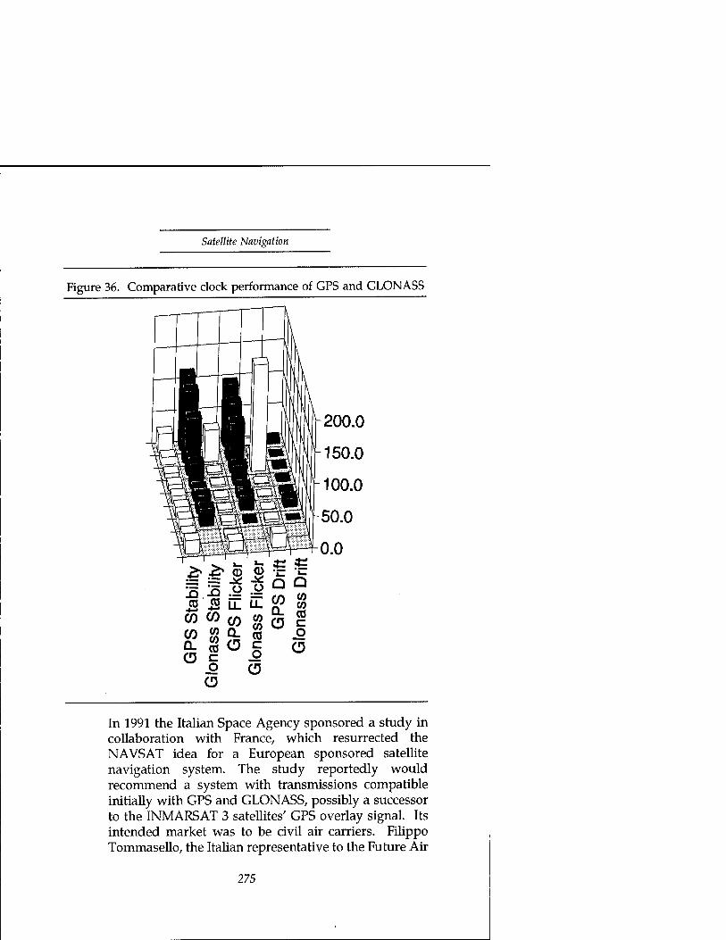
Satellite Navigation
Figure 36. Comparative clock performance of GPS and GLONASS
r I—\
\ \r3 V200.0
g|f| L 150.0
tpwrfSHnJ ̂ -100.0 nrfw3™ 1 *JBgPOS!|
-50.0 Ipii
4OlQiH^-0.0
GP
S S
tabi
lity"
G
lona
ss S
tabi
lity
GP
S F
licke
r"
Glo
nass
Flic
ker
GP
S D
rift
Glo
nass
Drif
t
In 1991 the Italian Space Agency sponsored a study in collaboration with France7 which resurrected the NAVSAT idea for a European sponsored satellite navigation system. The study reportedly would recommend a system with transmissions compatible initially with GPS and GLONASS, possibly a successor to the INMARSAT 3 satellites' GPS overlay signal. Its intended market was to be civil air carriers. Filippo Tommasello, the Italian representative to the Future Air
275

Plowshares and Power
Navigation System committee reported in June 1991, "Despite the fact that in 1989, the United States and the Soviet Union jointly proposed a compatible receiver, capable of monitoring the integrity of the navigation signal, GPS-GLONASS integration alone is clearly considered by the International Civil Aviation Organization to be unacceptable for solving basic civil navigation problems.... On the other side, the attitude of the U.S. Federal Aviation Administration has swung in favor of a civil four-satellite overlay supplement to GPS and GLONASS." In response, the Italian proposal offered a GPS overlay incrementally developed beginning with European coverage. The motive for a separate European GPS overlay in addition to or in place of INMARSAT'S is not clear. It could be a matter of regional pride or industrial policy.
RDSS Systems. Although unlikely to supply the high degree of precision that the GPS system is capable of, commercial RDSS systems could possibly supply a navigation service that military forces might find useful, if not decisive. However, the limitation of RDSS positioning service to two dimensions limits its utility in guiding airplanes and cruise or ballistic missiles. Airborne platforms would have to add an altimeter measurement for three dimensional positioning. Terrestrial and maritime forces would be able to exploit RDSS systems to advantage if they offered accuracy substantially better than GPS does with Selective Availability enabled. The technology needed for an RDSS system is essentially the same as that needed for a GPS receiver. The technical ability to field an RDSS system, like that for GPS receivers, is as widespread as the ability to build or buy a modest-bandwidth, direct- sequence spread-spectrum radio system. The international ability to supply an RDSS system is more a financial than a technical issue. Based on financial performance to date, separate RDSS systems' limited
276

Satellite Navigation
military utility should pose little threat. Despite rosy initial market projections, the mass
market appeal of RDSS services has not been enough to sustain the investment needed for satellite systems. Both American and European attempts at a dedicated- satellite RDSS system failed financially. The previous chapter mentioned Geostar's (the American company) failure. After its May 1991, bankruptcy, its European licensee, Locstar, failed to obtain financing and followed it into bankruptcy in July. Locstar's business plan originally planned the purchase of two satellites, (later reduced to one satellite planned for a 1992 launch) based on a market projection of a million terminals.
Based on that business plan, it's no wonder that Locstar couldn't find financing. The competition, Eutelsat's Euteltracs service (based on the American Qualcomm system) projected a market of only 50,000 vehicles in its first three to four years, and it beat Locstar to market by years. It had a two-fold advantage in being able to use existing communications transponders rather than a dedicated system, which eliminated the need for a large investment in its own satellites and brought its service to market without the long wait for satellite development and launch.85
The advertised Euteltracs-Qualcomm location accuracy of a thousand feet poses no military threat. From the threat point of view, their commercial success would be a welcome alternative to high precision GPS services. However, their profitability is clearly in doubt. The combination of GPS's ready availability and greater accuracy with emerging mobile communications capabilities such as Orbcomm, Iridium, and INMARSAT'S Standard C will likely be overwhelming. The small size of the market segment willing to settle for thousand foot accuracy will make it difficult for them to achieve economies of scale in comparison with the total GPS receiver market. As John McLucas
277
Plowshares and Power
observed in his 1991 survey of commercial space, "while Geostar and Qualcomm have both shown that there is a market for tracking trucks, neither has enough customers yet to make money."86
A higher precision service, Star-Fix87, has found a niche market in regional service to the Gulf of Mexico and Mid-Western United States since 1987. Its primary customer is the oil industry. Like Qualcomm, it uses a spread spectrum signal transponded through four existing, commercial communications satellites to supply two dimensional positioning.88 The Star-Fix ranging system provides roughly one meter accuracy in longitude and three to five meters in latitude. Rather than fight the GPS trend, it has joined it with a differential GPS pseudo-range correction broadcast through the same transponders. Seven base stations around the United States (roughly two per satellite) provide the basis for corrections covering the country and its coastal areas. Star-Fix relies on proprietary receiving equipment to restrict use of its broadcast to paying customers. However, its signal is a commercially available spread spectrum modulation with no cryptographic protection. A moderately sophisticated and reasonably well financed user (such as a foreign government or government-sponsored terrorist) could readily supply its own receiving capability.
Security Strategies We've seen compelling evidence that the civil GPS marketplace is developing capabilities suitable for such military use as precision weapons delivery—in spite of the GPS features intended to reserve that capability to U.S. forces. In the case of the highest precision, the commercial market is well ahead of the military. Strategies beyond Selective Availability are clearly in order. As with remote sensing and communications satellites, we'll examine strategies based both on restricting the
278

Satellite Navigation
supply of dangerous capabilities and on supplying safer alternatives to satisfy the demand.
In the case of GPS, the issue is much more urgent than it is for remote sensing or communications satellites, because the capabilities in question do not require a new generation of satellites. Terrestrial systems, as we've seen with the RDSS competition, can evolve much faster in response to market demand than can satellites. The difference in responsiveness suggests that any strategy which relies on a feature of the space segment should be careful not to telegraph its punches by revealing the extent of measures embodied in spacecraft hardware. Conversely, any spacecraft measures, like Selective Availability or Anti-Spoofing should have as many degrees of "software" freedom as possible to allow them to change and adapt to their terrestrial competition without the delay of satellite development and launch.
Supply Side Measures: Export Control and Direct Attack. There has been recent progress in liberalizing and clarifying both the multilateral CoCom export controls and the unilateral U.S. munitions controls on GPS user equipment. The changes greatly improve the ability of U.S. manufacturers to export without burdensome restrictions. The new rules include a well-intentioned measure aimed at the proliferation of missile guidance technology. That measure, unfortunately, is little more than a fig leaf for a problem that is not susceptible to export controls.
Because export control can be only a very limited part of the solution to an opponent's use of GPS, direct measures will be an essential part of a total solution. As we will see, they will need all the help they can get from other measures.
• Multilateral Controls. The May 1991, CoCom agreement on a Core List of controlled items imposed export licensing restrictions only on GPS equipment that has either access to the encrypted P-code service or a null-steering antenna providing protection against jammers.
The new rule only suggested a warning label for
279

Plowshares and Power
receivers that use the unencrypted P-code, to caution users that the Department of Defense could implement Anti-Spoofing measures that would make the unencrypted P-code unavailable. The Core List exempted, therefore, virtually all commercial GPS receivers. Prior interpretation of the CoCom rules had required individually validated licenses for all receivers capable of
• using an external frequency standard, (potentially helpful for estimating and defeating the clock dither parameters of Selective Availability—unneccessary with code-differential corrections)
• receiving the L2 frequency (enabling correction for errors due to the propagation medium— unnecessary with differential corrections) or
• processing the unencrypted P-code (which codeless receivers don't need to track the carrier phase).
The old rules made a large class of commercial receivers subject to delay in export. They attempted to protect Selective Availability and Anti-Spoofing features already bypassed by differential corrections and kinematic surveying methods.
The CoCom agreement established guidelines for receivers acceptable under missile technology proliferation controls by defining maximum altitude and speed capability limits for GPS receivers. The limits were to exclude the operating regimes of high-altitude, high-speed missiles.89 Except for this, they were a substantial improvement over the previous rules.
Unilateral Controls. A revision of GPS munitions export controls published in January 1992, paralleled the CoCom agreement and added language aimed at cruise
280
Satellite Navigation
as well as ballistic missiles. It retained munitions controls on:
— (4) Global Positioning System (GPS) receiving equipment specifically designed, modified or configured for military use; or GPS receiving equipment with any of the following characteristics:
a. Designed for encryption or decryption (e.g., Y-Code) of GPS precise positioning service (PPS) signals; b. Designed for producing navigation results above 60,000 feet altitude and at 1,000 knots velocity or greater; c. Specifically designed or modified for use with a null steering antenna or including a null steering antenna designed to reduce or avoid jamming signals; d. Designed or modified for use with unmanned air vehicle systems capable of delivering at least a 500 kg payload to a range of at least 300 km. (NOTE: GPS receivers designed for use with military unmanned air vehicle systems with less capability are considered to be specifically designed, modifed or configured for military use and therefore covered under this subparagraph.)
Any GPS equipment not meeting this definition is subject to the jurisdiction of the Department of Commerce (DOC). Manufacturers or exporters of equipment under DOC jurisdiction are advised that the U.S. Government does not assure the availability of the GPS P-Code for civil navigation. It is the policy of the Department of Defense (DOD) that GPS receivers using P-Code without clarification as to whether or not those receivers were designed or modified to use Y-Code will be presumed to be Y-Code capable and covered under this paragraph. The DOD policy further requires that a notice be attached to all P-Code receivers presented for export. The notice must state the following:
281

Plowshares and Power
'ADVISORY NOTICE: This receiver uses the GPS P-Code signal, which by U.S. policy, may be switched off without notice.'90 (emphasis added)
Both these revisions are a welcome improvement over the previous controls. The previous controls did little or nothing to preserve the advantages of Selective Availability and Anti-Spoofing and restricted U.S. export of widely available commodities. The revisions don't attempt to preserve Selective Availability and Anti-Spoofing, but they minimize needless restrictions on U.S. exports. However, the munitions controls contain several flaws that could cause some harm. The policy that presumes a receiver possesses a dangerous capability unless papered over by a warning label is curiously like the earlier controls—it provides no protection for U.S. security. It is, at least, relatively harmless to the exporter. However, the added controls aimed at missile proliferation are at best meaningless and at worst a source of false comfort.
The cruise missile oriented language may define a class of air vehicles but it does not define a class of GPS equipment. GPS receivers for use with unmanned air vehicle systems are indistinguishable from those for use with manned air vehicle systems. Either kind may or may not include a display, for example. Nor are the receivers in any way sensitive to the range or payload ability of the air vehicle, manned or unmanned.
The cruise missile constraint, at least, is transparently a fig leaf. The ballistic missile language is more insidious, because a manufacturer can cite objective evidence of his compliance. However, his compliance is inherently reversible by the customer and generally quite easily so.
For example, consider a representative GPS receiver intended for a vehicle application. Ashtech offers a twenty-four channel GPS receiver configured
282

Satellite Navigation
to provide milliradian-accuracy vehicle attitude and heading reference in addition to the usual navigation functions (which include the ability to receive differential corrections)—its Model 3DF. The 3DF weighs only eight pounds in an eight-by-eight-by-four inch package. It operates over a temperature range of -20 to 50 Celsius, tolerates accelerations up to six G's—all features suitable for a missile application. But, the 3DF dutifully limits its speed and altitude capability to a thousand knots and sixty thousand feet. For a list price of $55,000 it's an impressive capability—a little pricey for the consumer market, but a bargain for an airplane or a missile.
How hard would it be to adapt the 3DF to guide an Al Abbas or Al Hussein homegrown Scud? Not hard at all. Its signal processing functions employ some proprietary digital logic design that might be hard to reverse engineer and modify. Fortunately for the Scud engineer, they'll work fine as is. The speed and altitude limits, on the other hand, are a navigation function, and the navigation processor is a widely available, understood, and supported general-purpose microprocessor, the Motorola 68002. The navigation limits and limit-checking logic reside in firmware for that microprocessor. The firmware is stored in flash EPROM, making its contents conveniently visible and changeable from a maintenance connection. Disabling the limit-checking logic is a straightforward matter of:
• reading the firmware machine language instructions,
• (optionally) disassembling them into assembly language form for the programmer's convenience,
• locating the limit check comparisons and inserting an unconditional branch around them before
283

Plowshares and Power
• re-loading the firmware into the EPROM.
It doesn't take the proverbial rocket scientist. The entire process is a reasonable assignment for an undergraduate electrical engineering laboratory.91
Export controls on GPS receiver equipment can do little to protect security without serious disruption to trade. The damaging capabilities of commercial GPS receivers are those that defeat Selective Availability—the ability to generate or use differential corrections. Neither is inherent in the navigation receiver. If export controls kept them out of all receivers, an unsophisticated user could still add the capabilities externally. They are relatively undemanding computation and communication tasks independent of the signal processing and navigation tasks of the GPS receiver.
If there is a place for controls on terminal equipment it is on the cryptographic equipment that decrypts the Precision Positioning Service during Selective Availability and Anti-Spoofing and on electronic countermeasures like nulling antennas that make receivers less vulnerable to jamming. However, in both of these cases, there is still legitimate and profitable civil application for similar capabilities.
Facilities for encryption and decryption are essential for commercial interests in privacy and billable access to proprietary services. Export controls should allow for appropriate privacy mechanisms for civil users that would neither endanger the security of GPS PPS nor empower potential adversaries to create an Anti-Spoofing feature of their own.
Legitimate commercial interest in nulling antennas comes from two problems that GPS surveyors encounter:
• multipath signals reflected from the ground or obstructions such as buildings interfere with the
284
Satellite Navigation
desired line-of-sight signals from the satellites, and
codeless GPS receivers, because they lack the processing-gain signal improvement that despreading provides, are susceptible to unintentional interference from sources like commercial broadcast equipment harmonics.92
Nulling antennas are not absolutely essential to deal with the multipath problem. Judicious shaping of the antenna pattern should be enough for most cases. The government could remove the issue of codeless receiver interference by making the unencrypted P-code signal routinely available and enabling Anti-Spoofing only when crisis or conflict looms. However, the same concerns would apply as with Selective Availability regarding the ability to impose Anti-Spoofing in crisis if critical civilian applications become dependent on its absence.
In the space segment, on the other hand, there are two elements worth protecting with export controls. Happily for both of them, export controls can still be effective with little harm to trade. They are spaceborne atomic clocks and spread spectrum communications equipment. The atomic clocks are the rubidium and cesium frequency standards that GPS uses, and hydrogen masers that could provide even better performance. Spaceborne spread- spectrum signal generation was also one of the key elements of communications satellite technology that the previous chapter recommended for control. There is little or no viable market demand or credible civil use for those capabilities in space. What limited civil or scientific use that might arise could certainly tolerate the burden of case-by-case export control scrutiny. If the clocks and signal generation are kept on the ground, alternate or
285

Plowshares and Power
supplementary GPS signals that might not be welcome during a conflict will have to transpond through satellites, making them vulnerable to ground-based jamming or direct attack if gentler forms of persuasion don't work.
The COCOM Core list does protect the atomic clocks needed to create an alternate navigation satellite service. Specifically it embargos:
—1.A.2.g. Atomic frequency standards having either of the following characteristics:
1. Long term stability (aging) less (better) thanl x 10"11/month; or
2. "Space qualified"; NOTE: 1 A.2.g.l. does not embargo non-"space qualified" rubidium standards.—
However, the clocks' presence on the COCOM list doesn't prevent their sale to COCOM countries that may be the most likely sources of alternative or supplementary GPS services. To control export to COCOM members would require retention of the State Department's munitions export controls for spaceborne clocks.
> Direct Attack. Because the most likely and dangerous misuse of GPS by an opposing military is differential correction of Selective Availability's induced errors, the most direct response with least collateral damage will often be a direct attack. A direct attack may use weapons or electronic countermeasures, targeted at the reference station, the communications relay, or the end user.
If routine peacetime use of Selective Availability drives the proliferation of differential equipment and services, a direct attack on the opponent's use may be the only option available. A U.S. Space Command author, defending the routine use of
286

Satellite Navigation
Selective Availability, wrote recently: "DGPS-capable weapons systems have yet to appear on the world arms market, and their development may indeed be only a short time away. However, when they do appear, the U.S. military should be prepared to counter with either technology or tactics."93 A counter with tactics may not be realistic. The signature, either physical or electronic, of a differential GPS system may not be identifiable in advance or even possibly in use.
As far as physical signature, a GPS receiving antenna may be the only external evidence of a reference receiver's location. A GPS-receive antenna can be so small and nondescript as to be virtually invisible—a small patch of printed circuit board an inch or two on a side. Even the largest of them are only a few inches in the longest dimension—easily concealed behind a radome of arbitrary shape. As far as electronic signature, the corrections may use virtually any communications means, diversely routed, with no incriminating signals radiating from the reference station. Such common systems as cellular telephones could carry the corrections.
Physical attack on the differential reference station may be simply too hard. You can't kill what you can't find. The remaining targets are the communications relay and the end user. The end user is clearly a target of last resort. Although U.S. forces will certainly have defenses aimed at aircraft and missiles, high-quality GPS navigation will make them more difficult targets, allowing them silent approach by circuitous and difficult routes.
For the most precise modes of differential GPS navigation (phase-differential), there may be an effective electronic countermeasure for the end user that U.S. forces could reasonably apply to broad areas. Surveyors' experience with broadcast signals' harmonics interfering with codeless receivers
287

Plowshares and Power
suggests that an area broadcast of narrowband noise aimed at codeless receivers might render them ineffective. U.S. receivers could retain the full benefit of the GPS signal due to the processing gain of de-spreading the signal. Anti-Spoofing encryption of the spreading code would reserve that advantage—and its centimeter accuracy—to U.S. forces.
Although U.S. forces should expect to retain the sole use of phase-differential use of the P-code signal, there remains the problem of code- differential correction of the C/A-code signal—a meter or two accuracy problem. If the end user and the reference station are not vulnerable, we're left with the communications relay as a target.
The communications relay may be a difficult target to find and to counter. The bandwidth needed is extremely small and so can have a high degree of jamming protection via spectrum- spreading. A commercial service sends its corrections at teletype rates (600 bits per second) and spreads them over five megahertz of bandwidth—not for jamming protection but to avoid interference with other users that share the same spectrum. The low signal power that makes them unobtrusive also makes them hard to find.94
The communications channel may use any or a multiplicity of frequencies, modulations, and routing. A security conscious adversary will reserve some frequencies and modes for wartime to preserve surprise.
The only constraint on a differential GPS communication channel is an update rate high enough and a delay in transit small enough to make the corrections timely. That rate depends on the clock dither rate used with Selective Availability. Dither rates demonstrated to date require a communications delay comfortably less than ten
288

Satellite Navigation
seconds for differential corrections.95 (Restricting the error after differential corrections to the order of five meters requires updates at an interval of twelve seconds or less, although inertial augmentation or clock-coasting with a stable local clock could extend this considerably.)96 Selective Availability errors can be significantly greater than the hundred meter peacetime standard should the President direct an increase. If the GPS operators have avoided the Knickebein mistake of premature disclosure, the potential dither rate could be higher as well. Differential corrections care little about the magnitude of the numbers they send, but the communications rate needed to keep up with the errors may exceed the capacity of the channel provided.
This brief glimpse at the cat and mouse nature of an electronic attack on the communications path for differential GPS should leave a clear impression that it's a risky business. Cleverness, luck and preparation play a large part in the outcome. However, it may be the best hope for attacking differential GPS. Discussions of mobile communications in the preceding chapter and in Appendix B should make a physical attack look much less attractive. U.S. forces will hopefully prepare for both the physical and the electronic attack. As export controls are clearly inadequate to the task, there appears no other alternative short of conceding to the opponent the benefit of a U.S. investment of a third of a billion dollars a year in the GPS constellation.97 To make the preparation easier or at least no harder than necessary, there are useful measures available on the demand side of the equation.
Demand Side: Pre-emption. The last two chapters recommended that international law should extend a country's
289

Plowshares and Power
responsibility for its satellites—beyond damage caused by the inadvertent re-entry of space debris—to include the requirement to prevent misuse of its satellites by others. Sadly, GPS is an excellent counterexample to that extended principle of responsibility. It provides a global capability with significant civil and military utility, with no feature allowing the selective embargo of its services to a country or region under international sanction. Pre-emptive, demand side measures provide an opportunity to reverse that structural deficiency in the system.
The goal of pre-emptive measures against GPS proliferation should be to encourage safer or at least more controllable capabilities before the marketplace produces more dangerous ones. The services and equipment of concern are those capable of defeating Selective Availability with differential corrections. The kinds of pre-emptive measures available include:
• Foregoing routine use of features that create demand for dangerous capabilities
• Promulgating safe standards for commercial equipment
• Subsidizing public services in lieu of private initiatives
• Licensing commercial operations to make misuse and unauthorized use difficult
• Providing international, civil services capable of regional or national disruption without global harm.
The commercial public's favorite solution to the problem of differential GPS and Selective Availability is simply not to use Selective Availability except during time of war. When the DoD restored Selective Availability after the Gulf War, calls for its removal were immediate—usually accompanied by justifications like, "The military didn't need it during the war" or "My tax money paid for GPS, why can't I use it?" The first claim is true, but only because the newness of GPS meant our
290

Satellite Navigation
adversary was unprepared to use it against us—a fortunate circumstance likely never to be repeated. The second claim is also true, but, from a conventional military point of view, no more relevant to GPS than it would be to a C-5 or any other weapon system that might have an incidental civil use.
Perhaps, however, that conventional view is too narrow for a world of severely limited military budgets and ill-defined military threats. For most other dual-use products or services, like the C-5, there is a purely civil equivalent. There is no civil equivalent to GPS. If there were one, it could represent a greater military threat to U.S. forces, supplying precision navigation without discrimination. Continued fiscal support for a military GPS navigation system will doubtless require a balance of utility for both civil and military users.
A more sophisticated argument on the side of the civil users is the economic damage done to U.S. industry. One GPS receiver vendor has labelled Selective Availability the U.S. government contribution to structural impediments to U.S. imports in other countries.98 SA allows other governments to overlay degraded GPS signals with a local differential service (either supplied or subsidized) selectively licensed to their own industries. To prevent such opportunities and level the playing field for U.S. GPS manufacturers the U.S. government would need either to forego routine use of SA or to assure an openly available differential GPS overlay through its own subsidy or through international cooperation. These alternatives deserve serious consideration to keep a healthy GPS manufacturing industry in the United States.
The more strident calls for an end to Selective Availability, when GPS use was still in its infancy, do illustrate the danger that General Kutyna foresaw. When, in the future, a mature GPS becomes the basis for worldwide maritime navigation, harbor pilotage and en route air traffic control, a decision to degrade its accuracy world-wide could be too hard to make for some regional crisis or troop deployment. A better solution would allow some degree of regional or level-of-service discrimination in applying Selective Availability controls. That better solution requires global imposition of some amount of
291

Plowshares and Power
Selective Availability error routinely with much more selectively available differential corrections provided routinely also. The greater degree of selectivity should allow high accuracy service to continue in areas or to customers not under sanction. It should ideally allow a minimum level of service, essential to public safety, to continue globally. At the very least, it should allow timely warning to the travelling public of any lapse in service, either globally or regionally. All of these are possible with developing trends in differential service if a few, prudent controls on those services are in place. Among them is the promotion of reasonable standards for commercial equipment and service, the subject of the next section.
The characteristic of differential systems that a standard could most usefully help control is the update rate for corrections. If that rate is substantially less than the dither rate possible in the satellites, the U.S. government could, in extremis, increase the dither rate beyond the ability of commercial receivers to follow. Because this would have global effect, it should clearly be a last resort after embargo of local differential corrections.
Commercial systems, in minimizing costs, will seek the minimum update rate necessary for routine operations in their intended markets. Higher rates require more communications bandwidth and more capable navigation processors, both of them more expensive. Competing manufacturers will naturally prefer lower rates for commercial products. A difference in update rate capability could provide a clear distinction between a commercial and a military receiver. However, a danger to be wary of in making that distinction is the ease of customer conversion, as we saw with the potential for bypass of speed and altitude constraints. The update rate in a GPS receiver's navigation processor might be a visible parameter in its firmware or a changeable function of an interrupt clock. Classification of a receiver as a commercial item would require some judgment or testing to confirm that conversion to military capability would require more than a simple parameter adjustment. Fortunately, in most real-time software, changing an interrupts timing requires a major change to the design.
292

Satellite Navigation
Commercial receivers would likely have little difficulty with update rate as a discriminant. An unfortunate by-product of such an approach would be potentially higher costs for military receivers (already more expensive due to the decryption capability needed for Anti-Spoofing) resulting from decreased opportunity for economies of scale in shared production. Further, such a software distinction between civil and military receivers would provide no guarantee of security. It would only make diversion hard for the unsophisticated. A more sophisticated opponent could still engineer around limitations; however, a more sophisticated opponent could probably develop his own receiver in any case.
Another, informal, means of standard setting would be the earlier mentioned encouragement of surveying receivers which use the de-spread P-code in lieu of codeless operation. This would require the government to forego routine use of the Anti-Spoofing encryption of the P-code spreading code. Doing so would create a de-facto standard through ease of use and improved performance over codeless receivers. Making code de-spreading receivers a de-facto commercial standard would associate codeless receivers more clearly with possible military use. It would also eliminate a legitimate commercial demand for interference rejection capability (nulling antennas, for example) not subject to government control by supplying an interference rejection method that the government could deny as needed by re-activating Anti-Spoofing encryption in time of war or crisis. However, if the Anti-Spoofing encryption of the spreading waveform is the government's only means to deny unauthorized access to the Precise Positioning Service, removing it during routine operation might encourage the civil dependence that General Kutyna worried would endanger the ability to employ Anti-Spoofing when really needed. Customary availability of the precise service without encryption might have a similarly corrosive effect on U.S. military forces if their training doesn't include routine practice with the conditions they would have for combat operations. A compromise that might answer both concerns without requiring expensive modifications to satellites or receivers
293

Plowshares and Power
would be to schedule periodic episodes of Anti-Spoofing operation frequent enough to train military forces and accustom the civil populace but infrequent enough to make code-despreading receivers customary for surveyors.
A more formal, and essential, standard for all commercial differential services should require reasonably secure privacy measures to control access to the service. Authority to impose such standards exists in most countries' regulation of all broadcasters using the radio spectrum within their territory. The FCC has not made access control a necessary condition for licensing yet. In the case of the commercial StarFix service, the issue may have escaped attention entirely when the RDSS service added a differential GPS broadcast to its incidental communications service. All commercial services require some assurance that customers will pay for service, unless they are able to support the service through other revenues. Privacy measures or proprietary receiving equipment are the usual means of minimizing free riders. The additional regulatory burden needed should be light—only a review of access control security evaluated against the abilities of likely opponents to penetrate security and misuse the service. The degree of protection imposed need not be burdensome. The requirement for privacy is not to deny accesss to the navigation information indefinitely—only to delay access beyond the time of immediate tactical utility. As we pointed out in an earlier chapter, technology is commercially available to provide any degree of security desired.
The clearest example of this approach is the U.S. Coast Guard's charter to provide navigation aids in U.S. navigable waters. The Coast Guard is testing a differential GPS service in the Northeastern United States, principally for harbor navigation. It plans to expand the test into a complete, national system by 1996. The service will use existing navigational radio beacons broadcasting in the frequency range from 285 to 325 kHz. The Coast Guard will add data modulation to them to carry pseudorange error corrections at a rate of 50 bits per second. There are similar systems operating already in Sweden, Finland, Canada, Germany, and
294

Satellite Navigation
Norway. A publicly available system with national coverage could
provide an opponent or terrorist the means for weapons guidance in an attack on U.S. soil. In a more likely terrorist scenario, threats of such an attack could force decision makers to consider nationwide disruption to counter a local threat. Repeated threats might lull authorities into complacency or else disrupt the nation's commerce enough to provide the terrorist a bloodless victory. So, national coverage could provide local actors with national leverage.
Fortunately, the Coast Guard has included safeguards in its system that could serve as a model in miniature of a global differential service. Their radio beacons' differential corrections are limited in range to an approximate radius from the beacon of a 150 miles. They are all subject to real-time control for immediate termination of service, beacon by beacon, if the National Command Authority directs."
Commercial differential services could provide an alternative or supplement, however, to the Coast Guard system. If not suitably regulated, they could supply a counter to the subsidized service's protective features.
The Star-Fix RDSS-differential GPS service mentioned earlier is a prime example of a commercial approach to market pre-emption. It provides a service very similar to the Coast Guard's. However it doesn't have the geographic discrimination of the Coast Guard's beacons' 150-mile range limit. It does have a limited degree of security against misappropriation of its signals through the use of proprietary receiving equipment. However, its signal is not secure in any cryptographic sense. The ability to receive it without permission is within the resources and ability of most nations and many commercial users of VSAT communications terminals. (It uses a direct-sequence-spread-spectrum signal with a 5-MHz chip rate, spread by a 14-bit maximal-length linear shift register code. The signal and the receiving equipment are common to a VSAT terminal developed by Equatorial Communications, now a subsidiary of CONTEL ASC.)100
295

Plowshares and Power
If the security of access control to such commercial services is deficient, they will undermine the effectiveness of the Coast Guard's subsidized service. If the security is adequate, they can usefully extend the Coast Guard's service to broader areas. Statutory authority to enforce security measures in commercial differential GPS services exists in Title 14, Section 83's prohibition on separate aids to navigation and in the FCC's licensing authority over use of the radio spectrum in the Communications Act of 1934. However, the Star-Fix example suggests a need to clarify licensing guidelines and regulations to define criteria for responsible security practices for positioning services that could be misappropriated.
In the discussions of both remote sensing and communications, we found international cooperation or consortia attractive means for controlling the demand for dangerous space capabilities. In the case of GFS, similar means will be an essential element of any solution.
INMARSAT'S value-added differential correction service to its Standard-A customers is an opportunity for market pre- emption. The INMARSAT GPS overlay in its third-generation satellites is another. However, both require a broader, international consensus to enforce an embargo of service or to institute the responsible security measures needed to make an embargo effective and selective. A decision to embargo precision service should be possible in any regional conflict that would involve a coalition with membership represented in the consortium. However, the decision will be moot unless the consortium establishes in advance both the intent and the physical means in its equipment to do so. Because INMARSAT'S commercial, value-added services employ cryptographic protection to assure payment, they have the physical means. The integrity monitoring feature of the GPS overlay in INMARSAT 3 satellites could enjoy similar selective application, by region rather than customer, but may not unless the consortium requires it. Insistence on such selective controls should be a priority for U.S. diplomacy and participation in the consortium.
Because both of the INMARSAT services are ground-based
296

Satellite Navigation
and transponded through communications satellites, they could be selectively deniable to a region without the INMARSAT consortium's consensus. Any country with territory or a ship in the satellite's receive-antenna footprint could interfere selectively with the corrections broadcast for one or more regions. Interference would require a terminal of power and size roughly equivalent to the INMARSAT uplink terminal's, transmitting a signal with the same spreading code and timing. To make the interference selective to a region, it could transmit its interference only during the portions of a message frame corresponding to the corrections for the targeted region. Awareness of that physical vulnerability should make the consortium more amenable to the development of procedures and physical mechanisms for voluntary embargo. The availability of voluntary measures would hopefully discourage nations from attempting interference that might have unintended results.
Conclusions • Space based navigational aids are a powerful tool for
military and civil uses. The unprecedented accuracy available with GPS enables revolutionary applications in weapons delivery, air traffic control, surveying, and scientific research.
• Although GPS capabilities are revolutionary, the technology needed to exploit them is not. Any country with an electronics industry or access to one can acquire significant military navigation capabilities using GPS.
• GPS design features intended to preserve U.S. military advantage are vulnerable to countermeasures within the capability of commercial industry.
• U.S. policy to make full-precision GPS available only to U.S. and allied military forces encourages the uncontrolled proliferation of commercial countermeasures.
297
Plowshares and Power
Existing U.S. and multi-lateral export controls are incapable of controlling or discouraging the proliferation of countermeasures to Selective Availability or of GPS capabilities suitable for cruise and ballistic missile systems.
U.S. and multi-lateral export controls on GPS receiver equipment are no longer damaging to U.S. commercial and economic interests.
Multi-lateral export controls on atomic clocks are appropriate but insufficient. Unilateral controls should also control export of space-borne atomic clocks to prevent alternative or supplementary satellite systems whose operations are not subject to security control.
A more liberal U.S. policy on operation of GPS and its Selective Availability and Anti-Spoofing features could encourage safer forms of civil GPS operation and discourage proliferation of more dangerous equipment.
U.S. Coast Guard plans for coastal corrections to GPS are a prudent and effective measure to pre-empt the domestic marketplace's tendency to develop more dangerous services. Commercial positioning services could help if appropriate licensing scrutiny assures reasonable security for their services. Current licensing oversight does not assure that security.
International consortia, such as INMARSAT, provide the best opportunity to pre-empt the development of dangerous international satellite navigation services.
U.S. forces will face in the near future extremely high precision (sub-meter accuracy) GPS-guided weapons, based on commercial surveying technology, and high precision (few meter accuracy) GPS-guided weapons, based on commercial differential navigation technology. The first class of weapons can be vulnerable to a combination of
298

Satellite Navigation
Anti-Spoofing and area jamming. The second class of weapons will be extremely difficult to deny and will require effective theater defenses against cruise and ballistic missiles.
• At a minimum, the United States should observe and encourage, in custom at least and in treaty where possible, the principle that a state's responsibility for its space navigation aids (including supplemental services) includes the obligation to assure that it can embargo harmful use of their data without harm to legitimate users. Current forms of Selective Availability are inconsistent with this principle.
Notes 1. "The plan was this: If from the surface of the earth, by a
gigantic pea-shooter, you could shoot a pea upward from Greenwich, aimed northward as well as upward; if you drove it so fast and far that when its power of ascent was exhausted, and it began to fall, it should clear the earth, and pass outside the North Pole; if you had given it sufficient power to get half round the earth without touching, that pea would clear the earth forever. It would continue to rotate above the North Pole, above the Feejee Island place, above the South Pole and Greenwich, forever, with the impulse with which it had first cleared our atmosphere and attraction. . ." "But a pea is so small!" "Yes," said Q, "but we must make a large pea." Edward Everett Hale, The Brick Moon, quoted in Delbert D. Smith, Communication via Satellite, A Vision in Retrospect (Boston: Sijthoff-Leyden, 1976), 13,16.
2. Tao Hanzhang, Sun Tzu's Art of War (New York: Sterling Publishing Co., NY 1990), 102.
3. Ibid., 108, 104. 4. Ibid., 122. 5. John Colombos, The International Law of the Sea (New York:
David McKay, 1967), 334. 6. Ibid., 335. 7. R. R. Churchill and A. V. Lowe, The Law of the Sea
(Manchester University Press, 1988), 68. 8. Ibid., 67-8.
299

Plowshares and Power
9. Ibid., 215. 10. Reginald V. Jones, The Wizard War, British Scientific Intelligence
1939-1945 (New York: Coward, McCann & Geoghegan, Inc.), 105,129. 11. Brian Johnson, The Secret War (New York:Methuen Press,
1978) 36. 12. Ibid., 36-7. 13. Jones, 179-80. 14. Johnson, 85. 15. Henry E. Guerlac, RADAR in World War II, in The History of
Modem Physics, vol. 8, part II (Tomash Publishers/American Institute of Physics, 1987), 732-41.
16. Guerlac, 800, 739-741. 17. Johnson, 90-1. 18. Daniel J. Boorstin, The Discoverers (New York: Random
House, 1983), 43. 19. Boorstin, 39-40, 76. 20. Ibid., 74-6. 21. Ibid., 60-61. 22. C. C. Counselman, Origins of GPS Surveying, Phillips
Laboratory Report PL-TR-91-2088, April 26, 1991, AD-A239676, 3. 23. Ibid., 6-7. 24. G. D. Dunlap and H.H. Shufeldt, Dutton's Navigation and
Piloting, 12th Edition (Annapolis, MD: Naval Institute Press, 1972), 580-8.
25. Neil Ackroyd and Robert Lorimer, Global Navigation, A GPS User's Guide (London: Lloyd's of London Press, Ltd., 1990), 3-25.
26. Counselman, 8. 27. Joseph Wysocki, "GPS and Selective Availability—The
Military Perspective," GPS World, July/August 1991, 3844. 28. U.S. Department of Transportation DRT-1 and U.S.
Department of Defense ASD/C31,1990 Federal Radionavigation Plan, DOT-VNTSC-RSPA-90-3/DOD-4650.4 (Springfield, VA: NTIS), 1-8.
29. Alfred Leick, GPS Satellite Surveying (New York: John Wiley & Sons, New York, 1990), 53.
30. Ackroyd, 145-7. 31. U.S. Department of Transportation DRT-1 and U.S.
Department of Defense ASD/C3I, 1990 Federal Radionavigation Plan, DOT-VNTSC-RSPA-90-3/DOD-4650.4 (Springfield, VA: NTIS, A-34; Discussion of Presidential approval is in Wysocki, 38-39; Dr. Benjamin Remondi, U.S.GS, reports observing six hundred meter orbit errors during 1989 DoD tests. This would be one or two
300
Satellite Navigation
hundred times normal. More recently, in November 1991, he observed errors up to 1,250 meters.
32. Martin C. Faga, Assistant Secretary of the Air Force (Space), Remarks to the Seventh National Space Symposium, April 11, 1991, Colorado Springs, CO.
33. Stanley Oman, "Who Needs Stars?" Aerospace 91 (Singapore: Asian Business Press PTE Ltd,), 27.
34. Wysocki, 42. 35. Barton Gellman, "Gulf Weapons' Accuracy Downgraded,"
Washington Post, April 10,1992, 1. 36. Norman Friedman, Desert Victory, The War for Kuwait
(Annapolis, MD: Naval Institute Press, 1991), 224-5. 37. Friedman, 230. 38. Faga. 39. Briefing by personnel of GPS satellite control squadron,
March 30, 1992, Falcon AFB, CO. 40. Donald J. Kutyna, "The Military Space Program and Desert
Storm," The Space Times, July-August 1991, 5. 41. Kosta Tsipis, "Offshore Threat—Cruise Missiles," New York
Times, April 1,1992, 25. 42. H. Gyde Lund, et al, "Taking Back the Desert," GPS World,
June 1991, 25-30. 43. GPS World, June 1991, Eugene, Oregon, 23. 44. Hale Montgomery, "Taking it to the Streets," GPS World,
July/August 1991, 18. A 1993 survey placed GPS penetration of the potential market for automatic vehicle location at 7 percent ("Survey: GPS Demonstrates Strong Market Penetration," Space News, October 4-11, 1993, 13).
45. Michael Cross, "Japanese Cars Learn to Navigate by Satellite," New Scientist, May 26, 1990, 34.
46. Magellan Systems Corporation, Sales brochure, "GPS, Magellan 5-Channel Technology," Monrovia, CA, 1991.
47. GPS World, June 1991, 7-13. 48. Counselman, 13. 49. A. E. E. Rogers, et al, "Geodesy by Radio Interferometry:
Determination of a 1.24-km Base Line Vector with ~5-mm Repeatability," Journal of Geophysical Research! 83, no. Bl, January 10, 1978, 325.
50. FAA testimony in U.S. House of Representatives, Committee on Science and Technology, "Use of Advanced Satellite Systems for Global Air Traffic Control and Navigation," Hearing before the
301
Plowshares and Power
Subcommittee on Transportation, Aviation and Materials, September 24, 1986 (Washington, DC: GPO,1986), 83-8.
51. GAO testimony, 37-8. 52. Poritzky testimony, 95. 53. Leick, 53. 54. U.S. Department of Transportation DRT-1 and U.S.
Department of Defense ASD/C3I, 1990 Federal Radionavigation Plan, DOT-VNTSC-RSPA-90-3/DOD4650.4 (Springfield, VA: NTIS, 4-4—4- 5.
55. Global Navigation Satellite System, a GPS-like Russian satellite system.
56. GPS World, June 1991, 18. 57. Brian O'Keeffe, "Flight Path to the Future," ICAO Journal,
December 1991, 6. 58. N.J.G. Ostiguy, "Potential Impact of FANS Far-Reaching and
Positive," ICAO Journal, December 1991, 7. 59. Lawrence Vallot, et al, "Design and Flight Test of a
Differential GPS/Inertial Navigation System for Approach/Landing Guidance," Navigation: Journal of the Institute of Navigation, Vol 38 No 2, Summer 1991, 119; Richard M. Hueschen and Cary R. Spitzer, "Analysis of DGPS/INS and MLS/INS Final Approach Navigation Errors and Control Performance Data," ION National Technical Meeting, San Diego, CA, January 27-29,1992., 10-11.
60. Dr. Remondi (U.S.GS) reports substantial progress and possibilities in differential positioning for auto-landing. He is able to achieve routinely 20 cm accuracy horizontally and 50 cm vertically with normal satellite geometry using carrier smoothing methods. With strictly carrier methods he can achieve 5 cm vertical accuracy. The remaining issue is the reliability of this level of performance. He anticipates continuing improvements in GPS receivers to make Category III GPS landings possible.
61. David Thomas testimony in "Use of Advanced Satellite Systems for Global Air Traffic Control and Navigation," Hearing before the Subcommittee on Transportation, Aviation and Materials, September 24, 1986, 27.
62. "O'Hare to Evaluate Use of GPS for Tracking Ground Traffic," Aviation Week & Space Technolog}/, March 23, 1992, 30.
63. Philip J. Klass, "INMARSAT'S GPS Proposal to Undergo Evaluation," Aviation Week and Space Technology, May 14,1990,103-5; "INMARSAT Decision Pushes GPS to Forefront of Civil Nav-Sat Field," Aviation Week and Space Technology, January 14, 1991, 34.
302

Satellite Navigation
64. Darrell Lowrance, President, Lowrance Electronics, interview, June 2, 1992.
65. The reference to surveying includes navigation. Dr. Remondi reports kinematic positioning performance on a marine vessel to centimeter accuracy without static initialization to be operating in real-time by next year (1993).
66. Ackroyd, 49. 67. Ackroyd, 52-3. 68. Benjamin William Remondi, Using the Global Positioning
System (GPS) Phase Observable for Relative Geodesy; Modeling, Processing, and Results, doctoral dissertation, Center for Space Research, University of Texas at Austin, May 1984, reprinted by the National Geodetic Information Center, NOAA, Rockville, MD December 1984.
69. Benjamin Remondi, Bull. Geod. 59, 1985, 361-377. 70. Benjamin W. Remondi, "Performing Centimeter-level Surveys
in Seconds with GPS Carrier Phase: Initial Results," Navigation: Journal of the Institute of Navigation 32, no. 4 (Winter 1985-6): 399.
71. Leick, 251. 72. Remondi, Centimeter-level Surveys, 399. 73. Depending on the distances, Dr. Remondi has demonstrated
on-the-fly initialization with as few as five satellites in view. 74. Patrick Y.C. "Kinematic GPS for Differential Positioning:
Resolving Integer Ambiguities on the Fly," Navigation: Journal of the Institute of Navigation 38, no. 1 (Spring 1991): 9,15.
75. Remondi quoted in GPS World, June 1991, 22. 76. Cross, 34. 77. Three California companies conducted field tests of a hybrid
GPS-inertial system in 1993 ("Firms Test GPS's Ability to Improve Navigation," Space News, October 4-11, 1993, 13).
78. GPS World, June 1991, 14, 17, 49-50. 79. George W. Zachmann, "Differential GPS Transmissions by
Geostationary L-Band Satellites," Sea Technology, May 1990, 57-63; Rick Walton, COMSAT Mobile Communications, telephone interview, April 27, 1992.
80. Philip J. Klass, "INMARSAT Decision Pushes GPS to Forefront of Civil Nav-Sat Field," Aviation Week and Space Technology, January 14, 1991, 34.
81. George V. Kinal, Jim Nagle and Rick Walton, "INMARSAT Integrity Channels for Global Navigation Satellite Systems," INMARSAT Land Mobile and Special Services Division, London, and COMSAT Mobile Services, Washington.
303
Plowshares and Power
82. Japan has announced a plan to orbit two GPS data relay satellites to distribute air traffic control information and to supplement GPS positioning signals similarly to INMARSAT 3 ("Japan Plans GPS Adjunct/' Space News, September 13-19,1993,1,20).
83. Peter Daly, et al, "Frequency and Time Stability of GPS and GLONASS Clocks," International Journal of Satellite Communications, vol. 9,1991, 22.
84. Ackroyd, 3-25. 85. Peter B. de Selding, "Skepticism Over Location Services Spells
End for Locstar," Space News, July 15-28, 1991, 7. 86. John L. McLucas, Space Commerce (Cambridge, MA: Harvard
University Press, 1991), 156. 87. A service of John Chance and Associates. 88. Ackroyd, 3-25; Kirk Maynard and Douglas D. Miller, John E.
Chance & Associates, telephone interview, April 15, 1992. 89. GPS World, July/August 1991, 22-24. 90. "Amendments to the International Traffic in Arms
Regulations (ITAR), Notice of Proposed Rule Making," Federal Register (January 16, 1992) vol. 57, no. 11.
91. Anderson and Mark Kuhl, Ashtech Inc., telephone interview, April 14, 1992.
92. Kuhl. 93. Wysocki, 43. 94. Douglas Miller, Chance and Associates. 95. Zachmann, 57-63. 96. Ackroyd, 53-5. 97. BG Robert Dickman, Secretary of the Air Force, Deputy
Director, Space and SDI Systems, private communication, February 14, 1992.
98. Lowrance. 99. Commander Doug Alsip, U.S.CG Headquarters, U.S.C.G.
Differential GPS Program Manager, telephone interview, April 20, 1992.
100. Douglas Miller, Chance & Associates, telephone interview April 15, 1992.
304

V. The Future
In the preceding three chapters we've explored the three commercial civil uses of space: remote sensing, communications, and navigation. In addition to direct commercial revenue, they offer valuable public benefits in economic development, resource management, public safety, and diplomacy. In each of the three applications, there is also potential military utility. As civü applications mature, competition and consumer demand push them to improve performance and responsiveness, increasing their military utility and availability. In the past, civil space systems have largely escaped the notice of potential military users. Their owners have generally ignored the possibility that an unfriendly military might misuse their capabilities. With the growing international awareness of space's military utility and the increasing capability of civil systems, however, that possibility will become a certainty unless the owners of civil systems act to prevent it.
Military space's dramatic coming of age has thrust civil space into the limelight as well. Whether regional power or superpower, every military force will have to make its plans with an eye towards the space capabilities of potential opponents. Few aspiring regional powers have the resources or technology to match a superpower's military space systems. But they don't need to develop their own to be a cause for serious concern. Even a modest military space capability can greatly reduce a superpower's advantage and overwhelm a developing neighbor with none.
An aspiring neighborhood hegemon may grow or buy some degree of military space capability but will find it more expedient and effective to rent or steal one instead. Although an indigenous space capability may be a badge of national pride or a useful cover for ballistic missile development, the world's civil space systems offer a more effective (and
305

Plowshares and Power
dangerous) alternative for a Third World belligerent. Aside from attractive price and greater capability, they offer built-in hostages that provide a degree of invulnerability the hegemon would find hard to match from any other source. The hostages are the people and economies of the world that rely on continued availability of civil space systems as a fundamental element of modern infrastructure.
That risk—of essential civil services held hostage to military misadventure—justifies one imperative among our many conclusions. Providers of civil space capabilities must assume the responsibility to detect and prevent harmful use of those capabilities without harm to legitimate users. From this imperative flows the over-riding recommendation that U.S. policy should encourage the principle that a state's (or any international entity's) responsibility for its space communication, sensing, and navigation services includes the obligation to assure that it can selectively embargo their use. This principle of responsibility is a direct extension of internationally accepted principles of state responsibility for objects launched into space. It needs elaboration and clarification to extend the scope of responsibility to include preventing misuse and to encompass international consortia.
Of the avenues available to reduce the possibility of military misuse of civil space systems, international consortia appear the most attractive. The international satellite communications consortia, INTELSAT and INMARSAT, provide thriving models of institutional structures for the necessary cooperation:
• Their economies of scale and scope enable competitive costs and performance.
• Their dual commercial and governmental membership structure combines efficiency and authority.
• Their broad-based membership and consensual decision-making prevent an intimidating appearance of domination by any single nation. Their legitimacy as
306

The Future
well-intentioned, responsible providers of civil services is unambiguous.
Their charters include provision for both peaceful purpose and compliance with the international agreements of a consensus of their member states. However, their charters need revision to clarify the scope of responsibility for an embargo of service, to establish the conditions for embargo, and to enable timely action to execute one. With those changes, INTELSAT and INMARSAT could be responsible providers of civil communications. INMARSAT could also be an effective provider of responsible civil navigation and positioning with its differential GPS service. For remote- sensing applications, a new international entity would be more likely to succeed than would assignment to one of the communications consortia. Just as INMARSAT'S membership and charter reflect a different constituency than INTELSAT, an ENVIROSAT or similar consortium should reflect a different membership, goals, and constraints peculiar to earth sensing.
Although international consortia may be the best alternatives, they are probably not sufficient. There is also need for national governmental programs, commercial companies, technology controls, and direct countermeasures.
A clear example of a national government program is the Coast Guard's provision of differential GPS services in U.S. coastal waters. U.S. interests in a safe service for its shores are stronger than any other international body, and the Coast Guard program is a good example of selectivity. However, it is not comprehensive enough. Similarly, selective services should extend to the interior of the country also, or another provider may inadvertently provide precision weapons guidance to targets in the interior. Either the Coast Guard or adequately licensed commercial providers could provide suitably selective and comprehensive service.
Responsible commercial ventures are valuable approaches to the problem as well. They offer the agility and efficiency of profit motivation. They can be a useful goad to a governmental or quasigovernmental activity like the communications
307

Plowshares and Power
consortia. More importantly, they are the source of economic growth essential to national strength and welfare. With the growing international trend towards privatization of state enterprises, they are increasingly the arena for enforcement of responsible space services. The challenge will be to impose minimal, necessary controls without tilting the competitive playing field or erecting structural impediments to free trade.
Technology export controls are the traditional means applied to limit the availability of military space capability. They are the least attractive here, because they undermine economic security objectives and because the greatest source of danger is not the purchase of technology but the subversion of commercially available vital services. There is a role for controls, but not as defined and directed in the Cold War CoCom. Most of the controls will need multilateral cooperation among the traditional CoCom members and the targets of then- past efforts in former communist countries.
In general, a judicious combination of market preemption by government and private enterprise with minimal controls on the sale of space technology will reduce the threat of military misuse of civil systems. There will remain some residual risk of misappropriation and a certainty of attempts to develop autonomous military space capabilities. For both of these, U.S. forces will need the means for direct countermeasures. The countermeasures may target the satellites, their ground systems, or their users. Many of these countermeasures are within the bounds of existing weapons and missions: air defense against GPS-guided cruise missiles; destructive or electronic countermeasures against communications; and camouflage, concealment, and deception. First among the the countermeasures should be a heightened sensitivity to the threat; timely intelligence warning is prerequisite to any counter. With that awareness and the general guidance, there are also specific conclusions peculiar to the individual applications.
308

The Future
Navigation A more liberal U.S. policy on operation of GPS and its Selective Availability and Anti-Spoofing features could encourage safer forms of civil GPS operation and discourage proliferation of more dangerous equipment. Routinely denying civil access to GPS in its full precision encourages the uncontrolled proliferation of commercial countermeasures. Developments in on-the-fly surveying will allow those commercial countermeasures to supply centimeter level accuracy to weapons.
Any country with an electronics industry or access to one can acquire significant military navigation capabilities using GPS, independently of Selective Availability. Export controls on GPS user equipment cannot be effective. They can do substantial economic harm to a fledgling, U.S. GPS user- equipment industry with the potential to grow to multi-billion dollar size. Multi-lateral export controls on atomic clocks are appropriate but insufficient. Unilateral controls should also control the export of space-borne atomic clocks to prevent alternative or supplementary satellite systems whose operations are not subject to security control.
Although technology controls on GPS receivers can not eliminate the supply of dangerous GPS capabilities, preemptive measures to satisfy legitimate commercial demand can help. U.S. Coast Guard plans for coastal corrections to GPS are a prudent and effective measure to pre-empt the domestic marketplace's tendency to develop more dangerous services. Commercial positioning services could help if appropriate licensing scrutiny assures reasonable security for their services. Current licensing oversight does not assure that security. As mentioned in the general observations above, a consortium- supplied service like INMARSAT'S is the best approach to pre- empt the international market.
Ultimately, U.S. forces will need effective defenses against GPS-guided weapons. Opponents will soon have access to extremely high precision (centimeter accuracy) weapons, based on commercial surveying technology, and high precision (few
309
Plowshares and Power
meter accuracy) weapons, based on commercial differential navigation technology. The accuracy of the first class of weapons can be vulnerable to a combination of Anti-Spoofing and area jamming. The second class of weapons will be extremely difficult to deny and will require comprehensive countermeasures against the communications links supplying differential corrections as part of effective theater defenses against cruise and ballistic missiles.
Communications Controls on communications, both nationally and internationally, have a complex structure of law and institution born of the necessity to coordinate interfaces, the value of secure state communications (and of penetrating others'), and the political power of information. Market forces are beginning to penetrate the politics and precedent of intrusive regulation, but any controls on satellite communications will need to acknowledge the existing institutions, at least, and almost certainly will have to incorporate them in a solution.
The international market for telecommunications satellite services will produce capabilities with substantial military utility for potential opponents, not available to them by other means. The military impact of this proliferation could quickly become intractable by reversible means (ECM), making destructive anti-satellite weapons a necessity. The civil impacts of ASAT use would make them a last resort, aside from the political difficulty (for U.S. forces, at least) of acquiring them in the first place. For these reasons, market preemption with more controllable products is essential. Both governmental (consortia) and commercial enterprise can help.
Although the United States pioneered and still leads the technology, the satellite communications technology base resides throughout the industrial West and Russia. Effective export controls will need all their cooperation. Current U.S. State Department initiatives in unilateral export controls provide a useful framework for revised multi-lateral controls.
To contain and reverse the proliferation of military satellite
310

The Future
communications will require a balanced combination of multi- lateral technology controls, market pre-emption, and certain vulnerability to soft-kill electronic countermeasures. To assure the success of electronic countermeasures will require deployment of survivable, mobile jamming systems into the theater of operations.
Remote Sensing There is an oversupply of remote-sensing systems for civil use. Individually most have some degree of utility for military reconnaissance against both fixed targets and battalion or larger sized land units. Despite individual inadequacies, in aggregate they constitute a respectable military intelligence capability if their products are accessible. This is partially due to more frequent viewing with the combination of their individual revisit opportunities. It is also a result of the synergism possible from the combination of their different phenomenologies and strengths. Although their spatial resolution is relatively coarse, contrast in target response to their various wavelength capabilities can enable detection and identification of features smaller than their nominal spatial resolution capability. The world's civil remote-sensing satellites comprise together a military capability worth denying to an opponent and reserving to friendly use.
Even though there is excess (relatively coarse-resolution) civil capacity, there are still open market niches for higher resolution systems of even greater military utility. Those markets do not appear compellingly lucrative, but they may justify investment for some companies and certainly provide a plausible cover for covert development of a military imaging satellite.
The technology base for space remote-sensing is spread throughout the world's industrialized nations, with concentrations in the United States, France, Germany, Japan, and Russia. Effective remote-sensing proliferation controls will need all their participation. Dangerously useful military capabilities do not require the most sophisticated technology.
311
Plowshares and Power
In conjunction with multi-lateral technology controls, encouraging the sale of limited capability systems could reduce the likelihood of surprise by the developments that will inevitably circumvent controls. U.S. industry is well-positioned now to dominate the market for such systems and thereby establish de facto standards for relatively safe, well understood remote-sensing systems. If continuing unilateral controls delay the entry of safe systems into the international market, U.S. industry's comparative advantage will erode due to declining U.S. defense budgets and continuing foreign subsidies of their competitors.
Multi-lateral cooperation could provide several workable alternatives to reduce the demand for dangerous remote- sensing. Among them, an international civil-commercial consortium similar to INTELSAT appears the best prospect. International space-based security systems (for treaty verification or warning) are the least likely to succeed. They pose the greater danger of proliferating camouflage, concealment, and deception measures to the detriment of U.S. intelligence.
In conjunction with efforts at technology control and market preemption, prudent military responses will include increased attention to concealment and deception, development of direct countermeasures (such as destructive ASAT weapons and sensor interference), and deployment of force structures that emphasize speed and concentration of destructive power.
Final Thoughts At the beginning, we set out to review three strategies for response to the proliferation of civil space capabilities with significant military use:
• Where the United States has a monopoly, it could try to preserve the monopoly with controls.
• Where the United States has a temporary advantage, it could encourage safe precedents as de facto standards
312
The Future
in the commercial marketplace.
• Where it is one of several competitors, it could seek cooperation under international sanction, or pre-empt the marketplace with subsidized or protected safe solutions.
This book has shown that the first condition applies to no arena of civil space activity; the best approximation is an oligopoly of space-capable countries. The United States can usefully seek multilateral controls among the members of that oligopoly, but the durability of such cartel action will depend on a continued coincidence in their national interests. The second applies in a few, selected areas like satellite navigation, and we have identified specific recommendations to exploit them. The third applies virtually everywhere and must be the centerpiece of any strategy. There is an implicit fourth alternative—use of direct military action in response to the opponent's space capabilities. Direct action must form a part of any effective strategy. The challenge is to find a balance among these elements and a balance between the economic, diplomatic, and purely military elements of national power.
There can be no disputing the tremendous benefits that civil space activities have brought the world. They've brought global awareness, commerce, communication and growth. With those benefits comes dependence, and with dependence comes vulnerability. Effective counters to those who might exploit the vulnerability will require both foresight and global perspective.
313

Appendix A: Remote-Sensing Fundamentals
In its most familiar (although not always most useful) form, remote-sensing information is pictures. Key differences in the kind and usefulness of pictures come from the kind of illumination: What wavelength of light and from what source. Most current remote sensing satellites use cameras sensitive to either visible or infrared light or both. The visible light and some of the infrared light is reflected sunlight. Information from the reflected infrared image can identify water or other chemical content. That chemical information can indicate plant stress and help predict crop yields. It can also penetrate camouflage in military applications.1 The longer wavelength infrared radiation is emitted by the objects in the scene depending on their temperature. We've all seen nighttime pictures of homes used to identify where heat is leaking from poor insulation. Geologists use the different ability of various minerals to retain heat to locate hidden structures and mineral content in remote sensing images made from the thermal infrared radiation. The same effect allows an analyst to identify buried objects, for example for archaeological study or detection of military targets. Some remote sensing satellites take their pictures of the earth with radar, which can penetrate darkness, bad weather, and even layers of foliage or dry soil.2
For example, we've recently seen dramatic scenes of an active volcano on Venus, taken by a satellite radar through Venus's constant cloud cover. Figure A-l is an example of such an image converted to a three-dimensional perspective view by "draping" the two dimensional image over the scene's altitude profile.
Anyone who watched ABC Television's coverage of the Olympic games in Calgary, Canada, saw the same technique (only animated and using an optical rather than a radar imaging satellite) to give viewers a breathtaking, high-speed, bird's-eye tour of the venues for the various events. On the eve of Operation Desert Storm, ABC used the technique again
315

to take its viewers on a simulated low-level bombing flight into Iraq.3 Not surprisingly, the technique has operational as well
Figure A-l. Magellan spacecraft radar image by Jet Propulsion Laboratory, NASA
as entertainment value. Based on its experience with military market demands during the Gulf War, SPOT Image, the French company that markets imagery from the SPOT remote sensing satellite, is offering a similar product to the international marketplace, a video moving map, simulating low-level flight over the imaged terrain, intended for mission planning or familiarization for military aircraft and cruise missiles.4
A radar image presents a map of the radar reflectivity much as a visible or infrared image presents a map of the
316
Appendix A
brightness of the light reflected or emitted from a scene. The factors that influence radar reflectivity are the electrical conductivity of the materials in the scene and the shape and size (relative to the wavelength of the microwave signal) of features in the scene. The more the features behave like an antenna at the radar's wavelength, the brighter will be their contribution to the image. For this reason, a radar or infrared image side by side with a visible image may seem qualitatively very different but will have recognizable similarities. The differences often convey the most valuable information, identifying chemical or electrical properties which can discriminate geological properties or attempts at camouflage. With radar, as with infrared imaging, remote sensing can help a scientist lift the veils of time and distance, or it can help a military commander pierce the fog of war.
How well the scientist or commander can see depends on the quality of the image and the skill of interpreter. Both researcher and commander measure quality in units of the scale of the features in which they're interested. They judge that quality against their own intended uses of the information. The features of interest depend on the commander's perspective. A platoon leader might worry about a single sniper or tank. A corps commander might worry about the whereabouts of opposing maneuver brigades. A theater commander might look for reserve divisions, lines of communication, or logistics depots. The headquarters staff planning weapons development or justifying them to the Congress might need to know the type and thickness of armor on an enemy tank down to the millimeter. In military jargon, typical terms for uses of remote sensing information are detection, recognition, identification, and analysis, by which is meant something more or less like this:
• Detection: "I see something."
• Recognition: "It's a tank."
• Identification: "It's a 1-72."
317
Plowshares and Power
• Analysis: "They've added a laser warning sensor and reactive armor."
The fundamental figure of merit that distinguishes these is spatial resolution.
Spatial Resolution The most familiar measure of quality is spatial resolution— how small a feature we can see in the picture. As conventional wisdom has it, spatial resolution of twenty meters or greater is useful principally for natural resource analysis and large scale economic uses, one to ten meters for military reconnaissance, and less than one meter for technical analysis of military systems.5 Although apparently reasonable, this categorization depends on how big a thing you're trying to see. The traditional figure of merit used to describe the resolution capability of photographic film is "line pairs per unit length" or how close together the lines in an image of a standard test target are when the lines begin to blur together. We can turn the "line pairs per unit length" definition around to ask "what's a meaningful unit length?" Experiments on human subjects have shown that people need to see at least one pair of lines within the smallest dimension of a target to be able to detect it, three to five pairs to recognize it, and five to nine pairs to identify it.6 In other words, for detection you need spatial resolution on the order of the smallest dimension of interest in the target; for recognition, a third to a fifth of the smallest dimension; and, for identification, a fifth or better. On this basis, 20-meter resolution is adequate:
• To detect ships but not small boats
• To recognize larger ships by general type (aircraft carrier, cruiser, etc.)
• To identify harbors and the presence of ships at harbor or airfields by the size and orientation of their landing
318
Appendix A
strips and hangars.
If you're looking for other objects, table A-l gives some idea of the resolution you'll need. Table A-2 contains empirical results obtained from surveying a sample of professional imagery analysts evaluating actual commercial remote-sensing images.
We can understand qualitatively the technical factors that influence spatial resolution by analogy to the photographic hobbyist taking snapshots. To take a clear picture of something at a distance he needs a big telephoto lens, steady hands (or tripod), fine-grained film, and, when he's spent as much as he can afford on equipment, he can improve by moving in as close as possible to the subject. The quality and utility of his pictures depend on lens, pointing, film, distance, and proper exposure to adequate illumination. The remote- sensing picture depends on these plus the means of getting the picture from the camera to the user.
Distance How close can we get our satellite camera to its subject on the earth? Atmospheric drag on the satellite sets the limit at around two hundred kilometers altitude where the orbit begins to decay rapidly and sharply limit the satellite's useful life. If the satellite carries enough propellant, it can make up some the energy lost to atmospheric drag for a time. If its orbit is elliptical, it can dip down into the atmosphere for only the lower altitude portion of its orbit, prolonging life, but restricting the improved resolution to only part of its orbit and sacrificing resolution over the higher altitude portion.
319

Plowshares and Power
Table A-1. Resolution requirements
Target Detect Recognize Describe Analyze
Artillery 1.0 0.6 0.05 0.045
Supply dump 1.5 0.6 0.03 0.030
Vehicles 1.5 0.6 0.06 0.045
Radar 3.0 1.0 0.15 0.015
SSM sites 3.0 0.6 0.30 0.080
Command hdqtrs
3.0 0.9 0.15 0.030
Aircraft 4.5 1.5 0.15 0.045
Bridge 6.0 4.5 1.00 0.300
Troop unit in bivouac
6.0 1.2 0.30 0.150
Airfield facilities
6.0 4.5 0.30 0.150
Minefields 9.0 6.0 0.03 0.090
Roads 9.0 6.0 0.60 0.400
Ships 15.0 4.5 0.30 0.045
Landing beaches
15.0 4.5 1.50 0.150
Harbors 30.0 15.0 3.00 0.300
Urban areas 60.0 30.0 3.00 0.750
Terrain n/a 90.0 1.50 0.750
Sources: Ann M. Florini, "The Opening Skies: Third-Party Imaging Satellites and U.S. Security;' International Security 13, no. 2 (Fall 1988): 98; "The Implications of Establishing an International Satellite Monitoring Agency," Report of the Secretary General (New York: UN Department for Disarmament Affairs, 1983), 30;John A. Adam, "Peacekeeping by Technical Means," IEEE Spectrum, July 1986, 52.
320
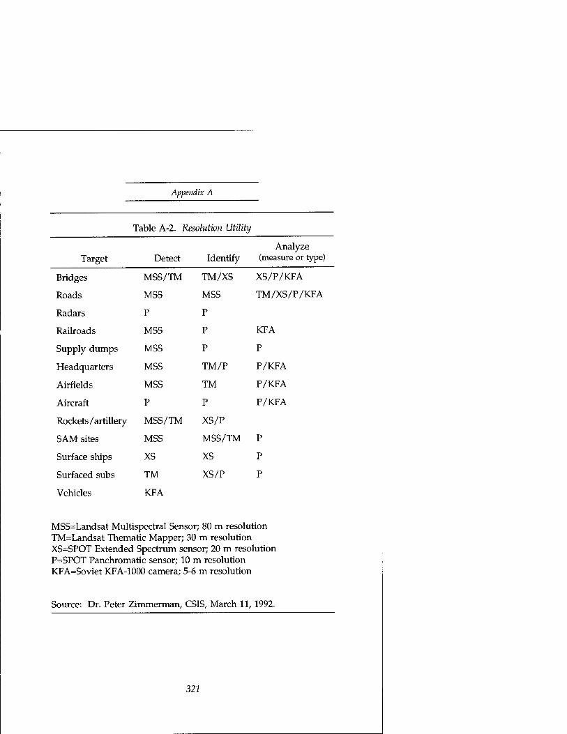
Appendix A
Table A-2. Resolution Utility
Target Detect Identify Analyze
(measure or type)
Bridges MSS/TM TM/XS XS/P/KFA
Roads MSS MSS TM/XS/P/KFA
Radars P P
Railroads MSS P KFA
Supply dumps MSS P P
Headquarters MSS TM/P P/KFA
Airfields MSS TM P/KFA
Aircraft P P P/KFA
Rockets /artillery MSS/TM XS/P
SAM sites MSS MSS/TM P
Surface ships xs XS P
Surfaced subs TM XS/P P
Vehicles KFA
MSS=Landsat Multispectral Sensor; 80 m resolution TM=Landsat Thematic Mapper; 30 m resolution XS=SPOT Extended Spectrum sensor; 20 m resolution P=SPOT Panchromatic sensor; 10 m resolution KFA=Soviet KFA-1000 camera; 5-6 m resolution
Source: Dr. Peter Zimmerman, CSIS, March 11, 1992.
321

Plowshares and Power
Lens For this and the following discussions, figure A-2 illustrates the key terms. How big a lens are we trying to point at the scene from our satellite? That depends on how sharp a picture we need and how high the satellite is. The atmosphere sets the ultimate limit on resolution at a few centimeters, with distortion caused by turbulence, such as we would notice looking at the horizon shimmering on a hot day.7 The best resolution possible with a lens is approximately the distance to the subject divided by the diameter of the lens measured in wavelengths. To achieve resolution of a few centimeters at visible wavelengths (half a micron) from 200 km would require a nearly perfect lens the diameter of the Hubble space
Figure A-2. Typical remote-sensing optics
Cross Track Scan Mirror
o c CD ,
-C O W
CO E LU o i_
H—
'j r .c
PrimaryJ Secondary Mirror Mirror
Focal Plane Electronics
D5
322
Appendix A
telescope's (2.4 m).8 If we can get by with only a one-meter resolution (which table A-l indicates would cover a lot of military uses for a lot of interesting targets), we could use something like an 8- to 14-in diameter lens available commercially for amateur astronomers for a lot less money than a Hubble telescope.9
How big a lens also means how long. A short focal length lens with a large diameter will gather more light but won't magnify the image of the distant object when it is focused on the film. The focal length is determined by the degree of magnification needed, which is set by the distance to the subject and the size of the film. The longer the focal length, the greater the magnification and the more restricted will be the field of view. Should the focal length make the lens physically unwieldy, we can "fold" the lens into a shorter length with mirrors. We may run into some difficulty with narrow field of view when we specify a long enough focal length to provide the magnification needed to focus the image on the "film" from satellite distances. Field of view limitations will translate into accuracy requirements both on pointing and knowing where to point. This is the familiar "looking through a soda straw" sensation we find when trying to use high powered binoculars to view a fast moving sporting event.
Film The satellite camera's analogy to film is one of several electro- optical alternatives, such as a charge coupled device (CCD) or vidicon imaging tube as may be found inside a video camcorder. Using an electro-optic device allows us to send the picture to the ground by radio and saves worrying about how and when to get the firm to Fotomat and how to re-load the satellite's camera with our free roll of fresh film. A CCD contains an array of very small "buckets" which collect electrical charge in proportion to the number of photons of light that strike them. Clocking signals from a computer cause the buckets to pass the charge along "bucket-brigade" fashion into buffer electronics, which translate the amount of charge
323

Plowshares and Power
into a number for the computer's memory. Aside from the logistics of film processing, CCDs offer many other advantages over film or even electro-optic imaging tubes. They are more sensitive to lower levels of light and respond to a wider range of wavelengths. Because they are less prone to saturation (then- response to illumination doesn't level off as the light gets brighter), they allow more effective computer processing after the fact to correct for non-uniformities. They provide their output directly in a numerical form suitable for recording, processing in a computer, or transmitting via radio signal to the ground.10
The requirement for fine grain in our photographer's film translates into small pixel size in the CCD array. Pixel is a contraction of picture element—in this case the CCD's charge bucket. If we can't decrease the CCD's pixel size, we could increase the focal length and magnification of the lens, but at considerable expense. A "small" pixel means sized to match the lens resolution on the focal plane. (Ideally a pixel size twice the theoretical resolution of the lens will capture most of the energy from a point in the scene corresponding to the pixel.)11 Table A-3 lists representative CCDs used in civil remote sensing. For our Hubble telescope example, we're talking about a 13-micron (millionths of a meter) pixel. Kodak makes a million-pixel array of nine-micron pixels.12 For the amateur astronomer, a typical CCD array available commercially today for around $7,500 would provide 512 by 512 20-micron pixels.
Pointing The satellite camera analogy to steady hands or a sturdy tripod is smooth pointing of the camera's line of sight. We can point the line of sight by one or more of these methods:
• By mounting the telescope on a gimbal and pointing the camera
• By scanning a flat steering mirror back and forth in
324

Appendix A
front of the telescope
By slewing the entire spacecraft
By allowing the orbital motion of the satellite to sweep the line of sight along push broom fashion.
Table A-3. Multispectral detector materials
Material Wavelength (urn) Temp (K)
Si 0.4-1.1 200-300
HgCdTe 1.0-26.0 80-200
InAsSb 2-8 40-200
Si:In 2-8 20-40
Si:Ga 7-16 20-40
PbS 2.5-3.0 130
Source: Hsi Shu Introduction (Orlando,
Chen, Space Remote Sensing Systems: An FL: Academic Press, 1985), 41.
What means of pointing we'd use depends on how hefty the camera and satellite are and how quickly we need to be able to point. How smoothly we must point the line of sight is determined by how small an angle a pixel covers and how long the line of sight must dwell on that pixel to collect enough light for a good exposure. It will help if there are no sources of vibration on the spacecraft to smear the image. Vibrations caused by thermal expansion and contraction of its solar arrays have been a limiting factor in the Hubble space telescope's operation. However to use our amateur astronomer's fourteen- inch telescope again—to take 1-meter resolution pictures from orbit, it would need to point only one-sixth as smoothly as Hubble. And it's a lot lighter to muscle around than Hubble.
325
Plowshares and Power
If we're still unable to point as smoothly as we would like, computer processing of the image after the fact may allow correction for the effects of platform motion, potentially allowing registration of our jittery picture down to a fraction of a pixel, depending on the motion.13
Exposure To make a good exposure with our electronic camera, we need to collect enough photons in the bucket to translate into a charge significantly larger than that which will build up because of the random thermal motion of electrons in the array. If no light arrives, there will still be a "noise" signal in the electronics like the noise of static on a radio. We can use a technique called time delay integration (TDI) to add up the energy from the same location in the scene over a period of time as it scans across a succession of pixels. This will improve the signal level and average out noise and variability among pixels or failures of pixels. Varying the number of TDI steps we use for the addition can provide exposure control to compensate for variations in brightness of the scene.14
Spectral Resolution If our amateur astronomer decides to sell his pictures to a television network that insists on color and won't colorize them, he'll need to include spectral resolution in his worries. To separate different bands of light by wavelength he can employ filters over the CCDs on the focal plane or prisms or gratings in the optical path to the focal plane.15 But there's a penalty to pay. For each wavelength band, he'll have to replicate the focal plane electronics, data recording and communications or relay capacity. As the wavelengths get longer (beyond the visible into the infrared), spatial resolution through the same optics will degrade proportionately. And the temperature of the focal plane will need to be cooled to cryogenic temperatures to keep the background thermal noise from obscuring the desired infrared signal. Table A-4 lists typical temperatures needed for different detector materials.
326

Appendix A
Table A-4. Remote- focal
sensing satellite visible plane technology
imaging
Sensor Era Detectors Size (microns)
MSS
TM
MLA
late '60s
mid-'70s
mid-'80s
6
16
1,000
100
100
15
MSS=Landsat Multispectral Scanner TM=Landsat Thematic Mapper MLA=NASA study, multilinear array
Source: Study for an Advanced Civil Earth Remote Sensing System, vol. 2 (Landover, MD: KRS Remote Sensing, 1988), 34.
(Room temperature is around 290 degrees Kelvin.) Fortunately for our astronomer, outer space is pretty cold if you're not looking at the sun. Cooling of focal planes by passive radiation of the heat to cold space can get temperatures down to the range of 200 to 40 degrees Kelvin, but the range of temperatures from 40 to 4 degrees requires active refrigeration by a cryostat (a very cold "icecube") or refrigerator (whose mechanical moving parts and fluid seals make them unreliable in satellites).16 We can see from the table that visible and near- infrared wavelengths are not a problem, but thermal infrared is considerably more challenging.
Delivery The distinctive aspect of remote sensing in our analogy to amateur photography is the need to deliver the picture. Once our satellite camera's CCDs have recorded the numbers that constitute the image of the scene, we have to provide the means to transmit the numbers to the ground, either directly when a satellite ground station is visible or through a relay satellite when one is not. NASA's Tracking and Data Relay Satellite System (TDRSS) provides this service for the Space
327

Plowshares and Power
Shuttle, Hubble Space Telescope, and Landsat. For those times when we have to wait for visibility or
availability of a ground station or relay, we'll need a way to record the image on board the satellite. We might also need storage as a buffer if our communications link cannot accommodate the information as fast as we generate it. Depending on the size of the scene, the spatial resolution of the camera, the number of shades of gray or brightness, and the number of spectral bands or colors imaged, this could mean a lot of on-board storage or a high capacity communications link.
For example, consider a 25-km square scene at 1-meter resolution with 256 shades of gray. This degree of gray scale shading is typical of the current crop of personal computer image scanners intended for desktop publishing and translates to eight bits of storage per sample. Twenty-five kilometers is a relatively small dimension in terms of the ranges of modern military weapons and the range of visibility afforded by aircraft and satellites. However, storing this one fairly modest image would fill up 625 megabytes (five gigabits) of memory or ten times the disk storage space in the laptop computer used to draft this manuscript. We can reduce this with data compression easily by a factor of two17 and reportedly up to a factor of six without compromising on picture quality.18 If we're willing to compromise some on the image fidelity, we could reduce the storage needed by a factor of 10 to 100 using methods developed for the commercial broadcast and simulation industries.19 The compromise would probably invalidate the imagery's scientific utility but could preserve its military usefulness for detection and identification. Even so, data storage and transmission could quickly become a problem on a satellite. Table A-4 summarizes some typical bulk storage components for satellites. A quick comparison of the storage needed for our hypothetical scene with the limitations of the recorders in the table emphasizes the value of data compression and prompt transmission to the ground. Only the most capacious of these recorders could hold even one complete scene without compression. With the most optimistic compression performance, it's still the only one able to store
328
Appendix A
any significant number of scenes. When we include redundant recorders for reliability and compare the weights and power requirements of these recorders with a typical remote-sensing satellite weight, on-board storage of a reasonable amount of high resolution imagery consumes a substantial portion of satellite resources. The original Landsat satellites weighed about 950 kilograms; the more recent French SPOT satellites and current Landsat satellites weigh about 1840 and 1940 kilograms respectively.20 Comparison with proposed "lightsat" small satellites weighing a few hundred kilograms or less suggests that on-board storage of any useful amount of imagery is incompatible with a lightsat until very light, very capable recorders become available.
The limitations of on-board storage only add urgency to the satellite's need for high capacity communications with the ground. Although the technology of high capacity radio communications is well understood and widely available, providing it on board a satellite requires substantial weight and power and therefore substantial cost. Table A-5 lists the communications needs of some typical satellite sensors. For comparison, NASA's TDRSS relay satellite's capacity is limited to 300 megabits per second.21 Our amateur astronomer's ten- inch telescope sweeping out a 4-degree field of view from 250 km might need 30 megabits per second to transmit pictures to the ground.
Orbits and Timeliness The final technical issue in remote-sensing from satellites is the choice of orbit and design of the constellation, i.e., selecting the number and placement of satellites in those orbits, to deliver the pictures when needed—both in terms of delivery delay and of the frequency of opportunities to revisit the same scene. We mentioned the potential for delay in delivery due to the lack of a conveniently visible ground station in the discussion of data storage and communications. If adequate communications relays are visible to the satellite when it takes a picture, delay from that time is not a problem. However, there may be
329

Plowshares and Power
unacceptable delay in waiting for the satellite to fly within line of sight of the scene to be photographed.
Table A-5. Communications requirements
Sensor (Mbps) Design era Rate
MSS late 1960s 15
TM mid 1970s 85
SPOT late 1970s 50
ROS mid 1980s 264
ERS-1 late 1980s 105
JERS-1 late 1980s 65
ROS: Research Optical Sensor from NASA study of Multilinear Array (MLA) ERS-1: European Remote Sensing Satellite JERS-1: Japan Earth Resources Satelllite
Source: KRS 1988, 2:34, 3, 40
A more instructive way to think of the geometry of the situation is not in terms of the satellite flying to the scene, but of the earth rotating the scene toward the satellite. Except for minor perturbations in its orbit because of the effects of atmospheric drag, the gravity of the sun and moon, and the slightly pear-like shape of the earth, the satellite is going around the same orbit waiting for the earth to rotate underneath to the point that the scene will be visible. The amount of earth rotation per satellite orbit depends principally on the period of the orbit (the time to complete a rotation around the earth) which depends on its altitude. At the lowest feasible altitudes, the period is about 90 minutes. For higher altitudes the orbit's period and the portion of the earth visible both increase. For typical remote-sensing altitudes,
330
Appendix A
figure A-3 illustrates the radius of visibility measured from the point under the satellite to the horizon and the amount of time the satellite is visible above the horizon if it passes directly overhead. Although the area of the earth visible increases rapidly until a complete hemisphere is visible, much of that area is not as useful for remote-sensing because spatial resolution degrades substantially out towards the horizon where the curvature of the earth makes the view of the earth's surface more nearly edge-on. Figure A-4 shows this degradation in terms of the amount of coverage contributed by the horizon in comparison with the total. It depicts the area of the earth's surface swept out per hour by a single satellite using three different types of search scan. The horizon swath is a scan starting from one horizon and including a twenty degree arc down towards the nadir point immediately under the satellite. The nadir scan sweeps a 20-degree arc centered immediately beneath the satellite.
To see how much of the total area seen by the satellite is near the horizon, double the amount depicted for the horizon swath to account for both sides of the satellite. That amount constitutes most of the visible area. The small area covered by the nadir swath represents the high resolution opportunity.
The alternatives available for designing a constellation where timeliness is an issue are to raise the orbit altitude and make the optics and the rest of the satellite more expensive or to add satellites at lower altitude and multiply the cost by the number of satellites. The customer's need for timeliness has not been a driver for past remote-sensing satellites, most of which have been more developmental than operational. The international proliferation of remote-sensing programs will increase the frequency of observation, but not necessarily in a coordinated fashion. Alternatively, the development of Brilliant Pebbles and Brilliant Eyes very small satellite technology may enable more affordable constellations of many small satellites at low altitude. Such large constellations would provide frequent revisit and continuously available data relay via the other satellites in the constellation.22
331

Plowshares and Power
Figure A-3. Area search rate
1000 2000 3000 4000 5000 6000 7000 8000
Altitude (km)
Horizon range (km) ■ Time in view (min)
Figure A-4. Orbit visibility
1500 3000 4500
Circular Orbit Altitude (km)
6000 7500
nadir swath horizon to horizon horizon swath
332

Appendix A
A fortunate side effect of the regularity of a satellite's orbit and the earth's rotation is that opportunities for observation by satellite are predictable. Knowing its orbital parameters, a person on the ground with something to hide knows precisely when to cover that something up before the satellite rises above the horizon—unless the satellite has maneuvered into a lower or higher orbit without his knowledge. Because those maneuvers use up rocket propellant, a life-limiting resource on a satellite, civil satellites ordinarily maneuver only to keep then- orbits predictable, not to make them unpredictable.
Further Reading Readers looking for a more detailed understanding of remote- sensing than that provided in this brief tutorial may wish to consult the Manual of Remote-sensing published by the American Society of Photogrammetry, Falls Church, VA. Readers interested in a more comprehensive understanding of space systems should read Wertz and Larson's compendium, Space Mission Analysis and Design, published by Kluwer Academic Press, Boston, MA. (It uses the design of a forest fire detection remote-sensing satellite as a thread of consistency through a series of articles on all aspects of space system conceptual design.)
Notes 1. Ann M. Florini, "The Opening Skies: Third-Party Imaging
Satellites and U.S. Security," International Security 13, no. 2 (Fall 1988), 95-96.
2. Eli Brookner in Kosta Tsipis, David W. Hafemeister, Penny Janeway, eds, Arms Control Verification, The Technologies That Make It Possible (Washington, DC: Pergamon Press, 1986), 11: 139.
3. Mark Brender, Producer, ABC News, Washington DC, interview October 28, 1991.
4. Theresa M. Foley,, "SPOT Markets New Products Commercially," Space News, June 24-July 7, 1991, 25.
5. Florini, 95. 6. RCA Corporation, RCA Electro-Optics Handbook (Harrison, NJ:
RCA Commercial Engineering, 1974), 121.
333

Plowshares and Power
7. John A. Adam, "Peacekeeping by Technical Means," IEEE Spectrum, July 1986, 49.
8. Adam, 50. 9. Celestron Inc. catalog #93895-90A, Torrance, CA, 1990, 23-
24. 10. Kosta Tsipis in Tsipis, 109-120. 11. Hsi Shu Chen, Space Remote Sensing Systems: An Introduction
(Orlando, FL: Academic Press,1985), 24-25 12. Gregory Canavan and Edward Teller, "Low-Level Satellites
Expand Distributed Remote Sensing," Signal, Aug 1991, 100. They attribute to signal processing the ability to correlate successive frames to relative displacements of a few thousandths of a pixel in a later, internal paper, "Distributed Remote Sensing for Defense and the Environment," Los Alamos Laboratory report, LA-UR-91-1169(rev), May 21, 1991, 20.
13. Canavan and Teller, 103. 14. Chen, 20-23. 15. Remote Sensing, Study for an Advanced Civil Earth Remote
Sensing System, vol. Ill (Landover, MD: KRS Remote Sensing, 1988), 2:32.
16. Chen, 47. 17. James R. Wertz and Wiley J. Larson, eds., Space Mission
Analysis and Design (Norwell, MA: Kluwer Academic Publishers, 1991);Wertz and Larson, 457.
18. Peter B. de Selding, "Corporations, Space Agencies Announce New Joint Ventures," Space News, June 24-July 7,1991, 23.
19. KRS 1988, 2: 38. 20. KRS 1988, vol. Ill, appendix A. 21. Wertz and Larson, 455. 22. Gregory H. Canavan and Edward Teller, "Brilliant Eyes
Technology Provides Dual-Mode Viewing," Signal, December 1990, 31-33.
334

Appendix B: Communications Satellite
Vulnerability
This appendix is not meant to provide a comprehensive tutorial on satellite communications. There are many excellent texts and articles available for a general discussion. For example:
• Wilbur Pritchard's "The Basics of Satellite Technology," in Pelton and Howkins, Satellites International (Stockton Press, 1987,) 19-24, is a good, short introduction to satellite communications and basic terminology.
• Walter Morgan and Gary Gordon's Communications Satellite Handbook (John Wiley & Sons, 1989) contains numerous quantitative examples of system configurations.
• Chapter six of Roger Freeman's Telecommunication Transmission Handbook (New York: Wiley & Sons, 1991) has a good overview of the engineering practice of satellite communications.
• Chapter nine of Bernard Sklar's Digital Communications: Fundamentals and Applications (Prentice Hall, 1988) discusses Intelsat's multiple access methods; chapter ten discusses spread-spectrum modulation in the context of the entire communications system with some insight into the cat-and-mouse nature of jammer and communications design.
Many communications texts also discuss jamming in a general way. What is missing is a review of the peculiar context of the satellite transponder, where the jammer attacks an intermediate relay point rather than the ultimate receiver, and the jammer ordinarily has the luxury of seeing the results
335

of his attack reflected directly in the relay's output. This appendix provides some insight into the problem. It defines what kind of features make a satellite communications system more or less vulnerable—and, therefore, less or more dangerous.
Chapter three of this text listed the following features that make a communications satellite system hard to attack and hard to overhear:
• Ground terminal mobility
• Poor satellite visibility (line of sight)
• Spot beam, sharply tapered or nulling satellite antennas
• Cross-links (inter-satellite links)
• On-board signal processing.
What makes these features dangerous?
Mobility In the Persian Gulf War, Iraqi SCUD missile crews convincingly demonstrated the value of mobility for survival. Although coalition planners devoted about ten percent of then- daily air strikes to SCUD suppression, the strikes were almost entirely ineffective. The planes were reduced to waiting for SCUDs to launch before being able to detect their location by satellite or pilot sighting of the hot plume.1 A similar mobility for Iraq's Intelsat terminals at Dujail could have saved them the devastation of air attack.
Visibility The first prerequisite to either jamming a satellite or intercepting its signals is the ability to see it without obstructions. Most familiar communications satellites are in high orbit, either the geosynchronous arc around the equator or a highly elliptical orbit like that of the Russian Molniya which dwells for much of its orbit high above the high
336

Appendix B
latitudes.2 These high orbit satellites are within line of sight of large areas of the earth's surface from which they can be jammed or their signals intercepted, providing their antennas illuminate those portions of the globe adequately. (See the next section on satellite antennas.) There is also a less well known class of communications satellite that operates from low altitude orbit. The Soviet Union offered such a system for sale internationally and announced plans for internal use of a similar system. In 1991, A. I. Ilyin, the Chief Constructor for Koskon's (Space Conversion) venture to modernize Soviet communications described its main task as "the creation of the global low-orbit satellite communications system for solving the information technology problems in various branches of the national economy."3 (emphasis added) Low-altitude orbiting satellites can be usefully visible to a ground station while screened by the earth's horizon from a jammer. Figure B-l illustrates the geometry (roughly to scale) for both low orbits and geosynchronous altitude orbits. The horizon will often shield a low altitude satellite from a neighboring jammer for some part of its visibility to a user particularly where the user is in the interior of his territory and the jammer is kept at some distance by a border. In that case ground-based jammers can deny use of low earth orbit satellites if they can straddle the victim terminal or if one is close enough to have essentially the same horizon as the victim (which might make jamming either superfluous or hazardous.) Figure B-2 shows a closer look at the geometry involved in "straddling" the victim ground station. It is an expanded view of the previous figure with a second jammer added and an additional, slightly higher orbit shown for comparison with the low orbit. Compared to the geosynchronous orbit satellite, the low flyer is flying "nap of the earth" and enjoys the same kind of protection from the horizon that a low flying airplane enjoys from radars.
337

Plowwshares and Power
Figure B-l. Jammer geometry for low and geosynchronous orbits
Geosynchronous Orbit \
\ Jammer \
Horizon masks jammer up to this point.
^ Jammer horizon
\ \ \ \ \
"Victim" ground terminal Low earth orbit
-Terminal horizon
Satellite Antennas Even if a ground-based jammer has a clear line-of-sight view to a satellite, the satellite may not be susceptible to its jamming. All satellite receive antennas have some degree of directionality (except for a command receiving antenna which needs to provide all aspect coverage in case an anomaly on board the spacecraft causes it to lose its earth pointing orientation). That directionality provides gain or increased sensitivity in the preferred direction from which it anticipates users. (If nothing else a satellite will expect users on the
338

Appendix B
Figure B-2. Jammer geometry straddling victim terminal
Jammer Jammer horizons
Higher orbit visible to at least one jammer throughout user's coverage
Horizon masks jammers between these points of low orbit ^Jammer
Terminal horizon
earth's surface as opposed to space.) Outside that area the antenna's gain is reduced. The designers of the antenna will shape the pattern of gain to match the contour of the area for which the satellite is licensed to provide service. (They may use multiple regional or spot beams to partition and cover the service area in order to re-use the frequencies from one spot in another without conflict from users in neighboring spots.) Those antenna patterns may cover the whole earth, a hemisphere, a region, a country, or a metropolitan area containing a high population density. By selectively exciting elements of the antenna feed array, the antenna can shape its coverage of a region with fairly rapid tapering off of the power level received outside the desired area, for example, the SATCOM-5 C-band coverage of the continental United States decreases its gain by a factor of four (6 dB) from the southern border of Texas to barely inside Mexico.4 Where the service area is a small "spot," the spot beam will severely attenuate any jamming signal generated outside the spot beam's coverage compared with the desired signals generated within the spot. Shaped coverage or spot beams are an important part of any commercial communications satellite. Although broader coverage would seem to add additional potential customers,
339

Plowwshares and Power
the ability to clearly define a geographical service area makes it easier to get a license to operate without interference to or from adjacent areas. They also concentrate the satellite's transmitted power and sensitivity in the desired service area, allowing its customers to use smaller, lower power, and therefore less expensive ground terminal equipment.
In addition to directionality, antennas may include features to directly reduce the strength of an interfering signal by forming a null in its direction. It may form a null either in the intended service area or outside it. An early report of array beam-nulling of a single jammer produced 30 db of nulling (a factor of a thousand-power reduction) of the jammer while reducing the intended signal by only 3 db (a factor of two reduction) providing a net improvement of 27 dB (or a factor of 500.) The ability to form a null in the direction of the jammer and still maintain the desired signal strength depends on the geometry and proximity of the jammers to the desired transmitter. The same author cited additional examples:
• Two jammers nearly straddling the user: jammer reduced by 70 to 75 dB, the user by only 2 dB
• 2 jammers, one close to the user: user signal reduced by 5 dB, nearest jammer by 74 dB and furthest by 85 dB
• 3 jammers surrounding the user: user signal reduced by about 10 dB, jammers reduced by 67 to 72 dB.5
Nulling antennas can clearly be powerful weapons against jammers, but they are typical of military rather than civil communications satellites. There are few legitimate reasons for civil applications to use them, and commercial satellites have no profit incentive to incur the additional complexity and expense needed to employ nulling. In the unlikely event of peacetime interference to a commercial satellite, civil remedies are available.
340
Appendix B
Cross Links Satellite cross-links or inter-satellite links are communications relayed between satellites before transmission back to the ground. For low-altitude satellites they are a necessity for over-the-horizon real-time communications. (Otherwise, the low flying satellite may store a message on board for later forwarding to the addressee.) If the satellite does not also re- transmit the uplinks it receives back to the ground but forwards them via cross-link, it may appear to the observing jammer to be silent, providing no indication of any communications to jam. If the cross-link is transmitted over a very narrow beam (which is naturally the case for higher frequencies and especially optical frequencies) or at a frequency which the atmosphere absorbs, the jammer will not be able to hear the cross-link from the ground. If the jammer transmits to be on the safe side, it will have no indication of success or failure. It's also much harder to eavesdrop on the communications, even if interference isn't needed.
On-board Processing If the satellite processes the received radio frequency signals, demodulating to recover the underlying information and then re-modulating (perhaps combined with other channels of information), it improves its protection against jamming.6 This form of communications satellite transponder is called a regenerative transponder because it regenerates the input instead of simply amplifying it.
A basic frequency translating (non-regenerative) transponder performs no signal processing other than some degree of conditioning that attempts to minimize distortion in the replica of the uplink signal that it translates to a downlink frequency and re-broadcasts. The downlink signal contains as faithful a copy of all the uplink signals in its passband as possible, including any interfering signals.
This feature of a nonregenerative transponder allows a jammer to identify target signals and adjust its own frequency, modulation, and timing to match its intended victim(s). It can
341

Plowwshares and Power
even observe the effectiveness of its interfering signals by attempting to process the combination of target and interference in a receiver of its own. This visibility can be a powerful advantage, allowing the jammer to tailor its signals precisely to the intended targets and share its disruptive energy among more.targets. However, if the transponder does not provide a copy of its uplinks in the downlink, the jammer not only loses the visibility of its effectiveness, it may lose its effectiveness entirely.7
Some forms of uplink modulation (spread spectrum) rely on very strong correlation between the expected waveform and the received waveform to pass through the receiver and be demodulated. Interfering signals that do not closely match the expected signal in waveform, including timing and frequency, will be suppressed to the same degree that the desired signal is amplified. The magnitude of the improvement is the "processing gain" of the modulation.8 If a jammer cannot see its own and the targeted signal in the downlink, it will not be able to set its jamming on (align in frequency, modulation, timing, and power) to the target and can only try to overcome the processing gain advantage by brute force.
Brute force may not be effective because the receiver may include a limiter intended to reduce the magnitude of too strong signals. If not a hard limiter, it may contain a linear element that will saturate and act effectively as a limiter.9
(However, a jammer driving a satellite transponder's linear amplifier into saturation will cause significant disruption to some forms of modulation. Modulations that try to pack the most information into the available spectrum, which is typical of commercial use, are particularly susceptible. Some of those forms require the transponder to operate at power levels backed off as much as seven decibels or a factor of five from the amplifier's peak power level.10) If the satellite combines on- board signal regeneration with an inter-satellite link, the jammer will not have the benefit of visibility into even the downlink signal. In that case even brute force will be blind and most likely ineffective.
342
Appendix B
Spread Spectrum
The previous section mentioned a class of signal modulation techniques called spread spectrum. They deserve a little extra attention here, because
• There is legitimate civil and commercial application for them in satellite communications
• They have significant military utility for covert communications and jam resistance
• Their use in civil satellite communications may or may not be dangerous, depending on the specifics of then- application.
What is spread spectrum? It is a method of modulating a transmitted signal, not to convey information but to spread the modulated information among a large number of possible modulations. This reduces the density of transmitted energy making it harder to detect. It also forces a jammer without precise knowledge of the modulation to dilute its power among the many alternatives. There are three defining characteristics of spread-spectrum signals:
• They occupy a frequency bandwidth greatly in excess of the minimum needed to convey the information.
• They are spread throughout that bandwidth by a spreading signal that is independent of the information transmitted.
• The receiver despreads the signal and recovers the modulated information by correlating the spread signal with a synchronized replica of the spreading signal.11
The spreading signal may be transmitted to the receiver or stored there. A stored reference signal can be at best pseudo-
343

Plowwshares and Power
random—it should appear random to the casual observer, but it is necessarily predictable and over some period of observation will show a repeatable structure, which a listener or jammer may be able to exploit. The length of that period of unpredictability is a design parameter that will depend on the designer's tolerance for the length of time and difficulty of synchronizing the reference signal with the desired transmission. A transmitted reference signal, on the other hand, may be truly random and unpredictable. If transmitted simultaneously, synchronization at the receiver is then easier. However, transmitted reference signals are also available to unintended listeners (which may not only listen in but generate spoofing signals of their own), occupy additional frequency spectrum, and consume extra transmitter power.12
For this reason, most modern applications spread the spectrum by either hopping the carrier frequency in a pseudo-random way or by phase modulating the carrier (abruptly switching the transmitted phase or timing of the signal) at a rate much higher than the information rate to be transmitted, with the high rate modulation determined by a pseudo-random sequence.
The receiving stations lock a duplicate of the pseudo-noise generator to the received signal to either de-hop or de-spread it and extract the information (and often some timing information to acquire or maintain synchronization with the pseudo-noise code.)13 There is a design trade-off between the desire for a long time over which the pseudo-noise code appears random and the delay or complexity needed to synchronize the receiver with the transmitted signal. Short- cuts that include in the signal modulation some aid to synchronization (such as a separately broadcast or encoded synchronizing signal) may present a vulnerability to jammers who could find the synchronizing signal easier to interfere with than the information signal. An alternative to a transmitted synchronization aid can be a shared clock. Ultrastable, highly precise (relative to the spreading modulation rates) atomic clocks developed for precision navigation can provide the shared clock.
344

Appendix B
Spread spectrum was originally used for military and other covert communications and radar.14 Its military utility comes from the difficulty of detecting or demodulating the signal without advance knowledge of its form and from its relative immunity to interference. Its civil and commercial utility comes from these same attributes. The difficulty of detection translates into an ability to share the frequency spectrum with other non-spread spectrum users without causing them unacceptable interference. The interference rejection features help not only in sharing the spectrum but in reducing the self- interference caused by "multi-path" reflections of transmitted signals caused by buildings, the ground or other obstacles to a clear line of sight between transmitter and receiver. Multiple spread spectrum users can share the same spectrum (called Code Division Multiple Access—CDMA) by using different (uncorrelated) spreading codes. In terrestrial applications, they may have to coordinate their transmitter power levels to account for the differences in distance between transmitters and receiver. In high-altitude satellite applications, this is less likely to be a problem because all terrestrial users within the satellite antenna's footprint are at more or less the same (long) distance from the satellite. If the received power levels are similar, the number of CDMA users is ultimately limited by the total interfering power received from the multiple users transmitting. The net result can be a high degree of efficiency and convenience for commercial users.
The FCC opened up three bands for terrestrial, commercial spread-spectrum users in 1983—902-928 MHZ, 2400 to 2483.5 MHZ and 5725 to 5850 MHz—to explore the demand for spread spectrum. Commercial uses have been quick to appear. The first use of commercial spread spectrum in satellite communications was in 1981 for the multiple access return links of Very Small Aperture Terminal (VSAT) networks.15
Spread-spectrum modulation is also attractive for such growth markets as personal communications systems (PCS). A PCS is effectively a miniature cellular telephone system with cells spaced a thousand feet apart rather than a few miles apart. This allows the user to move around with a telephone
345

Plowwshares and Power
untethered by a wire or a single base station. Judging from the popularity of cordless telephones for the home, this could be a substantial market. Field tests in Houston, Orlando, and New York have confirmed the feasibility of operating a CDMA personal communication system.16
In response to the perception of large growth markets for this and other innovative communications technologies (such as digital, compact disk quality, broadcast radio) Congress proposed in 1989 the Emerging Technology Act (ETTA, HR-2965) to reallocate 200 MHz of government spectrum for commercial use.17 Commercial spread spectrum is widespread and likely to grow. As commercial spread spectrum uses grow, they may pose a military danger in civil satellites, but only to the extent that their features confer immunity from deliberate jamming.
The good news is that widespread commercial spread spectrum is not necessarily dangerous. What spread-spectrum features provide jamming immunity? In a terrestrial application, the amount of spreading provides protection. This is not necessarily the case for a satellite transponder. The greatest danger comes from the combination of spread spectrum and on-board processing. If the satellite transponds a replica of its received signals, a jammer has a reasonable chance of identifying target signals and synchronizing matching waveforms that will enjoy the same processing gain in the targeted receivers as the intended signals, thereby removing the advantage. If the satellite does transpond the signals, the second level of danger could come from a spreading modulation that is deliberately difficult to identify, generate, and synchronize. Fortunately, there are few (if any) legitimate commercial incentives to use such modulations.
Notes 1. Norman Friedman, Desert Victory, The War for Kuwait
(Annapolis, MD: Naval Institute Press, 1991), 194. 2. Joseph N. Pelton and John Howkins, eds., Satellites
International (Stockton Press, 1987), 128-9.
346

Appendix B
3. Vremya newscast 1800 GMT, 28 Feb 91, "Modernization of Communications Discussed," FBIS-SOV-91-043, March 5, 1991, 42.
4. John E. Keigler and Charles E. Profera, "Domestic and Regional Satellite Systems," Proceedings of the IEEE 78 no. 7 (July 90): 1042.
5. P. F. Sielman et al, "Multiple Beam Communicating Satellites with Remote Beam Steering and Beam Shaping," in P.L. Bargellini, ed., Communications Satellite Systems (Cambridge: MIT Press, 1972), 272-7.
6. Frederick J. Altman et al., Satellite Comunications Reference Data Handbook, prepared for Defense Communications Agency contract DCA 100-72-C-0002, July 1972, 2-18.
7. Ibid., 2-17. 8. Donald L. Schilling et al., "Spread Spectrum for Personal
Communications," Microwave Journal, September 1991, 28. 9. Altman, 2-19. 10. M. Cominetti, "Perspectives and evolution of HDTV by
satellite," Telecommunication Journal 57-IX, 614. 11. Bernard Sklar, Digital Communications: Fundamentals and
Applications ( Englewood Cliffs, NJ: Prentice Hall, 1988), 537. 12. Sklar, 544-6. 13. Walter L. Morgan and Gary D. Gordon, Communications
Satellite Handbook (New York: John Wiley & Sons, 1989), 417. 14. Ibid. 15. Norman Abramson, "VSAT Data Networks," Proceedings of the
IEEE 78, no. 7 (July 1990): 1269, 16. Donald L. Schilling et al., "Spread Spectrum for Personal
Communications," Microwave Journal, September 1991, 33-8. 17. Ibid., 27-8.
347

Appendix C: Global Positioning System
This appendix provides a brief introduction to the Global Positioning System and its use for precision positioning. Because the field is relatively new and developing rapidly, there are few texts that provide a comprehensive treatment. For a more rigorous development of GPS surveying, the reader will find Alfred Leick's GPS Satellite Surveying (New York:John Wiley & Sons, 1990) helpful. It is the source for much of this material. For a more general introduction to spread-spectrum signals like those of GPS, see appendix B.
Space Segment The space segment of the Navstar GPS includes the constellation of spacecraft and their various payloads. Our concern here is strictly the navigation payload. The navigation payloads of the satellites each transmit a pair of navigation signals on the same two frequencies. The satellites share the same frequencies by means of spread spectrum code division multiple access (discussed in appendix B.) The parameters of a GPS satellite's transmissions come from a set of very stable, on-board atomic clocks that provide a fundamental frequency of slightly less than 10.23 MHz. The offset from 10.23 MHz is a correction for relativistic effects caused by the satellite's velocity relative to the earth's surface. To a terrestrial observer the frequency appears as 10.23 MHz. The navigation signals' frequencies are multiples of that fundamental frequency: LI: 1575.42 MHz (154 times the fundamental) and L2: 1227.60 MHz (120 times the fundamental).
The LI carrier contains two spread-spectrum direct sequence modulations in quadrature (offset from each other by ninety degrees of phase—effectively the sum of a sine and a cosine term.) Underlying one of the spreading codes is the P-code or precise code data message. Underlying the
349

other is the C/A code or coarse/acquisition code data message. The P-code signal is spread with a chip rate of 10.23 MHz using a very long composite code (derived from two other shorter codes) that repeats itself every thirty- seven weeks. The C/A code on the other hand has a 1.023 MHz chip rate. Its code is only a millisecond long, repeating every 1,024 chips. The two codes are synchronized to allow a receiver to rapidly synchronize with the P code once it has done so with the C/A code. The L2 carrier carries the P code modulation and may at the option of ground controllers carry the C/A also. The P code has thirty-seven different code time slots for different satellites (each slot is a week's worth of code.) The underlying navigation messages all transmit at a rate of 50 bits per second.
The navigation message is 1,500 bits long and so takes 30 seconds to transmit. The first six seconds of transmission contain a correction to match the satellite's clock to the system-wide clock. The next 12 seconds contain the predicted ephemeris or position of the satellite. Although expressed in the form of classical Keplerian orbital elements, they are not a true orbital element set usable for predicting the orbit but a least squares fit to the best prediction of position over the period of intended use for navigation. The final 12 seconds transmit one of twenty- five pages of almanac describing the remaining satellites, special messages, ionospheric correction terms and coefficients for conversion of GPS time to universal time. The complete almanac takes 750 seconds to transmit, and then the entire sequence repeats itself.1
The C/A code's navigation signal provides Standard Positioning Service with 100-meter horizontal navigation accuracy worldwide. The Precise Positioning Service, using the P code signal, provides better accuracy restricted to military users and selected U.S. nonmilitary users whose use is in the national interest. Its optional exclusivity comes from two features. The first encrypts the P code. The encrypted P code signal changes its name to Y code. The government refers to this feature as Anti-Spoofing because the encryption prevents others without the
350

Appendix C
encryption key from transmitting false navigation signals that would be decoded by a receiver using the encryption keys. The second feature is Selective Availability. It deliberately degrades the navigation information in the C/A code message and dithers the C/A code clock signal to add phase errors.2 Selective Availability's deliberate ephemeris error magnitude is nominally about forty to fifty meters on each satellite, changed at hourly updates. In addition its clock dither gives an error growth of a tenth of a meter per second which changes direction at about three minute intervals.3
Ground Segment The ground segment of the Navstar system includes the Air Force's control and monitoring stations around the world, which maintain the health of the satellites and update their navigation information, as well as the numerous user terminals or receivers. Our interest is in the user equipment. There are two general classes of receiver, defined by their purpose and accuracy—navigation receivers and surveying receivers. Navigation receivers use the data messages coded into the satellites' navigation signals in the intended way. Surveying receivers may use additionally or exclusively the phase of the navigation signals' carrier frequency—in some cases without regard for the transmitted navigation messages or even for the (possibly encrypted) spreading code.
Navigation Receivers. The system's designers intended its users to navigate using the information in the spread- spectrum signals' underlying data messages. When the user's receiver despreads the signals it provides the times of transmission and receipt of code epochs. Despreading requires the receiver to match in time and maintain track between the signal's spreading code and a locally generated replica of the spreading code, therefore providing a measurement of time of receipt as good as the track of the spreading code and the calibration of propagation and
351
Plowshares and Power
processing delay through the receiver (typically one-tenth of a chip duration in the past—recent improvements have achieved between a hundredth and a thousandth of a chip. Roughly quarter meter precision pseudoranges are available from both P and C/A code receivers.)4 The difference between the times of transmission and receipt provides the signal's transit time and therefore the range to the satellite. Because the receiver's clock includes an unknown offset error relative to the satellite's clock, the indicated range is called a pseudorange.
The satellite's navigation message includes its location. Measurement of pseudoranges to four different satellites simultaneously provides four equations to solve for the three components of position and the receiver's clock error.5
The equations are nonlinear but readily soluble by iterative methods. The precision of the solution (independent of selective availability) is a function of the angles to the satellites. A wide distribution of satellites over the sky provides the best precision. The actual distribution available determines a factor diluting the pseudorange solution's precision. The average value of horizontal and vertical dilution of position for the best possible arrangement of four satellites is about two. If the receiver has more than four channels and more than four satellites are in view, additional measurements can improve the solution.6 The number and distribution of satellites in view change continuously as they orbit the earth. When the operational constellation of satellites is completely populated, users virtually anywhere in the world should have at least four satellites in view most of the time. When the constellation reaches its operational size of 21 plus three active spares, at least six satellites should be in view most of the time.
When Selective Availability is active, a user can still have accurate relative navigation between two receivers. If one receiver is stationary at a known location, subtracting its navigation solution from the other receiver's solution will give a relative position with any errors common to
352

Appendix C
both receivers (for example, selective availability errors, ionospheric and tropospheric signal propagation errors, and satellite clock errors) eliminated by the subtraction. The error budget in table C-l illustrates this. Similarly, a receiver at a known location can broadcast corrections based on the difference between its known and computed locations. The broadcast may use any communications means available that provides timely corrections.
Table C-l . Typical GPS error budgets
Source Stand-alone (m) Differential
Space:
Clock instability 15.0 0.0
Ephemeris error 40.0 0.0*
Orbit error 5.0 0.0
Ground:
Ionosphere 12.0 1.0
Trophosphere 3.0 0.5
Multi-path 2.0 2/0
Receiver noise 2.0 2.8
Total RSS 44.8 3.6
*2 ppm, for a 100-km baseline, a 40-m orbit error would yield 10 to 20 cm of positioning error; 30 cm of ionospheric error; 20 cm of tropospheric, etc.
Source: Ackroyd, 47; Remondi, private communication
For the clock dither used to date, an update interval between corrections of twelve seconds or less will keep the residual error due to Selective Availability down to the
353

Plowshares and Power
order of 5 meters.7 Post-processing can remove virtually all SA errors. The differential corrections may be translated into changes in pseudorange to the satellites instead of position relative to the reference station. This allows use of the corrections over a wider range of distance from the reference station. The Radio Technical Committee-Maritime Special Committee standard for pseudo-range differential GPS corrections, RTCM SC-104, gives an error that increases with distance from the reference station. As figure C-l illustrates, an extended correction based on a distributed network of reference stations can reduce the error's growth with distance.8
Figure C-l. Differential GPS error
30.0 RTCM SC-104
Extended DGPS limit
4000
Phase Measurement. Typical GPS surveying methods use interferometry or the direct measurement of the phases of signals from widely separated sources. (However, surveying receivers are increasingly using the navigation coded signal to aid use of the carrier phase, and navigation receivers are increasingly using the carrier phase to smooth the navigation code solution.) The phase differences between received and locally generated signals provide a
354
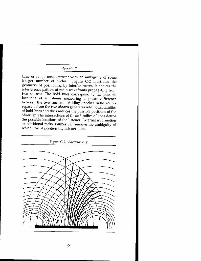
Appendix C
time or range measurement with an ambiguity of some integer number of cycles. Figure C-2 illustrates the geometry of positioning by interferometry. It depicts the interference pattern of radio wavefronts propagating from two sources. The bold lines correspond to the possible locations of a listener measuring a phase difference between the two sources. Adding another radio source separate from the two shown generates additional families of bold lines and thus reduces the possible positions of the observer. The intersections of those families of lines define the possible locations of the listener. External information or additional radio sources can remove the ambiguity of which line of position the listener is on.
Figure C-2. Interferometry
355

Plowshares and Power
If the GPS spreading code is available to the receiver, the de-spreading process tracks the phase difference directly. If not, the receiver must generate a carrier-related signal by either squaring the received signal (multiplying it by itself) or by cross-correlating (multiplying) the LI and L2 P-code signals. The resulting signals will not be as strong as if the code were available, but the receivers can still track and accumulate a phase measurement accurate to about one hundredth of a cycle depending on elevation. Differencing between multiple observations of the phase can eliminate or reduce clock errors and propagation medium effects. Phase measurements might supply one to two meter accuracy at a single, fixed point if several hours were available with good orbit and clock information. However, relative positioning methods between points can supply much greater accuracy in much shorter times, and so are more widely developed.9
Relative positioning methods are either static, requiring both receivers to remain fixed for periods of tens of minutes, or kinematic, allowing motion of one of the receivers without losing track of their locations. (A compromise between the two is intermittent static or pseudo-kinematic surveying, in which the remote receiver makes two or more visits to an unknown site with an hour or two separating the visit. Pseudo-kinematic surveying can provide millimeter accuracy.)10 We can characterize kinematic methods by their use of carrier phase. Table II lists the characteristics of three classes of such methods.
The first column of table C-2 is differential navigation without using carrier phase information—the code differential method of the previous section. The third column is differential interferometry. The middle column combines the two, using phase information to smooth out the errors in the pseudorange solution.11 A similar approach (of less interest for surveying but useful for navigation) to remove the short-term errors of selective availability would use an inertial reference for smoothing the pseudorange solution. In that case, with navigation
356

Appendix C
beginning from a known position, frequent communication of corrections would not be necessary. Given suitable communications capacity, all three of the methods in the table are usable for real-time applications like weapons delivery. Interferometry's need for external information to defeat Selective Availability comes from the clock dither and from the need for correct orbit determination.
Table C-2. Comparison of kinematic methods
Differential Phase- Phase position smoothed differencing correction pseudorange
Accuracy 5-15 m 1-3 m 1-3 cm C/A
Accuracy P 3-5 m 0.5-1 m 1-3 cm
Pseudorange needed needed needed
Carrier phase no needed needed
Real time use easily possible need possible external
Source: Adapted from Hein et al., "Terrestrial and Aircraft Differential Kinematic GPS Positioning," in Groten & Strauss, eds., GPS-Techniques Applied to Geodesy and Surveying (Springer Verland, 1988), 312.
Selective Availability degrades the broadcast orbit information, the broadcast value of the clock offset, and the phase of the satellite's clock signal. Changes to the orbital elements and clock offset can be overcome for surveying or weapons applications by estimating those parameters from differential measurements.
The dither of the clock signal is more of a problem because it directly changes the phase measurements used for interferometry. Measurements of the dithered clock
357

Plowshares and Power
signals have shown a variation of several cycles per second over a 30-second period. When accumulated over several minutes, the error can produce an error on the order of twenty to fifty meters. The two differential receivers can subtract simultaneous measurements to minimize the effect, but the error depends on both the frequency deviation and the distance between receivers. Separate receivers have different distances to the satellites and hence different signal propagation times. The difference in propagation time means that the phases being subtracted are from different transmission times. (At dither rates of 5 meters in 12 seconds, the largest error would be under a centimeter given that the receivers' propagation times differ by no more than ten to twenty milliseconds.)12 Differences in sampling time or synchronization between the receivers cause similar errors. However, estimating the parameters of the clock dither from frequent samples compared with a stable local signal can minimize the clock dither's effect on selective availability. A sampling interval of thirty seconds is enough for the level of dithering employed so far. The Cooperative International GPS Network (CIGNET) of monitor stations conveniently supplies samples freely to the public at that rate now.13
Aside from differences in method, kinematic GPS surveying differs from moving platform navigation in the following qualitative respects related to the use of the data:
• Loss of lock is more serious for the moving platform navigator so tracking loops have wider tracking bandwidths and hence more tracking noise and less accuracy.
0 In kinematic surveying, initial coordinates of the roving antenna are available via swap of antenna positions (requiring a minute or less to perform) unless "on-the-fly" or known starting point methods are used.14
358

Appendix C
• The trajectory is only a byproduct of the kinematic survey. So errors in transit are tolerable so long as the destination waypoint accuracy is good. This allows a surveyor to open up the phase-tracking bandwidth during transit and close it down during survey at site.15
These differences illustrate the tradeoffs available to apply the high accuracy of kinematic surveying to the precision navigation application of weapons delivery. The technique of varying the phase tracking loop bandwidth is the key to applying kinematic surveying to weapon delivery. For example, a typical carrier-tracking GPS receiver has user selectable dynamics available to vary the phase tracking loop settings among bandwidths of 0.7,5,8, and 16 Hz. The receiver is able to withstand accelerations of 0, 6,15, and 40 meters per second2 with those settings.16
At the widest (and least accurate) setting, it can tolerate a four g maneuver. For a weapon delivery application, the delivery platform (or weapon) can fly most of its route to the target with the widest bandwidth setting and need only maintain low acceleration for a few seconds before weapon release or final update of a weapon's inertial system to achieve the higher accuracy possible.
Notes 1. Alfred Leick, GPS Satellite Surveying (New York: John
Wiley & Sons, 1990), 52-62. 2. Ibid., 53. 3. Levels of ephemeris error up to a kilometer have been
demonstrated in public tests, and clock dither error rates at least up to 0.5 meters/second are known to be possible. (Dr. Benjamin Remondi, U.S.GS, private communication.); Neil Ackroyd and Robert Lorimer, Global Navigation, A GPS User's Guide (London: Lloyd's of London Press, Ltd., 1990), 53-5.
4. Dr. Benjamin Remondi, private communication, June 1992.
5. Leick, 204-6. 6. Leick, 204-9.
359

Plowshares and Power
7. Ackroyd, 53-5. 8. Alison Brown, "Extended Differential GPS," Navigation:
Journal of the Institute of Navigation 36, no. 3 (Fall 1989): 267, 284. 9. Leick, 209-17. 10. Benjamin Remondi, "Kinematic and Pseudo-kinematic
GPS," Ashtech, Inc., Sunnyvale, CA; "Pseudo-kinematic GPS Results Using the Ambiguity Function Method," National Geodetic Survey, Rockville, MD.
11. Guenter W. Hein et al.," Terrestrial and Aircraft Differential Kinematic GPS Positioning" in Groten & Strauss, eds., GPS-Techniques Applied to Geodesy and Surveying (Springer Verlag, 1988), 312.
12. Remondi, private communication. 13. Kurt L. Feigl et al., "A Scheme for Reducing the Effect of
Selective Availability on Precise Geodetic Measurements from the Global Positioning System," Geophysical Research Letters 18, no. 7, (July 1991): 1292,
14. Dr. Remondi reports current "on-the-fly" performance of a few centimeters over 15 km baselines with a minimum of five satellites (six preferred.)
15. Benjamin W. Remondi, "Performing Centimeter-level Surveys in Seconds with GPS Carrier Phase: Initial Results," Navigation: Journal of the Institute of Navigation 32, no. 4 (Winter 1985-6): 386-7.
16. V. Ashkenazi et al., "Kinematic Surveying," in Groten & Strauss, 239.
360

The Author Colonel Bob Preston, born into an Air Force family, has been an Air Force officer for 21 years. His Air Force career has been spent entirely in the U.S. military space program, working in space research and technology, system acquisition, launch, operations, and policy. Col. Preston wrote this paper while attending the Industrial College of the Armed Forces, where he was also Research Fellow. His current assignment is in Los Angeles, CA, where he works in the Development Plans Directorate.
Col. Preston received a B.S. in electrical engineering at Michigan State University and a Masters in aeronautics and astronautics at the Massachusetts Institute of Technology.
*U.S. G.P.0.:1995-387-330:20007
361
Plowshares and Power
Composed in Palatino type Book designed and edited by Mary A. Sommerville
Cover prepared by Juan A. Medrano
Back cover photos:
Top: LANDSAT thematic mapper image of oil-ßlled flame trenches.
Nominal resolution 30 meters.
Bottom: Oil-filled flame trenches comprising first-line defense of Iraqi positions in Kuwait. Photo taken with Russian KFA-WOO camera, June 1991; nominal resolution 6 meters. (Source: Soyuzkarta)