Non-destructive methods and GIS technologies for Spatial Planning Strategies in Mining Areas
Upload
khangminh22Category
view
3download
0
University of Pennsylvania University of Pennsylvania
ScholarlyCommons ScholarlyCommons
Publicly Accessible Penn Dissertations
Spring 2011
Physical Planning Strategies of National High-Technology Physical Planning Strategies of National High-Technology
Industrial Development Zones in China Industrial Development Zones in China
Sisi Liang University of Pennsylvania, [email protected]
Follow this and additional works at: https://repository.upenn.edu/edissertations
Part of the Environmental Design Commons, Public Administration Commons, Technology and
Innovation Commons, Urban, Community and Regional Planning Commons, and the Urban Studies and
Planning Commons
Recommended Citation Recommended Citation Liang, Sisi, "Physical Planning Strategies of National High-Technology Industrial Development Zones in China" (2011). Publicly Accessible Penn Dissertations. 989. https://repository.upenn.edu/edissertations/989
This paper is posted at ScholarlyCommons. https://repository.upenn.edu/edissertations/989 For more information, please contact [email protected].
Physical Planning Strategies of National High-Technology Industrial Development Physical Planning Strategies of National High-Technology Industrial Development Zones in China Zones in China
Abstract Abstract Over the last two decades, High-Technology Industrial Development Zone (HIDZ) has become an important strategy for urban development in China. Modeled on earlier examples in the US and Asia, they have developed in unique ways in China because of the rapid urbanization, large-scale sites, and trend toward high-technology-based new townships or technopoles. While the 84 current national HIDZs widely use planning strategies in their government-guided development and construction, the impact of these planning strategies remains is not well understood. This dissertation explores how and to what extent planning and management strategies impact the outcomes of HIDZs. It examines closely four case examples (Beijing Zhongguancun Science Park, Shanghai Zhangjiang High-Technology Park, Suzhou Industrial Park, and Shenzhen High-Technology Industrial Park). The study reveals the diverse and sometimes competing purposes of national HIDZs, ranging from stimulating innovation and improvement of products, to serving as an economic anchor and a tool for attracting international firms. The research demonstrates the importance of adopting a sustainable strategy for development of HIDZs that it guides place-making, regulates the land development process, improves the quality of the environment, facilitates cooperation among various sectors, and attracts investment. It explores the versatility of planning approaches, identifies a series of key factors that shape planning strategies, and provides suggestions for tailoring the approach to planning to local resources and conditions.
Degree Type Degree Type Dissertation
Degree Name Degree Name Doctor of Philosophy (PhD)
Graduate Group Graduate Group City & Regional Planning
First Advisor First Advisor Gary Hack
Keywords Keywords high-technology industrial development zone, China, planning strategy, urban design, science park
Subject Categories Subject Categories Environmental Design | Public Administration | Technology and Innovation | Urban, Community and Regional Planning | Urban Studies and Planning
This dissertation is available at ScholarlyCommons: https://repository.upenn.edu/edissertations/989

PHYSICAL PLANNING STRATEGIES OF NATIONAL HIGH-TECHNOLOGY
INDUSTRIAL DEVELOPMENT ZONES IN CHINA
Sisi Liang
A DISSERTATION
in
City and Regional Planning
Presented to the Faculties of the University of Pennsylvania
in
Partial Fulfillment of the Requirements for the
Degree of Doctor of Philosophy
2011
Supervisor of Dissertation
Signature______________________________
Gary Hack, Professor of Urban Design, Dean and Paley Professor Emeritus, School of Design
Graduate Group Chairperson
Signature______________________________
Eugenie L. Birch, Lawrence C. Nussdorf Professor of Urban Research and Education, City & Regional Planning, School of Design
Dissertation Committee
Gary Hack, Professor of Urban Design, Dean and Paley Professor Emeritus, School of Design
Jonathan Barnett, Professor of Practice in City & Regional Planning, Director of the Urban Design Program
Eugenie L. Birch, Lawrence C. Nussdorf Professor of Urban Research and Education, City & Regional Planning
PHYSICAL PLANNING STRATEGIES OF NATIONAL HIGH-TECHNOLOGY
INDUSTRIAL DEVELOPMENT ZONES IN CHINA
COPYRIGHT
2011
Sisi Liang
iii
DEDICATION
To My Grandfather To My Parents To Wei Zhang

iv
ACKNOWLEDGEMENT
As I look back over the course of my dissertation research, I am overwhelmed by
the number of people who supported me through what is usually considered solitary
endeavor. First and foremost, I thank my dissertation advisor, Gary Hack. From our first
meeting on September 4th, 2007, and through the many the phases of my journey though
the Ph.D. program at Penn, you were everything I could ever have wished for in an
advisor: supportive, extraordinarily responsive, and patient in guiding me and my
research. More importantly, your encouragement and confidence has been a constant
source of inspiration throughout the process. I owe a great deal of my success to you and
I look forward to many more years of collaborative work and friendship.
I am deeply grateful to my dissertation committee members, Jonathan Barnett and
Genie Birch, for their insightful instruction. Jonathan’s extensive knowledge in the
practice and theory of urban design greatly expanded the scope of my dissertation. He
shares my enthusiasm about planning practices in China’s urban development, and his
criticism helps to direct and deepen my thinking. Genie has been outstanding in giving
me sage advice, asking the right penetrating questions, and helping me place planning
strategies and science park development in a transnational context. Being a prolific
author, she has also provided me with innumerable writing suggestions. I am grateful for
her guidance, dedication, and insights.
I would like to extend my special gratitude to many other faculty and fellow
students who inspired me along the way in the City and Regional Planning Program at
the University of Pennsylvania. In my first year I came to Penn, Lynne Sagalyn guided
me into the field of city planning research with patience and insight. Later, John Landis’s
v
understanding and enthusiasm for scientific research set a standard for which I will strive
throughout the rest of my career. I also enjoyed and appreciated my time as a teaching
assistant for Laura Wolf-Powers. She opened the door of urban economic to me and gave
me tremendous encouragement. In addition, I thank Michael Larice, Amy Hiller, and
Domenic Vitiello for their advice and guidance and Kate Daniel, Roslynne Carter, and
Rick Dunn for constant support in countless ways. I have enjoyed the intimate yet open
academic atmosphere of the Ph.D. group of City and Regional Planning at Penn, and the
friendships with my colleagues, which I treasure and look forward to continuing in the
future. I am particularly grateful to Amy Lynch and Matthias Sweet for their editorial
assistance in various phases of this thesis. I am also indebted to Amanda Johnson,
Stephanie Ryberg, and Seung Ah Byun, for making me a part of their studies, and have
benefited greatly from their council on living in and enjoying my time in the U.S.
I am also grateful to several scholars in Tsinghua University for their comments
on my dissertation, especially Liangyong Wu, Chuan Zuo, Wenyi Zhu, Qizhi Mao, Jun
Shan, Weimin Zhuang, and Jie Zhang. They provided me great supports and guidance
during my seven years in Tsinghua University, helping me through both my Bachelor of
Architecture and Master of Architecture studies. More importantly, they offered advice
and comments during my four years in the United States, and shared information and
sources that were invaluable in my research. I look forward to continuing my work with
these insightful people in my future career.
Thanks to the generous grant from the China Scholarship Council and School of
Design, University of Pennsylvania, I was able to spend four years continuing my studies
and conducting my research. I am also grateful to the faculty at Tsinghua University who

vi
selected me as the only student of School of Architecture in Tsinghua University to
pursue a Ph.D. in City and Regional Planning in the United States.
I am fortunate to have a terrific group of friends who have helped me through the
entire process. To Steve French, I put you in my list of friends rather than faculty,
because I am grateful to you for your constant encouragement to me during the writing
process, and for pulling me up during my desperate times. To Mengke Chen and Penghui
Sun, thank you for the constant calls and research discussions, our group study sessions
in Van Pelt Weigle Information Commons and the Fine Arts Library, and countless
lunches and dinners together. To Amy Lynch, our many discussions over brunch,
Starbucks and Cosi coffee, and the time we spent together in libraries and 2010 ACSP
workshop provided me a steady source of insight and diversion. To Shunxi Wang, thank
you for being with me throughout my writing process, and for reading and revising drafts.
To all my other close friends, thank you for sticking by me when I was buried in exams,
writing, and work, and for such warm friendship.
Finally, I want to thank my family, especially my fiancé, Wei Zhang, for his
unfailing love, patience, and support. I dedicate this dissertation to our coming wedding,
for it is a testament to every minute of joy, courage, and life we have shared, and the
difficulties we have overcome together over the years. I would also like to share the joy
of completing my dissertation and upcoming graduation with my parents and parents-in-
law in China. My dear parents, thank you for your constant encouragement during all my
twenty-six years of life. Thanks also go to my aunts, uncles, and grandparents who have
been by my side for as long as I can remember. Particularly, my dear grandfather in
heaven, I know I am, and will always, a granddaughter you are proud of.
vii
ABSTRACT
PHYSICAL PLANNING STRATEGIES OF NATIONAL HIGH-TECHNOLOGY
INDUSTRIAL DEVELOPMENT ZONES IN CHINA
Sisi Liang
Dissertation Supervisor: Gary Hack
Over the last two decades, High-Technology Industrial Development Zone (HIDZ) has
become an important strategy for urban development in China. Modeled on earlier
examples in the US and Asia, they have developed in unique ways in China because of
the rapid urbanization, large-scale sites, and trend toward high-technology-based new
townships or technopoles. While the 84 current national HIDZs widely use planning
strategies in their government-guided development and construction, the impact of these
planning strategies remains is not well understood. This dissertation explores how and to
what extent planning and management strategies impact the outcomes of HIDZs. It
examines closely four case examples (Beijing Zhongguancun Science Park, Shanghai
Zhangjiang High-Technology Park, Suzhou Industrial Park, and Shenzhen High-
Technology Industrial Park). The study reveals the diverse and sometimes competing
purposes of national HIDZs, ranging from stimulating innovation and improvement of
products, to serving as an economic anchor and a tool for attracting international firms.
The research demonstrates the importance of adopting a sustainable strategy for
development of HIDZs that it guides place-making, regulates the land development
process, improves the quality of the environment, facilitates cooperation among various

viii
sectors, and attracts investment. It explores the versatility of planning approaches,
identifies a series of key factors that shape planning strategies, and provides suggestions
for tailoring the approach to planning to local resources and conditions.

ix
TABLE OF CONTENTS
DEDICATION.................................................................................................................. iii
ACKNOWLEDGEMENT ............................................................................................... iv
ABSTRACT ..................................................................................................................... vii
LIST OF TABLES ......................................................................................................... xiv
LIST OF FIGURES ........................................................................................................ xv
LIST OF MAPS............................................................................................................ xviii
CHAPTER 1: SETTING THE SCENE .......................................................................... 1
1. Introduction ................................................................................................................... 1
2. High Technology as an Economic Growth Engine .................................................... 2
2.1 International Development of Science Parks .......................................................... 2
2.2 Learning from International Precedents and Experiences ...................................... 4
3. High-Tech Park Initiatives in China ......................................................................... 15
3.1. Initiatives from Globalization .............................................................................. 15
3.2. Transforming from a Labor-Intensive Industry to a High-Technology Industry 16
3.3. Industry and Urban Expansion............................................................................. 17
3.4. Chinese Science and Technology Industry Park Policy ...................................... 22
4. Structure of this Research .......................................................................................... 24
4.1. Questions and Dimensions ................................................................................... 24
4.2. Overview of the Dissertation ............................................................................... 27
CHAPTER 2: A GENERAL SURVEY: CHINA’S HIGH-TECHNOLOGY INDUSTRIAL DEVELOPMENT ZONE (HIDZ) ....................................................... 32
1. Introduction ................................................................................................................. 32
2. Scan of National HIDZs.............................................................................................. 33
2.1 Samples ................................................................................................................. 33
2.2 HIDZs and their Cities .......................................................................................... 36
2.3 Spatial Development ............................................................................................. 39
3. Typology and Planning Strategies Interventions ..................................................... 42
3.1 Four Types ............................................................................................................ 42
x
3.2 Discussion of Planning Strategies ......................................................................... 44
3.3 Case Selection ....................................................................................................... 55
CHAPTER 3: BEIJING ZHONGGUANCUN HAIDIAN PARK .............................. 61
1. An Overview ................................................................................................................ 61
2. History of Beijing Zhongguancun Science Park ...................................................... 64
2.1 Original Haidian “Northwest Cultural and Educational Area” ............................. 64
2.2 Evolution of the Beijing City Comprehensive Plan .............................................. 65
2.3 Historical Evolution of Zhongguancun Science Park ........................................... 67
3. Planning Strategies and Implementation.................................................................. 70
3.1 Planning Administrative System........................................................................... 70
3.2 Land Use in Haidian Park ..................................................................................... 73
3.3 Land Development Approaches ............................................................................ 75
3.4 Programming in Transit and Open Space ............................................................. 77
3.5 Site Planning for Specialized Science Parks ......................................................... 79
4. Achievements and Features ....................................................................................... 81
4.1 Business Real Estate in Center Area ..................................................................... 81
4.2 An Example of Regulation Changes: Zhongguancun West Zone ........................ 87
4.3 Changes in Land Functions ................................................................................... 88
4.4 Housing Supply ..................................................................................................... 90
5. Lessons ......................................................................................................................... 94
5.1 Interaction between the City and the High-Technology Park ............................... 94
5.2 Changes in Natural Resources and the Cultural Environment .............................. 95
5.3 Legislation and Regulation for Approval ............................................................. 96
CHAPTER 4: SHANGHAI ZHANGJIANG HIGH-TECHNOLOGY PARK ....... 100
1. An Overview .............................................................................................................. 100
2. Historical Evolution .............................................................................................. 102
2.1 Development of Pudong New Area .................................................................... 102
2.2 Development of Zhangjiang High-Technology Park .......................................... 105
3. Key Strategies ............................................................................................................ 109
3.1 Land Use Plan and Phasing................................................................................. 109
xi
3.2 Land Development .............................................................................................. 112
3.3 Government Management ................................................................................... 116
3.4 Transit Program .................................................................................................. 117
4. Outcomes and Features ............................................................................................ 120
4.1 Planning Adjustment ........................................................................................... 120
4.2 Design of Open Space ......................................................................................... 123
4.3 The Island: Housing and Associated Facilities ................................................... 125
4.4 Industrial Chain ................................................................................................... 128
5. Lessons ....................................................................................................................... 130
5.1 Regard Government Domain as a Key Element ................................................. 130
5.2 Making Necessary Transformations during the Process ..................................... 131
5.3 Suggestions for Planning Guidelines .................................................................. 133
CHAPTER 5: SUZHOU INDUSTRIAL PARK ........................................................ 137
1. Brief Introduction ..................................................................................................... 137
2. Historical Evolution .................................................................................................. 139
2.1 Preparation (1992-1994) ..................................................................................... 139
2.2 Joint-Cooperation (1994-2000) ........................................................................... 141
2.3 Self-Development (2001-Present) ...................................................................... 143
3. Planning Strategies ................................................................................................... 145
3.1 Administrative Management ............................................................................... 145
3.2 Land Development Steps and Approaches ......................................................... 149
3.3 Planning Structure ............................................................................................... 151
3.4 Land Use Pattern ................................................................................................. 154
4. Construction of SIP................................................................................................... 155
4.1 Infrastructure Focused on Long-Term Benefits .................................................. 155
4.2 Central Business District..................................................................................... 156
4.3 Residential Neighborhood Center ....................................................................... 158
4.4 Industrial Areas ................................................................................................... 160
4.5 Jinji Lakeside Areas ............................................................................................ 161
4.6 Programs on Transit and Green Landscape ........................................................ 164
5. Lessons and Experiences Learned from SIP .......................................................... 165

xii
5.1 Focusing on Specific Context ............................................................................. 165
5.2 Forming a Complete Planning System ............................................................... 167
5.3 Several Recommend Planning Principles ........................................................... 169
5.4 Summary ............................................................................................................. 172
CHAPTER 6: SHENZHEN HIGH-TECHNOLOGY INDUSTRIAL PARK ......... 174
1. Brief Introduction ..................................................................................................... 174
2. Historical Evolution .................................................................................................. 178
2.1 Why develop high-tech industry in Shenzhen? .................................................. 178
2.2 Development of Shenzhen High-Technology Park ............................................ 180
3. Planning and Management Strategies .................................................................... 182
3.1 Management Agency .......................................................................................... 182
3.2 Incremental Development vs. Statutory Plan ...................................................... 184
3.3 Land Use in SHIP ............................................................................................... 189
3.4 Planning of Assorted Environment ..................................................................... 193
3.5 Urban Village in SHIP as a Challenge ................................................................ 195
3.6 High-Technology Industrial Belt: Further Development .................................... 198
4. Development of SHIP ............................................................................................... 201
4.1Companies in SHIP .............................................................................................. 201
4.2 R&D Centers in SHIP ......................................................................................... 202
4.3 Virtual University Park ....................................................................................... 204
5. Discussion and Recommendation ............................................................................ 205
5.1 Making Plans Based on Transformation of Industry .......................................... 205
5.2 Specific Planning and Management Mode ......................................................... 207
5.3 Planning an Open Space ..................................................................................... 207
5.4 Fully Use of the Intellectual Resources at Right Time ....................................... 209
CHAPTER 7: FROM THE PLANNING PERSPECTIVE: COMPARATIVE STUDY, EXPERIENCE, AND CONCLUSION ........................................................ 212
ISSUE 1: Nature of the Development Plan ................................................................. 213
1.1 Segregation, Mixed Use, and Single Land Use .................................................. 213
1.2 Nature of Human Exchange: Does Location Matter? ......................................... 218
xiii
2.3 Strategies Accommodating Changes .................................................................. 223
ISSUE 2: Role of Development Plan in HIDZ ............................................................ 225
2.1 Composition of Plans .......................................................................................... 225
2.2 Infrastructure Investment and Construction........................................................ 226
2.3 Regulating Land Use According to the Demands of HIDZs .............................. 228
ISSUE 3: Recognizing Educational Resources as Essential ...................................... 230
3.1 Local Advantages and Weakness ........................................................................ 230
3.2 Strategies Used.................................................................................................... 232
ISSUE 4: Implementation and Organization ............................................................. 234
4.1 Governmental Leadership and Other Sectors ..................................................... 234
4.2 Processes and Phasing......................................................................................... 236
4.3 Improve a Plan’s Capacity .................................................................................. 239
4.4 Responsibilities for Public Facilities .................................................................. 242
ISSUE 5: Environmental Sustainability ..................................................................... 245
5.1 Maintenance: Use of Natural Elements and Industrial Resources ...................... 245
5.2 Land Use and Transportation .............................................................................. 245
5.3 Energy Consumption .......................................................................................... 247
Summary ........................................................................................................................ 248
The Big Picture: Development toward Innovation .................................................... 252
APPENDICES ............................................................................................................... 257
Appendix 1: List of 84 National HIDZs, Cities, Provinces, and Approval Years .... 258
Appendix 2: 57 National HIDZs (1991-2009) By Region........................................ 262
Appendix 3`: Literature Review/Annotated Bibliography ....................................... 264
BIBLOGRAPHY........................................................................................................... 312
INDEX ............................................................................................................................ 334

xiv
LIST OF TABLES
CHAPTER 1: SETTING THE SCENE
Table 1.1: Four Dimensions of China Learning from International Precedents ...…………... 5
Table 1.2: A Summarized Typology of International Science Parks……………………....... 6
Table 1.3: Chinese Science Park Categories………………………………………………… 8
Table 1.4: Five National Development Zones in China……………………………………... 21
Table 1.5: Dimensions of Evaluating Planning Approaches………………………………… 26
CHAPTER 2: A GENERAL SURVEY: CHINA’S HIGH-TECHNOLOGY INDUSTRIAL DEVELOPMENT ZONE (HIDZ)
Table 2.1: Timeline and Number of National HIDZs……………………………………….. 34
Table 2.2: Road Hierarchy in National Requirement………………………………………... 53
Table 2.2: Characteristics of Four Selected Cases…………………………………………… 59
CHAPTER 3: BEIJING ZHONGGUANCUN HAIDIAN PARK
Table 3.1: Timeline and Events of Beijing ZGC Park………………………………………. 67
Table 3.2: List of Electronic Market Plazas…………………………………………………. 85
CHAPTER 4: SHANGHAI ZHANGJIANG HIGH-TECHNOLOGY PARK
Table 4.1: Events of Shanghai ZJ Park from 1992 to 1999………………………………….. 105
CHAPTER 5: SUZHOU INDUSTRIAL PARK
Table 5.1: Timeline and Events of SIP………………………………………………………. 142
CHAPTER 6: SHENZHEN HIGH-TECHNOLOGY INDUSTRIAL PARK
Table 6.1: Planning System in Shenzhen…………………………………………………….. 187
CHAPTER 7: FROM THE PLANNING PERSPECTIVE: COMPARATIVE STUDY, EXPERIENCE, AND CONCLUSION
Table 7.1: Strategies to Address Local Advantages and Weaknesses……………………….. 232
Table 7.2: Steps of Plans in Each Case………………………………………………………. 238
Table 7.3: Division of Responsibilities ……………………………………………………… 243

xv
LIST OF FIGURES
CHAPTER 1: SETTING THE SCENE
Figure 1.1 China Urban/Rural Population Growth 1950-2030……………………………... 19
CHAPTER 2: A GENERAL SURVEY: CHINA’S HIGH-TECHNOLOGY INDUSTRIAL DEVELOPMENT ZONE (HIDZ)
Figure 2.1: HIDZs Number in Each Region………………………………………………... 36
Figure 2.2: HIDZs Numbers in Cities and Population……………………………………… 36
Figure 2.3: HIDZs with Different Range of Area…………………………………………... 41
Figure 2.4: A Typology of National HIDZs, Locations, Features, and Examples………….. 44
Figure 2.5: General Land Development Process in High-Technology Parks………………. 47
Figure 2.6: Chinese Planning System………………………………………………………. 50
CHAPTER 3: BEIJING ZHONGGUANCUN HAIDIAN PARK
Figure 3.1: Land Development Organization of Haidian Park……………………………... 76
Figure 3.2: Rendering Picture of Tsinghua University Park………………………………... 80
Figure 3.3: Tsinghua University Park………………………………………………………. 80
Figure 3.4: Rendering Picture of ZGC Software Park……………………………………… 80
Figure 3.5 Zhongguancun West Zone………………………………………………………. 89
Figure 3.6 Zhongguancun West Zone………………………………………………………. 89
Figure 3.7 Zhongguancun West Zone………………………………………………………. 89
Figure 3.8 Zhongguancun West Zone………………………………………………………. 89
CHAPTER 4: SHANGHAI ZHANGJIANG HIGH-TECHNOLOGY PARK
Figure 4.1: 1995-2008 Development Indicators of ZJ Park………………………………… 106
Figure 4.2: Land Development Organization of Shanghai ZJ Park………………………… 112
Figure 4.3: Trolley in ZJ Park………………………………………………………………. 119
Figure 4.4: Shuttle in ZJ Park………………………………………………………………. 119
Figure 4.5: Subway in ZJ Park……………………………………………………………… 119
Figure 4.6: Green Space……………………………………………………………………. 124
Figure 4.7: Green Space……………………………………………………………………. 124
Figure 4.8: Green Space……………………………………………………………………. 124
Figure 4.9: Roads…………………………………………………………………………… 124
xvi
Figure 4.10: Roads…………………………………………………………………………. 124
Figure 4.11: Roads…………………………………………………………………………. 124
Figure 4.12: Specialized Parks……………………………………………………………… 124
Figure 4.13: Specialized Parks……………………………………………………………… 124
Figure 4.14: Specialized Parks……………………………………………………………… 124
Figure 4.15: View of Zhangjiang Town……………………………………………………. 124
Figure 4.16: View of Zhangjiang Town……………………………………………………. 124
Figure 4.17: View of Zhangjiang Town……………………………………………………. 124
Figure 4.18: Green space along riverside and roadside…………………………………….. 124
Figure 4.19: Green space along riverside and roadside…………………………………….. 124
Figure 4.20: Green space along riverside and roadside…………………………………….. 124
CHAPTER 5: SUZHOU INDUSTRIAL PARK
Figure 5.1: Land Development Organization of SIP……………………………………….. 150
Figure 5.2: Models of First Phase……………………………………..…….…….………... 153
Figure 5.3: Housings in SIP I……………………………………..…….…….…….………. 153
Figure 5.4: Housings in SIP II……………………………………..…….…….…….……… 153
Figure 5.5: Industrial Area……………………………………..…….…….…….…….…… 153
Figure 5.6: Current Construction of CBD……………………………………..…….……… 157
Figure 5.7: Planned Skyline of CBD……………………………………..…….…….…….. 157
Figure 5.8: Bird View of SIP……………………………………..…….…….…….………. 157
Figure 5.9: Models of CBD……………………………………..…….…….…….………… 157
Figure 5.10: Actual Construction of CBD by 2005……………………………………..….. 157
Figure 5.11: EDAW Design of Jinji Lake……………………………………..……………. 163
Figure 5.12: Program of Eight Functional Zones…………………………………………… 163
Figure 5.13: Overview of SIP……………………………………..…….…….…….……… 163
Figure 5.14: Ligongdi around Jinji Lake……………………………………..…….…….…. 163
Figure 5.15: Jinji Lakeside……………………………………..…….…….…….…………. 163
Figure 5.16: Moon Port……………………………………..…….…….…….…….………. 163
Figure 5.17: Yuanrong Plaza……………………………………..…….…….…….…….…. 163
Figure 5.18: Lakeside Area……………………………………..…….…….…….…….…... 163
Figure 5.19: Jinji Lakeside Landscape……………………………………..…….…………. 163
Figure 5.20: Lakeside……………………………………..…….…….…….…….…….…... 163
xvii
Figure 5.21: Planning System in SIP……………………………………..…….…….…….. 167
CHAPTER 6: SHENZHEN HIGH-TECHNOLOGY INDUSTRIAL PARK
Figure 6.1: Illustration of SHIP’s Location……………………………………..…………... 177
Figure 6.2: Land Development Organization of SHIP……………………………………… 183
Figure 6.3: Dachong Village……………………………………..…….…….…….……….. 197
Figure 6.4: Footprint View of Dachong Village……………………………………..……... 197
Figure 6.5: Current Construction of SHIP……………………………………..…….……... 197

xviii
LIST OF MAPS
CHAPTER 2: A GENERAL SURVEY: CHINA’S HIGH-TECHNOLOGY INDUSTRIAL DEVELOPMENT ZONE (HIDZ)
Map 2.1: 57 National HIDZs in China…….…….…….…….…….…….…….…….……… 35
CHAPTER 3: BEIJING ZHONGGUANCUN HAIDIAN PARK
Map 3.1: Beijing ZGC Park: one zone, seven parks.…….…….…….…….…….…………. 63
Map 3.2: Current Land Use of Haidian Park.…….…….…….…….…….………………… 75
Map 3.3: Suburban Area of Haidian Park.…….…….…….…….…….……………………. 75
Map 3.4: Locations of Key Clusters in Haidian Park.…….…….…….…….…….………... 75
Map 3.5: Site Plan of Zhongguancun Software Park.…….…….…….…….…….………… 80
Map 3.6: Location of 1st Generation of Market.…….…….…….…….…….……………... 86
Map 3.7: Location of Electronic Trade Places.…….…….…….…….…….……………….. 86
Map 3.8: Site Plan of Zhongguancun West Zone.…….…….…….…….…….……………. 89
CHAPTER 4: SHANGHAI ZHANGJIANG HIGH-TECHNOLOGY PARK
Map 4.1: Shanghai ZJ Park and Other 5 Dispersed Parks.…….…….…….…….…….…… 101
Map 4.2: One Axis, Three Corridors in Pudong Area.…….…….…….…….…….……….. 104
Map 4.3: Three Phased Districts of ZJ Park.…….…….…….…….…….…………………. 110
Map 4.4: Land Distribution of ZJ Park (North District) .…….…….…….…….…….…….. 110
Map 4.5: Road Network of ZJ Park and Surrounding Area.…….…….…….…….…….….. 119
Map 4.6: Trolley and Subway Lines in ZJ Park.…….…….…….…….…….……………… 119
Map 4.7: Land Use in ZJ Park.…….…….…….…….…….……………………………….. 121
CHAPTER 5: SUZHOU INDUSTRIAL PARK
Map 5.1: Regional Map of Suzhou and SIP I.…….…….…….…….…….………………... 138
Map 5.2: Regional Map of Suzhou and SIP II.…….…….…….…….…….……………….. 138
Map 5.3: Location of SIP to Suzhou City and Suzhou New District.…….…….…….…….. 153
Map 5.4: Phasing Development of SIP.…….…….…….…….…….………………………. 153
Map 5.5: Land Use Map of Phase 1 District.…….…….…….…….…….…………………. 153
Map 5.6: Site Plan of CBD.…….…….…….…….…….……….…….…….……………… 157
CHAPTER 6: SHENZHEN HIGH-TECHNOLOGY INDUSTRIAL PARK
xix
Map 6.1: Shenzhen SHIP Location.…….…….…….…….…….…………………………... 177
Map 6.2 Land Use Plan of Nanshan District.…….…….…….…….…….…………………. 188
Map 6.3: Detail of Statutory Plan of SHIP.…….…….…….…….…….…………………... 189
Map 6.4: Detail of Statutory Plan of SHIP.…….…….…….…….…….…………………... 189
Map 6.5: Districts in SHIP.…….…….…….…….…….…………………………………… 190
Map 6.6: Land Use in SHIP.…….…….…….…….…….………………………………….. 190
Map 6.7: High-Technology Industrial Belt in Shenzhen.…….…….…….…….…….…….. 200
1
CHAPTER 1: SETTING THE SCENE
1. Introduction
Over the past 30 years, China has achieved an unprecedented economic growth
rate of more than 10 percent per year and it is now an exemplar of Asian poverty
reduction.1 China has grown to be the second largest economy and trading nation in the
world.2 A contributing factor to China’s success is its use of science parks to attract
technically oriented international firms. Originating in the pioneering industrial estates
and parks of the early twentieth century, science parks have become dynamic settings for
businesses, incubators for new technologies, and high-skill employment centers that
contribute to surrounding neighborhoods. The importance of science parks in economic
development has grown in both developed and developing countries over the last two
decades.3 China’s science parks vary in scale, mission, industry mix, and management,
ranging from small incubators to large-scale, high-technology-based zones.
Among the many types of science parks in China, the high-technology industrial
development zone (HIDZ) is an important component of economic success and social
achievement. With an annual growth rate of 36.5% over the past 15 years, HIDZs
account for more than10% of China’s Gross Domestic Product (GDP). Despite the recent
global economic crisis, HIDZs in China have grown in size and number and in2008,
Chinese national HIDZs provided 663,000 new job opportunities—the equivalent of
establishing one-and-a-half Silicon Valleys in a year.4 By 2009, there were 57 national
HIDZs in China, spread across the 28 provinces and central-guided municipalities. The

2
total area approved for HIDZs covers 1,290 km2, twice the area of Chicago and more
than ten times the size of San Francisco.5
HIDZs in China are planned by government-led urban planning teams who follow
specific economic and planning principles. The parks are mixed-used and are located n a
variety of urban and peri-urban settings, which means their development is closely
associated with the country’s overall urbanization and industrialization. The research
demonstrates the importance of planning for the sustainable development of HIDZs that
the key missions are to guide place-making, regulate the land development process,
improve the quality of the environment, facilitate cooperation among various sectors, and
attract investment. It explores the role of planning strategies in the ability of high-
technology parks to adapt to local conditions and to achieve sustainable growth, explores
the versatility of planning, and identifies a series of key factors determining planning
strategies. The dissertation is written for Chinese readers involved in the planning and
development of high-technology parks, and for international audiences interested in
understanding the “why” and “how” of China’s high-technology parks. The work
emphasizes the physical planning strategies used in high-technology parks, a topic which
has been largely neglected in academic research.
2. High Technology as an Economic Growth Engine
2.1 International Development of Science Parks
The first science park, Stanford University Park, was established in the San
Francisco Bay area of Palo Alto, California in the 1950s. The first Western European

3
science parks, the Cambridge Science Park, in the United Kingdom, and Sophia Antipolis,
in France, were both established in the late 1960s, and received early impetus from the
American experience.6 A few years later, science parks in Germany, such as the Science
and Technology Park in Berlin Adlershof, and the Heidelberg Technology Park, also
developed rapidly, along with the Trieste AREA Science Park, and the Bio-industry Park
del Canavese in Italy. Since the 1950s, a series of science parks, technology parks, and
science cities have also been established in the former Soviet Union and countries in
Eastern Europe, such as the Novosibirsk Technopark in 1957, and the Moscow State
University Science Park in 1992.7 In other European countries, including Belgium, the
Netherlands, Spain, Sweden, and Finland, science parks were not established in
significant numbers until the 1980s and 1990s.8
When the wave of high-technology parks, originating from the United States,
moved across the Atlantic towards Europe, it also encouraged the development of science
parks in Asian countries across the Pacific. Japan was the first Asian country to establish
science parks. The Japanese Ministry of International Trade and Industry master-minded
the technopolis program, a national plan to create a series of new science cities in the
country’s peripheral areas, in order to simultaneously promote new technologies and
develop lagging regions.9 Other newly industrialized and developing countries in Asia
and Oceania also built various types of high-technology parks, among them Taiwan’s
Hsinchu Science Park, South Korea’s Daedeok Innopolis, Singapore’s Kent Ridge
Science Park, Bangalore’s International Tech Park, and Australia’s Technology Park
Adelaide.

4
The number of science parks worldwide rose dramatically in the 1990s and
continued through the early 2000s. It is difficult to approximate the current number of
science parks, as the figure depends on a varying definition, but, according to the
International Association of Science Parks (IASP), by 2000, there were 1,240 science and
technology parks worldwide.10
Due to the short history of science parks and differences in local contexts, there is
a wide variety seen in intellectual resources, enterprises, investment strengths, and
development environments in science parks worldwide. A significant number of
international studies attempt to provide a comprehensive policy framework for
policymakers to pump new life into flagging regional and national economies by
pursuing high-tech industrial development.11 These policy and theoretical analyses are
usually at the regional level and are primarily confined to providing a comprehensive list
of policies and factors necessary for high-tech industries to be vehicles for regional
(re)development.12 Despite the detailed literature, which thoroughly documents science-
park development within the broader context of industrial technology and regional
development (for a detailed annotated bibliography, please see appendix), until recently,
there has been little discussion on the planning and management issues of science parks.
2.2 Learning from International Precedents and Experiences
Chinese high-technology parks have drawn upon international experience.
Chinese academics and science park practitioners have devoted a great deal of attention
to identifying the factors that contributed to the development of successful high-tech
centers such as Silicon Valley, Boston’s Route 128, and Raleigh’s Research Triangle
5
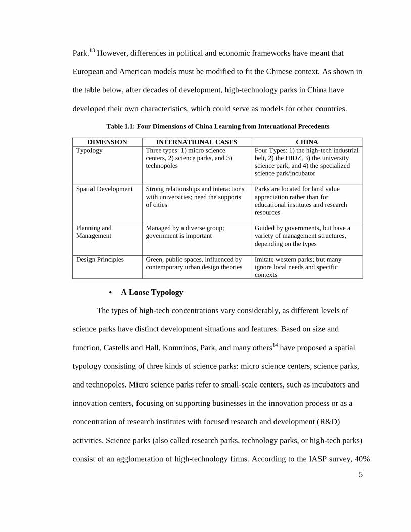
Park.13 However, differences in political and economic frameworks have meant that
European and American models must be modified to fit the Chinese context. As shown in
the table below, after decades of development, high-technology parks in China have
developed their own characteristics, which could serve as models for other countries.
Table 1.1: Four Dimensions of China Learning from International Precedents
DIMENSION INTERNATIONAL CASES CHINA Typology Three types: 1) micro science
centers, 2) science parks, and 3) technopoles
Four Types: 1) the high-tech industrial belt, 2) the HIDZ, 3) the university science park, and 4) the specialized science park/incubator
Spatial Development Strong relationships and interactions with universities; need the supports of cities
Parks are located for land value appreciation rather than for educational institutes and research resources
Planning and Management
Managed by a diverse group; government is important
Guided by governments, but have a variety of management structures, depending on the types
Design Principles Green, public spaces, influenced by contemporary urban design theories
Imitate western parks; but many ignore local needs and specific contexts
• A Loose Typology
The types of high-tech concentrations vary considerably, as different levels of
science parks have distinct development situations and features. Based on size and
function, Castells and Hall, Komninos, Park, and many others14 have proposed a spatial
typology consisting of three kinds of science parks: micro science centers, science parks,
and technopoles. Micro science parks refer to small-scale centers, such as incubators and
innovation centers, focusing on supporting businesses in the innovation process or as a
concentration of research institutes with focused research and development (R&D)
activities. Science parks (also called research parks, technology parks, or high-tech parks)
consist of an agglomeration of high-technology firms. According to the IASP survey, 40%
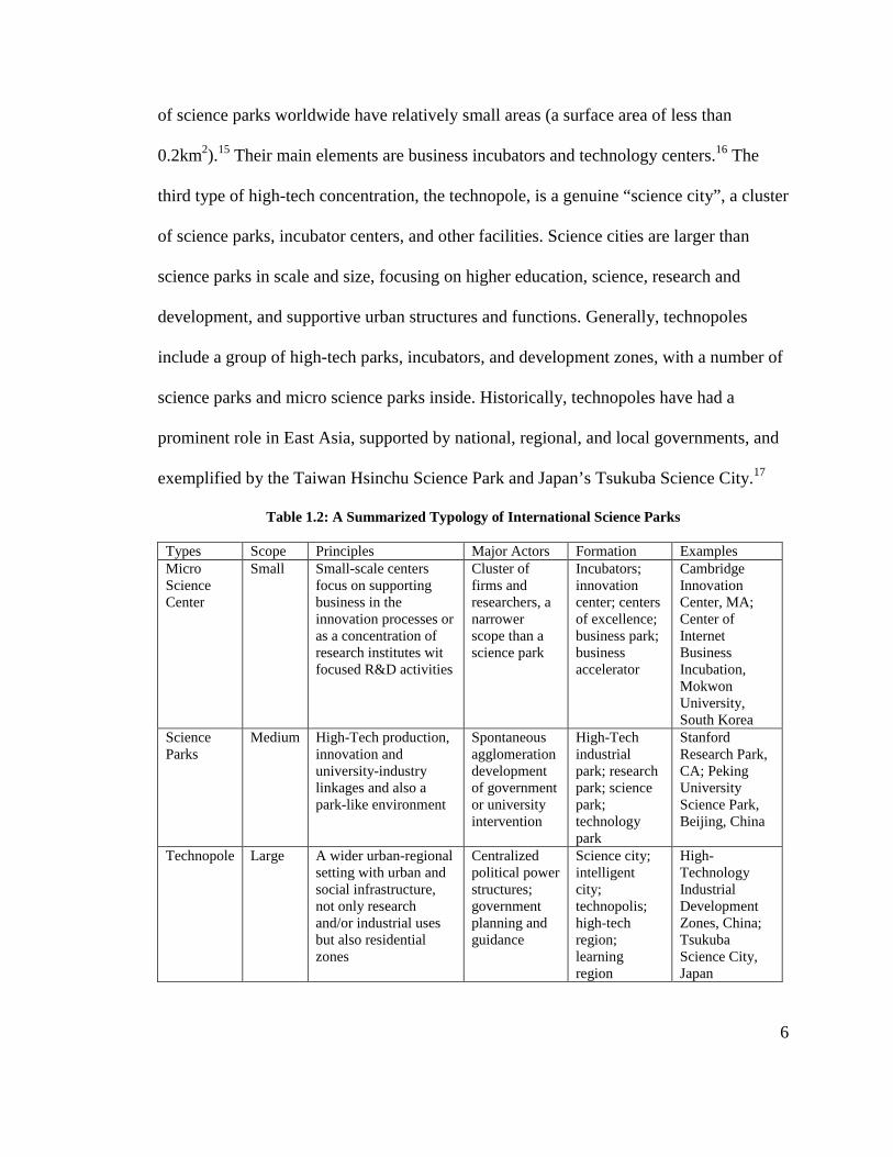
6
of science parks worldwide have relatively small areas (a surface area of less than
0.2km2).15 Their main elements are business incubators and technology centers.16 The
third type of high-tech concentration, the technopole, is a genuine “science city”, a cluster
of science parks, incubator centers, and other facilities. Science cities are larger than
science parks in scale and size, focusing on higher education, science, research and
development, and supportive urban structures and functions. Generally, technopoles
include a group of high-tech parks, incubators, and development zones, with a number of
science parks and micro science parks inside. Historically, technopoles have had a
prominent role in East Asia, supported by national, regional, and local governments, and
exemplified by the Taiwan Hsinchu Science Park and Japan’s Tsukuba Science City.17
Table 1.2: A Summarized Typology of International Science Parks
Types Scope Principles Major Actors Formation Examples Micro Science Center
Small Small-scale centers focus on supporting business in the innovation processes or as a concentration of research institutes wit focused R&D activities
Cluster of firms and researchers, a narrower scope than a science park
Incubators; innovation center; centers of excellence; business park; business accelerator
Cambridge Innovation Center, MA; Center of Internet Business Incubation, Mokwon University, South Korea
Science Parks
Medium High-Tech production, innovation and university-industry linkages and also a park-like environment
Spontaneous agglomeration development of government or university intervention
High-Tech industrial park; research park; science park; technology park
Stanford Research Park, CA; Peking University Science Park, Beijing, China
Technopole Large A wider urban-regional setting with urban and social infrastructure, not only research and/or industrial uses but also residential zones
Centralized political power structures; government planning and guidance
Science city; intelligent city; technopolis; high-tech region; learning region
High-Technology Industrial Development Zones, China; Tsukuba Science City, Japan

7
Currently, China contains over 10% of the world’s science parks.18 Clusters of
high-technology industries in China are loosely called high-technology parks or zones
and in terms of scale and management approaches, there are four types: 1) the high-tech
industrial belt, 2) the HIDZ, 3) the university science park, and 4) the specialized science
park/incubator. The first type of development, the high-technology industrial belt, is a
spatial concept referring to a cluster of multiple technological industry-based cities.
Research shows that there are five high-tech belts in China: the Beijing–Tianjing Belt, the
Yangtze River Delta Belt, the Pearl River Delta Belt, the Shenyang Highway Belt, and
the Shandong Peninsula High-Tech Belt. China’s development of a high-tech industrial
belt is a top-down enterprise that follows the Japanese technopolis program which
emphasizes coordinated regional economic development. University science parks and
specialized science parks are set up by semi-public or private companies and are similar
to what Castells and Hall call “micro science centers and science parks.” University
parks are operated by research institutes and universities, and are concerned with future
developments in science and technology, and with bringing research outcomes to market.
Many specialized science parks have distinct industrial focuses, varying from business
and technology parks with a focus on product advancement and innovation, to industrial
parks that focus on manufacturing. Some independent high-technology companies also
set up incubators and standard office buildings, providing support for the development of
high-technology firms.
China’s second type of high-technology park, the HIDZ, is similar to the
technopole. Planned as a large-scale development involving multiple science parks, R&D
centers, and business incubators, HIDZs mirror the functions of their international

8
counterparts. Yet, in China, their classification has been expanded: Chinese HIDZs are
not purely places for scientific research and production, but zones that induce new
industrial growth, jobs, and production by attracting high-technology manufacturing
firms to a privileged site with preferential policies. A HIDZ’s development often starts
from a single science park, originally based on links to universities and research institutes.
With expansion, it adds other aspects of a city, including business, commercial, and
housing. Some eventually become sub-centers of the city in which they are located while
others become self-sufficient towns.
Table 1.3: Chinese Science Park Categories
FORMAT CHARACTERISTICS EXAMPLE High-Tech Industrial Belt
• Governmental Guidance • Regional Area • Spatial Industrial Connection
Yangtze River Delta High-Technology Industrial Belt
High-Tech Industrial Development Zone (HIDZ)
• Governmental Guidance • Mixed-Use • Important role as economic and
social development • Feasible and researchable on
planning and management • Include Various Types of Science
Parks
Shenzhen High-Technology Industrial Park Beijing Zhongguancun Science Park
University Science Park
• Groups of High-Tech Firms or Incubators
• Cluster of Individual Office Buildings
• Located in HIDZ
Tsinghua University Science Park
Specific Science Park or Incubators
• Private Company • One or Two Individual Office
Building • Located in HIDZ
Pudong Software Park
• Spatial Development
The evolution of science parks illustrates the spatial characteristics of modern
industrial clusters. By providing a location where researchers and companies operate in
close proximity, research parks create an environment that encourages innovation and

9
promotes technology development, transfer, and commercialization. As bases of growth,
science parks are emerging as strong sources of entrepreneurship, talent, and economic
competitiveness for regions, states, and nations.19 Science parks have strong relationships
and interactions with universities, as exemplified by the Stanford Research Park, and the
North Silicon Valley in Canada. Educational resources often provide a motivation for the
development of science parks. In Massachusetts, the presence of outstanding research
universities, particularly MIT and Lincoln Labs, which MIT operates as a national
laboratory, was a decisive factor in the development of Boston’s Route 128 in the early
1950s.20 By sharing facilities with universities, and by hosting research groups and
offices, science parks have provided research institutes with environments for
transferring research outcomes into the industrial productions.
Many Science Parks need the support of cities, regardless of their location in
urban or suburban areas. Some parks are primarily an urban (or metropolitan)
phenomenon and exist in a tight network that shares energy, transportation,
communication, and infrastructure.21 Other parks are located in suburban areas,
functioning simply as research and technology zones. Support resources, such as housing,
medical facilities, commercial, and transit hubs are located in adjacent cities. In the early
1960s, the migrant population and movement of industries from London and the East of
Britain motivated the growth of manufacturing in the Cambridge Science Park. Later
improvement of the transportation network in the 1970s increased the accessibility of the
Cambridge Science Park to major cities, and facilitated the park’s development. Japan’s
Tsukuba Science City was constructed without dependence on any city, and was put in
place to either establish or replace research institutes. The large original investment led to

10
the slow development of Tsukuba in the start-up period. Growth did not accelerate until
the boundary of the Tokyo metropolitan area expanded towards Science City in the 1980s,
and provided infrastructure, services, and associated facilities to Tsukuba.
In addition, science parks generally have a well-developed information network,
allowing quick and easy communication with other parks and regions worldwide. More
and more science parks have indicated that the presence of this information infrastructure
is very important in their development.
In recent years, guided by theories of industrial agglomeration and growth poles,
many Chinese state and local economic-development groups have attempted to create
environments that are conducive to the expansion and growth of high-tech industry
clusters, based on the commonly held notion that high-technology clusters offer
advantages over other types of industrial activity. Applied under conditions of explosive
urbanization, such efforts have yielded science parks with distinct spatial characteristics
in terms of quantity, size, and population.
Distinct from other types of science parks, HIDZs are government-guided
development efforts aimed at accelerating economic growth and one city may have many
of them, scattered in different locations. HIDZs are not always located near education
institutes, and may be located on vacant public land, allowing the city to profit from land
sales. Being slightly decentralized, HIDZs may even release population pressure from
central areas as population streams to the new zone in search of job opportunities. A
common occurrence under rapid industrialization, this migration has incentivized mixed
land use in science parks, instead of the pure research and manufacturing functions as
originally intended. However, where parks are located for land value appreciation rather
11
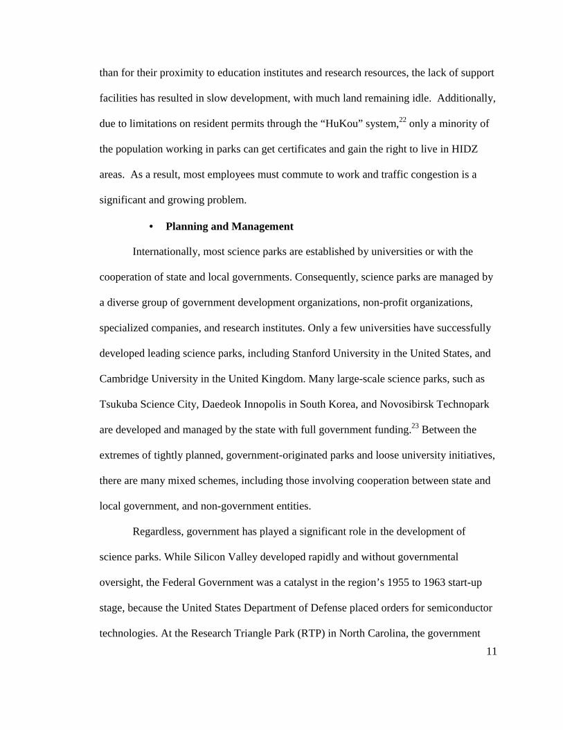
than for their proximity to education institutes and research resources, the lack of support
facilities has resulted in slow development, with much land remaining idle. Additionally,
due to limitations on resident permits through the “HuKou” system,22 only a minority of
the population working in parks can get certificates and gain the right to live in HIDZ
areas. As a result, most employees must commute to work and traffic congestion is a
significant and growing problem.
• Planning and Management
Internationally, most science parks are established by universities or with the
cooperation of state and local governments. Consequently, science parks are managed by
a diverse group of government development organizations, non-profit organizations,
specialized companies, and research institutes. Only a few universities have successfully
developed leading science parks, including Stanford University in the United States, and
Cambridge University in the United Kingdom. Many large-scale science parks, such as
Tsukuba Science City, Daedeok Innopolis in South Korea, and Novosibirsk Technopark
are developed and managed by the state with full government funding.23 Between the
extremes of tightly planned, government-originated parks and loose university initiatives,
there are many mixed schemes, including those involving cooperation between state and
local government, and non-government entities.
Regardless, government has played a significant role in the development of
science parks. While Silicon Valley developed rapidly and without governmental
oversight, the Federal Government was a catalyst in the region’s 1955 to 1963 start-up
stage, because the United States Department of Defense placed orders for semiconductor
technologies. At the Research Triangle Park (RTP) in North Carolina, the government

12
also played an important impact on land use and industrial structure plans. In the early
1960s, the North Carolina State government established the Research Triangle Park
Committee, which is responsible for land arrangements within the science park. In
addition, the municipal government formed a specialized authority to organize
infrastructure and incubator construction. The coordination of enterprise, government,
and the research institute has led to the success of RTP. With the increase of a highly
educated population and the establishment of research institutes, the park has fostered
economic growth and community development and has been a success since the 1970s.
Local government has also played a role in other science parks, particularly in
addressing environmental and energy supply concerns. For example, during the
expansion of Silicon Valley, local government took the lead in addressing concerns of
transit, natural resource, and energy from surrounding communities and
environmentalists. Municipal and county governments have also supported science parks
through such infrastructure investments as road improvements, transit accessibility and
information-network construction.
Science parks in China are guided by the government, but have a variety of
management structures. Most university parks and specialized science parks are managed
by independent entities, such as universities or research institutes. Some HIDZs are
managed by independent management entities with full economic and social power but
the majority are managed by governmental development committees. Development
committees may be directly led by a municipal government that takes charge of all local
district affairs, or be assigned by state government to undertake land and economic
development, leaving social and commercial activities to town or community

13
organizations. Specific management strategies are dependent on the strength of the
leadership of local municipalities, the location of HIDZs, and their development mission.
Notably, with the improvement of market economies in China, more independent
organizations have become involved in the management of HIDZs. For instance, some
municipal governments have arranged for development committees to coordinate various
departments, but have coupled them with other semi-public corporations to undertake
infrastructure and land-development. Private enterprises are also involved in the various
associations and participate in decision-making processes.
• Design Principles
Today’s science parks are master-planned, mixed use developments that
incorporate a broad variety of residential, commercial, social service, and recreational
uses. Influenced by current design theory, physical environments are often
environmentally friendly and emphasize public spaces, walkability, tree-lined avenues,
greenbelts, and low-emissions facilities. In short, today’s developments seek to
emphasize the “park” in science park.
Contemporary urban design theories have also impacted the design of science
parks. The zoning code and land-use plans of these communities are based on the
principles of functionalism. The styles are usually modern and follow the technological
development of materials and construction methods, with abundant use of reinforced
concrete, metal skins, simple windows, and minimal decoration. Design is important as
science parks seek to attract employers and companies with their livable physical
environments. Taiwan Hsinchu Science Park has a number of employee dormitories,
schools, nature parks, and green spaces in its 3.77 km2 area. Because of their multiple

14
uses, convenience, and beautiful green parks, many workers prefer these parks to more
conventional locations.
Accessibility, livability, mobility, and equity have gained increasing attention in
today’s community development schemes.24 Science parks incorporate design principles
to promote place-making and sustainable development. For example, there are specific
institutes and places for communicating with employees and research professionals in
Tsukuba Science City. The well-designed green spaces and livable environment of
Tsukuba Science City have attracted employees and residents who work elsewhere in the
city.
In the relatively short period of their development, Chinese science parks have
absorbed many of the features of western parks. High-technology parks in China mirror
the design format, land-development intensity, green space, and architectural forms of
their international counterparts. However, the rapidity of the construction of parks in
China did not leave adequate time for research on design regulations and quality control.
Ultimately, local needs and specific contexts have often been overlooked. Yet, a few
high-technology parks have been successful in developing their own style and responding
to local cultural features and the demands of urbanization. Suzhou Industrial Park and the
Virtual University Park in Shenzhen High-Technology Industrial Park is an example of
this type of success, and will be discussed later.

15
3. High-Tech Park Initiatives in China
3.1. Initiatives from Globalization
The flow of capital, products, processes, individuals, and ideas globally from the
United States, combined with the country’s preeminence in technology, has inspired
other nations to create their own technopoles.25 Examination of the dynamic linkage
model as it moves across the Pacific Rim shows how an essentially Western, land-based
science park model fares in different political and economic environments. Operating
under a completely different framework than the United States, China, like other
developing countries, is transitioning from a tightly controlled economy and centralized
government to a mixed economy and a major global player.
Global labor specialization has led to an international production chain. Many
originally integrated companies outsourced their manufacturing processes to other
locations. Since companies seek low-cost labor, which remains available in Asia, many
of the new locations were in China. As a result, and buoyed by convenient transportation
and rich labor resources, coastal areas in particular, have gained important production and
export-processing districts. Many districts in China have become magnets for
international support and investment, forming the base for further high-technology
industrial development. Global competition also built a network of city-regions that were
less subordinate to nation-states than in the preceding century.26 Highly successful, but
small, city-states, such as Singapore, have experienced economic growth, and have
become major sources of assistance to China.
16
The development of high-technology development zones is also motivated by
internal demand. An increasing number of countries see leveraging the knowledge
economy as a key political strategy for domestic development. China’s program of
“developing the country by relying on science and education” and “developing high-
technology industry” in the 1980s has become a focus of government. China seeks to use
emerging high-technology industries to readjust economic structure and redistribute
social and political resources.
3.2. Transforming from a Labor-Intensive Industry to a High-Technology
Industry
In 1978, when reform started, China was a low-income country with agriculture
as its largest employment sector. The Chinese economy was oriented towards heavy
industry, and earned foreign exchange through the export of manufactured goods and raw
materials such as crude coal, crude oil, minerals, and agricultural products.27 At that time,
China was similar to other low-income countries, rich in natural resources and unskilled
labor, but poor in intellectual resources. In this situation, only labor- and resource-
intensive industries had a comparative, open market advantage.28 The heavy industry-
oriented development strategy used before the reform in 1979 meant that the economic
system in China remained distorted and closed.
Since the foundation of the People’s Republic of China in 1979, Chinese industry
has experienced several achievements.29 The first industrial achievement occurred in
1986, when the exports of textiles and clothing exceeded that of crude oil. This point
signified China’s transition from exporting resource-intensive products to labor-intensive

17
textile and clothing products, which is consistent with China’s comparative advantage.
The second achievement happened in 1995, when China’s export of machinery and
electronics exceeded those of textiles and clothing. This is indicative of China’s transition
from exporting traditional, labor-intensive exports to exporting non-traditional, labor-
intensive products. The third achievement came in 2001 after China’s accession to the
WTO, when high- and new-tech exports grew rapidly, and the level of product
sophistication increased. China’s central and local governments conducted regulatory
reforms to improve the investment climate and to provide incentives for foreign direct
investment (FDI), export expansion, and private-sector development. Chinese exports
have since become an integral part of the global supply chains of multinationals in
automobiles, computers, and airplanes.
Foreign investors bring not only capital, but also new products/services and
practical sector-specific skills. From 1992 to 2001, FDI inflows to China exceeded
indirect investment inflows, and the number of international firms rose rapidly in China.
These multinational manufacturing firms from the OECD countries moved into China on
a large scale, bringing advanced technology. After China joined the WTO, this trend
accelerated. All levels of government attached more importance to attracting high-tech
firms, managerial know-how, and talent, helping China to become an integral part of the
global supply chain, and the manufacturing center of the world.
3.3. Industry and Urban Expansion
Under a planned economic system, urban areas are composed of self-contained
units. Each unit, based around a factory or institute, provides associated housing and
18
other employee facilities. The state government employed programs that evenly managed,
developed and distributed “welfare” houses. The government or institutes took full
responsibility for the development and maintenance of such houses. The “welfare”
system of urban-housing worked well under certain conditions but was inefficient in
allocating resources. The system created an “iron rice-bowl”, which is a lifelong career
for the worker and reduces his mobility.30After moving towards a market economy, the
welfare system was canceled, and new functional areas were developed. The
construction of a range of housing, office buildings, and commercial buildings placed
heavy burdens on central cities.
The wave of industrialization in China has led to the creation of industrial
agglomerations in many regions and cities, and has dramatically increased the size of
urban areas. Two boom periods can be identified: the first from 1992 to 1995, began
when Deng Xiaoping started his “southern tour”, and ended when Zhu Rongji
implemented macroeconomic adjustment, and the second, from 2000 to 2004, began
when the property market recovered from the 1997 Asian financial crisis, and ended
when the central state began to tighten land policies. Both periods ended with an
overheated real-estate market and consequent macroeconomic adjustment that altered
urban land development.
The development of industry largely changed the spatial orientation of urban
landscapes. The central city relocated large enterprises and factories to the fringe,
increasing industrial land in those areas. In doing this, the expansion of industry changed
the composition of urban landscapes in two ways, through the closure of old industries in
the central cities and through the relocation of industry to suburban areas. The inner
fringe lost factories,
industrial grow
industrial parks rather than
suburbanization and
Rapid urban expansion
extension of built
development
sub-centers
have transformed
from the large
China was not
formulated sprawl
growth.32
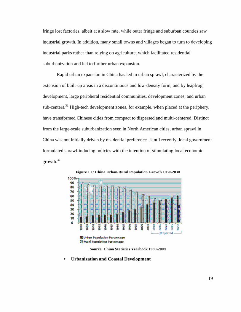
lost factories, albeit at a slow rate, while
growth. In addition, many small towns and villages
industrial parks rather than relying on agriculture, which
suburbanization and led to further urban expansio
Rapid urban expansion in China has led to urban sprawl, characterized
extension of built-up areas in a discontinuous and low
development, large peripheral residential communities,
ters.31 High-tech development zones,
transformed Chinese cities from compact to
the large-scale suburbanization seen in North American cities, urban sprawl in
was not initially driven by residential preference
formulated sprawl-inducing policies with the intention of stimulating local economic
Figure 1.1: China Urban/Rural Population
Source: China Statistics Yearbook 1980
• Urbanization and Coastal Development
while outer fringe and suburban counties
mall towns and villages began to turn to
agriculture, which facilitated residential
urban expansion.
has led to urban sprawl, characterized
up areas in a discontinuous and low-density form, and by leapfrog
, large peripheral residential communities, development zones, and urban
tech development zones, for example, when placed at the
from compact to dispersed and multi-centered
in North American cities, urban sprawl in
driven by residential preference. Until recently, local government
with the intention of stimulating local economic
China Urban/Rural Population Growth 1950-2030
China Statistics Yearbook 1980-2009
Urbanization and Coastal Development
19
suburban counties saw
turn to developing
facilitated residential
has led to urban sprawl, characterized by the
by leapfrog
zones, and urban
for example, when placed at the periphery,
centered. Distinct
in North American cities, urban sprawl in
local government
with the intention of stimulating local economic
20
China is currently experiencing a period of rapid urbanization. Radically
reoriented under market reform, Chinese cities play an important role in the country’s
overall economic development.33 Levels of urbanization in China have risen from 18% in
1978 to 30% in 1995 and to 39% in 2002. In 2009, it was reported that the levels of
urbanization in China was 47%.34 Over the coming ten-year period, China will face
considerable employment pressure, and must carefully address the issue. The sustainable
development of new districts will be crucial in managing the profound changes in the
patterns of people’s lives and the new economic and social structures that follow rapid
urbanization.
Since 1978, when Deng Xiaoping’s economic reforms opened China and signaled
a shift towards closer integration of the domestic and global economies, five types of
development zones emerged.35 These types, each with a different target, developed
sequentially and are currently at different phases of economic development. They are: the
economic technology development zone, the HIDZ, the tax-protected zone, the export-
processing zone, and the border economic-cooperation zone. These development zones
differ in their industrial functions and in their main elements. The economic technology
development zone is the most common, and is the most conventional type that focuses on
traditional industries. In its early stages, the economic technology development zone was
similar to the “export-processing zone” of other countries; it used favorable taxation
policies to attract foreign investors and other joint ventures to invest in the processing and
manufacture of export-oriented products. Economic technology development zones have
now become mixed industrial investment areas without regulations on exports. The
second type of development zone, HIDZs, focuses on shifting from a labor-intensive

21
industry to a high-technology industry. Of the five types of development zones, HIDZs
and economic technology development zones are, by far, the most common. The final
three zones, the tax-protected zone, export-processing zone, and border economic-
cooperation zone represent the minority and are specialized zones closely linked with
ports and customs.
The creation of new development zones and their associated land development
markets are rapidly changing the spatial distribution of Chinese cities, particularly those
in coastal areas. Due to convenient transportation networks and human and intellectual
resources, the Eastern coastal provinces of China have had booming economies since the
mid-1980s, with occasionally double-digit annual growth rates. As the most highly
urbanized regions, eastern coastal cities contain an overwhelming concentration of FDI,
primarily in the three regions of the Pearl River Delta in Guangdong, the Yangtze River
Delta around Shanghai, and the Beijing–Tianjin axis in the northeast. These urban
clusters are already important economic-growth poles, and lead regional, urban, and rural
development.36 Industrial development zones in these areas served as economic-growth
engines, experiencing increasing population pressure from the cities, and moving to
extend new development spaces.
Table 1.4: Five National Development Zones in China
NAME FEATURES Economic Technology Development Zone Traditional type, attracting economic investment through
preferential policies, focusing on traditional industries, especially manufacture and processing
High-Technology Industrial Zone Shifting from labor-intensive industry to high-technology industry
Tax-Protected Zone Under custom supervision, focus on logistics Export-Processing Zone Favorable taxation policies to attract foreign investors in
ports Border Economic-Cooperation Zone Specific border areas

22
3.4. Chinese Science and Technology Industry Park Policy
The planning and programming of HIDZs started in the late 1980s. In 1985, the
Chinese Academy of Science (CAS) and the Shenzhen Municipal Government co-
founded the Shenzhen Technology Industrial Park, a pilot science park that opened the
door to HIDZ development in China. China then started the “863 Program”, also called
the State High-Tech Development Plan, in 1986. Funded and administered by the central
government, it was intended to stimulate the development of a range of advanced
technologies and render China independent of financial obligations for foreign
technologies.37 Two years later, the launch of the national “Torch Program” provided
carrots (incentives) and sticks (regulations) to lure foreign investment to “economic
technology zones” and science and industrial parks concentrated mainly in coastal China.
These sites, based upon the judgment of the central government, were most likely to
benefit from infusions of foreign capital in the form of corporations and managers.38 The
creation of 27 HIDZs in March 1991 was the thrust of the Torch Program and a series of
preferential policies to facilitate HIDZ development soon followed.
At this time, due to the economic benefits that high-technology zones often bring
to cities, many municipalities in China were competing to declare HIDZs. In 1991, China
was restructuring economically and was developing high-technology parks to prompt and
accelerate the readjustment process. The country hoped that preferential policies relating
to land price, tax relief, and additional funding would spur the rapid growth of cities. On
the other hand, the municipalities needed the establishment of HIDZs to release their
cities’ population pressures. In the early 1990s, when the state council began to reform
tax-sharing between local municipalities and state government, local tax revenue

23
decreased. To increase income, many local governments developed on vacant land. Many
cities in China were suffering from a real-estate downturn, and construction projects were
postponed or suspended.
Chinese HIDZs can be national or provincial. The state council approved the first
set of national HIDZs, after which provincial governments seeking to enhance their
economic strength began establishing their own. Compared with provincial HIDZs,
national HIDZs have more sources of income, including state funding support,
preferential policies for land use, financial services, and taxation reduction for trade
activities. For example, while provincial HIDZs have the right to reduce local taxes—
housing property tax, individual tax, and urban construction tax—the taxation reductions
of national HIDZs cover additional, and much larger, central taxes, such as value added
tax, consumption tax, and enterprise income tax. Furthermore, national HIDZs play a
particularly important role in economic development. In 2009, with over 50,000 high-
technology enterprises located in national HIDZs, the total output value was 10% of
China’s total GDP. The R&D investment in high-technology enterprises in national
HIDZs accounted for a third of the R&D investment in all enterprises in China, and the
number of patents requiring investment created in HIDZs was half of the entire amount of
all Chinese patent investment.39
The planning strategies in high-technology parks evolved concurrently with the
development of Chinese modern city planning and management. At the beginning of the
1990s, the “real-estate boom” and “development-zone boom” created an urban planning
challenge, with places without controls or regulations. In order to calm the situation and
strengthen the regulation of urban real-estate development, detailed regulatory planning
24
was implemented nationwide. After the reform of the taxation system in 1994, local
government interests diverged from those of the central government. To balance the
different demands, in May 1996, the state council issued its “Circular Regarding the
Strengthening of Urban Planning”, which laid out the central government’s mission on
urban planning under a market economy. The circular stated that “the basic task of urban
planning is to uniformly arrange the various lands and spaces in cities; to
comprehensively deploy the various construction projects; and to achieve sustainable
economic and social development.”40 Following the issuance of the circular, urban
planning in high-technology parks gradually transferred from the original margin of the
national economic plan, to regulatory measures guiding and controlling the investment
activities of different market players.
4. Structure of this Research
4.1. Questions and Dimensions
With the significant number of science parks in China and due to their role in the
national economy, the Chinese science park has become an important class of
development. After half a century of development, international science parks now fall
into several types, each having distinct features. China has developed a unique approach
to the development of science parks, particularly with its most distinct type—the HIDZ.
Chinese HIDZs differ from general university parks and specialized parks in that they
perform many tasks ranging from economic growth to community development.
The HIDZ, with its close links to rapid urbanization and high-technology park
development, extremely large-scale sites, governmental guidance with top-down

25
development and construction, and trend towards high-technology-based new townships
or technopoles, is an increasingly dominant form of science park in China. This research
fills the lack of academic study on planning intervention in science parks by comparing
four national HIDZs that diversified beyond general science park operation and into
large-scale, government-guided developments. The research considers three questions.
Firstly, what planning strategies did managers of HIDZs employ, in what
circumstances, and for what purpose? Secondly, how did physical planning
strategies impact outcomes, and to what extent? And thirdly, what are the major
lessons and experiences?
To answer these questions, the study draws on a wide range of sources including
enabling legislation, annual reports, financial statements, development plans, urban
design, land-use plans, and interviews, to offer important insights into the opportunities
and challenges that the existing governmental entities of science parks face when they
plan and manage HIDZs. It identifies six aspects of planning intervention, including: site
selection, land-development approaches, planning and management systems, land-
use plans and strategies, transit programs and implementation, and open-space
design and construction. Each of these aspects differs substantially in local context.
This study demonstrates the importance of a variety of external and internal forces in
determining planning approaches. These forces include sources of capital, composition of
enterprises and institutes, and the strengths and weaknesses of land resources in terms of
infrastructure, volume, and land-use.
In evaluating how planning approaches have affected the development of HIDZs,
this chapter identifies five overarching comparative issues: the nature of development
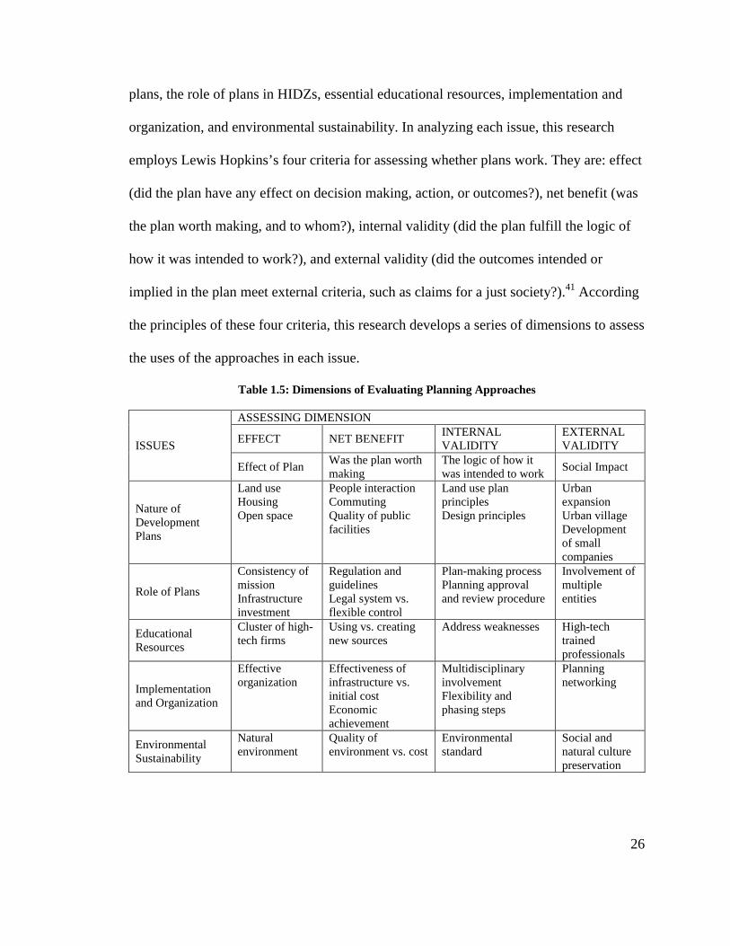
26
plans, the role of plans in HIDZs, essential educational resources, implementation and
organization, and environmental sustainability. In analyzing each issue, this research
employs Lewis Hopkins’s four criteria for assessing whether plans work. They are: effect
(did the plan have any effect on decision making, action, or outcomes?), net benefit (was
the plan worth making, and to whom?), internal validity (did the plan fulfill the logic of
how it was intended to work?), and external validity (did the outcomes intended or
implied in the plan meet external criteria, such as claims for a just society?).41 According
the principles of these four criteria, this research develops a series of dimensions to assess
the uses of the approaches in each issue.
Table 1.5: Dimensions of Evaluating Planning Approaches
ISSUES
ASSESSING DIMENSION
EFFECT NET BENEFIT INTERNAL VALIDITY
EXTERNAL VALIDITY
Effect of Plan Was the plan worth making
The logic of how it was intended to work
Social Impact
Nature of Development Plans
Land use Housing Open space
People interaction Commuting Quality of public facilities
Land use plan principles Design principles
Urban expansion Urban village Development of small companies
Role of Plans
Consistency of mission Infrastructure investment
Regulation and guidelines Legal system vs. flexible control
Plan-making process Planning approval and review procedure
Involvement of multiple entities
Educational Resources
Cluster of high-tech firms
Using vs. creating new sources
Address weaknesses High-tech trained professionals
Implementation and Organization
Effective organization
Effectiveness of infrastructure vs. initial cost Economic achievement
Multidisciplinary involvement Flexibility and phasing steps
Planning networking
Environmental Sustainability
Natural environment
Quality of environment vs. cost
Environmental standard
Social and natural culture preservation
27
4.2. Overview of the Dissertation
This introductory chapter outlines the issues and questions, sets the background
and frames the research. Chapter 2 then starts with a general overview of national HIDZs
including their phases of development, geographic distribution, and spatial planning
features. The survey provides a typology of national HIDZs, organizing them by level of
local resources and development objectives and outlining planning and management
differences. The chapter also discusses the processes and criteria for case selection. Four
cases are selected for in-depth study and comparative analysis: the Beijing Haidian Park
of Zhongguancun Science Park (ZGC), the Shanghai Zhangjiang High-Technology
Industrial Park (ZJ Park), the Suzhou Industrial Park (SIP), and the Shenzhen High-
Technology Industrial Park (SHIP).
The four national HIDZs, and associated cities, serve as the basis for this thesis.
The four case study chapters analyze the use, implementation, and effectiveness of
planning strategies in different types of HIDZs. Each HIDZ is located in the heart of a
major Chinese city, ranging in size from Shanghai, the second largest city in the country
(14 million); to Beijing, the third largest (12.5 million); Suzhou, the fifty-fifth largest (6.3
million); and Shenzhen, two hundred and eighteenth largest (2.46 million).42
Zhongguancun Science Park is the largest high-technology zone in China, and the model
for Chinese science parks. ZGC, located in the northwest of Beijing, is the main part of
the Zhongguancun Science Park and has exceptional educational resources. Chapter 3
discusses the planning approaches and land development in mixed- used urban areas, and
analyzes both the pros and cons of the large number of state-owned research institutes
and universities.

28
Zhangjiang High-Technology Industrial Park is located within the Pudong New
Area of Shanghai. It is one of five science parks in the Shanghai area, each of which
serves a different district. ZJ opened in 1992 but began to boom from 1999 onwards,
when the state council and Pudong government enacted a series of national policies, such
as the “Focus on Zhangjiang Policy”. Thus, Chapter 4 analyzes how ZJ began as a small
town, and gradually developed into an important, single-use, scientific and research
industrial area. The chapter explores how governmental guidance and relative policies
impacted ZJ’s development, integrating it with regional development of the Pudong New
Area.
Chapter 5 examines the Suzhou Industrial Park, which is a typical, self-sufficient,
new-town development. Located to the west of Suzhou city, SIP originates from a
partnership between China and Singapore. With international investment and mature
governance from Singapore, SIP has become a mixed-use, high-technology-based district,
with 300,000 residents. The chapter discusses the planning approaches used in SIP’s
development, and provides recommendations for developing new-town science parks in
isolated areas.
Shenzhen High-Technology Industrial Park (SHIP) is located in the western
Shenzhen Special Economic Zone, where Shenzhen’s geographic and historical features
limit usable land and educational resources. While Shenzhen City has only 2.46 million
registered inhabitants, there are over 12 million migrants in the Shenzhen Special
Economic Zone. The large population and labor source have attracted successful private
companies, which have become major powers in high-technology parks. Chapter 6

29
discusses how SHIP maximized land resources and local innovation systems, and how it
tailored its planning strategies to address the lack of research sources.
The last chapter answers questions posed in the introduction through a
crosscutting analysis of the four cases. It discusses five overarching comparative issues
based on cross-case analyses. These issues build upon one another to create a new
framework through which park managers, public officials, developers, and private
citizens may better work together to help their high-technology parks grow more
sustainably. It weaves together the findings from each case, demonstrating that planning
strategies play important roles in the sustainable development of HIDZs through flexibly
addressing a diverse set of local conditions, improving the quality of place-making,
regulating land-development processes, and facilitating cooperation among various
sectors. However, the decision-making and implementation processes were often
challenged, and faced a series of limitations related to the socioeconomic context. The
chapter reconsiders the importance of Chinese HIDZs, both in China’s future
development and in influencing international science-park development, and concludes
with a summary of the lessons to be learned from current planning strategies and
management approaches.
1 World Bank Report. "Global Economic Prospects 2009." Washington D.C.: World Bank, 2008.12. 2 BBC. "China Overtakes Japan as World's Second-Biggest Economy." BBC Business News, 2.14 2011. It mentioned: “Japan’s nominal gross domestic product for the second quarter totaled $1.288 trillion, less than China’s $1.337 trillion, the Japanese Cabinet Office said today. Japan remained bigger in the first half of 2010, the government agency said. Japan’s annual GDP is $5.07 trillion, while China’s is more than $4.9 trillion.”

30
3 IASP, "Survey of International Science Parks 2002." International Association of Science Parks (2002) 4 Census Data of Silicon Valley; Annual Statistics Book of China (2008). 5 Census Data of Chicago; Annual Statistics Book of China (2009). 6 Yiannis L. Bakouros, Dimitri C. Mardas, and Nikos C. Varsakelis,"Science Park, a High Tech Fantasy?: An Analysis of the Science Parks of Greece" Technovation 22 (2002): 123-28. 7 Yisheng, Chen,An Incubator for Innovation in the High-Tech Industry: A Study of Science Parks (Beijing: Chinese Economic Publisher, 2008). 8 D.J. Storey and Tether, B.S. "Public Policy Measures to Support New Technology Based Firms in the European Union." Research Policy 26 (1998): 1037-57. 9 Manuel Castells,and Peter Hall,Technopoles of the World: The Making of 21st Century Industrial Complexes(London: Routledge Press, 1994), 112. 10 IASP, "Survey of International Science Parks 2006-2007." International Association of Science Parks, (2006-2007).It is difficult to give even an approximation on the number of science parks, as the figure depends on the criteria used. The International Association of Science Parks (IASP) tends to be rather strict when labeling any project as a science park, as they give this status only to those projects that fulfill the criteria of the official definition of science park given by the IASP. Keeping this in mind the approximation of the number of genuine science parks, as defined by the IASP in the world in the early 2000s, may be between 700 to 850. When a looser definition is applied, the total number is probably closer to some 1,240. 11 Castells and Hall,Technopoles of the World; Harvey A. Goldstein and Luger, Michael I., "University-Based Research Parks as a Rural Development Strategy." Policy Studies Journal 20, no. 2 (1992). 12 Castells and Hall,Technopoles of the World; David Keeble, "High-Technology Industry and Local Environments in the United Kingdom." In High Technology Industry and Innovative Environments: The European Experience, ed. Philippe Aydalot and David Keeble (London: Routledge, 1988); Doreen Massey, Paul Quintas, and David Wield,High-Tech Fantasies: Science Parks in Society, Science and Space(London: Routledge, 1992). 13 Bradley M. Braunand W. Warren McHone, "Science Parks as Economic Development Policy: A Case Study Approach." Economic Development Quarterly 6 (1992): 135. 14 Castells and Hall,Technopoles of the World; N. Komninos, Intelligent Cities. Innovation, Knowledge Systems and Digital Spaces(London and New York: Spon Press, 2002). 15 IASP, "Survey of International Science Parks 2006-2007." On the other hand, 29% of the science parks have more than 600,000 m2, while the giants, with over 1 million m2, represent 19% of all science parks. However, they are still smaller than the technopolis, which refers to the cities or regions of science. 16 Ibid. 17 Ari-Veikko Anttiroiko,"Global Competition of High-Tech Centers." International Journal of Transport Management 28, no. 3/4/5 (2004). 18 IASP, "Survey of International Science Parks 2006-2007." 19 Margaret PughO'Mara, Cities of Knowledge: Cold War Science and the Search for the Next Silicon Valley (Princeton: Princeton University Press, 2005). 20 Castells and Hall,Technopoles of the World, 31. 21 IASP, "Survey of International Science Parks 2006-2007."

31
22 Hukou refers to the system of residency permits that date back to ancient China, where household registration is required by law in People's Republic of China and the Republic of China. A household registration record officially identifies a person as a resident of an area and includes identifying information such as name, parents, spouse, and date of birth. A hukou can also refer to a family register in many contexts since the household registration record is issued per family, and usually includes the births, deaths, marriages, divorces, and moves, of all members in the family. 23 Chen,An Incubator for Innovation in the High-Tech Industry, 89 24 Jonathan Barnett,Redesigning Cities: Principles, Practice, Implementation (Chicago: Planners Press, American Planning Association, 2003). 25 Sam Ock Park, "Networks and Embeddedness in the Dynamic Types of New Industrial Districts." Progress in Human Geography 20 (1996): 476-93; Ann Markusen, "Sticky Places in Slippery Space: A Typology of Industrial Districts." Economic Geography (1997): 293-310; Michael E. Porter, "Location, Competition, and Economic Development: Local Clusters in a Global Economy." Economic Development Quarterly 14 (2000): 15-34 26 Susan M. Walcott, Chinese Science and Technology Industrial Parks (Ashgate Publishing, 2003), 3. 27 Justin Yifu Lin and Yan Wang, "China's Integration with the World: Development as a Process of Learning and Industrial Upgrading." In Word Bank Policy Research Working Paper WPS 4799, 2008.12. 28 Justin Yifu Lin, Fang Cai, and Zhou Li, China's Miracle: Development Strategy and Economic Reform (Hong Kong: Chinese University Press, 2003). 29 Lin and Wang, "China's Integration with the World,” 15. 30 Here this metaphor refers to a saying of a confirmed lifetime job position, in state-owned institute under a planned economy. 31 Walcott, Chinese Science and Technology Industrial Parks. 32 Wei-wei Zhang, Transforming China: Economic Reform and Its Political Implications(Basingstoke: Macmillan Press, 2000). 33 Qizhi Mao, et al. "The State of China's Cities." ed. UN Habitat (2010), 10. 34 Annual Statistics Book of China (1980-2009) 35 Jici Wang and Jixian Wang, "An Analysis of New-Tech Agglomeration in Beijing: A New Industrial District in the Making?" Environment & Planning A 30, no. 681-701 (1998). 36 Mao, et al, "The State of China's Cities,"16. 37 Wu, Hequan "The Progress of Communication Technology Subject of Hi-Tech Research Development Plan of China." International Conference on Communication Technology Proceedings 1 (2000) 38 Walcott, Chinese Science and Technology Industrial Parks, 12. 39 Annual Statistics Book of China (1980-2009) 40 “Circular Regarding the Strengthening of Urban Planning”, China State Council (1996) No. 18. 41 Lewis D. Hopkins, "How Plans Work." In Urban Development, the Logic of Making Plans, ed. Lewis D. Hopkins (Washington, D. C: Island Press, 2001). 42 Annual Statistics Book of China (1980-2009)
32
CHAPTER 2: A GENERAL SURVEY: CHINA’S HIGH-
TECHNOLOGY INDUSTRIAL DEVELOPMENT ZONE (HIDZ)
1. Introduction
In China, High-Technology Industrial Development Zones are at the forefront of
industrial growth. They transfer high technology and research knowledge into production,
provide housing, commercial and social services, and explore the development
environment for urban extension. During the past two decades, most Chinese HIDZs have
planned strategic developments and contributed to the general understanding of balancing
sustainable environmental quality, the role of releasing urbanization pressure, and the
importance of attracting investment to facilitate economic growth.
This chapter reports the author’s scan of national-level HIDZs. The national
HIDZs are located in major cities and directly governed municipalities. They account for
the highest level of the development of science and technology parks in China. Over 20
years of development, under the unified support and policies of the science and
technology research plan by the Ministry of Science and Technology of China (MSTC),
they have achieved remarkable economic and social accomplishments. Different from
provincial HIDZs, which are entirely under the control of the municipal government, the
development agencies of national HIDZs control administrative decisions in terms of
planning and management. The national HIDZs have employed a series of planning
strategies in guiding their large-scale, mixed-use developments, providing an abundance
of information and resources for analyzing the role of planning and management
intervention in the development of high-technology parks.

33
My national survey built a data set in order to explore the common planning
practices in the development of HIDZs, through an understanding of their missions,
strategies, and activities. The research shows that national HIDZs are widely distributed,
covering almost all large cities in China. These HIDZs differ significantly in terms of
spatial development and management approaches, as well as in the responses to different
levels of local resources and contexts. The interventions of planning strategies in national
HIDZs cover a wide range of factors, involving site selection, land development,
infrastructure, planning system, land use, transit, and open space programming. The study
develops a typology of national HIDZs and provides background for the in-depth case
studies that follow.
2. Scan of National HIDZs
2.1 Samples
There are 84 national High-Technology Industrial Development Zones in China.
Their development can be divided into several periods. Between 1991 and 1992, the state
council approved the establishment of 52 national HIDZs. Out of these 52, 27 were
approved in 1991, and 25 in 1992. Between 1993 and 1997 the state council approved
only two national HIDZs; they were Suzhou Industrial Park (1994) and Yangling
Agricultural High-Technology Park (1997). The economic accomplishments achieved by
the first group of HIDZs have led the state council to allow local HIDZs to apply for
national upgrading. Municipal governments scrambled to apply for funding to upgrade in
order to benefit from preferential policies, especially tax relief. In 2007 and 2009, the

34
state council approved the change of three province-level HIDZ to national HIDZs, and
in 2010 it announced 27 additional upgrades. This large number indicates recognition of
the importance of national HIDZs by both state and local governments.
Table 2.1: Timeline and Number of National HIDZs
APPROVAL YEAR NUMBERS EXAMPLE 1991 26 Shanghai Zhangjiang High-Technology Industrial Park 1992 26 Beijing Zhongguancun Science Park 1994 1 Suzhou Industrial Park 1997 1 Yangling Agricultural High-Technology Development
Park 2007 1 Ningbo High-Technology Industrial Development Zone 2009 2 Xiangtan High-Technology Industrial Development
Zone 2010 27 Tangshan High-Technology Industrial Development
Zone
Due to limitations on time resource, this research study used a general survey
based on the first 57 national HIDZs. It is noteworthy that the recent batch of 27 national
HIDZs was originally province-level high-technology zones that were established in the
early 2000s. Before getting approval for upgrading, they were different from the national
HIDZs in terms of the degree of preferential policies, taxation, and regulation. However,
these zones regarded the original national HIDZs as templates and applied their
experiences to practical projects. Thus, they have adopted a similar process in planning
and construction. The discussion of the spatial development of the first 57 national
HIDZs can, to some extent, represent the entire development condition of High-
Technology Industrial Development Zones.
The original HIDZs are located in the coastal areas, middle areas, and western
areas. This geographic distribution illustrates that the State Council recognizes every
province’s right to develop national HIDZs. While provinces and cities apply for national
HIDZs, the selection of cities in which to develop national HIDZs is decided by state
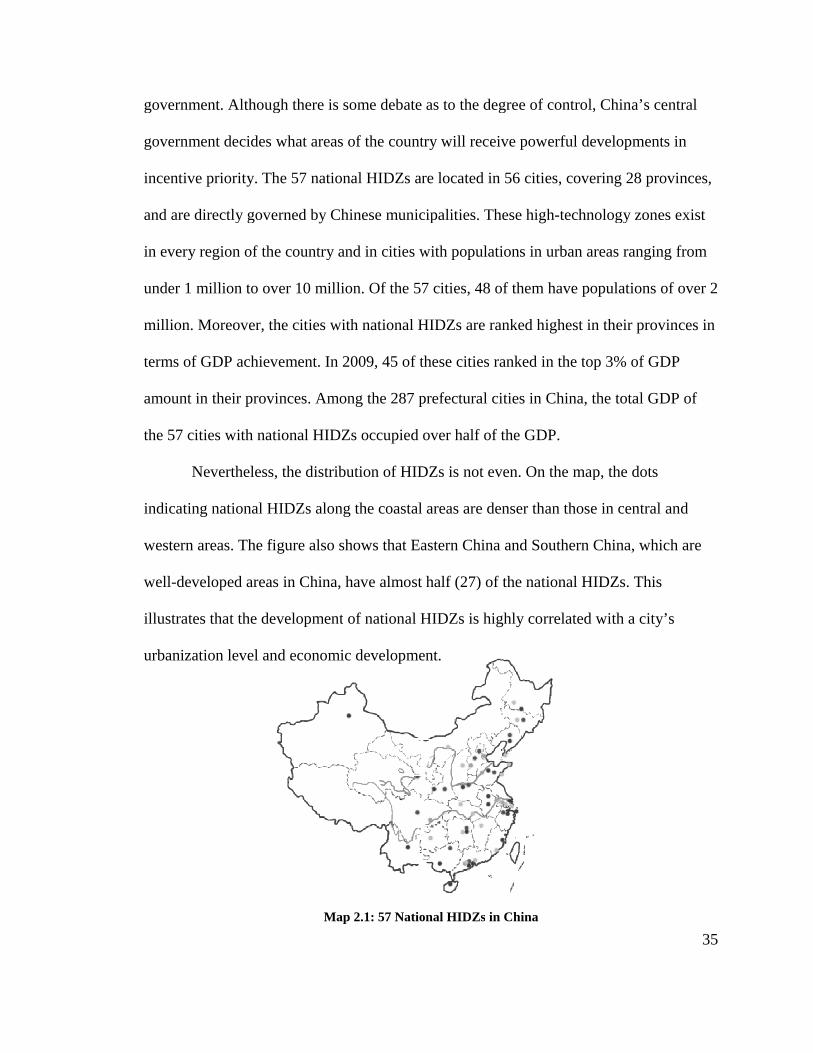
government.
government decide
incentive priority.
and are directly governed
in every region
under 1 million
million. Moreover,
terms of GDP
amount in their provinces. Among the 287 prefectural cities in China, the total GDP of
the 57 cities with national HIDZs occupied over half of the GDP.
Nevertheless, the distribution of HIDZs
indicating
western areas. The figure also shows that Eastern China and Southern China, which are
well-developed areas in China, have almost half (27) of the national HID
illustrates that the development
urbanization
government. Although there is some debate as to the degree of control, China
government decides what areas of the country will receive powerful development
incentive priority. The 57 national HIDZs are located in 56 cities, covering 28 provinces
directly governed by Chinese municipalities
region of the country and in cities with population
under 1 million to over 10 million. Of the 57 cities, 48 of them have populations of over 2
million. Moreover, the cities with national HIDZs
terms of GDP achievement. In 2009, 45 of these cities ranked in the t
amount in their provinces. Among the 287 prefectural cities in China, the total GDP of
the 57 cities with national HIDZs occupied over half of the GDP.
Nevertheless, the distribution of HIDZs
national HIDZs along the coastal areas are denser than
western areas. The figure also shows that Eastern China and Southern China, which are
developed areas in China, have almost half (27) of the national HID
that the development of national HIDZs
urbanization level and economic development.
Map 2.1: 57 National HIDZs
Although there is some debate as to the degree of control, China
what areas of the country will receive powerful development
al HIDZs are located in 56 cities, covering 28 provinces
municipalities. These high-technology zones exist
of the country and in cities with populations in urban areas ranging from
. Of the 57 cities, 48 of them have populations of over 2
the cities with national HIDZs are ranked highest in their provinces in
In 2009, 45 of these cities ranked in the top 3% of GDP
amount in their provinces. Among the 287 prefectural cities in China, the total GDP of
the 57 cities with national HIDZs occupied over half of the GDP.
Nevertheless, the distribution of HIDZs is not even. On the map, the dots
along the coastal areas are denser than those in central and
western areas. The figure also shows that Eastern China and Southern China, which are
developed areas in China, have almost half (27) of the national HIDZs. This
national HIDZs is highly correlated with a
development.
Map 2.1: 57 National HIDZs in China
35
Although there is some debate as to the degree of control, China’s central
what areas of the country will receive powerful developments in
al HIDZs are located in 56 cities, covering 28 provinces,
technology zones exist
ranging from
. Of the 57 cities, 48 of them have populations of over 2
in their provinces in
op 3% of GDP
amount in their provinces. Among the 287 prefectural cities in China, the total GDP of
n the map, the dots
in central and
western areas. The figure also shows that Eastern China and Southern China, which are
. This
a city’s

36
Figure 2.1: HIDZs Number in Each Region Figure 2.2: HIDZs Numbers in Cities and Population
2.2 HIDZs and their Cities
The synergistic relationship between a high-technology park and its city is
important. High-technology industrial parks conform to their cities’ development
mechanisms and regulations. The city provides management organization, resources, and
funding support for the park’s development. In exchange, the city benefits from a high-
technology park through land sales, economic growth, employment opportunities, and
funding support from the central government. In 2008, there were 12 national HIDZs that
were contributing over 20% of the GDP of their respective cities. Furthermore, national
HIDZs provided many employment opportunities for the cities. In 2009, the 57 national
HIDZs held 53,418 enterprises, with an average of 971 firms per national HIDZ. For
comparison, less than 2% of international science parks have over 800 enterprises in each
park.
Each national HIDZ is developed around a single city and performs an important
role for the city. These cities have different resources and provide different motivations
37
for HIDZ development. These cities can be divided into three types. The first type of city
is the extremely large city, as exemplified by Beijing, Tianjin, Shanghai, Wuhan, and
Xi’an. With an abundance of universities and research institutes, these cities offer a rich
variety of scientific and research resources to the HIDZs. In addition, the
commercialization needs of research outcomes motivate the emergence of HIDZs in these
cities. A second type of city is the industrial city. These cities have a strong focus on such
manufacturing industries as steel and oil, yet they are weak in research resources. When
transforming traditional industries into high-technology-based industries, these types of
cities need to establish high-technology parks in order to stimulate the adjustment of the
industrial infrastructure. The last type of city is the coastal, border, or riverside city, as
exemplified by Weihai, Suzhou, Shenzhen, Xiamen, and Changzhou. These cities have
benefited from opening-up policies and convenient transportation. They have experienced
rapid economic growth through foreign trade, and have attracted international investment
and talent. The agglomeration of international high-tech firms facilitates the proliferation
of High-Technology Industrial Zones in these areas.
A variety of local socioeconomic circumstances, especially the types of local
resources available, has led to HIDZs having a series of different development goals,
including the creation of employment opportunities, high-technology industry
development, commercialization of scientific and research outcomes, social services, and
sustainable environmental practices. These missions range from single R&D-oriented to
mixed-use-oriented development. But their development status is not evenly distributed
along a continuum. Instead, HIDZs exist at opposite ends of the spectrum. Some HIDZs
concentrate on developing R&D and manufacturing in order to fully use the educational

38
resources and power of manufacturers. Other HIDZs fully integrate multiple types of
urban activities into their construction, aiming to build mixed-use districts to relieve
population pressure on the center of the city. Some HIDZs start with manufacturing as
the principal land use, and gradually become mixed-use because of their increasing needs
for housing, commercial and retail spaces, and other functions.
There are several different types of relations between the location of HIDZs and
the center of the city. Some national HIDZs originate from small clusters of science parks
that were developed in existing urban areas where there is an abundance of educational
and research resources. For example, Beijing Zhongguancun Science Park began from a
cluster of high-tech firms in the Haidian Cultural and Educational Area near Tsinghua
University, Peking University, and CAS. Then, needing more space, it expanded toward
the suburban areas. This is common in Chinese cities where overly dense urban functions
and populations in the center of the city have led to the expansion of the city’s area.
Increasingly, urban fringe areas are constructed as the new industrial district, as in such
areas as Xi’an, Guangzhou, and Chengdu. The original movement toward urban fringe
areas used existing infrastructure to reduce the cost of construction. However, later
development of industrial districts in outer areas called for additional infrastructure
development and other urban functions. The main challenge now is to rapidly attract a
cluster of companies and high-technology industries. Moreover, some large-scale
industrial districts are isolated from cities, but still within a metropolitan’s administrative
boundary. They center on small villages or towns, and connect with the cities through
highways or rail lines. While these HIDZs have land and natural resources, they have to
39
overcome the costly investment in infrastructure, and they still rely on the city’s functions
and services.
2.3 Spatial Development
HIDZs concentrated on attracting high-tech companies, including international
companies, R&D institutes, state-owned companies, manufactory, and private domestic
firms. While industrial companies differ in terms of functions and business activities,
they all need to have a close relationship with educational and intellectual resources. This
causes more demand on associated facilities and social services in high-technology zones
than in traditional manufacturing districts. Consequently, high-technology zones have
more varied land areas, involving business, commercial, industry, research, and
educational elements.
The mix of areas differs significantly according to individual HIDZ development
goals. While the HIDZs that focus on single R&D development have relatively pure
industrial and educational uses, other HIDZs that intend to become new townships have
multiple urban functions. Generally, the single-use parks are located near educational
resources within an urban area. Their land use includes universities, technology, business
buildings, and specialized science incubators. They may have university and specialized
science parks within the area. The university parks, established around universities and
research institutes, aim to transfer the research achievement to commercial products, take
advantage of educational intelligence, and establish high-technology enterprises.
Specialized science parks have distinct industrial types that emphasize private local
enterprises. The incubators are places that foster the growth of qualified, small, high-

40
technology firms. They also provide students with numerous resources with which to
establish their companies. By expanding the area and the demands of residents and
employees, land use is diversified with additional commercial, housing, and social
services.
In terms of spatial clusters, there are three types of HIDZ in the city: single cluster;
scattered clusters with one dominant center; and evenly scattered clusters. Over two-
thirds of the national HIDZs are single large-scale zones located within the city’s
boundary. With advances in high technology, municipal governments have established
several new high-technology parks elsewhere in their cities. These zones, together with
the original high-technology zone, constitute the entire HIDZ. The original zone is still
the largest and dominant zone. Beijing’s Zhongguancun Science Park is an example. This
science park started from the original development of Haidian Park, which is located in
Northwest Beijing near several universities. It also served as the leader in Zhongguancun
Science Park. Over time, Beijing developed six other parks dispersed throughout the city.
These are specialized parks supporting Haidian Park. Another type of HIDZ consists of
several high-technology parks. Among these parks, there is no geographic relationship.
Usually the city is large and is divided into several districts. These high-technology parks
were planned and developed separately. They are based in their own district, each with
their respective industrial focuses, and are relatively small in scale. When applying for a
national HIDZ, the municipal government combines them to achieve a larger size and a
higher economic outcome. For instance, Shanghai High-Technology Industrial Park is
composed of six dispersed high-technology zones. Among them, Zhangjiang High-
Technology Industrial Park is located in Pudong New Area, Shanghai University Science
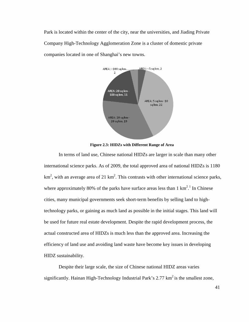
41
Park is located within the center of the city, near the universities, and Jiading Private
Company High-Technology Agglomeration Zone is a cluster of domestic private
companies located in one of Shanghai’s new towns.
Figure 2.3: HIDZs with Different Range of Area
In terms of land use, Chinese national HIDZs are larger in scale than many other
international science parks. As of 2009, the total approved area of national HIDZs is 1180
km2, with an average area of 21 km2. This contrasts with other international science parks,
where approximately 80% of the parks have surface areas less than 1 km2.1 In Chinese
cities, many municipal governments seek short-term benefits by selling land to high-
technology parks, or gaining as much land as possible in the initial stages. This land will
be used for future real estate development. Despite the rapid development process, the
actual constructed area of HIDZs is much less than the approved area. Increasing the
efficiency of land use and avoiding land waste have become key issues in developing
HIDZ sustainability.
Despite their large scale, the size of Chinese national HIDZ areas varies
significantly. Hainan High-Technology Industrial Park’s 2.77 km2 is the smallest zone,
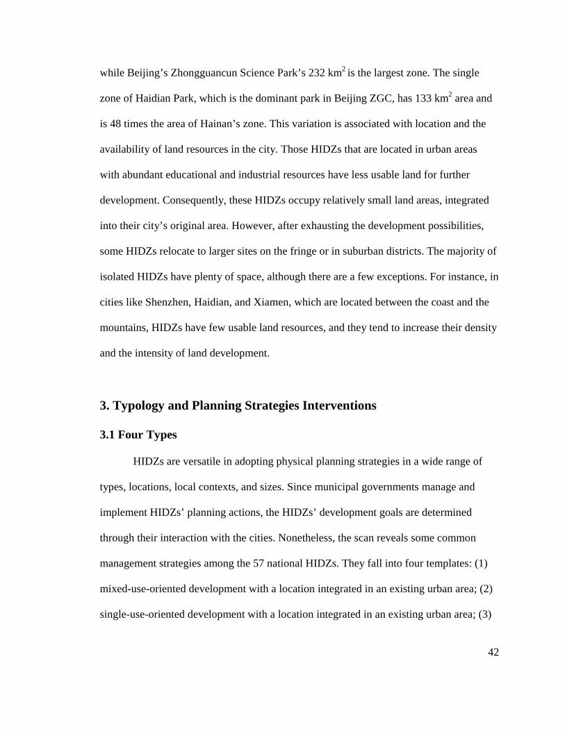
42
while Beijing’s Zhongguancun Science Park’s 232 km2 is the largest zone. The single
zone of Haidian Park, which is the dominant park in Beijing ZGC, has 133 km2 area and
is 48 times the area of Hainan’s zone. This variation is associated with location and the
availability of land resources in the city. Those HIDZs that are located in urban areas
with abundant educational and industrial resources have less usable land for further
development. Consequently, these HIDZs occupy relatively small land areas, integrated
into their city’s original area. However, after exhausting the development possibilities,
some HIDZs relocate to larger sites on the fringe or in suburban districts. The majority of
isolated HIDZs have plenty of space, although there are a few exceptions. For instance, in
cities like Shenzhen, Haidian, and Xiamen, which are located between the coast and the
mountains, HIDZs have few usable land resources, and they tend to increase their density
and the intensity of land development.
3. Typology and Planning Strategies Interventions
3.1 Four Types
HIDZs are versatile in adopting physical planning strategies in a wide range of
types, locations, local contexts, and sizes. Since municipal governments manage and
implement HIDZs’ planning actions, the HIDZs’ development goals are determined
through their interaction with the cities. Nonetheless, the scan reveals some common
management strategies among the 57 national HIDZs. They fall into four templates: (1)
mixed-use-oriented development with a location integrated in an existing urban area; (2)
single-use-oriented development with a location integrated in an existing urban area; (3)
mixed-use-
single-use-
Figure 2.4: A Typology of National HIDZs
The four types of national HIDZs
terms of their
city population. However, the four types have distinct characteristics with regard to goals,
types of local resources, and locations
planning approaches.
Located in
advantages
origination of high
Their mixed
single research
-oriented development with a location isolated fro
-oriented development with a location isolated from
Figure 2.4: A Typology of National HIDZs
he four types of national HIDZs do not significant
their spatial distribution in China, the
city population. However, the four types have distinct characteristics with regard to goals,
types of local resources, and locations. These
planning approaches.
Located in existing urban areas, Type 1
advantages, such as the abundance of educational or industrial resources
origination of high-tech parks. There are 13 national HIDZs
mixed-use goal has led to land uses that
research and production function. Thus
location isolated from the original city
location isolated from the city.
Figure 2.4: A Typology of National HIDZs, Locations, Features, and Examples
do not significantly differ from each other i
the city, GDP, HIDZ GDP, HIDZ area size,
city population. However, the four types have distinct characteristics with regard to goals,
. These characteristics largely determine the
ype 1, Mixed-Use and Integrated, has distinct
educational or industrial resources that support the
. There are 13 national HIDZs that belong to this type.
that include multiple functions, rather than
. Thus, the key challenge of planning strategies is
43
original city; and (4)
, Locations, Features, and Examples
differ from each other in
GDP, HIDZ area size, or
city population. However, the four types have distinct characteristics with regard to goals,
largely determine their
has distinct
that support the
that belong to this type.
rather than a
the key challenge of planning strategies is
44
to balance the multiple interests among existing institutes, landowners, and various
potential functional facilities.
Type 2, Single-Use and Integrated, benefits from the abundance of existing urban
infrastructure. There are 18 national HIDZs in this type. The single-use mission leads to
the construction of a series of individual, specialized science parks and research bases.
Thus, this type needs to coordinate with the surrounding urban area to address social
service issues.
Type 3, Mixed-Use and Isolated, has eight HIDZs. They originate from a high-
technology industrial district, and gradually incorporate residents and other urban
functions with employment opportunities. Finally, they achieve a self-sufficient new
township model as a sub-center of the original city. The construction cost of an entirely
new high-technology-based community is high at the beginning (due to the need for
infrastructure), which also affects the possible rate of return.
Type 4, Single-Use and Isolated, creates a single research and high-technology
industrial district at a distance from the center of the city. The major tasks of planning are
to arrange industrial and educational uses, and to address the funding, commuting, and
transportation issues so as to maintain the connection with its city. These sites are
constructed close to harbors, airports, and transport ports; as a result, they benefit from
convenient transportation.
3.2 Discussion of Planning Strategies
Each type of HIDZ has tailored the planning strategies in different ways to meet
their needs. The planning and management activities refer to: (1) the various ways plans

45
work, such as the agendas, policies, visions, designs, and strategies; and (2) the process
of implementation, including legislation, construction, and maintenance. Since the inner
motivations of planning actions are development goals and tasks, and the knowledge of
local circumstances, HIDZs’ planning activities can be summarized as having six
dimensions: (1) site selection, (2) land development approaches, (3) planning and
management system, (4) land use plan and strategies, (5) transit program and
implementation, and (6) open space design and construction.
• Site Selection
The park’s site selection is largely based on whether there is an abundance of
existing resources or already formed clusters of high-technology enterprises. The
planners proposed HIDZs in urban areas, aiming to fully use urban infrastructure and
facilities to incubate specialized small enterprises, such as Type 1 and Type 2. They are
located near universities and research institutes. They are either placed in the revitalized
industrial areas or near ports and transportation hubs. Since these types of parks have a
strong dependence on the city structure, their construction is closely linked with the
reconstruction of infrastructure and the urban revitalization process. The construction and
environmental improvement of its surrounding urban area directly affects the pace of the
park’s development. The complexity of issues emerging during urbanization, such as the
replacement of old households and the exchange of land functions, has a significant
impact on the development of these high-technology parks.
The site selection of HIDZs in urban fringe areas is closely related to the spatial
development of cities. As a top-down, guided governmental activity, site selection largely
depends on the city-level decision makers’ knowledge of both the urban development

46
plan and the local advantages. The municipality takes on the planning of the high-
technology zone, integrating its plan into the city’s comprehensive plan. Generally, the
mission of suburban HIDZ is to develop as a sub-center of the city. For instance, Tianjin
Binhai High-Technology Industrial Zone is located to the east of Tianjin City, lying in
the juncture of the Beijing-Tianjin City Belt and the eastern seaboard of Tianjin, right on
the east development axis of Tianjin’s new town development direction. The construction
of this new district is one important step toward facilitating Tianjin’s urban-rural
development and establishing a new sub-center of Tianjin.
To sum up, the development of an HIDZ is an important part of the city, closely
related to other functional districts in the city. The construction of HIDZs results in a
large number of changes to the city’s spatial development by filling up urban areas with
new industrial land uses, impacting traffic, the physical environment, the infrastructure,
and people’s commuting behaviors, as well as replacing farmland and village residences
in urban fringe areas.
• Land Development Approaches
Local government and administrative committees take charge of the land
development of HIDZs. At the beginning of development, land was the only capital of
high-technology parks. The committee assigned development corporations to take charge
of the land development process as shown in Figure 2.5. Theoretically, with the support
of the city government, the land development company buys land at a low price from the
government, and then develops the land using mortgaging and money loans from the
bank. This process creates two products: one is the usable land that can be distributed for
detailed planning and construction; the other one is the basic infrastructure.2

47
Figure 2.5: General Land Development Process in High-Technology Parks Source: Qiansheng Pi, Introduction of Chinese Economic Development Zones
(Beijing: Sanlian Press, 2004).
In reality, the focus of different land development approaches vary significantly
according to different types of HIDZs. In Type 1 and Type 2, where the HIDZs are
integrated within existing urban areas with fully developed infrastructure and supporting
facilities, the major responsibilities of land development companies are transferred from
infrastructure construction to first, adjusting land ownership and redistributing the land,
and second, renovating and replenishing infrastructure facilities. In China, the majority of
land is owned by communities and the state. There are also many state-owned institutes
and universities located in the areas of HIDZs. They have absolute power to reallocate
the land parcels. Thus, the land development process is not as easy as the investment,
because it needs to balance multiple sectors and their demands.

48
Type 3 and Type 4, in which HIDZs develop from farmland, face much higher
costs than the other two types, because they have to construct new infrastructure and
facilities. The administrative committees and land development companies need to
increase revenue to cover the high cost. A common way is to redistribute land and sell
parcels to assignees—the high-technology enterprises in HIDZs. However, keen
competition with the high-technology parks has led many HIDZ committees to reduce the
sale price of land to attract more business investments. Consequently, other than long-
term revenue from the taxation of enterprises, the committees begin to seek some short-
term revenue resources. For instance, developing non-industrial land has become a way
to increase revenue. The committee sells non-industrial land by auction, which increases
the land price. At the same time, many real estate speculators buy the land for the purpose
of developing a high-technology enterprise with a low price, but gain large profits by
changing the land use for further speculations.
Multiple factors impact the use of the land-development approach. While
increasing the level of governmental control is important in the initial land phasing steps,
the network involving multiple land ownerships has meant long-term negotiation and has
led land development to maintain a balance among these various interests. Compared
with single-use high-technology parks, the mixed-use parks have to address more
complex issues, such as phasing steps among different uses, and the investment sequence
in different functions.
• Planning and Management System
The Chinese planning regulations regard the planning of high-technology parks as
a sub-district plan that is under the city’s comprehensive plan. Since 1982, China has
49
implemented an administrative system with five levels, namely, the central government;
provincial governments (provinces, autonomous regions and municipalities, special
administrative regions); prefecture-level governments (prefecture-level cities,
autonomous prefectures and leagues); county governments (municipal districts, county-
level cities, counties, autonomous counties, banners, autonomous banners, special
economic zones, forest zones); and township governments (townships, nationality
townships, and towns). At present, there is a planning system with four administrative
levels: central government, provincial governments, municipal and county governments,
and township governments. The planning of HIDZs is one part of the district planning
that is attached to the comprehensive planning by the municipal government authority
and followed by statutory and amendatory detailed planning procedure.
In 1989, the City Planning Act of the People’s Republic of China established a set
of basic systems regarding modern urban planning and management in China. One
important scheme is “one letter and two permits”: Guideline Letter for Site Selection
(GLSS), Planning Permit for Land Development (PPLD), and Planning Permit for
Construction Engineering (PPCE). The law states that in all urban development activities,
the land may be allocated by the land administrative authority only after the developer
has obtained the PPLD. If the state-owned land-use right is obtained through paid leasing,
then the planning conditions of the approved urban plan and site plan shall be the
premises for leasing and the issuance of the PPLD. For any construction of buildings,
structures, roads, pipelines, or other projects, the PPCE must be obtained before the
actual construction takes place.3
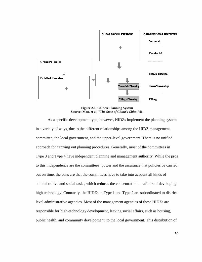
As a specific
in a variety of ways
committee,
approach for carrying out
Type 3 and Type 4
to this independence
out on time, the cons are that the committees have to take
administrative and social tasks, which reduce
high technology. Contrarily,
level administrative agencies. Most of the management agencies of these HIDZs
responsible for high
public health, and community deve
Figure 2.6: Chinese Planning SystemSource: Mao, et al, "The State of China's Cities
As a specific development type, however, HIDZs
in a variety of ways, due to the different relationship
, the local government, and the upper
for carrying out planning procedure
Type 3 and Type 4 have independent planning
to this independence are the committees’ power
out on time, the cons are that the committees have to take
administrative and social tasks, which reduce
high technology. Contrarily, the HIDZs in Type
level administrative agencies. Most of the management agencies of these HIDZs
responsible for high-technology development, leaving social affairs, such as housing,
public health, and community development, to the local government. This distribution of
2.6: Chinese Planning System The State of China's Cities,"41.
type, however, HIDZs implement the planning system
relationships among the HIDZ management
upper-level government. There is no unified
planning procedures. Generally, most of the committees in
planning and management authority. While the pros
power and the assurance that policies be carried
out on time, the cons are that the committees have to take into account all kinds of
administrative and social tasks, which reduces the concentration on affairs of developing
in Type 1 and Type 2 are subordinate
level administrative agencies. Most of the management agencies of these HIDZs
technology development, leaving social affairs, such as housing,
lopment, to the local government. This distribution of
50
the planning system
management
ere is no unified
the committees in
and management authority. While the pros
policies be carried
account all kinds of
the concentration on affairs of developing
subordinated to district-
level administrative agencies. Most of the management agencies of these HIDZs are
technology development, leaving social affairs, such as housing,
lopment, to the local government. This distribution of
51
responsibilities has facilitated innovation and industrial development. However, it takes a
long time to achieve consensus between committees and the local government on the
approval of policies. The control level of the HIDZ development committee during the
implementation process hence reduces.
• Land-Use Plan and Strategies
Land-use patterns differ between mixed-use HIDZs and single-use HIDZs. While
the single industrial district often appears to be organized as a pattern of grids and blocks,
the multi-use-oriented high-technology parks have much more organically arranged
functions, especially those parks located in existing urban areas. The land-use plan of the
former type is largely influenced by modern rational design principles that aim to achieve
average land parcel size, and flexibility in phasing development. The latter type’s land-
use pattern is determined by the road networks in existing urban areas.
The different land-division patterns have different impacts on industrial
production and human activities. The grids and blocks pattern regards industrial parcel
arrangement as the priority; hence, this type benefits transportation and provides
convenient manipulation of these parcels. The mixed-use high-technology parks take
people’s work, life, and communication activities into account; thus, the accessibility
among different functions is essential to people’s daily lives.
The planning agencies of HIDZs adopt a series of land-use regulations to manage
the changes in land use. Different from the isolated HIDZs that simply use phasing steps
to control the expansion, HIDZs integrated in city areas slowly follow the original city’s
fabric to change or infill functions parcel by parcel. Some of them use land and
regulations to reserve green land or vacant blocks for future use, while other lands are at
52
the center of linear growth along a major transit spine. The levels of subdivision are also
diverse in different timing of development. Land functions are under a sketchy
arrangement in the primary land-use plan, but become more and more detailed from the
mandatory detailed plan to urban design, and, finally, to site plans.
• Transit Program and Implementation
The primary concerns of the transit program in HIDZs include two aspects: transit
ways and road system design. The types of logistics and the flow of people determine
multiple transit ways. As an industrial district, HIDZs regard logistics as a significant
element. They place increasing accessibility to airports, seaports, and developing
highways as the priority in infrastructure construction. The information infrastructure,
including internet, electronic wires, and cables, are much more important in HIDZs than
in traditional industrial districts. With regard to the flow of people, HIDZs focus on two
factors. First, most workers in high-technology industrial parks commute on public transit.
The subway lines and lots of circulation ways inside parks, such as shuttle buses and
public trolleys, are established for a better connection between various specialized parks
and service facilities. Second, business trade activities play an important role in current
Chinese HIDZs, more so than in other factories and research bases. Most of the
enterprises and employers choose cars as their major transit vehicles, for convenience.
With the increasing development of high-technology companies, the increase of car flow
brings additional traffic pressure to science parks, especially ones that are built in existing
urban areas.
In terms of road systems, the National Code of Transport Planning (1995)
stipulates the hierarchy of roads with corresponding width of roads and speed of vehicle,
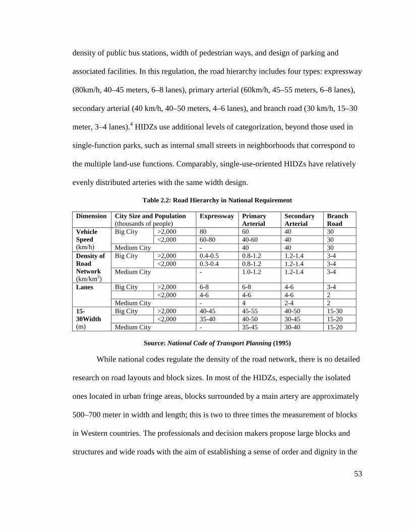
53
density of public bus stations, width of pedestrian ways, and design of parking and
associated facilities. In this regulation, the road hierarchy includes four types: expressway
(80km/h, 40–45 meters, 6–8 lanes), primary arterial (60km/h, 45–55 meters, 6–8 lanes),
secondary arterial (40 km/h, 40–50 meters, 4–6 lanes), and branch road (30 km/h, 15–30
meter, 3–4 lanes).4 HIDZs use additional levels of categorization, beyond those used in
single-function parks, such as internal small streets in neighborhoods that correspond to
the multiple land-use functions. Comparably, single-use-oriented HIDZs have relatively
evenly distributed arteries with the same width design.
Table 2.2: Road Hierarchy in National Requirement Dimension City Size and Population
(thousands of people) Expressway
Primary Arterial
Secondary Arterial
Branch Road
Vehicle Speed (km/h)
Big City >2,000 80 60 40 30 <2,000 60-80 40-60 40 30
Medium City - 40 40 30 Density of Road Network (km/km2)
Big City >2,000 0.4-0.5 0.8-1.2 1.2-1.4 3-4 <2,000 0.3-0.4 0.8-1.2 1.2-1.4 3-4
Medium City - 1.0-1.2 1.2-1.4 3-4
Lanes Big City >2,000 6-8 6-8 4-6 3-4 <2,000 4-6 4-6 4-6 2 Medium City - 4 2-4 2
15-30Width (m)
Big City >2,000 40-45 45-55 40-50 15-30 <2,000 35-40 40-50 30-45 15-20 Medium City - 35-45 30-40 15-20
Source: National Code of Transport Planning (1995)
While national codes regulate the density of the road network, there is no detailed
research on road layouts and block sizes. In most of the HIDZs, especially the isolated
ones located in urban fringe areas, blocks surrounded by a main artery are approximately
500–700 meter in width and length; this is two to three times the measurement of blocks
in Western countries. The professionals and decision makers propose large blocks and
structures and wide roads with the aim of establishing a sense of order and dignity in the

54
districts. However, in mixed-use HIDZs, the large block is not welcoming for residents
and employees.
• Open Space
The use of place-making strategies aims to create multiple kinds of public spaces
for human exchanges and daily activities. While the functions and uses of public space
are different according to different service goals and district users, the main intention of
HIDZs’ public space is to attract investment, companies, and their employees. The public
space includes plazas, civic parks, pedestrian walkways, tree-lined avenues, greenbelts,
and public facilities. These are all aimed at creating low-carbon, mixed-use environments
to meet the demands of high-technology firms. For instance, the national HIDZs have
much higher green space ratios than other types of development zones; the main entrance
plazas of HIDZs and specialized parks are strong symbols; the civic parks are placed
along the riverside, transit stops, and major stations. There are also public gathering
plazas, places for exercise, food courts, restaurant squares, badminton courts, and
basketball courts. Additionally, a variety of facilities are proposed to create the desired
image and culture of high-technology parks, including sculptures, cultural signals, and
landscape elements.
Admittedly, the design of landscape and public space garners less attention than
the construction of the infrastructure, building density, and road system. However, by
considering green sustainability, Chinese HIDZs have gradually stepped through the
initial growth phase and moved toward a mature stage. The requirement for energy
efficiency, low carbon use, and emission reduction has mandated significant tasks
regarding green spaces, as well as on traffic control. With increasing residences and

55
urban functions in high-technology parks, both place-making and human activities have
become important elements in the contemporary and future development of high-
technology parks.
3.3 Case Selection
Different development missions and specific relations between high-technology
parks and their cities have yielded four different types of HIDZs and their
correspondingly different adoption of planning strategies. The implementation of
planning strategies is impacted by a series of factors, including local resources, power of
enterprises, type of planning agency, legal control and regulation, and users. All these
elements intertwine to form a brief background for the planning and management of
national HIDZs.
To really understand how HIDZs are planned, and the effectiveness of planning
strategies, we need to take a close look at several cases. Based on the historical evolution
of national HIDZs and the typology summarized from general surveys, this book intends
to select HIDZ examples according to the following main criteria: (1) cases representing
samples across each of the four types of HIDZs; (2) cases representing samples across
different levels of local resources and city features; (3) cases with rich information in
terms of planning approaches and assessable outcomes; and (4) cases serving as
exceptional models for the majority of HIDZs, and thus having generalizable lessons for
future practices. This study selected four cases for in-depth discussion and comparison:
Beijing Haidian Park of Zhongguancun Science Park (ZGC), Shanghai Zhangjiang High-

56
Technology Industrial Park (ZJ), Suzhou Industrial Park (SIP), and Shenzhen High-
Technology Industrial Park (SHIP).
While the complexity of factors, interests, policies, and contextual forces makes it
difficult to untangle the planning mechanisms that operate within the HIDZs and to trace
how these mechanisms yield quite different spatial configurations on the ground, these
difficulties are somewhat eased in a more controlled comparison of the four cases by the
similarities in their overarching evolutional, social, and political contexts. First, created in
the early 1990s, all four HIDZs received state preferential policies in supporting high-
technology firms and land taxations. Through two decades, the physical development of
each has taken place under the adoption of a series of planning strategies, consisting of
multiple projects including specialized parks, educational institutes, incubators, and
associated facilities. Each uses a series of regulated physical planning systems: city-level
comprehensive planning, part of sub-district planning, land development process, detailed
planning, and site planning. All four HIDZs perform well above average in
socioeconomic development, ranking in the top five in national evaluations of HIDZs in
1992 and 2008. Each became a large and regionally influential high-technology industrial
zone, serving as a model for implementing planning activities and legislating
development behaviors in high-technology parks, learned or simulated by a majority of
other national HIDZs and municipal HIDZs. Furthermore, the four HIDZs are similar in
organizational structure and planning activities. Appointed commissions governed all
four zones, although there were subtle but important variations between them in terms of
commission structure, composition, and distribution of responsibilities.

57
Nevertheless, the four HIDZs offer enough significant variations to make
comparisons among them a fertile source for new insights into the planning activities in
contemporary high-technology industrial parks. Because they are located in different
cities in different regions of China, they grew in different contexts and were shaped by
different initiatives and markets. The cities they are located in have developed unique
characters and political cultures that act as important forces on the HIDZs. Beijing has an
abundance of universities and educational institutes. Thus many high-technology firms
were created by research institutes and local graduates. As an influential global city,
Beijing receives significant international investment and interest from high-technology
companies. Shanghai has been famous for its influence over finance, commerce, and
business trade since the early 20th century. State and municipal governments have placed
great emphasis on stimulating Shanghai’s high-technology development with supportive
programs, policies, and funding. The cooperation between the governments in China and
Singapore placed the project in Suzhou, thus giving birth to Suzhou Industrial Park, with
its international influence on investment and the influx of high-technology companies.
The economic development of the Shenzhen Economic Zone provides high-technology
firms fertile resources, involving convenient international trade approaches, a labor
market with a large migrant population, and free business environments with a market
economy.
These four cases represent different HIDZ development missions. These four
HIDZs are representative of many others throughout China that sought to generate
suitable sources of revenues by diversifying distinct development missions. Beginning in
the early 1990s, HIDZs assumed the primary responsibility for the development of high
58
technology and served as economic growth anchors in their respective cities. But the
variation in local resources and contexts has led to different focuses in their later
developments. Beijing Zhongguancun Science Park aims to fully utilize the abundant
research resources intellectual resources to transform the research into products, thereby
creating a self-innovation center in China. Shanghai Zhangjiang High-Technology
Industrial Park has been proposed as a high-tech branch belonging to the entire economic
structure of Pudong New Area, serving as a high-technology—especially the IC and
software industrial—district, which can compete with other places in China. Conversely,
Suzhou Industrial Park took a path toward a new urbanized township with mixed urban
functions, rather than pure high-technology industry. The advantages of the Yangtze
River Delta area and Singapore’s support facilitated SIP’s industrial development. The
increasing employment opportunities in SIP made the new township program possible to
implement. Shenzhen’s advanced market-economy environment catalyzed the boom in
domestic private companies. Thus, the main focus of Shenzhen High-Technology
Industrial Park is the capacity for local innovation and high-technology development.
Moreover, the physical characteristics of the four HIDZs are also quite different.
Beijing, being the largest area among national HIDZs, is located on the northwest of the
Fourth Ring Road in Beijing, infilling the mixed-used urban fabric and expanding toward
suburban areas. Zhangjiang High-Technology Park is one of the six dispersed science
parks in Shanghai. It is located in Pudong New Area and was constructed as a single-use-
oriented industrial park surrounding Zhangjiang Town. Suzhou Industrial Park is an
independent, self-sufficient, new town to the east of the city’s center. Shenzhen High-
Technology Industrial Park is far away from downtown and was developed as an isolated

59
high-technology industrial base for research and development. These four HIDZs serve as
models for other high-technology parks by tailoring planning strategies to respond to
specific local circumstances.
Table 2.3: Characteristics of Four Selected Cases
Criteria Beijing ZGC Shanghai ZJ Suzhou SIP Shenzhen SHIP
Sustained Involvement in Planning
Yes (since 1989)
Yes (since 1992)
Yes (since 1994)
Yes (since 1996)
Completed More than One Project
Yes Yes Yes Yes
Used Various Physical Planning Strategies
Yes (General Planning System; Land Use; Land Development; Site Plans)
Yes (General Planning System; Planning Agency; Land Use; Land Development)
Yes (General Planning System; Planning Agency; Land Use; Land Development; Site Plans; Urban Design)
Yes (General Planning System; Planning Agency; Land Use; Land Development)
Exemplary in Socioeconomic Development5
Yes (rank top 5)
Yes (rank top 5)
Yes (rank top 5)
Yes (rank top 5)
Expected Development Mission
Medium-mixed-use Medium-single R&D use
Mixed-use new township focus
Single R&D use
Relationship with Cities
Integrated Integrated Isolated Isolated
Size and Scale Largest 133 sq km
25 sq km 80 sq km Smallest 11.52 sq km
Geographic Location in China
Northeast Middle east Middle east South
Initial Key Resources
Abundant Educational Resources; strong state-owned enterprises sector
Weak educational resources; strong policy support and guidance;
Weak educational resources; strong international cooperation supports;
Weak educational resources; strong special zone policy supports; strong private domestic enterprise sector

60
1 IASP, "Survey of International Science Parks 2006–2007." 2 Pi, Introduction of Chinese Economic Development Zones. 3 Mao, et al, "The States of China's Cities." 4 National Code of Transport Planning (1995). 5 Evaluation of national High-Technology Industrial Development Zones by Ministry of Science and Technology, P. R. China, 2008
61
CHAPTER 3: BEIJING ZHONGGUANCUN HAIDIAN PARK
1. An Overview
If a casual observer were to be asked what China’s “Silicon Valley” is, they
almost certainly would mention Zhongguancun Science Park (ZGC for short) in Beijing.
Zhongguancun Science Park is the epitome of national high-tech industrial zones in
China with its prominent economic growth and considerable construction volume. Since
Beijing implemented the strategy of “invigorating the country through science,
technology, and education” in the 1980s, the city has placed more emphasis on high-
technology industries. The planning agency of Beijing intended to “establish ZGC as the
demonstration base for national scientific and technological innovations”.1 Compared to
two decades ago when there were only 527 companies with an annual income of $2.5
million in Zhongguancun, as of 2008, there were 20,000 high-technology companies,
with an entire income of $146 billion.2 The region has also been experiencing a growth
rate of more than 30% per year. At present, ZGC has become one of the most important
growth points in the capital’s economic development, as it contributes 36% of the total
gross industrial output value of Beijing. Furthermore, it serves as a model for other
national HIDZs, with its business income of industry, trade, and technology accounting
for 18% of the total income of all Chinese HIDZs in 2008.3
Zhongguancun Science Park represents the Type 1 of national HIDZs—
intensively landscaped and comprehensively planned sites centered upon research
institutes, filled with national enterprises and institutions, existing as a relatively mature
market with commercial activities, central focuses on high-technologies and information,

62
and populated by professional human resources. ZGC consists of seven geographically
dispersed zones in different locations in Beijing. Among them, Haidian Park, located in
the northwest of Beijing, is much larger than the other six zones. The entire
Zhongguancun Science Park originated from the 75 km2 high-density urban part of
Haidian Park, which also includes a 300 km2 suburban area as an expansion of the urban
region In this urban area, there are 70 institutions of higher learning, including Tsinghua
University and Peking University, and over 230 research institutes, as exemplified by the
Chinese Academy of Science (CAS) and Chinese Academy of Engineering (CAE). Over
one third of the top academics in China live and work here. Among the 940,000
employees in ZGC, people with doctoral degrees account for 1%, those with master’s
degrees account for 7%, and bachelor degree holders account for 38% of the total
amount.4 The advantage of human and high-tech research resources have attracted many
international companies and domestic enterprises to locate their technology research
institutes or R&D centers in this region, such as Microsoft, IBM, Intel, Lenovo, Founder,
and Ufida.
As a representative Type 1 HIDZ that developed on an existing urban area with
mixed-use functions, Haidian Park in ZGC needs to arrange various land ownerships
during the land development process. Many universities and institutes are under the direct
administration of the central government. For instance, while Tsinghua University,
Peking University, and CAS are located in Haidian District, the two universities are
under the management of the Ministry of Education of China, whereas CAS is directly
guided by the State Council. None are managed under the jurisdiction of Haidian District
Administration or Zhongguancun Science Park Development Committee. Additionally,

63
various state-owned, CAS-owned, and CAE-owned institutes were moved to Haidian
District long before the science park was established. This complicated administrative
relationship among the multiple colleges and institutes has made land exchanging and re-
planning of Haidian Park difficult.
Map 3.1: Beijing ZGC Park: one zone, seven parks Source: Development Record 1980-2009, 2010, translated by author
64
2. History of Beijing Zhongguancun Science Park
2.1 Original Haidian “Northwest Cultural and Educational Area”
Located in the northwest area of Beijing as part of Haidian District,
Zhongguancun used to be a village with a cluster of royal landscapes, as exemplified by
the Summer Palace. Since the early 20th century when both Tsinghua University and
Peking University were established, Haidian District has become a commercial village, as
most of the universities and institutes have served their populations on their campuses.
Haidian District did not begin its large construction of research institutes until the
establishment of P. R. China in 1949. The planning of Beijing in May 1949 was
conducted through a series of ideas involving the development of industry in Beijing;
locating colleges and institutes in Haidian District; and moving the Chinese Academy of
Science to Zhongguancun area.
This planning vision was intended to create a university sector in Haidian District.
It defined Zhongguancun in Haidian as a “Northwest Cultural and Educational Area.”
Various college and research institutes gradually clustered there, aiming to use the shared
equipment and faculty resources.
However, the planning and construction lacked both management and technical
guidance. The infrastructure lagged far behind the housing and institute construction,
resulting in repeated constructions and disordered traffic conditions; the lack of an
implementation mechanism led to each institute planning its own land without
considering its connection to the surrounding areas. Without land use control, many

65
institutes also extended their land boundaries far beyond their needs. These early
situations left barriers to later development and management.
2.2 Evolution of the Beijing City Comprehensive Plan
After a period of suspended execution,5 city planning in Beijing got on the right
track. The municipal government clarified the high-technology development vision on
the Northwest Cultural and Educational Area, and developed a series of policies, plans,
and regulations. Under its market economy, however, the government has no longer been
the only controlling factor on the spatial flow and agglomeration of resources. The
market-based profit maximization has influenced the self-choices of enterprises and
individuals. The two forces intertwined together to form the development context of
Zhongguancun Science Park.
• Beijing Comprehensive Planning in 1983
In November 1981, the Beijing municipality reestablished the Beijing City
Planning Commission and began the comprehensive planning of Beijing.6 Unlike
previous planning ideas that emphasized establishing an “economic center” or “industrial
center,” the comprehensive plan criticized the overemphasis on industry and ignorance of
natural resources and the environment. This new plan strengthened the principles of
having a green city and the importance of improving the quality of the physical
environment. The plan also extended Beijing city’s administrative boundary to release the
pressure caused by a rapidly increasing population in the downtown area. Under the
guidance of the comprehensive plan from 1982 to 1984, Haidian District finished its land
use plan for the Northwest Cultural and Educational Area.

66
• Development Experimental Zone for New Tech and Industry
In the 1980s, when the Beijing Comprehensive Plan proposed a business service
center in Zhongguancun Village, many technology companies emerged in Haidian
District. Those scientists and engineers, most of whom graduated from the universities in
Haidian District and were later study-abroad returnees, explored various ways to adapt
the mode of Silicon Valley or Route 128 to China. Retail electronic stores assembled
along the main streets in Zhongguancun, which aroused the attention of the government
and academia. The China Academy of Science set up a development center with research
and industry departments to support this development. Later, the Beijing City Planning
Commission organized a series of institutes to compose a research group to investigate
the newly emerged enterprises and to conduct planning and design research in
Zhongguancun.7 The investigation led to the establishment of a science park in
Zhongguancun, with unified planning and rational land distribution.8
In 1988, as a response to the prominent automatic development of the
Zhongguancun area, the Sate Council officially proposed the Zhongguancun area as the
first national high-tech industrial zone in China and named it the “Beijing Development
Experimental Zone for New Technology and Industry.” The related regulation delineated
an area of approximately 100 km2 with the Northwest Cultural and Educational Area as
its center. Since then, it has experienced rapid development.
• Amendment: 1993 Beijing Comprehensive Plan
From 1981 to 1991, the planning neither followed the rapid urban development to
make adjustments to the high-technology industry agglomeration in Zhongguancun, nor
undertook any effective programs to preserve open space. Thus, the Beijing government
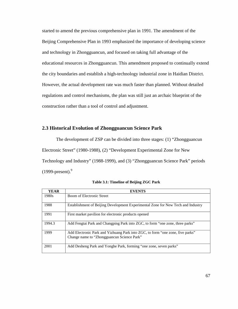
67
started to amend the previous comprehensive plan in 1991. The amendment of the
Beijing Comprehensive Plan in 1993 emphasized the importance of developing science
and technology in Zhongguancun, and focused on taking full advantage of the
educational resources in Zhongguancun. This amendment proposed to continually extend
the city boundaries and establish a high-technology industrial zone in Haidian District.
However, the actual development rate was much faster than planned. Without detailed
regulations and control mechanisms, the plan was still just an archaic blueprint of the
construction rather than a tool of control and adjustment.
2.3 Historical Evolution of Zhongguancun Science Park
The development of ZSP can be divided into three stages: (1) “Zhongguancun
Electronic Street” (1980-1988), (2) “Development Experimental Zone for New
Technology and Industry” (1988-1999), and (3) “Zhongguancun Science Park” periods
(1999-present).9
Table 3.1: Timeline of Beijing ZGC Park
YEAR EVENTS 1980s Boom of Electronic Street
1988 Establishment of Beijing Development Experimental Zone for New Tech and Industry
1991 First market pavilion for electronic products opened
1994.3 Add Fengtai Park and Changping Park into ZGC, to form “one zone, three parks”
1999 Add Electronic Park and Yizhuang Park into ZGC, to form “one zone, five parks”
Change name to “Zhongguancun Science Park”
2001 Add Desheng Park and Yonghe Park, forming “one zone, seven parks”
68
• “ Zhongguancun Electronic Street” Period (1980-1988)
During this period, Zhongguancun area was still a place with clusters of private
enterprises that were developed from the bottom-up. The high-technology firms formed
an “Electronic Street,” demonstrating the huge energy of transforming science and
technology into production, and hence attracted the attention of the municipal
government and urban management department. The so-called “Electronic Street”
referred to a main avenue, Baiyi Road, in the Zhongguancun area, with a variety of E-
commerce stores gathering along both sides of the road, and selling computers, hardware,
and software. Most of the stores were one or two-story, reused, existing shops and small
houses. In spite of their specific economic vitality, these temporary buildings sprawled
everywhere with neither order nor consideration of building appearances, even occupying
lots of urban open space and green areas.
• “Development Experimental Zone” Period (1988-1999)
With the establishment of the “Beijing Development Experimental Zone for New
Tech and Industry,” Zhongguancun transitioned from automatic activity into a stage with
plans, management, and policy. While the original experimental zone was located in
Haidian Park, the State Scientific and Technological Commission approved adding four
more zones into the experimental zone, with two added in 1994 and another two in 1997.
The original Development Experimental Zone was renamed Haidian Park, which is the
largest zone. Since then, the experimental zone has become a cluster of five individual
dispersed zones. Moreover, the Beijing municipal government established an appointed
agency, the Experimental Zone Development Committee, in 1997 to manage the
development affairs in the zone.
69
From 1988 to 1999, Zhongguancun was the fastest growing construction area in
Beijing. Zhongguancun's first market pavilion for electronic products opened in 1991,
showing that the form of trading and exchange had shifted from the previous individual
shop fronts to joint operation at large-scale counters. Both Peking Science Park and
Tsinghua Science Park were established in short time periods with over 107,000 sq ft
areas of building and related services. Moreover, Baiyi Road (now Zhongguancun Main
Avenue) was reconstructed with an enhanced capability for infrastructure in 1997. The
land use and distribution also changed. Compared with a highly increased rate of public
service land use from 1% in 1984 to 9.78% in 1995, the proportion of industrially used
land declined from 14.2% in 1984 to 6.58% in 1995.10 Several commercial services with
over 21,000 m2 areas each were built, and have formed an important business center in
Haidian District. Many sports and cultural facilities including Haidian Book City,
Haidian Theatre, and Haidian Gymnasium, as well as over 30 small residential
neighborhoods, were constructed in this area.11
• “ Zhongguancun Science Park” Period (1999-present)
After a decade of rapid development, Zhongguancun had accumulated sufficient
experience in developing science parks, and was prepared to undertake the responsibility
of leading high-technology development in China since 1990. In 1999, the State Council
renamed the “Development Experimental Zone for New Technology and Industry” to
“Zhongguancun Science Park.” The experimental zone committee was changed to the
Zhongguancun Development Committee. According to the Comprehensive Plan of ZGC
by the Beijing Municipal Institute of City Planning and Design in 2000, it consists of five
parks, among which Haidian Park is the largest and most important. In 2001, ZGC
70
increased another two zones, located in Xicheng District and Chaoyang District,
illustrating that ZGC finally includes seven dispersed individual zones in Beijing.
After entering into the “Zhongguancun Science Park” period, both the municipal
government and local district government enhance their emphases on the construction of
physical environments. The Haidian government has made a significant effort to
transform Baiyi Road again. The reconstruction included demolishing old houses with the
total amount of 46,568 m2 area buildings between the road lines, and removing over 100
households-residents, parts of Haidian district-level and municipal-level institutes, and
over 500 science and technology enterprises. This government-guided construction
effectively solved the arrears of infrastructure, enhanced the accessibility, and improved
the quality of the environment. The opening of both the North Forth Ring Road in 2000,
and the No. 13 light rail west line in 2002 benefited the northern expansion of ZGC, as
well as real estate development along the traffic line. With the construction of
Zhongguancun West Zone, Chinese Academy of Science (CAS) Science City, Software
Park, and several university science parks, ZSP has truly become a “large construction
site.”
3. Planning Strategies and Implementation
3.1 Planning Administrative System
In 1997, the Beijing municipality government appointed a group of staff members
to form the Zhongguancun Management Committee. The construction leading group in
municipality, with the mayor as the head, supervises the work of Zhongguancun
71
Management Committee.12 The committee takes charge of proposing development plans
and implementing construction in Zhongguancun Science Park. Since Zhongguancun
Science Park consists of a variety of high-technology parks, there are sub-management
committees in each high-technology park that undertake the development responsibilities,
respectively. For instance, Haidian Park Development Committee is one of the branches
of Zhongguancun Management Committee, and it undertakes the development affairs
such as land use plan, project approval, and land assignment in Haidian Park.
Such organization has experienced a series of adjustments in the past. In the
period of the development experimental zone, the Haidian Experiment Zone
Development Committee took charge of the entire development. After “one ZGC Zone
consisting five Parks” was set up in 1999, the Haidian Park Development Committee
became a sub-department under Zhongguancun Management Committee. Regarding the
much more important role of Haidian Park than others, in 2001, the Beijing municipality
decided to combine the Zhongguancun Management Committee and Haidian Park
Development Committee. However, this combination dissolved after two years, and
currently, the Zhongguancun Management Committee organizes all seven branches
including Haidian Park’s.13
However, the Haidian Park Development Committee does not directly lead the
enterprises in Haidian Park. Instead, the corporate tax income is submitted to the local
Haidian District government. The Haidian Park Development Committee concentrates on
the tasks of planning approval, building permits, and construction permits, leaving the
social affairs to local government. The committee has played a significant role in
preferential strategies, plans, and park programs, financing and investment, developing
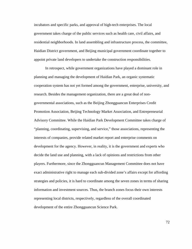
72
incubators and specific parks, and approval of high-tech enterprises. The local
government takes charge of the public services such as health care, civil affairs, and
residential neighborhoods. In land assembling and infrastructure process, the committee,
Haidian District government, and Beijing municipal government coordinate together to
appoint private land developers to undertake the construction responsibilities.
In retrospect, while government organizations have played a dominant role in
planning and managing the development of Haidian Park, an organic systematic
cooperation system has not yet formed among the government, enterprise, university, and
research. Besides the management organization, there are a great deal of non-
governmental associations, such as the Beijing Zhongguancun Enterprises Credit
Promotion Association, Beijing Technology Market Association, and Entrepreneurial
Advisory Committee. While the Haidian Park Development Committee takes charge of
“planning, coordinating, supervising, and service,” those associations, representing the
interests of companies, provide related market report and enterprise comments on
development for the agency. However, in reality, it is the government and experts who
decide the land use and planning, with a lack of opinions and restrictions from other
players. Furthermore, since the Zhongguancun Management Committee does not have
exact administrative right to manage each sub-divided zone’s affairs except for affording
strategies and policies, it is hard to coordinate among the seven zones in terms of sharing
information and investment sources. Thus, the branch zones focus their own interests
representing local districts, respectively, regardless of the overall coordinated
development of the entire Zhongguancun Science Park.

73
3.2 Land Use in Haidian Park
As noted previously, Haidian Park consists of two parts: the original urban area,
and the later-expanded suburban area. The urban area is a 75 km2 district with mixed uses.
The land use plan of Haidian Park proposed several key blocks in this urban area,
involving technology innovation centers and business centers. The business center,
exemplified by Zhongguancun West Zone, is a place for business trading and exchange,
product exhibition, public service center, and large high-tech enterprises. There are
various business buildings in the West Zone. The blocks around universities and research
institutes are used for university science parks and incubators, attracting thousands of
high-technology companies. Currently, the urban area has a high rate of land
development intensity, and thus, lacks potential space for further development. As a
result, Haidian Park has gradually expanded its boundary toward the northwest suburban
area.
Today’s Haidian Park occupies a 300 km2 suburban area, within which 60 km2
areas are constructed land for science parks. The suburban area has a much lower
development density than the urban area in Haidian Park. The land use plan proposed
several specialized parks in this area, with each park surrounded by large-scale green and
rural space. Since this area is located in the greenbelt of Beijing City defined by a
comprehensive plan, only 1/5 of the space is used for science park construction. The land
use plan also requires a series of building indices, such as the building height and FAR on
this land. Thus most of the buildings are no more than four floors in this area.

Map 3.2: Current Land Use of Haidian ParkSource: BeijingDevelopment Record 1980
Such a l
Therefore,
have adopted a s
Haidian District government proposed a 10 km
Science Park. This plan, conducted later by Beijing
includes the following functional areas: 200,000 m
Road, 150,000 m
business building in West Zone, 100
Map 3.2: Current Land Use of Haidian Park Beijing Zhongguancun Science Park
Development Record 1980-2009, 2010.
Map 3.4: Locations of Key Clusters in Haidian ParkSource:
Such a large-scale land use plan cannot be completed in a short
the Haidian Park Development Committee and Haidian District
adopted a series of approaches to achieve this large
Haidian District government proposed a 10 km
Science Park. This plan, conducted later by Beijing
includes the following functional areas: 200,000 m
, 150,000 m2 high-technology building area nearby Peking University
usiness building in West Zone, 100,000 m2
Map 3.3: Suburban Area of Haidian Park Source: Ibid.
: Locations of Key Clusters in Haidian Park Source: Ibid.
scale land use plan cannot be completed in a short time period.
Development Committee and Haidian District government
eries of approaches to achieve this large-scale project. In 1994
Haidian District government proposed a 10 km-long functional belt in Zhongguancun
Science Park. This plan, conducted later by Beijing Planning and Design Institute in 199
includes the following functional areas: 200,000 m2 public building area along Chengfu
technology building area nearby Peking University, 150,000 m
2 high-technology building along the
74
of Haidian Park
period.
government
scale project. In 1994, the
long functional belt in Zhongguancun
Planning and Design Institute in 1995,
public building area along Chengfu
, 150,000 m2
technology building along the
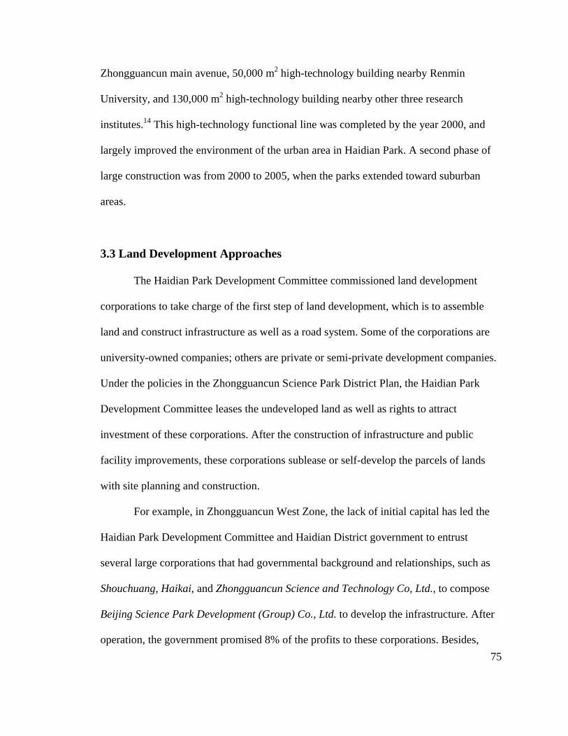
75
Zhongguancun main avenue, 50,000 m2 high-technology building nearby Renmin
University, and 130,000 m2 high-technology building nearby other three research
institutes.14 This high-technology functional line was completed by the year 2000, and
largely improved the environment of the urban area in Haidian Park. A second phase of
large construction was from 2000 to 2005, when the parks extended toward suburban
areas.
3.3 Land Development Approaches
The Haidian Park Development Committee commissioned land development
corporations to take charge of the first step of land development, which is to assemble
land and construct infrastructure as well as a road system. Some of the corporations are
university-owned companies; others are private or semi-private development companies.
Under the policies in the Zhongguancun Science Park District Plan, the Haidian Park
Development Committee leases the undeveloped land as well as rights to attract
investment of these corporations. After the construction of infrastructure and public
facility improvements, these corporations sublease or self-develop the parcels of lands
with site planning and construction.
For example, in Zhongguancun West Zone, the lack of initial capital has led the
Haidian Park Development Committee and Haidian District government to entrust
several large corporations that had governmental background and relationships, such as
Shouchuang, Haikai, and Zhongguancun Science and Technology Co, Ltd., to compose
Beijing Science Park Development (Group) Co., Ltd. to develop the infrastructure. After
operation, the government promised 8% of the profits to these corporations. Besides,

Peking University
independently
Science; and
Science Park Development Co., Ltd
Most of the corporations were original state
their respective political supports.
land development
appropriate way to deal with this rapid
university, and research
The “Regulations of the
developme
In principle,
residential, and industrial land, as well as the
Peking University and Tsinghua University
independently; the project of Beijing Science City
and several individual parks in the Expansion
Science Park Development Co., Ltd under the
Most of the corporations were original state
ctive political supports. While this intricate situation results in confusion for
land development to the extent of infrastructure
appropriate way to deal with this rapidly-developing context in which each enterprise,
ity, and research institute has strong discourse power on land development.
Figure 3.1: Land Development
he “Regulations of the Zhongguancun Science Park
development in the ZGC shall proceed according to Z
In principle, the first step land development
, and industrial land, as well as the
develop their own university science park
Beijing Science City is the charge of Chinese Academy of
the Expansion Area belong to the Haidian
the guidance of Haidian District government.
Most of the corporations were original state-owned institutes or agencies, and thus have
his intricate situation results in confusion for
infrastructure coordination, there is no more
developing context in which each enterprise,
strong discourse power on land development.
Land Development Organization of Haidian Park
Zhongguancun Science Park” require that “first
according to ZGC's unified construction plan
includes the assembly of commercial,
, and industrial land, as well as the public service of infrastructure, su
76
university science park
is the charge of Chinese Academy of
Haidian
guidance of Haidian District government.
owned institutes or agencies, and thus have
his intricate situation results in confusion for
, there is no more
developing context in which each enterprise,
strong discourse power on land development.
irst step land
's unified construction plan.”15
assembly of commercial,
public service of infrastructure, such as

77
traffic, electricity, water, drainage, telecommunication, cable, gas, and natural land
consolidation. However, the regulations do not clarify the actual mandates in first step
land development. In many districts in Haidian Park, especially those in urban areas, the
infrastructures are under the control of state trade monopoly, which have not perfectly
followed the local government requirements. This makes sector difficult effectively
coordinate on the construction of electricity power and other key elements.
3.4 Programming in Transit and Open Space
During the rapid construction time period between 1999 and 2005, there was an
investment of over 2.9 billion dollars on construction or redevelopment of the road
system in Haidian Park. More than 40 roads over 93 miles16 in length have been built,
such as Zhongguancun South Road and the Forth Ring Road. The Zhongguancun Main
Avenue (previous Baiyi Road) was also widened. Haidian Park also constructed several
subway and light rails connecting Zhongguancun with other important districts in Beijing.
With its annual 10% growth rate in the number of automobiles, however, Haidian
Park has become one of the most crowded places in Beijing. The traffic congestion is still
a severe issue, despite the construction efforts. The increased length and area of roads
cannot satisfy the demand of the increasing number of passengers and cargo flow.
Moreover, while the subway system has been completely developed, cars still dominate
most of the business activities in the high-tech industrial park, which cause difficulties for
public traffic use to solve the congestion.
Besides, some irrational traffic designs and management also aggravate the
congestion. In order to enhance accessibility, there is a systematic bus traffic network in

78
the Zhongguancun area. However, over-crowed bus stations in important regions often
bring negative impacts. For instance, more than 30 bus stations gathered in front of
People’s University of China, which is right at the intersection of Zhongguancun Main
Avenue and Third Ring Road. During rush hour, the frequently shifting-line buses and
large passenger flows sharpened the crowded situation. Moreover, there are too many
crossroads in Center Area. There are around 15 intersections and 10 traffic lights on
Zhongguancun Main Avenue with short distances between one another, significantly
reducing the speed of cars.
In suburban area, there is a lag between rapidly constructed infrastructure within
each specialized science park and the slowly developed traffic roads. While the
corporations of specialized parks constructed their respective parks, the Beijing
municipality government and Haidian Park Committee took charge of the external traffic
network at a much slower rate because they gave priority to urban area construction. The
lack of abundant available connections now causes congestion in the suburban area
regardless of the low density, and hence increases the time cost of companies and
employees.
With urban expansion, Haidian Park has thus gradually transitioned from an
original small commercial town into a mixed-use urban area. Compared with those high-
tech industrial zones in newly constructed areas, the existing urban sites with increasing
traffic volume but old road networks have a larger transportation challenge for science
parks. It may not be possible to solve the traffic congestion, except by limiting cars,
devoting the streets to transit, and ensuring that a large percentage of people arrive by
public transit. Thus, the municipal government announced the control of trade market of

79
automobiles, and reduced the price of public transit in late 2010. The program’s
effectiveness will still require additional time to assess.
3.5 Site Planning for Specialized Science Parks
The site planning for specific science parks within Haidian Park is conducted by
private companies and organizations. This mode meets the current demands of Haidian
Park. With the rapid pace of development and construction, it would be too late to start
site planning and development at Haidian Park until all the land’s infrastructure
construction is complete. Since the individual science parks are managed by different
companies, they have distinct features and demands in site planning. For instance,
Zhongguancun West Zone and University Science Parks perform as business and
research centers, Software Park is constructed as a reprinted version of Car Park and
incubators, and Shanghai Information Industry Base is a modern industry facility.
Moreover, the individual land development process gives each park its own business
characteristics, and hence it is easy to attract investments. Zhongguancun Aviation
Scientific Park is located in Center Area of Haidian with a 43.5 acres site area. Inside the
site, one story manufactory and 4-6 story office buildings erected in the 1970s sit behind
scrubby gardens, and are environed by high-rises in surrounding areas. The detailed plan
successfully transferred such a small and congested position into an advantage of the
“Silent Valley.” The distinct features of the park, involving proper building layout,
design of green shelters, entrance setting, and cultural design such as aviation landscape
walls in open space, have successfully attracted a variety of companies and institutes.

80
However, there is a lack of basic unified design guidelines for all the science
parks, which has resulted in several deficiencies in the science parks’ design. While there
are multiple features and types of different parks, the urban appearances are somewhat
cluttered and lack a unified design. Many parks only focus on their own internal design
regardless of how this coordinates or integrates with the surrounding areas. Each park is
developed as an independent island isolated by wide roads and walls. Currently, the
partial design and development of individual parks largely exceeds the various parks’
pace of coordination.
Figure 3.2: Rendering Picture of Tsinghua University Park Figure 3.3: Tsinghua University Park Source: ZGC Website http://www.zgc.gov.cn Source: Author 2010
Map 3.5: Zhongguancun Software Park Figure 3.4: Rendering Picture of ZGC Software Park Source: Beijing Zhongguancun Source: ZGC Website Development Science Park Record 1980-2009, 2010.

81
Lacking design experiences, many science parks just slavishly copied the modes
of science parks in Europe and the United States without adaption. For instance, since the
employees in European and American science parks always drive to work, their parks
followed a vehicle-oriented design principle. While there are public traffic stations at the
park entrances, there is no transit circulation within the large-scale special parks.
However, most of the employees in Haidian Park commute to work through public transit.
This design hence has forced employees to walk a long distance to work in such a large-
scale area.
4. Achievements and Features
4.1 Business Real Estate in Center Area
The high-technology real estate development in Haidian Park has two types: the
business buildings rentable for high-technology firms, and the self-constructed
specialized incubators or parks in suburban areas. Compared with specialized parks, most
of the business buildings and trade retail plazas are constructed in urban areas in Haidian
Park. To date, there is a construction area of 4.5 million m2 in Haidian Park’s urban area,
most of which is comprised of office buildings and public service facilities.17
• The Growth of Business Real Estate
A majority of the high-technology companies in Beijing are concentrated in
Haidian Park. Specifically, Shanghai Zhangjiang High-Technology Park and Shenzhen
High-Technology Industrial Park have 27.3% and 34.2% of the amount of high-
technology companies in their cities respectively. Over 96% of the high-tech companies
in Beijing are located in Haidian Park, focused on developing the software industry and

82
the information service industry, which is represented by the integrated circuit industry.
There are a series of influential international companies that locate their own
headquarters or research centers in Haidian Park. The agglomerations of branches of
large international companies benefit local districts with both their funds and global
business network. Beside, thousands of other small to medium high-technology
companies account for over 60% of the office building users in Haidian Park.
Currently, the office markets in ZGC have three parts: Zhongguancun West Zone,
Zhongguancun East Zone, and the rest of the park. Among them, the West Zone is a
business center with the largest office building supply and highest annual rent price at
$25 /sf.18 The clients in West Zone vary considerably, covering fields such as science and
technology, education, media, and finance. While only some large domestic corporations
buy the buildings, 60% to 70% of the office buildings in ZSP are rented by medium to
large companies such as international corporations and the world’s top-500 companies.
The office market in Haidian Park’s urban area recently faced a downturn
between 2003 and 2005 when the large supply of office buildings far exceeded the
absorption rate. In 2004, the construction area was over 800,000 m2, while in the previous
several years the total area was only 300,000 m2. The large lag between supply and
demand caused high vacancy rates in the Zhongguancun area, with over 1 million m2 of
vacant area by the end of 2004, and a 33.2% vacancy rate.19 With the adjustment
strategies of city planning through reducing the supply and focusing on infrastructure
construction, by the end of 2009 the vacancy rate in the Zhongguancun area had fallen to
8.9%, which is far lower than the average rate of 19.9% in the Beijing office market. The
83
business environment and improving physical environment have gradually increased
clients, as proved by the large number of releasing and expansion activities.
While it is the nature of real estate that development companies are eager to flood
the market when there is high demand, and work off the vacant space over a few years,
the rental price did not reduce as a result of the office building surplus. Rather, the rent
and sale price of office buildings and the electronic market in the Zhongguancun Center
Area kept rising, which to some extent, threatened the survival of many small high-tech
enterprises. In 2009, the annual rental price of 5A office building in Center Area achieved
$50/sf, with an average annual rent of overall office buildings in Haidian Park’s urban
area at $27.5/sf.20 However, at that time the average annual rent for office buildings in
Beijing was $25/sf. Most of the small high-tech companies and research enterprises
cannot afford such expensive rental costs, and thus have moved toward suburban districts
with lower rents. Other small business companies have gathered in crowded commercial
and residential buildings with poorer conditions.
Besides the direct impact, another impact that the increased price brought to
Zhongguancun area real estate is indirect but even larger. The former president of Sina
Corporation, Zhidong Wang described a vivid metaphor: “In the past Zhongguancun was
the information center of China… now it is more like a large trade market… Despite lots
of funds and strategies from state and municipality, we found that there is no software
product but a large real estate project… Such kind of diversity is not suitable for high
technology”.21
Thus, the development of business real estate in Zhongguancun has, to some
extent, interfered with the high-technology enterprises’ ability to stay on the right track.

84
Admittedly, some early real estate development is necessary at the beginning stage of a
high-tech industrial park so as to enhance the quality and value of the entire environment.
However, when real estate developers gained the land profits from preferential strategies,
the burden of high rent and land prices is shifted to those high-tech enterprises seeking
places to develop. Such a situation has aggravated the innovation circumstances for small
to medium companies in this area. Perhaps the development entity or the city shall have
the responsibility to create places with limited prices, or to reduce rental costs for
developers housing startup companies, but a formula needs to be devised.
• Development of the Electronic Product Trade Market
The boom of electronic trade business is one of the most specific and obvious
features in Haidian Park. There are nine first-generation pavilions for business exchange
with 2,000 m2 of land, respectively. Three large markets with areas ranging from 20,000
to 70,000 m2 are established as the second-generation after the Haidian District
government proposed the vision of “upgrading market and industry” in 1999.22 With the
continual growth and success of the electronic product trade market, the third-generation
of trade retail buildings with a much larger area was constructed subsequently. Those
new buildings are large-scale high rises with multiple functions involving business,
commercial, science and technology exhibition, electronic products trading, recreation,
and catering.
Unfortunately, this white-hot boom of electronic retail plazas has produced a
series of problems. First, the repeated construction of electronic market buildings is a
waste of resources. One building area of the third-generation market has exceeded the

85
total amount of all second-generation buildings. Contrarily, the trend of the electronic
product market is not as stable as building construction. In 2008, when the sale of
electronic products was at its lowest ebb, many companies had to sublease, leave, or seek
sharing.
Table 3.2: List of Electronic Market Plazas
NAME OF ELECTRONIC TRADE PLAZA
AREA (m2) OPEN TIME
First Generation ZGC Electronic Trade Market 1,700 1991 Electronic World 1,500 1993 Keyuan 1,500 1996 Zhongfa 800 1994 Xiandai 3,900 1996 Shangyue 1,500 1997 Zhonghai 2,0000 1998
Second Generation Guigu 42,000 1999.5 Taipingyang 41,600 1999.19 Hailong 20,000 1999.12
Third Generation Dinghao 100,000 2002 Kemao 100,000 2002
Source: Micro 98 World online, 2000, http:// www.pcworld.com.cn; Dongxue Yu, Observation of
Electronic Market in ZGC, February, 2002, http://www.ccidnet.com
Moreover, there is no comprehensive consideration of the connection and
function distribution among those markets, which causes unnecessary competition. For
instance, the E-Commerce buildings’ construction in Dinghao, Kemao was a competition
for the previous buildings of Guigu, Saibo on the southwest side of Peking University. In
2003, Saibo E-Commerce had to leave Zhongguancun, in 2003, and Guigu is still in a
relative downturn. Most of the principal E-Commerce buildings are gathered in the core
area of Zhongguancun, which lacks an effective traffic design, and hence, is the most
congested area of Haidian Park. The E-Commerce buildings, as a major source of

86
passenger and cargo flows, undoubtedly caused traffic congestion and worsened the
environment of this district.
Map 3.6: Location of 1st Generation of Market Map 3.7: Location of Electronic Trade Places Source: Feng Ni, "Spatial Development of. Source: Ibid High-Technology Industrial Parks: Zhongguancun Science Park as an Example." PhD Thesis, Tsinghua University, 2003
Several strategies have been adopted to solve these problems. By mixing tenants
and compressing the business area, the ZGC management committee has gradually
adjusted the environment and electronic industry in Haidian Park. The plan aims to move
some low-end electronic market places elsewhere, and transfer more space for high
technology and finance uses. As investigated in late 2010, the major E-Commerce
building, Hailong, finished turning its 12-16 floors into office spaces, and providing
some rent support to its tenants. At present, adjustments are still in progress.
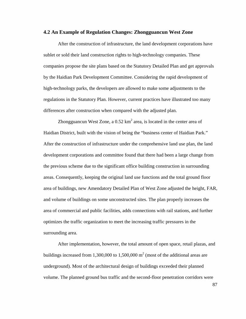
87
4.2 An Example of Regulation Changes: Zhongguancun West Zone
After the construction of infrastructure, the land development corporations have
sublet or sold their land construction rights to high-technology companies. These
companies propose the site plans based on the Statutory Detailed Plan and get approvals
by the Haidian Park Development Committee. Considering the rapid development of
high-technology parks, the developers are allowed to make some adjustments to the
regulations in the Statutory Plan. However, current practices have illustrated too many
differences after construction when compared with the adjusted plan.
Zhongguancun West Zone, a 0.52 km2 area, is located in the center area of
Haidian District, built with the vision of being the “business center of Haidian Park.”
After the construction of infrastructure under the comprehensive land use plan, the land
development corporations and committee found that there had been a large change from
the previous scheme due to the significant office building construction in surrounding
areas. Consequently, keeping the original land use functions and the total ground floor
area of buildings, new Amendatory Detailed Plan of West Zone adjusted the height, FAR,
and volume of buildings on some unconstructed sites. The plan properly increases the
area of commercial and public facilities, adds connections with rail stations, and further
optimizes the traffic organization to meet the increasing traffic pressures in the
surrounding area.
After implementation, however, the total amount of open space, retail plazas, and
buildings increased from 1,300,000 to 1,500,000 m2 (most of the additional areas are
underground). Most of the architectural design of buildings exceeded their planned
volume. The planned ground bus traffic and the second-floor penetration corridors were

88
not implemented, and the traffic congestion still remains a huge problem. Some
infrastructure facilities, such as cooling towers, have been arranged in the center area of
green space. Those gaps in the proposed schemes and transportation setbacks delayed the
process of attracting investments and companies to some extent.
Several factors resulted in these disregarded practices. While various scholars and
planning institutes participated in the process of planning, design, and adjustment, there
is a lack of investigation of clients, public participation, research on behaviors of use, and
features of high-tech enterprises. Hence, there are still significant changes that need to be
made in later constructions. Another reason is that the plan lacks a control index that can
be easily followed during implementation rather than FAR, green space ratio, and height.
However, there is no guideline as to what forms of green spaces can and should adopt, or
where the infrastructure facilities should be located. Thus, it is difficult to maintain the
consistency of the development mission through a variety of plans that have been
proposed and implemented by different sectors.
4.3 Changes in Land Functions
The change of land function is critical in development process. In actual
development, many developers changed the land functions after acquiring the right to
land construction. While at the beginning, a large part of land in ZGC was assigned as
industrial use land, most of the developers change the previous industrial land into
commercial or residential uses in later development to increase profit. These behaviors
put the development and construction of many places in Haidian Park into disorder, and
derailed the land use plans.
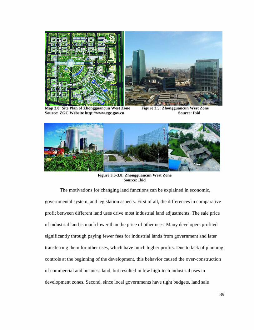
89
Map 3.8: Site Plan of Zhongguancun West Zone Figure 3.5: Zhongguancun West Zone Source: ZGC Website http://www.zgc.gov.cn Source: Ibid
Figure 3.6-3.8: Zhongguancun West Zone Source: Ibid
The motivations for changing land functions can be explained in economic,
governmental system, and legislation aspects. First of all, the differences in comparative
profit between different land uses drive most industrial land adjustments. The sale price
of industrial land is much lower than the price of other uses. Many developers profited
significantly through paying fewer fees for industrial lands from government and later
transferring them for other uses, which have much higher profits. Due to lack of planning
controls at the beginning of the development, this behavior caused the over-construction
of commercial and business land, but resulted in few high-tech industrial uses in
development zones. Second, since local governments have tight budgets, land sale
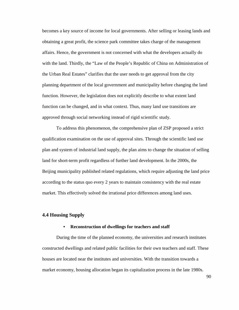
90
becomes a key source of income for local governments. After selling or leasing lands and
obtaining a great profit, the science park committee takes charge of the management
affairs. Hence, the government is not concerned with what the developers actually do
with the land. Thirdly, the “Law of the People’s Republic of China on Administration of
the Urban Real Estates” clarifies that the user needs to get approval from the city
planning department of the local government and municipality before changing the land
function. However, the legislation does not explicitly describe to what extent land
function can be changed, and in what context. Thus, many land use transitions are
approved through social networking instead of rigid scientific study.
To address this phenomenon, the comprehensive plan of ZSP proposed a strict
qualification examination on the use of approval sites. Through the scientific land use
plan and system of industrial land supply, the plan aims to change the situation of selling
land for short-term profit regardless of further land development. In the 2000s, the
Beijing municipality published related regulations, which require adjusting the land price
according to the status quo every 2 years to maintain consistency with the real estate
market. This effectively solved the irrational price differences among land uses.
4.4 Housing Supply
• Reconstruction of dwellings for teachers and staff
During the time of the planned economy, the universities and research institutes
constructed dwellings and related public facilities for their own teachers and staff. These
houses are located near the institutes and universities. With the transition towards a
market economy, housing allocation began its capitalization process in the late 1980s.

91
However, the residents in the university-provided housings only have the living and
utilization rights of the housing without housing property, and cannot sell the residences
personally. The expansion of educational institutes largely increased the housing demand
in university staff; while on the other hand, in order to avoid speculation of housing real
estate, national strategies have paused the construction of housing in the Zhongguancun
area and have stopped approving housing projects in Center Area since 2000. Thus, many
research institutes have had to reconstruct old buildings and develop new housing in
places far from the urban area in Haidian Park.
The rapid growth of land price is another factor that drives the universities and
research institutes to appoint real estate developers to develop the land for commercial
and business uses, and compensate their residents or move them to constructed houses in
the suburban area. Take the reconstruction of Zhongguancun Red House as an example.
It is the first reconstruction project in Haidian Park undertaken by Chinese Academy of
Science. These old dormitories, constructed in the 1950s, are low quality buildings, but
have complete infrastructure and livable environments. At the beginning of the process,
the reconstruction was accepted by the research faculties and staff. As the project
continued, however, the residents began to reject the requirement of displacement.23 Most
of the opponents are not satisfied with the compensation, and do not want to move to
suburban areas, which are in poorly developed and inconvenient environments. While
they have argued the compensation price is much lower than the land value before it was
transformed into commercial and business uses, there was no legal land price assessment
system at that time.
92
An underlying factor making the reconstruction of old houses difficult is that
some institutes and their residents sold their houses and use rights to other public citizens.
These people cannot obtain relative compensation or replaced houses during the
reconstruction process because they are neither teachers nor retired staff. For example, by
the end of 1999, over 3,000 apartments in Peking University had been sold, accounting
for 81% of the university’s housing. Consequently, the residents of the dwellings vary
considerably: some are original teachers and staff, some are public employees, and others
are retired staffs who view the apartment as a social benefit from the universities. This
diversity has enhanced the level of difficulty of the reconstruction process.
At last, the Zhongguancun Red House project took eight years to finish, and the
removing and replacing process was not completed until 2009, which is much longer than
the expected schedule. During this period, the CAS has constructed some apartments as
well as associated facilities in the suburban area to replace some of the residents. A
majority of original residents have now moved back to Red House after paying a
negotiable price under a formed land price assessment system.
Nevertheless, the conflicts between original residents and developers are
unavoidable if the systematic regulations on transferring and developing residential land
are still lacking. The rising value of housing real estate in the Zhongguancun area entirely
changed the original land price system. From the perspective of development entities and
universities, the reconstruction project does not merely aim to extend development space,
but to change the residential land for other high-value land uses. For the residents, the old
houses become an effective tool for gathering profits by selling them at higher values. It
93
is necessary to establish a legal system to regulation this process and to achieve
consistency between two sides.
• Students and Employees
The lack of student dormitories is another urgent problem in Zhongguancun. In
addition to the increased universities and the expansion of existing ones, many private
schools and training centers are rapidly being concentrated in Zhongguancun, resulting in
a severe shortage of student dormitories. Thus, many private development entities have
begun to hastily construct student apartments. However, neither the Comprehensive Plan
in Beijing 2004-2020 nor the Comprehensive Plan of Haidian Park in ZGC has plans on
the scale of educational land development. The disordered construction without planning
brought huge pressure to the environment in Zhongguancun.
Moreover, the graduates, employees, and some traders significantly dominate the
rent housing market in Zhongguancun. Distinct from average people, they have similar
characteristics: seeking to rent housing nearby work or study places; having low incomes
and thus not able to afford the high price of houses; frequently commuting with public
traffic. The rentable apartments and student dormitories compose their living places.
Thus, many graduates and employees have to seek proper places to live with
affordable prices. The low income class has to live in the fringe villages at the north side
of the suburban area. Despite a high-level education, they have to experience hard lives in
the same way that farmers do. The county of Tangjialing is such a typical place. The
villagers continue developing in crowded spaces to profit from rent. During rush hour,
hundreds of commuters are squashed together in transit buses just like sardines in a tin.
The so-called “Ant Tribe” group has become a rigorous social problem in Haidian Park.
94
Tangjialing Village is one of these examples. Located to the north of Beijing Haidian
Park, this small-scale village originally had 3,000 residents and it was a place where
people could complete walking around in less than one hour. Currently, it has over
50,000 migrants, most of which are students and workers in Haidian Park. The houses
vary greatly in size, from small rooms of a few square meters to large rooms over 10 m2.
The environment is in extremely bad quality.
5. Lessons
5.1 Interaction between the City and the High-Technology Park
The planning and design of Zhongguancun Science Park is closely related to the
entire development plan of Beijing city in terms of site selection, impacts of plans, and
land use distribution. Zhongguancun Science Park is not merely a single project, but a
key element in developing the entire city. Located in urban areas, Haidian Park gained
rapid development with an abundance of supportive factors, such as well-planned urban
development strategies, concentrated intellectual resources, plenty of labor resources, and
complete infrastructure. In turn, the rapid economic growth of Haidian Park has led this
northwest cultural area to become one of the most important areas in Beijing.
There is an active and effective relationship between Haidian Park and the
development of policy for the entire city of Beijing. It is the “Electronic Street’s” bottom-
up development that first demonstrated the prominent power of the science and
technology enterprises’ agglomeration, which then gained the government’s support to
develop the Zhongguancun area as the city’s high-tech industrial center On the other
95
hand, a successful science park is not and cannot be a “stand alone” venture. It is
intimately connected to and involved in the implementation of national and regional
innovation policies. Without a comprehensive plan and government guidance, it would be
hard for the previous electronic street to transform into today’s top high-tech industrial
zone.
The amendment of city planning has effectively guided the development of ZGC
through land assignment, improved infrastructure and transportation, increased building
construction, and enhanced public facilities. According to the over-rapid urban
development rate, however, to some extent, the planning still lacks well-implemented and
up-to-date measures. As such, this has left plenty of areas for improvement. For instance,
Haidian Park lacks an effective organization to deal with needs like housing for students
and workers. Furthermore, while multiple roadways and light rail lines have been
constructed to connect Haidian Park with other districts in Beijing, the traffic congestion
within the park requires additional time to be solved.
5.2 Changes in Natural Resources and the Cultural Environment
In addition to the business and high-technology industries, the cultural
environment is a key feature of Zhongguancun Science Park. The cultural environment of
ZGC contains not only the royal gardens and places of historical interest, but also the
university culture and business commercial lifestyle.
Many research institutes and universities have developed surrounding vacant or
low efficiency land into University Science Parks. The construction of Tsinghua
University Park reused the land with original disorganized construction, and brought
96
business activities and high-quality environments. Peking University Software Park
appeals to high-technology companies not only due to its safety, complete infrastructure,
and convenient physical environment, but also because it is a cultural place with various
exhibitions, studios, museums, and famous bookstores. The cultural and commercial real
estate development has shown an organic combination of university culture and business,
and has attracted a large number of students and employees.
However, the development of Haidian Park has threatened the natural
environment. The increased high-rises broke the skyline of some royal gardens; the
irrational road and traffic design divided the landscape into separate parcels without
internal connections; the expansion of the urban area replaced the original natural
resources surrounding Summer Palace, such as rivers, water systems, and paddies. It is
necessary to propose building guidelines and environmental regulations to control the
construction behaviors.
5.3 Legislation and Regulation for Approval
Planning control and environmental construction are in need of regulation and
relative legislations. Thus, Zhongguancun Science Park has been at the forefront of the
national HIDZs in the legislation of management. Beijing municipality promulgated
"Regulations of the Zhongguancun Science Park" in 2001, which has provided the legal
basis and guidelines for the future development and activities of high-technology
enterprises. The park is now moving at a vigorous pace to promote technological
innovation in accordance with the principle of "Bold innovation in the areas shall not be
banned by the law.”24 This is the first legal regulation for science and technology parks in
97
China. Rather than a pure administrative legislation, the “Regulations of the ZGC” are
more like comprehensive ordinances involving the economy, science and technology,
education, and administration.25
Research shows that up until now, the large enterprises have tended to prefer the
innovative environment of the district rather than specific support strategies.26 With
regard to planning management, the innovative environment includes the convenient
approval process of projects, complete construction of infrastructure, public service,
cultural atmosphere, and physical environment.
Consequently, the planning committee has intensified the approval of planning
and construction. The Zhongguancun Management Committee and Haidian Park
Development Committee have decentralized their power of approval on some planning,
design, and construction activities to the local related departments. In the past, many
applications initially had to obtain approval in the district government, and then apply
further to the municipal department. The “Regulations of the ZGC” streamlined the
application process in aspects of housing construction project reports, construction
permits, planning approvals, evaluations on constructed projects, and reviewing fire and
security, among others. For instance, the application for a construction permit was
reduced from an original processing time of 250 business days to 84 days. The main
approval aspects in initial land development have reduced from 49 to 20.
To sum up, during the development process, the Zhongguancun Science Park
Development Committee also faced a series of challenges involving the support of high-
technology development, addressing residential and commuting issues, avoiding traffic

98
congestion in this mixed-use urban area, and controlling expansion toward suburban
areas. For instance, the development of science parks and high-technology enterprises has
resulted in increasingly high land prices, thus attracting many real estate developers but
limiting smaller high-technology firms. The construction of business buildings has
brought additional traffic volume to this district as well. Moreover, a majority of
employees have to choose long-distance commuting rather than residing in this area.
Many institutes also transfer their residential lands into commercial use for more profit,
causing the original residents to be displaced.
The ZGC Committee implements a series of planning strategies to address these
problems, involving endorsing regulations to limit non-high technology real estate
development, management and organization, establishing a land use development system,
and improving public-transit and road construction. As a pioneer of national HIDZ,
ZGC’s experiences with approaches to planning have been adopted by many other HIDZs
with similar characteristics and, more importantly, provide lessons for further practices.
1 Beijing High-Technology Industrial Development Plan 2001-2006. 2 Beijing Zhongguancun Science Park Development Record 1980-2009. (2010) 3 National Bureau of Statistics of China, ed, China High-Technology Industry Development Yearbook 2008 (2009). 4 Beijing Haidian Park Development Yearbook. 2009. 5 From 1966 to 1976 there was a comprehensive reform movement in China initiated by Mao Zedong in 1965 to eliminate counterrevolutionary elements in the country's institutions and leadership. It was characterized by political zealotry, purges of intellectuals, and social and economic chaos. This movement caused city planning to suspend execution, and the construction of Northwest Area to bog down during this period. 6 “Development Record 1980-2009”, 91. the head of the committee was Mayor Jiao, Ruoyu. 7 Ibid, 91. the group includes Tsinghua University, Peking University, CAS, CSE, etc.

99
8 Ibid, 363. 9 Ibid, 2. 10 Ibid, 408. 11 Ibid, 679. 12 Ibid, 91. In 2009, Zhao, Fengtong, the president of standing committee of Beijing municipal was arranged to be the party leader of Haidian District and the party leader of Zhongguancun Science Park Development Committee. 13 Beijing Haidian Park Development Yearbook, 2002, 718 14 “Development Record 1980-2009”, the other three research institutes are Chinese Academy of Agriculture, Beijing Institute of Technology, and the fifth institute of China Aerospace Corporation. 15 Regulations of Zhongguancun Science Park. 2001. 16 Beijing Haidian Park Development Yearbook, 2006. 17 Dushiguangyu Co. Ltd. ed. Report of Zhongguancun Science Park Real Estate Market, 2008-2010. 18 Ibid. 19 Ibid. In this report, in 2009, the average vacancy rate of 5-A office buildings in Beijing is 13.4%, and 3.8% in CBD. 20 Ibid. The average rent price of 5-A office buildings is $25/sf per year in 2009. 21 Zhongguancun Online, “Interview of Zhidong Wang”, (2001), http://news.zol.com.cn. 22 Beijing Youth Daily, April 13, 2010. 23 “Development Record 1980-2009”. 24 “Regulations of Zhongguancun Science Park.” 2001. 25 Jun Chen and Bin Fan, "Highlights in Regulation of Zhongguancun Science Park." Beijing's View (2001). 26 Tihua Jing and Zihzong Liu, "From Development Zone to a New Town: Beijing Zhongguancun Science Park." Beijing Planning View 1 (2006).
100
CHAPTER 4: SHANGHAI ZHANGJIANG HIGH-TECHNOLOGY
PARK
1. An Overview
Shanghai Zhangjiang High-Technology Park (ZJ) represents a Type 2 national
High-Tech Industrial Zone (HIDZ), integrated into urban areas and developed into a
single high-technology research and development (R&D) zone. Zhangjiang, located in
the middle of Pudong New Area, has a planned area of 25 km2 and sits 9 km away from
the Lujiazui Financial Trade Zone around Century Park, which includes several key state-
level industrial bases, such as Pudong Software Park, Integrated Circuits (IC) Industrial
Park, and Biomedical Industrial Base. High-technology development accounts for over
60 percent of the land use. With 125,600 workers, Zhangjiang High-Technology Park
produced ¥42.14 billon GDP in 2008, accounting for over 50 percent of the entire GDP
of Shanghai National HIDZ.
Governmental support in introducing investment and funding resources has
contributed importantly to Zhangjiang’s success. Founded in 1992, Zhangjiang High-
Tech Park did not see development until August 1999, when the Shanghai Municipal
Committee and Municipal Government created a new strategy, “Focus on Zhangjiang,”
and identified the IC industry, software industry, and biomedicine as the foremost
industries of the Park which would play a leading role in innovation.
ZJ Park, together with five other high-tech parks, comprises the national HIDZ in
Shanghai, renamed “Shanghai Zhangjiang HIDZ” in 2006 (also called “Big Zhangjiang”).
The five parks include: Caohejing New Technology Development District, Shanghai
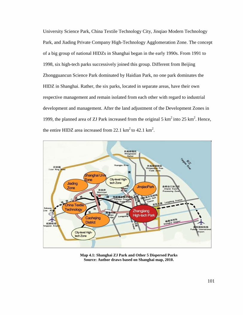
101
University Science Park, China Textile Technology City, Jinqiao Modern Technology
Park, and Jiading Private Company High-Technology Agglomeration Zone. The concept
of a big group of national HIDZs in Shanghai began in the early 1990s. From 1991 to
1998, six high-tech parks successively joined this group. Different from Beijing
Zhongguancun Science Park dominated by Haidian Park, no one park dominates the
HIDZ in Shanghai. Rather, the six parks, located in separate areas, have their own
respective management and remain isolated from each other with regard to industrial
development and management. After the land adjustment of the Development Zones in
1999, the planned area of ZJ Park increased from the original 5 km2 into 25 km2. Hence,
the entire HIDZ area increased from 22.1 km2 to 42.1 km2.
Map 4.1: Shanghai ZJ Park and Other 5 Dispersed Parks Source: Author draws based on Shanghai map, 2010.

102
While located within Pudong Area, the area included only the original Zhangjiang
town and a few villages during the early stages of the Zhangjiang High-Technology Park.
A small town, Zhangjiang did not afford enough infrastructure and road support for the
new development; hence, new construction makes up most of ZJ Park’s industrial uses.
Moreover, since the Pudong Area experienced a short development period, few research
and educational resources existed in this district. However, ZJ Park tailored a series of
strategies to overcome these deficiencies and enhanced the development intensity of
high-technology industries as an R&D- oriented park. With extension, ZJ Park also
developed many associated functions to address housing and living issues of workers,
providing useful experience for other similar HIDZs.
2. Historical Evolution
While Zhangjiang High-Technology Park belongs to the “Big Zhangjiang,” the
six dispersed parks have had isolated development and serve each district, respectively.
Thus, compared with the evolution of the entire Shanghai national HIDZ, Pudong New
Area, the location of ZJ Park, has had a more significant impact in Zhangjiang’s
development.
2.1 Development of Pudong New Area
The triangular Pudong Area sits to the east of the old city of Shanghai, across the
Huangpu River. In the first half of 20th century, while Shanghai ruled as an international
metropolis, the Pudong Area formed a vast farmland and brown field area of warehouses
filled with oilcans. In the early 20th century, two plans arose for, the “East Harbor Plan”
and the “Big Shanghai Plan.” Taking lessons from Washington, D.C., and Chicago, the
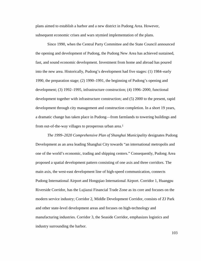
103
plans aimed to establish a harbor and a new district in Pudong Area. However,
subsequent economic crises and wars stymied implementation of the plans.
Since 1990, when the Central Party Committee and the State Council announced
the opening and development of Pudong, the Pudong New Area has achieved sustained,
fast, and sound economic development. Investment from home and abroad has poured
into the new area. Historically, Pudong’s development had five stages: (1) 1984–early
1990, the preparation stage; (2) 1990–1991, the beginning of Pudong’s opening and
development; (3) 1992–1995, infrastructure construction; (4) 1996–2000, functional
development together with infrastructure construction; and (5) 2000 to the present, rapid
development through city management and construction completion. In a short 19 years,
a dramatic change has taken place in Pudong—from farmlands to towering buildings and
from out-of-the-way villages to prosperous urban area.1
The 1999–2020 Comprehensive Plan of Shanghai Municipality designates Pudong
Development as an area leading Shanghai City towards “an international metropolis and
one of the world’s economic, trading and shipping centers.” Consequently, Pudong Area
proposed a spatial development pattern consisting of one axis and three corridors. The
main axis, the west-east development line of high-speed communication, connects
Pudong International Airport and Hongqiao International Airport. Corridor 1, Huangpu
Riverside Corridor, has the Lujiazui Financial Trade Zone as its core and focuses on the
modern service industry; Corridor 2, Middle Development Corridor, consists of ZJ Park
and other state-level development areas and focuses on high-technology and
manufacturing industries. Corridor 3, the Seaside Corridor, emphasizes logistics and
industry surrounding the harbor.

104
Map 4.2: One Axis, Three Corridors in Pudong Area Source: 1999–2020 Comprehensive Plan of Shanghai Municipality
Under this spatial pattern, four state-level development areas exist, including
Lujiazui Financial Trade Zone, Zhangjiang Hi-tech Park Zone, Jinqiao Export Processing
Zone, and Waigaoqiao Bonded Zone. Each development district has its own distinct
functional concerns. Lujiazui Financial Trade Zone, designated as the new financial hub
of modern China, sits at the western tip of the Pudong district. ZJ Park focuses on
development of the IC industry, the software industry, and biomedicine. Jinqiao Export
Processing Zone is the center of modern manufacturing, and Waigaoqiao Bonded Zone,
the harbor area, involves imports and exports. In 2004, with two newly added zones—
Sanlin Area for the 2010 World Expo and Chuansha New Town, the Pudong Area grew
to include six main functional areas.
The development of ZJ Park largely relies on the Pudong New Area that provides
economic bases and functional support to ZJ and guarantees that ZJ pursues high-
technology industries. Lujiazui Financial Trade Zone represents the direct financial
source for ZJ Park. As Shanghai’s new commercial and business center, it has also
introduced other enterprises into the Pudong Area and spread the word about Zhangjiang.

105
Waigaoqiao Bonded Zone and Jinqiao Export Processing Zone serve as manufacturing
and foreign trade service centers for Zhangjiang High-Technology Park. The original
Zhangjiang Town provides the residential area for Zhangjiang’s workers.
2.2 Development of Zhangjiang High-Technology Park
• First Seven Years (1992–1999)
In its first seven years, from 1992 to 1999, ZJ Park experienced very slow
development. In 1992, ZJ Park Development Company was established, indicating the
beginning of ZJ Park. After the State Council approved ZJ Park as part of a national
HIDZ, the Pudong New Area government proposed two years for construction of
infrastructure for ZJ Park. However, due to lack of motivation, ZJ remained a farmland
two years later.
Table 4.1: Events of Shanghai ZJ Park from 1992 to 1999
1992.7.28 Zhangijang High-tech Park Development Company was established
1993.12.30 First Highway: Longdong Avenue opened to traffic
1994.5.16 First foreign funded venture: Roche China entered Zhangjiang
1995.1.10 The first incubator base was established
1996.8 The first state –level industrial base: State Biotech and Pharmaceutical Industrial Base in Shanghai was established
1997.9.14 Pudong Software Park started
1998.10.29 The first state-level research center: chinese National Human Genome Center at Shanghai was established
1999.8.26 The strategy of “Focus on Zhangjiang” was announced
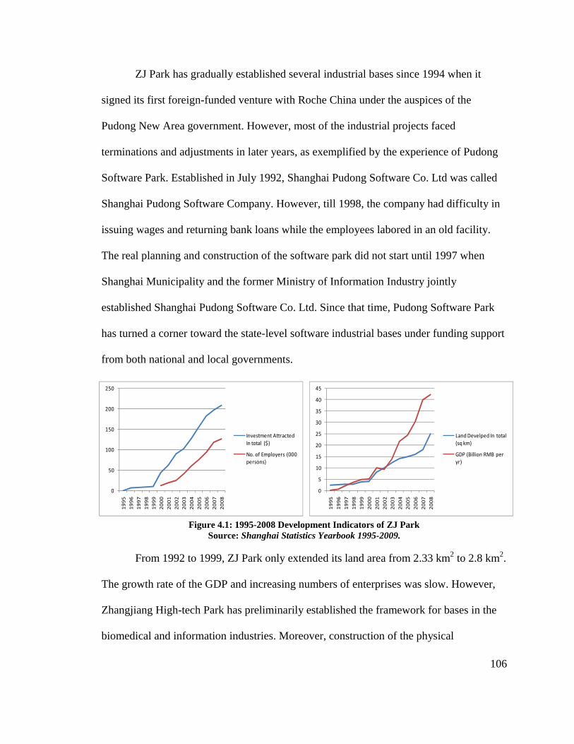
106
ZJ Park has gradually established several industrial bases since 1994 when it
signed its first foreign-funded venture with Roche China under the auspices of the
Pudong New Area government. However, most of the industrial projects faced
terminations and adjustments in later years, as exemplified by the experience of Pudong
Software Park. Established in July 1992, Shanghai Pudong Software Co. Ltd was called
Shanghai Pudong Software Company. However, till 1998, the company had difficulty in
issuing wages and returning bank loans while the employees labored in an old facility.
The real planning and construction of the software park did not start until 1997 when
Shanghai Municipality and the former Ministry of Information Industry jointly
established Shanghai Pudong Software Co. Ltd. Since that time, Pudong Software Park
has turned a corner toward the state-level software industrial bases under funding support
from both national and local governments.
Figure 4.1: 1995-2008 Development Indicators of ZJ Park Source: Shanghai Statistics Yearbook 1995-2009.
From 1992 to 1999, ZJ Park only extended its land area from 2.33 km2 to 2.8 km2.
The growth rate of the GDP and increasing numbers of enterprises was slow. However,
Zhangjiang High-tech Park has preliminarily established the framework for bases in the
biomedical and information industries. Moreover, construction of the physical
0
5
10
15
20
25
30
35
40
45
1995
1996
1997
1998
1999
2000
2001
2002
2003
2004
2005
2006
2007
2008
Land Develped In total (sq km)
GDP (Billion RMB per yr)
0
50
100
150
200
250
1995
1996
1997
1998
1999
2000
2001
2002
2003
2004
2005
2006
2007
2008
Investment Attracted In total ($)
No. of Employers (000 persons)

107
environment formed a solid base for further development. By 1998, ZJ Park had
completed the landscape construction of two boulevards and established green parking
and several public places.
• “Focus on Zhangjiang” Strategy
The improvement of Zhangjiang’s development occurred in 1999, a year that also
marked the tenth year of Pudong New Area’s development. With the remarkable
achievement of Pudong, officials began to consider where to concentrate their efforts for
the next ten years. Since ZJ’s development lagged far behind the other development
zones in Pudong, the Shanghai Municipal Committee and Municipal Government
decided to gather more resources to promote the development of Zhangjiang High-tech
Park. As Renjie Qian, former secretary of the Party Committee of Zhangjiang
Development Area in Shanghai and former president of Shanghai Zhangjiang ZJ Park
Development Co. Ltd, stated, “Because Pudong Development is an important national
policy, as a center area of Pudong Area, the decision to develop Zhangjiang High-
Technology Park is a key strategy under state governmental guidance.”2 As mentioned
earlier, in 1999 the Shanghai Municipal Committee and Municipal Government
announced the strategy, “Focus on Zhangjiang,” and identified IC and software industries
as well as biomedicine as leading industries of the Park that would play a leading role in
innovation.
The motivation for Zhangjiang differs from either Silicon Valley or even
Beijing’s Zhongguancun Science Park. Silicon Valley arose organically with various
enterprises. Zhongguancun Science Park had many scientists gathered together to create
an innovation environment at first, and then attracted the attention of the government.

108
Zhangjiang, however, was a product of systematic governmental. The “Focus on
Zhangjiang” strategy expresses the top-down support from the state government. The
strategy explicitly required ZJ Park to concentrate on high-technology industries for
economic effects of agglomeration to leave flexible space for further development.
With the intellectual resources and investments provided by the government, ZJ
Park has achieved rapid development. For example, many key state-level industrial bases
subsequently entered ZJ Park, such as State Biotech and Pharmaceutical Industrial Base,
National Information Industry Base, National IC Industry Base, and State Software
Industrial Base. Zhangjiang has many incubators and pioneer parks created for overseas
graduates to start their companies.. The first phase and second phase of Pudong Software
Park came about in 2000 and 2002, respectively, in a land area of 120,000 m2. By 2007,
750 enterprises had taken root in this park, including over 200 companies focused on the
software industries involving financing, telecommunications, and information security.
From 2000 to 2005, the increased industrial lands of ZJ Park attracted foreign
investments at the rate of 1.5 billion dollars per km2.3 In the year 2004, personal income
in the park achieved 69,000 dollars. The two indicators had achieved the same level as
Taiwan Hsinchu Science Park by 1999. In 2008, Zhangjiang had 125,600 employees. The
GDP of ZJ Park was ¥42.14 billion, with total business income of ¥83.97 billion.
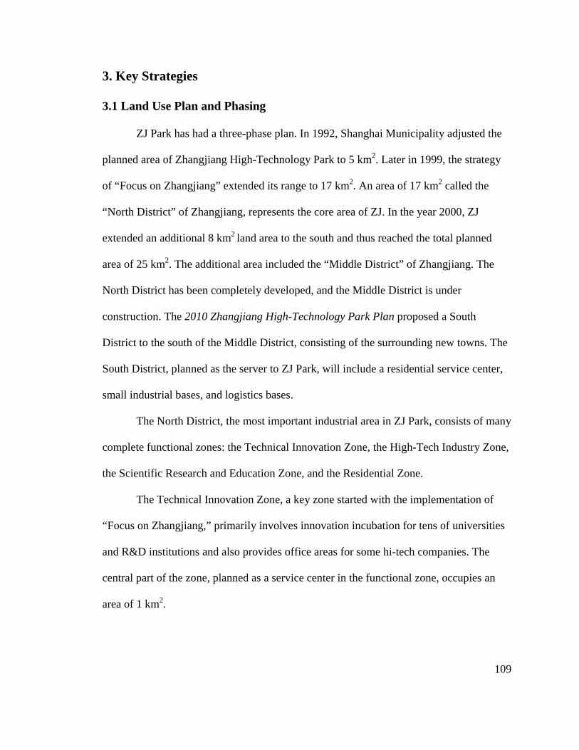
109
3. Key Strategies
3.1 Land Use Plan and Phasing
ZJ Park has had a three-phase plan. In 1992, Shanghai Municipality adjusted the
planned area of Zhangjiang High-Technology Park to 5 km2. Later in 1999, the strategy
of “Focus on Zhangjiang” extended its range to 17 km2. An area of 17 km2 called the
“North District” of Zhangjiang, represents the core area of ZJ. In the year 2000, ZJ
extended an additional 8 km2 land area to the south and thus reached the total planned
area of 25 km2. The additional area included the “Middle District” of Zhangjiang. The
North District has been completely developed, and the Middle District is under
construction. The 2010 Zhangjiang High-Technology Park Plan proposed a South
District to the south of the Middle District, consisting of the surrounding new towns. The
South District, planned as the server to ZJ Park, will include a residential service center,
small industrial bases, and logistics bases.
The North District, the most important industrial area in ZJ Park, consists of many
complete functional zones: the Technical Innovation Zone, the High-Tech Industry Zone,
the Scientific Research and Education Zone, and the Residential Zone.
The Technical Innovation Zone, a key zone started with the implementation of
“Focus on Zhangjiang,” primarily involves innovation incubation for tens of universities
and R&D institutions and also provides office areas for some hi-tech companies. The
central part of the zone, planned as a service center in the functional zone, occupies an
area of 1 km2.

110
Map 4.3: Three Phased Districts of ZJ Park Source: ZJ Park Website http://www.zjpark.com
Map 4.4: Land Distribution of ZJ Park (North District) Source: Ibid.
111
The Hi-tech Industry Zone comprises two phases of the Biomedicine Industry
Zones and two phases of the IC Industry Zone. Biomedicine Industry Zone (Phase 1) sits
to the south of Longdong Avenue, to the west of Jinke Road, to the north of Zuchongzhi
Road, and to the east of Keyuan Road, occupying an area of 1.5km2. The Biomedicine
Industry Zone (Phase 2) is adjacent to the arterial Gaoke Road, with a total area of
1.5km2. The five roads in the Park give it a checkered pattern and connect it with the
arterial Gaoke Road, Jinxie Road, and Zhangheng Road, thus forming a convenient
roadway system. The IC Industry Zone (Phase 1) is to the south of Longdong Avenue, to
the east of Jinke Road, to the north of Zuchongzhi Road, and to the west of Zhangjiang
Road, occupying an area of 1.5km2. The IC Industry Zone (Phase 2) is about 2.74km2
with Subway Line No. 2 going through it. The Park will be divided by three traverse
arteries from east to west and one vertical artery from south to north.
The Scientific Research and Education Zone takes advantage of the national light
source project and attracts more scientific research institutions and postgraduate schools
of science and engineering universities and colleges. In addition, the Scientific Research
and Education Zone has a residential service zone to the north, which provides necessary
residential services to researchers, professors, and students.
The Residential service center, located alongside Jinke Road, at the intersection of
Zuchongzhi Road and Subway Line No. 2, offers an independent residential area with
infrastructure. The Residential Zone also includes the Residential Zone (Phase 1 and 2)
and two migration bases at the Park. This zone was developed based on the original
Zhangjiang Town, a relatively lower-quality environment. The town’s limited housing
cannot provide for the residential demands of the over 125,600 workers in ZJ. Thus,

many employees commute to surrounding
also proposes the South District to solve the residential needs.
3.2 Land Developmen
Two entities directly lead ZJ
Committee, appointed by both Shanghai
Development Committee, taking charge of
governments; another is ZJ
semi-public company in charge of land development and construction of infrastructures.
The ZJ Park Development Company
with tight initial capital. With the
Company faced a transformation from
developer.
many employees commute to surrounding residential
also proposes the South District to solve the residential needs.
3.2 Land Development
Two entities directly lead ZJ’s development affairs. One is
Committee, appointed by both Shanghai municipality government and Pudong Area
Development Committee, taking charge of delivering policies and strategies of upper
governments; another is ZJ Park Development Company
public company in charge of land development and construction of infrastructures.
The ZJ Park Development Company played an important role in initial land development
with tight initial capital. With the maturity of ZJ
faced a transformation from governmental
developer.
Figure 4.2: Land Development Organization of Shanghai
residential areas in Pudong. The 2010 Plan
also proposes the South District to solve the residential needs.
s development affairs. One is ZJ Park Development
municipality government and Pudong Area
delivering policies and strategies of upper
Development Company, which was established as a
public company in charge of land development and construction of infrastructures.
played an important role in initial land development
of ZJ’s development, ZJ Park Development
governmental agent to private real estate
Figure 4.2: Land Development Organization of Shanghai ZJ Park
112
2010 Plan
Development
municipality government and Pudong Area
delivering policies and strategies of upper
, which was established as a
public company in charge of land development and construction of infrastructures.
played an important role in initial land development
s development, ZJ Park Development
agent to private real estate
113
• Initial Land Development Agreement
In 1992, the government’s financial condition could not allow for the construction
of ZJ Park. The entire income of the Pudong Area Committee was only ¥1.2 million with
no extra capital to invest in infrastructure. Thus, the government transferred the burden of
infrastructure investment to the ZJ Park Development Company in a creative way.
Shanghai Land Management Bureau and ZJ Park Company signed the Zhangjiang High-
Technology Park Development Company Regulations and Agreement of Transferring
Land Use Right of ZJ Park in 1992. As interpreted in the agreement, Shanghai Municipal
Finance Department assessed the cost of land rights transfer at ¥0.25 billion. The Pudong
Area Committee paid this amount of capital to ZJ Park Company with a check as a
governmental sponsor. Meanwhile, the Company bought the land use rights from the
municipal government at the same amount of capital with the check. Thus, the
development company gained the land use rights at zero cost, and the government
successfully transferred the task of infrastructure construction to the development
company.
This development by zero-capital rollover highlights a particular Chinese
approach to high-technology parks: the government lacks the initial capital for
construction but has great power in controlling land use rights. Through this approach,
the government legally transfers the development responsibility to the development
company. As some scholars said,4 “In Chinese High-Tech Park development… it is a
typical phenomenon that the government appoints the development company to take the

114
responsibility of both costs and benefits. The land development process has become a
production procedure of commodity.”
• Transformation of the Development Company
At the beginning of development in ZJ Park, both the ZJ committee and the
development company had the same mission—to carry out land development and
construction on behalf of the Shanghai municipality government and Pudong Area
government. With the completion of infrastructure and distribution of land parcel by
parcel, however, the development company began to seek new ways to achieve economic
benefits rather than simply relying on land leasing. On the other hand, the specific
identity of ZJ Development Company as a governmental agency has led it to include real
estate services and public facilities into its operations.
The operations of real estate largely depend on user demands. Currently, the high-
technology enterprises in ZJ Park involve three types: IC industrial companies,
biomedical research and production manufacturing, and software companies. Distinct
from the traditional industrial companies, these high-tech enterprises have several
specific characteristics: (1) most of them experience rapid growth with large quantities;
(2) the larger enterprises have multiple ways of financial support from international
investment, governmental support, and domestic capital infusion; (3) they have strong
profitability with Net Profit Margin around 20–30 percent; and (5) more and more
international companies have located their headquarters in ZJ Park, such as GE, Dupont,
and IBM.5 In general, these clients need increasingly large-scale facilities, especially for
high-technology research and development to support the entire industrial chain, with
fewer concerns about price issues.

115
Consequently, ZJ Development Company has mainly transferred its operation
tasks to two fields: (1) the real estate property developed for high-technology enterprises,
and (2) public facilities as well as high-end real estate services. In terms of real estate
property, ZJ Company provides the enterprises a series of tailored properties, such as
headquarters, research and development centers, training and educational bases, and
industrial incubators. Given the amount of time construction would take for all these
properties, ZJ Company purchased over 130,000 m2 of rentable properties in 2006. Since
then, the rental rate of real estate property of the ZJ Company has been at 95 percent,
becoming a strong capital source for the company’s development and other operations.
Moreover, hotels offered another new field for ZJ Park Development Company.
Regarding high-technology and business enterprises as its major clients, the ZJ
Development Company provides high-end hotel facilities and services and has achieved
an almost 100 percent occupancy rate at their business hotels.
Under the guidance of the government, ZJ Development Company also provides
specific services for medium to small high-tech enterprises. These companies just
beginning their development often find themselves in an unstable status, requiring
financial investment as well as facilities support. Thus, in addition to the Pudong Area
government’s providing funding support and bringing in board funding for them, ZJ
Development Company provides a series of services involving consulting, industrial
value assessment, development report, and stockholder investments.

116
3.3 Government Management
When the land development companies transitioned to real estate-based
operations, the roles of the government and committees changed as well during the
development process of ZJ Park. The major responsibilities of Zhangjiang High-
Technology Industrial Park Committees have changed from originally representing
preferential policies, to construction, planning management, and granting approvals.
First, the Pudong Area government enacted a series of legislation and preferential
strategies to attract more funding and research institutes and to regulate the planning,
management, and construction of ZJ Park. In 2001, Shanghai Municipality issued the
Several Provisions of Shanghai Municipality Promoting the Development of Zhangjiang
High Technology Park. The Provisions encourage foreign institutions to set up venture
capital enterprises in the Park.6 Qualified applicants are entitled to streamlined
procedures for incorporation in the Park.7 Multiple-exit permits are made available to the
personnel of the enterprises in the Park under the simplified application procedures for
overseas business travel.8 The Provisions also outline the management structure of the
Park, which includes a project appraisal commission largely consisting of professionals.
This represents the first official regulation of construction at ZJ Parks.
In terms of construction management, the development committee offers a
support series to high-tech companies. The government affords direct rent subsidy to
high-tech enterprises located in the software Park, aiming to reduce entrepreneurs’ initial
investments. The development committee also provides long-term land concessions to
basic scientific research projects. In the meantime, the regulations require the committee
to give some high-tech enterprises with self-innovation capability and high-growth

117
character both land and rent concessions through options or shares. These measure serve
to promote high-tech enterprises’ rapid growth within three to five years.
The process of adjustment of planning approval evidenced the growth of planning
management in ZJ Park. Since ZJ Committee does not have the administrative power for
planning and construction, all the projects should get the approval of the Pudong Area
government and planning department. Before the year 2000, when Pudong Area
established its local government, all the projects had to get a permit from Shanghai
Municipality, resulting in a very long approval process. In addition, ZJ Park not only
includes Zhangjiang Town, but also covers several other villages and small towns. The
multiple layers of organization brought difficulty and complexity to the implementation
process. Thus, Shanghai Municipality and Pudong Area government authorized ZJ Park
Committee to take charge of approving all the plans and projects in 2001. After that, the
committee established a planning approval platform to enhance efficiency of the approval
process. It also abbreviated the approval forms from 87 items to 38.
3.4 Transit Program
The Shanghai municipal government and Pudong Area selected the location of ZJ
Park as the middle area of Pudong for its average distance to several other functional
zones and aimed to extend Pudong Area toward the south. However, in the beginning ZJ
Park comprised farmland without convenient connections to surrounding areas.
Consequently, the transit program of ZJ Park responded with three major aims in mind:
(1) to enhance the accessibility from surrounding key zones into Zhangjiang; (2) to
strengthen the ties with several important resources lacking in the park; and (3) to benefit

118
flow and circulation within the park. Multiple ways are used to achieve the three
strengths.
In terms of a road system, ZJ Park connects with the inner-ring road through the
Longdong Avenue to the north of the park, an important channel connecting the inner-
ring road and Pudong International Airport. The Luonan Avenue to the south of the park,
another main road, connects the inner-ring road and outer-ring road. The subway No. 2
line from Hongqiao International Airport to Pudong International Airport passes through
ZJ Park as well, with three stops in the park. The subway line also connects several key
places in Shanghai, such as the Century Park, Lujiazui Financial Trade Zone, and the
People’s Square, providing high efficiency for people in Zhangjiang.
Shanghai ZJ Park lacks educational resources and universities. At the beginning
of construction when few research bases and institutes had moved into the park, Pudong
Area government constructed two public transit lines, which connect Fudan University
and Shanghai Jiaotong University to the park, intending to bring higher accessibility for
educational resources to ZJ Park.
Moreover, more than 50 bus lines cross Zhangjiang, over 10 of which are the
main bus lines in the Park. In 2006, Zhangjiang High-tech Park opened a trolley line,
which is 10 km in length with an investment of ¥600,000,000. The origin of the line is the
same as Subway Line No. 2’s Zhangjiang Station, with the terminus at the north of the IC
Industry Zone (Phase 2). The trolley line has 15 stops. The average distance between two
stops is about 620 meters. In total, nine trolleys run in the park with intervening times of
eight minutes. The trolley line covers almost all the major industrial bases, research
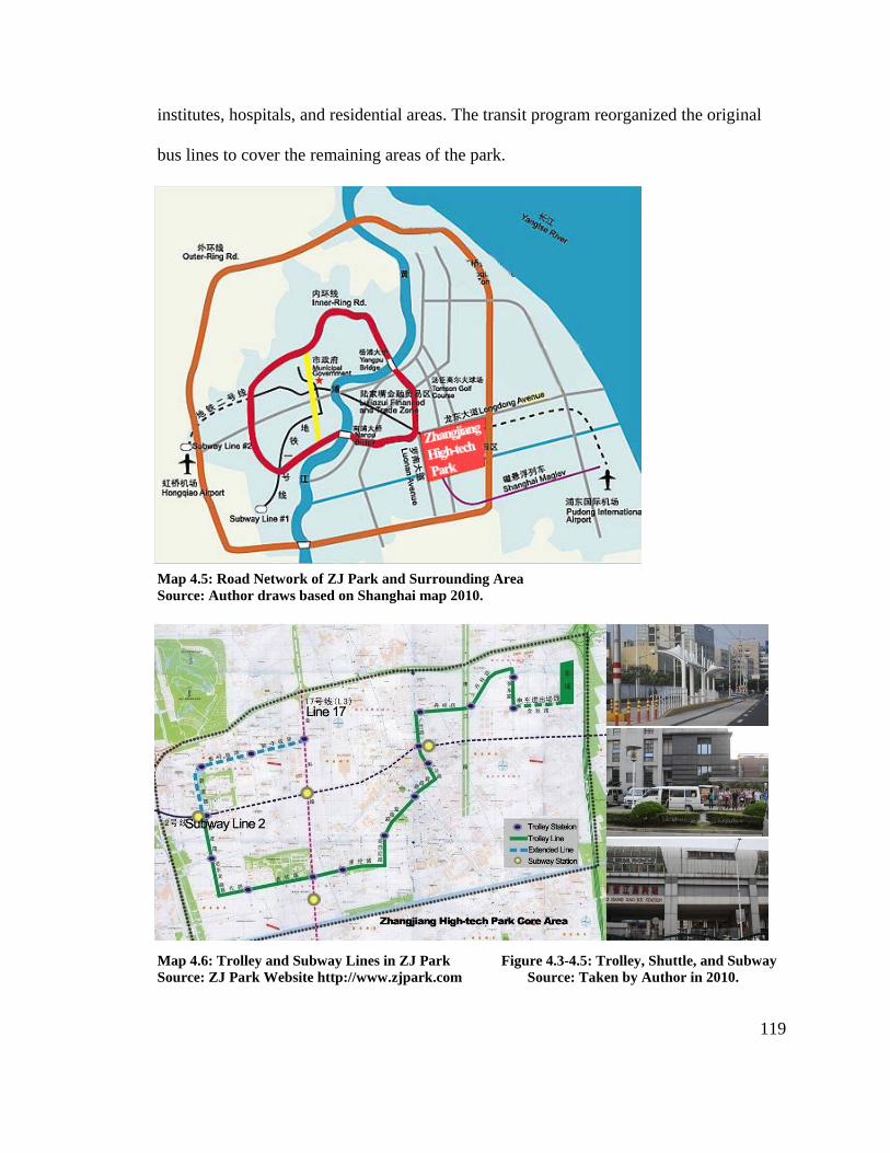
119
institutes, hospitals, and residential areas. The transit program reorganized the original
bus lines to cover the remaining areas of the park.
Map 4.5: Road Network of ZJ Park and Surrounding Area Source: Author draws based on Shanghai map 2010.
Map 4.6: Trolley and Subway Lines in ZJ Park Figure 4.3-4.5: Trolley, Shuttle, and Subway Source: ZJ Park Website http://www.zjpark.com Source: Taken by Author in 2010.

120
4. Outcomes and Features
4.1 Planning Adjustment
ZJ Park has experienced many adjustments when facing problems throughout the
development process, and the corresponding measures taken have provided the lessons
and references for other parks. The first structural planning of Zhangjiang High-
Technology Park began in December 1992. This plan divided the Park’s land use into
three parallel zones from west to east: Service and Research Zone, Industrial Zone, and
Residential Zone. The Industrial Zone was placed in the middle, occupying two-thirds of
the entire area, completely separating the Service and Research Zone from the
Residential Zone. This plan separated the land use functions of the park and simply
wedged industrial use together with other land uses. Because of ZJ Park’s slow
development in the early years due to lack of investment and projects, this plan was not
implemented.
The 1995 Amendatory Structural Plan of Zhangjiang High-tech Park made big
changes to the previous plan, and formed the present framework of Zhangjiang. It
increased the residential area from 0.8 km2 to 1.7 km2, and also enhanced the ratio of
research and education of the whole area. Instead of the former parallel style of land use,
this plan extended the residential use to the center of the park. It established a grid-like
road network instead of the previous ring road, strengthening the links among different
functional zones. The plan proposed rail lines into the park setting up multiple stations
and placing several commercial centers around the stations. Also, each functional zone
has a small service center.
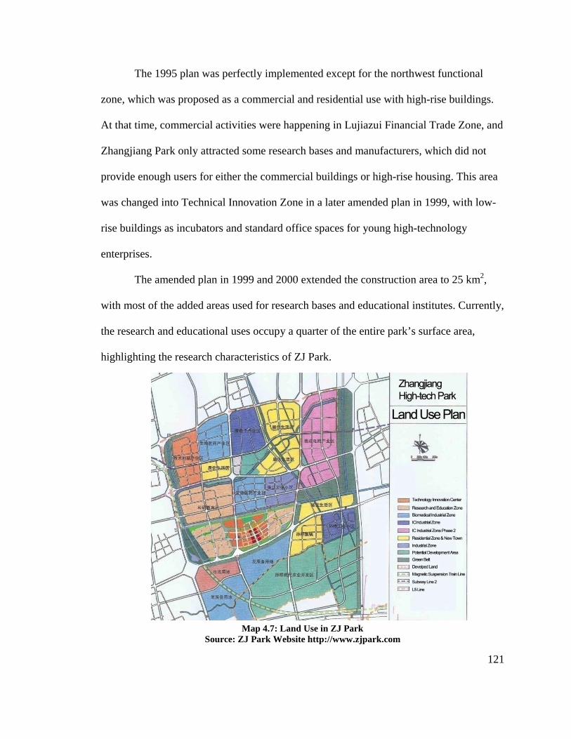
121
The 1995 plan was perfectly implemented except for the northwest functional
zone, which was proposed as a commercial and residential use with high-rise buildings.
At that time, commercial activities were happening in Lujiazui Financial Trade Zone, and
Zhangjiang Park only attracted some research bases and manufacturers, which did not
provide enough users for either the commercial buildings or high-rise housing. This area
was changed into Technical Innovation Zone in a later amended plan in 1999, with low-
rise buildings as incubators and standard office spaces for young high-technology
enterprises.
The amended plan in 1999 and 2000 extended the construction area to 25 km2,
with most of the added areas used for research bases and educational institutes. Currently,
the research and educational uses occupy a quarter of the entire park’s surface area,
highlighting the research characteristics of ZJ Park.
Map 4.7: Land Use in ZJ Park Source: ZJ Park Website http://www.zjpark.com
122
During the implementation process, however, an amendment changed block size
and FAR in 2000. The previous plan imitated the pattern of Silicon Valley, with its low-
rise buildings and green gardens. Thus, the initial plan set up each block with 5–10
hectares, and the amended plan in 2000 required the FAR of research and educational
zone to be less than 0.55, and the FAR of Technology Innovation Zone to be less than
0.85. However, the low-density, “Silicon Valley land development style” does not fully
apply to Zhangjiang. While the size of block can satisfy most small high-technology
enterprises, many research bases, manufacturers, and educational institutes require larger
and more isolated sites of around 20 hectares. Moreover, Zhangjiang’s mature and rapid
development requires a large amount of construction and high intensity land use. Thus,
currently most sites in ZJ Park have changed the FAR to 1.2 or 2.
While the construction of each zone was adjusted during the implementation
process due market conditions, the basic framework and structure of ZJ Park was set up
through the initial plans and kept the R&D characteristics of Zhangjiang Park. While ZJ
Park was established around the original town, most of the expansion took place in farm
lands. Thus ZJ Park has had more opportunities to create a green environment rather than
filling up urbanized areas. The design of green space was considered in the development,
and landscaping was programmed into each functional zone and planned along the river
and road network. Both the 1995 plan and the later amended plan explicitly required
areas of green space of no less than 40 percent of the total land area and the ratio of green
space in each functional zone is higher than its counterpart in Shanghai’s requirements.
123
4.2 Design of Open Space
Currently, five major high-tech areas and eight industrial bases comprise the
innovation system of R&D in ZJ Park. The five major high-tech areas include: research
and development centers; headquarters of high-tech international companies; branches of
top-level educational institutes in Zhangjiang; an overseas talent agglomeration area; and
an incubator for medium to small high-tech enterprises. The eight industrial bases include
areas for: software, bank cards, LCDs, modern medical appliances, IC, biomedical,
national information security, and cultural recreation. These parks are differentiated by
product types. Different from Beijing Zhongguancun Science Park, which has common
electronic streets or business buildings for rent, ZJ Park consists of these individual parks
designed and constructed separately.
While each individual park has a high-quality physical environment, the
landscapes become their backyard view, which cannot be shared as public open space.
Pudong Software Park proposed a central plaza with a dining hall surrounded by a cluster
of standard incubators. Zhangjiang IC Industrial Zone established a dozen middle-rise
buildings for over 200 IC industrial companies, and placed the buildings within a garden-
style environment separated from surrounding areas by walls. Zhangjiang Third Phase
Software Park created a small lake within its boundary from a nearby river, and created a
backyard landscape shared with surrounding several buildings. One hardly notices this
lake from outside.
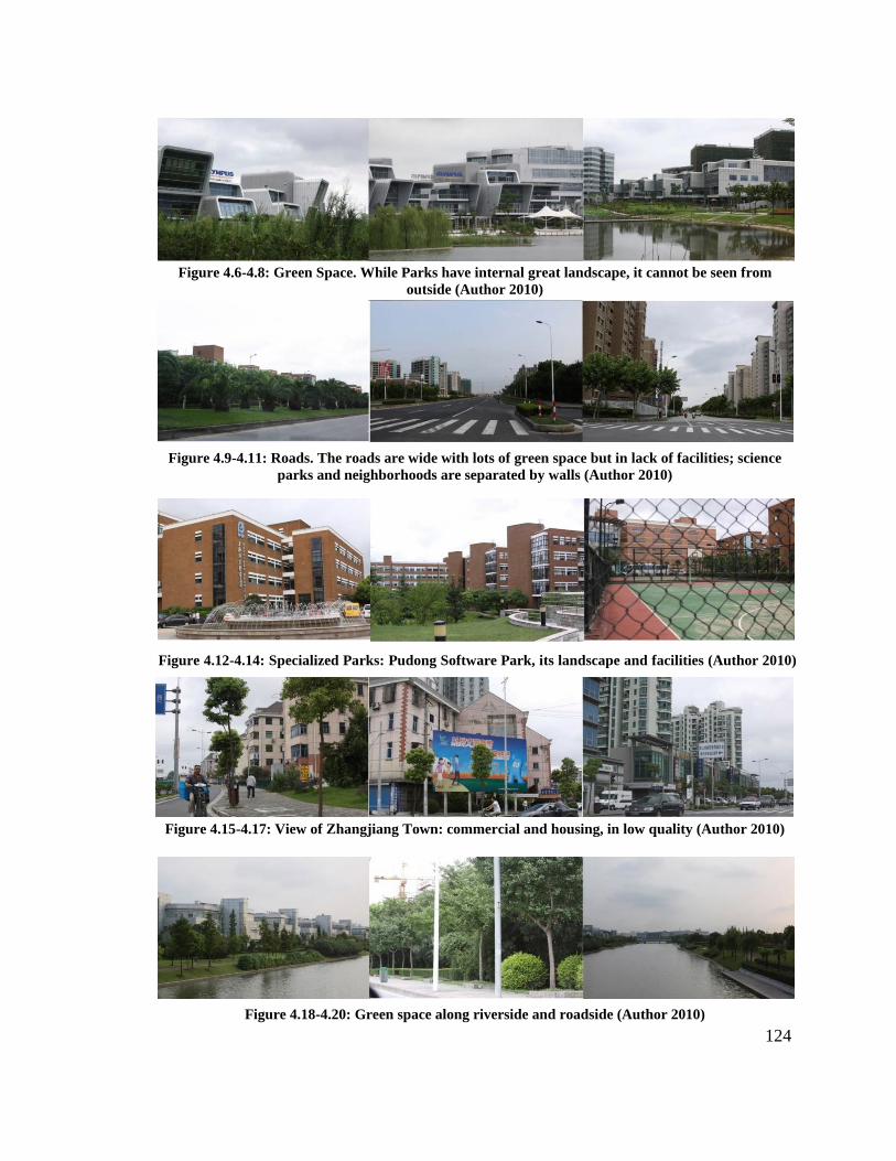
124
Figure 4.6-4.8: Green Space. While Parks have internal great landscape, it cannot be seen from outside (Author 2010)
Figure 4.9-4.11: Roads. The roads are wide with lots of green space but in lack of facilities; science parks and neighborhoods are separated by walls (Author 2010)
Figure 4.12-4.14: Specialized Parks: Pudong Software Park, its landscape and facilities (Author 2010)
Figure 4.15-4.17: View of Zhangjiang Town: commercial and housing, in low quality (Author 2010)
Figure 4.18-4.20: Green space along riverside and roadside (Author 2010)

125
Moreover, while ZJ Park has a high ratio of green areas, the green landscape
along the roads and river systems lack human activities. Most of the roads have deep
green space along both sides. but walls separate them from the individual specialized
parks. One seldom sees people walking on the pedestrian streets. The central area of ZJ
Park, Zhangjiang town, has only a few commercial and retail stores set along one or two
streets, but the facilities are of poor quality and fail to match the culture of high-
technology industries that the Pudong Area government and ZJ Park Committee intended.
It would be better to either increase the connection of individual parks with outside areas
or place more entertainment or recreation facilities in the green spaces, which offer great
possibility for basketball or tennis courtyards.
4.3 The Island: Housing and Associated Facilities
While ZJ Park was planned to integrate into the Pudong Area, it developed as
single R&D uses. Thus it has few residential, business, and commercial uses and public
services within the park. Despite the fact that Zhangjiang is known as a place full of
talent, the staffs work far from the city center and have no leisure life there. As of the end
of 2008, the population of workers had reached 120,000, with more than three-quarters of
them having college degrees. Most of them have science and engineering backgrounds
and work in the IT business. The male to female ratio is 3:2. Since most of the buildings
are factories and office buildings, when night falls, Zhangjiang High-tech Park resembles
a black island in Pudong Area, with employees going elsewhere to live their lives. For the
vast majority of people who live in Shanghai, Zhangjiang represents a far-away and wild
place with only high technologies and industries. When people speak about the rapid

126
development of Pudong in recent years, they focus more on Lujiazui Financial Trade
District.
Four kinds of users need housing in Zhangjiang High-Technology Park. The first
type, the villager and farmers, came from the original farmland, now used for high-
technology industry. The ZJ Park plan created multiple affordable housing units to the
east of the park and displaced these people there. A second type includes the employees
and managers of research institutes and high-technology companies. With relative higher
income than normal workers, most of them drive to work, and choose to live in high-end
residential places elsewhere in Shanghai; however, they still need a few apartments inside
ZJ Park some weeks. The third type, the students and faculty, belong to research
institutes or educational university branches in ZJ Park. Their dormitories are included in
the construction of each university or college area. The last type, the most important but
easily ignored group, is the middle-income and low-income laborers and employees of
high-technology companies and manufacturers. They represent the largest population in
need of housing inside the park to avoid over-long commuting distances.
In the initial plan, ZJ Park could get support and facilities from the surrounding
areas. However, when ZJ Park extended its area from the initial 5 km2 to 25 km2 but kept
the same scale of residential and commercial uses as before, the employees had much
longer commuting distances, and their needs for commercial and business became much
more urgent.
To reverse this situation, Shanghai municipality planned to increase the real estate
construction in surrounding areas so as to create an attractive living space for the workers.
At present, Zhangjiang High-tech Park has 2,751 apartments with an area of 177,000 m2

127
and 13,000 people capacity. It planned to start additional construction of 9,850
apartments at the end of 2010 to accommodate an additional 17,000 people. For example,
the Zhangjiang Jiangdong Personnel Apartment can accommodate 3,000 people with rent
of only ¥500 per month. The development committee also offers the employee ¥200
stipends every month. The apartments will make full use of various resources for market
operations, such as a new dining center of 3,000 m2 and staff recreation centers to
supplement regional activities.
In addition, companies also increased their supporting facilities for the employees.
For example, Semiconductor Manufacturing International of China (SMIC) constructed
complete services and facilities, intending to let their employees know that they can have
a good life with the company. Most of the employees in SMIC live in nearby staff
apartments within a walking distance. The apartment building has a swimming pool, a
fitness center and other equipment. It is fully decorated and comes with a low rent of only
¥400 to ¥500 RMB per month. It includes supermarkets, fast food shops, steak houses,
and bakeries close to the apartments. Shanghai Supercomputer Center (SSC) offers hot
water for staff to take showers at work. SSC invited local residents to provide breakfast
and lunch for the employees. As for the dinners, the workers always take the public
shuttle, which is the most frequently used bus line in ZJ Park, to the restaurants in the
Park or surrounding areas, but most of them do not leave Pudong Area.
While some commercial areas and food courts have been established around three
subway stations in ZJ Park, the current commercial land uses cannot satisfy the
increasing population and high-technology companies. Thus the plan in 2010 proposed a
series of business and recreation facilities for the extended Middle District of Zhangjiang,

128
which is connected to the city center city by the subway and a large number of transit
lines. The plan also proposed several mixed-use new towns in South District of
Zhangjiang to provide living spaces for the employees. Moreover, the residents living in
ZJ Park are mainly engaged in the high-end technology industry; while laborers with
medium to low income levels choose to live in the neighboring areas.
4.4 Industrial Chain
Intellectual resources make up the crucial factor for the construction of ZJ Park
and for enhancing industrial levels. To form an intellectual pool, ZJ Park adopted a new
mode of “remote human resource” to attract human resources. For example, Zhangjiang
formed an advisory committee consisting of 21 reputable scientists, of which 10 are
academicians, to provide advice for the development of the Biomedical Industry. These
experts, invited to Zhangjiang Park to give lectures periodically, received support to
establish research laboratories in ZJ Park. Because Zhangjang lacks universities and other
educational institutes to cultivate human resources, the introduction of remote talent
provided intellectual resources for the park at its early stage. Gradually, with the
increasing development of Zhangjiang, there are now 12 branches of educational
institutes in ZJ Park. More and more overseas students have returned to Zhangjiang to
start their careers. One student can bring several or dozens of related personnel back to
the area.
While ZJ Park orients toward an R&D-oriented HIDZ, multiple functional steps
within the industrial chain range from initial scientific research to the final manufacturing
production. Without key leading enterprises, ZJ Park formed a complete industrial
129
network involving research bases, enterprises, and governments. For instance, in 1996,
Shanghai Municipality and the State Department jointly established the State Biotech and
Pharmaceutical Industrial Base in Shanghai. One year later, ZJ Park developed the first
and the only national center for drug screening in China. According to the strategy of
“Focus on Zhangjiang,” Shanghai Institute of Materia Medica, Chinese Academy of
Science, relocated to Zhangjiang. This relocation brought Institute of Materia Medica
more space for development and also motivated the development of Zhangjiang’s
biomedical industry. After this relocation, many other key research institutes moved to
Zhangjiang, such as the School of Pharmacy of Fudan University and Shanghai
Traditional Chinese Medicine University (TCM). By 2003, Shanghai Institute of Materia
Medica had formed a system of biomedical innovation together with other several state
research institutes. In November 2003, when the TCM relocated to ZJ Park, it brought
research on Traditional Chinese Medicine into the development plan of biomedical
industry. In addition, the Shanghai Museum of TCM opened in 2004 for all the residents
and students. The museum consists of the history of Traditional Chinese Medicine, an
exhibition hall of Chinese Medicine, and a history museum and widely publicizes science
education to the public.
Such an active industrial chain not only benefits ZJ Park’s internal development,
but more importantly, has formed an active interaction between ZJ Park and Lujiazui
Financial Trade Zone: ZJ Park provides the software and electronic industry needed by
the financial industry. The commercial and business areas in Lujiazui Zone can in turn
fully provide financial investment in these industries and promote the level of industry
agglomeration in Zhangjiang.
130
5. Lessons
5.1 Regard Government Domain as a Key Element
Zhangjiang is not only a product of government planning but also the outcome of
state strategy. In the loop of Zhangjiang’s development, it seems that the drivers are
technology, projects, and companies. However, these are not the “growth engine” that
played the decisive role of the loop. Instead, when looking into this in depth, the key
factors underlying the development process that surface include a series of arrangements
on resources, industries, and land value. Based on understanding the context of Pudong
and Zhangjiang, Shanghai Municipality made the arrangements to stimulate Zhangjiang
to develop as a science and technology anchor for the entire region.
Choosing Zhangjiang as the location of the anchor also closely relates to the
development vision of the Pudong New Area. When developing a science park, choosing
a site with convenience transit, and nature environment is a critical first step. Zhangjiang
is located in the center of the Pudong New Area. When Pudong became the focus of
Shanghai, it emphasized that Zhangjiang can definitely benefit Pudong’s development.
On the other hand, Zhangjiang also has an advantage with the large undeveloped space to
the south. Compared with science parks in urban areas with limited land resources,
Zhangjiang has plenty of space for further extension. Even though currently Zhangjiang
is only one industry-based part integrated in the Pudong New Area, a trend still exists to
develop toward a science-based new town with complete functions. This is the
Zhangjiang plan, but it also matches the vision of the Pudong New Area.

131
Furthermore, the mode of land development under the guidance of the
government is consistent with China’s situation. It is also useful for those science parks
with strong government support but lacking financial support to start. Historically, at the
beginning of development, the composition of both development committee and land
development company included the same people, which is a specific characteristic in
Chinese new district development. Later, with the completion of the first step of land
development, both infrastructure and usable land are produced, and both government and
the development company need to transform their operations.
5.2 Making Necessary Transformations during the Process
• Transformation of Government
When a science park has developed to a certain stable stage, the role of
government needs to transfer from leading the market back to serving the market. In ZJ
Park, the Shanghai Municipality Promoting the Development of Zhangjiang High
Technology Park Several Provisions carried out the government’s preferential policies
according to the regulations. It thus ensured the sustainability of government policies.
The government steps back to provide public facilities and services. It left the rights of
investment and construction to the development companies and enterprises. Through
decentralization of administrative authority, both the efficiency of planning approval and
the capacity of self-management of science parks are enhanced greatly. Moreover, with
the emergence of more and more agencies and independent sectors, a management
network has been established to separate different social affairs.
• Transformation of the Development Company

132
ZJ Park Development Company serves as the main development body of ZJ Park
and thus carries both the mission of applying state strategy and getting economic profit
through land development. As a development company, it must pursue economic
interests. Meanwhile, on behalf of the government, it has responsibility for the
construction and management of Zhangjiang High-Technology Park. At the beginning
stage, working as a land development company together with Shanghai Municipality,
Zhangjiang High-Tech Park Development Company completed the first cash flow and
construction from raw land to usable land. As the industry grew larger, the company
gradually transitioned its main business toward real estate properties and high-end
services. It also worked continually as the bridge between government and the small and
medium enterprises in need of financial and property support. ZJ Park Development
Company helps the individual enterprises by integrating their needs and reflecting these
on to the government, to get their needs addressed.
• Industrial Networking
During the restructuring of industries, the development of the R&D chain is a
crucial factor for a science park. One weakness of ZJ Park was that it lacked sufficient
research institutes and large leading enterprises in its beginning stages. However, ZJ Park
successfully created a complete industrial network involving different steps in the
industrial chain. “Focus on Zhangjiang” introduced a large number of national and world-
class research institutes and educational university branches, thus attracting more and
more enterprises to settle their research centers in Zhangjiang. The agglomeration of
high-level educational and research institutes helped the high-tech enterprises in
Zhangjiang to get various techniques, intellectual resources, and equipment easily.
133
5.3 Suggestions for Planning Guidelines
• Size Hierarchy of Site
A major difference between high-technology parks and traditional industrial
districts high-tech parks has highly correlated industries and enterprises. They often form
a complete industry system with explicit hierarchy around a particular industrial field.
With regard to the physical planning, accordingly, the sizes of sites vary greatly. For
those major industrial sites, a large scale is more flexible for further development and
distribution. It can also prevent the entire road network structure’s destruction in later
development.
However, some large-scale sites without roads crossing through them performed
as a block in ZJ Park. Separated from surrounding areas, it has streets but a lack of
human activities. Zhangjiang High-Technology Park needs further detailed regulations on
land size to avoid either over-large segregation or too-small parcels unsuitable for large
enterprises and research bases.
• Mixed-use Function
The enterprises and clients of high-tech parks also differ from traditional
industrial districts. As analyzed above, such parks need specific real estate property and
service facilities such as research bases, incubators, hotels, and standard factories. The
types of property service provided by ZJ Park Development Company are great
references for other science parks. In 2008, the ratio of research staff to the entire
employees was up to 20 percent, and staffs with college degrees make up over 50 percent
of the entire population. Commuters with regular schedules always have irregular
134
working hours and flexible working places. Accordingly, it is necessary to propose more
communications and recreation space and more leisure facilities for them. Moreover,
compared with centralized settings, it is more suitable to place these facilities within
individual building to provide a uniform service range. Currently, ZJ Park has not
sufficiently considered mixed-use functions and the arrangement of those facilities.
• Diversify Housing Types and Open Spaces
Residential construction should simply use the general regulations on residential
district planning. General residential communities have a minimum required quota for
public services and facilities. The public services consist of eight elements to satisfy the
basic life demand of residents: education, health care, culture, sports, business service,
community management service, social welfare, transit, and public utilities. For instance,
traditional regulations for residential community planning have requirements on the areas
of kindergartens, elementary schools, and high schools per 1,000 residents. ZJ Park’s four
types of housing—relocation housing for the farmers, high-level condos for managers
and talents, dormitories for employees and students, and apartments for white-collar
employees—have distinct demands on unit design and public service. For example, the
latter two types do not need as many areas for kindergartens or schools as the first two
types in that they have fewer families. Consequently, the physical planning of high-tech
parks should consider the diversification of user types and thus propose various targeted
site plans.

135
Physical planning is important in the development of high-tech parks. In
Zhangjiang High-Technology Park, what the planners did most frequently in the first
several years included “making videos, creating models, and telling stories.”9 Making
videos means that they continually showed the blueprints and plans through videos and
slides to visitors and potential investors. They used models to show them Zhangjiang’s
district plan, land use plan, and site plans. Moreover, they also recommended the site to
visitors and described the design, preferential policies, and development visions. In the
process, the planning became a marketing tool—a way of persuading high government
officials and investors of the quality of environment, through images and models of the
park.
Moreover, the planning and design of high-technology parks should not only be a
blueprint of how the district should be physically developed, but also provide strategies
for the park’s spatial development. The multiple ways it serves include counseling the
Development Committee, providing government the physical platform for discussion,
offering advice and suggestions for legislation and regulation, arranging land resources
for further regional development, and attracting more investments and enterprises.

136
1 Pudong Yearbook, 2001. 2 Jun Ming, The National Mission: Focus on Zhangjiang (Shanghai: Shanghai Science and Technology Literature Press, 2009), 34. 3 Shanghai Statistics Yearbook, 2000-2005 4 Wansong Sun, High-Tech Development Area Innovation and Competition Power (Beijing: Chinese Economy Press, 2006); Ming, The National Mission, 36. 5 Zhangjiang High-Technology Development Company Annual Report, 2007.01 6 Several Provisions of Shanghai Municipality Promoting the Development of ZJ Park, Article 15 7 Ibid, Article 6 8 Ibid, Article 13. 9 Ming, The National Mission, 61.
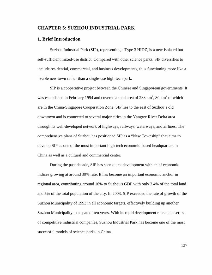
137
CHAPTER 5: SUZHOU INDUSTRIAL PARK
1. Brief Introduction
Suzhou Industrial Park (SIP), representing a Type 3 HIDZ, is a new isolated but
self-sufficient mixed-use district. Compared with other science parks, SIP diversifies to
include residential, commercial, and business developments, thus functioning more like a
livable new town rather than a single-use high-tech park.
SIP is a cooperative project between the Chinese and Singaporean governments. It
was established in February 1994 and covered a total area of 288 km2, 80 km2 of which
are in the China-Singapore Cooperation Zone. SIP lies to the east of Suzhou’s old
downtown and is connected to several major cities in the Yangtze River Delta area
through its well-developed network of highways, railways, waterways, and airlines. The
comprehensive plans of Suzhou has positioned SIP as a “New Township” that aims to
develop SIP as one of the most important high-tech economic-based headquarters in
China as well as a cultural and commercial center.
During the past decade, SIP has seen quick development with chief economic
indices growing at around 30% rate. It has become an important economic anchor in
regional area, contributing around 16% to Suzhou's GDP with only 3.4% of the total land
and 5% of the total population of the city. In 2003, SIP exceeded the rate of growth of the
Suzhou Municipality of 1993 in all economic targets, effectively building up another
Suzhou Municipality in a span of ten years. With its rapid development rate and a series
of competitive industrial companies, Suzhou Industrial Park has become one of the most
successful models of science parks in China.
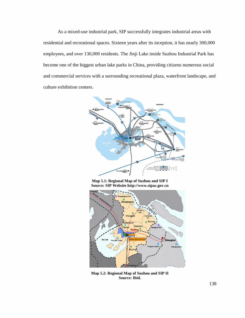
138
As a mixed-use industrial park, SIP successfully integrates industrial areas with
residential and recreational spaces. Sixteen years after its inception, it has nearly 300,000
employees, and over 130,000 residents. The Jinji Lake inside Suzhou Industrial Park has
become one of the biggest urban lake parks in China, providing citizens numerous social
and commercial services with a surrounding recreational plaza, waterfront landscape, and
culture exhibition centers.
Map 5.1: Regional Map of Suzhou and SIP I Source: SIP Website http://www.sipac.gov.cn
Map 5.2: Regional Map of Suzhou and SIP II Source: Ibid.

139
Its success is largely due to borrowing experiences of new town planning and
management from Singapore. The Suzhou Industrial Park Administrative Committee
applied the lessons from those models into a local context to form a series of planning
management principles, modes, and approaches. The planning strategies adopted in
Suzhou Industrial Park have four main levels: governmental management; land
development processes (phasing and timing of land development); planning structures (a
series of plans of SIP and flexible land use); and planning content (in terms of spatial
arrangement, programs of each functional area, and design guidelines). As an exemplar
of a high technology-based development, SIP has formed many useful experiences in
planning management system and principles of planning and design that are worthy for
integration into other science parks in China.
2. Historical Evolution
2.1 Preparation (1992-1994)
As China's modernization drive gained momentum in the late 1980s, many
Chinese delegations visited Singapore, a Southeast Asian nation that achieved seeming
economic miracles within 30 years of its independence. The Chinese visitors were eager
to learn modern management methods while Singapore was also planning its own
Economic Regionalization at that time and hence focused on overseas investment.
The motivation of SIP started in September 1992 when Senior Minister Lee Kwan
Yew of Singapore led a delegation to China and expressed the intent to cooperate with
China on setting up a model for the adaptation of Singapore’s own developments.

140
Through subsequent consultations and site surveys for joint development and
construction, the two sides finally decided to develop a modern industrial park in Suzhou.
On February 11, 1994, the State Council issued “Approval on Issues Concerning the
Development and Construction of Suzhou Industrial Park”,1 giving official approval on
cooperation between Suzhou and Singapore in the development of Suzhou Industrial Park.
The China-Singapore Suzhou Industrial Park (CS-SIP, later SIP) was thus born on
February 26, 1994 when both China and Singapore signed the Agreement on the Joint
Development of Suzhou Industrial Park in Beijing. The Agreement planned to develop a
China-Singapore Cooperation Zone within a 70 km2 area to the east of Suzhou. On
March 1, 1994, the “6-utility-access” infrastructure construction was started.
Both governments established the China-Singapore Joint Steering Council to
ensure the implementation of the Agreement. Co-directed by China and Singapore,
current co-directors are Mr. Wang Qishan, the Vice Premier of China, and Mr. Wong
Kan Seng, the Deputy Prime Minister of Singapore. The Suzhou Municipality and
Ministry of Trade and Industry in Singapore joined together to form the Bilateral
Working Committee to carry out policies made in the Joint Steering Council. The main
development body was the China-Singapore Suzhou Industrial Park Development Co.
Ltd (CSSD). On Aug 13, 1994, the CSSD was officially established with the approval of
National Administration of Industry and Commerce with US$50 million in registered
capital and a total investment of US$100 million, with the Singapore Consortium holding
65% and the Chinese Consortium holding 35% of the equity shares.2
China and Singapore joined together to attract foreign investment. On April 21,
1994, the first joint investment promotion delegation of China and Singapore set off for
141
Europe. Singapore used its global network resources to raise international public
awareness of SIP. For instance, Prime Minister Goh Chok Tong, and Lee Kuan Yew
promoted the investment personally. In 1995, sixteen Fortune 500 companies contributed
funds to SIP, becoming the first group of multinational companies investing in SIP. The
companies included Comfort of Singapore; Hitachi Global, Fujitsu Global, and
Sumitomo Bakelite in Japan; Samsung in Korea; GE, Lilly Pharmaceutical, and BD from
the United States; Siemens in Germany; and L'Oreal in France.
Cooperation between the countries even extended through education. Singapore
also shared planning management expertise and design and construction software and
approaches by training Chinese professionals. On April 20, 1994, the first group of
trainees for SIP (planning and construction delegations) was dispatched to Singapore,
marking the official start of adapting Singapore’s experiences into SIP.
2.2 Joint-Cooperation (1994-2000)
During 1994 to 2000, SIP finished construction of the infrastructure in the first
phase district. Since it had city planning and management experience from Singapore,
SIP Administrative Committee created the master development plan for SIP and
subsequent subdivision plans. Therefore, the major work during this period included
infrastructure construction, building major facilities for water, electricity, and heating,
displacement of farmers, and construction of standard factories and commercial and
residential buildings.
Major investment promotions occurred during this time as well. When the
Singapore government used its global network to bring international investment to
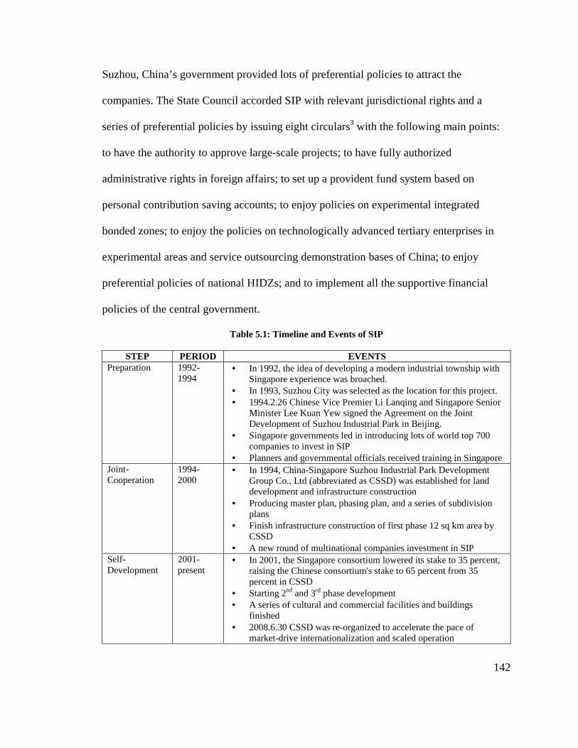
142
Suzhou, China’s government provided lots of preferential policies to attract the
companies. The State Council accorded SIP with relevant jurisdictional rights and a
series of preferential policies by issuing eight circulars3 with the following main points:
to have the authority to approve large-scale projects; to have fully authorized
administrative rights in foreign affairs; to set up a provident fund system based on
personal contribution saving accounts; to enjoy policies on experimental integrated
bonded zones; to enjoy the policies on technologically advanced tertiary enterprises in
experimental areas and service outsourcing demonstration bases of China; to enjoy
preferential policies of national HIDZs; and to implement all the supportive financial
policies of the central government.
Table 5.1: Timeline and Events of SIP
STEP PERIOD EVENTS Preparation 1992-
1994 • In 1992, the idea of developing a modern industrial township with
Singapore experience was broached. • In 1993, Suzhou City was selected as the location for this project. • 1994.2.26 Chinese Vice Premier Li Lanqing and Singapore Senior
Minister Lee Kuan Yew signed the Agreement on the Joint Development of Suzhou Industrial Park in Beijing.
• Singapore governments led in introducing lots of world top 700 companies to invest in SIP
• Planners and governmental officials received training in Singapore Joint-Cooperation
1994-2000
• In 1994, China-Singapore Suzhou Industrial Park Development Group Co., Ltd (abbreviated as CSSD) was established for land development and infrastructure construction
• Producing master plan, phasing plan, and a series of subdivision plans
• Finish infrastructure construction of first phase 12 sq km area by CSSD
• A new round of multinational companies investment in SIP Self-Development
2001-present
• In 2001, the Singapore consortium lowered its stake to 35 percent, raising the Chinese consortium's stake to 65 percent from 35 percent in CSSD
• Starting 2nd and 3rd phase development • A series of cultural and commercial facilities and buildings
finished • 2008.6.30 CSSD was re-organized to accelerate the pace of
market-drive internationalization and scaled operation
143
The infrastructure construction and advanced preferential policies led to a
dramatic increase of foreign investment in 1998. Compared with the initial funding
campaign in 1995, this second round of foreign investment has several distinct features.
Most of the existing companies largely increased their investments. Many companies,
such as Samsung, Fujitsu, and Sumitomo, set up several subsidiaries in SIP, and several
companies began to establish individual research and development institutes in the park
as well. For instance, Emerson Electric in Suzhou set up its Climate Technologies R&D
Center. The investment of Fortune 500 companies in SIP thus contributed to economic
development through increasing the amount of GDP, accumulated taxes, utilized foreign
capital, and registered RMB capital.
However, the park was built almost simultaneously with the competing Suzhou
New District (SND) industrial park, located to the west of Suzhou old downtown. SND
was established in 1992 to be a national HIDZ too. Compared with SIP’s development
process in which the Suzhou government had only 35% stake, the government had direct
leadership on SND’s development. Thus the municipal government paid more attention
to SND, leaving the affairs of SIP to Singaporeans. However, since SIP had a negative
net-income during the first several years, its developers were not satisfied by the Suzhou
government’s ignorance.
2.3 Self-Development (2001-Present)
Suzhou Industrial Park transitioned into a self-development stage in 2001 and
continues to develop to this day. After incurring losses of some US$90 million over 5
years, the Singapore consortium lowered its stake to 35 percent, raising the Chinese

144
consortium's stake to 65 percent from 35 percent and reducing the Singaporean share area
from a planned 70 km2 to a first phase with 8 km2. The Chinese appointed Wang Jinhua,
vice-mayor of Suzhou and the former manager of the New District, as the new chief
executive of SIP. In 2001, one year after Singapore lowered its stake, the park made its
first profit of $3.8 million. After three consecutive profit-making years, CSSD had
written off all previous losses by the end of 2003.
Two main factors have led SIP to make a profit since 2001. One is the change of
emphasis of the Suzhou Municipality from SND to SIP, with devoting more investments
and leadership in order to benefit SIP’s development. Another reason is that, until 2001,
the construction of the Phase 1 district was almost completed, and the site started to
accumulate economic product and finally made profits. Based on experiences learned
from Singapore, SIP developed an independent planning system. Since then, Suzhou’s
local government began to play a more important role in leading construction and
development of SIP than Singaporean side.
However, training from Singapore continues. Chinese personnel receive training
in Singapore in successive groups. As of the end of 2008, fifty special training programs
have been conducted for over 1,500 trainees in 118 groups, helping formulate 85
statutory documents to lead the development and planning Suzhou Industrial Park.
During this time, SIP began to diversify into a mixed-use property. On March 23,
2001, the Suzhou Municipal Government and Party held a meeting to mobilize efforts for
the acceleration of SIP development and construction, signaling the start of SIP’s next
two phases. In the park's tenth anniversary in 2004, SIP shifted its focus from labor-
intensive manufacturing to both modern technological innovation, and the services. This
145
shift included expansion of the software industry, outsourcing, and nanotechnology.
Moreover, the planners wished to make SIP a more livable community and constructed a
large amount of housing and a series of cultural and recreational facilities, such as a
science and technology cultural center, an international exhibition center, recreation
commercial plazas, and neighborhood centers.
3. Planning Strategies
3.1 Administrative Management
• Dissociation of Administrative Body and Development Body
In Suzhou Industrial Park, the administrative body and development body have
explicitly separated their responsibilities. In traditional industrial parks, the
Administrative Committee takes charge of all the land development and construction of
parks, but here the Suzhou Industrial Park Administrative Committee only has
administrative functions. The main development body, CSSD, is responsible for land
development and construction. Some HIDZs have a government-appointed development
company to take charge of land development, yet the two entities have the same people in
each committee. By contrast, the committee and development company SIP are separated
from each other. Just as the Suzhou Industrial Park is a cooperative project between the
Chinese and Singaporean governments, CSSD is a joint venture between the two
countries. This settlement involves both parties in the construction of SIP. However, as a
China-owned industrial park, the sovereignty of SIP belongs exclusively to China
government. As the agency of the government of Suzhou Municipality, the Suzhou

146
Industrial Park Administrative Committee represents the government in carrying out
public affairs, planning management, and social service.
The Suzhou Municipality accords the Plan and Construction Bureau under the
Suzhou Industrial Park Administrative Committee to model planning and management of
SIP upon Singapore’s experiences. The main tasks of the Plan and Construction Bureau
include to direct and to approve a series of plans for the SIP; to establish planning
management and technical approaches under Singapore’s guidance; and to review and to
approve land development and site plans reported by CSSD. The selection of planning
professionals was under rigid review and is the result of a competitive process. Most of
the professionals have received training on planning skills in Singapore, thus providing
scientific base for planning decisions. The administrative leadership of the Committee is
responsible for some vital plans, giving authority to city planning decisions.
• Role of the Administrative Agency: Business as Priority
The administrative agency of SIP has transformed its role from “leading” to
“serving” and then again into a “steering” group. During the planned economy era in
1980s, entire city planning and development strategies of other countries were under the
leadership of a single administrative government. In the 1990s, under the influence of
capital market, private management was gradually involved in the decision-making
process. The government agency gradually changed its role to serve enterprises and the
public. However, the recent economic crisis has led to a readjustment of the
government’s role from server to manager again. Through directing city planning,
establishing management mechanisms, and regulating construction and land development,
147
both the government and planning agencies play an active role in SIP’s latest
development.
Within the planning strategies of SIP, regarding business as a priority is an
important principle. In Singapore, multinational companies are important drivers of
economic growth. The government provides a well-developed environment of high
quality places and infrastructure to attract companies and more investments. SIP also
applied this business-oriented principle into planning and management process. For
instance, when the SARS virus overran China in April and May 2003, all the construction
workers had to receive at least one-month segregation and physical exams before getting
trained and then working at SIP. At that time, companies in SIP were in dire need of over
ten thousand construction workers but the spaces for segregation are limited, thus leading
to a serious delay of construction and development. SIP Administrative Committee
creatively transferred the use of built standard factories into segregation centers and also
arranged training programs during the period of segregation. This approach largely
reduced the waiting time and reduced costs for companies.
• Approaches
Several techniques were used to bolster or to streamline development of SIP. SIP
Administrative Committee used a series of approaches to achieve concise and effective
management. First of all, in order to form a concise, unified, and efficient management
system, SIP Administrative Committee has set up sixteen bureaus and one secretarial
office with only one hundred officials. Each bureau in the Committee corresponds to four
or five municipality-level bureaus. The director and key officials in the secretarial office
are nominated by the Suzhou Municipality Government and Party; all the other officials
148
and professionals are selected through public competition and examinations. The range of
the Committee’s jurisdiction covers the China-Singapore Cooperation Zone and its
surrounding five villages and towns.
SIP Administrative Committee also created a one-stop project-approval service to
increase the effectiveness and efficiency of approving projects. The service also provided
checklist for applicants to self-check whether they have met the requirements of planning
techniques. The approaches are tiny, yet they effectively reduced wasted time and
unnecessary repetition. According to the survey, 60% of applications accepted approvals
immediately, 30% of them get approved within two to three working days, and the rest of
the applications are completed in no longer than seven working days.
Moreover, statutory documents and the great power of chief planners have
guaranteed a strong scientific base for planning decisions. SIP Administrative Committee
has formulated over sixty statutory documents of planning requirements to support
management. There are four levels of planning decision-making positions: the planner,
the director of the Plan and Construction Bureau, the Chief Planner, and the director of
Committee. Distinct from traditional industrial districts where planning decisions are
usually made by governmental officials and directors, SIP authorized the Chief Planner
strong power in plan-making and management. The committee director only deal with
important cases of non-compliance and appeals. This separation of responsibilities
effectively avoids situations where planners have to change plans according to
leadership’s political concerns.
149
3.2 Land Development Steps and Approaches
SIP added an “agency sector” in land development steps, an important innovation
that is different from normal industrial districts. In traditional industrial districts, land
developers apply for approvals of projects with site selection reports and site plans. After
approval, the Land and Real Estate Bureau signed the agreement to transfer the right of
land use to each land developer respectively. In Suzhou Industrial Park, though, the
Administrative Committee transferred large areas of phased districts to CSSD at one time
and provided CSSD land planning and construction permits. This approach granted
CSSD the rights of negotiating site selection and site plans with individual developers
and added bargaining chips for attracting investment.
In addition, SIP adopted Singapore's “plan first, build later; underground first,
ground later” principle to implement construction. This principle emphasizes the
importance of plans in guiding construction and requires building infrastructure first to
provide a solid base for investment environment. According to Ma Minglong, party
secretary of SIP, “This meant that we had to inject large amounts of money in the initial
phase. But it helped us to avoid the situations of rebuilding the roads frequently in the
future. This sequence and detailed planning have gained many appraisals and
acknowledgements, not only from China and Singapore, but also from other countries,
such as the former British premier, Tony Blair.”4
This approach largely enhanced consistency during the implementation process.
In some industrial districts, where making plans takes a long time, the government cannot
wait and sell the land ahead of time; thus the Land and Real Estate Bureau approves land
use permits based on which developer can afford the high rental price. It does not
consider whether the
effectively controlled the entire land layout through an advanced unified plan, ensuring
the quality of the environment.
Moreover, a complete infrastructure ensures the land value of SIP
industrial districts the
investment
raising the land price
Development Bureau has no right to reduce any land price for companies.
High price and strict plan requirement successfully attracted over 12,000
enterprises from inside and outside of China, including nearly
companies. Compa
high-tech-based multinational companies emphasize comprehensive advantages of
investment environments. The advantages include preferential policies
infrastructure
consider whether the site selection and land use is appropriate. Conversely, SIP
effectively controlled the entire land layout through an advanced unified plan, ensuring
the quality of the environment.
Figure 5.1: Land Development Organization of SIP
Moreover, a complete infrastructure ensures the land value of SIP
industrial districts the administrative committee
investments, CSSD has invested over 30 billion
the land price as high as US$60/m2. T
Development Bureau has no right to reduce any land price for companies.
igh price and strict plan requirement successfully attracted over 12,000
enterprises from inside and outside of China, including nearly
companies. Compared with those small to medium investors focusing on labor density,
based multinational companies emphasize comprehensive advantages of
investment environments. The advantages include preferential policies
infrastructure with high construction quality; qualified labor workers
land use is appropriate. Conversely, SIP
effectively controlled the entire land layout through an advanced unified plan, ensuring
Figure 5.1: Land Development Organization of SIP
Moreover, a complete infrastructure ensures the land value of SIP. While in
administrative committee reduces land price to attract more
has invested over 30 billion RMB into infrastructure construction
. The director of Economic and Trade
Development Bureau has no right to reduce any land price for companies.
igh price and strict plan requirement successfully attracted over 12,000
enterprises from inside and outside of China, including nearly eighty Fortune 500
red with those small to medium investors focusing on labor density,
based multinational companies emphasize comprehensive advantages of
investment environments. The advantages include preferential policies; completed
truction quality; qualified labor workers; well-developed
150
land use is appropriate. Conversely, SIP
effectively controlled the entire land layout through an advanced unified plan, ensuring
. While in some
land price to attract more
into infrastructure construction,
and Trade
igh price and strict plan requirement successfully attracted over 12,000
Fortune 500
red with those small to medium investors focusing on labor density,
based multinational companies emphasize comprehensive advantages of
completed
developed
151
traffic networks; effective planning approval services; and well-enacted regulations. The
physical environment is worthy of the high land price because the development meets the
standard of the “9 Utilities and Leveled Land.”5
3.3 Planning Structure
One key notion that SIP officials adopted from Singapore was to set out all the
development plans in careful detail right from the start and to stick with these blueprints
during rapid development. The master plan of SIP got its approval in 1994; the sequential
master and land use plans of the Phase 1 District were finished in 1995 by the Plan and
Construction Bureau of the SIP Administrative Committee, Singapore Construction
Ministry, and several international design consultant companies. Even though the initial
plan was to develop an 8 km2 area, SIP finished a master plan of 70 km2 at one time that
had detailed a land use plan and regulations. Later, SIP was clearly demarcated according
to the different urban design of each important functional area, including the Jinji
lakeside Area, the Central Business District, the Science Hub, and the Dushu Lake
Higher Education Park.
This emphasis on planning structure is a significant turnaround from China's
practices, which tend to focus less on planning and more on actual construction. Despite
using several levels of planning in many cities, few of the planners created effective
detailed plans and strictly implemented urban designs and regulations. In SIP, more than
US$7 million were pumped in during the early days of development to draw up the initial
plans and blueprint. Under supervision of Singaporean experts, SIP strictly enacted the
plan system to make the master plan and sequentially-phased plans with urban designs in

152
important parcels of land, leading SIP to become a well-developed urban space and
physical environment. Thus Secretary Ma says the results show that this bold move—
which set a precedent in China—was the right one.
• Approaches of Dynamic Planning
Under the complete plan system, SIP Administrative Committee achieved
dynamic development through phasing development; the concept of the “land bank”; and
reviewing plans over time.
SIP divided the plan of a 600,000 person population into three phases. Each
phased district equals the scale of a Singaporean new town. The Phase 1 District, which
started construction in 1994, is an 8 km2 area located between Suzhou’s original
downtown and Jinji Lake in the center of SIP, aiming to develop this phase as a
commercial and business center with industrial support for manufacturing. As the closest
phase to downtown, the Phase 1 District reduced the construction cost through extending
downtown’s infrastructure network into the new district and shortening the commuting
distance for employees. Phase 2, located to the east of Jinji Lake, is a high-tech industrial
district with a corresponding residential area. The proposed Phase 3 is a large-scale
processing industrial area with a population of 300,000.
The land use plan of SIP uses the concept of “land bank” to aid future
development. Land bank refers to propose the blank lands with an uncertain function in
the initial land use plan. In some areas, the land can be temporarily planned as green
landscape according to surrounding lakes, rivers, commercial centers, or transit stations;
it can then be built up for other uses such as a visitor center, a public riverside park,
parking, or a plaza. Some blank lands are even developed as temporary industrial areas.

153
According to SIP’s development mission, these sites will become commercial or business
service land in ten to fifteen years.
Figure 5.2: Models of First Phase Source: Taken by Author in 2010.
Map 5.3: Location of SIP to Suzhou City and Suzhou New District Source: SIP Website http://www.sipac.gov.cn
Figure 5.3: Housings in SIP I Source: Ibid.
Map 5.4: Phasing Development of SIP Source: Ibid.
Figure 5.4: Housings in SIP II Source: Ibid.
Figure 5.5: Industrial Area Source: Ibid.
Map 5.5: Land Use Map of Phase 1 District Source: Ibid.

154
Over time, the Planning and Construction Bureau of SIP have made constant
adjustments to the master plans based on SIP’s growth. Even by keeping the basic
network structure, the current master plan increased from its original 70 km2 area to 80
km2. The change lowered the proportion of manufacturing to other industries but raised
the space set aside to develop the modern technology sector and residential and public
facilities.
3.4 Land Use Pattern
Since the mission of SIP is a self-sufficient new township, SIP followed the basic
rule of city growth. It attracted investment and created job opportunities first to bring an
increased population into the district; it then developed housing and relevant commercial
and public service to promote the growth of the entire district. With regard to the land use
pattern, the master plan of SIP arranges commercial and business areas in the center of a
park that is adjacent to Jinji Lake. Commercial and business areas surround residential
communities that are also encompassed by light industrial areas. The Central Business
District (CBD) area is fully segregated from housing; the development of land starts from
industrial areas and then moves inward. In this pattern, residential areas are closely linked
with either industrial areas where people work or commercial areas and public facilities.
Moreover, the land value of the Jinji Lake landscape can be maximized when developed
together with commercial and business areas, leading to future extended profits.
The arrangement of varying proportions of different land use functions is also
based on predictions of the demands of a new town with 600,000 residents. The
populations of Phase 1, Phase 2, and Phase 3 are 100,000, 200,000, and 300,000,
155
respectively. Among the land uses, industrial areas has the largest proportion with 33%,
followed by residential land at 25%, roads at 15%, green landscape and river areas at
14%, and other facility and service areas at 10%. The proportion of land functions is
different in each phasing district. For instance, the Phase 1 District has lower industrial
land but higher commercial and business use than the other two phases.
Notably, despite segregation of different land use functions, residential and
commercial areas have a much higher level of mixed-use purposes than industrial
districts. The blank land planned in those areas plays an important role in merging
functions together. For example, there are many commercial and residential apartments in
commercial areas, while neighborhood centers are located within residential areas. Open
spaces, such as green landscape, wetland, rivers, and public plazas, are widely dispersed
within those areas. Moreover, the relevant independence of the industrial areas more or
less resembles the atmosphere of what science parks look like in Singapore.
4. Construction of SIP
4.1 Infrastructure Focused on Long-Term Benefits
During the construction process, SIP spent more on infrastructure than normal
HIDZs in an effort to secure more benefits over a longer period of time. For instance, SIP
is located in a low-lying area. When planning construction, Singaporean experts insisted
on level land one meter higher than normal construction. This suggestion was
controversial at that time since it would cost twice the price of labor than normal leveling.
The leveled land was finally finished under the Singaporean sector’s insistence. One year

156
later in 1995, Suzhou City suffered a large flooding disaster, but the Phase 1 District of
SIP still kept its normal construction pace without any damage, which counteracted the
additional construction cost.
Similarly, for selecting trees along Jinji Road, a 2.7 km long main road in SIP,
Singaporean experts set high standards for planting trees in terms of height and thickness
of trees and type of soil. This approach ensured that all trees would survive over time that
in turn would save the cost of changing and maintenance. SIP also replaced the old
digging machines for plumbing with new ones to dig a 9 m depth instead of the normal 5
m so all of the needed pipes could be laid at once to avoid the damage of exposure,
avoiding the need for a future re-dig.
4.2 Central Business District
Distinct from the old concept of the central urban area, where different business
functions mixed together and there were several social interactions, CBD in Suzhou
Industrial Park focuses on high-level business offices and hotels. The CBD starts east of
Suzhou’s original downtown and extends towards the center of SIP with increased land
area by the Jinji lakeside. Covering an area of 1 km2, CBD consists of dozens of land
parcels. Each parcel is 80 meters wide by 100 meters long. Commercial and residential
buildings are located at the outer fringe of CBD that then merges surrounding residential
areas with CBD.
Located in the center of SIP, the high-rise buildings serve as the symbol of
Suzhou Industrial Park. While the height of the buildings is limited in the west part of
CBD due to skyline control of Suzhou’s original downtown, building height inside CBD
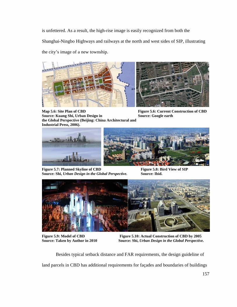
157
is unfettered. As a result, the high-rise image is easily recognized from both the
Shanghai-Ningbo Highways and railways at the north and west sides of SIP, illustrating
the city’s image of a new township.
Map 5.6: Site Plan of CBD Figure 5.6: Current Construction of CBD Source: Kuang Shi, Urban Design in Source: Google earth the Global Perspective (Beijing: China Architectural and Industrial Press, 2006).
Figure 5.7: Planned Skyline of CBD Figure 5.8: Bird View of SIP Source: Shi, Urban Design in the Global Perspective. Source: Ibid. Figure 5.9: Model of CBD Figure 5.10: Actual Construction of CBD by 2005 Source: Taken by Author in 2010 Source: Shi, Urban Design in the Global Perspective.
Besides typical setback distance and FAR requirements, the design guideline of
land parcels in CBD has additional requirements for façades and boundaries of buildings
158
along the streets. For example, building boundaries along main avenues and public plazas
should completely attach to the setback line. Moreover, all driveways should be placed
on branch streets instead of main avenues. All the first four floors of buildings in CBD
are commercial and business use, forming a unified vision with a strong commercial
atmosphere. Those detailed requirement have led to visual consistency on main roads in
the CBD.
However, the entire CBD lacks activities and social opportunities. With less than
half of high-rise buildings finished and only one open space (Century Park), there is a
limited flux of people and business activities. By contrast, Yuanrong Plaza, located to the
east of Jinji Lake in the Phase 2 District, has attracted people with its fashion shows,
commercial shops, restaurants, and varied recreational facilities. Yuanrong Plaza is
designed as a shopping center with river crossings throughout the mall. In the
surrounding area, there is a Ferris wheel park and home discount shops (like IKEA from
Scandinavia and the Home Depot from the US). After playing and shopping in those
places by day, people tend to select Yuanrong Plaza for dinner or for other evening
activities. This distinction reduces CBD’s exchange activities, and makes it necessary for
CBD to propose more commercial uses.
4.3 Residential Neighborhood Center
Resembling Singapore’s new town plan principles, SIP’s residential areas are
divided into three residential districts. Each district includes thirty to one hundred
thousand households, each consisting of five neighborhoods. The master plan sets up
seventeen “neighborhood centers” in each residential area. Each neighborhood center

159
serves 500 m radius that includes 8,500 households. All public and commercial facilities
are concentrated in neighborhood center and are constructed by the Plan and Construct
Bureau of the SIP Administrative Committee.
Currently there are seven neighborhood centers established in SIP. The first
neighborhood center, Xincheng Plaza, is an18,000 km2, five-story building established in
1998. It hosts a supermarket, bank, post office, restaurant, laundry, hair salon, pharmacy,
car maintenance center, clinics, and many other public services. Subsequent
neighborhood centers have added hotels and convention centers and include a series of
buildings with open parks rather than a single building.
The construction of neighborhood centers has brought convenience services to the
communities in one central location instead of traditional commercial storefronts on the
first and second floors of residential buildings. Since the land use plan separated housing
from other types of buildings, residents are the only users of these areas. As a result, only
small restaurants and supermarket chains can survive over time. In some other
neighborhoods in the industrial district, developers set retail along the streets, yet the
stores are low quality and do not have proper management or maintenance. The chaotic
façade of shops along the street conflicts with the high-quality of the modern residential
high-rise buildings. The neighborhood center has thus served residents by providing
services within walking distance, which effectively reduces wasted land resources and
attracts people with its localized concentration of retail that is sufficient to meet
consumer demand.
160
4.4 Industrial Areas
Industrial areas with high logistical demands are arranged on the north and south
sides of SIP and closely connected to main traffic arteries, including the 312 Highway,
the Shanghai-Hangzhou Highway, the Beijing-Shanghai Railroad, and several main river
channels. By contrast, high-tech-based industrial companies are located closely to
residential neighborhoods because they have a lower noise impact than heavy industrial
factories. Moreover, the detailed land use plan designates riverside areas and land along
the main roads for high-tech industrial enterprises, especially international companies.
High-rise buildings facing main roads and international company brands have formed a
city image to serve as market tool to attract more investments.
Distinct from the Shanghai Zhangjiang High-Tech Park, where clusters of science
parks dominate the whole district, only a few of the industrial areas in SIP are
concentrated as science parks. In Suzhou Industrial Park, individual international
companies play a much more important role in economic growth than those industrial
clusters. Notably, “blank land” is constructed as standard factories in industrial areas. The
factories, which have different levels of construction standards, can meet demands of
various industries. Over time, the proportion of industrial land use changes in response to
the need to adapt and to upgrade the facilities or in an effort to shift suburban areas for
urban space. Because blank land is so flexible, some areas may be maintained and
upgraded while others are demolished and replaced as hotels, restaurants, sports and
recreation facilities, or dormitories for employees.
Although Suzhou Industrial Park has achieved its remarkable development under
Singapore’s guidance and promotion investment, most of the industries in SIP are still
161
focused on manufacturing rather than incorporating true high-technology companies. One
of the most important reasons is that, unlike Beijing and Shanghai, Suzhou lacks a
research and education institute. Without sufficient research institutes and highly
educated people, sole dependence on large international companies makes it hard to form
sustainable domestic industrial clusters. Consequently, SIP developed Dushu Lake
Education Innovation Park on the south side, establishing campus branches with the aim
to provide more talent to SIP. The founding of Xi’an Jiaotong-Liverpool University
(XJTLU) also opens a new field of cooperation with foreign countries. In addition, the
fundamental educational system has become well-balanced with sixty-five community
schools scattered in three towns and two neighborhoods.
4.5 Jinji Lakeside Areas
Jinji Lake is a 7 km2 lake located in the center of SIP; it features an abundance of
natural resources. A main theme of the master plan of SIP is to take advantage of the lake
as a resource for public citizens. SIP aims to develop the Jinji lakeside area as a public
park for residents and tourism as well as a riverfront recreation place. Privatization of the
lake or lakeside is prohibited.
Within a superblock, there are opportunities to reserve areas for open space and
recreation and possibilities for forming green liner spines of open spaces. The central area
of the Suzhou Industrial Park adopts this strategy with great success, connecting the
lakefront with the large new central park. Such greenways are important visual amenities
and also provide recreational functions. People use the open space for walking, jogging,
working in the community garden, and playing.
162
Landscape design and programming of the Jinji lakeside area increased land value
and brought more people to SIP. EDAW, a well-known landscape design firm, was
commissioned by the Plan and Construction Bureau to take charge of the landscape
design in 1998. It programmed eight theme parks around the lake with different features
and functions. The Jinjihu bridge, Suzhou Technology and Cultural Center, the Suzhou
Exhibition Center, and the park with ferris wheel on the north side of Jinji Lake have
formed a cultural and recreational attraction for both residents and tourists. On the south
side, Ligongdi Causeway has been repurposed as a commercial street, and a green golf
course have created a natural commercial and leisure space. Open space has become an
important outlet for local interaction.

163
Figure 5.11: EDAW Design of Jinji Lakeside Figure 5.12: Program of Eight Functional Zones Source: Shi, Urban Design in the Global Perspective Source: SIP Website http://www.sipac.gov.cn
Figure 5.13: Overview of SIP Figure 5.14: Ligongdi around Jinji Lake Figure 5.15: Jinji Lakeside Source: Ibid. Source: Ibid. Source: Ibid.
Figure 5.16: Moon Port Figure 5.17: Yuanrong Plaza Source: Jinji Lake Website http://www.sipjinjilake.com. Source: Ibid.
Figure 5.18: Lakeside Area Figure 5.19: Jinji Lakeside Landscape Figure 5.20: Lakeside Source: Taken by Author 2010 Source: Ibid. Source: Ibid

164
4.6 Programs on Transit and Green Landscape
The entire infrastructure, roads, and buildings of SIP are newly constructed since
the project started in 1994. Despite that land use designated for roads is only 15%, lower
than the average ratio of Chinese cities, the traffic pressure in SIP is much less than those
high-tech parks developed based on existing towns. Transit was developed to help
alleviate traffic. The plan separated potential roads to handle the flow of traffic from
those more appropriate for working and shopping street; it also established links from the
north to the south, with the main axial crossing the CBD from west to east.
Unlike single-use industrial parks, SIP has many more levels in its road hierarchy
system to support different traffic demands. The eight streets in the road system plan of
the Phase 1 District have widths that range from 18 m to 52 m to serve all types of
functions, from branch streets in neighborhoods through expressways crossing different
districts. Main avenues link industrial areas and commercial areas through residential
districts, providing the most effective transit for commuting. The river system is designed
to parallel the street system. The space between the river and the street is a pedestrian
landscape with benches, sculptures, and green landscape, resembling the waterside
village framework in Suzhou’s old downtown. However, the size of blocks and widths of
streets are much larger.
One drawback, though, is little accommodation for pedestrians who wish to walk
on the streets. Over time, planners generally overemphasized the traffic functions of
streets and ignored its promise as a place for social interaction. In the residential area,
most of the high-rise housing is separated from the roads and green landscape by walls.
Most road planners did not consider pedestrians when the streets were designed.
165
Consequently, green landscaping along streets have few people despite public facilities
for them. Additionally, although design guidelines in the CBD have detailed regulations
for the consistency of façades along main streets, the roads are too wide to form a proper
path for people shopping on the street. It is necessary to construct more facilities to
enhance people’s access to the streets.
However, SIP fully used natural lakes and rivers to create a sustainable and
livable environment. Those open spaces are dispersed among industrial, commercial, and
residential areas and have enhanced surrounding land value. SIP focuses on establishing a
smooth transition from the old cultural downtown to a new township through extending
the river framework and keeping similar land blocks and cultural elements available to
the public. All of these natural and cultural resources form a green landscape network in
SIP, providing residents and workers a natural environment to live and to work.
5. Lessons and Experiences Learned from SIP
5.1 Focusing on Specific Context
The impetus that led the Suzhou Municipality to develop SIP as a mixed-use
township is threefold. First, there are various purely HIDZs within Yangtze River Delta
area. As a late developed district, it is necessary for SIP to find a distinct feature to
compete with other high-technology parks.. Second, limitation of land resources and
overpopulation caused Suzhou City to develop eastwards. Thus SIP took the
responsibility for releasing the pressures of an increasing population and demand for job
opportunities.
166
SIP culled a great deal of knowledge from Singapore’s experiences. The deputy
party secretary of SIP, Pan Yun Guan, said that from the beginning, China set out to draw
upon Singapore's institutional knowledge and expertise in three key areas: “The first was
in city planning and construction, the second was financial development, and thirdly, in
public administration. We learned from Singapore by sending our officials there for
training, as well as inviting Singapore officials here to Suzhou. There were also mutual
dialogues and exchanges. We've sent over 1,000 officials to Singapore so far.”6
SIP fully utilized Singaporean institutional knowledge for city planning,
construction, and management, including strategies for planning and management, public
utility construction, public undertakings, land development and management, real estate
development and management, environmental protection, and construction of small
townships. Singaporean professionals also helped SIP officials establish a series of
development and construction plans as well as a public management system. The
Economic Development Bureau in Singapore and departments in the Management
Bureau in Jurong Town lent accredited representatives for guidance on long-term
development.
SIP allowed more experimentation for its financial development. It used the
economic development strategies of Singapore involving investment promotion,
industrial and commercial administration, tourism development, finance and taxation,
state-owned fixed assets management, market agencies, modern logistics, and science
park management. The joint development body, CSSD, serves as a creative adjustment to
implement those strategies.

Since both countries utilize
public service
labor management
uncorrupted government,
mechanism instead of government intervention
Construction Bureau
consistency of planning during
5.2 Forming a Complete Planning System
What SIP
companies
new township.
to the development of SIP, which
Since both countries utilize different political system
public service constructs including security enforcement, public health, education, and
labor management from Singaporean experience
uncorrupted government, SIP Administrative Committee
mechanism instead of government intervention
Construction Bureau carried out planning regulations and statutory documents to enforce
consistency of planning during the implementation process.
5.2 Forming a Complete Planning System
hat SIP has learned from Singapore is not management experience of individ
ies or single departments, but integrating
new township. A well-developed planning system has
the development of SIP, which others can adopt
Figure 5.21: Planning System in SIP
different political systems, SIP selectively borrowed
including security enforcement, public health, education, and
from Singaporean experience. With regard to law enforcement and
Administrative Committee established its own
mechanism instead of government intervention for project applications. The Plan and
carried out planning regulations and statutory documents to enforce
implementation process.
5.2 Forming a Complete Planning System
has learned from Singapore is not management experience of individ
integrating a series of experiences for building
developed planning system has served as a significant foundation
others can adopt.
1: Planning System in SIP
167
selectively borrowed
including security enforcement, public health, education, and
regard to law enforcement and
competition
Plan and
carried out planning regulations and statutory documents to enforce
has learned from Singapore is not management experience of individual
building a
served as a significant foundation
168
This planning system consists of planning organization, technical principles, and
legal regulations. The separation of land development right (as invested in the CSSD)
from administrative affairs (that is controlled by the Plan and Construction Bureau)
effectively stimulates the CSSD to pursue economic profit but also leaves the
Administrative Committee rights to review and to adjust plans according to market
demand. The complete planning structures and sustainable principles of physical plans
are achieved through careful consideration of planning agencies and experts. Those plans
and their subsequent construction are authorized through legal regulations. However, in
most Chinese cities, legal aspects are still ignored because of the people-based political
system and overly rapid construction pace.
Ideal land development steps focus on infrastructure and road construction first
before considering investment promotions and project construction. In reality, due to
budget limitations, municipal governments tend to sell or to rent land for short-term profit
without making a complete master plan, much less a well-developed infrastructure.
However, the shortage of infrastructure and public service plans slow down the pace of
attracting investment, causing delay or even stoppage of further project development,
leaving the entire district with scattered projects and many vacancies.
SIP attacked this problem through phased development. The small size of a
phased area in SIP ensured that the infrastructure would be finished on time and with
high quality. A well-developed environment and complete public services within a small
phased area successfully attracted high-tech companies. The investment of international
companies and their subsequent construction in turn enhanced the land value and spurred

169
further phasing development. SIP and its surrounding five towns all used this strategy and
have made great profits.
Another recommended strategy to ensure sustainable development is to compile a
series of plans focused not only on land use but also on urban forms, especially for those
isolated areas in newly-constructed districts. Some new developments in China invested
enough capital in infrastructure at first and constructed a number of buildings but still did
not get the image of a high-tech industrial district that they desired. This result stemmed
from use of a rough land use plan. SIP Committee made many detailed subdivision plans
under the guidance of a master plan and a land use plan. Those subdivision plans
carefully considered urban forms and open spaces together with surrounding functions
and implemented the requirements through planning regulations and design guidelines. In
addition, whether a site plan is consistent with zoning code and has mandatory detailed
plans is an important factor that the Land and Real Estate Bureau uses to approve land
construction applications. Moreover, the plans should be dynamic and reviewed and
adjusted over time to accommodate market changes. The “land bank” strategy in SIP can
be used in many districts that aim to develop mixed-use communities yet did not propose
enough functions for the area during initial planning.
5.3 Several Recommend Planning Principles
• Human-Oriented Design
People’s interactions with the environment and public facilities are a key issue in
making “live” open space. All the green landscapes in SIP are open to the public, offering
sculptures, benches, sports facilities, and playgrounds. Jinji Lake’s accessible lakeside

170
region anticipates a number of visitors with its 22 km space. The programs of the lakeside
region include various recreational and cultural facilities to attract people and to answer
their demands. The facilities also enhance the land value surrounding the Jinji lakeside
area and bring more commercial activities. Furthermore, another way to improve
interaction is through construction of restaurants and housing in commercial and business
areas. Consequently, SIP began to place mixed-use areas in CBD, such as adding
commercial-residential apartments to enhance the people activities.
Offering multiple housing choices is another human-oriented principle. Plans on
residential land use considered different demands and paying abilities of potential
residents. The result is housing categorized into five types: low-rise attached housing;
medium-rise apartments; high-rise apartments; high-rise public housing; and dormitories
for construction labor workers. Despite different living densities and building quality, all
have open parks and convenient public services in a local neighborhood center within
walking distance. The closer property is to Jinji Lake, the higher land value is, so lower
density populations and lower-rise housing is planned in these locales. This approach
allows Jinji Lake to be shared by most of the residents and also balances economic
demands and social equity.
• Energy Saving
SIP has placed great emphasis on environmental protection through policy
guidance, regulation of standards, and advocacy projects. Statutory documents explicitly
regulate relevant standards in terms of sewage disposal, water facilities, pollution,
construction materials, and air emission. Through regulation, SIP strictly implements
design review, energy saving construction quality control inspection, and other means to

171
save energy and to ensure that buildings meet conservation requirements. Over time
practices have shown the effectiveness of environmental conservation strategies. SIP’s
environment has been approved by ISO14000 and is recognized as one of the first groups
of national ecological demonstration parks. The greenery coverage rate of SIP exceeds
45%. The standard coal consumption is 0.34 tons per 10,000 RMB, which is 1/4 of the
national average level. The emission of CO2 and SO2 in SIP is 1/18 and 1/40, respectively,
of the national average.7 At the November 20, 2010 meeting to promote building energy
efficiency in the Jiangsu Province, the Planning and Construction Bureau of Suzhou
Industrial Park was awarded “, an advanced building energy conservation group” by
Jiangsu Province.
The improvement of environmental quality through a high green space ratio, well-
designed public space, and high ecological standards has attracted several companies
such as Lilly Pharmaceutical, GSK, and AMD Semiconductor. These companies have
high requirements on the quality of environment and thus are convinced by SIP’s
transparent environmental conservation strategies and regulations. In April 1998, the
National Association of Countries Delegation to China highly appraised the work of
ecological strategies used in SIP after visiting Suzhou and expressed the willingness to
introduce American enterprises available opportunities to invest in Suzhou Industrial
Park as priority in China.
172
5.4 Summary
“Suzhou Industrial Park, a pioneer in experimenting new policies and measures, is becoming an important window for China to understand the outside world and playing a more obvious demonstration role. Its success urges more and more Chinese to learn and adapt the useful experience of other countries with more open concept and more positive attitude.”
China News Service, August 29, 2009
Suzhou Industrial Park combines various elements of city, garden, industry,
business, and life by centering on people, stressing harmonious development, and
managing to achieve balance between growth and public benefits, prosperity, and the
personal happiness. Both Singapore’s leading investment in SIP’s early days and SIP’s
successful planning system, approaches, and techniques learned from the Singaporeans
have played major roles in its success. Those strategies are also suitable for those high-
tech parks that show rapid development on vacant land. In addition, the pressures and
problems SIP faced can be lessons for other development districts. These problems
include segregated land use, green space along roads devoid of interpersonal interaction,
and deficiency in educational resources. SIP used a series of planning strategies to
supplement its weaknesses and serves as a model for others’ practices.
Its regional focus has presented SIP with both opportunities and challenges. At
present, from a new starting point, SIP began the Ecological Optimization Campaign and
is striving to build up renewed superiority by making new breakthroughs in technological
innovations, information projects, modern service industries, and talent pooling, all for
the goal of building up a modernized, information-based, environmentally-friendly, and
innovative-oriented industrial park. SIP has stepped onto an ecological way towards a
new “eco township.” This approach has brought higher requirements for forming an

173
effective land development system and planning structure. In this new township where
people work and live, human interaction with open space is much more important than
just laying green landscape on the blueprint. Rather, planning reveals the importance of
selecting proper principles and methods for physical planning and design.
1 “Approval on Issues Concerning the Development and Construction of Suzhou Industrial Park”, National Document by State Council [1994] No. 9 2 Suzhou Statistics Yearbook, 1996 3 National Document by State Council [1994] No.9; [2006] No. 128; [2002] No. 37; [2003] No. 11; [2004] No. 71; [2006] No. 70; [2007] No. 62; and [2008] No. 23. 4 Suzhou Municipality, ed. Recoding Suzhou: Stories of Suzhou Industrial Park (Suzhou: Guwuxuan Press. 2009). 5 "9 Utilities and Leveled Land" refers to: Roads, Power Supply, Water Supply, Gas Supply, Steam Supply, Sewage System, Storm Water Drainage, Telecommunication, Cable Television, and Leveled Land. 6 Suzhou Municipality, ed. Recoding Suzhou. 7 Suzhou Statistics Yearbook, 2008

174
CHAPTER 6: SHENZHEN HIGH-TECHNOLOGY INDUSTRIAL
PARK
1. Brief Introduction
Shenzhen High-Tech Industrial Park (SHIP) is an example of the Type 4 of
national HIDZs, which is isolated R&D oriented high-technology zones. Located in the
Nanshan District, one of the four districts within the boundary of the Special Economic
Zone of Shenzhen City, SHIP was developed as a single R&D-oriented industrial park
with its main industries as (Integrated Circuit) IC industry, consumer electronics, and
telecommunications. It was established in September 1996 and covers an area of 11.5
km2.After 15 years of development, this zone has benefitted businesses and become a
home for success. In 2003, the total industrial output value of SHIP was ¥227.2 billion,
which is 22 times its 1996 output. Occupying only 0.6% of the Shenzhen land, SHIP has
produced 30% of the city’s industrial output, and its export value was 10.7 billion USD.
Specific features in Shenzhen have contributed to development of SHIP as an
industry dominated park. Shenzhen is a city of sub-provincial administrative status in
southern China's Guangdong province, which is situated immediately north of Hong
Kong. Owing to China's economic liberalization under the policies of reformist leader
Deng Xiaoping, the area became China's first—and arguably one of the most
successful—Special Economic Zones. With 12,000,000 people, Shenzhen City has the
largest migrant population and is five times that of the registered residents (2,460,000
people).
175
The interaction between Shenzhen and Hong Kong is another driving force
behind SHIP’s development. Shenzhen is the only mainland city in China that is
connected to Hong Kong by both water and land. It was also the only opening city with
an airport and a seaport in the 1990s. This geographic advantage makes it possible for
Shenzhen to make full use of each other’s recourses. Hong Kong needs to resort to
mainland technical power to develop high technology, and utilize the mainland
manufacturing industry to develop the service industry. Meanwhile, Shenzhen takes full
advantage of capital and information resources provided by high technology products
from Hong Kong. Numerous high technology enterprises made use of Hong Kong’s
capital market, and raised funding supports for development.
In the past fifteen years, SHIP has undergone an evolution. Before SHIP’s
establishment in 1996, there were several scattered industrial bases in this area. These
industrial bases were comprised of individual institutes or companies. Historically,
industry in SHIP was based on intensive labor work and processing factories. Shenzhen,
which is the same as other cities in China, has no restriction in regards to population
mobility, but is comparatively more open to the market. Thus, a large number of
surrounding farmers moved to Shenzhen. With a low level of education, most of these
farmers did manual labor. Abundant migrants provided a solid industrial employee base
for SHIP. In the beginning stage, when labor-intensive work was the major contributing
factor to the economic development of Shenzhen, migrants created a significant amount
of processing work.
After the readjustment of the industry by the Shenzhen Municipal Government in
2000, more and more R&D centers, together with other commercial, residential, and

176
public service functions, moved into SHIP. The development of SHIP’s trade and
production activities led to the growth of higher qualified labors and advanced
technologies. Thus, Shenzhen Municipality moved processing factories to nearby villages
and towns surrounding SHIP, and established research centers in the park. Besides, the
distance from Shenzhen to Hong Kong shortens the transporting time from production to
trade market. When talking about why someone should invest in Shenzhen, one director
of a foreign enterprise said, “Products were assembled in the morning in Shenzhen, and
arrived in the afternoon at Hong Kong airport”.1
SHIP is located in the Shenzhen Nanshan District, which is inside the boundary of
a special zone and benefits from the advantageous policy of an economic special Zone.
But there is a quite distance from SHIP to the center of Shenzhen; it is located on the line
from the city’s center to the airport, and connects to the front of the south sea. Since
the1990s, small sized processing industry parks with nearby Shenzhen University
provided fundamental resources for SHIP’s construction. Moreover, because SHIP is
dominated by single industry development, it depends more on the airport and seaport
supply chain, as well as a mobile suburban labor force, than the connection with the
city’s center.
Several distinct characteristics of SHIP has led to its specific development in
terms of land use and planning mode. First of all, due to the limited land area in
Shenzhen Special Economic Zone, SHIP is one of the smallest national High-Technology
Industrial Development Zones. This results in more demand for intensive development in
this area. Secondly, most of the companies in SHIP are domestic-developed private civic
enterprises, instead of state-owned institutes or large international companies. They
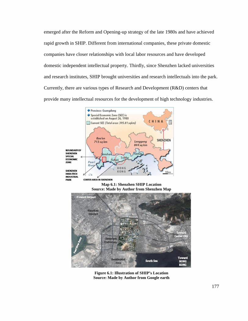
177
emerged after the Reform and Opening-up strategy of the late 1980s and have achieved
rapid growth in SHIP. Different from international companies, these private domestic
companies have closer relationships with local labor resources and have developed
domestic independent intellectual property. Thirdly, since Shenzhen lacked universities
and research institutes, SHIP brought universities and research intellectuals into the park.
Currently, there are various types of Research and Development (R&D) centers that
provide many intellectual resources for the development of high technology industries.
Map 6.1: Shenzhen SHIP Location Source: Made by Author from Shenzhen Map
Figure 6.1: Illustration of SHIP’s Location Source: Made by Author from Google earth

178
The case of Shenzhen High-Tech Industrial Park has provoked several following
considerations. How should plans be made according to the transformation of industrial
focuses? In what context is SHIP’s management mode appropriate? What is the benefit of
developing SHIP as an open “space” rather than just a production-trading place? Why
should SHIP gain sufficient intellectual resources, despite the serious lack of research
institutes during the initial periods?
SHIP uses a lot of planning strategies to address these questions. The industrial
development in SHIP caused the transformation of planning strategies in terms of land
use, planning system, management agency, and planning content. The planning activities,
in turn, have impacted the environmental layout, land framework, and human activities in
SHIP. Moreover, with limited land resources in SHIP, the Shenzhen Municipal
Government began to establish the High-Technology Industrial Belt, a group consisting
of 11 districts and driven by SHIP, to displace processing labor factories outside and
increase R&D powder within SHIP.
2. Historical Evolution
2.1 Why develop high-tech industry in Shenzhen?
Shenzhen City’s industry started from almost zero and has experienced three steps
during its several decades of development. The first stage was before 1985, when the
Shenzhen Economic Zone was approved and started to attract investments. During this
period, it established an industrial foundation. The second stage was from the late 1980’s
to the early 1990’s. During this time, Shenzhen’s industries developed at a high rate.
179
Shenzhen established a variety of export-oriented enterprises. The third stage started
in1996 when SHIP was established. Since then, high technology industries developed
rapidly, with an annual growth rate of 40%.
With increasing nationwide competition in the 1990s, Shenzhen began to consider
changing industrial types from processing to high technology. Due to its lack of natural
resources, Shenzhen needed technological progress and high technology industry to
enhance its economic development and area competition. Moreover, as the reform and
opening situation became apparent in many other regions, foreign trade channels had
been increased. Shenzhen’s specific advantage as a Special Economic Zone has become
weakened, and the impact of advanced preferential policies became much less than
before. At the same time, the cost of key production in Shenzhen, for example, land and
labor resources, increased constantly. This constrained the development of labor intense
processing industries. In early 1990’s, when some foreign factories began to move north
of Shenzhen, the previous trade development format became weakened.
In the late 1980s and the beginning of the 1990s, the Shenzhen municipal
government completed a comprehensive survey and research initiative. They realized the
importance of high-technology development for future industry. Thus, many industries,
like computer, telecommunication, and bioengineering, were regarded as strategic
industries to aid in the economic development that was designed to positively affect
Shenzhen’s future. However, due to its lack of technical expertise, Shenzhen did not have
any chance to directly develop large information technology bases. Thus, Shenzhen
adopted a way of introducing advanced technology, technical facilities, and high
technology enterprises from outside regions. Under the leadership of the government, in

180
the early of 1990s, Shenzhen developed many small independent high technology areas,
such as the technology industry area jointly run by Shenzhen and Chinese Academy of
Sciences. This is the earliest established high technology area with total area of 1.02 km2;
this was followed by the establishments of Shenzhen technology industry area, the
Chinese Technology Development Institution, the Shenzhen High Technology Industry
Village, the National Electronic Technology Application Laboratory Center, and
Shenzhen University. These industrial bases and small enterprises helped establish an
economic foundation for the development of a high technology industry.
With the rapid development of the high technology industry in the late 1990s,
government and other enterprises established a common view on the positive effect of the
high technology industry. Thus, Shenzhen High-Technology Industrial Park was
constructed, and formed its own features during its process of industrial development.
Nowadays, the high technology industry has become the main economic power
contributing to the improvement of Shenzhen’s industrial development.
2.2 Development of Shenzhen High-Technology Park
With booming development of the high technology industry in Shenzhen from
1991 to 1996, the Shenzhen municipal government set up an agenda to improve the
quality of the high-tech industry. In 1996, the government created the International
Development Strategy of the High Technology Industry, whose aim was to use
international investment to promote the development of domestic companies. In May of
1996, the government created SHIP, located on the site of several small industry areas.
An Administrative Group was established to lead SHIP; this group was directed by

181
Shenzhen City’s Mayor Zibin Li. The group consisted of officials from nineteen
municipal bureaus, such as the Technology Bureau, the Land Resource Bureau, and the
City Planning Bureau. The Administrative Office was set up under the lead of the
Administrative Group, and worked as the municipal government’s agency whose task
was to manage all the high technology affairs in SHIP.
Covering small individual industrial bases, SHIP has an area of 11.5 km2. It is
divided into the North, the Middle, and the South areas. Most of the previous small
industrial bases were located in the Middle area. Shenzhen University was located in the
South area. Both the North and Middle areas were planned as a unified managed place,
while the South area extended the area by reclaiming land from the sea, and started the
construction of an infrastructure.
When the Shenzhen government developed the idea of the High-Tech Industrial
Belt in 2002, SHIP had already established many functions like IC production, software,
telecommunication, biology, new material, higher education, and research in its fully
developed 11.52 km2piece of land. Over 200 high technology industries gathered together
in this area. Besides the private domestic enterprises, such as Great Wall, Huawei, ZTE,
Lenovo, APTECH, TCL, Founder, and Tongfang, Many multi-national enterprises, such
as IBM, Philips, Compaq, Olympus, Epson, Lucent, Harris, and Thompson. Lenovo, who
initially planned to enter Shenzhen in 1993 but gave up due to the high cost of land
resources, came back to Shenzhen and also removed its research center into SHIP. A
Lenovo official is quoted as saying “they came back because of the increasingly intense
atmosphere in this high technology district.”2

182
3. Planning and Management Strategies
The development of high technology in Shenzhen started in 1990s at a slow pace
but rapidly developed. It profits largely from successfully merging technology and
economic development. A well-managed and well-planned urban environment
contributed to this partnership. Here, the environment refers to the infrastructure, as well
as the physical environments and facilities for all city activities. Planning and
construction of the environment has promoted the agglomeration of enterprises in SHIP.
In turn, the development of high technology brings more demands to planning and
management. Based on local characteristics, SHIP has adopted several planning strategies
involving management agency, statutory plans, incremental land use, planning of
environment, and further high-tech industrial belt to address the problems in development,
as discussed below.
3.1 Management Agency
The Shenzhen Municipal Government is responsible for the leadership, decision-
making, planning and macro-management of SHIP. It adopts an open-oriented three-level
management pattern that is in line with Chinese laws and regulations. The decision-
making body is the Administrative Group of SHIP with the mayor of Shenzhen as the
head. This body supervises the implementation of the relevant policies regarding the
development of SHIP. The management body is the Administrative Office of SHIP and is
responsible for the routine daily high technology activities in SHIP. The service body,
which includes the Service Center of SHIP, the Service Center of Shenzhen Virtual
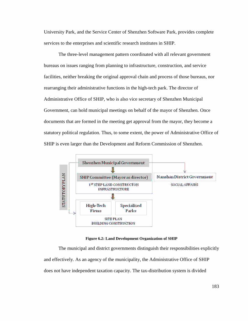
University Park
services to the enterprises and scientific research institutes in SHIP.
The three
bureaus on issues ranging
facilities, neither breaking the original approval chain and process of those bureaus, nor
rearranging
Administrative Office of SHIP
Government, can h
documents
statutory political regulation. Thus
SHIP is even larger than the Development an
The municipal and district
and effectively
does not have independent taxation capacity.
University Park, and the Service Center of Shenzhen Software Park
to the enterprises and scientific research institutes in SHIP.
The three-level management pattern
on issues ranging from planning to infrastructure, construction, and service
facilities, neither breaking the original approval chain and process of those bureaus, nor
rearranging their administrative functions in the
Administrative Office of SHIP, who is also
Government, can hold municipal meetings on behalf of the mayor of Shenzhen. Once
s that are formed in the meeting get approval
statutory political regulation. Thus, to some extent, the power of Administrative Office of
is even larger than the Development an
Figure 6.2: Land Development Organization of SHIP
he municipal and district governments
effectively. As an agency of the municipality, the Administra
does not have independent taxation capacity.
and the Service Center of Shenzhen Software Park, provides
to the enterprises and scientific research institutes in SHIP.
t pattern coordinated with all relevant government
from planning to infrastructure, construction, and service
facilities, neither breaking the original approval chain and process of those bureaus, nor
ive functions in the high-tech park. The director of
also vice secretary of Shenzhen Municipal
on behalf of the mayor of Shenzhen. Once
formed in the meeting get approval from the mayor, they
to some extent, the power of Administrative Office of
is even larger than the Development and Reform Commission of Shenzhen.
Figure 6.2: Land Development Organization of SHIP
governments distinguish their responsibilities explicitly
municipality, the Administrative Office of SHIP
does not have independent taxation capacity. The tax-distribution system is divided
183
es complete
with all relevant government
from planning to infrastructure, construction, and service
facilities, neither breaking the original approval chain and process of those bureaus, nor
tech park. The director of
Municipal
on behalf of the mayor of Shenzhen. Once
become a
to some extent, the power of Administrative Office of
mmission of Shenzhen.
distinguish their responsibilities explicitly
tive Office of SHIP
is divided

184
between the municipality and the local government. Neither the Administrative Group
nor the Administrative Office of SHIP is responsible for the social activities in SHIP.
Rather, the local district government of the Nanshan District where SHIP is located
provides services that include schools, hospitals, and retail and public facilities in
neighborhoods. As early as the 1990s, the office intended to establish a joint development
company to oversee land development. However, in Shenzhen’s free market economy,
the company over-emphasized profit and revenue but overlooked high-tech industries.
Thus, Shenzhen Municipality repurchased the stock of the company, and changed the
land development to in-budget development.
3.2 Incremental Development vs. Statutory Plan
SHIP does not have its separated subdivision plan. Instead, SHIP has a planned
industrial area integrated in the Nanshan District Plan under the guidance of the
comprehensive plan of Shenzhen Special Zone. Nanshan District Plan established SHIP
as a base combining several existing industrial parks on site. For instance, the transit plan
and the green space plan of Nanshan District have explicitly defined and regulated
planning in SHIP.
Nevertheless, in 1996, the Municipal Party Committee and the Municipal
Government established a planning group consisting of 44 experts from 25 relevant
department and bureaus, whose aim was to develop a series of plans for SHIP. The
planning group includes a main section, an industry section, a land and construction
section, and a regulatory section. They have finished the development plan, the land use
plan, and the industrial plan of SHIP in one to two years and got those plans approved.
185
The basic framework of the plans was well carried out and is still guiding SHIP’s
developments today.
Despite constant land use structure, SHIP underwent regeneration over time. At
the initial step of Chinese Reform and Opening up in the 1980s, Shenzhen, as the first
Special Economic Zone, engaged its industrial development in the global division of
world economy. Due to outmoded economic thinking, what Shenzhen got at that time
was only the production role rather than developing manufacturing industries with
independent intellectual property. Consequently, in the 1990s, the planning of SHIP
focused on providing basic physical environment and infrastructure for production. It
developed the road structure among existing small industrial parks, and used the roads
and infrastructure to link them together to form a basic framework of a high-technology
industrial park. The completion of the basic infrastructure and production environment
led to rapid industrial development in SHIP. Correspondingly, the planning of SHIP
began to infill a series of functions involving commercial, business, cultural, research,
and educational uses into the site. For instance, Shenzhen Software Park was established
to aggregate software enterprises together under well-planned standard office buildings.
The adjusted development plan displaced some outside processing factories and brought
housing and commercial areas into the site in order to meet the demands of high-tech
industry development.
The control of construction is under the statutory plan of SHIP. Shenzhen is the
first Chinese city to formulate statutory land-use plans as legal documents. Until 2005,
the Shenzhen Urban Planning Board had approved the five statutory plans in SHIP.
Following the Hong Kong model, the statutory plan is similar to zoning regulation and
186
has a set of criteria to regulate development. It consists of a map and text explanations,
with the map showing how the sub-districts are divided into small zones, and text
describing the rules that apply to each zone. All parcels are indexed by number, and
acceptable land activities (first category) for each indexed parcel are also listed on the
map. In addition, the statutory plan provides a land-use control table to offer further
criteria that includes lot area ,floor area ratio, green space ratio, a second category of
allowable land-use types(second category requiring city government approval), as well as
a third category (requiring approval from the Urban Planning Board).
The statutory plans in SHIP have left flexible space for incremental change in this
district. For instance, when the statutory plan of the North-West area in SHIP was
approved in 2002, half of the land parcels in this area were awaiting investment. Thus, in
the plan, the first category stipulates those lands as “high-tech park industrial use” but
leaves the second and third category blank for further development guidelines. Contrarily,
in 2002, the statutory plan of the South Area in SHIP explicitly specifies land use types
and volumes as most of the land parcels in the South Area have been leased to developers
and subsequently constructed.
SHIP is undergoing much faster development than the approval of the plans. It
takes a long time to prepare and approve a statutory plan as a legal document. Shenzhen
Municipal Government established a three-level system, including the planning
technology committee, the statutory plan committee, and the urban planning committee,
to approve the plan. There are over 40 meetings on statutory plans each year. In addition,
due to several controversial arguments on whether the statutory plans are suitable to
become legal control documents, the development rate was reduced, as well as any

187
amendment to these plans. Thus, the depth of control illustrated in the statutory plan is
still too loose to regulate the local activities at each site.3
Table 6.1: Planning System in Shenzhen
Master Plan District Plan Statutory Plan Focus 1. Function of the
city 2. Scale of the city
(population size and urbanized area)
3. Future development goals
4. Overall arrangement of different district of the city
1. Land-use arrangement
2. Transportation network
3. Open space 4. Preservation 5. Utility network
1. Land-use type 2. Development
intensity 3. Facility layout 4. Transportation
Geographical Coverage
The whole city 73-180 km2 Varying between 0.65 and 74.61 km2
Time Span Until 2020 Until 2020 Not applicable

188
Map 6.2 Land Use Plan of Nanshan District
Source: Land Use Plan of Nanshan District 2006-2010
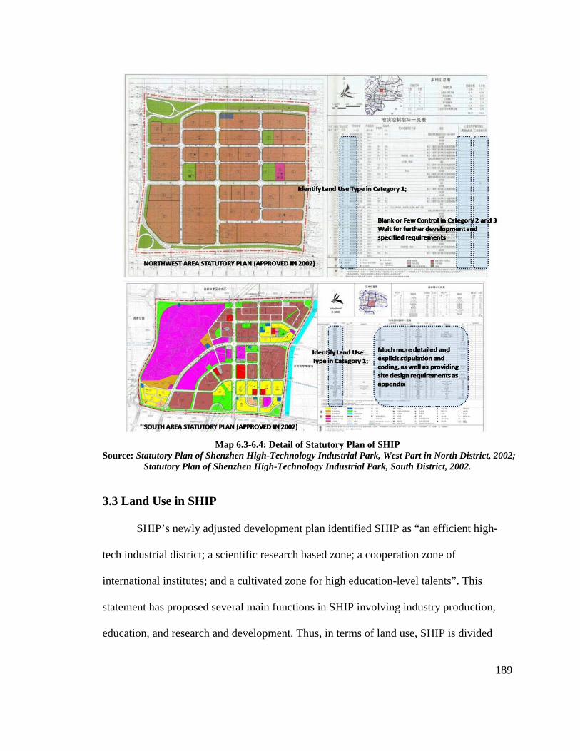
189
Map 6.3-6.4: Detail of Statutory Plan of SHIP Source: Statutory Plan of Shenzhen High-Technology Industrial Park, West Part in North District, 2002;
Statutory Plan of Shenzhen High-Technology Industrial Park, South District, 2002.
3.3 Land Use in SHIP
SHIP’s newly adjusted development plan identified SHIP as “an efficient high-
tech industrial district; a scientific research based zone; a cooperation zone of
international institutes; and a cultivated zone for high education-level talents”. This
statement has proposed several main functions in SHIP involving industry production,
education, and research and development. Thus, in terms of land use, SHIP is divided

190
into three areas. They are: the North Area, which is dominated by the production factories
of the photoelectric industry; the Middle Area with industries such as software, biological
engineering, and computer science; and the South Area, with an industrial base of
electronic information, as well as a main center for management, education, R&D,
exhibition, commercial and business activities. Currently, there are four major types of
buildings in SHIP: office tower buildings, large modern factory buildings, workers’
dorms, and an informal retail and restaurant spaces. These commercial activities are
mainly located along Keyuan Road, which is the main axis of the region. Most of the
office buildings are located along Shenzhen Road, which is crossed by Keyuan Road and
separates the South and Middle Areas.
Map 6.5: Districts in SHIP Map 6.6: Land Use in SHIP Source: Made by Author on Shenzhen Map Source: Land Use Plan of SHIP, 1998.

191
This pattern of land use evolved from the initial scattered industrial parks. Most of
the previous land parcels were less than 0.01 km2 and had low efficiency. Thus, based on
the demands of newly emerged high-technology companies, the land use plan regulated
each industrial land parcels into areas larger than 0.02km2, and provided standard
factories to agglomerate those small-sized factories and companies.
In 2000, the adjustment of the land code led to the transformation of SHIP
companies from production to research and development based. In the 1990s, most of the
newly boomed domestic private companies in SHIP were small in scale and needed the
financial support of the Administrative Office in SHIP to survive. After their successful
development towards larger companies, the Office changed the relationships with those
companies from funding support to normal land leasing and construction approval. In
2000, one of the biggest domestic private companies, Zhongxing Co. Ltd, applied for
higher FAR in its site due to the limited land resources in SHIP. While SHIP’s
Administrative Office tended to agree with this application, the planning department of
Shenzhen Municipal Government rejected this request. The reason is that higher FAR in
this site would cause discordant urban form in the surrounding area; more importantly, it
is possible for Zhongxing Company to use the additional area for commercial real estate
rather than industrial production. The Shenzhen Municipal Government finally made the
following decision. First, the government clarified the characteristic of Zhongxing
Company, which is an IT industry that is research and development based and distinct
from normal manufactory companies. Thus, it is reasonable to increase the ratio of R&D,
trade, and service areas. Secondly, based on a wide and deep investigation, the
government suggested that SHIP’s development plan should emphasize R&D companies

192
rather than production factories. Thus, the FAR can be slightly enhanced. Also,
Zhongxing Company was required to properly adjust its architectural design to avoid
conflicts with surrounding areas. This argument has motivated the rethinking of high-tech
industries in SHIP. Furthermore, the investigation finally caused the R&D orientation of
today’s SHIP.
Realizing the important effect of R&D functions, the Shenzhen Municipal
Government provided strong supports to establish several research bases. Under the on-
site supervision of municipal officials, it took less than one month to finish the flat land
for construction of Peking University Biological Valley, which consisted of an 87,000
km2 area and took only one day to finish the application process. Moreover, the Shenzhen
Municipal Government invested ¥250 million into the planning and construction of
Shenzhen Software Park.4 So far, the Shenzhen Software Park consists of over 80% R&D
centers of multinational companies who were attracted to SHIP because of its green space,
complete service, high quality of infrastructure, and unified management.
Rather than R&D centers of companies, SHIP also established large buildings for
important research bases. One of the examples is the site design of Shenzhen-Hong Kong
Research Institution. With a gross area of 36,000 m2, this site was finished construction
in less than one year. The site has three parts, including a teaching building, a high-
technology research area, and a public training area. The teaching building has facilities
that can accommodate remote education, public classrooms, and MBA and MPA training.
The High-technology research has an area of over 20,000 m2, which has gradually
brought in many key state laboratories and high-tech enterprises that were incubated at
Peking University or University of Hong Kong. The public areas include an exhibition

193
center, a conference room, a multifunction room, and an intermediary agent service space.
Those comprehensively developed functions have intertwined together to form a mature
research base, providing strong R&D support to high-tech industries.
3.4 Planning of Assorted Environment
For a single R&D research based industrial park, the physical planning in SHIP
mainly focuses on supporting four kinds of assorted environments: (1) environments for
human activities, such as cultural, recreation and sports areas; (2) industrial environments,
such as well-planned land use pattern and functions; (3) information environments with
unified information networking; and (4) community environments affording daily
services for employees and residents. Currently, the North Area has hotels and civic
parks for employees and business visitors; the Middle Area has established a large
supermarket and bookstores, together with leisure plazas for residents in neighborhoods
and employees in the Software Park. Based on Shenzhen University and Virtual
University Park, the South Area has many clubs of company presidents, commercial
retail spaces, restaurants, and student apartments. Due to its high environmental standards,
SHIP has been issued the ISO9001 Quality Management System Certificate, ISO14000
Environmental Management System Certificate, and the SA8000 Social Accountability
Management System Certificate.
Moreover, according to Development Plan of SHIP in 2008, the capacity of
SHIP’s employees is about 137,000 persons. SHIP’s land use can only accommodate less
than 90,000 residents on site, which means that about 50,000 employees need to
commute work. This has motivated construction of many residential projects in the areas

194
surrounding SHIP, such as Taoyuan Village to the east of SHIP, or reclamation areas to
the southwest part. A developed subway system has largely promoted the real estate in
those areas.
As an R&D based park, SHIP’s land use pattern of is different from those mixed-
use new town type science parks, where residential and commercial lands dominated
center areas, with industrial lands at the marginal edge of parks. The residential lands
inside SHIP are formed into groups of neighborhood apartments, located separately in
each industrial district. Those employees working in nearby industrial areas have priority
and preferential support for those housings. This plan effectively minimizes the distance
between work and home, and reduces the work flow.
In terms of the road system, most of the land use are for industrial functions and,
consequently, the road structure in SHIP is designed in a grid and block horizontally and
vertically. Single industrial land use and a few other services have led to four levels of
street hierarchy. The first type, freeway or express way, is for long-distance routes
connecting metro areas. The second type is public transit routes connecting regional
functional groups within Shenzhen City. The third type is frequently used main streets
connecting different functions inside SHIP, while the fourth type is streets between
neighborhoods and working places within each area. Compared with mixed use district,
the road system in SHIP is much simpler because the industrial use has much less
demands for diverse road styles. Nevertheless, there is a lack of pedestrian streets in
SHIP’s residential areas, causing inconvenience for people’s daily activities.
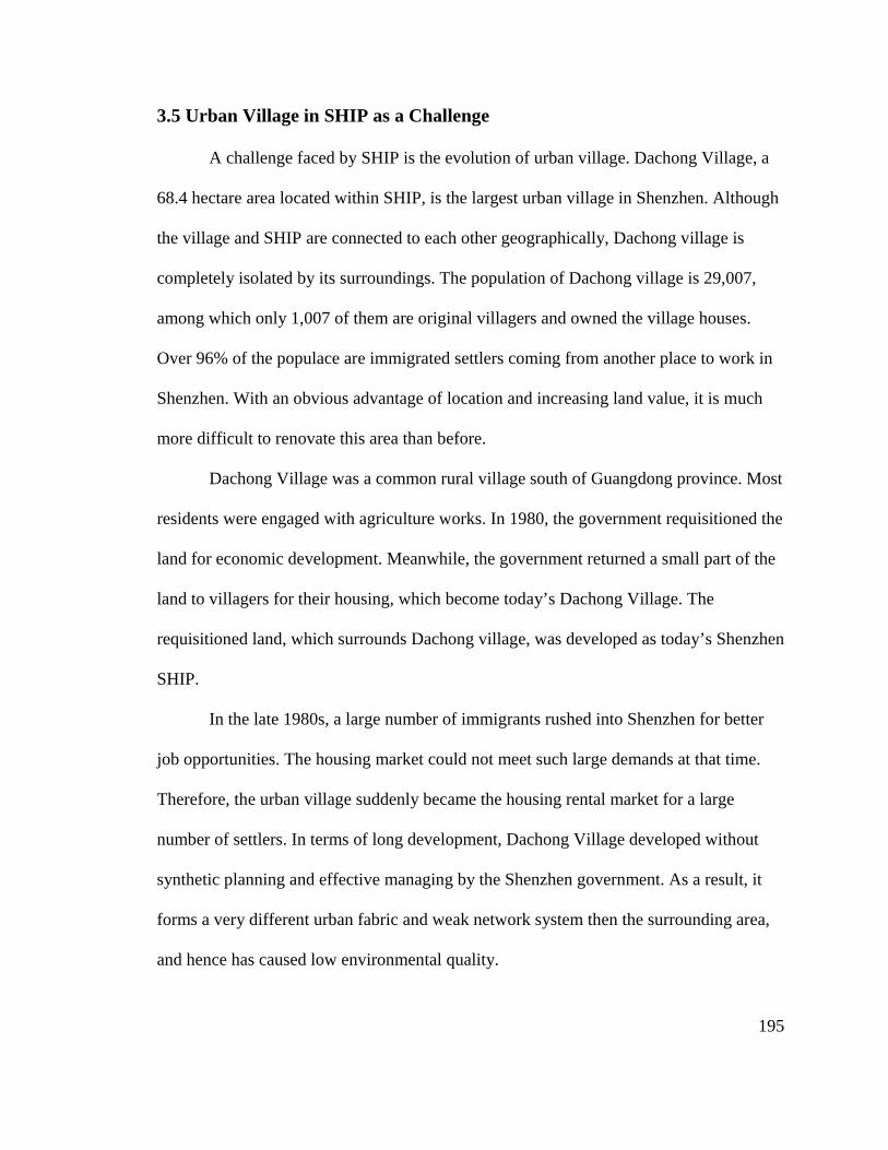
195
3.5 Urban Village in SHIP as a Challenge
A challenge faced by SHIP is the evolution of urban village. Dachong Village, a
68.4 hectare area located within SHIP, is the largest urban village in Shenzhen. Although
the village and SHIP are connected to each other geographically, Dachong village is
completely isolated by its surroundings. The population of Dachong village is 29,007,
among which only 1,007 of them are original villagers and owned the village houses.
Over 96% of the populace are immigrated settlers coming from another place to work in
Shenzhen. With an obvious advantage of location and increasing land value, it is much
more difficult to renovate this area than before.
Dachong Village was a common rural village south of Guangdong province. Most
residents were engaged with agriculture works. In 1980, the government requisitioned the
land for economic development. Meanwhile, the government returned a small part of the
land to villagers for their housing, which become today’s Dachong Village. The
requisitioned land, which surrounds Dachong village, was developed as today’s Shenzhen
SHIP.
In the late 1980s, a large number of immigrants rushed into Shenzhen for better
job opportunities. The housing market could not meet such large demands at that time.
Therefore, the urban village suddenly became the housing rental market for a large
number of settlers. In terms of long development, Dachong Village developed without
synthetic planning and effective managing by the Shenzhen government. As a result, it
forms a very different urban fabric and weak network system then the surrounding area,
and hence has caused low environmental quality.

196
The scheme of Dachong Village’s reformation was first brought forward by the
Shenzhen Planning department in 2002. In 2004, the urban planning regulation on urban
village reformation was approved by the Shenzhen government. In 2005, the Dachong
village reformation commenced. The new reformation scheme will demolish the old
Dachong Village and build a high-class modern residential area combined with office,
entertainment, and retailing facilities. However, after the scheme was approved, the
villagers found that the new property value and benefit of the development are much
higher than the compensation they received. Therefore, they did not agree with the
compensation program and refused to remove. As a result, the whole project had to be
shut down atthe end of 2005.
Renovation of an urban village is a difficult systematic project involving planning
techniques, land, compensation for displacement, and problems with land property
ownership. It is related to many social and economic issues and is more complex than
simply demolishing buildings and removing residents. According to report, the
renovation project in Dachong, Nanshan District, started on Saturday, 25th January 2010,
with 168 families in the neighborhood having signed an agreement with the project
developer the same day. However, how to negotiate with settlers, how to relocate the
immigrants, and how to infill this land as an integrated park of SHIP, is still a challenge
to the government and city planners.
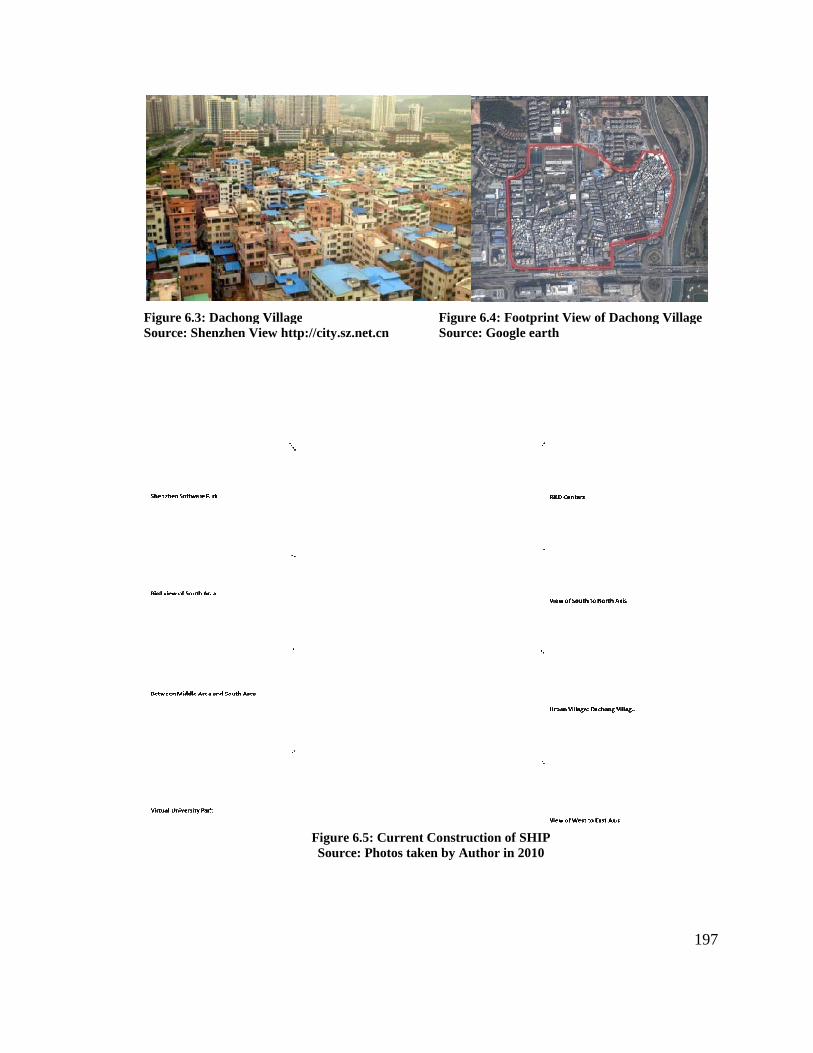
Figure 6.3: Dachong VillageSource: Shenzhen
: Dachong Village Shenzhen View http://city.sz.net.cn
Figure 6.5: Current Construction of SHIPSource: Photos taken by Author in 2010
Figure 6.4: Footprint View of Dachong Village Source: Google earth
: Current Construction of SHIP
Source: Photos taken by Author in 2010
197
w of Dachong Village

198
3.6 High-Technology Industrial Belt: Further Development
Among the national High-Technology Industrial Development Zones, Shenzhen
High-Technology Industrial Park is one of the smallest. Despite this, there has been
intensive land utilization; however, further development was halted by lack of potential
space. Early in 2000, SHIP’s Administrative Office had to deny an application of high-
tech industrial base from an American IC company, as it required a site with over 1km2,
which SHIP cannot afford. In recent years, SHIP has cleared up and adjusted over 1.12
km2 of usable land; the shortage of land supply is still not resolved.
Consequently, Shenzhen Municipal Part Committee propounded a scheme of
developing High-Technology Industrial Belt across regional areas both in and out of
Specific Economic Zone in Shenzhen. This scheme is based on several existing industrial
areas in Shenzhen’s metro region, led by SHIP as the main anchor. There are 11 proposed
districts in this belt with different main functions. The planned High-Tech Industrial Belt
is 100 km long, covering 152.62 km2 of land, which equals 12 times the original SHIP.
In terms of industrial development, High-Tech Industrial Belt emphasized the
R&D function of SHIP, and planned to gradually displace the manufacturing companies
and processing industry with more high-tech industries and their R&D functions. This
program, if implemented, will significantly increase the capacity of research and
development function in SHIP, as well as keep assorted industries in surrounding areas.
However, the implementation of developing the industrial belt faces challenges resulting
from different strategies inside and outside the Special Economic Zone. Also, the lack of
rapid transit network restricts the development. Consequently, in July, 2010, the
199
Shenzhen Municipal Government announced the extension of the Special Economic
Zone’s boundaries from its original four districts to its current area covering the entire
Shenzhen City, which is five times as large as before. This strategy strongly reduced the
imbalance between the special zone and the non-special zone, providing an equal
political environment for further development.
In terms of industrial development, High-Tech Industrial Belt emphasized the
R&D function of SHIP, and planned to gradually displace the manufacturing companies
and processing industry with more high-tech industries and their R&D functions. This
program, if implemented, will significantly increase the capacity of research and
development function in SHIP, as well as keep assorted industries in surrounding areas.
However, the implementation of developing the industrial belt faces challenges resulting
from different strategies inside and outside the Special Economic Zone. Also, the lack of
rapid transit network restricts the development. Consequently, in July, 2010, the
Shenzhen Municipal Government announced the extension of the Special Economic
Zone’s boundaries from its original four districts to its current area covering the entire
Shenzhen City, which is five times as large as before. This strategy strongly reduced the
imbalance between the special zone and the non-special zone, providing an equal
political environment for further development.
The construction of the High-Tech Industrial Belt also brought an opportunity to
develop an ecological metro-region. The planned Belt covered several water source
protection areas and ecologically sensitive areas. As a result, it required a much higher
quality of environment conservation. The plan of the High-Tech Industrial Belt has
implemented several strategies to ecologically protect the environment. They include: in
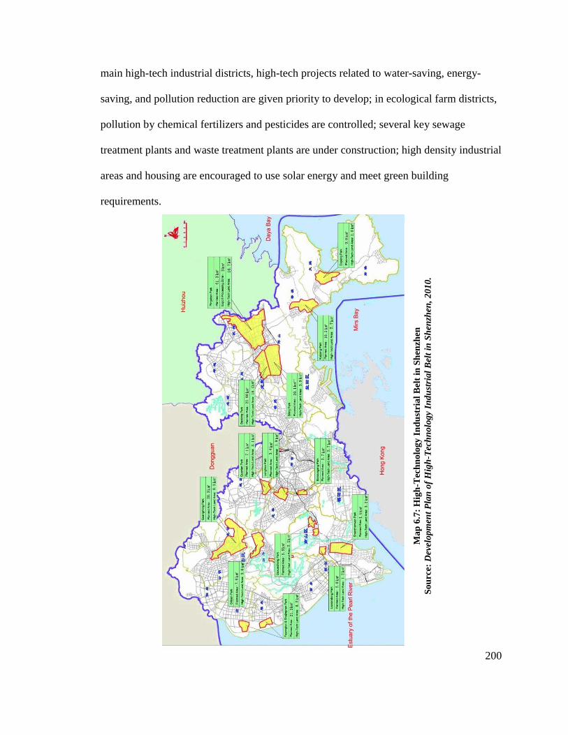
200
main high-tech industrial districts, high-tech projects related to water-saving, energy-
saving, and pollution reduction are given priority to develop; in ecological farm districts,
pollution by chemical fertilizers and pesticides are controlled; several key sewage
treatment plants and waste treatment plants are under construction; high density industrial
areas and housing are encouraged to use solar energy and meet green building
requirements.
Map
6.7
: Hig
h-T
echn
olog
y In
dust
rial B
elt i
n S
henz
hen
Sou
rce:
Dev
elop
men
t Pla
n of
Hig
h-T
echn
olog
y In
dust
rial B
elt i
n S
henz
hen,
201
0.

201
4. Development of SHIP
4.1Companies in SHIP
Historically, Shenzhen has tried to develop high-tech parks depending on state-
owned industries, which are supported by state government capital. The traditional
connection between government and state-owned institutes has had a positive effect on
speeding up the development of large-scale industries; however, it is proved to be
ineffective in promoting high-tech industries, such as the IT industry. Contrarily, some
enterprises that develop without state-owned institutes’ control had more rights to handle
their own affairs, and developed very fast. Thus, the Shenzhen Government gave up
dependence on state-owned institutes and governmental direct investment. The Shenzhen
Municipal Government explicitly clarified the government’s responsibility: it could plan,
direct, support and create a nice environment, but not invest directly as a state-owned
company to monopolize the entire area.
Thus, small and medium sized enterprises, especially those domestic private ones
developing on their own, have become a basic characteristic of SHIP. Beginning in 1995,
the Shenzhen Municipal Party Committee and Municipal Government began to establish
a high technology industry village as a way to gather twenty-four newly established high
technology industries. Despite the small scale of the industry, the technological level was
high. Many of them have become major domestic private companies after establishment
of SHIP in 1996
Most of the domestic private enterprises are established by technicians. They
collected capital, got together to form the team, handled the business, and took the
202
responsibility forprofit and loss by themselves. Most of them concentrated on the
activities of development, transfer, counseling and serving. Private is not a signal for
economic category, but is a special product in China, differing from those state-owned
industries and companies with the Chinese government’s support and investment.
However, private enterprises have some disadvantages. For example, they are in
small scale and are in lack of human resources. Those features of private enterprise have
brought a special characteristic to SHIP. Shenzhen had made a great effort to solve the
lack of human resource in the private industry. The municipal government provided
funds to cooperate with national technology committee, prestigious universities, and
famous universities to establish research centers in order to strengthen the technology
research power. Moreover, the Administrative Group in SHIP was inclined to small and
medium sized enterprises in policies; they supported and encouraged private industry to
establish their own research bases. At the same time, SHIP made full use of its leading
role in the planning on resource allotment to establish public facilities, such as libraries,
public laboratories, and a large scale public data base.
4.2 R&D Centers in SHIP
The main part of innovation entities in Shenzhen is high-technology enterprise. In
Shenzhen, there is a statement referred to as the “four 90%.” They are: 90% of research
development institutes belong to the enterprise; 90% of research personnel are working in
the enterprise; 90% of research funds are from the enterprise; and 90% of the invention
patents are created by the enterprise. One of the main characteristics of Shenzhen’s high
technology area is that it has a variety of research centers. In the high technology area,

203
there are a lot of autonomous intellectual property programs, such as telecommunication
power supply from Huawei and CDMA from Zhongxing.
There are three types of research and development centers in SHIP. The first one
is that several companies, such as Lenovo, TCL, and Skyworth, place their production
basements in peripheral towns and villages, such as Dongguan and Huizhou, while
locating the research centers in SHIP so as to provide technical support for those
processing factories. The second type is distributive research and development center,
which means that private industries not only develop R&D centers in SHIP, but also
establish centers outside, such as in Silicon Valley in the United States or centers in
Beijing, Shanghai, and Nanjing. This is exemplified in such companies as Zhongxing and
Kexing. A third type is multinational companies establishing R&D centers in SHIP, such
as Lucent, Sunplus, and V-tech, in order to focus on research into advance technologies
and industries.
International technological research organizations came to SHIP not only because
of the potential of Shenzhen, but also because of the existing cooperation strength.
Lucent Co. Ltd has stated that the good development atmosphere, unlimited potential
market, and excellent human resources in SHIP are an advanced strategic base for them.
The participation of multi-national companies, in turn, largely enhances the research
development power, making SHIP play an increasingly important role in the international
technology research field.
204
4.3 Virtual University Park
In the process of encouraging the establishment of research centers, the main jobs
that SHIP did was attracting colleges, universities and technology organizations to
establish in the park. As a newly developing modern city, compared with many other
cities in China, Shenzhen does not have many colleges, universities and technology
research institutes. The only one comprehensive university, Shenzhen University, is not
yet a famous university in China. In order to develop higher education, SHIP was the
first to establish a unique university, Virtual University Park, as the foundation of
cooperation between enterprises, schools, and research institutions.
Established in 1999, Virtual University Park was located in the South Area of
SHIP with the purpose of effectively using the resources of technology institutions and
educational atmosphere in Shenzhen to form a base for human resources recruiting and
technological innovation. Generally, virtual university exists on the internet; however,
Virtual University Park in Shenzhen’s high technology area is different. On one hand, it
is a virtual logical concept because it shares its information resources with other
universities via the internet. On the other hand, it is an essential geographic concept with
its own building with an area over 10,000 m2. Every university has its representative to
handle daily issue, hold lectures, and engage in research activities. More importantly, it
transfers intelligent achievement to production directly through intelligence
communication.
With the opening of Virtual University Park, many famous universities, such as
Beijing University, Tsinghua University, and Hong Kong University, joined. In addition,
about 20 famous universities from the United States, Russia, Britain, and Australia
205
received internet membership. Virtual University Park was built on a 3,000 m2area as
initiation area. The Shenzhen Government established the Virtual University
Management Center to take charge of the processing and management of the center on
behalf of the Administrative Group and Office of SHIP. Also, Shenzhen’s government
annually allots ¥10 million as university area processing special fund, paying the rent and
real estate management fee for each university, as well as providing free facilities and
long-term pass to Hong Kong for each university.
Virtual University Park has become an important part in planning of SHIP, direct
affecting the planning and industry strategy by transferring the industry from a labor-
oriented one to a R&D based industry. Currently, many colleges and universities
registered for high technology companies at virtual university; therefore, many new
enterprises that have autonomous intellectual property are created. In turn, the
cooperation between enterprises and colleges has increased. Many enterprises came to
virtual university area, talked with a representative, and tried to look for human resource,
achievement and opportunity. Virtual University Park has provided a chance for
cooperation between research and the market.
5. Discussion and Recommendation
5.1 Making Plans Based on Transformation of Industry
In 1980s, the Shenzhen Municipal Government correctly estimated the economic
trend and made the decision of changing its original emphasis from labor-intensive
processing industries towards a focus on high-tech industries represented by electronic

206
information, new energy, and new material research. This change of emphasis has
transformed city planning strategies as well.
First of all, the framework of infrastructure has transformed from transit-oriented
to a “transit and information network-oriented” structure. In the beginning stages, SHIP
concentrated on constructing the infrastructure of the land and physical environment so as
to form a base for industrial development. The infrastructure includes heating, water,
sewage, transit system, logistic ways, electricity network, and standard factories.
Currently, high-technology has placed more demands on independent information supply
and networking. Thus, SHIP transformed the planning focuses to provide more intangible
resources for companies, such as establishing the “three networks in one” broadband in
SHIP, providing one-stop online approval platform, and publicly publishing statutory
plans.
In reality, the transformation of the industry from labor-intensive to high-
technology has also led to new content in physical planning. With replacing processing
industry with R&D functions, SHIP has promoted more and more business, educational,
and commercial projects to enhance local activities. Those commercial areas are placed
along the sides of the main avenues, while R&D centers are located either in key research
bases, or nearby universities. Moreover, housing and recreation facilities are gradually
developed to meet the increasing demands of employees, changing SHIP from original
isolated industrial park towards a modern high-technology R&D district.

207
5.2 Specific Planning and Management Mode
Fifteen years of development has proved the effectiveness of SHIP’s open
planning and management mode. The Administrative Office, consisting of officials from
each bureau and department of the Shenzhen Municipal Government, used the constant
working method and approaches in Shenzhen Special Economic Zone. Using officials
from municipal departments fully mobilized various resources to support the
development of SHIP. Moreover, the Administrative Office of SHIP took charge of the
land development process alone, because currently the primary objective of land
development in SHIP is not market competence and activity, but to achieve intensive
development of limited land through tendentious giving of priority to key private
companies, software parks, and university parks.
However, this management process might not be suitable for larger scale
development. Several shortcomings of this mode include: long periods of time to
coordinate among multiple departments, low efficiency, and large amount of negotiation
work. When facing a larger scale, especially mixed-use development site, it is required to
develop more independent planning and management agency, which has a greater ability
to make financial decision and plans on time.
5.3 Planning an Open Space
Despite that SHIP is named as one of the six pilot zones of the national High-
Technology Industrial Development Zones by China State Council, it has encountered
many problems during its initial steps. There was a lack of universities, research institutes,
and intellectuals in Shenzhen. Shenzhen did not have international investment either.

208
However, SHIP experienced rapid development in high-technology industry by fully
using advantages and creating the place as an open “space”.
Many high-tech industrial parks in China are places where companies come to sell
and buy tangible products or to establish processing manufactory. These high-tech parks
may be clusters of high-tech companies, but are not real clusters of high technologies and
industries. Contrarily, SHIP focused significantly on establishing cross-region
coordination in technology, financing support, and research. Despite having only11.52
km2 of land, enterprises within SHIP have a completely open atmosphere in terms of
R&D, producing, and research. SHIP’s plan did not identify a clear boundary of the place;
rather, it proposed SHIP as an open space that was integrated with the surrounding
district to form an entire information network. For instance, the Virtual University Park
in SHIP accommodates remote trade and communication on education and research with
top ranked universities around the world. Processing factories in Dongwan and Huizhou
counties in nearby Shenzhen City can effectively provide intensive labor work with low
cost. Shenzhen- Hong Kong Research Base has brought high-end international trade
market in Hong Kong to SHIP. These strategies have extended limited place toward
unlimited space, bringing multiple functions into the site and accelerating development of
SHIP. This concept of “open” can be applied to many other kinds of high-technology
zones. For the single-used zones, they can coordinate with surrounding areas to get
associated functions. For the mixed-use zones, they can get benefits through enhancing
accessibility of the transit system.

209
5.4 Fully Use of the Intellectual Resources at Right Time
Agglomeration of intellectual resources is a key factor that impacts site selection
of high-tech parks. While universities and research institutes can provide stable
intellectual and research projects, technical education can also provide the district with
well-trained laborers that are needed in high-tech parks. This has been proved by many
science parks around the world.
However, in the early 1990s, China’s scientific research system was still under a
planned economy. Most of the research institutes were separated from enterprises and the
market. Until 1997, there were over 6,700 state-owned or province-owned institutes with
600,000 research staffs, occupying over70% of research staffs in China. Few of their
research projects or topics originated from the demands of companies or markets, causing
extremely low transformation capacity of technology and research.
Realizing this situation, SHIP did not simply bring all kinds of institutes to
establish a Virtual University Park. It created strict criteria during the selection of
research institutes. One of the standards is “the research proposal and projects must fit
current or long-term demands of developing high-technology industry, and have the
potential to transform into production”. The purpose of university parks and cooperation
research bases are not only to introduce advance research projects, but also to attract
more high-tech companies that are looking for intellectuals. Less than one year after
construction, the Shenzhen Tsinghua Research Institute introduced over 15 companies
and raised over ¥350 million.
Timing is another key issue for the successful development of research bases. In
the early 1980s, there were many universities and research institutes coming to Shenzhen

210
attempting to start businesses and investment companies. Most of them failed and those
intellectuals did not stay in Shenzhen. This is because, at that time, Shenzhen was still in
the initial accumulation stage, when the most profitable companies in the market and the
main anchor of the economy were not high technology, but real estate and labor-intensive
processing companies. As for today, when rapid development of industry has formed a
stable base for the economy, high technology has become increasingly important in
leading the economy towards a more advanced stage. Consequently, the various types of
R&D cooperation can achieve successes.
However, when facing new industrial updates, the planning system and
management did not fulfill its role of providing guidance. Due to its limited area,
continuous consumption of land and energy resources is still a serious problem in SHIP.
How to deal with the relationship between incremental development and statutory
planning system and to guide further development is still a significant challenge.
Just how the city government will eventually respond to the limitation of land use
in SHIP, soon to unfold in other locations and other cities, is not known. But a number of
parallel efforts provide some hints of what is possible. The High-Technology Industrial
Belt discussed above remains a distinct possibility. Displacing processing factories
outside and replacing them with high-technology industries have led to new development
space for SHIP. The city will implement comprehensive statutory plans in a couple of
years that, at least in theory, will increase the intensity of development. A third
possibility is that the large number of virtual universities and R&D centers in the area
211
will lead to an incremental change towards a research and development oriented base
within the existing framework.
1 Jinkui Li and Zhanjun Liu, Economic Motivation to Shenzhen High-Technology Industrial Park (Shenzhen: Haitian Press, 2000). 2 Dazhi Wei, What We Learn from High-Technology Industrial Development from Shenzhen (Shenzhen: Haitian Press, 2000). 3 Shenzhen Bureau of Planning and Management Website, http://www.szpl.gov.cn 4 Shenzhen Statistics Yearbook 1990-2009. The investment was ¥265 million in total, with 250 million coming from Shenzhen Municipal Government, and 15 million from China State Development and Reform Commission.

212
CHAPTER 7: FROM THE PLANNING PERSPECTIVE:
COMPARATIVE STUDY, EXPERIENCE, AND CONCLUSION
The development of Chinese high-technology parks is not simply an imitation or
application of existing science parks in developed countries. On the contrary, they are
based on both the knowledge acquired from the international paradigm and, more
importantly, the local context and socioeconomic demands. Rapid development and
Chinese cities’ distinct characteristics have created diverse opportunities as well as
challenges in high technology parks, which also provide various growth environments for
high technology industries and enterprises.
To represent this development, the following four critical case studies were
conducted: Beijing Zhongguancun Haidian Park, Shanghai Zhangjiang High-Technology
Park, Suzhou Industrial Park, and Shenzhen High-Tech Industrial Park. Their distinct
experiences have shown the diversity and versatility of China’s HIDZs. Admittedly, these
four examples cannot reflect every problem that has emerged from HIDZ’s experiences.
All of these parks have greater funding and higher priorities in development than others
with the benefits from the local cities’ economic strength and state political emphases.
Yet they constitute four different exemplars tailoring a series of planning strategies to
address distinct developmental pressure and practical problems in implementation, which
afford rich information and resources for analyses, show differences in styles, and
provide lessons for further development.
213
ISSUE 1: Nature of the Development Plan
1.1 Segregation, Mixed Use, and Single Land Use
The land use plan in high-tech parks generally anticipates and organizes the use of
space, programming activities related to existing and potential land, and resources. The
types of functions, their ratios, and the spatial arrangement vary significantly according to
different missions. Unlike the parks in Shanghai and Shenzhen in which industrial land
dominates the land functions, Suzhou Industrial Park proposed multiple functions in its
land use plan, creating a self-sufficient new town style. Beijing Haidian Park, based in
the original Haidian District, with a variety of universities, research institutes, and
sufficient public services, has also developed the land in a highly mixed-used format.
Despite the differentiations in land use contents and proportions, land use is
segregated, regardless of how many functions the land serves. Most of the functional
arrangements in Chinese high-tech parks imitate international paradigms such as new
township planning in Singapore and zoning in the United States, and these arrangements
are explicitly segregated according to the different uses of the land. Suzhou Industrial
Park, for instance, sets CBD at the center, surrounded by residential communities, and the
industrial areas are located near express ways. Shenzhen High-Tech Industrial Park,
which is essentially a single use park, is divided by Shennan Avenue, separating
educational use to the south and industrial and manufacturing use to the north.
This layout separates functional areas from each other and reduces people’s
interactions. Beijing ZGC and Shanghai ZJ Park have formed a variety of isolated islands.
The housing in Shenzhen High-Technology Park is placed along the main avenue without
214
consideration for neighborhood activities. However, Suzhou Industrial Park has made
some improvements to address this issue. It plans to place more commercial and
residential apartments into CBD area instead of organizing individual neighborhood
clusters. This will greatly enhance the human exchange in CBD, and also bring more
functions to the residential areas.
In HIDZs, it is critical that the housing supply is treated like a real estate control
activity rather than a result of estimating the population and corresponding demands of
public service based on employment opportunities. In the late 1990s, when national
HIDZs experienced their initial economic growth, many real estate developers invested in
this area, causing rapid increases in land prices, which, in turn, largely enhanced the entry
threshold for high-technology enterprises. In order to avoid the negative impact to high-
tech parks caused by this over-booming real estate market, since 2000, Beijing
Zhongguancun Science Park has stopped approving new housing projects within its
boundaries and strictly controlled the approvals in surrounding areas. Currently, the
housing in Beijing Haidian Park includes university faculty apartments, research
institutes’ employee apartments, student dormitories, and a few houses. According to the
district plan, the housing supply in the next decade will concentrate on faculty and
student apartments in research institutes and universities. Most of the land in the high-
tech parks is used for research and production development, and the land of other
residential areas will not expand. Meanwhile, the rapid growth of high-technology
companies has raised housing issues for the increasing number of employees. Since the
housing preferential policy by state government and local municipality only provide a

215
limited amount of housing and allowances to the top talent, most of the employees have
to live in other districts and commute to work.
Single land use in Shenzhen SHIP and Shanghai ZJ Park has caused distant
commuting, thereby resulting in traffic congestion. Thus, increasingly, associated
elements such as housing, social services, and public facilities are being added to high-
technology parks. Shanghai ZJ Park places most of the housing in Pudong New Area.
However, with its development toward becoming an essential economic center, the
demands on real estate are increasing as well and cannot be solved simply through long-
distance commuting. Shenzhen SHIP has the same problem with its location, that is,
away from center city. Consequently, ZJ Parks constructed a variety of talent apartments
for employees despite the tight land space. These apartments are managed by ZJ
Development Company and rented by the high-technology companies, who then sublease
them to their employees at a low price. Since most of the employees are unmarried, each
unit is shared by two or three young people. Many employees move out of the apartments
after getting married and leave the apartments to other employees. The agency in SHIP
has also proposed employee apartments in the newly developed South Area.
In mixed-use parks, the segregation of functions into different phases has also
caused problems. In Suzhou Industrial Park, the original purpose of CBD district was
pure business and commercial use. However, since this district belongs to the first phase
that focuses on high-technology industrial land development, there is a lack of demand
for housing, commercial, and business functions. Moreover, the restaurant plaza and
playground at the east of Jinji Lake that were developed in the second phase have
attracted much more human activity than the CBD area. When many plots in CBD are
216
still vacant, it is hard to sustain development with a pure business function. Thus, the
updated program of CBD district transfers part of the land functions to condominiums,
hotels, and apartments. This approach aims to use housing to attract more users, which
brings more commercial opportunities to this site. Comparably, while Shenzhen High-
Technology Industrial Park has had intensive land development with relatively single and
segregated uses, the management agency proposed a series of residential neighborhoods
and hotel apartments along the main avenue and nearby Shenzhen University. This land,
while minimal, provides business venues for companies and living spaces for their
employees.
• Urban Village
The problems of the traditional villages demolished by development are inevitable
in Chinese urbanization and the construction process of development zones. Many of the
HIDZs in China are selected for development on agricultural land and in villages.
Meanwhile, other HIDZs located in urban areas seek to expand, thereby occupying the
land of surrounding villages and towns. Therefore, the rapid development rate of high-
technology parks and the bad quality of the surrounding villages have caused resident to
move to elsewhere. Furthermore, the development and extension of high-technology
parks has caused land price increases, leading to higher rates than the original
compensation, and hence, complicated the negotiation of displacement.
HIDZ development committees take a long time to address the issue of village
displacement, as there are a variety of factors involved, including land ownership, human
rights, land prices, the responsibility of governmental agencies, and policies. So far, the
Dachong Village in Shenzhen High-Technology Industrial Park is the largest urban
217
village in the Shenzhen Special Economic Zone. In Shanghai, while the Zhangjiang old
town is not a real urban village, the quality of its construction and environment far exceed
that of Zhangjiang High-Technology Park and the surrounding Pudong New Area.
The issue of the urban village is not only about housing displacement and land
construction. Many villages are filled with migrants and employees working in
surrounding areas, especially in science parks, as exemplified by “Ant Tribe.” Their
issues cannot be addressed by demolishing the urban village. Since employees must seek
residences farther away, with the extension of high-technology parks and urban sprawl, a
new “Ant Tribe” in the new urban village will emerge again.
The planning of Suzhou Industrial Park provides a possible solution: the urban-
rural integration plan. This approach was followed from the beginning of construction,
and it aimed to achieve a mutually beneficial pattern with integrated development and
common prosperity. The plan considered the China-Singapore cooperation district and its
surrounding towns as an entire area. It set up zoning codes to control the volume of
construction in village areas, especially on the land to the southeast of the China-
Singapore cooperation district. This spatial control altered the village residents’
displacement and land function, facilitated the negotiation process, and avoided the
disorganized expansion and occupation of agricultural land. Moreover, the integration
plan proposed an infrastructure and facilities network shared and co-constructed by the
cooperation of both the district and villages, which largely enhanced the urbanization of
the surrounding towns. In terms of environmental preservation, all projects in the
surrounding four towns must obtain the approval of the planning bureau and
environmental preservation bureau of SIP before beginning construction. Important

218
projects must submit an evaluation of their environmental impact as well. The production
and live sewage of the entire area are collected in to water treatment factories in SIP. In
addition to the facilities, since 1994, the approaches to the farmers’ housing construction
in SIP are no longer based on parcel-by-parcel displacement. Rather, the SIP committee
proposed “new village construction” involving communities with medium-rise
apartments, public services, and urban-level facilities. This plan has saved around 70,000
km2 of village residential land, and has largely improved the living standards and quality
of life of the farmers.
1.2 Nature of Human Exchange: Does Location Matter?
• Trading Place for Real Estate, or High-Tech Space?
In the development statements of national HIDZs, there are several common
missions that aim to build HIDZ “as incubators of high-technology enterprises, as places
to transform scientific and research outcomes, as educational bases for high-level talent,
and places for business activities.” In actual practice, however, many high-technology
parks regard “high-technology” as a title or a physical cluster of normal industries. The
park neither reflects the development of high-technology industries nor provides high-
technology enterprises an ideal living environment involving R&D spaces to give life to
research outcomes.
There are several primary factors that have caused this development status. First,
when construction begins on a high-technology park in China, its original intention is to
establish industrial bases to attract as many companies as possible so as to form an
agglomeration of industries. Thus, the threshold of the criteria for approving companies is

219
low, allowing almost all companies to enter the park and enjoy preferential policies as
long as their titles relate to technology. Second, many international high-technology
companies emphasize not only economic benefits but also educational resources,
infrastructure, industrial chain support, incubator construction, and the information
platform. However, Chinese HIDZs largely ignore the associated services and facilities,
making it hard to attract many real high-technology enterprises. A third important reason
is that the developers prefer this trade market to incubators and specific parks with regard
to the fast return and easy management. There is more money to be gained by renting to
the producers of electronic products than leasing the buildings to small companies.
Consequently, many high-technology companies have become involved in the real estate
market and have gradually overlooked the major high-technology R&D industry. In turn,
the higher land and rental costs for office buildings have deterred many small and
medium companies and many overseas talents who returned from Silicon Valley and
intended to start businesses in Beijing.
Admittedly, real estate construction is necessary to motivate the development of
high-technology parks. Suzhou Industrial Park has used the construction of CBD and
housing around the landscape of Jinji Lakeside to attract more investment and activities.
Shanghai Zhangjiang High-Technology Park, however, did not improve until the
construction of real estate improved the environment and attracted more international
companies after the policy of “focus on Zhangjiang” was enacted in 1999. However, the
over-emphasis on the real estate market has caused a series of phenomena such as the
mixed businesses in high-tech parks, the repeated construction of electronic product trade
markets, and the exceedingly high proportion of commercial use office buildings. This
220
has concealed the specific features of high-technology industries, changing the
development path from its original mission.
The practices of HIDZs prove that it is useful to address these problems through
strengthening the criteria in the approving enterprises, enhancing the intensity of the land
use, and adjusting land functions. The “Regulations of ZGC” have regulated specific
criteria for high-technology companies in terms of industrial features, scale, and major
services. The establishment of the Coordination Committee of Zhongguancun West Zone
in March 2010 aims to return the commercial services of electronic product trade market
to high-technology industrial businesses, leaving more space for supportive funding to
small innovation high-technology companies. The “Regulations on the Promotion of
Shanghai ZJ Park” concentrates on bringing important research institutes and
international high-technology companies as growth anchors. Through the implementation
of the Statutory Plan, Shenzhen SHIP strictly controls the land for R&D use.
• Space for Human Exchange
Both the large-scale mixed-use oriented high-technology community and
relatively single-use oriented high-technology parks use various planning strategies to
create space for human exchange. For instance, Suzhou Industrial Park, performing as a
new town style that incorporates living, business, and industrial production, has created
multiple types of public spaces. The Jinji Lakeside spaces consist of eight public plazas,
each with a distinct function and characteristics. These functions include a pedestrian
road, restaurant plaza, shopping mall, sports playground, golf course, and civic green
landscape. Beijing Zhongguancun West Zone has an active public plaza in a crowded
221
urban area, surrounded by multiple 5-A level office building, hotels, shopping malls, and
supermarkets. Now, the public plaza has become the most active place in Haidian Park.
In well-planned active areas, the site selection of important projects prioritizes
transportation and the transit system. The TOD strategy that combines parks, plazas, and
transit stations successfully links people’s commuting with leisure activities. The design
of each transit station and its large plaza, in turn, helps evacuate crowds in commercial
areas. The locations around Haidian Huanghuang Subway Station, Shanghai Zhangjiang
Station, and Shenzhen University Station are all primary commercial, educational, and
business areas that are concentrated with the most people flow in their HIDZs. Currently,
the subway line connecting Suzhou city center and the central park in Suzhou Industrial
Park is under construction.
Moreover, large-scale development has provided greater opportunities to reserve
areas for open space and recreation and made it possible to connect these spaces across
different parcels to form green linear spines. The central spine of Suzhou Industrial Park
exemplifies the successful adoption of this strategy, connecting the lake with the major
central park at the entrance of SIP. The green spine and its radiations that link the river
system are important visual amenities that provide a green network in SIP.
• City Image
City image enhancement and location marketing provide mutual benefits. In
practice, urban design initiatives appear to be important means of enhancing the quality
of a city’s image so as to attract economic investment. The concept of city image is broad,
as it involves the natural landscape, social traditions, cultural facilities, heritage, and the
context of the original residential activities. The four case studies have provided useful

222
strategies for enhancing city image in terms of the expression of the city image. They
include the preservation of natural resources, adoption of cultural elements, and human-
based design principles.
Many of the urban locations of the national HIDZs have abundant historic and
cultural resources. In the layout of Beijing Haidian Park, the specific parks, university
parks, R&D centers, and incubators are developed around the universities and places of
interest, with close linkages and without changing the original density and landscape.
Moreover, the land regulation in Haidian Park limits a building’s height in areas near
places of interest in order to protect the historic character. Suzhou is famous for its
historical gardens in the old city as well.
While Suzhou SIP is separated from the old city by highways, the urban design
guidelines fully consider the linkage between old city and new district along the main
avenue that intersects the two districts. In the areas closer to the old city, many public
facilities such as transit stations, sculptures, footbridges, and benches for pedestrians use
small scale and traditional Chinese elements. When walking towards Jinji Lake, where
high-rise office buildings and large-scale civic parks are located, the style of the public
facilities becomes much more modern. This transformation is also represented in the
skyline design of the CBD buildings, exemplified by the gateway building, displaying the
symbols of SIP.
While the four cases demonstrate the best practices in Chinese national HIDZs,
there are several shortages in the practices. The large extension of Haidian Park toward
the suburbs consumed much of the original farmland, rivers, water system, and many
other natural landscapes. Despite the preservation approaches on Summer Palace, other

223
dispersed historical heritage sites are not well preserved. The courtyard house in
Zhongguancun West Zone has retained its format, with no reaction with the surrounding
business and commercial districts. Besides, the landscape and building types in many
national high-technology industrial parks look similar; they lack specific characteristics
in space creation. These high-technology parks, located in vacant large-scale districts on
the edges of suburban or urban areas, follow unified building codes and regulations in
terms of land density and building format. Their appearance, with the same low-rise
manufactory, block-by-block residential neighborhoods, overly wide express roads, and
modern high-rise office buildings in the center, lack their own city identification, and
thus, have difficulty attracting more investment interest.
2.3 Strategies Accommodating Changes
The human exchange activities are not static. Rather, the development process of
high-technology parks is full of uncertainty. Thus, a key characteristic of a well-
developed plan in a high-technology industrial zone is that there are various strategies
accommodating both expected and unexpected changes, exemplified by Suzhou SIP and
Shenzhen SHIP.
Suzhou SIP uses the “land bank” to store plenty of land resources for further
development, deliberately holding land in the center for uses not yet known. In terms of
the selection of land, the mixed-use areas are more tolerant to further conversion of use.
Moreover, since most land in “land bank” is not programmed to be a certain type in the
first phase of development, it is identified as green space. Thus, the selected land is
located near mixed-use areas such as transit stations or green spaces, such as the riverside,

224
instead of intense industrial districts or residential neighborhoods. This arrangement
retains the consistency of land function in developed areas, and it reduces the
reconstruction costs for further development. With limited land resources, Shenzhen
SHIP does not adopt the strategy of “land bank.” Instead, the use of a statutory plan—a
land control regulation—establishes a series of codes on development parcels. According
to the development status, the statutory plan has different levels of control depth ranging
from detailed control requiring various reference documents, to loosely defined land use
and building types. While the guidelines on blank lands are loose, which leave flexibility
to develop, there are strict control regulations on the lands that are already distributed and
start construction, so as to guarantee the construction quality.
Keeping land flexible does not mean leaving all the development powers to
private sectors or developers. Neither over-regulatory land use control nor an over-
discretionary system is suitable for the current urgent development needs. Beijing
Haidian Park in ZGC commissioned multiple development companies and institutes to
operate infrastructure and land construction, respectively, causing many separate islands
for specific parks and a waste of the resources among those islands. For instance, many
specific parks and roads are separated by walls instead of open spaces that can be utilized
for human exchange. The discretionary system also lacks control approaches to deal with
the disordered expansion of each land, which, thus, facilities the urban sprawl. While
Shanghai ZJ Park followed a governmental plan, it did not consider flexible space for the
future other than simply continually extending southward. This caused heavy traffic and
low intensity of land development.

225
ISSUE 2: Role of Development Plan in HIDZ
2.1 Composition of Plans
Guided by different missions, the policies of the high-technology parks’ plans
differ; thus, they have different agendas, designs, and strategies. In these plans, each of
which has the mission to become a “new urban district, comprehensive business center,
and livable environment,” there are explicit phased agendas, such as 2–3-year short-term
plans, 5-year plans, and 10-year plans. These agendas are linked closely with phasing
design and operation strategies. Comparatively, another type of HIDZ developed as a
simple R&D industrial anchor that concentrated solely on the development of high-
technology companies. Hence, the strategies emphasize technology innovation and the
protection of intellectual property. The design focuses on the creation of soft
environments such as incubators, platform of enterprises, and approval processes. The
policies in these types of high-technology parks pay more attention to the predictability
of economic growth than social fairness. Thus, the subsequently constructed physical
environment aims to provide associated services and facilities rather than leading the
development.
Despite their different visions, one of the common objectives of high-tech parks is
to achieve economic growth through the development of high-technology industries. The
design of the physical environment and place-making strategies also serve this purpose
through multiple aspects. The construction of infrastructure and road systems is aimed to
enhance the accessibility to the site and provide convenience to commuters. The
management of land use functions and density is the result of negotiations among various

226
interests. It balances various needs and maximizes the profits for high-technology park
development. Moreover, in terms of urban space, place-making is used as a marketing
tool to persuade investors with the quality of the environment being sought through the
image of the park.
2.2 Infrastructure Investment and Construction
Development committees in Chinese high-technology parks have played an
important role as the provider of public goods and manager of road construction. In
general, governments are responsible for the implementation of infrastructure and road
systems, and then it leases the cultivated developed land to private developers. Some
other governments directly lease the undeveloped land to private developers and leave the
right of infrastructure construction to the developers as well. Under this circumstance,
since it costs a lot for development to invest in infrastructure, and it takes a long time to
receive the return, the rental price is lower and the term is much longer than the previous
condition. Even in cases where private developers own the land, the land development
companies are, in fact, state-owned institutions rather than private companies. These
semi-public institutions are integrated into governmental organizations of the
municipality, taking the responsibility of operation with debt. Moreover, the development
committee pays them with the long-term tax income as their supplement in the operation
process.
This specific phenomenon in China is due to several factors. First, the Chinese
government holds the land ownership rights, hold rights, and utilization rights, which
make government involvement necessary. Second, in most government planned high-
227
technology parks, the construction capital comes from the governmental budget and
income through the transfer of land utilization rights to private companies. The major
tasks of the development committee as a public good provider include (1) proposing a
scientific plan based on the functional requirements of high-technology parks; (2)
providing a basic environment with established road, sewage, water, electricity, phone,
telecommunication, broadband, and land leveling systems; (3) offering social services
including health care, education, cultural services, public transit, and other public
facilities; (4) managing and maintaining public facilities; and (5) supplying industrial
service for high-technology enterprises.
Suzhou SIP used different approaches to land development by appointing CSSD
to take charge of all the work. At the beginning of construction, CSSD was an
independent entity isolated from SIP’s Committee. However, this approach can only be
adopted with abundant initial capital investment. CSSD also changed its identity to a
government-owned company in 2001, when the stock structure ratio between China and
Singapore was adjusted and the Secretary of Suzhou Municipal Committee served as the
president.
While the construction of infrastructure is primarily managed by a development
committee, the implementation process is largely impacted by many other sectors. The
first limitation comes from state monopolies. For instance, in Beijing ZGC, the
universities and major research institutes developed their own districts regardless of the
coordination. Second, the development committee works as the agency under the direct
guide of the municipal government. While the state policy brought state-owned
institutions into the park, the over-intervention of upper-level government extended the
228
approval period. Thus, many HIDZs began to streamline their organizations, readjust
staff, tighten internal control, and strengthen the independence of committees. Lastly, in
the administrative organization, planning management, land-use management, and
planning enforcement are under the jurisdiction of different agencies. When land-leasing
needs to calculate land premiums based on the permitted land use and development
intensity stipulated in the conditions of the lease, the intention of urban planning must be
translated into lease conditions for its implementation; however, there is a general lack of
coordination between them. Land leasing is administered by the Ministry of Land and
Resources and its subordinate agencies, whereas planning is administrated by the
Ministry of Construction and its related planning bureau.
2.3 Regulating Land Use According to the Demands of HIDZs
Development regulation is one of the powerful forces that shape the constructed
environment. Regulations have a structure similar to investments with two kinds of
decisions: decisions to regulate and decisions to act given the regulations. The former
refers to the land use zoning code and regulations and the latter refers to building
architecture or spaces in these regulated zones. In the practices of HIDZs, the decision to
regulate is collective and the decision to act is individual.
According to the different administrative systems in each city, the decision-
makers who determine the regulation in HIDZs vary considerably. In Beijing and
Shanghai, where the high-technology parks are integrated in the current urban area, the
regulations are prepared by the regional planning bureau. The land use guidelines in
Haidian District are set by the planning department in the Haidian District government

229
under the guidance of the Beijing Municipality; furthermore, the Pudong New Area
Management Committee takes charge of the regulatory detailed plan of ZJ Park. While
Shenzhen SHIP is separated from the original center, its land regulation belongs to the
unified Statutory Plans in the Shenzhen Special Economic Zone. This management
approach regards the high-technology park as one part of a larger area; thus, the land use
regulation can effectively reduce the negative effects of the adjacency of different
administrative zones. However, the approaches lack a detailed plan concerning the local
features. Comparably, Suzhou SIP is a relatively independent area; thus, the management
committee of SIP devises the land use plan and regulation of its site.
Regardless of the level of mixed use, development plans in high-technology parks
use mandatory standards, especially space ad dimensional standards, as a supplement of
policies to regulate land development and construction activities. Primarily, the planning
of national HIDZs use two levels of land regulation: regulatory detailed planning and site
planning.
However, the process of making regulations has several weaknesses. Firstly, the
rapid development rate places a higher requirement on the decision making process, such
as finishing all the land regulation, or developing a statutory plan that covers the entire
city administrative boundary in a few months when the planners have yet to understand
the current development situation and land ownership layout. The hasty process forces
planners to overlook many uncertainties of development, making a regulatory detailed
plan a mere formality. Secondly, many political leaders are eager to see the construction
of buildings rather than consider what planners have suggested for phasing. Thirdly,
HIDZs are not very concerned with urban design, and the physical environmental
230
landscape and building design as a supplement of site planning. Lastly, HIDZs still have
to live with the national code, such as road systems, building programs, public facilities,
land density, and parking. They do not have adjustments based on local conditions. For
instance, the traditional “thousand people index” refers to a regulated area of
kindergarten, educational institutions, health care, and other public services per one
thousand residents. In the early years of Shanghai ZJ Park, which had many employees
and few residents, the proposed commercial and social services could not satisfy the real
demands of employment.
ISSUE 3: Recognizing Educational Resources as Essential
3.1 Local Advantages and Weakness
Research on science parks has pointed out that university-industry alliances
became increasingly important to the cities of knowledge as federal support was
reduced.1 Successful cities of knowledge have had universities at their center with (1) the
resources and willingness to embrace corporate partnerships and (2) the political clout
and institutional ability to play a leading role in local economic development. Both
Stanford and Penn in the US have close relationships with the local power structure, and
these universities act both as intellectual anchors and as sources of commercial profit.
The embrace of corporate partnership was what gave certain universities an early
advantage in the competition for scientific industry, and the engagement of the powerful
university in economic development continues to be essential for the high-tech parks to
flourish.

231
Nevertheless, case studies of Chinese national HIDZs indicate that integrating
university resources into the economic development of high-tech parks is a more
complicated and specific proposition in China than it may be elsewhere. The four cities
represented by the case studies—Beijing, Shanghai, Shenzhen, and Suzhou—cover the
range in size of major Chinese cities from medium to super-extra large. Their educational
resources and other facilities vary considerably as well (table), creating different contexts
for the development. While Beijing Haidian Park is surrounded by the top universities
with rich talent resources, Shanghai ZJ Park is far away from Shanghai’s top universities.
Suzhou SIP has a lack of research resources in its city as well. However, both Shanghai
and Suzhou are located within the Yangtze River Delta area, which has a complete
industrial chain and system of research and development that to some extent supplements
the deficiency of educational resources. Shenzhen SHIP benefits from its advanced
location near Hong Kong, the capital of trade, and the surrounding towns with rich labor
resources. The advanced preferential policy in the Shenzhen Special Economic Zone
leads the development of high-technology industries. However, Shenzhen University, as
the only research institute, lacks strong educational and intellectual resources. In addition,
the development of Shenzhen SHIP is constrained by limited land resources.

232
Table 7.1: Strategies to Address Local Advantages and Weaknesses
Beijing ZGC Shanghai ZJ Suzhou SIP Shenzhen SHIP Advantages Abundant
educational resources Universities and State-owned research institutes
Special strategy under Pudong New Area State “Focus on Zhangjiang” Strategy
China-Singapore international collaboration Yangtze River Delta industrial chain
Special Economic Zone Connection with Hong Kong Abundant labor resources
Deficiencies Over-population Over-power of state-owned institutes and companies
No educational institute Long distance from center city and key universities
No educational institute Compete with existing Suzhou High-tech Park
No strong educational institute Limited land area
Strategies Catalyze self-investment and development Establish university parks and incubators
Increase link with educational resources via transit Bring state-owned companies and research bases
Catalyze investment Introduce training and educational institutes Bring international research institute
Virtual University Park Shenzhen-Hongkong Research Base Displace labor-based industry, replace with R&D high tech
3.2 Strategies Used
The various advantages and deficiencies in national HIDZs have played an
important and decisive role in the uses of different planning and management strategies.
For the HIDZs located in Beijing, Xi’an, and other cities with rich educational resources,
the management committees encourage the universities and research institutes to
establish their own university science parks and incubators so as to promote self-
employed businesses. The abundant talent resources also attract rich investment from
international corporations. Shanghai ZJ illustrates the important role of governmental
support and the introduction of a variety of state-owned institutes given the condition
when the HIDZ lacks various resources. The construction of infrastructure and the transit
system managed by the Pudong New Area government linked the site with several key
institutes in Shanghai, promoting its accessibility to those educational resources. The
establishment of Chinese Medicine University and many other medical research bases
233
facilitated the development of the biomedical medicine industry in ZJ. However, these
institute-owned science parks are constructed separately; thus, the association among
these isolated parks is overlooked.
Despite the deficiency in various resources, Suzhou SIP—the first China-
Singapore joint project—fully utilized the advantage of international cooperation. In
addition to the international investments brought by the governments of Singapore and
China, SIP has emphasized the creation of talent and educational resources. It established
a training system that provides abundant well-trained labor resources for companies and
solved employment pressure by increasing the population. In order to offset the
educational defect, the SIP development committee cooperated with Liverpool to form
the Xi’an Jiaotong-Liverpool University, moved Suzhou University into SIP, and created
Dushu Lake Educational Zone. With these multiple approaches, SIP has achieved its
successful new township development.
While Shenzhen lacks the counterbalancing educational resources that Beijing
and Shanghai have, Shenzhen SHIP developed a new style of its own: the Virtual
University Park. With the preferential policies and advanced location, the committee
encouraged the top universities and research institutes to set up branches in SHIP with
periodic lectures, conferences, and remote education. The registrations of many
companies by research institutes in SHIP have motivated a lot of innovative enterprises
with self-owned intellectual property rights. The establishment of the Shenzhen-Hong
Kong R&D base has largely facilitated the construction of R&D bases by private
domestic companies, which further promotes the interaction between enterprises and
research institutes. The growth of the power of high-technology R&D is gradually

234
replacing traditional manufactory, thus improving the quality of high-technology
industries in SHIP.
The case studies illustrate multiple ways of using resources. Chinese cities cover a
wide geographic range and various contexts; thus, depending on rich educational
resources is not the only method to achieve the successful development of high-
technology parks. While some of the national HIDZs began their development from the
districts with rich educational institutions, more high-technology parks did not follow the
same path of international science parks. Rather, they created distinct roads of
development through establishing, utilizing, adjusting, or incorporating research institutes
and other talent resources, which provided abundant experiences for further practices.
ISSUE 4: Implementation and Organization
4.1 Governmental Leadership and Other Sectors
Many parties with complicated formal and informal interrelationships are engaged
in the planning of high-technology parks in China. Similar to the United States, this
planning culture is complicated and often messy, characterized by dispersed power
derived from three sources: permission or mandate to administer rules (state), ability to
control money (state, market, and, to a lesser extent, civil society), and the capacity to
rally votes (states, market, civil society).2 Thus, in high-tech park planning, the network
consists of four groups of actors, each with power at a different level: (1) public group
including the state, local municipality, planning departments, and management committee;
(2) semi-public group including municipality-owned development company; (3) private

235
group including business clubs, individual science park, research/educational association,
enterprises, and incubators; and (4) civic group including the public, residents, clients,
and professional groups. Through the evolution of high-tech parks in China, some cases
have all of these sectors, and others have only some of them. These actors, interrelating
with one another and positioning themselves, influence, if not determine, the
development ideology, the mode of governance, the development agenda, and the
effectiveness of the planning mechanisms.
This dynamic network in HIDZs changes over time and has different purposes. In
the initial stage, the government leads the development process. During the first seven
years of the development of Shanghai ZJ Park, there was no improvement until the state
policy of “Focus on Zhangjiang” brought strong funding, and the ZJ Development
Company was commissioned to take charge of land construction with debt. The
governmental funding support reduced after Zhangjiang stepped on the right path of
economic growth. ZJ Park has also gradually transferred its planned development toward
market-oriented development. Even in SIP, which is a joint project between two entities,
the Singapore sector expected the Chinese government to be more concerned with SIP’s
development. The later adjustment of the stock ratio of both sides in CSSD represented a
rearrangement of interests and achieved a new balance.
Contrarily, in some districts, where the economic system was transferred in
advance, the development has a relatively free market atmosphere. The level of
involvement of multiple sectors in the planning network in Beijing ZGC and Shenzhen
SHIP is more active as well. The preferential policy in special economic zones has led to
earlier development in the Shenzhen market economy than those of other Chinese cities.

236
Thus, the private domestic enterprises and trade activities are much more vigorous. In
order to increase their involvement in the decision-making and planning of Shenzhen
SHIP, the companies formed a variety of organizations such as associations of
entrepreneurs, platform of incubators, and clubs for innovation enterprises. Since private
domestic enterprises contribute a large proportion of the economic growth of SHIP, they
are included in the discussion of district development and plan adjustment together with
the development committee and department bureaus. For instance, the increase of FAR
along Shennan Avenue in SHIP is a result of the gaming among those multiple interests.
Beijing ZGC also has multiple interests in sector networks. The international companies
and specific science parks aim to pursue economic benefits, and the various universities
need to consider where staff and students will live as well as to obtaining profits by
extending land and real estate activities. Moreover, the state-owned institutions have a
strong relationship with administrative staff, while the university science parks are
private companies. Thus, the key development issue in Haidian Park is achieving balance
within the complex.
4.2 Processes and Phasing
It is difficult but important to maintain the consistency of the plans in different
phases and of different managers through the timeline. The process of planning in large-
scale high-technology parks is typically a hierarchical system consisting of various plans.
These multiple plans vary in content, land use boundaries, and according to the depths of
policies. Moreover, the operation sectors range from municipality level to private real
estate developers.
237
The development in Chinese HIDZs can be divided into two phases in terms of
the level of self-innovation capacity: the normal industrial development phase, and the
high-technology innovation phase. In the first normal phase, the government funding and
external investment were the primary motivations of development. The major activities in
the HIDZ were the construction of infrastructure, attracting investment, and marketing to
attract international companies. Since the companies in developed countries keep their
core technology secret, most domestic companies were still operating normal industrial
businesses and learning from advanced technology. The networking and increasing
communication with international businesses helped domestic companies accumulate
innovative techniques, marking the high-technology park’s progression into the second
phase. In the phase of high-technology innovation, the main characteristic of the park is
the increasing of new domestic companies as well as the growth of networking among
high-technology enterprises. HIDZs in this phase are comprehensively impacted by
economic, social, and cultural effects.
The differences between the two types of land development are caused by initial
funding support and the size of the high-technology parks. A lack of funding at the
beginning of development causes a type of “rolling development” in which the committee
uses a limited amount of funding to start a small scale high-technology park. The income
earned in the completed first phase is used to plan and develop the second phase. In this
type, most committees work essentially like land development companies. However,
rolling development has many uncertainties during its phasing steps, and the land use
plan is easily changed due to unexpected funding issues. The opposite type of
development, such as that in the cases of Suzhou and Shenzhen, has a relatively closer

238
linkage among several phased constructions. The abundant funding and investment in
Suzhou SIP ensures the proper implementation of SIP’s land use plan and phased
development. Shenzhen SHIP benefits not only from the unified management of the
Shenzhen Special Economic Zone but also from its relatively small scale, which largely
reduced the cost of initial construction.
Land development comes after phased development and a land use plan. It has
two steps: (1) the construction of roads and infrastructure, aiming to create cultivated
land and (2) leasing or selling the land use rights to developers. As previously discussed,
the first step in most HIDZs is essentially managed by the government or its agency.
However, the four cases vary substantially in the second step. Suzhou SIP’s land
assignment is completely managed by CSSD. Some small HIDZs can use SHIP’s
approach of using the municipal planning department to control land trade activities.
Table 7.2: Steps of Plans in Each Case
Beijing ZGC Shanghai ZJ Suzhou SIP Shenzhen SHIP Comprehensive Plan
City level City level City level City level
District Plan (Land Use Plan)
By Authority By Authority By Authority By Authority
Phasing Steps piece-by-piece development
piece-by-piece development
keep consistency Based on existing small research bases
Land Development
By multiple land development companies
By Authority-owned company
By CSSD (private company, but China and Singapore owned)
By Authority
Statutory Plan/Detailed Control
Regulation changed by developer
n/a keep consistency after statutory plan finished in 2002
Site Plan and Construction
By individual developer
By individual developer
Under guideline, by individual developer
By individual developer
In the step of site planning, the HIDZs gradually step into the second high-
technology innovation phase. The consistency of the plan depends more on development
239
control than the initial master plan. Effective development control depends not only on
well-made plans but also on well-defined legislation and an administrative framework.
However, the master plan—the only statutory plan in most Chinese cities—is too sketchy
to provide concrete guidance in processing development applications. Development
control is, thus, open to interpretation and the administrative discretion of planning
officials, and it becomes very difficult if not totally impossible.
4.3 Improve a Plan’s Capacity
• Professional Skills
There is a gap between the knowledge of high-technology industrial development
and physical planning strategies for land use, the transit system, and the environment. In
major Chinese cities, physical planning is institutionally separated from economic
planning, and both are separated from environmental management and transportation,
with little communication among them. HIDZs focus on the industrial location for
project-specific development rather than simply the creation of urban space. Therefore,
the physical planning strategies in high-technology parks are rarely discussed.
The current plans of large-scale high-technology industrial parks are undertaken
by municipal governments through the appointment of either a planning bureau or
planning institutes to propose the initial plan and then obtain the approval of the city
council. The district plan of Shanghai ZJ Park was proposed by the Shanghai Planning
Institute, and the detailed plans were implemented by the Pudong New Area Planning
Bureau. The Suzhou SIP Committee appointed groups of planning staff to receive
training of management and planning in Singapore, and these groups undertook the
240
development through international bidding. The planning and management of Shenzhen
SHIP was proposed by an expert group invited by the Shenzhen Municipality.
However, the planning review process has several deficiencies. First of all, the
proportion of professional staff and relative experts is less than one third of the total
number of people involved. Most of the decision makers are administrators and political
staff; thus, the planners have no formal power over land-use policies and planning
strategies. Secondly, the content of planning review focuses on the appearances of plans
and ignores the underlying correlation with economic, transportation, and ecological
development issues. Also, almost nobody knows the knowledge about commercial and
development. In other review meetings such as the road system program held by the
Transportation Bureau, or the environmental impact discussion led by the Environmental
Preservation Bureau, planners are not involved. The segregation among different
disciplines may bring many unexpected problems during the implementation process,
resulting in a waste of resources and difficulties in construction.
A possible solution is to involve multidisciplinary experts to propose planning
strategies. A comprehensive city plan involves various fields including the economy,
anthropology, transportation, the environment, and sociology. However, when applied to
district plans or land use plans in high-technology parks, the research on these subjects is
lacking in practical application. Thus, when proposing a plan, the managers of HIDZs can
invite or commission experts from multidisciplinary fields to provide opinions from
different perspectives. Moreover, it is necessary to strengthen the coordination among
planning-related departments to avoid the dysfunctions of planning control. Since there
are profit competitions among the departments and bureaus at the same administrative
241
level, the Municipal Government must take the responsibility to organize and supervise
the co-working process. The Suzhou SIP Committee reduced its tens of management
departments to several comprehensive departments. Since combining these originally
related departments into one section increases communication, this approach largely
improves the efficiency of management.
• Statutory System
The statutory planning systems of HIDZs focus on the development right of the
land and the control and approval of land construction, among which detailed planning
regulation is the most important legislation. Theoretically, once approval is obtained, the
detailed planning regulation has legal power and cannot be amended without undergoing
a certain review process. However, the high uncertainty caused by the rapid development
of high-technology parks in many Chinese cities has largely weakened the control power
of detailed planning.
There are controversial arguments about whether it is suitable to legislate detailed
planning and regulation. The advocates insist that detailed planning aims to protect the
land development rights and public benefits through regulating the land use, building
height, associated facilities, and other spatial controls of land development. These
indexes are highly related to the users’ benefits and should be legally protected. On the
other hand, the opponents argue that current detailed planning is made based on the
technicalism of physical planning rather than by considering economic and social issues.
Given the current rapid development with a constantly changing market, even the most
excellent planners cannot predict the future developers and their requirements for land
use, especially in the high-technology parks located in new, vacant areas. There is no

242
definitive answer, as it largely depends on the practical conditions. In the initial stage of
the construction of high-technology parks, when the investors and clients are unclear,
detailed planning regulations are more like a programming document. Unlike the
previous large amount of content in detailed planning regulations, the programming
includes market surveys and analysis, focusing on the types of potential industries,
companies, and residents. It intends to provide potential investors with a loose
identification of land use and intense land development. After the investors are explicitly
identified, the regulation sets deeper and more complete details on land construction. By
dividing the proposal and implementation of regulations into several phases of procedural
planning, the detailed statutory planning fully gives play to its power of legal control on
land development.
4.4 Responsibilities for Public Facilities
Theoretically, the development zones are isolated districts that focus on economic
development. A development zone is a “geographic island, economic island, functional
island, and political island.”3 These special zones have independent rights on project
approval, engineering construction, import and export trade, and scientific technique
management. However, may HIDZs are located in urban areas; some others include
towns in their extended boundaries, causing issues of dividing responsibilities between
the local government and the committee.
The four case studies have shown different approaches to balancing the
responsibilities of economic management and social affairs. Suzhou Industrial Park was
developed under a new township mode; hence, it has the highest independence in

243
management rights, which covers both economic development and social affairs.
Nevertheless, the management committee of Suzhou SIP reduced its scale and
commissioned most economic affairs, especially profit-oriented tasks such as land
construction and attracting investment, to CSSD. The major concentrations of SIP are
social affairs, planning approval, and the provision of facilities for commercial and public
activities. Moreover, the SIP management committee comprehensively considered
coordinating with the surrounding rural areas. The construction of new villages for the
displacement of farmers, and the construction of Dushu Educational District to the south
of SIP are successful examples.
Table 7.3: Division of Responsibilities
Role of Management Authority
Beijing ZGC Shanghai ZJ Suzhou SIP Shenzhen SHIP
Special District Agency
Appointed by Municipal Government
Appointed by Municipal Government
Director Appointed by Municipal Government; Officials through exam
Appointed by Municipal Government
Tax By both Haidian District Government and Beijing Municipal Government
By Pudong New Area Development Agency
Suzhou Municipal Government
By both Nanshan District Government and Shenzhen Municipal Government
Land Development
Leave to multiple land development companies
Zhangjiang High-Technology Park Development Committee
Leave to CSSD Shenzhen Municipal Government
Service and commercial activities
Leave to Haidian District Government
Guided by Pudong New Area Development Agency; leave partial service to original town government
Independent organization. Also consider social affairs of surrounding areas.
Leave to Nanshan District Government
In contrast, since Shenzhen SHIP is a small R&D zone, all of its development
affairs are under the unified guidance of the Nanshan District government and the

244
Shenzhen Municipality. The development committee of SHIP is an appointed agency,
with the mayor serves as the president of committee. The Special Economic Zone’s
advanced policies provide SHIP with a concentration of investment and funding.
In Shanghai ZJ Park, the affairs are explicitly divided into two parts. While the
local Zhangjiang town government takes charge of community development and health
care facilities, all the other high-technology companies and commercial facilities are
under the management of the ZJ Committee. The relatively single land use in ZJ avoids
the potential conflicts between the two teams. However, due to the separation of
management, Zhangjiang town’s low level of social and commercial development was
not enhanced by the surrounding development of specific science parks and industrial
bases.
In the case of Beijing, the complicated political context has led to the role of ZGC
Management Committee as an industrial policy-maker and intermediary among various
sectors. Furthermore, the Haidian District government undertakes most of the commercial
activities, social affairs, and public services. Meanwhile, the infrastructure improvement
and land construction practices are under separate land development companies.
Nevertheless, ZGC Management Committee experienced several administrative
adjustments during the decades of development, aiming to provide more effective
services for coordination and policy-making.

245
ISSUE 5: Environmental Sustainability
5.1 Maintenance: Use of Natural Elements and Industrial Resources
Through the utilization of natural resources, high-technology parks have created
different types of outdoor spaces for both nature and social uses. Given the excellent
natural resources and climate advantages, SIP has embraced the green and sustainability
concepts in its master plan design. Since its inception in 1994, it has proposed a large-
scale, ecological, green landscape along original river systems and lakes, aiming to create
a green landscape network within the industrial park. Currently, there are various leisure
parks around Jinji Lake that integrate human activities with green spaces and create
livable environments and great open spaces. Furthermore, Shenzhen High-Technology
Industrial Park serves as a model for the utilization of natural resources. Its infrastructure
construction fully considers the local topographic situation. Usually, the construction
involves trimming the ground and then disposing the pipeline. However, since SHIP’s
original terrain was uneven with an elevation difference of over ten meters, the
infrastructure pipelines were laid according to the elevations and depressions of the
natural landscape, which not only preserved the advantages of the original terrain but also
largely saved construction costs.
5.2 Land Use and Transportation
Sustainable approaches can also be adopted in land use and transportation aspects.
SIP, for example, employs sustainable land use strategies in terms of two parts. With
regard to infrastructure, Singaporean experts insist on more investment in initial

246
construction in order to gain more revenue from the high quality of infrastructure. The
advanced equipment and higher quality of plants and green landscapes has guaranteed the
efficient operation of facilities and avoided the waste of frequent checks and fills of gaps
in further maintenance. The use of land banks has also left a lot of space for further
development.
In terms of land functional arrangement, regardless of scale, most HIDZs adopt
the TOD mode. Mixed-use facilities and buildings are proposed for construction around
important transit stations. In some HIDZs, where the subway and trolley systems are
constructed after the development has matured, the site selection for transit stations
focuses on covering key districts as well as further expansion directions. For instance, the
trolley line in Shanghai Zhangjiang High-Technology Park starts from Zhangjiang
Station of No. 2 Subway line, and covers all important industrial bases in Zhangjiang
Park. Nevertheless, it is notable that most transit systems in HIDZs concern vehicles,
buses, or subways; pedestrian programming is ignored by many managers. Although, the
industrial districts do not need as many pedestrians as communities do, the lack of
pedestrian considerations has diminished the quality of commercial environment in CBD
district and public plazas.
The HIDZs face challenges with regard to sustainable development during their
expansion and sprawls toward suburban areas. While the spatial extensions have brought
development opportunities to surrounding towns and villages, the lack of coordination
among the districts has caused disorder in the land arrangement. The extended areas are
dispersed separately around every town or village with weak development intensity and
low density. The growth of manufactories continues to swallow an increasing amount of
247
farmland without systematical control and assignment. Thus, the low density of land
development results in a waste of land resources and a break in the natural environment.
The future of HIDZs may be out of control without balancing the demands of industries
and original suburban villages.
5.3 Energy Consumption
Opportunities to reduce energy usage and carbon emissions, especially through
improvements in technology and behavioral changes, and to promote alternative energies
can be accelerated as people gain awareness of their ecological footprint. In terms of
energy savings, within the expanding urbanization period, HIDZs set up strict criteria on
the selection of sustainable companies who may enter the park. Most industries in high-
technology companies are devoted to scientific research and product service. Low-
technical manufacturing industries were rejected by the HIDZs. Environmental
conservation regulation is the main approach to energy saving in the high-technology
parks. Drawing on the experiences of Singapore’s environmental control, Suzhou
Industrial Park planned a rigorous management system for planning and construction that
covered a series of aspects including sewage, water, pollution, construction materials, and
gas emission standards. SIP also proposed energy-efficient buildings and factories in
important districts that can save a large amount of energy resources in the entire life cycle
of a building. Shenzhen High-Technology Industrial Park adopted a similar management
system to successfully create an excellent working environment. Currently, the South
Area of SHIP holds a series of environmental preservation certificates.

248
Nevertheless, most of the HIDZs’ environmental developments are at a far lower
level than the average level of environmental preservation among worldwide science
parks. The low efficiency of energy utilization is closely related to the types of industries
in HIDZs. Transferring manufacturing industries toward sustainable high-technology
industries is not only beneficial for the development of high-tech companies but also to
energy saving and environmental preservation.
Summary
The HIDZ is a significant example of science park development for international
practices with specific features. They are closely linked with rapid urbanization, which
bring particular social commissions to high-technology park developments, as well as
economic growth. Chinese HIDZs show how extremely large-scale sites were developed
under specific governmental top-down planning and management. The urbanization,
industrialization, socioeconomic, and environmental issues intertwined to force Chinese
HIDZ development toward new high-technology-based townships or technopoles.
The Beijing Zhongguancun Haidian Park, Shanghai Zhangjiang High-Technology
Park, Suzhou Industrial Park, and Shenzhen High-Technology Industrial Park illustrate
how Chinese HIDZs use planning strategies to benefit their development. These
examples vary across resource levels, and represent different HIDZ development types.
They work across diverse contexts, demonstrating the versatility of planning by blending
a variety of key planning and public goals to guide environmental place-making, regulate
the land development process, and attract economic investment.
249
In addressing the first research question (What planning strategies did
management entities of HIDZs determine and implement, and in what circumstance and
for what purpose?), this research found that, in order to accommodate both anticipated
and unexpected changes, HIDZs shaped their planning strategies around local conditions.
A couple key factors determine the choice of strategies for planning and development.
For instance, the source of capital is essential in determining the approach for land
development, as well as the relationship between the land development company and the
administrative committee. If lacking in initial funding, most of the HIDZs use the power
of government to motivate the construction of the parks. Another influential factor is the
composition of enterprises and institutes, which hold large amounts of power in the
decision-making process and the adjustment of plans. Moreover, the characteristics of the
physical environment, and the surrounding area, also impact the choice of planning
strategies and the corresponding design programs. For example, the large scale of
projects has led them to adopt phasing steps, and existing land use directly impacts both
the programmed layout and the transit program.
Much has also been learned from investigating how physical strategies impact the
outcomes of HIDZs. For example, a flexible plan is necessary in the development process.
This flexibility can be achieved multiple ways, such as land banks, statutory plan systems,
and phasing steps. A second discovery is that while many HIDZs lack essential
educational resources in their cities, these resources can be created through a series of
approaches, which involve international cooperation, the creation of a Virtual University
Park, and enacting remote education programs. Moreover, transport issues could be
attacked at the outset by improving public transit systems and providing supportive

250
facilities, as with those for housing, service, and commercial use, along with high-
technology institutes and manufactory.
In developing a sustainable high-technology park, the approaches to
environmental control include the establishment of environmental standards, the reduced
use of resources, and the saving of energy for further development. The approaches also
include an increase in the intensity of land development, the development of new
recycling resources, and energy conservation in buildings. In terms of operation, the
sustainable practices can refer to regional policies, local regulations and codes for land
development, building guidelines, and the criteria of the planning review.
Chinese HIDZ development also reveals a variety of common problems. For
instance, most of the HIDZs overlook the importance of human exchanges in high-
technology parks. They propose segregation in land use, layout, and phasing steps, and
ignore interactions between people and the environment. While many HIDZs have
currently adopted mixed-use in areas that were originally single-use, in order to enhance
human activities, human-oriented design principles have yet to be acknowledged in most
of the economic-oriented science parks. Moreover, in terms of planning management,
current splits in responsibility, between local governments and HIDZ committees, are
counterproductive. An alternative is to establish better co-directional mechanisms among
different administrative organizations, and to put major responsibilities in one strong
hand.
The culture of planning in HIDZs has evolved from a state-planned process to a
process driven by experts and local government. Early in development, the preferential
policies of local governments provide funding, residential allowance, taxation,

251
infrastructure, and land benefits to attract companies and create employment
opportunities. The government can also borrow from governmental partnership
experiences with advanced science parks in developed districts in order to mobilize
greater resources. As exemplified by Japan, Korea, Singapore, and Taiwan, state and
municipal governments promote the funding of high-technology in order to protect their
domestic industries, supporting development and stimulating the growth of market-
oriented systems and the maturation of domestic high-technology companies.
When the output value of high-technology industry has become an important part
of urban industry, the high-technology parks will mature and the role of government will
change, moving away from intervention in the market and toward a role as a service
provider for the market. In the innovative market, the government’s capacity and
efficiency at responding to fast change is lower than market-oriented enterprises.
Government-controlled development does not promote a capacity for personal innovation,
ham`1pering rapid growth in high-technology enterprises. Thus, a series of one-piece
service platforms and public service centers are established. High-technology companies
form associations to participate in the decision-making process, and the land development
companies gradually transfer from governmental agency to real estate developers to
serving companies and R&D centers. However, the importance of networking has yet to
be appreciated in current HIDZ practices. Moreover, practical processes lack the
corresponding legal and public participation needed to support the multi-sector planning
network. There are many practices in the HIDZs that still need improvement.

252
The Big Picture: Development toward Innovation
Despite the over two decades of development, the current national HIDZs are not
at the same development stage. Behind the versatility of the planning and management of
China’s HIDZs, there are three different urban development purposes. A limited number
of national HIDZs, as exemplified by Beijing ZGC and Shanghai Zhangjiang Park, are
developed toward the establishment of a national innovation center with strong high-
technology research and development capacity. More cities, however, take the approval
of national HIDZs as favorable occasions to develop industries and achieve economic
growth rather than certainly improving the self-innovation ability of high-technology
development. There is a third group of national HIDZs, such as Suzhou Industrial Park,
that use preferential policies of high-technology zones to attract international investment
and firms to their cities and stimulate the urban development.
Their differentiations of developments illustrate a series of sequences driven by
China’s economic reform since the 1980s. The reforms in the 1980s and early 1990s were
characterized by various schemes of devolving power from higher to lower levels of
government and allowing more of any surplus and autonomy to accrue to local units,
without fundamental change in the encompassing structure of macroeconomic
administration. Thus, many domestic private firms automatically emerged in some large
cities during this period, such as Electronic Street in Beijing and small companies in
Shenzhen, as an alternative to state-owned large manufactories and institutes. The boom
of these firms represented their early innovation incentives of developing high-tech
industries. The second phase of economic reform since the mid-1990s shifted the focus
from the modification of the pre-reform economic system to the construction of a “new

253
market system with socialist characteristics,” which is generally interpreted as
incorporating market forces within an essentially socialist system. Many cities, especially
those in coastal areas, intended to cultivate high-technology industries for economic
growth. Driven by global specialization, many international companies also began to step
into China’s market in search of processing and labor factories.
As a result of the piecemeal transformation of the economic structure, the original
purpose of State Council’s establishment of national HIDZs in the 1990s was to facilitate
the development of high-technology industries through the enlargement of high-
technology companies and international investments, and achieve successful
industrialization. The state policies with regard to urbanization and guiding high-
technology industrial development during the transitional period remain significant in
funding, taxation, and bringing investment for cities. However, the policies, especially
the preferential strategies for high-technology industrial development zones, overlook the
completion of a management system in supporting the local innovation capacity of high-
technology companies.
Consequently, when applying the policies in local contexts, the variation in social
resources, differentiations of economic structures, and imbalances among different
districts have led to different development purposes of local governments, and hence,
resulted in a variety of patterns of national HIDZs. As an “experimental zone,” Beijing
ZGC implemented the strategy of “boosting the country through scientific and
educational advances” through the full use of educational resources by encouraging the
establishment of university parks and incubators. Despite the heating of business and
commercial activities in the central area, self-developed, high-technology companies

254
such as Lenovo and Founder Tech, as well as international high-technology companies’
research bases in this area, such as Google and Microsoft Research Institutes, evince the
well-developed innovation capacity of ZGC. Some national HIDZs located in areas with
rich educational resources such as Xi’an and Wuhan also applied ZGC’s approaches to
retain the research scholars and graduates and to transform research outcomes into high-
technology productions.
Some other national HIDZs also use the strong power of state government to
remove or establish university branches, research institutes, and incubators in their areas,
as exemplified by Shanghai Zhangjiang High-Technology Park. While Lujiazui Financial
Trade Zone has attracted a lot of international businesses and become the top business
center in China and Jinqiao Export Processing Zone has well-developed manufacturers,
Zhangjiang Park did not have its own high-technology incentives in either domestic firms
or universities. A state policy of “Focus on Zhangjiang” helped ZJ Park gain successful
economic growth through the construction of Pudong Software Park, IC Industrial Zone,
and many institutional research bases. The state government aims to build ZJ Park as a
competitive high-tech zone in South China as a counterpart of Beijing ZGC.
Different from previous development patterns that have increased the
competiveness of research, some other cities have focused on the production end and
intended to use the national HIDZs’ construction to improve labor’s professional capacity
and R&D ability of high-technology companies. Shenzhen Special Economic Zone used
to concentrate on traditional manufacturing and processing industries. In order to twist its
role as the end of the industrial chain, Shenzhen Municipality used a series of approaches

255
to cultivate the research ability of high-technology firms, involving headquarter research
bases, R&D platform, Virtual University Park, and innovation incubators.
The path of development toward innovation in Chinese cities is intertwined with
the context of urbanization and industrialization. Thus, some cities are constructing high-
technology industrial zones with the primary goal of creating a new urban center and to
attract people with employment opportunities. For instance, Suzhou Industrial Park,
despite being under the label of a “high-technology industrial zone,” aims to develop a
mixed-use industrial town driven by industrial growth and economic accomplishments
instead of a pure R&D base. Thus, it attracts international companies through highly-
trained, skilled professionals and high-level labor pool sources rather than focusing on
the construction self-innovation research bases or incubators. Some other cities such as
Chengdu and Tianjin also gradually transferred their suburban industrial districts into a
mixed-use urban sub-center. The meaning of HIDZs to these cities is more like industrial
incentives stepping toward urbanization than developing innovative industry.
Consequently, the development and construction of China’s national HIDZs are
not conventional international science parks that simply refer to the agglomeration of
high-technology industries. In China’s specific context, instead, the national HIDZ is a
distinct label and approach for developing a new urbanized district. The incompletion of
economic and management systems has led most of the national HIDZs to firstly create
high-level labor professionals so as to attract outside companies and investment. To date,
the management of HIDZs still focuses on environmental construction and preferential
policies rather than on providing supportive functions for the research and redevelopment
of innovative industries.

256
With 27 newly approved national HIDZs in December 2010, the current 84
national HIDZs have become an important part of China’s economic development,
allowing it to increase its competiveness in international development. In the mid-2000s,
China’s state government announced a “second technological innovation” strategy for
national HIDZs, aiming to increase its self-innovation capacity rather than its skilled
labor manufacturers at the bottom of the international industrial chain. However, from
original, traditional, cheap labor to high-skilled labor for development industries, and to
the self-innovation development of China’s high-technology industries, there is still a
long way to go in their planning and management practices.
1 O'Mara, Cities of Knowledge, 227. 2 Eugenie L. Birch, "U.S. Planning Culture under Pressure, Major Element Endure and Flourish in the Face of Crisis." In Comparative Planning Cultures, ed. Bishwapriya Sanyal, (New York: Routledge, 2005). 3 Pi, Introduction of Chinese Economic Development Zones.

257
APPENDICES

258
Appendix 1: List of 84 National HIDZs, Cities, Provinces, and Approval
Years
NAME OF HIDZS CITY PROVINCE APPROVAL YEAR
1 Changchun High-Technology Industrial Development Zone
Changchun Jilin 1991
2 Changsha High-Technology Industrial Development Zone
Changsha Hunan 1991
3 Chengdu High-Technology Industrial Development Zone
Chengdu Sichuan 1991
4 Chongqing High-Technology Industrial Development Zone
Chongqing Chongqing 1991
5 Daliang High-Technology Industrial Park
Dalian Liaoning 1991
6 Fuzhou Science Park Fuzhou Fujian 1991
7 Guangzhou High-Technology Industrial Development Zone
Guangzhou Guangdong 1991
8 Guilin High-Technology Industrial Development Zone
Guilin Guangxi 1991
9 Hainan International Science Park Haikou Hainan 1991
10 Hangzhou High-Technology Industrial Development Zone
Hangzhou Zhejiang 1991
11 Harbin High-Technology Industrial Development Zone
Harbin Heilongjiang 1991
12 Hefei High-Technology Industrial Development Zone
Hefei Anhui 1991
13 Jinan High-Technology Industrial Development Zone
Jinan Shandong 1991
14 Lanzhou High-Technology Industrial Development Zone
Lanzhou Gansu 1991
15 Nanjing High-Technology Industrial Development Zone
Nanjing Jiangsu 1991
16 Shanghai Zhangjiang High-Technology Industrial Development Zone
Shanghai Shanghai 1991
17 Shenyang High-Technology Industrial Development Zone
Shenyang Liaoning 1991
18 Shenzhen High-Technology Industrial Park
Shenzhen Guangdong 1991
19 Shijiazhuang High-Technology Industrial Development Zone
Shijiazhuang Hebei 1991
20 Tianjin New Technology Industrial Park
Tianjin Tianjin 1991
21 Weihai Torch High-Technology Industrial Development Zone
Weihai Shandong 1991
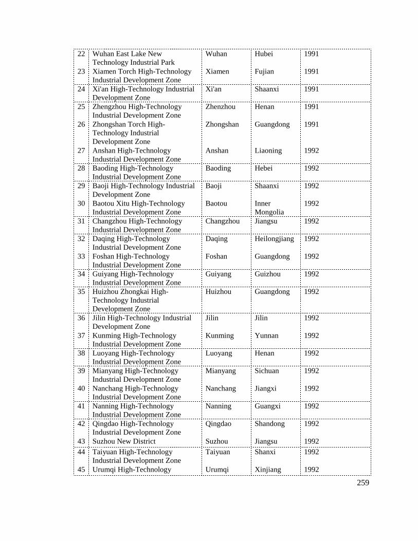
259
22 Wuhan East Lake New Technology Industrial Park
Wuhan Hubei 1991
23 Xiamen Torch High-Technology Industrial Development Zone
Xiamen Fujian 1991
24 Xi'an High-Technology Industrial Development Zone
Xi'an Shaanxi 1991
25 Zhengzhou High-Technology Industrial Development Zone
Zhenzhou Henan 1991
26 Zhongshan Torch High-Technology Industrial Development Zone
Zhongshan Guangdong 1991
27 Anshan High-Technology Industrial Development Zone
Anshan Liaoning 1992
28 Baoding High-Technology Industrial Development Zone
Baoding Hebei 1992
29 Baoji High-Technology Industrial Development Zone
Baoji Shaanxi 1992
30 Baotou Xitu High-Technology Industrial Development Zone
Baotou Inner Mongolia
1992
31 Changzhou High-Technology Industrial Development Zone
Changzhou Jiangsu 1992
32 Daqing High-Technology Industrial Development Zone
Daqing Heilongjiang 1992
33 Foshan High-Technology Industrial Development Zone
Foshan Guangdong 1992
34 Guiyang High-Technology Industrial Development Zone
Guiyang Guizhou 1992
35 Huizhou Zhongkai High-Technology Industrial Development Zone
Huizhou Guangdong 1992
36 Jilin High-Technology Industrial Development Zone
Jilin Jilin 1992
37 Kunming High-Technology Industrial Development Zone
Kunming Yunnan 1992
38 Luoyang High-Technology Industrial Development Zone
Luoyang Henan 1992
39 Mianyang High-Technology Industrial Development Zone
Mianyang Sichuan 1992
40 Nanchang High-Technology Industrial Development Zone
Nanchang Jiangxi 1992
41 Nanning High-Technology Industrial Development Zone
Nanning Guangxi 1992
42 Qingdao High-Technology Industrial Development Zone
Qingdao Shandong 1992
43 Suzhou New District Suzhou Jiangsu 1992
44 Taiyuan High-Technology Industrial Development Zone
Taiyuan Shanxi 1992
45 Urumqi High-Technology Urumqi Xinjiang 1992

260
Industrial Development Zone
46 Weifang High-Technology Industrial Development Zone
Weifang Shandong 1992
47 Wuxi High-Technology Industrial Development Zone
Wuxi Jiangsu 1992
48 Xiangfan High-Technology Industrial Development Zone
Xiangfan Hubei 1992
49 Zhongguancun Science Prk Beijing Beijing 1992
50 Zhuhai High-Technology Industrial Development Zone
Zhuhai Guangdong 1992
51 Zhuzhou High-Technology Industrial Development Zone
Zhuzhou Hunan 1992
52 Zibo High-Technology Industrial Development Zone
Zibo Shandong 1992
53 Suzhou Industrial Park Suzhou Jiangsu 1994
54 Yangling Agriculture High-Technology Industrial Zone
Xianyang Shaanxi 1997
55 Ningbo High-Technology Industrial Development Zone
Ningbo Zhejiang 2007
56 Taizhou High-Technology Industrial Development Zone
Taizhou Jiangsu 2009
57 Xiangtan High-Technology Industrial Development Zone
Xiangtan Hunan 2009
58 Anyang High-Technology Industrial Development Zone
Anyang Henan 2010
59 Baiyin High-Technology Industrial Development Zone
Baiyin Gansu 2010
60 Bengbu High-Technology Industrial Development Zone
Bengbu Anhui 2010
61 Changji High-Technology Industrial Development Zone
Changji Xinjiang 2010
62 Dongwan High-Technology Industrial Development Zone
Dongwan Guangdong 2010
63 Jiangmen High-Technology Industrial Development Zone
Jiangmen Guangdong 2010
64 Jingdezhen High-Technology Industrial Development Zone
Jingdezhen Jiangxi 2010
65 Jining High-Technology Industrial Development Zone
Jining Shandong 2010
66 Kunshan High-Technology Industrial Development Zone
Suzhou Jiangsu 2010
67 Liaoyang High-Technology Industrial Development Zone
Liaoyang Liaoning 2010
68 Liuzhou High-Technology Industrial Development Zone
Liuzhou Guangxi 2010
69 Nanyang High-Technology Industrial Development Zone
Nanyang Henan 2010
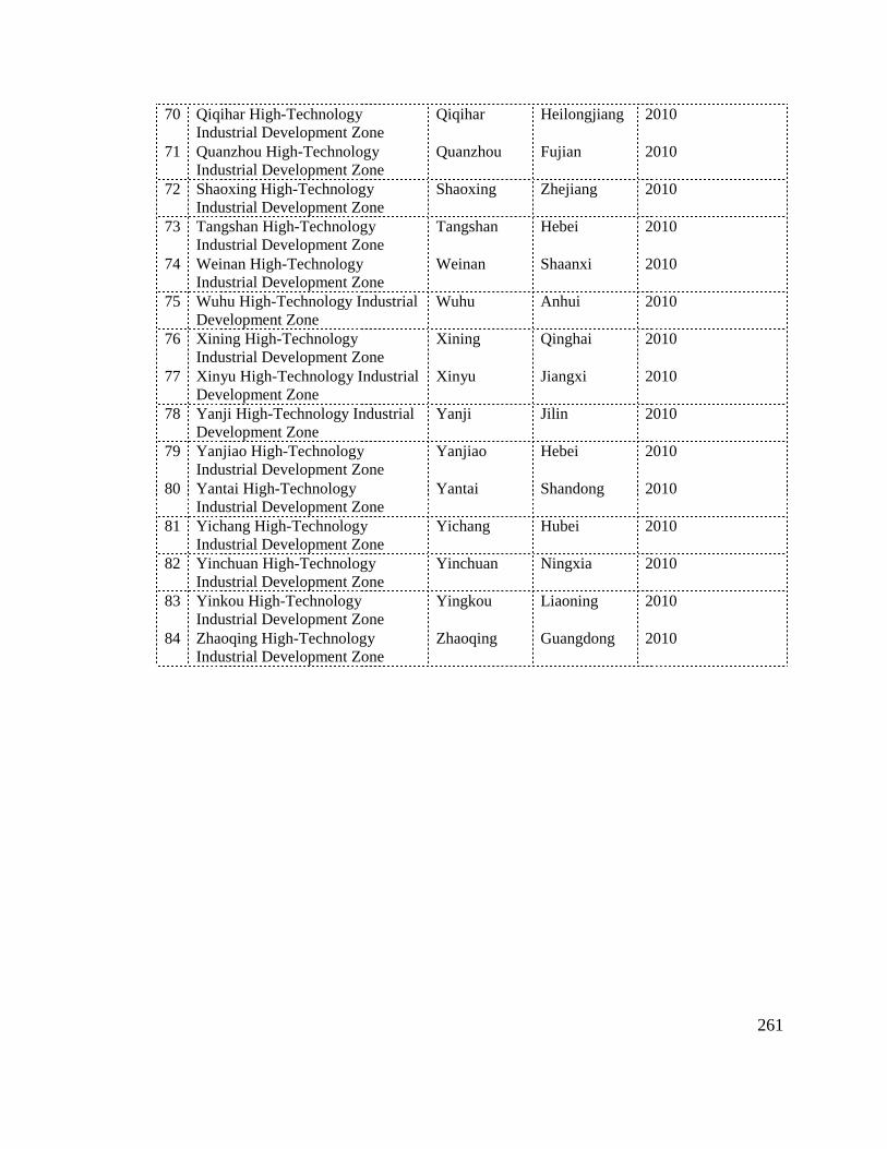
261
70 Qiqihar High-Technology Industrial Development Zone
Qiqihar Heilongjiang 2010
71 Quanzhou High-Technology Industrial Development Zone
Quanzhou Fujian 2010
72 Shaoxing High-Technology Industrial Development Zone
Shaoxing Zhejiang 2010
73 Tangshan High-Technology Industrial Development Zone
Tangshan Hebei 2010
74 Weinan High-Technology Industrial Development Zone
Weinan Shaanxi 2010
75 Wuhu High-Technology Industrial Development Zone
Wuhu Anhui 2010
76 Xining High-Technology Industrial Development Zone
Xining Qinghai 2010
77 Xinyu High-Technology Industrial Development Zone
Xinyu Jiangxi 2010
78 Yanji High-Technology Industrial Development Zone
Yanji Jilin 2010
79 Yanjiao High-Technology Industrial Development Zone
Yanjiao Hebei 2010
80 Yantai High-Technology Industrial Development Zone
Yantai Shandong 2010
81 Yichang High-Technology Industrial Development Zone
Yichang Hubei 2010
82 Yinchuan High-Technology Industrial Development Zone
Yinchuan Ningxia 2010
83 Yinkou High-Technology Industrial Development Zone
Yingkou Liaoning 2010
84 Zhaoqing High-Technology Industrial Development Zone
Zhaoqing Guangdong 2010

262
Appendix 2: 57 National HIDZs (1991-2009) By Region
NORTHEASTERN PROVINCE Anshan High-Technology Industrial Development Zone Liaoning
Changchun High-Technology Industrial Development Zone Jilin
Daliang High-Technology Industrial Park Liaoning
Daqing High-Technology Industrial Development Zone Heilongjiang
Harbin High-Technology Industrial Development Zone Heilongjiang
Jilin High-Technology Industrial Development Zone Jilin
Shenyang High-Technology Industrial Development Zone Liaoning
NORTHERN
Baoding High-Technology Industrial Development Zone Hebei
Baotou Xitu High-Technology Industrial Development Zone Inner Mongolia
Shijiazhuang High-Technology Industrial Development Zone Hebei
Taiyuan High-Technology Industrial Development Zone Shanxi
Tianjin New Technology Industrial Park Tianjin
Zhongguancun Science Prk Beijing
EASTERN
Changzhou High-Technology Industrial Development Zone Jiangsu
Fuzhou Science Park Fujian
Hangzhou High-Technology Industrial Development Zone Zhejiang
Hefei High-Technology Industrial Development Zone Anhui
Jinan High-Technology Industrial Development Zone Shandong
Nanchang High-Technology Industrial Development Zone Jiangxi
Nanjing High-Technology Industrial Development Zone Jiangsu
Ningbo High-Technology Industrial Development Zone Zhejiang
Qingdao High-Technology Industrial Development Zone Shandong
Shanghai Zhangjiang High-Technology Industrial Development Zone Shanghai
Suzhou Industrial Park Jiangsu
Suzhou New District Jiangsu
Taizhou High-Technology Industrial Development Zone Jiangsu
Weifang High-Technology Industrial Development Zone Shandong
Weihai Torch High-Technology Industrial Development Zone Shandong
Wuxi High-Technology Industrial Development Zone Jiangsu
Xiamen Torch High-Technology Industrial Development Zone Fujian
Zibo High-Technology Industrial Development Zone Shandong
SOUTHERN
Foshan High-Technology Industrial Development Zone Guangdong
Guangzhou High-Technology Industrial Development Zone Guangdong
Guilin High-Technology Industrial Development Zone Guangxi
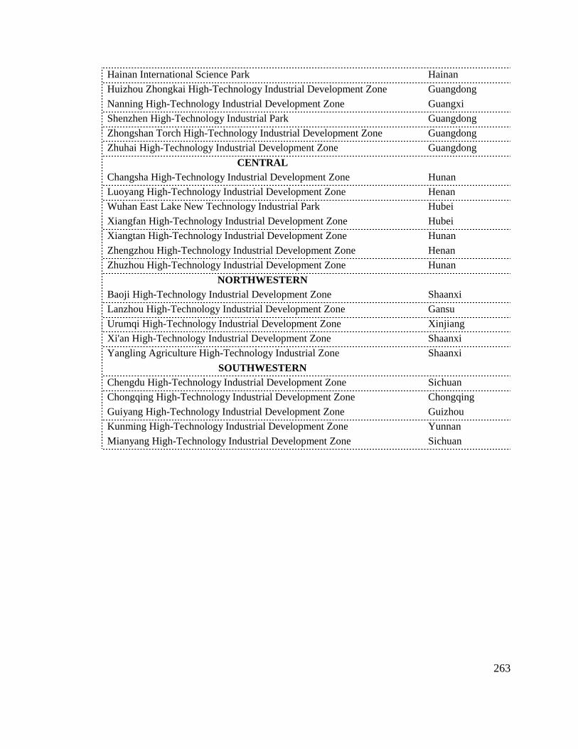
263
Hainan International Science Park Hainan
Huizhou Zhongkai High-Technology Industrial Development Zone Guangdong
Nanning High-Technology Industrial Development Zone Guangxi
Shenzhen High-Technology Industrial Park Guangdong
Zhongshan Torch High-Technology Industrial Development Zone Guangdong
Zhuhai High-Technology Industrial Development Zone Guangdong
CENTRAL
Changsha High-Technology Industrial Development Zone Hunan
Luoyang High-Technology Industrial Development Zone Henan
Wuhan East Lake New Technology Industrial Park Hubei
Xiangfan High-Technology Industrial Development Zone Hubei
Xiangtan High-Technology Industrial Development Zone Hunan
Zhengzhou High-Technology Industrial Development Zone Henan
Zhuzhou High-Technology Industrial Development Zone Hunan
NORTHWESTERN
Baoji High-Technology Industrial Development Zone Shaanxi
Lanzhou High-Technology Industrial Development Zone Gansu
Urumqi High-Technology Industrial Development Zone Xinjiang
Xi'an High-Technology Industrial Development Zone Shaanxi
Yangling Agriculture High-Technology Industrial Zone Shaanxi
SOUTHWESTERN
Chengdu High-Technology Industrial Development Zone Sichuan
Chongqing High-Technology Industrial Development Zone Chongqing
Guiyang High-Technology Industrial Development Zone Guizhou
Kunming High-Technology Industrial Development Zone Yunnan
Mianyang High-Technology Industrial Development Zone Sichuan

Appendix
The literature research of physical planning and management strategies in China’s national highurban planning and design, science park development, and China’s specific issue (Figure). This annotated bibliography aims to explore the major themes in each subject, and current gap in the overlay of three fields. The worldwide science park development consists overview discussions of international science park development, most of which are books written by Western scholars, published since the 1980s; and (2) subdivided topics of science park practices, most of which are Western journal papers certain region, with regard to management and industrial development issues. The second section, urban planning and design, also has two parts: (1) urban planning and design principles, which are books or sectphysical planning strategies; and (2) the application process of planning and design in practical activities, such as design review, guideline, planning system, and design contrChina’s issues, is composed of three major parts of literature research: (1) a general overview of China’s urbanization and industrialization. Most of the books are written by Chinese Scholars but in English versions; (2) China’s plannipublished in key Chinese journals since 2000s, focusing on discussing problems in China’s planning and design practices; and (3) science parks practices in China, which are Chinese books or journals in case China.
Appendix 3`: Literature Review/Annotated
The literature research of physical planning and management strategies in China’s national high-technology industrial development zones covers a wide range of fields, involving
anning and design, science park development, and China’s specific issue (Figure). This annotated bibliography aims to explore the major themes in each subject, and current gap in the overlay of three fields. The worldwide science park development consists overview discussions of international science park development, most of which are books written by Western scholars, published since the 1980s; and (2) subdivided topics of science park practices, most of which are Western journal papers certain region, with regard to management and industrial development issues. The second section, urban planning and design, also has two parts: (1) urban planning and design principles, which are books or sections in planning and design fields, aiming to explore theories and taxonomy of physical planning strategies; and (2) the application process of planning and design in practical activities, such as design review, guideline, planning system, and design contrChina’s issues, is composed of three major parts of literature research: (1) a general overview of China’s urbanization and industrialization. Most of the books are written by Chinese Scholars but in English versions; (2) China’s planning and design research, many of which are papers published in key Chinese journals since 2000s, focusing on discussing problems in China’s planning and design practices; and (3) science parks practices in China, which are Chinese books or journals in case practices of science parks or high
Figure A: Literature Review Fields
/Annotated Bibliography
The literature research of physical planning and management strategies in China’s technology industrial development zones covers a wide range of fields, involving
anning and design, science park development, and China’s specific issue (Figure). This annotated bibliography aims to explore the major themes in each subject, and current gap in the overlay of three fields. The worldwide science park development consists of two parts: (1) overview discussions of international science park development, most of which are books written by Western scholars, published since the 1980s; and (2) subdivided topics of science park practices, most of which are Western journal papers focusing on single or several science parks in certain region, with regard to management and industrial development issues. The second section, urban planning and design, also has two parts: (1) urban planning and design principles, which
ions in planning and design fields, aiming to explore theories and taxonomy of physical planning strategies; and (2) the application process of planning and design in practical activities, such as design review, guideline, planning system, and design control. The last field, China’s issues, is composed of three major parts of literature research: (1) a general overview of China’s urbanization and industrialization. Most of the books are written by Chinese Scholars but
ng and design research, many of which are papers published in key Chinese journals since 2000s, focusing on discussing problems in China’s planning and design practices; and (3) science parks practices in China, which are Chinese books
practices of science parks or high-technology industrial development zones in
: Literature Review Fields
264
The literature research of physical planning and management strategies in China’s technology industrial development zones covers a wide range of fields, involving
anning and design, science park development, and China’s specific issue (Figure). This annotated bibliography aims to explore the major themes in each subject, and current gap in the
of two parts: (1) overview discussions of international science park development, most of which are books written by Western scholars, published since the 1980s; and (2) subdivided topics of science park
focusing on single or several science parks in certain region, with regard to management and industrial development issues. The second section, urban planning and design, also has two parts: (1) urban planning and design principles, which
ions in planning and design fields, aiming to explore theories and taxonomy of physical planning strategies; and (2) the application process of planning and design in practical
ol. The last field, China’s issues, is composed of three major parts of literature research: (1) a general overview of China’s urbanization and industrialization. Most of the books are written by Chinese Scholars but
ng and design research, many of which are papers published in key Chinese journals since 2000s, focusing on discussing problems in China’s planning and design practices; and (3) science parks practices in China, which are Chinese books
technology industrial development zones in

265
1. INTERNATIONAL SCIENCE PARK DEVELOPMENT
1.1 GENERAL DISCUSSION OF INTERNATIONAL SCIENCE PARK
1. Anttiroiko, Ari-Veikko. "Global Competition of High-Tech Centers." International Journal of Transport Management 28, no. 3/4/5 (2004).
This article highlights the present state of development of the global competition between high-tech centers. Special attention is paid to science parks as a development policy option and the extent to which this policy has been adapted in the USA and major European and Asian countries. Another important framing theme of the article is to outline the development of science parks and clarify the science park terminology. In addition, the functions, performance, and new directions of science parks are briefly discussed.
2. Bugliarello, George. "Knowledge Parks and Incubators." In The Technology Management Handbook, edited by R.C. Dorf. Boca Raton, FL: CRC Press, 1999.
The author defines knowledge parks and incubators as special physical environments for the creation—directly or indirectly—of economic value through the development, application, and transfer or knowledge and the creation of new enterprise. Most parks are planned, but some happen spontaneously. This part of paper discusses the typology, strategies, resources needed for a knowledge park, the originator, and the entrepreneur. It also analyzes the agglomerative effect of spin-offs from a university center on the technology commercialization environment.
3. Castells, Manuel, and Peter Hall. Technopoles of the World: The Making of 21st Century Industrial Complexes. London: Routledge Press, 1994.
Technopoles - planned centers for the promotion of high-technology industry - have become a key feature of national economic development worldwide. Created out of a technological revolution, the formation of the global economy and the emergence of a new form of economic production and management, they constitute the mines and foundries of the information age, redefining the conditions and processes of local and regional development. This text is a systematic survey of technopoles in all manifestations: science parks, science cities, national technopoles and techno-belt programs. Detailed case studies, ranging from the Silicon Valley to Siberia and from the M4 Corridor to Taiwan, relate how global technopoles have developed, what each is striving to achieve and how well it is succeeding. This book distils the lessons learned from the successes and failures, embracing a host of disparate concepts and a few myths, and offering guidelines for national, regional and local planners and developers worldwide.
4. Frej, Anne, et al. Business Park and Industrial Development Handbook. Washington, D.C.: Urban Land Institute, 2001.

266
This book is a guidance book of the development of business parks and their individual components. It provides a brief history of the evolution of business parks from the early 1900s to the present, as well as the characteristics of a successful business park and its specialized types. It details the process of analyzing the market and financial feasibility of business parks using case studies and financial pro formas based on actual projects. This book also provides an overview of the capital markets for industrial development. In addition, it addresses the important components of site planning and designing business parks. Besides the marketing, leasing, operations, and management of industrial projects, this book uses many case studies to highlight the experience gained from successful projects around the world.
5. IASP. "Survey of International Science Parks." International Association of Science Parks, 2002.
A general survey of international science parks in 2002, conducted by IASP.
6. ———. "Survey of International Science Parks." International Association of Science Parks, 2006-2007.
A general survey of international science parks in 2002, conducted by IASP.
7. Komninos, Nicos. Intelligent Cities and Globalisation of Innovation Networks. New York: Routledge, 2008.
This book is about innovation, cities, and regions. It approaches the subject not through addressing a theory of innovation, but to quest for understanding the environment for generating innovation. It explains why intelligent environments are important today; sets out their role within global innovation networks; and discusses how we can create such environments. The intelligent cities have two dimensions of identification: (1) as territorial systems of innovation within which a continuous mix of skills and learning institutions takes place, driving the development of new products and technologies in the organizations located into a territory (companies, R&D centers, intermediaries, incubators, science parks, etc), and (2) as digital spaces of collaboration. The book combines concepts and theories from three different fields of science and technology: (1) urban development and planning; (2) innovation management; and (3) virtual/intelligent environments. It offers a series of digital platforms and tools for the making of intelligent cities.
The first part of the book looks at the evolution of territorial system of innovation under the pressure of globalization and the rise of intelligent environments (cities, clusters, regions) as a means of dealing with global innovation networks, global new product development, and global knowledge outsourcing. The second part of the book addresses several key functions within intelligent cities such as strategic intelligence, technology acquisition, cooperative product development, global supply chains and digital-city market places. It ends within discussing three levels that make an intelligent city (creative people and organizations,
267
innovation support institutions, digital innovation spaces) and the four functions that enable people to work cooperatively and master different forms of knowledge and know-how.
8. Luger, Michael Ian, and Harvey A. Goldstein. Technology in the Garden: Research Parks and Regional Economic Development. Chapel Hill, N.C.: University of North Carolina Press, 1991.
This book assesses the impact of research parks on regional economic development, including job creation, new business formation, and average wage and salary levels. It also aims to explore how the benefits of such parks are distributed among population groups, particularity among minorities and women. It provides an overview of the population of research parks in the U.S., discusses the expected economic development outcomes of research parks, introduces a model of the stages of development of research parks and discuss the concepts of success and failure in terms of these stages., and presents the results of a cross-sectional analysis of a large sample of research parks. Using case studies of three of the most successful research parks in the U.S.: Research Triangle Park, University of Utah Research Park, and Stanford Research Park, the book identifies the contextual and situation-specific factors of success. It explores the two-way relationship between research parks and their associated universities, and discusses the implications of findings for the design of regional economic development and technology policies.
9. Massey, Doreen, and Richard Meegan. The Anatomy of Job Loss: The How, Why and Where of Employment Decline. London: Methuen, 1982.
This book looks at the geographic impact of different forms of production change within industry in the context of recession. This book focuses on the different processes of employment decline, and aims to explore an approach to the analysis of its geography. It examines a number of sectors of British economy that were losing employment over the years 1968 to 1973. Then it explores how, why, and where these jobs were lost, and in turn their implications for the geography of employment decline. It argues that the fact of continuing employment decline has had a number of wider effects, both social and political. It had become an important weapon in the battle between labor and capital.
10. Massey, Doreen, Paul Quintas, and David Wield. High-Tech Fantasies: Science Parks in Society, Science and Space. London: Routledge, 1992.
This book explores the relation between the scientific and technological content of science parks, their social structure and meaning, and their spatial distribution and form. It analyzes the places of scientists, technologists, and engineers in the class structure of capitalist societies, and how that place s changing. The book also examines the social and scientific bases of the hype around high tech, takes up arguments about the nature of scientific research and industrial innovation. The impact on, and of, geography in the new era of high tech, and the social significance of spatial symbolism are studied. This book criticizes the divisive hype of science parks arguing that both the theory and practice are unproductive for the economy

268
and for any socially progressive science and technology. Questioning responsibility, innovation and symbolism, the authors explore the mutual determination of society, science and space.
11. Markusen, Ann. "Sticky Places in Slippery Space: A Typology of Industrial Districts." Economic Geography (1997): 293-310.
This paper identifies three additional types of industrial districts, wt quite disparate firm configurations, internal versus external orientations, and governance structures: a hub-and-spoke industrial district, revolving around one or more dominant, externally oriented firms; a satellite platform, an assemblage of unconnected branch plants embedded in external organization links; and the state-anchored district, focused on one or more public-sector institutions. It also reviews the strengths and weaknesses of each.
12. O'Mara, Margaret Pugh. Cities of Knowledge: Cold War Science and the Search for the Next Silicon Valley. Princeton: Princeton University Press, 2005.
This book focuses on historically ad spatially understanding why high technology thrived in certain places, and why these regions have proved so hard to replicate. It calls these places as cities of knowledge: consciously planned communities that were physical manifestations of a particular political and cultural moment in history, and shaped by the relationship between the state and civil society in late 20th century America. This study traces the intersections of policy and place, and the role of universities within this process from inception to implementation, beginning with the Cold War politics of the late 1940s, moving through the local economic development efforts of the 1960s, and taking an intense look at the experience of three very different metropolitan areas and their leading research institutes. It finds that cities of knowledge are products of Cold War spending patterns, products of university-centered economic development, and products of local action. The cases illustrate the unevenness of the high-technology playing field, and the way in which Cold War politics spurred tremendous opportunities for some places and closed off economic possibilities for others.
13. Porter, Michael E. "Location, Competition, and Economic Development: Local Clusters in a Global Economy." Economic Development Quarterly 14 (2000): 15-34.
It is widely recognized that changes in technology and competition have diminished many of the traditional roles of location. Yet clusters, or geographic concentrations of interconnected companies, are a striking feature of virtually every national, regional, state, and even metropolitan economy, especially in more advanced nations. The prevalence of clusters reveals important insights about the microeconomics of competition and the role of location in competitive advantage. Even as old reasons for clustering have diminished in importance with globalization, new influences of clusters on competition have taken on growing importance in an increasingly complex, knowledge-based, and dynamic economy. Clusters represent a new way of thinking about national, state, and local economies, and they
269
necessitate new roles for companies, government, and other institutions in enhancing competitiveness.
1.2 SCIENCE PARK PRACTICES
1. Bakouros, Yiannis L., Dimitri C. Mardas, and Nikos C. Varsakelis. "Science Park, a High Tech Fantasy?: An Analysis of the Science Parks of Greece." Technovation 22 (2002): 123-28.
There is a lack of evidence about the role of science parks in the less developed countries. This paper examines the science parks in a peripheral European country, Greece. The findings indicate that the picture of the three science parks of Greece is not the same in terms of the links between university and industry. Informal links have been developed between the firms and the local university, however, only the firms located at one science park have developed formal links, while the formal links of the companies of the other two parks are at the infant level at this time.
2. Bigliardi, Barbara, et al. "Assessing Science Parks' Performances: Directions from Selected Italian Case Studies." Technovation 26, no. 4 (2006).
This paper aims at providing a sound and theory-grounded methodological framework to science parks performance measurement and some practical suggestions useful for the design and the implementation of a Science Park's performance evaluation. Based on the analysis of four Italian case studies, the empirical findings partly lend support to previous research output and partly add new elements of discussion to the debate. More specifically, major results are that the evaluation criteria should be aligned with science park (a) actual mission, (b) major stakeholders commitment, (c) economic regional conditions, (d) legal forms, (e) nature of the scientific competence base available within research centers and (f) SP's life-cycle stages.
3. BMI, (Battelle Memorial Institute). "Characteristics and Trends in North American Research Parks: 21st Century Directions." AURP (Association of University Research Parks), 2007.10.
This is a general report on the development of American Research Parks in 2007, conducted by Association of University Research Parks (AURP).
4. Braun, Bradley M., and W. Warren McHone. "Science Parks as Economic Development Policy: A Case Study Approach." Economic Development Quarterly 6 (1992): 135.
This article uses the results of a recent survey of high-technology firms in Orlando, Florida to compare and contrast the characteristics of firms that have located in a university-related

270
research park with high-tech firms that operate in other parts of the metropolitan area. In general, the survey revealed substantial differences between these two categories of high-tech firms, extending across many dimensions of firm structure and development.
5. Bugliarello, George. "Urban Knowledge Parks, Knowledge Cities and Urban Sustainability." International Journal of Transport Management 28, no. 3/4/5 (2004).
Urban knowledge parks, a subset of knowledge parks, are a new mechanism for the transformation of cities into knowledge cities. Take Metrotech in NYC as an example, this research outlines the distinguish characteristics of urban knowledge parks and the processes by which they come into being.
6. Cabral, Regis. "The Cabral-Dahab Science Park Management Paradigm: An Introduction." International Journal of Transport Management 16, no. 8 (1998).
This is a series of researches involving science park cases from a global perspective: Brazil, Sweden, USA, China, and Kuwait. This introduction provides ten points of the Cabral-Dahab Paradigm in terms of guidance for success of science parks. It also provides a new definition of innovation and, as a consequence of science park.
7. Chou, Tsu-Lung. "The Science Park and the Governance Challenge of the Movement of the High-Tech Urban Region Towards Polycentricity: The Hsinchu Science-Based Industrial Park." Environment & Planning A 39 (2007): 1382-402.
This paper explore the governance challenges of science-park-based urban regions by exploring the case study of the Hsinchu science-based industrial park in Taiwan. In contrast to the economic emphasis of new regionalism on regional learning, It investigates the change and development of the high-tech Hsinchu region as it moves towards polycentricity, by exploring how the political processes of multiple and interconnected forces, from international to national and subnational levels, affect spatial-construction and regional governance issues. The research highlights that international, national, and subnational forces caused the polycentric development, which in turn has led to governance contradictions.
8. Cooke, Philip. "The Role of Research in Regional Innovation Systems: New Models Meeting Knowledge Economy Demands." International Journal of Transport Management 28, no. 3/4/5 (2004).
This paper discusses the recent thinking and experiences of regional innovation systems. It focuses on the governance, or functional support system of public and private research intermediaries now understood to be of central importance to the health of innovation systems and the clusters that may be embedded within tem. Based on the questions of governance in further depth, new examples of innovative regional governance of innovation systems grappling with the exacting demands of the knowledge economy are presented.
271
9. Elstrom, Peter., Paul M. Eng, Paul Judge, and Gary McWilliams. "It Must Be Something in the Water." Business Week-Silicon Valley Special Report 1997.08.
This discussions analyzes the role governments play in the development of Silicon Valley.
10. Ferguson, Richard. "Why Firms on Science Parks Should Not Be Expected to Show Better Performance -- the Story of Twelve Biotechnology Firms." International Journal of Transport Management 28, no. 3/4/5 (2004).
This paper investigates growth in employment over a 13-year period in 12 small biotechnology firms, with the purpose of understanding the effects of a science park location on firm development. Findings show that all of the firms experiencing higher-growth moved off of a science park prior to exhibiting high-growth performance. Similarly, all the non-surviving firms with a science park history also relocated off-park prior to their failure. This suggests that we need to look beyond firms' present locations to see the effects of a science park location.
11. Glasmeier, A. "The Japanese Technopolis Programme: High-Tech Development Strategy or Industrial Policy in Disguise?" International Journal of Urban and Regional Research, no. 12 (1988): 268-84.
This paper reports the strategy of Japanese Technopolis Programme enacted in the 1980s. It analyzes the background, incentives, motivation, and strategies used in this program.
12. Goldstein, Harvey A. and Michael I. Luger. "University-Based Research Parks as a Rural Development Strategy." Policy Studies Journal 20, no. 2 (1992).
This paper describes some conditions that are normally required for research parks in the U.S. to be an effective rural development strategy. It discusses the research park phenomenon, with particular attention to the roles of state and local governments and universities, the rationale for developing research parks in nonmetropolitan areas, the attributes and performance of research parks in nonmetropolitan areas, and lessons that experience to date holds for planners, policy makers, university officials, and others considering the use of research parks as a rural development stimulus.
13. Henton, D. "Lessons from Silicon Valley: Governance in a Global City-Region." In Global City-Regions: Trends, Theory, Policy, edited by Allen J. Scott. New York: Oxford University Press, 2001.
This paper examines an innovative region, Silicon Valley, to discuss the governance and institutions in global city-region under the period of new economy. It traces back the historical change of governance of Silicon Valley from the 1970s. After addressing the challenges and key principles, this paper concludes that Silicon Valley has evolved from a laissez-faire approach through business-led model to collaboration and networks just as the
272
economy has evolved toward networking. Joint Venture employs a collaborative model based on networks and voluntary agreements rather than hierarchy or markets.
14. Hommen, Leif, David Doloreux, and Emma Larsson. "Emergence and Growth of Mjärdevi Science Park in Linköping, Sweden." European Planning Studies 14, no. 10 (2006).
This article examines the role that science parks play in the promotion of regional development with particular reference to one of Sweden’s most successful science parks, the Mjärdevi Science Park. This article traces the historical events related to the creation of Mjärdevi Science Park that have influenced its technological and industrial development. It then outlines the park’s path of development and subsequently addresses key factors affecting the growth dynamics of the park.
15. Keeble, David. "High-Technology Industry and Local Environments in the United Kingdom." In High Technology Industry and Innovative Environments: The European Experience, edited by Philippe Aydalot and David Keeble. London: Routledge, 1988.
This chapter demonstrates the widespread nature of high-technology industrial growth in spatially in the United Kingdom, in a context of national high-technology job decline focused on major cities and conurbations. It argues a clear association between expanding high-technology activity and less-urbanized small0town locations, to reflect the key importance to this sector of highly-qualified R&D workers and entrepreneurs, and the marked residential preference.
16. Lindelof, Peter, and Hans Löfsten. "Academic Versus Corporate New Technology-Based Firms in Swedish Science Parks: An Analysis of Performance, Business Networks and Financing." International Journal of Technology Management 31, no. 3/4 (2005).
This study is in the field of new technology-based firms and the role of science park. It empirically tested on the basis of 134 new technology-based firms in Swede, which can be divided into two categories: university spin-offs, and corporate spin-offs. The two groups tended to exhibit differences between advices from managers in the parks. The study indicates that there is a direct relationship between science park importance for attracting external capital and financing issues. There are some evidence that professional businesses benefit from a science park location.
17. Lindelof, Peter, et al. "Science Park Location and New Technology-Based Firms in Sweden--Implications for Strategy and Performance." Small Business Economics 20, no. 3 (2003).
This research surveys a total of 273 new technology-based firms (NTBFs), of which 134 were on a Science Park and 139 were not on a park. There were significant differences in the means of strategy dimensions between the on-Park and off-Park firms. It can be seen that the
273
NTBFs who located in Science Parks showed significantly greater emphasis on firm characteristics as innovation ability, competitor- and market-orientation, sales and employment growth, high profits etc. The differences indicate a slight advantage for the Science Park firms. The off-Park sample reported proximity to other firms to be of higher importance than the on-Park sample in their choice of location. However, these differences do not show any clear pattern, making it difficult to understand if NTBFs who locate on Science Parks are systematically looking for something different in their location.
18. Link, Albert N., et al. "U.S. Science Parks: The Diffusion of an Innovation and Its Effects on the Academic Missions of Universities." International Journal of Industrial Organization 21, no. 9 (2003).
The paper is an exploratory study of science parks in the United States. It models the history of science parks as the diffusion of an innovation that was adopted at a rapid and increasing rate in the early 1980s, and since then at a decreased rate. It models the growth of a science park once established, showing significant effects on growth for the proximity to universities and other resources. The paper also reports university administrators’ perceptions about the impact of their science parks on the academic missions of their universities. Statistical analyses show there is a direct relationship between the proximity of the science park to the university and the probability that the academic curriculum will shift from basic toward applied research.
19. Park, S-C. "The Transformation of the South Korean Economy and International Economic Development in East and Southeast Asia." International Planning Studies 2, no.2 (1997).
The Asia-Pacific region has been the most dynamic part of the world economy throughout the postwar period. This paper reviews that rapid economic development in the Asian countries has resulted in a transformation of economic structure as well, however, regional cooperation in Asia is still weak compared with the European Union. Its multilateral economic cooperation is mainly based on the governmental level instead of private sector initiatives. It explains the South Korean economy in three facets of growth, namely diversification, stabilization and growth momentum. In order to reach these goals, the government has played the role of entrepreneur who planned what, when and how much to produce.
20. Phillips, Su-Ann Mae, et al. "A Place for R&D? The Singapore Science Park." Urban Studies 40, no. 4 (2003).
This paper argues that it is insufficient for R&D places to provide just physical infrastructure and investment benefits. Understanding actor-specific strategies and their enrolment in innovation networks and enabling institutional pre-conditions are equally important in embedding R&D activities. Based on a study of one such place-the Singapore Science Park-this paper explores the realities of science park formation. It is found that adequate institutional thickness and local embeddedness apply only to a small number of R&D firms in

274
the Park. The paper also examines the myth that spatial proximity to R&D institutions and organisations automatically results in collaborative R&D efforts. The study shows that there is an urgent need for a fundamental transformation in the prevailing thinking of economic planning, R&D policies and urban development.
21. Siegel, Donald S., et al. "Assessing the Impact of University Science Parks on Research Productivity: Exploratory Firm-Level Evidence from the United Kingdom." International Journal of Industrial Organization 21, no. 9 (2003).
University science parks are alleged to stimulate technological spillovers. However, there is virtually no empirical evidence on the impact of these facilities on research productivity. This paper examines whether companies located on university science parks in the United Kingdom have higher research productivity than observationally equivalent firms not located on a university science park. The preliminary results appear to be consistent with this hypothesis and are robust to the use of alternative econometric procedures to assess relative productivity.
22. Simmie, James, et al. "Local Innovation System Governance and Performance: A Comparative Analysis of Oxfordshire, Stuttgart and Toulouse." International Journal of Transport Management 28, no. 3/4/5 (2004).
This paper traces the development of three ''ideal types'' of local innovation system governance since the Second World War in three highly innovative city regions. The types of innovation governance are dirigiste, networked and grass roots. These are analyzed in the case study areas of Oxfordshire, Stuttgart and Toulouse. It is shown that the hegemony of each type of governance changes over time in each area. The analysis of the relative performance of the three changing local innovation systems indicates that widely networked systems grow faster than market oriented grassroots systems.
23. Staudt, Erich, and Jurgen Bock. "Technology Centres and Science Parks: Agents or Competence Centres for Small Businesses?" International Journal of Technology Management 9, no. 2 (1994).
This research investigates the role of technology centers and science parks in the transfer process between the research and education sector and small businesses, as well as the importance attached to these institutions by its target population. It explores the conditions in which these institutions operate, the ways in which they perceive themselves, and the extent to which their support policies meet the requirements of a small business. It reveals that at present there are considerable weaknesses to be observed in this area from both technology centers’ side and small business’s side.
24. Sternberg, Rolf. "Technology Centres in Germany: Economic Justifications, Effectiveness and Impact on High-Tech Regions." International Journal of Transport Management 28, no. 3/4/5 (2004).
275
This paper seeks to analyze the relationship between technology centers and high-tech regions in Germany. This paper demonstrates that the Munich region clearly represents one such high-tech region. Despite the existence of technology centers in this and many other German regions, only in a very few exceptional cases have these institutions generated statistically significant economic effects at the regional level, and never to the emergence of a high-tech region. Realistically, however, this cannot be the goal of German-style technology centers, as they differ considerably from, for example, the British or US style of science or research parks.
25. Storey, D. J., and B. S. Tether. "Public Policy Measures to Support New Technology Based Firms in the European Union." Research Policy 26 (1998): 1037-57.
This paper provides a review of public policy measures implemented in EU countries to support New Technology-Based Firms (NTBFs) during the 1980s and early 1990s. It identifies five policy areas and provides a synthesis of the policy developments during this period and an assessment of their effectiveness. The policy areas examined are: Science Parks; the Supply of PhDs in Science and Technology, the relationships between NTBFs and Universities/Research Institutions; Direct Financial Support to NTBFs from National Governments; and the Impact of Technological Advisory Services on NTBFs.
26. Suzuki, Shigeru. "Technopolis: Science Parks in Japan." International Journal of Transport Management 28, no. 3/4/5 (2004).
Technopolis, a plan for developing science park in Japan, came into force in the early 1980s. There were 26 regios designated by Technopolis. However, the Technopolis Act was terminated in 1998, and the program discontinued. This paper aims to explain what features and problems Japan parks had and why the Technopolis program failed.
27. Zhang, Yuehua. "Critical Factors for Science Park Development: The Case of the Singapore Science Park." International Journal of Technology Transfer & Commercialisation 4, no. 2 (2005).
Through tracing Singapore Science Park’s two-decade history, this study identifies factors critical to its development. These include: a national environment encouraging R&D endeavor; strong government support; a committed management team; competitive rentals; and familiarity with the market. They suggest that both governments with the macro-environment it creates and park management with the micro-strategies it formulates are decisive for the Park development.
2. URBAN PLANNING AND DESIGN
2.1 URBAN PLANNING AND DESIGN PRINCIPLES

276
1. Alexander, Christopher. A New Theory of Urban Design. New York: Oxford University Press, 1987.
A New Theory of Urban Design is Alexander’s evolving design philosophy for creating a growing whole in a city. This book describes a new theoretical framework of how cities can evolve in a coordinated and organic manner. This book is useful for those students and professionals in the architecture, urban design, and planning fields.
Questioning the lack of organic character of modern cities, Alexander presents a set of seven rules to return to a feeling of wholeness in urban designs. In his book, Alexander first, explains his concept of “a growing whole.” However, the author acknowledges that “growing whole is “piecemeal” and “unpredictable,” yet “coherent.” Alexander develops and states his overriding design principle, which essentially suggests that each part of developing a city should “heal the city.” Furthermore, he states that every new act of construction must create a continuous structure of “wholes” around it. Alexander tests his seven governing rules of his design process in an area in San Francisco.
2. Bailly, Antoine S., et al. Socially Sustainable Cities: Principles and Practices. London: Economica, 2000.
This research identified the social sustainability of city and addresses six main themes of local management: urban governance, social and cultural policies, public services; land and housing policies, urban transport, and economic revitalization. These key issues allow us to consider solutions that could promote socially sustainable cities. Each theme is introduced with a discussion of conceptual elements ad general urban management issues. Examples drawn from the Network’s case studies then illustrate how these issues have been tackled in local ad metropolitan policies.
3. Barnett, Jonathan. An Introduction to Urban Design. New York: Harper & Row, 1982.
In this book, Barnett is targeting urban designers in academia and in professional practice. He highlights that the current pattern of development is not going to change because of private investment in existing buildings and people’s attachment to buildings. In his book, he offers a definition of urban design, advocates the modern movement, and describes a new atmosphere for urban design.
Barnett sections his book into three parts. Part I of his book discusses the changing framework for urban design with the emergence of environmental considerations, community participation, and historic preservation. Part II concentrates on development controls rather than specific building designs. Finally, Part III covers the elements of design and development strategy and includes land use planning, open space, street design, transportation, and public investment. Barnett places responsibility on urban designers to “write the rules for the significant choices that shape the city.”

277
4. ———. Redesigning Cities: Principles, Practice, Implementation. Chicago: American Planning Association, Planners Press, 2003.
This book provides basic principle, practical applications of these principles, and implementation strategies. The examples of successful projects in this book do not merely showcase demonstration projects on greenfield sites but further include the revitalization and reinvention of more problematic and complex segments of existing cities and their sprawl. It surveys the history of urban design from a lot of literatures, and introduces five basic principles of design: “Community, Livability, Mobility, Equity, and Sustainability”. The second part describes how these principles are applied in creating new neighborhoods; in the rebirth of older, first-ring suburbs and inner-city neighborhoods; in giving new vitality and value to outmoded commercial areas and downtowns that have lost their competitive edge; and in aiding edge cities to become real cities with community and livability and transit-centered mobility that are both sensible and sustainable. Lastly, it provides commonsense implementation guidelines that illustrate that better public and private space can optimally serve society with essential opportunities for interaction, sense of community, and livability.
5. Beatley, Timothy and Kristy Manning. The Ecology of Place: Planning for Environment, Economy, and Community. Washington D.C.: Island Press, 1997.
This book is about creating and nurturing sustainable towns, cities, and regions—“sustainable places”. Beatley and Manning offer an idealistic and visionary view of a possible future for cities and towns. Their approach to planning simultaneously addresses concerns about the environment, the quality of human life, and the distribution of social and economic opportunities. Beatley and Manning start with the idea of planning for sustainable places. They argue that this is the natural next step in the evolution of the idea of planning. In four substantive chapters, Beatley and Manning provide a very rich discussion of how to move in the direction of creating sustainable places. Successively, they take up urban form, the struggle of cities and regions to live within their ecological landscapes, economic development, and issues of civic involvement and social capital including nurturing cultural and social diversity. The concluding chapter presents the next logical steps in promoting more sustainable places. Beatley identifies elements of a new ethic of environment and community and proposing actions to promote such an ethic. The authors then discuss specific local and regional actions that can be taken to move in the direction of sustainable places. This book proposes a number of concrete federal policy changes that could assist in the creation of sustainable communities. These include such things as changes in the tax code, environmental policy reform, and adjustments to federal subsidies and financial incentives.
6. Ben-Joseph, Eran. The Code of the City: Standards and the Hidden Language of Place Making. Cambridge, MA: MIT Press, 2005.
This book aims to answer questions about the origins and diffusion of design standards, performance and outcome, and design standards’ implications for transformation and opportunities. Ben-Joseph discusses the American place-making mode and leads us to a

278
broader understanding of the impacts of standards and codes on urban development. Ben-Joseph’s work is insightful to architects, planners, designers, and decision makers interested in the history and future of American planning and design.
The author describes the factors that played a major role in standards development and how professions such as land surveying shaped urban form. To demonstrate how standards have contributed to the shaping of the neighborhoods, cities, and natural landscape, the author uses many examples from different countries to emphasize that we should look at the cultural differences and the circumstances of a plan’s norm to determine what is appropriate to be built and designed, instead of adhering to the vision of an ideal average and social homogenization. Ben-Joseph proceeds over several chapters to address the impact of technological choices on planning practice and landscape, and indicates that countless landowners who care more about sale returns than the community’s future have planned our cities. Last, the author emphasizes that the failure to think in community terms and to appreciate that the city is a physical thing involves losses that the future cannot repair.
7. Brebbia, C. A. et al, ed. Sustainable City: Urban Regeneration and Sustainability. Boston: WIT Press, 2000.
This book consists of different academics, professionals, and practitioners in a wide range of disciplines to exchange ideas and identify best policies and practices for a viable urban environment. These selected papers represent an international view toward a sustainable development. The major themes include: strategy and development in terms of factors, elements, management, and programs; environmental management and pollution which related to drainage, brownfield redevelopment, waste recycling, and performance evaluation; land use and management; transport environment and integration; cultural heritage and architectural issues; planning development and management such as national plan, interactive model, inner-city renewal, and housing policy; restructuring and renewal; community and the city; and finally the public safety and security.
8. Brooks, Michael P. Planning Theory for Practitioners. Chicago: American Planning Association, Planners Press, 2002.
This book focuses on the ways in which a number of issues central to the planning theory literature affect the role performance of professional planners. It argues that planning theory is important to the profession’s sense of identity and purpose. This book emphasizes the process of planning rather than the substance of specific planning issues. In other words, the chapters discuss the very nature of planning as a distinct form of professional activity. It views planning theory as the process component of planning profession; it guides planners through a continuous self-examination of what it is we are doing, how, why, for whom, and with what results.
Moreover, it points out that it is necessary to identify and employ planning strategies that are integrated with, and make creative use of, the political system. In the relationship between

279
planning and politics, there are a series of fundamental issues such as one’s professional value, and ethics. It is worth mentioning that this book argues that there are no universal value systems to which all planners subscribe, and thus the value-based planning behaviors under ethical dilemmas causes some conflicts in practices. While there is no definitive and universal set of ethics that will cover all situations, self-awareness, introspection, sensitivity to the value nuances of practice are major virtues that every planner should possess.
One of the contributions of this book other than academic discussion on importance of planning theory is that it provides an action strategy of planning—Feedback Strategy—that planners might follow in the pursuit of planned change. This strategy includes six stages from defining problems to make a decision. When applying the strategy in realistic practices, this book also offers several key elements of being a political savvy planner.
9. Brower, Sidney. Good Neighborhoods: A Study of in-Town & Suburban Residential Environments. Westport, Conn: Praeger, 1996.
This book is a study of ideal residential neighborhoods in as experienced by residents. Brower’s book is useful to academics and professionals in urban studies, urban planning, and urban design. Good Neighborhoods applies to neighborhood development and environmental design. In his book, Brower takes a linear approach to developing a typology of good neighborhoods.
Brower claims that the coexistence of his “good neighborhoods” in a single urban environment is impossible. He highlights the variety of residential areas for the varying needs of city dwellers. Brower’s normative approach identifies the characteristics of good neighborhoods in three dimensions: Ambiance, Engagement, and Choicefulness. Brower organized the book into three sections. The first section discusses the basis for his work and definitions of neighborhoods. The second section describes concepts for good neighborhoods established from existing and historical neighborhoods. In the last section of the book, Brower builds a typology of good neighborhoods from the first two sections. Brower also tests his hypotheses for these neighborhoods. Brower’s typologies are based on aspects of place, activity, and the personality and culture of residents. Brower uses four prototypical neighborhood types: Center Neighborhoods, Small-Town Neighborhoods, Residential Partnerships, and Retreat Neighborhoods.
10. Dutton, John A. New American Urbanism: Re-Forming the Suburban Metropolis. Milan: Skira, 2000.
In this provocative study, John Dutton shows how American urban models, whose influence has been essential in the shaping of cities worldwide since 1945, are currently recovering at home from the crisis of the 1970s and 1980s. He masterfully analyzes the theoretical inputs and the design solutions that have shaped a collection of experimental town landscapes that deserve all our attention today.

280
The projects in this book demonstrate their attempts to restructure urban growth into cohesive designs that balance buildings, open space, infrastructure, landscape, and transportation. In place of the piecemeal advance of placeless, car-dominated suburban sprawl, they envision dense, mixed-use neighborhoods with walkable streets, and connections to transit. The work ranges from entire new towns to urban infill. Many of the architects practicing these ideas have formed a movement called the Congress for New Urbanism (CNU), which most clearly and effectively has articulated this alternative vision. This book is about particular tendencies, however, and not ownership of ideas. Although the Congress for New Urbanism presents its position in the proprietary form of a charter, its vision is representative of much broader strains of architectural ideology, and continues a twentieth-century search to find ways to address the problems of the modern city.
11. Evans, Graeme and Jo Foord. "The Generation of Diversity: Mixed Use and Urban Sustainability." In Urban Sustainability through Environmental Design: Approaches to Time-People-Place Responsive Urban Spaces, edited by Kevin Thwaites, et al. New York: Routledge, 2007.
This paper defines a series of urban environmental elements that combine to determine the quality of life in higher-density, mixed-use locations can be triangulated in terms of the key features involving physical land use, social vitality, and seedbed economy. It presents the development of a GIS-based analysis and planning tool arising from a study of mixed-use inner-city areas.
12. Farr, Douglas. Sustainable Urbanism: Urban Design with Nature. Hoboken J: John Wiley, 2008.
This book seeks to create a brand, agenda, and standards for an emerging and growing design reform movement: sustainable urbanism, which is an integration of walkable and transit-served urbanism with high-performance buildings and high performance infrastructure. It provides a historical outline of courses in planning, architecture, engineering, environmental studies, and interdisciplinary sustainable development. Then it discusses an operating system of implementing the theme involving leadership, plan, process, projects, and templates. Nearly thirty emerging thresholds of sustainable urbanism are included in this book, used as benchmarks and performance targets on projects, particularly useful in conjunction with the LEED ND, or even more robust standards. Lastly, multiple case studies, including a diverse and mature worldwide movement of visionary neighborhood-scale projects provide practical experiences in design guidance and goals.
13. Francis, Mark, Lisa Cashdan, and Lynn Paxson. Community Open Spaces: Greeting Neighborhoods through Community Action and Land Conservation. Washington, D.C.: Island Press, 1984.
This book is the authoritative research on the phenomenon of community-developed and maintained gardens and parks in urban neighborhoods. It presents a detailed and realistic

281
picture of community open-space development. In highlighting the process, benefits, and problems of this unique community development activity, the book provides an invaluable tool for the continuation and expansion of urban open-space efforts. Based on an overview of the movement in both the United States and Europe, the authors discuss and evaluate New York City community open-space projects. Then the book discusses some of the characteristics and consequences common to community open-space projects everywhere. The concluding chapter presents a brief vision of the future of the community open-space movement, providing a road map for community residents, designers, and government officials who want to develop open spaces for communities with community participation.
14. Gehl, Jan. Life between Buildings: Using Public Space. New York: Van Nostrand Reinhold, 1987.
In Life between Buildings, Gehl focuses on the life between buildings and how architecture and planning impact this space and our everyday lives. In this book, the author puts public spaces and daily activities at the center of her work and towards a new approach to architecture, urban design and city planning. This book is helpful to understand the everyday needs of the public for students and professionals in those fields.
Gehl begins by highlighting public spaces such as streets, plazas, and other open spaces. The author draws from example in Copenhagen and other Danish cities to illustrate her point. Gehl describes the prerequisites for planning in terms of process and projects. Gehl identifies three types of activities: necessary, optional, and social activities. The author states that these activities create demands on the physical environment. He proposes spaces that create safe urban areas by attracting people to them. Gehl’s observation and conclusions are premised on humanistic needs and interactions.
15. Gehl, Jan and Lars Gemze. Public Spaces, Public Life Copenhagen: Danish Architectural Press, 1996.
This book describes the remarkable qualitative improvements which have taken place in central Copenhagen over the past 34 years, and how they have been accomplished, and is a handbook on how to create human qualities in the city. The book is split into 4 different sections. Part 1: Public Spaces- A report on how streets and squares in the city have developed over the period 1962-1996; Part 2: Public Life- This section contains the results of the surveys documenting how the city center was used in 1995/96; Part 3: Interviews- Looks at who uses the city and what people think about it? The results of over 2,000 street interviews and 1, 000 questionnaires are presented, and include user descriptions of activities and viewpoints; and Part 4: Public Spaces? Public Life 1996 is a summary of the studies along with opinions and advice about the future development in the city.
16. Glazer, Nathan. "The Public Image of the Profession." In The Profession of City Planning: Changes, Images and Challenges, 1950-2000, edited by Lloyd Rodwin, and
282
Bishwapriya Sanyal. New Brunswick, NJ: Center for Urban Policy Research at Rutgers, 2000.
Using a metaphor of “public image of planning profession”, this paper discusses the movement of planning principles, practices, and their impact to the public in a sequence following the development of planning theory and activities. A series of movements and figures include Mumford, Jacobs, preservation movement, new urbanism, environmentalism, and community advocacy, etc. With looking back to consider the image of the city planner to the public, the paper argues that there needs to be greater interplay between the exceptional figures that do embody the image of the planner in the public mind, and the professional practice of planning.
17. Golany, Gideon S. Ethics and Urban Design: Culture, Form, and Environment. New York: J. Wiley, 1995.
Golany's Ethics and urban design: culture, form, and environment features historical examples and contemporary case studies from around the world to illustrate an approach to urban design that balances the requirements of both cultural and natural environments. The book also addresses such issues as housing, transportation, urban ecology, public space and geospace design options. There is a wealth of line drawings and photographs of Golany's design concepts.
What Golany finds in the success stories of the past are cohesive sociocultural values that shaped the design of homes, neighborhoods, and cities. These ethical values helped to maintain equilibrium within the society that permeated its natural, social, and humanmade environments. In the present era, conversely, he finds a major disconnection between human values and the ethics of technology, which has resulted in confusion, imbalance, and dehumanization. To help designers gain a perspective on possible solutions, Golany explains leading comprehensive design strategies, including the valley theory, the urban border zone concept, and the regional concept of Patrick Geddes. "Future Frontiers for Urban Design", the culminating section of this groundbreaking book, opens with Golany's vision of the future city. He examines the issues of thermal performance and climate as they relate to urban design and offers the concept of "geospace" - the earth enveloped habitat. Buttressing his presentation with detailed information on the mechanics of geospace, Golany describes case studies of the successful use of earth enveloped habitats in China and Tunisia. He makes a powerful argument for the geospace city as a renewal of ancient traditions that can restore the vital equilibrium between nature and human settlements that we seem to have lost.
18. Gosling, David, and Barry Maitland. Concepts of Urban Design. New York: St. Martinís Press, 1984.
Gosling and Maitland’s Concepts of Urban Design is intended for urban design students and practitioners. The main objective of the book is to establish a realistic and technical background of the varied and opposing directions found in urban design. The book covers
283
topics in urban design concentrating at the scale of the quarter. First, Gosling and Maitland discuss the nature of the problem of modern city form. Then, the authors describe the sources and theories of urban design. Using, international case studies, the book delves into case studies of urban design. Finally, the book describes future directions and concludes with two separation conclusions from each of the contributing authors. Overall, the book stresses the urgency to find appropriate techniques and good models of urban design.
19. Greenbie, Barrie B. Spaces: Dimensions of the Human Landscape. New Haven, CT: Yale University Press, 1981.
In this book, Greenbie examines townscapes, urban environments, and the countryside. The author examines how manmade environment relates to social interaction in both public and private spaces. This book offers a humanistic view on urban space to planners, architects, urban designers, and landscape architects in academia and in practice. The author investigates civilized life and urban spaces in North America and Europe. His book begins at the home and street scale and transitions toward the neighborhood level. The second half of the book is a review of large cities such as Boston and Rome. The author investigates the social interactions of public square, parks, promenades, and marketplaces. Greenbie also explores the use/misuse of elements of urban form such as roadways, monuments, and natural features. Greenbie’s framework proposes a study of space and cross-cultural behavior.
20. Hack, Gary. "Planning Metropolitan Regions." In Planning for a New Century, edited by Jonathan Barnett. Washington, D. C.: Island Press, 2001.
In a metropolitan-wide context, this paper describes that urban areas are already evolving into a new kind of regional city, so the setting for these new policies has already changed in ways that some people do not yet recognize. After addressing the changes and diversities of current down-towns, neighborhoods, and regions, Gary provides two regional strategies for the new realities: one is to undertake regional development plan and a permanent mechanism for metropolitan region; and another is to give more decision-making power and responsibility to local governments.
This book, consisting many metropolitan planning-related topics, cover a wide range of issues, such as transportation and land-use planning, zoning and design, housing, public education, welfare reform, public safety, down-town revitalization, pollution control, and protection of open spaces and natural areas.
21. Hall, Peter. Urban and Regional Planning. 3rd ed. London: Routledge, 1992.
This book historically traces the evolution of urban and regional problems, and of planning philosophies, techniques and legislation, from the Industrial Revolution to the present day, with special references to the changes brought by these movements. It analyses the post-war history, and attempts to pass judgment on the performance of the planning system, first at broad regional level in respect of economic planning, then at the scale of the town and the

284
city region in respect of urban planning. It also provides a comparative look at planning experiences in UK, other Western Europe, and the U.S. It discusses an outline of the sequence of urban and regional plan making, with an introduction to some of the more important techniques involved at various stages of this process.
22. Hillier, Bill, and Julienne Hanson. The Social Logic of Space. Cambridge: Cambrige University Press, 1984.
The authors develop a new theory and method of analysis that are underscored by the relationship between society and space. Using this new theory and method, the authors attempt to generate knowledge of social process which was once thought to be created in academic studies. This book provides useful theory, methods, and practical knowledge to planners and designers.
Understanding that there is not much effective theory or methodology applicable to social spatial relation, the authors have created a new theory and method. These new theory and method of analysis overcomes two difficulties. The two obstacles are the lack of consistency in descriptive accounts of morphological features of man-made spaces and of societies. Hillier and Hanson build a descriptive theory based on “the social content of spatial patterning and the spatial content of social patterning.” The book also describes their method of analysis of spatial pattern, which account for the relationship between local and global patterns. They further their study by using this descriptive theory and analysis method to generate information about the social-spatial connection.
23. Jacobs, Allan B. Looking at Cities. Cambridge, MA: Harvard University Press, 1985.
This book is about how to look at and understand urban environments. In order to plan sensitively, the city and regional planner must walk in, look at, wonder about, and simply enjoy cities. Careful observation is a crucial tool for the kind of analysis and questioning necessary to achieve good planning. Through observation the city planner and urban activist can learn when an area was built, for whom it was built, who lives there now, how it has changed, and how it might be improved for present and future inhabitants. Case studies of American and European cities--San Jose, San Francisco, Cincinnati, Bologna, Rome—and over two hundred striking photographs, drawings, and maps by the author present ways to read the environment that will prove indispensable for urban planners and will delight all city watchers.
24. Jacobs, Allan B. Great Streets. Cambridge, MA: MIT Press, 1993.
This book is a survey and analysis of a wide array of street types and urban spaces around the world. Jacobs believes that good cities are made of good streets and designers and planners are rapidly losing our talent for creating them. This book is not only useful to planners and designers, but also appealing to a general audience. The first section of the book highlights fifteen of the finest examples of “great streets.” The author uses 242 line drawings to “great
285
streets” from around the world. Among those included are Barcelona’s Ramblas, Paris’s Boulevard Saint-Michel, and Venice’s Grand Canal. In his section second Jacobs compares streets by types such as boulevards, main streets, and residential roads. The author devotes a chapter to square-mile maps of street patterns in 50 cities, offers a comparison of urban fabric. The author evaluates the streets and has developed a list of characteristics that make “great streets.” They include buildings of similar height, interesting facades, trees, windows that invite viewing, intersections, beginnings and endings, stopping places and, to be sure, space for leisurely walking, and “the magic of design.”
25. Jacobs, Jane. The Death and Life of Great American Cities. New York: Vintage Books, 1961.
This book targets a general audience as well as academics and practitioners in the urban planning and design fields. This book has had a major impact for the planning and designing of cities. The Death and Life of Great American Cities has influenced contemporary planning movements to address the problems that prior planning policies have created. The author initially intended to describe her idea of a good street live. The author critiques modern city planning and claims that the planning policies have led to the destruction of inner-cities. For example Jacobs stresses the impacts of urban renewal and conventional zoning for separation of uses. Jacobs consistently refers to Greenwich Village in New York City as a model of an exemplar community. Jacobs suggestions for revitalizing cities is go against what urban planners and designers recommend. These activities include creating dense and mixed-use urban communities, cutting block sizes, and varying size, type and condition of buildings. In Death and Life, the author’s resourcefulness is applied to her ideas for revitalizing communities.
26. Jenks, Mike, and Nicola Dempsey, ed. Future Forms and Design for Sustainable Cities. Amsterdam: Elsevier, 2005.
This book provides examples in different urban forms and the ways in which planning activities are designed to be more sustainable. A great deal has been written about the influences that affect the urban form, such as the technological, social, economic, institutional, geographical ad physical. Three themes are discussed in this book: the first section discusses different spatial urban concepts, with particular reference to the city region. Section two discuss case studies in high density urban areas with sustainable objectives such as the efficient use of land, good accessibility to employment, and key services and facilities through public transport use, walking and cycling. The third section offers some holistic arguments for achieving sustainable development, and illustrates how different urban forms have particular requirements that must be taken into account for sustainability to occur.
27. Kuang, Shi, Gary Hack and Zhongjie Lin. Urban Design in the Global Perspective. Beijing: China Architectural and Industrial Press, 2006. (Partially Chinese)

286
This book reviews a series of worldwide large-scale projects and discusses the urban design strategies and approaches used in these practices. Gary Hack, in the introduction of this book, discusses several principles of large-scale urban design.
28. Lang, Jon. Urban Design: The American Experience. New York: Van Nostrand Reinhold, 1994.
Lang reviews the context of places within the social and environmental design arenas. Lang’s humanistic focus of urban design emphasizes the needs of society and the individual. The book targets professionals, researchers, and students of the urban design field. The book synthesizes the works of previous practitioners about designing based on the knowledge gained in the field about the environment and people. Furthermore, this knowledge has started to move urban designers towards Empiricism. The first section is an overview of current urban design practices. In this section, Lang proposes a more functionalist, empiricist urban design focus. The second part follows with a redefinition of functionalism and discusses meeting the needs of a Sociogenic and Biogenic environment. The third section synthesizes this new functionalist approach and proposes a procedural model. Finally, the book concludes with a discussion of the future of urban design. This book provides a comprehensive overview of urban design in the United States and the needs for the future.
29. Lozano, E. Community Design and the Culture of Cities: The Crossroad and the Wall. Cambridge: Cambridge University Press, 1990.
This book attempts to combine the theory and practice of designing at a community scale. Lozano applies a systems approach to spatial community design. The author makes two claims in his book. First, Lozano argues that interdisciplinary systems approach should be the methodology for spatial planning and design of cities. Second, Lozano identifies universal rules for urban form. The book organized into four major parts. Part I discusses the background of urban form and traditional professional practices. Part II delves into the idea of a systems analysis and it applies to typology, morphology, and urban patterns. Part III addresses land use and density in cities. Part IV describes the roots of design and form of traditional communities. Lozano concludes with “a call to action” for planning and design professionals to incorporate the culture of cities with their designs.
30. Lynch, Kevin. The Image of the City. Cambridge, MA: MIT Press, 1960.
In this book, Lynch introduces the concept of imageability. Lynch creates a new language of urban form in legible manner. Lynch’s book is a method of evaluation which can be used by students, researchers, and practitioners in urban planning and design. Lynch’s study in this work analyzes Los Angeles, Boston, and Jersey City into elements of urban form. The five elements are paths, districts, edge, nodes, and landmarks. Using graphic representation for these elements, Lynch could deduce individual’s mental images of cities. Lynch’s research and contribution to the field has added an ability to “read” the city and gain an understanding of city dwellers images of the environments.
287
31. ———. What Time Is This Place. Cambridge, MA: MIT Press, 1972.
This book deals with the evidence of time which is embodied in the physical world, how those external signals fit (or fail to fit) our internal experience, and how that inside-to-outside relationship might become a life-enhancing one. The discussion ranges from historical preservations to the forms of transition, futurism, time signals, the esthetics of time, biological rhythm, time perception, disaster, renewal, and revolution. The theme of the book is that he quality of the personal image of time is crucial for individual well- being and also for our success in managing environmental change, and that the external physical environment plays a role in building and supporting that image of time. The relationship is therefore reciprocal.
32. ———. A Theory of Good City Form. Cambridge, MA: MIT Press, 1981.
The primary objective of this book is to develop a normative theory of urban form. In this book, Lynch analyzes earlier theories and draws from other artistic arenas such as film, painters, and novelists. This book is not only important in theory, but also the process through which Lynch synthesizes a theory of city form. Students and practitioners who are in the design and planning fields will find this book very useful. Lynch’s theory relates to the value of the city and its urban form. In Part 1 of his book, Lynch evaluates existing theories and models of urban form. Part 2 outlines his normative theory of urban form by employing performance dimensions. The five dimensions are: vitality, sense, fit, access, and control of the use of the settlement. Lynch uses two other “meta-criteria”, efficiency and equity, as all-encompassing of the five dimensions of good city form. Part 3 of the book discusses applications of his theory to cities, neighborhoods, growth, conservation, urban textures, and communication networks. The last section reviews functional theory, describes city patterns and values.
33. Madanipour, Ali. Design of Urban Space: An Inquiry into a Socio-Spatial Process. Chichester, UK: John Wiley & Sons, 1996.
The author discusses space as a combination of people and objects and this space is “understood in the process of its creation.” The author approaches the dynamics of design and development as a socio-spatial platform. The authors take from useful concepts introduced by Lynch, CIAM’s Athens Charter, Lefebre, and Giddens to define urban space to encompass all the buildings, objects, and spaces in the urban form. Madanipour describes three interlinked demands. The first is the lack of clarity in the interdisciplinary field of urban design. Second is the recent growth of interest in urban design. The third demand is need for research in urban design. Madanipour takes a normative approach with respect to the physical dimension of the political environment, hence addressing both the physical and social scopes of the built environment.
34. ———. "Roles and Challenges of Urban Design." Journal of Urban Design. 11, no. 2 (2008): 173-93.

288
This paper provides an analysis of the rising significance of urban design and the challenges it is facing. It places urban design in the wider context of the urban development process, and of the growing importance of cities in the global economy. By adopting a dynamic and multi-dimensional perspective, the paper looks at this process from the viewpoints of producers, regulators and users of the built environment. Urban design is found to make major contributions for each of these groups, which explains its rising but contested significance; being integrated into the mainstream of the development process has generated new challenges for urban design.
35. Moore, Gary T., D. Paul Tuttle, and Sandra C. Howell, ed. Environmental Design Research Directions, Process and Prospects. New York: Praeger, 1985.
Here is a compendium of the thoughts by most of the major figures in the field of environment and design. They suggest ways to structure education programs and select areas that should be research priorities. This survey of environment studies, behavior and design is based upon a grant from the National Endowment for the Arts to the Environmental Design Research Association. The book is organized in three parts. Part I provides a synthesis of the field. Part II outlines areas, topics, and issues needing immediate and sustained research attention. Part III suggests some of the strategies necessary to see the research directions implemented through legislation, granting agencies and foundations, research institutes, and education.
36. Moudon, Anne Vernez. Built for Change: Neighborhood Architecture in San Francisco. Cambridge, MA: MIT Press, 1986.
Here is a compendium of the thoughts by most of the major figures in the field of environment and design. They suggest ways to structure education programs and select areas that should be research priorities. This survey of environment studies, behavior and design is based upon a grant from the National Endowment for the Arts to the Environmental Design Research Association. The book is organized in three parts. Part I provides a synthesis of the field. Part II outlines areas, topics, and issues needing immediate and sustained research attention. Part III suggests some of the strategies necessary to see the research directions implemented through legislation, granting agencies and foundations, research institutes, and education.
37. Shirvani, Hamid. The Urban Design Process. New York: Van Nostrand Reinhold, 1985.
This book is Shirvani’s compilation of urban design practices in cities in the United States. Shirvani’s synthesis of existing approaches, issues, and prospects is useful to practitioners, researchers, and students in the urban design field. Shirvani’s objective is to collect the components of urban design into an overall framework, as he views the urban design process as “a microsynthesis of urban design components.” The author develops his overall framework through three orientations: development, conservation, and community. He suggests that a realistic approach much incorporate and possibly balance all three orientations.

289
In the first few chapters, the author gives an overview of these three dimensions and their elements. Shirvani describes design methods and practices used by in the profession. The Internalized method is an intuitive approach, which the Synoptic method is essentially the rational method. The next three chapters cover administrative, legal, and financial implementation. Finally, the author concludes with a discussion on prospects for the future of urban design. The author suggest that the urban design process needs to incorporate criteria and standards which better relate the human dimension and the natural environment.
38. Southworth, Michael. and Eran Ben-Joseph. Streets and the Shaping of Towns and Cities. New York: Mcgraw-Hill, 1981.
This book historically traces ideas for street design from London through to the United States. The authors critique the current situation in the United States and suggest some options that are less rigidly controlled, more flexible, and responsive to local conditions. In terms of structure, the first four chapters review the history of streets through American eyes, with reference to Britain, in terms of evolution in the widths of rights-of-way, usage of street surfaces, codes, bylaws and practices. The discussion is devoted to three-thinking of streets that began in the 1980s. The first is the "rightsizing" of streets for the uses they are supposed to serve. Second is form: straighter versus curvilinear streets, and grids versus discontinuous patterns. Third is displacing the automobile-as-king syndrome by finding palatable tradeoffs between traffic efficiency and improved social and residential environments. The notion of "shared streets" has been at the centre of this school of thought. In the last section, Then the authors show that the shift found generally in planning to establish performance standards is reflected in street planning.
39. Spirn, Anne Whiston. The Granite Garden: Urban Nature and Human Design. New York: Basic Books, 1984.
This book introduces nature as an element of urban form. Her book brings useful theoretical considerations into the fields of architecture, urban planning and design, and landscape architecture. The author imparts urban life set in a garden and a natural approach to urban planning. Spirn emphasizes the interdependence between city and nature. The author uses examples throughout history from Boston to Zurich. The book is arranged using various natural systems include air, earth, water, and plants and wildlife. At the end of each section, Spirn describes how these processes can be part of “A Plan for Every City.” The author unites these individual systems into one “Urban Ecosystem” and discusses designing the city as a “Granite Garden” and reinforces an ecological approach for the future of urban planning.
40. Steiner, Frederick R., and Kent Butler. Planning and Urban Design Standards. Hoboken, N.J.: J. Wiley, 2007.
This is a comprehensive reference book in urban planning and design. The American Planning Association compiled these references from resources throughout the profession.
290
The book includes tools and techniques for practices in urban planning and design. The APA has focused the book towards practicing professionals.
Planning and Urban Design Standards incorporates theory and analysis methods, in addition to, practical standards for design and planning. Part I of the book is Plans and Plan Making. Part II is Environmental Management, which covers air, water, land, and hazards. Part III, Structures, contains building types, transportation, infrastructure, open space, and working landscapes. Part IV is Place and Place-making and includes theoretical underpinnings and design considerations at a variety of scales. Part V of the book, Analysis Techniques, encompasses projections and impact analyses, as well as, mapping and visualization tools. The book incorporates Implementation Techniques in Part VI. This section includes legal bases, preservation, economic development, and real estate development. Finally, the APA has compiled a bibliography organized by subject matters.
41. Trip, Jan Jacob. "The Role of Urban Quality in the Planning of International Business Locations: The Case of Amsterdam Zuidas." Journal of Urban Design 12, no. 2 (2007): 275-93.
Based on an extensive case study of the Zuidas project in Amsterdam, this paper addresses the questions as to how urban quality, and in particular diversity, is taken into account in the planning of large-scale international business locations, which actors are responsible and to what extent they base their actions on a distinct long-term perspective on urban quality. It is concluded that even in such a prestigious, quality-oriented project the role of urban quality is not necessarily guaranteed; the paper therefore advocates a more flexible and open development process.
42. Vale, Lawrence J. "Urban Design for Urban Development." In The Profession of City Planning: Changes, Images and Challenges, 1950-2000, edited by Lloyd Rodwin, and Bishwapriya Sanyal. New Brunswick, NJ: Center for Urban Policy Research at Rutgers, 2000.
This paper discusses the resurgence in interest in physical planning involving its phenomena, reasons, and lessons. As urban designers linking the issue of design to a variety of the most pressing issues of development and implementation, more educational sessions devote to urban design than to any other topic. It argues that physical planning has returned not as an alternative to economic planning but as an increasingly integrated component of urban development. Since the actions of both architects and planners remain marginalized by the power of developers, lawyers, and engineers to dictate the framework of most important design decisions, especially in the U.S., urban designers need to combine their visualization skills with a newfound development savvy to gain greater influence in the future, but at the same time do so without losing a commitment to the quality of public spaces.
43. Vidler, Anthony. "The Third Typology." Oppositions 7 Winter 1976 (1976): 251-55.
291
This short reading discusses the rise of urban form typologies and introduces a new typology based on the existential form of the city. Vidler describes two earlier typologies that were architecturally-based and provided legitimization for design practices of the day. A first typology is found in the Enlightenment rationalization of neo-classical architecture through nature. A second typology rationalizes modernist architectural practice through processes of mechanization and mass-production. In describing a new third typology, Vidler eschews external validations of typology, opting instead for one that is internally self-referential—the city itself. This paper can be read as advocacy for empirically-based research in urban form and a contemporary urban design practice associated with the importance of public space and everyday urbanism.
44. WCED, (World Commission on Environment and Development). "Towards Sustainable Development, Our Common Future." New York: Oxford University Press, 1987.
Often referred to as the “Brundtland Report”, this report provides a working definition of "sustainability" that is used today. This report, published later as a book, has been a key document in the international dialogue of sustainability. All academics and practitioners in any field related to sustainability and sustainable development should be familiar with this work. The report begins by explaining the world crisis due to the increase in human population and our impact on the environment. WCED is “a call to action” and urges a break from past patterns of economic development. The Commission suggests a moving from the symptoms and causes and move to find solutions. Sustainable development requires that societies meet human needs both by increasing productive potential and by ensuring equitable opportunities for all. Sustainable development is a process of change in which the exploitation of resources, the direction of investment, the orientation of technological development, and institutional change are all in harmony and enhance both current and future potential to meet human needs and objectives.
45. Whyte, William H. The Social Life of Small Urban Spaces. Washington, D.C.: Conservation Foundation, 1980.
This book is "an outgrowth" and synthesis of Whyte’s Street Life Project. The book is essentially about the details that make public spaces in the city thrive. It explains how basic tools of observation and interviews generate empirical data and in turn make cities more livable. Whyte’s work changed the planning and creation of public spaces. Each chapter of the book serves as design guidelines for that particular topic. Chapter subjects includes plazas, sitting space, food, the street, effective capacity, the "undesirables," among other public space related elements.
46. Yuen, A.F. Foo, Belinda, ed. Sustainable Cities in the 21st Century. Singapore: Faculty of Architecture Building & Real Estate, National University of Singapore, 1999.
This book is about cities: their growth and future development. The essays in this book can be broadly classified into three main groups: (1) sustainable resources including important

292
aspects of city development: water supply, shelter, transport, solid waste, and possible strategies to address there; (2) principles for the good life which are essentially design-oriented, and (3) enhancing civilization and city growth, which question the very meaning of sustainability and what constitutes sustainable development. This book with its collection of nine essays brings together a variation of views and visions of how we might build sustaining cities into the 21st century.
2.2 PLANNING AND DESIGN PRACTICES
1. Abu-Lughod, Janet L. New York, Chicago, Los Angeles: America's Global Cities. Minneapolis: University of Minnesota Press, 1999.
This book studies the forces of globalization that have swept three major American cities over the last century. The author singles out New York, Chicago and Los Angeles as America's "global cities" shaped by the increased importance of business services, a dichotomized class structure and the internationalization of commerce. Globalization, she insists, is much older than many scholars understand, with the seeds firmly in place in the mid-19th-century. A central thesis here is that, since 1973, the class and income gap between rich and poor Americans has widened sharply thanks to regressive government policies, cutbacks in entitlements and a tax system that shifts wealth upwards from the poor and the middle classes to corporations and the wealthy.
2. Birch, Eugenie L. "U.S. Planning Culture under Pressure, Major Element Endure and Flourish in the Face of Crisis." In Comparative Planning Cultures, edited by Bishwapriya Sanyal, 2005.
Within the U.S. complicated planning culture, the promotion and acceptance of plans is an iterative process and reflects the checks and balances inherent in a society wit shared power. Taken New York City’s World Trade Center in September 2001 as an example, this paper outlines early planning responses from September 2001 to August 2003. It argues that despite the crisis atmosphere and the desire for rapid reconstruction of the site, the dynamics and practice of American planning culture not only endured but also flourished and expanded into new territory.
3. Brand, Stewart. "Shearing Layers." In Urban Design Reader, edited by Matthew Carmona, and Steve Tiesdell. Burlington, MA: Architectural Press, 2007.
Brand presents an important discussion of how the different parts of a building age/change at different rate. He extends and develops Frank Duffy’s series of layers of longevities to create a series of six systems: site, structure, skin, services, space plan, and stuff. The systems are differently paced—site and structure are the slowest, stuff and space plan are the quickest. As Brand suggests, the key to robust buildings—those able to accommodate change—is to allow

293
the faster paced system to change without the need for change in the slower paced system. Furthermore, a building’s—and a place’s enduring character may be substantially embedded in its slower movig system.
4. Devas, Nick, and Crole Rakodi, ed. Managing Fast Growing Cities: New Approaches to Urban Planning and Management in the Developing World. Harlow, Essex, England: Longman Scientific & Technical, 1993.
Situations faced by rapid urbanizing cities in developing countries become much more critical, involving both population pressure and environmental problems. This book examines the attempts which have been made to plan and manage the cities of the developing world, and draw lessons from that experience as a basis for identifying new approaches to the planning and management of the world’s fast growing cities. After addressing current challenges, this research intertwined governance together with planning and management, and then identified four key themes: the role of cities in national development, population growth and manageability, the need for realistic and effective planning and management, and the institutional and political framework for urban governance.
In terms of planning and management, it summarizes a series of activities involved in the planning/policy/management process, such as survey, strategies, policies, implementation, monitoring, and evaluation. This book then discussed how these activities work in a logic cycle to meet the needs of developing cities, especially analyzing the role of planning activities in urban land market, the institutional arrangement by government, political context, and application of law into urban planning and management. However, this book neither specially discusses the application of planning and management in the context of rapid growing cities, nor compares it with developed countries.
5. Hall, A. C. Design Control: Towards a New Approach. Oxford: Butterworth Heineman, 1996.
This book addresses the ability of planning agencies to control the design of town and country. It does not seek to define or explore the concept of good design, important as this is. Rather, it examines the means by which these agencies pursue the control of design and , in doing so, focuses upon how policies are generated and how they are put over to others. The first two chapters establish the need for design control as a legitimate planning operation. They identify the lack of policy statements in current practice and the consequent problems experienced by both participants in the development process and the public at large. Chapter 3 develops a new methodology aimed at the production of effective design plans. Chapter 4 provides an illustration of the application of the ideas proposed by means of a case study of the town of Chelmsford. Chapter 5 draws attention to the relationship between the ideas suggested and examples from British practice. Chapter 6 notes the problems of communicating design control policies to the lay public, reviews the media available and advocates the use of computer visualization as the way forward.

294
6. Hester, Randolph. Neighborhood Space. Stroudsburg, PA: Dowden, Hutchinson & Ross, 1975.
Hester points out that the scholars usually ignored social sustainability of neighborhood, such as user’s concern of safe, friends, and controlling environment, when they undertake the site design of neighborhoods. In this book he defines neighborhoods as public outdoor territory close to home, which, because of the residents’ collective responsibility, familiar association, and frequent shared use, is considered to be their own. The book addresses different neighborhood conceptions. Hester discusses neighborhoods from a design aspect and defines their desirable features as: a focal point (elementary school), peripheral access roads, elimination of rectangular residential islands surrounded by roads, safe residential streets, neighborhood facilities, a shopping center. Neighborhoods also have a social aspect where the neighborhood is viewed in terms of its symbolic and cultural aspects, emphasizing shared activities and experiences, social groupings, common values, and others. Hester also describes a socio-spatial conception, which practitioners have attempted to define neighborhood by relating human behavior and geography, land development and social predictions, and city planning and social change. Hester states that neighborhood groups are largely seen to be increasing in influence as citizens see that collective action can indeed preserve and enhance neighborhoods. Hence, designers need to pay attention to intangibles in the design of physical space and should involve the community for which they are planning.
7. Hoch, Charles J., Linda C. Dalton, Frank S. So, ed. The Practice of Local Government Planning. 3rd ed. Washington, D.C.: International City/County Management Association, 2000.
This book covers a wide range of important principles used to guide and evaluate planning practice as well as descriptions of a generous sampling of planning activities. It describes state-of-the-art planning; relying on the “best practice” examples selected from a variety of routine rather the exotic situation. It is not designed to function as a step-by-step planning guide, rather, it consists of chapters covering five main parts: planning context, planning analysis, functional planning elements, implementing plans, and planning, people, and politics.
8. Hopkins, Lewis D. "How Plans Work." In Urban Development, the Logic of Making Plans, edited by Lewis D. Hopkins. Washington, D. C: Island Press, 2001.
This research gives all those involved with planning human settlements a more thorough understanding of why and how plans are made, enabling them to make better choices about using and making plans. It is an important contribution that will be essential for students and faculty in planning theory, land use planning, and planning project courses. Developers, politicians, and citizens alike blame "poor planning" for a host of community ills. But what are plans really supposed to do? How do they work? What problems can they successfully address, and what is beyond their scope? In Urban Development, leading planning scholar Lewis Hopkins tackles these thorny issues as he explains the logic of plans for urban

295
development and justifies prescriptions about when and how to make them. He explores the concepts behind plans, some that are widely accepted but seldom examined, and others that modify conventional wisdom about the use and usefulness of plans. The book does the following: places the role of plans and planners within the complex system of urban development; offers examples from the history of plans and planning; discusses when plans should be made/not made; gives a realistic idea of what can be expected from plans; and examines ways of gauging the success or failure of plans.
9. Jones, John Chris. Design Methods. New York: John Wiley, 1992.
This book first evaluates traditional methods such as design-by-drawing and shows how they do not adequately address the complexity of demands upon today’s designer. It then provides 35 new methods that have been developed to assist designers and planners to become more sensitive to user needs. The new methods are described and classified in a way that makes it easier for designers and planners to find a method that suits a particular design situation. They include logical procedures such as systematic search and systems engineering, data gathering procedures such as literature searching and the writing of questionnaires, innovative procedures such as brainstorming and synectic and system transformation, and evaluative procedures such as specification writing and the selection of criteria. Offering a wider view—accompanied by appropriate skills—than can be obtained from the teaching of any specialized design profession, Design Methods is important reading for designers and teachers in numerous fields. It will be welcomed by engineers, architects, planners, and landscape architects, as well as by interior, graphic, product, and industrial designers. This extraordinary book will provide key insights to software designers and numerous others outside traditional design professions who are nevertheless creatively involved in design processes. It is also relevant to the teaching of cultural studies, technology, and any kind of creative project.
10. Krieger, Alex. "The Planner as Urban Designer: Reforming Planning Education in the New Millennium." In The Profession of City Planning: Changes, Images and Challenges, 1950-2000, edited by Lloyd Rodwin, and Bishwapriya Sanyal. New Brunswick, NJ: Center for Urban Policy Research at Rutgers, 2000.
In the transition from the "narrower" world of spatial thinking to the broader world of process and policy formulation, the work of planners became more abstract, less approachable, and ironically, more distant from public expectations about what a plan or planners can do. Planning education is in need of reform again, now by reintroducing design thinking into the curricula. Krieger develops nine specifications composing the DNA of his ideal planners at the dawn of the new century.
11. Lang, Jon. Urban Design: A Typology of Procedures and Products. New York: Architectural Press, 2005.

296
This book provides a comprehensive and accessible introduction to urban design, presenting a three dimensional model with which to categorize the processes and products involved. It not only defines the subject, but also considers the future direction of the field and what can be learned from the past. 50 international case studies demonstrate the variety of urban design efforts that have occurred in recent history.
12. Larice, Michael and Elizabeth Macdonald, ed. The Urban Design Reader. London: Routledge, 2007.
This book brings together some of the most influential writing on the historical development and contemporary practice of urban design. This anthology includes forty-one selections that illuminate the history, theory and practice of urban design. In addition to classic writings from the field's luminaries, such as Jane Jacobs, William H. Whyte, and Kevin Lynch, The Urban Design Reader provides recent material on the urban design aspects of contemporary urbanism, place-making, density, sustainability, neighborhood planning, traffic calming, green infrastructure, and the public realm. The readings are organized into eight topical sections beginning with historical precedents, continuing with a variety of theoretical and pragmatic concerns, and concluding with material on current professional practice. The sections begin with introductory essays that contextualize and situate major themes within the field. In addition, introductions for each selection highlight important lessons emanating from the literature, as well as biographical information on the authors and suggested supplemental reading.
13. Lynch, Kevin, and Gary Hack. Site Planning. 3rd ed. Cambridge, MA: MIT Press, 1984.
This is a widely used introductory textbook. An introduction summarizes the site planning process. This is followed by a case study of a typical professional project and ten chapters which provide new materials on user analysis, programming, site planning for built places, housing tenures and their planning implications, cost estimating, mapping, the reading of air photographs, site design for housing in developing countries, design strategies, environmental impact analyses, and many others - all illustrated with in-text photographs and line drawings and with Lynch's characteristic marginal sketches.
14. Marcus, Clare Cooper, and Wendy Sarkissian. Housing as If People Mattered: Site Design Guidelines for Medium-Density Family Housing. Berkeley: University of California Press, 1986.
This book gathers some of the information -- how to design housing to fulfill people's needs--in the form of design guidelines. It has evolved from 15 years of examining housing, conducting post occupancy evaluation research, and analyzing comparable studies done by others. It represents what we know at this time about human needs and desires in the housing environment and how they are affected by design. The guidelines are based on sensitive observation of how people apparently want to behave, to be, to play and work and socialize in and around their homes and how they feel about these activities. This book focuses on the

297
arrangement of dwellings on the site, the treatment of facades and entries, and the crucial spaces between buildings. It is primarily about housing for families. The guidelines in this book are statements regarding human behavior in or attitudes toward the built environment that might be useful to designers and their clients.
15. McGlynn, Sue, and Paul Murrain. "The Politics of Urban Design." In Urban Design Reader, edited by Matthew Carmona, and Steve Tie. Burlington, MA: Architectural Press, 2007.
This paper takes the presentation of the different sectors in the development process further by exploring power relations between them—relations that are summarized in the form of a Powergram. The Powergram draws basic distinctions between actors who can exercise power to initiate or control development, those with a legal or contractual responsibility towards some aspect of development, and those with an interest or influence in the process. It graphically illustrates how power is concentrated on the matrix’s left-hand-side among the actors able to initiate and control development in a very direct way. It also shows the wide-ranging interests of designers, and the lack of power wielded by the users of development. Actors on the right-hand-side rely primarily on argumentation, alliances and participation to influence the process. The value of the Powergram lies in encouraging consideration of power relationships, and how different actors can use the powers available to them to advantage.
16. Moudon, Anne Vernez. "A Catholic Approach to Organizing What Urban Designers Should Know." Journal of Planning Literature 6, no. 4 (1992.05): 332-49.
This article introduces a framework for the practice of urban design. Her article is directed to researchers and practitioners in the urban design and related fields. Moudon focuses on methods of inquiry, which can inform urban design practice. These nine concentrations of inquiry include: urban history studies; picturesque studies; image studies; environment-behavior studies; place studies; material culture studies; typology morphology studies; space-morphology studies; and nature-ecology studies. Moudon points out that there is no single approach to urban design as a result of the "catholic" nature of the field, which draws from a variety of disciplines.
17. Preiser, Wolfgang F. E., ed. Environmental Design Perspectives: Viewpoints on the Profession, Education, and Research. Blacksburg: College of Architecture, Virginia Polytechnic Institute and State University, 1972.
This book establishes a dialogue between environmental research and education on one side and practicing designer on the other. The papers contained in this volume have been grouped into three topical domains dealing with design education, professional practice and research in environmental design. The first section represents descriptions of current educational objectives and approaches. Needed and proposed future changes in the various curricula are discussed and , as an example, the model of an interdisciplinary course sequence in man-
298
environment relations is present. Rather personal viewpoints are expressed in a group of papers concerned with the changing attitudes and the new social and political context in professional design practice. Research involvement of the graduate interdisciplinary faculty is exemplified in the third section of the book. It contains contributions on topics such as the design application of research findings in user behavior evaluations.
18. Priest, Donald. et al. Large-Scale Development: Benefits, Constraints, and State and Local Policy Incentives. Washington: Urban Land Institute, 1977.
The large-scale projects, best exemplified by the so-called new towns, have become an established form of urban development. This book discusses the benefits and costs of large-scale, planned development. It details constraints to such development, and presents various incentives and techniques that encourage scale. This research also compare these different techniques drawn from existing programs and analyzed for effectiveness. This study familiarizes local and state officials with the techniques which they could consider in order to facilitate or encourage large-scale, planned development.
19. Punter, John. Design Guidelines in American Cities: A Review of Design Policies and Guidance in Five West Coast Cities. Liverpool: Liverpool University Press, 1999.
This book is a study of design initiatives and policies in five US West Coast cities – Seattle, Portland, San Francisco, Irvine and San Diego – all of which have had particularly interesting experience of relevance to urban design practice in Britain and other countries. Punter summarizes and synthesizes the finding that come from analyzing the urban design public policy of five cities on the west cost of the United States—cities that he posits are generally understood to have put in place best practice urban design guidance. From the analysis, which includes review of legal issues related to planning regulatory controls, the author distills a framework for how design guidance should be structured that he argues is applicable to cities elsewhere, including in different countries.
20. Punter, John and Matthew Carmona. The Design Dimension of Planning: Theory, Content, and Best Practice for Design Policies. New York: E & FN Spon, 1997.
This book evolves from two research projects: one is a practice-oriented piece of academic research, the other is a piece of research consultancy for the Department of the Environment. This book explains the various components of the research—content analysis of plans, case studies of best-practice authorities, studies of policy effectiveness and policy sources. It also examines the methodological strengths and weaknesses.
There are several key issues addressed in this book: 1 The scope of design control, its operation at different scales, the issues it embraces and their relationships to urban conservation, to architectural and urban design practice, but also to landscape, ecology, access and security/public safety; 2 the analytical basis of policy, the relationship to design theory and principles, the method of study of locality and context, and the derivation of

299
principles; 3 the relationship between policy and public preferences, how public views are sought and accommodated, and how professional and public concerns are reconciled both within and without the plan-making process; 4 the context of policy formulation -- in particular, the way in which landscape/townscape qualities, development pressures, political priorities or indeed staff skill and resources determine policy responses; 5 the hierarchy of guidance -- what should be put in the plan, and how this relates to design at different scales, to supplementary design guidance, guides and briefs and other kinds of informal guidance; 6 the implementation of policy, embracing architectural and development industry reaction to policy parameters, the reaction of government inspectors at local plan inquiries, the relationship to central government advice, and the ability of less skilled staff to apply policies; 7 the overall relationship between design principles and policies and the theory of environmental aesthetics.
21. Rowley, Alan. "Private-Property Decision Makers and the Quality of Urban Design." In Urban Design Reader, edited by Matthew Carmona, and Steve Tie. Burlington, MA: Architectural Press, 2007.
This book looks in more detail at the motivations of different groups of development actors by examining the involvement of developers, investors, and occupiers in urban design through a set of five case studies, six expert panels, and a literature review. From the perspective of a private-property decision-maker, it examines the role and importance of urban design considerations; the benefits of giving explicit attention to such considerations; factors constraining the promotion of good urban design, and incentives and other measures encouraging increased attention to urban design quality. It concludes that a better understanding of the relationship between urban design, the development process and the property industry is a prerequisite to achieving lasting improvements in the quality of the urban environment.
22. Scheer, Brenda Case, and Wolfgang F.E. Preiser. Design Review: Challenging Urban Aesthetic Control. New York: Chapman and Hall, 1994.
Design review is a procedure, like zoning, used by cities and towns to control the aesthetics by design and towns to control the aesthetics and design of development projects. This book is a edited collection of papers on diverse aspects of design review. There are three parts in this book. Part I focused on issues in design review, it reviews the development process and power of design review from a historical perspective; Part II analyzes design review from a practical perspective and uses several case studies to support the analysis. Part III provides several critical perspectives and design review and explains several most important problems in the development and implementations of design review.
23. Seamon, David. "Phenomenology and Environment/Behavior Research." In Advances in Environment, Behavior, and Design, edited by E.H. Zube and Gary Moore. New York: Plenum Press, 1987.

300
This chapter reviews phenomenological research on the person-environment relationship since 1982 and considers contributions from both the design and the environment-behavior literatures. The chapter begins with a general discussion of the phenomenological approach and examines why designers and social scientists have become interested in this perspective. Next, four themes are considered-life world, place, home, and design as place making-which mark substantive phenomenological topics in environment-behavior research. Finally, the chapter examines several criticisms often made against phenomenological work and asks whether it can be fruitfully integrated with mainline positivist research in environment-behavior studies.
24. Shirvani, Hamid. Urban Design Review: A Guide for Planners. Washington, D.C: Planners Press 1995.
This book investigates city government’s implementation of urban design. It intends to examine the effectiveness of specific models of review procedures presently in practice, to explore the relationship between model features and environmental considerations, and to draw conclusions about the ways in which models can be applied in different environmental situations. This book is divided into fourteen chapters. Following the introduction, Chapter 2 is a framework for comparison of the models of design review. Chapter 3-6 contain a careful analysis of the design review procedures in Boston and other cities. Chapter 7 compares the models in design review and classifies the components used in each city. Chapter 8-12 examine one representative case study in each of four cities. Chapter 13, Findings, includes an extensive discussion of the environmental factors that influence design review procedures. Chapter 14 offers recommendations for the further development of design review.
25. Watson, Donald, ed. Time-Saver Standards for Urban Design. New York: McGraw-Hill, 2003.
This handbook is a professional reference on the physical design of cities and urban places. Featuring articles by authoritative urban design scholars and practitioners, this book provides a visual and detailed archival record of: Context of global cities; Classic texts of urban design; Urban design history and design theory; Preservation, renewal, and extension of existing cities; Methods of urban design from regional to pedestrian scale; Sustainable communities; and Details and case studies of urban design practice. It covers the full-spectrum of allied disciplines such as transportation planning, bioregionalism, storm water management, parking, universal design, urban acoustics, and graphics. It provides a single source for the key reference articles on urban design and physical planning of cities, including social, environmental and economic data. It also provides a one-volume reference that is indispensable for urban design policy and practice.
26. Wolfe, Myer R., and R. D. Shinne. Urban Design within the Comprehensive Planning Process. Seattle: University of Washington, 1970.
301
The purpose of the book is to provide a guideline document that amplifies the role of a design element in the planning process and that clarifies concepts of urban design in comprehensive urban planning. A model approach is established and a demonstration is given by applying it to an actual case study. The case study is representative of a small city planning program. Basic concepts were applied to a case study community. Urban design in the comprehensive planning process considered: 1 the establishment of pertinent objectives; 2 identification and classification of the form giving elements and characteristics of the community; 3 possible conservation efforts to protect and enhance existing and emerging perceptual experiences; 4 public policies that set out urban design frameworks; 5 the development of alternative design schemes; and 6 measures possible for the implementation of alternatives with priorities.
3. CHINA’S DEVELOPMENT
3.1 CHINA’S URBANIZATION AND INDUSTRIALIZATION
1. BBC. "China Overtakes Japan as World's Second-Biggest Economy." BBC Business News, 2.14 2011.
This reports that “Japan’s nominal gross domestic product for the second quarter totaled $1.288 trillion, less than China’s $1.337 trillion, the Japanese Cabinet Office said today. Japan remained bigger in the first half of 2010, the government agency said. Japan’s annual GDP is $5.07 trillion, while China’s is more than $4.9 trillion.”
2. Fan, C. Cindy. "Uneven Development and Beyond: Regional Development Theory in Post-Mao China." International Journal of Urban and Regional Search 21 (1997): 620-39.
This paper reviews the Chinese literature on post-Mao regional development, and attempts to explore the prevailing thoughts and deals which have influenced regional policy. It outlines the background and strategies of uneven regional development and then summarize the findings on the regional development gap. It reviews the criticisms on and alternatives to the uneven regional development policy, and discusses the Ninth Five-Year Plan, and a concluding section with some comments on China’s regional development theory.
3. Li, Zhang. China's Limited Urbanization: Under Socialism and Beyond. New York: Nova Science, 2004.
Under-urbanization, defined as the achievement of a high industrial growth without a parallel growth of urban population, is one of the profound features of socialist development. Under-urbanization in China, in effect, represents a seriously distorted relationship between urbanization process and economic development as conventionally understood on the basis of well-documented Western experience. In an attempt to theorize the Chinese urbanization experience, scholars often treat it simply as a by-product of restricted migration policies
302
driven by the overall strategy of industrialization. In contrast to the thrust of the extant influential literature on urbanization in the context of socialist economies, where industrialization strategies alone are taken as fundamental in explaining what we find evolving through time, this book has focused, rather, on systemic characteristics that have not received the thorough treatment already given the strategies of industrialization. From a perspective of political economy to analyze the impacts of economic system requirements on urbanization, this study argues that the root cause of Chinese under-urbanization is systemic, in which state controls and the state-biased nature play a decisive role.
4. Lin, George C. S. "State, Capital, and Space in China in an Age of Volatile Globalization." Environment & Planning A 32 (2000): 455-71.
This study of China's economic performance against the recent Asian financial turmoil suggests that the Chinese central state has played a crucial role in the growth and restructuring of the national economy. The immediate impact of the financial crisis on China has been limited although the long-term effects remain uncertain. China has so far narrowly escaped the crisis primarily because of a state-led capital injection in mid-1998 to stop economic downturn, an austerity program that led the overheated economy to 'soft-land' prior to the crisis, and stringent state control of capital flow into and out of the country. Contrary to the 'end of the nation-state' claim made by many globalization prophets, the Chinese socialist state has remained an active agent interacting with global market forces. The interplay between the socialist state and transnational capital has been a place-specific phenomenon despite the pervasive assertion of 'the end of geography'.
5. Lin, Justin Yifu, and Yan Wang. "China's Integration with the World: Development as a Process of Learning and Industrial Upgrading." In Word Bank Policy Research Working Paper WPS 4799, 2008.12.
This paper attempts to distill lessons from China’s reform and opening up process, and investigate the underlying reasons behind China’s success in trade expansion and economic growth. This paper reviews the drivers behind China’s learning and trade integration and provides both positive and negative lessons for developing countries with diverse natural endowments, especially those in Sub-Saharan Africa
6. Lin, Justin Yifu, Fang Cai, and Zhou Li. China's Miracle: Development Strategy and Economic Reform. Hong Kong: Chinese University Press, 2003.
China’s miracle that came about as a result of China’s economic reform and development since the late 1970s has received worldwide attentions. In the past several hundred years, China’s development fell behind that of other nations. Why was it able to catch up so fast and achieve tremendous economic progress in just a decade or so? This book reviews China’s historical evolution of traditional economic system to pre-reform economic development, and to current economic reform process. It concludes that the fundamental cause of China’s slow economic development before reform was the adoption of a heavy industry-oriented

303
development strategy, and the key to the rapid development after the reform was the better use of China’s comparative advantages which was brought about by reforming the trinity of the traditional economic system.
This book explores the characteristics of China’s economic reform that the reform started by improving micro-incentive through decentralizing and allowing micro-units to share newly created profits. The improvement in the micro-incentive mechanism produced a new stream of resources. Micro-management units obtained the right to allocate part of the newly created resources, and pressed for subsequent reform of the resource-allocation mechanism. After analyzing the difficulties and problems that have emerged during China’s reform process, it reveals that China’s reform of the macro-policy environment lags behind reform of the micro-management institution and resource-allocation mechanism, and the shift in the development strategy is thus incomplete. Thus it has become increasingly clear that reform of the macro-policy environment, and particularly of the factor-price formation mechanism, is imperative so as to complete to the transformation of China’s development strategy.
7. Mao, Qizhi, et al. "The State of China's Cities." edited by UN Habitat, 2010.
This report is about China’s cities’ current status. It analyzes the development of China’s modern cities in terms of 11 major themes. They are: urbanization and national economic development; regional and spatial distribution of cities and towns; urban housing development and reform; urban environment and infrastructure; floating population and rural migrant workers; medical and health insurance system; education development; community service and development; social assistance and charity; urban planning and management; and challenges and opportunities.
8. Pi, Qiansheng. Introduction of Chinese Economic Development Zones. Beijing: Sanlian Press, 2004. (Chinese)
Based on theoretical economy and regional economic, this book introduces the development of Chinese Economic Development Zones, and provides insights on management, land development, financing, investment, and enterprises on China’s specific zones’ development.
9. Sun, Wansong. High-Tech Development Area Innovation and Competition Power. Beijing: Chinese Economy Press, 2006. (Chinese)
This book introduces the historical evolution of international science park, and then develops a series of models, such as CIT model, to evaluate the performance of China’s high-technology industrial development.
10. Walcott, Susan M. Chinese Science and Technology Industrial Parks. Aldershot, Hampshire: Ashgate Publishing, 2003.

304
This work examines types of advanced technology Chinese districts set aside for developing products for national and global markets. Of particular interest is their function in transferring innovative knowledge. Theories of corporate clusters are presented and compared to the Chinese situation. Case studies explore the role of park policies in accelerating economic growth in China, as well as the major steps in China's business development since 1978. Regional variations are explored in six locations, from Xi'an in the west to Beijing in the north, Suzhou-Shanghai on the east coast and Shenzhen-Dongguan in the southeast. The difference between zones concerned with promoting multinational corporations and those encouraging ties to local research forms a key distinction. The book culminates in a proposed best practice model for Chinese integration into global networks, based on China's own particular political economy.
11. World Bank. "Global Economic Prospects 2009." Washington D.C.: World Bank, 2008.12.
This report discusses the economic development situation in worldwide range, including both developed and developing countries.
12. Wu, Fulong, Jiang, Xu, and Anthony G. O. Yeh. Urban Development in Post-Reform China: State, Market, and Space. New York: Routledge, 2007.
Radically reoriented under market reform, Chinese cities present both the landscapes of the First and Third World, and are increasingly playing a critical role in the country’s economic development. Yet, radical marketization co-exists with the ever-presence of state control. Exploring the interaction of China’s market development, state regulation and the resulting transformation and creation of new urban spaces, this innovative, key book provides the first integrated treatment of China’s urban development in the dynamic market transition. Focusing on land and housing development, the authors show how the market has been ‘created’ under post-reform urban conditions, and examine ‘the state in action’, highlighting how changing urban governance towards local entrepreneurial state facilitates market formation. A significant, original contribution, they highlight the key actors and their institutional contexts.
13. Zhang, Wei-wei. Transforming China: Economic Reform and Its Political Implications. Basingstoke: Macmillan Press, 2000.
This book intends to explore China’s dramatic economic reform and its distinctive features as well as political implications. Based on a brief factual account of the economic reform, it examines a number of features including dual goal between development and transition, soft and hard reforms, dynamic gradualism, ideological reorientation, reform leadership, and the role of the overseas Chinese. With regard to political implications, it discusses the social structure, informal liberalization, corruption, and political reform, etc. This book provides a general background of knowledge for understanding the wide range covered by China’s economic reform and its several key characteristics. However, it did not dig into a further
305
discussion of how this reform impacts the governance and planning activities, as well as its implication on city management and industrialization.
3.2 CHINA’S PLANNING AND DESIGN ACTIVITIES
1. Chen, Binzhao. "On Hierarchical Management, Comprehensive Management and Vertical Management in Urban Planning." Urban Planning Review, no. 5 (1999). (Chinese)
This paper argues that in order to implement urban planning favorably, a hierarchical management, comprehensive management and vertical management must be carried on in the process of urban planning management.
2. Fu, Yuguang., and Linglong Kong. "On the Adaptability of Regulatory Detailed Planning." Management, no. 3 (2003). (Chinese)
There exists a limitation to the regulatory detailed planning in its understanding, method of preparation, the content of preparation, technology and the process of management. This limitation has made it impossible to bring into full play the advantages and functions of the regulatory detailed planning in practical construction. The paper suggests that the existing planning method and system should be perfected by the control of target system, the classification of land use, the plotting of land block, the extent of development of land and space, the mode of control and the management system so as to increase the adaptability of the regulatory detailed planning.
3. Guo, Xujun., and Hong Xu. "Statutory Map Development in Shenzhen." Planners, no. 6 (2007). (Chinese)
Statutory map in Shenzhen has achieved success and meanwhile shown problems. This paper argues that, compared with regulatory plan development, Shenzhen statutory map is still an institutional tool and needs to be integrated in many aspects.
4. Jin, Guangjun. "The Sustainability of Urban Design Outputs." City Planning Review, no. 3 (1999). (Chinese)
Regarding the sustainability as major channel, based on the characteristics of urban design process, the paper discusses the sustainability of urban design outputs, the practicability of implementing decision making process, implementing institutions of urban design, and the ensuring system, to make sure that the urban design outputs are with strong capability of guiding, to reach the urban design targets.

306
5. Liang, Jiang, and Hui Zhao. "The Legalization of the Approval Procedure: The Essential to the Reform on the Regulatory System of Urban Planning with Shenzhen as the Case." City Planning Review, no. 7 (2000). (Chinese)
From the legal perspective, this paper compares approval management of Shenzhen’s Statutory Plan and American Zoning Regulations.
6. Song, Xiaodong, and Jian Xu. "The Challenges of the Authority Decentralization-- Discussion on Administrative Mechanism of Urban Planning in Shanghai." Urban Planning Review, no. 6 (1999). (Chinese)
This paper discusses the urban management in Shanghai Municipality, in terms of organization composition, conflicts between short-term and long-term benefits, and training professional. It provides a series suggestions to enhance legal capacity of planning regulation, and strengthen the professional skills of planning official.
7. Tian, Li. "Regulatory Detailed Planning in China: Dilemma and Solution." City Planning Review 31, no. 1 (2007): 16-20. (Chinese)
This paper presents the origin and framework of the regulatory detailed planning in China, and examines its problems. Through the analytical framework of the new institutional economics, it discovers that the nature of regulatory detailed planning is the development rights of land and it plays a critical role in interest allocation of land. It suggests that the improvement of regulatory detailed planning in the transitional period should not be the hasty legalization of planning documents, but the introduction of marketization approach. Therefore the “ultimate blueprint” plan should be replaced by the dynamic “procedural plan”, and related policies should be formulated to enforce the implementation and feasibilities of the plan.
8. ———. "The Thinking of the Status Quo and the Reform of the Urban Planning Control System." City Planning Review 25, no. 12 (2001): 30-35. (Chinese)
Along with the urban political and economic reform, the jurisdiction for urban management has experienced continuous change. This paper analyses some individual modes of this kind and some problems brought by those centralized or not. It also raises the requirement for the shift of the jurisdiction under the situation of the rapid urbanization and global economic integration, followed with the related suggestions for a rational and scientific urban planning management system.
9. Wang, Ka. "Study on Process Supporting System of Urban Design." PhD Thesis, Zhejiang University, 2006. (Chinese)
307
Based on the theory of process supporting system of urban design, this research aims to provide a good supporting system for the process of urban design on its surrounding environment.
10. Wang, Shifu. "Legal Protection on City Design." Planners, no. 4 (2003). (Chinese)
City design is more and more applied to the present city planning management. But, in reality, the effect of city design is only at the technical level. It is suggested to revise the issues about city design in the Statute of City Planning and the Making of City Planning to provide better legal protection system for city design.
11. Xiong, Guoping. "The Legislation Study of Regulatory Detailed Planning." City Planning Review, no. 3 (2002). (Chinese)
This paper studies the way of legislation sustain, the law sustain and procedure sustain, as well as the requirement of the regulatory plan, urban planning and administration rules, zoning, its content definition such as the general control technology, the regulation of urban planning, construction management technology and statutory map. It also puts forward the relative counter measure to some problems like the public open space, the rule of the special provision, bonus FAR, the public involvement, the urban planning committee and the appeal committee.
12. Zhang, Tingwei. "Challenges to China's City Planning." City Planning Review, no. 6 (1997). (Chinese)
Based on a survey of Shaghai, Hangzhou, Ningbo, Xiamen, and Wuhan regarding planning and design activities, the author summarizes a series of key issues emerging in current China’s planning practices, such as management responsibility in planning, land leasing, housing, and regional construction.
13. Zhang, Weiying. "Law--a Behaviour Regulation through the Third Party." Reading 11 (2000): 76-81. (Chinese)
This paper discuses the power of law in changing the expectation of human and entities so as to change the balanced results. It also discusses the relationships between the law and the culture.
14. Zhao, Jian and Su Liu. "Urban Design in Regulatory Detailed Planning." City Planning Review, no. 5 (1995). (Chinese)
This paper focuses on the management of regulatory detailed plan, and addresses its content as well as characteristics from two dimensions: conceptual content at the first stage, and guidance in later stage.
308
15. Zhao, Yanjing. "City Planning in the Perspective of Institutional Economic." City Planning Review 2005, no. 6, 7 (2005). (Chinese)
Institution has long been an element that can not been properly analyzed in urban planning, and many plans is based on the presumption that the influence of institution is zero. Once the “ideal” plans are put into practice, they are distorted by the force of institutional elements. For half a century institutional economics has gradually developed a series of methods which could be helpful to understand the institutional element in urban planning. Therefore it is important to establish a framework for institutional analysis in urban planning by referring to the progress in institutional economics.
3.3 SCIENCE PARKS IN CHINA
1. Chen, Jun, and Bin Fan. "Highlights in Regulation of Zhongguancun Science Park." Beijing's View 2001. (Chinese)
This paper discusses several key important issues in Regulation of Zhongguancun Science Park, which is the first legal document in national HIDZ.
2. Chen, Yisheng. An Incubator for Innovation in the High-Tech Industry: A Study of Science Parks. Beijing: Chinese Economic Publisher, 2008. (Chinese)
Take international science parks as background, this book widely studies the historical evolution, spatial characteristics, systematical structure, function, environmental feature, strategies and legislation, and management of China’s science parks.
3. Jing, Tihua; and Liu, Zhizong. "From Development Zone to a New Town: Beijing Zhongguancun Science Park." Beijing Planning View 1 (2006). (Chinese)
Yizhuang Science Park is an important part of Beijing Zhongguancun Science Park. As a specialized district enjoying preferential policies from both national HIDZs and national Economic Development Zones, it has achieved great economic growth and develops towards a mixed-used new town. This paper introduces its historical evolution and the features of construction.
4. Li, Jinkui, and Zhanjun Liu. Economic Motivation to Shenzhen High-Technology Industrial Park. Shenzhen: Haitian Press, 2000. (Chinese)
This book discusses several motivations to the economic development of Shenzhen, especially on the development of high-technology industries. The motivations include: globalization, information and network, new innovation economy, E-government, educational reform, and advanced scientific research.

309
5. Li, Lingji, Ping Hu, and Lei Zhang. "Roles, Models and Development Trends of Hi-Tech Industrial Development Zones in China." International Journal of Transport Management 28, no. 3/4/5 (2004).
This paper focuses on the development of High-Technology Industrial Development Zones (HIDZ) in China. Following the historical review and simple comparison of Economic-Technological Development Area (ETDA) and HIDZ, it examines three management models of HIDZ: government-oriented, enterprise-oriented, and comprehensive management models.
6. Ma, Bo-Qiang. "A Project for the 21st Century in China: Kwanghua Science Park." International Journal of Transport Management 16, no. 8 (1998).
This paper describes a project for a science-based park, the Kwanghua Science Park, to be constructed in Shanghai, China. The construction of Kwanghua Science Park draws upon the Hsinchu practical experience and the Cabral-Dahab Paradigm for policy guidelines.
7. Ming, Jun. The National Mission: Focus on Zhangjiang. Shanghai: Shanghai Science and Technology Literature Press, 2009. (Chinese)
This book reviews the development history of Shanghai Zhangjiang Park from 1992 to 2009, especially since the implementation of national strategy of “Focus on Zhangjiang” in 1999. It describes private domestic companies, research institutes, and management in Zhangjiang Park.
8. Ni, Feng. "Spatial Development of High-Technology Industrial Parks: Zhongguancun Science Park as an Example." PhD Thesis, Tsinghua University, 2003. (Chinese)
This dissertation starts from the history of international science park development, summarizes Zhongguanzun area growth history and realistic problems, studies the major conflicts and related policies during the city changes and developments. It analyzes the development of Zhongguancun area, and exposes the main problems during Zhongguancun science park physical planning development. The research argues that the imbalanced policies and massive real estate development have negative impacts on Zhongguancun area's innovation environment and social structure, the chaotic concepts and systematic weakness of current city planning cannot meet the challenge of city development, and that the physical planning of Zhongguancun science park needed new concepts and arrangements.
9. Suzhou Municipality, ed. Recoding Suzhou: Stories of Suzhou Industrial Park. Suzhou: Guwuxuan Press. 2009 (Chinese)
This book compiles the stories happening throughout development of Suzhou Industrial Park. Based on historical evolution, it demonstrates many aspects of SIP’s development, such as design, planning, management, housing, neighborhood, commercial and business activities, and governance.
310
10. Wang, Jici and Jixian Wang. "An Analysis of New-Tech Agglomeration in Beijing: A New Industrial District in the Making?" Environment & Planning A 30, no. 681-701 (1998).
Based on the assumption of the strong embedding of the stable and 'pure' district model, in this paper examines a new-tech agglomeration in Beijing, as a variant of such districts in the making, and explains it with the use of concepts adopted from the industrial districts school. The Beijing case represents an experiment in the conscious public creation of new industrial spaces founded on the spontaneous action of key individuals. Initially it progressed as an embryonic industrial district that, in its early development, appeared to contain all three elements of entrepreneurship: small firms, new firm formation, and innovativeness. However, it has eventually been stranded by a unique combination of weaknesses. These include strong hierarchical restraints from the state-owned institutions or firms on local networking, and direct global linkages with the multinationals, which expose local economies to volatile world competition.
11. Wang, Lihong. "Agglomeration of Beijing Zhongguancun Science Park." Investment and High-Tech Industry in China 2006, 25-27. (Chinese)
This report is a survey of effects of the agglomeration of Beijing Zhongguancun Science Park since its beginning to present. It reports the economic growth, industrial types, construction of industrial bases, innovation capacities, international cooperation, and the governance and management of Zhongguancun Science Park.
12. Wei, Dazhi. Important Factors of High-Technology Industrial Development: Shenzhen High-Technology Industrial Park as an Example. Shenzhen: Haitian Press, 2002. (Chinese)
This book analyzes a series of factors that determine the success development of high-technology industries, such as advanced management system, industrial strategy, intellectual resources, technical innovation, and abundant risk investment.
13. ———. What We Learn from High-Technology Industrial Development from Shenzhen. Shenzhen: Haitian Press, 2000. (Chinese)
This book systematically introduces the experiences, theories, methods, and strategies in developing high-technology industries in Shenzhen, and proves the importance of high-technology industry in economic development in China.
14. Wu, Hequan "The Progress of Communication Technology Subject of Hi-Tech Research Development Plan of China." International Conference on Communication Technology Proceedings 1 (2000).

311
In 1986, China put a high-technology research development plan, named the 863 plan, into operation. The subject of communication technology was formally included into the 863 plan in 1992, and the research projects were put into operation in 1993. After reviewing the research achievements in communication technology and introducing the research projects in progress and their key technologies, this paper presents the research direction of communication technology for the S-863 plan, which will start in 2001 after the 863 plan.
15. Xu, Guanhua. "Ten Years' Review on the Development of High-Tech Industrial Development Zones in China 1991-2001." Ministry of Science and Technology of China, 2001. (Chinese)
As a minister of the Ministry of Science and Technology of China, Xu provides a report on the conference of tenth anniversary of national High-Technology Industrial Development Zones. He summarizes the accomplishments of national HIDZs, and discusses current challenges and future development trends.
16. Xue, Lan. "Promoting Industrial R&D and High-Tech Development through Science Parks: The Taiwan Experience." International Journal of Technology Management 13, no. 7/8 (1997).
This paper offers a comprehensive review of the development of Hsinchu Science –based Industrial Park (HSIP) in Taiwan. After examining the technical and economic background of HSIP, the research discusses the critical factors contributed to the success of HSIP, and identifies several salient features of HSIP and their implications for developing countries, such as the active involvement of the government, accumulation of knowledge and skill, and focus on manufacturing and demand-motivated R&D.
17. Zhao, Chuan. Ten High-Technology Industrial Bases in Shenzhen. Shenzhen: Haitian Press, 2002. (Chinese)
This book introduces ten high-technology industrial bases in Shenzhen, including Shenzhen High-Technology Industrial Park, Longgang Large Industrial District, Baolong District, Ecological Agricultural Base, etc. The discussion focuses on their features, location, advantages, historical evolution, and management.
312
BIBLOGRAPHY
SECONDARY SOURCES AND LITERATURE: Abu-Lughod, Janet L. New York, Chicago, Los Angeles: America's Global Cities.
Minneapolis: University of Minnesota Press, 1999.
Alexander, Christopher. A New Theory of Urban Design. New York: Oxford University Press, 1987.
Anttiroiko, Ari-Veikko. "Global Competition of High-Tech Centers." International Journal of Transport Management 28, no. 3/4/5 (2004).
Bailly, Antoine S., et al. Socially Sustainable Cities: Principles and Practices. London: Economica, 2000.
Bakouros, Yiannis L., Dimitri C. Mardas, and Nikos C. Varsakelis. "Science Park, a High Tech Fantasy?: An Analysis of the Science Parks of Greece" Technovation 22 (2002): 123-28.
Barnett, Jonathan. An Introduction to Urban Design. New York: Harper & Row, 1982.
———. Redesigning Cities: Principles, Practice, Implementation. Chicago: American Planning Association, Planners Press, 2003.
BBC. "China Overtakes Japan as World's Second-Biggest Economy." BBC Business News, 2.14 2011.
Beatley, Timothy and Kristy Manning. The Ecology of Place: Planning for Environment, Economy, and Community. Washington D.C.: Island Press, 1997.
Ben-Joseph, Eran. The Code of the City: Standards and the Hidden Language of Place Making. Cambridge, MA: MIT Press, 2005.
Bigliardi, Barbara, et al. "Assessing Science Parks' Performances: Directions from Selected Italian Case Studies." Technovation 26, no. 4 (2006).
Birch, Eugenie L. "U.S. Planning Culture under Pressure, Major Element Endure and Flourish in the Face of Crisis." In Comparative Planning Cultures, edited by Bishwapriya Sanyal, 2005.
BMI, (Battelle Memorial Institute). "Characteristics and Trends in North American Research Parks: 21st Century Directions." AURP (Association of University Research Parks), 2007.10.

313
Brand, Stewart. "Shearing Layers." In Urban Design Reader, edited by Matthew Carmona, and Steve Tiesdell. Burlington, MA: Architectural Press, 2007.
Braun, Bradley M., and W. Warren McHone. "Science Parks as Economic Development Policy: A Case Study Approach." Economic Development Quarterly 6 (1992): 135.
Brebbia, C. A. et al, ed. Sustainable City: Urban Regeneration and Sustainability. Boston: WIT Press, 2000.
Brooks, Michael P. Planning Theory for Practitioners. Chicago: American Planning Association, Planners Press, 2002.
Brower, Sidney. Good Neighborhoods: A Study of in-Town & Suburban Residential Environments. Westport, Conn: Praeger, 1996.
Bugliarello, George. "Knowledge Parks and Incubators." In The Technology Management Handbook, edited by R.C. Dorf. Boca Raton, FL: CRC Press, 1999.
———. "Urban Knowledge Parks, Knowledge Cities and Urban Sustainability." International Journal of Transport Management 28, no. 3/4/5 (2004).
Cabral, Regis. "The Cabral-Dahab Science Park Management Paradigm: An Introduction." International Journal of Transport Management 16, no. 8 (1998).
Castells, Manuel, and Peter Hall. Technopoles of the World: The Making of 21st Century Industrial Complexes. London: Routledge Press, 1994.
Chen, Binzhao. "On Hierarchical Management, Comprehensive Management and Vertical Management in Urban Planning." Urban Planning Review, no. 5 (1999).
Chen, Jun, and Bin Fan. "Highlights in Regulation of Zhongguancun Science Park." Beijing's View 2001.
Chen, Yisheng. An Incubator for Innovation in the High-Tech Industry: A Study of Science Parks. Beijing: Chinese Economic Publisher, 2008.
Chou, Tsu-Lung. "The Science Park and the Governance Challenge of the Movement of the High-Tech Urban Region Towards Polycentricity: The Hsinchu Science-Based Industrial Park." Environment & Planning A 39 (2007): 1382-402.
Cooke, Philip. "The Role of Research in Regional Innovation Systems: New Models Meeting Knowledge Economy Demands." International Journal of Transport Management 28, no. 3/4/5 (2004).
Creswell, John W. Qualitative Inquiry & Research Design: Choosing among Five Approaches. 2nd ed. Thousand Oaks: Sage Publications, 2007.
314
Devas, Nick, and Crole Rakodi, ed. Managing Fast Growing Cities: New Approaches to Urban Planning and Management in the Developing World. Harlow, Essex, England: Longman Scientific & Technical, 1993.
Dutton, John A. New American Urbanism: Re-Forming the Suburban Metropolis. Milan: Skira, 2000.
Elstrom, Peter., Paul M. Eng, Paul Judge, and Gary McWilliams. "It Must Be Something in the Water." Business Week-Silicon Valley Special Report 1997.08.
Evans, Graeme and Jo Foord. "The Generation of Diversity: Mixed Use and Urban Sustainability." In Urban Sustainability through Environmental Design: Approaches to Time-People-Place Responsive Urban Spaces, edited by Kevin Thwaites, et al. New York: Routledge, 2007.
Fan, C. Cindy. "Uneven Development and Beyond: Regional Development Theory in Post-Mao China." International Journal of Urban and Regional Search 21 (1997): 620-39.
Farr, Douglas. Sustainable Urbanism: Urban Design with Nature. Hoboken J: John Wiley, 2008.
Ferguson, Richard. "Why Firms on Science Parks Should Not Be Expected to Show Better Performance -- the Story of Twelve Biotechnology Firms." International Journal of Transport Management 28, no. 3/4/5 (2004).
Francis, Mark, Lisa Cashdan, and Lynn Paxson. Community Open Spaces: Greeting Neighborhoods through Community Action and Land Conservation. Washington, D.C.: Island Press, 1984.
Frej, Anne, et al. Business Park and Industrial Development Handbook. Washington, D.C.: Urban Land Institute, 2001.
Fu, Yuguang., and Linglong Kong. "On the Adaptability of Regulatory Detailed Planning." Management, no. 3 (2003).
Gehl, Jan. Life between Buildings: Using Public Space. New York: Van Nostrand Reinhold, 1987.
Gehl, Jan and Lars Gemze. Public Spaces, Public Life Copenhagen: Danish Architectural Press, 1996.
Glasmeier, A. "The Japanese Technopolis Programme: High-Tech Development Strategy or Industrial Policy in Disguise?" International Journal of Urban and Regional Research, no. 12 (1988): 268-84.
315
Glazer, Nathan. "The Public Image of the Profession." In The Profession of City Planning: Changes, Images and Challenges, 1950-2000, edited by Lloyd Rodwin, and Bishwapriya Sanyal. New Brunswick, NJ: Center for Urban Policy Research at Rutgers, 2000.
Golany, Gideon S. Ethics and Urban Design: Culture, Form, and Environment. New York: J. Wiley, 1995.
Goldstein, Harvey A. and Michael I. Luger. "University-Based Research Parks as a Rural Development Strategy." Policy Studies Journal 20, no. 2 (1992).
Gosling, David, and Barry Maitland. Concepts of Urban Design. New York: St. Martinís Press, 1984.
Greenbie, Barrie B. Spaces: Dimensions of the Human Landscape. New Haven, CT: Yale University Press, 1981.
Guo, Xujun., and Hong Xu. "Statutory Map Development in Shenzhen." Planners, no. 6 (2007).
Hack, Gary. "Planning Metropolitan Regions." In Planning for a New Century, edited by Jonathan Barnett. Washington, D. C.: Island Press, 2001.
Hall, A. C. Design Control: Towards a New Approach. Oxford: Butterworth Heineman, 1996.
Hall, Peter. Urban and Regional Planning. 3rd ed. London: Routledge, 1992.
Henton, D. "Lessons from Silicon Valley: Governance in a Global City-Region." In Global City-Regions: Trends, Theory, Policy, edited by Allen J. Scott. New York: Oxford University Press, 2001.
Hester, Randolph. Neighborhood Space. Stroudsburg, PA: Dowden, Hutchinson & Ross, 1975.
Hillier, Bill, and Julienne Hanson. The Social Logic of Space. Cambridge: Cambrige University Press, 1984.
Hoch, Charles J., Linda C. Dalton, Frank S. So, ed. The Practice of Local Government Planning. 3rd ed. Washington, D.C.: International City/County Management Association, 2000.
Hommen, Leif, David Doloreux, and Emma Larsson. "Emergence and Growth of Mjärdevi Science Park in Linköping, Sweden." European Planning Studies 14, no. 10 (2006).

316
Hopkins, Lewis D. "How Plans Work." In Urban Development, the Logic of Making Plans, edited by Lewis D. Hopkins. Washington, D. C: Island Press, 2001.
IASP. "Survey of International Science Parks." International Association of Science Parks, 2002.
———. "Survey of International Science Parks." International Association of Science Parks, 2006-2007.
Jacobs, Allan B. Looking at Cities. Cambridge, MA: Harvard University Press, 1985.
Jacobs, Allan B. Great Streets. Cambridge, MA: MIT Press, 1993.
Jacobs, Jane. The Death and Life of Great American Cities. New York: Vintage Books, 1961.
Jenks, Mike, and Nicola Dempsey, ed. Future Forms and Design for Sustainable Cities. Amsterdam: Elsevier, 2005.
Jin, Guangjun. "The Sustainability of Urban Design Outputs." City Planning Review, no. 3 (1999).
Jing, Tihua; and Liu, Zhizong. "From Development Zone to a New Town: Beijing Zhongguancun Science Park." Beijing Planning View 1 (2006).
Jones, John Chris. Design Methods. New York: John Wiley, 1992.
Keeble, David. "High-Technology Industry and Local Environments in the United Kingdom." In High Technology Industry and Innovative Environments: The European Experience, edited by Philippe Aydalot and David Keeble. London: Routledge, 1988.
Komninos, Nicos. Intelligent Cities and Globalisation of Innovation Networks. New York: Routledge, 2008.
Krieger, Alex. "The Planner as Urban Designer: Reforming Planning Education in the New Millennium." In The Profession of City Planning: Changes, Images and Challenges, 1950-2000, edited by Lloyd Rodwin, and Bishwapriya Sanyal. New Brunswick, NJ: Center for Urban Policy Research at Rutgers, 2000.
Kuang, Shi, Gary Hack and Zhongjie Lin. Urban Design in the Global Perspective. Beijing: China Architectural and Industrial Press, 2006.
Lang, Jon. Urban Design: A Typology of Procedures and Products. New York: Architectural Press, 2005.

317
———. Urban Design: The American Experience. New York: Van Nostrand Reinhold, 1994.
Larice, Michael and Elizabeth Macdonald, ed. The Urban Design Reader. London: Routledge, 2007.
Li, Jinkui, and Zhanjun Liu. Economic Motivation to Shenzhen High-Technology Industrial Park. Shenzhen: Haitian Press, 2000.
Li, Lingji, Ping Hu, and Lei Zhang. "Roles, Models and Development Trends of Hi-Tech Industrial Development Zones in China." International Journal of Transport Management 28, no. 3/4/5 (2004).
Li, Zhang. China's Limited Urbanization: Under Socialism and Beyond. New York: Nova Science, 2004.
Liang, Jiang, and Hui Zhao. "The Legalization of the Approval Procedure: The Essential to the Reform on the Regulatory System of Urban Planning with Shenzhen as the Case." City Planning Review, no. 7 (2000).
Lin, George C. S. "State, Capital, and Space in China in an Age of Volatile Globalization." Environment & Planning A 32 (2000): 455-71.
Lin, Justin Yifu, and Yan Wang. "China's Integration with the World: Development as a Process of Learning and Industrial Upgrading." In Word Bank Policy Research Working Paper WPS 4799, 2008.12.
Lin, Justin Yifu, Fang Cai, and Zhou Li. China's Miracle: Development Strategy and Economic Reform. Hong Kong: Chinese University Press, 2003.
Lincoln, Yvonna S., and Egon G. Guba. Naturalistic Inquiry. Beverly Hills, Calif.: Sage Publications, 1985.
Lindelof, Peter, and Hans Löfsten. "Academic Versus Corporate New Technology-Based Firms in Swedish Science Parks: An Analysis of Performance, Business Networks and Financing." International Journal of Technology Management 31, no. 3/4 (2005).
Lindelof, Peter, et al. "Science Park Location and New Technology-Based Firms in Sweden--Implications for Strategy and Performance." Small Business Economics 20, no. 3 (2003).
Link, Albert N., et al. "U.S. Science Parks: The Diffusion of an Innovation and Its Effects on the Academic Missions of Universities." International Journal of Industrial Organization 21, no. 9 (2003).
318
Lozano, E. Community Design and the Culture of Cities: The Crossroad and the Wall. Cambridge: Cambridge University Press, 1990.
Luger, Michael Ian, and Harvey A. Goldstein. Technology in the Garden: Research Parks and Regional Economic Development. Chapel Hill, N.C.: University of North Carolina Press, 1991.
Lynch, Kevin. The Image of the City. Cambridge, MA: MIT Press, 1960.
———. What Time Is This Place. Cambridge, MA: MIT Press, 1972.
———. A Theory of Good City Form. Cambridge, MA: MIT Press, 1981.
Lynch, Kevin, and Gary Hack. Site Planning. 3rd ed. Cambridge, MA: MIT Press, 1984.
Ma, Bo-Qiang. "A Project for the 21st Century in China: Kwanghua Science Park." International Journal of Transport Management 16, no. 8 (1998).
Madanipour, Ali. Design of Urban Space: An Inquiry into a Socio-Spatial Process. Chichester, UK: John Wiley & Sons, 1996.
———. "Roles and Challenges of Urban Design." Journal of Urban Design. 11, no. 2 (2008): 173-93.
Mao, Qizhi, et al. "The State of China's Cities." edited by UN Habitat, 2010.
Marcus, Clare Cooper, and Wendy Sarkissian. Housing as If People Mattered: Site Design Guidelines for Medium-Density Family Housing. Berkeley: University of California Press, 1986.
Markusen, Ann. "Sticky Places in Slippery Space: A Typology of Industrial Districts." Economic Geography (1997): 293-310.
Massey, Doreen, and Richard Meegan. The Anatomy of Job Loss: The How, Why and Where of Employment Decline. London: Methuen, 1982.
Massey, Doreen, Paul Quintas, and David Wield. High-Tech Fantasies: Science Parks in Society, Science and Space. London: Routledge, 1992.
McGlynn, Sue, and Paul Murrain. "The Politics of Urban Design." In Urban Design Reader, edited by Matthew Carmona, and Steve Tie. Burlington, MA: Architectural Press, 2007.
Ming, Jun. The National Mission: Focus on Zhangjiang. Shanghai: Shanghai Science and Technology Literature Press, 2009.
319
Moore, Gary T., D. Paul Tuttle, and Sandra C. Howell, ed. Environmental Design Research Directions, Process and Prospects. New York: Praeger, 1985.
Moudon, Anne Vernez. Built for Change: Neighborhood Architecture in San Francisco. Cambridge, MA: MIT Press, 1986.
———. "A Catholic Approach to Organizing What Urban Designers Should Know." Journal of Planning Literature 6, no. 4 (1992.05): 332-49.
Ni, Feng. "Spatial Development of High-Technology Industrial Parks: Zhongguancun Science Park as an Example." PhD Thesis, Tsinghua University, 2003.
O'Mara, Margaret Pugh. Cities of Knowledge: Cold War Science and the Search for the Next Silicon Valley. Princeton: Princeton University Press, 2005.
Park, S-C. "The Transformation of the South Korean Economy and International Economic Development in East and Southeast Asia." International Planning Studies 2, no.2 (1997).
Park, Sam Ock. "Networks and Embeddedness in the Dynamic Types of New Industrial Districts." Progress in Human Geography 20 (1996): 476-93.
Phillips, Su-Ann Mae, et al. "A Place for R&D? The Singapore Science Park." Urban Studies 40, no. 4 (2003).
Pi, Qiansheng. Introduction of Chinese Economic Development Zones. Beijing: Sanlian Press, 2004.
Porter, Michael E. "Location, Competition, and Economic Development: Local Clusters in a Global Economy." Economic Development Quarterly 14 (2000): 15-34.
Preiser, Wolfgang F. E., ed. Environmental Design Perspectives: Viewpoints on the Profession, Education, and Research. Blacksburg: College of Architecture, Virginia Polytechnic Institute and State University, 1972.
Priest, Donald. et al. Large-Scale Development: Benefits, Constraints, and State and Local Policy Incentives. Washington: Urban Land Institute, 1977.
Punter, John. Design Guidelines in American Cities: A Review of Design Policies and Guidance in Five West Coast Cities. Liverpool: Liverpool University Press, 1999.
Punter, John and Matthew Carmona. The Design Dimension of Planning: Theory, Content, and Best Practice for Design Policies. New York: E & FN Spon, 1997.
Rowley, Alan. "Private-Property Decision Makers and the Quality of Urban Design." In Urban Design Reader, edited by Matthew Carmona, and Steve Tie. Burlington, MA: Architectural Press, 2007.
320
Scheer, Brenda Case, and Wolfgang F.E. Preiser. Design Review: Challenging Urban Aesthetic Control. New York: Chapman and Hall, 1994.
Seamon, David. "Phenomenology and Environment/Behavior Research." In Advances in Environment, Behavior, and Design, edited by E.H. Zube and Gary Moore. New York: Plenum Press, 1987.
Shirvani, Hamid. The Urban Design Process. New York: Van Nostrand Reinhold, 1985.
———. Urban Design Review: A Guide for Planners. Washington, D.C: Planners Press 1995.
Siegel, Donald S., et al. "Assessing the Impact of University Science Parks on Research Productivity: Exploratory Firm-Level Evidence from the United Kingdom." International Journal of Industrial Organization 21, no. 9 (2003).
Simmie, James, et al. "Local Innovation System Governance and Performance: A Comparative Analysis of Oxfordshire, Stuttgart and Toulouse." International Journal of Transport Management 28, no. 3/4/5 (2004).
Song, Xiaodong, and Jian Xu. "The Challenges of the Authority Decentralization-- Discussion on Administrative Mechanism of Urban Planning in Shanghai." Urban Planning Review, no. 6 (1999).
Southworth, Michael. and Eran Ben-Joseph. Streets and the Shaping of Towns and Cities. New York: Mcgraw-Hill, 1981.
Spirn, Anne Whiston. The Granite Garden: Urban Nature and Human Design. New York: Basic Books, 1984.
Stake, Robert E. "Case Studies." In Strategies of Qualitative Inquiry, edited by and Yvonna S. Lincoln Norman K. Denzin, 134-64. Thousand Oaks: Sage Publications, 2003.
Staudt, Erich, and Jurgen Bock. "Technology Centres and Science Parks: Agents or Competence Centres for Small Businesses?" International Journal of Technology Management 9, no. 2 (1994).
Steiner, Frederick R., and Kent Butler. Planning and Urban Design Standards. Hoboken, N.J.: J. Wiley, 2007.
Sternberg, Rolf. "Technology Centres in Germany: Economic Justifications, Effectiveness and Impact on High-Tech Regions." International Journal of Transport Management 28, no. 3/4/5 (2004).
Storey, D. J., and B. S. Tether. "Public Policy Measures to Support New Technology Based Firms in the European Union." Research Policy 26 (1998): 1037-57.
321
Sun, Wansong. High-Tech Development Area Innovation and Competition Power. Beijing: Chinese Economy Press, 2006.
Suzhou Municipality, ed. Recoding Suzhou: Stories of Suzhou Industrial Park. Suzhou: Guwuxuan Press. 2009
Suzuki, Shigeru. "Technopolis: Science Parks in Japan." International Journal of Transport Management 28, no. 3/4/5 (2004).
Tian, Li. "Regulatory Detailed Planning in China: Dilemma and Solution." City Planning Review 31, no. 1 (2007): 16-20.
———. "The Thinking of the Status Quo and the Reform of the Urban Planning Control System." City Planning Review 25, no. 12 (2001): 30-35.
Trip, Jan Jacob. "The Role of Urban Quality in the Planning of International Business Locations: The Case of Amsterdam Zuidas." Journal of Urban Design 12, no. 2 (2007): 275-93.
Vale, Lawrence J. "Urban Design for Urban Development." In The Profession of City Planning: Changes, Images and Challenges, 1950-2000, edited by Lloyd Rodwin, and Bishwapriya Sanyal. New Brunswick, NJ: Center for Urban Policy Research at Rutgers, 2000.
Vidler, Anthony. "The Third Typology." Oppositions 7 Winter 1976 (1976): 251-55.
Walcott, Susan M. Chinese Science and Technology Industrial Parks. Aldershot, Hampshire: Ashgate Publishing, 2003.
Wang, Ka. "Study on Process Supporting System of Urban Design." PhD Thesis, Zhejiang University, 2006.
Wang, Lihong. "Agglomeration of Beijing Zhongguancun Science Park." Investment and High-Tech Industry in China 2006, 25-27.
Wang, Jici and Jixian Wang. "An Analysis of New-Tech Agglomeration in Beijing: A New Industrial District in the Making?" Environment & Planning A 30, no. 681-701 (1998).
Wang, Shifu. "Legal Protection on City Design." Planners, no. 4 (2003).
Watson, Donald, ed. Time-Saver Standards for Urban Design. New York: McGraw-Hill, 2003.
WCED, (World Commission on Environment and Development). "Towards Sustainable Development, Our Common Future." New York: Oxford University Press, 1987.
322
Wei, Dazhi. Important Factors of High-Technology Industrial Development: Shenzhen High-Technology Industrial Park as an Example. Shenzhen: Haitian Press, 2002.
———. What We Learn from High-Technology Industrial Development from Shenzhen. Shenzhen: Haitian Press, 2000.
Whyte, William H. The Social Life of Small Urban Spaces. Washington, D.C.: Conservation Foundation, 1980.
Wolfe, Myer R., and R. D. Shinne. Urban Design within the Comprehensive Planning Process. Seattle: University of Washington, 1970.
World Bank Report. "Global Economic Prospects 2009." Washington D.C.: World Bank, 2008.12.
Wu, Fulong, Jiang, Xu, and Anthony G. O. Yeh. Urban Development in Post-Reform China: State, Market, and Space. New York: Routledge, 2007.
Wu, Hequan "The Progress of Communication Technology Subject of Hi-Tech Research Development Plan of China." International Conference on Communication Technology Proceedings 1 (2000).
Xiong, Guoping. "The Legislation Study of Regulatory Detailed Planning." City Planning Review, no. 3 (2002).
Xu, Guanhua. "Ten Years' Review on the Development of High-Tech Industrial Development Zones in China 1991-2001." Ministry of Science and Technology of China, 2001.
Xue, Lan. "Promoting Industrial R&D and High-Tech Development through Science Parks: The Taiwan Experience." International Journal of Technology Management 13, no. 7/8 (1997).
Yin, Robert K. Applications of Case Study Research. 2nd ed. Thousand Oaks, Calif.: Sage Publications, 2003.
———. Case Study Research: Design and Methods. 3rd ed. Thousand Oaks, Calif.: Sage Publications, 2003.
Dongxue Yu, Observation of Electronic Market in ZGC, February, 2002, http://www.ccidnet.com
Yuen, A.F. Foo, Belinda, ed. Sustainable Cities in the 21st Century. Singapore: Faculty of Architecture Building & Real Estate, National University of Singapore, 1999.
Zhang, Tingwei. "Challenges to China's City Planning." City Planning Review, no. 6 (1997).

323
Zhang, Wei-wei. Transforming China: Economic Reform and Its Political Implications. Basingstoke: Macmillan Press, 2000.
Zhang, Weiying. "Law--a Behaviour Regulation through the Third Party." Reading 11 (2000): 76-81.
Zhang, Yuehua. "Critical Factors for Science Park Development: The Case of the Singapore Science Park." International Journal of Technology Transfer & Commercialisation 4, no. 2 (2005).
Zhao, Chuan. Ten High-Technology Industrial Bases in Shenzhen. Shenzhen: Haitian Press, 2002.
Zhao, Jian and Su Liu. "Urban Design in Regulatory Detailed Planning." City Planning Review, no. 5 (1995).
Zhao, Yanjing. " City Planning in the Perspective of Institutional Economic." City Planning Review 2005, no. 6, 7 (2005).
324
PUBLIC DOCUMENTS: General Documents National Bureau of Statistics of China, ed. China High-Technology Industry Development Yearbook. 2002. ———. 2003. ———. 2004. ———. 2005. ———. 2006. ———. 2007. ———. 2008. ———. 2009. National Bureau of Statistics of China, ed. China Statistics Yearbook. 1980-1990. ———. 1991. ———. 1992. ———. 1993. ———. 1994. ———. 1995. ———. 1996. ———. 1997. ———. 1998. ———. 1999. ———. 2000. ———. 2001. ———. 2002. ———. 2003. ———. 2004. ———. 2005. ———. 2006. ———. 2007. ———. 2008. ———. 2009. National Bureau of Statistics of China, ed. China Torch Statistical Yearbook. 2008-2009. ———. 2009. Code for Design of Wastewater Reclamation and Reuse. 2003.
National Code for Planting Planning and Design on Urban Road, 1998.
National Code for Transport Planning on Urban Road, 1995.
Code for Urban Electric Power Planning. 1999.
Code for Urban Engineering Pipeline Comprehensive Planning. 1999.
Code for Urban Land Use. 1992.
Code for Urban Planning Engineering Geotechnical Investigation and Surveying . 1994.
325
Code of Urban Wastewater Engineering Planning. 2001.
Design Code of District Heating Network. 2003.
Standard for Basic Terminology of Environmental Sanitation. 1996.
Standard for Basic Terminology of Landscape of Architecture. 2002.
Standard for Basic Terminology of Urban Planning. 1999.
Standard for Market Planning of Town and Township. 2000.
Standard of Town and Village Planning. 1994.
Standard of Water Quality for City's Residential Use. 2002.
Urban Planning Formulation Regulation. 2006.
Urban and Rural Planning Law. 2008.
Beijing ZGC Science Park Beijing Comprehensive Plan, 1993.
Beijing Haidian Park Development Yearbook. 2002.
———. 2003 ———. 2004 ———. 2005 ———. 2006 ———. 2007 ———. 2008 Beijing High-Technology Industrial Development Plan 2001-2006.
Beijing Youth Daily (Newspaper)
Beijing Zhongguancun Science Park Development Record 1980-2009, 2010.
Development Plan of Haidian Park, 2001.
Dushiguangyu Co. Ltd. ed. Report of Zhongguancun Science Park Real Estate Market, 2008-2010.
Environmental Standards of Zhongguancun Science Park. 2005.
Regulations of Zhongguancun Science Park. 2001.
Regulation of Beijing Development Experimental Zone for New Tech and Industry, 1988.
Site Plan, Zhongguancun Software Park. 2001.
Site Plan, Zhongguancun West Zone, 2000
Shanghai Zhangjiang High-Technology Park 1995 Amendatory Structural Plan of Zhangjiang High-tech Park
326
1999–2020 Comprehensive Plan of Shanghai Municipality.
2010 Zhangjiang High-Technology Park Plan
Shanghai Statistics Yearbook. 1994.
———. 1995. ———. 1996. ———. 1997. ———. 1998. ———. 1999. ———. 2000. ———. 2001. ———. 2002. ———. 2003. ———. 2004. ———. 2005. ———. 2006. ———. 2007. ———. 2008. ———. 2009. Shanghai Yearbook. 1996. ———. 1997. ———. 1998. ———. 1999. ———. 2000. ———. 2001. ———. 2002. ———. 2003. ———. 2004. ———. 2005. ———. 2006. ———. 2007. ———. 2008. Pudong Yearbook. 2000. ———. 2001. ———. 2002. ———. 2003. ———. 2004. ———. 2005. ———. 2006. ———. 2007. ———. 2008. ———. 2009. Several Provisions of Shanghai Municipality Promoting the Development of Zhangjiang Park, 1999.

327
Zhangjiang High-Technology Development Company Annual Report, 2007.
Zhangjiang High-Technology Park Development Company Regulations and Agreement of Transferring Land Use Right of ZJ Park, 1992.
Suzhou Industrial Park Detailed Plan of Suzhou Industrial Park Phase 1,1994
Comprehensive Plan of Suzhou Industrial Park Phase 2 and 3, 1995
Master Plan of Suzhou Industrial Park, 1994
Structural Plan of Suzhou Industrial Park Phase 2 and 3, 1995
Suzhou Industrial Park Development Guide Plan Phase 2, 1995
Suzhou Industrial Park’s Development Strategy 2011-2015
Suzhou Industrial Park’s Economics and Social Growth Plans 2011-2015
Suzhou Statistics Yearbook. 1994.
———. 1995. ———. 1996. ———. 1997. ———. 1998. ———. 1999. ———. 2000. ———. 2001. ———. 2002. ———. 2003. ———. 2004. ———. 2005. ———. 2006. ———. 2007. ———. 2008. ———. 2009. Suzhou Yearbook. 1994. ———. 1995. ———. 1996. ———. 1997. ———. 1998. ———. 1999. ———. 2000. ———. 2001. ———. 2002. ———. 2003. ———. 2004.

328
———. 2005. ———. 2006. ———. 2007. ———. 2008. Shenzhen High-Technology Industrial Park Comprehensive Plan of Shenzhen Municipality 1996-2010.
Development Plan of High-Technology Industrial Belt in Shenzhen, 2010.
District Plan of Nanshan District in Shenzhen 2002-2010.
Land Use Plan of Shenzhen High-Technology Industrial Park, 1998.
Amends on Regulation of City Planning in Shenzhen Municipality 2001.
Shenzhen Statistics Yearbook. 1995.
———. 1995. ———. 2002. ———. 2003. ———. 2004. ———. 2005. ———. 2006. ———. 2007. ———. 2008. ———. 2009. Shenzhen Yearbook. 1997-2009 ———. 1998. ———. 1999. ———. 2000. ———. 2001. ———. 2002. ———. 2003. ———. 2004. ———. 2005. ———. 2006. ———. 2007. ———. 2008. ———. 2009. Statutory Plan of Shenzhen High-Technology Industrial Park, East Part in Middle District, 2002.
Statutory Plan of Shenzhen High-Technology Industrial Park, East Part in North District, 2002.
Statutory Plan of Shenzhen High-Technology Industrial Park, South District, 2002.
Statutory Plan of Shenzhen High-Technology Industrial Park, West Part in Middle District, 2002.
Statutory Plan of Shenzhen High-Technology Industrial Park, West Part in North District, 2002.

329
WEBSITES: General Website Ministry of Science and Technology of China: http://www.most.gov.cn/
China Torch Plan: http://www.chinatorch.gov.cn/
Ministry of Housing and Urban-Rural Development: http://www.mohurd.gov.cn/
Beijing ZGC Science Park Beijing ZGC Park Development Record: http://yqz.zgc.gov.cn
Changping Park in ZGC: http://www.zgc-cp.gov.cn/chpy/
Daxing Biomedical Industrial Base in ZGC: http://www.bjcbp.com.cn/
Desheng Park in ZGC: http://www.bjxch.gov.cn/pub/xch_zhuzhan/zjxc/B8/B8_4/B8_4b/
Electronic Technology Park in ZGC: http://www.zgc-dzc.gov.cn/xcms/index.html
Fengtai Park in ZGC: http://www.zgc-ft.gov.cn/sites/outer/index.jsp
Haidian District Government: http://www.bjhd.gov.cn/
Haidian Park: http://www.zhongguancun.com.cn/hdyglwyh/
Peking University Park: http://www.pkusp.com.cn/
Shijingshan Park in ZGC: http://www.zgc-sjs.gov.cn/
Tongzhou Park in ZGC: http://zgc-tzp.bjtzh.gov.cn/
Tsinghua University Park: http://www.spmember.com/
Yizhuang Economic Development Zone in ZGC: http://www.bda.gov.cn/cms/
Yonghe Park in ZGC: http://www.bjdch.gov.cn/n1569/n2458434
Zhongguancun Science Park: http://www.zgc.gov.cn/
ZGC Software Park: http://www.zpark.com.cn/
Shanghai Zhangjiang High-Technology Park Caohejing New Technology Development District in Zhangjiang HIDZ: http://www.caohejing.com/
China Texitile Technology Park in Zhangjiang HIDZ: http://www.cttc.sh.cn/
Jiading Private Company High-technology Agglomeration Zone in Zhangjiang HIDZ: http://www.jdhitech.com/
Jinqiao Modern Technology Park in Zhangjiang HIDZ: http://www.jinqiao.gov.cn/
Pudong New Area Development Committee: http://www.pudong.gov.cn

330
Shanghai University Park in Zhangjiang HIDZ: http://www.sustp.shu.edu.cn/
Zhangjiang National HIDZ: http://www.sh-hitech.gov.cn/
Zhangjiang Park Development Company: http://www.600895.com/
Zizhu Science Park: http://www.zizhupark.com/
ZJ Park: http://www.zjpark.com/
Suzhou Industrial Park CSSD: http://www.cssd.com.cn/
Dushu Lake Higher Education Town: http://www.sipedi.com/front/
Dushu Lake Science and Educational Innovation District: http://seid.gov.cn/yqkjcxw/
Education Platform in SIP: http://sipedu.sipac.gov.cn/
Jinji Lake-side Center: http://www.sipjinjilake.com/
SIP: http://www.sipac.gov.cn/
SIP City Planning and Management Department: http://yqcg.sipac.gov.cn/yqcg/
SIP Design and Research Institute: http://www.sipdri.com/
SIP Environmental Production: http://epb.sipac.gov.cn/
SIP Land Investigation: http://www.dpark.com.cn/
SIP Plan and Construction: http://www.dpchina.com/dpchina/
SIP Science and Technology Development Center: http://tech.sipac.gov.cn/
SIP Train and Management Center: http://tmc.sipac.gov.cn/
Shenzhen High-Technology Industrial Park Nanshan District Government: http://www.szns.gov.cn/index.jsp
Shenzhen Bureau of Planning and Management: http://www.szplan.gov.cn
Shenzhen Development and Reform Committee: http://www.szpb.gov.cn/
Shenzhen Science and Technology Department: http://www.szsti.net/
SHIP: http://www.ship.gov.cn/
National Scan Anshan High-Technology Industrial Development Zone: http://www.asht-zone.gov.cn/
Baoding High-Technology Industrial Development Zone: http://www.bdgxq.cn/portal/xzsp_xianqu
Baoji High-Technology Industrial Development Zone: http://www.bj-hightech.com/

331
Baotou Xitu High-Technology Industrial Development Zone: http://www.rev.cn/
Bengbu High-Technology Industrial Development Zone: http://www.bbhnz.gov.cn/
Changchun High-Technology Industrial Development Zone: http://www.chida.gov.cn/
Changsha High-Technology Industrial Development Zone: http://www.cshtz.gov.cn/
ChangzhouHigh-Technology Industrial Development Zone: http://www.czxd.gov.cn/
Chengdu High-Technology Industrial Development Zone: http://www.cdht.gov.cn/
Chongqing High-Technology Industrial Development Zone: http://www.hnzcq.com.cn/
Daliang High-Technology Industrial Park: http://www.ddport.com/
Daqing High-Technology Industrial Development Zone: http://www.dhp.gov.cn/
Foshan High-Technology Industrial Development Zone: http://www.fs-hitech.gov.cn/
Fuzhou Science Park: http://www.fzhitech.com/
Guangzhou High-Technology Industrial Development Zone: http://www.getdd.gov.cn/web/html/ydy/
Guilin High-Technology Industrial Development Zone: http://www.eguilin.org/
Guiyang High-Technology Industrial Development Zone : http://www.gyhtz.gov.cn/
Hainan International Science Park: http://www.gkygfgs.com/
Hangzhou High-Technology Industrial Development Zone: http://www.hhtz.gov.cn/
Harbin High-Technology Industrial Development Zone: http://www.kaifaqu.com.cn/
Hefei High-Technology Industrial Development Zone: http://www.hefei-stip.com.cn/
Huizhou Zhongkai High-Technology Industrial Development Zone: http://www.hzzk.cn/
Jiangmen High-Technology Industrial Development Zone: http://gxq.jiangmen.gov.cn/
Jilin High-Technology Industrial Development Zone: http://www.jlhitech.gov.cn/
Jinan High-Technology Industrial Development Zone: http://www.jctp.gov.cn/
Jingdezhen High-Technology Industrial Development Zone: http://www.jdzgxq.com/
Jining High-Technology Industrial Development Zone: http://www.jnhn.gov.cn/
Kunming High-Technology Industrial Development Zone: http://www.kmhnz.gov.cn/
Kunshan High-Technology Industrial Development Zone: http://www.ksnd.gov.cn/
Lanzhou High-Technology Industrial Development Zone : http://www.lzhtp.gov.cn/
Liuzhou High-Technology Industrial Development Zone : http://www.lzgxq.com/
Luoyang High-Technology Industrial Development Zone: http://www.lhdz.gov.cn/
Mianyang High-Technology Industrial Development Zone: http://gaoxinqu.my.gov.cn/
Nanchang High-Technology Industrial Development Zone: http://www.nchdz.com/Index.shtml
Nanjing High-Technology Industrial Development Zone: http://www.njnhz.gov.cn/
Nanning High-Technology Industrial Development Zone : http://www.nnhitech.gov.cn/

332
Nanyang High-Technology Industrial Development Zone: http://gxq.nanyang.gov.cn/structure/shouye/
Ningbo High-Technology Industrial Development Zone: http://gjgxq.ningbo.gov.cn/
Qingdao High-Technology Industrial Development Zone : http://gxq.qingdao.gov.cn/
Qiqihar High-Technology Industrial Development Zone: http://www.qkq.gov.cn/
Shanghai Zhangjiang HIDZ: http://www.sh-hitech.gov.cn/structure/
Shaoxing High-Technology Industrial Development Zone: http://www.sx.gov.cn
Shenyang High-Technology Industrial Development Zone: http://www.hunnan.gov.cn/
Shenzhen High-Technology Industrial Park: http://www.ship.gov.cn/
Shijiazhuang High-Technology Industrial Development Zone: http://www.shidz.com/
Suzhou Industrial Park: http://www.sipac.gov.cn/
Taiyuan High-Technology Industrial Development Zone : http://www.tyctp.com.cn/
Tangshan High-Technology Industrial Development Zone: http://www.tsgxq.gov.cn/
Tianjin New Technology Industrial Park : http://www.thip.gov.cn/
Urumqi High-Technology Industrial Development Zone: http://www.uhdz.gov.cn/
Weifang High-Technology Industrial Development Zone: http://www.wfgx.gov.cn/
Weihai Torch High-Technology Industrial Development Zone: http://www.whtdz.com.cn/
Weinan High-Technology Industrial Development Zone: http://www.whnz.gov.cn/
Wuhan East Lake New Technology Industrial Park: http://www.wehdz.gov.cn/structure/index.htm
Wuhu High-Technology Industrial Development Zone: http://www.wuhu-tech.com/
Wuxi New District: http://www.wnd.gov.cn/
Xiamen Torch High-Technology Industrial Development Zone: http://www.xmtorch.gov.cn/
Xi'an High-Technology Industrial Development Zone: http://www.xdz.com.cn/
Xiangfan High-Technology Industrial Development Zone: http://www.xfhdz.org.cn/
Xiangtan High-Technology Industrial Development Zone: http://www.xtctp.com/
Xinyu High-Technology Industrial Development Zone: http://www.xyhdz.gov.cn/index/
Yangling Agriculture High-Technology Industrial Zone: http://www.ylagri.gov.cn/
Yanji High-Technology Industrial Development Zone: http://www.yjkfq.gov.cn/
Yanjiao High-Technology Industrial Development Zone: http://www.yanjiao.gov.cn/col/col206/
Yantai High-Technology Industrial Development Zone: http://www.ytgxq.gov.cn/
Yichang High-Technology Industrial Development Zone: http://www.yckfq.gov.cn/
Yinchuan High-Technology Industrial Development Zone: http://www.ycda.gov.cn
Yinkou High-Technology Industrial Development Zone: http://www.ykhi-tech.gov.cn/
333
Zhaoqing High-Technology Industrial Development Zone: http://www.zqgx.gov.cn/
Zhengzhou High-Technology Industrial Development Zone: http://www.zzgx.cn/
Zhongguancun Science Park: http://www.zgc.gov.cn/
Zhongshan Torch High-Technology Industrial Development Zone: http://www.zstorch.gov.cn/2010cn
Zhuhai High-Technology Industrial Development Zone: http://www.zhhbi.com/
Zhuzhou High-Technology Industrial Development Zone: http://www.zzty.gov.cn/
Zibo High-Technology Industrial Development Zone: http://www.china-zibo.com/

334
INDEX
2010 World Expo and Chuansha New Town, 104
5A office Building, 83
Adlershof, 3
Administrative Group of Shenzhen High-Technology Industrial Park, 182
Administrative Office of Shenzhen High-Technology Industrial Park,, 182-184, 207
APTECH, 181
AREA Science Park, 3
Baiyi Road, 68-70, 77
BD, 141
Beijing, vii, 7-8, 21, 27, 29, 31, 34, 37, 38, 40, 42, 46, 47, 55, 57-59, 61-75, 77-78, 80-83, 90, 93-96, 98-99, 101, 107, 123, 136, 140, 142, 157, 160-161, 203-204, 212-214, 219-220, 222, 224, 227-228, 231-233, 235, 238, 243-244, 248, 252-254, 325
Bio-industry Park del Canavese, 3
Border Economic-Cooperation Zone, 20-21
Branch Road, 53
Cambridge Science Park, 3, 9
Caohejing New Technology Development District, 100
Chinese Academy of Science, 21, 38, 62, 70, 92, 98
Castells, 5, 7, 29, 30
Central Business District (CBD), 99, 151, 154, 156-158, 164-165, 170, 213-215, 219, 222, 246
Changzhou, 37
Chaoyang District, 70
Chengdu, 38, 255
Chengfu Road, 74
China Textile Technology City, 101
China-Singapore Suzhou Industrial Park Development Co. Ltd, 140, 142, 144-146, 149-150, 166, 168, 227, 235, 238, 243
Comfort, 141
Compaq, 181
Cultural and Educational Area, 38, 64-66
Dachong Village, 195-197, 216
Deng Xiaoping, 18, 20, 174
Department of Defense, 11
Detailed Regulatory Planning, 23
Development Experimental Zone for New Tech and Industry, 66-69
Development Experimental Zone for New Technology and Industry, 66-67, 69
Dinghao, 85
Dongguan, 203
Dushu Lake, 151, 161, 233
Dushu Lake Higher Education Park, 151
Economic Technology Development Zone, 20-21
EDAW, 162-163
Electronic Market Plaza, 85
Electronic Park, 67
Electronic Street, 67-68, 94, 252
Epson, 181
Export-Processing Zone, 20-21
Expressway, 53
Foreign Direct Investment (FDI), 17, 21
Floor Area Ratio (FAR), 73, 87-88, 122, 157, 191-192, 236
Fudan University, 118, 129
Gaoke Road, 111
Gross Domestic Product, 1, 23, 29, 35-36, 43, 100, 106, 108, 137, 143
GE, 141
Goh Chok Tong, 141
Great Wall, 181
Guangzhou, 38
Guideline Letter for Site Selection (GLSS), 49
Guigu, 85
335
Haidian District, 62, 64-67, 69, 71, 74-75, 84, 87, 99, 213, 228, 243-244
Haidian Park, 27, 40, 42, 55, 62, 68-69, 71-79, 81-88, 91, 93-99, 101, 212-214, 221-222, 224, 231, 236, 248
Haidian Park Development Committee, 71-72, 74-75, 87, 97
Haidian Science Park Development Co., Ltd, 76
Haikai, 75
Hailong, 85-86
Hall, 5, 7, 29-30
Harris, 181
Heidelberg Technology Park, 3
High-Technology Industrial Development Zone (HIDZ), vii, 1, 2, 5-8, 10, 12, 20-27, 29, 32-58, 61-62, 96, 98, 100-102, 105, 128, 137, 142-145, 155-165, 174, 212, 214, 216, 218-222, 225, 228-229, 231-232, 234-235, 237-242, 246-256
High-Tech Industrial Belt, 8, 181, 198-199
Hong Kong University, 204
Hsinchu Science Park, 3, 6, 13, 108
Huawei, 181, 203
Huizhou, 203, 208
HuKou, 10
International Association of Science Parks (IASP), 4, 5, 29-30, 60
IBM, 62, 114, 181
IC Industry Zone, 111, 118
Intel, 62
Iron Rice-Bowl, 17
ISO14000 Environmental Management System Certificate, 193
ISO9001 Quality Management System Certificate, 193
Jiading Private Company High-Technology Agglomeration Zone, 41, 101
Jiaotong-Liverpool University, 161, 233
Jinji Lake, 138, 151-152, 154, 156, 158, 161-163, 169, 170, 215, 219-220, 222, 245
Jinke Road, 111
Jinqiao Export Processing Zone, 104-105, 254
Jinqiao Modern Technology Park, 101
Jinxie Road, 111
Kemao, 85
Keyuan Road, 111, 190
Komninos, 5, 30
Land Distribution, 110
Lee Kuan Yew, 141-142
Lenovo, 62, 181, 203, 254
Lewis Hopkins, 25
Lilly Pharmaceutical, 141
Longdong Avenue, 105, 111, 118
L'Oreal, 141
Lucent, 181, 203
Lujiazui Financial Trade Zone, 100, 103-104, 118, 121, 129, 254
Ma Minglong, 149
Massachusetts, 8
Metropolitan, 9, 38
Microsoft, 62, 254
Ministry of Science and Technology of China. See MTSC
MSTC, 32
Nanshan District, 174, 176, 184, 188, 196, 243
Neighborhood Center, 145-155, 158-159
Ningbo High-Technology Industrial Development Zone, 34
North Carolina, 11
Novosibirsk Technopark, 3, 11
OECD, 17
Olympus, 181
One Letter and Two Permits, 49
Palo Alto, 2
Pan Yun Guan, 166
Pearl River Delta, 7, 21
Peking University, 38, 62, 64, 74, 76, 85, 92, 96, 98, 192-193

336
Peking University Software Park, 96
Philips, 181
Planning Permit for Land Development (PPLD), 49
Prefecture-level, 49
Primary Arterial, 53
Pudong New Area, 27, 40, 58, 100, 102-107, 112-118, 125, 127, 130, 215, 217, 229, 232, 239, 243
Pudong Software Park, 8, 100, 105-106, 108, 123, 124, 254
Qiansheng Pi, 47
R&D, 5, 7, 23, 37, 39, 59, 62, 100, 102, 109, 122, 123, 125, 128, 132, 143, 174, 175, 177, 178, 190-194, 198, 199, 202, 203, 205, 206, 208, 210, 218-220, 222, 225, 232-233, 243, 251, 254-255
Renjie Qian, 107
Renmin University, 75
Research Triangle Park, 5, 11
Route 128, 4, 9, 66
RTP. See Research Triangle Park
SA8000 Social Accountability Management System Certificate, 193
Saibo, 85
Samsung, 141
San Francisco, 2
Sanlin Area, 104
SARS, 147
Scientific Research and Education Zone, 109, 111
Secondary Arterial, 53
Shandong Peninsula High-Tech Belt, 7
Shanghai, vii, 21, 27, 34, 37, 40, 55, 57-59, 79, 81, 100-107, 109, 112-114, 116-119, 122, 125-127, 129-132, 136, 157, 160-161, 203, 212-213, 215, 217, 219-221, 224, 228, 230-233, 235, 238-239, 243-244, 246, 248, 252, 254
Shanghai Institute of Materia Medica, 129
Shanghai Traditional Chinese Medicine University, 129
Shanghai University Science Park, 41, 101
Shennan Avenue, 213, 236
Shenzhen, vii, 8, 14, 21, 27-28, 37, 42, 56-59, 81, 174-199, 201-205, 207-209, 211-213, 215-216, 220-224, 229, 231-233, 235, 237, 238-240, 243, 245, 247-248, 252, 254, 323
Shenzhen Economic Zone, 57
Shenzhen High-Technology Industrial Park (SHIP), 27-28, 56, 59, 174-186, 189-199, 201-210, 215, 220, 223-24, 229, 231-233, 235, 238, 240, 243, 245, 247
Shenzhen Software Park, 183, 185, 192
Shenzhen Special Economic Zone, 28, 176, 207, 217, 229, 231, 238, 254
Shenzhen Virtual University Park, 14, 183, 193, 204-205, 208-209, 232-233, 249, 255
Shouchuang, 75
Siemens, 141
Silicon Valley, 4, 8, 11, 12, 29-30, 61, 66, 107, 122, 203, 219
Sina Corporation, 83
Sophia Antipolis, 3
Statutory Plan, 87, 184, 187, 189, 220, 238
Summer Palace, 64, 96, 222
Suzhou, vii, 14, 27, 28, 33, 34, 37, 56-59, 137, 138-140, 142-147, 149, 152-153, 156, 160-162, 164-166, 171-173, 212-215, 217, 219-223, 227, 229, 231-233, 237-239, 241-243, 247-248, 252, 255
Suzhou Industrial Park (SIP), 27-28, 56, 58-59, 137-139, 141-172, 217, 221-223, 227, 229, 231-233, 235, 238, 239, 241, 243, 245, 247
Suzhou Industrial Park Administrative Committee, 141, 147-148, 151-152, 159, 167
Suzhou New District, 143, 144
Tangjialing, 93
Tangshan High-Technology Industrial Development Zone, 34
Tax-Protected Zone, 20, 21
TCL, 181, 203
337
Technopole, vii, 5, 6, 7, 14, 24, 248
Technopolis Program, 3, 7
Third Ring Road, 78
Thompson, 181
Tianjin, 21, 37, 46, 255
Tianjin Binhai High-Technology Industrial Zone, 46
Tianjing, 7
Torch Program, 22
Trieste, 3
Tsinghua University, 8, 38, 62, 64, 76, 80, 86, 98, 204
Tsinghua University Park, 80, 95
Tsukuba Science City, 6, 9, 11, 14
Ufida, 62
United Kingdom, 11, 30
Vacancy Rate, 82, 99
Waigaoqiao Bonded Zone, 104-105
Weihai, 37
WTO, 16-17
Xi’an, 37, 38, 161, 232-233, 254
Xiamen, 37, 42
Xiangtan High-Technology Industrial Development Zone, 34
Xicheng District, 70
Xincheng Plaza, 159
Yangling Agricultural High-Technology Development Park, 34
Yangling Agricultural High-Technology Park, 33
Yangtze River Delta, 7, 8, 21, 58, 137, 165, 231, 232
Yizhuang Park, 67
Yuanrong Plaza, 158, 163
Zhangheng Road, 111
Zhangjiang High-Technology Industrial Park, 27, 100-110, 112-123, 125-129, 131-134, 136, 213, 215, 220, 224, 229-231, 235, 239, 244, 254
Zhangjiang Park Development Company, 105, 112-115, 132-133, 215, 235
Zhangjiang Town, 58, 105, 111, 117, 124
Zhidong Wang, 83, 99
Zhongguancun Aviation Scientific Park, 79
Zhongguancun Main Avenue, 69, 77, 78
Zhongguancun Management Committee, 70, 71, 72, 97
Zhongguancun Red House, 91, 92
Zhongguancun Science and Technology Co, Ltd, 75
Zhongguancun Science Park, 27, 42, 55, 59, 61-63, 67, 69, 71, 76, 80, 82, 85-86, 88-89, 93, 95, 97-98, 213, 220, 224, 227, 232, 235, 238, 243-244, 252-254
Zhongguancun West Zone, 70, 73, 75, 79, 82, 87, 89, 220, 223
Zhongxing, 191, 203
Zhu Rongji, 18
Zibin Li, 181
ZTE, 181
Zuchongzhi Road, 111
Copyright © 2022 FDOKUMEN