Papp, É., Burraston, L. and McPhail, D.C.: Identifying palaeochannels and their influence on...
15
1 Identifying palaeochannels and their influence on groundwater systems in the Lower Murrumbidgee catchment, NSW. Papp, É. a* , Burraston, L. a and McPhail, D.C. a a Research School of Earth Sciences, Building 142, Mills Road, Australian National University, Acton ACT 0200 Australia *Corresponding author: Papp, É. Email: [email protected] Abstract Alluvial plains are often host to major agricultural irrigation areas, such as the Coleambally Irrigation Area (CIA) in the Lower Murrumbidgee Catchment, New South Wales, Australia. There are multiple aquifers in the catchment, making it difficult to understand the impacts of groundwater extraction and irrigation. Known groundwater mounding from irrigation and decreasing hydraulic heads from groundwater extraction, combined with groundwater salinity represent a significant threat to the future of extraction and irrigation in the CIA. In this study we discovered a previously unmapped branch of a known palaeochannel system within the heavily irrigated CIA, based on radiometrics images. We then used a combination of resistivity geophysics, geological logs, hydrogeology and hydrogeochemistry to understand the subsurface geometry of the palaeochannel and the impacts on groundwater. Four resistivity surveys totalling 2.8 km length and 60 m depth were conducted over the paleochannel, with survey lines run parallel to irrigation channels. The results revealed a broad sandy paleochannel partially filled with clay sediments. The clay-rich regions can act as aquitards that impede downward groundwater flow and contribute to rising water tables and elevated levels of shallow groundwater salinity. The sand-rich parts of the channel can provide pathways for saline water from the shallow aquifers to leak into deeper aquifers. We also found evidence of leakage from bores and irrigation channels. Bore hydrographs show that the aquifers are well connected at depths greater than approximately 50 m, where groundwater is extracted for irrigation, but less well connected at shallower depths, reflecting the sand-rich and clay-rich parts of the channel. The shallow groundwater is saline and becomes fresher with increasing depth. Combined with strong downwards hydraulic gradients, this results in a risk to the water quality in the deeper aquifers, if the saline groundwater is transported into the freshwater aquifers at depth. Keywords: Geophysics, radiometrics and resistivity imaging, alluvial plains, palaeochannels, groundwater, irrigation. Introduction The Lower Murrumbidgee catchment of New South Wales, Australia (Figure 1), consists of an alluvial aquifer system and is widely used for agriculture and horticulture (e.g., Kumar, 2010), particularly in the Murrumbidgee Irrigation Area (MIA) to the north of the river and the Coleambally Irrigation Area (CIA) to the south of the river. Water for irrigation in this arid environment is sourced from the Murrumbidgee River through a series of weirs and canals, and increasingly from fresh groundwater in deeper aquifers in the catchment. The sedimentology in the catchment is complex (e.g., Page et al., 2009) and this affects the distribution, quality and flow of groundwater in the multiple aquifers (e.g., Timms and Acworth, 2002; Kumar, 2010).
Transcript of Papp, É., Burraston, L. and McPhail, D.C.: Identifying palaeochannels and their influence on...
1
Identifying palaeochannels and their influence on groundwater systems in the Lower Murrumbidgee catchment, NSW.
Papp, É.a*, Burraston, L.a and McPhail, D.C.a aResearch School of Earth Sciences, Building 142, Mills Road,
Australian National University, Acton ACT 0200 Australia *Corresponding author: Papp, É. Email: [email protected]
Abstract
Alluvial plains are often host to major agricultural irrigation areas, such as the Coleambally Irrigation Area (CIA) in the Lower Murrumbidgee Catchment, New South Wales, Australia. There are multiple aquifers in the catchment, making it difficult to understand the impacts of groundwater extraction and irrigation. Known groundwater mounding from irrigation and decreasing hydraulic heads from groundwater extraction, combined with groundwater salinity represent a significant threat to the future of extraction and irrigation in the CIA. In this study we discovered a previously unmapped branch of a known palaeochannel system within the heavily irrigated CIA, based on radiometrics images. We then used a combination of resistivity geophysics, geological logs, hydrogeology and hydrogeochemistry to understand the subsurface geometry of the palaeochannel and the impacts on groundwater. Four resistivity surveys totalling 2.8 km length and 60 m depth were conducted over the paleochannel, with survey lines run parallel to irrigation channels. The results revealed a broad sandy paleochannel partially filled with clay sediments. The clay-rich regions can act as aquitards that impede downward groundwater flow and contribute to rising water tables and elevated levels of shallow groundwater salinity. The sand-rich parts of the channel can provide pathways for saline water from the shallow aquifers to leak into deeper aquifers. We also found evidence of leakage from bores and irrigation channels. Bore hydrographs show that the aquifers are well connected at depths greater than approximately 50 m, where groundwater is extracted for irrigation, but less well connected at shallower depths, reflecting the sand-rich and clay-rich parts of the channel. The shallow groundwater is saline and becomes fresher with increasing depth. Combined with strong downwards hydraulic gradients, this results in a risk to the water quality in the deeper aquifers, if the saline groundwater is transported into the freshwater aquifers at depth.
Keywords: Geophysics, radiometrics and resistivity imaging, alluvial plains, palaeochannels, groundwater, irrigation.
Introduction
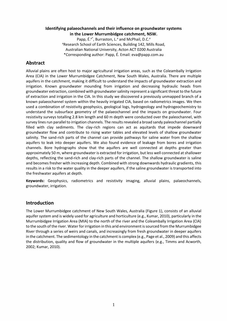
The Lower Murrumbidgee catchment of New South Wales, Australia (Figure 1), consists of an alluvial aquifer system and is widely used for agriculture and horticulture (e.g., Kumar, 2010), particularly in the Murrumbidgee Irrigation Area (MIA) to the north of the river and the Coleambally Irrigation Area (CIA) to the south of the river. Water for irrigation in this arid environment is sourced from the Murrumbidgee River through a series of weirs and canals, and increasingly from fresh groundwater in deeper aquifers in the catchment. The sedimentology in the catchment is complex (e.g., Page et al., 2009) and this affects the distribution, quality and flow of groundwater in the multiple aquifers (e.g., Timms and Acworth, 2002; Kumar, 2010).
2
Figure 1. Location of the Lower Murrumbidgee catchment, NSW, Australia. The Coleambally Irrigation Area (CIA), which is the site of this study, is indicated by the red square.
Characterising the complexity of groundwater resources in this catchment has been traditionally done using bore hole, drill core and other point sources of information (e.g., Kumar, 2010) as well as computer models (e.g., Khan et al., 2004). The complexity, however, requires more detail than can usually be observed through these more traditional methods. Surface geophysical methods, such as radiometric imaging, can indicate features that reflect the subsurface geology affecting groundwater resources. The subsurface geology can be characterised using hydrogeophysics (e.g., Revil et al., 2012; Anderson and Acworth, 2009), and has been done in the past on one area in the Lower Murrumbidgee catchment (Timms and Acworth, 2002). The hydrogeology and hydrogeochemistry can be studied using piezometers to measure hydraulic heads and to sample groundwater for chemical analysis, such as in the Lower Murrumbidgee catchment (e.g., Kumar, 2010).
In this study, we show how we identified a new palaeochannel and underlying geology in the Lower Murrumbidgee catchment using radiometrics and resistivity methods, and then used hydrogeology and hydrogeochemistry data to discuss the influence of palaeochannels on groundwater flow and quality. We also discuss the impacts of palaeochannels on irrigation and water use in this catchment.
Regional overview
The Lower Murrumbidgee Catchment (LMC) lies within the Riverine Plain in the eastern Murray Basin (Figure 2). It covers an area of 33,000 km2 and is located between the towns of Narrandera, Booligal, Balranald and Jerilderie (Cook et al., 2010). The landscape of the LMC is generally flat, with elevations ranging from 162 m above Australian Height Datum (AHD) in the east at Narrandera, to 56 m at Balranald, 400 km to the west (Kumar, 2010). The only relief is from sand dunes that are associated with palaeochannels (Page et al., 2009).
The Murrumbidgee River enters the LMC at Narrandera and flows west through the catchment. There are over 300 irrigation bores and 120 monitoring bores in the LMC that are monitored regularly for groundwater extraction volumes and levels (Kumar, 2010). The Coleambally Irrigation Area (CIA), the site of this study, was developed between 1958 and 1970, together with the Snowy Hydro Scheme. The major land use in the CIA is rice farming in the summer, with wheat, barley, oats, pasture and canola being the main winter crops (CICL, 2010). Rice is grown using flood irrigation and is the primary consumer of the irrigation water. The water is diverted from the Murrumbidgee River through man-made channels (500 GL/yr; CICL, 2010) and supplemented by groundwater (sometimes exceeding 300 GL/yr; Kumar, 2010).
3
The LMC is a semi-arid environment with average annual rainfall of 440 mm in the east at Narrandera and 320 mm at Balranald in the west. Annual evaporation is between 1600 and 2000 mm (Kumar, 2010). Average annual rainfall and evaporation at Coleambally is 395 mm and 1861 mm, respectively (CICL, 2010). Average temperatures range from 16°C to 36⁰C in summer, and 3°C to 18⁰C in winter (Commonwealth Bureau of Meteorology, 2011).
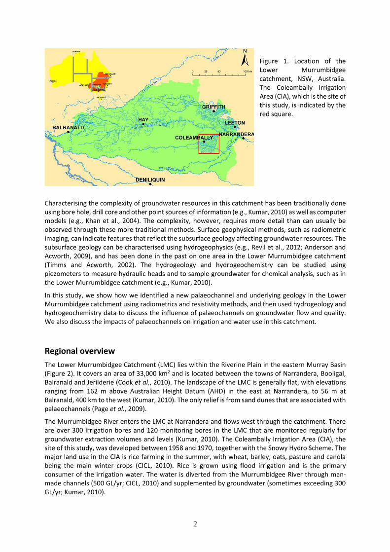
Figure 2. Geology of the Murray Basin (Brown, 1989). The Lower
Murrumbidgee catchment is indicated by the red box.
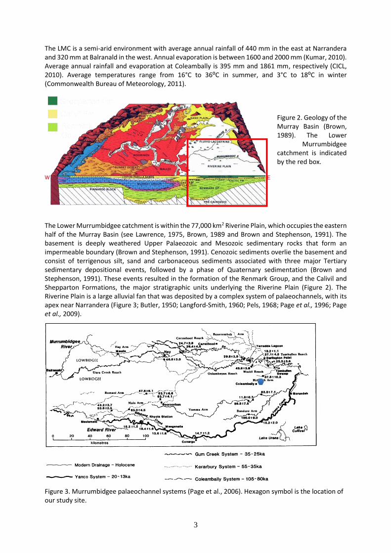
The Lower Murrumbidgee catchment is within the 77,000 km2 Riverine Plain, which occupies the eastern half of the Murray Basin (see Lawrence, 1975, Brown, 1989 and Brown and Stephenson, 1991). The basement is deeply weathered Upper Palaeozoic and Mesozoic sedimentary rocks that form an impermeable boundary (Brown and Stephenson, 1991). Cenozoic sediments overlie the basement and consist of terrigenous silt, sand and carbonaceous sediments associated with three major Tertiary sedimentary depositional events, followed by a phase of Quaternary sedimentation (Brown and Stephenson, 1991). These events resulted in the formation of the Renmark Group, and the Calivil and Shepparton Formations, the major stratigraphic units underlying the Riverine Plain (Figure 2). The Riverine Plain is a large alluvial fan that was deposited by a complex system of palaeochannels, with its apex near Narrandera (Figure 3; Butler, 1950; Langford-Smith, 1960; Pels, 1968; Page et al., 1996; Page et al., 2009).
Figure 3. Murrumbidgee palaeochannel systems (Page et al., 2006). Hexagon symbol is the location of our study site.
Shepparton Fm
Calivil Fm
Renmark Gp
4
The groundwater resources are largely contained within aquifers in the Renmark Group and Calivil and Shepparton Formations, which are transmissive and hydraulically connected. The Renmark Group represents the basal semi-confined aquifer underlying the confined to semi-confined Calivil Formation. The Shepparton Formation is a composite aquifer-aquitard complex overlying the Calivil Formation (e.g., Khan et al., 2004; Kumar, 2010). It is less transmissive than the underlying aquifers and the groundwater is more saline.
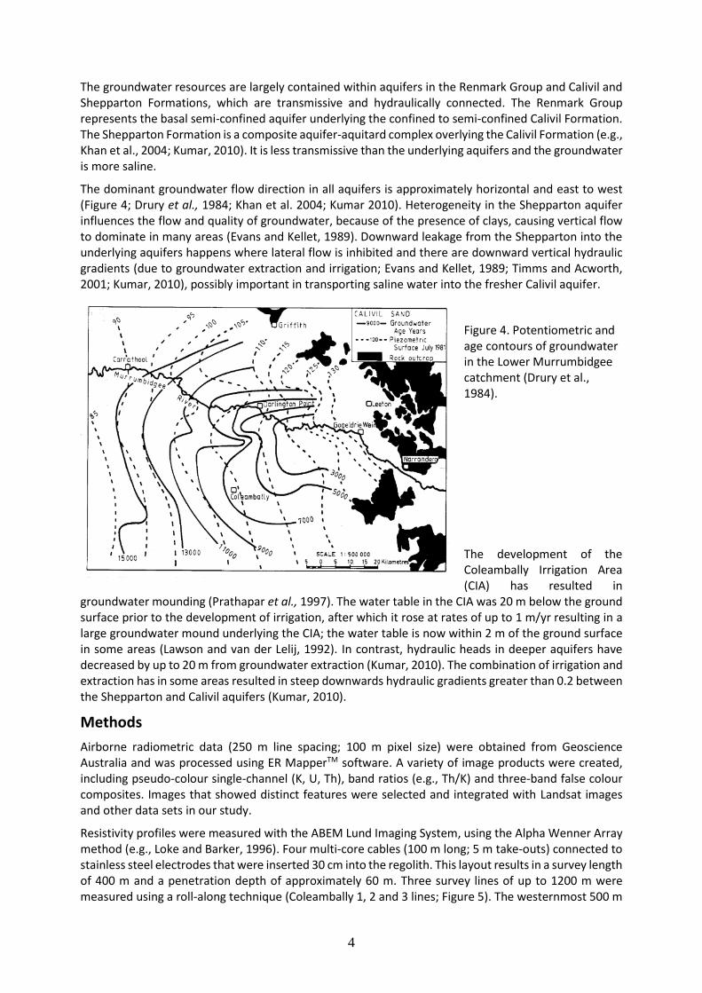
The dominant groundwater flow direction in all aquifers is approximately horizontal and east to west (Figure 4; Drury et al., 1984; Khan et al. 2004; Kumar 2010). Heterogeneity in the Shepparton aquifer influences the flow and quality of groundwater, because of the presence of clays, causing vertical flow to dominate in many areas (Evans and Kellet, 1989). Downward leakage from the Shepparton into the underlying aquifers happens where lateral flow is inhibited and there are downward vertical hydraulic gradients (due to groundwater extraction and irrigation; Evans and Kellet, 1989; Timms and Acworth, 2001; Kumar, 2010), possibly important in transporting saline water into the fresher Calivil aquifer.
Figure 4. Potentiometric and age contours of groundwater in the Lower Murrumbidgee catchment (Drury et al., 1984).
The development of the Coleambally Irrigation Area (CIA) has resulted in
groundwater mounding (Prathapar et al., 1997). The water table in the CIA was 20 m below the ground surface prior to the development of irrigation, after which it rose at rates of up to 1 m/yr resulting in a large groundwater mound underlying the CIA; the water table is now within 2 m of the ground surface in some areas (Lawson and van der Lelij, 1992). In contrast, hydraulic heads in deeper aquifers have decreased by up to 20 m from groundwater extraction (Kumar, 2010). The combination of irrigation and extraction has in some areas resulted in steep downwards hydraulic gradients greater than 0.2 between the Shepparton and Calivil aquifers (Kumar, 2010).
Methods
Airborne radiometric data (250 m line spacing; 100 m pixel size) were obtained from Geoscience Australia and was processed using ER MapperTM software. A variety of image products were created, including pseudo-colour single-channel (K, U, Th), band ratios (e.g., Th/K) and three-band false colour composites. Images that showed distinct features were selected and integrated with Landsat images and other data sets in our study.
Resistivity profiles were measured with the ABEM Lund Imaging System, using the Alpha Wenner Array method (e.g., Loke and Barker, 1996). Four multi-core cables (100 m long; 5 m take-outs) connected to stainless steel electrodes that were inserted 30 cm into the regolith. This layout results in a survey length of 400 m and a penetration depth of approximately 60 m. Three survey lines of up to 1200 m were measured using a roll-along technique (Coleambally 1, 2 and 3 lines; Figure 5). The westernmost 500 m

5
of the Coleambally 2 line was surveyed again 4 months after the first survey, in order to detect any temporal changes. The data were interpreted using the Res2DINV software (Loke and Dahlin, 2002; Loke, 2010) and consisted of noise suppression followed by inversion using the finite difference method with smoothness-constrained least-squares and Gauss-Newton optimisation (deGroot-Hedlin and Constable, 1990; Sasaki, 1992). The vertical to horizontal flatness filter ratio was set to one, in order to avoid making assumptions about the geometry of subsurface features. No topographic corrections were necessary due to the flatness of the site.
Figure 5. Resistivity survey lines, irrigation channel and bore locations at the Coleambally study site.
Groundwater was sampled using bailers for shallow bores (<15 m) and down-hole pumps for deeper bores. Shallow bores were emptied and left to recover for 24 hours before sample collection. Deeper bores were sampled at the screened interval using a QED Sample Pro MicroPurge© pump or a Bennett Sample pump. In both cases, groundwater was pumped through a flow cell fitted with electrodes to monitor temperature, electrical conductivity and pH. Values were recorded approximately every 15 minutes and groundwater samples were taken after the readings had stabilised for at least 30 minutes.
Results and Discussion
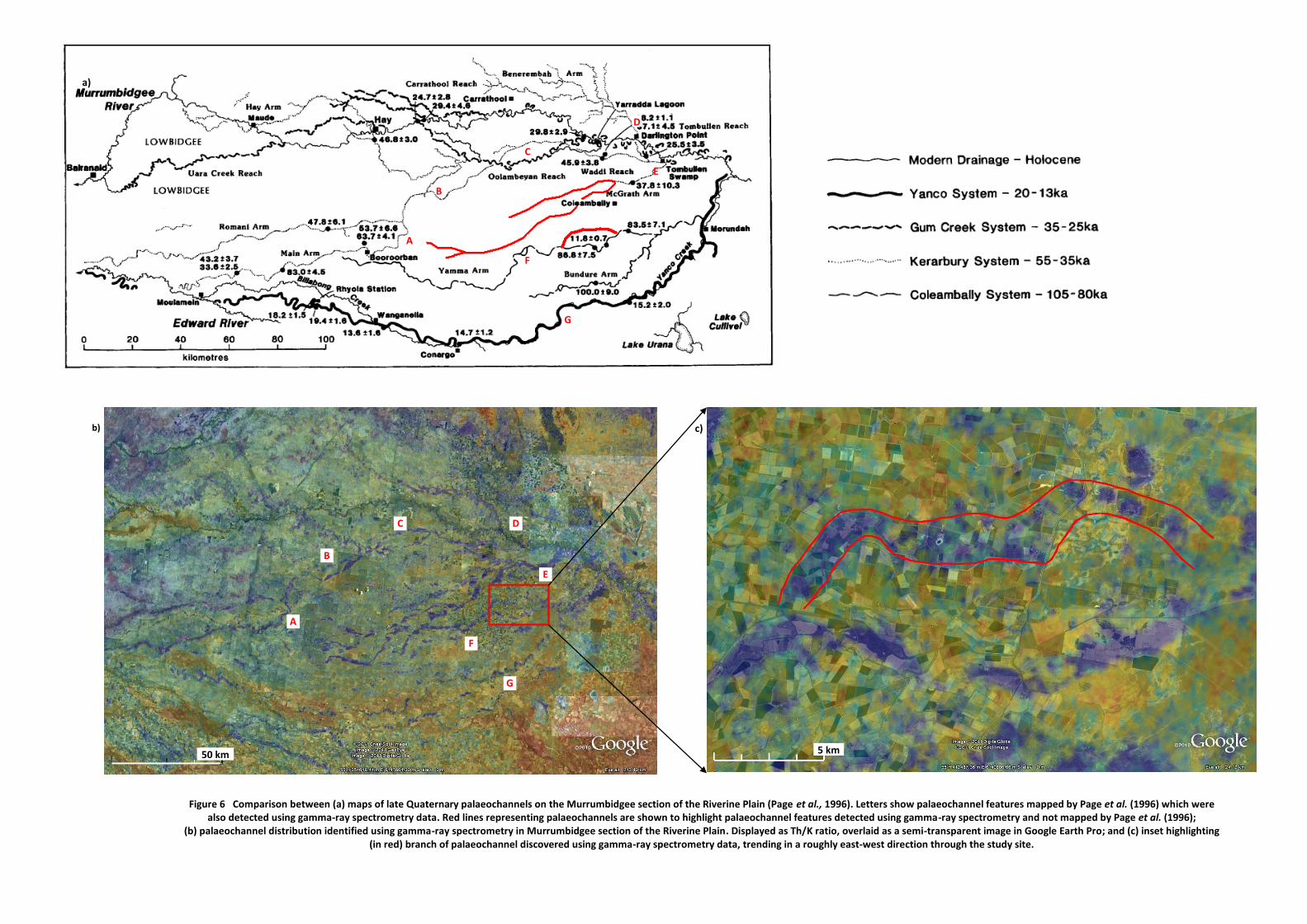
We identified features that we interpret as previously unmapped palaeochannels, based on comparisons between the enhanced radiometrics images of our study and the drainage systems of Page et al. (2009; Figure 6). The palaeodrainage systems that are clearly shown in Figure 6b (blue linear features) correspond to those identified by Page et al. (2009; Figure 6a) using thermoluminescence dating (Figure 3). These features are associated with the McGrath Arm of the Kerarbury System, and the Yamma Arm of the Coleambally System (Figure 6b). The new feature we identified is an extension of the McGrath Arm that continues westward through the CIA, beyond the northwest termination of the Coleambally arm shown in Page et al. (1996; Figure 6). The other new feature we identified is an additional channel of the Yamma Arm, which we interpret as a meander cutoff.
Figure 6.
300 m
Coleambally 2 and 2b resistivity surveys
Channel 9b
Channel 9
Bores
Coleambally 1 resistivity survey
Coleambally 3 resistivity survey
(a)
(a)
a)
b) c)
Figure 6 Comparison between (a) maps of late Quaternary palaeochannels on the Murrumbidgee section of the Riverine Plain (Page et al., 1996). Letters show palaeochannel features mapped by Page et al. (1996) which were also detected using gamma-ray spectrometry data. Red lines representing palaeochannels are shown to highlight palaeochannel features detected using gamma-ray spectrometry and not mapped by Page et al. (1996);
(b) palaeochannel distribution identified using gamma-ray spectrometry in Murrumbidgee section of the Riverine Plain. Displayed as Th/K ratio, overlaid as a semi-transparent image in Google Earth Pro; and (c) inset highlighting (in red) branch of palaeochannel discovered using gamma-ray spectrometry data, trending in a roughly east-west direction through the study site.
5 km
A
A
B
B
C
C D
D
E
E
F
G
F
G
50 km
6
Airborne Radiometrics Remote Sensing
We found that variations in the Th/K ratio in the airborne radiometric data are effective in distinguishing the surface expression of palaeo and modern drainage channels in our study area. Lower Th/K ratios indicate palaeochannels, characterised by coarser sediment deposited in higher energy environments, e.g., the coarse sand-aggraded channels in the Riverine plain identified by Page and Nanson (2006) and Page et al. (2009). The coarser sediments have higher potassium-feldspar content, resulting from granitic sources, and consequently have lower Th/K ratios (e.g., Wilford et al., 1997). Modern channels are characterised by higher Th/K ratios, reflecting lower energy depositional environments with higher silt and clay content. For example, the Yanco palaeochannel system, which follows closely the current
Yanco Creek (Figure 6a), is identifiable by a low Th/K ratio (Figure 6b). The Yanco system is
characterised by large, mixed-load sinuous laterally migrating palaeochannels, which subsequently
evolved to the current smaller channels (Page et al., 2009) with the current highly sinuous flow regime
characterised by higher Th and K consistent with fine clay and silt deposition. Bierwirth et al. (1996) and
Wilford et al. (1997) made similar observations in the nearby Wagga Wagga region. They observed
higher values of radioelements (K > 1.4 wt.% and Th > 15 ppm) along modern drainage systems that are
likely the result of recent deposition of silt and clay.
Ground-based Resistivity Geophysics
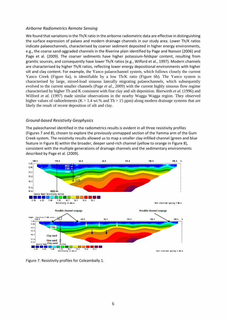
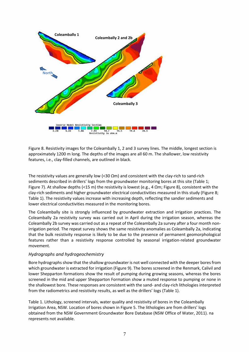
The paleochannel identified in the radiometrics results is evident in all three resistivity profiles (Figures 7 and 8), chosen to explore the previously unmapped section of the Yamma arm of the Gum Creek system. The resistivity results allowed us to map a smaller clay-infilled channel (green and blue feature in Figure 8) within the broader, deeper sand-rich channel (yellow to orange in Figure 8), consistent with the multiple generations of drainage channels and the sedimentary environments described by Page et al. (2009).
Figure 7. Resistivity profiles for Coleambally 1.
7
Figure 8. Resistivity images for the Coleambally 1, 2 and 3 survey lines. The middle, longest section is approximately 1200 m long. The depths of the images are all 60 m. The shallower, low resistivity features, i.e., clay-filled channels, are outlined in black.
The resistivity values are generally low (<30 Ωm) and consistent with the clay-rich to sand-rich sediments described in drillers’ logs from the groundwater monitoring bores at this site (Table 1; Figure 7). At shallow depths (<15 m) the resistivity is lowest (e.g., 4 Ωm; Figure 8), consistent with the clay-rich sediments and higher groundwater electrical conductivities measured in this study (Figure 8; Table 1). The resistivity values increase with increasing depth, reflecting the sandier sediments and lower electrical conductivities measured in the monitoring bores.
The Coleambally site is strongly influenced by groundwater extraction and irrigation practices. The Coleambally 2a resistivity survey was carried out in April during the irrigation season, whereas the Coleambally 2b survey was carried out as a repeat of the Coleambally 2a survey after a four month non-irrigation period. The repeat survey shows the same resistivity anomalies as Coleambally 2a, indicating that the bulk resistivity response is likely to be due to the presence of permanent geomorphological features rather than a resistivity response controlled by seasonal irrigation-related groundwater movement.
Hydrographs and hydrogeochemistry
Bore hydrographs show that the shallow groundwater is not well connected with the deeper bores from which groundwater is extracted for irrigation (Figure 9). The bores screened in the Renmark, Calivil and lower Shepparton formations show the result of pumping during growing seasons, whereas the bores screened in the mid and upper Shepparton Formation show a muted response to pumping or none in the shallowest bore. These responses are consistent with the sand- and clay-rich lithologies interpreted from the radiometrics and resistivity results, as well as the drillers’ logs (Table 1). Table 1. Lithology, screened intervals, water quality and resistivity of bores in the Coleambally Irrigation Area, NSW. Location of bores shown in Figure 5. The lithologies are from drillers’ logs obtained from the NSW Government Groundwater Bore Database (NSW Office of Water, 2011). na represents not available.
Coleambally 1 Coleambally 2 and 2b
Coleambally 3
North

8
Bore Number
Screened Interval (m)
Lithology at screen EC25°C (µS/cm)
Resistivity (Ωm)
T (°C)
pHT
groundwater geophysics
GW401595/1
3.7-5.2 Clay 4740 2.17 CHECK 2.11 (web)
3.2-3.9 19 7.5
GW401595/2
9.6-11.1 Clay 7570 1.37 1.33
3.9-4.3 20 7.1
GW401595/3
14.5-16.0 Fine sand 5643 1.76 1.77
5.9-6.9 22 7.1
GW401587/1
29.0-30.5 Clay/sand 3405 3.01 2.93
9.3-10.7 20 6.4
GW401587/2
38.0-40.1 Clay/sand 1278 8.01 7.81
12.5-14.5 19 6.7
GW036773/1
57.3-62.8 Sand 3995 2.5 2.50
na 21 6.9
GW036773/2
122-128 Gravel/ carbonaceous sand
1038 9.62 na 22 6.5
GW036773/3
166-172 Carbonaceous sand 617 16.1 na 23 6.2
The hydraulic heads (Figure 9) show a continuous, strong downwards hydraulic gradient (> 0.1) from the surface to the lower Shepparton Formation, and lower hydraulic gradients between the deeper formations. The high proportion of clay within the Shepparton Formation inhibits horizontal connection between sand lenses in many areas causing vertical flow to dominate (Evans and Kellet, 1989), and the vertical gradient enhances the potential for vertical leakage of water and solutes into the deeper aquifers.
Figure 9. Bore hydrographs for piezometers at the Coleambally site. The depths of screened intervals are shown in the legend.
Where there is clay-rich infill, it acts as an aquitard to groundwater flow, contributing to rising water tables and elevated levels of shallow groundwater salinity in the shallow aquifer (Figure 10). The clay-rich infill in the broad sandy palaeochannel has a high electrical conductivity (Figure 9). The hydraulic conductivity of the clay-rich sediments is low, e.g., 5 x 10⁻³ m/day at 5 m depth and 4 x 10⁻² m/day at 30 m depth, based on slug test measurements (Burraston, 2012). The low hydraulic conductivity impedes vertical flow and contributes to shallow water table (2 m below surface) at this site. Sandy sections of the palaeochannel feature identified using drillers’ logs, resistivity surveys (Figure 8) and irrigation

9
surveys act as conduits for irrigation channel leakage and vertical groundwater flow, e.g., to the eastern end of resistivity images 2 and 3 (Figure 8).
Figure 10. Electrical conductivity and chloride concentrations in groundwater at Coleambally.
Electrical conductivity of water in the bores increases from 461 mS/m at 5 m depth to 730 mS/m at 10 m, decreases to 125 mS/m at 40 m, increases at 60 m depth and then decreases to 104 mS/m and 62 mS/m at 125 m and 169 m (Table 1; Figure 10). The resistivity calculated from the measured groundwater electrical conductivity show a similar trend to the bulk resistivity from the resistivity survey, but are systematically lower due to the contribution of more resistive host sediments (Table 1; Figure 11).
Figure 11. Resistivity values derived from geophysical surveys compared to values calculated for groundwater at Coleambally.
Elevated salinity in the Shepparton aquifer at the Coleambally sites is likely a result of elevated groundwater levels at these sites causing remobilisation of unsaturated zone salts, similar to the findings of Cartwright et al. (2004, 2007) in their studies of the southeast Murray Basin. The potential for leakage of shallow saline groundwater into underlying fresher aquifers results from induced downwards hydraulic gradients due to groundwater extraction.
Groundwater quality is also affected by the palaeochannel. Groundwater EC was highest within the clay layer at 10 m depth, e.g., in GW401595/2, and lowest in the mid-Shepparton Formation at 30-40 m depth. GW036773/1 screened in the lower Shepparton Formation at the study site revealed chemical similarities to the shallow groundwater samples within the high conductivity layer, such as elevated groundwater electrical conductivity. These findings lead to the interpretation of either GW036773/1 as a leaky bore, or alternatively a local high permeability region (aquitard window) enabling leakage of shallow groundwater through to the lower Shepparton aquifer. Elevated groundwater salinity in the deeper aquifers underlying the irrigated sites (Coleambally and Four Corners) relative to Steam Plains further west along the path of groundwater flow indicate that the strong vertical hydraulic gradients in irrigated areas leads to contamination of the deeper aquifers from the overlying saline Shepparton aquifer.
10
Summary and conclusions
The following is a brief summary of significant findings from this project:
A previously unmapped branch of a known palaeochannel system was discovered from radiometrics and surface geology;
Detailed subsurface geometry of this palaeochannel from resistivity imaging revealed a broad sandy feature partially infilled with clay sediments;
Combined analysis of geological bore logs, hydrographs, hydrogeochemical data and geophysics showed how this partially clay-filled palaeochannel system acts as an aquitard, contributing to rising water-tables and increasing groundwater salinity at the study site;
Sandy sections of the palaeochannel act as conduits for leakage or as ‘aquitard windows’;
Evidence of leakage from irrigation channels was identified using resistivity imaging;
Localised groundwater mounding in the CIA was found to have a significant impact on both local and regional groundwater gradients and flow directions; and
The presence of strong vertical hydraulic gradients underlying the Coleambally and Four Corners sites in the CIA has resulted in elevated salinity in the fresher deep aquifers, which has disrupted regional groundwater chemical trends.
Regional findings and implications for the CIA and the LMC
Groundwater mounding and shallow groundwater salinity represents a significant threat to the future of irrigation in the CIA. Groundwater mounding beneath the CIA is a well-documented problem. Findings from this project have contributed to a better understanding of the causes of this problem by showing how the presence of geomorphological features exert significant influence on groundwater mounding. The presence of a palaeochannel underlying the study site has been shown to influence both groundwater movement and quality. This project assists in understanding why mounding exists at the Coleambally site despite intensive pumping from deeper aquifers and strong vertical downward hydraulic gradients. Clays which partially fill a broad sandy palaeochannel were shown in this study to prevent lateral and vertical dissipation of groundwater.
The hypothesis that irrigation channels at the study site are leaking was proven by resistivity imaging. Findings from this project can assist in minimising excessive loss of irrigation water through the identification of leaky areas of irrigation channels. Leakage pathways through the Shepparton Formation, such as aquitard windows or leaky bores, were found to result in changes to groundwater quality caused by mixing of irrigation water and ground water. This contributes to and supports previous work identifying the presence and impacts of aquitard windows.
Significant implications for surface water and groundwater interactions, especially from irrigation, are evident from this study. Sands and clays were shown to have very different effects on subsurface conditions. The higher bulk electrical resistivity of the sandy areas indicates that water recharging the subsurface in these areas is not contributing to increasing groundwater salinity. However, it is inefficient to irrigate on sands because of the substantially higher water usage compared to clays. Irrigating on clays prevents large volumes of water from being lost through the subsurface, however the findings from this study show that groundwater mounding and shallow groundwater salinity are largely a result of irrigating on clays.
11
References
Allen, D. (2007) Geophysics for the Irrigation Industry, Land and Water Australia: Canberra (178pp).
ANCID (2000) Open channel seepage and control: Vol 1.1 Literature review of channel seepage identification and measurement. Australian National Committee on Irrigation and Drainage. Prepared by Sinclair Knight Merz.
Anderson, M.S., Meredith, K., Timms, W. and Acworth, R.I. (2008) Investigation of δ18O and δ2H in the Namoi River catchment – elucidating recharge sources and the extent of surface water/groundwater interaction. XXXVI IAH Congress, Toyama, Japan 26 October–1 November 2008.
Anderson, M.S. and Acworth, R.I. (2009) Stream-aquifer interactions in the Maules Creek catchment, Namoi Valley, New South Wales, Australia. Hydrogeology Journal, 17: 2005-2021.
Appelo, C.A.J. and Postma, D. (2005) Geochemistry, groundwater and pollution, 2nd edn, A.A. Balkema Publishers: Leiden, The Netherlands (649pp).
Archie, G.E. (1942) The electrical resistivity log as an aid in determining some reservoir characteristics. Trans. Am. Inst. Min. Eng, 146: 54-62.
Baskaran, S., Ransley, T., Brodie, R.S. and Baker, P. (2009) Investigating groundwater-river interactions using environmental tracers. Australian Journal of Earth Sciences, 56(1): 13-19.
Bierwirth, P.N., Gessler, P. and McKane, D. (1996) Empirical investigations of airborne gamma-ray images as an indicator of soil properties – Wagga Wagga, NSW. Proceedings of the 8th Australasian Remote Sensing Conference, Canberra, 1996 .
Bouwer, H. and Rice, R.C. (1976) A slug test for determining hydraulic conductivity of unconfined aquifers with completely or partially penetrating wells. Water Resources Research, 12: 423-428.
Brown, C.M. (1989) Structural and stratigraphic framework of groundwater occurrence and surface discharge in the Murray Basin, southeastern Australia. Journal of Australian Geology and Geophysics, 11: 127-146.
Butler, B.E. (1950) A theory of prior streams as a causal factor of soil occurrence in the Riverine Plain of south-eastern Australia. Australian Journal of Agricultural Research, 1: 231-252.
Butler, B.E. (1956) Parna: an aeolian clay. Australian Journal of Science, 18: 145-151.
Brown, C.M., and Stephenson, A.F. (1991) Geology of the Murray Basin Southeastern Australia. Bulletin 235, Bureau of Mineral Resources: Canberra (432pp).
Carr, J. (2011) The geochemistry and hydrogeology of leakage from a confined layer: Case study from the Coleambally Irrigation Area, lower Murrumbidgee riverine plain, N.S.W., Honours Thesis, Australian National University (unpublished).
Cartwright, I., Weaver, T.R., Fulton, S., Nichol, C., Reid, M. and Cheng, X. (2004) Hydrogeochemical and isotopic constraints on the origins of dryland salinity, Murray Basin, Victoria, Australia. Applied Geochemistry, 19: 1233–1254.
Cartwright, I., Weaver, T.R. and Fifield, L.K. (2006) Cl/Br ratios and environmental isotopes as indicators of recharge variability and groundwater flow: An example from the southeast Murray Basin, Australia. Chemical Geology, 231: 38-56.
Cartwright, I., Weaver, T.R., Stone, D. and Reid, M. (2007) Constraining modern and historical recharge from bore hydrographs, 3H, 14C and chloride concentrations: Applications to dual-porosity aquifers in dryland salinity areas, Murray Basin, Australia. Journal of Hydrogeology, 332: 69-92.
Cartwright, I. and Simmonds, I. (2008) Impact of changing climate and land use on the hydrogeology of southeast Australia. Australian Journal of Earth Sciences, 55: 1009-1021.
Cartwright, I., Weaver, T.R., Simmons, C.T., Fifield, L.K., Lawrence, C.R., Chisari, R. and Varley, S. (2010) Physical hydrogeology and environmental isotopes to constrain the age, origins, and stability of a low-salinity groundwater lens formed by periodic river recharge: Murray Basin, Australia. Journal of Hydrology, 380: 203-221.
Christen, E. and Hornbuckle, J.W. (2002) Irrigation Insights No.2: Sub-surface drainage design and management practices in irrigated areas of Australia. Land and Water Australia: Canberra (180pp).
12
CICL (2010) Annual Compliance Report. Coleambally Irrigation Cooperative Limited (87pp).
Clark, I.D. and Fritz, P. (1997) Environmental Isotopes in Hydrogeology, CRC Press: Florida (328pp).
Clarke, J., Lawrie, A. and Fitzpatrick, A. (2007) Application of geophysical methods to improve knowledge of groundwater flow and leakage from supply infrastructure: Case study 2 – the Lower Burdekin, pp.125-131, In Allen, D. (Ed.) Geophysics for the Irrigation Industry, Land and Water Australia: Canberra
Commonwealth Bureau of Meteorology (2011), Climate Calendar: Yanco Agricultural Institute, Commonwealth of Australia, viewed 30 June 2011. < http://www.bom.gov.au/jsp/ncc/cdio/calendar/climate-calendar?stn_num=074037&month=10&day=27>
Cook, P., Leaney, F., Kumar, P.B. and Caputo, M. (2010) Time-Series Comparison of Carbon-14 Groundwater Ages in Heavily Pumped Confined Aquifers, Lower Murrumbidgee, Southern NSW. CSIRO Water for a Healthy Country Flagship Report series (22pp).
Dahlin, T. and Loke, M.H. (1998) Resolution of 2D Wenner resistivity imaging as assessed by numerical modelling. Journal of Applied Geophysics, 38: 237-249.
Dahlin, T. and Owen, R. (1998) Geophysical investigations of alluvial aquifers in Zimbabwe. Proc. 4th EEGS Meeting, Barcelona, 14-17 September.
Dahlin, T. (2001) The development of DC resistivity imaging techniques. Computers & Geosciences, 27: 1019-1029.
Dahlin, T. and Bing, Z. (2004) A numerical comparison of 2D resistivity imaging with 10 electrode arrays. Geophysical Prospecting, 52: 379-398.
deGroot-Hedlin, C. and Constable, S. (1990) Occam’s inversion to generate smooth, two-dimensional models from magnetotelluric data. Geophysics, 55(12): 1613-1624.
Domenico, A. and Schwartz, F. (1990) Physical and Chemical Hydrogeology, John Wiley & Sons, Canada (824pp).
Drury, L. W., Calf, G. E. and Dharmasiri, J. K. (1984) Radiocarbon dating of groundwater in Tertiary sediments in the Eastern Murray Basin. Australian Journal of Soil Resources, 22: 379-387.
DWLC (1998) Aquifer risk assessment report. NSW Department of Land and Water Conservation: Sydney (20pp)
Elliot, P.J. and Thomas, L.T. (1986) Interpretation of lithology from the formation resistivity of unconsolidated argillaceous/arenaceous sediments. Exploration Geophysics, 17: 75-79.
ERDAS (1999) ERDAS Field Guide – Fifth Edition, Revised and Expanded. ERDAS: Atlanta, Georgia (698pp)
ERDAS (2005) ER Mapper. 7.0 ed., ERDAS: Atlanta, Georgia
Ernston, K. and Kirsch, R. (2006) Geoelectrical methods, pp.85-118, In Kirsch, R. (Ed,) Groundwater Geophysics: A Tool for Hydrogeology, Springer: Heidelberg, Germany.
Evans, W. R. and Kellet, J. R. (1989) The hydrogeology of the Murray Basin, southeastern Australia. BMR Journal of Australian Geolology and Geophysics, 11: 147-166.
Fetter, C.W. (2001) Applied Hydrogeology, 4th edn, Prentice Hall, Upper Saddle River, New Jersey (598pp).
Foster, S.S. and P.J. Chilton, 2003: Groundwater: The processes and global significance of aquifer degradation, Philosophical Transactions of the Royal Society of London Series B Biological Sciences, 358(1440): 1957–72.
Garner, R. (2010) Resistivity imaging and surface water – groundwater interactions in the Lower Murrumbidgee Catchment. Honours Thesis, Research School of Earth Sciences, The Australian National University (unpublished).
Geoelectric (2010) RES2DINV ver. 3.59 Manual. Geoelectric.
Griffiths, D.H. and Barker, R.D. (1993) Two-dimensional resistivity imaging and modelling in areas of complex geology. Journal of Applied Geophysics, 29: 211-226.
Herczeg, A.L. and Leaney, F.W. (2010) Review: Environmental tracers in arid-zone hydrology. Hydrogeology Journal, 19(1): 17-29.
13
Hvorslev, M.J. (1951) Time lag and soil permeability in groundwater observations. Waterways Experimental Station, US Army Corps of Engineers: Vicksburg, Mississippi (50pp).
Kellet, J.R. (1989) The Ivanhoe Block – its structure, hydrogeology and effect on groundwaters of the Riverine Plain of New South Wales. BMR Journal of Australian Geology & Geophysics, 11: 333-353.
Khan, S., Rana, T., Carroll, J. Wang, B. and Best, L. (2004) Managing climate, irrigation and groundwater interactions using a numerical model: A case study of the Murrumbidgee Irrigation Area. CSIRO Land and Water Technical Report No. 13/04, 413 pp.
Khan, S., Mushtaq, S., Hanjra, M.A. and Schaeffer, J. (2008) Estimating potential costs and gains from an aquifer storage and recovery program in Australia. Agricultural Water Management, 95, 477-488.
Kumar, P.B. (2010) Lower Murrumbidgee Groundwater Sources: Groundwater Management Area 002 Groundwater Status Report – 2009. NSW Office of Water: Sydney (48pp).
Langford-Smith, T. (1960) The dead river systems of the Murrumbidgee. Geographical Review, 50: 368-389.
Lawrence, C.R. (1975) Geology, hydrodynamics and hydrogeochemistry of the southern Murray Basin. Geological Survey of Victoria, Memoir, 30: 1-359.
Lawson, S. and van der Lilij, A. (1992) Coleambally deep bore project: analysis of long term pumping test – summary report. Department of Water Resources: Sydney (25pp).
Leaney, F.W.J. and Herczeg, A.L. (1999) The origin of fresh groundwater in the SW Murray Basin and its potential for salinisation. Technical Report 7/99. CSIRO Land and Water (76pp).
Loke, M.H. and Barker, R.D. (1995) Least-squares deconvolution of apparent resistivity pseudosections. Geophysics, 60(6): 1682-1690.
Loke, M.H. and Barker, R.D. (1996) Rapid least-squares inversion of apparent resistivity pseudosections by a quasi-Newton method. Geophysical Prospecting, 44: 131-152.
Loke, M.H. (2001) Electrical imaging surveys for environmental and engineering studies. Online guidebook (68pp), viewed 21 July, 2010. <http://www.geoelec.com.mx/softelectricos/lokenote.pdf>
Loke, M.H. and Dahlin, T. (2002) A comparison of the Gauss-Newton and quasi-Newton methods in resistivity imaging inversion. Journal of Applied Geophysics, 29: 149-162.
Loke, M.H. (2010) Tutorial: 2-D and 3-D electrical imaging surveys. Geoelectrical. Online guidebook (68pp), viewed 21 July, 2010. <http://www.landviser.biz/forall/RES2DINV/CourseNotes.pdf>
Meredith, K.T., Hollins, S.E., Hughes, C.E., Cendon, D.I., Hankin, S. and Stone, D.J.M. (2009) Temporal variation in stable isotopes (18O and 2H) and major ion concentrations within the Darling River between Bourke and Wilcannia due to variable flows, saline groundwater influx and evaporation. Journal of Hydrology, 378: 313-324.
Minty, B.R.S. (1997) Fundamentals of airborne gamma-ray spectrometry. AGSO Journal of Australian Geology and Geophysics, 17(2): 39-50.
Munday, T. (2008) Regolith Geophysics, pp.219-250, In Scott, K.M. and Pain, C.F. (Ed.) Regolith Science. CSIRO Publishing: Collingwood.
New South Wales Office of Water (2011) Real Time Data – Bores, NSW Government, viewed 27 July 2011. <http://realtimedata.water.nsw.gov.au/water.stm?ppbm=GROUND_WATER&gw&3&gwkm_url>
Odins, J.A., Williams, R.M., O’Neill, D.J. and Lawson, S.J. (1991) Pre-Tertiary basement structure of the central Murray Basin, and its effect on groundwater flow patterns. Exploration Geophysics, 22: 285-290.
Page, K.J. and Nanson, G.C. (1996) Stratigraphic architecture resulting from Late Quaternary evolution of the Riverine Plain, south-eastern Australia. Sedimentology, 43: 927-945.
Page, K., Nanson, G. and Price, D. (1996) Chronology of Murrumbidgee River palaeochannels on the Riverine Plain, southeastern Australia. Journal of Quaternary Science, 4: 311-326.
Page, K.J., Kemp, J. and Nanson, G.C. (2009) Late Quaternary evolution of Riverine Plain paleochannels, southeastern Australia. Australian Journal of Earth Sciences, 56: 19-33.
14
Pels, S., Stannard, M.E., and Talsma, T. (1968) Environmental studies of the Coleambally Irrigation Area and surrounding districts. Bulletin 2 – Land Use Series, Water Conservation and Irrigation Commission: New South Wales (48pp).
Peterson, D.M. and Wilson, J.L. (1988) Variably saturated flow between streams and aquifers. Tech Completion Report 233. New Mexico Water Resources Research Institute: Socorro (303pp).
Prasad, A., Christen, E.W., and Khan, S. (2001) The potential role for deep groundwater pumping in the control of irrigation induced salinity in the Riverine Plain. A case study for the Coleambally Irrigation Area. Technical Report 01-01. CSIRO Land and Water: Griffith, NSW (88pp).
Prathapar, S.A., Lawson, S. and Enever, D.J. (1997) Hydrogeology of the Coleambally Irrigation Area: A brief description for use with a groundwater simulation model. Technical Report 3/97. CSIRO Land and Water: Griffith, NSW (39pp).
Pratt Water (2004) The Business of Saving Water: the report of the Murrumbidgee valley water efficiency feasibility project. Pratt Water: Campbellfield, Victoria (61pp).
Sasaki, Y. (1989) Two-dimensional joint inversion of magnetotelluric and dipole-dipole resistivity data. Geohpysics, 54(2): 254-262.
Sasaki, Y. (1992) Resolution of resistivity tomography inferred from numerical simulation. Geophysical Prospecting, 40: 453-463.
Sophocleous, M. (2002) Interactions between groundwater and surface water: the state of the science. Hydrogeology Journal, 10: 52-67.
Telford, W.M., Geldart, L.P. and Sheriff, R.E. (1990) Applied Geophysics, 2nd edn, Cambridge University Press: Cambridge (770pp).
Timms, W. and Acworth, R. (2002) Origin, lithology and weathering characteristics of Upper Tertiary – Quaternary clay aquitard units on the Lower Murrumbidgee alluvial fan. Australian Journal of Earth Sciences, 49: 525-537.
United States Geological Survey (USGS) (2011), Earth Explorer, United States Geological Survey, viewed 10 April 2011. <http://edcsns17.cr.usgs.gov/NewEarthExplorer/>
Van der Lelij, A., Ellis, L. and Gee, B. (1987) Groundwater hydrology of the Coleambally Irrigation Area. Technical Report. Department of Water Resources: NSW (58pp).
Wilford, J.R., Bierwirth, P.N. and Craig, M.A. (1997) Application of airborne gamma-ray spectrometry in soil/regolith mapping and applied geomorphology. AGSO Journal of Australian Geology and Geophysics, 17(2): 201-216.
Wilford, J. and Creasey, J. (2002) Landsat Thematic Mapper, pp.6-12, In Papp, E. (Ed.) CRC LEME Open File Report 144: Geophysical and Remote Sensing Methods for Regolith Exploration. CRC LEME.
Winter, T.C., Harvey, J.W., Franke, O.L. and Alley, W.M. (1998) Ground water and surface water: a single resource. USGS Circular 1139, US Geological Survey: Denver, CO (79pp).
Worthington, P.F. (1982) The influence of shale effects upon the electrical resistivity of reservoir rocks. Geophysical Prospecting, 30: 673-687.
Worthington, P.F. (1985) The evolution of shaly-sand concepts in reservoir evaluation. The Log Analyst, 26(1): 23-40.
Yesou, H., Besnus, Y. and Rolet, J. (1993) Extraction of spectral information from Landsat TM data and merger with SPOT panchromatic imagery – a contribution to the study of geologic structures. ISPRS Journal of Photogrammetry and Remote Sensing, 48(5): 23-36.
Zhou, B. and Dahlin, T. (2003) Properties and effects of measurement errors on 2D resistivity imaging surveying. Near Surface Geophysics, 1(3): 105-11.