Palaeontology and depositional environments of ancient brine seeps in the Middle Cambrian Burgess...
20
Palaeontology and depositional environments of ancient brine seeps in the Middle Cambrian Burgess Shale at The Monarch, British Columbia, Canada Paul A. Johnston a,b, ⁎, Kimberley J. Johnston b , Christopher J. Collom c , Wayne G. Powell d , Robyn J. Pollock e a Department of Earth Sciences, Mount Royal College, Lincoln Park Campus, Calgary, Alberta, Canada T3E 6K6 b c/o Royal Tyrrell Museum of Palaeontology, Box 7500, Drumheller, Alberta, Canada T0J 0Y0 c Department of Chemical & Petroleum Engineering, The University of Calgary, 2500 University Drive, Calgary, Alberta, Canada T2N 1N4 d Department of Geology, Brooklyn College of CUNY, 2900 Bedford Avenue, Brooklyn, NY 11210, USA e Department of Biology, University of Saskatchewan, 112 Science Place, Saskatoon, Saskatchewan, Canada S7N 5E2 abstract article info Keywords: Burgess Shale Brine pools Seeps Nonbiomineralized fossils Chemosynthesis Dolomitization The Monarch, a mountain in southeastern British Columbia, exposes the Cathedral Escarpment, which abuts the basinal Burgess Shale and an underlying limestone, the upper Takakkaw Tongue. At one section, a dolomitized megabreccia, representing an intraformational collapsed cavern, forms the Cathedral Escarp- ment wall. The megabreccia is cross-cut by the subsequent megatruncation event marking the collapse of the Cathedral margin, which supports previous hypotheses that dolomitizing brines were active at the Cathedral margin, prior to and during deposition of the Burgess Shale. Epiphyton-rich carbonate megablocks within the basinal strata, previously interpreted as olistoliths spalled off the Escarpment, are unlike the peritidal strata comprising the Cathedral margin and are more likely deep-water carbonate mud mounds that grew in the basin near the Escarpment face. Evidence for early brines in basinal environments at this locality includes lenses of dark, magnesium-rich clinochlore (N 30 wt.% MgO vs ~2% in background shales) within the Burgess Shale at the Escarpment wall. These clinochlores are interpreted as precipitates from seafloor brine seeps analogous to ones currently found at the foot of the Florida Escarpment and on the distal shelf and slope of the northern Gulf of Mexico. Like the Gulf examples, the brines formed standing pools on the Cambrian seafloor and hosted abundant organisms in a narrow fringe around their peripheries but not within the pools. Sponges, priapulid worms, hyoliths, linguliform brachiopods and trilobites predominate. Shales only a few metres basinward from the pools are nearly barren of animal fossils. Increased biologic productivity localized at the seeps would account for the patchy distribution of fossils in the Burgess Shale in a narrow zone close to the Escarpment. The discovery of brine seep deposits and associated fringing communities at The Monarch shows that at least some assemblages in the Burgess Shale were preserved within their habitat and were supported by chemosynthesis. © 2009 Elsevier B.V. All rights reserved. 1. Introduction The Middle Cambrian Burgess Shale Formation, remarkable for its preservation of nonbiomineralized fossils (sensu Butterfield, 2003), is exposed in an outcrop belt that extends about 60 km from the type area around Field, British Columbia, to a mountain known as The Monarch on the eastern edge of Kootenay National Park (Fig. 1). Fossils are known from several localities in the Burgess Shale (Collins et al., 1983). These sites invariably occur in close proximity (in our experience typically b 50 m) to the Cathedral Escarpment, a steeply dipping surface marking the headwall of the gravity-collapsed margin of the platformal carbonates of the Cathedral Formation, against which the Burgess Shale accumulated (McIlreath, 1975; Stewart, 1991; Stewart et al., 1993). The trend of the Cathedral Escarpment coincides with a fault-controlled, linear, palaeotopographic feature known as the Kicking Horse Rim (Aitken, 1971). Faults along this structure were probably important conduits for dolomitizing and mineralizing brines rising from deeper strata along the platform margin during the Middle Cambrian (Powell et al., 2006). In the adjacent basinal strata of the Burgess Shale, the brines left distinctive deposits that appear in outcrop as dark-coloured, lens- shaped lithosomes composed of MgO-rich clinochlore laminates (Powell et al., 2006); these are invariably associated with abundant fossils and have been documented at several localities, including Mummy Lake, the Trilobite Beds of Mount Stephen, and others (Johnston et al., 2003). The lithosomes have been interpreted as representing precipitates of dense Mg-rich brines that seeped locally from or near the base of the Cathedral Escarpment and pooled on the seafloor during Burgess Shale time (Johnson et al., 2003). In this study Palaeogeography, Palaeoclimatology, Palaeoecology 277 (2009) 86–105 ⁎ Corresponding author. Department of Earth Sciences, Mount Royal College, Lincoln Park Campus, Calgary, Alberta, Canada T3E 6K6. Tel.: +1 403 440 6174; fax: +1 403 440 6333. E-mail address: [email protected] (P.A. Johnston). 0031-0182/$ – see front matter © 2009 Elsevier B.V. All rights reserved. doi:10.1016/j.palaeo.2009.02.013 Contents lists available at ScienceDirect Palaeogeography, Palaeoclimatology, Palaeoecology journal homepage: www.elsevier.com/locate/palaeo
Transcript of Palaeontology and depositional environments of ancient brine seeps in the Middle Cambrian Burgess...
Palaeontology and depositional environments of ancient brine seeps in the MiddleCambrian Burgess Shale at The Monarch, British Columbia, Canada
Paul A. Johnston a,b,⁎, Kimberley J. Johnston b, Christopher J. Collom c, Wayne G. Powell d, Robyn J. Pollock e
a Department of Earth Sciences, Mount Royal College, Lincoln Park Campus, Calgary, Alberta, Canada T3E 6K6b c/o Royal Tyrrell Museum of Palaeontology, Box 7500, Drumheller, Alberta, Canada T0J 0Y0c Department of Chemical & Petroleum Engineering, The University of Calgary, 2500 University Drive, Calgary, Alberta, Canada T2N 1N4d Department of Geology, Brooklyn College of CUNY, 2900 Bedford Avenue, Brooklyn, NY 11210, USAe Department of Biology, University of Saskatchewan, 112 Science Place, Saskatoon, Saskatchewan, Canada S7N 5E2
a b s t r a c ta r t i c l e i n f o
Keywords:Burgess ShaleBrine poolsSeepsNonbiomineralized fossilsChemosynthesisDolomitization
The Monarch, a mountain in southeastern British Columbia, exposes the Cathedral Escarpment, which abutsthe basinal Burgess Shale and an underlying limestone, the upper Takakkaw Tongue. At one section, adolomitized megabreccia, representing an intraformational collapsed cavern, forms the Cathedral Escarp-ment wall. The megabreccia is cross-cut by the subsequent megatruncation event marking the collapse of theCathedral margin, which supports previous hypotheses that dolomitizing brines were active at the Cathedralmargin, prior to and during deposition of the Burgess Shale. Epiphyton-rich carbonate megablocks within thebasinal strata, previously interpreted as olistoliths spalled off the Escarpment, are unlike the peritidal stratacomprising the Cathedral margin and are more likely deep-water carbonate mud mounds that grew in thebasin near the Escarpment face. Evidence for early brines in basinal environments at this locality includeslenses of dark, magnesium-rich clinochlore (N30 wt.% MgO vs ~2% in background shales) within the BurgessShale at the Escarpment wall. These clinochlores are interpreted as precipitates from seafloor brine seepsanalogous to ones currently found at the foot of the Florida Escarpment and on the distal shelf and slope ofthe northern Gulf of Mexico. Like the Gulf examples, the brines formed standing pools on the Cambrianseafloor and hosted abundant organisms in a narrow fringe around their peripheries but not within the pools.Sponges, priapulid worms, hyoliths, linguliform brachiopods and trilobites predominate. Shales only a fewmetres basinward from the pools are nearly barren of animal fossils. Increased biologic productivity localizedat the seeps would account for the patchy distribution of fossils in the Burgess Shale in a narrow zone close tothe Escarpment. The discovery of brine seep deposits and associated fringing communities at The Monarchshows that at least some assemblages in the Burgess Shale were preserved within their habitat and weresupported by chemosynthesis.
© 2009 Elsevier B.V. All rights reserved.
1. Introduction
The Middle Cambrian Burgess Shale Formation, remarkable for itspreservation of nonbiomineralized fossils (sensu Butterfield, 2003), isexposed in an outcrop belt that extends about 60 km from the typearea around Field, British Columbia, to a mountain known as TheMonarch on the eastern edge of Kootenay National Park (Fig. 1).Fossils are known from several localities in the Burgess Shale (Collinset al., 1983). These sites invariably occur in close proximity (in ourexperience typically b50 m) to the Cathedral Escarpment, a steeplydipping surface marking the headwall of the gravity-collapsed marginof the platformal carbonates of the Cathedral Formation, against
which the Burgess Shale accumulated (McIlreath, 1975; Stewart, 1991;Stewart et al., 1993). The trend of the Cathedral Escarpment coincideswith a fault-controlled, linear, palaeotopographic feature known asthe Kicking Horse Rim (Aitken, 1971). Faults along this structure wereprobably important conduits for dolomitizing and mineralizing brinesrising from deeper strata along the platformmargin during theMiddleCambrian (Powell et al., 2006).
In the adjacent basinal strata of the Burgess Shale, the brines leftdistinctive deposits that appear in outcrop as dark-coloured, lens-shaped lithosomes composed of MgO-rich clinochlore laminates(Powell et al., 2006); these are invariably associated with abundantfossils and have been documented at several localities, includingMummy Lake, the Trilobite Beds of Mount Stephen, and others(Johnston et al., 2003). The lithosomes have been interpreted asrepresenting precipitates of dense Mg-rich brines that seeped locallyfrom or near the base of the Cathedral Escarpment and pooled on theseafloor during Burgess Shale time (Johnson et al., 2003). In this study
Palaeogeography, Palaeoclimatology, Palaeoecology 277 (2009) 86–105
⁎ Corresponding author. Department of Earth Sciences, Mount Royal College, LincolnPark Campus, Calgary, Alberta, Canada T3E 6K6. Tel.: +1 403 440 6174; fax: +1403 4406333.
E-mail address: [email protected] (P.A. Johnston).
0031-0182/$ – see front matter © 2009 Elsevier B.V. All rights reserved.doi:10.1016/j.palaeo.2009.02.013
Contents lists available at ScienceDirect
Palaeogeography, Palaeoclimatology, Palaeoecology
j ourna l homepage: www.e lsev ie r.com/ locate /pa laeo

we describe some particularly well exposed examples of theMgO-richlithosomes from a locality known as Monarch Assiniboine, anddocument the associated biota. These observations, in turn, compelre-evaluation of the paleoecology and depositional environment ofthe Burgess Shale in its broader context through the mountain parks.
2. Localities
The Burgess Shale is exposed at four localities on The Monarch:North Face (NF), Monarch Cirque North (MCN), Monarch Cirque South(MCS), and Monarch Assiniboine (MA) (Figs. 1–4). Localities MonarchCirque North and Monarch Cirque South are within Monarch Cirque, asouthwest-facing cirque on the southwest side of The Monarch.Localities North Face and Monarch Assiniboine are on the externalfaces of prominent ridges that form the north and south walls of thecirque, respectively (Fig. 2). The Cathedral Escarpment is exposed in adip section at North Face and Monarch Cirque South (Fig. 4), anoblique dip section at Monarch Cirque North, (Fig. 3A) and in a nearstrike section at Monarch Assiniboine (Fig. 3B, C).
Stewart (1991) discovered localities Monarch Cirque North,Monarch Cirque South, and North Face, and measured sections atthe latter two, noting nonbiomineralized fossils in scree at MonarchCirque South. In 1996, one of us (PAJ) visited the Monarch CirqueSouth and Monarch Cirque North localities with W.D. Stewart and a
field party from the Royal Ontario Museum (ROM). PAJ and R. Powersfound in situ nonbiomineralized fossils at Monarch Cirque North(specimens are archived at the ROM). ROM researchers madecollections from there and from scree at Monarch Cirque South, butfossils were not found in situ at the latter. PAJ discovered the MonarchAssiniboine locality during helicopter reconnaissance in 2001. Fieldparties organized by PAJ examined the Monarch Cirque North andMonarch Cirque South localities in 2000 and 2002, and the MonarchAssiniboine locality in 2001 and 2003. Tremaine et al. (2001)summarized palaeoecological aspects of the Burgess Shale at MonarchCirque North and Monarch Cirque South. In an unpublished thesis,Tremaine (2003) provided taxonomic descriptions of the preservedbiota at The Monarch. Johnston (2005) and Powell et al. (2006)provided preliminary accounts of the brine seep deposits at MonarchAssiniboine, which are the focus of the present study.
3. Stratigraphy
3.1. Burgess Shale Formation
Powell et al. (2006) reviewed the stratigraphy, tectonic setting, anddepositional environments of the Burgess Shale Formation andassociated units within the Chancellor Group (see also Collom et al.,2009-this issue). Complete sections of the Burgess Shale Formation are
Fig. 1. Location of The Monarch, Fossil Ridge and boundaries of nearby Rocky Mountain parks.
87P.A. Johnston et al. / Palaeogeography, Palaeoclimatology, Palaeoecology 277 (2009) 86–105

Fig. 2. Topographicmap of TheMonarch (lower right). Elevations inmetres above sea level; contour interval 40m. Shaded areaswith broken outlines showapproximate areal extentsof study localities: North Face (NF), Monarch Cirque North (MCN), Monarch Cirque South (MCS), and Monarch Assiniboine (MA). Trend of Cathedral Escarpment shownwith heavyline (solid — margin exposed; broken — margin inferred). Trend changes within southern spur of mountain and marks southeastern arm of Natalko Embayment of Stewart (1991).NSB — brine pool deposit in Naiset Formation (Powell et al., 2006). Upper diagrams show generalized stratigraphy and fossil distribution for type area of Burgess Shale (i.e., FossilRidge, Mount Field, and Mount Stephen; data from Fletcher and Collins, 1998, and our observations) and The Monarch localities (NF modified from Stewart, 1991). Abbreviations:LTT — lower Takakkaw Tongue; UTT — upper Takakkaw Tongue; KHS — Kicking Horse Shale Member; YRL — Yoho River Limestone Member; CCS — Campsite Cliff Shale Member;WL—Wash LimestoneMember;WQS—Walcott Quarry Shale Member; RQS— Raymond Quarry Shale Member; ELO— Emerald Lake Oncolite Member; OS— Odaray Shale Member;PL— Paradox LimestoneMember; ML—Marpole LimestoneMember; ELD— Eldon Formation; CAT— Cathedral Formation; BSh— Burgess Shale Formation; TKM— Tokumm subunit;MB — megabreccia.
88 P.A. Johnston et al. / Palaeogeography, Palaeoclimatology, Palaeoecology 277 (2009) 86–105

exposed at all four localities at TheMonarch. Although the localities spana distance of only 2 km, the Burgess Shale varies in thicknessconsiderably: North Face, 177.8 m (Stewart, 1991, p. 452); MonarchCirqueNorth,154m;MonarchCirqueSouth,84m(Stewart,1991, p. 453);
Monarch Assiniboine, 80 m (Fig. 2). In contrast, the Burgess Shale is270 m thick in the type area (Fletcher and Collins, 1998).
At all TheMonarch localities, the Burgess Shale, with the exceptionof brine pool deposits low in the section at Monarch Assiniboine,
Fig. 3. Outcrop photographs of (A) Monarch Cirque North and (B, C) Monarch Assiniboine showing geological features and contacts. Abbreviations: TKM — Tokumm subunit; dol —dolomitized body in Tokumm subunit; A-1 is a geochemical sampling transect (Tremaine, 2003); BSh — Burgess Shale Formation; nb — concentrations of nonbiomineralizing biota;mm— carbonate mud mounds; MTS—megatruncation surface of Stewart (1991) and Stewart et al. (1993) (essentially the Escarpment face); UTT— upper Takakkaw Tongue; CAT—
Cathedral Formation; GOG — Gog Formation. At Monarch Assiniboine, pisolite is a pisolite grainstone lens in upper Takakkaw Tongue; pl — approximate location of a priapulid lens;vt — beds with vendotaenid? microbial filaments. BP1, BP2 and BP3 — brine pool deposits. “Notch” at Monarch Assiniboine is same notch noted at Monarch Cirque South, which isexposed on other side of ridge (Fig. 4). Black line through lower part of BP1 is a geochemical sampling transect. (B) View of dashed area in C without interpretive drawings.
89P.A. Johnston et al. / Palaeogeography, Palaeoclimatology, Palaeoecology 277 (2009) 86–105

comprises a monotonous series of argillites with occasional thininterbeds of skeletal grainstone. In a study centred on the type areaaround Field, B.C., Fletcher and Collins (1998) subdivided the BurgessShale Formation into several members including the distinctive YohoRiver Limestone and Wash Limestone members. We could notdistinguish any of their members within the Burgess Shale at TheMonarch sections, nor are any conspicuous limestone units present.This suggests that significant facies changes in the Burgess Shale occurbetween The Monarch and the type area to the northwest.
3.2. Upper Takakkaw Tongue
TheBurgess Shale is underlainby theupper TakakkawTongue,which,at The Monarch, consists predominately of thin-bedded limestones. AtMonarch Cirque North, the upper Takakkaw Tongue is poorly exposed,cropping out intermittently on a mostly scree-covered and vegetated
slope (Fig. 3A). The topographically uppermost outcrops pinch outagainst a prominent spurof theCathedral Escarpment (Fig. 3A).Here, theuppermost metre is dominated by skeletal grainstones with abundantthree-dimensional remains of the problematic phosphatic worm(?)tubes Byronia annulata and Tubulella flagellum. On the lower slope of thecirque wall, an approximately 10 m thick exposure of the upperTakakkaw Tongue includes Epiphyton-rich carbonatemegablocks withinlimestone plate debriites (Fig. 3A, ‘mm’).
At Monarch Cirque South, disarticulated ptychopariid trilobites arecommon in at least the lower part of the upper Takakkaw Tonguesection. The limestones have also yielded monoplacophoran molluscs(Latouchella sp.), linguliform brachiopods and sponge spicules,interbedded skeletal grainstones and limestone plate debriites(Fig. 5C), the last especially near the top of the section. In MegabrecciaGully, two carbonate megablocks are exposed within the upperTakakkaw Tongue on the cliff wall, the upper protruding into the
Fig. 4. (A) Monarch Cirque South. Note position of “notch” for reference with Fig. 3C. (B) Outcrop interpretation at Monarch Cirque South includes BP3 (see Fig. 3); “bp?” — a possiblebrine pool on inaccessible cliff face; colours superimposed on scree slopes show relative fossil abundances. Blue bodies labelled “mm” are basinal carbonate mudmounds. Prominentmegabreccia clasts are orange and marked “mb”. Red line marks megatruncation surface (MTS). Formational contacts are yellow. Inset (C) is a hand-sample from megabreccia withclasts and sulfides surrounded by saddle dolomite cement; scale is 1 cm.
90 P.A. Johnston et al. / Palaeogeography, Palaeoclimatology, Palaeoecology 277 (2009) 86–105

lower Burgess Shale (Fig. 4A, B). This section serves as the type sectionfor Collom et al.'s (2009-this issue) new formation for the upperTakakkaw Tongue.
The upper Takakkaw Tongue is mostly scree covered at MonarchAssiniboine. A prominent pisolite lens stands in relief near the top ofthe section (Fig. 3C). Byronia-dominated grainstones overlie thepisolite and are in turn overlain by the Burgess Shale.
3.3. Cathedral Formation
At The Monarch, the platformal Cathedral Formation differs fromthewell known exposures at its type and reference sections near Field.
In our study area, the carbonate is dominated by ooidal grainstonesand herringbone calcite cement-filled cavities, facies that are lesscommon elsewhere (e.g., at Mt. Stephen as figured by Aitken, 1997,p. 68). A more obvious difference is that the reference section for theCathedral Formation at Ross Lake is 375 m thick and at Mt. Stephen,over 600 m thick (Aitken, 1997); Stewart (1991, p. 453), however,reports only 111 m at Monarch Cirque South. The face of the CathedralEscarpment at The Monarch (and elsewhere, Aitken, 1997) isdolomitized top to bottom, although limestone is preserved locallywithin the platform only a few hundred metres inboard.
Hypotheses about the timing of dolomitization on the Cathedralmargin vary widely (differing even by geologic eras) and have been
Fig. 5. (A) Sharp contact of upper reaches of Brine Pool 1 (BP1) with surrounding tan shale and siltstone of hemipelagic facies (hpf) of Burgess Shale Formation; CAT — CathedralFormation; scale bar ~5 m. (B) Sulfide-bearing vein in megabreccia, Monarch Cirque South. (C) Debriite comprising exclusively intraformational limestone clasts and carbonate mudmound fragments, Monarch Cirque South; hammer is 40 cm long. (D) Vendotaenids? (2 cm scale), Field Member, Mt. Stephen. (E) Vendotaenids?, vt horizon, Monarch Assiniboine(Fig. 3C); coin edge at bottom of photo; X2.2. (F) Carbonate mud mound in basal Burgess Shale Formation, Monarch Cirque South; person circled for scale.
91P.A. Johnston et al. / Palaeogeography, Palaeoclimatology, Palaeoecology 277 (2009) 86–105

hotly debated (see Powell et al., 2006 for review). As explained below(underMegabreccia section), simple cross-cutting relationships of theCathedral Escarpment at Monarch Cirque South support earlydolomitization, a conclusion also reached by Powell et al. (2006).
Themainly linear Cathedral Escarpment extends for at least 60 km,mostly paralleling the structural trend of the Rocky Mountains (NW–SE). However, two large embayments carve deep diversions into theplatform; the more southerly one was mapped by Stewart (1991) asthe Natalko Embayment. The Monarch is close to the south end of thisfeature, but Stewart (1991) was unable to delimit the point where theEscarpment returned to its dominant trace owing to limited outcrops.At Monarch Assiniboine, the newly discovered exposure of the marginshows that it is here the Escarpment makes a sharp bend ofapproximately 45° to the south southwest and constrains thesoutheastern arm of the Natalko Embayment (Fig. 2). Two faultplanes converge at the bend, and it is here that the brine pool depositsat Monarch Assiniboine are developed (Fig. 2).
3.4. Megabreccia
Stewart (1991) discovered an unusual lithosome at MonarchCirque South, which he termed “megabreccia” (Fig. 4). This chaoticdeposit includes some extremely large clasts, or megablocks, up to90 m in diameter. Though dolomitized, the clasts sometimes preserveprimary structures such as herringbone cement and ooliths (Powellet al., 2006, Fig. 10D) and match lithologically the peritidal sedimentsof the adjacent Cathedral platform. At least four limestonemegablocksare visible in the overlying upper Takakkaw Tongue and basal BurgessShale (Figs. 4 and 5F), but unlike those in the megabreccia, theyconsist of massive Epiphyton-rich micritic biolithite with some Re-nalcis and rare Girvanella (Pratt, 1995).
Stewart (1991) interpreted the megabreccia clasts as olistolithsderived from the headwall during minor retrograde spalling subse-quent to the massive collapse of the margin that produced theCathedral Escarpment. He proposed that the debris created by theinitial failure was transported downslope beyond the outcrop range atThe Monarch (Stewart, 1991, p. 324) (we are unaware of any outcropsalong the length of the Cathedral Escarpment that preserve debrisfrom this initial collapse). According to Stewart (1991), the majorfailure surface (= his “megatruncation surface” or MTS) immediatelyunderlies the megabreccia. The Epiphyton-rich limestone megablocksabove the megabreccia, he suggested, are olistoliths derived fromcalcimicrobe buildups that became re-established along the rim of theEscarpment (Stewart, 1991, p. 325).
We agree with Stewart (1991) that the Cathedral Escarpment wasgenerated by massive collapse of the outer platform margin, but weoffer new observations on the origin of both the megabreccia and theEpiphyton-rich megablocks in the overlying strata. We interpret thelatter, within the upper Takakkaw Tongue and lower Burgess Shale, asdeep-water carbonate mud mounds, not olistoliths. We know of noevidence for calcimicrobe buildups on the upper margin of theEscarpment here or anywhere on the Cathedral margin that couldhave sourced the megablocks. At The Monarch and elsewhere,subhorizontal peritidal beds can be seen to intersect the megatrunca-tion surface without intervening buildups (Figs. 3C and 4A) (Stewart,1991). The megablocks are lithologically unlike the well-bedded ooid-and herringbone cement-dominated strata that form the adjacentEscarpment wall. Finally, we note that the megablocks are not angularas might be expected if they represent olistoliths, and most exhibit adome-shaped profile with flattened bottoms (Fig. 5D) typical of deep-water carbonate mud mounds elsewhere in the geological record(Aitken et al., 2002).
Therefore, The Monarch mud mounds must have grown at or nearthe toe of the Escarpment. Some slid or toppled tens to hundreds ofmetres down palaeoslope as evidenced by bulldozing of sediments ontheir distal sides and by their occurrence in debris flow deposits. Clasts
within these debriites consist of basinal ribbon limestone and rarely,broken pieces of mud mounds (Fig. 5C). Ribbon limestones at thebases of the mud mounds show a complete transition from intactbeds, to slightly broken up beds, to brecciated beds. Clasts in thesedebris flows and in those in the underlying upper Takakkaw Tonguedo not match the lithologies of the adjoining platform. Mud moundsalso occur near the face of the Escarpment in the basal Burgess Shale atNorth Face, and elsewhere in this unit as, for example, in the upperYoho River Limestone Member at the Trilobite Beds on MountStephen.
Had the megabreccia at The Monarch accumulated as rockfall at thebase of the Escarpment as Stewart (1991) proposed, it would have beenexposed to subsequent seafloor sedimentation. If so, the intersticesbetween the clasts would be filledwith sediment of the overlying upperTakakkaw Tongue. This is not the case. Everywhere that we could accessthe megabreccia at Monarch Cirque South, interstices were filled withsaddle dolomite cement and sulfides (Fig. 4C; Powell et al., 2006,Fig. 10C). An exception is the Escarpment wall at Monarch Assiniboine,where a 30 cmwide exposure of themegabreccia occurs adjacent to thelowermost brine pool deposit (BP1). Here the interstices were filledwith carbonate sediment, now dolomitized (Fig. 6C).
We propose that the megabreccia represents an intraformationalcollapse feature within the Cathedral platform. This collapse occurredprior to the massive outer platform failure that produced themegatruncation surface. In this scenario, debris would have collapsedwithin a cavern, probably formed via dissolution from dolomitizinghydrothermal fluids. Isolated from sediments accumulating on theplatform top, interstices between the breccia clasts were cemented bysaddle dolomite. Subsequent failure of the platform transected thealready-cemented megabreccia against which the upper TakakkawTongue then accumulated. Such breccias form the Escarpment wall atother localities as well, including Mummy Lake and the Mt. StephenTrilobite Beds. Jeary (2002) described an intraformational hydrothermalbreccia in the Cathedral Formation at Whirlpool Point, 50 km inboardfrom the Escarpment. These examples are evidence that intraforma-tional brecciation events were widespread within the CathedralFormation, especially near the platform margin prior to developmentof the Escarpment. However, once established, the Escarpmentremained remarkably stable, as no undoubted platform-derivedolistoliths are known except for a single example on the northwestshoulder of Mt. Stephen in the upper Takakkaw Tongue (Aitken, 1997,Fig. 37).
Sulfide minerals (mostly pyrite) at The Monarch are concentratedin large veins within the megabreccia (Fig. 5B). In places these aretruncated by, and thus predate, the megatruncation surface.
We have argued elsewhere that dolomitization of the megabrecciaoccurred prior to the generation of the megatruncation surface (Powellet al., 2006). Evidence includes: (1) some clasts within themegabrecciaretain details of their original fabrics and these match fabrics preservedin intact strata of the adjacent Cathedral Formation; in no instance canclasts be ascribed to the upper Takakkaw Tongue or the Burgess Shale;(2) no brecciation is observed in the overlying upper Takakkaw Tongueor Burgess Shale, even though the latter is in direct contact with themegabreccia; this excludes the possibility of brecciation during deep-burial diagenesis as this would incorporate adjacent units; (3) locallyunaltered ribbon limestones of the upper TakakkawTongue are in directcontact with saddle dolomite cemented breccia; these field relation-ships make sense only if dolomitization of the megabreccia occurredprior to deposition of the upper Takakkaw Tongue.
We conclude that: (1) neither the megabreccia clasts nor theEpiphyton-rich megablocks in overlying strata represent olistolithsderived from retrograde failure of the Escarpment; (2) the mega-breccia was an intraformational collapse feature that preceded themegatruncation event; (3) dolomitization and sulfide emplacementwithin the megabreccia preceded the megatruncation event; (4)Epiphyton-rich megablocks in the overlying strata are deep-water
92 P.A. Johnston et al. / Palaeogeography, Palaeoclimatology, Palaeoecology 277 (2009) 86–105

mud mounds that grew in the basin at or near the face of theEscarpment; (5) the Cathedral Escarpment was stable and yieldedlittle or no input of debris in the form of rockfall during Burgess Shaletime.
4. Brine pool deposits at Monarch Assiniboine
4.1. Distribution
At Monarch Assiniboine, three lithosomes composed of MgO-richclinochlore laminates are exposed in the basal Burgess Shale (Fig. 3B, C).These are interpreted herein as deposits formed in standing brine poolson the Cambrian sea floor (see also Powell et al., 2006). All threelithosomes are in contact with, or in close proximity to, the CathedralEscarpment (Fig. 3C). The topographically lowest, BP1, is the largest,
measuring 49.5 m in lateral extent. The lowest reach of the lithosome,16.5 m thick, is especially conspicuous from the air, appearing as a darktriangular body in outcrop (Fig. 3B). The topographically uppermostedge of the lithosome is attenuated and continues upslope and upsection (Fig. 3C), although is obscured in places by scree. If onecontinuous lithosome, it ascends through about 30 m of strata. Thelowest part of the lithosome abuts a conspicuous emargination in theEscarpment face, while the upper part lies against a gently curvingpromontory (Fig. 3C). Fig. 6C shows detail of the contact where MgO-rich clinochlore of BP1 meets a narrow zone of dolomitized brecciaforming the Escarpment wall; planar cracks, sometimes beddingparallel in the Escarpment, are infilled with clinochlore. Within theEscarpment, about 3 m laterally from the contact with BP1, thedolostone hosts doubly terminated quartz euhedra (Fig. 6B), anassociation noted in dolostones abutting other brine pool deposits in
Fig. 6. (A) Outcrop of lower portion Burgess Shale (BSh) with BP1; seated person circled for scale. (B) Quartz euhedrawithin 3 m of BP1 contact (cluster of crystals circled); cm scale.(C) Contact of BP1 lithofacies with Escarpment dolostones; white arrow marks direction of intrusion of BP1 clinochlore into fracture; ruler for scale. (D) Outcrop interpretation offacies at BP1 (note person for scale). (E) Close up showing lithology in lower part of BP1 lithosome; coin (1.9 cm) for scale.
93P.A. Johnston et al. / Palaeogeography, Palaeoclimatology, Palaeoecology 277 (2009) 86–105
the Burgess Shale and in younger deposits in the Chancellor Group(Powell et al., 2006, p. 446).
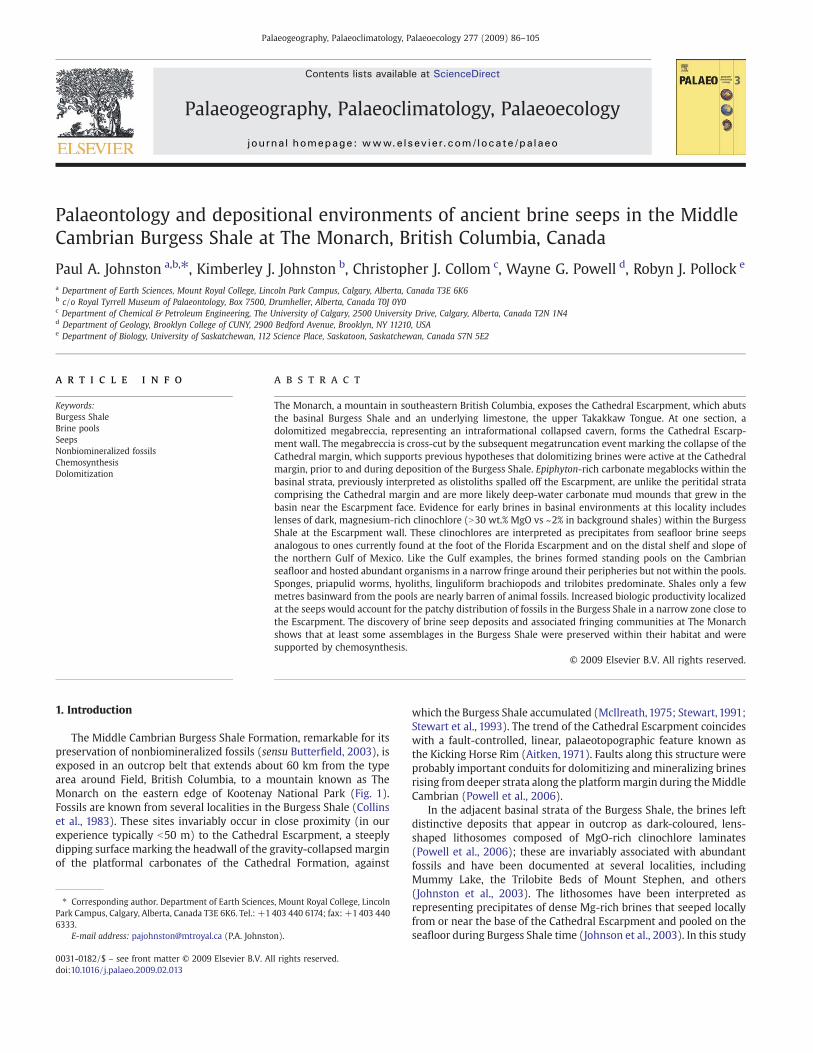
Lithosomes BP2 and BP3 occur successively further upslope, atabout the same stratigraphic level as the top of the BP1 lithosome. BP2occurs only a few tens of metres along strike from the upper reaches ofBP1 and might have originally been contiguous with it (theintervening area is now eroded). BP2 is about 7 m thick and about5 m in lateral extent (Fig. 7A). It is not in direct contact with the
Escarpment and is surrounded by tan-weathering shales. BP3 cropsout in a saddle or “notch” at the top of the ridge (Figs. 3B and 7D) andis 4.6 m thick with some tan-weathering interbeds. It can be traced inoutcrop for about 40 m downslope where it passes into dark, fissilebeds with rare fossils and papillose bedding surfaces of probablemicrobial origin (Fig. 8E) (see below). BP3 is underlain at the notch bya metre of tan-coloured, deeply weathered mudrock, which is, in turn,underlain by 20 cm of orange-weathering gossan (Fig. 7D). The
Fig. 7. (A) BP2 lithosome in Burgess Shale Formation (BSh). Solid white line marks perimeter of dark clinochlore-rich rock with abundant fossils; dashed white line marksapproximate boundary of surrounding tan-weathering rocks with abundant fossils. MTS in red marks contact with Cathedral Formation (CAT). Note person for scale. (B) hyoliths,priapulid worms and sponges in dark matrix. (C) A slab from tan-coloured strata at perimeter of BP2 lithosome dominated by priapulid worms and sponges (cm scale). (D) BP3 atnotch, bounded below by tan-coloured mudstone and gossan layer. Person in foreground standing on megatrucation surface.
94 P.A. Johnston et al. / Palaeogeography, Palaeoclimatology, Palaeoecology 277 (2009) 86–105
northeastern edge of BP3 terminates in a cliff section where itdescends onto the south wall of Monarch Cirque (Monarch CirqueSouth; Fig. 4B).
The MgO-rich lithosomes at Monarch Assiniboine weather bluish-black to bluish-grey and so are easily distinguished in outcrop fromthe surrounding tan-weathering shales, even from the air (Fig. 3B).Conspicuous red- or orange-weathering, commonly iridescent (hema-titic?), typically swaley partings arewell developed through the lowertwo-thirds of BP1 (Fig. 6A, E) but were less evident in the others. The
contact of the MgO-rich lithosomes with the adjacent tan shales ischaracteristically sharp (Figs. 5A, 6D, and 7A, D). Hand samples feelheavy and slightly greasy or soapy, and are easily scratched with acopper penny. Fresh surfaces are nearly black. The rock typicallyweathers to small chips and so is quickly diluted and hard to find onlarge talus slopes where there is extensive overlying outcrop. Cut andpolished surfaces show regular to wispy laminations (Fig. 8B).Rhomboidal, cubic and irregular vugs mark dissolved dolomite andpyrite crystals. Fossils are exceptionally rare and poorly preserved.
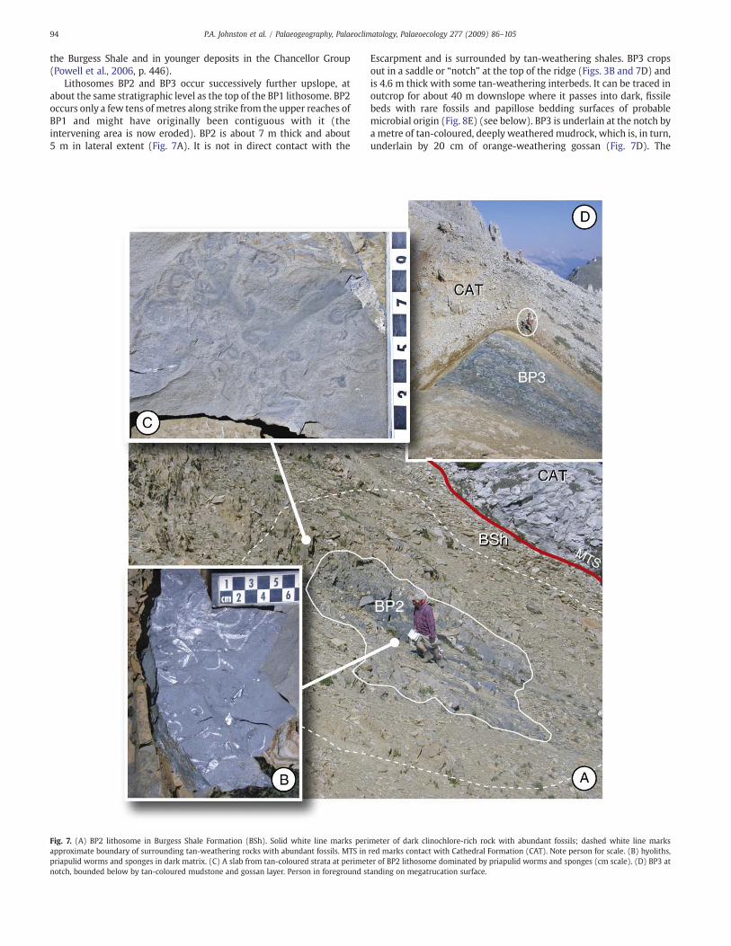
Fig. 8. (A) Recent Gulf of Mexico NR-1 brine pool (photo courtesy of I. MacDonald) with facies identified. The pool occurs at a depth of 650 m on the Louisiana continental slope and is22 m long and 11 mwide; brine depth at the centre exceeds 3.5 m (MacDonald et al., 1990). White dots mark individual chemosymbiotic bivalves; white patches are bacterial mats.Cartoon of partly undercut (from dissolution) Cathedral Escarpment is superimposed. Panels B–F are corresponding facies in the Burgess Shale. (B) Polished section from BP1showing wispy laminations and vugs that mark dissolved dolomite and pyrite crystals. (C) Fringing fauna facies with dense assemblage of priapulid worms. (D) Cross-sectional viewof slab in 8C showing no hint of burrows or other traces disturbing laminations. (E) Microbial mat texture on bedding plane within 20 m of, and on strike from, BP3 lithosome.(F) Unfossiliferous shales of the Burgess Shale Formation, hemipelagic facies.
95P.A. Johnston et al. / Palaeogeography, Palaeoclimatology, Palaeoecology 277 (2009) 86–105

Powell et al. (2006) provide petrographic descriptions of the brinepool clinochlores.
MgO-rich lithosomes were not found in situ at Monarch CirqueNorth; however one sample from scree (Z) yielded 31.23 wt.% MgO(Table 1) indicating that brine pool deposits occur higher in the section.A critical area between fossiliferous outcrop and the Escarpment, whereMgO-rich lithosomes might be expected, is scree covered except for afewmetres at the top of the ridge (Fig. 3A). AtMonarch Cirque South, aninaccessible cliff exposure near the notch shows a dark lens in theBurgess Shale that may be an MgO-rich lithosome (Fig. 4B).
4.2. Fossil distribution
Except for a single pygidium of Kootenia sp., Stewart (1991)records no fauna from his North Face section. During a brief helicopterstop at the base of the section there in 2001, we found no fossils inscree.
At Monarch Cirque North, nonbiomineralized fossils are restrictedto two narrow strips adjacent to the Escarpment that together spanabout the lower 30 m of the Burgess Shale (Fig. 3A; Tremaine, 2003).Biomineralized taxa constituting hyoliths, trilobites, chancelloriidsand linguliform brachiopods occur rarely in the rest of the section butbecome somewhat more common in the upper 10 m.
At Monarch Cirque South, fossils are common in scree, but only inthe fall zones below the notch, which terminates the east edge of BP3in the Monarch Assiniboine section. The scree below the notchaccumulated in Escarpment Gully, and Megabreccia Gully (Fig. 4B).Fossils were common in scree within and below Escarpment Gully butcomparatively rare in scree within and below Megabreccia Gully. Wecarefully examined outcrop and scree of the Burgess Shale at andbelow its main exposure immediately to the southwest of the notch(Fig. 4B), and found it to be virtually barren of fossils except for veryrare linguliforms, despite excellent exposures of large beddingsurfaces. Pratt (pers. comm., 2000) reported finding a single specimenof Ottoia and several trilobites from the upper 20 m of the BurgessShale well southwest of the notch. Nonetheless, the distribution ofBurgess Shale fossils in the scree at Monarch Cirque South implies arestricted source area in the vicinity of the notch, coincident with theeastern extent of BP3. Fossiliferous scree within Megabreccia Gullymay have originated from a southwest extension of BP3 onto the cliffface below the notch, or perhaps from around another possible brinepool deposit on that cliff, which was inaccessible for study (Fig. 4B).
At Monarch Assiniboine, all nonbiomineralized fossils that wefound in situ occurred within or in close proximity to the brine pooldeposits, with the exception of vendotaenid? fragments and possibly apriapulid-rich lens (discussed below). At BP1, fossils were abundant
Table 1Geochemistry of strata at Monarch Assiniboine (MA) and Monarch Cirque North (MCN).
SiO2
(wt.%)TiO2
(wt.%)Al2O3
ICP95Fe2O3
(wt.%)MnO(wt.%)
MgO(wt.%)
CaO(wt.%)
Na2O(wt.%)
K2O(wt.%)
P2O5
(wt.%)LOI(wt.%)
Sum(wt.%)
Ba(ppm)
V/Sc Ni/Co
PAAS 62.8 1 18.9 5.9 0.11 2.2 1.3 1.2 3.7 0.16 6 99.9 650
Sample Unit Locality Stratigraphicposition
AV Upper UTT MA, 2 mfrom BSh
MA upr TakakkawTng
47.6 0.47 11.7 3.3 0.05 3.02 13.5 0.06 3.88 0.15 15.1 98.9 421 6.13 3.20
A BSh MA, BP1 base of BP1 31.22 0.66 20.03 2.61 b0.01 31.64 0.58 b0.01 0.02 0.31 13 100 9 8.40 5.79B BSh MA, BP1 2 m from base BP1 43.27 0.53 15.94 2.89 b0.01 26.04 0.83 b0.01 b0.01 0.53 10.8 101 7.4 13.20 10.95C BSh MA, BP1 4 m from base BP1 30.96 0.63 20.25 4.86 b0.01 31.28 0.22 b0.01 0.01 0.15 13.3 102 7.1 4.88 3.17D BSh MA, BP1 6 m from base BP1 30.43 0.66 21 4.55 b0.01 30.85 0.28 b0.01 b0.01 0.15 13.4 101 10.7 5.79 1.98E BSh MA, BP1 Mid-pool BP1 30.88 0.57 19.37 5.26 b0.01 30.42 0.37 b0.01 b0.01 0.21 12.40 99.53 2.9 7.55 2.72F BSh MA, BP1 7 m from base BP1 33.57 0.66 18.86 4.82 b0.01 30.3 0.17 0.01 b0.01 0.17 13.2 102 6.6 5.43 3.51G BSh MA, BP1 Mid-pool BP1 52.27 0.25 11.19 2.03 0.01 20.79 2.77 b0.01 0.02 0.43 11.20 101.00 2 5.10 4.63H BSh MA, BP1 12 m from base BP1 43.58 0.71 21.32 6.65 b0.01 16.13 0.2 0.09 2.28 0.17 8.6 99.8 103 5.19 2.92I BSh MA, BP1 14 m from base
BP144.18 0.61 20.73 8.05 b0.01 16.63 0.33 0.09 1.79 0.22 8.6 101 75.4 4.53 3.66
J BSh MA, BP1 17 m from baseBP1
48.84 0.69 22.71 6.99 0.04 3.14 5.71 0.3 4.91 0.17 9 103 230 4.90 3.33
K BSh MA, BP2 Base of BP2 51.58 0.74 23.77 5.73 b0.01 7.71 0.22 0.31 4.34 0.13 6.4 101 191 4.43 3.64L BSh MA, BP2 1 m from base BP2 49.8 0.72 23.4 5.63 b0.01 6.63 0.22 0.34 4.74 0.1 6.1 97.8 190 4.85 3.14M BSh MA, BP2 2 m from base BP2 48.1 0.71 22.3 6.66 b0.01 8.24 0.58 0.31 4.06 0.1 7 98.2 172 5.59 3.29N BSh MA, BP2 3 m from base BP2 51.5 0.72 25.3 3.3 b0.01 4.11 0.63 0.41 6.1 0.14 5.6 97.9 234 4.57 3.14O BSh MA, BP3 2 m from base BP3 46.3 0.56 15.9 5.22 b0.01 19.7 1 0.03 0.33 0.12 9.9 99.1 20 6.36 2.32P BSh MA, at vt MA 23 m 51.6 0.67 23.7 3.9 b0.01 0.94 3.08 0.66 5.81 0.09 6.2 96.7 417 5.20 3.33Q BSh MA, 10 m
from topMA 70 m 51.2 0.7 23.3 5.6 0.02 1.33 2.61 0.55 5.67 0.09 6 97.1 273 5.68 3.14
R BSh MA, 5 mfrom top
MA 75 m 50.3 0.71 23.3 4.46 0.02 1.05 4.59 0.38 6.45 0.08 7.3 98.7 304 7.19 2.22
S Basal TKM MA MA basal Tokumm 1.51 0.01 0.48 0.23 0.04 3.49 51.9 0.06 0.09 b0.01 41 98.8 7.6 1.00 2.00T BSh A-1 section
MCNMCN 74.2 m 48 0.76 21.8 2.69 0.03 3.76 5.55 0.23 6.19 0.16 11.1 100.3 92.14 1.04 2.15
U BSh A-1 sectionMCN
MCN 79 m 50.4 0.77 23.1 6.25 0.05 1.40 4.09 0.29 6.14 0.12 7.4 100.1 121.33 0.97 3.77
V BSh A-1 sectionMCN
MCN 89 m 46.8 0.67 20.8 7.9 0.04 1.54 7.41 0.2 5.15 0.27 9.4 100.2 121.23 0.73 1.88
W BSh A-1 sectionMCN
MCN 104 m 43.7 0.61 20.9 7.79 0.05 2.20 8.97 0.32 4.04 0.11 11.4 100.2 246.9 0.79 2.00
X BSh A-1 sectionMCN
MCN 127 m 37.1 0.55 16.2 7.45 0.1 2.25 15.9 0.43 3.24 0.09 17 100.4 227.62 0.73 2.40
Y BSh A-1 sectionMCN
MCN 151 m 50 0.68 20.9 4.12 0 13.80 0.23 0.03 2.9 0.12 7.5 100.3 57.25 0.85 3.50
Z BSh MCN MCN, scree Mg10 28.54 0.83 18.1 4.52 0.02 31.23 2.4 0.04 0.01 0.24 14.9 99.3 18 7.18 2.48
Abbreviations: BP, brine pool deposit; BSh, Burgess Shale Formation; PAAS, Post Archean Average Shale (Taylor and McLennen, 1985); TKM, Tokumm subunit; UTT, upper TakakkawTongue. Major element geochemical analyses were conducted by XRAL Laboratories (Don Mills, Ontario, Canada) using ICP-AES after digestion using the lithium metaborate fusionmethod.
96 P.A. Johnston et al. / Palaeogeography, Palaeoclimatology, Palaeoecology 277 (2009) 86–105

inside a 1–3 m halo around the perimeter of the lithosome (Fig. 6D).Beds within the lithosome and those beyond this halo were virtuallybarren of fossils, even along strike. At BP2, fossils were abundantwithin the lithosome itself and in a 1–2 m wide halo around itsperimeter (Fig. 7), but rare (linguliforms and trilobites) or absent inmore peripheral beds. At BP3 papillate textures are common onbedding surfaces at the south end of the lithosome (Fig. 8E); in situfossils here comprise only rare and disarticulated trilobites. Fossils,especially priapulid worms, were abundant in scree here andcontinuing up to the notch. Exposure of the beds in the 2–3 m intervalabove BP3 was poor, and the source of the fossil slabs was difficult todetermine precisely. From their distribution in scree, it is evident thatthey were weathering primarily from a narrow interval around BP3.We did not find fossils within the BP3 lithosome itself. Better exposed,stratigraphically higher beds at the notch (Fig. 6) were virtuallybarren of fossils. Tremaine (2003) reported a thin bed with abundantpriapulids about 30 m above the base of the Burgess Shale, at a sitetopographically downslope from BP1, but she was unable to trace thefossils for more than a fewmetres along strike and no collections weremade (Fig. 3C). It is uncertain whether these fossils are associatedwith MgO-rich lithologies, as this site was unknown to us whengeochemical sampling was conducted in 2003.
Approximately 25m above the base of the Burgess Shale and about200 m downslope from BP1, several beds (together about one metrethick) contain short segments of what appear to be microbialfilaments (vendotaenids?, Fig. 5E) and rare, disarticulated Olenoidesserratus. In the remainder of the section, fossils were rare or absent,except for the uppermost few metres of the Burgess Shale, whichyielded agnostid trilobites and rare Byronia annulata.
5. MgO distributions at Monarch Assiniboine and MonarchCirque North
Results of whole-rock major element analyses of samples collectedat Monarch Assiniboine andMonarch Cirque North are summarized inTable 1 and Fig. 9. BP1–BP3 showed an average concentration of MgOof 23.77 wt.%, an order of magnitude higher than the Post ArchaeanAverage Shale (PAAS) value of 2.20 wt.% (Taylor andMcLennen, 1985).Brine pool deposits in the Burgess Shale elsewhere (e.g., Mt. Stephen,Mummy Lake) showed similar MgO concentrations (Powell et al.,2006, Table 2), although BP1, with a maximum value of 31.64 wt.%,records the highest value known to date. A vertical transect throughBP1 and its margin produced samples A–J. Samples H and I, from highin the transect, have lower values of MgO compared to those lower inthe transect. Sample J, from the fossiliferous zone at the edge of thelithosome showed a much lower value but higher than PAAS.Fossiliferous samples K–N from BP2 showedMgO values intermediatebetween PAAS and the main body of the BP1 lithosome (Fig. 9).Samples of Burgess Shale from beds laterally distant to BP1 (sample P,about equivalent stratigraphically to sample H, was collected about240 m topographically downslope along strike) and stratigraphicallyhigher (samples Q and R) at Monarch Assiniboine yielded low MgOvalues, less than PAAS.
At Monarch Cirque North, six samples (T–Y, Fig. 9) were takenthrough the exposed section of the upper half of the Burgess Shale nearthe top of the ridge (Tremaine's, 2003 section A-1; Fig. 3A; Table 1). Thetwomost basal (samples T and U) yielded 3.76 wt.% and 1.40wt.%MgO,respectively, and coincidewith abundant fauna including nonbiominer-alized forms (Fig. 9). At 151mMgOvalues spike to 13.80wt.%.While this
Fig. 9. Bar graph of MgO weight per cent values from samples listed in Table 1. MA prefix denotes samples from Monarch Assiniboine section; MCN prefix denotes samples fromMonarch Cirque North section. Samples are labelled alphabetically (A–Z) for reference in text. Samples from brine pool deposits (BP) are shown in black. Samples yieldingnonbiomineralized fossils are indicated with an arthropod cartoon. Dolomitized non-brine pool deposits are indicated with cross-hatching. Sample A′ was collected in the upperTakakkaw Tongue. Sample S was collected in the basal Tokumm subunit. PAAS value (Post Archaean Average Shale, Taylor and McLennen, 1985) included as datum (white horizontalline).
97P.A. Johnston et al. / Palaeogeography, Palaeoclimatology, Palaeoecology 277 (2009) 86–105
occurs with a modest increase in the abundance of fossils (biominer-alized taxa), the overlying Tokumm subunit here is intensely dolomi-tized less than 5mhigher (Fig. 3A) and that eventmay have secondarilyenriched Mg in adjacent underlying strata.
MgO wt.% values of samples from the Burgess Shale at MonarchAssiniboine define three groups: (1) nonfossiliferous black clinochlorefrom BP1 and BP3 have values between 15 and 30 wt.% (samples A–I,O), which are highly elevated above PAAS; (2) richly fossiliferous shalefrom BP2 and the perimeter of BP1 with values between 3 and 9 wt.%(samples J–N); and (3) poorly fossiliferous and barren strata thatdominate the Burgess Shale at Monarch Assiniboine have wt.% valuesslightly below PAAS (samples P–R). At Monarch Cirque North, asimilar grouping of values is evident, although sample U fromfossiliferous beds shows low MgO, comparable to values in poorlyfossiliferous and barren samples higher in the section. Dolomitizedcarbonates from the upper Takakkaw Tongue, basal Tokumm, anduppermost Burgess Shale give variable values, although none over-lapping the black clinochore (samples A', S, and Y, respectively).
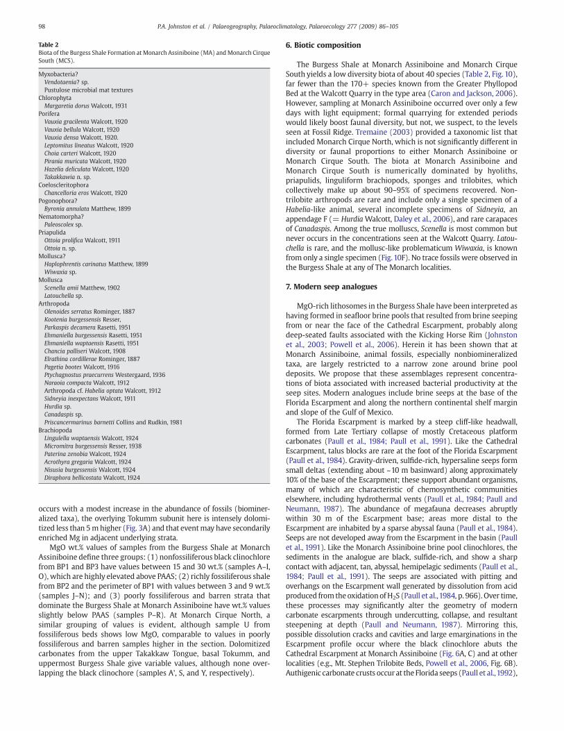
6. Biotic composition
The Burgess Shale at Monarch Assiniboine and Monarch CirqueSouth yields a low diversity biota of about 40 species (Table 2, Fig. 10),far fewer than the 170+ species known from the Greater PhyllopodBed at the Walcott Quarry in the type area (Caron and Jackson, 2006).However, sampling at Monarch Assiniboine occurred over only a fewdays with light equipment; formal quarrying for extended periodswould likely boost faunal diversity, but not, we suspect, to the levelsseen at Fossil Ridge. Tremaine (2003) provided a taxonomic list thatincluded Monarch Cirque North, which is not significantly different indiversity or faunal proportions to either Monarch Assiniboine orMonarch Cirque South. The biota at Monarch Assiniboine andMonarch Cirque South is numerically dominated by hyoliths,priapulids, linguliform brachiopods, sponges and trilobites, whichcollectively make up about 90–95% of specimens recovered. Non-trilobite arthropods are rare and include only a single specimen of aHabelia-like animal, several incomplete specimens of Sidneyia, anappendage F (= Hurdia Walcott, Daley et al., 2006), and rare carapacesof Canadaspis. Among the true molluscs, Scenella is most common butnever occurs in the concentrations seen at the Walcott Quarry. Latou-chella is rare, and the mollusc-like problematicum Wiwaxia, is knownfrom only a single specimen (Fig.10F). No trace fossils were observed inthe Burgess Shale at any of The Monarch localities.
7. Modern seep analogues
MgO-rich lithosomes in the Burgess Shale have been interpreted ashaving formed in seafloor brine pools that resulted from brine seepingfrom or near the face of the Cathedral Escarpment, probably alongdeep-seated faults associated with the Kicking Horse Rim (Johnstonet al., 2003; Powell et al., 2006). Herein it has been shown that atMonarch Assiniboine, animal fossils, especially nonbiomineralizedtaxa, are largely restricted to a narrow zone around brine pooldeposits. We propose that these assemblages represent concentra-tions of biota associated with increased bacterial productivity at theseep sites. Modern analogues include brine seeps at the base of theFlorida Escarpment and along the northern continental shelf marginand slope of the Gulf of Mexico.
The Florida Escarpment is marked by a steep cliff-like headwall,formed from Late Tertiary collapse of mostly Cretaceous platformcarbonates (Paull et al., 1984; Paull et al., 1991). Like the CathedralEscarpment, talus blocks are rare at the foot of the Florida Escarpment(Paull et al., 1984). Gravity-driven, sulfide-rich, hypersaline seeps formsmall deltas (extending about ~10 m basinward) along approximately10% of the base of the Escarpment; these support abundant organisms,many of which are characteristic of chemosynthetic communitieselsewhere, including hydrothermal vents (Paull et al., 1984; Paull andNeumann, 1987). The abundance of megafauna decreases abruptlywithin 30 m of the Escarpment base; areas more distal to theEscarpment are inhabited by a sparse abyssal fauna (Paull et al., 1984).Seeps are not developed away from the Escarpment in the basin (Paullet al., 1991). Like the Monarch Assiniboine brine pool clinochlores, thesediments in the analogue are black, sulfide-rich, and show a sharpcontact with adjacent, tan, abyssal, hemipelagic sediments (Paull et al.,1984; Paull et al., 1991). The seeps are associated with pitting andoverhangs on the Escarpment wall generated by dissolution from acidproduced from theoxidationofH2S (Paull et al.,1984, p. 966). Over time,these processes may significantly alter the geometry of moderncarbonate escarpments through undercutting, collapse, and resultantsteepening at depth (Paull and Neumann, 1987). Mirroring this,possible dissolution cracks and cavities and large emarginations in theEscarpment profile occur where the black clinochlore abuts theCathedral Escarpment at Monarch Assiniboine (Fig. 6A, C) and at otherlocalities (e.g., Mt. Stephen Trilobite Beds, Powell et al., 2006, Fig. 6B).Authigenic carbonate crusts occur at the Florida seeps (Paull et al.,1992),
Table 2Biota of the Burgess Shale Formation at Monarch Assiniboine (MA) andMonarch CirqueSouth (MCS).
Myxobacteria?Vendotaenia? sp.Pustulose microbial mat textures
ChlorophytaMargaretia dorus Walcott, 1931
PoriferaVauxia gracilenta Walcott, 1920Vauxia bellula Walcott, 1920Vauxia densa Walcott, 1920.Leptomitus lineatus Walcott, 1920Choia carteri Walcott, 1920Pirania muricata Walcott, 1920Hazelia deliculata Walcott, 1920Takakkawia n. sp.
CoeloscleritophoraChancelloria eros Walcott, 1920
Pogonophora?Byronia annulata Matthew, 1899
Nematomorpha?Paleoscolex sp.
PriapulidaOttoia prolifica Walcott, 1911Ottoia n. sp.
Mollusca?Haplophrentis carinatus Matthew, 1899Wiwaxia sp.
MolluscaScenella amii Matthew, 1902Latouchella sp.
ArthropodaOlenoides serratus Rominger, 1887Kootenia burgessensis Resser,Parkaspis decamera Rasetti, 1951Ehmaniella burgessensis Rasetti, 1951Ehmaniella waptaensis Rasetti, 1951Chancia palliseri Walcott, 1908Elrathina cordillerae Rominger, 1887Pagetia bootes Walcott, 1916Ptychagnostus praecurrens Westergaard, 1936Naraoia compacta Walcott, 1912Arthropoda cf. Habelia optata Walcott, 1912Sidneyia inexpectans Walcott, 1911Hurdia sp.Canadaspis sp.Priscancermarinus barnetti Collins and Rudkin, 1981
BrachiopodaLingulella waptaensis Walcott, 1924Micromitra burgessensis Resser, 1938Paterina zenobia Walcott, 1924Acrothyra gregaria Walcott, 1924Nisusia burgessensis Walcott, 1924Diraphora bellicostata Walcott, 1924
98 P.A. Johnston et al. / Palaeogeography, Palaeoclimatology, Palaeoecology 277 (2009) 86–105

something not observed commonly around the brine pool deposits atMonarch Assiniboine. However, a thin dolomite-rich bed with highlyirregular bedding surfaces in the lower part of BP1 is probably analogous(Fig. 11).
The Florida seep biota includes chemosynthetic organisms such asvestimentiferan worms plus mytilid and vesicomyid clams, andbacterial mats. More typical abyssal faunal elements such asholothurians, anemones, and ophiuroids are also present, evidently
attracted by the increased local biologic productivity (Paull et al.,1984). The brines, with their reduced compounds, flow through theupper layers of the bottom muds turning them black; the fauna ismost abundant on the dark pyritic sediments (Paull et al., 1992). AtMonarch Assiniboine, fauna was observed peripheral to, but notwithin, BP1 and BP3, and only very sparsely in other brine pooldeposits in the Burgess Shale. BP2, however, yielded abundant faunathroughout, including the dark beds (Fig. 7B). BP2 may represent a
Fig. 10. Representative fossils in scree from inferred fringing facies of brine pool deposits at Monarch Cirque South and Monarch Assiniboine. (A) Chancia palliseriWalcott and Vauxiagracilenta Walcott. (B) Chancelloria eros Walcott. (C) Olenoides serratus Rominger. (D) Takakkawia sp., TMP 2000.69.18. (E) Arthropoda cf. Habelia optata Walcott, TMP 2000.69.203.(F) Wiwaxia sp. (lower right) with Haplophrentis carinatus (Matthew) and Ottoia sp., TMP 2000.69.60. (G) Margaretia dorus Walcott, TMP 2000.60.10. (H) Probable linguliformbrachiopod with extended pedicle. (I) Ottoia prolificawith gut trace and extended proboscis (note hooks). A, C, F with cm scale; B, D, E, G scale bar=1 cm; H, I with mm scale. A–C, H,I, field photographs.
99P.A. Johnston et al. / Palaeogeography, Palaeoclimatology, Palaeoecology 277 (2009) 86–105

brine delta, although no channel-shaped bodies of the dark sedimentwere observed. Alternatively, BP2 may represent exposure of themargin of a brine pool, the main body of which already eroded or isnot exposed.
Along the slope and distal shelf of the northern Gulf of Mexico,seeping brines pool in depressions or pockmarks on the sea floor(MacDonald, 1992). The pools are anoxic and seep animals form afringing community on the “shores” of the pool (MacDonald et al.,1990). In places, bacterial mats proliferate distally and are inter-spersed with patches of pitted and disarticulated mussel shells andstained sediment from leaking brine (MacDonald et al., 1990, p. 1098).Beyond the fringing community and mats, faunal density drops offabruptly (Fig. 8A). The Monarch Assiniboine MgO-rich lithosomescombine features of these two modern analogues; brines evidentlypooled in depressions at the foot of the Cathedral Escarpment.
8. Brine pool facies and taphonomy
At least four facies are distinguished at Gulf brine pools hosted onsoft-sediment substrates: (1) faunally barren, black, sulfide-richdeposits forming the bottom of the anoxic pool; (2) a fringing“shore” zone around the perimeter of the pool supporting a densechemosynthetic community; (3) more distal bacterial mats withpatchy fauna; and (4) surrounding hemipelagic muds with adepauperate abyssal fauna (MacDonald et al., 1990; MacDonald,1992; Fig. 8A). A similar pattern occurs at the Monarch Assiniboinebrine pool deposits, especially BP3, with the MgO-rich, nonfossilifer-ous beds representing deposits formed within the brine pool (Faciesi), fauna-rich slabs marking the “shore” facies (Facies ii), pustulosetextures with rare fauna representing the mat facies (Facies iii), andfaunally depauperate tan-coloured shales indicating “normal” bottomconditions beyond the influence of the seeps (Facies iv) (Fig. 8B–F).Waxing and waning of the pools before their eventual terminationwould have resulted in migration of the facies over time to producethe nested facies relationships evident in outcrop (Fig. 12A, B). Themore distal facies, away from the influence of the brines, show acorresponding decrease in MgO wt.% values (Fig. 12C).
Compositionally, the biota at Monarch Assiniboine and MonarchCirque South differs from that at Fossil Ridge primarily in the rarity ofcuticularized vagrant epifauna and nektobenthic fauna such as Cana-dia, Wiwaxia, Odontogriphus, Marrella and Anomalocaris, pelagic soft-bodied fauna such as Eldonia and Ctenorhabdotus, and, except for rareMargaretia, a complete lack of putative algae (e.g., Yuknessia, Dal-rympia) and cyanobacteria (Marpolia,Morania). These organisms mayhave been rare at TheMonarch during deposition of the Burgess Shale.
More plausibly, palaeoenvironmental biases at The Monarch in someway favoured preservation of cuticularized shallow infauna and semi-infauna (viz., Ottoia spp, Palaeoscolex sp.) and semi-robust to robustepifauna including sponges, hyoliths, linguliform brachiopods andtrilobites, but not epiflora or soft-bodied to cuticularized epifauna andnekton. We suggest that a lower frequency of obrution events at TheMonarch compared to Fossil Ridge might, at least partly, account forpreservational losses in certain palaeoecological categories.
Obrution potential at The Monarch may have been limited if theprofile of the megatruncation surface was gentler than at Fossil Ridge.At Monarch Cirque North and Monarch Assiniboine, the steepness ofthe megatruncation surface is difficult to assess because theselocalities expose platform/basin contact in oblique sections. NorthFace and Monarch Cirque South (Fig. 4) expose the megatruncationsurface inwhat are more nearly true dip sections. Themegatruncationsurface at Monarch Cirque South is highly irregular, and megablockswithin the underlying megabreccia would have protruded well abovethe sea floor during deposition of the overlying upper TakakkawTongue. Overall, the dip of the megatruncation surface at MonarchCirque South is about 30–40° and seems to steepen only in the upper50 m or so of its extent (as determined from photographs; Fig. 4). Asimilar profile occurs at North Face (Stewart, 1991, Plate 42). However,the uppermost part of the megatruncation surface is not preserved ateither locality, and so the height of the cliff-like part at its proximalextent is unknown. It is unlikely that it could have been even 100 mtall at Monarch Assiniboine as the entire Burgess Shale here is onlyabout 80 m thick (Fig. 2). By contrast, at Fossil Ridge and at MountField the megatruncation surface produces a nearly vertical headwallabout 200 m high (Fritz, 1971; Fletcher and Collins, 1998). Themegatruncation surface at these localities was therefore cliff-like,whereas at The Monarch it was more ramp-like except at its mostproximal extent. Organisms living at the base of the headwall at FossilRidge were more prone to obrution events generated from storm orseismic events disturbing sediments on the platform overhead thanwere organisms living partway down the irregular ramp-like mega-truncation surface at The Monarch. In the absence of regular obrutionevents, organisms around the brine pools at The Monarch would havebeen buried largely by hemipelagic sedimentation. Organisms dyingon the surface would be subject to longer periods of exposure beforeburial, and so on average only the more robust remains would survive.Infaunal to semi-infaunal worms, already covered by at least a thinlayer of sediment would more likely preserve soft-part anatomy,especially given the likely presence of anoxic brine in the pore waters(Powell et al., 2003) as well as subsequent sealing by bacterial mats.
Wrinkled to pustulose bedding surfaces (Fig. 8E) likely mark thedevelopment locally of robust microbial mats. These were especiallyabundant near BP3. The mat textures were not seen in hemipelagicfacies distal to the brine pool deposits. The mat textures match closelyprokaryotic mat textures in the Solnhofen Limestone (Seilacher et al.,1985; cf. their Plate 1, Fig. 7 and this paper, Fig. 8E).
Some of the fossiliferous beds at The Monarch show dense, nearmonospecific assemblages of priapulidworms (Fig. 8C). These indicatecensus events (sensu Caron and Jackson, 2006), as time-averagedaccumulations would incorporate greater taxonomic diversity. Giventhe proximity of the fauna to brine pools (only a fewmetres) it may bethat brine pulses occasionally breached the brine pool margins andflooded the fringing fauna resulting in a mass kill. Worms in TheMonarch fauna are almost invariably tightly coiled like the number “6”(Fig. 7C), a necrolytic feature thatmight signal exposure to toxic brines.Seilacher et al. (1985, Plate 1) document contortions in fish and shrimpexposed to seafloor brines in the Solnhofen basin. Likewise, fishsubjected to lethal exposures of H2S and sinking into modern brinepools become strongly recurved owing to osmotic dessication(MacDonald, 1992). Seafloor brines greatly reduce decay rates oforganisms immersed in them (MacDonald, 1992; Parsons-Hubbardet al., 2006 and references therein). Brine flooding events onto the
Fig. 11. Probable authigenic dolomitic crust, lower BP1 lithosome, Monarch Assiniboine.
100 P.A. Johnston et al. / Palaeogeography, Palaeoclimatology, Palaeoecology 277 (2009) 86–105

fringing biota of the Monarch Assiniboine brine pools might havesufficiently delayed decay and scavenging to allow the nonbiominer-alizing fauna, especially shallow infaunal forms like priapulids, tobecomemore completely buried by hemipelagic sedimentation or rareobrution events.
Although vagrant epifauna and priapulids (presumed burrowers)are abundant in the Monarch Assiniboine brine pool assemblages, notrace fossils were observed. Slabs covered with priapulids are finelylaminated (Fig. 8D). We agree with Caron and Jackson (2006) andDevereux (2001) who determined, given the rarity of burrows in theGreater Phyllopod Bed and the Raymond Quarry, that the priapulidOttoia must have inhabited burrows shallowly emplaced and parallelto the substrate surface, probably within the topmost layer ofsediment. Anoxic pore waters likely inhibited deeper burrowers atThe Monarch, and the Burgess Shale generally, if such animals hadindeed evolved in deep-water facies by the Middle Cambrian (Powellet al., 2003). Thixotrophic surface sediments and/or bacterial matsmay have inhibited the production and preservation of surface traces.
A case cannot be made that the biota at The Monarch was widelydistributed throughout the section but preserved only around thebrine pools, because heavily biomineralized taxa such as trilobites andhyoliths would not be subject to such vicissitudes of preservation.Furthermore, the occurrence of rare trilobites, brachiopods, and Byr-onia, especially near the top of the section shows the potential forpreservation of at least biomineralized faunawell away from the brinepools.
The vast majority of animals preserved atMonarch Assiniboine andMonarch Cirque South can be interpreted as having lived in closeproximity to seafloor brine pools, based on (1) in situ occurrences inclose proximity to the brine pool deposits, as fringing halos, and(2) the restricted distribution of fossils in scree, which indicates asource at or close to brine pool deposits topographically upslope.Except for two scree pieces (one analysed: sample Z, Table 1), wefound no direct evidence for brine pools at Monarch Cirque North;however as noted earlier, a critical area between the fossil-rich bedsand the Escarpment is scree covered.
Fig. 12. (A) Cartoon showing inferred facies at Burgess Shale brine pools at Monarch Assiniboine: (i) brine pool facies; (ii) fringing fauna facies: examples of fauna shown includetrilobites, hyoliths, priapulids, monoplacophorans, sponges, and pogonophoran(?) worm tube Byronia. White filaments mark inferred presence of sulfur-oxidizing bacteria likemodernBeggiatoa; (iii) bacterialmat facieswith rare fauna; (iv) hemipelagic facies. To right is Cathedral (CAT) Escarpmentwith dolomitizedbreccia; brines rising at arrow. (B) Facies tractsthrough time around a brine pool producing a halo of fringing fauna and more distal facies. (C) Typical MgO values for facies (i), (ii) and (iv) of 30, 7 and 2 wt.%, respectively.
101P.A. Johnston et al. / Palaeogeography, Palaeoclimatology, Palaeoecology 277 (2009) 86–105

The fragmentary filaments that occur in beds at MonarchAssiniboine topographically down slope from the brine pool deposits(Fig. 5E) are similar to those we have found at many localities withinthe Burgess Shale and in the Field Member of the Eldon Formation(Fig. 5D), and in younger units of the Chancellor Group. The Monarchexamples, however, are shorter, less abundant, less diverse, and lesswell preserved thanmost. In all these units, these structures are non-branching and thus unlikely to be fragments of Yuknessia or otherbranching putative algae. We suspect the structures at The Monarchand at other localities are mostly microbial in origin. In size andshape they most resemble Vendotaenia and other filamentouscarbonaceous megafossils described from the upper Proterozoicand Lower Cambrian (Hofmann, 1985; Steiner et al., 2001). Vidal(1989) suggested that vendotaenids may be the sheaths of giantsulfur-oxidizing bacteria akin to modern Beggiatoaceae such asThioploca. If vendotaenids are present at The Monarch and elsewherein the Burgess Shale and associated units, they show that exaerobicconditions prevailed locally, a conclusion also reached by Powellet al. (2003). The occurrence of vendotaenids? (and rare nonbiomi-neralizing animals) at The Monarch in beds far removed laterallyfrom the brine pool deposits and some distance from the Escarpment isimportant: there was potential for preservation of nonbiomineralizedorganisms distal to the Escarpment. The rarity of animal fossils inthese beds, and in strata remote from the brine pool depositsgenerally, must be a primary biologic signature; it is not simply apreservational artifact as has been advocated by others (e.g., Briggset al., 1994) for the general absence of animal fossils in the BurgessShale away from the rheologic protection of the Escarpment duringdiagenesis.
9. Summary interpretation
9.1. Stratigraphy
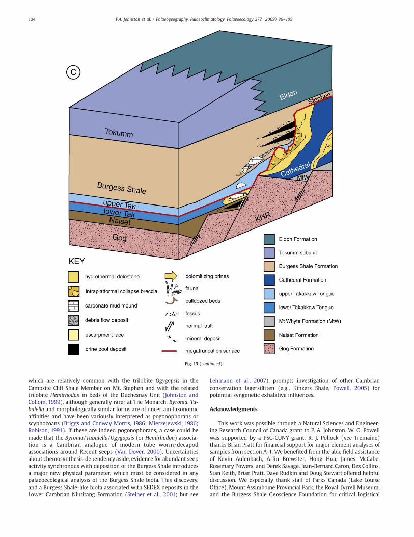
Study of the lithofacies, geochemistry and fossils at The Monarchoffers a new palaeoenvironmental perspective on the Burgess Shaleand the evolution of this part of the Chancellor Basin. Fig. 13summarizes depositional and fluid flow events, and the bioticresponses, during the Middle Cambrian at The Monarch.
Fig. 13A is the oldest in a series of three stratigraphic drawings anddepicts the seafloor at The Monarch near end-Cathedral time with theunderlying stratigraphy shown in cutaway views. TheKickingHorseRim(KHR) was built by a succession of parallel faults (reactivated from thebasement) in the Gog Formation during Early Cambrian rifting (Aitken,1971; Bond and Kominz, 1984; Collom et al., 2009-this issue). Mg-richbrines, rising along the fault planes, breached the substrate surface andpooledagainst anescarpment in theGog Formationduringdepositionofthe Naiset Formation (a brine pool deposit in this unit, with anassociated prolific fauna including Ogygopsis, Byronia, and hyoliths, isexposed about 800 m east of Monarch Assiniboine [Fig. 2]; this is theoldest brine pool deposit known from the Chancellor Basin). Carbonatemud mounds developed during deposition of the lower TakakkawTongue (we observed these about 200 m southeast of MonarchAssiniboine; they were close to the edge of the shelf and are heavilydolomitized). Prior to massive failure of the Cathedral Formation thatproduced the Escarpment, fluids again migrated upwards and dolomi-tized limestones of the lower Takakkaw Tongue and the adjacentplatform margin. This event also created a large, dissolution cavitywithin the Cathedral Formation that collapsed subsequently to producethe megabreccia of Monarch Cirque South. We have shown an inboardplume of fluid (Fig. 13A, right side of drawing) to account for localplatformal hydrothermal dolomitization such as Jeary's (2002) Whirl-pool Point intraformational collapse breccia. Because of the linear trendof the Kicking Horse Rim, there is a corresponding linearity to thedolomitization front, a coincidence that did not escape Aitken (1997,p. 67) who commented that “base-to-top dolomitization of the
Cathedral Formation is…only along the Kicking Horse Rim”. Thedolostones became initiation sites for megatruncation.
Fig. 13B shows the seafloor at The Monarch during deposition ofthe Burgess Shale. Gravity collapse of the platform margin hadoccurred (themegatruncation surface is highlighted as a red line), andthe fault meandered through the intraformational breccia picking acircuitous path over and around megaclasts. This left a headwall thatwas not mostly vertical, but rather, a bathymetrically variable ramp,which is well exposed at Monarch Cirque South (Fig. 4). Duringdeposition of the upper Takakkaw Tongue the largest megaclast of themegabreccia would have stood in relief, isolating a small basin on theEscarpment side. This geometry is evident at Monarch Cirque South(Fig. 4B, note the capping beds on the “mb” block are truncated butcontinue to the right, on the seafloor beside the boulder; this is not afault, but a true depositional relationship). During deposition of theoverlying Burgess Shale, brine pools and their fringing chemosyn-thetic community were established against the Escarpment face.Carbonate mounds and associated debris flow deposits in the basalBurgess Shale occur at Monarch Cirque South (Fig. 4B). The bulk of theBurgess Shale is barren of fossils (hemipelagic facies).
The third diagram (Fig. 13C) is youngest in this series. The BurgessShale infilled the basin and is correlative with the Stephen Formationdeposited on the Cathedral platform. The Eldon Formation followed,forming a new carbonate platform. At the same time the basinalTokumm subunit was deposited as a carbonate basinal equivalent.This facies change remained over the Kicking Horse Rim, not farremoved from the fault of the Cathedral Escarpment. Later, this actedas a new conduit for brine migration, extending vertically the deeperfaults that had brought the Mg-rich fluids to the Cathedral Formationand Burgess Shale. Eventually, the Eldon Formation was dolomitizedand failed along its distal margin to produce a new escarpment withaccompanying brine pools (Motz, 2005; Powell et al., 2006; Johnstonet al., 2009-this issue).
9.2. Palaeoecology
Historically, much discussion about the palaeoecology of the BurgessShale has centered on whether the biota was preserved largely withinhabitat or was mostly or entirely transported from elsewhere, possiblythe overlying platform (e.g., Conway Morris, 1986; see Caron andJackson, 2006, for summary). Indeed, recent studies promote oppositeconclusions regarding the degree of transport of biota preserved in theGreater Phyllopod Bed: Caron and Jackson (2006) and Caron et al.(2006) arguemostly from palaeontologic evidence that the biota showsprimarily within-habitat preservation; in contrast, Gostlin and Miall(2005) and Gostlin (2006) maintain from sedimentologic evidence andichnologic evidence (or the near absence thereof) that the preservedbiota is mostly allochthonous, having been swept off the Cathedralplatform by storm events and concentrated by back currents near thebase of the Escarpment, a hypothesis proposed by Aitken andMcIlreath(1990). Concentrations of fossils in narrow rimming facies around brinepool deposits in the Burgess Shale at Monarch Assiniboine cannot beexplained by any model invoking transport and so provide dramaticevidence of within-habitat preservation.
The patchy distribution of concentrations of fossils within a narrowzone adjacent to the Cathedral Escarpment at Monarch Assiniboineand Monarch Cirque North is a pattern consistent with the develop-ment of a linear series of brine seeps, as along the foot of the modernFlorida Escarpment. MgO-rich lithosomes and accompanying fossilsare also known from several other localities along the CathedralEscarpment in the Burgess Shale (Johnston et al., 2003). Theselocalities indicate that brine seeps were active along much of theCathedral Escarpment during Burgess Shale time, and that theyconcentrated megafauna around them as the result of associatedincreases in microbial productivity. Additional field evidence isnecessary to determine whether this is the principal explanation for
102 P.A. Johnston et al. / Palaeogeography, Palaeoclimatology, Palaeoecology 277 (2009) 86–105

localized concentrations of fossils in the Burgess Shale. Brine pooldeposits are, so far, unknown from the classic quarries at Fossil Ridge,and some other fossil-bearing localities that we have investigated,including a cirque on Mt. Odaray (Collins et al., 1983) and the CollinsQuarry locality on Mt. Stephen (Fletcher and Collins, 2003).
Concentrations of biota in the Burgess Shale, at least at localitieswith MgO-rich lithosomes, probably consisted of a mixture ofchemosynthesis-dependent organisms and a more normal back-ground Cambrian outer shelf/slope biota. These were attracted tolocalized seep-related increases in nutrient availability, as occurs at
some modern seeps (Paull et al., 1984). It is difficult to specify whichorganisms in the Burgess Shale might have been chemosynthesis-dependent. Such assessments for fossils in other fossil seep and ventdeposits have been based on taxonomic uniformitarianism withextant chemosynthesis-dependent animals. The Burgess Shale ani-mals aremostly far removed phylogenetically and temporally from theoldest known members of undoubted chemosynthesis-dependentlineages such as vesicomyid clams (Late Cretaceous) and pogono-phoran worms (Late Silurian) (Little et al., 1999; Kanie et al., 2000).Possible exceptions include annulated tubes (Byronia and Tubulella),
Fig. 13. Evolution of margin of Chancellor Basin at The Monarch during Middle Cambrian (see text for detail). (A) Pre-collapse of platform margin, but post-dolomitization andintraformational brecciation. (B) Post-collapse of margin; brine seeps and mud mounds developed in Burgess Shale Formation. Some mud mounds have slid and are incorporatedinto debris flows. (C) Subsequent infilling of basin overlain by Tokumm subunit and Eldon Formation of next Grand Cycle.
103P.A. Johnston et al. / Palaeogeography, Palaeoclimatology, Palaeoecology 277 (2009) 86–105
which are relatively common with the trilobite Ogygopsis in theCampsite Cliff Shale Member on Mt. Stephen and with the relatedtrilobite Hemirhodon in beds of the Duchesnay Unit (Johnston andCollom, 1999), although generally rarer at The Monarch. Byronia, Tu-bulella and morphologically similar forms are of uncertain taxonomicaffinities and have been variously interpreted as pogonophorans orscyphozoans (Briggs and Conway Morris, 1986; Mierzejewski, 1986;Robison, 1991). If these are indeed pogonophorans, a case could bemade that the Byronia/Tubulella/Ogygopsis (or Hemirhodon) associa-tion is a Cambrian analogue of modern tube worm/decapodassociations around Recent seeps (Van Dover, 2000). Uncertaintiesabout chemosynthesis-dependency aside, evidence for abundant seepactivity synchronous with deposition of the Burgess Shale introducesa major new physical parameter, which must be considered in anypalaeoecological analysis of the Burgess Shale biota. This discovery,and a Burgess Shale-like biota associated with SEDEX deposits in theLower Cambrian Niutitang Formation (Steiner et al., 2001; but see
Lehmann et al., 2007), prompts investigation of other Cambrianconservation lagerstätten (e.g., Kinzers Shale, Powell, 2005) forpotential syngenetic exhalative influences.
Acknowledgments
This work was possible through a Natural Sciences and Engineer-ing Research Council of Canada grant to P. A. Johnston. W. G. Powellwas supported by a PSC-CUNY grant. R. J. Pollock (nee Tremaine)thanks Brian Pratt for financial support for major element analyses ofsamples from section A-1. We benefited from the able field assistanceof Kevin Aulenbach, Arlin Brewster, Hong Hua, James McCabe,Rosemary Powers, and Derek Savage. Jean-Bernard Caron, Des Collins,Stan Keith, Brian Pratt, Dave Rudkin and Doug Stewart offered helpfuldiscussion. We especially thank staff of Parks Canada (Lake LouiseOffice), Mount Assiniboine Provincial Park, the Royal Tyrrell Museum,and the Burgess Shale Geoscience Foundation for critical logistical
Fig. 13 (continued).
104 P.A. Johnston et al. / Palaeogeography, Palaeoclimatology, Palaeoecology 277 (2009) 86–105

support. Ian MacDonald kindly supplied the photograph of the Gulf ofMexico brine pool NR-1 used in Fig. 8. Charles Paull provided helpfuldiscussion about the Florida Escarpment seeps. Comments fromPatrick Orr, Martin Brasier and an anonymous reviewer greatlyimproved the manuscript.
References
Aitken, J.D., 1971. Control of Lower Paleozoic sedimentary facies by the Kicking HorseRim, southern Rocky Mountains, Canada. Bulletin of Canadian Petroleum Geology19, 557–569.
Aitken, J.D., 1997. Stratigraphy of the Middle Cambrian platformal successions, SouthernRocky Mountains. Geological Survey of Canada Bulletin 398, 1–322.
Aitken, J.D., McIlreath, I., 1990. Comment: not in the shadow of the CathedralEscarpment. GeoScience Canada 17 (2), 111–116.
Aitken, S.A., Collom, C.J., Henderson, C.M., Johnston, P.A., 2002. Stratigraphy,paleoecology, and origin of Lower Devonian (Emsian) carbonate mud buildups,Hamar Laghdad, eastern Anti-Atlas, Morocco, Africa. Bulletin of CanadianPetroleum Geology 50 (2), 217–243.
Bond, G.C., Kominz, M.A., 1984. Construction of tectonic subsidence curves for the earlyPaleozoic miogeocline, southern Canadian Rocky Mountains: implications forsubsidence mechanisms, age of breakup and crustal thinning. Geological Society ofAmerica Bulletin 95, 155–173.
Briggs, D.E.G., ConwayMorris, S., 1986. Problematica from theMiddle Cambrian BurgessShale of British Columbia. In: Hoffman, A., Nitecki, M.H. (Eds.), Problematic FossilTaxa. Oxford Monographs on Geology and Geophysics, 5, pp. 167–183.
Briggs, D.E.G., Erwin, D.H., Collier, F.J., 1994. Fossils of the Burgess Shale. SmithsonianInstitution Press, Washington.
Butterfield, N.J., 2003. Exceptional fossil preservation and the Cambrian Explosion.Integrative and Comparative Biology 43, 166–177.
Caron, J.B., Jackson, D.A., 2006. Taphonomy of the greater Phyllopod Bed Community,Burgess Shale. Palaios 21, 451–465.
Caron, J.B., Scheltema, A., Schander, C., Rudkin, D., 2006. A soft-bodied mollusc withradula from the Middle Cambrian Burgess Shale. Nature 442, 159–163.
Collins, D., Briggs, D.E.G., Conway Morris, S., 1983. New Burgess Shale fossil sites revealMiddle Cambrian faunal complex. Science 222, 163–167.
Collom, C.J., Johnston, P.A., Powell, W.G., 2009. Reinterpretation of ‘Middle’ Cambrianstratigraphy of the rifted western Laurentian margin: Burgess Shale Formationand contiguous units (Sauk II Megasequence); Rocky Mountains, Canada.Palaeogeography, Palaeoclimatology, Palaeoecology 277, 63–85 (this issue).
Conway Morris, S., 1986. The community structure of the Middle Cambrian PhyllopodBed (Burgess Shale). Palaeontology 29 (3), 423–467.
Daley, A., Budd, G., Caron, J.B., 2006. An interpretation of Hurdia as a dinocaridid fromthe Burgess Shale, British Columbia, Canada. Progressive Palaeontology 2006,Cambridge, Abstract Book, p. 7.
Devereux, M., 2001. Palaeontology of the Middle Cambrian Raymond Quarry Fauna,Burgess Shale, British Columbia. Unpublished M.Sc. Thesis, University of WesternOntario, London, Ontario, Canada.
Fletcher, T.P., Collins, D.H., 1998. The Mid-Cambrian Burgess Shale Formation and itsrelationship to the Stephen Formation in the southern Canadian Rocky Mountains.Canadian Journal of Earth Sciences 35 (4), 413–437.
Fletcher, T.P., Collins, D.H., 2003. The Burgess Shale and associated Cambrian formationswest of the Fossil Gully Fault Zone on Mount Stephen, British Columbia. CanadianJournal of Earth Sciences 40 (12), 1823–1838.
Fritz, W.H., 1971. Geological setting of the Burgess Shale. Proceedings of the NorthAmerican Paleontological Convention, Chicago, Illinois, U.S.A., Part 1, pp.1155–1170.
Gostlin, K.E., 2006. Sedimentology and palynology of the Middle Cambrian BurgessShale. Unpublished Ph.D. Thesis, University of Toronto, Toronto, Ontario, Canada.
Gostlin, K.E., Miall, A.D., 2005. Sedimentology and depositional setting of the BurgessShale's Greater Phyllopod Bed. Geological Society of America, Abstracts withPrograms, vol. 37(7), p. 547.
Hofmann, H.J., 1985. Precambrian carbonaceous megafossils. In: Toomey, D.F., Nitecki,M.H. (Eds.), Paleoalgology: Contemporary Research and Applications. Springer-Verlag, Berlin, pp. 20–33.
Jeary, V.A., 2002. The origin of Middle Cambrian-hosted mid-platform dolomite;Cathedral Formation, Whirlpool Point, Alberta. Unpublished M.Sc. Thesis, Uni-versity of Calgary, Calgary, Canada.
Johnston, P.A., 2005. Early dolomitization, ancient brine seeps, and the Burgess Shale atMonarch Mountain, southeastern British Columbia. Geological Society of AmericaAbstracts with Programs 37 (7), 547.
Johnston, P.A., Collom, C.J., 1999. Implications of ancient seeps for interpreting CambrianBurgess Shale Formation-like lagerstätten. Canadian Paleontology Conference,Program and Abstracts 9, 13–14.
Johnston, P.A., Collom, C.J., Motz, K.J., Powell, W.G., 2003. Seep-related controls on thedistribution of biota preserved in the Middle Cambrian Burgess Shale and youngerunits, British Columbia. Canadian Paleontology Conference Proceedings 1, 22–23.
Johnston, K.J., Johnston, P.A., Powell, W.G., 2009. A new, Middle Cambrian, BurgessShale-type biota, Bolaspidella Zone, Chancellor Basin, southeastern BritishColumbia. Palaeogeography, Palaeoclimatology and Palaeoecology 277, 106–126(this issue).
Kanie, Y., Nishida, T., Kuramochi, T., Kawashita, Y., 2000. Chemosynthetic bivalvecommunity discovered from the Cretaceous deposits in Horokanai-cho, North-western Hokkaido. Science Report of the Yokosuka City Museum 47, 73–78.
Lehmann, B., Nägler, T.F., Holland, H.D., Wille, M., Mao, J., Pan, J., Ma, D., Dulski, P., 2007.Highly metalliferous carbonaceous shale and Early Cambrian seawater. Geology 35(5), 403–406.
Little, C.S., Maslennikov, V.V., Morris, N.J., Gubanov, A.P., 1999. Two Palaeozoichydrothermal vent communities from the southern Ural mountains, Russia.Palaeontology 42 (6), 1043–1078.
MacDonald, I.R., 1992. Sea-floor brine pools affect behaviour, mortality, and preserva-tion of fishes in the Gulf of Mexico: Lagerstaetten in themaking? Palaios 7, 383–387.
MacDonald, I.R., Reilly II, J.F., Guinasso Jr., N.L., Brooks, J.M., Carney, R.S., Bryant, W.A.,Bright, T.J., 1990. Chemosynthetic mussels at a brine-filled pockmark in thenorthern Gulf of Mexico. Science 248, 1096–1099.
McIlreath, I.A., 1975. Stratigraphic relationships at the western edge of the MiddleCambrian carbonate facies belt, Field, British Columbia. Geological Survey of CanadaBulletin, Paper 75-1 (Part A), pp. 557–558.
Mierzejewski, P., 1986. Ultrastructure, taxonomy and affinities of some Ordovician andSilurian organic microfossils. Acta Palaeontologia Polonica 47, 129–220.
Motz, K.J., 2005. Burgess Shale-type biota and depositional environment of theVermilion/Duchesnay units, upper Middle Cambrian, SE British Columbia.Geological Society of America, Abstracts with Programs, vol. 37(7), p. 547.
Parsons-Hubbard, K., Ashton-Alcox, K., Callender, R., Raymond, A., Staff, G., 2006.Exceptional preservation in a Gulf of Mexico brine seep: Lagerstätte in the making?Geological Society of America, Abstracts with Program, vol. 122, p. 5.
Paull, C.K., Neumann, A.C., 1987. Continental margin brine seeps: their geologicalconsequences. Geology 15, 545–548.
Paull, C.K., Hecker, B., Commeau, R., Freeman-Lynde, R.P., Neumann, C., Corso, W.P.,Golubic, S., Hook, J.E., Sikes, E., Curray, J., 1984. Biological communities at the FloridaEscarpment resemble hydrothermal vent taxa. Science 226, 965–967.
Paull, C.K., Twichell, D.C., Spiess, F.N., Curray, J.R., 1991. Morphological development ofthe Florida Escarpment: observations on the generation of time transgressiveunconformities in carbonate terrains. Marine Geology 101, 181–201.
Paull, C.K., Chanton, J.P., Neumann, A.C., Coston, J.A., Martens, C.S., Showers, W., 1992.Indicators of methane-derived carbonates and chemosynthetic organic carbondeposits: examples from the Florida escarpment. Palaios 7, 361–375.
Powell, W., 2005. Mineralogical and lithological features associated with brine seeps inthe Burgess Shale, with implications for the interpretation of the Kinzers Shale, PA.Geological Society of America, Abstracts with Programs, vol. 37(7), p. 547.
Powell, W.G., Johnston, P.A., Collom, C.J., 2003. Geochemical evidence for oxygenatedbottom waters during deposition of fossiliferous strata of the Burgess ShaleFormation. Palaeogeography, Palaeoclimatology and Palaeoecology 201, 249–268.
Powell, W.G., Johnston, P.A., Collom, C.J., Johnston, K.J., 2006. Middle Cambrian brineseeps on the Kicking Horse Rim and their relationship to talc and magnesitemineralization, and associated dolomitization, British Columbia, Canada. EconomicGeology 101, 431–451.
Pratt, B.R., 1995. The origin, biota and evolution of deep-water mud-mounds.International Association of Sedimentologists Special Publication 23, 49–123.
Robison, R.A., 1991. Middle Cambrian biotic diversity: examples from four UtahLagerstätten. In: Simonetta, A.M., Conway Morris, S. (Eds.), The Early Evolution ofMetazoa and the Significance of Problematic Taxa. Cambridge University Press,Cambridge, pp. 77–98.
Seilacher, A., Reif, W.-E., Westphal, F., 1985. Sedimentological, ecological and temporalpatterns of fossil Lagerstätten. Philosophical Transactions of the Royal Society ofLondon, B 311, 5–23.
Steiner, M., Wallis, E., Erdtmann, B.-D., Zhao, Y., Yang, R., 2001. Submarine-hydrothermalexhalative ore layers in black shales from South China and associated fossils;insights into a Lower Cambrian facies and bio-evolution. Palaeogeography,Palaeoclimatology, Palaeoecology 169 (3–4), 165–191.
Stewart, W.D., 1991. Stratigraphy and sedimentology of the Chancellor succession(Middle and Upper Cambrian), southeastern Canadian Rocky Mountains. Unpub-lished Ph.D. Thesis, University of Ottawa, Ottawa, Ontario, Canada.
Stewart, W.D., Dixon, O.A., Rust, B.R., 1993. Middle Cambrian carbonate-platformcollapse, southeastern Canadian Rocky Mountains. Geology 21, 687–690.
Taylor, S.R., McLennen, S.M., 1985. The Continental Crust—Its Composition andEvolution. Blackwell Scientific Publication, Oxford, England.
Tremaine, R.J., 2003. Paleoecology of the Burgess Shale Formation at The Monarch,Southern Rocky Mountains, Canada. Unpublished M.Sc. Thesis, University ofSaskatchewan, Saskatoon, Saskatchewan, Canada.
Tremaine, R., Johnston, P.A., Collom, C.J., Pratt, B., 2001. Paleoecology of the MiddleCambrian Burgess Shale at The Monarch, British Columbia. Canadian PaleontologyConference, Program and Abstracts, vol. 11, pp. 52–55.
Van Dover, C.L., 2000. The Ecology of Deep-Sea Hydrothermal Vents. PrincetonUniversity Press, Princeton, New Jersey.
Vidal, G., 1989. Are late Proterozoic carbonaceous megafossils metaphytic algae orbacteria? Lethaia 22, 375–379.
105P.A. Johnston et al. / Palaeogeography, Palaeoclimatology, Palaeoecology 277 (2009) 86–105