Sedimentology, palaeontology and palaeo-environments of the Middle (?) to Upper Permian Emakwezini...
30
E.M. BORDY AND R. PREVEC 429 INTRODUCTION The coal-bearing Emakwezini Formation (Adelaide Subgroup, Beaufort Group, Karoo Supergroup) is restricted to a narrow, faulted, meridional outcrop and subcrop belt in the central (Swaziland) and southern (north-eastern KwaZulu-Natal) Lebombo Basin (Figure 1). This little-studied formation has been considered lithostratigraphically equivalent to the Upper Permian Normandien Formation (incorporating the now informal Estcourt Formation) in the eastern and north eastern and the Balfour Formation in the southern parts of the main Karoo Basin (Linström, 1987a; SACS, 1980; Joubert, 1994; Johnson et al., 2006). Temporal correlation with these formations has been based on a few accounts of fossil plants found near Somkele (Etheridge, 1902; Seward, 1907; Plumstead, 1970) and Empangeni (Anderson and Anderson, 1985; Van Dijk, 2000). However, these few records and accompanying locality information were vague and conflicting. This study provides a brief review of earlier accounts of the lithology and flora of the Emakwezini Formation, a sedimentological description of the unit and a clarification of known fossil localities following our recent exploration of the region. In addition, some preliminary findings on previously reported and newly discovered plant fossil localities that have yielded an abundant and diverse flora are presented. This contribution also provides a palaeoenvironmental interpretation of the Emakwezini Formation, serves to confirm a Late Permian age for the upper half of the formation, and for the first time reports floral elements associated with the economically important coal seams in the lower part of the unit. GEOLOGICAL SETTING The Upper Permian Emakwezini Formation constitutes the sole representative of the Beaufort Group (Karoo Supergroup) in the southern half of the Lebombo Basin (or ‘Monocline’; Figure 1), an elongated Phanerozoic depression that stretches in a north-south direction between the Limpopo River in the north and Empangeni in the south for a total of ~700 km. The type area of the Emakwezini Formation is west and northwest of Empangeni (KwaZulu-Natal), more specifically railway sections east and west of Emakwezini siding (from S 28° 30.508’, E 31° 50.354’ to S 28° 33.025’, E 31° 52.743’); road and other cuttings around the old collieries near Ntambanana (S 28° 36.443’, E 31° 45.487’); various cuttings between Dukaneni and Kwa-Yaya railway sidings (S 28° 43.895’, E 31° 35.378’ and S 28° 41.767’, E 31° 41.286’) and a few natural outcrops (streams, dongas), pit walls of open Sedimentology, palaeontology and palaeo-environments of the Middle (?) to Upper Permian Emakwezini Formation (Karoo Supergroup, South Africa) E.M. Bordy and R. Prevec Department of Geology, Rhodes University, Grahamstown 6140, South Africa e-mail: [email protected], [email protected] © 2008 December Geological Society of South Africa ABSTRACT The little-known Emakwezini Formation (Adelaide Subgroup, Beaufort Group, Karoo Supergroup) crops out in a narrow strip just inland of the eastern coast of South Africa in northern KwaZulu-Natal. It is an actively mined coal-bearing succession characterised by fining-upward successions of coarse- to fine-grained sandstones together with mudstones containing a fossil assemblage of animal traces, insects, molluscs, arthropods, fish and plants. Previously, only Glossopteris leaves and Phyllotheca australis had been described from this formation, on the basis of a few very small, scattered and poorly provenanced collections. Recent regional-scale sedimentary facies analysis (based on field relationships, provenance studies, palaeocurrent and subsurface data) together with palaeobotanical studies of a newly discovered, well-preserved and diverse palaeoflora from the Emakwezini Formation, have permitted a more detailed interpretation of the depositional environment. The current investigation also reveals the first evidence of the plant fossils Dictyopteridium flabellatum, Rigbya arberioides, Lidgettonia spp., and Trizygia speciosa in the upper parts of the Emakwezini Formation, strongly supporting a Late Permian age based on correlation with floras from Upper Permian units in the main Karoo Basin. In the lower part of the unit, within the partings of actively mined coal seams, our preliminary investigations also show the presence of a new flora including both the glossopterid fructification Ottokaria sp. (only known from the Lower Permian in South Africa) and the sphenopsid Schizoneura gondwanensis (typical of the Upper Permian in South Africa). With sediments sourced from a north-easterly continental interior, the Emakwezini Formation was deposited rapidly in a fluvio- lacustrine setting under moist conditions capable of supporting an abundant and diverse biota. The permanently moist environment in which the Emakwezini Formation was deposited contrasts with that of the time-equivalent lower Beaufort Group units in the main Karoo Basin where environmental indicators suggest deltaic, lacustrine and meandering fluvial systems developed in a seasonally dry and more arid setting. Thus, within southern Africa, during the Middle to Late Permian, the environmental conditions, including climate, were varied leading to a mosaic of continental depositional settings. SOUTH AFRICAN JOURNAL OF GEOLOGY,2008,VOLUME 111 PAGE 429-456 doi:10.2113/gssajg.111.4.426
Transcript of Sedimentology, palaeontology and palaeo-environments of the Middle (?) to Upper Permian Emakwezini...

E.M. BORDY AND R. PREVEC 429
INTRODUCTION
The coal-bearing Emakwezini Formation (AdelaideSubgroup, Beaufort Group, Karoo Supergroup) isrestricted to a narrow, faulted, meridional outcrop andsubcrop belt in the central (Swaziland) and southern(north-eastern KwaZulu-Natal) Lebombo Basin (Figure1). This little-studied formation has been consideredlithostratigraphically equivalent to the Upper PermianNormandien Formation (incorporating the now informalEstcourt Formation) in the eastern and north eastern andthe Balfour Formation in the southern parts of the mainKaroo Basin (Linström, 1987a; SACS, 1980; Joubert, 1994;Johnson et al., 2006). Temporal correlation with theseformations has been based on a few accounts of fossilplants found near Somkele (Etheridge, 1902; Seward,1907; Plumstead, 1970) and Empangeni (Anderson andAnderson, 1985; Van Dijk, 2000). However, these fewrecords and accompanying locality information werevague and conflicting.
This study provides a brief review of earlier accountsof the lithology and flora of the Emakwezini Formation,a sedimentological description of the unit and aclarification of known fossil localities following ourrecent exploration of the region. In addition, somepreliminary findings on previously reported and newly discovered plant fossil localities that have
yielded an abundant and diverse flora are presented. This contribution also provides a palaeoenvironmentalinterpretation of the Emakwezini Formation, serves toconfirm a Late Permian age for the upper half of theformation, and for the first time reports floral elementsassociated with the economically important coal seamsin the lower part of the unit.
GEOLOGICAL SETTING
The Upper Permian Emakwezini Formation constitutesthe sole representative of the Beaufort Group (KarooSupergroup) in the southern half of the Lebombo Basin(or ‘Monocline’; Figure 1), an elongated Phanerozoicdepression that stretches in a north-south directionbetween the Limpopo River in the north and Empangeniin the south for a total of ~700 km.
The type area of the Emakwezini Formation is westand northwest of Empangeni (KwaZulu-Natal), morespecifically railway sections east and west ofEmakwezini siding (from S 28° 30.508’, E 31° 50.354’ toS 28° 33.025’, E 31° 52.743’); road and other cuttingsaround the old collieries near Ntambanana (S 28°36.443’, E 31° 45.487’); various cuttings betweenDukaneni and Kwa-Yaya railway sidings (S 28° 43.895’,E 31° 35.378’ and S 28° 41.767’, E 31° 41.286’) and a fewnatural outcrops (streams, dongas), pit walls of open
Sedimentology, palaeontology and palaeo-environmentsof the Middle (?) to Upper Permian Emakwezini Formation
(Karoo Supergroup, South Africa)
E.M. Bordy and R. PrevecDepartment of Geology, Rhodes University, Grahamstown 6140, South Africa
e-mail: [email protected], [email protected]
© 2008 December Geological Society of South Africa
ABSTRACT
The little-known Emakwezini Formation (Adelaide Subgroup, Beaufort Group, Karoo Supergroup) crops out in a narrow strip just
inland of the eastern coast of South Africa in northern KwaZulu-Natal. It is an actively mined coal-bearing succession characterised
by fining-upward successions of coarse- to fine-grained sandstones together with mudstones containing a fossil assemblage of
animal traces, insects, molluscs, arthropods, fish and plants. Previously, only Glossopteris leaves and Phyllotheca australis had been
described from this formation, on the basis of a few very small, scattered and poorly provenanced collections.
Recent regional-scale sedimentary facies analysis (based on field relationships, provenance studies, palaeocurrent and
subsurface data) together with palaeobotanical studies of a newly discovered, well-preserved and diverse palaeoflora from the
Emakwezini Formation, have permitted a more detailed interpretation of the depositional environment. The current investigation
also reveals the first evidence of the plant fossils Dictyopteridium flabellatum, Rigbya arberioides, Lidgettonia spp., and Trizygia
speciosa in the upper parts of the Emakwezini Formation, strongly supporting a Late Permian age based on correlation with floras
from Upper Permian units in the main Karoo Basin. In the lower part of the unit, within the partings of actively mined coal seams,
our preliminary investigations also show the presence of a new flora including both the glossopterid fructification Ottokaria sp.
(only known from the Lower Permian in South Africa) and the sphenopsid Schizoneura gondwanensis (typical of the Upper
Permian in South Africa).
With sediments sourced from a north-easterly continental interior, the Emakwezini Formation was deposited rapidly in a fluvio-
lacustrine setting under moist conditions capable of supporting an abundant and diverse biota. The permanently moist environment
in which the Emakwezini Formation was deposited contrasts with that of the time-equivalent lower Beaufort Group units in the
main Karoo Basin where environmental indicators suggest deltaic, lacustrine and meandering fluvial systems developed in a
seasonally dry and more arid setting. Thus, within southern Africa, during the Middle to Late Permian, the environmental
conditions, including climate, were varied leading to a mosaic of continental depositional settings.
SOUTH AFRICAN JOURNAL OF GEOLOGY, 2008, VOLUME 111 PAGE 429-456
doi:10.2113/gssajg.111.4.426

cast mines and exploration trenches around Somkele (S 28° 20.1’, E 31° 6.5’) (Figure 1). The unit is alsopresent in the subsurface along the western side of theLebombo Basin from Empangeni to at least as far northas Komatipoort (Figure 1).
The study area is a high rainfall, coastal region,where the natural vegetation is dense coastal bushveldand grassland. Most of the region is intensively farmed,with sugar cane fields dominating the landscape. It wasa challenge finding laterally extensive exposures thatwere not heavily weathered or vegetated. Correlationsbetween local exposures were further hampered byextensive faulting and an abundance of doleriteintrusions in the region. An additional difficultyencountered was the high level of crime in much of the region, necessitating the use of armed guards alongthe Emakwezini section of the Richards Bay-Volksrustrailway line.
The Emakwezini Formation consists chiefly offossiliferous, grey, greenish-grey and brown mudstoneswith intercalated coal seams, subordinate white oryellow-white, mainly medium-, but locally coarse-
grained, commonly feldspathic sandstones and veryrare, discontinuous limestone lenses. The mudstone tosandstone ratio is approximately 2 to 1. Planar cross-bedding, current-ripple cross-lamination, and horizontaland massive bedding, and soft-sediment deformationfeatures, are the most common sedimentary structures inthe sandstones. Coal seams (usually <1 m, but locally upto 15 m thick) are associated mainly with the mudstones.It is estimated that the formation attains a thickness of~490 m near Somkele (Marshall, 1966), and ~550 m westof Somkele and at Emakwezini (Watson and McGeorge,1977). From here, it thins southwards to ~370 m west ofEmpangeni (Genis, 1961); however, according to Du Preez (1982), the formation is ~500 m thick in thisarea. North of Somkele, the formation thins dramatically,attaining a thickness of ~130 to 150 m in Swaziland(Davies, 1961) and near Komatipoort (Du Toit, 1918).Further north, between Komatipoort and the LetabaRiver (~S 25° 30’ to ~S 24°), the lack of stratigraphicmarkers preclude the separation of the different Permiancoal-bearing units i.e., equivalents of the Vryheid and/orEmakwezini Formations (own observation based on
SOUTH AFRICAN JOURNAL OF GEOLOGY
SEDIMENTOLOGY, PALAEONTOLOGY AND PALAEO-ENVIRONMENTS OF THE MIDDLE (?)
TO UPPER PERMIAN EMAKWEZINI FORMATION (KAROO SUPERGROUP, SOUTH AFRICA)
430
Figure 1. Geological maps showing (A) the position of the Lebombo Basin and the study area (small rectangle, enlarged in B) in relation
to the main Karoo Basin and other outcrop areas with Karoo-age deposits in southern Africa and (B) the distribution of the Emakwezini
Formation in the study area. For GPS coordinates, see text. Modified after 1:1000 000-scale geological map of South Africa, Lesotho and
Swaziland (Council for Geoscience, 1997) and Johnson et al. (1996).

E.M. BORDY AND R. PREVEC
SOUTH AFRICAN JOURNAL OF GEOLOGY
431
Council for Geoscience borehole data). Intense post-Karoo faulting probably caused the localized duplicationof the unit, but because of poor exposures and lack ofstratigraphic subdivisions, the faulting often remainsundetected and thickness estimations are, therefore, veryuncertain for the whole region. Probably this has givenrise to anomalously large apparent thicknesses in someareas (e.g., ~600-700 m near Vryheid - Linström, 1987b).The strata are inclined fairly consistently eastwards tosouth-eastwards at angles up to 30° (average 15-20°).
This coal-bearing stratigraphic unit has aconformable, gradational (Wolmarans and Du Preez,1986) lower boundary, which is taken at the base of thefirst cross-bedded sandstone located above the grey andblue-grey, commonly micaceous (but non-carbonaceous), carbonate-nodule-bearing, monotonousmudstones of the underlying Volksrust Formation. The Emakwezini Formation has an unconformableupper boundary, which coincides with the base of thefirst coarse- to very coarse-grained, “glittering”,feldspathic sandstone (top of the uppermostcarbonaceous mudstone; Du Preez, 1978, in Linström,1987a).
PALAEONTOLOGY
Palaeoflora There have been several previous reports of fossil plantsin the Emakwezini Formation, although most of thesehave been based either on a few poorly provenancedspecimens, or have been cursory assessments simplyacknowledging the presence of Glossopteris.
Etheridge (1902) and Seward (1907) both describedplant fossils from the Somkele Coalfield. The materialwas collected in the vicinity of the ‘Enseleni River’ (northof Somkhele Mine), and was sent to them by the thenGovernment Geologist of Natal, Mr W. Anderson.Etheridge (1902) described the Nseleni River material asthickly packed mats of fragmentary, poorly preservedGlossopteris leaves in clay shale. He recorded thepresence of Phyllotheca zeilleri, Glossopteris retifera, G. damudica, G. browniana, G. stenoneura, andAngiopteridium (a taeniopteroid leaf form). Seward(1907) recorded Phyllotheca zeilleri, G. browniana, G. indica, G. retifera and Vertebraria from severalpoorly defined localities in the region.
Visser (1957a; b) and Genis (1961) noted anabundance of Glossopteris fossils in several beds in therailway cuttings near the Emakwezini Station, along theRichards Bay-Vryheid railway line. Plumstead’s (1970)account of Glossopteris leaves, Phyllotheca andDictyopteridium in carbonaceous shales associated withcoal seams in SO1 borehole sunk by the South AfricanGeological Survey (S 28° 21’; E 32° 06’) was pivotal inthe assignation of the Emakwezini Formation to theUpper Permian. The fossil specimens are housed in the Bernard Price Institute for Palaeontology at theUniversity of the Witwatersrand. What Plumstead (1970)described as Phyllotheca etheridgei was found at a depth of ~512 m in massive carbonaceous shales.
She considered this taxon to be a good index fossil forUpper Permian deposits, although it was the first recordof this sphenopsid in South Africa. P. etheridgei has sincebeen synonymized with P. australis (e.g., Anderson andAnderson, 1985), which although stratigraphically long-ranging in its Gondwana-wide occurrence, does appearto be typical of Upper Permian deposits in South Africa.What Plumstead (1970) claimed to be specimens ofDictyopteridium sporiferum were found ~3 m higher inthe same borehole (at a depth of ~509 m). Examinationof the purported specimens of Dictyopteridium duringthe current investigation revealed that they are small,narrow Glossopteris leaves and not fertile organs.However, most of these leaf impressions have dense,irregularly dispersed concentrations of insect ovipositionscars on the lamina (Plate III: E; F), and thesesuperficially resemble the seed scars of Dictyopteridium.The distinctive morphology of Dictyopteridium, i.e.,elongate lanceolate receptacle with small, circular,regularly spaced, raised tubercles (in impression fossils) representing seed attachment sites, the marginalrow of these corresponding in position to segments ofan entire, narrow peripheral wing, is absent in these specimens (cf. Dictyopteridium flabellatumin Plate I: A; B).
Anderson and Anderson (1985) documented threeslabs from a railway cutting to the north of Empangeni,at the Emakwezini railway siding. They reported thepresence of Phyllotheca australis (60%) and two speciesof Glossopteris (40% with 5% of the flora represented byopen-meshed leaves assigned to their Rigbya arberioidespalaeo-species). They characterized the Emakwezinilocality as less than 10 m in extent. Photographs of twoof the slabs containing Phyllotheca impressions werelabelled by Anderson and Anderson (1985) as NM 2538and NM 2539, although according to the Natal Museumcatalogue, specimens with these numbers are insectfossils from another locality at Balgowan. Staff at theNatal Museum were unable to provide any catalogueinformation on plant fossil material collected from theEmakwezini Formation or the Empangeni region. VanDijk (2000) suggested that the plants recorded byAnderson and Anderson (1985) from EmakweziniStation, in fact originated from another locality atMevamhlope. However, according to geological maps ofthe vicinity, the Mevamhlope railway siding is a fewkilometres east of Kwa-Yaya, within deposits of theVolksrust and Vryheid Formation. We investigated thisarea, and the few poor and limited exposures we foundwere apparently devoid of plant fossils. It is possible thatVan Dijk’s report represents a misidentification of theKwa-Yaya site, although we think this unlikely due tothe fairly sporadic and infrequent occurrences ofPhyllotheca australis whorls and the clear dominance of Glossopteris leaves at Kwa-Yaya.
PalaeofaunaAssociated with the fossil plants, a protorthopteraninsect Neoliomopterum picturatum (Riek 1976, p. 763),
clam shrimp Estheria greyii (now called Cyzicus)together with ganoid (Etheridge, 1902, p. 75) andCoelacanthus dendrites (Gardiner 1973, p. 33) fish scaleshave been reported. Kynaston (1906, p. 51) alsomentioned “some Ganoid scales and teeth”.Furthermore, unidentified “indistinct casts of Mollusca”were reported in association with some localizedlimestones by Anderson (1907, p. 144).
STRATIGRAPHIC CORRELATION
The Karoo Supergroup in the southern Lebombocontains two Permian carbonaceous successions, whichare now assigned to the older Vryheid and youngerEmakwezini Formations (SACS, 1980; Joubert, 1994).Historically, Anderson (1907) described the uppersuccession as correlative with the Upper Ecca because inhis view there was no satisfactory stratigraphic andpalaeontological evidence to suggest that coal-bearingrocks could also be present in the Beaufort Group.However, most subsequent studies (e.g., Du Toit, 1918;1954), assigned the upper coal-bearing strata to theformer “Lower Beaufort” based on improved plant-basedbiostratigraphic data and/or their stratigraphic positionrelative to the base of the Karoo Supergroup.
Lithostratigraphic correlations The lithostratigraphic equivalents of the EmakweziniFormation (Figure 2) are the Normandien Formation(incorporating the previous Estcourt Formation) in thenorth eastern and eastern parts of the main Karoo Basinand the Balfour Formation in the south-eastern mainKaroo Basin (SACS, 1980; Linström, 1987a; Joubert, 1994;Johnson et al., 2006). This correlation is based chiefly ontheir stratigraphic position relative to the underlyingVolksrust Formation (in case of the NormandienFormation), the diagnostic Late Permian plant,invertebrate and vertebrate fossil assemblages (seesection on Biostratigraphic correlations), and, to someextent, on the coal and carbonaceous mudstone contentof these units. The Emakwezini Formation is litho- andbiostratigraphically most similar to the NormandienFormation, and a brief review of this formation ispresented in the next section. For recent summaries of
SOUTH AFRICAN JOURNAL OF GEOLOGY
SEDIMENTOLOGY, PALAEONTOLOGY AND PALAEO-ENVIRONMENTS OF THE MIDDLE (?)
TO UPPER PERMIAN EMAKWEZINI FORMATION (KAROO SUPERGROUP, SOUTH AFRICA)
432
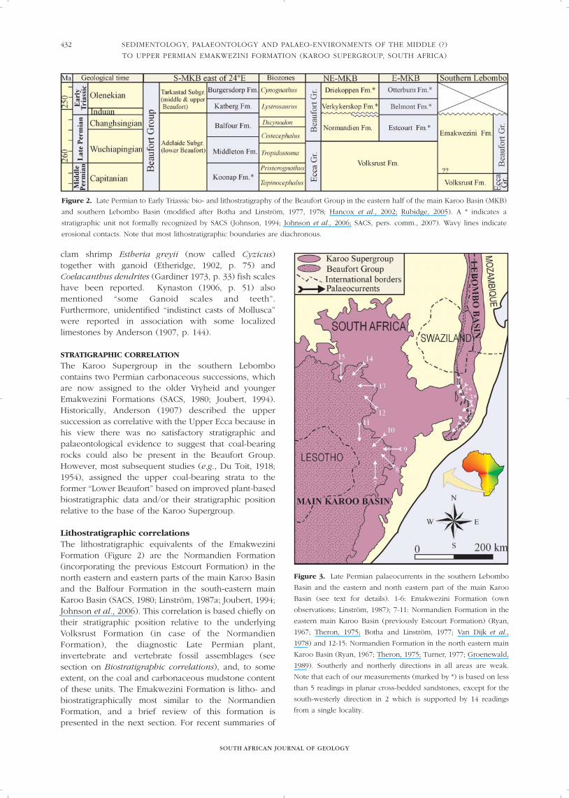
Figure 2. Late Permian to Early Triassic bio- and lithostratigraphy of the Beaufort Group in the eastern half of the main Karoo Basin (MKB)
and southern Lebombo Basin (modified after Botha and Linström, 1977, 1978; Hancox et al., 2002; Rubidge, 2005). A * indicates a
stratigraphic unit not formally recognized by SACS (Johnson, 1994; Johnson et al., 2006; SACS, pers. comm., 2007). Wavy lines indicate
erosional contacts. Note that most lithostratigraphic boundaries are diachronous.
Figure 3. Late Permian palaeocurrents in the southern Lebombo
Basin and the eastern and north eastern part of the main Karoo
Basin (see text for details). 1-6: Emakwezini Formation (own
observations; Linström, 1987); 7-11: Normandien Formation in the
eastern main Karoo Basin (previously Estcourt Formation) (Ryan,
1967; Theron, 1975; Botha and Linström, 1977; Van Dijk et al.,
1978) and 12-15: Normandien Formation in the north eastern main
Karoo Basin (Ryan, 1967; Theron, 1975; Turner, 1977; Groenewald,
1989). Southerly and northerly directions in all areas are weak.
Note that each of our measurements (marked by *) is based on less
than 5 readings in planar cross-bedded sandstones, except for the
south-westerly direction in 2 which is supported by 14 readings
from a single locality.
E.M. BORDY AND R. PREVEC
SOUTH AFRICAN JOURNAL OF GEOLOGY
433
the fluvio-lacustrine Balfour Formation, the reader isreferred to Catuneanu and Elango (2001), Catuneanu et al. (2005) and Botha and Smith (2007) and referencestherein.
In the north-eastern main Karoo Basin (i.e., north-western KwaZulu-Natal, north-eastern Free State,southern Mpumalanga), the Upper Permian NormandienFormation contains ~30-40% sandstone and thins from~320 m in the southwest to ~100 m in the northeast(Turner, 1977; Groenewald, 1984; logs in Groenewald,1989). Proximal sedimentary sources situated to thenortheast, east, southeast, and north are suggested byTheron (1975), Turner (1977) and Groenewald (1989)(Figure 3). In this north-eastern region, the formationcontains freshwater conchostracans (Turner, 1977),numerous trace fossils (Turner, 1977; Groenewald,1989), Late Permian plant fossils and Late Permian toEarly Triassic vertebrate fossils (e.g., Rhachiocephalusmagnus, Dicynodon lacerticeps, Lystrosaurus murrayi)(Groenewald, 1984, 1989; Rubidge, 1995).
In the basal part of the formation, the FrankfortMember (<80 m), consists of two upward-coarseningand upward-thickening sequences comprisingrhythmites, carbonaceous shales, siltstones and fine- tocoarse-grained, feldspathic sandstones with minor coalseams (Turner, 1977; Groenewald, 1989; Johnson et al.,1997; Cairncross et al., 2005). In this lower part,sedimentary structures such as flaser-bedding, waveripples, trough and planar cross-bedding and otherfacies relationships suggest a mainly westward-draining,fluvially-dominated deltaic depositional environment(Groenewald, 1989; Cairncross et al., 2005). The rest ofthe formation, consisting of fining-upward successionscomprising (from the base upwards) minorconglomerates with quartz and granite clasts, fine- tocoarse-grained sandstones, and coal-bearing, black,green and grey mudstones together with red to purplemudstones in the upper part (Harrismith Member)(Groenewald, 1989), has been interpreted as deposits ofhigh-sinuosity, mixed-load meandering rivers andoverbank lakes in an increasingly arid climate (Turner,1977; Groenewald, 1989; Hancox et al., 2002).
In the eastern main Karoo Basin, around Mooi River-Bergville-Ladysmith area (western KwaZulu-Natal), theNormandien Formation (representing the now obsoleteEstcourt Formation, Johnson et al., 2006) consists ofdark-grey (red in its uppermost part), carbonaceous,locally calcareous mudstones, fine- to coarse-grained,moderately well-sorted, poorly rounded, feldspar- andgarnet-bearing sandstones with some conglomerates(Botha and Linström, 1977, 1978) and very rare coalseams (Visser and Loock, 1978). It attains a totalthickness of ~400 m (Botha and Linström, 1978), and ischaracterized by coarsening-upward successions in its lower two-thirds, and fining-upward successions in itsupper third (Cadle, 1974; Veevers et al., 1994; Johnson et al., 1997). Palaeocurrents were directed mainly fromthe northeast, southeast, and east, and to a lesser extent,from the north and south (Theron, 1975; Botha and
Linström, 1977; Van Dijk et al., 1978; Figure 3). In thiseastern region of the main Karoo Basin, in addition totrace fossils, freshwater conchostracans, and LatePermian plant fossils, the formation also contains arange of insects, freshwater molluscs, fish scales, fossilfish (Atherstonia) (e.g., Rossouw, 1970; Lacey et al.,1975; Van Dijk et al., 1978; Anderson and Anderson,1985; Linström, 1987a), and, in its upper part, “plentiful”Dicynodon leoniceps (=Daptocephalus) remains(Dicynodon Assemblage Zone, Botha and Linström,1978). According to Dingle et al. (1983, p. 21), theformation also contains Lystrosaurus Zone fossils. A diverse insect assemblage (e.g., Riek 1973; 1976) notonly corroborates the Late Permian age of the formation,but also suggests a palaeoclimate between cold-moistand warm-dry (Riek, 1976; Geertsema et al., 2002).Except for its uppermost part (dominated by red bedsrich in vertebrate remains), the formation has beeninterpreted as comprising deposits of a moist milieu,dominated by a prograding fluvio-deltaic system withsmall river-mouth deltas, swampy floodplains (Bothaand Linström, 1977; 1978) and interdistributary bays (vanDijk et al., 1978). More recently, Selover and Gastaldo(2005) reinterpreted part of the formation as deposits ofa deeper water turbidite system.
Biostratigraphic correlations All previous biostratigraphic correlations of theEmakwezini Formation have been based onpalaeobotanical observations (Etheridge, 1902; Seward,1907; Du Toit, 1954; Plumstead, 1970; Anderson andAnderson, 1985). Etheridge (1902) noted strongsimilarities between the plant fossils he described fromthe Emakwezini Formation near St. Lucia and those ofthe Upper or Newcastle Coal Measures of Australia.Seward (1907) supported allocation of the strata to the Beaufort Group, based on the absence ofGangamopteris, and Du Toit (1954) also considered theplants of the St. Lucia coalfield indicative of the Beaufortrather than the Ecca Group, although he gave noreasons. Plumstead (1970) based her assessment of aLate Permian age for the coal deposits at Somkele on thepresence of Dictyopteridium and Phyllotheca etheridgei,taxa she considered to be diagnostic of this time period.Although Anderson and Anderson (1985) provided noexplanation for assigning strata at the Emakwezinilocality to the Upper Permian, their recognition ofbroad-meshed Glossopteris leaves of the type associatedwith Rigbya arberioides, provided them with a basis forcorrelation with floras of the Normandien (previouslyEstcourt) Formation.
MATERIALS AND METHODS
SedimentologySedimentological fieldwork was carried out in southernLebombo (see Geological Setting for localities) andinvolved compilation of detailed sedimentary logs, fieldsketches and photomosaics. Because of the generallypoor quality of exposures, the spatial variation and

SOUTH AFRICAN JOURNAL OF GEOLOGY
434
Figure 4. Sedimentological logs of the Emakwezini Formation detailing vertical facies relationships. All logs show true thicknesses. Zone
A-D = major coal zones. (A) Based on Somkele 1 deep borehole (SO1) (Marshall, 1966); to date, this log is the most complete and reliable
record of the entire formation. Note the two coarsening-upward successions (each <20 m thick) in the lowermost part of the formation,
and a number of faults (F) and dolerite intrusions (do). (B) Sedimentological log recorded along the railway cutting near Emakwezini
station, reproduced from unpublished material (Genis, 1961). It represents the uppermost and middle parts of the formation, intersected
by dolerite (do) intrusions and numerous faults (F) (hence its anomalous thickness). (C) Generalized sedimentological log of the
Emakwezini Formation equivalent in Swaziland based on coal exploration boreholes reported in Davies (1961). * = Volksrust Formation
equivalent unit; ** = Upper Beaufort Group equivalent unit: a ~40 m thick, “grey blue micaceous shale” that starts with a thin clay pellet
conglomerate, and which is then followed by coarser sandstone unit, equivalent of the Molteno/Ntabeni Formations (Davies, 1961).
SEDIMENTOLOGY, PALAEONTOLOGY AND PALAEO-ENVIRONMENTS OF THE MIDDLE (?)
TO UPPER PERMIAN EMAKWEZINI FORMATION (KAROO SUPERGROUP, SOUTH AFRICA)

E.M. BORDY AND R. PREVEC
SOUTH AFRICAN JOURNAL OF GEOLOGY
435
Figure 4. (continued)
(D) Generalized sedimentary log of the middle part of the Emakwezini Formation, between Coal Zones B and C at Somkhele Mine
(See Figure 4A for reference). (E) Detailed sedimentary log of the 5th upward-fining succession shown in yellow in D.(F) Detailed
sedimentary log measured in the upper part of the Emakwezini Formation at the type locality near the Emakwezini railway station.

SOUTH AFRICAN JOURNAL OF GEOLOGY
SEDIMENTOLOGY, PALAEONTOLOGY AND PALAEO-ENVIRONMENTS OF THE MIDDLE (?)
TO UPPER PERMIAN EMAKWEZINI FORMATION (KAROO SUPERGROUP, SOUTH AFRICA)
436
Tab
le 1
.Su
mm
ary
of
the
gener
al c
har
acte
rist
ics
and inte
rpre
tatio
n o
f th
e lit
hofa
cies
of
the
Em
akw
ezin
i Fo
rmat
ion.,
Adap
ted w
ith m
odific
atio
ns
from
Mia
ll (1
978,
198
5, 1
996)
.
Fac
ies
Lith
olo
gy
Sed
imen
tary
Bio
ta
Ab
un
dan
ce/
Inte
rpre
tati
on
cod
e fe
atu
res
occ
urr
ence
Gm
Congl
om
erat
e (g
ranule
- to
Mas
sive
, cl
ast- to
None
reco
rded
Rar
eChan
nel
lag
s/ve
ry thin
gra
vel bar
s er
oded
fro
m
peb
ble
-gra
de
stringe
rs o
f cl
asts
:m
atrix-
supported
Occ
urs
at th
e bas
e of
finin
g-upw
ard
floodpla
in f
ines
and/o
r from
in-c
han
nel
under
upper
mudst
one
>> q
uar
tz, gr
anite
)su
cces
sions,
in e
lem
ents
SS,
CF
flow
reg
ime
conditi
ons
Sp
Mai
nly
med
ium
, but al
so
Pla
nar
cro
ss-b
edded
None
reco
rded
Ver
y ab
undan
tSt
raig
ht-cr
este
d (
2D)
dunes
. D
epen
din
g on b
ed
very
coar
se-
to f
ine-
grai
ned
Occ
urs
in e
lem
ents
SS,
DA, CF,
LA, CS
thic
knes
s, m
ay indic
ate
low
er o
r hig
her
flo
w r
egim
e
sandst
one
conditi
ons
SmM
ainly
med
ium
, but al
so v
ery
Mas
sive
(st
ruct
ure
less
) W
hole
and/o
rAbundan
tH
yper
-conce
ntrat
ed f
low
dep
osi
ts u
nder
hig
her
flo
w
coar
se-
to v
ery
fine-
grai
ned
frag
men
tary
foss
il le
aves
Occ
urs
in e
lem
ents
SS,
DA, CF,
LA, CS
regi
me
conditi
ons
and/o
r des
truct
ion o
f prim
ary
sandst
one
and lar
ge w
oody
axes
stru
cture
s by
dew
ater
ing
due
to r
apid
agg
radat
ion
ShM
ediu
m-
to v
ery
fine-
grai
ned
Horizo
nta
lly lam
inat
ed
None
reco
rded
Moder
atel
y ab
undan
tPla
ne-
bed
fro
m f
ast,
shal
low
flo
w u
nder
upper
sandst
one,
loca
lly m
icac
eous
Occ
urs
in e
lem
ents
SS,
CF,
CS
flow
reg
ime
conditi
ons
SlM
ediu
m-
to v
ery
fine-
grai
ned
Low
-angl
e cr
oss
-bed
ded
Fr
agm
enta
ry w
oody
Rar
eH
um
pbac
k or
was
hed
-out dunes
under
upper
flo
w
sandst
one
axes
Occ
urs
in e
lem
ents
SS,
DA, CF,
CS
regi
me
conditi
ons
Sr
Fine-
to v
ery
fine-
grai
ned
Rip
ple
cro
ss-lam
inat
ed
None
reco
rded
Moder
atel
y ab
undan
tCurr
ent ripple
s in
low
er f
low
reg
ime
conditi
ons
sandst
one
Occ
urs
in e
lem
ents
SS,
CF,
LA, CS
FlCoar
se to f
ine
silts
tone,
Horizo
nta
lly lam
inat
ed
Pla
nts
(le
aves
, st
ems,
Ver
y ab
undan
tO
verb
ank,
rar
e w
anin
g flow
as
wel
l as
shal
low
clay
stone,
often
hig
hly
roots
), tra
ce f
oss
ils,
Occ
urs
in e
lem
ent O
F, r
arel
y at
the
top
to d
eeper
lak
e dep
osi
ts
carb
onac
eous
inse
cts,
fre
shw
ater
of
finin
g-upw
ard s
ucc
essi
ons,
arth
ropod a
nd f
ish
in e
lem
ents
SS,
CF
FmCoar
se to f
ine
silts
tones
,M
assi
ve
Pla
nts
roots
, Abundan
tPed
oge
nic
ally
alte
red o
verb
ank
and s
hal
low
lak
e m
argi
n
clay
stones
, often
hig
hly
trac
e fo
ssils
O
ccurs
in e
lem
ent O
Fdep
osi
ts
carb
onac
eous
Ca
Car
bonat
e, f
erru
ginous
Mas
sive
to n
odula
r M
ollu
scs
Ver
y ra
rePed
oge
nic
and/o
r dia
genet
ic inorg
anic
pre
cipita
tion
with
rar
e co
ne-
in-c
one
Occ
urs
in e
lem
ent O
F
stru
cture
s
PFi
ne
silts
tone
and c
lays
tone
Colo
ur
and r
oot-m
ottle
dCar
boniz
ed r
oots
Rar
ePal
aeoso
l w
ith i
n s
itu
vege
tal m
atte
r
and r
ootle
tsO
ccurs
in e
lem
ent O
F
CCoal
Finel
y la
min
ated
to
Car
boniz
ed lea
ves
Rar
e Pea
t ac
cum
ula
tion in f
resh
-wat
er s
wam
ps
mas
sive
and w
oody
axes
Occ
urs
in e
lem
ent O
F

E.M. BORDY AND R. PREVEC
SOUTH AFRICAN JOURNAL OF GEOLOGY
437
Tab
le 2
.Cla
ssific
atio
n a
nd d
escr
iptio
n o
f ar
chite
ctura
l el
emen
ts r
ecogn
ized
with
in the
Em
akw
ezin
i Fo
rmat
ion. W
ith m
inor
modific
atio
n, ar
chite
ctura
l el
emen
ts a
nd the
crite
ria
for
thei
r re
cogn
ition
wer
e ad
apte
d f
rom
Mia
ll (1
985,
199
6).
Arc
hit
ectu
ral
un
itA
rch
itec
tura
l el
emen
t Fac
ies
com
po
siti
on
Geo
met
ryB
ou
nd
ing
surf
aces
Coar
se-g
rain
edSu
per
impose
d s
andst
one
Sp >
> S
m, Sl
, Sh
,Sh
eet-lik
e co
mple
xes
exte
ndin
g >10
0 m
lat
eral
ly,
Ero
sive
, pla
nar
to irr
egula
r to
slig
htly
conve
x-dow
n b
asal
surf
aces
.
faci
es a
ssoci
atio
nsh
eets
(SS
)Sr
, m
inor
Flan
d <
4 to
>15
m thic
k (c
om
monly
~4
to 8
m).
Upper
surf
aces
usu
ally
ero
sive
, irre
gula
r to
pla
nar
.
Conta
ined
indiv
idual
tab
ula
r or
lentic
ula
r bed
s ra
nge
Num
erous
flat
inte
rnal
surf
aces
.
from
~3-
5 m
to ~
100
m long
and f
rom
0.0
5 to
2.2
m
(ave
rage
~0.
2 to
0.3
m)
thic
k.
Dow
nst
ream
-acc
rete
dm
ainly
Sp, fe
w S
rW
hal
ebac
k-sh
aped
body
~1–
1.5
m thic
k an
d >
30 m
long.
Pla
nar
to s
lightly
conve
x-dow
n b
asal
surf
aces
. U
pper
surf
aces
dep
osi
ts (
DA)
Ove
rlie
s O
F el
emen
t, ove
rlai
n b
y SS
or
CF
elem
ents
. sh
arp c
onve
x-up, st
rongl
y dow
nw
ard-c
urv
ing.
Inte
rnal
surf
aces
dow
n-c
urr
ent dip
pin
g to
pla
nar
.
Chan
nel
-fill
s of
variab
leSp
>> S
m, Sl
, Sh
Lentic
ula
r bodie
s of
variab
le s
cale
fro
m 1
.5 to >
100
mSh
arp, co
nve
x-dow
n, st
rongl
y upw
ard-c
urv
ing
bas
al s
urf
aces
.
scal
e (C
F)w
ide
and ~
0.5
to >
8 m
thic
k. O
verlie
SS,
DA a
nd O
FU
pper
surf
aces
ero
sive
ly p
lanar
, co
nve
x-dow
n to g
radat
ional
.
elem
ents
, ove
rlai
n b
y SS
ele
men
t. Ver
y ra
re, la
rge-
scal
e
varian
ts m
ay c
onta
in e
lem
ents
SS,
DA, LA
.
Late
rally
-acc
rete
dSp
>> S
m, Sr
,Tap
ered
wed
ge-s
hap
ed b
odie
s an
d ~
1-1.
5 m
thic
k an
dPla
nar
to s
lightly
conve
x-dow
n b
asal
surf
aces
. U
pper
surf
aces
dep
osi
ts (
LA)
min
or
Fl<10
m w
ide.
Ove
rlai
n b
y SS
or
CF
elem
ents
. irre
gula
r to
pla
nar
. In
tern
al s
urf
aces
strai
ght,
slopin
g in
direc
tions
nea
rly
per
pen
dic
ula
r (>
60°)
rel
ativ
e to
the
mai
n
pal
aeocu
rren
t direc
tion.
Fine-
grai
ned
fac
ies
Ove
rban
k fines
(O
F)Fl
, m
inor
Fm,
Late
rally
ext
ensi
ve s
hee
t-lik
e bodie
s, e
xten
din
g >50
0 m
Pla
nar
to irr
egula
r to
slig
htly
conve
x-dow
n, sh
arp to tra
nsi
tional
asso
ciat
ion
C >
Ca,
Pin
len
gth, <0.
5 to
<10
m thic
k. E
rosi
vely
ove
rlai
nbas
al s
urf
aces
. U
pper
surf
aces
shar
p to tra
nsi
tional
.
by
SS, D
A a
nd C
F el
emen
ts, as
soci
ated
with
CS
elem
ent.
Cre
vass
e sp
lay
(CS)
Sm, Sh
, Sr
>> S
pLe
ntic
ula
r to
shee
t-lik
e bodie
s, e
xten
din
g <40
m lat
eral
lyEro
sive
, sh
arp, pla
nar
bas
al s
urf
aces
. U
pper
surf
aces
pla
nar
to
and 0
.1-4
m thic
k. C
om
monly
pas
sing
late
rally
into
undula
tory
to s
lightly
dow
nw
ard-c
urv
ing
or
tran
sitio
nal
.
OF
elem
ents
, an
d a
ssoci
ated
with
sm
all-sc
ale
CF
and O
F el
emen
ts. Ero
sive
ly o
verlai
n b
y SS
ele
men
ts.
relationships of the facies were interpreted usingsupplementary data from Council for Geoscience coalexploration boreholes and unpublished reports. The data were compiled and interpreted according tostandard facies analysis techniques (Miall, 1978; 1985;1996). Palaeocurrent measurements and petrographicstudies (thin-section descriptions) were undertaken tocomplement the field-based facies analysis, in particularto establish the direction of the local and regionalpalaeoslopes and source rock geology.
PalaeobotanyPlant fossils were collected under AMFA Permit number06/01, issued to RP. Specimens from Kwa-Yaya andEmakwezini are impressions, in fine-grained olive-greymudstone, whereas those from Somkhele Mine areimpressions and compressions within highlycarbonaceous, fine-grained siltstone. All material (over900 slabs) is currently housed in the Albany Museum,Grahamstown, and specimens have been assignedtemporary field numbers with the prefix KY (Kwa-Yaya),ES (Emakwezini Station) or SM (Somkhele Mine).Specimens were photographed with a Canon Powershot G6 digital camera under low-angled,unilateral light.
SEDIMENTOLOGY OF THE EMAKWEZINI FORMATION
Vertical profile analysis shows that the EmakweziniFormation is composed of four major clastic-coalsequences (demarcated by Coal Zones A –D; Figures 4A;4B; 4C). These all fine upward, except at Somkele,where the first clastic-coal sequence commences withtwo upward-coarsening successions (<20 m each; seenext section). Each upward-fining clastic-coal sequencerests on a prominent erosion surface and commenceswith coarse-grained sandstones. Furthermore, each ofthese major upward-fining sequences comprisesbetween two and five vertically stacked fining-upwardsuccessions that can be further subdivided into severalsmaller-scale (<10 m thick), fining-upward successions(Figures 4D; 4E; 4F; 6). The coal is always found in theupper part of each major clastic-coal sequence and isinterbedded with other fine-grained lithofacies. In mostinstances, the coal occurs at variable distances from thebase of the succeeding sequence, with the exception ofthe second sequence, where the regionally mostpersistent and uniformly thick coal zone is overlaindirectly (with a sharp erosional contact) by the verycoarse, pebbly sandstones of the third sequence (Figures 4A, 4C). Based on the current scant data,substantial and progressive grain-size differences do notoccur among the four major upward-fining clastic-coalsequences, however, the third sequence appears to becoarsest, and at least in Swaziland, the fourth(uppermost) is the finest (Figure 4C).
Facies analysis Lithofacies data obtained from regional outcrop andsubsurface facies analysis were synthesized, and, based
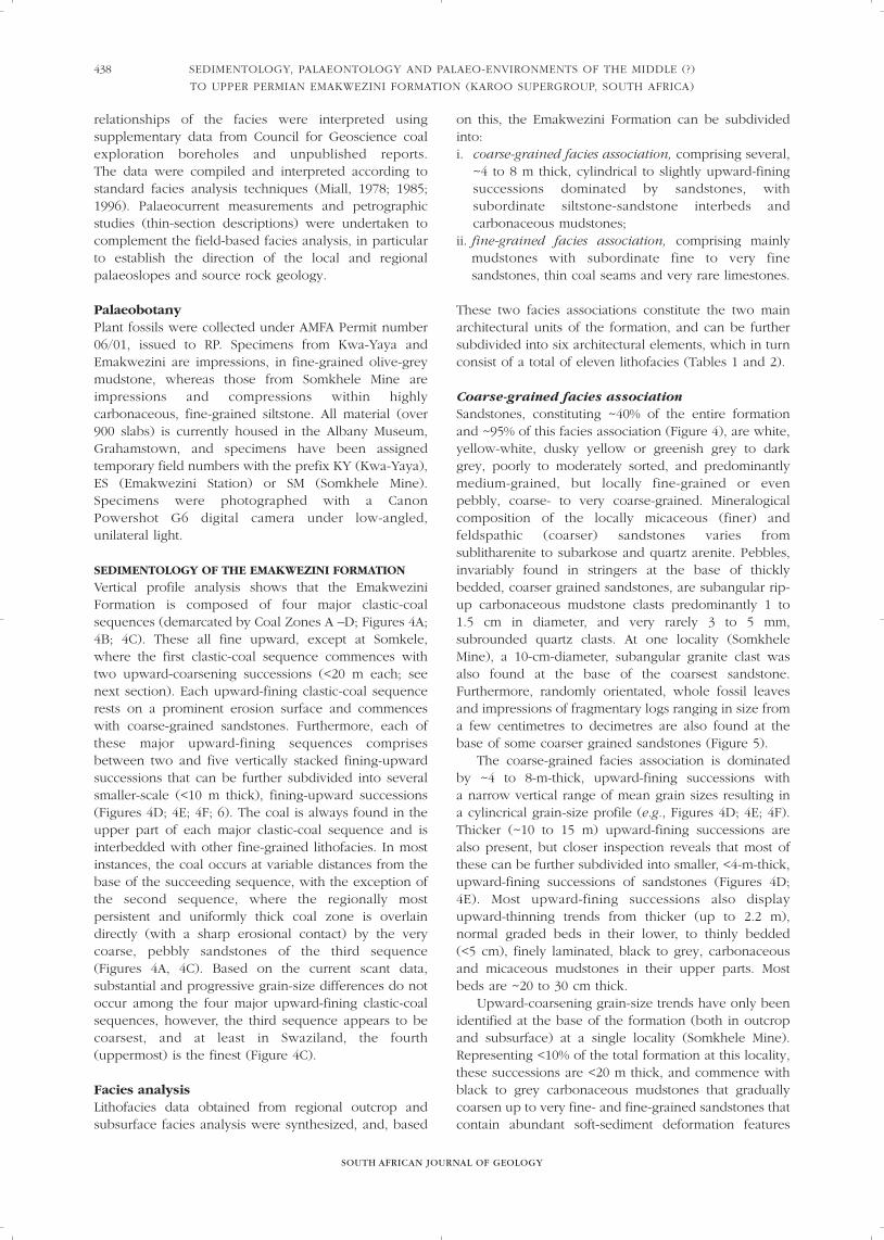
on this, the Emakwezini Formation can be subdividedinto: i. coarse-grained facies association, comprising several,
~4 to 8 m thick, cylindrical to slightly upward-finingsuccessions dominated by sandstones, withsubordinate siltstone-sandstone interbeds andcarbonaceous mudstones;
ii. fine-grained facies association, comprising mainlymudstones with subordinate fine to very finesandstones, thin coal seams and very rare limestones.
These two facies associations constitute the two mainarchitectural units of the formation, and can be furthersubdivided into six architectural elements, which in turnconsist of a total of eleven lithofacies (Tables 1 and 2).
Coarse-grained facies association Sandstones, constituting ~40% of the entire formationand ~95% of this facies association (Figure 4), are white,yellow-white, dusky yellow or greenish grey to darkgrey, poorly to moderately sorted, and predominantlymedium-grained, but locally fine-grained or evenpebbly, coarse- to very coarse-grained. Mineralogicalcomposition of the locally micaceous (finer) andfeldspathic (coarser) sandstones varies fromsublitharenite to subarkose and quartz arenite. Pebbles,invariably found in stringers at the base of thicklybedded, coarser grained sandstones, are subangular rip-up carbonaceous mudstone clasts predominantly 1 to1.5 cm in diameter, and very rarely 3 to 5 mm,subrounded quartz clasts. At one locality (SomkheleMine), a 10-cm-diameter, subangular granite clast wasalso found at the base of the coarsest sandstone.Furthermore, randomly orientated, whole fossil leavesand impressions of fragmentary logs ranging in size froma few centimetres to decimetres are also found at thebase of some coarser grained sandstones (Figure 5).
The coarse-grained facies association is dominatedby ~4 to 8-m-thick, upward-fining successions with a narrow vertical range of mean grain sizes resulting ina cylincrical grain-size profile (e.g., Figures 4D; 4E; 4F).Thicker (~10 to 15 m) upward-fining successions arealso present, but closer inspection reveals that most ofthese can be further subdivided into smaller, <4-m-thick,upward-fining successions of sandstones (Figures 4D;4E). Most upward-fining successions also displayupward-thinning trends from thicker (up to 2.2 m),normal graded beds in their lower, to thinly bedded (<5 cm), finely laminated, black to grey, carbonaceousand micaceous mudstones in their upper parts. Mostbeds are ~20 to 30 cm thick.
Upward-coarsening grain-size trends have only beenidentified at the base of the formation (both in outcropand subsurface) at a single locality (Somkhele Mine).Representing <10% of the total formation at this locality,these successions are <20 m thick, and commence withblack to grey carbonaceous mudstones that graduallycoarsen up to very fine- and fine-grained sandstones thatcontain abundant soft-sediment deformation features
SOUTH AFRICAN JOURNAL OF GEOLOGY
SEDIMENTOLOGY, PALAEONTOLOGY AND PALAEO-ENVIRONMENTS OF THE MIDDLE (?)
TO UPPER PERMIAN EMAKWEZINI FORMATION (KAROO SUPERGROUP, SOUTH AFRICA)
438

E.M. BORDY AND R. PREVEC
SOUTH AFRICAN JOURNAL OF GEOLOGY
439
and trace fossils. In comparison, upward-coarseningsuccessions constitute over two-thirds of theNormandien Formation in the eastern (i.e., outcrop areaof the previous Estcourt Formation), and approximatelyone-quarter in the north-eastern main Karoo Basin.
Because of the limited lateral continuity ofexposures, the abundance of large-scale macroforms
(e.g., lateral or downstream accreted beds) could not bedetermined with certainty, as in many cases the lateraldimension of even individual beds was difficult toquantify. Nevertheless, the sandstones appear to havetabular to lenticular geometry with variable lateralcontinuity ranging from a few ~3 to 5 m to up to ~100 m in sections oblique to the palaeoflow direction (Figure 6).
Irrespective of their scale, the fining-upwardsuccessions are invariably characterized by sharp, flat toconcave-up, erosional lower contacts with relief of a fewdecimetres or metres. Erosion surfaces within large-scale, composite fining-upward successions havevariable geometries, and in decreasing order ofabundance, they are identified as:1. planar - lending a multi-storey, vertically stacked,
tabular appearance to the strata;2. downward-curving - lending a whaleback
appearance to strata;3. upward-curving - lending a channel-like appearance
to strata; and4. straight, sloping in directions nearly perpendicular
(>60 degrees) to the main palaeocurrent direction(Figure 6).
Primarily, the nature of these surfaces and geometry ofthe contained beds allowed the subdivision of thecoarse-grained facies association into four architecturalbuilding blocks, namely:superimposed sand sheets (SS);downstream-accreted deposits (DA);channel-fills of variable scale (CF); andlaterally-accreted deposits (LA) (Figure 6; Table 1).
Most sandstones in the coarse-grained faciesassociation are medium (> 0.1 m to < 1 m) to thick (> 1 m), planar cross-bedded (facies Sp) (Figure 6), andarranged in erosively-based co-sets 0.4 to 2.2 m thickcomprising individual sets 0.1 to 0.15 m thick. Foresetsand cosets are often draped by a few millimetre thickcarbonaceous mud film.
Strata with no visible sedimentary structures (faciesSm) are also common. However, the proportion ofprimary structureless (including post-depositionalobliteration of syn-depositional structures) to secondarystructureless (massive) sandstones is uncertain given thehighly weathered nature of the outcrops. Low-anglecross-bedded (facies Sl), horizontally laminated (faciesSh) and asymmetrical ripple cross-laminated (facies Sr)sandstones are less common and mainly restricted tofine- to very fine-grained, commonly argillaceous andmicaceous sandstones. Ripple cross-laminated sand-stones are found exclusively towards the upper part ofupward-fining successions, and generally areinterbedded with <5-cm-thick, finely laminated,carbonaceous mudstone.
Soft-sediment deformation features in sandstones arevery abundant and range from slump structures(Marshall, 1966, p. 3), contorted beds and water-escapestructures to overturned cross-beds and load casts(Figures 7A; B).
Figure 5. (A and B) Non-diagnostic, random, impressions of
fragmentary woody axes up to 50 cm long in coarse, massive
sandstone at the base of an upward-fining succession (Emakwezini
railway station). Scale intervals are 1 cm. (C) Random impression
fossils of intact Glossopteris leaves in coarse, massive sandstone at
the base of an upward-fining succession (Emakwezini railway
station).

SOUTH AFRICAN JOURNAL OF GEOLOGY
SEDIMENTOLOGY, PALAEONTOLOGY AND PALAEO-ENVIRONMENTS OF THE MIDDLE (?)
TO UPPER PERMIAN EMAKWEZINI FORMATION (KAROO SUPERGROUP, SOUTH AFRICA)
440
Fig
ure
6.
Arc
hite
ctura
l el
emen
ts a
nd b
oundin
g su
rfac
es in the
Em
akw
ezin
i Fo
rmat
ion. Photo
mosa
ic a
nd lin
e in
terp
reta
tion o
f a
~10
0 m
-long
artif
icia
l tren
ch a
t So
mkh
ele
Min
e th
at c
ut ac
ross
the
conta
ct
of th
e co
arse
- an
d fin
e-gr
ained
fac
ies
asso
ciat
ions
(see
Coal
Zone
B a
nd o
verlyi
ng
sandst
one
in F
igure
4A), r
ough
ly p
aral
lel to
the
regi
onal
struct
ura
l st
rike
and o
bliq
ue
to p
alae
o-flo
w d
irec
tions.
Sep
arat
ed
from
the
under
lyin
g ca
rbonac
eous
mudst
ones
and c
oal
(el
emen
t O
F) b
y a
stro
ng
erosi
on s
urf
ace,
the
~6-
7 m
-thic
k sa
ndst
one
succ
essi
on (
eroded
) co
nta
ins
super
impose
d s
and s
hee
ts (
SS), c
han
nel
-fill
s
(CF)
of
variab
le s
cale
and l
ater
ally
-acc
rete
d d
eposi
ts (
LA). N
ote
that
obse
rvat
ions
of
such
cle
arly
-def
ined
, sl
opin
g m
ajor-
chan
nel
mar
gins
are
exce
ptio
nal
ly r
are
for
the
Em
akw
ezin
i Fo
rmat
ion,
pro
bab
ly
due
to t
he
poor
qual
ity o
f th
e outc
rops
and t
hei
r orien
tatio
ns
(i.e
., m
ost
ly p
aral
lel
to p
alae
o-flo
w). M
ost
com
mon l
ithofa
cies
are
Sp,
follo
wed
by
Sl i
n t
he
med
ium
, an
d S
h,
Sr i
n t
he
fine
sandst
ones
.
Sedim
ento
logi
cal lo
g (n
ote
its
blo
cky
grai
n-s
ize
pro
file
) on the
righ
t w
as m
easu
red in the
low
erm
ost
upw
ard-fin
ing
succ
essi
on (
see
das
hed
lin
e on the
left f
or
appro
xim
ate
trac
e).

E.M. BORDY AND R. PREVEC
SOUTH AFRICAN JOURNAL OF GEOLOGY
441
Fine-grained facies association This facies association consists mainly of mudstones,subordinate fine to very fine grained sandstones, thincoal seams and very sparse limestones. It forms theupper part of the major clastic-coal sequences attainingthicknesses of up to 50 m (Figure 4). The fine-grainedfacies association commonly has gradational or abrupt lower and sharp, erosional upper (Figure 6)contacts.
Constituting up to ~60% of the entire formation(Figure 4), black, dark to light grey, blue-grey, grey-green and brown mudstones (facies Fl and Fm) havevariable carbon content and grain sizes ranging fromsparse claystones to more common silty claystones andsiltstones. In spite of the generally poor quality of theoutcrops, the bulk of the mudstones have delicatehorizontal laminations, a feature especially prominentwhere regular intercalation of silt- and clay-rich laminaeoccur, resulting in rhythmic bedding. Slight grain sizevariation from silty claystone to very fine sandy siltstoneis also detectable in broken lenticular-beddedmudstones with single, flat, isolated lenses of coarsergrained sediments. In fact, successions of uniform/pureclaystones or siltstones are very rare, and their thicknessseldom exceeds 0.5 m. Because of the generally intenseweathering of the exposures, assessing the proportion ofprimary versus secondary structureless mudstones(facies Fm) is impossible. Very rare ichnofauna (Figure 7C) are associated with the structurelessmudstones.
An additional lithofacies associated with thecarbonaceous mudstones are rare limestones that formlaterally discontinuous (<2 m) carbonate lenses up to~0.2 cm thick (Figure 7D) (facies Ca). These lenses haveknobbly lower and upper contacts, strong ferruginouspigmentation and poorly-developed cone-in-conestructures. During this study, such limestones were onlyobserved at Emakwezini but they have been reported tooccur very rarely at various other localities (e.g., Davies,1961; Wolmarans and Du Preez, 1986), and, in oneinstance, in association with a cast of a mollusc(Anderson, 1907).
Root- and colour-mottled, dark to light grey,bleached white and rusty red-brown (ferruginous)mudstones (clay- and siltstones) (facies P) are associatedwith coal seams (facies C) and highly carbonaceous,locally fossiliferous mudstones. The vegetal matterassociated with these mottled mudstones varies fromhorizontal to subhorizontal, minute, bifurcating andtapering rootlets cross-cutting indistinctly preservedlaminations (Figure 7E) to robust in situ Vertebrariaaxes. Impression fossils of these large, unmistakable,woody roots of the Glossopteris plant have acharacteristically jointed appearance, resulting from thepresence of air chambers in the root that are thought tobe an adaptation to water-logged soils. Most commonly,however, the root remains found in this lithofacies aredisseminated throughout the host mudstones in the formof short (<5 cm), featureless, carbonized axes.
The second-most common lithofacies of the fine-grained facies association are intercalations of silty, veryfine-, to fine-grained and locally medium- and coarse-grained sandstone intercalations. These are locallymicaceous and commonly contain irregularly shaped,locally deformed, rip-up clasts of carbonaceousmudstone up to 8 cm in diameter. Due to the generallypoor quality of the outcrops, their lateral contacts areunclear and very few were observed. Nonetheless, thelimited data suggests that these interbedded sandstonesform fairly continuous, tabular and lenticular strata,several decametres long. Locally, inclined layers withoutdistinct internal sedimentary structures resemble laterallyaccreted surfaces. Upward-fining or -thinning trends arescarce, and, the base of one such upward-finingsuccession of very fine sand to siltstone is marked bypoorly-preserved impressions of large woody axes of upto 30 cm long. These intercalations, which seem to occurin a random manner in the mudstones, can be up to 4 m in total thickness and consist of <10 to >40 cm-thickbeds, usually with sharp, well-defined lower and lessdistinct upper contacts. The very fine to fine sandstonestypically show no internal structures (facies Sm) or havedelicate horizontal lamination (facies Sh), flaser bedding,ripple, trough and low-angle cross-lamination (facies Sr),whereas the coarser grained sandstones are commonlyplanar cross-bedded (facies Sp), horizontally laminated(facies Sh) or structureless (facies Sm). Soft-sedimentdeformation features, especially load casts (Figure 7F)are very common.
Thin (usually <1 m) coal seams (facies C) make upthe remainder of the fine-grained facies association, andconsist of semi-anthracite to anthracite with >75% ofvitrinite (reflectance of 2.4 to 3.1%), ~25% raw ash,<0.015% phosphorus and 0.7 to 0.8% sulphur contents(Bordy et al., 2008). Natural exposures of coal are veryrare; however, they have been reported (often as “LowerBeaufort” coals) to occur from Heatonville in the southto Komatipoort in the north, in the following regions ofthe Lebombo Basin: Somkele-Heatonville area (Visser,1957a; b; Genis, 1961; Marshall, 1966); Nongoma(Snyman, 1998); Swaziland (Davies, 1961) andKomatipoort (Kynaston, 1906; Du Toit, 1918; de Jager,1986). Assessing whether all of these occurrences areindeed within the Middle to Upper Permian successionsis beyond the scope of this study. However, it is evidentthat most of these descriptions refer to coal-bearingstrata that either contain diagnostic Late Permian floralelements or appear above a non-carbonaceous unit (i.e.,Volksrust Formation equivalents) that is underlain by theolder coal-bearing succession (i.e., the Lower PermianVryheid Formation equivalents).
The maximum number of coal seams in the Somkele1 borehole is eleven, with the first major seam occurring~174 m (discounting the dolerite intrusions) above thelower contact of the formation (see Figure 4A –recalculated from Chart 2 of Marshall, 1966). In the samearea, Grant and Snelling (2005) recognized four coalzones of which the first (lowermost) is ~60 m above the

SOUTH AFRICAN JOURNAL OF GEOLOGY
SEDIMENTOLOGY, PALAEONTOLOGY AND PALAEO-ENVIRONMENTS OF THE MIDDLE (?)
TO UPPER PERMIAN EMAKWEZINI FORMATION (KAROO SUPERGROUP, SOUTH AFRICA)
442
Figure 7. (A) Contorted beds in coarse-grained sandstone (north of Somkhele Mine). (B) Overturned cross-beds are confined to single
beds (here 35 cm thick) of medium-grained, planar-cross bedded sandstone, and formed due to downcurrent bending and partial collapse
of over-steepened foresets (Emakwezini railway station). (C) Rare, non-diagnostic trace fossils in blue-grey, fine- to very fine siltstones
(facies Fm) (Ntambanana). Scale intervals are 1 cm. (D) Thin, discontinuous limestone lenses with knobbly lower and upper contacts (facies
Ca) (Emakwezini railway station). (E) Close-up of horizontal to subhorizontal rootlets displaying several orders of delicate branching in
white, massive claystones (facies P). These fine, bifurcating and tapering root traces can be several centimetres in length, are less than
1 mm in diameter, and cross-cut weakly preserved bedding planes at low-angle. Their morphology may suggest broadly spreading root
systems with shallow penetration in consistently wet substrates (north of Somkhele Mine). Scale intervals are 1 cm. (F) Soft-sediment
deformation features are very common in the interbedded sandstones and range from water escape structures to load casts and convoluted
bedding (northeast of Somkhele Mine).

E.M. BORDY AND R. PREVEC
SOUTH AFRICAN JOURNAL OF GEOLOGY
443
base of the formation, and the second (Coal Zone B)contains the thickest (5.3 m) coal seam (Figure 4A).
At Emakwezini, about eight thin (0.15 to 1 m) coalseams and strongly carbonaceous mudstones werereported, chiefly in the middle to upper part of theformation (du Preez, 1982, p. 58). At Heatonville, twothin (<1.5 m) coal seams are present in an ~18 m-thickcoal zone, some 120 m above the base of the formation(Genis, 1961, p. 15). In Swaziland, the EmakweziniFormation equivalent unit is much more condensed(<150 m thick; Figure 4C), yet the coal zones are againfour in total, of which the lowermost zone is 30 m abovethe basal contact of the formation, and the second oneis again the main zone with an average workable coalseam thickness of ~6 m (Davies, 1961). According toDavies (1961, p. 17), the notable consistency inthickness of the main coal zone and that of thecontained coal seam makes them reliable markers forstratigraphic correlations within Swaziland.
In summary, it appears that the best developed coalzone is in the lower one-third or half of the formation(Figure 4), occurring immediately beneath the coarsestand thickest sandstone package. It is also noteworthythat the average thicknesses of workable coal seams inthe coal zones are similar, even in widely separatedareas such as Swaziland and Somkele, where theaverage thicknesses of the minable coal seam in the main coal zones are ~6 m and 5.3 m, respectively. In light of the ongoing coal exploration efforts in theregion, these stratigraphic distribution patterns mightprove to be important for regional correlations. Datafrom the current geological exploration and miningoperations, especially around Somkhele Mine, willclarify the lateral and vertical facies distribution withinthe Emakwezini Formation.
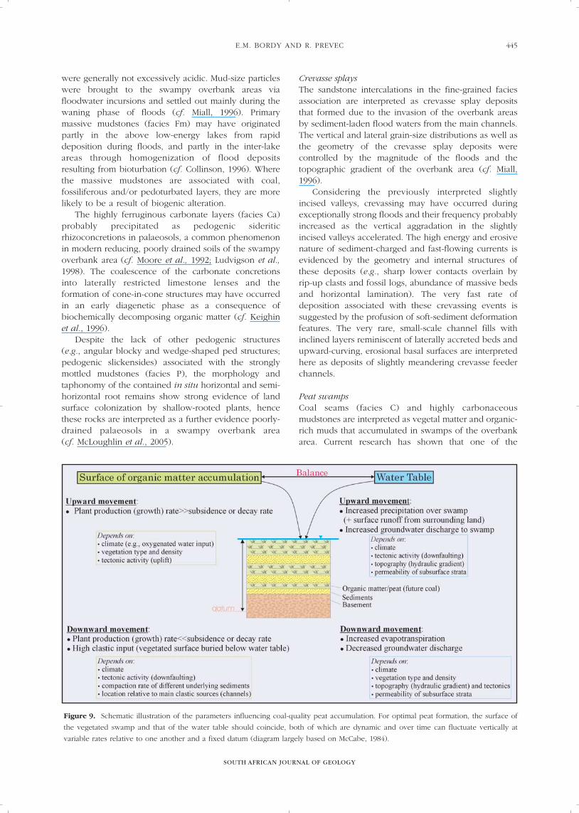
InterpretationsThe two major facies associations of the EmakweziniFormation represent environments of a swampy fluvio-lacustrine setting, namely (1) a higher energy, low-sinuosity river channel belt and (2) a lower energy,alluvial floodbasin consisting of (a) overbank areas withpermanent lakes, (b) crevasse splays and (c) peatswamps (Figure 8).
Low-sinuosity river channel beltThe building blocks of the coarse-grained faciesassociation are interpreted as fills of shallow, mobile,sand-bed braided channels that were contained inslightly incised valleys. The latter are indicated by sharperosional surfaces at the base of the major channel-fills,commonly overlain by coarse channel lags. The incisionprobably occurred during fluvial base-level fall, and thevalleys were subsequently filled, at times fairly rapidlyand essentially through simple vertical and, to someextent, downstream aggradation (cf. Miall, 1996), duringtimes of fluvial base-level rise.
The multi-storey sequence architecture of themedium-grained sandy bedforms consisting ofindistinctly upward-fining successions, the ratheruniform palaeocurrent patterns (Figure 3) and the lackof features such as cut-banks, sloping channel margins,major lateral accretion surfaces, and point barsuccessions with bell-shaped log profiles, collectivelyimply that deposition in the slightly incised valleysoccurred in low-sinuosity, weakly confined braidedfluvial channels with an overall medium to high energylevel. In addition to the medium grain size, the moderateenergy level of these fluvial systems can be deducedfrom the abundance of planar cross-bedded sandstones(cf. Miall, 1996). The fluctuating current velocities within
Figure 8. Schematic block diagram illustrating the environments of a swampy fluvio-lacustrine setting of the Upper Permian Emakwezini
Formation in the Lebombo Basin.

the channels are indicated by the mud-draped coset andforeset surfaces.
Rapid aggradation rates are suggested by the varioussoft-sediment deformation features that resulted chiefly from water movement through overloaded,unconsolidated sediments (cf. Owen, 1996). In part-icular, overturned cross-bedding indicates a very fastrate of sedimentation, as it results from the drag of high-energy, sediment-laden flows across planar cross-bedded sandbars (cf. Turner, 1981; Owen, 1996).Considering the abundance of soft-sedimentdeformation features in the study area, it is possible thatmany of the massive, structureless sandstones formed asa result of over-rapid ‘dumping’ of sediments orwholesale dewatering during fast accumulation rates(Miall, 1996). The massive sandstones in the lower partof fining-upward successions with randomly orientedplant remains are additional unambiguous indicators ofsuch rapid accumulation of sediments from sporadichyper-concentrated flows. Soft-sediment deformationmight also be taken as indirect evidence for a relativelymoist environment, as the high sedimentation ratessuggested by them are also indicative of high rates ofdenudation, probably driven by increased precipitationin the drainage area.
According to Bridge (2003), upward-fining and -thinning successions with regular upward decrease inthe scale of cross-stratification may be interpreted as theresult of decelerating flow and decreasing sedimenttransport rate over the passage of a single flood.However, the presence of numerous internal erosionsurfaces within these indistinctly upward-finingsuccessions suggests that such multi-storey sand bodiesare products of multiple flooding events during whichpreviously deposited single-flood units were partially ortotally eroded (cf. Miall, 2006). Therefore channel-depthestimates, which are usually based on the scale of anautogenic channel-fill, are not attempted here. However the preserved maximum thickness of planarcross-beds (~2.2 m) allows for the minimum heightestimation of large sand dunes. Based on this, andconsidering that the ratio between the height of sandbars and total bankfull depth is ~0.5 in the modernBrahmaputra River (Bristow in Miall, 2006), theEmakwezini braided channels may have been, at leastlocally, 4 to 5 m deep, implying medium-sized rivers(sensu Fielding - see Miall, 2006). Because the steepstructural tilt and limited lateral continuity of outcropsprevented thorough assessment of three-dimensionalstacking arrangements of strata, other details of fluvialmorphology could only be hypothesized. For example,palaeo-channel widths, the calculation of which requirescontinuous outcrops roughly perpendicular to palaeo-flow, are estimated to have been about 100 m based onthe lateral continuity of some erosion surfaces (e.g.,Figure 6).
Architectural elements (e.g., SS, DA, LA) of thecoarse-grained facies association are interpreted asvarious sandy bedforms within the low-sinuosity
channels. Based on their relative abundance, these mid-channel sand dunes were accreted mainly vertically, lessfrequently in a downcurrent direction and very rarelysideways. The rare, medium-scale channel-fills withstrongly upward-curving basal surfaces (Figure 6) are explained as temporary margins of migratingchannels within the much wider channel belt in theslightly incised valleys. Interpretations of individuallithofacies of the coarse-grained facies association (Table 1) are not repeated in the text as these arestandard features of fluvial facies models (Miall 1978;1985; 1996).
Based on the characteristic depositional features(e.g., contained lithofacies, architectural elements, andgeometry of their internal erosion surfaces), the fluvialstyle of the Emakwezini Formation rivers closelyresembled that of the shallow, perennial, sand-bedbraided river model (Miall 1978; 1996). This similarity is underscored by the relative consistency of thepalaeoflow directions and by the dominance of planarcross-bedded sandstones (facies Sp) that occur inrelatively simple sand sheets (elements SS), and, lesscommonly, as downstream accreted deposits (elementDA). The only difference in the case of the Emakwezini,is the higher proportion of preserved floodplaindeposits, due to the relative confined nature of the mainbraided channel belt (see Discussion below).Considering the numerous recent accounts of the co-existence of shallow, sand-bed braided rivers andassociated extensive floodplains, this discrepancyexemplifies the need for modification of the originalfacies model of this river type (cf. Miall, 1996; Bristow et al., 1999; Allan and Fielding, 2007).
Alluvial floodbasinThe building blocks of the fine-grained facies associationare interpreted as deposits of moist overbank areascharacterized by various micro-relief features, viz. ridgesand swales, locally isolated depressions of variable sizeand relatively level plains. These features are typicallyassociated with different groundwater elevations, occurat different distances from the active channels, andhence reflect different water depths, soil drainage and sedimentary processes.
Overbank area with permanent lakesBased on their fine grain size, the mudstones weredeposited from suspension via low-energy processes inthe overall low-lying area of the overbank region. The finely laminated (facies Fl), rhythmically bedded,non-bioturbated and carbonaceous nature of themajority of the facies association suggests that the overbank area was dotted with deeper stratifiedlakes with restricted water circulation. The lack of waveripples in conjunction with the rhythmic bedding,suggests that these lakes had either a small fetch or steepmargins. Considering the relatively abundant aquaticfauna (e.g., fish, molluscs, concostrachans), it isreasonable to assume that these standing water bodies
SOUTH AFRICAN JOURNAL OF GEOLOGY
SEDIMENTOLOGY, PALAEONTOLOGY AND PALAEO-ENVIRONMENTS OF THE MIDDLE (?)
TO UPPER PERMIAN EMAKWEZINI FORMATION (KAROO SUPERGROUP, SOUTH AFRICA)
444
E.M. BORDY AND R. PREVEC
SOUTH AFRICAN JOURNAL OF GEOLOGY
445
were generally not excessively acidic. Mud-size particleswere brought to the swampy overbank areas viafloodwater incursions and settled out mainly during thewaning phase of floods (cf. Miall, 1996). Primarymassive mudstones (facies Fm) may have originatedpartly in the above low-energy lakes from rapiddeposition during floods, and partly in the inter-lakeareas through homogenization of flood depositsresulting from bioturbation (cf. Collinson, 1996). Wherethe massive mudstones are associated with coal,fossiliferous and/or pedoturbated layers, they are morelikely to be a result of biogenic alteration.
The highly ferruginous carbonate layers (facies Ca)probably precipitated as pedogenic sideriticrhizoconcretions in palaeosols, a common phenomenonin modern reducing, poorly drained soils of the swampyoverbank area (cf. Moore et al., 1992; Ludvigson et al.,1998). The coalescence of the carbonate concretionsinto laterally restricted limestone lenses and theformation of cone-in-cone structures may have occurredin an early diagenetic phase as a consequence ofbiochemically decomposing organic matter (cf. Keighinet al., 1996).
Despite the lack of other pedogenic structures (e.g., angular blocky and wedge-shaped ped structures;pedogenic slickensides) associated with the stronglymottled mudstones (facies P), the morphology andtaphonomy of the contained in situ horizontal and semi-horizontal root remains show strong evidence of landsurface colonization by shallow-rooted plants, hencethese rocks are interpreted as a further evidence poorly-drained palaeosols in a swampy overbank area (cf. McLoughlin et al., 2005).
Crevasse splays The sandstone intercalations in the fine-grained faciesassociation are interpreted as crevasse splay depositsthat formed due to the invasion of the overbank areasby sediment-laden flood waters from the main channels.The vertical and lateral grain-size distributions as well asthe geometry of the crevasse splay deposits werecontrolled by the magnitude of the floods and thetopographic gradient of the overbank area (cf. Miall,1996).
Considering the previously interpreted slightlyincised valleys, crevassing may have occurred duringexceptionally strong floods and their frequency probablyincreased as the vertical aggradation in the slightlyincised valleys accelerated. The high energy and erosivenature of sediment-charged and fast-flowing currents isevidenced by the geometry and internal structures ofthese deposits (e.g., sharp lower contacts overlain byrip-up clasts and fossil logs, abundance of massive bedsand horizontal lamination). The very fast rate ofdeposition associated with these crevassing events issuggested by the profusion of soft-sediment deformationfeatures. The very rare, small-scale channel fills withinclined layers reminiscent of laterally accreted beds andupward-curving, erosional basal surfaces are interpretedhere as deposits of slightly meandering crevasse feederchannels.
Peat swampsCoal seams (facies C) and highly carbonaceousmudstones are interpreted as vegetal matter and organic-rich muds that accumulated in swamps of the overbankarea. Current research has shown that one of the
Figure 9. Schematic illustration of the parameters influencing coal-quality peat accumulation. For optimal peat formation, the surface of
the vegetated swamp and that of the water table should coincide, both of which are dynamic and over time can fluctuate vertically at
variable rates relative to one another and a fixed datum (diagram largely based on McCabe, 1984).

SOUTH AFRICAN JOURNAL OF GEOLOGY
SEDIMENTOLOGY, PALAEONTOLOGY AND PALAEO-ENVIRONMENTS OF THE MIDDLE (?)
TO UPPER PERMIAN EMAKWEZINI FORMATION (KAROO SUPERGROUP, SOUTH AFRICA)
446
most important factors influencing coal-quality peatdevelopment in swamps is the stability of a generallyanaerobic, low pH water table at the surface of vegetalaccumulation (Moore and Shearer, 2003). On one hand,the development of such equilibrium conditions, inother words the coincidence of the water table with thedepositional surface of the organic matter, is dependenton a steady balance between the water that enters andleaves the peat swamp (McCabe, 1984). The waterbudget in the swamp is influenced by factors such as the amount of direct precipitation, overland runoff (e.g., floodwaters), groundwater discharge andevapotranspiration rates (Figure 9). On the other hand,the position of a vegetated surface relative to the watertable is dependent on the plant production versus decayrates, subsidence rates (which may be due to tectonicmovements or compaction of the underlying sediment).Another important factor influencing coal formation isthe amount of flood water input to the swamps, whichin addition to providing aerated water, is also the mainsource of clastic sediments, and, in the case of paralicsettings, the source of sulphur and phosphorus(McCabe, 1984; 1987).
In fluvial environments, the influx of clastic sedimentis mainly related to the magnitude and frequency ofoverbank flooding and the lateral and vertical positionof the swamp surface relative to the main fluvialchannels. McCabe (1984, p. 24), who consideredaverage rates of peat accumulation and compactiontogether with frequency of flooding events in fluvialsettings, suggested that coal-quality peat accumulation isa strong indicator of long periods of negligible regionalclastic supply to the swamp.
The low sulphur and phosphorus together with highash content of the Emakwezini coal indicate that theseMiddle (?) to Late Permian swamps were distant frommarine influence, but were relatively close to fluvialsystems (cf. Thomas, 2002). Together with clastics,overbank flooding also supplied moisture, which wasprobably supplemented by direct precipitation andgroundwater discharge. The high vitrinite content of theEmakwezini coal, together with the large size of somefossil roots and woody axes and an abundance oflayered mats of Glossopteris leaves (see Palaeobotanysection), indicates that the swamps were probablyforested (cf. McCabe, 1984; Mastalerz and Padgett,2002).
Provenance and PalaeocurrentsBased on preliminary petrographic studies, the medium-to coarse-grained feldspathic and quartzose sandstonesof the Emakwezini Formation were provenanced fromcraton interior and transitional continental sources. Thedominant medium grain-size and the mineralogicallyand texturally submature sandstones (e.g., subangular tosubrounded and poorly sorted grains) and subroundedquartz pebbles, indicate moderate transportationdistances mainly under intermediate flow conditions.The relatively high feldspar content, in conjunction with
the micaceous facies and occurrence of granite clasts,suggest the dominance of granitoid rocks in the sourcearea. High-consistency palaeocurrent measurements(Figure 3), obtained from the foresets of planar cross-bedded sandstones, indicate low-sinuosity channels thatcarried sediments from a main source area to thenortheast, and to lesser extents to the southeast and east.Southerly or northerly palaeocurrents were notobserved. These results tie in well with the previouslysuggested general westerly palaeocurrents in the north-eastern and eastern part of the main Karoo Basin in theMiddle to Late Permian (see Figure 3). The name the“Eastern Highlands” was coined as by Ryan (1967) forthis predominantly eastern source area. He suggestedthat this mountainous region was an important source ofsediments for the Ecca and lowermost Beaufort Groupsin the eastern part of the main Karoo Basin. Morerecently, based on palaeoflow, palaeogeography anddetrital zircon analysis, Veevers et al. (2007)demonstrated that a granitoid source in centralAntarctica was a dominant and supposedly long-livedsupply of sediments to peri-Antarctic basins during theCambrian–Ordovician, Early Permian and Early Triassic.Similarity of the Emakwezini Formation to the LowerPermian successions in regional palaeocurrents,sandstone composition and regional palaeogeographyindicate that the same central Antarctic granitoid sourcewas also significant in the Middle and Late Permian.
PALAEOBOTANY OF THE EMAKWEZINI FORMATION
Description and assessment of the plant fossillocalitiesEmakwezini StationThe highly weathered railway section at EmakweziniStation is the holostratotype of the formation (Figures 1B, 4B, 4F). Although Visser (1957a) and Genis(1961) recorded the presence of several coal seams andcarbonaceous mudstones in this section (Figure 4B), wewere unable to locate these. We did, however, findseveral fossiliferous horizons containing well-preservedGlossopteris leaves in finely laminated, highly fissilemudstones in the middle and upper part of theformation (Figure 4B). Collections (Table 3) were madeat two of the most productive locations in the middle toupper-middle part of the formation, referred to here asSite 01 (S 28° 31.653’, E 31° 52.221’) and Site 02 (S 28°32.006’, E 31° 52.423’). Both sites expose intercalatedsandstones (mainly element CS), mudstones and sandysiltstones (element OF) of the fine-grained faciesassociation.
The plant fossils at Site 01 appear to beautochthonous, as indicated by an abundance ofVertebraria (rooting structures of Glossopteris) that insome cases transect the bedding planes and apreponderance of impressions of delicately preserved,leafy shoots with intact leaf whorls, belonging to twosphenopsid taxa. These taphonomic characteristics andvarious sedimentological features (such as horizontallylaminated, carbonaceous shales with good lateral

E.M. BORDY AND R. PREVEC
SOUTH AFRICAN JOURNAL OF GEOLOGY
447
continuity associated with rhythmites and crevasse splaysandstones), indicate that the deposits probablyrepresent a vegetated lake margin setting in theoverbank area, where there was in situ accumulation ofleaves and rooting of the substratum.
Site 02 is dominated by mats of well-preservedGlossopteris leaf impressions, with sphenopsidscomprising a minor element of the flora (Plates I; II; III).No in situ plant material was found, indicating that thedeposit is probably parautochthonous. This, togetherwith the associated horizontally laminated carbonaceousmudstones, suggests that the localized depositionalsetting at this site was probably a crevasse splay, withinwhich the plants were moved for a short distance beforethey settled out during the waning phase of a crevassingevent together with the suspended mud-size particles.
Kwa-Yaya railway siding This plant fossil locality (Figure 1B) is a railway cutting200 m west of the Kwa-Yaya railway siding,approximately 25 km west of Empangeni along the R34(S 28° 41.915’, E 31° 40.730’). The locality has not, to ourknowledge, been reported previously in the literaturealthough it has been known to geologists working in the
area for many years. Members of the Zululand Rock andMineral Club (ZRMC) have visited the site on severaloccasions (K. Pieterson, pers. comm.). This spatiallyisolated exposure of the Emakwezini Formation is ~2.75m high and ~100 m long, and displays a successionfrom the fine-grained facies association, including twopartial, very slightly upward-fining sandy successionsseparated by a scour surface that is overlain by a basallag with few impressions of (~30 m long) woody axes.Because of spatial isolation, the stratigraphic position ofthis site within the formation is only estimated to becloser to the upper boundary of the unit.
The flora (Table 3) comprises dense mats ofGlossopteris leaf impressions, interspersed withglossopterid ovuliferous and polleniferous fructificationsand several sphenopsid taxa. Examples of in situsphenopsid plants and Vertebraria roots cross-cuttingthe bedding planes were observed. The autochthonousnature of the deposit, together with associatedsedimentary features (such as horizontally laminatedmudstones overlain by an erosively based upward-finingsuccession with vague lateral accretions surfaces),indicates that the site probably represents the in situaccumulation of leaf litter in a vegetated floodplain
Table 3. Preliminary list of fossil plants from re-examined and newly discovered localities in the Emakwezini Formation.
Locality Floral elements Illustrations
Emakwezini Station Glossopteridales Glossopteris spp.
Rigbya arberioides Lacey et al. 1975
Dictyopteridium flabellatum Benecke 1976 Pl. I, B
Lidgettonia africana Thomas 1958 Pl. I, D
Lidgettonia lidgettonioides (Lacey et al. 1975) And. & And. 1985 Pl. I, E
several types of samaropsoid seed Pl. I, G
Eretmonia natalensis du Toit 1932 emend. Lacey et al. 1975
Arberiella sp.
Scale leaves
Vertebraria indica Royle 1834
Sphenopsida Phyllotheca australis Brongniart 1828 emend. Townrow 1955 Pl. II, A
Paracalamites australis Rigby 1966
Raniganjia kilburnensis And. & And. 1985 Pl. II, B
KwaYaya Glossopteridales Glossopteris spp. Pl. I, I, J; Pl. II, D-K;
Pl. III, B
Rigbya arberioides Lacey et al. 1975 Pl. I, F, H
Plumsteadia gibbosa (Benecke 1976) And. & And. 1985 Pl. I, H
Lidgettonia africana Thomas 1958
several types of samaropsoid seeds Pl. I, C
Eretmonia natalensis du Toit 1932 emend. Lacey et al. 1975
Arberiella sp.
Scale leaves
Vertebraria indica Royle 1834
Sphenopsida Phyllotheca australis Brongniart 1828 emend. Townrow 1955
Paracalamites australis Rigby 1966
Trizygia speciosa Royle 1840 emend. Pant & Mehra 1963 Pl. II, C
Incertae sedis Benlightfootia sp.
Somkhele coal mine Glossopteridales Glossopteris spp. Pl. III, A, D
(Coal Zone B) Ottokaria sp. Pl. III, G
Vertebraria indica Royle 1834
Sphenopsida Schizoneura gondwanensis Feistmantel 1876 Pl. III, C

SOUTH AFRICAN JOURNAL OF GEOLOGY
SEDIMENTOLOGY, PALAEONTOLOGY AND PALAEO-ENVIRONMENTS OF THE MIDDLE (?)
TO UPPER PERMIAN EMAKWEZINI FORMATION (KAROO SUPERGROUP, SOUTH AFRICA)
448
Plate I. Impression fossils of glossopterid leaves, ovuliferous fructifications and seeds from Emakwezini Station and Kwa-Yaya railway
siding. (A) apex of a Dictyopteridium sp. fructification [ES 190e]; (B) Dictyopteridium flabellatum fructification [ES 205]; note the small,
circular, raised tubercles (seed scars) evenly dispersed on the surface of the receptacle; (C and G) platyspermic, winged, samaropsoid seeds
[KY 28b; ES 185]; (D) dorsiventrally compressed capitulum of the ovuliferous fructification Lidgettonia africana (arrow) [ES 166b];
(E) laterally compressed capitulum of Lidgettonia lidgettonioides (arrow) [ES 190f]; (F) ovuliferous glossopterid fructification Rigbya
arberioides [KY 28a]; (H) partially preserved impression of the veined surface of the fructification Plumsteadia gibbosa (P), and
R. arberioides (R) [KY 19a]; (I) and (J) small, narrow Glossopteris leaves with polygonal meshes (note insect margin feeding traces in the
specimen in I) [KY 75a; KY 79a]; this morphotype is commonly associated with R. arberioides. Scale bars = 10 mm unless otherwise
specified. Square brackets contain the temporary field numbers of the specimens.

E.M. BORDY AND R. PREVEC
SOUTH AFRICAN JOURNAL OF GEOLOGY
449
Plate II. Sphenophytes and Glossopteris morphotypes from Emakwezini Station and Kwa-Yaya railway siding. (A) Phyllotheca australis leaf
whorls [ES 08]; (B) highly fused, disk-like leaf whorl of Raniganjia kilburnensis [ES 123b]; (C) Trizygia speciosa leaf whorls [KY 301a];
D to K samples of Glossopteris leaf morphotypes [KY 32; ES 45; KY 7a; KY 315a; KY 78a; KY 301a; KY 75a; KY 63b]: note the insect
oviposition scars to either side of the midrib in (D) particularly towards the apex; (E) a leaf with particularly broad/open meshes, similar
to those attributed by Lacey et al. (1975) to (G) conspicua, and by Anderson and Anderson (1985) to their Estcourtia vandijkii palaeo-
species; morphotypes in D and G to (J) fall within the palaeo-genus Lidgettonia of Anderson and Anderson (1985). Scale bars = 10 mm.
Square brackets contain the temporary field numbers of the specimens.

SOUTH AFRICAN JOURNAL OF GEOLOGY
SEDIMENTOLOGY, PALAEONTOLOGY AND PALAEO-ENVIRONMENTS OF THE MIDDLE (?)
TO UPPER PERMIAN EMAKWEZINI FORMATION (KAROO SUPERGROUP, SOUTH AFRICA)
450
Plate III. (A and B) distinctive Glossopteris morphotypes included by Anderson and Anderson (1985) within their palaeo-species Estcourtia
bergvillensis, found at both Kwa-Yaya [B; KY 72], and Somkhele Mine [A; SM 01]; note that the Somkhele specimen is double the size of
the leaf from Kwa-Yaya; (C) an unusually well-preserved specimen of the sphenopsid Schizoneura gondwanensis from Somkhele Mine,
with multiple foliar lobes in attachment [SM 02; scale bar = 50 mm]; (D) Glossopteris morphotype from Somkhele Mine [SM 03; scale bar =
50 mm]; (E and F) impression fossils from the SO1 borehole at Somkele, described by Plumstead (1970) as Dictyopteridium. Note the
abundance of oviposition scars, particularly along the midrib, in the specimen in E, which is the basal portion of a small Glossopteris leaf;
(G) adjacent specimens of the ovuliferous glossopterid fructification Ottokaria sp. (arrows). Scale bars = 10 mm unless otherwise specified.
Square brackets contain the temporary field numbers of the specimens.

E.M. BORDY AND R. PREVEC
SOUTH AFRICAN JOURNAL OF GEOLOGY
451
setting in relative close proximity to a wide, shallow,suspended-load, slightly meandering (?crevasse feeder)channel in the overbank area.
The plant fossils found in the Emakwezini Stationand Kwa-Yaya railway cuttings are unusually well-preserved and abundant. Preliminary investigations haverevealed a floral diversity directly comparable to that ofthe Late Permian floras of the main Karoo Basin.
By far the most dominant floral element at both thesesites is Glossopteris. The most common morphotypes areillustrated in Plates I, II and III. The leaves are generallyvery well-preserved, with excellent venation detail,although complete specimens are rare because of theweathered, fractured and fragmentary nature of theslabs. The abundance of material will allow for accurateand detailed characterization of the morphotypespresent, to be described in a future paper. Leaves fallingwithin the circumscriptions of the Estcourtia,Lidgettonia, Rigbya arberioides and Plumsteadia gibbosapalaeo-taxa of Anderson and Anderson (1985) areparticularly abundant (Plates I; II; III).
Although Anderson and Anderson (1985) did notreport the occurrence of R. arberioides fructifications atthe Emakwezini locality, they did note the presence ofleaves they attributed to their R. arberioides palaeo-species, i.e., glossopterid leaves consistently associatedwith this fructification at multiple sites. These leaves areapparently the same as those described by Lacey et al.(1975) from the Mooi River locality as Belemnopteriselongata. Many examples of this long, broad-meshedleaf with small, pointed basal lobes were found at Kwa-Yaya (Plate I: I, J), associated with a surprisingabundance (over 80 specimens) of Rigbya arberioidesfructifications (Plate I: F, H). Rigbya is only known fromthe Late Permian, and has a fairly broad distribution,with reports from Australia (Rigby, 1972; McLoughlin,1990, 1995) and Antarctica (Schopf, 1976).
Several other taxa of ovuliferous glossopteridfructification were found at the Kwa-Yaya andEmakwezini Station localities. These are the firstunequivocal fertile glossopterid organs to be reportedfrom the Emakwezini Formation. Rigbya arberioides,Dictyopteridium flabellatum (Plate I: A; B), Plumsteadiagibbosa (Plate I: H), Lidgettonia africana (Plate I: D) andLidgettonia lidgettonioides (Plate I: E), and thepolleniferous glossopterid organ Eretmonia natalensisare all characteristic elements of the Upper PermianNormandien Formation of the main Karoo Basin inwestern KwaZulu-Natal (Lacey et al., 1975; Benecke,1976; Anderson and Anderson, 1985; Adendorff, 2005).Dictyopteridium in particular is considered to be a usefulbiostratigraphic indicator for the Late Permian, and hasbeen recorded in Upper Permian deposits in India(Surange and Chandra, 1973), South Africa (Benecke,1976) and Australia (Rigby, 1978).
The genus Plumsteadia has a wide-ranging temporaland spatial distribution in Gondwana, probably becauseof its broad circumscription. Plumsteadia gibbosa,however, is a distinctive fructification currently known
only from several Upper Permian South African localitiesin the main Karoo Basin (Loskop, Mooi River, Inhluzani– Anderson and Anderson, 1985; Adendorff, 2005).
Numerous dispersed platyspermic seeds with lateralwings were found at both Kwa-Yaya and EmakweziniStation (Plate I: C; G). Very similar seeds are known tohave been produced by species of Lidgettonia andRigbya arberioides (Anderson and Anderson, 1985;Adendorff, 2005).
Two specimens of the extremely rare leaf typeBenlightfootia were found at Kwa-Yaya. This representsonly the second report of this probable sphenophytefrom South Africa – Lacey et al. (1975) described twoleaves from the Upper Permian Mooi River locality in themain Karoo Basin.
Sphenopsids Phyllotheca australis and Trizygiaspeciosa, both typical Upper Permian elements in themain Karoo Basin, were found at the Kwa-Yaya andEmakwezini Station localities. The deposits atEmakwezini Station (Site 01) contain a high density ofPhyllotheca australis foliage shoots (Plate II: A).Raniganjia kilburnensis (Plate II: B) is also present andhas been found at numerous localities in the UpperPermian Normandien (previously Estcourt) Formation,and a few localities that are thought to be MiddlePermian in age (Lacey et al., 1975; Anderson andAnderson, 1985). Within these localities it is apparentlyrare, and in most cases is recognized from fragmentedspecimens, but at Emakwezini Station there is anunusual profusion of this delicate sphenopsid andseveral specimens with multiple leaf whorls attached toindividual axes were collected.
The Somkele 1 deep borehole (SO1)Although the specimens from this borehole (approx. S28°21’ and E 32°06’ – see Figure 1B; taken ~170 m belowthe upper contact of the formation – see Figure 4A)identified by Plumstead (1970) as Dictyopteridiumappear to have been misidentified, they still provideevidence for a Late Permian age for the upper one thirdof the formation in the Somkele area. The Glossopterisleaves from the SO1 borehole core are very similar tothose consistently associated with the glossopteridfructification Lidgettonia, and which constitute the mostcommonly occurring leaf forms in the Upper Permiandeposits of the main Karoo Basin (Plate III: E; F). A LatePermian age is further supported by the presence ofPhyllotheca australis within the same section of the core,viz. above Coal Zone C (Figure 4A).
Somkhele MineThe recent open-cast mining operations west ofSomkele, at Somkhele Mine (Figure 1B) opened freshexposures of the coal-bearing succession associated withCoal Zones B and C (Figures 4A; 4D; 4E; 6) in themiddle part of the formation. Recent examination ofthese led to the discovery of a new fossil flora withinCoal Zone B (overlain by a prominent erosion surface;~115 m below the SO1 borehole core specimens

documented by Plumstead, 1970; Figures 4A; 6). Wewere able to make a small collection of the fossil flora,but the site was destroyed by mining operations shortlyafterwards.
Preliminary investigations have revealed aGlossopteris-dominated flora with glossopterid fertileorgans and subsidiary sphenopsid elements. Vertebrariaand rooted sphenopsid rhizomes cross-cutting thebedding planes indicate that the deposits areautochthonous. Based on the taphonomic characteristicsof the collected plant material and the associatedsedimentary features (horizontally laminated mudstonesclosely associated with coal seams) (Figure 4A), this siteprobably represents a very low energy, vegetated peatswamp isolated from sites of active clasticsedimentation.
Preliminary investigations have revealed that this isan atypical flora within the context of our currentperceptions of South African Permian biostratigraphy.The two key biostratigraphic indicators in thisGlossopteris-dominated flora are Ottokaria (Plate II: G)and Schizoneura gondwanensis (Plate II: C).
Ottokaria is a genus of glossopterid ovuliferousfructifications that, in South Africa, has only been foundpreviously in Lower Permian rocks (Plumstead, 1956;Anderson and Anderson, 1985; Adendorff, 2005) andmost other Gondwanan records are also restricted to thisinterval. There have been a few reports of this genus inthe Upper Permian of India and Australia (e.g., Banerjee,1978; McLoughlin, 1990) although the atypical wingmorphologies of those specimens suggest they could beplaced in a separate genus. On the other hand, S. gondwanensis is currently known only from theUpper Permian in South Africa, Australia and Brazil(Etheridge, 1903; Du Toit, 1932; Benecke, 1976;Anderson and Anderson, 1985; Rohn and Rösler, 1986;McLoughlin, 1992), although it has been found in bothMiddle and Upper Permian deposits in India(Feistmantel, 1880; Singh, 2000).
The Somkhele Mine flora is dominated byGlossopteris leaves much larger (some over 300 mmlong) than those characterizing the Upper Permian ofSouth Africa (Plate III: D). Although leaf size alone is nota sound biostratigraphic indicator, there is a trend withinSouth African Permian floras for larger Glossopterisleaves to be associated with Lower to Middle Permiandeposits (Anderson and Anderson, 1985). The presenceof broad-meshed morphotypes, very similar in shapeand venation style to those found in the Middle to UpperPermian of the main Karoo Basin (attributed byAnderson and Anderson, 1985, to Estcourtia), maysupport either a Middle or Late Permian age for the flora(Plate III: A; B). Detailed characterization of theGlossopteris morphotypes in this ongoing study willhopefully clarify this further.
PhytostratigraphyA detailed study of the floras is currently underway, butpreliminary results clearly demonstrate a strong
correlation between the upper parts of the EmakweziniFormation (represented by the Kwa-Yaya andEmakwezini Station localities) and the Normandien(previously Estcourt) Formation of the main KarooBasin. A Late Permian age is confirmed by the presenceof a range of taxa typical of this time period in SouthAfrica, including several sphenopsids and a suite ofovuliferous glossopterid fructifications.
The flora from Somkhele Mine (Coal Zone B) hasyielded a new glossopterid assemblage that containselements typical of both Late and Early Permian SouthAfrican floras, precluding a confident age determinationof the host strata within the biostatigraphic frameworkcurrently recognised in South Africa. This unusualcombination of plants, and the generally large size of theleaves present, may indicate that these deposits are nottemporal equivalents of the exclusively Upper Permianstrata at KwaYaya and Emakwezini. Alternatively, theprolonged existence of moist fluvio-lacustrine habitats inthe Somkhele region may have promoted the growthand preservation of plants atypical of floras commonlyassociated with the Upper Permian in the main KarooBasin.
DISCUSSION
Local environmental settingStratigraphic architecture in continental basins removedfrom marine influences is controlled by thesuperimposed effects of autogenic processes (e.g.,channel belt avulsion due to differential compaction),tectonics and climate (Shanley and McCabe, 1994).These are the ultimate controls of the changes in theequilibrium (graded) river profiles (or fluvial base level)and lake and local groundwater levels in fluvial-lacustrine settings (Catuneanu, 2006). Aggradation willoccur in fluvial channels when the fluvial base level isabove the land surface. This can be caused by tectonicsubsidence and/or relatively low discharge periods.Incision of channels will take place when fluvial baselevel falls below the land surface as a consequence oftectonic uplift and/or relatively high discharge periods.
Generally, previous studies have suggested that bythe time Beaufort Group deposition commenced in themain Karoo Basin in the Middle Permian, this part ofsouthern Gondwana was isolated from marineincursions (e.g., Catuneanu and Elango, 2001; Cairncrosset al., 2005; Catuneanu et al., 2005). However, based onthe recently discovered marine bivalve in the VolksrustFormation (Figure 2) of the eastern main Karoo Basin(Cairncross et al., 2005), marine influences cannot beexcluded. Hence, changes in sediment accommodation,at least in the Middle Permian portion of the EmakweziniFormation, may also have been impacted by fluctuationsin eustatic sea levels. However, considering the lowsulphur and phosphorus contents of Emakwezini coal,and the presence of freshwater conchostracans, directmarine incursions can be excluded. The currentdatabase does not allow us to extricate the tangledsignatures of autogenic, tectonic, climatic and possibly
SOUTH AFRICAN JOURNAL OF GEOLOGY
SEDIMENTOLOGY, PALAEONTOLOGY AND PALAEO-ENVIRONMENTS OF THE MIDDLE (?)
TO UPPER PERMIAN EMAKWEZINI FORMATION (KAROO SUPERGROUP, SOUTH AFRICA)
452

E.M. BORDY AND R. PREVEC
SOUTH AFRICAN JOURNAL OF GEOLOGY
453
eustatic influences on fluvial base-level cyclicityrepresented in the Emakwezini Formation.
Sequence architecture of the Emakwezini Formation,including the lateral equivalence of the shallow,perennial, sand-bed braided rivers and extensivevegetated floodbasin, together with the verticalrelationships of four major clastic-coal sequences, isexplained here in terms of large-scale depositional anderosional events dictated by cyclical changes in sedimentaccommodation (e.g., fluvial graded profile).
We hypothesize that the co-existence of relativelyhigh to moderate energy braided fluvial and mainly lowenergy floodplain processes was facilitated by therepeatedly incised nature of the braided channel belts.The incision would have provided an elevationdifference between the depositional surfaces within andoutside the channel belt, and ensured protection offloodplains from influx of sand-size sediment whichonly entered these areas during stronger floods or attimes when the accommodation space within the incisedvalley was reduced, as the valley was gradually filled byvertically accreted sand bodies.
In terms of temporal fluvial base-level changes, thedepositional events that may have taken placethroughout the development of each clastic-coalsequence are the following: Phase 1 – fluvial base-level fall: incision of the valleysand coeval heavy erosion of the floodplain regions (notethat in the case of strong incision, the removal ofsediments deposited in the previous phase could occur). Phase 2 – stasis (relative stability of the system): by-passof sediments in the incised valleys (which acted asconduits in flushing the bedload towards the west andsouthwest), and coeval soil formation in the overbankareas. Phase 3 – during fluvial base-level rise: increasedsediment loads in channels leading to vertical stackingof sandbodies within the incised valleys and significantcoeval peat accumulation in the overbank areas cut offfrom active clastic sedimentation.Phase 4 – during late fluvial base-level rise: increasedaggradation of sediments (and reduced accommodationspace) in the incised valleys leading to more frequentflooding (including crevassing) with a high clastic influxto the overbank area.
A similar configuration of sandy braided channelbelt, associated floodplains and in-channel aggradationinduced by fluvial base-level rise and subsequentcrevasse splay formation has been described from themodern Niobrara River in Nebraska, USA (Bristow et al.,1999). As already mentioned, unravelling the autogenicand allogenic imprints and their effects on these fluvialbase-level changes is not currently possible. However,their magnitude can be deduced from the scale andnature of the architectural appearance (e.g., thickness,grain size, lateral continuity) of the contained sequences.For instance, the great and uniform thickness of CoalZone B at Somkele and in Swaziland (Figure 4A, 4C)suggests an extended period during which clastic influx
to the peat swamps was relatively low and probablycoincided with climatic conditions ideal for peataccumulation on a regional scale. The low sulphurcontent of the coal in combination with relatively lowclastic influx to the peat swamps collectively imply anextended period of relatively fast regional subsidence(cf. McCabe, 1989; Thomas, 2002) during whichdeposition of coarse clastic sediments was confined tothe incised valleys. This regionally fast rate ofsubsidence (phase 3 above) eventually slowed down(phase 4), and the subsidence was ultimately terminatedwhen the strongest fluvial base-level fall of theformation occurred (a new phase 1). This major incisionevent caused the significant down-cutting of thechannels to the level of thick, erosion-resistant peatlayers (Coal Zone B), the removal of the sequencesdeposited during the slower subsidence rates (of phase4) and the development of the prominent erosionsurface at the base of the coarsest (third) clastic-coalsequence. Considering the uncertain age of the floraassociated with Coal Zone B and the confidence withwhich we can deduce a Late Permian age for the rest ofthe succession, this prominent erosion surface aboveCoal Zone B may in fact represent a regionalunconformity.
Regional environmental settingExcept for the two localized coarsening-upwardsuccessions identified at Somkele (both in outcrop andin the subsurface - Figure 4A), diagnostic evidence ofdeltaic sedimentation (e.g., hummocky, herringbone,and wave ripple cross-stratification, bidirectionalpalaeocurrents, mature sandstones) has not beenrecognized in the study area. Therefore, the claim that the Emakwezini Formation has a “fluvio-deltaicorigin” (e.g., Linström, 1987a) is unsubstantiated by thecurrent findings. However, it is possible that the twobasal coarsening-upward successions indicate a short-lived, initial deltaic interlude that was eventuallysucceeded by the dominant fluvio-lacustrinedepositional interval.
A similar change from deltaic to fluvio-lacustrinesettings is present on a regional scale in thestratigraphically equivalent Normandien Formation,which is also characterized in its lower part bycoarsening-upward successions, albeit in differentproportions. These coarsening-upward successions areespecially prominent in the eastern main Karoo Basin(outcrop region of the former Estcourt Formation), anarea that constituted the basinward continuation of themore upslope depositional settings in the northeasternparts of the main Karoo Basin, and the southernLebombo (i.e., current study area) (Figure 3). In additionto palaeocurrent trends, the poor sorting, thearchitecture of the multi-storey sandstones, the higherabundance of upward-fining successions and thepresence of better developed coal seams in theEmakwezini Formation collectively suggest thatdeposition in the southern Lebombo area occurred in
closer proximity to the mountainous source to the eastand northeast, in a wetter, more densely vegetatedsetting than that envisaged for the other Upper Permiansuccessions in the main Karoo Basin.
One of the regional stratigraphic implications of thenewly discovered Emakwezini Formation floralassemblages is that the Ecca-Beaufort transition seems tohave occurred earlier in the southern Lebombo regionthan in the eastern main Karoo Basin (Figure 2). In otherwords, the possible time equivalence of the lowerEmakwezini Formation with the upper lacustro-marine(?) Volksrust Formation, and of the upperEmakwezini Formation with the fluvio-deltaic/lacustrineNormandien Formation, suggests that the overallregressive shrinking of the terminal Ecca lake(?‘Volksrust sea’) took place first from the south, theneast and finally from the north as indicated by thestratigraphic distribution of prograding deltaicsuccessions.
Climate during the Middle(?) to Late PermianLocal climate Coal seams, soft-sediment deformation, autogenic peatswamp limestones and shallow root systems collectivelypoint to relatively high to moderate precipitation and/orrelatively shallow groundwater levels throughout the deposition of the Emakwezini Formation. Theenvironment was continuously moist, a conditionnecessary for coal-quality peat formation andpreservation (cf. Miall, 1996). This permanently moistsetting is further corroborated by the absence in thesouthern Lebombo Basin of at least episodically dryclimate indicators such as raindrop impressions,desiccation cracks or semi-arid palaeosol features (e.g.,evaporitic pseudomorphs and rosettes, pedogeniccarbonate concretions, red colour mottling).Furthermore, the relative abundance of the medium-grained feldspathic sandstones, indicating slow chemicalweathering in this moist milieu, suggests cool, temperate(as opposed to warm, humid) conditions, probably in asetting distal to the montane climate of the EasternHighlands. The relatively wide range of fossil plant andanimal (i.e., trace fossils, insects, molluscs, arthropodsand fish) species reflects the presence of a complexecosystem in the area during the Middle to Late Permian.While individually none of these fossil organisms can beused as a climate indicator, several are aquatic, andhence may be taken as indicators of a fresh-waterwetland setting.
Regional climate Conditions that prevailed during the Late Permian aregenerally considered to have been unsuitable for thedevelopment of coal-bearing successions (e.g., Fuare et al., 1995), with the climate having becomeincreasingly arid (e.g., McLoughlin et al., 1997; Ward et al., 2000; 2005; Kiddler and Worsley, 2004). Thepalaeoclimatic signal of the Emakwezini Formationtherefore has regional implications.
Although Upper Permian coal measures are relativelyabundant in other high palaeolatitude sedimentarybasins of Gondwana with a humid, cool, temperateclimate (e.g., Australia, Antarctica, Chumakov andZharkov, 2003), coal is subordinate in the NormandienFormation and absent in the Balfour Formation in theneighbouring temperate, semi-arid main Karoo Basin(reconstructed at ~50 to 60ºS palaeolatitude, but ~41ºSaccording to Ward et al., 2005, supplement). Notably, insouth-central Africa, Middle Permian coal and UpperPermian mudstones with variable carbon content(Madumabisa Mudstone Formation and equivalents)have also been reported in Zambia, Tanzania, Malawi,etc. (Catuneanu et al., 2005). The latter are mainlyinterpreted as deposits of lake interior and littoralenvironments in a continental temperate climate (meanannual surface palaeotemperatures >10°C) (Yemane et al., 1989; Yemane and Kelts, 1990; Yemane and Kelts,1996; Nyambe and Dixon, 2000; Wopfner, 2002).
Within the lower Beaufort Group of the southern andwestern main Karoo Basin, evaporitic pseudomorphsand rosettes, desiccation cracks, raindrop impressions,pedogenic carbonate concretions and red mudstones arecommon in the Middleton Formation and are sporadic,but nonetheless present in the Balfour Formation(Johnson, 1976; Jourbert, 1994; Smith, 1990, 1995;Catuneanu and Elango, 2001). These features have beenused to interpret the Middleton Formation as deposits ofan arid to semi-arid fluvio-lacustrine setting (Smith,1990), and the Balfour Formation as deposits of “streamsin a semi-arid climate” and “shallow lacustrineenvironments on a cool, seasonally dry (i.e.,predominantly wet) alluvial plain” (Botha and Smith,2007, p. 132). Notably, up-sequence, the Upper Permianunits of the main Karoo Basin have been reported tobecome redder and contain calcareous nodules anddesiccation cracks in increasing abundance, whichaccording to Botha and Linström (1978), Groenewald(1989), Visser (1995) and Botha and Smith (2007) implya gradual aridification in the terminal Permian on aregional scale. Recently, however, these interpretationsof end-Permian aridification have been contested largelybased on geochemical and ichnological data (e.g., Taboret al., 2007; Gastaldo and Rolerson, 2008).
Accepting that the association of red mudstones,calcareous concretions, and desiccation cracks in theUpper Permian of the main Karoo Basin implies relativedryness on a regional scale, the absence of thisassociation from the upper part of the EmakweziniFormation may be explained as due to either (1) non-deposition/-preservation in a relatively moister, morereducing environment, implying a mosaic of differenthabitats in South Africa from the Middle until the veryend of the Permian, or (2) local erosion during aregional-scale denudation event that preceded thedeposition of the overlying ‘Stormberg Group’. The lattercase would imply that close to the end of the Permian,throughout South Africa, a homogeneous distribution ofgradually more arid environments with thin vegetal
SOUTH AFRICAN JOURNAL OF GEOLOGY
SEDIMENTOLOGY, PALAEONTOLOGY AND PALAEO-ENVIRONMENTS OF THE MIDDLE (?)
TO UPPER PERMIAN EMAKWEZINI FORMATION (KAROO SUPERGROUP, SOUTH AFRICA)
454

E.M. BORDY AND R. PREVEC
SOUTH AFRICAN JOURNAL OF GEOLOGY
455
cover and ephemeral rivers and lakes was prevalent.Lack of absolute age indicators and the limitations of thebiostratigraphic resolution currently do not permit theclarification of this dilemma. Nonetheless, the otheroverall facies differences between the EmakweziniFormation and its correlatives in the main Karoo Basinsuggest that in the Middle Permian and for most of theLate Permian, the southern Lebombo was characterizedby a moist milieu with thick vegetation, permanent lakesand slightly incised braided-river belts sourced from theEastern Highlands of Gondwana (Figure 8).
Considering the physical proximity of theEmakwezini Formation and its age equivalents in the main Karoo Basin, it is unlikely that their moisturedifference resulted from palaeolatitude-controlledclimatic variation (e.g., dry, warm vs. wet, cooltemperate). More likely, these local moisture differencesmay be attributed to the topographic effect of theEastern Highlands over the Middle and Late Permiancontinental interior climate of southern Africa (cf. Chumakov and Zharkov, 2003). These north-southmountain ranges and upslope winds from the direction of perennial, internal lakes of southern Africa (e.g., Johnson, 1976, Yemane and Kelts, 1996) possiblyprovided sufficient orographic precipitation in the localhydrological cycle to maintain groundwater flow andrecharge rivers in the drainage basin of the EmakweziniFormation (Figure 8). The study area was, therefore, apermanent wetland that linked the surroundingmountains to the east and northeast to the lowlands inthe main Karoo Basin further to the west, wheresomewhat drier conditions were probably accentuatedby the rain shadow effect of the rising Cape Fold Belt inthe south (cf. Du Toit, 1948; Ward et al., 2000).
CONCLUSIONS
Sedimentary facies analysis and palaeobotanical studiesof the Middle (?) to Upper Permian coal-bearingEmakwezini Formation in the southern Lebombo Basinreveals a mosaic of architectural elements typical of low-gradient, alluvial floodbasins and low-sinuosity fluvialsettings. These permanent lakes, swampy floodplainsand relatively high- to moderate-energy river channelscoexisted, and were continuously recharged in an activehydrological cycle (probably via direct precipitation,overland as well as groundwater flow). The lateral andvertical stacking pattern as well as the indistinctlyupward-fining and chiefly planar cross-bedded nature ofthe multi-storey sandstones with erosional bases,suggest that the braided rivers were shallow, perennial,and sand-bed dominated and probably restricted toslightly incised valleys. Regional palaeocurrents,sandstone composition and regional palaeogeographyindicate that the Emakwezini Formation sediments weresourced from the northeast, east and southeast (from theEastern Highlands of Gondwana that stretchedeastwards, possibly into central Antarctica).
The association of carbonaceous, plant-fossil-bearing, laminated to massive mudstones, palaeosols
with in situ Vertebraria and rootlet horizons, coal, andinterbedded crevasse splay sandstones suggests that,flanking the incised valleys, the extensive vegetatedalluvial floodbasins had an irregular microrelief withdepressions of variable size, permanent lakes andforested swamps. This unit is exceptional in that it hassupplied geological and palaeontological evidence todemonstrate that in the southern Lebombo Basinpermanently moist climatic conditions favourable forcoal-quality peat formation existed in the Middle(?) toLate Permian, in contrast to other parts of westernGondwana, including the southern and north-westernmain Karoo Basin.
ACKNOWLEDGEMENTS
We gratefully acknowledge full financial support fromRhodes JRC (EB), the Palaeontological Scientific Trust(P.A.S.T.) (RP), the National Science Foundation (EAR-0230024) (RP) and the National Research Foundation(African Origins Grant, UID: 65241) (RP).
Thank you to Dr Billy de Klerk, Sean Linkermann,Mamadou Diop, John Hepple and Jenny Abdy for theirfield assistance, and to Sean Linkermann and JennyAbdy for helping with preliminary curation of thespecimens. We are also most grateful to SeanLinkermann for drawing our attention to the Kwa-Yayalocality. Thank you to the South African Police Forceofficials at Ntambanana for their concern and assistance.Data obtained from the Council for Geoscience in theform of coal exploration boreholes and unpublishedreports are gratefully acknowledged here together withthe beyond-the-call-of-duty assistance from Mrs NickyMcilrae, Mr Mxolisi Kota and Dr Johann Neveling.Insightful scientific discussions as well as invaluablefield and logistical assistance at Somkhele Mine (Petmin)were provided by Messrs David Grant, Brian Paull, Mark Snelling and Dr Ricky Pinheiro. We also thank S. McLoughlin and M. Johnson for constructive reviewsof the paper.
REFERENCESAdendorff, R. (2005). A revision of the ovuliferous fructifications of
glossopterids from the Permian of South Africa. Unpublished PhD thesis,
University of the Witwatersrand, Johannesburg, 421pp.
Allen, P.J. and Fielding, R.C. (2007). Sedimentology and stratigraphic
architecture of the Late Permian Betts Creek Beds, Queensland, Australia.
Sedimentary Geology, 202, 5-34.
Anderson, J.M. and Anderson, H.M. (1985). Palaeoflora of southern Africa.
Prodomus of southern African megafloras Devonian to Lower Cretaceous.
A.A. Balkema, Rotterdam, The Netherlands, 423pp.
Anderson, W. (1907). The geology of the Hlabisa district, including the
Somkele coal-field. Third and Final Report of the Geological Survey of Natal
and Zululand. Surveyor, 129-149.
Banerjee, M. (1978). Genus Glossopteris Brongniart and its stratigraphic
significance in the Palaeozoics of India. Part 1 – a revisional study of some
species of the genus Glossopteris. Bulletin of the Botanical Society of
Bengal, 32, 81-125.
Benecke, A.K. (1976). Several new forms of Glossopteris fructifications from
the Beaufort Daptocephalus-zone (Upper Permian) of Natal, South Africa.
Palaeontologia africana, 19, 97-125.
Bordy, E.M., Prevec, R. and Grant, D. (2008). Sedimentology, Palaeobotany
and Coal Geology of the Upper Permian Emakwezini Formation (Lebombo
Basin, South Africa). Abstract, American Association of Petroleum

Geologists (AAPG) International Conference and Exhibition, Cape Town,
South Africa.
Botha, B.J.V. and Linström, W. (1977). Palaeogeological and
palaeogeographical aspects of the upper part of the Karoo Sequence in
North-Western Natal. Annals of the Geological Survey of South Africa,
12, 177-192.
Botha, B.J.V. and Linström, W. (1978). A note on the stratigraphy of the
Beaufort Group in north-western Natal. Transactions of the Geological
Society of South Africa, 81, 35-40.
Botha, J. and Smith, R.M.H. (2007). Lystrosaurus species composition across
the Permo-Triassic boundary in the Karoo Basin of South Africa. Lethaia,
40, 125-137.
Bridge, J.S., 2003. Rivers and Floodplains: Forms, Processes and Sedimentary
Record. Blackwell, Oxford, United Kingdom, 491pp.
Bristow, C.S., Skelly, R.L. and Ethridge, F.G. (1999). Crevasse splays from the
rapidly aggrading, sand bed, braided Niobrara River, Nebraska: effect of
base-level rise. Sedimentology, 46, 1029-1047.
Cadle, A.B. (1974). A subsurface sedimentological investigation of parts of
the Ecca and Beaufort Groups in the north-eastern Karoo Basin.
Unpublished MSc thesis, University of Natal, Pietermaritzburg, South
Africa, 144p.
Cairncross, B., Beukes, N.J., Coetzee, L.L. and Rehfeld, U. (2005). The bivalve
Megadesmus from the Permian Volksrust Shale Formation (Karoo
Supergroup), northeastern Karoo Basin, South Africa: implications for Late
Permian basin development. South African Journal of Geology,
108, 547-556.
Catuneanu, O. (2006). Principles of sequence stratigraphy. Elsevier,
Amsterdam, The Netherlands, 375pp.
Catuneanu, O. and Elango, H.N. (2001). Tectonic control on fluvial styles: the
Balfour Formation of the Karoo Basin, South Africa. Sedimentary Geology,
140, 291-313.
Catuneanu, O., Wopfner, H., Eriksson, P.G., Cairncross, B., Rubidge, B.S.,
Smith, R.M.H. and Hancox, P.J. (2005). The Karoo basins of south-central
Africa. Journal of African Earth Sciences, 43, 211-253.
Chumakov, N.M. and Zharkov, M.A. (2003). Climate during the
Permian–Triassic Biosphere Reorganizations. Stratigraphy and Geological
Correlation, 11, 361-375.
Cole, D.I. and Wipplinger, P.E. (2001). Sedimentology and molybdenum
potential of the Beaufort Group in the main Karoo Basin, South Africa.
Memoir, Council for Geoscience, South Africa, 80, 225pp.
Collinson, J.D. (1996). Alluvial sediments. In: H.G. Reading (Editor).
Sedimentary Environments: Processes, Facies and Stratigraphy. 3rd edition.
Blackwell Science, Oxford, United Kingdom., 37-82.
Davies, D.N. (1961). The Karoo System Sediments of Eastern Swaziland.
Bulletin of the Swaziland Geological Survey and Mines Department,
1, 15-22.
De Jager, F.S.J. (1986). Coal occurrences of the central, north-western,
northern and eastern Transvaal. In: C.R. Anhaeusser and S. Maske
(Editors). Mineral Deposits of Southern Africa, Geological Society of South
Africa, 2047-2055.
Dingle, R.V., Siesser, W.G. and Newton, A.R. (1983). Mesozoic and Tertiary
Geology of Southern Africa. A.A. Balkema, Rotterdam, The Netherlands,
375pp.
Du Preez, J.W. (1982). The Geology of the Area West of Richards Bay.
Explanation to Sheets 2831D and 2832C. Unpublished Open File Report
Geological Survey of South Africa, 1982-0010, Pietermaritzburg, South
Africa, 143pp.
Du Toit, A.L. (1918). The zones of the Karroo system and their distribution.
Proceedings of the Geological Society of South Africa, 21, XVII–XXXVIII.
Du Toit, A.L. (1932). Some fossil plants from the Karoo System of South
Africa. Annals of the South African Museum, 28, 370-393.
Du Toit, A.L. (1948). The climatic setting of vertebrate faunas of the Karoo
System and its significance. Special publication, Robert Broom
commemorative volume. Royal Society of South Africa, Cape Town,
113-125.
Du Toit, A.L. (1954). The Geology of South Africa. Oliver and Boyd,
Edinburgh, United Kingdom, 611 pp.
Etheridge, R. (1902). Notes on fossil plants from the St Lucia Bay Coalfield,
Enseleni River, Zululand. In: W. Anderson (Editor). First Report of the
Geological Survey of Natal and Zululand. Surveyor General Department,
Natal. P. Davis & Sons, Pietermaritzburg. South Africa, 69-76.
Etheridge, R. Jr. (1903). The fructification of Schizoneura australis, Etheridge
fil. Geological Survey of New South Wales Record, 7, 234-235.
Faure, K., De Wit, M.J. and Willis, J.P. (1995). Late Permian global coal hiatus
linked to 13C depleted CO2 flux into the atmosphere during final
consolidation of Pangea. Geology, 23, 507-510.
Feistmantel, O. (1880) The fossil flora of the Gondwana System (Lower
Gondwanas). Part 2: The flora of the Damuda-Panchet divisions (first half).
Memoirs of the Geological Survey of India (Palaeontologica Indica),
12(3), 1-77.
Gardiner, B.G. (1973). New Palaeozoic fish remains from southern Africa.
Palaeontologia africana, 15, 33-35
Gastaldo, R.A. and Rolerson, M.W. (2008). Katbergia gen. nov., a new trace
fossil from the Upper Permian and Lower Triassic rocks of the Karoo Basin:
Implications for paleoenvironmental conditions at the P/T extinction event.
Palaeontology, 51, 215-229.
Geertsema, H., Van Dijk, D.E. and Van den Heever, J.A. (2002). Palaeozoic
insects of southern Africa: a review. Palaeontologia africana, 38, 19-25.
Genis, L.M. (1961). Die geologie van die gebied teen noordweste van
Empangeni, Zoeloeland, met spesiale verwysing na die voorkoms van
steenkool. Unpublished Geological Survey of South Africa Report ‘Open File’
KZ31. 2831 DB, Pietermaritzburg, 21pp.
Council for Geoscience (1997). Geological map of the Republic of South
Africa, Lesotho and Swaziland. Scale 1:1000000.
Grant, D. and Snelling, M. (2005). The geology and proposed mining of the
Somkhele Coalfield. Abstract GEO2005 Geological Society of South Africa,
88-89.
Groenewald, G.H. (1984). Stratigrafie en sedimentologie van die groep
Beaufort in die Noordoos-Vrystaat. Unpublished MSc thesis, Rand Afrikaans
University, Johannesburg, South Africa, 174pp.
Groenewald, G.H. (1989). Stratigrafie en sedimentologie van die Groep
Beaufort in die noordoos Vrystaat. Geological Survey of South Africa
Bulletin, 96, 62pp.
Hancox, P.J., Brandt, D., Reimold, W.U., Koeberl, C. and Neveling, J. (2002).
Permian-Triassic boundary in the northwest Karoo basin: Current
stratigraphic placement, implications for basin development models, and
the search for evidence of impact. Geological Society of America, Special
Paper, 356, 429-444.
Johnson, M.R. (1976). Stratigraphy and sedimentology of the Cape and Karoo
sequences in the Eastern Cape Province. Unpublished PhD thesis, Rhodes
University, Grahamstown, South Africa, 366pp.
Johnson, M.R., Van Vuuren, C.J., Visser, J.N.J., Cole, D.I., Wickens, H. de V.,
Christie, A.D.M. and Roberts, D.L. (1997). The foreland Karoo Basin, South
Africa: In: R.C. Selley (Editor). Sedimentary Basins of Africa. Elsevier,
Amsterdam, The Netherlands, 269-317.
Johnson, M.R., Van Vuuren, C.J., Visser, J.N.J., Cole, D.I., Wickens, H. de V.,
Christie, A.D.M. and Roberts, D.L. and Brandl. G. (2006). Sedimentary
Rocks of the Karoo Supergroup. In: M. R. Johnson, C. R. Anhaeusser and
R. J. Thomas (Editors). The Geology of South Africa. Geological Society of
South Africa, Johannesburg/Council for Geoscience, 461-501.
Jourbert, M.R. (1994). Emakwezini Formation. In: M. R. Johnson
(Editor):.Lexicon of South African Stratigraphy: Part 1: Phanerozoic Units,
South African Committee for Stratigraphy, Council For Geoscience, Soouth
Africa, 56pp.
Keighin, C.W.M., Flores R.M and Rowland, T. (1996). Occurrence and
morphology of carbonate concretions in the Beulah-Zap coal bed,
Williston Basin, North Dakota. Organic Geochemistry, 24, 227-232.
Kidder, D.L. and Worsley, T.R. (2004). Causes and consequences of extreme
Permo-Triassic warming to globally equable climate and relation to Permo-
Triassic extinction and recovery. Palaeogeography, Palaeoclimatology,
Palaeoecology, 203, 207-237.
Knyaston, H. (1906). The geology of the Komati Poort Coal-field. Transvaal
Mines Department, Geological Survey, Memoir, 2, 55pp.
Lacey, W., Van Dijk, D.E. and Gordon-Gray, K.D. (1975). Fossil plants from
the Upper Permian in the Mooi River district of Natal, South Africa. Annals
of the Natal Museum, 22, 349-420.
Linström, W. (1987a). The geology of the Dundee area. Explanation of the
Sheet 2930 (1:250 000), Geological Survey of South Africa, 52pp.
Linström, W. (1987b). The geology of the Vryheid area. Explanation of the
Sheet 2730 (1:250 000), Geological Survey of South Africa, 48pp.
Ludvigson, G.A., Gonzalez, L.A., Metzger, R.A., Witzke, B.J., Brenner, R.L.,
Murillo, A.P., and White, T.S. (1998). Meteoric sphaerosiderite lines and
SOUTH AFRICAN JOURNAL OF GEOLOGY
SEDIMENTOLOGY, PALAEONTOLOGY AND PALAEO-ENVIRONMENTS OF THE MIDDLE (?)
TO UPPER PERMIAN EMAKWEZINI FORMATION (KAROO SUPERGROUP, SOUTH AFRICA)
456

E.M. BORDY AND R. PREVEC
SOUTH AFRICAN JOURNAL OF GEOLOGY
457
their use for paleohydrology and paleoclimatology. Geology,
26, 1039-1042.
Marshall, C.G.A. (1966). Final report on the bore-hole at Somkele, Hlabisa
District, Zululand. Unpublished Geological Survey of South Africa Report
‘Open File’ RE11, 23pp.
Mastalerz, M. and Padgett, P.L. (2002). Coal quality controls of the Danville
Coal in Indiana (Illinois Basin, central USA). International Journal of Coal
Geology, 48, 217-231.
McCabe, P. J. (1987). Facies studies of coal and coal-bearing strata. In: A.C.
Scott (Editor). Coal and Coal-Bearing Strata: Recent Advances. Geological
Society, London, Special Publication, 32, 51-66.
McCabe, P.J. (1984). Depositional environments of coal and coal-bearing
strata. In: R.A. Rahmani, and R.M. Flores (Editors). Sedimentology of Coal
and Coal-bearing Sequences. Special Publication, International
Association of Sedimentologists, 7, 13-42.
McLoughlin, S. (1990). Some Permian glossopterid fructifications and leaves
from the Bowen Basin, Queensland, Australia. Review of Palaeobotany and
Palynology, 62, 11-40.
McLoughlin, S. (1992). Late Permian plant megafossils from the Bowen
Basin, Queensland, Australia: Part 1. Palaeontographica, 228B, 105-149.
McLoughlin, S. (1995). Bergiopteris and glossopterid fructifications from the
Permian of Western Australia and Queensland. Alcheringa, 19, 175-192.
McLoughlin, S., Lindström, S., and Drinnan, A.N. (1997). Gondwanan floristic
and sedimentological trends during the Permian-Triassic transition: new
evidence from the Amery Group, northern Prince Charles Mountains, East
Antarctica. Antarctic Science, 9, 281-298.
McLoughlin, S., Larsson, K. and Lindström, S. (2005). Permian plant
macrofossils from Fossilryggen Vestfjella Dronning Maud Land. Antarctic
Science, 17, 73-86.
Miall, A.D. (1978). Lithofacies types and vertical profile models in braided
river deposits: a summary. In: A.D. Miall (Editor). Fluvial Sedimentology.
Canadian Society of Petroleum Geologists Memoir, 5, 597-604.
Miall, A.D. (1985). Architectural-element analysis: a new method of facies
analysis applied to fluvial deposits. Earth-Science Reviews, 22, 261-308.
Miall, A.D. (1996). The Geology of Fluvial Deposits. Blackwell Scientific
Publications, Oxford, United Kingdom, 582pp.
Miall, A.D. (2006). How do we identify big rivers? And how big is big?
Sedimentary Geology, 186, 39-50.
Moore, S.E., Ferrell, R.E. and Aharon, P. (1992). Diagenetic siderite and other
ferroan carbonates in a subsiding marsh sequence. Journal of Sedimentary
Petrology, 62, 357-366.
Moore, T.A., and Shearer, J.C. (2003). Peat/coal type and depositional
environment – are they related? International Journal of Coal Geology,
56, 233-252.
Nyambe, I.A., and Dixon, O. (2000). Sedimentology of the Madumabisa
Mudstone Formation (Late Permian), Lower Karoo Group, mid-Zambezi
valley basin, southern Zambia. Journal of African Earth Sciences,
30, 535-553.
Owen, G. (1996). Experimental soft-sediment deformation: structures formed
by the liquefaction of unconsolidated sands and some ancient examples.
Sedimentology, 43, 279-293.
Plumstead, E.P. (1956). On Ottokaria, the fructification of Gangamopteris.
Transactions of the Geological Society of South Africa, 59, 211-236.
Plumstead, E.P. (1970). Recent progress and the future of palaeobotanical
correlation in Gondwanaland. In: S.H. Haughton (Editor). Proceedings 2nd
IUGS Symposium on Gondwana Stratigraphy and Palaeontology. Council
For Scientific and Industrial Research, South Africa, 139-144.
Riek, E.F. (1973). Fossil insects from the Upper Permian of Natal, South
Africa. Annals of the Natal Museum, 21, 513-532.
Riek, E.F. (1976). New Upper Permian insects from Natal, South Africa.
Annals of the Natal Museum, 22, 755-789.
Rigby, J.F. (1972). On Arberia White, and some related Lower Gondwana
female fructifications. Palaeontology, 15, 108120.
Rigby, J.F. (1978). Permian glossopterid and other cycadopsid fructifications
from Queensland. Geological Survey of Queensland Publication
367, Palaeontological Paper 41, 1-21.
Rohn, R. and Rösler, O. (1986). Caules de Sphenophyta da Formação Rio do
Rasto (Bacia do Paraná, Permiano Superior). Boletim do Instituto Geologia
Universidad de São Paulo, 17, 39-56.
Rossouw, P.J. (1970). Freshwater mollusca in the Beaufort Series of southern
Africa. In: S.H. Haughton (Editor). Proceedings 2nd IUGS Symposium on
Gondwana Stratigraphy and Palaeontology. CSIR, Pretoria, 615-616.
Rubidge, B.S. (Editor) (1995). Biostratigraphy of the Beaufort Group (Karoo
Supergroup)., South African Committee for Stratigraphy, Biostratigraphic
Series, 1, 46pp.
Rubidge, B.S. (2005). Re-uniting lost continents – Fossil reptiles from the
ancient Karoo and their wanderlust. South African Journal of Geology,
108, 135-172.
Ryan, P.J. (1967). Stratigraphic and palaeocurrent analysis of the Ecca Series
and Lowermost Beaufort Beds in the Karoo Basin of South Africa.
Unpublished PhD thesis, University of the Witwatersrand, Johannesburg,
South Africa, 218pp.
SACS (South African Committee for Stratigraphy) (1980). Stratigraphy of
South Africa. Part 1 (Compiled by Kent, L. E.). Lithostratigraphy of the
Republic of South Africa, South West Africa/Namibia, and the Republics of
Bophuthatswana, Transkei and Venda. Handbook of the Geological Survey
of South Africa, 8, 690pp.
Schopf, J.M. (1976). Morphologic interpretation of fertile structures in
glossopterid gymnosperms. Review of Palaeobotany and Palynology,
21, 25-64.
Selover, R.W. and Gastaldo, R.A. (2005). A reinterpretation of the Wagendrift
Quarry, Estcourt, KwaZulu-Natal Province, and its implications for Karoo
Basin paleogeography. South African Journal of Geology, 108, 429-438.
Seward, A.C. (1907). On a collection of Permo-Carboniferous plants from the
St. Lucia (Somkele) Coal-field, Zululand, and from the Newcastle District,
Natal. Transactions of the Geological Society of South Africa, 10, 81-89.
Shanley, K.W. and McCabe, P.J. (1994). Perspectives on the sequence
stratigraphy of continental strata. American Association of Petroleum
Geologists Bulletin, 78, 544-568.
Singh, K.J. (2000). Plant biodiversity in the Mahanadi Basin, India, during the
Gondwana period. Journal of African Earth Sciences, 31, 145-155.
Smith, R.M.H. (1990). Alluvial paleosols and pedofacies sequences in the
Permian lower Beaufort of the southwestern Karoo Basin, South Africa.
Journal of Sedimentary Petrology, 60, 258-276.
Smith, R.M.H. (1995). Changing fluvial environments across the Permian-
Triassic boundary in the Karoo Basin, South Africa and possible causes of
tetrapod extinctions. Palaeogeography, Palaeoclimatology, Palaeoecology,
117, 81-104.
Snyman, C.P. (1998). Coal. In: M.G.C.Wilson and C.R. Anhaeusser (Editors).
The Mineral Resources of South Africa. Handbook 16, Council for
Geoscience, South Africa, 136-205.
Surange, K.R. and Chandra, S. (1973). Dictyopteridium sporiferum
Feistmantel – female cone from the Lower Gondwana of India.
Palaeobotanist, 20, 127-136.
Tabor, N.J., Montanez, I.P., Steiner, M.B. and. Schwindt, D. (2007). Delta 13
C values of carbonate nodules across the Permian-Triassic boundary in the
Karoo Supergroup (South Africa) reflect a stinking sulfurous swamp, not
atmospheric CO2. Palaeogeography, Palaeoclimatology, Palaeoecology,
252, 370-381.
Theron, J.N. (1975). Sedimentological evidence for the extension of the
African continent southwards during the Late Permian – Early Triassic
times. In: K.S.W. Campbell (Editor). Gondwana Geology. Australian
National University Press, Canberra, Australia, 61-71.
Thomas, L. (2002). Coal Geology. Wiley, Chichester, United Kingdom, 384pp.
Turner, B.R. (1981). Deformed cross-bedding patterns in the Upper Triassic
Molteno Formation in the main Karoo Basin, South Africa: A model for
their genesis. International Journal of Earth Sciences, 70, 910-924.
Turner, J.R. (1977). Palaeoenvironmental study of the Lower Beaufort in the
northeast Karoo Basin. Unpublished MSc thesis, University of Natal,
Pietermaritzburg, South Africa, 138pp.
Van Dijk, D.E. (2000). Contributions to knowledge of some southern African
fossil sites and their fossils. Unpublished MSc thesis, University of
Stellenbosch, South Africa, 138pp.
Van Dijk, D.E., Hobday, D.K. and Tankard, A.J. (1978). Permo-Triassic
lacustrine deposits in the Eastern Karoo Basin, Natal, South Africa. Special
Publication of the International Association of Sedimentologists, 2, 225-239.
Veevers, J.J. and Saeed, A. (2007). Central Antarctic provenance of Permian
sandstones in Dronning Maud Land and the Karoo Basin: Integration of
U–Pb and TDM ages and host-rock affinity from detrital zircons.
Sedimentary Geology, 202, 653-676.
Veevers, J.J., Cole, D.I. and Cowan, E.J. (1994). Southern Africa: Karoo Basin
and Cape Fold Belt. In: J.J. Veevers and C.McA. Powell (Editors). Permian-

Triassic Pangean basins and foldbelts along the Panthalassan margin of
Gondwanaland. Geological Society of America Memoir, 184, 223-279.
Visser, H.N. (1957a). Enkele bevindings aangaande die sisteem Karoo
noordwes van Empangeni. Unpublished Report for the Geological Survey of
South Africa, 6pp.
Visser, H.N. (1957b). Enkele bevindings oor die geologie van Somkele-
Gebied. Unpublished Report for the Geological Survey of South Africa, 5pp.
Visser, J.N.J. (1995). Post-glacial Permian stratigraphy and geography of
southern and central Africa: boundary conditions for climatic modelling.
Palaeogeography, Palaeoclimatology, Palaeoecology, 118, 213-243.
Visser, J.N.J. and Loock, J.C. (1978). Water depth in the main Karoo Basin,
South Africa, during Ecca (Permian) sedimentation. Transactions of the
Geological Society of South Africa, 81, 185-191.
Ward, P.D., Botha, J., Buick, R., De Kock, M.O., Erwin, D.H., Garrison, G.H.,
Kirschvink, J.L. and Smith, R.M.H. (2005). Abrupt and gradual extinction
among Late Permian land vertebrates in the Karoo Basin, South Africa.
Science, 307, 709-714.
Ward, P.D., Montgomery, D.R. and Smith, R.M. H. (2000). Altered river
morphology in South Africa related to the Permian–Triassic extinction.
Science, 289, 1740-1743.
Watson, A.D. and McGeorge, I.B. (1977). Report on the Geology of 2831B
Hlabisa. Unpublished Report for the Geological Survey of South Africa,
37pp.
Wolmarans, L.G. and Du Preez, J.W. (1986). The geology of the St. Lucia
area. Explanation of the Sheet 27?32 (1:250 000), Geological Survey of
South Africa, 42pp.
Wopfner, H. (2002). Tectonic and climatic events controlling deposition in
Tanzanian Karoo basins. Journal of African Earth Sciences, 34, 167–177.
Yemane, K. and Kelts, K. (1990). A short review of palaeoenvironments for
lower Beaufort (upper Permian) Karoo sequences from southern to central
Africa: A major Gondwana lacustrine episode. Journal of African Earth
Sciences, 10, 169-185.
Yemane, K. and Kelts, K. (1996). Isotope geochemistry of Upper Permian
early diagenetic calcite concretions: implications for Late Permian waters
and surface temperatures in continental Gondwana. Palaeogeography,
Palaeoclimatology, Palaeoecology, 125, 51-73.
Yemane, K., Siegenthaler, C. and Kelts, K. (1989). Lacustrine environment
during lower Beaufort (upper Permian) Karoo deposition in northern
Malawi. Palaeogeography, Palaeoclimatology, Palaeoecology, 70, 165-178.
Editorial handling: J.M. Barton
SOUTH AFRICAN JOURNAL OF GEOLOGY
SEDIMENTOLOGY, PALAEONTOLOGY AND PALAEO-ENVIRONMENTS OF THE MIDDLE (?)
TO UPPER PERMIAN EMAKWEZINI FORMATION (KAROO SUPERGROUP, SOUTH AFRICA)
458