Regional droughts and food security relationships in the Zambezi River Basin
Upload
independentCategory
view
0download
0
184 - INVESTIGATING SURFACE WATER/ GROUNDWATER INTERACTION BETWEEN THE ZAMBEZI WETLANDS AND THE KALAHARI SUPERGROUP SEDIMENTS AT KASAYA IN SOUTHWESTERN ZAMBIA USING GEOPHYSICAL METHODS
Mkhuzo ChongoDepartment of Environmental Engineering, Technical University of Denmark (DTU), Lyngby, Denmark
Imasiku Anayawa NyambeDepartment of Geology, School of Mines, University of Zambia, Lusaka, Zambia
Flemming LarsenDepartment of Geochemistry, Geological Survey of Denmark and Greenland (GEUS), Copenhagen, Denmark
Peter Bauer-GottweinDepartment of Environmental Engineering, Technical University of Denmark (DTU), Lyngby, Denmark
New approaches of informing groundwater models with geophysical data include coupled hydrogeophysical inversion (CHI) and joint hydrogeophysical inversion (JHI). In contrast to traditional sequential hydrogeophysical inversion (SHI) whereby geophysical data is used primarily for initial setup of groundwater models, CHI inverts hydrogeological model parameters only but minimizes the misfit between simulated hydrological state variables and traditional hydrogeological data, and between simulated geophysical signals computed using petrophysical transformations of simulated states and geophysical observations. Furthermore, JHI simultaneously inverts hydrogeological and geophysical parameters which are coupled through petrophysical relations that constrain hydrogeological parameters to geophysical parameters.
This research focuses on further development of the CHI approach to allow for simultaneous use of both direct current (DC) and transient electromagnetic (TEM) data in one CHI. DC and TEM data were collected on a 6.6 km transect line perpendicular to the Zambezi River at Kasaya in southwestern Zambia using the Terrameter Lund System and WalkTEM instruments respectively. The geophysical dataset comprised 64 TEM soundings and 25,003 individual DC data points.
The CHI was developed for a groundwater model simulating intrusion of fresh surface water into a saline aquifer in SEAWAT whereas the Gauss-Marquardt-Levenberg algorithm implemented in the parameter estimation program PEST was used for automatic iterative least-squares optimization. The optimization sought to minimize the difference between forward responses calculated using AarhusInv from petrophysical transformations of the SEAWAT model concentration profile and the measured geophysical data.
Resulting inverse model sections from the geophysical data depicted a freshwater lens overlying a regional saline aquifer. The fresh water lens was about 60 m thick at the boundary with the Zambezi River but gradually thinned out with increasing salinity further inland. The final SEAWAT model concentration profile was in good agreement with the geophysical data whereas DC and TEM data constrained hydraulic and petrophysical parameters to reasonable values to yield sharp parameter estimates.
Session S8.5 - Aqua 2015 - 42nd
IAH Congress
1

Investigating surface water/ groundwater interaction between the Zambezi Wetlands and the Kalahari Supergroup sediments at Kasaya in southwestern Zambia using geophysical methods
(ID No. 184) Mkhuzo Chongo, PhD
Co Authors: Peter Bauer-Gottwein, PhD, DTU-Environment. Flemming Larsen, PhD, GEUS. Imasiku A. Nyambe, PhD, UNZA
Session 8.5a Hydrogeophysics, remote sensing, and radar technologies: innovative tools and recent development"
2015-09-14 15:15-15:30
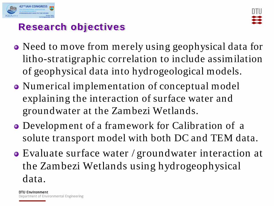
Research objectives Need to move from merely using geophysical data for litho-stratigraphic correlation to include assimilation of geophysical data into hydrogeological models. Numerical implementation of conceptual model explaining the interaction of surface water and groundwater at the Zambezi Wetlands. Development of a framework for Calibration of a solute transport model with both DC and TEM data. Evaluate surface water /groundwater interaction at the Zambezi Wetlands using hydrogeophysical data.

CHI implementation

The study area

The study area

Kasaya Transect
(Bauer-Gottwein, 2010)

DCIP-TEM results Resistivity and chargeability x-sections from joint DCIP-TEM inversion

The IP experiment of Slater & Lesmes
Slater and Lesmes, 2002

Important hydrological mechanisms
Seasonal annual precipitation ( ~ 808 mm) Seasonal flood cycle ( 1- 4 months) Potential evapotranspiration (~ 1500 mm/ annum) Neighboring wetlands

Conceptual hydrological model

CHI preliminary result

Conclusions
A SEAWAT model with evapotranspiration as the main climatic forcing was able to simulate the intrusion of fresh surface water into a pre existing saline environment
Calibration of the SEAWAT model with DC and TEM data resulted reasonable and sharp estimates of hydraulic parameters
The SEAWAT model x-section was largely in agreement with the geophysical data, an indication of plausibility of the initial conceptual model
Copyright © 2022 FDOKUMEN