Part I of James's Account of S. H. Long's Expedition, 1819–1820
South African Archaeological Bulletin 68 (197): 00–00, 2013 1
Research Article
SETTLEMENTS, LANDSCAPES AND IDENTITIES AMONGTHE TSWANA OF THE WESTERN TRANSVAAL AND
EASTERN KALAHARI BEFORE 1820
FRED MORTONDepartment of History, University of Botswana, Private Bag UB 00703, Gaborone, Botswana
E-mail: [email protected]
(Received November 2012. Revised March 2013)
ABSTRACTThis paper suggests that our appreciation of Tswana history in the17th and 18th centuries can be improved by taking into considerationthe diverse types of landscape the many Tswana groups attached them-selves to. Making the argument has required generating forms ofcorroborating evidence: plotting settlements derived from oraltraditions; linking resettlement patterns to territory with overlays ofterrain, soil and water resources; measuring likely territories con-trolled by individual groups; using archaeological studies and theobservations of early 19th-century travellers to determine the rela-tionship of settlements to water, agricultural and grazing resources,and finally, using totemic identities as a measure of mobility as relatedto landscape. There appears overall to be an east-to-west pattern oflandscape resources that correlates with individual Tswana settlementoptions. From east to west, rainfall, water and soils decline in quantityand quality, leading to greater territory deployed to sustain agricul-ture and grazing, with the nature of settlements adapting accordingly.The larger the territory, the greater was the incentive for leaders to useforce to control or expand it. The paper seeks to refute widely heldassumptions that the pre-1800 Rustenburg area in the Transvaal wassuffering from increasing violence and demonstrates that Hurutshehegemony, such as it was, could not have extended much beyond theSwartruggens area to include Rustenburg-Pilanesberg. It suggests,however, that conflict was on the rise in the pre-1800 period among theKalahari Tswana. It also supports the broadening of archaeologicalanalysis through the use of oral traditions, language analysis, terrainanalysis and other contextual approaches, as well as the application ofgeographical information systems software, to historicise the archaeo-logical record. It suggests that some Tswana groups preferred to moveperiodically and build smaller and more sustainable settlements ratherthan attach themselves to mega-sites.
Key words: Tswana, Transvaal, Kalahari, settlements, landscape,totems.
INTRODUCTIONA simple and hardly novel argument is offered here: that
our appreciation of Tswana history prior to 1820 can be improvedby taking into consideration the diverse types of landscape themany Tswana groups attached themselves to. What is newhere is the manner in which this argument is made. It is theresult of generating forms of corroborative evidence: plottingsettlements derived from published oral accounts; linkingresettlement patterns to territory with overlays of terrain, soiland water resources; measuring likely territories controlledby individual groups; using archaeological studies and theobservations of early 19th-century travellers to determine therelationship of settlements to water, agricultural and grazingresources, and finally, using totemic identities as a measure ofmobility as related to landscape.
Additionally, there appears overall to be an east-to-west
pattern of landscape resources that correlates with individualTswana settlement options. Sansom (1974) drew attention toeast-to-west variations in traditional economies, using theDrakensberg as the dividing line. What is apparent, at leastfrom this study, is that even in the much smaller territoriesexamined, significant variations also apply in this manner.Thus, when moving from the western Transvaal (Transvaalused throughout to indicate the geographic region betweenthe Vaal and Limpopo Rivers) to the eastern Kalahari (Fig. 1),rainfall, water and soils decline in quantity and quality, leadingto greater territory deployed to sustain agriculture and grazing(a study of hunting patterns awaits further research). In tandem,the nature of settlements adapts to these east-to-west patterns.In the east, settlements adjoin good soils, grazing and watersupply, whereas toward the west, soils and grazing tend to befurther away from the main settlements. The further west onegoes, settlements or posts for cattle have to be maintained toofar away for herders to live at the main settlement, and tillerslikewise may be required during growing season to live awayat the fields, or lands. The larger the territory, too, the greaterthe incentive for leaders to use force to control or expand it.
Another outcome in developing this argument is the addi-tional evidence generated to overturn a version of Transvaalhistory that has been in vogue among historians and archaeol-ogists for the last seventeen years. I refer to Andrew Manson’sarticle in Mfecane Aftermath (Manson 1996). Briefly stated,Manson uses a few of Breutz’s traditions to state that theHurutshe had dominated the western Highveld until c. 1750,after which previously ‘subordinate chiefdoms’ broke awayand came into conflict with one another over control of land,cattle and women, amounting to escalating violence in theregion prior to the mfecane. Manson’s narrative was accepted byNeil Parsons, who published in the same volume, and bothManson’s and Parsons’ stance has been adopted by archaeolo-gists working in the Transvaal to the present (e.g. Hall et al.2008; Wright 2010; Hall 2012). An article refuting Manson’sconclusions as being based on limited, selective use of Breutz,appears not to have made any headway (Morton 2008). Briefly,the 2008 article compares traditions collected by Breutz amongthe eight largest Rustenburg-Pilanesberg area Tswana groups,and demonstrates that violence was not on a significant riseduring the pre-1810 period; that, apart from the Tlhako, allthese groups retained control of their neighbouring territories,and that they were not expanding at one another’s expense.
The evidence assembled for this paper supports the 2008conclusion. Moreover, it demonstrates that Hurutshe hegemony,such as it was, could not have extended much beyond theSwartruggens area to include Rustenburg-Pilanesberg. Breutz(1953: 50) concluded that the Hurutshe occupied only the“western half of Rustenburg district,” i.e. west of the Selons

River and therefore west of the territory of the MmakauKwena. Though regarded as senior in reckoning descent insocial gatherings and rituals, the Hurutshe exercised controlover a limited territory from their capital at Tswenyane. Theirswas not a militarised or imperial force, and the Hurutshe begansubdividing as early as the 17th century. Where conflict was onthe rise in the pre-1820 period, moreover, was not in theRustenburg-Pilanesberg area, but among the Tswana occupyingthe eastern Kalahari. The frequency of cattle raiding in theKalahari sandveld increased steadily from the mid-18th centuryto the early 19th century, stimulated by Korana and Griquaexpansion north of the Orange River and Moleta, and byMakaba’s Ngwaketse expansion south towards the Hurutsheand Rolong after breaking away from the Kwena. Diutwileng’srelocation of the Hurutshe capital from Tswenyane toKaditshwene atop a nearby hill was a response to this regionalconflict, as was Moleta’s stone wall settlement at Pitsa andMakaba’s settlement on Kanye Hill.
SOURCES AND METHODSPre-colonial Tswana-speaking people are distinct among
other southern Africans as having acquired linguistic, socialand judicial similarities over four centuries while colonising alarge area of diverse terrain and climate, living in temporarysettlements, and forming small to mid-size independent, sub-dividing communities made up of lineages of heterogeneousorigin. Though close to Sotho-speakers linguistically, Tswana-speakers’ history has been characterised by expansion; divisionand resettlement; absorption of outsiders; adaption to highlyvaried geographical conditions; the centrality of cattle, andresistance to strong hierarchical authority.
Yet, the prevailing literature on the Tswana has created theimpression that they are monolithic in nature, sharing moreor less identical societal structures, spatial arrangements, andpolitically centralised institutions. Such notions stem from thepreponderance of Tswana research carried out on the easternfringe of the Kalahari by Schapera with reference to the Kwena,Kgatla, Ngwato, Ngwaketse and Tawana of Botswana, and bySchapera and others to a lesser degree on the Rolong andHurutshe of the northern Cape. Left largely unattended in the
historical literature are the Tswana groups stretching across theTransvaal and parts of the northern Cape for whom the worksof Breutz and Ellenberger offer the most insight. Breutz in par-ticular has produced an abundance of valuable ethnographicand historical information on the South African Tswana.Nevertheless, Breutz’s attempt to integrate his evidence into ageneral history within the broader Tswana spectrum, while animportant resource, lacks Schapera’s coherence and, by virtueof being privately published, has had a limited audience(Breutz 1987). Thus, Schapera’s work, such as The Handbook ofTswana Law and Custom (Schapera 1938 et al.1) and otherBechuanaland-based studies such as Willoughby (1900, 1928),Wookey (1922) and Brown (1926), have remained the primaryreference point for historians and archaeologists. A recenthistory of the Fokeng of Rustenburg, for example, ignoresBreutz and uses Schapera instead to describe the Fokeng’ssocial and political organisation (Mbenga & Manson 2010). Yet,when joined with the archaeological and geographical record,evidence from Breutz and others demonstrates that Fokengand other Tswana groups in the western Transvaal bushveldutilised a significantly smaller area than did the Tswana of theKalahari sandveld described by Schapera. Archaeologistsworking in the Transvaal also have tended to lean on Schaperawhen analysing social and settlement patterns (e.g. Pistorius1992; Plug & Badenhorst 2006; Anderson 2011) and, while notingthe close proximity of Transvaal settlements to agriculturalactivity (Huffman 1986; Boeyens 2003; Hall et al. 2008; Anderson2011), have yet to determine whether or not cattle and otherstock were grazed nearby. In the literature on the pre-1820Tswana, the cattle-post system remains an assumption. Whathas been lacking, therefore, is a study of Tswana-speakingpeoples occupying varied landscapes over time.
Bringing the Transvaal, not to mention the northern CapeTswana into the discussion, however, presents its own chal-lenges. Unlike the Tswana of the Kalahari, who occupied largeterritories that were not significantly altered by the impositionof the Bechuanaland Protectorate (1885–1966), almost allTswana in the Transvaal were dislocated from their historicalspheres of settlement by the invasions that began with the Pediin c. 1810 and ended with the land policies of the Zuid
2 South African Archaeological Bulletin 60 (182): 72–78, 2005
FIG. 1. Settlement areas, eastern Kalahari and western Transvaal before 1820.
South African Archaeological Bulletin 60 (182): 72–78, 2005 3
Afrikaansche Republiek (ZAR). Evidence of their pre-1810 past isreposed in assorted oral traditions/histories collected in the1930s and 1940s among Transvaal emigrants resettled inBechuanaland (Ellenberger 1937 for Lete; Ellenberger 1939 forTlokwa; Schapera 1942 for Kgafela Kgatla; Matthews 1945 forRolong), and in the 1950s among the Tswana fragments thatsurvived on farm settlements in the then Transvaal and northernCape (Breutz 1953, 1956a,b, 1963). Among the BechuanalandTswana, Isaac Schapera (born 1905 in Little Namaqualand)carried out research by staying in their capital settlements andemploying assistants to gather his information (Kuper 2002).Meticulous, thorough and eventually fluent in Setswana,Schapera visited Bechuanaland off and on between 1929 and1934 and 1938 and 1943, shouldering much of his publishedwork on the Kgatla of Mochudi. Paul-Lenert Breutz (b. 1912 inHamburg, Germany), on the other hand, started collectinghis data from more than fifty small, scattered and disjointedcommunities in a single year (1936). He later worked as aGovernment Ethnologist in the Department of Native Affairs,Pretoria (1948–1977), where he updated his material andfrom 1953 began publishing his seven volumes on the Tswanain the department’s ‘tribes’ series. Breutz gathered his datausing a questionnaire-style cum catalogue approach andpublished his data largely ‘uncooked’; that is, in unsynthe-sised, tribe-by-tribe data in an unvarying, prescribed set ofsubheadings. Breutz’s introductions to each volume providedan historical narrative of the district by importing informationfrom archival and published travellers’ accounts, and drawingon other scholars, but the bulk of each ‘tribe’ publication con-sists of separate units by tribe, each subdivided into district,name of tribe, chief, language, land and population, migrationand affinities, history and genealogy of chiefs, politicalorganisation, etc.
Unsurprisingly, the contrast between their publications isstriking. Schapera’s study of a few, long-established, large,contiguous communities mostly of common descent showedthat their pasts overlapped and their institutions bore closeresemblance to one another. Moreover the corpus of his historicaldata was well suited to corroboration and thematic reconstruc-tion. On the other hand, Breutz’s research among many small,widely-scattered groups yielded a fragmented record, albeitcopious in amount, of raw data for each group, district by district.Breutz’s attempts to cross-reference such common data aspersons and events, and his indexes, though unorthodox, arehelpful, but his published work also contains a number ofcontradictory statements, perhaps because the oral data werehastily collected, if not hastily produced for publication. Inretirement, Breutz attempted to synthesise his material andinfuse it with published ethnographic literature and 19th-centurytravel accounts, but he remained tied to the group-by-groupformat of his ‘tribes’ series (Breutz 1987). His few interpreta-tions of Tswana origins and the emergence of Tswana materialand cultural features contain some profound insights, butmore often they are the product of outworn and occasionallydiscredited quasi-anthropological theories. Nevertheless,Breutz’s publications have proved valuable for historians andarchaeologists, mainly because of the large amount of unfil-tered information to be found in his ‘tribes’ series, much ofit derived from Tswana informants or recorders and fromacknowledged written and published sources. Breutz’s publi-cations are flawed, but they are also rich with data, and it ishard to imagine understanding the Tswana in a larger sensewithout them.
Particularly valuable in the Breutz record are the detailedgeographical locations of Tswana settlements. His informants
commonly associated Tswana site names with 19th-centuryDutch-rendered farms (Schapera’s Kgatla and Ellenberger’sLete and Tlokwa informants in the 1930s often did likewise)and, in turn, settlement names are remembered in connectionwith previous leaders (dikgosi) and in the later periods with theformation of named age-sets, or so-called ‘regiments’(mephato)(Morton 2012). They also narrate other events as occurringwhile settled at a particular site. Such internal corroborationhas induced Breutz to estimate the years in which any eventtook place, such as when a reign began or when an age-set wasformed, though he adopted no systematic measure in thisregard. Nevertheless, the uniformity of settlement-linkedtraditions among the many Transvaal Tswana groups enablesus to reconstruct settlement patterns over time and, with them,to reach some conclusions about the integrity of Tswanagroups, inter-Tswana relations, and their strategies of land-scape selection and use. For example, preliminary comparisonsof Transvaal Tswana settlements suggest that considerablevariation existed among the Transvaal Tswana in the way theyutilised territory. Naturally, when considering the terrain ofthe Transvaal, particularly that stretching from the central tothe western portions, which is characterised by rocky hills andslopes, bushveld, perennial streams and arable soils, we wouldexpect that the groups that occupied it from at least the 17th tothe early 19th centuries adopted strategies of settlement andterritorial use that differed from the Kalahari Tswana, forwhom aridity and the scarcity of good soils and permanentwater supply were overriding considerations (for a survey ofthe Transvaal area’s topography, climate, geology, soils, andvegetation, see Morton 2008 and Anderson 2011).
Comparisons of major settlement and land-use variationsmay also contribute to the discussion of the nature of totemicidentities and their relevance to dominant and constituentgroups subsumed within a larger (‘tribal’), common groupidentity. The pre-colonial Tswana have long been understoodas a set of independent entities made up of wards and sectionsof heterogeneous origin (Schapera 1952a). It has been arguedlately that ethnic or tribal labels are 19th-century euro-constructsand were illegitimate then among the Tswana, who gave prece-dence to totemic identities (Landau 2010). What is suggestedhere, rather, is that group, totemic and other identities co-existed prior to the arrival of European inquisitors, that theymay play a role in historical reconstruction, and that the totemiccomposition of Tswana ethnicities was significantly alteredafter 1810.
For consideration here are the various Tswana entities thathad come into existence by the 18th century and managed tosurvive through the vicissitudes of the early-to-mid 19th cen-tury and into the 20th century, albeit in reduced form. Roughly,the Tswana discussed here were administered by the ZuidAfrikaansche Republiek (ZAR) (1852–1902); the Transvaal Govern-ment (1902–1910), and the Union of South Africa, TransvaalProvince (1910–1960) made up of the Marico, Rustenburg andPilanesberg districts. Their persistence likely was enhancedthrough the absorption of the fragments of groups disintegrat-ing from the Kololo and Ndebele incursions. As Smith noted in1832, when travelling in this area “…the number of little dis-tinct tribes in the country must in old times have been verygreat, as the names of so many are mentioned and each inde-pendent of the others” (Smith 1832: 131).
What follows is a set of descriptions of Tswana groupsusing their recorded recitation of events, places, lineages,poetry and other traditions/histories with maps and databasesto chart the sequence of their settlements over generations. Bycreating this form of evidence, it is possible to determine with

some clarity the manner in which different Tswana groups uti-lised their respective landscapes before 1820. The method of re-construction goes as follows: in oral histories published by Breutz,Ellenberger and several others, settlement Tswana placenames are commonly associated by informants with specific,surveyed farm names. The approximate location of settlementscan be determined within farm boundaries found on topo-cadastral maps in comparison with the original farm templatedownloaded from the Agricultural Geo-Referenced System’sComprehensive Atlas (AGISCA) (http://www.agis.agric.za/agisweb/?MIval=agish_content.html#). In turn, landscapefeatures associated with these settlements can be downloadedfrom the AGISCA (rivers, soils, terrain) and Google Earth(rivers, terrain).
SETTLEMENT PATTERNS AMONG THETRANSVAAL TSWANA
Mapping Transvaal Tswana settlements reveals consistentpatterns of site selection and considerable variation in patternsof territory utilised. High-resolution Google Earth images ofstone-wall sites recorded throughout the Highveld and easternescarpment point to the same conclusion (Merlo & Mothulatshipi2012). The most common choices of settlement location wereon elevations close to streams, arable soils and grazing. Incontrast to the Kalahari Tswana, whose main settlements hadpermanent water often at a distance from arable soils andgrazing, Transvaal Tswana settlements made it possible forinhabitants to have access to all three essential resources withinrelatively short walking distance. Where Transvaal Tswanavaried in pattern was size of territory within which resettlementtook place. For purposes of analysis, they are grouped accord-ing to five distinct (re)settlement patterns. The eleven Trans-vaal groups represent the traditions contained in Breutz (1953),Coertze (1987), Ellenberger (1937, 1939), as follows (withoutstandard prefixes): Fokeng, Kgafela Kgatla, Lete, ModimosanaKwena (Mmatau/ Matlhaku, Ramanamela/Maake), Phalane,Phiring, Po, Tlhako and Tlokwa; and for the Hurutshe, Breutz(1956b).
SINGLE SETTLEMENTS RELOCATED NEARBY(PHIRING, PO, TLHAKO AND TLOKWA)
Simply put, in each case, over a century or more, within ageneration, each of these groups resettled within fifteen kilo-metres of their previous settlement. When the settlements areplotted together, they enclose an area with a radius of roughlynine kilometres. Two of these (Tlhako and Tlokwa) relocatedtheir settlements in roughly the same area, corresponding tothe slopes and plains west of the Pilanesberg. In other wordsthey were historical neighbours sharing the same landscape.The Tlokwa ‘mega-site’ of Marathodi is located within this areabut is aberrant in that it, like the well-known Kaditshwene‘mega-site’ north of Zeerust, was located away from good soilsand was occupied for a brief period. Their atypicality will bediscussed later in the paper. The Po, located at the eastern edgeof the Magaliesberg near present Brits, relocated at short dis-tances from their previous settlement, all on the lower slopes,adjacent to water, good soils and facing excellent grazing on theplains to the north (Breutz 1953). It is possible that the Po or aprecursor located their main settlement at Malle Hill in theplains west of Brits (Pistorius et al. 2002).
SINGLE SETTLEMENTS OCCUPIED FOR ANEXTENDED PERIOD(MODIMOSANA KWENA–MMATAU/MATLHAKU,RAMANAMELA/MAAKE, FOKENG, HURUTSHE. See Fig. 2)
The four Modimosana Kwena groups originated from thelegendary Rathateng along the Limpopo, and migrated sepa-rately to their eventual destinations (McDonald 1940; Breutz1953; Pistorius 1992). In the late 1600s, Mmatau, Matlhaku andRamanamela briefly settled at Mafatle immediately west of thenorthern Magaliesberg. The Ramanamela moved west toBoitsemagano north of Swartruggens, where they were joinedby the Maake in the late 1700s. No later than mid-18th century,the Mmatau and Matlhaku had settled permanently severalkilometres southeast of Mafatle at Molokwane, well known asone of the Transvaal’s mega-sites (Pistorius 1992). The Fokeng,who appeared in the Magaliesberg area in the mid-to-late
4 South African Archaeological Bulletin 60 (182): 72–78, 2005
FIG. 2. Long-term settlements before 1820.

South African Archaeological Bulletin 60 (182): 72–78, 2005 5
16th century, later settled permanently at Phokeng on the easternslope of the northern Magaliesberg (Breutz 1953; Coertze 1987;Pistorius et al. 2001). Similarly, the Hurutshe made Tswenyanetheir principal settlement from the 16th until the late 18th century,when Kaditshwene was established on the adjacent hill(Breutz 1956a; Boeyens & Cole 1995; Boeyens 2000). Likewise,the offshoot Manyane Hurutshe remained permanently inBorutwe (Mangope siding) after leaving Tswenyane in the 17thcentury. And after the regent Diutweleng made Kaditshwenethe capital in the 1790s, Tswenyane remained occupied.Readily available to all settlement locations in this category,with the exception of Kaditshwene, are plentiful water, excel-lent soils, and access to nearby grazing.
MULTIPLE SETTLEMENTS OVER EXTENSIVE TERRITORY(KGAFELA KGATLA).
This group’s management of territory has been describedat some length (Morton 2008, 2010). Briefly put, at differenttimes, the Kgatla maintained contemporary settlements near tomining, grazing and agricultural resources from the Dwarsbergto Rooiberg and the northern Pilanesberg area. What can beadded here is that their principal settlement, where the seniorroyal resided, itself shifted regularly in an area enclosed by thePilanesberg, Waterberg and the Oodi River (Fig. 3). Thoughakin to other Transvaal Tswana in their preference for slopesand access to water, the Kgatla locations were relatively brieflyoccupied and removed from good soils. The Kgatla zone ofsettlement also stands in contrast with most others utilised bythe Transvaal Kgatla in that it is situated in the more arid andless fertile thorny bushveld.
SINGLE SETTLEMENT RELOCATED TO ANDFROM DISTANT POINTS(PHALANE).
Like the Kgatla, the Phalane settled in the thorny bushveld,to the north of the Kgatla and around the slopes of theWaterberg. They settled on marginal land, which they vacatedto gain refuge with the Mmapela Laka before returning to theiroriginal settlement at Tlhapelabjiale.
RELOCATION OF A SINGLE SETTLEMENT OVERAN EXTENSIVE AREA ON AN EAST-TO-WEST PLANE(LETE).
The Lete are among the several ‘Transvaal Ndebele’ whoemigrated from KwaZulu-Natal in the late 15th or early16th century and settled and assimilated among the Tswana inthe present Limpopo, Gauteng, and North West provinces.With the exception of the Lete, the Transvaal Ndebele weresettled more or less permanently by the 17th century. Beforereaching Tswane (Pretoria) in the late 16th century, some of theoriginal immigrants had hived off in the Limpopo province(Mokopana, Laka, Mmauna, Letwaba, Seleka). After a severefamine, a further split at Tswane occurred, with the Po,Hwadubu, Tlhako and Moephshwe moving to their own finaldestinations in the Limpopo, and North West provinces, andthe central district of Botswana, respectively. The Lete, on theother hand, for the next two centuries, relocated steadily in awesterly, albeit sometimes back-and-forth direction. By the late17th century, after moving in turn to Majwaneng, MafhikaaTlhoe, Kgetleng, and Mmatshidi, they had settled atRabogadi, near Groot Marico. Over the next century, theymoved into Botswana near Ramotswa, before returning to theTransvaal and establishing a settlement at Lotlhakane north ofSwartruggens. They remained there for a number of decadesand became prosperous and powerful. In the early 19th cen-tury they were attacked and scattered by a joint Hurutshe andNgwaketse force, regrouped and eventually settled atRamotswa (Ellenberger 1937). At Lotlhakane, where the dura-tion of Lete occupation was their longest, the landscape is note-worthy for its abundant water, arable soils and grazing. Theplaces where they settled for shorter periods, such as atRabogadi and the pans near Ramotswa, were iron ore sources.The Lete were noted smelters and smiths.
SETTLEMENT PATTERNS OF THE KALAHARI TSWANAThe Tswana discussed here border or straddle the southern
and eastern Kalahari sands. From south to north: Rolong,Ngwaketse, and Kwena. The Ngwato of Central Botswana, ac. 1770 Kwena offshoot, and the Tawana of northwestern
FIG. 3. Kgafela Kgatla settlements before 1810.

Botswana (Ngamiland), a late 18th-century Ngwato offshoot,have not been included, because until the 19th century, theNgwato were unable to establish themselves as the majorentity in central Botswana (Parsons 1973). The Tlhaping andTlharo have also not been included, because their autonomy inthe 18th century is suspect and from 1780 their communitieswere increasingly buffeted by turmoil emanating from theOrange River area (Penn 2005; Legassick 2010). Other, small,Tswana-speaking groups, such as the Kaa, Khurutshe andMmanaana Kgatla, were located among the former, butsurvived mainly as dependencies of larger groups. In the late19th century, the Kalahari Tswana in present North Westprovince and Botswana fell under the authority of the CapeGovernment and the British Colonial and Dominions offices,respectively.
The North West province Tswana (Tlhaping, Tlharo,Rolong) represent long-standing occupation, the Rolong beingthe oldest residents; the Tlharo being an early Hurutshe off-shoot that failed to establish an autonomous territory, and theTlhaping, a Rolong offshoot of uncertain independence untilthe late 18th century. Only the Rolong sustained over timetheir occupation of a significant area, though in the mid-18th century its royal family subdivided into the autonomous,contiguous Ratlou, Tshidi, Seleka/Rapulana and Makgotlagroups. During the reign of Tau (c. 1720–1750), which immedi-ately preceded their subdivision, the Rolong controlled fromTau’s capital of Taung, a large area extending north to theMolopo and over to present-day Ottoshoop and Klerksdorp(Breutz 1956a). Before establishing himself at Taung, Tau hadbuilt Moletwane (near Ottoshoop) and Tsebetwane approxi-mately 35 km west-northwest of Mahikeng. Tau’s three capitalshad similar terrain attributes: on slight elevations above plainstransected by a stream (Molopo, Molemane, Harts). Tau’scontrol of his territory, however, became tenuous. Tlhapingand Tlharo were obliged to acknowledge Rolong supremacybut found ways to distance themselves from his control. Ulti-mately, Tlhaping resistance led to Tau’s death, the division ofthe Rolong, and the gradual emergence of the Tlhaping and
Tlharo as autonomous, but weak, dividing entities beset byraiders on their southern borders and inclined to protect them-selves by shifting their settlements to the west in the ever drierKalahari.
The Botswana Tswana (Kwena and its offshoot Ngwaketse,who broke away c. 1750) are immigrants from the Transvaalwho entered the Kalahari sandveld in the 18th century orbefore, encroached on its Kgalagadi and Bushman (Sarwa)occupants, and displaced or subordinated them (Schapera &Van der Merwe 1945; Ramsay 1991; B. Morton, 1994; Okihiro2000). In the 20th century, the Kwena, Ngwaketse and Ngwatowere the principal subjects of study by Isaac Schapera, thoughmost of Schapera’s research pertains to the Kgafela Kgatla, whomigrated to Bechuanaland from the Transvaal in the late19th century and occupied the eastern territories of the Kwena(Morton 2009).
In the 18th century the Kwena and Ngwaketse had sizeablecapitals and each controlled a large territory (Schapera 1942a,1952b, 1980). They shifted their principal settlements from onehill location to another. The stone-walled Ngwaketse capital ofKgosi Moleta (ruled c. 1770–1790) at Pitsa covers c. 1.5 km2 andcontains at least 40 stone stock enclosures (Fig. 4), including onewith an area of 1.1 acre, which if allotting 102 metres per adultcow, could contain in excess of 400 cattle. Under Makaba II(1790–1824), the Ngwaketse controlled a large territory, fromthe Molopo to the southern boundary of the Kwena, andstretching west into the Kalahari. They were capable of raidingas far as 360 km west of their capital and south into the territo-ries of the Hurutshe, Tlhaping and elsewhere. Makaba’s principalsettlement was Kanye Hill, which he fortified with stone walls.Of the 18th- and early 19th-century Kwena settlements, apartfrom the reign of Motshodi (c. 1740–1770) at Oodi, Mosweu andPhuthadikobo (present Mochudi), they moved between twosettlements close to one another, i.e. on the hills of Dithej(w)aneand Shokwane, on either side of the modern Kwena capital,Molepolole. Driven by succession conflicts and weakened bythe departure of the Ngwato, the Kwena were also at logger-heads with the Ngwaketse, but they also attracted many Taung
6 South African Archaeological Bulletin 60 (182): 72–78, 2005
FIG. 4. Pitsa central settlement (mapping detail overlay on Google Earth by Thabo Kgosietsile and L.O. Thabeng).
South African Archaeological Bulletin 60 (182): 72–78, 2005 7
immigrants from the south (Okihiro 2000). Judging by the loca-tion of their early cattle posts, the Kwena controlled an arearoughly equivalent to that of the Ngwaketse.
SETTLEMENTS, TERRITORY AND LANDSCAPESThe brief summary above of different Tswana settlement
patterns can now be joined to a discussion of other distinguish-ing features among pre-1800 Tswana. To clarify, we are con-cerned here neither with the respective Tswana origins, whichare in little dispute (Legassick 1969; Ngcongco 1979; Huffman2007; Landau 2010), nor in their relative seniority when itcomes to social and political rituals, which has been a mainstayof comparative discussions about them for decades. Rather ourattention now is on the events in the century prior to 1820 asthey relate to the physical landscape on which these Tswanaentities built and sustained their societies. To put our concernin the form of a question; did the historical location of Tswanasettlements reflect, and in any way determine, how they lived?The conclusion at this stage is that they did, and in ways thathelp us understand the Tswana in a comparative and dynamicsense before their history entered the modern period. Thesudden and then steady arrival of more powerful forces in theTransvaal and northern Cape, post-1800, began the phasewhich determined the 20th century shape and prospects of theTswana. Long before 1820, the Tswana had been connected,mainly through trade, to the larger region, and among themore powerful of them, responsible for terminating the auton-omy of their neighbours, but I equate the ‘modern history’ ofthe Tswana to that period when their own autonomy steadilysubsided, though at varying rates. The main sources forrecounting Tswana events and activities remain as before,namely the oral record and use of landscape-related data.
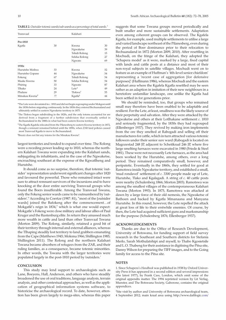
Measuring the landscape area they used leads to the firstclear distinctions we can make among various Tswana groups.Table 1 represents the approximate territories utilised, if notalways controlled, by what is often assumed to be the morepowerful Tswana ‘chiefdoms.’ The Ngwato have been includedto demonstrate the contrast between the pre-1820 and modernperiods. It would be difficult to represent their pre-1820 territory,when they controlled an indeterminately small area. Their‘growth spurt’ came in the modern period, which was partlytrue of the Kwena until 1875 and, to a lesser degree, theNgwaketse. The Tswana displayed in Table 1 are the largest ofthe Tswana territorial groups with 18th-century settlements.The possible exception is the Mogopa Kwena, whose history isdifficult to reconstruct because of the thin oral record likelycaused by more severe displacement suffered by them thanother Rustenburg District Tswana. Tlhaping and Tlharo territoryis also indistinct before 1800, whereas post-1800 Tlhapingsettlements have been well described (Shillington 1985).
Albeit rough, the estimates on Table 1 reveal the contrasts inthe extent of territory required to sustain these societies.Among the five Transvaal Tswana groups, only the KgafelaKgatla were in the habit of relocating settlements at any dis-tance. Three (Mmakau Kwena, Fokeng, Hurutshe) remained ina single capital for an extended period (Fig. 2), and the Tlokwarelocated each of their settlements very near to the previoussite, including Marothodi, the mega-site occupied prior to thearrival of Sebetwane and later intruders (Anderson 2011). It isno coincidence that the restless Kgatla alone utilised a land-scape with marginal soils. The other Transvaal Tswana werepermanent occupants of landscapes amidst ample resources insoil, water and grazing (Morton 2008). The Mmakau Kwenacapital of Molokwane, which was occupied in the 18th century(Pistorius 1992), grew steadily to become the largest stone wall
settlement in the region before its abandonment in the 1820s.“The Bakwena domain,” Pistorius (1992: 72) has remarked,“was populated by a formidable population involved in aprosperous agro-pastoral way of life perfected by their uniqueand successful adaption to an environment well suited forherding and agriculture”. He goes on:
The linear distribution of Molokwane’s settlements on anescarpment adjacent to the Ngwaritse [Selons] River valley isecologically favourable for a variety of reasons. The north tosouth orientation corresponds not only with the distributionof dykes and sills of diabase which were exploited at the seamsfor building material, but also with the flow of the NgwaritseRiver which was a permanent source of water essential for thelarge population and herds of cattle and small stock. The linearsettlement pattern also allows for agricultural fields andgrazing areas parallel and close to the village…. Good rainfall(probably higher than today’s), arable red soils suitable forcrop production, and variety of nutritious and palatable grassspecies for grazing, as well as abundant seeds from acacia treesand low, browsable shrubbery for goats and [grazing for]sheep, contributed to an agro-pastoral subsistence…
The Fokeng capital of Phokeng, likewise occupied fordecades prior to the Pedi invasion of c. 1810, bears similar land-scape attributes to that of Molokwane, and unlike the MmakauKwena, the Fokeng returned to Phokeng as early as 1834 andhave remained ever since. The reoccupation and subsequentgrowth of modern Phokeng, however, obliterated the remainsof its pre-1800 settlement, to the loss of archaeology. Theprocess of displacement appears to have started early. By the1860s, stone was passé and mud-plastered walls had come intovogue. In 1852, Phokeng’s c. 300 houses were made of stoneand plastered with mud (Sanderson 1860). Ten years later, a vis-itor to a much larger Phokeng saw wide streets intersecting thetown, many of its 600–700 round homes encircled by walls thatwere plastered much better than the “ordinary Dutch house”,and the houses thatched so well that they had a “betterappearance than any thatching I have seen in this country”. Hewas struck especially by the elaborate, decorative plastering ofwalls of houses, courtyards and even courtyard floors, whichwere “swept scrupulously clean, so that breakfast might havebeen laid on it”. He remarked as well on the “tasteful contrast”of polished, coloured abutments of the houses and the smoothsurfaces above (Unknown author 1862; also Maggs 1993).
TABLE 1. Territorial control (estimated territories*).
Group Territory Period (kgosi)controlled (km2)
TransvaalMmakau Kwena 311 Mid-18th century (Kgaswane)Tlokwa 330 Late 18th century (Makabe)Fokeng 1 470 Pre-1800 (Sekete IV)Kgafela Kgatla 2 623 Pre-1800 (Pheto I to Pheto II)Hurutshe 3 023 Pre-1800 (Motebele to Duitweleng)
KalahariRolong 27 969 Mid-18th century (Tau)Ngwaketse 16 545 Late 18th century (Makaba II)Kwena 16 299 Early 19th century (Moruakgomo)Ngwato 192 303 Late 19th century (Khama III)
*Rough estimates using http://www.freemaptools.com/area-calculator.htm linked toGoogle maps, territorial markers based on capital locations over time plus reach ofpower (cattle posts, incidents of successful raids, battles). References to such locationsand claimed boundaries are derived from Ellenberger (1937, 1939); Schapera (1942,1952b, 1980); Breutz (1953, 1956a,b, 1963) and, in the case of the Ngwaketse, from thedeposition of Gaseitsiwe aMakaba, 20 May 1871, (unknown author 1871) and for theNgwato, from Khama’s letter of 13 May 1888 (Dachs 1975).
Tswenyane, the ancient Hurutshe capital, was never reoccu-pied after Mzilikazi’s arrival (though the Ndebele brieflysojourned there after being ousted from Mosega). The site hasbeen surveyed on foot on several occasions but has not beenaccurately measured or excavated.
Insofar as the Transvaal Tswana are concerned, it seemsreasonable to conclude that their settlements were locatedwithin short, walking distance of grazing, crop fields and water.This was probably true also of the Kgafela Kgatla, though theeasy depletion of the marginal soils in their settlement land-scape may explain their more frequent resettlement over awider area. According to Isang Pilane, Kgatla regent based inMochudi, Bechuanaland:
Long ago the Bakgatla Tribe in the Transvaal lived at the cattleposts on account of there being plenty of room because nowhite people had yet come there, there was much freedomand plenty of water. Every Headman knew where the Chiefwas [and] the lands and cattle were near. Everyone was nearthe lands and pasture and worked on the spot. In the morningthe man would go off hunting game for meat, the womanwould go to the lands to hoe or weed, or harvest, and the boysof the family would drive the cattle to the pasture lands andherd them there. In the evening the man would return withsome game for the pot, the woman would bring in greenmealies or pumpkins, and the boys – after driving the cattlehome – would bring milk to their mothers
(Bechuanaland Protectorate Native Advisory Councilminutes, 10th session, 15 April 1930: 19, Botswana NationalArchives and Records Services, Gaborone).
It would be a mistake, therefore, to envisage the 18th-century Transvaal Tswana as locating their settlements far fromlands and cattle posts, as is commonly assumed, and oftenderived from Schapera. An extreme example is a description ofthe Fokeng: “crop fields were located some eight to 40 kilo-metres away from the settlements…similarly, cattle…werekept by older boys at grazing posts some 64 or more kilometresaway, all year round” (Mbenga & Manson 2010: 25, citingSchapera 1938: 11).
Such was true for the Kalahari Tswana surveyed ethno-graphically by Schapera in the 1930s, but not for the Fokengand other Transvaal Tswana who were established by themid-18th century. The Hurutshe at Tswenyane, for example,who were accustomed to living near their resources, learnedhow difficult it was to live without adopting the ‘Schaperamodel’, when they relocated their capital to the hilltop site ofKaditshwene, which was removed from rivers, arable soils andgrazing (Boeyens 2000). For a time, they maintained large grainfields in the flat lands below the hilltop several kilometresaway, and grazed their cattle daily out on the plains beforereturning with them in the evening. They were able to sustain apopulation in this manner until it reached between 16 000 and20 000 people in 1820. At minimum, the Hurutshe would thenhave required an intake of at least 32 million calories a day,a conservative estimate using the modern requirement of2000 calories per day for an adult woman as an averagebetween an adult man (2500) and children and elderly (varyingbelow adult females) multiplied by 16 000 (National HealthService, UK; http://www.nhs.uk/chq/pages/1126.aspx?categoryid= 51&subcategoryid=165 (accessed 25 September2012)). We should bear in mind, too, that many Kaditshweneadults would have used considerable energy to climb up anddown the steep hillside, cultivating and herding below duringthe day, and carrying water (and grain when harvested) up tothe top of Kaditshwene each evening. The regent Diutwilengtold the visiting John Campbell, who asked why the town was
built upon a hill and not in the valley, that it was because of theenemies, and that several other towns for the same reason werebuilt on eminences, but they found it very inconvenient, beingso far from wood and water” (Campbell 1822: 232). The follow-ing year, when Stephen Kay arrived at Kaditshwene, he wrotethat: “Great poverty was apparent in the aspect both of old andyoung; and their reduced state induced them eagerly to eyeeverything that was at all edible” (Kay 1834: 198). Drought andinsecurity caused by conflict in the area were certainly contri-butors to Hurutshe hardship, but as designed, the settlement ofKaditshwene was unsustainable. Even at Molokwane, wherethey lived quiescently for decades, the Mmakau Kwena depletedthe soils and vegetation around it as their population increased(Pistorius 1992).
On the other hand, the Hurutshe’s enemy neighbour,Makaba’s Ngwaketse to the west whose territory bordered theKalahari, kept their cattle and many of their people at hilltopposts a distance away from their main settlement at Kanye.One of their major posts was located 32 km southwest of Kanyeon the two, adjacent low-lying hills of Motsenekatse, wheretoday, numerous stone kraals may be seen (Kilibone testimonyin Unknown author 1871; Pahl 1971; Segokgo 2012). Twelvekilometres northeast of Motsenekatse is the hilltop site of Pitsa,which is studded with cattle kraals and probably served asanother Ngwaketse post after Moleta (1770–1790) shifted hiscapital from Pitsa to Kanye (see Fig. 4). The Kwena, too, locatedtheir cattle posts on such hills as Lentswe le Tau, Morwa andpossibly Letlhakeng. The positioning of cattle and people awayfrom the capital appears to have been the pattern with theirneighbours immediately south, the Tlhaping at Dithakong andRolong at Mosheu. As Campbell remarked after being inDithakong in 1820: “The South African nations only cultivatethe ground in the vicinity of towns, though they have cattle-places at the distance of one and two day’s journey” (Campbell1822, II: 60). And while in Mosheu: “They have likewise manyout-posts for cattle, at all of which there are inhabitants”(Campbell 1822, I: 181).
It is possible that the Kalahari Tswana began placing cattleaway from the main settlement in response to the raidingculture stemming from the Orange River in the late 18thcentury and the retaliatory habits commenced in the 1790s byMakaba II of the Ngwaketse and which continued until hisdeath in 1824. Makaba’s belligerent reign is one for the recordbooks. He earned his spurs between 1790 and 1795 attackingthe erstwhile parent Kwena, from whom the Ngwaketse hadsprung, and then repulsed in 1798 or 1799 a combined force ofRolong, Korana, Griqua and the northern Cape bandit JanBloem. Over the next two decades, Makaba subjugated theMmanaana Kgatla and launched raids on the Kwena, Tlhaping,Hurutshe, Lete and others. His reputation as a regional menaceis attested by the combined force that then tried but failed todefeat him, made up of Tlharo, Tlhaping, Hurutuse, Kwena,Lete, Kgatla Kgafela and Korana. The Tshidi Rolong, whoseroyal family intermarried with Makaba, took sides with theNgwaketse (Ngcongco 1971). Thereafter Makaba directed hisrevenge at the Tlhaping.
Before the Tlhaping became the regular targets and perpe-trators of cattle raids, they were in the habit, like the Hurutsheand other Transvaal Tswana of keeping their cattle inside thecapital, as the assistant secretary of the Truter and SomervilleExpedition, P.B. Borcherds, observed in 1801:
They make superior herdsmen, and are very much attached totheir cattle and sheep. In the morning their herds are dividedin small groups, and placed in charge of different men, appar-ently the regular herdsmen of the town, by turns, who drive
8 South African Archaeological Bulletin 60 (182): 72–78, 2005

South African Archaeological Bulletin 60 (182): 72–78, 2005 9
their charges to pasture at fixed hours and return before thesun sets to stall them in their kraals. On coming home againthe cattle, in particular, are welcomed and caressed by theirowners, and the favourites spoken to in terms of endearmentor high eulogium…. When the cattle are secured, the men pro-ceed to the task of milking, and carry the milk home either inwooden or earthen jugs, the latter manufactured by thewomen. (Borcherds 1861: 126–127)
Campbell also observed an extensive stone wall settlementsouth of the Molopo too old for the Rolong to identify its previousinhabitants. It, too, reflects the centrality of stock-keepingwithin the main settlement:
30th [April 1820]…. We proceeded at ten a.m. and soon passedmany old cattle inclosures [sic], built of stone, some parts asneatly done as if they had been erected by European work-men. A town had evidently once stood on that spot, and thekraals we saw had been attached to the different districts. Itappeared to have been two miles in length and of considerablebreadth. (Campbell 1822, I: 97)
TOTEMS AND TSWANA IDENTITIESTo this point, references have been made only to long-
standing group labels (Rolong, Kgatla, Kwena, etc.) to docu-ment settlement patterns in relationship to landscape across awide area occupied by Tswana-speaking people in the 17th and18th centuries. From this point, a survey of totems (sereto, seano)is included to judge their relevance in differentiating amongthe various Tswana over time.
Until recently, totems have been studied or included onlyas an ethnographic component of Tswana societies andavoided when narrating historical developments (Willoughby1905 remains the standard source). To reverse this trend, PaulLandau’s Popular Politics (2010) uses totemic identities to inter-pret early 19th-century Tswana history. Landau has rejected“the ethnic or tribal approach [which] results only in a fog ofparticularity” (Landau 2010: 64). He dispenses with ethnic/tribal/group labels and uses mostly totemic or ancestral nameswith reference to courts, places and chiefdoms to give “furthermeaning by recovering the history surrounding their usage,not by explaining to the reader how they were used” (Landau2010: xiv). Thus the Rolong become “the people of Rolong,” theKgatla, “the ‘tan’ monkey people” (referring to their totemkgabo, which is rather the vervet or grey/blue monkey), theKwena the “people of the crocodile” (kwena in place ofBakwena), etc. Landau’s one-not-the-other approach jettisonssingle attributions he considers to be European-engineeredand misleading and elevates political labels that he considers tohave been Tswana-created and long-used. The effect, however,is the same, i.e. to use one identity for a political unit that hasdeveloped as a community made up of heterogeneous totems,origins and histories and one which, moreover, can relocate itsmain settlement physically each generation, if not more often.Sorting out the difference between group and totemic identi-ties can present befuddling challenges. What, for example, arewe to make of this statement made to Andrew Smith in 1835?
When they separated from the Barolong they had no cattle butlived upon fish therefore the other tribes gave them the nameof Batclapin which means eaters of Fish[.] The Barolongs alsocalled them Baborwa, that is to say the people of that countryfor them. They used to call themselves Buchuana other tribesgave them the name of Batlclapin. (Tlhaping Kgosi Mothibi,Smith 1832: 71–72)
Whether or not tribal/ethnic/group labels are replaced withtotemic and other identities, the task at least for the pre-1820Tswana here under review, is to determine the value of totemic
and group identities in explaining who these people were andhow they organised their lives.
Group and totemic identities both have, it would seem, arole to play. Group labels and succession lists make it possible totrack the movement of settlements and estimate territory,while totems enable us to explore the manner and time inwhich these societies expanded or altered. ComparingTransvaal and Kalahari Tswana is made easier because, whileall were made up of many different totemic groups, theyshared the same political arrangement. Each group was ruledby a senior family of several or more generations deep thatrevered one totem (which in some cases was abandoned foranother). Below them were other families of long or morerecent association, some of whom adopted the ruling totem butmore often than not revered other (outsider) totems (Schapera1952a). Such outsider totemic families had come under theruling family as immigrants or conquered subjects.
Totemic lists for most Transvaal and Kalahari Tswana showwide diversity among senior and outsider families, but oftenlacking is information on the circumstances that led to outsiderfamilies becoming juniors to the senior family. Schapera’s EthnicComposition (1952a) is the exception. His lists for each group fixthe approximate time and cause of each totemic group’s entryinto the territory of the ruling senior family. For many of theTransvaal Tswana, Breutz’s publications contain lists of wards,or what he sometimes calls ‘clans’, that usually are linked toparticular totems, though without any historical references.The same is true of Ellenberger’s articles on the Lete andTlokwa. For the three Transvaal Tswana who relocated toBechuanaland (Kgafela Kgatla, Lete and Tlokwa), Schapera’sEthnic Composition is detailed only with regard to the KgafelaKgatla, thus in effect for the Transvaal Tswana, apart from theKgatla, we are left with only totems that existed whenEllenberger and Bruetz recorded them. Another complicatingfactor is that all of the Transvaal Tswana interviewed by Breutzin the 1940s and 1950s consisted of groups that had beenuprooted and often scattered in the 1820s, and able to return totheir old neighbourhoods in the late 1830s only at the sufferanceof the Boers. It therefore becomes impossible, with the exceptionof the Kgatla, to determine which totemic groups belonged tothe Transvaal Tswana before 1810.
The pre-1810 Kgatla totems nevertheless are revealing. Ofthe fourteen non-kgabo totemic wards, twelve were establishedby immigrants, and only two (both Rokologadi, noko totem) byconquered subjects. In addition, eight original non-Kgatlaward families adopted kgabo after becoming Kgatla, six asconquered subjects, two as immigrants. The moments of incor-poration of the twenty-two non-kgabo were comparatively briefand confined to two. Three wards (Morema, Malebye I and II)were established by those conquered in the early 1700s, and theremaining 19 by those who joined (14) or were subjugated(five) between 1750 and 1790 (Schapera 1952a). This latterperiod corresponds to the emergence of the Kgatla as a militaryforce in the Rustenburg Pilanesberg area and as an ally ofMakabe’s Tlokwa (Morton 2012).
Let us assume for the moment that the Kgafela Kgatlaprovide us with this hypothesis: that the level of totemic heter-ogeneity is the consequence of the exercise of political and/ormilitary power. In other words, in the 17th and 18th centuries,those who sought safety and resources were at least as likely, ifnot more so, to submit willingly to a more powerful seniorfamily in the area as to be brought under its authority by force.The percentages in Table 2, which reflect the level of non-senior, ‘outsider’ totem identity, bear this out. Those withthe highest proportion in the pre-1810 period controlled the
largest territories and tended to expand over time. The Rolongwere a receding power leading up to 1810, whereas the north-ern Kalahari Tswana were expanding into the Kalahari sands,subjugating its inhabitants, and in the case of the Ngwaketse,encroaching southeast at the expense of the Kgwatlheng andHurutshe.
It should come as no surprise, therefore, that totemic ‘out-sider’ representation underwent significant changes after 1820and favoured the powerful. Those who remained intact weresure to attract remnant survivors of the incursions and to haveknocking at the door entire surviving Transvaal groups whofound the Boers insufferable. Among the Transvaal Tswana,only the Fokeng senior wards came to be outnumbered by ‘out-siders’.4 According to Coertze (1987: 81), “most of the [outsiderwards] joined the Bafokeng after the commencement…ofMokgatlê’s reign in 1834,” which is what one would expect:Mokgatle’s Fokeng were close military and labour allies of PaulKruger and the Rustenburg elite. In return they amassed muchmore wealth in cattle and land than other Transvaal Tswana(Morton 2009). The Rolong, similarly, retained a good bit oftheir territory through internal and external alliances, whereasthe Tlhaping steadily lost territory to land grabbers emanatingfrom the Cape (Matthews 1945; Molema 1966; Shillington 1985;Shillington 2011). The Rolong and the northern KalahariTswana became absorbers of refugees from the ZAR, and theirruling families, as a consequence, became totemic minorities.In other words, the Tswana with the larger territories werepopulated largely in the post-1810 period by ‘outsiders.’
CONCLUSIONThis study may lend support to archaeologists such as
Lane, Boeyens, Hall, Anderson, and others who have steadilybroadened the use of oral traditions, language analysis, terrainanalysis, and other contextual approaches, as well as the appli-cation of geographical information systems software, tohistoricise the archaeological record. To date, however, atten-tion has been given largely to mega-sites, whereas this paper
suggests that some Tswana groups moved periodically andbuilt smaller and more sustainable settlements. Adaptationeven among coherent groups can be observed. The KgafelaKgatla, for example, used multiple settlements to utilise a largeand varied landscape northeast of the Pilanesberg, even duringthe period of Boer dominance prior to their relocation toBechuanaland in 1872 (Morton 2009, 2010). After resettling inMochudi, on the fringe of the Kalahari, they adopted the‘Schapera model’ as it were, marked by a large, fixed capitalwith lands and cattle posts at a distance and most of theirnon-royal subjects in satellite villages. Mochudi went on tofeature as an example of Huffman’s ‘4th-level senior chiefdom’representing a ‘recent case of aggregation [for defensivepurposes]’ (Huffmann 1986), whereas Mochudi and the easternKalahari area where the Kgafela Kgatla resettled may be seenrather as an adaption in imitation of their new neighbours in aheretofore unfamiliar landscape, one unlike the Kgatla hadbeen settled in for generations prior.
We should be reminded, too, that groups who remainedsmall may therefore have been enabled to be adaptable andresilient. For the Lete, at least, smallness was the likely source oftheir perpetuity and salvation. After they were attacked by theNgwaketse and others at their Lotlhakane settlement c. 1810and seriously fragmented, by the 1830s they had regrouped(Ellenberger 1937). They revived by making iron implementsfrom the ore they smelted at Rabogadi and selling off theirmanufactures for cattle, which in turn attracted various totemicfollowers under their senior nare ward (Rabogadi is located onMagozestad 248 JP, adjacent to Scheitkraal 246 JP, where fivelarge smelting furnaces were excavated in 1980 (Friede & Steel1981). These were not necessarily Lete furnaces, as the area hadbeen worked by the Hurutshe, among others, over a longperiod. They remained comparatively small, however, andperipatetic. Eventually in the 1860s, they settled for good atRamotswa inside Ngwaketse territory, and established a small,‘mud rondavel’ settlement of c. 3300 people made up of Lete,Hurutshe, Tlako and Kgalagadi. A string of c. 40 cattle postswere nearby (Schulenberg 1866; Morton 2003). Ramotswa wasamong the smallest villages of the contemporaneous KalahariTswana (Morton 1993). In 1875, Ramotswa was attacked atdawn by a large force of their old nemesis, the Ngwaketse ofBathoen and backed by Kgatla Mmanaana and ManyanaHurutshe. In this round, however, the Lete repelled the attackat great loss of life to their erstwhile enemies. Of course, bythen, the Lete had acquired sufficient guns and marksmanshipfor the purpose (Schulenberg 1876; Ellenberger 1937).
ACKNOWLEDGEMENTSThanks are due to the Office of Research Development,
University of Botswana, for funding support of field surveyresearch in the Southeast and Southern districts for StefaniaMerlo, Sarah Mothulatshipi and myself, to Thabo Kgosietsileand L.O. Thabeng for their assistance in digitising the Pitsa site,Danny Wilson for preparing the TIFF images, and to the Goingfamily for access to the Pitsa site.
NOTES1. Since Schapera’s Handbook was published in 1938 by Oxford Univer-sity Press it has appeared in a second edition and several impressions(the latest 1977), by Frank Cass, London, which omit some of theoriginal appendix matter. The 1994 reprinted version by Lit Verlag,Munster, and The Botswana Society, Gaborone, contains the originalappendices.2Site visit by author and University of Botswana archaeological team,4 September 2012; main kraal area using http://www.daftlogic.com/
10 South African Archaeological Bulletin 60 (182): 72–78, 2005
TABLE 2. Outsider totemic wards/sub-wards as a percentage of total wards.3
Transvaal Kalahari
Pre-1810Kgatla 30 Kwena 30
Ngwaketse 39Tshidi Rolong 15Seleka Rolong 27Ngwato 69
1930sHurutshe Moilwa 33 Kwena 52Hurutshe Gopane 44 Ngwaketse 54Fokeng 67 Tshidi Rolong 54Maake Kwena 50 Seleka Rolong 54Phiring 33 Ngwato 87Tlhako 24 Lete* 49Phalane 29 Tlokwa† 55Mmakau Kwena¥ ?? Kgatla§ 44
*The Lete were devastated in c. 1810 and did not begin regrouping under Mokgosi untilthe 1830s before migrating continuously. In the 1850s they entered Bechuanaland andultimately settled in eastern Ngwaketse territory in 1875.
†The Tlokwa began subdividing in the 1820s, and the only totems accounted for arederived from a fragment of a further subdivision that eventually settled inBechuanaland in the 1880s in what had been eastern Kwena territory.
¥The Kgatla Kgafela relocated from the Pilanesberg to eastern Kwena territory in 1872,though a remnant remained behind until the 1890s, when ZAR land policies causedmost Transvaal Kgatla to move to Bechuanaland.
§Breutz does not list any totems for the Mmakau Kwena4.

South African Archaeological Bulletin 60 (182): 72–78, 2005 11
projects-google-maps-area-calculator-tool.htm (accessed 8 September2012).3For the Kalahari Tswana, including Kgatla (Schapera 1952a, passim);for the Lete (Ellenberger 1937: 56–57); for the Tlokwa (Ellenberger 1939:198); for the Fokeng (Coertze 1987: 79–80); all others from Breutz (1953,1956b, passim). Schapera’s list for the Tshidi Rolong closely correspondsto Matthews n.d., which lacks historical data.4The Maake Kwena percentage is misleading; when Breutz inter-viewed them in the 1950s, they had only twelve dikgoro/dikgotla, six ofwhich were of the senior kwena totem. In contrast, the Fokeng hadsixty-two, twenty of which were kwena, also the Fokeng’s senior totem(Breutz 1953; Coertze 1988).
REFERENCESAnderson, M.S. 2011. Marathodi: The Historical Archaeology of an African
Capital. Bozeat: Atikkam Media.Bechuanaland Protectorate Native Advisory Council minutes, 10th
session, 15 April 1930: 19. Gaborone: Botswana National Archivesand Records Services.
Boeyens, J.C.A. 2000. In search of Kaditshwene. South African Archaeo-logical Bulletin 55: 3–17.
Boeyens, J.C.A. 2003. The Late Iron Age sequence in the Marico and earlyTswana history. South African Archaeological Bulletin 58: 178: 63–78.
Boeyens, J.C.A. & Cole, D.T. 1995. Kaditshwene: What’s in a name?Nomina Africana 9(1): 1–40.
Borcherds, P.B. 1861. An Auto-Biographical Memoir. Cape Town: A.S.Robertson.
Brown, J.T. 1926. Among the Bantu Nomads: A Record of Forty Years Spentamong the Bechuana, a Numerous and Famous Branch of the Central SouthAfrican Bantu, with the First Full Description of Their Ancient Customs,Manners & Beliefs. London: Seely Service.
Breutz, P-L. 1953. The Tribes of Rustenburg and Pilanesberg Districts.Pretoria: Government Printers.
Breutz, P-L. 1956a. The Tribes of the Mafeking District. Pretoria: Govern-ment Printers.
Breutz, P-L. 1956b. The Tribes of the Marico District. Pretoria: Govern-ment Printers.
Breutz, P-L. 1963. The Tribes of the Districts of Kuruman and Postmasburg.Pretoria: Government Printers.
Breutz, P-L. 1987. A History of the Batswana and Origin of Bophuthatswana.A Handbook of a Survey of the Tribes of the Batswana, s.-Ndebele, QwaQwaand Botswana. Margate: P-L. Breutz.
Campbell, J. 1822. Travels in South Africa, vols. I & II. London: FrancisWestley.
Coertze, R.D. 1988. Bafokeng Family Law and Law of Succession. Pretoria:Sabra.
Dachs, A.J. 1975. The Papers of John Mackenzie. Johannesburg: Universityof Witwatersrand Press.
Ellenberger, J. 1937. History of the Ba-Ga-Malete of Ramoutsa(Bechuanaland Protectorate). Transactions of the Royal Society of SouthAfrica 25(4): 1–72.
Ellenberger, J. 1939. History of the Batlokwa of Gaberones. BantuStudies 13: 165–198.
Friede, H.M. & Steel, R. 1981. Schietkraal: an iron smelting site nearZeerust. South African Archaeological Bulletin 36: 88–91.
Hall, S., Anderson, M., Boeyens, J. & Coetzee, F. 2008. Towards an out-line of the oral geography, historical identity and political economyof the late precolonial Tswana in the Rustenburg region. In:Swanepoel, N., Esterhuysen, A. & Bonner, P. (eds) Five Hundred YearsRediscovered: Southern African Precedents and Prospects: 55–85.Johannesburg: Wits University Press.
Hall, S. 2012. Identity and political centralisation in the western regionsof the Highveld, c. 1770–1830: an archaeological perspective. Journalof Southern African Studies 38(2): 310–316.
Huffman, T. 1986. Archaeological evidence and conventional explana-tions of Southern Bantu settlement patterns. Africa 56(3): 280–298.
Huffman, T. 2007. Handbook to the Iron Age: The Archaeology of Pre-ColonialFarming Societies in Southern Africa. Scottsville: KwaZulu Natal Press.
Kay, S. 1834. Travels and Researches in Caffraria. New York: B. Waugh andT. Mason.
Kuper, A. 2002. Isaac Schapera (1905–2003) his life and times. In:Comaroff, J.L., Comaroff, J. & James, D. (eds) Picturing a Colonial Past:The African Photographs of Isaac Schapera: 19–41. Chicago: University ofChicago Press.
L’Abbé, E.N., Coetzee, F.P. & Loots, ??. South African Archaeological Bulle-tin 63: 28–36.
Landau, P. 2010. Popular Politics in the History of South Africa, 1400–1948.Cambridge: Cambridge University Press.
Legassick, M. 1969. The Sotho-Tswana peoples before 1800. In: Thomp-son, L. (ed.) African Societies in Southern Africa: 86–115. London:Heinemann.
Legassick, M. 2010. The Politics of a South African Frontier: the Griqua, theSotho-Tswana, and the Missionaries, 1780–1840. Basel: Basler AfrikaBibliographien.
Maggs, T. 1993. Sliding doors at Mogkatle’s, a nineteenth centuryTswana town in the central Transvaal. South African ArchaeologicalBulletin 48: 32–36.
Manson, A. 1996. Conflict in the western Highveld/southern Kalahari,c. 1750–1820. In: Hamilton, C. (ed.) Mfecane Aftermath: ReconstructiveDebates in Southern African History: 351–361. Johannesburg: Univer-sity of Witwatersrand Press.
Matthews, Z.K. 1945. A short history of the Tshidi Barolong. Fort HarePapers I.
Matthews, Z.K. n.d. Barolong BooRatshidi: List of Wards andSub-Wards. ZK Matthews Papers, UNISA, www.uir.unisa.ac.za/bitstream/handle/10500/5460/ZKM_AZ_27.pdf?..1 (accessed 27 June2012).
Mbenga, B. & Manson, A. 2010. ‘People of the Dew’: A History of theBafokeng of Phokeng-Rustenburg Region, South Africa, from Early Times to2000. Auckland Park: Jacana.
McDonald, C.A. 1940. The material culture of the Kwena tribe of theTswana. Unpublished MA dissertation. Johannesburg: University ofWitwatersrand.
Merlo, S. & Mothulatshipi, S. 2012. Stone wall Iron Age settlements insoutheastern Botswana. University of Botswana History departmentseminar presentation, 20 September.
Molema, S.M. 1966. Montshiwa 1815–1896: Barolong Chief and Patriot.Cape Town: C. Struik.
Morton, B. 1993. Pre-1904 population estimates of the Tswana. BotswanaNotes and Records 25: 89–99.
Morton, B. 1994. Servitude, slave trading, and slavery in the Kalahari.In: Eldredge, E. & Morton, F. (eds) Slavery in South Africa: Captive Laboron the Dutch Frontier: 215–250. Boulder: Westview Press.
Morton, F. 2003. Perpetual motion: resettlement patterns in the west-ern Transvaal and southeastern Botswana since 1750. Historia: Journalof the Historical Association of South Africa 48(1): 265–282.
Morton, F. 2008. Creating maps as historical evidence: reconsideringsettlement patterns and group relations in the Rustenburg-Pilanesberg area before 1810. New Contree: A Journal of Historical andHuman Sciences for Southern Africa 56: 1–22.
Morton, F. 2009. When Rustling Became an Art: Pilane’s Kgatla and theTransvaal Frontier, 1840–1902. Cape Town: David Phillip/New AfricaBooks.
Morton, F. 2010. Fenders of space: Kgatla territorial expansion underBoer and British rule, 1840–1920. In: Limb, P., Etherington, N. &Midgley, P. (eds) Grappling with the Beast: Indigenous Southern AfricanResponses to Colonialism, 1840–1930: 22–46. Leiden: Brill.
Morton, F. 2012. Mephato: the rise of the Tswana militia in thepre-colonial period. Journal of Southern African Studies 38(2): 385–397.
Ngcongco, L.D. 1971. Aspects of the history of the Bangwaketse to 1910.Unpublished PhD thesis. Dalhousie: Dalhousie University.
Ngcongco, L.D. 1979. Origins of the Tswana. Pula: Botswana Journal ofAfrican Studies 1(2): 21–46.
Okihiro, G.A. 2000. A Social History of the Bakwena and Peoples of theKalahari of Southern Africa, 19th century. Lewiston: Edwin Mellen Press.
Parsons, Q.N. 1973. On the origins of the bamaNgwato. Botswana Notesand Records 5: 82–103.
Parsons, N. 1996. Prelude to Difaqane in the interior of southern Africa,c. 1600–c.1822. In: Hamilton, C. (ed.) Mfecane Aftermath: ReconstructiveDebates in Southern African History: 322–349. Johannesburg: Univer-sity of Witwatersrand Press.
Pahl, R. 1971. Notes on an Iron Age settlement on Mosenekatse.Botswana Notes and Records 3: 27–31.
Penn, N. 2005. The Forgotten Frontier: Colonist and Khoisan on the Cape’sNorthern Frontier in the 18th century. Athens: Ohio University Press.
Pistorius, J.C.C. 1992. Molokwane: An Iron Age Bakwena Village, EarlyTswana Settlement in the Western Transvaal. Johannesburg: PerskorPrinters.
Pistorius, J.C.C., Badenhorst, S. & Plug, I. 2001. Late Iron Age Siteson Mmatshetshe Mountain in the Central Bankeveld of the NorthWest Province, South Africa. South African Archaeological Bulletin 56:46–56.
Pistorius, J.C.C., Steyn, M. & Nienaber, W.C. 2002. Two burials at Malle,a Late Iron Age settlement in the Bankeveld in the North-WestProvince. South African Archaeological Bulletin 57: 55–63.
Plug, I. & Badenhorst, S. 2006. Notes on the fauna from three Late IronAge mega-sites, Boitsemagano, Molokwane and Mabjanamatshwana,North West Province, South Africa. South African ArchaeologicalBulletin 61, 183: 57–67.
Ramsay, F.J. 1991. The rise and fall of the Bakwena dynasty of South-Central Botswana, 1820–1940. Unpublished PhD thesis. Boston:Boston University.
Sanderson, J. 1860. Memoranda of a trading trip into the Orange River(Sovereignty) Free State, and the country of the Transvaal Boers,1851–1852. Journal of the Royal Geographical Society of London 30: 249.
Sansom, B. 1974. Traditional economic systems. In: Hammond-Tooke,W.D. (ed.) The Bantu-Speaking Peoples of Southern Africa: 135–176.London: Routledge and Kegan Paul.
Schapera, I. 1938. A Handbook of Tswana Law and Custom: Compiled for theBechuanaland Protectorate Administration. London: Oxford UniversityPress for the International African Institute.
Schapera, I. 1942a. A short history of the Bangwaketse. African Studies 1:1–26.
Schapera, I. 1942b. A Short History of the Bakgatla-baga-Kgafela. CapeTown: University of Cape Town School of African Studies.
Schapera, I. 1952a. The Ethnic Composition of Tswana Tribes. London:London School of Economics.
Schapera, I. 1952b. The Kwena. In: Sillery, A. (ed.) The BechuanalandProtectorate: 104–114. Oxford: Oxford University Press.
Schapera, I. 1980. Notes on the early history of the Kwena (Bakwena-bagaSechele). Botswana Notes and Records 12: 83–87.
Schapera, I. & Van der Merwe, D.F. 1945. Notes on the tribal groupings,
history, and customs of the Bakgalagadi. School of African StudiesCommunications 13. Cape Town: University of Cape Town.
Schulenberg, H.C. 1866. Report, 1 July 1866. Box 2H, HermannsburgCollection. Gaborone: Botswana National Archives and RecordsServices.
Schulenberg, H.C. 1876. Report, 3 January 1876. Box 2H, Hermanns-burg Collection. Gaborone: Botswana National Archives andRecords Services.
Segokgo, L.B. 2012. Project preliminary results: Motsenekatse. Archae-ology undergraduate research paper, Department of History.Gaborone: University of Botswana.
Shillington, K. 1985.The Colonisation of the Southern Tswana, 1870–1900.Braamfontein: Ravan Press.
Shillington, K. 2011. Luka Jantjie: Resistance Hero of the South AfricanFrontier. Johannesburg: Wits University Press.
Smith, A. 1832. Unpublished Notebook. Andrew Smith Collection,Cape Town: South African Museum.
Unknown author. 1862. Natives of the Transvaal. Graham’s TownJournal, 11 Oct. 1862, as reprinted from Zuid Afrikaan, n.d.
Unknown author. 1871. Evidence Taken at Bloemhof…. Cape Town: SaulSolomon.
Willoughby, W.C. 1900. Native Life on the Transvaal Border. London:Simpkin, Marshall, Hamilton, Kent.
Willoughby, W.C. 1905. Notes on the totemism of the Becwana. Journalof the Anthropological Institute of Great Britain and Ireland 35: 295–314.
Willoughby, W.C. 1928. Soul of the Bantu: A Sympathetic Study of theMagico-Religious Practices and Beliefs of the Bantu Tribes of Africa.
London: Student Christian Movement.Wookey, A.J. (ed.) 1922. Dinwao leha e le depolelo kaga dico tsa Secwana, 3rd
edn. Tiger Kloof: London Missionary Society.Wright, J. 2010. Trading, raiding, and political expansion, 1760s to 1810s.
In: C. Hamilton, Mbenga, B.K., Ross, R.(eds) The Cambridge History ofSouth Africa. Volume 1. From Early Times to 1885: 211–252. Cambridge:Cambridge University Press.
12 South African Archaeological Bulletin 60 (182): 72–78, 2005
Copyright © 2022 FDOKUMEN