
Part I of James's Account of S. H. Long's Expedition, 1819–1820
286
Library of Congress Part I of James's Account of S. H. Long's Expedition, 1819–1820 http://www.loc.gov/resource/lhbtn.th014 Part I of James's Account of S. H. Long's Expedition, 1819–1820 Early Western Travels 1748–1846 Volume XIV Early Western Travels 1748–1846 A Series of Annotated Reprints of some of the best and rarest contemporary volumes of travel, descriptive of the Aborigines and Social and Economic Conditions in the Middle and Far West, during the Period of Early American Settlement Edited with Notes, Introductions, Index, etc., by Reuben Gold Thwaites, LL.D. Editor of “The Jesuit Relations and Allied Documents,” “Original Journals of the Lewis and Clark Expedition,” “Hennepin's New Discovery,” etc. Volume XIV Part I of James's Account of S. H. Long's Expedition, 1819–1820 LC Cleveland, Ohio The Arthur H. Clark Company 1905 LIBRARY of CONGRESS Two Copies Received APR 19 1905 Copyright Entry Apr. 19. 1905 CLASS a XXo. No. 114719 Copy B Copyright 1905, BY THE ARTHUR H. CLARK COMPANY
-
Upload
khangminh22 -
Category
Documents
-
view
1 -
download
0
Transcript of Part I of James's Account of S. H. Long's Expedition, 1819–1820
Library of Congress
Part I of James's Account of S. H. Long's Expedition, 1819–1820 http://www.loc.gov/resource/lhbtn.th014
Part I of James's Account of S. H. Long's Expedition,
1819–1820
Early Western Travels 1748–1846 Volume XIV
Early Western Travels 1748–1846
A Series of Annotated Reprints of some of the best and rarest contemporary volumes of
travel, descriptive of the Aborigines and Social and Economic Conditions in the Middle and
Far West, during the Period of Early American Settlement
Edited with Notes, Introductions, Index, etc., by Reuben Gold Thwaites, LL.D.
Editor of “The Jesuit Relations and Allied Documents,” “Original Journals of the Lewis and
Clark Expedition,” “Hennepin's New Discovery,” etc.
Volume XIV
Part I of James's Account of S. H. Long's Expedition, 1819–1820
LC
Cleveland, Ohio The Arthur H. Clark Company
1905
LIBRARY of CONGRESS Two Copies Received APR 19 1905 Copyright Entry Apr. 19.
1905 CLASS a XXo. No. 114719 Copy B
Copyright 1905, BY THE ARTHUR H. CLARK COMPANY
Library of Congress
Part I of James's Account of S. H. Long's Expedition, 1819–1820 http://www.loc.gov/resource/lhbtn.th014
ALL RIGHTS RESERVED
The Lakeside Press R.R. DONNELLEY & SONS COMPANY CHICAGO
CONTENTS OF VOLUME XIV
Preface To Volumes XIV–XVII. The Editor 9
Account Of An Expedition From Pittsburgh To The Rocky Mountains, Performed In The
Years 1819, 1820. By order of the Hon. J. C. Calhoun, Secretary of War, under the
command of Maj. S. H. Long, of the U. S. Top. Engineers. Compiled from the Notes of
Major Long, Mr. T. Say, and other Gentlemen of the Party. [Part I, being chapters i–x
of Volume I of the London edition, 1823.] Edwin James, Botanist and Geologist to the
Expedition
Dedication 33
Preliminary Notice [from Philadelphia edition, 1823] 35
Text:
CHAPTER I — Departure from Pittsburgh. North-western slope of Alleghany Mountains.
Rapids of the Ohio 39
CHAPTER II — The Ohio below the Rapids at Louisville. Ascent of the Mississippi from
the mouth of the Ohio to St. Louis 77
CHAPTER III — Tumuli and Indian graves about St. Louis, and on the Merameg. Mouth of
the Missouri. Charboniere. Journey by land from St. Charles to Loutre Island 108
CHAPTER IV — Settlement of Cote Sans Dessein. Mouths of the Osage. Manito Rocks.
Village of Franklin 136

Library of Congress
Part I of James's Account of S. H. Long's Expedition, 1819–1820 http://www.loc.gov/resource/lhbtn.th014
6
CHAPTER V — Death of Dr. Baldwin. Charaton River, and Settlement. Pedestrian
Journey from Franklin to Fort Osage 153
CHAPTER VI — Mouth of the Konzas. Arrival at Wolf River. Journey by land from Fort
Osage to the Village of the Konzas 171
CHAPTER VII — Further Account of the Konza Nation. Robbery of Mr. Say's Detachment
by a War-party of Pawnees. Arrival at the Platte 199
CHAPTER VIII — Winter Cantonment near Council Bluff. Councils with the Otoes,
Missouries, Ioways, Pawnees, &c. 221
CHAPTER IX — Animals. Sioux and Omawhaw Indians. Winter Residence at Engineer
Cantonment 250
CHAPTER X — Account of the Omawhaws. Their Manners, and Customs, and Religious
Rites. Historical Notices of Black Bird, Late Principal Chief 288
ILLUSTRATIONS TO VOLUME XIV
“Map of the Country drained by the Mississippi” 30
Facsimile of title-page to Volume I of James's Account 31
“Indian Record of a Battle between the Pawnees and the Konzas — a Fac-Simile of a
Delineation upon a Bison Robe” 202
“War Dance in the interior of a Konza Lodge” 208
“Oto Council” 238
Library of Congress
Part I of James's Account of S. H. Long's Expedition, 1819–1820 http://www.loc.gov/resource/lhbtn.th014
“Pawnee Council” 246
PREFACE TO VOLUMES XIV–XVII
The present volume and the three which succeed it are devoted to a reprint of Edwin
James's Account of an Expedition from Pittsburgh to the Rocky Mountains, performed in
the Years 1819, 1820, under the Command of Maj. S. H. Long. This exploration was the
outcome, and almost the only valuable result, of the ill-starred project popularly known
at the time as the Yellowstone expedition, which had been designed to establish military
posts on the upper Missouri for the several purposes of protecting the growing fur-trade,
controlling the Indian tribes, and lessening the influence which British trading companies
were believed to exert upon them.1 The movement gave rise to great expectations, for
interest in our Western territories was already keen; it was confidently hoped that an era
of rapid development was about to open in the trans-Mississippi region, under government
initiative and protection.2
1 See statement of the objects of the expedition by Secretary Calhoun, in American State
Papers, “Military Affairs,” ii, p. 33.
2 See quotations from contemporary sources in Chittenden, American Fur Trade, ii, p. 562
et seq. Chapter ii of that volume gives a good account of the Yellowstone expedition.
As originally planned, the scientific observations of the expedition were to be conducted by
a company of specialists under the command of Major Long, to whom detailed instructions
were issued by Secretary of War Calhoun.3 The military branch, under Colonel Henry
3 See Preliminary Notice to the Philadelphia edition (1823), which we supply in its proper
place in the present reprint — it having been omitted from the London edition which we
follow.
10 Atkinson,4 was set in motion in the autumn of 1818, and a considerable body of troops
passed the following winter near the present site of Leavenworth, Kansas. In the spring
Library of Congress
Part I of James's Account of S. H. Long's Expedition, 1819–1820 http://www.loc.gov/resource/lhbtn.th014
of 1819, however, defects in the plans began to hamper the execution of the enterprise.
Those were the early days of steam navigation, and the waters of the Missouri had not yet
been stirred by paddle-wheels. Prudence counselled that the success of the movement
should not be staked on the behavior of steamboats in untried waters. Nevertheless, the
authorities decided against the old-fashioned keel-boats recommended by Atkinson;5 in
arranging for transportation, a further blunder was made in engaging a contractor without
competition or adequate securities. The service proved entirely inefficient, and it was not
until late in September of 1819 that the troops were concentrated at Council Bluffs, where,
perforce, a halt was made for the winter.
4 Henry Atkinson of North Carolina, became captain in the Third Infantry in 1808. His
subsequent record, as given in Powell, List of Officers of the U. S. Army, is as follows:
“Col. I. G. 25 April, 1813. Col. 4th Inf., 15 April, 1814. Trans. to 37th Inf., 22 April, 1814.
Trans. to 6th Inf., 17 May, 1815. Brig. Gen. 13 May, 1820. Col. A. G., 1 June, 1821 which
he declined, and on 16 Aug., 1821, was assigned as Col. 6th Inf. Retained as Col., 21
Aug., with Bvt. rank of Brig. Gen., 13 May, 1820. Died 14 June, 1842.”
5 Atkinson had contrived a device similar to the paddle-wheel of a steamer, for propelling
keel-boats, but operated by men. It was afterwards used successfully.
The scientific members of the expedition had meanwhile assembled at Pittsburg, and on
May 5, 1819, they began the descent of the Ohio in the steamer “Western Engineer.”6
Stephen Harriman Long, the chief of this party, was born at Hopkinton, New Hampshire, in
1764. After being graduated at Dartmouth (1809), and teaching
6 See the description of this boat given in note 145, Post.
11 for a few years, he entered the army (1814) as lieutenant in the corps of engineers.
Until 1816 he was assistant professor of mathematics at West Point, being then
transferred to the topographical engineers, with the brevet rank of major. Previous to the
exploration which forms the subject of our text, he travelled extensively in the Southwest,
Library of Congress
Part I of James's Account of S. H. Long's Expedition, 1819–1820 http://www.loc.gov/resource/lhbtn.th014
between the Arkansas and Red rivers, and his journals, although never published, ranked
among the most useful sources of information for that region. Major Long's associates
in the present undertaking were Major John Biddle, journalist of the party; Dr. William
Baldwin, physician and botanist; Dr. Thomas Say, zoologist; Augustus Edward Jessup,
geologist; T. R. Peale, assistant naturalist; Samuel Seymour, painter; and Lieutenant
James D. Graham and Cadet William H. Swift, assistant topographers.7
7 For biographical sketches see footnote 1 of text.
The “Western Engineer” arrived at St. Louis on the ninth of June, and proceeded again on
the twenty-first, after the party had completed certain arrangements for their journey and
examined the Indian mounds in the vicinity. The voyage up the Missouri was begun on
the twenty-second, being marked by no more important incident than an occasional halt
to repair the machinery or clean the boiler. Notwithstanding it drew but nineteen inches of
water, the boat grounded twice on sand-bars within four miles of the Mississippi; but on
the whole, it worked fairly will and gave comparatively little annoyance. At St. Charles, on
June 27, the party Was joined by Benjamin O'Fallon, agent for Indian affairs, and John
Dougherty, his interpreter. Here Messrs. Say, Jessup, Peale, and Seymour left the boat
and made a land excursion, rejoining 12 the party at Loutre Island. At Franklin, then the
upper-most town of any importance on the Missouri, a halt of several days was made;
here Dr. Baldwin, who had been ill since the departure from Pittsburg, was left behind,
his death occurring on the thirty-first of August. From Franklin a party under Dr. Say
proceeded by land to Fort Osage, where they arrived on July 24, a week in advance of the
boat. On the sixth of August Dr. Say left Fort Osage in command of a party bound for the
principal village of the Kansa Indians, then situated near the site of the present village of
Manhattan, Kansas. Arriving there on the twentieth, they were hospitably entertained for
four days; but after their departure were set upon and robbed by a war party of Pawnee
braves, and consequently forced to abandon further progress by land and return to the
boat.
Library of Congress
Part I of James's Account of S. H. Long's Expedition, 1819–1820 http://www.loc.gov/resource/lhbtn.th014
Meantime the steamer had left Fort Osage on August 10, and eight days later arrived at
Cow Island, near Leavenworth, where a portion of the troops of the Yellowstone expedition
had wintered. Here another week was spent in a council with the Kansa Indians. On the
twenty-ninth of August, Say and his companions arrived at Cow Island, four days after
the departure of the boat; both Say and Jessup were ill, and the party had decided to
return to the river at that point instead of attempting the longer journey to Council Bluffs,
the appointed rendezvous. The others succeeded in overtaking the steamer, the invalids
remaining for a time at Cow Island.
Near the quarters of the troops at Council Bluffs (Camp Missouri), Long's party also halted,
on September 17, and prepared a winter camp, named “Engineer Cantonment.” Here
Long left his companions, and, accompanied by Jessup, returned to the East for the
winter. His colleagues 13 at the cantonment pursued such studies as were possible in the
winter season, collecting much valuable information relative to the neighboring tribes of
Pawnee, Oto, Iowa, Missouri, and Omaha Indians, and making short excursions which
gave them some knowledge of the geology and natural history of the vicinity.
Long returned to the West in the spring of 1820. Leaving St. Louis on April 24, he crossed
the intervening wilderness to Council Bluffs by land, arriving at Engineer Cantonment
on May 28. With him came Captain J. R. Bell, to replace Major Biddle, also the author of
the account herewith reprinted; the latter assumed the duties which had originally been
assigned to Baldwin and Jessup. Edwin James was born at Weybridge, Vermont, in 1797,
and after graduation at Middlebury College (1816) pursued the study of medicine under a
brother, Daniel James, who was a practising physician of Albany, New York. At the same
time he prosecuted studies in botany and geology under Dr. John Torrey and Professor
Amos Eaton, joining the expedition in 1820 fresh from the tutelage of these men.
Long was also the bearer of fresh instructions. Congress, annoyed at the first season's
operations, the results of which had been out of all proportion to the heavy expenditures,
had refused further appropriations, and the progress of the Yellowstone expedition was
Library of Congress
Part I of James's Account of S. H. Long's Expedition, 1819–1820 http://www.loc.gov/resource/lhbtn.th014
necessarily arrested. Long's party, however, with the exception of Lieutenant Graham, who
with the steamboat was assigned to special duty on the Missouri and Mississippi, was to
ascend the Platte to its source, and return to the Mississippi by way of the Arkansas and
the Red.
The company as now organized, in addition to the scientific 14 gentlemen already named,
included Dougherty and four other men to serve as interpreters, baggage handlers, and
the like, and a detachment of seven soldiers from the troops at Camp Missouri — a total
of twenty. Leaving the Missouri on June 6, the expedition visited the Pawnee villages on
Loup River, where two Frenchmen were engaged as guides and interpreters. An effort
was made to introduce the process of vaccination among the Pawnee, who, in common
with other tribes, had suffered heavily from the ravages of smallpox; but the vaccine
having been thoroughly drenched by the wreck of one of the keel-boats of the Yellowstone
expedition, the attempt was unsuccessful. After two days at the villages, progress was
resumed on the thirteenth, and from this time until the mountains were reached, little was
encountered to excite interest, save herds of buffalo and the mirage. From near Grand
Island the company followed the north bank of the Platte, until they reached the forks,
where they crossed to the south bank of the South Fork.
On the thirtieth the Rockies were first sighted — their route along the Platte having borne
directly towards the mountain which has since received Long's name, and which was, at
first, mistaken for Pike's Peak. The fourth of July, which they had hoped to celebrate in
the mountains, found them still at some distance from them; on the fifth they encamped
upon the site of the present city of Denver, and the following day directly in front of the
chasm through which issues the South Platte. Here two days were passed while James
and Peale, with two companions, sought to cross the first range and gain the valley of the
Platte beyond; but after surmounting several ridges, each of which appeared to be the
summit, only to find 15 higher land beyond, the undertaking was abandoned. They did
Library of Congress
Part I of James's Account of S. H. Long's Expedition, 1819–1820 http://www.loc.gov/resource/lhbtn.th014
reach, however, an elevated point from which they could distinguish the two forks of the
South Platte.
A few days later, members of the expedition performed a more memorable exploit. On
the twelfth of July, the camp then being a few miles south of the site of Colorado Springs,
James set out with two men, and two days later succeeded in reaching the summit of
Pike's Peak, being, so far as history records, the first to accomplish this feat. In honor
of the achievement, Major Long christened the mountain James's Peak; but by force of
local usage, the present name supplanted this appropriate designation. Lieutenant Swift
had meanwhile quite accurately calculated the height of the peak above the basal plains,
although an erroneous estimate of the elevation of the latter produced an error of nearly
three thousand feet in the determination for the elevation of the summit above sea level.
Here, as elsewhere, the observations for longitude and latitude involved a considerable
error.
On the sixteenth the party again broke camp, and moved southwest to the Arkansas,
which they reached twelve or fifteen miles above the present city of Pueblo. The following
day Captain Bell, Dr. James, and two of the men ascended the river to the site of Cañon
City, at the entrance of Royal Gorge, where they turned back, again baffled by what
seemed to them impassable barriers.
The expedition began the descent of the Arkansas on the nineteenth. After two days'
march a camp was made a few miles above the future site of La Junta, Colorado; here a
division into two parties was effected, for the purpose of carrying out the instructions of
the War Department to explore the courses of both the Arkansas and the 16 Red. The
division assigned to the exploration of Red River, consisting of James, Peale, and seven
men, was commanded by Major Long himself, for this was one of the principal objects
of the expedition; the other division, charged with the less important task of descending
the Arkansas, the entire course of which had already been examined by Pike and his
assistants, was led by Captain Bell.
Library of Congress
Part I of James's Account of S. H. Long's Expedition, 1819–1820 http://www.loc.gov/resource/lhbtn.th014
Leaving the Arkansas on the twenty-fourth, Long's party crossed Purgatory Creek and the
upper waters of Cimarron River, and after six days reached a small tributary of Canadian
River, which, after five days' still further travel, brought them to the latter near the present
Texas-New Mexico boundary line. As the region in which they had encountered the waters
of the Canadian was that wherein the sources of the Red had, previous to that time, been
universally supposed to lie, they naturally at first believed that they were upon the latter
stream. Their suspicions were soon aroused by the deviation of the river's course from that
which they expected the Red to pursue; but it was not until they arrived at the confluence
of this waterway with the Arkansas that they became certain of their error. During their
descent of the Canadian they encountered parties of Kaskaia and Comanche Indians,
whose conduct was not uniformly friendly. Few incidents of interest, however, broke the
painful monotony of a journey accompanied by almost constant suffering from exposure to
violent storms and intense heat, lack of food and water, and the attacks of wood ticks. On
the thirteenth of September the explorers arrived at Fort Smith, the appointed rendezvous,
where they found Bell's party awaiting them.
17
The experience of the Arkansas division had, in most particulars, been quite similar to
that of Long's, but on the whole less vexatious. The chief event, however, involved an
irreparable loss to the expedition. This was the desertion, on the night of the thirtieth of
August, of three soldiers, who wantonly took with them all the manuscripts completed by
Dr. Say and Lieutenant Swift since leaving the Missouri. The stolen books contained notes
on the manners, habits, history, and languages of the Indians, and on the animals which
had been examined, a journal of the expedition, and a mass of topographical data. During
part of the journey, Bell's party was even more astray than Long's. Soon after passing the
Great Bend of the Arkansas, they mistook the Nennescah River for the Negracka, or Salt
Fork of the Arkansas; similar errors added to their bewilderment, and for some time they
were unaware whether they were near Fort Smith or still far distant — until, on the first

Library of Congress
Part I of James's Account of S. H. Long's Expedition, 1819–1820 http://www.loc.gov/resource/lhbtn.th014
of September, they met friendly Osage Indians near Verdigris River. They reached Fort
Smith on the ninth.
From Fort Smith the reunited party followed the Arkansas to the Cherokee towns on Illinois
Creek, in Pope County, Arkansas, whence they proceeded overland directly to Cape
Girardeau, Missouri. James and Swift, parting from their companions at the Cherokee
towns, visited the Arkansas Hot Springs, now a famous health resort, and returning
to the Arkansas at Little Rock, also crossed the country to Cape Girardeau, where all
members of the expedition were assembled on October 12. Here nearly all of the party
were attacked by intermittent fever.
Two or three weeks later, the expedition being now disbanded, 18 Major Long and
Captain Bell set out for Washington, leaving their colleagues to act according to their own
pleasure. About the first of November, Messrs. Say, Seymour, and Peale departed by
steamboat, intending to return home by way of New Orleans. They were accompanied by
Lieutenant Graham, who, on completion of the special duties assigned to him at Engineer
Cantonment, had met the exploring party at Cape Girardeau with the “Western Engineer.”
Lieutenant Swift and Dr. James essayed to ascend the Ohio to Louisville with the vessel;
but at Golconda, Illinois, James experienced a recurrence of fever, which for some time
prevented his proceeding farther, while Swift, leaving the boat at Smithland, Kentucky,
continued his journey on horseback.
James's Account is the only narrative of the expedition, and his connection with the
party gives his work the authority of an official report. Moreover, he not only had access
to the notes of his associates, but received much personal assistance, especially from
Long and Say. The original edition was published at Philadelphia in 1823, by Carey
and Lea; it consisted of two volumes of 503 and 442 pages respectively, containing
James's narrative, with appendices giving a catalogue of animals observed at Engineer
Cantonment, the Indian sign language, Indian speeches at the councils held by Major
O'Fallon, astronomical and meteorological records, and vocabularies of Indian languages,
Library of Congress
Part I of James's Account of S. H. Long's Expedition, 1819–1820 http://www.loc.gov/resource/lhbtn.th014
especially those of the Oto, Kansa, Omaha, Sioux, Minitaree, and Pawnee tribes. Extracts
from Major Long's report to the secretary of war, dated January 20, 1821, and from
the report made by his assistants to Long on the mineralogy and geology of the region
explored, were incorporated in the second volume. A 19 third volume contained the maps
and plates, and the edition was provided with a brief index and “Preliminary Notice.”
The same year another edition was published in London, by Longman, Hurst, Rees, Orme,
& Brown. This edition, the one selected by us for reprinting, was in three volumes, and
contained the text essentially as printed in the Philadelphia edition.8 In the arrangement
of notes, however, a different plan was adopted; in the Philadelphia issue, all annotation
was given at the foot of the appropriate pages, while in the London edition the notes for
each volume were grouped in the back of the book. In the present reprint the former plan
is followed. The Preliminary Notice found in the Philadelphia edition was omitted from the
London version, but is supplied in the present reprint. The appendices giving astronomical
and meteorological data and Indian vocabularies, which were omitted from the London
edition, are also included in our reprint. Finally, instead of the atlas which accompanied the
Philadelphia edition, selected illustrations, including a map of the region explored, were
incorporated with the text in the various volumes of the London print.
8 There are in the two editions differences in phraseology, and each contains a few
paragraphs omitted from the other. As a rule these differences are of minor importance;
where important, the footnotes to the reprint give both readings. The London edition
contains a complete copy of Long's report in place of mere extracts.
In certain ways the results of the expedition were disappointing, even to those persons
whose expectations were far less extravagant than the Missourian who had declared
that “ten years shall not pass away before we shall have the rich productions of [China]
transported from Canton to the Columbia, up that river to the mountains, over the 20
mountains and down the Missouri and Mississippi, all the way (mountains and all), by the
potent power of steam.” To this class, the report which the expedition made on the trans-
Library of Congress
Part I of James's Account of S. H. Long's Expedition, 1819–1820 http://www.loc.gov/resource/lhbtn.th014
Mississippi country was far from encouraging. Said Major Long in his final estimate: “In
regard to this extensive section of country, I do not hesitate in giving the opinion, that it is
almost wholly unfit for cultivation, and of course uninhabitable by a people depending upon
agriculture for their subsistence. Although tracts of fertile land considerably extensive are
occasionally to be met with, yet the scarcity of wood and water, almost uniformly prevalent,
will prove an insuperable obstacle in the way of settling the country. This objection rests
not only against the section immediately under consideration, but applies with equal
propriety to a much larger portion of the country. This region, however, viewed as a
frontier, may prove of infinite importance to the United States, inasmuch as it is calculated
to serve as a barrier to prevent too great an extension of our population westward, and
secure us against the machinations or incursions of an enemy that might otherwise be
disposed to annoy us in that part of our frontier.” In similar vein is the comment of Dr.
James. “We have little apprehension of giving too unfavourable an account of this portion
of the country. Though the soil is in some places fertile, the want of timber, of navigable
streams, and of water for the necessities of life, render it an unfit residence for any but a
nomad population. The traveller who shall at any time have traversed its desolate sands,
will, we think, join us in the wish that this region may for ever remain the unmolested haunt
of the native hunter, the bison, and the jackall.” Such a verdict was not welcomed by an
expansive 21 people, eager to enter into and possess a land which imagination pictured as
suitable for the seat of an empire.
The teeming animal life of the great plains might have suggested to Long and his
associates its adaptability to the needs of man; but for the occupation of the land without
political peril, at least two agencies were required, which were, in their day, hardly more
than dreams. We cannot blame the explorers for failing to anticipate the marvels of the
railroad and the irrigating ditch; indeed, the repulse of the agricultural vanguard which
attempted the invasion of the plains west of the hundredth meridian only half a generation
ago, vindicates the prediction that the country could not be possessed by methods then
known. It may be doubted whether their conservatism was not wiser than the confidence
Library of Congress
Part I of James's Account of S. H. Long's Expedition, 1819–1820 http://www.loc.gov/resource/lhbtn.th014
of the more ardent expansionists; yet it is doubtless true that their report, by depreciating
the estimate of the value of the region, put weapons into the hands of those Eastern men
who cherished a traditional jealousy of Westward expansion, and caused the government
rather to follow than to lead the movement.
Another apparent ground for criticism is the failure of the expedition to accomplish either
of the great objects mentioned in the instructions — the discovery of the sources of the
Platte and of the Red. The readiness with which the explorers relinquished their efforts to
penetrate the mountains at the cañons of the Platte and Arkansas, although the season
was midsummer, seems to indicate inefficiency as well as indifference to instructions.
Likewise, when the Canadian was reached and mistaken for the Red, no effort was made
to ascend the stream to its source; the explorers were content to descend the river, 22
leaving the exact location of its head undetermined. Some excuse for this conduct is
afforded by the inadequacy of the equipment provided by Congress for this enterprise. The
federal government supplied six horses; the remainder of the thirty-four were furnished
by the members of the party. “Our saddles and other articles of equipage,” wrote James,
“were of the rudest kind, being, with a few exceptions, such as we had purchased from the
Indians, or constructed ourselves;” and, he adds, that the “very inadequate outfit was the
utmost our united means enabled us to furnish.” Consequently, the party was compelled
to subsist largely upon the country explored, and its movements were in no small degree
dictated by the fear of want. That many of the hardships experienced were due to the
slender outfit, is proved by the comparative comfort with which later parties followed in
their footsteps. Twenty-five years afterwards, Colonel Abert, starting from Bent's Fort,
on the upper Arkansas, not many miles from the point where Long's forces had divided,
crossed the upland to the Canadian and descended to its mouth, following essentially
Long's route, and making the whole journey in wagons, for which, save in a few places,
a smooth course was found. This party succeeded in finding sufficient water at almost
every camp, while the entire trip resembled more an outing for pleasure than it did the
Library of Congress
Part I of James's Account of S. H. Long's Expedition, 1819–1820 http://www.loc.gov/resource/lhbtn.th014
harrowing journey of Major Long. The route up the Canadian afterward became a much-
used pathway to New Mexico.9
9 The expedition was the most extensive which had been sent out by the government,
up to that time; and, as the North American Review remarked, was “in many respects
much better qualified and fitted out than Lewis and Clark.” Nevertheless, in commenting
on the sentence in the Preliminary Notice, in which James explains the scarcity of means
for the expedition as due to the state of the national finances, the same journal exclaims:
“Detestable parsimony! The only country but one in the world, that has not been reduced
to an avowed or virtual bankruptcy; the country, which has grown and is growing in
wealth and prosperity beyond any other and beyond all other nations, too poor to pay a
few gentlemen and soldiers for exploring its mighty rivers, and taking possession of the
empires, which Providence has called it to govern!”
23
When all allowances have been made, much carelessness is evident in the explorations of
the Long expedition. The bewilderment of Bell's party was inexcusable in men of science
possessing instruments for determining latitude and longitude; their geographical errors
to some extent nullified their observations of natural features. Cimarron River, the most
important tributary of the Arkansas next to the Canadian, they missed entirely, and the
relative size and location of the tributaries of the Arkansas remained uncertain for years
after. Upon beginning the descent of the Arkansas they travelled two hundred miles
without, so far as James's Account shows, making a note on geography or topography;
but possibly some allowance for this omission should be made because of the theft of
manuscripts by the deserters. Of the itinerary of the expedition from the Platte to the
Canadian, it has been said, “It would be scarcely possible to find in any narrative of
Western history so careless an itinerary, and in a scientific report like that of Dr. James it
is quite inexcusable.”10 To the account of the country traversed by the expedition, James
added information relative to portions of Arkansas and Louisiana, much of which was
already accessible to the public through the reports and writings of Hunter and Dunbar,

Library of Congress
Part I of James's Account of S. H. Long's Expedition, 1819–1820 http://www.loc.gov/resource/lhbtn.th014
Sibley, Darby, Stoddard, Schoolcraft, and others. However, this portion of James's
narrative also draws data from Major Long's manuscript
10 Chittenden, American Fur Trade, ii, p. 578.
24 journals, not elsewhere available, and gives the only account of the attempted
exploration of Red River under Captain Richard Sparks, based on the memoranda of
members of the expedition.
After all criticisms have been urged to the utmost, the work of the expedition was, and
is, of considerable value. The exploration of the Canadian River was an important
contribution to American geography. It was thenceforth evident that the sources of the
Red must be looked for farther south than had previously been supposed, although a
generation was to elapse before their discovery. Otherwise, the exploration added greatly
to the knowledge of a portion of the country but imperfectly known through hunters and
traders. Especially is this true as regards details relative to natural history and ethnology;
for the work was done in the spirit of modern scientific investigation, and in this respect
anticipated later expeditions, for which American public sentiment in 1820 was hardly
ripe. The collections included more than sixty skins of new or rare animals, several
thousand insects, of which many hundreds were new, nearly five hundred undescribed
plants, mineral specimens, many new species of shells, numerous fossils, a hundred and
twenty-two animal sketches, and a hundred and fifty landscape views. While not primarily
designed as a scientific report on these collections, James's Account gives in the form
of notes11 much of the more important information derived from them. Perhaps no other
portions of the work, however, equal in value those devoted to the aborigines;
11 We have, for convenience, signed James's name to all notes reprinted by us from
the original issue; it should be understood, however, that several members of the party
contributed these notes — some of them being indicated therein, and others not.
25 as an authoritative source of knowledge of the sociology of the Kansa and Omaha
tribes, the Account has no rival.
Library of Congress
Part I of James's Account of S. H. Long's Expedition, 1819–1820 http://www.loc.gov/resource/lhbtn.th014
Soon after his return from the Rockies, Major Long was sent upon another expedition,
this time to the sources of the St. Peter's (now Minnesota) River. This enterprise was
contemplated by the original instructions issued to Long at the time of the Yellowstone
project; but the subsequent abandonment of the latter compelled alterations in the
programme of the scientific division. As in the case of the first journey, the report of the St.
Peter's exploration is the work of another person — William H. Keating, author of Long's
Expedition to the Source of St. Peter's River, Lake of the Woods, etc. (Philadelphia, 2
vols., 1824).
For these several explorations, Long was breveted lieutenant-colonel. In 1827 he assumed
charge of the survey of the Baltimore & Ohio Railroad, and for many years thereafter
was much engaged in railroad engineering. His Railroad Manual (1829) was the first
original treatise on railroad building published in this country. Upon the organization of the
Topographical Engineers as a separate corps (1838), he became a major; later (1861) he
was made chief of the corps, with the rank of colonel. He was retired from active service
in 1863, still being entrusted with important duties, which were interrupted by his death,
occurring at Alton, Illinois, the following year.
After the publication of his account of Long's expedition, Dr. James received an
appointment as army surgeon, and was on the frontier for six years, which he utilized
in studying Indian dialects; during this period he translated the New Testament into
the Chippewa tongue (1833), and published The Narrative of John Tanner (New York,
26 1830), the story of a child who had been stolen by the Indians, and became a well-
known interpreter. Resigning his army post (1830), James became associate editor of the
Temperance Herald and Journal , at Albany; later (1834) he removed to Iowa, and settled
(1836) as an agriculturist near Burlington, where he died in 1861.

Library of Congress
Part I of James's Account of S. H. Long's Expedition, 1819–1820 http://www.loc.gov/resource/lhbtn.th014
In the preparation for the press of this reprint of James's Account , the Editor has had
throughout the assistance of Homer C. Hockett, B.A., instructor in history in the University
of Wisconsin.
R. G. T.
Madison. Wis., March, 1995.
PART I OF JAMES'S ACCOUNT OF S. H. LONG'S EXPEDITION, 1819–1820
Preliminary Notice reprinted from Volume I of Philadelphia edition, 1823. Text reprinted
from Volume I of London edition, 1823.
ACCOUNT OF AN EXPEDITION FROM PITTSBURGH TO THE ROCKY MOUNTAINS,
PERFORMED In the Years 1819, 1820. BY ORDER OF THE Hon. J.C. CALHOUN,
Secretary of War, UNDER THE COMMAND OF Maj. S.H.LONG, OF THE U.S. Top.
Engineer,
COMPILED FROM THE NOTES OF MAJOR LONG, MR. T. SAY, AND OTHER
GENTLEMEN OF THE PARTY, By EDWIN JAMES, BOTANIST AND GEOLOGIST TO
THE EXPEDITION.
IN THREE VOLUMES.
VOL.I.
LONDON: PRINTED FOR LONGMAN, HURST, REES, ORME, AND BROWN,
PATRENOSTER-ROW.
1823.
Library of Congress
Part I of James's Account of S. H. Long's Expedition, 1819–1820 http://www.loc.gov/resource/lhbtn.th014
TO THE HONOURABLE JOHN C. CALHOUN, SECRETARY OF WAR; WHOSE LIBERAL
VIEWS, ENLIGHTENED POLICY, AND JUDICIOUS MEASURES, WHILE THEY HAVE
BEEN PROSECUTED WITH THE UTMOST CIRCUMSPECTION AND ECONOMY,
HAVE CONTRIBUTED IN AN EMINENT DEGREE TO THE ADVANCEMENT OF
THE NATIONAL CHARACTER OF THE UNITED STATES, BOTH IN SCIENCE AND
POLITICS; THE FOLLOWING PAGES ARE MOST RESPECTFULLY DEDICATED BY
THE AUTHORS, AS A FEEBLE TESTIMONIAL OF THEIR HIGH CONSIDERATION OF
HIS TALENTS AND PATRIOTISM, AND A GRATEFUL ACKNOWLEDGEMENT OF HIS
INDULGENCE AND PATRONAGE.
PRELIMINARY NOTICE [From the Philadelphia edition, 1823]
In selecting from a large mass of notes and journals the materials of the following volumes,
our design has been to present a compendious account of the labors of the Exploring
Party, and of such of their discoveries as were thought likely to gratify a liberal curiosity. It
was not deemed necessary to preserve uniformity of style, at the expense of substituting
the language of a compiler for that of an original observer. Important contributions of entire
passages from Major Long and Mr. Say, will be recognized in various parts of the work,
though we have not always been careful to indicate the place of their introduction. Those
gentlemen have indeed been constantly attentive to the work, both to the preparation of
the manuscript and its revision for the press.
In the following pages we hope to have contributed something towards a more thorough
acquaintance with the Aborigines of our country. In other parts of our narrative where
this interesting topic could not be introduced, we have turned our attention towards the
phenomena of nature, to the varied and beautiful productions of animal and vegetable life,
and to the more magnificent if less attractive features of the inorganic creation.
[2] If in this attempt we have failed to produce any thing to amuse or instruct, the
deficiency is in ourselves. The few minute descriptions of animals and plants that were

Library of Congress
Part I of James's Account of S. H. Long's Expedition, 1819–1820 http://www.loc.gov/resource/lhbtn.th014
thought admissible, have been placed as marginal 36 notes, and we hope they will not
be the less acceptable to the scientific reader, for being given in the order in which they
occurred to our notice.
Descriptions of the greater number of the animals and plants collected on the Expedition,
remain to be given. These may be expected to appear from time to time, either in
periodical journals or in some other form.
Not aspiring to be considered historians of the regions we traversed, we only aimed
at giving a sketch true at the moment of our visit, and which, as far as it embraces the
permanent features of nature, will we trust, be corroborated by those who shall follow
our steps. Much remains to be done not only on the ground we have occupied, but in
those vast regions in the interior of our continent, to which the foot of civilized man has
never penetrated. We cannot but hope, that the enlightened spirit which has already
evinced itself in directing a part of the energies of the nation, towards the development
of the physical resources of our country, will be allowed still farther to operate; that the
time will arrive, when we shall no longer be indebted to the men of foreign countries, for a
knowledge of any of the products of our own soil, or for our opinions in science.
We feel it a duty incumbent upon us, to acknowledge our obligations to many distinguished
individuals, both [3] military and scientific, and particularly to several members of the
Philosophical Society at Philadelphia, for their prompt offers of any aid in their power to
contribute towards advancing the objects of the expedition at its commencement. We are
indebted more especially to Professors James, Walsh, and Patterson, to Dr. Dewees and
Mr. Duponceau; each of whom furnished a number 37 of queries, and a list of objects, by
which to direct our observations. These we found eminently useful, and we regret to state
that, with many of our manuscripts they were inadvertently mislaid, otherwise, they should
have been published in this place, for the information of future travellers.

Library of Congress
Part I of James's Account of S. H. Long's Expedition, 1819–1820 http://www.loc.gov/resource/lhbtn.th014
An interesting communication from Messrs. Gordon and Wells, of Smithland, Kentucky,
was received after the first volume had gone to press, consequently too late for insertion.
As a farther introduction to our narrative, we subjoin an extract from the orders of the
Honourable Secretary of War to Major Long, exhibiting an outline of the plan and objects
of the Expedition.
“You will assume the command of the Expedition to explore the country between the
Mississippi and the Rocky Mountains.”
“You will first explore the Missouri and its principal branches, and then, in succession, Red
river, Arkansa and Mississippi, above the mouth of the Missouri.”
“The object of the Expedition, is to acquire as thorough and accurate knowledge as may
be practicable, of a portion of our country, which is daily becoming [4] more interesting, but
which is as yet imperfectly known. With this view, you will permit nothing worthy of notice,
to escape your attention. You will ascertain the latitude and longitude of remarkable points
with all possible precision. You will if practicable, ascertain some point in the 49th parallel
of latitude, which separates our possessions from those of Great Britain. A knowledge of
the extent of our limits will tend to prevent collision between our traders and theirs.”
38
“You will enter in your journal, every thing interesting in relation to soil, face of the country,
water courses and productions, whether animal, vegetable, or mineral.”
“You will conciliate the Indians by kindness and presents, and will ascertain, as far as
practicable, the number and character of the various tribes, with the extent of country
claimed by each.”
“Great confidence is reposed in the acquirements and zeal of the citizens who will
accompany the Expedition for scientific purposes, and a confident hope is entertained, that
Library of Congress
Part I of James's Account of S. H. Long's Expedition, 1819–1820 http://www.loc.gov/resource/lhbtn.th014
their duties will be performed in such a manner, as to add both to their own reputation and
that of our country.”
“The Instructions of Mr. Jefferson to Capt. Lewis, which are printed in his travels, will afford
you many valuable suggestions, of which as far as applicable, you will avail yourself.”
It will be perceived that the travels and researches of the Expedition, have been far less
extensive than [5] those contemplated in the foregoing orders:—the state of the national
finances, during the year 1821, having called for retrenchments in all expenditures of
a public nature,—the means necessary for the farther prosecution of the objects of the
Expedition, were accordingly withheld.
EXPEDITION FROM PITTSBURGH TO THE ROCKY MOUNTAINS [PART I.] CHAPTER
I
Departure from Pittsburgh — North-western slope of the Alleghany Mountains — Rapids of
the Ohio.
Early in April, 1819, the several persons constituting the exploring party had assembled
at Pittsburgh. It had been our intention to commence the descent of the Ohio, before the
middle of that month; but some unavoidable delays in the completion of the steam boat,
and in the preparations necessary for a long voyage, prevented our departure until the first
of May. On the 31st of March, the following instructions were issued by the commanding
officer, giving an outline of the services to be performed by the party, and assigning to
each individual1 the appropriate duties: —
1 John Biddle, a Pennsylvanian, entered the army July 6, 1812, as second lieutenant
in the 3d Artillery. In March following he became first lieutenant, and in the succeeding
October captain in the 42d Infantry. He was transferred to the artillery corps in 1815, made
major and assistant inspector-general in 1817, and disbanded in 1821. He was in Long's
party only during the first season.

Library of Congress
Part I of James's Account of S. H. Long's Expedition, 1819–1820 http://www.loc.gov/resource/lhbtn.th014
William Baldwin (1779–1819), also of Pennsylvania, was the son of a minister of the
Society of Friends. He studied medicine in the University of Pennsylvania, taking his
degree in 1807. Meanwhile he had become interested in botany, and upon locating at
Wilmington, Delaware, to practice his profession, studied assiduously the flora of the
vicinity. In 1811 ill-health compelled him to remove to Georgia, but during the War of
1812–15 he served as a surgeon in the army. In 1817 he was a member of the special
commission sent by the federal government to investigate the affairs of the Spanish-
American colonies, then struggling for independence. Some of Dr. Baldwin's writings
were published in the Transactions of the American Philosophical Society and Silliman's
Journal. He died while upon the present expedition, and a further sketch will be found in
the text, post.
Thomas Say (1787–1834) was also the son of a Pennsylvania Friend, Benjamin Say, a
physician, and one of the “fighting Quakers” of the Revolution. Thomas was one of the
founders of the Academy of Natural Sciences at Philadelphia, and before joining Long's
expedition had taken part in a scientific exploration of the coasts of Georgia and Florida.
He accompanied Major Long upon his later expedition up St. Peter's River. In 1825 he
joined the colony under Robert Dale Owen, at New Harmony, Indiana. His principal work
was American Entomology (Philadelphia, 3 vols., 1824–28). He is said to have discovered
more new species of insects than any predecessor, many of them being discovered during
the present exploration.
Augustus Edward Jessup was born at New Richmond, Massachusetts, in 1789, and
although known chiefly as a prosperous Philadelphia business man, was much interested
in science, being an early member of the Philadelphia Academy. He remained with the
expedition during the first season only.
Titian Ramsey Peale (1800–1885) came of a family which has produced a remarkable
number of artists, the most notable being a brother, Rembrandt. His father, an uncle,
another brother, and three cousins achieved more or less distinction in that field. Like his
Library of Congress
Part I of James's Account of S. H. Long's Expedition, 1819–1820 http://www.loc.gov/resource/lhbtn.th014
father and brother, T. R. Peale divided his attention between art and natural science. He
was an officer of the Philadelphia Academy, and author of Mammalia and Ornithology
(1848). From 1838 to 1842 he was a member of Lieutenant Charles Wilkes's exploring
expedition to the South Sea; during the years 1849–72 he was an examiner in the patent
office.
The events of the life of Samuel Seymour are now not known.
James D. Graham (1799–1865), a Virginian, was a West-Pointer of the class of 1817.
When ordered on Long's expedition he was first lieutenant in the artillery corps. From
1822–29 he was on topographical duty in Vermont and elsewhere. This experience was
followed by a number of years of railroad surveying, and he also took part in nearly all
the federal boundary surveys of the period, serving on the northeastern, Canadian, and
Mexican boundary commissions. During the later years of his life he was in charge of
harbor improvements on the Atlantic coast and Great Lakes, and while engaged in the
latter work discovered the existence of lake tides. At the time of his death he was colonel
in the corps of engineers.
William Henry Swift, of Massachusetts, was of mixed Puritan and Huguenot stock. His
father was an army surgeon, and a brother, General Joseph Gardner Swift, was the first
graduate of West Point. William himself entered the military academy when but thirteen
years of age (1813), and as his class graduated during his absence on Long's expedition,
he was, under date of July 1, 1819, promoted to a lieutenancy in the artillery corps. The
map of the country explored by the expedition was prepared by him. His later career was
notable — he was engaged especially on coast improvements, fortifications, railroads,
and canals; to him more than to any one else is attributed the success of the Illinois
and Michigan canal. His collection of papers relative to the latter was, upon his death,
presented to the Chicago Historical Society.— Ed.
40
Library of Congress
Part I of James's Account of S. H. Long's Expedition, 1819–1820 http://www.loc.gov/resource/lhbtn.th014
“Pursuant to orders from the Hon. Secretary of War, Major Long assumes the command of
the expedition about to engage in exploring the Mississippi, Missouri, and their navigable
tributaries, on board the United States' steam-boat, Western Engineer.
“The commanding officer will direct the movements and operations of the expedition, both
in relation [2] to military and scientific pursuits. A strict observance of all orders, whether
written or verbal, emanating from him, will be required of all connected with the expedition.
The prime object of the expedition being a topographical description of the country to be
explored, the commanding officer will avail himself of any assistance he may require of
any persons on board to aid in taking the necessary observations. In this branch of duty,
41 Lieutenant Graham and Cadet Swift will officiate as his immediate assistants.
“The journal of the expedition will be kept by Major Biddle, whose duty it will be to record
all transactions of the party that concern the objects of the expedition, to describe the
manners and customs, &c. of the inhabitants of the country through which we may pass; to
trace in a compendious manner the history of the towns, villages, and tribes of Indians we
may visit; to review the writings of other travellers, and compare their statements with our
own observations; and in general to record whatever may be of interest to the community
in a civil point of view, not interfering with the records to be kept by the naturalists attached
to the expedition.
“Dr. Baldwin will act as botanist for the expedition. 42 A description of all the products of
vegetation, common or peculiar to the countries we may traverse, will be required of him,
also the diseases prevailing among the inhabitants, whether civilized or savages, and
their probable causes, will be subjects for his investigation; any variety in the anatomy of
the human frame, or any other phenomena observable in our species, will be particularly
noted by him. Dr. Baldwin will also officiate as physician and surgeon for the expedition.
“Mr. Say will examine and describe any objects in zoology, and its several branches, that
may come under our observation. A classification of all land and water animals, insects,
Library of Congress
Part I of James's Account of S. H. Long's Expedition, 1819–1820 http://www.loc.gov/resource/lhbtn.th014
&c. and a particular description [3] of the animal remains found in a concrete state will be
required of him.
“Geology, so far as it relates to earths, minerals, and fossils, distinguishing the primitive,
transition, secondary, and alluvial formations and deposits, will afford subjects of
investigation for Mr. Jessup. In this science, as also in botany and zoology, facts will
be required without regard to the theories or hypotheses that have been advanced on
numerous occasions by men of science.
“Mr. Peale will officiate as assistant naturalist. In the several departments above
enumerated, his services will be required in collecting specimens suitable to be preserved,
in drafting and delineating them, in preserving the skins, &c. of animals, and in sketching
the stratifications of rocks, earths, &c. as presented on the declivities of precipices.
“Mr. Seymour, as painter for the expedition, will furnish sketches of landscapes, whenever
we meet with any distinguished for their beauty and grandeur. He 43 will also paint
miniature likenesses, or portraits, if required, of distinguished Indians, and exhibit groups
of savages engaged in celebrating their festivals, or sitting in council, and in general
illustrate any subject, that may be deemed appropriate in his art.
“Lieutenant Graham and Cadet Swift, in addition to the duties they may perform in the
capacity of assistant topographers, will attend to drilling the boat's crew, in the exercise of
the musket, the field-piece, and the sabre.
“Their duties will be assigned them, from time to time, by the commanding officer.
“All records kept on board the steam-boat, all subjects of natural history, geology, and
botany, all drawings, as also journals of every kind relating to the expedition, will at all
times be subject to the inspection of the commanding officer, and at the conclusion of each
trip or voyage, will be placed at his disposal, as agent for the United States' government.
Library of Congress
Part I of James's Account of S. H. Long's Expedition, 1819–1820 http://www.loc.gov/resource/lhbtn.th014
[4] “Orders will be given, from time to time, whenever the commanding officer may deem
them expedient.
“S. H. LONG, Major U. S. Engineers, commanding Expedition.”
On the 3d of May we left the arsenal,2 where the boat had been built, and after
exchanging a salute of twenty-two
2 Allegheny arsenal is on the Pittsburg side of Allegheny River, opposite the upper end of
McCullough's Island. The grounds lie between Thirty-ninth and Fortieth streets. The site
was purchased in 1814; a wall inclosing the grounds was completed in 1829. The arsenal
was for many years used in the manufacture of war materials, a force of twelve hundred
men being employed there during the War of Secession. Since 1868 it has been used as a
military post, and as a quartermaster's depot. There were recently (1904) discovered there
the principal documents relating to the equipment of the Lewis and Clark expedition, which
was largely outfitted therefrom.— Ed.
44 guns, began to descend the Alleghany, towards Pittsburgh. Great numbers of
spectators lined the banks of the river, and their acclamations were occasionally noticed
by the discharge of ordnance on board the boat. The important duties assigned the
expedition rendered its departure a subject of interest, and some peculiarities in the
structure of the boat attracted attention.
We were furnished with an adequate supply of arms and ammunition, and a collection of
books and instruments.
On Wednesday the 5th of May, having completed some alterations, which it appeared
necessary to make in our engine, and received on board all our stores, we left Pittsburgh
and proceeded on our voyage. All the gentlemen of the party, except Dr. Baldwin, were in
good health, and entered upon this enterprise in good spirits and with high expectations.
Fourteen miles below Pittsburgh, we passed a steam-boat lying aground; we received
Library of Congress
Part I of James's Account of S. H. Long's Expedition, 1819–1820 http://www.loc.gov/resource/lhbtn.th014
and returned their salute, as is customary with the merchants' boats on the Ohio and
Mississippi.
At evening we heard the cry of the whip-poor-will;3 and among other birds saw the
pelecanus carbo, several turkey vultures, and the tell-tale sand-piper. The spring was now
rapidly advancing, the dense forests of the Ohio bottoms were unfolding their luxuriant
foliage, and the scattered plantations assuming the cheering aspect of summer.
3 Caprimulgus vociferus.— James.
[5] A few weeks' residence at and near Pittsburgh, and several journies across the
Alleghany mountains, in different parts, have afforded us the opportunity of collecting 45 a
few observations relative to that important section of country, which contains the sources
of the Ohio.
In the Alleghany river we found several of those little animals, which have been described
as a species of Proteus, but which to us appear more properly to belong to the genus
Triton.4
4 Triton lateralis. Say.— Body and extremity above brown, with irregular black spots;
tail much compressed, subacutely edged above and beneath, lanceolate; a black vitta
from the nostrils passes through the eyes, and is dilated on the sides, and becomes
obsolete on the tail; a vertebral indented line, from the neck to the origin of the caudal
carina, more faintly indented on the head; head somewhat rectilineary attenuated from
the anterior branchia, to the vicinity of the nostril, and truncate or subemarginate before;
nostrils minute; eyes very small, whitish, crossed with the lateral line of the head; beneath
pale flesh-colour; chin and jaws to the branchia, and tail from the posterior feet, with
the exception of the areola of the anus, coloured like the back; mouth moderate, angles
beneath the eyes; lips covering the jaws freely, inferior lip with a duplicature each side,
which is white and covered by the superior lip; tongue free, fleshy, rounded, extending
beyond the angles of the mouth; teeth, lower jaw in a single row, obtusely conic, small,
Library of Congress
Part I of James's Account of S. H. Long's Expedition, 1819–1820 http://www.loc.gov/resource/lhbtn.th014
rather distant; a few smaller ones near the angle, elevated on a slightly prominent portion
of the jaw; superior jaw, with a double series of teeth similar to the others, but rather
smaller, an unarmed depression corresponding with the elevation in the lower jaw, and a
few elevated teeth nearer the angle; throat with a duplicated cuticle; branchiæ permanent.
Legs short, weak, four-toed.
Total length 10 inches, from the tip of the nose to the vent, 6½ inches.
We caught this animal with the hook and line in the neighbourhood of Pittsburgh, but it is
by no means so common there as the Salamandra Alleghaniensis of Michaux, or young
alligator.
The colour above is in reality pale, but it is rendered of a brownish appearance by the
very numerous confluent points of that colour, which nearly cover the surface of the body;
branchia bright red; peduncles colour of the body. Daudin informs us, that Schneider, in
his history of Amphibia, describes an animal very similar to this, found in Lake Champlain,
and which Daudin supposes to be the larva of Triton Alleghaniensis; Daudin, however, is
of the opinion, that the hind feet were mutilated, from the circumstance of their having only
four toes.
The late Professor B. S. Barton had heard of this animal, and from the account he
received, was led to regard it as a Siren.
Finally, Dr. Mitchell has autoptically described the animal, in the 4th vol. of Silliman's
Journal, as a Proteus.
Not supposing the lateralis to belong, strictly speaking, to either of these genera, and with
a view to ascertain its real nature, we obtained permission from the Academy of Natural
Science, to open a specimen belonging to their cabinet, and which was brought from the
Ohio by Mr. J. Speakman. The result corresponded with our most confident expectations,
showing that the number of its vertebræ is greatly inferior to that of the Proteus, and

Library of Congress
Part I of James's Account of S. H. Long's Expedition, 1819–1820 http://www.loc.gov/resource/lhbtn.th014
corresponding with that of the Tritons; and that the pseudo ribs were in an entire series,
somewhat superior in proportional length and perfection of form to those of the Proteus,
and resembling those of the Triton. It has, therefore, a far more close alliance with the
genus Triton, than with any other yet established.
Several animals have been described, to which it is more closely related by the character
of the persistent branchia, than it is to the well-known types of the genus, of which the
branchia disappear at the age of puberty. Of such animals the following may be instanced:
The Axolotl of Mexico. Siren pisciformis of Shaw. Gen. Zool.
The Tetradactyla of Lacepede in the Ann. des Mus. vol. x.
The Siren Operculée of Beauvois in Philos. Trans. of Phila. vol. iv.
And possibly also, the Proteus Neo Cæsariensis of Professor Green.— Jour. A. N. S. vol.
i.
These four or five species might with propriety be separated from the genus to which
they are referable in the present state of the system, and placed in a separate genus, the
external characters of which will be the same as those of Triton, with the exception of the
persistent branchia. Its proper station will doubtless be intermediate between Triton and
Proteus, but far more closely related to the former.
It may be proper to mention in this place, that the generic name Triton, was applied by
Laurenti to the Newts, long before Montfort made use of it in Conchology to designate the
war conch of the ancient Romans, and of the present inhabitants of Madison's Island.
We are indebted to Dr. Richard Harlan, for the following anatomical observations, on this
singular animal.
Library of Congress
Part I of James's Account of S. H. Long's Expedition, 1819–1820 http://www.loc.gov/resource/lhbtn.th014
Alveolar margins of the maxillæ serrated, the spiculæ pointing backwards towards the
œsophagus. The œsophagus very large, like that of the serpents, gradually expanding
as it descends to form the stomach, which again contracts at the commencement of
the intestinal tube; the lining membrane of the œsophagus and stomach, thrown into
longitudinal folds, which were continued throughout the intestines; which tube undergoes
several enlargements in its course, giving it a sacculated appearance similar to the
alimentary canal of the alligator; in the animal under consideration, they form several
convolutions previous to their termination into the cloaca; the stomach contained an earth
worm. The mesentery transparent, displaying a number of very large lacteals, which, in the
present instance, were filled with coagulated chyle. Length of the intestines 10 inches. The
ovary is of considerable size, of an oblong figure, lying close to the vertebræ, and opening
by a straight duct into the posterior part of the cloaca. Liver very large, and apparently
(but not certainly) discharged its contents into the stomach. Lungs consist of two long
membranous bags, which run the whole length of the abdomen, anteriorly to the stomach
and intestines; the opening of the larynx scarcely large enough to admit a pin's head; the
lungs resemble two long air-bags, more than a true pulmonary apparatus; the cartilaginous
laminæ of the branchia, three in number, attached superiorly to the integuments over
the cervical vertebræ, converging together beneath or anteriorly, and are attached to a
cartilage answering to the os hyoides; the heart, which was extremely small, consisted
apparently of one auricle and one ventricle, the aorta soon bifurcated, sending one branch
to each pulmonary apparatus to be intimately ramified upon the branchia, resembling
so far the circulation of fishes, and differing from the amphibia, in which there is either a
double or mixed circulation.
Olfactory apparatus similar to that of fishes, viz. a small aperture near the extremity of the
snout leads into a cavity or cul de sac, lined by a delicate membrane, plentifully supplied
by the fibrillæ of two slender olfactory nerves, which go off from the anterior end of each
lobe of the cerebrum. The brain is of an oblong figure, the cerebrum is formed of two
lobes, the cerebellum of one lobe situate directly posterior, not much thicker than the

Library of Congress
Part I of James's Account of S. H. Long's Expedition, 1819–1820 http://www.loc.gov/resource/lhbtn.th014
medulla oblongata. The optic nerves, which were large in proportion to the organs of
vision, took their origin in a very unusual manner. On either side of the medulla oblongata,
is given off a large nerve, which proceeds forwards and outwards, and soon after it passes
outside of the cavity of the cranium, it divides into two branches, the smaller goes to the
eye, the larger is distributed to the superior maxilla. The eye itself is small, and the lens
which was coagulated by the spirits, is about half the size of a pin's-head, and of the
texture of the lens of a fish when boiled.
The number of vertebrae from the atlas to the last lumbar, is exactly nineteen; to
the transverse processes of all of them (after the two first) is attached, by a movable
articulation, a small slender spicular of bone, or rib-like process, about one-eighth of an
inch in length, which at the same time, they give origin to the large muscles that move the
body, offer no obstruction to the lateral curvatures of the animal when in motion, but as to
appearance or function, are not to be considered as ribs. The number of vertebrae from
the first sacral to the last caudal, is from twenty to thirty-five; they become exceedingly
small towards the end of the tail; on the back part of the œsophagus, exterior to the cavity
of the cranium, is found on each side, a calcareous concretion, similar to that in the head
of the shark.— James.
46
The north-western slope of that range of mountains, known collectively as the Alleghanies,
has a moderate inclination towards the bed of the Ohio, and the St. 47 Lawrence, which
run nearly in opposite directions along its base. This mountain chain extends uninterrupted
along the Atlantic coast, from the Gulf of St. Lawrence 48 south-west to the great alluvial
formation of the Mississippi. It crosses the St. Lawrence at the rapids above Quebec, and
has been supposed to be connected as a spur to a group of primitive mountains occupying
a large portion of the interior of the continent, north of the great Lakes.5 An inspection of
any of the late maps of North America, will show that this range holds the second place
among the mountain chains of this continent. All our rivers of the first magnitude have
their sources, either in the Rocky Mountains, or in elevated spurs, projecting from the

Library of Congress
Part I of James's Account of S. H. Long's Expedition, 1819–1820 http://www.loc.gov/resource/lhbtn.th014
sides of that range. The largest of the rivers, flowing from the Alleghanies, is the Ohio; and
even this, running almost parallel to the range, and receiving as many, and, with a few
exceptions, as large rivers from the north as from the south, seems in a great measure
independent of it. From the most elevated part of the continent, at the sources of the
Platte, and Yellow Stone, branches of the Missouri, the descent towards the Atlantic is
at least [6] twice obstructed by ranges of hills nearly parallel, in direction, to each other.
Erroneous impressions have heretofore prevailed respecting the character of that part
of the country called the Mississippi Valley. If we consider attentively that extensive
portion of our continent, drained by the Mississippi, we shall find it naturally divided
into two nearly equal sections. This division is made by a range of hilly country, to be
hereafter particularly described, running from near the north-western angle of the Gulf of
Mexico north-eastwardly to Lake Superior. Eastward, from this range, to the summit of the
Alleghanies, extends a country of forests, having usually a
5 Maclure.— James.
49 deep and fertile soil, reposing upon extensive strata of argillaceous sandstone,
compact limestone, and other secondary rocks. Though these rocks extend almost to the
highest summits of the Alleghanies, and retain even there the horizontal position which
they have in the plains, the region they underlay is not to be considered as forming a
district of table lands. On the contrary, its surface is varied by deep vallies and lofty hills;
and there are extensive tracts elevated probably not less than eight hundred feet above
the Atlantic ocean. The north-western slope of the Alleghany mountains, though more
gradual than the south-eastern, is, like it, divided by deep vallies, parallel to the general
direction of the range. In these vallies, many of the rivers, which derive their sources from
the interior and most elevated hills of the group, pursue their courses for many miles,
descending either towards the south-west, or the northeast, until they at length acquire
sufficient force to break through the opposing ridges, whence they afterward pursue a
more direct course. As instances, we may mention the Monongahela river, which runs
nearly parallel, but in an opposite direction, to the Ohio; the great Kenhawa, whose
Library of Congress
Part I of James's Account of S. H. Long's Expedition, 1819–1820 http://www.loc.gov/resource/lhbtn.th014
course above the falls forms an acute angle with the part below; also the Cumberland,
and Tennessee, which run a [7] long distance parallel to each other, and to the Ohio.
This fact seems to justify the inference, that some other agent than the rivers has been
active in the production of the vallies between the subordinate ridges of the Alleghany.
There appears some reason to believe that the rocky hills, along the immediate course
of the Ohio and the larger western rivers, have received, at least, their present form
from 50 the operation of streams of water. They do not, like the accessory ridges of the
Alleghany, form high and continuous chains, apparently influencing the direction of rivers,
but present groups of conic eminences separated by water-worn vallies, and having a
sort of symmetric arrangement. The structure of these hills does not so much differ from
that of the Alleghany mountains, as their form and position. The long chains of hills, which
form the ascent to the Alleghany, on the western side, are based either on metalliferous
limestone, or some of the inclined rocks belonging to the transition formation of Werner,
and have their summits capped with the more recent secondary aggregates in strata
without inclination, and greatly resembling those found in the plains west of the Ohio. It
is not easy to conceive how these horizontal strata, unless originally continuous, should
appear so similar at equal elevations in different hills, and hills separated by vallies of
several miles in width. If that convulsion which produced the inclination of the strata, of
the metalliferous limestone, the clay-slate, and the gray wacke, happened before the
deposition of the compact limestone, and the argillaceous sandstones, why are not these
later aggregates found principally in the vallies, where their integrant particles would be
supposed most readily to have accumulated? On the other hand, if the secondary rocks
had been deposited previous to that supposed change, how have their stratifications
retained the original horizontal [8] position, while that of the transition strata has been
changed?
Most of the rivers which descend from the western side of the Alleghany mountains
are of inconsiderable magnitude, 51 and by no means remarkable, on account of the
straightness of their course, or the rapidity of their currents. The maps accompanying
Library of Congress
Part I of James's Account of S. H. Long's Expedition, 1819–1820 http://www.loc.gov/resource/lhbtn.th014
this work, will, in the most satisfactory manner, illustrate the great contrast in this
respect, between the district now under consideration and the eastern slope of the
Rocky Mountains. The Tennessee, the Cumberland, the Kentucky, the Kenhawa
and Alleghany rivers, though traversed in their courses by rocky dikes, sometimes
compressing their beds into a narrow compass, occasioning rapids, and in other instances
causing perpendicular falls, yet compared to the Platte, and the western tributaries of the
Missouri generally, can be considered neither shoal nor rapid. Their immediate banks
are permanent, often rocky, and the sloping beach covered with trees or shrubs, and the
water, except in time of high floods, nearly transparent. The waters of the Ohio, and its
tributaries, and perhaps of most other rivers, when they do not suspend such quantities
of earthy matter as to destroy their transparency, reflect, from beneath their surface, a
greenish colour. This colour has been thought to be, in some instances, occasioned by
minute confervas, or other floating plants, or to result from the decomposition of decaying
vegetable matter. That it depends on neither of these causes, however, is sufficiently
manifest, for when seen by transmitted light, the green waters are usually transparent
and colourless. Some rivers of Switzerland, and some of South America, which descend
from lofty primitive mountains, consisting of rocks of the most flinty and indestructible
composition, covered with perpetual snows, and almost destitute of organic beings, or
exuviæ, either animal or [9] vegetable, and whose waters have a temperature, even in 52
summer, raised but a few degrees above the freezing point, which circumstance, together
with the rapidity of their currents, render them unfit for the abode of vegetable life, and is
incompatible with the existence of putrefaction, notwithstanding the transparency of their
waters, and the reddish, or yellowish colour of the rocks which pave their beds, have a
tinge of green, like the Ohio and Cumberland, at times of low water. It is well known that
the water of the ocean, though more transparent than any other, is usually green near
the shores; and on soundings, while at main ocean, its colour is blue. Perhaps the power
which transparent waters have of decomposing the solar light, and reflecting principally the
green rays, may have some dependence upon the depth of the stratum. If this were the

Library of Congress
Part I of James's Account of S. H. Long's Expedition, 1819–1820 http://www.loc.gov/resource/lhbtn.th014
case, we might expect all rivers, equally transparent and of equal depth, to reflect similar
colours, which is not always the case.
In the southern part of Pennsylvania, the range called particularly the Alleghany ridge, is
near the centre, and is most elevated of the group. Its summit divides the waters of the
Susquehannah on the east from those of the Ohio on the west.
This mountain consists principally of argillite and the several varieties of grey wacke, grey
wacke slate, and the other aggregates, which in transition formations usually intervene
between the metalliferous limestone and the inclined sandstone. The strata have less
inclination than in the Cove, Sideling, and South mountains, and other ridges east of
the Alleghany. The summit is broad, and covered with heavy forests. Something of the
fertility of the Mississippi valley seems to extend, in this direction, to the utmost limits of
the secondary formation. The western 53 descent of the Alleghany ridge is more gradual
than the eastern, and the inclination of the strata in some measure reversed. It is proper
to remark, that, [10] throughout this group of mountains, much irregularity prevails in
the direction as well as of the dip and inclination of strata. If any remark is generally
applicable, it is, perhaps, that the inclination of the rocks is towards the most elevated
summits in the vicinity.
Laurel ridge, the next in succession, is separated from the Alleghany by a wide valley. Its
geological features are, in general, similar to those of the eastern ranges; but about its
summit, the sandstones of the coal formation begin to appear alternating with narrow beds
of bituminous clay-slate. Near the summit of this ridge, coal beds have been explored,
and, at the time of our visit, coals were sold at the pits for ten cents per bushel. In actual
elevation, the coal strata at the summit of Laurel-hill, fall but little below the summits of
the Alleghany. Thus, in traversing from east to west the state of Pennsylvania, there is
a constant but gradual ascent from the gneiss at Philadelphia, the several rocky strata
occurring one above another, in the inverse order of their respective ages, the points most
Library of Congress
Part I of James's Account of S. H. Long's Expedition, 1819–1820 http://www.loc.gov/resource/lhbtn.th014
elevated being occupied by rocks of recent origin, abounding in the remains of animal and
vegetable life.
Near the summit of this ridge some change is observed in the aspect of the forest. The
deep umbrageous hue of the hemlock spruce, the Weymouth pine, and other trees of the
family of the coniferæ, is exchanged for the livelier verdure of the broad-leaved laurel, the
rhododendron, and the magnolia acuminata.
Chesnut ridge, the last of those accessary to the Alleghany on the west, deserving the
name of a mountain, is 54 somewhat more abrupt and precipitous, than those before
mentioned. This ridge is divided transversely by the bed of the Loyalhanna, a rapid, but
beautiful stream, along which the turnpike is built. Few spots in the wild and mountainous
regions [11] of the Alleghanies, have a more grand and majestic scenery than this chasm.
The sides and summits of the two overhanging mountains, were, at the time of our
journey, brown, and to appearance almost naked; the few trees which inhabit them being
deciduous, while the laurels and rosebays gave the deep and narrow vallies the luxuriant
verdure of spring.
The Monongahela rises in Virginia, in the Laurel ridge, and running northward, receives
in Pennsylvania the Yohogany, whose sources are in the Alleghany mountain, opposite
those of the Potomac. This river, like most of those descending westward from the
Alleghany, has falls and rapids at the points where it intersects Laurel-hill, and some of
the smaller ranges. Along the fertile bottoms of the Alleghany river, we begin to discover
traces of those ancient works so common in the lower parts of the Mississippi valley,
the only remaining vestiges of a people once numerous and powerful, of whom time has
destroyed every other record. These colossal monuments, whatever may have been
the design of their erection, have long since outlived the memory of those who raised
them, and will remain for ages affecting witnesses of the instability of national, as well as
individual greatness; and of the futility of those efforts, by which man endeavours to attach
Library of Congress
Part I of James's Account of S. H. Long's Expedition, 1819–1820 http://www.loc.gov/resource/lhbtn.th014
his name and his memorial to the most permanent and indestructible forms of inorganic
matter.
In the deep vallies west of the Alleghany, and even west of the Laurel ridge, the
metalliferous limestone, which 55 appears to be the substratum of this whole group
of mountains, is again laid bare. In this part of the range, we have not observed those
frequent alternations of clay-slate with this limestone, which have been noticed by
Mr. Eaton and others in New England.6 In its inclination, and in most particulars [12]
of external character, it is remarkably similar to the mountain limestone of Vermont,
and the western counties of Massachusetts. Many portions of the interior of the state
of Pennsylvania have a basis of this limestone. When not overlaid by clay-slate, and
particularly when not in connexion with sandstone, the soils resting on the transition
limestone are found peculiarly fertile and valuable, having usually a favourable disposition
of surface for agricultural purposes, and abounding with excellent water.
6 Geological Survey of Rensselaer county, p. 11.— James.
The transition limestone is not, however, of frequent occurrence westward of the Alleghany
ridge. It appears only in the rallies,7 and is succeeded by clay-slate and the old sandstone
lying almost horizontally. The coal, with the accompanying strata of argillaceous sandstone
and shale, are, as far as we have seen, entirely horizontal.
7 When central Pennsylvania began to seek an outlet for her population, the fertility of the
soil produced by the disintegration of the limestone flooring of the northeast-and-southwest
valleys of the mountains, and the barriers to Western migration imposed by the parallel
ridges, directed most of the pioneers southwestward.— Ed.
The country westward from the base of the Chesnut ridge has an undulating surface.
The hills are broad, and terminated by a rounded outline, and the landscape, presenting
a grateful variety of fields and forests, is often beautiful, particularly when, from some
Library of Congress
Part I of James's Account of S. H. Long's Expedition, 1819–1820 http://www.loc.gov/resource/lhbtn.th014
elevation, the view overlooks a great extent of country, and the blue 56 summits of the
distant mountains are added to the perspective.
Pittsburgh has been so often described, the advantages and disadvantages of its situation,
and the gloomy repulsiveness of its appearance, have been so often and so justly
portrayed, that we should not think ourselves well employed in recounting our own
observations. The Alleghany and the Monongahela at Pittsburgh, where they unite to form
the Ohio, are nearly equal in magnitude; the former, however, on account of the rapidity of
its current, and the transparency of its waters, is a far more beautiful river than the latter.
Its sources are distributed along the margin of Lake Erie, and a portage, of only fifteen
miles, connects its navigation with that of the St. Lawrence.
[13] About the sources of the Alleghany are extensive forests of pine, whence are drawn
great supplies of lumber for the country below as far as New Orleans. On French Creek,
and other tributary streams, are large bodies of low and rather fertile lands, closely
covered with forests, where the great Weymouth pine, and the hemlock spruce, are
intermixed with beech, birch, and the sugar maple. The great white or Weymouth pine,
is one of the most beautiful of the North American species. Its trunk often attains the
diameter of five or six feet, rising smooth and straight from sixty to eighty feet, and
terminated by a dense conical top. This tree, though not exclusively confined to the
northern parts of our continent, attains there its greatest magnitude and perfection. It forms
a striking feature in the forest scenery of Vermont, New Hampshire, and some parts of
Canada, and New York; rising by nearly half its elevation above the summits of the other
trees, and resembling, like 57 the palms of the tropics, so beautifully described by M. De
Saint Pierre, and M. De Humboldt, “a forest planted upon another forest.”8 The sighing of
the wind in the tops of these trees, resembles the scarce audible murmurings of a distant
waterfall, and adds greatly to the impression of solemnity produced by the gloom and
silence of the pine forest. In the southern parts of the Alleghany mountains, pines are less
Library of Congress
Part I of James's Account of S. H. Long's Expedition, 1819–1820 http://www.loc.gov/resource/lhbtn.th014
frequent, and in the central portions of the valley of the Mississippi, they are extremely
rare.
8 See Humboldt's Personal Narrative, vol. v. p. 46. Also St. Pierre's Paul and Virginia.—
James.
The coal formation, containing the beds which have long been wrought near Pittsburgh,
appears to be of great extent; but we are unable particularly to point out its limits towards
the north and east.9 One hundred miles above Pittsburgh, near the Alleghany river, is a
spring, on the surface of [14] whose waters are found such quantities of a bituminous oil,
that a person may gather several gallons in a day. This spring is most probably connected
with coal strata, as are numerous similar ones in Ohio, Kentucky, &c.10 Indeed, it appears
reasonable to believe that the
9 The great coal field of which that of western Pennsylvania is a part, is eight hundred
miles in length and one hundred and eighty in width. Besides Pennsylvania, it includes
southeastern Ohio, the western part of Maryland, most of West Virginia, portions of
Kentucky and Tennessee, and the northern end of Alabama. In Pennsylvania, the main
field does not extend farther north than a central east-and-west line, but several great
projections reach almost to the northern boundary. East of the Alleghenies the deposits
are anthracite, while the bituminous fields occupy the southwestern section of the state.—
Ed.
10 The uses of petroleum have been known from time immemorial; but the quantities
laboriously gathered from springs like those here described were economically
insignificant. The importance of the industry dates from the discovery, in 1858, that vast
quantities of oil could be obtained by drilling wells. The excitement which ensued was
comparable to that caused by finding gold in California. Among United States exports,
petroleum products now rank near the top of the column.— Ed.
Library of Congress
Part I of James's Account of S. H. Long's Expedition, 1819–1820 http://www.loc.gov/resource/lhbtn.th014
58 coal strata are continued along the western slope of the Alleghanies with little
interruption, at least as far northward as the brine springs of Onondago. Of all the saline
springs belonging to this formation, and whose waters are used for the manufacture
of salt, the most important are those of the Kenhawa, a river of Virginia. Others occur
in that country of ancient monuments, about Paint Creek, between the Sciota and the
Muskinghum, near the Silver Creek hills in Illinois; and indeed in almost all the country
contiguous to the Ohio river. Wherever we have had the opportunity of observing these
brine springs, we have usually found them in connexion with an argillaceous sandstone,
bearing impressions of phytolytes, culmaria, and those tessellated zoophytes, so common
about many coal beds.11 It appeared to us worthy of remark, that in many places, where
explorations have been made for salt water, and where perpendicular shafts have been
carried to the depth of from two to four hundred feet, the water, when found, rises with
sufficient force to elevate itself several feet above the surface of the earth. This effect
appears to be produced by the pressure of an ærial fluid, existing in connexion with the
water, in those cavities beneath the strata of sandstone, where the latter is confined,
or escaping from combination with it, as soon as the requisite enlargement is given, by
perforating the supericumbent
11 James implies that the Onondaga salt deposits are in the Carboniferous system. Such
deposits, however, occur in almost every geological system, from Silurian to Recent, and
the New York areas are found in the Silurian; the Kanawha salt district is Carboniferous.
The Onondaga springs were known to Jesuit missionaries as early as 1646, and soon
after were utilized in making salt for the Indian trade. The existence of salt licks and
springs west of the mountains was an important factor in the settlement of the trans-
Allegheny country. The pioneers could not have ventured so far from the coast without a
native supply of this necessity.— Ed.
59 strata. We have had no opportunity of examining attentively the gaseous substances
which escape from the brine pits, but from their sensible properties we are induced to
Library of Congress
Part I of James's Account of S. H. Long's Expedition, 1819–1820 http://www.loc.gov/resource/lhbtn.th014
suppose, that carbonic acid, and carburetted hydrogen, are among those of most frequent
occurrence.12
12 So-called gas springs were known to settlers long before any attempt was made to
utilize the product; about 1821, burners were first devised by which it was made to serve
for lighting purposes. For several years after the beginning of the oil industry, gas was
generally considered as a worthless and trouble-some by-product, and not many wells
were drilled for it until after 1870. The pressure of the gas is sometimes enormous — as
much as three hundred and fifty pounds to the square inch has been noted. Natural gas
consists essentially of carburetted hydrogen.— Ed.
[15] The little village of Olean,13 on the Alleghany river, has been for many years a point
of embarkation, where great numbers of families, migrating from the northern and eastern
states, have exchanged their various methods, of slow and laborious progression by land,
for the more convenient one of the navigation of the Ohio. From Olean downward, the
Alleghany and Ohio bear along with their currents fleets of rude arks laden with cattle,
horses, household furniture, agricultural implements, and numerous families having
all their possessions embarked on the same bottom, and floating onward toward that
imaginary region of happiness and contentment, which, like the “town of the brave and
generous spirits,” the expected heaven of the aboriginal American, lies always “beyond the
place where the sun goes down.”
13 Olean is situated at the head of navigation of the Allegheny, at the mouth of Olean
Creek, in Cattaraugus County, New York. The first settlers came prior to 1805. It was the
southern terminus of the Genesee Valley canal (begun in 1836), until in the fifties when
that waterway was extended to the Pennsylvania line. The growth of Olean has been rapid
since the inception of the oil industry; it now being one of the most important storage and
shipping points in the oil fields.— Ed.
Library of Congress
Part I of James's Account of S. H. Long's Expedition, 1819–1820 http://www.loc.gov/resource/lhbtn.th014
This method of transportation, though sometimes speedy 60 and convenient, is attended
with uncertainty and danger. A moderate wind blowing up the river, produces such
swells in some parts of the Ohio, as to endanger the safety of the ark; and these heavy
unmanageable vessels are with difficulty so guided in their descent, as to avoid the
planters, sunken logs, and other concealed obstructions to the navigation of the Ohio. We
have known many instances of boats of this kind so suddenly sunk, as only to afford time
for the escape of the persons on board.
On the 6th we arrived at Wheeling,14 a small town of Virginia, situate on a narrow
margin along the bank of the Ohio, at the base of a high cliff of sandstone. Here the
great national road from Cumberland comes in conjunction with that of Zanesville,
Columbus, and Cincinnati. The town of Cumberland, from which this great national
work has received the appellation of the Cumberland road, lies on the north side of the
Potomac, one hundred and forty miles E. by S. from Wheeling. The road between these
two points was constructed by the government [16] of the United States, at a cost of
one million eight hundred thousand dollars.15 The bridges and other works of masonry,
on the western portion of this road, are built of a compact argillaceous sandstone, of a
light gray or yellowish white colour, less durable than the stone used in the middle and
eastern sections, which is the blue metalliferous limestone, one of the most beautiful and
imperishable among the materials for building which our country affords. A few miles from
Wheeling, a small but beautiful bridge, forming
14 For sketch of Wheeling, see André Michaux's Travels, in our volume iii, note 15.— Ed.
15 For note on national road, see Harris's Journal, in our volume iii, note 45.— Ed.
61 a part of this road, is ornamented with a statue of that distinguished statesman, Mr.
Clay; erected, as we were informed, by a gentleman who resides in that neighbourhood.
In an excursion on shore, near the little village of Charleston,16 in Virginia, we met with
many plants common to the eastern side of the Alleghanies; beside the delicate sison
Library of Congress
Part I of James's Account of S. H. Long's Expedition, 1819–1820 http://www.loc.gov/resource/lhbtn.th014
bulbosum, whose fruit was now nearly ripened. In shady situations we found the rocks,
and even the trunks of trees to some little distance from the ground, closely covered
with the sedum ternatum, with white flowers fully unfolded. The cercis canadensis, and
the cornus florida, were now expanding their flowers, and in some places occurred so
frequently, as to impart their lively colouring to the landscape. In their walks on shore, the
gentlemen of the party collected great numbers of the early-flowering herbaceous plants,
common to various parts of the United States.17 An enumeration of a few of
16 Charleston, the seat of Kanawha County, West Virginia, is situated on the Great
Kanawha, about fifty miles above its mouth. The site was included in a grant made (1772)
by Lord Dunmore, royal governor of Virginia, to Thomas Bullitt. In 1786 Bullitt transferred
his claim to George Clendenin, who was the first settler on the spot; he built Clendenin's
fort in 1786 or 1787.— Ed.
17 April 3d. Dentaria ladniata, Lamium amplexicaule, Draba verna, Poa anua, Alsine
media, Houstonia cerulea, Saxifraga virginiensis.
4th. Anemone hepatica, Hepatica triloba of Pursh. Flowers varying from blue to white.
Alnus serulata, Carpinus Americanus, Satyrium repens, root perennial.
9th. Collected in flower from the south-west side of the Ohio, Sanguinaria canadensis,
Hydrocotile bipinnata; root small and round, with small tubers attached to the fibre like
radicles, flowers white. Poa brevi-folia.
13th. Glehoma hederacea; this plant covers not only the low grounds, but the wildest hills,
particularly in northern exposures. Is it native?
24th. Pulmonaria Virginica: this is a predominant plant on the islands, as well as along the
shores of the Alleghany on both sides. Epigæa repens, Phlox divaricata.
25th. Corydalis cucullaria, Trillium erectum, flowers varying from dark purple to white.
Anemone thalictroides, Carex oligocarpa, Gnaphalium plantathe gineum, Potentilla

Library of Congress
Part I of James's Account of S. H. Long's Expedition, 1819–1820 http://www.loc.gov/resource/lhbtn.th014
sarmentosa, Obolaria virginica, Acer saccharinum, and A. dasycarpum, still flowering. Also
the Celtis occidentalis, Ulmus Americana, and Planera aquatica, past.
27th. Veronica peregrina, and Ranunculus celeratus; both common in the wildest
situations and apparently native.
28th. Stellaria pubera, Turritis lævigata, Arabis lyrata, Viola pubescens, Ranunculus
hirsutus, Thalictum dioicum, Cercis canadensis, Cerastium vulgatum.
30th. Dentaria diphylla, Trillium sesile, Mitella diphylla, Delphinium tricorne, Arabis
thaliana, Caulophillum thalictroides.
May 1st. Carpinus Americanus, Vicia cracca, Ranunculus abortivus, Saxifraga
Pennsylvanica, Uvularia grandiflora, Ph.
3d. Geranium maculatum. Apple-tree flowering. Veronica officinalis. Dr. Baldwin's Diary.—
James.
62 species most commonly known, with the dates of their flowering, is given in the note.
The scenery of the banks of the Ohio, for two or three hundred miles below Pittsburgh,
is eminently beautiful, but is deficient in grandeur and variety. The hills usually approach
on both sides nearly to the brink of the river; they have a rounded and graceful form, and
are so grouped as to produce a pleasing effect. Broad and gentle swells of two or three
hundred feet, covered with the verdure of the almost unbroken [17] forest, embosom a
calm and majestic river; from whose unruffled surface, the broad outline of the hills is
reflected with a distinctness equal to that with which it is imprinted upon the azure vault
of the sky. In a few instances near the summits of the hills, the forest trees become so
scattered, as to disclose here and there a rude mass, or a perpendicular precipice of gray
sandstone, or compact limestone, the prevailing rocks in all this region. The hills are,
however, usually covered with soil on all sides, except that looking towards the river, and
in most instances are susceptible of cultivation to their summits. These hilly lands are
Library of Congress
Part I of James's Account of S. H. Long's Expedition, 1819–1820 http://www.loc.gov/resource/lhbtn.th014
found capable of 63 yielding, by ordinary methods of culture, about fifty bushels of maize
per acre. They were originally covered with dense and uninterrupted forests, in which the
beech trees were those of most frequent occurrence. These forests are now disappearing
before the industry of man; and the rapid increase of population and wealth, which a few
years have produced, speaks loudly in favour of the healthfulness of the climate, and of
the internal resources of the country. The difficulty of establishing an indisputable title to
lands, has been a cause operating hitherto to retard the progress of settlement, in some of
the most fertile parts of the country of the Ohio; and the inconveniences resulting from this
source still continue to be felt.
On the 7th, we passed the mouth of the Kenhawa, and the little village of Point Pleasant.
The spot now occupied by this village is rendered memorable, on account of the
recollections connected with one of the most affecting incidents in the history of the
aboriginal population. It was here that a battle was fought, in the autumn of 1774, between
the collected forces of the Shawanees, Mingoes, and Delawares on one side, and a
detachment of the Virginia militia, on the other. In this battle, Logan, the friend of the
whites , avenged himself in a signal manner of the injuries of one man, by whom all his
women [18] and children had been murdered. Notwithstanding his intrepid conduct, the
Indians were defeated, and sued for peace; but Logan disdained to be seen among the
suppliants. He would not turn on his heel to save his life. “For my country,” said he, “I
rejoice in the beams of peace; but, do not harbour a thought that mine is the joy of fear.
Logan never felt fear. Who is there to mourn for Logan! Not one.” This story is eloquently
related by 64 Mr. Jefferson, in his “Notes on Virginia,” and is familiar to the recollection of
all who have read that valuable work.18
18 For Point Pleasant and the battle fought there, see Thwaites and Kellogg, Documentary
History of Lord Dunmore's War (Madison, Wis., 1905); Croghan's Journals, in our volume
i, note 101; and Bradbury's Travels, in our volume v, note 156. Chief Logan was not
present at this battle. The full text of his famous speech is given in Jefferson's “Notes on
Virginia;” Ford, Writings of Thomas Jefferson (New York, 1894), iii, p. 156; Roosevelt,
Library of Congress
Part I of James's Account of S. H. Long's Expedition, 1819–1820 http://www.loc.gov/resource/lhbtn.th014
Winning of the West (New York, 1889), i, p. 237. It has long ranked as one of the great
masterpieces of Indian oratory; but its genuineness was attacked by Luther Martin, of
Maryland, and others. A summary of the evidence pro and con is given in Brantz, Tah-
Gah-Jute; or Logan and Cresap (Albany, 1867), appendix No. 2. It is now generally
conceded that it was delivered by Logan substantially as we have it.— Ed.
In the afternoon of the 8th, we encountered a tremendous thunder-storm, in which our
boat, in spite of all the exertions we were able to make, was driven on shore; but we
fortunately escaped with little injury, losing only our flag-staff with the lantern attached to it,
and some other articles of little importance. On the following day we passed Maysville,19
a small town of Kentucky. On our return to Philadelphia, in 1821, we were delayed some
time at this place; and taking advantage of the opportunity thus afforded, we made an
excursion into that beautiful agricultural district, south-east of Maysville, about the large
village of Washington.20 The uplands here are extremely fertile, and in an advanced state
of cultivation. The disposition of the surface resembles that in the most moderately hilly
parts of Pennsylvania; and to the same graceful undulation of the landscape, the same
pleasing alternation of cultivated fields, with dense and umbrageous forests, is
19 For sketch of Maysville, see André Michaux's Travels, in our volume iii, note 23.— Ed.
20 Washington, four miles southwest of Maysville, was founded in 1786, and was an
important town in the early days of Kentucky. It was for some time the seat of Mason
County.— Ed.
65 added an aspect of luxuriant fertility, surpassing any thing we have seen eastward of
the Alleghanies. Having prolonged our walk many miles, we entered after sunset a tall
grove of elms and hickories; towards which we were attracted by some unusual sounds.
Directed by these, we at length reached an open quadrangular area of several acres,
where the forest had been in part cleared away, and much grass had sprung up. Here we
found several hundreds of people, part sitting [19] in tents and booths, regularly arranged
around the area, and lighted with lamps, candles, and fires; part assembled about an
Library of Congress
Part I of James's Account of S. H. Long's Expedition, 1819–1820 http://www.loc.gov/resource/lhbtn.th014
elevated station, listening to religious exhortations. The night had now become dark,
and the heavy gloom of the forest, rendered more conspicuous by the feeble light of
the encampment, together with the apparent solemnity of the great numbers of people,
assembled for religious worship, made considerable impression on our feelings.
On the 9th May, we arrived at Cincinnati.21 Since our departure from Pittsburgh, Dr.
Baldwin's illness had increased, and he had now become so unwell, that some delay
appeared necessary on his account; as we wished also for an opportunity of making some
repairs and alterations in the machinery of the boat, it was resolved to remain at Cincinnati
some days. Dr. Baldwin was accordingly moved on shore, to the house of Mr. Glen, and
Dr. Drake was requested to attend him. Cincinnati is the largest town on the Ohio. It is on
the north bank of the river, and the ground on which it stands is elevated, rising gradually
from the water's edge.22
21 For the early history of Cincinnati, see Cuming's Tour, in our volume iv, note 166.— Ed.
22 For sketches of Glen and Drake, see Nuttall's Journal, in our volume xiii, note 35.— Ed.
66
Compact limestone appears here, in the bed of the Ohio, and extends some distance
in all directions. This limestone has been used in paving the streets, for which purpose
its tabular fragments are placed on edge, as bricks are sometimes used in flagging. The
formation of limestone, to which this rock belongs, is one of great extent, occupying a large
part of the country from the shores of Lake Erie, to the southern boundary of the state of
Tennessee.23 It appears, however, to be occasionally interrupted, or overlaid by fields of
sandstone. It abounds in casts, and [20] impressions of marine animals. An orthocerite, in
the museum of the college24 at Cincinnati, measures near three feet in length. Very large
specimens of what has been considered lignite, have also been discovered and parts of
them deposited in that collection. We saw here no remains of ammonites. Numerous other
Library of Congress
Part I of James's Account of S. H. Long's Expedition, 1819–1820 http://www.loc.gov/resource/lhbtn.th014
species appear to be similar to those found in the limestone of the Catskill and Hellebergh
mountains.
23 Drake's Picture of Cincinnati, page 64. To that work, Cranmer's [Cramer's] “Navigator,”
published at Pittsburgh in 1814, and Gilleland's “Ohio and Mississippi Pilot,” we refer our
readers for very minute, and in general very accurate, accounts of the country along the
Ohio.— James.
Comment by Ed. This area, known to geologists as the “Cincinnati anti-cline,” is co-
extensive with the fertile blue grass lands. It consists essentially of an island of Ordovician
(Lower Silurian) limestone, surrounded by the later systems. The Ordovician system
is especially characterized by mollusca of the cephalopod class, to which Orthoceras
belongs, while the Ammonites do not appear below the Devonian.
24 Cincinnati College, the forerunner of Cincinnati University, grew out of a school
established in 1814 on the model of the new English system of Lancaster and Bell. The
college was chartered in 1815. Possibly the reference is to the recently-established
medical college, for which see Nuttall's Journal, in our volume xiii, note 35.— Ed.
The soil, which overlays the limestone of Cincinnati, is a deep argillaceous loam,
intermixed with much animal 67 and vegetable matter. Vegetation is here luxuriant; and
many plants unknown eastward of the Alleghany mountains, were constantly presenting
themselves to our notice. Two species of æsculus are common. One of these has a nut as
large as that of the Æ. hippocastanum, of the Mediterranean, the common horse-chesnut
of the gardens.
These nuts are round, and after a little exposure become black, except in that part which
originally formed the point of attachment to the receptacle, which is an oblong spot three-
fourths of an inch in diameter; the whole bearing some resemblance to the eyeball of a
deer, or other animal. Hence the name buck-eye , which is applied to the tree. The several
species of æsculus are confined principally to the western states' and territories. In allusion

Library of Congress
Part I of James's Account of S. H. Long's Expedition, 1819–1820 http://www.loc.gov/resource/lhbtn.th014
to this circumstance, the indigenous backwoodsman is sometimes called buck-eye, in
distinction from the numerous emigrants who are introducing themselves from the eastern
states. The opprobrious name of Yankee is applied to these last, who do not always
stand high in the estimation of the natives of the south and west. Few of these sectional
prejudices are, however, to be discovered in Ohio, the greater part of the population
here having been derived from New England. Cincinnati, which in 1810, contained 2500
inhabitants, is now said to number about 12,000.25 Its plan is regular, and most of the
buildings are of [21] brick. The dwellings are neat and capacious, and sometimes elegant.
The site of the town was heretofore an aboriginal station, as appears from the numerous
remains of ancient works still visible. We forbear to give any account of
25 Population by census of 1820, 9,642; of 1830, 24,831.— Ed.
68 these interesting monuments, as they have already been repeatedly described.26
26 The Cincinnati mounds are now obliterated. A good description of them, with diagram,
is given in Smithsonian Contributions to Knowledge (Washington, 1852), iii, art. vii.— Ed.
On Tuesday, the 18th, the weather becoming clear and pleasant, Dr. Baldwin thought
himself sufficiently recovered to proceed on the voyage; accordingly, having assisted him
on board the boat, we left Cincinnati at ten o'clock.
During our stay at that place, we had been gratified by the hospitable attentions of the
inhabitants of the town. Mr. Glen was unremitting in his exertions to promote the recovery
of Dr. Baldwin's health; to him, as well as to Dr. Drake, and several other gentlemen of
Cincinnati, all the members of our party were indebted for many friendly attentions.
Below Cincinnati the scenery of the Ohio becomes more monotonous than above. The
hills recede from the river, and are less elevated. Heavy forests cover the banks on
either side, and intercept the view from all distant objects. This is, however, somewhat
compensated by the magnificence of the forests themselves. Here the majestic

Library of Congress
Part I of James's Account of S. H. Long's Expedition, 1819–1820 http://www.loc.gov/resource/lhbtn.th014
platanus attains its greatest dimensions, and the snowy whiteness of its branches is
advantageously contrasted with the deep verdure of the cotton-wood, and other trees
which occur in the low grounds.
The occidental plane tree is, perhaps, the grandest of the American forest trees, and little
inferior, in any respect, to the boasted plane tree of the Levant. The platanus orientalis
attains, in its native forests, a diameter of from ten to sixteen feet. An American plane
tree, which we measured, on the bank of the Ohio, between Cincinnati and the rapids at
Louisville, was fourteen feet in diameter. 69 One which stood, some years since, near
the village of [22] Marietta, was found, by M. Michaux, to measure 15 7/10 ft. in diameter,
at twenty feet from the ground.27 They often rise to an elevation of one hundred and
fifty feet. The branches are very large and numerous, forming a spreading top, densely
covered with foliage. Many of those trees, which attain the greatest size, are decayed
in the interior of the trunk, long after the annual increase continues to be added at the
exterior circumference. The growth of the American plane tree does not appear to be very
rapid. It was remarked by Humboldt, that in the hot and damp lands of North America,
between the Mississippi and the Alleghany mountains, the growth of trees is about
one-fifth more rapid than in Europe, taking for examples the platanus occidentalis, the
liriodendron tulipifera, and the cupressus disticha, all of which reach from nine to fifteen
feet in diameter. It is his opinion that the growth in these trees does not exceed a foot in
diameter in ten years.28 As far as our observation has enabled us to judge, this estimate
rather exceeds than falls short of the truth. This growth is greatly exceeded in rapidity by
the baobab, and other trees in the tropical parts of America; also by the gigantic adansonia
of the eastern continent,29 and equalled, perhaps, by several trees in our own climate,
whose duration is less extended than that of those above mentioned.30
27 Voy. a l' ouest des monts Alleghany, 1804. p. 93.— James.
Comment by Ed. See F. A. Michaux's Travels, in our volume iii, p. 175.

Library of Congress
Part I of James's Account of S. H. Long's Expedition, 1819–1820 http://www.loc.gov/resource/lhbtn.th014
28 Pers. Nar. vol. i. p. 357. Philadelphia Edition.— James.
29 Salt's Abyssinia, p. 49. Amer. Edit.— James.
30 The cotton-wood-tree is of very rapid growth. It has been ascertained that one
individual, in the term of twenty-one years, attained the height of one hundred and eight
feet, and nine inches, and the diameter of twenty and an half inches, exclusive of the bark.
Barton's Supp. Med and Phys. Jour. p. 71. — James.
70
The sycamore, or occidental plane tree, has been cultivated for more than one hundred
and eighty years in England, yet it does not appear to have become entirely naturalized
there, as we are informed by President Smith,31 that great numbers were killed by the
severe frost of the winters of 1810–11. In America this tree is very widely distributed,
and [23] extends northward beyond the forty-fifth degree of north latitude. In the fertile
alluvial lands of Otter Creek, and other rivers which discharge into Lake Champlain, the
sycamore attains more than one-half the magnitude which it is seen to reach in the most
prolific portions of the Mississippi valley; it appears, therefore, that some other cause than
the frigidity of the climate, must have occasioned the destruction of the plane trees in
England, since it is well known that the winters of Vermont and Lower Canada far surpass
in severity those of the island of Great Britain.
31 Sir James Edward Smith (1759–1828), founder and first president of the Linnæean
Society (1788).— Ed.
The fruit of the sycamore is the favourite food of the paroquet, and large flocks of these
gaily-plumed birds constantly enliven the gloomy forests of the Ohio.
During the night of the 18th, the weather being clear, we continued on our voyage, as is
customary with most of the steam-boats navigating the Ohio.
Library of Congress
Part I of James's Account of S. H. Long's Expedition, 1819–1820 http://www.loc.gov/resource/lhbtn.th014
It was long since remarked by Mr. Schultz,32 and considered by him as an inexplicable
circumstance, that the reflection, by night, of the image of the banks of the Ohio, does not
furnish an infallible guide to the middle of
32 Christian Schultz, Jr., was the author of Travels on an inland voyage through the states
of New York, Pennsylvania, Virginia, Ohio, Kentucky, and Tennessee, and through the
territories of Indiana, Louisiana, Mississippi, and New Orleans; performed in the years
1807 and 1808 (New York, 1810).— Ed.
71 the bed of the river. Nothing is more manifest than that the banks at different places,
having different degrees of elevation, and being sometimes naked, and sometimes
covered with very tall trees, must, of necessity, cast shadows of different lengths, upon
the surface of the water; consequently that the luminous stripe along the middle of the
river, from the surface of which the sky and the stars are reflected, must be greatly subject
to irregularities in position and direction. This circumstance often proves very annoying
to inexperienced pilots, who attempt to navigate the Ohio, or any other river of similar
character, by night, as we have had occasion in many instances to experience.
On the morning of the 19th we arrived at Louisville,33 having passed, in the night, the
boats containing [24] the sixth regiment of infantry, then on their way to the Missouri. At
Louisville, we stopped to procure a pilot to conduct our boat over the rapids. Two or three
pilots appointed pursuant to an act of the legislature of Kentucky, reside at Louisville,
always holding themselves in readiness to go on board such boats as are about to
descend the rapids, and leaving them again at Shippingsport; for which service they are
entitled to receive two dollars for each ark or raft.
33 On Louisville and the Falls of the Ohio, see Croghan's Journals, in our volume i, note
106.— Ed.
At these rapids, called usually the falls of the Ohio, the river descends about twenty-two
feet, in a distance of less than two miles. At times of high water an acceleration of current,
Library of Congress
Part I of James's Account of S. H. Long's Expedition, 1819–1820 http://www.loc.gov/resource/lhbtn.th014
not usual in other parts of the river, is all that is perceived in passing down this descent:
at other times the water is dashed and broken upon the rocky and uneven bed of the
channel, called the Indian chute , through which 72 a great part of the water passes. The
magnificence of a cataract is, however, at no time displayed here; and it is only in peculiar
conditions of the atmosphere, that the noise of the fall can be heard at the distance of one-
fourth of a mile from the bank of the river.
Large boats ascend the rapids at the time of the spring floods, by the aid of a cable
made fast to a tree, or some other object above, and taken in by the capstan. In 1821,
the Maysville, a steam-boat of about two hundred tons, was taken up, and had nearly
reached the head of the rapid, when the cable broke; and the boat swinging round, was
thrown against the rocks, in the bed of the river, and placed in such a situation as to render
hopeless all attempts to get her off before the next annual rise of the water. Arks and small
barges descend, by the aid of skilful pilots, for great part of the year. It is expected that the
navigation of this dangerous rapid will soon be rendered more convenient, by canaling,
which can be accomplished at a very inconsiderable [25] expense. The direction of the
Ohio, above and below the rapids, is nearly from north-east to south-west, but where the
stream passes the rocky obstruction occasioning the fall, it is a little deflected from its
course, making a bend towards the west. Thus a point is formed on the south-eastern
side projecting from the elevated bank, which, from its present position, would seem to
indicate that the bed of the river had changed its place, having formerly traversed the point
from north-east to south-west, in a direct line. In times of high floods the water is, in part,
discharged through this old channel, and large boats are said to have ascended by that
route within a few years past.
On this point stands the small town of Shippingsport, 73 at the foot of the rapids.34 The
proposed canal will traverse the point in the rear of this village. The obstacles to be
encountered in opening a canal at this place are but trifling. The soil is firm and gravelly,
being based on horizontal strata of compact limestone, and fine argillaceous sandstone.35
Library of Congress
Part I of James's Account of S. H. Long's Expedition, 1819–1820 http://www.loc.gov/resource/lhbtn.th014
34 For sketch of Shippingsport, see Cuiming's Tour, in our volume iv, note 171 — Ed.
35 For the history of the canal at the Falls of the Ohio, see Nuttall's Journal, in our volume
xiii, note 40.— Ed.
The sandstone, which is the rock of most common occurrence about the rapids, very
closely resembles that of Pittsburgh. It is commonly of a compact texture, having an
argillaceous cement, with a laminated structure. At Shippingsport, and at Clarksville,36
in Indiana, it is succeeded by bituminous clay-slate. While we were waiting at the rapids,
several of the party made an excursion to visit the boiling spring, at the foot of the Silver
Creek hills, in Indiana, at a little distance from New Albany.37 This spring is small,
discharging no water above the surface of the ground. It is an artificial excavation in the
clayey bank of a small stream, called Fountain Creek. It is filled to the level of the water
in the creek, the spring itself evidently discharging very little, if any water. That which fills
the basin is turbid, being kept in constant agitation by the bubbles of inflammable air which
rise through it. The [26] smell of sulphuretted hydrogen is perceptible at considerable
distance about the spring; and a piece of silver, held near the surface of the water, was
quickly tarnished.
36 On Clarksville see André Michaux's Travels, in our volume iii, note 123.— Ed.
37 New Albany, founded in 1813, is just below Louisville, in Floyd County, Indiana.— Ed.
74 The Silver Creek hills are of argillaceous sandstone, and secondary clay-slate; and this
spring seems to be placed near the meeting of the two strata.
In the bed of the Ohio, opposite Shippingsport, is a tabular mass of rocks, visible above
water for great part of the year, and called Corn Island.38 On the highest parts of this,
are remaining some small portions of the limestone stratum, which appears in many
places to have been worn through, and removed by the river. Five or six acres of the
surface of this island are of the smooth compact argillaceous sandrock before mentioned,
Library of Congress
Part I of James's Account of S. H. Long's Expedition, 1819–1820 http://www.loc.gov/resource/lhbtn.th014
lying horizontally, and divided into squares and parallelograms by the natural fissures.
These fissures contain some soil which supports, in the summer, a dense growth of
herbaceous plants. Among these, we noticed the hypericum sphæcrocarpum of Michaux,
(apparently not the plant mentioned by Nuttall, under that name, which has been noticed
near Philadelphia, by Collins and others, but without doubt that originally described by
Michaux). Two species of andropogon, the panicum virgatum, solanum nigrum, polygala
verticillata, leplanthus gramineus, chenopodium botrys, &c. The lower part of the island is
covered with loose sand; bearing some small cotton-wood and willow trees.
38 Corn Island was the site of the first settlement at Louisville. George Rogers Clark built
a fort on the island in the spring of 1778, to protect his supplies. The twenty families who
had followed him to Kentucky established themselves at the lower end, where the land
was most elevated, and during the summer raised the crop of corn from which it is said
the island derived its name. It stood just above the present Louisville-Albany bridge, in the
elbow of the stream; in Clark's time it had an area of at least seven acres, but it has now
been almost entirely obliterated both by the erosion of the stream and the operations of a
neighboring cement mill which has used the island as a quarry.— Ed.
The unenclosed grounds, about Louisville and Shippingsport, 75 are extensive, and afford
pasturage to great numbers of domestic animals. They are, however, much overrun with
luxuriant weeds. The datura strammonium, which is common in every part of Ohio, is
sometimes eaten by sheep; and the spiny capsules of the seed, when about half ripened,
we have seen eaten with apparent avidity by cows. In addition to this loathsome plant,
the common May-weed (anthemis cotula) has become abundant [27] in all the waste-
grounds, to the exclusion of the native plants. A few of these, which keep their places with
the greatest obstinacy by the road sides, are the sida abutilon and S. spinosa, and the
verbena hastata; while the thistles, chrysanthemums and Johnsworts, so common about
old fields in New England, are not to be met with. The eleusine mucronata, of Pursh , is
one of the most frequent grasses along the streets.

Library of Congress
Part I of James's Account of S. H. Long's Expedition, 1819–1820 http://www.loc.gov/resource/lhbtn.th014
The Silver Creek hills are elevated about one hundred and fifty or two hundred feet
above the level of the country in the rear of Jeffersonville.39 They form a continuous
range, crossing the country from north to south. On the Kentucky side they constitute the
commencement of a rugged and barren district, called the Knobs , and extending far to the
south.40 At some remote period this range may have formed a barrier, extending across
what is now the immediate valley of the Ohio, and retarding the retreat of the waters from
the tract above the falls.41 Coal
39 Jeffersonville, laid out in 1802, is opposite Louisville, in Clark County, Indiana.— Ed.
40 The same name is applied locally to the hills which extend nearly fifty miles to the
northward of the river.— Ed.
41 Volney.— James.
Comment by Ed. Constantin François Chasseboeuf Boisgirais, Comte de Volney, the
French traveller and author, member of the brilliant group which included Holbach,
Madame Helvetius, Voltaire, and the encyclopædists, the correspondent of Franklin and
the friend of Bonaparte, travelled extensively in the interior of America during the years
1795 to 1799, and after his return to France published an account of his observations
under the title, Tableau du Climat et du Sol des Etats-Unis d' Amérique (Paris, 1803). A
translation was published in Philadelphia the succeeding year.
76 occurs frequently in this range of hills, on the north side of the Ohio; quarries have been
opened near the Blue river, in Indiana, about the two Pidgeons, opposite the mouth of
Green river, and in various other places.42
42 The Indiana coal fields axe now known to embrace an area of about seven thousand
square miles, chiefly in the southwest quarter of the state.— Ed.
The larger steam-boats which run on the Mississippi, and the Ohio, ascend usually no
farther than Shippingsport; and several of them remain at this place, during several
Library of Congress
Part I of James's Account of S. H. Long's Expedition, 1819–1820 http://www.loc.gov/resource/lhbtn.th014
months of the summer, while the water is too low to admit their passing up and down the
rivers. This time it is often necessary to spend in repairs of various kinds. The high steam-
engines require frequent repairs, and in the difficult navigation of the Mississippi the hulks
of vessels are often injured. It frequently happens that the boats built at Pittsburgh, and
other places near the sources of the Ohio, are, within three or four years after they [28] are
launched, in a condition to require the planking of the hulk to be replaced with new timber.
These boats are usually planked with the upland white oak: we have been informed that
such as are built lower down on the river, and of timber found in the low grounds, are more
durable.
77
[29] CHAPTER II
The Ohio below the Rapids at Louisville — Ascent of the Mississippi from the mouth of the
Ohio to St. Louis.43
43 Observations were made, at Shippingsport, to ascertain the rate of going of our
chronometer, the latitude of the place, and for other purposes; according to these, the
Falls are in 38° 15# 23# N.— James.
Comment by Ed. The latitude is 38° 15# 8#.
Our small boat descended over the rapids without injury; and having taken on board some
wood near New Albany, we proceeded on our voyage, with a pressure of steam equalling
one hundred pounds to the square inch, upon all parts of the engine exposed to its
immediate operation. This enabled us to descend, at the rate of ten miles per hour. A small
island in the Ohio, about twenty-three miles below the rapids, is called Flint Island, from
the great numbers of fragments of flints, broken arrow points, and various instruments of
stone, heretofore used by the Indians, which are found there on turning up the soil. This
island has probably been the favourite residence of some tribe, particularly expert in the
manufacture of those rude implements, with which the wants of the aboriginal Americans
Library of Congress
Part I of James's Account of S. H. Long's Expedition, 1819–1820 http://www.loc.gov/resource/lhbtn.th014
were supplied. The stone employed in these manufactures appears to have been, in
most instances, that compact flint, which occurs in nodular masses, in the secondary
limestones. In one instance we met with a triangular prism, of a very hard and compact
aggregate of felspar, and hornblende, unlike any rock we have seen in the valley of the
Mississippi. This prism was about five inches long, with faces of about [30] an inch in
width, and was perforated, from end to end, forming a complete tube, with an orifice about
half an inch in diameter, and 78 smoothly polished, both within and without. We were
never able to discover to what use this implement could have been applied; nor do we
recollect to have met with accounts of any thing analogous to it, except, perhaps, those
“tubes of a very hard stone” mentioned by the Jesuit Venegas, as used by the natives
of California, in their treatment of the sick.44 That it may have passed, by means of the
intercourse of various tribes of Indians, from the primitive mountains of California to the
rapids of the Ohio, is not, perhaps, improbable. Indirect methods of communication may
have conveyed the productions of one part of the continent to another very remote from
it. The savages of the Missouri receive an intoxicating bean from their neighbours on
the south and west; these again must probably procure it from other tribes inhabiting, or
occasionally visiting, the tropical regions.
In the Philadelphia museum are many Indian pipes of that red indurated clay, found only
(as far as hitherto known) on the Pipe Stone branch of the Little Sioux river of the Missouri;
one of these, however, was found on the banks of the Rio de la Plata, in South America:
several were found in the territory now called New England, and in the north-eastern part
of the continent.
On the 26th we passed the mouth of the Wabash, and
44 Page 108.— James.
Comment by Ed. Miguel Venegas, a native of Mexico, was born in 1680, joined the Jesuit
order in 1700, and after several years' service as professor of Latin, rhetoric, and theology,
went out as a missionary to the Indians. His chief work was, Noticia de la California y
Library of Congress
Part I of James's Account of S. H. Long's Expedition, 1819–1820 http://www.loc.gov/resource/lhbtn.th014
su Conguista temporal y espiritual hasta el tiempo presente (Madrid, 3 vols., 1757).
Its importance as a contemporary account of the native tribes and mission stations of
California is attested by the fact that translations were promptly made into English, French,
and Dutch. The English edition is entitled Natural and Civil History of California (London, 2
vols., 1759).
79 arrived at Shawaneetown,45 ten miles below. Near the mouth of the Wabash, an
accident happened to the engine, which rendered it necessary for us to drift down, until
we should arrive at some place where repairs might be made. Some of the gentlemen of
the party determined to go on shore, and walk to Shawaneetown. In swimming across a
creek, [31] three miles above that place, Lieutenant Graham dropped his rifle in the water,
and having spent some time in attempts to recover it, did not arrive at Shawaneetown until
after the boat had reached that place.
45 For historical importance of the Wabash River and origin of the name, see Croghan's
Journals, in our volume i, note 107; for sketch of the site of Shawneetown, see ibid., note
108.— Ed.
On the 27th, several of the party went out to hunt in the forests and swamps, north-west
of Shawaneetown. At about four miles' distance from the Ohio, they arrived at the banks
of a small pond, three miles long, and only three or four hundred yards wide. Here they
killed a turkey; and some small birds. On the bank of the pond, was found a specimen of
the Lake Erie tortoise,46 depositing its eggs in the sand, at about twenty yards' distance
from the water. It had made, with its feet, a hole in the sand, two inches in diameter and
four inches in depth, enlarging towards the bottom to three inches. This species occurs
frequently in the pools and stagnant waters along the Ohio. We first met with it near the
rapids at Louisville. Among other birds, we noticed about Shawaneetown, the pileated
woodpecker, the minute tern, numerous flocks of the psittacus caroliniensis, two broods
of young wood duck, some gulls, and semipalmated sandpipers. The terns appear to be
attracted hither by great

Library of Congress
Part I of James's Account of S. H. Long's Expedition, 1819–1820 http://www.loc.gov/resource/lhbtn.th014
46 Testudo geographica of Leseuer.— James.
80 numbers of a species of phryganea, with which we found the stomachs of some
of them filled. The semipalmated sandpipers were in large flocks, and did not appear
stationary.
We left Shawaneetown at twelve o'clock on the 28th, and stopped three miles below,
to take in wood; then proceeding forward, at four P. M. we ran aground on a sand bar,
seven miles above the “Cave Inn,” or “House of Nature.”47 After much exertion, by means
of anchors and poles, with the aid of the engine, and all the men, who were under the
necessity of jumping into the river, we at length [32] succeeded in getting her off, and ran
down to the cave, where we lay by for the night.
47 Usually called Cave-in-Rock. For additional facts relative to its history, see Cuming's
Tour, in our volume iv, note 180— Ed.
Early the next morning, we went to visit the cave, of the entrance to which two views were
sketched by Mr. Seymour. It is a perpendicular fissure, extending about one hundred and
sixty feet into the horizontal limestone cliffs, which here form the north bank of the river. At
times of high water, the Ohio flows in, and fills the cave nearly to its roof. In this cave, it is
said, great numbers of large bones were some time ago found, but we saw no remains of
any thing of this kind. Impressions and casts of the shells of submarine animals are seen
in the rocks, forming the sides of the cave, as in all the strata of compact limestone, in
this region. The organic remains here, do not appear to be so numerous as those of the
rocks at the falls, and at Cincinnati; and are much less distinct, and visible in the fracture;
indeed the fracture generally exhibits to the eye no vestige of organic remains. It is upon
the surface only, and more especially in such parts 81 of it as are in a certain stage of
decomposition, that they are at all to be distinguished.
As far as we could discover, they consist chiefly of the caryophyllæ, similar to the radiated
species, so common at the falls of Ohio; of the encrinus, but of this our specimens were

Library of Congress
Part I of James's Account of S. H. Long's Expedition, 1819–1820 http://www.loc.gov/resource/lhbtn.th014
not so perfect as to enable us to determine the analogy. Numerous other remains were
exhibited, but not sufficiently characterized to be referred to their proper places in the
system. The top of the cliff, into which this fissure opens, is said to be the favourite haunt
of great numbers of birds of prey. This is not improbable, as many hawks and birds of
prey always choose high and inaccessible cliffs to build their nests in. We saw about the
tops of these rocks, only one pair of hawks, which we took to be of the red-shouldered
species, (falco lineatus,) but a heavy rain, which commenced soon after we had ascended,
prevented [33] us from procuring a specimen. About the cave, we found some fragments
of pottery, arrow points, and other articles of Indian manufacture.
Near Shawaneetown are extensive salt manufactories, at a place heretofore called United
States' Saline, affording employment and a source of trade to a part of the inhabitants of
that village. Common salt, with the nitrates of lime, potash, &c. occur in great plenty, in
connexion with the horizontal limestones and sandstones on the Ohio. Of these we subjoin
some account, from the mineralogical report of Mr. Jessup.48
48 Nitrate of Potash.—This salt occurs in most of the caves in the western states and
territories. It is found in efflorescences and incrustations frequently combined with nitrate
of lime. Its colour is grayish or yellowish white. The manufacture of nitre, in the numerous
caves in Kentucky, is conducted as follows: The earths containing the nitrates of lime and
potash are lixiviated; the lixivium is afterwards passed through the ashes of wood, by the
alkali of which the nitrate of lime is decomposed. If the earths, after having been lixiviated,
are replaced in the caves, they again become impregnated with the same salts.
One bushel of earth commonly yields from one to four pounds of nitre. The process
by which nature supplies the consumption of this important article has not yet been
discovered.
Muriate of Soda.—In the United States, common salt has been usually found in solution
combined with the sulphates of lime, magnesia, and soda, and with sulphuretted hydrogen
Library of Congress
Part I of James's Account of S. H. Long's Expedition, 1819–1820 http://www.loc.gov/resource/lhbtn.th014
gas. The springs yielding the greatest quantity of salt, are those of the Kenhawa, and Little
Sandy rivers, the United States' Salines near Shawaneetown, Illinois, Boon's Saline, near
Franklin, Missouri, and Lockhart's on the Le Mine river.
The Kenhawa salt-works supply about thirty thousand bushels of salt per annum.
The rocks about these springs belong to the secondary formation, and are limestone,
variegated sandstone, and bituminous shale: we were informed that two hundred and
fifty gallons of this water yield one bushel of salt. At the Salines of the Little Sandy, ten
thousand bushels are manufactured yearly. The waters, like those of the Kenhawa, hold
in solution muriate and sulphate of soda, sulphate of lime, and probably a small portion
of sulphate of magnesia. Limestone and sandstone are the only rocks to be met with in
the neighbourhood. The United States' salines, near Shawaneetown, produce at present
about a hundred and thirty thousand bushels of salt per annum; they formerly yielded more
than two hundred thousand in the same time. There are now seven furnaces in operation:
the water is procured from three wells, two of which are rented by Major I. Taylor. At these
works the salt water formerly issued from the earth at the surface. A well of sixteen feet
deep brought the workmen to a spring, which now discharges sixteen gallons of water per
minute. Two hundred and fifty gallons yield fifty pounds of salt. About one thousand yards
to the east of this well is a basin, or hollow, one hundred and thirty-five feet in diameter.
The soil in and about it is intimately blended with fragments of earthen ware.
In the middle of this basin a well has been sunk, which affords a more concentrated brine
than that before mentioned; one hundred and ten gallons yielding fifty pounds of salt.
In digging this well, the first fourteen feet was through a light earth mixed with ashes and
fragments of earthen ware: the remaining fourteen through a bed of clay, deeply coloured
with oxyde of iron, and containing fragments of pottery. The clay has something the
appearance of having been subjected to the action of fire. At the eastern side of the basin
appears to have been a drain for the purpose of conveying away the superabundant water.
In this drain, about four feet below the surface of the earth, is a layer of charcoal about six
Library of Congress
Part I of James's Account of S. H. Long's Expedition, 1819–1820 http://www.loc.gov/resource/lhbtn.th014
inches deep. The stones in the vicinity appear as if they had been burnt. Four miles west
of this point, a. well has been sunk sixty feet through the following beds.
First — twenty feet of tenacious blue clay, at the bottom of which they came to a small
spring of salt water.
Second — another bed of clay, of a similar character, twenty-five feet thick.
Third — a bed of quicksand, about ten feet deep; in which they met with a large vein of salt
water.
Bones of the mammoth, and other animals, were found both in the clay and sand. The
original reservation at these salines comprised ninety-two thousand one hundred and sixty
acres of woodland, and was transferred from the United States to the state of Illinois, at
the time of the admission of the latter into the union. The rents amount to ten thousand
dollars per annum.
Nitrate of Lime is found in the calcareous caverns of Kentucky, accompanying nitrate of
potash, with which it is intimately blended in the earth, on the floors of the caves: it is also
sometimes found in delicate accicular crystals, shooting up from the walls and floors of the
caverns.— James.
82
On the 29th of May we passed the mouths of the Cumberland and Tennessee, the two
largest rivers, tributary to the Ohio. At the mouth of the Cumberland is a little village called
Smithland; where, for a considerable part of the year, such goods are deposited as are
designed for Nashville and other places on the Cumberland.
The Cumberland and Tennessee rivers are, for many miles, nearly parallel in direction,
and at no great distance apart. Between them are some low sandstone hills; but, we
believe, no lofty range of mountains, as has been 83 sometimes represented. About these

Library of Congress
Part I of James's Account of S. H. Long's Expedition, 1819–1820 http://www.loc.gov/resource/lhbtn.th014
hills, also, in the low ridges north of the Ohio, we found the sandstone, which appears to
be the basis rock, often overlaid with extensive beds of a pudding-stone, wherein pebbles
of white, yellow, and variously coloured quartz, are united in a cement highly tinged by
oxide of iron; extensive fields of compact limestone also occur in the same connexion.
About half way between the mouth of the Cumberland and Tennessee, near the old
deserted settlement originally called Smithland,49 are several large catalpa trees. They
49 Smithland is now the seat of Livingston County. The deserted settlement three miles
below the mouth of Cumberland River was laid out about 1800 by one Coxe; upon the
failure of his plans, the site was converted into a farm.— Ed.
84 do not, however, appear to be native; nor have we here, or elsewhere, been able to
discover any confirmation of the opinion, that this tree is indigenous to any part of the
United States.
It is here called petalfra , which, as well as catalpa, [34] the received appellation, may be
a corruption from Catawba, the name of the tribe by whom, according to the suggestion of
Mr. Nuttall, the tree may have been introduced. Following the directions of the Pittsburgh
navigator,50 we kept near the left shore, below the Cave Inn; by which means we again
ran our boat aground, on a sand-bar, where we spent a considerable part of the night in
the most laborious exertions. These were at length crowned with success; and having the
boat once more afloat, we proceeded with greater caution.
50 See Cuming's Tour, in our volume iv, note 43.— Ed.
On the 30th, we arrived at a point a little above the mouth of Cash river, where a town
has been laid out, called America.51 It is on the north bank of the Ohio, about eleven
miles from the Mississippi, and occupies the first heights on the former, secure from the
inundation of both these rivers (if we except a small area three and a half miles below,
where there are three Indian mounds, situated on a tract containing about half an acre
above high-water mark). The land on both sides of the Ohio,

Library of Congress
Part I of James's Account of S. H. Long's Expedition, 1819–1820 http://www.loc.gov/resource/lhbtn.th014
51 The correct name of this stream is Cache River. The French explorers applied the
term “cache” (hiding-place) to many streams, probably because of articles hidden there
by them. This particular stream is about thirty miles long, being navigable for small boats
about a third of the distance.
The town of America was laid off in 1818, with the expectation that it would attain
considerable size. For two or three years it grew rapidly; then low water uncovered a
long bar which excluded steamers from the landing, whereupon the town declined and
practically disappeared, the site now being occupied by but one or two small dwellings.—
Ed.
85 below this place, is subject to be overflowed to various depths, from six to fourteen
feet in time of floods; and on the south side, the flat lands extend four or five miles above,
separated from the high country by lakes and marshes. The aspect of the country, in and
about the town, is rolling or moderately hilly, being the commencement of the high lands
between the two rivers above mentioned; below it, however, the land is flat, having the
character of the low bottoms of the Ohio. The growth is principally cotton-wood, sycamore,
walnut, hickory, maple, oak, &c. The soil is first-rate, and well suited to the cultivation of
all products common to a climate of 37 deg. N. lat. From the extensive flat, or bottom,
in its neighbourhood, and the heavy growth of timber which here generally prevails, it is
probable that the place will be unhealthy, till extensive clearings are made in its vicinity.
This position may be considered as the head of constant [35] navigation for the
Mississippi. The Mississippi, from New Orleans to the Ohio, is navigable for boats of the
largest size; and America may be considered as the head of constant as well as heavy
navigation. Ice is seldom to be found in the Mississippi as low down as the mouth of
the Ohio, and never in so large quantities as to oppose any serious obstruction to the
navigation.
Library of Congress
Part I of James's Account of S. H. Long's Expedition, 1819–1820 http://www.loc.gov/resource/lhbtn.th014
The navigation of the Ohio has a serious impediment about four and a half miles above the
town, occasioned by a limestone bar extending across the river, called the Grand Chain.
This bar is impassable in the lowest stage of the water, and will not admit boats of any
considerable burden, except in the higher stages.
The Mississippi has, in like manner, two bars, called the Big and Little Chain, which appear
to be a continuation 86 of the same range of rocks as that in the Ohio, extending across
the point of land situated between the two rivers. These bars are situated a little above the
Tyawapatia Bottom, about thirty miles above the mouth of the Ohio, and in low water have
but a moderate depth of water across them; which, added to the rapidity of the current,
occasions a serious obstacle to the navigation.
Boats suited to the navigation of both rivers above the bars here specified, should be of
inferior size; those for the Mississippi not exceeding one hundred tons burden, and those
for the Ohio from fifty to seventy-five tons.
Any position on the Mississippi in the neighbourhood of the Ohio would be objectionable,
for the following reasons: — First, The rapidity of the current, which renders it difficult
to find a safe and commodious landing, there being no rocky-bound shore within thirty
miles above and a far greater distance below the point. The Iron Banks,52 seventeen
miles below the mouth of the Ohio, have been thought by some an eligible position for the
extensive business, [36] which, it is admitted by all, must centre in this neighbourhood.
But at this place there is no safe landing; and besides, the banks are composed of layers
of sand and clay alternating with each other, of an acclivity nearly perpendicular, and
annually wearing away by the current of the river, which sets strongly against them. These
banks are elevated about one hundred and thirty feet above the common level of the river,
and are insurmountable, except by a circuitous route, leading from the river a considerable
distance above and below them.
Library of Congress
Part I of James's Account of S. H. Long's Expedition, 1819–1820 http://www.loc.gov/resource/lhbtn.th014
52 For a description of the Iron Banks, see Nuttall's Journal, in our volume xiii, note 54.—
Ed.
87
Second, There are no positions on the Mississippi, except the Iron and Chalk Banks, for
a great distance below the Ohio, secure from inundation. The bottom directly opposite the
mouth of the Ohio, on the west side of the Mississippi is elevated a little above high water;
but as it is an alluvial shore, having no permanent foundation, and the banks often falling
in, it affords no conveniences or security as a place of business.
Third, No places of anchorage for boats of heavy burden are to be found, except in the
main channel of the river, where they would be exposed to drift-wood, great quantities of
which are brought down in times of freshet; and when borne along with the rapid current of
the river, occasion serious danger to boats lying in its way.
The town of America is almost entirely exempt from any of these objections; — although
it has not a rocky foundation, (which may be said of most of the towns on the Ohio,) the
current of the river is so gentle, that no such guard against the undermining and wasting
away of the banks is required. In case of an excessive flood, or an unusual quantity of
floating ice (which may possibly be apprehended in remarkably cold seasons), the mouth
of Cash river, five miles below the town, is a harbour in which boats may lie in perfect
security.53
53 Although the range from extreme high to extreme low water amounts to sixty feet
perpendicular, in many parts of the Ohio, it does not exceed twenty feet at this place,
owing to the width to which the Ohio spreads in this neighbourhood, when the river is high.
This may be considered a circumstance much in favour of the place, when compared with
the disadvantages most other positions on the Ohio labour under, from inundation in high
water, and the difficulty of unlading in low.— James.
Library of Congress
Part I of James's Account of S. H. Long's Expedition, 1819–1820 http://www.loc.gov/resource/lhbtn.th014
We would not encourage the idea, that the site [37] now fixed upon as a town is
exclusively the point where business 88 is to be done; but that the town will eventually
extend along on that side of the river about four miles, to the Big Chain above described.
In view of the great extent of inland navigation centring at this place, and the incalculable
amount of products to be realized, at no distant period, from the cultivation of the rich
vallies and fertile plains of the west, a great proportion of which must find a market here,
no doubt can be entertained that it will eventually become a place of as great wealth and
importance as almost any in the United States.
In the afternoon of the 30th we arrived at the mouth of the Ohio.
This beautiful river has a course of one thousand and thirty-three miles, through a country
surpassed in fertility of soil by none in the United States. Except in high floods, its water
is transparent, its current gentle, and nearly uniform. For more than half of its course its
banks are high, and its bed gravelly. With the exception of about two miles at the rapids,
at Louisville, it has sufficient depth of water, for a part of the year, to float vessels of 300
tons burthen to Cincinnati. The country which it washes may, with propriety, be considered
under two divisions. The first, extending from its head at Pittsburgh to the little town of
Rockport,54 about 150 miles below the falls or rapids at Louisville, is hilly. This district
forms a portion of one of the sides of that great formation of secondary rocks, which
occupies the basin of the Mississippi and its tributaries. This formation, like others of the
same period, is rough, with small elevations, which are most
54 Rockport is the seat of Spencer County, Indiana, one hundred and forty miles below
Louisville, measured on the river's course.— Ed.
89 considerable on its borders, and diminish in proportion as we approach nearer its
central parts.
Library of Congress
Part I of James's Account of S. H. Long's Expedition, 1819–1820 http://www.loc.gov/resource/lhbtn.th014
Compact limestone, and sandstone of several varieties, are the rocks which invariably
occur along that portion of the Ohio we are now considering. Sandstone of a light gray or
ashen colour, of a compact [38] texture, an argillaceous cement, and a slaty or lamellated
structure, is the most abundant, and occupies the lowest points which we have hitherto
been able to examine. This rock frequently contains alternating beds of coal, bituminous
shale, and its accompanying minerals. The beds of compact limestone, which occur in
this region, usually rest upon the sandstone just mentioned. Considered as a stratum,
its distribution is the reverse of that of the sandstone. It occupies the central and least
elevated portions of the formation; and on the borders where the sandstone is most
abundant, the limestone is of less extent and of more uncommon occurrence. These
remarks are applicable to the hilly district on the upper portion of the Ohio river. From
Pittsburgh to Cincinnati, the prospect from the river is that of hills of moderate elevation,
sometimes rocky and abrupt, but often sufficiently gradual in their ascent to admit of
cultivation to their summits. Their character, as to extent, direction, &c. seems to be
determined by the number, direction, and magnitude of the streams which traverse them.
They are the remains of what was formerly a continuous and nearly horizontal stratum,
with a large deposit of superincumbent soil, which the flowing of water, during the lapse
of ages, has channelled and excavated to its present form. These hills diminish in altitude
as you approach the falls from above; there they again rise to a height nearly equal to
what they attain at the head 90 of the river, and from thence gradually diminish, until they
disappear, a little above the confluence of the Ohio and Green55 rivers. Here commences
the low country, which extends west to the Mississippi. It is characterized by the great
extent of the river alluvion, the increased width and diminished velocity of the stream.
The river banks are low, but thickly wooded with sycamore, cotton-wood, river maple,
the planera aquatica, cypress, &c. The river hills, which terminate the alluvial district,
[39] are distant and low; and it often happens that the surface descends on both sides,
from the immediate banks of the river to these hills. Hence, when the waters of the river
are sufficiently swollen to flow over its banks, they inundate extensive tracts; from which
they cannot return to the channel of the river, and are left stagnant during the summer
Library of Congress
Part I of James's Account of S. H. Long's Expedition, 1819–1820 http://www.loc.gov/resource/lhbtn.th014
months, poisoning the atmosphere with noxious exhalations. Many of these inundated
tracts have a soil of uncommon fertility, which it is probable will hereafter be recovered
from the dominion of the river by dikes or levees.
55 Green River enters the Ohio from the Kentucky side, thirty-five miles below Rockport —
Ed
The beach or sloping part of the immediate bank of the Ohio, throughout its whole extent,
is of rather gradual ascent, and covered with timber a considerable distance below high-
water mark. The average rapidity of the current of the Ohio is about two and a half miles
per hour, and the descent of its surface nine inches per mile, as estimated by Dr. Drake of
Cincinnati. The annual inundations happen in the spring. The range between extreme high
and low water, in the upper part of the river, is more than 60 feet; but below, where it is not
confined by high banks, it is much less.
91
About the falls of Ohio, the cane, (myegia macrosperma of Persoon,) begins to be seen,
and increases in quantity thence westward to the Mississippi. The “Cave Inn Rock,” or
“House of Nature,” which we have before mentioned, is an immense cavern penetrating
horizontally into a stratum of compact limestone, which forms the river bank for some
distance above Golconda in Illinois. Its entrance is a large and regular arch, placed
immediately on the brink of the river, and a similar form is preserved in some degree
through its whole extent. The Battery Rock is a high mural precipice of the same stratum,
running in a straight line, and forming the northern bank of the river which washes its
base. The face of this precipice is smooth and naked, and it is surmounted [40] by a
heavy growth of timber. This limestone is compact, entirely horizontal in its position, and
filled with organic remains. It is traversed by veins containing sulphuret of lead; and at
several places near Golconda, this is accompanied by fluat of lime, in beautiful yellow and
violet-coloured crystals. Fluat of lime is also found disseminated in small and irregular
masses throughout the rock. At Golconda, six miles below the cave, a coarse gray flinty
Library of Congress
Part I of James's Account of S. H. Long's Expedition, 1819–1820 http://www.loc.gov/resource/lhbtn.th014
sandstone is found, extending some distance to the west. This rock forms broad hills on
the Kentucky side, between the Cumberland and Tennessee rivers; where it abounds
in iron ore of several kinds. Perhaps these hills ought to be considered as a spur from
the Cumberland hills. At the mouth of the Tennessee river, is a locality of the columnar
argillaceous oxide of iron, which rises from the surface in pyramidal and columnar masses,
somewhat resembling the cypress knees.
An extensive tract of land between the Tennessee and 92 Mississippi rivers, included in
the recent purchase from the Cherokees,56 is rocky and broken, abounding in ores of iron
and lead, and probably some other minerals. We have seen a specimen of sulphuret of
antimony, in possession of an inhabitant, who being a sort of alchymist, greatly delighting
in mystery, thought it imprudent to reveal the secret of its particular locality. It is to be
hoped, future and more minute examinations than we had the opportunity of making, may
hereafter detect valuable mineral depositions in this tract.
The confluence of the Ohio and Mississippi, is in latitude 37° 22# 9# north, according to
the observations of Mr. Ellicott, and in longitude 88° 50# 42# west, from Greenwich.57 The
lands about the junction of these two great rivers are low, consisting of recent alluvion,
and covered with dense forests. At the time of our journey, the spring floods having
subsided in the Ohio, this quiet and gentle river [41] seemed to be at once swallowed up,
and lost in the rapid and turbulent current of the Mississippi. Floods of the Mississippi,
happening when the Ohio is low, occasion a reflux of the waters of the latter, perceptible
at Fort Massac, more than thirty miles above. It is also asserted, that the floods in the Ohio
occasion a retardation in the current of the Mississippi, as far up as the Little Chain, ten
miles below Cape Girardeau.58 The navigation of the Mississippi above the mouth of the
Ohio, also that of the Ohio, is usually obstructed for a part of the winter by large masses of
floating ice. The boatmen
57 Latitude 36° 59# 47.99#; longitude, 89° 9# 31.2#— Ed.
Library of Congress
Part I of James's Account of S. H. Long's Expedition, 1819–1820 http://www.loc.gov/resource/lhbtn.th014
58 Schultz's Travels, vol. 2. p. 92.— James.
93 observe that soon after the ice from the Ohio enters the Mississippi, it becomes so
much heavier by arresting the sands, always mixed with the waters of that river, that it
soon sinks to the bottom. After ascending the Mississippi about two miles, we came to an
anchor, and went on shore on the eastern side. The forests here are deep and gloomy,
swarming with innumerable mosquitoes, and the ground overgrown with enormous nettles.
There is no point near the confluence of the Ohio and Mississippi, from which a distant
prospect can be had. Standing in view of the junction of these magnificent rivers, meeting
almost from opposite extremities of the continent, and each impressed with the peculiar
character of the regions from which it descends, we seem to imagine ourselves capable
of comprehending at one view all that vast region between the summits of the Alleghanies
and of the Rocky Mountains, and feel a degree of impatience at finding all our prospects
limited by an inconsiderable extent of low muddy bottom lands, and the unrelieved,
unvaried, gloom of the forest.
Finding it necessary to renew the packing of the piston in the steam-engine, which
operation would require some time, most of the gentlemen of the [42] party were dispersed
on shore in pursuit of their respective objects, or engaged in hunting. Deer, turkeys, and
beaver are still found in plenty in the low grounds, along both sides of the Mississippi;
but the annoyance of the mosquitoes and nettles preventing the necessary caution and
silence in approaching the haunts of these animals, our hunting was without success.
We were gratified to observe many interesting plants, and among them several of the
beautiful family of the 94 orchidæ,59 particularly the orchis spectabile, so common in the
mountainous parts of New England.
59 The cymbidium hiemale of Willdenow, which has been placed by Mr. Nuttall under the
genus corallorhiza of Haller, occurs in the fertile soils of the Mississippi, with two radical
leaves, as described by the early authors. Mr. N.'s amended description is therefore only

Library of Congress
Part I of James's Account of S. H. Long's Expedition, 1819–1820 http://www.loc.gov/resource/lhbtn.th014
applicable to the plant as it occurs in the eastern states, where it is commonly found to
have but a single leaf.— James.
The progress of our boat against the heavy current of the Mississippi, was of necessity
somewhat slow. Steamboats in ascending are kept as near the shore as the depth of
water will admit; and ours often approached so closely as to give such of the party as
wished, an opportunity to jump on shore. On the first of June, several gentlemen of the
party went on shore, six miles below the settlement of Tyawapatia bottom, and walked
up to that place through the woods. They passed several Indian encampments, which
appeared to have been recently tenanted. Under one of the wigwams they saw pieces of
honeycomb, and several sharpened sticks, that had been used to roast meat upon: on a
small tree near by was suspended the lower jaw-bone of a bear. Soon after leaving these
they came to another similar camp, where they found a Shawanee Indian and his squaw,
with four children, the youngest lashed to a piece of board, and leaned against a tree.
The Indian had recently killed a deer, which they purchased of him for one dollar and
fifty cents—one-third more than is usually paid to white hunters. They afterwards met
with another encampment, where were several families. These Indians have very little
acquaintance with the English language, and appeared reluctant to use the few words
they [43] knew. The squaws wore great numbers 95 of trinkets, such as silver arm-bands
and large earrings. Some of the boys had pieces of lead tied in various parts of the hair.
They were encamped near the Mississippi, for the purpose of hunting on the islands. Their
village is on Apple Creek, ten miles from Cape Girardeau.
June 2d. As it was only ten miles to Cape Girardeau, and the progress of the boat
extremely tedious, several of the party, taking a small supply of provisions, went on shore,
intending to walk to that place.
Above the settlement of Tyawapatia, and near Cape à la Bruche,60 is a ledge of rocks,
stretching across the Mississippi, in a direct line, and in low water forming a serious
Library of Congress
Part I of James's Account of S. H. Long's Expedition, 1819–1820 http://www.loc.gov/resource/lhbtn.th014
obstacle to the navigation. These rocks are of limestone, and mark the commencement
of the hilly country on the Mississippi. Here the landscape begins to have something of
the charm of distant perspective. We seem released from the imprisonment of the deep
monotonous forest, and can occasionally overlook the broad hills of Apple Creek, and
the Au Vaise,61 or Muddy river of Illinois, diversified with a few scattered plantations, and
some small natural meadows.
60 Tyawapatia (Tywappity, Tiwappaty) Bottom was the name formerly applied to the flood
plain on the Missouri side, in the present Scott County. It extended from the mouth of
the Ohio to Commerce, near the site of which was the settlement referred to. Americans
began to enter the bottom as early as 1798, and in 1823 the town of Commerce was laid
out on the site of a trading post already twenty years old.
The name Cape à la Bruche is probably a corruption of Cape à la Broche (spit-like). The
point was also called Cape La Croix (The Cross), which name alone survives. It is about
six miles below Cape Girardeau, on the same side of the river.— Ed.
61 The name Au Vaise is a corruption of Rivière au Vase (Muddy River); the present name
is Big Muddy. It enters the Mississippi from the northeast, at the northwest corner of Union
County, Illinois, and boats ascend forty or fifty miles.— Ed.
96
About five miles above Cape Girardeau we found the steam-boat Jefferson, destined
for the Missouri. She had been detained some time waiting for castings which were on
board the Western Engineer. Several other steamboats, with stores for the troops about
to ascend the Missouri, had entered that river, and were waiting to be overtaken by the
Jefferson and the Calhoun, which last we had left at the rapids of the Ohio. On the 3d
of June we passed that insular rock in the middle of the Mississippi, called the Grand
Tower.62 It is about one hundred and fifty feet high, and two hundred and fifty in diameter.
Library of Congress
Part I of James's Account of S. H. Long's Expedition, 1819–1820 http://www.loc.gov/resource/lhbtn.th014
Between it and the right shore is a [44] channel of about one hundred and fifty yards in
width, with a deep and rapid current.
62 Opposite the town of the same name, in Jackson County, Illinois.— Ed.
In the summer of 1673, Father Marquette and M. Joliet descended the Mississippi,
probably as far as the mouth of the Arkansa. Their narrative contains sufficient evidence
that they passed the mouth of the Missouri, the Grand Tower, the mouth of the Ohio, &c.
As their work may not be easily accessible to many of our readers, we subjoin, in a note,
an interesting passage, in which these objects are mentioned.63
63 They left the Illinois about the middle of June. Of the rocky cliffs below the confluence
of that river, Father Marquette speaks as follows: “Among the rocks I have mentioned,
we found one very high and steep, and saw two monsters painted upon it, which are so
hideous that we were frightened at first sight, and the boldest savages date not fix their
eyes upon them. They are drawn as big as a calf, with two horns like a wild-goat. Their
looks are terrible, though their face has something of human figure in it. Their eyes are
red, their beard is like that of a tiger, and their body is covered with scales. Their tail is so
long that it goes over their heads, and then turns between their fore-legs under the belly,
ending like a fish-tail. There are but three colours, viz. red, green, and black; but those
monsters are so well drawn that I cannot believe the savages did it; and the rock whereon
they are painted is so steep that it is a wonder to me how it was possible to draw those
figures: but to know to what purpose they were made is as great a mystery. Whatever it
be, our best painters would hardly do better.
“As we fell down the river, following the gentle stream of the waters, and discoursing upon
those monsters, we heard a great noise of waters, and saw several small pieces of timber,
and small floating islands, which were huddled down the river Pekitanoni. The waters
of this stream (the Missouri) are so muddy, because of the violence of its stream, that it
is impossible to drink of it; and they spoil the clearness of the Mississippi, and make its

Library of Congress
Part I of James's Account of S. H. Long's Expedition, 1819–1820 http://www.loc.gov/resource/lhbtn.th014
navigation very dangerous in this place. This river runs from the north-west; and I hope to
discover, in following its channel to its source, some other river that discharges itself into
the Mar Marvejo, or the Caliphornian Gull.
“About twenty leagues lower than the Pekitanoni, we met another river, called the
Ouabouskigon; but before we arrived there, we passed through a most formidable place
to the savages, who believe that a manito or devil resides in that place, to deliver such as
are so bold as to come near it. This terrible manito proves to be nothing but some rocks
in a turning of the river, about thirty feet high, against which the stream runs with great
violence.” This is probably the Grand Tower. “The river Ouabouskigon (Ohio) comes from
the eastward. The Chuoanous (Shawneese) inhabit its banks; and are so numerous, that
I have been informed there are thirty-eight villages of that nation situated on this river.”
James.
Comment by Ed. James dates the start too early, for by Marquette's account, it was near
the end of June (“sur la fin de Juin”); nor is James's version quite accurate. Compare the
French of Marquette's account in Jesuit Relations, lix, p. 138.
97
The strata of sandstone containing the extensive beds of coal which have been
explored, about the Muddy river of Illinois, are here divided transversely by the bed of
the Mississippi. The Grand Tower, the precipice opposite the mouth of the Obrazo,64
containing the singular cavity called the Devil's Oven, the Cornice Rock, and other
remarkable cliffs, are monuments indicating the great extent to which the Mississippi has
channelled its bed in these strata of horizontal sandstone.
64 Spelled also Brazos and Brazeau—a Perry County (Missouri) tributary of the
Mississippi.— Ed.
The Grand Tower, from its form and situation, strongly suggests the idea of a work of
art. It is not impossible 98 that a bridge may be constructed here, for which this rock
Library of Congress
Part I of James's Account of S. H. Long's Expedition, 1819–1820 http://www.loc.gov/resource/lhbtn.th014
shall serve as a pier. The shores, on both sides, are of substantial and permanent rocks,
which undoubtedly extend across, forming the bed of the river. It is probable, however,
that the ledge of rocks called the Two Chains, extending down to Cape à la Bruche,
presents greater facilities for the construction of a bridge than this point, as the high lands
there approach nearer the river, and are less broken than in the neighbourhood of the
Grand Tower. The Ohio would also admit of a bridge at the chains, which appear to be a
continuation of the range of rocks here mentioned, crossing that river fifteen miles above
its confluence with the Mississippi. We look forward to the time when these great works
will be completed.
[45] Compact and sparry limestones are frequent in this region; but all the rocks seem
to be acted upon with great rapidity by currents of water. The country on the east side
of the Mississippi, back of Fort Chartres, and about the river St. Mary, is much broken
by sink holes, having the form of a funnel, and occasioned, probably, by the action of
subterraneous streams of water finding their way through the friable sandstones, which
underlay the deep and fertile soils in those places. We passed in succession the mouths
of the river St. Mary, opposite to which is the fine settlement of the Bois Broule bottoms;
the Ocoa, or Kaskaskia river; the St. Lora, a handsome stream, from the west; and the
Gabaree Creek, on which stands the old French town of St. Genevieve.65 The navigation
of the
65 The Bois Broulé (Burnt Wood) Bottoms lie chiefly in Perry County, Missouri. The tract is
about eighteen miles long and from four to six wide.
For Kaskaskia River and settlement, see André Michaux's Travels, in our volume iii, note
132.
For Ste. Genevieve, see Cuming's Tour, in our volume iv, note 174.— Ed.
99 Mississippi, above the mouth of the Ohio, is at all times difficult. The current is
considerably accelerated by the descent of the river over the rocky traverses which cross

Library of Congress
Part I of James's Account of S. H. Long's Expedition, 1819–1820 http://www.loc.gov/resource/lhbtn.th014
its bed. At times of low water, innumerable sand-bars occur in various parts of the channel,
rendering the navigation extremely precarious.
A little below the mouth of the Kaskaskia, is a creek called the Saline, entering on the
west side. A grant of a tract of land, one league square, was here made by the Spanish
government, in favour of a Frenchman named Pegreau, the founder of the deserted town
called New Bourbon.66 The tract included a valuable brine spring, near the mouth of the
creek. The proprietor built a house near the bank of the Mississippi, where he resided for
some time, and carried on a manufacture of salt; but having occasion to go to France,
he rented his works to a man, who for want of funds, or for some other reason, failed to
keep them in operation. After the transfer of Louisiana to the United States' Government,
this grant, among others, became an object of speculation; and advantage being taken
of Pegreau's absence, the worthless tenant was instigated [46] to prosecute his landlord
for breach of contract, and by a legal process recovered damages to the amount of nine
thousand dollars, for the disbursement of which the property was sold, and fell into the
hands of the present proprietors.
66 Among the nobles who fled from France during the Revolution was the father of
Charles Dehault Delassus, last governor of Upper Louisiana under Spanish domination.
The elder Delassus came to Ste. Geneviève, and was placed in command of a post
established for him on a bluff overlooking the river, two or three miles below the town;
this post was named New Bourbon (La Nouvelle Bourbon), in honor of the fallen French
dynasty. The town which grew up around it was still in existence in 1812.— Ed.
At the mouth of the Kaskaskia river, on the east bank 100 of the Mississippi, a town has
been recently commenced, called Portland. The high lands approach here to the brink of
the river, affording an elevated and advantageous site. The landing is said to be good;
and there is reason to expect that Portland will soon rival the old town of Kaskaskia, the
present seat of a great portion of the mercantile business in this part of Illinois.67
Library of Congress
Part I of James's Account of S. H. Long's Expedition, 1819–1820 http://www.loc.gov/resource/lhbtn.th014
67 Portland was one of many towns laid out along the Mississippi by speculators who
hoped that important cities would arise on the sites chosen. This particular venture was
undertaken by a company organized in Cincinnati in 1819; but inhabitants failed to come,
and the buildings erected by the promoters fell into ruins. The site was near the present
town of Chester; an Illinois state penitentiary now stands on the spot.— Ed.
On the 5th the wind blew from the south-east, and with the aid of sails, we were enabled
to ascend the river with considerable rapidity. As we were proceeding briskly forward, our
boat struck upon one of those concealed trunks of trees so frequent in the Mississippi,
and soon afterwards we discovered that a leak had occurred, which made it necessary for
us to lie by. By the constant use of the pumps during the remainder of the day, and the
following night, we were able to prevent the water from gaining further upon us; and the
next day, having discovered the leak, we raised the stern of the boat, by means of a pair of
shears, and succeeded in repairing the injury.
On the beach, opposite the place where we lay by for these repairs, was a large flock of
pelicans, which remained in sight for several hours. We had met with some wild geese;
and a swan, which we saw was unable to fly, having at that time cast its feathers. The
yellow-breasted chat, chuck-wills-widow, the falco haliatus, the kingfisher, 101 bank
swallow, and numerous other birds, occurred.
At the mouth of the Kaskaskia river, on the east side of the Mississippi, commences the
celebrated valley called the American Bottom, extending along [47] the eastern bank of
the river last mentioned to the Piasa hills, four miles above the mouth of the Missouri. It
is several miles in width, and has a soil of astonishing fertility, consisting of comparatively
recent depositions from the river. It has all the disadvantages usually attending tracts of
recent river alluvion, the most valuable parts of it being liable to be swept away by the
current of the Mississippi, and its surface descending from the brink of the river to the
stagnant pools and lagoons, at the outskirts of the valley. But the inexhaustible fertility
of its soil makes amends for the insalubrity of the air, and the inconveniences of a flat
Library of Congress
Part I of James's Account of S. H. Long's Expedition, 1819–1820 http://www.loc.gov/resource/lhbtn.th014
and marshy situation; and this valley is undoubtedly destined to become one of the most
populous parts of America. We were formerly shown here a field that had been cultivated,
without manure, one hundred years in succession, and which, when we saw it (in August,
1819) was covered with a very luxuriant growth of corn.
The town of Kaskaskia, the villages of Prairie de Roches, Kahokia, Prairie du Pont,
Harrisonville, and Fort Chartres, are situate in this tract. Some of them are in a flourishing
condition. Fort Chartres, which was built by the French government, at the expense of
one million and a half of dollars, stood near the bank of the river, about twenty miles from
Kaskaskia. Not long after they were erected, a part of the works were undermined by the
washing of the river; since which time the whole has 102 been suffered to remain in ruins,
which are now one-fourth of a mile distant from the river.68
68 It is stated by Mr. Schultz that Fort Chartres, which was originally built one-fourth of a
mile from the river, was undermined in 1808. Vol. 2, P. 37.— James.
Comment by Ed. For Kaskaskia, Prairie du Rocher, Cahokia, and Fort Chartres, see André
Michaux's Travels, in our volume iii, notes 132, 133, 135, 136.
Prairie du Pont, one mile south of Cahokia, grew up about a water-mill built in 1754 on a
creek of that name, by missionaries of St. Sulpice.
Harrisonville dates from the era of American domination. It was laid out in 1808, and
named for William Henry Harrison, the governor of Indiana Territory, which then included
Illinois. It was, in early days, the county town.
The country west of the Mississippi, opposite the American Bottom, is of a very different
character. The high lands approach the river, presenting abrupt declivities, prominent
points, and in many places perpendicular precipices from one to two hundred [48] feet
high, frowning over the brink of the river. One of the most remarkable of these is known
by the name of the Cornice Rock. It bounds a narrow arm of the river, which has generally
Library of Congress
Part I of James's Account of S. H. Long's Expedition, 1819–1820 http://www.loc.gov/resource/lhbtn.th014
sufficient water to admit the passage of boats. The rock extends nearly in a straight line,
having a front of about four hundred yards, the brow of the precipice at some points
impending over the channel through which boats pass. The rock rises above, to the height
of fifty or sixty feet, smoothly rounded by the attrition of the water, which never rising to the
upper part of the precipice, leaves that to project in the form of a cornice. Though the lands
on the west side of the Mississippi are less fertile than those of the American Bottom, they
are of great value, and have long been objects of scandalous speculation.
Among a variety of stratagems, practised in this part of the country to obtain titles to
lands, was one which will be 103 best explained by the following anecdote, related
to us by a respectable citizen of St. Genevieve. Preparatory to taking possession of
Louisiana in 1805, the legislature passed a law, authorising a claim to one section of
land, in favour of any person who should have actually made improvements , in any
part of the same, previous to the year 1804. Commissioners were appointed to settle all
claims of this description; more commonly known by the name of improvement rights.
A person, somewhere in the county of Cape Girardeau, being desirous of establishing
a claim of this kind to a tract of land, adopted the following method:— The time having
expired for the establishment of a right, agreeably to the spirit of the law, he took with
him two witnesses to the favourite spot, on which he wished to establish his claim, and
in their presence marked two trees, standing on opposite sides of a spring; one with the
figures 1803, the other 1804, and placed a stalk of growing corn in the spring. He then
brought the witnesses before the commissioners, who upon their [49] declaration, that
they had seen corn growing at the place specified, in the spring between 1803 and 1804,
admitted the claim of the applicant, and gave him a title to the land. In the old district of
Cape Girardeau, as in other parts of Louisiana, the difficulty of establishing indisputable
titles to the lands, arising out of the great number of Spanish grants, pre-emption, and
improvement claims, has greatly retarded the settlement of the country.69 Establishments
were made here more than one hundred and fifty years since; yet the features of the
country are little changed, retaining
Library of Congress
Part I of James's Account of S. H. Long's Expedition, 1819–1820 http://www.loc.gov/resource/lhbtn.th014
69 Ample information on the subject of land titles, is contained in Stoddart's Sketches of
Louisiana, pages 243–267.— James.
104 the rudeness and gloominess of the original forest.70
70 The statement here is not accurate. Marquette's descent of the Mississippi was just
one hundred and fifty years earlier, and the French settlements in Illinois date from the
beginning of the eighteenth century; while Ste. Geneviève, the first in Missouri, was not
established before 1732.— Ed.
At five o'clock, on the afternoon of the sixth, we passed the Platteen rock, a perpendicular
precipice, not unlike the Cornice rock, near the mouth of a creek of the same name. Along
the base of this cliff, we found the water three and sometimes four fathoms deep. In the
evening we arrived at Herculaneum, a small village on the west side of the Mississippi,
depending principally upon the lead mines for its business.71
71 Herculaneum, laid out in 1808, was another of the now extinct river towns. It was thirty
miles below St. Louis, and was at one time seat of Jefferson County.— Ed.
Here are three shot manufactories, all of them built at the summits of perpendicular
precipices; by which means, the expense of erecting high towers has been avoided. Thirty
or forty miles to the south-west of Herculaneum, commences the region of the lead mines,
which, though not yet satisfactorily explored, is known to extend for many miles through
the hilly country, at the sources of the Merameg, the St. Francis, and the other small rivers,
rising in the angle between the Mississippi and Missouri, below the mouth of the latter
river.
Soon after the cession of Louisiana to the United States, particular care was taken to have
all claims to land investigated and registered. Some few [50] may have been omitted,
which may be hereafter revived, but these cannot be numerous. In all the recent sales
of public lands in the 105 western states and territories, liberal reservations have been

Library of Congress
Part I of James's Account of S. H. Long's Expedition, 1819–1820 http://www.loc.gov/resource/lhbtn.th014
made for the encouragement of learning. We subjoin some particulars, extracted from a
communication of the commissioner of public lands. From this statement, it will be easy to
form an idea of the liberal provision made by government, for the future support of schools
and colleges. It is probable, similar grants will be made to the Eastern States.72
72 A township is a square, whose sides (limited by true meridians and parallels to the
equator) are each 6 miles in length: area 36 square miles, or sections, each containing
640 acres. Each township contains 23,040 acres. A quarter-section is a square whose
sides (bounded by meridians and parallels), are each half a mile, and contain 160 acres.
The corners of each section are distinctly marked by the United States' deputy-surveyors.
The sections are numbered from 1 to 36, beginning at the N. E. corner of the township,
and going from right to left, to the N. W. corner; and then returning from left to right to the
east boundary of the township, and so on.
The act of February 22, 1817, authorizes the sale, in half quarter sections, or (80 acres) of
the sections 2, 5, 20, 23, 30, 33, of each township. The subdivision of the quarter section
is made by true meridians.
The section No. 16. in every township, is by law reserved for the support of schools; the
S. E. corner of that section is the centre of each township. More than 60 million acres of
United States' land, have already been surveyed:— 1/36 of 60 millions is 1,666,666 acres,
reserved by law for the support of schools. The section No. 16. will unquestionably be
reserved in all future surveys and disposals of public lands.
For colleges and seminaries of a higher grade, thirteen whole townships have already
been granted by the United States to Michigan, Ohio, Indiana, &c. Thirteen townships are
equal to 299,520 acres.
By section 2. of the act of April 18, 1806, relative to Tennessee, 200,000 acres are in that
state reserved for colleges and academies.

Library of Congress
Part I of James's Account of S. H. Long's Expedition, 1819–1820 http://www.loc.gov/resource/lhbtn.th014
The reservations for schools, colleges, &c. are —
Section No. 16. 1,666,666
Thirteen townships 299,520
Reservation in Tennessee 200,000
2,166,186 acres;
which, at the minimum price established previous to the year 1820, of two dollars per acre,
is $4,332,372.
The area of the whole state of Ohio (the eldest of the states north of the Ohio) is about
25 millions of acres; of this about 14,400 had been surveyed anterior to the late cessions,
which embrace the N. W. part of that state: 1/36 of 14,400,000 is 400,000.
The free spirit of Ohio, united with signal industry and economy, has already given to
section 16. in the surveyed portion of the state, a value of at least four dollars per acre,
or of 1,600,000 dollars. There are instances, in which section 16. in Ohio, is worth from
twenty to thirty dollars per acre. — National Intelligencer of November 10. 1819.— James.
106
On the 7th, after taking in wood at Herculaneum, we moved up the river; but had scarcely
passed the mouth of the Merameg,73 when we found ourselves unable to stem the heavy
current of the Mississippi, on account of the great quantities of mud that had accumulated
in the boilers, and prevented our raising the requisite pressure of steam. While we
were lying at anchor, to afford the steam engineer an opportunity to clean the boilers,
some gentlemen of the party returned along shore to the Merameg, a beautiful river,
whose limpid and transparent waters present a striking contrast to the yellow and turbid
Mississippi. They were fortunate in meeting with many interesting objects, and, among
others, an undescribed mus, which has received, from Mr. Ord, the name of floridanus.74
Library of Congress
Part I of James's Account of S. H. Long's Expedition, 1819–1820 http://www.loc.gov/resource/lhbtn.th014
73 The Meramec River (the name is a corruption of an Indian word meaning “Catfish”)
forms part of the boundary between Jefferson and St. Louis counties, Missouri. It flows
from the southwest, its chief sources lying in Dent County, and is navigable for steamboats
for almost a hundred miles.— Ed.
74 Genus Mus. L.— M. Floridanus, Ord, Say. Body robust; back plumbeous; sides,
sacrum, and origin of the tail, ferrugineous-yellowish; fur plumbeous near its base; all
beneath white; tail hairy, above brown, as long as the body; head plumbeous, intermixed
with gray, gradually attenuated to the nose; ears large, prominent, patulous, obtusely
rounded, naked or furnished with obsolete sparse hairs behind, and on the margin within;
eyes moderately prominent; whiskers, some black, and some white bristles, elongated,
longest surpassing the tips of the ears, arranged in six longitudinal series, superior
labia, and those of the angles of the mouth, folded into the mouth, and hairy within; legs
subequal, robust; anterior legs with a few white projecting setæ near the foot behind; feet
white; toes annulate beneath, with impressed lines, intermediate ones equal, exterior ones
equal; shorter thumb minute; palm with five tuberculous prominences, of which the anterior
ones are placed triangularly, and the others transversely; nails concealed by the hairs;
posterior feet, inner toe shortest, 2d, 3d, and 4th subequal, the third slightly longest, all
beneath annulated; nails concealed by the hairs; palm with six tubercles, of which the
three posterior ones are distant from each other. Entire length, from nose to tip of tail,
sixteen inches nearly; tail seven inches, ear rather more than 9/10 of an inch long, greatest
breadth one inch. From tip of nose to anterior canthus of the eye, 1/20 inches. Length of
the eye nearly #.— James.
Comment by Ed. George Ord, a Philadelphia scientist and writer, was known especially for
his work in ornithology. He was at one time a vice president of the American Philosophical
Society, and Irom 1851–58 was president of the Academy of Natural Sciences at
Philadelphia.
Library of Congress
Part I of James's Account of S. H. Long's Expedition, 1819–1820 http://www.loc.gov/resource/lhbtn.th014
107 Upon the specimen, which was a male, was a dilated, glabrous, ventral line, 2¼
inches long. This species is well known in some districts, under the name of large hairy-
tailed rat, and is by no means rare in Florida. It is as large as the ordinary stature of
the Norway rat, and is equally troublesome. The contents of its stomach were entirely
vegetable, consisting of the green bark of trees, and the young shoots of plants. Their
nests are large, and are composed of a great quantity of brush. Dr. Baldwin had rarely
been able to join in the excursions on shore. Plants were, however, collected and brought
to him on board the boat, [51] where he spent much of his time in the examination of such
as were interesting or new.75
75 Near the mouth of the Merameg were collected the Rudbeckia hirta, and R. purpurea,
a small white flowering species of Houstonia, the Galium tinctorium Smyrnium aureum,
a phlox, a new species of potentilla, a conyza, the trifolium reflexum, a beautiful aira, the
campunula perfoliata, diospyros virginiana, rhus glabra, and many others. Dr. Baldwin's
MS. Notes.—. James.
A few rods above our anchoring ground, were two graves, supposed to be those of
Indians. One of them was quite recent, and both were covered with heaps of loose stones,
probably designed as monuments, and to protect the graves from the ravages of wolves
or other animals. The eighth of June brought us to the small village 108 of Vide Poche,76
and the following day to St. Louis, where our arrival was noticed by a salute from a six-
pounder on the bank of the river, and the discharge of ordnance on board several of the
steam-boats lying in front of the town.
76 Vide Poche (Empty Pocket), more properly Carondelet, now included in St. Louis, was
at this time five miles south of the original city. It is of about the same age.— Ed.
[52] CHAPTER III

Library of Congress
Part I of James's Account of S. H. Long's Expedition, 1819–1820 http://www.loc.gov/resource/lhbtn.th014
Tumuli and Indian Graves about St. Louis, and on the Merameg — Mouth of the Missouri
— Charboniere — Journey by land from St. Charles, to Loutre Island.
Saint Louis , formerly called Pain Court,77 was founded by Pierre La Clade [Laclède]
and his associates in 1764, eighty-four years after the establishment of Fort Crevecœur,
on the Illinois river. Until a recent period, it was occupied almost exclusively by people
of French extraction, who maintained a lucrative traffic with the Indians. The history,
and present condition of this important town, are too well known to be dwelt upon in this
place. Its population has been rapidly augmented within a few years, by the immigration of
numerous families, and its wealth and business extended by the accession of enterprising
merchants and mechanics from the Eastern States. As the town advances in importance
and magnitude, the manners
77 The name Pain Court (Short of Bread), and the similar appellations of Carondelet (
Vide Poche — Empty Pocket), and of Ste. Geneviève ( Misère — Poverty), are said to
have originated in the good-natured raillery between the French of the several settlements.
They probably point also to the want often experienced by a trading people who neglected
agriculture. For further facts relative to the early history of St. Louis, see Croghan's
Journals, in our volume i, note 134, and André Michaux's Travels, in our volume iii, note
138.— Ed.
109 and customs of the people of the United States, are taking the place of those of the
French and Spaniards, whose numbers are proportionably diminishing. As this place
seems destined to be the depôt for such articles of merchandize, as are to be sent from
New Orleans to the upper rivers, it is unfortunate, that no good harbour offers for the
protection of boats against the impetuosity of the current, and from the danger occasioned
by floating ice. In this respect, the site of a projected town, a few miles below, has a
decided advantage over Saint Louis, as it possesses a good harbour. It was selected
many years since, by some Canadian Frenchmen, who formed a settlement there.78
Library of Congress
Part I of James's Account of S. H. Long's Expedition, 1819–1820 http://www.loc.gov/resource/lhbtn.th014
78 The lack of a good harbor at St. Louis has occasioned vast trouble and expense. The
encroachment of the river on the Illinois side caused sand-bars to form along the city water
front, and for many years it seemed likely that the town would eventually be left high and
dry. Efforts at improvement were begun in 1833, ox-teams and plows being used to loosen
the sand for high water to remove. Both city and federal governments have since made
many improvements, the river at that point requiring almost continuous care.— Ed.
The horizontal strata of limestone which underlay the town of Saint Louis and the
surrounding country, [53] have strongly attracted the attention of the curious, on account of
having been found, in one or two instances, to contain distinct impressions of the human
foot. There is now in the possession of Mr. Rapp,79 of the Society of the Harmonites, a
stone, which has upon its surface marks that appear to have been formed by the naked
feet of some human being, who was standing upon it while in a plastic state; also an
irregular line, apparently traced by a stick or
79 George Rapp, the founder of the Harmonites, was born in Würtemberg in 1770. The
sect endeavored to revive the practices of the primitive Christian church, communism and
celibacy being among its tenets. After founding Harmony, Pennsylvania, in 1803, and New
Harmony, Indiana, in 1815, the community settled at Harmony, Pennsylvania, where Rapp
died in 1847.— Ed.
110 wand, held in the hand of the same person. This stone was taken from the slope of
the immediate bank of the Mississippi below the range of the periodical floods. To us there
seems nothing inexplicable or difficult to understand in its appearance.
Nothing is more probable, than that impressions of human feet made upon that thin
stratum of mud, which was deposited on the shelvings of the rocks, and left naked by
the retiring of the waters, may, by the induration of the mud, have been preserved, and
at length have acquired the appearance of an impression made immediately upon the
limestone. This supposition will be somewhat confirmed, if we examine the mud and slime
deposited by the water of the Mississippi, which will be found to consist of such an intimate
Library of Congress
Part I of James's Account of S. H. Long's Expedition, 1819–1820 http://www.loc.gov/resource/lhbtn.th014
mixture of clay and lime, as under favourable circumstances would very readily become
indurated. We are not confident that the impressions above mentioned have originated in
the manner here supposed, but we cannot by any means adopt the opinion of some, who
have considered them as contemporaneous to those casts of submarine animals, which
occupy so great a part of the body of the limestone. We have no hesitation in saying, that
whatever those impressions may be, if they were produced, as they appear to have been
by the agency of human feet, they belong to a period far more recent, than that of the
deposition of the limestone on whose surface they are found.
The country about St. Louis, like that in the rear [54] of Fort Chartres, and indeed like the
horizontal limestone country generally, abounds in sink holes sometimes of great depth.
These are very numerous, from five to seven 111 miles back of the town. They are in the
form of vast funnels, having at the surface a diameter of from twenty to fifty yards. Mr. Say
descended into one of these, for the purpose of ascertaining the medium temperature
below the surface of the earth. This sink opens at the bottom of a deep ravine. It has two
apertures near each other, through which water is admitted, and each large enough to
afford passage to the body of a man. Within are two chambers from six to twelve feet
in breadth, and thirty-five feet long. At the bottom of the second chamber is a pool of
water rather difficult of access. In this apartment the mercury stood at 6o° fah.: in a shady
part of the ravine about twenty-five feet below the general surface at 75°. The grassy
plains to the west of St. Louis are ornamented with many beautifully flowering herbaceous
plants. Among those collected there, Dr. Baldwin observed the aristolochia Sipho,
cypripedium spectabile,80 lilium catesbeiana, bartsia coccinea, triosteum perfoliatum,
cistus canadensis, clematis viorna, and the tradescantia virginica. The borders of this plain
begin to be overrun with a humble growth of black jack and the witch hazel,81 it abounds
in rivulets, and some excellent springs of water, near one of which was found a new and
beautiful species of viburnum. On the western borders of this prairie are some fine farms.
It is here that Mr. John Bradbury,82 so long and so advantageously known as a botanist,
and by his travels into the interior of America, is preparing to erect his habitation.
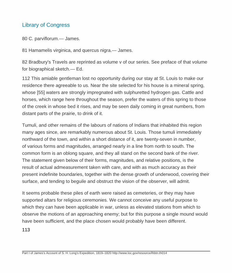
Library of Congress
Part I of James's Account of S. H. Long's Expedition, 1819–1820 http://www.loc.gov/resource/lhbtn.th014
80 C. parviflorum.— James.
81 Hamamelis virginica, and quercus nigra.— James.
82 Bradbury's Travels are reprinted as volume v of our series. See preface of that volume
for biographical sketch.— Ed.
112 This amiable gentleman lost no opportunity during our stay at St. Louis to make our
residence there agreeable to us. Near the site selected for his house is a mineral spring,
whose [55] waters are strongly impregnated with sulphuretted hydrogen gas. Cattle and
horses, which range here throughout the season, prefer the waters of this spring to those
of the creek in whose bed it rises, and may be seen daily coming in great numbers, from
distant parts of the prairie, to drink of it.
Tumuli, and other remains of the labours of nations of Indians that inhabited this region
many ages since, are remarkably numerous about St. Louis. Those tumuli immediately
northward of the town, and within a short distance of it, are twenty-seven in number,
of various forms and magnitudes, arranged nearly in a line from north to south. The
common form is an oblong square, and they all stand on the second bank of the river.
The statement given below of their forms, magnitudes, and relative positions, is the
result of actual admeasurement taken with care, and with as much accuracy as their
present indefinite boundaries, together with the dense growth of underwood, covering their
surface, and tending to beguile and obstruct the vision of the observer, will admit.
It seems probable these piles of earth were raised as cemeteries, or they may have
supported altars for religious ceremonies. We cannot conceive any useful purpose to
which they can have been applicable in war, unless as elevated stations from which to
observe the motions of an approaching enemy; but for this purpose a single mound would
have been sufficient, and the place chosen would probably have been different.
113

Library of Congress
Part I of James's Account of S. H. Long's Expedition, 1819–1820 http://www.loc.gov/resource/lhbtn.th014
Nothing like a ditch, or an embankment, is to be seen about any part of these works.83
83 What we have called base in the following statement is in reality the length of a line
passing over the top of the mound, from the termination of the base each side.
The numbers refer to a draft. The heights are estimated, with the exception of two.
No. 2. A square with a hollow way, gradually sloping to the top; or, in other words, a hollow
square open behind.
Base 50 feet.
Height 5
Distance N. from the Spanish bastion 259
No. 3. An oblong square.
Longitudinal base 114
Transverse do. 50
Length at top 80
Perpendicular height 4
Distance from No. 2. N. 115
No. 4. An oblong square.
Longitudinal base 84
top 45
Library of Congress
Part I of James's Account of S. H. Long's Expedition, 1819–1820 http://www.loc.gov/resource/lhbtn.th014
Perpendicular height 4
Distance N. 251
Nos. 2. 3. and 4. are each about 33 ordinary steps from the edge of the second bank of
the river.
No. 5. An oblong square.
Longitudinal base 81 feet.
top 35
Perpendicular height 4
Distance W. 155
No. 6. Different in form from the others. It is called the Falling Garden, and consists of
three stages, all of equal length, and of the same parallelogramic form: the superior stage,
like the five succeeding mounds, is bounded on the cast by the edge of the second bank
of the river: the second and third stages are in succession on the declivity of the bank,
each being horizontal; and are connected with each other, and with the first, by an abruptly
oblique descent.
Longitudinal base 114 feet.
top 88
Transverse base of first stage 30
height of do. 5
Declivity to the second stage 34

Library of Congress
Part I of James's Account of S. H. Long's Expedition, 1819–1820 http://www.loc.gov/resource/lhbtn.th014
Transverse surface of do. 51
Declivity to the third stage 30 feet. Transverse surface of do. 87
Declivity to the natural slope 19
No. 7. Like the three succeeding ones, conical. Distance northward 95
Base 83
Top 34
Height 4½
No. 8. Distance about N. 94
Base 98
Top 31
Height 5
No. 9. Distance about N. 70
Base 114
Top 56
Height 16
No. 9. Distance about N. 70
Base 114

Library of Congress
Part I of James's Account of S. H. Long's Expedition, 1819–1820 http://www.loc.gov/resource/lhbtn.th014
Top 56
Height 16
No. 10. Distance about N. 74
Base 91
Top 34
Height 8 or 10
No. 11. Nearly square, with a large area on the top (a brick house is erected at the S.W.
corner). The eastern side appears.to range with the preceding mounds.
Distance 158 feet.
Base 179
Top 107
Height W. side, say 5
S. 11
E. 15 Or 20
No. 12. Nearly square, westerly a little N. from No. 7. and distant from it 30 feet.
Base 129
Top 50
Height 10

Library of Congress
Part I of James's Account of S. H. Long's Expedition, 1819–1820 http://www.loc.gov/resource/lhbtn.th014
No. 13. A parallelogram, placed transversely with respect to the group.
Distance 30 feet.
Distance from No. 5. N. 10 W. 350
Longitudinal base 214
top 134
Transverse base 188
top 97
Height 12
No. 14. A convex mound, W. 55
Base 95
Height 5 or 6
No. 15. Together with the three succeeding ones, more or less square.
Distance N.W. 117
Base 70
Height 4
No. 16. Distance N. 10 E. 103
Base 124
Library of Congress
Part I of James's Account of S. H. Long's Expedition, 1819–1820 http://www.loc.gov/resource/lhbtn.th014
No. 17. Distance N. 78
Base 82
No. 18. Distance, N.N.E. 118
Base 77
The mounds from 14. to 18. inclusive, are so arranged as to describe a curve, which, when
continued, terminates at the larger mounds, Nos. 15. and 19.
No. 19. A large quadrangular mound, placed transversely, and with No. 13., ranging in a
line nearly parallel to the principal series (from 2. to 11.)
Distance N.N.W. from No. 13 484 feet.
E.N.E. 18. 70
Base 187
Top 68
(By measurement) Height 23
No. 20. A small barrow, perhaps two feet high, and of proportionably rather large base, say
15 or 20 feet.
No. 21. A mound similar to the preceding, same height. West of No. 16., base 25 feet.
No. 22. Quadrangular. Distance West from No. 16. 319 feet.
Base 73
Library of Congress
Part I of James's Account of S. H. Long's Expedition, 1819–1820 http://www.loc.gov/resource/lhbtn.th014
No. 23. A mound of considerable regularity; but, owing to the thickness of the bushes, we
cannot at present satisfy ourselves of its being artificial, though from its corresponding with
No. 25. we suppose it to be so.
No. 24. Appears to be an irregular mound 10 or 12 feet high, and 145 feet base.
No. 25. Distant N. 10 E. 114 feet; and following this course 132 feet, we arrive at an
elevation on its margin, as is also the case with No. 24., and which we have numbered 26.
No. 26. Of which the base is 89 feet, and height 10 or 12.—It is distant W.N.W. from No.
26., 538 feet.
No. 27. Is the largest mound, of an elongated-oval form, with a large step on the eastern
side. Distance N. from No. 26. 1463 feet.
Longitudinal base 319
top 136
Transverse base 158
top 11
Step transversely 79
Height by measurement 34
At the distance of a mile to the westward, is said to be another large mound. — James.
Comment by Ed. These mounds have been effaced by the growth of the city. The map of
them prepared by Long's party was not published until 1861; it will be found on page 387
of the Smithsonian Institution Report for that year.
Library of Congress
Part I of James's Account of S. H. Long's Expedition, 1819–1820 http://www.loc.gov/resource/lhbtn.th014
114
Indian graves are extremely numerous about St. Louis, though none are found in the
immediate vicinity of the town: they are most frequent on the hills about the Merameg and
on the north side of the Missouri. On the 12th June, Mr. Say and Mr. Peale, accompanied
by one man, descended the Mississippi, [56] in a small boat to the mouth of the Merameg,
and ascended the latter river about fifteen 115 miles, to a place where great numbers
of graves have been explored, and have been represented to contain the bones of a
diminutive race of men. Most of these graves are found near the bank of the Merameg.
They do not rise above the general surface, but their presence is ascertained by the
vertical stones which enclose them, and project a little at either end of the grave. When
the included 116 earth, and the numerous horizontal flat stones are removed, we find the
sides neatly constructed of long flat stones, vertically implanted and adapted to each other,
edge to edge, so as to form a continuous wall. The graves are usually three or four feet,
though sometimes six feet in length. The bones they contained appeared to have been
deposited after having been separated from the flesh, and from each other, according to
the custom of some tribes of Indians at the present day.
In the first grave opened by Mr. Say were found the fragments of an earthen pot, and the
bones of an infantine skull; the second contained what appeared to be the remains of a
middle aged man, of the ordinary stature, laid 117 at full length; the bones much confused
and broken. An inhabitant residing here informed them, that many similar graves had been
found along the summits of most of the neighbouring hills. In one of these he had found
two pieces of earthenware, one having nearly the form of a porter-bottle; the other with a
wide mouth; but this grave contained no bones. After spending a night at this place, they
crossed the river to the town of Lilliput, (one of the projected towns here has received
this name,) the place so often mentioned as the locality of the graves of a pigmy race.
Appearances here are in general similar to those already described. One head that had
been dug up was that of an old person, in whom the teeth had been lost, and the alveolæ
[57] obliterated, leaving the sharp edge of the jaw-bone. From this the neighbouring
Library of Congress
Part I of James's Account of S. H. Long's Expedition, 1819–1820 http://www.loc.gov/resource/lhbtn.th014
settlers had inferred the existence of a race of men without teeth, having their jaws like
those of the turtle. Having satisfied themselves that all the bones found here were those
of men of the common size, Mr. Say and Mr. Peale “sold their skiff, shouldered their guns,
bones, spade, & c. and bent their weary steps towards St. Louis, (distant sixteen miles,)
where they arrived at eleven o'clock P. M., having had ample time, by the way, to indulge
sundry reflections on that quality of the mind, either imbibed in the nursery or generated by
evil communications, which incites to the love of the marvellous, and, by hyperbole, casts
the veil of falsehood over the charming features of simple nature.”
These graves evidently contain the relics of a more modern people than those who
erected the mounds.
On the summit of one of the large hillocks, near St. Louis, (No. 27. described in note
83) are several of these graves: we opened five of them, but in one only were we 118
fortunate in finding any thing interesting, and all that this contained was a solitary tooth of
a species of rat, together with the vertebræ and ribs of a serpent of moderate size, and in
good preservation; but whether the animal had been buried by the natives, or had perished
there, after having found admittance through some hole, we could not determine. If they
were buried by the Indians, they are probably the bones of a species of crotalus, as it is
known that many Indians of the present day have a sort of veneration for animals of that
genus. The circumstance of the discovery of these bones renders it somewhat probable,
that rattlesnakes were formerly worshipped by the natives of America, and their remains,
like those of the Ibis of Egypt, religiously entombed after death.
Whilst we were at Cincinnati, Dr. Drake exhibited [58] to us, in his cabinet of natural
history, two large marine shells, that had been dug out of ancient Indian tumuli in that
vicinity. These shells were each cut longitudinally, and the larger half of each only
remained. From this circumstance it seems probable that they had been used by the
aborigines as drinking cups; or, consecrated to superstition, they may have been regarded
as sacred utensils, and either used in connection with the rites of sacrifice, or in making

Library of Congress
Part I of James's Account of S. H. Long's Expedition, 1819–1820 http://www.loc.gov/resource/lhbtn.th014
libations to their deities; they may, however, like the cymbium of the Archipelago, have
served a more useful and salutary purpose in bathing.
One of these specimens seems to be a Cassis cornutus , of authors, or great conch shell,
though it is proper to observe, that of the three revolving bands of tubercles, characteristic
of that species, the inferior one in this specimen is double. In length it is about nine inches
and a quarter, and in breadth seven inches.
119
The other specimen is a heterostrophe shell of the genus Fulgur of Montfort; and, as far
as we can judge, in every respect the same with those which are, at the present day,
found on the coast of Georgia and East Florida, known to naturalists under the name of F.
perversus , though it is certainly much larger than any of the recent specimens we have
seen; its length being nine inches, and breadth six and a half.
Several different countries have been mentioned by authors as the habitation of the
cornutus ; according to Rumphius, it inhabits Amboyna, the straits of Malacca, and the
shores of the island of Boeton; Humphreys says it is brought from the East Indies and
China; Linnæus believed it to inhabit the coasts of America; but Bruguiere, a more recent
author, informs us that Linnæus was probably mistaken in the habitation of this shell, and
states it to be a native of the Asiatic ocean.
The cornutus becomes of some importance in the question relative to the Asiatic origin
of the American [59] Indians. All the authorities to which we have been able to refer,
correspond in assigning the shores of Asia, or those of the islands which lie near that
continent, as the native territory of this great species of conch, with the sole exception of
Linnæus; but as no other author has discovered it on the coasts of this continent, we must
believe with Bruguiere, that it is only to be found in the Asiatic ocean.
The circumstance then of this shell being discovered in one of the ancient Indian tumuli,
affords, at least, an evidence that an intercourse formerly existed between the Indians of
Library of Congress
Part I of James's Account of S. H. Long's Expedition, 1819–1820 http://www.loc.gov/resource/lhbtn.th014
North America and those of Asia; and leads us to believe that even a limited commerce
was carried on 120 between them, as it undoubtedly was with the Atlantic coast, from
which the Fulgur was obtained.
But although this isolated fact does not yield a positive proof of the long asserted migration
of the ancestors of the present race of American Indians from Asia to this country, yet,
when taken in combination with other evidence, which has been collected by various
authors, with so much industry, it will be regarded as highly corroborative of that popular
belief.84
84 The uncertainty with which the shell mentioned was classed as Cassis cornutus
renders its identification in terms of modem nomenclature practically impossible; such
identification could be accurately made only by examination of the same specimen.
The value of the argument relative to the origin of the Indians is, therefore, not easy to
estimate.— Ed.
In the prairies of Illinois, opposite St. Louis, are numbers of large mounds. We counted
seventy-five in the course of a walk of about five miles, which brought us to the hill a few
years since occupied by the monks of La Trappe.85 This enormous mound lies nearly
from north to south, but it is so overgrown with bushes and weeds, interlaced with briers
and vines, that we were unable to obtain an accurate account of its dimensions.
85 From this fact it derived the name “Monk's Mound.” The Trappist establishment was
made in 1808, but was soon afterwards abandoned. The mound is one of the largest in the
United States — the area of the base is six acres, that of the top two; the height is ninety-
one feet.— Ed.
The survey of these productions of human industry, these monuments without inscription,
commemorating the existence of a people once numerous and powerful, but no longer
known or remembered, never fails, though often repeated, to produce an impression
of sadness. As we stand upon these [60] mouldering piles, many of them now nearly
Library of Congress
Part I of James's Account of S. H. Long's Expedition, 1819–1820 http://www.loc.gov/resource/lhbtn.th014
obliterated, we cannot but compare their aspect of decay with the freshness of the wide
field of nature, which 121 we see reviving around us; their insignificance, with the majestic
and imperishable features of the landscape. We feel the insignificance and the want of
permanence in every thing human; we are reminded of what has been so often said of the
pyramids of Egypt, and may with equal propriety be applied to all the works of men, “these
monuments must perish, but the grass that grows between their disjointed fragments shall
be renewed from year to year.”86
June 21st. After completing our arrangements at St. Louis, we left that place at noon,
and at 10 o'clock on the following day, entered the mouth of the Missouri. From St. Louis
upward to the Missouri, the water of the Mississippi, for a part of the year, is observed to
be clear and of a greenish colour on the Illinois side, while it is turbid and yellow along the
western bank. But at the time of our ascent every part of the Mississippi appeared equally
turbid, its waters soon becoming blended with the heavy flood of the Missouri.
The Missouri being now swollen by the spring floods, which had subsided in the
Mississippi, entered that river with such impetuosity, as apparently to displace almost the
whole body of the waters in its channel. We had occasion to observe that the water of the
Missouri passes under that of the Mississippi, rising and becoming mingled with it on the
opposite shore, so that a portion of the clear, green waters of the latter river run for some
distance in the
86 Maturin.— James.
Comment by Ed. Charles Robert Maturin (1782–1816) was a Dublin dramatist and
novelist. In his writings passages of undoubted eloquence were strangely mingled with
extravagance and bombast. The incoherence of his plots and the inconsistency of his
characters led many who recognized his genius to believe him mad.
122 middle of the channel, and along the surface of the Missouri waters, rendered perhaps
specifically heavier by the great quantities of earthy matter mingled with them. The waters
Library of Congress
Part I of James's Account of S. H. Long's Expedition, 1819–1820 http://www.loc.gov/resource/lhbtn.th014
of the Missouri are so charged with mud and sand as to be absolutely opake, and of a
clay [61] colour; while those of the Mississippi being comparatively clear, and having a
somewhat olivaceous tint, afford an opportunity of tracing their respective courses, after
their junction in the same channel. At some stages of water they run side by side, and in a
great measure unmingled as far as Herculaneum, forty-eight miles below their confluence.
We had the pleasure to find, notwithstanding the furnace was supplied with wood of an
indifferent quality, that the force of our steam-engine was sufficient to propel the boat
against the current of the Missouri, without recourse to the aid of the cordelle ,87 which we
had expected to find necessary.
87 The cordelle was a rope, often several hundred yards long, by means of which men
towed boats up rapid streams. When the current was especially strong, the end of the
cordelle was attached to a tree and a windlass used.— Ed.
We were somewhat surprised to see here a flock of black-headed terns. It is remarkable
that these birds, whose ordinary range is in the immediate vicinity of the sea-coast, should
ascend this river to so great a distance. They are not seen on the Delaware as high as
Philadelphia, unless driven up by storms.
In ascending from the mouth of the Missouri to Bellefontain, a distance of four miles,
our boat grounded twice on the point of the same sand-bar, and considerable time was
consumed in efforts to get her afloat. A military post was established at Bellefontain,
under the direction of the government of the United States, by General Wilkinson, in
1803; but the soil on which his works were erected has 123 disappeared, the place
being now occupied by the bed of the river. A few fruit trees only, which stood in the
end of his garden, are yet standing, but are now on the brink of the river. The first bank
is here ten or twelve feet high, rising perpendicularly from the water. Near its base are
the trunks of several trees with one end imbedded, and the other projecting horizontally
over the surface of the water, affording an evidence of the recent deposition of the soil
Library of Congress
Part I of James's Account of S. H. Long's Expedition, 1819–1820 http://www.loc.gov/resource/lhbtn.th014
of the low plains, and an admonition of the uncertainty of tenure, on the first bank of the
river. One of these projecting trunks is still in good preservation. It is [62] about three
feet in diameter, and from its direction, must pass immediately under the roots of two
large trees, now occupying the surface of the soil.88 Similar appearances are frequent
along the Mississippi and Missouri, and furnish abundant evidence that these rivers
are constantly changing their bed, and, from the great rapidity of the stream, as well as
from the appearances presented, we must suppose these changes are not very slowly
produced; but their range is confined to the valley within the second banks, which are here
raised about seventy feet. On this second bank, in the rear of the site of the former works,
the buildings belonging to the present military establishment have been erected. They
were commenced in 1810. The houses are of one story, constructed of logs, based upon
masonry, and united in the form of a hollow square. At
88 In a section of forty feet perpendicular, of the alluvion of the Mississippi, near New
Madrid, Mr. Shultz found seven hundred and ninety-eight layers, indicating an equal
number of inundations, in the time of their deposition. Supposing these inundations to
have happened yearly, we have an easy method of forming an estimate of the rapidity of
the elevation of the bed of the Mississippi. These layers were found to vary in thickness,
from one-fourth of an inch to three inches. See Shultz's Travels, vol. ii. p. 90.— James.
124 the foot of the second bank rises a fine spring of water, which has given name to
the place. Cold Water creek, a very small stream not navigable, discharges itself a few
hundred yards above; in times of high water its mouth might afford harbour to small boats.
Before the recent change in the bed of the Missouri, this creek entered higher up than at
present, and then afforded a good harbour for boats of all sizes. The sixth regiment were
encamped here at the time of our arrival, waiting for the contractor's steam-boats, three of
which we had passed at the mouth of the river.89
89 Bellefontaine, or Fort Bellefontaine (old Fort Charles the Prince), was occupied by
troops until 1826. See Thwaites, Original Journals of the Lewis and Clark Expedition, v,
pp. 392, 393, note 2. The site of the newer works mentioned in the text is now uncertain.
Library of Congress
Part I of James's Account of S. H. Long's Expedition, 1819–1820 http://www.loc.gov/resource/lhbtn.th014
An island opposite the mouth of Cold Water Creek was the camp of. Lewis and Clark the
first night after beginning the ascent of the Missouri (May 14, 1804).— Ed.
Here we found it necessary to adjust a tube to the boilers of our steam-engine, in order
to form a passage, through which the mud might be blown out: the method heretofore
adopted, of taking off one end for the purpose of admitting a man to clean them, proving
too tedious when it was found necessary to repeat the operation daily. The expedient of
the tube succeeded to our entire satisfaction.
Dr. Baldwin found here a plant, which he considered as forming a new genus, approaching
astragalus; [63] also the new species of rose, pointed out by Mr. Bradbury, and by him
called Rosa mutabilis. This last is a very beautiful species, rising sometimes to the height
of eight or ten feet. The linden tree90 attains great magnitude in the low
90 Tilia Americana. The Podalyria alba, anemone virginiana, polygala incamata (prairies)
anagallis arvensis, lathyrus decaphyllus, ranunculus fluviatalis, carex multiflora, &c. were
collected at Bellefontain. Dr. Baldwin's MS. Notes. — James.
125 grounds of the Missouri; its flowers were now fully expanded.
In ascending from Bellefontain to Charboniere, where we came to an anchor, on the
evening of the 24th, we were opposed by a very strong current, and much impeded by
sand-bars. On the upper ends of these sand-bars are many large rafts of drift wood; these
are also frequent along the right hand shore. In several places we observed portions of
the bank in the act of falling or sliding into the river. By this operation, numerous trees,
commonly cotton-woods and willows, are overturned into the water.
The forests, on the low grounds immediately in the vicinity of the Missouri, are remarkably
dense; but in many instances, the young willows and poplars (which are the first and
almost the only trees that spring up on the lands left naked by the river) have not attained
half their ordinary dimensions, before, by another change in the direction of the current,
they are undermined, and precipitated down, to be borne away by the river. The growth of
Library of Congress
Part I of James's Account of S. H. Long's Expedition, 1819–1820 http://www.loc.gov/resource/lhbtn.th014
the cotton-tree is very rapid, that of the salix angustata, the most common of the willows
found here, is more tardy, as it never attains to great size. The seeds of both these trees
are produced in the greatest profusion, and ripened early in the summer, and being
furnished by nature with an apparatus to ensure their wide dissemination, they have
extended themselves and taken root in the fertile lands along all the ramifications of the
Mississippi, prevailing almost to the exclusion of other trees.
[64] Charboniere91 is on the right bank of the Missouri.
91 The correct orthography of the word is Charbonnière, which means “carrying coals.”—
Ed.
126
This name was given it by the boatmen and the earliest settlers, on account of several
narrow beds of coal, which appear a few feet from the water's edge, at the base of a high
cliff of soft sandstone. The smell of sulphur is very perceptible along the bank of the river,
occasioned doubtless by the decomposition of pyrites, in the exposed parts of the coal
beds. Some small masses of sulphate of lime also occur, and have probably derived their
origin from the same source.
At St. Charles we were joined by Maj. O'Fallon, agent for Indian affairs in Missouri, and his
interpreter, Mr. John Dougherty, who had travelled by land from St. Louis.92 When Lewis
and Clark ascended the Missouri, the town of St. Charles was said to contain one hundred
houses, the inhabitants deriving their support principally from the Indian trade. This source
having in a great measure failed, on account of the disappearance of the aborigines,
before the rapid advances of the white population, the town remained in a somewhat
declining condition for several years; but as the surrounding country was soon occupied
by an agricultural population, a more permanent though less lucrative exchange is taking
the place of the Indian trade. Accordingly within two or three years, many substantial
Library of Congress
Part I of James's Account of S. H. Long's Expedition, 1819–1820 http://www.loc.gov/resource/lhbtn.th014
brick buildings had been added, and several were now in progress: we could enumerate,
however,
92 This was Benjamin O'Fallon, whose mother was the youngest sister of George Rogers
and William Clark; his father, Dr. James O'Fallon, was a Revolutionary character and
prominent Kentucky pioneer. A brother, John O'Fallon, was in the middle of the century,
one of the most prominent citizens of St. Louis.
John Dougherty was later for many years agent for the Oto, Pawnee, and Omaha tribes.—
Ed.
127 only about one hundred houses. There are two brick kilns, a tanyard, and several
stores.93
93 For St. Charles, see Bradbury's Travels, in our volume v, note 9.— Ed.
A mile or two below St. Charles, are many trunks of trees projecting from the bank, like
those mentioned at Bellefontain. In the face of the banks are usually great numbers of the
holes made by the bank-swallow for its nest, and the birds themselves are frequently seen.
At St. Charles, arrangements were made for the purpose of transporting baggage for
such of the gentlemen [65] of the party as should choose to ascend the Missouri by
land, that they might have the better opportunities for investigating the natural history
of the country. Messrs. Say, Jessup, Peale, and Seymour, having provided themselves
with a horse and pack-saddle, on which they fastened their blankets, a tent, and some
provisions, accompanied by one man, left St. Charles at 7 o'clock on the morning of
the 26th, intending to keep nearly an equal pace with the steam-boat, in order to rejoin
it as occasion might require. Dr. Baldwin, still confined by debility and lameness, was
compelled to forego the pleasure of accompanying them.
The Western Engineer proceeded on her voyage, soon after the departure of Mr. Say
and his detachment. Having grounded several times in the course of the day, and
Library of Congress
Part I of James's Account of S. H. Long's Expedition, 1819–1820 http://www.loc.gov/resource/lhbtn.th014
contending all the way against a heavy current, she proceeded but a few miles. We
passed some rocky cliffs; but in general the immediate banks of the river presented the
same appearance as below, consisting of a recent alluvium. After we had anchored at
evening, Dr. Baldwin 128 was able to walk a short distance on shore, but returned much
fatigued by his exertions.94
94 The vegetable productions at this place were, the populus deltoides, occupying the
narrow margin of the river (not here preceded by the salix angustata, as is generally the
case in recent alluvial grounds on the Ohio and Mississippi); the amorpha fruticosa,*
* beautiful flowering shrub occupies the low lands of Georgia, on the sea coast, but is not
confined to the margin of rivers, as appears to be the case on the Missouri.
and platanus occidentalis, next follow. The margin of the bluff produces the quercus
rubra, juglans pubescens, carpinus Americana, (around the latter, we observed the
celastrus scandens entwined and in fruit,) and on higher grounds, the laurus sassafras
and juniperus Virginianus. Of herbaceous plants, the only one in flower was the rudbeckia
fulgida. The higher parts of the hills were in many places thickly covered with species
of elymus and andropogon, the summits being usually quite naked, and consisting of
horizontal masses of ferruginous coloured sandstone. Baldwin.— James.
On the morning of the 27th, after having taken in a small supply of indifferent fuel, we
crossed over to the right-hand side of the river, and took on board one of the party,
who had left the boat at an early hour, to visit a friend residing a short distance from
the river. At evening we came to anchor half a mile below Point Labidee,95 a high bluff,
where observations for latitude were taken. Here we were detained a day making some
necessary repairs.
95 On Point L'Abbadie, see Bradbury's Travels, comprising our volume v, note 13.— Ed.
A fine field of wheat, which appeared to be ripe, extended down to the brink of the river
opposite the spot where we lay. This belonged to the plantation of a farmer, recently from
Library of Congress
Part I of James's Account of S. H. Long's Expedition, 1819–1820 http://www.loc.gov/resource/lhbtn.th014
Virginia. From him we obtained a plentiful supply of milk, and some bacon hams. A portion
of the bank had lately fallen into [66] the river, and with it a part of the wheat field, and the
dwelling house and other buildings seemed destined soon to follow.
The shore here was lined with the common elder, (sambucus canadensis) in full bloom,
and the cleared fields 129 were yellow with the flowers of the common mullein. This plant,
supposed to have been originally introduced from Europe, follows closely the footsteps of
the whites. The liatris pycnostachia, here called “pine of the prairies,” which was now in full
bloom, has a roundish tuberous root, of a warm somewhat balsamic taste, and is used by
the Indians and others for the cure of gonnorrhœa.
The Indian interpreter, Mr. Dougherty, also showed us some branches of a shrub, which
he said was much used among the natives in the cure of lues venerea. They make a
decoction of the root, which they continue to drink for some time. It is called “blue wood” by
the French, and is the symphoria racemosa of Pursh, common to the maritime states, the
banks of the St. Lawrence, and the Missouri. It is here rather taller, and the branches less
flexuous than in the eastern states.96
96 Baldwin.— James.
Without meeting any remarkable occurrences, we moved on from day to day, encountering
numerous obstacles in the navigation of the river, and being occasionally delayed by the
failure of some part of the steam-engine, till on the 2d of July, we arrived at Loutre Island,
where we found Mr. Say and his companions.
After leaving the steam-boat at St. Charles, on the 25th of June, this party had travelled
over a somewhat hilly country, covered with open oak woods for about ten miles, to a
small creek, called the Darden,97 entering the Mississippi a few miles above the Illinois.
This stream they crossed three miles from the Missouri, having in their
Library of Congress
Part I of James's Account of S. H. Long's Expedition, 1819–1820 http://www.loc.gov/resource/lhbtn.th014
97 Dardenne Creek flows northeast across St. Charles County to the Mississippi, as do
nearly all the watercourses of this county. It and the township of the same name are so
called from one of the early settlers.— Ed.
130 walk suffered greatly [67] from thirst. At evening they tied their pack-horse to a bush;
and as they returned, after being absent a few minutes for water, the animal took fright,
and breaking loose, disencumbered himself of his pack, and set off on a gallop to return
to St. Charles; and it was not without great exertion that he was overtaken and brought
back. They then pitched their tent, and were so fortunate as to find a house at the distance
of half a mile. This belonged to a family from Carolina, and exhibited great appearance
of neatness and comfort, but the owner was found particularly deficient in hospitality.
He refused to sell or to give any refreshments for the use of the party, and even granted
them some water with apparent reluctance, marching haughtily about his piazza, while
some person was annoying his family by playing wretchedly on a flute. Mr. Say and
the gentlemen of his party had on the fatigue dress of common soldiers, to which they
probably owed the coldness of their reception. We are, however, glad to be able, from
much experience, to say that there are few houses in the lately settled parts of the United
States, where common soldiers would have met such a reception as was accorded by this
Mr. N. to the gentlemen of the party. Want of hospitality is rarely the fault of the inhabitants
of the remote settlements. Being refused refreshments, they returned to their camp, and
with the addition of a hawk which they had killed, made a supper from the contents of their
pack.
On the 27th they crossed the Perogue,98 about nineteen miles from St. Charles; and after
a fatiguing march of
98 Perruque (Wig) Creek is said to commemorate the adventure of a Frenchman whose
wig became entangled in the branches of a tree while he was crossing the stream.— Ed.
131 several miles, were entertained at the house of a very worthy man, who supplied them
with whatever his place afforded. From too long fasting, and from the effect of exposure

Library of Congress
Part I of James's Account of S. H. Long's Expedition, 1819–1820 http://www.loc.gov/resource/lhbtn.th014
and fatigue, Mr. Say and others became somewhat unwell; and on their account, the party
remained at the house of their friendly host till evening, when they walked four [68] miles
to a place called Fort Kennedy. They purchased a ham, and a loaf of corn bread of Mr.
Kennedy, paying ten cents per pound for the ham, and twenty-five cents for all the bread,
milk, and corn, consumed during their stay.99
99 Thomas Kennedy, a Revolutionary veteran from Virginia came to Warren County,
Missouri, early in 1808. His stockade and blockhouse, built for protection against the
Indians during the War of 1812–15, stood a mile and a half southeast of Wright City.— Ed.
The next morning, having travelled about seven miles, they halted for breakfast; and
having fettered their horse, dismissed him to feed; but when sought for the purpose of
continuing their journey, he could not be found. Two travellers at length arrived, and
informed them that the horse had been seen at about six miles' distance, on the way
towards St. Charles: a horse was therefore hired, and a person returned in pursuit; but
he was not to be found, having proceeded on his journey previously to the arrival of the
messenger.
The prairie flies (a species of tabanus,) are exceedingly troublesome to horses and
cattle, insomuch that people who cross these grassy plains usually travel very early in the
morning, and again at evening, resting greater part of the day; some, indeed, journey only
by night. If they travel at all in the day, they have the precaution to defend the horse, by
a covering thrown loosely over him. The tabani appear about the 10th of June, and are
seen in 132 immense numbers, until about the 10th of August, when they disappear. Near
the farm houses we observed, that cattle, when attacked by them, ran violently among the
bushes, to rid themselves of their persecutors.—Mosquitoes were not numerous.
As they were fearful of being unable to overtake the steam-boat on the Missouri, if
they made a longer delay to prosecute the search for their horse, it was determined to
abandon him altogether, rather than return to St. Charles, whither he had doubtless gone;

Library of Congress
Part I of James's Account of S. H. Long's Expedition, 1819–1820 http://www.loc.gov/resource/lhbtn.th014
accordingly, on the 29th of June, they made a division of their baggage, and each one
shouldering his respective portion, proceeded towards the margin of Loutre Prairie. When
they arrived here, they determined [69] to take the most direct route towards the Missouri,
as it seemed folly for them to attempt, in the drought and heat, which then prevailed, to
cross the extensive plains of Loutre and the Grand Prairie with their heavy burthens. They
therefore followed a path leading nearly south, along a naked ridge; where they travelled
twelve miles, without finding water, and arrived at Loutre Island in the evening. They were
all the day tormented with excessive thirst; and being unaccustomed to travelling on foot,
they were much fatigued, and several became lame. The soil of the extensive prairies
which they passed was not very good; but mixed at the surface with so much vegetable
matter, accumulated by the successive growth and decomposition of the yearly products,
as to give it the aspect of fertility.100
100 The course of the party had been northwest through St. Clair and Warren counties,
and thence south by west to the river. Loutre Island is on the boundary between Warren
and Montgomery counties.— Ed.
On the south side of Loutre Prairie a well has been sunk 133 sixty-five feet, without
obtaining water; on the north water is readily found, by digging to a moderate depth. Loutre
Prairie is twenty-three, and Grand Prairie is twenty-five miles in length: on the borders of
each are some scattering settlements.
Near Loutre Island are several forts, as they are called by the inhabitants, built by the
settlers during the late war, and designed to afford protection against the attacks of the
aborigines, chiefly the Kickapoos, and Saukees, who were most feared in this quarter.
They are simply strong log-houses, with a projecting upper story, and with loopholes for
musketry.
It was within a few miles of this place, that a company of mounted rangers, commanded
by Captain Calloway, were attacked by the Indians. The assault commenced as the
Library of Congress
Part I of James's Account of S. H. Long's Expedition, 1819–1820 http://www.loc.gov/resource/lhbtn.th014
rangers were entering a narrow defile, near the confluence of the Prairie Forks of Loutre
Creek. Several men were killed at the first fire, and Captain Calloway received in his body
a ball that had passed through his watch. So furious was the onset, that there was no
time for reloading their pieces after they had discharged them. [70] Captain Calloway
threw his gun into the creek, that it might not add to the booty of the Indians; and though
mortally wounded, drew his knife, and killed two of the assailants; but seeing no prospect
of success he ordered a retreat, hoping thereby to save the lives of some of his men. He
was the last to leave the ground; when springing into the creek he received a shot in his
head, and expired immediately.101
101 This affair took place March 7, 1815. Captain James Callaway was the grandson of
Daniel Boone. His company consisted besides himself of a lieutenant and fourteen men.—
Ed.
134
Loutre Island is something more than nine miles long, and about one mile wide, and is
the residence of several families. Between it and the main land is an isthmus, which is
left naked at times of low water. Loutre Creek enters at the lower end of the island. It is
not navigable. Mr. Talbot, formerly from Kentucky, has been resident here for nine years.
His farm is in a high state of cultivation, and furnishes abundant supplies of poultry, eggs,
potatoes, and the numerous products of the kitchen garden, of which he sent a handsome
present on board our boat. He informed us that peach-trees succeed well in the most
fertile parts of the island.102
102 Loutre (Otter) Island was the site of the first settlements in Montgomery County, which
probably date back to 1798. There were two Talbots among the early arrivals, Christopher
and Hale. Among their neighbors were the Thorps, Ashcrafts, Coles, Pattons, and
Coopers—there were two or three families of each, most of them being from Kentucky.
The father of “Kit” Carson was another member of the community.— Ed.
Library of Congress
Part I of James's Account of S. H. Long's Expedition, 1819–1820 http://www.loc.gov/resource/lhbtn.th014
The first dwellings constructed by the white settlers are nearly similar in every part of the
United States. Superior wealth and industry are indicated by the number and magnitude
of corn-cribs, smoke-houses, and similar appurtenances; but on the Missouri, we rarely
meet with any thing occupying the place of the barn in the northern states. The dwellings
of people who have emigrated from Virginia, or any of the more southern states, have
usually the form of double cabins, or two distinct houses, each containing a single room,
and connected to each other by a roof; the intermediate space, which is often equal in
area to one of the cabins, being left open at the sides, and having the naked earth for a
floor, affords a cool and airy retreat, where the family will usually be found in the heat of
the day. The roof is composed of from three to five 135 logs, laid longitudinally, [71] and
extending from end to end of the building; on these are laid the shingles, four or five feet in
length; over these are three or four heavy logs, called weight poles, secured at their ends
by withes, and by their weight supplying the place of nails.
They have corn-mills, consisting of a large horizontal wooden wheel, moved by a horse,
and having a band passed round its periphery to communicate motion to the stone. These
are called band-mills, and are the most simple and economical of those in which the power
of horses is employed. The solitary planter, who has chosen his place remote from the
habitation of any other family, has sometimes a mill of a more primitive character, called a
hand-mill, probably differing little from those used among the ancient Egyptians. It consists
of two stones; and while one person causes the uppermost to revolve horizontally upon
the disk of the other, a second, who is usually a child or a woman, introduces the corn
a few grains at a time, through a perforation in the upper stone. Some are content with
the still ruder apparatus, consisting of an excavation in the top of a stump; into which the
corn is thrown, and brayed with a pestle. This is the method in use among many of the
agricultural Indians.
A large species of lampyris is common on the lower part of the Missouri. It is readily
distinguished from the smaller species, the common fire-fly, by its mode of coruscating. It
Library of Congress
Part I of James's Account of S. H. Long's Expedition, 1819–1820 http://www.loc.gov/resource/lhbtn.th014
emits from three to seven or eight flashes, in rapid succession, then ceases; but shortly
after renews its brilliancy. This species appears early in May. We saw many of them in
returning by night from the Merameg to St. Louis; but before our arrival at Loutre Island
they had disappeared, and were succeeded by great numbers of the 136 lampyris pyralis,
whose coruscations are inferior in quantity of light, and appear singly.
The black walnut attains, in the Missouri bottoms, [72] its greatest magnitude. Of one,
which grew near Loutre Island, there had been made two hundred fence-rails, eleven
feet in length, and from four to six inches in thickness. A cotton-tree, in the same
neighbourhood, produced thirty thousand shingles, as we were informed by a credible
witness.
[73] CHAPTER IV
Settlement of Cote Sans Dessein—Mouths of the Osage —Manito Rocks—Village of
Franklin
The left bank of the Missouri at the confluence of Loutre Creek is precipitous, terminating
a group of hills which can be distinguished running far to the north-east. Towards the river
these fall off in perpendicular precipices, whose bases are concealed in a dense growth
of trees and underwood. From their summits huge masses of rock have fallen; and some
of these are of such magnitude, that their summits rise above the surrounding forest. One
standing opposite the head of the island next above Loutre, is marked with numerous
rude drawings, executed by the Indians; some representing men with the heads of bisons,
spears, arrows, bows, &c. Half a mile above this rock the Gasconade enters the Missouri
from the south. The sources of this river are in the hilly country, near those of some of
the larger tributaries of the Yungar fork of the Osage; its waters are transparent, and its
current rapid. Traversing a rocky and broken country, it has not the uniformity of current
common to many of the branches of the Missouri, but is varied by numerous cataracts and
137 rapids, affording convenient stations for water-mills. Some saw-mills have already
Library of Congress
Part I of James's Account of S. H. Long's Expedition, 1819–1820 http://www.loc.gov/resource/lhbtn.th014
been erected; and from them a supply of pine-timber is brought to the settlements on the
Missouri, that tree being rarely met with here, except in the hilly country. The Gasconade
is navigable for a few miles. As might be expected, a projected town is placed at the
confluence of this [74] river and the Missouri, and is to be called Gasconade.103
103 Of Gasconade in 1823 it is said, “very few buildings are as yet erected, and it is very
doubtful whether its increase will be as rapid as was anticipated.” It was the first seat of
Gasconade County, but was supplanted by Hermann. At present its population numbers
less than one hundred.
The description of Gasconade River is adequate. The “Yungar” fork of Osage is now called
Niangua (Osage word for bear).— Ed.
Above the Gasconade, the aspect of the shores of the Missouri is the same as below,
except that the hills are discontinued on the left side, and make their appearance on the
right, extending along eight or nine miles; above this both shores are low bottom grounds.
Having received on board Mr. Say and his companions, we left Loutre Island on the 3d of
July; and passing in succession the mouths of the Gasconade, Bear Creek, the Au Vase,
and other tributaries, we anchored on the evening of the 5th, above the little village of Cote
Sans Dessein.104 This place contains about thirty families, mostly French, occupying as
many small log cabins, scattered remotely along the left bank of the river. Nearly opposite
104 Au Vase (Muddy) has been corrupted to Auxvasse, and there are now two streams in
Callaway County bearing this name. The larger, also called Big Muddy Creek, is the first
important stream above the Gasconade. Bear (or Loose) Creek, is seven miles farther up,
and the second Auxvasse, which answers the description in the text, is just beyond. Other
tributaries are Deer Creek, from the south, just above Big Muddy River, and Middle River,
from the north, opposite Bear Creek. The stream called Revoe's Creek a few lines below,
is now Rivaux (Rivals) Creek.
Library of Congress
Part I of James's Account of S. H. Long's Expedition, 1819–1820 http://www.loc.gov/resource/lhbtn.th014
For Côte Sans Dessein, see Bradbury's Travels, comprising our volume v, note 20.— Ed.
138 the village is the lower mouth of the Osage. Just above the town is the elevated
insular hill, which has given name to the place; it extends about eight hundred yards,
parallel to the bank of the river, and terminates at a small stream called Revoe's Creek.
Back of the hill is a marsh, discharging a small stream of water into the creek. The site
of the settlement of Cote Sans Dessein is remarkable on account of the fertility of the
soil, the black mould extending to the depth of about four feet. The soil is very rich for
twenty or thirty miles, in the rear of the village; but the uncertainty of the titles, arising
from the conflicting claims, founded on the basis of pre-emption, New Madrid grants, and
the concession of a large tract opposite the mouth of the Osage, made by the Spanish
authorities in favour of Mr. Choteau, still operates to retard the increase of population.105
105 The grants of land in Louisiana under Spanish rule were in a marked degree irregular
and heterogeneous. Only those were complete which had received endorsement by
the governor-general at New Orleans. Most of the settlers were too poor to undertake
the journey thither and pay the required fees; a tacit right of occupation was therefore
permitted by the local officials, lands were unsurveyed, and much confusion resulted.
During the last decade of Spanish authority (1794–1804) large numbers of Americans
had been tempted to cross the Mississippi and stake out claims in upper Louisiana.
Some of these were bona fide settlers, more mere speculators; and after the rumor of
Spanish cession to France was heard, fraudulent grants were made in large numbers.
Upon knowledge of this, the congress of the United States in the act of March 26, 1804,
revoked all grants made since the treaty of San Ildefonso (1800) with a proviso exempting
the rights of actual settlers. This law created much dissatisfaction, and petitions for redress
were sent from both upper Louisiana and Orleans Territory. See American State Papers,
“Miscellaneous,” i, pp. 396–405. Thereupon Congress passed acts for redress— that
for upper Louisiana (March 2, 1805) creating a commission, which first met in St. Louis,
Library of Congress
Part I of James's Account of S. H. Long's Expedition, 1819–1820 http://www.loc.gov/resource/lhbtn.th014
September 20, 1806; but its final report was not made until 1812. See American State
Papers, “Public Lands,” ii, pp. 388–603.
The lands set apart for the relief of sufferers by the New Madrid earthquakes were known
as “New Madrid grants.” Auguste Chouteau established the first distillery in St. Louis by
the aid of an extensive grant.— Ed.
139
At the time of the late war the inhabitants of this settlement, relying on mutual protection,
did not retire, but erected two stockades, and block-houses for their defence; the Sauks,
assisted by some Foxes and Ioways, having by a feigned attack and [75] retreat, induced
the greater part of the men to pursue them, gained their rear by means of an ambuscade,
and entering the village, raised their war-cry at the doors of the cabins. The women and
children fled in consternation to the block-houses. At this juncture a young man was
seen, who would not abandon his decrepit mother, even though she entreated him to
fly and save his own life, leaving her, who could at best expect to live but a few days, to
the mercy of the savages. The youth, instead of listening to her request, raised her upon
his shoulders, and ran towards the stockade, closely pursued by the Indians. They fired
several times upon him, and he must have been cut off had not a sally been made in his
favour.
After killing the villagers who had fallen into their hands, the Indians proceeded to attack
the lower stockade. The block-house at this work was defended by two men, and several
women. On hearing the war-cry, this little but determined garrison responded to it in such
a manner as to communicate to the Indians the idea that the block-house contained a
considerable number of men. They, therefore, proceeded to the attack with caution. In
the first onset, one of the two men received a mortal wound, which made him incapable
of further exertion— the other continued to discharge the guns at the besiegers, they
being loaded and put into his hands by the women. One mode of attack, adopted by the
Indians, had nearly proved successful. They threw burning torches upon the 140 roof,
Library of Congress
Part I of James's Account of S. H. Long's Expedition, 1819–1820 http://www.loc.gov/resource/lhbtn.th014
which was several times on fire; but the women, with admirable presence of mind, and
undaunted intrepidity, ascended to the top of the building and extinguished the flames.
This scene continued during the entire day; and at evening, when the assailants withdrew,
a small portion only of the roof remained; so often had the attempt to fire the building been
repeated. The loss sustained by the enemy was never correctly [76] ascertained; it has
since been stated by an Indian, that fourteen were killed and several wounded, but many
are of opinion that two or three only were killed.
We saw the hero of this affair at the block-house itself, now converted into a dwelling;
but he did not appear to be greatly esteemed, having perhaps few qualities except
personal intrepidity to recommend him.106 Cote Sans Dessein contains a tavern, a store,
a blacksmith's shop, and a billiard table.
106 The hero of this exploit was a Frenchman bearing the name of Baptiste Louis Roi.—
Ed.
The Cane107 is no where met with on the Missouri; but its place is in part supplied by
the equisetum hiemale, which, remaining green through the winter, affords an indifferent
pasturage for horned cattle and horses: to the latter, it often prove deleterious. The
inhabitants of St. Genevieve placed their horses upon an island covered with rushes,
where great numbers of them shortly after died; but it was observed that such as received
regularly a small quantity of salt remained uninjured. Of a large number of horses, placed
on an island near the mouth of the Nishnebottona,108 to feed upon this plant, no less than
twenty
107 Miegia macrosperma of Persoon.— James.
108 The Nishnebottona (Nishnabotna) enters the Missouri in Atchison County, in the
northwest corner of the state. See post, note 166.— Ed.
Library of Congress
Part I of James's Account of S. H. Long's Expedition, 1819–1820 http://www.loc.gov/resource/lhbtn.th014
141 were found dead at the end of five days. May not the deleterious properties of the
equisetum hiemale depend, in some measure, on the frozen water included in the cavity of
the stalk?
We were told the cows on this part of the Missouri, at certain seasons of the year, give
milk so deleterious as to prove fatal, when taken into the stomach; and this effect is
commonly attributed to a poisonous plant, said to be frequent in the low grounds, where
it is eaten by the cattle. They have a disease called the milk sickness : it commences
with nausea and dizziness, succeeded by headache, pain in the stomach and bowels,
and finally, by a prostration of strength, which renders the patient unable to stand; a
general torpor soon ensues, succeeded [77] by death. It is a common belief that the
flesh of animals, that have eaten of this poisonous weed, is noxious, and that horses are
destroyed by it.
We have heard it remarked by the inhabitants of the Ohio below the rapids, that the milk
of cows running at large in August is poisonous; and this they do not fail to attribute to
the effect of noxious plants; and in some places they point out to you one, and in another
place another vegetable, to which they assign these properties. The inhabitants generally
seem to have no suspicion that milk, unless it is poisoned, can be an unwholesome
article of diet; and we have been often surprised to see it given to those labouring under
fever. Throughout the western states, and particularly in the more remote settlements,
much use is made of butter-milk, and soured milk in various forms; all of which they
sell to travellers. Below Cote Sans Dessein we paid, for new milk, twenty-five cents per
gallon, and for soured milk, eighteen and three-fourth cents. At 142 that place twenty-five
cents per quart were demanded by the French settlers. It is commonly remarked that the
French, as well as the Indians, who have been long in the immediate vicinity of the whites,
charge a much higher price for any article than the Anglo-Americans, under the same
circumstances. Emigrants from the southern states prefer sour milk; and the traveller' taste
in this particular, we have often observed, forms a test to discover whether he is entitled to
the opprobrious name of Yankee, as the people of the northern and eastern states rarely
Library of Congress
Part I of James's Account of S. H. Long's Expedition, 1819–1820 http://www.loc.gov/resource/lhbtn.th014
choose sour milk. We have found that in some of the sickliest parts of the valley of the
Mississippi, where bilious and typhoid fevers prevail, through the summer and autumn,
the most unrestrained use is made of butter, milk, eggs, and similar articles of diet. Dr.
Baldwin was of opinion that the milk sickness of the Missouri did not originate from any
deleterious vegetable substance eaten by the cows, but [78] was a species of typhus,
produced by putrid exhalations, and perhaps aggravated by an incautious use of a milk
diet.
During the few days we remained at Cote Sans Dessein, Dr. Baldwin, though suffering
much from weakness, and yielding perceptibly to the progress of a fatal disease, was able
to make several excursions on shore. His devotion to a fascinating pursuit stimulated him
to exertions for which the strength of his wasted frame seemed wholly inadequate; and it is
not, perhaps, improbable that his efforts may have somewhat hastened the termination of
his life.
Between Loutre Island and Cote Sans Dessein compact limestone occurs, in horizontal
strata, along the sides of the Missouri valley. It is of a bluish white colour, compact
structure, and a somewhat concoidal fracture, containing 143 few organic remains. It
alternates with sandstones, having a silicious cement.109 These horizontal strata are
deeply covered with soil, usually a calcareous loam, intermixed with decayed vegetable
matter.
109 From Bay Charles Hill, four miles below Hannibal, Missouri, we received, through Dr.
Sommerville, several organic remains. Among them are the following:—
Carbonate of Lime.
One specimen contains exclusive quantities of segments of the encrinite of small diameter,
from one-fourth of an inch down to minute.
Library of Congress
Part I of James's Account of S. H. Long's Expedition, 1819–1820 http://www.loc.gov/resource/lhbtn.th014
Another specimen also, with numerous small encrinites, has a very wide and short
radiated productus.
Another specimen, a grayish chert, containing cavities formed by the solution and
disappearance of encrinites. The parts of these which were originally hollow when in the
state of carbonate of lime, being subsequently filled with chert, now show the nature of the
fossil, being cylindrical cavities, with a solid centre and transverse partitions, the largest
three-tenths of an inch wide.
From Rector's-hill, adjoining the village of Clarksville, Missouri, from Dr. Sommerville's
collection:—
A specimen of oolite—carbonate of lime.
It is composed of small spherical granules in contact with each other, which, in their
fracture, exhibit rather a concentric tendency, with the appearance of a central nucleus;
but we could not perceive any decided evidences of former organization in them.
Imbedded in the mass are a few columnar segments of encrinites, and a portion of a
compressed bivalve, which, in the form of its radiating lines, resembles a pecten.
From Charbonière:—
A specimen in argillaceous sandstone of a portion of a leaf like the nelumbium. It is only
the middle portion of the impression of the leaf that remains, being of an oval form of about
five inches in greatest diameter, the rest being broken away; the stalk has been broken off
at the junction of the leaf.
Productus spinosus. Say.
Library of Congress
Part I of James's Account of S. H. Long's Expedition, 1819–1820 http://www.loc.gov/resource/lhbtn.th014
A small species of terebratula, in width two-fifths, and in length more than seven-tenths of
an inch—an internal cast—individuals very numerous, varying much in size, the smallest
being about one-fifth of an inch wide.
From the Mammelles near St. Charles:—
Productus: a portion of a valve, and smaller portion of the opposite valve of a remarkably
large species, of which the proportions may have been not dissimilar to that of the Ency.
Meth. pl. 244. fig. 5. The striæ are similar to those of that shell, except in being somewhat
smaller; and the groove of one valve, and consequent elevation of the other, not so
profound, less abrupt, and more angular in the middle, and far less prominent on the edge
of the shell. It may justly be named grandis, as its hinge width was more than 3½ inches.—
James.
144
July 6th.— Soon after leaving the settlement of Cote Sans Dessein, we passed the
upper and larger mouth of the Osage river. Here, to use the language of the country, a
town has been located , and the lots lately disposed of at St. Louis, at various prices,
from fifty to one hundred and eighty dollars each.110 Within the limits of this town is a
considerable hill, rising at the point of the junction of the two rivers, and running parallel
to the Missouri. From its summit is an extensive view of the village of Cote Sans Dessein,
and the surrounding country.
110 The town established here was Osage City. In 1823 it was described as still “nearly in
a state of nature.” The present population is about five hundred.— Ed.
The river of the Osages, so called from the well-known tribe of Indians inhabiting its banks,
enters the Missouri one hundred and thirty-three miles above the confluence of the latter
river with the Mississippi. Its sources are in the Ozark mountains, opposite those of the
White river of the Mississippi, and of the Neosho, [79] a tributary of the Arkansa. Flowing

Library of Congress
Part I of James's Account of S. H. Long's Expedition, 1819–1820 http://www.loc.gov/resource/lhbtn.th014
along the base of the north-western slope of a mountainous range, it receives from the
east several rapid and beautiful rivers, of which the largest is the Yungar, (so named, in
some Indian language, from the great number of springs tributary to it,) entering the Osage
one hundred and forty miles from the Missouri.
In point of magnitude the Osage ranks nearly with the Cumberland and Tennessee. It
has been represented as navigable for six hundred miles; but as its current is known to
be rapid, flowing over great numbers of shoals and sandbars, this must be considered
an exaggeration. In the lower part of its course it traverses broad and fertile bottom
lands, bearing heavy forests of sycamore and cotton 145 trees. We may expect the
country along the banks of this river will soon become the seat of a numerous population,
as it possesses in a fertile soil and a mild climate, advantages more than sufficient, to
compensate for the difficulty of access, and other inconveniences of situation.
The northern bank of the Missouri, for some distance above the confluence of the Osage,
is hilly. Moreau's Creek enters three miles above; and at its mouth is Cedar Island, where
we anchored for the night. This island is three miles long, and has furnished much cedar
timber for the settlements below; but its supply is now nearly exhausted.111
111 Moreau's Creek (River à Morou, Marrow Creek, Murrow Creek) flows from the south.
Moreau signifies “extremely black.”
Just above Cedar Island is Jefferson City (Missouriopolis on the map,) the state capital.—
Ed.
In the afternoon of the following day we were entangled among great numbers of snags
and planters , and had a cat-head carried away by one of them. In shutting off the steam
on this occasion, one of the valves was displaced; and as we were no longer able to
confine the steam, the engine became useless, the boat being thus exposed to imminent

Library of Congress
Part I of James's Account of S. H. Long's Expedition, 1819–1820 http://www.loc.gov/resource/lhbtn.th014
danger. At length we succeeded in extricating ourselves; and came to an anchor near the
entrance of a small stream, called Mast Creek by Lewis and Clarke.112
112 Mast Creek cannot be identified with certainty, as there are several small creeks
where Lewis and Clark locate it, fourteen and a half miles above Cedar Island. The name
was given because of an accident to the mast of their vessel.— Ed.
[80] At evening dense cumulostratus and cirrostratus clouds skirted the horizon: above
these we observed a comet bearing north-west by north. Above the mouth of the Osage,
the immediate valley of the Missouri gradually 146 expands, embracing some wide
bottoms, in which are many settlements increasing rapidly in the number of inhabitants.
The Manito rocks, and some other precipitous cliffs, are the terminations of low ranges
of hills running in quite to the river. These hills sometimes occasion rapids in the river, as
in the instance of the Manito rocks; opposite which commences a group of small islands
stretching obliquely across the Missouri, and separated by narrow channels, in which the
current is stronger than below. Some of these channels we found obstructed by collections
of floating trees, which usually accumulate about the heads of islands, and are here called
rafts. After increasing to a certain extent, portions of these rafts becoming loosened, float
down the river, sometimes covering nearly its whole surface, and greatly endangering
the safety, and impeding the progress, of such boats as are ascending. The group above
mentioned is called the Thousand Islands.
Nashville, Smithton, Rectorsville, and numerous other towns of similar character and
name, containing from one to half a dozen houses each, are to be met with in a few miles
above the Little Manito rocks. Almost every settler, who has established himself on the
Missouri, is confidently expecting that his farm is, in a few years, to become the seat of
wealth and business, and the mart for an extensive district.113
Library of Congress
Part I of James's Account of S. H. Long's Expedition, 1819–1820 http://www.loc.gov/resource/lhbtn.th014
113 Nashville was laid out in 1819, on land owned by a man named Nash. The site was on
the river, just below Providence, Boone County, but the town was destroyed by a change
of the channel.
The site of Smithton was a half mile west of the court house in the town of Columbia, but
the difficulty in obtaining water there led to removal in 1820 to the site of Columbia. The
original town was named Smithton in honor of Thomas A. Smith, land office register at
Franklin. See post, note 118.— Ed.
147
The banks of the Missouri, in this part, present an alternation of low alluvial bottoms and
rocky cliffs. Roche à Pierce Creek is a small stream entering nearly opposite another,
called Splice Creek, a few miles above the Manito rocks. Here is a range of rocky cliffs,
penetrated by numerous cavities and fissures, [81] hence called by the French boatmen,
Roche a Piercè, and giving name to the creek.114 These rocks we found filled with
organic remains, chiefly encrinites. About eight or ten miles above this point the Missouri
again washes the base of the rocky hills, which bound its immediate valley. The rocks
advance boldly to the brink of the river, exhibiting a perpendicular front, variegated with
several colours arranged in broad stripes. Here is a fine spring of water gushing out at
the base of the precipice; over it are several rude paintings executed by the Indians.
These cliffs are called the Big Manito rocks, and appear to have been objects of peculiar
veneration with the aborigines, and have accordingly received the name of their Great
Spirit.
114 Roche à Pierce is a corruption of a phrase meaning “pierced rock,” which has been
restored in the present name of the stream (Roche Percée). The mouth of the river is just
above Providence.
On some maps, Splice Creek is Spice Creek.— Ed.
Library of Congress
Part I of James's Account of S. H. Long's Expedition, 1819–1820 http://www.loc.gov/resource/lhbtn.th014
It is not to be understood that the general surface of the country, of which we are now
speaking, is traversed by continuous ridges, which, in their course across the valley of the
Missouri, occasion the alternation of hill and plain; which to a person ascending the river,
forms the most conspicuous feature of the country. The immediate valley of the Missouri
preserves great uniformity in breadth, and is bounded on both sides by chains of rocky
bluffs rising from one to two hundred feet above the surface of the included valley, and
separating it from those vast woodless plains 148 which overspread so great a part of
the country. Meandering from right to left along this valley the river alternately washes
the base of the bluffs on either side, while, from a person passing up or down the stream,
the heavy forests intercept the view of the bluffs, except at the points where they are thus
disclosed. Opposite the Big Manito rocks, and the island of the same name, is the Little
Saline river, on the left side; and three or four miles above, on the opposite side, a stream
called the Big Manito Creek.115 Here we passed the night of the 12th July. About midnight
so violent a storm arose that we were [82]compelled to leave our encampment on shore,
the tent being blown down, and to seek shelter on board the boat. Though the storm did
not continue long, the water fell to the depth of one inch and an half.
115 The Little Saline (Petite Saline) flows from the south. Big Manito Creek (now corrupted
to Moniteau) debouches at Rocheport, on the north side of the river. Another Moniteau
Creek enters the Missouri from the south, at the Thousand Islands, near the boundary
between Cole and Moniteau counties.— Ed.
After taking in a supply of wood, we departed on the morning of the 13th, and the same
day arrived at Franklin. This town, at present, increasing more rapidly than any other
on the Missouri, had been commenced but two years and an half before the time of
our journey. It then contained about one hundred and twenty log houses of one story,
several framed dwellings of two stories, and two of brick, thirteen shops for the sale of
merchandize, four taverns, two smiths' shops, two large team-mills, two billiard-rooms, a
court-house, a log prison of two stories, a post-office, and a printing-press issuing a weekly
Library of Congress
Part I of James's Account of S. H. Long's Expedition, 1819–1820 http://www.loc.gov/resource/lhbtn.th014
paper. At this time bricks were sold at ten dollars per thousand, corn at twenty-five cents
per bushel, wheat one dollar, bacon at twelve and a half cents per pound, uncleared 149
lands from two to ten or fifteen dollars per acre. The price of labour was seventy-five cents
per day.
In 1816 thirty families only of whites, were settled on the left side of the Missouri, above
Cote Sans Dessein. In three years, their numbers had increased to more than eight
hundred families.
The Missouri bottoms about Franklin are wide, and have the same prolific and
inexhaustible soil as those below. The labour of one slave is here reckoned sufficient for
the culture of twenty acres of Indian corn, and produces ordinarily about sixty bushels
per acre, at a single crop. In the most fertile parts of Kentucky, fifteen acres of corn are
thought to require the labour of one slave, and the crop being less abundant, we may
reckon the products of agriculture there, at about one third part less than in the best lands
on the Missouri. Franklin is the seat of [83] justice for Howard county. It stands on a low
and recent alluvial plain, and has behind it a small stagnant creek. The bed of the river,
near the shore, has been heretofore obstructed by sand-bars, which prevented large boats
from approaching the town; whether this evil will increase or diminish, it is not possible
to determine; such is the want of stability in every thing belonging to the channel of the
Missouri. It is even doubtful whether the present site of Franklin will not, at some future
day, be occupied by the river, which appears to be at this time encroaching on its bank.
Similar changes have happened in the short period since the establishments of the first
settlements on the Missouri. The site of St. Anthony, a town which existed about thirteen
years since, near Bon Homme, is now occupied by the channel of the river. Opposite
Franklin is Boonsville, containing, at the time 150 of our visit, eight houses, but having,
in some respects, a more advantageous situation, and probably destined to rival, if not
surpass, its neighbour.116
Library of Congress
Part I of James's Account of S. H. Long's Expedition, 1819–1820 http://www.loc.gov/resource/lhbtn.th014
116 The disaster feared actually occurred in 1828. Franklin was laid off in 1816, being
named for the famous Philadelphian. For a decade it was a town of considerable
importance. It was the county seat, contained the United States land office, and was the
point of departure for the Santa Fé country. Most of the inhabitants hailed from Kentucky,
Tennessee, and Virginia, and at one time numbered between fifteen hundred and two
thousand. When the encroachments of the river drove away the residents, they founded
New Franklin, two miles distant, and thereafter the earlier site was known as Old Franklln.
— Ed.
Numerous brine springs are found in the country about Franklin. Boon's Lick, four miles
distant, was the earliest settlement in this vicinity, and for some time gave name to the
surrounding country. Some furnaces have been erected, and salt is manufactured, in
sufficient quantities to supply the neighbouring settlements. Compact limestone appears
to be the prevailing rock, but it is well known that the coal-beds, and strata of sand-
stone, occur at a little distance from the river.117 We visited one establishment for the
manufacture of salt. The brine is taken from a spring at the surface of the earth, and is not
remarkably concentrated, yielding only one bushel of salt to each four hundred and fifty
gallons. Eighty bushels are manufactured daily, and require three cords of wood for the
evaporation of the water. The furnace consists of a chimney-like funnel, rising obliquely
along the side of a hill, [84] instead of the vertical and horizontal flues, commonly used in
these manufactories. The fire being kindled in the lower orifice of this, the ascent of the air
117 In compact limestone, which had been subjected to the action of fire, we observed
segments of encrinites becoming easily detached. They were three-fifths of an inch in
diameter, varying to the size of fine sand. At Boonsville we found a small ostrea and a
terebratula, in carbonate of lime.— James
151 drives the flame against forty or fifty iron pots, inserted in a double series; to these the
water is conveyed by small pipes. The banks of the ravine in which this spring rises, still

Library of Congress
Part I of James's Account of S. H. Long's Expedition, 1819–1820 http://www.loc.gov/resource/lhbtn.th014
retain the traces of those numerous herds of bisons, elk, and other herbivorous animals,
which formerly resorted here for their favourite condiment.
While at Franklin, the gentlemen of the exploring party received many gratifying
attentions, particularly from Gen. T. A. Smith, at whose house they were often hospitably
received, and where they all dined by invitation on the 17th of July.118 Here we met
several intelligent inhabitants of the village, and of the surrounding country, from whose
conversation we were able to collect much information of the character of the country, and
the present condition of the settlements.
118 Thomas A. Smith, a native of Virginia, attained the rank of brigadier-general during
the War of 1812–15. Resigning his commission in 1818, he was appointed receiver of the
land office at Old Franklin, Missouri. In 1826 he removed to a large tract of prairie land on
Salt Fork, Saline County, about eight miles from Marshall. This being one of the earliest
attempts to occupy prairie land, Smith called his estate “Experiment.” He was an intimate
friend of Senator Thomas A. Benton. See volume xvi of our series, note 91, for his military
record.— Ed.
Mr. Munroe, a resident of Franklin, related to us, that being on a hunting excursion, in the
year 1816, he remained some time on a branch of the Le Mine river, where he found the
relics of the encampment of a large party of men, but whether of white troops, or Indian
warriors, he could not determine. Not far from this encampment, he observed a recent
mound of earth, about eight feet in height, which he was induced to believe must be a
cachè, or place of deposit, for the spoils which the party, occupying the encampment, had
taken from an enemy, and which they could not remove with them on their departure. He
152 accordingly opened the mound, and was surprised to find in it the body of a white
officer, apparently a man of rank, and which had been interred with extraordinary care.
The body was placed in a sitting posture, upon an Indian rush mat, with its back resting
against some logs placed around it in the manner of a log house, enclosing [85] a space
Library of Congress
Part I of James's Account of S. H. Long's Expedition, 1819–1820 http://www.loc.gov/resource/lhbtn.th014
of about three by five feet, and about four feet high, covered at top with a mat similar to
that beneath. The clothing was still in sufficient preservation to enable him to distinguish
a red coat, trimmed with gold lace, golden epaulets, a spotted buff waistcoat, finished
also with gold lace, and pantaloons of white nankeen. On the head was a round beaver
hat, and a bamboo walking stick, with the initials J. M. C. engraved upon a golden head,
reclined against the arm, but was somewhat decayed where it came in contact with the
muscular part of the leg. On raising the hat, it was found that the deceased had been
hastily scalped.
To what nation this officer belonged, Mr. Munroe could not determine. He observed,
however, that the button taken from the shoulder, had the word Philadelphia moulded
upon it. The cane still remains in the possession of the narrator, but the button was taken
by another of his party.
In relation to this story, Gen. Smith observed, that when he commanded the United States'
troops in this department, he was informed of an action that had taken place near the Le
Mine, in the Autumn of 1815, between some Spanish dragoons, aided by a few Pawnee
Indians, and a war party of Sauks and Foxes. In the course of this action, a Spanish officer
had pursued an Indian boy, who was endeavouring to escape with a musket on his 153
shoulder, but who finding himself nearly overtaken, had discharged the musket behind him
at random, and had killed the officer on the spot. The skirmish continuing, the body was
captured, and recaptured several times, but at last remained with the Spanish party. This
may possibly have been the body discovered by Mr. Munroe, but by whom it was buried, in
a manner so singular, is unknown.
About the middle of July, the summer freshets in the Missouri began to subside at
Franklin. On the [86] 17th the water fell twelve inches, though in the preceding week more
than two inches of rain had fallen. We were informed that the floods had continued longer
this year, and had risen higher than usual, owing to the unusual quantities of rain that had
fallen.
Library of Congress
Part I of James's Account of S. H. Long's Expedition, 1819–1820 http://www.loc.gov/resource/lhbtn.th014
[87] CHAPTER V
Death of Dr. Baldwin — Charaton River, and Settlement — Pedestrian Journey from
Franklin to Fort Osage.
Dr. Baldwin 'S health had so much declined that, on our arrival at Franklin, he was induced
to relinquish the intention of ascending farther with the party. He was removed on shore
to the house of Dr. Lowry, intending to remain there until he should recover so much
strength as might enable him to return to his family. But the hopes of his friends, even for
his partial recovery, were not to be realized. He lingered a few weeks after our departure,
and expired on the thirty-first of August. His diary, in which the latest date is the eighth
of August, only a few days previous to his death, shows with what earnestness, 154
even in the last stages of weakness and disease, his mind was devoted to the pursuit, in
which he had so nobly spent the most important part of his life. He has left behind him a
name which will long be honoured; — his early death will be regretted not only by those
who knew his value as a friend, but by all the lovers of that fascinating science, to which
his life was dedicated, and which his labours have so much contributed to advance and
embellish. We regret that it is not in our power to add to this inadequate testimony of
respect, such notices of the life and writings of Dr. Baldwin, as might be satisfactory to
our readers. His manuscripts were numerous, but his works were left unfinished. The
remarks on the Rotbollia, published in Silliman's Journal, are his only productions, as far
as we are informed, hitherto before the public.119 His Herbarium, it is well known, [88] has
contributed to enrich the works of Pursh and Nuttall. He was the friend and correspondent
of the venerable Muhlenbergh, and contributed materials for the copious catalogue of
North American plants, published by that excellent botanist. In South America he met
with Bonpland, the illustrious companion of Humboldt, and a friendly correspondence was
established between them, which continued
119 In a letter addressed to Mr. Frazer, an extract from which was published in the
tenth volume of the London Journal of Literature and the Arts, Dr. Baldwin mentions
Library of Congress
Part I of James's Account of S. H. Long's Expedition, 1819–1820 http://www.loc.gov/resource/lhbtn.th014
having discovered near Monte Video, in South America, the Solanum Tuberosum in its
native locality. Mr. Lambert, however, considered this plant as the Solanum Commersoni
of Dunal; and though it produces tuberous roots, and in other respects makes a near
approach to S. tuberosum, he was not satisfied of their identity, and remarks that it
is yet to be proved, that this is the stock from which the common potatoe has been
derived. It appears, however, that the original locality of the solarium tuberosum has been
ascertained by Ruiz and Pavon, after having escaped the observation of Humboldt and
Bonpland.— James.
155 until his death.120 He had travelled extensively, not only in South America, but in
Georgia, Florida, and other parts of North America. His notes and collections are extensive
and valuable. During the short period of his connection with the exploring party, the
infirmities, resulting from a long established and incurable pulmonary disease, then rapidly
approaching its fatal termination, could not overcome the activity of his mind, or divert his
attention entirely from his favourite pursuit. Though unable to walk on shore, he caused
plants to be collected and brought on board the boat; and not disheartened by the many
vexations attending this method of examination, he persevered, and in the course of the
voyage from Pittsburgh to Franklin, detected and described many new plants, and added
many valuable observations relating to such as were before known. To show the scope
and accuracy of his method of observation, and for the gratification of the botanical reader,
we subjoin a part of the observations registered in Dr. Baldwin's diary, from July 15th, the
time of our departure from Cote Sans Dessein, to its conclusion. From this the reader will
be able to form a
120 Frederick Pursh was born in Siberia, in 1774. Coming to the United States at the
age of twenty-five, he spent twelve years in botanical studies, the results of which were
published in England under the title Flora Americae Septentrionalis, or a Systematic
Arrangement and Description of the Plants of North America (London, 2 vols., 1814).
Pursh died at Montreal in 1820, while preparing a flora of Canada.
Library of Congress
Part I of James's Account of S. H. Long's Expedition, 1819–1820 http://www.loc.gov/resource/lhbtn.th014
For sketch of Muhlenberg, see F. A. Michaux's Travels, in our volume iii, note 9.
Aimé Bonpland (1773–1858) was a French scientist and traveller. It has been said
that the expedition of Humboldt and Bonpland in tropical America (1799–1804.) “laid
the foundation of the sciences of physical geography and meteorology in their larger
bearings.” The fruit of their joint labors appeared at Paris in 1807, under the title Voyage
aux régions équinoxiales du nouveau continent.— Ed.
156 satisfactory idea of the vegetable physiognomy of the country on this portion of the
banks of the Missouri.121
121 Above Cote Sans Dessein, we saw frequently the Juglans nigra, and J. pubescens,
called white hickory; also a species of Cratægus, which, though sometimes seen in
Pennsylvania, appears to be hitherto undescribed. Its fruit is large, yellow when ripe, and
of an agreeable flavour. On the evening of the 11th we anchored opposite a steep bank,
which I was assisted to climb; but night came on, and put an end to our herbarizations
before I had the opportunity to collect any thing interesting. The soil here is a dark
vegetable mould, at least five feet in depth, and little intermixed with sand. I ascended the
same bank on the following morning, but found nothing except a species of Carex that I do
not recollect to have seen before.
After getting under weigh, we passed high calcareous bluffs on the left side of the river,
covered with timber, and reminding us of the deep umbrageous forests within the tropics.
Franklin, July 15th. Portulacca sativa, Solanum nigrum, Urticapumila, Datura
strammonium, and Phytolacca decandra, occur by the road side. Blackberries were now
ripe, but not well-flavoured. Campanula Americana, the large Vernonia mentioned at Cote
Sans Dessein, now flowering.
Some plants were brought in, among which we distinguished the Monarda fistulosa,
Achillea millefolia, Cacalia atriplicifolia, called “horse-mint,” Queria canadensis,

Library of Congress
Part I of James's Account of S. H. Long's Expedition, 1819–1820 http://www.loc.gov/resource/lhbtn.th014
Menispermum lyoni, Verbena urticifolia. The Annona triloba is frequent about Franklin;
also the Laurus benzoin, and the Symphoria now in flower, the Rhus glabrum, Cercis
canadensis, Ampelousis quinquefolia, Eupatorium purpureum, in flower. Cucubalus
stellatus, still flowering. The Pricklyfruited Æsculus has nearly ripened its nut, Zanthoxylon
clava herculis, in fruit, a “wild gourd” not in flower.
July 26th. The Gleditschia is a small tree here; Geum album, Myosotis virginiana,
Amaranthus hybridus, Erigeron canadense, Solanum carolinianum, very luxuriant and
still flowering. The leaf of the Tilia glabra I found to measure thirteen inches in length, and
eleven in breadth. Bignonia radicans, Dioscorea villosa, a Helianthus with a leaf margined
with spines, the narrowleaved Brachystemum, the Lyatris pycnostachia, Rudbeckia
purpurea, and various others in flower. Juglans porcina and cinerea, Ostrya virginica,
Rhus copallinum. — August 4th. Dr. Lowry informed me he has seen Pyrus coronaria,
forty feet in height, in the forests about Franklin. He showed me a Rudbeckia about three
feet high with a cone of dark purple flowers, probably a new species.
5th. Eupatorium hieracifolium beginning to flower, Menispermum canadense, here called
“sarsaparilla,” its slender yellow roots being substituted for that article.
6th. A Mimulus is found here resembling M. ringens, but the leaves are not sessile;
peduncle very short, flowers large, pink-coloured, stem acutely quadrangular; Campanula
Americana, three and a half feet high.— James.
157
Messrs. Say, Jessup, Seymour, and Dougherty, accompanied by Major Biddle, left
Franklin on the 19th of July, intending to traverse the country by land, to Fort Osage,
where they proposed to await the arrival of the steamboat. A pack-horse was purchased
[89] for the transportation of their baggage, and a tent, blankets, and provisions, furnished
for their accommodation.
Library of Congress
Part I of James's Account of S. H. Long's Expedition, 1819–1820 http://www.loc.gov/resource/lhbtn.th014
The party now remaining on board the steam-boat, consisted of Major Long, Major
O'Fallon, Mr. Peale, and Lieutenants Graham and Swift. Having completed some repairs
of machinery, and other necessary operations, which had occasioned a delay of six
days at Franklin, we left that place on the same day, at four o'clock in the afternoon.
The inhabitants of the village were assembled on the banks of the river to witness our
departure, and signified their good wishes by repeated cheers and acclamations. The
fuel we had taken on board, being of an indifferent quality, we were able to make small
progress against the rapid current of the Missouri. We anchored, for the night, three miles
above Franklin. Finding the valves, and other parts of the steam-engine, so much worn by
the fine sand, suspended in the water of the river, as to become leaky, we were compelled
to lie by, and were occupied for a day in making repairs. In the meantime the boat's crew
were employed in taking on board a supply of dry mulberry wood, which is the best that
the forests along the Missouri afford. The water in the river was now subsiding, and the
rapidity of the current consequently diminishing; we did not, therefore, so much regret the
necessary delays, as we might otherwise have done. Some of the party went out on the
south-west side of the river, to search for game. Most of the deer, and larger animals, as
well as 158 the turkies, have fled from this part of the country, though it is but a few years
since they were extremely abundant; they met, however, with a racoon, the Maryland
arctomys, some small birds, and some interesting little animals. After leaving the river
bottom, they passed some groves of small scattered oak trees, and bushes, and arrived
at the margin of a wide grassy plain, which spread before them as unvaried, [90] and
apparently as boundless as the ocean, and which is said to extend uninterrupted, near
three hundred miles, to the Arkansa.
At evening a soldier came on board the boat, who had been sent express from Colonel
Chambers' command. He brought intelligence that the detachment had arrived within
fifteen miles of Fort Osage, and that their provisions were nearly exhausted.
Library of Congress
Part I of James's Account of S. H. Long's Expedition, 1819–1820 http://www.loc.gov/resource/lhbtn.th014
Charaton, where we arrived on the 22d, is a small village, its settlement having been
commenced in the year 1817. It is, however, in a flourishing condition, and from the
advantages of its situation, promises to become one of the most important towns on
the Missouri. It does not stand immediately on the bank of the Missouri, but of the
Charaton river, about seven hundred yards above its mouth. Charaton will be the depot of
merchandize, for a large extent of fertile country, which lies towards the north and east. At
this time, the settlement contained about fifty houses, and near five hundred inhabitants,
on a spot where two years previous, no permanent habitation had been established.
Such is the rapidity, with which the forests of the Missouri are becoming filled with an
enterprising and industrious population.122
122 The name of this river has undergone many changes, appearing as Charleton,
Charlatan, Chératon, Charliton, Chareton, and Charlotte; the form Chariton has now
become fixed. The origin is unknown.
The town here mentioned, two miles north of Glasgow, was laid out by Duff Green, a
famous Jacksonian politician, and other associates. The growth was for a few years so
rapid that one settler exchanged St. Louis lots for an equal number in Chariton; but the
location proved unhealthful, and was abandoned in 1829. Monticello, on higher ground, a
mile away, and Thorntonsburg, at the mouth of the Chariton, were founded in succession,
but likewise disappeared. Glasgow, laid out in 1836, was the first permanent town in the
vicinity.— Ed.
159
Charaton river is seventy-five yards wide at its mouth, and navigable, at high water, one
hundred and fifty miles. Half a mile from its confluence with the Missouri, it receives the
Little Charaton, also a considerable stream, and navigable for many miles. The Charaton
originates near the De Moyen123 river of the Mississippi, and traverses a country which is
of great importance, both on account of the fertility of its soil, and its inexhaustible mines
of coal. The Western Engineer, being the first steam-boat that had ever ascended the
Library of Congress
Part I of James's Account of S. H. Long's Expedition, 1819–1820 http://www.loc.gov/resource/lhbtn.th014
Missouri, above Charaton, great numbers of the settlers were attracted to the banks of
the river, on both sides, to witness our progress. So numerous were the obstacles to
be encountered, that many were of opinion our progress [91] would soon be arrested.
It sometimes happened, that mistaking the channel, we ran our boat aground in shoal
places, and in some instances it was necessary to fall back, in order to extricate ourselves
from these difficulties. In this way much time was consumed.
123 The Des Moines River. The Illinois Indians called their habitat Moingona. The French
contracted this to les Moins, and called this stream la Rivière des Moins. Later the name
became associated with the Trappist monks (moines), and by a play on words was
changed to la Rivière des Moines.— Ed.
The expansions of the Missouri bottom above Franklin have, since their settlement,
received distinctive names. We pass on the south the Chenai au Barre, Tabeau, Titesaw,
and Miami bottoms; on the north, those of Charaton, Sugar-tree, and Grand river.
These are wild and fertile 160 plains, usually covered with heavy forests of cotton-wood,
sycamore, ash, and sugar-maple, and partly encircled by the bluffs, rising abruptly, about
to the elevation of the highest trees, thence sloping gradually to the prairies, the region
of the Gramina, and the Cyperaæa. Eighteen miles above Charaton, is the entrance of
Grand river an important tributary to the Missouri from the north. This river is one hundred
and fifty yards wide at its mouth, and is navigable for boats of small burthen, about two
hundred miles. Its waters are transparent, except in times of high floods, and its current
less rapid than that of the Missouri. There are no settlements on its banks, except at the
mouth, where is a trading house, and the residence of a single family. The lands are,
however, of a good quality, and the adequate supply of timber, and numerous springs
of water, will ensure their speedy settlement. The Sauks, Foxes, and Ioways, hunt in the
plains towards the sources of Grand river, where elk and deer are still numerous, and the
latter dispose of their pelfries to the traders on the Missouri.124
Library of Congress
Part I of James's Account of S. H. Long's Expedition, 1819–1820 http://www.loc.gov/resource/lhbtn.th014
124 On the Sauk and Foxes, see Bradbury's Travels, in our volume v, note 21. For the
Iowa, see Brackenridge's Journal, in our volume vi, note 13.— Ed.
The navigation of the Missouri, for a few miles above and below the mouth of Grand river,
is supposed to be more difficult than at almost any other place, owing to the rapidity of
the current, and the numerous sand-bars and snags. Two miles above the confluence
is the channel called Grand river [92] Cut-Off, so thickly set with snags as to be almost
impassable. The distance by the Cut-Off to the head of the island is three-fourths of a mile;
by the course of the river to the same point it is six miles.125
125 Changes in the river have obliterated the channel here called the Cut-Off.— Ed.
161 We followed the old channel, which is much obstructed by trunks of trees and sand-
bars, and after a few hours succeeded in ascending this dangerous pass. Compact
limestone, and argillaceous sandstone, occur frequently along the Missouri, above the
mouth of Grand river, and indications of coal are often met with. In a country affording
but an insufficient supply of timber for the consumption of a dense population, these
extensive beds of fossil coal will be considered of great value, and the necessities of the
inhabitants will lead to their early exploration. Whenever the dominion of man is sufficiently
established in these vast plains to prevent the annual ravages of fires, trees will spring up;
but we may expect that before forests originating in this manner can arrive at maturity, the
population along the banks of the Missouri will become so dense, as to require the greater
part of the soil for the purposes of culture.
The beds of coal in this district lie horizontally, varying much in thickness, and occurring
often at an elevation of a few feet above the surface of the water in the Missouri.126
126 The coal-fields of Missouri have an area of about twenty-six thousand square miles;
a line drawn southwest from the mouth of the Des Moines River to Vernon County roughly
bounds the district. Northwest of this line every county contains coal, and there are
outlying patches on the southeast.— Ed.

Library of Congress
Part I of James's Account of S. H. Long's Expedition, 1819–1820 http://www.loc.gov/resource/lhbtn.th014
On the first of August we arrived at Fort Osage, one hundred and five miles above the
mouth of Grand river. Here Mr. Say and his party had been some days encamped, having
arrived on the 24th of July from their equestrian journey across the country from Franklin.
After leaving that place on the 19th, they passed through a fine bottom on the left side of
the river, closely covered with forests of oaks, elms, hackberry, walnut, the mulberry, the
gleditschia, the guilandina, and the other trees common on 162 the Missouri, for twelve
miles, when they arrived at Arrow rock, where is a ferry by which they crossed [93] the
Missouri. In this walk they passed a field of corn, containing seven hundred acres. The
ferry boat used at Arrow rock is one peculiarly adapted to the navigation of a rapid stream.
It consists of two canoes, on which rests a platform, with a slight railing to prevent cattle
from falling off.
Arrow rock is so called from its having been formerly resorted to, by the neighbouring
Indians, for the stone used to point their arrows. It is a beautiful situation, and rises to
considerable elevation above the water.127 From its summit is a pleasing view of the
river, and near the base is a remarkable eddy, which, as they were crossing, whirled their
ferry-boat entirely round. On the second day they left their encampment at an early hour,
and travelled forward through plains where very few trees were to be seen. They turned
off from the Osage trace, in which they had been travelling, and went eight miles to visit
the salt-works, and some remarkable diggings, on the saline fork of the Le Mine. Here, at
one establishment, one hundred bushels of salt are manufactured per week; eight men
are employed, and one hundred and eighty gallons of water are evaporated to produce a
bushel of salt.128
127 Arrow Rock (the Pièrre à flèche of early French explorers) stands on the west
side of the river, in Saline County. The first settlements in the county were made in the
neighboring bottoms, and the earliest ferry west of Franklin crossed the river at this point.
The rock gave its name to a town founded in 1829, which for a time was the county seat
and an important shipping point.— Ed.
Library of Congress
Part I of James's Account of S. H. Long's Expedition, 1819–1820 http://www.loc.gov/resource/lhbtn.th014
128 Le Mine (Lamine, or La Mine) River empties into the Missouri seven miles above
Booneville, Cooper County. Renaudière named the stream Rivière à la Mine, in 1723. It
is about a hundred and thirty miles long. Salt Fork, here called “saline fork,” the principal
tributary, crosses Saline county roughly parallel with the Missouri.— Ed.
163
Two miles from the confluence of the Camp Fork with the Saline, are the salt-works, and
the residence of Mr. Lockhart, who received the detachment with much hospitality.
His works were not then in operation, but were sufficiently extensive for the manufacture of
five hundred bushels of salt per week. Near his house are the diggings so often mentioned
in this region as objects of curiosity. These are irregular, but very numerous excavations
of little depth, but evidently the result of the united labours of many persons who were
possessed of instruments of iron and steel, as no others could have penetrated, and
removed the compact rocky soil, of which the points and brows of the hills are composed.
These excavations occur frequently [94] in an extent of two or three miles; and from the
amount of labour which appears to have been expended on them, it has been thought by
some, that several hundred men must have been occupied two or three years in digging
them; but this is, doubtless, much overrated. Whoever were the labourers, it is probable
their search was for the precious metals, though at present no indications of any metallic
ores, except of a little iron, are perceptible about the diggings. Mr. Lockhart had sunk a
shaft to the depth of twenty-two feet, but the appearances continued the same as at the
surface.129
129 In 1720 Philip Renault, director-general of mines of the French colonies in America,
sent prospecting parties from Fort Chartres, into Missouri and Arkansas, to seek gold and
silver. These curious “diggings” are by some supposed to have been made by his men.
Charles Lockhart, mentioned in the text, employed a number of men in 1819 in digging
over some of these old pits, but without making any important discoveries.— Ed.
Library of Congress
Part I of James's Account of S. H. Long's Expedition, 1819–1820 http://www.loc.gov/resource/lhbtn.th014
After travelling forty miles from Arrow rock, for great part of the way through open plains,
where the high grass 164 and weeds rendered their progress difficult and laborious, they
pitched their tent, on the evening of July 21st, on a branch of the Le Mine. Here they
saw four Mississippi kites. The forks of the tail of this bird are so much elongated as to
resemble some fortuitous appendage, for which, at first sight, they are often mistaken.
Sandhill cranes, and flocks of prairie hens were also seen, but were so shy as not to be
taken without much difficulty.
The country about the Le Mine is beautiful and fertile. The unaccustomed eye, in roving
over those extensive undulating prairies, is beguiled by the alternation of forests and
meadows, arranged with an appearance of order, as if by the labour of men, and seeks in
vain to repose upon some cottage or mansion embosomed in the little copses of trees, or
in the edge of the forest, which margins the small streams and ravines in the distance.
Their provisions being nearly exhausted, the detachment delayed a short time at their
encampment on the Le Mine, to replenish their stock by hunting. This camp was near a
place called the Grand Pass, a narrow neck of prairie between the timber of the Saline,
and that of a small creek discharging directly [95] into the Missouri. Here the Osage trace
passes, and a littre beyond falls into a waggon-road leading to the Tabeau settlement.130
130 Grand Pass received its name from the fact that the Osage trace, connecting farther
west with the Santa Fé trail, here followed the narrow divide between Salt Fork and the
Missouri bottom. This “pass” is about a mile and a half long, and in one place so narrow
that a stone can be thrown across. A hotel was built here in 1835, and a small village now
occupies the spot. For a short time during a flood in 1875, part of the water of Salt Fork
flowed across the divide.— Ed.
On the 22nd Major Biddle experienced a severe attack of cramp in the stomach, but
soon found some relief from 165 swallowing a quantity of ginger, the only medicine with
which they were provided. On the following day they entered the forests of the Missouri
Library of Congress
Part I of James's Account of S. H. Long's Expedition, 1819–1820 http://www.loc.gov/resource/lhbtn.th014
bottom, and soon after crossed the Tabeau, where a town of the same name, at that time
containing two houses, had been established. Tabeau is the name of a Canadian hunter,
who formerly frequented this region.131 The creek is navigable to the site of the projected
town, about one mile from the Missouri, having for this distance about six feet of water.
Four miles from this place they crossed the Little Tabeau, and at evening pitched their tent
on a stream called the Little Chenal au Barre, about a mile and a half from the Missouri.
Here is a good mill seat. The Great and Little Chenal au Barre, are two creeks entering
the Missouri about a mile and a half from each other. Before the mouths of these two
creeks is a large island, the slough or Chenal dividing this island from the shore, received
the additional name of Au Barre from a hunter known by that appellation, who was lost
here for some time, successively ascending the two creeks, which he mistook for the
Missouri; hence the name of Chenal au Barre island, Great and Little Chenal au Barre
Creek, &c.132
131 The entire courses of both the Tabeau and Little Tabeau are within Lafayette County.
The mouth of the larger is near the boundary between Ray and Carroll counties. The name
is sometimes erroneously spelled Tabo and Tebo.— Ed.
132 For derivation of this name, see Brackenridge's Journal, in our volume vi, note 14.—
Ed.
In the afternoon they halted to rest at the cabin of a hunter on Fire Prairie Creek, so called
from the circumstance of three or four Indians having been burned to death by the sudden
conflagration of the dry grass in the 166 meadows at its source.133 Here Mr. Say had
an opportunity to examine a young black wolf, which was confined by a chain at the door
of the hut. These animals are common in this part of the country. This individual was
one of five that had been taken from the same den. It had become [96] familiar with the
hunter and his family, but was shy towards strangers. When fed on meat the ferocity of his
disposition manifested itself in attempts to bite the children. It was ordinarily fed on bread
and milk.
Library of Congress
Part I of James's Account of S. H. Long's Expedition, 1819–1820 http://www.loc.gov/resource/lhbtn.th014
133 This stream debouches at the boundary between Jackson and Lafayette counties,
south of the Missouri. Its name is usually shortened to Fire Creek. Lewis and Clark applied
the name Fire Prairie Creek to a stream which entered from the north. No stream nearer
than Clear Creek, or Fishing Creek, five miles above Fire Creek, answers their description.
— Ed.
This man had been settled here two years, but had not “made a crop,” having subsisted
himself and his family by hunting, wherein he had been very successful. In the preceding
autumn he had killed seventy deer and fifty bears. He took great pleasure in relating his
hunting adventures, particularly his engagements with bears. One bear which he had
killed, he said, weighed seven hundred pounds; but in this instance he was probably
mistaken. He had seen in the winter of 1818, a large herd of bisons near the Grand Pass;
but they had been driven down by the severity of the weather, and were not ordinarily to
be found within the limits of his hunting excursions. During the severe wintry weather, he
affirmed that bears make for themselves a shelter of brushwood, into which they creep to
secure themselves from the cold.
From May until July the female of the common deer conceals her young whilst she goes to
feed. It is at this time that the hunters take advantage of the maternal feelings 167 of the
animal to secure their prey. They conceal themselves and imitate the cry of the fawn. The
solicitude of the parent animal for her young overcomes her usual care for her own safety;
and believing she hears the cries of her offspring in distress, she hurries toward the spot
where the hunter lies concealed, and falls an easy prey.134
134 A variety of this species, the Cervus Virginianus, three specimens of which occurred
at Engineer cantonment, had all the feet white near the hoofs, and extending to them on
the hind part from a little above the spurious hoofs. This white extremity was divided upon
the sides of the foot by the general colour of the leg, which extended down near to the
hoof, leaving a white triangle in front, of which the point was elevated rather higher than
Library of Congress
Part I of James's Account of S. H. Long's Expedition, 1819–1820 http://www.loc.gov/resource/lhbtn.th014
the spurious hoofs. The black mark upon the lower lip, rather behind the middle of the
sides, was strongly noted —
Total length, exclusive of hair, at tip of tail 5 ft. 4¾ in.
Ear, from the upper part of the head 0 6½
Tail, from lateral base, exclusive of the hair 0 9½
Hind foot, from tip of os calcus to tip of toe 1 6¼
Fore arm 1 11 7/8 Weight, in February, 115lbs.
This species, common as it is, was never figured, nor indeed very well described, until the
year 1819, when it appeared in the valuable work of Messrs. Geoffroy and F. Cuvier (Hist
Nat. des Mammiferes, 2d liv.) Its highest northern range is Canada, in North America; and
it is found as far south as the river Orinoco, in South America.
This species is leanest in February and March, and in best condition in October and
November. The rutting season commences in November, and continues about one month,
ceasing generally about the middle of December. During this season the neck of the male
becomes much dilated.
The fawn, towards autumn, loses its spots; and the hair becomes grayish, and lengthens
in the winter. In this state the deer is said by the hunters to be in the gray. This coat is
shed in the latter part of May and beginning of June, and is then substituted by the reddish
coat. In this state the animal is said to be in the red. Towards the last of August the old
bucks begin to change to the dark bluish colour; the doe commences this change a week
or two later. In this state they are said to be in the blue. This coat gradually lengthens until
it comes again to the gray. The skin is said to be toughest in the red, thickest in the blue,
and thinnest in the gray. The blue skin is most valuable.
Library of Congress
Part I of James's Account of S. H. Long's Expedition, 1819–1820 http://www.loc.gov/resource/lhbtn.th014
The horns are cast in January. They lose the velvet the last of September and beginning
of October. About the middle of March, Mr. Peale shot a large doe, in the matrix of which
were three perfectly formed young, of the size of a rabbit.— James.
168
Mr. Say and his companions were very politely received by Col. Chambers, then at Fort
Osage. The rifle regiment was encamped here, waiting the arrival of the contractor's
boats.135
135 This rifle regiment, under Colonel Talbot Chambers, was a contingent of the troops
assigned to the Yellowstone expedition. See preface.— Ed.
Fort Osage was established in 1808, by Gov. Lewis. It stands on an elevated bluff,
commanding a beautiful view of the river, both above and below. The [97] works are a
stockade, of an irregular pentagonal form, with strong log pickets perforated with loop-
holes; two block houses are placed at opposite angles; one of them, however, flanks one
of its curtains too obliquely to be of much service in defending it. There is also a small
bastion at a third angle. Within are two series of buildings for quarters, store-houses, &c.
The position of the fort is not a secure one, on account of numerous ravines and declivities
that would cover an enemy within a short distance; but is such, that boats ascending or
descending the river must be exposed to its fire. The stream in the middle of the river, and
on the opposite side, is so remarkably rapid, that it is in vain to contend against it with the
oar or paddle; it is, therefore, usually necessary for ascending boats to enter the eddy,
which brings them within musket-shot of the fort.136
136 Fort Osage was surrounded by a tract six miles square. It was the only government
trading factory west of the Mississippi. The post was occupied at intervals until 1827, when
it was superseded by Fort Leavenworth and permanently abandoned. The site was near
that of the present town of Sibley, Jackson County, which was named in honor of George
C. Sibley (see volume v of our series, note 36), who was (1818–25) government agent at
Library of Congress
Part I of James's Account of S. H. Long's Expedition, 1819–1820 http://www.loc.gov/resource/lhbtn.th014
Fort Osage. The distance above Chariton River, by the government survey of the Missouri,
is a hundred and twenty miles. See our volume v, note 31.— Ed.
At the time of our journey, Fort Osage, which, according 169 to our estimate, is one
hundred and forty-two miles, by the course of the river, above Charaton, was the extreme
frontier of the settlements. For a great distance below, the establishments of the white
settlers were confined to the immediate banks of the Missouri. The inhabitants of this
frontier are mostly emigrants from Tennessee, and are hospitable to strangers. Many
of them are possessed of considerable wealth. In the inhabitants of the new States and
Territories there is a manifest propensity, particularly in the males, to remove westward,
for which it is not easy to account. The women, having their attention directed almost
exclusively to domestic pursuits, form local attachments, and establish habits, which are
not interrupted without occasioning some disquietude. They are at first discontented in
their new abode; in a few weeks they become reconciled, but less attached than to their
former home; and, at length, by the habit of frequent migration, they [98] acquire the same
fondness for an adventurous unsettled life, as characterises the men.
Daniel Boon, whose history is connected with that of all the new settlements from
Kentucky westward, answered to an inquiry concerning the cause of his frequent change
of residence, “I think it time to remove when I can no longer fall a tree for fuel, so that its
top will lie within a few yards of the door of my cabin.”137 The charms of that mode of
life, wherein the artificial wants and the uneasy restraints inseparable from a crowded
population are not known, wherein we feel ourselves dependent immediately and solely on
the bounty of nature, and the strength of our own arm, will not be appreciated by those to
whom they
137 A sketch of Boone as a Missouri pioneer will be found in Bradbury's Travels, in our
volume v, note 16.— Ed.
170 are known only from description, though they never fail to make an impression upon
such as have acquired a knowledge of them from experience. A settler on the Missouri
Library of Congress
Part I of James's Account of S. H. Long's Expedition, 1819–1820 http://www.loc.gov/resource/lhbtn.th014
observed to us, that the land he at present occupied was not better than that he had left in
Tennessee; but he did not wish to spend all his life in one place, and he had learned from
experience, that a man might live in greater ease and freedom where his neighbours were
not very numerous.
A person upwards of sixty years old, who had recently arrived at one of the highest
settlements of the Missouri, inquired of us very particularly of the river Platte, and of
the quality of the lands about its source. We discovered that he had the most serious
intention of removing with his family to that river. On the last day of July and the first of
August, about two inches of rain fell: the prevailing winds were from the north-east; but
the superior strata of the atmosphere carried clouds of different descriptions in different,
and sometimes opposite directions. The moon soon after rising, passed behind a long
dense body of cirrus clouds, that floated over the eastern horizon. Long and distinct radii
were soon after seen converging to a point fifteen or twenty of [99] the moon's diameters
to the east-ward of its disk. Such is the refracting power of the aqueous vapors sometimes
suspended in the atmosphere.
Horizontal strata of sandstone and compact lime stone, are disclosed in the cliffs on both
sides the valley of the Missouri. These rocks contain numerous remains of caryophilla,
productus, and terebratulæ.138
138 From Fort Osage.
Productus spinosus, Say.— Longitudinally and transversely subequally striated, the
transverse striæ somewhat larger than the others; a few remote short spines, or acute
tubercles, on the surface, arising from the longitudinal striæ.
Breadth an inch and a half; the striæ are somewhat indistinct — as in No. 5.
Productus incurvus, Say.— Shell much compressed; hinge margin nearly rectilinear;
surface of the valves longitudinally striated; convex valve longitudinally indented in

Library of Congress
Part I of James's Account of S. H. Long's Expedition, 1819–1820 http://www.loc.gov/resource/lhbtn.th014
the middle; the beak prominent and incurred at tip; opposite valve with a longitudinal
prominence in the middle; the beak incurved into the hinge beneath the other beak, and
distant from it.
Width more than 2# inches. A few univalves also occurred, but they were so extremely
imperfect that their genera could not be made out.
A dark-coloured carbonate of lime, containing small Terebratulæ like the T. ovata of
Sowerby, but less than half as long.
No. 1. a mass of carbonate of lime, containing segments of encrinites in small ossicula.
6. A Caryophylla of a single star, about four inches long, of an irregularly transversely
undulated surface, imperfect at each end, but seems to have been attached at base. Near
the base it is bent at an angle of about 45 degrees.
Some small and young specimens of the Terebratula, like T. subundata of Sowerby.
Miliolites centralis. Say.
12. Astrea. A species of very minute alveoles. From the state of the petrifaction no radii
are perceptible, so that the genus is not determinable.
Saltworks near Arrow Rock. Columnar segments of the Encrinus.
Inferior portion of the head of A. Pentramea. Say.
Segments of the column of an oval encrinus, much narrower in the middle than the oval
vertebra of an encrinite represented by Parkinson, Vol. 2. pl. 13. f. 40.— resembling those
of the genus Platycrinites of Miller.— James.
171
Library of Congress
Part I of James's Account of S. H. Long's Expedition, 1819–1820 http://www.loc.gov/resource/lhbtn.th014
Some days passed after our arrival at Fort Osage, before the weather admitted our making
the astronomical observations necessary to ascertain its position. The mean of the results
of several observations of the meridian altitude of the sun's lower limb gave 39° 9# 33 ½#
north, for the latitude of the place.
[100] CHAPTER VI
Mouth of the Konzas — Arrival at Wolf River — Journey by land from Fort Osage to the
village of the Konzas.
Wishing to extend our examinations between Fort Osage and the Konzas river, also
between that river and the Platte, a party was detached from the steam-boat, with 172
instructions to cross the Konzas at the Konza village, thence to traverse the country
by the nearest route to the Platte, and to descend that river to the Missouri. The party
consisted of Mr. Say, to whom the command was entrusted, Messrs. Jessup, Peale, and
Seymour, Cadet Swift, Mr. J. Dougherty, and five soldiers. They were furnished with three
pack-horses, and a supply of provisions for ten days. Thus organized and equipped, they
commenced their march on the afternoon of August 6th, accompanied by Major Biddle and
his servant.
After their departure, the steam-boat was delayed a few days at Fort Osage. On the
ninth, a part of the troops destined for the Missouri service arrived in keel-boats. Colonel
Chambers, with the principal part of his regiment, were still at Fort Osage, awaiting the
arrival of supplies of provisions now daily expected.
On the following day we resumed our journey, and were accompanied about ten miles
by Mr. Sibley, agent of Indian affairs, and his lady, to whom the gentlemen of the party
were indebted for numerous hospitable attentions during their stay at Fort Osage; also
by Captain Bissel, and Lieutenant Pentland,139 of the rifle regiment, who returned in a
skiff. Our progress was much impeded by shoals and rapids in the [101] river, but we
Library of Congress
Part I of James's Account of S. H. Long's Expedition, 1819–1820 http://www.loc.gov/resource/lhbtn.th014
succeeded in passing these without warping, and anchored at sunset, having ascended
eighteen miles.
139 For Bissel, see Cuming's Tour, in our volume iv, note 182.
Charles Pentland, of Pennsylvania, served during the War of 1812–15 as ensign and
third lieutenant in the 4th Rifles. Retained in 1815, he was in 1821 transferred to the 6th
Infantry, in which, two years later, he became captain. He was dismissed in 1826.— Ed.
Between Fort Osage and the mouth of the Konzas river, a distance of about fifty-two miles,
are many rapid places 173 in the Missouri. We were able to ascend all these, except one,
without towing. It was with some difficulty we supplied our furnace with wood of a suitable
quality. The forests of the Missouri, though limited in extent, are deep and shady, and
though the atmosphere is perceptibly less humid than in the forests of the Mississippi,
fallen trees, whose wood is soft and porous like that of the linden and cotton tree, absorb
much moisture from the ground. It was only when we were so fortunate as to find a dry
mulberry, ash, or cotton-wood still standing, that we could procure fuel well adapted to
our purpose. Much time was of necessity expended in cutting and bringing on board our
supplies of this article, and the additional delay occasioned by the numerous obstacles to
the easy navigation of the river, made our ascent somewhat tedious.
The mouth of the Konzas river was so filled with mud, deposited by the late flood in the
Missouri, as scarcely to admit the passage of our boat, though with some difficulty we
ascended that river about a mile, and then returning dropped anchor opposite its mouth.
The spring freshets subside in the Konzas, the Osage, and all those tributaries that do not
derive their sources from the Rocky Mountains, before the Missouri reaches its greatest
fulness; consequently the waters of the latter river, charged with mud, flow into the mouths
of its tributaries, and there becoming nearly stagnant, deposit an extensive accumulation
of mud and slime. The Konzas river has a considerable resemblance to the Missouri; but
its current is more moderate, and the water less turbid, except at times of high floods. Its
Library of Congress
Part I of James's Account of S. H. Long's Expedition, 1819–1820 http://www.loc.gov/resource/lhbtn.th014
valley, like that of the Missouri, has a deep and fertile soil, bearing similar [102] forests
of cotton-wood, sycamore, &c., interspersed with meadows; but, in ascending, trees 174
become more and more scattered, and at length disappear almost entirely, the country, at
its sources, being one immense prairie.140
140 The Kansas River and its tributaries drain most of the state of the same name. It
heads in the prairies of eastern Colorado, and joins the Missouri at the point where the
latter enters the State of Missouri. It is still sometimes called the Kaw. The name appears
in various forms on early French maps — as Cans, Rivière des Kancés, Rivière des
Quans, etc.— Ed.
We sailed from the mouth of the Konzas on the 13th of August. Numerous sand-bars
occur in the Missouri above that point, and these occasioned us some delay. The water
having fallen several feet, we had less velocity of current to contend against, but found it
more necessary to keep in the channel, and could not so often take advantage of the eddy
currents below the points and along the shore.
A party of white hunters were encamped on the Missouri, not far above the Konzas. In
the rudeness of their deportment and dress, they appeared to us to surpass the savages
themselves. They are usually the most abandoned and worthless among the whites who
adopt the life of wandering hunters: frequently they are men whose crimes have excluded
them from society.
Eighteen miles above the Konzas river, and five above the Little Platte, is a large island,
which, from its rhombic form, has received the name of Diamond island. The principal
channel is on the north side. It is difficult to pass, being much obstructed by sand-bars.
Four miles above this is a small group, called the Three Islands; and two miles further
another cluster, known as the Four Islands, and by the French as the Isles des Parcs, or
Field Islands. At each of these places, as in the neighbourhood of islands generally, the
navigation is difficult.141

Library of Congress
Part I of James's Account of S. H. Long's Expedition, 1819–1820 http://www.loc.gov/resource/lhbtn.th014
141 The Little Platte (which the French called Petite Rivière Platte, or Little Shallow River),
rises in southern Iowa and flows south to its confluence with the Missouri in Platte County.
Its mouth is now opposite Diamond Island, for the channels of the two rivers have, in their
shifting, been brought together several miles above the old confluence. The abandoned
lower channel is still visible.
Diamond Island is near the Kansas side of the Missouri, on the line between Leavenworth
and Wyandotte counties.
When Lewis and Clark passed this spot in 1804, the two smaller islands of the group
called Three Islands had but recently appeared. They are opposite the mouth of Nine Mile
Creek, five or six miles below Leavenworth. The principal member of the group is Spar
Island.
The Four Islands are in front of Leavenworth, and one of the largest has the same name
as the city.—ED.
175
The site of an old village of the Konzas, and the remains of a fortification erected by
the French, were pointed out a few miles below Isle au Vache. This island, which lies
about one hundred miles above Fort Osage, was the wintering post of Capt. Martin's
detachment, destined to proceed in advance of the troops ordered to the Missouri. Captain
Martin, [103] with three companies of the rifle regiment, left Bellefontain in September
1818, and arrived at Isle au Vache in October, with the expectation of resuming his march
as early in the following spring as the weather would permit. But not having received the
necessary supplies of provisions as anticipated, they had been compelled to remain till
the time of our arrival, subsisting themselves principally by hunting. Fortunately this part
of the country afforded so much game, that a competent supply was easily obtained.
Between two and three thousand deer, beside great numbers of bears, turkies, &c., had
Library of Congress
Part I of James's Account of S. H. Long's Expedition, 1819–1820 http://www.loc.gov/resource/lhbtn.th014
been taken. The arrival of the boats, laden with provisions, now furnished them the means
of continuing their ascent, and they had the prospect of departing within a few days.142
142 Isle au Vache (Isle des Vaches, Isle de Vache, Buffalo Island), now Cow Island, is on
the line between Atchison and Leavenworth counties.
Wyly Martin, a Tennesseean, had been captain in the 3d Rifle regiment at the close of the
War of 1812–15, and after an honorable discharge in 1815, had been reinstated the same
year. He was transferred to the 6th Infantry in 1821, and resigned two years later.
Lewis and Clark note the site of the Kansa village and French fort. The former stood in a
valley between two high elevations, and the latter was on another elevation a mile in the
rear. They found few traces of the village, but there remained the general outline of the
fortifications and some ruins of chimneys. It was near this spot that Fort Leavenworth was
established, in 1827. See Bradbury's Travels, in our volume v, note 37.— Ed.
176
Previous to our departure from Fort Osage, Major O'Fallon, the Indian agent who
accompanied us, had sent a messenger across the country by land to the Konzas nation
of Indians, residing on the Konzas river, summoning their chiefs to a council, to be held
at Isle au Vache, on the arrival of the Western Engineer.143 Agreeably to the message
sent by an interpreter, the Indians had been expected on the 18th, but did not arrive
until the 23d of August, having been absent, when the messenger reached their village,
on a hunting excursion. As soon as they received the invitation, they repaired with all
convenient speed to the appointed place, having sent runners before, to apprise us of their
approach.
143 For the early history of the Kansa, see Bradbury's Travels, in our volume v, note 37.—
Ed.

Library of Congress
Part I of James's Account of S. H. Long's Expedition, 1819–1820 http://www.loc.gov/resource/lhbtn.th014
The interpreter, who returned with them, brought intelligence of the safe arrival of Mr. Say
and his party, and of their kind reception at the Konza village. We were sorry to learn that
Mr. Say had been in ill health, and had not entirely recovered.
On the 24th, the chiefs and principal men of the Konzas, to the number of one hundred
and fifty, assembled under an arbour prepared for their reception. The Indian agent
addressed them in a speech [104] adapted to the occasion, setting forth the causes of
complaint which they had given 177 by their repeated insults and depredations upon
the whites, giving them notice of the approach of a military force, of sufficient strength to
chastise their insolence, and advising them to seize the present opportunity of averting the
vengeance they deserved by proper concessions, and by their future good behaviour to
conciliate those, whose friendship they would have so much occasion to desire.
The replies of the chiefs were simple and short, expressive of their conviction of the
justice of the complaints made against them, and of their acquiescence in the terms of
reconciliation proposed by the agent. There were present at this council one hundred
and sixty-one Konzas, including chiefs and warriors, and thirteen Osages. The most
distinguished men were Na-he-da-ba, or Long Neck , one of the principal chiefs. Ka-he-
ga-wa-ta-ning-ga, Little Chief , second in rank. Shon-ga-ne-ga, who had been one of
the principal chiefs, but had resigned his authority in favour of Ka-he-ga-wa-ta-ning-ga.
Wa-ha-che-ra, Big Knife , a partizan or leader of war parties. Wom-pa-wa-ra, He who
scares all men , more commonly known to the whites as Plume Blanche, or White Plume,
a man rising rapidly in importance, and apparently destined to become the leader of the
nation.144 In addition to the Indians, the officers of the garrison and a few gentlemen were
present at the council. The ceremonies were commenced by a discharge of ordnance
from the steamboat; the flags were hoisted in their appropriate places, a council flag
being placed near the chair occupied by the agent. The Indians appeared gratified at the
displays
Library of Congress
Part I of James's Account of S. H. Long's Expedition, 1819–1820 http://www.loc.gov/resource/lhbtn.th014
144 White Plume became the chief of the tribe, and some fifteen years later was still
in power. Catlin, in North American Indians (London, 1866), ii, p. 23, described him as
urbane and hospitable, and of portly build.— Ed.
178 made on the occasion, but their attention was more particularly aroused by the
exhibition of a few rockets and shells, fired for their entertainment. At our departure, which,
on account of the Indians, was delayed until the 25th of August, many [105] of them were
present, and manifested some surprise at witnessing the operations of the steam-boat.145
145 The surprise of the Indians will hardly be cause for wonder, after reading the following
description of the “Western Engineer,” which appeared in the St. Louis Enquirer, June 19,
1819, ten days after the expedition arrived at that place: “The bow of the vessel exhibits
the form of a huge serpent, black and scaly, rising out of the water from under the boat,
his head as high as the deck, darted forward, his mouth open, vomiting smoke, and
apparently carrying the boat on his back From under the boat, at its stern issues a stream
of foaming water, dashing violently along. All the machinery is hid. The boat is ascending
the rapid stream at the rate of three miles an hour. Neither wind nor human hands are
seen to help her; and to the. eye of ignorance the illusion is complete, that a monster of
the deep carries her on his back smoking with fatigue, and lashing the waves with violent
exertion.”
A resident of Franklin, Missouri, thus described the boat and the impression it made upon
the savages: “In place of a bowsprit, she has carved a great serpent, and as the steam
escapes out of its mouth, it runs out a long tongue, to the perfect horror of all Indians that
see her. They say, ‘White man bad man, keep a great spirit chained and build fire under it
to make it work a boat.’” Ed.
It was thought advisable to make some addition to our force at Isle au Vache, as we
should soon be in advance of the troops on the Missouri, and might be exposed to
insults and depredations, from some of the numerous tribes of Indians. Accordingly, on
Library of Congress
Part I of James's Account of S. H. Long's Expedition, 1819–1820 http://www.loc.gov/resource/lhbtn.th014
application to Colonel Morgan, a boat and fifteen men, under the command of Lieutenant
Fields, were detailed for this duty, and directed to regulate their movements agreeably to
the orders of the commanding officer of the exploring expedition.146 These men were
146 Willoughby Morgan, a Virginian, served during the War of 1812–15 as captain and
major of infantry. In 1815 he was retained in the rifle regiment as captain, with brevet of
major, becoming lieutenant-colonel in 1818. In 1821 he was transferred to the infantry; he
became colonel of the 1st Infantry in 1830, and died in 1832.
“Lieutenant Fields” is probably Gabriel Field, whose army record is given as follows in the
registers: “Born in — Appointed from Mo. 2nd Lieut. Rifles, 24 May, 1817; 1st Lieut., 15
April, 1818; transferred to 6th Infantry, 1 June, 1821; resigned 16 April, 1823.”—ED.
179 furnished with provisions for sixty days, and having embarked on board a keel-
boat, called the General Smith, they sailed in company with the Western Engineer. A
favourable wind springing up, we proceeded in the course of the day about twenty-three
miles, and encamped at night near the entrance of a small stream, called Independence
Creek. A little above, and on the south side of the river, is the site of an old Konza town,
formerly called the village of the Twenty-four.147 Above Cow Island the Missouri is more
serpentine in direction than below, and the difficulties of the navigation we found by no
means diminished as we ascended. The bed of the river in many places is broad, and
the water distributed into small channels separated by sand-bars. About fifty miles above
Cow Island we passed a spot that had lately been occupied as a hunting camp by Captain
Martin, who had been here to procure the requisite provisions for the subsistence of his
party.
147 Independence Creek owes its name to Lewis and Clark, who reached this point on
July 4, 1804. Its mouth is on the line between Atchison and Doniphan counties, Kansas.
Lewis and Clark named another small stream, fifteen miles below, Fourth of July Creek.
They also visited the site of the Indian village here mentioned, and thought it must have
been a large one, judging from the remains— Ed.
Library of Congress
Part I of James's Account of S. H. Long's Expedition, 1819–1820 http://www.loc.gov/resource/lhbtn.th014
At the Yellow Banks we found the bluffs elevated about one hundred and fifty feet above
the surface of the valley,148 Barometric observations, several times repeated, gave nearly
the same result at some points below. One hundred
148 The color is due to the presence of yellow ochre.— Ed.
180 and fifty feet may, therefore, be assumed as the medium depth of the immediate
valley of the Missouri; its aggregate width, for the [106] first five hundred miles above
the Mississippi, may be estimated at about three miles. The corresponding appearances
in the strata of the opposite sides of this valley, as well as its entire form and character,
indicate it to have been formed by the river. But far more than that vast body of soil and of
rocky strata, which formerly filled the space now occupied by the immediate valley of the
river, has been removed by the Missouri. From the summit of the bluffs there is a sloping
ascent towards the interior of the country; and it is probable the aggregate elevation of the
great plains is not less than three hundred feet above the surface of the river. If we admit
that this great valley, with its numerous ramifications, has resulted from the operation of
currents, wearing down and transporting to the ocean the solid materials of the earth's
surface, it would appear necessary still farther to acknowledge that this channel was
once much deeper than at present, for we usually meet with thick alluvial depositions
covering the rocks that line the bottom of the Missouri valley. The manifest tendency of the
operation of the Mississippi, at this time, upon its valley, is to fill up rather than to excavate;
but it may be doubted whether this is equally, or even to any degree, the case with the
Missouri. The aggregate mass of alluvion within the valley of the Missouri is, undoubtedly,
moving downwards, with considerable rapidity; for the quantity of earthy matter carried
into the Mississippi is, at all times, very great. In their descent the alluvial substances are
alternately deposited and swept away, as by the variations in the direction of the current
any particular point is, from time 181 to time, either exposed to, or sheltered from, the
action of the stream.
Library of Congress
Part I of James's Account of S. H. Long's Expedition, 1819–1820 http://www.loc.gov/resource/lhbtn.th014
About eighty-seven miles above Cow Island is the mouth of the Nodowa, a river of some
importance, being about seventy yards wide, and navigable to some distance. It is not
usually seen in passing, being [107] concealed by the island called the Great Nodowa,
which is about five miles long, and covered with heavy forests. The lands on the Nodowa
are of an excellent quality.149
149 For data relative to the Nodaway River, see Bradbury's Travels, in our volume v, note
5.— Ed.
On the 1st of September, we were under the necessity of remaining encamped near the
mouth of Wolf river,150 that some repairs might be made to the steam engine. Here we
sent out some persons to hunt, who after a short time returned, having taken a deer, a
turkey, and three swarms of bees, which afforded us about half a barrel of honey. On
the trees which margin the river, we frequently observed a fine species of squirrel, which
possesses all the graceful activity of the common gray squirrel, as it leaps from bough to
bough.151 After our machinery was adjusted
150 The name of Wolf River or Creek (Rivière du Loup of early French maps), is a
translation of the Indian name. The stream debouches four miles below the town of Iowa
Point, in Doniphan County, Kansas.— Ed.
151 Sciurus macrurus. Say.— Body above each side, mixed gray and black; fur
plumbeous, black at base, then pale cinnamon, then black, then cinereous, with a long
black tip; ears bright ferruginous behind, the colour extending to the base of the fur,
which, in its winter dress, is prominent beyond the edge; within dull ferruginous, the fur
slightly tipped with black; side of the head and orbits pale ferruginous, cheek under the
eye and ear dusky; whiskers black, in about five series, of which the four inferior ones
are more distinct, hairs a little flattened; mouth margined with black; teeth reddish yellow;
head beneath, neck and feet above pale ferruginous; belly paler; fur pale plumbeous at
base; palms black; toes, anterior ones four, the thumb tubercle not longer than its lobe
Library of Congress
Part I of James's Account of S. H. Long's Expedition, 1819–1820 http://www.loc.gov/resource/lhbtn.th014
in the palm, and furnished with a broad flat nail; posterior toes five; tail beneath bright
ferruginous, the colour extending to the base of the fur, with a submarginal black line;
above mixed ferruginous and black; fur within pale cinnamon, with the base and three
bands black; tip ferruginous.
From nose to tip of tail (exclusive of the hair) 1 ft. 7 ¼ in
Tail, from base to tip ditto 9 1/10
Ear, from head to tip 0 ¾
The most common species of squirrel on the banks of the Missouri river. It is allied to S.
cinereus, but cannot be considered as a variety of that species; neither does it approach
any of the numerous varieties of the very variable S. capistratus of Bosc.
The fur of the back in the summer dress is from # to 7/10 of an inch long; but in the winter
dress the longest hairs of the middle of the back are one inch and ¾ in length. This
difference in the length of the hairs, combined with a greater portion of fat, gives to the
whole animal a thicker and shorter appearance; but the colours continue the same, and it
is only in this latter season that the ears are fringed, which is the necessary consequence
of the elongation of the hair. This species was not an unfrequent article of food at our
frugal yet social meals at Engineer Cantonment, and we could always immediately
distinguish the bones from those of other animals, by their remarkably red colour.
The tail is even more voluminous than that of the S.cinereus.
It seems to approach the Sc. rufiventer. Geoff. v. Dict. D. Hist. Nat. article Ecu. p. 104.—
James.
182 we resumed our ascent, and had proceeded a short distance, when we were hailed
from shore by Mr. Dougherty, who had accompanied Mr. Say'party across the country.
Library of Congress
Part I of James's Account of S. H. Long's Expedition, 1819–1820 http://www.loc.gov/resource/lhbtn.th014
We were not a little surprised at this unexpected meeting, and were apprehensive some
disaster had befallen the detachment.
Mr. Dougherty being received on board, informed us that Mr. Peale, Mr. Swift, Mr.
Seymour, Chaboneau the Indian interpreter,152 one of the soldiers, were at a little
distance in the rear, having accompanied him across the country, from Cow Island, where
they had arrived five days after our departure. Mr. Say and Mr. Jessup had been left sick
at Cow Island. We encamped immediately, to give those who were near an opportunity of
joining us. It will now be necessary to return to the time of Mr. Say's
152 See sketch of Charbonneau in Brackenridge's Journal, volume vi of our series, note 3.
— Ed.
183 departure from Fort Osage, and briefly to trace the progress of his detachment to the
place where a rencontre with a war-party of Pawnees frustrated their design, and made it
necessary for them to rejoin the steam-boat.
Mr. Say's detachment, consisting of twelve men and a boy, furnished with three pack-
horses for the [108] transportation of baggage, departed from Fort Osage on the evening
of August 6th. Their route lay westward across the woodless plains about the sources of
the Hay Cabin, Blue Water, and Warreruza Creek. The cliffs along the Blue Water are
naked perpendicular rocks. In the vallies numerous Indian encampments occurred, which
appeared not long since to have been occupied. These were most frequently seen at the
points, where the streams making almost a complete circuit, and nearly enclosing a small
tract of ground, afforded an important protection against the approach of an enemy. The
prairies about the head waters of the Warreruza abound in game. Here ravens were first
seen by the party, and numbers of large banded rattlesnakes were killed. The blowing
flies swarmed in inconceivable numbers, attacking not only the provision of the party, but
depositing their eggs upon the blankets, clothing, and even on the furniture of the horses.
On the 11th of August they arrived at some elevated ridges, from which they overlooked
an extensive country, and could trace the whole course of the Wahrengeho, or Full Creek,

Library of Congress
Part I of James's Account of S. H. Long's Expedition, 1819–1820 http://www.loc.gov/resource/lhbtn.th014
diverging slightly from the Konzas, and could readily perceive timber upon several of
its head branches. The lands between the head waters of Full Creek and the Konzas
are not so good as those about the sources of the Warreruza, and produce less timber.
The settlement of this region will be much retarded 184 on account of the want of trees,
these being confined to the margins of the watercourses, while tracts of valuable soil, of
many miles in extent, have not a single tree or bush upon them. The soil is, however, well
adapted to the culture of some of our most valuable forest trees. The sugar-maple, and
several of the most important species of carya, the oaks, the tulip-tree, and the linden,
would unquestionably succeed.153
153 Hay Cabin Creek and Blue Water are now known respectively as the Little Blue River
and Big Blue River (or Creek; not to be confounded with the Big Blue of Kansas). Both
debouche in Jackson County, Missouri. The Warreruza is the modern Wakarusa (the
meaning of which is variously given as “thigh deep” and “river of big weeds”), which flows
across Shawnee and Douglas counties, Kansas, to the northeast corner of the latter. Full
Creek (or River) is the present Upper Mill Creek, another southern tributary of the Kansas,
the mouth of which is in northeastern Wabaunsee County, by a direct line about fifty miles
above the confluence of the Wakarusa. Pike's chart of 1806, which Say's party possessed,
shows Hay Cabin Creek, Blue Water, Warreruza, and Full River successively, south of the
Missouri and Kansas. There are several other creeks, however, between the Blue Water
and Warreruza which Pike does not show, and the Warreruza is a larger stream than his
chart indicates. Say's party apparently mistook one of the small streams for the Warreruza,
and, upon reaching the latter, mistook it in turn for Full Creek. They could hardly have
traced the course of Full Creek from the lower Warreruza, where they must have been
on August eleventh. This error explains their doubt, while encamped on the Kansas on
August sixteenth, whether they were above or below the Indian village, which is plainly
shown on Pike's chart as situated at the mouth of Blue Earth (Big Blue) River.— Ed.
In consequence of the excessive heat of the weather, the great fatigues of the party, and
their constant [109] exposure in the open plains, the health of several of them began
Library of Congress
Part I of James's Account of S. H. Long's Expedition, 1819–1820 http://www.loc.gov/resource/lhbtn.th014
to be impaired. The high and coarse grasses, which now covered the plains, greatly
impeded their progress, and very rapidly destroyed their clothing and mockasins. Their
journey was, therefore, slow and laborious. On the night of the 13th they encamped on
the bank of the Konzas, having travelled some distance parallel to the course of 185 that
river. The next day several of the party, already much debilitated, began to be afflicted
with dysentery; some accidents also occurred to retard their progress, and on that and
the following day they advanced only two miles. On the 16th they marched about fifteen
miles, and encamped on the bank of the Konzas. Being now in doubt as to the situation
of the Konza village, and the illness of some of the party continuing, they determined to
remain encamped, while some persons should be sent out to reconnoitre the country, and
discover, if possible, whether that part of the river at which they had arrived, was above
or below the village they designed to visit.154 The Konzas river, in this part, bears the
closest resemblance to the Missouri, both in the turbulence and rapidity of its current, and
the aspect of the country along its banks; it is, however, so shoal as at almost any point to
admit of being forded without difficulty.
154 When Say's party reached the Kansas, they had crossed Johnson and Douglas
counties, following the high pralrie country which lies from six to fifteen miles south of the
river. The camp on the thirteenth was probably not far from Lecompton; by the sixteenth,
they must have been near Topeka.
Big Blue River (Blue Earth on the map), at the mouth of which the Kansa village stood,
rises in Nebraska, flows through Marshall County, Kansas, and forms the boundary
between Riley and Pottawatomie counties. Near the confluence, a westward bend of
the Big Blue forms a peninsula about two miles long and half a mile wide, which was the
site of the village. A few years ago the exact locations of the lodges were still indicated
by circular ridges and depressions, from which a map of the village was prepared (see
Kansas Historical Society Transactions, 1881, p. 288). The site was partially abandoned in

Library of Congress
Part I of James's Account of S. H. Long's Expedition, 1819–1820 http://www.loc.gov/resource/lhbtn.th014
1830, and three villages constructed near Topeka; these in turn were abandoned when the
territory which contained them was ceded to the United States in 1846.— Ed.
Willow islands, moving sand-bars, and falling-in banks, are as frequent as in the Missouri.
The line of forest which skirts the banks, including the bed of the river, is about half a mile
wide, but not entirely uninterrupted. 186 The course of the river is remarkably serpentine,
forming woodland points alternately on both sides.
After crossing and recrossing the river, and extending their search in every direction, they
had the satisfaction at last to fall in with a beaten path leading up the river, and which their
guide and interpreter was confident would conduct them to the Konza village.
[110] On the morning of the 19th, they passed across a wide and fertile prairie to the
Vermillion, a stream which enters the Konzas from the north-west. It is four feet deep, and
about twenty yards wide.155 Here they halted in the middle of the day, and dined on the
flesh of a black wolf, the only game they were able to procure.
155 The Vermillion is a Pottawatomie County stream about twenty miles east of the Big
Blue.— Ed.
About Vermillion Creek are some open forests of oak, not extending far on either side.
The trees are from fifteen to twenty-five feet high, and from one foot to eighteen inches in
diameter, standing at a considerable distance from each other.
On the day following, the Konza village was descried at a distance. The detachment
immediately halted to arrange their dress, and inspect their firearms. This was thought
the more necessary, as no party of whites had visited the village since a number of the
Konzas had received a whipping at Isle au Vache, and it was a matter of doubt, whether
the party would meet a friendly reception.
Library of Congress
Part I of James's Account of S. H. Long's Expedition, 1819–1820 http://www.loc.gov/resource/lhbtn.th014
As they approached the village, they perceived the tops of the lodges red with the crowds
of natives; the chiefs and warriors came rushing out on horseback, painted and decorated,
and followed by great numbers on foot. Mr. 187 Say and his party were received with the
utmost cordiality, and conducted into the village by the chiefs, who went before and on
each side, to protect them from the encroachments of the crowd. On entering the village
the crowd readily gave way before the party, but followed them into the lodge assigned to
them, and completely and most densely filled the spacious apartment, with the exception
only of a small space opposite to the entrance, where the party seated themselves on
the beds, still protected from the pressure of the crowd by the chiefs, who took their seats
on the ground immediately before them. After the ceremony of smoking with the latter,
the object which the party had in view in passing through their territories was explained
to them, and [111] seemed to be perfectly satisfactory. At the lodge of the principal chief
they were regaled with jerked bison meat and boiled corn, and were afterwards invited to
six feasts in immediate succession. Chaboneau and the old Frenchman, who had been
despatched from Fort Osage, to summon the Konzas to meet the agent at Isle au Vache,
had arrived some days previous; but the nation being at that time absent on a hunting
excursion, the interpreters, after reaching the village, had proceeded immediately into the
plains in pursuit of them. At the time of the arrival of our detachment, the village was in
confusion, the hunters having lately returned, and being then engaged in preparations
for the journey to Isle au Vache. Two runners were despatched to give notice to Major
O'Fallon, that his summons had been received; and at the same time the chiefs and
principal warriors departed for the place appointed. Before his departure, the principal
chief was careful to appoint a fit person to attend Mr. Say's party, and arrangements were
made to promote 188 their comfort and convenience, while they should remain at the
village.
Many reports had been circulated among the Konzas respecting the invitation to council
their chiefs had received. They were conscious of having recently offended, by firing
on Major O'Fallon, and by insulting and plundering several soldiers of Captain Martin's
Library of Congress
Part I of James's Account of S. H. Long's Expedition, 1819–1820 http://www.loc.gov/resource/lhbtn.th014
command. For these offences they had been in some measure punished at the time,
Major O'Fallon having returned their fire from his boat, and not entirely without effect, as
was supposed; several also had been flogged by the orders of Captain Martin; yet they
did not consider themselves secure from the vengeance of the whites. Many believed
that at the time of the anticipated council, barrels of gunpowder were to be placed in the
earth to destroy them at once. The two runners, who had been despatched, quarrelled
before they had gone far; one saying, all [112] the things that had been told them by the
interpreters were lies, for which assertion he was struck to the ground by his companion.
In this situation they were found by the advancing chiefs. Finally, a dispute happened
between the chiefs themselves respecting rank, in consequence of which ten or twelve of
them returned to the village.
Mr. Say, who spent some time among the Konzas, gives, in his notes, the following
account of that nation:
“The approach to the village is over a fine level prairie of considerable extent; passing
which, you ascend an abrupt bank of the height of ten feet to a second level, on which the
village is situate in the distance, within about one-fourth of a mile of the river. It consists
of about a hundred and twenty lodges, placed as closely together as convenient, and
destitute of any regularity of arrangement. The ground 189 area of each lodge is circular,
and is excavated to the depth of from one to three feet, and the general form of the
exterior may be denominated hemispheric.
“The lodge in which we reside is larger than any other in the town, and being that of a
grand chief, it serves as a council-house for the nation. The roof is supported by two
series of pillars, or rough vertical posts, forked at top for the reception of the transverse
connecting pieces of each series; twelve of these pillars form the outer series, placed in
a circle; and eight longer ones the inner series, also describing a circle; the outer wall,
of rude frame-work, placed at a proper distance from the exterior series of pillars, is five
or six feet high. Poles, as thick as the leg at base, rest with their butts upon the wall,
Library of Congress
Part I of James's Account of S. H. Long's Expedition, 1819–1820 http://www.loc.gov/resource/lhbtn.th014
extending on the cross-pieces, which are upheld by the pillars of the two series, and
are of sufficient length to reach nearly to the summit. These poles are very numerous,
and, agreeably to the position which we have indicated, they are placed all round in a
radiating [113] manner, and support the roof like rafters. Across these are laid long and
slender sticks or twigs, attached parallel to each other by means of bark cord; these are
covered by mats made of long grass, or reeds, or with the bark of trees; the whole is then
covered completely over with earth, which, near the ground, is banked up to the eaves.
A hole is permitted to remain in the middle of the roof to give exit to the smoke. Around
the walls of the interior, a continuous series of mats are suspended; these are of neat
workmanship, composed of a soft reed united by bark cord, in straight or undulated lines,
between which lines of black paint sometimes occur. The bedsteads are elevated to the
height of a common seat from the ground, and are about six feet wide; they extend 190 in
an uninterrupted line around three-fourths of the circumference of the apartment, and are
formed in the simplest manner of numerous sticks, or slender pieces of wood resting at
their ends on cross pieces, which are supported by short notched or forked posts, driven
into the ground; bison-skins supply them with a comfortable bedding. Several medicine or
mystic bags are carefully attached to the mats of the wall; these are cylindrical, and neatly
bound up; several reeds are usually placed upon them, and a human scalp serves for their
fringe and tassels. Of their contents we know nothing.
“The fire-place is a simple shallow cavity, in the centre of the apartment, with an upright
and a projecting arm for the support of the culinary apparatus. The latter is very simple in
kind, and limited in quantity, consisting of a brass kettle, an iron pot, and wooden bowls
and spoons; each person, male as well as female, carries a large knife in the girdle of the
breech cloth behind, which is used at their meals, and sometimes for self-defence. During
our stay with these Indians they ate four or five times each day, invariably supplying
us with the best pieces, or choice [114] parts, before they attempted to taste the food
themselves.
Library of Congress
Part I of James's Account of S. H. Long's Expedition, 1819–1820 http://www.loc.gov/resource/lhbtn.th014
“They commonly placed before us a sort of soup, composed of maize of the present
season, of that description which, having undergone a certain preparation, is appropriately
named sweet corn, boiled in water, and enriched with a few slices of bison meat, grease,
and some beans, and to suit it to our palates, it was generally seasoned with rock salt,
which is procured near the Arkansa river.
“This mixture constituted an agreeable food; it was served up to us in large wooden
bowls, which were placed 191 on bison robes or mats, on the ground; as many of us as
could conveniently eat from one bowl sat round it, each in as easy a position as he could
contrive, and in common we partook of its contents by means of large spoons made of
bison horn. We were sometimes supplied with uncooked dried meat of the bison, also a
very agreeable food, and to our taste and reminiscence, far preferable to the flesh of the
domestic ox. Another very acceptable dish was called leyed corn ; this is maize of the
preceding season shelled from the cob, and first boiled for a short time in a ley of wood-
ashes until the hard skin, which invests the grains, is separated from them; the whole
is then poured into a basket, which is repeatedly dipped into clean water, until the ley
and skins are removed; the remainder is then boiled in water until so soft as to be edible.
They also make much use of maize roasted on the cob, of boiled pumpkins, of musk-
melons, and water-melons, but the latter are generally pulled from the vine before they are
completely ripe.
“Ca-ega-wa-tan-ninga, or the Fool Chief, is the hereditary principal chief, but he possesses
nothing like monarchical authority, maintaining his distinction only by his bravery and good
conduct. There are ten or twelve inferior chieftains, or persons who aspire to such dignity,
but these do not appear to [115] command any great respect from the people. Civil as
well as military distinction arises from bravery or generosity. Controversies are decided
amongst themselves; they do not appeal to their chief, excepting for counsel. They will not
marry any of their kindred, however remote. The females, before marriage, labour in the
fields, and serve their parents, carry wood and water, and attend to the culinary duties;

Library of Congress
Part I of James's Account of S. H. Long's Expedition, 1819–1820 http://www.loc.gov/resource/lhbtn.th014
when the eldest 192 daughter marries, she commands the lodge, the mother, and all
the sisters; the latter are to be also the wives of the same individual. When a young man
wishes to marry a particular female, his father gives a feast to a few persons, generally old
men, and acquaints them with his design; they repair to the girl, who generally feigns an
unwillingness to marry, and urges such reasons as her poverty, youth, &c.—the old men
are often obliged to return six or seven times before they can effect their object. When
her consent is obtained, the parents of the young man take two or three blankets and
some meat to the parents of the female that they may feast, and immediately return to
their lodge. The parents put on the meat to cook, and place the same quantity of meat and
merchandize on two horses, and dress their daughter in the best garments they can afford;
she mounts one of the horses, and leads the other, and is preceded by a crier announcing,
with a loud voice, the marriage of the young couple, naming them, to the people; in this
way she goes to the habitation of her husband, whose parents take from her every thing
she brings, strip her entirely naked, dress her again in clothes as good as she brought,
furnish her with two other horses, with meat and merchandize, and she returns with her
crier to her parents. These two horses she retains as her own, together with all the articles
she brings back with her. Her parents then make a feast, to which they invite the husband,
his parents and friends; the young couple are seated together, and [116] all then partake
of the good cheer, after which the father of the girl makes a harangue, in which he informs
the young man that he must now assume the command of the lodge, and of every thing
belonging to him and his daughter. All the merchandize which the bride returned with, is
dis ” 193 tributed in presents from herself to the kindred of her husband in their first visit.
The husband then invites the relatives of his wife to a feast. Whatever peltries the father
possesses are at the disposal of the son to trade with on his own account; and in every
respect the parents, in many instances, become subservient to the young man.
“After the death of the husband the widow scarifies herself, rubs her person with clay, and
becomes negligent of her dress, until the expiration of a year, when the eldest brother
of the deceased takes her to wife without any ceremony, considers her children as his

Library of Congress
Part I of James's Account of S. H. Long's Expedition, 1819–1820 http://www.loc.gov/resource/lhbtn.th014
own, and takes her and them to his house; if the deceased left no brother, she marries
whom she pleases. They have, in some instances, four or five wives; but these are mostly
sisters; if they marry into two families the wives do not harmonize well together, and give
the husband much inquietude; there is, however, no restriction in this respect, except in
the prudence of the husband. The grandfather and grandmother are very fond of their
grandchildren, but these have very little respect for them. The female children respect
and obey their parents; but the males are very disobedient, and the more obstinate they
are, and the less readily they comply with the commands of their parents, the more the
latter seem to be pleased, saying, ‘He will be a brave man, a great warrior; he will not be
controlled.’
“The attachment of fraternity is as strong, if not stronger, than with us. The niece has great
deference for the uncle. The female calls her mother's sister mother , and her mother's
brother uncle. The male calls his father's brother father , his father's sister [117] aunt ,
his mother's sister mother , and his mother's brother uncle. 194 Thirteen children have
occurred in one family. A woman had three children at a birth; all lived.
“The young men are generally coupled out as friends; the tie is very permanent, and
continues often throughout life.
“They bear sickness and pain with great fortitude, seldom uttering a complaint; bystanders
sympathize with them, and try every means to relieve them. Insanity is unknown; the
blind are taken care of by their friends and the nation generally, and are well dressed and
fed. Drunkenness is rare, and is much ridiculed; a drunken man is said to be bereft of his
reason, and is avoided. As to the origin of the nation, their belief is, that the Master of life
formed a man, and placed him on the earth; he was solitary, and cried to the Master of life
for a companion, who sent him down a woman; from the union of these two proceeded
a son and daughter, who were married, and built themselves a lodge distinct from that of
their parents; all the nations proceeded from them, excepting the whites, whose origin they
pretend not to know. When a man is killed in battle, the thunder is supposed to take him

Library of Congress
Part I of James's Account of S. H. Long's Expedition, 1819–1820 http://www.loc.gov/resource/lhbtn.th014
up, they do not know where. In going to battle each man traces an imaginary figure of the
thunder on the soil; and he who represents it incorrectly is killed by the thunder. A person
saw this thunder one day on the ground, with a beautiful mockasin on each side of it;
having much need of a pair, he took them and went his way; but on his return, by the same
spot, the thunder took him off, and he has not been since heard of. They seem to have
vague notions of the future state. They think that a brave warrior, or good hunter, will walk
in a good path; but a bad man, or coward, will find a 195 bad path. Thinking the deceased
has far to travel, they bury with his body mockasins, some articles of food, &c. [118] to
support him on the journey. Many persons, they believe, have become reanimated, who
had been, during their apparent death, in strange villages; but as the inhabitants used
them ill, they returned. They say they have never seen the Master of life, and therefore
cannot pretend to personify him; but they have often heard him speak in the thunder;
they wear often a shell which is in honour, or in representation of him, but they do not
pretend that it resembles him, or has any thing in common with his form, organization, or
dimensions.
“This nation having been at profound peace with the Osages, since the year 1806,156
have intermarried freely with them, so that in stature, features, and customs, they are
more and more closely approaching that people. They are large and symmetrically well
formed, with the usual high cheek bones, the nose more or less aquiline, colour reddish
coppery, the hair black and straight. Their women are small and homely, with broad faces.
We saw but a single squaw in the village who had any pretensions to beauty; she was
recently married to an enterprizing warrior, who invited us to a feast, apparently in order to
exhibit his prize to us. The ordinary dress of the men is a breech cloth of blue or red cloth,
secured in its place by a girdle; a pair of leggings, made of dressed deer-skin, concealing
the leg, excepting a small portion of the upper part of the thigh; a pair of mockasins made
of
156 Pike, p. 144.— James.

Library of Congress
Part I of James's Account of S. H. Long's Expedition, 1819–1820 http://www.loc.gov/resource/lhbtn.th014
Comment by Ed. The reference is to An Account of Expeditions to the Sources of the
Mississippi and through the Western Parts of Louisiana, etc. (Philadelphia, 1810). Pike
mediated a peace treaty between the Kansa and Osage, at the Pawnee village on
Republican River, September 28, 1806.
196 dressed deer, elk, or bison-skin, not ornamented; and a blanket to cover the upper
part of the body, often thrown over one arm in hot weather, leaving that part naked; or it
is even entirely thrown aside. The outer cartilage of the ear is cut through in three places,
and upon the rims, thus separated, various ornaments are suspended, such as wampum,
string beads, silver or tin trinkets, &c. The hair of most of their chiefs and warriors is
scrupulously removed from the head; being careful, however, to leave enough, as in
honour [119] they are bound to do, to supply their enemy with a scalp, in case they should
be vanquished. This residuum consists of a portion on the back of the head, of about the
breadth of the hand, rounded at its upper termination near the top of the head, the sides
rectilinear, and nearly parallel, though slightly approaching each other towards the origin
of the neck, where it abruptly terminates; on the exterior margin, the hair is somewhat
longer and erect; this strip of hair is variously decorated; it is sometimes coloured on the
margin with vermilion, sometimes a tail feather of the war eagle is attached transversely
with respect to the head; this feather is white at base, and black at tip; but the principal
ornament, which appears to be worn by some of their chief warriors, and which is, at the
same time, by far the most handsome, is the tail of the common deer; this is attached
by the base near to the top of the patch of hair, the back of it resting on the hair, and
the tip secured near the termination of the patch; the bristly hair of the tail is dyed red by
a beautiful permanent colour, and parted longitudinally in the middle by a broad silver
plate, which is attached at top, and suffered to hang loose. Many of them are tattooed on
different parts of the body. The 197 young boys are entirely naked, with the exception of
a girdle, generally of cloth, round their protruding abdomen. This part of the body in the
children of this nation is remarkably prominent; it is more particularly so when they are
very young, but gradually subsides as they advance in age. In hot weather the men, whilst
Library of Congress
Part I of James's Account of S. H. Long's Expedition, 1819–1820 http://www.loc.gov/resource/lhbtn.th014
in the village, generally use fans, with which they cool themselves, when in the shade, and
protect their heads from the sun whilst walking out; they are made of the wing or tail of
the turkey. The women rarely use them. The dress of the female is composed of a pair of
mockasins, leggings of blue or red cloth, with a broad projecting border on the outside, and
covering the leg to the knee, or a [120] little above; many, however, and perhaps almost a
majority of them, do not in common wear this part of the dress. Around the waist, secured
by a belt or cestus, is wrapped a piece of blue cloth, the sides of which meet, or come
nearly in contact on the outside of the right thigh, and the whole extends downward as far
as the knee, or to the midleg; around the left shoulder is a similar piece of cloth, which is
attached, by two of the corners, at the axilla of the right arm, and extends downward as
far as the waist. This garment is often laid aside, when the body, from the waist upward,
is entirely exposed. Their hair is suffered to grow long; it is parted longitudinally on the
top of the head, and flows over the shoulders, the line of separation being coloured
with vermilion. The females, like those of other aborigines, cultivate the maize, beans,
pumpkins, and water-melons; gather and prepare the two former, when ripe, and pack
them away in skins, or in mats, for keeping; prepare the flesh of the bison, by drying, for
preservation; attend to all the cooking; bring wood and 198 water; and in other respects
manage the domestic concerns, and appear to have over them absolute sway. These
duties, as far as we could observe, they not only willingly performed as a mere matter
of duty, but they exhibited in their deportment a degree of pride and ambition to acquit
themselves well; in this respect resembling a good housewife amongst the civilized fair.
Many of them are tattooed.
“Both sexes of all ages bathe frequently, and enter the water indiscriminately. The infant
is washed in cold water soon after its birth, and the ablution is frequently repeated; the
mother also bathes with the same fluid soon after delivery. The infant is tied down to a
board, after the manner of many of the Indian tribes.
“The chastity of the young females is guarded by the mother with the most scrupulous
watchfulness, [121] and a violation of it is a rare occurrence, as it renders the individual
Library of Congress
Part I of James's Account of S. H. Long's Expedition, 1819–1820 http://www.loc.gov/resource/lhbtn.th014
unfit for the wife of a chief, a brave warrior, or good hunter. To wed her daughter to one of
these, each mother is solicitous; as these qualifications offer the same attractions to the
Indian mother as family and fortune exhibit to the civilized parent.
“The men carefully pluck from their chins, axilla of the arms, eye-brows, &c. every hair of
beard that presents itself: this is done with a spiral wire, which, when used, is placed with
the side upon the part, and the ends are pressed towards each other so as to close the
spires upon the hairs, which can then be readily drawn out; this instrument we observed
to be an article of dress of the chiefs, who departed to attend the council at the Isle au
Vache.”
199
[122] CHAPTER VII
Further Account of the Konza Nation — Robbery of Mr. Say's Detachment by a War-Party
of Pawnees — Arrival at the Platte.
The Konza warriors, like those of some others of the Missouri tribes on their departure
on a war excursion, sometimes make vows, binding themselves never to return until they
have performed some feat which they mention, such as killing an enemy, striking an
enemy's dead body, or stealing a horse. An instance lately occurred of a warrior who had
been long absent under a vow of this sort, and finding it impossible to meet an enemy, and
being in a starving condition, he returned to his own village by night, with the determination
of accomplishing his vow, by killing and scalping the first person he should meet. This
person happened to be the warrior's own mother, but the darkness of the night prevented
the discovery until he had accomplished his bloody purpose.
On the 23d of August, Mr. Say's party began to prepare for leaving the Konza village,
where they had been treated with much hospitality. They purchased a number of articles
for their use on the journey they proposed to take, such as jerked bison meat, pounded
maize, bison fat put up like sausages, mockasins, leggings, spoons made of the horn of

Library of Congress
Part I of James's Account of S. H. Long's Expedition, 1819–1820 http://www.loc.gov/resource/lhbtn.th014
the bison, two large wooden dishes, &c. They received also an addition to their cavalcade
of two horses, one belonging to Major O'Fallon, and another which they procured from a
Frenchman residing in the village.
A Pawnee prisoner, an interesting young man, [123] was brought to them, who said he
was desirous to accompany them to his nation, but at the same time was afraid 200
his people would not recognize him, and would kill him for a Konza. He was promised
protection, but at the same time it was remarked to him, that if he should attempt to steal
the horses of the party on the way, they would certainly pursue him and take his scalp.
On the 24th, says Mr. Say, having been detained until afternoon in searching for our
horses, we departed, accompanied by several Indians, who intended to pass the night with
us and to return to the village the following morning.
Our path led along the margin of Blue Earth Creek, a stream of the width of twenty-five
yards, and greatest depth of three feet, which discharges into the river a mile or two above
the Konza village. The soil supports but a thin growth of grass, and the timber is far from
abundant, consisting principally of different sorts of oak, confined to the margin of the
creek, its ravines and tributaries. One of our Indian followers, who, although a chief of the
extinct Missouri nation,157 has yet much influence with the Konzas, wished to exchange
a horse he had with him for one of ours, which was evidently a less valuable animal. The
reason he assigned in explanation of his desire of such an apparently disadvantageous
exchange was, that his horse had been presented to him by a person, who, he feared,
intended to reclaim him, but that if he should exchange him for another horse, he would
be secure in the possession of the individual so obtained, as an Indian will not reclaim a
present which is not identically the same he had given. At the distance of seven miles from
the village, our party encamped by the side of the creek, in a
157 For sketch of the Missouri Indians, see Bradbury's Travels, in our volume vi note 26.—
ED.
Library of Congress
Part I of James's Account of S. H. Long's Expedition, 1819–1820 http://www.loc.gov/resource/lhbtn.th014
203 narrow, but beautiful and level prairie bottom, which was bounded by an abrupt,
though verdant range of bluffs.
Mr. Dougherty and one of the Indians went in [124] quest of game, and having supplied
the two remaining Indians with a pipe and tobacco, we were partaking of some
refreshment, when one of the party suddenly drew our attention to an extensive cloud of
dust, which arose from the plain, and which we soon perceived but partially concealed a
body of Indians, who had already approached within a quarter of a mile, and were now
running with great swiftness. Our Indian followers now displayed all their activity; the chief
seized his gun, and ran towards the advancing multitude to obtain his horse, which he
mounted and rode off at full speed, whilst his companion disappeared in the bushes in
an instant. This was a sufficient intimation that a hostile party was before us, and a timely
admonition of the approach of danger. Our men were therefore drawn up in a line, and all
prepared themselves for defence in case of extremity.
The advancing party were armed, decorated, and painted, for battle, but they manifested,
as they rushed up to us, the most pacific deportment, shaking us by the hand, putting
their arms about our necks, and raising their hands with the palm towards us, in token
of peace. We were not, however, disposed to rely upon these assurances of friendship,
being fully aware of the difficulties which their partizans would have to surmount in
checking the inconsiderate prowess of the younger warriors. We now observed some
of them seizing our horses, which were staked at some distance: they mounted them
and rode swiftly in the direction that the chief had taken, but they soon returned. It soon
became necessary to protect our 204 baggage by arranging ourselves around it; still,
however, in despite of our vigilance, many of our small articles were stolen. They begged
for whiskey and tobacco; and a small portion of the latter was given them. Amidst the
confusion arising from the incessant and rapid movements of the Indians, we observed
an individual bearing off a small [125] package of very fine pounded meat; I immediately
pointed out the circumstance to the partizan, and directed him to recover it and punish
the thief; he complied by wresting the meat from the grasp of the latter, and from that of

Library of Congress
Part I of James's Account of S. H. Long's Expedition, 1819–1820 http://www.loc.gov/resource/lhbtn.th014
several others who had been contending for portions of it, placed it beneath his feet, and
defended it with his lance; but Chabonneau, to whom the meat belonged, declaring that
he had given it to them, they were permitted to retain it. A tent which had been pitched
for me in consideration of my illness, and in which my blanket, pistols, together with some
small articles, had been deposited, was plundered of its contents; it was finally cut down,
and would have been taken away, had we not made an effort to preserve it. During the
whole transaction those warriors, who stood at a short distance, intently watched our
movements, as if they were led to believe, from the attitude we assumed, that we would
attempt to repel them, even with our inadequate force. No sudden action or motion of any
one of the party escaped them; and individuals were frequently observed to draw their
arrows to test the elasticity of the bows. At a critical juncture, a tall and graceful Indian
cocked his gun fiercely, and put his war whistle to his mouth, but the signal was not blown.
Amongst numerous incidents that occurred during the half hour that we were surrounded
by them, an individual attempted to seize a knapsack belonging to one of the 205 soldiers,
and immediately under his observation; the latter placed his foot upon the knapsack to
detain it, and at the same time prepared his gun as if to shoot the offender, who leaped
backward with great agility, and with an ejaculation of pleasure, drew his arrow to the
head. The whole party precipitately retreated just as Mr. Dougherty returned from hunting;
being briefly informed of the nature of their visit, he called aloud to the fugitives in their
own language, but they passed on without heeding him, taking our [126] horses with them.
I had by a rough estimate fixed their number at one hundred and forty; they were chiefly
armed with the bow and arrow, and lance, with the usual accompaniments of tomahawks,
war-clubs, and knives, together with a few guns. Fortunately no personal indignity was
offered us; yet we could not repress a sensation of much mortification at the prospect of a
frustration of our enterprise, which now seemed inevitable, and of extreme vexation at the
irreparable loss of our horses, which no exertions of ours could have saved: an appeal to
arms, except in the last extremity, would have been the height of imprudence, conquest
being hopeless, and escape almost impossible.
Library of Congress
Part I of James's Account of S. H. Long's Expedition, 1819–1820 http://www.loc.gov/resource/lhbtn.th014
Soon after their departure Mr. Jessup and Chabonneau set out for the village to
procure assistance, for the purpose of removing our camp to that place from which we
recommenced our journey at a moment so unpropitious; whilst we busied ourselves in
removing the baggage to a situation amongst the neighbouring bushes, which appeared
favourable for concealment, and for defence, in case of a night attack, which was
confidently anticipated. Several alarms occurred during the night, and on the return of day
we observed thirty mounted Indians riding 206 swiftly towards us. The chief, who left us so
precipitately the preceding evening, on his arrival at the village, hastily assembled a little
band of warriors for the purpose of returning immediately to our assistance, and it was he
and his party, that we had now the pleasure to greet. They expressed great satisfaction,
when they learned that we were all uninjured. After saluting us cordially, they pursued
the trail of the Pawnees for some distance, and from the footsteps in the grass, and other
appearances, to be duly appreciated only by the eye of an Indian, they estimated the
number of the Pawnees at one hundred and thirty. On their return they restored to us
some bacon and other articles, which had been [127] carried off by the fugitives, and
rejected as not at all to their taste. We were now supplied with a conveyance for ourselves
and our baggage, and were conducted back to the village.
The Indians who committed this robbery, were a war-party of the republican Pawnees, and
were about one hundred and forty in number. Their nation was at war with the Konzas.
Mr. Say's party were kindly received at the village they had left on the preceding day. In
the evening they had retired to rest in the lodge set apart for their accommodation, when
they were alarmed by a party of savages rushing in, armed with bows, arrows, and lances,
shouting and yelling in a most frightful manner. The gentlemen of the party had immediate
recourse to their arms; but observing that some squaws, who were in the lodge, appeared
unmoved, they began to suspect that no molestation to them was intended. The Indians
collected around the fire in the centre of the lodge, yelling incessantly; at length their
howlings assumed something of a measured tone, and they
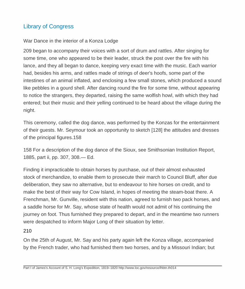
Library of Congress
Part I of James's Account of S. H. Long's Expedition, 1819–1820 http://www.loc.gov/resource/lhbtn.th014
War Dance in the interior of a Konza Lodge
209 began to accompany their voices with a sort of drum and rattles. After singing for
some time, one who appeared to be their leader, struck the post over the fire with his
lance, and they all began to dance, keeping very exact time with the music. Each warrior
had, besides his arms, and rattles made of strings of deer's hoofs, some part of the
intestines of an animal inflated, and enclosing a few small stones, which produced a sound
like pebbles in a gourd shell. After dancing round the fire for some time, without appearing
to notice the strangers, they departed, raising the same wolfish howl, with which they had
entered; but their music and their yelling continued to be heard about the village during the
night.
This ceremony, called the dog dance, was performed by the Konzas for the entertainment
of their guests. Mr. Seymour took an opportunity to sketch [128] the attitudes and dresses
of the principal figures.158
158 For a description of the dog dance of the Sioux, see Smithsonian Institution Report,
1885, part ii, pp. 307, 308.— Ed.
Finding it impracticable to obtain horses by purchase, out of their almost exhausted
stock of merchandize, to enable them to prosecute their march to Council Bluff, after due
deliberation, they saw no alternative, but to endeavour to hire horses on credit, and to
make the best of their way for Cow Island, in hopes of meeting the steam-boat there. A
Frenchman, Mr. Gunville, resident with this nation, agreed to furnish two pack horses, and
a saddle horse for Mr. Say, whose state of health would not admit of his continuing the
journey on foot. Thus furnished they prepared to depart, and in the meantime two runners
were despatched to inform Major Long of their situation by letter.
210
On the 25th of August, Mr. Say and his party again left the Konza village, accompanied
by the French trader, who had furnished them two horses, and by a Missouri Indian; but
Library of Congress
Part I of James's Account of S. H. Long's Expedition, 1819–1820 http://www.loc.gov/resource/lhbtn.th014
this last had followed them only a few miles, when he repented of his undertaking and
returned.
In pursuing the most direct route from the Konza village to the Missouri, they crossed at
the distance of seventeen miles, the Vermilion, a small stream bordered with handsome
forests. Nineteen miles beyond this they arrived at the sources of Grasshopper Creek,
where they encamped on the evening of the 27th.159 Here the soil changes somewhat
abruptly. The high prairies about the Vermilion and Blue Earth creeks are barren, almost
naked, and inhabited by some orbicular lizards. About Grasshopper Creek the soil is
fertile, the grass dense and luxuriant.
159 Grasshopper Creek rises near the northern line of the state, its mouth being in
Jefferson County, opposite Lecompton. The name was changed to Delaware River when
the tribe of that name was removed to its lower course.
The route of the party on its return may have been across Pottawatomie and Jackson
counties, and through southern Atchison; or, more probably, northern Jefferson and
Leavenworth counties.— Ed.
On the 29th they arrived at Isle au Vache, and were hospitably received by Colonel
Morgan and the officers of his command, but had the mortification to learn that Major
Long, after waiting a sufficient time to enable the Indian agent to complete his negotiations
[129] with the Konzas, had departed with the steam-boat before the arrival of the
messengers, that had been sent to notify him of their disaster. These runners had been
despatched immediately after their arrival, with instructions to overtake the steam-boat,
and to deliver Mr. Say's letter, but 211 after some days they returned, without having been
able to effect any thing.
It was now determined that Mr. Say and Mr. Jessup, who on account of ill health, were
unable to travel farther on foot, should for the present remain at Isle au Vache, while the
other gentlemen of the detachment should continue their journey. Mr. Dougherty, from
Library of Congress
Part I of James's Account of S. H. Long's Expedition, 1819–1820 http://www.loc.gov/resource/lhbtn.th014
his intimate acquaintance with the country, was of opinion that by crossing in the nearest
direction from Isle au Vache to the mouth of Wolf river, they might yet overtake the steam-
boat. They accordingly placed themselves under his guidance, and, by great exertion,
fortunately arrived at he mouth of Wolf river, on the evening of the 1st of September, as
the steam-boat was passing.
The country south-west of the Missouri, between the Konzas and the Platte, is drained
principally by Wolf river and the Great Nemahaw. These rivers, like the Nodowa and
Nishnebottona, which enter the Missouri nearly opposite them from the north-east, rise
in the prairies at an elevation probably of forty or fifty feet above the level of the Missouri.
As they descend, their vallies becoming gradually wider, embosom a few trees, and at
length, near their entrance into the Missouri valley, are forests of considerable extent. The
surfade of these prairies presents a constant succession of small rounded hills, becoming
larger and more abrupt as you approach the beds of the rivers. The soil is deep, reposing
usually on horizontal beds of argillaceous sandstone, and secondary limestone. In all
the limestones along the Missouri, we observe a tendency to crystalline structure, and
they have often a reddish or yellowish white [130] colour. There is, 212 however, always
something in the arrangement and in the aspect of the crystals to distinguish these sparry
varieties from the primitive granular limestone, to which they have something of general
resemblance. The horizontal disposition of the strata of this limestone, the great numbers
of organic relics contained in it, and its intimate connexion with coal strata, indicate with
sufficient clearness its relation to the secondary rocks. No person who shall examine
this stratum with the least attention, either about the Nemahaw and the Konzas, or in the
mining district at the sources of the Gasconade, the Merameg, and the St. Francis, will for
a moment mistake it for any of those varieties of transition or primitive limestone, which it
in some respects so closely resembles. The crystalline varieties, no less than the compact
blue limestones, embrace numerous masses of chert or hornstone. This occurs of various
colours, and these are arranged in spots or stripes. Some specimens have several distinct
colours arranged in zigzag lines, somewhat resembling the fortification agate. The hunters
Library of Congress
Part I of James's Account of S. H. Long's Expedition, 1819–1820 http://www.loc.gov/resource/lhbtn.th014
use fragments of this stone for gun-flints; the savages also formerly employed it in the
manufacture of arrow points and other implements.160
160 Jessup's MS. Report.— James.
The soil superimposed upon these strata of limestone, is a calcareous loam. Near the
rivers it is intermixed with sand; this is also the case with the soil of the high prairies about
the Konzas village. In ascending the Konzas river, one hundred, or one hundred and
twenty miles from the Missouri, you discover numerous indications, both in the soil, and
its animal and vegetable productions, of an approach to the borders of that great Sandy
Desert, which stretches eastward from the base of the Rocky Mountains.
213
You meet there with the orbicular lizard, or “horned frog,” an inhabitant of the arid plains of
[131] New Mexico. You distinguish also some cacti, as well as many of those plants allied
to chenopodium and salsola, which delight in a thirsty muriatiferous soil. The catalogue
of the forest trees belonging to the vallies of this region is not very copious. The cotton-
wood and the plane tree, every where form conspicuous features of the forests. With these
are intermixed the tall and graceful acacia, the honey locust, and the bonduc, or coffee-
tree,161 and several species of juglans, carya and fraxinus, with pinnated or many-parted
leaves. Trees of the family of the coniferæ are not of frequent occurrence on the Missouri.
About the summits of rocky cliffs are here and there a few cedars or junipers, the only
trees that retain their verdure during the winter.
161 The guilandina dioica of Linn., Marshall, &c. but referred by Michaux to the new genus
gymnocladus, of which it is the only well ascertained species. It is common throughout the
western states, and territories, and in Canada, where it is called by the French Chicot, or
stump tree, from the nakedness of its appearance in winter. In the English gardens, where
it has been cultivated many years under the name of the hardy bonduc, it has attained
considerable magnitude, but has not hitherto been known to produce flowers.— James.
Library of Congress
Part I of James's Account of S. H. Long's Expedition, 1819–1820 http://www.loc.gov/resource/lhbtn.th014
The prairies, for many miles on each side of the Missouri, produce abundance of good
pasturage; but as far as our observation has extended, the best soil is a margin from ten to
twelve miles in breadth, along the western bank of the river. In the summer very little water
is to be found in the prairies, all the smaller streams failing, even though the season be
not unusually dry. On account of the want of wood and of water, the settlements will be for
a long time confined to the immediate vallies of the Missouri, the Konzas, and the larger
rivers; but it is probable, forests will hereafter be cultivated in those vast woodless regions,
214 which now form so great a proportion of the country; and wells may be made to supply
the deficiency of running water.
We have seen at Bellefontain, as well as at several other points on this river, a pretty
species of sparrow, which is altogether new to us;162 and several specimens of a serpent
have occurred, which has considerable affinity with the pine-snake of the southern states,
or bull-snake of Bartram.163
162 Fringilla grammaca, Say.—Above blackish-brown; head lineated; beneath white, a
black line from the inferior base of the inferior mandible, above this a dilated white line;
from the angle of the mouth proceeds a black line, which is much dilated and ferruginous
behind the eye, and terminates in a contracted black line; a black line from the eye to the
superior mandible, enclosed, as well as the eye, by a dilated white line, which is more
contracted behind the eye; top of the head with two dilated lines, which are black on the
front and ferruginous on the crown and hind head, and separated from each other by a
cinereous line; interscapulars and lesser wing coverts margined with dull cinereous or
brownish; wings dusky brown, a white spot on the outer webs of the second, third, and
fourth primaries, near their bases; back dirty olive-brown; tail rounded; tail feathers twelve,
blackish-brown, two intermediate ones immaculate, adjoining ones with a small white spot
at tip, which, on the lateral ones, increases in size until on the exterior one it occupies half
of the total length of the feather; the exterior web of the outer feather is white to its base;

Library of Congress
Part I of James's Account of S. H. Long's Expedition, 1819–1820 http://www.loc.gov/resource/lhbtn.th014
chin and throat white; neck and breast dull cinereous; abdomen and vent white; feet pale,
tinged with orange; nail of the middle toe slightly dilated on the inner side.
Length six and a quarter inches.
Shot at Belle Fontain on the Missouri. Many specimens were obtained. The auriculars
of the female are yellowish-brown. They run upon the ground like a lark, seldom fly into
a tree, and sing sweetly. They were subsequently observed at Engineer Cantonment.—
James.
163 Coluber obsoletus, Say.— Body black above, beneath whitish, with large subquadrate
black spots, which are confluent, and pale bluish towards the tail; throat and neck pure
white; sides between the scales with red marks.
Description. Body black, anterior half with a series of continuous, dilated dull-red large
circles, formed upon the skin between the scales, on the side; on many of the scales, are
white marginal dashes near their bases: these scales are placed in groups each side of
the vertebræ of the anterior moiety of the body; scales bipunctured at tip; beneath flat, so
as to produce an angle or carnia each side; white slightly tinged with yellowish red, irrorate
with black points, and spotted with large oblong quadrate marks, which gradually become
more continuous, confluent and plumbeous towards the tail, occupying nearly the whole
surface; head beneath and throat pure white; posterior canthus of the eye two-scaled; iris
blackish; pupil deep-blued black, enclosed by a silvery line.
One specimen, Pl. 228 — Sc. 67?
Another do. do. 233 — do. 84
Another do. do. 228 — do. 84
Total length — 4 feet 11 # inches.
Library of Congress
Part I of James's Account of S. H. Long's Expedition, 1819–1820 http://www.loc.gov/resource/lhbtn.th014
Tail do. do. 10 # do.
The lateral red marks are not perceptible, unless the skin be dilated so as to separate
the scales; and the small white marginal lines on the bases of some of the scales are
observable only on close inspection. It varies in being nearly or quite destitute of spots
on the anterior portion of the body beneath, but the posterior half of the inferior surface
still remains blackish. The whole animal bears strong resemblance to C. constrictor; but
the scales are decidedly smaller, and the number of its plates and scales approach it still
more closely to that uncertain species C. ovivorus. It is not an uncommon species on the
Missouri from the vicinity of Isle au Vache to Council Bluff.
Penis terminated by a hemisphere, covered with compressed, white spines, which are
reflected at tip; the series interrupted on the posterior side of the member by a canal; it is
much dilated, dark reddish brown, abruptly contracted at base from the exterior side, and
with a prominent tubercle on the middle of the inner side: length one inch and a quarter,
width about seven-sixteenths of an inch.— James.
215
Having received on board the detachment that had arrived from the Konza village, except
Messrs. [132] Say and Jessup, who, on account of ill health, remained at Isle au Vache,
we left the mouth of Wolf river on the 2nd of September. A party of hunters, furnished with
a horse for the transportation of game, were despatched at the same time with instructions
to hunt on the south side of the river, and to join us again in the evening. We had little
difficulty in procuring a constant supply of venison. Deer are very numerous on this part
of the Missouri, and we had several opportunities to kill them from on board, as they were
swimming across the river.
Twenty-one miles above the mouth of Wolf river, and 216 on the same side, is the
entrance of the Grand Nemahaw, a considerable river which rises in the plains between
the Platte and the Republican Fork of the Konzas river, and running eastwardly about

Library of Congress
Part I of James's Account of S. H. Long's Expedition, 1819–1820 http://www.loc.gov/resource/lhbtn.th014
one hundred and fifty miles, discharges into the Missouri a little north of latitude forty
degrees. In the straightness of its course, the rapidity and turbulence of its stream, it has
a general resemblance to the other western tributaries of the Missouri. A few miles above
the Nemahaw, and on the opposite side, is the mouth of the Tarkio, a smaller stream.164
164 The Grand Nemahaw, now usually called Big Nemaha, does not rise so far to the west
as is here implied. Its sources are in Lancaster County, Nebraska, almost directly north
of the mouth of Republican River. The confluence of the Big Nemaha is just above the
Kansas-Nebraska line.
There are two streams (Big and Little) called Tarkio Creek. They flow parallel through
Atchison and Holt counties, Missouri. The mouth of the Big Tarkio is opposite that of the
Big Nemaha; that of the Little Tarkio is now about eleven miles below, but the channel is
very changeable. Tarkio is said to mean “full of walnuts.”— Ed.
On the 4th of September we were joined by the hunters, who brought two deer, and
informed us they had killed several others. Lieutenant Field's boat was allowed to remain
at the encampment of the preceding night, after the departure of the steam-boat, for the
purpose of taking on board a large quantity of honey. Swarms of bees were found here in
great numbers, and the honey they afforded made a valuable addition to our provisions,
consisting now in a great measure of hunters' fare.
Finding one of the valves of the steam-engine much worn and leaky, we were now under
the necessity of stopping for a day to have a new one, which we had brought, adapted to
its place. Several of the men amused themselves by hunting and fishing. [133] We had
now a plentiful 217 supply of game, and many large catfish were taken, some of them
weighing more than fifty pounds.
We passed in succession the mouths of the Nishnebottona and the Little Nemahaw,165
and arrived on the 7th at the Grand Pass. Here the Nishnebottona, a beautiful river about
sixty yards wide, approaches within one hundred and fifty yards of the Missouri, being

Library of Congress
Part I of James's Account of S. H. Long's Expedition, 1819–1820 http://www.loc.gov/resource/lhbtn.th014
separated from it by a sandy prairie, rising scarcely twenty feet above the surface of the
water. After pursuing for a short distance a parallel course, the two rivers diverge, and,
Nishnebottona meanders along the side of the Missouri valley, about sixty miles to its
confluence with the latter river.166 From this point is a pleasing view of the hills called
the Baldpated Prairie, stretching along the north-eastern side of the Nishnebottona, and
diminished to the size of anthills in the distant perspective.167 Here the navigation is
much obstructed by sand-bars, and the ordinary current of the Missouri, according to the
statement of Lewis and
165 The Little Nemaha flows through the Nebraska county of the same name; its mouth is
between the towns of Aspinwall and Nemaha.— Ed.
166 Nishnabotna is an Indian word signifying “canoe making river.” Fifteen years earlier,
Lewis and Clark found the divide between the rivers about three hundred yards wide.
At that time the mouth of the Nishnabotna was on the line between Atchison and Holt
counties, Missouri. Since then its waters have found their way across Grand Pass, and
the old channel below that point has been abandoned. In 1804 the main current of the
Missouri ran north of L'Isle Chauve (Bald Island), the middle of which lay opposite Grand
Pass. The channel now runs south of this island, while the Nishnabotna, reaching the
old channel of the Missouri at the middle of the island, follows it to the confluence of the
island's foot. This was the condition in 1879 (see Map of the Missouri River, from the
government survey, plates xx and xxi), but the channels are constantly shifting.— Ed.
167 Lewis and Clark applied the name “Bald Hills” to “the ridge of naked hills” here
described, and “Bald-pated Prairie” to the low lands at their base.— Ed.
218 Clarke, corroborated by our observation, is something more than one fathom per
second.168 In many places the Missouri hurries across concealed sand bars and other
obstructions, with the velocity of seven, eight, or even twelve feet in a second.169
Between these obstructions, the channel becomes deeper, and the current more
moderate; consequently the aggregate velocity at times of low water may be reckoned
Library of Congress
Part I of James's Account of S. H. Long's Expedition, 1819–1820 http://www.loc.gov/resource/lhbtn.th014
something less than six feet to the second. As the volume of water is increased by the
heavy rains, and the melting of the snows within the Rocky Mountains, the current is
proportionably accelerated, and becomes more equable, running for many miles in
succession, not less than seven hundred and twenty feet per minute. At the time of our
ascent the summer floods had not entirely subsided, and in contending against the current,
we found occasion [134] in a few instances to make use of the towing rope.
168 Lewis and Clarke, vol. i. p. 28.— James.
Comment by Ed. The reference is to Biddle's History of the Expedition under the
Command of Captains Lewis and Clark to the Sources of the Missouri, etc. (Philadelphia,
1814). See also Thwaites, Original Journals of the Lewis and Clark Expedition (New York,
1914).
169 This velocity of current is equalled by that of the Cassiquiare in South America, and
probably surpassed by the Oronoko, the average descent of whose bed is thirteen inches
to the mile of 950 toises (6 feet 4.376 inches per toise). See Humb. Pers. Nar. vol. v. p.
637, and vol. iv. p. 452. La Condamine and Major Rennel suppose the mean descent of
the Amazon and the Ganges, scarce four or five inches to the mile, which is about equal to
that of the Mississippi, according to the most satisfactory estimates we have been able to
make.— James.
About thirteen miles above the Grand Pass is a point where Lewis and Clarke witnessed
the falling of a portion, about three-fourths of a mile in length, of a high cliff of sandstone
and clay. Appearances have considerably changed since the time of their journey. There
is still an indentation along the bluff, showing the upper part of the 219 portion which had
slid down, but the whole is now covered with grass. The river has retired from the base
of the cliff it was then undermining. A grassy plain, of some extent, occupies the spot
where the bed of the river must have been; but this prairie is, in its turn, experiencing
the vicissitude incident to every thing along the bank of the Missouri, and is evidently
Library of Congress
Part I of James's Account of S. H. Long's Expedition, 1819–1820 http://www.loc.gov/resource/lhbtn.th014
very soon to disappear entirely. A mile or two above this point are cliffs of sandstone and
indurated clay, in a state of rapid disintegration. Here we observed extensive beds of
aluminous earth, of a dark grey colour, alternating with red and yellowish white sandstone.
Here are also numerous vegetable remains, which Mr. Say thought to consist of the limbs
of trees included in the rock, carbonized and often intermixed with pyrites; smaller limbs in
short fragments lay intermixed, and crossing each other in every direction.
Among other things, we observed here what appeared to be the cast of the seed vessel
of the nelumbium, of uncommon magnitude. Fragments of mineral coal were observed
scattered about the surface.
The mouth of the Platte,170 where we arrived on the 15th of September is, according
to our observations, in latitude 41° 3# 13# north. We shall hereafter have occasion to
speak more particularly of this river. Its mouth now exhibited a great extent of naked sand-
bars, the water, which was transparent and of a greenish colour, flowing almost unseen
through a number of small channels. Masses of sand accumulate at the mouth of the
Platte, rendering the [135] navigation of the Missouri at that
170 Platte River (sometimes called Flatwater and Nebraska, all three names having the
same meaning) is the largest tributary of the Missouri. It joins the latter between Sarpy and
Cass counties, Nebraska, 640.8 miles from the Mississippi. Its mouth is taken as the line
between the “upper” and “lower” Missouri.— Ed.
220 point extremely difficult. The Platte, during its floods, pours into the Missouri a volume
of water, considerably exceeding in magnitude that of the latter river, occasioning a reflux
of the waters for many miles. From the Platte upward, the annual range from high to low
water in the Missouri, may be rated at about eighteen feet.
Above the Platte, the scenery of the Missouri becomes much more interesting. The bluffs
on each side are more elevated and abrupt, and being absolutely naked, rising into conic
points, split by innumerable ravines, they have an imposing resemblance to groups of
Library of Congress
Part I of James's Account of S. H. Long's Expedition, 1819–1820 http://www.loc.gov/resource/lhbtn.th014
high granitic mountains, seen at a distance. The forests within the valley are of small
extent, interspersed with wide meadows covered with carices and cyperaceæ, with some
species of limnetis, polypogon, and arundo, sometimes sinking into marshes occupied
by sagittarias, alismas, and others of the hydrocharidæ. The woodlands here, as on the
whole of the Missouri below, are filled with great numbers of pea vines,171 which afford
an excellent pasturage for horses and cattle. The roots of the apios tuberosa were much
sought after, and eaten by the soldiers, who accompanied us in our ascent. They are little
tubers about half an inch in diameter, and when boiled are very agreeable to the taste.
Two and a half miles above the mouth of the Platte, and on the same side, is that of the
Papilion, a stream of considerable length, but discharging little water.172 Here we found
two boats belonging to the Indian traders at St. Louis. They had passed us some days
before, and were to remain for the winter at the mouth of the Papilion, to trade with the
Otoes, Missouries, and other Indians.
171 Species of apios, the glycine of Lin.— James.
172 See Bradbury's Travels, in our volume v, note 40.— Ed.
221
The banks of the Missouri, above the Platte, have long been frequented by the Indians,
either as places [136] of permanent or occasional residence. Deserted encampments are
often seen. On the north-east side, near the mouth of Mosquito river, are the remains of
an old Ioway village. Four miles above, and on the opposite side, was formerly a village
of the Otoes. On the 17th of September we arrived at the trading establishment of the
Missouri Fur Company, known as Fort Lisa, and occupied by Mr. Manuel Lisa, one of the
most active persons engaged in the Missouri fur trade. We were received by a salute from
this establishment, and encamped a little above, on the same side of the river.173
173 The Mosquito is on the Iowa side, in Pottawatomie County, its mouth being a few
miles below Council Bluffs.
Library of Congress
Part I of James's Account of S. H. Long's Expedition, 1819–1820 http://www.loc.gov/resource/lhbtn.th014
For the Oto Indians, Missouri Fur Company, and Manuel Lisa, see Bradbury's Travels, in
our volume v, notes 42, 149, 64 respectively. Lisa established the post named for him, in
1812, and for a decade it was the most important trading station on the Missouri. It stood
about twenty miles above the present town of Council Bluffs (Iowa), on the opposite side of
the river.— Ed.
[137] CHAPTER VIII
Winter cantonment near Council Bluff—Councils with the Otoes, Missouries, Ioways,
Pawnees, &c.
The position selected for the establishment of winter quarters for the exploring party,
was on the west bank of the Missouri, about half a mile above Fort Lisa, five miles below
Council Bluff, and three miles above the mouth of Boyer's river.174 At this place we
anchored on the 19th
174 The camp was in the southeast corner of Washington County, Nebraska. Boyer River
rises in Sac County, Iowa, flows southwest through Crawford and Harrison counties, and
debouches in Pottawatomie County, nearly opposite the boundary between Washington
and Douglas counties, Nebraska.— Ed.
222 of September, and in a few days had made great progress in cutting timber, quarrying
stone, and other preparations for the construction of quarters.
Cliffs of sparry limestone rise in the rear of the site we had selected, to an elevation of
near three hundred feet.175 At times of low water, strata of horizontal sandstone are
disclosed in the bed of the Missouri. These pass under and support the limestone. Both
these strata probably extend in connexion, some distance to the west; but as they are
deeply covered with soil, we could not accurately ascertain their boundary in that direction.
On the map accompanying this work, we have traced a line running from the Canadian
river of the Arkansa, to the Elk Horn, between 96° and 98° west longitude, and marking
Library of Congress
Part I of James's Account of S. H. Long's Expedition, 1819–1820 http://www.loc.gov/resource/lhbtn.th014
what we supposed nearly the westernmost limit of the horizontal limestones, and the
argillaceous sandstones, disclosed in the beds of the larger rivers.
175 Height of the bluff, ascertained by Lieutenant Graham. Trigonometrically, 271 feet.
Barometrically, 277 — James.
[138] Both these strata embrace numerous relics of marine animals, many of which we
collected.176
176 We add some notices of a few of the most important.
1. Terebratula.—A specimen considerably resembling the T. subundata of Sowerby, in the
undulated line of the edges of the valves; but it is a much more depressed shell, and of a
much less rounded form. In the young state, the undulation of the edge is not very distinct;
but this character increases with age, so that in the young state, it appears like a totally
different species from the adult.
2. In the same rock are very numerous arquated spines, like ribs of fish, some of them 1 ½
inches long.
3. A fragment of a terebratula or productus, imbedded, with very long spines, which may
possibly be the same with the above.
4. A specimen, being a mass of comminuted fragments of shells, amongst which are only
recognizable a few segments of the column of the encrinus, and minute turretted univalves
of five whirls, which resemble turritella, and are about one-twentieth of an inch long.
5. Millepora cylindrica, Say.— Branched, cylindric; pores very regular, alternate, oval,
placed nearer to each other than the length of their own transverse diameters, and
resembling those of an alveolite. Diameter, about one-tenth of an inch.
6. Segments of the column of encrinus of authors, of a pentangular form.

Library of Congress
Part I of James's Account of S. H. Long's Expedition, 1819–1820 http://www.loc.gov/resource/lhbtn.th014
7. Ossiculae of the body of a crinoid animal of the analogous species to No. 21.
8. Fragment of Perna?
9. A mass of argillaceous sandstone, containing spines of a Linnean echinus, belonging
probably to the genus cidarites of Lamarck. Of these spines some are elongate-conic,
others slightly fusiform, obtuse and slightly dilated near the tip, both are armed with short
asperities throughout their length. They resemble in some degree those of the cidarites
pistillaris of Lamarck, but they are smaller, less fusiform, and the asperities are not
prominent.
In the same mass are segments of encrinus, and fragments of the retepore.
10. Retepore, much resembling the milleporites flustriformis of Martin, Petrif. Derbi. pl. 43.
fig. 1 and 2., but the alveoles in our specimens are rather smaller.
11. Milkpora cylindrica, Say.—Of the diameter of half an inch.
12. Productus subserratus, Say.— Shell transverse, convex valve semicircular, destitute
of asperities or striae, longitudinally indented in the middle; line of the hinge rectilinear,
half as long again as the length of the shell, with three or four spines or serratures on each
side towards the angle; umbo not prominent; the beak hardly prominent beyond the line
of the hinge. Length, more than three-tenths; breadth, more than half an inch. A large
specimen was four-fifths of an inch wide.
If we except the beak, the outline of this shell, as respects the hinge margin and the sides,
considerably resembles that of P. spinulosus of Sowerby, but the base is far more obtusely
rounded, and it is a shorter shell comparatively with its width. The serratures are very often
broken off. The curvature of the sides does not in the slightest degree project beyond the
angles of the hinge line.
Library of Congress
Part I of James's Account of S. H. Long's Expedition, 1819–1820 http://www.loc.gov/resource/lhbtn.th014
13. An imperfect cast, very like the terebratula subundata of Sowerby, and of equal
magnitude.
14. Pentagonal ossiculae of the trunk of encrinus of authors, which in outline may be
compared to figs. 61 and 62, of plate 13. vol. 2. of Parkinson's Organic Remains, but their
surfaces do not now exhibit any sculpture.
15. Many of these shells exhibit the most unequivocal evidences of having been in a
plastic state, at some period or other, since their deposition in their present situations.
The fine striae of a productus lineolatus, are so interlaced on the middle of a valve of
one of our specimens, as at once to convince every observer of the shell having been
thus partially dissolved, and when in this state to have been gently rubbed by some other
body, in two directions proceeding obliquely to the same point, so as to throw the striae
in that part entirely out of their proper longitudinal direction. It is very common to find
shells unnaturally flattened, or compressed in various ways and degrees, often without
any fracture in the shell or cast; a circumstance which certainly could never happen to the
shell, unless it was in a plastic state, or in a state of partial solution.
16. A specimen of carbonate of lime, on its surface a mass of sub-parallel tubes,
connected by short lateral processes. The whole much resembles, and is probably
congeneric with the erismatholithus tubiporites ( catenatus) of Martin's Petrif. Derbi. t.
42. fig. 2., but the connecting processes of the tubes are much shorter than they are
represented in that figure; but it corresponds much more exactly with the tubiporite, figured
by Parkinson in his Organic Remains, vol. 2. pl. I. f. I., and may with great propriety form a
new genus, the type of which will be the tubipora strues of Lin.
The genus is probably allied to favosites and tubipora.
17. Trilobus.—The abdomen of a species of this singular genus frequently occurs in the
sandstone of the Missouri; near Engineer Cantonment they were very common. The
Library of Congress
Part I of James's Account of S. H. Long's Expedition, 1819–1820 http://www.loc.gov/resource/lhbtn.th014
largest was rather more than one inch long, by about one and three-tenths inches in
breadth at base; but the more general length is about three-fourths of an inch. The tergum
or intermediate lobe is narrow, being not more than two-thirds of the width of the flanks,
and much more convex than those parts.
But a single specimen occurred, which we can, without any doubt, consider as the thorax
of a trilobus; but whether or not it appertains to the same species with the above, or to
some other of which we have no other fragment, we are at a loss to determine. Like the
above-mentioned abdomen, it is distinct from any that we have seen figures of. It is of a
narrow lunate form, highly convex, the disk destitute of sculpture, and the eyes prominent.
18. Many imperfect casts of two different kinds of bivalve shells occur near Engineer
Cantonment, of which one may possibly have been a cardita.
19. Tooth of a squalus, which seems to approach nearest to those of Sq. maximus, by its
compressed conic form.
Greatest length 2 110 inches.
Thickness more than # of an inch.
The sides are rounded, without any appearance of serratures; thickened near the tip, and
more compressed near the base.
20. Tooth of a squalus, something like that of S. galeus, but less of a tricommitted angular
form, and the lateral processes are more distinct, and also less triangular than in that
species.
21. An imperfect body of a crinoid animal, encrinite of authors; the fragment is about one-
half of the inferior portion of the body, from which the following description is made out,
taking into view the whole circumference. The plates composing the first costal series
(Miller), five in number, axe longitudinally pentangular, much curved inwards towards
Library of Congress
Part I of James's Account of S. H. Long's Expedition, 1819–1820 http://www.loc.gov/resource/lhbtn.th014
the base, to join the first columnar joint, or perhaps the pelvis; at which part the plate is
narrow, being about one-ninth of an inch, whilst the other sides are nearly three-tenths
of an inch each, the superior ones being somewhat longer than the others; the second
costal plates, (Miller,) five in number, are transversely pentangular, the superior joint being
long, the lateral ones shortest, the former being one-half an inch in length, the latter 3/20,
and the inferior sides which articulate to the segments of the pelvis, somewhat less than
3/10 of an inch; the margins of the first costal joints, as well as the superior margins of
the segments of the pelvis, are armed with a few tubercles, some of which seem to have
been perforated; all the superior pieces are wanting in our specimen, but the truncated
surface, on which the scapulars (Miller) rested, is of a pentagonal outline, and composed
of a series of horizontal equilateral triangles, two to each side, which are separated on
each side from the adjacent pairs by a deep groove, which corresponds, and is nearly at
right angles with the exterior sutures, which join the first costal joints to each other; these
triangular surfaces are also separated from the exterior edge by two grooves, which are
crenated, and enclose an oblong foramina between them; a single intercostal plate occurs,
interposed between two of the second costals; it is of an oblong hexagonal form, its base
resting upon the extremity of a segment of the first costals, which is truncated to receive it;
the superior portion of this plate is much bent inward towards the abdominal cavity; its tip
is quadrate and concave.
The whole exterior surface of this reliquium, with the exception of the tubercles, and
sutural impressed lines, is plain and equable.
If we have not mistaken the pieces of this imperfect specimen, the pelvis is wanting, but
the cavity in which it existed must have been about 3/20 of an inch in diameter.
The plate-like form of the ossiculae, and their mode of articulation with each other, by an
extension horizontally inwards, as we have described above, in the case of those plates
which we have considered as the second costals, seem to indicate, that this species ought
to be referred to the second division of the crinoidea, or semiarticulata of Miller. It certainly,
Library of Congress
Part I of James's Account of S. H. Long's Expedition, 1819–1820 http://www.loc.gov/resource/lhbtn.th014
however, cannot be at all referred to poteriocrinites, the only genus which that author has
framed in this division of the family. We refrain from distinguishing it by a name either
generic or specific, until other specimens can be obtained, in which the characters are less
equivocal.
We have two second costal plates, which made part of distinct individuals, larger than the
above described one. Of these the surface of one is perfectly glabrous, whilst that of the
other has light orbicular indentations instead of tubercles; a third very small one is perfectly
smooth like the first, and doubtless formed part of the body of a young individual.
Another plate found near the same spot with the above, is of a somewhat triangular
form exteriorly, or rather like the face of a truncated pyramid, of which the middle of the
summit is a little produced in the form of a right angle, thus offering a scollop on each
side of the apex for the adaptation of superior ossiculae. On divesting it carefully of its
extraneous matrix, we discovered that it was readily adjusted by its base to the summit of
those segments of the fragment above described, which we have supposed to be second
costals, a prominent line on its base corresponding with the inner one of those grooves
which we have described, to characterize the superior face of those plates. This plate,
then, agreeably to the relations in which we have viewed the preceding pieces, must be
a scapula; it is susceptible of considerable hinge-like motion, and appears to have been
much less firmly attached to the costals than the latter are to each other.
A segment of a crinoid animal, which seemed to have been a first costal joint of a
pentacrinus of Parkinson, occurred near the same place.
22. Productus pectinoides, Say.— Convex valve, with a central longitudinal indentation;
the whole surface is longitudinally ribbed, each rib being marked by two striae, in addition
to the central carina.
The shell is not of frequent occurrence, and a perfect specimen has not yet been obtained,
but the portions we have examined, are sufficient to show that it is perfectly distinct from
Library of Congress
Part I of James's Account of S. H. Long's Expedition, 1819–1820 http://www.loc.gov/resource/lhbtn.th014
either of the species we have mentioned. We do not find any species figured or described
by authors like it.
23. Productus compressus, Say.— much compressed,.with numerous acute striae,
upwards of fifty in number on each valve, the alternate ones rather smaller; a very slight
central longitudinal indentation on the convex valve; outline suborbicular; hinge edge
rectilinear, shorter than the greatest breadth of the shell.
Greatest breadth from # to 1 inch. In its proportions it resembles the truncated portion of
the productus of Martin, as represented on his plate 22. fig. 3. It is very common.
24. A shell of the length and breadth of three inches sometimes occurs, the convex valve
of which is transversely undulated, its umbo prominent, and curved like that of a gryphaea,
its tip resting on the base of the opposite valve which is concave, with a transverse linear
base; its muscular impressions seem to have been lateral.
25. A single specimen was found of a valve of a shell, in some degree resembling a
pecten, but without the auricles. Length more than 2 8/10 inches.
26. Productus lineotatus, Say.— Valves with numerous, fine, equal, equidistant,
longitudinal striae, and a few small tubercles; convex valve very much elongated, its basal
portion is curved downwards, almost perpendicularly with respect to the disk near the
umbones.
So singular is the structure of this shell, that the internal cavity appears to have been
perfectly transverse, with respect to the general length of the shell, and small in
comparison with the length. It strongly resembles the anomites productus of Martin, as
represented on plate 22. fig. 102. of his Petrif. Derbi., and like that shell it is armed with
small tubercles, though fewer in number, and the striae are much more numerous and
smaller.
Library of Congress
Part I of James's Account of S. H. Long's Expedition, 1819–1820 http://www.loc.gov/resource/lhbtn.th014
27. Cast of a turretted univalve, probably a cerithium, of the length of 2½ inches.
28. Cast of the anterior portion of a valve of a shell like an ostrea, of the breadth of 2½
inches.
29. On the Missouri near the Platte, occur masses of rock, which seem to be
almost exclusively composed of a remarkable petrifaction, belonging to the family of
concamerated shells. This shell is elongated, fusiform, and when broken transversely, it
exhibits the appearance of numerous cells disposed spirally as in the nummulite, but its
longitudinal section displays only deep grooves. The shell was therefore composed of
tubes or syphons, placed parallel to each other, and revolving laterally, as in the genus
melonis of Lamarck, with which its characters undoubtedly correspond. But as in the
transverse fracture, its spiral system of tubes cannot be traced to the centre in any of
the numerous specimens we have examined, it would seem to have a solid axis, and
consequently belongs to that division of the genus that Montfort regards as distinct,
under the name of millolites, which seems to be similar to the lasciolites of Parkinson,
and altogether different from the miliolites of Lamarck. Our specimens are conspicuously
striated on the exterior, which distinction, together with their elongated fusiform shape,
sufficiently distinguish them as a species from the sabulosus which Montfort describes as
the type of his genus. No aperture is discoverable in this shell, but the termination of the
exterior volution very much resembles an aperture as long as the shell.
The length is three-tenths of an inch; and its greatest breadth one-twelfth.
We call it miliolites secalicus, Say.— Mr. T. Nuttall informs me, that he observed it in great
quantities high up the Missouri.
In the same mass were some segments of the encrinus, and a terebratula with five or six
obtuse longitudinal waves.
Library of Congress
Part I of James's Account of S. H. Long's Expedition, 1819–1820 http://www.loc.gov/resource/lhbtn.th014
30. Another petrifaction, abundant in some fragments of compact carbonate of lime, also
found on the shores of the Missouri, possesses all the generic characters which we have
attributed to the preceding species, excepting that in the transverse fracture the cells
distinctly revolve from the centre itself, and of course the shell was destitute of the solid
nucleus as in melonis, Lamarck. It has about four volutions. We have named this species,
which is, notwithstanding the difference of the central portion of the same genus with
the preceding miliolites centralis, Say. As in the preceding, it is entirely filled solidly with
carbonate of lime, and this substance being of a greater purity in the filled-up cavities of
the fossil than in the mass, its interior divisions are very obvious.
The latter species we observed about one hundred miles up the Konzas river, where it
forms the chief body of the rocks in extensive ranges. It seems to be a carbonate of lime
containing iron.— James.
223
Immediately after our arrival, an interpreter had been sent across the country, to intercept
the traders then on their way to the Pawnees, with considerable quantities of 224
merchandize.It was thought proper to suspend all intercourse with those Indians, until an
adjustment of the recent difficulties should take place. In addition to the outrage 225 on
Mr. Say's party, they had made prisoners of two white hunters from the Arkansa, a father
and son, who had been found hunting in the Indian territories. 226 These men had been
liberated through the interference of some of the members of the Missouri Fur Company,
and had recently arrived at Fort Lisa. During their captivity, 227 they had been treated with
such severity by the Pawnees, that they had often entreated an end might be put to their
lives.
228
The interpreter returned on the 20th, having accomplished the object of his mission. Soon
afterwards, Mr. Dougherty arrived from the Oto village, whither he had been sent with
a deputation to Konzas, to aid in effecting a reconciliation between those nations. This
Library of Congress
Part I of James's Account of S. H. Long's Expedition, 1819–1820 http://www.loc.gov/resource/lhbtn.th014
proposition, which originated with the Konzas, was favourably received by the Otoes.
Mr. D. was soon afterwards despatched to the Pawnees, with instructions to demand of
them the property plundered from Mr. Say's party, also to require that the persons who
had committed that outrage should be given up. He was accompanied by two Frenchmen
acquainted with the Pawnees and their language.
A party of Otoes arrived at Fort Lisa on the 26th of September, with pack-horses laden
with pelfries, and bringing with them a soldier, who, having been accidentally separated
from a small detachment that were driving some beeves from Martin's Cantonments,
towards Council Bluff, had wandered about in the prairie for five days, without tasting food,
[139] when he at last had the good fortune to fall in with the Otoes, who hospitably fed and
conducted him to the trading house.
229
The Council Bluff, so called by Lewis and Clarke, from a council with the Otoes and
Missouries held there on the 3d of August 1804, is a remarkable bank rising abruptly
from the brink of the river, to an elevation of about one hundred and fifty feet. This is a
most beautiful position, having two important military features, security, and a complete
command of the river. Its defects are a want of wood within a convenient distance, there
being little within a mile above, and much farther below, also a want of stone and of water,
except that of the river. From the summits of the hills, about one mile in the rear of the bluff
is presented the view of a most extensive and beautiful landscape. The bluffs on the east
side of the river exhibit a chain of peaks stretching as far as the eye can reach. The river
is here and there seen meandering in serpentine folds, along its broad valley, chequered
with woodlands and prairies, while at a nearer view you look down on an extensive plain
interspersed with a few scattered copses or bushes, and terminated at a distance by the
Council Bluff.
This position is about five miles above that selected for the wintering post of the exploring
party. At the last mentioned place, a very narrow plain or beach, closely covered with
Library of Congress
Part I of James's Account of S. H. Long's Expedition, 1819–1820 http://www.loc.gov/resource/lhbtn.th014
trees, intervenes between the immediate bank of the river and the bluffs, which rise near
two hundred feet, but are so gradually sloped as to be ascended without great difficulty,
and are also covered with trees. This spot presented numerous advantages for the
cantonment of a small party like ours. Here were abundant supplies of wood and stone,
immediately on the spot where we wished to erect our cabins, and the situation was
sheltered by the high bluffs from the north-west winds. The place was called Engineer
Cantonment. [140] On the 230 26th of September, Mr. Say and Mr. Jessup arrived in the
flotilla from Cow Island, in company with Col. Morgan, Dr. Gale, and Captain Magee.177
They had both nearly recovered their health, and entertained the liveliest sense of the
eminent politeness and hospitality which had been conferred on them by the above named
gentlemen, as well as the other officers of the military expedition.
177 John Gale, of New Hampshire, was surgeon in the rifles. He entered the army in 1812,
as surgeon's mate in the 23d Infantry. After an honorable discharge in 1815, he was the
same year reinstated as surgeon's mate in the 3d Infantry, and in 1818 made surgeon in
the rifles. Three years later he became major-surgeon. He died in 1830.
Matthew J. Magee was captain of a Pennsylvania company of volunteers during the first
two years of the War of 1812–15. In 1814 he was made captain in the 4th Rifles. After
being discharged at the close of the war, he was reinstated (1816) as first lieutenant of
ordnance with brevet rank as captain. A little later he was made captain, and in 1818 was
transferred to the rifles. In 1821 he was transferred to the infantry. His death occurred in
1824.— Ed.
About one hundred Otoes, together with a deputation of the Ioway nation, who had been
summoned to a council by Major O'Fallon, presented themselves at our camp on the 3d
of October. The principal chiefs advanced before their people, and upon invitation seated
themselves. After a short interval of silence Shonga-tonga, the Big Horse, a large portly
Indian of a commanding presence, arose and said, “My father, your children have come
Library of Congress
Part I of James's Account of S. H. Long's Expedition, 1819–1820 http://www.loc.gov/resource/lhbtn.th014
to dance before your tent, agreeably to our custom of honouring brave or distinguished
persons.”
After a suitable reply, by Major O'Fallon, the amusement of dancing was commenced
by the striking up of their rude instrumental and vocal music; the former consisting of a
gong made of a large keg, over one of the ends of which a skin was stretched, which was
struck by a small stick; and another instrument, consisting of a stick of firm wood, notched
like a saw, over the teeth of which a smaller 231 stick was rubbed forcibly backward and
forward; with these, rude as they were, very good time was preserved with the vocal
performers who sat around them, and by all the natives as they sat in the inflection of their
bodies, or the movements of their limbs; after the lapse of a little time three individuals
leaped up and danced around for a few minutes, then, at a concerted signal from the
master of the ceremonies, the music ceased, and they retired to their seats uttering a loud
noise, which by patting the mouth rapidly with the hand, was broken into a succession of
similar sounds, somewhat like the hurried barking of a dog. Several sets [41] of dancers
succeeded, each terminating as the first. In the intervals of the dances, a warrior would
step forward and strike a flagstaff they had erected with a stick, whip, or other weapon,
and recount his martial deeds. This ceremony is called striking the post , and whatever
is then said may be relied upon as rigid truth, being delivered in the presence of many
a jealous warrior and witness, who could easily detect and would immediately disgrace
the striker for exaggeration or falsehood. *This is called the beggars' dance, during which
some presents are always expected by the performers, as tobacco, whiskey, or trinkets.
But on this occasion, as none of those articles were immediately offered, the amusement
was not, at first, distinguished by much activity. The master of the ceremonies continually
called aloud to them to exert themselves; but still they were somewhat dull and backward.
Ietan now stepped forward and lashed a post with his whip, declaring that he would thus
punish those who did not dance; this threat from one whom they had vested with authority
for this occasion had a manifest effect upon his auditors, who were presently 232 highly
Library of Congress
Part I of James's Account of S. H. Long's Expedition, 1819–1820 http://www.loc.gov/resource/lhbtn.th014
wrought up by the sight of two or three little mounds of tobacco twist which were now laid
before them, and appeared to infuse new life.
After lashing the post and making his threat, Ietan went on to narrate his martial exploits.
He had stolen horses seven or eight times from the Konzas; he had first struck the bodies
of three of that nation slain in battle. He had stolen horses from the Ietan nation, and had
struck one of their dead. He had stolen horses from the Pawnees, and struck the body of
one Pawnee Loup. He had stolen horses several times from the Omawhaws, and once
from the Puncas. He had struck the bodies of two Sioux. On a war party, in company with
the Pawnees, he had attacked the Spaniards and penetrated into one of their camps; the
Spaniards, [142] excepting a man and boy, fled; himself being at a distance before his
party, he was shot at and missed by the man, whom he immediately shot down and struck.
“This, my father,” said he, “is the only martial act of my life that I am ashamed of.”178 After
several rounds of dancing, and of striking at the post by the warriors, Mi-a-ke-ta, or the
Little Soldier, a war-worn veteran, took his turn to strike the post. He leaped actively about,
and strained his voice to its utmost pitch whilst he portrayed some of the scenes of blood
in
178 Ietan, as he was called by the whites, is said to have been the son of Big Horse
(Shonga-tonga). The name may have been given him for some exploit against the Ietan
(Comanche) tribe. His Indian name (Shamonekusse, Shongmunecuthe) means Prairie
Wolf. In 1821-22 Ietan accompanied a deputation of chiefs to the East; the Indians made
careful observations of what they saw, after their own fashion, and, it is said, attempted to
count the people of New York by means of notched sticks. Among his fellows Ietan was
noted for his wit and sagacity, as well as for warlike prowess. His death resulted (April,
1837) from a wound received while pursuing some young braves who had seduced two of
his wives.— Ed.
233 which he had acted. He had struck dead bodies of individuals of all the red nations
around, Osages, Konzas, Pawnee Loups, Pawnee Republicans, Grand Pawnees, Puncas,
Omawhaws, and Sioux, Padoucas, La Plais or Bald Heads, Ietans, Sauks, Foxes, and

Library of Congress
Part I of James's Account of S. H. Long's Expedition, 1819–1820 http://www.loc.gov/resource/lhbtn.th014
Ioways;179 he had struck eight of one nation, seven of another, &c. He was proceeding
with his account when Ietan ran up to him, put his hand upon his mouth, and respectfully
led him to his seat. This act was no trifling compliment paid to the well-known brave. It
indicated that he had still so many glorious acts to speak of, that he would occupy so
much time as to prevent others from speaking, and put to shame the other warriors by the
contrast of his actions with theirs.
179 The Ietan Indians, more commonly known as Comanche, were a branch of the
Shoshoni family. Their range was the upper Arkansas, Canadian, and Red rivers.
On the Pawnee and Pawnee Loups, see respectively Brackenridge's Journal, in our
volume vi, note 17, and Bradbury's Travels, in our volume v, note 44. The Pawnee
nation consisted of four principal tribes: 1. Pawnee proper (Grand Pawnee); 2. Pawnee
Republican, who dwelt on the Republican fork of Kansas River; 3. Tapage, on the Platte;
4. Pawnee Loups (Skidi; Pani-mahas).
The Omaha and Ponca were closely related tribes of Siouan stock. For their early history
and present condition, see our volume v, notes 49, 63.
The Sioux (Dakota) were the chief branch of the great family to which they have given their
name. The branch was divided into a number of tribes, including the Yankton and Teton,
mentioned below in the text.
Sketches of the Osage, Sauk and Foxes, and Iowa will be found in our volume v, notes 21,
22.
The Padouca were a powerful tribe when visited by Bourgmont in 1724 (see succeeding
volume, note 29), but the nation disintegrated and lost its identity before the close of the
eighteenth century, if, indeed, the name was not from the beginning applied collectively to
several kindred tribes of the plains. Their habitat was the banks of the upper Kansas River;
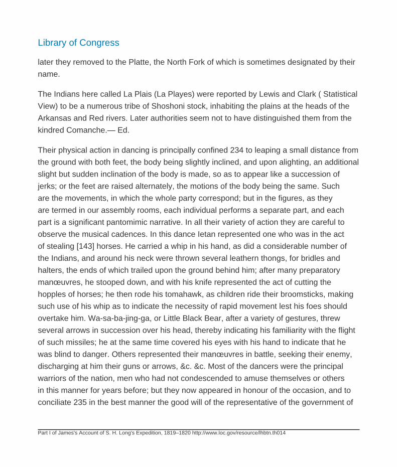
Library of Congress
Part I of James's Account of S. H. Long's Expedition, 1819–1820 http://www.loc.gov/resource/lhbtn.th014
later they removed to the Platte, the North Fork of which is sometimes designated by their
name.
The Indians here called La Plais (La Playes) were reported by Lewis and Clark ( Statistical
View) to be a numerous tribe of Shoshoni stock, inhabiting the plains at the heads of the
Arkansas and Red rivers. Later authorities seem not to have distinguished them from the
kindred Comanche.— Ed.
Their physical action in dancing is principally confined 234 to leaping a small distance from
the ground with both feet, the body being slightly inclined, and upon alighting, an additional
slight but sudden inclination of the body is made, so as to appear like a succession of
jerks; or the feet are raised alternately, the motions of the body being the same. Such
are the movements, in which the whole party correspond; but in the figures, as they
are termed in our assembly rooms, each individual performs a separate part, and each
part is a significant pantomimic narrative. In all their variety of action they are careful to
observe the musical cadences. In this dance Ietan represented one who was in the act
of stealing [143] horses. He carried a whip in his hand, as did a considerable number of
the Indians, and around his neck were thrown several leathern thongs, for bridles and
halters, the ends of which trailed upon the ground behind him; after many preparatory
manœuvres, he stooped down, and with his knife represented the act of cutting the
hopples of horses; he then rode his tomahawk, as children ride their broomsticks, making
such use of his whip as to indicate the necessity of rapid movement lest his foes should
overtake him. Wa-sa-ba-jing-ga, or Little Black Bear, after a variety of gestures, threw
several arrows in succession over his head, thereby indicating his familiarity with the flight
of such missiles; he at the same time covered his eyes with his hand to indicate that he
was blind to danger. Others represented their manœuvres in battle, seeking their enemy,
discharging at him their guns or arrows, &c. &c. Most of the dancers were the principal
warriors of the nation, men who had not condescended to amuse themselves or others
in this manner for years before; but they now appeared in honour of the occasion, and to
conciliate 235 in the best manner the good will of the representative of the government of
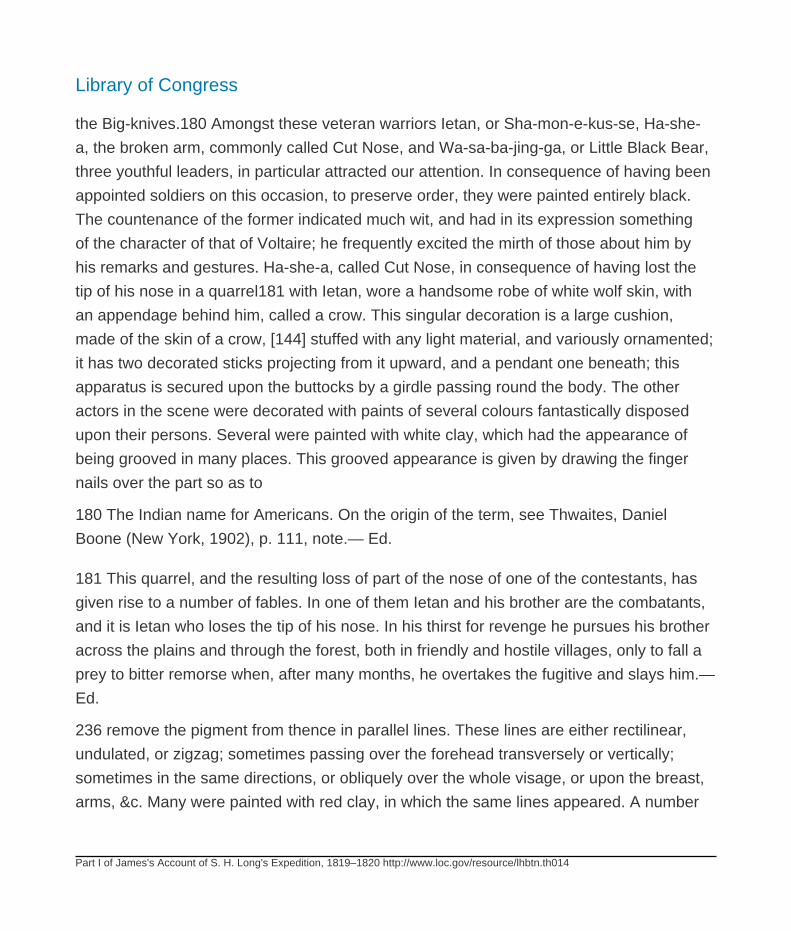
Library of Congress
Part I of James's Account of S. H. Long's Expedition, 1819–1820 http://www.loc.gov/resource/lhbtn.th014
the Big-knives.180 Amongst these veteran warriors Ietan, or Sha-mon-e-kus-se, Ha-she-
a, the broken arm, commonly called Cut Nose, and Wa-sa-ba-jing-ga, or Little Black Bear,
three youthful leaders, in particular attracted our attention. In consequence of having been
appointed soldiers on this occasion, to preserve order, they were painted entirely black.
The countenance of the former indicated much wit, and had in its expression something
of the character of that of Voltaire; he frequently excited the mirth of those about him by
his remarks and gestures. Ha-she-a, called Cut Nose, in consequence of having lost the
tip of his nose in a quarrel181 with Ietan, wore a handsome robe of white wolf skin, with
an appendage behind him, called a crow. This singular decoration is a large cushion,
made of the skin of a crow, [144] stuffed with any light material, and variously ornamented;
it has two decorated sticks projecting from it upward, and a pendant one beneath; this
apparatus is secured upon the buttocks by a girdle passing round the body. The other
actors in the scene were decorated with paints of several colours fantastically disposed
upon their persons. Several were painted with white clay, which had the appearance of
being grooved in many places. This grooved appearance is given by drawing the finger
nails over the part so as to
180 The Indian name for Americans. On the origin of the term, see Thwaites, Daniel
Boone (New York, 1902), p. 111, note.— Ed.
181 This quarrel, and the resulting loss of part of the nose of one of the contestants, has
given rise to a number of fables. In one of them Ietan and his brother are the combatants,
and it is Ietan who loses the tip of his nose. In his thirst for revenge he pursues his brother
across the plains and through the forest, both in friendly and hostile villages, only to fall a
prey to bitter remorse when, after many months, he overtakes the fugitive and slays him.—
Ed.
236 remove the pigment from thence in parallel lines. These lines are either rectilinear,
undulated, or zigzag; sometimes passing over the forehead transversely or vertically;
sometimes in the same directions, or obliquely over the whole visage, or upon the breast,
arms, &c. Many were painted with red clay, in which the same lines appeared. A number
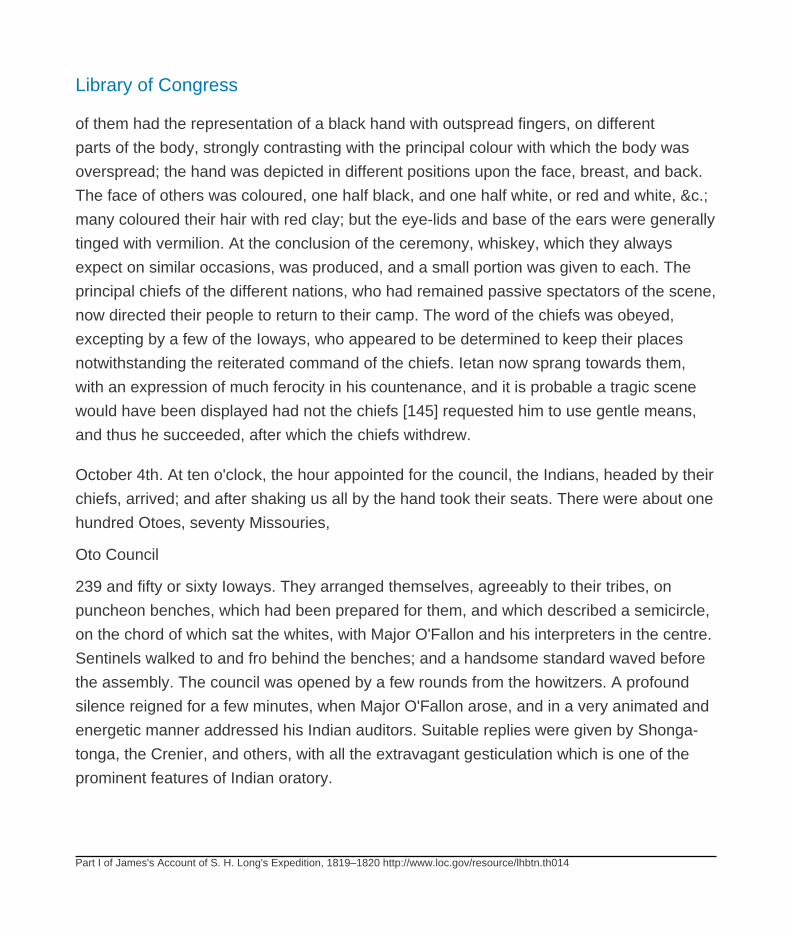
Library of Congress
Part I of James's Account of S. H. Long's Expedition, 1819–1820 http://www.loc.gov/resource/lhbtn.th014
of them had the representation of a black hand with outspread fingers, on different
parts of the body, strongly contrasting with the principal colour with which the body was
overspread; the hand was depicted in different positions upon the face, breast, and back.
The face of others was coloured, one half black, and one half white, or red and white, &c.;
many coloured their hair with red clay; but the eye-lids and base of the ears were generally
tinged with vermilion. At the conclusion of the ceremony, whiskey, which they always
expect on similar occasions, was produced, and a small portion was given to each. The
principal chiefs of the different nations, who had remained passive spectators of the scene,
now directed their people to return to their camp. The word of the chiefs was obeyed,
excepting by a few of the Ioways, who appeared to be determined to keep their places
notwithstanding the reiterated command of the chiefs. Ietan now sprang towards them,
with an expression of much ferocity in his countenance, and it is probable a tragic scene
would have been displayed had not the chiefs [145] requested him to use gentle means,
and thus he succeeded, after which the chiefs withdrew.
October 4th. At ten o'clock, the hour appointed for the council, the Indians, headed by their
chiefs, arrived; and after shaking us all by the hand took their seats. There were about one
hundred Otoes, seventy Missouries,
Oto Council
239 and fifty or sixty Ioways. They arranged themselves, agreeably to their tribes, on
puncheon benches, which had been prepared for them, and which described a semicircle,
on the chord of which sat the whites, with Major O'Fallon and his interpreters in the centre.
Sentinels walked to and fro behind the benches; and a handsome standard waved before
the assembly. The council was opened by a few rounds from the howitzers. A profound
silence reigned for a few minutes, when Major O'Fallon arose, and in a very animated and
energetic manner addressed his Indian auditors. Suitable replies were given by Shonga-
tonga, the Crenier, and others, with all the extravagant gesticulation which is one of the
prominent features of Indian oratory.
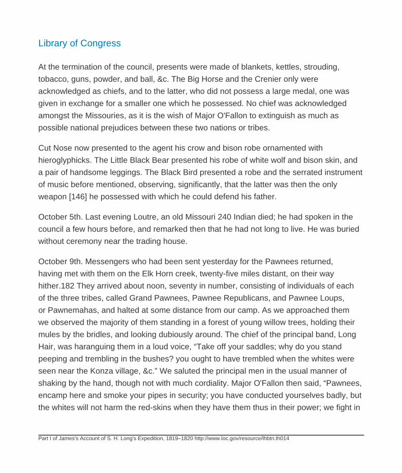
Library of Congress
Part I of James's Account of S. H. Long's Expedition, 1819–1820 http://www.loc.gov/resource/lhbtn.th014
At the termination of the council, presents were made of blankets, kettles, strouding,
tobacco, guns, powder, and ball, &c. The Big Horse and the Crenier only were
acknowledged as chiefs, and to the latter, who did not possess a large medal, one was
given in exchange for a smaller one which he possessed. No chief was acknowledged
amongst the Missouries, as it is the wish of Major O'Fallon to extinguish as much as
possible national prejudices between these two nations or tribes.
Cut Nose now presented to the agent his crow and bison robe ornamented with
hieroglyphicks. The Little Black Bear presented his robe of white wolf and bison skin, and
a pair of handsome leggings. The Black Bird presented a robe and the serrated instrument
of music before mentioned, observing, significantly, that the latter was then the only
weapon [146] he possessed with which he could defend his father.
October 5th. Last evening Loutre, an old Missouri 240 Indian died; he had spoken in the
council a few hours before, and remarked then that he had not long to live. He was buried
without ceremony near the trading house.
October 9th. Messengers who had been sent yesterday for the Pawnees returned,
having met with them on the Elk Horn creek, twenty-five miles distant, on their way
hither.182 They arrived about noon, seventy in number, consisting of individuals of each
of the three tribes, called Grand Pawnees, Pawnee Republicans, and Pawnee Loups,
or Pawnemahas, and halted at some distance from our camp. As we approached them
we observed the majority of them standing in a forest of young willow trees, holding their
mules by the bridles, and looking dubiously around. The chief of the principal band, Long
Hair, was haranguing them in a loud voice, “Take off your saddles; why do you stand
peeping and trembling in the bushes? you ought to have trembled when the whites were
seen near the Konza village, &c.” We saluted the principal men in the usual manner of
shaking by the hand, though not with much cordiality. Major O'Fallon then said, “Pawnees,
encamp here and smoke your pipes in security; you have conducted yourselves badly, but
the whites will not harm the red-skins when they have them thus in their power; we fight in
Library of Congress
Part I of James's Account of S. H. Long's Expedition, 1819–1820 http://www.loc.gov/resource/lhbtn.th014
the plains, and scorn to injure men seated peaceably by their fires. Think well of what you
will have to say to me in council to-morrow.” These assurances appeared to annul their
present apprehensions, and they proceeded to encamp.
182 Elkhorn River (Come de Cerf, of the French explorers) is a considerable northern
tributary of the Platte, into which it falls on the western line of Sarpy County. The head
waters are only a few miles from the Niobrara River, in Rock County.— Ed.
Three boats came from Camp Missouri to take on board 241 a quantity of provisions which
are stored here for the troops; we exchanged salutes with them. The noise of the artillery
excited the apprehensions of the [147] Indians; who, being sensible of having grossly
offended the whites, now anticipated some exemplary punishment, and were not at ease
until reassured of their safety, and the cause of the firing of such great guns so near them
was explained.
In the evening, accompanied by several gentlemen of the party, we visited the camp of the
Pawnees, whom we found sitting round their fires, smoking their pipes in silence. Some
were employed in making bows, having found plenty of hickory, and hop horn beam wood
here, which are not to be procured in the vicinity of their villages. Their mules were tied
to trees, feeding on the bark of the cotton wood. The three tribes were seated around
different fires. We sat down in the group of Grand Pawnees, and smoked with their chief
Tar-ra-re-ca-wa-o, or Long Hair. This [is] an hereditary chief, of a lofty and rather haughty
mien; his mouth is, perhaps through habit, drawn down a little at the corners. He has the
appearance and character of an intrepid man, although not distinguished as a warrior,
having, during his life, killed but a single man, who was a Spaniard. He is, however, artful
and politic, and has performed some laudable actions. The following anecdote may serve
in part to illustrate the more amiable traits of his character. Dorion, a Mestizo,183 on a
trading expedition, had accumulated a considerable quantity of peltry, at the Pawnee
republican village, when it was situated on the Republican fork of the Konza river.
Library of Congress
Part I of James's Account of S. H. Long's Expedition, 1819–1820 http://www.loc.gov/resource/lhbtn.th014
183 One of the half-breed sons of Pierre Dorion (Durion), who accompanied Lewis and
Clark as interpreter. See Bradbury's Travels, in our volume v, note 7.— Ed.
242
As he had no horses to transport his merchandize, he requested the chief of that village to
assist him in conveying it to the Grand Pawnees on the Platte, as he intended to descend
that river to trade with the Otoes, on his way to St. Louis; the chief directly ordered horses
to be brought, the furs were packed upon them, and they departed on the journey; but
owing to some alleged misconduct on the part of Dorion, the chief, when half way, ordered
the goods to be taken from the horses, and to be left on the plain. [148] He then, with his
followers, returned to his village. The trader, after bewailing his unfortunate condition, at
length resolved to go to the Grand Pawnee village and solicit the aid of Long Hair. Having
arrived at the residence of the chief, he related to him in what manner he had been used
by the Republican chief, and concluded by requesting assistance to bring in his goods.
Long Hair, without reply, ascended to the top of his lodge and called out to his people
to bring him one hundred horses. Taking the best of these, and a sufficient number of
attendants, he accompanied Dorion, and assisted him to transport all his peltries, and
did not cease with his good offices, until he had aided him in building a skin canoe, and
had packed all the merchandize aboard, although previously told by Dorion that he had
nothing to reward him with, having, as he said, traded every thing away, though at the
same moment he had a number of Indian goods concealed in his packs of buffalo robes.
After all was completed, “Now,” said the chief, “Dorion, I know that you are a bad man;
I have no doubt but you have a quantity of such goods as we want, concealed in those
packs, and could reward me if you were liberal enough; but I ask nothing: you have a
forked tongue. You have abused me to the whites, by 243 calling me a rascal, saying I
robbed the traders, &c.; but go, I will not harm you; tell the red head (Governor Clarke) that
I am a rascal, robber, &c., I am content.”184
Library of Congress
Part I of James's Account of S. H. Long's Expedition, 1819–1820 http://www.loc.gov/resource/lhbtn.th014
184 Red-head was the customary Indian name for Governor William Clark, and St. Louis
was “Red-head's Town.” For sketch of Clark, see Nuttall's Journal, in our volume xiii, note
105.— Ed.
At another fire, surrounded by his particular band, sat the Knife Chief, La-che-le-cha-ru,
principal chief of the Pawneemahas. He is a large portly man, with a very prepossessing
countenance; the hair on the sides of his head is gray; he has a deep scar on the right
side, from a wound which was inflicted by a female prisoner, of the Padouca nation, whom
he had adopted and taken into his family. This squaw, becoming infuriated at the prospect
of the state of slavery to which she supposed herself now reduced, [149] stabbed her
child to the heart, mortally wounded the brother of this chief, and, before she could be
despatched, had inflicted this wound, through which the bowels protruded. The individuals
of this band live in great harmony amongst themselves, owing probably to their having but
two chiefs, who are unrivalled. The second chief is a Mestizo. Against this band we have
no accusation; they have always demeaned themselves well towards the American whites.
In a third group were collected the representatives of the Pawnee Republicans; this nation
or clan stands accused of whipping, robbing, and otherwise abusing a white American
and his son, whom they found trapping beaver on the Arkansa river, this season; of killing
two American citizens, two years since, who were also trapping beaver on the same river;
and of robbing our party of sundry articles and horses, near the Konza village, whilst
under 244 the protection of the flag of our country, of the nature of which they had been
instructed, and perfectly well understood. These outrages, and many others, they had
committed on lands, to which they do not pretend to have any claim, situated far from their
own territories, and in the immediate vicinity of nations with whom they then were, and still
are, at war.185
185 It was a party of the Grand Pawnees that robbed and ill-treated Lieutenant Pike and
his party, when traversing the country within their range.— James.

Library of Congress
Part I of James's Account of S. H. Long's Expedition, 1819–1820 http://www.loc.gov/resource/lhbtn.th014
On the following day the Pawnees were summoned to council, and in a short time they
appeared marching leisurely in a narrow pathway, in Indian file, led by the grand chief;
near this pathway the musical band was stationed, and when Long Hair arrived opposite,
they struck up, suddenly and loudly, a martial air. We wished to observe the effect which
instruments, that he had never seen or heard before, would produce on this distinguished
man, and therefore [150] eyed him closely, and were not disappointed to observe that
he did not deign to look upon them, or to manifest, by any motion whatever, that he was
sensible of their presence. The Indians arranged themselves on the benches prepared
for them, and the cessation of the music was succeeded by stillness, which was suddenly
interrupted by loud explosions from our howitzers, that startled many of us, but did not
appear to attract the notice of the Pawnees.
Major O'Fallon rose and addressed them in a very austere tone and manner; stating
the offences they had committed against the white people, and admonishing them to a
reformation in their conduct, and to restore the articles they had stolen from us; this was
chiefly directed
Pawnee Council
247 against the Pawnee Republicans; the Loups were applauded for their uniformly good
deportment.
The council terminated after much of the property taken from us near the Konza village
was restored, and a promise given that the offenders should be punished by whipping.186
186 See Appendix C at the end of volume xvii.— Ed.
The leisure we enjoyed after our arrival at Engineer Cantonment, afforded the opportunity
of making numerous excursions to collect animals, and to explore the neighbouring
country. We give here some account of two species of sorex, taken near our cabins.187
Library of Congress
Part I of James's Account of S. H. Long's Expedition, 1819–1820 http://www.loc.gov/resource/lhbtn.th014
187 I. Sorex parvus, Say.— Brownish cinereous above; beneath cinereous; teeth blackish;
tail short, of moderate thickness.
Body above brownish cinereous, beneath cinereous; head elongated; eyes and ears
concealed; whiskers long, the longest nearly attaining the back of the head; nose naked
emarginate; front teeth black, lateral ones piceous; feet whitish, five-toed; nails prominent,
acute, white; tail short, subcylindric, of moderate thickness, slightly thicker in the middle,
whitish beneath.
Length from tip of nose to root of tail, 2 8/8 inches.
of tail, 0¾
from the upper teeth to tip of nose, 0 8/20;
Mr. Peale caught this animal in a pitfall, which he had dug for the purpose of catching a
wolf. It is a female.
Barton, in his Medical and Physical Journal for 1806, p. 67, says, that, “Sorex
minutissimus of Zimmerman, has been discovered in the trans-Mississippi part of the
United States, in the country that is watered by the Missouri;” —had he reference to this
species?
This sorex minutissimus, is probably synonymous with S. exilis, to which our specimens
cannot be referred, whilst the character attributed to that species, of “tail very thick in the
middle,” is considered essential.
2. Sorex brevicaudus, Say.— Blackish-plumbeous above, beneath rather lighter; teeth,
blackish; tail, short, robust.
Total length from nose to tip of tail, 4# inch.
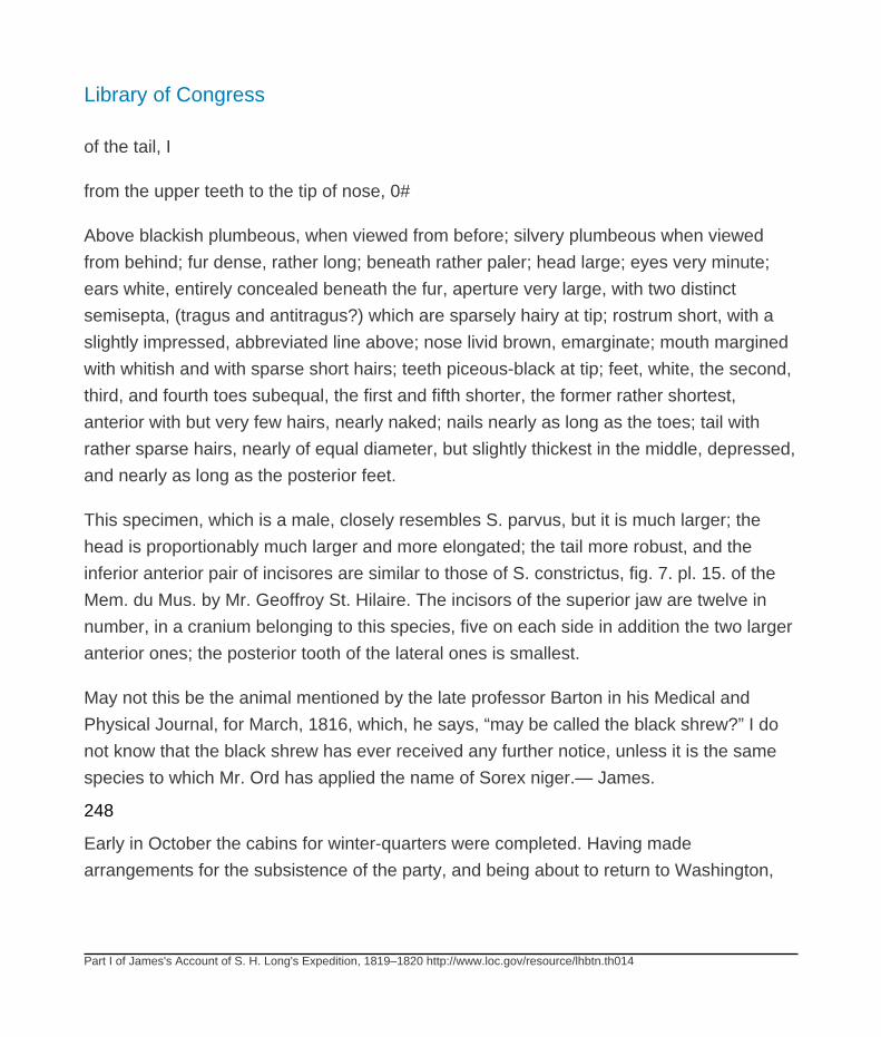
Library of Congress
Part I of James's Account of S. H. Long's Expedition, 1819–1820 http://www.loc.gov/resource/lhbtn.th014
of the tail, I
from the upper teeth to the tip of nose, 0#
Above blackish plumbeous, when viewed from before; silvery plumbeous when viewed
from behind; fur dense, rather long; beneath rather paler; head large; eyes very minute;
ears white, entirely concealed beneath the fur, aperture very large, with two distinct
semisepta, (tragus and antitragus?) which are sparsely hairy at tip; rostrum short, with a
slightly impressed, abbreviated line above; nose livid brown, emarginate; mouth margined
with whitish and with sparse short hairs; teeth piceous-black at tip; feet, white, the second,
third, and fourth toes subequal, the first and fifth shorter, the former rather shortest,
anterior with but very few hairs, nearly naked; nails nearly as long as the toes; tail with
rather sparse hairs, nearly of equal diameter, but slightly thickest in the middle, depressed,
and nearly as long as the posterior feet.
This specimen, which is a male, closely resembles S. parvus, but it is much larger; the
head is proportionably much larger and more elongated; the tail more robust, and the
inferior anterior pair of incisores are similar to those of S. constrictus, fig. 7. pl. 15. of the
Mem. du Mus. by Mr. Geoffroy St. Hilaire. The incisors of the superior jaw are twelve in
number, in a cranium belonging to this species, five on each side in addition the two larger
anterior ones; the posterior tooth of the lateral ones is smallest.
May not this be the animal mentioned by the late professor Barton in his Medical and
Physical Journal, for March, 1816, which, he says, “may be called the black shrew?” I do
not know that the black shrew has ever received any further notice, unless it is the same
species to which Mr. Ord has applied the name of Sorex niger.— James.
248
Early in October the cabins for winter-quarters were completed. Having made
arrangements for the subsistence of the party, and being about to return to Washington,

Library of Congress
Part I of James's Account of S. H. Long's Expedition, 1819–1820 http://www.loc.gov/resource/lhbtn.th014
Major Long issued orders to the officers and gentlemen of the expedition, for their
government during his absence. The following extract will show to what objects they were
instructed to direct their attention.
“Mr. Say will have every facility afforded him that circumstances will admit to examine the
country, [151] visit the neighbouring Indians, procure animals, &c. for the attainment of
which he will call on Lt. Graham, who is authorized to make any expenditures in behalf
of the expedition that may be deemed reasonable and necessary, and afford any aid in
his power, consistent with the performance of other duties. Mr. Seymour or Mr. Peale will
accompany him, whenever their services are deemed requisite.
“Major O'Fallon has given permisssion to Mr. Dougherty to aid the gentlemen of the party,
in acquiring information 249 concerning the Indians, &c.; this gentleman will, therefore,
be consulted in relation to visits, and all kinds of intercourse with the Indians, that may be
necessary in the prosecution of the duties of the expedition.
“In regard to these duties, the gentlemen of the expedition will consult my orders of March
last. The documents transmitted from the Philosophical Society of Philadelphia, by the
Secretary of War; and the instructions of Mr:. Jefferson to Capt. Lewis, to be found in vol.
1st of Lewis and Clarke's expedition,188 and regulate their observations and inquiries
accordingly.
188 See Thwaites, Original Journals of the Lewis and Clark Expedition, Appendix, vol. vii,
doc. xviii.— Ed.
“Lt. Graham will embrace every opportunity for celestial and barometric observations, and
calculate the latitude, longitude, magnetic dip and variation, with the utmost attainable
precision; also the heights of the neighbouring hills, and the adjacent high table lands.
He will also continue the meteorologic observations as usual, noticing the changes of
weather, and all celestial and atmospheric phenomena. To aid him in these duties, he will
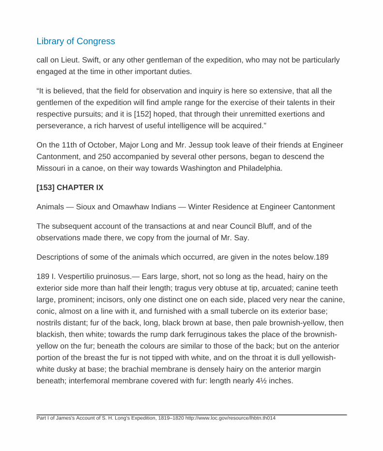
Library of Congress
Part I of James's Account of S. H. Long's Expedition, 1819–1820 http://www.loc.gov/resource/lhbtn.th014
call on Lieut. Swift, or any other gentleman of the expedition, who may not be particularly
engaged at the time in other important duties.
“It is believed, that the field for observation and inquiry is here so extensive, that all the
gentlemen of the expedition will find ample range for the exercise of their talents in their
respective pursuits; and it is [152] hoped, that through their unremitted exertions and
perseverance, a rich harvest of useful intelligence will be acquired.”
On the 11th of October, Major Long and Mr. Jessup took leave of their friends at Engineer
Cantonment, and 250 accompanied by several other persons, began to descend the
Missouri in a canoe, on their way towards Washington and Philadelphia.
[153] CHAPTER IX
Animals — Sioux and Omawhaw Indians — Winter Residence at Engineer Cantonment
The subsequent account of the transactions at and near Council Bluff, and of the
observations made there, we copy from the journal of Mr. Say.
Descriptions of some of the animals which occurred, are given in the notes below.189
189 I. Vespertilio pruinosus.— Ears large, short, not so long as the head, hairy on the
exterior side more than half their length; tragus very obtuse at tip, arcuated; canine teeth
large, prominent; incisors, only one distinct one on each side, placed very near the canine,
conic, almost on a line with it, and furnished with a small tubercle on its exterior base;
nostrils distant; fur of the back, long, black brown at base, then pale brownish-yellow, then
blackish, then white; towards the rump dark ferruginous takes the place of the brownish-
yellow on the fur; beneath the colours are similar to those of the back; but on the anterior
portion of the breast the fur is not tipped with white, and on the throat it is dull yellowish-
white dusky at base; the brachial membrane is densely hairy on the anterior margin
beneath; interfemoral membrane covered with fur: length nearly 4½ inches.
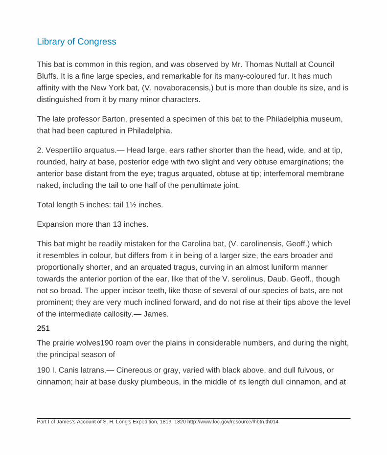
Library of Congress
Part I of James's Account of S. H. Long's Expedition, 1819–1820 http://www.loc.gov/resource/lhbtn.th014
This bat is common in this region, and was observed by Mr. Thomas Nuttall at Council
Bluffs. It is a fine large species, and remarkable for its many-coloured fur. It has much
affinity with the New York bat, (V. novaboracensis,) but is more than double its size, and is
distinguished from it by many minor characters.
The late professor Barton, presented a specimen of this bat to the Philadelphia museum,
that had been captured in Philadelphia.
2. Vespertilio arquatus.— Head large, ears rather shorter than the head, wide, and at tip,
rounded, hairy at base, posterior edge with two slight and very obtuse emarginations; the
anterior base distant from the eye; tragus arquated, obtuse at tip; interfemoral membrane
naked, including the tail to one half of the penultimate joint.
Total length 5 inches: tail 1½ inches.
Expansion more than 13 inches.
This bat might be readily mistaken for the Carolina bat, (V. carolinensis, Geoff.) which
it resembles in colour, but differs from it in being of a larger size, the ears broader and
proportionally shorter, and an arquated tragus, curving in an almost luniform manner
towards the anterior portion of the ear, like that of the V. serolinus, Daub. Geoff., though
not so broad. The upper incisor teeth, like those of several of our species of bats, are not
prominent; they are very much inclined forward, and do not rise at their tips above the level
of the intermediate callosity.— James.
251
The prairie wolves190 roam over the plains in considerable numbers, and during the night,
the principal season of
190 I. Canis latrans.— Cinereous or gray, varied with black above, and dull fulvous, or
cinnamon; hair at base dusky plumbeous, in the middle of its length dull cinnamon, and at

Library of Congress
Part I of James's Account of S. H. Long's Expedition, 1819–1820 http://www.loc.gov/resource/lhbtn.th014
tip gray or black, longer on the vertebral line; ears erect, rounded at tip, cinnamon behind,
the hair dark plumbeous at base, inside lined with gray hair; eyelids edged with black,
superior eyelashes black beneath, and at tip above; supplemental lid margined with black-
brown before, and edged with black-brown behind; iris yellow; pupil black-blue; spot upon
the lachrymal sac black-brown; rostrum cinnamon, tinctured with grayish on the nose;
lips white, edged with black, three series of black seta; head between the ears intermixed
with gray, and dull cinnamon, hairs dusky plumbeous at base; sides paler than the back,
obsoletely fasciate with black above the legs; legs cinnamon on the outer side, more
distinct on the posterior hair: a dilated black abbreviated line on the anterior ones near the
wrist; tail bushy, fusiform, straight, varied with gray and cinnamon, a spot near the base
above, and tip black: the tip of the trunk of the tail, attains the tip of the os calcis, when
the leg is extended; beneath white, immaculate; tail cinnamon towards the tip, tip black;
posterior feet four-toed, anterior five-toed.
ft. in.
Total length (excepting the hair at tip of tail) 3 9½
Trunk of the tail 1 0½
Hind foot os calcis to tip of claw 0 7#
Fore foot elbow to tip of claw 1 0¾
Ears from top of head 0 4
Rostrum from anterior canthus of the eye 0 3¾
Taken in a trap, baited with the body of a wild cat.
The line on the anterior side of the anterior feet, near the wrist, is wanting in a second
specimen.
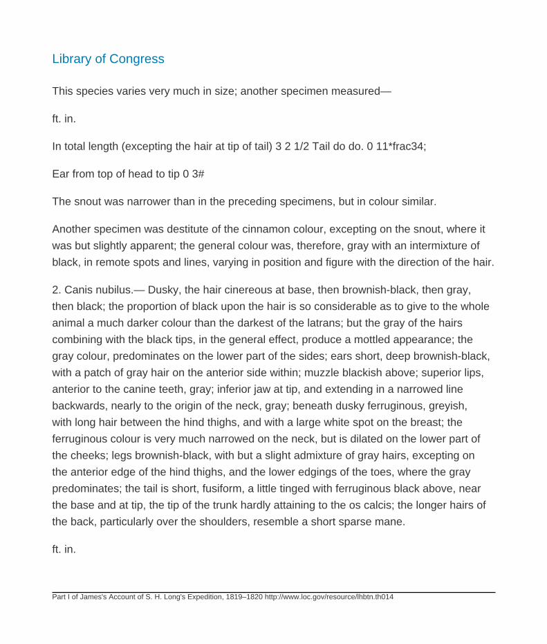
Library of Congress
Part I of James's Account of S. H. Long's Expedition, 1819–1820 http://www.loc.gov/resource/lhbtn.th014
This species varies very much in size; another specimen measured—
ft. in.
In total length (excepting the hair at tip of tail) 3 2 1/2 Tail do do. 0 11*frac34;
Ear from top of head to tip 0 3#
The snout was narrower than in the preceding specimens, but in colour similar.
Another specimen was destitute of the cinnamon colour, excepting on the snout, where it
was but slightly apparent; the general colour was, therefore, gray with an intermixture of
black, in remote spots and lines, varying in position and figure with the direction of the hair.
2. Canis nubilus.— Dusky, the hair cinereous at base, then brownish-black, then gray,
then black; the proportion of black upon the hair is so considerable as to give to the whole
animal a much darker colour than the darkest of the latrans; but the gray of the hairs
combining with the black tips, in the general effect, produce a mottled appearance; the
gray colour, predominates on the lower part of the sides; ears short, deep brownish-black,
with a patch of gray hair on the anterior side within; muzzle blackish above; superior lips,
anterior to the canine teeth, gray; inferior jaw at tip, and extending in a narrowed line
backwards, nearly to the origin of the neck, gray; beneath dusky ferruginous, greyish,
with long hair between the hind thighs, and with a large white spot on the breast; the
ferruginous colour is very much narrowed on the neck, but is dilated on the lower part of
the cheeks; legs brownish-black, with but a slight admixture of gray hairs, excepting on
the anterior edge of the hind thighs, and the lower edgings of the toes, where the gray
predominates; the tail is short, fusiform, a little tinged with ferruginous black above, near
the base and at tip, the tip of the trunk hardly attaining to the os calcis; the longer hairs of
the back, particularly over the shoulders, resemble a short sparse mane.
ft. in.
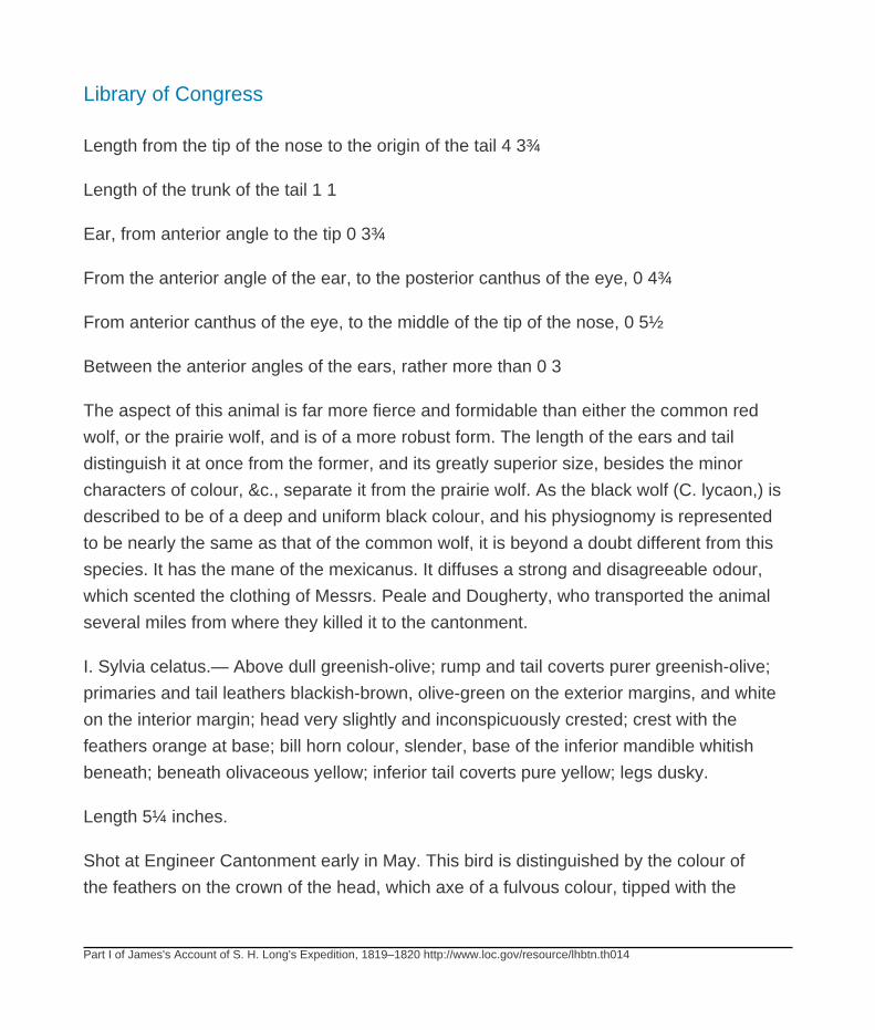
Library of Congress
Part I of James's Account of S. H. Long's Expedition, 1819–1820 http://www.loc.gov/resource/lhbtn.th014
Length from the tip of the nose to the origin of the tail 4 3¾
Length of the trunk of the tail 1 1
Ear, from anterior angle to the tip 0 3¾
From the anterior angle of the ear, to the posterior canthus of the eye, 0 4¾
From anterior canthus of the eye, to the middle of the tip of the nose, 0 5½
Between the anterior angles of the ears, rather more than 0 3
The aspect of this animal is far more fierce and formidable than either the common red
wolf, or the prairie wolf, and is of a more robust form. The length of the ears and tail
distinguish it at once from the former, and its greatly superior size, besides the minor
characters of colour, &c., separate it from the prairie wolf. As the black wolf (C. lycaon,) is
described to be of a deep and uniform black colour, and his physiognomy is represented
to be nearly the same as that of the common wolf, it is beyond a doubt different from this
species. It has the mane of the mexicanus. It diffuses a strong and disagreeable odour,
which scented the clothing of Messrs. Peale and Dougherty, who transported the animal
several miles from where they killed it to the cantonment.
I. Sylvia celatus.— Above dull greenish-olive; rump and tail coverts purer greenish-olive;
primaries and tail leathers blackish-brown, olive-green on the exterior margins, and white
on the interior margin; head very slightly and inconspicuously crested; crest with the
feathers orange at base; bill horn colour, slender, base of the inferior mandible whitish
beneath; beneath olivaceous yellow; inferior tail coverts pure yellow; legs dusky.
Length 5¼ inches.
Shot at Engineer Cantonment early in May. This bird is distinguished by the colour of
the feathers on the crown of the head, which axe of a fulvous colour, tipped with the
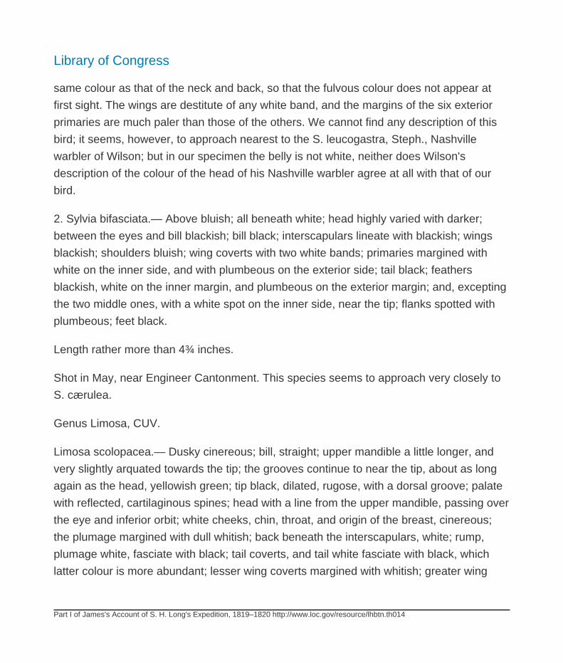
Library of Congress
Part I of James's Account of S. H. Long's Expedition, 1819–1820 http://www.loc.gov/resource/lhbtn.th014
same colour as that of the neck and back, so that the fulvous colour does not appear at
first sight. The wings are destitute of any white band, and the margins of the six exterior
primaries are much paler than those of the others. We cannot find any description of this
bird; it seems, however, to approach nearest to the S. leucogastra, Steph., Nashville
warbler of Wilson; but in our specimen the belly is not white, neither does Wilson's
description of the colour of the head of his Nashville warbler agree at all with that of our
bird.
2. Sylvia bifasciata.— Above bluish; all beneath white; head highly varied with darker;
between the eyes and bill blackish; bill black; interscapulars lineate with blackish; wings
blackish; shoulders bluish; wing coverts with two white bands; primaries margined with
white on the inner side, and with plumbeous on the exterior side; tail black; feathers
blackish, white on the inner margin, and plumbeous on the exterior margin; and, excepting
the two middle ones, with a white spot on the inner side, near the tip; flanks spotted with
plumbeous; feet black.
Length rather more than 4¾ inches.
Shot in May, near Engineer Cantonment. This species seems to approach very closely to
S. cærulea.
Genus Limosa, CUV.
Limosa scolopacea.— Dusky cinereous; bill, straight; upper mandible a little longer, and
very slightly arquated towards the tip; the grooves continue to near the tip, about as long
again as the head, yellowish green; tip black, dilated, rugose, with a dorsal groove; palate
with reflected, cartilaginous spines; head with a line from the upper mandible, passing over
the eye and inferior orbit; white cheeks, chin, throat, and origin of the breast, cinereous;
the plumage margined with dull whitish; back beneath the interscapulars, white; rump,
plumage white, fasciate with black; tail coverts, and tail white fasciate with black, which
latter colour is more abundant; lesser wing coverts margined with whitish; greater wing

Library of Congress
Part I of James's Account of S. H. Long's Expedition, 1819–1820 http://www.loc.gov/resource/lhbtn.th014
coverts black, terminal margin white: secondaries black, margin and submargin white;
primaries black, interior ones very slightly edged with white; outer shaft white. a little
longer than the second; breast and belly white; sides spotted or undulated with blackish
cinereous; inferior tail coverts with black abbreviated bands, the white prevailing; feet dirty
greenish; toes webbed at base, the exterior one reaching the first joint of outer toe, the
interior one very short; hind toe rather long.
Length from tip of bill to that of the tail, 11¾ inches.
Length of bill, 2¾
Length of feet, 5¾
Length from the knee to the origin of the feathers, 1 1/10;
Tail projecting more than one inch beyond the tip of the wing.
Several specimens were shot in a pond near the Bowyer creek. Corresponds with the
genus scolopax, Cuv. in having the dorsal grooves at the tip of the upper mandible, and in
having this part dilated and rugose; but the eye is not large, nor is it placed far back upon
the head; which two latter characters, combined with its more elevated and slender figure,
and the circumstance of the thighs being denudated of feathers high above the knee, and
the exterior toe being united to the middle toe by a membrane, which extends as far as
the first joint, and the toes being also margined, combine to distinguish this species from
those of the genus to which the form and characters of its bill would refer it, and approach
it more closely to limosa. In one specimen the two exterior primaries on each wing were
light brown, but the quills were white. It may perhaps with propriety be considered as the
type of a new genus, and under the following characters, be placed between the genera
scolopax and limosa.
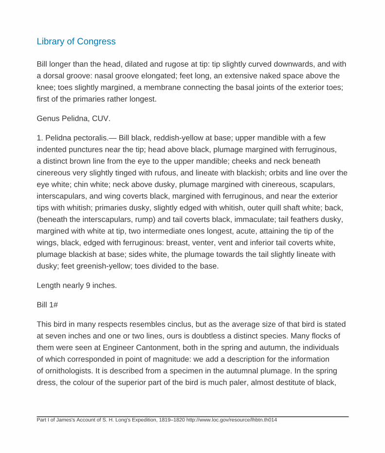
Library of Congress
Part I of James's Account of S. H. Long's Expedition, 1819–1820 http://www.loc.gov/resource/lhbtn.th014
Bill longer than the head, dilated and rugose at tip: tip slightly curved downwards, and with
a dorsal groove: nasal groove elongated; feet long, an extensive naked space above the
knee; toes slightly margined, a membrane connecting the basal joints of the exterior toes;
first of the primaries rather longest.
Genus Pelidna, CUV.
1. Pelidna pectoralis.— Bill black, reddish-yellow at base; upper mandible with a few
indented punctures near the tip; head above black, plumage margined with ferruginous,
a distinct brown line from the eye to the upper mandible; cheeks and neck beneath
cinereous very slightly tinged with rufous, and lineate with blackish; orbits and line over the
eye white; chin white; neck above dusky, plumage margined with cinereous, scapulars,
interscapulars, and wing coverts black, margined with ferruginous, and near the exterior
tips with whitish; primaries dusky, slightly edged with whitish, outer quill shaft white; back,
(beneath the interscapulars, rump) and tail coverts black, immaculate; tail feathers dusky,
margined with white at tip, two intermediate ones longest, acute, attaining the tip of the
wings, black, edged with ferruginous: breast, venter, vent and inferior tail coverts white,
plumage blackish at base; sides white, the plumage towards the tail slightly lineate with
dusky; feet greenish-yellow; toes divided to the base.
Length nearly 9 inches.
Bill 1#
This bird in many respects resembles cinclus, but as the average size of that bird is stated
at seven inches and one or two lines, ours is doubtless a distinct species. Many flocks of
them were seen at Engineer Cantonment, both in the spring and autumn, the individuals
of which corresponded in point of magnitude: we add a description for the information
of ornithologists. It is described from a specimen in the autumnal plumage. In the spring
dress, the colour of the superior part of the bird is much paler, almost destitute of black,
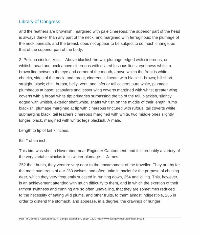
Library of Congress
Part I of James's Account of S. H. Long's Expedition, 1819–1820 http://www.loc.gov/resource/lhbtn.th014
and the feathers are brownish, margined with pale cinereous; the superior part of the head
is always darker than any part of the neck, and margined with ferruginous; the plumage of
the neck beneath, and the breast, does not appear to be subject to so much change, as
that of the superior part of the body.
2. Pelidna cinclus. Var.— Above blackish-brown, plumage edged with cinereous, or
whitish; head and neck above cinereous with dilated fuscous lines; eyebrows white; a
brown line between the eye and corner of the mouth, above which the front is white;
cheeks, sides of the neck, and throat, cinereous, lineate with blackish-brown; bill short,
straight, black; chin, breast, belly, vent, and inferior tail coverts pure white, plumage
plumbeous at base; scapulars and lesser wing coverts margined with white; greater wing
coverts with a broad white tip; primaries surpassing the tip of the tail, blackish, slightly
edged with whitish, exterior shaft white, shafts whitish on the middle of their length; rump
blackish, plumage margined at tip with cinereous tinctured with rufous; tail coverts white,
submargins black; tail feathers cinereous margined with white, two middle ones slightly
longer, black, margined with white; legs blackish. A male.
Length to tip of tail 7 inches.
Bill # of an inch.
This bird was shot in November, near Engineer Cantonment, and it is probably a variety of
the very variable cinclus in its winter plumage.— James.
252 their hunts, they venture very near to the encampment of the traveller. They are by far
the most numerous of our 253 wolves, and often unite in packs for the purpose of chasing
deer, which they very frequently succeed in running down, 254 and killing. This, however,
is an achievement attended with much difficulty to them, and in which the exertion of their
utmost swiftness and cunning are so often unavailing, that they are sometimes reduced
to the necessity of eating wild plums, and other fruits, to them almost indigestible, 255 in
order to distend the stomach, and appease, in a degree, the cravings of hunger.
Library of Congress
Part I of James's Account of S. H. Long's Expedition, 1819–1820 http://www.loc.gov/resource/lhbtn.th014
Their bark is much more distinctly like that of the domestic dog, than of any other animal;
in fact the first two or three notes could not be distinguished from the bark of a small
terrier, but these notes are succeeded by a lengthened scream.
The wonderful intelligence of this animal is well worthy 256 of note, and a few anecdotes
respecting it may not be amiss. Mr. Peale constructed and tried various kinds of traps to
take them, one of which was of the description called “a live trap,” a shallow box reversed,
and supported at one end, by the [154] well known kind of trap sticks, usually called
the “figure four,” which elevated the front of the trap upwards of three feet above its
slab flooring; the trap was about six feet long, and nearly the same in breadth, and was
plentifully baited with offal. Notwithstanding this arrangement, a wolf actually burrowed
under the flooring, and pulled down the bait through the crevices of the floor; tracks of
different sizes were observed about the trap. This procedure would seem to be the result
of a faculty beyond mere instinct.
This trap proving useless, another was constructed in a different part of the country,
formed like a large cage, but with a small entrance on the top, through which the animals
might enter, but not return; this was equally unsuccessful; the wolves attempted in vain to
get at the bait, as they would not enter by the route prepared for them.
A large double “steel trap” was next tried; this was profusely baited, and the whole, with
the exception of the bait, was carefully concealed beneath the fallen leaves. This was also
unsuccessful. Tracks of the anticipated victims were next day observed to be impressed in
numbers on the earth near the spot, but still the trap, with its seductive charge, remained
untouched. The bait was then removed from the trap, and suspended over it from the
branch of a tree; several pieces of meat were also suspended in a similar manner, from
trees in the vicinity; the following morning the bait over the trap alone remained.
257
Library of Congress
Part I of James's Account of S. H. Long's Expedition, 1819–1820 http://www.loc.gov/resource/lhbtn.th014
Supposing that their exquisite sense of smell warned them of the position of the trap, it
was removed, and again covered with leaves, and the baits being disposed as before, the
leaves to a considerable distance around were burned, and the trap remained perfectly
concealed by ashes; still the bait over the trap was avoided. Once only this trap was
sprung, and had fastened for a short time upon the foot of a species, which was shot the
following day at no great distance; it proved to be a species distinct from the [155] prairie
wolf, and we have described it under the name of C. nubilus.
In no respect disheartened by these futile attempts, many times repeated, and varied in
every obvious manner, another scheme was executed, which eventuated in complete
success. This was the log trap, in which one log is elevated above another at one end,
by means of an upright stick, which rests upon a rounded horizontal rigger stick, on the
inferior log.
The latrans does not diffuse the offensive odour, so remarkable in the two species of
jackalls, (C. aureus and C. anthus) though in many respects it resembles those animals.
Like the Mexicanus, the hair on the vertebral line is elongated; and we should be disposed
to regard it as the same animal, but it differs from the description of that species, both in
colour and physiognomy. The ears are proportionally longer than those of C. cancrivorus,
and, as well as the tail, shorter than the corresponding parts of C. mesomelas.
This animal, which does not seem to be known to naturalists, unless it should prove to
be the Mexicanus, is most probably the original of the domestic dog, so common in the
villages of the Indians of this region, some of the varieties 258 of which still retain much of
the habit and manners of this species.
On the 14th of October, four hundred Omawhaw Indians assembled at Camp Missouri.
Major O'Fallon addressed them in an appropriate speech, stating the reasons for their
being called to council; upon which Ong-pa-ton-ga, the Big Elk,191 arose, and after
shaking by the hand each of the whites present, placed his robe of otter skins, and his
Library of Congress
Part I of James's Account of S. H. Long's Expedition, 1819–1820 http://www.loc.gov/resource/lhbtn.th014
mockasins under the feet of the agent, whom he addressed to the following effect, as his
language was interpreted by Mr. Dougherty.
191 A sketch of Big Elk is given in Bradbury's Travels, volume v of our series, note 52.—
Ed.
“He had heard that his father wished to see him, and he had wished to see and to hear
the words of his father, ever since he learned that he was ascending [156] the river. He
was informed last fall of his being at the river Platte, and as he could not then go to see
him, he had now come to visit him; and here I am, my father. All these young people you
see around here are yours; although they are poor and trifling, yet they are your children. I
have always loved the whites since I first remember to have seen them, and this affection
increases with my age. All my nation loves the whites, and always have loved them.
Amongst all the good things of this world I place the whites first. But it appears that there
are many nations that live nearer to you than I, that do not love you, though you have
done more for them, than you have done for me. When they meet with you, they flatter
you, in order to get presents from you, notwithstanding which, they would not hesitate
to kill some of your people on their way home. Some of them shake hands with you in a
friendly manner, 259 whilst their hands are yet stained with your blood; and if you examine
your own hands, my father, I think you would find some of it adhering to them yet. For
my part, my father, I am proud to boast, that my hands are clean. Never has one of my
nation stained his hands with the blood of a white man. I do not understand, my father,
your mode of treating those well who treat you ill. It is true, I know, that you have more
sense than I have, but I cannot understand it. I have heard that the Pawnees have been
to see you; a nation that has killed, robbed, and insulted your people. I was also informed
that you feasted them, and at their departure you put weapons in their hands. I should not
be surprised to hear, that those very weapons were stained with white man's blood before
they reached the Pawnee village. This is what I cannot understand. This circumstance led
me to believe, that if you treated those that have injured you so well, you surely would treat
your poor children the Omawhaws, who have never done harm to your people, with much
Library of Congress
Part I of James's Account of S. H. Long's Expedition, 1819–1820 http://www.loc.gov/resource/lhbtn.th014
kindness [157] also. But I am afraid the transaction will have a bad effect on my young
men. When they heard of American troops ascending this river, they feared and respected
them. But I am fearful that this transaction will throw them off their guard, make them lose
their respect for you, and cause them to do something that they would not otherwise have
done, and thus create trouble and difference between us. You said, my father, that those
troops do not come to harm us. I believe it is true. I consider them all my brothers and
friends. So far from thinking they come to injure me, I regard them as my shield, to guard
me against bad nations around me. You say, that if ever there is a difference between us,
that it will be our fault; but I hope 260 not, my father, I cannot think that the Omawhaws
will offer any indignity to your people, now that they have seen all those troops, when
they have not harmed individuals who have resided years in their village unprotected,
although we were then less enlightened than we now are. Some think, my father, that
you have brought all these warriors here to take our land from us, but I do not believe
it. For although I am but a poor, simple Indian, yet I know that this land will not suit your
farmers; if I even thought your hearts bad enough to take the land, I would not fear it, as I
know there is not wood enough on it for the use of whites. You might settle along this river,
where timber is to be found; but we can always get wood enough in our country to make
our little fires. There is one thing I fear, my father; my nation is coming down here to hunt
this winter, and if you send out your soldiers to hunt also, they will drive off all the game,
and our women and children will starve. We have heard of the ascent of the troops up this
river ever since last fall, and we have been told by other nations, that if they chance to
meet with any squaws unprotected, they ravish them. But, my father, we shall soon know
if this be true or not; because, having [158] but little to eat, our squaws will be obliged to
go out into the prairies to dig roots; I shall trust to you, and not hesitate to let them go.” He
also observed, that he could not see the necessity of stationing so many troops here, as
there was no one to oppose; he thought it desirable that they should go higher up the river,
to chastise those refractory Indians who will not listen to our words. “There is one thing,
my father,” he observed, “which I wish you to inform me of. We have heard of your tying
up and whipping individuals of several nations, as you 261 ascended this river. What is
Library of Congress
Part I of James's Account of S. H. Long's Expedition, 1819–1820 http://www.loc.gov/resource/lhbtn.th014
the offence which will subject us to this punishment? I wish to know, that I may inform my
people, that they may be on their guard.” He then observed that all his children were poor,
and that they had come with the expectation of receiving something from their father.
This speech, contrary to the usual mode of Indian orators, was commenced in a low tone,
the voice gradually rising as the speaker proceeded, until it attained its full intonation.
Several speakers subsequently went forward and delivered their sentiments, generally
alluding to the circumstance of our treating those who injure us kindly, and neglecting our
friends.
Ta-sone, the White Cow,192 spoke with that allusion, and added, “Look at me, my
father, look at my hands; examine me well, I am a wild man, born in the prairie;” and
subsequently, “I told you, my father, to look at me, that you might see if there is any of
the blood of your people upon me. Some, whose hands have been stained with blood,
endeavour to wash it off, but some of it will still remain.”
192 Some reminiscences of White Cow (or White Buffalo), will be found in Nebraska
Historical Society Transactions, i, p. 79 et seq.— Ed.
It is proper to mention, as explanatory of some of the allusions in the above speeches, that
the Pawnees, at the conclusion of their council, had been invited to dine at Camp Missouri,
and that many of their chiefs were there presented with sabres, as I before stated. It was
to this circumstance that the above-mentioned [159] speakers had reference, as being
inexplicable to them; as it seemed as if we wished to conciliate the good will of those evil-
doers 262 through fear, and yet they could hardly accuse us of fear, surrounded as we
were by so formidable an array of troops.
It was evident, however, that the speakers had mentally no reference to Major O'Fallon, as
they knew he had not committed or sanctioned the acts of which they complained in their
truly delicate and peculiar manner. But they looked upon him as responsible for the actions
Library of Congress
Part I of James's Account of S. H. Long's Expedition, 1819–1820 http://www.loc.gov/resource/lhbtn.th014
of his people, knowing him to be the representative of the government, and that in case
of wrong, they could not obtain redress from any other person. How much soever Major
O'Fallon may have disapproved of the treatment which the Pawnees had received from the
military, he was perfectly conscious of having conducted himself towards them according
to their deserts, so far as power had been placed in his hands. But being thus verbally
accused, pointedly and repeatedly of injustice, for acts not his own, he arose and said,
“Omawhaws, you say I called the Pawnees here to feast them and make them presents,
after they had killed and insulted us, but it is not true. I did not smoke the pipe of peace
with them, neither will I, until our differences are settled. I told the Pawnees that, even
if I stood unsupported before them, I would, nevertheless, either compel them to make
reparation for their offences, or leave my bones amongst them for my nation to come and
bury.”
The Big Elk, and Big Eyes, were the only chiefs acknowledged by Major O'Fallon, who
then made liberal presents to them for their people.
Some of these presents were distributed by the Indians after a peculiar manner, but which
I learn is very common amongst the Indians of this country. A certain portion of them
is placed upon the ground, and whoever can strike 263 the post the most frequently,
[160] gains them. Another portion is then staked for any other competitors who may
choose to advance. A valuable stake was then offered, and an aged veteran stepped
forth, and looking round upon his nation with a majestic mien, in which there was not a
little expression of triumph, he seemed to challenge the bravest of the brave to come
forward and compete with him for the possession of it; but agreeably to his expectations
no one advanced, and he bore off the prize by common consent, without going through the
ceremony of striking.
From the 24th of October to the 10th of November, the atmosphere was generally filled
with a dense smoke, like a fog or stratus, which proceeded from the conflagrated prairies.
It sometimes affected our vision painfully, sometimes it so far intercepted the rays of the
Library of Congress
Part I of James's Account of S. H. Long's Expedition, 1819–1820 http://www.loc.gov/resource/lhbtn.th014
sun that the disk of that luminary appeared of a blood-red, and the eye could repose upon
it uninjured. On the morning of the 8th instant, it occurred in greater quantity than at any
other time, when it was so extremely dense as to intercept a view of the opposite shore of
the Missouri from Engineer Cantonment.
On the 9th of November some rain fell, attended with thunder and lightning. The rain
continued on the day following, with the wind from the south-east; at evening the smoke
was almost entirely dissipated, and the clouds, which were cirro-cumuli passing to the
north-north-west, became visible.
A party of Sioux visited us on the 15th of November, to view the steam-boat. As Major
Long had left orders to put the steam machinery in action occasionally, in order to
preserve it from rust, Lieutenant Graham concluded to exhibit the boat with the engine
in action. The Indians 264 hesitated to enter the boat, fearing, as they said, that it was,
or that it contained some great medicine of the Big-knives that might injure them. But
when on board and at their ease, one of them observed doubtingly, [161] “he hardly
thought the Big-knives had any medicine to hurt them.” They appeared much delighted
with the boat; its size seemed to surprise them, several measured the width of the deck
by straddling, instead of pacing as we do. We exhibited to them the air-gun, magnet, &c.
which considerably excited their attention. Two of the howitzers were discharged, loaded
with case-shot; the effect produced, of the shot falling into the water, at unequal distances
and times, was new and unexpected, and they covered their mouths with the hand, to
express their astonishment. Of these warriors, three are Tetons, one a Yancton, and a Sa-
ho-ne; three different tribes of the great Dacota or Sioux nation. They are fine looking men,
with very prominent cheekbones. They are more attentive to their dress, and are much
neater than the other Indians we have seen; though it is proper to observe that, as visitors,
they are clothed in their best attire. They decorate their hair with a profusion of feathers
of the war eagle, and of a species of owl which we have not seen. They also suspend
in the head-dress an entire skin of the paroquet. The hair is in great profusion, and is
thrown upon the back in very long rolls; but upon close inspection, the greater portion of
Library of Congress
Part I of James's Account of S. H. Long's Expedition, 1819–1820 http://www.loc.gov/resource/lhbtn.th014
it is perceived to be false hair artificially attached to their own, the points of junction being
indicated by small masses of clay, with which the attachment is effected. Two of these
Tetons are inseparable friends, were raised together from their infancy, and although
not allied by blood, there is a strong personal resemblance between them, which is not a
265 little enhanced by a studied similarity in dress and ornaments. These two individuals
are firm friends to the whites. One of them was a few years since at the Sa-ho-ne village
in company with a trader, and being invited to a feast, they had proceeded but a short
distance, when a Sa-ho-ne rushed from his concealment and knocked the trader down
with his war-club. The Teton immediately [162] attacked the assailant, felled him in his turn
to the earth, gashed his body with the spear of his war-club and left, him for dead. This is
a strong evidence of the determination of the savages, as they are called, to protect those
whom they consider under their guardianship. The Teton retaliated the blow given to the
trader, not only at the immediate risk of his life in the combat, but of having to expiate the
deed to many a kindred exasperated warrior, and also at the hazard of originating a war
between the two bands.
In the course of the winter we received frequent supplies of provisions from Camp
Missouri; and by means of some exertion and diligence in hunting, we were able to
procure plenty of fresh venison and other game. For coffee we substituted the fruit of the
gymnocladus canadensis, which afforded a palatable and wholesome beverage. The flesh
of the skunk we had sometimes dressed for dinner, and found it a remarkably rich and
delicate food.
On the 5th of December, the gentlemen of the party dined by invitation with Mr. M. Lisa.
The principal Ioway chief was once at our camp; he is a very intelligent Indian, with
a solemn dignity of deportment, and would not deign to enter our houses or even to
approach them until invited. He is said to have a more intimate knowledge of the manners
of the whites, than any 266 other Indian of the Missouri, and to be acquainted with many
of the words of our language, but will not willingly make use of them, fearing to express
Library of Congress
Part I of James's Account of S. H. Long's Expedition, 1819–1820 http://www.loc.gov/resource/lhbtn.th014
himself improperly, or not trusting to his pronunciation. He remained near Council Bluff in
the autumn, in order to be present at the councils with the different nations, and to observe
the conduct of the whites towards them respectively, a considerable time after his nation
had departed down the river to their beaver trapping. After this he went with his family to
the head waters of the Boyer, and during his stay there trapped sixty [163] beaver; when
with us he was about to go in search of his people. He had three wives with him, one
of whom appeared to be about nine or ten years of age, and whom we mistook for his
daughter, until he undeceived us. We showed him our books of engravings, with which
he was highly pleased. The Indians, almost all of them, delight to look over engravings,
particularly those which represent animals; they are not soon fatigued when employed in
this way.
This Indian is known by several names, as Grand Batture, Hard Heart, Sandbar, and in
his own language, Wang-e-waha. During our late contest with Great Britain, he turned his
back upon his nation, in consequence of their raising the tomahawk upon our citizens, and
crossing the Missouri, united his destiny with the Otoes, who received and treated him with
distinguished respect. Last autumn his nation joined him, and submitted to his guidance;
so that the Otoes, Missouries, and Ioways were then united.
Some time since in a transaction with a captain, formerly of the United States' army, he
thought himself grossly insulted, and demanded on the spot personal satisfaction, 267
agreeably to the custom of the whites, challenging his opponent to single combat, with
pistols or such other weapons as he might choose.
He is esteemed the bravest and most intelligent of the Ioways, and amongst the Otoes he
was associated with many equally brave with himself. But as there are national prejudices
amongst the Indians as well as amongst the whites, he has not escaped from many a keen
allusion to his nation. In a quarrel, which arose from some expressions of this nature, Ietan
knocked him down with a war-club.
Library of Congress
Part I of James's Account of S. H. Long's Expedition, 1819–1820 http://www.loc.gov/resource/lhbtn.th014
He has been in fifty battles, and has commanded in seven.
He says the white people often request the Indians to abstain from war, and yet the white
people continue [164] to fight each other, as if they wished to monopolize the occupation
of war, and thereby deprive the Indian of his principal avenue to honour and dignity.
Several Omawhaws, who have been trapping in the country opposite to Blackbird-hill,
remained with us last night. The principal one, A-ha-ga-nash-he, or the Upright Horn,
has a rather handsome Sioux squaw, to whom he appears to be much attached, paying
her great attention in conversation, giving her a portion of his whiskey, and handing her
the pipe to smoke. She is, however, not exempted from the ordinary employments of the
Indian women, and we had an opportunity to-day of seeing her depart from Mr. Lisa's with
a heavy load, consisting of the goods which her husband had received in exchange for
his beaver, on her back, whilst he carried only a keg of whiskey slung over his shoulders,
and his gun and hunting apparatus. Previously to the departure of the Omawhaws from
268 our establishment this morning, the brother of one of them, who, report said, had been
killed by the Sioux, arrived; he has been with about ten lodges, (about twenty men) of his
tribe trapping on the Elk Horn, and they had taken about two hundred beavers. He has
taken sixty himself, of which he presented his elder brother twenty, and is on his way to
Mr. Lisa, to have a trader with merchandize sent to his party to deal for the skins. It is a
singular circumstance, that this is the second instance of these two brothers meeting in
this vicinity, after the one had been supposed to have been killed by the Sioux.
A-ha-ga-nash-he, whom we invited to take up his lodgings for the night in our room,
became alarmed at my repute as a medicine man, fearing that I would cast some spell
upon him, or otherwise injure him by the operation of some potent mystic medicine: he
removed his quarters to the adjoining room, where he seemed to think he was safe from
my incantations.
Library of Congress
Part I of James's Account of S. H. Long's Expedition, 1819–1820 http://www.loc.gov/resource/lhbtn.th014
Our hunter, whose name is No-zun-da-je; or, “He [165] that does not dodge,” is esteemed
a good hunter by his nation; but he is not a distinguished warrior, although he has been
in numerous battles. He says he has killed several red skins in action, but never yet had
the honour to strike a body. He showed us the scars of many wounds, most of which he
had inflicted on himself, when in mourning for the death of his relatives and friends, by
thrusting arrows through the skin and a portion of the flesh of his arm. His brother, at the
same time, showed many scars which he had caused by cutting out pieces from his body
with a knife, on the same occasions.
Several Omawhaws visited us on the 8th, and a party of three of them, who were in
possession of a keg of whiskey, 269 invited our hunter to accompany them, for the night,
to “make his heart glad” with a portion of its contents. The Omawhaws, Otoes, Missouries,
and Ioways are excessively attached to this destructive liquor.
On the 9th December, Lieutenant Swift, in company with Mr. Pilcher193 of the Missouri
Fur Company, set out on a visit to the Omawhaws. His course was first directed towards
the Elk Horn river, tributary to the Platte, and afterwards along the valley of the former,
to the Omawhaw encampment, which he reached at the distance of about one hundred
and twenty miles. The country over which he travelled was almost entirely destitute of
woodland; the surface generally cut by numerous ravines; the soil for the most part sandy,
but in some instances enriched by a black loam. He returned to camp on the 23d, his
companion having purchased of the Indians one hundred and thirty beaver skins, besides
raccoon and deer skins.
193 Joshua Pilcher was a Virginian who came to St. Louis when a young man, during
the War of 1812–15, and there plied his trade of hatter. He became a director of the bank
of St. Louis, and entered the Missouri Fur Company upon its organization, succeeding
Manuel Lisa as president upon the latter's death. Upon the dissolution of this company,
he was for a time at Council Bluffs in charge of the American Fur Company's interests. He
Library of Congress
Part I of James's Account of S. H. Long's Expedition, 1819–1820 http://www.loc.gov/resource/lhbtn.th014
succeeded William Clark as superintendent of Indian affairs (1838), holding the position
until his death, in 1847.— Ed.
10th. By a recent occurrence, the late treaty of peace between the Otoes and Konzas
was on the eve of being infracted. The Otoes, who were encamped for hunting near the
mouth of the Platte, had four horses stolen from them about two weeks since, and [166]
subsequently ten more. These robberies were immediately attributed to the Konzas,
and a war-party prepared themselves to march and retaliate upon that nation. Hashea,
however, prevented them from going, saying that their father (Major O'Fallon) 270 had
been instrumental in reconciling them to a peace with the Konzas, and it would be highly
improper for them to strike a blow, without asking his opinion upon the subject. It seems
more probable that the horses have been taken either by the Sauks or Ioways. The latter
appears to be a faithless people; they obtained a considerable quantity of goods on credit,
last fall, from the Missouri Fur Company, and now, we are informed, instead of returning
to discharge their debts, they are on their way down the river to barter their beaver at Fort
Osage. It is said they will inhabit their old village, on the river Des Moines, the ensuing
season.
12th. Many Indians visited us yesterday and to-day, some of whom brought jerked deer
meat, mockasins, &c. to exchange for their favourite drink, and for trinkets. But as we
have none of the latter, and as the former is interdicted from them by our laws, we are
not authorized to make any purchases. That they do contrive to get whiskey elsewhere,
perhaps of the traders, we have abundant proof. Yesterday a squaw got drunk, and made
much noise; but her companions, after much ado, carried her off to their encampment.
As we were cutting up a log for fuel, one of the Omawhaws seeing a knot or protuberance
of the wood, suitable to form into a bowl, requested us to cut it off for him; but not choosing
to gratify him in that manner, we offered the axe we were using, that he might cut it in his
own way; he, however, would not accept of it, but pointed to the palm of his hand, giving
us to understand that such labour would make his hand sore and hard; he then called one
Library of Congress
Part I of James's Account of S. H. Long's Expedition, 1819–1820 http://www.loc.gov/resource/lhbtn.th014
of his squaws, who immediately went to work, [167] and handled the axe very dexterously.
Observing several young Indians passing, I indicated to her the propriety of requesting
271 one of them to assist her, but she laughed significantly, as if she would say — you are
ironical.
The Indians are very fickle in bargaining. An Indian, some time since, exchanged his
rifle for Mr. Dougherty's shot gun; yesterday he reversed the bargain, giving a pair of
mockasins in return; and this morning he requested to exchange again, in which he was
gratified.
A squaw offered to exchange mockasins for a couple of our military stocks. We could not
conceive to what use she would apply them, but, upon inquiry, we learned that she wished
to ornament the crupper of her horse with them.
The stone quarry, which supplied limestone for building chimnies at camp Missouri, was
situate at the distance of an hundred yards below our cantonment. The labourers that were
employed in this quarry opened upon many large fissures, in which were found a number
of serpents that had entered there for the purpose of hybernating. Of these, three species
appear to be new.194
194 Coluber flaviventris.— Olivaceous, beneath yellow; inferior jaw beneath white; scales
destitute of carina.
Description. Body above, olivaceous; tinged with brown on the vertebræ; scales
impunctured at tip, posterior edges and basal edge black; skin black, beneath yellow,
rather paler behind; inferior jaw beneath white to the origin of the plates; head with nine
plates above, two longitudinal series, of about four large scales each, intervening on
each side between the two posterior plates and the three posterior supermaxillary plates;
intermaxillary plate somewhat heptagonal, dilated, emarginate at the mouth, superior

Library of Congress
Part I of James's Account of S. H. Long's Expedition, 1819–1820 http://www.loc.gov/resource/lhbtn.th014
angle obtusely pointed; eye black-brown, pupil deep black, surrounded by a whitish line,
posterior canthus with two plates.
Plates 176, scales 84 174
Total length 3 ft. 4½ in.
Tail 8#
Head, to the tip of the maxillary bones 1 8/20 Another specimen, plates 130, scales 91.
Total length 3 ft. 11# in.
Tail 11½
Three specimens were found. The inferior surface of one was immaculate, but that of the
smaller one had on each side of the plates an obsolete double series of reddish-brown
spots, irregularly alternate on each side; these were so indistinct as not to be noticed at
the first glance of the eye. The tip of the tail in this last is deficient.
2. Coluber parietalis.— Above blackish, with three yellowish fillets, and about eighty red
concealed spots; beneath bluish; a series of black dots each side.
Description. Body above black-brown, a vertebral greenish yellow vitta, and a lateral pale
yellow one, beneath which is a fuliginous shade; between the dorsal and lateral vitta
are about eighty concealed red spots or semifasciæ, formed upon the skin and lateral
margins of the scales, obsolete towards the cloaca, at which the series terminates; scales
elongated, all carinate, and slightly reflexed at the lateral edges; head dark olive, beneath
white, parietal plates with a double white spot at the middle of the suture; intermaxillary
plate subhexagonal, emarginate at the mouth, and at tip hardly angulated, almost rounded
in that part, transverse diameter nearly double the longitudinal; superior maxillary plates
white, intermediate sutures blackish; eye yellowish, pupil black, posterior canthus two-
Library of Congress
Part I of James's Account of S. H. Long's Expedition, 1819–1820 http://www.loc.gov/resource/lhbtn.th014
scaled, beneath bluish green, a longitudinal series of black dots each side at the base of
the scuta, terminating at the cloaca.
Plates 165, scales 88.
Total length 1 ft. 3 3/10 in.
Tail 4 9/10
This is a common serpent in this section of country. In order to render the lateral red spots
very apparent, it is necessary to dilate the skin, when they exhibit a very striking character,
being of a vermilion red. It varies in having the lateral series of red spots alternating with a
series of smaller red spots nearer to the dorsal line.
In common with ordinatus it has a double common white spot on the parietal plates, and a
series of black spots on each side of the interior surface of the body; but in addition to the
proportions of plates, and scales, and length of tail, the red colour of the lateral concealed
spots very sufficiently denotes its specific dissimilarity from that most common of the
serpents of the United States.
3. Coluber proximus.— Body above black, trilineate, vertebral line ocraceous, lateral one
yellowish, a double white spot on the parietal plates.
Description. Body above black, with three vittæ; vertebral vitta ocraceous, occupying
the dorsal series of scales and a moiety of each one of the second series each side;
lateral vitta greenish-yellow, occupying more than the moiety of the seven and eight
series of scales: beneath the lateral vitta the black is tinged with greenish-blue; head
with seven olivaceous plates above; parietal ones with a double, white, longitudinal spot:
intermaxillary plate pentangular, the superior termination obtusely rounded; posterior
canthus of the eye three-scaled, of which the two inferior ones are white; anterior canthus
Library of Congress
Part I of James's Account of S. H. Long's Expedition, 1819–1820 http://www.loc.gov/resource/lhbtn.th014
white; supermaxillary plates bluish-green; maxillary angles with a small black dot; inferior
maxilla white beneath; beneath pale greenish-blue.
Plates 178, scales 86.
Total length 2 ft. 7¼ in.
Tail 78¾
Resembles Coluber saurita, ordinatus and parietalis. Numerous longitudinal, abbreviated
white lines, may be observed by dilating the black portion of the skin as in ordinatus; these
lines or spots are obsolete upon the neck and upon the posterior portion of the body. The
extreme tip of the tail is wanting in this specimen.
It differs from saurita in the numerical proportion which its subcaudal scales bear to its
plates; from ordinatus it may be distinguished by being destitute of the two series of
black points beneath; it is a much more slender serpent than parietalis, and the tail is
proportionally longer.— James.
272
This morning three Omawhaws were fired upon by a war-party of five Ioway Indians,
and two were wounded; this occurred on the east side of the river, nearly opposite to
our cantonment. When they fired, each one called out his name agreeably to the Indian
custom. A party of Omawhaws then assembled, and pursued them about fifteen miles, but
without success.
Two Oto warriors, and a boy, nephew of Ishta-gre-ja, Gray Eyes the elder, visited us this
afternoon. They have been hunting on Blue Water creek, in the neighbourhood of the
Konzas hunting camps, and not distant from the 273 village of the latter; they have been
so fortunate as to take one hundred and forty beavers, the skins of which they left at [168]
their village, under the care of the son of Gray Eyes and their squaws; their business in
Library of Congress
Part I of James's Account of S. H. Long's Expedition, 1819–1820 http://www.loc.gov/resource/lhbtn.th014
this quarter is to look out for the best market for their peltries. They say it was certainly
not the Konzas who stole the horses from their brethren who are encamped near the
confluence of the Platte. They attribute that theft to the Ioways, who, they say, are still
fools, as they always have proved themselves to be.
30th. In the morning a nimbus from the north. An 274 imperfect parhelion appeared at
sunrise, consisting of three luminous spots, at about 22° distant from each other in the
horizon; one of them was the real place of the sun, and the others were to the north and
south of it. As the sun ascended towards the zenith, the mock suns continued to ascend
equally and parallel with it, but became gradually fainter until they disappeared near the
zenith.
Evening. A complete paraselene appeared about the moon, of the diameter of 45 degrees.
The mercury was below Zero the greater part of the day, in Fahrenheit's thermometer.
31st. Several Canadians in the employ of the Missouri Fur Company, came this evening to
dance and sing before us, agreeably to the custom of their countrymen, in celebration of
the termination of the year. They were adorned with paint after the Indian manner, clothed
with bison robes, and had bells attached to different parts of their dress. So completely
were they disguised, that three of their employers, who happened to be present, had much
difficulty in recognizing them. This dance is called La Gineolet, 195 and may have had its
origin in the same cause that produced our Belshnickles, who make their appearance on
Christmas-eve. We gave them what was expected, whiskey, flour, and meat.
195 The name of this dance is apparently a derivative of the Canadian-French gingue (se
mettre en), meaning to engage in the gaiety of a lively company. The verb ginguer means
to run or jump hither and thither; it is a derivative of the Norman giguer, which has the
same meaning.— Ed.
Library of Congress
Part I of James's Account of S. H. Long's Expedition, 1819–1820 http://www.loc.gov/resource/lhbtn.th014
January 6th, 1820. Mr. Graham and I measured the width of the river in two places, a short
distance below our cantonment, and a short distance above; [169] the latter gave two
hundred and seventy-seven and one-third yards, and the former one hundred yards.
275
We hear the barking of the prairie wolves every night about us; they venture close to our
huts; last night they ran down and killed a doe, within a short distance of our huts; this
morning the remains of the carcass were found, consisting only of bones and skin.
Mr. Fontenelle,196 in the employ of the Missouri Fur Company, who has been absent for
some time trading with one of the bands of the Omawhaws, called to-day on his return;
this band had been much necessitated for food, subsisting for some time upon the fruit
of the red haws, which the squaws sought for beneath the proper trees, under the snow.
He met with some of the nation of Sioux, called Gens de Feuille,197 by the French. They
have been much thinned in numbers by a disorder, which, from the description given of
it may be the quinsy. This same band is said to have suffered much from the small-pox
last autumn. They were also now nearly starved for want of food; but they said if they
could hold out until they arrived at Minda-wa-cong, or Medicine lake, (on the maps, Spirit
lake,)198 they would do very well, as they had there a considerable quantity of wild oats
buried, or caché, as the French say.
196 Lucien Fontenelle, born in New Orleans of French parents, fled from his home when
fifteen years of age, and engaged in the fur-trade at St. Louis. Later he became a leader in
the mountain explorations of the American Fur Company. His wife was an Omaha woman,
and some of his descendants were prominent in the history of Nebraska; a son, Logan
Fontenelle, became a chief of the Omaha tribe. Fontenelle is supposed by some to have
committed suicide at Fort Laramie, about 1836, but the manner of his death is uncertain.—
Ed.
Library of Congress
Part I of James's Account of S. H. Long's Expedition, 1819–1820 http://www.loc.gov/resource/lhbtn.th014
197 The Gens des Feuilles (People of the Leaves) were the Assiniboin tribe of the Siouan
family. Lewis and Clark reported their numbers at two hundred and fifty men. At that time
they lived on White River, in South Dakota.— Ed.
198 In Dickinson County, Iowa.— Ed.
13th. Ietan,199 an Oto, of whom we have before spoken,
199 Sha-mon-e-kus-se.— James.
276 visited us to-day for the purpose of getting two gun-locks mended. He left his people
at the Republican fork of the Konza river, and intends as soon as he returns, to lead a
party in pursuit of bisons, which he says are in plenty on the Loup fork of the Platte, about
sixty miles distant from us.200
200 Loup (Wolf) River is a large northern tributary of the Platte, which empties into
the latter a few miles below Columbus, Platte County. It rises in the and sand hills of
northwestern Nebraska, and flows southeast for three hundred miles to the confluence. It
is sometimes called the Pawnee Loup River, from the dominant Indian tribe on its waters.
— Ed.
14th. Ietan called this morning, and as some of our party were going to visit at Camp
Missouri, he accompanied them in order to obtain Major O'fallon's permission for his
nation to go to war with the [170] Konzas. He informed the agent that individuals of
that nation had sometime since stolen horses from them. That one of the losers, Big
Soldier, had gone to the Konza village to demand the horses; but seeing a number of
horses belonging to that nation when he arrived near the village, he could not resist the
temptation of immediately retaliating by seizing several, and appropriating them to his
own use. But, Ietan said, he thought the honour of his nation still called for war, and he
solicited the acquiescence of the agent in that measure. The Major replied, that his opinion
ought to have been asked previously to the retaliatory measure which had already been

Library of Congress
Part I of James's Account of S. H. Long's Expedition, 1819–1820 http://www.loc.gov/resource/lhbtn.th014
prematurely taken, as they were not certain that the Konzas were the offenders, and that
this ought to have been ascertained before any depredation on the Konzas had been
committed. But the course which he would now advise them to pursue was, to send a
deputation to the Konzas, for the purpose of ascertaining the fact, to return the Konzas'
horses, and to demand their 277 own. This course seemed satisfactory to the warrior;
who, however, stated that if the Konzas attempted to steal horses from them in future, he
would certainly lead a war party himself against them.
15th. Mr. Woods, of the Missouri Fur Company, has returned from a trading excursion.
He reports that he saw several of the Pawnee caches, which had been broken open and
robbed of their corn by the Omawhaws. This is by no means a rare occurrence with the
Indians, but it does not appear that it has ever led to hostilities between nations; they say
that when a person is in want of food, he has a right to take any he can find.
Corporal Norman, who went out this morning to kill rabbits, returned about noon with
twenty-seven, which he had killed with single balls.
February 9th. Several Oto Indians have visited us within this day or two, and one of them,
Ca-he-ga-in-ya, [171] remained with us last night; he was finely dressed, had on a chief's
coat laced with silver, and a profusion of wampum about his neck, and suspended to his
ears; he departed this morning on his way to the Omawhaws, to trade for horses.
The ice on the Missouri is sixteen inches in thickness, that of the Boyer creek fifteen and
three-fourths.
12th. Messrs. Dougherty, Peel [Peale], and myself, with an assistant, encamped at a pond
near the Boyer to obtain fish; we cut several holes in the ice of the pond, and obtained
one otter and a number of small fishes, amongst which three species appeared to be new;
several specimens were of the genus gasterosteus.
Library of Congress
Part I of James's Account of S. H. Long's Expedition, 1819–1820 http://www.loc.gov/resource/lhbtn.th014
15th. Mr. Zenoni, of the Fur Company, who departed the twenty-seventh ultimo on a
trading expedition, returned 278 and remained with us last night. He and two men had
ascended the Elk Horn about twenty-five miles higher than Mr. Swift had been, but were
not successful in finding any Indians. And although they saw a few bisons and antelopes,
and elks, they were not so fortunate as to kill any game for subsistence, excepting three
turkeys; so that they returned in a state of considerable exhaustion, having been for some
time on an allowance of a little maize per day. He found that the upper part of the Elk
Horn had not frozen during the severe weather, but still remained open. This circumstance
seems to indicate the flow of a great quantity of spring water, or water of a medium
temperature, in that part of the stream, requiring time to cool in its passage, before it can
congeal.
19th. The sand is blown by the violence of the wind from the sand-bars of the river, so as
to resemble a dense fog. We have been hitherto very well supplied with fresh meat, from
game killed principally by Mr. Peale, who, on one occasion, killed two deer at a single shot
and with one ball, but we are now reduced again to salt pork of a very inferior quality. [172]
The party, with the exception of myself, continue to enjoy good health.
22d. Messrs. Dougherty and Peale returned from a hunt, having killed twelve bisons out of
a herd of several hundreds they met with near Sioux river, and brought us a seasonable
supply of meat. They saw several herds of elk, and yesterday they saw swans, geese, and
ducks, flying up the river. A dinner and ball were given at Camp Missouri, in honour of the
day, to which our party were invited.
24th. Mr. Graham and I endeavoured to ascertain the rapidity of the current of this part of
the Missouri, at the present low water. We availed ourselves of a long vacancy 279 in the
ice to float a porter bottle, to which the proper specific gravity was given, by partially filling
it with water, it was attached to a cord of one hundred and twenty-two feet in length; it
floated this distance in six successive experiments in the following several times 1# 07# —
Library of Congress
Part I of James's Account of S. H. Long's Expedition, 1819–1820 http://www.loc.gov/resource/lhbtn.th014
1# 4# — 1# 07½# — 1# 05# — 1# 07# — 1# 07#, the mean of which is 1# 06½# nearly,
giving a velocity of 1 mile 441 yards 1½ feet per hour.
By these experiments, however, the superficial current or stratum only was indicated,
and as we had reason to suppose that this stratum was more impeded by friction against
the inferior surface of the ice than it would be by the atmosphere, it became an object to
ascertain the average velocity of the different depths. With this view a staff ten feet long
was made to float vertically, by means of a weight attached to its inferior extremity; a line
of one hundred and seventy-eight feet in length was run out by this arrangement, during
the following intervals of time, in four experiments, viz. 1# 21# — 1# 21# — 1# 19# — 1#
21#, of which the mean is 1# 20½#, which would seem to indicate a current of the velocity
of 1 mile 893 yards 1 foot per hour. Thus the average velocity of ten feet in depth of the
current of the Missouri, is greater by almost 452 yards in a single hour, than [173] that of a
superficial stratum of about six inches depth, during the ice-bound state of the river. During
these experiments the atmosphere was nearly calm.
25th. Cooked for dinner the entire hump of a bison, after the manner of the Indians; this
favourite part of the animal was dissected from the vertebræ, after which the spinous
processes were taken out, and the denuded part was covered with skin, which was firmly
sewed to that of 280 the back and sides of the hump; the hair was burned and pulled off,
and the whole mass exhibiting something of a fusiform shape, was last evening placed
in a hole dug in the earth for its reception, which had been previously heated by means
of a strong fire in and upon it. It was now covered with cinders and earth, to the depth
of about one foot, and a strong fire was made over it. In this situation it remained until it
was taken up for the table to-day, when it was found to be excellent food. Mr. Lisa and
family dined with us by invitation. That we have sometimes food in great sufficiency, the
provision upon our table this day will sufficiently attest. It consisted of the entire bison
hump, above mentioned; the rump of a bison roasted, boiled bison meat, two boiled bison
tongues, the spinous processes roasted in the manner of spare-ribs, sausages made
of minced tender loin and fat, &c. It is true that we have no vegetables whatever, but
Library of Congress
Part I of James's Account of S. H. Long's Expedition, 1819–1820 http://www.loc.gov/resource/lhbtn.th014
having been so long estranged from them, we scarcely regret their absence. Their place is
supplied by excellent wheat flour, of which our cook prepares us bread fully equal, in point
of excellence, to any that we have ever eaten. The above repast was prepared for eleven
persons, of whom two were ladies.201 The collation was succeeded by coffee as a desert.
201 One of the ladies was Madam Lisa; the name of the other is not known. They are
supposed to have been the first white women to ascend the Missouri to this point.— Ed.
February 28th. I ascertained the temperature of spring water, which, however, was
somewhat exposed to the atmosphere, but in a shaded situation, and in a ravine, to be
47°; that of the atmosphere being at [174] the same time 56°, and that of the river 32°, of
Fahrenheit's scale.
Wednesday, March 8th. The Big Elk, Big Eyes, and 281 Wash-co-mo-ne-a visited us
to-day on their way, with their attendants, to the traders with jerked bison meat. They
presented us with five large pieces. The Big Elk, principal Omawhaw chief, is much pitted
with the small-pox, and is of commanding presence. He speaks with great emphasis,
and remarkably distinct. He observed that we must think them strange people to be thus
constantly wandering about during the cold of winter, instead of remaining comfortably
housed in their village; “But,” said he, “our poverty and necessities compel us to do so
in pursuit of game; yet we sometimes venture forth for our pleasure, as in the present
instance, to visit the white people, whom we are always delighted to see.” Big Eyes is a
large and remarkably muscular man. His nose is that of the European, the opposite to the
Roman curve; he is second chief of the Omawhaws.
The Omawhaw chiefs remained with us the greater part of the following day, and
presented us with eight more pieces of jerked meat. We presented them in return with
some tobacco, &c. The Big Elk made us a considerable harangue, with all the remarkable
vivacity, fluency, and nerve of Indian eloquence, in which he said that he would address
me by the title of father; “And you,” said he, to Mr. Dougherty, “whom I know so well, I
Library of Congress
Part I of James's Account of S. H. Long's Expedition, 1819–1820 http://www.loc.gov/resource/lhbtn.th014
will call brother. The Indians around,” said he, “who tell the white people that they love
them, speak falsely, as is proved by their killing the white people; but my nation truly love
you, they have never stained their hands with the blood of a white man, and this much
cannot be said by any nation of this land.” He added a strong expression, that such was
his attachment to us, that he believed that he should, at a future day, be a white man
himself.
282
[175] When they took their leave, we advised them not to visit Camp Missouri, telling them
what, in fact, they had already been informed of, that many of the soldiers were sick; (we
did not wish them to observe the extent of the malady, with which that camp was afflicted,)
but Big Elk remarked, that it had been his intention to go there, and it was not fear that
could prevent him; his life was at the disposal of the great Wahconda only, and he could
not die before his time; “But,” said he, “agreeably to your request I certainly will not go.”
Of all the objects which we exhibited to the view of the chiefs, quicksilver (mercury)
seemed to excite the most surprise; they weighed the vessel, in which it was contained,
in their hands, dipped their fingers into it, and were surprised at the resistance which
it offered to the immersion, and what appeared most singular was, that they should be
withdrawn without any appearance of moisture upon them; that they might not be deceived
they repeated the experiment again and again. A couple of iron nails were then thrown
upon the mercury, and as these did not sink to the bottom, they pressed them down with
their fingers; but finding that the nails constantly arose again to the surface, the Big Elk
returned the vessel to me, saying, with a smile of pleasure strongly impressed on his
strongly marked countenance, that the fluid was the Omawhaw's Wahconda.
The last load of stone, which was taken from the quarry early in December last, was
prevented from reaching Camp Missouri by the floating ice; the boat was driven ashore
and abandoned. It was now observed floating down the river, with a large quantity of
drift ice; and, when opposite our cantonment, was readily secured by Major Ketchum,
Library of Congress
Part I of James's Account of S. H. Long's Expedition, 1819–1820 http://www.loc.gov/resource/lhbtn.th014
without having received any injury 283 whatever.202 Major Ketchum, with a detachment
of men, has been engaged for two or three days past in cutting out of the ice, three of the
boats from our harbour. These, together with [176] one, which is at Camp Missouri, are
intended to convey the sick from that camp down the river to Fort Osage. Camp Missouri
has been sickly, from the commencement of winter; but its situation is at this time truly
deplorable. More than three hundred soldiers are, or have been sick, and nearly one
hundred have died. This fatality is occasioned by the scurvy (scorbutus). Individuals who
are seized rarely recover, as they cannot be furnished with the proper aliments; they have
no vegetables, fresh meat, nor antiscorbutics, so that the patients grow daily worse, and
entering the hospital is considered by them as a certain passport to the grave. Yet it is
some consolation to reflect that all the science, care, and attention of the healing art have
been exerted for the relief of the sufferers by Doctors Gale and Moore, as far as their
present insulated situation will admit. The causes which have been productive of all this
disease, are not distinctly known, although there are many supposed ones to which it has
been imputed. But it was generally remarked, that the hunters, who were much employed
in their avocation, and almost constantly absent from Camp Missouri, escaped the malady.
202 Daniel Ketchum owed his title of major to a brevet awarded for distinguished services
at the battle of Niagara Falls. He entered the army early in the war as second lieutenant
in the 25th Infantry, and rose through a first lieutenancy to a captaincy in 1813. He died in
1828.— Ed.
On the 19th, Mr. Immel,203 of the Missouri Fur Company,
203 Little is recorded concerning this individual. His name was probably Michael, and
he had been a United States army officer. The circumstances of his death are better
known than the incidents of his life, he having been killed by the Indians (1823) on the
Yellowstone.— Ed.
284 returned from an expedition to the Sioux. During his stay in the vicinity of the pseudo
volcanoes, which occur on the banks of the Missouri, a tremendous subterranean
Library of Congress
Part I of James's Account of S. H. Long's Expedition, 1819–1820 http://www.loc.gov/resource/lhbtn.th014
explosion occurred, which much alarmed the Indians as well as the whites; the concussion
was succeeded by a large volume of dense smoke from the aperture of the volcano, by
the sinking in of a portion of the hill in the rear, and by the cracking of the ice in the river.
Messrs. Peale, Swift, and Dougherty departed in a periogue yesterday, on their way to the
Bowyer Creek to hunt.
An igneous meteor, or jack-o'-lantern, was seen on the evening of the 20th, near our
cantonment; it was described to me as of the size of a double fist, [177] with a caudate
appendage, or tail, of the length of about two feet; it emitted a light of the colour of the
flame of burning sulphur; it passed along the river shore nearly over the observer's head,
at but a very small elevation, nearly in a right line, with an equable motion, about as rapid
as the flight of a bird, and with an audible sound like the blowing of a moderate stream
of air through a thicket; it was visible about one half a minute, when it crossed the river,
became paler, and disappeared.
The waters of the Missouri have been as clear during the winter as ordinary rivers; the
earthy matter, which they hold in suspension during the temperate and warm weather, and
which every person who views the river remarks as characteristic of its waters, subsides
as soon as the wintry temperature occurs, but is again renewed in the spring. They have
been gradually more and more turbid, these two or three days past. The ice in the river
broke up on the 29th ult., and entirely disappeared on the 19th instant.
285
Great flights of geese, swans, ducks, brant, and cranes have been passing up the river,
at their usual migrating altitude above the surface of the earth; but this migration of these
aquatic birds has nearly ceased.
April 5th. A war-party of Omawhaws arrived at the trading house of the Missouri Fur
Company. They are one of three parties, which have been for ten days past in pursuit of a
war-party of thirteen Sauks who carried off a number of horses from near the Omawhaw
Library of Congress
Part I of James's Account of S. H. Long's Expedition, 1819–1820 http://www.loc.gov/resource/lhbtn.th014
village. They pursued the trail of the Sauks, until they lost it nearly opposite to this place;
they, nevertheless, continued the pursuit in the direction which they supposed the enemy
had taken, but are now returning unsuccessful; they say they are in hopes, that one of the
other parties may overtake them. It seems probable, that it was this same [178] party of
Sauks who fired upon a soldier on the 30th ult.
6th. The war-party mentioned yesterday visited us this morning, on their way home.
They danced for us, and after receiving bread, buffaloe meat, and tobacco, departed well
pleased. In the afternoon, another war-party of eleven Omawhaws, who had also been
in pursuit of the same Sauks, arrived. We were notified of their proximity by hearing their
war-song, and going out, we observed them at a short distance arranged in a line, from
the centre of which were elevated two handsome streamers, which, upon their approach,
we found to be two long lances, to which feathers of different colours, fancifully arranged,
were attached. The partizan advanced, and made us a speech as usual, in which he gave
an account of their adventures, and concluded by praising the kindness of the whites, their
hospitality, and their greatness in arts and 286 arms. This address being well understood
to aim at food and lodging, though neither of these were mentioned, we supplied them
with bison meat, bread, and maize, and invited them to remain with us during the night to
rest themselves in comfort and safety. They immediately sat down, and, the food being
portioned out by one of the warriors, they proceeded to eat with the appearance of such
appetites as convinced us that their fast had been of long duration. In conversation during
the evening the partizan said, that they had followed a considerable trail, supposing that
the Sauks had taken that direction; that they observed stakes stuck in the ground at
certain distances, and the trees blazed as far as they went upon that trail. He inquired if we
knew the reason of such marks; he was then informed, that it was to indicate the course
of a road which was to be made in that direction, and that if he had travelled far enough
upon the trail he would have met with towns of white people, who would have treated him
well. After musing some time, he [179] observed, that they had travelled a good distance
on that route, and having occasion to deviate a short distance from it, they found when
Library of Congress
Part I of James's Account of S. H. Long's Expedition, 1819–1820 http://www.loc.gov/resource/lhbtn.th014
they returned that a white man and three horses had passed along during their absence;
(this was Lieutenant Fields, the express,) they immediately despatched two of their young
men back to follow him, and to learn if he had met the fugitive Sauks; but they could not
overtake him. “We continued on,” said Naugh-ken-ne (or the Left Hand), “with all speed;
but at length, being almost famished, we were necessitated to halt and hunt; of course we
gave over the pursuit. Not wishing to return to our nation without obtaining some trophy,
we resolved to go to Nishnebottona, in order to strike upon the Ioways, 287 who, we had
been informed, were at that place; but when we arrived there, we had the mortification
to learn that they were gone; we must, therefore, return without these poor young men
having any opportunity to distinguish themselves.” “Did you not,” we asked, “make peace
with the Ioways last season?” “Yes, it is true we made a kind of peace with them, but you
know they are bad men; we do not like them; the whites do not like them; perhaps it was
a party of that nation, and not Sauks, that stole our horses, and you know it was very hard
to be obliged, after all our difficulties and starvations, to return to our people without either
scalps or horses. We wished to obtain some trophy that should repay us for our toils.” In
the evening they sang for our amusement a number of tunes, whilst two or three danced
as well as they could in our small chamber. A negro belonging to the Fur Company coming
in on an errand, they spoke of him as the black white man , and one of them jokingly said,
he was a Wasabajinga, or little black bear.204
204 Compare the astonishment of the Indians at the appearance of Captain Clark's negro
servant York, in Thwaites, Original Journals of the Lewis and Clark Expedition, index.—
Ed.
The Indians departed early on the 7th, with many thanks for the attention they had
received. Before they went, they presented to us a wild cat, which [180] they had shot, but
we advised them to keep it to eat on the way home, upon which they thanked us for it, as if
they had never owned it.
Library of Congress
Part I of James's Account of S. H. Long's Expedition, 1819–1820 http://www.loc.gov/resource/lhbtn.th014
11th. We learn that a third war-party of Omawhaws, who departed in pursuit of the Sauks
before either of the others, were met by a strong party of that nation, who were on their
way to the Omawhaw village; they however escaped 288 from them with the loss of one
man killed and several wounded; the loss of the Sauks is not known. The party speak
highly of one of their number, a boy of twelve years, who, at a critical juncture of the
engagement, ran up to several of the enemy and flashed his gun three times at them; he
escaped unhurt.
[181] CHAPTER X205
205 The succeeding chapters [the last in this volume, and the first five in the next], which
relate to the manners and customs of the Indians, chiefly the Omawhaws, are from the
notes of Mr. Say.— James.
Comment by Ed. With the account of the Omaha here given, compare Dorsey, “Omaha
Sociology,” in Bureau of Ethnology Report, 1881–82, p. 205.
Account of the Omawhaws—Their manners and customs, and religious rites—Historical
notices of Black Bird, late principal chief.
A GREAT portion of the information contained in the following pages, respecting the
Missouri Indians, and particularly the Omawhaws, was obtained from Mr. John Dougherty,
deputy Indian agent for the Missouri, who had an excellent opportunity of making himself
acquainted with the natives, by residing for a time in the Omawhaw village, and by visiting
all the different nations of this river.
This gentleman with great patience, and in the most obliging manner, answered all
the questions which I proposed to him, relating to such points in their manners, habits,
opinions, and history, as we had no opportunity of observing ourselves. And we have
Library of Congress
Part I of James's Account of S. H. Long's Expedition, 1819–1820 http://www.loc.gov/resource/lhbtn.th014
much to regret that it is not in our power to present the reader with a biographical sketch of
this amiable and intrepid traveller.
The permanent Omawhaw village is situate on Omawhaw 289 Creek, within two and a
half miles of the Missouri river, and about one hundred miles by water above Engineer
Cantonment, and seventy by land. It consists of dirt lodges, similar to those of the Konzas
already described. Omawhaw creek takes its rise from the bluffs in the rear of the village,
and discharges into the river at the distance of seven miles below. About two miles from
the town it dilates into a large pond, which is filled with luxuriant [182] aquatic plants,
amongst which the zizania and nelumbium, are particularly worthy of note both for their
beauty and importance for economical purposes. A fertile prairie, of the length of four miles
by one mile and three quarters wide, is outspread in front of the village, and is bounded
near the river by a narrow line of timber.
The inhabitants occupy their village not longer than five months in the year. In April
they arrive from their hunting excursions, and in the month of May they attend to their
horticultural interests, and plant maize, beans, pumpkins, and water-melons, besides
which they cultivate no other vegetable. They also at this season dress the bison skins,
which have been procured during the winter hunt, for the traders, who generally appear for
the purpose of obtaining them. The young men, in the mean time, are employed in hunting
within the distance of seventy or eighty miles around for beaver, otter, deer, muskrat, elk,
&c.
When the trading and planting occupations of the people are terminated, and provisions
begin to fail them, which occurs generally in June, the chiefs assemble a council for
the purpose of deliberating upon the further arrangements necessary to be made. This
assembly decrees a feast to be prepared on a certain day, to which all the distinguished
290 men of the nation are to be invited, and one of their number is appointed to have it
prepared in his own lodge. On the return of this individual to his dwelling, he petitions his
squaws to have pity on him, and proceed to clean and adjust the apartment, to spread the
Library of Congress
Part I of James's Account of S. H. Long's Expedition, 1819–1820 http://www.loc.gov/resource/lhbtn.th014
mats and skins for seats, and to collect wood and bring water for cooking. He requests
them to provide three or four large kettles, to prepare the maize, and to kill their fattest
dog for a feast. The squaws generally murmur at this last proposition, being reluctant to
sacrifice these animals, which are so serviceable to them in carrying burdens, like the
dogs of the oberrating Tartars; but when they are informed [183] of the honour that awaits
them, of feasting all the distinguished men, they undertake their duties with pride and
satisfaction.
When they have performed their part, the squaws give notice to the husband, who then
calls two or three old public criers to his lodge; he invites them to be seated near him,
and after the ceremony of smoking, he addresses them in a low voice, directing them to
pass through the village, and invite the individuals whom he names to them, to honour
him by their presence at the feast, which is now prepared, “Speak in a loud voice,” says
he, “and tell them to bring their bowls and spoons.” The criers having thus received their
instructions, sally out together, and in concert sing aloud as they pass in various directions
through the village. In this song of invitation, the names of all the elect are mentioned.
Having performed this duty, they return to the lodge, and are soon followed by the chiefs
and warriors.
The host seats himself in the back part of the lodge facing the entrance, where he remains
during the ceremony.
291
If the host is invested with the dignity of chief, he directs those who enter, where to seat
themselves, so that the chiefs may be arranged on one side, and the warriors on the other;
if he is a warrior, he seats the principal chief of the village by his side, who whispers in his
ear the situation which those who enter ought to occupy; this intimation is repeated aloud
by the host.
Library of Congress
Part I of James's Account of S. H. Long's Expedition, 1819–1820 http://www.loc.gov/resource/lhbtn.th014
When the guests are all arranged, the pipe is lighted, and the indispensable ceremony of
smoking succeeds.
The principal chief, Ongpatonga, then rises, and extending his expanded hand towards
each in succession,206 gives thanks to them individually by name, for the honour [184]
of their company, and requests their patient attention to what he is about to say. He then
proceeds somewhat in the following manner. “Friends and relatives: we are assembled
here for the purpose of consulting respecting the proper course to pursue in our next
hunting excursion, or whether the quantity of provisions at present on hand, will justify a
determination to remain here to weed our maize. If it be decided to depart immediately,
the subject to be then taken into view will be the direction, extent, and object of our route;
whether it would be proper to ascend Running-Water creek, (Ne-bra-ra, or Spreading
water), or the Platte, (Ne-bres-kuh, or Flat water), or hunt the bison between the sources
of those two streams; or whether we shall proceed farther, towards the black hills of the
south-west, in pursuit of wild horses, &c.”
206 See No. 43 in Language of Signs, Appendix B, volume xvii.— Ed.
Having thus disclosed the business of the council, he is frequently succeeded by an old
chief, who thanks him for his attention to their wants, and advises the assembly to pay
great attention to what he has said, as he is a man of 292 truth, of knowledge, and of
bravery; he further assures them, that they have ample cause to return thanks to the great
Wahconda or Master of life, for having sent such a man amongst them.
The assembly then take the subject into consideration, and after much conversation,
determine upon a route, which Ongpatonga proposed in his speech. This chief, previous
to the council, is careful to ascertain the opinions and wishes of his people, and he speaks
accordingly.

Library of Congress
Part I of James's Account of S. H. Long's Expedition, 1819–1820 http://www.loc.gov/resource/lhbtn.th014
He sometimes, however, meets with opposition from persons who propose other hunting
grounds, but their discourses are filled with compliments to his superior knowledge and
good sense.
The proceedings of the council are uniformly conducted with the most perfect good order
and decorum.
[185] Each speaker carefully abstains from militating against the sensibility of any of
his hearers, and uncourteous expressions towards each other on these occasions,
are never heard. Generally at each pause of the speaker, the audience testify their
approbation aloud, by the interjection heh; and as they believe that he has a just right
to his own opinions, however absurd they may appear to be, and opposite to their own,
the expression of them excites no reprehension, and if they cannot approve, they do not
condemn, unless urged by necessity.
During the council, the criers remain seated near the fire listening to the proceedings,
and at the same time attending to the culinary apparatus, as neither the squaws nor the
children are admitted.
When the food is sufficiently cooked, the criers remove the kettles from the fire, and,
at the proper time, one of them takes up a portion of the soup in a spoon, and after
293 presenting it towards each of the cardinal points with one hand, whilst the other is
elevated, and the palm extended, he casts it into the ashes of the fire; a small piece of the
choice part of the meat is also sacrificed to the great Wahconda with the same formality,
and is doubtless intended as an impetratory oblation.
They then serve out the food to the guests, placing the best portions of it before the chiefs.
Each individual on the reception of his portion, returns his thanks to the host in such
respectful expressions as become his relative consequence, as How-je-ne-ha —How-
we-sun-guh — How-na-ga-ha, &c.; thank you father — thank you younger brother —
Library of Congress
Part I of James's Account of S. H. Long's Expedition, 1819–1820 http://www.loc.gov/resource/lhbtn.th014
thank you uncle, &c., after which they eat in silence. The criers help themselves out of the
kettles, but are careful to leave a portion in those that are borrowed, to compensate for
their use.
The feast terminated, the ceremony of smoking succeeds, after which, the business and
enjoyments of the council being concluded, the guests rise up in [186] succession, and
returning thanks to the host, pass out of the lodge in an orderly manner, first the warriors
and afterwards the chiefs.
The criers now sing through the village in praise of the host, thanking him before the
people for his hospitality, repeating also the names of the chiefs who were present, and
thanking them for their kindness to the old criers, who, they say, are disqualified by age for
any other occupations than those of eating, smoking, and talking; they also communicate
to the people the resolutions of the council.
The prospect of a journey is highly grateful to the squaws, who lose no time in preparing
for the day of departure, 294 by actively and assiduously occupying themselves in
mending mockasins and other clothing, preparing their pack-saddles and dog-sleds, and
depositing in the earth, for safe keeping, all the moveables which are not to be transported
with them on the journey.
The men in the mean time amuse themselves with hunting, playing with the hoop and
stick, cards, dancing, &c.; whilst at night the young warriors and beaux are occupied with
affairs of gallantry, or contriving assignations. The young men also adorn themselves with
paint, and do honour to chiefs and distinguished braves, by dancing in their respective
lodges.
The day assigned for their departure having arrived, the squaws load their horses
and dogs, and take as great a weight upon their own backs as they can conveniently
Library of Congress
Part I of James's Account of S. H. Long's Expedition, 1819–1820 http://www.loc.gov/resource/lhbtn.th014
transport, and, after having closed the entrances to their several habitations, by placing a
considerable quantity of brushwood before them, the whole nation departs from the village.
Those affluent chiefs and warriors who are the owners of many horses, are enabled to
mount their families on horseback, but the greater portion [187] of the young men and
squaws are necessarily pedestrians.
Many of the latter, besides the heavy load upon their backs, surmounted perhaps by an
infant, lead a horse with one hand, on the load of which another child is often placed, and
properly secured there in a sitting posture. In the other hand they often bear a heavy staff
of wood, sharpened to a broad edge at one end for the purpose of digging up the Nu-ga-re
, or ground-apple, called by the French Pomme blanche ; a root resembling a long turnip,
about the size of a hen's egg, with a rough thick skin, and 295 hard pith. It is sometimes
eaten raw, and has a sweet taste, but is rather dry; or it is dried in the sun, and pulverized;
in this state it furnishes the chief ingredient of an excellent soup.
The men scatter about in every direction to reconnoitre the country for enemies and
game; but, notwithstanding the constant activity of the hunters, the people are often much
necessitated for food previously to their arrival within view of the bisons, an interval of
fifteen or twenty days.
When at length the highly welcome news is brought of the proximity of a herd of these
animals, the nation proceeds to encamp at the nearest water-course.
The travelling huts, or as they are usually denominated, skin lodges, are neatly folded up,
and suspended to the pack-saddle of the horse, for the purpose of transportation. The
poles intended to sustain it are at one extremity, laid upon the neck of the horse, whilst
the opposite end trails upon the ground behind. When pitched, the skin lodge is of a high
conic form; they are comfortable, effectually excluding the rain, and in cold weather a fire
is kindled in the centre, the smoke of which passes off through the aperture in the top; on
one side of this aperture is a small triangular wing of skin, which serves for a cover [188]

Library of Congress
Part I of James's Account of S. H. Long's Expedition, 1819–1820 http://www.loc.gov/resource/lhbtn.th014
in rainy weather, and during the rigors of winter to regulate the ascent of the smoke. The
doorway is a mere opening in the skin, and closed when necessary by the same material.
They are often fancifully ornamented on the exterior, with figures, in blue and red paint,
rudely executed, though sometimes depicted with no small degree of taste.
The hunters, who are in advance of the main body on 296 the march, resort to telegraphic
signals, from an elevated position, to convey to the people information respecting their
discoveries. If they see bisons, they throw up their robes in a peculiar manner, as a signal
for a halt; another disposition of the robe intimates the proximity of an enemy; and if one
of their party has been killed, two of the survivors communicate the intelligence by running
towards each other from a little distance, and on passing, one of them casts himself upon
the earth.
On perceiving these latter signals, the warriors of the nation cast the burdens from the
horses, and with their martial weapons ride in full speed to meet them, exhibiting more the
appearance of a race, than an ordinary advance to mortal combat.
The hunters, after making the signal for bisons, to induce the people to halt and encamp,
return as expeditiously as possible, and on their approach are received with some
ceremony. The chiefs and magi are seated in front of their people, puffing smoke from
their pipes, and thanking the Master of life, with such expressions as “How-wa-con-da,”
“Thanks Master of life,” — “How-nin-e-shet-ta-wa-con-da-a-mah-pan-ne-nah-pa-e-wa-rat-
a-cum-ba-ra.”—“Thank you, Master of life, here is smoke, I am poor, hungry, and want to
eat.” The hunters draw near to the chiefs and magi, and in a low tone of voice inform them
of the discovery of bisons. They are questioned as to the number, and reply by holding
up to the view some small sticks in a horizontal position, [189] and compare one herd at a
stated distance with this stick, and another with that, &c.
It is then the business of some old man or crier to harangue the people, informing them
of the discovery, 297 requesting the squaws to keep in good heart, telling them they have
Library of Congress
Part I of James's Account of S. H. Long's Expedition, 1819–1820 http://www.loc.gov/resource/lhbtn.th014
endured many hardships with fortitude, that there is now a termination to their difficulties
for the present, and that on the morrow the men will go in pursuit of the bisons, and
without doubt bring them plenty of meat.
On all occasions of public rejoicings, festivals, dances, or general hunts, a certain number
of resolute warriors are previously appointed, to preserve order, and keep the peace.
In token of their office they paint themselves entirely black; usually wear the crow , and
arm themselves with a whip or war-club, with which they punish on the spot those who
misbehave, and are at once both judges and executioners. Thus, at the bison hunts, they
knock down or flog those whose manoeuvres tend to frighten the game, before all are
ready, or previously to their having arrived at the proper point, from which to sally forth
upon them.
Four or five such officers, or soldiers, are appointed at a council of the chiefs, held in the
evening, to preserve order amongst the hunters for the succeeding day.
On the following morning, all the men, excepting the superannuated, depart early in pursuit
of the favourite game. They are generally mounted, armed with bows and arrows. The
soldiers of the day accompany the rapidly moving cavalcade on foot, armed with war-
clubs, and the whole are preceded by a footman bearing a pipe.
On coming in sight of the herd, the hunters talk kindly to their horses, applying to them the
endearing names of father, brother, uncle, &c.; they petition them not to fear the bisons,
but to run well, [190] and keep close to them, but at the same time to avoid being gored.
The party having approached as near to the herd as they 298 suppose the animals will
permit, without taking alarm, they halt, to give the pipe-bearer an opportunity to perform
the ceremony of smoking, which is considered necessary to their success. He lights his
pipe, and remains a short time with his head inclined, and the stem of the pipe extended
towards the herd. He then smokes, and puffs the smoke towards the bisons, towards
the heavens, and the earth, and finally to the cardinal points successively. These last
Library of Congress
Part I of James's Account of S. H. Long's Expedition, 1819–1820 http://www.loc.gov/resource/lhbtn.th014
they distinguish by the terms sunrise, sunset, cold country , and warm country or they
designate them collectively, by the phrase of the four winds, Ta-da-sa-ga-to-ba.
The ceremony of smoking being performed, the word for starting is given by Ongpatonga.
They immediately separate into two bands, who pass in full speed to the right and left,
and perform a considerable circuit, with the object of enclosing the herd, at a considerable
interval, between them.
They then close in upon the animals, and each man endeavours to kill as many of them as
his opportunity permits.
It is upon this occasion that the Indians display their horsemanship, and dexterity in
archery. Whilst in full run they discharge the arrow with an aim of much certainty, so that it
penetrates the body of the animal behind the shoulder. If it should not bury itself so deeply
as they wish, they are often known to ride up to the enraged animal and withdraw it. They
observe the direction and depth to which the arrow enters, in order to ascertain whether or
not the wound is mortal, of which they can judge with a considerable degree of exactness;
when a death-wound is inflicted, the hunter raises a shout of exultation, to prevent 299
others from pursuing the individual of which [191] he considers himself certain. He then
passes in pursuit of another, and so on, until his quiver is exhausted, or the game has
passed beyond his further pursuit.
The force of the arrow, when discharged by a dexterous and athletic Indian, is very great,
and we were even credibly informed, that under favourable circumstances, it has been
known to pass entirely through the body of a bison, and actually to fly some distance, or
fall to the ground on the opposite side of the animal.
Notwithstanding the apparent confusion of this engagement, and that the same animal
is sometimes feathered by arrows from different archers, before he is despatched, or
considered mortally wounded, yet as each man knows his own arrows from all others,
and can also estimate the nature of the wound, whether it would produce a speedy death

Library of Congress
Part I of James's Account of S. H. Long's Expedition, 1819–1820 http://www.loc.gov/resource/lhbtn.th014
to the animal, quarrels respecting the right of property in the prey seldom occur, and it is
consigned to the more fortunate individual, whose weapon penetrated the most vital part.
The chase having terminated, each Indian can trace back his devious route to the starting-
place, so as to recover any small article he may have lost.
This surrounding chase the Omawhaws distinguish by the name of Ta-wan-a-sa.
A fleet horse well trained to the hunt, runs at the proper distance, with the reins thrown
upon his neck, parallel With the bison, turns as he turns, and does not cease to exert
his speed until the shoulder of the animal is presented, and the fatal arrow is implanted
there. He then complies with the motion of his rider, who leans to one side, in order to
direct his course to another bison. Such horses as these 300 are reserved by their owners
exclusively for the chase, and are but rarely subjected to the drudgery of carrying burdens.
When the herd has escaped, and those that are [192] only wounded or disabled are
secured, the hunters proceed to flay and cut up the slain.
Formerly, when the chiefs possessed a greater share of power than they now do, one of
them would advance towards a carcass which struck his fancy, either from its magnitude
or fatness, and the rightful owner would relinquish it to him without a word; but they now
seldom put the generosity of the people thus to the test.
Some individual will usually offer his bison to the medicine, either voluntarily, or at the
request of a chief, and on the succeeding day it is cooked, and all the distinguished men
are invited to partake of the feast.
In the operation of butchering, a considerable knowledge of the anatomical structure of the
animal is exhibited, in laying open the muscles properly, and extending them out into the
widest and most entire surfaces, by a judicious dissection.
Library of Congress
Part I of James's Account of S. H. Long's Expedition, 1819–1820 http://www.loc.gov/resource/lhbtn.th014
If they are much pressed by hunger, they in the first place open the flank in order to
obtain the kidneys, which are then eaten without waiting for the tardy process of culinary
preparation.
A hunter who has been unsuccessful, assists some one in skinning and cutting up, after
which he thrusts his knife in the part he wishes for his own share, and it is given to him.
If the squaws should arrive, the knife is resigned to them, whilst the men retire a short
distance from the scene, to smoke and rest themselves.
301
The slaughtered animals are chiefly, and almost exclusively, cows selected from the herd;
the bulls being eatable only in the months of May and June.
Every eatable part of the animal is carried to the camp and preserved, excepting the feet
and the head; but the brains are taken from the skull for the purpose of dressing the skin,
or converting it into Indian leather. Those skins which are obtained during this season are
known by the name Summer skins , and [193] are used in the construction of their skin
lodges, and for their personal cloathing for summer wear.
Three squaws will transport all the pieces of the carcass of a bison, excepting the skin, to
the camp, if the latter is at any moderate distance; and it is their province to prepare the
meat, &c. for keeping.
The vertebræ are comminuted by means of stone-axes, similar to those which are
not unfrequently ploughed up out of the earth in the Atlantic states; the fragments are
then boiled, and the rich fat or medulla which rises, is carefully skimmed off and put up
in bladders for future use. The muscular coating of the stomach is dried; the smaller
intestines are cleaned and inverted, so as to include the fat that had covered their exterior
Library of Congress
Part I of James's Account of S. H. Long's Expedition, 1819–1820 http://www.loc.gov/resource/lhbtn.th014
surface, and then dried; the larger intestines, after being cleaned, are stuffed with meat,
and cooked for present eating.
The meat, with the exception of that of the shoulders, or hump, as it is called, is then
dissected with much skill into large thin slices, and dried in the sun, or jerked over a slow
fire on a low scaffold.
The bones of the thighs, to which a small quantity of flesh is left adhering, are placed
before the fire until the meat is sufficiently roasted, when they are broken, and the 302
meat and marrow afford a most delicious repast. These, together with the tongue and
hump, are esteemed the best parts of the animals.
The meat, in its dried state, is closely condensed together into quadrangular packages,
each of a suitable size, to attach conveniently to one side of the packsaddle of a horse.
The dried intestines are interwoven together into the form of mats, and tied up into
packages of the same form and size. They then proceed to cache , or conceal in the earth
these acquisitions, after which they continue onward in pursuit of other herds of their
favourite animal.
The nation return towards their village in the month of August, having visited for a short
time the [194] Pawnee villages, for the purpose of trading their guns for horses.
They are sometimes so successful in their expedition, in the accumulation of meat, as to
be obliged to make double trips, returning about mid-day for half the whole quantity which
was left in the morning. When within two or three days journey of their own village, runners
are despatched to it, charged with the duty of ascertaining the safety of it, and the state of
the maize.
On the return of the nation, which is generally early in September, a different kind of
employment awaits the ever-industrious squaws. The property buried in the earth is to be
taken up and arranged in the lodges, which are cleaned out and put in order. The weeds
Library of Congress
Part I of James's Account of S. H. Long's Expedition, 1819–1820 http://www.loc.gov/resource/lhbtn.th014
which, during their absence, had grown up in every direction through the village, are cut
down and removed.
A sufficient quantity of sweet corn is next to be prepared for present and future use. Whilst
the maize is yet in the milk or soft state, and the grains have nearly attained to their full
size, it is collected and boiled on the cob; but 303 the poor who have no kettles, place the
ear, sufficiently guarded by its husk, in the hot embers until properly cooked; the maize is
then dried, shelled from the cob, again exposed to the sun, and afterwards packed away
for keeping, in neat leathern sacks. The grain prepared in this manner has a shrivelled
appearance, and a sweet taste, whence its name. It may be boiled at any season of the
year with nearly as much facility as the recent grain, and has much the same taste.
They also pound it into a kind of small hominy, which when boiled into a thick mush, with a
proper proportion of the smaller entrails and jerked meat, is held in much estimation.
When the maize which remains on the stalk is fully ripe, it is gathered, shelled, dried, and
also packed away in leathern sacks. They sometimes [195] prepare this hard corn for
eating, by the process of leying it, or boiling it in a ley of wood-ashes for the space of an
hour or two, which divests it of the hard exterior skin; after which it is well washed and
rinsed. It may then be readily boiled to an eatable softness, and affords a palatable food.
The hard ripe maize is also broken into small pieces between two stones, one or two
grains at a time, the larger stone being placed on a skin, that the flying fragments may not
be lost. This coarse meal is boiled into a mush called Wa-na-de. It is sometimes parched
previously to being pounded, and the mush prepared from this description of meal is
distinguished by the term Wa-jun-ga. With each of these two dishes, a portion of the small
prepared intestines of the bison, called Ta-she-ba, are boiled, to render the food more
sapid.
Their pumpkins, Wat-tong, are boiled, or rather 304 steamed, as the pot is filled with them
cut in slices, with the addition of a very small quantity of water. But the greater number of
Library of Congress
Part I of James's Account of S. H. Long's Expedition, 1819–1820 http://www.loc.gov/resource/lhbtn.th014
these vegetables are cut into long slips, and, as well as the smaller intestines and stomach
of the bison, cut in pieces, are interwoven as before mentioned into a kind of network
A singular description of food is made use of by some tribes of the Snake Indians,
consisting chiefly, and sometimes wholly of a species of ant, (formica, Lin.) which is very
abundant in the region in which they roam. The squaws go in the cool of the morning to
the hillocks of these active insects, knowing that then they are assembled together in the
greatest numbers. Uncovering the little mounds to a certain depth, the squaws scoop them
up in their hands, and put them into a bag prepared for the purpose. When a sufficient
number are obtained, they repair to the water, and cleanse the mass from all the dirt and
small pieces of wood collected with them. The ants are then placed upon a flat stone, and
by the pressure of a rolling-pin, are crushed together into a dense [196] mass, and rolled
out like pastry. Of this substance a soup is prepared, which is relished by the Indians, but
is not at all to the taste of white men. Whether or not this species of ant is analogous to the
vachacos, which Humboldt speaks of, as furnishing food to the Indians of the Rio Negro
and the Guainia, we have no opportunity of ascertaining.
We could not learn that any one of the nations of the Missouri Indians are accused, even
by their enemies, of eating human flesh from choice, or for the gratification of a horrible
luxury: starvation alone can induce them to eat of it. An Ioway Indian, however, having
killed an Osage, 305 compelled some children of his own nation to eat of the uncooked
flesh of the thigh of his victim. And a Sioux of the St. Peter's dried some of the flesh of a
Chippeway whom he had killed, and presented it to some white men, who ate it without
discovering the imposition.
The Indians, like the Hottentots, Negroes, and monkeys, eat the lice which they detect
in each others heads. The squaws search for these parasites; and we have often seen
them thus occupied with activity, earnestness, and much success. One of them, who was
engaged in combing the head of a white man, was asked why she did not eat the vermin;
she replied, that “white men's lice are not good.”

Library of Congress
Part I of James's Account of S. H. Long's Expedition, 1819–1820 http://www.loc.gov/resource/lhbtn.th014
Although the bison cow produces a rich milk, yet the Indians make no use of that of the
individuals they kill in hunting.
During these active employments, which the squaws cheerfully and even emulously
engage in, the occupations of the men are chiefly those of amusement or recreation.
Numbers of the young warriors are very officious in offering their services to the squaws,
as protectors during their field labours; and from the opportunities they enjoy of making
love to their charge in the privacy of high weeds, it is extremely common for them to
form permanent attachments to the wives [197] of their neighbours, and an elopement to
another nation is the consequence.
The men devote a portion of their time to card-playing. Various are the games which they
practise, of which one is called Matrimony ; but others are peculiar to themselves: the
following is one, to which they seem to be particularly devoted.
The players seat themselves around a bison robe spread on the ground, and each
individual deposits in the middle 306 the articles he intends to stake, such as vermilion,
beads, knives, blankets, &c., without any attention to the circumstance of equalizing its
value with the deposits made by his companions.
Four small sticks are then laid upon the robe, and the cards are shuffled, cut, and two
are given to each player, after which the trump is turned. The hands are then played, and
whoever gains two tricks takes one of the sticks. If two persons make each a trick, they
play together until one loses his trick, when the other takes a stick. The cards are again
dealt, and the process is continued until all the sticks are taken. If four persons have each
a stick, they continue to play, to the exclusion of the unsuccessful gamesters. When a
player wins two sticks, four cards are dealt to him, that he may take his choice of them. If a
player wins three sticks, six cards are dealt to him, and should he take the fourth stick he
wins the stake.

Library of Congress
Part I of James's Account of S. H. Long's Expedition, 1819–1820 http://www.loc.gov/resource/lhbtn.th014
They are so inveterately attached to the heinous vice of gambling, that they are known
to squander in this way every thing they possess, with the solitary exception of their
habitation, which, however, is regarded more as the property of the woman than of the
man.
A game, to which the squaws are very much devoted, is called by the Omawhaws Kon-se-
ke-da , or plumstone-shooting. It bears some resemblance to that of dice. Five plumstones
are provided, three of which are marked on one side only with a greater [198] or smaller
number of black dots or lines, and two of them are marked on both sides. They are,
however, sometimes made of bone, of a rounded and flattened form, somewhat like an
orbicular button-mould; the dots in this case being impressed. A wide dish, and a certain
number of small sticks, by the way of 307 counters, are also provided. Any number of
persons may play at this game, and agreeably to the number engaged in it, is the quantity
of sticks or counters. The plumstones or bones are placed in the dish, and a throw is made
by simply jolting the vessel against the ground to cause the dice to rebound, and they are
counted as they lie when they fall. The party plays round for the first throw. Whoever gains
all the sticks in the course of the game, wins the stake. The throws succeed each other
with so much rapidity, that we vainly endeavoured to observe their laws of computation,
which it was the sole business of an assistant to attend to.
The squaws sometimes become so highly interested in this game as to neglect their food
and ordinary occupations, sitting for a whole day, and perhaps night also, solely intent
upon it, until the losers have nothing more to stake.
Having now a plentiful store of provisions, they content themselves in their village until
the latter part of October, when, without the formality of a council or other ceremony, they
again depart from the village, and move in separate parties to various situations on both
sides of the Missouri, and its tributaries, as far down as the Platte.
Library of Congress
Part I of James's Account of S. H. Long's Expedition, 1819–1820 http://www.loc.gov/resource/lhbtn.th014
Their primary object at this time, is to obtain, on credit from the traders, various articles
indispensably necessary to their fall, winter, and spring hunts: such as guns, particularly
those of Mackinaw , powder, ball, and flints; beaver-traps, brass, tin, and camp-kettles;
knives, hoes squaw-axes, and tomahawks.
Having obtained these implements, they go in pursuit [199] of deer, or apply themselves to
trapping for beaver and otter. Elk was sometime since an object of pursuit, 308 but these
animals are now rather rare in the Omawhaw territories.
This hunt continues until towards the close of December, and during the rigours of the
season they experience an alternation of abundance and scarcity of food. The men are
very much exposed to the cold, and, in trapping, to the water. They are also frequently
obliged to carry heavy burdens of game from considerable distances.
The assiduous hunter often returns to his temporary residence in the evening, after
unsuccessful exertions continued the live-long day: he is hungry, cold, and fatigued; with
his mockasins, perhaps, frozen on his feet. His faithful squaw may be unable to relieve his
hunger, but she seats herself by his side near the little fire, and after having disposed of
his hunting apparatus, she rubs his mockasins and leggings, and pulls them off, that he
may be comfortable; she then gives him water to drink, and his pipe to smoke. His children
assemble about him, and he takes one of them upon his knee, and proceeds to relate to it
the adventures of the day, that his squaw may be informed of them. “I have been active all
day, but the Master of life has prevented me from killing any game; but never despond, my
children and your mother, I may be fortunate to-morrow.” After some time he retires to rest,
but the wife remains to dry his clothing. He often sings until midnight, and on the morrow
he again sallies forth before the dawn, and may soon return with a super-abundance of
food. Such is the life of the Indian hunter, and such the privations and pleasures to which
his being is habitually incident.
Library of Congress
Part I of James's Account of S. H. Long's Expedition, 1819–1820 http://www.loc.gov/resource/lhbtn.th014
The squaws, in addition to their occupation of flaying the animals which their husbands
entrap, and of preparing 309 and preserving the skins, are often necessitated to dig the
pomme de terre, noo ; and to [200] scratch the groundpea, himbaringa , (the same word is
also applied to the bean,) from beneath the surface of the soil. This vegetable is produced
on the roots of the apios tuberosa, they also frequently find it hoarded up in the quantity of
a peck or more in the brumal retreats of the field mouse, (mus agrarius, Var?) for its winter
store. The seeds of the nelumbium luteum, analogous to the sacred bean of the Brahmins,
also contribute to their sustenance; these are distinguished by the name Te-row-a, or
bison-beaver, [ te , bison; and row-a , beaver; in the Oto dialect,] and when roasted are
much esteemed. The root of this plant is also an article of food during the privations of this
portion of the year; it is either roasted or boiled; and is prepared for keeping by boiling,
after which it is cut up in small pieces and dried: in taste it is somewhat similar to the sweet
potato.
With the skins of the animals obtained during this hunt, the natives again repair to the
traders to compensate them for the articles which they had obtained on credit. But owing
to the intrigues of rival traders, the Indians are, with, however, numerous exceptions, not
remarkable for any great degree of punctuality in making their returns to cancel their debts.
Many obtain credit from one trader, and barter their peltries with another, to the great injury
of the first.
Like genuine traders, the Omawhaws endeavour, by various subterfuges, to make the
best of their market. An artful fellow will assure a trader that he has a number of skins,
but that he does not wish to bring them forward, until he assembles a still greater number;
but, in the meantime 310 time, he must have a keg of whiskey, otherwise he will barter
his skins with another trader. Another knave owes his trader, perhaps, twenty skins; but
in consequence of the unlucky occurrence of many circumstances, which he proceeds to
particularize, he can at present pay but half that number, and the other ten, which he [201]
brings with him, he wishes to trade for other articles of merchandize. The trader submits
Library of Congress
Part I of James's Account of S. H. Long's Expedition, 1819–1820 http://www.loc.gov/resource/lhbtn.th014
to the imposition thus practised, rather than lose their custom; and is thus deservedly
punished for his own deceptive proceedings with respect to his rivals, and for the habit of
practising on the ignorance of the natives, in which many of them freely indulge.
Thus the Missouri traders are repaid for hardly more than half the value of the
merchandize which they credit; but should they obtain peltries for one-third of the amount,
they clear their cost and charges.
After having discharged their debts wholly, or in part, the Indians exchange the remainder
of their skins, for strouding for breech-clouts and petticoats, blankets, wampum, guns,
powder and ball, kettles, vermilion, verdigrise, mockasin-awls, fire-steels, looking-
glasses, knives, chiefs' coats, calico, ornamented brass finger-rings, arm-bands of silver,
wristbands of the same metal, ear-wheels and bobs, small cylinders for the hair, breast
brooches, and other silver ornaments for the head; black and blue handkerchiefs, buttons,
tin cups, pans and dishes, scarlet cloth, &c.
The man is the active agent in this barter, but he avails himself of the advice of his squaw,
and often submits to her dictation.
Each nation of Indians practises every art they can devise, 311 to prevent white traders
from trafficking with their neighbours, in order to engross as much as possible of the
trade themselves, and to be the carriers at second hand to the others. For this purpose
they sometimes intrigue deeply, and resort to artful expedients. “You do not treat your
traders as we do,” said a cunning Oto to some Pawnees; “we dictate to them the rate of
exchanges; and if they persist in refusing to comply, we use force to compel them; we flog
them, and by these means we obtain our articles at a much lower rate than you do:”—
thus endeavouring to induce those people [202] to banish traders from their village by ill
treatment.
In trade, the largest sized beaver skin is called by the French a plus , and constitutes the
chief standard of value. Thus as many of any other description of skins as are considered
Library of Congress
Part I of James's Account of S. H. Long's Expedition, 1819–1820 http://www.loc.gov/resource/lhbtn.th014
of equal value with this large beaver skin, are collectively denominated a plus ; and the
number of deer, raccoon, otter, &c. that shall respectively constitute a plus, is settled
between the parties, previously to the commencement of the exchanges.
Brass kettles are usually exchanged for beaver skins, pound for pound, which weight of
the latter is worth about three dollars at St. Louis.
The beaver skins are embodied into neat packs by the traders, each weighing one
hundred pounds, and consisting of seventy or eighty skins, according to their magnitude.
The business of this hunt having terminated with the year, the Omawhaws return to their
village, in order to procure a supply of maize from their places of concealment, after which
they continue their journey in pursuit of bisons.
On this occasion they divide into two parties, one of which ascends the Missouri, and the
other the Elkhorn 312 rivers. The party which discovers a herd, gives notice of the fact to
the other party, by an especial messenger, and invites them to join in the pursuit of it.
This expedition continues until the month of April, when they return to their village, as
before stated, loaded with provisions.
It is during this expedition that they procure all the skins, of which the bison robes of
commerce are made; the animals at this season having their perfect winter dress, the hair
and wool of which are long and dense.
The process of preparing the hides for the traders falls to the lot of the squaws. Whilst
in the green [203] state, they are stretched and dried as soon as possible; and, on the
return of the nation to the village, they are gradually dressed during the intervals of other
occupations. The hide is extended upon the ground; and with an instrument resembling
an adze, used in the manner of our carpenters, the adherent portions of dried flesh are
removed, and the skin rendered much thinner and lighter than before. The surface is then

Library of Congress
Part I of James's Account of S. H. Long's Expedition, 1819–1820 http://www.loc.gov/resource/lhbtn.th014
plastered over with the brains or liver of the animal, which have been carefully retained
for the purpose, and the warm broth of meat is also poured over it. The whole is then
dried, after which it is again subjected to the action of the brains and broth, then stretched
in a frame, and while still wet, scraped with pumice-stone, sharp stones, or hoes, until
perfectly dry. Should it not yet be sufficiently soft, it is subjected to friction, by pulling it
backwards and forwards over a twisted sinew. This generally terminates the operation.
On the commencement of the process, the hides are almost invariably each divided
longitudinally into two parts, for the convenience of manipulation, and when finished, they
are again united 313 by sewing with sinew. This seam is almost always present in the
bison robe; but one of the largest that we have seen, is used as a covering for one of our
humble beds at this cantonment, and has been dressed entire, being entirely destitute of a
seam.
The brain of an animal is sufficient to dress its skin, and some persons make two-thirds of
it suffice for that purpose.
The skins of the elk, deer, and antelopes are dressed in the same manner; but those
that are intended to form the covering of their travelling lodges, for leggings, and summer
mockasins, &c. have the adze applied to the hairy side in dressing, instead of the flesh
side.
Great numbers of these robes are annually purchased by the traders; and Mr. Lisa
assured us, that [204] he once transported fifteen thousand of them to St. Louis in one
year.
The Indian form of government is not sufficiently powerful to restrain the young warriors
from the commission of many excesses and outrages, which continually involve the
nations in protracted wars; and, however well disposed the chiefs may be, and desirous
to maintain the most amicable deportment towards the white people, they have not the

Library of Congress
Part I of James's Account of S. H. Long's Expedition, 1819–1820 http://www.loc.gov/resource/lhbtn.th014
power to enable them to compel those restless spirits, greedy of martial distinction, to an
observance of that pacific demeanour which their precepts inculcate.
To accomplish this object, much depends upon the course pursued by the agents of
the United States. If the character of these is dignified, energetic, and fearless, they
will certainly meet that respect from the natives which is due to the importance of their
missions. But, on the contrary, if their conduct is deficient in promptness, energy, and
decision; if their measures are paralyzed by personal 314 fear of the desperadoes, whom
they must necessarily encounter in the execution of their duties, their counsels will fall
unheeded in the assemblies which they address.207
312 In corroboration of the remarks given in the text, we add the following account of an
interview which Major O'Fallon had with Indians of the Mississippi,*
* Of the Sauk nation; they call themselves Sauke-waw-ke.
whose agent has been hitherto unable to restrain them from carrying on warlike operations
against the Missouri Indians.
In St. Louis, on the 3d April, 1821, B. O'Fallon, agent for Indian affairs on Missouri, met
a deputation from the Saukee nation of Indians, on the subject of a most destructive war,
carried on by them against the Otoes, Missouries, and Omawhaws of his agency, and
spoke to them as follows:—
“ Saukees, “I am glad you have arrived, before my departure for the Council Bluff, as
it affords me an opportunity to address you on a subject that has agitated my mind for
some time past. Yes, Saukees, for some time past I have wished to speak to you on a
subject that even now makes the blood run warm in my veins. “In addressing you upon this
important subject, I shall not speak to please your ears, but to strike your hearts.
“Saukees, you must recollect to have seen me frequently; but you do not know me, and I
know you well. I recollect when I first visited your land, your balls whistled round my ears. I
Library of Congress
Part I of James's Account of S. H. Long's Expedition, 1819–1820 http://www.loc.gov/resource/lhbtn.th014
was then a boy, and wished to be a man — I am now a man, with a heart as strong as my
strength.
“A few winters since, I was a chief to the red skins of the upper Mississippi (Sioux and
Foxes); I am now chief to the red skins of Missouri, some of whose blood you have spilt.
Listen that you may hear me; dispose your minds to understand me; and remember well
what I am now going to tell you, and carry my words to your nation, that they may not
deceive themselves.
“When I first climbed the rapid Missouri, I found the red skins as wild as wolves. Without
ears they roved through the plains, only thirsting for each other's blood. They could only
see the storm as it gathered around them; they could only see the clouds when they
obscured the sun, and hear it thunder when it rained: but when I sat down on their land,
they assembled around me; they listened to my words; I settled the difference that existed
between them, and gave peace to the land. They then sat down to rest; but they could not
rest long, for the Saukees of the Mississippi, you whom the Big Knives, like fools, have
suffered to live, came and disturbed them in their sleep. When disturbed, not like women
did they mourn their misfortunes; but like men, they rose in arms and came to me. I did
not consult my feelings; I consulted the feelings of my nation, and I was for peace. I told
them to sit down, and they did so. Keep your ears open that you may hear me, and raise
your eyes that you may see me, for I have saved your blood. Yes, Saukees, I restrained
their arms, and they sat down in tears. But you were not satisfied: you presumed upon
their forbearance, and came again; but they were not asleep, and you did not spill their
blood, but you stole their horses: you stole horses from the whites, who, like fools, had
still suffered you to live; and you murdered some traders, who were also white. They
again raised their arms; every body who were there at the time, both whites and red skins,
raised their arms, and looked around them; but they could not see you; for, like the timid
wolf, you had sought the wood, where they could not follow you, until they had consulted
me — I, whose blood began to boil in my veins. Saukees, my heart was for war; but my
nation was too much for peace, and it was my business to promote peace; therefore I gave

Library of Congress
Part I of James's Account of S. H. Long's Expedition, 1819–1820 http://www.loc.gov/resource/lhbtn.th014
them some tobacco, and told them once more to sit down, and endeavour to restrain their
feelings: they did so; and I left them smoking their pipes, and came away to see the great
American Chief. After I left them, you returned again to their land: you found them asleep;
you stole their horses, murdered their women and children, took their scalps, and carried
some of them prisoners to your villages.
“How long, how long, Saukees, will you continue to disturb the repose of other nations?
How long will you (like the serpent creeping through the grass) continue to disturb the
unsuspecting stranger passing through your country? Be cautious how you disturb the
red skins of Missouri; or your women and children shall mourn the loss of husbands and
fathers — husbands and fathers shall mourn the loss of wives and children.
“Yes, Saukees, the Otoes, Missouries, and Omawhaws, are unwilling to be disturbed any
longer. They will no longer suffer you to make slaves of their children, and dance their
scalps in your villages.
“Saukees, be cautious; you live in the woods, and the game of your country is nearly
exhausted. You will soon have to desert those woods in which the red skins of Missouri
cannot find you, and follow the buffalo in the plains, where the red-skins are not less brave
than you, and as numerous as the buffalo. As long as you have the wood to conceal
your warriors, you may continue to disturb the women and children of Missouri; but when
hunger drives you from those woods, your bodies will be exposed to balls, to arrows,
and to spears. You will only have time to discharge your guns, before, on horseback,
their spears will spill your blood. I know that your guns are better than those of Missouri,
and you shoot them well: but when you reach the prairies, they will avail you nothing
against the Otoes, Missouries, Omawhaws, and Pawnees. As you have seen the whirlwind
break and scatter the trees of your woods, so will your warriors bend before them on
horseback. (Here B. O'Fallon paused, to give the Saukees an opportunity to reply; when
one of their most distinguished partisans arose and spoke with energy and animation,
recounting many of his feats in war. He mentioned how often he had struck upon the tribes
Library of Congress
Part I of James's Account of S. H. Long's Expedition, 1819–1820 http://www.loc.gov/resource/lhbtn.th014
of Missouri, and that the Otoes had killed his brother, whom he loved as a father, and
whose spirit could not be appeased as long as an Oto walked erect upon the earth. He
also spoke of the difficulty of restraining his young warriors, who were unwilling to die in
obscurity. To which B. O'Fallon spoke to the following effect:)
“Saukees, one of your partizans, forgetting to whom he was speaking, has had the
presumption to recount his feats in war, how often he had struck the red skins of Missouri,
and to insinuate that he was unwilling to restrain his young men. I believe him to be a man
of sense; but he has spoken without reflection, he has spoken like a fool.
“Saukees, it has always been, and still is, my business to prevent (if possible) the effusion
of human blood — to give peace and happiness to the land: but when I cannot stop the
running of blood, I will probe the wound, and make it run more fast.
“I wish you to understand that the Otoes and Missouries, though few in number, and
much exposed, do not beg for peace; and I do not ask it for them. They have not as yet
revenged the death of some of their murdered countrymen: the spirits of these dead are
not satisfied. No, Saukees, these red skins, whom you persecute, have opened their ears
to my words, and are constantly looking towards me. They do not wish a dishonourable
peace. I would sooner see you drink their blood, than suffer them to make a dishonourable
peace. You have a few of their children as prisoners among you; if you consult the interest
of your nation, you will send them to their mothers: if you do not deliver them up, the red-
skins of Missouri will go after them; and in hunting them they may find some of yours.
“I tell you to be cautious, Saukees, how you disturb the red skins of Missouri. They call
themselves my children: be cautious how you disturb my children, or I will no longer look
to the pacific disposition of my nation, but consult my own feelings, and probe the wound
which I cannot heal.
“I am not like many white chiefs whom, you have been accustomed to see. I never act
an humble part. I am one of those white men who never fear a red skin — when I move
Library of Congress
Part I of James's Account of S. H. Long's Expedition, 1819–1820 http://www.loc.gov/resource/lhbtn.th014
amongst them, it is not like a dog with his tail between his legs, but as becomes a man;
and when I speak, I feel the strength of my nation.
“On the Missouri I have guns, powder and balls, blankets, breech-clouts, and leggings,
and I am now getting more. I know where you have your village, and I know the face of
the country over which you stretch your limbs. I know how and where you are scattered
on hunting excursions. I know where you are most exposed, and what I do not know I can
easily learn from the whites, and other red skins of the Mississippi.
“I have every thing that a red skin wants; and you all know he wants only the means of
war. You know that all red skins are fond of war, and that I can make brother fight brother.
“Saukees; you are a strong nation of red skins; but if you don't endeavour to restrain the
ungovernable disposition of some of your young men, they will expose your hearts in the
midst of your strength.
“Yes, Saukees, be cautious how you offend me; lest I assemble an army of red skins, and
from some high peak on Missouri, show them where to find your village, and your exposed
and scattered lodges. I know that the red skins of Missouri cannot destroy you directly; but
they can give you unpleasant dreams. Be cautious, Saukees, how you deceive yourselves,
or suffer others to deceive you, or the day will come when some of your children will have
the misfortune to behold the dogs fighting over the bones of their fathers upon this land;
and as I may have many years to live, I don't intend to sit still; and if I continue to increase
in strength as I have done, I may live to see the day when I can make you smile, or shed
tears of blood. Saukees, I have done, I am going to the Council Bluff.”
The Chief of the Saukees, after consulting each warrior separately, replied, (in substance)
as follows:—
“American Chief, I have been attentive, and I have heard your words, and those of the red
head (Gov. Clark). Yours entered one ear, and his the other: they shall not escape until
Library of Congress
Part I of James's Account of S. H. Long's Expedition, 1819–1820 http://www.loc.gov/resource/lhbtn.th014
my nation hears them. I feel the truth of all you have said, and have never been more for
peace than now. All those braves have expressed their wish for peace with the red skins
of Missouri. This partizan, who without reflection spoke exultingly of his feats, since he has
heard your words is also for peace; not from any fear of those whom he has bled, but from
an unwillingness to displease you, whom he conceives to be a man of truth.
“At our village on Rock river, and encampment at the De Moyen, we have five Oto
prisoners, whom I will promise to deliver up, when you send for them.
“My brother, I only regret that my nation was not present on this occasion, to have heard
your words. The wisdom of my nation, all the reflecting men, are for peace; but we have
many young men difficult to restrain, whose ears, (I believe,) would open to words coming
from your mouth, when mine, for the want of strength, may fail.
“My brother, I wish you to pause — I wish you to forbear until I disclose your words to my
people, and you hear from them.
“My brother, we receive you as the son of the red head; and inasmuch as we love him, we
love you, and, do not wish to offend you.” — James.
315
The power of some of the former rulers of the Omawhaws 316 is said to have been almost
absolute. That of the 317 celebrated Black Bird,208 Wash-ing-guh-sah-ba, seems to
have been actually so, and was retained undiminished until his death, which occurred in
the year 1800, of the smallpox, which then almost desolated his nation. Agreeably to his
orders, he was interred in a sitting posture, on his favourite horse, upon the summit of
a high bluff of the bank of the Missouri, “that he might continue to see the white people
ascending the river to trade with his nation.”
208 For a sketch of Blackbird, see Bradbury's Travels, in our volume v, note 48.— Ed.
318
Library of Congress
Part I of James's Account of S. H. Long's Expedition, 1819–1820 http://www.loc.gov/resource/lhbtn.th014
A mound was raised over his remains, on which food was regularly placed for many years
afterwards; but this rite has been discontinued, and the staff, that [205] on its summit
supported a white flag, has no longer existence.
This chief appears to have possessed extraordinary mental abilities, but he resorted to
the most nefarious means to establish firmly the supremacy of his power. He gained the
reputation of the greatest of medicine men; and his medicine, which was no other than
arsenic itself, that had been furnished him for the purpose, by the villany of the traders,
was secretly administered to his enemies or rivals. Those persons who offended him, or
counteracted his views, were thus removed agreeably to his predictions, and all opposition
silenced, apparently by the operation of his potent spells.
Many were the victims to his unprincipled ambition, and the nation stood in awe of him, as
of the supreme arbiter of their fate.
With all his enormities he was favourable to the traders; and although he compelled them
to yield to him one half of their goods, yet he commanded his people to purchase the
remainder at double prices, that the trader might still be a gainer.
He delighted in the display of his power, and, on one occasion, during a national hunt,
accompanied by a white man, they arrived on the bank of a fine flowing stream, and
although all were parched with thirst, no one but the white man was permitted to taste
of the water. As the chief thought proper to give no reason for this severe punishment, it
seemed to be the result of caprice.
One inferior, but distinguished chief, called Little Bow, at length opposed his power. This
man was a warrior of 319 high renown, and so popular in the nation, that it was remarked
of him, that he enjoyed the confidence and best wishes of the people, whilst his rival
reigned in terror. Such an opponent could not be brooked, and the Black Bird endeavoured
to destroy him.
Library of Congress
Part I of James's Account of S. H. Long's Expedition, 1819–1820 http://www.loc.gov/resource/lhbtn.th014
[206] On one occasion the Little Bow returned to his lodge, after the absence of a few
days on an excursion. His wife placed before him his accustomed food; but the wariness of
the Indian character led him to observe some peculiarity in her behaviour, which assured
him that all was not right; he questioned her concerning the food she had set before
him, and the appearance of her countenance, and her replies, so much increased his
suspicions, that he compelled her to eat the contents of the bowl. She then confessed that
the Black Bird had induced her to mingle with the food a portion of his terrible medicine, in
order to destroy him. She fell a victim to the machination of the Black Bird, who was thus
disappointed of his object.
With a band of nearly two hundred followers, the Little Bow finally seceded from the nation,
and established a separate village on the Missouri, where they remained until the death of
the tyrant.
On one occasion, the Black Bird seems to have been touched by remorse, or perhaps
by penitence, in his career of enormity. One of his squaws having been guilty of some
trifling offence, he drew his knife, in a paroxysm of rage, and stabbed her to the heart.
After viewing her dead body a few moments, he seated himself near it, and covering his
face with his robe, he remained immovable for three days, without taking any nourishment.
His people vainly petitioned that he would “have pity on them,” and unveil his face; he
was deaf to all their remonstrances, 320 and the opinion prevailed that he intended to die
through starvation. A little child was at length brought in by its parent, who gently raised
the leg of the chief, and placed the neck of the child beneath his foot. The murderer then
arose, harangued his people, and betook himself to his ordinary occupations.
Towards the latter part of his life, he became very [207] corpulent, the consequence of
indolence and repletion. He was transported by carriers, on a bison robe, to the various
feasts to which he was daily invited; and should the messenger find him asleep, they

Library of Congress
Part I of James's Account of S. H. Long's Expedition, 1819–1820 http://www.loc.gov/resource/lhbtn.th014
dared not to awaken him by a noise or by shaking, but by respectfully tickling his nose with
a straw.
The successor of Black Bird was the Big Rabbit, Mushshinga. He possessed considerable
authority, but he lived only a few years to enjoy it.
Ta-so-ne, or the White Cow, the hereditary successor of Mush-shinga, being governed
by an unambitious wife, remained inactive; whilst the next important man, Ong-pa-ton-ga,
or the Big Elk, more distinguished for his vigorous intellect than for any martial qualities,
attained to the supreme dignity, which he still retains.
The power of this amiable and intelligent chief was very considerable during the early part
of his administration; and although not so absolute as his predecessors, yet it is believed
that he could then inflict the punishment of death upon an individual with his own hands,
with impunity. Five years ago he informed a stranger, in the presence of his people, that
he could compel any one of them to lie down before him, that he might place his foot upon
his neck; this assertion was assented to by his hearers.
But the influence of the grand chief of the Omawhaws 321 has very much diminished, in
consequence of the improper distribution of medals by the whites; so that, although one
of the most intelligent leaders that the nation has probably ever had, yet he could hardly
do more at this time than inflict a blow for the most serious offence. Still, however, he
maintains a supremacy over six or seven medalled rivals, in despite of the intrigues of the
trader.209 He does not now attempt to coerce any of his people, but substitutes advice
and persuasion.
209 On the custom of giving medals to chiefs in recognition of their leadership, see
Thwaites, Original Journals of the Lewis and Clark Expedition, index.— Ed.
[208] By his influence and pacific councils, he has rendered the Omawhaws a peaceful
people, who limit their warfare to the punishing of war-parties that depredate on them or
Library of Congress
Part I of James's Account of S. H. Long's Expedition, 1819–1820 http://www.loc.gov/resource/lhbtn.th014
their possessions; and he exultingly affirms, that his hands are unstained with the blood of
white men.
Regarding Historic Highways of America
“We cannot thoroughly understand our own history, local or National, without some
knowledge of these routes of trade and war.”— The Outlook.
THIS SERIES will be completed next month by the publication of the final volume
comprising the Analytical Index. This set contains much original matter accessible in no
other form, gathered from manuscript sources both in this country and in London. It was
published in an edition of one thousand sets only, and no more can be issued. “Historic
Highways of America” is not an ordinary publisher's enterprise. It meets the requirements
of discriminating readers and serious students; without the support of these and of our
College and Public Libraries the publication of such source works would not be possible.
“An experienced worker in his chosen field, we find Mr. Hulbert accurate and reliable.”—
The Nation.
Orders may be sent directly to the publishers The Arthur H. Clark Company
CLEVELAND, OHIO
X 115


![After Brazil: Portuguese Debates on Empire, c. 1820-1850 [2010]](https://static.fdokumen.com/doc/165x107/6318b31a65e4a6af370f7ab2/after-brazil-portuguese-debates-on-empire-c-1820-1850-2010.jpg)