Overview of the South China Sea circulation and its influence on the coastal physical oceanography...
16
Continental Shelf Research 24 (2004) 1745–1760 Overview of the South China Sea circulation and its influence on the coastal physical oceanography outside the Pearl River Estuary Su Jilan Laboratory of Ocean Dynamic Processes and Satellite Oceanography, Second Institute of Oceanography, State Oceanic Administration, P.O. Box 1207, Hangzhou 310012, China Received 14 September 2002; accepted 15 April 2004 Available online 26 August 2004 Abstract The northern South China Sea (SCS) has a complex energetic circulation, which exerts an important influence on the coastal oceanography outside the Pearl River Estuary (PRE) in southern China. In this review paper, three factors were identified which contribute to a generally cyclonic gyre in the upper ocean of the northern SCS: (1) The quasi-seasonal component of the wind forcing; (2) The net water transport into the SCS through the Luzon Strait; (3) Vorticity advection from the Kuroshio. The third one has an oscillating characteristic and also induces meso-scale eddies. Meso-scale eddies are rather active in the SCS, but few studies have addressed their generation dynamics. The intensified western boundary current of the cyclonic gyre, called the Dongsha Current in this paper, flows southwestward next to the shelf south of China. Meso-scale eddies from the SCS basin sometimes visit the slope area. A persistent northeastward South China Sea Warm Current straddles over the shelf-break region. Together with their frontal eddies, these two currents and the coastal current dominates the shelf processes outside the PRE in southern China. The PRE circulation has a coastal current-like structure in its lower reach. Its river plume has distinct monsoonal characteristics. During the southwest monsoon, it may spread some distance to the east over the shelf. r 2004 Elsevier Ltd. All rights reserved. Keywords: South China Sea; Pearl River Estuary; South China Sea Warm Current; Dongsha Current; Circulation; Meso-scale eddy; Frontal eddy 1. Introduction The South China Sea (SCS), with a total area of about 3.5 10 6 km 2 , is the largest semi-enclosed sea in the western tropical Pacific Ocean (Fig. 1). It has a large NE–SW oriented abyssal basin, connected to the western Philippine Sea (WPS) through the Luzon Strait with a sill depth of about 2400 m. The Luzon Strait is rather wide, but there are a series of small islands across its width. Other ARTICLE IN PRESS www.elsevier.com/locate/csr 0278-4343/$ - see front matter r 2004 Elsevier Ltd. All rights reserved. doi:10.1016/j.csr.2004.06.005 E-mail address: [email protected] (S. Jilan).
-
Upload
independent -
Category
Documents
-
view
0 -
download
0
Transcript of Overview of the South China Sea circulation and its influence on the coastal physical oceanography...

ARTICLE IN PRESS
0278-4343/$ - se
doi:10.1016/j.cs
E-mail addre
Continental Shelf Research 24 (2004) 1745–1760
www.elsevier.com/locate/csr
Overview of the South China Sea circulation and its influenceon the coastal physical oceanography outside
the Pearl River Estuary
Su Jilan
Laboratory of Ocean Dynamic Processes and Satellite Oceanography, Second Institute of Oceanography, State Oceanic Administration,
P.O. Box 1207, Hangzhou 310012, China
Received 14 September 2002; accepted 15 April 2004
Available online 26 August 2004
Abstract
The northern South China Sea (SCS) has a complex energetic circulation, which exerts an important influence on the
coastal oceanography outside the Pearl River Estuary (PRE) in southern China.
In this review paper, three factors were identified which contribute to a generally cyclonic gyre in the upper ocean of
the northern SCS: (1) The quasi-seasonal component of the wind forcing; (2) The net water transport into the SCS
through the Luzon Strait; (3) Vorticity advection from the Kuroshio. The third one has an oscillating characteristic and
also induces meso-scale eddies. Meso-scale eddies are rather active in the SCS, but few studies have addressed their
generation dynamics.
The intensified western boundary current of the cyclonic gyre, called the Dongsha Current in this paper, flows
southwestward next to the shelf south of China. Meso-scale eddies from the SCS basin sometimes visit the slope area. A
persistent northeastward South China Sea Warm Current straddles over the shelf-break region. Together with their
frontal eddies, these two currents and the coastal current dominates the shelf processes outside the PRE in southern
China. The PRE circulation has a coastal current-like structure in its lower reach. Its river plume has distinct
monsoonal characteristics. During the southwest monsoon, it may spread some distance to the east over the shelf.
r 2004 Elsevier Ltd. All rights reserved.
Keywords: South China Sea; Pearl River Estuary; South China Sea Warm Current; Dongsha Current; Circulation; Meso-scale eddy;
Frontal eddy
1. Introduction
The South China Sea (SCS), with a total area ofabout 3.5� 106 km2, is the largest semi-enclosed
e front matter r 2004 Elsevier Ltd. All rights reserve
r.2004.06.005
ss: [email protected] (S. Jilan).
sea in the western tropical Pacific Ocean (Fig. 1). Ithas a large NE–SW oriented abyssal basin,connected to the western Philippine Sea (WPS)through the Luzon Strait with a sill depth of about2400m. The Luzon Strait is rather wide, but thereare a series of small islands across its width. Other
d.

ARTICLE IN PRESS
Fig. 1. Map of the SCS. Units for the isobaths are in meters. Geographical names: A: Taiwan Strait; B: Luzon Strait; C: Mindoro
Strait; D: Karimata Strait; E: Hainan Island; F: Pearl River Estuary; G: Dongsha Island; H: Taiwan Shoal.
S. Jilan / Continental Shelf Research 24 (2004) 1745–17601746
important connections are to the Sulu Sea throughthe Mindoro Strait (sill depth of around 400m), tothe East China Sea through the Taiwan Strait (silldeptho70m) and to the Java Sea through theKarimata Strait (sill depth of 29m). The southernoutlet of the Sulu Sea, however, has a sill depth ofonly about 260m.The Pearl River Estuary (PRE) is located
midway along the northern boundary of the SCSbetween the Taiwan Shoal and the Hainan Island(Fig. 2). The coast has an ENE–WSW orientationand the adjacent shelf offshore is 150–250 kmwide. Dongsha Island lies about 350 km southeastof the PRE on a plateau over the uppercontinental slope.The SCS is under the influence of the East Asia
Monsoon (Liang, 1991). The onset of the summermonsoon over the SCS usually occurs around themiddle of May. The southwesterly winds areabruptly established in the southern and centralpart of the SCS and soon expand to the entire SCS
in June. In the northern SCS, the summermonsoon winds are actually more southerly,reaching peak values in July. In September thenortheast winter monsoon begins to appear overthe northern SCS, reaching the central SCS inOctober and covering the entire SCS in November.The winter monsoon gradually diminishes in April.In the northern SCS, the winter monsoon has amonthly average wind speed of 7–10m s�1, andgenerally o6m s�1 during the summer monsoon.The Kuroshio, the subtropic western boundary
current of the North Pacific, begins to form east ofthe Philippines around 131N. It flows north alongthe coast of Luzon and continues northward eastof Taiwan after making a slight excursion into theLuzon Strait.In this review, circulation features of the SCS,
including water exchange across the Luzon Strait,are first reviewed (also see Su et al., 1990; Su,1998). The coastal physical oceanography inwaters adjacent to the PRE is then discussed.

ARTICLE IN PRESS
Fig. 2. Map of the northern SCS above 181N. Units of the isobaths are in meters. See Fig. 1 for geographical names.
Fig. 3. Temperature (a) in 1C and salinity (b) sections across
the Luzon Strait along 19.51N in summer 1965 (after Nitani,
1972).
S. Jilan / Continental Shelf Research 24 (2004) 1745–1760 1747
2. Hydrography in the SCS
Fig. 3 shows the vertical temperature andsalinity distributions across the Luzon Strait.Salinity maximum and minimum values aresignificantly weakened when crossing from theWPS to the SCS. Furthermore, the temperatureand salinity contours above 600m shoal up about50–200m to the west, and shoaling of the salinitycontours continues to about 1000m. Thus, at thesame depth in the upper 600m of the ocean, theSCS water is cooler than the WPS water. Thethickness of the mixed layer in the SCS is also onlyabout half that of the WPS. Such apparent‘‘upwelling’’ characteristics of the hydrography ofthe upper 600m of water are found over the entiredeep basin of the SCS (e.g., Chen et al., 2001).Fig. 4 shows the T–S diagrams of the two recentsurveys covering the entire SCS (Liu et al., 2001a).Two T–S curves are also drawn, one representing amean for the North Pacific (Emery and Dewar,1982) and the other representing a mean for theSCS basin (Yang et al., 1988). It is evident that thehydrographic characteristics of the SCS are closelyrelated to, but distinctly different from the WPSwater (Gong et al., 1992).Below about 600m, the temperature of the SCS
water becomes slightly warmer than the WPSwater. Below 1500m the potential temperature-salinity curve of the SCS water falls on that of the
WPS, but, for the same depth, the former has ahigher potential temperature (Nitani, 1972).Furthermore, all SCS waters deeper than 2000mhave the same hydrographic properties of WPSwater at about 2000m (Chen et al., 2001).
3. Water exchange across the Luzon Strait
Water exchange across the Luzon Strait iscomplex. The net transport through this strait,however, may be estimated from the mass balance

ARTICLE IN PRESS
Fig. 4. T–S diagrams from hydrographic stations in the SCS with depth4200m during the (a) winter and (b) summer surveys in 1998
(Liu et al., 2001a). The dashed line represents the WPS water (Emery and Dewar, 1982) and the solid line the SCS water (Yang et al.,
1988). The inset map shows the sampling grid.
S. Jilan / Continental Shelf Research 24 (2004) 1745–17601748
consideration of the entire SCS. Based on short-term current measurements from different sources,Fang et al. (1991) estimated an average northwardtransport of 2.0 Sv (1 Sv=106m3 s�1) in TaiwanStrait. The estimated average southward transportthrough the Sulu Sea ranges from 2.2 Sv (Qu,2001) when applying the ‘‘island rule’’ (Godfrey,1989) to the Philippines, to 3.0 Sv (hindsight valuepreferred by Metzger and Hurlburt, 1996) basedon a reasonable model-predicted bifurcation posi-tion of the North Equatorial Current against thePhilippine coast. The transport through theKarimata Strait is likely to be not significant(Metzger and Hurlburt, 1996). Mass balanceconsideration yields a range of 4.2–5.0 Sv for theaverage net transport of the WPS water to the SCSthrough the Luzon Strait.The net transport into the SCS is believed to
involve mainly the water above and including thesalinity minimum water (Qu et al., 2000), i.e.,approximately the upper 600m. From archiveddata, Shaw (1991) found the presence of the WPSsalinity maximum water in the SCS, mostlyimmediately southwest of Taiwan, but also overthe continental slope as far as 800 km from theLuzon Strait. Though less frequent, the presence
of the WPS salinity minimum water immediatelysouthwest of Taiwan was also identified by Shaw(1989) from the same data set. The mechanism ofthis upper ocean transport from the WPS remains,however, uncertain.Earlier studies suggested that the Kuroshio
could loop around inside the SCS (Nitani, 1972;Chu, 1972) or even intrude as a direct current(SCSIO (South China Sea Institute of Oceanology,Academia Sinica), 1985). However, five recentsynoptic surveys (Xu et al., 1996; Xu and Su, 1997;Su et al., 1999; Liu et al., 2001a), covering theentire, or at least the northern SCS, did notconfirm either suggestion of the flow pattern.Using the T–S criterion of Shaw (1991), thesalinity maximum WPS water was found to beconfined mainly to the east of 1191E and north of201N during these surveys. However, during the1994 summer survey, salinity maximum WPSwater with characteristics similar to that of theKuroshio front was observed at several stationsnortheast of the Dongsha Island (Li et al., 1998).They were located at the center of a warm (anti-cyclonic) eddy about 150 km in diameter and morethan 1000m deep. A similar warm eddy was alsofound slightly to the south of the same area in the

ARTICLE IN PRESS
S. Jilan / Continental Shelf Research 24 (2004) 1745–1760 1749
1998 spring survey, although this time it wasentirely composed of SCS water (Su et al., 1999).Most numerical models for the SCS with open
boundaries predicted a loop current and a branchcurrent, both from the Kuroshio, inside the SCS(e.g., Metzger and Hurlburt, 1996). The discre-pancy between the modeled and observed flowpatterns may be explained as follows. Firstly,Metzger and Hurlburt (2001) demonstrated thataccurate representation of the small islands andshoals in the Luzon Strait needs a 1/161 or finerresolution. In such a model, the mean pathway ofthe Kuroshio simply by-passes the SCS. Forcoarse grid models that cannot resolve thesetopographic features, the Kuroshio will form aloop current inside the SCS. Secondly, since thereis a strong cyclonic gyre inside the SCS, withoutpaying close attention to the hydrographic char-acteristics, it is difficult to assess whether there is infact a branch current of the Kuroshio. Indeed,with the non-linear ‘‘layer-and-a-half model’’ in abeta-plane by Pichevin and Nof (1997), it can beshown that, in a configuration like the SCS understationary conditions, there can be no directbranch from the western boundary current (theKuroshio) going west through the gap (D. Nof,pers. comm.). Physically, as the Kuroshio flowsnorthward east of the Luzon Strait, a steadybranch current from the Kuroshio exiting to thewest through this Strait, is impossible becauseof the E–W ‘‘momentum imbalance paradox’’(Pichevin and Nof, 1997). The only possibilityfor part of the Kuroshio water to flow through thegap is via unstationary processes such as eddies.These eddies are removed from the Strait by thebeta-effect and propagate to the west, so that a netflow to the west results.From the above discussion one would be
tempted to conclude that the WPS water isadvected into the SCS as anti-cyclonic meso-eddiesarising from instability of the Kuroshio front. Aquick computation shows that a single eddy likethe one observed during the 1994 summer survey(Li et al., 1998) is equivalent to an annual averagetransport of about 0.6 Sv through the LuzonStrait. Thus at least 7–8 anti-cyclonic eddies areneeded annually to account for the average nettransport of 4.2–5.0 Sv into the SCS through the
Luzon Strait. The number of eddies would be evengreater if we allow for the transport of upperocean water out from the SCS to the PhilippineSea through the Luzon Strait. Past observationsare not sufficient to resolve this possibility.Another possible transporting mechanism isthrough entrainment of the Kuroshio water intothe cyclonic gyre in the northern SCS by sub-mesoscale processes. This will be discussed in thenext section. No observation of such processes hasbeen reported so far, as past synoptic surveys werefocused on mesoscale features or larger. However,hydrographic analysis of synoptic surveys inspring 1992 and summer 1994 in the northernSCS did suggest the likely existence of suchprocesses (Wang and Chern, 1997). Both themeso- and sub-mesoscale mechanisms will resultin the influx of Kuroshio frontal water into theSCS. Unlike the Kuroshio proper water, suchKuroshio frontal water has hydrographic char-acteristics close to that of the SCS water.Comparison of chemical properties between the
deep SCS and the deep WPS waters suggests thatthe abyssal basin of the SCS is filled constantly bythe deep WPS water flowing down the sill of theLuzon Strait (Gong et al., 1992; Chen et al., 2001).This filling rate was estimated to be between 0.42and 1.2 Sv (Wang, 1986; Liu and Liu, 1988). Thedeep SCS water was estimated to have a fastflushing time of 40–50 years based on the changeof its chemical properties from those of its sourcewater (Chen et al., 2001). In fact, the deep SCSwater is believed to upwell into the intermediateSCS water, defined by Chen and Huang (1996) asthe water between 350 and 1350m. This inter-mediate water is exported out of the SCS mainlythrough the northern end of the Luzon Strait(Chen et al., 2001). The basin-wide upwelling isprobably driven by the persistent basin-scalecyclonic gyre in the SCS, particularly over thenorthern half of the basin (see discussion in thenext section).
4. Circulation of the SCS
Increasing attention has been paid to theSCS circulation since the middle 1980s. The

ARTICLE IN PRESS
S. Jilan / Continental Shelf Research 24 (2004) 1745–17601750
observational base for these studies relied largely onhydrographic and altimeter data. Nevertheless,much has been learned about the circulation in theupper ocean of the SCS since the pioneeringwork of Wyrtki (1961). In this section, I firstgive a description of the general features ofthe SCS circulation based on observed data. Drivingmechanisms for the circulation are then discussed.
4.1. General features of the SCS circulation
The climatological mean January and Julydynamic height (dyn cm) distributions at 100mdepth (Fig. 5) can be used to discuss the large-scalefeatures of the seasonal surface circulation of theSCS.Using early hydrographic, sea-level and ship-
drift data, Wyrtki (1961) found that the surfaceSCS circulation has a distinct seasonal behavior. Ithas a large cyclonic gyre in winter. In summer, aweak cyclonic gyre remains in the northern SCS,but an anti-cyclonic gyre occupies the southernSCS. Dynamic height computation by Xu et al.(1982) based on historical data observed during1921–1970 confirmed the above circulation pat-tern. They also found that such a seasonal patternis reflected in waters down to 500m and below.Furthermore, they identified an upwelling centerwest of Luzon in winter and another one off theeast coast of Vietnam in summer. Satellitealtimetry and infrared data also confirmed most
Fig. 5. January and July mean dynamic height (dyn cm) distribution
2000)
of the above characteristics (Ho et al., 2000; Kuoet al., 2000; Liu et al., 2001b).Wyrtki (1961) also identified the existence of a
strong coastal jet off the east coast of Vietnam,reversing with the monsoon. During the wintermonsoon the southward coastal jet off Vietnam isin fact a continuation of another southwestwardcoastal jet over the continental slope south ofChina, beginning near Dongsha Island and carry-ing with it the intruding WPS water. Because of itsproximity to Dongsha Island, this southwestwardcoastal jet will be called the ‘‘Dongsha Current’’below (Narrow jets are not evident in Fig. 5because of smoothing in both space and time). Thedynamic height distribution of Xu et al. (1982)showed that during the summer monsoon, thenortherly coastal jet off Vietnam turned eastwardinto the interior of the SCS along the south side ofthe upwelling center. Further north, south ofChina during the summer monsoon, the south-westward Dongsha Current continued to existbeneath the northeasterly surface wind drift, basedon both hydrographic observations (SCSIO, 1985)and long-term current measurements (see Su,1998).Energetic mesoscale activity exists in the SCS, as
can be seen in the basin-wide hydrographicobservations of the SCS in the spring of 1998(Fig. 6). Two anti-cyclonic eddies and threecyclonic eddies can be identified in a northwest-southwest strip about 450 km wide, extendingfrom the Luzon Strait to the coast of Vietnam.
s at 100m in the SCS. Contour interval is 1 dyn cm. (after Qu,

ARTICLE IN PRESS
S. Jilan / Continental Shelf Research 24 (2004) 1745–1760 1751
The large anti-cyclonic eddy next to Vietnam iselongated in the north-south direction. Its centerat 100m is near 121N, about 300 km to the southof its center at 500m (Fig. 6). Using satelliteinfrared images, Kuo et al. (2000) identified anarrow cold-water tongue leaving from the coastof Vietnam at about 121N in August 1997. Theyobserved that the cold-water tongue was sand-wiched in between two anti-cyclonic (warm)eddies. Thus, the elongated anti-cyclonic eddynext to Vietnam in spring 1998 (Fig. 6) could be infact two anti-cyclonic eddies, as the data coveragewas rather sparse longitudinally around thatregion.Wang et al. (2000) found significant mesoscale
variability only in two narrow strips north of101N, based on 5 years of altimetry data from 1992to 1997. The stronger one lies along the northern/western boundary near the 2000m isobath over thelower continental slope where an energetic coastaljet flows nearby. The other strip coincides with theone inferred from Fig. 6 and discussed above.Results from a basin-wide airborne expendablebathythermograph survey also show similar char-acteristics (Chu et al., 1998).
Fig. 6. Temperature (1C) distribution at (a) 100m and (b) 500m dept
denotes a cyclonic meso-eddy, ‘‘A’’ an anti-cyclonic meso-eddy and ‘‘W
significant upwelling or downwelling characteristics maintained throu
The warm-pool next to Luzon (Fig. 6) was ashallow feature limited to the upper 300m. Itfurther expanded in size in July 1998 (Su et al.,1999). It was likely a result of the surface layerSulu Sea water surging into the SCS through theMindoro Strait after the cessation of the wintermonsoon.
4.2. Dynamics of the SCS circulation
Noting the reversing nature of the circulationgyre with the seasons, Wyrtki (1961) credited thisto the influence of the monsoon. This conjecturewas shown to be correct (Pohlmann, 1987), butShaw and Chao (1994) found that the influence ofthe Kuroshio is equally important in the northernSCS. In fact, except for part of the northern SCS,the barotropic sea surface height, computed fromthe Sverdrup relation (Pedlosky, 1996) withseasonal mean winds, has a similar seasonaldistribution to that of the sea surface dynamicheight obtained from the historical hydrographicdata from the SCS (Liu et al., 2001b). The latter,however, has a much larger magnitude than theformer because the SCS circulation, confined
hs in the SCS during April/May 1998 (after Su et al., 1999) ‘‘C’’
P’’ a shallow warm pool. Meso-eddies are defined as those with
ghout the upper 500m and deeper.

ARTICLE IN PRESS
S. Jilan / Continental Shelf Research 24 (2004) 1745–17601752
principally to the upper ocean, is baroclinic innature. This similarity implies a relatively shortthermocline adjustment time compared with theannual time-scale of the wind forcing (Liu et al.,2001b). They showed how a quasi-steady upper-ocean baroclinic Sverdrup balance is established inresponse to wind forcing, and demonstrated thatthe resulting baroclinic sea surface height is thedominant component of the observed sea surfaceheight derived from altimetry data.The interpretation by Liu et al. (2001b) is
supported by the results of a reduced-gravity oceanin a closed basin with weak dissipation (Cessi andPrimeau, 2001). They showed that, under a time-dependent wind forcing, the ocean has an amplifiedresponse with a period equivalent to the transit timerequired for a long Rossby wave to cross the basin.Cessi and Louazel (2001) also showed that, for abasin spanning wide latitudes, the gravest mode hasa period given by the transit time of the slowestlong Rossby wave. For the SCS, the transit timevaries from about 1 to 4 months, with longer timesat higher latitudes (Liu et al., 2001b). Therefore, theresponse of the SCS upper ocean favors the quasi-seasonal component of the wind forcing.The Kuroshio can influence the SCS circulation
in many ways. The numerical model results ofMetzger and Hurlburt (1996) showed that the nettransport into the SCS through the Luzon Straitgenerates, on average, a cyclonic current aroundthe northern half of the basin, because the exittransport from the SCS is mostly through theMindoro Strait (Fig. 1) next to Luzon around12.51N. It enhances the Dongsha Current alongthe northern boundary and leaves the Vietnamcoast as a broad current centered around 121N,finally exiting through the Mindoro Strait. Thiscyclonic current is likely to be highly intermittent,especially along the northern boundary, dependingon the way the WPS water breaks away from theKuroshio front and enters the SCS. There is also acontinuous flow leaving the northwest side of thecyclonic current to provide a net transport outthrough the Taiwan Strait.Another way that the Kuroshio can influence
the SCS circulation is through vorticity advection.Liu and Su (1992) have modeled this with areduced-gravity model (also see Su, 1998). Positive
vorticity advected westward from the Kuroshiofront will result in a large fluctuating cyclonic gyrespanning between the Luzon Strait and the HainanIsland. Its northwestern side is more concentratedand intensified, and this also enhances theDongsha Current there. As the vorticity is beingcontinuously advected into the SCS, a cycloniceddy is developed at the eastern end inside thegyre. As this eddy grows, it will migrate to the westand then to the southwest after it reaches thewestern end. Eventually it pinches off from thegyre as an isolated cyclonic eddy, dissipating as itmoves south. During this pinch-off process, ananti-cyclonic eddy with less strength is induced.The cyclonic gyre thus completes one cycle offluctuation and the whole process repeats again.The modeled fluctuation period is about 160 days.There is little research on the meso-eddy
generation mechanisms in the SCS. In additionto the vorticity advection mechanism (Liu and Su,1992) discussed above, Cai et al. (2002) reportedanother possible mechanism in the southern SCS,based on the results of their coupled single-layerand two-layer hybrid model designed for thewinter circulation. It seems that the interactionbetween a strong barotropic shelf current and thelocal topography can generate a baroclinic anti-cyclonic eddy over a trough at the southeast sideof the SCS. As the eddy grows, it migratesnorthwestward to the Vietnam coast. However,in the area where such anti-cyclonic eddies aresupposedly generated (Cai et al., 2002), thesatellite altimetry data do not show high mesoscalevariability (Wang et al., 2000).As to the two upwelling areas, analysis by Qu
(2000) indicated that the one west of Luzon islikely due to strong wind stress curl during thewinter monsoon, while the one next to the eastcoast of Vietnam is due to a combination of windstress curl and the upwelling-favorable northerlycoastal jet during the summer.
5. Coastal physical oceanography in the Northern
SCS
The Hong Kong fisheries authority began aseries of surveys over shelf waters near Hong Kong

ARTICLE IN PRESS
S. Jilan / Continental Shelf Research 24 (2004) 1745–1760 1753
in the later 1950s and lasted until the early 1970s(e.g., Chau and Wong, 1960; Watts, 1973). Therewere relatively few hydrographic surveys coveringthe other part of the shelf of the northern SCS. Inthe early 1960s, as Hong Kong’s contribution tothe International Cooperative Study of theKuroshio, Chan (1970) carried out several hydro-graphic surveys of the northern SCS. Each of thesesurveys covered four sections, two of which cutobliquely across the shelf area. The first systematicoceanographic study over the shelf area wasconducted by China in 1959–1961 as part of anation-wide survey (Anonymous, 1964). From1979 to 1981, China again conducted a compre-hensive survey over the northern half of the shelf(SCSIO, 1985). Only the last study includedcirculation dynamics as one of its objectives. Sincethen no other major dedicated studies of the shelfof the northern SCS have been reported.
5.1. Dongsha Current and meso-eddies
From the discussion in previous sections, onemay conclude that two prominent aspects of theSCS circulation are likely to have a stronginfluence on the dynamics of the shelf processessouth of China.The dominant aspect is the southwesterly coastal
jet, the Dongsha Current, centered over the lowercontinental slope south of China. Based ongeostrophic computations, its width was estimatedto be around 100 km with a transport of 6–10 Sv inwinter and 4–8 Sv in summer (SCSIO, 1985).There are three likely mechanisms for the
Dongsha Current. Each mechanism generates abasin-scale cyclonic gyre whose intensified westernboundary current contributes to the strength of theDongsha Current. The first is the monsoonalwinds that force a mean cyclonic Sverdruptransport gyre south of China in all seasons (Liuet al., 2001b), and it is strong in winter and weak insummer, although the surface Ekman flow isagainst the Dongsha Current in summer. Thesecond mechanism is the large fluctuating cyclonicgyre, due to vorticity advection from the Kuroshiofront (Liu and Su, 1992; Su, 1998). It augments theDongsha Current with fluctuating strength, prob-ably around two cycles annually. The third
mechanism is the net transport of the WPS waterinto the SCS from the Luzon Strait, mainly asKuroshio frontal water (Metzger and Hurlburt,1996). It also strengthens the Dongsha Current,though in a highly intermittent way. Proportionsof contribution from all three mechanisms to theDongsha Current transport are uncertain, but allare likely to have a mean around several Sv (seeestimates in Liu et al., 2001b; Metzger andHurlburt, 1996; Su, 1998).The next prominent aspect is the meso-eddies
migrating over the deep basin (Fig. 6). However,except for altimetry data (Wang et al., 2003) thereis not enough observational data, nor studies, todelineate their generation, migration and develop-ment. An anti-cyclonic eddy has been observed afew times east or northeast of the Dongsha Island,possibly just beyond where the Dongsha Currentbegins. It may have migrated directly to that sitewith the northern part of the basin-wide cyclonicgyre after it was generated at the Kuroshio front inthe Luzon Strait, as suggested by Li et al. (1998).This anti-cyclonic eddy likely migrates slowlynortheastward due to boundary effects andstays in the area southwest of Taiwan (Wangand Chern, 1987). A cyclonic eddy just south ofthe Dongsha Current has also been observeda few times (Fig. 6, Chu et al., 1998). It likelymigrates southeastward to the offshore area ofVietnam.
5.2. SCS warm current
In the south of China, there is a consistentnortheastward current straddling over the shelf-break region. During the summer monsoon itspreads over most parts of the shelf outside thecoastal current zone, while under the strongnortheasterly winter monsoon it persists aroundthe shelf-break area. This current was discoveredfrom an extensive survey over the SCS shelfconducted in 1959–1961, based on both hydro-graphic data and many 25-h anchored currentmeasurements (Anonymous, 1964). Guan (1978)named it the SCS Warm Current (SCSWC). Itspresence has been reaffirmed in many subsequentstudies. The speed of the SCSWC was found toincrease as it flows from the south to the north,
ARTICLE IN PRESS
S. Jilan / Continental Shelf Research 24 (2004) 1745–17601754
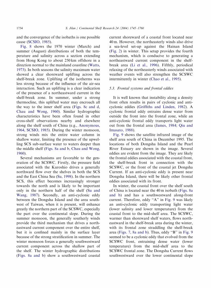
and the convergence of the isobaths is one possiblecause (SCSIO, 1985).Fig. 8 shows the 1970 winter (March) and
summer (August) distributions of both the tem-perature and salinity across a section extendingfrom Hong Kong to about 250 km offshore in adirection normal to the mainland coastline (Watts,1973). In both seasons the salinity maximum watershowed a clear shoreward uplifting across theshelf-break zone. Uplifting of the isotherms wasless strong because of the influence of the air-seainteraction. Such an uplifting is a clear indicationof the presence of a northeastward current in theshelf-break zone. In summer, under a strongthermocline, this uplifted water may encroach allthe way to the inner shelf area (Figs. 8c and d,Chau and Wong, 1960). Similar hydrographiccharacteristics have been often found in othercross-shelf observations nearby and elsewherealong the shelf south of China (e.g., Anonymous,1964, SCSIO, 1985). During the winter monsoon,strong winds mix the entire water column inshallow water, limiting the presence of the upwel-ling SCS sub-surface water to waters deeper thanthe middle shelf (Figs. 8a and b, Chau and Wong,1960).Several mechanisms are favorable to the gen-
eration of the SCSWC. Firstly, the pressure fieldassociated with the Kuroshio drives a generallynorthward flow over the shelves in both the SCSand the East China Sea (Su, 1998). In the northernSCS, this effect becomes increasingly strongertowards the north and is likely to be importantonly in the northern half of the shelf (Su andWang, 1987). Secondly, an anti-cyclonic eddybetween the Dongsha Island and the area south-west of Taiwan, when it is present, will enhancegreatly the northern part of the SCSWC, especiallythe part over the continental slope. During thesummer monsoon, the generally southerly windsprovide the third mechanism that drives a north-eastward current component over the entire shelf,but it is confined mainly in the surface layerbecause of the strong stratification in summer. Thewinter monsoon forces a generally southwestwardcurrent component across the shallow part ofthe shelf. The winter hydrographic distributions(Figs. 8a and b) show a southwestward coastal
current shoreward of a coastal front located near40m. However, the northeasterly winds also drivea sea-level set-up against the Hainan Island(Fig. 2) in winter. This setup provides the fourthmechanism, which is conducive to generating anortheastward current component in the shelf-break area (Li et al., 1996). Fifthly, periodicalrelaxing of the northeasterly winds associated withweather events will also strengthen the SCSWCintermittently in winter (Chao et al., 1995).
5.3. Frontal systems and frontal eddies
It is well known that instability along a densityfront often results in pairs of cyclonic and anti-cyclonic eddies (Griffiths and Linden, 1982). Acyclonic frontal eddy entrains dense water fromoutside the front into the frontal zone, while ananti-cyclonic frontal eddy transports light waterout from the frontal area (James, 1984; Qiu andImasato, 1988).Fig. 9 shows the satellite infrared image of the
shelf area south of China in December 1995. Thelocations of both Dongsha Island and the PearlRiver Estuary are shown in the image. Severaleddies are evident from the image. They are likelythe frontal eddies associated with the coastal front,the shelf-break front in connection with theSCSWC, or the front of the coastal jet DongshaCurrent. If an anti-cyclonic eddy is present nearDongsha Island, there will be likely other frontaleddies associated with its front.In winter, the coastal front over the shelf south
of China is located near the 40m isobath (Figs. 8aand b) and has a southwestward along-frontcurrent. Therefore, eddy ‘‘A’’ in Fig. 9 was likelyan anti-cyclonic eddy transporting light water(lower salinity and lower temperature) from thecoastal front to the mid-shelf area. The SCSWC,warmer than shoreward shelf waters, flows north-eastward in the shelf-break area during the winter,with its frontal zone straddling the shelf-breakarea (Figs. 7, 8a and b). Thus, eddy ‘‘B’’ in Fig. 9seemed to be a cyclonic eddy that evolved from theSCSWC front, entraining dense water (lowertemperature) from the mid-shelf area to theSCSWC frontal zone. The Dongsha Current flowssouthwestward over the lower continental slope

ARTICLE IN PRESS
<5
50 km
0
100
200
300
400
500
Station
0
0
-10
0
10
20-20
-3010
0
0
-10
Dep
th (
m)
Fig. 7. Geostrophic current speed (10�2m s�1) across a section
west of the Pearl River Estuary from (21.51N, 112.51E) to
(18.51N, 115.51E) in December 1981. The reference level is
500m and positive value denotes northerly flow. Positive values
denote northerly flowing currents. (after SCSIO, 1985).
S. Jilan / Continental Shelf Research 24 (2004) 1745–1760 1755
(Fig. 7). The water temperature between its frontand the SCSWC front is higher than the surround-ing waters. Eddy ‘‘C’’ in Fig. 9 seemingly was acyclonic eddy entraining dense water (lowertemperature) from the south of the DongshaCurrent front to its frontal area.The shelf area is highly stratified during the
summer monsoon (Figs. 8c and d). The less salinecoastal water usually rides over the saline shelfwater. Furthermore, instead of its natural ten-dency to move in the direction with the coast on itsright, the coastal water now moves northeastward,as a result of the combined effects of southerlywinds and generally the northeastward shelfcurrent. A strong meso-eddy is sometimes presentnear the Dongsha Island (Wang et al., 2003).However, very little is known about the frontalactivities during such events.
5.4. Other inner shelf features
The southwestward coastal current forced bythe winter monsoon brings low salinity water from
the Taiwan Strait to the SCS shelf (Fig. 9). In thewinter of 1956/1957, low salinity water wasobserved on the west side of Hong Kong (Chauand Wong, 1960). During the summer monsoon,the southerly winds can induce coastal upwellingat many places along the south coast of China(Han and Ma, 1988). Such an event usually bringsSCS sub-surface water that has upwelled at theshelf break area to the nearshore area.The Pearl River, the second largest river in
China in discharge, empties onto the shelf south ofChina (Fig. 9). Its river plume has a distinctmonsoonal behavior and influences strongly thehydrographic characteristics nearby. These will befurther discussed in the following section.
6. Pearl River Estuary Circulation and the Pearl
River Plume
The Pearl River discharges into the SCS througheight distributaries (see Fig. 1a of Wong et al.,2004). The four eastern-most distributaries,namely, Humen, Jiaomen, Hongqili and Heng-men, discharge their waters into the Lingdingyang,called ‘‘The Pearl River Estuary (PRE)’’ in thispaper. The average annual discharge through thePRE is about 5300m3 s�1, about 53% of the totaldischarge of the Pearl River. Eighty percent of thetotal flow occurs between April and September,the ratio of maximum-to-minimum discharges in ayear varying between 3 and 6 times.The PRE, with an area of over 2000 km2, has
two deep channels (Fig. 10). The east channelconnects the coastal ocean through Hong Kongwaters and the west one through the LantauChannel at the eastern side of the PRE. Except forthe deep channels and the areas around the outerislands where the water depth varies between 20and 30m, most of the PRE is quite shallow with awater depth between 2 and 10m.The PRE is located along a micro-tidal coast
with an average tidal range of about 1m. Thecombined effect of a small tidal range and largebay area has resulted in an interesting circulationand plume behavior in the PRE.During the northeast monsoon, the relatively
low river discharge apparently can sustain a

ARTICLE IN PRESS
1110
12
22
19
19 21
Kilometers from coast 0 50 100 150 200 250
16 17 1819 2421 23 24
20 22
20
18 16151413
9
8
0
100
200
300
400
500
600
700800
9001000
Depth in
meters
34.434.5
34.5
Kilometers from coast 0 50 100 150 200 250
<33.3 34.4 34.4 34.2 34.1
34.3
34.734.6
34.5
34.4
Depth in
meters
34.5
0
100
200
300
400
500
600
700800
9001000
18
1514
Kilometers from coast 0 50 100 150 200 250
28 29 28 27 28
20 24 27 22 26 24 18 20
17 16
13 12 11
109
8
7
6
5
4
Depth in
meters
0
100
200
300
400
500
600
700800
9001000
33.7 33.8 33.8 33.9
Kilometers from coast 0 50 100 150 200 250
<32.0 33.0 33.3 33.5 33.6
34.534.5 34.6
34.5
34.4
34.5
Depth in
meters
0
100
200
300
400
500
600
700800
9001000
(b)(a)
(d)(c)
Fig. 8. March (a and b) and August (c and d) distributions of temperature (1C) and salinity in 1970 across a section normal to the
mainland coastline and extending from Hong Kong to about 250 km offshore (after Watts, 1973).
S. Jilan / Continental Shelf Research 24 (2004) 1745–17601756
classical partially mixed estuarine circulation onlyin the upper reach of the PRE, where longitudinalgravitational circulation dominates (e.g., see Fig. 7of Dong et al., 2004). In the lower half of the PRE,however, the circulation assumes a typical patternof a coastal current, where an alongshore (follow-ing the western shore of the PRE) front and itsassociated frontal dynamics prevail (see Figs 2 and7 of Dong et al., 2004). In a sense, in the middlereach of the PRE, there is a transformation of thecirculation pattern from a river plume (confined by
the eastern shore of the PRE) to a coastal current.The two deep channels are likely important in thistransformation. For the northern hemisphere, it isknown that offshore water enters an estuarybeneath the river plume from the left side of theriver mouth when facing the direction of the ocean(e.g., Chao, 1988). The two deep channels con-veniently provide offshore water to the eastern sideof the middle reach of the PRE, where thetransition takes place. In this connection, theocean water entering the middle reach directly

ARTICLE IN PRESS
Fig. 9. AVHRR infrared image of the northern South China Sea taken on 31 December, 1995 (provided by Wei Huang of CCAR/
HKUST). The gray shade code is in 1C. ‘‘A’’, ‘‘B’’ and ‘‘C’’ denote the frontal eddies discussed in the text. The white circle offshore of
Eddy ‘‘B’’ is Dongsha Island. PRE denotes the Pearl River Estuary.
S. Jilan / Continental Shelf Research 24 (2004) 1745–1760 1757
through the east channel via Hong Kong may playa more critical role. The coastal current continuesto the west upon exiting from the PRE, as expectedfrom the behavior of a density current in thenorthern hemisphere (see Fig. 2 of Wong et al.,2004).During the southwest monsoon, the large river
discharge inundates the entire surface layer of thePRE (see Fig. 5 of Dong et al., 2004). Upon exitingfrom the PRE, the river plume spreads out rapidlyin the surface layer over the inner shelf (Fig. 11).The pattern of the offshore river plume is rathervariable (see Fig. 5 of Dong et al., 2004). This islikely due to the many factors influencing itsspreading, such as run-off, winds and coastalcurrents. If the surface plume reaches beyond theinner shelf, it may extend much further to the eastacross the shelf (Fig. 11), possibly driven by theSCSWC and favorable winds. Strong stratificationfavors the intrusion of high salinity offshorebottom water to the PRE through the two deepchannels. Thus, in the bottom layer of the PRE,
the circulation still assumes the same coastalcurrent structure that occurs during the northeastmonsoon. Outside the PRE, this bottom currentcontinues to the west along the coast like a densitycurrent, at least initially, because of the diminish-ing effect of the winds below the stratified layer(see Fig. 5 of Dong et al., 2004).
7. Conclusions
The wide and shallow PRE receives significantdischarge from the Pearl River. Because the PREis located along a coast with small tidal range, itstwo deep channels provide convenient passages forthe shelf water to enter its middle reach. Thiscauses the circulation in the PRE to change froman estuarine type to a coastal-current type aroundthe middle reach. Over the shelf, the river plumefrom the PRE has distinct monsoonal character-istics. However, little is known about the varia-bility of either the PRE circulation or the river

ARTICLE IN PRESS
Fig. 10. Topography of the PRE.
28 2930
3132 33
34
34
24°
22°
20°
N
112° 114° 116° 118° E
0 100 km
Fig. 11. Surface salinity distribution over the shelf area near the
PRE in June/July 1979 (after SCSIO, 1985).
S. Jilan / Continental Shelf Research 24 (2004) 1745–17601758
plume behavior, nor is there any study connectingthem to the shelf processes.The SCS sub-surface water has a strong
influence on the hydrographic characteristics ofthe shelf. During the summer monsoon, this sub-
surface water can be traced close to Hong Kong.This relatively nutrient-rich water (Chen et al.,2001) and the river plume water are importantnutrient sources for the ecosystems in both thePRE and the inner shelf. During the wintermonsoon, a strong southerly coastal current likelybrings nutrients from the north through TaiwanStrait.The image in Fig. 9 clearly shows that, to study
biological or biogeochemical processes in watersaround the PRE, it is important to have a betterunderstanding of the coastal current, the SCSWC,the Dongsha Current, as well as possibly anti-cyclonic meso-eddies occurring some times nearDongsha Island, and their interactions.
Acknowledgements
The study was supported by the MajorState Basic Research Program (Grant No.G1999043805) and the Pearl River Estuary Pollu-tion Project funded by the Hong Kong Jockey

ARTICLE IN PRESS
S. Jilan / Continental Shelf Research 24 (2004) 1745–1760 1759
Club. Assistance in the preparation of this manu-script was graciously provided by Wang Minfang,Wang Guihua and Liu Zhenhong.
References
Anonymous, 1964. Report of the Nation-Wide Comprehensive
Oceanographic Survey, Vol. 3, Office of the Nation-Wide
Comprehensive Oceanographic Survey, Beijing, 109pp (in
Chinese).
Cai, S.Q., Su, J.L., Gan, Z.J., Liu, Q.Y., 2002. The numerical
study of the South China Sea upper circulation character-
istics and its dynamic mechanism in winter. Continental
Shelf Research 22, 2247–2264.
Cessi, P., Louazel, S., 2001. Decadal oceanic response to
stochastic wind forcing. Journal of Physical Oceanography
31, 3020–3029.
Cessi, P., Primeau, F., 2001. Dissipative selection of low-
frequency modes in a reduced-gravity basin. Journal of
Physical Oceanography 31, 127–137.
Chan, K.M., 1970. The seasonal variation of hydrological
properties in the northern South China Sea. In: The
Kuroshio, a Symposium on the Japan Current. East-West
Center Press, Honolulu.
Chao, S.Y., 1988. River-forced estuarine plumes. Journal of
Physical Oceanography 18, 72–88.
Chao, S.Y., Shaw, P.T., Wang, J., 1995. Wind relaxation as a
possible cause of the South China Sea Warm Current.
Journal of Oceanography 51, 111–132.
Chau, Y.K., Wong, C.S., 1960. Oceanographical investigation
in the northern shelf region of the South China Sea off
Hong Kong. Hong Kong University Fisheries Journal, (3),
1–25.
Chen, C.T.A., Huang, M.H., 1996. A mid-depth front
separating the South China Sea Water and the Philippine
Sea Water. Journal of Oceanography 52, 17–25.
Chen, C.T.A., Wang, S.L., Wang, B.J., Pai, S.C., 2001.
Nutrients budgets for the South China Sea basin. Marine
Chemistry 75, 281–300.
Chu, T.Y., 1972. A study on the water exchange between Pacific
Ocean and the South China Sea. Acta Oceanographic
Taiwanica 2, 11–24.
Chu, P.C., Fan, C.W., Lozano, C.J., Kerling, J.L., 1998. An
airborne expendable bathythermograph survey of the South
China Sea, May 1995. Journal of Geophysical Research
103, 21637–21652.
Dong, L.X., Su, J.L., Wong, L.A., Cao, Z.Y., Chen, J.C., 2004.
Seasonal variation and dynamics in the Pearl River plume.
Continental Shelf Research, this issue (doi:10.1016/
j.csr.2004.06.006).
Emery, W.J., Dewar, J.S., 1982. Mean TS, SZ and TZ curve for
the North Atlantic and the North Pacific. Progress of
Oceanography 11, 219–305.
Fang, G.H., Zhao, B.R., Zhu, Y.H., 1991. Water volume
transport through the Taiwan Strait and the continental
shelf of the East China Sea measured with current meters.
Oceanography of Asian Marginal Seas, Elsevier Oceano-
graphy Series 54, 345–358.
Godfrey, J.S., 1989. A Sverdrup model of the depth-integrated
flow for the world ocean allowing for island circulations.
Geophysical and Astrophysical Fluid Dynamics 45, 89–112.
Gong, G.C., Liu, K.K., Liu, C.T., Pai, S.C., 1992. The chemical
hydrography of the South China Sea west of Luzon and a
comparison with the west Philippine Sea. Terrestrial,
Atmospheric and Oceanic Sciences 3, 587–602.
Griffiths, R.W., Linden, P.F., 1982. Laboratory experiments on
fronts. I. Density-driven boundary currents. Geophysical
and Astrophysical Fluid Dynamics 19, 159–187.
Guan, B.X., 1978. The Warm Current in the South China Sea.
Oceanologia et Limnologia Sinica 9, 117–127 (in Chinese).
Han, W.Y., Ma, K.M., 1988. Studies on the coastal upwelling
along the coasts of the east Guangdong Province. Acta
Oceanographica Sinica 10 (1), 52–59 (in Chinese).
Ho, C.R., Zheng, Q.A., Soong, Y.S., Kuo, N.J., Hu, J.H., 2000.
Seasonal Variability of sea surface height in the South
China Sea observed with TOPEX/Poseidon altimeter data.
Journal of Geophysical Research 105, 13981–13990.
James, I.D., 1984. A three-dimensional numerical shelf-sea
front model with variable eddy viscosity and diffusivity.
Continental Shelf Research 3, 69–98.
Kuo, N.J., Zheng, Q.A., Ho, C.R., 2000. Satellite observation
of upwelling along the western coast of the South China
Sea. Remote Sensing of Environment 74, 463–470.
Li, R.F., Guo, D.J., Zeng, Q.C., 1996. Numerical simulation of
interrelation between the Kuroshio and the current of the
northern South China Sea. Progress of Natural Sciences 6,
325–332.
Li, L., Nowlin, W.D., Su, J.L., 1998. Anticyclonic rings from
the Kuroshio in the South China Sea. Deep-Sea Research I
45, 1469–1482.
Liang, B.Q., 1991. Tropical Atmospheric Circulation System
Over the South China Sea. China Meteorology Press, China
224pp (in Chinese).
Liu, C.T., Liu, R.J., 1988. The deep current in the Bashi
Channel. Acta Oceanographica Taiwanica 20, 107–116.
Liu, X.B., Su, J.L., 1992. A reduced gravity model of the
circulation in the South China Sea. Oceanologia et
Limnologia Sinica 23, 167–174 (in Chinese).
Liu, Z.H., Xu, J.P., Li, L., Shi, M.C., 2001a. Characteristics
and distribution of water masses in the South China Sea
during the summer and the winter of 1998. Oceanography in
China 13, 221–230.
Liu, Z.Y., Yang, H.J., Liu, Q.Y., 2001b. Regional dynamics of
seasonal variability in the South China Sea. Journal of
Physical Oceanography 31, 272–284.
Metzger, E.J., Hurlburt, H., 1996. Coupled dynamics of the
South China Sea, Sulu Sea, and the Pacific Ocean. Journal
Geophysical Research 101, 12331–12352.
Metzger, E.J., Hurlburt, H., 2001. The importance of high
horizontal resolution and accurate coastline geometry in
modeling South China Sea inflow. Geophysical Research
Letters 28, 1059–1062.

ARTICLE IN PRESS
S. Jilan / Continental Shelf Research 24 (2004) 1745–17601760
Nitani, H., 1972. Beginning of the Kuroshio. In: Stommel, H.,
Yoshida, K. (Eds.), Kuroshio: Its Physical Aspects.
University of Washington Press, Seattle, pp. 129–163.
Pedlosky, J., 1996. Ocean Circulation Theory. Springer, Berlin
453pp.
Pichevin, T., Nof, D., 1997. The momentum imbalance
paradox. Tellus 49, 298–319.
Pohlmann, T., 1987. A three-dimensional circulation model of
the South China Sea. In: Nihoul, J.J., Jamart, B.M. (Eds.),
Three-dimensional models of marine and estuarine dy-
namics. Elsevier, New York, pp. 245–268.
Qiu, B., Imasato, N., 1988. Baroclinic instability of buoyancy-
driven coastal density currents. Journal of Geophysical
Research 93, 5037–5050.
Qu, T.D., 2000. Upper-layer circulation in the South China Sea.
Journal of Physical Oceanography 30, 1450–1460.
Qu, T.D., 2001. Role of ocean dynamics on determining the mean
seasonal cycle of the South China Sea surface temperature.
Journal of Geophysical Research 106 (C4), 93–6955.
Qu, T.D., Mitsuderaq, T., Yamagata, T., 2000. Intrusion of the
North Pacific waters into the South China Sea. Journal of
Geophysical Research 105 (C3), 6415–6424.
SCSIO (South China Sea Institute of Oceanology, Academia
Sinica), 1985. Report of the 1979–1982 Multidisciplinary
Research Program on the Northern South China Sea. Vol.
II, China Science Press, Beijing, 432pp (in Chinese).
Shaw, P.T., 1989. The intrusion of water masses into the sea
southwest of Taiwan. Journal of Geophysical Research 94,
18213–18226.
Shaw, P.T., 1991. The seasonal variation of the intrusion of the
Philippine Sea Water into the South China Sea. Journal of
Geophysical Research 96, 821–827.
Shaw, P.T., Chao, S.Y., 1994. Surface circulation in the South
China Sea. Deep-Sea Research 41, 1663–1683.
Su, J.L., 1998. Circulation dynamics of the China Seas: north of
181N. In: Robinson, A.R., Brink, K. (Eds.), The Sea, The
Global Coastal Ocean: Regional Studies and Syntheses,
Vol. 11. Wiley, New York, pp. 483–506.
Su, J.L., Wang, W., 1987. On the sources of the Taiwan Warm
Current from the South China Sea. Chinese Journal of
Oceanology and Limnology 5, 299–308.
Su, J.L., Guan, B.X., Jiang, J.Z., 1990. The Kuroshio. Part I.
Physical Features. Oceanography and Marine Biology: An
Annual Review 28, 11–71.
Su, J.L., Xu, J.P., Cai, S.Q., Wang, O., 1999. . In: Ding, Y., Li,
C. (Eds.), Gyres and eddies in the South China Sea; Onset
and evolution of the South China Sea monsoon and its
interaction with the ocean. China Meteorological Press,
China, pp. 272–279.
Wang, J., 1986. Observation of abyssal flows in the northern
South China Sea. Acta Oceanographica Taiwanica 16,
36–45.
Wang, J., Chern, C.S., 1987. The warm-core eddy in the
northern South China Sea, I. Preliminary observations on
the warm-core eddy. Acta Oceanographica Taiwanica 18,
92–103 (in Chinese).
Wang, J., Chern, C.S., 1997. On the trajectory of subsurface
and intermediate waters in the northeastern South China
Sea. Tropic Oceanology 16 (2), 24–41 (in Chinese).
Wang, L.P., Koblinsky, C.J., Howden, S., 2000. Meso-
scale variability in the South China Sea from the
TOPEX/Poseidon altimetry data. Deep-Sea Research I 47,
681–708.
Wang, G.H., Su, J.L., Chu, P.C., 2003. Mesoscale eddies in the
South China Sea observed with altimeter data. Geophysical
Research Letters 30 (21), 2121.
Watts, J.C.D., 1973. Hydrography of the continental shelf area
off Hong Kong, II. Observations for the year 1970. Hong
Kong Fisheries Bulletin 3, 37–46.
Wong, L.A., Chen, J.C., Dong, L.X., 2004. A model study of
the plume front of the Pearl River Estuary, China and
adjacent coastal waters in the winter dry season. Con-
tinental Shelf Research, this issue (doi:10.1016/j.csr.
2004.06.007).
Wyrtki, K., 1961. Scientific results of marine investigation of
the South China Sea and Gulf of Thailand. NAGA Report
2, 195pp.
Xu, J.P., Su, J.L., 1997. Hydrographic analysis on the intrusion
of Kuroshio into the South China Sea. II. Observational
results during the cruise from August to September in 1994.
Tropic Oceanology 16 (2), 1–23 (in Chinese).
Xu, J.P., Su, J.L., Qiu, D.Z., 1996. Hydrographic analysis on
the intruding of Kuroshio water into the South China Sea.
Oceanography in China 6, 1–12.
Xu, X.Z., Qiu, Z., Chen, H.C., 1982. The general descriptions
of the horizontal circulation in the South China Sea. In:
Proceedings of the 1980 Symposium on Hydrometeorology,
Chinese Society of Oceanology and Limnology, Science
Press, Beijing, pp. 137–145 (in Chinese).
Yang, Y.H., Li, L., Wang, Z.D., 1988. Characteristics of
average T–S, S–Z and T–Z in the South China Sea. Tropical
Oceanography 7 (3), 54–59 (in Chinese).