Hydrology Oceanography – Solar Resource - GEONICA
30
Alejandro Rodríguez 22 28039 Madrid SPAIN Environmental Monitoring Meteorology – Hydrology Oceanography – Solar Resource Document No 9992 0043 Since 1974 www.geonica.com
-
Upload
khangminh22 -
Category
Documents
-
view
3 -
download
0
Transcript of Hydrology Oceanography – Solar Resource - GEONICA

Alejandro Rodríguez 2228039 MadridSPAIN
Environmental MonitoringMeteorology – Hydrology
Oceanography – Solar Resource
Document No 9992 0043
Since 1974
www.geonica.com

THE COMPANY
GEONICA Spanish company founded in 1974, designs, manufactures, installs and maintainsAutomatic Stations, Systems and Measurement Networks with Data Transmission, Imagesand Alarms in Real Time for Environmental Monitoring.
Based on our own line of Automatic Data Acquisition and Transmission Stations, METEODATA/ HYDRODATA Series, and an advanced and flexible software packages, GEONICA SUITE formanagement and WEBTRANS Internet Platform for Data Receiving Centre (GEO-DRC), wehave integrated a wide variety of sensors to provide complete solutions, systems andmeasuring networks, intended for different applications on many sectors:Meteorology, Hydrology, Early Warning (EWS), Water Management and Water Quality,Agriculture, Renewable Energy (Solar and Wind), Coastal Oceanography, Tides, Currentsand Waves (VTS), Intelligent Transport (ITS), Road Safety (RWIS), Railways, Ports, Airportsand Heliports (AWOS), Air Quality, Ambient Noise, Smart Cities, Civil Protection, Industryand Mining, Military applications, and Environmental Monitoring in general.
Also we design and provide some sensors like DATARAIN-4000 Electronic WeighingPrecipitation Sensor, PTH / PTHR-4000 Pressure, Temperature, Relative Humidity and SolarRadiation (only PTHR-4000) Smart Multisensor, SUNTRACKER-2000/3000 as part of ourSEMS Solar Energy Measurement System for Solar sector, and more.
During our more than 47 years in the market, we have carried out hundreds of projectsaround the World, always in the professional, scientific, industrial and military fields wherethe highest quality and the strictest technical specifications are required.
Following we present our line of products, classified by sectors, underlining the mostimportant aspects of each of our SYSTEMS and SOLUTIONS.
2SUNTRACKER-2000
METEODATA

SECTORS, SYSTEMS & SOLUTIONS
CLIMATOLOGY, METEOROLOGYHYDROLOGY, AGROMETEOROLOGY• HYDROMET• AGROMET
EARLY WARNING SYSTEMS (EWS)CIVIL PROTECTION• RAINALERT• FLASH FLOOD ALERT• LIGHTNING ALERT• SISMOALERT
COASTAL OCEANOGRAPHY• SAFE PORT• DATAMAR
AIRPORT / HELIPORT SAFETY• AIRPORT WEATHER
SMART CITIES• GEOcityQUAL: AIR QUALITY, TRAFFIC,
AMBIENT NOISE, METEOROLOGY
RENEWABLE ENERGY• SOLAR ENERGY MEASUREMENT SYSTEM
SEMS-PV, SEMS-2000/3000/Spectral• WINDPOWER
ROAD / RAIL TRAFFIC SAFETY• SAFE ROAD / TUNNEL• DATACAR• ICEFREE• SAFE RAIL• WINDALERT
ENVIRONMENTAL MONITORINGWATER QUALITY, AIR QUALITY, NOISE• AQUALERT• NOISE MAPPER• GAMMALERT• AIRcityQUAL• GASALERT
3
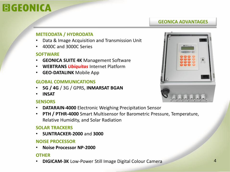
GEONICA ADVANTAGES
METEODATA / HYDRODATA• Data & Image Acquisition and Transmission Unit• 4000C and 3000C Series
SOFTWARE• GEONICA SUITE 4K Management Software• WEBTRANS Ubiquitas Internet Platform• GEO-DATALINK Mobile App
GLOBAL COMMUNICATIONS• 5G / 4G / 3G / GPRS, INMARSAT BGAN• INSAT
SENSORS• DATARAIN-4000 Electronic Weighing Precipitation Sensor• PTH / PTHR-4000 Smart Multisensor for Barometric Pressure, Temperature,
Relative Humidity, and Solar Radiation
SOLAR TRACKERS• SUNTRACKER-2000 and 3000
NOISE PROCESSOR• Noise Processor NP-2000
OTHER• DIGICAM-3K Low-Power Still Image Digital Colour Camera 4

METEODATA / HYDRODATA ADVANTAGES
DATA ACQUISITION UNIT - DATALOGGER• Very High Resolution by means of a 24-bit A/D Converter delta-sigma technology• 16 Single-Ended or 8 Differential Analogue Inputs or mix• 4 Digital Inputs with 4000V galvanic isolation• 4 Digital Outputs with 4000V galvanic isolation• 5 Digital Pulse Counters (32 bits)• 3 Serial Buses for Smart Sensors (RS232 / 422 / 485 / SDI-12)• Real Time Clock (GPS is not required for synchronization)• 1 or 2 Ethernet, USB, GNSS / GPS, Bluetooth, Wi-Fi• Ultra low power consumption: 37 mA working and 1 µA idle
COMPACT UNIT, INTEGRATING:• Datalogger with 32 Channels• All types of Communication Modules: 5G/4G/3G/GPRS, Ethernet, MODBUS, etc.• Dual Input Redundant Charge Controller and Internal Batteries (18 or 27 Ah)• ESD Protection for all Supply Lines (Transzorb, high current chokes and varistor)• ESD Protection of two Types for all Inputs and Outputs:
▪ Gas arrester, serial resistance and transzorb in parallel▪ Varistor, high current choke and transzorb in parallel
• EMI Protection for all Analogue Inputs (RC low pass EMI filter)
5

METEODATA / HYDRODATA ADVANTAGES
SENSORS• All types of sensors can be connected, with analogue or digital outputs, intelligent
sensors using special protocols, etc.
COMMUNICATIONS• Satellites: INMARSAT BGAN, THURAYA, IRIDIUM, METEOSAT, VSAT, GOES, INSAT• Cellular: 5G / 4G / 3G / GPRS / GSM / CDMA• Radio, AIS AtoN (Aids to Navigation)• Ethernet, Fibre Optic, Line, PSTN• TCP/IP, MODBUS, NTCIP, DGT (roads)
WEATHERPROOF ENCLOSURE• IP66 or IP67 Protection
OTHER• Memory-Display LCD QVGA 4.4“, Keyboard, Graphs & Values• Alphanumeric Display (LCD) 4x20 characters + 18-key Membrane Keyboard• Memory: 32 MB to 32 GB• microSD Memory Card: 2 to 128 Gbytes• GNSS / GPS Receiver with Antenna
6

GEONICA Suite 4K is the last generation package of applications for the communication
between remote stations based on our METEODATA datalogger and a Data Receiving
Centre for storing, processing, presentation and monitoring of collected data.
Software: GEONICA Suite & WEBTRANS
7
WEBTRANS Ubiquitas is the Internet
Platform developed by GEONICA to
allow users with only a web browser
and from everywhere to access data
from METEODATA stations in real-
time, configure graphical presentation,
show pictures obtained with
DIGICAM-3K camera, setup a FTP
server and other features.

DATARAIN-4000 WEIGHING RAIN GAUGE
MAIN FEATURES
• Electronic Weighing Digital Rain Gauge• Automatic Emptying System• High Accuracy and Resolution at both High & Low Rain Intensities• Ultra-Low Power Consumption
SPECIFICATIONS
8
Collecting Area
RangeAccuracy
in the whole Range
ResolutionQuantityof Rain
ResolutionIntensityof Rain
200 cm2 2000 mm/h 0.02% 0.001 mm 0.001 mm/h
400 cm2 2000 mm/h 0.02% 0.001 mm 0.001 mm/h

INMARSAT BGAN M2M SATELLITE COMMUNICATIONS
MAIN FEATURES / INMARSAT vs GOES COMPARISON
9
FEATURE GOES INMARSATBidirectional Communication NO YESIP Network NO YESRemote programming /configuration of field stations NO YESAverage power consumption (typical) Very Low Very LowAlways-ON Communication NO (*) YESAlarm Reception YES, very limited YES, unlimitedNeed for an expensive Satellite Earth Station requiredfor data reception at Data Receiving Center (1)
YES NO
Connection and services from NOAA network YES NOCommunication Cost (typical) Free, but (1) Similar to GPRSRemote diagnostic, support, and configuration.Firmware download / update
NO YES
Bandwidth (typical)300 bps (v1) / 1200 bps
(v2) only transmission (*)464 Kbps reception & 448 Kbps transmission
Capacity to transmit images from remote stations NO YESReal-Time Monitoring from Data Receiving Center NO (**) YESGlobal Satellite Coverage Only America YESNeed for development of an application to process received data
YES NO
Valid for Early Warning Systems (EWS) Application NO YES

INMARSAT BGAN M2M SATELLITE COMMUNICATIONS
INMARSAT vs GOES COMPARISON (cont.)
INMARSAT is a bidirectional satellite communication system that allows forreal-time control, supervision, and reception of information of a Hydro-Meteorology Stations Network. INMARSAT is an advanced technology systemthat leaves obsolete GOES system as shown in comparison table.
INMARSAT is ideal to implement Early Warning Systems (EWS) for alerting ofFlash Flood, Rainfall, Lightning, Tsunamis, etc.
(*) INMARSAT bandwidth is near 400 times GOES v2 (1200 bps) and near 1600times GOES v1 (300 bps), and GOES is only for transmission because it does notallow reception.
(**) In GOES assigned period by NOAA for transmission is 1 hour with astandard window of 10 seconds for each transmitter. Only in special casesNOAA grants shorter periods, but it is very limited because it has to share thelow capacity of GOES system for a huge number of transmitters. This restrictiondoes not exist with INMARSAT because it works in Always ON mode and real-time without limitations of period between transmissions or windows fordata transmission.
10
OWN TECHNOLOGY & EXPERIENCE
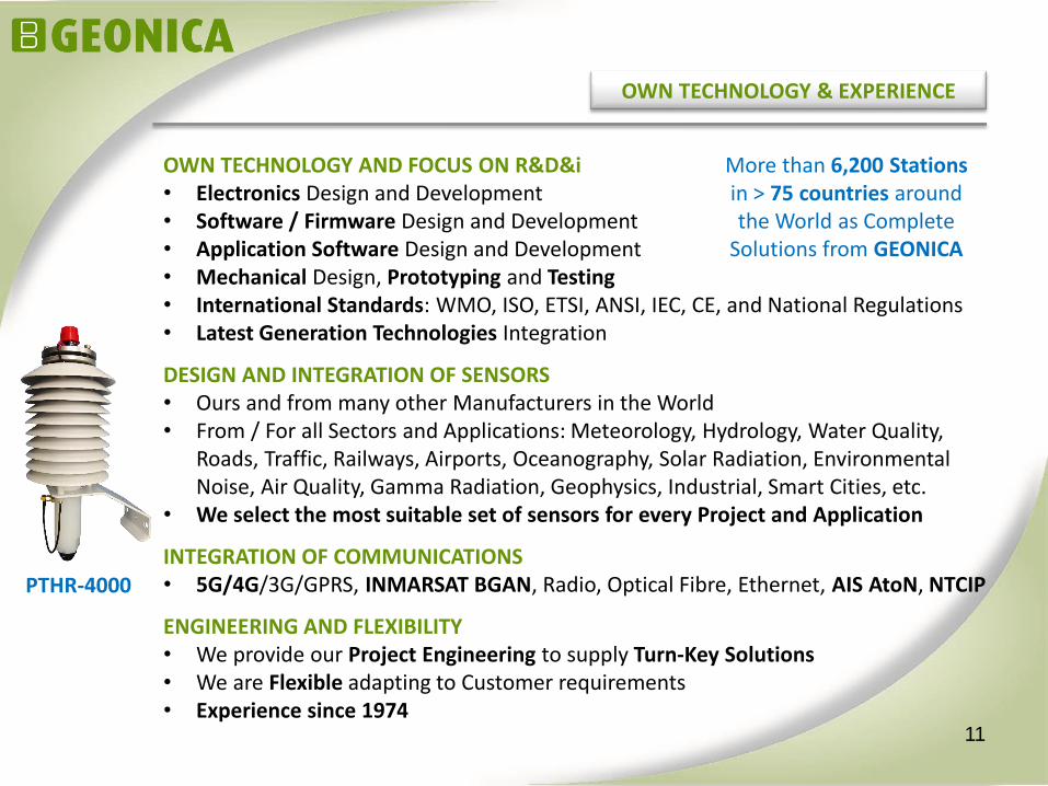
OWN TECHNOLOGY AND FOCUS ON R&D&i• Electronics Design and Development• Software / Firmware Design and Development• Application Software Design and Development• Mechanical Design, Prototyping and Testing• International Standards: WMO, ISO, ETSI, ANSI, IEC, CE, and National Regulations• Latest Generation Technologies Integration
DESIGN AND INTEGRATION OF SENSORS• Ours and from many other Manufacturers in the World • From / For all Sectors and Applications: Meteorology, Hydrology, Water Quality,
Roads, Traffic, Railways, Airports, Oceanography, Solar Radiation, Environmental Noise, Air Quality, Gamma Radiation, Geophysics, Industrial, Smart Cities, etc.
• We select the most suitable set of sensors for every Project and Application
INTEGRATION OF COMMUNICATIONS• 5G/4G/3G/GPRS, INMARSAT BGAN, Radio, Optical Fibre, Ethernet, AIS AtoN, NTCIP
ENGINEERING AND FLEXIBILITY• We provide our Project Engineering to supply Turn-Key Solutions• We are Flexible adapting to Customer requirements• Experience since 1974
11
More than 6,200 Stationsin > 75 countries around the World as Complete
Solutions from GEONICA
PTHR-4000

EXPERIENCE / REFERENCES
GENERAL• More than 6,200 Stations exceeding 75 countries as part of hundreds of Complete
System Solutions that GEONICA has been delivering since 1974.
HYDRO-METEOROLOGY / EARLY WARNING SYSTEM (EWS)• GRAFCAN - Regional Government of Canarias (Spain) [2021 - 2018]
➢ 59 Weather Stations (EWS) with Ethernet, 3G/GPRS and INMARSAT• EPA-EP Empresa Pública del Agua (Ecuador) [2017]
➢ 36 Hydro-Meteorology Stations with GPRS and INMARSAT• CAR Corporación Autónoma Regional de Cundinamarca Colombia [2015 - 2013]
➢ 55 Hydro-Meteorology Stations with INMARSAT BGAN• Vietnam Hydro-Met Services (VHMS) [2013]
➢ 29 Rainfall Stations with GSM and INMARSAT BGAN (redundancy)• Uttar Pradesh Water Sector Restructuring Project Irrigation Dept. (India) [2010]
➢ 26 Automatic Weather Stations with GSM
SOLAR - METEOROLOGY• DEWA FASE V 900MW PV, IV 950MW CSP+PV, III 800MW PV, II 200MW PV -
Dubai [2022 - 2016]➢ 85 Solar Radiation & Weather Stations with FO and 3G/GPRS
• NIWE National Institute of Wind Energy - India [2021 - 2011]➢ 137 Solar Radiation and Weather Stations with 3G/GPRS
12
EXPERIENCE / REFERENCES
COASTAL OCEANOGRAPHY• Suez Canal Authority (Egypt) - Vessel Traffic Service (VTS) [2017 - 2016]
➢ 22 Visibility, Meteorology and Water Level with Ethernet and Wi-Fi• Navy of Peru (MGP - DHN) [2015, 2014, 2010]
➢ 12 Radar Tidal Stations with INMARSAT BGAN and GPRS / 3G• Department of Mineral Resources (DMR) Thailand [2015, 2013]
➢ 8 Radar Tidal Stations with GPRS / 3G• Izmir Waterworks Authority (IZSU) Turkey [2015, 2012]
➢ 8 Meteorology, Tide, Sea Currents and Water Quality Stations with GPRS / 3G• Universidade Federal do Rio Grande (FURG) Brazil [2014]
➢ 14 Radar Tidal & Meteorology Stations with GPRS / 3G• Indian National Centre for Ocean Information Services (INCOIS) India [2010]
➢ 21 Radar Tidal Stations with GPRS, VSAT and INSAT (simultaneously)
AMBIENT NOISE• Central Pollution Control Board (CPCB) India [2014 - 2011]
➢ 70 Ambient Noise Monitoring Stations with GPRS / 3G (Phase 1 and Phase 2)
AND MORE• See Document 9993 0017 GEONICA List of References
13

HYDROMET SystemHYDROMET has been designed for measuring all sorts of meteorological andhydrological parameters, as stand-alone stations or networks with data transmission via4G / 3G / GPRS, direct radio link or satellite, such as the INMARSAT network, with itsglobal coverage and advanced performance (with two-way communications and IPaddressing) that harness the whole power and universality of the Internet.
14

Early Warning Systems (EWS)
An Early Warning System (EWS) is a major element of disaster risk reduction. It preventsloss of life and reduces the economic and material impact of disasters. To be effective,Early Warning Systems need to effectively disseminate alerts, and warnings.
A complete and effective Early Warning System supports four main functions:
❑ Data collection by continuous monitoring and event detection❑ Data Transmission to a Central Receiving Station❑ Risk assessment based on data analysis by the Authorities❑ Warning and Alerts dissemination
GEONICA implements advanced Early Warning Systems (EWS) focused in the followingareas of risk:
❑ Flash Floods and Heavy Rains❑ Lightning and Thunderstorms❑ Environmental Gamma Radiation❑ Tsunamis
15

Early Warning Systems (EWS)
16

RAINALERT SystemRain and Flood Alert
The typical configuration of a Rain and Flooding Alert Network is made up by a series of remote rainfallstations located at different parts of the river basin being monitored, completed with other river levelmeasurement stations.
Both types of remote stations provide the appropriate data and alarm transmission systems via 4G / 3G /GPRS, Radio Link, or satellite (preferably INMARSAT, given the enormous technological advantages itprovides), towards a Central Receiving Station.
This central station will be managed by the Civil Protection Authorities, who will be in charge of alertingthe population depending on the risk of flooding for each rural or urban area.
This system operates in real-time, since in case of heavy and prolonged rains, the pluviometric stationslocated at different points of the catchment basin, as well as the river level measurement stations, willimmediately send the appropriate warnings to the Central Receiving Station.
RAINALERT System’s Management Software can be complemented with mathematical models that usetime as a variable for calculating water volumes collected by the river basin, along with the topographicdata of the area received via satellite using SAR (Synthetic Aperture Radar) Interferometry, in order toestimate the height of a possible flood.
DATARAIN-4000 Electronic Weighing Digital Rain Gauge is particularly suitable for EWS due to its HighAccuracy and Resolution at both High & Low Rain Intensities.
17

RAINALERT System can be extended by means of X-BAND WEATHER
RADARS providing information in Zones with Special Risk due to Local
Meteorological Phenomena in Ares of 50 to 120 Km.
Weather Radars
18
Applications of X-Band Weather Radars
❑ Real Time Monitoring covering a wide area
❑ Gap Filling for Existing Networks
❑ Classification of Rain, Hail and Snow
❑ Monitoring of Severe Weather Conditions
❑ Nowcasting and Forecasting
❑ Support to Authorities in charge of Early Warning to
protect population and infrastructures
❑ Support Civil Protection for Alerting and take
Preventive Actions in case of severe and immediate
meteorological phenomena: storms, heavy rain, snow,
fog, hail, flash flood

X-BAND WEATHER RADARS are the reasonable alternative to classic, big
and expensive long-range C-S Radars, at a lower price for acquisition,
installation and operation.
Weather Radars
19
Main Advantages
❑ Network Operation of several Radars to
generate a Cluster to transmit data to Control
Centre for Mosaic images generation
❑ Compact Antenna and Hardware
❑ Can be installed in a Mobile Platform to be
placed where and when it is required
❑ Very high resolution both Time and Spatial
❑ Good short-to-medium range of Sensitivity
Detection (50-120Km)
❑ Remote Control of Main Functions
❑ Data is stored in standard formats to be used
directly for later processing
❑ Ease to use

SAFE PORT and DATAMAR Systems
For Ports and Coast sector, we offer our SAFE PORT System which transmits the information to the PortAuthorities, and to ships by means of AIS AtoN Transponder. Optionally, it can also upload the data tothe Internet, making them available to any ship with Internet access, by means of 4G / 3G / GPRS,INMARSAT satellite, or other communication systems.
DATAMAR System allows for an advanced RADAR Tide Network.20

DATACAR System has been designed by GEONICA to assist on the number of vehiclestraveling through different sections of roads and motorways, while classifying themaccording to their size or length. Application in Intelligent Transport Systems (ITS).
Depending on the type of sensors used, it is also possible to detect queues and trafficjams. These data complete the information required for preparing vehicular traffic studies.
The vehicle sensors or detectors are connected to one of our METEODATA Remote DataCollection Units, which logs all the traffic measurements, transmitting the information inreal time to a Central Receiving Station or SCADA, usually via fiber optic or using 3G /GPRS cellular network, if the road does not provide its own communications network.
GEONICA offers the SAFE ROAD System as a response to the pressingneed for improving safety on roads and motorways, since traffic canbe affected by the most diverse and extreme weather conditions,such as lack of visibility, ice on the road, the presence of snow orheavy rains, etc. Application in Road Weather Information Systems(RWIS).
This sector is of great importance, especially in countries whereroads cross cold or mountainous areas with frequent fog banks thatreduce visibility, as well as shady areas where ice is likely to form onthe surface, or simply those that are prone to suffer adverse weatherconditions, such as wind, rain, etc., representing an important risk tothe safety of vehicular traffic.
SAFE ROAD and DATACAR Systems
21

The Airport Weather System (AWOS) deals with measuring all the meteorological parametersof airports, aerodromes, heliports, etc., providing data already processed to the MeteorologyCenter for distributing them to the aircraft pilots and Authorities responsible for air trafficsafety, using different communication systems.
Airport Weather System (AWOS)
22

GEOcityQUAL for Smart Cities
23

European regulations and those of other countries, force Municipal Authorities of urban centers exceeding a certain number ofinhabitants to establish preventive measurements for controlling and limiting the levels of ambient noise. For this purpose, so-called noise maps need to be generated, which in turn require a series of precise measurements and the appropriatemathematical models.
Our NOISE MAPPER System provides an advanced solution for continuous measurement of ambient noise in urban areas, roads,airports, etc. Data is transmitted in real time to a Central Receiving Station, usually via 3G / GPRS, which is integrated in theRemote Station itself.
Our ambient noise monitoring system is made up of outdoor fixed or mobile Remote Stations with stand-alone operation basedon internal batteries charged by a solar panel, and provided with a weather-resistant microphone.
NOISE MAPPER System
24

The continuous measurement and monitoring of the quality of both surfaceand underground water represents an unavoidable requirement for knowing itscondition and helping to take the necessary measures to preserve both theenvironment and a resource as valuable and increasingly scarce as water.
For this purpose, GEONICA has developed the AQUALERT system for thecontinuous measurement of all parameters of water:• Physicochemical: Conductivity, Temperature, pH, Dissolved Oxygen, REDOX
Potential, Turbidity, Ammonia, Ammonium, Nitrates, Nitrites, Chloride,Rhodamine, Chlorophyll a, BGA, etc.
• Biochemical: Total Organic Carbon (TOC), Biological Oxygen Demand (BOD),Chemical Oxygen Demand (COD), SAC254, and even Nitrites and Nitratesusing submersible probes based on UV-VIS spectrometric technology.
• Hydrocarbons: PAH (Polycyclic Aromatic Hydrocarbons), BTX aromatichydrocarbons (Benzene, Toluene and Xylenes), Crude Oils, Refined Fuels.
Other: Consult.
AQUALERT System
WINDPOWER SystemThis system is oriented to assessing the sites for installationof wind turbines as well as for measuring wind speed andweather conditions in wind farms during their operation.
For such purpose GEONICA offers the provision ofmeteorological towers over 100 meters height, includingthe necessary wind and meteorological sensors mountedat different measuring levels, as well as the suitableMETEODATA datalogger which also allows datatransmission via 3G / GPRS communications for remoteconfiguration, maintenance and diagnosis.
25

LIGHTNING ALERT System
LIGHTNING ALERT System has been designed tomeasure the risk of a specific location being hit bylightning or atmospheric discharge under specific orcertain weather conditions.
The system is made up by a precise meter thatmeasures the Electric Field in the air, that is, thepositive or negative gradient present in a range of±20,000 volts/meter. It’s value will determine therisk of lightning falling in a range of around 6-8 Kmfrom the point of measurement.
The electric field meter is connected to one of theMETEODATA stations, which records themeasurements and transmits the data and warningsto a local SCADA system or remote computer usingwhat ever means possible, 3G / GPRS cellulartelephony or direct cable connection.
26
The warning thresholds are programmable at the METEODATA station, depending on the electric field value, which is whatdetermines the risk conditions. Note that this system is not designed for detecting actual lightning strikes, as is the case oflightning detector systems. That is, it is designed to alert about the risk of lightning in order to prevent its consequences.
The LIGHTNING ALERT System should be used, for example, at Airport facilities, basically for risk assessment during fuelloading operations in planes, as well as in fuel storage areas, gas and petrol transfer areas, etc., golf courses, recreationalareas, swimming pools and open-air events, operations with big cranes in sea ports, blasting works, electric substations, windfarms, etc.

SEMS-2000 / 3000 and SEMS-PV SYSTEMS FOR SOLAR ENERGY RESOURCE APPLICATION
Remote Diagnostic Monitoring and Efficiency Analysis in Real-Time via Internet
SEMS-PV for Photovoltaic PlantsSoiling measurementModule Temperature, Calibrated Cells
SEMS-2000/3000 for Thermosolar PlantsSUNTRACKER-2000/3000 Very low powerActive Tracking
SEMS-2000/3000 SpectralSolar SpectrumAerosols (AOD), Ozone, Water Vapor
27
SEMS Solar Energy Measurement System

Solar Energy AssessmentSEMS has been designed to evaluate the location of major thermal and photovoltaic solarplants that, due to the investments worth millions they require, need high qualityprofessional measurement equipment providing reliable data. These are essentialrequirements for the promoters / investors that need to guarantee the return oninvestments.
Likewise, mid- to small-sized solar plants require information on solar radiation and otherweather parameter such as wind, precipitation, atmospheric pressure, humidity andambient temperature, or even the surface temperature of the solar panels themselves,since their performance is affected by all weather conditions.
This is one of the flagship lines of our company, with a solidly consolidated position in thenational and international markets offering comprehensive systems for assessing theenergy resources of the sun, as well as for monitoring photovoltaic (PV) solar Energy,Concentrating Solar Power (CSP), and Concentrated Photovoltaic (CPV) plants, sinceduring the operation of a Solar Plant, it is essential to be aware at all times of itsperformance based on the available energy source; in this case, global, direct and diffusesolar radiation, depending on the type of technology used.
28
SEMS Solar Energy Measurement System
SUNTRACKER-3000
SUNTRACKER-2000

• Very high accuracy• Integrated GPS• Fully automatic• Unattended operation
• Position control and remote communication by associated METEODATA Datalogger
• Optimized power requirements of less than 2 W• Automatic operating diagnosis
29

30
THANK YOUFOR YOUR ATTENTION
Supplying Solutions and providingService to our Customers
www.geonica.com