Overview of the geography of the Monte Desert biome (Argentina)
10
Overview of the geography of the Monte Desert biome (Argentina) E. Abraham a, c, * , H.F. del Valle b, c , F. Roig a, c , L. Torres a, c , J.O. Ares b, c , F. Coronato b, c , R. Godagnone d a Instituto Argentino de Investigaciones de las Zonas Aridas (IADIZA), 5500 Mendoza, Argentina b Ecologı ´a Terrestre, Centro Nacional Patago ´nico (CENPAT), Argentina c Consejo Nacional de Investigaciones Cientı ´ficas y Te ´cnicas (CONICET), Argentina d Centro de Recursos Naturales, Instituto Nacional de Tecnologı ´a Agropecuaria (INTA), Argentina article info Article history: Received 1 March 2007 Received in revised form 17 September 2008 Accepted 19 September 2008 Available online 7 November 2008 Keywords: Biome transitions Biophysical issues Regional delineation Social issues abstract The compilation of published results on the geography of the Monte Desert biome of Argentina that we present here offers a review of its boundaries and ecotones, and of its biophysical and socio-economic characteristics. In relation to socio-ecological issues, the focus is on a case study in the province of Mendoza. An analysis is presented about the ecological-economic issues and the sustainable investment policies in rangelands of the Patagonian Monte. In addition, this biome is compared with other South American arid biomes and their North American counterparts. We identified some gaps in the current knowledge, especially at a mesoscale level, where studies on Monte borders are deemed necessary as well as explicit boundary criteria for ecosystem differentiation. Also the ecological-economic relations and feedbacks between livestock herbivory, soil erosion and market behaviour should be considered within the framework of wider socio-ecological research. Ó 2008 Elsevier Ltd. All rights reserved. 1. Introduction The Monte Desert is a South American subtropical to warm temperate desert and semidesert located in western Argentina (Fig. 1). This biome extends from 24 35 0 S in Salta province to 44 20 0 S in Chubut province, lying in the inner basins of the Andes of Catamarca and La Rioja, in the Precordillera, the Sierras Pam- peanas and the basins of San Juan, Mendoza and San Luis, in western La Pampa, eastern Neuquen, central Rio Negro and northeastern Chubut. It is bordered on the west by the Andes, on the south by the Patagonian semidesert, and on the east by the dry subtropical woodlands of Chaco and Espinal (Morello, 1958; Cabrera, 1976). The Monte Desert constitutes the most arid rangeland of Argentina (Ferna ´ndez and Busso, 1997). Agriculture is confined to irrigation valleys, where fruit, vegetables and forage crops are grown under intensive agriculture. The climate is semiarid to arid, with high evaporation enhanced by windy conditions, especially in the south (Patagonian Monte). Mean annual rainfall varies between <100 and 450 mm, strongly conditioned by the surrounding relief (Fig. 2a). Mean annual temperature varies between <10 and 18 C; lowest values are found in the north of the area, where isotherms are clearly topography-dependent (Fig. 2b). Rainfall occurs overwhelmingly in the summer in most of the Monte (up to 70% of the total in the north). A tendency to a reverse seasonality appears south of 40 S, where westerly circulation becomes dominant and summers yield less than 20% of the annual rainfall (Prohaska, 1976). Long rainless periods may extend over seven months in the northern Monte but very seldom occur in the south, because of the alternation of air mass origins (Paruelo et al., 1998a). Differences between summer and winter temperatures, as well as diurnal ranges, clearly depict the continentality of the temperature regime, enhanced by topo- graphic enclosure (Le Houe ´ rou, 1999). The predominant wind direction changes according to latitudinal variations; westerly winds predominate all the year round in the southern Monte, whereas in the northern Monte winds from the south and east prevail (Rundel et al., 2007). The natural Monte areas are shown in Appendix 1a, b (electronic version). The northern area of the Monte (27–29 S) occupies the basins of La Rioja and Catamarca and because of its latitude it is a transitional area towards the tropical summer rainfall regime that exists in Tucuman, Salta and Jujuy (24–26 S). The amount of rainfall is limited by the shadow effect produced by Sierras Pampeanas, which restrains the flow of Atlantic air. This blocked condition is also that of the Central Monte in San Juan, Mendoza and western San Luis, which occupies the basins lying between the Precordillera and Sierras Pampeanas (30–35 S). Here, under the typical subtropical horse latitudes, the ecotone between the Monte and the arid Chaco is the driest area of Argentina with some annual records below * Corresponding author. Instituto Argentino de Investigaciones de las Zonas Aridas (IADIZA), 5500 Mendoza, Argentina. Tel.: þ54 261 5244102; fax: þ54 261 5244101. E-mail address: [email protected] (E. Abraham). Contents lists available at ScienceDirect Journal of Arid Environments journal homepage: www.elsevier.com/locate/jaridenv 0140-1963/$ – see front matter Ó 2008 Elsevier Ltd. All rights reserved. doi:10.1016/j.jaridenv.2008.09.028 Journal of Arid Environments 73 (2009) 144–153
-
Upload
independent -
Category
Documents
-
view
0 -
download
0
Transcript of Overview of the geography of the Monte Desert biome (Argentina)

lable at ScienceDirect
Journal of Arid Environments 73 (2009) 144–153
Contents lists avai
Journal of Arid Environments
journal homepage: www.elsevier .com/locate/ jar idenv
Overview of the geography of the Monte Desert biome (Argentina)
E. Abraham a,c,*, H.F. del Valle b,c, F. Roig a,c, L. Torres a,c, J.O. Ares b,c, F. Coronato b,c, R. Godagnone d
a Instituto Argentino de Investigaciones de las Zonas Aridas (IADIZA), 5500 Mendoza, Argentinab Ecologıa Terrestre, Centro Nacional Patagonico (CENPAT), Argentinac Consejo Nacional de Investigaciones Cientıficas y Tecnicas (CONICET), Argentinad Centro de Recursos Naturales, Instituto Nacional de Tecnologıa Agropecuaria (INTA), Argentina
a r t i c l e i n f o
Article history:Received 1 March 2007Received in revised form 17 September2008Accepted 19 September 2008Available online 7 November 2008
Keywords:Biome transitionsBiophysical issuesRegional delineationSocial issues
* Corresponding author. Instituto Argentino de IAridas (IADIZA), 5500 Mendoza, Argentina. Tel.: þ545244101.
E-mail address: [email protected] (E. Abr
0140-1963/$ – see front matter � 2008 Elsevier Ltd.doi:10.1016/j.jaridenv.2008.09.028
a b s t r a c t
The compilation of published results on the geography of the Monte Desert biome of Argentina that wepresent here offers a review of its boundaries and ecotones, and of its biophysical and socio-economiccharacteristics. In relation to socio-ecological issues, the focus is on a case study in the province ofMendoza. An analysis is presented about the ecological-economic issues and the sustainable investmentpolicies in rangelands of the Patagonian Monte. In addition, this biome is compared with other SouthAmerican arid biomes and their North American counterparts. We identified some gaps in the currentknowledge, especially at a mesoscale level, where studies on Monte borders are deemed necessary aswell as explicit boundary criteria for ecosystem differentiation. Also the ecological-economic relationsand feedbacks between livestock herbivory, soil erosion and market behaviour should be consideredwithin the framework of wider socio-ecological research.
� 2008 Elsevier Ltd. All rights reserved.
1. Introduction
The Monte Desert is a South American subtropical to warmtemperate desert and semidesert located in western Argentina(Fig. 1). This biome extends from 24�350S in Salta province to44�200S in Chubut province, lying in the inner basins of the Andesof Catamarca and La Rioja, in the Precordillera, the Sierras Pam-peanas and the basins of San Juan, Mendoza and San Luis, inwestern La Pampa, eastern Neuquen, central Rio Negro andnortheastern Chubut. It is bordered on the west by the Andes, onthe south by the Patagonian semidesert, and on the east by the drysubtropical woodlands of Chaco and Espinal (Morello, 1958;Cabrera, 1976).
The Monte Desert constitutes the most arid rangeland ofArgentina (Fernandez and Busso, 1997). Agriculture is confined toirrigation valleys, where fruit, vegetables and forage crops aregrown under intensive agriculture.
The climate is semiarid to arid, with high evaporation enhancedby windy conditions, especially in the south (Patagonian Monte).Mean annual rainfall varies between <100 and 450 mm, stronglyconditioned by the surrounding relief (Fig. 2a). Mean annualtemperature varies between <10 and 18 �C; lowest values are
nvestigaciones de las Zonas261 5244102; fax: þ54 261
aham).
All rights reserved.
found in the north of the area, where isotherms are clearlytopography-dependent (Fig. 2b). Rainfall occurs overwhelmingly inthe summer in most of the Monte (up to 70% of the total in thenorth). A tendency to a reverse seasonality appears south of 40�S,where westerly circulation becomes dominant and summers yieldless than 20% of the annual rainfall (Prohaska, 1976). Long rainlessperiods may extend over seven months in the northern Monte butvery seldom occur in the south, because of the alternation of airmass origins (Paruelo et al., 1998a). Differences between summerand winter temperatures, as well as diurnal ranges, clearly depictthe continentality of the temperature regime, enhanced by topo-graphic enclosure (Le Houerou, 1999). The predominant winddirection changes according to latitudinal variations; westerlywinds predominate all the year round in the southern Monte,whereas in the northern Monte winds from the south and eastprevail (Rundel et al., 2007).
The natural Monte areas are shown in Appendix 1a, b (electronicversion). The northern area of the Monte (27–29�S) occupies thebasins of La Rioja and Catamarca and because of its latitude it isa transitional area towards the tropical summer rainfall regime thatexists in Tucuman, Salta and Jujuy (24–26�S). The amount of rainfallis limited by the shadow effect produced by Sierras Pampeanas,which restrains the flow of Atlantic air. This blocked condition is alsothat of the Central Monte in San Juan, Mendoza and western San Luis,which occupies the basins lying between the Precordillera andSierras Pampeanas (30–35�S). Here, under the typical subtropicalhorse latitudes, the ecotone between the Monte and the arid Chaco isthe driest area of Argentina with some annual records below
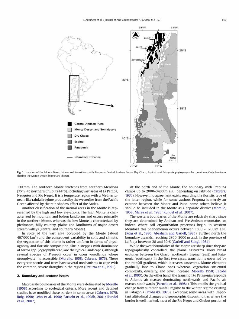
Fig. 1. Location of the Monte Desert biome and transitions with Prepuna (Central Andean Puna), Dry Chaco, Espinal and Patagonia phytogeographic provinces. Only Provincessharing the Monte Desert biome are shown.
E. Abraham et al. / Journal of Arid Environments 73 (2009) 144–153 145
100 mm. The southern Monte stretches from southern Mendoza(35�S) to northern Chubut (44�S), including vast areas of La Pampa,Neuquen and Rıo Negro. It is a temperate region with a Mediterra-nean-like rainfall regime produced by the westerlies from the PacificOcean affected by the rain shadow effect of the Andes.
Another classification of the natural areas in the Monte is rep-resented by the high and low elevations. The high Monte is char-acterized by mountain and bolson landforms and occurs primarilyin the northern Monte, whereas the low Monte is characterized bypiedmonts, hilly country, plains and landforms of major desertstream valleys (central and southern Monte).
In spite of the vast area occupied by the Monte (about467 000 km2) and the consequent variability in soils and climate,the vegetation of this biome is rather uniform in terms of physi-ognomy and floristic composition. Shrub steppes with dominanceof Larrea spp. (Zygophyllaceae) are the typical landscapes, althoughseveral species of Prosopis occur in open woodlands wheregroundwater is accessible (Morello, 1958; Cabrera, 1976). Theseevergreen shrubs and trees have several mechanisms to cope withthe common, severe droughts in the region (Ezcurra et al., 1991).
2. Boundary and ecotone issues
Macroscale boundaries of the Monte were delineated by Morello(1958) according to ecological criteria. More recent and detailedstudies have modified these borders in some areas (Cabrera, 1976;Roig, 1998; Leon et al., 1998; Paruelo et al., 1998b, 2001; Rundelet al., 2007).
At the north end of the Monte, the boundary with Prepunaclimbs up to 2000–3400 m a.s.l. depending on latitude (Cabrera,1976). However, no agreement exists regarding the floristic type ofthe latter region, while for some authors Prepuna is merely anecotone between the Monte and Puna, some others believe itshould be included in the Monte as a separate district (Morello,1958; Mares et al., 1985; Rundel et al., 2007).
The western boundaries of the Monte are relatively sharp sincethey are determined by Andean and Pre-Andean mountains, orindeed where soil cryoturbation processes begin. In westernMendoza this phenomenon occurs between 1500 – 1700 m a.s.l.(Roig et al., 1980; Abraham and Garleff, 1985). Further north theboundary ascends, reaching 2800–3000 m a.s.l. in the province ofLa Rioja between 28 and 30�S (Garleff and Stingl, 1984).
While the west boundaries of the Monte are sharp since they aretopographically controlled, the plains eastwards allow broadecotones between the Chaco (northeast), Espinal (east) and Pata-gonia (southeast). In the first two cases, transition is governed bythe rainfall gradient, which increases eastwards. Monte elementsgradually lose to Chaco ones whereas vegetation structuralcomplexity, diversity, and cover increase (Morello, 1958; Cabidoet al., 1993). On the other hand, the transition to Patagonia respondsto Atlantic air masses dominating northwards and Pacific airmasses southwards (Paruelo et al., 1998a). This entails the gradualchange from summer rainfall regime to the winter regime existingin Patagonia (Prohaska, 1976). Excepting some areas with impor-tant altitudinal changes and geomorphic discontinuities where theborder is well marked, most of the Rio Negro and Chubut portion of
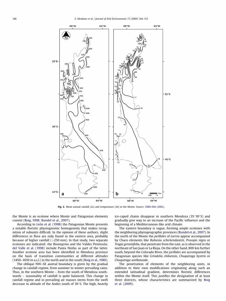
Fig. 2. Mean annual rainfall (2a) and temperature (2b) in the Monte. Source: SSRH-INA (2002).
E. Abraham et al. / Journal of Arid Environments 73 (2009) 144–153146
the Monte is an ecotone where Monte and Patagonian elementscoexist (Roig, 1998; Rundel et al., 2007).
According to Leon et al. (1998) the Patagonian Monte presentsa notable floristic physiognomic homogeneity that makes recog-nition of subunits difficult. In the opinion of these authors, slightdifferences in flora are only found in the eastern area, probablybecause of higher rainfall (>250 mm). In that study, two separateecotones are indicated: the Rionegrino and the Valdes Peninsula;del Valle et al. (1998) include Punta Ninfas as part of the latter.Another ecotone area has been identified in Mendoza provinceon the basis of transition communities at different altitudes(1450–1650 m a.s.l.) in the north and in the south (Roig et al., 1980).
The oblique NW–SE austral boundary is given by the gradualchange in rainfall regime, from summer to winter prevailing rains.Thus, in the southern Monte – from the south of Mendoza south-wards – seasonality of rainfall is quite balanced. This change inrainfall regime and in prevailing air masses stems from the swiftdecrease in altitude of the Andes south of 36�S. The high, heavily
ice-caped chains disappear in southern Mendoza (35�30�S) andgradually give way to an increase of the Pacific influence and thebeginning of a Mediterranean-like arid climate.
The eastern boundary is vague, forming ample ecotones withthe neighboring phytogeographic provinces (Rundel et al., 2007). Inthe north of the Monte the jarillales of Larrea appear accompaniedby Chaco elements like Bulnesia schickendantzii, Prosopis nigra orTragia geraniifolia, that penetrate from the east, as is observed in thenortheast of San Juan or La Rioja. On the other hand, 800 km furthersouth, beyond the Colorado River, the jarillales are accompanied byPatagonian species like Grindelia chiloensis, Chuquiraga hystrix orChuquiraga avellaneade.
The penetration of elements of the neighboring units, inaddition to their own modifications originating along such anextended latitudinal gradient, determines floristic differenceswithin the Monte itself. This justifies the designation of at leastthree districts, whose characteristics are summarized by Roiget al. (2009).

E. Abraham et al. / Journal of Arid Environments 73 (2009) 144–153 147
The analysis based on functional attributes derived from theseasonal curves of the Normalized Difference Vegetation Index(NDVI), derived from the Advanced Very High Resolution Radi-ometer (AVHRR) sensor on National Oceanic & AtmosphericAdministration (NOAA) satellites for a 10-year period, allows thedefinition of a clear boundary between the Monte and the Pata-gonian steppes (Paruelo et al., 1998a, 2001). The attributes usedwere: (a) the annual integral as an estimate of the fraction ofphotosynthetic active radiation absorbed by the canopy and henceof primary production, (b) the relative range of NDVI, and (c) thedate of maximum NDVI, both of which were used to capture theseasonality of primary production. The location of this boundarycorresponds well with the southernmost area of influence of theAtlantic air masses.
3. Geographical characteristics
3.1. Geology and landforms
Morello’s (1958) review of the geomorphology of the Monte hassince been updated by regional and local studies (Fidalgo and Riggi,1970; Abraham, 1979, 2000; Gonzalez Dıaz and Malagnino, 1984;Garleff, 1987; Godagnone et al., 2001). These studies were used tocompile the geomorphic map legend (Table 1, Fig. 3a).
Detailed geological studies with emphasis on mapping ofbedrock units, description of stratigraphic sections, and structuralgeology are listed for the mountain area (Ramos, 1999; Rapela et al.,2001). Primary lithologies include igneous and metamorphic rocks(Precambrian undifferentiated, Paleozoic–Mesozoic intrusives,Mesozoic volcanics, Cretaceous–Tertiary volcanics and Quaternaryvolcanics) and sedimentary rocks (Cretaceous, Tertiary andQuaternary). The mountain ranges of the northern Monte consti-tute part of the sub-Andean ranges formed by the uplift of theAndes. Both ranges are N–S oriented anticlines and have coresmostly of metamorphosed, phyllitic basement rocks of Precambrianage. The central Monte is an undulating to depressed loess-like
Table 1Geomorphic map legend (see also Fig. 3a).
Geomorphologic units (see Fig. 3a) Area
km2 %
Structural-denudational units1. High and low mountains 69 333 14.92. Hilly country and foothills 3467 0.73. Dominant volcanic landforms 34 421 7.4
Denudational units4. Badlands 6 504 1.45. Rolling and irregular plains 3114 0.76. Structural plains and pediments 13 960 2.97. Destructional plains, residual hills and erosion fronts 7719 1.78. Peneplains, hilly country and depressions 44 710 9.6
Fluvio-denudational/aeolian units9. Closed depressions/Salinas 3648 0.810. Alluvial-aeolian plains 56 445 12.111. Intermontane basin (bolson) landforms 39 287 8.4
Fluvioglacial-denudational/fluvial unit12. Gravel plains (different levels) 87 630 18.7
Fluvial units13. Alluvial plains 53 179 11.414. Alluvial fans 12132 2.6
Aeolian units15. Aeolian plains 28 686 6.116. Active sand dunes/dunefields 2088 0.5
Coastal-denudational unit17. Littoral environments 652 0.1
466 975 100.0
sandy plain of quaternary fluvial, lacustrine and aeolian origin. Thesouthern Monte is in part covered by gravel deposits locally named‘‘Rodados Patagonicos’’ of Pliocene–Pleistocene age (Fidalgo andRiggi, 1970). Older geologic units are exposed in the erosion frontsof plains and depressions, and in the littoral cliffs; they consistmainly of Tertiary marine sediments of Miocene age (Haller et al.,2000).
The relief intensity of the Monte region is one of the mostsignificant discriminating terrain factors observed by the ShuttleRadar Topography Mission (SRTM) global elevation data (Fig. 3b).This figure shows the range of altitudes in a shaded relief form.
The distribution of alluvial and aeolian landscapes reflects analternating balance between the wetter and drier climatic phases ofthe Quaternary. Gently undulating sandplains and active sanddunes are found near Cafayate (Salta), in Campo del Arenal andBelen (Catamarca), near Vinchina and Guandacol (La Rioja), in theMedanos Grandes desert (San Juan) and in northeastern Rio Negroprovince (near Caleta de los Loros). Deposits of finer texturedaeolian material also occur extensively both in alluvial environ-ments and on more undulating plains.
3.2. Watershed boundaries
The area occupied by the Monte is drained by 22 watersheds,although in most of them neither the headwaters nor the mouthare located in the Monte itself (Appendices 2 and 3a, electronicversion).
Localized marsh environments (San Juan, Mendoza, Tunuyan,Colorado, Negro, and Chubut watersheds) are biologically therichest places in the Monte (Appendix 3b, electronic version). Themost difficult issue in conserving the biological value of thesepermanent rivers is the assurance of water flow, due to severalreasons such as uncertain permanence and dam diversion. Salinitymay affect these rivers and their floodplains (del Valle et al., 2008).In the irrigated valleys the return flow may also carry residues ofagricultural chemicals and toxic trace elements.
The most important wetland is the system of lagoons in Gua-nacache and Rosario in the Mendoza province; it is a Ramsar site(strong protection from international agreements) that is home toan interesting diversity of aquatic and migratory birds (Sosa, 1999).
Basin characteristics are shown in Appendix 4 (electronicversion). Most water bodies are dry, seasonally or for years ata stretch. The dry water bodies and playa lake/salinas are prolificsources of dust. In the southern watersheds, lakes and dams offermuch bigger surfaces that might be biologically important,although this is not well known.
3.3. The soil cover
Soil cover diversity deals with the density of soil bodies and thevariety of soil species present. The general soil map (Fig. 4a,b)shows the geographic distribution of the major soils in the Monte(Godagnone et al., 2001). Table 2 shows the approximate area insquare kilometers and the percentages of soil orders and suborders(USDA, 2003). The relative soil importance per natural area is asfollows:
- >Orthents> Psamments>Udepts (High Monte/northernMonte)
- > Psamments>Argids> Calcids>Orthents¼ Fluvents>Cambids>Gypsids (Low Monte/central and southern Monte)
Entisol properties are determined largely by the parent material.Most Entisols have no diagnostic horizons, other than an ochricepipedon, and a very few an anthropic, albic or histic epipedon.Entisols are the dominant soils on gentle to steep slopes and
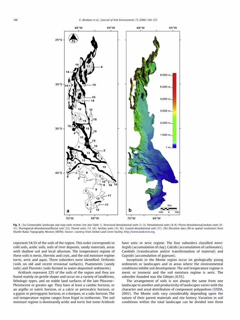
Fig. 3. (3a) Geomorphic landscape and map units review (see also Table 1). Structural-denudational units (1–3); Denudational units (4–8); Fluvio-denudational/aeolian units (9–11); Fluvioglacial-denudational/fluvial unit (12); Fluvial units (13, 14); Aeolian units (15, 16); Coastal-denudational unit (17). (3b) Elevation data (90-m spatial resolution) fromShuttle Radar Topography Mission (SRTM). Source: courtesy from Global Land Cover Facility, http://www.landcover.org.
E. Abraham et al. / Journal of Arid Environments 73 (2009) 144–153148
represent 54.5% of the soils of the region. This order corresponds tocold soils, aridic soils, soils of river deposits, sandy materials, areaswith shallow soil and local alluvium. The temperature regime ofthese soils is mesic, thermic and cryic, and the soil moisture regimetorric, xeric and aquic. Three suborders were identified: Orthents(soils on old and recent erosional surfaces), Psamments (sandysoils) and Fluvents (soils formed in water-deposited sediments).
Aridisols represent 22% of the soils of the region and they arefound mainly on gentle slopes and occur on a variety of landforms,lithologic types, and on stable land surfaces of the late Pliocene–Pleistocene or greater age. They have at least a cambic horizon, oran argillic or natric horizon, or a calcic or petrocalcic horizon, ora gypsic or petrogypsic horizon, or a duripan, or a salic horizon. Thesoil temperature regime ranges from frigid to isothermic. The soilmoisture regime is dominantly aridic and torric but some Aridisols
have ustic or xeric regime. The four suborders classified were:Argids (accumulation of clay), Calcids (accumulation of carbonates),Cambids (translocation and/or transformation of material) andGypsids (accumulation of gypsum).
Inceptisols in the Monte region occur on geologically youngsediments or landscapes and in areas where the environmentalconditions inhibit soil development. The soil temperature regime ismesic or isomesic and the soil moisture regime is xeric. Thesuborder founded was the Udepts (0.5%).
The arrangement of soils is not always the same from onelandscape to another and productivity of landscapes varies with thecharacter and areal distribution of component polypedons (USDA,2003). The Monte soils vary considerably depending upon thenature of their parent materials and site history. Variation in soilconditions within the total landscape can be divided into three
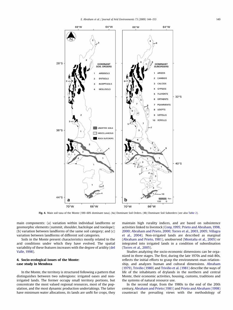
Fig. 4. Main soil taxa of the Monte (100–60% dominant taxa). (4a) Dominant Soil Orders. (4b) Dominant Soil Suborders (see also Table 2).
E. Abraham et al. / Journal of Arid Environments 73 (2009) 144–153 149
main components: (a) variation within individual landforms orgeomorphic elements (summit, shoulder, backslope and toeslope);(b) variation between landforms of the same soil category; and (c)variation between landforms of different soil categories.
Soils in the Monte present characteristics mostly related to thearid conditions under which they have evolved. The spatialvariability of these features increases with the degree of aridity (delValle, 1998).
4. Socio-ecological issues of the Monte:case study in Mendoza
In the Monte, the territory is structured following a pattern thatdistinguishes between two subregions: irrigated oases and non-irrigated lands. The former occupy small territory portions, butconcentrate the most valued regional resources, most of the pop-ulation, and the most dynamic production undertakings. The latterhave minimum water allocations, its lands are unfit for crops, they
maintain high rurality indices, and are based on subsistenceactivities linked to livestock (Cony, 1995; Prieto and Abraham, 1998,2000; Abraham and Prieto, 2000; Torres et al., 2003, 2005; Villagraet al., 2004). Non-irrigated lands are described as marginal(Abraham and Prieto, 1981), unobserved (Montana et al., 2005) orintegrated into irrigated lands in a condition of subordination(Torres et al., 2005).
Studies analyzing the socio-economic dimensions can be orga-nized in three stages. The first, during the late 1970s and mid-80s,reflects the initial efforts to grasp the environment–man relation-ship, and analyzes human and cultural dimensions. Abraham(1979), Trivino (1980) and Trivino et al. (1981) describe the ways oflife of the inhabitants of drylands in the northern and centralMonte, their economic activities, housing, customs, traditions andthe systems of natural resource use.
In the second stage, from the 1980s to the end of the 20thcentury, Abraham and Prieto (1981) and Prieto and Abraham (1998)counteract the prevailing views with the methodology of
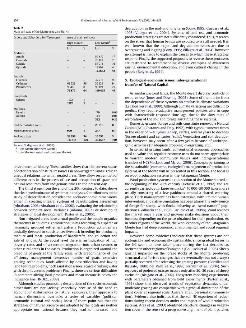
Table 2Main soil taxa of the Monte (see also Fig. 4).
Orders and Suborders Soil Taxonomy Area of main soil taxa
High Montea Low Monteb
km2 % km2 %
AridisolsArgids – – 59 877 17Cambids – – 25183 7Calcids – – 57 018 16Gypsids – – 11574 4
153 652 44
EntisolsFluvents – – 32 217 9Orthents 63 529 56 32129 9Psamments 9348 8 96 119 27
72 877 64 160 465 45
InceptisolsUdepts 1172 1 – –
1172 1 – –
MollisolsUstolls – – 179 0.06Xerolls – – 143 0.04
322 0.10
Undifferentiated soils – – 28 816 8
Miscellaneous areas 970 1 247 0.1
Rock outcrops 38 399 34 10 055 3113 418 100 353 557 100
Source: Godagnone et al. (2001).a High Monte (northern Monte).b Low Monte (central and southern Monte).
E. Abraham et al. / Journal of Arid Environments 73 (2009) 144–153150
environmental history. These studies show that the current statusof deterioration of natural resources in non-irrigated lands is due tounequal relationship with irrigated areas. They allow recognition ofdifferent eras in the process of use and occupation of space andnatural resources from indigenous times to the present day.
The third stage, from the end of the 20th century to date, showsthe clear predominance of systematic analyses. Contributions to thestudy of desertification consider the socio-economic dimensions,either in creating integral systems of desertification assessment(Abraham, 2003; Abraham et al., 2006), evaluating the relationshipbetween complex social variables (Adamo, 2003) or developingstrategies of local development (Pastor et al., 2005).
Non-irrigated areas have a rural profile and the people organizethemselves in ‘‘puestos’’ (production units) according to a sparse orminimally grouped settlement pattern. Production activities arebasically devoted to subsistence: livestock breeding for producingmanure and meat, production of handicrafts, and collection andsale of jonquil. At the social level there is an indication of highpoverty rates and of a constant migration into urban centres orother rural areas in the oases. Production is organized around thebreeding of goats at the family scale, with predominance of lowefficiency management (excessive number of goats, extensivegrazing techniques, lands affected by desertification and havingland tenure problems, flock sanitation issues, scarce drinking waterwith chronic arsenic problems). Finally, there are serious difficultiesin commercializing local products and mean income is below theindigence line (INDEC, 2008).
Although studies promoting descriptions of the socio-economicdimensions are not lacking, especially because of the need toaccount for disturbances to natural resources, their approach tohuman dimensions overlooks a series of variables (political,economic, cultural and social). Most of them point out that thestrategies of natural resource use adopted by the locals are neitherappropriate nor rational because they lead to increased land
degradation in the mid-and long term (Cony, 1995; Guevara et al.,1995; Villagra et al., 2004). Systems of land use and economicproduction strategies are not sufficiently considered; thus, researchon the stress that human beings are exposed to is still needed. It iswell known that the major land degradation issues are due toovergrazing and logging (Cony, 1995; Villagra et al., 2004), howeverno attempt is made to explain the causes to which these strategiesrespond. Finally, the suggested proposals to reverse these processesare restricted to recommending diverse examples of awarenessraising, environmental education, and even cultural change in thepeople (Roig et al., 1991).
5. Ecological-economic issues, inter-generationaltransfer of Natural Capital
As similar pastoral lands, the Monte desert displays conflicts ofresource use (Jones and Dowling, 2005). Some of them arise fromthe dependence of these systems on stochastic climate variations(Le Houerou et al., 1988). Although climate variations are difficult topredict, they require adaptive management policies able to copewith characteristic response time lags, due to the slow rates ofrestoration of the soil and forage sustaining these systems.
Domestic grazers, forage and soils constitute renewable NaturalCapital (NC) (Costanza and Daly, 1992), with typical turnover timesin the order of 5–10 years (sheep, cattle), several years to decades(forage plants) and centuries (soils). Vegetation and soil degrada-tion, however, may occur after a few years because of anthropo-genic activities (inadequate cropping, overgrazing, etc.).
In semiarid grazing lands, conventional economic approachesused to value and regulate resource uses do not seem appropriateto warrant modern community values and inter-generationaltransfers of NC (MacLeod and McIvor, 2006). Concepts pertaining tothe sustainable (economic, ecological) management of productionsystems at the Monte will be presented in this section. The focus ison wool production systems in the Patagonian Monte.
Wool production systems in this section of the Monte started atthe beginning of the 20th century (Defosse et al., 1992) and arecurrently carried out in large ‘estancias’ (10 000–50 000 ha or more)usually consisting of a few paddocks around a shared wateringplace. Flock management has been extensive, with limited humanintervention, and native vegetation has been almost the only sourceof forage for sheep, with flocks behaving as ‘‘semi-natural’’ pop-ulations (Golluscio et al., 1998; Paruelo et al., 1998b). Wool reachesthe market once a year and growers make decisions about theirbusiness depending on the price obtained for their production. Asin other regions of the world, the wool economy of the PatagonianMonte has had deep economic, environmental, and social regionalimpacts.
However, some evidences indicate that these systems are notecologically and economically sustainable, since gradual losses inthe NC seem to have taken place during the last decades, asoccurred in other regions of Patagonia (Golluscio et al., 1998). Sheepgrazing impacted on the forage stocks of the Monte, producingstructural and floristic changes that are eventually (but not always)partially reverted after releasing the grazing pressure (Bertiller andBisigato, 1998; del Valle et al., 1998; Bertiller et al., 2004). Suchrecovery of preferred grasses occurs only after 20–30 years of sheepexclusion (Bisigato et al., 2002). Ecosystem modeling experimentswith parameters obtained from field experiments (Parton et al.,1993) show that observed trends of vegetation dynamics undermoderate grazing are compatible with a gradual diminution of theplant cover at regional scale (Carrera et al., personal communica-tion). Evidence also indicates that the soil NC experienced reduc-tions during recent decades under the impact of wool productionsystems. Ares et al. (2003) identified structural changes in vegeta-tion cover in the sense of a progressive alignment of plant patches
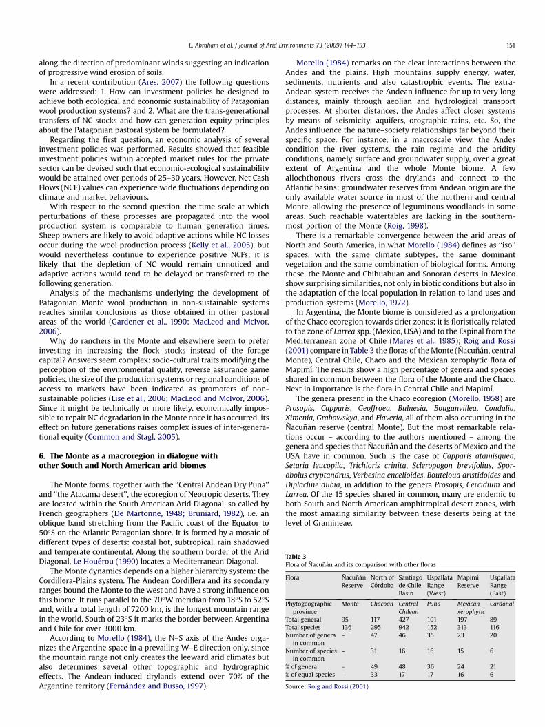
Table 3Flora of Nacunan and its comparison with other floras
Flora NacunanReserve
North ofCordoba
Santiagode ChileBasin
UspallataRange(West)
MapimıReserve
UspallataRange(East)
Phytogeographicprovince
Monte Chacoan CentralChilean
Puna Mexicanxerophytic
Cardonal
Total general 95 117 427 101 197 89Total species 136 295 942 152 313 116Number of genera
in common– 47 46 35 23 20
Number of speciesin common
– 31 16 16 15 6
% of genera – 49 48 36 24 21% of equal species – 33 17 17 16 6
Source: Roig and Rossi (2001).
E. Abraham et al. / Journal of Arid Environments 73 (2009) 144–153 151
along the direction of predominant winds suggesting an indicationof progressive wind erosion of soils.
In a recent contribution (Ares, 2007) the following questionswere addressed: 1. How can investment policies be designed toachieve both ecological and economic sustainability of Patagonianwool production systems? and 2. What are the trans-generationaltransfers of NC stocks and how can generation equity principlesabout the Patagonian pastoral system be formulated?
Regarding the first question, an economic analysis of severalinvestment policies was performed. Results showed that feasibleinvestment policies within accepted market rules for the privatesector can be devised such that economic-ecological sustainabilitywould be attained over periods of 25–30 years. However, Net CashFlows (NCF) values can experience wide fluctuations depending onclimate and market behaviours.
With respect to the second question, the time scale at whichperturbations of these processes are propagated into the woolproduction system is comparable to human generation times.Sheep owners are likely to avoid adaptive actions while NC lossesoccur during the wool production process (Kelly et al., 2005), butwould nevertheless continue to experience positive NCFs; it islikely that the depletion of NC would remain unnoticed andadaptive actions would tend to be delayed or transferred to thefollowing generation.
Analysis of the mechanisms underlying the development ofPatagonian Monte wool production in non-sustainable systemsreaches similar conclusions as those obtained in other pastoralareas of the world (Gardener et al., 1990; MacLeod and McIvor,2006).
Why do ranchers in the Monte and elsewhere seem to preferinvesting in increasing the flock stocks instead of the foragecapital? Answers seem complex: socio-cultural traits modifying theperception of the environmental quality, reverse assurance gamepolicies, the size of the production systems or regional conditions ofaccess to markets have been indicated as promoters of non-sustainable policies (Lise et al., 2006; MacLeod and McIvor, 2006).Since it might be technically or more likely, economically impos-sible to repair NC degradation in the Monte once it has occurred, itseffect on future generations raises complex issues of inter-genera-tional equity (Common and Stagl, 2005).
6. The Monte as a macroregion in dialogue withother South and North American arid biomes
The Monte forms, together with the ‘‘Central Andean Dry Puna’’and ‘‘the Atacama desert’’, the ecoregion of Neotropic deserts. Theyare located within the South American Arid Diagonal, so called byFrench geographers (De Martonne, 1948; Bruniard, 1982), i.e. anoblique band stretching from the Pacific coast of the Equator to50�S on the Atlantic Patagonian shore. It is formed by a mosaic ofdifferent types of deserts: coastal hot, subtropical, rain shadowedand temperate continental. Along the southern border of the AridDiagonal, Le Houerou (1990) locates a Mediterranean Diagonal.
The Monte dynamics depends on a higher hierarchy system: theCordillera-Plains system. The Andean Cordillera and its secondaryranges bound the Monte to the west and have a strong influence onthis biome. It runs parallel to the 70�W meridian from 18�S to 52�Sand, with a total length of 7200 km, is the longest mountain rangein the world. South of 23�S it marks the border between Argentinaand Chile for over 3000 km.
According to Morello (1984), the N–S axis of the Andes orga-nizes the Argentine space in a prevailing W–E direction only, sincethe mountain range not only creates the leeward arid climates butalso determines several other topographic and hydrographiceffects. The Andean-induced drylands extend over 70% of theArgentine territory (Fernandez and Busso, 1997).
Morello (1984) remarks on the clear interactions between theAndes and the plains. High mountains supply energy, water,sediments, nutrients and also catastrophic events. The extra-Andean system receives the Andean influence for up to very longdistances, mainly through aeolian and hydrological transportprocesses. At shorter distances, the Andes affect closer systemsby means of seismicity, aquifers, orographic rains, etc. So, theAndes influence the nature–society relationships far beyond theirspecific space. For instance, in a macroscale view, the Andescondition the river systems, the rain regime and the aridityconditions, namely surface and groundwater supply, over a greatextent of Argentina and the whole Monte biome. A fewallochthonous rivers cross the drylands and connect to theAtlantic basins; groundwater reserves from Andean origin are theonly available water source in most of the northern and centralMonte, allowing the presence of leguminous woodlands in someareas. Such reachable watertables are lacking in the southern-most portion of the Monte (Roig, 1998).
There is a remarkable convergence between the arid areas ofNorth and South America, in what Morello (1984) defines as ‘‘iso’’spaces, with the same climate subtypes, the same dominantvegetation and the same combination of biological forms. Amongthese, the Monte and Chihuahuan and Sonoran deserts in Mexicoshow surprising similarities, not only in biotic conditions but also inthe adaptation of the local population in relation to land uses andproduction systems (Morello, 1972).
In Argentina, the Monte biome is considered as a prolongationof the Chaco ecoregion towards drier zones; it is floristically relatedto the zone of Larrea spp. (Mexico, USA) and to the Espinal from theMediterranean zone of Chile (Mares et al., 1985); Roig and Rossi(2001) compare in Table 3 the floras of the Monte (Nacunan, centralMonte), Central Chile, Chaco and the Mexican xerophytic flora ofMapimı. The results show a high percentage of genera and speciesshared in common between the flora of the Monte and the Chaco.Next in importance is the flora in Central Chile and Mapimı.
The genera present in the Chaco ecoregion (Morello, 1958) areProsopis, Capparis, Geoffroea, Bulnesia, Bouganvillea, Condalia,Ximenia, Grabowskya, and Flaveria, all of them also occurring in theNacunan reserve (central Monte). But the most remarkable rela-tions occur – according to the authors mentioned – among thegenera and species that Nacunan and the deserts of Mexico and theUSA have in common. Such is the case of Capparis atamisquea,Setaria leucopila, Trichloris crinita, Scleropogon brevifolius, Spor-obolus cryptandrus, Verbesina encelioides, Bouteloua aristidoides andDiplachne dubia, in addition to the genera Prosopis, Cercidium andLarrea. Of the 15 species shared in common, many are endemic toboth South and North American amphitropical desert zones, withthe most amazing similarity between these deserts being at thelevel of Gramineae.
E. Abraham et al. / Journal of Arid Environments 73 (2009) 144–153152
Analyzing the divergences among plant species is alsoextremely interesting, with the most outstanding case being that ofthe Cactaceae, a family endemic to America with a high number ofspecies. Nevertheless, the cacti of Argentina, Chile and Mexicoshow few relations, the similarity being reduced to the genusOpuntia without any coincidence with the North hemisphere.
Four theories are developed to explain the amphitropicaldisjunction of these dispersions between two desert areas morethan 9000 km apart: (1) the existence of only one desert in the past,(2) the formation of possible ecological corridors, (3) the dispersionover great distances, and (4) the convergent evolution fromcommon ancestors, with greater possibilities being granted to thetwo first theories. These theories are discussed in the work by Roiget al. (2009).
7. Concluding remarks
With this contribution we have attempted to provide an upda-ted overview of the existing knowledge related to the Monte as anecoregion, while searching to encompass all aspects of its diverseenvironmental problematic issues: from the biophysical to thesocio-economic and the cultural. The most controversial topic wasthe regional delineation of the Monte. As with other biomes,opinions differ about the Monte boundaries and transitions(ecotones). In our discussion, we laid emphasis on vegetation, but itmust not be forgotten that heterotrophs also play essential roles inthe Monte. Further studies on Monte borders are deemednecessary.
Besides, we analyzed the related information generated in theMonte itself with a view to determining the state of knowledge inthe light of the different theories and disciplinary bodies to whichthe authors subscribe. In so doing, we found a great asymmetrybetween the literature related to biophysical aspects and thatassociated with socio-cultural ones. The scientific production hasprivileged biophysical issues, whereas social and cultural aspectshave been disregarded. The interdisciplinary approach is unusualand only partially applied, especially between naturally alliedsciences and subjects, for instance relationships among water,vegetation and soils. Interdisciplinary studies addressing perspec-tives and links between the cultural and the natural are harder tofind. The same is true for integrated, systemic studies, practicallyabsent since Morello’s works.
Sustainable investment policies in rangelands of the PatagonianMonte should consider the ecological-economic relationships andfeedbacks between forage consumption by ewes and ewe natality/soil erosion controls exerted by forage and market behaviour.
Comparative studies on the similarities of the Monte desert, theSonoran and Chihuahuan deserts in Mexico, and the deserts in theSouth West of the USA should be fostered, in the certainty that theycould contribute new models for comprehending the structure,dynamics and evolution of drylands.
The evolution of the knowledge emerging in relation to theMonte shows a parallelism with that of environmental sciences;starting from early simple inventories of the ecosystem compo-nents – even in the cultural realm – it is only in recent times thatsystemic and research-action approaches have been attained. Thisindicates an attempt to generate processes of local developmentand, in this sense, the Monte is a region not yet well understood.
Acknowledgements
We wish to acknowledge the valuable observations made to thiswork by anonymous reviewers. Also, we are grateful to Nelly Horakfor her technical assistance and to the interdisciplinary team of theLaboratory of Desertification and Land Management (LaDyOT-IADIZA) for their valuable comments. This research was funded by
the following projects of Argentina: PIP 6413 (CONICET), PICT 13-15034 (FONCYT, SEPCYT) and CYTED XVII.1 (IberoamericanProgram of Science and Technology for Development).
Appendix A. Supplementary material
Supplementary material associated with this article can befound in the online version, at doi:10.1016/j.jaridenv.2008.09.028.
References
Abraham, E.M., 1979. Geomorfologıa y biota del Valle de Sanagasta (Provincia de LaRioja, Argentina). Deserta 5, 95–155.
Abraham, E.M., 2000. Geomorfologıa de la Provincia de Mendoza. In:Abraham, E.M., Rodrıguez Martınez, F. (Eds.), Argentina. Recursos y problemasambientales de la zona arida. Provincias de Mendoza, San Juan y La Rioja. Juntade Andalucıa. Universidades y Centros de Investigacion de la Region AndinaArgentina, Buenos Aires, pp. 29–48.
Abraham, E.M., 2003. Desertificacion: bases conceptuales y metodologicas parala planificacion y gestion. Aportes a la toma de decision. Zonas Aridas 7,19–68.
Abraham, E.M., Garleff, K., 1985. Fenomenos periglaciales (geocriogenicos) fosiles enel centro y sur del piedemonte mendocino. Zentralblatt fur Geologie undPalaontologie I (11/12), 1709–1719.
Abraham, E.M., Prieto, M.R., 1981. Enfoque diacronico de los cambios ecologicos y delas adaptaciones humanas en el NE arido mendocino. Cuadernos del CEIFAR 8,107–139.
Abraham, E.M., Prieto, M.R., 2000. Viticulture and desertification in Mendoza,Argentina. Zentralblatt fur Geologie und Palaontologie I (7/8), 1063–1078.
Abraham, E.M., Montana, E., Torres, L., 2006. Desertificacion e indicadores: pos-ibilidades de medicion integrada de fenomenos complejos, Scripta Nova.Revista electronica de Geografıa y Ciencias Sociales 10 (214).
Adamo, S.B., 2003. Vulnerable People in Fragile Lands: Migration and Desertifi-cation in the Drylands of Argentina: the Case of the Department of Jachal.Doctoral dissertation, The University of Texas at Austin. Available from:http://hdl.handle.net/2152/66.
Ares, J., 2007. Systems valuing of natural capital and investment in extensivepastoral systems: lesson from the Patagonian case. Ecological Economics 62,162–173.
Ares, J., del Valle, H.F., Bisigato, A., 2003. Detection of process-related changes inplant patterns at extended spatial scales during early dryland desertification.Global Change Biology 9, 1643–1659.
Bertiller, M., Bisigato, A., 1998. Vegetation dynamics under grazing disturbance. Thestate and transition model for the Patagonian steppes. Ecologıa Austral 8,191–199.
Bertiller, M.B., Bisigato, A.J., Carrera, A.L., del Valle, H.F., 2004. Estructura de lavegetacion y funcionamiento de los ecosistemas del Monte austral. Boletın de laSociedad Argentina de Botanica 39 (3–4), 139–158.
Bisigato, A., Ares, J., Bertiller, M., 2002. Assessment of pristine vegetation structurein semiarid shrublands based on spatial explicit modeling. Phytocoenologia 32,581–594.
Bruniard, E.D., 1982. La diagonal arida argentina. Un lımite climatico real. RevistaGeografica IPGH (Instituto Panamericano de Geografıa e Historia) 95, 5–20.
Cabido, M., Gonzalez, C., Dıaz, S., 1993. Vegetation changes along a precipitationgradient in central Argentina. Vegetatio 109, 5–14.
Cabrera, A.L., 1976. Regiones Fitogeograficas Argentinas. Fascıculo 1. In:Kugler, W.F. (Ed.), Enciclopedia Argentina de Agricultura y Jardinerıa, BuenosAires, vol. 2, p. 85.
Common, M., Stagl, S., 2005. Ecological Economics. Cambridge University Press,Cambridge.
Cony, M., 1995. Reforestacion Racional de Zonas Aridas y Semiaridas con arbolesmultipropositos. Interciencia 20 (5), 249–253.
Costanza, R., Daly, H.E., 1992. Natural capital and sustainable development.Conservation Biology 6, 37–46.
Defosse, G.E., Bertiller, M.B., Rostagno, C.M., 1992. Rangeland management inPatagonian drylands. In: Perrier, G.K., Gay, C.W. (Eds.), Proceedings of theInternational Rangeland Development Symposium. Society for RangeManagement, Spokane, pp. 12–21.
De Martonne, E., 1948. Traite de Geographie Physique, seventh ed. Colin, Parıs.Ezcurra, E., Montana, C., Arizaga, S., 1991. Architecture, light interception, and
distribution of Larrea species in the Monte Desert, Argentina. Ecology 72,23–34.
Fernandez, O.A., Busso, C.A., 1997. Arid and Semi-Arid Rangelands: Two Thirds ofArgentina. RALA Report 200, pp. 41–60.
Fidalgo, F., Riggi, J.C., 1970. Consideraciones geomorfologicas y sedimentologicassobre los rodados patagonicos. Revista de la Asociacion Geologica Argentina(RAGA) 25 (4), 430–443.
Gardener, C.J., McIvor, J.G., Williams, J., 1990. Dry tropical rangelands: solving oneproblem and creating another. Proceedings of the Ecological Society of Australia16, 279–286.
Garleff, K., 1987. El piedemonte andino de la Argentina. In: Roig, F. (Ed.), Deteccion ycontrol de la desertificacion. UNEP-IADIZA, Mendoza, pp. 133–138.

E. Abraham et al. / Journal of Arid Environments 73 (2009) 144–153 153
Garleff, K., Stingl, H., 1984. Hohenstufen und ihre raumzeitlichen Veranderungenin den argentinischen Anden. Zentralblatt fur Geologie und Palaontologie I(11/12), 1701–1707.
Godagnone, R.E., Bertola, H., Ancarola, M., 2001. Mapa de suelos de la RepublicaArgentina, escala 1:2.500.000, Segunda Edicion. INTA/CIRN e IGM.
Golluscio, R.A., Deregibus, V.A., Paruelo, J.M., 1998. Sustentabilidad y manejo en lasestepas Patagonicas. Ecologıa Austral 8, 265–284.
Gonzalez Dıaz, E.F., Malagnino, E.C., 1984. Geomorfologıa de la provincia de RıoNegro. Servicio geologico Nacional, Centro Investigaciones Recursos Geologicos(CIRGEO), 155 pp.
Guevara, J.C., Estevez, E.R., Torres, E., 1995. Receptividad de las pasturas naturales dela llanura de Mendoza. Multequina 4, 29–35.
Haller, M.J., Monti, A.J., Meister, C.M., 2000. Hoja Geologica 4363-I: PenınsulaValdes, Provincia del Chubut, Boletın 266. Servicio Geologico Minero Argentino.
Instituto Nacional de Estadıstica y Censos (INDEC), 2008. Encuesta Permanente deHogares (EPH). Ministerio de Economıa, Republica Argentina.
Jones, R., Dowling, P., 2005. Sustainability and economics of temperate perennialAustralian grazing systems. Agriculture, Ecosystems and Environment 106, 313–416.
Kelly, D.L., Kolstad, Ch.D., Mitchell, G.T., 2005. Adjustment costs from environmentalchange. Journal of Environmental Economics and Management 50, 468–495.
Le Houerou, H.N., 1990. Bioclimatologie comparative des zones arides de l’Afrique etde l’Amerique Latine. Terra Aridae 7, 26–55.
Le Houerou, H.N., 1999. Estudios e Investigaciones ecologicas de las zonas aridas ysemiaridas de Argentina. Informe Interno. IADIZA, Mendoza.
Le Houerou, H.N., Bingham, R.L., Sterbeck, L.,1988. Relationship between the variability ofannual precipitation in world arid lands. Journal of Arid Environments 15, 1–18.
Leon, R.J.C., Bran, D., Collantes, M., Paruelo, J.M., Soriano, A., 1998. Grandes unidadesde vegetacion de la Patagonia extra andina. Ecologıa Austral 8, 125–144.
Lise, W., Hess, S., Purev, B., 2006. Pastureland degradation and poverty amongherders in Mongolia: data analysis and game estimation. Ecological Economics58, 350–364.
MacLeod, N.D., McIvor, J.G., 2006. Reconciling economic and ecological conflicts forsustained management of grazing lands. Ecological Economics 56, 386–401.
Mares, M.A., Morello, J.H., Goldstein, G., 1985. The Monte desert and othersubtropical semi-arid biomes of Argentina, with comments on their relation toNorth American arid areas. In: Evenari, M., Noy-Meir, I., Goodall, D. (Eds.), HotDeserts and Arid Shrublands. Elsevier Science, Amsterdam, pp. 203–237.
Montana, E., Torres, L., Abraham, E.M., Torres, E., Pastor, G., 2005. Los espaciosinvisibles. Subordinacion, marginalidad y exclusion de los territorios no irri-gados en las tierras secas de Mendoza, Argentina. Region y Sociedad 32, 3–32.
Morello, J.H., 1958. La Provincia Fitogeografica del Monte. Opera Lilloana 2, 5–115.Morello, J.H., 1972. Variables estructurales de la vegetacion del Monte (Argentina) y
desierto Sonorense (E.U.A.). I Congreso Latinoamericano de Botanica, Memorias,pp. 359–364.
Morello, J.H., 1984. Perfil ecologico de sudamerica. Instituto de CooperacionIberoamericana.
Parton, W.J., Scurlock, J.M., Ojima, D.S., 1993. Observations and modeling of biomassand soil organic matter dynamics for the grassland biome worldwide. GlobalBiogeochemical Cycles 7, 785–810.
Paruelo, J.M., Beltran, A., Jobbagy, E.G., Sala, O.E., Golluscio, R.A., 1998a. The climateof Patagonia: general patterns and controls on biotic processes. Ecologıa Austral8, 85–101.
Paruelo, J.M., Jobbagy, E.G., Sala, O.E., 1998b. Biozones of Patagonia (Argentina).Ecologıa Austral 8, 145–154.
Paruelo, J.M., Jobbagy, E.G., Sala, O.E., 2001. Current distribution of ecosystemfunctional types in temperate South America. Ecosystems 4, 683–698.
Pastor, G., Abraham, E.M., Torres, L., 2005. Desarrollo local en el desierto de Lavalle.Estrategia para pequenos productores caprinos (Argentina). Cuadernos deDesarrollo Rural 54, 131–150.
Prieto, M.R., Abraham, E.M., 1998. Historia ambiental del sur de Mendoza (SiglosXVI al XIX). Los factores crıticos de un proceso de desertificacion. BambergerGeographische Schriften 15, 277–297.
Prieto, M.R., Abraham, E.M., 2000. Caminos y comercio como factores de cambioambiental en las planicies aridas de Mendoza (Argentina) entre los siglos XVII yXIX. Revista Theomai 2.
Prohaska, F., 1976. The climate of Argentina, Paraguay and Uruguay. In:Schwerdtfeger, W. (Ed.), The Climate of Central and South America, WorldSurvey of Climatology. Elsevier, New York, pp. 13–143.
Ramos, V., 1999. Las provincias geologicas del territorio argentino. Instituto deGeologıa y Recursos Minerales. Geologıa Argentina, Anales 29 (3), 41–96.
Rapela, C.W., Casquet, C., Baldo, E., Dahlquist, J., Pankhurst, R.J., Galindo, G.,Saavedra, J., 2001. Las Orogenesis del Paleozoico Inferior en el margen proto-andino de America del Sur, Sierras Pampeanas, Argentina. Journal of IberianGeology 27, 23–41.
Roig, F.A., 1998. La vegetacion de la Patagonia. In: Correa, M.N. (Ed.), Flora Pata-gonica, Parte 1. INTA, Buenos Aires.
Roig, F.A., Rossi, B., 2001. Flora y vegetacion. In: Claver, S., Roig, J.S. (Eds.), El desierto delMonte: la Reserva de Biosfera de Nacunan. IADIZA. UNESCO, Cordoba, pp. 41–75.
Roig, F.A., De Marco, G., Wuilloud, C., 1980. El lımite entre las provincias fitogeog-raficas del Monte y de la Patagonia en las llanuras altas de San Carlos, Mendoza.Boletın de la Sociedad Argentina de Botanica 19, 331–338.
Roig, F.A., Gonzalez, M.M., Abraham, E.M., Mendez, E., Roig, V.G., MartınezCarretero, E., 1991. Maps of desertification hazards of Central Western Argen-tina, (Mendoza Province). In: UNEP (Ed.), World Atlas of Thematic Indicators ofDesertification. E. Arnold, Londres.
Roig, F.A., Roig-Junent, S., Corbalan, V., 2009. Biogeography of the Monte Desert.Journal of Arid Environments 73 (2), 164–172.
Rundel, P.W., Villagra, P.E., Dillon, M.O., Roig-Junent, S., Debandi, G., 2007. Arid andsemi-arid ecosystems, pp. 158–183. (chapter 11). In: Veblen, T.T., Young, K.R.,Orme, A.R. (Eds.), The Physical Geography of South America. Oxford UniversityPress, Oxford, UK, 368 p.
Sosa, H., 1999. Informe Taller Lagunas de Guanacache, Lavalle - Mendoza, Argentina.Oficina de Medio Ambiente de la Municipalidad de Lavalle.
SSRH-INA, 2002. Atlas Digital de los Recursos Hıdricos Superficiales de la RepublicaArgentina. CD-ROM. Subsecretarıa de Recursos Hıdricos de la Nacion. InstitutoNacional del Agua, Buenos Aires.
Torres, L., Abraham, E.M., Torres, E., Montana, E., 2003. Acceso a los recursos ydistribucion de la poblacion en tierras secas de Argentina: el caso de Mendoza.Aportes hacia la equidad territorial, Scripta Nova. Revista Electronica de Geo-grafıa y Ciencias Sociales VII (148).
Torres, L., Montana, E., Abraham, E.M., Torres, E., Pastor, G., 2005. La Utilizacion deindicadores socio-economicos en el estudio y la lucha contra la desertificacion:acuerdos, discrepancias y problemas conceptuales subyacentes. Revista Estu-dios Interdisciplinarios de America Latina y el Caribe, Tel Aviv University 16 (2),111–133.
Trivino, L., 1980. El hombre en las zonas aridas. Serie cientıfica 3, 12–19.Trivino, L., Abraham, E.M., Bocco, A., Prieto, M.R., 1981. El folklore y la religiosidad
popular. Centro de Investigaciones del Folclore, Cordoba, 89 pp.USDA, 2003. Keys to Soil Taxonomy, ninth ed. Natural Resources Conservation
Service (NRCS), 332 pp.del Valle, H.F., 1998. Patagonian soils: a regional synthesis. Ecologıa Austral 8,
103–123.del Valle, H.F., Blanco, P.D., Sione, W., Rostagno, C.M., Elissalde, N.O., 2008.
Assessment of salt-affected soils using multisensor radar data: a case studyfrom northeastern Patagonia (Argentina). In: Metternicht, G., Zinck, A. (Eds.),Remote Sensing of Soil Salinization: Impact on Land Management. CRC PressTaylor and Francis Group, pp. 155–173 (Chapter 9).
del Valle, H.F., Elissalde, N.O., Gagliardini, D.A., Milovich, J., 1998. Status of desert-ification in the Patagonian region: assessment and mapping from satelliteimagery. Arid Soil Research and Rehabilitation 12 (2), 1–27.
Villagra, P., Cony, M., Mantovan, N., Rossi, B., Gonzalez, M., Villalba, R., Marone, L., 2004.Ecologıa y manejo de los algarrobales de la Provincia Fitogeografica del Monte. In:Arturi, M., Frangi, J., Goya, J. (Eds.), Ecologıa y manejo de bosques nativos deArgentina. Editorial Universidad Nacional de La Plata, La Plata, pp. 1–32.