ORIGIN AND EVOLUTION OF SEDIMENTARY BASINS, THEIR ENERGY AND MINERAL RESOURCES WITH REFERENCE TO...
150
ORIGIN AND EVOLUTION OF SEDIMENTARY BASINS, THEIR ENERGY AND MINERAL RESOURCES WITH REFERENCE TO INTERNATIONAL ISSUES IN THE MEDITERRANEAN SEA State of the Art Dr. Mahmoud A. Radi Dar Associate Professor, Marine Geology and Geophysics National Institute of Oceanography and Fisheries 2013
Transcript of ORIGIN AND EVOLUTION OF SEDIMENTARY BASINS, THEIR ENERGY AND MINERAL RESOURCES WITH REFERENCE TO...
ORIGIN AND EVOLUTION OF SEDIMENTARY
BASINS, THEIR ENERGY AND MINERAL RESOURCES
WITH REFERENCE TO INTERNATIONAL ISSUES IN
THE MEDITERRANEAN SEA
State of the Art
Dr. Mahmoud A. Radi Dar Associate Professor, Marine Geology and Geophysics
National Institute of Oceanography and Fisheries
2013
I
Contents
Subject P.No. SUMMARY 1 CHAPTER I: SEDIMENTARY BASINS 9
1- Sedimentary Basins Definition 9 2- Origin and Mechanisms of Basins Formation 10 Earth's Crust Components 12 A- The continental shelf 12 B- The continental slope 13 C- The continental 13 D- Deep-Ocean Trenches 3 E- Plate margin (plate boundary 13 E.1- Convergent boundaries (subduction zones) 14 E.2- Continental crust 14 E.3- Oceanic crust 15 E.4- Triple junctions 15 3- Sedimentary Basins evolutions 16 Divergent boundaries (ocean ridges) 17 Convergent boundaries 18 Transform boundaries 19 Passive continental margins 20 Active continental margins 21 Foreland basin Systems 22 Pripheral or Pro-foreland basin 23 Retroarc or Retro-foreland basin 23 Dynamic topography 24 4- Classification of Sedimentary Basins 25 I- Tectonic Basin Classification 25 I.1- Continental or interior sag basins 27 I. 2- Continental graben structures and rift zones form narrow elongate basins bounded by large faults
28
I. 3 - Failed rifts or aulacogens 28 I. 4- Passive margin basins 29 I. 5- Oceanic sag basins or nascent ocean basins 29 I. 6- Basins related to subduction 30 I. 7- Terrane-related basins 30 I. 8- Basins related to collision 31 Retroarc or intramontune basins 33 Pannonian-type basins 33 I. 9- Strike-slip and wrench basins 33 II- Pre-, Syn-, and Post-Depositional Basins 34 1- Post-depositional basins 34 2- Syn-depositional basins 34 3- Pre-depositional basins 35 5- Basins Morphology 36 6- Depositional Environments 38 1- Continental Sediment Environments 39 1.1- Glacial Environments 39 1.2- Aeolian Environments 39 1.3- Rivers and Alluvial Fans 40 1.4- Lakes and Lacustrine Environments 42 2- Marine Sediment Environments 44 2.1- Marine deltas 45

II
2.2- Clastic Coasts and Estuaries 46 2.3- The beach 46 2.4- Coastal plains 47 2.5- Beach barriers 48 2.6- Shallow Marine Carbonate and Evaporite Environments 49 2.7- Adjacent sea basins and epicontinental seas 49 2.8- The shallow seas and continental shelf sediments 50 2.9- Deep-sea basins 50 CHAPTER II: GEOTHERMAL ENERGY IN THE SEDIMENTARY BASINS 52 1- Geothermal Gradient 54 2- Effect of the geothermal energy on hydrocarbon maturation 55 3- Geothermal energy utilizations 56 3.1- Hydrothermal Systems - Geothermal Aquifers 57 3.2- Hot Dry Rocks (HDR) Enhanced Geothermal Systems (EGS) 57 3.3- Geothermal energy in contemporary balneotherapeutics and Tourism
59
4- Healing and therapeutic value of geothermal waters 59 4.1- Therapeutic tourism 60 4.2- Geothermal Electricity Production around the world 60 CHAPTER III: MINERAL RESOURCES OF THE SEDIMENTARY BASINS 62 I- Organic Mineral Resources 63 I.1- Oil and Natural Gas Resources 63 1.1- Sedimentary basins and petroleum formation in the Middle East
63
1.2- Petroleum prospectivity of the principal sedimentary basins on the United Kingdom Continental Shelf
65
1.3- Prospectivity of the sedimentary basins of Irish Sea 66 I. 2- Coal bearing formations 66 2.1- Australia 66 2.2- India 66 II- Inorganic Mineral Resources 66 II.1- Volcanogenic massive sulphides (VMS) 67 II.2- Metaliferous Oxides 67 II.3- Metallic and Gem Minerals in Placer Deposits 67 II.4- Evolution of a Mineralized Geothermal System, Valles Caldera, New Mexico, USA
68
II.5- Mineral Resources of the Western Canada Sedimentary Basin 68 II.6- Mineral Resources of the Australian Sedimentary Basins 69 6.1- Heavy minerals 69 6.2- Bauxite 69 6.3- Sedimentary phosphate deposits 69 6.4- Other Metals 69 CHAPTER IV: MEDITERRANEAN SEA 70 I- Mediterranean Geosynclinal Belt 70 II- Origin and evolution of Mediterranean geosyncline 71 III- Paleoenvironmental analysis 73 IV- Mediterranean basins 74 IV. 1- Tectonic Settings of Eastern Mediterranean basin 75 IV.2- Tectonic Settings of the Western Mediterranean 76 V- Origin and Tectonic History of Mediterranean Sub-basins 79 V.1- The Levantine Basin 79 V.2- Aegean Sea basin 80 V.3- Adriatic Sea basin 82 V.4- Ionian Sea basin 84 V.5- The Tyrrhenian Sea 86
III
V.6- The Alboran Sea 88 V.7- The Algerian Basin 90 VI- Geothermal Potentials and Uses of the Mediterranean 94 VI. A- Geothermal potentials 94 A.1- Geothermal Resources in Foreland Environments 95 A.2- Thermal Coastal Springs 95 VI. B- Geothermal Uses 96 B.1- Electrical production 96 V- Mineral Resources in the Mediterranean Region 97 V.1- Organic minerals (Oil – Natural Gas – Coal) 97 1. A- Oil and natural Gas resources 97 A.1- Lavantine basin 97 A.2- Adriatic Sea 97 A.3- Neogene petroleum system at Alboran - Algerian Basins
98
1.B- Coal Bearing Formations 98 V.2- Inorganic mineral resources 99 CHAPTER V: EGYPT (Genius of the Place) 102 1- Sedimentary Basins of Egypt 102 1.1- Nile Delta 102 1.2- Eastern Desert 104 1.3- Red Sea Rift Valley 105 1.4- Western Desert 106 2- Geothermal Regime of Egyptian Basins 108 2.1- Geothermal reservoirs in the Hammam Faraun and Hammam Musa regions
110
3- Mineral Resources 111 3.1- Organic minerals 111 A- Oil and Gas 111 B- Coal Bearing formations 112 3.2- Inorganic minerals 113 2.1- Talc deposits 113 2.2- Gold, magnetite and zircon 113 2.3- Platinum-group minerals 114 2.4- Uranium isotopes 115 2.5- Phosphate deposits 116 2.6- Gypsum deposits 117 2.7- Limestone deposits 118 2.8- Shale formations 119 References 120
1
SUMMARY
Sedimentary basins are regions of the earth of long-term subsidence creating
accommodation space for infilling by sediments. Sedimentary basins are a characteristic
feature of the Earth's crust and lithosphere and range in age from Archaean to the present day.
Approximately 70% of the Earth's surface is underlain by basins of one type or another.
Sedimentary basins occur in diverse geological settings usually associated with plate tectonic
activity. The subsidence results from the thinning of underlying crust, sedimentary, volcanic,
and tectonic loading, and changes in the thickness or density of adjacent lithosphere. Some of
the world's largest basins occur within or on the stable continental and are termed
Intracratonic basins. Sedimentary basins are found in a variety of tectonic settings.
Subsequently, they are classified structurally in various ways, with a primary classifications
distinguishing among basins formed in various plate tectonic regime (divergent, convergent,
transform, intraplate), the proximity of the basin to the active plate margins, and whether
oceanic, continental or transitional crust underlies the basin. Convergent boundaries create
foreland basins through tectonic compression of oceanic and continental crust during
lithospheric flexure. Tectonic extension at divergent boundaries where continental rifting is
occurring can create a nascent ocean basin leading to either an ocean or the failure of the rift
zone. In tectonic strike-slip settings, accommodation spaces occur as transpressional,
transtensional or transrotational basins according to the motion of the plates along the fault
zone and the local topography pull-apart basins. On oceanic crust, basins are likely to be
subducted, while marginal continental basins may be partially preserved, and intracratonic
basins have a high probability of preservation. As the sediments are buried, they are subjected
to increasing pressure and begin the process of lithification. Such a definition excludes basins
whose sedimentary infill is now incorporated in fold belts, but includes those in the stable
continental interiors and flanking regions that have escaped the destructive effects of plate
subduction and rifling. The largest sediment thicknesses in the geological record are also
believed to have occurred at the margins of the continents.
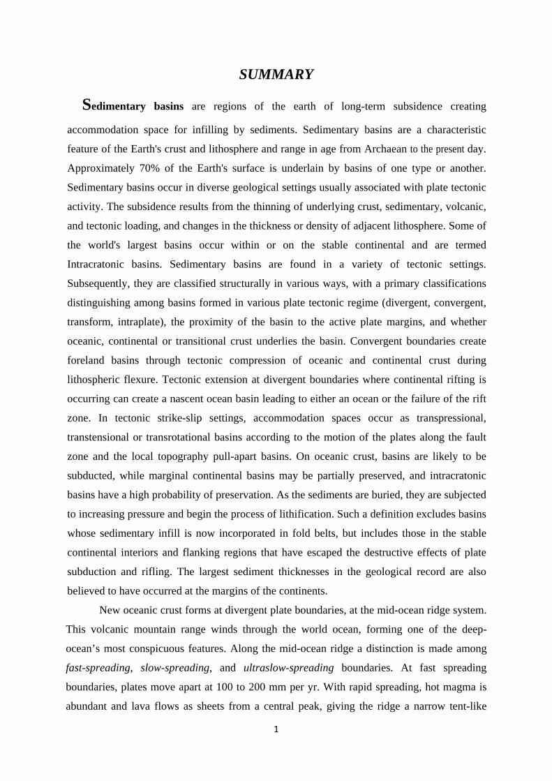
New oceanic crust forms at divergent plate boundaries, at the mid-ocean ridge system.
This volcanic mountain range winds through the world ocean, forming one of the deep-
ocean’s most conspicuous features. Along the mid-ocean ridge a distinction is made among
fast-spreading, slow-spreading, and ultraslow-spreading boundaries. At fast spreading
boundaries, plates move apart at 100 to 200 mm per yr. With rapid spreading, hot magma is
abundant and lava flows as sheets from a central peak, giving the ridge a narrow tent-like

2
profile (e.g., the East Pacific Rise). At slow-spreading boundaries, plates move apart at less
than 55 mm per yr and the topography is broader, rougher, and features rift valleys (e.g., Mid-
Atlantic Ridge). At ultraslow-spreading boundaries, plates move apart at less than 20 mm per
yr and great slabs of mantle rock rise to the seafloor. Where two oceanic plates converge or
where an oceanic plate converges with a continental plate, a subduction zone forms. In a
subduction zone, the denser oceanic plate slips under the other plate and descends into the
mantle. Hence, lithosphere is incorporated into the mantle in subduction zones. Subduction
zones produce trenches on the deep ocean floor and are associated with shallow to deep
earthquakes and violent volcanic eruptions. A transform plate boundary occurs where
adjacent plates slide laterally past one another.
Foreland basins are associated with compressional plate boundaries. By way of
contrast, smaller basins of the fore-arc, back-arc and strike-slip type develop in response to
an extensional compressional or strike-slip stress field along a plate collision zone.
Sedimentary basin will not form unless there is an initial depression for the sediments to fill
in. Rift-type (divergent type), compressional-type (convergent type) and strike-slip
(transform type) basins are often characterized by thick sequences of continental and
shallow-water sediments and therefore require substantial tectonic driving forces in order to
explain them. The best known of the basin-forming mechanisms is thermal contraction of
the oceanic lithosphere as it cools away from a mid-ocean ridge crest.
The wide variety of sedimentary basins produce numerous types of sedimentary
environments classified into; continental (fluvial, glacial, eolian), lacustrine, and deltaic
environments; adjacent sea basins and epi-continental seas of varying salinity; marine
depositional areas of normal salinity; transitional environments may be defined between
continental and marine environments (include marine deltas, intertidal environments, coastal
lagoons, estuaries, and barrier island systems). On the continents, sedimentation might be
thought to begin with clastic materials shed from the flanks of mountain ranges. These
alluvial fans are characterized by poorly sorted, boulder and gravel dominated, debris flow
conglomerates. Fluvial (river) facies include cross-bedded and rippled river sandstones and
parallel or cross-bedded floodplain mudstones (siltstones and clay shale). Lacustrine (lake)
facies include sands deposited at the mouths of rivers which empty into the lake and along the
shoreline as well as muddy facies on the deep lake bottom. Swamps often form in low-lying
areas (for example, the area near sea level behind the shore environment) in which parallel
layered, organic-rich black shales and coal form. In arid regions with little vegetation and few
3
rivers, aeolian (wind deposited - sand dunes) environments may dominate. Aeolian
sandstones frequently display large scale (1 to 3 meter) crossbed sets.
Deltas form at the mouths of rivers where large volumes of siliclastics are dumped
into the ocean (and lakes also). Thick accumulations of sand, silt and mud form in several
subenvironments, including stream channels, flood plain, beaches, tidal flats, and sand bars.
Farther offshore, at the edge of the continental shelf, is the continental slope and rise, down
which gravity flows or turbidites move poorly-sorted sands and muds down into the deep
ocean basins. On the deep abyssal plains, far from the influence of turbidite transported
continental materials, organic mud or marine oozes are the result of a fine rain of the shells of
microorganisms filtering down from near the surface.
Geothermal energy indicates that part of the heat within the Earth that can or might be
recovered and exploited by mankind. The geothermal or temperature gradient is the rate of
increase in temperature per unit depth in the Earth due to the outflow of heat from the centre.
The temperature gradient between the centre of the Earth and the outer limits of the
atmosphere averages about 1°C per kilometer. Vertical deformations of the lithosphere result
from the purely mechanical effects of sediment loading as well as from changes in the
ambient temperature field. The temperature anomalies contribute to these deformations not
only by setting up body forces but also by creating thermal in plane forces and associated
bending units. Temperatures in the model are governed by the effects of vertical and
horizontal thermal conduction such that the lithosphere-asthenosphere boundary is defined as
a partial melt isotherm or phase change boundary which migrates vertically depending on the
transient thermal state.
Due to the long-term availability and the large extent of geothermal heat, geothermal
energy represents an efficient renewable energy worldwide. Making geothermal heat an
effective source for a sustainable supply of energy requires a quantitative reserve and resource
assessment. Though immense in its nature, only a fraction of the Earth’s heat can be utilized
in practice, its exploitation being limited to areas characterized by favorable hydrogeological
conditions for geothermal resources to develop. A proper geothermal exploration involves
different stages comprising: (1) a correct localization of potential areas to ascertain the
existence of a particular geothermal field; (2)an accurate estimate of the size of the resource to
determine the type of geothermal field; and (3) an appropriate identification of the main
physical transport processes involved to properly identify geothermal phenomena. This
requires an integrated approach involving different disciplines and methodologies including
4
geological field measurements, laboratory-based investigations as well as mathematical
modeling. It is well that the most significant portion of the world’s mineral, energy and water
resources is hosted in sedimentary basins. Formation of these resources results from
interactions between different coupled processes comprising groundwater flow, mechanical
deformation, mass transport and heat transfer and different water–rock interaction
mechanisms. Understanding the relative impact of fluid and other heat driving processes on
the resulting geothermal field as well as the resulting subsurface flow dynamics is of crucial
importance for geothermal energy production. For geothermal exploration it is essential to
quantify the above-mentioned processes by interpretation of their characteristic thermal
signatures in the subsurface.
Direct-use of geothermal energy is one of the oldest, most versatile and also the most
common form of utilization of geothermal energy. Now, there are 78 countries having direct
utilization of geothermal energy, is a significant increase from the 72 reported in 2005, the 58
reported in 2000, and the 28 reported in 1995. The thermal energy used is 438,071 TJ/year
(121,696 GWh/yr). The distribution of thermal energy used by category is approximately
49.0% for ground-source heat pumps, 24.9% for bathing and swimming (including
balneology), 14.4% for space heating (of which 85% is for district heating), 5.3% for
greenhouses and open ground heating, 2.7% for industrial process heating, 2.6% for
aquaculture pond and raceway heating, 0.4% for agricultural drying, 0.5% for snow melting
and cooling, and 0.2% for other uses.
The diversified geology of various regions and stratigraphic levels within the basins
have given rise to a wide variety of minerals, more than 50 different kinds other than oil, gas
and coal, that have an existing or potential resource value. The minerals are divided into
industrial (or nonmetallic) minerals and metallic minerals. Subsurface fluid flow plays a
significant role in many geologic processes and is increasingly being studied in the scale of
sedimentary basins and geologic time perspective. Many economic resources such as
petroleum and mineral deposits are products of basin scale fluid flow operating over large
periods of time. Volcanogenic massive sulphides are major sources of Zn, Cu, Pb, Ag and Au,
and significant sources for Co, Sn, Se, Mn, Cd, In, Bi, Te, Ga and Ge. Some also contain
significant amounts of As, Sb and Hg. Historically, they account for 27% of Canada's Cu
production, 49% of its Zn, 20% of its Pb, 40% of its Ag and 3% of its Au. Marine placer
mineral deposits are metallic and Gem minerals found on the continental shelf from the
beaches to the outer shelf.

5
Mediterranean Sea is one of the largest mobile regions of the earth’s crust,
separating the Eastern European, Siberian, Sino-Korean, and South China platforms from the
African-Arabian and Indian platforms. The Mediterranean geosynclinal belt stretches across
Eurasia (Europe-Asia), from the Strait of Gibraltar in the west to the Indonesian archipelago,
where it joins the Pacific geosynclinal belt. Geologic features in the present-day
Mediterranean essentially result from two major processes: the tectonic displacement caused
by the subduction of the African plate underneath the Eurasian plate; and the progressive
closure of the Mediterranean Sea involving a series of submarine-insular sills. There are
three major geomorphical settings within the Mediterranean basin; areas with stable margin
characteristics, areas with unstable convergent margin characteristics, and areas with
extensional margin (rifting) characteristics. The main division is that of the Western
Mediterranean and Eastern Mediterranean: two basins separated by an underwater ridge that
crosses the sea from Sicily to the coasts of Tunisia. The Eastern Mediterranean is one of the
key regions for the understanding of fundamental tectonic processes, including continental
rifting, passive margins, ophiolites, subduction, accretion, collision and post-collisional
exhumation. It involves; Levantine Basin, Aegean Sea basin, Adriatic basin and Ionian Sea
basin. The western Mediterranean is the younger part of the Mediterranean, being a basin
formed from late Oligocene to present. The western Mediterranean consists of a series of
sub-basins such as the Alboran Sea, Algerian and Tyrrhenian Sea basins.
The exploitable geothermal resources in the Mediterranean are generally related not
to conductive systems but to convective ones. This means that the heath is brought near the
surface by fluids (mainly waters) flowing vertically from depth toward the surface, so that
sufficiently high temperature may be reached by drilling at economical depth. Geothermal
resources are suitable for many different types of uses and according to their temperature are
commonly divided into two categories, high and low enthalpy. High enthalpy is suitable for
electrical generation with conventional cycles, low enthalpy resources are employed for
direct uses. The direct use o f geothermal energy is at a relatively advanced stage in
European countries compared with other parts of the world. It supplies a wide range of
applications and uses due to the versatility and demand for base-load heat demand plus the
availability o f the resource. European countries have been pioneers in the exploitation of
geothermal resources. European experience and expertise in this sector has been duplicated
by other countries world-wide.
Different mineral resources were considered in the Mediterranean sub-basins;
6
petroleum and gas resources and coal bearing formations. At Turkey, The mineral matter of
the basins are mainly clay minerals (illite–smectite and kaolinite), plagioclase and quartz in
Bolu coal field, clay minerals (illite–smectite, smectite and illite), quartz, calcite, plagioclase
and gypsum in Seben coal field, quartz, K-feldspar, plagioclase and clay minerals (kaolinite
and illite), dolomite, quartz, clinoptilolite, opal and gypsum. In Western Europe,
intermediate- and high sulphidation Pb–Zn–Ag–Au deposits and minor porphyry Cu–Mo
mineralization in the Eastern Rhodopes are predominantly hosted by veins in shoshonitic to
high-K calc-alkaline volcanic rocks of closely similar age. Base-metal-poor, high-grade gold
deposits of low sulphidation character occurring in continental sedimentary rocks of
synextensional basins show a close spatial and temporal relation to detachment faulting prior
and during metamorphic core complex formation.
Egypt was subdivided into five major morpho-structural units; the Mediterranean
Fault Zone, a belt of linear uplifts and half-grabens, the North Sinai Fold Belt “Syrian Arc”,
the Suez and Red Sea Graben, and the intracratonic basins of southern Egypt. The Nile Deep-
Sea Fan (NDSF) forms a thick sedimentary wedge covering about 100,000 km2, constructed,
for the most part, since the late Miocene by influx of clastic sediments from the Nile River.
The present day NDSF covers a segment of an older passive margin thought to have formed
during successive rifting episodes in Jurassic and early Cretaceous times, and the total
thickness of sediments on the Egyptian margin (including the post-Miocene NDSF) could
exceed 9 km.
The Eastern Desert of Egypt constitutes the northwestern end of the Nubian segment
of the Arabian-Nubian Shield. The ophiolitic rocks of the Arabian-Nubian Shield have supra-
subduction geochemical signatures. The supra-subduction signature of the ophiolites in the
Eastern Desert led to further debate on whether they were formed in a back-arc setting or in a
forearc setting during subduction. The Neoproterozoic ophiolites of the Eastern Desert were
formed in a forearc setting based on the depleted nature of the serpentinized mantle rocks.
The Red Sea occupies part of a large rift valley in the continental crust of Africa and
Arabia. This break in the crust is part of a complex rift system that includes the East African
Rift System. To the north, the Red Sea bifurcates into the Gulfs of Suez and Aquaba, with
the Sinai Peninsula in between. The Gulf of Suez is a failed intercontinental rift that forms
the NW–SE trending continuation of the Red Sea rift system and was initiated during the late
Oligocene to Early Miocene by the NE–SW separation of the African and Arabian plates. It
extends more than 300 km in length and can be divided into three parts: the northern portion

7
of the Gulf dips to the SW; the central part dips to the NE; and the southern part dips to the
SW. The structure of the Gulf of Suez region is governed by normal faults and tilted blocks,
of which the crests represent a major hydrocarbon exploration target.
The Western Desert of Egypt consists of a number of sedimentary basins that
received a thick succession of Mesozoic sediments. Various geological studies have been
carried out dealing with the stratigraphy, facies distribution, and tectonic framework of these
sedimentary basins. The sedimentary section in the northern part of the Western Desert can
be divided into three sequences based on lithology, namely: the lower clastic unit from
Cambrian to pre-Cenomanian, the middle carbonates from Cenomanian to Eocene and the
upper clastic unit from Oligocene to Recent.
The thermal data at the eastern part of Egypt indicate that the geothermal situation of
the Red Sea is more complex and broader than the Gulf of Suez. Observations near to the
axial trough of the Red Sea have a mean of 470mWm2 that typical associated with an active
spreading center. Whereas a mean of 116mWm2 was recorded near the coast of the northern
Red Sea that is appropriate with the estimated values at the Gulf of Suez. Two heat flow
provinces were distinguished: 1- the west of Nile-north of Egypt normal province with low
heat flow about 46 mWm-2 and reduced heat flow of 20 mWm-2 typical of Precambrian
platform tectonic setting and 2- the eastern Egypt tectonically active province with heat flow
up to 80-130 mWm-2 including the Gulf of Suez and the northern Red Sea Rift System with
reduced heat flow of > 30-40 mWm-2, at the transition between the two provinces.
Three distinct oil and gas provinces were well known in Egypt; the Gulf of Suez, the
Nile delta and Western Desert. The largest part of the production and reserves drives from
prolific area of the Gulf of Suez. Egypt's hydrocarbons are accumulated in formations ranging
in age from Carboniferous to Pliocene. The reservoirs are formed essentially by sands and
sandstones and to a lesser extent by carbonates. Safa Formation belongs to the upper clastic
unit of Middle Jurassic age is the well known coal bearing in Egypt. The thickness of the
main coal seams ranges from 130 cm to 2 m and are underlain and overlain by thin black
shale beds.
Talc deposits occur within mafic, intermediate and felsic volcanic rocks and the talc
ore bodies represent a distinct lithological unit within the volcanics. Gold deposits and
occurrences located in the Nubian Shield have been known in Egypt since Predynastic times.
These are stratabound deposits and non-stratabound deposits hosted in igneous and
metamorphic rocks, as well as placer gold deposits. Platinum-group element (PGE)
mineralization has been recently reported in podiform chromitites from the late Proterozoic

8
Pan–African ophiolite of the Eastern Desert of Egypt. Geochemical comparison between the
ore and the Nubia sandstone showed that the ore is depleted in the residual elements (Al, Ti,
V, and Ni) and enriched in the mobile elements (Fe, Mn, Zn, Ba, and U) which indicates that
the Bahariya iron ore is not a lateritic deposit despite the deep weathering in this area.
Phosphorite deposits in Egypt, known as the Duwi Formation, are a part of the Middle East to
North Africa phosphogenic province of Late Cretaceous to Paleogene age. Phosphatic grains
in these deposits are classified into phosphatic mudclasts and phosphatic bioclasts. Gypsum
crusts are recorded only capping the Middle Eocene carbonate rocks that are interbedded with
thick gypsiferous shale beds in the north central part of Egypt.
Thebes Formation forms an extensive carbonate platform on the southern margin of
Tethys, outcropping along the Nile Valley and over large areas of the Western Desert of
Upper Egypt. The upper Oligocene Wadi Arish Formation is composed of a carbonate-
dominated succession at Gebel Risan Aneiza (Sinai) with about 77-m-thick. Hagul formation
represents Upper Miocene clastic/limestone sequence of about 22 m thick measured near the
entrance of Wadi Hagul and Thebes Limestone, the last marine deposit before Red Sea proto-
rifting began in Oligocene times. The Thebes Limestone formation contains several beds, 0.5
to 2 m thick near Qusier city. Carbonaceous shales have a wide distribution on the Egyptian
surface and in subsurface sedimentary sequences e.g. in sediments of predominantly
Carboniferous, Jurassic, Cretaceous, Paleocene and Eocene age. The carbonaceous and black
shales in Egypt gained interest since five decades when the phosphorite deposits were
discovered and exploited.

9
CHAPTER I
SEDIMENTARY BASINS
1- Sedimentary Basins Definition
Sedimentary basins are the areas in which sediments have accumulated during a
particular time period at a significantly greater rate and to a significantly greater thickness
than surrounding areas and be preserved for long geological time periods, compare with
physiographic basin – a depression in the surface of the land or sea-floor that may or may not
be infilled with sediments. In addition, there also exist areas of long-persisting denudation, as
well as regions where erosional and depositional processes more or less neutralize each other
(creating what is known as non-deposition or omission) (Einsele, 1992). Sedimentary basins
of one type or another today cover about 70% of the Earth's surface and contain sediment
thicknesses that range from about a kilometer to several 10's km. Some basins are
geologically young others have existed for 100's million years.
According to Bally (1975) sedimentary basins may defined as realms of subsidence
with thicknesses of sediments commonly exceeding one kilometer that are today still
preserved in a more or less coherent form. A basin is born from the meeting of a sedimentary
deposit and a more or less pronounced concavity in the basement. The Earth's surface exhibits
a wide variety of sedimentary basins. Most of them are mobile zones by definition and are
encountered at the plate boundaries. However, some of them, particularly the most extensive
basins are situated on the plate themselves. These are the cratonic and intracratonic basins
(Perrodon, 1983). Cratonic basins are sites of prolonged, broadly distributed but slow
subsidence of the continental lithosphere, and are commonly filled with shallow water and
terrestrial sedimentary rocks (Allen and Armitage, 2011), while the intracratonic basins are
the basins that occur within the continental interiors away from the plate margins that undergo
differential subsidence relative to the surrounding area (Busby and Azor, 2012).
Allen and Allen (2006) reported that the sedimentary basins are regions of prolonged
subsidence of the earth's crust. Sedimentary basins can have numerous different shapes; they
may be approximately circular or, more frequently elongate depressions, troughs, or
embayments, but often they may have quite irregular boundaries. Even areas without any
topographic depression, such as alluvial plains, may act as sediment traps. The size of
sedimentary basins is highly variable, though they are usually at least 100 km long and tens of
km wide.

2- OriM
sedimen
intrapla
during
formatio
lithosph
transitio
et al.
mechan
ultimate
within
thermal
(lithosp
Earth's c
upper m
Astheno
the Ear
lithosph
molten
of abou
200 km
compos
which a
each oth
exist in
of plate
transfor
general
rifted o
subsiden
et al., 1
gin and MMost stu
ntary basi
ate stresses
basin
on of sedim
heric stre
onal stress
., 1989).
nisms of
ely related
the relativ
boundary
phere). Lith
crust and A
most part of
osphere is
rth's mantle
here and co
rock, exten
ut 75 km (4
m (124 mi).
sed of a n
are in motio
her.
Sedimentar
n a backgro
e motion. T
rm, and hyb
characteris
or sheared
nce driven
989). Activ
Mechanismudies of
ins agree
play critic
formation.
mentary bas
etching re
levels (Clo
The d
subsidenc
d to pro
vely rigid,
layer of the
hosphere in
sthenosphe
f mantle) (F
the upper p
e lies benea
onsists of pa
nding from a
46.5 mi) to
The lithosp
number of
on with resp
ry basins th
ound enviro
The major
brid; 23 bas
stics of the e
continental
by the ther
ve sediment
ms of Basf the
e that
cal role
The
sins by
equires
oetingh
driving
e are
ocesses
cooled
e Earth
nvolves
ere (the
Fig., 1).
part of
ath the
artially
a depth
o about
phere is
plates
pect to
erefore
onment
subdivision
sin categori
evolution of
margins, a
rmal contrac
t deposition
10
sins Form
ns of basin
es occur wi
f many sedi
are conven
ction of an
n, at a specif
Source
Fig., (1) Strucin the http://www.clactonics_intro.h
mation
n settings in
ithin these
imentary ba
ntionally ex
anomalousl
fic rate, occ
e: http://en.wik
ture of the Earcontinen
assroomatsea.nehtml)
nclude dive
settings (In
asins, espec
xplained by
ly hot litho
curs within
kipedia.org/wik
rth and the lithnt and et/general_scien
ergent, con
ngersoll, 198
cially those
y models of
sphere (Ste
the overlyin
ki/Lithosphere
osphere compoocean.(S
nce/plate_tecton
nvergent,
88). The
found at
f crustal
ephenson
ng basin
ositions Source: nics/te
11
and the thermal state of the sedimentary basin is fully coupled with that of the lithosphere.
Sleep (1971) proposed that the tectonic subsidence of continental margin basins was caused
by crustal thinning after uplift and erosion at the time of continental rifting. The apparent
decrease in the widths of some basins through time can be explained by the model if sediment
deposition is followed by erosion of the basin and its edges (Watts et al., 1982).
The modes of rift continental margins formations can be defined based on the general
geometry of the crust and mantle lithosphere during extension (Huismans and Beaumont,
2009); 1) core complex mode, where upper crustal extension is concentrated in a local area
concomitant with lower crustal thinning over a wide area; 2) wide rift mode, with uniform
crustal and mantle lithosphere thinning over a width greater than the lithospheric thickness;
and 3) narrow rift mode, with crust and mantle lithosphere thinning over a narrow area.
Narrow rifting is attributed to local weakening factors such as thermal thinning of the
lithosphere, local strain weakening of the strong layers in the system, or local magmatism
(Buck, 1991; Buck et al., 1999). Three explanations have been provided for wide rifts: 1) a
local increase of the integrated strength resulting from replacement of crustal material by
stronger mantle lithospheric material and concomitant cooling during lithosphere extension
causing extension to migrate to un-thinned weaker areas of lithosphere resulting in a wide rift
mode (England, 1983; Houseman and England, 1986); 2) flow of weak lower crust to areas of
thinned crust in response to pressure gradients related to surface topography that result in
delocalization of deformation (Buck, 1991; Buck et al., 1999); and 3) the degree of brittle-
ductile coupling in systems containing a frictional layer bonded to a viscous layer, where the
occurrence of localized or distributed, pure shear modes depends on the coupling between the
layers and the lower layer viscosity (Huismans et al., 2005). Core complex modes of
extension are understood to result when rapid lower crustal flow removes the crustal thickness
variations (Fig., 2) required for mechanisms that would results in a wide rift zone (Buck,
1991).
The thermal and mechanical response of the lithosphere to extension which occur during
rifting have very great attentions. The first type involves nicking of the lithosphere, so that
extension produces thinning of both upper and lower lithosphere over a given horizontal
distance (Keen, 1989). The second type of geometry involves offset of the lithosphere along a
low angle detachment (Wernicke, 1985). The low angle detachment or shear zone either
extends through the entire lithosphere or only through the upper lithosphere. In latter case, the
motion along the shear zone may be transferred to the lower lithosphere (Keen, 1989).

12
According to Huismans and Beaumont (2009), the predicted rift modes belong to three
fundamental types: 1) narrow, asymmetric rifting in which the geometry of both the upper and
lower lithosphere is approximately asymmetric; 2) narrow, asymmetric, upper lithosphere
rifting concomitant
with narrow,
symmetric, lower
lithosphere extension;
and 3) wide,
symmetric, crustal
rifting concomitant
with narrow, mantle
lithosphere extension.
Watts et al., (1982)
concluded that, the
dominant mechanisms affecting basin subsidence are thermal contraction following heating
and thinning of the lithosphere at the time of their formation, and sedimentary loading.
Thermal contraction controls the overall shape of basin that is available for sedimentation,
whereas sedimentary loading is the main control on the stratigraphy of a basin. They added,
the flexural strength increases with time after basin initiation as the lithosphere cools. In the
oceans the flexural strength of the lithosphere increases with age away from a mid-ocean
ridge crest, while in the continents, the flexural strength appears to increase with age after a
thermal event. The role of flexure varies as a function of both time and position during the
evolution of a basin and is an important factor to consider in 'back stripping' sedimentary
loads through geological time (Busby and Azor, 2012).
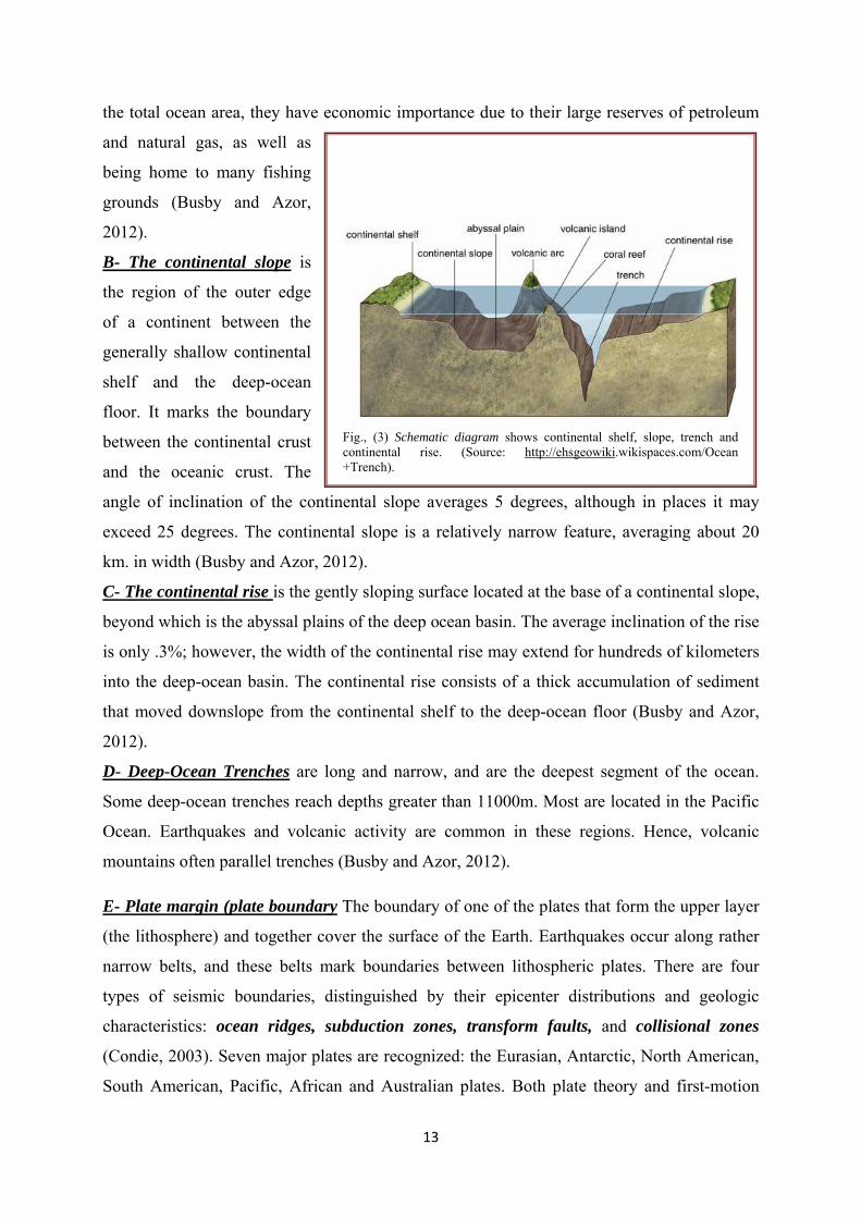
Earth's Crust Components (Fig., 3)
A- The continental shelf is a very gently sloping, submerged, extension of the continental
land mass extending from the shoreline toward the deep-ocean basin. The continental shelf is
relatively featureless, although some areas contain glacial deposits. The main features are
long valleys running from the coastline into deeper waters. These are seaward extensions of
river valleys which (along with the rest of the continental shelf) were flooded in the last Ice
Age. Along some coasts the continental shelf is almost nonexistent, while at others it may
extend seaward as far as 1500 km. On average, the continental shelf is 80 km wide and has a
depth of 130m at the seaward edge. Although the continental shelves constitute only 7.5% of
Fig., (2) Schematic diagram illustrates the basic concepts of plate tectonic theory. Continental crust = orange; oceanic crust = green. (Source: http://www.classroomatsea.net/general_science/plate_tectonics/tectonics_intro.html
13
the total ocean area, they have economic importance due to their large reserves of petroleum
and natural gas, as well as
being home to many fishing
grounds (Busby and Azor,
2012).
B- The continental slope is
the region of the outer edge
of a continent between the
generally shallow continental
shelf and the deep-ocean
floor. It marks the boundary
between the continental crust
and the oceanic crust. The
angle of inclination of the continental slope averages 5 degrees, although in places it may
exceed 25 degrees. The continental slope is a relatively narrow feature, averaging about 20
km. in width (Busby and Azor, 2012).
C- The continental rise is the gently sloping surface located at the base of a continental slope,
beyond which is the abyssal plains of the deep ocean basin. The average inclination of the rise
is only .3%; however, the width of the continental rise may extend for hundreds of kilometers
into the deep-ocean basin. The continental rise consists of a thick accumulation of sediment
that moved downslope from the continental shelf to the deep-ocean floor (Busby and Azor,
2012).
D- Deep-Ocean Trenches are long and narrow, and are the deepest segment of the ocean.
Some deep-ocean trenches reach depths greater than 11000m. Most are located in the Pacific
Ocean. Earthquakes and volcanic activity are common in these regions. Hence, volcanic
mountains often parallel trenches (Busby and Azor, 2012). E- Plate margin (plate boundary The boundary of one of the plates that form the upper layer
(the lithosphere) and together cover the surface of the Earth. Earthquakes occur along rather
narrow belts, and these belts mark boundaries between lithospheric plates. There are four
types of seismic boundaries, distinguished by their epicenter distributions and geologic
characteristics: ocean ridges, subduction zones, transform faults, and collisional zones
(Condie, 2003). Seven major plates are recognized: the Eurasian, Antarctic, North American,
South American, Pacific, African and Australian plates. Both plate theory and first-motion
Fig., (3) Schematic diagram shows continental shelf, slope, trench and continental rise. (Source: http://ehsgeowiki.wikispaces.com/Ocean +Trench).

14
studies at plate boundaries indicate that plates are produced at ocean ridges, consumed at
subduction zones, and slide past each other along transform faults. Plate boundaries are
dynamic features, not only migrating about the Earth's surface, but changing from one type of
boundary to another. In addition, new plate boundaries can be created in response to changes
in stress regimes in the lithosphere. Also, plate boundaries disappear as two plates become
part of the same plate, for instance after a continent-continent collision (Condie, 2003).
Plate margins are of three main types: (a) constructive margins where newly created
lithosphere is being added to plates which are moving apart at oceanic ridges; (b) convergent
margins which can be either destructive margins, where one plate is carried down into the
mantle, beneath the bordering plate, at a subduction zone, or a collision zone, where two
island arcs or continents, or an arc and a continent, are colliding; or (c) conservative margins,
where two plates are moving in opposite directions to each other along a transform fault. All
three margins are seismically active, with volcanic activity at constructive and destructive
margins. Some plate margins exhibit features of more than one of the three main types and are
known as combined plate margins (Kimura et al., 2012).
E.1- Convergent boundaries (subduction zones) a convergent plate boundary where one
plate subducts beneath the other,
usually because it is denser (Fig.,
4). The western coast of South
America is roughly coincident
with a subduction zone in which
a plate consisting of ocean floor
is subducting beneath the
continental mass of South
America (Gutscher, 2002).
Convergent plate boundaries are
defined by earthquake
hypocenters that lie in an
approximate plane and dip beneath arc systems (Condie, 2003).
E.2- Continental crust is the layer of granitic, sedimentary and metamorphic rocks which
form the continents and the areas of shallow seabed close to their shores, known as
continental shelves. It is less dense than the material of the Earth's mantle and thus "floats" on
top of it. Continental crust is also less dense than oceanic crust, though it is considerably
Fig., (4) Subduction zone. Source: http://geology.com/nsta/ divergent-plate-boundaries.shtml
15
thicker; mostly 35 to 40 km versus the average oceanic thickness of around 7-10 km. About
40% of the Earth's surface is now underlain by continental crust (Gutscher, 2002).
E.3- Oceanic crust is the outermost layer of Earth’s lithosphere that is found under the oceans
and formed at spreading centers on oceanic ridges. The oceanic crust is about 6 km (4 miles)
thick. It is composed of several layers, not including the overlying sediment. The topmost
layer, about 500 meters (1,650 feet) thick, includes lavas made of basalt. Oceanic crust differs
from continental crust in several ways: it is thinner, denser, younger, of different chemical
composition, and formed above the subduction zones (Gutscher, 2002).
E.4- Triple junctions are points where three plates meet. Such junctions are a necessary
consequence of rigid plates on a sphere, since this is the common way a plate boundary can
end. There are sixteen possible combinations of ridge, trench, and transform-fault triple
junctions, of which only six are common. Triple junctions are classified as stable or unstable,
depending on whether they preserve their geometry as they evolve. It is important to
understand evolutionary changes in triple junctions, because changes in their configuration
can produce changes that superficially resemble changes in plate motions. Triple junction
evolution is controlled by the lengths of transform faults, spreading velocities, and the
availability of magma (Condie, 2003).

16
3- Sedimentary Basins evolutions: Sedimentary basins are dominated during their evolution by epeirogenic or vertical
movements of the Earth's crust. Epeirogenic
setting is the formation and submergence of
continents by broad relatively slow displacements
of the earth's crust. Epeirogenic movement can be
permanent or transient. Transient uplift can occur
over a thermal anomaly due to convicting
anomalously hot mantle, and disappears when
convection wanes. Permanent uplift can occur
when igneous material is injected into the crust,
and circular or elliptical structural uplift (that is,
without folding) over a large radius (tens to
thousands of km) is one characteristic of a mantle plume.
Although an individual basin may change its tectonic setting during its evolution, most
basins can be classified as occurring in either a rifted or an orogenic setting (Sloss and Speed,
I974; Dickinson and Yarborough 1976; Bally and Snelson I980). Rifted basins are associated
with divergent plate boundaries where extension is dominant, for example, the U.S. Atlantic
margin basins (Baltimore Canyon Trough, South Carolina Trough), which are located on
transitional crust between ocean and continent, and possibly the North Sea Basin, which
occurs on pre-Mesozoic continental crust (). Orogenic basins (Bally and Snelson 1980), on
the other hand, are associated with convergent plate boundaries where compression is
dominant, for example fore-arc basins (Cook Inlet, Alaska) and foreland basins (Appalachian,
Alberta and Ganges) (Watts et al., 1982). Orogenic setting is the variety of processes that
occur during mountain-building, including: distinctive patterns of deposition, deformation,
metamorphism, intrusions, volcanic activity, oceanic trenches and seismic activity.
Lithospheric flexure (also called regional isostasy) is the process by which the lithosphere
bends under the action of forces as the weight of a growing orogen or the changes in ice
thickness related to (de)glaciations.
Sedimentary basins subside primarily owing to the following processes: attenuation of
crust as a result of stretching and erosion, contraction of lithosphere during cooling,
depression of lithosphere by sedimentary and tectonic loads and the vertical crustal
movements. Phase changes occur beneath the lithosphere in the upper mantle, such as
Fig., (5) Triple junction. Source: http://www.geosophia.co.in/more_article %202.php
17
localized cooling followed by contraction which will create a superficial depression (later on
it will be filled up by sediments). Conversely, lithosphere may locally heat up and expand
causing the continental crust to dome. Erosion follows and creates a hollow for sediments to
fill in (Einsele, 1992).
The first two processes dominate in most divergent settings, whereas the third process
dominates in most convergent settings. Intraplate, transform, and hybrid settings experience
complex combinations of processes. Several basin types have low preservation potential, as
predicted by their susceptibilities to erosion and uplift during orogeny and as confirmed by
their scarcity in the very ancient record. The relative tectonic motion produces deformation
concentrated along plate boundaries which are of three basic types (Einsele, 1992):
• Divergent boundaries.
• Convergent boundaries.
• Transform boundaries.
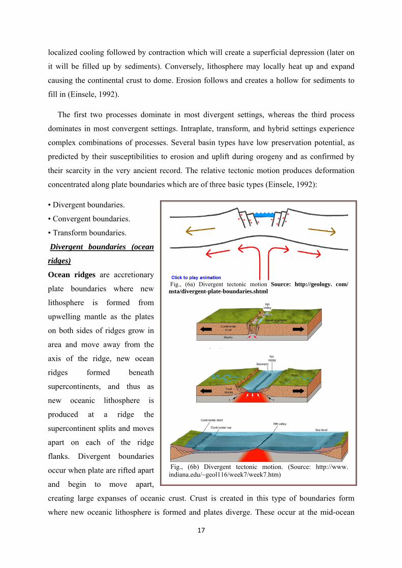
Divergent boundaries (ocean
ridges)
Ocean ridges are accretionary
plate boundaries where new
lithosphere is formed from
upwelling mantle as the plates
on both sides of ridges grow in
area and move away from the
axis of the ridge, new ocean
ridges formed beneath
supercontinents, and thus as
new oceanic lithosphere is
produced at a ridge the
supercontinent splits and moves
apart on each of the ridge
flanks. Divergent boundaries
occur when plate are rifted apart
and begin to move apart,
creating large expanses of oceanic crust. Crust is created in this type of boundaries form
where new oceanic lithosphere is formed and plates diverge. These occur at the mid-ocean
Fig., (6a) Divergent tectonic motion Source: http://geology. com/ nsta/divergent-plate-boundaries.shtml
Fig., (6b) Divergent tectonic motion. (Source: http://www. indiana.edu/~geol116/week7/week7.htm)

18
ridges (Fig., 6a,b). At fast spreading boundaries, plates move apart at 100 to 200 mm/yr. With
rapid spreading, hot magma is abundant and lava flows as sheets from a central peak, giving
the ridge a narrow tent-like profile (e.g., the East Pacific Rise). At slow-spreading boundaries,
plates move apart at less than 55 mm/yr and the topography is broader, rougher, and features
rift valleys (e.g., Mid-Atlantic Ridge). At ultraslow-spreading boundaries, plates move apart
at less than 20 mm/yr and great slabs of mantle rock rise to the seafloor. The median valley of
ocean ridges varies in geological character due to the changing importance of tectonic
extension and volcanism. In the northern part of the Mid-Atlantic ridge, stretching and
thinning of the crust dominate in one section, while volcanism dominates in another. Where
tectonic thinning is important, faulting has exposed gabbros and serpentinites from deeper
crustal levels (Condie, 2003). The axial topography of fast- and slow-spreading ridges varies
considerably. A deep axial valley with flanking mountains characterizes slow-spreading
ridges, while relatively low relief, and in some instances a topographic high, characterize fast-
spreading ridges. Model studies sag as oceanic lithosphere thickens with distance from a ridge
axis, horizontal extensional stresses can produce the axial topography found on slow-
spreading ridges. In fast-
spreading ridges, however, the
calculated stresses are too small
to result in appreciable relief.
The axis of ocean ridges is not
continuous, but may be offset by
several tens to hundreds of
kilometers by transform faults
(Condie, 2003). .
Convergent boundaries form
where plates converge. One
plate is usually subducted
beneath the other at a
convergent plate boundary.
Convergent boundaries may be
of different types, depending on
the types of lithosphere
involved. These results in a wide
diversity of basin types formed at convergent boundaries. There are two types of convergent
Source: http://geology.com/nsta/convergent-plate-boundaries.shtml
Fig., (7) Convergent Tectonic motion between continent and ocean
plate. Source: http://rainforestgirl.edu.glogster.com/plate-boundaries/
19
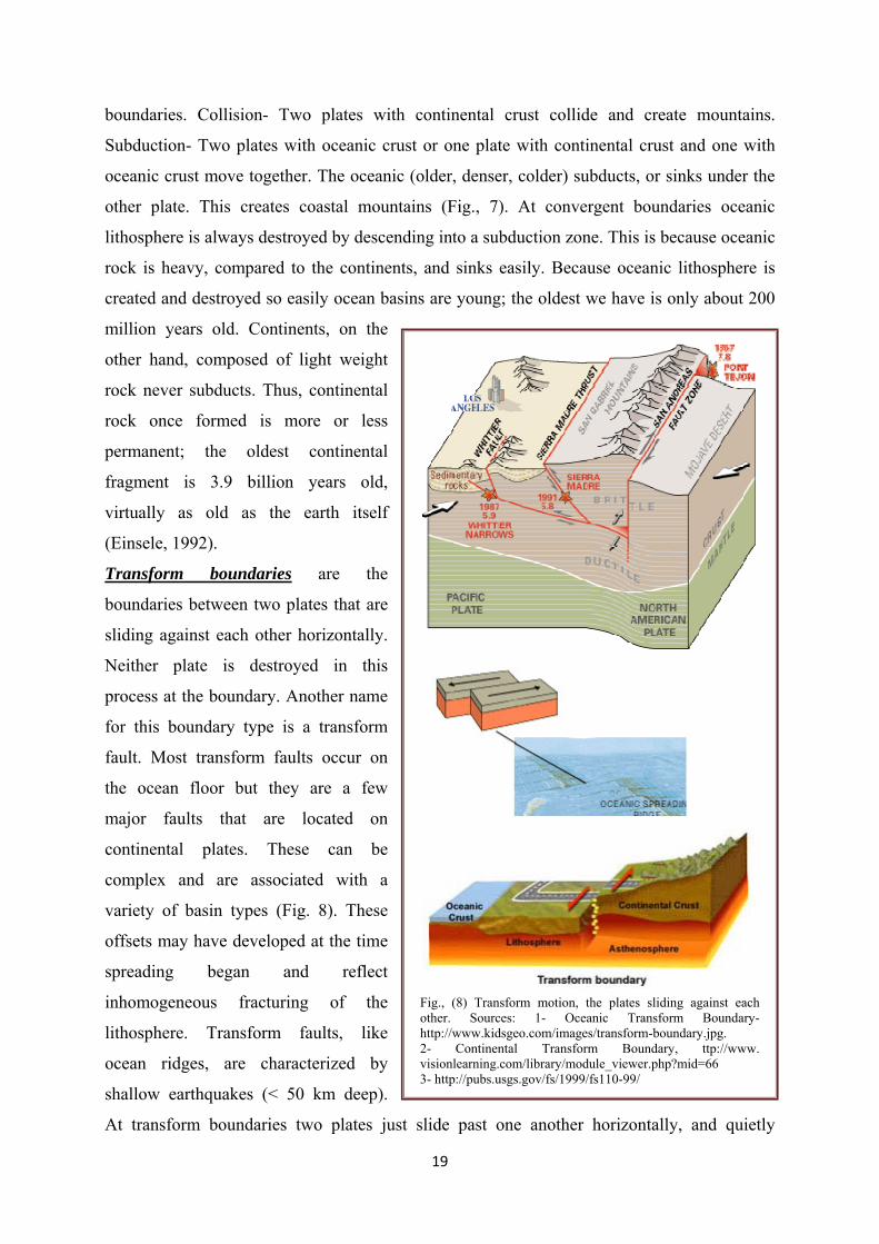
boundaries. Collision- Two plates with continental crust collide and create mountains.
Subduction- Two plates with oceanic crust or one plate with continental crust and one with
oceanic crust move together. The oceanic (older, denser, colder) subducts, or sinks under the
other plate. This creates coastal mountains (Fig., 7). At convergent boundaries oceanic
lithosphere is always destroyed by descending into a subduction zone. This is because oceanic
rock is heavy, compared to the continents, and sinks easily. Because oceanic lithosphere is
created and destroyed so easily ocean basins are young; the oldest we have is only about 200
million years old. Continents, on the
other hand, composed of light weight
rock never subducts. Thus, continental
rock once formed is more or less
permanent; the oldest continental
fragment is 3.9 billion years old,
virtually as old as the earth itself
(Einsele, 1992).
Transform boundaries are the
boundaries between two plates that are
sliding against each other horizontally.
Neither plate is destroyed in this
process at the boundary. Another name
for this boundary type is a transform
fault. Most transform faults occur on
the ocean floor but they are a few
major faults that are located on
continental plates. These can be
complex and are associated with a
variety of basin types (Fig. 8). These
offsets may have developed at the time
spreading began and reflect
inhomogeneous fracturing of the
lithosphere. Transform faults, like
ocean ridges, are characterized by
shallow earthquakes (< 50 km deep).
At transform boundaries two plates just slide past one another horizontally, and quietly
Fig., (8) Transform motion, the plates sliding against each other. Sources: 1- Oceanic Transform Boundary- http://www.kidsgeo.com/images/transform-boundary.jpg. 2- Continental Transform Boundary, ttp://www. visionlearning.com/library/module_viewer.php?mid=66 3- http://pubs.usgs.gov/fs/1999/fs110-99/
20
compared to convergent and divergent plate boundaries. Most of these are found in the ocean
basins, but the San Andreas Fault in California and Mexico is an example coming on land
(Einsele, 1992).
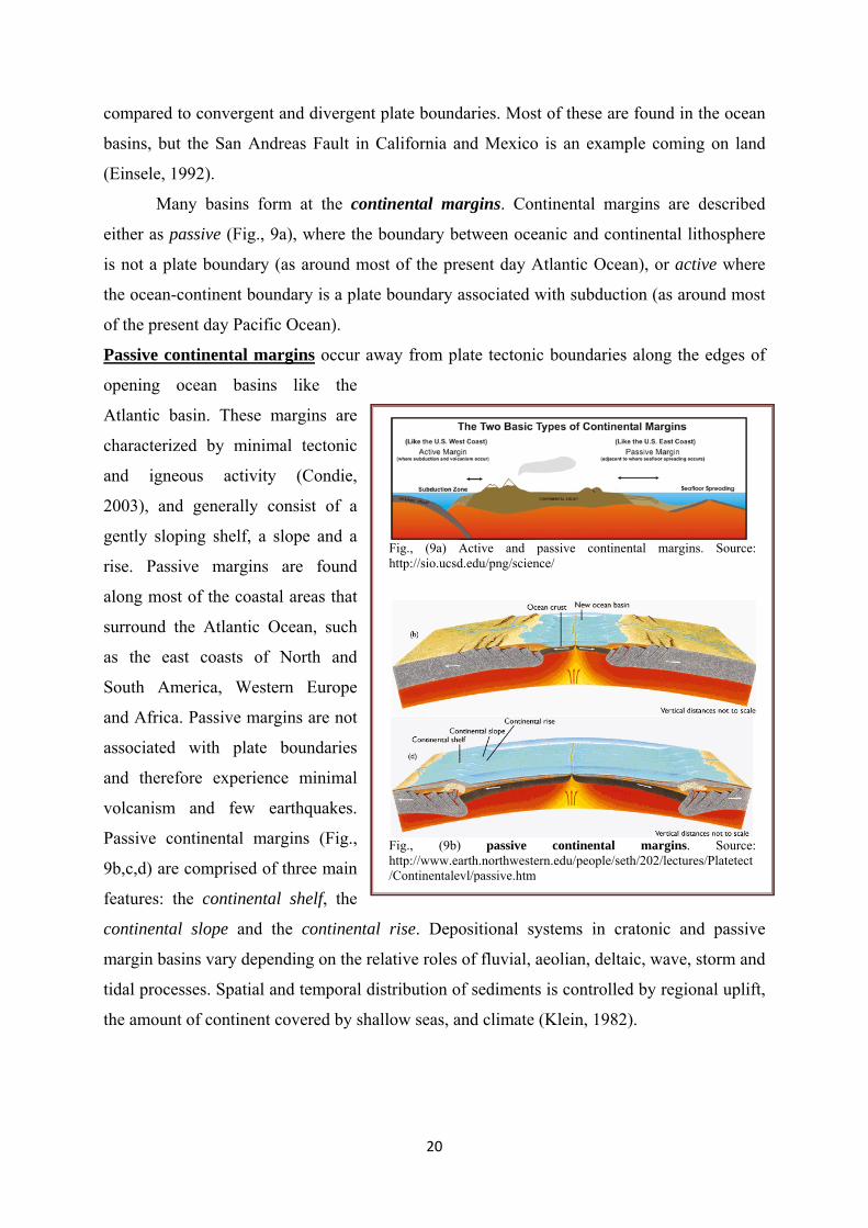
Many basins form at the continental margins. Continental margins are described
either as passive (Fig., 9a), where the boundary between oceanic and continental lithosphere
is not a plate boundary (as around most of the present day Atlantic Ocean), or active where
the ocean-continent boundary is a plate boundary associated with subduction (as around most
of the present day Pacific Ocean).
Passive continental margins occur away from plate tectonic boundaries along the edges of
opening ocean basins like the
Atlantic basin. These margins are
characterized by minimal tectonic
and igneous activity (Condie,
2003), and generally consist of a
gently sloping shelf, a slope and a
rise. Passive margins are found
along most of the coastal areas that
surround the Atlantic Ocean, such
as the east coasts of North and
South America, Western Europe
and Africa. Passive margins are not
associated with plate boundaries
and therefore experience minimal
volcanism and few earthquakes.
Passive continental margins (Fig.,
9b,c,d) are comprised of three main
features: the continental shelf, the
continental slope and the continental rise. Depositional systems in cratonic and passive
margin basins vary depending on the relative roles of fluvial, aeolian, deltaic, wave, storm and
tidal processes. Spatial and temporal distribution of sediments is controlled by regional uplift,
the amount of continent covered by shallow seas, and climate (Klein, 1982).
Fig., (9a) Active and passive continental margins. Source: http://sio.ucsd.edu/png/science/
Fig., (9b) passive continental margins. Source: http://www.earth.northwestern.edu/people/seth/202/lectures/Platetect/Continentalevl/passive.htm

21
Active continental margins are
usually narrow and consist of highly
deformed sediments. They occur
where oceanic lithosphere is being
subducted beneath the margin of a
continent. In active continental
margins, the continental slope and the
continental wall of the trench are
essentially the same feature. An active
continental margin is found where
either a subduction zone or a transform
fault coincides with continent-ocean
interface. Examples are the Andean and
Japan continental-margin arc systems
and the San Andreas transform fault in
California (Condie, 2003). The oceanic
lithosphere is being subducted beneath
the edge of a continent. The sediments
from the ocean floor and pieces of the
oceanic crust are scraped from the
descending oceanic plate and plastered
against the edge of the overriding
continent. This area of highly deformed
sediment is called an accretionary
wedge. Some active continental
margins do not have an accretionary
wedge, indicating the ocean sediments
are being carried directly into the
mantle. Here the continental margin is
very narrow and the trench may lie
only 50km offshore (Einsele, 1992). The formative mechanisms of sedimentary basins fall into a small number of categories,
although all mechanisms may operate during the evolution of a basin as documented in Allen
and Allen (2006):
Fig., (9c) Active Continental margins. Source: http://www. geology.ohio-state.edu/~vonfrese/gs100/lect21/index.html
Fig. (9d) Active continental margin. Source: http://elearning.stkc.go.th/lms/html/earth_science/LOcanada6/604/7_en.htm.
Fig. (9e) Isostatic changes in the crustal/lithosphere thickness. Source: http://www. earth.northwestern .edu/people/ seth/ 202/ lectures/Platetect/Continentalevl/Image130.gif

22
• Isostatic consequence of changes in crustal/lithosheric thickness, such as caused
mechanically by lithospheric stretching, or purely thermally, as in cooling and
subsidence of oceanic lithosphere as it moves away from oceanic spreading centers;
• Loading (and unloading) of the lithosphere causes a deflection or flexural deformation
and therefore subsidence (and uplifting) as in foreland basins (Fig., 9e).
Foreland basin System
A foreland basin system is
defined as: (a) an elongate region of
potential sediment accommodation that
forms on continental crust between a
contractional orogenic belt and the
adjacent craton, mainly in response to
geodynamic processes related to
subduction and the resulting peripheral or
retroarc fold-thrust belt (Fig., 10a); (b) it
consists of four discrete depozones,
referred to as the wedge-top, foredeep,
forebulge and back-bulge depozones –
which of these depozones a sediment
particle occupies depends on its location
at the time of deposition, rather than its
ultimate geometric relationship with the
thrust belt; (c) the longitudinal dimension
of the foreland basin system is roughly
equal to the length of the fold-thrust belt,
and does not include sediment that spills
into remnant ocean basins or continental
rifts (impactogens) (DeCelles and Giles
1996). The generally accepted definition
of a foreland basin attributes sediment
accommodation solely to flexural subsidence driven by the topographic load of the thrust belt
and sediment loads in the foreland basin. Equally or more important in some foreland basin
Fig., (10a) Foreland basin development. Source: http://ww w.searchanddiscovery.com/documents/2009/50203smith/ images/fig27.htm .
Fig. , (10b) Schematic map view of a ‘typical’ foreland basin, bounded longitudinally by a pair of marginal ocean basins. After DeCelles and Giles (1996)
23
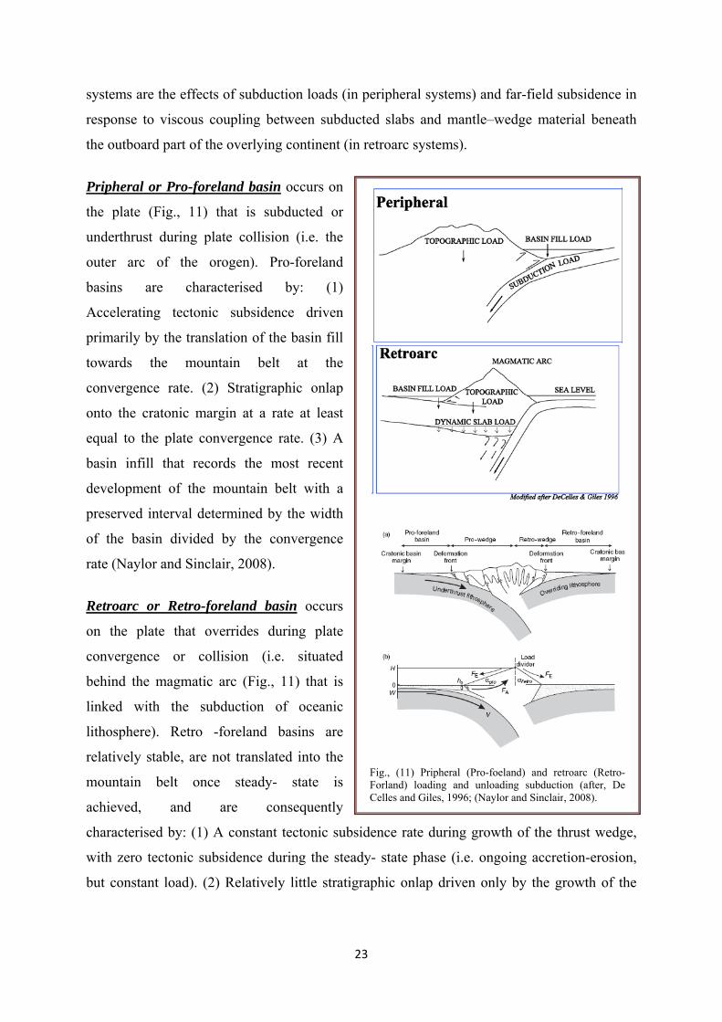
systems are the effects of subduction loads (in peripheral systems) and far-field subsidence in
response to viscous coupling between subducted slabs and mantle–wedge material beneath
the outboard part of the overlying continent (in retroarc systems).
Pripheral or Pro-foreland basin occurs on
the plate (Fig., 11) that is subducted or
underthrust during plate collision (i.e. the
outer arc of the orogen). Pro-foreland
basins are characterised by: (1)
Accelerating tectonic subsidence driven
primarily by the translation of the basin fill
towards the mountain belt at the
convergence rate. (2) Stratigraphic onlap
onto the cratonic margin at a rate at least
equal to the plate convergence rate. (3) A
basin infill that records the most recent
development of the mountain belt with a
preserved interval determined by the width
of the basin divided by the convergence
rate (Naylor and Sinclair, 2008).
Retroarc or Retro-foreland basin occurs
on the plate that overrides during plate
convergence or collision (i.e. situated
behind the magmatic arc (Fig., 11) that is
linked with the subduction of oceanic
lithosphere). Retro -foreland basins are
relatively stable, are not translated into the
mountain belt once steady- state is
achieved, and are consequently
characterised by: (1) A constant tectonic subsidence rate during growth of the thrust wedge,
with zero tectonic subsidence during the steady- state phase (i.e. ongoing accretion-erosion,
but constant load). (2) Relatively little stratigraphic onlap driven only by the growth of the
Fig., (11) Pripheral (Pro-foeland) and retroarc (Retro-Forland) loading and unloading subduction (after, De Celles and Giles, 1996; (Naylor and Sinclair, 2008).

24
retro-wedge. (3) A basin fill that records the entire growth phase of the mountain belt, but
only a condensed representation of steady state conditions (Naylor and Sinclair, 2008).
Dynamic topography
A substantial portion of
Earth's topography is known to
be caused by the viscous
coupling of mantle flow to the
lithosphere but the relative
contributions of shallow
asthenospheric flow versus
deeper flow remains
controversial (Fig., 12). The
motions of continents relative to
large-scale patterns of mantle
convection can contribute to the
creation and destruction of
sediment accommodation space
due to transient, dynamic
displacement of the surface
topography, usually referred to
as dynamic topography
(Lithgow-Bertelloni and Gurnis, 1997; Gurnis et al., 1998). Previously, the anomalous depth
has been attributed to asthenospheric flow and the coupling of the shallow mantle. It is well
established that mantle convection imparts an influence on surface plate dynamics and the
surface expression of such deep earth processes is manifested in large-scale and non-isostatic
vertical motions also termed “dynamic topography” (Shephard et al., 2012). Large-scale,
mantle-driven dynamic topography can be approximated by the time-dependent vertical shifts
and tilts of a plane, computed from the displacement needed to reconcile the interpreted
pattern of marine incursion with a predicted topography in the presence of global sea level
variations (DiCaprio et al., 2009, Heine et al., 2010).
Fig., (12) Subsidence/uplift dynamic topography structure due to viscous flow of mantle (After Smith et al., 2009).
25
4- Classification of Sedimentary Basins Many sedimentologists therefore prefer a classification scheme based mainly on criteria
which can be recognized in the field, i.e., the facies concept and the definition of the
depositional environment (fluvial sediments, shelf deposits etc.). A further approach is the
subdivision of sediments into important lithologic groups, such as siliciclastic sediments of
various granulometries and composition, carbonate rocks, evaporites, etc. Having established
the facies, succession, and geometries of such lithologic groups, one can proceed to define the
tectonic nature of the basin investigated (Einsele, 1992). Sedimentary basins have been
classified principally in terms of the type of lithospheric substratum (continental, oceanic,
transitional), the position with respect to a plate boundary (interplate, intraplate) and the type
of plate margin (divergent, convergent, transform) closest to the basin (Gutscher, 2002). Allen
and Allen (2006) classified the sedimentary basins principally in terms of the type of
lithospheric substratum (i.e., continental, oceanic, transitional), their positions with respect to
the plate boundary (intracratonic, plate margin), and type of plate motion nearest to the basin
(divergent, convergent, transform). According to Einsele (1992), there are three essential
types of sedimentary basins can be recognized:
(1) Active sedimentary basins that are still accumulating sediments.
(2) Inactive, but little deformed sedimentary basins showing more or less their original
shape and sedimentary fill.
(3) Strongly deformed and incomplete former sedimentary basins, where the original fill
has been partly lost to erosion, for example in a mountain belt.
The regional deposition of sediments, non-deposition, or denudation of older rocks are
controlled mainly by tectonic movements. Most of the recent attempts to classify sedimentary
basins have been based on global and regional tectonic concepts (Einsele, 1992).
Subsequently, the characteristics of sediments filling a basin of a certain tectonic type are
predominantly controlled by other factors and can be extremely variable. In addition to
tectonic movements in the basinal area itself, sedimentary processes and facies are controlled
by the paleogeography of the regions around the basin (peri-basin morphology and climate,
rock types and tectonic activity in the source area), the depositional environment, the
evolution of sediment-producing organisms, etc.
I- Tectonic Basin Classification
Basin-generating tectonics is the most important prerequisite for the accumulation of
sediments. Therefore, a tectonic basin classification system is of the most important
26
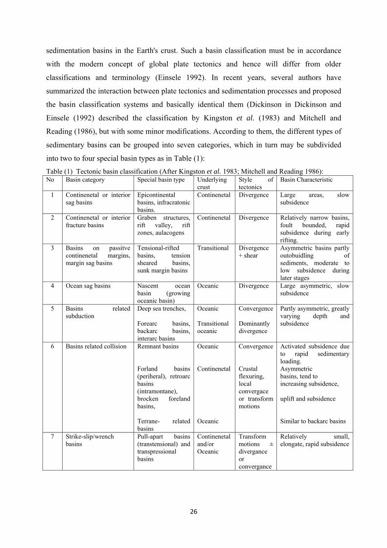
sedimentation basins in the Earth's crust. Such a basin classification must be in accordance
with the modern concept of global plate tectonics and hence will differ from older
classifications and terminology (Einsele 1992). In recent years, several authors have
summarized the interaction between plate tectonics and sedimentation processes and proposed
the basin classification systems and basically identical them (Dickinson in Dickinson and
Einsele (1992) described the classification by Kingston et al. (1983) and Mitchell and
Reading (1986), but with some minor modifications. According to them, the different types of
sedimentary basins can be grouped into seven categories, which in turn may be subdivided
into two to four special basin types as in Table (1):
Table (1) Tectonic basin classification (After Kingston et al. 1983; Mitchell and Reading 1986): No Basin category Special basin type Underlying
crust Style of tectonics
Basin Characteristic
1 Continenetal or interior sag basins
Epicontinental basins, infracratonic basins.
Continenetal Divergence Large areas, slow subsidence
2 Continenetal or interior fracture basins
Graben structures, rift valley, rift zones, aulacogens
Continenetal Divergence Relatively narrow basins, foult bounded, rapid subsidence during early rifting.
3 Basins on passitve continenetal margins, margin sag basins
Tensional-rifted basins, tension sheared basins, sunk margin basins
Transitional Divergence + shear
Asymmetric basins partly outobuidling of sediments, moderate to low subsidence during later stages
4 Ocean sag basins Nascent ocean basin (growing oceanic basin)
Oceanic Divergence Large asymmetric, slow subsidence
5 Basins related subduction
Deep sea trenches, Forearc basins, backarc basins, interarc basins
Oceanic Transitional oceanic
Convergence Dominantly divergence
Partly asymmetric, greatly varying depth and subsidence
6 Basins related collision Remnant basins Forland basins (periheral), retroarc basins (intramontane), brocken foreland basins, Terrane- related basins
Oceanic Continenetal Oceanic
Convergence Crustal flexuring, local convergace or transform motions
Activated subsidence due to rapid sedimentary loading. Asymmetric basins, tend to increasing subsidence, uplift and subsidence Similar to backarc basins
7 Strike-slip/wrench basins
Pull-apart basins (transtensional) and transpressional basins
Continenetal and/or Oceanic
Transform motions ± divergance or convergance
Relatively small, elongate, rapid subsidence

27
I.1- Continental or interior sag basins
According to Einsele
(1992), basins on continental crust
are commonly generated by
divergent plate motions and
resulting extensional structures and
thermal effects. In the case of large
interior sag basins, however, major
fault systems forming the
boundaries of the depositional area
or a central rift zone may be
absent. Subsidence occurs
predominantly in response to
moderate crustal thinning or to a
slightly higher density of the
underlying crust in comparison to
neighboring areas (Fig., 13). In
addition, slow thermal decay after
a heating event and sedimentary
loading can promote and maintain
further subsidence for a long time.
Alternatively, it was recently
suggested that long-term
subsidence of intracratonic basins
may be related to a decrease of the
mantle heat flow above a "cold
spot", i.e., to abnormal cooling
(Ziegler 1989). In general, rates of
subsidence are low in this geodynamic setting.
Intracontinental sags, rifts, failed rifts and passive continental margins fall within an
evolutionary suite of basins unified by the process of lithospheric stretching. Rifts are areas of
crustal thinning, demonstrated by the shallow depth of Moho, high surface heat flows,
volcanic activity, seismic activity with predominantly extensional focal mechanism solutions,
negative Bouguer gravity anomalies and commonly elevated rift margin topography (Allen
Fig., (13). Conceptual diagram of basins in the rift–drift suite, associated with continental extension, modified from Allen and Allen (2006). Cratonic basins are viewed as basins whose primary mechanism for subsidence is low strain rate stretching.
Fig., (14) Models of strain geometry; a- pure shear geometery, b- simple shear and c- hybrid model of simple shear.

28
and Allen 2006). The nature of the fault system and associated sedimentary basins within
extending continental lithosphere depends on the initial crustal structure and geotherm, strain
rate and total amount of strain (Fig., 13). Discrete, localized continental rifts appear to form
on normal thickness crust and extend slowly over long period of time. At higher strain rates,
localized rifts may evolve into passive margins.
Passive continental margins are in general seismically inactive, and tectonics are
dominated by gravity driven collapse, halokinesis and growth faulting. Passive continental
margins can be divided into two types: i) volcanic margins are characterized by extensive
extrusive basalts and igneous underplating and significant surface uplift at the time of breakup
and ii) nonvolcanic margins lack evidence for strong thermal activity, and consist of extensive
sediment traps overlying a strongly rifted basement Allen and Allen 2006).
I. 2- Continental graben structures and rift zones form narrow elongate basins bounded by
large faults
Their cross sections may
be symmetric or asymmetric (e.g.,
halfgrabens) (Fig., 15). If the
underlying mantle is relatively
hot, the lithosphere may expand
and show updoming prior to or
during the incipient phase of rifting substantial thinning of the crust by attenuation, which is
often accompanied by the upstreaming of basaltic magma, thus forming transitional crust,
causes rapid subsidence in the rift zone. Subsequent thermal contraction due to cooling and
high sedimentary loading enable continuing subsidence and therefore the deposition of thick
sedimentary infillings (Einsele 1992).
I. 3 - Failed rifts or aulacogens
If divergent plate motion comes to an end before the moving blocks are separated by
accretion of new oceanic crust, the rift zone is referred to as "failed". A certain type of such
failed rifts is an aulacogen. Aulacogens represent the failed arm of a triple junction of a rift
zone (Fig., 15), where two arms continue their development to form an oceanic basin.
Aulacogen floors consist of oceanic or transitional crust and allow the deposition of thick
sedimentary sequences over relatively long time periods. Basins similar to aulacogens may
also be initiated during the closure of an ocean and during orogenies (Einsele 1992).
Fig., (15) Continental graben structures, rift zones and Failed rifts and aulacogens. (After Dickinson and Yarborough 1976; Kingston et al. 1983; Mitchell and Reading 1986).

29
I. 4- Passive margin basins.
The initial stage of a true oceanic basin setting (or a proto-oceanic rift system) is
established when two divergent continents separate and new oceanic crust forms in the
intervening space. This does not necessarily mean that such a basin type fills with oceanic
sediments, but it does imply that the central basin floor lies at least 2 to 3.km below sea level
(Fig., 16). When such a basin
widens due to continued
divergent plate motions and
accretion of oceanic crust
(drifting stage), its infilling
with sediments lags more and
more behind ocean spreading.
Consequently, the sediments
are deposited predominantly at
the two continental margins of
the growing ocean basin. The marginal "basins" developing on top of thinned continental
crust are commonly not bordered by morphological highs and represent asymmetric
depositional areas. Their underlying crust increasingly thins seaward; hence subsidence tends
to become greater and faster in this direction. Here, sediments commonly build up in the form
of a prism. Some of these marginal basins may be affected and bordered by transform motions
(tension-sheared basins). In a sediment starved environment, subsided transitional crust can
create deep plateaus (sunk basins). In general, subsidence of these marginal basins tends to
decrease with passing time, unless it is reactivated by heavy sediment loads (Einsele 1992).
I. 5- Oceanic sag basins or nascent ocean basins
These types of basins occupy the
area between a mid-oceanic
ridge, including its rise, and the
outer edge of the transitional
crust along a passive continental
margin. They commonly
accumulate deep-sea fan or
basin plain sediments. Due to
the advanced cooling of the aging oceanic crust, subsidence is usually low, unless it is
activated by thick sedimentary loading near the continental margin. Fault-bounded basins of
Fig., (16) Passive margin basins and the oceanic basin plain and fault-bounded basin. (After Dickinson and Yarborough 1976; Kingston et al. 1983; Mitchell and Reading 1986).
Fig., (17) Oceanic sag basins or nascent ocean basins (After Dickinson and Yarborough 1976; Kingston et al. 1983; Mitchell and Reading 1986)
30
limited extent are common in conjunction with the growth of mid-oceanic ridges (Fig., 17)
(Einsele 1992).
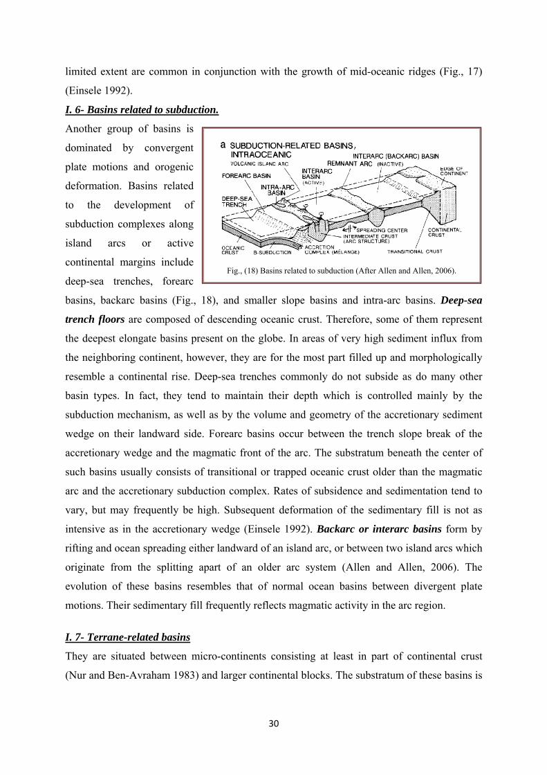
I. 6- Basins related to subduction.
Another group of basins is
dominated by convergent
plate motions and orogenic
deformation. Basins related
to the development of
subduction complexes along
island arcs or active
continental margins include
deep-sea trenches, forearc
basins, backarc basins (Fig., 18), and smaller slope basins and intra-arc basins. Deep-sea
trench floors are composed of descending oceanic crust. Therefore, some of them represent
the deepest elongate basins present on the globe. In areas of very high sediment influx from
the neighboring continent, however, they are for the most part filled up and morphologically
resemble a continental rise. Deep-sea trenches commonly do not subside as do many other
basin types. In fact, they tend to maintain their depth which is controlled mainly by the
subduction mechanism, as well as by the volume and geometry of the accretionary sediment
wedge on their landward side. Forearc basins occur between the trench slope break of the
accretionary wedge and the magmatic front of the arc. The substratum beneath the center of
such basins usually consists of transitional or trapped oceanic crust older than the magmatic
arc and the accretionary subduction complex. Rates of subsidence and sedimentation tend to
vary, but may frequently be high. Subsequent deformation of the sedimentary fill is not as
intensive as in the accretionary wedge (Einsele 1992). Backarc or interarc basins form by
rifting and ocean spreading either landward of an island arc, or between two island arcs which
originate from the splitting apart of an older arc system (Allen and Allen, 2006). The
evolution of these basins resembles that of normal ocean basins between divergent plate
motions. Their sedimentary fill frequently reflects magmatic activity in the arc region.
I. 7- Terrane-related basins
They are situated between micro-continents consisting at least in part of continental crust
(Nur and Ben-Avraham 1983) and larger continental blocks. The substratum of these basins is
Fig., (18) Basins related to subduction (After Allen and Allen, 2006).

31
usually oceanic crust. They may be bordered by a subduction zone and thus be associated
with either basins related to subduction or collision.
I. 8- Basins related to collision.
Partial collision of continents with irregular shapes and boundaries which do not fit each other
leads to zones of crustal
overthrusting and, along
strike, to areas where one or
more oceanic basins of
reduced size still persist.
These remnant basins (Fig.
19) tend to collect large
volumes of sediment from
nearby rising areas and to
undergo substantial
synsedimentary deformation
(convergence, also often
accompanied by strike-slip
motions). Foreland basins,
and peripheral basins in
front of a foldthrust belt, are
formed by depressing and
flexuring the continental
crust ("A-subduction", after
Ampferer, Alpine-type)
under the load of the
overthrust mountain belt. The
extension of these
asymmetric basins tends to
increase with time, but a
resulting large influx of clastic sediments from the rising mountain range of ten keeps pace
with subsidence. As a result of the collision of two continental crusts, the overriding plate
may be affected by "continental escape", leading to extensional graben structures or rifts
perpendicular to the strike of the fold-thrust belt (Figs., 20, 21). Three stages of arc-continent
collision were recognized (Escalona and Mann, 2011):
Fig. (19) Tectonic basin classification, Subduction and collision-related basins (remnant basin) (After Allen and Allen, 2006).
Fig. (20) Tectonic basin classification. Collision-related basins and strike-sliplwrench basins. (After Allen and Allen, 2006).
Fig., (21) Retroarc or intramontune basins (After Allen and Allen, 2006).

32
Stage one of arc-continent collision
Initial collision is characterized by overthrusting of the south- and southeastward-
facing Caribbean arc and forearc terranes onto the northward-subducting Mesozoic passive
margin of northern South America. Northward flexure of the South American craton produces
a foreland basin between the thrust front and the downward-flexed continental crust that is
initially filled by clastic sediments shed both from the colliding arc and cratonic areas to the
south. As the collision extends eastward towards Trinidad, this same process continues with
progressively younger foreland basins formed to the east. On the overthrusting Caribbean arc
and forearc terranes, north-south rifting adjacent to the collision zone initiates and is
controlled by forward momentum of southward-thrusting arc terranes combined with slab pull
of the underlying and subducting, north-dipping South American slab. Uplift of fold-thrust
belts arc-continent suture induces rerouting of large continental drainages parallel to the
collisional zone and to the axis of the foreland basins.
Stage two
This late stage of arc-continent collision is characterized by termination of deformation in one
segment of the fold-thrust belt as convergent deformation shifts eastward. Rebound of the
collisional belt is produced as the north-dipping subducted oceanic crust breaks off from the
passive margin, inducing inversion of preexisting normal faults as arc-continent convergence
reaches a maximum. Strain partitioning also begins to play an important role as oblique
convergence continues, accommodating deformation by the formation of parallel, strike-slip
fault zones and backthrusting (southward subduction of the Caribbean plate beneath the South
Caribbean deformed belt). As subsidence slows in the foreland basins, sedimentation
transitions from a marine underfilled basin to an overfilled continental basin. Offshore,
sedimentation is mostly marine, sourced by the collided Caribbean terranes, localized islands
and carbonate deposition.
Stage three
This final stage of arc-continent collision is characterized by: 1) complete slab breakoff of the
northward-dipping South American slab; 2) east-west extension of the Caribbean arc as it
elongates parallel to its strike forming oblique normal faults that produce deep rift and half-
grabens; 3) continued strain partitioning (strike-slip faulting and folding). The subsidence
pattern in the Caribbean basins is more complex than interpreted before, showing a succession
of extensional and inversion events. The three tectonic stages closely control the structural
styles and traps, source rock distribution, and stratigraphic traps for the abundant hydrocarbon
resources of the on- and offshore areas of Venezuela and Trinidad.

33
Retroarc or intramontune basins occur in the hinterland of an arc orogen ("B-subduction"
zone). They may affect relatively large areas on continental crust. Limited subsidence appears
to be caused mainly by tectonic loading in a backarc fold-thrust belt.
Pannonian-type basins originate from postorogenic divergence between two fold-thrust
zones (Fig. 22a). They are usually associated with an A-subduction zone and are floored by
thinning continental or transitional crust. During crustal collision, some foreland (and
retroarc) basins can get broken up
into separate smaller blocks,
whereby strike-slip motions may
also play a role (Fig. 22c). Some
of the blocks are affected by
uplift, others by subsidence,
forming basinal depressions. The
mechanics of such tilted block
basins were studied, for example,
in the Wyoming Province of the
Rocky Mountain foreland
(McQueen and Beaumont 1989).
So-called Chinese-type basins
(Bally and Snelson 1980) result
from block faulting in the
hinterland of a continent-continent
collision. They are not directly
associated with an A-subduction
margin, but it appears unnecessary
to classify them as a special new
basin type (Hsii 1989).
I. 9- Strike-slip and wrench basins
Transform motions may be associated either with a tensional component (transtensional) or
with a compressional component (transpressional). Transtensional fault systems locally cause
crustal thinning and therefore create narrow (Fig. 22b), elongate pull-apart basins. If they
evolve on continental crust, continuing transform motion may lead to crustal separation
perpendicular to the transform faults and initiate accretion of new oceanic crust in limited
spreading centers.
Fig. (22) Tectonic basin classification: Collision-related basins and
strike-slip/wrench basins. (Allen and Allen, 2006).

34
Until this development occurs, the rate of subsidence is usually high. Transpressional systems
generate wrench basins of limited size and endurance. Their compressional component can be
inferred from wrench faults and fold belts of limited extent (Fig. 22c). In order to identify
these various basin categories, one must know the nature of the underlying crust as well as the
type of former plate movement involved during basin formation, i.e., divergence or
convergence. Even in the case of transform movement, either some divergence or
convergence must take place. Small angles of convergence show up as wrenching or fold
belts, and small angles of divergence appear as normal faulting or sagging. One should bear in
mind that all these basin types represent proto-types of tectonically controlled basins. They
offer a starting point for the study and evaluation of basins, but there are no type basins which
can be used as a complete model for any other basin (Burchfiel and Royden 1988). Even
within a single broad tectonic setting, the development of smaller individual basins may
display great variation. As soon as basins are analyzed in greater detail, the broad tectonic
basin classification listed above becomes less useful. In addition, over long time periods, a
sedimentary basin may evolve from one basin type into another (polyhistory basins) and thus
exhibit a complex tectonic and depositional history (Allen and Allen, 2006).
II- Pre-, Syn-, and Post-Depositional Basins Principally, tectonic movements and sedimentary processes can interact in three different
ways. These are used to distinguish between different types of sedimentary basins (Selley
1985a):
1- Post-depositional basins. The deposition of sediments largely predates tectonic movements
forming a basin structure. Hence, there is no or little relationship between the transport,
distribution, and facies of these sediments and the later evolved basin structure (Fig. 23a).
However, some relationship between the syndepositional subsidence phase and the
subsequent basin-forming process cannot be excluded.
2- Syn-depositional basins. Sediment accumulation is affected by syn-depositional tectonic
movements, e.g., differential subsidence (Fig. 23b). If the sedimentation rate is always high
enough to compensate for subsidence, the direction of transport and the sedimentary facies
remain unchanged, but the thickness of the sediment in certain time slices varies. In (Fig.
23b), the sediment thickness increases toward the center of the basin. In this case, the basin
structure is syn-depositional, but there was hardly a syn-depositional morphological basin
controlling the sedimentary facies of the basin. If sedimentation is too slow to fill up the

35
subsiding area, a
morphological basin will
develop. Then, the distribution
and facies of the succeeding
sediments will be affected by
the morphology of the
deepening basin.
3- Pre-depositional basins.
Rapid tectonic movements
predate significant sediment
accumulation and create a
morphological basin, which is
filled later by post-tectonic
sediments. The water depth in
the basin decreases with time,
although some syn-
depositional subsidence due to
sediment loading is likely.
Sediment transport as well as
vertical and lateral facies
development is substantially
influenced by the basin
morphology. Of course, there
are transitions between these
simplified basin types and
certain basins may show a complex history and therefore contain pretectonic as well as syn-
tectonic or post-tectonic sediments (Allen and Allen, 2006).
Fig. (23) Post depositional basin created by tectonic after the deposition of sheet-lie fluvial and lake sediments; younger syn-tectonic basin fill is removed by subsequent erosion. b Syn-depositional tectonic movements control varying thicknesses of fluvial and shallow marine sediments and generate a basin-fill structure, although a morphological basin barely existed. c Rapid, pre-movements depositional tectonics creates a deep morphological basin which is later filled up by post-tectonic sediments. The geometry of the former basin can be derived from transport directions and facies distribution (Allen and Allen, 2006).
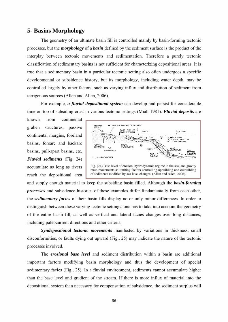
36
5- Basins Morphology The geometry of an ultimate basin fill is controlled mainly by basin-forming tectonic
processes, but the morphology of a basin defined by the sediment surface is the product of the
interplay between tectonic movements and sedimentation. Therefore a purely tectonic
classification of sedimentary basins is not sufficient for characterizing depositional areas. It is
true that a sedimentary basin in a particular tectonic setting also often undergoes a specific
developmental or subsidence history, but its morphology, including water depth, may be
controlled largely by other factors, such as varying influx and distribution of sediment from
terrigenous sources (Allen and Allen, 2006).
For example, a fluvial depositional system can develop and persist for considerable
time on top of subsiding crust in various tectonic settings (Miall 1981). Fluvial deposits are
known from continental
graben structures, passive
continental margins, foreland
basins, forearc and backarc
basins, pull-apart basins, etc.
Fluvial sediments (Fig. 24)
accumulate as long as rivers
reach the depositional area
and supply enough material to keep the subsiding basin filled. Although the basin-forming
processes and subsidence histories of these examples differ fundamentally from each other,
the sedimentary facies of their basin fills display no or only minor differences. In order to
distinguish between these varying tectonic settings, one has to take into account the geometry
of the entire basin fill, as well as vertical and lateral facies changes over long distances,
including paleocurrent directions and other criteria.
Syndepositional tectonic movements manifested by variations in thickness, small
disconformities, or faults dying out upward (Fig., 25) may indicate the nature of the tectonic
processes involved.
The erosional base level and sediment distribution within a basin are additional
important factors modifying basin morphology and thus the development of special
sedimentary facies (Fig., 25). In a fluvial environment, sediments cannot accumulate higher
than the base level and gradient of the stream. If there is more influx of material into the
depositional system than necessary for compensation of subsidence, the sediment surplus will
Fig. (24) Base level of erosion, hydrodynamic regime in the sea, and gravity mass movements as limiting factors controlling upbuilding and outbuilding of sediments modified by sea level changes. (Allen and Allen, 2006).

37
be carried farther downslope into
lakes or the sea. This signifies
that the level up to which a basin
can be filled with sediments may
depend on the geographic
position of the basin in relation to
the erosional base.
The morphology of water-
filled basins may significantly
change as a result of depositional
processes. Lakes and low-energy
basins frequently show a
prograding deltaic facies, causing
pronounced basinward
outbuilding of sediment.
Consequently, the areal
distribution of the finer-grained
sediment in the deeper basin
portions decreases with time,
although the initial, tectonically
controlled basin configuration
persists. By contrast, high-energy
basins are little influenced by
sediment outbuilding (Fig., 25). For example, terrigenous sediments transported into high-
energy shelf seas tend to be reworked and swept into deeper water by wave action and bottom
currents, except for some local seaward migration of the shoreline. Even on deep submarine
slopes and in the deep sea, there is no general outbuilding or upbuilding of sediments, because
gravity mass movements and deep bottom currents redistribute large quantities of material.
These few examples demonstrate that the most appropriate classification scheme for
sedimentary basins depends primarily on the objectives of the study. If tectonic structure and
evolution of a region are the main topics, then basin fill geometry and subsidence history
derived from the thickness of stratigraphic units are of primary importance. If, on the other
hand, the depositional environment, sedimentary facies, and paleogeographic reconstructions
are of primary interest, then the basin classification used should not be strictly tectonic. Such
Fig. (25). Overview of depositional environments, based primarily on basin morphology and peri-basin characteristics. All basins, particularly those on land (a) or adjacent to continents (b and c), are strongly affected by variations in terrigenous input under differing conditions of climate and relief. d Various marine basins (Allen and Allen, 2006).

38
a classification should also take into account changes in basin morphology caused by
depositional processes, the chemical and hydrodynamic regimes of the basin, and peri-basin
characteristics such as the size and nature of the drainage areas on nearby land.
The surface of recent sediments on land and under water can be well observed, but in
many cases, for example in fluvial environments, such temporary surfaces are rarely
preserved in the sedimentary record. By contrast, indurated beds alternating with weaker
material frequently show excellently preserved lower and upper bedding planes with trace
fossils, various marks, and imbrication phenomena which are difficult to observe in soft
sediments. Diagenesis may, however, also obscure primary bedding features.
6- Depositional Environments
On the surface of
our present-day globe, on
land and below the sea,
hundreds of depositional
areas are known which
meet the definition of
sedimentary basins. In the
various types of
sedimentary basins are
predominantly classified
according to their
depositional environment
and basin morphology (Fig., 26) including:
1- Continental (fluvial, glacial, eolian), lacustrine, and deltaic environments.
2- Adjacent sea basins and epicontinental seas of varying salinity.
3- Marine depositional areas of normal salinity.
4- Transitional environments may be defined between continental and marine environments.
This group includes marine deltas, intertidal environments, coastal lagoons, estuaries, and
barrier island systems.
Fig., (26) Types of continental Sedimentary Environments.
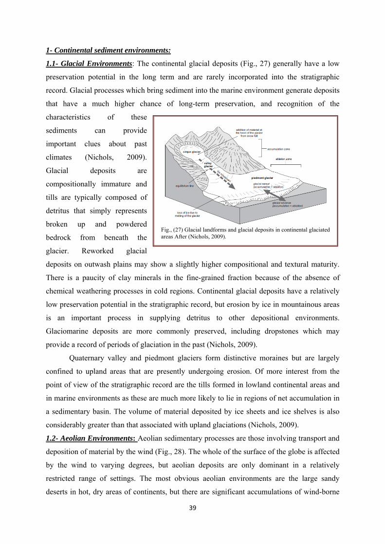
39
1- Continental sediment environments:
1.1- Glacial Environments: The continental glacial deposits (Fig., 27) generally have a low
preservation potential in the long term and are rarely incorporated into the stratigraphic
record. Glacial processes which bring sediment into the marine environment generate deposits
that have a much higher chance of long-term preservation, and recognition of the
characteristics of these
sediments can provide
important clues about past
climates (Nichols, 2009).
Glacial deposits are
compositionally immature and
tills are typically composed of
detritus that simply represents
broken up and powdered
bedrock from beneath the
glacier. Reworked glacial
deposits on outwash plains may show a slightly higher compositional and textural maturity.
There is a paucity of clay minerals in the fine-grained fraction because of the absence of
chemical weathering processes in cold regions. Continental glacial deposits have a relatively
low preservation potential in the stratigraphic record, but erosion by ice in mountainous areas
is an important process in supplying detritus to other depositional environments.
Glaciomarine deposits are more commonly preserved, including dropstones which may
provide a record of periods of glaciation in the past (Nichols, 2009).
Quaternary valley and piedmont glaciers form distinctive moraines but are largely
confined to upland areas that are presently undergoing erosion. Of more interest from the
point of view of the stratigraphic record are the tills formed in lowland continental areas and
in marine environments as these are much more likely to lie in regions of net accumulation in
a sedimentary basin. The volume of material deposited by ice sheets and ice shelves is also
considerably greater than that associated with upland glaciations (Nichols, 2009).
1.2- Aeolian Environments: Aeolian sedimentary processes are those involving transport and
deposition of material by the wind (Fig., 28). The whole of the surface of the globe is affected
by the wind to varying degrees, but aeolian deposits are only dominant in a relatively
restricted range of settings. The most obvious aeolian environments are the large sandy
deserts in hot, dry areas of continents, but there are significant accumulations of wind-borne
Fig., (27) Glacial landforms and glacial deposits in continental glaciated areas After (Nichols, 2009).

40
material associated with sandy beaches and periglacial sand flats. Sands deposited in these
desert areas are characteristically
both compositionally and
mineralogically mature with
large-scale cross-bedding formed
by the migration of dune
bedforms. Oxidising conditions
in deserts preclude the
preservation of much fossil
material, and sediments are
typically red–yellow colours
(Nichols, 2009). Aeolian dust
deposits are deposits of Quaternary age in Eastern Europe, North America and China that are
interpreted as accumulations of wind-blown dust (Pye 1987). These deposits, known as loess,
locally occur in beds several meters thick made up predominantly of well-sorted silt-sized
material, with little clay or sand-sized material present.
Associated facies in arid regions are mud and evaporites deposited in ephemeral lakes
and poorly sorted fluvial and alluvial fan deposits. Aeolian deposits are less common outside
of desert environments, occurring as local sandy facies associated with beaches and glaciers,
and as dust distributed over large distances into many different environments, but, apart from
Quaternary loess, rarely in significant quantities (Nichols, 2009).
1.3- Rivers and Alluvial Fans: Rivers are an important feature of most landscapes, acting as
the principal mechanism for the transport of weathered debris away from upland areas and
carrying it to lakes and seas, where much of the clastic sediment is deposited. River systems
can also be depositional, accumulating sediment within channels and on floodplains. The
grain size and the sedimentary structures in the river channel deposits are determined by the
supply of detritus, the gradient of the river, the total discharge and seasonal variations in flow.
Overbank deposition consists mainly of finer-grained sediment, and organic activity on
alluvial plains contributes to the formation of soils, which can be recognized in the
stratigraphic record as palaeosols. Water flows over the land surface also occur as unconfined
sheet floods and debris flows that form alluvial fans at the edges of alluvial plains. Fluvial and
alluvial deposits in the stratigraphic record provide evidence of tectonic activity and
indications of the palaeoclimate at the time of deposition (Nichols, 2009).
Fig. (28) Depositional environments in arid regions: coarse material is deposited on alluvial fans, sand accumulates to form aeolian dunes and occasional rainfall feeds ephemeral lakes where mud and evaporite minerals are deposited (Nichols, 2009).
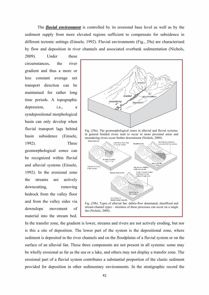
41
The fluvial environment is controlled by its erosional base level as well as by the
sediment supply from more elevated regions sufficient to compensate for subsidence in
different tectonic settings (Einsele, 1992). Fluvial environments (Fig., 29a) are characterised
by flow and deposition in river channels and associated overbank sedimentation (Nichols,
2009). Under these
circumstances, the river
gradient and thus a more or
less constant average net
transport direction can be
maintained for rather long
time periods. A topographic
depression, i.e., a
syndepositional morphological
basin can only develop when
fluvial transport lags behind
basin subsidence (Einsele,
1992). Three
geomorphological zones can
be recognized within fluvial
and alluvial systems (Einsele,
1992). In the erosional zone
the streams are actively
downcutting, removing
bedrock from the valley floor
and from the valley sides via
downslope movement of
material into the stream bed.
In the transfer zone, the gradient is lower, streams and rivers are not actively eroding, but nor
is this a site of deposition. The lower part of the system is the depositional zone, where
sediment is deposited in the river channels and on the floodplains of a fluvial system or on the
surface of an alluvial fan. These three components are not present in all systems: some may
be wholly erosional as far as the sea or a lake, and others may not display a transfer zone. The
erosional part of a fluvial system contributes a substantial proportion of the clastic sediment
provided for deposition in other sedimentary environments. In the stratigraphic record the
Fig. (29a). The geomorphological zones in alluvial and fluvial systems: in general braided rivers tend to occur in more proximal areas and meandering rivers occur further downstream (Nichols, 2009).
Fig. (29b). Types of alluvial fan: debris-flow dominated, sheetflood and stream-channel types – mixtures of these processes can occur on a single fan (Nichols, 2009).

42
channel fills are represented by lenticular to sheet-like bodies with scoured bases and channel
margins, although these margins are not always seen. The deposits of gravelly braided rivers
are characterised by crossbedded conglomerate representing deposition on channel bars
(Nichols, 2009).
Both sandy braided river and meandering river deposits typically consist of fining-
upward successions from a sharp scoured base through beds of trough and planar cross-
bedded, laminated and cross-laminated sandstone. Lateral accretion surfaces characterize
meandering rivers that are also often associated with a relatively high proportion of overbank
facies. Floodplain deposits are mainly alternating thin sandstone sheets and mudstones with
palaeosols; small lenticular bodies of sandstone may represent crevasse splay deposition.
Palaeocurrent data from within channel deposits are unidirectional, with a wider spread about
the mean in meandering river deposits; palaeocurrents in overbank facies are highly variable.
Alluvial fans are cones of detritus that form at a break in slope at the edge of an
alluvial plain (Fig., 29b). They are formed by deposition from a flow of water and sediment
coming from an erosional realm adjacent to the basin. The term alluvial fan has been used in
geological and geographical literature to describe a wide variety of deposits with an
approximately conical shape, including deltas and large distributary river systems. Alluvial
fans form where there is a distinct break in topography between the high ground of the
drainage basin and the flatter sedimentary basin floor (Einsele, 1992). Alluvial fan deposits
are located near to the margins of sedimentary basins and are limited in lateral extent to a few
kilometers from the margin. The facies are dominantly conglomerates, and may include
matrix-supported fabrics deposited by debris flows, well-stratified gravels and sands
deposited by sheetflood processes and in channels that migrate laterally across the fan surface.
Alluvial and fluvial deposits will interfinger with lacustrine and/or aeolian facies, depending
on the palaeoclimate, and many (but not all) river systems feed into marine environments via
coasts, estuaries and deltas.
1.4- Lakes and Lacustrine Environments
Lakes are an inland body of water. Although some modern lakes may be referred to as
‘inland seas’, it is useful to draw a distinction between water bodies that have some exchange
of water with the open ocean (as lagoons) and those that do not, which are true lakes. Lakes
form where there is a supply of water to a topographic low on the land surface. They are fed
mainly by rivers and lose water by flow out into a river and/or evaporation from the surface.
Lakes form where there is a depression on the land surface which is bounded by a sill such

43
that water accumulating in the
depression is retained. Lakes are
typically fed by one or more streams
that supply water and sediment from
the surrounding hinterland.
Groundwater may also feed water
into a lake. Sand and mud are the
most common components of lake
deposits. The amount of sediment
accumulated in lakes is small
compared with marine basins, but
they may be locally significant,
resulting in strata hundreds of
meters thick and covering hundreds
to thousands of square kilometers.
The balance between inflow and outflow and the rate at which evaporation occurs
control the level of water in the lake and the water chemistry. Under conditions of high inflow
the water level in the lake may be constant, governed by the spill point of the outflow, and the
water remains fresh. Low water input coupled with high evaporation rates in an enclosed
basin results in the concentration of dissolved ions, which may be precipitated as evaporites in
a perennial saline lake or when an ephemeral lake dries out. Lakes are therefore very sensitive
to climate and climate change. Many of the processes that occur in seas also occur in lakes:
deltas form where rivers enter the lake, beaches form along the margins, density currents flow
down to the water bottom and waves act on the surface. There are, however, important
differences with marine settings: the fauna and flora are distinct, the chemistry of lake waters
varies from lake to lake and certain physical processes of temperature and density
stratification are unique to lacustrine environments (Nichols, 2009).
In lacustrine sedimentation, terrigenous materials entering the basin may come either
from one or several nearby sources, or, solely or in addition, from a distant source (Fig., 30).
Consequently, deposition will be either texturally immature or markedly mature and display
either a fairly uniform or complex composition. In addition, the climate in the source area(s)
exerts a strong influence. Where sediment accumulation cannot compensate for subsidence,
long persisting, deepening lakes or shallow seas evolve (Einsele, 1992). Other characteristics
of fluvial and alluvial facies include an absence of marine fauna, the presence of land plant
Fig. (30). Hydrological regimes of lakes (Nichols, 2009).

44
fossils, trace fossils and palaeosol profiles in alluvial plain deposits (Nichols, 2009).
Limestones, evaporites and organic material are of lacustrine deposits as well as plants and
animals living in a lake may be preserved as fossils in lacustrine deposits, and concentrations
of organic materials can form beds of coal. The characteristics of the deposits of lacustrine
environments are controlled by factors that control the depth and size of the basin (which are
largely determined by the tectonic setting), the sediment supply to the lake (which is a
function of a combination of tectonics and climatic controls on relief and weathering) and the
balance between water supply and loss through evaporation (which is principally related to
the climate). If the climate is humid a lake will be hydrologically open, with water flowing
both in and out of it. Such lakes can be considered to be overfilled (Bohacs et al. 2000, 2003),
and their deposits are characterised by accumulation both at the margins, where sediment is
supplied to deltas and beaches, and in the deep water from suspension and turbidity currents.
The lake level remains constant, so there is no evidence of fluctuations in water depth under
these conditions (Nichols, 2009).
The majority of large modern lakes are freshwater lakes; they occur at latitudes
ranging from the Equator to the Polar Regions (Bohacs et al. 2003) and include some of the
largest and deepest in the world today. Lacustrine deposits from lakes of similar scales are
known from the stratigraphic record, mainly from Devonian through to Neogene strata
(Nichols, 2009).
Saline lakes are perennial, supplied by rivers containing dissolved ions weathered
from bedrock and in a climatic setting where there are relatively high rates of evaporation.
The salinity may vary from 5 g L-1 of solutes, which is brackish water, to saline, close to the
concentration of salts in marine waters, to hypersaline waters, which have values well in
excess of the concentrations in seawater. From a sedimentological point of view, brackish
water lakes are similar to freshwater lakes because it is the high concentrations of salts that
provide saline lakes with their distinctive character (Nichols, 2009).
2- Marine Sediment Environments
The physical processes of tides, waves and storms in the marine realm define regions
bounded by water depth changes. The beach foreshore is the highest energy depositional
environment where waves break and tides regularly expose and cover the sea bed. At this
interface between the land and sea storms can periodically inundate low-lying coastal plains
with seawater. Across the submerged shelf, waves, storms and tidal currents affect the sea bed
to different depths, varying according to the range of the tides, the fetch of the waves and the

45
intensity of the storms. Sedimentary structures can be used as indicators of the effects of tidal
currents, waves in shallow water and storms in the offshore transition zone. Further clues
about the environment of deposition are available from body fossils and trace fossils found in
shelf sediments (Nichols, 2009).
2.1- Marine deltas represent a transitional, highly variable depositional environment between
continental and marine
conditions. A delta can be
defined as a ‘discrete
shoreline protuberance
formed at a point where a
river enters the ocean or other
body of water’ (Fig. 31)
(Janok et al., 2003;
Bhattacharya 2006), and as
such it is formed where
sediment brought down by the
river builds out as a body into
the lake or sea (Nichols,
2009). In marine settings the
interaction of subaerial processes with wave and tide action results in complex sedimentary
environments that vary in form and deposition according to the relative importance of a range
of factors (Nichols, 2009). The subaerial part of such a delta is controlled by fluvial and
possibly lacustrine processes, whereas its coastal and subaqueous regions are dominated by
the hydrodynamic and chemical properties of the sea (Einsele, 1992). Delta form and facies
are influenced by the size and discharge of the rivers, the energy associated with waves, tidal
currents and longshore drift, the grain size of the sediment supplied and the depth of the
water. They are almost exclusively sites of clastic deposition ranging from fine muds to
coarse gravels. Deposits formed in deltaic environments are important in the stratigraphic
record as sites for the formation and accumulation of fossil fuels. Large terrigenous sediment
supply causes prograding of the deltaic complex toward the sea; high sedimentation rates and
subsidence enhanced by the sediment load enable the formation of thick, widely extended
deltaic sequences. Marine delta complexes provide a particularly good example of
depositional environments which are controlled predominantly by exogenic factors (Einsele,
1992).
Fig. (31) The forms of modern deltas: (a) the Nile delta, the ‘original’ delta, (b) the Mississippi delta, a river-dominated delta, (c) the Rhone delta, a wave-dominated delta, (d) the Ganges delta, a tide-dominated delta (Nichols, 2009).

46
2.2- Clastic Coasts and Estuaries
Coasts are the areas of interface between the land and the sea, and the coastal
environment can comprise a variety of zones, including coastal plains, beaches, barriers and
lagoons (Fig., 32). The
shoreline is the actual margin
between the land and the sea.
Coastlines can be divided
into two general categories
on the basis of their
morphology, wave energy
and sediment budget. The
morphology of coastlines is
very variable, ranging from
cliffs of bedrock to gravelly
or sandy beaches to lower energy settings where there are lagoons or tidal mudflats. Wave
and tidal processes exert a strong control on the morphology of coastlines and the distribution
of different depositional facies. Wave-dominated coasts have well-developed constructional
beaches that may either fringe the coastal plain or form a barrier behind which lies a protected
lagoon. Barrier systems are less well developed where there is a larger tidal range and the
deposits of intertidal settings, such as tidal mudflats, become important. Estuaries are coastal
features where water and sediment are supplied by a river, but, unlike deltas, the deposition is
confined to a drowned river valley (Nichols, 2009). Erosional coastlines typically have
relatively steep gradients where a lot of the wave energy is reflected back into the sea from
the shoreline: both bedrock and loose material may be removed from the coast and
redistributed by wave, tide and current processes. At depositional coastlines the gradient is
normally relatively gentle and a lot of the wave energy is dissipated in shallow water:
provided that there is a supply of sediment, these dissipative coasts can be sites of
accumulation of sediment (Woodroffe, 2002).
2.3- The beach is the area washed by waves breaking on the coast. The seaward part of the
beach is the foreshore, which is a flat surface where waves go back and forth and which is
gently dipping towards the sea (Fig., 33a). Where wave energy is sufficiently strong, sandy
and gravelly material may be continuously reworked on the foreshore, abrading clasts of all
sizes to a high degree of roundness, and effectively sorting sediment into different sizes
Fig. (32) Reflective coasts are usually erosional with steep beaches and a narrow surf zone. Dissipative coasts may be depositional, with sand deposited on a gently sloping foreshore (Nichols, 2009).
47
(Nichols, 2009). Sandy sediment is deposited in layers parallel to the slope of the foreshore,
dipping offshore at only a few degrees to the horizontal (much less than the angle of repose).
This low-angle stratification of well-sorted, well-rounded sediment is particularly
characteristic of wave-dominated sandy beach environments (Clifton, 2006). Grains are
typically compositionally mature as well as texturally mature because the continued abrasion
in the beach swash zone tends to
break down the weaker clasts
(Nichols, 2009).
2.4- Coastal plains are low-
lying areas adjacent to seas.
They are part of the continental
environment where there are
fluvial, alluvial or aeolian
processes of sedimentation and
pedogenic modification. Coastal
plains are influenced by the
adjacent marine environment
when storm surges result in
extensive flooding by seawater.
A deposit related to storm
flooding can be recognised by
features such as the presence of
bioclastic debris of a marine
fauna amongst deposits that are
otherwise wholly continental in
character (Fig., 33b, c). Sandy
coastlines where an extensive
area of beach deposits lies
directly adjacent to the coastal
plain are known as strand
plains. Along coasts supplied
with sediment, beach ridges
create strand plains that form sediment bodies tens to hundreds of meters across and tens to
hundreds of kilometers long and progradation of strand plains can produce extensive
Fig. (33a) Morphological features of a beach comprising a beach foreshore and backshore separated by a berm; beach dune ridges are aeolian deposits formed of sand reworked from the beach (Nichols, 2009).
Fig. (33b) A wave-dominated coastline with a coastal plain bordered by a sandy beach: chenier ridges are relics of former beach strand plains (Nichols, 2009).
Fig. (33c) Morphological features of a coastline influenced by wave processes and tidal currents (Nichols, 2009).
48
sandstone bodies. The strand plain is composed of the sediment deposited on the foreshore
and backshore region. The backshore area merges into the coastal plain and may show
evidence of subaerial conditions such as the formation of aeolian dunes and plant colonization
(Nichols, 2009). 2.5- Beach barriers are composed of sand and/or gravel material and are largely built up by
wave action. They may be partially attached to the land, forming a beach spit, or wholly
attached as a welded barrier that completely encloses a lagoon, or can be isolated as a barrier
island in front of a lagoon (Fig., 34). In practice, the distinction between these three forms can
be difficult to identify in ancient successions and their sedimentological characteristics are
very similar. Barriers range in size from less than 100m wide to several kilometers and their
length ranges from a few hundred meters to many tens of kilometers (Davis and Fitzgerald
2004). The largest tend to form along the open coasts of large oceans where the wave energy
is high and the tidal range is
small (Nichols, 2009).
Lagoons are coastal bodies of
water that have very limited
connection to the open ocean.
Seawater reaches a lagoon
directly through a channel to the
sea or via seepage through a barrier; fresh water is supplied by rainfall or by surface run-off
from the adjacent coastal plain. If a lagoon is fed by a river it would be considered to be part
of an estuary system. They are typically very shallow, reaching only a few meters in depth
(Nichols, 2009).
An estuary is the marine-influenced portion of a drowned valley (Dalrymple et al. 1992). A
drowned valley is the seaward portion of a river valley that becomes flooded with seawater
when there is a relative rise in sea level. They are regions of mixing of fresh and seawater.
Sediment supply to the estuary is from both river and marine sources, and the processes that
transport and deposit this sediment are a combination of river and wave and/or tidal
processes. An estuary is different from a delta because in an estuary all the sedimentation
occurs within the drowned valley, whereas deltas are progradational bodies of sediment that
build out into the marine environment. A stretch of river near the mouth that does not have a
marine influence would not be considered to be an estuary (Nichols, 2009).
Fig. (34). Distribution of depositional settings in a wave-dominated estuary (Nichols, 2009).

49
2.6- Shallow Marine Carbonate and Evaporite Environments: Limestones are common and
widespread sedimentary rocks that are mainly formed in shallow marine depositional
environments. Most of the calcium carbonate that makes up limestone comes from biological
sources, ranging from the hard, shelly parts
of invertebrates such as molluscs to very
fine particles of calcite and aragonite
formed by algae. The accumulation of
sediment in carbonate-forming
environments is largely controlled by
factors that influence the types and
abundances of organisms that live in them.
Water depth, temperature, salinity, nutrient
availability and the supply of terrigenous
clastic material all influence carbonate
deposition and the buildup of successions
of limestones. Some depositional
environments are created by organisms, for
example, reefs built up by sedentary
colonial organisms such as corals.
Evaporite deposits in modern marine
environments are largely restricted to
coastal regions, such as evaporate lagoons and sabkha mudflats. However, evaporite
successions in the stratigraphic record indicate that precipitation of evaporate minerals has at
times occurred in more extensive marine settings (Fig., 35).
2.7- Adjacent sea basins and epicontinental seas are connected with the open sea and
therefore exchange basin water with normal ocean water (Einsele, 1992). The extent of this
water exchange and thus the salinity of the basin water strongly depend on the width and
depth of the opening to the ocean. In humid regions, adjacent basins with a limited opening
tend to develop brackish conditions, while arid basins frequently become more saline than
normal sea water. Adjacent basins and epicontinental basins on continental crust are
commonly shallow, but basins on oceanic or mixed crust may also be deep. All these basins
may show either symmetric or asymmetric cross sections, and they may represent either
simple morphological features or basins subdivided by shallow swells into several sub-basins
(segmented basins). In the latter case, markedly differing depositional sub-environments have
Fig. (35). Settings where barred basins can result in thick successions of evaporates (Nichols, 2009).

50
to be taken into account. Most of these adjacent basins are still strongly influenced by the
climate and relief of peri-basin land regions, which control the influx of terrigenous material
from local sources. In addition, more distant provenances may contribute to the sediment fill.
In summary, adjacent basins may exhibit a particularly great variety of facies (Einsele, 1992).
2.8- The shallow seas and continental shelf sediments are still considerably affected by
processes operating in neighboring land regions, which generally provide sufficient material
to keep these basins shallow. Strong waves, and surface and bottom currents usually tend to
distribute the local influx of terrigenous sediment over large areas. Especially in shallow
water, the high-energy, sediment-transporting systems prevent the deposition of fine-grained
materials, partially including sands. Therefore, such areas often persist over long time periods
without being filled up to sea level. This is also true for widely extended shallow-marine
basins, as long as excess sediment volume (in relation to space provided by subsidence) can
be stored in special depressions (Einsele, 1992) or be swept into a neighboring deeper ocean
basin. The margin of such basins is commonly characterized by a kind of ramp morphology.
2.9- Deep-sea basins or basin plains are the deepest parts of marine environments except for
the special features of deep-sea trenches. Large volumes of terrigenous material can also be
collected by the troughs in a submarine horst and graben topography bordering the continent
(Fig., 36). Similarly, deep sea
trenches at the foot of relatively
steep slopes and slope basins are
sites of preferential sediment
accumulation (Einsele, 1992).
Thick, ancient flyisch sequences
are mostly interpreted as
depositions in such basins. Less
important sediment accumulation features are small basins, called "ponds", which occur along
oceanic ridges, and infillings of narrow troughs due to fracturing of the oceanic crust. The
thin, frequently incomplete sedimentary records on the tops of submarine ridges, platforms,
and seamounts strongly contrast with all other marine sediments. These deposits are mostly
biogenic or chemically precipitated and usually contain only very small proportions of
terrigenous or volcaniclastic materials. Although such limited sediment accumulations can
hardly be referred to as basin fills, they do constitute an important and diagnostically
significant part of larger marine depositional environments. The direct influence of tectonic
basin evolution on sedimentary facies is only evident in areas, where tectonic movements are
Fig. (36). Deep water environments are floored by ocean crust and are the most widespread areas of deposition worldwide (Nichols, 2009).

51
rapid and non-uniform, such as at the basin margins, or where sediment accumulation lags far
behind subsidence. This situation is common in continental rift and pull-apart basins during
their early stages of evolution, in subduction-related settings, in remnant and foreland basins,
and in deep marine environments along oceanic ridges or transform faults far away from large
land masses.
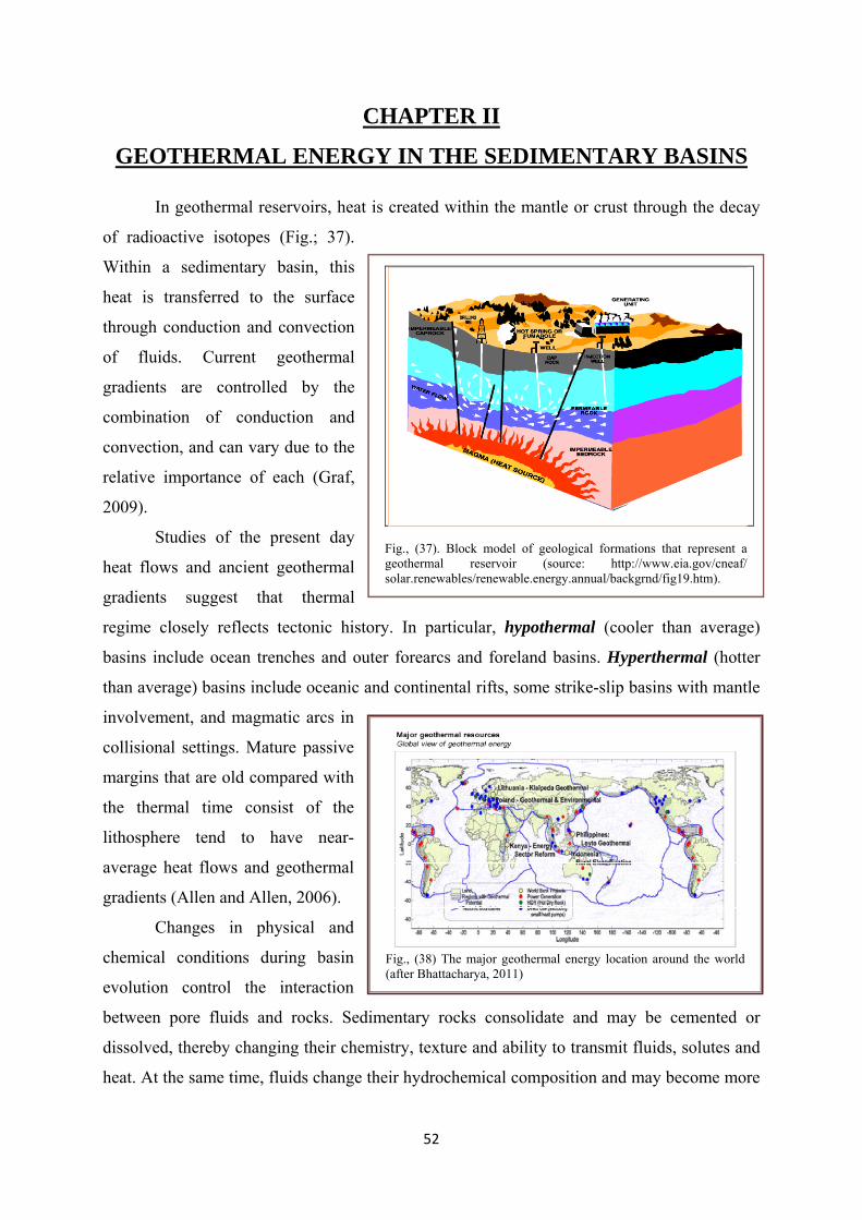
52
CHAPTER II
GEOTHERMAL ENERGY IN THE SEDIMENTARY BASINS
In geothermal reservoirs, heat is created within the mantle or crust through the decay
of radioactive isotopes (Fig.; 37).
Within a sedimentary basin, this
heat is transferred to the surface
through conduction and convection
of fluids. Current geothermal
gradients are controlled by the
combination of conduction and
convection, and can vary due to the
relative importance of each (Graf,
2009).
Studies of the present day
heat flows and ancient geothermal
gradients suggest that thermal
regime closely reflects tectonic history. In particular, hypothermal (cooler than average)
basins include ocean trenches and outer forearcs and foreland basins. Hyperthermal (hotter
than average) basins include oceanic and continental rifts, some strike-slip basins with mantle
involvement, and magmatic arcs in
collisional settings. Mature passive
margins that are old compared with
the thermal time consist of the
lithosphere tend to have near-
average heat flows and geothermal
gradients (Allen and Allen, 2006).
Changes in physical and
chemical conditions during basin
evolution control the interaction
between pore fluids and rocks. Sedimentary rocks consolidate and may be cemented or
dissolved, thereby changing their chemistry, texture and ability to transmit fluids, solutes and
heat. At the same time, fluids change their hydrochemical composition and may become more
Fig., (37). Block model of geological formations that represent a geothermal reservoir (source: http://www.eia.gov/cneaf/ solar.renewables/renewable.energy.annual/backgrnd/fig19.htm).
Fig., (38) The major geothermal energy location around the world (after Bhattacharya, 2011)

53
diluted or more concentrated (Bitzer et al., 2001). As these fluids change in temperature, they
may dissolve when mixed with other fluids or if a further change of temperature occurs.
Flowing groundwater takes up the geothermal energy from the Earth’s crust and
transports part of it in the direction of water flow. Productivity of a geothermal reservoir is
controlled predominantly by the geothermal gradient (i.e., temperature variation with depth)
encountered in a basin. Extremely high gradients (200°C/km) are observed along oceanic
spreading centers (e.g., the Mid- Atlantic Rift) and along island arcs (e.g., the Aleutian chain)
(Fig., 38). In Iceland, geothermal energy, the main source of energy, is extracted from areas
with geothermal gradients ≥40°C/km. Low gradients are observed in tectonic subduction
zones because of thrusting of cold, water-filled sediments beneath an existing crust.
Tectonically stable shield areas and sedimentary basins have average gradients that typically
vary from 15 C/km to 30°C/km (Graf, 2009). The geothermal provinces at India are
associated with major rifts or subduction tectonics and registered high heat flow and high
geothermal gradient. The reservoir temperatures estimated are 120° C (west coast), 150° C
(Tattapani) and 200° C (Cambay). The depth of the reservoir in these provinces is at a depth
of about 1 to 2 km. These geothermal systems are liquid dominated and steam dominated
systems prevail only in Himalayan and Tattapani geothermal provinces (Bhattacharya, 2011)
Geothermal energy indicates that part of the heat within the Earth that can or might be
recovered and exploited by mankind. Due to the long-term availability and the large extent of
geothermal heat, geothermal energy represents an efficient renewable energy worldwide.
Making geothermal heat an effective source for a sustainable supply of energy requires a
quantitative reserve and resource assessment. Though immense in its nature, only a fraction of
the Earth’s heat can be utilized in practice, its exploitation being limited to areas characterized
by favorable hydrogeological conditions for geothermal resources to develop. A proper
geothermal exploration involves different stages comprising: (1) a correct localization of
potential areas to ascertain the existence of a particular geothermal field; (2)an accurate
estimate of the size of the resource to determine the type of geothermal field; and (3) an
appropriate identification of the main physical transport processes involved to properly
identify geothermal phenomena. This requires an integrated approach involving different
disciplines and methodologies including geological field measurements, laboratory-based
investigations as well as mathematical modeling. It is well known (Bethke et al., 1988;
Raffensperger and Vlassopoulos, 1999) that the most significant portion of the world’s
mineral, energy and water resources is hosted in sedimentary basins. Formation of these
resources results from interactions between different coupled processes comprising
54
groundwater flow, mechanical deformation, mass transport and heat transfer and different
water–rock interaction mechanisms. Understanding the relative impact of fluid and other heat
driving processes on the resulting geothermal field as well as the resulting subsurface flow
dynamics is of crucial importance for geothermal energy production. For geothermal
exploration it is essential to quantify the above-mentioned processes by interpretation of their
characteristic thermal signatures in the subsurface. This requires a correct interpretation of the
impact of all processes contributing to the temperature field to not misinterpret similar, but
distinct in nature, thermal signatures. Heat in the crust is mainly transferred by diffusion. In
sedimentary basins, an additional mean of heat transport is provided by advective forces by
ground water circulating through permeable aquifers (Andersaon, 2005).
Temperatures in the model are governed by the effects of vertical and horizontal thermal
conduction such that the lithosphere-asthenosphere boundary is defined as a partial melt
isotherm or phase change boundary which migrates vertically depending on the transient
thermal state. Vertical deformations of the lithosphere result from the purely mechanical
effects of sediment loading as well as from changes in the ambient temperature field. The
temperature anomalies contribute to these deformations not only by setting up body forces but
also by creating thermal in plane forces and associated bending units (Stephenson et al.,
1989).
1- Geothermal Gradient
The geothermal or temperature gradient is the rate of increase in temperature per unit depth in
the Earth due to the outflow of
heat from the centre. The
temperature gradient between the
centre of the Earth and the outer
limits of the atmosphere averages
about 1°C per kilometer (Fig.,
39). To classify geothermal
systems, Tester et al., (2006)
divided geothermal resources into
high- (>150⁰C), medium- (50–
150⁰C) and low- (<50⁰C)
temperature resources. The low
Fig., (39) Structure of the Earth and the geothermal gradient. (Source: http://www.mpoweruk.com/geothermal_energy.htm).
55
temperature resources were used for direct heating applications. The temperature gradient in
the Earth's fluid layers and the magma tend to be lower because the mobility of the molten
rock tends to even out the temperature. This mobility however does not exist in the solid crust
where temperature gradient is consequently much higher, typically between 25°C and 30°C
per kilometer depending on the location and higher still in volcanic regions and along tectonic
plate boundaries where seismic activity transports hot material to near the surface. (Source:
http://www.mpoweruk.com/geothermal_energy.htm)
2- Effect of the geothermal energy on hydrocarbon maturation
Subsidence in sedimentary basins causes thermal maturation in the progressively
buried sedimentary layers. Indicators of the thermal history include; organic, geochemical,
mineralogical and thermochronometric parameters. The most important factors in the
maturation of organic matter are temperature and time, pressure being relatively un-important.
This temperature and time dependency describes the reaction rate increases exponentially
with temperature, the rate of increase (Allen and Allen, 2006). The combined effects of
sedimentary processes and heat flow are the prime control on the rate and extent of
hydrocarbon maturation in potential source rocks, which is of prime interest in oilfield
appraisal. Hydrocarbons generated by organic matter rich sediments may be transported
towards reservoir rocks, if physico-chemical conditions and timing are appropriate. Flow,
transport and reaction in the scale of sedimentary basins are in most cases slow and steady
processes. However, over the scale of geologic time, its effects are of great importance as they
can generate important resources (Bitzer et al., 2001). The maturation of the hydrocarbons
involves the slow thermodynamic conversion of the organic matter (Kerogens) in potential
source rock into oil and gas, which may then migrate to more porous reservoir rocks. The
maturation process is heavily influenced by two factors; the local temperature and the
duration of the thermal event. In turn, these are strongly controlled by the rates of subsidence
and sedimentation. During basin forming events, large amounts of heat are transferred from
the basement through the evolving sedimentary cover, providing an energy source for the
hydrocarbon maturation processes (Palumbo et al., 1999; Gray et. al. 2012). As in any ‘slow
cooking’ process, however, maturation can occur at a given temperature only if the effective
heating time is long enough. The maturation index, which depends on both the effective
heating time and the thermal history, is a quantitative measure of the degree of maturation.
(Pieri 1988; Cranganu and Deming 1996).

56
3- Geothermal energy utilizations
Direct-use of geothermal energy is one of the oldest, most versatile and also the most
common form of utilization of geothermal energy (Dickson and Fanelli, 2003). The early
history of geothermal direct-use has been well documented for over 25 countries. Cataldi et
al., (1999) documents that the geothermal uses are for over 2,000 years. Now, there are 78
countries having direct utilization of geothermal energy, is a significant increase from the 72
reported in 2005, the 58 reported in 2000, and the 28 reported in 1995 (Lund et al., 2010).
The thermal energy used is 438,071 TJ/year (121,696 GWh/yr), about a 60% increase over
2005, growing at a compound rate of 9.9% annually. The distribution of thermal energy used
by category is approximately 49.0% for ground-source heat pumps, 24.9% for bathing and
swimming (including balneology), 14.4% for space heating (of which 85% is for district
heating), 5.3% for greenhouses and open ground heating, 2.7% for industrial process heating,
2.6% for aquaculture pond and raceway heating, 0.4% for agricultural drying, 0.5% for snow
melting and cooling, and 0.2% for other uses (Table 2). About Egypt, no data were submitted
for WGC2005 or WGC2010. A spa at Hammam Faraun is also reference in Lashin and Al
Arifi (2010). The estimates in Lund et al. (2005) of 1.0 MWt and 15 TJ/yr are assumed to still
be valid. There are two main exploitable sources of geothermal energy. Hydrothermal
systems, first demonstrated in 1904, used the naturally occurring hot water or steam trapped
in or circulating
through permeable
rock, to drive steam
powered electricity
generators. More
recently, since 1970,
technology has been
developed to extract
the heat from hot rock
by artificially circulating water through the rock to produce super-heated water or steam to
drive the generators.
For cost efficient electricity generation, suitable temperatures for hot water and steam
range upwards from 120°C to 370°C. Such naturally occurring hydrothermal resources are not
widely available and are found in only a few regions of the world where the Earth's crust is
very thin, usually around the edges of the crustal tectonic plates. Geothermal electricity
Table (2): Summary of geothermal energy use by continent in 2000, showing contribution of Europe (Fridleifsson, 2002; based on Huttrer, 2001; Lund and Freeston, 2001)

57
generating plants have been installed in over twenty countries with new installations planned
in several more. In shallow reservoirs or regions where the water or steam temperature may
range between 21°C to 149°C and not be hot enough for efficient electricity generation, the
hot water can be used directly for local heating applications. Iceland is widely considered the
success story of the geothermal community. The country of just over 300,000 people is now
fully powered by renewable forms of energy, with 17% of electricity and 87% of heating
needs provided by geothermal energy (fossil fuels are still imported for fishing and
transportation needs (Blodgett and Slack, 2009).
3.1- Hydrothermal Systems - Geothermal Aquifers
Conventional hydrothermal systems make use of geothermal aquifers which are
naturally occurring geological formations of permeable rock or unconsolidated sediment
(gravel, sand, silt, or clay) in which water may accumulate, between layers of impermeable
rock. Where these aquifers occur in fractured volcanic rocks where temperatures are relatively
high near the surface or in non volcanic areas where the crustal heat flow is very high, the
water temperature may be high enough to provide steam for powering a conventional prime
mover driving an electricity generator.
The hot water can be extracted from these hydrothermal reservoirs using boreholes
and, after the heat has been extracted, the cooled water is pumped back into the ground to
maintain the water table and pressure. Energy from geothermal aquifers is not completely
renewable since heat is usually extracted at a rate quicker than it is replenished by the
surrounding rocks.
3.2- Hot Dry Rocks (HDR) Enhanced Geothermal Systems (EGS)
Hot rock systems extract energy from dry rocks with temperatures up to 1000°C deep
in the Earth's crust, rather than from hydrothermal aquifers, but first the solid rock must be
made permeable to allow the circulation of water into which the rocks give up some of their
heat. Such Hot Dry Rock (HDR) systems (Fig., 40) need Enhanced Geothermal Systems
(EGS) to extract the available energy and these involve much higher investments and
exploration risks than extracting energy from naturally occurring hydrothermal reservoirs
(Pruess 2007).
Like hydrothermal systems, practical HDR systems depend on particular natural
geological formations. They need access to hot granite or similar rocks with temperatures of
250°C or more, maintained by the heat flow from the Earth's hot core and such high
temperatures are normally found at depths of over 3 kms. The deeper the rock, the higher the
temperature but current drilling technology limits the practical working depths to about 5
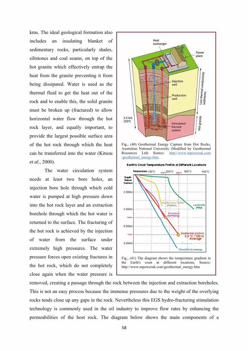
58
kms. The ideal geological formation also
includes an insulating blanket of
sedimentary rocks, particularly shales,
siltstones and coal seams, on top of the
hot granite which effectively entrap the
heat from the granite preventing it from
being dissipated. Water is used as the
thermal fluid to get the heat out of the
rock and to enable this, the solid granite
must be broken up (fractured) to allow
horizontal water flow through the hot
rock layer, and equally important, to
provide the largest possible surface area
of the hot rock through which the heat
can be transferred into the water (Kitsou
et al., 2000).
The water circulation system
needs at least two bore holes, an
injection bore hole through which cold
water is pumped at high pressure down
into the hot rock layer and an extraction
borehole through which the hot water is
returned to the surface. The fracturing of
the hot rock is achieved by the injection
of water from the surface under
extremely high pressures. The water
pressure forces open existing fractures in
the hot rock, which do not completely
close again when the water pressure is
removed, creating a passage through the rock between the injection and extraction boreholes.
This is not an easy process because the immense pressures due to the weight of the overlying
rocks tends close up any gaps in the rock. Nevertheless this EGS hydro-fracturing stimulation
technology is commonly used in the oil industry to improve flow rates by enhancing the
permeabilities of the host rock. The diagram below shows the main components of a
Fig., (40) Geothermal Energy Capture from Hot Rocks, Australian National University (Modified by Geothermal Resources Ltd) Source: http://www.mpoweruk.com /geothermal_energy.htm.
Fig., (41) The diagram shows the temperature gradient in the Earth's crust at different locations. Source: http://www.mpoweruk.com/geothermal_energy.htm

59
geothermal power plant used to capture energy from hot dry rocks. The temperature profile
varies, depending on factors such as the porosity of the rock, the degree of liquid saturation of
the rock and sediments, their thermal conductivity, their heat storage capacity and the vicinity
of magma chambers or heated underground reservoirs of liquid.
3.3- Geothermal energy in contemporary balneotherapeutics and Tourism
In many countries, bathing and swimming are important and attractive aspects of
geothermal direct uses. Geothermal is utilized in this way in at least 51 countries, i.e. over
11% of total installed power and 22% of thermal energy for direct uses worldwide (Fig., 41).
Nowadays, recreation and healing based on geothermal water, steam, and energy are a very
attractive and perspective branch of tourism where the demand exceeds the supplies.
Geothermal plays a number of functions in tourism, e.g. swimming and therapeutic pools,
curative geothermal by-products (e.g. salts), ecological heating of hotels and spas.
Hydrothermal phenomena themselves (warm springs, geysers, hydrothermal minerals, etc.)
are tourist attractions, similar to the historical objects or ruins related with geothermal use
(Antics and Sanner 2007). Incorporation of these phenomena and objects in the common
domain of tourism favours the idea of “sustainable development” and pro-ecological
development of many regions and countries (Kępińska, 2004).
4- Healing and therapeutic value of geothermal waters
Generally, cold mineral and geothermal waters can be treated as “therapeutic” or
“having healing properties” if they meet at least one of the following criteria: 1) chemical
(chemical composition); and 2) physical (temperature, radioactivity). Both these criteria are
met by geothermal waters which can, owing to their physical (over 20⁰C) and chemical
properties, naturally play healing or therapeutic functions (Antics and Sanner 2007; Kępińska,
2004).
Temperature is one of the main factors thanks to which geothermal waters (just like
regular mineral waters heated to a proper temperature) are applicable to healing,
rehabilitation, and prophylaxy of diseases and dysfunctions of muscles, rheumatism,
neurological diseases and many other ailments. Chemical composition greatly determines the
application of geothermal waters for a spectrum of skin and internal diseases (Antics and
Sanner 2007; Kępińska, 2004).
Geothermal waters are also used for the production of therapeutic salt, leaches and
evaporated salt. The total dissolved solids of such waters cannot exceed 60 g/dm3 and
pharmacological-dynamic factors are taken into account. These minimum concentrations of
chemical components dissolved in water or physical properties of water make up a threshold

60
for biologically active waters. Therapeutic waters cannot be contaminated with bacteria or
chemical compounds. Their curative properties must be proven by tests, and the oscillations
in chemical composition and physical properties of waters may change only in a very small
range (Antics and Sanner 2007; Kępińska, 2004).
4.1- Therapeutic tourism
Geothermal balneotherapy and spas are basic elements of therapeutic tourism, one of
the most important forms of recreation nowadays. Healing purposes can be acquired through
various forms of tourism (spas, weekend tours,
general healing tours, healing tours dedicated to
specific diseases, etc.) Today, therapy is one of
the fundamental functions of tourism, thanks to
which the negative effects of civilization, e.g.
stress can be reduced, and the inner force and
feeling of integration reinforced (Kępińska,
2004). Over the centuries, these purposes have
been most successfully realized in health resorts,
i.e. spas, especially those with geothermal water.
Spas are also attributed to a specific lifestyle,
leisure, healing and biological rejuvenation, and
an aspect of cultural and social life (Kępińska,
2004).
4.2- Geothermal Electricity Production around
the world
Many regions of the world are already
tapping geothermal energy as an affordable and
sustainable solution to reducing dependence on
fossil fuels, and the global warming and public
health risks that result from their use. For
example, more than 8,900 megawatts (MW) of
large, utility-scale geothermal capacity in 24
countries now produce enough electricity to
meet the annual needs of nearly 12 million
typical U.S. households (GEA 2008a).
Fig., (42) Three different systems applied in Geothermal Electricity production. Source: http://www.ucsusa.org/clean_energy/our-energy-choices/renewable-energy/how-geothermal-energy-works.html

61
Geothermal plants produce 25 percent or more of electricity in the Philippines, Iceland, and El
Salvador (Fig., 42).
The United States has more geothermal capacity than any other country, with more
than 3,000 megawatts in eight states. Eighty percent of this capacity is in California, where
more than 40 geothermal plants provide nearly 5 percent of the state’s electricity.1 In
thousands of homes and buildings across the United States, geothermal heat pumps also use
the steady temperatures just underground to heat and cool buildings, cleanly and
inexpensively.
The largest geothermal system now in operation is a steam-driven plant in an area
called the Geysers, north of San Francisco, California. Despite the name, there are actually no
geysers there, and the heat that is used for energy is all steam, not hot water. Although the
area was known for its hot springs as far back as the mid-1800s, the first well for power
production was drilled in 1924. Deeper wells were drilled in the 1950s, but real development
didn't occur until the 1970s and 1980s. By 1990, 26 power plants had been built, for a
capacity of more than 2,000 MW. (Source: http://www.ucsusa.org/clean_energy/our-energy-
choices/renewable-energy/how-geothermal-energy-works.html).
Geothermal energy supplies more than 10,000 MW to 24 countries worldwide and
now produces enough electricity to meet the needs of 60 million people. The Philippines,
which generates 23% of its electricity from geothermal energy, is the world's second biggest
producer behind the U.S. Geothermal energy has helped developing countries such as
Indonesia, the Philippines, Guatemala, Costa Rica, and Mexico. The benefits of geothermal
projects can preserve the cleanliness of developing countries seeking energy and economic
independence, and it can provide a local source of electricity in remote locations, thus raising
the quality of life. Iceland has been expanding its geothermal power production largely to
meet growing industrial and commercial energy demand. In 2004, Iceland was reported to
have generated 1465 gigawatt-hours (GWh) from geothermal resources; geothermal
production is expected to reach 3000 GWh at end of 2009 (Blodgett and Slack, 2009).
62
CHAPTER III
MINERAL RESOURCES OF THE SEDIMENTARY BASINS
The diversified geology of various regions and stratigraphic levels within the basins
have given rise to a wide variety of minerals, more than 50 different kinds other than oil, gas
and coal, that have an existing or potential resource value. The minerals are divided into
industrial (or nonmetallic) minerals and metallic minerals. Under these broad categories the
minerals are grouped into the various mineral types shown, with each type having common
geological characteristics or elemental associations or both. With respect to the origin of basin
fluids, Lawrence and Cornford (1995) distinguish between internally derived fluids such as
formation waters (connate waters) and hydrocarbons, and externally derived fluids such as
meteoric and metamorphic fluids. This hydrothermal circulation also extracts minerals and
salts from rock. Minerals precipitate out of the hot waters and build spectacular vents, tens of
meters high, on the mid-ocean ridges. Another internal source of fluid is related to clay
diagenesis, which may contribute to overpressure build-up in subsiding basins (Bethke, 1986).
Subsurface fluid flow plays a significant role in many geologic processes and is
increasingly being studied in the scale of sedimentary basins and geologic time perspective.
Many economic resources such as petroleum and mineral deposits are products of basin scale
fluid flow operating over large periods of time. Such ancient flow systems can be studied
through analysis of diagenetic alterations and fluid inclusions to constrain physical and
chemical conditions of fluids and rocks during their paleohydrogeologic evolution. Basin
simulation models are useful to complement the paleohydrogeologic record preserved in the
rocks and to derive conceptual models on hydraulic basin evolution and generation of
economic resources. Different types of fluid flow regimes may evolve during basin evolution
(Bitzer et al., 2001). The most important with respect to flow rates and capacity for transport
of solutes and thermal energy is gravitational fluid flow driven by the topographic
configuration of a basin. Such flow systems require the basin to be elevated above sea level.
Consolidational fluid flow is the principal fluid migration process in basins below sea level,
caused by loading of compressible rocks. Flow rates of such systems are several orders of
magnitude below topography driven flow. However, consolidation may create significant
fluid overpressure. Episodic dewatering of over-pressured compartments may cause sudden
fluid release with elevated flow velocities and may cause a transient local thermal and
chemical disequilibrium between fluid and rock. This paper gives an overview on subsurface

63
fluid flow processes at basin scale and presents examples related to the Penedès basin in the
central Catalan continental margin including the offshore Barcelona half-graben and the
compressive South-Pyrenean basin (Bitzer et al., 2001).
I- Organic Mineral Resources
I.1- Oil and Natural Gas Resources
The world was divided into 8 regions and 937 geologic provinces. These provinces have
been ranked according to the discovered known oil and gas volumes (Klett et al., 1997).
Then, 76 “priority” provinces (exclusive of the United States and chosen for their high
ranking) and 26 “boutique” provinces (exclusive of the United States) were selected for
appraisal of oil and gas resources. Boutique provinces were chosen for their anticipated
petroleum richness or special regional economic or strategic importance (Klett, 2000).
A geologic province is an area having characteristic dimensions of hundreds of
kilometers that encompasses a natural geologic entity (for example, a sedimentary basin,
thrust belt, or accreted terrane) or some combination of contiguous geologic entities. Each
geologic province is a spatial entity with common geologic attributes. Province boundaries
were drawn as logically as possible along natural geologic boundaries, although in some
places they were located arbitrarily (for example, along specific water-depth contours in the
open oceans) (Klett, 2000).
Total petroleum systems and assessment units were delineated for each geologic province
considered for assessment. It is not necessary for the boundaries of total petroleum systems
and assessment units to be entirely contained within a geologic province. Particular emphasis
is placed on the similarities of petroleum fluids within total petroleum systems, unlike
geologic provinces and plays in which similarities of rocks are emphasized (Klett, 2000).
The total petroleum system includes all genetically related petroleum that occurs in
shows and accumulations (discovered and undiscovered) generated by a pod or by closely
related pods of mature source rock. Total petroleum systems exist within a limited mappable
geologic space, together with the essential mappable geologic elements (source, reservoir,
seal, and overburden rocks). These essential geologic elements control the fundamental
processes of generation, expulsion, migration, entrapment, and preservation of petroleum
within the total petroleum system (Klett, 2000).
1.1- Sedimentary basins and petroleum formation in the Middle East
Middle East is divided into three major sedimentary basins: the Greater Arabian
Basin, the Zagros Basin and the Oman Basin. Each basin is further divided into sub-basins,
and each of these has its own style and time of origin reflected by differences in thickness and

64
lithology. The megatectonic
framework of the Middle East
(Alsharhan and Nairn 2003) shows
that the area is dominated by the
many sub-basins, broad regional
highs, anticlines and flexures
reflecting deep-seated basement
faults and salt diapirisms. From the
early Mesozoic onwards, the
pattern of sedimentation in the
Middle East was influenced by
periods of increased activity
alternating with quiet intervals.
During the late Turonian to the
early Campanian (Fig., 43), a major
change in basin configuration took
place, heralding the first phase of Alpine compressive tectonics (Murris, 1980). During the
Late Cretaceous orogenic period in Syria, northwestern Iraq and Southeast Turkey, dextral
and sinistral strikeslip faults, fault zones and grabens were formed. The grabens were filled by
a thick sequence of Sediments, which were inverted during the late Tertiary compressive
phase, giving rise to en-echelon fold belts. The only areas in the Middle East with production
and potential approaching that of the Middle East are in the Pricaspian Basin and the West
Siberian Basin of the former USSR. Saudi Arabia ranks second in proven reserves and first in
exporting oil, replacing the former Soviet Union with its rapidly declining production.
Exploration in the producing areas of the Arabian Gulf and in the Zagros generally is in the
mature phase; after many years of increasing reserve estimates, the figures are beginning to
decline, despite the dramatic increase in reserve estimates of gas. However, there still are
major untested areas, particularly in Iraq, Jordan and Yemen, and new play concepts and the
introduction of new technologies may reverse the decline, at least temporarily (Powers, et al.,
1985).
The Albian–Cenomanian consists mainly of Orbitolina-bearing limestone with local
basin margin rudist buildups in the offshore North field of Qatar and northeast Iraq. There are
two main oil provinces where the Mauddud Formation is a major oil-producing reservoir. The
Northern Province includes Iraq’s oil fields such as Ain Zalah, Bai Hassan, and Jambur. The
Fig., (43) Paleogeographic map of the Albian–upper Cenomanian strata of the Arabian Gulf basin (modified from Murris, 1980).

65
southern province includes the Ratawi field in southern Iraq, Raudhatain, Sabriya, and Bahra
fields in Kuwait, Bahrain (Awali) field in Bahrain, and Fahud and Natih fields in Oman. The
formation has high oil potential in the southern and southeastern fields of Iraq and the
offshore areas of Qatar and Saudi Arabia (Sadooni and Alsharhan 2003).
1.2- Petroleum prospectivity of the principal sedimentary basins on the United Kingdom
Continental Shelf
The main sedimentary basins within the UKCS can be broadly divided into a number
of separate provinces, on the basis of petroleum geology and location. These provinces
comprise the North Sea Oil Province, the North Sea Gas Province, the Irish Sea and the
Atlantic Margin (Fig., 44). The remaining and future petroleum potential of these provinces is
summarised below. The following six exploration plays, in particular are anticipated to offer
significant hydrocarbon potential (Munns et al., 2005): Upper Jurassic syn-rift deep-water
play, Upper Jurassic shallow-marine ‘inter-pod’ play, Lower Cretaceous deep-water play,
Paleogene deep-water play, Upper Cretaceous Chalk play, and Lower Permian basin-margin
play (Gray, 2010).
The North Sea Oil Province is one of the world’s major oil-producing regions. The
geological history of the oil province was dominated by an episode of late Jurassic to earliest
Cretaceous crustal extension, which
developed the Viking Graben, Moray Firth
and Central Graben rift systems. Syn-rift,
organic-rich marine mudstones
(Kimmeridge Clay Formation) are the
source rocks for virtually all of the
region’s hydrocarbons. Post-rift thermal
subsidence enabled these source rocks to
become mature for hydrocarbon
generation along the rift axes from
Paleogene times onwards (Johnson and
Fisher, 1998). Hydrocarbon migration has
been mainly vertical. Consequently, most
of the producing oil and gas fields lie
within the geographical boundary of the mature source rocks. Hydrocarbons occur in a wide
range of pre-rift, syn-rift and post-rift reservoirs (Gray, 2010). Although extensional rifting
generally ceased during the earliest Cretaceous (Ryazanian), fault-controlled subsidence
Fig. (44). Distribution of oil and gas provinces and petroleum Carboniferous source rocks on the UK Continental Shelf (After Gary, 2010).

66
persisted in parts of the Moray Firth Basin, throughout much of Early Cretaceous times. This
localised tectonism is considered by Oakman and Partington (1998) to have been controlled
by strike-slip faulting.
1.3- prospectivity of the sedimentary
basins of Irish Sea
The East Irish Sea Basin is at a
mature exploration phase. Early
Namurian basinal mudstones are the
source rocks for these hydrocarbons.
Production from all fields is from fault-
bounded traps of Lower Triassic,
principally aeolian Sherwood Sandstone
reservoir, top-sealed by younger Triassic
continental mudstones and evaporates
(Fig., 45). Future exploration will
initially concentrate on extending this play, but there remains largely untested potential also
for gas and oil within widespread Carboniferous fluvial sandstone reservoirs. This play
requires intraformational mudstone seal units to be present, as there is no top-seal for
reservoirs subcropping the regional base Permian unconformity in the east of the basin, and
Carboniferous strata crop out at the sea bed in the west (Gray, 2010).
I. 2- Coal bearing formations:
2.1- Australia: The Australian coals can be separated into Permian, Mesozoic and tertiary
coals. The Permian coals are in general hard coal between high volatile bituminous and
anthracite rank, the Mesozoic coals are high volatile bituminous, perhydrous coals and the
tertiary coals are of the lignitic rank. The coals of the Gippsland Basin are the youngest coals
that can be extracted by mining. The coal has five major coal seams, which are defined in
Yallourn, Morwell and Traralgon Formations. These three formations are all not older than 5
Ma; the individual seam thickness often exceeds the 100 m. The vertical stratigraphic position
is over 400 m of continuous low ash coal (Crosdale, 2004; Holdgate, 2005; Golab et al.,
2007).
2.2- India: Indian coal resources are confined to two distinct geological periods and basinal
set-ups – (i) Permian sediments deposited mostly in the intra-cratonic Gondwana basins of
Peninsular India and a few minor occurrences as thrust sheets (overriding Siwalik sediments)
Fig. (45). Hydrocarbon fields and discoveries.

67
in the foothills of Darjeeling and Arunachal Pradesh Himalayas and (ii) Early Tertiary
sediments deposited in the near shore peri-cratonic basins and shelves in the North Eastern
Region. More than 99% of total coal resources are Gondwana coal. The Gondwana basins of
Peninsular India, restricted to the eastern and central parts of the country are disposed as
linear belts along the course of major river valleys of Damodor-Koel (with a subsidiary belt to
the north). Extensive spread of Gondwana sediments beneath the Ganga and Brahmaputra
alluvium in the Bengal Basin and beneath the Deccan traps in Central Indian craton, in
addition to the occurrences of Gondwana outliers beyond the confines of known coalfields, is
suggestive of a much wider span of the parent Gondwana basins. Gondwana sediments are
represented by thick sequence of glacial, marine, fluvial and lacustrine facies (Bhattacharya,
2011).
II- Inorganic Mineral Resources
II.1- Volcanogenic massive sulphides (VMS) deposits are also known as volcanic-
associated, volcanic-hosted, and volcano-sedimentary-hosted massive sulphide deposits. They
typically occur as lenses of polymetallic massive sulphide that form at or near the seafloor in
submarine volcanic environments. They form from metal-enriched fluids associated with
seafloor hydrothermal convection. Their immediate host rocks can be either volcanic or
sedimentary. VMS deposits are major sources of Zn, Cu, Pb, Ag and Au, and significant
sources for Co, Sn, Se, Mn, Cd, In, Bi, Te, Ga and Ge. Some also contain significant amounts
of As, Sb and Hg. Historically, they account for 27% of Canada's Cu production, 49% of its
Zn, 20% of its Pb, 40% of its Ag and 3% of its Au. Because of their polymetallic content,
VMS deposits continue to be one of the best deposit types for security against fluctuating
prices of different metals. There are close to 800 known VMS deposits worldwide with
geological reserves over 200,000 t (Galley et al., 2007).
II.2- Metaliferous Oxides: Manganese nodules occur in all the oceans. Their accretion rate is
very slow, only a few mm in 1 million years. The average nodule has 24% manganese,
compared to 35 to 55% manganese in land ore bodies, so they do not offer solid economics as
a manganese source, but they also contain iron (14%), copper (1%), nickel (1%), and cobalt
(0.25%).
II.3- Metallic and Gem Minerals in Placer Deposits: A placer deposit is an accumulation of
mineral grains concentrated by sedimentary processes. When pebbles, sands, and silts are
sorted by wave action or stream flow, minerals with higher specific gravity and resistance to
weathering become concentrated, especially in beaches and drowned river mouths. Marine
68
placer mineral deposits are found on the continental shelf from the beaches to the outer shelf.
The strategic element titanium derived mainly from ilmenite and rutile ores, while the noble
elements are gold and platinum.
II.4- Evolution of a Mineralized Geothermal System, Valles Caldera, New Mexico, USA:
Hot springs and fumaroles are surface manifestations of a hydrothermal reservoir
(210°–300°C; 2–10 x 103 mg/kg Cl) that is most extensive in fractured, intracaldera Bandelier
Tuff and associated sedimentary rocks, located in specific structural zones. Fluids are
composed of deeply circulating water of (primarily) meteoric origin, which have a mean
residence time in the reservoir of 3–10 kyr. Host rocks show intense isotopic exchange with
hydrothermal fluids. Alteration assemblages are controlled by temperature, permeability, fluid
composition, host‐rock type and depth. A generalized distribution from top to bottom of the
system consists of argillic, phyllic, propylitic, and calc‐silicate mineral assemblages. Typical
alteration minerals in phyllic and propylitic zones are quartz, calcite, illite, chlorite, epidote
and pyrite, whereas common vein constituents consist of the above minerals plus fluorite,
adularia, and wairakite. Argentiferous pyrite, pyrargyrite, molybdenite, sphalerite, galena,
chalcopyrite, arsenopyrite, stibnite and barite have been found at various depths and locations
in the Valles system (Goff, 2012).
II.5- Mineral Resources of the Western Canada Sedimentary Basin
Minerals other than oil, gas and coal occur in abundance and variety in the Western
Canada Sedimentary Basin. They include the industrial (or nonmetallic) and metallic minerals
and together account for a significant proportion of Western Canada's wealth. Metallic
minerals are much less developed; known deposits are few and generally small, although they
include the world-class Pine Point (Pb-Zn) ore-body.
For the industrial minerals, most production comes from the Interior Plains region,
where Phanerozoic rocks form a northeast-tapering wedge of undeformed strata. These strata
include Paleozoic carbonates and evaporites that give rise to rich resources of sulphur, potash,
salt, gypsum, limestone and dolomite. The Paleozoic strata are succeeded by Mesozoic and
Tertiary clastic rocks that are sources for economic deposits of kaolin and structural clays,
bentonite, silica sand, and constructional sands and gravels. Important production also comes
from the Cordilleran region, where deformed and upthrusted basin strata in the Rocky
Mountain belt expose economic deposits of limestone, magnesite, gypsum and quartzite.
For the metallic minerals, except for Pine Point, most deposits have been found in the
Cordilleran region. These are mainly lead-zinc deposits of the Mississippi Valley type, few in
69
number and widely separated; limited past production came from small localized orebodies in
southeastern British Columbia. In the Interior Plains, the Pine Point lead-zinc deposit is the
largest and only significant economic deposit. Some placer gold is still produced from
Tertiary and recent gravels. Sedimentary iron deposits (in the Clear Hills region of Alberta)
are large, but remain undeveloped (Hamilton and Olson, 1990).
II.6- Mineral Resources of the Australian Sedimentary Basins
6.1- Heavy minerals: the Murray Basin, much of which is in New South Wales, has the
potential to become one of the world’s major new mineral sands provinces. Total resources of
coarse-grained heavy minerals (rutile, zircon, ilmenite and weathered ilmenite) identified in
the Murray Basin exceed 100 Mt, of which over 80 Mt occurs in the New South Wales part of
the basin. Beach placers along much of the coast north of Sydney were formerly major
sources of rutile, zircon and ilmenite. These heavy minerals form as accessory minerals in
many igneous and metamorphic rocks, nearly all major economic deposits of these minerals,
principally rutile, zircon and ilmenite, occur as detrital accumulations in young (Pliocene or
younger) shoreline or beach placer deposits (Force 1991; Roy and Whitehouse 2003).
6.2- Bauxite: Australia is the largest producer of bauxite in the world. New South Wales has
numerous comparatively small, scattered deposits of bauxite/laterite that typically occur as
discontinuous deposits along the crests of flat hills, ridges and in areas of generally subdued
topography (Holmes et al. 1982).
6.3- Sedimentary phosphate deposits occur on every continent and range in age from
Precambrian to Recent. Large resources of phosphates occur on the continental shelves.
Phosphorite beds consist of grains, pellets or fragments of cryptocrystalline apatite
(collophane) and are typically a few centimeters to tens of meters thick (McHaffie and
Buckley 1995). These deposits typically show extensive reworking, secondary enrichment
and replacement. Shallow oceanic areas and continental shelves commonly have thick
accumulations of phosphorus-rich organic debris, mainly derived from deep oceanic sources
associated with upwelling currents of cold, nutrient-rich water. The Phosphate Hill deposit is
the only commercial phosphate rock mine in Australia. The southern Eromanga Basin (Great
Australian Basin) may have potential for economic phosphate rock deposits (Wallis, 2004).
6.4- Other Metals: Gold, Copper, Silver, Uranium, Gypsum, Iron oxide, Kaolin, Limestone,
Magnesite,, Magnetite , Manganese, Mica, Olivine, Opal, Asbestos and Dolomite (McHaffie
and Buckley 1995).

70
CHAPTER IV
MEDITERRANEAN SEA
The Mediterranean Sea is a mid-latitude semi-enclosed sea, or almost isolated oceanic
system. Many processes which are fundamental to the general circulation of the world ocean
also occur within the Mediterranean, either identically or analogously. The Mediterranean Sea
exchanges water, salt, heat, and other properties with the North Atlantic Ocean. The North
Atlantic is known to play an important role in the global thermohaline circulation, as the
major site of deep- and bottom-water formation for the global thermohaline cell (conveyor
belt) which encompasses the Atlantic, Southern, Indian, and Pacific Oceans. The salty water
of Mediterranean origin may affect water formation processes and variabilities and even the
stability of the global thermohaline equilibrium state (Robinson et al., 2001).
I- Mediterranean Geosynclinal Belt
Mediterranean Sea is one of the largest mobile regions of the earth’s crust, separating
the Eastern European, Siberian, Sino-Korean, and South China platforms from the African-
Arabian and Indian platforms. The Mediterranean geosynclinal belt stretches across Eurasia
(Europe-Asia), from the Strait of Gibraltar in the west to the Indonesian archipelago, where it
joins the Pacific geosynclinal belt. It encompasses a large part of Western and Southern
Europe, the Mediterranean Sea, North Africa (Morocco, Algeria, and Tunisia), and Southwest
Asia. Geosynclines are all down-warped and down-faulted basins within the craton exclude
thick continental terrace-type deposits some of which have been designated geosynclines as
the Gulf Coast (Pettijohan, 1984). They are characterized by; 1) location marginal to or
between cratons, 2) mobility expressed by intense folding and thrusting, 3) initial somatic
igneous phase marked by ophiolitec emission I internal (away of the craton) zones and, 4)
synorogenic and post-orogenic igneous activity in internal zones (Pettijohan, 1984). The
Mediterranean geosynclinal belt includes the Hercynian (Variscan) folded regions of Western
and Central Europe, the Alpide geosynclinal (folded) region, and the Indonesian folded
region. The vast Tethys Sea was located on the site of the Mediterranean geosynclinal belt
during the Paleozoic and Mesozoic.
The Mediterranean was once a deep, dry valley, some five million years ago, dividing
the three continents, Europe, Africa and Asia, until a cataclysmic broach was made in the
retaining wall, which kept out the Atlantic Ocean in the West, towards present-day Gibraltar.

71
A huge cascade of water began, flooding the whole Mediterranean basin, in a process that
lasted many, many years, and a new sea was born. Analysing the geographical configuration
of this new sea more closely, we find that it is rather formed from a number of seas: the
Alboran, the gulf of Lione, the Tirrhennian Sea, the Ionian Sea, the Aegean Sea, the Adriatic
Sea etc, each with its own characteristics (Pettijohan, 1984; Robertson and Mountrakis, 2006).
II- Origin and evolution of Mediterranean geosyncline
The Eastern Mediterranean is one of the key regions for the understanding of
fundamental tectonic processes, including continental rifting, passive margins, ophiolites,
subduction, accretion, collision and post-collisional exhumation. It is also ideal for
understanding the interaction of tectonic, sedimentary, igneous and metamorphic processes
through time that eventually lead to the development of an orogenic belt. Tethyan
nomenclature remains controversial and we will suggest an appropriate informal terminology
for the various oceanic basins that existed. This envisaged southward subduction of a Late
Palaeozoic-Early Mesozoic ocean (Palaeo-Tethys) and the related opening of several marginal
basins along the northern margin of Gondwana. Closure of this ocean culminated in
continental collision by the latest Triassic-Early Jurassic time, and was followed by opening
of a new, Jurassic ocean basin (Northern Neotethys) (Robertson and Mountrakis, 2006).
Geologic features in the present-day Mediterranean essentially result from two major
processes: the tectonic displacement caused by the subduction of the African plate underneath
the Eurasian plate; and the progressive closure of the Mediterranean Sea involving a series of
submarine-insular sills. The development of the Mediterranean basin begins with the breakup
of the supercontinent Pangea in the Mesozoic Era. During this time, sea-floor spreading
triggered the development of the Atlantic Ocean in the Triassic period, which separated the
African and Eurasian plates from the North American plate. Sea-floor spreading in another
geographical location caused the development of the Tethys Ocean, separating the African
plate from the Eurasian. In the late Cretaceous period, these African and Eurasion plates
began to converge, closing the Tethys ocean basin, and the remnants of this ancient ocean
(Smith 1993; Dercourt et al., 2000; Robertson and Mountrakis, 2006).
In the Cainozoic age, the area of the Mediterranean Sea was a huge ocean that slowly
shrank into a few secondary basins. The main one then turned into the Mediterranean Sea.
This was caused by the African and Eurasian continental plate moving closer to each other.
72
The powerful thrusts coming from the south caused the sediments built up at the bottom of the
ocean to raise, thus originating the mountain ridges of the Atlantis, the Pyrenees, the Alps, the
Balkans and Asia Minor. During the late Miocene, the ancient ocean became an internal sea,
even if different from today’s Mediterranean Sea (Robertson and Mountrakis, 2006). During
the Pliocene, the Mediterranean Sea dried up. The geological phenomena associated with this
period, such as the opening of huge fractures, volcanic activity, the raising of coastal areas,
etc., prompted the formation of the ecological and geographical complexity of the
Mediterranean region. This phase boosted the expansion of salt-resistant plants (Halophytes
of the genera: Limonium, Salicornia, Arthrocnemum, Salsola, Artemisia) and the appearance
of small and sparse species whose adaptability to particular conditions made them develop
quickly. In the end, today’s Straits of Gibraltar broke up because of the earth's crust moving,
and the water of Atlantic sea flew into the Mediterranean basin. The current configuration of
this basin came into being approximately five million years ago (Dercourt et al., 2000;
Robertson and Mountrakis, 2006).
There are three major geomorphical settings within the Mediterranean basin; areas
with stable margin characteristics, areas with unstable convergent margin characteristics, and
areas with extensional margin (rifting) characteristics. Thus the Mediterranean basin is a
location of an intercontinental interplate system; with compressional and extensional events
occurring within close proximity (Robertson and Mountrakis, 2006). Geologists have yet to
come to a consensus about which plates in addition to the African and Eurasian ones, if any,
are involved in Mediterranean tectonics. Subsidence-related and other vertical displacements
are also found in compressional and extensional areas. A few notable events occurred during
the Cenozoic which affected the entire Mediterranean; the Messinian "salinity crisis", when
the closing off of the Mediterranean-Atlantic seaway caused complete isolation of the
Mediterranean and thus widespread evaporation; and then the Pliocene "revolution", when the
channel opened back up, causing reestablishment of marine conditions; and the Quaternary
"transgressive raised terraces," of controversial geological origin; among others (Dercourt et
al., 1986; 1993; 2000).
The Central portion of the Mediterranean basin exemplifies the juxtaposition of
compressional and extensional tectonic activity in the area. The region bordered to the west
by Sicily and to the east by Turkey's west coast (encompassing the Aegean, Ionian, and
Adriatic seas) exhibit a particular set of features. There were four major periods of extension
73
in this area. The first one occurred in the Mid-Upper Jurassic; evidence of this phase is seen in
the Strepanosa Trough and Ionian plain. A second one occurred in the Mid-Late Triassic,
opening up the Ionian Sea and the Eastern Mediterranean. A third extensional phase occurred
in the Mid-Upper Cretaceous, as evidenced by the stretched features of the Sirte Rise, a
monocline with normal faults and tilted blocks. The fourth one, occurring in the Mid-Upper
Miocene through to the Quaternary period, affected many areas of the Central Mediterranean
(Dercourt et al., 2000). This extensional phase is closely associated with compressive
motions; it is part of the reason for a counter-clockwise rotation of the Southern Appennine
area which begins in the upper Cretaceous. All four of these extensional phases are the cause
of geologic features found in the area, such as volcanic activity and rift-related sedimentary
processes. Due to such extension, the oceanic crusts of the Central Mediterranean are
considerably thinned in some places. The opening of small oceanic basins of the central
Mediterranean follows a trench migration and back-arc opening process that occurred during
the last 30 Myr. This phase was characterized by the counterclockwise rotation of the
Corsica-Sardinia block, which lasted until the Langhian (ca.16 Ma), and was in turn followed
by a slab detachment along the northern African margin. Subsequently, a shift of this active
extentional deformation led to the opening of the Tyrrenian basin (Dercourt et al., 1986;
1993; 2000).
The Mediterranean Ridge or Outer Median Ridge is a sea-floor feature that marks the
unstable (convergent) margin between two or more oceanic plates. The first stages of the
major collision between the North of the African plate and the South of the Eurasion plate are
believed to have occurred in the lower-middle Miocene (Dercourt et al., 1993; 2000). This
collision is also associated with the counter-clockwise rotation of the Appennine area, and
both of these associations are exhibited in the Calabrian (Italy and Sicily) and Hellenic
(Greece) orogenic arcs which are situated among both compressive and extensional dynamics.
The ridge extends geographically from Sicily to Cyprus along a generally E/W strike. It is an
extensive fold-fault system corresponding to recent uplift and folding of past abyssal plains
(Smith, 1993; Dercourt et al., 2000).
III- Paleoenvironmental analysis
Its semi-enclosed configuration makes the oceanic gateways critical in controlling
circulation and environmental evolution in the Mediterranean Sea. Water circulation patterns
are driven by a number of interactive factors, such as climate and bathymetry, which can lead

74
to precipitation of evaporites. During late Miocene times, a so-called "Messinian Salinity
Crisis" (MSC hereafter) occurred, which was triggered by the closure of the Atlantic gateway.
Evaporites accumulated in the Red Sea Basin (late Miocene), in the Carpatian foredeep
(middle Miocene) and in the whole Mediterranean area (Messinian) (Cendon et al., 2004). An
accurate age estimate of the MSC—5.96 Ma—has recently been astronomically achieved;
furthermore, this event seems to have occurred synchronously. The beginning of the MSC is
supposed to have been of tectonic origin; however, an astronomical control (eccentricity)
might also have been involved. In the Mediterranean basin, diatomites are regularly found
underneath the evaporitic deposits, thus suggesting (albeit not clearly so far) a connection
between their geneses. The present-day Atlantic gateway, i.e. the Strait of Gibraltar, finds its
origin in the early Pliocene. However, two other connections between the Atlantic Ocean and
the Mediterranean Sea existed in the past: the Betic Corridor (southern Spain) and the Rifian
Corridor (northern Morocco). The former closed during Tortonian times, thus providing a
"Tortonian Salinity Crisis" well before the MSC; the latter closed about 6 Ma, allowing
exchanges in the mammal fauna between Africa and Europe. Nowadays, evaporation is more
relevant than the water yield supplied by riverine water and precipitation, so that salinity in
the Mediterranean is higher than in the Atlantic. These conditions result in the outflow of
warm saline Mediterranean deep water across Gibraltar, which is in turn counterbalanced by
an inflow of a less saline surface current of cold oceanic water (Source:
http://www.princeton.edu/~achaney/tmve/wiki100k/docs/Mediterranean_Sea.html).
IV- Mediterranean basins
The Mediterranean, seen from the surface, looks like a single sea divided into a
number of basins with different characteristics, a different geological history, and also
different morphologies of the sea floor. The main division is that of the Western
Mediterranean and Eastern Mediterranean: two basins separated by an underwater ridge that
crosses the sea from Sicily to the coasts of Tunisia. The morphological differences between
the two basins also provoke differences in the temperature and in the chemical characteristics
of the water. The western basin has a temperature of 12 °C in winter and 23 °C in summer, its
salinity is 36‰ , while the eastern basin is warmer and more salty, it temperature is 16 °C in
winter and 26-29°C in summer, its salinity is 39‰. The geological and morphological
differences of the two basins also have consequences on the distribution of the living forms.

75
The two main basins are in turn divided into smaller sub-basins, whose characteristics depend
greatly on the geological history that led to their formation (Mazzoleni et al., 1992).
IV. 1- Tectonic settings of Eastern Mediterranean basin
The Eastern Mediterranean is one of the key regions for understanding of fundamental
tectonic processes, including continental rifting, passive margins, ophiolites, subduction,
accretion, collision, and post-collisional exhumation. It is ideal for understanding the
interaction of tectonic, sedimentary, igneous and metamorphic processes through time that
eventually lead to the
development of an orogenic
belt (Robertson and
Mountrakis, 2006). The
origin of the Eastern
Mediterranean basin
(EMB) by rifting along its
passive margins is
reevaluated. Evidence from
these margins shows that
this basin formed before the
Middle Jurassic; where the older history is known, formation by Triassic or even Permian
rifting is indicated. Off Sicily, a deep Permian basin is recorded. In Mesozoic times, Adria
was located next to the EMB and moved laterally along their common boundary, but there is
no clear record of rifting or significant convergence (Fig., 46). Farther east, the Tauride block,
a fragment of Africa–Arabia, separated from this continent in the Triassic. After that the
Tauride block and Adria were separate units that drifted independently. The EMB originated
before Pangaea disintegrated. Two scenarios are thus possible. If the configuration of Pangaea
remained the same throughout its life span until the opening of the central Atlantic Ocean
(configuration A), then much of the EMB is best explained as a result of separation of Adria
from Africa in the Permian, but this basin was modified by later rifting. The Levant margin
formed when the Tauride block was detached, but space limitations require this block to have
also extended farther east. Better constraints on the history of Pangaea are thus required to
decipher the formation of the Eastern Mediterranean basin (Garfunkel, 2004). In middle
Miocene times, the collision between the Arabian microplate and Eurasia led to the separation
Fig. (46). The East Mediterranean Basin (EMB) and the extent of its subducted parts (Garfunkel, 2004).

76
between the Tethys and
the Indian Oceans. This
process determined
profound changes in the
oceanic circulation
patterns, which shifted
global climates towards
colder conditions. The
Hellenic Arc, which has a
land-locked configuration,
underwent a widespread extension for the last 20 Myr due to a slab roll-back process (Fig.,
46). In addition, the Hellenic Arc experienced a rapid rotation phase during the Pleistocene,
with a counterclockwise component in its eastern portion and a clockwise trend in the western
segment. To the east and south, its original passive margins are preserved, whereas its present
northern and western margins were shaped by later subduction and plate convergence.
Seismic refraction studies show that the EMB has an up to 10 km thick probably oceanic crust
(and/or strongly attenuated continental crust) overlain by 6 to >12 km of sediment (DeVoogd
et al., 1992; Ben-Avraham et al., 2002).
In contrast, the Africa–Arabia continent next to the passive margins of this basin has
30- to 35-km thick continental crust (Makris et al., 1988). Such a change in crustal structure
allows the interpretation that the EMB formed as a result of rifting, which led to detachment
and northward drifting of blocks away from these passive margins. This view is widely
accepted, but the history of rifting, the identity and original location of the detached blocks,
and the growth history of the basin remain incompletely understood (Robertson et al., 1996).
IV.2- Tectonic Settings of the Western Mediterranean
The western Mediterranean is the younger part of the Mediterranean, being a basin
formed from late Oligocene to present. The western Mediterranean consists of a series of sub-
basins such as the Alboran, Valencia, Provençal, Algerian and Tyrrhenian seas. These basins
have in general a triangular shape and they generally rejuvenate moving from west to east.
They are partly floored by oceanic crust (Provençal and Algerian basins, and two smaller
areas in the Tyrrhenian Sea). The remaining submarine part of the western Mediterranean
basin is made of extensional and transtensional passive continental margins. The continental
Fig. (47). The East Mediterranean Basin (EMB) and the extent of its subducted parts (Garfunkel, 2004).

77
crust is composed of Paleozoic and pre-
Paleozoic rocks deformed by the
Caledonian and Variscan orogenic
cycles (Carminati et al., 1998a, b).
The geological evolution of the
western Mediterranean exhibits
complicated interactions between
orogenic processes and widespread
extensional tectonics. The region is
located in a convergent plate margin
separating Africa and Europe, and
consists of marine basins – the Alboran
Sea, the Algerian-Provençal Basin, the
Valencia Trough, the Ligurian Sea and
the Tyrrhenian Sea which formed as
back-arc basins since the Oligocene.
The evolution of these basins,
simultaneously with ongoing
convergence of Africa with respect to
Europe, has been the subject of
numerous studies (e.g., Stanley and
Wezel 1985, Durand et al. 1999).
Widespread extension associated with
the formation of these basins led to
considerable thinning of the continental
crust (i.e., in the Alboran Sea and the
northern Tyrrhenian) or to the local
initiation of sea floor spreading (i.e., in
the southern Tyrrhenian and Provençal
Basin). Furthermore, extensional tectonism in the western Mediterranean was coeval with
orogenesis in the adjacent mountain chains of the Rif-Betic cordillera, the Maghrebides of
northern Africa and Sicily, the Apennines, the Alps and the Dinarides (Malinverno and Ryan,
1986; Crespo-Blanc et al., 1994; Tricart et al., 1994; Cello et al., 1996; Azañón et al., 1997;
Frizon de Lamotte et al., 2000; Faccenna et al., 2001). Since Mesozoic to Tertiary times,
Fig., (48) Western Meditteranean reconstruction through Oligocene (Rosenbaum, et al. 2002).

78
during convergence between Africa and Iberia, it developed the Betic-Rif mountain belts.
Tectonic models for its evolution include: rapid motion of Alboran microplate, subduction
zone and radial extentional collapse caused by convective removal of lithosferic mantle. The
development of these intramontane Betic and Rif basins led to the onset of two marine
gateways which were progressively closed during the late Miocene by an interplay of tectonic
and glacio-eustatic processes (Fig., 48).
The simultaneous formation of extensional basins together with thrusting and folding
in adjacent mountain belts has led to several tectonic models that acknowledge the role of
large-scale horizontal motions associated with the retreat of the subduction trench (hereafter
termed subduction rollback) (Malinverno and Ryan, 1986; Royden, 1993a; Lonergan and
White, 1997). These provide an explanation for the origin of allochthonous terranes, which
drifted great distances to their present locations (e.g., Calabria). However, some issues are yet
to be resolved and have been the subject of considerable debate. Different models have been
proposed to explain the evolution of the Alboran Sea, namely, as a back-arc basin associated
with a retreating slab (Lonergan and White, 1997), or as the result of an extensional collapse
of thickened lithosphere (Platt and Vissers, 1989; Houseman, 1996). The evolution of the
Tyrrhenian Sea is also controversial, with some fundamental problems in the current
explanations of the evolution of this basin (Rosenbaum et al., 2002).
According to Rosenbaum et al., (2002), the reconstruction shows that during Alpine
orogenesis, a very wide zone in the interface between Africa and Europe underwent
extension. Extensional
tectonics was governed by
rollback of subduction
zones triggered by
gravitational instability of
old and dense oceanic
lithosphere. Back-arc
extension occurred in the
overriding plates as a result
of slow convergence rates
combined with rapid
subduction rollback (Fig., 49). This mechanism can account for the evolution of the majority
of the post-Oligocene extensional systems in the western Mediterranean. Moreover, extension
led to drifting and rotations of continental terranes towards the retreating slabs in excess of
Fig., (49). Tectonic sketch of the Western Mediterranean Region (modified from Barrier et al., 2004).

79
100-800 km. These terranes - Corsica, Sardinia, the Balearic Islands, the Kabylies blocks,
Calabria and the Rif-Betic - drifted as long as subduction rollback took place, and were
eventually accreted to the adjacent continents. We conclude that large-scale horizontal
motions associated with subduction rollback, back-arc extension and accretion of
allochthonous terranes played a fundamental role during Alpine orogenesis.
The formation of the Western Mediterranean back-arc Basin is related to the
northwards convergence of the Nubia (Africa) Plate relative to the Eurasia Plate since the late
Cretaceous (Olivet, 1996). The plate boundary between Nubia (Africa) and Eurasia plates is
clearly delineated in the Eastern Atlantic Ocean then becomes diffuse in the Alboran Sea and
the adjacent areas in Spain and Morocco. Along the North Algeria the earthquakes, with
reverse or strike-slip focal mechanisms compatible with NW–SE compression, are localized
along a 200 km large stripe from the coast to in-land (Mauffret, 2007)
V- Origin and Tectonic History of Mediterranean Sub-basins
V.1- The Levantine Basin
The Eastern Mediterranean, and with, it the Levantine Basin, is a relic of the Mesozoic Neo-
Tethys Ocean (Stampfli and
Borel, 2002; Garfunkel,
2004). The Levantine Basin
is confined by the Israeli
and the Egyptian coasts,
Cyprus and the Eratosthenes
Seamount. In the Miocene,
the so-called ‘Messinian
Salinity Crisis’ was initiated
by the disconnection of the
Mediterranean to the
Atlantic (Fig., 50). This was
caused by a combination of
tectonic uplift and sea level
changes and led to a drop of
sea level, a rise in salt
concentration and finally to precipitation (e.g., Gradmann et al., 2005).
Fig., (50) Levantine Basin, surrounding and related basins in the Eastern Mediterranean. Source: http://my.opera.com/talatkm/blog /index.dml/tag/ renewable%20energy
80
The early evolution of the Levantine Basin in the Southeastern Mediterranean Sea is
closely related to the history of the Neo-Tethys. Determining whether the crust in the basin is
continental or oceanic is crucial for reconstruction of the Neo-Tethys opening and the position
of its spreading axes (Netzeband et al., 2006). Whereas the continental character of the crust
under the Eratosthenes Seamount and Cyprus is undisputed (Garfunkel, 1998; Robertson,
1998a), the nature of the crust underlying the Levantine Basin is still a matter of debate.
According to these theories, the Eratosthenes Seamount was separated from the African
margin in the Permian (Garfunkel, 1998) along with other continental fragments (Ben-
Avraham and Ginzburg, 1990) and migrated northwards, where it presently collides with
Cyprus (Robertson, 1998b) with an annual collision rate of approximately 1cm/year (Kempler
and Garfunkel, 1994; Albarello et al., 1995).
The basin has undergone significant subsidence for more than 100Ma (Almagor, 1993;
Vidal et al., 2000), over 2km since Pliocene and is still subsiding (Tibor et al., 1992). A fold
belt, which extends from the Western Desert of Egypt through Sinai into the Palmyra folds of
Syria has been termed the Syrian Arc (Walley, 1998). The evolution of this regional
compressional tectonic feature began in the Late Cretaceous and continued until the Early–
Middle Miocene (Walley, 1998). Its evolution was related to the closure of the Neo-Tethys
(Garfunkel, 1998, 2004).
V.2- Aegean Sea basin
The Aegean Sea and its surroundings regions comprise one of the most rapidly
deforming parts of the Alpine-Himalayan mountain belt. Through the deformation of the belt
as a whole is related to the northward movement of Africa, Arabia and India relative to
Eurasia, the tectonics of the Aegean region itself is dominated by strike-slip and extensional
motions (Jackson, 1994). The sedimentary basin of Aegean Sea was formed by lithosphere
stretching (McKenzie, 1979). McKenzie and Jackson (1983), noticed that the association of
thinned crust with high heat flow, normal faulting and subsidence. The oceanic lithosphere to
the SW is subducted in the Hellenic trench beneath the continental lithosphere of the Aegean
to the NE, leading to the formation of an inclined seismic zone with active volcanos above it
(Jackson, 1994).

81
The Aegean Sea region was an active tectonic region, it was shortening by a series of
collisional events in the late Mesozoic and early Tertiary, which imparted a strong structural
fabric in the form of folds, thrust faults, and sutures that trend NW-SE in mainland of Greece,
and then change to more E-W or ENE-WNW orientation across the central Aegean and into
western Turkey (Sengor et al., 1984). The Aegean region, located in the overriding plate of
the Hellenic subduction zone, has been subjected to extensional tectonics since the late
Eocene-Early Oligocene (~35 Ma) (Jolivet and Faccenna, 2000; Jolivet and Brun, 2010).
Earlier extension may have occurred to the North in the Rhodope massif since some 45 Ma at
a slower pace (Brun and Sokoutis, 2007). The Hellenides formed from the Late Jurassic to the
Present above the Hellenic
subduction (Royden and
Papanikolaou, 2011;
Philippon et al., 2012). They
result from the off scrapping
of crustal units from the
Pelagonian in the north and
then the Pindos Ocean and
Apulian block further south
that were subducted below
Eurasia after the closure of the
Vardar ocean in the Late
Cretaceous (Fig., 51a). The
Aegean Sea experiences
considerable amounts of
extensional features as well,
related to the subduction of
the African plate underneath
the Hellenic Arc. The
shortening of the Pindos and
Apulian blocks led to the
formation of a series of large
scale nappes, all emplaced
with a south or southwest
Fig., (51a). Sedimentary basin development of Aegean Sea: Three reconstructions of the section showing the progressive slab retreat, fter Jolivet and Brun (2010) and a velocity field of particles after the analogue model of Funiciello et al. (2003). Partially molten lower crust is shown in red After (Jolivet et al., 2012).
Fig., (51b) Tectonic map of Aegean-Anatolian Region (After (Jolivet et al., 2012).

82
vergence of the thrust front, from the Eocene to the present (Sotiropoulos et al., 2003; Van
Hinsbergen et al., 2005).The Aegean domain, since the Oligo-Miocene, in a geodynamic
sense, also encompasses a part of western Anatolia (Fig., 51b). The Menderes massif has
indeed recorded tectonic events that are typically Aegean and it is thus useful to review the
evolution of ideas on this region as well. Moreover, the crust is thicker in the Menderes
massif and the pre-extension structures are thus better preserved than in the Cyclades (Jolivet
et al., 2012). Subsidence in the late Miocene also had a grand affect on the region, resulting in
the fragmentation of an Aegean landmass from vertical displacement. Extension in the
Hellenic arc area runs generally N/S, and
crustal shortening forms an E/W insular
platform. Here the oceanic crust is
thinned to almost 1/2 its original
thickness. The counter-clockwise motion
is further expressed in the area by
transcurrent faulting in the Northern
Aegean, beginning in the fourth
extensional phase of the Mid-Upper
Miocene. The outer regions of the
Hellenic zones, by contrast, exhibit
compressive geology. It is characterized
by the presence of over 200 islands and
is subdivided into various minor basins,
such as the Crete sub-basin (Fig., 52),
surrounded by a trench that is 2,500 m
deep (Jolivet and Brun, 2010; Ring et al.,
2010).
V.3- Adriatic Sea basin
The Adriatic basin has geological and morphological characteristics that are quite
particular. Over one third of the area of the sea bottom is no more than 50-60 m deep. The
Adriatic basin lies between the Apennine mountain range and the area of the Balkans. It is a
zone of great compression with the margin of the European plate dipping below the Adria
plate. It is not a very deep sea, it filled rapidly with the sediments from the erosion of the two
Fig., (52) Aegean Basin constructions, sub-basis and boundaries (after: Jolivet et al., 2012).

83
mountain ranges facing each other, and
in a near geological future it is destined
to disappear. It is subdivided into three
different basins (Casero and Bigi 2012).
The northern part, or Upper Adriatic Sea,
is entirely covered with the alluvial
deposits of the large rivers of the North
East, specially of the Po river, and is
characterized by a sea-bottom that
degrades gently to a maximum depth of
75 m. The central part is a closed and
more variable depression, the so-called
Middle Adriatic trench (Fig., 53), which
is 266 m deep. The southernmost part is
known as the Lower Adriatic and is
characterized by a plain that is 1,000 m
deep on average. The basin reaches a
maximum depth of 1,230 m near the
coast of the Puglia region. Toward the
south, the sea bottom rises to a depth of
800 m near the Strait of Otranto, which
separates the Adriatic Sea from the
Ionian Sea (Cattaneo and Trincardi,
1999; Asioli et al., 2001). The south Adriatic is a deeper basin showing a complex
morphology and a maximum depth of about 1200 m (Maselli et al., 2010). Overall, the
Adriatic Sea is a mud‐dominated system where the Po River is the most important source of
sediment. The flexure of the lithosphere belonging to the Adria margin started from the most
internal areas and migrated eastward through time, forming foredeep basins oriented sub-
parallel to the belts and filled by large quantities of terrigenous (siliciclastic) sediments,
derived from the erosion of the incipient inverted margin (orogen and former foredeep). Each
flexural phase was accommodated either by the sedimentation of a flysch wedge, or by the
sub-marine gravitational emplacement of large rock masses detached from the inverted
margin sequence (Casero and Bigi 2012).
Fig., (53) tectonic setting of Adriatic Sea (After Mantovani et al., 2009)

84
During the last 25 Ma the westward subduction of the Adria plate led to the formation
of the Apennine chain, while the Adriatic basin became a foreland domain. During the
Pliocene and Pleistocene, the central Adriatic basin was characterized by a high subsidence
rate because of the eastward rollback of the hinge of the Apennine subduction (Royden et al.,
1987). The southern Adriatic basin was, instead, characterized by a different tectonic style,
showing uplift since the middle Pleistocene (Scrocca, 2006; Ridente and Trincardi, 2006).
This different tectonic behavior has been ascribed to differences in the thickness of the
Adriatic lithosphere subducted toward the west (Doglioni et al., 1994). The Sicily Channel
Rift area is an example of the Miocene-Quaternary extensional phase. The Adriatic Sea itself
is relatively shallow, and almost the ocean floor (a thick carbonitic platform underlain by
continental crust) exhibits compressional deformation structures, except for the Ionian
Abyssal Plain, which is thought to be underlain by Paleoceanic crust. The western Adriatic
margin (eastern Mediterranean), part of the Apennine foreland, is characterized by a
differentiated tectonic setting, showing high subsidence rates (up to 1 mm/yr) in the northern
area and tectonic uplift (on the order of 0.3–0.5 mm/yr) in the southern part corresponding
with the so‐called Apulia swell. The average subsidence rate of about 0.3 mm/yr appears
greater than the average sediment supply rate (0.15 mm/yr), and this fact explains the overall
back stepping of the 100 kyr regressive depositional sequences on the margin. The results
obtained help to improve the understanding of the regional tectonics and can be used for
quantitative reconstruction of Quaternary sea level changes in the Adriatic region (Maselli et
al., 2010). The history of the Alpine orogeny, constituting the northwestern portion of the
Adriatic, really begins in the Mesozoic as well, for the sedimentary strata which constitutes
most of its orogenic elements was laid down in the continental margins of the ancient Tethys
Ocean. The Alpine orogeny and the Calabrian arc orogeny are both results of convergent plate
margin movement between Africa and Europe, and display some vertical uplift associated
with the subsidence of Mediterranean sea-floor deposits during the Cenozoic (Mantovani et
al., 2009).
V.4- Ionian Sea basin
The Ionian Sea represents a key area for the understanding of the evolution of the
Mediterranean geodynamics, both for the Apennines and Hellenic subduction zones
(Scandone, 1980; Angelier et al., 1982; Royden et al., 1987), and for the Mesozoic Tythyan
paleogeography (Dercourt, 1986; Lemoine et al., 1986). This basin has been considered by Le
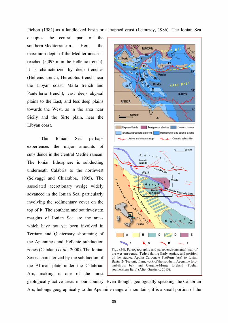
85
Pichon (1982) as a landlocked basin or a trapped crust (Letouzey, 1986). The Ionian Sea
occupies the central part of the
southern Mediterranean. Here the
maximum depth of the Mediterranean is
reached (5,093 m in the Hellenic trench).
It is characterized by deep trenches
(Hellenic trench, Herodotus trench near
the Libyan coast, Malta trench and
Pantelleria trench), vast deep abyssal
plains to the East, and less deep plains
towards the West, as in the area near
Sicily and the Sirte plain, near the
Libyan coast.
The Ionian Sea perhaps
experiences the major amounts of
subsidence in the Central Mediterranean.
The Ionian lithosphere is subducting
underneath Calabria to the northwest
(Selvaggi and Chiarabba, 1995). The
associated accretionary wedge widely
advanced in the Ionian Sea, particularly
involving the sedimentary cover on the
top of it. The southern and southwestern
margins of Ionian Sea are the areas
which have not yet been involved in
Tertiary and Quaternary shortening of
the Apennines and Hellenic subduction
zones (Catalano et al., 2000). The Ionian
Sea is characterized by the subduction of
the African plate under the Calabrian
Arc, making it one of the most
geologically active areas in our country. Even though, geologically speaking the Calabrian
Arc, belongs geographically to the Apennine range of mountains, it is a small portion of the
Fig., (54). Paleogeographic and palaeoenvironmental map of the western-central Tethys during Early Aptian, and position of the studied Apulia Carbonate Platform (Ap) to Ionian Basin. 2- Tectonic framework of the southern Apennine fold-and-thrust belt and Gargano-Murge foreland (Puglia, southeastern Italy) (After Graziano, 2013).
86
Alpine range of mountains, like Corsica and Sardinia (Fig., 54). The superficial expression of
the subduction is the volcanic arc of the Aeolian islands (Doglioni et al., 1999). The Ionian
Abyssal Plain in this region is characterized by differentially subsiding areas but generally
experiences more than adjacent regions, contributing greatly to the uplift associated with the
Alpine orogeny and the Quaternary coastal blocks. The Hellenic trench (a thrust fault linked
to the convergent activity in the Mediterranean ridge) began propagation in Miocene and
continues today; it constitutes a major element of Ionian seafloor topography.
The extensional features in the Ionian region are somewhat subdued, the dominant
tectonic activity is convergent and/or related to vertical movement. Towards the West the
Ionian Sea is bordered by the deep Malta Slope, this 3,000 m drop separates the Ionian Sea
from the Western Mediterranean. Between the two basins is the so-called Pelagian Block, an
offshoot of the African coast that extends between Tunisia and Sicily, forming a submerged
ridge, of which Malta and the Pelagian Islands (Lampedusa and Lampione) are the highest
tops, so high that they emerge from the sea. The Apulia Carbonate Platform (ACP) and the
bounding Ionian Basin (IB) (southeastern Italy) were two major paleogeographic domains of
the Mesozoic-Cenozoic central Tethys. During Aptian times they were located apart from the
European-African landmasses and their related influence (Graziano, 2013)
V.5- The Tyrrhenian Sea
The Tyrrhenian Sea is an almost triangular shaped depression, between Sardinia and
peninsular Italy, and is the youngest of the deep Mediterranean basins. It has a depth of
3,800m and is the deepest of the western basins. The Tyrrhenian Sea is located in the center
of the Mediterranean and it is a small back-arc basin developed behind the east-migrating
Apennine chain. The Tyrrhenian rifting started about 10-12 Ma. A slab rollback mechanisms,
which occurred at different rates between the northern and southern part of the basin, is
commonly invoked to explain, respectively, the counterclockwise eastward migration of the
Apennines and the SE migration of the Calabro-Peloritano arc (Pastore et al., 2011).
Morphologically, it is a deep basin surrounded by sharp and deep slopes, cut by deep
submerged valleys. The Tyrrhenian Sea is the youngest basin in the western Mediterranean,
forming since the Tortonian (~9 Ma). It was opened, according to this reconstruction, as a
result of a southeastward rollback of subduction systems near the margins of the Adriatic
plate (Malinverno and Ryan, 1986) due to the collision of Corsica and Sardinia with the
Apennines at ~18 Ma that led to a relative quiescence in back-arc extension between 18-10
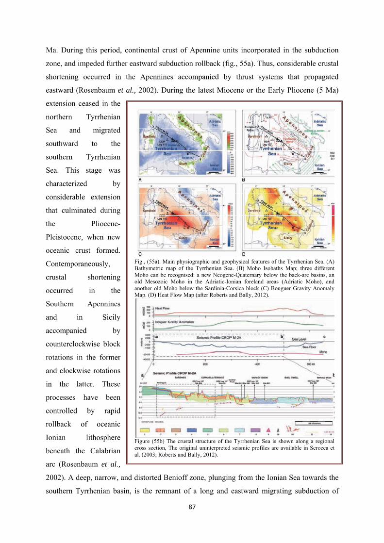
87
Ma. During this period, continental crust of Apennine units incorporated in the subduction
zone, and impeded further eastward subduction rollback (fig., 55a). Thus, considerable crustal
shortening occurred in the Apennines accompanied by thrust systems that propagated
eastward (Rosenbaum et al., 2002). During the latest Miocene or the Early Pliocene (5 Ma)
extension ceased in the
northern Tyrrhenian
Sea and migrated
southward to the
southern Tyrrhenian
Sea. This stage was
characterized by
considerable extension
that culminated during
the Pliocene-
Pleistocene, when new
oceanic crust formed.
Contemporaneously,
crustal shortening
occurred in the
Southern Apennines
and in Sicily
accompanied by
counterclockwise block
rotations in the former
and clockwise rotations
in the latter. These
processes have been
controlled by rapid
rollback of oceanic
Ionian lithosphere
beneath the Calabrian
arc (Rosenbaum et al.,
2002). A deep, narrow, and distorted Benioff zone, plunging from the Ionian Sea towards the
southern Tyrrhenian basin, is the remnant of a long and eastward migrating subduction of
Fig., (55a). Main physiographic and geophysical features of the Tyrrhenian Sea. (A) Bathymetric map of the Tyrrhenian Sea. (B) Moho Isobaths Map; three different Moho can be recognised: a new Neogene-Quaternary below the back-arc basins, an old Mesozoic Moho in the Adriatic-Ionian foreland areas (Adriatic Moho), and another old Moho below the Sardinia-Corsica block (C) Bouguer Gravity Anomaly Map. (D) Heat Flow Map (after Roberts and Bally, 2012).
Figure (55b) The crustal structure of the Tyrrhenian Sea is shown along a regional cross section, The original uninterpreted seismic profiles are available in Scrocca et al. (2003; Roberts and Bally, 2012).
88
eastern Mediterranean lithosphere (Fig., 55b). From Oligocene to Recent, subduction
generated the Western Mediterranean and the Tyrrhenian back-arc basins, as well as an
accretionary wedge constituting the Southern Apenninic Arc (Sartori, 2003).
It communicates with the other basins through 4 passages: a 300-400 m deep channel
puts it in communication with the Ligurian Sea; a wide, 2,000 m deep channel between Sicily
and Sardinia connects it to the Algerian basin; the Boniface Strait (that is max. 50 m deep)
connects it to the Provence basin; and finally, the Strait of Messina is the connection (100 m
deep) with the Ionian Sea. Large volcanic structures, which, for the time being are quiescent,
rise from the sea bottom here. In the Tyrrhenian Sea, stretching started in late Miocene and
eventually produced two small oceanic areas: the Vavilov Plain during Pliocene (in the
central sector) and the Marsili Plain during Quaternary (in the southeastern sector). They are
separated by a thicker crustal sector, called the Issel Bridge. Back-arc extension was rapid and
discontinuous, and affected a land locked area where continental elements of various sizes
occurred. Discontinuities in extension were mirrored by changes in nature of the lithosphere
scraped off to form the Southern Apenninic Arc. Part of the tectonic units of the southern
Apennines, accreted into the wedge from late Miocene to Pliocene, had originally been laid
down on thinned continental lithosphere, which should constitute the deep portion of the
present slab. After Pliocene, only Ionian oceanic lithosphere was subducted, because the large
buoyancy of the wide and not thinned continental lithosphere of Apulia and Africa (Sicily)
preserved these elements from roll back of subduction. After Pliocene, the passively retreating
oceanic slab had to adjust and distort according to the geometry of these continental elements
(Sartori, 2003).
V.6- The Alboran Sea
It extends from the Strait of Gibraltar to the Balearic Basin. Its maximum depth is
1,500 m, that drops to 1,800 m in the Alboran rift that separates it from the Algerian basin. In
the centre there is a small volcanic island, 10 m above sea level that rises from the sea bottom
that is 1,500 m below. This part of the Mediterranean receives the direct influence of the
Atlantic, because it is where the sea water mixes with the ocean water. The water here is
generally colder and less salty and rich with organisms coming from the Atlantic (Ammar et
al., 2007). The total volume of Neogene sediments deposited in these basins is ~209,000 km3
and is equally distributed between the internal (Alboran Basin and intramontane basins) and
the external basins (foreland basins and Atlantic Margin). The largest volumes are recorded
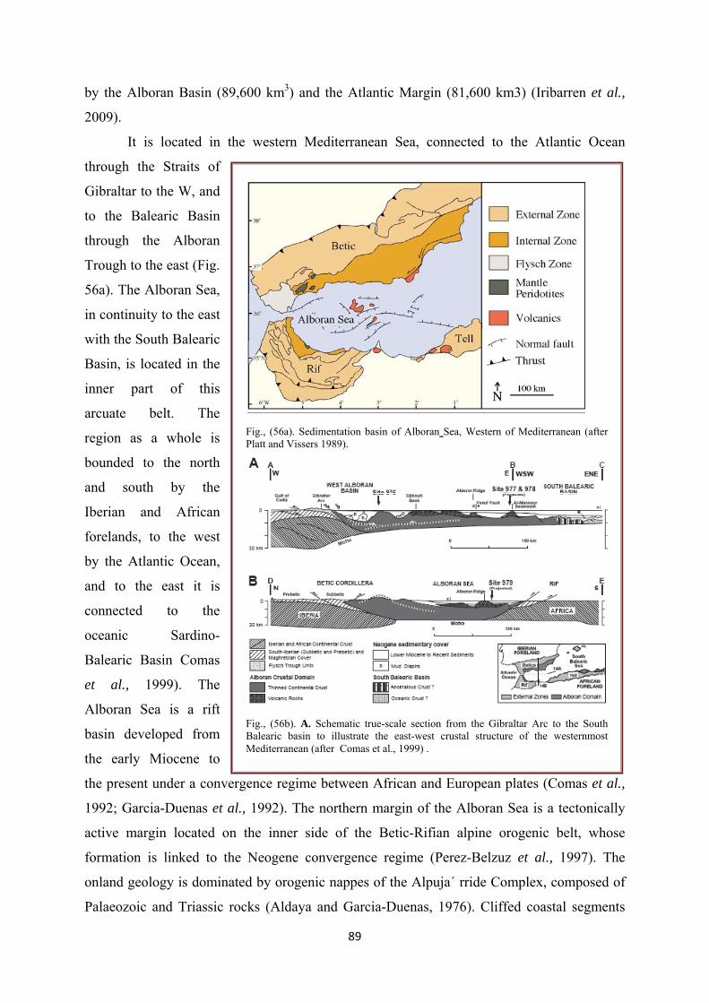
89
by the Alboran Basin (89,600 km3) and the Atlantic Margin (81,600 km3) (Iribarren et al.,
2009).
It is located in the western Mediterranean Sea, connected to the Atlantic Ocean
through the Straits of
Gibraltar to the W, and
to the Balearic Basin
through the Alboran
Trough to the east (Fig.
56a). The Alboran Sea,
in continuity to the east
with the South Balearic
Basin, is located in the
inner part of this
arcuate belt. The
region as a whole is
bounded to the north
and south by the
Iberian and African
forelands, to the west
by the Atlantic Ocean,
and to the east it is
connected to the
oceanic Sardino-
Balearic Basin Comas
et al., 1999). The
Alboran Sea is a rift
basin developed from
the early Miocene to
the present under a convergence regime between African and European plates (Comas et al.,
1992; Garcia-Duenas et al., 1992). The northern margin of the Alboran Sea is a tectonically
active margin located on the inner side of the Betic-Rifian alpine orogenic belt, whose
formation is linked to the Neogene convergence regime (Perez-Belzuz et al., 1997). The
onland geology is dominated by orogenic nappes of the Alpuja´ rride Complex, composed of
Palaeozoic and Triassic rocks (Aldaya and Garcia-Duenas, 1976). Cliffed coastal segments
Fig., (56a). Sedimentation basin of Alboran Sea, Western of Mediterranean (after Platt and Vissers 1989).
Fig., (56b). A. Schematic true-scale section from the Gibraltar Arc to the South Balearic basin to illustrate the east-west crustal structure of the westernmost Mediterranean (after Comas et al., 1999) .

90
occur in the study area due to the proximity of orogenic nappes. Depressed areas are filled
with Plio-Quaternary deposits, represented by alluvial fans at the piedemont of orogenic
nappes and by deltaic deposits (Lobo et al., 2006). Plio-Quaternary sediments in the
Guadalfeo River deltaic plain show high granulometric variability, ranging from medium
sands to gravels, or even boulders. Beaches along the Guadalfeo River prodelta are composed
by sandy sediments and gravels (IGME, 1980).
The formation of the Alboran Sea occurred during the westward migration of the
subduction hinge. Rapid rollback was compensated by wholesale extension in the overriding
continental crust, which was thinned to ~15 km between 23-10 Ma (Lonergan and White,
1997). Contemporaneously, fragments of continental crust were thrust onto the passive
margin of Africa and Iberia (the External Zone), forming rotation patterns consistent with
oblique thrusting derived by the westward rollback of the subduction zone. Final accretion of
the Rif-Betic Cordillera occurred at ~10 Ma (Fig., 56b), when the subduction zone rolled back
as far as Gibraltar. Subduction rollback then ceased, together with the cessation of backarc
extension in the Alboran Sea (Lonergan and White, 1997; Rosenbaum et al., 2002).
Depositional geometries and distribution patterns of shelf sediment wedges mainly
derived from small rivers located in the northern margin of the Alboran Sea, Western
Mediterranean Basin, are reported in this study, in order to understand: (1) their generation
under particular physiographic and climatic conditions of river basins; (2) the interaction of
shallow water wedges with submarine valleys. A high amount of data has been used in this
study, including river discharge and wave climate data, multibeam bathymetry, high-
resolution seismic profiles and surficial sediment samples (Lobo et al., 2006; Ammar et al.,
2007). The basins include the Alboran Sea, the intramontane basins, the Guadalquivir and
Rharb foreland basins and the Atlantic Margin of the Gibraltar Arc.
V.7- The Algerian Basin
This is the vastest basin of the western Mediterranean area. Leaving the Alboran Sea
to the west, it extends with a triangular shape from the Gulf of Valencia to the Ligurian Sea.
Its maximum depth is 2,800 m, near the western coasts of Sardinia. It is characterized in its
most western part, by the large deep sea cone of the Ebro River, where the continental shelf
reaches a width of 60 km (Fig., 57a). Along the northern coasts, up to Genoa, the continental
shelf is practically absent, it is no wider than 3-9 km. The sea bottom descends rapidly to

91
depths over 2,000 m and is
characterized by a number
of submarine canyons that
cut across it. These
canyons carry large
quantities of material from
the erosion of the emersed
land toward the abyssal
depths. The tectonic
evolution of the Algerian
Alpine belt starts during the
Eocene with the subduction
of the Tethyan oceanic
domain (Roca et al., 2004)
in a context of a 15 mm a-1
N-S convergence between
the European and African
plates (Dewey et al., 1989).
Simultaneously, the
opening of the Algerian
basin commences in a
back-arc position and is
associated with the
Tethysian slab roll-back
(Fig., 57b) and possibly
with slab break-off
(Carminati et al., 1998a).
After the splitting of the forearc and closure of the Tethyan ocean, the convergence rate
between the European and African plates decreases to 5 mma-1 and deformation occurs
onshore mostly on S-dipping thrusts progressively sealed by Miocene deposits and volcanic
rocks (Strzerzynski et al., 2010b).
The Algerian margin is affected by a Messinian sea-level fall responsible for subaerial
erosion expressed by fluvial canyons. After the subsequent final sea level rise, the building of
Fig., (57a) Simplified present-day geodynamic scenario of the Central–Western Mediterranean region superimposed on the topography and bathymetry. GL: Giudicarie Lineament; IL: Insubric Line (after Carminati et al., 2012).
Fig. (57b) Representative 6-channel seismic profile across the Algerian margin, east of Algiers, off Dellys, crossing the Sebaou canyon on the slope (see location in figure 1). Top: line drawing of the whole section; bottom: interpreted enlargements of the seismic line. p.q.:Plio-Quaternary deposits, Mess.: Messinian deposits, Ant 1, 2 and 3: anticlines, (After . Strzerzynski et al., 2010b)
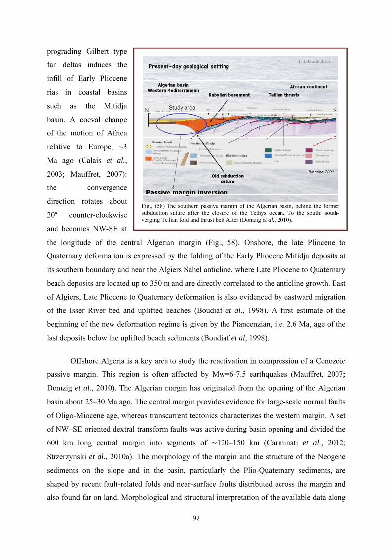
92
prograding Gilbert type
fan deltas induces the
infill of Early Pliocene
rias in coastal basins
such as the Mitidja
basin. A coeval change
of the motion of Africa
relative to Europe, ~3
Ma ago (Calais et al.,
2003; Mauffret, 2007):
the convergence
direction rotates about
20º counter-clockwise
and becomes NW-SE at
the longitude of the central Algerian margin (Fig., 58). Onshore, the late Pliocene to
Quaternary deformation is expressed by the folding of the Early Pliocene Mitidja deposits at
its southern boundary and near the Algiers Sahel anticline, where Late Pliocene to Quaternary
beach deposits are located up to 350 m and are directly correlated to the anticline growth. East
of Algiers, Late Pliocene to Quaternary deformation is also evidenced by eastward migration
of the Isser River bed and uplifted beaches (Boudiaf et al., 1998). A first estimate of the
beginning of the new deformation regime is given by the Piancenzian, i.e. 2.6 Ma, age of the
last deposits below the uplifted beach sediments (Boudiaf et al, 1998).
Offshore Algeria is a key area to study the reactivation in compression of a Cenozoic
passive margin. This region is often affected by Mw=6-7.5 earthquakes (Mauffret, 2007;
Domzig et al., 2010). The Algerian margin has originated from the opening of the Algerian
basin about 25–30 Ma ago. The central margin provides evidence for large-scale normal faults
of Oligo-Miocene age, whereas transcurrent tectonics characterizes the western margin. A set
of NW–SE oriented dextral transform faults was active during basin opening and divided the
600 km long central margin into segments of 120–150 km (Carminati et al., 2012;
Strzerzynski et al., 2010a). The morphology of the margin and the structure of the Neogene
sediments on the slope and in the basin, particularly the Plio-Quaternary sediments, are
shaped by recent fault-related folds and near-surface faults distributed across the margin and
also found far on land. Morphological and structural interpretation of the available data along
Fig., (58) The southern passive margin of the Algerian basin, behind the former subduction suture after the closure of the Tethys ocean. To the south: south-verging Tellian fold and thrust belt After (Domzig et al., 2010).

93
the ~1000 km of the margin leads us to characterize several fault segments with a variable
length and position. In Central Algeria (Algiers region), the main contractional structures are
active blind thrusts (Plio-Quaternary) generally located near the ocean-continent transition
and verging to the north (opposite to preexisting features). They form generally large
asymmetrical folds sub-perpendicular to the present-day convergence direction, which are
often arranged in en echelon segments at different scales. Offshore Boumerdes (east of
Algiers), we show that the faults have typically a flat-and-ramp geometry creating a
succession of perched basins from the mid-slope down to the deep basin, and prograding
towards the basin (Carminati et al., 2012). Although the Messinian salt tectonics and the
sedimentary fluxes at the outlets of canyons play a significant role, the sediment deposition as
well as the morpho-structure of the margin appear to be controlled at first order by these slow-
rate tectonic movements, indicating a clear interaction between crustal-scale tectonics and
sedimentation. We discuss the implications of these results in terms of seismic hazard and
sedimentary architecture (turbidites) in deep environments (Domzig et al., 2010).
The upper Miocene, Plio-Quaternary, and present-day tectonic setting is, however,
compressional and supports the occurrence of a margin inversion, a process still poorly
documented worldwide (Strzerzynski et al., 2010a). The central Algerian margin represents a
rare example of inverted margin, where the process of subduction inception is particularly
well expressed and helps understand how extensional and transtensive structures are involved
in margin shortening (Strzerzynski et al., 2010a). Pre-Miocene structures such as basement
highs and transform faults appear to control changes of the deformation pattern along this part
of the margin, resulting in different widths, geometries, and relative positions of folds and
faults. Plio-Quaternary and active blind thrust faults do not reuse Oligo-Miocene normal and
transform faults during inversion, but instead grow within the continental margin, at the foot
of the continental slope and at the northern sides of basement highs interpreted as stretched
continental blocks of the rifted margin. The inherited structures of the margin appear,
therefore, to determine this deformation pattern and ultimately the earthquake and tsunami
sizes offshore. The complex geometry of the fault system along the Algerian margin suggests
a process of initiation of subduction in its central and eastern parts (Strzerzynski et al.,
2010a).

94
VI- Geothermal Potentials and Uses of the Mediterranean
Geothermal resources are suitable for many different types of uses but are commonly
divided into two categories, high and low enthalpy and according to their energy content.
High enthalpy resources (>150 °C) are suitable for electrical generation with conventional
cycles, low enthalpy resources (<150 °C) are employed for direct heat uses and electricity
generation using a binary fluids cycle (EC, 1999). The large geothermal potential worldwide
available within a few km depth in several on land and marine areas of the Mediterranean Sea
is encouraging investors and enterprises to invest in geothermal exploration for power
generation and for combined heat and power co‐generation.
VI. A- Geothermal potentials
Geothermal energy is the natural heat o f the earth. Immense amounts of thermal
energy are generated and stored in the earth’s core, mantle, and crust. The heat is transferred
from the interior towards the surface mostly by conduction. This heat flow makes
temperatures rise with increasing depth in the crust on average by between 25-30°C/km. An
average thermal gradient o f 30°C/km means that at a depth of 2 km the temperature in the
rocks is around 70°C in areas where there is no volcanic activity and where ground water is
not affecting the thermal gradient (EC, 1999).
The exploitable geothermal resources in the Mediterranean are generally related not to
conductive systems but to convective ones. This means that the heath is brought near the
surface by fluids (mainly waters) flowing vertically from depth toward the surface, so that
sufficiently high temperature may be reached by drilling at economical depth. Geothermal
resources are suitable for many different types of uses and according to their temperature are
commonly divided into two categories, high and low enthalpy. High enthalpy is suitable for
electrical generation with conventional cycles, low enthalpy resources are employed for direct
uses (EC, 1999).
• High temperature resources, used for power generation (with temperatures above
150 °C) are confined to areas geologically active, that is where movements of the earth
crust bring the magma near the surface.
• Low temperature resources which are mainly used for heat production (with
temperatures below 150°C) can, on the other hand, be found in most countries. These
are formed by the deep circulation o f meteoric water along faults and fractures, and by
water residing in high porosity rocks, such as sandstone and limestone, at sufficient
depths for the water to be heated by the Earth's geothermal gradient.

95
A.1- Geothermal Resources in Foreland Environments:
Geothermal resources are commonly confined where high heat flow (> 70 mW/m2) is
recorded and extension controls the tectonic evolution, determining diffuse fracturing in
rocks, underneath an impervious cover. Nevertheless, areas with low heat flow and located in
foreland tectonic settings can be also affected by geothermal manifestations, although in
spot‐areas and with low temperature (about 25‐28°C) geothermal fluids, as it is the case of the
Santa Cesare Terme zone, located in the Apulia carbonate platform, the foreland of the
southern Apennines (Cretaceous‐Pleistocene). The platform is constituted of a
Jurassic‐Cretaceous succession, thick more than 5 km in the study area, and believed to rest
over the Late Triassic evaporite (Burano Fm). Oligocene‐Pleistocene calcareous and
terrigeneous sediments rest unconformably over the Platform. The area is deformed by
transtensional structures, thus determining extensional jogs and pull‐apart structures where the
permeability is enhanced. It is therefore concluded that along these almost vertical structural
channels the upflow of deep fluids, heated through the thermal gradient normally typifing
foreland areas (Liotta, 2012).
A.2- Thermal Coastal Springs:
Carbonate aquifers represent important thermal water resources outside the volcanic
areas, supplying spans or geothermal installations. The thermal springs constitute so the
discharge areas of the deep groundwater flowing within these carbonate aquifers whose
hydraulic conductivity and the relevant geothermal fluid migration are strictly controlled by
both the discontinuities network and the karsification processes. An example of these springs
occurs along the south‐easternmost portion of the Apulia region (Southern Italy) where some
sulphurous and warm waters (25‐33°C) flow out in partially submerged caves located along
the coast, supplying so the spas of Santa Cesarea Terme. These springs are known from
ancient times (Aristotele in III century BC) and the physical‐chemical features of their
thermal waters resulted to be partly influenced by the sea level variations (Polemio et al.,
2012). In Morocco there are several geothermal anomalies and thermal clues, with occurrence
of numerous hot springs and important deep aquifers; thus it could be considered as a real
geothermal promising country. Measured temperature of hot springs ranges from 21 to 54°C
and disharge rates from 2.5 to 40 l/s. Geothermometers applied are: silica, Na/K, Na-K-Ca,
Na-K-Ca-Mg, Mg/Li and Na/Li (Zarhloule, 2003).

96
VI. B- Geothermal Uses
The direct use o f geothermal energy can involve a wide variety of applications
including the geothermal heat pumps. In most industrialised countries, a significant
percentage of the energy consumption is devoted to heat production at temperatures of 50-100
°C, which are common in low-enthalpy geothermal areas. Most of this energy is supplied by
the burning o f oil, coal or gas at much higher temperatures. The scope for using geothermal
water alone as well as in combination with other local sources of energy is therefore very
large (EC, 1999).
The direct use o f geothermal energy is at a relatively advanced stage in European
countries compared with other parts of the world. It supplies a wide range of applications and
uses due to the versatility and demand for base-load heat demand plus the availability o f the
resource. European countries have been pioneers in the exploitation of geothermal resources.
European experience and expertise in this sector has been duplicated by other countries
world-wide. However, European operators should still be in a position to maintain their
leading role in the development and utilisation o f geothermal energy for both direct use and
for electricity production (EC, 1999).
B.1- Electrical production
Italy has been the first country to exploit geothermal energy for electrical production, starting
in early 20th century in Larderello, Tuscany. One century after, a large electrical production
(about 6000 GWh per year, with an installed power of about 800 MW). A sound and careful
program of geothermal exploitation of existing resources in Italy could lead, in a period of
10‐20 years, to increase geothermal‐electrical production of a factor 2 to 5, possibly
increasing its contribution to the total budget from the present 2% up to 10% (De Natale et
al., 2012).
Germany, Geothermal power generation is done through the use of binary cycle technology.
Since November 2003, a ca. 0,2 MWe pilot power plant using this process is exploited at
Neustadt-Glewe and another twenty megawatts (4 or 5 power plants) is currently in the
planning and construction stage, chiefly in Southern Bavaria. The most advanced project is
that of Unterhaching (Antics and Sanner 2007).
Geothermal electricity production in Iceland has increased significantly since 1999, with the
installation of new plants in Svartsengi, Krafla and Nesjavellir, up to the present value of 202
MW. An additional 30 MW single flash unit at Nesjavellir is at an advanced stage of
construction (Ragnarsson, 2005; Gunnlaugsson, 2003).
97
In Portugal, exploitation of geothermal energy to produce electricity has been developed on
the volcanic archipelago of the Azores, or more precisely on the Sao Miguel Island. This
island has five geothermal power plants achieving a total capacity of 16 MWe (Antics and
Sanner 2007).
The electricity generation in Turkey has been increased to 30 MWe with the addition of the
Aydin-Salavatli binary cycle geothermal power plant, adding a 10 MWe installed capacity to
the existing Kizildere geothermal power plant (20 MWe installed capacity) (Mertoglu et al,
2007).
France started up its second geothermal power plant in 2004 on the Bouillante site, i.e. an
additional 10 MW (14.7 MWe in total), that could produce an additional 72 GWh per year.
Furthermore, the Bouillante 3 feasibility study, launched in 2003, could result in a third power
plant with more than 10 MWe capacity (Antics and Sanner 2007).
V- Mineral Resources in the Mediterranean Region V.1- Organic minerals (Oil – Natural Gas – Coal)
1. A- Oil and natural Gas resources
A.1- Lavantine basin
Assessment of undiscoverable gas resources of the Lavantine basin province (East
Mediterranean) using current technology were estimated by the USGS (U.S. Geological
Survey) to be about 3.5 tcm (trillion cubic meters) of gas. Already in the Israeli E.E.Z.
(Exclusive Economic Zone) an amount of 800 bcm (billion cubic meters) has discovered in
the fields of Marie B, Gaza Marine. In the Cypriot part of the Levant basin, the estimated
amount of gas reserves around 300 bcm. In the Nile delta and the E.E.Z. of the Cyprus
Republic USGS has estimated a natural gas potential of 6.3 tcm, besides the 2.2 tcm of gas
and 1.7 Bbbl (Billion barrels) of oil already discovered in the Egyptian E.E.Z. Out of the 6.3
Tcm. These estimated resources are comparable to some other large gas provinces
encountered in the world. In the same region, crude oil potential reserves of about 1.7 Bbbl of
oil and about 6 Bbbl of gas condensate are also estimated by USGS to exist (Bruneton et al.,
2011).
A.2- Adriatic Sea
During the geological period from Triassic until Upper Lias, Dinarides and Apulian
platform formed one consistent unit. Since Upper Lias until the end of Upper Cretaceous, due
to paleo-tectonic influence, this consistent platform was separated by Adriatic Basin called

98
’Scaglia-Biancone Basin’ with pelagic and hemi-pelagic younger Mesozoic deposits and
during Tertiary with clastic sediments of flysch and molasse type. Platforms are divided from
the basins by steep offshore slopes where periplatform carbonates clastics and turbidites were
sedimented. Due to the obvious analogy between Apulian and Dinarides slopes and their
petroleum-geological characteristics (Grandic and Kolbah 2009). The separation episode on
the Italian side is characterized by Rosso Ammonitico stratigraphic horizon which in the
Dinarides corresponds to ’Spotted limestone’ formation in the top of Lithiotis deposits.
However, the term Adriatic carbonate platform (Veli, et al. 2002; Vlahovi, et al. 2002;
Vlahovi, et al. 2005) has been used lately for offshore and onshore part of carbonate
sediments which were formed in the period from Triassic to Paleogene (Grandic and Kolbah
2009).
A.3- Neogene petroleum system at Alboran - Algerian Basins
The Algerian offshore is part of the southern margin of the western Mediterranean
Sea. The western part of this offshore area represents the transitional margin between the
South Algero-Balearic Basin and the Alboran Basin. The Yusuf-Habibas Ridge is a major
EW-striking structure of this complex plate boundary, separating the eastern and southern
parts of the Alboran Basin from the South Algero-Balearic Basin. The ridge played an
important role during the Neogene Alboran westward block migration between the Africa and
Iberia plates, while the Kabylies blocks migrated southward and accreted to Africa. Three
main reservoirs are recognized in the Habibas well sedimentary section: (1) sandstones in the
Pliocene, above the Messinian evaporites; (2) sandstones in the Middle-to-Upper Miocene,
below the Messinian evaporites; and (3) carbonates and sandstones in the older allochthonous
units (Medaouri et al., 2012).
1.B- Coal Bearing Formations
Turkey: During the period Neogene to Quaternary, several lacustrine basins developed in
Turkey. These basins are generally characterised by volcanic-sedimentary successions. These
basins are characterized by important fossil–fuel and industrial–mineral resources such as
lignite, oil shale, clays, borates and zeolites (Sener et al 1995; Sener and Gundogdu 1996).
The coal-bearing Hirka Formation was deposited over the Galatian Andesitic Complex and/or
massive lagoonal environments during the Miocene (Sener, 2007). The lignite-bearing
Yoncalı formation was found between Yozgat and Sorgun, in central Anatolia (Akkiraz et al.,

99
2008).The Middle–?Upper Eocene Yoncalı formation dominantly consists of continental and
shallow marine sediments containing basal conglomerate and fine-grained sediments at the
base. These fine-grained sediments are overlain by flysch-like sediments including
fossiliferous reef limestone lenses. Coal seams occur in the lowest part of the unit and are
intercalated with sandstone and mudstone layers (Akkiraz et al., 2008).
V.2- Inorganic mineral resources
Turkey: During the period Neogene to Quaternary, several lacustrine basins developed in
Turkey. The Neogene basins were filled by clayey, carbonaceous and sandy sediments, and
also by explosive products of contemporaneous K-rich calc-alkaline volcanism with various
degrees of crustal contamination (Yılmaz 1989; Gulec 1991; Inci 1991; Gundogdu et al.,
1996).The mineral matter of the basins are mainly clay minerals (illite–smectite and
kaolinite), plagioclase and quartz in Bolu coal field, clay minerals (illite–smectite, smectite
and illite), quartz, calcite, plagioclase and gypsum in Seben coal field, quartz, K-feldspar,
plagioclase and clay minerals (kaolinite and illite), dolomite, quartz, clinoptilolite, opal and
gypsum (Sener, 2007). Italy: Supercritical Fluids in Geothermal Systems: Information from Fluid Inclusions
Trapped in Minerals of the Larderello Geothermal Field and from the Study of Fossil,
Magmatic‐Related, Hydrothermal Systems of Southern Tuscany:
At Larderello, the possible occurrence of a high‐temperature fluid phase below the
vapor-dominated reservoirs hosted within metamorphic and sedimentary rocks, is suggested
by the occurrence at about 3‐5 km depth by the abundant fragments of quartz–tourmaline
veins erupted by a geothermal well. Some of the fluids could escape from K‐horizon through
crustal shear zones, which are interpreted to be generated by the extensional tectonic events
(Early, Middle Miocene ‐ Present). These events affected the inner Northern Apennines after
collisional tectonics (Cretaceous‐Late Oligocene, Early Miocene), and determined the
thinning of the crust and the lithosphere to the present thickness values of about 22 and 30
km, respectively. Extensional tectonics was coeval with the emplacement of shallow‐level
igneous intrusions since early Miocene (Corsica) and progressively shifted eastward. These
intrusions, at Larderello are testified by the Pliocene‐Quaternary peraluminous leucogranites
and monzogranites found in several deep wells (between 2.5 and 4.5 km depth) with
significant fluorine and boron content, and their thermometamorphic aureoles (Rocchi et al.,
2010).
100
Fluid inclusion studies on granites and thermometamorphic rocks found in Larderello
geothermal wells indicate the occurrence of three nearly coeval fluids which could record the
conditions within a past K‐horizon: 1) Na‐Li‐rich brines, probably exsolved from granites
during crystallization, 2) high‐saline fluids and aqueous vapours produced by boiling of the
Na‐Li brines and 3) aqueous‐carbonic fluids (H2O+CO2±CH4±N2), and formed as a
consequence of de‐hydration processes and graphite‐water interaction during heating of the
Paleozoic metamorphic (sometimes C‐rich) rocks (Boiron et al., 2007). Interpretation of fluid
inclusion data alone, or combined with contact metamorphic mineral equilibria, indicates that
the early fluids were trapped at high temperatures (≥420°C) under infra‐lithostatic or
lithostatic pressure conditions. Evidence for boron metasomatism and veining (tourmaline
precipitation), occurring at the contact between the granites and schistose metamorphic
basement in the eastern sector of Elba Island, are also present at Larderello, and in particular
testified in the K‐horizon by the quartz‐tourmaline veins fragments erupted by a geothermal
well (Dini et al., 2008). Moreover, eastern Elba is characterized by cataclastic level,
associated to a significant network of mineralized Fe‐ and quartz veins (Ruggieri et al., 2012).
Spain: Th- and U-bearing minerals, which were recently found in the SE Mediterranean
margin of Spain. These minerals are REE phosphates (mainly monazite) which occur as
amoeboidal-to-elongate inclusions, from around 10 μm to 120 μm, hosted in single garnet
crystals from dacite lavas and metamorphic rocks from the El Hoyazo Volcanic Complex. Th
and U contents are higher than 1 wt%, with 3.04 to 5.62 wt % for ThO2, and 0.7 to 1.75 wt%
for UO2. Both elements are also found in xenotime (ThO2: 0.24, UO2: 0.27 wt%). Given that
the erosion of the volcanic source rocks has generated a "placer-type" deposit of monazite
sands and that garnets (main carriers of monazite) are being commercialised, an
environmental monitoring and management plan should be urgently executed in the area
(Martinez-Frias et al., 2004).
Bulgaria and Greece: Hydrothermal ore deposits related to post-orogenic extensional
magmatism and core complex formation
The Rhodope Massif in southern Bulgaria and northern Greece hosts a range of Pb–
Zn–Ag, Cu–Mo and Au–Ag deposits in high-grade metamorphic, continental sedimentary and
igneous rocks. Following a protracted thrusting history as part of the Alpine–Himalayan
collision, major late orogenic extension led to the formation of metamorphic core complexes,
block faulting, sedimentary basin formation, acid to basic magmatism and hydrothermal
activity within a relatively short period of time during the Early Tertiary. Large vein and

101
carbonate replacement Pb–Zn deposits hosted by high-grade metamorphic rocks in the
Central Rhodopean Dome (e.g., the Madan ore field) are spatially associated with low-angle
detachment faults as well as local silicic dyke swarms and/or ignimbrites. Ore formation is
essentially synchronous with post-extensional dome uplift and magmatism, which has a
dominant crustal magma component according to Pb and Sr isotope data. Intermediate- and
high sulphidation Pb–Zn–Ag–Au deposits and minor porphyry Cu–Mo mineralization in the
Eastern Rhodopes are predominantly hosted by veins in shoshonitic to high-K calc-alkaline
volcanic rocks of closely similar age. Base-metal-poor, high-grade gold deposits of low
sulphidation character occurring in continental sedimentary rocks of synextensional basins
show a close spatial and temporal relation to detachment faulting prior and during
metamorphic core complex formation (Marchev et al., 2005).

102
CHAPTER V
EGYPT
(Genius of the Place)
1- Sedimentary Basins of Egypt
Egypt, located in the northeastern corner of the African continent, is bounded to the
east by the Red Sea and by what has been interpreted as a median spreading center in the Red
Sea and Gulf of Suez (McKenzie et al., 1970). Such a tectonic setting suggests that this area
may be suitable for geothermal development. The far northern end of the Red Sea is divided
into two parts by the Sinai Peninsula: the Gulf of Suez in the west, and the Gulf of Aqaba in
the east. Egypt can be subdivided into five major morpho-structural units; 1) the
Mediterranean Fault Zone, 2) a belt of linear uplifts and half-grabens, 3) the North Sinai Fold
Belt “Syrian Arc”, 4) the Suez and Red Sea Graben, and 5) the intracratonic basins of
southern Egypt (Sestini, 1995) (Fig., 59). Pre-Cambrian basement rocks outcrop in South
Sinai, the Red Sea Mountains, at Aswan and near Sudan. The sedimentary section overlying
the basement, 1-3 km in the south (Kharga Oasis), thickens northwards to 5-6.5 km near the
Mediterranean, but with notable irregularities in the basinal areas (e.g. 10-13 km in Abu
Gharadig Basin versus 3 km on the Ras Qattara Ridge at its north margin). The distribution of
sedimentary facies follows a simple north-south trend: sands increase in percentage and grade
from shallow marine to predominantly continental (including coals) towards the south,
whereas carbonate rocks are more common in the north, except in the stratigraphic intervals
that correspond to southwards transgressions (Sestini, 1995; El Diasty et al., 2012).
1.1- Nile Delta
The Nile Deep-Sea Fan (NDSF) forms a thick sedimentary wedge covering about
100,000 km2, constructed, for the most part, since the late Miocene by influx of clastic
sediments from the Nile River (Dolson et al., 2000). The present day NDSF covers a segment
of an older passive margin thought to have formed during successive rifting episodes in
Jurassic and early Cretaceous times (Hirsch et al., 1995). According to Aal et al. (2001) and
Mascle et al. (2003), the total thickness of sediments on the Egyptian margin (including the
post-Miocene NDSF) could exceed 9 km (Loncke et al., 2006).
The geodynamic framework of the eastern Mediterranean and its surroundings is
characterized by a complex pattern of active, thick-skinned, crustal-scale tectonics (Mascle et
al., 2000; McClusky et al., 2000), resulting from interactions between various tectonic plates

103
and microplates.
Geodynamic features
surrounding the region are
(a) in the southeast, the
almost-aborted Suez Rift; (b)
in the east and northeast, the
Dead Sea/Levant and East
Anatolian Fault zones related
to the motion of the Arabian
plate with respect to Africa;
(c) northward, along the
eastern Hellenic and Cyprus
arcs, the subduction/collision
of Africa beneath Europe and
the rapidly moving Aegean–
Anatolian microplate; and (d)
the Egyptian margin, a
passive margin of Mesozoic
age that may have been
reactivated partly during
Miocene rifting of the Suez–
Red Sea Rift system (Mascle
et al., 2000). In this tectonic
framework, sediments of the
NDSF drape onto the former
Egyptian passive margin and
reach north to the subducting
Tethyan oceanic domain. The
distal parts of the NDSF, however, have not yet reached the Hellenic and Cyprus arcs: its
western edge feeds the accretionary Mediterranean Ridge (MR), whereas its eastern corner is
bounded by an almost flattopped, subcircular seamount (Eratosthenes Seamount, hereafter
referred to as ‘ESM’). This bathymetric high is interpreted to have a continental origin,
having been rifted away from the African/Levant domain during the Mesozoic. It is currently
colliding against the island of Cyprus (Robertson et al., 1995; Guiraud and Bosworth, 1999).
Fig., (59) Geological maps of Egypt.

104
According to Abdel Aal et al. (2000) and Samuel et al. (2003), two major fault trends
characterize the offshore NDSF. The Temsah trend (oriented NW–SE) and the Rosetta trend
(oriented NE–SW to ENE–WSW) are both thought to be inherited from the Mesozoic rifting
phase (Loncke et al., 2006). The structural elements affecting the northern margin of Egypt,
including the Nile Delta, were formed during the tectonic evolution of the southern part of
Eastern Mediterranean basin (Abdel Aal et al., 2001; Abd-Allah, 2008). This region
represents the Northeast African continental margin that is covered by the Nile Delta
sediments. Likes the other deltas in the World, the largest Nile Delta has attached attentions
of several hydrocarbon companies. The pre-existing faults were reactivated during the
evolution of the Nile Delta by two tectonic events. These events took place during the Late
Miocene–Early Pliocene and Late Pliocene–Early Pleistocene times and were coeval with two
falls in the sea level pattern. The thickness of the Pliocene-Recent sediments and the location
of the pre-existing faults controlled these reactivations. The mechanical contrast of these
sediments and fault displacements controlled the geometry of the reactivated faults. The
northwest sinking (bending) of the outer part of the African continental margin under the
Eurasian plate at the Hellenic subduction Arc has induced a tangential northwest trending
extension (Abd-Allah et al., 2012).
1.2- Eastern Desert
The Eastern Desert of Egypt constitutes the northwestern end of the Nubian segment
of the Arabian-Nubian Shield. The ophiolitic rocks of the Arabian-Nubian Shield have supra-
subduction geochemical signatures (Stern et al., 2004), but Zimmer et al. (1995) reported the
occurrence of mid-ocean ridge (MOR) ophiolite in the Gerf area in the southern Eastern
Desert. The supra-subduction signature of the ophiolites in the Eastern Desert led to further
debate on whether they were formed in a back-arc setting (El-Sayed et al., 1999; Farahat et
al., 2004) or in a forearc setting during subduction initiation (Azer and Stern, 2007; Khalil
and Azer, 2007). Azer and Stern (2007) proposed that the Neoproterozoic ophiolites of the
Eastern Desert were formed in a forearc setting based on the depleted nature of the
serpentinized mantle rocks. Although their conclusion is consistent with other Arabian-
Nubian Shield ophiolitic mantle units (Stern et al., 2004), alternative geodynamic settings
have been proposed for the upper-mantle peridotites of the Central Eastern Desert. Khalil
(2007) inferred a mid-ocean ridge tectonic setting for the mantle rocks of Wadi Ghadir
ophiolite in the Eastern Desert. Ophiolitic gabbros and pillow lavas in the Central Eastern
Desert were interpreted as remnants of oceanic crust formed in a back-arc basin (Farahat et
al., 2004; Abd El-Naby and Frisch, 2006; Abd El-Rahman et al., 2009).
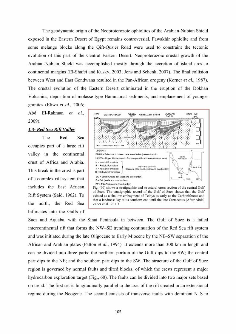
105
The geodynamic origin of the Neoproterozoic ophiolites of the Arabian-Nubian Shield
exposed in the Eastern Desert of Egypt remains controversial. Fawakhir ophiolite and from
some mélange blocks along the Qift-Qusier Road were used to constraint the tectonic
evolution of this part of the Central Eastern Desert. Neoproterozoic crustal growth of the
Arabian-Nubian Shield was accomplished mostly through the accretion of island arcs to
continental margins (El-Shafei and Kusky, 2003; Jons and Schenk, 2007). The final collision
between West and East Gondwana resulted in the Pan-African orogeny (Kornِer et al., 1987).
The crustal evolution of the Eastern Desert culminated in the eruption of the Dokhan
Volcanics, deposition of molasse-type Hammamat sediments, and emplacement of younger
granites (Eliwa et al., 2006;
Abd El-Rahman et al.,
2009).
1.3- Red Sea Rift Valley
The Red Sea
occupies part of a large rift
valley in the continental
crust of Africa and Arabia.
This break in the crust is part
of a complex rift system that
includes the East African
Rift System (Said, 1962). To
the north, the Red Sea
bifurcates into the Gulfs of
Suez and Aquaba, with the Sinai Peninsula in between. The Gulf of Suez is a failed
intercontinental rift that forms the NW–SE trending continuation of the Red Sea rift system
and was initiated during the late Oligocene to Early Miocene by the NE–SW separation of the
African and Arabian plates (Patton et al., 1994). It extends more than 300 km in length and
can be divided into three parts: the northern portion of the Gulf dips to the SW; the central
part dips to the NE; and the southern part dips to the SW. The structure of the Gulf of Suez
region is governed by normal faults and tilted blocks, of which the crests represent a major
hydrocarbon exploration target (Fig., 60). The faults can be divided into two major sets based
on trend. The first set is longitudinally parallel to the axis of the rift created in an extensional
regime during the Neogene. The second consists of transverse faults with dominant N–S to
Fig. (60) shows a stratigraphic and structural cross section of the central Gulf of Suez. The stratigraphic record of the Gulf of Suez shows that the Gulf existed as a shallow embayment of Tethys as early as the Carboniferous and that a landmass lay at its southern end until the late Cretaceous (After Abdel Zaher et al., 2011)
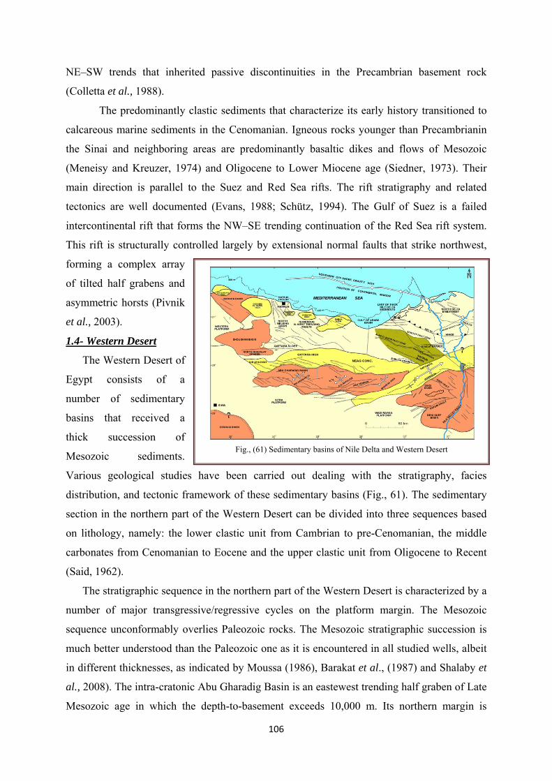
106
NE–SW trends that inherited passive discontinuities in the Precambrian basement rock
(Colletta et al., 1988).
The predominantly clastic sediments that characterize its early history transitioned to
calcareous marine sediments in the Cenomanian. Igneous rocks younger than Precambrianin
the Sinai and neighboring areas are predominantly basaltic dikes and flows of Mesozoic
(Meneisy and Kreuzer, 1974) and Oligocene to Lower Miocene age (Siedner, 1973). Their
main direction is parallel to the Suez and Red Sea rifts. The rift stratigraphy and related
tectonics are well documented (Evans, 1988; Schütz, 1994). The Gulf of Suez is a failed
intercontinental rift that forms the NW–SE trending continuation of the Red Sea rift system.
This rift is structurally controlled largely by extensional normal faults that strike northwest,
forming a complex array
of tilted half grabens and
asymmetric horsts (Pivnik
et al., 2003).
1.4- Western Desert
The Western Desert of
Egypt consists of a
number of sedimentary
basins that received a
thick succession of
Mesozoic sediments.
Various geological studies have been carried out dealing with the stratigraphy, facies
distribution, and tectonic framework of these sedimentary basins (Fig., 61). The sedimentary
section in the northern part of the Western Desert can be divided into three sequences based
on lithology, namely: the lower clastic unit from Cambrian to pre-Cenomanian, the middle
carbonates from Cenomanian to Eocene and the upper clastic unit from Oligocene to Recent
(Said, 1962).
The stratigraphic sequence in the northern part of the Western Desert is characterized by a
number of major transgressive/regressive cycles on the platform margin. The Mesozoic
sequence unconformably overlies Paleozoic rocks. The Mesozoic stratigraphic succession is
much better understood than the Paleozoic one as it is encountered in all studied wells, albeit
in different thicknesses, as indicated by Moussa (1986), Barakat et al., (1987) and Shalaby et
al., 2008). The intra-cratonic Abu Gharadig Basin is an eastewest trending half graben of Late
Mesozoic age in which the depth-to-basement exceeds 10,000 m. Its northern margin is
Fig., (61) Sedimentary basins of Nile Delta and Western Desert

107
known as the Qattara Ridge (where the depth to basement is about 3300 m); while to the
south it is bounded by the Sitra Platform. The basin is divided into northern and southern sub-
basins by an eastewest trending horst (EGPC, 1992). The structure at the Abu Gharadig Field
is a faulted, asymmetric
anticline, which was
formed during the Late
Cretaceous-Early Tertiary
(Abdel Aal and Moustafa,
1988).
The sedimentary
section of the Western
Desert ranges from Early
Paleozoic to Recent. Four
major sedimentary cycles
occurred, with maximum,
southward transgression in
Carboniferous, Upper
Jurassic, Middle and Late
Cretaceous, Middle
Miocene and Pliocene time
(Schlumberger, 1984). In
the unstable shelf area, the
lithostratigraphic column
of the overlying series
maybe subdivided into three sequences. First the lower clastic unit, from Cambrian to
Cenomanian, second the middle carbonates, from Turonian to Eocene and finally the upper
clastic unit, from Oligocene to Recent (Fig., 62). In the northwestern corner of the Western
Desert along the Libyan border a NeS trending synclinorium (Siwa Oasis - Faghur) has been
delineated with a Paleozoic section of some 3000 m thickness; mostly continental to shallow
marine sandstones, siltstones and shales, with thin intercalations of carbonates (El Diasty et
al., 2012).
Throughout Mesozoic time, continental environments prevailed over the Western Desert
south of Latitude 28⁰N. The Lower Jurassic, Wadi Natrun Formation consists of lagoonal
deposits; alternating with dense limestone, green shales and dolomite. Middle-Late Jurassic
Fig., (62) geological sequences comparison in the different localities of Egypt

108
rocks are represented by the Khatatba Formation, a thick carbonaceous shale sequence, with
interbedded porous sandstone, coal seams and limestone streaks (Jenkins, 1990; Keeley and
Wallis, 1991). Basinwards, the Khatatba Formation grades into the time equivalent Masajid
Formation, made up of platform carbonates, including oolitic, reefal and dolomitic limestones
with cherty intervals (Schlumberger, 1984). A widespread unconformity is recorded at the
Jurassic-Cretaceous boundary. The Lower Cretaceous clastic series correspond to a
transgressive cycle, with fluvio-continental sediments at the beginning (Neocomian) and at
the end (Late Albian-Early Cenomanian) with a transitional near-shore to deltaic depositional
environment during Early Aptian and Albian. The Late Cenomanian-Turonian Abu Roash
Formation consists of an alternation of dolomitized calcarenites, shale and sandstones; the
carbonates become more abundant and thicker northwards. The top of the Western Desert
sequence is mostly formed by terrigenous clastics, the Late Eocene-Oligocene Dabaa
Formation (200e400 m, max. 825 m) marine shales, and the Late Oligocene to Early Miocene
Moghra Formation, 200e970 m, mainly sandstones, fluvio-marine, lagoonal to shallow marine
upwards (Sestini, 1995; El Diasty et al., 2012).
2- Geothermal Regime of Egyptian Basins
The thermal data at the eastern part of Egypt indicate that the geothermal situation of
the Red Sea is more complex and broader than the Gulf of Suez. Observations near to the
axial trough of the Red Sea have a mean of 470mWm2 that typical associated with an active
spreading center. Whereas a mean of 116mWm2 was recorded near the coast of the northern
Red Sea (Boulos, 1990) that is appropriate with the estimated values at the Gulf of Suez.
According to Hosney (2000), two heat flow provinces were distinguished: 1- the west of Nile-
north of Egypt normal province with low heat flow about 46 mWm-2 and reduced heat flow of
20 mWm-2 typical of Precambrian platform tectonic setting and 2- the eastern Egypt
tectonically active province with heat flow up to 80-130 mWm-2 including the Gulf of Suez
and the northern Red Sea Rift System with reduced heat flow of > 30-40 mWm-2 , at the
transition between the two provinces. Chemical and isotopic analyses of thermal waters of the
main hot springs in the areas around the Gulf of Suez were performed by Sturchio and
Arehart (1996). The preliminary heat flow values ranging from 42 to 175 mW m-2 have been
estimated for Egypt from numerous geothermal gradient determinations with a reasonably
good geographical distribution, and a limited number of thermal conductivity determinations.
For northern Egypt and the Gulf of Suez, gradients were calculated from oil well bottom hole
temperature data; east of the Nile, and at three sites west of the Nile, gradients were calculated
from detailed temperature logs in shallow boreholes. With one exception, the heat flow west
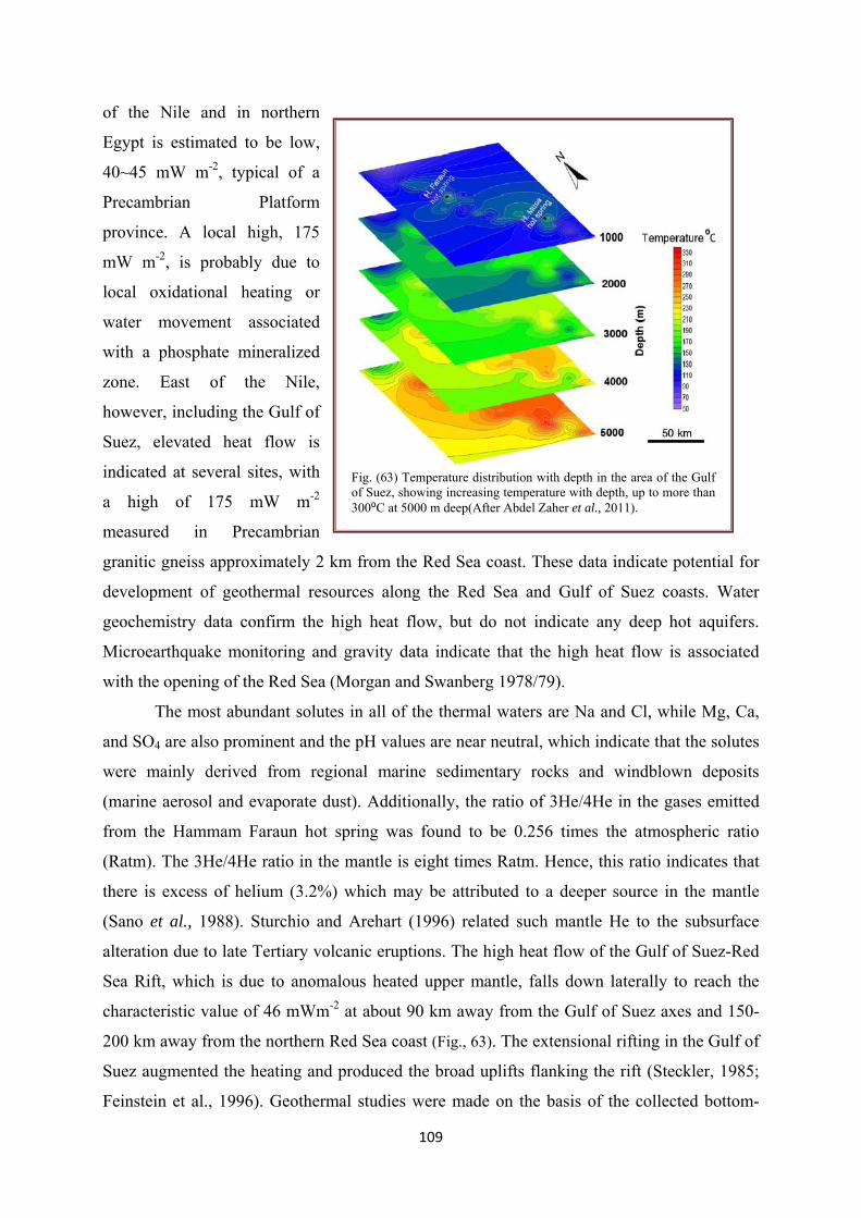
109
of the Nile and in northern
Egypt is estimated to be low,
40~45 mW m-2, typical of a
Precambrian Platform
province. A local high, 175
mW m-2, is probably due to
local oxidational heating or
water movement associated
with a phosphate mineralized
zone. East of the Nile,
however, including the Gulf of
Suez, elevated heat flow is
indicated at several sites, with
a high of 175 mW m-2
measured in Precambrian
granitic gneiss approximately 2 km from the Red Sea coast. These data indicate potential for
development of geothermal resources along the Red Sea and Gulf of Suez coasts. Water
geochemistry data confirm the high heat flow, but do not indicate any deep hot aquifers.
Microearthquake monitoring and gravity data indicate that the high heat flow is associated
with the opening of the Red Sea (Morgan and Swanberg 1978/79).
The most abundant solutes in all of the thermal waters are Na and Cl, while Mg, Ca,
and SO4 are also prominent and the pH values are near neutral, which indicate that the solutes
were mainly derived from regional marine sedimentary rocks and windblown deposits
(marine aerosol and evaporate dust). Additionally, the ratio of 3He/4He in the gases emitted
from the Hammam Faraun hot spring was found to be 0.256 times the atmospheric ratio
(Ratm). The 3He/4He ratio in the mantle is eight times Ratm. Hence, this ratio indicates that
there is excess of helium (3.2%) which may be attributed to a deeper source in the mantle
(Sano et al., 1988). Sturchio and Arehart (1996) related such mantle He to the subsurface
alteration due to late Tertiary volcanic eruptions. The high heat flow of the Gulf of Suez-Red
Sea Rift, which is due to anomalous heated upper mantle, falls down laterally to reach the
characteristic value of 46 mWm-2 at about 90 km away from the Gulf of Suez axes and 150-
200 km away from the northern Red Sea coast (Fig., 63). The extensional rifting in the Gulf of
Suez augmented the heating and produced the broad uplifts flanking the rift (Steckler, 1985;
Feinstein et al., 1996). Geothermal studies were made on the basis of the collected bottom-
Fig. (63) Temperature distribution with depth in the area of the Gulf of Suez, showing increasing temperature with depth, up to more than 300⁰C at 5000 m deep(After Abdel Zaher et al., 2011).

110
hole temperature logs of 103 deep oil wells in the Gulf of Suez, with depths ranging from
2000 to 4500 m. The blanketing effect of the overburden allows sediments to heat by
conduction that causing to increase the pressure and temperature of the deeper parts of the
earth. Thus, there is big difference in temperature between the surface and subsurface strata
which leads to produce high value of temperature gradient (Abdel Zaher et al., 2011).
The thermal data at the eastern part of Egypt indicate that the geothermal situation of
the Red Sea is more complex and broader than the Gulf of Suez. Observations near to the
axial trough of the Red Sea have a mean of 470mWm2 that typical associated with an active
spreading center. Whereas a mean of 116mWm2 was recorded near the coast of the northern
Red Sea (Boulos, 1990) that is appropriate with the estimated values at the Gulf of Suez.
2.1- Geothermal reservoirs in the Hammam Faraun and Hammam Musa regions
A heat source, a reservoir, and a fluid represent the main elements in any geothermal
system. The reservoir is a volume of permeable rocks from which the circulating fluids
extract the heat. In the majority of cases the geothermal fluid is meteoric water, though
systems near the coast may be fed by both meteoric water and seawater. It is possible that the
magmatic heat source adds some water and dissolved constituents (Abdel Zaher et al., 2011).
This geothermal fluid is the carrier that transfers the heat. The geothermal systems in the Gulf
of Suez region represent low-temperature systems that occur in a variety of geologic units
(Abdel Zaher et al., 2011).
The Hammam Faraun tilted block is one of the main fault blocks in the central dip
province of the Suez rift that is bounded to the east and west by major normal fault zones.
These major border fault zones are in excess of 25 km long, dip steeply to the west, and have
displacements up to 2–5 km (Moustafa and Abdeen, 1992; Sharp et al., 2000). The Hammam
Faraun hot spring (70⁰C) flows from faulted Eocene dolomitic limestone. These geological
characteristics, combined with geochemical and geophysical information, indicates that the
source of the hot springs is the tectonic uplift of hotter rocks, causing deep fluid circulation
through faults on the surface of the basement rock (Abdel Zaher et al., 2011). These faults
allow the formation of discharge conduits for water ascending from depth after being heated
and mixed with other water types. The Hammam Musa hot spring is located to the south of
the Hammam Faraun hot spring, where the temperature of the emerging thermal water reaches
37⁰C and flows from faulted Miocene rocks. The geophysical interpretation of the Gulf of
Suez reflects that the fault below the Hammam Musa hot spring is not only due to vertical
displacement. During the early Miocene, NNE–SSW extension, oblique to the trend of the

111
Gulf, took place. Faults in these trends frequently show a component of left lateral strike slip
motion (Angelier, 1985; Moustafa and Abdeen, 1992). The conceptual model of the
hydrothermal system in Hammam Musa assumes that the origin of the hot spring is this kind
of oblique-slip fault (Abdel Zaher et al., 2011). Furthermore, tectonic uplift of deeper, hotter
rocks below the Hammam Musa hot spring causes deep fluid circulation through faults at the
surface of the basement rock. The hot water flows upward through lateral fractures and
oblique-slip faults, and the main recharge of the deep water comes from two main sources:
meteoric water and the intrusion of sea water.
3- Mineral Resources
3.1- Organic minerals
A- Oil and Gas
Three distinct oil and gas provinces were well known in Egypt; the Gulf of Suez, the
Nile delta and Western Desert. The largest part of the production and reserves drives from
prolific area of the Gulf of Suez. Egypt's hydrocarbons are accumulated in formations ranging
in age from Carboniferous to Pliocene. The reservoirs are formed essentially by sands and
sandstones and to a lesser extent by carbonates.
The source rocks of hydrocarbons in the Gulf of Suez District are generally classified
according to the amount and type of organic matter, the degree of maturation and the thermal
alteration. The sedimentary section contains six intervals which exhibit source rock
characteristics. These intervals consist of fine clastics and carbonates and are present in
Carboniferous formation (Nubia B), in Upper Cretaceous carbonates (Sudr Formation), in
Paleocene-Eocene deposits (Esna Shale) and in lower and Middle Miocene fine clastics
(Kareem, Rudies and Belayim shales). Their content in organic, oil born matter ranges
between 1.04% to 1.44% which classified as a good content, (Anon, Geology of Egypt).
Abu Madi/El Qar’a is a giant field located in the north eastern part of Nile Delta and is
an important hydrocarbon province in Egypt, but the origin of hydrocarbons and their
migration are not fully understood. In this paper, organic matter content, type, and maturity of
source rocks have been evaluated and integrated with the results of basin modeling to improve
our understanding of burial history and timing of hydrocarbon generation. Modeling of the
empirical data of source rock suggests that the Abu Madi formation entered the oil in the
middle to upper Miocene, while the Sidi Salem formation entered the oil window in the
Lower Miocene. Charge risks increase in the deeper basin megasequences in which migration
hydrocarbons must traverse the basin updip. The migration pathways were principally lateral
112
ramps and faults which enabled migration into the shallower middle to upper Miocene
reservoirs (Keshta et al., 2012).
Western Desert of Egypt forms the major part of the unstable shelf, located northeast-
southwest trending basin. This basin characterizes by its high oil and gas accumulations and
its oil productivity about 45,000 BOPD from 150 producing wells in 16 oilfields, which
represents more than one third of the oil production from the northern Western Desert of
Egypt (Younes, 2012). The upper clastic and regressive series referred to as the Albian
Kharita Formation and Early Cenomanian Bahariya Formation (Schlumberger, 1984). They
were respectively deposited in shallow marine and fluvio-deltaic environment. They consist
of consolidated sandstone with occasional coal seams and minor intercalations of shales. Oil
and gas is produced from sandstones of the Bahariya Formation in the Alamein and Abu
Gharadig fields. In the Upper Cretaceous section, the thickness of which may exceed 2300 m,
two main rock units have been recognized, the Abu Roash Group and the Khoman Formation
(El Diasty et al., 2012).
B- Coal Bearing formations
Lithostratigraphically, the Safa Formation belongs to the upper clastic unit of Middle
Jurassic age. It consists of 215 m thick carbonaceous, banded, silty sandstones with a few
earthy grey limestones. The ratio of lime/clay/sand is 29:37:34. The sandstones are cross-
bedded, ripple-marked, concretionary and with occasional iron sulphides. The lower part of
this formation includes the economic coal beds of Gebel Maghara. The Jurassic coal deposit
in the Maghara area, Sinai, Egypt contains at least 11 coal seams of lenticular shape (Issawi et
al., 1999; Baioumy, 2009). These coals are interpreted as having been deposited in lakes or
lagoons adjacent to the coastline (Jenkins, 1990). Hassaan et al., (1992) concluded that the
Safa Formation was deposited from acid tropical soils in continental estuarine to very shallow
marine environments interrupted by fluviomarine or continental phases. The structure of the
Maghara area is an asymmetric doubly plunging anticline; its direction is concordant with the
Syrian Arc Structural trend through Northern Sinai (Mostafa and Younes 2001). The
thickness of the main coal seams ranges from 130 cm to 2 m and are underlain and overlain
by thin black shale beds. Mineralogical analysis indicated that this coal is characterized by
low mineral matter with traces of quartz in some samples. However, coal ash is made up of
quartz with traces of calcite, anhydrite, and hematite. Analysis of coal rank parameters
indicated that the Maghara coal can be classified as medium volatile bituminous coal. The
high sulfur contents and the relatively high proportion of pyritic sulfur suggest a possible
marine transgression after the deposition of precursor peat. This interpretation is supported by

113
the relatively high B contents. The relatively high Ge in the Maghara coal could be attributed
to an infiltration of Ge enriched water from the surrounding siliceous sediments probably
during diagenesis. The high Au contents were contributed to an Au-rich provenance of the ash
contents of this coal (Baioumy, 2009).
3.2- Inorganic minerals
2.1- Talc deposits
The Atshan, Abu Gurdi, Darhib and Kashira talc deposits of the Eastern Desert of
Egypt are located 18–60 km west of the Red Sea and occur within a 60 km radius. Of the 35
reported small talc occurrences in the Eastern Desert and Sinai, the Atshan and Darhib mines
were the main talc producers. Atshan mine, the largest producer, was in operation
intermittently from 1962 to 1992 and has an estimated reserve of approximately 60,000 tones
of talc (Schandl et al., 2002). All four talc deposits occur within mafic, intermediate and felsic
volcanic rocks and the talc ore bodies represent a distinct lithological unit within the
volcanics. Shear zones and intrusive rocks are common at all four locations and the deposits
had a protracted, complex metamorphic history. The talc crystallized from the replacement of
siliceous carbonate beds locally intercalated with clastic sediments. The talc deposits may
represent relict fragments of an ancient, regionally extensive carbonate horizon within the arc-
related metavolcanics. The talc-rich rocks, which contain relict carbonate, serpentinized
olivine and tremolite, precluding mafic or felsic igneous protoliths. The deposits were locally
affected by contact metamorphism, giving rise to pyroxene-hornfels and granulite facies
assemblages, and by regional metamorphism which produced greenschist-amphibolite grade
assemblages. Disseminated sulfides commonly occur in the talc-tremolite-rich rocks (having
low Al2O3 concentrations), suggesting that the metals were probably present in the original
carbonate beds, but were remobilized and reconcentrated during the various metamorphic
events (Schandl et al., 2002).
2.2- Gold, magnetite and zircon:
Gold deposits and occurrences located in the Nubian Shield have been known in
Egypt since Predynastic times. These are stratabound deposits and non-stratabound deposits
hosted in igneous and metamorphic rocks, as well as placer gold deposits. The stratabound
deposits are hosted in island arc volcanic and volcaniclastic rocks of comparable composition
formed in ensimatic island arcs. They are thought to have formed by exhalative hydrothermal
processes during the waning phases of sub-marine volcanic activity. Stratabound deposits are
sub-divided into three main types: gold-bearing Algoma-type Banded Iron Formation, gold-
bearing tuffaceous sediments and gold-bearing volcanogenic massive sulphide deposits. Non-
114
stratabound deposits occur in a wide range of igneous and metamorphic rocks. They were
formed during orogenic and post-cratonization periods by mineralizing fluids of different
sources. Non-stratabound deposits are divided into veintype mineralization, which constituted
the main target for gold in Egypt since Pharaonic times, and disseminated-type mineralization
hosted in hydrothermally altered rocks (alteration zones) which are taken recently into
consideration as a new target for gold in Egypt. Placer gold deposits are divided into modern
placers and lithified placers. The former are sub-divided into alluvial placers and beach
placers. Conglomerates occurring on or near ancient eroded surfaces represent lithified
placers (Botros, 2004).
The stream sediments of Dahab area, southeastern Sinai, Egypt, are immature as
indicated by poor sorting and other mechanical parameters. They are derived from
Precambrian basement rocks, which are mostly represented by granitic rocks in addition to
lesser amounts of volcanics and gabbros. The mineralogical investigation revealed that these
sediments contain considerable amounts of placer gold, Fe–Ti oxides and zircon. The
concentrated Fe–Ti oxides comprise homogeneous magnetite and ilmenite in addition to
ilmeno-magnetite, hemoilmenite and rutile–hematite intergrowths. Isodynamic separation of
some raw samples of size = 1 mm revealed that up to 15.12% magnetic minerals can be
recovered. Zircon shows remarkable variations in morphology, colour, chemistry and
provenance. U-poor and U-rich varieties of zircon were discriminated containing UO2 in the
ranges of 0.04–1.19 and 3.05– 3.68 wt.%, respectively. REE-bearing minerals comprise
monazite, allanite and La-cerianite (Surour et al., 2003).
2.3- Platinum-group minerals
Serpentinites are the predominant components in the ophiolitic mélange, either as
matrix or as variably sized blocks, and are derived from harzburgite and subordinate dunite.
The central Eastern Desert chromitites have a wide compositional range from high-Cr to high-
Al varieties, whereas those of the southern Eastern Desert have a very restricted
compositional range. The Cr of spinel ranges from 0.5 up to 0.8 in the former, while it is
around 0.8 in the latter. Platinum-group element (PGE) mineralization has been recently
reported in podiform chromitites from the late Proterozoic Pan–African ophiolite of the
Eastern Desert of Egypt. The populations of platinum-group minerals (PGM) in the Eastern
Desert chromitites are quite distinguishable; they are mainly sulfides (Os-rich laurite) in the
former, and Os–Ir alloy in the latter (Ahmed, 2007).
115
2.4- Uranium isotopes
The economic iron ore deposits of Egypt are located at Bahariya Oasis in the Lower
Middle Eocene limestone. The main iron minerals are goethite, hematite, siderite, pyrite, and
jarosite. Manganese minerals are pyrolusite and manganite. Gangue minerals are barite,
glauconite, gibbsite, alunite, quartz, halite, kaolinite, illite, smectite, palygorskite, and
halloysite. Geochemical comparison between the ore and the Nubia sandstone showed that the
ore is depleted in the residual elements (Al, Ti, V, and Ni) and enriched in the mobile
elements (Fe, Mn, Zn, Ba, and U) which indicates that the Bahariya iron ore is not a lateritic
deposit despite the deep weathering in this area. On the other hand, the Nubia sandstone
showed depletion in the mobile elements, which demonstrates the leaching process in the
Nubia Aquifer. The presence of such indicator minerals as jarosite, alunite, glauconite,
gibbsite, palygorskite, and halloysite indicate that the ore was deposited under strong acidic
conditions in fresh water. Isotopic analyses of the uranium in the amorphous and crystalline
phases of the ore, in the country rocks, and dissolved in the Nubia Aquifer water, all support
the conclusion that U and Fe were precipitated together from warm ascending groundwater. U
and Fe display strong co-variation in the ore, and the 234U/238U activity ratio of the newly
precipitated U in the country rock and the leached component of U in the groundwater are
identical. There is only slightly more uranium in the amorphous phase than in the crystalline
and only a slightly lower 234U/238U activity ratio, suggesting that the iron in the two phases
have a similar origin (Dabous, 2002).
2.5- Phosphate deposits
Phosphorite deposits in Egypt, known as the Duwi Formation, are a part of the Middle
East to North Africa phosphogenic province of Late Cretaceous to Paleogene age. Phosphatic
grains in these deposits are classified into phosphatic mudclasts and phosphatic bioclasts (fig.,
64a).
Phosphatic bioclasts are subdivided into fish bone fragments and shark tooth
fragments. All phosphatic grains are composed of francolite (Baioumy et al., 2007). The
Duwi Formation overlies a fluvial shale sequence of the middle Campanian Qusseir
Formation, and is overlain by the deeper marine shales and marls of the middle Maastrichtian
Dakhla Formation. Thus, deposition of the Duwi Formation represents an initial stage of the
late Cretaceous marine transgression in Egypt (Fig., 64b). The precise age of the Duwi
Formation is poorly known, and generally considered as either late Campanian to early
Maastrichtian based on paleontological evidences (Glenn and Arthur, 1990).

116
According to Baioumy and Tada (2005), the Duwi Formation in the Red Sea, Nile
Valley, and Abu-Tartur areas overlies non-
marine, varicolored shale of the middle
Campanian Qusseir Formation, and is
comformably overlain by marine, laminated,
gray, foraminefera-rich shale of the middle
Masstrichtian Dakhla Formation. The Duwi
Formation is subdivided into four members
based on its lithology. The lower member is
composed of coarse phosphatic sandstone in
the Abu-Tartur area whereas it is composed
of quartzose sandstone and siliceous shale in
the Nile Valley and Red Sea areas. The
middle member is composed of soft,
laminated, organicrich, black shale in the
three areas. The upper member is composed
of coarse glauconitic sandstone at Abu-Tartur
area, phosphatic sandstone in the Nile Valley
area, and phosphatic sandstone and oyster
fragment-rich calcarenite in the Red Sea area,
respectively. The uppermost member is
composed of hard, massive grayish brown to
gray shale in the three areas. Individual
phosphorite beds in the Duwi Formation
range in thickness from a few millimeters to
tens of centimeters. Thicker phosphorite beds
are formed by amalgamation of thinner
individual beds. The thickest accumulation of
minable phosphorites occurs in the lower member in Abu-Tartur area where the phosphorite
beds locally amalgamate to form a single seam averaging approximately 12 m thick. One
common feature of nearly all Duwi phosphorites is extensive bioturbation. As a result, most
of the phosphatic beds appear massive and internally structureless (Baioumy et al., 2007).
Fig. (64a) Geological map of Egypt with the localities of phosphate areas (Baioumy et al., 2007).
Fig. (64b) Correlation of columnar sections of the Duwi Formation and equivalent phosphate-bearing formations in the studied localities (Baioumy and Tada, 2005).

117
2.6- Gypsum deposits
Gypsum crusts are recorded only capping the Middle Eocene carbonate rocks that are
interbedded with thick gypsiferous shale beds in the north central part of Egypt. In Girza area,
the gypsum crusts are capping different stratigraphic formations, the oldest of which is the
Middle Eocene Ravine beds (Gehannam Formation) that consist of gypsiferous shale, marl,
limestone and sandstone (Strougo and Haggag, 1984). The Ravine beds form the inselberg of
Girza (Gebel Gerzah) that reach a height of 99 m and overlooking the Fayum Depression that
reach a depth up to 45 m below sea level at Lake Qarun (Aref, 2003).
The Quaternary littoral plain of the Red Sea between Ras Shukeir and Ras Banas
comprises a narrow pediment of gently sloping alluvial fans, fringing the Neogene hills and
the raised edge of the Precambrian range. This part of the African Shield, of up to 2000 m,
constitutes the so-called Red Sea Hills, separating the Eastern Desert from the Red Sea
coastal area Quaternary evaporite sites examined on the western side of the Red Sea contain
two contrasting sedimentary series, of Late Pleistocene age, respectively composed of reefal
carbonate and salina gypsum deposits (Orszag-Sperber et al., 2001). The Late Pleistocene
(MIS 5.5) reefs constitute the lowest subcontinuous carbonate cliff fringing the present reefal
shoreline, whereas the evaporitic unit is located a few hundred meters behind the eroded back
of the MIS 5.5 reef-and-beach relief and is interpreted as subaqueous gypsum deposited in
salinas (Orszag-Sperber et al., 2001).
The Ras Shukeir Holocene evaporites are located on the western shoreline of the Gulf
of Suez (about 3 km west of Ras Shukeir, 35 km southwest of Ras Gharib city. They are
separated from the sea by a 1-km-wide barrier ridge of sandy, bioclastic limestones and
mudstones probably of Plio-Pleistocene age (Purser et al., 1987). The dry sabkha plain is
covered with gypsum and halite crusts that exhibit tepee structures. Near its southern
extremity several small salinas occur; these have an average depth of 1 m and were formed
along NW-SE fault lines (Wali et al., 1986). The Holocene evaporite sequence in the Ras
Shukeir area conformably overlies marine shell banks and cross-bedded to graded-bedded
beach sands and gravels. The evaporite sequence is represented by gypsum-anhydrite layers
that are interbedded with mudstone layers. Field and petrographic investigations of the
evaporite deposits revealed two facies types, laminated evaporite facies (primary) and nodular
to enterolithic anhydrite facies (diagenetic) (Aref, 2003). The studied evaporite rocks crop out
in three isolated hills separated by small wadis. The hills are located on the upthrown side of a
WNW-ESE fault line, whose downthrown side is believed to be located beneath the present-
day sabkha. This is evidenced by the sharp termination of the evaporate exposure toward the

118
sabkha and the presence of 50 cm low-lying evaporite hills north of the fault line. The
evaporite rocks overlie uplifted beach terraces which contain rock fragments from the
surrounding Quaternary gravels (thus the evaporites are younger in age than the Quaternary
gravels) (Aref et al., 1997).
2.7- Limestone deposits
The upper Oligocene Wadi Arish Formation is composed of a carbonate-dominated
succession at Gebel Risan Aneiza (Sinai). The 77-m-thick unit disconformably overlies
Jurassic to lower Cretaceous carbonates and is subdivided into three members, comprising six
lithofacies units. The lower Wadi Arish member contains three units, a gypsiferous sandstone
unit, overlain by two limestone units. The middle Wadi Arish member is represented by a
conspicuous marl unit that is overlain by two upper limestone units of the upper Wadi Arish
member (Kuss and Boukhary 2008).
The Mio-Pliocene sedimentary sequence is widely distributed in the Cairo–Suez road
district and along the western coast of the Gulf of Suez. It unconformably overlies either the
Middle or upper Eocene rocks and unconformably underlies the Pleistocene rocks. this
sequence was divided (exposed in a district between Gabal Ataqa and El Galala El Bahariya
plateau, located at the northwestern side of the Gulf of Suez) into three series: the Lower,
Middle and Upper Miocene. This division was differentiated it into three formations; these are
from older to younger, Sadat, Hommath and Hagul, respectively. They established the Hagul
formation to represent an Upper Miocene clastic/limestone sequence of about 22 m thick
measured near the entrance of Wadi Hagul (Khalaf and Gaber 2008).
Gebel Umm Hammad in the Red Sea Mountains east of Quseir, Egypt, enabling the
widening of joint controlled openings in the Thebes Limestone. The valley and Gebel,
together somewhat more than 5 km wide, run parallel to the Egyptian Red Sea coast for a
distance of about 30 km, 25 km inland from Quseir. The hogback consists of Thebes
Limestone, the last marine deposit before Red Sea proto-rifting began in Oligocene times.
The Thebes Limestone formation contains several beds, 0.5 to 2 m thick, with intercalated
‘conglomerates’ of rounded chert nodules (Moeyersons et al., 1999).
Thebes Formation forms an extensive carbonate platform on the southern margin of
Tethys, outcropping along the Nile Valley and over large areas of the Western Desert of
Upper Egypt. It has an extensive literature, but its biostratigraphy, depositional environments
and sequence stratigraphy are still not well integrated on a regional scale. The type section of
the Thebes Formation is Gebel Gurnah, on the west bank of the Nile opposite Luxor. The

119
maximum thickness is preserved in the area of the high peak EI Qurn, which overlooks the
Valley of the Kings. A 350 m section was logged in this area; samples were collected for
XRD analysis, microfauna and nannofossils. The Thebes Formation comprises mainly chalk
and chalkstone (chalk with secondary interstitial cement). Layers of chert nodules are
common, and siliceous limestones become increasingly common in the upper part.
Lithofacies range from calcareous and dolomitic claystone through chalk to nodular
limestone. These largely reflect relative water depths. Thin bioclastic limestones with larger
foraminiferids represent episodes of reduced sedimentation (King et al., 2011).
2.8- Shale formations
Carbonaceous shales have a wide distribution on the Egyptian surface and in
subsurface sedimentary sequences e.g. in sediments of predominantly Carboniferous, Jurassic,
Cretaceous, Paleocene and Eocene age. The carbonaceous and black shales in Egypt gained
interest since five decades when the phosphorite deposits were discovered and exploited. The
phosphorites are intercalated with and capped by black shales that contain considerable
amounts of organic matter and are enriched in trace elements, which may be of economic
potential. Black and carbonaceous shales of Duwi Formation, Dakhla Shale and Esna Shale of
Upper Cretaceous and Lower Tertiary age in Abu Tartur, Nile Valley and Quseir, detrital
smectite is the dominant clay mineral in addition to minor kaolinite and chlorite contents. The
smectite content gives evidence of considerable marine influence during the sedimentary
processes in South Egypt in comparison to Sinai. The Duwi Formation in Abu Tartur was
deposited in a shallow and restricted marine environment under prevailing reducing
conditions. There, the Campanian/Maastrichtian transgression was interrupted by multiple
regressive phases which caused intensive reworking of sediments and enrichment of the
phosphate layers in this formation. The Duwi Formation is characterized by absence of
foraminifera, compared to the abundance of foraminifera's assemblages in Dakhla and Esna
shales which suggest open marine environments and prograding marine transgression during
the deposition of these formations (Temraz, 2005).

120
REFERENCES
Aal, A., El Barkooky, A., Gerrits, M., Meyer, H., Schwander, M. and Zaki, H. (2000).
Tectonic evolution of the Eastern Mediterranean basin and its significance for
hydrocarbon prospectivity in the ultradeepwater of the Nile delta. The Leading Edge,
1086–1102.
Abd El-Naby, H., Frisch, W. (2006). Geochemical constraints from the Hafafit Metamorphic
Complex (HMC): evidence of Neoproterozoic back-arc basin development in the
central Eastern Desert of Egypt. Journal of African Earth Sciences 45, 173–186.
Abd El-Rahman, Y.; Polata, A.; Dilekb, Y.; Fryera, B. J.; El-Sharkawyd, M. and Sakrand, S.
(2009). Geochemistry and tectonic evolution of the Neoproterozoic incipient arc–
forearc crust in the Fawakhir area, Central Eastern Desert of Egypt. Precambrian
Research 175 (2009) 116–134.
Abd-Allah, A.M.A. (2008). Mesozoic-Cenozoic inversion tectonic of North Sinai: integration
of structural and basin analysis. Journal of Applied Geophysics 7, 77–108.
Abd-Allah, A.M.A.; Abdel Aal, M.H. and Ghandour A. (2012). Structural characteristics and
tectonic evolution of the northwestern margin of the Nile Delta, Egypt. Journal of
African Earth Sciences 68: 82–95.
Abdel Aal, A., El Barkooky, A., Marc, G., Hans, J.M., Marcus, S., Hala, Z. and (2001).
Tectonic evolution of the Eastern Mediterranean basin and its significance for
hydrocarbon prospectivity of the Nile Delta Deep Water Area. GeoArabia 6: 363–383.
Abdel Aal, A., Moustafa, A.R. (1988). Structural Framework of the Abu Gharadig Basin,
Western Desert, Egypt. Paper presented at the 9th Exploration and Production
Conference. Egyptian General Petroleum Corporation, Cairo, 2, 23-50 pp.
Abdel Zaher, M.; Saibi, H.; El Nouby, M.; Ghamry, E. and Ehara, S. (2011). A preliminary
regional geothermal assessment of the Gulf of Suez, Egypt. Journal of African Earth
Sciences 60: 117–132.
Ahmed, A.H. (2007). Diversity of platinum-group minerals in podiform chromitites of the late
Proterozoic ophiolite, Eastern Desert, Egypt: Genetic implications. Ore Geology
Reviews 32: 1–19.
Akkiraz, M.S.; Kayseri, M.S. and Akgun, F (2008). Palaeoecology of Coal-Bearing Eocene
Sediments in Central Anatolia (Turkey) Based on Quantitative Palynological Data.
Turkish Journal of Earth Sciences (Turkish J. Earth Sci.), 17: 317–360.
121
Albarello, D., Mantovani, E., Babbucci, D., Tamburelli, C. (1995). Africa–Eurasia
kinematics: main constraints and uncertainties. Tectonophysics 243, 25–36.
Aldaya, F. and Garcia-Duenas, V. (1976). Les se´quences lithologiques des nappes
alpujarrides au Sud et au Sud-Ouest de la Sierra Nevada (Cordille`res be´tiques,
Andalousie). Bulletin de la Socie´te´ geologique de France 7, 635–639.
Allen, P. A. and Armitage, J. J. (2011). Cratonic Basins, in Tectonics of Sedimentary Basins:
Recent Advances (eds C. Busby and A. Azor), John Wiley & Sons, Ltd, Chichester,
UK.
Allen, P.A. and Allen, J.R. (2006). Basin analysis: principles and Applications. 2ed, Blackwell
Publishing, Australia, 562P.
Almagor, G. (1993). Continental slope processes off northern Israel and southernmost
Lebanon and their relation to onshore tectonics. Mar. Geol. 112, 151–169.
Alsharhan,A.S. and Nairn, A.E.M. (2003). Sedimentary basins and petroleum geology of the
Middle East. 2ed, ELSEVIER SCIENCE B.V., 870P.
Ammar, A., Mauffret, A., Gorini, C. and Jabour, H. (2007): The tectonic structure of the
Alboran Margin of Morocco. Revista de la Sociedad Geológica de España, 20 (3-4):
247-271.
Andersaon, M. P. (2005). Heat as a ground water tracer. GROUND WATER 43(6): 951–968
Angelier, J. (1985). Extension and rifting: the Zeit region, Gulf of Suez. J. Struct. Geol. 7,
605–612.
Angelier, J.; Lyberis, N.; Le Pichon, X.; Barrier, E. and Huchon, Ph. (1982). The tectonic
development of the Hellenic arc and the sea of Crete: a synthesis, Tectonophysics, 86:
159-196.
Antics, M and Sanner, B. (2007). Status of Geothermal Energy Use and Resources in Europe.
Proceedings European Geothermal Congress, Unterhaching, Germany, 30 May-1 June
(2007).
Aref, M.A.M. (2003). Classification and depositional environments of Quaternary pedogenic
gypsum crusts (gypcrete) from east of the Fayum Depression, Egypt. Sedimentary
Geology 155: 87–108.
Aref, M.A.M.; Attia, O.E.A. and Wali, A.M.A. (1997). Facies and depositional environment
of the Holocene evaporites in the Ras Shukeir area, Gulf of Suez, Egypt. Sedimentary
Geology 110: 123-145.

122
Asioli, A., F. Trincardi, J. J. Lowe, D. Ariztegui, L. Langone, and F. Oldfield (2001). Sub-
millennial scale climatic oscillations in the central Adriatic during the Lateglacial:
Palaeoceanographic implications, Quat. Sci. Rev., 20, 1201–1221.
Azañón, J.M., Crespo-Blanc, A. & Garcia-Dueñas, V. (1997). Continental collision, crustal
thinning and nappe forming during the pre-Miocene evolution of the Alpujarride
Complex (Alboran Domain, Betic). Journal of Structural Geology, 19: 1055-1071.
Azer, M.K., Stern, R.J. (2007). Neoproterozoic (835–720 Ma) serpentinites in the Eastern
Desert, Egypt: fragments of forearc mantle. The Journal of Geology 115, 457–472.
Baioumy, H.M. (2009). Mineralogical and geochemical characterization of the Jurassic coal
from Egypt. Journal of African Earth Sciences 54 (2009) 75–84
Baioumy, H.M., Tada, R. (2005). Origin of Upper Cretaceous phosphorites in Egypt.
Cretaceous Res. 26, 261–275.
Baioumy, H.M.; Tada, R. and Gharaie, M.H.M. (2007). Geochemistry of Late Cretaceous
phosphorites in Egypt: Implication for their genesis and diagenesis. Journal of African
Earth Sciences 49: 12–28.
Bally, A. W. and Snelson, S. (1980). Realms of Subsidence. In Facts and Principles of World
Petroleum Occurrences. Ed. by A. D. Miall. Can. Soc. Petrol. Geol., Memoir 6, p. 9-
94.
Bally, A.W. (1975). A geodynamic scenario for hydrocarbon occurrences: 9th World
Pertoleum Congress Proceedings V. 2 p. 33-44.
Barakat, M. G., Darwish, M. & Abdel Hamid, M. L. (1987). Hydrocarbon source rock
evaluation of the Upper Cretaceous (Abu Roash Formation) east Abu Gharadig Area,
North Western Desert, Egypt. M. E. R. C. Ain Shams university, Earth Sci., Ser. 1,
120-150.
Barrier, E., Chamot-Rooke, N., Giordano, G. (2004). Geodynamical Map of the editerranean.
Sheet 1: Tectonics and Kinematics. CCGM/CGMW, Paris.
Ben-Avraham, Z., Ginzburg, A., Makris, J., Eppelbaum, L. (2002). Crustal structure of the
Levant basin, Eastern Mediterranean. Tectonophysics 346, 23– 45.
Ben-Avraham, and Ginzburg, Z. (1990). Displaced terranes and crustal evolution of the
Levant and the eastern Mediterranean. Tectonics 9, 613–622.
Bethke, C.M. (1986). Inverse hy d r o l ogic analysis of the distribution and origin of Gulf
Coast-type geopressured zones. J.G e o p hys. Research, 91: 6535-6545.
Bethke, C.M.; Harrison, W.J.; Upson, C. and Altaner, S.P. (1988). Supercomputer analysis of
sedimentary basins. Science 239, no. 4837: 261–267.
123
Bhattacharya, D. (2011). Base Paper on CGPB Committee V: Energy Minerals and Resources
(Coal, Lignite & Geothermal). Natural Energy Resources – MIIB, Geological Survey
of India, Kolkata, 32P.
Bhattacharya, J.P. (2006). Deltas. In: Facies Models Revisited (Eds Walker, R.G. &
Posamentier, H.). Special Publication 84, Society of Economic Paleontologists and
Mineralogists, Tulsa, OK; 237–292.
Bitzer, K.; Travé, A. and Carmona, J.M. (2001). Fluid flow processes at basin scale. ACTA
GEOLOGICAHISPANICA, 36 ( 1-2):. 1-20.
Blodgett, L. and Slack, K. (2009). Geothermal 101: Basics of Geothermal Energy Production
and Use. GEOTHERMAL ENERGY ASSOCIATION, Pennsylvania Avenue SE,
Washington, D.C., 55P.
Bohacs, K.M., Carroll, A.R. and Neal, J.E. (2003). Lessons from large lake systems –
thresholds, nonlinearity, and strange attractors. In: Extreme Depositional
Environments: Mega End Members in Geologic Time (Eds Chan, M.A. and Archer,
A. W.). Geological Society of America Special Paper 370, Boulder, CO; 75–90.
Bohacs, K.M., Carroll, A.R., Neal, J.E. and Mankiewicz, P.J. (2000). Lake-basin type, source
potential, and hydrocarbon character: an integrated sequence-stratigraphic–
geochemical framework. In: Lake Basins through Space and Time (Eds Gierlowski-
Kordesch, E.H. & Kelts, K.R.). Studies in Geology 46, American Association of
Petroleum Geologists, Tulsa, OK; 3–34.
Boiron, M.C., Cathelineau, M., Ruggieri, G., Jeanningros, A., Gianelli, G., Banks, D.A.
(2007). Active contact metamorphism and CO2‐CH4 fluid production in the Larderello
geothermal field (Italy) at depths between 2.3 and 4 km. Chemical Geology, 237:
303‐328.
Botros, N.S. (2004). A new classification of the gold deposits of Egypt. Ore Geology Reviews
25: 1 –37.
Boudiaf A., Ritz J. F. and Philip H. (1998). Drainage diversions as evidence of propagating
active faults: example of the El Asnam and Thenia faults, Algeria. Terra Nova, 10:
236-244.
Boulos, F.K. (1990). Some aspects of the geophysical regime of Egypt in relation to heat
flow, groundwater and microearthquakes. In: Said, R. (Ed.), The Geology of Egypt.
A.A. Balkema, Rotterdam, pp. 61–89.

124
Brun, J.P. and Sokoutis, D. (2007). Kinematics of the Southern Rhodope Core Complex
(North Greece). International Journal of Earth Science, DOI 10.1007/s00531-007-
0174-2.
Bruneton, A.; Konofagos, E. and Foscolos, A.E. (2011). Economic and Geopolitical
Importance of Eastern Mediterranean gas fields for Greece and the E. U. Emphasis on
the Probable Natural Gas Deposits Occurring in the Libyan Sea within the Exclusive
Economic Zone of Greece. ΟΡΥΚΤΟΣ ΠΛΟΥΤΟΣ/MINERAL WEALTH , 7-30.
Buck, W. R. (1991). Modes of Continental Lithospheric Extension. J. Geophys. Res., 96:
20161-20178.
Buck, W. R., Lavier, L. L. and Poliakov, A. N. B. (1999). How to make a rift wide. Phil.
Trans. R. Soc. Lond. A-Math., Phys., Eng. Sc., 357: 671-693.
Busby, C. and Azor, A. (2012). Tectonics of sedimentary basins: Recent Advances. Willey-
Blackwell, USA, 710P.
Calais, E., Demets, C. and Nocquet, J. M. (2003). Evidence for a post-3.16 Ma change in
Nubia-Eurasia plate motion. Earth Planet. Sc. Lett., 216: 81-92.
Carminati, E., Lustrino, M. and Doglioni, C. (2012). Geodynamic evolution of the central
and western Mediterranean: Tectonics vs. igneous petrology constraints.
Tectonophysics, 579: 173–192.
Carminati, E., Wortel; M.J.R., Spakman, W. and Sabadini, R. (1998a). The role of slab
detachment processes in the opening of the western–central Mediterranean basins:
some geological and geophysical evidence. Earth Planet. Sci. Lett. 160, 651–665.
Carminati, E., Wortel, M.J.R., Meijer, P.T. and Sabadini, R. (1998b). The two stage opening
of the western-central Mediterranean basins: a forward modeling test to a new
evolutionary model. Earth Planet. Sci. Lett. 160: 667–679.
Casero, P. and Bigi S. (2012). Structural setting of the Adriatic basin and the main related
petroleum exploration plays. Marine and Petroleum Geology xxx (2012) 1-13
Catalano, R.; Doglioni, C. and Marlini, S. (2000). On the Mesozoic Ionian Sea Basin.
Geophys. J. Int., 143:1-24.
Cataldi, R., Hodgson, S. F., and J. W. Lund (1999). Stories from a Heated Earth – Our
Geothermal Heritage, Geothermal Resources Council and International Geothermal
Association, Davis, California, 569 pp.
Cattaneo, A., and F. Trincardi (1999). The lateQuaternary transgressive record in the Adriatic
epicontinental sea: Basin widening and facies partitioning, in Isolated Shallow Marine
Sand Bodies: Sequence Stratigraphic Analysis and Sedimentologic Interpretation,
125
edited by K. Bergman and J. Snedden, Spec. Publ. SEPM Soc. Sediment. Geol., 64,
127–146.
Cello, G., Ivernizzi, C. and Mazzoli, S. (1996). Structural signature of tectonic processes in
the Calabrian Arc, southern Italy; evidence from the oceanic-derived Diamante-
Terranova Unit. Tectonics, 15: 187-200.
Cendon, D.I.; Peryt, T.M.; Ayora, C.; Pueyo, J.J. and Taberner, C. (2004). The importance of
recycling processes in the Middle Miocene Badenian evaporite basin (Carpathian
foredeep): palaeoenvironmental implications. Palaeogeography, Palaeoclimatology,
Palaeoecology 212: 141– 158.
Clifton,H.E. (2006). Are-examination of faciesmodels for clastic shorelines. In: Facies
Models Revisited (Eds Walker, R.G. and Posamentier, H.). Special Publication 84,
Society of Economic Paleontologists and Mineralogists, Tulsa, OK; 293–337.
Cloetingh, S.; Kooi, H. and Groenewoud, W. (1989). Interaplate stresses and sedimentary
basin evolution. 1-15, In: Price, R. A. Origin and evolution of sedimentary basins and
their energy and mineral resources. Geophysical Monograph volume (3). American
Geophysical Union, 175P.
Colletta, B., Le Quellec, P., Letouzey, J., Moretti, I. (1988). Longitudinal evolution of the
Suez rift structure (Egypt). Tectonophysics 153: 221–233.
Comas, M.C., Garcia-Duenas, V. and Jurado, M.J. (1992). Neogene Tectonic Evolution of the
Alboran Sea from MCS data. In: Maldonado, A. (Ed.), Alboran Sea. Geo-Marine
Letters 12, 157–164.
Comas, M.C.; Platt, J.P.; Soto, J.I. and A.B. Watts, J.I. (1999). The origin and tectonic
history of the Alboran Basin: Insights from leg 161 results1. In: Zahn, R., Comas,
M.C., and Klaus, A. (Eds.). Proceedings of the Ocean Drilling Program, Scientific
Results, 161: 555-580.
Condie, K. C. (2003). Plate Tectonics and Crustal Evolution (Fourth edition). Butterworth-
Heinemann, An imprint of Elsevier Science. 294.
Cranganu, C. and Deming, D. (1996). Heat Flow and Hydrocarbon Generation in the
Transylvanian Basin, Romania, AAPG Bull., 80: 1641–1653.
Crespo-Blanc, A., Orozco, M. and Garcia-Dueñas, V. (1994). Extension versus compression
during the Miocene tectonic evolution of the Betic chain. Late folding of normal fault
systems. Tectonics, 13: 78-88.
Crosdale, P.J. (2004). Coal facies studies in Australia. International Journal of Coal Geology
58: 125-130.

126
Dabous, A.A. (2002). Uranium isotopic evidence for the origin of the Bahariya iron deposits,
Egypt. Ore Geology Reviews 19: 165–186
Dalrymple, R.W., Zaitlin, B.A. and Boyd, R. (1992). Estuarine facies models: conceptual
basis and stratigraphic implications. Journal of Sedimentary Petrology, 62, 1130–
1146.
Davis, R.A. Jr and Fitzgerald, D.M. (2004). Beaches and Coasts. Blackwell Science, Oxford.
De Natale, G.; Troise, C.; Carlino, S. and R. Somma (2012). Sustainable Geothermal
Exploitation in Highly Urbanised Areas of Italy. 39th Course of the International
School of Geophysics on Understanding Geological Systems For Geothermal Energy
Erice, 25th September | 1st October, 2012.
DeCelles, P. G., and Giles, K. A. (1996). Foreland basin systems: Basin Research, v. 8, no. 2,
p. 105–123.
Dercourt, J. (1986). Geological evolution of the Tethys belt from the Atlantic to the Pamirs
since the Lias. Tectonophysics, 123: 241-315.
Dercourt, J. Ricou, L. E. and Vrielynck, B. (1993). Atlas Peri-Tethys Palaeogeographical
Maps.CCGM/CGMW, Paris.
Dercourt, J., Gaetani, M. and Vrielynck, B. (2000). Per- Tethys Palaeogeographical
Atlas.Gauthier-Villars, Paris.
Dercourt, J., Zonenshain, T. P. and Ricou, L. E. (1986). Geological evolution of the Tethys
belt from the Atlantic to the Pamirs since the Lias. Tectonophysics, 123, 241-315.
DeVoogd, B., Truffet, C., Chamot-Rooke, N., Huchon, P., Lallemant, S. and Le Pichon, X.,
(1992). Two-ship deep seismic sounding in the basins of the Eastern Mediterranean
Sea (Pasiphae cruise). Geophysical Journal International 109: 536– 552.
Dewey, J. F. and J. M. Bird (1970). Mountain belts and the new global tectonics, J. Geophys.
Res., 75(14): 2625–2647,
Dewey, J. F., Helman, M, Turco, E., Hutton, D. and Knott, S. (1989): Kinematics of the
western Mediterranean. In: M. Coward, D. Dietrich and R. Park (eds): Alpine
tectonics, Geol.Soc. London: 265-283.
DiCaprio, L., Gurnis, M., Müller, R.D., (2009). Long-wavelength tilting of the Australian
continent since the Late Cretaceous. Earth Planet. Sci. Lett. 278, 175–185.
Dickinson, W. R. (1976). Plate tectonic evolution of sedimentary basins. In W. R. Dickinson,
and H. Yarborough, Plate tectonics and hydrocarbon accumulations. Continuing
Education Course Note Series 1 (pp. 1-62). American Association Petroleum
Geologists.

127
Dickson, M. H., and M. Fanelli (2003). Geothermal Energy: Utilization and Technology,
UNESCO Renewable Energy Series, 205 pp.
Dini, A., Mazzarini, F., Musumeci, G. and Rocchi, S. (2008). Multiple hydro‐fracturing by
boron‐rich fluids in the Late Miocene con‐ tact aureole of eastern Elba Island
(Tuscany, Italy) Source. Terra Nova, 20 (4), 318‐326.
Doglioni, C., F. Mongelli, and P. Pieri (1994), The Puglia uplift (SE Italy): An anomaly in the
foreland of the Apenninic subduction due to buckling of a thick continental
lithosphere, Tectonics, 13, 1309–1321.
Doglioni, C.; Merlini, S. and Cantarella, G. (1999). Foredeep geometries at the front of the
Apennines in the Ionian Sea (central Mediterranean), Earth Planet Sci., 168:243-254.
Dolson, J.C., Boucher, P.J. and Shann, M.V., (2000). Exploration potential in the offshore
Mediterranean, Egypt: perspectives from the context of Egypt’s future resources and
business challenges. EAGE Conference on Geology and Petroleum Geology, Malta.
Domzig, A.; Deverchere, J.; Strzerzynski, P.; Yelles, K.; Babonneau,N.; Cattaneo, A.; de
Lepinay, B.M.; Graindorge, D.; Bracene, R.; Kherroubi, A. and Gaullier, V. (2010).
The Algerian Margin: A Case Study of Interaction between Plio-Quaternary
Sedimentation and Tectonics. AAPG Convention Conf., Denver, Colorado, June 7-10.
Durand, B., Jolivet, L., Horvath, F. and Séranne, M. (1999). The Mediterranean Basins:
Tertiary Extension within the Alpine Orogen. Geological Society, London, Special
Publications, 156, 570
EC, (1999). Blue book on geothermal resources. “A Strategic Plan for the Development o f
European Geothermal Sector”. European Communities. 578P.
EGPC, (1992). Western Desert, Oil and Gas Fields, a Comprehensive Overview. Paper
presented at the 11th Petroleum Exploration and Production Conference. Egyptian
General Petroleum Corporation, Cairo. 431 p.
Einsele, G. (1992). Sedimentary Basins: Evolution, Facies, and Sediment Budget. Springer-
Verlag, New York, 632p.
El Diasty, W.Sh. and Moldowan, J.M. (2012). Application of biological markers in the
recognition of the geochemical characteristics of some crude oils from Abu Gharadig
Basin, north Western Desert – Egypt. Marine and Petroleum Geology 35: 28-40.
Eliwa, H.A., Kimura, J.I. and Itaya, T. (2006). Late Neoproterozoic Dokhan volcanic rocks,
northern Eastern Desert, Egypt. Precambrian Research 151: 31–52.

128
El-Sayed, M.M., Furnes, H. and Mohamed, F.H. (1999). Geochemical constraints on the
tectonomagmatic evolution of the late Precambrian Fawakhir ophiolite, Central
Eastern Desert, Egypt. Journal of African Earth Science 29, 515–533.
El-Shafei, M.K. and Kusky, T.M. (2003). Structural evolution of the Neoproterozoic Feiran-
Solaf metamorphic belt, Senai Peninsula: implications for the closure of the
Mozambique Ocean. Precambrian Research 126: 269–293.
England, P. (1983): Constraints on extension of continental lithosphere. J. Geophys. Res., 88:
1145-1152.
Escalona, A. and Mann, P. (2011). Tectonics, basin subsidence mechanisms, and
paleogeography of the Caribbean-South American plate boundary zone. Marine and
Petroleum Geology 28: 8–39
Evans, A.L. (1988). Neogene tectonic and stratigraphic events in the Gulf of Suez rift area,
Egypt. Tectonophysics 153, 235–247.
Faccenna, C., Becker, T.W., Lucente, F.P., Jolivet, L. and Rosseti, F. (2001). History of
subduction and back-arc extension in the Central Mediterranean. Geophysical Journal
International, 145: 809-820.
Farahat, E.S., El Mahalawi, M.M., Hoinkes, G. and Abdel Aal, A.Y. (2004). Continental
backarc basin origin of some ophiolites from the Eastern Desert of Egypt. Mineralogy
and Petrology 82, 81–104.
Force, E.R. (1991). Geology of titanium mineral deposits. Geological Society of America,
Special Paper (259).
Foster, N. H. and Beaumont, E. A. (1987). Sedimentation and deposition; Geology, Structural
American Association of Petroleum Geologists (Tulsa, Okla., U.S.A.), ISBN
0891814000.
Fridleifsson, I.B. (2000): Prospects for geothermal energy worldwide in the new century.
Proceedings of the World Geothermal Congress 2000, Japan, 789-794.
Frizon de Lamotte, D., Saint Bezar, B., Bracéne, R. and Mercier, E. (2000). The two main
steps of the Atlas building and geodynamics of the western Mediterranean. Tectonics, 19:
740-761.
Funiciello, F., Faccenna, C., Giardini, D. and Regenauer-Lieb, K. (2003). Dynamics of
retreating slabs: 2. Insights from three-dimensional laboratory experiments. Journal of
Geophysical Research 108 (B4), 2207.
Galley, A.G., Hannington, M.D., and Jonasson, I.R. (2007). Volcanogenic massive sulphide
deposits, in Goodfellow, W.D., ed., Mineral Deposits of Canada: A Synthesis of Major

129
Deposit-Types, District Metallogeny, the Evolution of Geological Provinces, and
Exploration Methods: Geological Association of Canada, Mineral Deposits Division,
Special Publication No. 5, p. 141-161.
Garcia-Duenas, V., Balanza, J.C. and Martinez-Martinez, J.M., (1992). Miocene extensional
detachments in the outcropping basement of the Northern Alboran Basin. In:
Maldonado, A. (Ed.), Alboran Sea. Geo-Marine Letters 12, 88–95.
Garfunkel, Z. (2004). Origin of the Eastern Mediterranean basin: a reevaluation.
Tectonophysics 391: 11 –34.
Garfunkel, Z. (1998). Constraints on the origin and history of the Eastern Mediterranean
basin. Tectonophysics 298, 5–35.
Garfunkel, Z. (2004). Origin of the Eastern Mediterranean basin: a reevaluation.
Tectonophysics 391, 11–34.
Glenn, C.R. and Arthur, M.A. (1990). Anatomy and origin of a Cretaceous phosphorite-
greensand giant, Egypt. Sedimentology, 37: 123–154.
Goff, F. (2012). Evolution of a Mineralized Geothermal System, Valles Caldera, New
Mexico, USA. 39th Course of the International School of Geophysics on
UNDERSTANDING GEOLOGICAL SYSTEMS FOR GEOTHERMAL ENERGY
Erice, 25th September-1st October, 2012.
Golab, A.N.; Hutton, A.C. and French, D. (2007). Petrography, carbonate ... Hunter Valley,
Australia. International Journal of Coal. Geology 70: 150-165
Gradmann, S., Hübscher, C., Ben-Avraham, Z., Gajewski, D. and Netzeband, G.L. (2005).
Salt tectonics off northern Israel. Mar. Pet. Geol. 22 (5), 597–611.
Graf, T. (2009). Simulation of Geothermal Flow in Deep Sedimentary Basins in Alberta.
Energy Resources Conservation Board, Alberta Geological Survey, Canada, 23P.
Grandi, S., Balaš, E. and Šušterèi, M. (1994): Exploration Concept and Dinarides
Stratigraphic and Structural Model in Croatian Offshore Area.AAPG Bulletin, 72, 8,
104-105.
Grandi, S., Kratkovi, I. and Kolbah, S. (2007): Review of the hydrocarbon plays in the
Croatian offshore and Periadriatic areas. Nafta, 58, 3, 146-158.
Grandic, S. and Kolbah, S. (2009). New Commercial Oil Discovery at Rovesti Structure in
South Adriatic and its Importance for Croatian Part of Adriatic Basin. NAFTA 60 (2)
68-82.
Gray, D. A.; Majorowicz, J. and Unsworth, M. (2012). Investigation of the geothermal state
of sedimentary basins using oil industry thermal data: case study from Northern

130
Alberta exhibiting the need to systematically remove biased data. J. Geophys. Eng. 9:
534–548.
Gray, J. (2010). Petroleum prospectivity of the principal sedimentary basins on the United
Kingdom Continental Shelf. Department of Energy and Climate Change,
PETROLEUM PROSPECTIVITY, UKCS, 80P.
Graziano, R. (2013). Sedimentology, biostratigraphy and event stratigraphy of the Early
Aptian Oceanic Anoxic Event (OAE1A) in the Apulia Carbonate Platform Margin e
Ionian Basin System (Gargano Promontory, southern Italy). Cretaceous Research 39:
78-111.
Guiraud, R. and Bosworth, W. (1999). Phanerozoic geodynamic evolution of northeastern
Africa and the northwestern Arabian platform. Tectonophysics 315, 73–108.
Gulec, N. (1991). Crust-mantle interaction in western Turkey: implications from Sr and
isotope geochemistry of Tertiary and Quaternary volcanics; Geological Magazine 128:
417–435.
Gundogdu, M. N.; Yalcın, H.; Temel, A. and Clauer, N. (1996). Geological, mineralogical
and geochemical characteristics of zeolite deposits associated with borates in the
Bigadi¸c, Emet and Kırka Neogene lacustrine basins, western Turkey; Mineralium
Deposita 31 492–514.
Gunnlaugsson, E. (2002). The Use of Geothermal Energy-Example from Iceland-,
International Workshop in Possibilities of Geothermal Energy Development in the
Aegean islands, 5-7 September.
Gurnis, M., Müller, R.D. and Moresi, L.N. (1998). Cretaceous vertical motion of Australia
and the Australian–Antarctic discordance. Science 279, 1499–1504.
Gutscher, M. (2002). Andean subduction styles and their effect on thermal structure and
interpolate coupling. Journal of South America Earth Sciences, 15: 3-10.
Hamilton, W.N. and Olson, R.A. (1990). Mineral Resources of the Western Canada
Sedimentary Basin. Bulletin of Canadian Petroleum Geology, 38( 1): 165-165.
Hassaan, M.M., Abdel Hafez, N.A., Ahmed, A.A., Dardir, A.A. and Erian, M.A. (1992).
Geological and geochemical studies of the Safa and Masajid Formations and
associated coal seam, Risan Eneiza, Northern Sinai, Egypt. Egypt. J. Geol. 36, 233–
252.
Heine,C.; Müller, R.D.; Bernhard Steinberger,B. and DiCaprio, L. (2010). Integrating deep
Earth dynamics in paleogeographic reconstructions of Australia. Tectonophysics 483:
135–150.

131
Hirsch, F., Flexer, A., Rosenfield, A. and Yellin-Dror, A. (1995). Palinspastic and crustal
setting of the eastern Mediterranean. Journal of Geology 18, 149–170.
Holdgate, G. R. (2005). Late Cretaceous dysoxia in a southern high latitude siliciclastic
succession, the Otway Basin, southeastern Australia International Journal of Coal
Geology 63: 130-155.
Holmes G.G., Lishmund S.R. and Oakes G.M. (1982). A review of industrial minerals and
rocks in New South Wales. Geological Survey of New South Wales, Bulletin 30.
Hosney, H. M. (2000). Geophysical parameters and crustal temperatures Characterizing
tectonic and heat flow provinces of Egypt. / ICEHM2000, Cairo University, Egypt,
September, page 152- 166.
Houseman, G. and England, P. (1986). A dynamical model of lithosphere extension and
sedimentary basin formation. J. Geophys. Res., 91: 719-729.
Houseman, G., 1996. From mountains to basin. Nature, 379: 771-772.
Huismans, R. S. and Beaumont, C. (2009). Structural style of formation of passive margins,
insights from dynamical modeling. Trabajos de Geología, Universidad de Oviedo, 29 :
342-348.
Huismans, R. S., Buiter, S. J. H. and Beaumont, C. (2005). The effect of plastic-viscous
layering and strain-softening on mode selection during lithospheric extension. J.
Geophys. Res., 110, 17 pp. doi:10.1029/2004JB003114.
Huttrer, G.W., 2001: The status of world geothermal power generation 1995-2000.
Geothermics 30-1, 1-27.
IGME, (1980). Mapa Geologico de Espana. Escala 1:200.000. Hoja n1 83. Granada-Malaga.
Servicio de Publicaciones del Ministerio de Industria y Energia, 33pp.
Inci, U. (1991). Miocene alluvial fan-alkaline playa lignite-trona bearing deposits from an
inverted basin in Anatolia: sedimentology and tectonic controls on deposition;
Sedim.Geol. 71: 73–97.
Ingersoll R.V. (19880. Tectonics of sedimentary basins. Geol. Soc. Amer. Bull. 100, 1704-
1719.
Iribarren, L.; Vergés, J. and Fernàndez, M. (2009). Sediment supply from the Betic–Rif
orogen to basins through Neogene. Tectonophysics, Volume 475, Issue 1, 21
September 2009, Pages 68-84.
Issawi, B., El Hinnawi, M., Francis, M. and Mazhar, A. (1999). The Phanerozoic Geology of
Egypt – A Geodynamic Approach. The Egyptian Geological Survey (EGSMA),
Special Publication No. 76, 402 pp.
132
Jackson, J. (1994). Active tectonics of the Aegean Region. Annual Review of Earth and
Planetary Sciences, 22: 239-271.
Janok P., Bhattacharya, J.P and Giosan, L. (2003). Wave-influenced deltas: geomorphological
implications for facies reconstruction. Sedimentology (2003) 50, 187–210.
Jenkins, D.A. (1990). North and Central Sinai. In: Said, R. (Ed.), Geology of Egypt. Balkema,
Rotterdam, pp. 361-380.
Johnson, H.D., and Fisher, M.J. (1998). North Sea plays: geological controls on hydrocarbon
distribution, in K.W. Glennie, ed., Petroleum geology of the North Sea, basic concepts
and recent advances, 4th edition: London, Blackwell Science Limited, p. 463-547.
Jolivet, L. C. Faccenna; B. Huet, L. Labrousse; L. Le Pourhiet; O. Lacombe; E. Lecomte; E.
Burov; Y. Den`ele; J. Brun; M. Philippon; A. Paul; G. Salaun; H. Karabulut; C.
Piromallo; P. Monie; F. Gueydan; A. I. Okay; R. Oberhansli A. Pourteau; R. Augier;
L. Gadenne and Driussi, (2012). Aegean tectonics: Strain localisation, slab tearing and
trench retreat. Tectonophysics, Available online 15 June 2012.
Jolivet, L. and Brun, J.P. (2010). Cenozoic geodynamic evolution of the Aegean region. Int. J.
Earth Science, 99: 109–138, DOI: 10.1007/s00531-008-0366-4.
Jolivet, L. and Faccenna, C., 2000. Mediterranean extension and the Africa-Eurasia collision.
Tectonics, 19(6): 1095-1106.
Joِns, N., and Schenk, V. (2007). Relics of the Mozambique Ocean in the central Eastern
African Orogen: evidence from the Vohibory Block of southern Madagascar. Journal
of Metamorphic Geology 26, 17–28.
Keeley, M.L. andWallis, R.J. (1991). The Jurassic system in northern Egypt: II. Depositional
and tectonic regimes. Journal of Petroleum Geology 14 (1), 49-64.
Keen, C.E. (1989). Constructing styles of lithospheric extension determined from crustal
studies across rift basins, Eastern Canada. P. 37-42. In: Price, R. A. (1989). Origin and
evolution of sedimentary basins and their energy and mineral resources. Geophysical
Monograph volume (3). American Geophysical Union, 175P.
Kempler, D. and Garfunkel, Z. (1994). Structures and kinematics in the northeastern
Mediterranean: a study of an unusual plate boundary. Tectonophysics 234, 19–32.
Kępińska, B. (2004). Lectures on geothermal resources and utilization in Poland and Europe.
United Nations University, Geothermal Training Programme, Reykjavík, Iceland,
107P.

133
Keshta, S.; Metwalli, F. M. and Al Arabi, H. S. (2012). Analysis of Petroleum Systemfor
Exploration and Risk Reduction in AbuMadi/Elqar’a Gas Field, Nile Delta, Egypt.
International Journal of Geophysics, 1-10.
Khalaf, F.I and Gaber, A.S. (2008). Occurrence of cyclic palustrine and calcrete deposits
within the lower Pliocene Hagul formation, East Cairo district, Egypt. Journal of
African Earth Sciences 51 (2008) 298–312.
Khalil, A.E.S. and Azer, M.K. (2007). Supra-subduction affinity in the Neoproterozoic
serpentinites in the Eastern Desert, Egypt: evidence from mineral composition. Journal
of African Earth Sciences 49, 136–152.
Khalil, K.I. (2007). Chromite mineralization in ultramafic rocks of the Wadi Ghadir area,
Eastern Desert, Egypt: mineralogical, microchemical and genetic study. Neues
Jahrbuch für Mineralogie: Abhandlungen 183, 283–296.
Kimura, G.; Yamaguchi, A.; Hojo, M.; Kitamura, Y.; Kameda, J.; Ujiie, K.; Hamada, Y.;
Hamahashi, M. and Shoko Hina (2012). Tectonic mélange as fault rock of subduction
plate boundary. Tectonophysics 568–569 (2012) 25–38.
King, C.; Aubry, M.P.; Berggren, W.A.; Dupuis, C.; Galal, W.F.and Knox, R.W. (2011). Type section of
the Thebes Formation (Lower Eocene, Egypt). Berichte Geol. B.-A., 85 (ISSN 1017-
8880) - CBEP 2011, Salzburg, June 5th - 8th.
Kingston, D.R; Dishroon, C.P. and Williams, P. A. (1983). Global Basin Classification
System. The American Association of Petroleum Geologists Bulletin, 67(12): 2175-
2193.
Kitsou, O.I.; Herzog, H.J. and Tester, J.W. (2000). Economic modeling of HDR enhanced
geothermal systems. Proceedings World Geothermal Congress 2000, Kyushu -
Tohoku, Japan, May 28 - June 10.
Klein, G.D. (1987). Current aspects of basin analysis: Sedimentary Geology, v. 50, p. 95-118.
Klett, T.R. (2000). Total Petroleum Systems of the Illizi Province, Algeria and Libya
Tanezzuft-Illizi. U.S. Geological Survey, Bulletin 2202–A, 79P.
Klett, T.R., Ahlbrandt, T.S., Schmoker, J.W., and Dolton, G.L. (1997). Ranking of the
world’s oil and gas provinces by known petroleum volumes: U.S. Geological Survey
Open-File Report 97-463.
Kornِer, A., Greiling, R.O., Reischmann, T., Hussein, I.M., Stern, R.J., Durr, S., Kruger, J.
and Zimmer, M. (1987). Pan-African crustal evolution in the Nubian segment of
northeast Africa. In: Krnِer, A. (Ed.), Proterozoic lithospheric evolution. American
Geophysical Union, Geodynamics Series 17, pp. 237–257.

134
Kuss, J and Boukhary, M.A. (2008). A new upper Oligocene marine record from northern
Sinai (Egypt) and its paleogeographic context. GeoArabia, Vol. 13, No. 1, 2008
Oligocene paleogeography, Egypt, Gulf PetroLink, Bahrain.
L awrence, S.R. and Cornford, C. (1995). Basin geofluids. Basin Research, 7: 1-7.
Lashin, A., and N. Al Arifi: Some Aspects of Geothermal Potential of Egypt – Case Study:
Gulf of Suez-Egypt, Proceeding World Geothermal Congress 2010, Bali, Indonesia,
25-29 April 2010, paper no. 1196.
Le Pichon, X. (1982). Landlocked oceanic basins and continental collision: the Eastern
Mediterranean as a case example, in Mountain building Processes, pp. 201-211, ed.
Hsu, K.J., Academic Press, London.
Lemoine, M. et al., (1986). The continental margin of the Mesozoic Tethys in western Alps.
Mar. Petrol. Geol., 3:179-199.
Letouzey, J. (1986). Cenozoic paleo-stress pattern in the Alpine Foreland and structural
interpretation in a platform basin, Tectonophysics, 132: 215-231.
Liotta, D.; Palladino, G. and Santaloia, F. (2012). Geothermal Resources in Foreland
Environments: the Santa Cesarea Terme Structural Setting. 39th Course of the
International School of Geophysics on UNDERSTANDING GEOLOGICAL
SYSTEMS FOR GEOTHERMAL ENERGY, Erice, 25th September , 1st October,
2012.
Lithgow-Bertelloni, C. and Gurnis, M. (1997). Cenozoic subsidence and uplift of continents
from time-varying dynamic topography. Geology 25 (8), 735–738.
Lobo, F.J.; Fernandez-Salas, L.M.; Moreno, I.; Sanz, J.L. and Maldonado, A. (2006). The sea-
floor morphology of a Mediterranean shelf fed by small rivers, northern Alboran Sea
margin. Continental Shelf Research 26: 2607–2628.
Loncke, L.; Gaullier, V.; Mascle, J.; Vendeville, B. and Camera, L. (2006). The Nile deep-sea
fan: An example of interacting sedimentation, salt tectonics, and inherited subsalt
paleotopographic features. Marine and Petroleum Geology 23: 297–315.
Lonergan, L. and White, N. (1997). Origin of the Betic-Rif mountain belt. Tectonics, 16: 504-
522.
Lund, J. W., Freeston, D. H., and Boyd, T. L. (2005): Direct Application of Geothermal
Energy: Worldwide Review, Geothermics 34, Elsevier, London, UK, 691-727.
Lund, J.W., and Freeston, D.H. (2001). World-wide direct uses of geothermal energy 2000.
Geothermics 30-1, 29-68.

135
Lund, J.W.; Freeston, D. H. and Boyd, T.L. (2010). Direct Utilization of Geothermal Energy
2010 Worldwide Review. Proceedings World Geothermal Congress, Bali, Indonesia,
25-29 April 2010.
Makris, J., Rihm, R. and Allam, A. (1988). Some geophysical aspects of the evolution and
structure of the crust in Egypt. In: El-Gaby, S., Greiling, R.O. (Eds.), The Pan-African
Belt of Northeast Africa and Adjacent Areas. Friedrich Vieweg and Sohn,
Braunschweig, Germany, pp. 345– 369.
Malinverno, A. and Ryan, W.B.F. (1986). Extension on the Tyrrhenian Sea and shortening in
the Apennines as result of arc migration driven by sinking of the lithosphere.
Tectonics, 5: 227-245.
Mantovani, E.; Babbucci, D.; Tamburelli, C. and Viti, M. (2009). A review on the driving
mechanism of the Tyrrhenian–Apennines system: Implications for the present
seismotectonic setting in the Central-Northern Apennines. Tectonophysics 476: 22–40.
Marchev, P.; Kaiser-Rohrmeier,M.; Heinrich, C.; Ovtcharova, M.; von Quadt, A. and
Raicheva, R. (2005). Hydrothermal ore deposits related to post-orogenic extensional
magmatism and core complex formation: The Rhodope Massif of Bulgaria and
Greece. Ore Geology Reviews 27: 53–89.
Martinez-Frias, J; Lunar, R. and Benito, R. (2004). Th- and U-bearing minerals in the SE
Mediterranean margin of Spain. Episodes Vol. 27(1). 33-38.
Mascle, J., Camera, L., Chamot-Rooke, N., Costis, C., Gaullier, V., Loncke, L., Nielsen, C.,
Operto, S., Ribodetti, A., Sage, F., Sallares and V., Schenini, L. (2003). New
constraints on the deep structure of the eastern Mediterranean sea from new MCS
seismic reflection data: EGS-AGU-EUG Joint Assembly. ISSN: 1029–7006.
Maselli, V., F. Trincardi, A. Cattaneo, D. Ridente, and A. Asioli (2010), Subsidence pattern in
the central Adriatic and its influence on sediment architecture during the last 400 kyr,
J. Geophys. Res., 115, 1-23.
Mauffret, A. (2007). The Northwestern (Maghreb) boundary of the Nubia (Africa) Plate.
Tectonophysics 429: 21–44.
Mazzoleni, S.; Lo Porto, A. and Blasi, C. (1992). Multivariate analysis of climatic patterns of
the Mediterranean basin. Vegetation, 98: 1-12.
McClusky, S., Balassanian, S., Barka, A., Demir, C., Ergintav, S., Georgiev, I., Gurkan, O.,
Hamburger, M., Hurst, K., Kahle, H., Kastens, K., Kekelidze, G., King, R., Kotzev,
V., Lenk, O., Mahmoud, S., Mishin, A., Nadariya, M., Ouzounis, A., Paradissis, D.,
Peter, Y., Prilepin, M., Reilinger, R., Sanli, I., Seeger, H., Tealeb, A., Tokso¨z, M.N.

136
and Veis, G. (2000). GPS constraints on plate kinematics and dynamics in the eastern
Mediterranean and Caucasus. Journal of Geophysical Research 105, 5695–5719.
McHaffie I.W and Buckley R.W. (1995). Industrial minerals and rocks of Victoria.
Geological Survey of Victoria, Report 102.
McKenzie, D. (1978). Active tectonics of the Alpine-Himalayan belt: The Aegean Sea and
surrounding regions. Geophysics J. R. Astron. Soc., 55: 217-254.
McKenzie, D. and Jackson, J. (1983). The relationship between strain rates, crustal thinning,
paleomagnetism, finite strain and fault movement within a deforming zone. Earth
Planet. Sci. Lett. 65: 182-202.
McKenzie, D.P., Davies, D. and Molnar, P. (1970). Plate tectonics of the Red Sea and East
Africa. Nature 226, 243–248.
Medaouri, M.; Bracene, R ; Deverchere, J ; D. Graindorge, A. Ouabadi and Yelles-Chaouche,
A. K. (2012). Structural styles and Neogene petroleum system around the Yusuf-
Habibas Ridge (Alboran Basin, Mediterranean Sea). The Leading Edge (SPECIAL
SECTION: M e d i t e r r a n e a n r e g i o n). 776-785.
Meneisy, M.Y. and Kreuzer, H. (1974). Potassium-argon ages of Egyptian basaltic rocks.
Geol. Jahrb. D9, 21–31.
Mertoglu, O., Mertoglu, F. M., Bakir, N. and Kaya, T. (2007). Recent Geothermal Activities
and Developments in Turkey and Projections for the Year 2013. Proceedings,
European Geothermal Congress 2007, Unterhaching, Germany, 30 May-1 June.
Miall A.D. (1981). Sedimentation and Tectonics in Alluvial Basins. Geological Association
of Canada, Dept. of Earth Sciences, University of Waterloo, 272p.
Miall, A.D. (1984). Principles of sedimentary basin analysis: New York, NY, Springer-
Verlag, 490 p.
Mitchell, A.H.G. and Reading, H.G. (1986). Sedimentation and tectonics. In: Reading, H.G.
(ed.) Sedimentary environments and facies. Blckwell Sci. Publ., Oxford, p. 471-519.
Moeyersons, J.; Vermeersch, P.M.; Beeckman, H. Van Peer, P. (1999). Holocene
environmental changes in the Gebel Umm Hammad, Eastern Desert, Egypt.
Geomorphology 26:297–312.
Morgan, P. and Swanberg, C.A. (1978/79). Heat Flow and the Geothermal Potential of
Egypt. BirkNiuser Verlag, Basel , Pageoph, Vol. l 17.
Mostafa, A.R.and Younes, M.A (2001). Significance of organic matter in recording
paleoenvironmental conditions of the Safa Formation coal sequence, Maghara Area,
North Sinai, Egypt. International Journal of Coal Geology 47:9–21.

137
Moussa, S. (1986). Evaluation of the Sedimentary Basins of the Northern Western Desert,
Egypt. EGPC 8th Expl. Sem. Cairo, 14 p.
Moustafa, A.R. and Abdeen, A.R. (1992). Structural setting of the Hammam Faraun Block,
eastern side of the Suez rift. J. Univ. Kuwait (Sci.) 19, 291–310.
Munns, J.W., J.C. Gray, S.J. Stoker, I.J. Andrews and Cameron, T.D.J. (2005). The
remaining hydrocarbon potential of the UK Continental Shelf. In: Doré, A.G. and
Vining, B. (eds) Petroleum Geology: North-West Europe and Global perspectives –
Proceedings of the 6th Petroleum Geology Conference. Geological Society, London,
p. 41-54.
Murris, R. J. (1980). Middle East: Stratigraphic evolution and oil habitat: AAPG Bulletin, v.
64, p. 597– 618.
Naylor, M. and Sinclair, H. D. (2008). Pro- vs. retro-foreland basins.. Basin Research, 20(3):
285-303.
Netzeband, G.L.; Gohl, K.; Hübscher, C.P.; Ben-Avraham, Z.; Dehghani, G.A.; Gajewski, D.
and Liersch, P. (2006). The Levantine Basin—crustal structure and origin.
Tectonophysics 418: 167–188.
Nichols, G. (2009). Sedimentology and Stratigraphy. Blackwell Publishing, A John Wiley &
Sons, Ltd., Publication, 432P.
Nur, A., and Ben-Avraham, Z. (1983). Breakup and accretion tectonics, in: Accretion
Tectonics in the Circum-Pacific Regions, Hashimoto, M. and S. Uyeda, eds. 3-18,
Advances in Earth and Planetary Sciences, Terra Sci. Publ. Co., Tokyo.
Oakman, C.D, and Partington, M.A. (1998). Cretaceous in K.W. Glennie, ed., Petroleum
geology of the North Sea, basic concepts and recent advances, 4th edition: London,
Blackwell Science Limited, p. 294-349.
Olivet, J.L. (1996). La cinématique de la plaque ibérique. Bull. Cent. Rech. Explor. Prod. Elf-
Aquitaine 20, 131–195.
Orszag-Sperber, F.; Plaziat, J.C.; Baltzer, F. and Purser, B.H. (2001). Gypsum salina-coral
reef relationships during the Last Interglacial (Marine Isotopic Stage 5e) on the
Egyptian Red Sea coast: a Quaternary analogue for Neogene marginal evaporites?.
Sedimentary Geology 140: 61-85.
Palumbo, F.; Main, I.G. and Zito, G. (1999). The thermal evolution of sedimentary basins and
its effect on the maturation of hydrocarbons. Geophys. J. Int. (1999) 139, 248–260.
138
Pastore , M.; Pezzati, G.; D’Oriano, F.; Vannucchi, P. and Zitellini, N. (2011). Evidence of
post-rift compressional tectonics in the North-Eastern Tyrrhenian Basin. Geophysical
Research Abstracts Vol. 13.
Patton, T.L., Moustafa, A.R., Nelson, R.A. and Abdine, A.S. (1994). Tectonic evolution and
structural setting of the Suez rift. In: Landon, S.M. (Ed.), Interior Rift Basins, vol. 58.
Am. Assoc. Pet. Geol. Mere, pp. 9–55.
Perez-Belzuz, F., Alonso, B. and Ercilla, G. (1997). History of mud diapirism and trigger
mechanisms in the Western Alboran Sea. Tectonophysics 282, 399–422.
Perrodon, A. (1983). Dynamics of oil and gas accumulations. Elf Aquitaine, Documentation
Centre Micoulau, France, 363P.
Pettijohan, E.J. (1984). Sedimentary rocks. CBC Publishers and Distributors, Delhi, Idia,
628P.
Philippon, M., Brun, J.P. and Gueydan, F. (2012). Deciphering subduction from exhumation
in the segmented Cycladic Blueschist Unit (Central Aegean, Greece). Tectonophysics
524-525: 116-134.
Pieri, M., (1988). Petroleum: Origin, Exploration, Exploitation, Statistical Data and
Economical Aspects, pp. 76–87, Zanichelli, Bologna.
Pivnik, D.A., Ramzy, M., Steer, B.L., Thorseth, J., El Sisi, Z., Gaafar, I., Garing, J.D. and
Tucker, R.S. (2003). Episodic growth of normal faults as recorded by syntectonic
sediments, July oil field, Suez rift, Egypt. Aapg. Bull. 87, 1015–1030.
Platt, J.P. and Vissers, R.L.M. (1989). Extensional collapse of thickened continental
lithosphere: A working hypothesis for the Alboran Sea and Gibraltar arc. Geology, 17:
540-543.
Polemio, M.; Zuffianò, L.; Limoni, P. and Santaloia, F. (2012). Hydrogeological
Characterization of Thermal Coastal Springs and Geothermal Opportunities (Santa
Cesarea Terme, Apulia). 39th Course of the International School of Geophysics on
UNDERSTANDING GEOLOGICAL SYSTEMS FOR GEOTHERMAL ENERGY,
Erice, 25th September , 1st October, 2012.
Powers, R. W.; Ramirez, L. F.; Redmond, C. D. and El-Berg, E. L. (1985). Geology of the
Arabian Peninsula Sedimentary Geology of Saudi Arabia. (Second Edition). U.S.
Geological Survey, 154P.
Pruess, K (2007). Enhanced geothermal systems (egs): Comparing water and CO2 As heat
transmission fluids. Proceedings, New Zealand Geothermal Workshop, Auckland,
New Zealand, November 19-21.
139
Purser, B.H., Soliman, M. and M'Rabet, A. (1987). Carbonate, evaporite, siliciclastic
sedimentary transitions in Quaternary rift sediments of the north-western Red Sea.
Sediment. Geol., 53: 247-267.
Pye, K. (1987). Aeolian Dust and Dust Deposits. London, Orlando, San Diego, New York,
Austin, Boston, Sydney, Tokyo, Toronto: Academic Press, 334pp.
Raffensperger, J.P., and D. Vlassopoulos. M.A. (1999). The potential for free and mixed
convection in sedimentary basins. Hydrogeology Journal 7, no. 6: 505–520.
Ragnarsson A. (2005). Geothermal Development in Iceland 2000-2004. Proceedings World
Geothermal Congress, Antalya, Turkey, April 24-29.
Ridente, D., and F. Trincardi (2006), Active foreland deformation evidenced by shallow folds
and faults affecting late Quaternary shelfslope deposits (Adriatic Sea, Italy), Basin
Res., 18(2), 171–188.
Ring, U., Glodny, J., Will, T. and Thomson, S. (2010). The Hellenic Subduction
System:High-Pressure Metamorphism, Exhumation, Normal Faulting, and Large-
Scale Extension. Annu. Rev. Earth Planet. Sci., 38: 45–76.
Roberts, D.G. and Bally, A.W. (2012). Regional Geology and Tectonics: Phanerozoic,
PassiveMargins, Cratonic Basins, and Global Tectonic Maps. Volume 1C, Elsevier,
16P., ISBN: 978-0-444-56357-6.
Robertson A.H. R. and Mountrakis, D. (2006). Tectonic development of the Eastern
Mediterranean Region. The geological society of London, UK, 579P.
Robertson, A.H.F, (1998a). Mesozoic–Tertiary tectonic evolution of the easternmost
Mediterranean area: Integration of marine and land evidence. In: Robertson, A.H.F.,
Emeis, K.-C., Richter, C., Camerlenghi, A. (Eds.), Proceedings of ODP, Science
Results, vol. 160. Ocean Drilling Program, College Station, TX, pp. 723–782.
Robertson, A.H.F. (1998b). Tectonic significance of the Eratosthenes Seamount: a continental
fragment in the process of collision with a subduction zone in the eastern
Mediterranean (Ocean Drilling Program Leg 160). Tectonophysics 298, 63–82.
Robertson, A.H.F., Dixon, J.E., Brown, S., Collins, A., Morris, A., Pickett, E., Sharp, I. and
Ustafmer, T. (1996). Alternative tectonic models for the Late Paleozoic–Early Tertiary
development of Tethys in the Eastern Mediterranean. In: Morris, A., Tarling, D.H.
(Eds.), Palaeomagnetism and Tectonics of the Mediterranean Region. Special
Publication-Geological Society of London, vol. 105, pp. 239– 263.
Robertson, A.H.F.; Kidd, R.B.; Ivanov, M.K.; Limonov, A.F.;, Woodside, J.M.;Galindo-
Zaldivar, J. and Nieto, L. ( 1995). Scientific Party of the 1993 TTR-3 Cruise.
140
Eratosthenes seamount: Collisional processes in the easternmost Mediterranean in
relation to the Plio-Quaternary uplift of southern Cyprus. Terra Nova 7, 254–264.
Robinson, A.R.; Leslie, W.G.; Theocharis, A. and Lascaratos, A. (2001). Mediterranean Sea
Circulation. OCEAN CURRENTS/ Mediterranean Sea Circulation, Academic Press,
1-19. doi:10.1006/rwos.2001.0376
Roca, E., Frizon De Lamotte, D., Mauffret, A., Bracene, R., Verges, J., Benaouali, N.,
Fernandez, M., Muñoz, J. A. and Zeyen, H. (2004). TRANSMED Transect II. In: W.
Cavazza, F. Roure, W. Spakman, G. M. Stampfli, and P. A. Ziegler (eds): The
TRANSMED Atlas – The Mediterranean region from crust to mantle. Springer-Verlag,
Berlin, 141 pp.
Rocchi, S., Westerman, D.S., Dini, A. and Farina, F. (2010) Intrusive sheets and sheeted
intrusions at Elba Island, Italy.Geosphere, 6, 225‐236.
Rosenbaum, G., Lister, G. S. and Duboz, C. (2002). Reconstruction of the tectonic evolution
of the western Mediterranean since the Oligocene. In: Rosenbaum, G. and Lister, G. S.
2002. Reconstruction of the evolution of the Alpine-Himalayan Orogen. Journal of
the Virtual Explorer, 8, 107 - 130.
Roy P.S. and Whitehouse J. (2003). Changing Pliocene sea levels and the formation of heavy
minerals beach placers in the Murray Basin, southeastern Australia. Economic
Geology 98: 975–983.
Royden, L. E., E. Patacca, and P. Scandone (1987). Segmentation and configuration of
subducted lithosphere in Italy: An important control on thrust belt and foredeep basin
evolution, Geology, 15, 714–717.
Royden, L.H. and Papanikolaou, D.J. (2011). Slab segmentation and late Cenozoic disruption
of the Hellenic arc. Geochem. Geophys. Geosyst, 12(3): Q03010,
doi:10.1029/2010GC003280.
Royden, L.H. (1993). Evolution of retreating subduction boundaries formed during
continental collision. Tectonics, 12: 629-638.
Ruggieri, G.; Farina, D.F.; Liotta, D.; Mazzarini, F. and Rocchi, S. (2012). Supercritical
Fluids in Geothermal Systems: Information from Fluid Inclusions Trapped in Minerals
of the Larderello Geothermal Field and from the Study of Fossil, Magmatic‐Related,
Hydrothermal Systems of Southern Tuscany. 39th Course of the International School
of Geophysics on UNDERSTANDING GEOLOGICAL SYSTEMS FOR
GEOTHERMAL ENERGY Erice, 25th September-1st October, 2012.
141
Sadooni, F. N. and Alsharhan, A. S. (2003). Stratigraphy, microfacies, and petroleum
potential of the Mauddud Formation (Albian–Cenomanian) in the Arabian Gulf basin.
AAPG Bulletin, v. 87, no. 10, pp. 1653–1680.
Said, R. (1962). The Geology of Egypt. Elsevier, Amsterdam. 377 pp.
Samuel, A., Kneller, B., Raslan, S., Sharp, A. and Parsons, C. (2003). Prolific deepmarine
slope channels of the Nile delta, Egypt. AAPG Bulletin 87, 541–560.
Sano, Y., Nakamura, Y., Notsu, K. and Wakita, H. (1988). Influence of volcanic eruptions on
helium isotope ratios in hydrothermal systems induced by volcanic eruptions.
Geochim. Gosmochim. Acta 52, 1305–1308.
Sartori, R. (2003). The Tyrrhenian back-arc basin and subduction of the Ionian lithosphere.
Episodes, 26(3): 217-221.
Scandone, P. (1980). Origin of the Tyrrhenian Sea and Calabrian Arc. Boll. Soc. Geol., Int.,
98: 27-34.
Schandl, E. S.; Gorton, M. P. and Sharara, N. A. (2002). The origin of major talc deposits in
the Eastern Desert of Egypt: relict fragments of a metamorphosed carbonate horizon?.
Journal of African Earth Sciences 34:2) 259–273.
Schlumberger, (1984). Well evaluation conference, Egypt. first ed., Cairo, Egypt, Smith,
Ch.M. (Ed.) 1, 19-34 pp.
Schütz, K.I. (1994). Structure and stratigraphy of the Gulf of Suez, Egypt. In: Landon, S.M.
(Ed.), Interior Rift Basins, AAPG Memoir 59. The American Association of
Petroleum Geologists, Tulsa, Oklahoma, USA, pp. 57–96.
Scrocca, D. (2006). Thrust front segmentation induced by differential slab retreat in the
Apennines (Italy), Terra Nova, 18, 154–161.
Scrocca, D., Doglioni, C., Innocenti, F.,Manetti, P.,Mazzotti, A. and Bertelli, L. (2003).
CROP Atlas: seismic reflection profiles of the Italian crust. Mem. Descr. Carta Geol.
d’It. 62, p. 194.
Selvaggi, G. and Chiarabba, C. (1995). Seismicity and P-wave velocity image of the Southern
Tyrrhenian subduction zone, Geophys. J. Int., 121: 818-826.
Sener, M. (2007). Depositional conditions of the coal-bearing Hirka Formation beneath Late
Miocene explosive volcanic products in NW central Anatolia, Turkey. J. Earth Syst.
Sci. 116(2): 125–135.
Sener, M. and Gundogdu, M. N. (1996). Geochemical and petrographic investigation of
Himmeto˘glu oil shale field, Goynuk, Turkey; Fuel 75 1313–1322.

142
Sener, M., S¸enguler , I. and Kok, M. V. (1995) . Geological considerations for the economic
evaluation of oil shale deposits in Turkey; Fuel 74: 999–1003.
Sengor, A.M.; Yilmaz, Y. and Sungurlu, O., (1984). Tectonics of the Mediterranean
Cimmerides: nature and evolution of the western termination of Paleo-tethys. See
Dixon and Robertson 1984, pp. 77-112.
Sestini, G. (1995). Egypt. In: Kulke, H. (Ed.), Regional Petroleum Geology of theWorld. Part
II: Africa, America, Australia and Antarctica. Gebrüder Bornträger
Verlagsbuchhandlung, Stuttgart, Beiträge zur regionalen Geologie der Erde, Band 22,
pp. 66-87.
Shalaby, M.R.; Abdullah, W.H. and Abu Shady, A.M. (2008). Burial history, basin modeling
and petroleum source potential in the Western Desert, Egypt. Bulletin of the
Geological Society of Malaysia 54 (2008) 103 – 113.
Sharp, I.R., Gawthorpe, R.L., Underhill, J.R., Gupta, S. (2000). Fault propagation folding in
extensional settings: examples of structural style and synrift sedimentary response
from the Suez rift, Sinai, Egypt. Geol. Soc. Am. Bull. 112, 1877–1899.
Shephard, G.E.; Liu, L.; Müller R.D. and Gurnis, M. (2012). Dynamic topography and
anomalously negative residual depth of the Argentine Basin. Gondwana Research 22:
658–663.
Siedner, G. (1973). K–Ar chronology of Cenozoic volcanic from northern Israel and Sinai.
Fortschr. Mineral. 50, 129–130.
Sleep, N. H. (1971). Thermal effects of the formation of Atlantic continental margins by
continental break-up, Geophys. J. R. astr. Soc., 24, 32-350.
Sloss, L. L. and Speed, N. (1974). Relationship of cratonic and continental margin tectonic
episodes: In Dickinson, E.R. Tectonics and sedimentation: Society of Economic
Paleontologists and mineralogists (special publication) 22: 38-55.
Smith, A. G. (1993). Tectonic significance of the Hellenic-Dinaric ophiolites. In:
PRICHARD, H. M., Alabaster, T., Harris, N. B. W. and Nance, D. R. (eds) Magmatic
Processes and Plate Tectonics.
Smith, R.B.; Jordan, M.; Steinberger, B.; Puskas, C. M.; Farrell, J.; Waite, G.P.; Husen, S.;
Chang, W. and O'Connell, R. (2009). Geodynamics of the Yellowstone hotspot and
mantle plume: Seismic and GPS imaging, kinematics, and mantle flow. Journal of
Volcanology and Geothermal Research. 188 (1–3):26–56.
143
Sotiropoulos, S., Kamberis, E., Triantaphyllou, M.V. and Doutsos, T. (2003). Thrust
sequences in the central part of the External Hellenides. Geological Magazine, 140:
661-668.
Stampfli, G.M. and Borel, G.D. (2002). A plate tectonic model for the Paleozoic and
Mesozoic constrained by dynamic plate boundaries and restored synthetic ocean
isochrons. Earth Planet. Sci. Lett. 196, 17–33.
Stanley, D.J. and Wezel, F.C. (1985). Geological evolution of the Mediterranean Basin.
Springer-Verlag, 589 pp.
Stephenson, R.A.; Nakiboglu, S.M. and Kelly, M. A. (1989). Effects of Asthenosphere
melting, regional thermoisostasy, and sediment loading on the thermo-mechanical
subsidence of extensional sedimentary basins. 17-27, In: Price, R. A. (1989). Origin
and evolution of sedimentary basins and their energy and mineral resources.
Geophysical Monograph volume (3). American Geophysical Union, 175P.
Stern, R.J., Johanson, P.R., Kroner, A. and Yibas, B. (2004). Neoproterozoic ophiolites of the
Arabian-Nubian Shield. In: Kusky, T.M. (Ed.), Precambrian Ophiolites and Related
Rocks. Developments in Precambrian Geology, vol. 13. Elsevier, Amsterdam, pp. 95–
128.
Strougo, A. and Haggag, M. (1984). Contribution to the age determination of the Gehannam
Formation in the Fayum province. N. Jb. Geol. Palaeontol. Mh. 1, 46– 52.
Strzerzynski, P.; Domzig, A.; Yelles, K.; Cattaneo, A.; Deverchere, J.; Babonneau, N.;
Mercier De Lepinay, B. ; Capron, A.; Boudiaf A. and Bracene, R. (2010b). Plio-
Quaternary deformation pattern along the Algerian margin: insights from multibeam
bathymetry and seismic reflection profiles (Maradja 1 and Samra cruises). Trabajos de
Geología, Universidad de Oviedo, 30: 261-265
Strzerzynski, P.; J. Déverchère, A. Cattaneo, A. Domzig, K. Yelles, B. Mercier de Lépinay,
N. Babonneau, and A. Boudiaf (2010a), Tectonic inheritance and Pliocene-Pleistocene
inversion of the Algerian margin around Algiers: Insights from multibeam and seismic
reflection data, Tectonics, 29, TC2008, doi:10.1029/2009TC002547.
Sturchio, N.C. and Arehart, G.B. (1996). Composition and origin of thermal waters in the
Gulf of Suez area, Egypt. Appl. Geochem. 11, 471–479.
Surour, A.A.; El-Kammar, A.A.; Arafa, E.H. and Korany, H.M. (2003). Dahab stream
sediments, southeastern Sinai, Egypt: a potential source of gold, magnetite and zircon.
Journal of Geochemical Exploration 77 (2003) 25–43.

144
Temraz, M.G. (2005). Mineralogical and Geochemical Studies of Carbonaceous Shale
Deposits from Egypt. M.Sc. Thesis, Bauingenieurwesen und Angewandte
eowissenschaften der Technischen Universität Berlin, 124P.
Tester J. W. (2006). The Future of Geothermal Energy: The Impact of Enhanced Geothermal
Systems on the United States in the 21st Century (Cambridge, MA: MIT Press).
Tibor, G., Ben-Avraham, Z., Steckler, M. and Fligelmann H. (1992). Late tertiary subsidence
history of the southern Levant Margin, Eastern Mediterranean Sea, and its
implications to the understanding of the Messinian Event. J. Geophys. Res. 97, 17593–
17614.
Tricart, P., Torelli, L., Argnani, A., Rekhiss, F. and Zitellini, N. (1994). Extensional collapse
related to compressional uplift in the Alpine Chain off northern Tunisia (Central
Mediterranean). Tectonophysics, 238: 317-329.
Van Hinsbergen, D.J.J., Zachariasse, W.J., Wortel, M J.R. and Meulenkamp, J.E. (2005).
Underthrusting and exhumation: a comparison between the External Hellenides and
the "hot" Cycladic and "cold" South Aegean core complexes (Greece). Tectonics, 24:
TC2011, doi:10.1029/2004TC001692.
Veli, I., Vlahovi, I. and Matièec, D. (2002): Depositional sequences and paleogeography of
the Adriatic carbonate platform. Memorie della Societa Geologica, Italiana., 57(1):
141-151.
Vidal, N.; Alvarez-Marrón, J. and Klaeschen, D. (2000a). Internal configuration of the
Levantine Basin from seismic reflection data (Eastern Mediterranean). Earth Planet.
Sci. Lett. 180, 77–89.
Vlahovi, I., Tišljar, J., Fuèek, L., Oštri, N., Prtoljan, B., Veli; I. and Matièec, D. (2002).
Geologia Croatica, 55: 1, 45-55.
Vlahovi, I., Tišljar, J., Veli, I. and Matièec, D. (2005): Evolution of the Adriatic Carbonate
Platform: Palaeogeography main events and depositional dynamics. Palaeogeography,
palaeoclimatology, palaeoecology, 220: 3-4, 333-360.
Wali, A.M.A., Abdel Wahab, S. and Taher, A.G. (1986). On some supratidal features, Ras
Shukeir coastal sabkha, Gulf of Suez. 8th Petroleum Exploration Conference (EGPC),
Cairo, 1, pp. 332-343.
Walley, C.D. (1998). Some outstanding issues in the geology of Lebanon and their
importance in the tectonic evolution of the Levantine region. Tectonophysics 298, 37–
62.
145
Wallis D. (2004). Phosphate rock. NRM facts; mine series. Bureau of Mining and Petroleum,
Queensland Government Natural Resources and Mines. www.nrm.qld.gov.au/
factsheets/pdf/mines/m4.pdf.
Watts, A. B.; Karner, G. D. and Steckler, M. S. (1982). Lithospheric Flexure and the
Evolution of Sedimentary Basins. Phil. Trans. R. Soc. Lond. A 305, 249-281.
Wernicke, B. (1985): Uniform-sense normal simple shear of the continental lithosphere. Can.
J. Earth Sci., 22: 108-125.
Woodroffe, C.D. (2002). Coasts : Form, Process and Evolution. Cambridge University Press,
640P.
Yılmaz, Y. (1989). An approach to the origin of young volcanic rocks of western Turkey; In:
Tectonic evolution of the Tethyan region (ed.) S¸eng¨or A M C (Hague: Kluwer) 159–
189.
Younes, M. A. (2012). Hydrocarbon Potentials in the Northern Western Desert of Egypt,
Crude Oil Exploration in the World, Prof. Mohamed Younes (Ed.), ISBN: 978-953-
51-0379-0, InTech, Available from: http://www.intechopen.com/books/crude-oil-
exploration-in-the-world/hydrocarbon-potentials-in-the-northernwestern-desert-of-
egypt.
Zarhloule, Y. (2003). Overview of geothermal activities in Morocco. International
Geothermal Conference, Reykjavik, Sept. 2003
Ziegler, P.A.; Wees, J.D. and Cloetingh, S. (1998). Mechanical controls on collision-related
compressional intraplate deformation. Tectonophysics 300: 103–129.
Zimmer, M., Krnِer, A., Jochum, K.P., Reischmann, T. and Todt, W., (1995). The Gabal Gerf
complex: a Precambrian N-MORB ophiolite in the Nubian Shield, NE Africa.
Chemical Geology 123, 29–51.

146
Internet Sites
1- http://www.classroomatsea.net/general_science/plate_tectonics/tectonics_intro.html.
2- http://geophysics.ou.edu/geol1114/notes/structure/structure.html
3- http://www.ga.gov.au/oceans/sa_krgln_Sdmnt.jsp
4- http://www.classroomatsea.net/general_science/plate_tectonics/tectonics_intro.html
5- http://ehsgeowiki.wikispaces.com/Ocean+Trench
6- http://geology.com/nsta/divergent-plate-boundaries.shtml
7- http://www.indiana.edu/~geol116/week7/week7.htm
8- http://geology.com/nsta/convergent-plate-boundaries.shtml
9- http://rainforestgirl.edu.glogster.com/plate-boundaries/
10- http://www.kidsgeo.com/images/transform-boundary.jpg
11- ttp://www.visionlearning.com/library/module_viewer.php?mid=66
12- http://pubs.usgs.gov/fs/1999/fs110-99/
13- http://sio.ucsd.edu/png/science/
14- http://www1.fccj.org/pacrews/oceans2.htm
15- http://elearning.stkc.go.th/lms/html/earth_science/LOcanada6/604/7_en.htm
16- http://www.earth.northwestern.edu/people/seth/202/lectures/Platetect/Continentalevl/Ima
ge130.gif
17- http://www.earth.northwestern.edu/people/seth/202/lectures/Platetect/Continentalevl/Ima
ge131.gif
18- http://www.eia.gov/cneaf/solar.renewables/renewable.energy.annual/backgrnd/fig19.htm
19- http://www.mpoweruk.com/geothermal_energy.htm
20- http://my.opera.com/talatkm/blog/index.dml/tag/renewable%20energy.
21- http://www.princeton.edu/~achaney/tmve/wiki100k/docs/Mediterranean_Sea.html.
22- http://www.mpoweruk.com/geothermal_energy.htm.
23- www.nrm.qld.gov.au/ factsheets/pdf/mines/m4.pdf.