new evidence from dalma and kura - araxes culture at tapeh qale - ye sarsakhti
14
Iran and the Caucasus 18 (2014) 101-114 Koninklijke Brill NV, Leiden, 2014 DOI: 10.1163/1573384X-20140202 New Evidence from Dalma and Kura-Araxes Culture at Tapeh Qal‘e-ye-Sarsakhti Akbar Abedi, Nasir Eskandari University of Tehran Hamid Khatib Shahidi, Ismail Sharahi University of Tarbiat Modarres, Tehran Gholam Shirzadeh University of Ardabil Abstract Tapeh Qal‘eh-ye-Sarsakhti is located between the Central Iranian Plateau and the Zagros Mountains, specifically in the entrance threshold to the Central Iranian Plateau from the eastern part of Central Zagros. It is a rich site including several periods: late Neolithic, Middle and Late Chalcolithic, Early and Middle Bronze Age, Parthian and eventually the Seljuk era. According to surveys conducted in the Central Zagros and in the Central Ira- nian Plateau, Tapeh Qal‘eh-ye-Sarsakhti appears to be one of the southeastern-most ex- tensions of the Kura-Araxes and the eastern sphere of Dalma Culture influence in the Cen- tral Iranian Plateau and East Central Zagros. Here, we trace the nature of the arrival of these cultures to the East Central Zagros and Central Iranian Plateau, as well as the role this area played in transferring of these cultures from east to west, north to south and vice versa. Keywords Archaeology of Iran, Qal‘eh-ye-Sarsakhti, Dalma, Sialk III6-7, Kura-Araxes, Godin III INTRODUCTION In this paper, we examine Tapeh Qal‘eh-ye-Sarsakhti as a case study in how the influence of different cultures from either the (mainly western part of the) Central Iranian Plateau (CIP) or the East Central Zagros (ECZ) expanded. We hypothesise about the influence routes of different cultures and also the location of sites in the important east-west and north-south communication road, as depicted, dating back to prehistoric times. Data
-
Upload
independent -
Category
Documents
-
view
1 -
download
0
Transcript of new evidence from dalma and kura - araxes culture at tapeh qale - ye sarsakhti
Iran and the Caucasus 18 (2014) 101-114
Koninklijke Brill NV, Leiden, 2014 DOI: 10.1163/1573384X-20140202
New Evidence from Dalma and Kura-Araxes Culture at Tapeh Qal‘e-ye-Sarsakhti
Akbar Abedi, Nasir Eskandari University of Tehran
Hamid Khatib Shahidi, Ismail Sharahi University of Tarbiat Modarres, Tehran
Gholam Shirzadeh University of Ardabil
Abstract Tapeh Qal‘eh-ye-Sarsakhti is located between the Central Iranian Plateau and the Zagros Mountains, specifically in the entrance threshold to the Central Iranian Plateau from the eastern part of Central Zagros. It is a rich site including several periods: late Neolithic, Middle and Late Chalcolithic, Early and Middle Bronze Age, Parthian and eventually the Seljuk era. According to surveys conducted in the Central Zagros and in the Central Ira-nian Plateau, Tapeh Qal‘eh-ye-Sarsakhti appears to be one of the southeastern-most ex-tensions of the Kura-Araxes and the eastern sphere of Dalma Culture influence in the Cen-tral Iranian Plateau and East Central Zagros. Here, we trace the nature of the arrival of these cultures to the East Central Zagros and Central Iranian Plateau, as well as the role this area played in transferring of these cultures from east to west, north to south and vice versa. Keywords Archaeology of Iran, Qal‘eh-ye-Sarsakhti, Dalma, Sialk III6-7, Kura-Araxes, Godin III
INTRODUCTION
In this paper, we examine Tapeh Qal‘eh-ye-Sarsakhti as a case study in how the influence of different cultures from either the (mainly western part of the) Central Iranian Plateau (CIP) or the East Central Zagros (ECZ) expanded. We hypothesise about the influence routes of different cultures and also the location of sites in the important east-west and north-south communication road, as depicted, dating back to prehistoric times. Data
A. Abedi et al. / Iran and the Caucasus 18 (2014) 101-114
102
collection occurred over several stages of whole-surface surveys of the site, combined with soundings. The surveys and sounding were carried out by the expedition team in order to prepare for further analysis. Such preparation was necessary, as the site comprises artifacts from many dif-ferent periods (Neolithic to the middle Islamic era) and has absorbed various impacts from the CIP, ECZ and possibly from as far north as mod-ern-day Azerbaijan Republic and the Caucasus. It has also been subject to heavy damage in recent time.
TAPEH QAL‘E-YE-SARSAKHTI
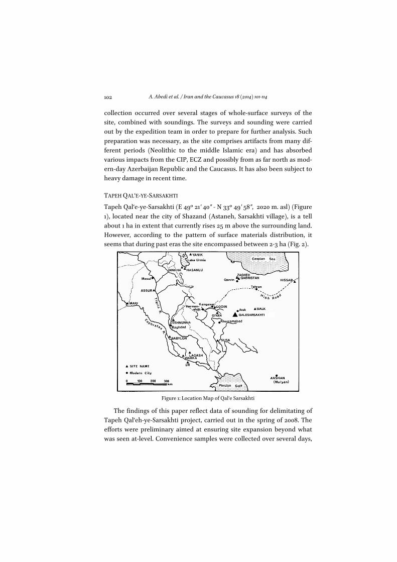
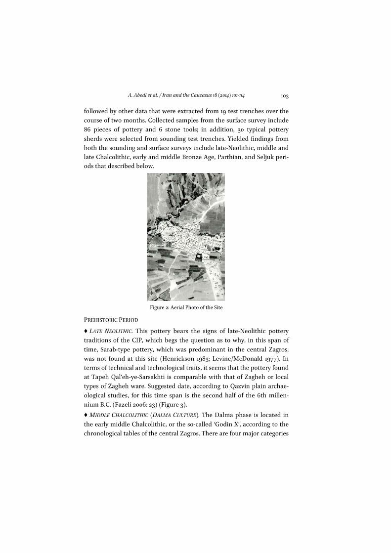
Tapeh Qal‘e-ye-Sarsakhti (E 49º 21' 40" - N 33º 49' 58", 2020 m. asl) (Figure 1), located near the city of Shazand (Astaneh, Sarsakhti village), is a tell about 1 ha in extent that currently rises 25 m above the surrounding land. However, according to the pattern of surface materials distribution, it seems that during past eras the site encompassed between 2-3 ha (Fig. 2).
Figure 1: Location Map of Qal‘e Sarsakhti
The findings of this paper reflect data of sounding for delimitating of Tapeh Qal‘eh-ye-Sarsakhti project, carried out in the spring of 2008. The efforts were preliminary aimed at ensuring site expansion beyond what was seen at-level. Convenience samples were collected over several days,
A. Abedi et al. / Iran and the Caucasus 18 (2014) 101-114
103
followed by other data that were extracted from 19 test trenches over the course of two months. Collected samples from the surface survey include 86 pieces of pottery and 6 stone tools; in addition, 30 typical pottery sherds were selected from sounding test trenches. Yielded findings from both the sounding and surface surveys include late-Neolithic, middle and late Chalcolithic, early and middle Bronze Age, Parthian, and Seljuk peri-ods that described below.
Figure 2: Aerial Photo of the Site
PREHISTORIC PERIOD
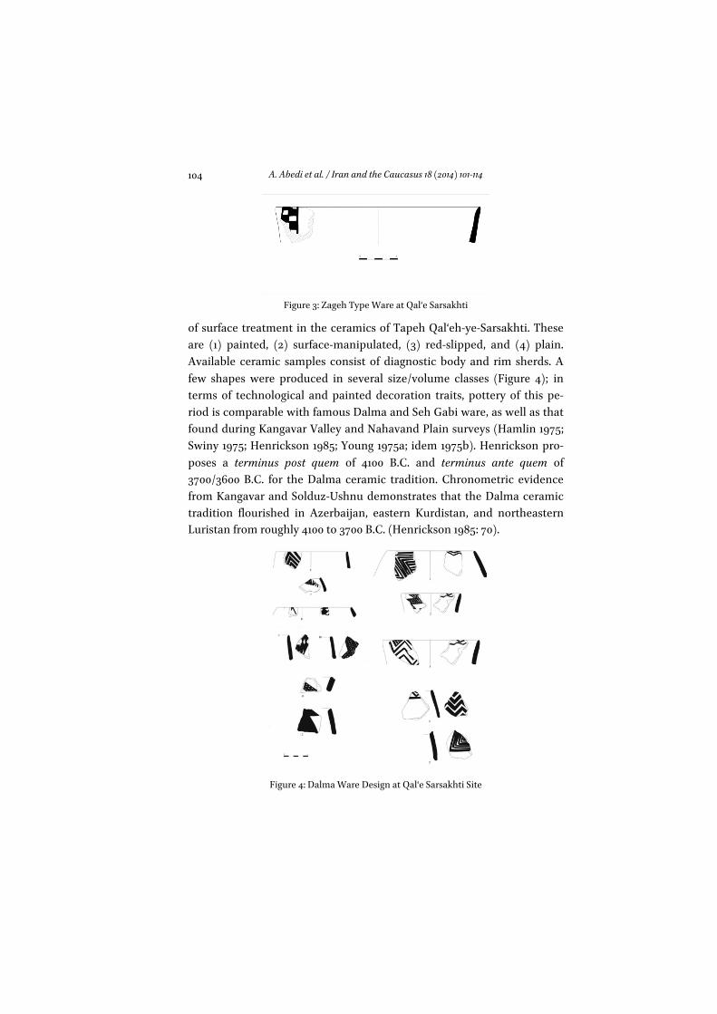
♦ LATE NEOLITHIC. This pottery bears the signs of late-Neolithic pottery traditions of the CIP, which begs the question as to why, in this span of time, Sarab-type pottery, which was predominant in the central Zagros, was not found at this site (Henrickson 1983; Levine/McDonald 1977). In terms of technical and technological traits, it seems that the pottery found at Tapeh Qal‘eh-ye-Sarsakhti is comparable with that of Zagheh or local types of Zagheh ware. Suggested date, according to Qazvin plain archae-ological studies, for this time span is the second half of the 6th millen-nium B.C. (Fazeli 2006: 23) (Figure 3). ♦ MIDDLE CHALCOLITHIC (DALMA CULTURE). The Dalma phase is located in the early middle Chalcolithic, or the so-called ‘Godin X’, according to the chronological tables of the central Zagros. There are four major categories
A. Abedi et al. / Iran and the Caucasus 18 (2014) 101-114
104
Figure 3: Zageh Type Ware at Qal‘e Sarsakhti
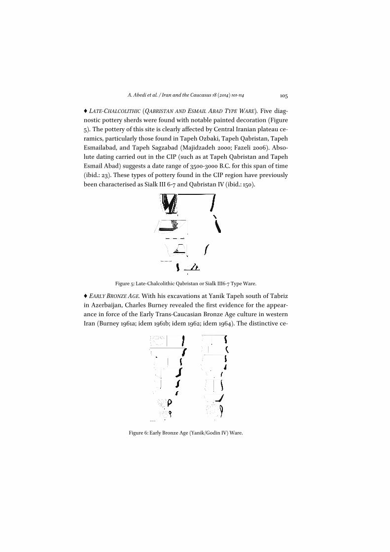
of surface treatment in the ceramics of Tapeh Qal‘eh-ye-Sarsakhti. These are (1) painted, (2) surface-manipulated, (3) red-slipped, and (4) plain. Available ceramic samples consist of diagnostic body and rim sherds. A few shapes were produced in several size/volume classes (Figure 4); in terms of technological and painted decoration traits, pottery of this pe-riod is comparable with famous Dalma and Seh Gabi ware, as well as that found during Kangavar Valley and Nahavand Plain surveys (Hamlin 1975; Swiny 1975; Henrickson 1985; Young 1975a; idem 1975b). Henrickson pro-poses a terminus post quem of 4100 B.C. and terminus ante quem of 3700/3600 B.C. for the Dalma ceramic tradition. Chronometric evidence from Kangavar and Solduz-Ushnu demonstrates that the Dalma ceramic tradition flourished in Azerbaijan, eastern Kurdistan, and northeastern Luristan from roughly 4100 to 3700 B.C. (Henrickson 1985: 70).
Figure 4: Dalma Ware Design at Qal‘e Sarsakhti Site
A. Abedi et al. / Iran and the Caucasus 18 (2014) 101-114
105
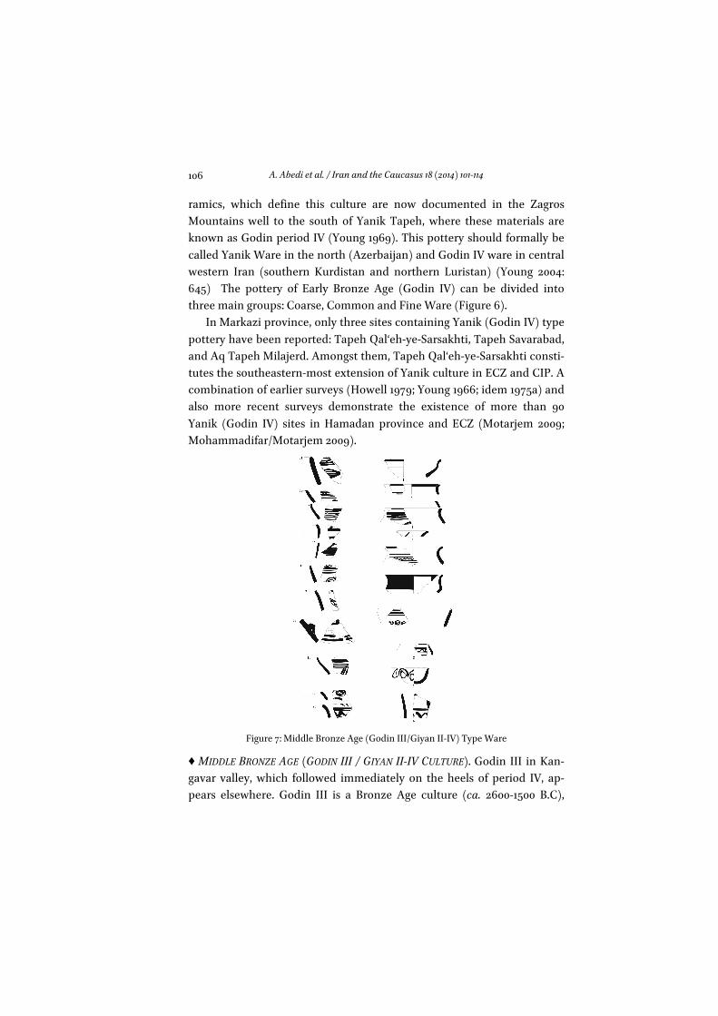
♦ LATE-CHALCOLITHIC (QABRISTAN AND ESMAIL ABAD TYPE WARE). Five diag-nostic pottery sherds were found with notable painted decoration (Figure 5). The pottery of this site is clearly affected by Central Iranian plateau ce-ramics, particularly those found in Tapeh Ozbaki, Tapeh Qabristan, Tapeh Esmailabad, and Tapeh Sagzabad (Majidzadeh 2000; Fazeli 2006). Abso-lute dating carried out in the CIP (such as at Tapeh Qabristan and Tapeh Esmail Abad) suggests a date range of 3500-3000 B.C. for this span of time (ibid.: 23). These types of pottery found in the CIP region have previously been characterised as Sialk III 6-7 and Qabristan IV (ibid.: 150).
Figure 5: Late-Chalcolithic Qabristan or Sialk III6-7 Type Ware.
♦ EARLY BRONZE AGE. With his excavations at Yanik Tapeh south of Tabriz in Azerbaijan, Charles Burney revealed the first evidence for the appear-ance in force of the Early Trans-Caucasian Bronze Age culture in western Iran (Burney 1961a; idem 1961b; idem 1962; idem 1964). The distinctive ce-
Figure 6: Early Bronze Age (Yanik/Godin IV) Ware.
A. Abedi et al. / Iran and the Caucasus 18 (2014) 101-114
106
ramics, which define this culture are now documented in the Zagros Mountains well to the south of Yanik Tapeh, where these materials are known as Godin period IV (Young 1969). This pottery should formally be called Yanik Ware in the north (Azerbaijan) and Godin IV ware in central western Iran (southern Kurdistan and northern Luristan) (Young 2004: 645) The pottery of Early Bronze Age (Godin IV) can be divided into three main groups: Coarse, Common and Fine Ware (Figure 6).
In Markazi province, only three sites containing Yanik (Godin IV) type pottery have been reported: Tapeh Qal‘eh-ye-Sarsakhti, Tapeh Savarabad, and Aq Tapeh Milajerd. Amongst them, Tapeh Qal‘eh-ye-Sarsakhti consti-tutes the southeastern-most extension of Yanik culture in ECZ and CIP. A combination of earlier surveys (Howell 1979; Young 1966; idem 1975a) and also more recent surveys demonstrate the existence of more than 90 Yanik (Godin IV) sites in Hamadan province and ECZ (Motarjem 2009; Mohammadifar/Motarjem 2009).
Figure 7: Middle Bronze Age (Godin III/Giyan II-IV) Type Ware
♦ MIDDLE BRONZE AGE (GODIN III / GIYAN II-IV CULTURE). Godin III in Kan-gavar valley, which followed immediately on the heels of period IV, ap-pears elsewhere. Godin III is a Bronze Age culture (ca. 2600-1500 B.C),
A. Abedi et al. / Iran and the Caucasus 18 (2014) 101-114
107
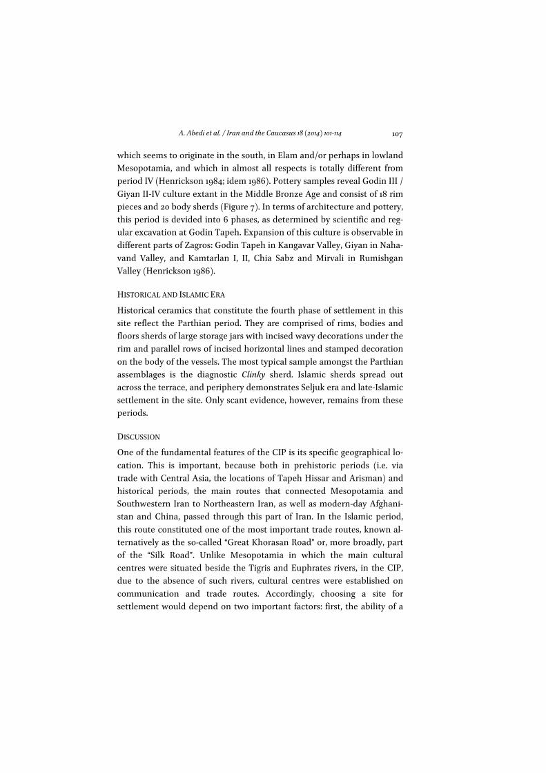
which seems to originate in the south, in Elam and/or perhaps in lowland Mesopotamia, and which in almost all respects is totally different from period IV (Henrickson 1984; idem 1986). Pottery samples reveal Godin III / Giyan II-IV culture extant in the Middle Bronze Age and consist of 18 rim pieces and 20 body sherds (Figure 7). In terms of architecture and pottery, this period is devided into 6 phases, as determined by scientific and reg-ular excavation at Godin Tapeh. Expansion of this culture is observable in different parts of Zagros: Godin Tapeh in Kangavar Valley, Giyan in Naha-vand Valley, and Kamtarlan I, II, Chia Sabz and Mirvali in Rumishgan Valley (Henrickson 1986).
HISTORICAL AND ISLAMIC ERA
Historical ceramics that constitute the fourth phase of settlement in this site reflect the Parthian period. They are comprised of rims, bodies and floors sherds of large storage jars with incised wavy decorations under the rim and parallel rows of incised horizontal lines and stamped decoration on the body of the vessels. The most typical sample amongst the Parthian assemblages is the diagnostic Clinky sherd. Islamic sherds spread out across the terrace, and periphery demonstrates Seljuk era and late-Islamic settlement in the site. Only scant evidence, however, remains from these periods.
DISCUSSION
One of the fundamental features of the CIP is its specific geographical lo-cation. This is important, because both in prehistoric periods (i.e. via trade with Central Asia, the locations of Tapeh Hissar and Arisman) and historical periods, the main routes that connected Mesopotamia and Southwestern Iran to Northeastern Iran, as well as modern-day Afghani-stan and China, passed through this part of Iran. In the Islamic period, this route constituted one of the most important trade routes, known al-ternatively as the so-called “Great Khorasan Road” or, more broadly, part of the “Silk Road”. Unlike Mesopotamia in which the main cultural centres were situated beside the Tigris and Euphrates rivers, in the CIP, due to the absence of such rivers, cultural centres were established on communication and trade routes. Accordingly, choosing a site for settlement would depend on two important factors: first, the ability of a
A. Abedi et al. / Iran and the Caucasus 18 (2014) 101-114
108
site to sustain livelihoods, and second, the geographical proximity of a site to other cultural centres. The fact that major prehistoric sites are dis-tributed along what is the main road today, suggests that prehistoric in-habitants of CIP may have used the same routes (Majidzadeh 1990). In this light, Tapeh Qal‘eh-ye-Sarsakhti must have boasted the crucial fea-tures mentioned above, rooted in the environmental conditions and geo-graphical particularities of the site.
From an archaeological perspective, the location of Shazand and Tapeh Qal‘eh-ye-Sarsakhti in a middle-point between the CIP and Zagros range is crucial, since during prehistoric eras, this region had been influ-enced and impacted simultaneously by different cultures of the neigh-bouring regions, and, thus, received and contributed to cross-cultural transmissions.
Based on existent data including evidence from the Late Neolithic, and cultural sequences from the Middle Chalcolithic to Middle Bronze Age, it can be inferred that this site was one of the eastern extensions of Dalma culture into the CIP (from both north and west), and would also constitute the southeastern expansion of Kura-Araxes culture in the CIP and ECZ. This latter theory, based on surveys and excavations conducted to this point in both Markazi province, and northern parts of Luristan province (i.e. Azna), awaits to be confirmed, as the data from these re-gions have yet to be fully documented and published. Another point is that, apart from Tapeh Qal‘eh-ye-Sarsakhti, there is currently no other site in the Markazi province dated to Dalma period. Worth noting here are the circumstances of the entrance of such cultures into these parts of the Zagros and CIP. In the late 5th-early 4th millennia B.C., Early Chalcolithic Dalma culture began to spread from its original provenance in the Lake Urmia Basin southward, down into the central Zagros.
Henrickson and others depict three main roads for Dalma culture from NW. A third easterly north-south road through the northern Zagros originates at Mianduab and runs southeast through Takab and Bijar, along the eastern edges of Kurdistan to Hamadan (see Levine 1973: 3-5; idem 1974: 99-104). All the three routs originate in the Urmia Basin, and intersect the Great Khorasan Road (Henrickson 1983: 35). Apart from this proposed route for the expansion of Dalma culture from the northwest, it is worth considering, regarding Tapeh Qal‘eh-ye-Sarsakhti, a third route
A. Abedi et al. / Iran and the Caucasus 18 (2014) 101-114
109
that Levine offers. For clarifying this issue, we now refer to Henrickson’s explanation about the “High Road”.
“The High Road (also called the Silk Road or Great Khorasan Road) is the best east-west route through central western Iran from the Iranian plateau to the Mesopotamian lowlands. It passes through the Kangavar (close to Godin Tepe), Sahneh, Mahidasht, and Shahabad valleys, finally descending from the Zagros Mountains into the middle reaches of the Di-yala River drainage through the Zagros Gates. The High Road thus forms an east-west link among the valleys at the northern ends of the north-south routes (Hamadan, Kangavar, Sahneh, Mahidasht and Shahabad). Lesser routes provide further east-west interconnections across the mountain ridges” (Henrickson E.F. 1989: 35; see also Goff 1966, idem 1971; Edmonds 1922).
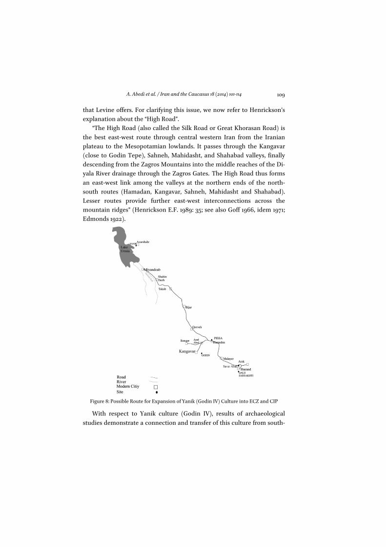
Figure 8: Possible Route for Expansion of Yanik (Godin IV) Culture into ECZ and CIP
With respect to Yanik culture (Godin IV), results of archaeological studies demonstrate a connection and transfer of this culture from south-
A. Abedi et al. / Iran and the Caucasus 18 (2014) 101-114
110
ern Caucasus, especially the Urmia Basin in the northwest, toward the western valleys of Iran (Young 1966). After its first settlement in north-west Iran, this culture spreads further south and east. This pattern of ex-pansion can explain the circumstances of the arrival of Kura-Araxes peo-ple, or their traditions, to the region in question. Exactly the same route may well apply for the Dalma culture, with a slight modification in respect to Kura-Araxes culture. Most likely, these peoples ranged from the south of Lake Urmia, namely in and around Miyandoab, Shahin Dezh, Takab, Bijar, Deh Golan, Qorveh and then split into two branches: one of them extended into the northern mountain range of Alvand, and then into the Hamadan Plain, while the other arrived at Sonqor and Asad Abad plains after passing across the southern slopes of Alvand (Motarjem 2009). Tapeh Qal‘eh-ye-Sarsakhti, in this case, would be a product of the first branch. Namely, after the Kura-Araxians passed from Qorveh to Hamadan plains, they would have moved on to Malayer, from there to Tapeh Savar Abad and to Tapeh Qal‘eh-ye-Sarsakhti (Figure 8). It should be mentioned that from this route numerous important Yanik type sites (ETC) are reported (Omrani 2006; Kargar 1992). This pattern of dispersal, however, raises the question as to why the arrival of Kura-Araxes peoples here was not faced with main difficulties, and they could inhabit in these places over the course of several centuries. This is one of the challenging questions and, maybe, this little evidence cannot fully answer it, but we try to depict some of possible answers.
One compelling explanation could be climatic change, which likely occurred in the late 4th millennium B.C. in these regions, facilitating the entry of Kura-Araxians into the northwest, and then to the ECZ and CIP. Evidence related to climatic changes during the Pleistocene has been yielded by pollen studies of Zagros intermountain lake bottom sediments. Studies from areas, such as Lake Zaribar (Marivan), and Sarab Niloofar (Kermanshah), show that, beginning from approximately 6000 years ago, dense oak forest in the Zagros gradually formed, accompanied by the emergence of grasses that would have been suitable for feeding animals (Van Ziest et al. 1983). This appears to have happened around 4000 B.C., but, toward the end of this period (Late-Chalcolithic), there is some evi-dence that suggests a shift to unfavourable climatic conditions. This would have occurred at approximately Late-Chalcolithic in northwestern
A. Abedi et al. / Iran and the Caucasus 18 (2014) 101-114
111
Iran and the Zagros region (Motarjem 2009; Omrani 2003; Rafifar/Gorbani 2006; Abdi et al. 2002)
Thus, one should expect a population reduction and change in sub-sistence strategy in the Late Chalcolithic period, providing the basis for entry of the new wave of migrants, who would not encounter serious bar-riers in Zagros (Motarjem 2009; Rafifar/Gorbani 2006). The size of Late Chalcolithic sites in northwestern Iran and ECZ demonstrates that many sites dating from this period are less than 1 ha in spatial extent (Abdi et al. 2002).
Patterns of settlement in both ECZ and Tapeh Qal‘eh-ye-Sarsakhti co-incide with the desirability of living conditions in the areas east of the Lake Urmia Basin and in eastern Anatolia, including lands with low pop-ulation, located in high zones with flanks, with possibility of some dry ag-riculture, and an abundance of good pastures (Rothman/Kozbe 1997). It seems that this cultural transfer, then, was not the result of rapid migra-tion but, rather, the result of continuous movement toward desired eco-logical and geographical conditions or diffusion, and probably local emu-lation of foreign styles by the local inhabitants.
Another important point is that the Kura-Araxes phenomenon in these regions (ECZ, CIP) is the prerequisite that the trade routes them-selves determined the migration patterns of the people. As mentioned earlier, because of the sites location, such as Tapeh Qal‘eh-ye-Sarsakhti, in a Median area situated in-between CIP and the central Zagros, and in continuance of the routes implied by the existence of sites, such as Tapeh Godin (located on a main east-west route, i.e. the “High Road”), the bear-ers of Kura-Araxes culture could well have played a very effective role not only in transmission, but also in the control of the important east-west and north-south trade routes (Young 2004: 659).
CONCLUSION
It can be concluded that, over the course of the 4500 years of its continu-ance across both prehistoric periods and several centuries in historical (Parthian) and Islamic (Seljuk) eras, Tapeh Qal‘eh-ye-Sarsakhti could have functioned as a crossroad for the transference of different periods’ cultures, from the central Zagros to the CIP and vice versa. It seems ap-parent that the communication-trade roles of this area, due to its location,
A. Abedi et al. / Iran and the Caucasus 18 (2014) 101-114
112
were more important than other possible functions. Based on newly available data, it is clear that Tapeh Qal‘eh-ye-Sarsakhti was occupied from the Late Neolithic to Middle Bronze Ages, as well as during the Par-thian and Seljuk periods.
Clarifying and better understanding of different aspects of these cul-tures, including the Dalma, Yanik (Godin IV), and Godin III, require more intensive surveys and scientific excavations in this part of Iran, so that data thus far obtained can be analysed with a higher degree of accuracy. We hope that more scientific excavations in Tapeh Qal‘eh-ye-Sarsakhti will be conducted in the near future, so that lingering questions, such as those discussed above, can be answered through the use of proper ar-chaeological methodology. The data available at this site are still quite challenging to analyse comprehensively, and such samples cannot fully answer all the historical and archaeological uncertainties pertaining to this part of the CIP.
The final point worthy of consideration is that the Kura-Araxes peo-ples could not spread into very fertile areas, such as the Zanjan Plain to the northwest, Solduz Valley to the south of Lake Urmia and Mahidasht Plain in the Central Zagros, and it appears these people may have selected areas with the potential of being a short distance from, or facilitating dominance in, communication-trade routes that would have transferred raw materials from the Caucasus into the south and southwestern parts of Iran and Mesopotamia. This process appears to have continued with little change in the subsequent Godin III periods and, may be, in historical and Islamic era.
BIBLIOGRAPHY Abedi, K. / G. Nokandeh / A. Azadi / F. Biglari / S. Heydari / D. Farmani / A. Rezaii / M.
Mashkour (2002), “Tuwah Khoshkeh: A Middle Chalcolithic Mobile Pastoralist Camp-Site in the Islamabad Plain, West Central Zagros Mountains, Iran”, IRAN vol. XL: 42-74.
Burney, C. A. (1961a), “Excavations at Yanik Tepe, North-West Iran”, Iraq XXIII: 138-153. —— (1961b), “Circular Buildings Found at Yanik Tepe in North-west Iran”, Antiquity , vol
XXXV: 237-240. —— (1962), “Excavation at Yanik Tepe, Azerbaijan”, IRAN XXIV: 134-152. —— (1964), “The Excavation at Yanik Tepe, Azerbaijan, 1962: Third Preliminary Report”,
Iraq XXVI: 54-61.
A. Abedi et al. / Iran and the Caucasus 18 (2014) 101-114
113
Edmonds, C. J. (1922), “Luristan: Pish-i Kuh and Bala Giriveh", Geographical Journal LIX: 335-56, 437-53.
Fazeli, H. (2006), The Archaeology of Qazvin from the Sixth to the First Millennium B.C., Teh-ran.
Goff, C. (1966), New Evidence of Cultural Development in Luristan in the Late Second and Early First Millennia, Ph.D. Dissertation, Institute of Archaeology, University of London.
—— (1971), “Luristan before the Iron Age”, IRAN IX: 131-52. Hamlin, C. (1975), “Dalma Tepe”, IRAN XIII: 111-127. Henrickson, E. F. (1983), Ceramic Styles and Cultural Interaction in the Early and Middle
Chalcolithic of the Central Zagros, Iran, Ph.D. Dissertation, Department of Anthro-pology, University of Toronto.
—— (1985), “An Updated Chronology of the Early and Middle Chalcolithic of the Central Zagros Highlands, Western Iran”, IRAN XXIII: 63-108.
Henrickson, R. C. (1984), Godin Tepe, Godin III and Central Western Iran: c. 2600-1500 B.C., Ph.D. Dissertation, Department of Near Eastern Studies, University of Toronto.
—— (1986), “New Light on Old Routes of Western Iran”, IRAN XXIV: 1-55. Howell, R. (1979), “Survey of the Malayer Plain”, IRAN XVII: 156-7. Kargar, B. (1992), Barresīye Bāstānšenāsiye šahrestān-e Šāhīn-dež, Unpublished Report pre-
pared for ICHHTO of W-Azerbaijan province. Levine, L. D. (1973), “Geographical Studies in the Neo-Assyrian Zagros”, IRAN XI: 1-27. —— (1974), “Geographical Studies in the Neo-Assyrian Zagros”, IRAN XII: 99-124. —— / M. A. McDonald (1977), “The Neolithic and Chalcolithic Periods in the Mahidasht”,
IRAN XV: 38-50. Majidzadeh, Y. (1990), Āγāz-e šahrnešīnī dar Iran, Tehran. —— (2000) “Gozāreš-e moqaddamātī-ye dovvomīn faṣl-e ḥafrīyāt-e bāstānšenāxtī dar
mohavvate-ye Ozbakī”, Journal of Archaeology and History, vol. 14/2: 38-49. Mohammadifar, Y. / A. Motarjem (2009), Gozāreš-e faṣl-e dovvom-e barrasiīva šenāsāyī-e
baxš-e markazī-ye šahresān-e Nahāvand, Unpublished Report prepared for ICHHTO of Hamadan.
Motarjem, A. (2009) Archaeological Survey and Patterns of Settlement Analysis of Early Bronze Age Sites in Alvand Basin, Hamadan, PhD. Dissertation, Department of Ar-chaeology, University of Tehran.
Omrani, B. (2003), Barresī-ye Bāstānšenāsī-ye šahrestān-e Šabestar, Unpublished Report prepared for ICHHTO.
—— (2006), Early Bronze Age in NW Iran, PhD. Dissertation, Department of Archaeology, University of Tarbiat Modarres.
Rafifar, J. / H. R. Gorbani (2006), “Barhamkonešhāy-e mohītī-ensānī va taγyīr-e esteratežīy-e maišatī dar Zāgros Markazī”, Name-ye Pažuhešgah-e Miras-e Farhangī va Gardeš-garī”, Journal of Research Institute, ICHHTO Special Issue, Anthropology and Myth, Atumn-Winter, Quarterly, Tehran: 43-65.
A. Abedi et al. / Iran and the Caucasus 18 (2014) 101-114
114
Rothman, M. / G. Kozbe (1997), “Mus in the Early Bronze Age”, Anatolian Studies, vol. 47: 105-126.
Swiny, S. (1975), “Survey in North-West Iran 1971”, East and West, vol: 25(1-2): 77-96. Van Ziest, W. T. / S. Bottema / S. Giese, et al. (1983), “Siesmic Crustul Studies in Southern
Iran between Central Iran and Zagros Belt Qeodynamic Project in Iran”, GST Re-port no. 51.
Young, T. C. Jr. (1966), “Survey in Western Iran 1961”, Journal of Near Eastern Studies, vol. 25.4: 228-239.
—— (1969), Excavations at Godin Tepe: First Progress Report. Art and Archaeology Occa-sional Paper 17, Toronto, Royal Ontario Museum.
—— (1975a), An Archaeological Survey of the Kangavar valley, Proceedings of the 3rd An-nual Symposium on Archaeological Research in Iran: 23-30.
—— (1975b), “Kangavar Valley Survey”, IRAN no.13: 191-193. —— (2004), “The Kangavar Survey”, A. Sagona (ed). A View from the Highland, Archaeo-
logical Studies in Honor of Charley Burney. Ancient Near Eastern Studies, Suppel-ment vol. 12, Leuven: 645-660.