New evidence for the form and extent of the Pernicana Fault System (Mt. Etna) from structural and...
10
Ž . Journal of Volcanology and Geothermal Research 84 1998 143–152 New evidence for the form and extent of the Pernicana Fault ž / System Mt. Etna from structural and soil–gas surveying Raffaele Azzaro a, ) , Stefano Branca b , Salvatore Giammanco c , Sergio Gurrieri c , Riccardo Rasa b , Mariano Valenza d ` a GNDT c r o Istituto Internazionale di Vulcanologia, C.N.R., P.za Roma, 2, 95123 Catania, Italy b Istituto di Scienze della Terra, UniÕersita di Messina, Salita Sperone, 31, 98166 Sant’Agata-Messina, Italy ` c Istituto di Geochimica dei Fluidi, C.N.R., Õia Ugo La Malfa, 153, 90146 Palermo, Italy d Dipartimento di Chimica e Fisica della Terra ed Applicazioni, UniÕersita di Palermo, Õia Archirafi, 36, 90123 Palermo, Italy ` Accepted 4 April 1998 Abstract A multidisciplinary study based on structural and soil–gas surveys was carried out in order to investigate the relationship between soil CO degassing and the tectonic setting of the lower northeastern flank of Mt. Etna volcano. The results show 2 that anomalous soil CO emissions occur mainly along faults trending WNW–ESE and also where these faults intersect the 2 Ž . other main fault set trending NE–SW that displaces the study area. In particular, anomalies in CO degassing were 2 Ž . revealed both along the Pernicana Fault and along another fault Fiumefreddo Fault which may represent the prolongation of the former towards the Ionian Sea coast. In the areas where these structures show evident surface faulting, they are all characterised by left-lateral displacements and aseismic creep behaviour. Furthermore, the geochemical survey revealed that these faults join in an area devoid of geological evidence of surface faulting and continue underneath an apparently unfaulted alluvial cover near the coastline. In the light of these findings, we suggest that the Pernicana and Fiumefreddo Faults are discrete segments of a near continuous left-lateral shear zone affecting the whole north-eastern flank of Mt. Etna as far as the Ionian coast. q 1998 Elsevier Science B.V. All rights reserved. Keywords: Mt. Etna; Pernicana Fault; active surface faulting; creeping; soil CO prospecting; buried fault recognition 2 1. Introduction The north-eastern flank of Mt. Etna is one of the most interesting areas for understanding the tectonic setting and dynamics of the volcanic edifice. This sector is crossed by an important and active tectonic Ž . structure, the Pernicana Fault Fig. 1 , having a mean strike WNW–ESE. It links westward to the active ) Corresponding author. Fax: q39-95-35801; e-mail: [email protected] NE Rift and seems to have an important role in controlling instability processes affecting the eastern Ž flank of the volcano Neri et al., 1991; Borgia et al., 1992; Lo Giudice and Rasa, 1992; Rasa et al., 1995; ` ` . McGuire et al., 1996; Rust and Neri, 1996 . Recent studies indicate that the Pernicana Fault is very active through sinistral, oblique-slip movements and is also characterised by frequent shallow seismicity Ž on the uphill western segment Azzaro et al., 1988; . Azzaro, 1997 and by remarkable creeping on the Ž downhill eastern one Rasa and Azzaro, 1995; Rasa ` ` 0377-0273r98r$19.00 q 1998 Elsevier Science B.V. All rights reserved. Ž . PII S0377-0273 98 00036-5
Transcript of New evidence for the form and extent of the Pernicana Fault System (Mt. Etna) from structural and...
Ž .Journal of Volcanology and Geothermal Research 84 1998 143–152
New evidence for the form and extent of the Pernicana Faultž /System Mt. Etna from structural and soil–gas surveying
Raffaele Azzaro a,), Stefano Branca b, Salvatore Giammanco c, Sergio Gurrieri c,Riccardo Rasa b, Mariano Valenza d`
a GNDT cro Istituto Internazionale di Vulcanologia, C.N.R., P.za Roma, 2, 95123 Catania, Italyb Istituto di Scienze della Terra, UniÕersita di Messina, Salita Sperone, 31, 98166 Sant’Agata-Messina, Italy`
c Istituto di Geochimica dei Fluidi, C.N.R., Õia Ugo La Malfa, 153, 90146 Palermo, Italyd Dipartimento di Chimica e Fisica della Terra ed Applicazioni, UniÕersita di Palermo, Õia Archirafi, 36, 90123 Palermo, Italy`
Accepted 4 April 1998
Abstract
A multidisciplinary study based on structural and soil–gas surveys was carried out in order to investigate the relationshipbetween soil CO degassing and the tectonic setting of the lower northeastern flank of Mt. Etna volcano. The results show2
that anomalous soil CO emissions occur mainly along faults trending WNW–ESE and also where these faults intersect the2Ž .other main fault set trending NE–SW that displaces the study area. In particular, anomalies in CO degassing were2
Ž .revealed both along the Pernicana Fault and along another fault Fiumefreddo Fault which may represent the prolongationof the former towards the Ionian Sea coast. In the areas where these structures show evident surface faulting, they are allcharacterised by left-lateral displacements and aseismic creep behaviour. Furthermore, the geochemical survey revealed thatthese faults join in an area devoid of geological evidence of surface faulting and continue underneath an apparently unfaultedalluvial cover near the coastline. In the light of these findings, we suggest that the Pernicana and Fiumefreddo Faults arediscrete segments of a near continuous left-lateral shear zone affecting the whole north-eastern flank of Mt. Etna as far as theIonian coast. q 1998 Elsevier Science B.V. All rights reserved.
Keywords: Mt. Etna; Pernicana Fault; active surface faulting; creeping; soil CO prospecting; buried fault recognition2
1. Introduction
The north-eastern flank of Mt. Etna is one of themost interesting areas for understanding the tectonicsetting and dynamics of the volcanic edifice. Thissector is crossed by an important and active tectonic
Ž .structure, the Pernicana Fault Fig. 1 , having a meanstrike WNW–ESE. It links westward to the active
) Corresponding author. Fax: q39-95-35801; e-mail:[email protected]
NE Rift and seems to have an important role incontrolling instability processes affecting the eastern
Žflank of the volcano Neri et al., 1991; Borgia et al.,1992; Lo Giudice and Rasa, 1992; Rasa et al., 1995;` `
.McGuire et al., 1996; Rust and Neri, 1996 . Recentstudies indicate that the Pernicana Fault is veryactive through sinistral, oblique-slip movements andis also characterised by frequent shallow seismicity
Žon the uphill western segment Azzaro et al., 1988;.Azzaro, 1997 and by remarkable creeping on the
Ždownhill eastern one Rasa and Azzaro, 1995; Rasa` `
0377-0273r98r$19.00 q 1998 Elsevier Science B.V. All rights reserved.Ž .PII S0377-0273 98 00036-5
( )R. Azzaro et al.rJournal of Volcanology and Geothermal Research 84 1998 143–152144
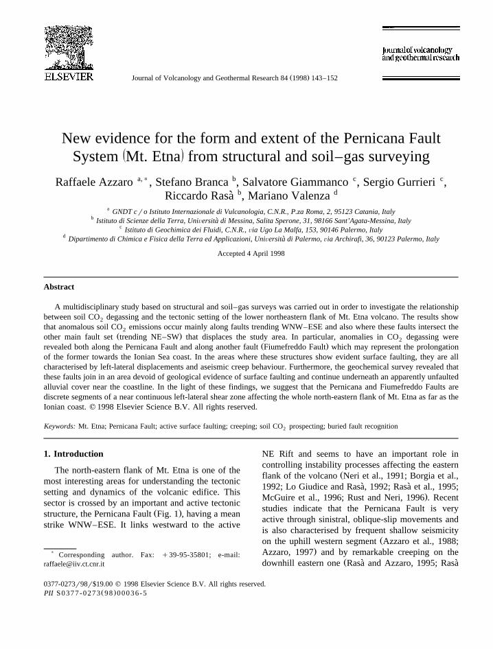
Ž .Fig. 1. Simplified tectonic map of the eastern side of Mt. Etna affected by south–eastward sliding movements shaded area according to LoŽ . Ž .Giudice and Rasa 1992 and Rasa et al. 1996a,b . Direction of movement is indicated by the white arrows, normal faults are denoted by` `
solid lines with barbs on downthrown side, while small arrows indicate lateral slip components. The NE Rift and SE Rift are sketched asŽ .fan-shaped sheaf of dashed lines. The inset box shows the study area Fig. 2 .
.et al., 1996a . At lower altitudes, field evidence forthe fault is discontinuous and ambiguous. In addi-tion, the presence in the area of a well-developed set
Žof NE–SW trending structures Cristofolini et al.,1977, 1978; Lo Giudice et al., 1982; Rasa et al.,`
.1982 near the eastern tip of the Pernicana Fault
Ž .Figs. 1 and 2 , and of pre-volcanic basement crop-Ž .ping out widely Ferrara, 1975 , make the local
tectonic framework rather complex.Nevertheless, the detection of a fault near the
Ž . Ž .village of Fiumefreddo Rasa et al., 1996b Fig. 2`and a morphological ridge in the nearby offshore

( )R. Azzaro et al.rJournal of Volcanology and Geothermal Research 84 1998 143–152 145
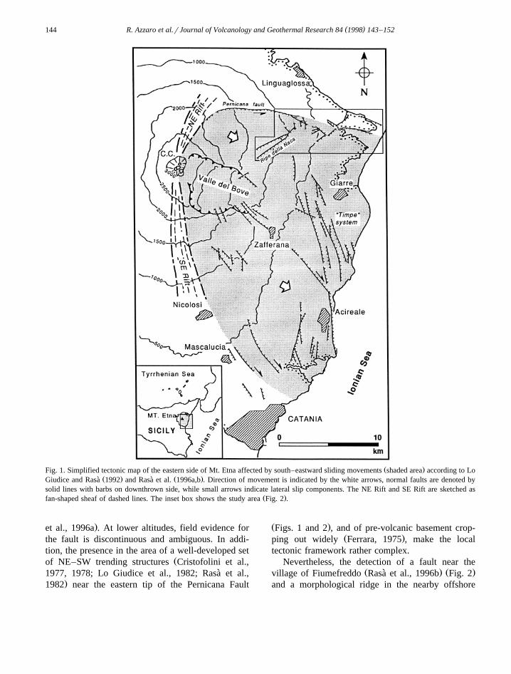
Ž . Ž . Ž .Fig. 2. Tectonic map of the lower northeastern flank. 1 Recent alluvium and shoreline deposits; 2 Etnean volcanics; 3 late-QuaternaryŽ . Ž . Ž . Ž .clays; 4 Appennine–Maghrebian Units; 5 partially outcropping cinder cones; 6 normal faults, dashed when buried; and 7 soil–gas
sampling lines. Star indicates the location of the Salinelle of Fondachello mofettes. Thick, dashed lines indicate the hypothetical extension,inferred from the soil degassing data, of the WNW–ESE structural set.
Ž .Riposto Ridge by Gabbianelli et al., 1995 , bothhaving a trend similar to that of the Pernicana Fault,may suggest an eastward continuation of the struc-ture throughout the entire volcanic edifice.
In order to adequately address the problem of theeastward continuation of the Pernicana Fault on thelower northeastern flank of the volcano, a multidisci-plinary study was undertaken. This integrated theresults of a detailed structural survey with investiga-tions of soil CO degassing carried out along sam-2
pling lines oriented subnormal to the WNW–ESEŽ .tectonic structures identified in this area Fig. 2 . It is
known that soil–gas geochemistry may be useful inŽdetecting and monitoring active faults e.g., Sugisaki
.et al., 1983; Klusman, 1993 . In the Etna area,anomalous soil degassing, especially of CO , occurs2
at the summit of the volcano and on its flanks,mainly in areas crossed by seismically active faultswhich represent preferential pathways of gas escapeŽD’Alessandro et al., 1992; Anza et al., 1993; Gi-`
.ammanco et al., 1995 . Preliminary studies also sug-gest, however, that the occurrence of anomalous soildegassing on Mt. Etna can also be attributed to
Ž .buried tectonic structures Giammanco et al., 1997 .Our findings confirm that CO emissions from soils2
may provide an important contribution in detecting
active faults, and even those devoid of field evi-dence.
2. Structural setting and active tectonics
The study area is a distinctive structural domainof the volcanic edifice where two fault sets are
Ž .arranged at almost right angle of each other Fig. 2 ,the first striking NE–SW, and the second trendingWNW–ESE, offsetting the former and also showingactive, surficial faulting.
The NE–SW structures uplift the pre-volcanicsedimentary basement by some hundreds of metersand are represented by the Ripe della Naca faultscarps and by the fault zone that crosses the areabetween the villages of Fiumefreddo, Piedimonte andPresa as far as the northeastern periphery of thevolcano near the sea. This structural sheaf couldtentatively be considered as the southernmost sectionof the Messina–Fiumefreddo Line, a master faultzone which developed along the Ionic coast of the
Ž .northern Sicily Ghisetti, 1979 , but the validity ofsuch an interpretation remains doubtful due to the
Ž .different principal azimuths NNE–SSW of the lat-Ž .ter Rasa et al., 1995 .`
( )R. Azzaro et al.rJournal of Volcanology and Geothermal Research 84 1998 143–152146
The Ripe della Naca are a couple of near-parallelstep faults with lengths of over 4 km and a verticalslip separation of about 150 m, and are highlightedin the field by a double fault scarp that is one of theoutstanding morpho-structural features in the investi-gated area. Despite their significant morphologicalexpression, these two faults are seismically dormant,as suggested by the lack of historical and recent
Žmacroseismicity related to these structures e.g.,.Imbo, 1935; Azzaro et al., 1989, 1992 and sup-`
ported by the discontinuous cover of yellowish tuffsattributable to the Tufi Gialli Superiori Formation of
Ž .Romano 1982 which unconformably overlies thefault lines and temporally constrains the latest tec-tonic activity of these faults to the end of the Ancient
Ž 14Mongibello activity about 4 ka, according to the C.radiometric dating from Cortesi et al., 1988 .
Although these two discontinuities are not seismi-cally active, they seem to play a role in propagationof magma from the central feeder system to thesurface in this sector of the volcano. This has signifi-cant implications for the volcanic hazards of the areasince these faults may also determine the location of
Žeruptive events at low altitude ca. 1000–500 m
.a.s.l. , as testified by the opening of the 1928 erup-Ž .tive fissure Carapezza, 1962 , by the partially ex-
posed scoria cones located on the hanging wall ofŽ .the lower fault locality of Contrada Nocille and by
Žthe cone east of Presa village locality of Contrada.Ragaglia .
Faults with similar strike and dip slip also developat a lower altitude east of Presa and Piedimonte, butthey are offset to the east with respect to the Ripedella Naca alignment by some NW–SE faults whichdelimit a minor graben-like structure. Although thesefaults are partly masked by recent lava-flows, theyconstitute an important sheave of dislocations as
Ždemonstrated by a vertical dip separation over 50.m inferred by the outcrop elevation of the sub-Etnean
Žclays on the footwall of the fault zone ca. 180 m.a.s.l. , while volcanics and alluvial covers on the
Žhanging wall have a significant thickness some tens.of meters .
The WNW–ESE system is represented by thePernicana Fault west of Presa, by the fault south ofFiumefreddo and by those bordering the structuralhigh of Serra San Biagio near the coast. The Perni-cana Fault segment inside the study area does not
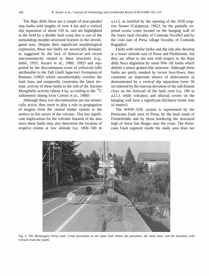
Fig. 3. The Montargano–Presa road. Creep movement on the splay fault offsets the pavement, the white lines, and the boundary wallŽ .viewed from the south .
( )R. Azzaro et al.rJournal of Volcanology and Geothermal Research 84 1998 143–152 147
Žseem to be affected by any seismic activity Azzaro,.1997 , and the high left-lateral displacements de-
tected at Rocca Campana are due to aseismic activeŽcreeping slip-rate of 2 cmryr in the last 150 yr,
.according to Rasa et al., 1996a . The fault terminates`by branching out eastwards into splay faults that arevisible downhill as far as the village of Presa andaccommodate the deformation eastwards by purelyleft-lateral displacements. This is also induced byaseismic creep. Fault-creep damage is evident on thepavement and boundary walls of the road ‘SP 68’that connects Vena to Presa as well as at the south-
Ž .ernmost outskirts of Presa Fig. 3 .Minor splay faults are structural features com-
Žmonly associated with fault terminations Hobbs et.al., 1976 , but further downhill a 15-m high fault
scarp with a strike similar to that of the PernicanaFault develops just south of the town of Fiume-freddo, and then disappears under the alluvial coveras the coast is approached. Damage to man-madestructures located on the fault trace reveals that thisfault is active through left-lateral displacements in-duced by creep. The largest degree of slip occursalong its western sector, where parts of structuresrelated to the Catania–Messina motorway and othernearby cultural features are clearly damaged. Al-though there is no visible connection between theeastern tip of the Pernicana Fault and the Fiume-freddo Fault, the only structures in the area showingevident surface movements, it is possible to infer thatdeformation propagates across a zone characterisedby ductile behaviour, probably due to the rheologicalproperties of the clay basement cropping out in the
Ž .area Ferrara, 1975 . If this is the case, both thePernicana and the Fiumefreddo Faults are prominentfeatures of a left-lateral shear zone displacing thewhole northern sector of Etna’s eastern flank with acomplex deformation mechanism involving transi-tion from brittle to ductile deformation processesunder high strain rate regimes.
3. Soil–gas survey
Measurements of dynamic concentrations of CO2
in the soil were carried out at various altitudes alongsampling lines across the Pernicana Fault, or itshypothetical extension, using the method of Gurrieri
Ž .and Valenza 1988 which was also described byŽ .Giammanco et al. 1995 . This method uses a special
probe, connected to an infrared spectrophotometerŽ .model RIKEN 550A accuracy within "5% . The
probe is inserted into the soil to a depth of 50 cmand soil–gas is pumped at constant flux into theinstrument after dilution with air. The CO concen-2
tration in the gas mixture reaches a constant valueafter a few minutes’ pumping. The dynamic concen-trations of CO measured in this way are directly2
proportional to the CO flux through the soil accord-2
ing to the relation FskC , where F is the COd 2Ž .flux through the soil in cmrs , C is the dynamicd
concentration of CO as read from the instrument2Ž .used in volumetric ppm and k is an empirical
constant that depends on the geometry of the sam-pling system used, the flow of the suction pump, thedepth of probe insertion and soil permeability.
This method is very simple and fast and allowsmany data to be acquired in a few days. Unlike theother above listed parameters, which can easily bekept constant during field measurements, soil perme-ability may vary appreciably in areas with differentlithologies. However, each sampling line crossedonly one lithotype at the time. Therefore, soil perme-ability can be reasonably assumed constant withinthe same profile.
The sampling step ranged from 5 to 200 m,depending on the desired resolution andror on logis-tics. This range of steps was a compromise betweenthe number of measurements needed and the timerequired to carry them out. Greater resolution in thespatial data would actually have meant an increaseby orders of magnitude in the time required toperform sampling. This would have led to time-de-pendant errors arising, for example, from the varia-tions in the atmospheric conditions that may inducerapid changes in the flux of gas through the soilsŽ .Hinkle, 1990; Giammanco et al., 1995 . Further-more, a shorter period of prospecting was preferredto a greater resolution in the sampling step also
Ž .because during the short time less than 2 h requiredto complete the analysis along each sampling line,the effect of variations in the volcanic activity on thespatial distribution of soil degassing may also beassumed to be negligible.
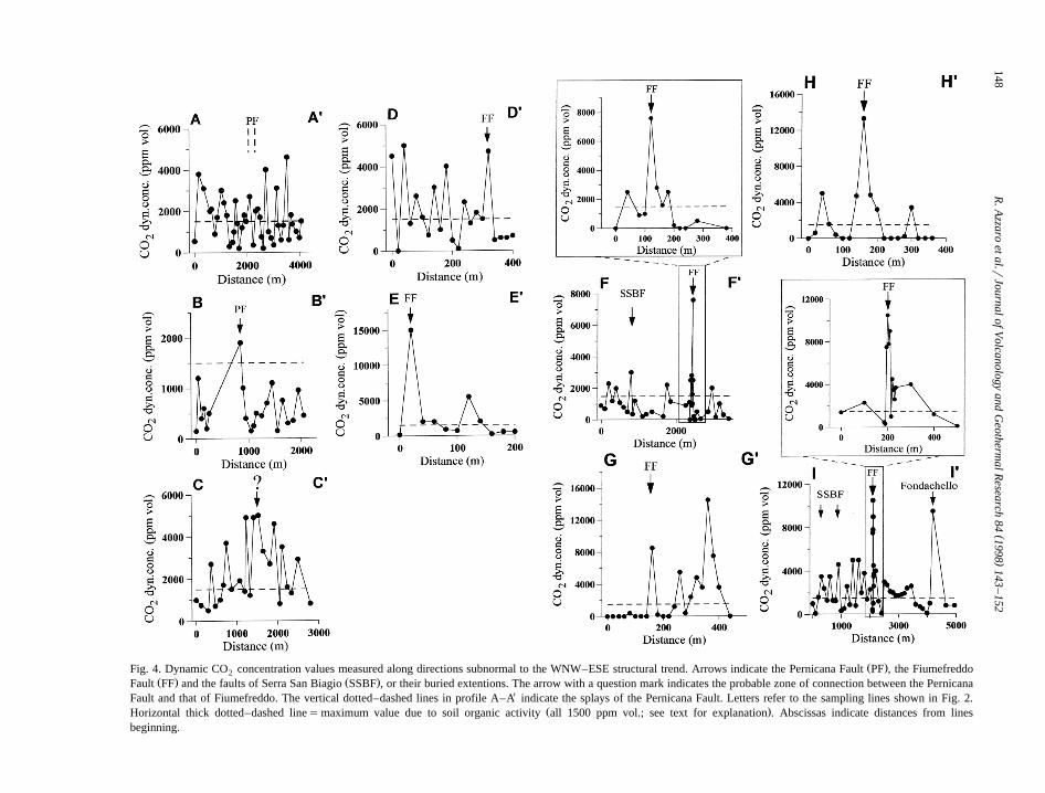
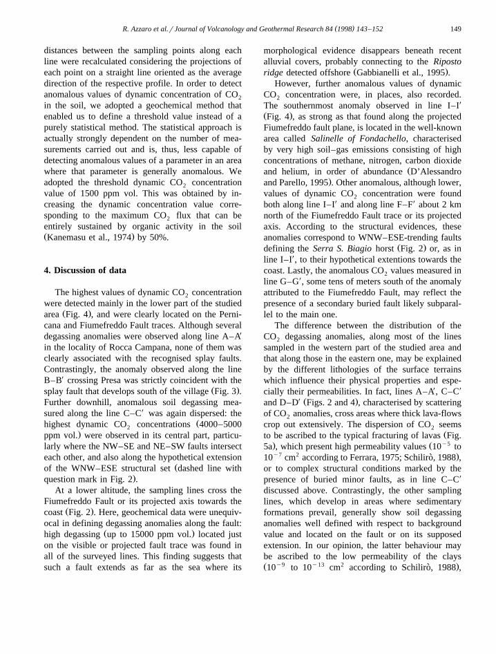
Dynamic concentrations of CO measured along2Ž .the sampling lines Fig. 2 are plotted in Fig. 4. The
()
R.A
zzaroet
al.rJournalof
Volcanology
andG
eothermalR
esearch84
1998143
–152
148
Ž .Fig. 4. Dynamic CO concentration values measured along directions subnormal to the WNW–ESE structural trend. Arrows indicate the Pernicana Fault PF , the Fiumefreddo2Ž . Ž .Fault FF and the faults of Serra San Biagio SSBF , or their buried extentions. The arrow with a question mark indicates the probable zone of connection between the Pernicana
Fault and that of Fiumefreddo. The vertical dotted–dashed lines in profile A–AX indicate the splays of the Pernicana Fault. Letters refer to the sampling lines shown in Fig. 2.Ž .Horizontal thick dotted–dashed linesmaximum value due to soil organic activity all 1500 ppm vol.; see text for explanation . Abscissas indicate distances from lines
beginning.
( )R. Azzaro et al.rJournal of Volcanology and Geothermal Research 84 1998 143–152 149
distances between the sampling points along eachline were recalculated considering the projections ofeach point on a straight line oriented as the averagedirection of the respective profile. In order to detectanomalous values of dynamic concentration of CO2
in the soil, we adopted a geochemical method thatenabled us to define a threshold value instead of apurely statistical method. The statistical approach isactually strongly dependent on the number of mea-surements carried out and is, thus, less capable ofdetecting anomalous values of a parameter in an areawhere that parameter is generally anomalous. Weadopted the threshold dynamic CO concentration2
value of 1500 ppm vol. This was obtained by in-creasing the dynamic concentration value corre-sponding to the maximum CO flux that can be2
entirely sustained by organic activity in the soilŽ .Kanemasu et al., 1974 by 50%.
4. Discussion of data
The highest values of dynamic CO concentration2
were detected mainly in the lower part of the studiedŽ .area Fig. 4 , and were clearly located on the Perni-
cana and Fiumefreddo Fault traces. Although severaldegassing anomalies were observed along line A–AX
in the locality of Rocca Campana, none of them wasclearly associated with the recognised splay faults.Contrastingly, the anomaly observed along the lineB–BX crossing Presa was strictly coincident with the
Ž .splay fault that develops south of the village Fig. 3 .Further downhill, anomalous soil degassing mea-sured along the line C–CX was again dispersed: the
Žhighest dynamic CO concentrations 4000–50002.ppm vol. were observed in its central part, particu-
larly where the NW–SE and NE–SW faults intersecteach other, and also along the hypothetical extension
Žof the WNW–ESE structural set dashed line with.question mark in Fig. 2 .
At a lower altitude, the sampling lines cross theFiumefreddo Fault or its projected axis towards the
Ž .coast Fig. 2 . Here, geochemical data were unequiv-ocal in defining degassing anomalies along the fault:
Ž .high degassing up to 15000 ppm vol. located juston the visible or projected fault trace was found inall of the surveyed lines. This finding suggests thatsuch a fault extends as far as the sea where its
morphological evidence disappears beneath recentalluvial covers, probably connecting to the Riposto
Ž .ridge detected offshore Gabbianelli et al., 1995 .However, further anomalous values of dynamic
CO concentration were, in places, also recorded.2
The southernmost anomaly observed in line I–IX
Ž .Fig. 4 , as strong as that found along the projectedFiumefreddo fault plane, is located in the well-knownarea called Salinelle of Fondachello, characterisedby very high soil–gas emissions consisting of highconcentrations of methane, nitrogen, carbon dioxide
Žand helium, in order of abundance D’Alessandro.and Parello, 1995 . Other anomalous, although lower,
values of dynamic CO concentration were found2
both along line I–IX and along line F–FX about 2 kmnorth of the Fiumefreddo Fault trace or its projectedaxis. According to the structural evidences, theseanomalies correspond to WNW–ESE-trending faults
Ž .defining the Serra S. Biagio horst Fig. 2 or, as inline I–IX, to their hypothetical extentions towards thecoast. Lastly, the anomalous CO values measured in2
line G–GX, some tens of meters south of the anomalyattributed to the Fiumefreddo Fault, may reflect thepresence of a secondary buried fault likely subparal-lel to the main one.
The difference between the distribution of theCO degassing anomalies, along most of the lines2
sampled in the western part of the studied area andthat along those in the eastern one, may be explainedby the different lithologies of the surface terrainswhich influence their physical properties and espe-cially their permeabilities. In fact, lines A–AX, C–CX
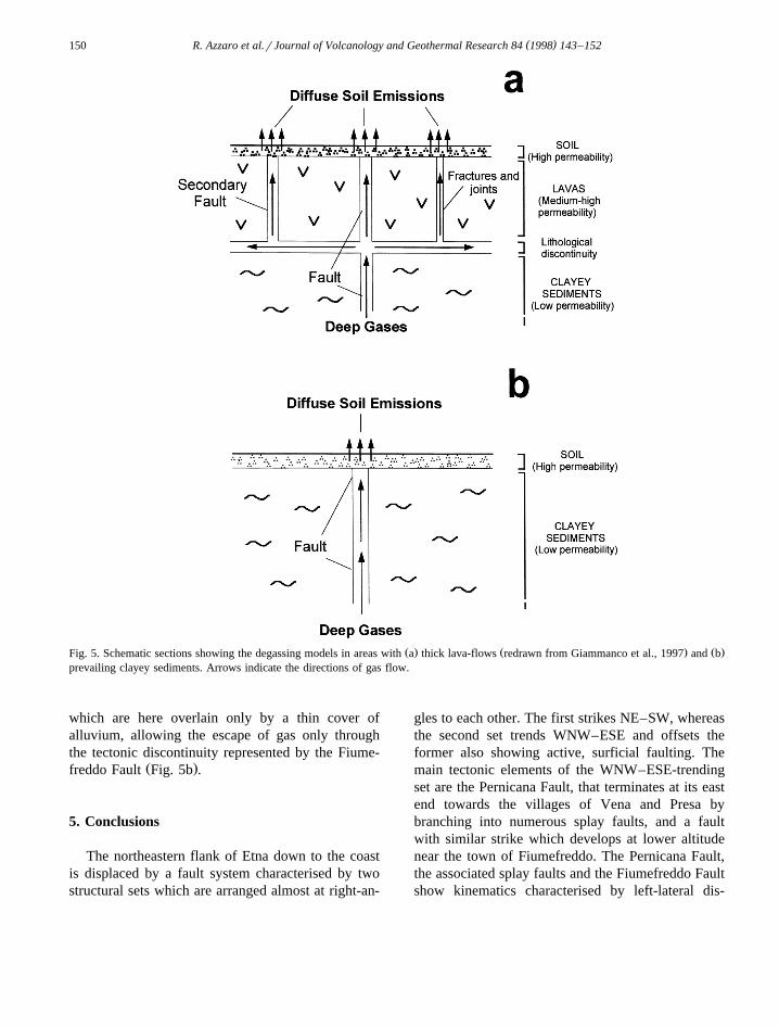
X Ž .and D–D Figs. 2 and 4 , characterised by scatteringof CO anomalies, cross areas where thick lava-flows2
crop out extensively. The dispersion of CO seems2Žto be ascribed to the typical fracturing of lavas Fig.
. Ž y55a , which present high permeability values 10 toy7 2 .10 cm according to Ferrara, 1975; Schiliro, 1988 ,`
or to complex structural conditions marked by thepresence of buried minor faults, as in line C–CX
discussed above. Contrastingly, the other samplinglines, which develop in areas where sedimentaryformations prevail, generally show soil degassinganomalies well defined with respect to backgroundvalue and located on the fault or on its supposedextension. In our opinion, the latter behaviour maybe ascribed to the low permeability of the claysŽ y9 y13 2 .10 to 10 cm according to Schiliro, 1988 ,`
( )R. Azzaro et al.rJournal of Volcanology and Geothermal Research 84 1998 143–152150
Ž . Ž . Ž .Fig. 5. Schematic sections showing the degassing models in areas with a thick lava-flows redrawn from Giammanco et al., 1997 and bprevailing clayey sediments. Arrows indicate the directions of gas flow.
which are here overlain only by a thin cover ofalluvium, allowing the escape of gas only throughthe tectonic discontinuity represented by the Fiume-
Ž .freddo Fault Fig. 5b .
5. Conclusions
The northeastern flank of Etna down to the coastis displaced by a fault system characterised by twostructural sets which are arranged almost at right-an-
gles to each other. The first strikes NE–SW, whereasthe second set trends WNW–ESE and offsets theformer also showing active, surficial faulting. Themain tectonic elements of the WNW–ESE-trendingset are the Pernicana Fault, that terminates at its eastend towards the villages of Vena and Presa bybranching into numerous splay faults, and a faultwith similar strike which develops at lower altitudenear the town of Fiumefreddo. The Pernicana Fault,the associated splay faults and the Fiumefreddo Faultshow kinematics characterised by left-lateral dis-

( )R. Azzaro et al.rJournal of Volcanology and Geothermal Research 84 1998 143–152 151
placements and are clearly active through creeping,as demonstrated by the progressive damage affectingseveral man-made features located on them.
Soil–gas surveys carried out along sampling linescrossing the faults indicate that in general CO2
anomalous degassing depends on the permeability ofthe exposed rocks and peaks primarily on the main
ŽWNW–ESE structures Pernicana and Fiumefreddo.Faults . The highest CO values were mainly de-2
tected in the lower part of the study area and wereclearly located on the Pernicana–Fiumefreddo FaultSystem and on its eastward prolongation. In particu-lar, the anomalous degassing observed along thecoast on the projected axis of the Fiumefreddo FaultŽ X X X X.lines B–B , G–G , H–H , A–A , suggests that thisstructure continues at least as far as the Ionian Sea.High dynamic CO concentrations were also ob-2
served in connection with other visible or buriedfaults of the area.
The cross-correlation between structural and geo-chemical data seems to indicate that the Pernicanaand Fiumefreddo Faults are discrete segments of anear continuous left-lateral shear zone which dis-places the whole north-eastern flank of Mt. Etna.This shear zone links to the active NE Rift andaccommodates the E–W extensional strains associ-ated with magma emplacement within the Rift itself.We suggest that the brittle deformation revealed bythe active left-lateral movement along the PernicanaFault is transferred downhill by splay faults, througha small area of ductile deformation, to the Fiume-freddo Fault as far as the Ionic coast. If this is true,the deformation zone is deeper than the volcaniccover and cuts at least the uppermost portion of theEtna’s sedimentary basement and may connect to thesubmarine ridge which develops offshore with thesame trend.
Not only has the information acquired shed morelight on the tectonics and related mechanisms ofstrain release along the easternmost sector of thePernicana Fault and its downhill prolongation, it hasalso improved the understanding of the nature ofdiffuse soil degassing on Mt. Etna in relation tofaults and lithofacies. In particular, the multidisci-plinary approach adopted has allowed the detectionof hidden faults as buried segments of surface activestructures. Such a methodology may significantlycontribute to improved seismic hazard assessment
and geodynamic modelling in other active volcanicareas.
Acknowledgements
This work was carried out within the frameworkof activities coordinated and financially supported bythe ‘Gruppo Nazionale per la Vulcanologia, C.N.R.’and by the ‘Gruppo Nazionale per la Difesa dasTerremoti, C.N.R.’ of Italy. The authors wish tothank T. Druitt, W.J. McGuire, and N. Oskarsson fortheir useful comments and suggestions.
References
Anza, S., Badalamenti, B., Giammanco, S., Gurrieri, S., Nuccio,`P.M., Valenza, M., 1993. Preliminary study on emanation of
Ž .CO from soils in some areas of Mt. Etna Sicily . Acta2
Vulcanol. 3, 189–193.Azzaro, R., 1997. Seismicity and active tectonics along the Perni-
Ž . Ž .cana Fault, Mt. Etna Italy . Acta Vulcanol. 9 1r2 , 7–14.Azzaro, R., Lo Giudice, E., Rasa, R., 1988. Il terremoto di Piano`
Ž .Pernicana Etna Nord del 28r10r1988. Campo macrosismicoe quadro deformativo fragile associato all’evento. Boll. GNV4, 22–40.
Azzaro, R., Lo Giudice, E., Rasa, R., 1989. Catalogo degli eventi`macrosismici e delle fenomenologie da creep nell’area etneadall’agosto 1980 al dicembre 1989. Boll. GNV 5, 13–46.
Azzaro, R., Birritta, G., Lo Giudice, E., Rasa, R., 1992. Eventi`macrosismici nell’area etnea nel periodo 1989–1991 ed impli-cazioni sismotettoniche. Boll. Acc. Gioenia Sci. Nat. Catania
Ž .25 339 , 375–394.Borgia, A., Ferrari, L., Pasquare, G., 1992. Importance of gravita-`
tional spreading in the tectonic evolution of Mt. Etna. Nature357, 231–236.
Carapezza, M., 1962. Un esempio di eruzione laterale da faglianell’apparato eruttivo etneo. Acta Geol. Alpina 8, 249–276.
Cortesi, C., Fornaseri, M., Romano, R., Alessio, A., Allegri, L.,Azzi, C., Bella, F., Calderoni, G., Follieri, M., Improta, S.,Magri, D., Preite-Mertinez, M., Sadori, L., Petrone, V., Turi,B., 1988. Cronologia 14C di piroclastiti recenti del MonteEtna, identificazione e distribuzione dei fossili vegetali. Boll.Soc. Geol. Ital. 107, 531–545.
Cristofolini, R., Patane, G., Puglisi, D., Rasa, R., Tranchina, A.,` `1977. Il basso versante nord-orientale dell’Etna nei dintorni diPiedimonte Etneo: studio geologico e morfostrutturale. Boll.Soc. Geol. Ital. 96, 695–712.
Cristofolini, R., Patane, G., Rasa, R., 1978. Studio morfostrut-` `turale del versante orientale etneo. Mem. Soc. Geol. Ital. 19,613–620.
D’Alessandro, W., Parello, F., 1995. Soil degassing from theŽ .lower flanks of Mt. Etna. In: Dubois, C. Ed. , Gas Geochem-
istry. Science Reviews, Northwood, UK, pp. 189–201.

( )R. Azzaro et al.rJournal of Volcanology and Geothermal Research 84 1998 143–152152
D’Alessandro, W., De Domenico, R., Parello, F., Valenza, M.,1992. Soil degassing in tectonically active areas of Mt. Etna.Acta Vulcanol. 2, 175–183.
Ferrara, V., 1975. Idrogeologia del versante orientale dell’Etna.Proc. 3rd Int. Conf. Acque Sotterranee. Palermo, Italy, pp.91–144.
Gabbianelli, G., Lanzafame, G., Lucchini, F., Pompilio, M., Rossi,P.L., Sartori, R., 1995. Indagini di geologia marina alla base
Ž .orientale dell’Etna. In: Ferrucci, F., Innocenti, F. Eds. , Pro-getto-Etna 1993–1995. Giardini, Pisa, Italy, pp. 79–84.
Ghisetti, F., 1979. Relazione tra strutture e fasi trascorrenti edistensive lungo i sistemi Messina-Fiumefreddo, Tindari-
Ž .Letojanni e Alia-Malvagna Sicilia nord-orientale : uno studiomicrotettonico. Geol. Romana 18, 23–58.
Giammanco, S., Gurrieri, S., Valenza, M., 1995. Soil CO de-2Ž .gassing on Mt. Etna Sicily during the period 1989–1993:
discrimination between climatic and volcanic influences. Bull.Volcanol. 57, 52–60.
Giammanco, S., Gurrieri, S., Valenza, M., 1997. Soil CO de-2Ž .gassing along tectonic structures of Mt. Etna Sicily : the
Pernicana Fault. Appl. Geochem. 12, 429–436.Gurrieri, S., Valenza, M., 1988. Gas transport in natural porous
mediums: a method for measuring CO flows from the ground2
in volcanic and geothermal areas. Rend. Soc. Ital. Min. Petrog.43, 1151–1158.
Hinkle, M., 1990. Factors affecting concentrations of helium andcarbon dioxide in soil gases. In: Durrance, E.M., Galimov,E.M., Hinkle, M.E., Reimer, G.M., Sugisaki, R., Augustithis,
Ž .S.S. Eds. , Geochemistry of Gaseous Elements and Com-pounds. Theophrastus Publications, Athens, Greece, pp. 421–448.
Hobbs, B.E., Means, W.D., Williams, P.F., 1976. An Outline ofStructural Geology. Wiley, New York.
Imbo, G., 1935. I terremoti etnei. Regia Accademia Nazionale dei`Lincei, pubblicazioni della commissione italiana per lo studiodelle grandi calamita, 5, pp. 1–93.`
Kanemasu, E.T., Powers, W.L., Sij, J.W., 1974. Field chambermeasurements of CO flux from soil surface. Soil Sci. 118,2
233–237.Klusman, R.W., 1993. Soil Gas and Related Methods for Natural
Resource Exploration. Wiley, New York.Lo Giudice, E., Rasa, R., 1992. Very shallow earthquakes and`
brittle deformation in active volcanic areas: the Etnean regionas example. Tectonophysics 202, 257–268.
Lo Giudice, E., Patane, G., Rasa, R., Romano, R., 1982. The` `structural framework of Mt. Etna. Mem. Soc. Geol. Ital. 23,125–158.
McGuire, W.J., Moss, J.L., Saunders, S.J., Stewart, I.S., 1996.Dyke-induced rifting and edifice instability at Mount Etna. In:
Ž .Gravestock, P.J., McGuire, W.J. Eds. , Etna: Fifteen Yearson. Cheltenham, pp. 20–24.
Neri, M., Garduno, V.H., Pasquare, G., Rasa, R., 1991. Studio˜ ` `strutturale e modello cinematico della Valle del Bove e delsettore nord-orientale etneo. Acta Vulcanol. 1, 17–24.
Rasa, R., Azzaro, R., 1995. Creep su faglia e sue implicazioni`sulla statica del versante orientale dell’Etna. In: Progetto Etna1993–1995: Stato di avanzamento delle Ricerche. Giardini,Pisa, pp. 137–144.
Rasa, R., Romano, R., Lo Giudice, E., 1982. Morphotectonic map`of Mt. Etna. Mem. Soc. Geol. Ital. 23.
Rasa, R., Ferrucci, F., Gresta, S., Patane, D., 1995. Etna: sistema` `di alimentazione profondo, assetto geostatico locale e bi-modalita di funzionamento del vulcano. In: Ferrucci, F., Inno-`
Ž .centi, F. Eds. , Progetto–Etna 1993–1995. Giardini, Pisa,Italy, pp. 145–150.
Rasa, R., Azzaro, R., Leonardi, O., 1996a. Aseismic creep on`faults and flank instability at Mt. Etna volcano, Sicily. In:
Ž .McGuire, W.J., Jones, A.P., Neuberg, J. Eds. , VolcanoInstability on the Earth and Other Planets. Geological SocietySpecial Publication, London, UK, 110, 179–192.
Rasa, R., Branca, S., Tripodo, A., 1996b. Carta geologica del`Ž .basso versante nord-orientale dell’Etna scala 1: 15.000 . Publ.
no. 8 del Laboratorio di Cartografia Numerica dell’Istituto diScienze della Terra, Univ. di Messina.
Romano, R., 1982. Succession of the volcanic activity in theEtnean area. Mem. Soc. Geol. Ital. 23, 27–48.
Rust, D., Neri, M., 1996. The boundaries of large-scale collapseon the flanks of Mt. Etna, Sicily. In: McGuire, W.J., Jones,
Ž .A.P., Neuberg, J. Eds. , Volcano Instability on the Earth andOther Planets. Geological Society Special Publication, Lon-don, UK, 110, pp. 193–208.
Schiliro, F., 1988. Proposta metodologica per una zonazione`geologico–tecnica del centro abitato di Maletto. Geol. Tecnica3r88, 32–53.
Sugisaki, R., Ido, M., Takeda, H., Isobe, Y., Hayashi, Y., Naka-mura, N., Satake, H., Mizutani, Y., 1983. Origin of hydrogenand carbon dioxide in fault gases and its relation to fault
Ž .activity. J. Geol. 91 3 , 239–258.