18CV35 - Basic Surveying
21
BE-3-CV-SKIT-Ph5b1-F02-V2.2 COURSE PLAN - CAY 2019-20 SRI KRISHNA INSTITUTE OF TECHNOLOGY , BANGALORE-90 COURSE PLAN Academic Year 2019-20 Program: B E – CIVIL ENGINEERING Semester : 3 Course Code: 18CV35 Course Title: Basic Surveying Credit / L-T-P: 4 / 4-0-0 Total Contact Hours: 50 Course Plan Author: VINOD M Academic Evaluation and Monitoring Cell #29, Hesaragatta Main Road, Chimney Hills Chikkabanavara Post Bangalore-560090 PH-080-23821488/23821315 www.Skit.org , Email: [email protected] 18CV35 / A Copyright ©2017. cAAS. All rights reserved. Page # 1 / 21 Ref No:
-
Upload
khangminh22 -
Category
Documents
-
view
3 -
download
0
Transcript of 18CV35 - Basic Surveying

BE-3-CV-SKIT-Ph5b1-F02-V2.2COURSE PLAN - CAY 2019-20
SRI KRISHNA INSTITUTE OF TECHNOLOGY , BANGALORE-90
COURSE PLAN
Academic Year 2019-20
Program: B E – CIVIL ENGINEERING
Semester : 3
Course Code: 18CV35
Course Title: Basic Surveying
Credit / L-T-P: 4 / 4-0-0
Total Contact Hours: 50
Course Plan Author: VINOD M
Academic Evaluation and Monitoring Cell
#29, Hesaragatta Main Road, Chimney HillsChikkabanavara Post Bangalore-560090
PH-080-23821488/23821315www.Skit.org, Email: [email protected]
18CV35 / A Copyright ©2017. cAAS. All rights reserved.Page # 1 / 21
Ref No:

BE-3-CV-SKIT-Ph5b1-F02-V2.2COURSE PLAN - CAY 2019-20
Table of ContentsA. COURSE INFORMATION..............................................................................................................3
1. Course Overview....................................................................................................................................................32. Course Content.......................................................................................................................................................33. Course Material....................................................................................................................................................... 44. Course Prerequisites...........................................................................................................................................45. Content for Placement, Profession, HE and GATE........................................................................4
B. OBE PARAMETERS...........................................................................................................................51. Course Outcomes..................................................................................................................................................52. Course Applications.............................................................................................................................................53. Mapping And Justification...............................................................................................................................64. Articulation Matrix.................................................................................................................................................65. Curricular Gap and Content...........................................................................................................................76. Content Beyond Syllabus................................................................................................................................7
C. COURSE ASSESSMENT................................................................................................................71. Course Coverage....................................................................................................................................................72. Continuous Internal Assessment (CIA)...................................................................................................8
D1. TEACHING PLAN - 1......................................................................................................................8Module - 1........................................................................................................................................................................ 8Module – 2....................................................................................................................................................................... 9
E1. CIA EXAM – 1.....................................................................................................................................10a. Model Question Paper - 1............................................................................................................................. 10b. Assignment -1........................................................................................................................................................ 10
D2. TEACHING PLAN - 2...................................................................................................................11Module – 3..................................................................................................................................................................... 11Module – 4..................................................................................................................................................................... 12
E2. CIA EXAM – 2....................................................................................................................................13a. Model Question Paper - 2............................................................................................................................. 13b. Assignment – 2..................................................................................................................................................... 14
D3. TEACHING PLAN - 3...................................................................................................................14Module – 5..................................................................................................................................................................... 14
E3. CIA EXAM – 3....................................................................................................................................15a. Model Question Paper - 3............................................................................................................................. 15b. Assignment – 3..................................................................................................................................................... 16
F. EXAM PREPARATION....................................................................................................................161. University Model Question Paper............................................................................................................162. SEE Important Questions............................................................................................................................... 17
G. Content to Course Outcomes...............................................................................................191. TLPA Parameters................................................................................................................................................. 192. Concepts and Outcomes:.............................................................................................................................20
Note : Remove “Table of Content” before including in CP Book Each Course Plan shall be printed and made into a book with cover page Blooms Level in all sections match with A.2, only if you plan to teach / learn at higher levels
18CV35 / A Copyright ©2017. cAAS. All rights reserved.Page # 2 / 21

BE-3-CV-SKIT-Ph5b1-F02-V2.2COURSE PLAN - CAY 2019-20
A. COURSE INFORMATION1. Course Overview
Degree: BE Program:CIVILENGINEERING
Semester: 3 Academic Year: 2019-20.Course Title: Basic Surveying. Course Code: 15cv35.Credit / L-T-P: 4 / 4-0-0. SEE Duration: 180 MinutesTotal Contact Hours: 50 Hours. SEE Marks: 60 MarksCIA Marks: 40 Marks. Assignment 1 / Module
Course Plan Author: VINOD M. Sign .
Checked By: MOHAN K T Sign .
CO Targets 65% SEE Target: 60%Note: Define CIA and SEE % targets based on previous performance.
2. Course ContentContent / Syllabus of the course as prescribed by University or designed by institute. Identify 2 conceptsper module as in G.Module
Content TeachingHours
IdentifiedModule
Concepts
BloomsLearning
Levels1 Definition of surveying, Objectives and importance of
surveying. Classification of surveys. Principles of surveying. Units of measurements, Surveying Measurements and errors,types of errors, precision and accuracy. Classification of maps, map scale, conventional symbols, topographic maps, map layout, Survey of India Map numbering systems.Measuring tape and types. Measurement using tapes, Tapingon level ground and sloping ground. Errors and corrections intape measurements, ranging of lines, direct and indirectmethods of ranging, Electronic distance measurement, basicprinciple. Booking of tape survey work, Field book, entries,Conventional symbols, Obstacles in tape survey, Numericalproblems.
10 Introductionand importance
of surveying
Measurementof Horizontal
Distances
L2,L4
2 Basic definitions; meridians, bearings, magnetic and Truebearings. Prismatic and surveyor’s compasses, temporaryadjustments, declination. Quadrantal bearings, whole circlebearings, local attraction and related problems.Theodolite and types, Fundamental axes and parts of Transittheodolite, uses of theodolite, Temporary adjustments oftransit theodolite, measurement of horizontal and verticalangles, step by step procedure for obtaining permanentadjustment of Transit theodolite.
10 Compasssurvey
Theodolitesurvey
L2,L3
3 Traverse Survey and Computations: Latitudes anddepartures, rectangular coordinates, Traverse adjustments,Bowditch rule and transit rule, Numerical Problems.Basic principle, types of tacheometry, distance equation forhorizontal and inclined line of sight in fixed hair method,problems.
10 Traverse survey
Tacheometrysurvey
L2,L3
4 Basic terms and definitions, Methods of leveling, Dumpylevel, auto level, digital and laser levels. Curvature andrefraction corrections. Booking and reduction of levels.Differential leveling, profile leveling, fly leveling, checkleveling, reciprocal leveling, trigonometric leveling (heightsand distances-single plane and double plane methods.
10 leveling L2,L4
5 By dividing the area into geometrical figures, area fromoffsets, mid ordinate rule, trapezoidal and Simpson’s one third
10 Computations of Area
L2
18CV35 / A Copyright ©2017. cAAS. All rights reserved.Page # 3 / 21

BE-3-CV-SKIT-Ph5b1-F02-V2.2COURSE PLAN - CAY 2019-20
rule, area from co-ordinates, introduction to planimeter,digital planimeter. Measurement of volumes-trapezoidal andprismoidal formula.Contours, Methods of contouring, Interpolation of contours,contour gradient, characteristics of contours and uses.
and volume contouring
- Total 50 - -
3. Course MaterialBooks & other material as recommended by university (A, B) and additional resources used by courseteacher (C).1. Understanding: Concept simulation / video ; one per concept ; to understand the concepts ; 15 – 30minutes2. Design: Simulation and design tools used – software tools used ; Free / open source3. Research: Recent developments on the concepts – publications in journals; conferences etc.Modul
esDetails Chapters
in bookAvailability
A Text books (Title, Authors, Edition, Publisher, Year.) - -1,2,3,4,
5B.C. Punmia, “Surveying Vol.1”, Laxmi Publications pvt. Ltd., New DelhI 2009.
1,2,3,4,5 In Lib / In Dept
1,2,3,4,5
Kanetkar T P and S V Kulkarni , Surveying and Leveling Part I, Pune Vidyarthi Griha Prakashan, 1988
1,2,3,4,5 In Lib/ In dept
B Reference books (Title, Authors, Edition, Publisher, Year.) - -.S.K. Duggal, “Surveying Vol.1”, Tata McGraw Hill Publishing Co. Ltd. NewDelhi. – 2009.
In Lib/ In dept
K.R. Arora, “Surveying Vol. 1” Standard Book House, New Delhi. – 2010 In Lib/ In deptR Subramanian, Surveying and Leveling, Second edition, Oxford University Press, New Delhi.
In Lib/ In dept
C Concept Videos or Simulation for Understanding - -C1 http://nptel.ac.in/courses.php?disciplineID=111 C2 http://wwww.khanacademy.org/E Recent Developments for Research - -
F Others (Web, Video, Simulation, Notes etc.) - -
4. Course PrerequisitesRefer to GL01. If prerequisites are not taught earlier, GAP in curriculum needs to be addressed. Include inRemarks and implement in B.5. Students must have learnt the following Courses / Topics with described Content . . . Module
sCourseCode
Course Name Topic / Description Sem Remarks BloomsLevel
5. Content for Placement, Profession, HE and GATEThe content is not included in this course, but required to meet industry & profession requirements andhelp students for Placement, GATE, Higher Education, Entrepreneurship, etc. Identifying Area / Contentrequires experts consultation in the area.Topics included are like, a. Advanced Topics, b. Recent Developments, c. Certificate Courses, d. CourseProjects, e. New Software Tools, f. GATE Topics, g. NPTEL Videos, h. Swayam videos etc.Mod Topic / Description Area Remarks Blooms
18CV35 / A Copyright ©2017. cAAS. All rights reserved.Page # 4 / 21
BE-3-CV-SKIT-Ph5b1-F02-V2.2COURSE PLAN - CAY 2019-20
ules Level1335--
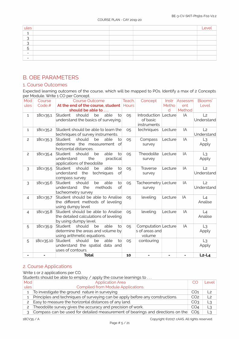
B. OBE PARAMETERS1. Course OutcomesExpected learning outcomes of the course, which will be mapped to POs. Identify a max of 2 Conceptsper Module. Write 1 CO per Concept.Modules
CourseCode.#
Course OutcomeAt the end of the course, student
should be able to . . .
Teach.Hours
Concept InstrMetho
d
Assessment
Method
Blooms’Level
1 18cv35.1 Student should be able tounderstand the basics of surveying.
05 Introductionof basic
instruments
Lecture IA L2Understand
1 18cv35.2 Student should be able to learn thetechniques of survey instruments.
05 techniques Lecture IA L2Understand
2 18cv35.3 Student should be able todetermine the measurement ofhorizontal distances.
05 Compasssurvey
Lecture IA L3Apply
2 18cv35.4 Student should be able tounderstand the practicalapplications of theodolite
05 Theodolitesurvey
Lecture IA L3Apply
3 18cv35.5 Student should be able tounderstand the techniques ofcompass survey
05 Traversesurvey
Lecture IA L2Understand
3 18cv35.6 Student should be able tounderstand the methods oftacheometry survey
05 Tacheometrysurvey
Lecture
IA L2Understand
4 18cv35.7 Student should be able to Analisethe different methods of levelingusing dumpy level
05 leveling Lecture IA L4Analise
4 18cv35.8 Student should be able to Analisethe detailed calculations of levelingby using dumpy level.
05 leveling Lecture IA L4Analise
5 18cv35.9 Student should be able todetermine the areas and volume byusing arithmetic equations.
05 Computations of areas and
volume
Lecture IA L3Apply
5 18cv35.10 Student should be able tounderstand the spatial data anduses of contours.
05 contouring L3Apply
- - Total 10 - - - L2-L4
2. Course ApplicationsWrite 1 or 2 applications per CO. Students should be able to employ / apply the course learnings to . . . Modules
Application AreaCompiled from Module Applications.
CO Level
1 To investigate the ground nature in surveying CO1 L21 Principles and techniques of surveying can be apply before any constructions. CO2 L22 Easy to measure the horizontal distances of any land. CO3 L32 Theodolite survey gives the accuracy and precision of work. CO4 L33 Compass can be used for detailed measurement of bearings and directions on the CO5 L3
18CV35 / A Copyright ©2017. cAAS. All rights reserved.Page # 5 / 21

BE-3-CV-SKIT-Ph5b1-F02-V2.2COURSE PLAN - CAY 2019-20
fields.3 Easy to identify the directions of land by using compass. CO6 L34 To get the knowledge of ground profile. CO7 L24 Before any constructions we can apply methods of leveling. CO8 L25 With help of arithmetic equations to calculate the areas and volume of all type of
land. CO9 L3
5 By using contours easy to determine the storage capacity of water bodies. CO10 L4
3. Mapping And JustificationCO – PO Mapping with mapping Level along with justification for each CO-PO pair.To attain competency required (as defined in POs) in a specified area and the knowledge & ability required to accomplish it.Modules
Mapping MappingLevel
Justification for each CO-PO pair Level
- CO PO - ‘Area’: ‘Competency’ and ‘Knowledge’ for specified ‘Accomplishment’ -CO1 PO1 L2 Engineering knowledge of basics of surveying. L2CO1 PO2 Engineering knowledge of basics of surveying. L2CO2 PO1 L2 Engineering knowledge of technics of surveying instruments L2CO2 PO2 L2 Analyses of problems on chain surveying L3CO3 PO1 Understanding the measurement of horizontal distances. L3CO3 PO2 L5 Analyses of problems on horizontal distances L4CO4 PO1 L5 Understanding the practical applications of theodolite L2CO4 PO2 Understanding the practical applications of theodolite L2CO5 PO1 L5 Engineering knowledge of techniques of compass surveying L3CO5 PO2 L5 Analyses of problems on compass surveying L4CO6 PO1 Engineering knowledge of methods of tacheometry surveying L2CO6 PO2 L5 Analyses of problems on tacheometric surveying L2CO7 PO1 L5 Engineering knowledge of different methods of leveling using dumpy
levelL2
CO7 PO2 Analyses of problems on leveling L4CO8 PO1 L5 Engineering knowledge of different methods of leveling using dumpy
levelL3
CO8 PO2 L5 Analyses of problems on leveling L4CO9 PO1 Engineering knowledge of areas and volume by using arithmetic
equations.L3
CO9 PO2 L5 Analyses of problems on areas and volume by using arithmetic equations. L4CO10 PO1 L5 Understanding the knowledge of spatial data and uses of contours. L3CO10 PO2 Understanding the knowledge of spatial data and uses of contours. L3
4. Articulation MatrixCO – PO Mapping with mapping level for each CO-PO pair, with course average attainment.
- - Course Outcomes Program Outcomes -Modules
CO.# At the end of the coursestudent should be able to . . .
PO1
PO2
PO3
PO4
PO5
PO6
PO7
PO8
PO9
PO10
PO11
PO12
PSO1
PSO2
PSO3
Level
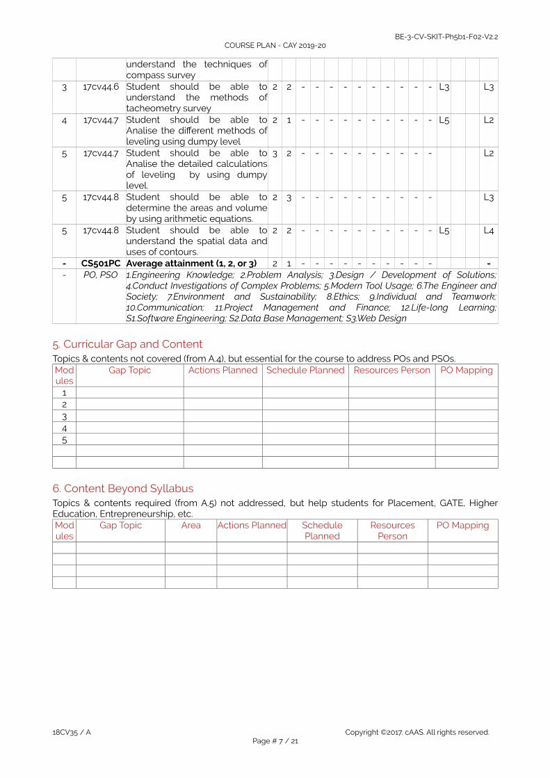
1 17cv44.1 Student should be able tounderstand the basics ofsurveying.
2 1 - - - - - - - - - - L2 L2
1 17cv44.2 Student should be able to learnthe techniques of surveyinstruments.
2 1 - - - - - - - - - - L3 L2
2 17cv44.3 Student should be able todetermine the measurement ofhorizontal distances.
2 2 - - - - - - - - - - L3 L2
2 17cv44.4 Student should be able tounderstand the practicalapplications of theodolite
3 3 - - - - - - - - - - L2 L2
3 17cv44.5 Student should be able to 3 2 - - - - - - - - - - L3 L3
18CV35 / A Copyright ©2017. cAAS. All rights reserved.Page # 6 / 21
BE-3-CV-SKIT-Ph5b1-F02-V2.2COURSE PLAN - CAY 2019-20
understand the techniques ofcompass survey
3 17cv44.6 Student should be able tounderstand the methods oftacheometry survey
2 2 - - - - - - - - - - L3 L3
4 17cv44.7 Student should be able toAnalise the different methods ofleveling using dumpy level
2 1 - - - - - - - - - - L5 L2
5 17cv44.7 Student should be able toAnalise the detailed calculationsof leveling by using dumpylevel.
3 2 - - - - - - - - - - L2
5 17cv44.8 Student should be able todetermine the areas and volumeby using arithmetic equations.
2 3 - - - - - - - - - - L3
5 17cv44.8 Student should be able tounderstand the spatial data anduses of contours.
2 2 - - - - - - - - - - L5 L4
- CS501PC Average attainment (1, 2, or 3) 2 1 - - - - - - - - - - -- PO, PSO 1.Engineering Knowledge; 2.Problem Analysis; 3.Design / Development of Solutions;
4.Conduct Investigations of Complex Problems; 5.Modern Tool Usage; 6.The Engineer andSociety; 7.Environment and Sustainability; 8.Ethics; 9.Individual and Teamwork;10.Communication; 11.Project Management and Finance; 12.Life-long Learning;S1.Software Engineering; S2.Data Base Management; S3.Web Design
5. Curricular Gap and ContentTopics & contents not covered (from A.4), but essential for the course to address POs and PSOs.Modules
Gap Topic Actions Planned Schedule Planned Resources Person PO Mapping
12345
6. Content Beyond SyllabusTopics & contents required (from A.5) not addressed, but help students for Placement, GATE, HigherEducation, Entrepreneurship, etc.Modules
Gap Topic Area Actions Planned SchedulePlanned
ResourcesPerson
PO Mapping
18CV35 / A Copyright ©2017. cAAS. All rights reserved.Page # 7 / 21

BE-3-CV-SKIT-Ph5b1-F02-V2.2COURSE PLAN - CAY 2019-20
C. COURSE ASSESSMENT1. Course CoverageAssessment of learning outcomes for Internal and end semester evaluation. Distinct assignment for eachstudent. 1 Assignment per chapter per student. 1 seminar per test per student.Modules
Title Teaching
Hours
No. of question in Exam CO LevelsCIA-1 CIA-2 CIA-3 Asg Extra
AsgSEE
1 Introduction and measurement ofhorizontal distances
10 2 - - 1 - 2 CO1, CO2 L2
2 Measurement of directions andangles compass surveyingTheodolite survey and instrumentadjustment
10 2 - - 1 2 CO3, CO4 L3
3 Traversing and Tacheometry 10 - 2 - 1 1 2 CO5, CO6 L34 Leveling 10 - 2 - 1 1 2 CO7, C08 L45 Areas and volumes
contouring 10 - 1 3 1 1 2 CO9, CO10 L3
- Total 50 4 5 3 5 3 10 - -
2. Continuous Internal Assessment (CIA)Assessment of learning outcomes for Internal exams. Blooms Level in last column shall match with A.2.
Evaluation Weightage in
Marks
CO Levels Evaluation
CIA Exam – 1 40 CO1, CO2, CO3, CO4 CIA Exam – 1 CIA Exam – 1 CIA Exam – 2 40 CO5, CO6, CO7, C08 CIA Exam – 2 CIA Exam – 2 CIA Exam – 3 40 CO9, CO10 CIA Exam – 3 CIA Exam – 3
Assignment - 1 05 CO1, CO2, CO3, CO4 Assignment - 1 Assignment - 1Assignment - 2 05 CO5, CO6, CO7, CO8 Assignment - 2 Assignment - 2Assignment - 3 05 CO9, CO10 Assignment - 3 Assignment - 3
Seminar - 1 05 CO1, CO2, CO3, CO4 Seminar - 1 Seminar - 1Seminar - 2 05 CO5, CO6,CO7,CO8 Seminar - 2 Seminar - 2Seminar - 3 05 CO9, CO10 Seminar - 3 Seminar - 3
Other Activities– define – Sliptest
CO1 to Co9 Other Activities– define – Sliptest
Final CIA Marks 40 - -
D1. TEACHING PLAN - 1Module - 1
Title: Introduction measurement of horizontal distances ApprTime:
08 Hrs
a Course Outcomes - Blooms- The student should be able to: - Level1 Understand the basics of surveying. CO1 L22 learn the techniques of survey instruments CO2 L2
b Course Schedule - -Class No Module Content Covered CO Level
1 Introduction and Definition of surveying C01 L12 Objectives and importance of surveying C01 L1
18CV35 / A Copyright ©2017. cAAS. All rights reserved.Page # 8 / 21

BE-3-CV-SKIT-Ph5b1-F02-V2.2COURSE PLAN - CAY 2019-20
3 Classification of surveys. Principles of surveying. Units of measurements C01 L24 Surveying Measurements and errors, types of errors, precision and accuracy.
Classification of maps, map scale C01 L2
5 conventional symbols, topographic maps, map layout, Survey of India Mapnumbering systems
C01 L2
6 Measuring tape and types. Measurement using tapes C01 L27 Taping on level ground and sloping ground. Errors and corrections in tape
measurementsC02 L2
8 ranging of lines, direct and indirect methods of ranging, Electronic distancemeasurement
C02 L2
9 basic principle. Booking of tape survey work, Field book, entries C02 L210 Conventional symbols, Obstacles in tape survey, Numerical problems C02 L2
c Application Areas CO Level1 To investigate the ground nature in surveying CO1 L22 Principles and techniques of surveying can be apply before any constructions. CO2 L2d Review Questions - -1 Define surveying ? Write the principles of surveying. CO1 L12 Write and explain classifications of survey. CO1 L23 Define errors, precision, accuracy CO2 L24 Define ranging ? Write and explain methods of ranging. CO2 L25 Write obstacles in chaining , ranging but not chaining. CO2 L26 A 20 M chain was found to be 10 cm too long after chaining a distance of
1500m. It was found to be 18cm too long at the end of days work afterchaining total distance of 2900m. Find the true distance if the chain wascorrect before the commencement of the work.
CO2 L2
e Experiences - -123
Module – 2Title: Measurement of directions and angles: compass survey
theodolite survey and instrument adjustmentAppr
Time: 08 Hrs
a Course Outcomes - Blooms- The student should be able to: - Level1 Student should be able to determine the measurement of horizontal
distances.CO3 L4
2 Student should be able to understand the practical applications of theodolite CO4 L3
b Course Schedule - -Class No Module Content Covered CO Level
1 Basic definitions; meridians, bearings, magnetic and True bearings C03 L22 Prismatic and surveyor’s compasses C03 L2
3 temporary adjustments, declination, Quadrantal bearings, whole circlebearings
C03 L2
4 local attraction and related problems. Theodolite and types C04 L25 Fundamental axes and parts of Transit theodolite C04 L36 uses of theodolite, Temporary adjustments of transit theodolite C04 L37 measurement of horizontal and vertical angles C04 L38 step by step procedure for obtaining permanent adjustment of Transit
theodoliteC04 L3
9 step by step procedure for obtaining permanent adjustment of Transittheodolite
C04 L3
18CV35 / A Copyright ©2017. cAAS. All rights reserved.Page # 9 / 21

BE-3-CV-SKIT-Ph5b1-F02-V2.2COURSE PLAN - CAY 2019-20
10 Basic definitions; meridians, bearings, magnetic and True bearings, Prismaticand surveyor’s compasses
C04 L3
11 temporary adjustments, declination C04 L3c Application Areas CO Level1 Easy to measure the horizontal distances of any land. CO3 L22 Theodolite survey gives the accuracy and precision of work. CO4 L3
d Review Questions - -1 Give in a tabular form, the difference between prismatic compass and
surveyors compass. CO3 L2
2 What is local attraction? How is it detected and eliminated ? CO3 L23 The following are bearings taken on a closed traverse.
Line F.B. B.B AB 80*10’ 259*0* BC 120* 20’ 301*50’ CD 170*50’ 350*50’ DE 230* 10’ 49*30’ EA 310*20’ 139*15’ compute the interior angles and correct them for observational errors.Assuming the observed bearings of the line C D to be adjust the bearing of theremaining sides.
CO3 L2
4 With neat sketch fundamental lines and desired relations of transit theodolite. CO4 L25 Explain the temporary adjustments of transit theodolite. CO4 L2
e Experiences - -
E1. CIA EXAM – 1a. Model Question Paper - 1Crs Code:18CV35 Sem: III Marks: 40 Time: 75 minutesCourse: Basic Surveying
- - Note: Answer any 1 questions from each module, each carry equalmarks.
CO Level Marks
Module-11 a Define surveying ? Write the principles of surveying. 15 CO1 L1
b Write obstacles in chaining , ranging but not chaining. L2c A 20 M chain was found to be 10 cm too long after chaining a distance of
1500m. It was found to be 18cm too long at the end of days work afterchaining total distance of 2900m. Find the true distance if the chain wascorrect before the commencement of the work.
CO2 L3
2 a Define ranging ? Write and explain methods of ranging. 15 CO2 L2b Give in a tabular form, the difference between prismatic compass and
surveyors compass.CO3 L3
c What is local attraction? How is it detected and eliminated ? CO3 L3
3 a The following are bearings taken on a closed traverse. Line F.B. B.B AB 80*10’ 259*0* BC 120* 20’ 301*50’ CD 170*50’ 350*50’ DE 230* 10’ 49*30’ EA 310*20’ 139*15’ compute the interior angles and correct them for observational errors.Assuming the observed bearings of the line C D to be adjust the bearingof the remaining sides.
15 CO3 L3
b With neat sketch fundamental lines and desired relations of transittheodolite.
CO4 L2
18CV35 / A Copyright ©2017. cAAS. All rights reserved.Page # 10 / 21

BE-3-CV-SKIT-Ph5b1-F02-V2.2COURSE PLAN - CAY 2019-20
c Explain the temporary adjustments of transit theodolite. CO4 L2
b. Assignment -1Note: A distinct assignment to be assigned to each student.Model Assignment QuestionsCrs Code: 18CV35 Sem: III Marks: 10 Time: 90 – 120 minutesCourse: Basic SurveyingNote: Each student to answer 2-3 assignments. Each assignment carries equal mark.SNo USN Assignment Description Marks CO Level1 1KT17CV101 Define surveying ? Write the principles of surveying. 5 CO1 L22 1KT17CV102 Write and explain classifications of survey. 5 CO1 L23 1KT17CV103 Define errors, precision, accuracy 5 CO2 L24 1KT17CV104 Define ranging ? Write and explain methods of ranging. 5 CO2 L35 1KT17CV105 Write obstacles in chaining , ranging but not chaining. 5 CO3 L26 1KT17CV106 Give in a tabular form, the difference between prismatic
compass and surveyors compass. 5 CO3 L2
7 1KT17CV107 What is local attraction? How is it detected and eliminated ? 5 CO3 L28 1KT17CV108 With neat sketch fundamental lines and desired relations of
transit theodolite. 5 CO3 L3
9 1KT17CV109 Explain the temporary adjustments of transit theodolite. 5 CO4 L210 1KT17CV110 Enumerate the application of theodolite. 5 CO4 L2
D2. TEACHING PLAN - 2Module – 3
Title: Traversing and Tacheometry ApprTime:
16 Hrs
a Course Outcomes - Blooms- The student should be able to: - Level1 Student should be able to understand the techniques of compass survey CO5 L22 Student should be able to understand the methods of tacheometry survey CO6 L3
b Course ScheduleClass No Module Content Covered CO Level
1 Traverse Survey and Computations CO5 L22 Latitudes and departures, rectangular coordinates CO5 L2
3 Traverse adjustments, Traverse adjustments CO5 L24 Numerical Problems CO5 L35 Numerical Problems CO5 L36 basic principle, types of tacheometry CO6 L27 distance equation for horizontal and inclined line of sight in fixed hair method CO6 L28 distance equation for horizontal and inclined line of sight in fixed hair method CO6 L29 Numerical Problems CO6 L310 Numerical Problems CO6 L3
c Application Areas CO Level1 Compass can be used for detailed measurement of bearings and directions on
the fields.CO5 L3
2 Easy to identify the directions of land by using compass. CO6 L3
d Review Questions - -1 Distinguish between chain survey and traverse surveying. CO5 L22 Briefly explain closed traverse and open traverse. CO5 L23 Explain clearly,with the help of illustrations, how traverse is balanced. CO5 L34 What are the different methods employed in tacheometric survey ? Describe
the method most commonly used.CO6 L3
18CV35 / A Copyright ©2017. cAAS. All rights reserved.Page # 11 / 21

BE-3-CV-SKIT-Ph5b1-F02-V2.2COURSE PLAN - CAY 2019-20
5 An observer standing on the deck of a ship just sees the top of light housewhich is 40mabove the sea level. If the height of the observer's eye is 8m above theCO6 sealevel, determinethe distance of the observer from the light house
CO6 L3
6 Two points A and B, 1530m apart are separated by a wide river. The followingreciprocal levels were taken with one level :
Instrument at Staff readings at
A B
A 3.810m 2.165m
B 2.355m 0.910m
The collimation error was —0.0004m per 100m. Calculate the true leveldifference between A and B and the refraction.
CO5 L3
e Experiences - -12345
Module – 4Title: Concrete mix Proportioning. Appr
Time: 08 Hrs
a Course Outcomes - Blooms- The student should be able to: - Level1 Student should be able to Analise the different methods of leveling using
dumpy levelCO7 L4
2 Student should be able to Analise the detailed calculations of leveling byusing dumpy level.
CO8 L4
b Course ScheduleClass No Module Content Covered CO Level
1 Basic terms and definitions CO7 L32 Methods of leveling, Dumpy level, auto level CO7 L33 digital and laser levels. Curvature and refraction corrections CO7 L3
4 Booking and reduction of levels, Differential leveling CO7 L5 profile leveling, fly leveling, check leveling CO8 L46 check leveling, reciprocal leveling CO8 L47 trigonometric leveling (heights and distances-single plane and double plane
methodsCO8 L4
8 trigonometric leveling (heights and distances-single plane and double planemethods
CO8 L4
9 trigonometric leveling (heights and distances- double plane methods) CO8 L410 trigonometric leveling (heights and distances- double plane methods) CO8 L4
c Application Areas CO Level1 To get the knowledge of ground profile. CO7 L32 Before any constructions we can apply methods of leveling. CO8 L4
d Review Questions - -1 Define leveling ? Write types of leveling. CO7 L22 Illustrate with neat sketches :
i) Profile levelingii) Differential levelingiii) Reciprocal leveling and
CO7 L3
18CV35 / A Copyright ©2017. cAAS. All rights reserved.Page # 12 / 21

BE-3-CV-SKIT-Ph5b1-F02-V2.2COURSE PLAN - CAY 2019-20
iv) Block leveling3 List and explain the temporary adjustments of a dumpy level CO8 L34 Two points A and B are 1530 m apart across a wide river. The following
reciprocal levels are taken with one level. Level @ Reading A on B (M) A 2.165 3.180 B 0.910 2.355The error in the Collimation adjustments of the level is —0.004m in 100 m.Calculate the true difference of levels between A and B and the refraction.
CO8 L4
5 Enumerate the errors in Leveling. CO8 L46 The following staff readings were observed successively with level, the
instrument having been moved after the third,sixth and eighth readings: 2.228,1.606, 0.988, 2.090, 2.864, 1.262, 0.602, 1.982, 1.044, 2.684, meters.Enter the above readings in a page of a level book and calculate the R L of thepoints, if the first reading was taken with a staff held on a bench mark of432.384 m.
CO8 L4
7 Define sensitiveness of bubble tube. Describe the field procedure todetermine the sensitiveness of bubble tube.
CO8 L3
8 Find the elevation of the top of the chimney from the following data:
Inst Station Reading on BM (m) Angle of elevation remarks
A 0.865 18*36’ RL of BM = 421.380m
B 1.225 10*12’ DistanceAB = 50m
Stations A, B and top of chimney are in the same vertical plane. Stationchimney.
CO8 L4
e Experiences - -12345
E2. CIA EXAM – 2a. Model Question Paper - 2Crs Code: 18cv35 Sem: III Marks: 40 Time: 75 minutesCourse: Basic Surveying
- - Note: Answer any 2 questions, each carry equal marks. Marks CO Level1 a Distinguish between chain survey and traverse surveying. 15 CO5 L1
b Briefly explain closed traverse and open traverse. L2c Two points A and B, 1530m apart are separated by a wide river. The
following reciprocal levels were taken with one level :
Instrument at Staff readings at
A B
A 3.810m 2.165m
B 2.355m 0.910m
The collimation error was —0.0004m per 100m. Calculate the true leveldifference between A and B and the refraction.
CO6 L3
2 a What are the different methods employed in tacheometric survey ?Describe the method most commonly used.
15 CO7 L2
b An observer standing on the deck of a ship just sees the top of lighthouse which is 40m above the sea level. If the height of the observer's
L4
18CV35 / A Copyright ©2017. cAAS. All rights reserved.Page # 13 / 21

BE-3-CV-SKIT-Ph5b1-F02-V2.2COURSE PLAN - CAY 2019-20
eye is 8m above the sea level, determine the distance of the observerfrom the light house
3 a illustrate with neat sketches : i) Profile leveling ii) Differential leveling iii) Reciprocal leveling and iv) Block leveling
15 CO8 L2
b Find the elevation of the top of the chimney from the following data:
Inst Station Reading on BM (m) Angle of elevation remarks
A 0.865 18*36’ RL of BM = 421.380m
B 1.225 10*12’ DistanceAB = 50m
Stations A, B and top of chimney are in the same vertical plane. Stationchimney.
CO8 L4
b. Assignment – 2Note: A distinct assignment to be assigned to each student.
Model Assignment QuestionsCrs Code: 18CV35 Sem: III Marks: 10 Time: 90 – 120 minutesCourse: Basic SurveyingNote: Each student to answer 2-3 assignments. Each assignment carries equal mark.SNo USN Assignment Description Marks CO Level
1 1KT17CV101 Distinguish between chain survey and traverse surveying. 5 CO6 L22 1KT17CV102 Briefly explain closed traverse and open traverse. 5 CO6 L33 1KT17CV103 Explain clearly,with the help of illustrations, how traverse is
balanced.CO7 L4
4 1KT17CV104 What are the different methods employed in tacheometricsurvey ? Describe the method most commonly used.
5 CO7 L3
5 1KT17CV105 Distinguish between chain survey and traverse surveying. 5 CO7 L36 1KT17CV106 Enumerate the errors in Leveling. 5 CO8 L37 1KT17CV107 illustrate with neat sketches :
i) Profile leveling ii) Differential leveling iii) Reciprocal leveling and iv) Block leveling
CO8 L3
8 1KT17CV108 Define sensitiveness of bubble tube. Describe the fieldprocedure to determine the sensitiveness of bubble tube.
5 CO8 L3
9 1KT17CV109 The following staff readings were observed successively withlevel, the instrument having been moved after the third,sixthand eighth readings: 2.228, 1.606, 0.988, 2.090, 2.864, 1.262,0.602, 1.982, 1.044, 2.684, meters.Enter the above readings in a page of a level book andcalculate the R L of the points, if the first reading was takenwith a staff held on a bench mark of 432.384 m.
5 CO8 L4
18CV35 / A Copyright ©2017. cAAS. All rights reserved.Page # 14 / 21

BE-3-CV-SKIT-Ph5b1-F02-V2.2COURSE PLAN - CAY 2019-20
D3. TEACHING PLAN - 3Module – 5
Title: Areas and volumes Contouring ApprTime:
08 Hrs
a Course Outcomes - Blooms- The student should be able to: - Level1 Student should be able to determine the areas and volume by using arithmetic
equations.CO9 L2
2 Student should be able to understand the spatial data and uses of contours. CO10 L3
b Course ScheduleClass No Module Content Covered CO Level
1 Measurement of area – by dividing the area into geometrical figures CO9 L22 area from offsets, mid ordinate rule CO9 L33 trapezoidal and Simpson’s one third rule, area from co-ordinates CO9 L2
4 introduction to planimeter, digital planimeter CO9 L35 Measurement of volumes-trapezoidal and prismoidal formula CO10 L26 Contours, Methods of contouring CO10 L37 Interpolation of contours, contour gradient CO10 L28 characteristics of contours and uses CO10 L39 Numerical Problems CO10 L210 Numerical Problems CO10 L3
c Application Areas CO Level1 With help of arithmetic equations to calculate the areas and volume of all type
of land. CO10 L3
2 By using contours easy to determine the storage capacity of water bodies. CO9 L4
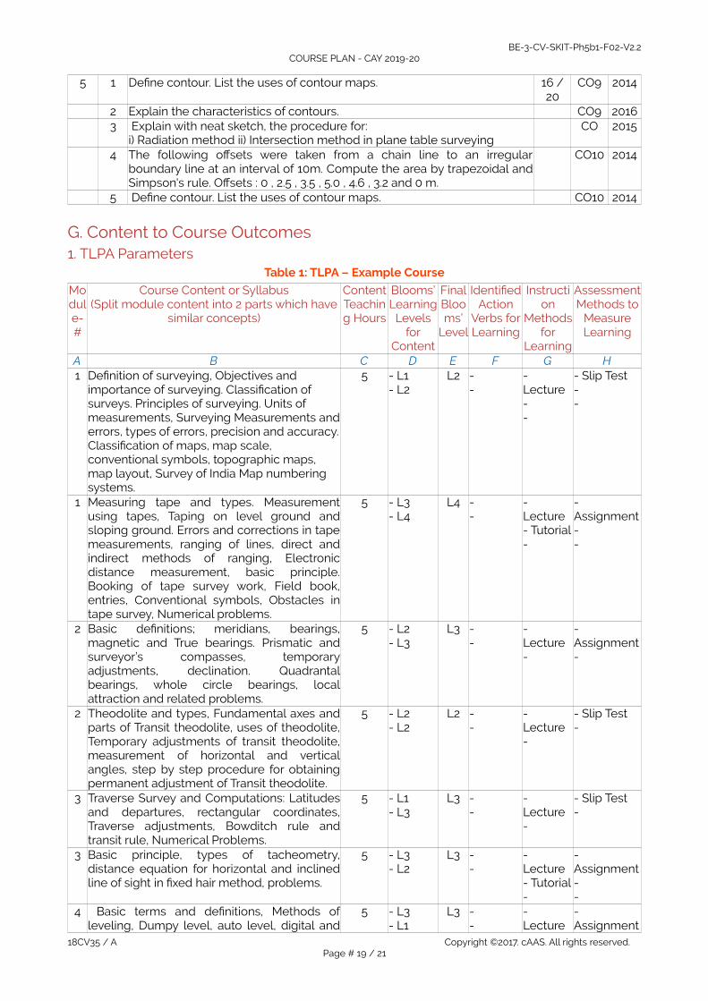
d Review Questions - -1 Define contour. List the uses of contour maps. CO10 L22 Explain the characteristics of contours. CO10 L33 Explain with neat sketch, the procedure for:
i) Radiation method ii) Intersection method in plane table surveyingCO9 L3
4 What do you mean by orientation of plane table? Explain the different methodsof orientation?
CO9 L4
5 Define Resection and hence state three point problem. CO9 L26 Define the following :
(i) Contour (ii) Contour interval (ii) Horizontal equivalent.CO10 L3
7 List the characteristics of contour with the help of neat sketches. CO10 L38 The following offsets were taken from a chain line to an irregular boundary line
at an interval of 10m. Compute the area by trapezoidal and Simpson's rule.Offsets : 0 , 2.5 , 3.5 , 5.0 , 4.6 , 3.2 and 0 m.
CO10 L4
9 List the differences between polymer – impregnated concrete, polymer – modified concrete, and polymer concrete.
CO8 L2
10 What are the various quality control tests done to ensure good performance of polymer concrete?
CO8 L2
e Experiences - -1 CO9 L2234 CO10 L25
18CV35 / A Copyright ©2017. cAAS. All rights reserved.Page # 15 / 21

BE-3-CV-SKIT-Ph5b1-F02-V2.2COURSE PLAN - CAY 2019-20
E3. CIA EXAM – 3a. Model Question Paper - 3Crs Code: 18CV35 Sem: III Marks: 15 Time: 75 minutesCourse: Basic Surveying
- - Note: Answer any 2 questions, each carry equal marks. Marks CO Level1 a Define contour. List the uses of contour maps. 15 CO9 L2
b Explain the characteristics of contours. CO9 L2c lain with neat sketch, the procedure for:
i) Radiation method ii) Intersection method in plane table surveyingCO9 L3
2 a List the characteristics of contour with the help of neat sketches. 15 CO10 L2b The following offsets were taken from a chain line to an irregular
boundary line at an interval of 10m. Compute the area by trapezoidal andSimpson's rule. Offsets : 0 , 2.5 , 3.5 , 5.0 , 4.6 , 3.2 and 0 m.
CO10 L4
3 a What do you mean by orientation of plane table? Explain the differentmethods of orientation?
15 CO9 L2
b Define Resection and hence state three point problem. CO10 L2c Define the following :
(i) Contour (ii) Contour interval (ii) Horizontal equivalent.CO10 L2
b. Assignment – 3Note: A distinct assignment to be assigned to each student.
Model Assignment QuestionsCrs Code: 18CV35 Sem: III Marks: 10 Time: 90 – 120 minutesCourse: Basic surveying Note: Each student to answer 2-3 assignments. Each assignment carries equal mark.SNo USN Assignment Description Marks CO Level
1 1KT17CV101 Define contour. List the uses of contour maps. 5 CO9 L22 1KT17CV102 Explain the characteristics of contours. 5 CO9 L33 1KT17CV103 lain with neat sketch, the procedure for:
i) Radiation method ii) Intersection method in plane tablesurveying
CO10 L4
4 1KT17CV104 What do you mean by orientation of plane table? Explain thedifferent methods of orientation?
5 CO10 L3
5 1KT17CV105 Define Resection and hence state three point problem. 5 CO10 L36 1KT17CV106 Define the following :
(i) Contour (ii) Contour interval (ii) Horizontal equivalent.5 CO10 L3
7 1KT17CV107 List the characteristics of contour with the help of neatsketches.
5 CO10 L3
8 1KT17CV108 Define contour. List the uses of contour maps. 5 CO10 L39 1KT17CV109 Explain the procedure adopted to measure the distance
between two mutually inaccessible points by plane tablesurveying.
5 CO10 L3
10 1KT17CV110 Describe the method of 'Resection' by 'Bessels graphicalmethod".
5 CO10 L3
F. EXAM PREPARATION1. University Model Question PaperCourse: Basic Surveying Month / Year Dec/19Crs Code: 18CV35 Sem: III Marks: 100 Time: 180 minutes
- Note Answer all FIVE full questions. All questions carry equal marks. Marks CO Level1 a How do you classify survey? Explain in detail. 8/20 CO1 l2
b Differentiate between :(i) Precision and Accuracy(ii) Plan and map
8 l2
18CV35 / A Copyright ©2017. cAAS. All rights reserved.Page # 16 / 21

BE-3-CV-SKIT-Ph5b1-F02-V2.2COURSE PLAN - CAY 2019-20
c The distance between two points measured along a slope is 265 m. Findthe horizontaldistance between them if,(i) the angle of slope is 4° 42'(ii) the difference in level is 27m
4 CO2 l3
OR2 a Explain different types of chains and tapes. 10/ 20 CO1 l2
b 30 m chain was found to be 15 cm too long after chaining 1524 m. Thesame chain was found to 30.5 cm too long after chaining a total distanceof 3048 m. Find the true distance chained assuming the chain was correctat the commencement of chaining.
10 CO2 l3
3 a What is meant by plane table surveying? List the chain surveyingequipments.
5/ 20 C03 l2
b What are offsets? Explain the types of offsets. 5 l2c In chaining past a pond, stations A and D on the main line were taken on
the opposite sides of the pond. Two lines DB and DC measuring 250 mand 300 m were laid down to the left and right of the line AD. The pointsA, B and C are on the same line. AB and AC are measured and are foundto be equal to 120 m and 130 m. Find the length of line AD.
10 CO4 l3
OR4 a Differentiate between the following :
i) Open traverse and closed traverse(ii) W.C.B and Q.B (iii) Magnetic Dip and Declination(iv) Isogonic line and agonic line (v) Magnetic bearing and true bearing
15/ 20 CO3 l3
b During a closed traverse survey ABCDA, the following interior angles weremeasured with a compass LA = 75° , LB = 120°, LC = 80° and ZD = 85°. If the bearing of the line AB is99°, what are the bearings of the remaining lines of the traverse?
5 CO4 l4
5 a List the errors in compass surveying and explain. 8 / 20 CO5 l3b With the help of neat sketches explain Bowditch graphical method of
adjustment of closing error in a closed traverse.8 l4
c The magnetic bearing of a line is 105° 30'. At that time of observation ifmagnetic declination is 6° 15' E, find the true bearing of the line. Also drawthe relevant sketch.
4 CO6 l4
6 a Explain the following :(i) Balancing of sights (ii) Profile leveling
6 / 20 CO7 l2
b During fly leveling, the following readings were taken:B.S : 0.620, 2.050, 1.420, 2.630, and 2.420F.S : 2.440, 1.350, 0.530, 2.410The first B.S was taken on a B.M of R.L 100.000 metres. From the last B.S itis required to set 4 pegs each at distance of 30 metres on a rising gradient1 in 200. Enter these readings in a level book form and calculate the R.L ofthe top of each peg by "Rise and Fall" method. Also calculate the staffreading on each peg and apply the usual checks.
14 l4
OR7 a Define the following :
(i) Contour (ii) Contour interval (iii) Horizontal equivalent6/ 20 CO9 l2
b List the various important factors to be considered at the time ofselecting the contour interval and explain.
6 CO9 l2
c List the characteristics of contour with the help of neat sketches. 8 CO10 l2
8 a What do you mean by plane tabling? List the plane table and itsaccessories.
5/ 20 CO10 l4
18CV35 / A Copyright ©2017. cAAS. All rights reserved.Page # 17 / 21

BE-3-CV-SKIT-Ph5b1-F02-V2.2COURSE PLAN - CAY 2019-20
b List the various important factors to be considered at the time ofselecting the contour interval and explain.
6 CO10 l4
c List the characteristics of contour with the help of neat sketches. 9 CO10 l4
2. SEE Important QuestionsCourse: Basic Surveying Month / Year Dec/19Crs Code: 18CV35 Sem: III Marks: 100 Time: 180 minutes
NoteAnswer all FIVE full questions. All questions carry equal marks. - -Module
Qno. Important Questions Marks CO Year
1 1 Distinguish between plane surveying and Geodetic surveying. 5/ 20 CO1 20162 Explain the terms : i) Accuracy ii) Precision iii) Discrepancy 6 CO2 20163 A 30 meter chain was tested before the commencement of day's work
and was found to be correct. After chaining 100 chains, the chain wasfound to be half decimeter too long. At the end of the day's work, afterchaining another 100 chains, the chain was found to be one decimeter toolong. What was the total true distance chained?
4 CO2 2016
4 Define surveying ? Write the principles of surveying. 2 CO2 20155 Write and explain classifications of survey. 3 CO2 2015
2 1 State the important points considered while selecting main stations insurveying.
16 /20
CO3 2015
2 With neat sketch, explain reciprocal ranging. CO3 20153 What is local attraction? How is it detected and eliminated ? CO3 20144 With neat sketch fundamental lines and desired relations of transit
theodolite. CO4 2016
5 Explain the temporary adjustments of transit theodolite. CO4 2014
3 1 With a neat sketch, explain the working of prism square. 16 /20
CO5 2015
2 Define: i) Survey lines ii) Check lines iii) Tie lines CO5 20163 Briefly explain closed traverse and open traverse. CO5 20174 Explain clearly,with the help of illustrations, how traverse is balanced. CO6 20175 What are the different methods employed in tacheometric survey ?
Describe the method most commonly used.CO6 2016
4 1 illustrate with neat sketches : i) Profile leveling ii) Differential leveling iii) Reciprocal leveling and iv) Block leveling
16 /20
CO7 2017
2 List and explain the temporary adjustments of a dumpy level CO7 20143 Find the elevation of the top of the chimney from the following data
Inst Station Reading on BM (m) Angle of elevation remarks
A 0.865 18*36’ RL of BM = 421.380m
B 1.225 10*12’ DistanceAB = 50m
Stations A, B and top of chimney are in the same vertical plane. Stationchimney.
CO8 2015
4 What is local attraction? How is it determined and eliminated? CO8 20145 Define :
i) Dependent co-ordinatesii) Independent co-ordinates
CO8 2015
18CV35 / A Copyright ©2017. cAAS. All rights reserved.Page # 18 / 21
BE-3-CV-SKIT-Ph5b1-F02-V2.2COURSE PLAN - CAY 2019-20
5 1 Define contour. List the uses of contour maps. 16 /20
CO9 2014
2 Explain the characteristics of contours. CO9 20163 Explain with neat sketch, the procedure for:
i) Radiation method ii) Intersection method in plane table surveyingCO 2015
4 The following offsets were taken from a chain line to an irregularboundary line at an interval of 10m. Compute the area by trapezoidal andSimpson's rule. Offsets : 0 , 2.5 , 3.5 , 5.0 , 4.6 , 3.2 and 0 m.
CO10 2014
5 Define contour. List the uses of contour maps. CO10 2014
G. Content to Course Outcomes1. TLPA Parameters
Table 1: TLPA – Example Course
Module-#
Course Content or Syllabus(Split module content into 2 parts which have
similar concepts)
ContentTeaching Hours
Blooms’Learning
Levelsfor
Content
FinalBlooms’
Level
IdentifiedAction
Verbs forLearning
Instruction
Methodsfor
Learning
AssessmentMethods to
MeasureLearning
A B C D E F G H1 Definition of surveying, Objectives and
importance of surveying. Classification of surveys. Principles of surveying. Units of measurements, Surveying Measurements anderrors, types of errors, precision and accuracy.Classification of maps, map scale, conventional symbols, topographic maps, map layout, Survey of India Map numbering systems.
5 - L1- L2
L2 --
- Lecture--
- Slip Test--
1 Measuring tape and types. Measurementusing tapes, Taping on level ground andsloping ground. Errors and corrections in tapemeasurements, ranging of lines, direct andindirect methods of ranging, Electronicdistance measurement, basic principle.Booking of tape survey work, Field book,entries, Conventional symbols, Obstacles intape survey, Numerical problems.
5 - L3- L4
L4 --
- Lecture- Tutorial-
- Assignment--
2 Basic definitions; meridians, bearings,magnetic and True bearings. Prismatic andsurveyor’s compasses, temporaryadjustments, declination. Quadrantalbearings, whole circle bearings, localattraction and related problems.
5 - L2- L3
L3 --
- Lecture-
- Assignment-
2 Theodolite and types, Fundamental axes andparts of Transit theodolite, uses of theodolite,Temporary adjustments of transit theodolite,measurement of horizontal and verticalangles, step by step procedure for obtainingpermanent adjustment of Transit theodolite.
5 - L2- L2
L2 --
- Lecture-
- Slip Test-
3 Traverse Survey and Computations: Latitudesand departures, rectangular coordinates,Traverse adjustments, Bowditch rule andtransit rule, Numerical Problems.
5 - L1- L3
L3 --
- Lecture-
- Slip Test-
3 Basic principle, types of tacheometry,distance equation for horizontal and inclinedline of sight in fixed hair method, problems.
5 - L3- L2
L3 --
- Lecture- Tutorial-
- Assignment--
4 Basic terms and definitions, Methods ofleveling, Dumpy level, auto level, digital and
5 - L3 - L1
L3 --
- Lecture
- Assignment
18CV35 / A Copyright ©2017. cAAS. All rights reserved.Page # 19 / 21

BE-3-CV-SKIT-Ph5b1-F02-V2.2COURSE PLAN - CAY 2019-20
laser levels. Curvature and refractioncorrections. Booking and reduction of levels.
- Tutorial-
--
4 Differential leveling, profile leveling, flyleveling, check leveling, reciprocal leveling,trigonometric leveling (heights and distances-single plane and double plane methods.
5 - L2- L4
L4 --
- Lecture- Tutorial-
- Assignment--
5 By dividing the area into geometrical figures,area from offsets, mid ordinate rule,trapezoidal and Simpson’s one third rule, areafrom co-ordinates, introduction to planimeter,digital planimeter. Measurement of volumes-trapezoidal and prismoidal formula.
5 - L2- L2
L2 --
- Lecture--
- Assignment--
5 Contours, Methods of contouring,Interpolation of contours, contour gradient,characteristics of contours and uses.
5 - L2- L2
L2 --
- Lecture--
- Assignment--
2. Concepts and Outcomes:Table 2: Concept to Outcome – Example Course
Module-#
Learning orOutcome
from study ofthe Contentor Syllabus
IdentifiedConcepts
fromContent
Final Concept ConceptJustification
(What all LearningHappened from thestudy of Content /Syllabus. A short
word for learning oroutcome)
CO Components(1.Action Verb,2.Knowledge,3.Condition /Methodology,4.Benchmark)
Course Outcome
Student Should beable to ...
A I J K L M N1 -
---
Introductionof basic
instruments
Engineeringknowledge of
basics of surveying.
- Understand- basics of surveying.--
understand thebasics of surveying.
1 --
--
techniques Engineeringknowledge of
basics of surveying.
- basics of surveying-
learn thetechniques of surveyinstruments.
2 --
--
Compasssurvey
Engineeringknowledge of
technics ofsurveying
instruments
- technics of surveying- -
determine themeasurement ofhorizontal distances.
2 --
--
Theodolitesurvey
Analyses ofproblems on chain
surveying
- Understand- chain surveying-
understand thepracticalapplications oftheodolite
3 --
--
Traversesurvey
Understanding themeasurement of
horizontaldistances.
- Understand- measurement of horizontal distances.- -
understand thetechniques ofcompass survey
3 --
--
Tacheometrysurvey
Analyses ofproblems on
horizontal distances
- Applyhorizontal distances- -
understand themethods oftacheometry survey
4 --
--
leveling Understanding thepractical
applications oftheodolite
- Apply- theodolite
Analise the differentmethods of levelingusing dumpy level
18CV35 / A Copyright ©2017. cAAS. All rights reserved.Page # 20 / 21

BE-3-CV-SKIT-Ph5b1-F02-V2.2COURSE PLAN - CAY 2019-20
5 --
--
leveling Understanding thepractical
applications oftheodolite
- Understand- theodolite
Analise the detailedcalculations ofleveling by usingdumpy level.
5 Computations of areas and
volume
Engineeringknowledge oftechniques of
compass surveying
- Understand- techniques of compass surveying
determine the areasand volume by usingarithmeticequations.
18CV35 / A Copyright ©2017. cAAS. All rights reserved.Page # 21 / 21