Multiply Your Surveying Possibilities
8
The International Electrotechnical Commission standard IEC 60529 describes a system for classifying degrees of protection provided by enclosures of electrical equipment. The IP Code consists of the letters IP and two numerals. Larger numbers represent greater levels of protection. Continuously tracks the prism, updating distance and angle values in real-time. Automatically sights and measures the target. Survey-grade reflectorless distance measurement. Possible to perform measurements using reflective sheet targets. Equipped with a high-visibility guide light to aid in setting-out operations. Windows CE based operating system installed. Supports a CompactFlash memory card for data storage and handling. Supports an SD memory card and a large capacity SDHC card for data storage and handling. USB port for data storage and/or connection with a PC. Low Temperature models available. Protection against ingress of solid foreign objects Highest level: 6 Protection against ingress of water Highest level: 8 7 levels: 0 to 6. X: unspecified. 9 levels: 0 to 8. X: unspecified. Icons used in this catalog Laser Class: IEC 60825-1Amd.2:2001 / FDA CDRH 21 CFR Part1040.10 and 1040.11 (Complies with FDA performance standards for laser products except for deviations pursuant to Laser Notice No.50, dated July 26, 2001.) Your local Authorized Dealer is: TOPCON CORPORATION 75-1 Hasunuma-cho, Itabashi-ku, Tokyo 174-8580, Japan Phone: (+81)3-3558-2993 Fax: (+81)3-3960-4214 www.topcon.co.jp -Bluetooth ® word mark and logos are registered trademarks owned by Bluetooth SIG, Inc. and any use of such marks by Topcon is under license.Other trademarks and trade names are those of their respective owners. - Designs and specifications are subject to change without notice. - Product colors in this brochure may vary slightly from those of the actual products owing to limitations of the printing process. POSITIONING INSTRUMENTS CATALOG 2012 vol.2 Multiply Your Surveying Possibilities Specifications subject to change without notice ©2012 Topcon Corporation All rights reserved. P-25-6 GE
-
Upload
khangminh22 -
Category
Documents
-
view
0 -
download
0
Transcript of Multiply Your Surveying Possibilities

The International Electrotechnical Commission standard IEC 60529 describes a system for classifying degrees of protection provided by enclosures of electrical equipment. The IP Code consists of the letters IP and two numerals. Larger numbers represent greater levels of protection.
Continuously tracks the prism, updating distance and angle values in real-time.
Automatically sights and measures the target.
Survey-grade reflectorless distance measurement.
Possible to perform measurements using reflective sheet targets.
Equipped with a high-visibility guide light to aid in setting-out operations.
Windows CE based operating system installed.
Supports a CompactFlash memory card for data storage and handling.
Supports an SD memory card and a large capacity SDHC card for data storage and handling.
USB port for data storage and/or connection with a PC.
Low Temperature models available.
Protection against ingress ofsolid foreign objects
Highest level: 6
Protection against ingress of water
Highest level: 87 levels: 0 to 6. X: unspecified.
9 levels: 0 to 8. X: unspecified.
Icons used in this catalog
Laser Class: IEC 60825-1Amd.2:2001 / FDA CDRH 21 CFR Part1040.10 and 1040.11 (Complies with FDA performance standards for laser products except for deviations pursuant to Laser Notice No.50, dated July 26, 2001.)
Your local Authorized Dealer is:TOPCON CORPORATION75-1 Hasunuma-cho, Itabashi-ku, Tokyo 174-8580, Japan
Phone: (+81)3-3558-2993 Fax: (+81)3-3960-4214www.topcon.co.jp
-Bluetooth ® word mark and logos are registered trademarks owned by Bluetooth SIG, Inc. and any use of such marks by Topcon is under license.Other trademarks and trade names are those of their respective owners. - Designs and specifications are subject to change without notice.- Product colors in this brochure may vary slightly from those of the actual products owing to limitations of the printing process.
POSITIONING INSTRUMENTS
CATALOG 2012 vol.2
Mult ip ly Your Sur veying Possibi l i t ies
Specifications subject to change without notice©2012 Topcon Corporation All rights reserved. P-25-6 GE

RC-PR5
Operating Range*1
(slope distance) 2 to 300m (7 to 980ft.)*2
*1 Good conditions. *2 When the height difference between total station
and RC-PR5 is within 20m (66ft.).
BluetoothClass 1
BluetoothClass 2
2 3
Superior X-ellence Station
The auto tracking models from the SX series total stations track a moving prism even with obstacles such as strong backlight or repetitive interruptions. When the prism is lost, the advanced on-demand remote control system RC-PR5 allows the SX to instantly relocate and lock the lost prism.
USBWIN-CE
*
* Only for Auto-Tracking models
Measuring beam spot size (reflectorless mode)
Distance 10m (33ft.) 40m (131ft.) 100m (328ft.)Beam spot size(height x width)
7 x 9mm(0.28 x 0.35in.)
14 x 14mm(0.55 x 0.55in.)
29 x 24mm(1.14 x 0.95in.)
SX-101T
To
tal S
tatio
ns
SX-101P SX-101T SX-102P SX-102T SX-103P SX-103T SX-105P SX-105T
Auto-Tracking - l - l - l - l
Auto-Pointing l l l l l l l l
Measuring range(Average conditions) Reflectorless* 1 0.3 to 800m (1 to 2,620ft.) / 0.3 to 1,000m (1 to 3,280ft.)* 2
With reflective sheet target 1.3 to 500m (4.3 to 1,640ft.) with RS90N-K (90x90mm) reflective sheet
With ATP1(S) 360° Prism 1.3 to 1,000m (4.3 to 3,280ft.)
With 1 AP prism 1.3 to 5,000m (4.3 to 16,400ft.) / to 6,000m (to 19,680ft.) under good conditions
Distance accuracy(ISO17123-4:2001) Reflectorless* 1
(2 + 2ppm x D)mm : 0.3 < D < 200m (1 < D < 650ft.)
(5 + 10ppm x D)mm : 200 < D < 350m (650<D < 1,140ft.)
(10 + 10ppm x D)mm : 350 < D < 1,000m (1,140<D < 3,280ft.)With reflective sheet target (2 + 2ppm x D)mm
With prism (1.5 + 2ppm x D)mmAngle display resolutions (selectable) Degree 0.5" / 1" 1" / 5"
Gon 0.0001 / 0.0002gon 0.0002 / 0.001gon
Mil 0.002 / 0.005mil 0.005 / 0.02milAngle accuracy(ISO17123-3:2001) H&V 1" / 0.3mgon / 0.005mil 2" / 0.6mgon / 0.01mil 3" / 1mgon / 0.015mil 5" / 1.5mgon / 0.025mil
Auto-Tracking range / Auto-Pointing range
With AP Prism 1,000m (3,280ft.)
With ATP1(S) 360° Prism 600m (1,960ft.)
*1 Kodak Gray Card white side (90% reflective). Reflectorless range/accuracy may vary according to measuring objects, observation situations and environmental conditions.*2 When brightness at object surface is 500 lux or less, regardless of ambient brightness conditions.
ATP1 ATP1S
RC-PR5 RC-Controller• The RC-PR5* On-Demand Remote Controller
allows rapid prism search regardless of your position. A built-in directional sensor constantly monitors the prism movement so the SX can turn left or right whichever in closer direction.
* Applicable with SX Auto-Tracking models
= =
=
= =
= =
=
ATP1/ATP1SMost Versatile and Accurate Prism System
• The high-precision 360° prisms can be mounted at either the top or bottom of a range pole.
• Fast measurement reading at every 0.9 seconds .• Reflectorless measuring range from 30cm to 1000m*.• SOKKIA's widely acknowledged pinpoint precision in reflectorless
distance measurement.• Auto-pointing with instant one touch operation. • IP65 dustproof / waterproof rating.• Bluetooth® Class1 wireless technology for reliable data
communications.• One-touch star key [H] offers instant access to functions.*With Kodak Gray Card white side (90% reflective). Brightness level at object surface: <=500 lx.
Update
Security
Visible on a Map
Remote LockOn-line Update
Reviewing Operating Time• Instrument location visible on a map• Remotely lock and unlock instrument• Review instrument operating time• New firmware alerts and user updating
TSshield*
World's first cloud-based total station management system.
Exclusive TSshield
technology built-in
Exclusive TSshield
technology built-in
New firmware update alerts on-board.User updates online.
Effectively manage instruments by reviewing accumulated operating time.
Locations of instruments are visible on a map.
Remote lock and unlock function is for theft deterrent.
Common Features for Auto-Tracking and Auto-Pointing models
ATP1 Features
ATP1S Features• The new, compact 360° Sliding Prism ATP1S slides along the
Pin Pole PP2 to enable quick adjustment of a prism height. • In combination with a pin pole, prism height can be set as low
as 10cm (4in.). The lower prism height improves measurement accuracy by minimizing error caused by tilt of a pole. (ATP1S)
Rapid prism search with RC-PR5
n MAGNET™MAGNETTM is a software family that uses the “cloud” for seamless
data connection between the field and office.
• MAGNET™ FieldPowerful on-board software that covers full functions for surveying and engineering tasks. MAGNET Field handles data collection, stake out, roads and coordinate geometry.
* This service may not be available in some areas.
SX SeriesSuperior X-ellence Station
SX-101T/SX-102T/SX-103T/SX-105T/
SX-101P/SX-102P/SX-103P/SX-105P/Auto-Pointing models:
Auto-Tracking models:

4 5
USBWIN-CE
*
* Option
Functional X-ellence Station
The FX series offer the highest standard IP65 in environmental protection among Windows CE models. The completely new on-board applications “MAGNET Field” or “Pocket-3D Lite” software can be chosen for a variety of jobs.
• Fast measurement reading at every 0.9 seconds.• SOKKIA's widely acknowledged pinpoint precision in reflectorless
distance measurement.• Dependably operates in the heat of up to +60°C (+140°F).• Bluetooth Class1 wireless technology for reliable data communications.*• One battery provides 20 hours of power.• One-touch star key [H] offers instant access to functions.• By using the trigger key, a series of measurement can be easily taken
without taking your eye off the telescope.* Offered as a factory option.
Featuring enhanced RED-tech EDM, convenient trigger key, powerful on-board software and market-proven reliability, the CX Series set a new standard for reflectorless total stations for all surveying and engineering applications.
• Fast measurement reading at every 0.9 seconds.• SOKKIA traditional pinpoint precision in reflectorless distance
measurement.• Reflectorless operation from 30cm to 500m.• Dependably operates in the heat of up to +60°C (+140°F).• Bluetooth Class1 wireless technology for reliable data communications.*1
• The CX single battery can last up to 36 hours.*2
• CX-101 and CX-102 feature groundbreaking IACS (Independent Angle Calibration System) technology for extremely reliable angle measurement.
• IP66 dustproof / waterproof rating.• One-touch star key [H] offers instant access to functions.• Trigger key lets you take a series of measurements without taking
your eye off the telescope.*1 Offered as a factory option.*2 Operating time will vary depending upon environmental conditions and CX activity.
The International Electrotechnical Commission standard IEC 60529 describes a system for classifying degrees of protection provided by enclosures of electrical equipment. The IP Code consists of the letters IP and two numerals. Larger numbers represent greater levels of protection.
Protection against ingress ofsolid foreign objects
Highest level: 6
Protection against ingress of water
Highest level: 87 levels: 0 to 6. X: unspecified.
9 levels: 0 to 8. X: unspecified.
=
=
Compact X-ellence Station
*1 With Kodak Gray Card white side (90% reflective). *1 With Kodak Gray Card white side (90% reflective).
CX-101 CX-102 CX-103 CX-105 CX-107Measuring range(Average conditions) Reflectorless* 1 0.3 to 500m (1 to 1,640ft.)
With reflective sheet target 1.3 to 500m (4.3 to 1,640ft.) with RS90N-K (90x90mm) reflective sheet
With 1 AP prism 1.3 to 4,000m (4.3 to 13,120ft.) / 1.3 < 5,000m (4.3 < 16,400ft.) under good conditionsDistance accuracy(ISO17123-4:2001) Reflectorless* 1 (3 + 2ppm x D)mm : 0.3 < D < 200m (1 < D < 650ft.)
With reflective sheet target (3 + 2ppm x D)mm
With prism (2 + 2ppm x D)mmAngle display resolutions(selectable) Degree 0.5" / 1" 1" / 5"
Gon 0.0001 / 0.0002gon 0.0002 / 0.001gon
Mil 0.002 / 0.005mil 0.005 / 0.02mil
Angle accuracy (ISO17123-3:2001) H&V
1" / 0.3mgon / 0.005mil
2" / 0.6mgon / 0.01mil
3" / 1mgon / 0.015mil
5" / 1.5mgon / 0.025mil
7" / 2.2mgon / 0.035mil
FX-101 FX-102 FX-103 FX-105 FX-107Measuring range(Average conditions) Reflectorless* 1 0.3 to 500m (1 to 1,640ft.)
With reflective sheet target 1.3 to 500m (4.3 to 1,640ft.) with RS90N-K (90x90mm) reflective sheet
With 1 AP prism 1.3 to 4,000m (4.3 to 13,120ft.) / 1.3 < 5,000m (4.3 < 16,400ft.) under good conditionsDistance accuracy(ISO17123-4:2001) Reflectorless* 1 (3 + 2ppm x D)mm : 0.3 < D < 200m (1 < D < 650ft.)
With reflective sheet target (3 + 2ppm x D)mm
With prism (2 + 2ppm x D)mmAngle display resolutions(selectable) Degree 0.5" / 1" 1" / 5"
Gon 0.0001 / 0.0002gon 0.0002 / 0.001gon
Mil 0.002 / 0.005mil 0.005 / 0.02mil
Angle accuracy (ISO17123-3:2001) H&V
1" / 0.3mgon / 0.005mil
2" / 0.6mgon / 0.01mil
3" / 1mgon / 0.015mil
5" / 1.5mgon / 0.025mil
7" / 2.2mgon / 0.035mil
To
tal S
tatio
ns
==
== == == ==
FX SeriesFunctional X-ellence StationFX-101/FX-102/FX-103/FX-105/FX-107
CX SeriesCompact X-ellence StationCX-101/CX-102/CX-103/CX-105/CX-107
n MAGNET™MAGNET™ is a software family that uses the “cloud” for seamless data connection between the field and office.
• MAGNET™ FieldPowerful on-board software that covers full functions for surveying and engineering tasks. MAGNET Field handles data collection, stake out, roads and coordinate geometry.
n Pocket-3D LiteSimple on-board software for engineering stakeout.With features of, simple and intuitive operation, sequential work flow, graphical points view, and supported general CAD formats. USB
*
* Option
FX-105 CX-105
HoursBattery36
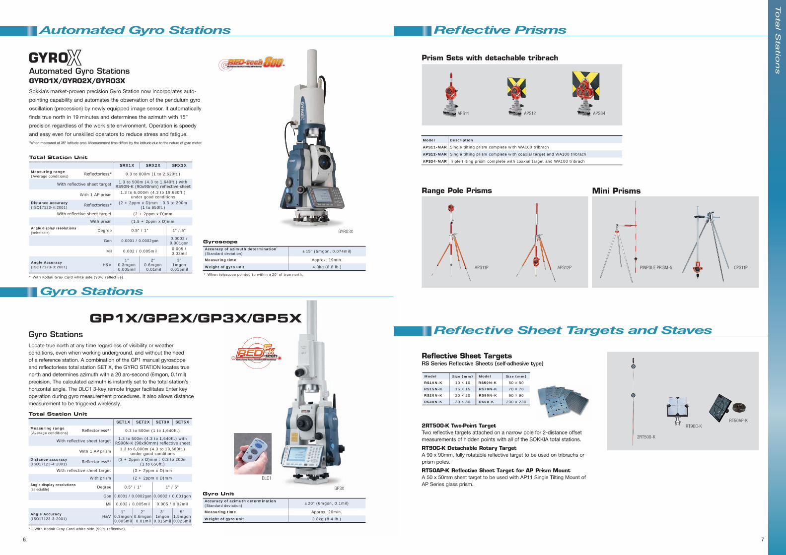
Sokkia’s market-proven precision Gyro Station now incorporates auto-
pointing capability and automates the observation of the pendulum gyro
oscillation (precession) by newly equipped image sensor. It automatically
finds true north in 19 minutes and determines the azimuth with 15”
precision regardless of the work site environment. Operation is speedy
and easy even for unskilled operators to reduce stress and fatigue.
*When measured at 35° latitude area. Measurement time differs by the latitude due to the nature of gyro motor.
Automated Gyro StationsGYRO1X/GYRO2X/GYRO3X
GYRO3X
Automated Gyro Stations
Total Station UnitSET1X SET2X SET3X SET5X
Measuring range(Average conditions) Reflectorless* 1 0.3 to 500m (1 to 1,640ft.)
With reflective sheet target 1.3 to 500m (4.3 to 1,640ft.) with RS90N-K (90x90mm) reflective sheet
With 1 AP prism 1.3 to 6,000m (4.3 to 19,680ft.) under good conditions
Distance accuracy(ISO17123-4:2001) Reflectorless* 1 (3 + 2ppm x D)mm : 0.3 to 200m
(1 to 650ft.)With reflective sheet target (3 + 2ppm x D)mm
With prism (2 + 2ppm x D)mm
Angle display resolutions(selectable) Degree 0.5" / 1" 1" / 5"
Gon 0.0001 / 0.0002gon 0.0002 / 0.001gon
Mil 0.002 / 0.005mil 0.005 / 0.02mil
Angle Accuracy(ISO17123-3:2001) H&V
1"0.3mgon0.005mil
2"0.6mgon 0.01mil
3"1mgon
0.015mil
5"1.5mgon0.025mil
*1 With Kodak Gray Card white side (90% reflective).
Total Station UnitSRX1X SRX2X SRX3X
Measuring range(Average conditions) Reflectorless* 0.3 to 800m (1 to 2,620ft.)
With reflective sheet target 1.3 to 500m (4.3 to 1,640ft.) with RS90N-K (90x90mm) reflective sheet
With 1 AP prism 1.3 to 6,000m (4.3 to 19,680ft.) under good conditions
Distance accuracy(ISO17123-4:2001) Reflectorless* (2 + 2ppm x D)mm : 0.3 to 200m
(1 to 650ft.)With reflective sheet target (2 + 2ppm x D)mm
With prism (1.5 + 2ppm x D)mm
Angle display resolutions(selectable) Degree 0.5" / 1" 1" / 5"
Gon 0.0001 / 0.0002gon 0.0002 / 0.001gon
Mil 0.002 / 0.005mil 0.005 / 0.02mil
Angle Accuracy(ISO17123-3:2001) H&V
1"0.3mgon0.005mil
2"0.6mgon 0.01mil
3"1mgon
0.015mil
* With Kodak Gray Card white side (90% reflective).
Gyro UnitAccuracy of azimuth determination(Standard deviation) ±20" (6mgon, 0.1mil)
Measuring time Approx. 20min.
Weight of gyro unit 3.8kg (8.4 lb.)
GyroscopeAccuracy of azimuth determination*
(Standard deviation) ±15" (5mgon, 0.074mil)
Measuring time Approx. 19min.
Weight of gyro unit 4.0kg (8.8 lb.)
Gyro StationsLocate true north at any time regardless of visibility or weather conditions, even when working underground, and without the need of a reference station. A combination of the GP1 manual gyroscope and reflectorless total station SET X, the GYRO STATION locates true north and determines azimuth with a 20 arc-second (6mgon, 0.1mil) precision. The calculated azimuth is instantly set to the total station’s horizontal angle. The DLC1 3-key remote trigger facilitates Enter key operation during gyro measurement procedures. It also allows distance measurement to be triggered wirelessly.
GP3X
DLC1
Gyro Stations
GP1X/GP2X/GP3X/GP5X
Reflective Prisms
Reflective Sheet Targets and Staves
Model
APS11-MAR
APS12-MAR
APS34-MAR
Description
Single tilting prism complete with WA100 tribrach
Single tilting prism complete with coaxial target and WA100 tribrach
Triple tilting prism complete with coaxial target and WA100 tribrach
Prism Sets with detachable tribrach
Range Pole Prisms Mini Prisms
2RT500-K Two-Point Target Two reflective targets attached on a narrow pole for 2-distance offset measurements of hidden points with all of the SOKKIA total stations.
RT90C-K Detachable Rotary Target A 90 x 90mm, fully rotatable reflective target to be used on tribrachs or prism poles.
RT50AP-K Reflective Sheet Target for AP Prism Mount A 50 x 50mm sheet target to be used with AP11 Single Tilting Mount of AP Series glass prism.
RT90C-K
2RT500-K
RT50AP-K
Model
RS10N-K
RS15N-K
RS20N-K
RS30N-K
Model
RS50N-K
RS70N-K
RS90N-K
RS00-K
Size (mm)
10 x 10
15 x 15
20 x 20
30 x 30
Size (mm)
50 x 50
70 x 70
90 x 90
230 x 230
Reflective Sheet Targets RS Series Reflective Sheets (self-adhesive type)
APS11 APS12 APS34
APS11P APS12P PINPOLE PRISM-5 CPS11P
6 7
To
tal S
tatio
ns
* When telescope pointed to within ±20’ of true north.
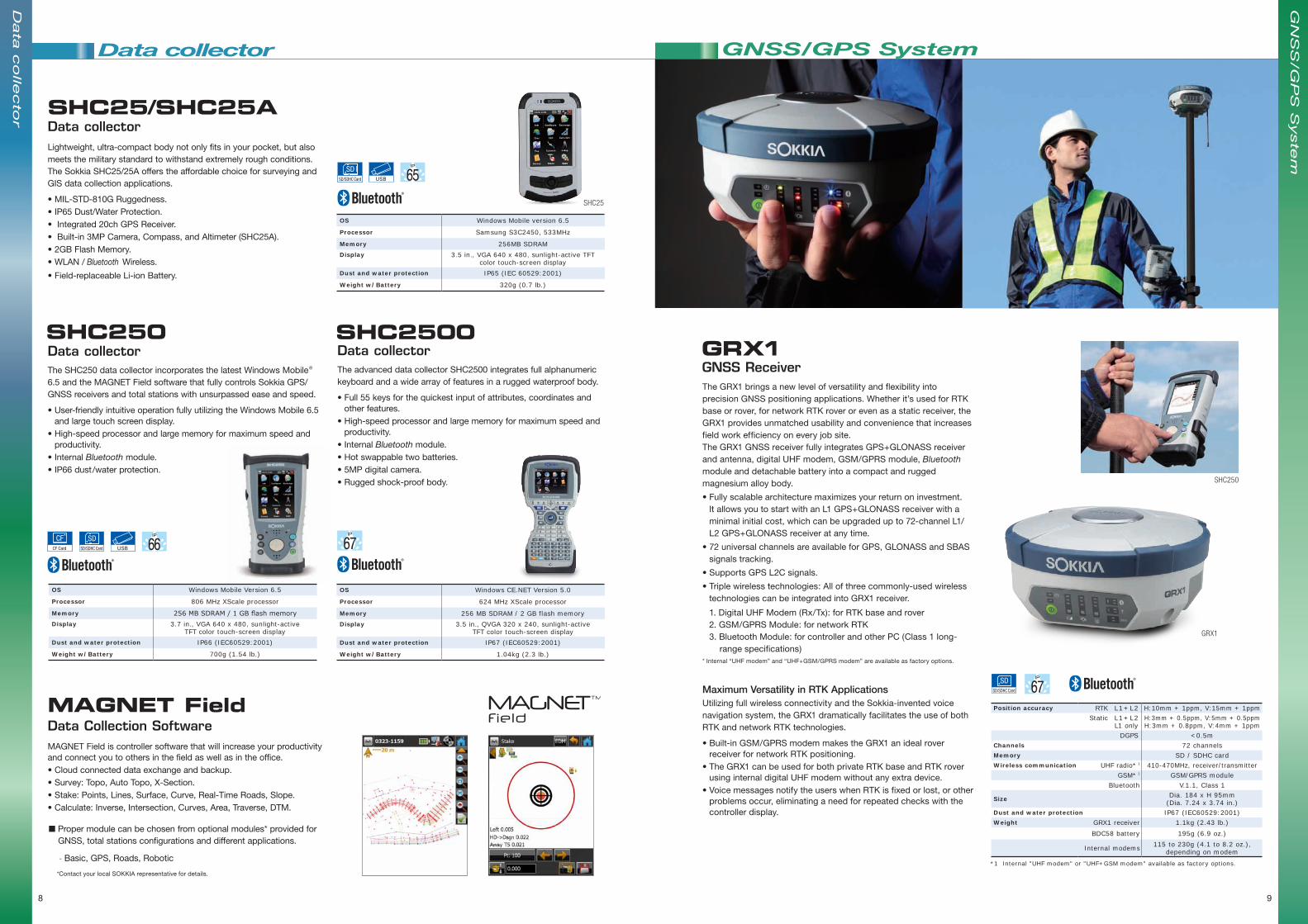
SHC250 SHC2500Data collectorThe SHC250 data collector incorporates the latest Windows Mobile® 6.5 and the MAGNET Field software that fully controls Sokkia GPS/GNSS receivers and total stations with unsurpassed ease and speed.
• User-friendly intuitive operation fully utilizing the Windows Mobile 6.5 and large touch screen display.
• High-speed processor and large memory for maximum speed and productivity.
• Internal Bluetooth module.• IP66 dust/water protection.
8
Data collector
Data Collection SoftwareMAGNET Field is controller software that will increase your productivity and connect you to others in the field as well as in the office.• Cloud connected data exchange and backup.• Survey: Topo, Auto Topo, X-Section. • Stake: Points, Lines, Surface, Curve, Real-Time Roads, Slope.• Calculate: Inverse, Intersection, Curves, Area, Traverse, DTM.
MAGNET Field
OS Windows Mobile Version 6.5
Processor 806 MHz XScale processor
Memory 256 MB SDRAM / 1 GB flash memoryDisplay 3.7 in., VGA 640 x 480, sunlight-active
TFT color touch-screen displayDust and water protection IP66 (IEC60529:2001)
Weight w/Battery 700g (1.54 lb.)
USB
Data collectorThe advanced data collector SHC2500 integrates full alphanumeric keyboard and a wide array of features in a rugged waterproof body.
• Full 55 keys for the quickest input of attributes, coordinates and other features.
• High-speed processor and large memory for maximum speed and productivity.
• Internal Bluetooth module.• Hot swappable two batteries.• 5MP digital camera.• Rugged shock-proof body.
OS Windows CE.NET Version 5.0
Processor 624 MHz XScale processor
Memory 256 MB SDRAM / 2 GB flash memoryDisplay 3.5 in., QVGA 320 x 240, sunlight-active
TFT color touch-screen displayDust and water protection IP67 (IEC60529:2001)
Weight w/Battery 1.04kg (2.3 lb.)
Data
co
llecto
r
Data collectorLightweight, ultra-compact body not only fits in your pocket, but also meets the military standard to withstand extremely rough conditions. The Sokkia SHC25/25A offers the affordable choice for surveying and GIS data collection applications.
• MIL-STD-810G Ruggedness.• IP65 Dust/Water Protection.• Integrated 20ch GPS Receiver.• Built-in 3MP Camera, Compass, and Altimeter (SHC25A).• 2GB Flash Memory.• WLAN / Bluetooth Wireless.
• Field-replaceable Li-ion Battery.
SHC25/SHC25A
OS Windows Mobile version 6.5
Processor Samsung S3C2450, 533MHz
Memory 256MB SDRAMDisplay 3.5 in., VGA 640 x 480, sunlight-active TFT
color touch-screen displayDust and water protection IP65 (IEC 60529:2001)
Weight w/Battery 320g (0.7 lb.)
USB
SHC25
GRX1 GNSS ReceiverThe GRX1 brings a new level of versatility and flexibility into precision GNSS positioning applications. Whether it’s used for RTK base or rover, for network RTK rover or even as a static receiver, the GRX1 provides unmatched usability and convenience that increases field work efficiency on every job site.The GRX1 GNSS receiver fully integrates GPS+GLONASS receiver and antenna, digital UHF modem, GSM/GPRS module, Bluetooth module and detachable battery into a compact and rugged magnesium alloy body.
• Fully scalable architecture maximizes your return on investment. It allows you to start with an L1 GPS+GLONASS receiver with a minimal initial cost, which can be upgraded up to 72-channel L1/L2 GPS+GLONASS receiver at any time.
• 72 universal channels are available for GPS, GLONASS and SBAS signals tracking.
• Supports GPS L2C signals.
• Triple wireless technologies: All of three commonly-used wireless technologies can be integrated into GRX1 receiver.
1. Digital UHF Modem (Rx/Tx): for RTK base and rover 2. GSM/GPRS Module: for network RTK 3. Bluetooth Module: for controller and other PC (Class 1 long-
range specifications)* Internal “UHF modem” and “UHF+GSM/GPRS modem” are available as factory options.
Maximum Versatility in RTK ApplicationsUtilizing full wireless connectivity and the Sokkia-invented voice navigation system, the GRX1 dramatically facilitates the use of both RTK and network RTK technologies.
• Built-in GSM/GPRS modem makes the GRX1 an ideal rover receiver for network RTK positioning.
• The GRX1 can be used for both private RTK base and RTK rover using internal digital UHF modem without any extra device.
• Voice messages notify the users when RTK is fixed or lost, or other problems occur, eliminating a need for repeated checks with the controller display.
GNSS/GPS System
Position accuracy RTK L1+L2 H:10mm + 1ppm, V:15mm + 1ppmStatic L1+L2
L1 onlyH:3mm + 0.5ppm, V:5mm + 0.5ppm H:3mm + 0.8ppm, V:4mm + 1ppm
DGPS <0.5mChannels 72 channelsMemory SD / SDHC cardWireless communication UHF radio* 1 410-470MHz, receiver/transmitter
GSM* 1 GSM/GPRS moduleBluetooth V.1.1, Class 1
Size Dia. 184 x H 95mm(Dia. 7.24 x 3.74 in.)
Dust and water protection IP67 (IEC60529:2001)Weight GRX1 receiver 1.1kg (2.43 lb.)
BDC58 battery 195g (6.9 oz.)
Internal modems 115 to 230g (4.1 to 8.2 oz.), depending on modem
*1 Internal "UHF modem" or "UHF+GSM modem" available as factory options.
Data collector
9
GN
SS
/GP
S S
yste
m
SHC250
GRX1
n Proper module can be chosen from optional modules* provided for GNSS, total stations configurations and different applications.
- Basic, GPS, Roads, Robotic
*Contact your local SOKKIA representative for details.

10 11
MONMOS
MONMOS3D Coordinate Measuring SystemThe MONMOS handles large-scale 3D measurement tasks with unmatched ease and speed, allowing a single operator to instantly acquire precise 3D coordinate values.
MONMOS applications include: • Deformation/displacement monitoring of large structures.• Precise baseline management.• Tunnel, bridge, railroad and power plant constructions.• Manufacturing and maintenance of ships, vehicles, railcars and
aircrafts.
NET1AXAutomated 3D StationThe NET1AX incorporates longer range EDM and a laser beam emitter option designed for tunnelling and general construction applications.
n 1" angle accuracyn Longer-range EDM
• 1mm + 1ppm precision up to 300m (980ft.) range with reflective sheets.
• Extended 400m (1,310ft.) reflectorless range with 2mm + 1ppm accuracy.
• The LSP1 optional laser beam emitter can be built into the telescope. The bright laser beam can be utilized for automatic profile projection on tunnel faces as well as various setting out tasks in underground constructions. Narrow parallel beam reaches up to 700m (2,300ft.).
NET05AX/NET1AX Common Features • Specialized Auto-Pointing algorithm enhances reliability of periodic
monitoring with predetermined prisms.• Constantly tracks a moving prism up to 90km/h at a distance of
100m (56mph at 320ft.).• Built-in target illumination for use in dim lighting conditions.• Robust IP64 dust/water protection.• Long-range Bluetooth module available as an option.
NET05AXAutomated 3D StationFeaturing 0.5" angle accuracy and sub-millimeter EDM, the NET05AX offers maximum precision in a broad range of applications.
n 0.5" angle accuracyn Sub-millimeter EDM
• Sub-millimeter 0.5mm + 1ppm accuracy using reflective sheets within the range of 200m (650ft.).
• 0.8mm + 1ppm precision with standard prisms up to 3,500m (11,480ft.).
• Reflectorless measurement can be performed with 1mm + 1ppm precision up to 100m (320ft.).
• 0.01mm ultra-fine distance resolution for industrial measurement applications.
USB
WIN-CE
NET05AX
NET05AX/NET1AX New Features• 1” auto-pointing accuracy with a standard prism.• Enlarged 3.7 inch LCD with automatic brightness control.• Reflector Prescan* can be used to quickly locate target positions,
dramatically reducing initial setup time for structural monitoring.• Rapid 2D Monitoring* enables fast recognition of vertical and
horizontal movements of targets for real-time subsidence monitoring and alarming applications.
* Available when operating the NET via command operation from an external PC or other devices.
Application Software for MONMOSContact your local SOKKIA representative for details.
MONMOS
NET05X 3D StationEquipped with a variety of innovative features, the NET05X provides ideal solutions for the most demanding surveying and measurement tasks that require the highest in precision.
• 0.5" angle accuracy.• Sub-millimeter EDM with 0.5mm + 1ppm precision with reflective
sheets.• Windows CE.• IP65 dust /water protection.• Long-range Bluetooth module option.• An optional Remote Trigger DLC1 enables wireless operation.
NET05AX NET05X NET1AX
Angle Display resolutions (Selectable) 0.1" / 0.5", 0.00002 / 0.0001gon, 0.0005 / 0.002mil
Angle Accuracy (ISO 12857-2:1997) 0.5", 0.15mgon, 0.0025mil 1" / 0.3mgon / 0.005mil
Measuring range With reflective sheet target 1.3 to 200m (4.3 to 650ft.) 1.3 to 300m (4.3 to 980ft.)
Reflectorless*1 0.5 to 100m (1.6 to 320ft.) 0.3 to 100m (1.0 to 320ft.) 0.5 to 400m (1.6 to 1,310ft.)
With 1 AP Prism 1.3 to 3,500m (4.3 to 11,480ft.)
Minimum distance resolution(selectable) Fine mode
0.00001m (0.01mm)0.0001ft., 1/64in.
0.0001m (0.1mm)0.001ft., 1/16in.
Distance Accuracy(ISO17123-4:2001) Reflective sheet target (0.5 + 1ppm x D)mm (1+1ppm x D)mm
Reflectorless*1 (1 + 1ppm x D)mm (2+1ppm x D)mm
With Prism (0.8 + 1ppm x D)mm (1 + 1ppm x D)mm
Auto-Pointing range With 1 AP prism 2 to 1,000m (6.6 to 3,280ft.) – 2 to 1,000m (6.6 to 3,280ft.)
With reflective sheet (RS50N-R) 5 to 50m (16.4 to 160ft.) – 5 to 50m (16.4 to 160ft.)
Auto-Tracking range With ATP1(S) 360° prism 2 to 600m (6.6 to 1,970ft.) – 2 to 600m (6.6 to 1,970ft.)
Auto-Pointing Accuracy*2 With Prism 1"(1mm@200m) – 1"(1mm@200m)
With reflective sheet 1mm@50m – 1mm@50m
*1 With Kodak Gray Card white side (90% reflective).*2 Auto-pointing accuracy is verified using the methods specified by the ISO 17123-3.
USBWIN-CE
NET05XDLC1
3D
Co
ord
inate
Measu
ring
Syste
m M
ON
MO
S

12 13
The industry's widest variety of reflective targets ensures full functionality of the MONMOS 3D Measuring System.
Targets for MONMOS
• Choose from various sizes according to measuring distance.• "T" type sheets feature 0.3mm thin cross lines for higher sighting
accuracy.• The unique "Half" type targets provide further measurement flexibility.
Note: NET1200 can also adopt the "K" type targets for normal total stations.
Reflective SheetsRS Series
Reflective Sheets RS Series
Self-adhesive sheets can be directly attached to the objects to be measured.
• Plastic Targets for long-range measurement.• Rotary Targets provide easy connection of coordinate
systems when instrument position is shifted. • 2-point Target for hidden measurement points,
Detachable Anchor Grip Type Targets, and more. Consult your local SOKKIA agent for further details.
RC100 RC50 RT30G10 RT50G10 RT90G10
RT1ART50M RT90M 2RT310A TK2
Specialized Targets
Half Type Reflective Sheets RS20H-R RS30H-R RS50H-R RS90H-R
Size (mm) 10×20 15×30 25×50 45×90
Number of targets per sheet 200 98 32 8
Cross-line thickness 0.5mm
RS00-R RS10N-R RS15N-R RS20N-R RS30N-R RS50N-R RS70N-R RS90N-R RS05T-R RS10T-R RS15T-R RS20T-R RS30T-R
Size (mm) 230×230 10×10 15×15 20×20 30×30 50×50 70×70 90×90 5×5 10×10 15×15 20×20 30×30
Number of targets per sheet 1 441 196 100 49 16 9 4 1600 441 196 100 49
Cross-line thickness Plain 0.5mm 0.3mm
Reflective Sheets
CPS12 KUS1 RC50 RC100 RT1A RT30G10 RT50G10 RT90G10 RT50M RT90M 2RT310A TK1 TK2
Product name High-Precision
Prism
Magnet Block Plastic Type Targets
High-Precision Target
Anchor Grip Type Rotary Targets w/10mm male screws
Magnetic Type Rotary Targets
Two-Point Target
Corner Half Target
Surface Half Target
Target size and/orconfiguration w/tribrach 6 pcs. 50×50mm 100×100mm 90x90mm
w/tribrach 30×30mm 50×50mm 90×90mm 50×50mm 90×90mm w/magnet arm
3pcs., 25x50mm
w/case
5pcs., 25x50mm,
w/case
DT940DT240
DT240 DT540 DT740 DT940 DT540L DT740L DT940L
Standard Model Laser Model
Laser visible range Daylight / Indoor – 50m (160ft.) / 200m (660ft.)Telescope Magnification 30x 26x 30x 26x
Display resolutions (selectable)1" / 5"
0.2 / 1mgon5" / 10"
1 / 2mgon10" / 20"2 / 5mgon
1" / 5"0.2 / 1mgon
5" / 10"1 / 2mgon
10" / 20"2 / 5mgon
Angle Accuracy 2" 5" 7" 9" 5" 7" 9"
Automatic compensator Working range ±3'(±55mgon) – – ±3'(±55mgon) – –Control panel layout On both faces On single face On both faces On single face
Weight w/batteries 4.1kg (9.0lb.) 3.5kg (7.7lb.) 4.2 kg (9.3lb.) 3.6kg (7.9lb.)
Battery LR6/AA batteries x 4 LR6/AA batteries x 4
Operating time with alkaline batteries(approximate)
Theodolite onlyLaser only
Theodolite + laser
100hours 140hours 150hours 170hours 140hours 150hours 170hours
– 80hours
– 45hours
Theodolites
DT240/DT540/DT740/DT940/DT540L /DT740L /DT940LDigital Theodolites Quality, Performance, and Affordability that Ensure Maximum Profitability
• Superior Performance and Durability All models feature superior optics, mechanics, advanced absolute encoder systems, proven tilt compensators, and the industry's highest IP66 protection grade.
• Power-Saving Technology Saves Battery Costs Four AA alkaline batteries provide extra-long operating time from 100 to 170 hours, saving costs for replacement batteries. The DT Series instruments operate for two to five weeks without changing batteries*.
* When used for seven hours a day, five days a week, excluding the use of laser pointers.
• Laser Pointer to Increase Construction Work Efficiency (Laser models) (The laser models incorporate built-in coaxial
laser pointers that maximize construction work efficiency. • The applications include:- Layout (Setting-Out)- Horizontal/Vertical Alignment- Leveling- Grading- Squaring
DT540L
Th
eo
do
lites
3D
Co
ord
inate
Measu
ring
Syste
m M
ON
MO
S

Digital Levels
Saving Measurement Time by up to 40%• The combination of advanced “Auto Focus” and “View Finder”
reduce the total measurement time by up to 40% compared to manual focus digital levels.
Intelligent Auto Focus• The SDL1X automatically focuses exclusively on the RAB-Code
staff, eliminating false focusing on undesirable objects.• Auto Focus eliminates the incomplete focusing that often causes
inaccurate measurement with digital levels.• Seamless switching between Auto Focus and manual focusing.
Measurement and Recording Programs• Onboard software supports height difference measurement and
data recording in the following procedures: BF, BFFB, BBFF, BFBF, aBF, aBFFB, aFBBF (B: Backsight, F: Foresight, a: alternating)
• Measurement tolerance can be set in each route for on-site accuracy checks.
World's Highest 0.2mm Precision• The SDL1X achieves the highest in precision when combined with
the New Super-Invar RAB-Code Staff BIS30A that boasts the industry's lowest linear expansion coefficient ±0.1ppm/°C.
• Ideal for first-order leveling as well as sub-millimeter height and subsidence measurement applications.
Eight innovative features never before available in the industry:* 1. 0.2mm precision (ISO17123-2) 2. Auto Focus for high-end digital level 3. View Finder for quick sighting 4. Remote Trigger for wireless operation 5. Dual-axis Tilt Sensor that ensures precision 6. SD card slot for data storage 7. 100m (320ft.) Bluetooth wireless communication 8. BIS30A staff with ±0.1ppm/ºC linear expansion coefficient
* As of July 1, 2012
SDL1XDigital Level The SDL1X is designed to achieve the highest precision and productivity in leveling and height measurement applications. From Intelligent Auto Focus to wireless operation, a number of innovative technologies are implemented for unmatched reliability. The SDL1X sets the ultimate benchmark for the precision digital levels.
Height accuracy* 1
(with RAB-Code staffs)
0.2mm (0.008in.)*2 (with New Super-Invar BIS30A)0.3mm (0.012in.) (with Invar BIS20/30)
1.0mm (0.04in.) (with Fiberglass BGS40/50/50G3)Distance accuracy(with RAB-Code staffs)
Up to 10m (33ft.) : Within ± 10mm (± 0.4in.), 10 to 50m (33 to 160ft.) : Within ± 0.1% x D (D=measuring distance)
Measuring range (with RAB-Code staffs) 1.6 to 100m (5.3 to 328ft.)
Minimum display(with RAB-Code staffs)
Height : 0.00001 / 0.0001 / 0.001m (0.0001 / 0.001 / 0.01ft.)Distance: 0.001 / 0.01 / 0.1m (0.01 / 0.1 / 1ft.)
Measuring time Single mode: < 2.5s, Rapid-repeat: < 1sAuto Focus Range 1.6 to 100m (5.3 to 328ft.)Telescope magnification 32x
Compensator Type: Pendulum compensator with magnetic damping system, Working Range: ± 12'
Horizontal circle Graduation: 1º (1gon)Data storage 10,000 pointsWeight w/battery 3.5kg (7.7 lb.)
*1 ISO 17123-2 (Standard deviation for 1km double-run leveling.)*2 Conditions for the highest accuracy: Low level of atmospheric turbulence, stable ambient
temperature, no direct sunlight on instrument and staff.
BIS30A New Super-Invar Staff• The BIS30A boasts the industry's lowest linear
expansion coefficient of ±0.1ppm/°C.• Its expansion/shrinkage value is less than 1/10 of
ordinary invar staffs in the market today. • The BIS30A ensures the world's highest leveling
precision in combination with the SDL1X digital level.
RAB-Code StaffsThe RAB-Code is one of the Sokkia's breakthrough technologies. Since its first introduction in 1998, the RAB-Code technology has been providing exceptional reliability in a wide variety of environmental conditions. Whether it's sunny or rainy, hot or cold, you can take measurement with maximum confidence.
Material Model Length Section Weight Reverse side graduation
New Super-Invar BIS30A 3m (9.84ft.) 1 5.5kg (12.1lb.) –Invar BIS20 2m (6.56ft.) 1 4.3kg (9.5lb.) – BIS30 3m (9.84ft.) 1 5.5kg (12.1lb.) –Fiberglass BGS40 4m (13.12ft.) 3 2.4kg (5.3lb.) Metric BGS50 5m (16.40ft.) 4 3.0kg (6.6lb.) Metric BGS50G3 5m (16.40ft.) 4 3.2kg (7.1lb.) feet/10th/100thAluminum BAS55 5m (16.40ft.) 5 1.9kg (4.2lb.) Metric
BIS30A
SDL1XDLC1
BIS30/20 Invar Staffs• 1ppm/°C linear expansion.• Provides 0.3mm precision with the SDL1X and 0.6mm with SDL30.
BGS Fiberglass Staffs• Standard for the popular SDL30 and SDL50 models.
BAS/BRS Aluminum Staffs• Affordable and lightweight staffs.
14 15
Levels
Height accuracy* (with RAB-Code staves)
Distance accuracy (with RAB-Code staves)
Measuring range (with RAB-Code staves)
Minimum display (Single, Repeat, Average)
Measuring time
Telescope magnification
Compensator
Horizontal circle
Data storage
Weight w/battery
0.4mm (0.016in.) (with Invar BIS30A), 0.6mm (0.03in.) (with Invar BIS20/30),
1.0mm (0.04in.) (with Fiberglass BGS40/50/50G3)Up to 10m (33ft.) : Within ± 10mm (± 0.4in.), 10 to 50m (33 to 160ft.) : Within ± 0.1% x D (D=measuring distance)
1.6 to 100m (5.3 to 320ft.)
Height : 0.0001m / 0.001m, 0.001ft. / 0.01ft. or 1/8in., Distance: 0.01m (0.1ft. or 1in.)
Single mode: < 3s, Tracking: < 1s
Type: Pendulum compensator with magnetic damping system, Working Range: ± 15'
Graduation: 1º (1gon)
2,000 points in max. 20 job files, (Job name user-definable)
2.4kg (5.3lb.)
0.6mm (0.024in.) (with Invar BIS30A),1.5mm (0.06in.) (with Fiberglass BGS40/50/50G3)
SDL30
SDL50
32x
28x
B20/B30/B40Automatic LevelsSOKKIA provides a wide range of automatic levels to suit your specific needs. All models incorporate exclusively designed precision compensators that employ a magnetic damping system for outstanding accuracy and dependability.IPX6 compliant water resistant.
B20 B40B30
GS1 Super Invar StaffThe GS1 is specially designed for the most precise leveling tasks. GS1's thermal expansion is theoretically "zero".
B20 B30 B40
Telescope Objective aperture 42mm (1.7in.) 36mm (1.4in.) 32mm (1.3in.)
Magnification 32x 28x 24x
Minimum focus 0.2m (7.9in.) from end of telescope, 0.3m (1.0ft.) from instrument center
Accuracy* Without micrometer 0.7mm (0.03in.) 1.5mm (0.06in.) 2.0mm (0.08in.)
With micrometer 0.5mm (0.02in.) –
Compensator Type 4 wire pendulum compensator with magnetic damping system
Working range ±15'
Horizontal circle graduation 1º (1gon)
Water protection IPX6 (IEC60529)
Weight 1.85kg (4.1lb.) 1.7kg (3.7lb.)
* Standard deviation for 1km double-run leveling.
Digital Levels
SDL30/SDL50 Digital LevelsSimply focus on the RAB-Code staff and press a button. The measurement results of both height and distance are displayed on the screen in 3 seconds. The SDL30 and SDL50 digital levels minimize human error and maximize the ease of leveling work, allowing an increased productivity.
• The SDL30/SDL50 automatically calculate height difference and elevation.• Setting-out for cut/fill can be easily performed.• Internal memory stores 2,000 points of data in 20 job files.• Measured data can be exported in CSV format using “SDL TOOL” software.
• The innovative "Wave-and-Read" technology provides automatic detection of the least value of staff reading while the staff is waved back and forth.
SDL30• A high performance digital level with 0.6mm precision using Invar RAB-Code staffs.• 1.0mm accuracy with using standard fiberglass RAB-Code staffs.
SDL50• A digital level with 1.5mm height precision.• Provides convenience and functionality of digital technology at an affordable cost.
Automatic Levels Super Invar Staff
SDL30
SDL50
Wave-and-Read
* ISO17123-2 (Standard deviation for 1km double-run leveling.)