„Navigating the Future of Surveying Education“ - International ...
188
FIG COMMISSION 2 (Professional Education) – Working Group 2.3 – Educational Management and Marketing Austrian Society for Surveying and Geoinformation „Navigating the Future of Surveying Education“ 26 – 28 February 2009 at BEV, Vienna, Austria TABLE of CONTENT Keynotes Stig ENEMARK President of FIG Surveying Education: Facing the Challenges of the Future Michael GOULD Director of ESRI Education Programme The Marketing of Spatial Thinking, Professional (Surveying) Education, and GI Science Steve FRANK Incoming Chair of FIG Commission 2 Surveying Student Recruitment in the U.S. Hans SU ¨ NKEL Rector of the Graz University of Technology The Future of Surveying Education: Committed to Excellence Gottfried BACHER Deputy Director for EU-Higher Education Programs and Head of the Austrian Bologna Contact Point The European Higher Education Area: Goals Achieved and Outlook towards 2010 Proceedings vgi – Austrian Journal for Surveying and Geoinformation Session 1a: Educational Networks (1) Carmen GRECEA (paper 107) Romania Geodetic Education at the “Politehnica“ University of Timisoara – Romania Andrej MESNER – Anka LISEC – Samo DROBNE (paper 110) Slovenia Can European Graduates Fulfil the Expectations of Slovenian (Private) Enterprises? Guido HEINZ – Jo ¨rg KLONOWSKI – Hartmut MU ¨ LLER (paper 112) Germany Interdisciplinary Knowledge Transfer within Surveying Higher Education Professional Education 2009 Professional Education 2009 FIG I t ti l W kh Vi ©www.foto-julius.at FIG International Workshop Vienna
-
Upload
khangminh22 -
Category
Documents
-
view
5 -
download
0
Transcript of „Navigating the Future of Surveying Education“ - International ...

FIG COMMISSION 2 (Professional Education) – Working Group
2.3 – Educational Management and Marketing
Austrian Society for Surveying and Geoinformation
„Navigating the Future of Surveying Education“
26 – 28 February 2009 at BEV, Vienna, Austria
TABLE of CONTENT
Keynotes
Stig ENEMARKPresident of FIGSurveying Education: Facing the Challenges of the Future
Michael GOULDDirector of ESRI Education ProgrammeThe Marketing of Spatial Thinking, Professional (Surveying) Education, and GI Science
Steve FRANKIncoming Chair of FIG Commission 2Surveying Student Recruitment in the U.S.
Hans SUNKELRector of the Graz University of TechnologyThe Future of Surveying Education: Committed to Excellence
Gottfried BACHERDeputy Director for EU-Higher Education Programs and Head of the Austrian Bologna Contact PointThe European Higher Education Area: Goals Achieved and Outlook towards 2010
Proceedingsvgi – Austrian Journal for Surveying and Geoinformation
Session 1a: Educational Networks (1)
Carmen GRECEA (paper 107)RomaniaGeodetic Education at the “Politehnica“ University of Timisoara – Romania
Andrej MESNER – Anka LISEC – Samo DROBNE (paper 110)SloveniaCan European Graduates Fulfil the Expectations of Slovenian (Private) Enterprises?
Guido HEINZ – Jorg KLONOWSKI – Hartmut MULLER (paper 112)GermanyInterdisciplinary Knowledge Transfer within Surveying Higher Education
Professional Education 2009Professional Education 2009
FIG I t ti l W k h Vi©www.foto-julius.at FIG International Workshop Vienna

Session 1b: Quality Assurance (1)
Gerhard NAVRATIL (paper 113)AustriaThe Impact of Student Numbers on the Quality of Teachers –The Situation in Vienna and a Possible Way Out
Nursu TUNALIOGLU – Taylan OCALAN (paper 118)TurkeyFinal Situation in Surveying Education in Turkey, and its Contradictions
Levente DIMEN – Nicolae LUDUSAN (paper 121)RomaniaTQM and Marketing Perspectives for Surveying Education and Training
Session 2a: Marketing of Professional Education
Francis A. FAJEMIROKUN – Peter NWILO – Olusegun BADEJO (paper 105)NigeriaSolving the Surveying and Geoinformatics Undergraduate Student Enrolment Problem:The University of Lagos Experience
Peter ENGLER – Tamas JANCSO – Andres SZEPES (paper 106)HungarySurveyors at the Faculty of Geoinformatics before and after the Introductionof the Credit System
Rob MAHONEY – John HANNAH – James KAVANAGH – Frances PLIMMER (paper 116)United KingdomWhere is Surveying Heading – Issues in Educating the Public?
Tom BRAMALD – Henny MILLS – Jon MILLS – Stuart EDWARDS (paper 111)United KingdomRecruitment, Retention and Progression of Geomatics Undergraduatesat Newcastle University
Session 2b: Availibility of Continuous Professional Development
Stuart EDWARDS – Alison BIRD – Henny MILLS (abstract 104)United KingdomGeomatics Continuing Professional Development – A UK Perspective
Paul WATSON – Norman WIENAND – Garry WORKMAN (paper 119)United KingdomAdvocating a Holistic Approach to Continuing Professional Development Provisionfor Practitioners and Providers
Francois MAZUYER (paper 126)FranceContinuous Training – the French Experience
Josef STROBL – Adrijana CAR (paper 128)AustriaContinuing Professional Education via Distance Learning –Success Factors and Challenges
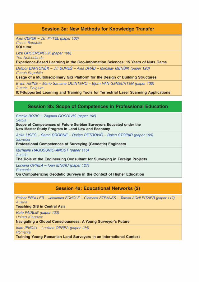
Session 3a: New Methods for Knowledge Transfer
Ales CEPEK – Jan PYTEL (paper 103)Czech RepublicSQLtutor
Liza GROENENDIJK (paper 108)The NetherlandsExperience-Based Learning in the Geo-Information Sciences: 15 Years of Nuts Game
Dalibor BARTONEK – Jiri BURES – Ales DRAB – Miroslav MENSIK (paper 120)Czech RepublicUsage of a Multidisciplinary GIS Platform for the Design of Building Structures
Erwin HEINE – Mario Santana QUINTERO – Bjorn VAN GENECHTEN (paper 130)Austria, BelgiumICT-Supported Learning and Training Tools for Terrestrial Laser Scanning Applications
Session 3b: Scope of Competences in Professional Education
Branko BOZIC – Zagorka GOSPAVIC (paper 102)SerbiaScope of Competences of Future Serbian Surveyors Educated under theNew Master Study Program in Land Law and Economy
Anka LISEC – Samo DROBNE – Dusan PETROVIC – Bojan STOPAR (paper 109)SloveniaProfessional Competences of Surveying (Geodetic) Engineers
Michaela RAGOSSNIG-ANGST (paper 115)AustriaThe Role of the Engineering Consultant for Surveying in Foreign Projects
Luciana OPREA – Ioan IENCIU (paper 127)RomaniaOn Computerizing Geodetic Surveys in the Context of Higher Education
Session 4a: Educational Networks (2)
Rainer PRULLER – Johannes SCHOLZ – Clemens STRAUSS – Teresa ACHLEITNER (paper 117)AustriaTeaching GIS in Central Asia
Kate FAIRLIE (paper 122)United KingdomNavigating a Global Consciousness: A Young Surveyor’s Future
Ioan IENCIU – Luciana OPREA (paper 124)RomaniaTraining Young Romanian Land Surveyors in an International Context

Session 4b: Quality Assurance (2)
Nicolae LUDUSAN – Levente DIMEN (abstract 125)RomaniaOn Student Assessment in Technical Distance Education
Olga PETRAKOVSKA (paper 114)UkraineCurrent Situation in Ukraine of Urban and Rural Land Development (Practice and Education)
Georg GARTNER – Robert WEBER (paper 123)AustriaComtemporary Education and Quality Assurance in the Geodesy and Geoinformation Programsat the Vienna University of Technology

Geodetic Education at the ’’Politehnica’’ University of
Timisoara – Romania
Carmen Grecea, Timisoara
1. Introduction
The paper describes the engineering programsand specific educational objectives in geodetichigher education from Politehnica University ofTimisoara’’; it offers a short presentation of theRomanian cadastral situation and aspects of thetransition in the educational system.
2. Generals on the Romanian Cadastre
During its evolution in Romania, geodetic activity,especially cadastral works dealt with manyeconomical and political changes and obstacles.That’s why, nowadays, the most important task of
the new cadastral policy is to assure theinformatization of this activity, related to generaland multipurpose cadastre, to provide a completeevidence of land and buildings in order to designthe territory in a convenient way with environmen-tal protection.
In time, it’s role remained just the same, but themethods, technical tools and principles inorganization changed a lot due to the progressin informatics and technology specific to geodeticwork and also due to the inner conditions of theRomanian society.
Fig. 1: RO - General context
Professional Education 2009 – FIG International Workshop Vienna FIG
Through cadastre work one can collect andstore a big amount of technical, juridical oreconomical information and all this job can beefficient if the access to these documents is quick,convenient and reflects the reality. The mainquality of a modern cadastre is represented by theuse of digital data at any level of the process.
Transformation of the present informationalsystem into database system supposes theorganization of all information into separate files,which are closely, related one to another.
The primary data processing for computationof the land surfaces for a property is quite simpleat this first level but it becomes very difficult due tothe huge number of parcels and owners and alsoto the existence of a great amount of corrections inthe adjustment of the territory (around 7 millionowners and a total surface of about 9 millionhectares, and if we take into consideration amedium number of 6 parcels/owner, it’s necessaryto create and determine by cadastral survey anumber of about 40 million parcels – for Romania),fig.1.
This situation requires the elaboration ofspecial, modern methods for data processinginside the local agencies for cadastre which offerthe following possibilities:
& to collect the primary information using theelectronic equipment which provides a conve-nient processing in addition;
& to collect by graphical tools the data which canbe obtained by digitizing the parcels directly onthe cadastral plans (this aspect implies the useof the existing data);
& to compute and evaluate specific elementsuseful for the preparation of the final cadastralregisters in the form of individual files;
& to draw up the new cadastral plans or to updatethe old ones;
& to create the database of the general cadastre.
The new tendencies of automation in this researcharea impose the necessity of restoration thetopographic and cadastral plans in the digitalform.
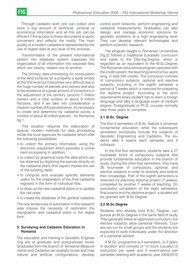
3. Surveying and Cadastre Education inRomania
The education and training in Geodetic Enginee-ring are at graduate and postgraduate levels.Graduates from the branch of Terrestrial Measure-ments and Cadastre can spatially locate and mapnatural and artificial configurations, develop
control point networks, perform engineering andcadastral measurements. Graduates can alsodesign and manage economic solutions forgeodetic problems at a high engineering level.They can develop relevant technologies andperform scientific research.
The program taught in Romanian Universities(fig.2) follows a traditional European curriculumand leads to the Dipl.Ing.Degree, which isregarded as an equivalent to the M.Sc.Degree.The Romanian educational program operates withthe credit system, the teaching period is four yearslong, in total 240 credits. The curriculum consistsof compulsory subjects, optional and electivesubjects, including in the eighth semester aperiod of 7 weeks which is reserved for preparingthe diploma project. According to the strictrequirements every student has to learn a foreignlanguage and take a language exam of mediumdegree. Postgraduate or Ph.D. courses normallytake three years to complete.
3.1 B.Sc. Degree
The first 3 semesters of B.Sc. feature a universal,fundamental education, while the subsequentsemesters exclusively include the subjects ofGeodetic Engineering and Cadastre. The stu-dents take 4 exams each semester and 4colloquia.
In the first four semesters, students take a 27hour/week block of compulsory subjects thatprovide fundamental education in the branch ofstudy. During the other four semesters, they have26 hour/week of compulsory, optional, andelective subjects in order to diversify and extendtheir knowledge. Part of the eighth semesters isreserved for planning diploma project (7 weeks),completed by another 7 weeks of teaching. Onsuccessful completion of the eight semesters,final exams and the diploma project, a student willbe granted with B.Sc.Degree.
3.2 M.Sc.Degree
Students who already hold B.Sc. Degree, canpursue an M.Sc.Degree in the same field of study.They generally follow an approved curriculum, butelective subjects allow personal interests. Cour-ses are run for small groups and the students areexpected to work individually under the directionof a personal advisor.
A M.Sc. programme is 4 semesters, or 2 yearsin duration and consists of 14 hours (usually) ofinstruction per week and 4 examinations persemester (starting with academic year 2009/2010
FIG Professional Education 2009 – FIG International Workshop Vienna
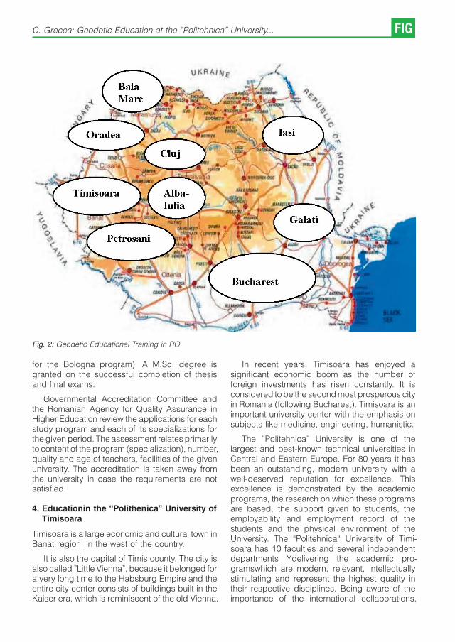
Fig. 2: Geodetic Educational Training in RO
for the Bologna program). A M.Sc. degree isgranted on the successful completion of thesisand final exams.
Governmental Accreditation Committee andthe Romanian Agency for Quality Assurance inHigher Education review the applications for eachstudy program and each of its specializations forthe given period. The assessment relates primarilyto content of the program (specialization), number,quality and age of teachers, facilities of the givenuniversity. The accreditation is taken away fromthe university in case the requirements are notsatisfied.
4. Educationin the “Polithenica’’ University ofTimisoara
Timisoara is a large economic and cultural town inBanat region, in the west of the country.
It is also the capital of Timis county. The city isalso called ’’Little Vienna’’, because it belonged fora very long time to the Habsburg Empire and theentire city center consists of buildings built in theKaiser era, which is reminiscent of the old Vienna.
In recent years, Timisoara has enjoyed asignificant economic boom as the number offoreign investments has risen constantly. It isconsidered to be the second most prosperous cityin Romania (following Bucharest). Timisoara is animportant university center with the emphasis onsubjects like medicine, engineering, humanistic.
The ’’Politehnica’’ University is one of thelargest and best-known technical universities inCentral and Eastern Europe. For 80 years it hasbeen an outstanding, modern university with awell-deserved reputation for excellence. Thisexcellence is demonstrated by the academicprograms, the research on which these programsare based, the support given to students, theemployability and employment record of thestudents and the physical environment of theUniversity. The “Politehnica“ University of Timi-soara has 10 faculties and several independentdepartments Ydelivering the academic pro-gramswhich are modern, relevant, intellectuallystimulating and represent the highest quality intheir respective disciplines. Being aware of theimportance of the international collaborations,
C. Grecea: Geodetic Education at the ’’Politehnica’’ University... FIG

Fig. 3: Timisoara - Location
directly related to the mission and the objectivesalready stated, the “Politehnica“ University ofTimisoara has continuously extended and deve-loped the relations with foreign partners throughprojects, programs and activities of learning andscientific research. The developing strategy forcooperation programs between the University andforeign partners is based on two coordinates:
& to take part in programs and projects financedby the European Union;
& to establish as many bilateral agreements aspossible with universities from Europe and othercontinents.
The “Politehnica“ University of Timisoara hasfocused on concluding agreements with univer-sities from all over the world. Due to theagreements signed between the faculties, thedepartments have established mutual relationsand facilities.
Speaking about the strategy of the manage-ment of international relations, in the “Politehnica“University of Timisoara was created the Depart-ment for International Programs and Relations.This department is directly coordinated by the
Rector and the Scientific Secretary and it assuresthe coordination, the evidence and monitoring ofthe international programs. This department hasthe following functions:
& representation, protocol and public relations inthe international agreements field;
& evidence and monitoring of the programs andactivities of academic collaborations;
& initiates the international collaboration, gathersinformation and acquires it;
& keeps the evidence of the official trips;- offersadvice for the use of the financial resourcesneeded in collaborations.
Starting with academic year 2005/2006 theUniversity adhered to the Bologna System with3 levels for studies:
1. Bachelor’s Program – B.Sc. Degree,
2. Master’s Program – M.Sc.Degree,
3. Doctoral Program – PhD,
so that, in the current academic year fourprograms are part of the Bologna project (I-II-III-
FIG Professional Education 2009 – FIG International Workshop Vienna
IV years of study), and one program is part of theold project (Vth year of study).
The educational program at the ’’Politehnica’’University of Timisoara is based on the creditsystem (ECTS). The branch of Terrestrial Measure-ments and Cadastre from the Faculty of CivilEngineering offers full-time degree programs inRomanian language only.
5. Program of terrestrial Measurements andCadastre in Timisoara
Within the ’’Politehnica’’ University of Timisoara,Faculty of Civil Engineering this programme wasfounded in 1991, being registered in theRomania’s Official Monitor of 13 May 2002, inthe section accredited specializations.
The development of the geodetic profile wasimposed, both locally and nationally, out of theeconomic and scientific needs, i.e. the lack ofexperts in this field of activity.
This speciality belongs to the field of GeodeticEngineering, a distinct profile in the RomanianNational Nomenclature of Specialities.
The structural changes, which occurred in ourcountry after 1989, due to the development of the
private properties and the passing to the marketeconomy, also led to fundamental changes in thefield of cadastre; both in what the record of the realassets and cadastral plans are concerned.
The update and the modernization of thecadastre, in order to make it multifunctional,require a large number of specialists and if at allpossible a uniform national distribution.
At the University of Timisoara, from 1991-2008more than 300 geodetic engineers were formed inthe 12th series of graduates.
The curriculum is adapted for the open highereducation system, and the syllabuses arecorrelated to similar national and internationalprograms, in order to comply with the EuropeanCredit Transfer System.
In order to meet the required future objectives,the geodetic engineer needs a thorough trainingin the field of terrestrial measurements. This canonly be ensured by the study of both fundamentalcourses (mathematics, physics, techniques ofcalculus, etc.) and speciality courses (Topo-graphy, Geodesy, Cartography, Photogrammetry,Cadastre, etc), Table 1,2.
Nr. DisciplineHours Weight ROregimentations
C S L TOTAL %
1 FUNDAMENTAL 308 168 126 602 18,59 min.18%
2 IN DOMAIN 518 – 767 1285 39,68 min.38%
3 SPECIALITATY 497 – 700 1197 36,97 min.25%
4 COMPLEMENTARY 14 140 – 154 4,76 max.8%
TOTAL 1337 308 1593 3238 100 100%
Table 1: Number of hours and distribution per discipline (1)
Nr. DisciplineHours Weight ROregimentations
C S L TOTAL %
1 COMPULSORY 994 308 1194 2496 77,08 60-80%
2 OPTIONAL 343 – 399 742 22,92 20-40%
Total: compulsory and optional 1337 308 1593 3238 100 100%
3 ELECTIVE 119 161 – 280 8,65 5 -10%
Table 2: Number of hours and distribution per discipline (2)
C. Grecea: Geodetic Education at the ’’Politehnica’’ University... FIG

For the complex training of the futurespecialists, a substantial contribution is broughtby disciplines belonging to the beneficiary fieldsof these activities, such as: Constructions,Urbanism, Transportation, Local and RegionalAdministration, etc. .
Nowadays, at the speciality of TerrestrialMeasurements and Cadastre of Timisoara, 200students are studying. Starting with the academicyear 2005/2006 a new educational plan wasintroduced, structured on 4 years for the technicaldomain (licensed engineer ) plus 2 years for theMaster degree (diplomat engineer) – the BolognaProcess.
The Bachelor Program (B.Sc. Degree) wasevaluated in 2008 by the Romanian Agency forQuality Assurance in Higher Education obtainingthe accreditation in the Bologna system.
The second level of the educational trainingincluding the Master Program (M.Sc.Degree) willbe evaluated until summer in Timisoara.
Graph 1: Dynamics of the human resources- number ofplaces
Graph 2: Dynamics of the Human Resources- number ofgraduates
The only institution that offered until now MasterProgrammes in Surveying and Geodesy in the oldsystem was the Faculty of Geodesy in Bucharest;it has been accredited also for new MasterProgrammes in Bologna system.
The specialization of Terrestrial Measurementsand Cadastre in Timisoara has had an ascendingevolution since its foundation, 18 years ago,justifying its existence completely (graph.1,2).The mission of training cadastre specialistsincludes not only the students but the teachingstaff as well. The quantitative and the qualitativelevel of the students follows an ascendingdirection, being reflected in the increasingnumber of places (graph.1,), the increasingnumber of graduates (graph.2) and the marksobtained by the students. The students’ evolution,since the admission until graduation, also reflectsthe interest and the preoccupation of the teachingstaff in order to meet the requirements of theteaching process.
The speciality consolidation strategy envisa-ges the following objectives:
& Continuous development of the curriculum andof the syllabuses, in conformity with theevolution of the techniques in the domain ofGeodesy, and in correlation with similarRomanian and European Union institutes;
& PhD development studies for the teaching staffand specialized training for external professors,i.e. people who work in the field of cadastre.
& The development of some current researchfields in cadastre such as: informatization of theland register, land information systems, GIS,satellite technologies.
Since 1991, the well individualized speciality ofTerrestrial Measurements and Cadastre part of the’’Politehnica’’ University of Timisoara, has produ-ced 12 series of alumni who have coveredsuccessfully the whole design and execution workin this field, mainly for the west part of the country.
The graduates, geodetic engineers, are em-ployed by state institutions (offices of the NationalAgency for Cadastre and Land Registration, LocalCouncils, Design Institutes, Autonomous admini-strations, etc.) private companies (trading com-panies) specialized in cadastre or having relatedactivities (constructions, urbanism) or, they arefreelancers.
The University, and the faculty respectively,ensure the adequate material basis required by aqualitative education, teaching spaces, adequatelaboratories, a specialized library, and obviously a
FIG Professional Education 2009 – FIG International Workshop Vienna

constant teaching staff and external professors,adequately trained.
Graph 3: Distribution of teaching personnel
All the teaching staff has been involved inscientific research. The various research themesin the field of geodesy engineering are madepublic either by the publication of scientificarticles, in various speciality magazines, manuals,courses, laboratory works, or by presenting thefindings at different national or internationalsymposiums. The staff is also involved in researchcontracts with various companies. The teachersalso belong to different professional associationssuch as: AGIR-the General Association of theEngineers in Romania, UGR-Romanian GeodesyUnion, the Local Geodesy Association, theRomanian Society of Geotechnical Engineeringand Foundations, the Romanian Road Society, etc.
5.1 Evolution and the perspective of the studyprogramme
The speciality of Terrestrial Measurements andCadastre was conceived as an interdisciplinaryspeciality, capable to train competent specialistsand to provide efficient solutions for the design,realization and exploitation of works in the field ofterrestrial measurements, for different purposes(topographic engineering works, cadastre works,systematization, urbanism, GIS, etc,)
6. Thematic Priorities in Research
The ’’Politehnica’’ University of Timisoara has along term strategy and short and middle termprograms which contain the objectives, theprojects and the foreseen results of the research,as well as to the means of reaching them.
These are some of the main directions of theresearch team, formed from teachers andstudents, of the speciality of Terrestrial Measure-ments and Cadastre.
& Topo-geodetic studies to monitor the tectonicprocesses in the western part of Romania;
& Topographic documentation to draw up theurban area plan projects in the western part ofRomania;
& Technical solutions for ensuring the stability ofcertain industrial objectives with various desti-nations;
& Updating the data base of the GeographicInformatic System of Timisoara – the capital ofthe Timis County;
& Updating the database for urban cadastre ;
& Updating the road cadastre data base;
& Cemeteries Cadastre
The findings of the research are made know indifferent ways: they are published in differentpublications for didactic purposes or scientificpublications; they are presented in doctoraltheses, or are rendered profitable in universityresearch contracts, since our department isaccredited by the National Agency for Cadastreand Land Registration.
Man’s wish and need for information hasalways been accompanied by new discoveries.Our field is not an exception. New wideperspectives are opened towards the understan-ding of the environment by the use of newtechnology and informatization.
In the field of terrestrial measurements, aconstant concern of people, for more than twomillenniums, to measure and study the shape andthe form of our planet, new problems keepoccurring, problems which have to be solved bythe present and the future geodetic engineers.
This field of activity is of large perspective inRomania and its mission is to find adequatetechnical and technological solutions for variousproblems that the specialists in the field have toface, i.e. either topo.-geodetic works, cadastreand land register works, or setting up newappropriate information systems to monitor thespecific engineering works, thus ensuring theirstability in time.
C. Grecea: Geodetic Education at the ’’Politehnica’’ University... FIG
References
[1] Henssen J.: Cadastral information, an important landmanagement tool, ITC Journal, 1, (1996).
[2] EUROLIS, Fifth Seminar, Poland 1996.
[3] Mihaila M., Corcodel Gh., Chirilov I.: General Cadastreand Real Estate Bucuresti, 1995.
[4] ****Geodesy, Cartography and Cadastre Magazine,vol.3, nr.2 Bucharest.
[5] Grecea C.: Cadastral Systems, new trends andexperiences, Journal of Cadastre, RevCAD nr.7, Ed.Aeternitas Alba Iulia 2007.
[6] Grecea C.: ’’Cadastral Evaluation between present andfuture’’, Academic Days, Timisoara, 2001.
[7] Grecea C.: ’’Geodetic education in Politehnica Univer-sity of Timisoara, Symposium 2008, Surduc – Romania.
[8] ***Strategy of the National Agency for Cadastre andLand Registration.
[9] ***Government Regulations and Laws regarding qualityassurance in education.
Contact
Assoc. Prof Carmen Grecea, ’’Politehnica’’ University ofTimisoara, Faculty of Civil Engineering, Department ofTerrestrial Measurements and Cadastre, 2A, Traian Lalescustr.300223-Timisoara, Romaniae-mail: [email protected], [email protected]
FIG Professional Education 2009 – FIG International Workshop Vienna

Can European graduates fulfil the expectations of Slovenian
(private) enterprises?
Andrej Mesner, Anka Lisec, Samo Drobne,
Ljubljana, Slovenia
Abstract
Liberalization of services and international recognition of professional competences are a topical issue of theinternational agenda. In the European Union, an additional challenge is the EU market, which provides the frameworkfor free trade in professional services within the EU member states. Consequently, the professional qualifications,which have to meet the labour market needs, have to be recognized on the international level. The competences of thegraduates and whether these competences are in line with the demands of the employment areas (in particular of theprivate enterprises) are discussed in connection to the field of surveying in Slovenia. In addition, some main findingsregarding the requirements of the European enterprises in the surveying profession are given, based on the researchwithin the framework of the EEGECS (European Education in Geodetic Engineering, Cartography and Surveying). Wetry to emphasize the importance of collaboration between private/public sector and higher educational institutions inorder to develop and/or adjust higher educational programmes to the technological and methodological development,and to the market needs, which would fulfil wide spectrum of the market needs.
Keywords: Surveying, geodesy, skills of graduates, private enterprises, Slovenia
1. Introduction
Each profession has to respond to the challengesof globalization, which dictates liberalization oftrade in professional services. The internationalmarket pressures, including the regulationstowards liberalization of trade stimulated by theWorld Trade Organization (WTO), and the EU freemarket within the EU member states, are reflectedalso in the surveying profession and surveyinghigher educational programmes throughout Eu-rope. The rights of the EU citizens to provideservices anywhere in the EU are fundamentalprinciple of the EU law. However, the nationalregulations and in particular licensed professions,such as surveying is in several Europeancountries, are serious obstacles to these funda-mental rights.
Traditionally, the surveying profession predo-minantly operated in the niche markets, whichwere either local or national in character. Theseregulated markets are not conductive to mobilityof professionals, due to the wide variety ofprocedures, laws, and functions performed bysurveyors. However the non-regulated part of thesurveying market is highly conductive to mobility.The European Commission has perceived themutual recognition as a device for securing thefree mobility of professionals within the single
market place of the EU. Mutual recognition can bedefined as a process which allows the qualifica-tions gained in one country to be recognised inanother country [1]. Although there are a numberof barriers, which hinder mutual recognition at aworld scale, such as language, national customs,culture etc., the free movement of professionalscan be based on the definition of the qualificationsrequired for professionals to practice in aprofession or discipline. The European Ministersof Education made a joint declaration (Bolognaagreement) in June 1999 to coordinate theirpolicies to achieve the adoption of easilycomparable higher educational degrees. Moder-nization of higher education in Europe is anongoing process which tries to follow the mainguidelines of Bologna declaration and marketneeds.
Establishment of the common European highereducation area is very important from theperspective of globalization process and deve-lopment of the European common market, whichdictates high level of knowledge and comparableeducational competences all over Europe. Privateenterprises as well as public agencies (institu-tions) would like to get highly qualified graduatesof surveying (geodesy) with as many competen-ces as possible directly from the universities.However, not only the educational outcomes
Professional Education 2009 – FIG International Workshop Vienna FIG

(which have to adopt the needs of society as well),but general ability of the individual to applyknowledge and skills to produce a requiredoutcome have to be defined in a standardizedform, often mentioned as professional compe-tency standards.
In this respect, the question arises: “How canhigher education institutions and their graduatesfulfil the expectations of the labour market?’’ Thetopic of establishing the equilibrium between thelabour market needs and developing trends of thehigher educational curriculum is illustrated on thecase of Slovenian labour market in the field ofsurveying (geodesy), where a brief comparisonwith the European area is given as well. For thispurpose, the results of analysis of questionnairesamong employers and graduates in surveyingprofession in Slovenia are given. Furthermore, abrief overview of the EEGECS (European Educa-tion in Geodetic Engineering, Cartography andSurveying) research among employers on nee-ded professional competences of graduates insurveying is given, which was done in 13 EUmember states.
2. Slovenian labour market needs in the fieldsof surveying
Professional competences of a graduated sur-veyor, defined by the labour market, have beenchanging very rapidly in the course of the lastdecades. This is mainly the consequence ofglobalization trends, changing needs of societyand technical development, which forced inparticular private enterprises (as well as publicsector in the fields of surveying) to take up achallenge and adjust their fields of work to thecurrent and future needs.
The higher educational study programmes ofsurveying as well as professional competences ofsurveyors vary among the EU countries mainlydue to historical reasons and regulatory frame-work of the profession. However, surveying hastraditionally leaned strongly towards engineering.Nowadays, the need to shift to teaching mana-gement skills applicable to interdisciplinary worksituations is obvious in almost all Europeancountries. There have been several discussionson competences of surveying profession, basedon the international comparison of highereducational curricula and professional competen-ces, in order to support the international mobilityand international trade in surveying services (see[2], [3]).
Comparable to other EU countries, globaliza-tion, interdisciplinary and technical developmenthas forced many Slovenian private enterprises tochange fields of work. This is the reason why theyneed different working profiles also in the field ofsurveying. The only higher educational program-mes in surveying in Slovenia are performed at theUniversity of Ljubljana, Faculty of Civil andGeodetic Engineering, Department of Geodesy.Although the higher educational programmes insurveying (geodesy) at the University of Ljubljanahave tried to be flexible and adjusted the curriculato the needs of the profession (there was aconsiderable renovation of study programmeswithin the Phare-Tempus project (1996-1999)), therenovation of study programmes according toBologna guidelines provided a new opportunityfor important changes in the educational compe-tences of surveying (geodetic) graduates.
For this purpose, the research was done by theUniversity of Ljubljana, Faculty of Civil andGeodetic Engineering, Department of Geodesyin 2005 and 2006, which aimed to gather usefuldata from the Slovenian labour market in order toget information for development of the newBologna programmes of geodesy (surveying,geoinformatics). The research of the surveyinglabour market in Slovenia was based on twoquestionnaires. The first one was the question-naire for graduates about the study programmesof surveying (geodetic) engineering in Slovenia(see [4], [5]). The second questionnaire wascompleted by the employers who had to answerabout study programmes of surveying (geodesy)in Slovenia and educational competences theyexpected from the graduate (see [4], [6]).
2.1 Employers’ opinion of the Slovenian highereducation in surveying
For the quality of renewal of the study program-mes, the opinions of experts outside the universityenvironment are appreciated. For this purpose,the analysis of employers’ (whose main field ofwork is surveying profession and related disci-plines) opinion of study programmes of surveying(geodetic) engineering at Faculty of Civil andGeodetic Engineering was performed in 2006 [6].The main aim of the analysis was to find out theratio between the expected and achieved abilities,skills and knowledge, which should be achievedby graduates in surveying (geodesy) during theirstudy at university or higher professional degree.The questionnaire contained the following com-plexes of questions (see [4], [6]):
FIG Professional Education 2009 – FIG International Workshop Vienna

(a) general information about company/institution(name, field of activity, number of employees);
(b) general opinion of achieved graduates’ level ofknowledge and skills important for the em-ployer;
(c) evaluation of expected and achieved abilities,skills and knowledge, which should beachieved by graduates of surveying (geodesy)during their higher education: (c1) the ability toapply knowledge in practice, (c2) the ability todevelop the profession, (c3) the knowledge ofmanagement, (c4) the knowledge of legisla-tion, (c5) the knowledge of standards, (c6) theknowledge of informatics and an ability to usenew information technologies, (c7) the ability tocommunicate effectively, (c8) the ability to leadand coordinate the projects/organization, (c9)other abilities and skills (ethical loyalty, anability to work in multidisciplinary teams etc.);and
(d) estimation of five most important abilitiesamong seventeen suggested.
Fig. 1: Employers’ opinion regarding the qualification ofgraduates in surveying (geodesy) at the Faculty of Civiland Geodetic Engineering, University of Ljubljana, tobegin to work at their companies.
In the research, 50 different employers ofsurveying diploma engineers answered thequestionnaire. The general opinion of Sloveneemployers in the fields of surveying (geodesy) isthat (university) diploma engineers of surveying(geodetic) engineering are rather prepared forwork in their company. But, employers in privatecompanies are more critical regarding thequalification of geodetic graduates to begin to
work at their companies. Their main subjects ofcritique are regarding graduates’ ability to applyknowledge of business management techniques.Fig. 1 shows employers’ opinion regarding thequalification of geodetic graduates.
Employers of geodetic graduates estimatedalso five most important abilities among seven-teen suggested ones. There are some differencesbetween public institutions and private enter-prises. For public institutions the most importantskills of the graduates are [4]:
& basic knowledge of surveying and geodesy,
& basic knowledge of profession (wider area ofprofession),
& the ability to apply knowledge to practice,
& the ability to accommodate oneself to a newsituation, and
& the ability to acquire knowledge.
In contrast to the employers in public sector, therepresentatives of the private enterprises empha-sized the skills of graduates in this order [4]:
& the ability to understand and communicate inforeign language,
& the ability to apply knowledge to practice,
& the basic knowledge of surveying and geodesy,
& the basic knowledge of profession (wider areaof profession), and
& the ability to create and implement new ideas.
2.2 Graduates’ opinion of the Slovenian highereducation in surveying
In 2005, the analysis of graduates’ opinion ofstudy programmes of geodetic engineering atFaculty of Civil and Geodetic Engineering,University of Ljubljana, was performed [5].Slovenian academic education of surveying(geodetic) engineering was based on Germaneducational system. At the moment, the studyprogrammes are in transition to the newprogrammes following the Bologna guidelines.However, at the time of the research, twoprogrammes of the higher education in surveying(geodesy) were performed (diploma degree) [4]:
& University study programme of geodesy (9semesters), which was comparable to themaster’s degree in countries using consecutivesystem of higher education.
& Higher professional study programme ofgeodesy (6 semesters), which was comparableto study programmes at Universities or Collegesof Applied Sciences.
A. Mesner, A. Lisec, S. Drobne: Can European graduates fulfil the expectations... FIG

The questionnaire for graduates contained thefollowing complexes of questions:
(a) general information about (university) diplomaengineer, his/her occupation and position,information about the institution and the fieldof work;
(b) evaluation of (b1) the volume of study coursesin the time of his/her study; (b2) requirementsof study courses; (b3) applicability of know-ledge and skills obtained during the study;(b4) importance of knowledge and skills for thefuture;
(c) missing knowledge and skills, and
(d) suggestions for improvement of study pro-grammes.
In the analysis, 50 university diploma engineers(university study programme) and 48 diplomaengineers (higher professional study programme)answered the questionnaires.
The graduates in surveying (geodesy), whoanswered the questionnaire, did not haveproblems to find a job – they found job veryquickly after they graduated, in less than onemonth. The fields of their work were from geodesy,land surveying, spatial data management, to landadministration, land management, which iscovered also by the newest definition of surveyingprofession (see [7]).
The main aim of the research was to find out theratio between the knowledge and skills acquiredduring the study at the faculty, and actualapplicability and utility in the praxis. In general,diploma engineers of both study programmessuggested that the volume of courses referring tothe real estate registration and real estatemanagement as well as courses in the fields oflegislation, public administration and businesseconomics could be enlarged. Both groups ofquestioned graduates agreed also that theimportance of topics of real estate registration,real estate management, spatial informatics,legislation and business economics should beincreased significantly in near future.
3 Permanent education in the (private)enterprises in some EU member states
Within the framework of European thematicnetwork EEGECS (European Education in Geo-detic Engineering, Cartography and Surveying),WG 4 – Public/ Private Enterprise, the needs ofsurveying (private) enterprises in some EUmember were analysed based on a questionnaire
for employers. The questionnaire was completedby representatives of 104 enterprises from 13 EUcountries [8]. The results of the research gave anoverview of the current situation of the surveyingprofession and employability of graduates insurveying in Europe, where following aspectswere considered:
& Segmentation and main fields of activities ofprivate/public enterprises;
& Number of graduates within the company;
& Main fields of activities of graduates within thecompanies;
& Skills of graduate staff expected by theenterprises;
& Continuous Lifelong Learning;
& Mobility across Europe.
The questionnaire was rather complex; we wouldlike to emphasize in particular the needs of theemployers regarding continuous lifelong learning.
3.1 EEGECS
The thematic network EEGECS (2002-2008) wasthe results of the vision for the Common EuropeanArea of Higher Education and was establishedwithin the Erasmus programme of the EuropeanCommission. As a part of the former EuropeanSocrates-Erasmus Programme, the thematic net-works were launched officially in May 1996. Theoriginal purpose was to help higher educationinstitutions to create forums with the aim to analyseand study the state of development of variouseducation and training fields in Europe in order toencourage the European dimension and improvethe quality of education and training. Generallyspeaking, a thematic network presents a co-operation between departments of higher educa-tion institutions and other partners (e.g. academicorganisations or professional bodies). All coun-tries participating in the Socrates-Erasmusprogrammes (EU, EFTA and Candidate Countries)had possibility to be involved in a thematicnetwork. The main aim of the programme is toenhance quality and to develop a Europeandimension within a given academic discipline orstudy area [9].
The thematic network EEGECS, which wasestablished in 2002 and later connected over 100institutions from 27 European countries, aimed tofacilitate trans-national access to educationalresources in Europe. The EEGECS is a projectoriginally created by Geodetic Engineering,Cartography and Surveying institutions whosemain objective was to enhance collaboration and
FIG Professional Education 2009 – FIG International Workshop Vienna

Fig. 2: Companies’ main activities [8].
co-operation between the higher educationinstitutions which offer these studies and studiesfrom related fields [10]. The work was organised insix working groups. One of the focuses of theEEGECS was the research of labour market needsin surveying, geodesy, cartography and relatedfields, which was mainly studied in the WG 4 –Public/ Private Enterprises.
3.2 Some basic findings of the EEGECSresearch
Simple survey of the main fields of activities of thecompanies, that answered the questionnaire,showed that their field of work is focused ontechnical land surveying, which takes in averagemore than one third of the companies recourses,another 27% flows into other activities, mainlyadministration, marketing and promotion andmanagement. Land management covers 15% ofthe company’s activities, software development13% and real estate economics and land valuationand construction are of minor relevance (Fig. 2,see also [8]).
The official academic education presents onlya part of the professional competences - becauseof the fast developing technology and changingneeds of society, each individual has to upgradehis/her knowledge and skills in the profession aswell as in the other fields referring to his/her work,
the analysis of lifelong learning practice in thecompanies was performed. The analyses of thequestionnaires showed that more than 65% of thecompanies support life long learning activities oftheir graduate employees. Almost half of themcover the course costs and provide working timefor training programs. The largest number ofpersons is getting training in the fields ofmanagement skills, communication skills andInformation and Communications Technology(ICT) skills (Fig.3).
4. Market needs of enterprises in Slovenia incomparison to other EU countries
Based on the EEGECS research on skills ofgraduates required by European enterprises, wecan say, that the European enterprises, working inthe field of surveying and related fields, havesimilar demands for graduates. However, we cannot directly compare the results of the analysis,performed by the Faculty of Civil and GeodeticEngineering, University of Ljubljana, and theEEGECS, because questions and structure ofquestionnaires was not the same. Nevertheless,we can get general idea about the needs andexpectations of Slovenian and EU enterprisesfrom graduates in the fields of surveying(geodesy).
A. Mesner, A. Lisec, S. Drobne: Can European graduates fulfil the expectations... FIG

Fig. 3: Number of persons trained per year [8].
In general, we can say that (private) enter-prises expect graduates from the university tohave more skills and professional competencesas they get it during the period of study. On theother hand, it is interesting, that in Slovenia, allgraduates get work in one month after they finishtheir study (study from 2005, [5]). There aredifferent kind of enterprises and different fields ofwork where graduates in Slovenia are employed.The employers’ institutions can be classifiedconsidering different aspects:
& private – public;
& small – medium – big enterprise;
& mostly surveying field of work – partly surveyingfield of work – other field of work.
Expectations also vary according to the abovementioned groups because we can not forexample compare small company (2 employees)with public institution (few hundreds employees).The small companies mostly work in the traditionalfields of surveying (engineering surveying,geodetic surveying, real estate registration etc.)and they need graduates with a lot of professionalpractical knowledge. Bigger companies, whichhave more experts, can arrange their owneducation and introduction into the work andthey do not expect that graduates will get enough
knowledge for everyday work already during thestudy period. Generally private companies aremore critical and expect more from graduatesthan public ones.
Referring to the needed skills of the graduateswhen applying for a job, it has to be emphasized,that in Slovenia as well as in other EU countriessoft skills (project management, communication,time management, team work, economic, foreignlanguage etc.) are more and more important, inparticular in the private sector. These skills arenecessary in all fields of work and sometimes theyare even more important than professionalknowledge. As an example, almost all of thework in the private enterprises is project oriented;without proper project management, communica-tion skills, teamwork, there are no (expected)results. Basic knowledge of economics is neededin every project and foreign language is nowadaysobligatory. The expectations of graduates as wellas employers for the future development ofsurveying profession are further referring to theinterdisciplinary work. We noticed that theseexpectations (already demands of society) aregetting higher every day and it is very difficult forgraduates and for the academic institutions tofollow development of the labour market.
FIG Professional Education 2009 – FIG International Workshop Vienna

4.1 Graduates between studying programmeand employers
Based on the presented researches on opinion ofgraduates and employers about the educationalcompetences, we can say that graduates getenough of technical and expert knowledge butthey do not get enough practice and soft skills. InSlovenia, only one month of practical work in theenterprise was obligatory during the study at theuniversity level (and one semester at the higherprofessional level). However, we have to know thatthe educational competences are only part of theprofessional competences, which have to bedeveloped lifelong. Students in Slovenia acquirepractical and soft skills also by student work(summer job), which is widely supported also bythe government. This may also be the reason forrather positive answer on graduates’skills from theemployers in Slovenia. Nevertheless, the highereducational institutions have to follow theprofessional development on the internationallevel and the needs of society.
4.2 Adjusting the study programmes to theneeds of society
In the last few years almost all the highereducational institutions in Europe, that did nothave the three tires higher educational system inthe past, are being in the process of changing thestudy programmes according to the Bolognaprocess. Bologna declaration forced highereducational institutions throughout EU to changetheir programmes, which has been also a greatopportunity to adjust the programmes to thecurrent guidelines of the profession and the needsof society. Fig.5 shows the triangle with importantactors in the process of changing highereducational study programmes. In order to getas objective as possible overview of the currentsituation and the necessary changes it isnecessary, that the higher educational institution(university, faculty) includes all levels of profes-sion in discussion while renovating the studyprogramme. In Slovenia, the Department ofGeodesy, Faculty of Civil and Geodetic Enginee-ring at the University of Ljubljana, did a lot of workto acquire the important information from mainactors in the field of surveying before preparingthe proposal and accepting the new programmesof surveying (geodesy) at the department. For thispurpose, the Strategic Council was established,which was advisory body for the faculty in theprocess of changing the programme, consideringthe guidelines of Bologna declaration. TheStrategic Council members were representatives
of the Surveying and Mapping Authority of theRepublic of Slovenia, Professional SurveyingAssociation, Chamber of surveying engineersand private enterprises.
Fig. 4: Important actors for changing the programmes.
4.3 How can the enterprises influence thecurriculum development
Cooperation between science (universities) andenterprises is an assurance for economy growth inall fields of work and surveying is not an exception.Because of this, enterprises should be activelyinvolved in the process of changing the studyprogrammes. Study programmes are not chan-ging very often (however, the contents of eachcourse are changing but this are not changes thatinfluence on the study programmes as a whole)and every considerable change will not haveimmediate impact on labour market. This is themain reason, why every change is important forthe long term development of the profession. Inthis aspect, a special support can be provided bythe professional associations, which can coordi-nate the communication, support the exchange ofideas and following the ideas of all actors in theprofession, prepare also some guidelines for thehigher educational programmes in the future. InSlovenia, there are many possibilities for theenterprises to have direct or indirect influence oncurriculum development; at least on the contentsof the practical training programme within theframework of the higher education. The best wayis a collaboration between professional associa-tion (for example in Slovenia we have Chamber ofsurveying engineers and Association of privateenterprises) and the faculty.
A. Mesner, A. Lisec, S. Drobne: Can European graduates fulfil the expectations... FIG

Due to the fast development of the surveyingprofession and the extension of the surveyingcompanies’ fields of work, it is impossible toexpect, that the higher education will ever“produce’’ graduates which will provide all thecompetences, needed in the enterprises. Som-etimes the enterprises want to get some specificknowledge, which is a short term need, and thehigher educational institutions should not re-sponse to such initiatives immediately by proposalof changing study programmes. Enterprises doesnot expect that either, because other approachesare much more appropriate for such needs suchas life-long learning programmes, which are onthe other side a challenge for the enterprises aswell as for the higher educational institutions, whocan organise the short training programmes forthe particular topic. In Slovenia, there is still a widespace for developing this cooperation in thefuture, which can contribute to development of theprofessional skills of graduates by meetingdemands of society.
5. Conclusions
In order to follow the needs of society, enterprisesand graduates should play an important role in theprocess of changing higher educational studyprogrammes in a certain field of profession. Thehigher educational institutions have to response tothe market needs, not only with flexible studyprogrammes but also with other kind of courses inthe context of Lifelong Learning. The idea ofestablishing a Strategic Council for higher educa-tion in the field of surveying, where all theimportant actors (private, public, chamber) wouldtake part in, is widely accepted in the Slovenianprofessional society, because of the advantagesof such cooperation in the period of developingnew study programmes in accordance with theBologna declaration in the course of the last years.
References
[1] Enemark, S. and Plimmer, F.: Mutual Recognition ofprofessional Qualification. FIG publication nr. 27, FIGOffice, Copenhagen, 2002.
[2] Enemark, S. and Prendergast, P. (Eds.): EnhancingProfessional Competence of Surveyors. FIG Seminar,Delft, The Netherlands, November, 2000.
[3] Ruiz Fernandez, L. A. (Ed.): Proceedings of theInternational Congress on Geomatics Education inEurope, Warsaw, Poland, November 30 – December 1,2007.
[4] Drobne, S., Petrovic, D. and Lisec, A.: New StudyPrograms of Geodetic Engineering in Slovenia.Proceedings of the International Congress on Geo-matics Education in Europe, Warsaw, Poland, Novem-ber 30 – December 1, 2007.
[5] Drobne, S., Breznikar, A. and Babic, U.: Mnenjediplomantov o ucinkovitosti studija geodezije (=Graduate’s Opinion on Efficiency of Study ofSurveying). Geodetski vestnik 50(2): 270-286, 2005.
[6] Drobne, S. and Modic, I. 2007: Mnenje delodajalcev oucinkovitosti studija geodezije (= Employe’s Opinion onEfficiency of Study of Surveying). Geodetski vestnik51(1): 85-101, 2007.
[7] Enemark, S.: International Trends in Surveying Educa-tion. Presented at the FIG XXII International Congress,Washington, D. C. USA, April 19-26, 2002.
[8] Heine, E., Mesner, A., Schafer, T. and Steinkellner, G.:European Education in Geodetic Engineering, Carto-graphy and Surveying – Skills of graduates required byEuropean enterprises. FIG Workshop on eGovernance,Budapest, Hungary, April 27-29, 2006.
[9] Lisec, A. and Ruiz Fernandez, L. A.: European Projecton Higher Education in the Fields Related to Geomaticsas Support for Mobility of Students and Teachers.Presented at the ISPRS XXI International Congress,Beijing, China, July 3-11, 2008.
[10] Steinkeller, G. and Heine, E.: European Education inGeodetic Engineering, Cartography and Surveying(EEGECS) – Thematic Network for Higher Education.From Pharaohs to Geoinformatics, FIG Working Week2005 and GSDI-8, Cairo, Egypt, April 16-21, 2005.
Contact
Andrej Mesner, Igea d.o.o., Koprska 94, SI-1000 Ljubljana,Slovenia, e-mail: [email protected]
Assist. Prof. Anka Lisec, PhD, University of Ljubljana,University of Ljubljana, Faculty of Civil and GeodeticEngineering, Jamova 2, SI-1000 Ljubljana, Sloveniae-mail: [email protected]
Senior Lect. Samo Drobne, MSc, University of Ljubljana,University of Ljubljana, Faculty of Civil and GeodeticEngineering, Jamova 2, SI-1000 Ljubljana, Sloveniae-mail: [email protected]
FIG Professional Education 2009 – FIG International Workshop Vienna

Interdisciplinary Knowledge
Transfer within Surveying Higher
Education
Guido Heinz, Jorg Klonowski, Hartmut Muller, Germany
Abstract
At Mainz University of Applied Sciences, Department of Geoinformatics and Surveying, a long experience is availablein co-operation projects with partners from the humanities for the purpose of archaeological and cultural heritagedocumentation and preservation. This paper focuses on a subset of about 40 diploma thesis which were executedwithin archaeological and cultural heritage documentation projects outside Germany. Besides the location of theproject area, another selection criterion was the overall importance of diploma work for the respective project. Whileconducting such work in close co-operation with students and professionals of other disciplines, surveying studentsgain valuable knowledge from those other fields. In such projects, students of all participating disciplines have thechance to augment their disciplinary knowledge with knowledge from other disciplines.
Keywords Higher Education, Surveying, Students work, Humanities
1. IntroductionSurveying as a discipline most often offers servicesto other natural or engineering sciences likearchitecture or mechanical engineering. However,a wide range of opportunities to establish fruitful co-operations is available in the humanities, too.
i3mainz , Institute for Spatial Information andSurveying Technology, has knowledge andexperience in the fields of image processing,photogrammetry, remote sensing, surveying, 3D-visualization, internet applications developmentand software engineering. The institute is
Fig. 1: Recording of archaeological findings using tachaeometry
Professional Education 2009 – FIG International Workshop Vienna FIG
equipped with a wide range of devices for datarecording and processing. Besides own software,it can rely on the leading software products for theabove mentioned fields. Members of pi3mainzphave collected considerable experience withappropriate surveying methods ranging fromsimple hand surveys, tacheometry, satellitenavigation systems up to aerial and close rangephotogrammetry, terrestrial and airborne scan-ners, remote sensing using satellite images inmany cooperation projects with partners from thehumanities. A large number of publications dealwith surveying methods for archaeology andcultural heritage documentation ([1], [2], [3], [5],[8]).
The professors and scientific co-workers of theinstitute are involved in Surveying Higher Educa-tion, as well. In the last semester of their studies,students at the Department of Geoinformatics andSurveying usually prepare their diploma theses ortheir bachelor and master thesis, in the near future([10]). Each diploma thesis is supervised by amember of the teaching staff. It must be finishedwithin 6 months. About more than 10% of thesetheses on average are prepared outside Germanyand some are written in English. A good overviewof all the aspects of internationalization ofeducation at the Department of Geoinformaticsand Surveying in cooperation with i3mainz is givenin [6].
Following the defined selection criteria, namelyto present only projects from outside Germany,where students’ work yielded an essential part ofproject deliverables, projects from the fivecountries China, Turkey, Yemen, Israel andUkraine will be presented.
2. China since 1993
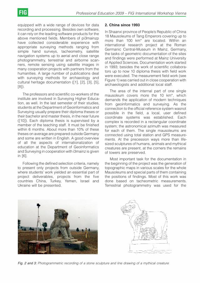
In Shaanxi province of People’s Republic of China18 Mausoleums of Tang Emperors covering up tomore than 100 km* are located. Within aninternational research project at the RomanGermanic Central-Museum in Mainz, Germany,the tasks of geometric documentation of the sitesand findings were performed at Mainz Universityof Applied Sciences. Documentation work startedin 1993; besides the work of scientific collabora-tors up to now 10 diploma thesis with field workwere executed. The measurement field work (seeFigure 1) was carried out in close cooperation witharchaeologists and additional local staff.
The area of the internal part of one singlemausoleum covers more the 10 km*, whichdemands the application of modern techniquesfrom geoinformatics and surveying. As theconnection to the official reference system wasnotpossible in the field, a local, user definedcoordinate systems was established. Eachcomplex is recorded in a rectangular coordinatesystem; the astronomical azimuth was measuredfor each of them. The single mausoleums areconnected using total station and GPS measure-ments. At the precession ways more than life-sized sculptures of humans, animals and mythicalcreatures are present, at the corners the remainsof towers are preserved.
Most important task for the documentation inthe beginning of the project was the generation oftopographic maps in various scales for the wholeMausoleums and special parts of them containingthe positions of findings. Most of this work wasdone based on tacheometric measurements.Terrestrial photogrammetry was used for the
Fig. 2 and 3: Photogrammetric recording of a stone sculpture and line drawing of a mythical creature
FIG Professional Education 2009 – FIG International Workshop Vienna

Fig. 4: Image map with four mausoleums using satellite imagery (from [9]). Satellite images: * Space Imaging andCNES/Spot Image
documentation of selected stone sculptures (seeFigure 2 and Figure 3). All geometric data wasprocessed in a CAD environment generating up to40 maps in different scales from 1/5 up to 1/10.000for each complex.
Due to the lack of aerial images to anincreasing degree satellite images were usedwithin the project. The usability of various systemswith different geometric and radiometric resolu-tion was evaluated. Landsat and SPOT data with30 m respectively 10 m resolution was usedespecially for the generation of lower resolutionelevation models and overview maps (see Figure4). Over the years the geometric resolution of theavailable satellite image data increased enor-mously. With this imagery image maps and 3D-views could be generated in bigger scales. Theinformation content of the plans was increasedand the field work could be reduced with this newdata source.
The interdisciplinary character of the project,the exotic environments in terms of area andfeatures to record as well as the spectrum oftechniques to use made this project interesting forthe students and their diploma thesis.
3. Turkey since 1998
Documentation work in Turkey, Tavium, CentralAnatolia started in 1998. Till now, 11 diplomathesis were executed there. Besides extensivelarge scale tacheometric surveys of the terrainsurface animated 3D scenes of the landscapewere generated from existing maps. An overallweb presentation was developed to present theTavium Research Project in much detail.
The ancient Galatian city of Tavium is located atthe present-day village of Buyuknefes, 150 kmeast of Ankara, 20 km from the Hittite capital ofHattusha. The site being occupied from the 4thmillennium BC had its flourishing phase during theHittite period. In the 3rd century BC the Trocmii, aCeltic tribe from the Danube area occupied thesite of Tavium ([15]). Since 1998 the area of the cityhas been surveyed by a team led by Karl Strobelof the University of Klagenfurt and supported byi3mainz, concentrating on the extensive Romanand Byzantine remains which are still available.Geophysical work has shown the citadel andlower city had a total extent of 150 hectares, pre-classical remains have been found at a number ofplaces within the survey area ([16], [17], [18]).
G. Heinz, J. Klonowski, H. Muller: Interdisciplinary Knowledge Transfer... FIG
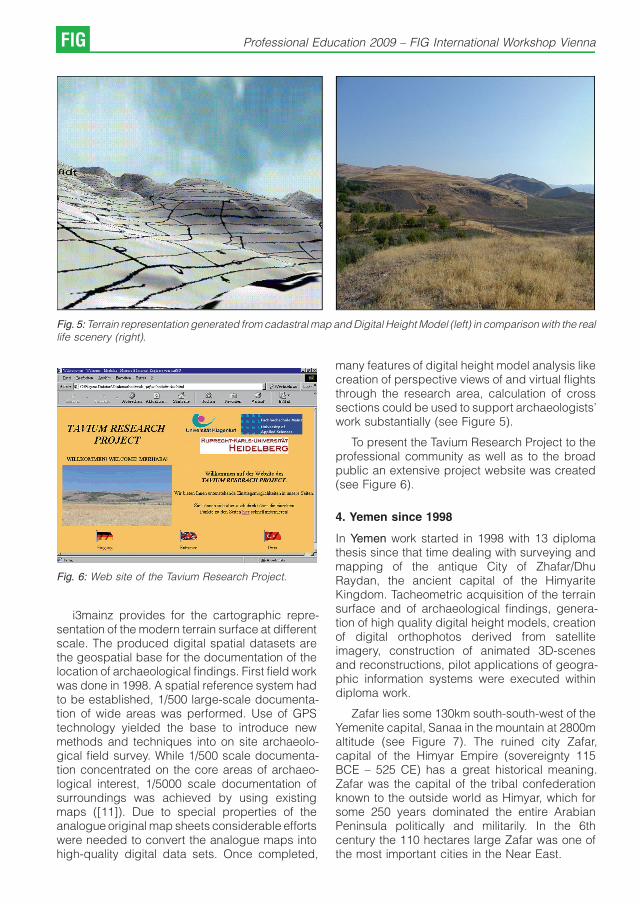
Fig. 5: Terrain representation generated from cadastral map and Digital Height Model (left) in comparison with the reallife scenery (right).
Fig. 6: Web site of the Tavium Research Project.
i3mainz provides for the cartographic repre-sentation of the modern terrain surface at differentscale. The produced digital spatial datasets arethe geospatial base for the documentation of thelocation of archaeological findings. First field workwas done in 1998. A spatial reference system hadto be established, 1/500 large-scale documenta-tion of wide areas was performed. Use of GPStechnology yielded the base to introduce newmethods and techniques into on site archaeolo-gical field survey. While 1/500 scale documenta-tion concentrated on the core areas of archaeo-logical interest, 1/5000 scale documentation ofsurroundings was achieved by using existingmaps ([11]). Due to special properties of theanalogue original map sheets considerable effortswere needed to convert the analogue maps intohigh-quality digital data sets. Once completed,
many features of digital height model analysis likecreation of perspective views of and virtual flightsthrough the research area, calculation of crosssections could be used to support archaeologists’work substantially (see Figure 5).
To present the Tavium Research Project to theprofessional community as well as to the broadpublic an extensive project website was created(see Figure 6).
4. Yemen since 1998
In Yemen work started in 1998 with 13 diplomathesis since that time dealing with surveying andmapping of the antique City of Zhafar/DhuRaydan, the ancient capital of the HimyariteKingdom. Tacheometric acquisition of the terrainsurface and of archaeological findings, genera-tion of high quality digital height models, creationof digital orthophotos derived from satelliteimagery, construction of animated 3D-scenesand reconstructions, pilot applications of geogra-phic information systems were executed withindiploma work.
Zafar lies some 130km south-south-west of theYemenite capital, Sanaa in the mountain at 2800maltitude (see Figure 7). The ruined city Zafar,capital of the Himyar Empire (sovereignty 115BCE – 525 CE) has a great historical meaning.Zafar was the capital of the tribal confederationknown to the outside world as Himyar, which forsome 250 years dominated the entire ArabianPeninsula politically and militarily. In the 6thcentury the 110 hectares large Zafar was one ofthe most important cities in the Near East.
FIG Professional Education 2009 – FIG International Workshop Vienna

Fig. 7: Location of the ancient city Zafar.
Fig. 8: Workers at the excavation site.
In 1998, the Heidelberg University Expeditionto Zafar, in the Yemenite Highlands, initiated aprogramme of excavation, mapping and training([19], [20]). The mapping showed the ancientwalled city with a core area comprising some 1000x 1200 m. The core of Himyarite Zafar spreadsover the southern and western slopes and thesummit of the Husn Raydan, the fortified al-Gusr,and the present-day village. The ancient cityextends eastward and southward outside the citywalls. Till now some 1000 Himyarite inscriptionsand relieves are being catalogued. They datepredominantly to the 3rd – early 6th centuries. Alate Himyarite cemetery on a mountain slope and
a foundation at the southern foot of the HusnRaydan was excavated, the site museum wasnewly installed and all of the inscriptions werephotographed. Other excavation started on thesouth-western flank of the Husn Raydan in whatappears to be magazines; parts of a largelimestone building came to light as well as a life-size king’s sculpture (see Figure 8). Parts of thesite were investigated by means of magnetometersurvey.
As part of an interdisciplinary team i3mainzjoined the field campaigns of the years 1998,2000, 2002, 2003, 2005, 2006 und 2008.Documentation of the terrain surface and ofarchaeological findings was performed (seeFigure 9 and Figure 10).
Fig. 9: Transport of measuring equipment.
Digital orthophotos, digital height models,virtual three-dimensional reconstructions weregenerated from satellite images (see Figure 11). Afirst prototype of a geoinformation system wasdeveloped.
5. Israel since 2004
Mainz University of Applied Sciences started itswork in Israel in 2004 within the Kinneret RegionalProject, a European expedition to the north-western shore of the Sea of Galilee in Israel (seeFigure 12). The aim of the project is to explore thesite of Tel Kinrot – ancient Kinneret – and itssurroundings. The history of large excavations atthis site started in 1982 after preliminary investiga-tions ([13]). Despite several field campaigns ofexcavation only a fraction of the site is known sofar. A detailed description of Kinneret RegionalProject is given in [14] and in [12].
G. Heinz, J. Klonowski, H. Muller: Interdisciplinary Knowledge Transfer... FIG

Fig. 10: True scale map of field names in Arabic language.
Fig. 11: 3D view of the surroundings of Zafar
FIG Professional Education 2009 – FIG International Workshop Vienna

Fig. 12: Sea of Galilee with major sites (from [14]).
In the meantime 4 diploma thesis werecompleted in the context of this project. Thegoal of the first diploma thesis in 2004 was theestablishment of a spatial reference systemconnected with the official Israel referencesystem. Thus, geo-referencing of local surveysmade by the archaeologists in a common spatialcontext had become reality. In addition the site ofTel Kinrot with an expansion of 10.000 m* wascompletely re-surveyed using the latest surveyingtechnology. This comprehensive survey resultedin a consistent spatial data base of the excavationsite.
2005 two further diploma thesis started with asurveying campaign to complement and toexpand the results of 2004. The collected datawere the basis for a three dimensional precisegeometric documentation of the excavation site inorder to be able to derive 3D landscape modelsand longitudinal or cross profiles. The processingwork took time until 2006.
Precise differential GPS was the clue to anacceleration of the work of the archaeologists in2007. The fast and precise survey of findings andlocal excavation areas the archaeologists workedon antemeridian were processed noontime andoffered to the archaeologists in the afternoon in
their databases. This procedure led to anincreased productivity because several of theformer working steps could be omitted now.
Fig. 13: DISTA with the representation of the coloured 3Dobjects with respect to the different thematic layers.
Another investigation for the development of anoptimized work flow for both surveying andarchaeological field work was done by usingphotogrammetric recordings. Aerial photos of theexcavation site were taken by a consumer camerawhich was fixed to a small hot-air airship. UsingDISTA (digital stereoscopic evaluation architec-ture ([4])) – a photogrammetric evaluation systemused for the precise determination of 3D-coordinates from blocks of large metric imagesdeveloped at i3mainz it was possible to build upstereo models and to register 3D objectsdescribed by points, lines, poly-lines and poly-gons. A thematic differentiation of the 3D objectwas done by the introduction of the layers “wall’’,“floor’’ and “breakline’’ (see Figure 13).
Fig. 14: Photo-realistic 3D model of the excavation site.
G. Heinz, J. Klonowski, H. Muller: Interdisciplinary Knowledge Transfer... FIG
3D models of the excavation site using photo-realistic textures were derived based on theseresults (see Figure 14). An impressive visualiza-tion was generated by a walk and a flight throughthe virtual 3D model of the site.
In addition 3D archaeological objects likepillars, oven or door lintel were virtually recon-structed and implemented into the 3D scenes(see Figure 15).
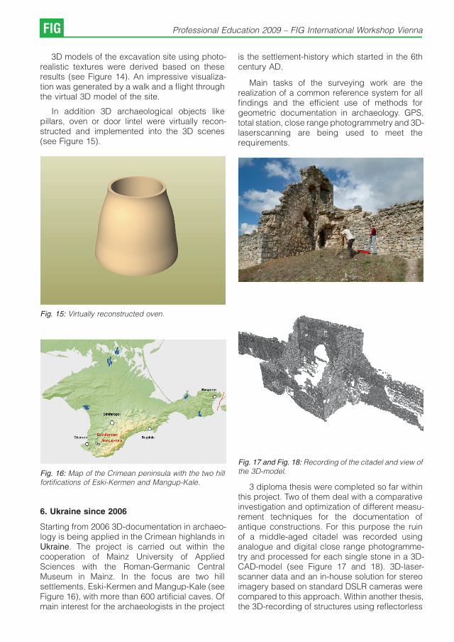
Fig. 15: Virtually reconstructed oven.
Fig. 16: Map of the Crimean peninsula with the two hillfortifications of Eski-Kermen and Mangup-Kale.
6. Ukraine since 2006
Starting from 2006 3D-documentation in archaeo-logy is being applied in the Crimean highlands inUkraine. The project is carried out within thecooperation of Mainz University of AppliedSciences with the Roman-Germanic CentralMuseum in Mainz. In the focus are two hillsettlements, Eski-Kermen and Mangup-Kale (seeFigure 16), with more than 600 artificial caves. Ofmain interest for the archaeologists in the project
is the settlement-history which started in the 6thcentury AD.
Main tasks of the surveying work are therealization of a common reference system for allfindings and the efficient use of methods forgeometric documentation in archaeology. GPS,total station, close range photogrammetry and 3D-laserscanning are being used to meet therequirements.
Fig. 17 and Fig. 18: Recording of the citadel and view ofthe 3D-model.
3 diploma thesis were completed so far withinthis project. Two of them deal with a comparativeinvestigation and optimization of different measu-rement techniques for the documentation ofantique constructions. For this purpose the ruinof a middle-aged citadel was recorded usinganalogue and digital close range photogramme-try and processed for each single stone in a 3D-CAD-model (see Figure 17 and 18). 3D-laser-scanner data and an in-house solution for stereoimagery based on standard DSLR cameras werecompared to this approach. Within another thesis,the 3D-recording of structures using reflectorless
FIG Professional Education 2009 – FIG International Workshop Vienna

total stations inside and outside artificial caveswas optimized. The data is recorded using asimple point numbering system providing allinformation for the semi-automated generation of3D-CAD data of the point and vector objects.Currently another thesis is prepared concentra-ting on the integration of old maps with the moderndata and using old landscape marks in combina-tion with the results of archaeological field surveys.
The spatial data is collected and processed ina common reference system as basis for a GIS-System. The GIS is used for storage, administra-tion and analysis of all project data. The collectionof attribute data is carried out in close cooperationwith German and Ukrainian archaeologists. Thedata is used as well for generating maps in variousscales, visualization and reconstruction tasks.
7. Conclusions and further work
Virtually all surveying students who decided to joinan interdisciplinary team reported valuableexperiences from their expeditions not to bemissed, seen both from the personal and theprofessional view points. In that way, the well-established close link between institutionalresearch and higher education at Mainz Universityof Applied Sciences proves to provide for a stableknowledge transfer base for different disciplines.
Special challenges exist in projects withpartners from different professional culturesinvolved, like from different engineering sciencesand, at the same time, from the humanities.Consequently, Mainz University of Applied Sci-ences, Department of Geoinformatics and Sur-veying, and Gutenberg University Mainz arecooperating to establish a new study programmein Archaeology (Master) with a special attention tospatial information and surveying technology andits application in archaeology ([7]).
References
[1] Bohler, W., Heinz, G. (1997): Recording and VisualizingTopography and Object Geometry for ArchaeologicalDocumentation. Archaologisches Korrespondenzblatt,27, 1997, Heft 2, Verlag des Romisch-GermanischenZentralmuseums Mainz, pp 355 – 373.
[2] Bohler, W., Heinz, G., Scherer, Y., Siebold, M. (2001):Topographic Information in Cultural and Natural Heri-tage Visualization and Animation. International Archi-ves of Photogrammetry, Remote Sensing and SpatialInformation Sciences, Volume XXXIV, Part 5/W1, pp. 56-61.
[3] Bohler, W., Bordas Vicent, M., Heinz, G., Marbs, M.,Muller, H. (2004): High Quality Scanning and Modelingof Monuments and Artifacts. In: Proceedings of the FIGWorking Week 2004, Athens, Greece, May 22-27, 2004,Workshop – Archaeological Surveys, WSA2 – Modellingand Visualization, paper number WSA2.2. . http://www.fig.net /pub/athens/wsa2/WSA2_2_Bohler_e-t_al.pdf.
[4] Boochs, F., Muller, H., Neifer, M. (2001): DISTA – aportable software solution for 3D-compilation of photo-grammetric image blocks. In: Conference-ProceedingsSPIE Digital Library Volume 4298 – Three-DimensionalImage Capture and Applications IV, San Jose, CA, USA.24 January 2001.
[5] Boochs, F., Heinz, G., Huxhagen, U., Muller, H. (2006):Digital documentation of cultural heritage objects usinghybrid recording techniques, In: EPOCH PublicationThe e-volution of Information Technology in CulturalHeritage, edited by M.Ioannides, D. Arnold, F.Niccolucci, K. Mania, 2006, pp 258-262.
[6] Boochs, F., Klonowski, J. (2008): i3mainz und dieInternationalisierung in der Lehre, Schriftenreihe Infor-mations- und Messtechnik, Band 7, Shaker Verlag,Aachen, 2008.
[7] Bruhn, K.-C., Klonowski, J. (2008): Master-StudiengangArchaologie – Einrichtung eines gemeinsamen Studien-gangs der Johannes Gutenberg Universitat Mainz undder Fachhochschule Mainz, Schriftenreihe Informa-tions- und Messtechnik, Band 7, Shaker Verlag,Aachen, 2008
[8] Boos, S., Hornung, S., Jung, P, Muller, H. (2008): GISbased processing of multiple source prospection datain landscape archaeology. Proceedings of the 1stInternational Workshop on “Advances in RemoteSensing for Archaeology and Cultural HeritageManagement’’,Rome 30 September – 4 October,2008, S. 113 -117.
[9] Gong Qiming, Koch, A. (2002): Das Qiaoling.Harrassowitz-Verlag, Wiesbaden, ISBN 3-447-04575-2.
[10] Klonowski, J., Muller, H. (2008): Status and Perspec-tives of Geomatics Education at Mainz University ofApplied Sciences. SICEHE ’08 Symposium on Inter-national Cooperation Experiences in Higher Education,International Meeting for Networking and Partnership,13th and 14th June 2008, Valencia, Spain, ConferenceProceedings CD ROM, ISBN 978-84-691-3877-9.
[11] Muller, H. (2003): Spatial Information Technology for theArchaeological Research Area of the Ancient CityTavium, Central Anatolia. In: Proceedings of the XIXthInternational Symposium CIPA 2003 ‚New PerspectivesTo Save Cultural Heritage‘, Antalya (Turkey), 30September – 04 October, 2003, Published by theCIPA 2003 organising committee. The InternationalArchives of Photogrammetry, Remote Sensing andSpatial Information Sciences, Vol. XXXIV, Part 5/C15,pp. 719-724.
[12] Munger, Stefan, Juha Pakkala, Jurgen Zangenberg,Wolfgang Zwickel: Das ‚Kinneret Regional Project’ –eine europaische Expedition an das Nordwestufer desSees Gennesaret. Jerusalem: Gemeindebrief – Stif-tungsjournal 4/07 (2007): 19-22.
G. Heinz, J. Klonowski, H. Muller: Interdisciplinary Knowledge Transfer... FIG
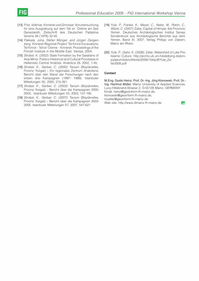
[13] Fritz, Volkmar, Kinneret und Ginnosar: Voruntersuchungfur eine Ausgrabung auf dem Tell el- ‘Oreme am SeeGenezareth, Zeitschrift des Deutschen Palastina-Vereins 94 (1978) 32-45
[14] Pakkala, Juha, Stefan Munger, and Jurgen Zangen-berg. Kinneret Regional Project: Tel Kinrot Excavations.Tel Kinrot – Tell el-‘Oreme – Kinneret. Proceedings of theFinnish Institute in the Middle East. Vantaa, 2004.
[15] Strobel, K. (2002): State Formation by the Galatians ofAsia Minor. Politico-Historical and Cultural Processes inHellenistic Central Anatolia. Anatolica 28, 2002, 1-45.
[16] Strobel, K., Gerber, C. (2000): Tavium (Buyuknefes,Provinz Yozgat) – Ein regionales Zentrum Anatoliens.Bericht uber den Stand der Forschungen nach denersten drei Kampagnen (1997- 1999). IstanbulerMitteilungen 50, 2000, 215-261.
[17] Strobel, K., Gerber, C. (2003): Tavium (Buyuknefes,Provinz Yozgat) – Bericht uber die Kampagnen 2000-2002,. Istanbuler Mitteilungen 53, 2003, 131-195.
[18] Strobel, K., Gerber, C. (2007): Tavium (Buyuknefes,Provinz Yozgat) – Bericht uber die Kampagnen 2003-2005. Istanbuler Mitteilungen 57, 2007, 547-621
[19] Yule, P., Franke, K., Meyer, C., Nebe, W., Robin, C.,Witzel, C. (2007): Zafar, Capital of Himyar, Ibb Province,Yemen. Deutsches Archaologisches Institut Sanaa,Sonderdruck aus Archaologische Berichte aus demYemen, Band XI, 2007, Verlag Philipp von Zabern,Mainz am Rhein.
[20] Yule, P., Galor, K. (2008): Zafar, Watershed of Late Pre-Islamic Culture. http://archiv.ub.uni-heidelberg.de/pro-pylaeumdok/volltexte/2008/134/pdf/Yule_Za-far2008.pdf
Contact
M.Eng. Guido Heinz, Prof. Dr.-Ing. Jorg Klonowski, Prof. Dr.-Ing. Hartmut Muller, Mainz University of Applied Sciences,Lucy-Hillebrand-Strasse 2, D-55128 Mainz, GERMANYEmail: [email protected],[email protected],[email protected] site: http://www.i3mainz.fh-mainz.de
FIG Professional Education 2009 – FIG International Workshop Vienna

The Impact of Student Numbers on the Quality of
Teachers – The Situation in Vienna and a Possible
Way Out
Gerhard Navratil, Vienna
Abstract
For years the Vienna University of Technology has had problems attracting a sufficient number of surveying students.This leads to financial problems if the budget is based on student numbers. Another problem is that low studentnumbers lead to low graduate numbers and this limits the choice when looking for employees at universities. Then evenless suited candidates have to be accepted. In the long run this will have an impact on the quality of the teachers. Thiscan only be prevented if more students are attracted. The traditional fields are well covered. Thus we need to addressnew target groups. However, both, the curriculum and the job description must be attractive.
1. Introduction
Assessing and improving the quality of educationis a standard problem (compare, for example, [1]).The curriculum is often used as a measure for thequality of the education. A specific field can onlybe taught if there are a certain number of classeswith a minimum duration. The education isdeemed poor if this requirement is not met. Thereare many examples for such curriculum descrip-tions [2-5]. However, the discussion of educatio-nal quality should not be restricted to thedevelopment of curricula and how to assessECTS points to the various fields. The quality ofeducation is based on several other factors, too.Some of them are
& monetary expenditure (for personnel, equip-ment, rooms, etc.),
& access to recent research results (projects,contacts, etc.),
& motivation of teachers, and
& quality of teachers.
Deficiencies in any of these areas can eliminatebenefits from improved curricula. The discussionin this paper concentrates on the quality ofteachers. The quality is influenced by severalparameters including the ones listed above. Whatis usually ignored, however, is the fact that thenumber of students has an impact on the quality ofteachers.
The remainder of the paper is structures asfollows: Section 2 shows the impact of lackingmonetary expenditure on the quality of theteachers. Section 3 shows the connectionbetween student numbers and the quality ofteachers. Some numbers and experiences fromAustria show the effects. Raising the universitybudget is in Austria a political decision and thus
we have almost no influence. Thus attracting morestudents is the only way to improve the quality ofteachers. Section 4 thus provides some ideas toraise student numbers in Austria.
2. Impact of Tight Budgets on the Quality ofTeachers
Monetary expenditure is a problem in times of tightbudgets. High quality teachers demand adequatepayment and if universities reduce salaries (asdone in Austria) the quality of teachers will drop.Excursions and field training are expensive as isthe acquisition of modern equipment. High qualityteachers will try to guarantee that they haveenough budgets to finance these activities andinvestments. Attracting internationally renownedexperts as professors is thus connected to aguaranteed minimum budget. Lack of money hasthus a direct influence on the attractiveness of theuniversity for high quality teachers.
A typical way out of this problem is theacquisition of projects to bolster the budget.However, this has a disadvantage. Projectproposals have to be written and, for acceptedprojects, the according work has to be done.Surveyors, as engineers, are usually successful inacquiring projects. But what is the impact on theteachers? They will have to help drafting theproposal and overlook the implementation of theproject. This takes time and is usually missingsomewhere else. Since administrative dutiescannot be neglected, either teaching or indepen-dent scientific work will be affected. Scientificwork is a major component for the development ofnew teaching material and thus excessive work-load for project acquisition will have an impact onthe quality of education.
Professional Education 2009 – FIG International Workshop Vienna FIG

The acquisition of projects usually requiresideas. Many ideas develop while reading texts orlistening to presentations. The publishing channelmust be accessible for reading. These channelsare still mainly journals and books. Access tothese kinds of publications is influenced bymonetary expenditure. The access dependsmainly on the budget of the university library. Ashrinking library budget results in deterioratingworking conditions because it is more difficult toaccess recent work of colleagues. Departmentscan try to keep the access by paying for theaccess themselves. The required money will,however, be missing somewhere else. Usingproject money may help but again leads to higherworkload for the personnel. Thus the budget hasnot only a direct effect on the quality of teachers bylimitation of wages, but also an indirect effect bydeterioration of working conditions.
Time pressure and short budgets may alsohave an impact on the motivation of teachers. It isfrustrating if there is not enough money availableto implement excursions or student projects. Thisis not yet a pressing issue in surveying educationin Austria (as most of my colleagues are highlymotivated and budgets are still high enough tosupport teaching) but it may become one.
3. Impact of Student Numbers on the Quality ofTeachers
We still have enough money and a number ofexcellent teachers in Vienna, but can we keep thislevel? The number of students is a crucial factor tokeep a certain level: Smaller communities likesurveyors have less influence than bigger ones(like, e.g., computer science or architecture) andreceive smaller shares of the budget. Additionally,teachers have to be selected from the group offormer students. It is therefore necessary to have adecent number of surveying students to guaran-tee the quality of future education.
Looking at the incoming student numbers forsurveying studies in Austria shows a significantincrease [6, 7]. Unfortunately, these numbers onlytell half the truth since the number of graduatesdoes not correlate with these numbers. One of themain problems is that ERASMUS students areincluded as starters, although they usually do notplan to finish their studies in Austria. Students whowant to finish their studies in Vienna will usuallytake courses according to the proposed schedule.This can be used to separate ERASMUS studentsfrom regular students. In addition, there may bestudents who only need the inscription for access
to social security system or who find out within thefirst weeks that surveying is not their main interest.These students can be eliminated when looking atthe number of students participating in a coursefrom the second or third semester. Figure 1 showsthe difference between the incoming studentnumbers and students participating in the courseadjustment computation in the third semester.Some of the missing students stopped studying.However, this cannot explain the different shape ofthe curves. Even if we eliminate the peak in 1997,the correlation between the lines is small. In 2003,for example, the number of students in the 3rd
semester increased whereas the number of newstudents from the previous year shows adecrease.
The number of graduates is another importantfactor. Figure 2 shows a comparison of the studentnumbers in the 3rd semester with the numbers ofgraduating students four years later. The correla-tion between the numbers is 82% and thus thenumber of students in the 3rd semester seems tobe a good indication for the available graduatesfour years later. Even better results can beobtained if removing the peak in 1992. This peakoriginates from the end of the old curriculum in1996 (four years later). A large number of studentswanted to avoid complications with the change ofcurriculum and this resulted in the high number ofgraduations. After removing this peak the correla-tion is even 94%.
A major problem from low numbers ofgraduates is employment at universities. Currently71 researchers are employed at the threesurveying departments at the Vienna Universityof Technology. This number rises to 74 if includingcurrently open positions. Three other Austrianuniversities have surveying departments: GrazUniversity of Technology (30 researchers), Uni-versity of Applied Life Sciences (11 researchers),and University Innsbruck (6 researchers). Thusthe universities alone must fill 120 researchpositions. Assuming an average work life of 40years 3 graduates per year are necessary (theactual rate is even higher due to short-timecontracts and migration to industry and admini-stration). This is a quarter of the recent graduates.Vienna University of Technology and GrazUniversity of Technology recently had problemsfinding suitable candidates for research positions.At least 4 to 5 candidates would be necessary toguarantee high quality of the personnel but at thetwo universities there were less than two applica-tions per position. Thus even less qualifiedapplicants have to be employed. Since these
FIG Professional Education 2009 – FIG International Workshop Vienna

Fig. 1: Comparison of surveying students at the Vienna University of Technology: Newly registered students in theprevious year vs. students in the 3rd semester.
Fig. 2: Comparison of student numbers in the 3rd semester with the number of graduating students 4 years later
G. Navratil: The Impact of Student Numbers on the Quality of Teachers FIG

Fig. 3: Number of surveying students (without PhD-students) in percent of the total number of inscribed studies at theVienna University of Technology
persons should also teach, the quality of theteaching will drop in the long run.
Whereas Figure 1 shows the absolute numbers,Figure 3 shows the relative importance ofsurveying at the Vienna University of Technology.The leaders of curricula with a large number ofstudents will have a higher impact in organizatio-nal decisions than the leaders of small curricula.The relative number of surveying studentsdecreased from 1990 (1.5% of the students inVienna) to 2003 (0.9%). Since then surveying isregaining relative importance. This indicates thatthere is a positive trend but the relative importanceis still at an unsatisfactory level. This problem evenincreases the monetary problems becauseeverybody needs more money and the budgetis at best at a constant level. Thus everybody triesto argue that his group is more important.Numbers of students and graduates are easy tocount and are thus often used. Probably a sideeffect of this problem is the dropping number ofplaces offering surveying education. In the lastyears, for example, Delft and Berlin closed theircurriculums in surveying. Similar developmentscan also be found in other parts of the world (e.g.,in Africa [8]).
4. How to Increase Student Numbers in Austria
A key factor to improve or even keep theeducational quality is therefore raising the numberof students in surveying. However, actions areonly possible if the problem areas are known. Thuswe should perform a thorough analysis of theinterests of surveying students in Vienna. Basedon this analysis we could then start focusedmarketing actions to increase the number ofstudents [9]. I did not do such an analysis. I justwant to show some observations I did in the recentten years.
A large fraction of surveying students is formedby children of surveyors. Later in their academiccareer they either want to take over the office oftheir parents or at least work in a similarenvironment. They have a clear picture of thejob and selected the studies because this is whatthey want to do. Marketing in this group ofpossible students is not necessary.
Other students had other contacts withsurveying:
& summer work in a surveying office or with theAustrian Federal Office for Metrology andSurveying,
FIG Professional Education 2009 – FIG International Workshop Vienna

& presentations given by researchers at schools,or
& other promotion material.
Whereas the first two possibilities are obvious, thelast one might be interesting. In Austria there is anannual exhibition where pupils can get informationon a wide variety of jobs. The Austrian universitiesare also present at this exhibition and researchersexplain to interested pupils the curriculum andchances in the job market. A study as done inSweden [10] could be helpful to communicate thechances in the job market because good chancesmay increase the interest (compare [11]).Typically, some of these interested pupils becomestudents of surveying. Other promotion materialincludes also folders (see Fig. 4) with information,which are sent directly to schools. As far as I knowthere are no reliable numbers of pupils whoactually see and read the folder.
Fig. 4: Promotional folder
Typical students in surveying in Vienna areinterested in mathematics and high precision ofmeasurements. Undoubtedly, high precisionmeasurements are necessary and interesting.For some fields, however, a different kind ofstudents would be better suited. Surveyingstudents in Austria, for example, seem not to beinterested in thinking economically. However, thisis a major requirement to become a licensedsurveyor or create new information products. Weesteem ourselves as the experts for geometricaland geographical data. This conflicts withsuccessful products like Google Earth wherethe impact of surveyors seems to have beenminimal. Otherwise it cannot be explained that thegeoreferencing was not done correctly. However,this technical flaw did not prevent a world-widesuccess of the service.
It seems that we fail to attract enough studentswho want to perform such creative developmenttasks. These students seem to study differentfields like computer science, spatial development,or civil engineering. These graduates then moveto companies and will pull colleagues into thecompany. Surveyors only rarely manage this step.A successful story is BMW where a small group ofsurveyors is employed. Still, it took large personaleffort by colleagues from Munich to place the firstone. The others just followed and even compe-titors saw the benefits of having surveyors in thecompany. Such an operation would be muchsimpler if surveyors were known for somethingelse than just accuracy.
5. Conclusions
Student numbers are a problem for surveyingcurricula. The first guess is usually the financialaspect of the problem: A low number of studentsresults in a low budget. However, there is a moreindirect aspect of the problem, too. Since themajority of teachers should come from the groupof surveying graduates, a low number ofgraduates limits the quality of the teaching. Thisagain leads to lower quality of the education. Thus,attracting new students must be a priority goal.Changing the name from “geodesy’’ to “geoma-tics’’ does not help [9] and therefore we must startfocused marketing. This, however, requires aclear idea which kind of students we want toattract and where they can find suitable jobs.
References
[1] Lunnay, C. (2006): Surveying and Land Administration –Sustainable Education for Developing Countries. XXIII FIGCongress, Munich, Germany.
[2] Leiknes, A. (2008): Education in Land Administrationand Surveying in Bergen University College, Norway.FIG Working Week, Stockholm, Sweden.
[3] Sternberg, H. and Krebs, C. (2008): New Perspectivesfor Geomatics Bachelor and Master Education at theHafenCity University Hamburg. FIG Working Week,Stockholm, Sweden.
[4] Strauhmanis, J. (2008): Practical Training in GeomaticsStudies in Latvia. FIG Working Week, Stockholm,Sweden.
[5] Vaskovich, M. (2008): Land Administration Education inBelarus: Past, Present, and Future. FIG Working Week,Stockholm, Sweden.
[6] Mansberger, R. and Steinkellner, G. (2007): How toEnhance the Interest for Surveying Studies. Scientia EstPotentia – Knowledge is Power, Prague, CzechRepublic, Czech Technical University &FIG Commis-sion 2.
[7] Vienna University of Technology (2008): TUWIS –Studenten – Statistik. Available from: http://info.zv.tu-wien.ac.at/ud/stud/.
G. Navratil: The Impact of Student Numbers on the Quality of Teachers FIG

[8] Ruther, H. (2003): The Situation of Geomatics Educationin Africa – An Endangered Profession. 2nd FIGRegional Conference, Marrakech, Morocco.
[9] Mahoney, R., Plimmer, F., Hannah, J., and Kavanagh, J.(2007): Where are we Heading? The Crisis in SurveyingEducation and a Changing Profession. FIG WorkingWeek, Hong Kong SAR, China.
[10] Aranda, N., Ekstrand, S., Fellesson, A., Granbom, F.,Grandqvist, I., Ljunghusen, E., and Palmgren, A.(2008): Land Surveying Education in Sweden StudentPerspective. FIG Working Week, Stockholm, Sweden.
[11] Meha, M. (2008): Perspective od Education in Geodesyin Kosova. FIG Working Week, Stockholm, Sweden.
Contact
PD DI Dr. Gerhard Navratil, Vienna University of Technology,Institute for Geoinformation and Cartography, Gusshausstr.27 – 29, 1040 ViennaE-mail: [email protected]
FIG Professional Education 2009 – FIG International Workshop Vienna

Final Situation in Surveying Education in
Turkey, and its Contradictions
Nursu Tunalıoglu, Taylan Ocalan, Istanbul
Abstract
As around the world, also in Turkey, with the impact of the globalization, there have been important changes anddevelopments in engineering education, particularly surveying engineering education, in a period of which freecirculation has become widespread and intensive efforts for the membership of the European Union have been made.There is no doubt that products and reflections of the developing and varying technology has seen in Turkey, too. Thefirst civilian survey education was begun in 1949 at Yildiz Technical University in Istanbul in Turkey. Over the past sixdecades, the number of active education training departments has risen to eleven. In addition, five new departmentshave been established, and they are still preparing for the active education training.It is vital to select suitable models, which provide integration between the world and Turkey, and include certainstandards with the aspect of survey engineering by the affect of both increasing number of departments and increasingenrolled and graduated student numbers. Therefore, redoubling the quality of the education, tracking the currentcurriculum, increasing the mobility in education, developing the e-learning system, adopting the European CreditTransfer System (ECTS), leading the national and international accreditation studies have been conducted as listedrespectively in several considerable subtitles. Accreditation is a developed method of the quality assurance of the socialservices with a systematic approach in several countries and sectors. In this point, accreditation is a significant meansof obtaining reliability and continuity for these services. Educational accreditation is a type of quality assurance processunder which services and operations of an educational institution or program are evaluated by an external body todetermine if applicable standards are met.Accreditation studies conducted in national and international areas were completed in some of our departments and,became sustainable. The other departments are continuing the national and international accreditation studies rapidly.Beside international accreditation studies, like conducted by ABET (Accreditation Board for Engineering andTechnology) and EUR-ACE (European System for Accreditation of Engineering Education), in national aspect MUDEK(Engineering Education Program Evaluation and Accreditation Association) conducts national accreditation studies. Inthis contrary, ITU (Istanbul Technical University) which is one of the university lectured surveying engineeringeducation, has obtained the ABET accreditation, and the other two universities; YTU and University of Selcuk hasobtained MUDEK accreditation. At the same time, MUDEK conducts accreditation studies with EUR-ACE (EuropeanAccreditation of Engineering Programs).Although some surveying departments have finished or still conduct accreditation studies in Turkey, some of them havenot started these facilities yet. Furthermore, serious differentiations between these departments have been affectingour country’s surveying education. The differentials emanate from physical infrastructure, device and hardwarecapacity, lecturer staff, divisions, students’ quota. There is no equal distribution on these listed issues in universities. So,one cannot wait to take an equally distributed education outputs (graduates) from these education system. This willfinally affect the profession and sector outputs.In addition to the problems as mentioned above, unbalanced growth in surveying profession will change the supplydemand balance. In spite of positive developments in engineering education because of the ABET or MUDEKstandards and criteria, new opened departments without determination survey sector needs of survey engineer wouldmake difficulties in the near future for our profession and our country. Especially, in terms of criteria listed above, theserious differentiations between departments will affect the education quality and graduates in terms of wellqualification and standardization throughout the country.Therefore, in this paper, change and development process of survey engineering education in Turkey from onrush totoday is examined. Moreover, studies about integration to the developed world are mentioned. Furthermore, in thisprocess, affirmative contributions of the system and also contradictions and missing sides of the survey education inTurkey will be emphasized.
Keywords: Surveying education, accreditation studies, ABET, MUDEK
1. Introduction
Surveying education at the degree level wasstarted to be given for the first time in Turkey uponthe Department, which was called as Survey and
Cadastral Engineering in those days, wasestablished in 1949 under administration of YildizTechnical University due to the efforts of GeneralDirectorate of Land registration and Cadastre.
Professional Education 2009 – FIG International Workshop Vienna FIG

This was intended for graduating technicalelements required for performing Turkey’s cada-stral affairs. The curriculum was intended for thetargets of completion of cadastral works in theearly years while it shifted due to increase inengineering projects such as dams, roads,bridges, tunnels etc, development and landagglomeration and large housing projects com-pleted in the course of time in our nation. On theother hand, due to replacements of classicmethods with electronic methods as a result ofadvances in technology and science, effectiveuse of information and informatics technologies,increasing effects of space and satellite tech-niques on our profession, educational institutionshave revised and rearranged their programs(curricula) for adapting to these changesoccurred in the course of time in the light ofthese developments.
Rapid change and development processbeing experienced in the world and in Turkeyhas ensured that the curricula have been updatedwhile our departments’ names were changed asGeodesy and Photogrammetry Engineering
through Higher Education Law Code publishedin 1981 in Turkey. Discusses on the name of theprofession have continued in Turkey just likearound the world until today since that date.
Today, Geodesy and Photogrammetry Eng-ineering education is being done in the depart-ments existing in 11 universities in Turkey. Some ofthese departments present master’s and doctoraldegree programs also. Geodesy and Photo-grammetry Engineering departments were esta-blished in five universities beside the mentioneduniversities; however, they have not acceptedstudents yet. These newly founded departmentsare making preparation works due to deficienciesin lecturers and also physical deficiencies. The listof universities to give active and passive educa-tion is seen in Table 1.
Also, institutions exist in 4 universities offeringonly graduate programs beside undergraduateprograms. These exist in METU (ODTU), Bospo-rus University (Bogazici Universitesi), GebzeAdvanced Technology Institution (Yuksek Tekno-loji Enstitusu) and Kultur University.
No University Department City State
1 Yıldız Technical University Dept. of Geodesy and Photogrammetry Istanbul active
2Karadeniz Technical
UniversityDept. of Geodesy and Photogrammetry Trabzon active
3 Istanbul Technical University Dept. of Geodesy and Photogrammetry Istanbul active
4 Selcuk University Dept. of Geodesy and Photogrammetry Konya active
5Zonguldak Karaelmas
UniversityDept. of Geodesy and Photogrammetry Zonguldak active
6 Gumushane University Dept. of Geodesy and Photogrammetry Gumushane active
7 Ondokuzmayıs University Dept. of Geodesy and Photogrammetry Samsun active
8 Afyon Kocatepe University Dept. of Geodesy and Photogrammetry Afyonkarahisar active
9 Erciyes University Dept. of Geodesy and Photogrammetry Kayseri active
10 Kocaeli University Dept. of Geodesy and Photogrammetry Kocaeli active
11 Aksaray University Dept. of Geodesy and Photogrammetry Aksaray active
12 Cumhuriyet University Dept. of Geodesy and Photogrammetry Sivas passive
13 Hacettepe University Dept. of Geodesy and Photogrammetry Ankara passive
14 Nigde University Dept. of Geodesy and Photogrammetry Nigde passive
15 Harran University Dept. of Geodesy and Photogrammetry SanlıUrfa passive
16 Pamukkale University Dept. of Geodesy and Photogrammetry Denizli passive
Table 1: Geodesy and Photogrammetry Engineering Departments in Turkey
FIG Professional Education 2009 – FIG International Workshop Vienna

Today, approximately 950 students obtain theright to study and are taught in Geodesy andPhotogrammetry Engineering departments eachyear. The universities apply different curriculums.Although current professional developments aretaken under consideration, these different lessonprograms in different universities may be consi-dered normal. However, deficiencies in lecturerand substructure are conspicuous at first sight inthe newly founded departments. Different types ofengineers are graduated with respect to quality inTurkey as a result of education given especially inthe departments, which are not sufficient inphysical substructure, instruments and equip-ments, laboratory and lecturers.
Therefore, in the recent years, especially thedepartments under administration of large andexperienced universities have started accredita-tion efforts to increase quality of the education atthe degree level in Geodesy and PhotogrammetryEngineering, to follow current lesson programs, toincrease mobility and to satisfy certain standardsin education and they completed some of theaccreditation works. In Table 2, number of thequotas of each university in Turkey can be seen.As mentioned and will be considered at the rest ofthe paper, the quotas of Geodesy and Photo-grammetry engineering departments are veryhigh in some of the universities, and it has affecteddirectly to the quality of the graduated students.
The higher number quota means the less qualityeducation.
2. Current Situation in Geodesy EngineeringEducation in Turkey
Educational problems in geodesy sector shouldbe taken under consideration within a wide rangeincluding the education in senior schools, theeducation in undergraduate department, training-on-job and certification programs. Under thiscontext, these problems should be taken underexamination seriously, planning should be doneand the plans should be executed undercoordination.
However, new departments and programs arebeing opened with an approach increasing theexisting problems by ignoring demands foreducated human resources in the sector. A reviewis required on curricula, educative staff and theircompetence, physical substructure in the educa-tive units and also relation between the educativeunits and the institutions in geodesy sector.Especially the efforts spent on higher educationarea are highlighted among these subjects so thatmost of the advantages acquired by the geodesysector within the process lasting from the rise ofthe geodesy sector until today have beenobtained due to undergraduate and graduateprograms being offered by the universities in ournation.
No UniversityOverall Quota
1. Education 2. Education
1 Yıldız Technical University 100 100
2 Karadeniz Technical University 80 80
3 Istanbul Technical University 70 –
4 Selcuk University 80 80
5 Zonguldak Karaelmas University 60 –
6 Gumushane University 40 –
7 Ondokuzmayıs University 50 50
8 Afyon Kocatepe University 50 –
9 Erciyes University 40 –
10 Kocaeli University 30 –
11 Aksaray University 30 –
Total 630 310
Table 2: Year 2008 Quotas of Geodesy and Photogrammetry Engineering Departments in Turkey
N. Tunalıoglu, T. Ocalan: Final Situation in Surveying Education in Turkey FIG

2.1 Problems in Graduate Programs andRecommendations for Them
2.1.1 Quality and Accreditation
In this process in which globalization is affectingthe whole of the world, quality and accreditationconcepts, which is emphasized in engineeringprograms, also have high impact on geodesyprograms. After both national and internationalaccreditation principles and criteria were speci-fied by different institutes and entities in differentcountries, our universities offering geodesyprograms started to execute their works basedon these principles and moreover, some of themhave advanced significantly in this way.
Under this context, some universities areexecuting various works based on the accredita-tion programs of national “MUDEK’’ and alsointernational “ABET’’. Here, the important matter isto ensure that certain principles and criteria ineducation are fulfilled in our universities byexecuting these works in all departments offeringgeodesy programs in coordination.
The departments in Yildiz Technical University,Selcuk University and Karadeniz Technical Uni-versity have started accreditation works ofMUDEK, which is a national accreditationprogram, as the first target to specify theseprinciples and criteria. The department existing inYTU among these departments has acquired thisnational accreditation after passing many tests.The other two departments are still underassessment stage. On the other hand, IstanbulTechnical University has fulfilled the internationalaccreditation of ABET and made it sustainable.Various efforts are being spent for accreditationworks in other departments also other than thesedepartments.
2.1.2 Curricula
The lessons on the profession other than the basicengineering lessons enforced by YOK (TheHigher Education Board) are generally specifiedby the departments. We cannot say that,demands in the nation are considered sufficientlywhile specifying these lessons. It is seen that,curricula are produced according to the structu-res of the existing lecturers in the departments.However, basic science lessons, professionaltheoretical and practical lessons and social andcultural lessons required for a contemporary,scientific and qualified engineering programconsidering current conditions also should betaught sufficiently and at required levels.
In the recent years, program-producing effortsbased on accreditation have become significantin the universities. Orientations of the universitiesin developed countries around the world are beingfollowed in this process.
In our universities, mutual ECTS (EuropeanCredit Transfer and Accumulation System) creditswere specified by making agreements with theuniversities existing in EU member states basedon Socrates – Erasmus Program.
2.1.3 Lecturer Staff
Considering departments offering geodesy pro-grams and accepting students in our country,some deficiencies and imbalances in lecturer staffare seen. Especially in the departments, which arenewly founded and have just started education,academic staff is not sufficient from the point ofview of number and serious assessments shouldbe carried out about these departments. There isno doubt that, the subjects such as scientificresearch and development activities and beco-ming specialist on different topics are also veryimportant beside educative efforts of the existingstaff. Therefore, various measures should betaken today in these departments againstpotential problems, which would occur in thefuture.
The staff of the newly founded departmentsshould be strengthened by providing encoura-ging conditions for research assistants, whoacquired Ph.D. degrees. It will be an importantresolution for the future and the quality of theprofession that, students are not accepted to theinsufficient departments from the point of view ofacademic staff and facilities.
2.1.4 Newly Founded Departments and Be-coming a School
The number of the institutes offering Geodesy andPhotogrammetry Engineering programs includingthe departments, which have just started educa-tion and those, which, have newly founded but notaccepted students yet, has increased in therecent years in our nation. However, first nationaldemands and then the demands in the geogra-phic region in which the department will befounded for geodesy engineers should beconsidered while deciding about founding thesedepartments. Therefore, the need for new depart-ments offering undergraduate geodesy programsshould be assessed in many aspects. Thelocations and location selections for the depart-ments offering programs should be assessedseriously. Minimum technologic and physical
FIG Professional Education 2009 – FIG International Workshop Vienna

University
Academic Staff Total
Prof.Dr.Assoc.-Prof.Dr.
Assist.-Prof.Dr.
Lecturer Res. Asist.
Yıldız Technical University 9 9 9 – 26 53
Karadeniz Technical University 7 3 6 – 16 32
Istanbul Technical University 15 11 5 – 22 53
Selcuk University 2 1 14 – 14 31
Zonguldak Karaelmas University 1 1 3 2 5 12
Gumushane University – – 2 1 2 5
Ondokuzmayıs University 1 – 5 1 2 9
Afyon Kocatepe University – – 4 1 3 8
Erciyes University – 2 2 – 6 10
Kocaeli University 3 – 5 – – 8
Aksaray University – – 5 – 2 7
Table 3: Academic staff in undergraduate education, 2008
substructure and lecturers required for theeducation should be determined.
The departments, which would be foundedwithout providing the required substructure,equipment and instruments and also lecturerstaff, would reduce the quality of the engineers tobe graduated and also may cause irreversibledamages our profession’s interests and the futureand also our nation.
Thus, the departments, which have been justfounded and not started teaching yet, should bebanned from accepting students until theycomplete their substructures and academicstaffs. New departments should be opened andteaching should be performed based on princip-les and through a proper strategic planning forgraduating qualified engineers.
3. The Result and Recommendations
There is no doubt that, the changed face ofengineering profession, especially our profession,geodesy engineering due to the advances inscience and technology is affecting geodesyprograms in our nation in this process in whichglobalization is affecting the whole of the world.This developments and advances have positiveeffects on geodesy programs. However, somebasic problems are becoming more significant ingeodesy sector on teaching area. The mostimportant problems are lack of coordination,
insufficient cooperation, less participation pro-cesses and in sufficient substructure facilities.
The first thing to overcome these problems andto eliminate potential troubles in the future is tomake strategic planning. A board includingpresidents of the departments offering Geodesyand Photogrammetry Engineering programs inthe universities may be established. This boardmay be enlarged with the heads of the mainscientific branch.
Because the fact that “investments on educa-tion do not yield results in short-term’’ is known,strategic thinking will be required for the steps tobe taken in the future. Focusing on the next periodincluding 15-20 years and orienting to establisheducative substructure for the future based oncontemporary values should be the basic initialpoint.
The steps to be taken for education will be anindicator for what kind of future we design. We canobtain the future by the steps to be taken todayabout education. The problem is important andvital.
Each engineer candidate should have thefollowing qualifications as a result of the existingundergraduate programs along with all the plans,which should be realized:
& The graduated students should have goodcommand of a foreign language.
N. Tunalıoglu, T. Ocalan: Final Situation in Surveying Education in Turkey FIG
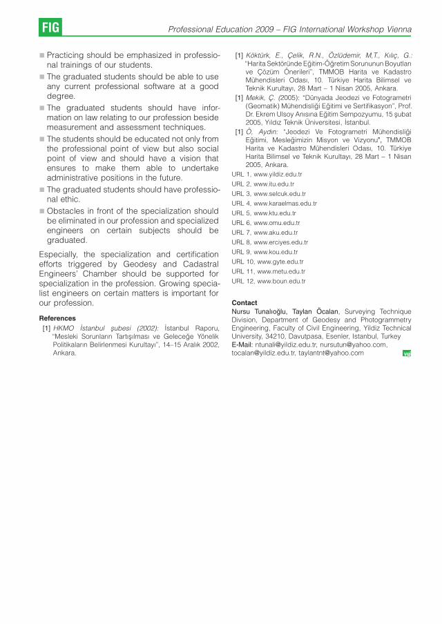
& Practicing should be emphasized in professio-nal trainings of our students.
& The graduated students should be able to useany current professional software at a gooddegree.
& The graduated students should have infor-mation on law relating to our profession besidemeasurement and assessment techniques.
& The students should be educated not only fromthe professional point of view but also socialpoint of view and should have a vision thatensures to make them able to undertakeadministrative positions in the future.
& The graduated students should have professio-nal ethic.
& Obstacles in front of the specialization shouldbe eliminated in our profession and specializedengineers on certain subjects should begraduated.
Especially, the specialization and certificationefforts triggered by Geodesy and CadastralEngineers’ Chamber should be supported forspecialization in the profession. Growing specia-list engineers on certain matters is important forour profession.
References
[1] HKMO Istanbul subesi (2002): Istanbul Raporu,“Mesleki Sorunların Tartısılması ve Gelecege YonelikPolitikaların Belirlenmesi Kurultayı’’, 14–15 Aralık 2002,Ankara.
[1] Kokturk, E., Celik, R.N., Ozludemir, M,T., Kılıc, G.:“Harita Sektorunde Egitim-Ogretim Sorununun Boyutlarıve Cozum Onerileri’’, TMMOB Harita ve KadastroMuhendisleri Odası, 10. Turkiye Harita Bilimsel veTeknik Kurultayı, 28 Mart – 1 Nisan 2005, Ankara.
[1] Mekik, C. (2005): “Dunyada Jeodezi ve Fotogrametri(Geomatik) Muhendisligi Egitimi ve Sertifikasyon’’, Prof.Dr. Ekrem Ulsoy Anısına Egitim Sempozyumu, 15 subat2005, Yıldız Teknik Universitesi, Istanbul.
[1] O, Aydın: “Jeodezi Ve Fotogrametri MuhendisligiEgitimi, Meslegimizin Misyon ve Vizyonu’’, TMMOBHarita ve Kadastro Muhendisleri Odası, 10. TurkiyeHarita Bilimsel ve Teknik Kurultayı, 28 Mart – 1 Nisan2005, Ankara.
URL 1, www.yildiz.edu.tr
URL 2, www.itu.edu.tr
URL 3, www.selcuk.edu.tr
URL 4, www.karaelmas.edu.tr
URL 5, www.ktu.edu.tr
URL 6, www.omu.edu.tr
URL 7, www.aku.edu.tr
URL 8, www.erciyes.edu.tr
URL 9, www.kou.edu.tr
URL 10, www.gyte.edu.tr
URL 11, www.metu.edu.tr
URL 12, www.boun.edu.tr
Contact
Nursu Tunalıoglu, Taylan Ocalan, Surveying TechniqueDivision, Department of Geodesy and PhotogrammetryEngineering, Faculty of Civil Engineering, Yildiz TechnicalUniversity, 34210, Davutpasa, Esenler, Istanbul, TurkeyE-Mail: [email protected], [email protected],[email protected], [email protected]
FIG Professional Education 2009 – FIG International Workshop Vienna

TQM and Marketing Perspectives for
Surveying Education and Training
Levente Dimen, Nicolae Ludusan, Romania
Abstract
This paper seeks to evaluate the arguments for the proposition that students in higher education are “customers’’ andshould be treated as such, and investigate whether the adoption of the terminology, systems and processes of the“student-as-customer’’ leads to a degradation or improvement of the quality of education and level of service deliveredto higher education students, especially focused on students enrollend in the field of surveying.
Keywords: TQM – Total Quality Management, QAA – Quality Assurance Agency
Focusing on the management function of theteaching and learning process these processesthat can be managed like any other. Onepossibility for achieving goals for education liesin the application of the ideas of total qualitymanagement (TQM) to the teaching and learningprocess. TQM is defined here as the collaborativeand holistic application of the ideas of theindustrial TQM model to teaching and learning.This focuses attention on the managementfunction that transforms teacher and studenteffort into learning. The power of a TQM teaching/learning model lies in its ability to suggesthypotheses concerning teaching strategies thatenhance learning and its emphasis on the qualityof product, orientation to students, to teamwork,and a continuing desire to im- prove.
Deming has abridged his philosophy in a set of14 principles for the transformation of anorganization (Deming 1986, 23-24):
1. Create constancy of purpose for improve-ment of product and service.
2. Adopt the new philosophy. We are in a neweconomic age.
3. Cease dependence on inspection to achievequality.... Build in quality in the first place.
4. End the practice of awarding business on thebasis of price alone. Instead, mini- mize totalcost
5. Improve constantly and forever [everyprocess].
6. Institute training on the job.
7. Institute leadership. The aim of supervisionshould be to help people . . to do a better job.
8. Drive out fear.
9. Break down barriers between departments.
10. Eliminate slogans, exhortations, and targets... for zero defects and new levels ofproductivity. Such exhortations only createadversarial relationships, as the bulk of thecauses of low productivity belong to thesystem and thus lie beyond the power of thework force.
11. Eliminate work quotas, management byobjective, management by numerical goals.Substitute leadership.
12. Remove barriers that rob people ... of pride ofworkmanship
13. Institute a vigorous program of education andself-improvement for everyone
14. Put everybody in the [organization] to work toaccomplish the transformation.
Total Quality Management (TQM) is a „mana-gement approach to long-term success throughcustomer satisfaction’’ (American Society ForQuality, Inc. (ASQ)). In a TQM effort, all membersof an organization participate in improvingprocesses, products, services and the culture inwhich they work.
Implementation of TQM often entails formingcross-functional quality im- provement teams,drawn from different levels to work on majorproblems, and intradepartmental working groupssometimes called quality circles.
The quality teams employ a problem-solvingprocess with four broad steps:
1. select a problem(s),
2. diagnose the problem(s),
3. suggest the solution(s),
4. and hold the gain(s).
5.
Professional Education 2009 – FIG International Workshop Vienna FIG

These generic steps are present in some form inall the various TQM models. For example, Coateespouses a 10-step problem-solving process thaten- compasses the four generic steps and“begins with the customer, focuses on the rootcauses/barriers to improvement, and ensures thatdecisions and actions are based on real data.(Coate,1990a, pp. 16-17):
1. Identify and select the most importantopportunities for improvement. Start withcritical processes, especially those thatsupport divisional goals, objectives, andbreakthrough items. Select team membersand empower them to make improve- ments.
2. Determine the key customers of the highligh-ted processes or services. Survey thecustomers, using a standard format, andanalyze survey data using check sheets andPareto diagrams.
3. Select the most important issue and write aclear issue statement
4. Identify and flowchart the key process orprocesses. This enables the team to moreclearly recognize opportunities for improve-ment
5. Agree on which aspects of your performanceyou want to measure and, with yourcustomers, set goals for continuous impro-vement in meeting or exceeding theirexpectations. To do this the teams mustrealistically evaluate current performanceand set obtainable goals for improvement.
6. Begin to explore probable causes of theproblems and barriers to improvement.
7. Gather data on the probable causes. Theinformation collected gives the team abenchmark against which to measure itsfuture progress.
8. Evaluate the data and show in “pictures“-charts and graphs.
9. Brainstorm and develop permanent solutions.Implement solutions; monitor their perfor-mance; adopt them if they work.
10. If the problem is solved, standardize the fixesas normal operating procedures.
The basic principles of TQM as applied to highereducation are as follows (Lynne & Ross 2007):
Delight the customer: Delight means beingbest at what matters most to customers, and thischanges over time. The aim is to prevent poor-
quality services from being produced or deliveredin the first place by focusing on processes andemphasising prevention rather than cure. Qualityassurance involves ensuring fitness for purpose.
People-based management: Knowing what todo, how to do it, and getting feedback onperformance is one way of encouraging people totake responsibility for the quality of their work.
Continuous improvement: Continuous impro-vement or incremental change, not majorbreakthroughs, is the aim of all who wish tomove towards total quality. Quality enhancementis more transformative and it requires a deliberatechange process – including teaching and learning– that is directly concerned with adding value,improving quality and implementing transforma-tional change. For the individual lecturer, enhan-cement is about improving their students’ workbased on the premise that they want their studentsto do well.
Management by fact: Knowing the currentperformance levels of the products or services inthe customers’ hands and of all employees is thefirst stage of being able to improve. From thisperspective academic quality is a „way ofdescribing how well the learning opportunitiesavailable to students help them to achieve theiraward. It is about making sure that appropriateand effective teaching, support, assessment andlearning opportunities are provided for them’’(QAA, 2004, p. 1)
The application of the industrial quality modelto the management of teaching and learningrequires the translation of a number of key terms.The teacher plays the role of manager. But whatrole does the student play? Should teachers thinkof students as customers of the teaching andlearning process whose needs should besatisfied; or should the teacher think of studentsas employees who should be empowered throughteamwork?
There are undoubtedly different groups ofstudents who may have both different objectivesin studying and different perspectives of their roleas customers, factors possibly under-recognisedby academic and administrative staff. Forexample, there will be differences betweenstudents relatively new to university study whoare seeking a qualification before entering theworld of work, compared to a mature student withsubstantial work experience who is undertakingstudy as part of continual professional develop-ment. We focus primarily on the large body of
FIG Professional Education 2009 – FIG International Workshop Vienna

students who are in the first mentioned group, butnote that there are differences between segmentsof this group, including substantial differences inobjectives and in quality perceptions betweenstudents.
There is considerable debate in the literatureregarding perceived positive and negativeaspects of the “student as customer’’ concept,drawing upon both general argumentation andempirical studies. The principal arguments areshown in Table I.
However, the transaction by which studentspay fees does not equate to a simple exchange ofmoney in return for a product or service.Universities not only provide a range of services,but also regulate them and set standards; thisincludes not awarding qualifications to studentswho do fail to meet these standards (Sharrock,2000). It seems to be necessary to ensure thatstudents understand the implicit contract and therole of academic and administrative staff infacilitating the student’s learning opportunities(Lammers et al., 2005). Education may mean thatstudents are taught a specific occupational skill,where the content of their education by and largeis determined by what is considered the
knowledge vital for the conduct of the occupation. This is the kind of education that charac-terizes many institutions e.g. in engineering.However, education may also have as its purposeto teach students a specific academic disciplinethat is considered to provide no other directoccupational knowledge than teaching andresearch within the discipline itself thinking aboutthe value of this kind of education on the labormarket beyond the specific research andteaching qualifications it may provide, we oftenthink of more general abilities that may be useful ina range of different occupations.
Students generally do not pay the full cost oftheir studies (Halbesleben et al., 2003; Pitman,2000). Thus, even if it were accepted that studentsshould be treated as customers because theycontribute to the cost of their education, they arenot the only customers; other groups who mightbe assumed to have entitlements include futureemployers, the government, families (who mayassist with educational costs), and society ingeneral, through the contribution of graduates tothe economy and to issues of social equity andsocial mobility opportunities claimed to beafforded to graduates.( Lynne and Brennan 2007).
Students pay an increasing proportion of their educationcosts; they therefore should be treated in the same way as anyother purchaser of goods or services
Bejou, 2005; Bennett, 2003 Halbesle-ben et al., 2003; Kanji and Tambi, 1999
Students do not know what combination of skills andknowledge will best equip them for the world of work; they maynot appreciate the importance of a subject until they are inemployment
Clayson and Haley, 2005; Adkins andRadtke, 2004; Driscoll and Wicks, 1998
Universities become focused on vocational training to thedetriment of generic, transferable skills such as criticalthinking analysis. This is coupled with reduced academicstandards and rigour, together with grade inflation
Clayson and Haley, 2005; Ballard, 2004;Carlson and Fleisher, 2002; Rolfe, 2002;Scott, 1999
Students seek the easiest programmes and courseswith soft assessments; conversely they may punishacademically demanding staff through critical feedback.This may have a detrimental impact on future staff promotionalprospects
Clayson and Haley, 2005; Yunker andYunker, 2003; Chonko et al., 2002
Students transfer responsibility on to education providers rather than taking responsibility for their own learning. Thisresults in a reluctance to conduct independent study andgreater demands for all material to be provided for students tolearn as if education can be simply passively consumed
Clayson and Haley, 2005; Rolfe, 2002;Tam, 2002; Sharrock, 2000; Laskey,1998
Table 1: Key arguments for and against the “student as customer’’ concept, synthetiszed by Lynne and Brennan 2007
L. Dimen, N. Ludusan: TQM and Marketing Perspectives for Surveying Education.. FIG

Higher education is very largely a private good– the benefits of a university education areappropriated almost entirely by the studentthrough enhanced life-time earnings. Accor-dingly, students increasingly are paying the costsof their university education. This makes thestudent the customer in the higher educationprocess, and this turn education into an industrylike any other, and the primary purpose of anindustry is to satisfy its customers. Students areseeking the easiest way to obtain a qualification,and so expect pre-packaged learning deliveredby happy, smiling service delivery staff. If theservice delivery staff fail to smile sufficiently, orinsist that learning demands time, concentrationand effort, or give objective grades based onassessed performance, the student-customer willexercise their legitimate right as a consumer andwill complain. „Accordingly, educators have comeunder pressure to reduce academic standards, toprovide teaching materials in a style which notalways reach an appropiate academic standards,and to give inflated grades for mediocre work.Students have happily relinquished responsibilityfor their learning to their educators, and believethat failure to achieve desired assessmentoutcomes should be blamed on the educatorrather than the student’’ (Based on: Clayson andHaley, 2005), but little empirical evidence hasbeen presented to support the claims made.
Marsh and Roche (2000) suggested that it ismerely a popular myth. and, there is a positiveassociation between student workload andstudent evaluation of teaching: students do notreward with high evaluation results those teacherswho give them relatively light workloads. There isindeed a correlation between grades and studentevaluations of teaching, this correlation can beexplained by the fact that students who achievehigher grades believe that they have learnedmore, and accordingly are inclined to the view thatthey were better taught.
Conclusion
There is no simple model for educating landsurveyors for the next century. Nobody can becertain that any educational model chosen iscorrect and appropriate. The student-as-custo-mer concept would undermine the student’ssense of responsibility for their own learning.There are clearly important public good aspectsto higher education, both those associated withthe contribution of graduates to the widercommunity, which depend upon learning andinformation for competitive advantage it is
necessary to have a highly educated workforceto sustain prosperity. While students are paying anincreasing proportion of the costs of highereducation in several countries, higher education isstill very largely funded by governments out ofgeneral taxation. Students are neither the soleconsumers in the higher education system, norare they the sole customers, therefore highereducation institutions must not seek to serve onlythe interests of students to the exclusion of otherstakeholder groups.
There is little evidence that students aresufficiently short-sighted as to prefer a universityeducation that is built around easily-won qualifica-tions and a cheerful approach to customerservice. The evidence suggests that studentshave a reasonably discerning approach to highereducation, believe that hard work is necessary toachieve worthwhile results, and do not penalise(through poor student evaluation reports) educa-tors who insist on hard work and objectiveassessment of performance. Additionally, therights and responsibilities of both the student andthe institution in all parts of the education processneed to be clearly stated
References
[1] Coate, L. E. (1990a): An analysis of Oregon StateUniversity’s total quality management.
[2] Boxer, L. (2005): “Discourses of change ownership inhigher education’’, Quality Assurance in Education, Vol.13 No. 4, pp. 344-52.
[3] Bejou, D. (2005): “Treating students like customers’’,BizEd, March/April, pp. 44-7, online edition available at:www.aacsb.edu/publications/archives/MarApr05/p44-47.pdf .
[4] Clayson, D.E. and Haley, D.A. (2005): “Marketingmodels in education: students as customers, products,or partners’’, Marketing Education Review, Vol. 15 No. 1,pp. 1-10.
[5] Deming, W. E. (1986): Out of crisis: Quality, productivity,and competitive position. Cambridge, Mass.: Center forAdvanced Engineering Study, Massachusetts Instituteof Technology.
[6] Halbesleben, J.R.B., Becker, J.A.H. and Buckley, M.R.(2003): “Considering the labor contributions ofstudents: an alternative to the student-as-customermetaphor’’, Journal of Education for Business, Vol. 78No. 5, pp. 255-7.
[7] Chizmar, John F.: Total Quality Management (TQM) ofTeaching and Learning , The Journal of EconomicEducation, Vol. 25, No. 2 (Spring, 1994), pp. 179-190Published by: Heldref Publications.
[8] Lammers, H.B., Kiesler, T., Curren, M.T., Cours, D. andConnett, B. (2005): “How hard do I have to work?Student and faculty expectations regarding universitywork’’, Journal of Education for Business, Vol. 80 No. 4,pp. 210-13.
FIG Professional Education 2009 – FIG International Workshop Vienna

[9] Eagle Lynne, Brennan Ross (2007): „Are studentscustomers? TQM and marketing perspectives’’ QualityAssurance in Education Vol. 15 No. 1, 2007 pp. 44-60,Emerald Group Publishing Limited.
[10] Laskey, K.B. (1998): “Are students our customers in theeducation marketplace?’’, Mason Gazette, November,online edition available at: ww.gmu.edu/news/gazette/9811/studcus.html, Marsh, H.W. and Roche, L.A.(2000), “Effects of grading leniency and low workloadon students’ evaluation of teaching: popular myth, bias,validity, or innocent bystanders?’’, Journal of Educatio-nal Psychology, Vol. 92 No. 1, pp. 202-28.
[11] Quality Assurance Agency for Higher Education (2004):“A brief guide to quality assurance in UK highereducation’’, available at: w.qaa.ac.uk/aboutus/he-Guide/guide.asp (accessed 14 September 2005).
[12] Pitman, T. (2000): “Perceptions of academics andstudents as customers: a survey of administrative staffin higher education’’, Journal of Higher Education Policyand Management, Vol. 22 No. 2, pp. 165-75.
[13] Sharrock, G. (2000): “Why students are not (just)’’,Journal of Higher Education Policy and Management,Vol. 22 No. 2, pp. 149-64.
[14] Rolfe, H. (2002): “Students’ demands and expectationsin an age of reduced financial support: the perspec-tives of lecturers in four English universities’’, Journal ofHigher Education Policy and Management, Vol. 24 No.2, pp. 171-82.
[15] Yunker, P.J. and Yunker, J.A. (2003): “Are studentevaluations of teaching valid? Evidence from ananalytical business core course’’, Journal of Educationfor Business, Vol. 78 No. 6, pp. 313-17.
Contact
Assoc.prof.dr. Levente Dimen, „1 Dcembrie 1918“ Universityof Alba Iulia, Romania,RO 510009 Alba Iulia, Str. N. Iorga, nr. 13E-mail: [email protected] prof.dr. Nicolae Ludusan, „1 Dcembrie 1918“University of Alba Iulia, Romania,RO 510009 Alba Iulia, Str. N. Iorga, nr. 13E-mail: [email protected]
L. Dimen, N. Ludusan: TQM and Marketing Perspectives for Surveying Education.. FIG

Solving the Surveying and Geoinformatics undergraduate
Student Enrolment Problem: The University of Lagos
Experience
Francis A. Fajemirokun, Dr. Peter Nwilo and Dr. Olusegun
Badejo, Lagos
Abstract
The first Survey School in Nigeria was established in 1908 as a Departmental post-secondary school, to cater for theeducation of the country’s youth who could not proceed overseas for further training. But it was not until 1962 that thefirst Department of Surveying in a Nigerian University was established at the University of Nigeria, Enugu Campus.In 1970 the University of Lagos (UNILAG) also began the training of Surveyors by establishing a Sub-Department ofSurveying in her Department of Civil Engineering. The sub-department became a full fledged department in 1973.About the same time survey training started in UNILAG, another Department of Surveying was established at theAhmadu Bello University in Zaria, in the northern part of the country. All these departments were domiciled in theFaculty of Engineering. At present, there are eleven Universities in Nigeria, offering courses in Surveying andGeoinformatics leading to the award of Bachelor’s and other degrees.One common and major problem faced by all the Universities is in recruiting interested and qualified candidates asstudents in their respective departments. This problem is aggravated by the large number of Universities struggling torecruit limited number of available qualified candidates. Other factors contributing to this problem include the following:the very low regard and poor publicity for Surveying profession in Nigeria, perception of poor career prospects forgraduates in Surveying, poor financial yield for Surveying professionals, centralized admission process in theUniversity and the stringent uniform requirements for all courses in the Faculty of domicile, and the physicallydemanding, and sometimes boring nature of some aspects of the training of Surveyors.The Department of Surveying and Geoinformatics, University of Lagos, has taken some steps to solve the problem ofrecruiting qualified candidates into the department. These include: organizing career talks in Secondary Schools,making admission requirements more relevant, encouraging and engineering positive publicity for the profession, andundertaking a review of the curricula, to make the course more interesting and attractive to young school leavers.The result of the efforts made at University of Lagos has generated a lot of interest in the profession amongst thestudents. By the 2008/2009, the Department had been able to fill its admission quota with qualified candidates, almostexclusively from those who indicated Surveying and Geoinformatics as their first choice course, in the centraladmission system.
Introduction
Surveying is one of the oldest professions inNigeria (Atilola, 1999). The Nigerian Surveyor wasamong the first professional man to be exposed toformal training locally. The first Survey School inNigeria was established in 1908 as a Departmen-tal post-secondary school, to cater for theeducation of the country’s youth who could notproceed overseas for further training. That schoolwas later moved to Ibadan in 1927, from where itfinally moved to Oyo in 1935. When the YabaCollege of Technology was established around1932 as the highest institution in Nigeria, aprovision was made for prospective surveyors toundergo basic educational studies in the institu-tion for two years, followed by two years of training
at the Survey School, Oyo. Successful candidateswere subsequently awarded diploma of theCollege. The first exposure to university educationcame in 1947 with the establishment of theUniversity College of Ibadan. There, provision wasmade for the training of professional surveyors forthe country. The programme was later disconti-nued following a change in the policy of thecolonial administration (Fajemirokun, 2008).
In 1962, the Nigerian College of Technology,Enugu became part of the then two year oldUniversity of Nigeria, Nsukka and the NigerianSurveyor was again exposed to university educa-tion. The first set of 5 students of surveying fromthe University graduated in 1966, 58 years afterthe first Survey school was opened in Lagos(Fajemirokun, 1976).
FIG Professional Education 2009 – FIG International Workshop Vienna

In 1970, the University of Lagos (UNILAG) alsobegan the training of Surveyors by establishing aSub-Department of Surveying in her Departmentof Civil Engineering. The Sub-Department be-came a full fledged department in 1973. The initialprogramme of the sub-department at the time wasa two-year postgraduate course of studies andresearch leading to the M.Sc. (Surveying) degree.Graduates in fields cognate to surveying wereadmitted into the programme (Department ofSurveying and Geoinformatics Unilag, 1999).Prior to all these, the Faculty of Engineering ofthe University of Lagos in 1967 arranged for a fewstudents who were surveying undergraduates ofthe University of Nigeria, Enugu Campus and whowere displaced by the Civil War, to complete theirdegree programmes in the Faculty, and earn adegree of the University. About the time surveytraining started in Lagos, another Department ofSurveying was established at the Ahmadu BelloUniversity in Zaria, in the northern part of thecountry. All these three departments weredomiciled in the Faculty of Engineering at thetime of their establishments.
At the beginning of the 1974/75 session, thefirst set of five students was admitted to Unilag topursue a three year B.Sc. programme inSurveying, after obtaining A’ Level papers inrelevant courses or having completed a one yearpreliminary programme in Engineering in theFaculty of Science. In addition, a postgraduatediploma programme for graduates with relevantdegrees was introduced (Department of Survey-ing Unilag, 1981). The three-year undergraduateprogramme was later changed to a four-yearprogramme to allow for enough practical expe-rience before graduating. Presently, the Depart-ment runs a five-year undergraduate programme.
University training in surveying in Nigeria isalso offered at the Enugu State University, Enugu,Federal University of Technology Minna, RiversState University of Science and Technology Port-Harcourt, Abubakar Tafawa Balewa UniversityBauchi, Imo State University Owerri, University ofUyo Uyo, Nnamdi Azikiwe University, Awka, andthe Federal University of Technology Yola.
The duration of university training programmein Nigeria is five years for candidates entering
through the University Matriculation Examination(UME), four years for candidates entering withNational Diploma certificate (ND) and three yearsfor holders of Higher National Diploma Certificate(HND). Postgraduate programmes in Surveyingand Geoinformatics at M.Sc. and Ph.D. levels alsoexist in a few of these Universities.
The minimum entry requirement for Surveyingand Geoinformatics courses in Nigerian Poly-technics is four credits (in W.A.E.C and NECO) atnot more than two sittings in Mathematics,Physics, English, and Chemistry or Geography.Candidates are also required to sit and get abovethe cut-off marks in the Polytechnic JAMBExamination.
At the university level the minimum entryrequirement is five credits at not more than twosittings in Mathematics, Physics, English, Chemi-stry or Geography and one other subject. Theminimum entry requirement in University of Lagosfor Surveying and Geoinformatics is five credits inFurther Mathematics, Mathematics, Physics, Eng-lish, Chemistry or Geography at one sitting.
Candidates seeking University admission arerequired to sit and pass the JAMB examinationand the Post JAMB test. The JAMB and PostJAMB test subjects for Surveying and Geoinfor-matics are Mathematics, Physics, English, Che-mistry or Geography.
2. Dearth of Qualified Candidates for Surveyingand Geoinformatics Programme
One common and major problem faced by all theUniversities is in recruiting qualified and inter-ested candidates in adequate numbers asstudents. This problem is aggravated by thelarge number of Universities struggling to recruitfrom the limited number of available qualifiedcandidates. While the number of Universitiesoffering Surveying increased from one in 1962 tothree in 1970, the position remained the same tillthe mid ‘80s. Within the next 15 years, the numberhad increased to eleven. Table 2.1 showsSurveying and Geoinformatics students’ enrol-ment statistics at the University of Lagos between1998 and 2009.
F. A. Fajemirokun, P. Nwilo, Dr. Olusegun: Solving the Surveying and Geoinformatics... FIG

S/N Session No
of
UM
EA
pplic
ants No of UME Admitted
No
of
DE
Applic
ants
No of DE Admitted
No
of
Applic
ants
for
Change
of
Cours
e
Merit Supplementary Merit Supplementary
1 1998/1999 *na 26 105 10
2 1999/2000 64 28 27 13
3 2000/2001 *na 11 65 23 25
4 2001/2002 *na 14 147 44 301
5 2002/2003 *na 28 27 20 30 54
6 2003/2004 42 23 *na 28 1
7 2004/2005
52 39 17 62+ 328 2005/2006
9 2006/2007 36 13 45 18 2 102
10 2007/2008 36 19 23 16+ 7
11 2008/2009 59 26 2 15+ 9
*na — not available
Table 2.1: Students Enrolment Statistics in University of Lagos Between 1998 and 2009
From table 2.1, most of the candidates cominginto the department through the UniversityMatriculation Examination (UME) are mostlythrough supplementary admission, which picksfrom candidates crossing from other departmentsbecause they could not be admitted for their firstchoice courses. The situation is different in thecurrent session, as almost all admitted studentswere on merit. It is hoped this trend will continue.
Most of the candidates coming in throughdirect entry (into year two and three) got admittedby merit. This is the case because manycandidates with National Diploma (ND) andHigher National Diploma from polytechnics wereable to come in between 1998 and 2002. However,when the entry qualification was changed fromUpper Credit to Distinction in 2003, many of themcould no longer come in. Most of the candidatescoming into the department through direct entry atpresent are candidates from the UniversityDiploma programme.
From table 2.1, it is clear that we havecandidates enrolment problem into Surveying andGeoinformatics programme. Many factors areresponsible for the dearth of qualified and
available candidates for recruitment into theSurveying and Geoinformatics programmes inNigerian’s Universities, these factors include:
i. Very low regard and poor publicity for theProfession of Surveying in the country.
ii. The centralized process of admission ofstudents into the various University program-mes.
iii. The perception of poor career prospects forgraduates in Surveying.
iv. The physically demanding (and sometimesdangerous) nature of the practical aspects ofthe training of Surveyors
v. Poor financial yield for qualified professionalsin Surveying in comparison to others
vi. The stringent entry requirements into thecourse, which is the same for other courseswithin the Faculty of domicile, while some ofthese courses are considered ’better’ thansurveying
vii. Perception of students that surveying as acourse is not only difficult, but also boring.
FIG Professional Education 2009 – FIG International Workshop Vienna

2.1 Very Low Regard and Poor Publicity for theProfession of Surveying in the Country
The poor enrolment rate in the profession ofsurveying can be largely attributed to the lowregard people have for the profession. Majority ofthe public erroneously think that all surveyors do isto carry poles and theodolites, and enter the bushto demarcate landed properties. Many youngschool leavers want courses or professions likeengineering, law and medicine that will make thempopular and give high financial yields. We live in acommunity where people worship titles and like tobe called doctors, lawyers or engineers. This lowregard for the profession is however changing asmore people get enlightened. The impact ofrecent advances in Information Technology,coupled with the emergence of GIS, has mademany enlightened people to know the power ofGIS and surveying in managing spatial data.
Poor publicity for the profession has alsocontributed to the enrolment problem. Forinstance, ethics of the profession as practicedin the country does not permit self advertisements.As a body, the profession also shies away fromaggressive publicity of its activities and capabi-lities. It is also our opinion that establishedprofessionals have also not done enough to attractand encourage young ones, through personalcontacts, print and electronic media to join theprofession. It is however interesting to note thatsome of our professional colleagues havesucceeded in getting their children to join theprofession. Many of them did this because of thewealth that the profession has brought to them,while others did so because of the love they havefor the profession.
2.2 The Centralized Process of Admission ofStudents Into the Various UniversityProgrammes
Admission of students into university programmesin Nigeria is through the Joint Admissions andMatriculation Board (JAMB). JAMB stipulates theminimum entry requirements into all universityprogrammes. For the University of Lagos,candidates are expected to score at least 200out of 400 in the JAMB exams before they could begiven any consideration into any degree pro-gramme. In addition, the cut off marks are usuallyhigh because of the large number of candidatesseeking admission into the university. The JAMBexamination is written at the same time by all thecandidates; because of this, candidates usually
prefer to choose popular courses, to the detrimentof the other ones like Surveying. The elevenuniversities offering surveying and geoinformaticsprogrammes are left to struggle to attract the veryfew school leavers, who are genuinely interestedin the course, and who have applied to JAMB forthe course.
Within the university, admission is handled onfaculty basis. Invariably, there is uniformity inadmission requirements within the faculty, and thisworks to the detriment of the less popular courseslike surveying. The department, often times, isforced to make do with candidates who wereunable to get admission into there first choicecourse. The problems associated with thecentralized process of admission have madeenrolment into surveying programmes difficult.
2.3 The Perception of Poor Career Prospectsfor Graduates in Surveying
There is a general belief by the general public inNigeria that there are little or no career prospectsfor graduates in the surveying programme in thecountry. Many people still see surveyors as peoplewho work only in the bush. This impression ishowever changing slowly, due to education andpublic enlightenment.
2.4 The Physically Demanding Nature of thePractical Aspects of the Training ofSurveyors
One of the reasons for the low enrolment ofcandidates into surveying and Geoinformaticsprogrammes is the fact that some aspects of workin the profession is physically demanding. Thoughwith modern instrumentation like GPS and remotesensing, the physically demanding part has beenreduced, people still have the old mentality ofsurveyors always carrying poles and traditionalinstruments about in the bush. In any case, thephysical nature of aspects of the surveyors’ workcannot be totally eliminated.
2.5 Poor Financial Yield for QualifiedProfessionals in Surveying in Comparisonto Other Professions
The poor financial yield in the profession ascompared with some other professions wherecharges are based on percentage of the cost ofproject has discouraged quite a number ofintending entrants. Despite the fact that effortsare made by the profession to see that surveyorsare adequately remunerated, we still have a lot tocontend with in this regard. Most survey projects
F. A. Fajemirokun, P. Nwilo, Dr. Olusegun: Solving the Surveying and Geoinformatics... FIG
are not given directly to members of theprofession, but are awarded to Engineers,Architects and even lawyers, who only give thesurvey components of the job out to surveyors atridiculous fees.
2.6 The Stringent Entry Requirements into theCourse
The stringent entry requirement in some univer-sities and especially University of Lagos hasdiscouraged many candidates from seekingadmission into Surveying and Geoinformatics.University of Lagos demands that all candidatesmust pass all the required subjects in the OrdinarySchool Certificate level at one sitting for allcourses in the university. In addition, Faculty ofEngineering, where the Department of Surveyingand Geoinformatics is domiciled, also requires acredit pass in further mathematics for any degreeprogramme in the Faculty. The Faculty alsorequires distinction from candidates with poly-technic diplomas for direct entry admission. Thesituation in the past used to be Upper Credit forcandidates coming in through the polytechnics.Since most of the candidates seeking admissioninto the department through direct entry haveupper credit, they are therefore unqualified foradmission.
2.7 Perception of the Students that Surveyingis Difficult and Boring
Many students in the profession believe thatsurveying as a course is not only difficult, but alsoboring. Most of those complaining are those whoare ill advised to choose the course instead ofsome other courses that are not so muchmathematically oriented. Also, some studentsadmitted after effecting a change of course, orduring supplementary admission, find it difficult tomove along with other students in the class.
3. Measures taken to solve Students’Enrolment Problem
The following steps have been taken by theDepartment of Surveying and Geoinformatics,UNILAG to encourage students’ enrolment intothe department:
& Organising career talks in Secondary Schools
& Reviewing admission requirements, and ma-king it more relevant to the course
& Encouraging and engineering more, andpositive publicity for the profession
& Reviewing the curricula, to make the coursemore interesting and attractive to young schoolleavers.
3.1 Career Talks and Positive Publicity
Public campaign to get qualified candidates intothe profession has been stepped up in recenttimes. Career talks have been given to secondaryschool students. The ‘GIS Day’, a day set apart topopularize GIS, has also been exploited to givecareer talks and sensitize candidates on theprofession. Secondary school students are beinginvited to the department to see some of thefacilities, and also get acquainted with what theystand to gain by joining the profession. Thedepartment of Surveying and Geoinformatics,Unilag, has used some of the pubic enlightenmentcampaign and career talks to identify areas of jobopportunities for graduates in Surveying andGeoinformatics. The department also publishes,regularly, students’ prospectus for undergraduateand graduate programmes. The prospectuses,among other things, list several job opportunitiesthat await graduates of this profession. Some ofthe places where graduates of this professioncould be employed in the country include, but arenot limited to:
1. Telecommunication Industry like MTN, ZAIN,GLO MOBILE and, STARCOMMS
2. Military (i.e. Nigerian Army, Navy, Airforce andPolice )
3. Oil Companies (i.e. Shell, NNPC, Exxon-Mobil, Chevron, Department of PetroleumResearch (DPR))
4. National Space Research and DevelopmentAgency (NASRDA)
5. Federal Airport Authority of Nigeria (FAAN),Nigerian Airways Management Authority(NAMA)
6. Federal and State Survey Departments
7. Federal and State Universities and Poly-technics
8. Federal and State Ministry of Solid Minerals
9. Federal and State Ministry of Water Works
10. Federal Capital Development Authority(FCDA) Abuja
11. Banks and Insurance Companies
12. Institutes of Agriculture and Forestry
13. Nigerian Ports Authority (NPA)
FIG Professional Education 2009 – FIG International Workshop Vienna

14. National Institute of Marine and Oceanogra-phy Research Department (NIOMR)
15. Nigerian Institute of Waterways Authority(NIWA)
16. Federal and State Environmental ProtectionAgencies
17. Dredging Companies like Dredging Interna-tional
18. Engineering Construction Firms (i.e. JuliusBerger)
19. Survey and GIS Companies and organisa-tions
20. Personal Survey Practices.
The poor perception by the public concerningcareer prospects for graduates in the profession isfast changing because of the high rate of generalunemployment in the country. People have nowcome to know that it is easier and more lucrative toown a private Surveying and Geoinformaticscompany than to build a hospital or set up anengineering firm. In addition, many of ourgraduates are working in telecommunicationfirms, oil companies, and federal and stategovernment establishments.
The Lagos State government in July 2007,through the office of the Surveyor General,embarked on a public forum to sensitize thecitizens on the benefit of the Lagos State Mappingproject to the general public. Through this forum,which was chaired by the Deputy Governor of theState, many people including prospective stu-dents have come to know more about surveyingand geoinformatics. The Nigerian Institution ofSurveyors has also, in recent times, beenaggressively promoting the publicity of theprofession. The President and other officerstake every opportunity that comes their way topublicize the profession and its valuable and keycontributions to the society
Besides career talks and publicity, many effortsare being made to counsel students who find thecourse difficult and boring, and majority of themhave come to love the course, especially as theyget to higher levels where they are introduced toGIS and modern instrumentation in surveying.
3.2 Reviewing Admission Requirements
It is worthy to note that University of Lagospioneered efforts to reduce some of the problemsassociated with the centralized admission byconducting post JAMB examination for candida-
tes who chose the university as their first choiceand scored more than 200 in JAMB examination.This laudable step was initially rebuffed by JAMB,but as more universities aligned with University ofLagos’ position, the post JAMB examination hascome to stay and it is now being conducted by allthe universities in Nigeria. The post JAMBexaminations have succeeded in getting qualifiedcandidates into the Nigerian universities.
The Department of Surveying and Geoinfor-matics, University of Lagos is also planning tomove out of the Faculty of Engineering to theFaculty of Environmental Science, where thedepartment actually belongs, and it is most likelythat the admission requirements there will be morefavourable to prospective students. These steps,when taken, will further improve students’enrolment into the department.
3.3 Curricula Review and Change of Name
In line with the development in Colleges ofEducation and Polytechnics, the National Univer-sities Commission (NUC) directed all institutionsoffering surveying to modernise their curricula.Due to recent advances in Information Technologyand its effect on the profession, the Department ofSurveying and Geoinformatics, University ofLagos recently reviewed its various degreeprogrammes and came out with new structures,whose curricula tended to address the shortco-mings of the past (Fajemirokun and Nwilo, 2000).Some of the new courses introduced at theundergraduate level include Computer Applica-tions in Surveying, Principles of Geoinformation,Digital Mapping, Coastal Mapping and Manage-ment and GIS Tools and Applications. At theGraduate level, some of the new coursesintroduced are Data Acquisition Systems, Advan-ced Concepts in Geoinformatics, Spatial DataStructures, GIS Implementation Strategies, Spa-tial Statistics, Policy Issues in GIS Implementationand Digital Cartography.
Advancement in technology coupled with thechanging trends in the surveying profession led toa worldwide debate on the appropriate name forthe profession. A number of training institutionsand establishments after the debates changedtheir names. Some of the new names adoptedinclude Geomatics, Surveying and Geoinforma-tics, and Geodesy and Geomatics Engineering.The global wind of change in name of theprofession also blew across Nigeria.
The Department of Surveying and Geoinfor-matics, University of Lagos formerly known as the
F. A. Fajemirokun, P. Nwilo, Dr. Olusegun: Solving the Surveying and Geoinformatics... FIG

Department of Surveying University of Lagos ledthe campaign for the change in name of theprofession in Nigeria. The campaign for thechange in name was cushioned with a workshopon Surveying and Spatial Information Technologyin July 1999 organised by the Department. Theobjectives of the workshop were to determine theappropriate name and direction for the professionin the Department as well as in the country (Nwiloet al, 2000). Experts in the profession across thecountry from tertiary institutions, oil companies,government agencies and other key managementleaders participated in the workshop. Paperswere delivered by some of the experts in theprofession. At the end of the workshop, theDepartment adopted the name “Surveying andGeoinformatics’. The new name had since beenapproved by the University Authority.
The modernization of the curriculum andchange in the name of the department hasattracted more people into the profession. Thereare many graduate students from other fieldscoming to do professional Masters in Geoinfor-matics in the department. In recent times many ofthe former graduates have been coming back todo M.Sc. programme in the department. Thedepartment graduated two Ph.D. students insurveying and Geoinformatics this year, and hasclose to ten registered Ph.D. students presently.
3.4 Improved Financial Yield for Professionals
The Federal Government has taken some steps tocorrect this anomaly by moving the Office of theSurveyor General of the Federation (OSGoF) fromthe Ministry of Works to the Presidency. Notably,some State governments have recently awardedGIS and mapping projects directly to surveyors.These efforts by both Federal and State gover-nments have rekindled hope in the profession.
4. Conclusion and Recommendation
4.1 Conclusion
Recruiting qualified and interested candidatesinto Surveying and Geoinformatics programmehas been a huge problem. Many factors like thelarge number of Universities competing for limitednumber of candidates, poor publicity for theprofession, centralized process of admission ofstudents into the various University programmescoupled with stringent entry requirements into thecourse have contributed to the inability to recruitinterested and qualified students into the pro-grammes in adequate numbers.
The Department of Surveying and Geoinfor-matics, University of Lagos, had been concernedand has been in the forefront of the vanguard tosolve the problem of the dearth of qualifiedcandidates for the Surveying and Geoinformaticsprogramme. The Department paid attention to thevery narrow interpretation given to “surveying’’ bythe general public, and the need to reflect thetremendous impact that the advances in tech-nology and modern techniques have had on theprofession of surveying. In 1998, the Department,in conformity with the reviewed programmechanged its name from ‘Department of Surveying’to the Department of Surveying and Geoinfor-matics, to portray a discipline that deals withacquisition, analysis, storage, distribution, mana-gement and application of spatially-referenceddata.
Public campaign to get qualified candidatesinto the profession has been stepped up in recenttimes. Career talks have been made to secondaryschool students. The GIS Day has also beenexploited to give career talks and sensitivecandidates for the profession.
It is worth noting that University of Lagospioneered efforts to reduce some of the problemsassociated with the centralized admission byconducting post JAMB examination for candida-tes who chose the university as their first choiceand scored more than 200 in JAMB examination.The Department of Surveying and Geoinformatics,University of Lagos is also planning to move out ofthe Faculty of Engineering to the Faculty ofEnvironmental Sciences, and to review the entryrequirements for prospective students.
The efforts made at the University of Lagoshave generated a lot of interests in the professionamongst students and prospective students. Bythe 2008/2009, the Department had been able tofill its admission quota with qualified candidates,almost exclusively from those who indicatedSurveying and Geoinformatics as their first choicecourse, in the central admission system. There arealso many graduates from other fields coming todo professional Masters in Geoinformatics in thedepartment. In recent times many formergraduates have been coming back for theM.Sc. programme in the department. Thedepartment also graduated two Ph.D. studentsin Surveying and Geoinformatics this year, andhas close to ten registered Ph.D. studentscurrently.
FIG Professional Education 2009 – FIG International Workshop Vienna
4.2 Recommendation
The following recommendations if carefullyimplemented will go a long way in attractingqualified candidates to join the Surveying andGeoinformatics profession.
1. More career talks and public enlightenmentcampaigns on surveying and geoinformaticsshould be made in secondary schools,electronic and print media.
2. The Federal and State governments shouldaward survey projects directly to competentand qualified professionals in their respectivefields.
3. All impediments like stringent admissionrequirements that are counter productiveshould be removed.
4. Surveying and Geoinformatics curriculashould be reviewed and modified from timeto time in line with advances in informationtechnology and instrumentation.
5. The Nigerian Institution of Surveyors and theSurveyors’ Council of Nigeria should workclosely with professionals in Higher Institu-tions, Public Service and in private practice tomodernize professional practice in Nigeria,and promote the well being of the profession.
References
[1] Atilola, O. (1999): Geo- Information TechnologiesPractice. In C.U. Ezeigbo, O. O. Ayeni, F. A.Fajemirokun & P.C. Nwilo (eds.) Proceedings of theworkshop on Surveying and Spatial InformationTechnology (SSIT): Issues of Name, Concept andFunction.
[2] Department of Surveying, University of Lagos (1980):‘Departmental Prospectus, Undergraduate and Post-graduate Programmes’. 35p Akoka-Lagos. Miral Prin-ting Press.
[3] Department of Surveying and Geoinformatics, Univer-sity of Lagos (1999): ‘Departmental Prospectus,Undergraduate and Postgraduate Programmes’. 54pAkoka-Lagos. JAS Publishers
[4] Fajemirokun, F. A. (2008): ‘Surveying and Geoinfor-matics Education and Training in Nigeria: Problems,Issues and Options’, Invited Paper to the NISManagement Retreat, NISPS, Kuru, Jos. August 10-13.
[5] Fajemirokun. F. A. (1976): ‘The Place of the University inSurveying Education’, Invited Paper at the Symposiumon Surveying Education, F.I.G. Permanent CommitteeMeeting, University of lbadan, lbadan.
[6] Fajemirokun, F.A. and Nwilo, P.C. (2000): ‘SurveyingPractice in Nigeria’, Strategies for Survival in the NewMillennium. Proceedings of the Nigerian Institution ofSurveyors 35th Annual General Meeting and Confe-rence. pp 55-60. Lagos. Nigerian Institution ofSurveyors.
[7] Nwilo, P.C., Peters K.O. & Badejo, O.T. (2000): ’NewTraining Mandates for Surveying and GeoinformaticsInstitutions in Nigeria’, International Archives of Photo-grammetry and Remote Sensing. Vol. XXXIII, Part B6.pp 223-230.
Contact
Prof. Francis A. Fajemirokun, Dr. Peter Nwilo, Dr. OlusegunBadejo, Department of Surveying and Geoinformatics,University of Lagos, Lagos, Nigeria,e-mail: [email protected], [email protected],[email protected],Tel: +234 802 319 4930; +234 1 7929798.
F. A. Fajemirokun, P. Nwilo, Dr. Olusegun: Solving the Surveying and Geoinformatics... FIG

Surveyors at the Faculty of Geo-
informatics before and after the
introduction of the credit systemTamas Jancso, Peter Engler and Andras Szepes,
Hungary
1. Introduction, short history
At the Faculty of Geoinformatics, University ofWest Hungary, the professionals are mainlyeducated in the field of land surveying andmanagement, GIS and mapping. In the 50’s therewas more and more demand for specialists at theexisting organizations of the National Survey, atthe surveying firms and at the big designinginstitutions. To meet this demand, with the aim ofproviding an up-to-date university education forexperts the precursor of the college wasestablished in 1962 under the name of LandSurveying Technical High School.
The next considerable change was in 1972,when the development of educational andscientific activity reached that level, where thetechnical training was replaced by the academictraining of production engineers, later on generalengineers. Within the meaning of the decision landsurveying and land management educationbegan in 1972 and 1975 resp. in Szekesfehervarin the College of Land Surveying and LandManagement, Sopron University.
The new college-form of organization createdfavourable conditions for solving practical geo-detic tasks. The relative self-independence of theCollege ensured the continuous enforcement ofthe claims of the land surveying branch, whiletaking over the useful educational and resear-ching experiences of the ancient parent esta-blishment.
2. The educational system and the effectingmarketing issues [Engler 2008]
In the last period our name was changed toFaculty of Geoinformatics. Our faculty success-fully kept the dominant role in the land manage-ment and surveying education. In 2005 becauseof the structural changes in the higher educationwe introduced the BSc education in landmanagement and surveying. After the 7 semestereducation the graduated engineers will becapable to deal with the new technologies ingeoinformatics, land development, land andproperty management, land valuation and quali-
fication. The diploma gives also authority to workin the field of photogrammetry, remote sensingand spatial informatics.
To deal with tasks in property and land mainlyjuridical knowledge is necessary. To offer welleducated professional in this field we founded in2000 the land registry management, and in 2006the public administration management courses.
We believe that from marketing point of view itis very important to follow up the improvementsand changes in the technology. The curricula havebeen renewed and revised continuously. Ourdirect highest authority was the Ministry ofAgriculture until 1993. In terms of the law aboutuniversity education LXXX, 1993, all Hungarianuniversities and colleges are directed by theEducational Ministry, but for us the Ministry ofAgriculture and Rural Development remained theprofessional director.
In the Hungarian higher education besides themarks the main measuring unit is the credit whichindicates the fulfilment of the curricula subjects.The introduction of the credit system was orderedby a governmental decree in 2000. This systemespecially uses the ECTS (European CreditTransfer System) as a tool. Our faculty introducedthis system in the 2002/2003 academic year anddesignated credits to the subjects, where the totalamount of credits is 210 at the BSc level. In ourcurricula the subjects are sorted in three groups:compulsory subjects (A), compulsory optionalsubjects (B) and optional subjects (C).
The credit system has many advantages, but –we should admit – disadvantages as well. Theadvantages are formulated in a nice way in thosematerials, which propagate them. That’s fine. Theproblem is that the practical introduction oftendoesn’t prove the theoretical expectations or thefulfilment of the conditions is difficult.
The credit system makes easier the earlierrigorous conditions. It gives possibility to thestudent to choose subjects in different ways.Practically it means that the student can plan hisacademic years in flexible way considering ofcourse the curricula requirements, especially the
FIG Professional Education 2009 – FIG International Workshop Vienna
pre-requisites. The students don’t have to repeatthe full-semester if they fail in one or more subjects.They can choose other subjects and they cancontinue their studies. The new system gave a toolto continue the studies in other institutions,admitting some certain subjects carried fromthe previous schools, etc. .
This methodology requires more caution andpunctuality from the students when they plan theirsemester. Many students are not prepared for that.They receive of course advice and aid from thetutors and the students learning in higher courses,but despite of this there are many repeatedsubjects, the pre-requisites are not fulfilled, etc..We consider as an advantage that that onesubject can be repeated three times, but on theother hand it makes the students irresponsible.
Also it is considered as an advantage that thecompleted subjects from other institutions can beaccepted. This tool was available before the creditsystem with similar conditions as well. Thispossibility is very useful at those professionswhich are educated in some different institutions,but there are many professions which are taughtonly in one institution. Our faculty belongs to thiscategory, which means that we are not able toaccept many subjects, especially the coresubjects, which are very special and accreditedonly at our faculty. This fact decreases the studentmobility.
The introduction of the credit system didn’taffect the entry system. It can be proved by thestatistics. At our faculty usually the number ofapplicants is twice more than the availablecapacity. Among the earlier recruiting methods(open day, carrier choosing exhibitions, EDUCA-TIO exhibition, visits at the middle professionalschools) we had to introduce new “tools’’ in themarketing process. Besides of the television andradio ads, we published ads in those newspapers,periodicals which are popular amongst theyounger. The impact of the Internet facilities hasgrown largely. Last year as a trial, we organized aseries of road shows in eight different cities, butthe surveying statistics showed us that mostpeople use the Internet to get more knowledgeabout a certain institution.
The main reason for the intensive propagandais that the number of entry students is less andless, and the financing is based on the number ofstudents. So, (more or less) the constant numberof students is a crucial issue at the universities.The other reason is that in 2007 the entryapplication system was changed. It means that
there is no certain amount of students designatedto a certain university, instead a contingent isdetermined for one professional field. In their entryapplication the students indicate the institutions inan order of importance, and it means that the largeuniversities can gain more profit from it, sincemostly the students indicate them at the first place.In 2007 except of two-three big universities, mostof the higher education institutions found them-selves in a disadvantageous situation. In 2008 thissystem was fixed considering those specialinstitutions where the given profession is educa-ted only there. Also an important marketing issueis that our faculty can provide an MSc course fromthe next academic year and two years ago westarted our PhD program in Geoinformatics.
3. Financial issues
The education is financed basically by thegovernment. It was regulated earlier with thetool of the „base budget’’, which meant that eachyear the budget was increased with a multiplierfactor calculated by centralized principles at thebeginning of each year. The governmental budgetprinciples have been changed radically and it hasbrought big changes in the financing of the highereducation sector. Recently the institutional budgetis composed from two sources: governmentalsubsidy and own incomes.
The subsidy contains a fixed and a variablepart. The calculation of the fixed part is dependingbasically on the number of students, theeducational staff and on the ratio of the tutorshaving academic degrees (PhD, professors, etc.),also the fixed part contains expenses for themaintenance of the infrastructure. Since 2007 thevariable part has been based on qualityimprovement pledges planned by central regula-tion principles. Hereafter the amount of thevariable part depends on the fulfilment of theundertaken quality improvement pledges.
Besides of this subsidy the important issue isthe own income. The governmental subsidy iscalculated only by the centrally regulated quantityof the students. It means that the educational staffis financed by the government only partly withsome ratio considering the number of studentsfinanced by the government. The expenses of theremaining staff should be financed, covered byown incomes.
The sources of income can be different. In thefirst place there is the income coming from thetuition fee of BSc courses. The tuition fee shouldcover all the expenses related to these BSc
T. Jancso, P. Engler, A. Szepes: Surveyors at the Faculty of Geoinformatics... FIG

courses. To achieve this goal the first condition isthat the tuition fee should reach the level of thegovernmental student subsidy. At our faculty thiscondition is not met yet. The tuition fee should becalculated according to marketing principles,mainly by the student market demands andneeds. Important factor is the parental salary.Examining the composition of students, if weexpect that the parents are not able to pay thedesired tuition fee, then the consideration is adifficult issue. If we remain at a lower tuition fee wecan expect higher number of students. On theother hand if we raise the tuition fee then thenumber of students can be decreased largely withthe same educational staff. This problem needs anoptimization. Recently we consider that thenumber of students is appropriate thanks to oursuccessful education, the reputation and the goodchances of the graduated students to get job onthe market.
The student hostel plays an important role inour expenditure and income. We receive gover-nmental subsidy to this facility, but it’s not enoughfor the maintenance. To get more income we offerthe empty rooms on the market. Recently it showsa raising tendency at our faculty.
4. Role of the postgraduate courses [Markus,Szepes, Engler 2007]
A special part in our educational program is thepalette of the postgraduate courses. We take careof it from the beginning. We have a multilayerpostgraduate system. Before describing them indetail, here are some thoughts about the role of thepostgraduate courses.
The engineers of our profession have inner andouter challenges to gain an updated or newknowledge. Several institutions are capable toeducate them, but for us as the Alma Mater it isvery important that our graduated engineersreturn for further studies. We organized anALUMNI movement. Belonging to it is a honour.The alumni support their Alma Mater morally andfinancially. The alumni bring new students to theBSc and postgraduate courses. The alumni areproud of the togetherness, and he/she becomesone of the most effective advertisement booster. Ifhe/she says that this faculty is a good institute thenit carries an authority. If he/she suggests changesamong the subjects, than it carries an authority.He/she has goodwill, because he/she as anemployer wants to have engineers with up-to-dateknowledge.
Our first task was to give engineering diplomato the technicians graduated from our school. Thiseducation lasted many years, hundreds oftechnicians become engineers.
After this period there was a demand to theprofessional postgraduate courses. In Hungarywe call it the “education of professional eng-ineers’’. The topics of these courses always fit themarket needs, the actual professional tasks, henew technologies. The topics of data processing,engineering geodesy, photogrammetry coveredthe first 15 years of the operation period
In the 1990s in our profession we encountereddeep changes. The Spatial Informatics graspedmore areas and it directed us to other paths. Fromthe Data Processing a new course was developed.In the same time we joined the UNIGIS initiative.We received learning material and methodology.Our task was the adaptation. Now we are aDistance Education Centre in our field ofprofession.
We just began this new way of teaching, whenwe started a TEMPUS project together withEnglish, Belgian and Austrian partners and as aresult we prepared learning materials andmethodology for Land Offices. The project wascalled as OLLO (Open Learning for Land Offices).Later on we founded a few postgraduate course.Recently our offer is: Geoinformatics, EngineeringGeodesy, Real Estate and Land Developer andSoil Mapper and Qualifier.
All these courses are organized by DistanceLearning, only an introductory 2-days workshop isheld at the beginning and then the students startto work with the teaching material at home. Wehave a special educational portal to maintain thecourses (www.vgeo.hu). The portal was develo-ped by the Moodle system (www.moodle.org).
The important part in our postgraduate courseare the so called “short courses’’. By thesecourses we try to react on the new challenges,technologies and needs.
5. International issues
To have more effective training in educational, co-operational and financial aspects our faculty hasthe following possibilities:
1. Join international professional networks; Thefaculty is member of the following professionalnetwork organizations: FIG, AGILE, UNIGIS,EuroPACE, EDEN.
FIG Professional Education 2009 – FIG International Workshop Vienna
2. Development of teaching materials in inter-national co-operation.
3. Join student and teacher mobility networks,initiatives; Our faculty is part of the ERASMUSand CEEPUS network.
4. Sign contracts for scientific-research andeducational co-operation.
5. Co-operate with foreign universities in organi-zation of common courses.
6. Submit jointly EU and other internationalapplications.
7. Offer the PhD schools for the internationalpartners.
All these activities play an important role in theutilization of international experiences, but fromthe listing the educational projects have biggeremphasis in the faculty’s life. To give animpression about these projects here is a shortlist of some typical projects:
a) Open Learning for Land Offices (OLLO)TEMPUS Joint European Project (1995-98):
The main objective of the OLLO project was thedevelopment of open learning materials andcourse infrastructure in Land Information Mana-gement within CSLM at professional and post-graduate level. The short term development ofshort cycle professional and practically orientedcourses in Land Information Management.
b) Distance Learning in GIS – MULTY-COUNTRYPHARE Project (1996-97):
Aims of the DLG project were the following thedevelopment of a distance learning professionaldegree course in Geoinformatics at CSLM. Thewide target group consists of professionals in theGeoinformation and related industries (nationalmapping organizations, application orientedorganizations – cadastre, local authorities, utilitiescompanies or private Geoinformation productioncompanies).
c) SDiLA – Staff Development in Land Administra-tion – a TEMPUS project (1999-2001):
There are three SDiLA project objectives. First, thecreation of a program of education for continuingprofessional development for Land Administrationin Hungary based on existing programs develo-ped under the OLLO TEMPUS Project and otherprojects in Hungary and the EU. In seeking toachieve these objectives, the project will developa core base of knowledge in land administrationmatters, the Knowledge Pool, which can be used
in a flexible manner as a part of staff developmentprogram tailored to individual’s requirements.Second, the creation of a delivery system forcontinuing professional development based on amanagement system and education technology,both CD and Web, with a comprehensive creditsystem. Third, the creation of a network of EUcenters and education providers with theobjective of participating fully in EU activities inLand Administration and the EU professionalcommunity.
d) LIME – Land Information Management forExecutives – a LEONARDO project (1999-2001):
One successful EU founded project (Land Infor-mation Management for Executives – LIME)proposal was prepared in co-operation with otherUNIGIS sites and GISIG on Issues of EUharmonization and Knowledge pool develop-ments. The project was started in December1999. The 18-month project will produce a newcourse for a new profession called Assistant inLand Information Management.
e) GI-INDEED – Geo-Information in the Imple-mentation of Net-based Distance Education forEnvironmental Decision-making (2006-2007):
GI-INDEED is a EU training project that aims atimproving life-long learning and continuoustraining in the field of geo- and environmentalinformation, to tune data according in particular tothe proposed new INSPIRE Directive. In such acontext, the realisation of modules of pilot trainingare foreseen on:
1. environmental web services
2. tuning of data and Spatial Data Infrastructures(SDI)
3. use of SDI for protected areas
4. use of SDI for coastal areas
f) eduGI – Reuse and sharing of e-Learningcourses in GI Science education (2006-2007)[Jancso, Markus 2008]:
Many European GI institutes have digital teachingmaterial available. Some already have introducede-Learning. The project idea is to (re)use existingresources by the exchange of e-Learning coursesvia the internet. Our faculty has developed the“Data Acquisition and Integration’’ learningmodule.
T. Jancso, P. Engler, A. Szepes: Surveyors at the Faculty of Geoinformatics... FIG
5. Summary, conclusions
In Hungary the Faculty of Geoinformatics startedto educate Surveyors in 1972 as a College forSurveyors and Land Managers. Gradually in thelast five years the attraction and enrolment of newstudents has become more end more important.The faculty should be involved deeply in themarketing including the advertisement in differentmedia, organization of road shows throughout thecountry. The atmosphere and the goals of usualeducational exhibitions have changed as well.With the introduction of the credit system thebudget planning and the economy with the humanresources and infrastructure require a newphilosophy and approach. The other importantmarketing issue is that – besides the BSc leveleducation – the faculty understood the import-ance of other forms including the MSc, PhD andpostgraduate courses. For these courses the
main source of students is coming from the alumni.To attract them for the continuation of their studiesis an important task. The credit system brought thenecessity of the credit transfer between theEuropean universities. The faculty is member ofseveral associations and mobility networks. Alt-hough there are some obstacles because of thespecific Hungarian accreditation system.
References
[1] Tamas Jancso, Bela Markus: Reuse and Sharing of e-Learning Materials Inside the EU Strategic Integrationof Surveying Services, FIG Working Week 2007 – HongKong SAR, China, 13-17 May 2007.
[2] Peter Engler: Institutional Guide 2008/2009, UWHFaculty of Geoinformatics, Szekeshefervar, Hungary,2008.
[3] Bela Markus, Andras Szepes, Peter Engler: FromSurveying to Geoinformatics, 45 years Jubilee edition,UWH Faculty of Geoinformatics, ISBN 978-963-9364-83-7,Szekesfehervar, Hungary, 2007.
FIG Professional Education 2009 – FIG International Workshop Vienna

Where is Surveying Heading – Issues in Educating the Public?
Rob Mahoney, Lewes; John Hannah,
Dunedin;James Kavanagh, London;
Frances Plimmer, Reading
Summary
It has been clear for some time, at least from the evidence presented at a number of FIG events, that the profession ischanging with a huge number of recognised competencies. This raises fundamental questions for the global surveyingprofession that include: what core subjects should be encompassed in educational curricula; how can we attract andeducate new recruits into the profession; how should we market the core surveying competencies; and how can weaddress the demographics of an aging profession?Different parts of the world report a range of major challenges, including low student numbers, closure of surveyingcourses, an aging teaching profession, inadequate job opportunities in some locations with an insufficient supply ofgraduates to fill the vacancies in others.Overarching these is the lack of any clear international recognition of definition of the profession of “surveyors’’ for the21st century. Thus we risk failure to promote, at a global level, the full range of surveying skills to both our clients and tothe broader public, thereby constricting both the supply of and demand for surveyors.This paper argues that there is need for a review of the core competencies that one might expect of a surveyor and theestablishment of a focused marketing programme that influences national and international agencies and overcomesthe relative ignorance about the nature, structure, education and regulation in the profession in different countries.This paper identifies and discusses these issues, and challenges the whole of FIG to contribute to developing a range ofglobal solutions to ensure the survival and future of our profession.
1. Introduction
In 2007 the authors presented a paper at the FIGConference in Hong Kong, SAR, China, Mahoneyet al. (2007) suggesting that the surveyingprofession faced critical future issues. The rapiddeterioration in the economic climate in manycountries since then has made the imperative toaddress them greater. This paper sets out toexplore some of the fundamental challengesfacing the surveying profession.
New technologies and new opportunities haveenabled surveyors to broaden their skills andcompetencies, and as a result they may beinvolved in such diverse activities as estatemanagement, digital image processing, boun-dary demarcation, engineering design, andsatellite orbit analysis. The number of competen-cies that surveyors claim now number over 200.This might suggest that that surveyors havebecome multi-talented professionals, or specialistgeneralists but it may also point towards aprofession that has difficulty in defining its coreexpertise. This is further confused by the fact thata competency regarded as part of the surveyingprofession in one jurisdiction may be part of anentirely different profession in another jurisdiction.
The general perception may be that surveyors are‘opportunists’ rather than ‘pragmatists’. This hasimplications, for the way the profession defines,educates and markets itself.
The global recession being experienced inmany countries is reported to be having aprofound effect on the surveying profession asa whole. Some members with professional skillscurrently encompassed with the “surveying’’domain will see a dramatic decline in workloads,while others are likely to find a major increase inworkloads.
In addition, there has been a fundamental shiftin the role of ’professionals’. Threats andchallenges emerge in the form of an increasinglylitigious and consumer-aware society; a few yearsago professional knowledge was required for theinterpretation of complex data, but this is now nolonger the case. The traditional values of integrityupheld by the professions have succumbed tocommercial pressures. This is reflected too in theevolution of the professional skills required ofsurveyors, who are increasingly delivering morecommercial advice. (RICS, 2004) This leads to anumber of critical questions being raised:
Professional Education 2009 – FIG International Workshop Vienna FIG

& What will constitute the core skills of professio-nal surveyors in the medium to long term?
& What does the profession need to do not only toretain its position of expertise within theprofessional community and in society butalso to enhance it?
& Have some areas become too niche?
& Are surveyors too generalist?
& Should measurement be the focus of theprofession?
& Is valuation really a form of technical accoun-ting?
& How should education develop to meet thechallenges of a changing profession?
& Is the drive for niche courses driven by theeducational institutions need to attract morestudents?
To ignore these questions or to leave thesequestions unanswered potentially threatens thesurvival of the surveying profession.
2. Supply and Demand
During the last decade, surveyors faced crucialsupply and demand problems. The promise ofmassive injections of capital into infrastructuralprojects suggests that those involved in associa-ted engineering surveying activities, may well belargely immune from these problems. It remains tobe seen if this is a temporary manifestation or along term permanent change.
The absence of a protected market in the UKallows the unqualified to compete with theprofessionally qualified. This is exacerbated bythe fact that RICS does not recognise theacademic qualifications gained from the majorityof UK universities, thereby limiting the market forquality recruits. In some countries, in particular,the UK and New Zealand there is a general lack ofsurveying technicians.
Another issue is how to attract the highestcalibre students into the profession. The publicperception of surveyors is varied, and the reality isthat we have an extremely low public profile whencompared to other professions, except in a veryfew surveying specialisms. Having attractedstudents, the challenge then becomes one ofproviding an educational programme that not onlyretains the interest of Generation Y1), but alsoencourages them to become skilled and resour-ceful professional practitioners. For over a
decade, almost every surveying degree pro-gramme in Australia has struggled to attract its fullquota of students. Anecdotal evidence nowsuggests that students are leaving more ‘artsbased courses’ and looking for academicqualifications that give them much more valuefor their student fee. Is this an opportunity that thesurveying profession can exploit?
Mills et al. (2005) suggest that attractingstudents has been a problem in the UK. There is ademographic time bomb in the profession whichmeans that a large number of surveyors will retirein the next ten years – where will their replace-ments come from? This is also a particularproblem within academia, where an agingteaching profession is a very visible barrier toattracting young people into University surveyingeducation.
3. A Fundamental Problem
The profession has developed in isolation indifferent jurisdictions to reflect the needs of theirmarkets, what may be considered to be the field ofexpertise of a surveyor in one country may beconsidered to be the expertise of some otherprofessional or technical specialism in anothercountry. Plimmer (2001) demonstrated the varia-tions of competencies (based on the FIG definitionof ’’surveyor’’) which comprises the profession of’’surveying’’ in 16 European countries. Unless thecurrent economic climate brings about radicalchange there is no evidence of an external driverto force commonality within the profession.According to Williamson, (1997) over ten yearsago, “The surveying profession is currentlystruggling for an identity in both the developedand developing worlds.’’ The profession requiresa clear, coherent and relevant identity.
3.1 National and Regional Variations
This issue of ‘identity’ is interesting, but perhaps itneeds be asked if individual surveyors areconcerned with status or identity? A cynicalview might suggest that part of the problem maybe the senior members of the profession who areresisting change, in order to maintain their ownposition and status rather than equipping theprofession for the future.
In the wider Australasian context, surveyors aretypically defined as specialists in spatial measu-rement and boundary demarcation. Land sur-
1) defined in www.dictionary.com as ’’The generation following Generation x, especially people born in the United States and Canadafrom the early 1980s to the late 1990s.’’
FIG Professional Education 2009 – FIG International Workshop Vienna
veyors are not estate agents or realtors, they arenot specialists in building construction nor arethey land valuers – these are all distinctly differentindustry groups, typically with a lower level ofeducation and skills such that they would not meetthe membership requirements of the localsurveying profession. However, the Royal Institu-tion of Chartered Surveyors (RICS) argues that amuch wider range of specialisms constitute thesurveying profession and embraces other groupsof specialists into the profession.
While all parties to the reciprocal agreementbetween all the Australian states and NewZealand, consider land law, spatial measurementand the definition of cadastral boundaries to bethe essential body of knowledge for a surveyor,surveyors in New South Wales and New Zealandtend to place added emphasis on municipalengineering. In these particular jurisdictions, thesurveyor has traditionally been the designer ofurban subdivisions, including all its engineeringservices. By way of contrast, in the United Statesmunicipal engineering is strictly the domain of theprofessional engineer and certainly not that of thesurveyor. There, the surveyor tends to specialisesin spatial measurement and land boundarydefinition.
There are also issues affecting divisionsbetween surveyors and professional practice insome jurisdictions. For example, some of thespecialisms of building surveyors are the solepreserve of architects within certain countries ofthe European Union. Similarly, the functionsundertaken by quantity surveyors are notpractised in some EU countries – professionalvaluers in the UK often combine the roles ofvaluation advice and estate agency, but this istraditionally unacceptable to professional valuersin some EU countries. (Gronow &Plimmer, 1992)
3.2 International Perception
At the other end of the spectrum, within theinternational community, there are documentswhich categorise the range of occupational andactivity-based data often used to appointappropriate people or organisations to undertakework. Two of these documents that show howsurveyors and their professional skills are repre-sented to the international community are two UNdocuments – The International Standard Classi-fication of Occupations (ISCO) and the Internatio-nal Standard Industrial Classification (ISIC Rev. 3).
ISCO provides a system for classifying andaggregating occupational information obtained
by means of statistical surveys and is one of thestandards of international labour statistics. WithinISCO-88, ten separate classifications for ’’sur-veyors’’ are listed, which do not cover the range ofcompetencies recognised by FIG. Thus, “sur-veyors’’ are shown as having a fragmented anddisparate range of activities with no cohesion,focus or single identity. These classifications wereagreed in 1988 and the profession has developedsignificantly since then.
ISIC is a basic tool for fostering internationalcomparability of data and for promoting thedevelopment of sound national statistical systems.ISIC is used in a wide range of statistics, includingdemographic and social statistics for labour andemployment analysis, which need detailed dataclassified by the kind of activity involved. It is hardto identify clearly those categories in which theactivities of surveyors should most appropriatelyappear. Since all of these “economic activities’’require the use of land and buildings, it could beargued that surveying should underpin them all.
It is vital for the future of the profession that itsexpertise is appropriately presented at this level.Failure to achieve this will result in the surveyingprofession being seen as increasingly irrelevant tothe major issues facing society; its expertise willbe overlooked at an international level and, unlessit is protected within national legislation, surveyingwork could be awarded to professions withinappropriate expertise. It is also likely tat theprofession’s role as influencers of policy will beeroded and the risks of significant and damagingerrors hugely increased.
The surveying profession has, therefore, amajor identity crisis – at least as far as the rest ofthe world is concerned, because, when viewedfrom a global perspective, the surveying profes-sion not only has a wide range of competencies,but also significant variations both in how thesespecialisms are grouped as a profession andwithin professional practice. It could be arguedthat the current FIG definition of a “surveyor’’, iftaken in its totality, is probably not appropriate inany one country. On top of this, we tend not toexploit our ability to act as ’professionalfacilitators’. Ultimately our success lies in ourability to exploit our professional abilities andsecure their recognition on the national andinternational stage.
If this is the case, how can the professionpossibly present the globally coherent marketingmessage necessary to attract international clients
R. Mahoney, J. Hannah, J. Kavanagh, F. Plimmer: Where is Surveying Heading... FIG

and also young people into an increasingly agedand apparently fragmented profession?
Indeed, its failure to do just this, may be the rootcause of a number of other problems such as,poor public recognition, poor student numbers,poor understanding of the surveyor’s skills andexpertise and, in some cases poor remuneration,resulting in a vicious circle of decline. While theremay be international standards in professionalpractice, national professional associations thatregulate professional education and qualificationsoperate largely in isolation from one another, orachieve a limited degree of co-operation atregional level, though it can be argued that it isonly through the global influence of an organisa-tion such as FIG that the forum to discuss andshare ideas and experience can be effective.
4. Societal Changes
The traditional professional whose position insociety was secured by the implicit integrity andtrust no longer exists. The increase in generaleducation and consumer legislation, mandatoryProfessional Indemnity Insurance (PII) cover andan increasing litigious culture are combining toerode the traditional status of the professional.(Dabson, et al. 2007)
Professionals are emerging into facilitators whorely not only on their own knowledge base, butalso on the expert in-put from clients, who in theirturn rely on the expert evaluation of the surveyor(Matzdorf et al., 1996). Until recently much of thesurveying profession was based broadly uponhigh-end technology. Today, many in the profes-sion are essentially working as part of theknowledge society, where careers are madethrough the provision of value added services.
Knowledge workers access their employment,specialism and social position through formaleducation, combining this with high manual skills.Different knowledge work will require differentlevels and kinds of formal knowledge, the sourceof which is institutional learning. Thus, the qualityof traditional teaching and learning is fundamen-tal. Increasingly new knowledge will be acquiredlater in life, through continuing life-long learning
According to Druker (1994) ‘Knowledge wor-kers . . . give the emerging knowledge society itscharacter, its leadership, its central challengesand its social profile.
A number of major changes within engineering,land administration, cadastral systems, GIS, andmarine projects are occurring. Multi-professional
groupings are being created to generate holisticcomplete life cycles solutions, of which thesurveying profession can form an integralcomponent. Land, marine and valuation surveyorshave been freed by technology to provide value-added service. The surveying profession as awhole must embrace these opportunities. Colla-borative working practices with other professionsfor the provision of value-added services need tobecome the norm or professional commercialcompetitors will take over
5. Possible Solutions
If, indeed, the surveying profession is to thrive,what solutions might exist?
5.1 Reviewing the Definition of “Surveyor’’
FIG (1991) recognizes a range of skills as beingwithin the competence of a ‘surveyor’. In the UK,there are recognized educational and qualifica-tion routes for different surveying specialisms. Inother countries, certain specialisms are conside-red to be separate professional activities. Is thecomplexity of the profession an advantage or ahindrance, both to the recruitment of students intouniversities and the public’s perception what asurveyors does? Clearly a review is long overdue.
As a starting point for discussion, a set of corecompetencies might perhaps be:
& spatial measurement- land, engineering, buil-dings and marine
& geospatial information – remote sensing, GISimagery, presentation
& Valuation
& land administration, – boundary demarcation,cadastre, land tenure arrangements
& planning and development
& project management and professional studies –ethics, basic business practice, multi-professio-nal projects
This core should be defined as soon as possible toenable the profession to change its marketingstrategy. Whatever core competencies are identi-fied, it then becomes important to decide whether,regardless of history, this is an appropriatecompetency or set of competencies for the future.Within individual countries, the surveyors’ exper-tise would then be defined by these corecompetencies plus any other necessary compe-tencies that might be country or region specific.
FIG Professional Education 2009 – FIG International Workshop Vienna

5.2 Identifying Successes and Failures
Within the FIG surveying community, some havetaken initiatives which have led to real success ingaining public recognition, in attracting students,in improving incomes. Equally, some initiativeshave proven to be failures. The following observa-tions can be made.
5.2.1 Changing Names is not a Solution
In the early-1990s it became fashionable tochange names, for example from “surveying’’ to“Geomatics’’, in an attempt to provide a moreintegrating title for a profession that was subject tosignificant technological change. It was to be anew name that reflected the breadth of subjectmatter encompassed in the profession, that hadgreater appeal than the old word “surveying’’ andthat would attract students into a professionwhose new vision had become one of producingand managing spatial data (Gagnon and Bedard,1996).
“Geomatics’’ has had a chequered history forsuch a young term. In Australia, in recent years, atleast one major university programme hasdropped the name, “Geomatics’’, in favour of areturn to “surveying’’. In China, the centralmapping and surveying institutions have changedtheir English translation to “Geomatics’’. In the UK,Geomatics gains some ground but mainly atcorporate level. Individuals tend to call themsel-ves Land or Hydrographic Surveyors, notgeometricians!
5.2.2 Focused Marketing is Essential
Anecdotal evidence from the UK indicates that arelatively high proportion of surveying studentsare encouraged into the profession by personalcontact with a practising surveyor who is either amember of the family or a close family friend.Hannah (2006) opines that the primary culpritresponsible for the skills crisis facing thesurveying profession in Australia is the lack ofpublic profile associated with the surveyingprofession. In reviewing the success of thesurveying programme at the University of Otagoin attracting students, versus the difficultiesexperienced by the Australian universities, heconcludes firstly, that it is essential to buildmarketing momentum; secondly, that a simpleand attractive marketing message is essential;thirdly, that it is important to use good communica-tion tools; and, finally, that target audiences mustbe identified and reached. Surveying recruitmentneeds to be more focused in both its message andits target audience, and professional associations
need to respond by ensuring that the very beststudents are attracted to professional member-ship.
5.2.3 Coordinated Marketing is Essential
Typically, when it comes to marketing theprofession, there are at least two major interestgroups, i.e., the professional bodies and theeducational institutions. In the first instance, it is inthe interest of the professional bodies to raise theirprofile thus attracting both work and members.They need an ongoing inflow of members tosurvive. Equally, the educational institutions needstudents if they are to survive. In the longer term,the aim should be for graduates to join theprofessional body.
The New Zealand experience is instructive.Prior to 2002, all Registered Surveyors wererequired by law to be members of the NZ Instituteof Surveyors (NZIS). The links between the tertiaryeducation courses and the NZIS were close, with ahigh level of coordination and shared marketing.New legislation passed in 2002 eliminated thename “Registered Surveyor’’ and introduced thenew name, “Licensed Cadastral Surveyor’’ forthose with appropriate education and experience.At the same time membership of the NZIS becamevoluntary. Immediately, a small splinter group offormer NZIS members (less than 5%) formed anew Institute known as the Institute of LicensedCadastral Surveyors (ILCS). Effective marketingcan only be done through a strong professionalorganizations and structures.
The recent careers brochures from RICSdemonstrated a new approach to a moreintegrated careers drive. The Land Group hasrecently designed and produced five newbrochures, similar in brand, format and layoutwhich highlight the areas of:
& Environment;
& Geomatics;
& Minerals and waste;
& Rural;
& Planning and development.
But reaching new recruits is just one of the criteriathat this information needs to address.
5.2.4 High Levels of Remuneration are Attrac-tive
One of the very clear benefits of the skills shortagein Australasia has been the marked increase inremuneration paid to surveyors at all levels.Average salaries paid to four-year BSurv gradu-
R. Mahoney, J. Hannah, J. Kavanagh, F. Plimmer: Where is Surveying Heading... FIG

ates from the University of Otago increased fromapproximately $NZ 30,000 in 2001 to $NZ 46,000in 2006. Typically, a surveyors’ expertise addsvalue to clients’ project far beyond that which theyhave traditionally charged. High levels of remu-neration are one important factor leading towardshigher levels of public recognition and in NewZealand have helped lead to higher levels ofrecruitment.
6. Conclusions
According to Williamson, (1997) “. . . the surveyingprofession is fortunate [in] that it has a welldeveloped sense of history, [and that] one of theimportant lessons that this historical perspectiveprovides is that change in the profession isconstant and inevitable.’’ The solutions facing theprofession need radical, dynamic, technological,managerial and procedural solutions or thecurrent situation will remain unchanged. However,we need to reflect on who we are, what we do, howto market the profession to recruit future genera-tions of surveyors, how to raise our profile topotential clients, and to adapt to the evolvingmarketplace for our services, before others takeover traditional markets.
While a unification of our profession wouldseem to be an overly ambitious goal, at this time,we do advocate a rapprochement which shouldbegin with a review of the core competencies thatone might expect of a surveyor.
If we could reach agreement, this would at leastallow a measure of coherency in marketing ourmessage to national and international agencies,clients and potential recruits. We need to establishmechanisms to overcome the relative ignoranceabout the nature, structure, education andregulation which occurs in the profession indifferent countries. National professional associa-tions operate largely in isolation from one another,and it is only through the global influence of anorganisation such as FIG that the forum to discussand share ideas is available. The important thingis to show the world – politicians, other NGOs, andstakeholders that our professional offerings arefundamental to the survival and well being ofsociety.
Given that professional recognition is a majorissue and that improved marketing of theprofession is fundamental, the sharing of marke-ting resources, or indeed the development of anew core set of resources may well prove to becrucial. This would certainly be true for educatio-nal institutions whose ability to attract quality
students is essential to the long-term health andfuture of our professional institutions.
For younger people, remuneration and life styleis an influence on the attractiveness of a particularcareer option. It is clear that professional recogni-tion and remuneration will only come about with aradical change in perception of the surveyor’sworth. In many countries, the existing demand forthose with measurement science skills andassociated skills is driving remuneration higher,thus presenting the profession with a uniqueopportunity to invest out of its abundance.
Anecdotal evidence suggests that in theeconomic downturn those surveyors who operatein niche areas with good client relations and coreskills are those likely to emerge the strongest. Theanticipated upturn in many economies shouldherald a time for the profession to move fromtechnical tasks to those that offer higher returns,and thereby secure its future.
References
[1] Dabson, Ashley, Waters, Mike, Plimmer, Frances (2007):Professional Advice and Agency: is there a fundamen-tal conflict? Paper to be presented at the FIG WorkingWeek, Hong Kong, May, 2007.
[2] Drucker, Peter F. (1994): Knowledge Work andKnowledge Society, The Social Transformations ofthis Century Edw in L. Godkin Lecture at HarvardUniversity John F. Kennedy School of Government.
[3] FIG, 1991: Definitions of a Surveyor. FIG PublicationsNo. 2 FIG Bureau (1988-1991)Gagnon, P., Bedard, Y. (1996): “From Surveying toGeomatics, Evaluation of Education Needs to Adapt toa New Paradigm (A Canadian Perspective). Geomatica,Vol. 50, No.3.
[4] Gronow, Stuart, Plimmer, Frances (1992): Educationand Training of Valuers in Europe. RICS ResearchPaper Series. Paper Number 23. The Royal Institution ofChartered Surveyors.
[5] Hannah, J. (2006): “The Surveying Profession and itsSkills Crisis’’. Proceedings 5th Trans Tasman SurveyorsConference, Cairns, Australia.
[6] ILO (1990): International Standard Classification ofOccupations. ISCO-88 International Labour Office,Geneva.
[7] ISIC (1990): International Standard Industrial Classifica-tion of All Economic Activities, Department of Inter-national Economic and Social Affairs, United Nations,Statistical Papers Series M No. 4 Rev. 3.
[8] Mahoney Rob, Plimmer, Frances, Hannah, John,Kavanagh, James (2007): Where are we heading?The Crisis in Surveying Education and a ChangingProfessionPaper Presented at FIG Working Week 2007, HongKong SAR, China.
FIG Professional Education 2009 – FIG International Workshop Vienna
[9] Matzdorf, Fides, Price, If, Green, Mike (1996): Barriersto Organisational Learning in the Chartered SurveyingProfession. Paper presented at the 4th InternationalConference of the European Consortium for theLearning Organisation. Sofia Antipolis, France, May.
[10] ls, J.P., Parker, D., Edwards, S.J. (2005): “Geomatic-s.org.UK: A UK Response to a Global AwarenessProblem’’. The international Archives of the Photo-grammetry, Remote Sensing and Spatial InformationSciences, Vol.34.
[11] Plimmer, Frances (2001): Professional CompetenceModels in Europe. in Enhancing Professional Compe-tence of Surveyors in Europe. Eds. Stig Enemark andPaddy Predergast. A Joint CLGE/FIG Publication.
[12] RICS (2004): 2010 Vision. An analysis of the markets forChartered Surveyors in The Land Consultancy Group.www.rics.org, Accessed 06 February, 2007.
[13] Williamson, Ian P. (1997): The Future of the SurveyingProfession – an Australian perspective. Geomatica Vol.51, No. 4, pp. 387-399.
Biographical Notes
Rob Mahoney FRICS, FBCartS is Principal of MahGeo, anindependent GI and LIS Consultancy. Rob studied LandSurveying at the Polytechnic of the South Bank, is a Fellow ofThe Royal Institution of Chartered Surveyors and currentChairman of the RICS’ Faculties and Forums Board, a Fellowof the British Cartographic Society and an active member ofFIG Commission 3. Rob has presented our 40 papers onassociated topics. Rob has extensive experience in themanagement of land information, and land registration,together with the associated technologies and businessprocesses. He has been engaged upon a wide variety ofsuccessful national and international projects. Rob is aregular contributor at international GIS conferences andguest lecturer at many masters courses in GIS. He is aformer member of the UK Government’s GI InformationPanel.
John Hannah BSc, DipSci, MSc, PhD, MNZIS, RPSurv,completed his first two degrees at the University of Otago,New Zealand. In 1976 he began study at The Ohio StateUniversity, completing an MSc and a PhD, both in GeodeticScience. From 1982 until 1988 he was Geodetic Scientist,and then subsequently, Chief Geodesist/Chief ResearchOfficer with the Department of Lands and Survey, NewZealand. After a 17 month appointment to the Chair inMapping, Charting and Geodesy at the US Naval Post-graduate School, California, he returned to New Zealand asDirector of Geodesy and subsequently, Director of Photo-grammetry for the Dept. of Survey and Land Information. In1993 he joined the School of Surveying, as Professor andHead of Department, becoming its Dean in 2001. Herelinquished this administrative role at the end of 2004 infavour of more teaching and research. He is a RegisteredProfessional surveyor is on the Council of Standards NewZealand and is a Past_ President of the NZ Institute ofSurveyors.
James Kavanagh BSc (Hons) MRICS C.Geog MInstCES is aChartered Land Surveyor, Chartered Geographer andgraduate of DIT Bolton Street, Dublin and University of EastLondon. He has worked on some of the largest engineeringprojects in Europe, including Canary Wharf and Broadgate,London and spent several years mapping refugee camps inthe Middle East whilst working for the United Nations. He hasbroad experience of land surveying in many countriesaround the world. James is currently Director of Land, withinthe Faculties and Forums department of The RoyalInstitution of Chartered Surveyors (RICS). The Land Groupcovers the specialist survey areas of Environment,Geomatics, Minerals and Waste Management, Rural andPlanning &Development and contains over 30,000 mem-bers.
Frances Plimmer, Dip Est Man, MPhil, PhD, FRICS, IRRV,FICPD is a Chartered Valuation Surveyor. She hasresearched into (amongst other things) valuation methodo-logy, land taxation, professional ethics and the mutualrecognition of professional qualifications and has publishedwidely on these subjects. She is the editor of PropertyManagement, an international refereed journal, a Fellow ofthe Institute of Continuing Professional Development, andhas been active within the RICS and FIG on matters ofeducation, research and international qualifications. She isthe former UK delegate to FIG’s Commission 2 (ProfessionalEducation) and headed the FIG Task Force on MutualRecognition. She is now the UK delegate to Commission 9(Valuation) and is chair-elect to that Commission. She isemployed as a Senior Research Officer at The College ofEstate Management in England.
Contact
Robert Mahoney, Principal – MahGeo, 7 Pellbrook Road,Lewes, East Sussex, BN7 2TF UNITED KINGDOM,Tel: + 44 (0) 7713 270 452E-mail: [email protected] Site: www.mahgeo.com
Professor John Hannah, School of Surveying, University ofOtago, PO Box 56, Dunedin, NEW ZEALAND,Tel. +64 3 479 9010, Fax + 64 3 479 7586E-mail: [email protected] site: www.surveying.otago.ac.nz
James Kavanagh, The Royal Institution of CharteredSurveyors, 12 Great George Street, London, SW1P 3ADUNITED KINGDOM, Tel. +44 (0) 207 222 7000,Fax + 44 (0) 207 334 3844E-mail: [email protected] site: www.rics.org
Professor Dr. Frances Plimmer, The College of EstateManagement, Whiteknights, Reading, RG6 6AW UNITEDKINGDOM, Tel. +44 (0) 118 921 4696,Fax + 44 (0) 118 921 4620E-mail: [email protected] site: www.cem.ac.uk
R. Mahoney, J. Hannah, J. Kavanagh, F. Plimmer: Where is Surveying Heading... FIG

Recruitment, retention and progression of Geomatics under-
graduates at Newcastle University
Tom Bramald, Henny Mills, Jon Mills and
Stuart Edwards, Newcastle
1. Introduction
Over the last 20 years, the geomatics communityhas endured great anxiety and debate surroun-ding the recruitment of young people to universitycourses and the profession. While debate in theinternational arena has ranged around the sub-ject’s name (e.g. Onsrud and Pinto (1993); Trinderand Fraser (1994); and Ballantyne (1996)), a needfor community wide responses to the problem(Parker and Booth, 1999) and even the problemsposed by secondary education phenomena (e.g.Lemmens, 2001), the issue of having to recruityoung people has remained. The last ten yearshave seen drastic changes in geomatics univer-sity education in the United Kingdom. Thedecreasing numbers of students studying geo-matics and the increased financial pressure onuniversities have led to the closure of severalgeomatics degree courses across the country. Asa result Newcastle University is now the soleprovider of Royal Institution of Chartered Sur-veyors accredited undergraduate geomaticshigher education in the UK. The undergraduateprogrammes in geomatics are also accredited bythe Institution of Civil Engineering Surveyors.
Based within Newcastle University’s School ofCivil Engineering and Geosciences (CEG), thegeomatics group conducts a broad range ofteaching, research and commercial activities.Geomatics undergraduate degree programmes,under one name or another, have been offered atNewcastle for more than 50 years and now havean annual intake quota of 35 UK and EU students,plus several “overseas“ students each year. Evenin the face of research, third-strand and serviceteaching pressures, securing an annual intake of35 students is the biggest challenge thegeomatics group at Newcastle University faces.To try and meet the challenge, the group hasundertaken a wide variety of recruitment andengagement activity coordinated by the wideruniversity, and has also undertaken a significantamount of geomatics-specific engagement and
recruitment work. The group’s work includes aninternationally recognised geomatics public en-gagement project and, more recently, a newprogramme working with school teachers that isshowing promise.
The variety of experiences and practices overthe last 10 years have allowed the group toarticulate a student life cycle that now underpinsthe marketing and recruitment work of the group.This paper sets out that life cycle and describessome of the marketing and recruitment workundertaken by Newcastle University’s geomaticsgroup.
2. The Undergraduate Student’s Life Cycle
In 2006, the School of Civil Engineering andGeosciences adopted a “life cycle’’ approach tothe recruitment, retention and progression of itsstudents. These terms are defined as follows:
Recruitment: The process by which applicationsto the degrees are encouraged and the sub-sequent conversion process, i.e. persuading anapplicant to eventually register for a degree.
Retention: The process by which students whoregister for the degree programmes are retainedfor each year of the programme through acombination of academic success and personalenjoyment/comfort in the surrounds.
Progression: The successful movement of astudent after graduation. This may be toemployment, postgraduate study or some otheractivity that is the ambition of the graduate (e.g.travelling).
The life cycle adopted is based on a student that isresident in England and who will leave school at 18years old to join university. It can be presented asa flow diagram (Figure 1). Clearly, there areexceptions to this set of conditions but it doesconform to the majority of Newcastle’s geomaticsstudents. The ability to articulate the life cycle
FIG Professional Education 2009 – FIG International Workshop Vienna

Fig. 1: The Undergraduate Lifecycle.
T. Bramald, H. Mills, J. Mills, S. Edwards: Recruitment, retention and progression... FIG
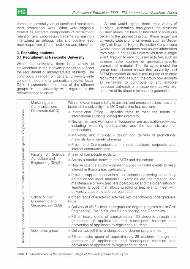
came after several years of continued recruitmen-tand promotional work. What were originallytreated as separate components of recruitment,retention and progression became increasinglyintertwined as virtuous links and positive feed-back loops from different activities were identified.
3. Recruiting students
3.1 Recruitment at Newcastle University
Within the university, there is a variety ofstakeholders in the lifecycle process to supportthe recruitment of undergraduate students. Thecontributions range from general, university-wideconcern though to a geomatics-specific focus.Table 1 summarises the roles of the differentgroups in the university with regards to therecruitment of students.
As one would expect, there are a variety ofactivities undertaken throughout the structureoutlined above that have an intended or a virtuousbenefit to the geomatics group. These range fromuniversity-wide promotion events such as Univer-sity Visit Days or Higher Education Conventions(where potential students can collect informationfrom most, if not all UK universities from a singleevent) through to very focussed activities such asscience taster courses or geomatics-specificpromotional material. The life cycle model thegroup has adopted shows that university andSTEM promotion all has a role to play in studentrecruitment and, as such, the group now acceptsall invitations to contribute to any schools-focussed outreach or engagement activity irre-spective of its direct relevance to geomatics.
Incre
asin
gconcern
and
focus
on
the
health
of
und
erg
rad
uate
geom
atics
pro
gra
mm
es
Marketing andCommunicationsDirectorate (MCD)
With an overall responsibility to develop and promote the business andbrand of the university, the MCD splits into four sections:
& International Office – specific remit to meet the needs ofinternational students joining the university.
& Recruitment and Admissions – focuses on pre-application activities,including widening participation, and the administration ofapplications.
& Marketing and Publicity – design and delivery of promotionalmaterials for a variety of media
& Press and Communications – media relations, corporate andinternal communications
Faculty of Science,Agriculture andEngineering (SAgE)
A team of four people exists to:
& Act as a conduit between the MCD and the schools.
& Realise science and/or engineering specific taster events to raiseinterest in those areas particularly.
& Provide support mechanisms for schools delivering secondaryeducation-focussed materials. Examples are the creation andmaintenance of www.teacherstoolkit.org.uk and the organisation ofTeachers Groups that allows practicing teachers to meet withuniversity academic and outreach staff.
School of CivilEngineering andGeosciences (CEG)
A broad range of academic activities with the following undergraduatefocus:
& Delivery of 6½ full time undergraduate degree programmes in CivilEngineering, Civil & Structural Engineering and Geomatics
& Fill an intake quota of approximately 130 students through thegeneration of applications and subsequent selection andconversion of applicants to registering students.
Geomatics group & Deliver two full-time undergraduate degree programmes
& Fill an intake quota of approximately 35 students through thegeneration of applications and subsequent selection andconversion of applicants to registering students.
Table 1: Stakeholders in the recruitment stage of the undergraduate life cycle.
FIG Professional Education 2009 – FIG International Workshop Vienna

3.2 Geomatics.org.uk
As student numbers entering geomatics dipped inthe mid 1990s, the geomatics group felt itnecessary to take action of its own. Relying onuniversity and STEM-wide activity was not provingto be sufficient in terms of recruiting students anda need for a geomatics-specific message wasrequired to be available throughout a student’ssecondary education. By 2000, the first of twosignificant recruitment-related initiatives was inthe planning.
The difficult recruitment situation was notunique to Newcastle and so, after identificationof a variety of professional and practisingstakeholders and contacts in other universities,in 2002, Newcastle became the leader of a UKGeomatics community-wide effort to engagesecondary school teachers and students in aprogramme known as Geomatics.org.uk (Mills etal., 2004). The project was not a Newcastlerecruitment project, rather a geomatics-commu-nity wide engagement initiative that hoped tosupport all members’ recruitment ambitionsthrough increased awareness of the subjectarea. The project ran successfully for four years,being mainly funded by the Engineering andPhysical Sciences Research Council, but alsoenjoying support from trade and professionalbodies, other universities and enthusiastic indivi-duals. The project name was taken from thewebsite that was central to the project. Geoma-tics.org.uk aimed to provide an online portal to theUK Geomatics community that would be accessi-ble to schools particularly; and to offer free loansof professional Geomatics equipment to supportpractical work in schools.
CEG still runs the scheme of equipment loansalthough without funding support from theGeomatics community. Since 2002 CEG, eitherindividually or as part of the geomatics.org.ukproject, has given out more than 150 equipmentloans to schools, thereby increasing the aware-ness of Geomatics nationwide. The majority ofequipment loans have supported Geography fieldstudies, particularly in the domains of river andcoastal studies, but in latter years, mathematicsand science teachers saw the potential ofgeomatics to show real-world application of theirdisciplines and often in a practical and outdoorenvironment.
3.3 Geomatics-based Continuing ProfessionalDevelopment (CPD) for teachers
With the end of geomatics.org.uk in 2006, thegeomatics group began to look for a new projectto promote geomatics to secondary (11-19 yearsold) teachers and/or students. The new projecttook shape in late 2007 when the geomatics groupwon funding from the UK Government’s Trainingand Development Agency for schools to design,deliver and evaluate geomatics-based ContinuingProfessional Development courses for secondaryteachers. The courses aimed to introduceteachers of different subject areas, e.g. Maths,Physics and Geography, to geomatics and showhow it can be used to support secondary teachingand learning.
A total of 24 people attended the courses,including teachers of varying experience, educa-tional consultants and graduate students trainingto be teachers by completing a PostgraduateCertificate in Secondary Education. At this stage,the sample sizes for impact evaluation are smalland, therefore, not too much weight can be lent tothem. However, the early indicators suggest thatusing geomatics as a tool to run CPD for teachershas great potential. Feedback collected on theday of each course gave the following results:
& the courses were rated as Excellent (17responses) and Good (7) on a four point scaleof Poor, Fair, Good or Excellent
& asked about the relevance to their job, 14 felt thecourses were excellent, 9 Good and 1 Fair
& 11 people felt that the relevance of the course tofuture career aspirations was excellent
& 23 felt that participation and “enjoyability’’ of thecourses was excellent
& 20 would definitely recommend these coursesto colleagues and friends and 4 would probablydo so.
Comments from on-the-day feedback included:
“Enjoyed day – buzzing with ideas to begin toplan’’
“I found the course materials, practicalexperience + the delivery excellent. Very relevantin terms of new Key Stage 3 programmes of studyand also the new A -level courses. The offer offollow up sessions in schools + the useful contactsis also an excellent resource. Excellent on apersonal + professional level to review + extendknowledge + skills and then disseminate todepartment + to pupils.’’
T. Bramald, H. Mills, J. Mills, S. Edwards: Recruitment, retention and progression... FIG
“The course has given me some excellent ideasto feedback to my organisation.’’
“Well run session with aims clearly outlined andrelevance to subject constantly highlighted. I thinkit is an excellent way of raising students’ interest inphysics and giving them an insight into real lifeapplications.’’
As part of the evaluation, delegates werecontacted three months after the event and askedto complete an online survey that examined whatthey could remember from the course and identifyany impact it had had on their teaching. The onlinesurvey results, although from a smaller pool ofpeople than the on-the-day feedback, offeredfurther insight in to the impact the project mayhave had.
Only 25% of those responding to the onlinesurvey had experience or knowledge of geoma-tics prior to the course. Since the event, 75% ofthose responding had used geomatics in theirlessons. The level and form of this use rangedfrom a single lesson through to a week of activitiestaking in about 10 lessons in all, including somepractical-based lessons. One course delegateresponding to the survey, a Head of Geography ina high school, stated that the school has investedin some GIS software as a direct result of thecourse. For the course to stimulate this purchaseat a time when GIS attracts a growing profile ingeography curricular is a considerable positiveimpact. This teacher is now involved in thegeomatics group’s interest in realising a teacher-focussed GIS CPD course (see below, FutureWork). For those that had used geomatics withtheir students since the course, this had takenplace in all secondary year groups except at ages15-16 when the pressure of the national GeneralCertificate in Secondary Education limits the timeavailable to staff and students to completeenrichment work.
All of those responding to the survey felt thatgeomatics-based teaching and learning is appro-priate for academic and vocational learning and alarge majority felt that it could be used to supportlearners of all abilities. Asked for commentary, thefollowing were offered:
& Maths: It made pupils think about that area ofmaths in a completely different way and madethem apply thinking skills.
& Geography: It developed the way studentsmake linkages between data and the spatiallocation/diversity of that data – also providedinterest and challenges for students who
otherwise would be disinterested by traditionalpaper based fieldwork and follow up.
& Maths: Pupils are not often given the chance tolearn by experimenting and using equipment inan outdoor setting. So pupils are given thechance to learn in a different way.
& Maths: It helped them with learning Trigonome-try
Interviews with four participants from the coursesafforded considerable qualitative feedback rela-ting to the impact the courses might have had.Highlights from two of those interviews arepresented below:
1) White British Male, teaches year studentsaged 11 – 18, has 1-5 years teaching experienceand falls into the age group 25-34:
What attracted you to use Geomatics in yourteaching?
It struck me as very, very different, somethingthat none of the kids will have come across before.None of them will have had their hands on this stuffbefore. They like being outside, they like doingthings that are different that was one thing. Iwanted also to give them the idea that Maths is notjust about sitting in a classroom solving puzzles. Ithas real world uses as well and this is somethingthey are familiar with ...’’
Will you use Geomatics in your lessons in thefuture?
Yes definitely, it’s such a positive thing I willdefinitely get it again. Motivation and getting thepupils stuck into maths that isn’t just run of the millstuff it’s something different and somethingpractical. There’s loads of stuff I haven’t done yet.
2) White British female, teaches year aged 11 –18, has 1-5 years teaching experience and fallsinto the age group 35-44:
What attracted you to use Geomatics in yourteaching?
I just want to bring through to the classroomthat maths is used truly outside. We can sit in theclassroom and teach them, you know, how to doTrigonometry, how to use Pythagoras, angles andbearings which, for them, is far too often from atextbook or the board. This actually gives themsome meaning, some understanding that thingsare really going on around them and I want to try toencourage them to actually stand and look to try towork out what is really going on
FIG Professional Education 2009 – FIG International Workshop Vienna

Owing to the success of the courses, they arebeing re-offered this year. Further delivery and,therefore, impact evaluation of the courses willmake for a stronger report to be presented at alater date.
4. Retaining Students
It is not just the recruitment cycle that is at the coreof the Newcastle Geomatics marketing strategy.Once recruited, a considerable level of supportexists for the students during their time atNewcastle University and in the geomatics groupin particular. With the challenge of recruiting astudent being so great, it is essential that thegroup retains those who register. A variety ofpractices have been implemented or resurrectedto try and ensure that the students have astimulating and caring environment in which towork.
4.1 Induction
At the start of the first year, students are takenaway on a residential induction course. The 24-hour programme involves travel to a Youth Hostel,a variety of outdoor team exercises supervised bythe academic and research staff from thegeomatics group, an evening quiz, overnightstay, team orienteering exercise and travel back toNewcastle. Feedback from 2008 graduatessuggested that they thought this catalyst to thedegree programmes should be repeated at thestart of each academic year, such was its worth.
A geomatics industrial evening, run under thename of “Life during and beyond Geomatics’’ isalso held at the start of each year which sees allstudents and staff join together with geomaticscompanies, professional bodies and trade groupsfor an evening of food, drink and introductions.Hosted in an on-campus restaurant, the event isdesigned to build bridges between the studentsand the wider geomatics community at the outsetof their studies and then each subsequent year ofstudy.
4.2 Teaching
At the start of the 2008-2009 academic year, CEGadopted a policy of issuing all first yearundergraduate students with a student responsedevice which can be used to interact withpresentations given by teaching staff. Therewere two aims of adopting this system. Primarily,the system can be used to collect anonymousstudent opinion, feedback and be used to testknowledge and understanding. The formative
feedback and stimulating benefits of studentresponse systems in a science environment arewell documented by Reay et al. (2005). Thesecond aim comes from the assigning of anidentifiable “clicker’’ to an individual and sub-sequently monitoring attendance. Bowen et al.(2005) describe some of the motivation andbenefits of adopting such a system. In the case ofNewcastle, the aim was not to monitor hour-by-hour attendance but rather to identify studentswhose absence over several days may suggesttheir becoming distracted from, or disengagedwith, the subject and see if the group can assist inany way.
Furthermore, there have been some significantchanges recently in pedagogical practice in thegeomatics group. From a survey of registeringstudents taken at the start of each of the last fouracademic years, the geomatics group is awarethat practical and field work is the joint highestattracting factor to the geomatics degreeprogrammes. The first year field course remainsa key part of the student’s experience. As well asthe technical experience of the course, living andworking alongside staff realises a strong bondbetween staff and students. Fieldcourses arebeing re-introduced to the final year of the degreeprogrammes from 2009. The final year fieldcoursewas removed from the curriculum in the early2000s owing to staff and financial costs being toohigh for a then small cohort of students, but theirvalue in attracting and satisfying students is nowso high that they are returning to the curriculum. E-learning tools are also being adopted to supportteaching and learning (Mills and Barber, 2008).
As part of the student’s final year studies ofAspects of Applied Geomatics, a three-day studytour is also now undertaken. Staff and studentstravel to see geomatics applied to a large scalecivil engineering project (the 2012 Olympics site),a trade exhibition, geomatics commercial practi-ces, the Ordnance Survey (Great Britain’s nationalmapping agency) and the Leica Geosystems UKheadquarters. Initially run in the 2007-2008academic year, the event proved to be popularwith the student body and was well supported bythe geomatics community.
Significant resource has been assigned to thegeomatics laboratory to give the students afunctional yet pleasant space in which to focus ontheir studies. The laboratory is equipped with 10common user PCs that are also equipped with thespecialist geomatics-software required at variouspoints through the degree programme. An
T. Bramald, H. Mills, J. Mills, S. Edwards: Recruitment, retention and progression... FIG

interactive whiteboard is in place to support IT-based group working and a survey pillar and wallmounted targets have been installed to supportinstrument practice and demonstration. There isspace to meet with peers or staff, and room forequipment set up for interactive demonstration.The availability of such working environment hasbeen greatly accepted and appreciated by thestudents and led to a closer interaction betweenthe students. There is a separate school-wide wifienabled common room that ensures the geoma-tics laboratory remains a place of study and notsocialising.
4.3 Pastoral care and communications
The induction and teaching activities are com-plemented by pastoral and communications-based support. Formal structures exist to affordfeedback and dialogue between the student andstaff groups, including a personal tutor, staff-student committee, board of studies, an entrysurvey to determine why students chose to studygeomatics at Newcastle and also confidentialfocus groups where, shortly before graduating,students can comment freely about their holisticexperience with the group.
The geomatics group also introduced astudent buddy system at the beginning of thelast academic year. The scheme was set-up asparent-children system, where one Stage 2student has been randomly allocated four orfive Stage 1 students to their care. For Stage 1students, the scheme aims to assist them withtransition to higher education, particularly in areassuch as time management, study skills and anempathetic ear all in the sanctuary of one’s peers.The scheme offers the Stage 2 studentsopportunity to consolidate their knowledgethrough sharing with others and develop personaland transferable skills that will augment theirtechnical education. Three formal sessions arescheduled between the parent and children so asto support its implementation, but the intention isthat scheme operates in an informal and ad hocnature between students.
It is planned to carry out a formal evaluation ofthe scheme later in this academic year by usingquestionnaires. Initial, anecdotal assessment ofthe scheme suggests that the scheme is workingwell and is of particular benefit to overseasstudents.
5. Progression
To make the life cycle approach complete, it isessential that affording a graduating studentexciting opportunities is as important as theirrecruitment and retention. In fact, the employmentprospects from a geomatics degree are, alongwith practical work, the joint highest attractingfactor amongst the Newcastle geomatics cohort.To support the student progression into theprofessional world, CEG has adopted differentevents and support schemes for the geomaticsstudents. Foremost amongst them is the intro-ductory industrial evenings described above.Additionally, CEG has developed close workingrelationships with a wide range of companies,often through alumni and, therefore, furtherextending the “life cycle“ approach. Industrialengagement has helped to support our studentsin finding a job after graduation, leading to a 100%progression level of the graduate students in 2007.Such a successful graduation: job conversion rateis a helpful statistic to convince potential newstudents to study Geomatics, supporting themarketing of the degrees further.
The group encourages and tries to assiststudents in finding geomatics-related work place-ments during their summer vacation periods.Companies wishing to recruit students are invitedto give lunchtime presentations to the students.These visits combine with the running of an on-linejobs board, the study tour and guest lectures tosupport students in their search for work.Excellent students are encouraged to apply forsummer studentships between Stages 2 and 3with a view to their being recruited to PhDopportunities.
6. Future Work
It is an ambition of the geomatics group tocontinue to improve in the area of recruitingstudents. Attracting more mathematically mindedand able students is one of the group’s primaryaims. A new project started in January 2009 thatsees a maths teacher working with the geomaticsgroup to identify new opportunities that may existfor geomatics to support teaching and learning in16-19 maths education in the UK.
The group has a strong track-record inContinuing Professional Development (CPD)provision for geomatics practitioners, particularlyin the field of GIS. With the rise of GIS’ presence inUK school curricular, the group has started toexplore delivering GIS CPD for school teachers.
FIG Professional Education 2009 – FIG International Workshop Vienna

7. Summary
Geomatics higher education around the worldremains in a perilous position owing to low studentnumbers. There have been some signs ofimprovement, for example the opening of newcourses, but student influx remains low (Lem-mens, 2007).
The situation in the UK is no different. Inresponse to the problem, the Geomatics group atNewcastle University has adopted a holisticmarketing approach to try to guarantee theannual intake of 35 students. The approach, one ofworking against a student lifecycle, along withsome specific practices adopted by the group,have been presented. The presented actionshave demonstrated success, as evidenced by the2008 intake of 41 “home’’ students plus two“overseas’’ students.
Despite the recent recruitment success of thegroup, it is vital to continue to actively recruit,retain and support the progression of students.With regards to recruitment, the first aim must bethat of at least stabilising student numbers at thecurrent level and ideally growing the size of thecohort. Furthermore, one could argue for a need toraise the standard of incoming students byseeking greater experience and performance intheir secondary education of mathematics andphysical sciences in particular. On the retentionside, the group hopes that recently adoptedpractices and will further increase studentsatisfaction levels but student and industrialfeedback will be used to seek continuedimprovement. The global recession may posechallenges to support the progression of students.In response, the group is already increasing itsdirect work with students on progression.
It is hoped that this paper offers points ofinterest and debate for others in geomatics andgeomatics higher education.
References
[1] Ballantyne, B. (1996): A polemic against “geomatics’’:buttering no parsnips. Survey Quarterly. Issue 5: 4 – 8.
[2] Bowen, E., Price, T., Lloyd, S., Thomas, S. (2005):Improving the quantity and quality of attendance datato enhance student retention. Journal of Further andHigher Education, 29(4): 375 – 385.
[3] Lemmens, M. (2001): Education: Surveying the Issues.Surveying World, 9(3): 36-38.
[4] Lemmens, M. (2007): Developments in GeomaticsEducation. GIM International, 21(9).
[5] Mills, H., Barber, D. (2008): A virtual surveyingfieldcourse for traversing. FIG International WorkshopSharing Good Practices: E-learning in Surveying, Geo-information Sciences and Land Administration. En-schede, The Netherlands.
[6] Mills, J. P, Parker, D., Edwards, S. J., 2004.Geomatics.org.uk: A UK response to a globalawareness problem. In: International Archives of thePhotogrammetry, Remote Sensing and Spatial Infor-mation Sciences, 35(B6): 1–6.
[7] Onsrud, H.J. and Pinto J.K. (1993): Survey andComparative Analysis of Alternative Names for anAcademic Discipline. Surveying and Land InformationSystems, 1993, 53(2): 164-178.
[8] Parker, D., Booth, S. (1999): Promoting Careers inmapping, navigation and spatial positioning – or how totell the world what surveying is really like! SurveyingWorld, 7(5): 42-43.
[9] Reay, N., Bao, L., Warnakulasooriya, R., Baugh, G.(2005): Towards the effective use of voting machines inphysics lectures. American Journal of Physics, 73(6):554.
[10] Trinder, J.C., Fraser, C.S. (1994): Geomatics – the casefor a change of name of discipline in the academiccontext. Australian Surveyor. 39(2): 87-91.
Biographical Notes
Tom Bramald is the Development Officer for the School ofCivil Engineering and Geosciences at Newcastle University.After completing a degree in Surveying and MappingScience (2001), he completed 2½ years as an OffshoreConstruction Surveyor working for Fugro around the world.He returned to the university in 2004 to work ongeomatics.org.uk before moving to the Development Officerpost in 2006. His work focuses on the recruitment, retentionand progression of civil engineering and geomaticsundergraduates.
Professor Jon Mills is Professor of Geomatic Engineering inthe School of Civil Engineering and Geosciences.
Dr Henny Mills is the Geomatics Teaching Associate for theSchool of Civil Engineering and Geosciences.
Dr Stuart Edwards is a Senior Lecturer in the geomaticsgroup and is the Director for Undergraduate studies for theSchool of Civil Engineering and Geosciences.
Contact
Tom Bramald, Dr Henny Mills, Prof Jon Mills, Dr StuartEdwards: School of Civil Engineering and Geosciences,Cassie Building, Newcastle University, NE1 7RU, UK
e-mail: [email protected]
T. Bramald, H. Mills, J. Mills, S. Edwards: Recruitment, retention and progression... FIG

Geomatics continuing professional development;
a UK perspectiveStuart Edwards, Alison Bird and Henny Mills, Newcastle
Extended Abstract
The School of Civil Engineering and Geosciencesat Newcastle University has delivered workforcetraining for many years with a broad portfolio ofshort continuing professional development (CPD)courses. During 2007/08 over 430 delegates willhave attend courses in a variety of subjects and ofincreasing importance amongst these are those inthe discipline of geomatics. Geomatics CPDofferings currently include; geographic informa-tion systems (GIS); survey computations and leastsquares adjustment; advanced data processingusing GPS and land survey techniques for thenone survey specialist. In the main all currentcourses have been developed in response torequests from industry and the growth in delegatenumbers has come from both new and esta-blished. This increase in demand presentschallenges for both the School and the individualsinvolved in CPD development and delivery.Moreover, increasing such outreach activitiespresents opportunities and challenges morewidely across the University. In order to betterunderstand the challenges of increasing CPDprevision, a study was undertaken with the aim ofidentifying key issues surrounding the provision ofCPD. Whilst the study was school wide thefindings are directly applicable to CPD courses ingeomatics.
The paper will address the issues surroundingthe provision of high quality geomatics CPDcourses from within the UK’s university system.Specific issues that will be addressed include:
The setting of appropriate and competitivecourse fees whilst ensuring all associated costsare met.
The benefits and inhibitors CPD activitiespresent for the individual academic. The studydemonstrated a very clear consensus that the lack
of academic staff time available to invest in CPDactivity, the relative merit of CPD activitycompared to other activities, and the absenceof a link between the staff generating the incomeand use of surplus, currently deterred individualacademics from engaging.
The requirement for administrative support inrelation to CPD development and delivery. Therole of dedicated support in relation to CPDactivity is explored. In particular, the difficulties ofeffective course promotion; accurate assessmentof demand; competitive pricing of courses; andinsufficient facilities were all highlighted as keyissues. In this regard it was identified that any‘central university’ financial levy on CPD incomewould remove the competitive edge of current andfuture courses reducing the motivation to developnew courses.
The competitive landscape of geomatics CPDprovision from other UK universities and commer-cial training providers. An extensive comparisonof course fees has highlighted the difficulty ofremaining competitive whilst recovering costs.
Potential for e-learning in CPD. The advanta-ges and disadvantages of an e-learning approachto CPD are considered within the context ofgeomatics.
The above elements have been identified asdirectly relevant to the long term sustainability andviability of geomatics CPD provision. The researchexplores each element through the use ofqualitative questionnaire and quantitative re-search and offers tentative conclusions that willstimulate further debate.
Contact
Stuart Edwards, Alison Bird, Henny Mills, School of CivilEngineering and Geosciences, Cassie Building, NewcastleUniversity, NE1 7RU, UK,e-mail: [email protected]
FIG Professional Education 2009 – FIG International Workshop Vienna
Advocating a Holistic Approach to Continuing Professional
Development Provision for Practitioners and Providers.
Paul Watson, Garry Workman, Neil Hanney,
United Kingdom
Abstract
This paper explores the interrelationship between Continuing Professional Development (CPD), Life Long Learning(LLL), Work Life Balance (WLB) and the linking key concept of Employability, with a view to developing a holisticapproach to CPD provision.It is understood that an important aspect of any professional person’s development is CPD; it enables the vital issue ofbeing a “Reflective Practitioner’’ to be addressed by professionals and assists in gaining an improvement inprofessional performance. One could also argue that CPD in the past has failed to be continuous and inclusive; it hasnot fully embraced the concept of Life Long Learning and has been fragmented and less than developmental. Concernsin the United Kingdom for CPD as a “national need’’ have been acknowledged by the National Committee of Inquiry intoHigher Education in the report (NCIHE 1997) “We believe that the aim of higher education should be to sustain alearning society’’. The emphasis here is clearly placed upon continuity throughout life, on broader knowledge andintellectual skills as well as vocational skills, and on ownership by the learner through the achievement of personalfulfilment. This paper provides a valid methodology for addressing the full implications and incorporated aspects ofCPD.
Keywords: Continuing professional development, employability, life long learning, reflective practitioner, work lifebalance
1. Introduction
CPD has been defined as “The systematicmaintenance, improvement and broadening ofknowledge and skills, and the development ofpersonal qualities necessary for the execution ofprofessional and technical duties through apractitioners working life’’ (RICS 1993). Thus thedefinition introduces and links to the concept ofLife Long Learning, an acknowledgment that onenever stops learning. The benefits of CPD as a LifeLong Learning professional life style have beenestablished as, the achievement of success inprofessional practise, enhanced quality assu-rance in the provision of professional services,contributing to client delight [satisfaction] andcontribution to sustained income generation (LeRoux et al 2004)
Thus a wider set of economic benefits that gobeyond merely those of employment should beconsidered and embraced. This concern is for amore comprehensive and holistic notion of CPDand the provision of a framework of opportunity forpractitioners throughout their working life. Thisissue is to be discussed further within the paper.
2. The Mixed Complexities of CPD
2.1 Work Based Learning Issues
The focus now being placed on CPD is forcingboth Higher Education and Professional Institu-tions to re-examine their methodologies fordeveloping and delivering CPD programmes.This is because if CPD is to be genuinelycontinuous, then the traditional approachescurrently adopted by many universities mustchange. With pressures being exerted to reducethe length of degree courses there is no longertime for traditional routes on undergraduateprogrammes to provide professionals with allthe tools and skills required to do their jobs bothnow and in the future.
Within Higher Education Institutions, the keyclient group is no longer 18 – 25 year olds, it is infact moving towards a more mature andexperienced people set, wishing to enhance theirexisting qualifications to meet changing circum-stances and future needs. Most importantly theywish to combine these with work based activitiesand truly attain the status of an “EffectiveReflective Practitioner’’. Therefore CPD can beextended to encompass the concept of “WorkBased Learning’’ This can also be credit bearing
Professional Education 2009 – FIG International Workshop Vienna FIG
and linked to a formal qualification, for example,within a degree course designed at SheffieldHallam University UK, which was built around CPDand in conjunction with the Association of BuildingEngineers, a 20 credit bearing module calledReflective Professional Practise was developed.
The entire course structure was designed to bedelivered in a flexible manner so as to meet theCPD requirements of a professional market place.It was fully understood by the course developmentteam that many practicing professionals haveyears of accumulated relevant valuable expe-rience. Hollerton (2005) opined that “It’s notusually the level of knowledge required [thatcauses problems for professional body students]it’s the style of [academic] work required’’. Thusthe new course sought to address the style issueand to utilise to a maximum those valuableexperiences by providing academic credit formature experienced students.
The credit is based on their ability to activelyreflect upon occupational experience. The workbased learning element cemented the notion ofthe value of the practical application of knowledgein the work place (Billett 1999) and furtherdeveloped the situational skills (Hinchliffe 2002)or contextual Knowledge (Portwood 2000) thatthese authors advocate as being essential for theperformance of a professional occupational role.
Thus it is imperative that the complex issue ofCPD does incorporate the “Work Based Learning’’concept, within the course students produce a“Portfolio of Evidence’’ covering the requiredlearning outcomes/competences. For students itprovides a focus for their learning and, in action, italso provides an accelerated means of obtainingacademic credit related to industrial practise.
Given the current debate relating to workbased learning, it is interesting to explore the roleof universities and colleges in CPD. The challengeseems to be one of meeting the needs of industryin terms of identifiable benefits and flexibility oflearning and yet ensuring academic quality. Itcould be argued that industry does not wanttraditional academic qualifications at all, and theproblem for universities is to re-focus on validprofessional competences. The emphasis here isclearly being placed upon continuity throughoutlife, on broader knowledge and intellectual skillsas well as vocational skills, and on ownership bythe learner through personal development andfulfilment.
A wider set of social and economic benefitsbeyond merely those of employment should beconsidered. This concern is for a more compre-hensive and holistic notion of CPD and aframework of opportunity that embraces earlyyears schooling through further and highereducation to include mid-career as well as pre-and post retirement needs.
The development of a key skills framework isfundamental to the accreditation of work basedlearning. If each individual student programme isseparately negotiated the key skills approachoffers an effective methodology for ensuringcomparability across and between programmesof work. There is, of course, no simple definitiveanswer to the question of what the key skills areand which are appropriate to the different levels ofaward within any programme of study.
2.2 Work Life Balance Issues
The concept of Work Life Balance impinges upona practitioners working life and hence is also anintegral part of CPD. Work Life Balance is notabout trying to schedule an equal number of hoursfor each of an individuals working and socialactivities. It is however, about people having ameasure of control over when, where and howthey work. It is achieved when an individual’s rightto fulfilled life inside and outside paid work isaccepted and respected as a norm of behaviour,to the mutual benefit of the individual, employerand society.
The result of a working and personal life that isout of balance is increased stress levels andhence an adverse impact upon work relatedperformance.
For most people juggling the demands of acareer and a personal life is an ongoing challenge.With so many demands placed on employees it isdifficult to strike an appropriate balance. Theobjective should be to make time for what isimportant to the individual.
Thus having a realistic balance between thetime spent working and the time one has to spendon other more social activities, such as ones familyis a critical factor and an employer must beattuned to this concept in order to appropriatelybalance out an employees workload. After all CPDis usually undertaken as an “Add-On’’ activity to anormal employees workload. If an employee doesnot obtain time to unwind they are very unlikely tobe able to maintain a sustained out-put at work.
FIG Professional Education 2009 – FIG International Workshop Vienna
So organisations must be aware of situationswhere work is taking over their employee’s life, thiscan only lead to a lose/lose situation for bothemployee and employer. What in fact should bethe goal of the employer is a win/win situation, thiscan be attained if the concept of work life balanceis accepted and acted on.
One of the vital aspects of avoiding an adversework-life balance is the leadership of managers. Itis the ’people skills’ of managers that seem to belacking. Therefore managers, as do all levels ofstaff require training and development. Thus boththe undergraduate curriculum and CPD shouldcontain ’People Skills Management’.
2.3 Life Long Learning Issues
Life Long Learning can be defined as all learningactivities undertaken throughout life, with the aimof improving knowledge, skills and competence,within a personal, civic and social and/oremployment – related perspective.
Thus Life Long Learning is about acquiring andupdating all kinds of abilities, interests, know-ledge and qualifications. It promotes the deve-lopment of knowledge and competences that willenable each person to adapt to our knowledge –based society.
Life Long Learning is also about providingsecond chances to update basic skills andoffering learning opportunities at more advancedlevels. All this means that formal systems ofprovision need to become much more flexible, sothat such opportunities can truly be tailored tomeet the needs of employees/students.
As noted above some academic awards aremoving away from the traditional undergraduateand postgraduate taught course framework andtowards one which can accommodate andrespond to the needs of CPD, a new structurefor making awards is required. Modular structuresdriven by credit based learning and CreditAccumulation and Transfer (CATS) have beenthe popular way of achieving these new buildingblocks. Credit based learning means that pointscan be earned from a wide variety of learningexperiences. For such a modular credit basedapproach to work effectively, it has to be based ona common set of criteria with a standard metric. Tothis end a national system for credit accumulationand transfer, in which common and standardisedtariffs are associated with a defined framework ofawards offered within the higher educationframework, has been developed.
Further the undergraduate and postgraduatecurriculum should develop “Transferable Skills’’.These transferable skills should encompass theskill to learn. To explain this further, if aprofessional is to truly benefit from engaging inthe life long learning activity then they requirespecific learning skills. So the curriculum has tohave learning outcomes, teaching and assess-ment strategies based upon students acting as faras is practicable as independent learners. Forexample this would include the ability to conductresearch, gather data and critically evaluate it,and drawing meaning full valid conclusions. Thusthe shaded area in Figure.2 depicts the overlapbetween employability and life long learning.(Hemmington 1999).
2.4 Employability Issues
A further concept requiring noting within the paperand one which forms part of the total holisticapproach to CPD delivery is the key concept of“Employability’’. The approach adopted by Shef-field Hallam University (SHU) in relation to’Employability’ is very distinctive because it isbased upon a long tradition of providingprofessional vocational awards. Further in 2005SHU was awarded national recognition (UK) as aCentre for Excellence in Teaching and Learning inEmployability.
Defining Employability ’Employability’ refers toa range of potential work activities and theseinclude:
& Paid/self employment
& Creative/artistic work
& Work in/for the community
& Family responsibilities
In order to address the issues encompassedabove, SHU have incorporated a strategy basedupon a distinctive approach. SHU’s approach isdistinctive because it concentrates on ’integratingand embedding’ a coherent set of curriculumfeatures within all its awards.
Integration: bringing together all features (e.g.through a vehicle such as student placement and/or the utilisation of case studies) so that studentsare better able to make the relevant connectionsbetween curriculum and application.
Embedding: having learning outcomes withrelevant learning and teaching methods andassessment, which are all aligned, presenting atruly holistic approach.
P. Watson, G. Workman, N. Hanney: Advocating a Holistic Approach... FIG

Therefore it is vital to have a valid curriculumdesigned with an input from all relevant sources,and linking learning outcomes to appropriatemethods of assessment. The teaching methodsshould enable the material to be delivered andtested, hence the utilisation of a ’teaching vehicle’such as a case study.
The Construction Industry Council (UK) whichrepresents construction professionals is a partnerin Construction Skills, the Sector Skills andConstruction Industry Training Board (CITB)Northern Ireland. Construction Skills representsthe whole of the UK construction industry. The fourkey goals of Construction Skills have beenestablished as:
& Reducing skills gaps and shortages
& Improving performance
& Boosting skills and productivity
& Improving learning supply.
& Employers and employees benefit from thisapproach by improving the quality of trainingand education on offer to meet both employersand employee needs. Further it ensures that thefuture skills needs of employers and employeesare addressed (in line with SHU’s definition ofemployability).
The above noted goals raise three vital questions:
1. How can employability enhance the curricu-lum?
2. How can employability enhance graduateemployment?
3. How can employers be engaged? (Brown2006)
Figure. 1 provides a pictorial guide for addressingthese critical questions, it also depicts theirinterlinking. What is evident from the inspection ofFigure.1 is that the three issues/questions cannotbe treated as mutually exclusive. Employercontact and consultation influences the curricu-lum content which in turn impacts upon theemployability agenda.
Thus it has been demonstrated that aprofessional’s future performance, developmentand employability are impacted upon by theundergraduate curriculum.
However, learning does not stop upongraduation, at this point the professional shouldbe embarking upon Continuous ProfessionalDevelopment (Life Long Learning).
This concept appertains to developing withingraduates the skills to learn and transferable skills,these are critical skills when considering the LifeLong Learning concept.
A critical aspect of this paper is the advocationof a holistic strategy when trying to address theCPD agenda for professional practitioners, ratherthan the disparate approach that tends to be thepreferred strategy adopted by most CPDproviders.
3. Case Study
Having described Work Based Learning, WorkLife Balance, Life Long Learning and Employabi-lity the following provides an integrated practicalapplication in the form of a case study. It is basedon the Association of Building Engineering (ABE)and Sheffield Hallam University (SHU) UK. TheABE has a requirement for all members to engagein some form of CPD activities, and promotion canoften be linked to the attainment of academicqualifications. Thus ABE membership approa-ched the ABE for some kind of formal CPD thatwould both lead to a formal qualification and beaccessible, as normal part-time attendance wouldnot be possible due to employer restrictions. Theinitiative had to be cognisant of the following:
& many ABE members have a wealth ofprofessional experience but may not haveformal qualifications;
& SHU’s mission is to forge collaborative links withrelevant professional bodies.
Our main objective (at SHU) of the collaborationwas to build on our existing good links betweenABE and SHU, so we endeavoured to:
& design and validate an appropriate academicaward built on CPD;
& develop a relevant curriculum building on theexisting strengths of students, e.g. work relatedexperience, encompassing Employability andLife Long Learning concepts;
& empower access to the award by matchingstudent requirements with delivery mode,address the Work Based Learning agenda;
& deliver and monitor the award and if necessarytake appropriate actions, to ensure the requiredcompetences and skill are incorporated into ourcurriculum.
The devised methodological approach wasbased upon setting-up a representative awardplanning team ( including ABE and Employer
FIG Professional Education 2009 – FIG International Workshop Vienna

representatives) and building on existing qualifica-tions (HNC/HND) and experience of students.
Therefore we developed module guides for theaward of a BSc (Hons) Building Engineeringdegree containing appropriate:
& learning outcomes, addressing required curri-culum and skills/competences;
& assessment criteria, engaging with employabi-lity;
& feedback strategy, addressing the reflectivepractioner concept;
& support systems, having appropriate supportbearing in mind the delivery mode.
The programme structure was designed to bedelivered in a flexible manner so as to meet theCPD requirements of the professional marketplace. From research conducted by Le Roux et al(2004) the “…benefits gained through implemen-tation of CPD as a life long learning professionallife style and an established organisational policyby practitioners operating in the built environmentwere identified as:
& [the] achievement of success in professionalpractice;
& [having] quality assurance in the provision ofprofessional services
& contribution to “client delight’’ and
& contribution to sustained income generation.’’
The above were not mutually exclusive with theobjectives of SHU and the ABE when we wereconsidering the outcomes of CPD and the newaward, and the above were fully embraced in ourdevelopment. We used diverse methods ofassessment that are consistent, practicable,and timely and effective in helping studentsdemonstrate the achievement of intended lear-
ning outcomes. We also specified clear assess-ment criteria designed to help ensure standardsare enhanced and to let students know what isrequired in order to improve their performance.
The ABE (in conjunction with SHU) nowprovides a CPD linked BSc (Hons) award for itsmembership, the award is innovative in terms ofboth delivery and in its assessment strategy(utilising Work Based Learning concepts). Themodel described in this case study can beadapted/adopted by other Higher Educationaland Professional Bodies, and Figure.3 provides avaluable flow diagram of the developmental anddelivery process. Again this diagram can beadopted or adapted to suit.
4. Conclusions
Within this paper the concepts of Employability,CPD, LLL and Work Life Balance have beenexplored. However it is important to point out thatthese are not mutually exclusive components of aprofessional’s development and performance.
The undergraduate curriculum impacts uponfuture CPD and both employability and CPDimpact upon Work Life Balance. In an everchanging operational environment where thefocus is on client satisfaction within an establishedcost framework we must not forget the truemeaning of employability, and the adverse effectsof not obtaining an acceptable Work Life Balancefor employees.
This paper should prove useful to the providersof CPD and practitioners, as it provides a modelfor adopting a holistic strategy which incorporatesContinuing Professional Development, Life LongLearning, Work Life Balance and Employability tothe benefit of all concerned.
P. Watson, G. Workman, N. Hanney: Advocating a Holistic Approach... FIG

Fig. 1: Employability Entering the Curriculum.
FIG Professional Education 2009 – FIG International Workshop Vienna

Fig. 2: Linking Employability, LLL, CPD and Work Life Balance.
P. Watson, G. Workman, N. Hanney: Advocating a Holistic Approach... FIG
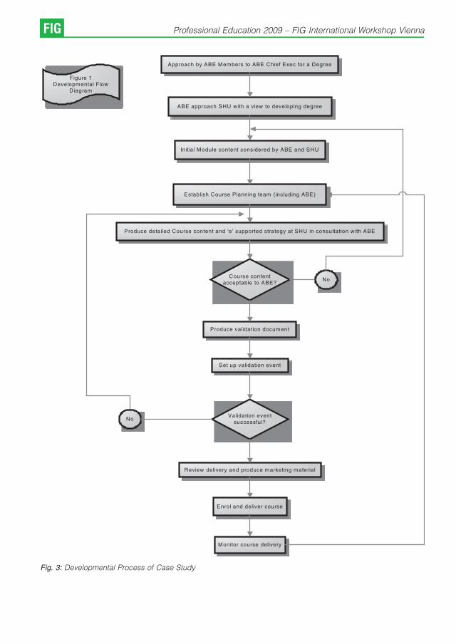
Fig. 3: Developmental Process of Case Study
FIG Professional Education 2009 – FIG International Workshop Vienna

References
[1] Billett, S. (1999): Guided Learning at Work in Bound andGarrick eds 1999 Understanding Learning at Work,London, Routledge.
[2] Brown, S. (2006): “Employability“ A Distinctive Ap-proach to Graduate ’Employment’, Seminar 16 March;Malaysia.
[3] Hemmington, N. (1999): Attitudes to CPD: Establishinga Culture of Life Long Learning at Work, ContinuingProfessional Development, Vol. 4, PP 100-104.
[4] Hinchliffe, G. (2002): Situating Skills: a conceptualframework for pedagogy and performance, 3rd AnnualSkills Conference Proceedings, Hertfordshire Integra-ted Learning Project 10 -11 July 2002, University ofHertfordshire, UK.
[5] Hollerton, I. (2005): How to Make Professional Qualifica-tions and Awards Count for Progression onto DegreeCourses, Journal of Building Engineers, Association ofBuilding Engineers, Northampton, UK, April Vol 80 p49.
[6] Le Roux, G., Nkado, R., & Mbachu, J. I. (2004): Role ofContinuing Professional Development (CPD) in Sustai-ning Professional Practice in the Built EnvironmentProfessions in South Africa, 2004 Proceedings of the2nd Construction Industry Development PostgraduateStudent Conference 10 – 12 October, pp 111 – 127,Cape Town, South Africa.
[7] NCIHE. (1997): Higher Education in the LearningSociety -Report of the National Committee of Inquiryinto Higher Education HMSO, London.
[8] Portwood, D. (2000): Workers, Students and Learners:Work Based Learning Perspectives and their Impact onOrganisations. The Impact of Work Based LearningConference Proceedings 14 – 15 December 2000,Fitzwilliam College, Cambridge, UK.
[9] Royal Institute of Chartered Surveyors (1993): CPD-Review of Policy and Future Strategy, London, RICS.http://students.shu.
Pro. Dr. Paul Watson, Mr. Garry Workman, Mr. Neil HanneyE-mail: [email protected]
P. Watson, G. Workman, N. Hanney: Advocating a Holistic Approach... FIG
Continuous Training – the French Experience
Francois Mazuyer, Saint Etienne d’Orthe
1. General context
While it was still conceivable in the 1950s that aprofessional would, after the completion of itsinitial training, enrich himself, this situation is overnow. The fast and growing evolution of tech-nologies, the accumulation of laws and regula-tions, the constant enlargement of areas ofactivities, the multiplication of exchanges entailthat the initial formation, however complete it maybe, and experience cannot anymore be regardedas a safeguard for the professional to ensure to hisclients and relationships a guarantee of compe-tence.
As a matter of fact, a new notion emerged in thesecond half of the 20s century, namely the notionof continuous training.
2. Concrete application to the profession
As regards the profession of surveyors, thisobligation emerged very early.
3. OGE’s role in continuous training
& Main provisions
The law establishing the French national associa-tion of surveyors dating back to May 6th, 1946, itsconsecutive decrees of application, as well as theinternal rules precise the role of training.
& Article 17 of the law foresees that the Frenchsurveyors’ Council “is watching over discip-line and professional improving’’
& Article 47 of the decree dating back to May,31st 1996 reads that “the land surveyor shallmaintain and improve its professional know-ledge’’.
& OGE’s role is to check the competence of itsmembers
The checking of this competence is not onlyensured during the registration to the association,but it is also regularly carried out during theprofessional life of OGE’s members.
The application of the rules enacted by OGE ismade at the Regional Councils’ level and can betwofold :
& Periodical checking of offices – the mostcommon way
& When clients complain or express theirdoubts about certain practices of a givensurveyor to a Regional Council – anotheroption.
Certain specific activities such as technicaldiagnostics to detect the presence of lead orasbestos in buildings, real estate managementare subject to preliminary specific trainings underthe control of Regional Councils.
4. The institution of mandatory continuoustraining
The adoption of a directive in 1999 by the Frenchsurveyors’ Council rendered continuous trainingmandatory.
This first directive laid down a minimum of 40hours of training per year. Those 40 hours wereconsidered on a basis of a three year period.Every 3 years, every surveyor had to prove that hehad undergone 120 hours of training.
OGE’s training commission is in charge ofputting on line the different existing trainings.
Regional Councils must enforce disciplinarymeasures in case of default which can rank from asimple warning to a ban to practice the professionin case of a serious default.
However, every sanction regarding a breach ofthe obligation of continuous training is subject toan appeal before the French surveyors’ Council,like any other disciplinary sanction imposed byRegional Councils.
This obligation of continuous training was evenmore amplified by the French surveyors’ Councillast year.
Since January 1st, 2009, the minimum level oftraining consists of 5 days of direct training plus 3days of indirect training (participation to Con-gresses, redaction of articles for professional
FIG Professional Education 2009 – FIG International Workshop Vienna
reviews…). Last but not least, the breakdown ofdays is made every year.
The Council indeed recognized that it wasextremely difficult to ensure a checking on a 3-year period time. The checking will, from this yearone, be made every year. Surveyors will have tosend, before the 1st of March, a declaration of thetrainings they have attended plus a justification forall of them to their Regional Council.
The trainings can either be trainings organizedby the OGE or by departmental or regionalprofessional instances, or complementary univer-sity trainings, or specializations in a given area.But in any case all the trainings must be in relationto the activities of surveyors or to the improvementin the management of offices.
Trainings can also lead to OGE’s or any otherinstance’s certifications (e.g. OGE’s certificationfor the technical diagnosis of buildings, certifica-tion of the Town Planning Qualification PublicOffice).
In order to offer available trainings, a specialnational Commission was created with a view to:
& Suggesting themes and speakers
& Evaluating the suggested trainings
& Putting on OGE’s website the different existingtrainings while specifying the dates, locations,speakers, content, and the validation by OGE
& As regards the trainings organized by OGE, thecontent of the training and the skills of the trainerare systematically evaluated by the participants;the evaluations are then sent to the trainingcommission which will analyze them.
Certain trainings dealing with fundamental areashave even been rendered compulsory:
& continuous training on land delimitation in 2002
& continuous training on insurances and risks in2005
& training on numerical land registry in 2006
& training on the new town planning rules in 2007
& a training on land techniques in the frameworkof the delegation of public services of surveyorsis under preparation.
5. Summer universities of surveyors
5.1 Basic principle
In order to mobilize surveyors on continuoustraining, the executive board of the councilestablished for the first time in 2005 a newconcept deriving from the notaries’ experience.
The idea is to organize periodically, in oneplace, during a few days, half a day or full daytrainings on different subjects. Here are the mainadvantages of this concept:
& It’s better to undergo a training while being awayfrom the office
& Spending many days in one place is good interms of sharing of experiences with othercolleagues
& It’s an opportunity for the Council to communi-cate about the difficulties of the profession, theactions to be taken, etc
& The costs are less important
& Friendly atmosphere
& Good way to unite the profession and reinforcethe «esprit de corps» of the profession
& The control of attendance record is easier
Summer universities are organized every twoyears (odd years) so as not to conflict with OGE’scongresses that take place during even years.They last for 3 days in one of the 3 schools leadingto the profession of surveyor.
The evaluation of trainings is based on thefollowing criteria:
1. content of the programme
2. balance between the programme and pro-fessional practice
3. quality of the trainers
4. interactivity
5. distribution of time between the differentsubjects
6. quality of teaching aids.
We attach much importance to the diversity ofsubjects (legal, technical, management of offi-ces).
Trainers can be surveyors themselves, acade-mics, or professionals (notaries, lawyers…).Trainings are open to surveyors, managerial staff,surveying trainees, foreign surveyors coming fromFrench-speaking countries, but also to theteaching staff of surveying technical schools.
5.2 Return of experience – perspectives for2009
Summer universities were a great success lastyear and gathered more than 400 participantsduring 3 days. According to the statistics, 96% ofthe participants declared that they will come backthe year after. The global budget for the last 2007
F. Mazuyer: Continuous Training – the French Experience FIG

summer universities amounted to 400 000 euros.At the end of the day, the balance sheet waspositive. For 2009, let me briefly give you aselection of different subjects that will be covered:
& The reform of our urban planning code
& The financing of public equipments
& The right of way : how to avoid conflicts?
& Real estate taxation
& Land delimitation
& The management of meetings
& Ethics and deontology
& GPS for “dummies’’.
5.3 The future of universities –the development of the concept
The success of the 2005 and 2007 summeruniversities cannot but lead us to perpetuate andimprove this event. While at the beginning weplanned to organize such meetings only every twoyears, the constant increase of mandatory days oftraining may, one of these days, lead us to launchannual summer universities. Similarly the length ofthese meetings could grow from 3 days to 4 or 5days (as it is already the case for the notaries)Workshops will have to be divided in two levelgroups: “beginners’’ and “confirmed’’.
Summer universities cannot as such cover thenumber of mandatory hours of continuous trainingbut they could, at least, cover half of the needs onfundamental subjects. The second half could becovered at the regional level with smaller groupsof participants and more specific topics. Besides,
a degree of flexibility is of course required shoulda new law or new provisions trigger a need for aspecific training.
6. Conclusion
In the framework of a more and more globalisationand a growing complexity of our professionalpractices, our professions can only perpetuate iftheir members are highly competent. Thiscompetence necessarily stem from a high levelof initial training but also a top-level continuoustraining. The duty of professional organisations inthis area is:
& To render continuous training mandatory
& To evaluate and offer top-level trainings
& To control the participation of surveyors
& To impose sanctions in case of default.
Last but not least, one cannot but be delighted atthe European recall of this legal and technicalobligation of continuous training in the recom-mendations of the Strasbourg declaration whichwas signed in September 2008 by the twoEuropean associations of surveyors, namely theComite de Laison des Geometres Europeens(CLGE) and Geometer Europas (GE).
Contact
Francois Mazuyer, Land surveyor d.p.l.g., Real estateexpert, Expert to the Court of Appeal and the administrativeCourt of PAU, Investigator Commissioner, « Hauron « –40300 – Saint Etienne d’Orthe,Tel +336.08.57.49.45; +335.58.73.64.07,Fax +335.58.73.12.10E-mail : [email protected]
FIG Professional Education 2009 – FIG International Workshop Vienna
Continuing Professional Education via Distance Learning –
Success Factors and Challenges
A case study based on the worldwide UNIGIS network
Josef Strobl, Adrijana Car, Salzburg
1. Overview
The UNIGIS network of universities has offeredpostgraduate distance learning in GIS&Tsince theearly 1990s (Molendijk and Scholten, 2006). Sincethen it has grown from a European consortium intoa global network offering different types ofacademic programmes and qualifications inseveral languages. This paper discusses insightsgained from UNIGIS courses graduating severalthousand students in many countries and fromvery different backgrounds.
Taking for granted the fact of an increasingdemand for professional and management skillsin the geospatial technologies and GISciencesectors, it is clear that continuing (and in-service)education plays an increasingly important role asfirst-cycle education does not entirely fulfil theneeds of the marketplace. This is particularly truein a cross-sectional methodology-oriented discip-line where many experts have graduated fromtheir original ‚application discipline‘(e.g. Ecology,Geosciences, Forestry, Marketing, ComputerSciences, Public Health and many others). Aftersome years of professional experience in any oneof these fields frequently the demand for deeperknowledge in a key methodology area –geospatial science and technologies – willbecome evident and lead to a desire for furtherstudy and qualifications.
2. Clearly Defined Professional Qualifications
Qualifications and their acceptance depend on anumber of factors like:
& Curriculum and syllabus
& Professional relevance and employability
& Track record with alumni and in industry
& Formal accreditation and quality indicators.
These and several more factors are beingdiscussed below in more detail, outlining ex-perience from past courses as well as current
developments within and beyond the UNIGISframework (Strobl, 2004 and Strobl, 2008).
With UNIGIS programmes primarily taken inpart-time, in-service mode by professionalsalready active in the field of GIS&T, learning isdirectly coupled with professional practice.Employers have and express clear expectationsand learners already know from on-the-jobexperience about their strengths and weaknes-ses, and thus about deficits to be compensatedand gaps to be filled. In-service programmestherefore are undergoing daily practical checks ofrelevance, and receive immediate feedbackregarding topical priorities and curricular com-pleteness.
Anecdotic evidence stated like: ‚our pro-gramme was perfectly matched with my profes-sional needs, I found answers in my studies asissues kept popping up in work‘ of course are amisperception, even if teachers are happy to hearsuch positive feedback. Rather students aresensitized to topics currently dealt with in theirstudy programme, and now recognize issues intheir professional practice which otherwise wouldhave gone unnoticed. This kind of awarenessbuilding is a core objective of advanced courses,‚seeing problems‘ often is considered a morecritically important qualification than solving them.The ability of identifying and structuring problemscertainly is considered a higher level skill thanworking through an already defined set of tasksfollowing a prescribed ‚algorithmic‘ routine.
Reputation is widely considered a critical factorin sustaining success, whether in education orother knowledge-centric activities. A documentedand evident track record of delivering what hasbeen promised, of fulfilling the personal andprofessional objectives of students, and above allof advancing the professional capabilities andcareers of alumni are important factors inattracting and convincing future applicants to
Professional Education 2009 – FIG International Workshop Vienna FIG

pursue a particular education track. Professionalsinterested in taking up the UNIGIS programmeroutine get in touch with current students andalumni to check their own expectations with theirpredecessors’ experience.
The UNIGIS programme has given birth to aloosely knit alumni network (‚Club UNIGIS‘),based on its strength of not having a clearlydefined operational mission. Rather, this alumninetwork autonomously collaborates on a broadrange of topics from simple (or not so simple)technical support to information about job offe-rings, jointly tackling more complex projects orlooking for particular expertise on a given subject.There is a lot of giving and taking across thisnetwork, recently MVP’s (most valuable professio-nals) have been identified by their generouscontributions through sharing advice and offeringsupport. All this works without an organisationalframework or institutional infrastructure, demon-strating the power and effectiveness of onlinecommunities sharing a common background(mastering a challenging educational experience)and set of interests defined by their professionalenvironments.
3. Curriculum Development
Particularly the development and implementationof curricula and the development of coursecontent and media are continuous challenges in arapidly evolving area like the geospatial sciences.This requires cooperation with institutions acrossmany disciplines and the integration of expe-rience and care for regional differences. UNIGIShas been and still is very actively involved inmultilateral curriculum development projects (e.g.the originally US-based Body-of-Knowledge –DiBiase et al 2006) aimed at firmly anchoringcurrent and future courses in all relevantdisciplines and professional practice.
For the entire UNIGIS network, a common corecurriculum is a key constituting element, a strongcommon denominator binding programmes in avariety of languages, institutional and legalframeworks and variants in their mode of deliverytogether. In a continuously evolving environmentlike GIS&T, a curriculum cannot be considered asbeing set in stone, it rather has to adjust toinnovation, demands from professional practice,and an expanding set of application domains.Rapid change, though, would create confusionand organisational challenges, and unstableexpectations regarding educational outcomes.Therefore managing curricular change is an ‚art‘ of
balancing adoption and innovation with a certainlevel of stability and continuity.
Curriculum development is a major ‚exportarticle‘ of UNIGIS, as partners in the network havebeen and still are involved in curriculumdevelopment projects around the world (seee.g. Car and Strobl 2007). Typically conducted asconsortia projects in particular regions, andfrequently co-funded by European Commissionprogrammes, new curricula (plus their implemen-tation) are set up at institutions launching orenhancing education in GI&T. Each of theseprojects provides valuable feedback and sugge-stions for modifications to the UNIGIS commoncore curriculum, and frequently offers opportuni-ties to enhance the UNIGIS network itself.
On a more general level, work on academiccurricula offers a much needed ‚distancing‘ andabstraction from the everyday practice ofteaching and tutoring. Taking this higher levelview of what is being taught, why, and with whatexpectations benefits instructors by providing animportant background to their daily routines.
4. Distance Learning
The distance learning / eLearning / online learningmode of delivery clearly is the key factor whyprospective students choose this type of pro-gramme. Compatibility with continued professio-nal activity, family and other social obligations,mobility restrictions etc. are the driving forcesbehind the emergence of distance learning as aleading organisational model of continuing educa-tion.
Over several years it has become increasinglyevident that there is no one-size-fits-all model fororganisation and delivery of postgraduate quali-fications in GIS&T (Howell et al 2003). Manystudents aim at a well-founded and prestigiousMSc degree, while others prefer the more directlyapplicable outcomes from a professional diploma.Full distance learning serves part-time studentswell while there is a growing demand for ‚goingback to school‘ for a condensed full-time studyexperience (which might be split over severalperiods) or even entering postgraduate onlinelearning immediately after undergraduate studies.
The organisation and communication conceptbehind a distance education offering clearly are acore success factor determining the long termsustainability of programmes like UNIGIS (Molen-dijk et al 2008). Several factors deserve attention,like
FIG Professional Education 2009 – FIG International Workshop Vienna
& Combination of advantages of centralizedcourse delivery with regional access to support
& Leveraging of novel Internet-based communica-tion facilities to really ‚stay in touch‘
& Balancing an accepted core set of knowledgeand skills with flexible options to enableindividual choices of elective subjects.
While distance learning clearly is a ‚unique sellingproposition‘ for an academic programme, it is nota value per se. It is valuable, if it enhances theaccessibility of continuing education for a targetgroup of learners. The actual USP therefore is thecatering to the needs of a mature, well motivatedand professionally active community of learnerswho are less mobile due to their job locations aswell as social commitments. Bridging distances,and facilitating communication by online media isa very helpful element in allowing access tocontinuing education.
5. Quality Assurance
Regional differences in educational systems,cultural expectations, online access and levelsof prior learning are significant across the globe.Maintaining a common standard of qualificationstherefore sometimes turns out to be an impossibleobjective and likely will be a challenge forever. Still,the common denominator between North Americaand Central Asia, between Europe, Latin Americaand the Indian subcontinent is larger than it mightbe expected, not the least due to the unifying and‚standardizing‘ force of a global software industryand common issues in professional practice.
Quality Assurance is an permanent challengein academia, and even more so in a distributed setof programmes being taught across all bounda-ries of cultures, languages, professions and levelsof economic development (ENQA 2005). UNIGIS(Car 2008) has implemented a clearly definedframework of goals, tools and indicators facilita-ting the integrity, monitoring and continuousimprovement of academic qualifications awar-ded. These start from a common core curriculumreferenced to established benchmarks, stan-dards for teaching and performance assessment,and cross-programme checks like joint degrees,credit transfer options and mutual evaluations.
QA is not a one-time procedure, not just onestep in a process chain, but rather a continued setof cross-cutting activities and perspectivesenveloping the entire education process includingthe targeting, design, development, implementa-tion, delivery, monitoring and assessment of
outcomes (IHEP 2000). As the value and thevalidity of education is determined by its manifestand perceived quality (Finnie and Usher 2005) QAis at the core of UNIGIS and a continued priority foreverybody involved.
6. Assorted Challenges
The varying background of students (as opposedto ‚vertically organised‘ higher level qualificationsdirectly continuing and expanding first qualifica-tions, like an Ecology Master’s built on top of aBiology Bachelor) poses a particular challenge tothe design and implementation of postgraduate,and even more for continuing education pro-grammes, as entry requirements and assumedprior knowledge differ considerably.
As a major asset continuing educationstudents tend to have professional experience,which means they already bring their questionsand a clear sense of mission to the studyprogramme. This high level of motivation isbalanced by the above mentioned fact of studentshaving a broad range of sometimes very differentbackgrounds. This, though, helps with movingfrom a ‚centrifugal‘ concept of ‚knowledgedissemination‘ to a collaborative vision ofknowledge creation. Virtually any intake or otherlarger group of students collectively exceed theirinstructors‘ skills and knowledge, substantiallychanging teachers roles (which is frequently thecase in adult education). Teachers are challengedas moderators and coaches, helping with buildingknowledge instead of dispensing it. Over time,while approaching advanced stages in theirprogramme, students notice that they increasinglylearn from and with each other. Teachers then areless in a central role, but rather serve as facilitatorsin a semi-autonomous educational process.
Likely the most important success factor, andchallenge, is the evolution of UNIGIS into trulyglobal qualifications recognized by a wide rangeof industries and professions. This is due to thegeographically distributed, multilingual pro-gramme offering by a set of well integratedinstitutions which is based on a common frame-work, joint courses and even international summerschools, use of common platforms and GISsoftware and, most importantly, a large body oftightly cooperating faculty from across the globe.
References
[1] Car, A. (2008): Towards a Quality Assurance Conceptfor Postgraduate Distance Learning Programmes forProfessionals. Lernen mit Geoinformation II. T. Jekel, A.Koller and J. Strobl, Heidelberg, Wichmann: 172-178.
J. Strobl, A. Car: Continuing Professional Education via Distance Learning FIG

[2] Car, A., Strobl J. (2007): TEMPUS: GISc&T Position andRole in Croatian Higher Education, [Online], available:http://vector1media.com/article/feature/tempus-%3a-gisc%26t-position-and-role-in-croatian-higher-educa-tion/, accessed on February 4, 2009.
[3] DiBiase, D., DeMers, M., Johnson, A., Kemp, K., Luck,A.T., Plewe, B., Wentz, E. (2006): Geographic Infor-mation Science & Technology Body of Knowledge,Washington, D.C.: Association of American Geogra-phers.
[4] ENQA (2005): Standards and Guidelines for QualityAssurance in the European Higher Education Area.Bergen Report. European Association for QualityAssurance in Higher Education (ENQA) published on.Accessed from http://www.enqa.eu/files/ENQA%20-Bergen%20Report.pdf, accessed on February 4, 2009.
[5] Howell, S. L., Williams, P. B., Lindsay, N. K., (2003):Thirty-two Trends Affecting Distance Education: AnInformed Foundation for Strategic Planning [online].Online Journal of Distance Learning Administration.State University of West Georgia, Distance EducationCenter VI(III, Fall 2003). http://www.westga.edu/~di-stance/ojdla/fall63/howell63.html, accessed on Fe-bruary 4, 2009.
[6] IHEP (2000): Quality on the Line: Benchmarks forSuccess in Internet-Based Distance Education. TheInstitute for Higher Education Policy, Washington DCpublished on April 2000. Accessed from http://www2.nea.org/he/abouthe/images/Quality.pdf, acces-sed on February 4, 2009.
[7] Finnie, R., Usher A. (2005): Measuring the Quality ofPost-secondary Education: Concepts, Current Practi-ces and a Strategic Plan. Canadian Policy ResearchNetworks Inc. (CPRN).Research Report W|28, http://www.cprn.com/doc.cfm?doc=1208&l=en, accessedon February 4, 2009.
[8] Molendijk, M.A., Scholten, H.J. (2006): From LocalHeroes towards Global Communicators: the Expe-rience of the UNIGIS network in educating GISProfessionals Worldwide. In Nuffic Expert Meeting.Den Haag: NUFFIC.
[9] Molendijk, M.A., Scholten, H.J., Kaandorp, J. (2008):Geographical Information for all: breaking the barriersfor GI distance learning. In L. Groenendijk & C. Lemmen(Eds.), Proceedings FIG International Workshop 2008:Sharing Good Practices: E-learning in Surveying, Geo-information Sciences and Land Administration (pp. 85-100). Enschede: FIG International.
[10] Strobl, J. (2008): Digital Earth Brainware. A Frameworkfor Education and Qualification Requirements. In:Schiewe, J. & Michel, U. (Hrsg., 2008): Geoinformaticspaves the Highway to Digital Earth. gi-reports@igf,Universitat Osnabruck, S. 134-138.
[11] Strobl, J. (2004): UNIGIS – Digital Campus forProfessionals. In: Geospatial Today 6/2004: 40-45.
Contact
Josef Strobl, Adrijana Car, Centre for Geoinformatics,University of Salzburg and UNIGIS International Association
FIG Professional Education 2009 – FIG International Workshop Vienna
SQLtutor
Ales Cepek and Jan Pytel, Prague
Abstract
SQLtutor is an interactive online web based tool for teaching and examining students’ knowledge of SQL. It wasintroduced into education at the Department of Mapping and Cartography of the Faculty of Civil Engineering at theCzech Technical University in Prague in 2007. The paper informs about the first practical experience gained from thefirst year of application of the project in education, deals with some uncovered problems and discusses the nextpossible developments of the project.By introducing the SQLtutor to an introductory database course, there were several goals followed. One of them was tooffer the students a learning tool that would help them to impair some casual bad practices brought from secondaryschools, like occasional dull mechanical memorizing. This tool would lead them spontaneously to individual learningand logical thinking in order to be able to solve simple SQL queries. The students need to understand basic principlesand they need to learn thinking in the categories of sets. A previous knowledge of procedural programming might beparadoxically a disadvantage.
1. Introduction
SQLtutor project was introduced for the first timeat our faculty workshop Geoinformatics FCE CTUin 2007 [5]. The main goal of the project is to comewith a simple and user friendly tool for teaching,active learning and testing the SQL that could beexploited at the study program of Geodesy andCartography at the Faculty of Civil Engineering,CTU Prague.
The need of the subjects such as theIntroduction to Relational Databases and SQLLanguage in the field of geodesy, geoinformatics /geomatics and other related study programs isobvious. Students should be educated inpractical database management and usage atleast on a basic level, even if they are going tofollow the traditional study branches like geodesy.An example that demonstrates such a need mightbe our paper on adjustment of densificationnetwork presented at FIG WW in Stockholm in2008 [3] (it would be unavailing effort to maintainall the adjustment data without a databasesupport).
SQL language and the introduction to data-bases are presented to the bachelor students ofour study program during the second semester oftheir curricula and SQLtutor is used as a gentleintroduction to SQL. As with any other computerlanguage it is nearly impossible to learn SQLwithout practical training and exercise and that iswhy the SQLtutor offers an online web access toits training database for the SQL novices. For thebachelor students of geoinformatics (at the fourth
semester), it also represents a simple project thatdemonstrates how to program trivial clientapplications, simple web services and someother basic programming techniques.
The SQLtutor project consists in part of a C++program of the same name sqltutor releasedunder the GNU General Public License (GNUGPL). Its source codes are available from theSavannah CVS server [4]. The second part of theproject is a free collection of SQL questions andanswers representing SQL tutorials. SQLtutorenables to run one or more tutorials in differentlanguages from a single database. The sqltutorprogram is a CGI script that selects SQLquestions from its database, checks the answersand evaluates the final score. The home page ofthe project is [1], SQLtutor is implemented on thetop of a relational database system PostgreSQL[6].
2. SQL tutorials
SQLtutor was inspired by the interactive tutorialSQLzoo [2] by Andrew Cumming from the Schoolof Computing, Napier University, Edinburgh, UK.Andrew Cumming kindly agreed on using hisdatasets and SLQ queries within our project.Implementation of the database and the sqltutorprogram is not dependent neither derived fromthe SQLzoo tutorial.
From the very beginning of planning theproject, our basic idea was that all materials fromthe project must be freely available to studentsbefore being used during examinations. One of
Professional Education 2009 – FIG International Workshop Vienna FIG
our tasks for the coming years is to enhance thevolume of the collection of questions and answersto the level, where it would be practicallyimpossible to memorize them.
A tutorial in SQLtutor is implemented as a set ofplain text files with tutorial questions (or problems)and correct answers (SQL queries). More thanone solution can be applied for a given problem;the first one listed is supposed to be the mostsuitable from the point of view of (learning) theSQL language. Typically, each file describes a setof related problems to be queried over a commonset of database tables. In the SQLturor project aset of questions and related tables is called adataset and the corresponding text file usesdefault filename extension .quiz.
Dataset files can contain comments introducedby # character (remaining text up to the end-line isignored during the file processing). Questions andanswers are written in SQL with questions put incomment lines and answers written as thefollowing SQL code, as demonstrated on thefollowing example of ’’airplanes’’ datasets (fileairplanes.quiz) with three relational tables.
# passenger_airplanes (id, manufacturer, airplane,radius_km, seats)
# airline_companies (id, company, country, region,alliance, founded)
# airline_fleets (company_id, airplane_id, number_-of_airplaines)
# – id=“601“ dataset=“airplanes“ category=“se-lect“ points=“1“
# –
# – Show all airline companies.
#
# SELECT company FROM airline_companies;
– id=“602“ dataset=“airplanes“ category=“se-lect“ points=“1“
–
– Which airplanes have capacity higher the 300 ofpassengers?
– Show manufacturer, airplane and capacity.
SELECT manufacturer, airplane, seats
FROM passenger_airplanes
WHERE seats › 300;
– id=“603“ dataset=“airplanes“ category=“join“points=“4“
–
– Which airline companies have in their fleetsairplane Douglas DC-8?
– Show company, country and the number ofairplaines.
SELECTA.company, A.country, B.number_of_air-plaines
FROM airline_companies A
JOIN
airline_fleets B
ON A.id = B.company_id
JOIN
passenger_airplanes C
ON C.id = B.airplane_id
WHERE C.airplane = ’Douglas DC-8’;
For easier debugging, the tables are listed inthe introductory comments together with theirattribute names in parentheses. This file formatwas chosen to enable debugging in the textualmode as it is available for example in GNU Emacsor in any other text editor supporting SQLcommand execution, such as editors Gedit orKate. The first question (id 601) is commented outand thus it is not to be included in the database.
Format/content of the leading comments (–) isobligatory. The first line defines question attribu-tes, id is the integer question identifier (primarykey in the table questions), ’’dataset’’ is the name ofcorresponding data set (it is not derived from thefile name), ’’points’’ is a point evaluation andattribute category defines categorization of thegiven question to one or more categories of SQLqueries (multiple categories are separated by thecharacter “|“). In the current version, thecategories are not processed; this attribute isreserved for use in future versions.
Dataset files *.quiz are processed by anauxiliary program quiz, that converts them to anSQL batch used for populating the database.Some leading commands generated by programquiz for the dataset airplanes are shown in thefollowing example.
–
– generated from input file : airplanes.quiz
FIG Professional Education 2009 – FIG International Workshop Vienna

–
BEGIN;
INSERT INTO questions (id, dataset, points,question) VALUES ( 602, ’airplanes’,
1,’Which airplanes have capacity higher the 300 ofpassengers?\
Show manufacturer, airplane and capacity.\
’ );
SELECT merge_category(602, ’select’);
INSERT INTO answers (question_id, priority,answer) VALUES ( 602, 1, ’SELECTmanufacturer,airplane, seats \
FROM passenger_airplanes\
WHERE seats › 300;\
’ );
INSERT INTO questions (id, dataset, points,question) VALUES ( 603, ’airplanes’,
4,’Which airline companies have in their fleetsairplane Douglas DC-8?\
x Show company, country and the number ofairplaines.\
’ );
... etc ...
Building the database and processing of all*.quiz files is controlled by a hierarchy of Makefilesgenerated by GNU Autotools. The database canbe populated directly by SQL commands withoutthe system of plain text datasets files described.We decided to prefer the batch processing,mainly because tutorial text files are easier tomaintain.
3. Educational database
Tutorials, questions and answers are stored inSQL tables tutorials, questions and answers
tutorials ( tutorial_id, language, tutorial, label, ord)
questions ( tutorial_id, id, dataset, points, question )
answers ( tutorial_id, question_id, priority, answer )
Primary keys are tutorial_id, (tutorial_id, id)and (tutorial_id, question_id, priority) respectively.
As there can be registered more than one answer(solution) for a given question, the table ofanswers contains also an attribute priority. Thehighest priority (value 1) is assigned to the firstanswer listed after the question.
Datasets and information about their tables areregistered in the table datasets
datasets ( dataset, ord, ds_table, columns )
where attribute ord defines the order, in whichthe tables are listed during the dialog before thetext of a question, see Fig. 1. The list of columns isa simple, comma separated list of the attributenames.
A table dataset_sources contains basic infor-mation about the information source of the givendataset
dataset_sources ( dataset, year, sources)
for example
company 2007 Pavel Stehule
films 2007 http://www.fdb.cz/
trams 2007 http://www.dpp.cz
unesco 2007http://whc.unesco.org/en/list/
countries 2006 http://unstats.un.org/
airplanes 2007 http://www.letadla.info/
rivers 2007http://hydro.chmi.cz/hpps/op_list.php
premyslids 2007 http://www.vicher.cz/
The dataset source table is not displayedduring sqltutor tests and plays only an informativerole in the project.
Tables categories and questions_categoriescategorize individual questions. As mentionedearlier, the categories are not actively used in thecurrent version
categories ( id, category )
questions_categories ( question_id, category_id )
Each test is registered in the table sessionsand answers to the questions in the tablesessions_answers
A. Cepek, J. Pytel: SQLtutor FIG

Fig. 1: Example of SQLtutor dialog with an SQL query and the result.
FIG Professional Education 2009 – FIG International Workshop Vienna

sessions ( session_id, tutorial_id, login, password,points_min, points_max,
dataset, help, host, time, status )
sessions_answers ( session_id, tutorial_id questio-n_id, answer, correct, time )
Some attributes of the sessions are currentlynot used and are reserved for future enhance-ments. Attribute status may be in one of two states’’open’’ or ‘‘closed’ and is used for locking thesession after the test is finished. It also serves as aprotection against subsequent tampering of thefinal score.
4. First empirical results
By introducing the SQLtutor to an introductorydatabase course, there were several goalsfollowed. One of them was to offer the studentsa learning tool that would help them to impairsome casual bad practices brought from secon-dary schools, like occasional dull mechanicalmemorizing. This tool would lead them sponta-neously to individual learning and logical thinkingin order to be able to solve simple SQL queries.The students need to understand basic principlesand they need to learn thinking in the categories ofsets. A previous knowledge of procedural pro-gramming might be paradoxically a disadvan-tage.
Students have the full collection of questionsand answers freely available, clear and simplerules for final test evaluation are given in advanceand students can be preparing for the finalexamination during the whole semester. The firstpractical contact with SQL is a kind of cultureshock for many freshmen students. They have notmet anything similar during their secondaryschool studies and they cannot imagine howthey could ever learn anything like that. But thesuccess rate in final examination is quite high. Thisway, the SQLtutor fulfils another of our goals tosupport sound self confidence of students at thevery beginning of their studies and to prove themclearly that if they work hard, they are going to beable to manage much more difficult tasks later.
Before introducing the SQLtutor into ourstandard education in the second semester ofbachelor studies, we verified the new study plantogether with the collection of exercises andparameters of test evaluation on experimentalteaching of a class of students from a masterdegree program in geoinformatics. The most
crucial task was to tune the parameters for finalexamination grading, based on the resulting pointscores. Together with the students, our commonconclusion was to have 60 minute test with rating30/60/90 points for rating good/very good/excellent. The chosen scale of 60 points hasbeen also selected, because it suits 15 pointsdivision for a new grading A/B/C/D/E/F that hasbeen adopted by our university in 2008.
The first semester of introduction to databaseswith SQLtutor went smoothly without noticeableproblems. During examination we did not discoverany incidents with cheating (the test was runningon local computers in a room with network closeddown), students did not try to dispute the givengrading scale. Nevertheless, the first semesterconfirmed the well known experience that most ofthe students always try to go the easiest way, eventhough we could not imagine what it might be.
One of the supplementary rules declared inadvance was that, if anyone finds an error in thecollection of examples (questions and answers),he will get the benefit of the point score for his finalexamination. Confusing and unclear questionswere considered as errors. Absolute majority oferrors was cleaned up with the help of thestudents from the experimental class. Still, two orthree errors remained, which proves that evenexcellent students sometimes take study mate-rials uncritically. Distribution of our first 119questions in the collection by the datasets andpoint evaluation is shown in the next table.
Majority of the questions is concentrated in thelower point ratings and as we could see fromevaluation of answers during examinations, anumber of students opted for the method of bruteforce and simply ignored questions from somedatasets, namely the questions from the dataset ofPremyslid royal dynasty and the dataset of rivers.Because in the SQLtutor premiere questions wereselected in random independently of the pointrating, in some cases this strategy proved to besuccessful.
The interesting point on the analysis ofexamination results was that this strategy wasnot only adopted by students who were tryinghard just to pass through, but also by some of thebest students. Resulting point score was calcu-lated as the sum of points for correct answersmultiplied by the ratio of the number of correctanswers to all questions asked. Total number ofquestions was limited only by the total time limit of60 minutes, eventually by answering all availablequestions.
A. Cepek, J. Pytel: SQLtutor FIG
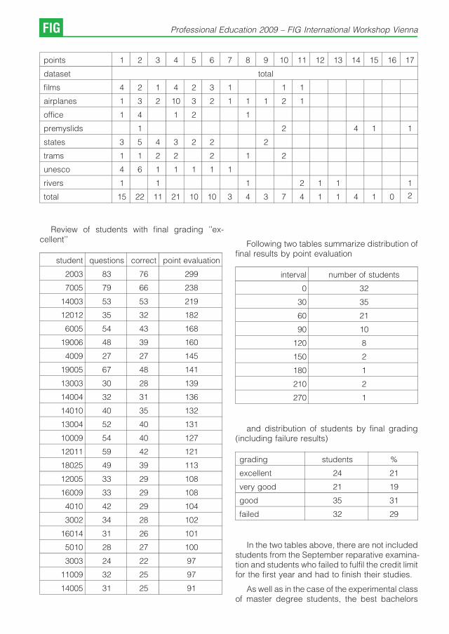
points 1 2 3 4 5 6 7 8 9 10 11 12 13 14 15 16 17
dataset total
films 4 2 1 4 2 3 1 1 1
airplanes 1 3 2 10 3 2 1 1 1 2 1
office 1 4 1 2 1
premyslids 1 2 4 1 1
states 3 5 4 3 2 2 2
trams 1 1 2 2 2 1 2
unesco 4 6 1 1 1 1 1
rivers 1 1 1 2 1 1 1
total 15 22 11 21 10 10 3 4 3 7 4 1 1 4 1 0 2
Review of students with final grading ’’ex-cellent’’
student questions correct point evaluation
2003 83 76 299
7005 79 66 238
14003 53 53 219
12012 35 32 182
6005 54 43 168
19006 48 39 160
4009 27 27 145
19005 67 48 141
13003 30 28 139
14004 32 31 136
14010 40 35 132
13004 52 40 131
10009 54 40 127
12011 59 42 121
18025 49 39 113
12005 33 29 108
16009 33 29 108
4010 42 29 104
3002 34 28 102
16014 31 26 101
5010 28 27 100
3003 24 22 97
11009 32 25 97
14005 31 25 91
Following two tables summarize distribution offinal results by point evaluation
interval number of students
0 32
30 35
60 21
90 10
120 8
150 2
180 1
210 2
270 1
and distribution of students by final grading(including failure results)
grading students %
excellent 24 21
very good 21 19
good 35 31
failed 32 29
In the two tables above, there are not includedstudents from the September reparative examina-tion and students who failed to fulfil the credit limitfor the first year and had to finish their studies.
As well as in the case of the experimental classof master degree students, the best bachelors
FIG Professional Education 2009 – FIG International Workshop Vienna

tended to compete among themselves to gain thehighest possible point score (some of themdoubted at the beginning of semester, if theywould be able to pass the test). The best result of299 points is the outcome that will probably neverbe beaten, it is admirable but it was also a warningthat the algorithm of questions selection had to bechanged. The aim is not to memorize thecollection of test queries and write in the speedthat forecloses logical thinking. The test shouldlead students to solve presented problems, SQLqueries.
This can be achieved not only by substantiallyenlarging the number of tutorial queries, butmainly by changing the strategy for selectingquestions. Even during the first experimentalclass, the students objected that trivial questionsare wasting their time and obstruct them fromgaining higher scores.
For next term, the SQLtutor will always startasking the simplest questions with one pointrating. After the first has been correctly answered,two correct answers for two point questions willfollow. After that, the questions with three and fourpoints will asked in the very similar way. If astudent answers all ten questions from the first teststage, his score will be exactly 30 points (gradingE). In the following second stage, the questionswith 5 or more points will be asked in random.
This way, the final evaluation should not bedistorted by answering trivial questions, namely inthe case of high ratings. Surely, for the secondstage some better strategy will be needed. Wecan possibly define an algorithm that wouldbalance the number of questions asked bycategories.
Conclusions
SQLtutor is a small and simple project, but wehope that some of our colleagues might find ithelpful, even if not for other reason than a toy topractice SQL queries.
One of the latest changes in SQLtutordatabase was an introduction of common schema’’sqltutor’’ for all tutorials and enhancement of thedatabase design to enable multiple languagesand/or tutorials in a single database. We wouldalso like to add other SQL commands such asDELETE, UPDATE and INSERT in the laterversions. One of our plans for next year is toprepare an online tutorial for PostGIS spatialqueries.
We would like to thank Andrew Cumming for hiskind approval to use his data and tutorials fromSQLzoo [2] in our project.
References
[1] SQLtutor, http://sqltutor.fsv.cvut.cz/
[2] SQLzoo.net, http://sqlzoo.net/
[3] Pytel, J. and Kostelecky, J, and Cepek, A.: Adjustmentof the Densification Network in the Czech Republic,Integrating Generations, FIG Working Week 2008,Stockholm, Sweden 14-19 June 2008
[4] GNU SQLtutor, http://savannah.gnu.org/projects/sqltu-tor/
[5] Ales Cepek, Svet se menı nenapadne, GeoinformaticsFCE CTU 2007, pp. 5-7, ISSN 1802-2669
[6] PostgreSQL http://www.postgresql.org/
Contact
Ales Cepek, Jan Pytel, Department of Mapping andCartography, Faculty of Civil Engineering, Czech TechnicalUniversity in Prague, Thakurova 7, 166 29 Prague 6, CZE,e-mails: [email protected], [email protected]
A. Cepek, J. Pytel: SQLtutor FIG

Experience-Based Learning in the Geo-Information
Sciences: 15 Years of Nuts Game
Liza Groenendijk, Enschede
Keywords: Experience-based learning, surveying education, natural resource management, land professionals
Abstract
One of the most successful modules offered at the International Institute for Geo-information Science and EarthObservation, ITC, The Netherlands, is the so-called NRM Module 1. The module is based on the Spiral Model ofLearning, an experience-based learning methodology, and is particularly developed for adult education. Theknowledge and the professional experiences of the students are seen as an important source of learning. Theeducation process is organised in a six-stage cycle involving six adaptive learning modes – initial expectation andreadiness, description of experiences, diagnosis and reflection, conceptualisation, experimentation and practice, andintegration and action planning. Each of these stages requiring a series of carefully developed individual or groupexercises.Through its interactive and reflective nature the module is constantly changing and adapting to new realities andchanging directions in the professional field. New learning tools, such as e-learning and the use of a virtual learningenvironment, appear to be developed for experiential learning. The Spiral Model of Learning methodology promoteslifelong learning and fits the concept of continuing professional development. It is recommended to further explore thisapproach and similar approaches in the search for new and sustainable curricula for future land professionals.
1. Introduction
The discussion on the changing nature of thesurveying profession has been a key issue formore than a decade. Experts in the fieldexpressed their concerns, analysed the issueand developed new insights on the nature of thesurveying profession and practice (Enemark,2002; Ossko, 2008).
The major key international trends in thesurveying education are summarized as follows(Enemark, 2007):
& Management skills, versus specialist skills
& Project organized education, versus subjectbased education
& Virtual academy, versus classroom lecturecourses
& Lifelong learning, versus vocational training
University and training institutions looked for newways to respond to these trends and thechallenges they represent (Enemark, 2002,2004, 2007; Markus, 2008; Sternberg & Krebs,2008; Lam &Chan, 2007; Coleman & Dare, 2007;Mansberger & Steinkellner 2007).
This paper highlights the experiences with oneof the successful modules offered at theInternational Institute for Geo-information Scienceand Earth Observation, ITC, The Netherlands, theso-called Natural Resource Management Module.
The paper describes the educational approachand structure of the Natural Resource Manage-ment Module, illustrated with some of the typicalexercises and one in particular, the so-called“Nuts Game’’.
In the search for new educational approachesfor training of future land professionals, it is worthwhile considering this example of an experience-based learning approach, where the experiencesof students are the source of learning anddevelopment.
2. The need for a multi-disciplinary module
The Introduction to Natural Resource Manage-ment, or the so-called NRM Module 1, marks thestart of the Master of Science Degree andPostgraduate Diploma Course in Geo-informationScience and Earth Observation for NaturalResources Management at the InternationalInstitute for Geo-information Science and EarthObservation (ITC), Enschede, The Netherlands.
This introductory module has a history datingback to 1993. At that time ITC was offering severalseparate courses in the field of Natural ResourceManagement: Forest Survey, Soil Survey, Ruraland Land Ecology Survey, Survey Integration forResource Development and Forestry for RuralDevelopment. The management of the instituterecognised the importance of a multi-disciplinary
FIG Professional Education 2009 – FIG International Workshop Vienna

approach towards Natural Resource Manage-ment and how could this be better promoted thanin a common introductory module for thesecourses?
Considering the aim and objectives of themodule and the particular target group, the SpiralModel of Learning methodology (FMD Consul-tants, 1993) was selected for this module. Thisstudent-centred training methodology is based onthe principles of experiential learning and is inparticular applicable for adult education.
The Spiral Model of Learning methodology wasearlier successfully applied at ITC in the post-graduate course Forestry for Rural Development(1990- 1997). In this course, with its particularfocus on community involvement in forestry andforest surveying, participatory and action re-search approaches were very much promoted.The Spiral Model of Learning was the appropriateeducation approach for this course.
A multi-disciplinary team of lecturers wasinvited to develop a module to form the commonstart for all Professional Master’s and MSc DegreeCourses in the field of Natural Resource Mana-gement. To bring staff from different disciplinestogether was at that time a unique and challengingundertaking, and not at all an easy one. Next totheir different professional backgrounds, moststaff members were not familiar with experience-based learning principles.
The different disciplinary courses became“specialisations’’ of a NRM Programme in 2000,and from 2008 further integration resulted in onenew MSc and Postgraduate Course in Geo-information Science and Earth Observation forNatural Resources Management.
The 15 years old NRM Module 1 survived allthese curriculum changes, adapted to newinsights and realities. It still brings together theexperiences of the students based on which acommon and solid framework is developed fortheir further MSc and PG study trajectory. Theeducational approach, management and basicstructure of the module have remained unchan-ged during the years the module is being offered.
Through its interactive nature the module isconstantly changing and adapting to new realities(Box 1). Each year the module is updated throughthe input of new contributing staff and theexperiences of the students, mostly mid-careerprofessionals. More than 50 different academicstaff members contributed as module coordina-tors, facilitators or moderators, while more than
1000 students, from all over the world, participa-ted.
Changing Aims of the NRM Module 1.
The NRM Module aims at eliciting from thestudents, and further developing, a commonbasis for the assessment of multi-actor and multi-disciplinary nature, and thus the complexity andconflicts involved in Natural Resource Manage-ment (Study Guide, 1999).
The module aims to support the MSc and PGdegree students, in acquiring a critical attitudetowards the role of geo-information science andearth observation for natural resources mana-gement while emphasising a system approachtowards solving natural resource managementproblems. (Study Guide, 2008)
Box. 1: hanging aims of the NRM Module 1.
Not only the content is constantly adapting tonew realities, also new educational tools andtechniques, including e-learning, are easily takenup and integrated. In particular young studentsare responsible for the introduction of challengingdigital tools such as Wiki, but also new forms ofinteractive presentation techniques.
3. Experience-based learning
3.1 Basic assumptions
The knowledge and the professional experiencesof the students are seen as an important source oflearning. Much of the training in the NRM Moduleis based on exchange, analysis and systematiza-tion of these experiences. This means starting withthe student and working with the experiences theygained in their organisation and actual workingsituation.
Experience-based learning also means stu-dents learn from systematic reflection on whatthey do individually and inside a training group,gaining essential skills for multi-disciplinary team-work. But also other basic professional andacademic skills such as critical thinking, inde-pendent learning, presentation and communica-tion skills, reading and writing skills are part of thelearning objectives.
3.2 The Spiral Model of Learning
The Spiral Model of Learning is based on theprinciples of discovery learning and is in particularapplicable for adult education. The Spiral Modelof Learning is based on the theory of experiential
L. Groenendijk: Experience-Based Learning in the Geo-Information Sciences FIG

learning developed by Kolb (1984). Learning isdefined as the process whereby knowledge iscreated through the transformation of experience.Kolb, in his structural model, describes theprocess of experiential learning as a four-stagecycle involving four adaptive learning modes –concrete experience, reflective observation, ab-stract conceptualisation, and active experimenta-tion.
The Spiral Model of Learning distinguishes thefollowing main steps in the education process:
1. Initial expectation and readiness
2. Description of students experiences
3. Diagnosis and reflection on experiences
4. Conceptualisation and analysis
5. Analysis, experimentation and practice
6. Integration and action planning
In the following paragraphs the different steps ofthe Spiral Model of Learning are explained andillustrated with practical examples of learningexercises from the Natural Resource Manage-ment Module.
3.2.1 Initial expectation and readiness
The learning process starts with the expectationsof the students about the course. These arepresented and compared with course objectives,and differences are discussed to reach a sharedlearning perspective. The training process isclarified for a clear and shared understanding ofhow learning is organised.
To stimulate favourable learning conditions,emphasis is on developing an open atmosphereof mutual respect, trust and commitment within thegroup. Students are stimulated to play an activerole in the learning process.
Fig. 1: The Spiral Model of Learning (FMD Consultants, 1993)
FIG Professional Education 2009 – FIG International Workshop Vienna

Reporting and Animation Committee
At the first day, participants are invited to take part in one of the following committees: reportingcommittee or animation committee. Through these committees they are made responsible for thecourse and their commitment for the learning process is increased.
Reporting Committee
The Reporting Committee is in charge of making a daily report of the activities and outcome of themodule. In this way the outcome of the module is documented, and the information can be used bystudents who arrive later in the module, and serves as input in other exercises. Each morning the reportof the day before will be presented by two reporters.
Participants in earlier courses (1993) used hand written reports, later followed by digital copies andPowerPoint presentations. The last years the digital learning environment Blackboard is used topublish and manage the daily reports. One of the recent groups organised the reports in a Wiki-environment, which allowed for more interaction and easier management of the reports.
Animation Committee
The Animation Committee takes care of a good working atmosphere in the group and promotesactive participation. The committee proposes the use of animation games when appropriate in themodule, e.g. at the start of the morning sessions or afternoon sessions. An active animation committeemay even organise social activities during the evenings or weekend.
Participants make use of a guide for workshop facilitation (Groenendijk, 2006). But more often theyuse there own experiences and ideas about group animation. This can vary from the well known ice-breakers and energisers, to traditional dances, songs and music plays. The use of You Tube was aremarkable experience in the 2008 course: various students were very eager to show their home oraspects of their work or projects they are involved in.
Mr. Toru Nagayama, Japan, demonstrating theKoto, NRM Module 1, 2007
One of the Kenyan students explaining hertraditional ornaments, NRM Module 1, 2007
Box. 2: Example of a learning exercise in step 1. Initial expectation and readiness.
3.2.2 Description of students’ experiences
In this step the present knowledge and experien-ces of students within their working context isanalysed and systematized. Students are stimu-
lated to describe their knowledge and experien-ces through a series of carefully developedindividual or group exercises:
& To express their knowledge and ideas
& To reflect their working experience and practice
L. Groenendijk: Experience-Based Learning in the Geo-Information Sciences FIG

& To reflect on their regular working behaviour orattitude
& To describe their working or institutional context
A central part of learning is that individualexperiences are being expressed, discussedand compiled for further brainstorming in thegroup.
Various exercises are developed to explorestudents’ perceptions on Natural Resources andNatural Resources Management. Analysis ofstudent’s working experiences result in on anoverview of success and failure factors in NaturalResource Management.
Success and Failure in NRM
Various exercises are developed to explore participants’ perceptions on Natural Resources andNatural Resources Management.
What are the key issues in Natural Resource Management? In this exercise students explore theirworking experiences to answer this question. The focus in this exercise is on success stories (whatwent good and why?) and the failures (what went wrong and why?) in NRM in their daily work. Furtheranalysis and relating the findings to the outcome of earlier exercises will lead to a list of key issues orproblems in Natural Resource Management.
Students are asked to answer the following questions and discuss these in teams:
& What do you see as a successful achievement in NRM in which you have been directly or indirectlyinvolved?
& What do consider an ‘unsuccessful’ NRM activities in which you have been directly or indirectlyinvolved in your work?
In plenary the results of the teams are presented, compiled and further analysed resulting in andoverview of achievements and difficulties and a consolidated list of success and failure factors in NRM.
Participants NRM Module 1, 2006. Group 2.
Box. 3: Example of a learning exercise in step 2. Description of students’ experiences.
FIG Professional Education 2009 – FIG International Workshop Vienna

3.2.3 Diagnosis and reflection on experiences
Students systematically compare their a prioriideas of their situations with the emerging pictureof actual practices and conditions under whichthese practices develop.
Such a comparison leads to the identification ofgaps between their actual (what they really do)and desired situations (what they think they do). Itenables the students to evaluate their role in thepast and motivates for further learning.
Based on the diagnosis of students’ experien-ces, gained in the earlier steps, the key issues and
problems in Natural Resource Management areidentified. These issues will be further studied inthe next steps.
In 1993 the following key issues in NaturalResource Management were identified by thecourse students: Participation, Multi-disciplinarity,Sustainability and Spatial variability; in 2008 oneof these issues has been considered still relevant,sustainability, but others have been replaced bymore prominent aspects like Competition andConflicts, and NRM in the International Context.
The village sketch map
Students are asked to draw a sketch map of a village they know very well (e.g. home village, or thevillage of their parents or grand parents, or a village they visit often for their work). They are asked toinclude aspects of build up area, different land uses, infrastructural features, water ways, elevation andother relevant aspects of the landscape. A legend is added to the map.
The sketch maps are used to discuss in teams, and later in plenary:
& The natural resource areas in the sketch map
& Location
& Trends (increasing/decreasing area)
& The actors involved in managing the natural resources.
& The owners, the users, the managers, …
& Interests and objectives of these actors.
& Management systems involved in NRM
& Issues of resource tenure
& Importance of geo-spatial information for Natural Resource Management
Example of Village Sketch Map, by Rhoda Nyaribi, Participant NRM Module 1, 2005.
Box. 4: Example of a learning exercise in step 3. Diagnosis and reflection on experiences.
L. Groenendijk: Experience-Based Learning in the Geo-Information Sciences FIG

The Nuts Game
A typical experience-based exercise and the exercise that has become the flagstone of the module.The Nuts Game marks the start of a learning block on the key issue of sustainability. Through thisexercise participants reflect on stakeholder behaviour with respect to the use and management ofscarce natural resources and recognise the role of institutional mechanisms to ensure sustainable useof natural resources.
The Nuts is a game played in teams of 5-7 participants. Each team gets a bowl and a number ofnuts, and a scoring table (Harvest Recording Sheet). Each player’s goal is to accumulate as many nutsas possible during a so-called life cycle. A life cycle consists of one or more seasons. After anexplanation of the rules, the teams start the game.
Immediately after the game, the moderator will summarise the total scores of the different teamsand the results, including the different strategies followed by the teams, are discussed in plenary. Thediscussion focuses on the analysis of players’ (stakeholders’) performance and underlying factorsand the attitudinal changes and development of co-operative strategies. Being the basic question:“What did you learn from this exercise in relation to the management of scarce Natural Resources?’’
Participants NRM Module 1, 2000, Group 1.
Conclusions
& People are “greedy’’
& Powerful people profit most, others “hungry’’
& Everybody for his own sake is not sustainable
& Rules needed for sustainable use of naturalresources
& Control!
& Everybody supposed to follow the rules, if not itwill not work
& Women are best resource managers: equalrepresentation
& Democratic rule/decision maker
For a complete description of this game see: Edney (1975), ITC (2008)
Box. 5: Example of a learning exercise in step 4. Conceptualisation and analysis.
3.2.4 Conceptualisation and analysis
Only at this stage new theories and experiencesfrom external sources are being offered to thestudents in the form of special lectures, readingassignments, reflective exercises, internet sear-ches, or videos. The key issues identified in earlierstages are now further studied.
The main elements for a framework for a multi-disciplinary approach in NRM are developed, theemphasis of which on the role of geo-informationin NRM. Central to the approach is theinterconnection between the key issues identified.This will create a new understanding of the role ofsurveying and geo-information within NRM.
The continuation of the course fits into this initialconceptual framework of NRM developed basedon the experiences and realities of the students.
3.2.5 Analysis, experimentation and practice
The students gain more insight experiment theconcepts and developed approach during afieldtrip. Under field conditions they validate theirnew insights and approach, which contributes tofurther learning and consolidation of concepts.
Students are responsible for the planning,organization and reporting of this one-day fieldtrip.Trained skills in earlier modules have to be appliedand gained insights are being tested.
FIG Professional Education 2009 – FIG International Workshop Vienna
3.2.6 Integration and action planning
In the case of NRM Module, the Spiral Model ofLearning methodology is applied in the introduc-tory phase of the course. In this case, theconcepts and approaches developed in theintroductory module serve as a “framework’’ forthe remaining part of the course. Regularmoments of reflection on the learning progressthroughout the course are organized in which thelearning experiences of the students are integra-ted in this overall framework.
At the final stage of the course, studentsprepare themselves for the implementation of thedeveloped framework in their own workingsituation: the training spiral is becoming a fullcycle.
4. Potential for training of the new landprofessionals?
The learning approach applied in the NRMModule at ITC has been particularly developedfor training of adult and mid-career professionalsfrom mainly developing countries. It has proven tobe an excellent educational approach to trainsurveying professionals with different working andcultural backgrounds.
The typical nature of the experiential learningapproach makes each module or course a newadventure. Changing realities in the professionalfield are brought in by the students and becomethe basis for further learning and developing themodule or course. If the only constant in thesurveying profession is change (Enemark, 2007),this more than 15 years old module has proven tobe an excellent and sustainable educationalanswer to that.
It is clear that experience–based learning, andas applied in this case, the Spiral Model ofLearning, promotes lifelong learning and fits theconcept of continuing professional development.Each new individual training effort can beconsidered a loop in the spiral model of lifelonglearning.
E-learning and the virtual learning environment,in this case Blackboard, increased dramaticallythe available number of educational tools andtraining challenges. Discussion boards, Wikis,Blogs and Communities of Practice are typicalexamples of these, and it seems as if they weredeveloped to support experiential learning.
Next to the content and technical skill training,experience-based approaches address profes-
sional and academic skills such as: criticalthinking and independent learning, communica-tion skills, group work, presentation skills andinformation skills.
It is recommended to further explore thisapproach and similar approaches in the searchfor new and sustainable curricula for future landprofessionals.
References
[1] Coleman, D. J. and P. Dare (2007). Renewing theGeomatics Engineering Undergraduate Curriculum atthe University of New Brunswick. Scientia est Potentia -Knowledge is Power. FIG Commission 2 - Symposium,7-9 June 2007, Czech Technical University, Prague,Czech Republic.
[2] Edney, J.J. (1975). The Nuts Game: a conciseCommons dilemma analog. J. of EnvironmentalPsychology & Nonverbal Behaviour 79, 252-254.
[3] Groenendijk, E.M.C. (2006): Tools. A collection ofgames and exercises for active learning and workshopfacilitation. ITC. PGM Department, 28 pg.
[4] Enemark, S. (2002): International Trends in SurveyingEducation. FIG XXII International Congress, TS2.2.Virtual Academy and Curricula Contents, Washington,D.C. USA, April 19-26.
[5] Enemark, S. (2004): Building competences of theFuture. Designing and Implementing a New Curriculumin Surveying at Aalborg University, Denmark. 3rd FIGRegional Conference. October 3-7 2004, Jakarta,Indonesia.
[6] Enemark, S. (2007): Promoting the interaction betweeneducation, research and professional practice. Scientiaest Potentia - Knowledge is Power. FIG Commission 2 -Symposium, 7-9 June 2007, Czech Technical University,Prague, Czech Republic.
[7] FMD Consultants (1992): The Spiral Model of LearningTraining Methodology. Working Document.
[8] ITC (1999): Study Guide. Natural Resource Manage-ment Programme.
[9] ITC (2000): NRM Module 1. Students Report, Group 1.
[10] ITC (2008): Study Guide. MSc and PostgraduateCourse in Natural Resource Management 2008-2010.
[11] Kolb, D. A. (1984): Experiential Learning. Experienceas the source of learning and development. New Jersey,Prentice-Hall, Inc.
[12] Lam, S. Y. W. and A. P. C. Chan (2007): SustainableCurriculum for Geomatics Higher Education. Scientiaest Potentia - Knowledge is Power. FIG Commission 2 -Symposium, 7-9 June 2007, Czech Technical University,Prague, Czech Republic.
[13] Mansberger, R. and G. Steinkellner (2007): How toEnhance the Interest for Surveying Studies Scientia estPotentia - Knowledge is Power. FIG Commission 2 -Symposium, 7-9 June 2007, Czech Technical University,Prague, Czech Republic.
[14] Markus, B. (2008): Thinking about e-Learning. FIGInternational Workshop. Sharing Good Practices: E-learning in Surveying, Geo-information Sciences andLand Administration, 11-13 June 2008, ITC, Enschede,The Netherlands
L. Groenendijk: Experience-Based Learning in the Geo-Information Sciences FIG

[15] Ossko, A. (2008): The importance of changes in landsurveyors’ education. FIG International Workshop.Sharing Good Practices: E-learning in Surveying,Geo-information Sciences and Land Administration,11-13 June 2008, ITC, Enschede, The Netherlands.
[16] Sternberg, H. and C. Krebs (2008): New perspectivesfor Geomatics Bachelor and Master Education at theHafen City University Hamburg. FIG Working Week2008. Integrating Generations. 14-19 June 2008,Stockholm, Sweden.
Contact
Ir. Liza Groenendijk, Department of Urban and RegionalPlanning and Geo-information Management InternationalInstitute for Geo-information Science and Earth Observation(ITC), P.O. Box 6, 7500 AA Enschede, The Netherlands,Tel: +31 53 4874528E-mail: [email protected]
FIG Professional Education 2009 – FIG International Workshop Vienna

Usage of a Multidisciplinary GIS Platform for the Design of
Building Structures
Dalibor Bartonek, Jirı Bures, Ales Drab,
Miroslav Mensık, Brno
Abstract
Topic of this paper is the usage of the multidisciplinary GIS platform for Design of Building Structures and GIS platformfor education at the Brno University of Technology (BUT). The GIS technology has been made use of at BUT Brno in alimited extent since as early as the 90’s, but as it was out of acceptable price range the utilization in greater extent wasnot possible. With the support of research projects the GIS platform became part and parcel of accredited studyprogrammes at BUT Brno three years ago. Current informatics infrastructure was completed with necessary systemsGeomedia 6.0 (Intergraph) and Arc/Info (ESRI), which are commonly widespread platforms. On initiation of Institute ofGeodesy, Faculty of Civil Engineering GIS data warehouse has been established for the needs of tuition at BUT Brno, itcontains all types of basic maps of CR and other types of data (ZABAGED, Orthophoto, BM – CR of various scales,cadastral maps, purpose-built maps, historical maps, special data – laser scanning, DMT, satellite data and others) inthe localities of interest. The data warehouse is continuously supplemented. A part of GIS platform is a catalogue ofmaps containing fragments of cadastral, civilian and military map works since 1825 till now.Hardware for the platform is the server HP Proliant DL380 G5 rack with 2x Quad-Core Intel Xeon Processor E5440(2,83 GHz, 80 Watts, 1333 FSB), 32 GB RAM memory PC2-5300 Fully Buffered DIMMs (DDR2-667) with AdvancedECC, disc space 8x 146 GB HDD SAS 10000 rps, Hot-plug and net interface 2x Gbit LAN. ArcGIS requires databaseconnectivity. As the university information system and additional university applications are in the long term based onMicrosoft technology, in this case the platform MS SQL 2008 in 64 bits version was also used.On the basis of standard multidisciplinary GIS platform the interests of several individual branches and worksites hasbeen succeeded to be integrated e.g.: branch of Geodesy and Cartography (application in range of real estate cadastre,geology and geodynamics, GIS of small municipalities and others), branch of Water Management and WaterStructures (solution in the field of hydrology), branch of Construction and Traffic Structures (GIS in traffic) and others.Informatics infrastructure is guaranteed at Faculty of Civil Engineering by Institute of Computer Aided Engineering andComputer Science, within the BUT by Faculty of Information Technology. The software solution of tasks in Open-GISsystems (Grass) ranks among contemporary trends. This article will be completed with demo results of hitherto solvedtasks in the GIS sphere at the Institute of Geodesy, Faculty of Civil Engineering, BUT. Current civil constructions andstructures are designed as optimized from a lot of aspects. Information integrated within the information system enablewhen proportioned to take into account even the influence of the outer conditions resulting from the geographicalposition and there out arising parameters e.g. the amount of rainfall, the speed and the direction of the wind, length ofsunshine intensity, geology etc. The platform provides database enabling to simulate different variability of practicalconditions of project assignment in the region. Data structure provides localized and geospatial data from global orregional character up to the detailed information of a particular cadastral allotment.Modern decision making in flood risk management is based on theoretical means which make possible objectiveforecasting of flood consequences, both qualitative and quantitative. Necessary tools for the practical implementationof the risk analysis methods in floodplains are the contemporary mathematical models of water flow in the inundationarea linked to a powerful GIS. The main task of GIS is to administer the input data, to analyse them and to present theresults.
Keywords: GIS, data warehouse, application of GIS.
1. Introduction
Geographic Information Systems (GIS) belongamong the youngest but at the same time the mostdeveloping sphere of information technology. AtBrno University of Technology (BUT) this tech-nology has been introduced into practical tuition in
a limited extend since as early as 90th andgradually it has found multidisciplinary usage.
Information concentrated in GIS and beingmade use of in a lot of technical civil engineeringbranches prove to be very suitable and important.For example a landscape planning often made ina principle nonreversible way has a great impact
Professional Education 2009 – FIG International Workshop Vienna FIG

on the life of the whole society. If the basic goalsand tasks dealing with the landscape planning areto be attained, the influences on sustainabledevelopment of landscape to be evaluated, theinfluences of the intentions dealing with ourenvironment to be judged objectively, then forreaching these decisions we should have rightand reliable information at our disposal. Quality ofprocessed spatial analytic source material as wellas landscape planning documentation play animportant role in these cases [3], [10].
Referring to the protection of basic rights andfreedoms of an individual the process of lands-cape planning has to be interconnected with theland record in the frames of information system ofthe real estates which is one of the most significantitems of a democratic society in a state respectingthe rule of law. The building act emphasises acontinuous updating of spatial analytic data on thebasis of Base Map of CR. This map and its digitalequivalent – primary base of geographic data(ZABAGED) is updated in the form of a periodicaerial surveying of one third of the state territory,which at present enables a real 3 – 5 year period ofupdating of the Base Map of CR and taking intoaccount the landscape development and achanges rate. In the future there will be atendency to update some geodetic elements inshorter periods out of external databases – forexample the road database. Topography of thestate map is created by a cadastral layer updatedon the basis of cadastral map topography. If theproject of Czech Office for Surveying, Mappingand Cadastre to digitize cadastral maps until 2015is carried out we can think about a digital statemap at a scale of 1:5000 covering the whole stateterritory after 2016 [2], [3], [7], [8].
In present time we are seeking for constitutionof a common platform and GIS standards on thebasis of experience and data flow of the individualplatforms working by higher area administrationunit e.g. county or municipalities or facilitymanagements e.g. CEZ, E.ON, RWE, O2 etc.[1], [4], [5], [6].
Technical specializations lectured at BUTrealize the necessity and advantages of makinguse of GIS sources for development of their studyprograms as well as special subjects. Guaranteeof the platform is Faculty of Civil Engineering(FCE) with contribution of Institute of Geodesy,Institute of Water Structures and Institute ofComputer Aided Engineering and ComputerScience. The FCE applies GIS databases in theaccredited study programs Civil Engineering and
Geodesy and Cartography. GIS platform withinBUT is participated by other faculties too: Facultyof Architecture, Faculty of Business and Mana-gement and Faculty of Mechanical Engineering.
2. Information infrastructure of GIS
The development of information infrastructure atBUT is guaranteed by the Centre of Computer andInformation Services. Each faculty is connectedwith the system by its own network. A basicqualification to take advantage of GIS progress atFCE is the faculty network serviced by Institute ofComputer Aided Engineering and ComputerScience.
In 2006 with the support of the developmentprojects together with the Ministry of Education atFCE projects ESRI – ArcGIS products and LeicaExtensions products for ArcGIS have beeninstalled. As a whole, it concerns 300 licensesof 10 different modules working through web userinterface. The multidisciplinary usage is ensuredby the GIS BUT data warehouse.
From the point of view of guarantee thecomplexity of GIS at BUT, the Institute of GeodesyFCE stands guarantor also for GeoMedia. Theplatform Intergraph GeoMedia came into being byjoining the international project RRL (RegisteredResearch Laboratory). By virtue of the observedpublishing activities, Intergraph provides the RRLmembers with the free license so that they can testGeoMedia products, and also offers a possibilityof free consultations 15 hours a year through e-mail (Intergraph Synergy email Support Services),one position for being trained in basic functions ofthe system, one position in the course for handlingany functional overlay GeoMedia module for oneyear and one free participation in yearly Worldconference Intergraph for one person. Within thisprogram each year about 30 students areprovided with license (for one year).
At present an innovation of the abovementioned GIS platform is under discussion:
& it is pondered above the extension of theplatform by ArcGIS server with multi-user’saccess. This server enables the access tospatial data through software ArcGIS mobileclients included, AutoCAD and web browsers. Itgives you scope for the publication of GISprojects on the geoweb,
& innovation of mobile technology data capture infield with making use of standard PDA+ArcPAD,
FIG Professional Education 2009 – FIG International Workshop Vienna

& upgrade of program module MGEO (Micro-Station V8) for geodetic and graphical dataprocessing,
& sustainable development of platform is ensuredin the form of maintenance for existing GISproducts.
Information infrastructure described above is inpreference built with the aim of maximum usage inall branches not only within the FCE but also BUTboth in full time mode and combined mode study.It can be used even in the processes of the lifelonglearning programs for the practice in civilengineering and public administration, for sup-plementary activities of faculties and for researchdevelopment and expert activities. By implemen-tation of GIS platform the tuition has beenextended and the quality has increased notonly with the subjects that have a lot in commonwith GIS but also with the subjects using spatialdata. In view of general trend of digitalization evenin the intermediate horizon we can expectgraduates to became involved in work moreeasily which is one of most important criterion tojudge the quality of education. Another contribu-tion is a possibility to offer specialized subjectscovering the needs of the practice mainly in theprograms of lifelong learning for practice in civilengineering as well as in public administration.
3. Multidisciplinary data warehouse GIS
In the frame the project integrated and multidis-ciplinary tutorial information system for GIScontents of multidisciplinary data warehouseBUT in corporation with FCE, Faculty of Architec-ture, Faculty of Business and Management andFaculty of Mechanical Engineering have beenformulated. The main aim of the project was tobuild information system, which would technicallyintegrate the tuition of various technical branchesand disciplines. The project paid particularattention to the development of modern tech-nologies applied in bachelor’s, master’s anddoctoral study programs in full time mode andcombined mode including the support of medi-cally handicapped students and applicantsrecruited of disadvantaged social groups. Theplatform of data servers has been built on ESRIArcGIS technology.
Data contents of multidisciplinary data ware-house – see Fig. 1.
a) digital state cartography works
b) ortophotos
c) digital purpose maps of large-scale
d) digital terrain models
e) laser scanning
f) satellite surveying data
g) historical data and maps
Multidisciplinary data warehouse should be usedby authorized access through BUT intranet up tothe level of source data.
Fig. 1: Structure of the Multidisciplinary data warehouseGIS BUT.
Multidisciplinary data warehouse coversneeds of Faculty of Civil Engineering (FCE) inbachelors, masters and doctoral study programsGeodesy and Cartography, Civil Engineering andArchitecture of Building Structures. At the Facultyof Architecture BUT ensures study programsArchitecture and Urbanism. At the Faculty ofBusiness and Management BUT supports thestudy program “Software Engineering and Infor-mati” specialization “Management Informati”,subjects: Data and Functional analyse, Databasesystems, further study program “Economy andManagement“ specialization “Economy and Ma-nagement of Enterprise“ subjects: StrategicManagement, Information Support of Processes,Applied Mathematic. At the Faculty of MechanicalEngineering BUT the facultative subject LandInformation Systems was initialized, taught in theframe of study program Geodesy and Cartogra-phy at FCE as offer of extension subjects amongfaculties of BUT.
4. Hardware guarantee of GIS platform
Hardware parameters of the platform wereestimated in part of applications needs, whichare necessary for these processes, further byaverage values representing volume of student’sprojects (space of GIS project in Bachelor’s orMaster’s thesis is approximately from 600 MB till4,5 GB, in average 1 GB). The main element ofhardware platform is the server dedicated toensuring access to the spatial data by software
D. Bartonek, J. Bures, A. Drab, M. Mensık: Usage of a Multidisciplinary GIS Platform... FIG
ArcGIS (including of mobile clients), AutoCADand web browsers. From multiyear experience theHP Proliant DL380 G5 rack server in followingconfiguration was selected:
& processor – 2x Quad-Core Intel Xeon ProcessorE5440 (2.83 GHz, 80 Watts, 1333 FSB)
& memory – 32GB RAM PC2-5300 Fully BufferedDIMMs (DDR2-667) with Advanced ECC
& disc space – 8x 146GB HDD SAS 10000 rps.Hot-plug
& net interface – 2x Gbit LAN
& redundant supplies and fans
For maximum performance 64 bit platform waschosen. System is based on Windows 2003Server R2 – 64 bit version. Disc subsystem wasinitialized in RAID-5 mode with one disc in hot-swap mode.
ArcGIS server demands database connectivity.Because the university information system andothers university applications are in the long termbased on Microsoft technologies the testedplatform MS SQL 2008 in 64 bit version waschosen. With regard of the server singularity withinfaculty and whole university the processor’slicensing was chosen.
Server is located in central node of FCEnetwork and connected to 1 Gb port of centralswitch HP Procurve 5412zl – see Fig. 2. To speedup the connection rate the port duplexing will bemade. In the next stage the 10 G bit connection isproposed.
Fig. 2: Configuration of server for GIS platform.
5. Tuition of GIS at BUT
GIS according to one of many definitions is aninformation system with special determinationconsisting in the integration of various brancheson the homogenous information platform. Fromthis point of view it belongs to interdisciplinarybranches and according to [9] it has a closerelationship to information technology above all togeodesy (data capture) and cartography (pre-sentation). It is clear that the Institute of Geodesyhas primary integrated GIS tuition into its programof Geodesy and Cartography. Nowadays itcontains basic information about GIS foundationof information systems, database systems,methods of data mining, basic graphs theory,topology (DIGEST norm) data models (vector,raster, matrix), digital terrain model, data capture,metadata, data quality, data sources, mapalgebra, spatial analyses, perspectives of furtherdevelopment of GIS. GIS appears in the syllabusof Faculty of Civil Engineering BUT. Further it istaught in the Institute of Water Structures in thesubject called “Hydroinformatics“, the aim ofwhich is to get acquainted with the principals andfunctions of hydroinformation in water supply togive necessary information about data captureand simulation models in water economy and getpractical skills making use of hydroinformation insemester projects. The subject involves: theo-retical and practical bases of utilization of moderninformation and communication technologies formodelling, management and decision making infield of water management, collecting andprocessing of input data. Application of simulationmodels in water management (rainfall-runoffmodels, simulation of water flow in pipe systemsand open channels, ground water flow modelling,simulation of sediment load motion, solute trans-port), processing and evaluation of modellingresults (application of GIS etc.).
Institute of Landscape Water Managementteaches GIS in the subject “Geographic infor-mation systems“ in the first year of master studyprogram in the specialization Water Managementand Water Structures. Tuition of Geographicinformation systems has to provide studentswith basic information about the principles of dataof digital technologies. The conception of tuition isdevoted to history and basic of GIS focusing onspatial analyses, digital models of relief and toolsfor solving the problem of watershed and natureprotection.
GIS teaching has a good tradition in thespecialization “Construction of Traffic Structures“
FIG Professional Education 2009 – FIG International Workshop Vienna

at the Institute of Railway Structures and Construc-tions. Students are introduced to the problems ofdatabase systems and geographical informationsystems and to practice acquiring knowledge andskills. GIS teaching consists of: introduction intoGIS problems, definitions and divisions of GIS,data GIS models, phases of formation, typology ofGIS, GIS managing data structures, definition,collection and organization of graphical data,procedure within formation of a GIS project,planning of geographical technologies, geogra-phical analyses, spatial questions, questions onmapping objects and attribute tables, charac-teristics of programming products of firms Inter-graph, Autodesk, Bentley, ESRI, introduction intoproblems of modelling over GIS platform, basictasks – transport optimization, goods delivery,optimal routes, region attendance, crisis mana-gement, application of GPS systems in transportetc, new trends of GIS development, connectionof GIS and the Internet, usage of GIS within public
authorities, usage of GIS for certification of lineconstructions, expert systems and its usagewithin railway transport. The same structure hasalso the doctoral study program.
Current civil constructions and structures aredesigned as optimized from a lot of aspects.Information integrated within the informationsystem enable when proportioned to take intoaccount even the influence of the outer conditionsresulting from the geographical position and thereout arising parameters e.g. the amount of rainfall,the speed and the direction of the wind, length ofsunshine intensity, geology etc. (Fig. 3). Theplatform provides database enabling to simulatedifferent variability of practical conditions ofproject assignment in the region. Data structureprovides localized and geospatial data fromglobal or regional character up to the detailedinformation of a particular cadastral allotment.
Fig. 3: GIS Usage for designing of civil engineering structures.
D. Bartonek, J. Bures, A. Drab, M. Mensık: Usage of a Multidisciplinary GIS Platform... FIG

Fig. 4: Output of the diploma project “GIS of Moravian Viticultural cycle-ways“.
6. The selected applications
Applications in the GIS sphere at the FCE dateback to early 90th that time, the staff of Institute ofGeodesy worked on the project of AM/FM(Automated Mapping/Facility Management) ap-plications. It concerned the system for mai-ntenance of gas pipeline LINDA, program fordata management of anticorrosive protection ofCR gas pipelines – GASACOR and GASSERV anda program PEARSON for evaluation of pipelinedefects. The applications go back to thebeginning when GIS started to be used for thefirst time. Nowadays LINDA product was inte-grated into more sophisticated graphical systemVKM (geodetic software for the creation of map ofmedium and large scales, geometric plans etc.)and a GVIEW system (interactive map browserwith possibility of conversion of a number ofvarious data formats and some GIS functionsimplemented). The taking advantage of GIS,marked a great boom when it was used for solvingparticular tasks which was connected with theintroduction of ESRI products e.g. the system Arc/Info implemented with the platform modules Leica
and Intergraph GeoMedia. The branch ofGeodesy and Cartography of the FCE in thefields of research and applications concentratedon 4 main directions: geological applications, GISof small municipalities, GIS of maintenance of fieldpoints and GIS for tourism and sport. Fig. 4 showsGIS layout from the diploma project “GIS ofMoravian Viticultural cycle-ways“.
One of the most important tools of datamanagement in GIS is their updating by datacapturing. With the development of new electronicintegrated mobile communication technologies itis possible to make use of computer PDA(Personal Digital Assistant), which are equippedwith GPS (Global Positioning System), camera,high quality display, memory and GSM (GlobalSystem for Mobile Communications) technology –see Fig 5 and Fig. 6. The technology of datacapturing is controlled by software e.g. ArcPad(ESRI) or Terra Sync (Trimble) etc. This process isunder way either by the system of surveying theobject in field or by its locating and demarking infield on the basis of coordinate GIS data. Ordinaryaccuracy of position destination is within the range
FIG Professional Education 2009 – FIG International Workshop Vienna
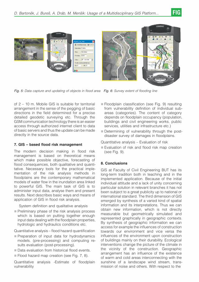
Fig. 5: Data capture and updating of objects in flood area Fig. 6: Survey extent of flooding line
of 2 – 10 m. Mobile GIS is suitable for territorialarrangement in the sense of the pegging of basicdirections in the field determined for a precisedetailed geodetic surveying etc. Through theGSM communication technology there is an easieraccess through authorized internet client to dataof basic servers and thus the update can be madedirectly in the source data.
7. GIS – based flood risk management
The modern decision making in flood riskmanagement is based on theoretical meanswhich make possible objective, forecasting offlood consequences, both qualitative and quanti-tative. Necessary tools for the practical imple-mentation of the risk analysis methods infloodplains are the contemporary mathematicalmodels of water flow in the inundation area linkedto powerful GIS. The main task of GIS is toadminister input data, analyse them and presentresults. Next describes basic ways and means ofapplication of GIS in flood risk analysis.
System definition and qualitative analysis
& Preliminary phase of the risk analysis processwhich is based on putting together enoughinput data dealing with the floodplain properties,hydrologic and hydraulics conditions etc.
Quantitative analysis – flood hazard quantification
& Preparation of input data for hydrodynamicsmodels. (pre-processing) and computing re-sults evaluation (post-processing).
& Data evaluation from historical flood events.
& Flood hazard map creation (see Fig. 7, 8).
Quantitative analysis -Estimate of floodplainvulnerability
& Floodplain classification (see Fig. 9) resultingfrom vulnerability definition of individual sub-areas (categories). The content of categorydepends on floodplain occupancy (population,buildings and civil engineering works, publicservices, utilities and infrastructure etc.)
& Determining of vulnerability through the post-disaster survey of damages in floodplains.
Quantitative analysis – Evaluation of risk
& Evaluation of risk and flood risk map creation(see Fig. 9).
8. Conclusions
GIS at Faculty of Civil Engineering BUT has itslong-term tradition both in teaching and in theimplemented application. Because of the initialindividual attitude and a lack of unity concerningparticular solution in relevant branches it has notbeen subject to a great publicity up to national orinternational standard. The third dimension of GISemerged by synthesis of a varied kind of spatialinformation and its interpretations. Thus we canobtain new information, which is not directlymeasurable but geometrically simulated andrepresented graphically in geographic contexts.By synthesis of geographic information we canaccess for example the influences of constructiontowards our environment and vice versa theinfluences of the environment upon constructionof buildings mainly on their durability. Ecologicalinterventions change the picture of the climate inthe vicinity of the construction. Geographicarrangement has an influence of the existenceof warm and cold areas interconnecting with thesunshine of a landscape wind stream, trans-mission of noise and others. With respect to the
D. Bartonek, J. Bures, A. Drab, M. Mensık: Usage of a Multidisciplinary GIS Platform... FIG

Fig. 7: Sample of Flood Map – Locality Brno
Fig. 8: Sample of Flood Hazard Map – Locality Brno
FIG Professional Education 2009 – FIG International Workshop Vienna

Fig. 9: Sample of Flood Risk Map – Locality Brno
protection of our environment the complexity oflinking the information is necessary for safe run ofthe construction especially with large roadstructures (highway, railway corridors, biocorri-dors etc.). In the sphere of building industry GIS isimportant at the synthesis of information for theproject of new construction location of theconstruction geography, weather, rainfalls, levelof bottom waters, snowfall areas, flood areasgeology etc. It aims to make periphery marginalconditions of construction designs more preciseand of higher quality.
This paper was created with support ofresearch task of Ministry of Education No00216630519.
Rferences
[1] Bares J.: Administration of The Digital Map Set ofPrague. 41. Geodetic Information Days, ECONPublishing, Ltd., Brno, Czech Republic, 2005, ISBN:80-86433-33-1, pp. 50 – 53, in Czech.
[2] Brazdil, K.: Fundametal Base of Geographic Data ofThe Czech Republic. 43. Geodetic Information Days,Brno, Czech Republic, 2007, ECON Publishing, Ltd.,ISBN 978-80-86433-42-4, pp. 52 – 60, in Czech.
[3] Cada, V.: GIS Land Data Model in Preparation ofAnalytical Foundations and Planning Documentationfor Town and Country Planning. 44. Geodetic Infor-mation Days, Brno, Czech Republic, 2008, ECONPublishing, Ltd., ISBN 978-80-86433-50-9, pp. 16 – 22,in Czech.
[4] Kniezova, Z.: Potentials of Exploitation of GeodeticSurveying Activities in Regional Planning, Building Lawand GIS. Surveying Works in Town and Countryplanning, Building regulations and GIS, Brno, CzechRepublic, 2008, Czech Union of Surveyors andCartographers, ISBN 978-80-02-02006-6, pp. 43 –47, in Czech.
[5] Martinec, J.: External Map Service as a Tool forCommunication. Surveying Works in Town and Countryplanning, Building regulations and GIS, Brno, CzechRepublic, 2008, Czech Union of Surveyors andCartographers, ISBN 978-80-02-02006-6, pp. 49 –55, in Czech.
[6] Pospısil, J., HOLUB, P.: Integrated Solution of LandAnalytic Sources and Land Plans in Zlin Region. 44.Geodetic Information Days, Brno, Czech Republic,2008, ECON Publishing, Ltd., ISBN 978-80-86433-50-9,pp. 24 – 32, in Czech.
[7] Stencel, K.: Digitalization of Cadastral Maps in Years2009 – 2015. 44. Geodetic Information Days, Brno,Czech Republic, 2008, ECON Publishing , Ltd., ISBN978-80-86433-50-9, pp. 76, in Czech.
D. Bartonek, J. Bures, A. Drab, M. Mensık: Usage of a Multidisciplinary GIS Platform... FIG

[8] Stencel, K.: Digitalization of Cadastral Maps – The Taskof Branch of The COSMC Till 2015. 43. GeodeticInformation Days, Brno, Czech Republic, Brno, 2007,ECON Publishing, Ltd., ISBN 978-80-86433-42-4, pp. 4– 13, in Czech.
[9] Tucek, J.: Geographic Information Systems. Principlesand Practice. Computer Press, Prague, CzechRepublic, 1998, ISBN 80-7226-091-X, 424 pp., inCzech.
[10] Valdova, I.: Implementation of The Inspire Directive andThe Branch of The COSMC. 43. Geodetic InformationDays, Brno, Czech Republic, Brno, 2007, ECONPublishing, Ltd., ISBN 978-80-86433-42-4, pp. 44 – 51,in Czech.
Contact
Dalibor Bartonek, Jirı Bures, Institute of Geodesy, Faculty ofCivil Engineering, BUT, Veverı 331/95,602 00, Brno, Czech RepublicE-mail: [email protected], [email protected]
Ales Drab, Institute of Water Structures, Faculty of CivilEngineering, BUT, Zizkova 17, 602 00, Brno, CzechRepublicE-Mail: [email protected]
Miroslav Mensık, Institute of Computer Aided Engineeringand Computer Science, Faculty of Civil Engineering, BUT,Veverı 331/95, 602 00, Brno, Czech RepublicE-Mail: [email protected]
FIG Professional Education 2009 – FIG International Workshop Vienna
ICT-Supported Learning and Training Tools for Terrestrial
Laser Scanning Applications
Erwin Heine, Vienna; Mario Santana Quintero, Bjorn Van
Genechten, Gent
Abstract
This paper describes the approach and developments of a project called ‘3DRiskmapping’. The project aims were tocreate a ‘learning on demand’ tool for the use of terrestrial laser scanners in documenting our built environment. Thedeliverables of the project include a number of ‘ICT-supported training tools’ that can be used and adopted by academicinstitutions in their current and future curriculum.The resulting package consists of a theoretical introduction on laser scanning and laser scanning data processingcompleted with a number of case studies in the form of online tutorials, lesson e-books and decision flowcharts forprocuring 3D spatial information surveying projects with laser scanning.The course material is available in five languages: English, Spanish, German, Romanian and Dutch.Future users will be able to register themselves online at the didactic portal and download all the course material free ofcharge.
1. Introduction
Terrestrial Laser Scanning (TLS) is a veryinnovative and useful surveying tool for capturing3D surface data. Since its beginning in the early1990s, it has been used in industrial applications,such as piping or in the automobile industry, but ithas also emerged in the cultural heritage sector aswell as in environmental risk characterization. Inspite of these increasing interests, its applicationhas not been fully exploited, among other things,due of lack of appropriate didactic materialavailable at academic institutions and deficien-cies in communicating the potential benefitsbased on real-life case studies.
The aim of the project called ‘3DRiskmapping’was to create an e-learning platform for utilizing3D terrestrial laser scanning techniques for riskcharacterization of our built environment.
The project was launched in autumn 2006 andran for two years and was co-financed by theEuropean Leonardo da Vinci Project. The projectgroup consisted of eight partners from six EUcountries: four academic institutions – KaHo Sint-Lieven Ghent (BE), Universitatea tehnica “GH.A-sachi’’ Iasi (RO), University of Natural Resourcesand Applied Life Sciences, Vienna (AT) andUniversidad Politecnica de Valencia (ES); threesurveying companies – Plowman Craven PCA(UK), BnS (BE) and Globe (BE); as well as oneengineering company in 3D modelling andsimulation – DelftTech (NL) .
2. Didactic approach / Teaching Material
The didactic material of this training course isdesigned to be used in an e-learning environment.The entire material is available at an onlinedidactic portal on the Internet and consists oflesson e-books, best practice training material,decision flowcharts and an information hub. Acompiled data set on DVD is available fordissemination to areas with limited Internet accessand/or broadband.
The didactic content prepared in this projectfollow a pragmatic approach, where the followingcharacteristics are present:
& Tutorials cover various applications
& Real data of a measured object
& Use of the most advanced laser scanning toolsto address the project needs
& Sufficient case study material to illustratecommon problems of TLS in practice
2.1 Lesson e-books
The Lesson e-books are designed to procure antheoretic background on laser scanning, alsoincluding:
& the process of procuring technology
& the application of technology for recordingthree-dimensional spatial information: processof collection and registration
Professional Education 2009 – FIG International Workshop Vienna FIG

& the application of software to provide three-dimensional spatial information: process ofmodelling and visualization
2.2 Training material
Examples of industrial application, heritagedocumentation and deformation monitoring areavailable to the trainees. All these tutorials arebased on commercial off-the-shelf (COTS) equip-ment and software. They all follow a strict format,where each processing step is explained in detailand an online evaluation is possible at each stageof the work.
Didactic modules used in the tutorials:
The trainee is guided step by step through theentire workflow of a scanning project; from theproblem statement at the beginning to the finalvisualization possibilities.
& Interactive instructions: The textual part of thetutorial consists of a verbal description of theprocedure and detailed step-by-step instruc-tions to follow up the work flow. Cross-references as well as hyperlinks offer furtherinformation on the specific items.
& Video tutorials: Additionally, the more complexprocessing steps are explained using short filmsequences.
& “To do’’ summary: At the end of the chapters a socalled “To do’’ summary is available torecapitulate all steps necessary to achievethe required result.
& Self test “Question boxes’’: The trainee is askedto explain the reasons for failures or errors thatoccurred during data processing. This self testoffers the user a possibility to evaluate theknowledge attained of a specific item.
& Success control using pre-processed data-sets:The trainee can compare the results he/shehas achieved with the “correct’’ results, whichare available at different stages of the course.
& Modular training : The above mentioned pre-processed datasets also offer the possibility toselect individual modules for training. Thus, forinstance users with experience in data captu-ring (scanning) can start the tutorial at thesection data processing or even 3D modelling.
2.3 Decision flowchart
Interactive flowcharts were developed to findadequate solutions to different questions. Thesedecision-making tools are individually coordina-ted with the requirements of the respectiveprocesses; each stage of the cycle provides
the trainee with information on how to apply thistechnique effectively and adequately.
For example, a quality control flowchartdescribes the processes for the correct acquire-ment of the built environment using laser scanning(Fig. 1)
Fig. 1: Decision flowchart “quality control’’
2.4 Information hub
A resource hub – compiled by the partners – withrelevant information and links for the target groupbeneficiaries in the application of these tech-nologies. A first version including further referencematerial and subject specific organizationsaround the world is available at: http://www.3drisk-mapping.org/site/
3. General description of the tutorial
The course developed within this project consistsof two main parts, a theoretical part and a practicalpart, or so called hands-on tutorial, based on real-life case studies.
FIG Professional Education 2009 – FIG International Workshop Vienna

3.1 Theoretical part
The first part of the course is dedicated to thetheory on TLS and is divided into 4 chapters:
Chapter 1 serves as a general introduction tolaser scanning and the applications for which itcan be used. The following topics are discussed:
& What is risk assessment?
& What is laser scanning?
& Static and dynamic laser scanning
& Applications of laser scanning
Chapter 2 is a theoretical expose of various laserscanner types and how they work. It also explainsthe different metrological aspects that need to betaken into consideration when scanning. Topicsdiscussed:
& The electromagnetic spectrum and light
& Lasers
& Important properties of laser light
& Laser safety
& Measuring using light
& Metrological aspects: error analysis
& State of the art laser scanner equipment
Chapter 3 explains the process of performing alaser scanning job. Every step of the process isexplained in detail, providing tips and tricksbased on expert experiences. Topics discussed:
& Survey planning
& Field operation
& Data acquisition
& Data preparation
& Registration & geo-referencing
& 3D point cloud processing
& Quality control & delivery
Chapter 4 provides a view on the problem of datamanagement. A set of meta-data tags that areimportant for the dissemination and archiving oflaser scanner data were defined. Topics dis-cussed:
& Laser scanner data formats
& Scanning metadata
& Project metadata
& Registration information
& Storage media
3.2 Best practice training examples
The practical part of the course is designed as ahands-on training part based on real-life casestudies. This tutorial contains 3 case studies, each
chosen to illustrate certain problems, benefits,purposes and limitations of the recording tech-nique utilized. Each of the case studies alsofocuses on different aspects of the laser scanningprocess:
Heritage Case Study (St. James Church)
The heritage case focuses on both the registrationphase and post-processing of data. The dimen-sions of the church and the inside-outsiderelationship of the scanned surfaces provide anexcellent challenge for linking scans taken fromdifferent positions. On the other hand, the level ofdetail requested and required deliverablesrequire a time-consuming post-processing phaseusing highly specialized software (Fig. 2).
Fig. 2: Cupola of St. James Church
Industrial Case Study (FPSO vessel)
This case study explains the possibilities of usinglaser scanning in surveying industrial sites. Anextensive overview of possible uses of theprocessed data during the engineering phaseis given: it also tackles the actual scanning itself,using a software tool that simulates a laserscanner, providing insight into how to set up thescanner and the correct parameters (Fig. 3).
Fig. 3: Petrochemical installation of the FPSO
Civil Infrastructure Case Study(Hydroelectric Dam)
This case study describes the use of laserscanning data for monitoring deformations overtime. Special emphasis is placed on determiningthe optimal laser scanning and target locationsand on comparing different datasets for monito-ring purposes (Fig. 4).
E. Heine, M. Santana Quintero, B. Van Genechten: ICT-Supported Learning... FIG
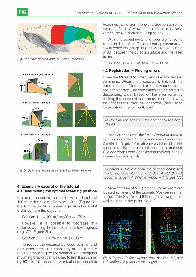
Fig. 4: Model of arch dam of “Kops’’ reservoir
Fig. 5: Scan distances at different scanner set-ups
4. Exemplary excerpt of the tutorial
4.1 Determining the optimal scanning position
In case of scanning an object with a height of100 m under a field-of-view of �30�– (Figure 5a),the Trimble GX 3D scanner requires a horizontaldistance from the object of:
Solution 1: l ¼ 100 m=tanð30�Þ � 175 m
However, it is possible to decrease thisdistance by tilting the laser scanner a few degrees(e.g. 20�, Figure 5b):
Solution 2:l ¼ 100 m=tanð50�Þ � 85 m
To reduce the distance between scanner anddam even more, it is necessary to use a totallydifferent mounting for the scanner. An orthogonalmounting bracket can be used to turn the scannerby 90�. In this case, the vertical scan direction
becomes the horizontal one and vice versa. So theresulting field of view of the scanner is 360�
vertical by 60� horizontal (Figure 5c).
With this adjustment, it is possible to comecloser to the object. To avoid the appearance oflow intersection (sharp) angles, we keep an angleof 30� between the object’s surface and the laserbeam:
Solution 3:l ¼ 100 m=tanð60�Þ � 60 m
4.2 Registration – Finding errors
Open the Registration menu and start the registercommand. When this procedure is finished, theerror column is filled and an error vector columnhas been added. The constraints can be sorted indescending order based on the error value byclicking the header of the error column. In this way,the constraints can be analyzed (see video“registration_interior_part6.avi’’).
To Do: Sort the error column and check the errorvalues.
In the error column, the first 4 (reduced dataset:2) constraints have an error measure of more that2 meters; Target 17 is also involved in all theseconstraints. By double clicking on a constraint,Cyclone opens both ScanWorlds involved in the 2viewers below (Fig. 6).
Question 1: Double click the second constraintmatching ScanWorld 5 and ScanWorld 6 andzoom to target 17. What is wrong with target 17?
Answer to Question 3 (remark: The answers arelocated at the end of the tutorial): “We can see thatTarget 17 in ScanWorld 6 (the right viewer) is notwell-defined in the point cloud.’’
Fig. 6: Target 17 in ScanWorld 5 (good position – left) andin ScanWorld 6 (bad position – right)
FIG Professional Education 2009 – FIG International Workshop Vienna
5. Conclusion
These training tools will benefit the surveyingcommunity as well as the laser scanning industryby making people more aware of this newtechnology and its possible applications. Besidesan introduction to laser scanning, its processingand decision flowcharts help the trainee to decidewhich recording technique is best for a certainsituation. The final outcome of this project is notmeant to be a commercial advertisement for laserscanning, but rather an in-depth analysis of thepossibilities and limitations of using this techniquefor recording the built environment on the onehand, as well as a manufacturer-independent,quality-oriented tutorial for the application ofterrestrial laser scanning.
References
[1] Lerma Garcıa J.L, Santana Quintero M., Heine E. (eds),2007: Applications of terrestrial laserscanning for riskmapping. Polytechnic University of Valencia, Spain.115 p.
[1] Lerma Garcıa J.L, VanGenechten, B., Heine E. and M.Santana Quintero (eds), 2008: Theory and practice onTerrestrial Laser Scanning. Training material based onpractical applications. Polytechnic University of Valen-cia, Spain. 261 p.
Acknowledgements
The authors wish to acknowledge and thank the FlemishAgency of the European Leonardo Da-Vinci program for co-financing this project and making this publication availableto scholars and professionals in Europe.
Contact
Dr. Erwin Heine, Institute of Surveying, Remote Sensing andLand Information, University of Natural Resources andApplied Life Sciences, Vienna, Peter Jordan-Strasse 82,1190 Vienna, Austria,Tel.: +43 1 476545104, Fax:+43 1 476545142E-mail: [email protected]. Mario Santana Quintero, University College Sint Lieven,Gebroeders De Smetsstraat 1, B9000 Gent, BelgiumE-mail: [email protected] Van Genechten, University College Sint Lieven,Gebroeders De Smetsstraat 1, B9000 Gent, BelgiumE-mail: [email protected]
E. Heine, M. Santana Quintero, B. Van Genechten: ICT-Supported Learning... FIG
Scope of Competences of Future Serbian
Surveyors Educated under the New Master
Study Program in Land Law and Economy
Branko BOZIC and Zagorka GOSPAVIC, Serbia
Keywords: Faculty of Civil Engineering, surveying education, master programme
AbstractThis article deals with quality control and main outcomes of the new MSc program at the Department ofGeodesy and Geoinformatics (DGG) developed under the Tempus project at the Faculty of Civil Engineering (FCE),Belgrade University (BU). Master program covers the area of Land Law and Economy and it is the first program with thisspecific contents in Serbia. The main aim of this Project is to take into account actual needs of the Serbian surveyorstoday and to prepare a curriculum, more cooperative with modern European education practice in this area. In thisProject we cooperate with the colleagues from Stockholm, Helsinki and Ljubljana Universities, with special heading roleof Royal Institute of Technology (KTH, Stockholm). We are now near the end of the Project. The teachers from fourdomestic faculties with foreign colleagues are going to prepare teaching materials that is expected to be finished untilthe August 2009. It is a multidiscipline program with legal, economic and technical subjects back grounding with a LandManagement Center which should be established during this Tempus Project, also. With the help of Land ManagementCenter which is prepared and equipped with modern computers, knowledge innovation courses and process ofpermanent education of Serbian land surveyors will be organized in a new manner. In this intention we expect muchhelp from European colleagues and every initiative will be of great importance to us. We also ask all colleagues to thinkabout mutual cooperation with DGG in sharing experiences in all directions of education process and professionalsurveyor’s development.
1. Land Market in Serbia and the Needs toEstablish a Modern Education System
Private ownership of land and real property is aprerequisite for rapid economic development ofany country. In a state, where it is unclear, whoowns what and where, who has which kind ofobligations and what mechanisms are available toenforce payment of the claims, the economy isconstrained and sluggish. Thus assets cannot beused for obtaining added value through multipleproperty transactions because of their unfixednature and uncertainty. In such a state, assetshave similarities with dead capital. Therefore,every country in the world is trying to avoid suchsituations.
Serbia is now in transition from poor economyto a welfare state, in transition from unsecured tosecure system of registration, from unreliable to anup to date property register, with clear, safe andguaranteed ownership rights. This road is longand treaded with obstacles, but has to be taken.The economic growth of the country cannot beimagined without reliable, secure and efficientsource of information concerning real property. Inother words with reliable information about anasset and well implemented legal framework, realestate is no longer just a physical object, itbecomes a ground for future investment andproduction of new capital.
At present the government of Serbia isundertaking measures to meet the Europeanstandards and values in real property sectorthrough implication of the concept of legalreliability and predictability, the transparencyprinciple, the principles of accountability, effici-ency and effectiveness. However, the correspon-ding legislation needs to be improved, theprocedure for registration of land units and landrights should be simplified and accelerated. Inparticular, Serbia needs to make the cadastralsystem suitable and attractive for future economicinvestments. Real properties must be transformedinto capital in order to help the economy to rise to anew level. In 2000 Serbia initiated the moderniza-tion of a property registration system that is stillgoing on.
2. The Serbian Efforts to Establish ModernEducation System of Surveyors
In 2002 the rules for private practice in Serbiawere established and since then experiences ofmarket surveyor’s position were taken andanalysed. To improve actual curriculum, DGGorganized a questionnaire in which about 40% ofprivate companies were included. We obtained avery clear picture of their position and opinionsrelated to their work conditions and influences of
FIG Professional Education 2009 – FIG International Workshop Vienna

professional education on their job success. Wesaw that the surveyors have been asking changesand all of them were aware of need that permanenteducation (lifelong learning) should be normal.We use it as an argument for the improvement ofthe education process in Serbia.
In 2002 there were only 92 private companiesin Serbia in which 500 surveyors were employed.Now, there are 740 surveying companies with2000 workers. They work on free market and applypublic tenders to get jobs. Most of them work inprojects related to boundary formation, real estatetransfer or topographic surveying for urbanpurposes. More than a half are engaged incadastre.
Until 2006 in Serbia there was only one place inwhich students could take academic degree insurveying - FCE. Now, we have two places. It wasone sign else that the old curricula at FCE must bechanged, and last occasion for new suitableeducation program, the Tempus project offered .We knew that it was not possible to do that easilyand we found reasonable that it should beprepared with the help of well experienceduniversity respective staffs in land surveying.
At the beginning of the new challenge we wereaware that to achieve the objectives and establisha good real property market in reality is impossiblewithout new type of specialists who will possesslegal, economic and surveying knowledge relatedto land and real property. In other words, suchprofessionals shall be well familiar with thefollowing key issues of real property sectorsuch as:
& Policy issues, i.e. when efficient and effectivepolicies with regard to development of landmarkets are to be developed and theirimplementation is monitored,
& Legal issues – national cadastre and landregistration laws that must be precise and mustharmonise with other related laws and complywith international and European regulations andstandards,
& IT issues – technological developments is alsoof crucial importance, especially the balancebetween latest state of the art on internationalbasis and the necessity of its implementation,and
& Financial issues – the development of afunctioning land market involves huge financialmeans, from the state and / or from the privatesector.
For development of a functioning land market allthese key issues must be addressed by modernuniversity training programme.
3. The Main Characteristics of the New MasterProgramme, its Aims, Outcomes and StudyRules
The process of integration of Serbia into theEuropean Union, initiated in 2000, offered theopportunity for qualitative reform of higher educa-tion, as well as for restructuring of the currenteducational system in accordance to Bolognaobjectives. In 2001 the Serbian Ministry ofEducation and Sport declared establishment ofa modern system of higher education as its maingoal for the on-going reform of higher education.Following that goal, the new Higher Education Lawwas passed (2005), National Council for HigherEducation was established (2005), and Accredita-tion and Quality Evaluation Commission wasformed (2006).
The FCE as the oldest and the most importanteducation institution in this area here, seeks aleading role in development of new educationalprogrammes not only in geodesy and geoinfor-matics but also in land management and cadastre.Having taken into consideration the on-goingeducational reform at UB as well as the newHigher Education Law and changes in the societyin general, it has been decided to develop a newmaster programme based on the current under-graduate programmes in geodesy and geoinfor-matics and fruitful cooperation with Royal Instituteof Technology (KTH). The programme shall payattention to legal and economic questionsespecially related to land consolidation andurban/suburban land development. The FCEhas high expectations from this new masterprogramme in terms of a growing interests amongfuture national and international students (espe-cially Balkan region), in terms of increasedcompetence of Faculty teaching staff andtherefore, of quality of education in general, andof strengthened cooperation between the UB andparticipating EU universities through findingmutual interested research topics. Moreover, wehope the Faculty will increase its level of technicalsupport of the whole educational process. Apartof the European Higher Education Area objectives(competitiveness, adaptation to new labourmarket conditions, reinforcing European citizen-ship, reinforcing shared values) adoption with thisnew master program we honestly want to acceptthe specific Bologna objectives (readability andcomparability of degrees, adoption of a two-cycle
B. Bozic and Z. Gospavic: Scope of Competences of Future Serbian Surveyors FIG

system, establishment of a common system ofcredits, removal of obstacles to freedom ofmovement of students, quality assurance inhigher education and promotion of Europeandimensions in higher education).
New master programme is a result of co-operation between three European universities –Royal Institute of Technology, Helsinki Universityof Technology and University of Ljubljana and twodomestic institutions – Faculty of Civil Engineeringand Republic Geodetic Authority. The Master’sProgramme - Land Law and Economy profile aimsto qualify students in land development, econo-mic development, law aspects, socio-politicalorganization, and environmental sustainability inan international context by using an interdiscipli-nary approach to teaching. After successfulcompletion of the program, students will receivethe Master of Science (MSc) in Land Law andEconomy academic degree - which will qualifythem for professional work and scientific research.This academic degree will enable students toenter PhD programs, also.
The Master’s Programme in Land Law andEconomy - is a four semester program. The firstsemester introduces students to the area of lawand gives them some basic information onproperty market, geographical information sy-stems and project methodology. In the secondsemester students are trained in land cadastre,land consolidation, urban land management andreceive knowledge in real property investment. Inthe third semester students continue their educa-tion choosing the courses which give them moremanagerial skills and exercise in group workdoing projects in urban planning or real estate. Atthe end of the third semester students spend twoweeks in adequately chosen geodesy officewhere they are faced with practical problems ofthe profession. The fourth semester is dedicatedto the Master’s Thesis.
Classes and practical work are structured intounits. The units are composed of lectures,seminars and practical work. The method ofteaching is suited to the contents of the courseand modern technology is used in education. Thelessons are organized in a modern classroomspecially equipped for this program (Center forLand Management - CLM) and each student isprovided a personal computer. The objective andcontents of each unit are presented in MScHandbook, as a guide. The detailed program foreach unit and unit-requirements are outlined in theunit specifications which will be handed out to the
students at the beginning of each unit. In order topass a class-unit, students must actively partici-pate in class work, present a written or oralpresentation and/or pass the final exam with beingaccredited at least sufficient passing mark.
The Master’s programme also includes anintegrated full/time internship period, related toLand Law, Economy and Land Management. Theinternship takes place between the third andfourth semesters. The Faculty is responsible tofind internship placement. Students are alsoencouraged to arrange their internships by theirown efforts in case of which they will be advised bytheir supervisor in accordance with their acade-mic profile and interest. The aim of this activity is togive students the opportunity to apply theirtheoretical knowledge to the practical work inpublic and private institutions dealing withcadastre transactions, land valuation, landconsolidation, urban and rural land management,etc. During the external practice, they areexpected to start their project as a separateunit in this area and which is expected to be thebase for master work. The minimum length ofinternship is two weeks.
During the last semester, students must writethe Master’s Thesis under supervision of a facultyprofessor. A total of 30 ECTS credits are assignedto the successfully completed Master’s Thesis.The time between the official beginning of writingthe Master’s Thesis and its completion must notexceed 3 months and will require a full-timeinvolvement. Students’ choice of topic for theirMaster’s Thesis should be done in close collabora-tion with their advisers. They are encouraged towrite their Master’s Thesis on a topic focusing onpractical issues
In order to register for the official start of writingthe Master’s Thesis students need to fulfil thefollowing requirements:
& Having successfully completed all unit require-ments;
& Produce proof for two week internship period;and
& Meet the registration deadline which is 3 monthsbefore the last day of semester 4;
The latest possible date to hand in the completedMaster’s Thesis is the last day of semester 4.Master’s Thesis could be written in Serbian orEnglish.
Student’s performance will be assessedthroughout the Master’s Programme. All workduring the study is structured into units with their
FIG Professional Education 2009 – FIG International Workshop Vienna

No. Courses/Semesters 7 8 9 10
ECTS ECTS ECTS ECTS
1 Real Property Law 7
2 Environmental and Planning Law 6
3 Property Market 5
4 Geographic Information Systems 7
5 Elective course 1 5
6 Project Methodology 5
7 Land Development and Consolidation - basic 5
8 Real Property Investment Analysis 5
9 Real Estate Cadastre 2 5
10 Urban Land Development 5
11 Elective course 2 5
12 Land Development and Consolidation – continuous 5
13 Real Property Valuation and Taxation 5
14 Elective course 3 5
15 Elective course 4 5
16 Elective course 5 4
17 Elective course 6 4
18 Internship 2
19 Master Thesis 30
Total 30 30 30 30
Table 1: MSc curriculum – Land law and economy profile
Course nameElective course
1 2 3 4 5 6
Project management þ þ2 WEB GIS þ þ3 Geodesy in space and urban planning þ þ4 Negotiation and communication þ5 Rural Land Development þ6 Infrastructure þ7 Natural Resources þ8 Environmental Protection þ9 Professional English þ10 Real Estate Project þ11 Geodetic Project in Urban Planning þ
Table 2: Elective courses
B. Bozic and Z. Gospavic: Scope of Competences of Future Serbian Surveyors FIG

respective credit points. The number of creditpoints assigned to each unit reflects the workloadfor the student in order to complete the unit inquestion. The weight of individual units corre-sponds with the European Credit Transfer SystemECTS. The success of a student in mastering asubject shall be continually under scrutiny andshall be expressed in points. By complying withthe pre-examination obligations and by passingexams a student may earn 100 points maximum. Astudy programme establishes the ratio of pointsearned through pre-examination obligations andthose earned at the exam. The pre-examinationobligations shall account for 30 points minimumand 70 points maximum. The success of a studentat the exam shall be expressed from grade 5(failed) up to grade 10 (excellent).
An exam shall be consolidated and taken orally,in writing and/or in a practical manner. It should betaken at the seat of a higher education institutionand/or on the premises specified in the workpermit. The Faculty may make arrangements fortaking exams outside its seat if so required by thenature of the subject involved. A student shall takean exam immediately upon completion of thecourse in that subject. The examination periodsshall be in January, April, June and September. If astudent fails an exam, he/she shall have the rightto take the exam two more times during the sameacademic year. Exceptionally, a student who hasone exam remaining from the study programme ofthe year he/she has enrolled in, shall have the rightto take that exam in the subsequent examinationperiod prior to the beginning of the followingacademic year.
Successful completion of all requirements ofthe Program means that students have passed theMaster’s Exam. The person who finishes thegraduate academic studies acquires the acade-mic title – graduated, with the name of the seconddegree of graduate academic studies in acorresponding area – master. In addition theyare given Diploma Supplement with listing ofindividual units and grades received throughoutthe Master’s course as well as the topic of theirMaster’s Thesis. The diploma and the SupplementDiploma shall also be issued in the Englishlanguage.
4. Sustainability of the New Master Programme
& Talking about sustainability of the new masterstudy programme – Land Law and Economyprofile, we can account:
& Financial sustainability will, first of all, beachieved through the financial support of thestate. It means that new Master programmeshall be accredited by the Ministry of Education.After successful accreditation and introductionof the programme into universities’ curricula, itwill be financed on regular basis as other studyprograms at UB. Since new Master programmewill meet the modern requirements of thesociety, we assume the high interest amongpotential students to enter this programme.
& Centre for Land Management as a neworganization unit formed under the project willensure sustainability by providing retrainingcourses for professionals from the RepublicGeodetic Authority and other relevant gover-nmental authorities in the future. The Centre forLand Management will continue its activitiesafter the project ends. The training courses atthe Centre, which are planned in the future willbe run on commercial base and will ensure thefinancial sustainability of the Centre.
& The new MSc program will be sustainable asnew curriculum and courses are developed inaccordance with the educational standards ofSerbia, the requirements from professionalpractice and experiences of three EuropeanUniversities.
& Trained teaching staff will guarantee institutionalsustainability of the project.
& The involvement of Republic Geodetic Authoritywill ensure that the new Master programme isrelevant to the labour market and covers landmanagement problems in Serbia.
& The involvement of the students graduated sofar at KTH into teaching process at UB willassure further development of the new Masterprogramme and application of modern tea-ching methodologies at FCE. The graduates willbecome a bridge between KTH and FCE andwill facilitate international cooperation in educa-tion and R&D.
& The leading position of FCE in Serbia and itsexperience in professional education is onemore valuable asset.
5. Conclusion
The new master programme at Faculty of CivilEngineering prepared with the help of threeEuropean Universities guarantees that the contentof the programme is familiar with Europeanexperiences in this area. We hope that this factshould be very important argument that we are atthe good road. Taking into consideration all
FIG Professional Education 2009 – FIG International Workshop Vienna

aspects of very good cooperation with threeEuropean institutions during this Project, weaccepted European harmonization educationprinciples: 1) put quality assurance systems tobe comparable, 2) take one step towardscompatibility of the European two-cycle system,readability and recognition of degrees, recogni-tion of the need to balance the objective ofcompetitiveness with the improvement of thesocial dimension in European higher education, 3)accepted reaffirmation of the principle that highereducation is a public good and a publicresponsibility, 4) go one step further into theneed for development of lifelong learning in highereducation, and 5) give emphasis on the priority ofacademic values and academic autonomy inSerbia.
Biographical Notes
Branko Bozic:
From 1982 to 2006 employed at the Military GeographicInstitute in Belgrade. Work activities related to surveyinglasted until going to the Faculty. Since 2000 assistantprofessor at the Department of geodesy at the Faculty ofCivil Engineering in the area of surveying. From 2003 to 2005head of the Institute for Geodesy at the same Faculty. From2001 to 2005 head of Belgrade’s Geodetic Society. Since2006 as associate professor engaged in several subjectsrelated to the adjustment and calculation. During the sameperiod head of Belgrade’s other technical disciplinedesigners in Serbian Engineering chamber. Local coordina-tor in TEMPUS III project – MsC study programme in LandLaw and Economy. Author of more than 30 articles andprojects and editor of 3 university books.
Zagorka Gospavic:
Born in 1959. Graduated in 1983. as Dipl.-Ing. in Geodesyand obtaining doctorate degree in 2002., both fromBelgrade University, until 1988. Teaching assistant atBelgrade University. Since 2003 Assistant Professor ofGeodetic and Project Management. During the period 2003 -2007 working as members of board directors of RepublicGeodetic Authority in Serbia. Delegate on the Commissionof Surveying Technical Academy and Delegate on theCommission of Surveying Technical Academy. There are 21works published, 6 of those were published and presentedin the international symposiums, while 15 were presented inlocal conferences internationally and nationally relevant andmain editor of Serbian geodetic journal ‘Geodetska sluzba’
References
[1] Bozic, B., Gospavic, Z., Vasovic, O.: Poll on surveyors’professional education, 2005.
[2] Bozic, B.: Raskovic, M.: New Master Study Programmein Land Law and Economy at the Faculty of CivilEngineering the University of Belgrade, FIG WorkingWeek, Stockholm, Sweden 14-19 June 2008.
[3] Bologna Declaration, The European Higher EducationArea, Joint Declaration of the European Ministers ofEducation, convened in Bologna, 19 June 1999.
[4] Bologna Declaration, http://www.bologna-ber-lin2003.de/pdf/bologna_declaration.pdf, accessed 9December 2003.
[5] Master Programme in Land Law and Economy, Tempusproject JEP 41037, 2006.
[6] Ministry of Education and sport: Law on HigherEducation, 2005.
[7] Furlong, P.: British Higher Education and the Bolognaprocess: An Interim Assessment, Political StudiesAssociation, Blackwell Publishing Ltd, Oxford, 2005.
[8] Steinkellner, G., Heine, E.: European Education inGeodetic Engineering, Cartography and Surveying(EEGECS) – Thematic Network for Higher Education,FIG Working Week, Cairo, Egypt April 16-21, 2005.
[9] Wehmann, W., Hahn, M.: On the Introduction of StagedBachelor and Master Courses of Study for Surveyors inGermany, FIG XXII International Congress, Washington,D.C. USA, April 19-26, 2002.
[10] Witte, B., Heck, B.: Changes and Perspectives inUniversity Education for Geodetic Engineers inGermany, FIG XXII International Congress, Washing-ton, D.C. USA, April 19-26, 2002.
Contact
Branko Bozic, PhD, The Faculty of Civil EngineeringUniversity of Belgrade, Th Boulevard of King Aleksandar73, 11000 Belgrade, SerbiaTel. (Fax): +381 11 3370293,E-mail: [email protected], www.grf.bg.ac.yu
Zagorka Gospavic, PhD, Faculty of Civil EngineeringUniversity of Belgrade, Boulevard of King Aleksandar 73,11000 Belgrade, Serbia,E-mail: [email protected], www.grf.bg.ac.yu
B. Bozic and Z. Gospavic: Scope of Competences of Future Serbian Surveyors FIG

Professional competences of Surveying (Geodetic) Engineers
Anka Lisec, Samo Drobne,
Dusan Petrovic, Bojan Stopar,
Ljubljana, Slovenia
Abstract
Globalisation, as a process and a condition of the space for higher education, dictates the guidelines for development ofstudy programmes. A special challenge has appeared in the fields depending on the fast developing informationtechnology, including spatial information science, and in the fields of licensed disciplines such as land surveying. Duehistorical reasons, surveying, geodesy and cartography have been often part of a common academic study programmein the most European countries. The competences of classical surveying, geodetic, and cartographic highereducational programmes have been changing and new areas are developing rapidly. In the article, we focused oncompetences of the surveying (geodetic) higher education in today’s society, where findings of actual internationaldiscussions are summarised. Furthermore, the renovation of higher study programmes of surveying in Slovenia ispresented (official translation is geodesy), which has been partly influenced by historical facts, and current Europeanand international guidelines in higher education of surveying and geodesy. In this respect, the competences of the newhigher educational programmes of surveying (geodesy) in Slovenia are presented.
Keywords: Surveying, geodesy, higher education, competence, Slovenia
1. Introduction
The new, fast developing technologies andmethodological approaches in different profes-sions are inevitably entering the everydaypractice, which dictates the guidelines for studyprogrammes in the higher education area all overthe world. There is not only development intechnology but also social-economic conditionsand guidelines in higher education, research andscience are changing, which demands therenovation of current curricula [1]. Therefore,the technological development is not the onlydriver in developing professions and theircompetences. A special problem for developingor renovating higher educational programmes hasappeared in the fields depending on the fastdeveloping (information) technology, and in thefields of regulatory (licensed) disciplines, wheresurveying is characterized by both challenges. Ingeneral, the surveying profession has to adoptand follow the spatial information revolution and atthe same time endeavour to maintain traditionalservices. Since surveying has been traditionallyrelated to the land, additional phenomena areshaping the surveying professional competences,such as need for sustainable spatial developmentand sustainable development in general.
The study objects in surveying, geodetic, otherspatial and land related studies have changedand broadened a lot during the last decades.
There have been several discussions on the topicof surveying (also geodetic, geomatics) highereducation in the last years on national, Europeanlevel as well as worldwide (see [2], [3], [4], [5]).Because of historical reasons, and because ofmethodological and technological dependence,surveying, geodesy, cartography and spatialinformation science are often included into acommon study programme of surveying, geodesy,geomatics, geoinformatics or similar. The fieldscovered by the surveying (geodetic) studyprogrammes are diverse among the countries.In addition, surveyors, geodetic engineers insome countries provide professional services,which are provided by different professionals inother countries. However, the list of functions,activities carried out by them is common to mostcountries, at least in Europe.
2. Surveying profession and competences
The history of surveying goes back to thecenturies when man permanently settled theland. The importance of this crucial naturalresource forced the human to develop technicaland methodological solution for evidencing andregistering the land, and consequently protectingof rights on land. On the other side, man has beeninterested in learning about the Earth from the old.Geodesy was developed in order to understandnatural phenomena which are related to the size,
FIG Professional Education 2009 – FIG International Workshop Vienna

shape, gravity field of the Earth. Terrestrial surveysand geodetic measurements have been thefundaments for determining size and shape ofthe Earth and position of spatial phenomena.Together with astronomy, geodesy is among theoldest sciences and is the oldest geoscience.However, surveying and geodesy were based onthe same principles – even more, the relative localand absolute positioning was usually performedwith the same instruments and both disciplinescomplemented each other. Furthermore, sur-veying and geodesy provided the basis formodern mapping. These three disciplines got acommon higher educational curriculum, at least inthe most European countries [6].
The nature of surveying, geodesy, cartographyand related fields has been changing because ofnew technologies, methodologies and growingdemands of the society for spatial data andinformation related to the geographical location.Consequently, the competences of the surveying,geodetic engineers, and cartographer have beenchanged in the last decades and the newdefinitions of surveying profession were formed.The international trends of surveying educationalprofile is much more focused on land manage-ment and administration than it used to be, wherethe areas of measurement science and landmanagement is supported/associated by inter-disciplinary paradigm of spatial informationmanagement. Such a professional profile aimsto be able to design/build/manage the natural andbuilt environment and connected spatial/legalrights and restrictions (see [7]).
2.1 Competency standards and challenges forsurveying profession
Competency can be defined as the ability to applyknowledge and skills to produce a requiredoutcome [8]. It is the ability to perform activitieswithin an occupation; to function as expected foremployment; and ability to do a job under a varietyof conditions, including the ability to cope withcontingency. Competency is expected to developfrom the three components over an employee’slifetime, comprising education, training andexperiences. Certifying a certain level of compe-tency is separate from what is described variouslyin different countries as legal registration orlicensure, which is legally enforceable registrationof an individual by a regional jurisdiction.Competency cannot be directly observed; henceit has to be inferred from indirect evidence and istherefore performance based. Competency is
defined by a set of standards, which define thelevel of attainment at various levels [8].
The benefits of professional competencystandards are that they can test the effectivenessof professional education and training, improverecruitment, identify training gaps, lead toimprove efficiency, worker safety and employeeretention. In addition, the competency standardscan be understood as the answer to professionalorganizations, where the intention of the EuropeanCommission for securing the free movement ofprofessionals within the single market place of theEU has to be emphasized on the European level.Furthermore, the World Trade Organization (WTO)aims to support the global market place forservices, for which mutual recognition of qualifica-tions is of big importance (see [9]).
Focusing on surveying profession, the tasks ofthe surveyor’s profession vary in the differentEuropean countries, just as in other parts of theworld, but the profession can be said to originatein mapping and in the definition of boundaries forreal estate units and other spatially based rights.The emphasis on these activities varies betweencountries and from the historical perspective. Theinteresting point, though, is that an originalknowledge of real estate has enabled thesurveyors to develop new activities such as legalcounselling, planning, land development, pro-perty valuation and property management.Meanwhile technical progress has been rapid.Internationally, then, the surveying profession, asa whole, has a wide range of professionalpractices that can change according to howreadily new tasks can be assimilated [10].According to FIG definition, the surveyingprofession is not focused only to the technicalaspects. On the international level (FIG) it isargued that any future educational profile ofsurveying should comprise measurement scienceand land management, and that it should besupported by and embedding in a broadinterdisciplinary paradigm of spatial informationmanagement [3].
2.2 Higher education in surveying (geodesy) –European contents
The past years have been a time for preparationand implementation of new curricula in the historyof the European higher education. The mainconcern has been on the reformation of thestructure of national higher education systems in aconvergent way in accordance to the BolognaDeclaration [11]. The main goal of the Bologna
A. Lisec, S. Drobne, D. Petrovic, B. Stopar: Professional competences... FIG

Declaration has been to create a European spacefor higher education in order to enhance theemployability and mobility of citizens and toincrease the international competitiveness ofEuropean higher education. Three main prioritiesof the Bologna process are [12]:
& introduction of the three cycle system (bachelor,master and doctorate),
& quality assurance, and
& recognition of qualifications and periods ofstudy.
Although the higher educational programmeshave to be flexible and follow the newesttechnological trends and needs of the society,and are therefore denoted with the constant called“change’’, the transition to three tire system of theacademic education according to Bolognaprovided an opportunity to introduce noveltiesor at least changes in a larger scale, which wasalso the case in Slovenia. Based on competencesof the higher educational programmes, whichwere defined on questionnaires for graduates insurveying (geodetic) engineering and employersin Slovenia, and following the main guidelines ofthe surveying profession on the international level,the new study programmes have been introducedat Department of Geodesy, Faculty of Civil andGeodetic Engineering, University of Ljubljana.
3. Higher educational programmes ofsurveying (geodesy) in Slovenia
3.1 Historical background
The profession of surveyor in Slovenia has its rootsin the far 18th century where Slovenia was part ofHabsburg monarchy. The professional educationprogramme of surveying in former Carniola wasadjusted to the need of technical support in Idrijamercury mine. Towards the end of the 18th century,the initiatives for establishment of the university inLjubljana on the model of Vienna University weregetting very strong. In that time, some studyprogrammes were performed in Ljubljana, and inthe framework of the humanistic educationalprogrammes also surveying was included; but thecontents was dependent on lecturers. Thesurveying course was mainly carried out in theframework of the tradesman’s education, adjustedto the needs of the society (land measurementand surveying mapping). Study of surveying inLjubljana was again introduced in the period ofIlirian provinces (1810) but remained only for twoyears. Since then, only periodic educationalprogrammes of cadastral surveyors and carto-graphers were organized in Ljubljana, while for
higher degree Slovenes had to study at foreignhigher schools and universities [13].
In 1919 the University of Ljubljana wasfounded. In the framework of the university, thepermanent higher education of surveying (geo-desy) was introduced. There were some changesand also interruption of performing this studyprogramme in the following 25 years. However theGerman (Austrian) influence shaped the studyprogrammes at the university. Right after theWorld War II (1945/46), the Department ofGeodesy was established at the University ofLjubljana, which introduced 9-semester studyprogramme of surveying, mainly dedicated to theneeds of the post-war economy. Already in 1956the narrow oriented study programme changedand courses from public infrastructure, urbanplanning and spatial development were included,and in 1957 the higher educational studyprogrammes of surveying (geodesy) got part ofuniversity study programme at the new Faculty ofArchitecture, Civil and Geodetic Engineering [13].
Today, the academic education of surveying(geodetic) engineering is still carried out inSlovenia only at the University of Ljubljana,Faculty of Civil and Geodetic Engineering. Mainlybecause of historical reasons, but also due needsof the society, the study programmes of surveying(geodesy) in Slovenia cover the fields fromgeodesy, land surveying, to spatial data mana-gement and land management. Since theSlovenian world “geodezija’’ usually representsall these fields, some dilemmas appear whentranslating these study programmes in English. Inthe paper, these fields are mentioned as“surveying (geodesy)’’, except the official transla-tion of the programmes, where the world“geodesy’’ is used. At the moment, the studyprogramme is in transition from the old studyprogrammes to tree tires study programmesfollowing the Bologna guidelines. Recently, thestudy programmes have been based on Germanhigher educational system. The graduates at the“University study programme of Geodesy’’ (9semesters, the last enrolment in the 1st semester in2008/09) have got title “university diploma eng-ineer of geodesy’’, which is comparable to amaster’s degree in countries that use consecutivesystem of higher education. The “Higher pro-fessional study programme of Geodesy’’ (6semesters, the last enrolment in the 1st semesterin 2007/08) is comparable to study programmesat Universities or Colleges of Applied Sciences (inGermany: Fachhochschule). Its diploma may becompared to the degree of a bachelor at honours
FIG Professional Education 2009 – FIG International Workshop Vienna

level. Diploma at this study programme entitlesthe graduate (“diploma engineer of geodesy’’) topractice in nearly all fields of surveying with theexception of certain fields of geodesy andsurveying [14].
The above mentioned programmes are not old,because the previous higher educational studyprogrammes of surveying (geodesy) were rene-wed in the framework of Phare-Tempus Pro-gramme (1996-1999). The main changes in thestudy programme at that time were incorporationof new courses of the principles of law andeconomics as well as land management and realestate valuation. However, already at the end ofthe project in 1999, it became obvious thatchanges of curricula were in fact the start of apermanent process of changing. The rapiddevelopment of science and technology, andnew dimension of the surveying professiondemanded that the started process should ratherbe a cyclical one. Therefore, as a more intangibleoutcome of the Phare-Tempus project, theagreement prevailed at the Department ofGeodesy that the continuous attendance ofsurveying study programmes are necessary. Inthis context, the last Bologna changes make alogical continuation and the study programmes ofsurveying (geodesy) are having been replaced byBologna study programmes. However, contrary toexperiences in some Western European countries,in Slovenia there has been solid interest insurveying (geodetic) study programmes in the
Fig. 1: Number of students in the 1st semester andgraduated at the University of Ljubljana (Slovenia) at theuniversity- and higher professional study programmes ofsurveying (geodesy) in 2001-2008 (*in the academicyear 2008/09, the new professional bachelor studyprogramme was introduced instead of the old highereducational programme).
last decades and the number mainly variedbecause of changing enrolment regulation – thelimitation of number of students in the firstsemester, which has been becoming stricterrecently (Fig. 1).
3.2 Renovation of higher education ofsurveying (geodesy) in Slovenia
The adoption of Bologna declaration at the Facultyof Civil and Geodetic Engineering, University ofLjubljana, which is the only institution in Sloveniathat carries out the academic education insurveying (geodesy), started in 2004 withpreparation of new study programmes at all threelevels: Bachelor, Master and PhD. This gave anadditional opportunity to adjust the highereducational study programmes to the needs ofthe society. The main idea of new studyprogrammes follows the Bologna guidelineswhere learning outcomes are instruments thatmake studies more compatible and comparable.However, one of the most important factors inrenovating study programmes was to follow theneed of the society.
For this purpose, the analysis of the situationabout the surveying (geodetic) profession inSlovenia was performed, based on two question-naires: for graduates (in 2005; see [15]) andemployers (in 2006; see [16]). All of 98 graduatesat Department of Geodesy in Ljubljana, whoanswered questionnaire, had no problem to find ajob after they graduated and were employed atthat time. Fig. 2 shows fields of work of graduatesin surveying (geodesy) (graduates at the Univer-sity study programme of Geodesy and graduatesat the Higher professional study programme ofGeodesy) in Slovenia. In general, diploma eng-ineers of both study programmes suggested thatthe topics of real estate registration, real estatemanagement, spatial informatics, law and busi-ness economics should be included in the newsurveying study programmes in the future (seealso [14], [15]). The general opinion of Sloveneemployers (50 answers) was that graduates insurveying (geodesy) are rather prepared for workin their company regarding their professionalknowledge and skills. The main subjects ofcritique of employers in private companies wereregarding graduates’ knowledge and skills inbusiness management, organization and ability tobe self-critical and critical in general (see also[14], [16]).
A. Lisec, S. Drobne, D. Petrovic, B. Stopar: Professional competences... FIG

Fig. 2: Field of work of geodetic (university) diplomaengineers in Slovenia [13].
As characteristic in the most Europeancountries, the need to change the focus insurveying education from predominantly an eng-ineering focus to a more managerial andinterdisciplinary education was shown also inSlovenia. Based on the results of the research(questionnaires) and therefore taking into consi-deration national needs beside the global trendsin surveying (geodetic) profession, the studycompetences of new Bologna study programmesin Slovenia has been introduced. This providedthe main basis for formation of new studyprogrammes at the Faculty of Civil and GeodeticEngineering of University of Ljubljana. It wasdecided to introduce four study programmes atthe Department of Geodesy at the first and secondlevel:
(1) “Professional Bachelor degree study pro-gramme Technical Real Estate Management’’(introduced in 2008),
(2) “University Bachelor degree study pro-gramme Geodesy and Geoinformation’’ (willbe introduced in 2009),
(3) “Master degree study programme Geodesyand Geoinformation’’ (planned in 2010), and
(4) “Master degree study programme SpatialPlanning’’ (planned in 2010).
In addition, a special attention was given to thedoctoral study programme (3rd level) whereadvanced student will get opportunity to joinadvance courses in two of three branches in theframework of common PhD study programme“Built Environment’’ at the University of Ljubljana,Faculty of Civil and Geodetic Engineering. Threestudy and research branches of PhD studyprogramme “Built Environment’’ are “Civil Eng-ineering’’, “Geodesy’’ and “Spatial Planning andLand Management’’, where the last two makes adirect upgrading of both above mentioned masterdegree study programmes at the Department ofGeodesy.
Names of new study programmes wereselected to reflect the last situation in profession(new technologies) and society, what cancontribute to promote the profession and increasethe affirmation of the profession [14].
3.3 Proposed competences of the Surveying(Geodetic) Engineer in Slovenia
As already ascertained, the educational compe-tences represent only part of the professionalcompetences, which are resulting from life-longlearning and practice. However, the society(employer) demands some certain knowledgeand skills already from the higher education inorder to get the profile of graduates to be able todevelop and upgrade his/her professional quality.The competences of introduced Bologna studyprogrammes (at the first two levels) at theDepartment of Geodesy, Faculty of Civil andGeodetic Engineering, University of Ljubljanawere defined by knowledge and several skills, thegraduates should acquire during study periodthrough learning and practice. In general, thecompetences can be summarised as describedin Table 1.
FIG Professional Education 2009 – FIG International Workshop Vienna

PROFESSIONAL COMPETENCESBA
TUNBAGG
MAGG
MASP
GENERAL COMPETENCES
Understanding and solving technical and/or business related problemsusing high level thinking skills (applying theory into praxis); the capabilitiesfor individual learning, critical evaluation of learning sources;
X X X X
The possession of appropriate personal and professional values,behaviours and responsibilities; the abilities to make sound judgementsin a professional and ethical context;
X X X X
Advanced language, numerical and IT literacy; communication skills andappropriate public appearance; comprehensive knowledge of related fieldsand the ability for interdisciplinary work;
X X X X
Understanding and using scientific methods; the abilities to define,research, understand and advanced solve practical and theoreticalproblems, principles;
X X
Understanding and critical evaluation and use of professional/scientificliterature; the abilities to critical, analytical and synthetic thinking; theabilities to professional and scientific expression;
X X
KNOWLEDGE (PROFESSIONAL SPECIFIC) COMPETENCES
Understanding the role of surveying, geodesy, spatial data in the society;the familiarity with spatial data acquisition, data sources, data quality.
x X X x
Understanding the role of technical real estate management for thesustainable development; the familiarity with spatial data acquisition, datasources and its quality as support for spatial planning and spatial policy.
X x x X
LA
ND
ME
AS
UR
EM
EN
T
Comprehension and professional use of advanced technology andmethodology in surveying measurements;
X X X
Maintaining the basic geodetic systems; designing, organizing, managing,implementing less exacting measurements; land cadastre measurements;
x X X
Designing, establishing, maintaining, renewing of basic geodetic system;performing of advanced, precise geodetic measurements; developingadvanced geodetic technology and methodology; monitoring the position ofnatural and man-made objects in space and time.
X
Advanced comprehension and critical monitoring of geographical andhuman environment, understanding of graphical presentation of the space;
X X X X
SP
ATIA
LD
ATA
MA
NA
GE
ME
NT
Understanding of conceptual modelling and model presentations of thegeographical environment, including intangible entities;
x X X x
Designing, managing, maintaining geographical, cartographic, landinformation systems; advanced problem solving and research in the fieldsof topography, cartography, photogrammetry and remote sensing.
X
Solving practical problems from the fields of spatial and land related dataacquisition, valuation, presentation and maintenance; use of surveying andother spatial/land related data independently (also in GIS);
x X X x
Understanding, planning, implementing advanced spatial data acquisition;developing advanced solutions in spatial data management, IT solutions;
X X
Understanding, designing and maintaining real estate recording/multipur-pose land information systems;
X X X
Registering the real estate: determining, presenting and recording technicalcharacteristics of real estate and rights referring to the real estate (land).
X X X
A. Lisec, S. Drobne, D. Petrovic, B. Stopar: Professional competences... FIG
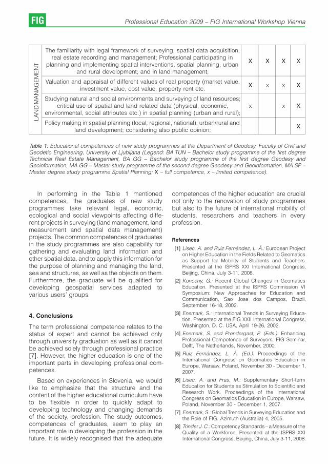
LA
ND
MA
NA
GE
ME
NT
The familiarity with legal framework of surveying, spatial data acquisition,real estate recording and management; Professional participating in
planning and implementing spatial interventions, spatial planning, urbanand rural development; and in land management;
X X X X
Valuation and appraisal of different values of real property (market value,investment value, cost value, property rent etc.
X x x X
Studying natural and social environments and surveying of land resources;critical use of spatial and land related data (physical, economic,
environmental, social attributes etc.) in spatial planning (urban and rural);x x X
Policy making in spatial planning (local, regional, national), urban/rural andland development; considering also public opinion;
X
Table 1: Educational competences of new study programmes at the Department of Geodesy, Faculty of Civil andGeodetic Engineering, University of Ljubljana (Legend: BA TUN – Bachelor study programme of the first degreeTechnical Real Estate Management, BA GG – Bachelor study programme of the first degree Geodesy andGeoinformation, MA GG – Master study programme of the second degree Geodesy and Geoinformation, MA SP –Master degree study programme Spatial Planning; X – full competence, x – limited competence).
In performing in the Table 1 mentionedcompetences, the graduates of new studyprogrammes take relevant legal, economic,ecological and social viewpoints affecting diffe-rent projects in surveying (land management, landmeasurement and spatial data management)projects. The common competences of graduatesin the study programmes are also capability forgathering and evaluating land information andother spatial data, and to apply this information forthe purpose of planning and managing the land,sea and structures, as well as the objects on them.Furthermore, the graduate will be qualified fordeveloping geospatial services adapted tovarious users’ groups.
4. Conclusions
The term professional competence relates to thestatus of expert and cannot be achieved onlythrough university graduation as well as it cannotbe achieved solely through professional practice[7]. However, the higher education is one of theimportant parts in developing professional com-petences.
Based on experiences in Slovenia, we wouldlike to emphasize that the structure and thecontent of the higher educational curriculum haveto be flexible in order to quickly adapt todeveloping technology and changing demandsof the society, profession. The study outcomes,competences of graduates, seem to play animportant role in developing the profession in thefuture. It is widely recognised that the adequate
competences of the higher education are crucialnot only to the renovation of study programmesbut also to the future of international mobility ofstudents, researchers and teachers in everyprofession.
References
[1] Lisec, A. and Ruiz Fernandez, L. A.: European Projecton Higher Education in the Fields Related to Geomaticsas Support for Mobility of Students and Teachers.Presented at the ISPRS XXI International Congress,Beijing, China, July 3-11, 2008.
[2] Konecny, G.: Recent Global Changes in GeomaticsEducation. Presented at the ISPRS Commission VISymposium: New Approaches for Education andCommunication, Sao Jose dos Campos, Brazil,September 16-18, 2002.
[3] Enemark, S.: International Trends in Surveying Educa-tion. Presented at the FIG XXII International Congress,Washington, D. C. USA, April 19-26, 2002.
[4] Enemark, S. and Prendergast, P. (Eds.): EnhancingProfessional Competence of Surveyors. FIG Seminar,Delft, The Netherlands, November, 2000.
[5] Ruiz Fernandez, L. A. (Ed.): Proceedings of theInternational Congress on Geomatics Education inEurope, Warsaw, Poland, November 30 - December 1,2007.
[6] Lisec, A. and Fras, M.: Supplementary Short-termEducation for Students as Stimulation to Scientific andResearch Work. Proceedings of the InternationalCongress on Geomatics Education in Europe, Warsaw,Poland, November 30 - December 1, 2007.
[7] Enemark, S.: Global Trends in Surveying Education andthe Role of FIG. Azimuth (Australia) 4, 2005.
[8] Trinder J. C.: Competency Standards – a Measure of theQuality of a Workforce. Presented at the ISPRS XXIInternational Congress, Beijing, China, July 3-11, 2008.
FIG Professional Education 2009 – FIG International Workshop Vienna

[9] Enemark, S. and Plimmer, F.: Mutual Recognition ofprofessional Qualification. FIG publication nr. 27, FIGOffice, Copenhagen, 2002.
[10] Mattsson, H.: Educational Profiles of Land Surveyors inWestern and Central Europe. Presented at the FIGSeminar Enhancing Professional Competence ofSurveyors, Delft, The Netherlands, November, 2000.
[11] Heine, E., Mesner, A., Schafer, T. and Steinkellner, G.:European Education in Geodetic Engineering, Carto-graphy and Surveying - Skills of graduates required byEuropean enterprises. FIG Workshop on eGovernance,Budapest, Hungary, April 27-29, 2006.
[12] European Council and Commission: ModernisingEducation and Training: a vital Contribution toProsperity and Social Cohesion in Europe. OfficialJournal of the European Union – Council Document C79/1, 2006.
[13] Faculty of Civil and Geodetic Engineering, University ofLjubljana: Annual and Other Reports. Ljubljana.
[14] Drobne, S., Petrovic, D. and Lisec, A.: New StudyPrograms of Geodetic Engineering in Slovenia.Proceedings of the International Congress on Geo-matics Education in Europe, Warsaw, Poland, Novem-ber 30 - December 1, 2007.
[15] Drobne, S., Breznikar, A. and Babic, U.: Mnenjediplomantov o ucinkovitosti studija geodezije (=Graduate’s Opinion on Efficiency of Study ofSurveying). Geodetski vestnik 50(2): 270-286, 2005.
[16] Drobne, S. and Modic, I. 2007: Mnenje delodajalcev oucinkovitosti studija geodezije (= Employe’s Opinion onEfficiency of Study of Surveying). Geodetski vestnik51(1): 85-101, 2007.
Contact
Assist. Prof. Anka Lisec, PhD, University of Ljubljana,University of Ljubljana, Faculty of Civil and GeodeticEngineering, Jamova 2, SI-1000 Ljubljana, Sloveniae-mail: [email protected] Lect. Samo Drobne, MSc, University of Ljubljana,University of Ljubljana, Faculty of Civil and GeodeticEngineering, Jamova 2, SI-1000 Ljubljana, Sloveniae-mail: [email protected]. Prof. Dusan Petrovic, PhD, University of Ljubljana,University of Ljubljana, Faculty of Civil and GeodeticEngineering, Jamova 2, SI-1000 Ljubljana, Sloveniae-mail: [email protected]. Prof. Bojan Stopar, PhD, University of Ljubljana,University of Ljubljana, Faculty of Civil and GeodeticEngineering, Jamova 2, SI-1000 Ljubljana, Sloveniae-mail: [email protected]
A. Lisec, S. Drobne, D. Petrovic, B. Stopar: Professional competences... FIG
The Role of the Engineering Consultant for
Surveying in Foreign Projects
Michaela Ragoßnig-Angst, Vienna
1. Background
Austrian engineers have been renowned asexperts, not only domestically, but also abroadfor centuries. One only has to think of names suchas Viktor Kaplan, Joseph Ressel, Carl Ritter vonGhega or Ferdinand Porsche. But the country hasalso produced a number of prominent geodesists:Joseph Liesgang, for example, made a majorcontribution to land surveying during the era ofMaria Theresia. Between 1761 and 1765, heoversaw the surveying of the Vienna meridian,which extends 320 km from Brunn am Gebirge viaVienna to Varazdin. The starting point for themeasurements was a 12km long section of what istoday Wiener Neustadter Strasse, which was thenknown as the Neunkirchner Allee. From 1785, heheaded the work on the Josephinen Kastaster, theland register, in Galicia.
Another renowned Austrian geodesist wasSimon von Stampfer who played a significant rolein the federal and provincial surveying betweenBavaria and Austria in 1819. During the measu-rement of the well known meridian triangulationarc, the so-called Struve Arc, which extends fromHammerfest (near the North Pole) to Izmail (nearthe estuary of the Danube into the Black Sea),Stampfer undertook the conversion of the Russianetalons to the Austrian fathom (Klafter) standard.He also published logarithmic-trigonometric ta-bles for universities which were used throughoutthe entire empire [1] [4].
Today, Austrian engineers are also renownedfor being reliable and competent. The outstandingstandard of education and the high technicalstatus of the profession in Austria are key factorswhen it comes to projects abroad.
2. The role of the engineering consultant forsurveying
In principal, the geodesist provides land-relatedinformation which serves as a basis necessary forvarious commercial activities, further planningwork, for infrastructure projects and for buildingsof all sorts, for agriculture, environmental protec-tion and for the preservation of the culturallandscape. The EU has indisputably brought
fundamental changes to all professions; morecompetition, however, also means more oppor-tunities in new markets. The limited geographicsize of Austria places limits on the domesticmarket, making it both an opportunity and anecessity to expand into new markets. If one goesback to the 1990s and the period immediatelyafter the fall of the Iron Curtain and compares theEastern European countries of then with the statusquo today, then one can see the rapidtechnological and economic development whichhas taken place. This was only made possible bywestern investors and lenders who financed andimplemented necessary projects – projects thatalso require reliable partners.
Every projects starts with a search for suitableland and sites. The clarification of boundaries andownership rights are the core activities of theengineer consultant for surveying. In severalcountries there are still no land registers andrestitution issues remain unresolved. It is stillpossible, however, to reconcile the (mostlycomplex) requirements of investors with the localconditions in these markets.
Austria has had an exemplary land registersystem since the 19th Century which is admiredworldwide. The quality of the system is highlightedby the fact that the majority of the countries in theformer Austro-Hungarian Empire have againintroduced this system and other countries suchas Poland and Russia have also based theirsystems on the Austrian one. Austria is alsoplaying a pioneering role in the modernisationprocess. The Austrian land database is serving asa model for modern solutions in several EasternEuropean countries [2].
This system-based knowledge is an advan-tage for engineering consultants for surveyingworking on projects in these countries. We oftencome across old land register plans that we areaccustomed to. In technical terms, the detailscontained on these old plans are soon under-stood, allowing us to focus on the considerablymore difficult issue – the question of ownership.
FIG Professional Education 2009 – FIG International Workshop Vienna

3. Partnerships – one approach toimplementing foreign projects
Since many investors often favour an overallsolution for their technical projects, it is importantto take the opportunity to enter into inter-professional partnerships with other consultantssuch as land planners, architects, culturaltechnicians, etc in order to be able to offersuch comprehensive solutions. The future also liesin international partnerships. The realities of theEU demand such international networks, particu-larly when one considers that Austria is a smallmember state with numerous neighbouringcountries. The main focus of this paper willtherefore be on the countries of Central andEastern Europe.
What were the reasons behind our company,Vermessung Angst, acquiring investments ab-road and involving itself in projects? Following thesetting up, in 1968, and experience in managing amedium-sized surveying office in Vienna, thefounder of Vermessung Angst, my father JosefAngst, began to look beyond Austria’s borders foropportunities to expand. He sought footholds inthose countries enjoying the economic boom and,as a result, set up various international operationsin Central and Eastern Europe as a supplement tothe company in Austria. There were no plans tooutsource Austrian contracts abroad in order totake advantage of the lower wages, nor was theidea to use Austrian personnel abroad to anysignificant extent. The central idea was simply toestablish strong partnerships abroad, particularlyin Eastern Europe.
In the course of the expansion of the EU, thesepartnerships have given rise to a wide variety ofadvantages. For example, it is important to have alocal partner in the home country where theproject will be implemented when submittingtenders for international projects. In addition, thelack of effective borders has created numeroussynergy effects such as the simple exchange ofinstruments and equipment. This makes invest-ments more profitable. A specialisation in variouskey areas on the part of the individual companiescan also be advantageous.
It is difficult to manage foreign projects onlyfrom Austria. True to our firm belief that the whole isstronger than the individual parts, the partner-ships and cooperations with local companies thatVermessung Angst has entered into have provento be extremely successful. The following factorshave played a role in this success:
& The most difficult task, and one which requiresmore than a little good luck, is in the selection ofthe right foreign partner. A decision has to bereached in a short period of time and it has to bethe right one in technical, organisational andrelationship terms. The possibility of failure cannever be excluded, which is why you need to becareful with investments in the early stages.Training of the future partner at the offices of theparent company and getting to know the keypersonnel in one’s own office has proven to beeffective and reduces the risk of later failure.
& The relationship with the general managers insitu should be on the basis of a partnershipamong equals. Any form of dictatorial manage-ment should be avoided.
& Suitable profit-sharing models (in terms ofrevenues and profits) and a reasonabledividend policy are a means of binding generalmanagers more closely to the company.
& Financial support from the Austrian company issomething which should be confined to theearly stages if possible. The foreign companymust be able to finance itself in the short-term.
& Good training of the partners and leadingemployees during the company’s first few yearsalso appears to be a further important successfactor. Another is constant controlling andmonitoring of the situation.
& One of the tasks of the Austrian company is topass on information regarding technical deve-lopments to the partner companies and also toensure that these companies update theirtechnical equipment to the extent that this isfinancially possible and prudent.
& It is also important to constantly communicaterequirements and to define targets in terms ofturnover and profits. The Austrian companyshould also be a source of ideas with regard tothe companies’ strategic direction.
4. Training situation in CEE countries
One key factor relevant to a partnership-basedapproach to implementing foreign projects is thelocal training situation. The following is a summaryof our experience to date in this regard in selectedCEE countries:
& Czech Republic and Slovakia
The training of personnel (particularly in the CzechRepublic) is excellent. Many academics haveeven completed two degrees (mostly onetechnical and one commercial). The quality ofthe work is very high.
M. Ragoßnig-Angst: The Role of the Engineering Consultant for Surveying in Foreign Projects FIG
& Hungary:
The level of training and technology is on a parwith Western Europe. The quality of the work,however, is often only satisfactory.
& Croatia:
Both the level of training and the quality of the workcan be regarded as good.
& Bosnia:
As a result of the brain drain associated with therecent war, the level of training at present is verypoor. The quality of the work also suffers as a resultand can only be regarded as satisfactory.
& Romania:
An increase in terms of quality has been seen in allsectors of the Romanian market in the past threeyears. The quality of the work still leaves a lot to bedesired in some cases. The personnel (particu-larly the younger ones) are, however, diligent andwilling to work.
The importance of knowledge transfer isdependent on the relevant training situation.
5. Knowledge transfer: how can it be ensuredthat projects yield the desired results?
As mentioned above, the level of training andeducation in the field of surveying is generally highin Austria. University-based education in particu-lar, especially at the Vienna University ofTechnology, compares well internationally accor-ding to the global ranking of natural sciences in2008 [5]. This ensures that leading personnelcontinue to have the skills they need to meet thechallenges of this profession.
More problematic, however, is the area ofpublic-sector education for school leavers follo-wing the discontinuation of the surveying courseat the technical college in Vienna. This is leadingto a lack of adequately trained technicians in anindustry which, to a great extent, is dependent onpersonnel with qualifications of this level. The onlyway of securing a practical qualification in thisindustry in Austria is to complete an apprentice-ship. A surveying course is offered by theChamber of Architects and Chartered Enginee-ring Consultants to apprentices who have gainedseveral years’ practical experience as a means ofcompleting their training.
This also presents a problem for employers inAustria’s private sector. There are only limitededucational possibilities at the level of surveyingtechnicians. The only real option left in order to
keep the skills of personnel updated and,ultimately, to underpin the profession’s goodreputation both at home and abroad, is to rely onin-company training.
Other European countries are also confrontedwith similar problems. In our experience, theengineering consultants are highly skilled, but it isdifficult to find good technicians. One (part of the)solution can be knowledge transfer withinpartnerships.
Let’s explore knowledge transfer further bymeans of an example:
An Austrian real estate investor commissions asurvey of usable floor space in a shopping centrein Romania. Such assignments are still relativelyrare in Romania, with the result that the personnelin this country are not up to performing such tasks.The situation in Austria in this respect is different. Awealth of appropriate requirement-specific know-ledge has been established in the course ofvarious past assignments of this nature. Thisexperience can now be made available to theRomanian partner by means of knowledgetransfer.
The first step in this case involved appointing atrained Austrian technician to work alongside theRomanian team during the initial project phase.When it was clear that the local team hadunderstood what the task involved and was awareof the problems entailed, it was possible for thelocal personnel to complete the assignment.
The second step was the preparation of theplans. Although sample plans were madeavailable, the first draft was not on a par withAustrian quality standards. This was followed by aweek-long on-the-job training course in Vienna.The results of the training were very satisfactoryand, consequently, not only had the necessaryknowledge transfer taken place, but the localpartner now has the skills necessary for furtherprojects of this kind.
This is just one example of many, but highlightshow knowledge transfer can work.
Last but not least, working in other countries isgreat fun since this constantly provides oppor-tunities to broaden one’s horizons and to meetpeople with completely different perspectives onlife and radically different approaches to solvingproblems.
FIG Professional Education 2009 – FIG International Workshop Vienna

References
[1] WALDHAUSL Peter, Vermessung und Weltkulturerbe,Presentation at the 14th International Geodetic Con-gress 2007, Obergurgl
[2] WESSELY Reinhold, Geoinformation – Fundament derWirtschaft (in German), VGI, Vol. 1/04
[3] http://de.wikipedia.org/wiki/Joseph_Liesganig; acces-sed on: 26.10.2008
[4] http://de.wikipedia.org/wiki/Simon_Stampfer; acces-sed on: 04.11.2008
[5] http://www.topuniversities.com/gradschool/schools/data/school_profile/default/viennauniversitytechno-logy/; accessed on: 18.01.2009
Contact
Michaela Ragoßnig-Angst, MSc. (OU), Mayergasse 11,A-1020 ViennaE-mail: [email protected]
M. Ragoßnig-Angst: The Role of the Engineering Consultant for Surveying in Foreign Projects FIG
On Computerising Geodetic Surveys in the
Context of Higher Education
Luciana Oprea, Ioan Ienciu, Romania
Abstract
The external academic quality appraisal of Romanian higher education institutions in the fundamental subject area ofEngineering Sciences and its respective study programmes is based on (reference) standards and performanceindicators set by a number of documents. These are the methodology, the reference standards and the performanceindicators list approved by the Government Decision no. 1418 of 11.10.2006, with which operates the RomanianAgency for Quality Assurance in Higher Education (ARACIS). There are also the specific standards applying to allfundamental subject areas, approved by ARACIS, in accordance with the Law no. 87/10 April 2006, Article 17.Regarding of this Government Decision, the curricula must specify the volume in hours for teaching activities withstudents and the number of hours required for the student’s individual training as well as the number of credits for eachdiscipline, both for coursework and project work or other applied activities.In order to analyse the quality of Romanian higher education for the “Geodetic Engineering’’ domain, in the field of ‘Landsurveying and Cadastre’ and the universities’ role in training new experts in the field, we want to present the curriculumof a young university – ‘December 1st 1918’ University of Alba Iulia, in relation to a university with a long tradition ofRomanian geodetic education – the Technical University of Civil Engineering, Bucharest.Also, as computer technologies evolve rapidly, the training of future university graduates has to be tuned to the latestdevelopments, so as to offer them better qualifications for the labour market. By this way, all the university including‘December 1st 1918’ University of Alba Iulia and „The Technical University of Civil Engineering’’ of Bucharest through itsBachelor’s degree programme “Territory measurements and cadastre’’, has included in the curricula a series ofspecialty disciplines that will help future geodetic engineers acquire competences in computerising geodetic surveys.The future graduates will also be able to adjust to the constant dynamics of this line of work.The description of the curricula shows that surveying students, during the four years of study, acquire enoughknowledge and practical skills to work with computers and specialized surveying software. These skills may increasethe quality and productivity of the surveyor’s work. They also become a huge advantage when using other computersoftware and other types of equipment in other surveying-related areas.All these accomplishments are the result of the connection between theory and practice, of a syllabus that iscompetitive with the dynamics of development in the field of land measurement and cadastre and also of the ease inassimilating all new information in the field.Trough the study of a wide range of topographic equipment and of computer software that are presently used inRomania and abroad, our young engineers are prepared to apply for jobs in Romania or in any member state of theEuropean Union. They are familiar with or they can adjust very easily to the specific topographical and computertechnology that they may be required to use.As regards the access to further studies, the holders of a Bachelor’s degree in Engineering will have access to Masterstudies and then to doctoral studies not only in Romania but also in the European Union or elsewhere.
1. The legislative framework for assuring thequality of Romanian higher education
The external academic quality appraisal ofRomanian higher education institutions in thefundamental subject area of Engineering Sci-ences and its respective study programmes isbased on (reference) standards and performanceindicators set by a number of documents. Theseare the methodology, the reference standards andthe performance indicators list approved by theGovernment Decision no. 1418 of 11.10.2006,with which operates the Romanian Agency forQuality Assurance in Higher Education (ARACIS).There are also the specific standards applying toall fundamental subject areas, approved by
ARACIS, in accordance with the Law no. 87/10April 2006, Article 17.
The following items of legislation were consi-dered when the Specific standards were elabo-rated:
& Law 288/24 June 2004 on the organization ofhigher education;
& The Government Decision 1175/06 Sept. 2006on the organization of undergraduate studiesand on the approval of the list containingsubject areas and undergraduate study pro-grammes,
& The Government Decision 404/29 March 2006on the organization of higher education;
FIG Professional Education 2009 – FIG International Workshop Vienna

IndicatorFull-time courses,
Distance education,Part-time courses
Evening classes
Length of studies, of which: 8 sem. 10 sem.
Minimum semester length 14 weeks 14 weeks
Number of hours/ week 26 –28 21 – 22
Added length of practical activities 4 – 6 weeks 4 – 6 weeks
Length of practical activities dedicatedto the preparation of the Thesis/Diplomaproject
2 – 3 weeks (during the lastyear of studies)
2 – 3 weeks (during the lastyear of studies)
Table 1: Length of studies and the volume of teaching activities.
& Law 87/10 Apr. 2006 on the approval of theGovernment Emergency Ordinance No. 75/2005 regarding the assurance of educationquality.
2. Contents of education as a process
The educational contents in the fundamental areaof Engineering Sciences contains the generalstandards common to all fundamental areas andforms of education approved by the ARACISCouncil, to which the following specific standardsare added.
The length of studies and the volume ofteaching activities must be as shown in table 1.
The required total number of hours of activityorganized according to the curriculum is between3152 and 3376, for full-time courses, distancecourses and part-time courses, to which thespecialty practice is added. The minimum volumeof practical activities is 240 hours.
The curricula must specify the volume in hoursfor teaching activities with students and thenumber of hours required for the student’sindividual training as well as the number ofcredits for each discipline, both for courseworkand project work or other applied activities.
The curricula of the study programmes in thefields from the fundamental field of EngineeringSciences must contain the following categories ofdisciplines, with the following percentages (the
percentages are calculated to the total volume ofhours, the 240 hours of minimum practical activityincluded):
& fundamental disciplines, minimum 17%;
& disciplines of the study area minimum 38 %;
& specialty disciplines, minimum 25 %;
& complementary disciplines, maximum 8%.
3. A comparative curricula study
In order to analyse the quality of Romanian highereducation in the field of ‘Land surveying andCadastre’ and the universities’ role in training newexperts in the field, we would like to show thecurriculum of a young university – ‘December 1st
1918’ University of Alba Iulia, in relation to auniversity with a long tradition of Romaniangeodetic education– the Technical University ofCivil Engineering, Bucharest.
‘December 1st 1918’ University of Alba Iulia,Romania was established in 1991. In 1997, theBachelor’s degree programme ‘Cadastre’ wasintroduced. In 2001, the long-term form ofeducation for the same the programme wasapproved and in 2005, it changed according tothe Bologna process, into a new programmecalled ‘Land surveying and Cadastre’, subjectarea: Geodetic engineering.
Currently, the approved curriculum for thisstudy programme is shown in table 2.
L. Oprea, I. Ienciu: On Computerising Geodetic Surveys in the Context of Higher Education FIG

Cr:
No:
Designation of Disciplines
Type
of
Dis
cip
line
Tuition and individual study hours
Num
bero
fcre
dits
Num
ber
of
weeks
Tuition hoursIndividual
study
Teaching activities
Tota
lhours=w
eek
Tota
lhours=sem
este
r
Tota
lhours=w
eek
Tota
lhours=sem
este
r
Cours
e
Sem
inar
Labora
tory
Pro
ject
1st YEAR
1ST SEMESTER
1 Mathematical analysis F 14 2 1 – – 3 42 3 42 4
2 Linear algebra F 14 1 1 – – 2 28 3 42 3
3 Descriptive geometry F 14 2 – 2 – 4 56 3 42 4
4 Physics F 14 2 – 1 – 3 42 2 28 4
5 Topography 1 F 14 2 – 2 – 4 56 3 42 5
6 Chemistry F 14 2 – 2 – 4 56 3 42 4
7Geodetic instruments and
surveying methodsD 14 2 – 2 – 4 56 3 42 4
COMPLEMENTARY DISCIPLINES
8 Foreign language 1 C 14 – 2 – – 2 28 1 14 2
9 Sport C 14 – 2 – – 2 28 0 0 –
TOTAL – 1st semester – 14 13 6 9 0 28 392 21 294 30
2ND SEMESTER
1 Special mathematics F 14 2 1 – – 3 42 1.5 21 3
2Differential and analytical
geometryF 14 2 1 – – 3 42 1.5 21 3
3 Technical and map drawing F 14 2 – 1 – 3 42 2 28 3
4 Topography 2 F 14 2 – 2 2 6 84 3 42 6
5Measurements compensa-
tion and statistics 1F 14 2 – 1 – 3 42 1.5 21 4
6 General geology D 14 2 – 2 – 4 56 1.5 21 3
7 Geography D 14 2 – – – 2 28 1.5 21 3
COMPLEMENTARY DISCIPLINES
8 Foreign language 2 C 14 – 2 – – 2 28 1.5 21 2
9 Sport C 14 2 – – 2 28 –
TOTAL – 2nd semester(without the practical activi-
ties)– 14 14 6 6 2 28 392 14 196 27
10Practical activities 1 (Topo-
graphy)D 2 – – – – 0 60 30 60 3
TOTAL / YEAR – 28 27 12 15 2 56 844 65 550 60
FIG Professional Education 2009 – FIG International Workshop Vienna

2ND YEAR
1st SEMESTER
1Computer programming and
numerical methodsF 14 2 – 2 – 4 56 3 42 5
2 Soil study D 14 2 1 – – 3 42 2.5 35 4
3General course in Civil, In-dustrial and Agricultural
EngineeringD 14 2 – 1 – 3 42 3 42 4
4 Geodesy I S 14 2 – 2 – 4 56 3 42 5
5Measurements compensa-
tion and statistics 2F 14 2 2 – – 4 56 3 42 5
ELECTIVE DISCIPLINES
6Geo-technique D 14 2 – 2 – 4 56 2 28 5
Tectonics
COMPLEMENTARY DISCIPLINES
7 Foreign language 3 C 14 – 2 – – 2 28 1.5 21 2
8 Sport C 14 2 – – 2 28 0
TOTAL 1st Semester – 14 12 7 7 0 26 364 18 252 30
2ND SEMESTER
1Land laws and cadastral
legislationD 14 2 2 – – 4 56 3 42 4
2Geodetic surveying by wa-
vesS 14 2 – 2 – 4 56 3 42 5
3 Geodesy 2 S 14 2 – 2 2 6 84 3 42 6
4 Photogrammetry 1 S 14 2 2 – – 4 56 3 42 5
5
Automatic processing ofgeodetic data
S 14 2 – 2 – 4 56 2 28 5
Programme operation in to-pography and cadastre
COMPLEMENTARY DISCIPLINES
6 Foreign language 4 C 14 – 2 – – 2 28 1.5 21 2
7 Sport C 14 2 – – 2 28 0
TOTAL – 2nd semester(without the practical activi-
ties)– 14 10 8 6 2 26 364 15.5 217 27
8Practical activities 1 (Topo-
graphy)D 2 – – – – – 60 30 60 3
TOTAL / YEAR – 28 22 15 13 2 52 788 63.5 529 60
L. Oprea, I. Ienciu: On Computerising Geodetic Surveys in the Context of Higher Education FIG
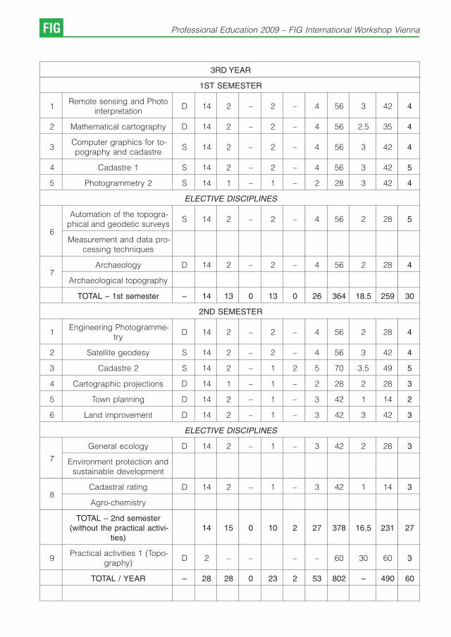
3RD YEAR
1ST SEMESTER
1Remote sensing and Photo
interpretationD 14 2 – 2 – 4 56 3 42 4
2 Mathematical cartography D 14 2 – 2 – 4 56 2.5 35 4
3Computer graphics for to-pography and cadastre
S 14 2 – 2 – 4 56 3 42 4
4 Cadastre 1 S 14 2 – 2 – 4 56 3 42 5
5 Photogrammetry 2 S 14 1 – 1 – 2 28 3 42 4
ELECTIVE DISCIPLINES
6
Automation of the topogra-phical and geodetic surveys
S 14 2 – 2 – 4 56 2 28 5
Measurement and data pro-cessing techniques
7Archaeology D 14 2 – 2 – 4 56 2 28 4
Archaeological topography
TOTAL – 1st semester – 14 13 0 13 0 26 364 18.5 259 30
2ND SEMESTER
1Engineering Photogramme-
tryD 14 2 – 2 – 4 56 2 28 4
2 Satellite geodesy S 14 2 – 2 – 4 56 3 42 4
3 Cadastre 2 S 14 2 – 1 2 5 70 3.5 49 5
4 Cartographic projections D 14 1 – 1 – 2 28 2 28 3
5 Town planning D 14 2 – 1 – 3 42 1 14 2
6 Land improvement D 14 2 – 1 – 3 42 3 42 3
ELECTIVE DISCIPLINES
7
General ecology D 14 2 – 1 – 3 42 2 28 3
Environment protection andsustainable development
8Cadastral rating D 14 2 – 1 – 3 42 1 14 3
Agro-chemistry
TOTAL – 2nd semester(without the practical activi-
ties)14 15 0 10 2 27 378 16.5 231 27
9Practical activities 1 (Topo-
graphy)D 2 – – – – 60 30 60 3
TOTAL / YEAR – 28 28 0 23 2 53 802 – 490 60
FIG Professional Education 2009 – FIG International Workshop Vienna
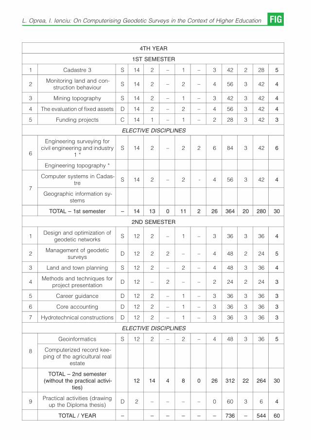
4TH YEAR
1ST SEMESTER
1 Cadastre 3 S 14 2 – 1 – 3 42 2 28 5
2Monitoring land and con-
struction behaviourS 14 2 – 2 – 4 56 3 42 4
3 Mining topography S 14 2 – 1 – 3 42 3 42 4
4 The evaluation of fixed assets D 14 2 – 2 – 4 56 3 42 4
5 Funding projects C 14 1 – 1 – 2 28 3 42 3
ELECTIVE DISCIPLINES
6
Engineering surveying forcivil engineering and industry
1 *S 14 2 – 2 2 6 84 3 42 6
Engineering topography *
7
Computer systems in Cadas-tre
S 14 2 – 2 - 4 56 3 42 4
Geographic information sy-stems
TOTAL – 1st semester – 14 13 0 11 2 26 364 20 280 30
2ND SEMESTER
1Design and optimization of
geodetic networksS 12 2 – 1 – 3 36 3 36 4
2Management of geodetic
surveysD 12 2 2 – – 4 48 2 24 5
3 Land and town planning S 12 2 – 2 – 4 48 3 36 4
4Methods and techniques for
project presentationD 12 – 2 – – 2 24 2 24 3
5 Career guidance D 12 2 – 1 – 3 36 3 36 3
6 Core accounting D 12 2 – 1 – 3 36 3 36 3
7 Hydrotechnical constructions D 12 2 – 1 – 3 36 3 36 3
ELECTIVE DISCIPLINES
8
Geoinformatics S 12 2 – 2 – 4 48 3 36 5
Computerized record kee-ping of the agricultural real
estate
TOTAL – 2nd semester(without the practical activi-
ties)12 14 4 8 0 26 312 22 264 30
9Practical activities (drawing
up the Diploma thesis)D 2 – – – – 0 60 3 6 4
TOTAL / YEAR – – – – – – 736 – 544 60
L. Oprea, I. Ienciu: On Computerising Geodetic Surveys in the Context of Higher Education FIG
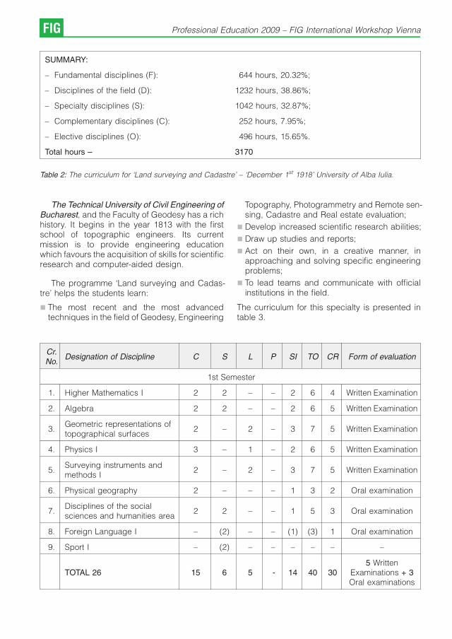
SUMMARY:
– Fundamental disciplines (F): 644 hours, 20.32%;
– Disciplines of the field (D): 1232 hours, 38.86%;
– Specialty disciplines (S): 1042 hours, 32.87%;
– Complementary disciplines (C): 252 hours, 7.95%;
– Elective disciplines (O): 496 hours, 15.65%.
Total hours – 3170
Table 2: The curriculum for ‘Land surveying and Cadastre’ – ‘December 1st 1918’ University of Alba Iulia.
The Technical University of Civil Engineering ofBucharest, and the Faculty of Geodesy has a richhistory. It begins in the year 1813 with the firstschool of topographic engineers. Its currentmission is to provide engineering educationwhich favours the acquisition of skills for scientificresearch and computer-aided design.
The programme ‘Land surveying and Cadas-tre’ helps the students learn:
& The most recent and the most advancedtechniques in the field of Geodesy, Engineering
Topography, Photogrammetry and Remote sen-sing, Cadastre and Real estate evaluation;
& Develop increased scientific research abilities;
& Draw up studies and reports;
& Act on their own, in a creative manner, inapproaching and solving specific engineeringproblems;
& To lead teams and communicate with officialinstitutions in the field.
The curriculum for this specialty is presented intable 3.
Cr.No.
Designation of Discipline C S L P SI TO CR Form of evaluation
1st Semester
1. Higher Mathematics I 2 2 – – 2 6 4 Written Examination
2. Algebra 2 2 – – 2 6 5 Written Examination
3.Geometric representations oftopographical surfaces
2 – 2 – 3 7 5 Written Examination
4. Physics I 3 – 1 – 2 6 5 Written Examination
5.Surveying instruments andmethods I
2 – 2 – 3 7 5 Written Examination
6. Physical geography 2 – – – 1 3 2 Oral examination
7.Disciplines of the socialsciences and humanities area
2 2 – – 1 5 3 Oral examination
8. Foreign Language I – (2) – – (1) (3) 1 Oral examination
9. Sport I – (2) – – – – – –
TOTAL 26 15 6 5 - 14 40 305 Written
Examinations + 3Oral examinations
FIG Professional Education 2009 – FIG International Workshop Vienna
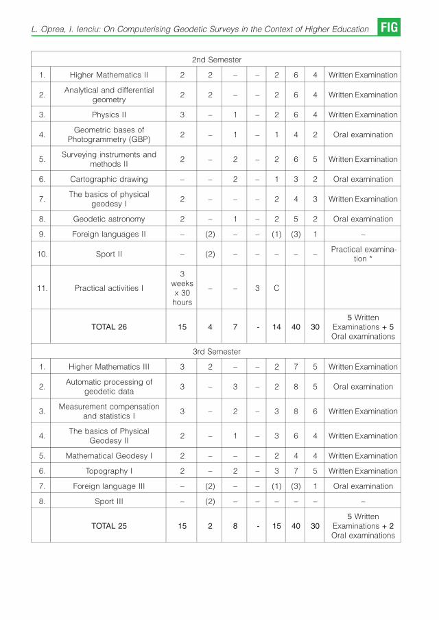
2nd Semester
1. Higher Mathematics II 2 2 – – 2 6 4 Written Examination
2.Analytical and differential
geometry2 2 – – 2 6 4 Written Examination
3. Physics II 3 – 1 – 2 6 4 Written Examination
4.Geometric bases of
Photogrammetry (GBP)2 – 1 – 1 4 2 Oral examination
5.Surveying instruments and
methods II2 – 2 – 2 6 5 Written Examination
6. Cartographic drawing – – 2 – 1 3 2 Oral examination
7.The basics of physical
geodesy I2 – – – 2 4 3 Written Examination
8. Geodetic astronomy 2 – 1 – 2 5 2 Oral examination
9. Foreign languages II – (2) – – (1) (3) 1 –
10. Sport II – (2) – – – – –Practical examina-
tion *
11. Practical activities I
3weeksx 30hours
– – 3 C
TOTAL 26 15 4 7 - 14 40 305 Written
Examinations + 5Oral examinations
3rd Semester
1. Higher Mathematics III 3 2 – – 2 7 5 Written Examination
2.Automatic processing of
geodetic data3 – 3 – 2 8 5 Oral examination
3.Measurement compensation
and statistics I3 – 2 – 3 8 6 Written Examination
4.The basics of Physical
Geodesy II2 – 1 – 3 6 4 Written Examination
5. Mathematical Geodesy I 2 – – – 2 4 4 Written Examination
6. Topography I 2 – 2 – 3 7 5 Written Examination
7. Foreign language III – (2) – – (1) (3) 1 Oral examination
8. Sport III – (2) – – – – – –
TOTAL 25 15 2 8 - 15 40 305 Written
Examinations + 2Oral examinations
L. Oprea, I. Ienciu: On Computerising Geodetic Surveys in the Context of Higher Education FIG

4th Semester
1.Measurement compensation
and statistics II3 – 2 – 2 7 5 Written Examination
2. Topography II 2 – – 2 3 73+
2
Written Examination+ Project work
3. Planimetric Photogrammetry 2 – 1 – 2 5 3 Written Examination
4.Computer systems in land
surveying3 – 2 – 2 7 5 Written Examination
5.The basics of geodetic
surveying by waves2 – 1 – 1 4 2 Oral examination
6. Mathematical Geodesy II 2 – 1 – 2 5 4 Written Examination
7.General course in Civil, Industrial
and Agricultural Engineering2 – 2 – 1 5 2 Oral examination
8. Foreign language IV – (2) – – (1) (3) 1 Oral examination
9. Sport IV – (2) – – – – –Practical
examination *
10. Practical activities II
3weeks
x30hours
– – 3 C
TOTAL 27 16 - 9 2 13 40 30
5 WrittenExamination +5
Oral examinations+ 1Project work
5th Semester
1.The basics of engineering
surveying2 – 2 – 2 6 5 Written Examination
2. Mathematical Geodesy II – – – 1 1 2 2 Project work
3. Mathematical Geodesy III 2 – – – 1 3 4 Written Examination
4. Map projections 2 – 1 – 3 6 4 Written Examination
5.Electronic distance
measurement2 – 2 – 2 6 4 Written Examination
6.Stereo-Photogrammetry and
Photo-interpretation2 – 1 – 2 5 4 Written Examination
7. Roads and works of art 2 – 2 – 2 6 3 Oral examination
8.Hydrotechnical constructions
and public technical utility
systems
2 – 2 – 2 6 3 Oral examination
9. Foreign language V – (2) – – (1) (3) 1 Oral examination
TOTAL 25 14 - 10 1 15 40 30
5 WrittenExaminations + 3Oral examinations+ 1Project work
FIG Professional Education 2009 – FIG International Workshop Vienna
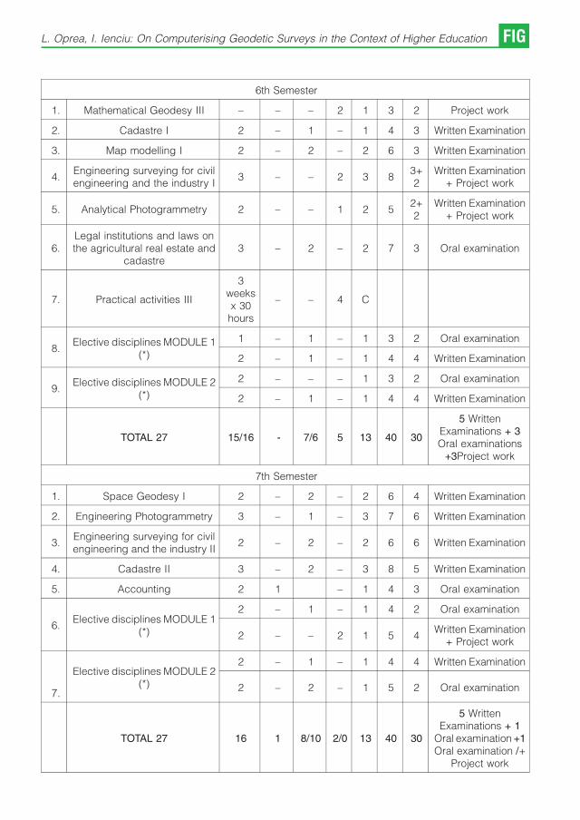
6th Semester
1. Mathematical Geodesy III – – – 2 1 3 2 Project work
2. Cadastre I 2 – 1 – 1 4 3 Written Examination
3. Map modelling I 2 – 2 – 2 6 3 Written Examination
4.Engineering surveying for civilengineering and the industry I
3 – – 2 3 83+2
Written Examination+ Project work
5. Analytical Photogrammetry 2 – – 1 2 52+2
Written Examination+ Project work
6.Legal institutions and laws onthe agricultural real estate and
cadastre3 – 2 – 2 7 3 Oral examination
7. Practical activities III
3weeksx 30hours
– – 4 C
8.Elective disciplines MODULE 1
(*)
1 – 1 – 1 3 2 Oral examination
2 – 1 – 1 4 4 Written Examination
9.Elective disciplines MODULE 2
(*)
2 – – – 1 3 2 Oral examination
2 – 1 – 1 4 4 Written Examination
TOTAL 27 15/16 - 7/6 5 13 40 30
5 WrittenExaminations + 3Oral examinations
+3Project work
7th Semester
1. Space Geodesy I 2 – 2 – 2 6 4 Written Examination
2. Engineering Photogrammetry 3 – 1 – 3 7 6 Written Examination
3.Engineering surveying for civilengineering and the industry II
2 – 2 – 2 6 6 Written Examination
4. Cadastre II 3 – 2 – 3 8 5 Written Examination
5. Accounting 2 1 – 1 4 3 Oral examination
6.Elective disciplines MODULE 1
(*)
2 – 1 – 1 4 2 Oral examination
2 – – 2 1 5 4Written Examination
+ Project work
7.
Elective disciplines MODULE 2(*)
2 – 1 – 1 4 4 Written Examination
2 – 2 – 1 5 2 Oral examination
TOTAL 27 16 1 8/10 2/0 13 40 30
5 WrittenExaminations + 1
Oral examination +1Oral examination /+
Project work
L. Oprea, I. Ienciu: On Computerising Geodetic Surveys in the Context of Higher Education FIG

8th Semester
1.The design and optimization of
geodetic networks2 – – – 2 4 3 Written Examination
2. Digital Photogrammetry 2 – 1 – 2 5 5 Written Examination
3. Remote sensing 2 – 2 – 3 7 5 Written Examination
4.Land improvement and town
planning2 – 1 – 1 4 3 Oral examination
5.Monitoring the behaviour of
lands and construction works2 – 1 – 3 6 5 Written Examination
6. Organizing geodetic works 2 – 2 – 1 5 3 Oral examination
7.Elective disciplines MODULE 1
(*)
2 – 1 – 1 4 2 Oral examination
2 – 1 – 2 5 4 Written Examination
8.Elective disciplines MODULE 2
(*)
2 – 2 – 2 6 4 Written Examination
1 – 1 – 1 3 2 Oral examination
TOTAL 16/15 - 9/10 - 15 40 305 Written
Examinations + 3Oral examinations
Table 3: The curriculum for ‘Land surveying and Cadastre’ – the Technical University of Civil Engineering.
The analysis of the two curricula shows analmost 90% similarity of fundamental disciplines,as some of them have close designations and anidentical content. The disciplines in the field andthe specialty disciplines are almost identical fromthe point of view of designations and syllabi. Thecomplementary disciplines and the specialtypractical activities at the two Universities areidentical.
From the point of view of study year structureand the number of hours for each semester, bothprogrammes meet the Bologna requirements.
4. Automation of geodetic surveys in aneducational context
As computer technologies evolve rapidly, thetraining of future university graduates has to betuned to the latest developments, so as to offerthem better qualifications for the labour market. Inthis context, ‘December 1st 1918’ University ofAlba Iulia, Romania, through its Bachelor’s degreeprogramme ‘Territory measurements and cadas-tre’, has included in the curricula a series ofspecialty disciplines that will help future geodeticengineers acquire competences in computerisinggeodetic surveys. The future graduates will also
be able to adjust to the constant dynamics of thisline of work.
In order for students to become acquaintedwith the topographic technical equipment andsoftware, the first year of studies includes coursessuch as ‘General topography’, ‘Topographicaltools and measurement methods’ and ‘Computerprogramming.’ Thus, students in topographyacquire abilities in using the topographic instru-ments, both in theory and in practice, as thecourses and their practical applications include.
In the second year of studies, there is a gradualpassage towards the use of the electronicequipment required by the course and laboratoryactivities of the discipline ‘Geodetic surveys bywaves’. The computerized processing of data isstudied within software applications that are usedboth nationally and internationally (Caltop, Cal-top8, Toposys).
The automation of topographic and geodeticsurveys (third year of studies) is studied in thecontext of creating the link between geodeticequipment and computers. Thus, students areintroduced to the software that allows datatransfers from and to the memory of devices
FIG Professional Education 2009 – FIG International Workshop Vienna
and machines, to the facilities that they offer and tothe possibilities of creating topographic applica-tions in programming environments.
The computer design of a project’s graphics isexemplified through drawing software used wor-ldwide such as AutoCAD, Surfer etc., and alsothrough national software that satisfies therequirements of the Romanian market, such asMapSys.
The last stage (the fourth year of study) in thetraining of future geodetic surveyors includes thestudy of satellite methods of surveying in view ofcreating a unitary geodetic network at the nationallevel and which can be part of the Europeangeodetic network. Also, Photogrammetry and itsmethods for point determination are considered,with examples of specific pieces of equipment.The purpose is to integrate the informationspecific to a project in a geographic system ofinformation.
The description of the curricula shows thatsurveying students, during the four years of study,acquire enough knowledge and practical skills towork with computers and specialized surveyingsoftware. These skills may increase the qualityand productivity of the surveyor’s work. They alsobecome a huge advantage when using othercomputer software and other types of equipmentin other surveying-related areas.
5. Conclusion
All these accomplishments are the result of theconnection between theory and practice, of asyllabus that is competitive with the dynamics ofdevelopment in the field of land measurement andcadastre and also of the ease in assimilating allnew information in the field.
Trough the study of a wide range oftopographic equipment and of computer softwarethat are presently used in Romania and abroad,
our young engineers are prepared to apply forjobs in Romania or in any member state of theEuropean Union. They are familiar with or they canadjust very easily to the specific topographicaland computer technology that they may berequired to use.
As regards the access to further studies, theholders of a Bachelor’s degree in Engineering willhave access to Master studies and then todoctoral studies not only in Romania but also in theEuropean Union or elsewhere.
References
[1] The Charter of the ‘December 1st 1918’ University ofAlba Iulia, 2004.
[2] The student’s guidebook, ‘December 1st 1918’ Univer-sity of Alba Iulia, 2008.
[3] The Government Decision 1175/06 Sept. 2006 on theorganization of undergraduate studies and on theapproval of the list containing subject areas andundergraduate study programmes.
[4] The Government Decision 404/29 March 2006 on theorganization of higher education.
[5] Law 288/24 June 2004 on the organization of highereducation.
[6] Law 87/10 Apr. 2006 on the approval of the GovernmentEmergency Ordinance No. 75/2005 regarding theassurance of education quality.
[7] Specific standards for study programmes in thefundamental subject area of ‘engineering sciences’,The Romanian Agency for Quality Assurance in HigherEducation (ARACIS), 2007.
[8] www.uab.ro.
[9] www.utcb.ro.
[10] http://geodezie.utcb.ro.
Contact
Assist. Lect. Phd. stud. eng. Luciana Oprea, ‘December 1st
1918’ University of Alba Iulia, 11-13 Nicolae Iorga street,Alba County, Postal Code 510009, RomaniaE-mail: [email protected], [email protected]. Prof. Phd. eng. Ioan Ienciu, ‘December 1st 1918’University of Alba Iulia, 11-13 Nicolae Iorga street, AlbaCounty, Postal Code 510009, RomaniaE-mail: [email protected], [email protected]
L. Oprea, I. Ienciu: On Computerising Geodetic Surveys in the Context of Higher Education FIG

Teaching GIS in Central Asia
Rainer Pruller, Johannes Scholz,
Clemens Strauß, Graz;
Teresa Achleitner, Salzburg
1. Introduction
In the year 2008 the Institute of Geoinformation,Graz University of Technology, Austria participa-ted in two geo-information science relatedactivities in Central Asia. The first activity wasthe international conference on “GIS for the futureof Central Asia’’ in Bishkek, Kyrgyzstan and thesecond activity was a train the trainer workshoptitled “Geo-Informatics for Mountain EnvironmentManagement’’ in Katmandu, Nepal.
These two events brought the authors to thelocal geo-information scientist community for afirst reality check of teaching geo-informationtopics on-site. Furthermore the novices among theAustrian participants socialized with the expertsand existing contacts got reacquainted. Based onthese fruitful networking and on the variousimpressions of these events, new ideas accordingto teaching Geographic Information Systems(GIS) related to local needs in Central Asia arearising for future activities.
The main challenges for teaching activities arefinding the right Geographic Information (GI) toolsthat are available for the local institutions andhaving access to regional geo-data so that theparticipants will develop a better relation to thelectures.
2. Teaching experiences in Central Asia
The contact to teaching activities in the CentralAsian region of the Institute of Geoinformation atGraz University of Technology began in spring2008 with the invitation of the Eurasia-PacificUninet to a symposium in Bishkek, Kyrgyzstan.The goal of the Eurasia-Pacific Uninet is to supportcontacts between universities, universities ofapplied sciences and other research facilities inAustria and member institutions in the Pacific, inEast, Central and South Asia. At present there areapproximately 100 member institutions in Bhutan,India, Kazakhstan, Kyrgyzstan, Mongolia, Nepal,Austria, Republic of Korea, Russian Federation,Tajikistan, Taiwan, Uzbekistan and the People’sRepublic of China. Financial support is given from
the Ministry of education, science and culture andfrom the Austrian Exchange Service (OAD)(Eurasia-Pacific Uninet, 2008 [5]).
The first participation of the Institute withinEurasia-Pacific Uninet was a Geoinformationsymposium in Bishkek under the topic “GIS forthe Future of Central Asia’’ (GISCA’08, 2008 [6]).The main intention for holding this conference wasthe encouragement of international cooperationand exchange of knowledge in GIS education inCentral Asia. In the course of the conference theAustria-Central Asian Centre for GIScience wasinaugurated which is the point of contact forAustrian initiatives for supporting the develop-ment of advanced competence in GIScience.Further objectives of the centre are the support ofeducation through teacher education and sum-mer schools and the support of joint initiativestowards externally funded projects in researchand education (Austrian-Central Asia Centre forGIScience, 2008). Based on contacts of thissymposium the Institute was invited to a “Train-the-Trainer“-Workshop in Kathmandu, Nepal underthe topic ’’Geoinformatics for Mountain Environ-ment Management (mountainGIS)’’ organized bythe International Centre for Integrated MountainDevelopment (ICIMOD). ICIMOD is an internatio-nal independent mountain learning and know-ledge centre committed to improving the sustai-nable livelihoods of mountain peoples in theextended Himalayan region (ICIMOD, 2008 [7]).The content presented by the Institute of Geoin-formation covered the topics forest growthmodelling and forest inventory with GIS in general.
Future activities will expand to Mongolia:During a visit of Khovd University in WesternMongolia, several ideas for organizing workshopsand realizing ideas in the field of agriculture orlandscape development were developed.
3. Teaching GIS
The idea of teaching GIS in Central Asia is anemerging topic in GI education. The drivingfactors for teaching Geoinformation in these
FIG Professional Education 2009 – FIG International Workshop Vienna
countries are explained in the following para-graph. First of all we want the Central Asiancountries to benefit from the skills the studentsacquire. Thus the economy may develop furtherand through the application of GIS techniques asustainable and ecologically worthwhile growthcan be maintained. By supporting international ornational Organisations within the scope ofmultilateral research projects as well as projectscarried out by local GIS experts and institutions anecological and economical balance may be found.Furthermore we can facilitate social networking(student exchange, etc.) to enhance the culturalexchange.
In order to have sustainable teaching “results’’the Problem Based Learning approach (Kopp andMandl 2002 [8], Car 2004 [4]) seems to beappropriate. In traditional instruction methods, theso-called instructional view, students are oftentrapped in a passive role (Mader and Stockl, 1999[9]), and we observe the phenomenon of inertknowledge (Artelt et. al., 2001 [1]; Arzberger andBrehm, 1994 [2]). This form of isolated knowledgecan be reproduced by the student, but cannot beapplied to any practical problem. This problemarises when theoretical information is presentedbased on the following assumptions (Kopp andMandl, 2002 [8]):
& Knowledge is a consequence of learning bothfacts and routines.
& Knowledge can be transmitted from one personto another like products.
& Learners can bridge the gap between theoryand practice themselves.
Mader and Stockl (1999) [9] and Kopp and Mandl(2002) [8] proposed, that a certain learningapproach, the constructivist approach in learningand teaching may overcome the creation of inertknowledge. According to this the learner has to beset in an active position, and the process oflearning should be a social process. Thus theteaching itself does not have a prominent part, ithas act in the sense of encouraging, supporting,as well as consulting.
To create a Problem-based learning environ-ment, both the instructional and the constructivistview have to be combined in an appropriate andbalanced manner. Thus, Reinmann-Rothmeierand Mandl (2001) [11] proposed four principlesthat have to be considered:
Authenticity and reference to application:Knowledge is presented using “real-world’’examples and showcases that may originate
from the professional field. With this “practical’’-oriented presentation students are motivated tofocus more on specific topics.
Multiple contexts and perspectives: Each topicshould be presented from different contexts inorder to avoid becoming trapped in one certaincontext. This results in a broader and flexibleknowledge, which helps applying the latter invarying situations.
Social learning arrangements: Due to the factthat cooperation and communication is essentialin every professional environment, learning has topick up and facilitate that concept. Working ingroups on certain tasks deepens the understan-ding of the gained knowledge and fosters thestudents’ communication abilities.
Instructions, information and constructionsupply: Instructions are a way of supporting thestudents while they are working on tasks. Theteacher has to maintain that the tasks are not toocomplex and thus avoid a cognitive overload. Inaddition the students should look for moredetailed information for completing the task ontheir own, based on the instructions from theteacher.
Based on these assumptions, we want to workspatial problems and incorporate problems fromthe local countries/education institutions. Project/Problem input from students and local professorsis very welcome, which intensifies the learningand teaching experience for both sides. A majorpart of the teaching material may be disseminatedvia the TUG TeachCenter – similar to theinteractive learning portal geoinformation.net(Plumer and Quadt, 2009 [10]). Moreover thisapproach helps to have a sustainable impact onthe students, due to the fact that they can gothrough the teaching material more often – even ifthe course is over.
Based on our experience open source soft-ware is appropriate for sustainable teaching, dueto the following facts: minimum costs for licensing(mostly available for free), great community basedsupport. For most GIS-related tasks there is anopen source tool available that can be applied inthe course of Problem Based Learning. Basicallywe provide “the way of thinking’’ during the shorttheoretical lectures which will be the basis forunderstanding GIS tools.
What our institution can provide are: highlyskilled and motivated teaching personnel, a greatnumber of students for exchange programs, a
R. Pruller, J. Scholz, C. Strauß, T. Achleitner: Teaching GIS in Central Asia FIG

pool of various geo-data, as well as severalinfrastructure facilities.
4. Workshop Participants Mentoring
Beside the primary content of a workshop that isfocused on the knowledge transfer of technolo-gies and methods in the area of GI in theconnection with local needs, the basic infra-structure to support this intention should be keptclearly in mind. Furthermore this infrastructureshould lead to a sustainable learning success.
For this purpose the mentoring phases of aworkshop have to be identified considering theparticipant’s needs, and link the necessities to thesupporting teaching infrastructure.
4.1 Mentoring Phases
The phases where participants of a workshopneed support or additional information can bedivided into three temporally separated parts:
& Pre-workshop
In this phase the potential participant shouldreceive general information about the structure ofthe workshop, links to useful documents andsoftware tools to exercise a preparation indepen-dently and get fit for the workshop. Additionally aportal for participant – participant and participant– lecturer communication in the pre-workshopphase should be provided for shorter communica-tion channels and better information flow.
& Workshop
During the workshop itself the presentation slidesor e-books, concerning the theoretical part, andinstructions for practical work during the labsequences and their sample solutions should beavailable by the supporting teaching infrastruc-ture.
& Post-workshop
Following the on-site workshop phase furthermentoring of the participants might be necessi-tated. For example coaching a long time labproject, a knowledge evaluation for a workshopcertificate, or just the facility to archive lecturedocuments and results arising from lab or projectwork.
4.2 Mentoring Infrastructure
The required functionality figured out afore can befound on several e-learning platforms. Theseplatforms include a data exchange area and aforum for communication purposes as their basicmodules. One exponent of e-learning platforms in
the free and open-source software community isrepresented by moodle (http://moodle.org). Asthey propagate on their web site, moodle can beseen as a course management system, learningmanagement system or as a virtual learningenvironment.
At the Graz, University of Technology the primeinfrastructure for supporting educational needsfor online and online-supported teaching is calledTeachCenter (http://tugtc.tugraz.at). A secondsystem, LearnLand, completes the infrastructureand focuses on the documentation and presenta-tion of individual work (http://tugll.tugraz.at).
& TeachCenter
The function range of this infrastructure isadaptable to the needs of a course. The keytools include an administration area for generalcourse information, time schedules or a groupingtool, a download area for lecture documents, aforum for communication and the possibility totake an examination (e.g. a multiple choice test).Moreover the course participants have the facilityto upload their own documents arising from labs orproject work for evaluation and exchange.
& LearnLand
Contrary to the TeachCenter, LearnLand providesan internet blogging framework including socialnetworking facilities for participants and lecturers.Within a blog lab or project work can be recordedfor the participants themselves, for a participant –lecturer communication or even for the wholeLearnLand community to share ideas and collectnew approaches.
5. Workshop concept “Solar energy potentialin Central Asia 2009’’
This workshop is planned for summer 2009 inBishkek, Kyrgyzstan for students and lecturers ofGIScience in Central Asia and will be founded bythe Eurasia-Pacific Uninet. The workshop willcreate skills for the application of tools which cancontribute a main part for the security in regionalenergy supply. The calculation of the theoretical,technical and economical potential of solarenergy can be handled by GIS. This is thesubject-specific aim of the workshop. To createpractical qualifications for the implementation ofsolar energy in Central Asia is the strategicobjective. Therefore the structure of the workshopis built in that way that 75 % will be focused ontheoretical background for modelling solar (inaddition wind and hydro) potentials in the region.Austrian experts from these scientific fields are
FIG Professional Education 2009 – FIG International Workshop Vienna

invited to communicate the participant ideas andconcepts of solar, wind and hydro models whichare implemented in the second part of theworkshop with appropriate open-source GIS tools.This part will be about 25 % of the planned fivedays duration. We will offer several modules tomeet requirements of the participants.
Practical applications will be the collection andspatial analysis of energy characteristics todocument the actual state, the calculation ofsolar potential and the calculation of potential formicro hydro plants in Central Asia. For these tasksonly for the participants available data will be usedto ensure that they can implement the methods intheir own workflows. The calculation of solarpotential will be done by the free available r.sunmodel which is implemented in the GRASS GISopen source environment. The model is able toserve raster maps of selected components (beam,diffuse and reflected) of solar irradiance [W.m*],solar incident angle [], the daily sum of solarirradiation [Wh.m-2] and duration of the beamirradiation [minutes] as output. The daily sum ofsolar irradiation and the duration of the beamirradiation computed as integration of irradiancevalues that are calculated in a selected time stepfrom sunrise to sunset. Another open sourcegeographic information system is SAGA GISwhich is also able to calculate solar radiationcoefficients within a very powerful terrain analysis.The decision which specific GIS tool will bechosen depends on the foreknowledge of theparticipants. Due to the fact that the workshop ismodular built, we can teach these modules whichfit best. Further worked out modules besidesGRASS GIS or SAGA GIS are the UMN Mapserverfor delivering calculation results, PostgreSQL/PostGIS database, PHP &phpMapscript and thetreatment of further open source GIS likeQuantumGIS or gvSIG.
The workshop should not only be seen asknowledge transfer from Austrian universities tothe counterparts in the Central Asia region, itshould also be a starting point for furthercooperation with Central Asian partners.
6. Eurasia-Pacific Uninet
Eurasia-Pacific Uninet is a network which aims atestablishing contacts and scientific partnershipsbetween Austrian universities, universities ofapplied sciences, other research institutionsand member institutions in East Asia, CentralAsia, South Asia and the Pacific region. Thenetwork was founded in the year 2000 by Prof. Dr.
Brigitte Winklehner and is strongly supported bythe Austrian Federal Ministry for Science andResearch and the Austrian Exchange Service(OAD).
At present with a total of 115 memberinstitutions in Austria, China, Mongolia, theRussian Federation, Korea, Kazakhstan, Kyrgyz-stan, Tajikistan, Uzbekistan, Bhutan, Nepal andIndia, the network promotes multilateral scientificcooperation, joint research projects, conferencesas well as faculty and student exchange.
Eurasia-Pacific Uninet is the largest sovereignuniversity network of its kind within Europe.
The goal of Eurasia-Pacific Uninet is to supportinterdisciplinary scientific exchange between itsmember institutions through
& scholarships for Post Docs and Ph.D. studentscoming to Austria
& projects
& summer schools
Further Eurasia-Pacific Uninet supports scientific,economic and cultural relations between Austriaand the target countries, R&D activities ofmultinational companies, visiting professorshipand reciprocal acknowledgement of study de-grees and programs. Eurasia-Pacific Uninetsupplies contacts between government agen-cies, educational institutions and companies,intercultural expertise through intense programsand courses and initiates joint research centers,joint schools for teaching, research and training,the development of joint curricula and double-degree program and research activities by meansof workshops, seminars and conferences andthrough the exchange of scientists amongmember institutions.
7. Outlook
Based on the impressive experiences in Kyrgyz-stan and Nepal in 2008, the authors are highlymotivated to intensify the existing contacts toCentral Asian GI institutions and ideas for new GIworkshops are arising. Additionally differentAustrian GI institutions in close connection andsciences, which are not situated in the core area ofGIS, have the chance to reactivate existing socialnetworks or built up new links covering suchteaching projects.
Furthermore, by creating lessons dealing withlocal circumstances the sensitivity rises forproblems and challenges in Central Asia thatare hardly known in the western world. This will
R. Pruller, J. Scholz, C. Strauß, T. Achleitner: Teaching GIS in Central Asia FIG
start at the technical infrastructure of communica-tion networks, like internet, concern the configura-tion of teaching class rooms, like computers andsoftware, and end up at the accessible geo-data.
Last but not least the importance of the Eurasia-Pacific Uninet as an institution for academicexchange should not remain unmentioned. Thisinstitution acts as base for scientific activities inCentral Asia and provides the social infrastructureon-site which allows the participants to focus oncontents but not on organizational work.
References
[1] Artelt, C., Baumert, J., Klieme, E., Neubrand, M.,Prenzel, M., Schiefele U., Schneider, W., Stanat, P.,Tillmann, K.-J. and Weiß, M. (Hrsg.) (2001): Pisa 2000:Zusammenfassung zentraler Befunde. URL: http://www.mpib-berlin.mpg.de/pisa/ergebnisse.pdf [ac-cessed on: 12.1.2009].
[2] Arzberger, H. and Brehm, K.-H. (1994): Computer-unterstutzte Lernumgebungen. Planung, Gestaltungund Bewertung. Erlangen: Publicis.
[3] Austrian-Central Asia Centre for GIScience (2008):Objectives. http://www.aca-giscience.org/ .
[4] Car, A. (2004): The Problem-Based Learning Approachin Geoinformation: An Example. In: Proceedings of TheFourth European GIS Education Seminar (EUGISES2004), Villach, Austria.
[5] Eurasia-Pacific Uninet (2008): Activities. http://www.eu-rasiapacific.net .
[6] GISCA’08 (2008): Second Central Asia GIS Conference– GISCA’08 “GIS for the Future of Central Asia’’. http://gis.org.kg/confer/gisca08/ .
[7] ICIMOD (2008): About ICIMOD. http://www.icimod.org/?page=abt.
[8] Kopp, B. and H. Mandl (2002): Problem-BasedLearning in virtual GIS learning-environments. In:Proceedings of The Third European GIS EducationSeminar (EUGISES 2002), Girona, Spain.
[9] Mader, G. and W. Stockl (1999): Virtuelles Lernen.Begriffsbestimmung und aktuelle empirische Befunde.Innsbruck, Studien Verlag.
[10] Plumer, L. and U. Quadt (2009): Interactive GISLearning Portal geoinformation.net. URL: www.geoin-formation.net [accessed on: 12.1.2009].
[11] Reinmann-Rothmeier, G. & Mandl, H. (2001): Unter-richten und Lernumgebungen gestalten. In: A. Krapp &B. Weidenmann (Hrsg.), Padagogische Psychologie.Ein Lehrbuch (S. 601-646). Weinheim: PsychologieVer-lagsUnion.
Contact
Rainer Pruller, Johannes Scholz, Clemens Strauß, GrazUniversity of Technology, Institute of Geoinformation, 8010Graz, Steyrergasse 30, Austria
E-mail: [email protected],[email protected],[email protected]
Teresa Achleitner, Eurasia-Pacific Uninet, 5020 Salzburg,Kaigasse 28, Austria
E-mail: [email protected]
FIG Professional Education 2009 – FIG International Workshop Vienna

Navigating the global consciousness:
A Young Surveyor’s Future
Kate Fairlie, United Kingdom/Australia
Summary
The crisis of surveying continues to haunt the literature of Commission 2 – low young surveying numbers, low FIG(International Federation of Surveyors) awareness and a near-invisible surveying public profile. But what is beingdone?This paper summarises key recent literature relating to this issue and the future of the profession – particularly withreference to future applications and marketing. It is suggested that a clear, concise surveying profile is developed bothnationally and regionally to enhance the public profile. Borders across the European Union and Asia may be opening up,but unless the borders between surveying disciplines become similarly permeable, surveying professionals will find itdifficult to evolve in the future marketplace. Ultimately an inclusive profession needs to be developed and marketed toall.Young surveyors in particular will benefit from such a move. As a generation they have already progressed beyond suchissues – having grown up with this international world of ‘plug-and-play’. But as a profession, greater mentorship andcommunication – across borders, generations and cultures – is required to raise the public surveying profile, in additionto the FIG profile within the profession.The Young Surveyors Working Group was developed from 2006 to address such issues, and is rapidly consolidating onachievements so far – notably a record student attendance at the FIG Working Week in Stockholm, 2008. On the eve ofthe group’s development into an FIG network, this paper summarises the key opportunities its success will create.
Keywords: Young surveyors, capacity development, standards, professional development, skills shortage, education
1. Crisis? What Crisis?
The crisis of a surveying skills shortages acrossthe majority of countries in the Western developedworld has been well documented (e.g. Williamson(1998); Hannah (2006); O’Connell (2006); Maho-ney et al. (2007); Hucker (2008)). These authorsreport a shortage of students, a shortage ofgraduates remaining in the surveying profession,and a shortage of young surveyors activelyparticipating in the professional organisations.
In Asia and the developing world, the story issimilar, however with increasing access to highereducation and rapidly growing infrastructure it isnot so much a problem of insufficient students asmuch as a lack of graduates and experiencedprofessionals to lead the way. The Yildiz TechnicalUniversity Department of Geodesy and Photo-grammetry Engineering in Turkey is planning todownsize student numbers due to limitedteaching resources (Aydin et al. 2006). Weigeland Svabensky (2006) (and also Meha (2008))further introduce the Eastern European viewpoint– that the required numbers of students andgraduates is in strong contrast to the demands ofpractical teaching which requires lower staff tostudent ratios. In many cases across the globe thenumber of students graduating is in no way
indicative of the number of graduates looking forjobs in the surveying disciplines – many findingapparently more lucrative work in adjacent fieldsand/or more lucrative countries (Hucker, 2008).
Mahoney et al. (2007) reports:
“It has been clear for some time, at least fromthe evidence presented at a number of FIG events,that the surveying profession is heading for aglobal crisis. The profession is changing and thenumber of competencies in which surveyors areactively involved is over 200.’’
So the crisis is a “skills’’ crisis and a numberscrisis. Many developed countries are struggling toattract and retain students and graduates ofsurveying, whilst developing countries are despe-rate for cross-disciplinal surveying leaders toassist in education, developing infrastructure andsetting up effective land management systems.
1.1 The crisis in other industries
Is the crisis unique to surveying? In the Australianand UK cases, skills shortages are also seenacross the IT (Thomson, 2008), Agricultural (King,2004), Engineering (HRM, 2007) and Construction(Dainty et al., 2005) sectors – namely, those verysectors in which surveying skills are essential. The
Professional Education 2009 – FIG International Workshop Vienna FIG

economy boom up until 2008 is likely to have beenparticularly key in this, with job growth nowsignificantly stalling, however Hucker (2008)reports:
“The recent credit crisis in the UK and thedownturn in new starts for housing and offices willhave an impact, but the latest survey figuresavailable (Q1, 2008) still show 30% companies inthe UK reporting difficulties in recruiting quantitysurveyors’’
Certainly plans by federal governments tostimulate the market are unlikely to negativelyimpact surveying employment opportunities
1.2 Marketability?
So is it a question of marketing? Hannah (2006)says yes by contrasting the cases of New Zealandand Australia – the former exhibiting no problemsin attracting students and reporting similarfindings to the Norwegian example of Leiknes(2008) where a change of name in the surveyingcourse to one more recognised by societyimproved student applications and enrolments(in the Norwegian case, from ‘Land Consolidation’to ’Land Surveying and Management’). In thiscase then, the marketing was successful in that itwas in the language of the customer – that is, thelayperson had a greater understanding of what“Land Surveying’’ was in comparison with “LandConsolidation’’.
This may also be the case in developingcountries, or those recovering from environmentaland political upheaval. Meha (2008) reports thecase of Kosovo, where student numbers are at (analbeit small) capacity. In this case, it is perhapsthe rapid infrastructural changes and develop-ment opportunities that are marketing the need forsurveyors. Ghana (Tenadu and Djaba, 2008), iftaken simplistically, may be in a similar category.
In such new surveying establishments, howe-ver, it may also be a case of ‘inclusivity’ – that is, abroader definition of the label ‘surveyor’. Withfewer experienced professionals about, firms aremore likely to be approached for a wider range ofsurveying tasks, rather than finding niches as mayhave happened in developed countries in thepast. Individuals are more likely to develop a widerrange of skills – ‘jack-of-all-trades’ so to speak.
In the case of Australia, Fryer (1996) says “Inthe 1970s ... about 90% of graduates wereregistered nationally, with this reducing to about50% in the 1980s and about 30% in the 1990s...’’Here Fryer is referring to the percentage of
graduates registered with the Institute of Sur-veyors Australia – an organisation that has theimage of predominantly supporting cadastralsurveyors. With such an image, few graduatesoutside of the cadastral surveying and measure-ment fields would join, let alone activelyparticipate. And yet the surveying professionhas grown rapidly beyond cadastral surveying, ifindeed it ever was restricted to such, and this hasbeen a topic of debate for the last decade in notonly Australia, but more recently Canada. A 2008Canadian report (Statham et al., 2008) reports theproblems of a profession fractured over regionsand disciplines “without an efficient cohesivevoice to respond to the profession’s key users ingovernment, industry and the public’’. Canadaand Australia are now promoting more streamli-ned and inclusive professional organisations,although in the case of Australia at least this isproving difficult with respect to accreditation andgeneral professional image and voice. Theseefforts are similar to the much documentedBologna process (see, for example, Steinkeller &Heine, 2005) which promotes a European-widesystem for education.
2. Changing face of Surveyors
Such efforts taking place across Australia and theEU are the result of two major changes takingplace across all professions – internationalisationand interoperability.
2.1 Internationalisation: The global Surveyor
The surveyors of today work in an increasinglyglobal market. The latter half of the 20th Centurysaw the birth of the United Nations, the formationof the European Union, the World Trade Organisa-tion and the WorldBank – and increasingcollaboration between the FIG and such externalbodies (in particular the UN). The BolognaProcess is now in force, following on fromexchange programs such as ERASMUS inopening up educational borders across Europe.In Asia the “soon to be ratified ASEAN [Associa-tion of South East Asian Nations] FrameworkArrangement for the Mutual Recognition ofSurveying Qualifications’’ (Teo, 2006) will furtheropen up international benefits to the surveyingcommunity.
And so, with increasing internationalisation,rapid technological change and deregulation ofthe profession, the Surveying Profession could beundergoing a ‘growth period’ (as Teo (2007) putsit) now more so than ever “especially conside-
FIG Professional Education 2009 – FIG International Workshop Vienna
ring... the increasing and extensive application ofsurveying and mapping technologies in businesssectors’’ (Teo, 2007).
Again, it is a question of inclusiveness.Surveying in the FIG all-encompassing definitionis indeed rapidly growing – both globally and inapplication – however in a traditional sense, themany surveying disciplines can still be thought ofas discrete, limited packages. Thus, as withgeneration Y, the profession is facing a newparadigm – that of the ‘interoperable’ surveyor
2.2 The interoperable “Plug-and-Play’’Surveyor
“Technology and knowledge are now primaryproduction factors. Technological advances allowinformation to be instantly transmitted across theworld, and the primary competitive advantage acompany possesses is its process of innovationand its ability to derive value from information.’’(-Bullard, 2005)
The equipment we use on a day today basis isincreasingly ‘plug and play’. So too will be (is?) theyoung professional of the future. Williamson(1997) wrote that “environmental degradation,sustainable development, the management of ourcities and economic rationalism all presentenormous opportunities for the surveyors of the21st century’’. The importance of issues central toour profession, such as cadastral reform andspatial data infrastructures, is being realised bypolicy makers as they grapple with the changingeconomic climate, sustainable development andsocial stability (Williamson, 1997).
Prendergast (2006) wrote of the wide range ofEU Directives existing at European level, forexample, the Water Framework Directive, theServices Directive, INSPIRE, the re-emergingPublic Services Information Directive, the Envi-ronmental Directives – all of which presentsignificant opportunities to European surveyors.
Other initiatives such as Galileo (the EuropeanGlobal Navigation Satellite System), GMES(Global Monitoring and Environmental Systems)and eGovernment (to create an InformationSociety and Knowledge Economy) can beharnessed to positively promote surveying asthe profession for future generations.
So with so many opportunities, and withgovernments and policy makers globally realisingthe capabilities of surveyors – how can there be acrisis? Fairlie (2008) largely attributes it to thisissue of “inclusivity’’ – essentially a crisis of identity
and the current industry paradigm of spatialversus surveying. Mahoney & Kavanagh (2006)state “One of the major challenges for theprofession is whether or not it is able to capitaliseupon this change…through the provision ofadded value services and fully engage withsuch diverse markets…’’ And it is a challenge – asWilliamson (1997) states – “there are already otherprofessions moving or ready to move into thesetraditional [and non-traditional] areas of thesurveyor if we don’t act’’ – in which case,surveying could end up as simply one professio-nal branch on the Information Technology tree!
But back to the young surveyor, and thechallenge of surveying versus spatial.
Hucker (2008) reports an increased number ofstudents studying towards a UK surveying degree(in contrast to the crisis), however significantnumbers do not continue to work as graduates inthe UK – instead many take up positions inadjacent fields. From the Swedish viewpoint,Andersson et al. (2006) report the low commit-ment of graduates to continuing work with thenational land authority (Lantmateriet): “Here[Sweden], the trainees think that prospects arepoorer if one stays too long at any one place...’’. Itis no longer considered enough to be a specialistin field – a more general knowledge acrosssurveying thought and technology is required.
Enemark (2001) suggested that the educatio-nal profile of the future for surveyors shouldencompass the three areas of MeasurementScience, Spatial Information Management, andLand Management – but the young surveyor’seducation in the future will surely engender muchmore than this, with few surveying courses stik-king to just these fundamentals. The University ofCalgary in Canada offers a geomatic engineeringdegree specializing also in biomedical enginee-ring – utilizing spatial and measurement skills inthe medical field. Meantime other universities areexpanding beyond the traditional civil engineeringor built environment/planning linkages to furthercombine surveying degrees with law, business,information technology, electrical engineering,software engineering and more.
However, with new disciplines seeminglydeveloping every day, surveyors cannot expecta regulated and/or standardised market ofgeoinformatics and geo-services to evolve sorapidly (Prendergast, 2006). Tenadu and Djaba(2008) give examples of the need for havingadequate standards in a national surveyingmarket (in this case, Ghana) and the consequen-
K. Fairlie: Navigating the global consciousness FIG
ces a lack of adequate standards can have ongrowth and professional integrity. With developingcountries experiencing the expansion of asurveying market (e.g. Kosovo – Meha (2008) )and the growing internationalisation of ourprofession (European Union, ASEAN, etc.) natio-nal and regional professional bodies will needassistance in developing and regulating newethical principles and codes of professionalconduct that not only suit the new roles surveyingprofessionals will be working in, but the varyingcultures across which they will be operating. Thelack of surveying professionals and leaders inthese developing countries makes this need evenmore critical – the young surveyors of the futurewill be dependent on the guidance of mentors anda reachable professional body.
In summary: the uncertain times we havebegun to witness in 2008 – ‘the credit crunch’ – willfurther exacerbate the demand for multi-skilled‘plug-and-play’ professionals – “levelling internaldemand may be achieved by working a number ofsectors and encouraging flexible movementacross sectors’’ (Hucker, 2008). Clear and trans-parent benchmarking procedures will be neces-sary to evaluate performance, identify needs anddevelop best practice for the future. This will beparticularly important to young surveyors expe-riencing the effects of the skills and age gapbefore them.
2.3 Key issues as presented by youngsurveyors at FIG Working Week 2008
So far young surveyor issues have beenpresented from a profession and societalviewpoint – what did the young surveyorsthemselves put forth as critical for the future?
In essence, papers presented during theYoung Surveyor session at the FIG Working Weekin Stockholm, Sweden 2008 had three key themes:
& The FIG Young Surveyors Working Group(Kivilcim & McAlister, 2008) and schemes toimprove young surveyor involvement (Fairlie,2008)
& Young Surveyor employment and professionaldevelopment (Brazenor, Carter & Dalrymple,2008; Hasova, Svabensky & Weigel, 2008)
& Surveying Education (Boder, 2008; Aranda etal., 2008)
Kivilcim & McAlister (2008) gave an overview ofthe FIG Young Surveyors Working Group, to beupdated and reviewed in the following sections,whilst Fairlie (2008) outlined a key opportunity (the
Young Surveyors Beyond Horizons Project, to berun at the FIG2010 World Surveying Congress) toaddress a lack of young surveyor awareness anda lack of young surveyor participation in the FIG.Brazenor, Carter & Dalrymple (2008) streng-thened support for the FIG Young SurveyorsNetwork by placing an onus on both youngsurveyors and employers to develop themselvesand provoke development opportunities whileBoder (2008) and Aranda et al. (2008) furtheroutlined opportunities for young surveyors andyoung surveyor promotion in the education sector.
These then are the main issues that YoungSurveyors are passionate about, and whichshould be addressed by the FIG Young SurveyorsWorking Group, which will soon become into aYoung Surveyors Network: namely young sur-veyor involvement, across all surveying discipli-nes and markets, in the future of the profession
3. Young Surveyors Network
“Lower surveyor numbers has a circular effect:Anecdotal evidence from the UK indicates that arelatively high proportion of surveying studentsare encouraged into the profession by personalcontact with a practising surveyor who is either amember of the family or a close family friend’’(Mahoney et al. 2007).
Young surveyors are not only the future of thesurveying profession, but also a key element of the‘now’. They have enormous potential that has notyet been harnessed – specifically in promoting theevolving identity of surveying, and in adapting tonew modes of work. Lack of awareness and lackof involvement may be two key elements inhibitingthe future of surveying but it is communication thatis key. Issues of low student numbers, youngsurveyor shortages and societal awareness areinterrelated (Fairlie, 2008) – students will choosesurveying if they know about it and think of it as achallenging, interesting and ‘wealth-creating’career; but they are not the only market. Withtraditional surveying disciplines opening up into awhole host of alternative applications, as aprofession we need to maintain strong links withadjacent professions and markets. In short – astronger network across generations, acrosscultures and across disciplines is absolutelymandatory for the future of our profession.
3.1 SWOT – Strengths, Weaknesses,Opportunities & Threats
See Table 1 for an overview of the SWOT analysisof the evolving FIG Young Surveyors Network.
FIG Professional Education 2009 – FIG International Workshop Vienna
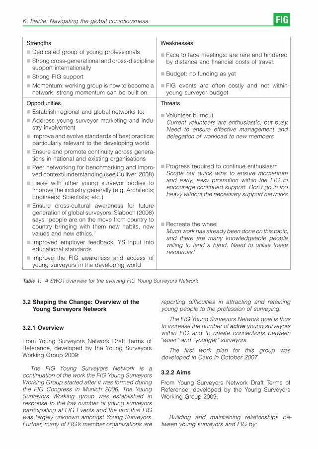
Strengths
& Dedicated group of young professionals
& Strong cross-generational and cross-disciplinesupport internationally
& Strong FIG support
& Momentum: working group is now to become anetwork, strong momentum can be built on.
Weaknesses
& Face to face meetings: are rare and hinderedby distance and financial costs of travel.
& Budget: no funding as yet
& FIG events are often costly and not withinyoung surveyor budget
Opportunities
& Establish regional and global networks to:
& Address young surveyor marketing and indu-stry involvement
& Improve and evolve standards of best practice;particularly relevant to the developing world
& Ensure and promote continuity across genera-tions in national and existing organisations
& Peer networking for benchmarking and impro-ved context/understanding (see Culliver, 2008)
& Liaise with other young surveyor bodies toimprove the industry generally (e.g. Architects;Engineers; Scientists; etc.)
& Ensure cross-cultural awareness for futuregeneration of global surveyors: Slaboch (2006)says “people are on the move from country tocountry bringing with them new habits, newvalues and new ethics.’’
& Improved employer feedback; YS input intoeducational standards
& Improve the FIG awareness and access ofyoung surveyors in the developing world
Threats
& Volunteer burnoutCurrent volunteers are enthusiastic, but busy.Need to ensure effective management anddelegation of workload to new members
& Progress required to continue enthusiasmScope out quick wins to ensure momentumand early, easy promotion within the FIG toencourage continued support. Don’t go in tooheavy without the necessary support networks
& Recreate the wheelMuch work has already been done on this topic,and there are many knowledgeable peoplewilling to lend a hand. Need to utilise theseresources!
Table 1: A SWOT overview for the evolving FIG Young Surveyors Network
3.2 Shaping the Change: Overview of theYoung Surveyors Network
3.2.1 Overview
From Young Surveyors Network Draft Terms ofReference, developed by the Young SurveyorsWorking Group 2009:
The FIG Young Surveyors Network is acontinuation of the work the FIG Young SurveyorsWorking Group started after it was formed duringthe FIG Congress in Munich 2006. The YoungSurveyors Working group was established inresponse to the low number of young surveyorsparticipating at FIG Events and the fact that FIGwas largely unknown amongst Young Surveyors.Further, many of FIG’s member organizations are
reporting difficulties in attracting and retainingyoung people to the profession of surveying.
The FIG Young Surveyors Network goal is thusto increase the number of active young surveyorswithin FIG and to create connections between“wiser’’ and “younger’’ surveyors.
The first work plan for this group wasdeveloped in Cairo in October 2007.
3.2.2 Aims
From Young Surveyors Network Draft Terms ofReference, developed by the Young SurveyorsWorking Group 2009:
Building and maintaining relationships be-tween young surveyors and FIG by:
K. Fairlie: Navigating the global consciousness FIG

Fig. 1: Mind Map of FIG Young Surveyor Committee structure
& Proposing and performing activities during FIGevents to attract and promote FIG as anorganisation for network and knowledge crea-tion;
& Establish necessary Liaison relationships withother Young Surveyors organizations;
& Establishing and maintaining lead contacts toCommission Chairs etc are in place;
& Maintaining an information flow on the YoungSurveyors Network to FIG members, includingthrough the FIG website and FIG Bulletin, andmore directly to relevant Commission Officers;
& Releasing the FIG Young Surveyors Newsletterquarterly with information about what’s happe-ning in the YS community.
The Young Surveyors Network sees itself as at thehub of FIG Young Surveyors activities, making thenecessary linkages and providing the necessaryadvice to commissions and others.
Specific performance indicators include achie-ving the following at or before the FIG2010 WorldSurveying Congress in Sydney, Australia:
Management structure firmly in place, inclu-ding the positions as per Figure 1.
Increase awareness and active participationsuch that elections akin to the FIG Council can beheld for the Young Surveyors Network
Incorporate all regional young surveyor net-works that are currently known to exist, andestablish regional coordinators and a set of tasksto manage regional expansion
3.2.3 Opportunities
Fairlie (2008) outlines the Young SurveyorsBeyond Horizons Project that is the key oppor-
tunity and major project hosted jointly by theYoung Surveyors Working Group and the FIG2010 Young Ambassadors.
From Fairlie (2008):
The project will see a series of technicalactivities held throughout Australia, targeting theapplication of Surveying knowledge and tech-nology. Attendance will be marketed towardsyoung surveyors, adding value to the potentiallylong and expensive journey to Australia. A numberof experienced and professional surveyors will beinvited to attend, building on the mentorshipprogram of the FIG1.2 Young Surveyors WorkingGroup and fulfilling further networking aims of theFIG Congress.
Activities are intended to be either
& Real projects contributing to local communities
& Real projects derived from industry researchand development foci
& Historical projects demonstrating the contribu-tions of the surveying profession to Australia
This opportunity presented by this ambitiousproject is that it is essentially a testing ground forfuture activities like it which add value to YoungSurveyor participation in FIG events, improvefunding possibilities, and generally create mediaattention to the surveying profession. Finally, thisproject is a test of possible future revenuegeneration for Young Surveyor activities.
The ultimate, long-term opportunity is to growthe Young Surveyors Beyond Horizons projectsuch that it fulfils a similar role as Engineer’sWithout Borders (www.ewb-international.org) andArchitects Without Borders (www.awb.ioho-me.net/)/Architects Without Frontiers (www.archi-
FIG Professional Education 2009 – FIG International Workshop Vienna

tectswithoutfrontiers.com.au). Initially projectswould be limited to increasing young surveyornetworks and skill levels whilst profiting our ownindustry: for example, Tenadu & Djaba (2008)mention a lack of GPS baseline permanentreference stations in Ghana, limiting GPS calibra-tion. The Young Surveyor’s Network couldchallenge young surveyors to use this as anopportunity, not only improve the integrity of theprofession in Ghana, but to improve the Africanregional network of young surveyors and inter-national FIG participation. Such projects furtherimprove cross-generational linkages, involvingmore experienced surveyors as consultants andmentors.
Ultimately there is scope for a future, ongoing“Surveyors Without Borders’’ skillpool – andpromotion such that surveyors are the first to becalled for where necessary.
4. Conclusion
“Engineering in the 21st C faces severalchallenges: firstly it is oriented towards globalmarkets and products; secondly, the underlyingknowledge quickly becomes obsolete; thirdly, itmust operate within an increasingly stressednatural and social environment’’ (Enemark, S.2006).
The crisis in surveying – skill shortages and lowpublic awareness – is real, and unlikely to beovercome quickly or easily. However, it is as mucha crisis of interpretation as anything else – thesurveying tools and knowledge is there, it is simplya case communicating its existence, and ensuringthe professional integrity of the industry.
Young Surveyors as a key element of the crisisare also a key solution. The Young Surveyor’sWorking Group has demonstrated the power andcommitment of this generation, and a passion toovercome the challenges of the future. Mentoringand networking across generations and cultureswill be key to continuing and expanding this groupto encompass an international network of youngsurveyors. There are extensive opportunities, andthe time is ripe for Young Surveyors to navigatethis global consciousness.
References
Please note: all papers, unless labelled otherwise, can beaccessed via the FIG Surveyor’s Reference Library at http://www.fig.net/srl/
[1] Andersson, T., Jansson, L., Oscarsson, A. (2006): “ANew Way to Provide Strategic Competence at Lantma-teriet’’ Presented at XXIII FIG Congress, Munich,Germany, October 8-13, 2006.
[2] Aydin et al. (2006): “What is Our Strategy to Perform aSustainable Development in Education and ResearchActivities of Our Department’’ Presented at XXIII FIGCongress, Munich, Germany, October 8-13, 2006.
[3] Brazenor, Carter, Dalyrmple (2008): “Young and theRestless – Development Strategies for Young Professio-nals’’ Presented at the FIG Working Week 2008,Stockholm.
[4] Bullard, K. (2005): “Attracting Young Professionals toYour Community: Why? And How?’’ Angelou Econo-mics, September 2005. Available at http://www.ange-loueconomics.com/young_professionals.html Acces-sed 30/12/2008
[5] Coombes, L. (2008): “Trends in Surveying’’, Presentedat the FIG Working Week 2008, Stockholm
[6] Culliver, F. (2008): “Training the Generations forBusiness Success’’, Presented at the FIG WorkingWeek 2008, Stockholm.
[7] Dainty, A., Ison, S., Briscoe, G. (2005):. “The Construc-tion Labour Market Skills Crisis: The Perspective ofSmall –Medium-Sized Firms’’ Construction Manage-ment and Economics, Volume 23, Number 4, May 2005 ,pp. 387-398(12) Available at: http://www.ingentacon-nect.com/content/routledg/rcme/2005/00000023/00000004/art00006.
[8] Enemark, S., Kolmos, A., Moesby, E. (2006): “Enginee-ring Education and Active Students. SEFI 34th AnnualConference, June 28-July01, 2006, Uppsala, Sweden.
[9] Enemark, S., Greenway, I. (2006): “Promoting Institutio-nal and Organisational Development in Surveying andLand Administration’’ Presented at XXIII FIG Congress,Munich, Germany, October 8-13, 2006.
[10] Fairlie, K. (2008): “Young Surveyors Beyond Horizons’’Presented at the FIG Working Week in Stockholm,Sweden 14-19 June 2008.
[11] Hannah, J. (2006): ’’Australasia’s Surveying Skills Crisis:Is it a Marketing Failure?’’. Presented at the XXIII FIGWorking Week in Munich, Germany 2006.
[12] HRM (2007): http://www.hrmguide.co.uk/hrd/low_-skills.htm.
[13] Hucker, R. (2008): “Planning & Managing theRecruitment and Retention of Construction Surveyors’’,FIG Working Week 2008, Stockholm.
[14] King, M. (2004): ’’Staff – How Do Other Industries Do It?’’NZ Dairy Industry. Available at side.org.nz/IM_Custom/ContentStore/Assets/7/15/b5a8bd214dd7f742a90a-fe3c42a8d3e6/5.3%20king.pdf Accessed 19th Ja-nuary 2009.
[15] Kıvıcım, C.O., McAlister, C. (2008): “A role-model forIntegrating Generations: The Young Surveyor’s WorkingGroup’’ Presented at the FIG Working Week inStockholm, Sweden 14-19 June 2008.
[16] Leiknes, A. (2008): “Education in Land Administrationand Surveying in Bergen University College, Norway’’Presented at the FIG Working Week in Stockholm,Sweden 14-19 June 2008.
[17] Mahoney, R., Plimmer, F., Hannah, J., Kavanagh, J.(2007): ’’Where are we Heading? The Crisis inSurveying Education and a Changing Profession’’.Presented at FIG working week – Hong Kong SAR 13-17 May 2007. Available also at: http://www.rics.org/NR/rdonlyres/91ABC67C-ACA3-442B-B0B319F613F07D86/0/Whereareweheading.pdf; AccessedJan 10th, 2009.
K. Fairlie: Navigating the global consciousness FIG

[18] McNamara, S.N. (2004): “Profile of a Young Surveyorand the future of surveying’’, Spatial Sciences InsituteAustralia, http://ssintyp.wikispaces.com/file/view/14.2+McNamara,+Shaun.pdf .
[19] Meha, M. (2008): “Perspective of Education in Geodesyin Kosova’’, Presented at the FIG Working Week 2008,Stockholm.
[20] Slaboch, V. (2006): “Impacts and Challenges of the EUMembershiop on Surveying Profession in the CzechRepublic’’ Vermessung & GeoInformation 1+2/2006, S.104-108, http://www.ovg.at/uploads/media/10_Sla-boch_VGI_1_2006.pdf Accessed 3rd January 2009
[21] Strande, K., Trinh A., Sourigna, K. (2008): “Networking,Competence and Capacity Building through FKNorway Exchange Program, Network in Geomaticsand Environment’’, Presented at the FIG Working Week2008, Stockholm.
[22] Statham, J. et al. (2008): ’’A Vision for the Future of theSurveying Profession in Canada’’ National Task Force ofthe Future of the Surveying Profession. Presented forDiscussion to the National Surveyors Conference andCanadian Hydrographic Conference 2008. Availableonline at http://pac.chs.gc.ca/files/session_3B/3B-3_Statham_et_al.pdf.
[23] Steinkeller, G., Heine, E. (2005): “European Educationin Geodetic Engineering, Cartography and Surveying(EEGECS) – Thematic Network for Higher Education’’.Paper presented at the FIG Working Week 2005 andGSDI-8, Cairo, Egypt, April 16-21, 2005.
[24] Teo, C.H. (2007): “Changing the Game: Sustaining theProfession’’ Presented at 6th Regional Conference 2007,San Jose, Costa Rica 12-15 November 2007.
[25] Tenadu, K., Djaba, S. (2008): “Standards and QualityAssurance: a need for the Land Surveyor in Imple-menting the Land Administration Project (Lap) ofGhana’’ Presented at the FIG Working Week 2008,Stockholm.
[26] Thomson, R. (2008): ’’The UK IT Skills Crisis: Anessential guide for IT Professionals’’ Computer Weekly29th July 2008 Available at http://www.computerwee-kly.com/Articles/2008/07/29/231661/the-uk-it-skills-cri-sis-an-essential-guide-for-it-professionals.htm.
[27] Waters, R., Woodsford, P., Hoskins, R. (2003): “Gettingit together: The Geography Jigsaw Puzzle’’ RICSGeomatics Research 2003. Available at http://www.ric-s.org/NR/rdonlyres/1C7797F1-1604-4332-B2DA-E7A292D95C12/0/getting_it_together_20030514.pdf.Accessed 18th January 2009.
[28] Wegner, J. D., Paffenholz, J. (2008): “ARGEOS: TheStudent’s Contribution to Shaping the Change’’Presented at the XXIII FIG Working Week 2006,Munich, Germany.
[29] Weigel, J., Svabensky, O. (2006): “Structure andSignificance of Fieldwork Courses in TransformedSurveying Education’’ Presented at the XXIII FIGWorking Week 2006, Munich, Germany.
[30] Williamson, I.P. (1997): “Does the Cadastral SurveyingProfession Have a Future?’’, Proceedings of CONSAS’97, Durban, South Africa, 24-28 August 1997, 20p,http://www.sli.unimelb.edu.au/research/publications/IPW/DCSPHF.htm.
[31] University of Calgary Courses Website: http://www.u-calgary.ca/pubs/calendar/2008/what/courses/EN-GO.htm. Accessed December 22nd, 2008.
Biographical Notes
Kate Fairlie 0BEng(Surveying and Spatial InformationSystems)
Kate Fairlie as a recent graduate of the University of NewSouth Wales (UNSW) admits to being a Gen Y’er. She has aBachelor of Engineering (Surveying and Spatial InformationSystems). Throughout her university degree, Kate wasawarded a number of awards and scholarships, includingthe UNSW Coop Scholarship which led her to workplacements with the New South Wales Department of Landsand a Sydney cadastral surveying firm. Kate is about toembark on PhD studies with the University of Technology(Sydney), having most recently worked as a GeoInformationAnalyst with Shell UK Exploration and Production.
Kate has been involved in a number of young surveyor andyoung engineer activities, including being an EngineeringAmbassador for UNSW – promoting engineering as a careerto high school students in Australia. She is a member of theFIG Commission 1.2 Young Surveyors Working Group, andhas been active in the NSW division of the Institute ofSurveyors Australia, the Spatial Sciences Institute ofAustralia and Young Engineers Australia. Kate hasorganized a number of New Professional and Studentnetworking and development events within Shell – and islooking forward to Young Surveyors beyond Horizons!
Contact
Ms Kate Fairlie, Currently changing address: Please emailfor further contact information…E-mail: [email protected]
FIG Professional Education 2009 – FIG International Workshop Vienna

Training Young Romanian Land Surveyors
in an International Context
Ioan Ienciu, Luciana Oprea, Romania
Abstract
The integration of Romania into an international context implies the harmonization of new requirements regardingcadastral activities and their organisation. New legislation has been issued regarding cadastral activity, of which we canmention the following: The Agricultural Real Estate Law on the retrocession of lands to the former owners or to theirinheritors, the Cadastre and Land Registration Law tackling the provisions for all landed property to be registered in theLand Book ad the Forest Fund Law with the later additions on the system of retrocession of forests to their previousowners.These laws are now in harmony with the European legislation through a generalised cadastral record keeping systemfor lands registered in the Land Book. The Romanian system is based on the Austrian system, which is at the basis ofmost cadastral systems in Europe.We should remind you that Romania has until recently had two separate cadastral record keeping of real estates. Onewas based on the Austrian system and it was used in northern, western and central Romania. The other was based onthe French system of Records Registries valid for the south and east of Romania. This situation lead to a series ofdiscrepancies that caused problems in meeting deadlines, in the citizens – administration relationship and that was inthe end, a waste of human and material efforts. There are also many cases in which different institutions store and usesimilar data on an administrative territory but they have their own means of data gathering and storing, which leads todifferent entries for the same record.In this context of transition in the field of cadastre and land registration, the training of future specialists in cadastralrecord keeping organisation activities, such as The Owners’ alphabetic index, the Registry of Parcels, the Registry ofProperty Items and etc allows the young degree holders of this field to work in an international context. They are alsointroduced into cadastral and land registration service providing and they are encouraged to acquire competences tomanage a new cadastral database and a computerised system that records land books.The software designed by the Romanian National Agency for Cadastre and Land Registration is also part of theircurricula. Such software is the ‘Property Item’ that generates a database for each owner. This database will then be partof the general cadastre of Romania, materialized in ‘E-Terra,’ which has been designed to manage the cadastre andland registration activities in all Romanian regions.The computerized record keeping system implies geodetic aids that can be included in the management of Land Books.Thus, CAD and similar software and Romanian cadastral software such as Mapsys are included in the students’curricula.The practical training of students includes practical activities carried out in Romanian companies active in the field ofland measurements and cadastre, in local public administrations and in the branches of the Romanian National Agencyfor Cadastre and Land Registration. The national Ministry of Education has issued a decision by which institutions andcompanies are required to receive students for practical activities so as to create the link between theory and practice.The Romanian companies are encouraged to give private study scholarships for the best students.Another opportunity for students in higher education are student mobility programmes, which offer them the chance tostudy or to have practical, training in Universities or private companies or partnerships abroad. Thus, a futureprofessional of a field that has specific characteristics in each country encourages experience sharing and contactsbetween the experts.
1. Introduction
“The general cadastre is the unitary and com-pulsory system of technique, economic andjudicial evidence, through which the identification,registration description and representation onmaps and cadastral plans of all lands is drawn,but also of other real estates from the territory of
the entire country, no matter their destination andthe owner.’’-Law no. 7/1996-“The Cadastre andLand Registration Law’’.
Starting from this statement, the main purposeof the general cadastre is that of giving in anymoment, the real data to the juridical and fiscalorganisms, concerning the quantitative part of the
Professional Education 2009 – FIG International Workshop Vienna FIG

real estate rights and also the economic data thatestablishes the qualitative part pf the estates froman administrative territory (village, town, and city).
2. The study of the cadastral legislation and ofthe organization of the territory
2.1 Law no. 18/1991
The year 1991 marked the beginning of vesting ofpossession and issuing title deeds of possessionof land based on Law no. 18/1991. The concernedsurface measured approximately 8 million hecta-res and it was the object of the constitution andreconstitution of property rights. By the constitu-tion of the new surface parcelling, the old lines ofparcelling were modified, thing that imposes thedrawn of new cadastral plans on a scale of 1: 2000for outside built-up areas and 1: 1000 or 1:500 forlocalities.
The Agricultural Real Estate Law no.18/1991stipulates that “all kind of lands, no matter thedestination, the title they are owned or the publicor private domain they take part of constitute theAgricultural Real Estate Law of Romania.’’
2.2 Law no. 7/1996
Law no. 7/1996 stipulated the introduction of thegeneral and modern cadastre and of landregistration. It was in conformity with the demandsof the legal rights of property. Land registrationensured the consolidation of the legal rights ofproperty and the facility of land and propertytransfer in favour of the right beneficiaries. In thispurpose, according to article 68, law 7/1996 that“In term of 90 days from the finalization of thecadastral work on an administrative territory, theevidence about the cadastral parties of all owners,must be transmitted to all Land Book Officesattached to the Courts of Law of the first instancein order to draw up land books for the real estate.’’
2.3 Law no. 1/2000
Law no. 1/2000 was adopted to regulate thereparatory measures that had to be taken after theanalysis of the application of the Agricultural RealEstate Law no. 18/1991, Law no. 1/2000 deals withthe reconstruction of the property right of landsand forest funds. This law also contains regula-tions concerning the legal situation of some realestates, the constitution of real usage rights andthe juridical circulation of the lands exploited byassociations that were established based on thestipulations of this Law.
2.4 Order no. 634/2006
The regulation of drawing the documents ondifferent work categories was regulated andsystematized by this order given by the NationalAgency for Cadastre and Land Registration.
In conformity with the regulation concerningthe contents and the modality of drawing up thecadastral documentation in order to register aland in the Land Book, the documents will bedrawn up as it follows:
a) Real estate that requires documentation for thefirst registration;
b) Real estate that requires documentation fordetachment;
c) Real estate that requires documentation forattachment;
d) Real estate that requires documentation toregister a final construction on a land alreadyregistered in the Land Book;
e) Real estate that requires documentation tomodify the property limit;
f) Real estate that requires documentation tomodify the surface;
g) Real estate that requires documentation todescribe the dismemberments of the propertyright;
h) Real estate that requires documentation toreconstruct the lost, destroyed or stolen landbook.
3. The study of cadastral evidence systems
3.1 The Austrian system
Land books, as they function nowadays, organi-zed on a based of precise measurements andcorrect cadastral maps, were institutionalized forthe Austro-Hungarian Empire in the Civil code in1896 and a Law from 1897. They unified the landlegislation under the next principles: the force ofthe registration, the constituent effect of rights ofregistrations, the solemnity of operations, legacy,and specialty, general and absolute registration.According to these principles, the registration canbe made only for estates that can be preciselyidentified with the exact proof of rights given bythe organisms determined by law, in a solemnform. These registers are public and their contentshave force of evidence to a third party.
FIG Professional Education 2009 – FIG International Workshop Vienna

3.2 The French system
In France, the revolutionary laws (1790) wereconcerned with encouraging loans and withrendering alienation and attainments opposableto third parties. The legal solution was found to betranscriptions. They meant copying the legaldocument and mortgages in a register from theCourt Clerk’s Offices from the district where theestate was located, in order of appearance. Thetranscription in the registers was not compulsory,and their registration was personal, incompleteand imperfect, which required subsequentchanges by the help of a Law from 1789 whenthe obligation of transcription of all propertydocuments was introduced.
3.3 The Romanian land registration systemusing Land Books
Nowadays, the land registration system by landbooks is regulated by the Decree-Law no. 115/1938 in order to unify the dispositions concerningthe land books, applied by law no. 241/1947.
The land books were introduced for the firsttime in Austria, from the order of the emperorJoseph II, in order to have a land tax based on realtopographic data. In that time these taxes werethe main income of the Austrian Empire and afterthat of other European countries. Nowadays, theland registration system is applied in Austria,Germany, Switzerland, Hungary, the CzechRepublic, Slovakia, the former Yugoslavia, someterritories from Poland, Italy, in the interwar periodin England also, and in some of the Britishcolonies.
On the territory of our country, the land bookswere introduced in Transylvania, Bukovina andgradually as it follows:
& 1794 – the old bordering regions;
& 1855 – in the territories where the Hungarianright was applied;
& 1870 – in the territories subjected to the AustrianCivil Code, including Bukovina.
In conclusion, in Transylvania, three-land bookregimes were applied, although they were similar,they also had some particular regulations. Theywere valid even after the constitution of theRomanian state, until the coming into force of theDecree-Law no. 115/1938 (1947 in Transylvaniaand 1938 in Bukovina).
The land books from Transylvania wereregulated by the Austrian legislation in somelocalities and by the Hungarian one in others.
During this different regulation, the LeadingCouncil from Sibiu, that administrated the territoryof Transylvania between 2nd December 1918 and2nd April1920, the institution of land books waskept even after the Leading Council was dissolvedand after the Romanian Government took over on2nd April 1920. The institution of land bookssurvived as local land legislation and it lasted untilthe legitimization of the Decree-Law 115/1938.
4. Training young Romanian land surveyors inan international context
4.1 The system of the study credits
In a synthetic definition, the credits are numericalconventional values that measure and express thenormal volume of work required from the studentto learn the knowledge, skills and work capacitiesfor the subjects that are present in the curriculumof the study programme that the student appliedfor. The main addition of study credits is based onthe estimated time of work, necessary for thestudy activity and all its forms: courses, seminars,laboratories, individual study, essays, projects,practical work, field work, preparation for thecurrent assessments, assessments from the examsessions, papers and final exams of studies(bachelor’s degree, dissertation, thesis, etc.).
A credit unit expresses a specific number ofhours, and the number (package) of credits givento a subject, a compact period for studies(semester, year) or to a series of studies(bachelor’s degree, master, doctorate) expressesthe study time recognized as necessary for thelearning of contents and the gaining of compe-tences according to the subject, the period of time,the series of studies through the collectivelearning activities, that suppose the presence ofthe student in the class, but also through theindividual and independent learning activities.
The system of study credits was originallycreated not as a standardization and recognitionof studies system in the case of pupil and studentmobility, as it was to evolve in Europe under theform of ECTS (European Credit Transfer System),but as a system of differentiation of studies basedon the individual capacities and motivations ofstudents (pupils). The credits appeared as aconstruction technique of the curriculum based onthe principle that the essential requirement whendesigning a curriculum was to assure thecorrespondence between the contents andlearning tasks, on one hand, and time and thelearning possibilities of students (pupils), on theother hand.
I. Ienciu, L. Oprea, Romania: Training Young Romanian Land Surveyors... FIG

With this significance, the system of the studycredit was first applied in the USA, Canada andsome European countries, as an internal organi-zational study system, based on assigning creditsto each course (subject) taking into considerationthe time for studying imposed by the educationalcurriculum. At the same time, through thepossibilities of students (pupils) to choosebetween different levels of credits of the com-pulsory subjects and between the differentpackages of elective or optional subjects, thesystem of credits was a good practical solution forindividualizing the time of learning by adaptingthem to the personal rhythm of learning for eachstudent.
There was an imposed compatibility concer-ning the units of study programme because,usually, the mobility of students did not last for thewhole period of studies but only for shorterperiods, as most actions and scholarships tookplace for a period of three, six months or at most ayear. Because of this situation, the necessity thatthe study programs should be divided into unitswith personal programmes appeared and also inorder to be followed by students as a wholepackage of subjects and learning activitiescomparable and replaceable with the counterpartpackage from the study programme of the basicinstitution (the place from where the studentleaves and where he/she returns to finish thestudies).
Based on the experience of most Europeancountries, ECTS recommends the semester as a
fundamental unit of study programmes and thesemester as a principle of drawing the curriculum.The length of a study programme is expressed innumber of semesters and every semester is ratedwith a standard number of 30 credits. In this way, aprogram of study with a length of 3 years (6semesters) will be credited with 180 credits, aprogramme of 4 years (8 semesters) will becredited with 240 credits and a programme of 5years (10 semesters) will be credited with 300credits and to those are also added a number ofcredits (15-30) to all final exams (bachelor’sdegree, dissertation).
For the recognition of credits and periods ofstudy, the compatible system is necessary for thelevel of assessment and grading. It is obvious thatthe student that studied at a different universitycannot benefit of the recognition of that period oftime in the original university unless he/shepromoted the forms of assessments practicedby the host university. This is why ECTSguarantees the academic recognition of studiesby a system that allows to compare and transfermarks or appraisals obtained in different institu-tions and educational systems.
The ECTS grading scale has 5 levels ofsuccess (the letters A-E) and two levels for failure(the letters FX and F). The option for a scale withseven levels and for a grading with letters (notnumbers) resulted from a pilot study on a group of84 European universities. The main idea is that the
ECTS grades Definitions and performances descriptors Estimated weightsGrades in the
Romanian system
AExcellent – outstanding performance with
only minor errors10% 10
BVery good – above the average standard but
with some errors25% 9
CGood – generally good work with a number
of notable errors30% 8
DSatisfactory – fair but with significant
shortcomings25% 7-6
ESufficient – passable performance, meeting
the minimum criteria10% 5
FXFail – some more work required before the
credit can be awarded.– 4
F Fail – considerable further work is required. – 3-1
Table 1: Grading scale
FIG Professional Education 2009 – FIG International Workshop Vienna
ECTS scale must be flexible and transparentenough to adapt to some of the different gradingsystems without interfering with any of them. In thispurpose, every level of the scale is nominallydefined (by appraisals) and by the syntheticdescription of performances. Also, the ECTSgrading scale provides, with an approximate title,the normal distribution of students for every levelunder the form of estimated weights.
The correlation of the Romanian grading scalefrom 10 to 1 with the ECTS grading scale in orderto recognize the credits for the students thatparticipate in European mobility is set on a basis ofcorrespondences from the following table. It mustbe mentioned that the weight for each level, orgrade, is approximate and depends on theexperience and practice of each university andfaculty. For example, 9 can be assimilated toexcellent (A) if the level of exigencies practiced atthe university, faculty or the program of studyplaces this grade at the level of remarkable results.Under these circumstances, level B will be theequivalent to 8, level C to 7 and level D to 6.
4.2 The students’ practical training
The practical training of undergraduate studentsis organized according to Law 84/1995, Law 288/2004 and the Charter of “1st December 1918’’University of Alba Iulia. The responsibility for thecoordination, organisation and realization of thestudents’ training belongs to:
a) At the university level -the vice-rector foreducation, strategy and quality;
b) At the faculty level – the vice-dean/thescientific secretary nominated by the Deanas responsible for students’ training.
c) At the level of departments – the trainingresponsible for each study program, nomina-ted and reconfirmed at the beginning of eachuniversity year by the council of the faculty.
According to their specialty, the faculties can drawinstructions with completions at the presentstatute, validated by the faculty council andcommunicated to the university, to the vice-rectorfor education, strategy and quality.
The training is compulsory and its length isregulated by the curriculum of each programme ofstudy according to the laws in force.
The training takes place in institutions/companies/ laboratories or compartments of thefaculty. These must have a relevant domain ofactivity for the specialty of the students. Working
students can receive training in the workplace, ifthe requirements for accumulating the competen-ces set in the training subject data sheet are met.
The training periods are organised based on atraining agreement (Annex 1), signed at the levelof faculty/department. Based on the trainingagreement, the host company assures, for thewhole training period, the guidance of students bydesignating a training coordinator.
The students have the possibility to choosebetween different ways of doing their training:
a) The training stage proposed by the student;the identification of the place where the trainingtakes place is the student’s obligation, it’s alsoa challenge and a way of training in finding ajob after graduating.
b) The training period organized by the faculty;the faculty and the department facilitates tofind some training places for students.
In order to do the training in the host companyproposed by the student, after finding a trainingplace, the students files an application form to thecoordinating department (Annex 2).
The student presents himself/herself at thetraining place based on an address issued by theFaculty Dean’s Office to the host company (Annex3). In the first day of training, the student presentsto the host company the following documents:
a) The address issued by the Faculty Dean’sOffice (Annex 3);
b) The training subject data sheet;
c) The example certificate that is to be filled in bythe host company at the end of the trainingstage.
The regulation of the training activity betweenstudent and the host company can be drawn as atraining contract. The student takes the wholeresponsibility to respect the organization normsand labour safety specific to the host company forthe whole period of the training period.
During the training period, the students havethe obligation to do homework, a project withrelevance for the domain/ specialty they follow,and their activity must apply the theoreticalknowledge they achieved during the educationalactivities. The activities must be relevant for theirspecialty. The host company must designate aperson responsible for the training activity ofstudents and this person must assist them duringthe whole period of training.
I. Ienciu, L. Oprea, Romania: Training Young Romanian Land Surveyors... FIG

At the end of the training period, the studentmust have the training project that must containthe following:
& The first name and name, the faculty, thespecialty, the year of study;
& The name of the host company, the period oftraining, the total number of hours of training;
& The training coordinator designated by the hostcompany;
& The training subject data sheet;
& The activities carried out, specific professionalaspects;
& Other documents that were demanded by thecoordinating department.
The host company evaluates the project (verygood, good, satisfactory/unsatisfactory) andvalidates the training period by issuing a TrainingCertificate (Annex 4).
The recognition of the training period isfinalized by giving the credits set in thecurriculum. The evaluation of the achieved skillsof the student during the training period takesplace as oral examination, by a Training Evalua-tion Committee designated at the level of thecoordinating department at the beginning of theacademic year.
The training period will be recognized duringthe oral examination only if the following require-ments are met:
& The Training agreement between the facultyand the host company is signed;
& The student works in a domain linked to his/herspecialty, using and achieving relevant know-ledge to practice profession he/she trains for,having as a reference the training subjectdatasheet;
& The training project was verified and counter-signed by the training coordinator of the hostcompany;
& The host company validated the training projectby handing out the Training Certificate (Annex4).
The assessment is based on the followingelements:
& The analysis of the training project presented bythe student; the relevance of the activities madefor the professional training according to thetraining subject datasheet; the skills andachieved knowledge, the evaluation obtainedfrom the host company;
& The assessment of the presentation perfor-mance of the training report in front of theEvaluation Commission;
& The presentation of the Training Certificategiven by the host company.
Between UNIVERSITY “1ST DECEMBER 1918’’ ALBA IULIATHE FACULTY OF SCIENCES
Dean (name, address,phone, fax, e-mail)
Prof. Sorin Briciu, Ph.D.510009, Alba Iulia, 11-13 Nicolae Iorga streetPhone: +40 258 806263 Fax: +40 258 806329
E-mail: [email protected]
Contact person (trainingresponsible)(name, address, phone,fax, e-mail)
The Company manager(name, address, phone,fax, e-mail)
Contact person (trainingcoordinator)(name, address, phone,fax, e-mail)
Table 2: Training Agreement for academic year 2008/2009.The university binds itself to:
FIG Professional Education 2009 – FIG International Workshop Vienna

4.2.1 Annex 1
The above persons agree to cooperate in order toaccomplish the students’ training. The partnercompany binds itself to:
& Assure training places;
& Organize monitoring and assistance activitiesfor students, including the briefing for worksafety;
& To assure the carrying out of the trainingaccording to the initial plan, signed by bothparties.
& Select the students;
& Organize the final assessment of the trainingactivity;
& Disseminate the results of the students’ trainingin agreement with the partner company.
The assessment of the training will be made by theuniversity and also by the company, based on thetraining subject data sheet, annexed to thepresent agreement.
No. FacultyThe field of undergraduate
studies/SpecialtyYear of study Number of students Period
1. SciencesGeodetic engineering/ Land
surveying and Cadastre
Table 3: The students’ training.
University “1st December 1918’’ Alba Iulia,The Faculty of Sciences
The name of the company
Dean: Prof. Sorin Briciu, Ph.D.Signature:Training coordinator at the level of faculty:Signature
General Manager:Signature:
Date: Date:
Table 4: Signatures of the authorized representatives.
4.2.2 Annex 2
FACULTY OF: ______________DEPARTMENT OF: ____________________
ApprovedTraining responsible
APPLICATION
I, the undersigned, ………………………………………student in year of study…………special-ty………………………….field of studies………………………. hereby apply for a training period withinthe company/institution ………………………………..located in (address)…………………………….
My reasons for the application are……………………………… I would like to add that the area of activity ofthe company is……………………………… and the requirements for the acquisition of competencesmentioned in the training subject data sheet are met.
Date, Signature,
I. Ienciu, L. Oprea, Romania: Training Young Romanian Land Surveyors... FIG

4.2.3 Annex 3
FACULTY OF:______________DEPARTMENT OF: ____________________
To,…………………………………….(the host company of the training)to the General manager……………………………………….
Based on the training agreement for students, signed between the Faculty ……………., from the University“1st December 1918’’ of Alba Iulia and ………………………….(name of the company), we inform you thatthe students:1.2.were assigned for practical training within your company. The coordinators for the training period of thestudents from our Faculty are:1.2.The training period lasts for 2/3 weeks, between………………………, with an average of 6 hours a day. Thedaily and weekly program of the training are decided by the training coordinators of the faculty, the trainingcoordinator of the company and the students, according to the schedule and the nature of activity of thecompany.The students have the obligation to follow the training programme exactly as well as the rules and norms ofbehaviour established by the internal regulations of the company and of the working place where the trainingtakes place. The students are responsible for any violation of these regulations and for the prejudices broughtto the company.In this respect, please appoint a training coordinator from your company.Thank you!
Training responsibleDean,
4.2.4 Annex 4
INSTITUTIONAddress:
CERTIFICATEFor training period
We hereby certify that ……………………………………, student at the Faculty……………….,specialty………………………..year……….of study, undertook in the period………………………………..-practical training in the specialty in……………………..(the name of the company), depart-ment…………………. The training coordinator appointed by the company was Mr./Mrs.………………………The training project of the student was assessed in our company according to the training subject data sheet,receiving the evaluation…………The present CERTIFICATEwas issued to serve for the student’s recognition of the training period during theoral examination.
Date General Manager,
FIG Professional Education 2009 – FIG International Workshop Vienna
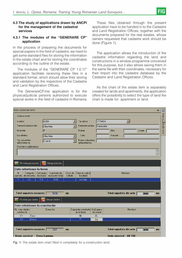
4.3 The study of applications drawn by ANCPIfor the management of the cadastralservices
4.3.1 The modules of the “GENERARE CP’’application
In the process of preparing the documents forspecial papers in the field of cadastre, we need toget some standard files for storing the informationin the estate chart and for storing the coordinatesaccording to the outline of the estate.
The modules of the “GENERARE CP 1.0.17’’application facilitate receiving these files in astandard format, which should allow their storingand validation by the inspectors of the Cadastreand Land Registration Offices.
The GenerareCP.msi application is for thephysical/judicial persons authorized to executespecial works in the field of cadastre in Romania.
These files obtained through the presentapplication have to be handed in to the Cadastreand Land Registration Offices, together with thedocuments prepared for the real estates, whoseowners requested that cadastre work should bedone (Figure 1).
The application allows the introduction of thecadastre information regarding the land andconstructions in a window programme conceivedfor this purpose, but it also allows saving them inthe same file with their coordinates, necessary fortheir import into the cadastre database by theCadastre and Land Registration Offices.
As the chart of the estate item is separatelycreated for lands and apartments, the applicationoffers the possibility to select the type of land thechart is made for: apartment or land.
Fig. 1: The estate item chart filled in completely for a construction land.
I. Ienciu, L. Oprea, Romania: Training Young Romanian Land Surveyors... FIG

4.3.2 The management of the cadastre and landregistration services in Romania– “e-Terra’’
The “Registry’’ (RGI) module is one of the threemain modules of the integrated Cadastre andLand Registration “e-Terra’’ System, the purposeof which is to computerize, automate and optimizethe registration flow of applications in theCadastre and Land Registration offices.
The Registry module accomplishes a mana-gement of the applications addressed forsupplying cadastre and land registration. Theapplications that are introduced in the systemreceive a number and a registration date, and theirresolutions are further observed in the system.
The RGI module implies the following process:
& Attestation;
& Application registration;
& Establishing the date when then they can beresolved;
& Allocating applications so that they can beresolved;
& Reallocating applications;
& Establishing unavailability intervals;
& Fill-in paper;
& Searching;
& Resolving/finding solutions;
& Analysing the application after the solution hasbeen found;
& Administration;
& Generating Registry reports.
The special staff of the National Agency ofCadastre and Land Registration, respectively theones of the Cadastre and Land registrationOffices that participate in the RGI module are as itfollows:
& Public Relations Advisor;
& Assistant registration officer;
& Registration officer;
& Chief Registration officer
& Inspector;
& Chief Engineer;
& System administrator.
The main menu of the RGI application has thefollowing submenus:
& Registration: allows the introduction of the datarelated to a certain application and saving themin the database;
& Searching: allows searching for the applicationsthat respect certain criteria;
& Finding multiple solutions (assistants): allowsfinding solutions for more applications at thesame time (only for registry assistants);
& Reallocating LB;
& Reallocating CAD;
& Processing: allows observing the applicationsafter a solution has been found or filling inpapers.
What is very important is the fact that theapplication offers security on an access level;thus, the submenus are active (available) forusers, according to the rights established for thetype of function it has. Searching for informationcan be done according to one or more searchingcriteria:
& The number of criteria;
& The time when the application was introduced;
& The person who applied;
& The solicitor;
& Authorization;
& The Land Book Office list;
& The land arrangement unit;
& The position of the person to whom theapplication was given;
& The people hired in Cadastre and Land BookOffice;
& The number of the land book;
& The state of the application (the solutions ofwhich have been found at the beginning of thesearch, with an exceeded term).
After one or more searching criteria have beenselected, the “Search’’ button should be pressed.For a new search the “Delete filter’’ should bepressed (Figure 2).
5. Conclusions and suggestions
The economic activity of a country cannot takeplace without a solid cadastral background thatcertifies the right of property for the investors.
The introduction of the general cadastre inRomania is a necessity that challenges people tofind the best technical solutions. The solution forthis problem is difficult. On the one hand becausethe introduction of the general cadastre wascarried out in different stages, with the help ofdifferent methods because of the dynamics of thelegislation, and on the other hand, because
FIG Professional Education 2009 – FIG International Workshop Vienna

Fig. 2: Searching information regarding the cadastre documents filed in.
homogeneity was required even if the demandscame before achievements.
In approaching this work, the general objectivewas to find efficient solutions about the optimiza-tion of the cadastral work, work that represent thebasis of the introduction of the general cadastreoptimizing of the cadastral work, work thatrepresent the basis of the introduction of thegeneral cadastre and that make possible theachievement of the most existing problems in thisdomain on a short period of time.
In this context, the training of young Romanianland surveyors implies the presentation andimplementation of some technical topographical-land surveying solutions according to thedemands of the Romanian Agency for Cadastreand Land Registration. These were stipulated inthe Order no. 634/2006 for Romania, and also any
other legislative act that regulates the cadastralactivity in a certain country.
In this context, the training activity of thespecialty “Land surveying and cadastre’’ from thefield “Geodesy Engineering’’ is structured asfollows, in three important directions:
& A first direction that shows the stages of acadastral work;
& The second direction is given by the legislationthat governs the means of drawing up thecadastral documents;
& The last concerns the means of drawing updocuments, pinpointing the main documentsthat are drawn by a land surveyor.
The multilateral connections between the differentmeans of drawing up cadastral documents havesingularities of manipulation and transformation of
I. Ienciu, L. Oprea, Romania: Training Young Romanian Land Surveyors... FIG

the data that could be solved only by specializedknowledge corroborated with IT knowledge and abig effort from the students, future graduates,during the whole educational activity in the fourundergraduate study years.
At the same time, the educational activity andthe training for the specialty proves a continuousinterest to combine theoretical knowledge andpractical training. Several papers prove this thatstudents wrote which were strongly anchored inthe geodesic reality.
Working for the Offices of Cadastre and LandRegistration and Town Halls cadastral Offices, orfor sole proprietors or for surveying companies,students can benefit from a significant decreaseof the study time as information is given togetheras a package, their projects have a higherexecution precision and the students can accessthe necessary information to complete theirassignments more easily and in due time. Thisway, the main purpose of the learning process isachieved.
At the same time, the interest of the studentsand teaching staff in ensuring a quality highereducation and also a modern one from the point ofview of the methodology and of the contents,benefits academic education as university me-thodology is connected to the current practicaltraining.
References
[1] Dragoi, A.: Elemente de drept civil, drept funciar sipublicitate imobiliara, Aeternitas Publishing House,Alba Iulia, 2004.
[2] Ienciu, I.: Optimizarea retelelor geodezice ın cadastru,Risoprint Publishing House, Cluj Napoca, 2006.
[3] Ienciu, I.: Probleme actuale specifice lucrarilor decadastru, Research paper during the doctoral pro-gramme, Petrosani.
[4] Miclea, M.: Cadastrul si cartea funciara, All PublishingHouse, Bucharest, 1995.
[5] Oprea L.: Optimizing the Evidence of Cadastre andLand Book Records, Proceedings of the internationalconference “Universitaria Simpro’’, Petrosani, 2008.
[6] Oprea L.: Cadastru – ındrumator de proiect, SeriesDidactica, Universitaty “1 Decembrie 1918’’, Alba Iulia,2008.
[7] Oprea L.: The Juridical Situation of the Real Estates inRomania, 6th International Conference of Phd Students,University of Miskolc, Hungary, 2007.
[8] Oprea L.: Evolutia sistemului de ınregistrare funciara aimobilelor si directii de dezvoltare, Proceedings of theinternational conference “Universitaria Simpro’’, Petros-ani, 2006.
[9] Padure, I.: Tudorascu, M.; Oprea, L. – Cadastru Funciar,series Didactica, University “1 Decembrie 1918’’, AlbaIulia, 2005.
[10] *** – Law no. 18 from 19th February 1991 on theAgricultural Real Estate.
[11] *** – Law no. 7 from 13th March 1996 on the Cadastreand Land Registration.
[12] *** – Law no. 1 from 11th January 2000 for reconstruc-tion of the property rights on agricultural land andforests, required according to the provisions of Law no.18/199, Law no. 169/1997.
[13] *** – Technical Norms for the Introduction of the GeneralCadastre, approved by the Ministry of PublicAdministration no. 534/1999.
[14] *** – Order no. 634/2006 to approve the regulationconcerning the contents and the means of drawing upcadastral documents for registration in Land Books.
[15] *** – The University Charter, University “1 Decembrie1918’’, Alba Iulia, 2004.
[16] *** – The system of study credits – A user’s guide,University “1 Decembrie 1918’’, Alba Iulia, 2006.
[17] *** – Regulations on the practical training ofundergraduate students, University “1 Decembrie1918’’, Alba Iulia, 2008.
[18] *** – The student’s guidebook, University “1 Decembrie1918’’, Alba Iulia, 2008.
Contact
Assoc. Prof. Phd. eng. Ioan IENCIU, ‘December 1st 1918’University of Alba Iulia, 11-13 Nicolae Iorga street, AlbaCounty, Postal Code 510009, RomaniaE-mail: [email protected], [email protected]
Assist. Lect. Phd. stud. eng. Luciana OPREA, ‘December 1st
1918’ University of Alba Iulia, 11-13 Nicolae Iorga street,Alba County, Postal Code 510009, RomaniaE-mail: [email protected], [email protected]
FIG Professional Education 2009 – FIG International Workshop Vienna

On Student Assessment in Technical Distance EducationNicolae Ludusan, Levente Dimen, Romania
Abstract
In order to make a more efficient assessment ofstudents enrolled in technical distance educationprogrammes, we believe that an alternative formof assessment is necessary. This would changethe standard test-based assessment to a practicalassessment, where students can exercise theirabilities through project work and judgement canreplace mechanical repetition of information.
Assessment techniques to be used in technicaleducation must meet specific requirements in thisfield, such as:
& students have to prove the competences thatthey have acquired during a degree pro-gramme; they do not just have to choose ananswer from a list of possible answers;
& competences have to be tested by project workwhere students can prove their learning abilitiesand their practical application skills;
& the assessment has to highlight the students’creativity, the extent to which they understandthe knowledge they have acquired and howthey use it in solving practical issues.
The assessment that best meets these require-ments is based on a ‘student’s portfolio’ thatcontains, in a logical structure, all the materialsthat a student uses during a cycle of education:abstracts, analyses, problem solving, diagrams,syntheses, reading notes, bibliographical lists etc.Some of these materials are mandatory worktasks, required by professors and others produ-ced by students during their studies.
When studying, each student creates their ownportfolio, even if some of the assignments requireteamwork. Every student will add to their portfoliothe documents containing the final results of theteamwork. Elaborated in this manner, portfolioscreate the possibility of a more complex and morecorrect assessment. The assessors can identifythe students’ practical abilities, when they haveapplicative work for which they have sufficienttime and resources at their disposal.
Portfolio-based assessment raises severalissues that can be formulated through thefollowing questions: “What should a portfoliocontain?’’, “What special techniques have to beused to make an objective assessment of aportfolio’s content?’’, “What standards have to beapplied in assessing the students’ activity?’’
The two assessment techniques, the test-based and the portfolio-based, have their ownsupporters. The partisans of portfolio-basedassessment suggested that it should completelyreplace standard test-based assessment. Howe-ver, there is the risk that the problem isapproached by different procedures and stan-dards, which leads to a decrease of the degree ofobjectivity for the assessment.
The paper shows the results of a pilot testapplied to a group of students enrolled in ‘LandMeasurements and Cadastre,’ a Bachelor’sDegree programme of ‘December 1st 1918’University of Alba Iulia.
The aim of the pilot test was to tackle twospecific issues raised by portfolio-based assess-ment:
1. clarifying the aspects connected to the way inwhich this method of assessment is used andthe manner in which it is applied, based on asurvey applied to a group of professors;
2. the outcomes that this means of assessmenthave on the students’ performances.
The conclusions of this test led to some interestingaspects:
& the portfolio-based assessment is rather usedby the young professors, keen on teaching andaiming for self-improvement;
& the results of the assessment are sometimescontested by students;
& most students prefer portfolio-based assess-ment.
References
[1] LeBaron, JohnF., Tello, Steven F.: The efficient evalua-tion of distance learning, in “Knowledge Quest’’, Mars-April 1998, p.26.
[2] Calfee, Robert C., Perfumo, Pam: Portofoliul studentu-lui: posibilitati pentru o revolutie in evaluare, from“Journal of Reading’’, vol. 36, no. 7, April, 1993.
[3] The Ministry of National Education: Open Learning toDistance, Bucharest, 1998.
Contact
Assoc Prof.dr. Nicolae Ludusan, „1 Dcembrie 1918’’University of Alba Iulia, RomaniaRO 510009 Alba Iulia, Str. N. Iorga, nr. 13E-mail: [email protected]. Levente Dimen, „1 Dcembrie 1918’’ Universityof Alba Iulia, RomaniaRO 510009 Alba Iulia, Str. N. Iorga, nr. 13E-mail: [email protected]
Professional Education 2009 – FIG International Workshop Vienna FIG

Current Situation in Ukraine of Urban and Rural Land
Development (Practice and Education)
Olga Petrakovska, Ukraine
1. New social and economic conditionsdemand the Reorganization of theeducation system
Land reform is continuing in Ukraine. It isaccompanied by a transformation of propertyrights, development of the land market, formationand improvement of the cadastre systems. Thatgenerates a need for radical reforms in landmanagement.
The fundamental changes which induce anecessity for improvement and adjustment in thepractise of the approaches towards land mana-gement for variable conditions are:
& The new conception of property right declaresvarious kinds of rights for land ownership andland use.
& Substitution of the only one owner by means ofproduction to unlimited number of owners bothpublic and private;
& Develop small-scale and middle-scale busi-ness and an appearance of a large quantity ofentrepreneurs;
& Monopolistic centralized system of financing ofland development from state budget orientatedtowards a greater number of independentinvestors;
& Declaration of local self-government rightstransferred management mechanisms to locallevel and has made relations between differentlevels of authority more complicated.
Furthermore land use right and the right to buildare separated. It produces supplementaryproblems and claims for land management anddevelopment.
The land policy reorganization and land reformare closely connected with land market formationand development. In spite of land ownershipbeing established in 1991, the reality is that themarket started to form and develop at thebeginning of this century after the adoption of aseries of statutes. The most important key toefficient development of property markets isadequate provision by qualified specialists. Thosespecialists have to be able to solve complicatedcomprehensive tasks both technical and juridical
concerning land transformation. Moreover func-tioning of land markets requires the creation ofupdated land registration systems. These sy-stems have to indicate clearly various kinds oflegal land ownership and keep information aboutland and different improvements.
It necessitates training for new professions inthe fields of land management and real estatedevelopment under the influence of new circum-stances. One of those trades is cadastrespecialist.
2. Particularities of The educational system
The land reform which was executed in Ukraineand the new conditions are the cause of changesof the higher education system. Ukraine has acomplicated system of higher education. Thissystem has remnants of soviet heritage andchanges under the influence of the present-daydemands of labour market. Those demands arechanging very fast. It could be explained by aretrospective review of land reform and themodification of legislation during the last ten years.Heritage of soviet times is evident in the strictstandards of education. These standards regulatethe structure of curricula and percentage ofdifferent disciplines for various specialties andmust be approved by the Ministry of Educationand Science, further “Ministry’’. Approximately70% disciplines are obligatory and can’t bechanged without Ministry agreement. For tech-nical specialties, obligatory disciplines includenext modules: the humanities, social and econo-mic studies, nature and science, profession andpractice studies for concrete professional sphe-res. Other disciplines are determined by universitydecision. It influences the making and changing ofcurricula greatly.
From 2004, education in Ukraine is realizedaccording to fixed educational fields which areaccepted and approved by Ministry. Each ofthese educational fields combines specialities of asimilar nature. For example, educational field“Construction’’ combines specialities like “indust-rial and civil engineering’’, “sanitary engineering’’etc. Cadastre activity is a part of education field“Geodesy, Cartography, Surveying’. Curriculum
FIG Professional Education 2009 – FIG International Workshop Vienna

for different specialities within the field must havean equal obligatory part. That makes an impact onthe curriculum structure very greatly as well andrestricts the possibility of its transformation.
Education institutions accrue a right ofteaching activities for different qualification levelsand education fields and specialities in accor-dance with domestic accreditation and licensing.The accreditation and licensing is implementedaccording to claims of education standards andstate requirements for staff, scientific, methodical,material support.
3. Adaptation to Bologna process
Worldwide globalization of education and integra-tion of Ukraine with the world community requiresthat the educational system should be adapted tonew social and economic conditions. At thebeginning this century Ukraine accepted Bolognamodel of education. Adoption of this model hasdemanded essential reorganization of Ukraine’ssystem of education and science. By now ESTChas been put into practice at Ukrainian universitiesand teaching is carried out in agreed modularunits.
Before acceptance of the Bologna model ofeducation we had the qualification levels engineeror specialist. By the law “About higher education’’(2002) there are qualification levels bachelor,specialist, master. Thus degree of specialist hasbeen kept from previous system and degrees ofbachelor and master have been taken accordingto the European experience. As a result there isunawareness about what kind of expert studentswho have different diplomas are. According to law,the degree of bachelor corresponds to “basichigher education’’. The degrees of specialist andmaster are declared as levels of “complete highereducation’’. The teaching of bachelors has beenrealised for ten years but the population has notunderstood and has not given credence to thisdegree till now. The same attitude exists fromemployers. It is difficult for graduates who have abachelor diploma to get a job. As a rule they get ajob under the condition that they will continue theireducation and will get a degree as a specialist or amaster. It is a tricky question of also what is thedifference between a specialist and a master. Inthis situation some universities turn to teachingbachelor and master degrees without thespecialist degree. This approach keeps up todate inasmuch as it corresponds to long-rategovernment plans. But factually that decision
leaves still more uncertainty about the specialistdegree which is accepted by legislation.
Specialist teaching can be received only after abachelor degree and takes one year. A Master’sprogram takes from one to two years at differentuniversities. Students can be accepted for amaster’s program if she/he has a bachelor or aspecialist degree. Teaching of specialist andmaster implementation is parallel at someuniversities. Their programs don’t have very bigdifferences. So in the last few years more andmore students want to get a master’s degreewithout going to the trouble of a specialist one.
Comparative analyses of the different approa-ches have to be done for the successfultransformation of the existing educational system.The necessary changes and the ways to realizethem could be defined and appreciated only afterthis comprehensive analysis. All new methodsshould be applied consecutively and afterpreliminary discussion and substantiation.
4. Teaching of surveying and cadastrespecialists
The training for surveying and cadastre specia-lists started in the middle of the 90s and the first ofthem were introduced into the labour market at thebeginning of this century. The teaching of thesespecialists began at both technical and agricultu-ral universities. The program for geodesy trainingformed the basis of this speciality at technicaluniversities and teaching has focused towardsengineering sciences. The education at agricultu-ral universities has been oriented towards solvingproblems and tasks of agricultural land manage-ment. The leading technical universities in Ukrainewhich realize this teaching are Kiev NationalUniversity of Architecture and Construction,Donetsk National Technical University, Lviv Poly-technic University. The agricultural ones are KievNational University of Biological Resource andNature Recourse Use, Lviv National AgricultureUniversity, Kharkov National University of Agricul-ture, National University of Water Managementand Nature Recourse Use (Rivne). By now thedepartments which have put into practice theteaching of new specialists have a unified name“department of surveying and cadastre’’ at bothtechnical and agriculture universities. But thisname doesn’t correspond with education taskswhich are decided in full measure.
The standards for cadastre education havebeen established for the bachelor degree.Curricula have been transformed to European
O. Petrakovska: Current Situation in Ukraine of Urban and Rural Land Development FIG

credit transfer and accumulation system (ECTS).All disciplines which are oriented to professionaleducation (profession and practice studies forconcrete professional field) aggregate approxi-mately 100 European credits in the curriculum.This part of the curriculum can be divided into fivemodules: technical, GIS, economical, juridicaland planning. The technical module is the biggestpart (50%) and geodesy disciplines averagealmost 80 %. In second place is the GIS module(28%) and then economical (14%), juridical (6%)and planning (2%). These figures speak forthemselves. In other words sometimes thegraduates of surveying and cadastre could benamed “modernized geodesist’’. In practicalsituations each of them could work as a geodesistif she/he wants.
Such a situation has been amended by meansof disciplines which are determined by auniversity’s decision in practice. The teaching inthe surveying and cadastre department at KievNational University of Architecture and Construc-tion is oriented towards urban land and in practicalsituations includes land management and deve-lopment. So disciplines which are determined bythe university enlarge the knowledge in urbanlegislation and planning, formation territory infra-structure, land and improvements valuation,engineering services etc. There is the samesituation at other technical universities. Agricul-ture universities focus on teaching about soilconservation, protection of natural resources etc.
Cadastre activities have been determined bynew Land Code in 2001. In according with that,the important points are: property delimitation,formation and juridical registration, propertyvaluation, state control and preservation. Thathas defined new qualitative demands for cadastrespecialists. As a result the curriculum has beencorrected. However geodesic disciplines take thegreater part of them until now.
Surveying and cadastre is the new scope ofactivity for Ukraine. We don’t have the necessaryand sufficient experience to make decisions aboutland problems which are natural for marketconnections and cooperation. Teaching suchexperts was not realized until the end of the 90s.Consequently, teaching staff are formed fromexperts from adjoining professional areas whoextend and improve their knowledge in the newfield. This is problematic for new trades andcreates extra problems in education. In additionthe former academic degree system is kept:candidate of science and doctor of science.
One more problem creates troubles forteaching in this field. This is a deficit of someforms of teaching materials. Practice methodsand mechanism of land management andregistration are closely connected with domesticlegislation. So some kind of teaching materialshave to be modified very often according to land,registration, planning and other policies.
5. Demands of present-day labour-market
Demands of the labour market have beenchanging permanently for the last seventeenyears. There are some reasons and explanationsfor it. When the cadastre speciality was esta-blished the main tasks for the economy were landunit delimitation and land registration for taxation.So it defined the needs of market. At first universitygraduates worked mainly at state bodies.
At the beginning of this decade, about 50% ofthe built-up land had been transferred to privateproperty. Formation and development of urbanland market has determined new requests. Newtasks have to be solved: land and constructionvaluation for selling and mortgage, improvementof the cadastre system for guarantee of title andinsurance, determination of more effective landuse under existing juridical and technical condi-tions. Subsequent evolution of the land marketbrings up questions like compulsory purchase,entitlement payment, division of right in time andspace. Land disputes emerge more frequentlyand are more complex. All those points could bejoined into one trade – land management. Butthere isn’t such a speciality in academic educationin Ukraine till now.
University graduates generally work at bothstate and private bodies in the present day. Stateinstitutions usually are cadastre, land and urbanplanning committees and bodies at national,region and local levels. Private organizations are:survey services, property sale and valuationagencies, insurance companies, mortgage bankand development companies. They work also atother bodies which are responsible for landmanagement and development.
It is the entrepreneur’s opinion today thatdetermination of more effective land use, searchof juridical and technical implementation methodsare the most prevalent and the most intricatequestion today. Public employers focus on thedevelopment and improvement of the structureregistration system, provision for their reliabilityand credibility. So it is evident that the currentsituation where there is a need for land market and
FIG Professional Education 2009 – FIG International Workshop Vienna

land management requests specialist, who is ableto solve problems on basis of complex interdis-ciplinary approaches, is approaching. Analysis ofpractice tasks which cadastre specialist now hasto solve proves a necessity of knowledgeextending into the fields of urban planning,economy, legislation (civil, land, urban, construc-tion, environmental law) and modern GIS tech-nology. An increase in part of these disciplinescan be implemented at the expense of thedecrease of geodesy disciplines. As it is obviousfrom the foregoing improvement, the surveyingand cadastre curriculum should be based onintegration with humanities, economy, juridicaland engineering sciences taking into accountEuropean standards for specialists in this area.
6. Conclusions and Propositions
The reasons for the main problems which exist inthe Ukrainian education system can be determi-ned both general for education system as a wholeand for the surveying and cadastre field inparticular.
The general problems are:
1. Transformation of the curriculum is very difficultin connection with existing standards andMinistry obligatory agreement.
2. Lack of understanding and recognition of thebachelor’s degree as a qualification level ofexpert and non-claiming of them by thedomestic industry. As a rule an open admissionto university is put into practice according tospecialities.
3. The similarity between the teaching program ofspecialist and master and the result unwar-rantable confusion with comprehension ofthose degrees.
4. The system of scientific degrees awarding ismore complicated than in Europe. It makespreparation for scientific and teaching staffvery difficult.
5. The weakening of cooperation betweenacademic institutes with scientific and indust-rial ones.
The problem of the surveying and cadastre fieldare:
1. Plenty of geodesy disciplines and shortage ofplanning, economy and jurisprudence disci-plines in the curriculum.
2. Provision by qualified teaching staff is difficultbecause of multidisciplinary approach ofeducation.
3. Formation of Master program for surveyingand cadastre field is difficult in connection withpermanently changing of legislation andlabour market demands.
4. Necessity of permanent modification of tea-ching material and their deficit.
Take into account foresaid the nearest improve-ment of surveying and cadastre education couldbe achieved by next methods:
1. There should be a defined difference betweenbachelor and specialist and between specia-list and master. It should be made byintroducing a difference in the curriculum insuch a way that if the specialist degree isdenied, the bachelor and master curriculumcould be easily transferred.
2. The percentage should be amended fordifferent disciplines in the curriculum. Toincrease planning, economy and jurispru-dence disciplines and decrease geodesyones. Fundamental knowledge of classicacademic science to give an opportunity forgrounded decision making under permanentlychanging social and economy conditions.
3. A system of retraining and raising the level ofprofessional skills should be developed forteaching staff in base industrial organisations.
More long-term methods are connected with thetransformation of the system of education andscience, and stabilisation of the political andeconomical situation in the country.
1. ��������� ��� �����. – �.: ����,2001.
2. �� ���� �����. ��� ������� 2984-III,17.01. 2002.
3. ��������� �.�. ������ � ����������������� �������� � ������������������� ��!��� ������������ � �� ���� ������ ������// "��� �������� �� ����������������������, – �.: �# $�, 2007. – �26. – C.229-234
Contact
Ms, Olga Petrakovska, Professor, doctor of science, KyivNational University of Construction and Architecture,Department of surveying and cadastre, 31, PovitroflotskyAve, Kyiv, 03680 Ukraine, Tel. +380674469862, Fax+380442432671; E-mail: [email protected]
O. Petrakovska: Current Situation in Ukraine of Urban and Rural Land Development FIG

Contemporary Education and Quality Assurance in the
Geodesy and Geoinformation Programs at the Vienna
University of Technology
Georg Gartner, Robert Weber, Vienna
Abstract
This paper provides some general remarks on the education programs in the domain of Geodesy and Geoinformationat the Vienna University of Technology. Currently one bachelor and three master programs are offered. A special focuspoint will be attempts for quality assurance.
1. Education and Teaching at the ViennaUniversity of Technology
The education offered by the Vienna University ofTechnology is rewarded by high international anddomestic recognition. The chances of graduatesfor getting an attractive employment are veryprosperous. The high demand on graduates of theVienna University of Technology from economyand industry, governmental as well as researchinstitutions is evidence for this.
The content of the provided courses isactualized continuously and adjusted to therequirements by industry and economy. Studentsof the Vienna University of Technology are veryflexible because of their solid know-how intechnical and natural science. This knowledgeis complemented by an offer of courses coveringthe areas personality development and the so-called “soft skills’’ (e.g. foreign languages,management know-how, etc.). They receive asolid basic knowledge accompanied with indivi-dual tasks to be chosen by each student subjectto their personal interests. Great emphasis is alsoput on the participation of students in currentresearch projects.
Students of the Vienna University of Tech-nology can choose between several curricula.They are offered without one exception (teachertraining programme) as bachelor and masterprogrammes. Bachelor programmes last for 6semesters. Master programmes can be comple-ted within further 3 or 4 semesters following abachelor programme or equivalent postgraduatedegree.
According to its status, the Vienna University ofTechnology offers postgraduate doctoral pro-grammes as a follow up to all master programmes.Besides the already well established doctoralprogrammes of Technical Sciences and NaturalSciences the new doctoral programme of Scienceof Social and Economic Affairs has beenintroduced in 2004.
More emphasis is at the moment and will in thefuture be put on at the following three importantaccents: internationalization of education, e-learning and continuing education. These tasksare fulfilled by the approved Department forInternational Relations, the E-Learning and theContinuing Education Center.
2. The Geodesy and GeoinformationDepartments of Vienna University ofTechnology
The aim of the research and education programsof the Geodesy and Geoinformation departmentsis based on international leading programs. This isvisible in the acceptance and attractiveness of theeducation programs to students from beyond theregion of Vienna and surrounding areas. It is alsovisible by the fact, that the research groups ofGeodesy and Geoinformation are heavily linked toleading international institutions.
The research activities of the research groupsin Geodesy and Geoinformation are noticed allover the world, which is documented in invitedpresentations and proceedings of internationalconferences, awards for scientific contributionsbut also by elections in executive committees of
FIG Professional Education 2009 – FIG International Workshop Vienna

international scientific organisations, editorialboards and program committees.
The area of Geodesy and Geoinformation isadministratively represented by three depart-ments, which are divided into seven researchgroups:
& Institute of Photogrammetry and Remote Sen-sing
& Research Group on Photogrammetry andLaser Scanning
& Research Group on Remote Sensing andData Assimilation
& Institute of Geoinformation and Cartography
& Research Group on Geoinformation
& Research Group on Cartography
& Institute of Geodesy and Geophysics
& Research Group on Advanced Geodesy
& Research Group on Applied Geodesy
& Research Group on Geophysics
Within the focus of the Institute of Photogrammetryand Remote Sensing the main areas of expertiseand research include especially issues of derivingSpatial Data from Laser Scanning and RemoteSensing. The research group “Photogrammetryand Laser Scanning’’ mainly deals with geome-trical aspects of object reconstruction, whereasthe research group “Remote Sensing and DataAssimilation’’ focuses on physical problems ofremote sensing as well as on advanced methodsof data interpretation.
The Research Group Geoinformation of theInstitute of Geoinformation and Cartographytraditionally deals with fundamental researchwithin the scope of spatial data handling.Ontological approaches for the acquisition andrepresentation of the importance of spatial dataare the main focus of information system research.Activities include the utilisation of functionalaspects and new mathematical modelling ofspatio-temporal processes. Among social andphysical geo data especially data which describeproperties (or other rights) are in the focus ofresearch.
The Research Group Cartography focuses intheir research especially on new ways ofcommunicating spatial information by cartogra-phic means. In this context the role of new media,especially within the domain of mobile systems, isa main area of research. Special fields offundamental and applied research are situatedin the domain of Location Based Services andUbiquitous Cartography, where fundamental
questions of efficient cartographic communica-tion processes are tackled and proved by applieddevelopments.
The three research groups of the Institute ofGeodesy and Geophysics cover a wide area ofexpertise. The research can be generally relatedto the research focus “Integrated Geodesy andGeodynamics’’. Main research activities cover thedomains of Navigation and Positioning by meansof satellite geodesy (GPS, Glonass, Galileo, SLR),the implementation of radio-interferometry on longbasic lines for geodesy and astrometry (VLBI), theintegration of geodetic space processes andcombination of geodetic parameters in the frameof Global Geodetic Observing Systems (GGOS),the analysis of interactions of the system earth bymeans of variations of the earth rotation parame-ters and the gravity field, the observation of globalchanges on the earth by means of GlobalMonitoring Earth Observing Systems (GMES),the analysis of geodynamic processes at regionaland local scale by means of geophysical methodsof exploration, monitoring and modelling, forexample in the alpine area (geodynamics ofEastern Alps, structure and genesis of alpinevalleys, stability of valley edges).
3. Education Programs in Geodesy andGeoinformation
As mentioned above the Vienna University ofTechnology offers within the branch of Surveyingand Geoinformation (Faculty of Mathematics andGeoinformation) one bachelor program (since2005) and three master programs (since 2008).Major goal of the courses is provision of keycompetences in engineering geodesy as well asin administration and visualization of spatial data.There is in addition a broad offer of coursesdealing with topics like satellite navigation, Earthobservation, geophysical exploration and monito-ring of hazardous regions. This broad basis ofcompetences opens successful students a widerange of job opportunities.
The programs are in detail
& Bachelor program “Geodesy and Geoinforma-tion’’
& Master program “Surveying and Cadastre’’
& Master program “Geodesy and Geophysics’’
& Master program “Geoinformation and Cartogra-phy’’
The bachelor program provides within the firstsemesters basic knowledge in mathematics,physics, informatics as well as geodetic coordi-
G. Gartner, R. Weber: Contemporary Education and Quality Assurance... FIG
nate systems and coordinate transformations.Introductory lectures in engineering geodesy,photogrammetry, airborne and terrestrial laser-scanning, cartography, geophysics, and satellitenavigation are accompanied by a number fieldcourses to practice. Starting with semester threeone out of two modules (30 ECTS-points each) hasto be selected to locate the students main focus.One module concentrates on modern geodesy,the other one on informatics and handling ofspatial data. Nevertheless an overlap of at least30% of the courses still ensures that students ofboth modules graduate with the same Bachelordegree and may switch later between the fields.Both modules cover, for example, lectures in legalrights, land administration and economics.Bachelor graduates usually proceed in one ofthe offered master courses but a small percentagealso looks for immediate employment.
Since the start of the bachelor program thenumber of new students per year has increasedfrom approximately 25 to about 50. A firstevaluation end of 2008 shows that out of around35 of them still in the program at the begin of thesecond year about 70% are able to receive theirbachelor degree within 7 semester.
All master programs are intended for nativeand foreign students who have achieved abachelor‘s degree and aim working as decisionmakers or leading scientists in geoinformatics,geodesy and navigation, engineering surveying,data adjustment, computer vision or remotesensing. Students are confronted with ‘state ofthe art’science and instructed how to provide highquality and efficient solutions in a permanentlychanging environment. Consequently, besidesthe technical skills, a number of courses deal withpresentation techniques and communication inforeign languages.
The master program “Surveying and Cadastre’’focuses on engineering geodesy and landmanagement. This includes for example courseson precise surveying techniques, machine gui-dance and control, indoor- and outdoor naviga-tion, monitoring of potentially hazardous motionsof artificial monuments or natural objects like landslides. Besides, special attention is paid to legaland economic competences which are indispen-sable skills to become a successful civil engineer.
The master program “Geodesy and Geo-physics’’ deals primarily with Earth observation,Global Change monitoring and exploration tech-niques. Focal points are Reference Systems,observation and modelling of the Earth Rotation
and Earth Gravity Field, satellite based EarthObserving Systems as well as seismic andgravimetric exploration techniques. Closely linkedare the tasks of precise positioning techniques bymeans of satellite navigation systems like GPS.
The master program “Geoinformation andCartography’’ consists of theoretical and appliedcoursed to contemporary topics of Geoinforma-tion and Cartography. In detail the masterprogram deals with the acquisition, modelling,analysis, visualization and communication of geo-data. Specific tasks include the combination ofdata from different sources, the integration intospatial information systems, and the establishingof user-adequate visualization techniques.
Based on a master degree the admission to aprogram of Doctoral Studies can be achieved aswell. International students of many countrieshave already joined the Geodesy and Geoin-formation institutes to successfully gain a Doctoraldegree from Vienna University of Technology.
4. Quality Assurance
The quality assurance within all educationprograms of Vienna University of Technologybasically focuses on three main points:
& Selection of teachers with professional compe-tence and adequate didactic qualification
& Continuous evaluation of courses by students
& Obligatory reporting to the Dean of AcademicAffairs in case of remarkable evaluation results
For further developing an effective system ofmonitoring and assuring the quality of educationprograms a couple of activities are necessary thatshould complement one another. Therefore theGeodesy and Geoinformation programs developfurther steps of quality assurance, based on thefundamental goals of the whole university. Anindispensable basic element of quality assuranceis hereby the evaluation of courses. Furthermore,accompanying methods are necessary likeincentive systems, mentoring strategies, institutio-nalized offers for improving teaching skills and aninstitutionalized monitoring and comparison ofinternational developments.
4.1 Evaluation of courses
The instrument of evaluation of courses is a keyelement of quality assurance in education at thefaculty of mathematics and geoinformation. Ageneral increase in the acceptance of thiselements by all participating parties (students,teachers) is a key goal, as it is a precondition for a
FIG Professional Education 2009 – FIG International Workshop Vienna

more precise and qualitative implementation ofthis instrument. Such an increase is aspired by
& optimisation of processes in evaluation ofcourses by means of optional usage ofinternet-based questionnaires resp. printedquestionnaires
& improvement of questionnaires for students bymeans of stronger individualisation concerningcourse type
& implementation of modul parts of questionnai-res which allow quicker answering by thosestudents who do not want to expand on detailedstatements
& the increase of communication between theinvolved groups in evaluation of courses(students, teachers, dean for study affairs) bymeans of increased and partly more transparentreactions. As further progression it is planned toconfront students with the instrument “evalua-tion of courses’’ and its processes within the firstsemester
& more transparent publication of relevant resultsof evaluations of courses in various adequatepanels
& Optional possibilities of comprehension ofcollegiate critiques like Wikis, Blogs shouldbe proved concerning their applicability
4.2 Incentive systems
Geoinformation education programs have adop-ted an incentive system for test purposes. As adirect result of evaluation of courses a “Best-of-education Award’’ has been tested. Based on thepositive experiences this will be developediteratively by defining a mix of quantitative andqualitative measures. Based on those measures aselection of classes being evaluated remarkablypositive will be discussed and finally decided by aboard consisting of student union members andthe dean of academic affairs and the chair of thecommission of academic affairs. For the timebeing this concept of a two-stage method(quantitative and qualitative ranking based onevaluation results resp. a jury) is used for variouscategories (compulsory lectures, applied classes,seminars, special courses).
4.3 Mentoring concepts
Within the Vienna University of Technologytutoring and mentoring programs are offeredand available. A special focus has to be given todedicated information about offered courses viaup-to-date communication media. A dedicatedsystem of help, consultation and guidance
through the very first steps of beginners is offeredcurrently and is monitored permanently with thegoal of further improvement. Finally, dedicatedinformation to those students starting their studynot in a regular way (Summer Semester instead ofWinter Semester; Foreign and Exchange Stu-dents) are offered and are also further developed,if necessary.
4.4 Teaching competence and e-learning
As a key element of quality assurance withineducation programs of Geodesy and Geoin-formation the Vienna University of Technologyoffers courses to improve teaching and didacticalskills. Currently there are a few offers on dedicatedworkshops dealing with teaching competence,which are available to all members of theUniversity. As a matter of fact more offers focusedon the needs of specific teaching situations willhave to be given. The final goal is to have moreprecise instruments for helping teachers to beable to make excellent classes and courses.
Under the acronym ‘E-learning’ a specialelectronic tool supplementing the regular lectureshas been introduced at TU-Vienna recently. E-Learning is a web-based new concept to preparethe subject contents for interactive use. Oneadvantage of e-learning is of course the possibilityto provide additional material and tests whichallow the students to jointly study and control theirunderstanding of the lecture content. This ispredominately impossible in large classes of a fewhundred students. There are of course a numberof still unresolved problems linked with E-learninglike quality-assurance of the provided material,how to improve the acceptance by the teachingstuff and last but not least how to motivatestudents to watch the lectures even if the subjectmatter is already provided in digital form. Insummary e-learning is clearly not a perfectsubstitute of the lecturer but it may haveadvantages in case of huge classes whichprohibit keeping contact with the lecturer. It helpsstudents to check steadily their knowledge byrunning automated tests and answering providedquestionnaires and of course these platforms areindispensable tools in remote education andpostgraduate programs.
4.5 Further instruments for quality assurance
Beside the described key elements of qualityassurance further instruments apply. Thoseinclude
G. Gartner, R. Weber: Contemporary Education and Quality Assurance... FIG
& assignment of international reviewers/exami-ners
& conducting of complementary time tables andexamination schedules to ensure concise studyprocess
& additional questionnaires for all graduates at theend of their study and approx. 3 – 5 years afterfinal degree in order to gain additional insightson the evaluation of the study program
& monitoring and matching with course schemesof comparable foreign universities
5. Further Developments
The further development of the profile of theGeodesy and Geoinformation group at ViennaUniversity of Technology is based on thefundamental goal of scientific excellence inresearch and education applied to the offerededucation programs. One consequence is that allcourses and classes should aim at includingaspects and results of recent research processes.
A permanent system of quality evaluation andassurance, consisting of a mix of instruments, isoffered and applied in order to follow the maingoal of Vienna University of Technology onensuring high quality programs instead of masseducation programs and aiming on producingstudents which are able to “compete’’ on aninternational level.
References
[1] Dorninger, D. (2009): Entwicklungsplan der Fakultat furMathematik und Geoinformation. Version of 30. January2009, TU Wien (for internal use only).
Contact
Georg Gartner, Dean of Academic Affairs Geodesy andGeoinformation, Vienna University of Technology, Vienna,AustriaE-mail: [email protected] Weber, Chair of Commission on Academic AffairsGeodesy and Geoinformation, Vienna University of Tech-nology, Vienna, AustriaE-mail: [email protected]
FIG Professional Education 2009 – FIG International Workshop Vienna