The Badenian parastratotype at Židlochovice from the perspective of the multiproxy study
Upload
lmu-munichCategory
view
1download
0
Research Article
Multiproxy Analyses of Stratigraphy and Palaeoenvironmentof the Late Palaeolithic Grabow Floodplain Site, NorthernGermanyJohann Friedrich Tolksdorf,1,* Falko Turner,2 Knut Kaiser,3 Eileen Eckmeier,4 Mareike Stahlschmidt,5
Rupert A. Housley,6 Klaus Breest,7 and Stephan Veil7
1Institute of Prehistoric Archaeology, University of Marburg, Marburg, Germany2Institute of Geobotany, University of Hannover, Hannover, Germany3GFZ German Research Centre for Geosciences, Potsdam, Germany4Institute of Crop Science and Resource Conservation, University of Bonn, Bonn, Germany5Institute for Archaeological Sciences, University of Tubingen, Tubingen, Germany6Department of Geography, Royal Holloway University of London, London, UK7State Museum of Lower Saxony, Hannover, Germany
Correspondence*Corresponding author;
E-mail: [email protected]
Received15 March 2012
Accepted10 October 2012
Scientific editing by Jamie Woodward
Published online in Wiley Online Library
(wileyonlinelibrary.com).
doi 10.1002/gea.21429
Changing river courses and fluctuations of the water table were some of themost fundamental environmental changes that humans faced during the LateGlacial, particularly as these changes affected areas intensively used for set-tlement and resource exploitation. Unfortunately, only a few stratigraphieshave been documented in the North European plain that show the interac-tion between river development, vegetation history, and occupation by LatePalaeolithic humans. Here, we present the results of detailed stratigraphicalstudies (pedology, archaeology, chrono-, tephra-, and palynostratigraphy) atthe Federmesser site Grabow 15 located in the broad Elbe River valley. Theresearch aimed to produce a model of site formation based on a multiproxy ap-proach, relating the local evidence to the palaeoenvironmental and settlementhistory of the wider region. After deposition of fluvial sands during the LatePleniglacial in a braided setting, the river course developed locally toward ameandering system at the transition from the Older Dryas to the Allerød, whileperiodic flooding led to the deposition of floodplain sediments during the earlyAllerød. The floodplain was settled by people of the earliest “Federmessergrup-pen,” who are believed to have chosen this open floodplain area along the riverfor collecting and processing amber of local origin. Their artifacts became em-bedded in the aggrading floodplain sediments. In the late Allerød, floodplainsedimentation ceased and a Fluvisol-type soil developed, indicating a trend to-ward geomorphic stability. The Fluvisol was then covered by silty floodplainsediments due to a rising water level during the late Younger Dryas resulting inthe cessation of human occupation in the area. Subsequent organic-rich LateGlacial/Holocene sediments preserved the settlement remains to the present.C© 2012 Wiley Periodicals, Inc.
INTRODUCTION
The main challenge to human cultures during the LateGlacial in northern Europe was the adaptation to rapidand fundamental changes in their environment. Al-though knowledge about general trends in vegetationand economy has improved in recent decades, still little
is known about adaptation to the hydrological changes(relocation of river courses, fluctuations of water table)of this time period. One of the main drawbacks in under-standing these processes is the small number of recordson the environmental history of central European rivervalleys during the Late Glacial and their strong distur-bance by later processes (e.g., Hiller, Litt, & Eißmann,
50 Geoarchaeology: An International Journal 28 (2013) 50–65 Copyright C© 2012 Wiley Periodicals, Inc.

TOLKSDORF ET AL. MULTIPROXY ANALYSES OF A LATE PALAEOLITHIC FLOODPLAIN SITE, GERMANY
1991; Hagedorn, 1995; Starkel, 2003; Kaiser et al., 2012).Consequently, knowledge about the effects of climaticand hydrological changes during this period in fluvial sys-tems is still rather limited and sites with the potential tolink these environmental reconstructions to human set-tlement history are exceptionally rare. The Grabow 15site therefore provides a rare insight into the relation be-tween vegetation, hydrology, and humans shedding lighton the adaptation of Late Glacial hunter-gatherers to achanging environment.
Since 2007, the site of Grabow 15 site has been thefocus of interdisciplinary research which aims to investi-gate archaeological features ascribed to the Federmesser-gruppen revealing their stratigraphical and palaeoen-vironmental context. While the history of the LateGlacial channel system (Turner et al., 2012) and the de-tailed description and interpretation of the archaeolog-ical assemblage will be addressed by forthcoming pub-lications, we here focus on the site stratigraphy andthe palaeoenvironmental record. Situated on the bankof an abandoned river channel, the artifacts of thesite are embedded in a complex stratigraphy of fluvialorigin.
Due to its specific sedimentary and archaeological set-ting, the Grabow 15 site therefore offers the rare oppor-tunity to study local fluvial and environmental dynamicsby a multiproxy analysis while relating these results tovegetation history and human environment. To link thesedimentological units and to build a chronologi-cal framework, palynological analysis, 14C-dating, andtephrostratigraphy were performed. High-resolutionpedological analysis included micromorphology and theanalysis of a fire-derived chemical marker (Black Carbon[BC]). By combining these results and linking them to theresults of the archaeological record, we attempt (i) to re-construct the environmental setting in which the humanoccupation took place, (ii) to investigate whether tracesof local human impact on the environment are visible,and (iii) to analyze whether post-depositional processesmight have affected the integrity of the archaeologicalrecord.
GEOGRAPHICAL SETTING
The Grabow 15 site (53◦00′N/11◦07′E, c. 13.5 m a.s.l.)is located on the Jeetzel River, which is a small tribu-tary flowing through the broad Elbe River valley (Wend-land area; Figures 1A, 1B, 2A). Situated at the westernedge of the glacial Elbe spillway, fluvial dynamics havebeen the main agent in the Jeetzel River plain below20 m a.s.l. in the past until regional drainage and rivercanalization in the 20th century limited fluvial influence.
Late Glacial fluvial sands and low dunes are prevalent inthe low-lying areas of the Jeetzel valley while morainesof Saalian age are present as partly isolated hills aroundthe site (Figure 1B). Detailed geomorphological mappingrevealed several generations of palaeochannels of LateGlacial and Holocene age in the immediate vicinity ofthe site (Figure 1C). Today the area is used for intensivecrop farming and most palaeochannels have been leveled.During the last two decades, intensive archaeological re-search in this area has revealed a multitude of sites dat-ing to the Late Palaeolithic period that yielded, amongothers, exceptional artistic amber artifacts (Veil & Breest,1995, 2000; Street et al., 2001; Veil & Breest, 2006; Veilet al., 2012). Generally, the high density of Late Palae-olithic floodplain sites in that area is an exceptional fea-ture for northern Germany. Two intensively investigatedsites, Weitsche and Grabow 15, are of special interest asthey not only provide the first evidence of amber pro-cessing and the stylistic development of art between thepreceding Magdalenian and the subsequent Mesolithic(Veil & Breest, 2006; Veil & Terberger, 2009; Veil et al.,2012), but they also belong to the earliest phase of thehunter-gatherer groups of the Allerød known as the “Fe-dermessergruppen” in archaeological terms (Schwabedis-sen, 1954; Riede & Edinborough, 2012).
METHODS
Fieldwork was conducted between 2007 and 2009. Dur-ing a first survey, the distribution and thickness of sed-imentological units was recorded and the microtopog-raphy was mapped using a differential GPS. Based onthese results, four profiles, representative of the site andlying in the abandoned river channel and in the exca-vated area, were selected for sampling (Figures 1D, 2A).Sediments from the channel fill were retrieved using the“palaeochannel core” (profile PC) for palynological andsedimentological analyses. The adjacent floodplain sedi-ments were sampled in a trench “reference profile” (RPpedological sequence) for pedological analyses includinggrain-size distribution, organic content, micromorphol-ogy, tephrostratigraphy, and the measurement of “BC”as a proxy for the occurrence of fire. A series of sam-ples was taken from two separate profiles in the exca-vation area and combined into a composite profile forpalynological analysis (Excavation Profile [EP] pollen se-quence). During excavation, the exact vertical and hori-zontal position of all flint or amber artifacts, charcoal andbone/antler fragments down to a size of at least 10 mmwere recorded in situ. These data were used to illustratethe vertical scattering of the artifacts within the sedimentunits.
Geoarchaeology: An International Journal 28 (2013) 50–65 Copyright C© 2012 Wiley Periodicals, Inc. 51

MULTIPROXY ANALYSES OF A LATE PALAEOLITHIC FLOODPLAIN SITE, GERMANY TOLKSDORF ET AL.
Figure 1 (A) Location of the Grabow 15 site within the northern European plain; (B) location of the Grabow 15 site and topographic situation of the Elbe
River valley; (C) distribution of palaeochannel structures and floodplain sediments in the vicinity of the Grabow 15 site; (D) plan of the excavation area
showing the position of the analyzed sequences.
Samples for palynological analyses were taken each 3–5 cm within PC pollen sequence and each 1–2 cm withinthe EP pollen sequence. Adding Lycopodium as a markerof pollen density (Stockmarr, 1971), the pollen sam-ples were prepared by acetolysis according to standardprocedures (Berglund & Ralska-Jasiewiczowa, 1986).Pollen identification and nomenclature followed Beug(2004). Samples were counted up to at least 500pollen grains of terrestrial plants. Percentages werecalculated with reference to a terrestrial pollen sum,
while Alnus, Poaceae, Cyperaceae, and other taxaof wet habitats were excluded (following de Klerk,2002). The diagrams were grouped into site pollenzones (SPZ) based on common trends in arboreal(AP)/nonarboreal pollen (NAP)-ratio and percentagesof taxa that are assumed to be synchronous. Bios-tratigraphical phases were defined according to existinghigh-resolution pollen sequences for northern Germany(Usinger, 1985; Merkt & Muller, 1999; de Klerk, 2002,2008).
52 Geoarchaeology: An International Journal 28 (2013) 50–65 Copyright C© 2012 Wiley Periodicals, Inc.

TOLKSDORF ET AL. MULTIPROXY ANALYSES OF A LATE PALAEOLITHIC FLOODPLAIN SITE, GERMANY
Figure 2 (A) Aerial view of the Grabow 15 site (view to southwest); (B) profile RP (pedological sequence) with micromorphological samples (thin sections)
and soil monolith; (C) position of an in situ artifact in a profile of the excavation area.
Sedimentological and pedological analyses were per-formed in the RP sequence. The profiles were describedaccording to both a German soil science standard (AGBoden, 2005) and an international pedological standard(FAO, 2006). Designations of soil horizons and soil typesare given using both the German standard (AG Boden,2005) and the “World Reference Base for Soil Resources”(IUSS-ISRIC-FAO, 2006). Soil color in the RP pedolog-ical sequence was determined using the “Munsell SoilColor Charts” under moist conditions. From the RP pedo-logical sequence, a soil monolith was extracted usinga steel box, which was later sampled in the laboratory(Figure 2B). Grain-size distribution was determined inthe RP pedological sequence in 1 cm increments by laserdiffraction (Fritsch Analysette 22). The content of organicmatter was estimated both by the analysis of loss on ig-nition at 550◦C (Heiri, Lotter, & Lemcke, 2001). Carbon-ate content was tested by reaction with HCl acid but wasshown to be absent in all samples from the RP pedo-logical and EP palynological sequences. Total elementcomposition (main and trace elements) was determinedby X-ray-fluorescence (XRF) analysis. After crushing tosilt-size with a pebble mill and ignition of the groundsamples at 975◦C, the samples were measured using aMagixPro analyzer (Panalytical). The content of “BC” in
the RP pedological sequence was determined as benzenepolycarboxylic acids (BPCAs) according to the methoddescribed by Brodowksi et al. (2005). BC comprises arange of chemical compounds that derive from incom-plete combustion of organic material. As they are rel-atively resistant to decomposition over long periods oftime they provide a proxy for biomass burning withinsediments. The samples (two replicates) were first treatedwith trifluoroacetic acid to remove polyvalent cations andthen digested with HNO3 at 170◦C for 8 hours. The sum ofBPCAs in each sample was analyzed after derivatizationin a gas chromatograph equipped with a flame ionizationdetector. We used a conversion factor of 2.27 to estimateBC contents from BPCA-C contents. This factor providesa conservative minimum estimate of the true BC contentsin soils (Glaser et al., 1998; Brodowksi et al., 2005).
For micromorphological analysis, three oriented andintact block samples from the RP pedological sequence(Figure 2B) were collected, encompassing three sedi-ment units and their contacts, which were then processedinto thin sections (by T. Beckmann, Braunschweig-Schwulper). Analysis was conducted with a petrographicmicroscope using plane- and cross-polarized light at dif-ferent magnifications to identify the organic and minero-genic components of the deposits as well as their related
Geoarchaeology: An International Journal 28 (2013) 50–65 Copyright C© 2012 Wiley Periodicals, Inc. 53

MULTIPROXY ANALYSES OF A LATE PALAEOLITHIC FLOODPLAIN SITE, GERMANY TOLKSDORF ET AL.
Figure 3 (A) Diagrammatic representation of the analyzed sequences. (B) West-east running trench recorded in the excavation area (see Figure 1D for
location) with artifact projections showing the vertical distribution of the artifacts.
appearance to infer formation processes. The micromor-phological description follows Stoops (2003) and Stoops,Marcelino, and Mees (2010). Samples were taken fromthe RP pedological sequence and the EP pollen sequenceand processed according to Blockley et al. (2005) to ascer-tain if tephra particles were present. The main objective ofthis analysis was to test whether specific supra-regionallyoccurring tephra horizons, such as the Laacher See tephra(LST) from the late Allerød age or the Vedde ash from theYounger Dryas are present within the sediments to pro-vide another independent chronological marker (Davieset al., 2012). Radiocarbon dating of organic material fromthe PC sequence and macroscopic charcoal from the ex-cavation area was conducted by the Leibniz-Laboratoryfor Radiometric Dating and Isotope Research in Kiel.The ages were calibrated using Calib 6.0 (Stuiver &Reimer, 1993) and the IntCal09-database (Reimer et al.,2009).
RESULTS
Archaeo-, Litho-, and Pedostratigraphy of the RPPedological Sequence
The excavation area is characterized by a sequence of rel-atively coarse-grained fluvial sands (sediment unit 1) thatare overlain by fluvial fine sands and silts (units 2a, 2b,3), with sharp transitions between the layers (Figure 3A).It was observed that the uppermost part of the sequence(unit 4) had been disturbed by ploughing. The documen-
tation of the artifacts in the excavation area showed thattheir vertical distribution is limited to units 2a and 2b(Figure 3B). Thus, the period of human occupation ofthe site and the phase of fine-grained overbank sedimen-tation would seem to be contemporaneous (Figure 2).Concentrations of charcoal, cremated bones, and heatedflint, indicating a hearth structure, were observed on thetransition from units 1 to 2 and suggest that this was amain horizon of human occupation. Profile RP is sub-divided into four main sediment units analogous to theexcavation area (Figure 4). Units 1a and 1b at the baseconsist mainly of relatively coarse-grained fluvial sands.Only a few microscopic scatters of organic matter wereobserved and few channels are present toward its up-per limit. At a depth of 46 cm below ground surface, thepercentage of silt and the organic content distinctly in-creased, marking the transition to unit 2, which generallyis attributed to low-energy fluvial processes and soil for-mation. Unit 2 can be subdivided into subunit 2a, repre-senting the lower part of a palaeosol developed from flu-vial sand (overbank deposit) with lower organic content,and subunit 2b, which represents the upper part of thispalaeosol with higher organic content (soil type accord-ing to IUSS-ISRIC-FAO, 2006: “Gleyic Fluvisol”; accord-ing to AG Boden, 2005: “Gley-Paternia”). Examination ofthin sections revealed in situ bioturbation-like channels,chambers, the presence of excrements and roots. Thesefeatures are more apparent in subunit 2b and representfirm evidence of pedogenesis (Retallack, 1981). The pres-ence of water lain laminae and the horizontal layering
54 Geoarchaeology: An International Journal 28 (2013) 50–65 Copyright C© 2012 Wiley Periodicals, Inc.
TOLKSDORF ET AL. MULTIPROXY ANALYSES OF A LATE PALAEOLITHIC FLOODPLAIN SITE, GERMANY
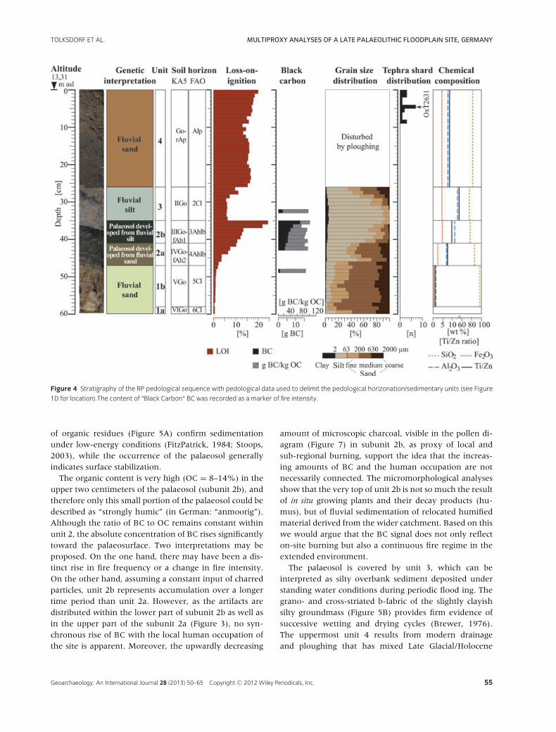
Figure 4 Stratigraphy of the RP pedological sequence with pedological data used to delimit the pedological horizonation/sedimentary units (see Figure
1D for location).The content of “Black Carbon” BC was recorded as a marker of fire intensity.
of organic residues (Figure 5A) confirm sedimentationunder low-energy conditions (FitzPatrick, 1984; Stoops,2003), while the occurrence of the palaeosol generallyindicates surface stabilization.
The organic content is very high (OC = 8–14%) in theupper two centimeters of the palaeosol (subunit 2b), andtherefore only this small portion of the palaeosol could bedescribed as “strongly humic” (in German: “anmoorig”).Although the ratio of BC to OC remains constant withinunit 2, the absolute concentration of BC rises significantlytoward the palaeosurface. Two interpretations may beproposed. On the one hand, there may have been a dis-tinct rise in fire frequency or a change in fire intensity.On the other hand, assuming a constant input of charredparticles, unit 2b represents accumulation over a longertime period than unit 2a. However, as the artifacts aredistributed within the lower part of subunit 2b as well asin the upper part of the subunit 2a (Figure 3), no syn-chronous rise of BC with the local human occupation ofthe site is apparent. Moreover, the upwardly decreasing
amount of microscopic charcoal, visible in the pollen di-agram (Figure 7) in subunit 2b, as proxy of local andsub-regional burning, support the idea that the increas-ing amounts of BC and the human occupation are notnecessarily connected. The micromorphological analysesshow that the very top of unit 2b is not so much the resultof in situ growing plants and their decay products (hu-mus), but of fluvial sedimentation of relocated humifiedmaterial derived from the wider catchment. Based on thiswe would argue that the BC signal does not only reflecton-site burning but also a continuous fire regime in theextended environment.
The palaeosol is covered by unit 3, which can beinterpreted as silty overbank sediment deposited understanding water conditions during periodic flood ing. Thegrano- and cross-striated b-fabric of the slightly clayishsilty groundmass (Figure 5B) provides firm evidence ofsuccessive wetting and drying cycles (Brewer, 1976).The uppermost unit 4 results from modern drainageand ploughing that has mixed Late Glacial/Holocene
Geoarchaeology: An International Journal 28 (2013) 50–65 Copyright C© 2012 Wiley Periodicals, Inc. 55

MULTIPROXY ANALYSES OF A LATE PALAEOLITHIC FLOODPLAIN SITE, GERMANY TOLKSDORF ET AL.
Figure 5 (A) The top of unit 2b (palaeosol) with organic rich brown to black layers, silty yellowish-gray laminae and several lines of quartz grain in-wash.
Plane-polarized light (PPL), scale at top left 1 mm. (B) Dense microstructure of unit 3 (fluvial silt). Note the orientation pattern of mica minerals and clay
representing a cross-striated b-fabric. Cross-polarized light, scale at bottom right 0.1 mm.
sandy-loamy overbank deposits and—probably—Holocene decomposed peat.
The XRF analyses corroborate by means of clearly dif-ferent elemental concentrations (particularly reflected bythe Ti/Zr-ratio) the designation of certain sediment lay-ers/units (Figure 4; Table I). The values result from differ-ent mineralogical properties depending on different parti-cle sizes during the changing sedimentation process. Theydo not result from a change in the source area caused bychanges in the catchment. The high SiO2 content of thelowermost unit (97%) indicates that it consists mainly ofquartz grains with no pedogenic signal. Throughout sedi-ment units 2a–3, the percentage representation of Fe2O3
and Al2O3 increases up the profile, which might be a re-sult of weathering processes that affected these horizons.The increase of Pb in unit 1 may indicate a certain imprintof industrial emissions and provides further evidence forthe recent age of these sediments.
Palynostratigraphy
The sediments at the base of the profile PC below 290 cmare fine- to medium-grained sands of fluvial origin. Thesewere not suitable for the preservation of pollen or otherorganic matter (Figure 6). These inorganic fluvial depositsare overlain by sands with intercalating organic layers upto 230 cm. Based on the remains of algae and aquaticmacrophytes, these partly organic sediments derive fromlacustrine sedimentation following the abandonment ofthe river channel. Pollen analyses reveal high percentagesof NAP, especially pollen of light-demanding taxa suchas Juniperus, Helianthemum, Artemisia, Cerastium-type, andSelaginella (Figure 6, SPZ C). Due to the occurrence ofthese light-demanding taxa and the high proportion ofEmpetrum, SPZ C can be correlated with records of the
second part of the Younger Dryas in NW Europe (e.g.,Hoek, 1997; Merkt & Muller, 1999; de Klerk, 2008;Theuerkauf & Joosten, 2012) thereby covering the lat-est part of this period, which lasted from approximately12,300 to 11,600 cal. BP.
The onset of SPZ D is marked palynologically by therise of Betula and Filipendula and lithologically by an in-crease in both OC and CaCO3 content. While the NAP-sum remains comparably high in the lower part of SPZ D,it decreases gradually in the upper part of the zone whereBetula reaches high values accompanied by low amountsof light-demanding taxa. SPZ D is assigned to the Pre-Boreal (c. 11,600–10,700 cal. BP). SPZ E, assigned to theBoreal period (c. 10,700–9600 cal. BP), is characterized bythe dominance of Pinus, the presence of Corylus to about5% and increasing values of Alnus and other taxa of a“mixed deciduous forest” (Ulmus, Quercus, Tilia, and Hed-era). Meanwhile, light-demanding taxa such as Helianthe-mum, Empetrum, and Selaginella have disappeared fromthe pollen assemblages. As the lower boundary of SPZE is marked by a break in pollen trends and the onsetof peat growth, we infer a hiatus in pollen sedimentationbetween SPZ D and E. While the trend of decreasing Pinusand increasing Ulmus, Quercus, Tilia, and Fraxinus prevailsduring the younger sediments, the appearance of Fagus inSPZ F supports an attribution to the late Atlantic (c. 7000–5900 cal. BP). The decline of Ulmus at the onset of SPZ Gis characteristic of the Sub-Boreal period (c. 5700–2900cal. BP).
As the fluvial sands at the base of the EP pollen se-quence yielded nearly no pollen, this record starts withSPZ A in the lower parts of the sandy-silty alluvial sed-iments of unit 2a (Figure 7). NAP-pollen values prevailhere, especially Artemisia, Helianthemum, Rosaceae, andThalictrum, but a high percentage of Poaceae, Cyperaceae,
56 Geoarchaeology: An International Journal 28 (2013) 50–65 Copyright C© 2012 Wiley Periodicals, Inc.

TOLKSDORF ET AL. MULTIPROXY ANALYSES OF A LATE PALAEOLITHIC FLOODPLAIN SITE, GERMANY
Table I Results of the pedological and XRF analyses. Designation of soil horizons and texture classification are given according to both AG Boden (2005)
and FAO (2006).
Depth [cm] 0–26 26–36 36–41 41–47 47–58 58–78 78–180
Horizon [KA5] Go-rAp II Go III Go-fAh1 IV Go-fAh2 V Go VI Go Gr
Horizon [FAO] Alp 2Cl 3Ahlb 4Ahlb 5Cl 6Cl 6Cr
Sedimentary
unit
4 3 2b 2a 1b 1a 1a
Excavation
layer
GS1 GS2 GS3 GS3 GS4 GS4 GS4
Genetic inter-
pretation
Fluvial sand Fluvial silt
(overbank
deposit)
Palaeosol
developed
(overbank
deposit)
Palaeosol
developed
from fluvial silt
(overbank
deposit)
Fluvial sand
from fluvial
sand (overbank
deposit)
Fluvial sand Fluvial
sand
Color [Munsell] 7.5YR2.5/1
(black)
2.5Y4/2 (dark
grayish brown)
10YR2/1 (black) 10YR4/1 (dark
gray)
2.5Y5/3 (light
olive brown)
2.5Y6/3 (light
yellowish
brown)
5Y4/2
(olive gray)
Granulometry Clay [%] 1.7–2.0 2.8–5.3 3.0–3.5 1.6–2.3 0.6–1.0 0.5 –
Silt [%] 32.9–39.7 50.9–87.2 58.3–75.4 30.9–46.6 5.7–16.4 1.9 –
Fine sand [%] 17.2–19.9 7.5–22.2 14.0–17.0 13.5–23.0 11.9–18.4 14.9 –
Medium sand [%] 25.6–26.0 0.0–16.7 12.0–19.5 23.5–39.6 43.5–58.3 65.7 –
Coarse sand [%] 15.4–19.6 0.0–7.6 1.1–2.2 4.7–14.4 20.7–23.5 17 –
Texture class [KA5] Su3-Su4 Us-Uu Us Su3-Su4 Ss-Su2 Ss Ss
Texture class [FAO] Sandy loam Silt loam-silt Silt loam Sandy loam Sand-loamy
sand
Sand Sand
Main elements SiO2 [%] 82.8 75.9 77.6 86.4 97 – –
Al2O3 [%] 7.7 12.9 11.2 7 1.6 – –
Fe2O3 [%] 4.8 4.8 4.9 2.4 0.2 – –
MnO [%] 0.1 0.0 0.0 0.0 0 – –
MgO [%] 0.5 1.1 0.7 0.5 0.1 – –
CaO [%] 1.1 1.0 1.7 0.7 0.1 – –
Na2O [%] 0.7 0.9 0.9 0.7 0.3 – –
K2O [%] 1.6 2.4 2.0 1.7 0.7 – –
TiO2 [%] 0.6 0.9 0.7 0.6 0.1 – –
P2O5 [%] 0.3 0.1 0.2 0.1 0.0 – –
SO3 [%] 0.0 0.0 0.1 0.0 0.0 – –
Trace elements
(selection)
Pb [ppm] 45 18 18 10 6 – –
Sr [ppm] 71 100 108 74 26 – –
Zr [ppm] 315 337 313 404 314 – –
Ti/Zr-ratio
[molar]
8.6 13.7 9.8 7.6 1.0 – –
and Selaginella selaginoides is also noteworthy. The tran-sition to the subsequent SPZ B is marked by decreasingterrestrial NAP-values, notably declines in Poaceae,Cyperaceae, and Selaginella. The uppermost samples ofthis zone show a dominance of Pinus-pollen.
The transition to SPZ C coincides with the lowerboundary of the silty overbank sediments of unit 3(Figure 7) and is marked by a sharp increase of NAP-values, especially Artemisia, Empetrum, Cerastium-type,Poaceae, and Cyperaceae. The high amounts of Pedias-
trum algae at the end of SPZ C indicate the (temporary)
existence of still water conditions and may derive from aphase of higher water levels during that time.
Both the break in pollen trends and the sedimento-logical change make a hiatus between SPZ B and C verylikely. As the pollen values of SPZ C in the PC pollen se-quence and SPZ C in the EP pollen sequence are verysimilar, we have correlated both pollen zones with onechronological phase. Based on the palynology, SPZ C rep-resents the second part of the Younger Dryas and SPZ Bcan be identified as an Allerød (c. 13,800–12,700 cal. BP)pollen spectrum. SPZ A may be equivalent to the Older
Geoarchaeology: An International Journal 28 (2013) 50–65 Copyright C© 2012 Wiley Periodicals, Inc. 57

MULTIPROXY ANALYSES OF A LATE PALAEOLITHIC FLOODPLAIN SITE, GERMANY TOLKSDORF ET AL.
Figure 6 Pollen diagram from the PC palynological sequence taken from the palaeochannel (see Figure 1D for location).
Dryas according to Hoek (1997) (c. 14,000–13,800 cal.BP).
Archaeo-, Chrono-, and Tephrostratigraphy ofthe RP Pedological Sequence and of theExcavation Area
The entire artifact assemblage can be attributed to anearly stage of the Federmesser techno complex (FMG)by means of typology and the technology of blade pro-duction. Based on 14C-data from other sites, the FMG inthe European plain is traditionally assigned to the Allerød(e.g., Bokelmann, Heinrich, & Menke, 1983; Terberger etal., 2004; Riede & Edinborough, 2012). The occurrence ofsome technological features which are more typical of theMagdalenian (e.g., fine long borers, use of burin spalls asblanks for borers) may indicate that this assemblage canbe placed at the very beginning of the known FMG tra-dition or even before. An early Allerød age (sensu Hoek,1997) of the site is confirmed by two 14C dates (TableII) of material from archaeological features from the low-
ermost part of subunit 2b. These yielded ages of 14,137–13,815 yr cal. BP and 14,185–13,703 yr cal. BP. The strati-graphic position of the artifacts within the lower partof unit 2 therefore provides evidence to date the startof sandy-silty overbank sedimentation to the end of theOlder Dryas or to the beginning of the Allerød. This is ingood accordance with the palynological analysis from thisstratigraphical unit.
Wood from the base of the palaeochannel infill in thePC palynological sequence yielded a 14C-age of 11,953–11,342 yr cal. BP (Table II) and confirmed the palyno-logical interpretation of the lowermost sediments (SPZ C)as Younger Dryas. The beginning of sedimentation dur-ing the Younger Dryas means that fluvial transport en-ergy must have declined in this period. Further 14C-agesfrom the PC palynological sequence confirm that the SPZD sediments date to the Pre-Boreal (11,594–11,200 yr cal.BP) and that SPZ G can be ascribed to the Sub-Boreal(5035–4848 yr cal. BP).
Tephra shards were only detected in low concentration(1–7 shards/g dry weight) in the uppermost samples of
58 Geoarchaeology: An International Journal 28 (2013) 50–65 Copyright C© 2012 Wiley Periodicals, Inc.

TOLKSDORF ET AL. MULTIPROXY ANALYSES OF A LATE PALAEOLITHIC FLOODPLAIN SITE, GERMANY
Figure 7 Composite pollen diagram from the EP palynological sequence taken from the excavation area (see Figure 1D for location).
RP, spread over a vertical distribution of 9 cm (OxT2631)probably as a result of historic ploughing. Based on theirchemical properties, they either derive from the A.D.1875 eruption of Askja (Oldfield et al., 1997; Haflidason,Eiriksson, & Kreveld, 2000) or from the 2210–1966 yr cal.BP Garry tephra (Barber, Langdon, & Blundell, 2008).
DISCUSSION
Site Development
The results allow us to establish a model of locallandscape development beginning in the Late Glacial(Figure 8). After deposition of fluvial sands in the LatePleniglacial, a deeper river channel incised into the flood-plain, probably during the Bølling or Older Dryas (prior
to 13,800 cal. BP). Episodic sedimentation in the flood-plain during flood events started around the onset of theAllerød. In this period, the river bank was inhabited bypeople with cultural affinities to the early Federmesser-gruppen whose artifacts became embedded in aggradingfine-grained fluvial sediments (14C-ages cover the timespan from 14,200 to 13,700 cal. BP). Because amber maystill be found today on erosional banks of the River Jeet-zel and such pieces are present in different stages of pro-cessing within the archaeological record, it seems verylikely that collecting and processing of amber from thesediments was an important local activity during humanoccupation. This may explain the decision to settle in thisopen and rather unsheltered area. During the Allerød,in general, fluvial sedimentation shifted toward a finerparticle size indicating decreased transportation energy
Table II Radiocarbon ages from the PC palynological sequence and from the archaeological record (excavation area). Calibration was performed using
Calib 6.0.1 software (Stuiver & Reimer, 1993) with the IntCal 09 database (Reimer et al., 2009).
14C age 14C cal. Age [years cal.
Lab. No. Profile/Context Material Depth [cm] [years BP] BP (2σ)] [IntCal09] δ13C [‰]
KIA-35106 PC palynological sequence Wood 246 10,065 ± 45 11,953–11,928; − 28.3
11,824–11,383;
11,379–11,342
KIA-35107 PC palynological sequence Organic material [indet.] 178 9885 ± 50 11,594–11,562; − 27.7
11,467–11,456;
11,405–11,200
KIA-35108 PC palynological sequence Wood 65 4355 ± 35 5035–5011; − 26.5
4978–4848
KIA-41862 Archaeological feature Charcoal (Betula) 12,125 ± 50 14,137–13,815 − 27.7
KIA-41861 Archaeological feature Bone fragments (calcined; one
fragment unburnt)
12,070 ± 100 14,185–13,703 − 23.8
Geoarchaeology: An International Journal 28 (2013) 50–65 Copyright C© 2012 Wiley Periodicals, Inc. 59
MULTIPROXY ANALYSES OF A LATE PALAEOLITHIC FLOODPLAIN SITE, GERMANY TOLKSDORF ET AL.
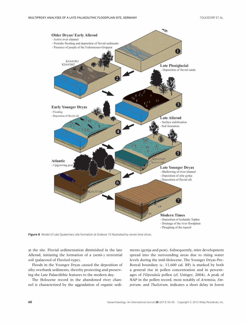
Figure 8 Model of Late Quaternary site formation at Grabow 15 illustrated by seven time slices.
at the site. Fluvial sedimentation diminished in the lateAllerød, initiating the formation of a (semi-) terrestrialsoil (palaeosol of Fluvisol-type).
Floods in the Younger Dryas caused the deposition ofsilty overbank sediments, thereby protecting and preserv-ing the Late Palaeolithic features to the modern day.
The Holocene record in the abandoned river chan-nel is characterized by the aggradation of organic sedi-
ments (gyttja and peat). Subsequently, mire developmentspread into the surrounding areas due to rising waterlevels during the mid-Holocene. The Younger Dryas-Pre-Boreal boundary (c. 11,600 cal. BP) is marked by botha general rise in pollen concentration and in percent-ages of Filipendula pollen (cf. Usinger, 2004). A peak ofNAP in the pollen record, most notably of Artemisia, Em-
petrum, and Thalictrum, indicates a short delay in forest
60 Geoarchaeology: An International Journal 28 (2013) 50–65 Copyright C© 2012 Wiley Periodicals, Inc.

TOLKSDORF ET AL. MULTIPROXY ANALYSES OF A LATE PALAEOLITHIC FLOODPLAIN SITE, GERMANY
development during the early Pre-Boreal. Later in thePre-Boreal, a birch-pine-forest developed replaced by apine-birch forest in the late Boreal. It is characterized bya paucity of hazel, which is typical on nutrient-poor siteslocated on Saalian till sediment and soils of the so-calledlower terrace (Late Glacial fluvial sands) in the wider re-gion (e.g., Speier, 1994). The pollen record shows a typi-cal Holocene vegetation sequence for northern Germany,with the spread of more thermophilic deciduous trees,and a remarkable early expansion of alder forests in fensaround the Grabow 15 site. Many archaeological sites ofMesolithic (c. 11,600–6000 cal. BP) and early Neolithicage (c. 6000–5000 cal. BP) along the Holocene channelsystem of the Jeetzel River attest to the attraction of thearea for hunting and farming groups during the early andmid-Holocene. Draining and ploughing during moderntimes caused an admixture of the uppermost sedimentsthat received late Holocene tephra shards.
Regional Palaeoenvironmental Implications
Comparably well-investigated Late Glacial stratigraphiesin floodplains and basins are rare in central andwestern Europe (e.g., Niers-Rhine/NW Germany: Kasseet al., 2005; Barthe river and Endinger Bruch basin/NEGermany: Kaiser, 2004a; Wierzyca and Wda rivers/NWPoland: Błaszkiewicz, 2010; Paris basin/France: Pastre etal., 2003; Selle river/France: Antoine et al., 2003). Someof these records suffer from a lack of preservation, lowchronological resolution or limited analytical approach.Thus, by avoiding such constraints, our results signifi-cantly improve our understanding of this period.
Although only a few pollen sequences from late Qua-ternary floodplain sediments in northern and central Ger-many have been used for environmental reconstruction(e.g., Willerding, 1960; Litt, 1992; Caspers, 1993, 2000),our cross-check of sediments from a palaeochannel andan adjacent floodplain site demonstrate that these sedi-ments offer considerable potential as reliable records ofvegetation change. Nonetheless, we do not expect thatfloodplain sediments represent the same level of palynos-tratigraphical precision as sediments from lakes and peats(Prentice, 1985; Sugita, 1994; Gaillard et al., 2008). Thecontribution of far-traveled fluvially transported pollen tothe pollen assemblage may be high and may have under-gone considerable fluctuations. Together with the localdeposition of pollen from plants in the immediate prox-imity, this may explain why the share of floatable saccatePinus-pollen and local elements (Cerastium, Selaginella) inthe EP is higher than in sequences from nearby lakesand peatlands. In contrast, the share of Betula seemsrelatively diminished in comparison with nearby pollen
diagrams (Lesemann, 1969; Rohrig et al., 2004; Chris-tiansen, 2008).
In general, the palynological results from the Grabow15 site support the findings from sites in the wider re-gion (Usinger, 1985; Hoek, 1997; Merkt & Muller, 1999).The relative maximum of NAP is in the Older Dryas–Allerød transition, especially of Helianthemum and Thal-ictrum, followed by a Juniperus maximum and decreasedvalues of terrestrial NAP, Poaceae, Cyperaceae, and Se-laginella. For the Younger Dryas, the palynological recordindicates the presence of open forest vegetation with scat-tered tree stands which is often characterized as “parktundra” (Lang, 1994; Usinger, 2004). Typical for this pe-riod are the light-demanding taxa such as Juniperus, He-
lianthemum, Artemisia, Thalictrum, and Selaginella. Basedon the occurrence of high amounts of Pinus-pollen and Pi-nus sylvestris-needles in the sediments, the Grabow 15 siterepresents one of the most north-westerly sites in cen-tral Europe where the persistence of P. sylvestris is provenduring the Younger Dryas (Spurk, Kromer, & Peschke,1999; Theuerkauf & Joosten, 2012). Further records forthe persistence of pine trees in central Europe have beenreported, for example, from the German Uplands (Rhinevalley: Holzer & Holzer, 1994; Neckar valley: Bos et al.,2008; Amoneburger basin: Bos, 2001) and from north-east Germany (Theuerkauf & Joosten, 2012). It there-fore seems that river valleys in central Europe may haveprovided microrefugia for pine trees during the YoungerDryas.
The peak of NAP and the delayed establishment offorest development observed at Grabow 15 during thePre-Boreal may be another local demonstration of thePre-Boreal oscillation, a cold and dry phase, frequentlydetected in records from NW Europe (Usinger, 2004;Bohncke & Hoek, 2007; Bos et al., 2007).
A palaeosol of Allerød age occurring in a fluvial se-quence is a feature hitherto rarely detected, indicatingthat a previously active environment stabilized succes-sively during the Allerød probably under the influence ofdenser vegetation. Comparable processes can be identi-fied at dry site of aeolian sands in the wider region wherethe formation of the frequently detected so-called “Us-selo and Finow soils” (Albic and Brunic Arenosols, re-spectively) started synchronously (Kaiser et al., 2009).
Although sediments from the Allerød are preservedat this site, no LST as a characteristic central Europeanmarker horizon of the late Allerød (Schmincke, Park, &Harms, 1999; Baales et al., 2002) was detected. With re-spect to the fallout zone mapped by means of the knownlocalities of this tephra (Riede et al., 2011), Grabow 15site is located close to the western edge of the suggestedfallout zone. We are therefore unable to decide if theLST did not fall in the local area or if the conditions of
Geoarchaeology: An International Journal 28 (2013) 50–65 Copyright C© 2012 Wiley Periodicals, Inc. 61

MULTIPROXY ANALYSES OF A LATE PALAEOLITHIC FLOODPLAIN SITE, GERMANY TOLKSDORF ET AL.
periodic floodplain sedimentation prevented preserva-tion. The same is true for the sediments dated to theYounger Dryas, where no layer of the expected Veddeash (Blockley et al., 2007) was identified.
Concerning hydrological changes during the LateGlacial, our results indicate a relative high water levelat this site during the Younger Dryas, which resulted inthe widespread deposition of silty floodplain sediments.This (seasonal?) local increase of the water level mightbe caused, on the one hand, locally by a nearby activeriver channel of the Jeetzel or Elbe River, or, on theother hand, regionally by an increasing water level in thebroadened Elbe valley. The latter—a general increase ofwater levels in rivers and lakes probably during the sec-ond half of the Younger Dryas—has been demonstratedpreviously by several records in nearby northeastern Ger-many (e.g., Helbig & de Klerk, 2002; Kaiser, 2004b; Ter-berger et al., 2004; Kaiser et al., 2007, 2012). Perhaps reg-ular flooding is responsible for the lack of archaeologicalevidence for human occupation in this area during thisperiod, that is, by people of the Tanged Point (Ahrens-burgian) culture.
CONCLUSIONS
The results presented in this paper show that floodplainsediments are suitable archives to analyze the interactionsbetween climate, hydrology, vegetation, and human ac-tivities from the Late Glacial with relatively high resolu-tion. The following conclusions can be drawn:
1. Older Dryas/early Allerød: Sandy and silty overbanksediments were deposited along an active mean-dering river channel, providing the parent materialfor subsequent pedogenesis.
2. Allerød: Fluvial sedimentation diminished and pe-dogenic processes started. A soil of Fluvisol-typerich in organic matter developed. In general, thishydrological stabilization phase probably favored(periodic?) human occupation of the river banksduring dry seasons. Amber was collected from lo-cal fluvial sediments and was processed into artisticobjects.
3. Late Younger Dryas: The river water level rose,which led to the deposition of silty overbank de-posits during floods while the river channel be-came abandoned. This protected the archaeologicalrecord from later disturbances. The overall trendof rising water tables during this period probablyforced humans out of the low-lying localities (rivervalleys, lake basins) in northern central Europe.
4. Holocene: The abandoned river channel was filledwith lacustrine sediments and peat growth started.
Paludification spread out into the surroundings.The uppermost sediment layer was disturbed bymodern human drainage and ploughing.
This study is part of the Weitsche research project directed by theState Museum of Lower Saxony Hannover and was generouslyfunded by the Federal State of Lower Saxony. Macroscopic char-coal was identified by F. Bittmann (Lower Saxony Institute forHistorical Coastal Research, Wilhelmshaven). P. M. Grootes andM. Huls (Leibniz-Laboratory for Radiometric Dating and IsotopeResearch, Kiel) supervised the radiocarbon measurements. Anal-ysis of OC was performed by B. Schneider (University of Leipzig)and XRF analysis was conducted by S. Jung (University of Ham-burg). We thank R. Lampe and S. Lorenz (both from Univer-sity of Greifswald) for allowing us to carry out grain-size analysisin their laboratory. Funding for the tephra research came fromgrants awarded to RESET by the UK’s Natural EnvironmentalResearch Council (NERC): NE/E/015905/1 and NE/E015670/1.This is RHOX/0008 publication. The contribution of K. Kaiserwas partly enabled by the projects ICLEA and TERENO of theHelmholtz Association. The families von Plato and von Blottnitzkindly gave permission to work on their property and supportedthe fieldwork. We are indebted to two anonymous reviewerswhose valuable comments helped to improve the manuscript.
REFERENCES
AG Boden. (2005). Bodenkundliche Kartieranleitung.
Hannover: Schweizerbart.
Antoine, P., Munaut, A.-V., Limondin-Lozouet, N., Ponel, P.,
Duperon, J., & Duperon, M. (2003). Response of the Selle
River to climatic modifications during the Lateglacial and
Early Holocene (Somme Basin-Northern France).
Quaternary Science Reviews, 22, 2061–2076.
Baales, M., Joris, O., Street, M., Weninger, B., & Wiethold, H.
(2002). Impact of the Late Glacial Eruption of the Laacher
See Vulcano, Central Rhineland, Germany. Quaternary
Research, 58, 273–288.
Barber, K., Langdon, P., & Blundell, A. (2008). Dating the
Glen Garry tephra: A widespread late-Holocene marker
horizon in the peatlands of northern Britain. The
Holocene, 18, 31–43.
Berglund, B.W., & Ralska-Jasiewiczowa, M. (1986). Pollen
analysis and pollen diagramms. In B.E. Berglund (Ed.),
Handbook of Holocene Palaeoecology and Palaeohydrology
(pp. 357–373). Chichester: John Wiley & Sons.
Beug, H.-J. (2004). Leitfaden der Pollenbestimmung fur
Mitteleuropa und angrenzende Gebiete. Munchen:
Pfeil-Verlag.
Błaszkiewicz, M. (2010). Development of fluvio-lacustrine
systems in the young glacial area in Poland based on the
research in the valleys of the rivers Wierzyca and Wda.
Questiones Geographicae, 29, 13–19.
Blockley, S.P.E., Pyne-O’Donnell, S., Lowe, J.J., Matthews,
I.P., Stonea, A., Pollard, A.M., Turney, C., & Molineaux, E.
(2005). A new and less destructive laboratory procedure
for the physical separation of distal glass tephra shards
62 Geoarchaeology: An International Journal 28 (2013) 50–65 Copyright C© 2012 Wiley Periodicals, Inc.
TOLKSDORF ET AL. MULTIPROXY ANALYSES OF A LATE PALAEOLITHIC FLOODPLAIN SITE, GERMANY
from sediments. Quaternary Science Reviews, 26, 3030–
3036.
Blockley, S.P.E., Lane, C.S., Lotter, A.F., & Pollard, A.M.
(2007). Evidence for the presence of the Vedde Ash in
Central Europe. Quaternary Science Reviews 26,
3030–3036.
Bohncke, S.J.P., & Hoek, W.Z. (2007). Multiple oscillations
during the Preboreal as recorded in a calcareous gyttja,
Kingbeekdal, The Netherlands. Quaternary Science
Reviews, 26, 1965–1974.
Bokelmann, K., Heinrich, D., & Menke, B. (1983). Funde des
Spatglazials am Hainholz-Essinger Moor, Kreis Pinneberg.
Offa, 40, 199–239.
Bos, J.A.A. (2001). Lateglacial and Early Holocene vegetation
history of the northern Wetterau and the Amoneburger
Basin (Hessen), central-west Germany. Reviews of
Palaeobotany and Palynology, 115, 177–212.
Bos, J.A.A., Van Geel, B., Van der Plicht, J., & Bohncke, S.J.P.
(2007). Preboreal climate oscillations in Europe:
Wiggle-match dating and synthesis of Dutch
high-resolution multi-proxy records. Quaternary Science
Reviews, 26, 1927–1950.
Bos, J.A.A., Dambeck, R., Kalis, A.J., Schweizer, A., &
Thiemeyer, H. (2008). Palaeoenvironmental changes and
vegetation history of the northern Upper Rhine Graben
(southwestern Germany) since the Lateglacial. Netherlands
Journal of Geosciences, 87, 67–90.
Brewer, R. (1976). Fabric and mineral analysis of soils.
Huntington: Robert E. Krieger Publisher.
Brodowksi, A., Rodionov, L., Haumaier, L., Glaser, B., &
Amelung, W. (2005). Revised black carbon assessment
using benzene polycarboxyclic acids. Organic
Geochemistry, 36, 1299–1310.
Caspers, G. (1993). Vegetationskundliche Untersuchungen
zur Flussauenentwicklung an der Mittelweser im
Spatglazial und Holozan. Abhandlungen aus dem
Westfalischen Museum fur Naturkunde, 55, 1–101.
Caspers, G. (2000). Sedimente und Entwicklung des Elbetals
im Gebiet der Wische (Sachsen-Anhalt) seit der
Weichsel-Kaltzeit. Untere Havel: Naturkundliche Berichte
aus Altmark und Prignitz, 10, 32–43.
Christiansen, J. (2008). Vegetationsgeschichtliche
Untersuchungen in der westlichen Prignitz, dem ostlichen
Hannoverschen Wendland und der nordlichen Altmark.
Ph.D. Thesis, University of Gottingen.
Davies, S.M., Abbott, P.M., Pearce, N.J., Wastegard, S., &
Blockley, S.P. (2012). Integrating the INTIMATE records
using tephrochronology: Rising to the challenge.
Quaternary Science Reviews, 36, 11–27.
de Klerk, P. (2002). Changing vegetation patterns in the
Endinger Bruch area (Vorpommern, NE Germany) during
the Weichselian Lateglacial and Early Holocene. Review of
Palaeobotany and Palynology, 119, 275–309.
de Klerk, P. (2008). Patterns in vegetation and sedimentation
during the Weichselian Late-glacial in north-eastern
Germany. Journal of Biogeography, 35, 1308–
1322.
FAO (2006). Guidelines for soil description. Rome: FAO.
FitzPatrick, E.A. (1984). Micromorphology of soils. London:
Chapman and Hall.
Gaillard, M.-J., Sugita, S., Bunting, M.J., Middelton, R.,
Brostrom, A., Caseldine, C., Giesecke, T., Hellmann, S.E.V.,
Hick, S., Hjelle, K., Langdon, C., Nielsen, A.-B., Poska, A.,
von Stedingh, H., Veski, S., & POLLANDCAL members
(2008). The use of modelling and simulation approach in
reconstructing past landscapes from fossil pollen data: A
review and results from the POLLANDCAL network.
Vegetation History and Archaeobotany, 17, 419–443.
Glaser, B., Haumaier, L., Guggenberger, G., & Zech, W.
(1998). Black carbon in soils: The use of benzenecarboxylic
acids as specific markers. Organic Geochemistry, 29,
811–819.
Haflidason, H., Eiriksson, J., & Kreveld, S.V. (2000). The
tephrachronology of Iceland and the North Atlantic region
during the middle and late Quaternary: A review. Journal
of Quaternary Science, 15, 3–22.
Hagedorn, J. (Ed.) (1995). Late Quaternary and present-day
fluvial processes in Central Europe. Zeitschrift fur
Geomorphologie Supplement 100.
Heiri, O., Lotter, A.F., & Lemcke, G. (2001). Loss on ignition
as a method for estimating organic and carbon content in
sediments: Reproducibility and comparability of results.
Journal of Paleolimnology, 25, 101–110.
Helbig, H., & de Klerk, P. (2002). Befunde zur spatglazialen
fluvial-limnischen Morphodynamik in kleinen Talungen
Vorpommerns. Eiszeitalter und Gegenwart, 51, 51–66.
Hiller, A., Litt, T., & Eißmann, L. (1991). Zur Entwicklung der
jungquartaren Tieflandstaler im Saale-Elbe-Raum unter
besonderer Berucksichtigung von 14C-Daten. Eiszeitalter
und Gegenwart, 41, 26–46.
Hoek, W.Z. (1997). Late-Glacial and early Holocene climatic
events and chronology of vegetation development in the
Netherlands. Vegetation History and Archaeobotany, 6,
197–213.
Holzer, A., & Holzer, A. (1994). Studies on the vegetation
history of the Latermoor in the Upper Rhine valles
(SW-Germany) by means of pollen, macrofossils, and
geochemistry. Dissertationes Botanicae, 234, 309–336.
IUSS-ISRIC-FAO. (2006). World reference base for soil
resources. A framework for international classification,
correlation and communication. World Soil Resources
Reports 103. Rome: FAO.
Kaiser, K. (2004a). Lake basin development in the Endinger
Bruch area (Vorpommern, NE Germany) during the Late
Pleistocene and Early Holocene. Zeitschrift fur
Geomorphologie, 48, 461–480.
Kaiser, K. (2004b). Geomorphic characterization of the
Pleistocene-Holocene transition in Northeast Germany. In
T. Terberger & B.V. Eriksen (Eds.), Hunters of a changing
world—Environment and archaeology of the
Geoarchaeology: An International Journal 28 (2013) 50–65 Copyright C© 2012 Wiley Periodicals, Inc. 63
MULTIPROXY ANALYSES OF A LATE PALAEOLITHIC FLOODPLAIN SITE, GERMANY TOLKSDORF ET AL.
Pleistocene-Holocene transition in northern Central
Europe ca. 11,500 years ago (pp. 53–73). Rahden:
Leidorf.
Kaiser, K., Rother, H., Lorenz, S., Gartner, P., & Papenroth, R.
(2007). Geomorphic evolution of small river-lake-systems
in Northeast Germany during the Late Quaternary. Earth
Surface Processes and Landforms, 32, 1516–1532.
Kaiser, K., Hilgers, A., Schlaak, N., Jankowski, M., Kuhn, P.,
Bussemer, S., & Przegietka, K. (2009). Palaeopedological
marker horizons in northern central Europe:
Characteristics of Lateglacial Usselo and Finow soils.
Boreas, 38, 591–609.
Kaiser, K., Lorenz, S., Germer, S., Juschus, O., Kuster, M.,
Libra, J., Bens, O., & Huttl, R.F. (2012). Late Quaternary
evolution of rivers, lakes and peatlands in northeast
Germany reflecting past climatic and human impact – an
overview. E&G Quaternary Science Journal, 61, 103–132.
Kasse, C., Hoek, W.Z., Bohncke, S.J., Konert, M., Weijers,
J.W., Cassee, M.L., & van der Zee, R.M. (2005). Late
Glacial fluvial response of the Niers-Rhine (western
Germany) to climate and vegetation change. Journal of
Quaternary Science, 20, 377–394.
Lang, F. (1994). Quartare Vegetationsgeschichte Europas.
Jena: Fischer.
Lesemann, B. (1969). Pollenanalytische Untersuchungen zur
Vegetationsgeschichte des Hannoverschen Wendlandes.
Flora B, 158, 480–519.
Litt, T. (1992). Fresh investigations into the natural and
anthropogenically influenced vegetation of the earlier
Holocene in the Elbe-Saale Region, Central Germany.
Vegetation History and Archaeobotany, 1, 69–74.
Merkt, J., & Muller, H. (1999). Varve chronology and
palynology of the Lateglacial in Northwest Germany from
lacustrine sediments of Hamelsee in Lower Saxony.
Quaternary International, 61, 41–59.
Oldfield, F., Thompson, R., Crooks, R., Gedye, E., Hall, V.,
HArkness, D., Housley, R., McCormac, F., Newton, A.,
Pilcher, J., Renberg, I, & Richardson, N. (1997).
Radiocarbon dating of a recent high latitude peat profile:
Stor Amran, northern Sweden. The Holocene, 7, 283–
290.
Pastre, J.-F., Limondin-Lozouet, N., Leroyer, C., Ponel, P., &
Fontugne, M. (2003). River system evolution and
environmental changes during the Lateglacial in the Paris
Basin (France). Quaternary Science Reviews, 22,
2177–2188.
Prentice, I.C. (1985). Pollen representation, source area, and
basin size: Towards a unified theory of pollen analysis.
Quaternary Research, 23, 76–86.
Reimer, P.J., Baillie, M.G.L., Bard, E., Bayliss, A., Beck, J.W.,
Blackwell, P.G., Bronk Ramsey, C., Buck, C.E., Burr, G.,
Edwards, R.L., Friedrich, M., Grootes, P.M., Guilderson,
T.P., Hajdas, I., Heaton, T.J., Hogg, A.G., Hughen, K.A.,
Kaiser, K.F., Kromer, B., McCormac, F.G., Manning, S.W.,
Reimer, R.W., Richards, D.A., Southon, J., Turney, C.S.M.,
van der Plicht, J., & Weyhenmeyer, C. (2009). IntCal09
and Marine09 radiocarbon age calibration curves, 0–50,000
years cal BP. Radiocarbon, 51, 1111–1150.
Retallack, G. (1981). Fossil soils: Indicators of ancient
terrestrial environments. In K.J. Niklas (Ed.), Paleobotany,
paleoecology and evolution (pp.55–102). Westport:
Greenwood.
Riede, F., Bazely, O., Newton, A.J., & Lane, C.S. (2011). A
Laacher See-eruption supplement to Tephrabase:
Investigating distal tephra fallout dynamics. Quaternary
International, 246, 134–144.
Riede, F., & Edinborough, K. (2012). Bayesian radiocarbon
models for the cultural transition during the Allerød in
southern Scandinavia. Journal of Archaeological Science,
39, 744–756.
Rohrig, R., Beug, H.J., Trettin, R., & Morgenstern, P. (2004).
Subfossil chironomid assemblages as paleoenvironmental
indicators in Lake Faulersee (Germany). Studia
Quaternaria, 12, 117–127.
Schmincke, H., Park, C., & Harms, E. (1999). Evolution and
environmental impacts of the eruption of Laacher See
Volcano (Germany) 12,900 a BP. Quaternary
International, 61, 61–72.
Schwabedissen, H. (1954). Die Federmessergruppen des
nordwesteuropaischen Flachlandes. Neumunster:
Wachholtz.
Speier, M. (1994). Vegetationskundliche und
palaookologische Untersuchungen zur Rekonstruktion
prahistorischer und historischer Landnutzung im sudlichen
Rothaargebirge. Abhandlungen au dem Westfalischen
Museum fur Naturkunde, 56, 1–174.
Spurk, M., Kromer, B., & Peschke, P. (1999).
Dendrochronologische, palynologische und
Radiokarbon-Untersuchungen eines Waldes aus der
Jungeren Tundrenzeit. Quartar, 49/50, 34–38.
Starkel, L. (2003). Palaeohydrology of Central Europe. In K.J.
Gregory & G. Benito (Eds.), Palaeohydrology,
understanding global change (pp. 77–104). Chichester:
Wiley.
Stockmarr, J. (1971). Tablets with spores used in absolute
pollenanalysis. Pollen et Spores, 13, 615–621.
Stoops, G. (2003). Guidelines for analysis and description of
soil and regolith thin sections. Madison: Soil Science
Society of America.
Stoops, G., Marcelino, V., & Mees, F. (2010). Interpretation of
micromorphological features of soils and regoliths.
Amsterdam: Elsevier.
Street, M., Baales, M., Cziesla, E., Sonke, H., Heinen, M.,
Joris, O., Koch, I., Pasda, C., Terberger, T., & Vollbrecht, J.
(2001). Final palaeolithic and mesolithic research in
reunified Germany. Journal of World Prehistory, 15,
365–453.
Stuiver, M., & Reimer, P. (1993). Extended 14C-database and
revised CALIB radiocarbon calibration program.
Radiocarbon, 35, 215–230.
64 Geoarchaeology: An International Journal 28 (2013) 50–65 Copyright C© 2012 Wiley Periodicals, Inc.

TOLKSDORF ET AL. MULTIPROXY ANALYSES OF A LATE PALAEOLITHIC FLOODPLAIN SITE, GERMANY
Sugita, S. (1994). Pollen representation of vegetation in
Quaternary sediments: Theory and method in patchy
vegetation. Journal of Ecology, 82, 881–897.
Terberger, T., de Klerk, P., Helbig, H., Kaiser, K., & Kuhn, P.
(2004). Late Weichselian landscape development and
human settlement in Mecklenburg-Vorpommern (NE
Germany). Eiszeitalter und Gegenwart, 54, 138–175.
Theuerkauf, M., & Joosten, H. (2012). Younger Dryas cold
stage vegetation patterns of central Europe—Climate, soil
and relief controls. Boreas, 41, 391–407.
Turner, F., Tolksdorf, J. F., Viehberg, F. A., Schwalb, A.,
Kaiser, K., Bittmann, F., von Bramann, U., Pott, R.,
Staesche, U., Breest, K., Veil, S. (2012). Lateglacial/early
Holocene fluvial reactions of the Jeetzel river (Elbe valley,
northern Germany) to abrupt climatic and environmental
changes. Quaternary Science Reviews [accepted, in press].
Usinger, H. (1985). Pollenstratigraphische, vegetations-und
klimageschichtliche Gliederung des
“Bølling-Allerød-Komplexes“ in Schleswig-Holstein und
ihre Bedeutung fur die Spatglazial-Stratigraphie in
benachbarten Gebieten. Flora, 177, 1–43.
Usinger, H. (2004). Vegetation and climate of the lowlands of
northern Central Europe and adjacent areas around the
Younger Dryas-Preboreal transition—With special
emphasis on the Preboreal oscillation. In T. Terberger &
B.V. Eriksen (Eds.), Hunters in a changing world.
Environment and archaeology of the Pleistocene-Holocene
transition (ca. 11000–9000 B.C.) in Northern Central
Europe (pp. 1–26). Rahden: Leidorf.
Veil, S., & Breest, K. (1995). Figurenfragmente aus Bernstein
vom Federmesser-Fundplatz Weitsche bei Luchow, Ldkr.
Luchow-Dannenberg (Niedersachsen). Archaologisches
Korrespondenzblatt, 25, 29–47.
Veil, S., & Breest, K. (2000). Der archaologische Befund der
Kunstgegenstande aus Bernstein auf dem
Federmesser-Fundplatz Weitsche. Die Grabungen
1994–1998. Die Kunde N.F., 51, 179–202.
Veil, S., & Breest, K. (2006). Origins of Mesolithic art? A
recently discovered pendant and other objects of amber
from the Federmesser site Weitsche, County of Luchow
Dannenberg (Lower Saxony, Germany). In C.-J. Kind
(Ed.), After the ice age. Settlements, subsistence and social
development in the Mesolithic of Central Europe (pp.
285–295). Stuttgart: Theiss.
Veil, S., & Terberger, T. (2009). Kunst und Umwelt im
Wandel. Was wurde aus der Eiszeitkunst? In S. Rau (Ed.),
Eiszeit: Kunst und Kultur (pp. 347–351). Ostfildern:
Thorbecke.
Veil, S., Breest, K., Grootes, P., Nadeau, M., & Huls, M.
(2012). A 14 000-year-old amber elk and the origins of
northern European art. Antiquity, 86, 660–673.
Willerding, U. (1960). Beitrage zur jungeren Geschichte der
Flora und Vegetation der Flussauen. Flora, 149, 435–
476.
Geoarchaeology: An International Journal 28 (2013) 50–65 Copyright C© 2012 Wiley Periodicals, Inc. 65
Copyright © 2022 FDOKUMEN