Hackensack Meadowlands Floodplain ... - Amazon S3
215
Hackensack Meadowlands Floodplain Management Plan prepared in conformity to The National Flood Insurance Program Community Rating System Activity 510 Guidelines for The New Jersey Meadowlands Commission One DeKorte Park Plaza Lyndhurst, New Jersey October 24, 2005
-
Upload
khangminh22 -
Category
Documents
-
view
3 -
download
0
Transcript of Hackensack Meadowlands Floodplain ... - Amazon S3

Hackensack Meadowlands Floodplain Management Plan
prepared in conformity to
The National Flood Insurance Program Community Rating System Activity 510 Guidelines
for
The New Jersey Meadowlands Commission One DeKorte Park Plaza Lyndhurst, New Jersey
October 24, 2005

Hackensack Meadowlands Floodplain Management Plan Page i
TABLE OF CONTENTS
Content
Page
Table of Contents
i
1. Preparation of the Plan 1.1. Introduction 1.2. Authorization 1.3. Kick-Off Meeting 1.4. Formation of the Plan Committee
1 1 2 2 3
2. Public Involvement 2.1. Public Meetings 2.2. Solicitation of Input
2.2.1. Flooding Questionnaire 2.2.2. Hotline 2.2.3. Response
5 5 5 5 6 7
3. Agency Coordination 3.1. Action 1: Permit-By-Rule Authority 3.2. Action 2: Regulation Conformity to Stormwater Management Rules
8 8 10
4. Hazard Assessment 4.1. Flood Hazard Identification 4.2. Flood Hazard Profiles
4.2.1. Meadowlands Parkway, Secaucus 4.2.2. Carol Place, Moonachie 4.2.3. Broad Street and 16th Street, Carlstadt 4.2.4. 40 Broad Street, Carlstadt 4.2.5. Barell Avenue, Carlstadt 4.2.6. Asia Place and Kero Road, Carlstadt 4.2.7. Grand Street and Christiana Avenue,
Moonachie 4.2.8. Avenue A and Moonachie Avenue, Moonachie 4.2.9. Fish House Road, Kearny 4.2.10. Wolf Creek, Ridgefield 4.2.11. Rutherford Tide Gates/ Route 17, Rutherford 4.2.12. Murray Hill Parkway, East Rutherford 4.2.13. Penhorn Avenue, Secaucus
11
11 12 17 23 29 34 39 45 55
61 66 73 78 83 89

Hackensack Meadowlands Floodplain Management Plan Page ii
4.2.14. Polito Avenue, Lyndhurst 4.2.15. N.J. Route 7 / Belleville Turnpike, Kearny 4.2.16. Gotham Parkway, Carlstadt 4.2.17. Additional Areas of Concern
A. 1600 Paterson Plank Road, Secaucus B. 176 Louis Street, Secaucus C. 758 Paterson Plank Road, East Rutherford D. 1250 Valley Brook Avenue, Lyndhurst E. Bellman’s Creek, North Bergen F. 694 Minnie Place South, Secaucus G. 325 Washington Avenue, Carlstadt H. 9 Chapman Drive, Little Ferry I. 67 Huber Street, Secaucus J. 64 Maiden Lane, Little Ferry K. Hartwick Street, Little Ferry L. 55 Second Avenue, Secaucus M. 1138B Farm Road, Secaucus N. Mill Ridge Road, Secaucus
4.3. Other Hazards 4.4. Future Impacts
96 100 106 114 114 117 120 124 128 133 136 142 146 149 153 158 161 164 170 177
5. Goals
192
6. Hazard Mitigation Recommendations 6.1. Revisions to Meadowlands Zoning Regulations 6.2. Open Space Priorities 6.3. Property Retrofitting Measures 6.4. District Flood Hazard Warning System 6.5. Mitigation Projects
194
194 196 200 204 206
7. Plan Adoption
209
8. Plan Maintenance
210
Appendix A: Plan Committee Meetings
Appendix B: Interagency Committee Meetings

Hackensack Meadowlands Floodplain Management Plan Page 1
SECTION 1: PREPARATION OF THE PLAN 1.1 Introduction The New Jersey Meadowlands Commission (“NJMC”) participates in the Federal Emergency Management Agency’s (FEMA) Community Rating System (“CRS”) on behalf of the 14 municipalities within the Hackensack Meadowlands District. This program is voluntary and recognizes and encourages community floodplain management activities that exceed the minimum National Flood Insurance Program (“NFIP”) requirements. Property owners and tenants in the Hackensack Meadowlands District currently enjoy a flood insurance discount due to the continued efforts by the NJMC to exceed the program requirements. Under the CRS guidelines, the NJMC is responsible for the preparation, adoption, implementation, evaluation, and maintenance of this comprehensive Floodplain Management Plan (the “Plan”). It is our goal to achieve the maximum permissible CRS point total for the Plan to not only further reduce the insurance premiums in the District, but also to better address the flooding that has plagued the District in the past several years. This Plan’s development, per the above guidelines, included the following:
Table 1-1: Plan Development Guidelines
Planning Regulations (44 CFR 201.6) CRS Planning Steps
Planning Process
201.6(c)(1) 1. Organize
201.6(b)(1) 2. Involve the public
201.6(b)(2) & (3) 3. Coordinate
Risk Assessment
201.6(c)(2)(i) 4. Assess the hazard
201.6(c)(2)(ii) & (iii) 5. Assess the problem

Hackensack Meadowlands Floodplain Management Plan Page 2
Mitigation Strategy
201.6(c)(3)(i) 6. Set goals
201.6(c)(3)(ii) 7. Review possible activities
201.6(c)(3)(iii) 8. Draft an action plan
Plan Maintenance
201.6(c)(5) 9. Adopt the plan
201.6(c)(4) 10. Implement, evaluate, revise
The objective of this document is to produce and guide a program of activities that will best tackle the District's potential vulnerability to flooding. Per FEMA, the developed Plan shall:
• Ensure that all possible activities are reviewed and implemented so that the most appropriate solutions are used to address the hazard;
• Ensure that activities are coordinated with each other and with other community goals, objectives, and activities, preventing conflicts and reducing the costs of implementing individual activities;
• Educate residents about local flood hazards, loss reduction measures, and the natural and beneficial functions of floodplains;
• Build public and political support for projects that prevent new problems, reduce losses, and protect the natural and beneficial functions of floodplains; and
• Build a constituency that wants to see the plan's recommendations implemented.
1.2 Authorization As per a September 27, 2004 memorandum from NJMC Executive Director Robert R. Ceberio to Ileana Kafrouni, P.P., A.I.C.P., Director of Land Use Management, Ms. Kafrouni was placed in charge of the completion of the Hackensack Meadowlands Floodplain Management Plan. The completion deadline was established as August 31, 2005. Note that a 60-day delay was caused, coincidently, by extensive flooding in the District following high intensity rainfall events in the summer and fall of 2004. 1.3 Kick-Off Meeting On October 19, 2004, a letter was sent from the NJMC [see Appendix A] to representatives from the following departments of each of the fourteen constituent municipalities inviting them to join the Floodplain Management Plan Committee:
1. Building Department; 2. Emergency Management/Public Safety;

Hackensack Meadowlands Floodplain Management Plan Page 3
3. Environmental Protection/Health Department; 4. Parks and Recreation; 5. Engineering; 6. Public Works; and/or 7. Public Information
A similar invitation was sent to impacted residents, business owners, property owners, business leaders, civic groups, academia, non-profit organizations, and the Meadowlands Regional Chamber of Commerce. A total of 200 individuals were invited. The kick-off meeting was held on Thursday, October 28, 2004, at the NJMC headquarters in Lyndhurst, NJ. A total of 62 interested individuals attended and expressed interest in becoming Plan Committee members. Additionally, eight NJMC employees, including the Executive Director, the Professional Planner in charge of the project, the Chief Engineer, and a number of supervising and staff engineers, attended the meeting. The PowerPointTm presentation shown to the group is attached in Appendix A. The meeting agenda included the following key items:
1. Introduction and welcome by Robert Ceberio, NJMC Executive Director 2. Roll call of guests / prospective Committee members 3. Summary of our relationship with FEMA and the NFIP 4. Outline of known problems and issues in the District 5. Summary of our current initiatives to reduce flooding
a. Permitting b. Managing tide gates and the District’s drainage ditch network
6. Outline of the Plan and its development 7. Discussion of Plan schedule 8. Discussion of immediate information needs 9. Distribution of Flooding Questionnaires 10. Questions 11. Establish next meeting 12. Adjourn
1.4 Formation of the Plan Committee As indicated above, the Plan Committee was established at the kick-off meeting. At subsequent committee meetings, on December 9, 2004 and March 24, 2005, the Plan Committee continued to contribute information on historic flood problems in the District. As of the last meeting, the membership attendance stood at approximately

Hackensack Meadowlands Floodplain Management Plan Page 4
30 members. Represented parties remained diverse and included towns, counties, property owners, and emergency management officials. One key request was the creation of an Interagency Committee to assist with facilitating permits related to stormwater management. The list of invitees is detailed below. Interagency Committee As requested by the Plan Committee, the NJMC invited the following regulators and agencies to attend an introductory meeting:
1. NJDEP Division of Watershed Management 2. Bergen County Office of Emergency Management 3. Hudson County Office of Emergency Management 4. New Jersey State Police - Emergency Management Section 5. FEMA Regional Office (Region II) 6. New Jersey Transit 7. New Jersey Turnpike Authority 8. NJDOT Division of Project Planning and Development 9. U.S. Army Corps of Engineers 10. Insurance Services Office, Inc. 11. NJDEP Land Use Regulation 12. Bergen County Department of Public Works 13. Hudson County Division of Engineering 14. Bergen County Soil Conservation District 15. Hudson, Essex and Passaic Soil Conservation District 16. Bergen County Mosquito Control Division
The meeting, held on February 10, 2005, was well attended. The attendance sheet and a copy of the presentation are included in Appendix B. A follow-up meeting was held on October 18, 2005, to finalize comments on the draft plan. Two key issues during the first meeting, other than presented Flood Incident Reports, included the following:
1. The NJMC and NJDEP committed to a verbal agreement to cooperatively develop a Permit-By-Rule provision that would allow the NJMC to grant, following a 45-day comment period for the NJDEP, Stream Encroachment Permits. Such permits are required for the repair, restoration, and construction of stormwater management measures in non-tidal waterways.
2. The NJMC and the Army Corps of Engineers verbally agreed to cooperatively work on the restoration of the Rutherford Tide Gates. This project will have extensive beneficial impacts to local and regional flooding, including the Route 17 corridor.

Hackensack Meadowlands Floodplain Management Plan Page 5
SECTION 2: PUBLIC INVOLVEMENT 2.1 Public Meetings The NJMC invited the public to comment throughout the planning process and held three public meetings prior to developing a draft of this Plan. The meetings, held on October 19, 2004, December 9, 2005, and March 24, 2005, were followed up with e-mail updates on a regular basis. An Interagency Committee meeting was also held. The invitation lists, as detailed in Section 1.3 and Section 1.4, included a large variety of over 200 interested parties. Prior to presentation to the Commission for formal adoption, two additional weeks of public comment were provided. This Plan was circulated to all Plan Committee and Interagency Committee members on Tuesday, October 11, 2005. Final meetings for both groups were held on October 18, 2005. 2.2 Solicitation of Input 2.2.1. Flooding Questionnaire A “Flooding Questionnaire” was developed by the Plan Committee (see Figure 2-1). The basis for the questions on the form included research into similar questionnaires used throughout the country by communities cooperating with FEMA efforts, as well as input received at the first Plan Committee meeting. Input on the form was solicited from engineers, planners, municipal officials, residents, other agencies, and a host of other parties. The Questionnaire was also circulated within the NJMC for input from the Commission’s engineers, planners, inspectors, and code officials. The Questionnaire requested that the public provide information on flooding impacts to their properties, including possible causes and possible solutions. The Questionnaire was e-mailed to the entire Plan Committee and Interagency Committee and was placed in local papers, including the following in December 2004, at a cost of over $11,000:
• Bergen News Group • H.H. Observer • Jersey Journal • Kearny Observer • Leader Papers • Secaucus Reporter • Secaucus Home News • South Bergenite • Wood Ridge
Independent

Hackensack Meadowlands Floodplain Management Plan Page 6
Figure 2-1: Flooding Questionnaire from South Bergenite
2.2.2 Hotline To complement the Flooding Questionnaire, a ”Flooding Hotline” was also established. The telephone Hotline allows the quick collection of new flooding data. Once a call is received, it is logged into a database and an inspection is completed by the NJMC. The Hotline is not used as an emergency contact, but rather as an information-gathering tool after the immediate flooding problem has been dealt with by emergency services.

Hackensack Meadowlands Floodplain Management Plan Page 7
Residents who call the Hotline, (201) 460-7770, are asked to leave information about the flooding location, details of the incident including the date, time, depth and duration of the flooding, and their knowledge of the area's flooding history. A NJMC representative contacts the caller within 24 hours, except on weekends.
2.2.3 Response Between the Flooding Hotline and Questionnaire, a total of 70 out-of-District and 133 in-District incidents were logged to date. These incidents, once recorded, were reviewed by a Stormwater Engineer and then entered into the NJMC’s CityView™ database. This database can be used to continually analyze the extent and severity of flooding, as well as trends in the areas impacted. Each logged in-District incident was followed-up with an inspection by a NJMC Land Use Management representative. Aerial photos, construction drawings, utility drawings, NJDEP and NJMC GIS data layers, and additional available records were reviewed prior to each of the 133 inspections. The results of this effort are presented in Section 4.2. Additionally, each in-District entry is available upon request. Note that this process of recording and investigating flood incidents is on-going.

Hackensack Meadowlands Floodplain Management Plan Page 8
SECTION 3: AGENCY COORDINATION As outlined in Section 1.4, a number of Federal, State and local agencies were contacted and attended the first and second Interagency Committee meetings. Topics of discussion included common problems, development policies, mitigation strategies, inconsistencies and conflicts in policies, plans, programs, and regulations. One of the key topics of discussion was the environmental permitting burden associated with the maintenance, repair and/or construction of stormwater management facilities. Facilities associated with the stormwater management systems typical to the District are dry detention basins, separate stormwater sewers, vegetated channels, drainage ditches, levees, pump stations, and tide gates. 3.1 Action 1: Permit-By-Rule Authority The NJMC, on behalf of the Plan Committee, requested that the Interagency Committee consider the expansion of the legislated authority of the NJMC to include “Permit-by-Rule” authority pertaining to Stream Encroachment Permits. These permits are typically issued by the New Jersey Department of Environmental Protection’s Land Use Regulation Program, per the Flood Hazard Area Control Act, N.J.S.A. 58:16A-50 et seq., and its implementing rules at N.J.A.C. 7:13. The NJMC, on behalf of the Plan Committee, requested that the NJDEP work to amend N.J.A.C. 7:13 to authorize the NJMC staff to permit the following activities:
1. The removal of accumulated sediment, debris or nuisance vegetation from any culvert, pipe, manhole, catch basin, or human-made channel;
2. The stabilization of any eroded, human-made channel; and/or 3. The reconstruction, repair, lining, and/or in-kind replacement of any:
a. Culvert along a human-made or human-altered channel; b. Stormwater pipe, manhole, or catch basin; c. Headwall, discharge structure, or associated conduit outlet protection;
and/or d. Tide gate, levee, or pump station along a waterway that is separated
from tidal influence by these structures;

Hackensack Meadowlands Floodplain Management Plan Page 9
Supporting documents, submitted by applicants to the NJMC, are proposed to include the following items to allow the NJMC to adequately review and regulate proposed stormwater management improvements:
1. A complete written description of the project; 2. One original NJDEP LURP-1 application form; 3. One copy of a USGS quad map with the site clearly outlined; 4. One copy of a municipal tax map with the site clearly outlined; 5. One copy of a NJDEP flood hazard area map or FEMA flood insurance rate
map with the site clearly outlined to scale, if such mapping exists; 6. One copy of each previous approval received from the NJDEP concerning the
site, if such approvals exist; 7. One set of color photographs depicting the entire project area, mounted on 8½
inch by 11 inch paper and accompanied by a map showing the location and direction from which each photograph was taken. Copies of photographs are acceptable provided they are color copies; and
8. Three sets of signed and sealed drawings. The NJDEP would then have 45 days to review the findings of the NJMC. Stream Encroachment Permits are submitted for drainage projects upstream of functional tide gates or other tidal separation devices. As a cautionary note, a Nationwide Permit No. 31, “Maintenance of Existing Flood Control Facilities,” is likely necessary from the U.S. Army Corps of Engineers for all flood control facility maintenance projects. This includes “debris basins, retention/detention basins, and channels…”
“ …the removal of accumulated sediment…”

Hackensack Meadowlands Floodplain Management Plan Page 10
Additionally, due to the area of disturbance for most systems being greater than 5,000 square feet, a Soil Erosion and Sediment Control Plan certification will be necessary from either the Bergen County Soil Conservation District or the Hudson, Essex, and Passaic County Soil Conservation District. 3.2 Action 2: Regulation Conformity to the Stormwater Management Rules Primary concerns expressed by the Plan Committee, especially business owners, included the need for language in the current NJMC Zoning Regulations (N.J.A.C. 19:4-8.6) that addresses the following:
1. Comment: There is significant concern that several large construction projects will comply with stormwater runoff requirements but will still have significant impacts on neighboring and/or upstream properties.
Response: Language will be added dictating that pre-development drainage patterns of any off-site contributions must be maintained unless a compensatory system is provided, which, at a minimum, maintains the pre-development on-site capacity to carry neighboring stormwater runoff peak flow during the 25-year storm.
2. Comment: There is confusion between the NJMC stormwater quantity design criteria and the design and performance standards found in the Stormwater Management Rules (N.J.A.C. 7:8).
Response: Language shall be updated to include the fact that the design storm may be reduced to the 25-year storm unless constructed outside of the FEMA Special Flood Hazard Area (SFHA). The NJDEP stormwater quantity requirements, which include larger storm events, will apply to areas outside of the SFHA. Additionally, groundwater recharge will NOT be necessary where there is a high groundwater table, where the land is being re-developed (not net loss in recharge), or where there are pollutants either stored on the site or within the soil (contaminated).

Hackensack Meadowlands Floodplain Management Plan Page 11
SECTION 4: HAZARD ASSESSMENT 4.1 Flood Hazard Assessment One end result of the collection of the flood data outlined in Section 2.2 was the development of detailed flood hazard mapping with associated attribute tables. The mapped “Known Flood Hazards” include the floodplain shown on the Flood Insurance Rate Map (FIRM), repetitive loss areas, areas not mapped on the FIRM that have flooded in the past, and surface flooding identified in Section 2.2 and investigated in Section 4.2. The attribute files, available in paper format from the NJMC, and directly linked to the GIS mapping available on-line to the general public, include the following information:
• Property Information • Contact Information • Date of Incident • Time of Flooding • Previous Flood Occurrences • Frequency of Occurrences • Areas Flooded (Checklist) • Duration of Flooding • Description of Problem • Reference Point – Flood Peak • Request for Inspection • Request for Flood Information • History of Flooding • Opinion of Cause • Flood Protection Measures
Previously Installed • Length of Stay in Building • Flood Insurance
• Type of Foundation • Response by NJMC • Additional Comments
The mapping, updated weekly, is available to all NJMC employees with access to a GIS viewer, to each municipality through the Internet Mapping Service developed by the Meadowlands Environmental Research Institute’s GIS Department (MERI-GIS), as well as to the general public in image file format through the NJMC website. An example of this mapping is shown below:

Hackensack Meadowlands Floodplain Management Plan Page 12
4.2 Flood Hazard Profiles This Section includes summary information on each of the flood hazards identified during the preliminary data collection phase of this Plan’s development, as well as detailed information on each assessed impacted watershed. Note that data collection will continue indefinitely as the Flood Hotline remains active. Additionally, NJMC personnel will continue to inspect the District for flood impacts following severe storms. Prior to reviewing the profiled flood hazards, it is essential that readers familiarize themselves with basic hydrologic values associated with the Meadowlands District. Below is a table of rainfalls, FEMA Flood Insurance Study (FIS) 25-year (4% chance of

Hackensack Meadowlands Floodplain Management Plan Page 13
the storm being exceeded in any given year) flood elevations, hurricane-induced surge elevations, normal tide elevations, and other data specific to the District. Table 4-1: Hydrologic Values within Meadowlands District
All Elevations NAVD88
Berry’s Creek Carlstadt
Hackensack River Little Ferry/ Ridgefield
Hackensack River Route 3/ Secaucus
Hackensack River Amtrak/ Kearny
25-Year Rainfall Total1
6.3 inches 6.3 inches 6.2 inches 6.2 inches
25-Year Rainfall Intensity2
5.6 inches 5.6 inches 5.6 inches 5.6 inches
Mean High Water (MHW)3
2.4 feet 2.1 feet 2.1 feet 2.0 feet
Mean High Water Spring (MHWS)3
3.0 feet 2.7 feet 2.6 feet 2.4 feet
Mean Low Water (MLW)3
-3.2 feet -3.3 feet -3.1 feet -3.5 feet
25-Year Flood Surge Elevation4
5.7 feet 6.1 feet 6.1 feet 6.5 feet
Category 1
Hurricane5
4.1 feet 6.0 feet 5.6 feet 7.1 feet
Category 2 Hurricane5
6.1 feet 7.3 feet 6.6 feet 8.4 feet
Category 3 Hurricane5
8.0 feet 9.0 feet 8.6 feet 11.5 feet
1 Based on county-delineated values from USDA-NRCS, New Jersey State Office. 2 Assumes a 10-minute duration (time of concentration), based on NOAA Atlas 14, Vol. 2. 3 NOAA historic data, 1973-1974, conversion from NGVD29 to NAVD88 is approximate.
Elevations reflect those recorded at nearest tide gage. 4 Bergen County Flood Insurance Study, Department of Homeland Security (FEMA), September 30,
2005. Nearest node. 5 New Jersey Hurricane Evacuation Study Draft Storm Surge Map, U.S. Army Corps of Engineers,
Philadelphia District, June 2005.

Hackensack Meadowlands Floodplain Management Plan Page 14
Table 4-2: Description of Impacts to Critical Facilities and Infrastructure
Class Description Telecommunications None Banking None
Energy
1. PSE&G Company Building, Kearny, Block: 287 Lot: 6 Route 7 (Belleville Turnpike)
2. PSE&G Company Building, Kearny, 784-788 Route 7 (Belleville Turnpike)
Transportation Freeway1 None Highway2 None
Arterial3
1. Secaucus Road at the intersection of Penhorn Avenue under rail bridge, Secaucus
2. Newark Jersey City Turnpike at the off-ramp of Route 7 (Belleville Turnpike) heading in the northwest direction, Kearny
3. Route 7 (Belleville Turnpike) between the intersection of Newark Jersey City Turnpike up to the Western Spur of the New Jersey Turnpike overpass, Kearny
4. Meadowlands Parkway at the intersection of the Route 3 off-ramp in front of the Armada Hess Corporation, Secaucus
Railways None Air Strips None
Critical Facilities Hospitals None
Fuel Storage Depots 1. Armada Hess Corporation, Secaucus, 35
Meadowlands Parkway
Food Storage Facilities None Water Supply Systems None
Government Buildings
1. Municipal Sanitary Landfill Authority Building, Kearny, Block: 287 Lot: 17 Route 7 (Belleville Turnpike)
2. Carlstadt D.P.W. Building, Carlstadt, 105 Kero Road
3. Carlstadt Sewerage Authority Building, Carlstadt, 570 Barell Avenue
4. Bergen County Voting Machine Warehouse,

Hackensack Meadowlands Floodplain Management Plan Page 15
Carlstadt, 660 Gotham Parkway Police Stations None Fire Stations None
1 Divided corridor with at least two lanes in each direction that operates in an uninterrupted flow mode (no signals, stop signs or at-grade intersections), access points limited to ramps.
2 Contains signals, stop signs and access points from at-grade intersections. Signal spacing is greater than 2 miles.
3 As above, with signal spacing less than 2 miles (interrupted flow). Table 4-3: Outline of Impacted Properties Building Class Residential1 Commercial2 Industrial3 Other4 Number Impacted 211 32 327 181
1 Includes 181 mobile homes (single lot), 26 single-family residences, and 4 multiple-unit dwellings.
2 Includes 7 commercial offices, 14 commercial retail buildings, and 11 hotels/motels. 3 Includes 314 industrial buildings and 13 industrial and commercial complexes. 4 Includes 3 communication/utility buildings, 19 public/quasi-public service buildings, 2
recreational properties, and 157 transportation properties. The above list (Table 4-3) was generated from the NJMC’s database of flood incident reports submitted by affected property owners as well as from field inspections during storm events. Residential impacts are expressed in “units,” rather than “property lots,” as a number of mobile home units are all located on a single property lot. The following is a more detailed description, per the NJMC Master Plan, of several of the land uses above:
• Industrial uses are comprised of land uses where manufacturing, assembly or
processing of products, or warehousing takes place. Light industrial, heavy industrial, and power generation are included.
• Industrial & commercial complexes include those industrial and commercial
land uses that typically occur together or in close proximity. Industrial and commercial uses are both present. Found here are light manufacturing; administration offices; research and development facilities; computer systems companies; and facilities for warehousing, wholesaling, retailing, and distributing.
• Communication & utilities include power stations; the course of transmission
lines; water treatment facilities; sewage treatment facilities; radio, radar, and

Hackensack Meadowlands Floodplain Management Plan Page 16
television antennas; microwave stations; power lines; power substations; and water towers. Towers include the land enclosed by guy wires. If the use does not meet the minimum mapable size, it is considered part of the land use in which it occurs. For example, a parcel with a radio tower in wetlands would be considered wetlands if the map scale does not enable the tower to be identified practically as a separate use.
• Public/Quasi-Public Services are owned by governmental agencies or quasi-
public entities. Uses are intended to serve the public and include post offices, public and private educational institutions at all levels, municipal buildings and other government centers, hospitals and other major health institutions providing direct health care to the public, correctional institutions, military installations, religious institutions, research facilities, social clubs associated with established organizations, and cemeteries. Transportation, communication, utility, and recreational facilities are excluded, even where the owner is a public or quasi-public entity.
• Recreational Land consists of areas that have been specifically developed for
recreational activities open to the general public. This use includes golf courses, picnic areas, marina and boat launches, community recreation areas, parks, swimming pools and beaches, formal lawns, arboretums and landscaped areas, stadiums, cultural centers, zoos and the Meadowlands Sports Complex area under the jurisdiction of the New Jersey Sports and Exposition Authority. Such uses that are not open to the general public are included as commercial uses.
• Transportation includes transportation routes, railroad facilities, bus and truck
terminals, airports, and port facilities.

Hackensack Meadowlands Floodplain Management Plan Page 17
4.2.1 Meadowlands Parkway, Secaucus A. Problem Description Flooding incidents have been reported to the NJMC in the vicinity of the Route 3 access ramps from Meadowlands Parkway. Meadowlands Parkway is located in the western section of Secaucus, Hudson County, and travels in a north-south direction parallel to the Hackensack River. Flooding occurs on both the northbound and southbound shoulders of the roadway near Block 100, Lot 1 (see Photos 1 to 4). The following table summarizes the flooding incidents: Table 4-4: Flooding Incidents, Meadowlands Parkway, Secaucus Incident # Filed Complaint / Inspection Findings
FL-05-077
Flooding occurs on both sides of the roadway near the Hess properties. Especially in the extreme right NB lane approaching Route 3 East. Drivers have to swing completely to the left lane in order to make a right up the ramp to Route 3 East.
FL-05-158 Flooding forms along roadway. It blocks traffic and causes significant delays. Flooding is tidally influenced. Problem needs to be looked into with further detail.
FL-05-049 Excessive rain - Meadowlands Parkway floods and backs up to Tenth Street.
B. Existing Conditions The impacted watershed is bounded by Route 3 to the north, the Hackensack River to the west, 5th Street to the east, and Sampson Place to the south. The watershed is comprised mostly of residential homes except for the industrial/commercial properties along Meadowlands Parkway. However, a critical structure, Meadowlands Hospital, is located just south of the problem area, at 55 Meadowlands Parkway. Flooding conditions may add significant response time for emergency personnel. The Hackensack River is tidally-influenced with a mean high water spring (MHWS) elevation of 2.6 feet (NAVD88) in this location. The MHWS elevation is utilized in this analysis, and throughout, because of the conservative nature of this elevation as a “normal condition.” The ground elevation for Meadowlands Parkway in the vicinity of the problem area is approximately 4 feet to 6 feet (NAVD88), marginally above the MHWS. In a 25-year storm event, the water surface elevation is 6.1 feet (NAVD88) and, per FEMA’s 2005 FIS, completely above the local roadway surface. According to an inspection of the problem area, the catch basins on Meadowlands Parkway appear to be partially clogged with silt and debris. The percentages of

Hackensack Meadowlands Floodplain Management Plan Page 18
collapsed catch basins and catch basins clogged with silt and/or debris within the watershed are 0% and 26%, respectively. The condition of stormwater system outfalls is not entirely known, as an outfall is located on private property at 35 Meadowlands Parkway. This property includes a 3.1-acre wetland remediation area and access is difficult. The Mayor of Secaucus has indicated that there is a stormwater outfall in the restoration area and that the outfall does not have a flap gate or one-way valve. The second known outfall is located approximately 170 feet from the Route 3-East overpass on Meadowlands Parkway (southbound). This outfall (see Photos 5 and 6) is fitted with a Tideflex check valve. The system appears to be fully functional. C. Preliminary Assessment The preliminary assessment for the flooding conditions on Meadowlands Parkway reveals that there is sedimentation and debris clogging a few catch basins. An interim solution is a clean out of the stormwater sewer system. Clean out should include the removal of silt and debris from each catch basin and the associated pipe network and outfall(s). Vegetation may need to be removed at the outfall on the wetlands restoration site. Installation of a one-way valve on this outfall is also encouraged as part of the drainage system maintenance. If flooding continues after cleaning the stormwater sewer system and installing the one-way valve system, the NJMC recommends a hydrologic and hydraulic study to determine whether the size and slope of the existing stormwater sewer system is sufficient and if a levee and/or pump station system is necessary. Secaucus has expressed a preference for pump systems over tide gates due to the continued maintenance burden of tide gates on their Department Public Works. Should a pump station be proposed, it is recommended that it be positioned on publicly owned land, such as 25 Meadowlands Parkway, and in close proximity to a roadway.

Hackensack Meadowlands Floodplain Management Plan Page 19
Photos for Meadowlands Parkway, Secaucus

Hackensack Meadowlands Floodplain Management Plan Page 20
1. Looking North on Meadowlands Parkway near Broadcast Plaza (1/26/05)
2. Looking South on Meadowlands Parkway near Broadcast Plaza (1/26/05)

Hackensack Meadowlands Floodplain Management Plan Page 21
3. Looking Northeast on Meadowlands Parkway near Broadcast Plaza (1/26/05)
4. Looking South on Meadowlands Parkway near Broadcast Plaza (6/10/05)

Hackensack Meadowlands Floodplain Management Plan Page 22
5. Looking at Meadowlands Parkway outfall near Route 3-East entrance ramp (10/03/05)
6. Discharge channel from above outfall to Hackensack River (10/03/05)

Hackensack Meadowlands Floodplain Management Plan Page 23
4.2.2 Carol Place, Moonachie A. Problem Description Flooding has been reported to the NJMC in the vicinity of Carol Place in the eastern section of Moonachie. Losen Slote is the closest body of water and meanders in the southeast direction through Little Ferry and South Hackensack into the Hackensack River. According to Moonachie Department of Public Works, the property located at 1 Carol Place floods during rain events. The following table summarizes the flooding incident: Table 4-5: Flooding Incident, Carol Place, Moonachie
Incident # Filed Complaint / Inspection Findings FL-05-125 Property floods during a rain event.
B. Existing Conditions The impacted watershed is bounded by Maple Street to the north, State Street to the west, Moonachie Road to the west, and Empire Boulevard to the south. The watershed is comprised mostly of light industrial buildings. Losen Slote Creek is not tidally-influenced due to a tide gate located at its confluence point with the Hackensack River. The condition of the Losen Slote Tide Gate is listed as “excellent” condition and is “fully functional” in the last annual NJMC inspections. The ground elevation for Carol Place in the vicinity of the problem area is approximately 2 feet to 4 feet (NAVD88). In a 25-year storm event, the water surface elevation is 6.1 feet (NAVD88), per FEMA’s 2005 FIS. Tide elevations are not relevant due to the tide gate system mentioned above. The flood incident report submitted by Moonachie Department of Public Works did not specify the exact flooding location. As such, the NJMC completed several detailed inspections of 1 Carol Place and the entire surrounding area. The catch basins at 1 Carol Place appear to be in clean and functional condition. The catch basins on Carol Place itself, however, are clogged and in need of cleanout. Additionally, the loading dock trench drains were also inspected and, though clear, did not appear to have pump-out systems. An earthen drainage ditch was found at the end of Carol Place during the field inspection of the watershed (see Photos 1 and 2). The overall condition of the ditch is good but, oddly, the banks are experiencing heavy soil erosion, apparently, to high

Hackensack Meadowlands Floodplain Management Plan Page 24
velocity flow. The stormwater system outfall condition(s) could not be confirmed since the location(s) is unknown. Following the heavy rains from October 8th, 2005 to October 14th, 2005, the NJMC conducted follow-up inspections of the area. Although the catch basins at 1 Carol Place are clean and in functional condition, severe flooding conditions were observed (see photos 4 to 6). A majority of the parking lot at 1 Carol Place and Carol Place itself were flooded with approximately 2 to 8 inches of water. The parking lot was impassable in sections. C. Preliminary Assessment Potential causes for minor flooding on 1 Carol Place are the grading of the loading docks, the lack of a pump system in the loading docks, and the clogged condition of the catch basins on Carol Place. The cause of the severe flooding during larger (2- to 5-year) storm events is unknown. As an interim response, the Carol Place stormwater sewer system should be inspected and cleaned out as necessary. Clean out should include the removal of silt and debris from each catch basin and the associated pipe network and outfall(s). Vegetation may need to be removed at the outfall(s), once located. Additionally, a one-way valve system installation at each outfall is encouraged as part of the drainage system maintenance. Lastly, the drainage ditch located at the cul-de-sac of Carol Place needs to have fallen trees removed as well as its slopes stabilized. In the long-term, a detailed hydrologic and hydraulic study of the entire drainage system is needed. This study should include an analysis of the capacity of each sub-watershed systems connecting to the municipal stormwater system on Carol Place and should investigate the cause of the erosive velocities in the above cul-de-sac drainage ditch. The study will need to include an elevation survey of the contributing drainage systems as well as of the above ditch and the unknown outlet(s). The subsequent report should detail potential (preliminary) remedies to the chronic flooding problem.

Hackensack Meadowlands Floodplain Management Plan Page 25

Hackensack Meadowlands Floodplain Management Plan Page 26
Photos for Carol Place, Moonachie
1. Drainage ditch at end of Carol Place (10/06/05)
2. Drainage ditch at end of Carol Place (10/06/05)

Hackensack Meadowlands Floodplain Management Plan Page 27
3. Detention basin located at 1 Carol Place (10/06/05)
4. View of flooding in the parking lot at 1 Carol Place (10/12/05)

Hackensack Meadowlands Floodplain Management Plan Page 28
5. View of flooding in the parking lot at 1 Carol Place (10/12/05)
6. View of flooding at 1 Carol Place (10/12/05)

Hackensack Meadowlands Floodplain Management Plan Page 29
4.2.3 Broad Street & 16th Street, Carlstadt A. Problem Description Flooding incidents have been reported to the NJMC in the vicinity of Broad Street and 16th Street in Carlstadt, New Jersey (see Photos 1 and 2). The Broad Street and 16th Street watershed is located in the western section of Carlstadt. The following table summarizes the flooding incidents: Table 4-6: Flooding Incidents, Broad Street & 16th Street, Carlstadt
Incident # Filed Complaint / Inspection Findings FL-05-211 Repetitive loss area. FL-05-206 Repetitive loss area.
FL-05-013 Every time it rains, the street floods approximately 18 inches and it takes about 2 days to drain.
FL-05-015 Property floods due to a clogged catch basin on the corner of 14th Street and Broad Street. Additional flooding comes from the building next door when it floods.
FL-05-019 The whole street floods from the building to the empty lot next door. FL-05-209 Repetitive loss area.
FL-05-081
Property is flooding due to the catch basin on the corner of 14th St. and Broad St. not draining. Additional flooding due to the building next door flooding and their water is coming onto Mr. Culleton's property.
FL-05-045
Our problem is caused by: 1) Storm drains not working properly, and 2) Adjacent property owners put their surface and roof water on our property. Our flooding problem occurs with every heavy rain. The problem is more severe than ever before. With rain, the storm drains back up; however when the rain stops the water goes down slowly over a week’s time. This is because the storm catch basins are full and the sewer pipes are full of silt and debris. Enclosed pictures taken 3 days after the rain.
FL-05-067 Changes to the elevation of Lot 2 or 3, Block 115 may be causing flooding to 325 14th Street.
FL-05-018 The street, sidewalk and loading dock have been flooded since 11/29/04. Water almost came into the building.
FL-05-017 The entire street and parking area is flooded due to the clogged drain on Broad Street and 16th Street.

Hackensack Meadowlands Floodplain Management Plan Page 30
B. Existing Conditions The impacted watershed is bounded by Route 17 to the west, 20th Street to the east, wetlands/marshes to the north, and Paterson Plank Road to the south. The watershed is comprised mostly of industrial buildings. There are a series of streams and/or ditches throughout the watershed that flow into the Hackensack River. There is an existing tide gate in the vicinity of the intersection of Broad Street and 20th Street. The condition of this tide gate is unknown, as it is typically submerged and has not been inspected recently. According to the Borough Adminstrator, this system has been a continual maintenance burden. Due to the lack of information on the tide gate system’s current and typical condition, it is assumed that the local streams and ditches are tidal influenced. As such, it is important to note that Berry’s Creek has a mean high water spring (MHWS) elevation of 3.0 feet (NAVD88) at NOAA’s “Berry’s Creek No. 4” tide gage. The ground elevation for the properties that submitted a flooding incident report generally lies between 2 feet to 6 feet (NAVD88). In a 25-year storm event, the water surface elevation is 5.7 feet (NAVD88), per FEMA’s 2005 FIS. According to recent field inspections, several catch basins in the stormwater sewer system on 16th Street and Broad Street are either clogged or have failed (see Photo 3). The percentages of collapsed catch basins and catch basins clogged with silt and/or debris within the watershed are 14% and 25%, respectively, for a total of 39%. The condition of stormwater system outfall(s) could not be confirmed, as their location(s) is unknown. C. Preliminary Assessment Due to the unknown functionality of the existing tide gate system, an analysis of the tide gate system is recommended. In conjunction with the tide gate system analysis, the stormwater sewer systems on 16th Street and Broad Street will need to be cleaned out before the area drainage system is evaluated. Clean out should include the removal of silt and debris from each catch basin and the associated pipe network and outfall(s). Vegetation may need to be removed at the outfall(s). A one-way valve system installation at all outfalls is encouraged as part of the drainage system maintenance. A detailed hydrologic and hydraulic analysis will be necessary to determine the next phase of improvements. It is recommended that the U.S. Army Corps of Engineers be involved in this process due to their access to an updated regional flood model as well as their expertise with tide gate systems. It is also recommended that this effort

Hackensack Meadowlands Floodplain Management Plan Page 31
be coordinated with the NJDOT due to proposed improvements to Paterson Plank Road as part of the Xanadu project at Continental Airlines Arena.

Hackensack Meadowlands Floodplain Management Plan Page 32
Photos for Broad & 16th Street, Carlstadt
1. Looking Southeast on 16th Street in front of Block 115, Lot 1 (4/25/05)
2. Looking Northeast on 16th Street along side Block 116, Lot 1 (4/25/05)

Hackensack Meadowlands Floodplain Management Plan Page 33
3. Catch basin on 16th Street at the intersection of Paterson Plank Road and 16th Street (4/29/05)
4. Interior of Photo No. 3 catch basin (4/29/05)

Hackensack Meadowlands Floodplain Management Plan Page 34
4.2.4 40 Broad Street, Carlstadt A. Problem Description Flooding incidents have been reported to the NJMC in the vicinity of 40 Broad Street in Carlstadt, New Jersey (see Photos 2 and 4). The watershed is located in the western section of Carlstadt. The following table summarizes the flooding incidents: Table 4-7: Flooding Incidents, 40 Broad Street, Carlstadt
Incident # Filed Complaint / Inspection Findings
FL-05-168 Every time it rains there is a foot of water out where the drain is. The trucks can’t get in because they are standing in a foot and a half of water.
FL-05-146
Our building No. 45 Broad and two adjoining buildings No. 35 and No. 55, have water problems in the back of our properties created by No. 75 Broad Street. They raised the level of their parking lot facing the back of the buildings, thereby, blocking the drainage of water to the common drain. Also their leaders are pitched to drain onto our property and causing additional flooding with no outlet for the water.
FL-05-149
The stream has backed into our parking lot. It is hindering employees’ parking and some have to park on the street. It’s also putting strain on loading and unloading of merchandise. We also cannot get to our dumpster because of the water. This is affecting our business and needs to be resolved as soon as possible. We need assistance on correcting this problem.
FL-05-183 Every time it rains, the parking lot floods. Delivery men can not get out of their trucks to unload.
FL-05-169 Perimeter dike system (concrete barrier) - not water tight. Pre cast - not water tight.
B. Existing Conditions The impacted watershed is bounded by 16th Street to the west, the Hackensack River to the east, wetlands/marshes to the north, and Broad Street to the south. The watershed is comprised mostly of industrial buildings. There is an area of wetlands and marshes in the northern portion of the watershed, adjacent to the Hackensack River. There is an existing tide gate in the vicinity of the intersection of Broad Street and 20th Street. The condition of this tide gate is unknown, as it is typically submerged and has not been inspected recently. Due to the lack of information on the tide gate

Hackensack Meadowlands Floodplain Management Plan Page 35
system, it is assumed that the local streams and ditches are tidally influenced. As such, it is important to note that Berry’s Creek has a mean high water spring (MHWS) elevation of 3.0 feet (NAVD88) per NOAA data from the nearest tide gage. The ground elevation for the properties that submitted a flooding incident report generally lies between 2 feet to 6 feet (NAVD88). In a 25-year storm event, the water surface elevation is 5.7 feet (NAVD88), per FEMA’s 2005 FIS. According to recent field inspections by the NJMC, the catch basins in the stormwater sewer system on Broad Street are clogged. The percentage of clogged catch basins with silt and/or debris within the watershed is 25%. The condition of stormwater system outfalls could not be confirmed, as their locations are unknown. As an example of typical local parking lot flooding, 40 Broad Street often has standing water due to the roof leaders and paved parking area directing all runoff to one clogged and undersized stormwater inlet in the parking lot. The grate cannot handle the volume of the runoff. Additionally, the system does not have the hydraulic grade necessary to allow gravity flow to the nearest waterbody, a tidal drainage ditch at the rear of the property which discharges to Berry’s Creek. The parking lot is at elevations as low as 0.4 feet. C. Preliminary Assessment In the short-term, the stormwater sewer system needs to be cleaned of all debris and sediment. Additionally, the condition of the local tide gate should be verified under low tide conditions and the gate system cleared of debris as necessary. In the near-term, the benefit of the tide gate system should be evaluated. This will require the analysis of the area’s topography, expected tide elevations, and the condition of the upstream stormwater sewer system. Additionally, area owners should consider retaining a Professional Engineer to evaluate the capacity of their onsite stormwater collection systems as off-site improvements will provide little benefit if an on-site stormwater system is undersized. Improvements completed by one property of interest in this watershed of interest included the following:
• Increasing the hydraulic capacity of the inlet grates; • Adding a high-power pump with backup; • Redirecting roof water away from the parking area; • Installation of a one-way valve on the system outlet; • Construction of a flood wall around critical property features to at least the
10 year surge elevation; and • Repaving the lot to reduce the amount of grit entering the pump chamber.
In the long-term, a tide gate on Berry’s Creek itself will need to be evaluated by the

Hackensack Meadowlands Floodplain Management Plan Page 36
U.S. Army Corps of Engineers as other developments on the Creek have similar elevation-related flooding problems.

Hackensack Meadowlands Floodplain Management Plan Page 37
Photos for 40 Broad Street, Carlstadt
1. Looking Southwest from the back of the parking lot (6/15/05)
2. Looking at Northeast corner of parking lot towards the floodwalls (10/14/05)

Hackensack Meadowlands Floodplain Management Plan Page 38
3. Looking Northeast of parking lot towards the floodwalls (6/15/05)
4. Flooded loading docks at 40 Broad Street (10/14/05)

Hackensack Meadowlands Floodplain Management Plan Page 39
4.2.5 Barell Avenue, Carlstadt A. Problem Description Flooding incidents have been reported to the NJMC in the vicinity of Barell Avenue in Carlstadt, New Jersey. The Barell Avenue watershed is located in the eastern section of Carlstadt. The following table summarizes the flooding incidents: Table 4-8: Flooding Incidents, Barell Avenue, Carlstadt
Incident # Filed Complaint / Inspection Findings
FL-05-138
During inspection, the NJMC observed that the drainage ditch located on the property has become blocked with heavy vegetation and miscellaneous debris. This section of the ditch is not being adequately maintained.
FL-05-134 “ FL-05-135 “ FL-05-136 “ FL-05-137 “
B. Existing Conditions The impacted watershed is bounded by Washington Avenue to the west, an industrial property to the north, and wetlands draining to the Hackensack River to the east and south. The watershed is comprised mostly of industrial properties. The Lower Muddabach Creek Tide Gate is located to the east of the watershed and the Moonachie Creek Tide Gate is located to the south of the watershed. The conditions of both tide gates are unknown since they were inaccessible at the time of the last annual inspection. Due to the lack of information of the tide gate systems, it is assumed that the waterways are tidally influenced. As such, it is important to note that the Hackensack River has a mean high water spring (MHWS) elevation of 3.7 feet (NAVD88) near the tide gates per NOAA. The ground elevation for Barell Avenue varies from 2 feet (NAVD88) at the low point of the street to 14 feet (NAVD88) at its intersection with Washington Avenue. In a 25-year storm event, the water surface elevation is 4.8 feet (NAVD88), per FEMA’s 2005 FIS, inundating the eastern end of the roadway. An NJMC inspection revealed that the drainage ditch behind the properties along the north side of Barell Avenue is clogged with heavy vegetation and sediment (see Photos 1 and 3). Toward the eastern end of the street, however, the ditch deepens and its condition improves. Additionally, the remnants of a failed tide gate are visible.

Hackensack Meadowlands Floodplain Management Plan Page 40
The stormwater sewer system on Barell Avenue was silted in with sedimentation. The percentage of clogged catch basins with silt and/or debris within the watershed is 59%. The condition of stormwater system outfall(s) could not be confirmed, as their location(s) is unknown. Drainage behind the buildings south of Barell Avenue appeared to be adequate, as long as each rear yard is properly sloped. C. Preliminary Assessment The short-term recommendation to mitigate the flood conditions in the Barell Avenue watershed is to clean out the stormwater sewer system on Barell Avenue and install a flap gate system at each outfall. In conjunction with this mitigation, the NJMC advises that a NJDEP Minor Stream Encroachment Permit be prepared for the maintenance cleanout of the drainage system behind the properties located north of Barell Avenue, as well as the restoration of a failed tide gate at the terminus of the ditch. The NJMC will provide whatever assistance possible in the permitting effort. A records search of the nearby tide gate systems and an inspection of the tide gate systems with the U.S. Army Corps of Engineers will be part of the investigation of the watershed. Following the completion of the above permitting, the ditch should be cleaned out and the tide gate restored as soon as possible. Regarding properties south of Barell Avenue, should positive drainage to the wetlands not be sufficient, pump systems will be required to carry the runoff from the loading docks/parking lots to the municipal stormwater sewer system. Any cracked or spalled concrete or asphalt will have to be replaced prior to bringing a pump station on-line as such material could substantially damage each pumps’ impeller. As a safety note, outdoor sump pumps constructed for flood relief by property owners north of the roadway should be dismantled and either abandoned or replaced with a system designed for safe outdoor use (see Photo 2).

Hackensack Meadowlands Floodplain Management Plan Page 41

Hackensack Meadowlands Floodplain Management Plan Page 42
Photos for Barell Avenue, Carlstadt
1. Looking downstream at drainage ditch behind 450 Barell Avenue (10/06/05)
2. Make-shift pump system behind 462 Barell Avenue (10/06/05)

Hackensack Meadowlands Floodplain Management Plan Page 43
3. Looking upstream at drainage ditch behind 472 Barell Avenue (10/06/05)
4. Flooding condition at 462 Barell Avenue (10/14/05)

Hackensack Meadowlands Floodplain Management Plan Page 44
5. Flooding condition at 462 Barell Avenue (10/14/05)
6. Looking Southeast on 472 Barell Avenue (10/14/05)

Hackensack Meadowlands Floodplain Management Plan Page 45
4.2.6 Asia Place & Kero Road, Carlstadt A. Problem Description Flooding incidents have been reported to the NJMC in the vicinity of Asia Place, Kero Road, Commercial Avenue, Jony Drive, and Gotham Parkway. The flooding problems are within the same watershed located in Carlstadt, New Jersey. The area is subject to frequent flooding as a result of a large quantity of urbanized runoff, high tides with respect to property elevations, and collapsed and clogged drainage system components (see Photos 1 to 8). The following table summarizes the flooding incidents: Table 4-9: Flooding Incidents, Asia Place/Kero Road, Carlstadt
Incident # Filed Complaint / Inspection Findings
FL-05-152 Access to the parking lot is restricted due to freezing conditions in the winter when flooding occurs. Water can be upwards of 1 foot deep.
FL-05-153 Flooding occurs in parking lot that is between 425 and 325 Gotham Parkway. Flooding can be upwards of 1 foot deep.
FL-05-154 Water can reach upwards of 2 feet deep in parking lot.
FL-05-155 Water can reach upwards of 1 foot deep. There is no pump station on the property to pump the water out.
FL-05-203 Owner complains that lot next door floods property. Loading bays are unable to be used with the amount of water that forms during a rain event.
FL-05-202 Parking lot floods during a rain event. Drainage system does not seem to be working properly.
FL-05-161 Flooding occurs in loading docks of 140 Kero Road. The flooding makes it hard for commercial vehicles to unload.
FL-05-160 Flooding occurs in the cul-de-sac of Kero Road. Access to 140 Kero Road is limited due to the depth of the water.
FL-05-178 Roof leaders are unable to contain water and have it flow properly. The water is blowing out of leaders at a great force and flooding the lot.
FL-05-179 Rear of lot floods during a rain event. This blocks the flow of traffic.
FL-05-188 Flooding occurs on roadway in front of the above property as well as in the parking lot of the property. The flooding on the property makes it difficult.
FL-05-163 Water flows up street from cul-de-sac. It then enters above property. Water is upwards of 6 inches to 1 foot in depth. Loading docks, as well as the parking lot, are affected due to this.
FL-05-187 This is the location of Carlstadt Public Works. The parking lot floods

Hackensack Meadowlands Floodplain Management Plan Page 46
when there is a rain event. Water ponds and makes it difficult to access the rear of the yard. Kero Road's drainage problems need to be studied.
FL-05-087 Parking lot floods during a rainstorm. The flooding makes it difficult to access the building without getting wet. Water can be upwards of 6-inches to 1-foot in depth.
FL-05-177 Loading docks flood during a rain event.
FL-05-141
The rear paved parking lot and truck-loading area have for many years drained surface waters through an underground drain line into the storm sewer on Asia Place in front of the building. While this was never perfect, and we did experience flooding in this paved area 2-3 times a year, this flooding situation has become intolerable since mid-2003. Now the lot remains flooded at all times, with or without rain. This floodwater has ruined pavement and caused much hardship.
FL-05-171 Property floods when the Asia Place drainage system floods and water enters onto owners’ property. Loading docks and bays flood.
FL-05-140
There has been standing water on the W&H Systems, Inc. warehouse parking lot / loading dock area since November 2003. This had not been a problem previously. Based on the fact that an upstream catch basin has standing water higher in elevation than the elevation of the standing water, it would appear that an upstream stormwater pipe has failed.
FL-05-165 Asia Place drainage ditches floods behind property.
FL-05-142
The dock area has taken on water, but in the past, over a period of a few hours, our drain was able to pump the water out to maintain our bays to be dry. We had a commercial plumbing company come in and clean and vacuum out our drains. During the process, it was discovered that the water was not only draining down from the street but also backing up into our bays from the main sewage line from the town. Since that time we have had stagnant water sitting in our bays, creating health issues for our employees.
FL-05-164 Loading docks flood when there is a rain event. This can cause commercial vehicles to stop making deliveries.
FL-05-172 Lot floods when Asia Place drainage system floods. Water remains on lot for several days. Loading bays and docks also flood. This causes economic loss because trucks will not deliver to the property.
FL-05-012
Every time it rains, the street floods a few inches and almost two feet on the property. Water also comes from the flooded property next door and from the ditch behind the warehouse, which overflows. If it only rains a little, water is gone the same day. If it rains a lot, a few days.

Hackensack Meadowlands Floodplain Management Plan Page 47
FL-05-016 Since it rained on Monday, November 29, 2004, water has flooded the street and her property.
FL-05-180 When the drainage ditch on Asia Place floods, the water travels onto the above property. The water reaches a depth of 6-inches to 1 foot.
FL-05-189 Loading docks and property floods during a rain event. Trucks at times will not deliver when the water reaches too high of a level. Flooding also occurs on the roadway in the front of the building.
FL-05-166 Loading docks flood during rain events. Water seems to be coming from the Asia Place system across the street. Water flows over the roadway and onto the property.
FL-05-159 During heavy rainstorms, water fills in loading dock and can reach as high as the top of the dock.
FL-05-173 Water floods lot severely during a rain event. Parking lot floods and is in-accessible. Deliveries are unable to be made.
FL-05-162 Flooding from the street enters above property. Loading bays and docks then flood. This makes it difficult for commercial vehicles to enter the above property.
FL-05-190 Rear of property floods during a rain event. Cars that park behind the building can become trapped if flooding worsens in the future.
FL-05-181
Rear of lot, as well as the loading docks, floods. Flooding is severe and, upon inspection, it was observed that the system that drains this property might be connected to Kero Road. The system on Kero Road needs to be fixed immediately.
FL-05-165 Asia Place drainage ditches floods behind property.
FL-05-022
Street floods over curb, onto lawn, to the tip of the loading dock and to the back of the property every time it rains heavy for the past 7 years. Employees' cars have been totaled by trying to drive through the water to get to work. It's very dangerous.
FL-05-166 Loading docks flood during rain events. Water seems to be coming from the Asia Place system across the street. Water flows over the roadway and onto the property.
FL-05-159 During heavy rainstorms, water fills in loading dock and can reach as high as the top of the dock.
B. Existing Conditions The impacted watershed is bounded by Gotham Parkway to the west, Commercial Avenue to the north, Washington Avenue to the east, and wetlands draining to Peach Island Creek to the south. The watershed is comprised mostly of industrial properties.

Hackensack Meadowlands Floodplain Management Plan Page 48
The Peach Island Creek Tide Gate is located southwest of the watershed. The condition of the tide gate is listed as only “average” and is “functional with restrictions” in the last annual NJMC inspection. Based on recent inspections (October 2005), there is some leakage through the second gate from the left (facing downstream), reducing its effectiveness at blocking the tide. As such, the tide gate is essential for protecting the majority of the properties in the watershed area from flooding. As a precautionary note relevant toward future repair operations to the above tide gate, Scientific Chemical Processing is located upstream of the Peach Island Creek Tide Gate. Scientific Chemical Processing is a former waste processing facility that has been shut down since the 1980’s for illegally dumping hazardous waste. The property is now a Federal Superfund Site, EPA ID# NJD070565403. Berry’s Creek has a mean high water spring (MHWS) elevation of 3.0 feet (NAVD88) near the tide gate system. The ground elevation in the area varies from 2 feet to 14 feet (NAVD88) throughout the watershed. In a 25-year storm event, the water surface elevation is 5.7 feet (NAVD88), per FEMA’s 2005 FIS. According to the most recent NJMC field inspection, a large number of the catch basins in the stormwater sewer system in the watershed are either clogged or failed. The percentages of collapsed catch basins and catch basins clogged with silt and/or debris within the watershed are 2% and 37%, respectively. The collection system in this watershed is a combination of open water drainage ditches and underground drainage pipes. The open channel systems are significantly clogged with sediment and debris. Stands of phragmites are also causing significant clogging. The system cannot function unless it is cleared to its original dimensions. Most importantly, there is a collapsed headwall at the end of the system at Peach Island Creek, adjacent to Palmer Terrace. The headwall, which is assumed to have been attached to a 54-inch corrugated metal pipe, was identified on archived construction drawings, but not found in the field. C. Preliminary Assessment A NJDEP Stream Encroachment Permit has been prepared for the maintenance cleanout of the “Asia Place” drainage system. This includes the headwall replacement at the system’s outfall at Peach Island Creek mentioned above. Once the maintenance project is complete, the flooding issues within the watershed should be largely alleviated. However, in addition to the “Asia Place” maintenance project, the stormwater sewer system on Kero Road must be cleaned out. A visual inspection has revealed that the entire system is clogged with sediment and debris. Clean out should include the

Hackensack Meadowlands Floodplain Management Plan Page 49
removal of silt and debris from each catch basin, the associated pipe network and outfall(s). Vegetation may need to be removed at the outfall(s). A one-way valve system installation at the outfall is encouraged as part of the drainage system maintenance. If flooding persists after the clean outs, a detailed survey and hydrologic and hydraulic analysis of the drainage system on Kero Road will be needed to determine whether the system is sufficient as constructed. Lastly, the Peach Island Creek Tide Gates need to be restored to completely separate the tide from the Asia Place system. It is recommended that a diving company, with experience in the inspection of tide control system, be placed under contract as soon as possible to assess the extent of repairs necessary and to make recommendations. It is then recommended that these repairs be completed as quickly as possible. It is further recommended that these repairs include the addition of railings, catwalks, paved/interlocking paver walkways, and other access features that will provide inspectors and operators with a greater level of access safety when at the tide gates.

Hackensack Meadowlands Floodplain Management Plan Page 50

Hackensack Meadowlands Floodplain Management Plan Page 51
Photos for Asia Place & Kero Road, Carlstadt
1. Looking Northwest at 120 Asia Place (6/10/05)
2. Looking Northeast at 105 Kero Road (7/08/05)

Hackensack Meadowlands Floodplain Management Plan Page 52
3. Looking Southwest at 135 Kero Road (7/08/05)
4. Looking Northeast from 140 Kero Road (7/08/05)

Hackensack Meadowlands Floodplain Management Plan Page 53
5. Drainage ditch behind 110 Asia Place (6/10/05)
6. Flooding condition behind 705 Commercial Avenue (7/08/05)

Hackensack Meadowlands Floodplain Management Plan Page 54
7. Flooding conditions at 745 Gotham Parkway in rear of the property (7/08/05)
8. Flooding conditions in the truck yard at 120 Kero Road (6/10/05)

Hackensack Meadowlands Floodplain Management Plan Page 55
4.2.7 Grand Street & Christiana Avenue, Moonachie A. Problem Description Flooding incidents have been reported to the NJMC in the vicinity of Grand Street in Moonachie, New Jersey. The Grand Street watershed is located in the western section of Moonachie. Flooding occurs on Grand Street and on properties next to Berry’s Creek (see Photos 1 and 4). The following table summarizes the flooding incidents: Table 4-10: Flooding Incidents, Grand Street & Christiana Avenue, Moonachie
Incident # Filed Complaint / Inspection Findings
FL-05-150 Property floods alongside building. A pool of water forms and does not evaporate or drain quickly causing it to be an inconvenience.
FL-05-108 A drainage ditch is located behind the property alongside the railroad tracks. Collected storm water then discharges to a ditch behind 160 West Commercial Avenue and adds to the flooding.
FL-05-109
Flooding in this location occurs when Berry's Creek water level rises over its banks. The location consists of commercial buildings. The West Riser Tide Gates are located at this location. The gates are partially functional and remain slightly open due to debris and sediment that have been lodged in and around the flaps.
FL-05-124 This is the location of the East Riser Tide Gates, out of the four tide gates, there are only two that are operating correctly.
FL-05-107
There is a drainage ditch that runs behind the sites commercial building. The water in the ditch has become stagnant, creating the potential of mosquito breeding. The lots that surround the ditch system flood very quickly. Phragmites have taken over a section of the ditch, and may be responsible for some of the flooding.
FL-05-205 NFIP Repetitive Loss
B. Existing Conditions The impacted watershed is bounded by Moonachie Avenue to the north, industrial buildings along Grand Street to the east, Berry’s Creek to the west, and East Riser Tide Gate to the south. The watershed is comprised mostly of light industrial properties. The East Riser Tide Gate is located to the south of the watershed. The condition of the tide gate is “good,” but a clean out of the East Riser ditch and the tide gate’s trash rack is necessary (see Photo 3). The West Riser Tide Gate is located to the west of the watershed. The condition of the West Riser Tide Gate is non-functional. The sheet

Hackensack Meadowlands Floodplain Management Plan Page 56
pile cutoff wall through which the tide gates penetrate appears to be undermined. The tide gate system is in danger of failing based on boils observed upstream during a tide change (low to high) (see Photo 2). Berry’s Creek has a mean high water spring (MHWS) elevation of 4.0 feet (NAVD88) near the tide gate systems. The ground elevation in the area varies from 2 feet to 6 feet (NAVD88) throughout the watershed. Specifically, Grand Street has ground elevations between 2 feet to 4 feet (NAVD88). In a 25-year storm event, the water surface elevation is 5.7 feet (NAVD88), per FEMA’s 2005 FIS. According to field inspection, many of the catch basins in the stormwater sewer system in the watershed are either clogged or failed. The percentages of collapsed catch basins and catch basins clogged with silt and/or debris within the watershed are 6% and 38%, respectively. The condition of stormwater system outfall(s) could not be confirmed, as their location(s) is unknown. C. Preliminary Assessment An analysis of the East Riser Tide Gate is under development by the U.S. Army Corps of Engineers. The analysis will include a hydrologic and hydraulic analysis of the existing and proposed (if necessary) tide gates to adequately discharge the 25-year storm during mean high water (MHW) conditions. A request to incorporate the West Riser Tide Gate system into the East Riser Tide Gate analysis project will be submitted to the U.S. Army Corps of Engineers based on the findings in Section B above. The analysis will determine whether each of the tide gate systems should be abandoned, repaired, or replaced per the findings above. In conjunction with the analysis of the tide gate systems, the Grand Street stormwater sewer system should be cleaned out. Clean out should include the removal of silt and debris from each catch basin and the associated pipe network and outfall(s). Vegetation may need to be removed at the outfall(s). A one-way valve system installation at the outfall(s) is encouraged as part of the drainage system maintenance.

Hackensack Meadowlands Floodplain Management Plan Page 57

Hackensack Meadowlands Floodplain Management Plan Page 58
Photos for Grand Street & Christiana Avenue, Moonachie
1. Flooding at the intersection of Grand Street and Moonachie Road (10/14/05)
2. Boils observed upstream of West Riser Tide Gate during a tide change (10/06/05)

Hackensack Meadowlands Floodplain Management Plan Page 59
3. Trash rack for East Riser Tide Gate (5/17/05)
4. Flooding at the intersection of Grand Street and Anderson Avenue (10/14/05)

Hackensack Meadowlands Floodplain Management Plan Page 60
5. Flooding at the intersection of Grand Street and Anderson Avenue (10/14/05)
6. Flooding at the intersection of Grand Street and Christiana Avenue (10/14/05)

Hackensack Meadowlands Floodplain Management Plan Page 61
4.2.8 Avenue A & Moonachie Avenue, Moonachie A. Problem Description Flooding incidents have been reported to the NJMC in the vicinity of Avenue A and Moonachie Avenue in Moonachie, New Jersey. The watershed is located in the western section of Moonachie. Flooding occurs in the vicinity of Avenue A on properties next to Berry’s Creek (see Photos 1 to 4). The following table summarizes the sole flooding incident reported: Table 4-11: Flooding Incident, Avenue A & Moonachie Avenue, Moonachie
Incident # Filed Complaint / Inspection Findings
FL-05-106
Flooding occurs at block 65 lot 2.03 and block 64.01 lot 2.01. The flooding then spreads and flows into the trailer parks behind the property. During a heavy rain storm the water can reach as high as the top of the skirts on the trailers. The water then discharges from this location to 160 West Commercial Avenue via a drainage pipe.
B. Existing Conditions The impacted watershed is bounded by Moonachie Avenue to the north, Caesar Place to the west, industrial buildings to the east, and West Commercial Avenue to the south. The watershed is comprised of residential mobile homes and light industrial properties. The East Riser Tide Gate is located to the south of the watershed. The condition of the tide gate is “good” per the 2004 NJMC field inspection report, but a clean out of the East Riser ditch and the East Riser Tide Gate’s trash rack are necessary. The stream located to the west of Avenue C may be tidally influenced if the East Riser Tide Gate is not fully functional. Berry’s Creek has a mean high water spring (MHWS) elevation of 4.0 feet (NAVD88) near the tide gate systems. The ground elevation in the area varies from 0 feet to 4 feet (NAVD88) throughout the watershed. In a 25-year storm event, the water surface elevation is 5.7 feet (NAVD88), per FEMA’s 2005 FIS. According to field inspection, the catch basins in the stormwater sewer system in the watershed are in good condition. The percentages of collapsed catch basins and catch basins clogged with silt and/or debris within the watershed are 0% and 0%, respectively. The condition of stormwater system outfall(s) could not be confirmed, as their location(s) is unknown.

Hackensack Meadowlands Floodplain Management Plan Page 62
C. Preliminary Assessment An analysis of the East Riser Tide Gate is a current project with the U.S. Army Corps of Engineers. The scope of services includes a hydrologic and hydraulic analysis of the ability of the existing and proposed (if necessary) tide gates to adequately discharge the 25-year storm during mean high water (MHW) conditions. The analysis will determine whether the tide gate systems will be abandoned, repaired, or replaced. Additional hydrologic and hydraulic analyses will be needed to determine the appropriate system to protect the residential mobile home area from at least the 25-year storm. Due to the lower elevation of the residential mobile home area, a levee and pump system might be necessary to prevent tidal and/or fluvial flooding. Any pump system should have a redundancy, manual override, and power backup.

Hackensack Meadowlands Floodplain Management Plan Page 63

Hackensack Meadowlands Floodplain Management Plan Page 64
Photos for Avenue A & Moonachie Avenue, Moonachie
1. Looking southwest from the entrance to the mobile home area (10/14/05)
2. Flooding condition at Southeast of the mobile home area (10/14/05)

Hackensack Meadowlands Floodplain Management Plan Page 65
3. Flooding condition along the edge of the mobile home area (10/14/05)
4. Flooding over the roadway in the mobile home area (10/14/05)

Hackensack Meadowlands Floodplain Management Plan Page 66
4.2.9 Fish House Road, Kearny A. Problem Description Flooding incidents have been reported to the NJMC in the vicinity of Fish House Road in Kearny, New Jersey. The Fish House Road watershed is located in the eastern section of Kearny. Flooding occurs beneath the PATH and CSX bridges next to the Hackensack River and at the industrial building (Block 287, Lot 67 / 1249 Newark Turnpike) adjacent to the entrance ramp to Route 7 (see Photos 1 and 2). The following table summarizes the flooding incidents: Table 4-12: Flooding Incidents, Fish House Road, Kearny
Incident # Filed Complaint / Inspection Findings
FL-05-121 Flooding occurs under the Newark Turnpike Causeway. The road can flood approximately 3-4 feet.
FL-05-122 Flooding occurs under the Amtrak Bridge. Water can reach over a foot in depth.
FL-05-216
The old cobblestone Newark Turnpike floods. This is now a side street off the Route 7 Highway. The drainage for the road is tied to the DOT drains by Owens Corning and in the middle of the wide traffic median that eventually drains to the Hackensack River.
FL-05-065 Two stormwater catch basins on the Route 7 west exit ramp to Belleville Turnpike are clogged at their outlet. The outfall needs to be unearthed. NJDOT is aware of the problem.
FL-05-121 Flooding occurs under the Newark Turnpike Causeway. The road can flood approximately 3-4 feet.
B. Existing Conditions The impacted watershed is bounded by industrial buildings near the entrance ramp to Route 7 to the north, the Hackensack River to the east and south, and industrial buildings to the west. The watershed is comprised mostly of industrial properties. The Hackensack River has a mean high water spring (MHWS) elevation of 3.9 feet (NAVD88) near the vicinity of the problem area. The ground elevation in the area varies from 2 feet to 4 feet (NAVD88) where flooding occurs in the watershed. During a 25-year storm event, the water surface elevation is 6.8 feet (NAVD88), per FEMA’s 2005 FIS. The Trumbull Asphalt Tide Gates are located near the old cobblestone Newark Turnpike. The condition of the tide gates is “non-functional” per the 2004 NJMC field inspection report due to heavy sedimentation.

Hackensack Meadowlands Floodplain Management Plan Page 67
According to a Secaucus official and the Hudson County Division of Engineering, once the ramps to Fish House Road off of Route 7 were constructed in the 1970’s, the Owens Corning properties at 1249 Newark Turnpike (Block 287, Lot 67 and 73) were cut-off from their original drainage path and have had flooding problems since that time. Based on a recent field inspection, a number of catch basins in the stormwater sewer system in the watershed are either clogged or failed. The percentages of collapsed catch basins and catch basins clogged with silt and debris within the watershed are 0% and 79%, respectively. Heavy sedimentation was found at the two outfalls associated with the Fish House Road stormwater sewer system. The first stormwater sewer system outfall is located east of Fish House Road immediately south of the PATH Bridge and the Route 7 Bridge. The concrete outfall pipe is 80% to 90% clogged with sediment (see Photo 4). A discharge channel conveys flows to the Hackensack River. The discharge channel is completely blocked with sediment and vegetation (see Photo 5). The second stormwater sewer system outfall is located east of Fish House Road near the CSX bridge and south of the above system. The outfall pipe is fitted with a TideFlex valve (see Photo 6). The associated discharge channel to the Hackensack River is completely clogged with sediment and vegetation (see Photo 7). Note that the Hudson County Division of Engineering does not think that this outfall is associated with the roadway but rather serves private property. Access to both outfalls is poor due to heavy stands of phragmites. C. Preliminary Assessment Flooding on Fish House Road is due primarily to the elevation of the roadway being at or below extreme high tide (MHWS). However, the duration of flooding can be significantly reduced by cleaning out the clogged catch basin system, each outfall, and each discharge channel. The associated stormwater sewer pipe may also need clean out. Clean out of the discharge channels will need to include vegetation removal. Additional short-term needs include permanent access to the outfalls and the installation of a one-way valve on the outfall nearest the PATH bridge. It is noted that there is a natural gas pipeline warning marker near the outfall (see Photo 7). Riprap scour control should be designed and placed following the clean out. Should flooding persist, long-term suggested improvements, assuming the roads cannot be raised due to required truck height clearances limited by existing bridges,

Hackensack Meadowlands Floodplain Management Plan Page 68
include the installation of an earthen berm to protect the road up to the 25-year storm event and the installation of pumps with redundancy and a reliable back-up power supply. Additional catch basins may be necessary. The Owens Corning properties should be included in the analysis and design. These improvements should be designed by a licensed Professional Engineer. Finally, a maintenance cleanout of the Trumbull Asphalt Tide Gates drainage system is suggested, followed by a hydraulic and hydrology analysis of the Trumbull Asphalt Tide Gates by a licensed Professional Engineer to determine the overall functionality of the tide gate system for the watershed. This analysis should determine whether the tide gate system should be abandoned, repaired, or replaced. Additionally, per the Hudson County Division of Engineering, the proposed replacement of the Route 7 bridge by NJDOT may provide the opportunity to analyze and construct significant drainage improvements in this impacted watershed. A meeting should be scheduled between the NJDOT, the NJMC, the Kearny Police Department, and the Hudson County Division of Engineering as soon as possible.

Hackensack Meadowlands Floodplain Management Plan Page 69

Hackensack Meadowlands Floodplain Management Plan Page 70
Photos for Fish House Road, Kearny
1. Looking Southwest along Fish House Road near the CSX rail bridge (10/14/05)
2. Looking Southwest along Fish House Road near CSX rail bridge (10/14/05)

Hackensack Meadowlands Floodplain Management Plan Page 71
3. Looking West Along Fish House Road underneath the PATH bridge (10/06/05)
4. Outlet located alongside Fish House Road near the PATH bridge (10/06/05)

Hackensack Meadowlands Floodplain Management Plan Page 72
5. Drainage ditch serving system in Photo 4 (10/06/05)
6. Second outfall with one-way valve system located alongside Fish House Road near CSX Rail Bridge (10/06/05)

Hackensack Meadowlands Floodplain Management Plan Page 73
7. View of discharge channel to Hackensack River from above system (Photo 6) (10/06/05) (Note: Gas line warning marker at right)
4.2.10 Wolf Creek, Ridgefield A. Problem Description Flooding incidents have been reported to the NJMC in the vicinity of Wolf Creek in Ridgefield, New Jersey. The Wolf Creek watershed is located in the western section of Ridgefield. Though there were no reported in-District flood incidents, local officials have indicated that the system has flooded in the reaches upstream of the District limits. B. Existing Conditions A detailed field inspection of the Wolf Creek drainage system was completed. Assessments were noted at various locations along the creek to better understand and record the condition of the natural and modified stormwater conveyance systems. Sections of the stormwater system outside Ridgefield’s right-of-way were unreachable. The overall hydraulic condition of the creek is good. Most sections of the creek are man-made and concrete-lined. At the locations inspected, there was no major debris visible. The natural sections of the stream have stone bottoms and contain minimal vegetation (see Photos 1 to 4).

Hackensack Meadowlands Floodplain Management Plan Page 74
C. Preliminary Assessment There is the possibility that the creek may overflow during a high intensity storm or other significant rainfall event. However, if the creek should overflow, it is more likely due to the capacity of on-line culverts and of the creek’s floodplain and not the need for debris and sediment removal. However, at this time, it does not appear that a cleanout or in-kind restoration of the drainage system would yield any increase in capacity. The Borough of Ridgefield has hired a consulting firm to perform a full hydrologic and hydraulic analysis to develop alternatives to flood mitigation within the Wolf Creek watershed. Once the report can be reviewed by the Committee, additional recommendations will be made.

Hackensack Meadowlands Floodplain Management Plan Page 75

Hackensack Meadowlands Floodplain Management Plan Page 76
Photos for Wolf Creek, Ridgefield
1.Wolf Creek looking Southwest from Elite Court Overpass (9/09/05)
2. Wolf Creek looking Northeast from Elite Court Overpass (9/09/05)

Hackensack Meadowlands Floodplain Management Plan Page 77
3. Wolf Creek looking Southwest from Clark Avenue Overpass (9/09/05)
3. Wolf Creek looking Northeast from Lloyd Street (9/09/05)

Hackensack Meadowlands Floodplain Management Plan Page 78
4.2.11 Rutherford Tide Gates/ Route 17, Rutherford A. Problem Description Flooding incidents have been reported to the NJMC upstream of Rutherford Tide Gates in Rutherford, New Jersey. The Rutherford Tide Gate watershed is located in the eastern section of Rutherford. Flooding occurs on the parking lot closest to the Rutherford Tide Gates at Berry’s Creek (see Photo 5). Local ponding/flooding has also been reported upstream near the intersection of Altman Drive and Veterans Boulevard and, though only partly related, on Route 17 near Highland Cross and the NJ Transit Bergen County Line bridge. The following table summarizes the flooding incidents: Table 4-13: Flooding Incidents, Rutherford Tide Gates, Rutherford
Incident # Filed Complaint / Inspection Findings
FL-05-198 Rear of lot floods during rain events. This problem makes it difficult for trucks and employees to enter parking lot.
FL-05-215 Flooding occurs during a rain event. Flooding happens when water in creek behind the building rises.
FL-05-196
Flooding occurs in rear of lot. Rutherford tide gates located behind property. Tide gates are not functional and during rain events cause flooding. Flooding can be upwards of 2 feet. It has become an inconvenience and parking becomes a problem.
B. Existing Conditions The impacted watershed above the Rutherford Tide Gates is bounded by industrial buildings on Veterans Boulevard to the north, railroad tracks to the east, Route 3 to the south, and Veterans Boulevard to the west. The watershed is comprised mostly of industrial properties. Berry’s Creek has a mean high water spring (MHWS) elevation of 3.9 feet (NAVD88) near the vicinity of the problem area. The ground elevation in the area varies from 2 feet to 4 feet (NAVD88) where flooding occurs in the watershed. In a 25-year storm event, the water surface elevation is 6.0 feet (NAVD88), per FEMA’s 2005 FIS. According to field inspections, a large number of catch basins in the stormwater sewer system in the watershed are either clogged or failed. The percentages of collapsed catch basins and catch basins clogged with silt and debris within the watershed are 8% and 77%, respectively. The condition of stormwater system outfall(s) could not be confirmed, as their location(s) is unknown.

Hackensack Meadowlands Floodplain Management Plan Page 79
The Rutherford Tide Gates complex, according to the U.S. Army Corps of Engineers’ draft August 2005 Assessment Report, “Rutherford Tide Gate Replacement Model Study,” as well as documents on file at NJMC, consists of five (5) 36-inch diameter metal flap gates, only three of which are in operation. The two others have been permanently sealed. Of the remaining three, only one forms a complete seal. The remaining two gates are either partially functional or completely non-functional. The Rutherford Tide Gates receive flows from both the drainage system described above, via twin culvert connections directly upstream (see map), and the drainage system on and above Route 17. The upstream culverts noted above, two (2) 36-inch corrugated metal pipes, are completely collapsed. The embankment supporting a light industrial rail siding that passes over the culverts and connects to the Bergen County Line is showing signs of subsidence. Additionally, the drainage ditches upstream of the tide gates that run parallel to, and on each side of the Bergen County Line, are partially clogged and are in inadequate condition to convey stormwater from Route 17 (see Photo 4). C. Preliminary Assessment Currently, the Rutherford Tide Gate system is being analyzed by the U.S. Army Corps of Engineers. The hydrologic and hydraulic analysis of the tide gate system is intended, once completed in November-December 2005, to verify the ability of the culvert and tide gates to adequately discharge the 25-year storm during mean high water (MHW) conditions if restored and, if inadequate, to recommend improvements with associated construction documents. While the analysis and restoration of the tide gate system is underway, the stormwater sewer system within the watershed should be cleaned out immediately, including the removal of silt and debris from each catch basin and the removal of silt, debris, and/or vegetation from all outfalls. A one-way valve system installation at the outfall(s) should be considered as part of the drainage system cleanout.

Hackensack Meadowlands Floodplain Management Plan Page 80

Hackensack Meadowlands Floodplain Management Plan Page 81
Photos for Rutherford Tide Gates, Rutherford
1. Looking Northwest at Rutherford Tide Gates outfalls (5/17/05)
2. Upstream inlets (submerged) to the Rutherford Tide Gates (5/17/05)

Hackensack Meadowlands Floodplain Management Plan Page 82
3. Entrance channel to collapsed twin culverts (5/17/05)
4. Drainage channel upstream of the Rutherford Tide Gates (5/17/05)

Hackensack Meadowlands Floodplain Management Plan Page 83
5. Flooding condition in loading docks at 299 Thomas E. Dunn Memorial Highway (10/14/05)
4.2.12 Murray Hill Parkway, East Rutherford A. Problem Description Local ponding/flooding incidents have been reported to the NJMC in the vicinity of Murray Hill Parkway in East Rutherford, New Jersey (see Photos 1 to 4). The Murray Hill Parkway watershed is located in the eastern section of East Rutherford. The following table summarizes the flooding incidents: Table 4-14: Flooding Incidents, Murray Hill Parkway, East Rutherford
Incident # Filed Complaint / Inspection Findings FL-05-200 During rainy weather at high tide, the parking lot fills with water. FL-05-199 “ FL-05-201 “
FL-05-182 Roof drainage system seems to be under sized. Roof leaders pushing out too much water.
FL-05-174 Parking lot floods during a rain event. Water can reach upwards of 6 inches to 1 foot in depth.
FL-05-184 The parking lot floods during heavy rains. The problem is not affecting the building itself but may cause problems with access to parking.

Hackensack Meadowlands Floodplain Management Plan Page 84
FL-05-104 Ever since roads have been re-paved in area, flooding has occurred during a medium rainstorm. Area at rear of property is an abandoned railroad siding, which is now a pond.
FL-05-105 Storm drains will not drain fast enough. Public drain at Madison Circle Drive clogged.
B. Existing Conditions The watershed is bounded by industrial buildings on Manor Street to the north, railroad tracks to the west, wetlands associated with Berry’s Creek to the south, and Berry’s Creek to the west. The watershed is comprised mostly of industrial properties. Berry’s Creek has a mean high water spring (MHWS) elevation of 3.9 feet (NAVD88) near the vicinity of the problem area. The ground elevation in the area varies from 4 feet to 6 feet (NAVD88) where flooding occurs in the watershed. In a 25-year storm event, the water surface elevation is 6.0 feet (NAVD88), per FEMA’s 2005 FIS. According to a recent NJMC field inspection, a number of catch basins in the stormwater sewer system in the watershed are either clogged or failed. The percentages of collapsed catch basins and catch basins clogged with silt and debris within the watershed are 15% and 30%, respectively. The condition of all of the stormwater system’s outfall(s) could not be confirmed, as their location(s) is unknown. A located outfall, directly east of 55 Madison Circle on Block 106.02 Lot 6, is buried in several feet of silt and has no visible connection to Berry’s Creek. A wetland directly below the culvert is above the crown elevation of the pipe. Remnants of a channel are visible on a 2002 aerial photograph of the area. Additionally, the flooding shown in Photo 2 has been eliminated by the regrading of the property as authorized by the NJMC (File No. 05-032). C. Preliminary Assessment The preliminary assessment reveals that the flooding conditions on Murray Hill Parkway are due to silt and debris clogging the catch basins, the system outfalls, and, potentially, the stormwater sewer pipes. An interim solution is for the stormwater sewer system to be cleaned out. The stormwater sewer system clean out should include the removal of silt and debris from each catch basin and the removal of silt, debris, and/or vegetation at any outfall. The installation of a one-way valve system at each located outfall is highly recommended. Note that the restoration of the outfalls will likely require significant permitting, as channels will have to be developed through wetlands.

Hackensack Meadowlands Floodplain Management Plan Page 85
If flooding continues after cleaning the stormwater drainage system, the NJMC recommends a more detailed hydrologic and hydraulic study to determine whether the size and slope of the drainage system are sufficient and as to whether a barrier levee and pump system will be required to reduce flooding. This study should be performed by a licensed Professional Engineer with experience in stormwater analysis and storm system design.

Hackensack Meadowlands Floodplain Management Plan Page 86

Hackensack Meadowlands Floodplain Management Plan Page 87
Photos for Murray Hill Parkway, East Rutherford
1. Flooding condition behind 360 Murray Hill Parkway (6/10/05)
2. Flooding condition at loading docks on Madison Circle Drive (6/10/05)

Hackensack Meadowlands Floodplain Management Plan Page 88
3. Looking Southeast from 140 East Union Avenue (6/10/05)
4. Looking Southeast from 140 East Union Avenue (6/10/05)

Hackensack Meadowlands Floodplain Management Plan Page 89
4.2.13 Penhorn Avenue, Secaucus A. Problem Description Flooding incidents have been reported to the NJMC in the vicinity of Penhorn Avenue in Secaucus, New Jersey (see Photos 1, 3 and 4). The Penhorn Avenue watershed is located in the southern section of Secaucus. Flooding occurs along Penhorn Avenue during even moderate storm events. The following table summarizes the flooding incidents: Table 4-15: Flooding Incidents, Penhorn Avenue, Secaucus
Incident # Description of Problem FL-05-014 Every time it rains, the street floods. In heavy rainfalls, it’s worse.
FL-05-101 Every time it rains, the street gets approx. 4 feet of water and it takes 3 to 4 days to go away.
B. Existing Conditions The impacted watershed is bounded by Penhorn Creek to the east and south and industrial buildings to the north and west. The watershed is comprised mostly of industrial properties. The ground elevation in the area varies from 2 feet to 8 feet (NAVD88) in the area of flooding within the watershed. In a 25-year storm event, the water surface elevation is 3.1 feet (NAVD88). Penhorn Creek is separated from the Hackensack River approximately 2 miles south of Penhorn Avenue by St. Paul’s Avenue Pump Station. Within the watershed of interest, there is a drainage ditch parallel to, and west of, Secaucus Road. This ditch connects to Penhorn Creek, which is parallel to Penhorn Avenue and passes south of Secaucus Road, the area of interest, via a concrete culvert. The Penhorn Creek Pump Station (see Photos 5 and 6) is approximately 250 feet upstream of Secaucus Road on Penhorn Creek. It is located next to the Northeast Corridor rail line. Note that a culvert located beneath the Northeast Corridor appears to connect the channels north of the rail to this system (see Photo 7). A pump station and associated levee with a single tide flap were installed by the now defunct Hudson County Mosquito Extermination Commission to drain the waterways upstream of Secaucus Road to ease their clean out. The tide gate and levee system no longer function properly. The levee has been compromised and the condition of the flap gate could not be verified visually. The pump system, per the Hudson County Engineering Office, is no longer operational.

Hackensack Meadowlands Floodplain Management Plan Page 90
According to a recent field inspection, some catch basins in the stormwater sewer system in the watershed of interest are clogged. The percentages of collapsed catch basins and catch basins clogged with silt and debris within the watershed are 0% and 33%, respectively. The condition of stormwater system outfall(s) could not be confirmed, as their location(s) is unknown. C. Preliminary Assessment Some inlets inspected were found to contain heavy loads of sedimentation, despite the Secaucus Department of Public Work’s excellent record of maintaining their stormwater systems. All of the inlets in the watershed will need to be inspected and/or cleaned out, as necessary. This should include the removal of silt and debris from each catch basin and the removal of silt, debris, and/or vegetation at any outfalls. The installation of a one-way valve system is suggested at each outfall as part of the drainage system maintenance. In the near term, an analysis of the need for the Penhorn Avenue Pump Station is suggested. The analysis should include a hydrologic and hydraulic analysis of the ability of the existing or proposed (if necessary) pump station system to adequately discharge the 25-year storm during mean high water (MHW) conditions. The analysis will determine:
• Whether the pump station is functional; • If the pump station is functional, whether the system is adequate; • If the pump station is not functional, whether it should be repaired or
decommissioned; and • Recommendations to improve or repair the system.
More importantly, a similar analysis is necessary for the functional St. Paul’s Avenue Pump Station. With continued redevelopment of the watershed likely, the adequacy of the system must be verified. According to local officials and the Hudson County Division of Engineering, this area has experienced heightened flooding recently due to redevelopment. Secaucus has had to place three (3) 6,000 gallon-per-minute (13 cfs) pumps during recent storms (October 2005). These have only provided minor relief.

Hackensack Meadowlands Floodplain Management Plan Page 91

Hackensack Meadowlands Floodplain Management Plan Page 92
Photos for Penhorn Avenue, Secaucus
1. Looking Southeast on Secaucus Road near NJ Transit railroad (10/14/05)
2. Looking Northeast on Penhorn Avenue (3/30/05)

Hackensack Meadowlands Floodplain Management Plan Page 93
3. Looking Northwest on Secaucus Road underneath NJ Transit bridge (6/10/05)
4. Looking North from Penhorn Avenue underneath NJ Transit bridge (3/30/05)

Hackensack Meadowlands Floodplain Management Plan Page 94
5. Downstream of Penhorn Avenue Pump Station (facing upstream) (10/06/05)
6. Downstream of Penhorn Avenue Pump Station (10/06/05)

Hackensack Meadowlands Floodplain Management Plan Page 95
7. Headwall located underneath railroad, to pump station (10/06/05)
8. Upstream of headwall, along side of NJ Transit railroad tracks (10/06/05)

Hackensack Meadowlands Floodplain Management Plan Page 96
4.2.14 Polito Avenue, Lyndhurst A. Problem Description Flooding incidents have been reported to the NJMC in the vicinity Polito Avenue in Lyndhurst, New Jersey. The Polito Avenue watershed of interest is located in the eastern section of Lyndhurst. Flooding occurs along Polito Avenue during even minor storm events and disrupts commuter traffic as well as access to two (2) major hotels in the area, including the Quality Inn and Courtyard by Marriott (see Photos 1 and 3). The roadway, due to continual flooding, has suffered considerable damage to the its wearing course. The following table summarizes the flooding incidents: Table 4-16: Flooding Incidents, Polito Avenue, Lyndhurst
Incident # Filed Complaint / Inspection Findings
FL-05-197 Polito Ave. floods during minimal rain events. The floods causes traffic delays. The flooding makes it hard for vehicles to enter into the hotels parking lot.
FL-05-176 Roadway floods severely during any rain event. Roadway remains flooded for several days. Condition of roadway is deteriorating and is becoming dangerous to drive on.
FL-05-217
Flooding has increased in the past 12-18 months; large sections of the parking lot have been closed off. Cars have had water damage. On June 29, 2005 during a rain storm the water flooded the 1st floor lobby. The line was cleaned and jetted, from the building to the parking lot. However, we were not able to jet from the parking lot to the creek. The lines are completely clogged due to the amount of sediment from the creek. Attached are pictures of the lobby and parking lot during a heavy storm.
FL-05-076
It rained hard & steady for a couple of hours, which caused dramatic flooding at Polito Avenue & Rutherford Avenue. Lyndhurst police towed out cars and controlled traffic. Approx. 50% of potential business was lost due to the flooding.
B. Existing Conditions The watershed of interest is bounded by Route 3 to the north, Route 17 ramps to the east, Orient Avenue to the west, and commercial buildings to the south. The watershed is comprised of residential and commercial properties. Berry’s Creek has a mean high water spring (MHWS) elevation of 3.9 feet (NAVD88) near the vicinity of the problem area. The elevation varies from 2 feet to 6 feet (NAVD88) where flooding occurs in the watershed. In a 25-year storm event, the water surface elevation is 6.0 feet (NAVD88), per FEMA’s 2005 FIS. Although part of

Hackensack Meadowlands Floodplain Management Plan Page 97
the area of interest is outside the District, the stormwater runoff generated from these sites is conveyed into this District problem area. According to field inspection, several catch basins in the stormwater sewer system in the watershed are either clogged or failed. The percentages of collapsed catch basins and catch basins clogged with silt and debris within the watershed are 10% and 5%, respectively. The outfall condition could not be verified since the outfall is submerged and partially or completely collapsed (see Photo 2). The outfall discharges to a tidal waterway adjacent to Rutherford Avenue and the Quality Inn. Ponding on Polito Avenue appears to be due to a combination of problems. First, the roadway elevation, in some locations, is significantly less than the area’s MHWS and the area is not protected by a tide gate. Second, several catch basins are filled with grit and debris and cannot handle even small storm events. Third, the outfall, which is a culvert beneath Polito Avenue, appears to be partially or completely collapsed. Lastly, a number of low points have developed on the roadway due to its rapid deterioration. These low points permanently pond water. C. Preliminary Assessment The recommended short-term improvement to the stormwater sewer system on Polito Avenue is the cleanout of the existing system. Several catch basins, and likely some sections of stormwater sewer pipe, are filled with sediment and debris. Additionally, and as a matter of public safety, it is recommended that Lyndhurst immediately restore the eastern shoulder and guide rail on Polito Avenue above the failed stormwater culvert. This system is at the intersection of Polito Avenue and Rutherford Avenue (Route 17). Long-term improvements include the repair and upgrade, as necessary, of the Polito Avenue stormwater system following a hydrologic and hydraulic analysis of the roadway system. The analysis should evaluate the installation of a one-way valve, raising the roadway, enlarging the existing system, a pump system with redundancy and power backup, as well as a combination of these remedial measures. This will need to be followed by the preparation of environmental and construction permits for the recommended solutions as well as the clean out of the receiving ditch to the nearest open-water body, Berry’s Creek. Once the short-term improvements are completed, it will be easier to evaluate the need for long-term improvements and to properly evaluate each alternative.

Hackensack Meadowlands Floodplain Management Plan Page 98

Hackensack Meadowlands Floodplain Management Plan Page 99
Photos for Polito Avenue, Lyndhurst
1. Looking West on Polito Avenue near intersection of Polito and Rutherford Avenues (10/14/05)
2. Collapsed catch basin located near the intersection of Polito and Rutherford Avenue (10/06/05)

Hackensack Meadowlands Floodplain Management Plan Page 100
3. Looking West on Polito Avenue (10/14/05) 4.2.15 N.J. Route 7/Belleville Turnpike, Kearny A. Problem Description Flooding incidents have been reported to the NJMC in the vicinity of Route 7/Belleville Turnpike in Kearny, New Jersey. The Route 7 watershed is located in the eastern section of Kearny. Flooding occurs in the loading docks of several private properties, on the entrance ramp from Belleville Turnpike southbound to Newark-Jersey City Turnpike eastbound, each of the overpasses on Route 7/Belleville Turnpike between Sellers Street and Newark-Jersey City Turnpike, and in front of 720 Route 7/Belleville Turnpike (Poland Spring). The Newark-Jersey City Turnpike is also known as Route 7 but travels in the east-west direction. The following table summarizes the flooding incidents: Table 4-17: Flooding Incidents, N.J. Route 7/Belleville Turnpike, Kearny
Incident # Filed Complaint / Inspection Findings
FL-05-120 There is flooding in the rear of the property, located in the truck yard. Water can be upwards of 1-2 feet deep.
FL-05-175 Property floods in truck yard. Making it hard for trucks to unload and make deliveries.
FL-05-080 Tidal flow backs up drains on Belleville Turnpike during heavy rains.

Hackensack Meadowlands Floodplain Management Plan Page 101
B. Existing Conditions The watershed of interest is bounded by the Harrison-Kingsland rail line to the north and west, industrial buildings to the east, and Newark-Jersey City Turnpike to the south. The watershed is comprised of industrial properties. The Hackensack River has a mean high water spring (MHWS) elevation of 3.9 feet (NAVD88) near the vicinity of the problem areas. The elevation varies from 2 feet to 6 feet (NAVD88) where flooding occurs in the watershed of interest. The minimum roadway elevation available from the NJMC orthophotogrammetry completed in 2002 is 2.6 feet (NAVD88), 1.3 feet below MHWS. In a 25-year storm event, the water surface elevation is 6.8 feet (NAVD88), per FEMA’s 2005 FIS. With regard to the existing stormwater management systems on and near the roadway, their condition has been extensively investigated. A barrier levee, the Cayuga Dike, which borders 4,600 feet of Route 7, has failed in several sections and provides minimal protection. Per the Hudson County Division of Engineering and a review of NJMC files, the Cayuga Dike was restored in 1954 and four (4) 30-inch tide gates were installed to reduce the depth of water in the resulting impoundment. A pump station was added in the 1960s with two (2) 10-inch pumps to protect low-lying areas from flooding, including Route 7. In 1985, an inspection by the County revealed that the tide gates had failed, restoring tidal flow. As such, the County installed three (3) TideFlex tide gates in 1988 and tidal flow was again cut-off (it is assumed the fourth tide gate was abandoned). As of 1989, all three (3) tide gates were not functional. Per the report prepared by CTE Engineers for the NJDOT and referenced in Section C, the Cayuga Dike was breached as of 2004. The condition of the sporadic catch basins along Route 7 is “clogged.” Vegetation lining the roadway hampers sheet flow runoff during low tide. Additionally, the outfall of the stormwater system on the aforementioned on-ramp to Newark-Jersey City Turnpike is blocked with accumulated road materials. Of special note, a makeshift pump system has been constructed at 996 Belleville Turnpike. This outdoor system includes a cinder block sump pit and sump pump with interlocking flexible hose connection (see Photos 1 and 2). The hose discharges adjacent to the NJ Transit/Amtrak railway embankment. The flows then sheet flows over a grass area. Some of the flow will return to the pumped area by gravity flow.

Hackensack Meadowlands Floodplain Management Plan Page 102
C. Preliminary Assessment Feasibility assessments (“FA”) of tidal and stormwater flooding on Route 7 have been completed for the New Jersey Department of Transportation (NJDOT) by CTE Engineers and for Russo Development by LGA Engineering, Inc. Both reports were thoroughly reviewed prior to the development of suggested courses of action. Short-term recommendations include the cleanout of all stormwater sewer system components on Route 7 including catch basins, stormwater sewer pipes, and outfalls. Outfall locations should be cleared to the extent that a positive slope away from the structures is maintained. At a minimum, all pipe inverts should be exposed. The level of effort may include the removal of vegetation, sediment, and debris. Additionally, private property owners with pump systems should ensure that pump system components, including power supply, are intended for outdoor use to eliminate the threat of electrocution. All discharges should be directed to existing, clear channels and never up-slope or toward a neighbor. It is highly recommended that outflow be directed to an open-water system as stormwater sewers in flat areas have limited capacity and tend to clog during large storm events. All privately-owned catch basins and stormwater sewer pipes should also be cleaned out. Associated outfalls should be cleared and one-way valves installed. Prior to any system restorations, a licensed Professional Engineer should be consulted to see if the system is adequate and should be restored in-kind. In the near-term, the NJMC is already working with the NJDOT and the U.S. Army Corps of Engineers to accelerate the preparation of a preliminary design for large-scale flood protection measures in the impacted drainage area. Items being investigated include re-grading Route 7, floodwalls with pumps, additional stormwater sewers, and restoring Cayuga Dike and associated decommissioned pumps to provide protection for at least the 10-year flood.
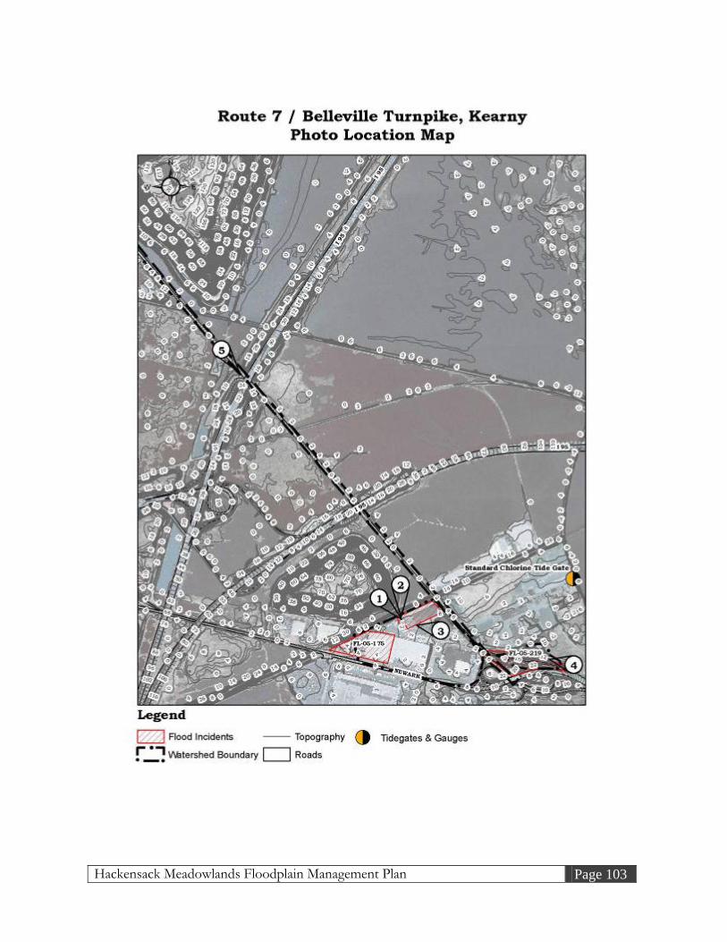
Hackensack Meadowlands Floodplain Management Plan Page 103

Hackensack Meadowlands Floodplain Management Plan Page 104
Photos for Route 7 & Belleville Turnpike, Kearny
1. Make-shift pump system at 996 Belleville Turnpike (10/06/05)
2. Sump pit for make-shift pump system at 996 Belleville Turnpike (10/06/05)

Hackensack Meadowlands Floodplain Management Plan Page 105
3. Flooding condition at the truck yard of 996 Belleville Turnpike (3/29/05)
4. Ponding conditions on the shoulder of Belleville Turnpike (10/14/05)

Hackensack Meadowlands Floodplain Management Plan Page 106
5. Looking east on Route 7 / Belleville Turnpike looking towards the Western Spur of the New Jersey Turnpike (10/14/05)
4.2.16 Gotham Parkway, Carlstadt A. Problem Description Flooding incidents have been reported to the NJMC in the vicinity Gotham Parkway in Carlstadt, New Jersey. Flooding occurs in numerous loading docks and across several parking lots. The following table summarizes the flooding incidents: Table 4-18: Flooding Incident, Gotham Parkway, Carlstadt
Incident # Filed Complaint / Inspection Findings
FL-05-147
As you are aware, there can be substantial flooding problems in this area during heavy rainfall due to the fact that the two "tide gates" on the corner of Starke and Dell Streets are not properly maintained. On numerous occasions, these gates have failed to operate properly due to debris clogging the gates. In addition, there is a group of tide gates on Mr. Wilson's property near the Summit Bank on the corner of Gotham Parkway and Paterson Plank Road. These gates are properly maintained.
FL-05-156 There are no drainage pumps in loading docks. The loading docks flood, as does the parking lot.

Hackensack Meadowlands Floodplain Management Plan Page 107
FL-05-170 Some concerns are if the tide gate is functional. Can someone place pumps on their property in order to get the water out? Parking lot has flooding, as does the roadway.
FL-05-151 Flooding occurs on property, waters can reach upwards of 1 foot high.
FL-05-126
The drainage ditch in the rear of the property has become blocked with fallen tree limbs, weed growth, and other debris. It is clear that this section of the ditch is not being adequately maintained to keep the ditch in a satisfactory operating condition.
FL-05-185 During a heavy rain storm the drainage ditch over flows and floods the property. The tide gates at this location might not be functioning properly.
B. Existing Conditions The watershed of interest is bounded by Amor Avenue to the north, Gotham Parkway to the east, Dell Road to the west, and Peach Island Creek to the south. The watershed is comprised of industrial properties. Berry’s Creek has a mean high water spring (MHWS) elevation of 3.0 feet (NAVD88) near the tide gate system. The ground elevation in the area varies from 2 feet to 4 feet (NAVD88) throughout the watershed. In a 25-year storm event, the water surface elevation is 5.7 feet (NAVD88). A high tide or storm event, based on the elevations above, could have significant impact on the area. The Peach Island Creek Tide Gate is located at the downstream terminus of the watershed and is essential to the functioning of the stormwater drainage system. The condition of the tide gate is “average” and “functional with restrictions” per a 2004 inspection report by the NJMC. The Peach Island Creek Tide Gate will need to be evaluated and repaired to operate in maximum functionality as soon as possible. Specifically, the second gate (of four), when facing downstream, is not sealing properly. Note that Scientific Chemical Processing is located directly upstream of Peach Island Creek Tide Gate. Scientific Chemical Processing is a former waste processing facility and is a “Superfund” site, indicating threats posed by hazardous substance. A detailed field inspection has identified the primary causes of local flooding. A drainage ditch parallel to and west of Gotham Parkway follows the rear of each property. The ditch, though well-maintained and clean in sections, has been completely severed in others and will not function in a storm event.

Hackensack Meadowlands Floodplain Management Plan Page 108
The ditch, approximately 10 feet wide throughout, extends 2,600 feet (0.5 miles) upstream to its terminus at 25 Amor Avenue and 660 Gotham Parkway. As above, the system begins immediately upstream of the Peach Island Creek Tide Gates. Floodwalls recently constructed at 430 Gotham Parkway and 480 Gotham Parkway appear to have severed the ditch system (see Photos 1 to 4). The floodwalls surround the parking lots on the properties and are accompanied by pump systems and flap gates. Without a functional ditch system, they have minimal effectiveness against flooding. Upstream of these buildings, the system moves through a culvert beneath Starke Road. The culvert appears to be functional and is protected by a trash rack. The drainage ditches above the culvert are in good condition. However, elliptical concrete culverts 2,200 feet upstream of Starke Road beneath an abandoned CSX rail are in need of cleanout or repair (see Photos 5 to 7). As the system upstream of the rail is stagnant, vegetation has choked the drainage ditch system. C. Preliminary Assessment The entire system relies on the proper functioning of the Peach Island Creek Tide Gates; as such, this tide gate must be restored as quickly as possible. Secondly, sections of the Gotham Parkway drainage ditch network need to be completely excavated, re-graded, and stabilized. This effort should be focused on 430 and 480 Gotham Parkway and the area above the CSX property. Additionally, if the rail is abandoned, the stormwater sewer culvert pipes should be removed, as an open channel will require less maintenance. The current elliptical concrete pipes completely restrict flows. No engineering analysis appears to be necessary at this time. Once the maintenance project is complete, the flooding issues within the watershed should be completely alleviated during small storms. However, the local catch basins must remain clear of debris and sediment for the entire system to function. A NJDEP Stream Encroachment Permit will be required for this maintenance cleanout.

Hackensack Meadowlands Floodplain Management Plan Page 109

Hackensack Meadowlands Floodplain Management Plan Page 110
Photos for Gotham Parkway, Carlstadt
1. Inlet and floodwall at 430 Gotham Parkway (10/06/05)
2. Upstream of confluence point with Peach Island Tide Gate (10/06/05)

Hackensack Meadowlands Floodplain Management Plan Page 111
3. Outfall pipes from pump station at 480 Gotham Parkway (10/06/05)
4. Looking downstream at rear of 725 Dell Road (ditch at far left) (10/06/05)

Hackensack Meadowlands Floodplain Management Plan Page 112
5. Elliptical culvert clogged with debris at the rear of 545 Dell Road (10/06/05)
6. Elliptical culvert clogged with debris and vegetation at the rear of 545 Dell Road (10/06/05)
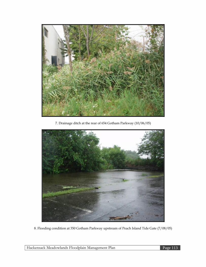
Hackensack Meadowlands Floodplain Management Plan Page 113
7. Drainage ditch at the rear of 654 Gotham Parkway (10/06/05)
8. Flooding condition at 350 Gotham Parkway upstream of Peach Island Tide Gate (7/08/05)

Hackensack Meadowlands Floodplain Management Plan Page 114
4.2.17 Additional Areas of Concern Below are flooding problem areas that are currently under investigation by the NJMC. Each site varies in the level of completeness of the visual inspections, record searches, hydrologic and hydraulic analyses (as appropriate) and the development of preliminary remediation strategies. A. 1600 Paterson Plank Road, Secaucus Localized flooding has been reported in the vicinity of 1600 Paterson Plank Road in the Township of Secaucus. A complaint from the owner of 1089 Farm Road indicated that the basement of their home (FL-05-088) was flooding due to fill being piled at 1600 Paterson Plank Road in preparation of townhouse construction. The fill material has filled an area that formerly accepted sheet flow from the backyard of 1089 Farm Road. Ponding in the rear yard, they alleged, had resulted in groundwater intrusion through the basement walls. The NJMC, following an inspection in 2004 confirming the above condition, asked the neighboring developer (1600) to create an infiltration basin at the rear of 1089 to improve sheet flow runoff during storm events. The basin was constructed and, per follow-up inspections, temporarily alleviated the flooding in the area (see Photos 1 and 2). Once 1600 Paterson Plank Road has been built upon, this system can be abandoned and a permanent stormwater system must be constructed. As such, this matter is considered temporarily closed. The following table summarizes the flooding incidents and inspection findings: Table 4-19: Flooding Incident, 1600 Paterson Plank Road, Secaucus
Incident # Filed Complaint / Inspection Findings
FL-05-088 Cellar floods at 1089 Farm Road, potentially due to raised property adjacent to home. I have a cellar pump.
FL-05-186 Upon inspection by the NJMC, the detention basin that was installed on the above property has been keeping the water away from local residential housing.

Hackensack Meadowlands Floodplain Management Plan Page 115

Hackensack Meadowlands Floodplain Management Plan Page 116
Photos for 1600 Paterson Plank Road, Secaucus
1. Infiltration basin located at 1600 Paterson Plank Road behind 1089 Farm Road (right) (6/10/05)
2. Same location at Photo 1, following one growing season. (7/08/05)

Hackensack Meadowlands Floodplain Management Plan Page 117
B. 176 Louis Street, Secaucus Localized flooding has been reported in the vicinity of 176 Louis Street in the Township of Secaucus. A complaint from the owner of 176 Louis Street indicated that her basement floods during a heavy storm event. The following table summarizes the flooding incident: Table 4-20: Flooding Incident, 176 Louis Street, Secaucus
Incident # Filed Complaint / Inspection Findings
FL-05-038 The homeowner enclosed a handwritten letter describing the problem. The basement floods approximately 2 inches deep during heavy rainfall events.
A handwritten letter from the property owner indicates that the basement accumulates 2 inches of water each time a heavy storm event occurs. Her basement has been damaged from the floodwater and resulting mildew and mold. The letter did not explain the location of the entering water other than the fact that it was emanating from the walls. Based on a recent field inspection, the inlets to the Louis Street stormwater sewer system are clear. The Louis Street profile appears to have sufficient slope to carry stormwater runoff to the inlets and away from the home. No ponding or flooding conditions were observed during the field inspection on Louis Street during heavy rains. The NJMC believes this flooding complaint is not a regional problem. The NJMC has recommended that the property owner solicit the assistance of a contractor familiar with basement flood-proofing and exterior residential stormwater systems. The property owner has contacted such a professional and will report back on the findings. As such, this matter is considered temporarily closed.

Hackensack Meadowlands Floodplain Management Plan Page 118

Hackensack Meadowlands Floodplain Management Plan Page 119
Photos for 176 Louis Street, Secaucus
1. Looking at the south side of the property at 176 Louis Street (10/14/05)
2. Looking at the east side of the property at 176 Louis Street (10/14/05)

Hackensack Meadowlands Floodplain Management Plan Page 120
3. Looking west in front of 176 Louis Street (10/14/05)
C. 758 Paterson Plank Road, East Rutherford Localized flooding has been reported in the vicinity of 758 Paterson Plank Road in the Borough of East Rutherford. A complaint from the owner of 758 Paterson Plank Road indicated that their property was flooded by their neighbor’s detention basin. The basin backs up during major storm events through a discharge pipe from the stormwater system at 758 Paterson Plank Road and floods the gas station’s parking lot. The following table summarizes the flooding incidents: Table 4-21: Flooding Incident, 758 Paterson Plank Road, East Rutherford
Incident # Filed Complaint / Inspection Findings
FL-05-099
Property was inspected by the NJMC. Flooding comes from a problem with the property behind the above location. The property behind the gas station installed a detention basin. The gas station, during construction, was tied into the detention basin. The basin’s maximum water surface exceeds that of the gas station’s parking lot, causing backflow into the lot during major storm events. A temporary fix to the problem involves installing a flap gate onto the outfall to the system.
FL-05-139 NJMC staff inspected the site to investigate the impacts of heavy runoff from the July 23, 2004 storm. Apparently due to back-up from

Hackensack Meadowlands Floodplain Management Plan Page 121
a detention basin, it flooded the entire lot. The rear of the lot had been under 2+ feet of water. With the water drained, it was apparent that the detention basin was the source of the floodwaters based on the similar sediment stains located in both the basin and at the area around the catch basin.
NJMC staff, following the inspection listed above (FL-05-139), requested that the neighboring property owner (2-100 Murray Hill Parkway) install a one-way valve (flap gate). Additionally, the owner of 758 Paterson Plank Road was issued a Zoning Certificate by the NJMC on October 6, 2003 to construct stormwater drainage improvements. These improvements, as of the date of this document, are under construction. As such, this matter is temporarily closed.

Hackensack Meadowlands Floodplain Management Plan Page 122

Hackensack Meadowlands Floodplain Management Plan Page 123
Photos for 758 Paterson Plank Road, East Rutherford
1. Looking at outfall that is connected to the inlet at 758 Paterson Plank Road (6/22/05)
2. Inlet on 758 Paterson Plank Road discharging to above outlet (Photo 1) (3/21/05)

Hackensack Meadowlands Floodplain Management Plan Page 124
D. 1250 Valley Brook Avenue, Lyndhurst Localized flooding has been reported in the vicinity of 1250 Valley Brook Avenue in the Township of Lyndhurst. A complaint from the owner of 1250 Valley Brook Avenue indicated the parking area behind the building was flooded by a drainage ditch system in the rear of the property. The following table summarizes the flooding incidents: Table 4-22: Flooding Incident, 1250 Valley Brook Avenue, Lyndhurst
Incident # Filed Complaint / Inspection Findings
FL-05-094
Property was inspected. Manhole covers were removed to see what the problem is. System seems to be in good condition. Flooding behind property comes from the drainage ditch system overflowing. Possible solutions can be to either raise that end of the parking lot or to dredge the system.
FL-05-133 The flooding in the parking lot is severe and occurs regularly without any additional development impact from EnCap
The ground elevation in the area varies from 2 feet to 6 feet (NAVD88) throughout the property. In a 25-year storm event, the water surface elevation is 6.12 feet (NAVD88). Behind the parking lot there is an area of phragmites, which drains to Berry’s Creek. The flooding problem occurs due to the low elevation of the parking lot and the lack of a positive slope to a drainage ditch to convey the runoff away from the property (see Photos 1 to 3). In the short-term, a Professional Engineer should be hired to survey the existing drainage system, and to evaluate feasible alternatives to increase its capacity. This evaluation should consider the proposed improvements associated with the EnCap re-development project bordering the rear of the property. The EnCap project will increase the capacity of downstream culverts beneath Valley Brook Avenue. Unless the capacity of the municipal system on Valley Brook Avenue can be verified, it is preferable to send stormwater flows to the rear of the property to an open channel system. Consideration should be made for the tidal nature of Berry’s Creek.

Hackensack Meadowlands Floodplain Management Plan Page 125

Hackensack Meadowlands Floodplain Management Plan Page 126
Photos for 1250 Valley Brook Avenue, Lyndhurst
1. Looking southeast towards ditch at rear of property (10/14/05)
2. Looking southeast towards ditch at rear of property (10/14/05)

Hackensack Meadowlands Floodplain Management Plan Page 127
3. Looking southwest towards loading docks (10/14/05)

Hackensack Meadowlands Floodplain Management Plan Page 128
E. Bellman’s Creek, North Bergen Localized flooding has been reported in the vicinity of 83rd Street, 85th Street, 88th Street, 90th Street, and 91st Street in the Township of North Bergen. A complaint was filed stating flooding occurred on 83rd Street, 85th Street, 88th Street, 90th Street, 91st Street, and Westside Avenue. The following table summarizes the flooding incidents: Table 4-23: Flooding Incident, Bellman’s Creek, North Bergen
Incident # Filed Complaint / Inspection Findings
FL-05-093 Flooding on 83rd Street, 85th Street, 88th Street, 90th Street, and 91st Street with water in street and over the curb.
FL-05-092 Flooding on Westside Avenue with as much as 6” of water Bellman’s Creek is located in North Bergen and discharges to the Hackensack River. Bellman’s Creek begins at 91st Street, travels through Fairview Avenue, and converges with Wolf Creek, and then meanders to the Hackensack River (see Photos 1 and 4). With high tide conditions and a low intensity storm event, Bellman’s Creek floods the surrounding streets. 83rd Street, 85th Street, 88th Street, 90th Street, and 91st Street are all within a low flat area where the drainage pipes does not have sufficient slope to convey the flow effectively. Another issue with respect to the North Bergen drainage system is that it is a combined stormwater and sewer system. Such combined systems tend to be significantly overburdened during large storms (see Photo 3). The preliminary recommendation for remediating the flooding conditions surrounding Bellman’s Creek is to prepare a NJDEP Minor Stream Encroachment Permit for the maintenance cleanout of the Bellman’s Creek drainage system. In addition, the stormwater sewer systems on 83rd Street, 85th Street, 88th Street, 90th Street, and 91st Street will need to be cleaned out. Clean out should include the removal of silt and debris from each catch basin and the associated pipe network and outfall(s). Vegetation may need to be removed at the outfall(s). Installation of a one-way valve system at the outfalls is encouraged as part of the drainage system maintenance. Near-term recommendations include utilizing the “2004 Statewide Drainage Feasibility Assessment Study, U.S. Route 1 and 9,” prepared by CTE Engineers for the NJDOT, and “Engineering Study Report for the Preliminary Design of 83rd Street Stormwater Pumping Stations,” prepared by Boswell Engineering for the Township of North Bergen in October, 2003, to develop an area-wide stormwater management plan. Boswell Engineering has indicated that their plan should have an area-wide benefit, extending to 93rd Street for up to the 10-year storm events. However, the

Hackensack Meadowlands Floodplain Management Plan Page 129
benefit is largely focused on 83rd Street. CTE Engineers’ plan was designed to reduce flood impacts specific to 2101 91st Street. This plan will need to include a complete hydrologic and hydraulic analysis, review alternatives for reducing flooding in the area, and present preliminary designs with construction cost estimates. Consideration should be given to a tide gate and /or pump station system on Bellman’s Creek directly downstream of its confluence with Wolf’s Creek. This location would serve both systems but must be evaluated for environmental impact. Additionally, Wolf’s Creek may not benefit significantly from being disconnected from the tides. Boswell Engineering has investigated a tide gate on Bellman’s Creek, 400 to 500 feet above its confluence with Wolf’s Creek.

Hackensack Meadowlands Floodplain Management Plan Page 130

Hackensack Meadowlands Floodplain Management Plan Page 131
Photos for Bellman’s Creek, North Bergen
1. Looking downstream of Bellman’s Creek at 91st Street (10/14/05)
2. Looking east towards Route 1&9 at 91st Street (10/14/05)

Hackensack Meadowlands Floodplain Management Plan Page 132
3. Surcharge condition for an inlet on 91st Street (10/14/05)
4. Looking upstream of Bellman’s Creek at Fairview Avenue (10/06/05)

Hackensack Meadowlands Floodplain Management Plan Page 133
F. 694 Minnie Place South, Secaucus Localized flooding has been reported in the vicinity of Minnie Place South in the Township of Secaucus. A complaint from the owner of 694 Minnie Place South indicated flooding occurred in their basement. The following table summarizes the flooding incident: Table 4-24: Flooding Incident, 694 Minnie Place South, Secaucus
Incident # Filed Complaint / Inspection Findings FL-05-044 Flooding in basement with up to 2 feet of water.
The property on 694 Minnie Place South is located on a dead end street near a drainage ditch that flows to the Golden Avenue Pump Station (see Photos 1 and 2). The drainage ditch overtops the banks during heavy storm events. From a recent field inspection, the inlets on the Minnie Place South stormwater sewer system are clear. The findings of NJMC staff, specific to 694 Minnie Place South, include the following: the Golden Avenue Pump Station is currently being upgraded downstream of the drainage ditch adjacent to Minnie Place South. The NJMC has requested that the Golden Avenue Pump Station incorporate flows from the Minnie Place South drainage ditch. Once the Minnie Place South system is added to the Golden Avenue Pump Station upgrade, the flooding situation should be alleviated. As such, this flood incident is temporarily closed.

Hackensack Meadowlands Floodplain Management Plan Page 134

Hackensack Meadowlands Floodplain Management Plan Page 135
Photos for 694 Minnie Place South, Secaucus
1. Looking downstream of the drainage ditch located at the end of Minnie Place South (10/11/05)
2. Looking upstream of the drainage ditch located at the end of Minnie Place South (10/11/05)

Hackensack Meadowlands Floodplain Management Plan Page 136
G. 325 Washington Avenue, Carlstadt Localized flooding has been reported in the vicinity of Washington Avenue in the Borough of Carlstadt. A complaint from the owner of 325 Washington Avenue indicated flooding occurs at the front of his property. The following table summarizes the flooding incident: Table 4-25: Flooding Incident, 325 Washington Avenue, Carlstadt
Incident # Filed Complaint / Inspection Findings
FL-05-009 June through August 2004 had the worst flooding. It was so bad that Don installed two pumps and layed down sand bags to divert the water to the back of the building.
The ground elevation is around 4 feet (NAVD88) throughout the property. In a 25-year storm event, the water surface elevation is 4.82 feet (NAVD88). The property at 325 Washington Avenue is located at a low point on Washington Avenue, also known as County Route 503. During heavy rain events and when the system is clogged with debris, the runoff travels down the two driveways at 325 Washington Avenue, flooding the parking area in front of the building and, on occasion, entering the building. The two driveways do not have sufficient slope to carry the runoff past the building and to the back lot, where a swamp and drainage ditch are located. The owner of 325 Washington Avenue has created a berm at the top of the driveway, where it borders Washington Avenue. However, the berms are incomplete and do not completely separate 325 Washington Avenue from runoff originating at the roadway (see Photo 2). Additionally, rain falling down-gradient of the berms is directed toward the front of the building. Two sump pumps have been added to pits on either side of the front doorway (see Photo 3). These pumps convey water to the sides of the building but not to the swamp or drainage ditch to the rear. Additionally, as the front yard and driveways slope toward the front door, it is unlikely that the pumps have adequate capacity, during a large storm, to move water away from the building. The above-referenced drainage ditch begins at the rear of 325 Washington Avenue and runs parallel to the parking lot of 303 Paterson Plank Road. The ditch is heavily vegetated and filled with debris. Downstream of the above drainage ditch is the Michelle Avenue culvert, which appears to be either clogged or collapsed (see Photo 4). The drainage ditch downstream of the Michelle Avenue culvert travels to the Hackensack River via the Richard P. Kane Natural Area (formerly known as the Empire Tract).
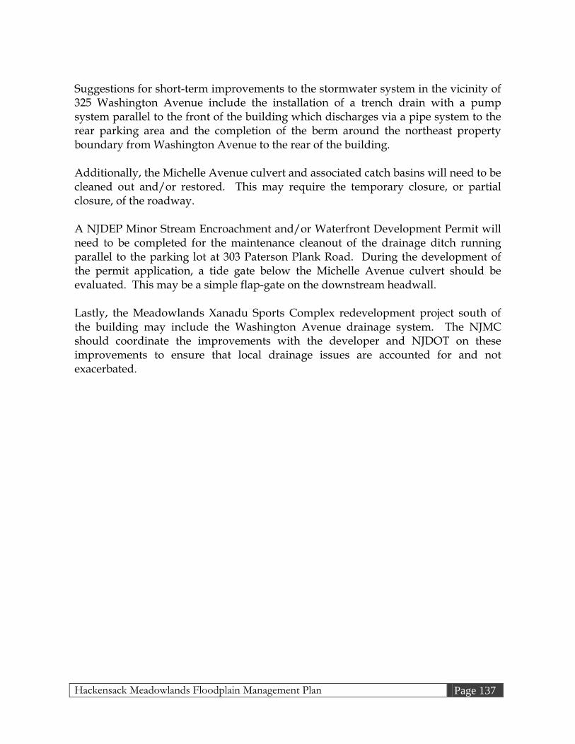
Hackensack Meadowlands Floodplain Management Plan Page 137
Suggestions for short-term improvements to the stormwater system in the vicinity of 325 Washington Avenue include the installation of a trench drain with a pump system parallel to the front of the building which discharges via a pipe system to the rear parking area and the completion of the berm around the northeast property boundary from Washington Avenue to the rear of the building. Additionally, the Michelle Avenue culvert and associated catch basins will need to be cleaned out and/or restored. This may require the temporary closure, or partial closure, of the roadway. A NJDEP Minor Stream Encroachment and/or Waterfront Development Permit will need to be completed for the maintenance cleanout of the drainage ditch running parallel to the parking lot at 303 Paterson Plank Road. During the development of the permit application, a tide gate below the Michelle Avenue culvert should be evaluated. This may be a simple flap-gate on the downstream headwall. Lastly, the Meadowlands Xanadu Sports Complex redevelopment project south of the building may include the Washington Avenue drainage system. The NJMC should coordinate the improvements with the developer and NJDOT on these improvements to ensure that local drainage issues are accounted for and not exacerbated.

Hackensack Meadowlands Floodplain Management Plan Page 138

Hackensack Meadowlands Floodplain Management Plan Page 139
Photos for 325 Washington Avenue, Carlstadt
1. Looking at the front of 325 Washington Avenue (10/06/05)
2. Looking at the raised berm and ponding of the driveway located at the south end of property (10/12/05)

Hackensack Meadowlands Floodplain Management Plan Page 140
3. Two pump systems located in front of the building of 325 Washington Avenue (10/06/05)
4. Looking West at the clogged inlet on the Michelle Avenue culvert (downstream on left) (10/12/05)

Hackensack Meadowlands Floodplain Management Plan Page 141
5. Looking upstream at the Michelle Avenue culvert (10/06/05)
6. Looking downstream at the Michelle Avenue culvert (10/06/05)

Hackensack Meadowlands Floodplain Management Plan Page 142
H. 9 Chapman Drive, Little Ferry Localized flooding has been reported in the vicinity of Chapman Drive in the Borough of Little Ferry. A complaint from the owner of 9 Chapman Drive indicated the nearby drainage ditch is being filled by eroded material. The following table summarizes the flooding incident: Table 4-26: Flooding Incident, 9 Chapman Drive, Little Ferry
Incident # Filed Complaint / Inspection Findings FL-05-085 Nearby drainage ditch filled by eroded material.
From a recent field inspection of Chapman Drive, the inlets on the Chapman Drive stormwater sewer system are clear of debris. No drainage ditch was found behind the property of 9 Chapman Drive but a drainage ditch was found next to the cul-de-sac of Chapman Drive, which is clear of debris and vegetation. During the recent field inspection, a brief interview with an officer from the Little Ferry Police Department explained Chapman Drive has not, to the officer’s recollection, had any flooding problems on the street itself. No ponding or flooding was observed at the recent field inspection, which occurred during a 2-year storm event (see Photo 2). No preliminary assessment is necessary for the Chapman Drive flood incident. NJMC believes this flooding complaint is not a regional hydrology problem. As such, this incident has been temporarily closed.

Hackensack Meadowlands Floodplain Management Plan Page 143

Hackensack Meadowlands Floodplain Management Plan Page 144
Photos for 9 Chapman Drive, Little Ferry
1. Looking at the front of 9 Chapman Drive (10/12/05)
2. Looking at the area behind 9 Chapman Drive (10/12/05)

Hackensack Meadowlands Floodplain Management Plan Page 145
3. Looking south at 9 Chapman Drive towards the cul-de-sac (10/12/05)
4. Looking East at the drainage ditch located next to the Chapman Drive cul-de-sac (10/12/05)

Hackensack Meadowlands Floodplain Management Plan Page 146
I. 67 Huber Street, Secaucus Localized flooding has been reported in the vicinity of Huber Street in the Township of Secaucus. A complaint from the owner of 67 Huber Street indicated that the water level in the backyard is high. The following table summarizes the flooding incident: Table 4-27: Flooding Incident, 67 Huber Street, Secaucus
Incident # Filed Complaint / Inspection Findings FL-05-086 Water level in backyard is high
Mill Creek has a mean high water spring (MHWS) elevation of 3.0 feet (NAVD88). The ground elevation varies from 2 feet to 6 feet (NAVD88) throughout the property. In a 25-year storm event, the water surface elevation is 6.1 feet (NAVD88), per FEMA’s 2005 FIS. From a recent field inspection, the inlets to the Huber Street stormwater sewer system were clear. The Huber Street profile appears to have sufficient slope to carry stormwater runoff to the inlets. No ponding or flooding conditions were observed during the field inspection on Huber Street. NJMC believes this flooding complaint is not a regional stormwater problem. The NJMC staff recommends that the property owner seek a licensed Professional Engineer to survey the property to determine the origin of the excess runoff to their property and to determine whether the backyard has a proper slope away from the house.

Hackensack Meadowlands Floodplain Management Plan Page 147

Hackensack Meadowlands Floodplain Management Plan Page 148
Photos for 67 Huber Street, Secaucus
1. Looking at the north side of the property at 67 Huber Street (10/14/05)
2. Looking at the west side of the property at 67 Huber Street (10/14/05)

Hackensack Meadowlands Floodplain Management Plan Page 149
J. 64 Maiden Lane, Little Ferry Localized flooding has been reported in the vicinity of 64 Maiden Lane in the Borough of Little Ferry. A complaint from the owner of 64 Maiden Lane indicated flooding in their backyard occurred from the construction of a retaining wall on from the property behind their house. The following table summarizes the flooding incidents: Table 4-28: Flooding Incident, 64 Maiden Lane, Little Ferry
Incident # Filed Complaint / Inspection Findings
FL-05-167 According to owner water floods the rear of their property due to a retaining wall that was installed on the lot behind the owner.
FL-05-103
Every time it rains, the back yard and street flood. This is due to the property owner behind her who put up a 4-foot wall (which was approved by the “HMDC”). The water forms a lake where geese congregate. All plants are destroyed.
From a recent field inspection, a retaining wall was found at the rear of the property located on 64 Maiden Lane (see Photo 2). The runoff from the backyard of 64 Maiden Lane has no flow path to drain properly to a pump station that has been installed down-gradient of the property (see Photos 3 and 4). As such, the water ponds within the property. It is recommended that the party responsible for the construction of the retaining wall modify the existing site grading to provide positive flow away from 64 Maiden Lane. This could be accomplished with a drainage ditch or pipe connection to the pump station behind the property. The NJMC will provide assistance in making the determination of ownership.

Hackensack Meadowlands Floodplain Management Plan Page 150

Hackensack Meadowlands Floodplain Management Plan Page 151
Photos for 64 Maiden Lane, Little Ferry
1. Looking at the backyard of 64 Maiden Lane (10/12/05)
2. View of the retaining wall behind 64 Maiden Lane (10/12/05)

Hackensack Meadowlands Floodplain Management Plan Page 152
3. View of empty lot behind 64 Maiden Lane (10/12/05)
4. View of stormwater pump system located in the lot behind 64 Maiden Lane (10/12/05)

Hackensack Meadowlands Floodplain Management Plan Page 153
K. Hartwick Street, Little Ferry Localized flooding has been reported in the vicinity of Hartwick Street in the Borough of Little Ferry. Complaints from several property owners in the vicinity of Hartwick Street indicated flooding in their area due to a backup of a nearby drainage ditch. The following table summarizes the flooding incidents: Table 4-29: Flooding Incident, Hartwick Street, Little Ferry
Incident # Filed Complaint / Inspection Findings FL-05-213 NFIP Repetitive Loss FL-05-204 NFIP Repetitive Loss FL-05-207 NFIP Repetitive Loss FL-05-212 NFIP Repetitive Loss FL-05-210 NFIP Repetitive Loss
The Hackensack River has a mean high water spring (MHWS) elevation of 2.6 feet (NAVD88), which is upstream of the confluence point with DePeyster Creek. The ground elevation is around 4 feet (NAVD88) throughout the area of flooded property. In a 25-year storm event, the water surface elevation is 6.2 feet (NAVD88), per FEMA’s 2005 FIS. The flooding in the vicinity of Hartwick Street is due to the inundation of the DePeyster Creek Pump Station. During a high intensity storm event, the drainage ditch leading to the DePeyster Creek Pump Station overflows due to the lack of the pump station’s capacity. Once the drainage ditch overflows in the vicinity of Hartwick Street, the excess water has nowhere to go and floods the surrounding properties since no stormwater sewer system has been installed in the local streets. From a recent field inspection, the DePeyster Creek Pump Station is in the process of being repaired at the end of Dietrich Street. A bypass system is temporarily pumping water while the new pump station is being constructed (see Photo 2). According to a hydrologic and hydraulic analysis of the watershed completed by Mianecki Consulting Engineers, the new pump station is unable to outpace projected peak flows from a two-year storm event. During larger storm events, it is likely that the pump station will be inundated and that the upstream channel will backup into the residential neighborhood. The NJMC recommends that a hydrologic and hydraulic analysis be prepared that analyzes the need for an additional pump system to adequately discharge the 25-year storm during mean high water (MHW) conditions. Note that a detailed hydrologic and hydraulic analysis of the existing and proposed pump station during the 25-year event has already been completed by Mianecki Consulting Engineers. NJMC

Hackensack Meadowlands Floodplain Management Plan Page 154
recommends that this study form the basis of the analysis of an additional pump system. The NJMC also recommends that access to the upstream trash rack be improved. A Little Ferry Department of Public Works employee should be able to clean off the rack via a pathway (see Photo 1). The NJMC has accepted the 25-year flood elevation (4.1 feet NAVD88) determined by the report. Water above this elevation leaves the watershed and enters the Losen Slote system.

Hackensack Meadowlands Floodplain Management Plan Page 155

Hackensack Meadowlands Floodplain Management Plan Page 156
Photos for Hartwick Street, Little Ferry
1. Looking upstream of the intake to the DePeyster Pump Station (10/11/05)
2. View of bypass pump system and new DePeyster Pump Station (10/11/05)

Hackensack Meadowlands Floodplain Management Plan Page 157
3. Front view of property at 37 Hartwick Street (10/14/05)
4. Hartwick Street pipe outlet flowing to drainage ditch towards DePeyster Pump Station (10/14/05)

Hackensack Meadowlands Floodplain Management Plan Page 158
5. Ponding in front of the property at 37 Hartwick Street (10/14/05)
L. 55 Second Avenue, Secaucus Localized flooding has been reported in the vicinity of Second Avenue in the Township of Secaucus. A complaint from the owner of 55 Second Avenue indicated that their basement floods. The following table summarizes the flooding incident: Table 4-30: Flooding Incident, 55 Second Avenue, Secaucus
Incident # Filed Complaint / Inspection Findings FL-05-010 Due to the saturated ground, water gets into the basement.
From a recent field inspection, no stormwater inlets were found on Second Avenue because the street is situated on a hill where the runoff can be conveyed to the stormwater sewer drainage system on Roosevelt Avenue. No ponding or flooding conditions were observed during the field inspection on Second Avenue. The NJMC believes this flooding complaint is not a regional hydrology problem. The NJMC recommends that the property owner seek the services of a licensed Professional Engineer or construction professional with experience with basement flooding to determine the cause of flooding specific and isolated to their property. This flood incident is temporarily closed.

Hackensack Meadowlands Floodplain Management Plan Page 159

Hackensack Meadowlands Floodplain Management Plan Page 160
Photos for 55 Second Avenue, Secaucus
1. Front view of the property at 55 Second Avenue (10/12/05)
2. Front view of the property at 55 Second Avenue (10/12/05)

Hackensack Meadowlands Floodplain Management Plan Page 161
M. 1138B Farm Road, Secaucus Localized flooding has been reported in the vicinity of Farm Road in the Township of Secaucus. A complaint from the owner of 1138B Farm Road indicated that their garage floods. The following table summarizes the flooding incident: Table 4-31: Flooding Incident, 1138B Farm Road, Secaucus
Incident # Filed Complaint / Inspection Findings
FL-05-039 Garage was flooded with up to 32” of water in 1992 during a nor’easter.
From a recent field inspection, the lot behind the flooded property appears to act as a detention basin because the drainage ditch leading to an outlet on the Hackensack River has been heavily vegetated (see Photos 2 and 3). Due to heavy vegetation, the NJMC inspection team was unable to determine whether the system outfall was the Acorn Road Tide Gates, which also discharge in the immediate area to the Hackensack River (see Photo 4). According to a Secaucus official, the outfall is not the Acorn Road Tide Gates and does not have a one-way valve. Additionally, Secaucus is recommending that a pump station be installed on its property at this location, 236 Meadow Lane, to service both the above ditch and the flow collected by the Acorn Road Tide Gates. The preliminary recommendation to mitigate the flood conditions in the vicinity of 1138B Farm Road is to clean out the stormwater sewer system on Farm Road and install a flap gate system at each outfall. Additionally, the slopes and elevations of the Farm Road stormwater sewer system should be verified to ensure adequate flow velocity. In conjunction with this survey, the NJMC recommends the preparation of a NJDEP Minor Stream Encroachment Permit for the maintenance cleanout of the drainage system leading to the system’s outfall. In the near-term, the NJMC concurs with the recommendation of Secaucus. The selected pump location would provide excellent construction and maintenance access, and serve a large area. Furthermore, the NJMC recommends that Secaucus consider a redundancy in the number of pumps as well as a back-up power supply.

Hackensack Meadowlands Floodplain Management Plan Page 162

Hackensack Meadowlands Floodplain Management Plan Page 163
Photos for 1138B Farm Road, Secaucus
1. Parking area for the residence of 1138B Farm Road where flooding occurs (10/11/05)
2. Looking south at the detention basin/drainage ditch behind 1138B Farm Road (10/11/05)

Hackensack Meadowlands Floodplain Management Plan Page 164
3. Looking north at the detention basin/drainage ditch behind the property of 1138B Farm Road (10/11/05)
4. View upstream of the outfall to the Hackensack River (10/11/05)

Hackensack Meadowlands Floodplain Management Plan Page 165
N. Mill Ridge Road, Secaucus Localized flooding has been reported in the vicinity of Mill Ridge Road in the Township of Secaucus. Complaints have indicated the backyard gets flooded due to the property to the north. The following table summarizes the flooding incidents: Table 4-32: Flooding Incident, 15 Mill Ridge Road, Secaucus
Incident # Filed Complaint / Inspection Findings
FL-05-011 If the storm drain in the backyard gets clogged with debris, the yard will flood about 1 foot.
FL-05-214 NFIP Repetitive Loss FL-05-208 NFIP Repetitive Loss
A recent field inspection determined that the inlets to the Mill Ridge Road stormwater sewer system were clear. The Mill Ridge Road profile appears to have sufficient slope to carry stormwater runoff to the inlets from the front yards of bordering properties. No ponding or flooding conditions were observed during the field inspection in the road at the stormsewer collection points. Per a Secaucus official, this property has a history of flooding. The basement was filled-in as a remediation measure. Additionally, this area, per the municipality, may benefit from components of the Secaucus High School Mitigation Plan. The NJMC believes this flooding complaint is not a regional stormwater problem. The NJMC recommends that the property owner seek the services of a licensed Professional Engineer to inspect the rear of the property and to make recommendations on improvements that will keep at least the 25-year flood surge waters and the 25-year storm away from the house.

Hackensack Meadowlands Floodplain Management Plan Page 166

Hackensack Meadowlands Floodplain Management Plan Page 167
Photos for Mill Ridge Road, Secaucus
1. Front view of the property at 15 Mill Ridge Road (10/14/05)
2. Side view of the property at 15 Mill Ridge Road (10/14/05)

Hackensack Meadowlands Floodplain Management Plan Page 168
3. Ponding in the backyard of 15 Mill Ridge Road (10/14/05)

Hackensack Meadowlands Floodplain Management Plan Page 169
Table 4-33: Summary of Profiles and Recommendations Watershed Clean Out Repair
No. Name Town Catch Basins
Sewer Pipes /
Culverts
Channel / Ditch(1)
Collection System
Pump Station /
Tide Gate
Hydrologic & Hydraulic Analysis
Suggested
1 Meadowlands Parkway Secaucus X X X(2)
2 Carol Place Moonachie X X X X
3 Broad Street & 16th Street Carlstadt X X X X
4 40 Broad Street Carlstadt X X X X 5 Barell Avenue Carlstadt X X X X
6 Asia Place & Kero Road Carlstadt X X X X X(2)
7 Grand Street & Christiana Avenue Moonachie X X X X
8 Avenue A & Moonachie Avenue Moonachie X
9 Fish House Road Kearny X X X X 10 Wolf Creek Ridgefield X
11 Rutherford Tide Gates/ Route 17 Rutherford X X X X
12 Murray Hill Parkway East Rutherford X X X X(2)
13 Penhorn Avenue Secaucus X X X X 14 Polito Avenue Lyndhurst X X X X X
15 N.J. Route 7/Belleville Turnpike Kearny X X X X X
16 Gotham Parkway Carlstadt X
17A 1600 Paterson Plank Road Secaucus
17B 176 Louis Street Secaucus
17C 758 Paterson Plank Road
East Rutherford
17D 1250 Valley Brook Avenue Lyndhurst X
17E Bellman’s Creek North Bergen X X X X
17F 694 Minnie Place South Secaucus X(3)
17G 325 Washington Avenue Carlstadt X X X X
17H 9 Chapman Drive Little Ferry 17I 67 Huber Street Secaucus X 17J 64 Maiden Lane Little Ferry X 17K Hartwick Street Little Ferry X X 17L 55 Second Avenue Secaucus 17M 1138B Farm Road Secaucus X X X X(4) 17N Mill Ridge Road Secaucus X
Note: 1 NJDEP Stream Encroachment Permit required 2 Hydrologic and hydraulic analysis needed if flooding persists after cleanout 3 Repair is in progress 4 Installation of a new pump station

Hackensack Meadowlands Floodplain Management Plan Page 170
4.3 Other Hazards The Flood Insurance Study for Bergen County, dated September 30, 2005, developed by FEMA under the Department of Homeland Security, includes significant information on historic flooding relevant to the Meadowlands District. According to the report, flooding in Bergen County can occur during any season of the year as New Jersey lies within the major storm tracks of North America. The worst storms, according to FEMA, have occurred in late summer or early fall when tropical disturbances (hurricanes) are most prevalent. Flooding is generally the result of heavy rainfall produced by hurricanes moving up the coast, large frontal storms from the west and south, and local thunderstorms. In September 1999, floods of unprecedented magnitude were caused by Hurricane Floyd in the highly urbanized basins of northeastern New Jersey. The storm resulted in a record discharge on Ho-Ho-Kus Brook of 4,670 cubic feet per second (cfs) at the U.S. Geological Survey (USGS) gage No. 01391000 (length of record 48 years) located at Ho-Ho-Kus, New Jersey. This discharge is only slightly lower than the estimated 1% annual chance exceedance (100-year) flood discharge. The second highest discharge on record was caused by a storm on November 8, 1977 with a discharge of 3,700 cfs. During that storm, 9.3 inches of rainfall were recorded in the northern New Jersey area. The flood of record on the Hackensack River also occurred on September 16, 1999 as a result of Hurricane Floyd. The USGS gage located on the Hackensack River at New Milford, New Jersey (01378500) recorded a flow of 9,760 cfs with an associated gage height of 11.45 feet (10.4 feet NAVD88). This flow of record is much higher than the estimated 1% annual chance exceedance peak flow on the Hackensack River at this location. This discharge is more than twice the second highest recorded discharge of 4,630 cfs, recorded in May 17, 1989. Hurricane Floyd also produced a maximum-recorded discharge of 750 cfs at the USGS gage (01378615) on Wolf Creek at the Borough of Ridgefield. This flood was estimated to have an approximate annual chance exceedance rate of 5%. The lower portions of the Hackensack River, Pascack Brook, Haunsmans Ditch, and Dorotockeys Run flood when Oradell Reservoir is at a high stage. Oradell Reservoir has a spillway crest elevation of 22.66 feet and has had several high stages in recent years. On September 17, 1999, the Oradell Reservoir recorded a peak elevation of 26.16 feet (25.1 feet NAVD88), surpassing the previous record of 24.96 feet (23.9 feet NAVD88) by more than one foot (DeMicco, 1999). In addition to the September 1999 stage, four other recorded stages occurring on the following dates have exceeded the 24-foot elevation: September 27, 1975, June 19, 1972, May 29, 1968 and December 21, 1973.

Hackensack Meadowlands Floodplain Management Plan Page 171
According to FEMA, the incidence of high reservoir stage and local stream flooding does not normally occur coincidentally. The small local streams will peak and recede rapidly, whereas the reservoir levels will lag behind these peaks and be dependent upon the water supply regulation in effect at the time. The principal flooding in southern Bergen County results from the tidal stages of Newark Bay, which affect the Hackensack River and in turn Bellmans Creek and Wolf Creek. The tidal influence is negated on Wolf Creek by a tidal barrier located approximately 1,000 feet upstream of the confluence of Wolf Creek and Bellmans Creek. Nearly every year there is some flooding in the District associated with the passage of nor’easter storms. Several hurricanes have also produced extraordinary tides. The tide of record at Upper Newark Bay of 8.9 feet in elevation (7.9 feet NAVD88) was produced by Hurricane Donna in 1960. The northeaster of 1953 produced the second highest tide on record with an elevation of 8.4 feet (7.4 feet NAVD88). The largest historical tide was produced by the hurricane of September 3, 1821. On the basis of old street maps and newspaper accounts, it has been concluded that the surge produced by that hurricane was approximately 10 to 11 feet. However, the surge peak occurred at the time of a low astronomical tide, and mean sea level for September 1821 was probably approximately 1.5 feet below present mean sea level for August. Consequently, such a hurricane surge on a high astronomic tide would now produce a tide of approximately 14 feet in elevation (13 feet NAVD88). Although the 1821 hurricane was weaker than other historic storms, its track, just inland from the Atlantic shore, and its forward speed, were conducive to critical wind surge conditions. The trajectory of Hurricane Doria of 1971 was similar to that of the 1821 hurricane, but its surges were considerably smaller. Previous studies of the records have shown that the most important hurricane surges of interest in the study area are those of 1821, 1938, 1944, 1954, 1955 (Connie), 1960 (Donna) and 1971. Hurricane Diane in 1955 and Tropical Storm Agnes in 1972 failed to produce major surges, although they resulted in heavy rainfall in several eastern states. The only hurricane surge higher than 4 feet occurring after Hurricane Donna in 1960 was produced by Doria in August 1971, which resulted in a surge of 4.2 feet, the third largest since 1926. Important hurricane surges at the Battery, New York City, from 1926 to 1976 are presented below:

Hackensack Meadowlands Floodplain Management Plan Page 172
Table 4-33: History of Hurricane Surges at the Battery, New York City Date Surge Height (feet)* September 1960 5.3 September 1944 5.0 August 1971 4.2 September 1938 4.1 August1954 3.1 August1955 3.1
*Net surge, exclusive of predicted tide Winter storms or northeasters are far more frequent in the area than hurricanes, and may produce severe surges. Winds in the northeasters blow in a direction that is conducive to surge generation along the 80 or 90 miles of continental shelf off of New York Bay. Important nor’easter surges at the Battery, New York City, from 1926 to 1976 are presented below:
Table 4-34: History of Nor’easter Surges at the Battery, New York City
Date Surge Height (feet)* November 1950 8.5 November 1953 5.4 November 1932 5.3 December 1974 5.2 November 1968 5.0 February 1927 4.6 March 1962 4.3 January 1944 4.2
* Net surge, exclusive of predicted tide. The 1950 northeaster failed to produce the highest recorded tide (8.9 feet in elevation produced by Hurricane Donna in 1960) because its surge peak occurred at a low astronomic tide. While the surge peak produced by Hurricane Donna was only 5.3 feet, it occurred practically in coincidence with a high astronomic tide. Storm-tide flooding in the area depends not only on the storm-tide elevation, but also on the location of the area. Flooding of areas located near the mouth at Upper Newark Bay depends on the tide crest elevation. Flooding of areas located further inland depends not only on the tide crest elevation at Newark Bay, but also on the duration of the storm surge, as the tide propagates through the river and its system of tidal streams. Due primarily to the storage available in the system, a high storm-tide elevation created by a hurricane may be less critical to tidal flooding than a comparatively lower storm-tide of longer duration, such as those produced by

Hackensack Meadowlands Floodplain Management Plan Page 173
“The NJMC uses the North American Vertical Datum (NAVD88) which is approximately 1.05
feet lower in elevation than NGVD29.”
nor’easters. Therefore, the frequency distribution of high tide elevations in the Meadowlands must be obtained through separate routing of tides of either kind, with prescribed frequencies of occurrence at the mouth. The elevations thus obtained for each area are then to be used in a joint frequency analysis. The significant land development, which has occurred since the last major storm (Hurricane Donna in 1960), has changed the elevation-frequency distribution in the Meadowlands. Development has produced a general increase of water-surface elevations for comparable return periods. This effect tends to increase with the distance from the mouth of the Hackensack River. The NJMC concurs with the FEMA position that flooding along the streams within several of the communities is due, in part, to backwater, which is created by the inadequate storm drains, culverts, and narrow channels in the floodplain. Our agencies also agree that, because some communities within Bergen County have highly congested areas, even minor flooding causes damage to both public and private property. Currently, New Jersey has no statewide hazard mitigation plan. However, the NJMC gathered and reviewed data on hazards other than rain-induced flooding. One such study, the Sea, Lake, and Overland Surges from Hurricanes (SLOSH) model, was evaluated for impacts to the District. SLOSH is a computerized model run by the National Hurricane Center (NHC) to estimate storm surge heights and winds resulting from historical, hypothetical, or predicted hurricanes by taking into account the following:
• Pressure • Size • Forward speed • Track • Winds
Graphical output from the model displays color-coded storm surge heights for a particular area in feet ab-ove the model's reference level, the National Geodetic Vertical Datum (NGVD29), which is the elevation reference for most Federal maps. The NJMC uses the North American Vertical Datum (NAVD88), which is approximately 1.05 feet lower in elevation than NGVD29. The freeware “Corpscon” from the U.S. Army Corps of Engineers is useful for determining the exact conversion in a given area. It is available at http://crunch.tec.army.mil/software/corpscon/corpscon.html. It is

Hackensack Meadowlands Floodplain Management Plan Page 174
important to emphasize that the conversion varies throughout the District and that unreferenced vertical elevations should not be quoted as an “elevation.”
The calculations are applied to a specific locale's shoreline, incorporating the unique bay and river configurations, water depths, bridges, roads, and other physical features. If the model is being used to estimate storm surge from a predicted hurricane (as opposed to a hypothetical one), forecast data must be put in the model every 6 hours over a 72-hour period and updated as new forecasts become available.
The SLOSH model is generally accurate within plus or minus 20 percent. For example, if the model calculates a peak 10 foot storm surge for the event, one can expect the observed peak to range from 8 to 12 feet. The model accounts for astronomical tides (which can add significantly to the water height) by specifying an initial tide level, but does not include rainfall amounts, riverflow, or wind-driven waves. However, this information is combined with the model results in the final analysis of at-risk-areas.
The point of a hurricane's landfall is crucial to determining which areas will be inundated by the storm surge. Where the hurricane forecast track is inaccurate, SLOSH model results will be inaccurate. The SLOSH model, therefore, is best used for defining the potential maximum surge for a location.
As the U.S. Army Corps of Engineers (Philadelphia District) has a Hurricane Evacuation Study (which combines SLOSH model results with traffic flow information) for the District, information about storm surge heights in a real hurricane situation is not needed. All that is necessary is the forecast of the storm's intensity at landfall and the tide at that time to be able to make an appropriate evacuation decision.
The data, broken down by “Category” (see below), is available on demand from the NJMC in GIS format. It has also been made available to the municipalities in the District by MERI-GIS via the Internet Mapping Service. The Category, typically announced in advance and constantly updated by the National Weather Service (NWS), is based on the Saffir-Simpson Hurricane Scale:
• Tropical Storm: Winds 39-73 mph • Category 1 Hurricane: Winds 74-95 mph (64-82 knots). No real damage to
buildings. Damage to unanchored mobile homes. Some damage to poorly constructed signs. Also, some coastal flooding and minor pier damage. Examples: Irene 1999 and Allison 1995
• Category 2 Hurricane: Winds 96-110 mph (83-95 knots). Some damage to building roofs, doors, and windows. Considerable damage to mobile homes. Flooding damages piers and small craft in unprotected moorings may break

Hackensack Meadowlands Floodplain Management Plan Page 175
their moorings. Some trees blown down. Examples: Bonnie 1998, Georges(FL & LA) 1998, and Gloria 1985
• Category 3 Hurricane: Winds 111-130 mph (96-113 knots). Some structural damage to small residences and utility buildings. Large trees blown down. Mobile homes and poorly built signs destroyed. Flooding near the coast destroys smaller structures with larger structures damaged by floating debris. Terrain may be flooded well inland. Examples: Keith 2000, Fran 1996, Opal 1995, Alicia 1983, and Betsy 1965
• Category 4 Hurricane: Winds 131-155 mph (114-135 knots). More extensive curtainwall failures with some complete roof structure failure on small residences. Major erosion of beach areas. Terrain may be flooded well inland. Examples: Hugo 1989 and Donna 1960
• Category 5 Hurricane: Winds 156 mph and up (135+ knots). Complete roof failure on many residences and industrial buildings. Some complete building failures with small utility buildings blown over or away. Flooding causes major damage to lower floors of all structures near the shoreline. Massive evacuation of residential areas may be required. Examples: Andrew(FL) 1992, Camille 1969, and Labor Day 1935
Below is a sample map developed from data available via the Internet Mapping Service:

Hackensack Meadowlands Floodplain Management Plan Page 176
Note that the above mapping has been incorporated into the District Flood Hazard Warning System’s design. This system is discussed in detail in Section 6.2. Hurricanes do pose a significant threat to the Meadowlands District. A Category One hurricane would impact approximately 80-to 90-percent of the total land area within the District. Per the Draft June 2005 mapping from the U.S. Army Corps of Engineers (Philadelphia District), the following impacts may be experienced based on surge heights calculated by that National Weather Service’s SLOSH Model. Note that the storm surge elevations represented on the mapping in Section 4.1 and used to develop the below impacts are “worst-case” combinations of direction, forward speed, landfall point and astronomical tide for each category. The surge elevations do not include wave heights that may accompany storm surge. Additionally, the limits of the hurricane impact areas in each category do not completely coincide with District boundaries. As such, some impacts listed below are out-of-District. Table 4-3: Estimates of Housing Units (HU) Subject to Tidal Flooding Municipality Category 1 Category 2a Category 3a Category 4a
Jersey City West 1898 590 1196 2324 North Bergen Bay 2 23 52 99 Secaucus Town 2161 405 308 923 Kearny Town 10 43 346 705 Ridgefield Borough 32 19 21 124 Lyndhurst Township 90 1065 489 605 Rutherford Borough 174 92 147 690 East Rutherford Borough 30 28 49 660 Carlstadt Borough 180 6 67 115 Moonachie Borough 867 28 0 0 Little Ferry Borough 3412 198 66 303 Wood-Ridge Borough 44 33 2 0 Teterboro Boro 3 5 1 0 South Hackensack Township Southeast
0 0 0 0
a Additional impacts for each Category The above data was produced by the U.S. Army Corps of Engineers (“Corps”) with 10-meter resolution topographic data. Note that the NJMC has recently (2005) provided the Corps with sub-meter accuracy topographic data procured by the NJMC in 2002. This data will be used to generate new mapping in the months ahead.

Hackensack Meadowlands Floodplain Management Plan Page 177
4.4 Future Impacts The NJMC has proposed, in addition to the newly adopted NJ Stormwater Management Rules (N.J.A.C. 7:8), a number of revisions to the District’s Zoning Regulations. These changes are intended to guide future development in a way that will mitigate, if not reduce, the impacts due to both local and regional flooding often associated with new development and redevelopment. The NJMC’s primary planning document, the NJMC Master Plan, incorporates the following general policies regarding land use and future development in the Meadowlands District:
• The District’s remaining environmentally sensitive areas, including its wetlands and waterways, will be preserved as open space. There is now a greater understanding of the critical role of wetlands as wildlife habitat and the overall quality of the Hackensack River system than existed at the time of the original Comprehensive Plan. Once viewed as non-productive, wetlands are now recognized as important in the hemispherical context as part of the North American Flyway for migratory birds and for the richness of the wetland environment as a host for a variety of wildlife.
• Redevelopment of landfill sites will not only provide forthe closure of landfill
operations, but will also create much needed recreation, open space, and habitat enhancement areas. Landfill sites in Rutherford, Lyndhurst, North Arlington, and Kearny will be designated as “Resort Recreation Community” areas, consistent with the adopted redevelopment plan for these areas.
• The expansion of the warehouse/distribution sector in the District is essential,
particularly when considering the regional growth in port-related and intermodal freight business. The many freight railroads that traverse the District induce demand for additional intermodal facilities and freight related businesses.
• The Frank R. Lautenberg Station at Secaucus Junction will influence the entire
south Secaucus area in terms of economic development and the entire District in terms of transportation services.
• The evolution of the New Jersey Sports and Exposition Authority (NJSEA)
area continues to play a vital role in this plan. The New Jersey Sports and Exposition Authority ’s plans to redevelop the Meadowlands Sports Complex to include a mix of commercial uses dramatically influences land use decisions regarding adjacent areas.

Hackensack Meadowlands Floodplain Management Plan Page 178
Incorporating these policies, the Land Use Plan of the NJMC Master Plan divides the Meadowlands District into planning areas, each with its own unique character. A summary of the planning areas and their respective sizes is included in the following table. The planning areas are delineated on the map appearing on the next page. Table 4-4: Summary of the Meadowlands District Planning Areas
Planning Areas in the Meadowlands District
PLANNING AREAS ACRES PERCENTAirport 681.9 3.5%Secaucus Transit Center 137.3 0.7%Commercial Corridor 398.1 2.0%Employment Center 2550.9 13.1%Logistics/Intermodal/Industrial 2528.6 13.0%Paterson Plank Corridor 199.6 1.0%Preserve: Berry's Creek,
Hackensack River, & Penhorn 7128.7 36.6%Resort Recreation Community 1255.6 6.4%Sports and Entertainment 583.3 3.0%Transportation 2865.8 14.7%Utility 54.3 0.3%Village: Little Ferry, Lyndhurst,
Moonachie, Secaucus, & Teterboro 396.2 2.0%Warehouse Outlet Center 542.3 2.8%Waterfront Development 162.8 0.8%TOTAL ACRES 19485.4 100.0%Note: Total acres are approximate due to rounding.

Hackensack Meadowlands Floodplain Management Plan Page 179

Hackensack Meadowlands Floodplain Management Plan Page 180
Preserve: Hackensack River, Berry's Creek, and Penhorn The Hackensack River system is recognized as a defining attribute of the Meadowlands District in the designation of the Hackensack River Preserve and two tributary preserve areas, the Berry's Creek Preserve and the Penhorn Preserve. This designation includes most of the existing wetland areas in the District. Some uplands are also included, particularly along the Hackensack River where they are important for recreation or open space protection. The Preserve areas will protect wetlands remaining in the District, with the intent of full public ownership. The Meadowlands Conservation Trust, a public/private partnership formed to acquire and preserve environmentally sensitive land in the Hackensack River watershed, acquired a 587-acre wetland tract in March 2005. The NJMC seeks to acquire approximately 2,000 additional acres of wetlands for preservation purposes so that these areas will not be consumed by sprawl development. Preserves permit uses that are consistent with the preservation of open space and habitat protection and enhancement. Wildlife management areas are encouraged. The plan promotes the formulation of a habitat enhancement program for the preserve areas, as well as edge parks and waterfront park areas for the public. Wetland restoration and/or mitigation is provided in connection with programs and regulations of other State and Federal agencies. The Preserve areas consist of all undeveloped land adjacent to the Hackensack River. This includes most of the land between the western spur of the New Jersey Turnpike and the Hackensack River, the undeveloped land on the east side of the River to the north of the developed portions of Secaucus, the Saw Mill Creek Wildlife Management Area, and Kearny Marsh. Major tributaries associated with the Hackensack River Preserve are located on both sides of the river and include the Losen Slote, Moonachie Creek, Saw Mill Creek, Anderson Creek, Mill Creek and Bellmans Creek. The Penhorn Creek Preserve includes the headwater areas north of Secaucus Road in North Bergen and the area surrounding the Malanka Landfill and the Public Service Electric and Gas facilities in Secaucus and Jersey City, respectively. The Berry's Creek Preserve includes the areas along both the Creek itself and Berry's Creek Canal in Rutherford and East Rutherford. Further upstream, it includes the Berry's Creek Tidal Marsh on the New Jersey Sports and Exposition Authority property and the wetland areas in Carlstadt at the confluence of the East and West Riser Ditches and Peach Island Creek. Its designation as part of Berry’s Creek Preserve will allow the Berry’s Creek Tidal Marsh to be used for open space in conjunction with other development on the Sports Complex site.

Hackensack Meadowlands Floodplain Management Plan Page 181
Resort Recreation Community This designation is associated with the existing landfill areas in Rutherford, Lyndhurst, North Arlington and Kearny. The landfill areas include the Viola, the Avon, the Rutherford, the Lyndhurst, the Erie, I-E, and the Kingsland landfills. The purposes of the Resort Recreation Community are to convert landfills and adjacent areas to recreation uses, establish upland and wetland habitat areas, properly close the landfills using techniques that are proven to protect the environment, and provide for economic development in concert with the recreation uses. Golf courses will be constructed on top of the closure materials. Three courses are planned together with ancillary facilities such as a practice range and a clubhouse. A conference center, offices and residential development are also proposed within the Resort Recreation Community area. The residential development will offer overlooks of the golf courses and the wetland environment. Together, the Resort Recreation Community and the Hackensack River Preserve will establish a substantial open space area west of the Hackensack River. The area will include passive and active recreational facilities and provide for both upland and wetland habitat protection areas in an expansive system of streams and elevation changes. It will enrich the Meadowlands as a destination for resort recreation opportunities. Secaucus Transit Center Secaucus Transit Center is a planned mixed-use development. The Frank R. Lautenberg Station at Secaucus Junction, the most significant transportation improvement in the northeastern United States in the past decade, is located at the center. Secaucus Junction connects every major rail commuter line in northeast New Jersey and allows transfers to various destinations in the region. Operated by NJ Transit, Secaucus Junction provides direct, interrelated train operations among NJ Transit’s Bergen and Main Line, Amtrak, and the Northeast Corridor Line. The Northeast Corridor carries trains from the Raritan Valley Line, the Montclair Branch, the Boonton Line, and the Jersey Shore Line via the Newark Penn Station. Officially opened in September 2003, Secaucus Junction is establishing itself as a transit hub. Consistent with smart growth principles, the station is the focal point of a major development node that offers potential as a “transit village.” Permitted uses immediately above and adjacent to Secaucus Junction may include retail, office, hotel, parks, and residential development. Commercial space in conjunction with Secaucus Junction will accommodate the

Hackensack Meadowlands Floodplain Management Plan Page 182
needs of the local employee base and residents. Concourse space is available within Secaucus Junction itself. Retail including business services may be established within proximity of the residential development. Office space is planned for the area above and adjacent to the station. The office space establishes a unique commitment to the economic development of the area and is one of the most significant public-private partnership arrangements ever to take place in this region. Mass transit will be the preferred transportation mode for persons accessing the office buildings, including approximately 60 percent of the office employees. Active and passive recreational facilities will have connections to the water, residences, and offices. The transit village will be a walkable neighborhood. Wetlands along the Hackensack River and Penhorn Creek will remain as natural open space. The Secaucus Greenway would be the focal point for open space. The Greenway should be interconnected to future waterfront open space areas north of the County Park. Giants Stadium, Continental Airlines Arena, and the Meadowlands Racetrack have immediate recognition in the world of sports and entertainment. The events held in the Sports Complex are highly attended, each bringing thousands of people into the Meadowlands area. From a land use perspective, the Sports Complex and its facilities are a focal point of Meadowlands development. The facilities are located at the center of the District, visible from various viewpoints in and around its environs. The NJMC Master Plan recognizes the Sports Complex as a Sports and Entertainment District subject to the Sports Authority’s plans for development of the site. The Berry's Creek Tidal Marsh is designated as part of Berry's Creek Preserve, reflecting the intent to preserve as much of the District’s remaining wetlands as possible. The NJMC does not, however, have jurisdiction to regulate development on the Sports Complex site. Special legislation creating the Sports Authority conferred the entity with powers to plan and develop its properties based on its own criteria, not the Commission’s Master Plan and zoning regulations. Nevertheless, the NJMC recognizes the need to coordinate its planning outcomes with those of the NJSEA, particularly with regard to surrounding land uses and transportation planning efforts. The NJMC’s focus is planning for compatible uses around the Sports Complex. Current plans for the overall redevelopment of the Sports Complex site presently include these components:
• Xanadu. The $1.3 billion plan for Xanadu consists of a 4.96 million-square-foot family entertainment /retail complex, office, and hotel project on a 104-acre site near Continental Airlines Arena. A partial list of attractions includes an indoor snow dome, a resort-style spa, a skate park, a baseball

Hackensack Meadowlands Floodplain Management Plan Page 183
park, and a New Jersey Music Hall of Fame. Construction is underway, and the entertainment phase of the project could open as early as 2006.
• Mass transit improvements. A $400 million financial plan is being
developed for mass transit improvements, including a 2.5-mile rail loop that would circle the sports complex and connect with Secaucus Junction and the Pascack Valley, Main, and Bergen rail lines.
Employment Centers Employment centers contain the workplaces for a relatively large number of the District’s employment population. The centers may include a mix of land uses such as office, warehouse-distribution, and industrial facilities. Permitted uses also include business incubator parks for manufacturing start-up and buildings with multiple manufacturing and “value-added” tenants. The Land Use Plan calls for centers with a concentration of industrial and warehouse distribution businesses. Business and professional services and transportation facilities are also encouraged. Employment Centers could evolve into the next phase of distribution and light industrial facilities. The plan encourages the continuation of office development at the locations where it currently exists. Villages: Little Ferry, Lyndhurst, Moonachie, Secaucus, and Teterboro Although there is not an extensive amount of residential development in the Meadowlands District, residential areas do exist and need to be addressed in the Land Use Plan. As described previously, the most extensive residential areas in the District are located in the Town of Secaucus. Other areas of residential use are located in Little Ferry, Moonachie, Teterboro, Lyndhurst, and Jersey City. The dominant residential development in these areas consists of single and two family houses on small lots. The largest multi-family residential development in the District is Harmon Cove in Secaucus, which consists of townhouses and several high rise buildings. The Land Use Plan generally seeks to protect and maintain the existing one and two family residential areas. The Plan’s “Village” designation will promote the continuation of this development scale and ensure that the Village areas are compatible with adjacent residential development outside the District. Low density residential development will be permitted in single and two-family structures. New development will be pedestrian-friendly and consistent with the character of surrounding neighborhoods. Retail and service establishments will be permitted to accommodate residents.

Hackensack Meadowlands Floodplain Management Plan Page 184
The Village designation also includes the two mobile home parks located for many decades on Moonachie Avenue in Moonachie. The parks are evolving into manufactured home parks where “single-wide units” are being replaced with new “double-wide” manufactured homes. These areas are active neighborhoods despite their locations between warehouses and Teterboro Airport. Airport Teterboro Airport is owned and operated by the Port Authority of New York and New Jersey (PANY/NJ) and subject to Federal Aviation Administration and PANY/NJ regulations. The NJMC has limited jurisdiction in regulating development on property owned by the Port Authority. The Airport planning area straddles the municipalities of Teterboro and Moonachie. Uses at the 827-acre airport include paved runways, taxiways, landing strips, and aprons; aircraft storage, service and hanger facilities; lighting, radio and radar facilities; aircraft fueling facilities; and private passenger terminal facilities. The airport has 408 aeronautical acres, 90 acres of aircraft hangers/maintenance/office and 329 acres of undeveloped land. The undeveloped land includes a 140-acre lowland forest, considered wetland. The surrounding land uses include medical research facilities, limited distribution facilities, airport executive office park and limited residential development. Teterboro is designed as a reliever airport and therefore does not accommodate scheduled carrier operations. The airport imposes a weight restriction that prohibits use by aircraft with operating weights in excess of 100,000 pounds. The Airport concept assumes Teterboro Airport will continue as a “general aviation reliever” airport along with related uses. Consistent with smart growth principles, uses will value regional considerations of sustainability over isolated actions. This aspiration should be complemented by the surrounding land use. All uses on and around the Airport are subject to height restrictions and established noise controls set by the Federal Aviation Administration. The wetland on the Airport property will be preserved in its natural state. It is one of the few locations in the Meadowlands area where natural forested areas can be found. Commercial Corridor The Commercial Corridor takes advantage of commercial retail opportunities along major transportation corridors. In addition to recognizing existing commercial centers, the Commercial Corridor designation promotes a range of commercial development uses, including community commercial centers, highway commercial development, big box retail, theme retail, commercial recreation facilities and office/hotel development.

Hackensack Meadowlands Floodplain Management Plan Page 185
The corridor includes the land adjacent to Route 3 in East Rutherford and Secaucus. Mill Creek Mall in Secaucus is a retail area already located in the corridor. The individual commercial uses with highway frontage along Route 3 in Secaucus are part of this district. Also added to this designation is the Sheraton Plaza area in East Rutherford which is in proximity to Interchange 16W of the New Jersey Turnpike. The commercial development of this area may be influenced by the redevelopment of the New Jersey Sports and Exposition property. Waterfront Development Waterfront Development areas are located adjacent to the Hackensack River. Since most of the Hackensack River frontage is wetland, there are limited locations where upland areas have opportunities to interface with the river. For those locations, comprehensive design planning will maximize the waterfront opportunities for recreation and access to the water. These activities include pedestrian walkways, restaurants, marinas/boat launches, related commercial activities and, in certain portions, residential development. Any residential development should provide for public access to the waterfront and to pedestrian walkways. Design standards will require commercial development to be constructed at a scale that will allow the river to play an important visual role in how the buildings are viewed and how the mix of uses is integrated into the water’s edge. Residential development should maintain moderate densities. These areas are designated as Waterfront Development:
• The land area adjacent to the Hackensack River from Harmon Cove Towers in the south to Paterson Plank Road in the north. This includes much of the existing development along the River including Harmon Cove, Meadowlands Hospital, and commercial uses along the west side of Meadowland Parkway.
• An area located at the foot of Paterson Plank Road along the Hackensack
River in Carlstadt/ East Rutherford. This area is not deemed suitable for residential uses.
• A portion of Little Ferry at its northernmost point within the District.
Paterson Plank Road Corridor The Paterson Plank Road Corridor is a designated redevelopment area in the District. It is situated along Paterson Plank Road between Route 17 and Washington Avenue, adjacent to the Sports Complex. The Corridor also acts as the entrance way to the

Hackensack Meadowlands Floodplain Management Plan Page 186
Gotham Industrial Park in Carlstadt. Paterson Plank Road is a heavily traveled roadway and is used as a bypass between Route 3 and Route 17. It contains two Superfund sites, which are in the process of remediation. This designation provides a combination of commercial and entertainment uses along the frontage of Paterson Plank Road. Office, retail, and hotel uses are planned in a comprehensive manner to coordinate the various commercial uses and provide adequate access and parking. The area is intended to be redeveloped as a significant destination point for business and visitors in conjunction with future development at the Sports Complex site. A transit station may be developed at the Pascack Valley Line along the western portion of the Corridor. Warehouse Outlet Center The Warehouse Outlet Center designation acknowledges the outlet area already located in Secaucus. The area has evolved from a warehouse/distribution park into a warehouse area with substantial retail facilities, including a mall entirely dedicated to retail use. It has become a major attraction for shoppers and visitors to the region. The Land Use Plan encourages the Warehouse Outlet Center to develop into a cohesive, planned, retail-oriented area. The warehouse component, vital to the Meadowland’s economy, would remain. Because the two uses are not always compatible from a transportation perspective, requirements should ensure adequate truck movements to warehouses and sufficient parking areas for retail outlet stores. Logistics/Intermodal/Industrial Logistics/Intermodal areas are traditionally associated with heavy industry in the Meadowlands. They include heavy industry, public service uses and intermodal rail and truck facilities. Two trends have created an opportunity to restructure the heavy industry use category by defining geographic areas for intermodal and logistic uses:
• The relocation of most heavy industry out of the region is being accompanied by increases in uses related to growth in the Port Newark/Elizabeth area and freight rail business. The rail business has dramatically changed since the sale of Conrail to Norfolk Southern and CSX. The two companies have expanded their intermodal yards and increased the amount of goods imported into the region by rail; they look to improve connections to the ports for increased freight services. The ports, in response to changing conditions in world trade, are anticipating increased imports. A harbor dredging program by the Army Corps of Engineers is underway to enable larger vessels to utilize the port facilities.

Hackensack Meadowlands Floodplain Management Plan Page 187
• The intermodal designation is derived from the use of multiple transportation modes to get goods from manufacturers to the consumer market. The product flow from ship to rail to truck requires a series of transportation transfers at intermodal facilities. Intermodal uses have a particular reliance on the trucking industry.
• The manufacturing of products from raw materials has evolved into “value-
added” and light assembly with a heavy reliance on trucking services to move freight to the local markets from the railheads or from light manufacturing facilities. This process is called “logistics,” because it involves the combination of transportation, assembly, processing and delivery of goods to the market.
The Land Use Plan designates these locations for Logistics/Intermodal/Industrial:
• A portion of the Town of Kearny south of Kearny Marsh from the Hackensack River to the western border of the District;
• The majority of the in-District portion of Jersey City and adjacent parcels in
North Bergen;
• A section of Ridgefield including the Little Ferry Yard and an auto terminal;
• The southern portion of Little Ferry adjacent to the Hackensack River;
• An area of North Bergen located between Westside Avenue and the Northern Branch Rail Line; and
• A section of Lyndhurst along the westerly border of the District.
These area plans and strategies impact the District’s natural environment, land use, society, and economy. A build-out analysis, summarized in the following table, presents the course charted by new development permitted under the NJMC Master Plan. The table identifies the approximate square footage of buildings that would be razed in redevelopment areas as part of the site preparation for new construction. These structures are mostly old warehouses and industrial buildings. The Master Plan provides for a mix of new residential and non-residential uses throughout the District. The extent of new development was calculated by applying current development practices in the District for each use as permitted in each of the planning areas of the Land Use Plan.

Hackensack Meadowlands Floodplain Management Plan Page 188
Table 4-5: Summary of Impacts of Added Development
The NJMC has also analyzed the plan’s effects with regard to wetland preservation. As a result of the policy considerations, wetlands fill for development shall be limited to approximately 23 acres. Wetland fill for transportation improvements is estimated to be about 60 additional acres. There will be temporary wetland impacts needed for landfill closure. The exact number of wetland impacts at the 1-D, Keegan, and Malanka landfills has not been determined. Development will be excluded from the balance of approximately 8,400 acres of wetlands and waterways. This represents a significant increase to the 3,700 acres that the original Comprehensive Plan of 1970 would have preserved as Marshland Preservation and Open Water Areas. Rutgers Center for Urban Policy Research has prepared a fiscal impact analysis for the buildout of the NJMC Master Plan. It addresses the impacts of the new plan with regard to local tax bases, municipal services, and school enrollment. Summary findings are as follows:
• Valuation. Approximately $5.6 billion in additional market value and $4.9 billion of increased assessed value to the District’s municipalities. The projected increase in market value would add approximately 25 percent to the total market value of the municipalities.
• Demographics. An additional resident population of 8,194, including 722
public school children, and 56,250 workers.
• Cost and Revenue Impacts. Additional property taxes and other public revenues estimated at $116.1 million per year, resulting from new
Removal of structuresin redevelopment areas 3,562,553 sq. ftNew development:
Residential units 3,741 unitsCommercial sq. ft. 6,593,326 sq. ft.*
Office sq. ft. 8,939,369 sq. ft.*Industrial/Warehouse sq. ft. 12,106,359 sq. ft.
Hotel rooms 2,750 rooms** Calculations include consideration of development by the New Jersey Sports and Exposition Authority.
Impacts of Added Development Authorized by the NJMC Master Plan

Hackensack Meadowlands Floodplain Management Plan Page 189
development. Increased public service costs due to the added population and workers would partially offset these revenues. The increased public service costs are estimated at $43.0 million per year. The net effect is a large fiscal surplus to the District’s municipalities and school districts, estimated at $73.1 million.
Redevelopment Mechanism Given the extensive history of environmental degradation within the Meadowlands, it is not surprising that certain properties remain idle or underutilized. These sites may contain factories, warehouses, landfills, former service stations, or other facilities. Several sites throughout the District are listed under the federal Comprehensive Environmental Response, Compensation, and Liability Act (CERCLA, also known as Superfund, administered by the US Environmental Protection Agency (USEPA)) or various databases of known contaminated sites maintained by the New Jersey Department of Environmental Protection (NJDEP). Remediation actions are to be implemented under the supervision of the USEPA or the NJDEP. Remediation is intended to provide permanent protection of public health and the environment from releases of hazardous substances and to facilitate redevelopment. The District also contains sites that are not included in any State or Federal database of contaminated properties, although they can be considered brownfields. The USEPA defines brownfields as “real property, the expansion, redevelopment, or reuse of which may be complicated by the presence or potential presence of a hazardous substance, pollutant, or contaminant.” Redevelopment of brownfields can revitalize the District by improving the tax base, creating businesses and jobs, preserving open space, and preventing sprawl. When sites remain idle or underutilized, owners suffer from depressed property values and insufficient return from the property. Neighbors are also affected by reduced property values and potential environmental concerns. Owners of contaminated sites face the possibilities of lawsuits due to the contamination and enforcement actions by government regulatory agencies. Developers avoid contaminated sites, creating negative pressures to develop greenfield sites and wetlands or other limited, undeveloped land while furthering undesirable sprawl. The original enabling legislation granted the NJMC broad powers for redevelopment of blighted areas in the Meadowlands District. The Commission undertook its first redevelopment project in 1994. The proposal to evaluate a site for redevelopment stems from a variety of sources including NJMC staff, a constituent municipality, or a property owner or third party. The redevelopment planning process consists of two phases:

Hackensack Meadowlands Floodplain Management Plan Page 190
• An area must be deemed “in need of redevelopment” in accordance with NJMC regulations. After a site analysis is conducted, a report is prepared to establish the reasons for the redevelopment investigation and findings.
• If the Commission agrees that the site is in need of redevelopment, defined as
a renewal area in the NJMC enabling legislation, it may authorize a redevelopment plan to be prepared. The redevelopment plan is subject to the Commission’s adoption and the approval of the Hackensack Meadowlands Municipal Committee.
Both phases include public participation and commenting opportunities. The existing redevelopment areas are delineated on the map of Redevelopment Areas appearing on the next page. The general process for identifying and redeveloping future brownfield sites will utilize the NJMC’s redevelopment authority. Basic steps follow:
• The NJMC is preparing an inventory of brownfield sites in the District. Properties are being selected based upon specified criteria, such as listing in a State contamination database; proximity to another site with evidence of serious contamination; the existence of other public health risks; redevelopment potential; and developer interest.
• The sites of the highest priority may then be deemed “in need of
redevelopment” in accordance with the NJMC’s redevelopment powers.
• Redevelopment plans would be prepared and adopted for the “in need” sites. Unless there is compelling reason to pursue an alternative type of development, the permitted land use(s) would be consistent with the uses designated for the planning area in which the site is located.
• The NJMC would assist in marketing the properties with incentives to
potential redevelopers.
• For brownfield sites, the NJMC can assist the selected redeveloper with the remediation process by coordinating technical assistance from State and federal agencies and identifying financial assistance programs suitable to the project. There are a growing number of loan, grant, and tax incentives programs applicable for brownfield redevelopment.

Hackensack Meadowlands Floodplain Management Plan Page 191

Hackensack Meadowlands Floodplain Management Plan Page 192
SECTION 5: GOALS Based on the hazards identified in Section 4, the goals of the Hackensack Meadowlands Floodplain Management Plan are as follows: 1. Restore, replace, or decommission the 31 regional tide gate, levee, and pump
station systems in the District. • These systems shall be evaluated by the U.S. Army Corps of Engineers based
on the two-dimensional floodplain model developed for the Meadowlands District by their Waterways Experiment Station.
• Expedite the replacement of the Rutherford Tide Gates, the restoration of the Peach Island Creek Tide Gates, the restoration of the East Riser Ditch Tide Gates and the restoration of the West Riser Ditch Tide Gates.
2. Prepare the permitting necessary for the clean out of the Asia Place, Gotham
Parkway, and Barell Avenue stormwater drainage ditch systems. • Permitting is assumed to include NJDEP Stream Encroachment Permits, U.S.
Army Corps of Engineers Nationwide Permit 31, and a Soil Conservation District Soil Erosion and Sediment Control Plan certification.
• Coordinate with the municipalities and owners to complete the clean out of each of the systems.
• Where abandoned rails cross the systems with collapsed or undersized culverts, coordinate with the responsible rail owner for the permanent removal of the stream impediment to restore open channel flow. Culvert systems are prone to becoming clogged over time and during high intensity rainfall events, when debris is often carried in the waterways.
3. Address each of the impacted watersheds that are not improved by above per the
priority score associated with each area in Section 6. • This effort will include pursuing grants and environmental permits, as well as
providing technical assistance to the owner(s). • Emphasis will be placed on balancing environmental protection, economic
viability, and a realistic maintenance burden. Where possible, mechanical and piped systems will be avoided.
4. Update, in coordination with the U.S. Army Corps of Engineers, Philadelphia
District, the New Jersey Hurricane Evacuation Study’s Storm Surge Map of the District.
5. Develop and implement a District Flood Hazard Warning System that utilizes
both the real-time rainfall and stream elevation data collection systems deployed by the NJMC in District, as well as real-time systems upstream of the District.

Hackensack Meadowlands Floodplain Management Plan Page 193
• Warnings shall be advanced when practical and shall be designed to alert municipalities of fluvial flooding, tidal flooding, as well as hurricane-related flooding.
• Warning levels shall include the 2-year, 10-year, and 25-year storms and tidal surges, as well as Category 1, 2, and 3 hurricanes.
• The system should deliver a clear description of potential areas of impacts to the District’s municipalities accompanied by relevant mapping in a universal digital format and be automated with user override capabilities.
6. Assemble the Plan Committee and Interagency Committee on a quarterly basis. 7. Assume responsibility for approving Stream Encroachment Permits for flood
control projects within the District from the NJDEP in non-tidal (tide separated) waters.
8. Continue to provide data to the Committees and the general public via the NJMC
website.

Hackensack Meadowlands Floodplain Management Plan Page 194
SECTION 6: HAZARD MITIGATION RECOMMENDATIONS 6.1 Revisions to Meadowlands Zoning Regulations As detailed in Section 3.2, the NJMC has proposed changes to the District Zoning Regulations, N.J.A.C. 19:4. These changes were prompted by New Jersey’s NFIP Coordinator at the Bureau of Dam Safety and Flood Control, as well as comments from the Plan and Interagency Committees. These proposed changes are awaiting approval via the New Jersey Office of Administrative Law (OAL). 6.1.1. N.J.A.C. 19:4-4.4 A subsection has been proposed that requires the submission of the elevation to which floodproofing is provided in structures that require such measures. Additionally, a subparagraph has been proposed to clarify the requirement for a submittal of a licensed-professional’s certification regarding the floodproofing methods used in nonresidential structures. These changes were proposed to be consistent with FEMA’s model flood plain management regulations. 6.1.2. N.J.A.C. 19:4-8.6 The proposed changes include a revision to allow the use of vegetated channels to convey stormwater runoff. This proposed additional language provides greater flexibility to design professionals and, by permitting surface stormwater collection and conveyance systems, serves to improve the quality of stormwater runoff and to increase the likelihood of proper maintenance. Grass swales and other vegetated channels have a reported capacity to reduce the level of suspended solids in stormwater runoff. The proposed revision more specifically defines what hydrologic and hydraulic studies are necessary to verify the capacity of receiving stormwater collection systems. This proposed revision provides for uniformity in the level of detail required of design professionals to demonstrate that proposed stormwater systems will not increase downstream flooding when using an existing collection system. This revision also allows the design professional the option of not completing a capacity study provided that peak flows do not increase. An important revision mentioned in Section 3.2 is a clarification on the requirement that new development or redevelopment shall maintain existing drainage patterns. Specifically, construction may not block existing drainage systems or overland flow patterns to the detriment of neighboring properties for storms of up to the 25-year event.

Hackensack Meadowlands Floodplain Management Plan Page 195
Specific design criteria have also been proposed to more specifically define the expectations of the NJMC regarding the methodologies employed in submitted stormwater hydrologic and hydraulic analyses. These criteria include the following:
1. Language is clarified to specify the source of the rainfall data to be used for the development of rainfall intensities and/or rainfall depths for the 25-year design storm and the NJDEP Water Quality Storm. There is no change to the storms that must be addressed; rather, this addition is meant to assist design professionals in locating the required sources of rainfall design data.
2. The proposed description of the appropriate use of the Rational and Modified
Rational Method for peak flow and peak runoff volume determination has been revised to conform with the description of in the guidance manual “Standards for Soil Erosion and Sediment Control” promulgated by the New Jersey State Soil Conservation Committee. Specifically, an antecedent precipitation factor has been incorporated into the runoff coefficient and is also included in Figure 8-2. This multiplier accounts for soil saturation during larger storms, such as the 25-year event. This change will have no impact to impervious lots as the multiplier only impacts pervious cover.
3. The proposed description of allowable methodologies for developing the time
of concentration for watersheds has been updated to reflect the maximum sheet flow length of 150 feet dictated by the NJDEP and the federal Natural Resources Conservation Service (NRCS). This proposed revision is minor and merely clarifies the maximum sheet flow length that was established by the NRCS in 1993. The clarification differentiates between a maximum sheet flow length of 150 feet for paved surfaces and 100 feet for vegetated surfaces.
4. Language is proposed regarding pressure flow. Specifically, stormwater pipe
is not typically designed to carry stormwater under pressure, as pipe joints may open up. The proposed addition states that stormwater pipe systems may not operate under pressure unless justified by the design professional and approved by the NJMC.
5. Language is added to clarify the hydraulic calculations required when a
stormwater outfall is in tidal waters. Specifically, a statement has been added that the backwater condition generated by the mean high water (MHW) in tidally-influenced waters needs to be analyzed. This statement clarifies to the design professional the appropriate tailwater elevation to be analyzed in conjunction with tidal areas that require tide gates.

Hackensack Meadowlands Floodplain Management Plan Page 196
6.2 Open Space Priorities The NJMC reviewed the location of vacant lands in the District in conjunction with the 25-year floodplain. The data nodes from the 2005 Bergen County Flood Insurance Study, effective September 30, 2005, include only the 10-year, 50-year, 100-year and 100-year tidal surge elevations. As such, a regression was performed on each of the study’s nodes by the NJMC following receipt of the report from FEMA to interpolate, as accurately as possible, the 25-year surge elevation. The data was then converted from NGVD29 to NAVD88. These data points were then modified, with high-resolution digital topographic data and ArcMap GIS software, into a boundary map of the extents of the 25-year flood area. A layer of the vacant lands was projected through the above boundaries to identify Properties of Interest (POI). POIs that were eliminated included sites smaller in size that 0.15 acres, properties owned by the NJMC, and isolated properties. The findings are presented below in Table 6-x. Note that this table represents the initial step in identifying properties beneficial to the goals listed in Section 5.0 and will need to be further refined and updated with this Plan on a regular basis. Preference should be placed on wetland areas and properties bordering established wetlands based upon the demonstrated ability of such features to reduce flooding, provide critical habitat, and improve overall water quality. Note that the NJMC adopted a Master Plan in January 2004 that protects 8,400 undeveloped acres of wetlands within the District.

Hackensack Meadowlands Floodplain Management Plan Page 197
Table 6-1: Properties of Interest:
Elevation (ft) (NAVD88)*
Street Address Block/Lot Nearby Intersection Municipality Multiple
Lot Owner Site Size
(Ac.) Zoning Range 25-Year
Garden Street 39/1.02 Garden St./Moonachie Avenue Moonachie No Public 0.56 Light Industrial A 5-6 6.12
Garden Street 37/12 Garden St./Moonachie Avenue Moonachie No Public 0.6
Low Density Residential 3-8 6.12
Mehrhoff Road 82/20 Washington Avenue & Mehrhoff Road Little Ferry No Private 1.12
Low Density Residential 3-8 6.22
Mehrhoff Road 82/17 Washington Avenue & Mehrhoff Road Little Ferry No Private 0.31
Neighborhood Commercial 3-4 6.22
Mehrhoff Road 82/19 Washington Avenue & Mehrhoff Road Little Ferry No Private 0.16
Neighborhood Commercial 3-4 6.22
Industrial Avenue 108.06/2 Lot South of 75 Industrial Avenue Little Ferry No Private 0.97 Light Industrial B 3-8 6.22
Off of Washington Avenue 109/5.04
Lot North of 16 Industrial Avenue Little Ferry No Private 0.17 Light Industrial B 5-7 6.22
Industrial Avenue 107/2.01 Lot East of Maiden Lane Little Ferry No Private 8.03 Low Density Residential 3-5 6.22
Industrial Avenue 106.01/13.06 Lot South of Maiden Lane Little Ferry No Private 1.07
Low Density Residential 3-5 6.22
Washington Avenue 127/13 Lot North of 790 Washington Avenue Carlstadt No Private 0.74 Light Industrial B 3-6 3.12
Avenue A 129/9 Lot North of 450 Barell Avenue Carlstadt No Private 0.43 Light Industrial A 3-8 4.82
390 Veterans Boulevard 124/33 Carlstadt No Private 1.4 Light Industrial B 3-8 5.72
100 Dae Woo Place 128/4 Dae Woo Place and Michelle Avenue Carlstadt No Private 0.97 Light Industrial A 1-4 4.82
300 Washington Avenue 124/22 Carlstadt No Private 1.32
Paterson Plank Road Redevelopment Area 4-8 4.82
Paterson Plank Road 124/2 Lot West of 256 Paterson Plank Road Carlstadt No Public 0.41 Redevelopment Area 3-6 5.72
269 Paterson Plank Road 122/3
Gotham Parkway and Paterson Plank Road Carlstadt No Private 0.21 Redevelopment Area 0-4 5.72
Broad Street and 20th Street 120/20 Carlstadt No Private 0.65 Right Of Way 0-3 5.72
16th Street 116/1 Carlstadt No Public 0.52 Redevelopment Area 3-8 5.72
13th Street and 112/2 Carlstadt Yes Both 0.75 Redevelopment Area 5-8 5.72

Hackensack Meadowlands Floodplain Management Plan Page 198
Paterson Plank Road
Dubuis Street 102/4 Lot West of 405 Murray Hill Parkway
East Rutherford Yes Private 10.7 Light Industrial A 1-4 5.92
Veterans Boulevard 219.02/A Lot North of 275 Veterans Boulevard Rutherford Yes Unknown 23.4
Highland Cross Redevelopment Area 3-8 5.92
Paterson Plank Road 134/1 Paterson Plank Road and Outwater Lane Carlstadt Yes Public 0.47 Right Of Way 3-8 6.12
Outwater Lane 136/12 Lot Northeast of 200 Outwater Lane Carlstadt No Private 0.26 Waterfront Recreation 1-4 6.12
Mill Ridge Road 226/39 Dead End of Mill Ridge Road Secaucus Yes Private 4.4
Environmental Conservation/Parks 1-7 6.12
Paulanne Terrace 191/7 End of Paulanne Terrace Secaucus Yes Private 5.4
Low Density Residential 3-8 6.12
1600 Paterson Plank Road 193/10.01 Secaucus Yes Private 0.65
Low Density Residential 3-7 6.12
Back area of Farm Road 193/12
Lot East of 1600 Paterson Plank Road Secaucus No Private 0.23
Low Density Residential 3-7 6.12
End of Oak Lane 194/14 Secaucus No Private 0.18 Low Density Residential 3-7 6.12
1139 Farm Road 193/23.02 Secaucus Yes Private 0.3 Low Density Residential 3-5 6.12
1110 Farm Road 203/23 Secaucus Yes Private 0.24 Low Density Residential 3-8 6.12
208 Meadow Lane 203/12 Secaucus Yes Private 0.91 Low Density Residential 0-8 6.12
20 Meadowland Parkway 117/1 Secaucus No Private 0.89 Commercial Park 3-8 6.12
10 Meadowland Parkway 118/1 Secaucus No Private 0.56 Commercial Park 4-7 6.12
34 Meadowland Parkway 101/8 Secaucus Yes Private 2.61
Neighbor Hood Commercial 3-8 6.12
Mill Creek Drive 184.01/2 Secaucus No Private 0.27 Highway Commercial 6-7 6.12
300 Mill Creek Drive 185/11.08 Secaucus No Private 13.8 Regional Commercial 3-8 6.12
Park Place 227/4.01 Secaucus No Private 32.8 Regional Commercial 3-8 6.92 North of Route 3, East
of Turnpike 227/9 Secaucus No Private 61.6 Regional Commercial 3-8 6.92
West Side Avenue 452d/12 South of West Side Avenue and 50th Street
North Bergen No Private 0.85 Intermodal A 5-8 6.92
1 Harmon Meadow Boulevard 157.01/1
Lot west of 1 Harmon Meadow Boulevard Secaucus No Private 0.69 Regional Commercial 5-8 6.92

Hackensack Meadowlands Floodplain Management Plan Page 199
Back of 1055 Paterson Plank Road 155/1.02 Secaucus No Private 2.19 Regional Commercial 3-7 6.92
850 Paterson Plank Road 155/4 Secaucus No Private 2.45 Regional Commercial 5-7 6.92
Weigands Lane 39/2 Moller Street and Weigands Lane Secaucus No Private 0.34
Low Density Residential 1-8 2.72
302 Secaucus Road 62/12 Secaucus No Private 0.94 Heavy Industrial 1-8 2.72
101 Penhorn Avenue 47/1 Penhorn Avenue and Secaucus Road Secaucus No Private 0.26 Light Industrial A 1-4 2.72
Secaucus Road 63/1 Penhorn Avenue and Secaucus Road Secaucus No Private 0.33 Light Industrial A 1-3 2.72
100 Penhorn Avenue 46/14 Penhorn Avenue and Secaucus Road Secaucus No Private 0.74 Light Industrial A 0-4 2.72
600 Penhorn Avenue 46/3.01 Penhorn Avenue and Secaucus Road Secaucus Yes Private 8.4 Light Industrial A 1-5 3.12
New County Road 16/6 Lot West of 501 New County Road Secaucus No Private 1.25 Transportation Center 1-4 3.12
New County Road 20/6 Lot North of 140 Seaview Road Secaucus Yes Private 11.5 Light Industrial A 3-8 3.12
200 Castle Road 9/9 Lot South of 115 Castle Road Secaucus Yes Private 12.7 Redevelopment Area 3-8 3.12
West of Meadowland Parkway 5/6
Lot West of 1125 Castle Road Secaucus No Private 3
Transit Village Redevelopment Area 1-5 6.22
444 St. Paul's Avenue 656.1/1 St. Paul's Avenue and Duffield Avenue Jersey City No Public 11.8 Heavy Industrial 5-8 6.82
Howell-Duffield 649.1/1 St. Paul's Avenue and Duffield Avenue Jersey City No Public 8.2 Heavy Industrial 5-8 6.82
1015 Belleville Turnpike 287/46 Kearny No Private 17.4 Intermodal B 1-8 6.52
Barczewski Street 150/34 Barczewski Street and Belleville Turnpike Kearny Yes Private 1.6
Belleville Turnpike Redevelopment Area 3-5 6.42
Barczewski Street 150a/52.02 Barczewski Street and Belleville Turnpike Kearny Yes Private 16.8
Belleville Turnpike Redevelopment Area 1-8 6.42
Barczewski Street 150/46 Barczewski Street and Belleville Turnpike Kearny Yes Private 10.8
Belleville Turnpike Redevelopment Area 1-8 6.42
∗ NAVD88, approximate. Minimum value based on orthophotogrammetry performed in 2002 for the NJMC. The 25-year storm is based on the nearest (downstream) Bergen County Flood Insurance Study node.

Hackensack Meadowlands Floodplain Management Plan Page 200
6.3 Property Retrofitting Measures Before a homeowner or commercial/industrial property owner decides to what extent to retrofit their structure, four things should be considered: what damage-reduction methods are available, the degree to which they work, their cost, and whether they meet your specific needs. A number of documents have been prepared by FEMA which can assist each impacted property owner, or potentially impacted property own, in answering the above questions. These documents include:
1. Homeowners Guide to Retrofitting: Six Ways to Protect Your House from Flooding, June 1998 (FEMA Publication No. 312) http://www.fema.gov/pdf/hazards/hurricanes/guide.pdf
2. Engineering Principles and Practices for Retrofitting Flood Prone Residential
Buildings, January 1995 (FEMA Publication No. 259) http://www.fema.gov/pdf/hazards/floods/fema259.pdf
3. Floodproofing Non-Residential Structures, May 1986 (FEMA Publication No.
102) http://www.fema.gov/pdf/fima/job6.pdf
4. Mitigation of Flood and Erosion Damage to Residential Buildings in Coastal Areas, October 1994 (FEMA Publication No. 257) http://www.fema.gov/pdf/hazards/floods/fema257.pdf
5. Coastal Construction Manual: Principles And Practices Of Planning, Siting, Designing, Constructing, And Maintaining Residential Buildings In Coastal Areas, June 2000 (FEMA Publication No. 55) Available only from FEMA Distribution Center (see below)
Each of the above publications are available from the FEMA Distribution Center. Call 800-480-2520 and request the any of the above publications by their publication number. Additionally, the NJMC has each of the above documents on site in the MERI Library. An appointment to view the materials can be setup by calling 201-460-2808.
6.3.1 Retrofitting Options for Residences
1. Elevation: Involves raising your house to bring the lowest floor above flood level. This goal can be achieved by either lifting the house and building or extending a foundation or by leaving the house in place and elevating the

Hackensack Meadowlands Floodplain Management Plan Page 201
first floor or adding a new upper story. Elevation is the most common way, according to FEMA, of avoiding flood damage.
2. Wet Floodproofing: Protects a building by allowing floodwaters to enter uninhabited areas of the property. Examples of such areas include parking and storage.
3. Dry Floodproofing: Sealing a home to prevent floodwaters from entering. Note that, per FEMA, once water exceeds a depth of about three feet, masonry and masonry stucco walls may collapse or suffer severe damage. Conventionally framed walls have lower strengths.
4. Relocation: Moving a house to higher ground. Restrictions along the road, such as low bridges, weight limits, and narrow lanes, can significantly complicate this process.
5. Levees and Floodwalls: Barriers constructed of compacted soil or manmade materials like concrete or masonry that block floodwaters. Such systems should be built at least a foot above the 100-year base flood elevation (BFE). Additionally, note that an internal drainage system is always necessary to remove trapped stormwater as well as seepage. The NJMC always recommends the addition of a reliable, independent back-up power supply and redundant pumps to barrier systems. Vehicular access and other breaks to the barrier system must have watertight gates or other closures to restore the barrier. Lastly, the potential force against a basement from seepage, called hydrostatic pressure, must be considered by your design professional.
6. Demolition: Demolishing a home and rebuilding on the property or elsewhere, to meet flood-resistant standards.
Per FEMA guidelines, two of the six methods described above, dry floodproofing and levees/floodwalls, may not be used to bring a substantially damaged or substantially improved house into compliance with the goals of this plan.

Hackensack Meadowlands Floodplain Management Plan Page 202
Additionally, the NJMC cautions that the use of either practice can trap a resident for a prolonged period of time in their home. Though the interior of the building may remain dry, egress may be compromised, and could remain that way for several days.
Note that, also per FEMA guidelines, damage to a building, regardless of the cause, is considered substantial damage if the cost of restoring the building to its before-damage condition would equal or exceed 50 percent of the market value of the structure before the damage occurred. Should a home have a basement and be substantially damaged, the basement must be filled. The NFIP definition of a basement does not include what is typically referred to as a “walkout-on-grade” (see graphic).
Similarly, an improvement of a building (such as reconstruction, rehabilitation, or an addition) is considered a substantial improvement if its cost equals or exceeds 50 percent of the market value of the building before the start of construction of the improvement.
6.3.2 Retrofitting Options for Businesses
The options presented in 6.3.1. are not applicable, in their entirety, to non-residential properties. Specifically, flood-proofing methods are narrowed down to the following:
1. Elevation: Involves raising a building to bring the lowest floor above flood level. This technique is better suited to new construction and has very limited applications in true retrofitting. However, in some rare cases, it my be possible to raise a warehouse floor and develop ramps to all access points, including loading docks, pedestrian entrances, and emergency exits.
2. Wet Floodproofing: Protects a building by allowing floodwaters to enter uninhabited areas of the property. Examples of such areas include parking and storage. All utilities and utility shut-off works must be above the BFE and any piping potentially exposed to floodwater should be outfitted with a one-way (or “check”) valve. Additionally, areas that may be exposed to floodwaters internal to the facility should use waterproof paints, finishes, flooring materials, and cabinetry. Lastly, all floors should have a positive slope to a sump that can be used to pump water out of the structure.
3. Dry Floodproofing: Sealing a building to prevent floodwaters from entering. Note that, per FEMA, once water exceeds a depth of about three feet, masonry and masonry stucco walls may collapse or suffer severe

Hackensack Meadowlands Floodplain Management Plan Page 203
damage. Conventionally framed walls have lower strengths. Methods of waterproofing include the use of impermeable concrete, sealants, membranes and, in rare occasions, watertight cores. Openings to a building below the expected BFE must be either raised or retrofit with waterproofing measures. When raised, openings should be fitted with ramps or, where handicapped accessibility is not necessary, stairways. Unused openings should be sealed and abandoned permanently.
4. Levees and Floodwalls: Barriers constructed of compacted soil or manmade materials like concrete or masonry that block floodwaters. Such systems should be built at least a foot above the 100-year base flood elevation (BFE). As with residential barriers, note that an internal drainage system is always necessary to remove trapped stormwater as well as seepage. The NJMC always recommends the addition of a reliable, independent back-up power supply and redundant pumps to barrier systems. Vehicular access and other breaks to the barrier system must have watertight gates or other closures to restore the barrier. Lastly, the potential force against a basement from seepage, called hydrostatic pressure, must be considered by your design professional.
6.4 District Flood Hazard Warning System With sufficient warning of a flood, a community and its floodplain occupants can take protective measures to move sensitive materials and people out of harms way and restrict access to areas that may be impacted. When a flood threat recognition system is combined with an emergency response plan that addresses the community's flood problems, a great deal of flood damage can often be prevented. Time is only one factor, however, to a useful flood warning system. Also of key importance is providing each community with a prepared set of maps showing the extent of the project area of impact. Specifically, the projected impact area of storms and hurricanes of various magnitudes. FEMA recognizes these two fundamental elements of flood warning and response planning in the following excerpt from the document CRS Credit for Flood Warning Programs, NFIP-CRS, December 2002:
1. Flood Threat Recognition System (FTR). The first element of a flood warning program is the operation of a system that tells the community that a flood is impending. This is termed a flood threat recognition system and is recognized as element FTR. The notice that a flood is coming can be provided by the National Weather Service, by a state or regional agency, by monitoring local rain and river gages, and/or in other ways. However, the community must have a system for receiving meaningful early notifications.

Hackensack Meadowlands Floodplain Management Plan Page 204
2. Emergency Warning Dissemination (EWD). The next element is the
dissemination of the flood warning to residents of the community. This element is termed emergency warning dissemination and is shown as the acronym EWD. Various methods can be used, such as sirens, telephone calls, or the Emergency Alert System. The goal for this element is to have a flood threat recognition system, an annual outreach project that covers flood warning and flood safety and reaches at least 90% of the target audience, and an adopted flood response plan.
The NJMC and Plan Committee, as part of the Plan development process, felt compelled to develop such a system to guide local OEM officials during a flood emergency within the District. Fortunately, the Meadowlands Environmental Research Institute (MERI), the research division of the NJMC, was already in the process of developing such a system. MERI has utilized a combination of advanced sensors, communication technology and industrial sized databases to dynamically measure water depth and weather conditions along the Hackensack River. The automated data collection stations, which have been in place since 2004, are strategically placed to maximize accuracy and minimize error. Conveyance of the collected data is a key element in the system. Data communication is facilitated by industrial sized databases (Oracle) that provide an underlying stability when the data is published in real-time through the internet. Per coordination with NJMC Land Use Management (LUM) and the U.S. Army Corps of Engineers’ Philadelphia District, MERI has been provided with the following data:
1. The elevation of the 10-, 25-, 50- and 100-year storm surges in the District; 2. The depth of rainfall that may produce the above events; and 3. The approximate areas of impact from a Category 1, 2, 3 or 4 hurricane (see
Section 4.3). In addition to the real-time, continuous information collected in the District by MERI, including rainfall in Lyndhurst and the depth of flow on or near the Hackensack River in the Kearny, Secaucus, and Rutherford, the National Weather Service and USGS have real-time rainfall and stream elevation data located in the following municipalities:

Hackensack Meadowlands Floodplain Management Plan Page 205
Table 6-2: Upstream Data Stations Stream Data Rainfall Data
Municipality USGS NWS Franklin Lakes √ Lodi √ Oakland √ Oradell √ Ridgewood √ Rivervale √ Westwood √ Woodcliff Lake √
This data is in the Hackensack River watershed upstream of the District, providing advanced warning of rising stream elevations and severe weather in the contributing area. Additionally and related to the data above, LUM is in the process of calculating approximate lag times from the station locations to the upstream boundary of the District. Once complete, the expected response of the Hackensack River, and associated tributaries in-District, may be better understood. As a strong foundation is now in place, MERI is seeking to deploy additional sensors and configure the database to integrate hydrological data from the NJMC network, USGS, NOAA and the National Weather Service Network. The primary focus of this data initiative is to trigger a warning in the advent of a flooding situation resulting from rainfall and a particular set of current and antecedent weather conditions (e.g. wind direction, tide condition, time-elapsed rain depth, etc.) or hurricane-induced tidal surge. The end result will be the automated distribution of mapping and warnings to OEM officials explaining the expected severity of a forming event. Specifically, municipal officials would receive an outline of expected impacts, as discussed above, with color mapping of their respective town. Mapping will include the locations of critical structures as well as local street names and local water bodies. Officials will be trained as to how to interpret such mapping and the limitations of the methodologies employed. This process is expected to be completed in 2006.

Hackensack Meadowlands Floodplain Management Plan Page 206
6.5 Mitigation Projects In Section 4.0, each of the impacted areas in the District were examined in detail, including short-term, near-term, and long-term solutions. Following this examination, each location was ranked based on the following criteria, as established by the Floodplain Management Plan Committee:
1. Incident Hazard: the hazard posed by the extent of flooding during the 5-year storm event based on field observations and incident reports from the public:
a. High Hazard: Areas where the first floor of a building is flooded or access for emergency personnel is restricted.
b. Significant: A garage, basement, loading dock, or major roadway is flooded (but will not impede emergency response).
c. Low: A yard or local roadway is flooded (but will not impede emergency response).
2. Incident Clustering: addresses related incidents in a single sub-watershed: a. Multiple High or Significant: Hazard events of either magnitude have
been reported or observed by NJMC. b. Multiple Low: As above, but Low Hazard only.
3. Attempted / Planned Remediation: The owner and/or occupant have made an attempt to reduce the severity of the flooding problem or have retained a professional to develop a remediation strategy.
4. Multiple Reports: More than one Flood Incident Report has been filed for a given property since the establishment of the Floodplain Management Plan Committee.
Table x-x represents the culmination of over one year of detailed inspections, record reviews and the analysis of reported incidents. The Point Totals will continue to evolve as this Plan is updated and should not be takes as absolutes. Additionally, the Priority Ranking System (PRS), which interprets the Point Totals, has been developed as follows:

Hackensack Meadowlands Floodplain Management Plan Page 207
Table 6-3: Priority Ranking System Range Ranking Description
150+ Extreme The flooding problem must be rectified immediately to eliminate either a threat to life or an extreme threat to the economic viability of commercial/industrial properties. Meetings with those involved should be established within 60 days of plan approval, including all regulators (permitting), local officials, property owners, and the NJMC. Recommended short-term improvements should be completed within 60 days. Funding avenues and permitting requirements should be evaluated by the NJMC. The U.S. Army Corps of Engineers, if the impacted area is regional in nature, should be involved in the study of long-term solutions.
100-149 High The widespread flooding problem may cause damage to structures and may interrupt commerce in a large area during storm events. Meetings with those involved should be established within 90 days of plan approval, including all regulators (permitting), local officials, property owners, and the NJMC. Recommended short-term improvements should be completed within 180 days. Funding avenues and permitting should be evaluated by the NJMC. The U.S. Army Corps of Engineers, if the impacted area is regional in nature, should be involved in the study of long-term solutions.
50-99 Intermediate The flooding problem may flood yards, parking lots, garages, basements and local roadways intermittently during storm events. Meetings with those involved should be established within 180 days of plan approval, including all regulators (permitting), local officials, property owners, and the NJMC. Recommended short-term improvements should be completed within 180 days. Funding avenues and permitting should be evaluated by the NJMC. The U.S. Army Corps of Engineers, if the impacted area is regional in nature, should be involved in the study of long-term solutions.
0-49 Low The flooding problem may flood individual yards, parking lots, basements and garages to a shallow depth during storm events. Meetings with those involved should be established within 1 year of plan approval, including all regulators (permitting), local officials, property owners, and the NJMC. Recommended short-term improvements should be completed within 180 days.

Hackensack Meadowlands Floodplain Management Plan Page 208
Table 6-4: Project Prioritization List
Incident Hazard Incident Clustering
Description Watershed
No.
Residential First Floor or Emergency Response
Access (High)
Business First Floor
(High)
Basement/ Garage/
Loading Docks (Significant)
Major Roadway
(Significant)
Property or Local Roads
(Low)
Multiple High or Significant
Hazard Multiple Low
Hazard
Attempted/ Planned
Remediation
Multiple Reports at Same Site
Point Total
Points 100 100 75 50 25 50 25 25 25
Broad Street & 16th Street Carlstadt 3 100 50 25 25 200 Asia Place & Kero Road Carlstadt 6 100 50 25 25 200 Bellman's Creek North Bergen 17E 100 50 25 25 200 Rutherford Tide Gates / Route 17 Rutherford 11 100 50 25 25 200
N.J. Route 7 / Belleville Turnpike Kearny 15 100 50 25 25 200 Avenue A & Moonachie Avenue Moonachie 8 100 50 25 175 Murray Hill Parkway East Rutherford 12 75 50 25 25 175
Grand Street & Christiana Avenue Moonachie 7 100 25 25 150 Meadowlands Parkway Secaucus 1 100 25 25 150 Fish House Road Kearny 9 100 25 25 150
Penhorn Avenue Secaucus 13 100 25 25 150 325 Washington Avenue Carlstadt 17G 100 25 25 150 758 Paterson Plank Road East Rutherford 17C 100 25 25 150
Carol Place Moonachie 2 100 50 150 40 Broad Street Carlstadt 4 75 25 25 25 150
Polito Avenue Lyndhurst 14 50 50 25 25 150
Gotham Parkway Carlstadt 16 75 25 25 125 Hartwick Street Little Ferry 17K 75 25 25 125 1250 Valley Brook Avenue Lyndhurst 17D 75 25 25 125 Mill Ridge Road Secaucus 17N 75 50 125
55 Second Avenue Secaucus 17L 75 25 100
694 Minnie Place South Secaucus 17F 75 25 100
176 Louis Street Secaucus 17B 75 75 Barell Avenue Carlstadt 5 25 25 25 75 1138B Farm Road Secaucus 17M 75 75
1600 Paterson Plank Road Secaucus 17A 75 75
67 Huber Street Secaucus 17I 25 25 64 Maiden Lane Little Ferry 17J 25 25
9 Chapman Drive Little Ferry 17H 25 25
Wolf Creek Ridgefield 10 UNDER INVESTIGATION BY OTHERS Note: (a) Only one Incident Hazard may be selected per area (b) Where scores are equal, locations are not in order of importance

Hackensack Meadowlands Floodplain Management Plan Page 209
SECTION 7: PLAN ADOPTION On October 26, 2005, the Board of the New Jersey Meadowlands Commission unanimously approved, by resolution, a package of flood management measures, including this document, to continue the important task of mitigating flood impacts within the District. To support the goals of this Plan, the Board also approved significant financial resources for the development of a flood hazard warning system designed to alert local emergency management officials to localized floodwaters through 24-hour automated technical analysis and a network of instruments in the Hackensack River.

Hackensack Meadowlands Floodplain Management Plan Page 210
SECTION 8: PLAN MAINTENANCE Both the Plan Committee and Interagency Plan Committee will meet on a quarterly basis following the approval of this Plan by the FEMA Region II office. At each quarterly meeting, the following Plan components will be reviewed: the extent and severity of local hazards, the goals of this Plan, and the status of mitigation measures. Committee members will be invited to identify necessary changes and revisions and to comment on the progress toward meeting the objectives. The Plan will be revised accordingly and a draft revised Plan will be submitted to the FEMA Region II office with an Annual Evaluation Report as required.

Hackensack Meadowlands Floodplain Management Plan A-1
APPENDIX A: PLAN COMMITTEE MEETINGS

Hackensack Meadowlands Floodplain Management Plan Page B-1
APPENDIX B: INTERAGENCY PLAN COMMITTEE MEETINGS