
CoastalAreaMngtSoutheastAsia_... - Amazon S3
261
.I! ". .!I' ~ I . . . ~-~--~.~-
-
Upload
khangminh22 -
Category
Documents
-
view
1 -
download
0
Transcript of CoastalAreaMngtSoutheastAsia_... - Amazon S3

.I!
".
.!I'
~I
. ..~-~--~.~-
s.mondoux
Text Box
Chua, Thia-Eng and D. Pauly (Editors). 1989. Proceedings of the ASEAN/US Policy Workshop on Coastal Area Management, 25-27 October. Johor Bahru, Malaysia. ICLARM Conference Proceedings 19, 254 p.

48 a:
Mastal Area Management in Southeast Asia: "~olicies, Management Strategies and Case Studies
Edited by Chua Thia-Eng and Daniel Pauly
Association of Southeast Asian Nations/ United States Coastal Resources Management Project Conference Proceedings 2

APR 00 2 1990 Coastal Area Management in Southeast Asia: Policies, Management Strategies and Case Studies
Proceedings of the ASEAN/US Policy Workshop on Coastal Area Management Johore Bahru, Malaysia 2527 October 1988
EDITED BY CHUA THIA-ENG AND DANIEL PAULY
Published by the: Ministry of Science, Technology and the Environment, Kuala Lurnpur, and Johor State Economic Planning Unit, Johore Bahru, Malaysia
International Center for Living Aquatic Resources Management, Manila, Philippines, on behalf of the Association of Southeast Asian Nations/United States Coastal Resources Management Project
Printed in Manila, Philippines.
Chua, T.-E. and D. Pauly, editors. 1989. Coastal area management in Southeast Asia: policies, management strategies and case studies. ICLARM Conference Proceedings 19,254 p. Ministry of Science, Technology and the Environment, Kuala Lumpur; Johor State Economic Planning Unit, Johore Bahru, Malaysia; and Interna- tional Center for Living Aquatic Resources Management, Manila, Philippines.
Cover artwork by Aque.
ISSN 01 15-4435 ISBN 971-1022-61-3 (paper) ISBN 971-1022-76-1 (cloth)
ICLARM Contribution No. 543

Contents
Preface
Plenary Session Coastal Resources Management in Johore: A Balance between
Development and Sustainable Use. Muhyiddin Hj. Mohd. Yassin doastal Resources Management in the ASEAN Region: Problems
and Directions. KT. Yong
Session I: Sectoral Management of Coastal Resources and Coastal Development--Problems and Policy Issues
\/Fisheries Resources Management in Southeast Asia: Why Bother? D. Pauly
\Management and Conservation of Mangrove Resources for Coastal Development in the Southeast Asian Nations. S. Aksornkoae
-Coral Reef Resources and the SEAN/US Coastal Resources Management Project. E. D. Gomez
Petroleum and Minerals: Policy Issues. M.1. Valencia Beaches and Tourism in Thailand. R.J. Dobias
,,.Coastal Aquaculture Development in ASEAN: The Need for Planning and Environmental Management. T.-E. Chua, J.N. Paw and E. Tech
) l i e Status of Marine and Coastal Pollution in Southeast Asia. A. Soegiarfo
Session 11: Case Studies The Management of Matang Mangrove Forest Reserves in
Peninsular Malaysia. M. Darus b.Hj. Mahrnud and Haron b.Hj.A.H. ' P w o Community-based Marine Reserves: Lessons for Coastal
Management. AT. White Cleaning Up the Singapore River. C.H. Khoo Coastal Area Management: A Hawaii Case Study. K. L o w y
vii
xi

Session 111: Coastal Area Management for Sustainable Development
v.P ople's Participation in Coastal Area Management. E.M. Ferrer /APhilippine Approach to the Integration of Coastal Resources
Management into Regional Development Planning. J.M. Alabama ,&onomic Considerations in Evaluating Options for Coastal
Resources Management. M. Agiiero
Session IV: Tools for Coastal Area Planning and Management Coastal Resources: Assessing Al t e rn tives. ].A. Dixon Application of Remote Sensing and Geographical Information
Systems in Coastal Area Management. S.P. Kam Artificial Reefs: A Practical Means to Enhance Living Marine
Resources. M. W.R.N. De Silva
/ Information Needs for Coastal Resources Management. R.D.
Guerrero III ,, Community-based Resources Management: The Experience of the
Central Visayas Regional Project-I. J.C. Alix
Session V: Legal and Institutional Framework in Coastal Area Management
,.Issues in Designing a Coastal Management Program. K. Lowy Institutional Capabilities and Coordination for Coastal Area
Management in Thailand. A. Suphapodok and I. Baker
Session VI: Transfer of Coastal Resources Management Experience Transferring Implementable Coastal Resources Management: The
University of Rhode Island's Experience. W.V. Branan 6 "Coastal Area Management Planning: Thailand's Experience.
P. Kiravanich and S. Bunpapong
Session VII: Summary and Recommendations iWill Coastal Area Management Programs Work in Southeast Asia? , T.-E. Chua
/Policy Recommendations for Coastal Area Management in the S E A N Region
Appendices List of Participants Program of Activities

Preface
The coastal waters of Southeast Asian countries have some of the world's rich- est ecosystems characterized by extensive coral reefs and mangrove forests. Blessed with warm tropical climate and high rainfall, these waters are further enriched with nutrients from land which enable them to support a wide diversity of marine life. Because economic benefits could be derived from them, the coastal zones in these countries teem with human settlements. Over 70% of the popula- tion in the region lives in coastal areas which are characterized by high-level resource exploitation brought about by increasing population pressure and asso- ciated economic activities over the last two decades. Large-scale destruction of the region's valuable resources has caused serious degradation of the environ- ment, thus affecting the economic condition and quality of life of the coastal inhabitants. This lamentable situation is mainly the result of ineffective or poor management of the coastal resources.
It is essential to consider coastal resources as valuable assets that should be utilized on a sustainable basis. Unisectoral overuse of some resources has caused grave problems. Indiscriminate logging and mining in upland areas might have brought large economic benefits to companies undertaking these activities and, to a certain extent, increased government revenues, but could prove detrimental to lowland activities such as fisheries, aquaculture and coastal tourism-depen- dent industries. Similarly, unregulated fishing efforts and the use of destructive fishing methods, such as mechanized push-netting and dynamiting, have caused serious destruction of fish habitats and reduction of fish stocks. Indiscriminate cutting of mangroves for aquaculture, fuel wood, timber and the like has brought temporary gains in fish production, but losses in nursery areas of commercially important fish and shrimp, coastal erosion and land accretion.
The coastal zones of most nations in the Association of Southeast Asian Nations (ASEAN) are subjected to increasing population and economic pressures manifested by a variety of coastal activities, notably, fishing, coastal aquaculture, waste disposal, salt-making, tin mining, oil drilling, tanker traffic, rural construction and industrialization. This situation is aggravated by the expanding economic activities attempting to uplift the standard of living of coastal people, the majority of whom live below the official poverty line.
Some ASEAN nations have formulated regulatory measures for their coastal resources management (CRM) such as the issuance of permits for fishing, log- ging, mangrove harvesting, etc. However, most of these measures have not prov- en effective due partly to enforcement failure and largely to lack of support for the communities concerned.
Experience in CRM in developed nations suggests the need for an integrated, interdisciplinary and multisectoral approach in developing plans which provide a course of action usable for daily management of the coastal areas.
v

The SEAN/United States (US) Coastal Resources Management Project (CRMP) arose from the existing CRM problems. Its goal is to increase existing capabilities within ASEAN nations for developing and implementing CRM strategies. The project, which is funded by the US Agency for International Development (USAID) and executed by the International Center for Living Aquatic Resources Management (ICLARM), attempts to attain its goals through these activities:
analyzing, documenting and disseminating information on trends in coastal resources development; increasing awareness of the importance of CRM policies and identifying, and where possible, strengthening existing management capabilities; providing technical solutions to coastal resources use conflicts; and promoting institutional arrangements that bring multisectoral planning to coastal resources development.
In addition to implementing training and information dissemination programs, CRMP also attempts to develop site-specific CRM plans to formulate integrated strategies that could be implemented in the prevailing conditions in each nation. One of the main constraints to smooth implementation of these plans is the
failure to obtain the wholehearted support of the political leadership on realizing the long-term benefits of integrated CRM. The Policy Workshop on Coastal Area Management held in Johore Bahru, Malaysia, on 25-27 October 1988, was orga- nized with the purpose of improving the dialogue among policy- and decision- makers, scientists and coastal planners so that they can better understand integrated CRM. That these people were gathered together during the workshop indicated the significance and endorsement accorded to CRM.
Both the keynote address of The Honorable Minister of Science, Technology and the Environment, Datuk Arnar Stephen K.T. Yong, and the opening address of the Chief Minister of Johore, The Right Honorable Tan Sri Haji Muhyiddin Haji Mohd. Yassin, underscored the Government of. Malaysia's interest in managing its coastal resources properly.
The cooperative spirit among the scientists and resource planners from the ASEAN countries and the United States was also reflected. The success of the workshop was also made possible by the full logistical support of the State Government of Johore, especially through the State Economic Planning Unit under Datuk Ishak Mohd. Yusof. ICLARM professional and support staff also contributed much to the workshop preparation and execution. All these efforts are greatly appreciated and acknowledged.
Chua Thia-Eng Daniel Pauly Project Coordinator Director, Capture Fisheries SEAN/US Coastal Resources Management Program, ICLARM Management Project and Director, Coastal Area Management Program, ICLARM
Plenary Session
Coastal Resources Management in Johore: A Balance between Development and Sustainable Use
(Editors' note: The following is the Opening Address delivered by THE RIGHT HONORABLE TAN SRI HAJI MUHMDDIN HAJI MOHD. YASSIN, Chief Minister of the State Government of Johore, Malaysia, during the Opening Ceremonies of the Policy Workshop on Coastal Area Management on 25 October 1988.)
Introduction
On behalf of the State Government of Johore, it is my privilege to welcome you all to Malaysia's Southern Gateway, Johore Bahru, and to this Policy Workshop which has been organized by the ASEAN/US Coastal Resources Management Project to further the region's effort in maximizing the wise utilization and management of our valuable coastal resources. I wish to acknowledge the pres- ence today of many distinguished persons from our ASEAN neighbors partici- pating in this Policy Workshop. I also extend my greetings to our friends and colleagues from the United States who have joined us to share their expertise and knowledge on resource assessment and management.
The Johore State Government is indeed pleased to co-host a workshop of this magnitude and importance. We in Johore, being active participants in the ASEAN/US CRMP, feel that this is of immense relevance to assist our own gov- ernment's economic development policies, a feeling which, I am certain, is shared by the other ASEAN governments represented here today with respect to their own national development programs. This workshop is particularly important because of the increasing conflicts arising from the indiscriminate exploitation and utilization of our coastal resources. Such actions are causing the depletion of these resources and degradation of the coastal environments.
Background of Johore
Johore's unique geographical location makes it essentially a coastal state, bounded in the east by the South China Sea; in the south, by the Straits of Johore and the island of Singapore; and in the west, by the heavily traversed Straits of
vii
Malacca. Rich marine resources abound in Johore's waters. Mangroves fringe the west coast supporting a rich shrimp fishery. Offshore from the east coast, fring- ing coral reefs can be found in the numerous islands. Because of the potentials for economic development in the State and the government's desire to improve the standard of living of its people, the government is putting attention on encouraging rapid industrialization and urban and agricultural development. We must, of course, be careful to balance these development efforts with sustain- able use of our resources.
CRM Issues
Coupled with development, however, is the increase in population growth. Like the other ASEAN countries, the population of the State of Johore is unevenly distributed, with the bulk of the population concentrated in urban areas. Since 1980, Johore Bahni has become the fourth largest metropolitan town in Peninsular Malaysia, next to Kuala Lumpur, Ipoh and Georgetown. Not sur- prisingly, it also has one of the highest population growth rates from both natural increase and immigration.
The peninsular shape of Malaysia makes coastal resources easily accessible. The coastline of the State of Johore stretches over 400 km. Over the past decade, problems arising from pressure on the coastal resources brought about by rapid economic development and population increase have been seen in the forms of water pollution and a decline in fisheries catch in the coastal waters.
Mangrove forests are being converted to other uses. In 1986, only 42,284 ha were left and a large percentage of the remaining stands has already been ga- zetted for conversion to prawn ponds. The loss of mangroves is not only attrib- uted to conversion to aquaculture ponds. The use of mangroves for firewood and construction materials makes them vulnerable to logging. In addition, a small loss also results from the construction of mud bunds, salt intrusion-preventing structures which divert freshwater supply to the mangroves.
Meanwhile, offshore mining of sand for construction has been going on off Tanjung Penawar, Tanjung Sepang and off Palau Kukup. This activity has increased siltation, and water turbidity and coastal erosion are potential negative impacts.
Water quality in the coastal waters of Johore is threatened by sewage dis- charge from urban areas and the proliferation of rubber factories, palm oil mills and pig farms brought about by rapid industrialization. The consequences of this dumping of effluents from factories and farms are high coliform bacteria counts and increased heavy metals in the water.
The State Government is aware of the extent and scale of these coastal prob- lems and that remedial measures should not be further delayed. Otherwise, these problems will only expand. We recognize the urgency for solutions to these problems and are prepared to invest time and effort to alleviate, if not eradicate, them. There is a critical need within the State for more information on coastal environments, the natural processes and the environmental impacts of human
viii

activities. You will agree with me, I am sure, that most of the problems con- fronting us now are caused by the lack of information on how to use natural and coastal resources wisely. Further resource use conflicts will only constrain devel- opment opportunities and impose progressively increasing costs in the form of lowered resource productivity and costly remedial measures.
Today, there are many existing management approaches but, as you know, they have generally failed to provide long-term and equitable solutions to the management of coastal areas. Well-developed theoretical frameworks for uni- sectoral management regulations generally do not consider the interrelated nature of upland, coastal and marine ecosystems. The failure of policyrnakers and resource managers to fully understand the underlying causes of environ- ment stress has been an apparent factor contributing to the inefficiencies in addressing issues affecting the management of the coastal environment.
CRMP in Johore
The advent of the CRMP in the ASEAN region is most timely for our project site of Johore. As yet, there exist no integrated management plans or working models on which we can follow for the sustainable development of Malaysia's coastal resources. The choice of Johore as the pilot site is appropriate since it mirrors the problems of Malaysia's other coastal areas. It is, therefore, our hope that the project can assist us to:
develop policy guidelines on coastal resources exploitation and utiliza- tion on an environmentally sustainable basis; develop action plans to minimize resource use conflicts; formulate environmental management strategies for special areadre- sources of concern such as mangroves, coral reefs, island ecosystems and coastal fishery resources; identify high priority areas for conservation along the coastline; gain a better understanding of the impact of natural processes and land use practices, especially recreation-related and aquaculture develop- ment, on coastal lands and environments, and consequently, on coastal resources; improve the environmental conditions of developed areas; and strengthen the capability of the people of Johore in developing their coastal resources on a sustainable basis.
It is heartening to note that the six ASEAN countries have already taken the initial steps in formulating coastal area management plans. They have been able to mobilize concerned government agencies and individuals to participate in the decisionmaking process for drawing up the CRM plans. We in the State of Johore are behind you in this effort. I am certain that government officials who are in attendance fully support this endeavor and first concrete effort to involve multi- sectoral agencies in plan development. The policy recommendations and action plans proposed by the CRMP for South Johore will be carefully considered and looked into closely by us in government. We shall find ways and means to adopt them in our state and national development plans.
ix

Conclusion
This Policy Workshop is certainly an appropriate forum in which various policy-related CRM issues are discussed. I am very pleased that high govern- ment officials from the participating countries including ministers, governors, congressmen, senior administrators and resource managers have taken a per- sonal interest by attending this workshop. There is no doubt in my mind that your recommendations will be seriously reviewed by the ASEAN governments concerned. I am sure the three-day workshop will generate both further interest and determination among the decisionmakers and political leadership to make a collective effort in ensuring sustainable development of the coastal resources.
I am pleased to note that the United States has taken active steps alongside its ASEAN counterparts in getting this project off the ground. We in the region place a great value on this undertaking not only because we are the ultimate beneficiaries of the results but also because it gives us an opportunity to correct past mistakes and make every effort to save our dwindling resources.
I would like to congratulate the organizers for making possible the holding of this workshop in Johore Bahru. I understand that it is not easy to bring senior government officials together in one meeting such as this but you have done it. I am indeed honored to be here today and to declare this workshop officially open. I wish your workshop every success.

Coastal Resources Management in the ASEAN Region: Problems and Directions
(Editors' note: The following is the Keynote Address delivered by THE HONORABLE DATUK AMAR STEPHEN K.T. YONG, Minister of Science, Technology and the Environment, Malaysia, during the Opening Ceremonies of the Policy Workshop on Coastal Area Management on 25 October 1988.)
Introduction
It is common knowledge that human existence depends on a stable and healthy global ecosystem, known as the biosphere. The oceans and coastal ecosystems comprise a very large component of our biosphere and harbor tremendous resources used by people. It is thus important to maintain this marine environment in a state capable of supporting marine resources in a sustainable manner.
The Southeast Asian region constitutes a rich biogeographic area in which shallow-water marine plants and animals reach the peak of their species diver- sity. This diversity is associated with very high production of organic matter which translates to high fishery yields. Coastal ecosystems and upwelling areas are capable of producing over 10 times as much organic matter per square meter per year as offshore waters. This very high production of organic matter is transformed into a tremendous variety of economically valuable products used by people in the region.
More than 30% of the world's coral reef resources and 26% of the world's mangroves are found in Southeast Asia. The region produces about 8.4 million t of fish per year or 10% of the world fish production.
A large proportion of the population of Southeast Asia lives in the coastal zone. Of the 300 million people in ASEAN, 60 to 75% live in coastal areas. About 60% of the protein consumed by people in the region is derived from the sea.
The six ASEAN member states are economically dependent on coastal envi- ronments. Fish and other edible coastal products are consumed locally or exported. Beaches and coral reefs attract tourists in increasingly large numbers. In Thailand, for example, tourism is the largest foreign exchange earner, a por- tion of which comes from coastal tourism. Coastal habitats are increasingly used for aquaculture of shrimp and fish which is a booming industry of economic importance to each country in the region.
xi

The problem we face concerning coastal resources management is how to maintain the integrity of the resource base for sustainable use. An overview picture indicates that the resources are being overused, and the basis of their production eroded. This trend, if continued, will obviously lead us to a situation beyond which there is no return or in which we will have to pay dearly in order to restore the resource base we have destroyed.
Problems of CRM in the Region
Population growth is high with an average doubling time of about 25 years. The Philippine population, for instance, is growing at 2.9% which means it will double in 23 years, while that of Indonesia at 2.2% means a doubling in about 32 years. Such increases in population will continue to place tremendous pressure on the limited coastal resources and fragile ecosystems.
Although per capita income has increased in Singapore, Thailand, Malaysia and Brunei in recent years, the larger and more heavily populated countries of Indonesia and the Philippines still have per capita annual incomes of US$700 or less. Poverty in the coastal areas of these countries forces people to exploit beyond sustainable limits the existing living resources. Thailand, for example, has experienced a rapid decline in catch rate of fish in the coastal waters from 300
. kg/hour in the early 1960s to 30 kg/hour in the early 1980s. Similar declines have occurred in the Philippines, Malaysia and Indonesia.
There are increasing conflicts between small-scale fishermen and commercial fishery operators, particularly commercial trawlers which encroach into the in- shore fishery grounds. The Indonesian partial ban on trawling in coastal waters is a response to this situation. Commercial fishing boats from various countries are often in the news because of the limited space and resources of their own waters encouraging them to fish in neighboring waters. Exclusive Economic Zone (EEZ) declarations have aggravated this problem.
Small-scale fisheries are plagued with dwindling stocks from overfishing and destructive fishing methods. Mechanical push-netting, and using dynamite for blast fishing and cyanide for aquarium fish collection are increasingly used in coral reef and inshore waters where fishermen seek more efficient methods as fish become scarce.
More than half of the coral reefs in the Philippines, for example, are severely damaged, with only 30% of live coral cover in good condition. A similar situation exists in Indonesia, Malaysia and Thailand where coral mining, destructive fish- ing methods and siltation from deforestation are all common. Coral reefs, aside from acting as buffers against waves and coastal erosion and as a source of sand for beaches, supply 10 to 25% of fish protein to people living along coastlines, and up to 100% to people who live adjacent to reefs.
Mangrove resources are dwindling due to competitive use of these areas for human settlement, agriculture, logging, tin mining and aquaculture especially for shrimp farming. In the Philippines, about 65 to 75% of the original 450,000 ha
xii

of mangroves have been destroyed, about two-thirds of which have been con- verted into fishponds. Shrimp farming is now an important alternative use of the mangrove habitat because of its rapid and large economic returns.
Water quality along many coastal areas is rapidly declining as more terrestrial wastes are flushed into the sea. All the major cities in the ASEAN region now lie adjacent to essentially dead marine ecosystems and highly polluted waters. Singapore is the only state which treats domestic waste in the region, and mas- sive investment is necessary to develop sewage treatment plants for large cities. Upland deforestation, improper agriculture techniques and mining are dumping large amounts of silt into the marine environment. Siltation decreases marine ecosystem productivity, smothers coral reefs and makes coastal waters less de- sirable for tourism as in the case of Phuket Island, Thailand, where many of the natural coral reefs are now dead or unattractive.
Vulnerable marine animals in the region depend upon coastal environments for sustenance; these include sea turtles, crocodiles, dugongs, seabirds, shore- birds and selected invertebrates like giant clams.
Sea turtles are the most economically important endangered animals. The sin- gle largest concentration of sea turtles nesting in the region occurs along the east coast of Malaysia and its offshore islands where more than a million eggs are deposited annually. However, this is declining rapidly as eggs are collected for human consumption and sea turtles are killed for their various by-products.
The once plentiful giant clam, Tridacna, traditionally important as food throughout the region, is now scarce and/or absent in many areas. This bivalve has been overexploited for its meat and shell.
Thus, natural resources depletion and environmental degradation are serious problems in most areas in the region. Development is constrained as water pol- lution increases and ecological productivity declines. It is, therefore, ever more costly just to maintain some semblance of environmental quality especially in most heavily populated areas.
Coastal resources are being exploited to maximize short-term gains with little regard to stability and sustainability of production or of equitable access to resource-rich areas. Now, at least, some people are beginning to become aware of the severity of the problems in coastal resources management as the negative impact of poor management becomes more widespread.
As more research on coastal ecosystems and resources is conducted, aware- ness of the problems increases. Nevertheless, the question on how useful this research is for coastal resources management policy decisions, remains. Much research does not fully serve the requirements of resources management deci- sions. We need to consider this problem as another serious gap in our efforts to address coastal resources management.
Policy Issues and Responses
The overuse of marine resources has implications for the long-term viability of the resource base. This can create tension between policies for development and
. . . X l l l
resources management and conservation. The primary development and conser- vation issues in the ASEAN region with which we are faced include maintenance of water quality, destructive overfishing, destruction of mangroves for aquacul- ture and other uses, upland land management which affects the health of down- stream marine ecosystems and conservation of endangered marine animals.
Let us assume that sustainable use of marine resources is desirable. Planning for sustainable use is a beginning. The real crux of the problem is how to implement sustainable use practices.
A society that insists that all utilization of living resources be sustainable ensures that it will benefit from those resources virtually indefinitely. Since our knowledge of marine ecosystems is still inadequate and human impact on them is not fully understood and controlled, the potential for adverse ecological change affecting resources and processes is substantial. Inadequate planning can lead to conflicts of resource use involving short- and long-term interests. Such conflicts include those between small-scale and commercial fishermen in many coastal areas; coastal forestry and aquaculture versus uses of mangroves; and waste disposal versus fisheries, aquaculture and tourism.
Most human-induced environmental changes are, at least initially, the result of actions taken to provide positive benefit to some interested party often in the name of development. It is the goal of coastal resources management and conser- vation to balance these positive development benefits with the negative envi- ronmental effects and to measure the composite result. Management with this perspective must have reliable information concerning the resources and marine processes affected and the potential development benefits from a proposed envi- ronmental change. A goal to strive for is "ecodevelopment," that is, development that is ecologically considerate, meaning that which takes account of ecological processes, life-support systems, and the potentials for beneficial development with coastal areas.
It is now clear that existing unisectoral management approaches in the ASEAN region are inadequate to achieve sustainable management of coastal resources. The successes that do exist are often limited in scope and not integrated in nature. They fail to recognize the linkages between upland, coastal and marine systems. The profound impact of siltation on many marine areas is an obvious example. The extensive conversion of mangrove habitats and coastal wetlands to alternative uses is another case of ignoring the ecological linkages important for nutrient support of offshore marine ecosystems. These simple relationships need to be included in management models. Unisectoral management strategies fail to recognize how different ecosystems and resources are interdependent and must be considered as a whole. Without more integrated approaches put in practical terms, we will continue to see increasingly costly external effects of development such as those arising from water pollution from industrial and urban sources.
As we begin to formulate more integrated approaches to coastal resources management, we have to be clear about what is causing the problem. We will need reliable information and commitment to planning and implementation of difficult decisions. We must recognize that:
xiv

most renewable resources are already heavily exploited and that coastal ecosystems are under stress; there is severe environmental degradation in the coastal zone; most coastal people are living in poverty; there are inadequate institutional frameworks in place; there is poor law enforcement in most areas; there is a lack of public appreciation of renewable coastal resources and sustainable management; and there is a lack of integrated management approaches and capabilities.
How do we proceed given the magnitude of the problem? Developing man- agement options is an important aspect of integrated coastal resources manage- ment. This requires sound socioeconomic and ecological information. In the past, socioeconomic considerations have often been overlooked. The comparative valuation of resources and its alternative uses is an important tool in decision- making for resources management. When decisionmakers lack reliable data upon which to make rational decisions, they revert to political considerations and ad hoc procedures. A recent study of sedimentation damage to marine resources in Eacuit Bay, in the Philippines, is a case in point. The study quantified economic losses from further damage to the bay ecosystem in terms of fisheries and tourism caused by continued logging in the watershed area. The study projected a US$43 million reduction in total gross revenue over a 10-year period with con- tinued logging of the watershed as compared with total gross revenue given implementation of a logging ban. This study provides a good example where decisions can be made based on an economic analysis from sound baseline data. Such an analysis can also accommodate social values which are often missing from resources management decisions. This is a case of the researchers asking the right question to squarely address management issues. It has been put in terms which policymakers and local residents can understand.
In order to start the resources management process moving, firm political will and institutional commitment at the national and local levels will be important for developing national policy and action which focus on sustainable resource use. The ASEAN members have already agreed in principle, several timcs, to cooperate in promoting sustainable development to protect ASEAN's common resources and environment. The 1987 ASEAN Summit in Manila reaffirms this commitment.
Now it is necessary to extend this commitment into action programs which are practical and appropriate. This, however, is often frustrated by institutional and administrative constraints that prevent effective coordination among national agencies. Resources management agencies often have to give in to the priorities of the resource development agencies which need to fulfill national economic targets. Interagency conflicts are common and can often stymie implementation plans which involve more than one agency.
Past regulatory measures have not been very successful, often because of the lack of cooperation and support of the community and the inefficiency of law
xv

enforcement. Adequate consultation with local communities is therefore an important part of the planning and implementation process. Management strate- gies should take into consideration community perceptions and customs, partic- ularly traditional use rights and practices.
If community participation is successful, resource management can be sus- tained by the people themselves. In fact, the real problem may be to assist people to manage their own coastal resources for which they have a sense of ownership and control. Such community-based management has proven effective on several small islands in the southern Philippines. Here, the coral reef resources are guarded by the island residents and managed in the form of a marine reserve with a sanctuary area where no fishing or collection is allowed and a traditional- use area where only ecologically sound and tradittonal fishing methods are permitted.
Conclusion
Sustainable use management is a very appealing concept, but extremely diffi- cult to implement. Coastal resources management problems in the ASEAN region are complex. Even though our level of awareness about these problems is much higher than a few years ago, we still have a formidable task ahead of us to educate local populations about coastal resources management. Beyond that, we need to learn how to organize people to manage their resources. We need to look carefully at the important conflicts of interest and how to find equitable solu- tions. Good information with sound ecological and economic analyses will help in this regard. However, such information is not easy to generate and often not appreciated by policymakers who are impatient and want quick answers. In most cases, such answers may be short-sighted. We must invest in good research and analysis for which practical and long-term solutions can be found for implementation. Otherwise, we remain in a cycle of quick research, myopic deci- sions and not really addressing the problems and their root causes.
Probably of highest priority at present is to put our pilot project plans being formulated by the ASEAN/US Coastal Resources Management Project into action. It is easy to do research and to formulate plans, but it is extremely diffi- cult to formulate implementable plans which are practical. The time-tested way to learn in this regard is trial and error. At this stage in the process, we may be better to err on the side of action instead of inaction, as in the past. Developing Cl?h4 plans is a learning process through refinement, adjustment and imple- inentation. It is cyclical, but we can only learn if it goes through the full cycle.
In the implementation process, we will need the full participation and commitment of local governments as well as the assistance of nongovernmental organizations because they are closer to the resources management problems that are being addressed. These institutions will be in a position to effectively implement and monitor coastal resources management plans.
xvi

In this regard, national governments need to rethink how to implement programs which will be effective in the field. They will need to question past methods and institutions which are not capable of solving our current problems of integrated coastal resources management. Even though it will be a formidable task, we are already at the stage of conceptualizing the plans and new approaches. Our next step will be to put these into action, even if at first on a small scale. This is our challenge and hopefully we will gain some insights from the present workshop.
Thank you.
xvii
Session I: Sectoral Management of Coastal Resources and Coastal Development:
Problems and Policy Issues
Fisheries Resources Management in Southeast Asia: Why Bother?
DANIEL PAULY Internatioml Cenfer for Living Aquatic
Resources Management M.C. P.O. Box 1501
Mkati, Metro Manila, Philippines
PAULY, D. 1989. Fisheries resources management in Southeast Asia: why bother? p. 1-9. In T.-E. Chua and D. Pauly (eds.) Coastal area management in Southeast Asia: policies, management strategies and case studies. ICLARM Conference Proceedings 19,254 p. Ministry of Science, Tech- nology and the Environment, Kuala Lurnpur; Johor State Economic Planning Unit, Johore Bahru, Malaysia; and International Center for Living Aquatic Resources Management, Manila, Philip pines.
Abstract
Because, in general, the economies of Southeast Asian countries are "developing", policymakers generally assume that the fisheries sector also needs to be "developed" through soft loans, tax rebates, construction of ports, etc. This contribution shows that such classical fisheries development methods are no longer appropriate for fisheries in the ASEAN countries, where overfishing is the rule rather than the exception. A rationale and some strategies for rolling back excessive fishing effort in over- fished areas are briefly presented.
Introduction
ASEAN countries are usually considered "developing" countries, although newly industrialized Singapore stretches the definition rather far, and Brunei ~arussalam has one of <he world's highest per capita gross national product (GNP).
However, even if we put only the remaining four ASEAN member states in the developing category, this still does not imply that all sectors of the economies of Indonesia, Malaysia, the Philippines and Thailand are also "developing". Thus, no one would argue that petroleum extraction in Indonesia is a developing industry, or that the high quality of service on the Thai national airline reflects this country's developing-country status.
1

2 This contribution deals specifically with the management of coastal marine
fisheries resources, and I shall first ask whether the fisheries sector in each of the six ASEAN countries is a "developing" sector or not, and try to provide answers independent of the overall economic status of the countries in question.
Then, I shall proceed to examine briefly, by country, the type of intervention($ needed, or presently considered, in each of the ASEAN member states, with regard to fostering their fisheries. For each country, except Singapore, one figure shall be presented illustrating what I believe is the key problem of fisheries man- agement in the country in question.
Country-Specific Accounts
Brunei Darussalam
The marine fisheries sector of Brunei Darussalam lands about 2,500 t of fish per year, contributing 0.2% of the country's gross domestic product. This is extremely low, and most of the fish eaten in the country is imported. Internal production and imports (mainly from Malaysia) allow a consumption of 40 kg/person/year, one of the highest in Southeast Asia (Khoo et al. 1987).
The marine fisheries resources of Brunei are certainly not as strongly exploited as those of Western Indonesia, the Philippines or Thailand. However, the effort exerted in recent years by inshore fishermen and by a few licensed trawlers has significantly reduced the inshore fish stocks to about half their level a decade ago, at least in the areas that were regularly surveyed by the Fisheries Depart- ment's research vessel (Fig. 1).
Y e a r
Fig. 1. Trend in catch/effort of demersal fishes off Brunei Darussalam, Squares 1 (Q35) and 2 (P35), 1979-1986. Trend line has a slope significantly different from zero (95% level of confidence) when fitted with a number of hauls used for computing means (black dots) as weighting factors.

3 This implies that: 1. Brunei Darussalam's demersal fish resources are not necessarily "under-
exploited" as suggested by hasty comparisons with the overexploited fisheries resources in, eg., Sabah or the Philippines.
2. Development of some fisheries (e.g., small pelagics) is possible; but the goal of complete import substitution is probably not achievable due to the increasing demand fueled by population growth and rising incomes.
3. Further development of Brunei Darussalam's marine fisheries should be extremely cautious in view of the overall smallness of the resources and the difficulties inherent in reducing the fishing effort in a fishery, once it has exceeded the optimum (see below).
Indonesia
Bailey et al. (1987) comprehensively reviewed the marine fisheries of Indonesia using provincial data collected throughout the country during the period over- lapping the imposition of the trawling ban of 1980 (Sardjono 1980). This report emphasized the imbalance between Western Indonesia, where fishermen and markets are concentrated, and Eastern Indonesia, whose resources, although substantial, remain underfished, mainly because of the absence of local markets and/or of cost-effective shipping to Java, the major market. This dilemma is - illustrated by Fig. 2.
" P a c ~ f i c Ocean
Fig. 2. Southeast Asia, showing countries discussed in the text and illustrating population imbalance between southwestern (Sumatra, Java) and northeastern Indonesia (Kalimantan, Sulawesi, frian Jaya).

4 A large Indonesian-Dutch oceanographic research project, the Snellius I1 Ex-
pedition, was conducted in Eastern Indonesia in the early 1980s. During the course of this work, indications of localized seasonal upwelling provided addi- tional evidence of the productivity of Eastern Indonesian waters, particularly with regard to small pelagic fish (sardines, anchovies, mackerel, scads, etc.).
Overall, one can conclude: 1. The government of Indonesia, through its radical ban on trawling, has
successfully managed to reduce overall fishing effort in Western Indone- sia, and to reallocate some of the inshore resources toward small-scale fisheries.
2. Population growth and rural landlessness will erode the gains obtained in (1) within a few years if no provisions are made to provide alternative income opportunities for would-be fishermen.
3. Development of Eastern Indonesian fish resources is contingent on access to larger markets. Lack of cheap inter-island transport of, e.g., dried or refrigerated fish products, will imply continued near exclusive use of the Arafura Shelf for shrimp trawling by foreign-oriented joint ventures which discard the bulk of their fish by-catch.
Malaysia
A single comprehensive review of Malaysian fisheries, such as cited above for Brunei Darussalam or Indonesia, does not appear to exist. However, fisheries catch statistics and reports on various aspects of the living marine resources of Peninsular Malaysia, Sarawak and Sabah do exist (see, e.g., contributions in IPFC 1987).
Overall, these contributions demonstrate the occurrence of overcapitalization of the demersal fisheries and overfishing of the nearshore demersal resources with, possibly, some potential left for the fisheries exploiting small-scale pelagic fish. In response to this situation, Malaysia is attempting to implement a fisheries management plan that involves, among other things;
1. implantation of artificial reefs in nearshore waters (e.g., in the Malacca Strait) to hinder larger trawlers and to serve as aggregating devices for small-scale fisheries;
2. identification of depth-specific fishing zones, with shallow, inshore waters reserved for small-scale fishermen and only the deeper offshore waters being accessible to large trawlers; and
3. material incentives for small-scale fishermen to move out of fishing. The second element of this strategy implies that resources in the deeper part of
the Malaysian Exclusive Emnomic Zone (EEZ) are of sufficient magnitude to sustain large trawlers. However, penaeid shrimp-the most valuable catch of demersal trawlers-occur only inshore, and demersal fish stocks in Southeast Asia have extremely low densities in deeper water (Fig. 3). I do not see how Malaysian trawl operators could be convinced to fish far offshore in the face of economic constraints that force them to operate close inshore.

Adjusted catch/effort (kg/hr) Catch/effort (kg/hr)
Philippines l o ( l%6-M7, all shelf 1
Fig. 3. Relationship between dernersal fish abundance and depth at two typical Southeast Asian sites, prior to exploitation (Pauly 1987).
The conclusions are: 1. Malaysia is seriously attempting to manage its marine fisheries. 2. That part of the management plan that assumes an untapped deepwater
demersal potential, towards which trawlers must be directed, is not like- ly to succeed, as previous experiences in a variety of other countries, e.g., India, Indonesia, the Philippines and Thailand, suggest.
3. The stated national goal of a population of 70 million for Malaysia will increase the pressure, with devastating effects, on the fisheries resources, and can be expected to force large numbers of (future) landless farmers into fishing.
Philippines
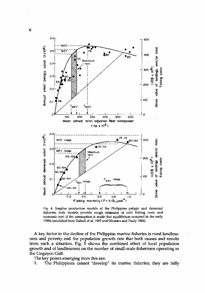
A number of comprehensive reviews in recent years document the main trends and aspects of the Philippine marine fisheries (Pauly et al. 1986, Dalzell et al. 1987). A clear pattern of overcapitalization and overfishing has emerged, with regard to the demersal, the small pelagics and the tuna fisheries. Indeed, effort in the fisheries sector as a whole is two to three times in excess of optimum exploi- tation rates. The results of this are: (1) declining catches during the last 5-10 years and (2) a more or less total dissipation of the economic rent which could be ex- tracted from these fisheries (Fig. 4).
The Philippine fisheries are at present characterized by an extremely uneven distribution of benefits from fishing. Large-scale operators catch and earn hun- dreds, or even thousands of times, more than small-scale fishermen. Also, large- scale fish habitat destruction (e.g., clear-cutting of mangroves, and reef destruc- tion through dynamiting and cyanide poisoning) is occurring throughout the country.
Mean annual total adjusted fleet horsepower ( hp 103 1
Fishing mortality ( F= Y/B; 1
Fig. 4. Surplus production models of the Philippine pelagic and demersal fisheries; both models provide rough estimates of total fishing costs and economic rent if the assumption is made that equilibrium occurred in the early 1980s (modified from Dalzell et al. 1987 and Silvestre and Pauly 1986).
A key factor to the decline of the Philippine marine fisheries is rural landless- ness and poverty and the population growth rate that both causes and results from such a situation. Fig. 5 shows the combined effect of local population growth and of landlessness on the number of small-scale fishermen operating in the Lingayen Gulf.
The key points emerging from this are: 1. The Philippines cannot "develop" its marine fisheries; they are fully

15 -
- Natl~nal wpulation census m 2 - 8 Not~onal fisher'b census " 10- A BFAR provincial data c
E - b - c .- .- -
Fig. 5 . Changes in the number of small-scale fishermen in the Lingayen Gulf area, Philippines, from the 1930s to the early 1980s. Note dip due to the Second World War and the tre- mendous inaease in the 1980s. (The last point does not reflect a decrease, but a result of a different sampling methodology.)
developed to the extent that this country is now the twelfth fishing nation in the world.
2. Rehabilitation of the Philippine fisheries involves massive reduction of fishing effort (by at least a factor of two). Such reduction of effort involves providing material incentives for hundreds of thousands of small-scale fishermen to stop fishing.
3. Projections of the Philippine population and the status of the Philippine marine fisheries suggest that per capita availability and consumption of domestically produced marine fish will tend to decrease.
Singapore
Singapore's brief history as a city-state is that of a devolution of its fishing sector, i.e., the bulk of the marine fish consumed or marketed through Singapore is imported. To the extent that other countries continue to have suitable fish to export, and that Singapore has the cash to pay for these imports, this country will have no problem of capture fisheries management, and hence need not be con- sidered in the context of the present paper.
Thailand
The explosive growth of the Thai demersal fisheries in the 1960s in the Gulf of Thailand, their expansion outside the gulf, their retrenchment following the 1973

8 oil crisis and the promulgation of EEZs by Southeast and South Asian countries where Thai trawlers had been operating are now so well-documented that they have become part of the folklore of fisheries biologists (Panayotou and Jetanavanich 1987; Fig. 6). What Thai fisheries managers are confronted with, however, is that the Gulf of Thailand is "empty" of fish and full of fishing boats, i.e., with a more urgent need than ever to impose effective regulations on the trawling fleet.
1 1,250 - 1,500 -
10,500- 350 - IpOO- NO. trawlers
9,750 - LmJ - 9,000 - 300- 1,200 -
6,750 - k 800- . 4,500- 150-z 600-
3,750 - 500 - 3,000- 100- 400-
1,500 - 50 - 200 -
1 1 1 1 1 1 1 1 1 1 1 1 1 1 1 1 1 1 1 t 1 1958 €0 62 64 66 68 70 72 74 76 78 80 82
Fig. 6. Time trends in the number of trawlers, catch per hour and total demersal catch in the Gulf of Thailand, 1958-1982 (Panayotou and Jetanavanich 1987).
Approaches which are being studied are, among others: 1. imposition of larger mesh sizes for the cod end of the trawlers; 2. 'buy-back" and restrictive licencing schemes; and 3. use of sturdy, concrete, artificial reefs to prevent inshore trawling and to
allocate the nearshore resources to small-scale fishermen using passive gears.
These and other measures suggested to rehabilitate Thai demersal fisheries could succeed, especially if the Thai economy continues to do well and funds could be made available to implement these management interventions. Also, the land-based sectors of the economy may be able to absorb excess fishermen, given that Thailand has, in general, a low population growth rate.
Conclusions
The fisheries of the six ASEAN countries are not all "developing". In fact, a minority of ASEAN member states have scope to expand their fisheries. ASEAN
fisheries range in scope and sophistication from inshore-bound, traditional srnall- scale affairs to large-scale, capital-intensive international operations. Thus, the interventions needed by the fisheries sectors of the various ASEAN member states require a level of sophistication which go well beyond laissez-faire, or extending subsidized credit to fishermen, hitherto the favorite tools of fisheries developers.
Thus, getting back to the title of this contribution, one should "bother" about managing fisheries resources because not managing them turns one's fisheries sector from a healthy, productive factor of national development into a subsidy- guzzling drag on the economy. Management interventions will have a positive impact on the other hand, only if they are based on a combination of solid bio- logical and economic research and on a political commitment to resolve issues rather than letting them fester.
References
Wy, C., A. Dwiponggo and F. Marahudin. 1987. Indonesian marine capture fisheries. International Center for Living Aquatic Resources Management, Manila, Philippines; Directorate General of
isheries and Marine Fisheries Research Institute, Ministry of Agriculture, Jakarta, Indonesia. zell, P., P. Corpuz, R. Ganaden and D. Pauly. 1987. Estimation of maximum sustainable yield and d maximum economic rent from the Philippine small pelagic fisheries. Bur. Fish. Aquat. Resour. Tech. Pap. Ser. 10(3):1-23.
IPFC (Indo-Paafic Fisheries Commission). 1987. Papers presented at the Symposium on the Exploi- tation and Management of Marine Fishery Resources in Southeast Asia, 16-19 February 1987. Darwin, Australia. RAPA Rep. 1987/10.552 p.
9 oo, H.W., S. Selvanathan and A.M.S. Halidi. 1987. Capture fisheries, p. 89-108. In T.-E. Chua, L.M. Chou and M.S.M. Sadorra (eds.) The coastal environmental profile of Brunei Darussalam: resource assessment and management issues. Fisheries Department, Ministry of Development, Brunei Darussalam; and International Center for Living Aquatic Resources Management, Manila, Philippines.
,P6nayotou, T. and S. Jetanavanich. 1987. The economics and management of Thai marine fisheries. International Center for Living Aquatic Resources Management, Manila, Philippines; and Winrock International Institute for Agricultural Development, Arkansas, USA.
uly, D. 1987. Theory and practice of overfishing: a Southeast Asian perspective, p. 146-163. In / Papers presented at the Symposium on the Exploitation and Management of Marine Fishery
Resources in Southeast Asia, 16-19 February 1987. Darwin, Australia. RAPA Rep. 1987/10.552 p. ,l%uly, D., J. Saeger and G. Silvestre, editors. 1986. Resources, management and socioeconomics of
hilippine marine fisheries. UPV-CF Tech. Rep. Dep. Mar. Fish. No. 10.217 pp. ardjono, I. 1980. Trawlers banned in Indonesia. ICLARM Newsl. 3(4):3. aP
/$llvestre, G. and D. Pauly. 1986. Estimate of yield economic rent from Philippine demersal stocks. Paper presented at the IOC-WESTPAC Symposium on Marine Science in the Western Pacific, 1-6 December 1986. Townsville, Australia.

Management and Conservation of Mangrove Resources for Coastal Development in the Southeast Asian Nations
SANIT AKSORNKOAE Faculty of Forestry
Kasetsart University Bangkok, Thnilnnd
AKSORNKOAE, S. 1989. Management and conservation of mangrove resources for coastal develop ment in Southeast Asian nations, p. 11-15. In T.-E. Chua and D. Pauly (eds.) Coastal area man- agement in Southeast Asia: policies, management strategies and case studies. ICLARM Confer- ence Proceedings 19, 254 p. Ministry of Science, Technology and the Environment, Kuala Lurnpur; Johor State Economic Planning Unit, Johore Bahru, Malaysia; and International Center for Living Aquatic Resources Management, Manila, Philippines.
Abstract
The causes of mangrove destruction in Southeast Asian nations are reviewed. The various tools used in managing mangroves are discussed: setting up management, conservation, conversion and/or reconstruction zones, managing for the integration of forestry and fishery production, and use of mangrove forest for agriculture and habitation. It is concluded that education and public par- ticipation are crucial factors in mangrove conservation.
Introduction
Mangrove forests are rich and diverse living resources. In Southeast Asia, these areas have long been important in the subsistence of a large percentage of the population. More recently, they attained great economic significance, because of their direct resource utilization in forestry and fisheries production and in view of their potential in protecting coastlines and maintaining estuarine ecological balance.
Unfortunately, rapid developments in the mangrove environments of many Southeast Asian regions have led to uncontrolled and destructive use patterns frequently associated with pollution and environmental degradation.
Southeast Asian countries now recognize the need for management and con- servation of this extensive resource and the desirability of introducing advanced
11

12 technology to further increase its economic potential. Conservation and man- agement of mangrove areas for optimum economic potential should be deter- mined before they are all removed in the interests of other activities such as fish- ponds, resettlement areas and industrial sites.
Causes of Mangrove Destruction
Vast areas of mangrove forests are destroyed every year, directly or indirectly as a result of other activities. The causes of mangrove destruction in various countries are very similar. Population growth has led to an increased demand for food, fuel, building materials, urbanization and land for cultivation. The causes can be classified, thus: overexploitation by traditional users; conversion to aqua- culture, agriculture, salt pans; urban development; construction of harbors and channels; liquid or solid waste or garbage disposal; and spillage of oil and other hazardous chemicals. Natural stressors such as cyclone and freshwater dis- charges also destroy mangrove ecosystems. However, the degree of destruction in each country depends on specific conditions.
Management and Conservation of Mangroves
The conversion of mangrove areas for various purposes is increasing each year. Mangrove forests should be reserved for conservation or utilized on a sustained-yield basis, with a minimum of conversion or destruction. To achieve these, proper conservation and management plans should be formulated. The following are recommended:
Mangrove land use zoning
Before deciding on mangrove land use and zoning, a map of mangrove condi- tions should be made. The map should consider the distribution and quality of forests, landforms, drainage patterns, current pattern and other environmental factors which sustain or constrain the mangrove ecosystem. Plans for mangrove land-use zoning should also be coordinated with national socioeconomic and coastal development plans. Mangrove zones should be outlined for the following activities:
Conservation Zones. These zones protect natural and relatively undisturbed mangrove ecosystems to maintain species and genetic diversity, and to provide areas for scientific research, education, recreation and cultural interest. The zones also provide shoreline protection and habitats for fish and shellfish. These areas should be declared as and managed for mangrove nature reserves.
Management Zones. The management zone covers two parts: 1. Management for sustained yield for timber production: A silvicultural
system for timber harvesting should minimize environmental impact and encourage natural regeneration. Planting should be done in har- vested areas where natural regeneration is insufficient. Clear-felling in

13 strips or in blocks is an appropriate silvicultural system or harvesting method which features a cutting rotation of about 3040 years. It has been applied to mangrove forests in various countries, particularly, Thailand, Venezuela and Malaysia (see Darus, this vol.).
2. Management for sustained yield for fisheries: The forest should maintain the habitat sustaining fish and crustacean, which can be harvested in the mangrove area and in the adjacent estuarine, lagoonal or marine waters. In practice, it should be possible to combine management for both fish- eries and forestry products.
Conversion Zones. In these zones, mangrove areas are provided for other uses, such as aquaculture (fish and shrimp ponds), salt farms, agriculture, and urban and industrial development. Conversion requires clearing and destruction of some parts of mangrove ecosystem activities which, should be kept to a mini- mum and done preferably in previously converted sites. These zones should also be located, as much as possible, away from the shoreline and/or behind the mangrove forests.
Reforestation
Reforestation of mangroves should be planned, not only for degraded man- grove forests, but also on abandoned areas, particularly those left after tin mining and fish or shrimp farming have been done. Mangroves can also be planted on mudflats.
The success or failure of mangrove reforestation depends on various factors which should be carefully considered: tidal patterns, soil conditions and harmful biota. The areas to be planted should be flooded by seawater. Rhizophora spp. prefer muddy soils, while other species such as Ceriops and Bruguiera prefer drier soils. For a large-scale mangrove plantation, the operation should be made by both public and private sectors.
Multiple-use management system approach
The multiple-use management system approach, rather than the single-use one, should be emphasized. Some recommended systems for the farmers are as follows:
Management System for integrated Forestry and Fishery Products. The integrated management system involving mangrove plantation and aquaculture (fish and shrimp farming) used in Indonesia can be applied to avoid clearing mangrove forests for aquaculture purposes only. Called tumpang sari or silvo-fishery system in Indonesia, this system saves natural mangrove formations and provides tradi- tional fisheries products.
The fish or shrimp ponds are constructed around the plantation by digging a small canal, about 5 m in width and 1.5 m in depth. The ditch area for raising fish or shrimp is approximately 20% of the total area. The total area of plantation with ditches is usually about 5 ha. Villagers identified by a government agency take care of the plantation and the fish or shrimp ponds. They collect the fish or shrimp, while the government agency gets the wood from the plantation. It is
14 hoped that by using this integrated management system, proven effective in Indonesia, the clearing of mangrove areas for aquaculture only could be dimin- ished or even stopped in the future.
Management System Using Mangrove Forest for Agriculture. Indonesia is the leading country in practicing this, another tumpang sari system. Basically, it is for growing agricultural crops, especially rice. The inner part of the mangrove forest is used or clear-felled. Then a ditch or small canal 3-5 m wide is dug around the cultivation 1-2 m over the high-tide mark. When it rains, salt is drained into the ditch. Rice or other agricultural crops are planted when soil conditions are suit- able, i.e., in the absence of too much salt in the soil. With this method, the man- grove forest can be permanently used for agriculture, which reaps high returns.
Salt Ponds. Salt production from mangrove forest areas in Thailand has been highly successful. The simple system involves clear-felling the mangrove areas at the driest and saltiest inland site. Ponds 50 cm deep are dug and seawater is pumped in (some areas use windmills). Solar radiation evaporates the seawater, so salt production is done only during the hot season. Rhizophora spp. can be grown on the dikes of the salt pond. When these trees are 7-10 years old, they can be used as firewood for charcoal burning. The combination of plantation and salt production is a good multiple-use system in which the owner benefits from mul- tiple products.
Mangrove forest for habitation and sites for harbor and industrial complex
This type of mangrove use includes housing, building of harbor and of indus- trial complexes, etc. There is no well-marked system for such use. Small villages occupying the mangrove areas are the main encroachers. In Thailand, the gov- ernment allows people to reside in the mangrove area, but only in clusters, as they are easier to control than scattered habitations. To use mangrove areas for harbor facilities or industrial complexes, entrepreneurs must submit a project proposal and an environmental impact assessment (EIA) to the National Man- grove Committee and the Office of the National Environment Board. When such use is expected to have strong adverse effects on the environment, the project is not granted permission for implementation unless modified to prevent damage. By this process, the conversion of mangrove areas for these activities mitigates economic returns and the conservation of mangrove forests.
Conservation
For effective conservation and protection of mangrove forests, laws and regu- lations should be backed-up by an enforcement mechanism, with sufficient trained officers. Effective enforcement also requires support equipment, includ- ing vehicles and boats, to enable the officers to carry out their responsibilities.
1. Knowledge on the various aspects of mangrove ecosystems is important for effective conservation, management and utilization of mangrove resources. So far, this knowledge is inadequate and still needs further investigation especially that on the detailed functioning of the ecosystem and the socioeconomics of mangrove dwellers. The action and collabora-

15 tion of research among scientists fram various countries are necessary. International organizations such as the United Nations Educational, Scientific and Cultural Organization (UNESCO), United Nations Development Program (UNDP), United States Agency for International Development (USAID), Food and Agriculture Organization (FAO) and ICLARM, among others, play a significant role in bringing together scientists from developing countries to better understand the mangrove ecosystem. These agencies also provide grants for research activities. It is believed that from such cooperation, the ideas and knowledge can help in the management of mangrove resoqrces.
2. Education helps ensure public support for legislation and for the enforcement of regulations controlling land use of mangrove areas. Special education is necessary for those who live in and near mangrove areas, for public officials, administrators and legislators, and also for school children and biology students. Educational programs should emphasize the ecological and economic values of mangrove ecosystems as natural resources, and should help generate support for regulations protecting the mangroves.
3. Public participation is important fcpr the conservation of mangrove forests. As the inhabitants are usually the owners and users of natural mangrove forests, their understanding of the mangrove is vital. If they practice conservation measures, the destruction of mangrove forests will decrease. New concepts of "social forestry," forest for community and agroforestry (silvo-fishery) must be introduced to the public to effect a two-way communication.
It is the duty of government agencies to assess the mangrove forest resources using remote sensing and computer technology and other scientific methods, and to carry out research on the status of mangrove communities. On the other hand, research on the phenomena, processes and potential of mangrove communities is the responsibility of scientists. The rural people and mangrove users should not only have the right to log and exploit but also the responsibility to replant and protect the resource. The government may allocate special funds for "slack season" work for rural people who seek employment in such projects.
Conclusion
Mangroves are valuable sources of fuel and food. But many mangrove forests have been destroyed because of conversion 10 different uses. Southeast Asian countries are attempting to maximize and codserve their mangroves. Corrective measures on research, planning, managemen't and conservation are being for- mulated. Education emphasizing the ecological and economic values of the man- grove ecosystem and the impacts of human activities is essential, as is public participation in mangrove conservation efforts.
Coral Reef Resources andl the ASEANIUS Coastal Resources Management Project
EDGARDO D. GOMEZ Marine Science institute
Uniwrsity of the Phili$pines Diliman, Quezan City, Phflippines
GOMEZ, E.D. 1989. Coral reef resources and the ASEAN/US Coastal Resources Management Project, p. 17-26. In T.-E. Chua and D. Pauly (eds.) Coastal area management in Southeast Asia: policies, management strategies and case studies. ICLARM Conference Proceedings 19,254 p. Ministry of Science, Technology and the Environment, Kuala Lumpw; Johor State Economic Planning Unit, Johore Bahru, Malaysia; and International Center for Living Aquatic Resources Management, Manila, Philippines.
Abstract
This paper reviews the status of coral reefs in the ASEAN region and the studies made on them by the ASEAN/US CRMP. The destructive factors and the m a j ~ management strategies to combat these are also discussed.
Introduction
The seas of ASEAN stretch some 5,000 km from east to west and some 3,000 km from north to south, straddling the equator and linking the Pacific and the Indian Oceans. What might have been a vast expanse of ocean is in fact broken up by more than 20,000 islands and the southernmost claw of continental Asia, the Thai-Malay peninsula. I
Along the coasts of these land masses are extensive fringing coral reefs and further offshore are countless annular atolls, likewise constructed by minute polyps of corals into formidable circular calcium carbonate ramparts standing in clear oceanic waters. These reefs are among the most productive ecosystems in the world and certainly the most diverse and aesthetically pleasing.
Coral reefs are the earth's largest topographia features that are of biological origin. While calcareous material from molluscs dnd other organisms contribute
17
18 to the consolidation of reefs, the primary builders are the anemone-like coral polyps which are almost exclusively colonial and which have a symbiotic rela- tionship with microscopic algae called zooxanthellae. Through this mutualistic cooperation between plant and animal, the corals form a calcareous skeleton. In time, the individual colonies of hundreds of species fuse to form geologic struc- tures, the coral reefs as we know them.
Because of the biological nature of these features of our shallow seas, they are susceptible to destruction by natural phenomena or by man. Most of the reefs are close to land (Fig.l), and they are, therefore, easily accessible to man who make them more vulnerable to human-induced stresses.
Much has been written on Southeast Asia's coral reefs, and I had the privilege of being the first to attempt a synthesis of information specifically on the coral reefs of the region in 1980. The United Nations Environment Programme (UNEP) was developing the East Asian Seas Action Plan and needed a situationer on the coral reefs of ASEAN. Consequently, I undertook a mission to collect all available literature and to interview all the scientists and laymen in the region who had studied coral reefs. My report, entitled "Status Report on Research and Degrada- tion Problems of the Coral Reefs of the East Asian Seas," served as an information paper for the meeting of Experts to Review the Draft Action Plan for the East Asian Seas convened by UNEP in Baguio City, Philippines, in June 1980.
The general picture has changed little in eight years. To economize on effort, let me quote part of ths report's sununary. The 1980 paper was revised in 1983 (Yap and Gomez 1985). However, for the present purposes, the original paper (Gomez 1980) is quoted, thus:
The high productivity of coral reefs makes them important components of the marine world and coral reef fisheries make up a significant percentage of the protein intake of coastal peoples. Besides food production, reefs serve to protect coast- lines from erosional processes and as recreational areas for man. Various nonfood items including building materials and indus- trial and pharmaceutical products may be derived from reefs.
Because of the expanding populations and the concomitant demands for food and other economic benefits, the coral reefs of the region have become subjected to more and more stresses by man.
Much of the region is composed of islands, with Indonesia and the Philippines accounting for more than 20,000. Such a set- ting in the tropical belt makes the proliferation of coral reefs ideal. In this marine biogeographic region, corals have attained their greatest diversity with some 80 genera of reef building corals reported.
In contrast there are a quarter of a billion people (now about 300 billion) inhabiting the region, thus making it one of the most populous in the world. While the economy is basically agricul- tural, industrialization is fast developing along with the related pollution problems. The importance of coral reefs to the region
L I B R A R Y INTEPNATIQNAL CENTER FOR LlVlNP
. r , ... .,, "<. 7 r T - . , . - b . < ~ v

I I I I
loo0 lloO 1 20° 130° I 140 I
Fig 1. Dktrhtion of coral reefs in the East Asian Seas region (after Gomez 1980).

20 lies in their ability to provide consumable protein for man. It has been estimated that about 10 to 15% of fish production is coral reef related.
While there are natural causes of coral reef destruction, the resilience of these ecosystems allows them to survive these processes. However, man-induced stresses are posing a real danger to these important biotopes. These stresses include silta- tion or sedimentation, destructive fishing practices such as blasting, the mining of corals, the collection of corals and coral reef fauna for other purposes, tourism, and other pollution problems.
Coral research in the region in the past has been rather limited due to the lack of marine scientists. The picture is changing as more and more institutions within the region are focusing atten- tion to coral reef research. Nevertheless, there is an acknowl- edged lack of basic understanding of coral reef biology. Coral reef degradation problems are only beginning to be studied. It is heartening to learn that all the countries of ASEAN are devel- oping research efforts to study coral reefs.
Coral Reef Studies in the Coastal Resources Management Project
Of the six countries participating in the CRMP, only four, Brunei Darussalam, the Philippines, Singapore and Thailand, address the issues on coral reefs within the general context of coastal resource utilization and consequent degradation. In addition to the coral reef conditions in the East Asian Seas region reported by Yap and Gomez (1985), more reefs have been described in Brunei Darussalam (Chou et al. 1987), the Philippines (Meiiez et al. 1988, McManus and Chua, in press), Singapore (Chou 1986, Chia et al. 1988) and Thailand (Paw et al. 1988).
In Brunei Darussalam, the turbid condition of the water resulted in limited coral formation known to occur in the offshore islets and rocks (Fig. 2). Of these, three sites-Pelong Rocks, TWO Fathom Rocks and Pulau Punjit--the first two were surveyed in more detail. Results revealed a reef community that was pre- dominantly rubble and sand, a fair-to-poor reef condition in terms of live coral cover, and a low population of chaetodontids or butterflyfish, the coral reef fish which are considered to be indicators of the reef's health. Fish abundance and diversity were low, although the presence of large-sized, highly sought commer- cial fish (serranids) gave an impression that the areas were not overfished.
The Philippine site, Lingayen Gulf, is characterized by fringing reefs concen- trated on the western coast (Fig. 3). Corals at the reef slope were predominantly of the low-profile type (massives and encrusting species) while the backreef was covered mostly be seagrass. Majority of the reefs surveyed in 40 stations covering the big and small islands in the gulf are in fair condition except two sites (Malinap and Cangaluyan) which are in good condition. The commercially im- portant fish species were small and constituted only 3.7% of the total reef fish population, indicating an overfished reef area. Chaetodontids, which made up

I 1 I
South China Sea g FEY ' 1 Two
Fathom ' Ahm Rock
Rock * * r PWng Rocks
Fig. 2. Location of known reef areas in Brunei Darussalam (after Chou et al. 1987).
8% of the total fish population, are largely collected in the area for the aquarium industry.
Singapore, on the other hand, had coral formations at the southwestern section extending from Tanjong Tuas to Pulau Semulan and around the unre- claimed southern islands (Fig. 4). CRMP surveys were conducted in seven of the southern islands. At the time of writing, no information on coral reef areas was available except for Pulau Salu and Pulau Hantu. The former is fringed with live corals concentrated on the reef slope. The slope projects a good to fair coral con- dition. However, if live corals were measured from the reef flat, reef edge and reef slope altogether, the overall condition of the reef would be shown to be poor. On the other hand, Pulau Hantu, which coral cover has been reduced by land reclamation, exhibits a poor reef condition. Additional information on Singapore reefs is provided below.
In Thailand, the CRMP study site covered coral reef areas of Ban Don Bay where the Mu KO Ang Thong National Park, the only marine protected area, is situated (Fig. 5). This, together with KO Samui-KO Phangan-KO Ang Thong, is surrounded by well-developed and undamaged coral reefs.

Fig. 4. Singapore coral reef areas (Chi. el al. 1988).

Aa Moe Nom and KO Ma
A0 Hot Lot, \
Southern Hat Cha Wen9
Fig. 5. Coral quality in Ban Don Bay Islands, Thailand (Paw et al. 1988).
Table 1 summarizes data from the coral reef surveys undertaken by CRMP for the three countries where quantitative data were presented. The categories of condition used are as follows:
Excellent : 75-100% live coral cover Good : 50-74.9% live coral cover Fair : 2549.9% live coral cover Poor : 0-24.9% live coral cover
For comparative purposes, Table 2 provides information on Philippine coral reefs collected in the course of three different projects. In addition, Chou (1988) provides a summary table of Singapore's reefs. He shows that corals at the 3-m depth of reef slopes range from poor (23.5%) to good (62%) with a fair mean (44.4%).
Management Concerns
The coral reefs under study are commonly destroyed by siltation. Destructive fishing methods have aggravated the situation in the Philippines, Brunei Darus- salarn and Thailand. Damage by boat anchors cannot be underrated in Thailand

Table 1. Status of coral reefs based on surveys by the ASEAN/US CRMP in three countries.
Country No. of Excellent Good Fair Poor stations No. % No. % No. % No. %
Brunei Darussalam 7 4 57.1 3 42.9 Philippines 40 18 45.0 17 42.5 5 12.5 Singapore
Average 2 2 100.0 Reef slope only 2 1 50.0 1 50.0 Reef flat only 2 2 100.0
Table 2. Status of Philippine coral reefs based on surveys by three projects.
Source No. of Excellent Good Fair Poor stations No. % No. % No. % No. %
Yap and Gomez (1985) 632 35 5.5 153 24.0 242 38.3 202 32.1 ASEAN-Australia CLRPa 59 9 15.3 30 50.8 20 33.9 ASEAN-US CRMP 40 18 45.0 17 42.5 5 12.5
aSource: Unpublished data from the Coastal Living Resources Project (CLRP).

25 since the coral reefs under investigation are mostly within the national parks or marine reserves. Excessive collection of marine organisms, such as seaweeds, aquarium fish (by the use of cyanide), gastropods, bivalves, cephalopods, echin- oderms and corals, is a major destructive factor of the Lingayen Gulf coral reef ecosystems in the Philippines.
Overall, Southeast Asian reefs are at varying degrees of degradation. The CRMP ultimately aims to arrive at an integrated management plan, appropriate to the coastal resources, whether to support food supply and livelihood (as in the case of the Philippines and Thailand), develop tourism (as in Singapore) or merely to preserve the remaining coral communities for ecological reasons (as in Brunei Darussalam). Major management strategies include: encouraging the eco- logical use of resources; increasing public awareness on sound resource use and management through education/information programs; involving community participation in resource management plan formulation and implementation; adopting alternative livelihood activities; strictly enforcing protection laws; and strengthening ties among government agencies and between government and nongovemment organizations concerned with resource evaluation, planning, development and utilization.
Various actions can be taken by the countries involved; two are briefly presented here.
First, the establishment of coral reef parks and reserves should be encouraged vigorously. The region has gained some experience in this regard and should exert more effort. Protected coral reef areas serve two major objectives: to replenish areas and gene pools for fish and invertebrates, thereby increasing their productivity and potentials; and to serve as recreational and study areas, thus increasing economic and scientific benefits to the country.
Second, the ASEAN countries should take concerted action to enforce laws protecting coral reefs. In those countries where these are lacking, appropriate measures to protect coral reef resources should be enacted. Where one country has taken measures to protect its coral reef resources, other countries should cooperate in preventing unscrupulous individuals from circumventing national legislation. One example is the ban on the exportation of corals from the Philip- pines. It is well-known that corals are being smuggled out of the country. It would help if all the neighboring countries could prohibit the importation or transshipment of banned Philippine corals.
References
ia, L.S., K. Habibullah and L.M. Chou. 1988. The coastal environmental profile of Singapore. Inter- p' national Center for Living Aquatic Resources Management, Manila, Philippines.
Chou, L.M. 1986. The potential of artificial substrates in enriching living reef resources in turbid ters. Trop. Coast. Area Manage. l(2): 56.
u, L.M.,M.W.R.N. DeSilva andA.T.White. 1987. Coral reefs, algae and seagrasses, p. 43-58. In T.- / E. Chua, L.M. Chou and M.S.M. Sadorra (eds.) The coastal environmental profile of Brunei
Darussalam: resource assessment and management issues. International Center for Living Aquatic Resources Management, Manila, Philippines.

26 Gomez, E.D. 1980. Status report on research and degradation problems of the coral reefs of the East
Asian seas. LJNEP/WG 41/INF. 15. 68 p. South China Sea Fisheries Development and Coordi- nating Programme, Manila.
fianus, L.T. and T.-E. Chua, editors. The coastal environmental profile of Lingayen Gulf, Philip pines. International Center for Living Aquatic Resources Management, Manila, Philippines. (In press).
Meiiez, L.A.B., L.T. McManus, N.M. Metra, J.F. Jimenez, C. Rivera, J. Concepdon and C.Z. Luna. 1988. Survey of coral reef resources of western Lingayen Gulf, Philippines. Paper presented at the ASEAN/US Technical Workshop on Integrated Tropical Coastal Area Management, 28-31 Octo-
r 1988. Singapore. w, J.N., S. Bunpapong. A.T. White and M.S.M. Sadorra, editors. 1988. The coastal environmental / profile of Ban Don Bay and Phangnga Bay, Thailand. International Center for Living Aquatic
Resources Management, Manila, Philippines. Yap, H.T. and E.D. Gomez. 1985. Coral reef degradation and pollution in the East Asian Seas Region,
p. 185-207. In A.L. Dahl and J. Carew-Reid (eds.) Environment and resources in the Pacific. LJNEP Reg. Seas Rep. Stud. 1.

Petroleum and Minerals: Policy Issues
MARK J . VALENCIA Resource Systems Institute
East- West Center Honolulu, Hawaii, USA
VALENCIA, M.J. 1989. Petroleum and minerals: policy issues, p. 2741. In T.-E. Chua and D. Pauly (eds.) Coastal area management in Southeast Asia: policies, management strategies and case studies. ICLARM Conference Proceedings 19, 254 p. Ministry of Science, Technology and the Environment, Kuala Lumpur; Johor State Economic Planning Unit, Johore Bahru, Malaysia; and International Center for Living Aquatic Resources Management, Manila, Philippines.
Abstract
This paper reviews the status and potential of offshore petroleum and mineral production in the Southeast Asian region, summarizes possible conflicts between their extraction and other uses of the coastal area, and outlines policy options.
Petroleum Resources
This contribution briefly reviews the status and potential of offshore petroleum and related products in Southeast Asian seas, with emphasis on con- flicts (extent or potential) between the petroleum industry and other coastal activities (Fig. 1).
Valencia (1983) presented detailed maps of the distribution of sedimentary basins, oil and gas deposits, oil and gas potential and petroleum rights in South- east Asia. The following section is based on these, and on Valencia (1985a, b).
Regional petroleum geology
The continental shelves of the Southeast Asian region are underlain by thick tertiary sedimentary basins; in places, such sediments also underlie the conti- nental slopes and rises and the deep ocean floor. The elongated basins under- lying the central and northwestern Sunda Shelf are generally parallel to the surrounding land masses and are distributed in a double festoon draped around
27

Fig. 1. Stages in oil development: exploration, drilling, production and transportation (adapted from Gilbert 1982). Note areas of overlaps, incompatibilities and potential conflicts between this industry and other coastal activities.

29 the Natuna Arch. The north-south-trending Thai Basin in the Gulf of Thailand and the northwest-southeast-trending Malay Basin off the northeast coast of the Malay Peninsula are separated by the east-west Tenggol Arch from the east- west-trending Penyu and West Natuna Basins to the south. The Malay Basin is the thickest, with over 9 km of sediment. The Malay and West Natuna Basins are largely separated from the Sarawak Basin to the east by a ridge of basement rocks, the Natuna Arch. The Sarawak Basin extends to the west and south and to the east into the Brunei-Sabah basins. To the northeast, the Northwest Palawan Basin hugs the coast of Palawan. To the north of the Sarawak Basin, the Saigon Basin is separated from the Mekong Basin by the Con Son Swell, a buried ridge of basement rock. The Mekong Basin is also separated from the Thai Basin to the west by the Korat Swell. The deep South China proper contains the 2-km-thick South China Basin, the shallow Spratly and Reed Bank basins, which rest on a microcontinental block, an unnamed and largely unknown basin parallel to the coast of central Vietnam, several thin sub-basins in the Paracels, and an unnamed 2-km-thick basin in deepwater in the northern part of the South China Basin.
Petroleum production
Cumulative production to 1987, excluding Indonesia, amounted to about 5 billion barrels (bbl). Daily production, excluding Indonesia, is about 1.2 million bbl of oil and 1.1 billion ft3 (BCF) of gas (Table 1). Even including Indonesia, the region produces only about 3.5% of the world's crude oil and 2.5% of its natural gas. Asia's first offshore well was drilled on the northwest continental shelf of Borneo in 1957. In 1975,20% of crude oil in the region was produced offshore; in 1980, about 50% of crude oil production was from offshore wells.
Brunei Darussalam, Indonesia, Malaysia, Thailand and the Philippines have established offshore hydrocarbon potential and account for most of the ex- ploratory wells drilled in the region. The predominant offshore discoveries and production are in basins in the central and southern Sunda Shelf and the North- west Palawan and North Surnatera Basins.
Important non-Indonesian producing fields or discoveries include: Bintang, Tapis, Bekok, Pulai, Seligi, Sotong and Anding oil fields; Duyong gas field off the east coast of West Malaysia; South Furious, Tembungo, Erb West and Samarang oil fields off west Sabah (East Malaysia); Champion, Fairley, Seria and Swampa oil fields off Brunei Darussalam; and Fairley-Baram, Baram, Baronia, Betty, Bakor, Bakau, Tukau and Temana oil fields and Central Laconia and West Lutong gas fields in adjacent Sarawak waters and Nido off northwest Palawan. Important offshore Indonesian producers include: Gita, Rama and Aruna oil fields in the Java Sea, and Attaka oil field off east Kalimantan. The southeastern Malay Basin is oil-prone, whereas the Gulf of Thailand basins to the north and the West Natuna Basin to the south are gas-prone. The Central Luconia Platform is gas-prone and the Baram Delta, Brunei-Sabah, ard Northwest Palawan areas are oil-prone.
For the Sunda Shelf alone, excluding Indonesia, total estimated ultimate recoverable reserves (proved and in some cases probable) are 3.8 to 5.3 bbl of oil

Table 1. Hydrocarbon production and reserves from selected offshore basins as of December 1986~.
Production Cumulative (Estimated ultimate q l production recoverable) Remaining reserves
(thousand % Gas % Oil Gas Oil Gas Oil Gas Country1 barrels1 off- (million off- (million (trillion (million (trillion (million (trillion
basin day) shore ft3/day) shore barrels) ft3) barrels) ft3) barrels) ft3)
Brunei Darussalam Baram Delta
Indonesia
Malaysia West Malay East Sabah Sarawak Bar am Balingian C. Luconia
Philippines Palawan Reed Bank
Thailand Thai Basin
2,900-3,400 107,089b 20,750 3,427 1,c'c'o 200+
? minor minor
16.3 50
100 49
12.5 (35)C
115 48. (98)C 6.6 - 15
?
15 0.14
minor 37 7.2
aSources: Ernest P. Du Bois, pers. comm.; Shell Brunei; T.D. Adam (SEAPEX); Petroleum News (January 1983); Petroleum Economist (December 1981); N. Ramli, Petronas; Oil and Gas Journal (26 December 1983,28 December 1987); Swdayao (1984); Energy Information Administration, The petroleum resources of Indonesia, Malaysia, Brunei, and Thailand, Office of Oil and Gas, US Department of Energy, Washington, D.C, July 1984. Entries are: - = none; ? = amount unknown. bBarrels of oil equivalent; offshore = 89,500. Nayoan's study (1981) focuses on offshore areas claimed by more than one country. For a thorough treatment of the petroleum resources of all Indonesia, see Bee (1982); and of Southeast Asia as a whole, Siddayao (1978). CThe Energy Information Administration reports 133 trillion ft3 of ultimately recoverable gas in Malaysia and Brunei.

3 1 and 56 to 67 trillion ft3 (TCF) of gas (Table 1). If the gas is converted to oil-equiv- alent units, total hydrocarbon reserves are on the order of 13.5-17 bbl of oil equivalent. Offshore Indonesia adds some 43.9 billion bbl of ultimate recoverable resources (Table 2) with more than 40% underwater depths greater than 200 m.
Table 2. Indonesia's remaining ultimate recoverable oil and gas resources (Nayoan 1981).
Oil and gas resources Oil and gas resources Basin (billion bbl oil equivalent) Basin (billion bbl oil equivalent)
North Sumatera Basin Sibolga Basin Central Sumatera Basin Bengkulu Basin South Sumatera Basin Sunda Basin North West Java Basin Billiton Basin South Java Basin North East Java Basin Pati Basin North East Java Sea Basin East Natuna Basin West Natuna Basin Ketungau/Melawi Basin Barito Basin Asam-Asam Basin Kutal Basin Tarakan Basin Sulawesi Basin
Total
Makassar Strait Basin Lariang Basin Makassar Basin Gorontalo Basin Banggai Basin Bone Basin Sulawesi Tenggara Basin Flors Basin Bali Basin S a w Basin Timor Basin Banda Basin Halmahera Basin Walgeo Basin Salawati Basin Bintuni Basin Am Basin Waropen Basin Akimengah Basin Sahul Basin
Petroleum potential
Although Southeast Asia's proved petroleum reserves are small by world standards, the extensive offshore shelf represents a prospective area for explo- ration. Developments in remote sensing and positioning technology, geological stratigraphic correlation techniques, deepwater drilling equipment, and pipeline and transmission technology make operations in deepwaters increasingly rou- tine, although extremely costly and not without risk. Offshore exploratory drilling capabilities worldwide increased from a water depth of 412 m in 1973 to about 2,400 m in 1983, although no discovery in waters deeper than about 1,500 m has yet been developed. One of the world's deepest wells then in terms of water depth (Exxon-Discoverer 534'1,055 m) was drilled in 1976 in the Andaman Sea off Thailand. The absolute amount of deep ocean drilling in the region is negligible, however, relative to the prospective areas involved. Offshore explo- ration activity in the region will eventually increase and extend farther offshore and into deeper waters.

32 In the South China Sea, the Brunei-Sabah Basins have a high potential for oil,
while the Central Luconia Platform, Baram Delta and Malay Basin have a high gas potential.
On the other hand, the Northwest Palawan Basin, the central and western Gulf of Thailand basins and the northern Andaman Sea have a poor potential for oil, while the Northwest Palawan Basin, the Reed Bank, most of the Brunei-Sabah basins and Balingian area and the West Natuna Basin have a poor gas potential. Large areas of sedimentary deposits greater than 2-km thick, but with unknown hydrocarbon potential, are located mostly in deepwater in the northern, north- western, central and southwestern South China Sea.
Exploration rights
Most areas of Southeast Asia presently under petroleum exploration rights are on and around known deposits like the Gulf of Thailand and the southwestern and southeastern Sunda Shelf Basins. Some are situated in unproved areas. Areas under petroleum exploration rights appear to be generally limited to the conti- nental shelf. Areas with petroleum rights under waters deeper than 200 m in- clude part of the Northwest and Southeast Palawan and Reed Bank Basins.
Possible Conflicts with Other Coastal Uses
Oil spills
Worldwide, the petroleum industry has recorded 140 rig accidents, causing damages valued at about US$1 billion in 26 years. Most of the accidents were caused by blowouts, followed by on-location damage by hurricanes and rough seas. While safety is the most important consideration, oil-well blowouts are also the most-feared in terms of environmental impact. Blowouts have caused 20-24% of accidents over the years, indicating that, despite technological developments and precautions, the tendency to drill deeper and faster is keeping the accident rate up.
For example, of the 46 blowouts that occurred in the Gulf of Mexico between 1971 and 1978, 30 occurred during development drilling operations. Most of these blowouts, however, were short (generally lasting from 15 minutes to one day), causing little damage. Sixteen blowouts occurred during completion, pro- duction and workover operations. Blowouts experienced during these phases of operation are usually of longer duration and have historically posed the greatest threat to safety and the environment. About 90% of the 46 blowouts which occurred in the Gulf of Mexico from 1971 to 1978 were caused by human error.
Despite intensive offshore drilling and exploitation activities in the South China Sea region during the past decade, the area has had a generally good safety and environment record. However, much of the continental shelf in the region appears to contain shallow, high-pressure gas pockets. Where these have been encountered, there have been few spectacular gas blowouts, but none has yet resulted in serious environmental consequences. For example, off Burma in

33 1972, a jack-up rig capsized after a gas blowout, and in 1983, in Indonesia's Natuna area, one rig capsized and sank when the water became saturated with gas from a blowout. There have also been several minor gas blowouts in Indone- sia and off the east coast of Peninsular Malaysia from only 300 to 400 m. In 1971, however, a drill barge sank off Brunei after a blowout and fire, and reportedly, oil drifted into Malaysian waters continuously for several months.
Natural hazards for oil rigs abound in the region. Typhoons are the most po- tentially destructive and frequent. They may exacerbate unstable seabed condi- tions leading to liquefaction or scouring and redeposition. Over a 45-year period, an average of nine typhoons per year struck exposed sites in the South China Sea. The typhoon season lasts from July through November, with July and September being most hazardous. From June through December, and occasion- ally in April and May, typhoons originate in the western central Pacific, move, west and northwestward through the Philippines and impact the Chinese and, occasionally, the Vietnamese coast.
The South China Sea region has the most active volcanos in any region of comparable size on earth today. Explosions, extensive ash falls, and mud and lava flows characterize the more violent eruptions. Coastal and submarine vol- canic eruptions may be accompanied by earthquakes and tsunamis which may, in turn, damage oil rigs. Volcanic activity is concentrated in three regions: the portion of the Indonesian island extending from Sumatra through Ceram and including submarine activity north and east of Timar; the western Pacific Ocean from the island of New Guinea through the Philippine Islands and Taiwan including submarine activity south of Mindanao and north of Luzon; and a region of solely submarine volcanism in the South China Sea off the southern coast of Vietnam. Submarine volcanic activity has been reported, but not con- firmed, in the Karimata Strait and in the area between the Paracel Islands and Vietnam.
Earthquakes with underwater epicenters may be accompanied by tsunamis and may cause movement or failure of the seafloor affecting structures attached to it. The region can be categorized into subareas of slight, moderate, great and extreme seismicity. Concentrations of activity occur along the Indonesian island arc and in the portion of the Circum-Pacific seismic belt extending from New Guinea through Taiwan. The Philippines is one of the most seismically active areas in the world. About 5% of the earthquakes occurring there are of 6 or greater Richter magnitude. The island of Borneo, the Sunda Shelf and most of the South China Sea are comparatively much less seismic. Earthquakes have also been felt at sea at various places on both sides of the Indonesian island arc, in the Moro Gulf, and west and north of Luzon in the Philippines.
Tsunamis can damage structures fixed to the sea bottom, floating or emplaced along the coast. From 1900 to 1965, 20 tsunamis were reported in the region, a frequency of one about every three years. The areas of reported tsunami impact correspond to those where submarine earthquakes have been experienced and can be classified as local tsunamis. However, these local tsunamis might have travelled outside the locus of their generation and affected other coasts in the region, although reports have been inconclusive.

34 All the above events can initiate submarine slides, slumps and turbidity cur-
rents which, in turn, can dislocate drilling and production platforms. Also, sub- sidence after withdrawal of fluids at depth may distort artificial structures. Fur- ther, the Sunda Shelf exhibits irregularly patterned channel, cut-and-fill structure formed by successive cycles of sea level rise and fall; these may compact differ- entially. Such events may occur at the shelf edge and on the continental slope and be hazardous as deeper waters become economically attractive. On some large deltas, sediment creep may occur.
Any of the above events could initiate an accident where oil is spilled. Trajec- tories have been generated for hypothetical oil spills originating at five points distributed through the region (Valencia 1983, Valencia et al. 1983). These are: Tapis (off the east coast Malay Peninsula), Tembungo (off northwest Sabah), Bach Ho and Dua 1 (south of the Mekong Delta) and Nido (off northwest Palawan). These preliminary trajectories assume a worst case scenario of a con- tinuous spill like that at Ixtoc 1 in the Gulf of Mexico which fed 3 x lo6 barrels of oil into the water over a nine-month period, and where oil travelled in recogniz- able accretions over 500 km.
It is clear that oil spilled at most times of the year at most of the sample points could enter the waters of neighboring countries within a few weeks. The trajecto- ries indicate that during the height of the northeast monsoon, oil spilled at Tapis might impact the southeast coast of the Malay Peninsula within three weeks. Oil spilled at Nido during the northeast monsoon might drift northeasterly into oceanic and small island areas claimed by China, whereas a slick originating at Tembungo during this period might pass through Brunei Darussalam waters and eventually reach the coast of southwest Sarawak. That originating at Dua 1 could penetrate Indonesian and Malaysian waters.
At the peak of the southwest monsoon, oil spilled at the Tembungo site might move northeastwards and enter Philippine waters within two weeks, possibly impacting Balabac Island. Oil spilled at Nido during this period would probably stay within Philippine waters and impact the northwest coast of Palawan within three weeks. A slick originating at Tapis during the southwest monsoon might move northeastwards into Vietnamese waters and eventually impact the Mekong Delta area, whereas oil emanating from Dua 1 might stay within Vietnamese waters eventually impacting the Vietnamese coast south of Cam Ranh Bay.
Oil emanating from offshore drilling adds to that entering the marine envi- ronment from other sources--land discharge, the atmosphere, ships and natural seeps. Valencia (1983) presented a detailed map of the pattern of oil pollution in the region. Hydrocarbon concentrations in Southeast Asian waters range over three orders of magnitude from coastal waters to the open sea, perhaps partly due to the use of different measurement methods. In Indonesian waters, concen- trations ranging from 0.3 to 1.1 parts per million (ppm) were found north of Jakarta in the vicinity of the Cinta and Aquna oil terminals; while in the Riau Archipelago, southwest of Singapore, hydrocarbons ranged from 1 ppm to 11.5 ppm. Other Indonesian locations measured were Pangkalan Susu (0.4-1.2 ppm) and Dumai (1.2-1.5 ppm). The relatively low figures for Dumai may reflect the deballasting facilities available in this location, Indonesia's largest oil port. Con- centrations in Manila Bay ranged from 3.6 ppm at Manila's South Harbor to 4.0
35 ppm at Cavite. In Peninsular Malaysia, concentrations were 0.1-0.23 ppm for east coast waters and 0.12 ppm at Penang.
The highest hydrocarbon concentrations in the region are found in the South China Sea off southern and eastern Vietnam and in the Makassar Strait, and many tarballs are also found in these locales. Tarballs have also been reported beached along both coasts of the Gulf of Thailand, the Thai Andaman Sea coast, both coasts of the Malay Peninsula and in Pulau Seribu north of Jakarta.
Oil can have direct and indirect lethal and sublethal effects on eggs, juveniles and adults of many fish species. Of more immediate economic importance, fish may be tainted, and fishing gear may be fouled by oil, resulting in socioeconomic depression of the fishing industry and thus indirectly affecting all those who depend upon it for food and livelihood.
The Southeast Asian seas support one of the world's most productive marine fisheries. In recent years, the annual catch from the region has been approxi- mately 7 million t. Historically these abundant fisheries resources have been har- vested in inshore and coastal waters with a variety of traditional fishing gears, and have been an important source of food, animal protein and employment for the region's coastal people. While market and barter systems, with networks ex- tending to the interior, are based on these fisheries, mechanized fishing for ex- port provides a significant source of foreign exchange and the infrastructure supporting these fisheries is a further source of income and employment (e.g., freezing, cold storage, boat-building, netmaking and mending, etc.).
The marked increase in regional fishing effort in the past 20 years, encouraged by the rapidly increasing local and international demand for fisheries products, has subjected many of the region's inshore and coastal fisheries to intense fishing pressures and has resulted in the overexploitation of several important fisheries. Concurrent with these has been the loss of important spawning and nursery grounds of many valued species due to increased coastal pollution and the widespread development of coastal lands. Thus, many of the region's fisheries are already under severe stress.
Some sample oil impact areas, such as the east coast of the Malay Peninsula and the Mekong Delta, are intensively fished inshore by relatively small inshore and coastal trawlers and traditional gears. Many of the shallow-water, pelagic fisheries in the sample impact areas are also intensively fished (e.g., the east coast of the Malay Peninsula and northwestern Palawan for chub mackerel and round scad, and northwest Sabah for chub mackerel). The high-priced deepwater pelagic catch is also significant in the sample areas of impact. Around the south- ern Malay Peninsula and in the northwest Sabah-Palawan area, the annual catch per area is about 10,000 t valued at about US$15 million each.
The vulnerability of coastal ecosystems to oil spills is a current concern. Field observations show that these ecosystems and their component species are sus- ceptible to at least short-term damage or destruction if exposed to large amounts of oil. The prime ecosystems of consideration for the South China Sea region are: (1) estuaries within the mouths of larger river systems; (2) mangroves associated with low coastlines and estuaries; and (3) coral reefs associated with most smaller islands and those coasts on larger islands lacking large inputs of fresh- water or sediments from river systems.
36 The impact of oil on tropical estuaries is not well-known, although it may be
surmised that the most significant effect, aside from high toxicity in the water column, would be that on shoreline and bottom fauna and flora. Since estuaries receive up to 50% of their organic matter from mangrove systems, the impact on mangroves is important. Mangroves (and coastal marshes) have been ranked as the most sensitive or vulnerable, due to the persistence of oil in that environment and the ecosystem's slow recovery, estimated at 20 years or more. The vulnera- bility of coral reefs to oil depends on the level of toxicity in the water column, presence and degree of mixing and degree of direct exposure of corals and other organisms to the oil. Beach systems, although not productive alone, provide habitat for certain organisms vulnerable to oil. The impact of oil on species nor- mally involves a degradation of habitat.
The eastern coast of the Malay Peninsula is well-endowed with sand beaches which provide habitat for major nesting sites of endangered sea turtles. The sea turtles attract tourists who frequent this coast and stay in small resorts. These populations support a fishery for turtle eggs. The offshore islands of Palau Tioman, Tenggol, Redang and Perhentian Besar are fringed by coral reefs and possess beaches used for turtle nesting. Each island is proposed for reserve or park status and each holds a potential for increased tourism. Estuarine areas on the coast include several shorebird sanctuaries. The sensitivity of this coast and islands to a potential oil spill is significant.
The coast fronting Sarawak, Brunei Darussalam and Sabah generally lacks ex- tensive coral reef growth, but is richly endowed with estuarine areas, mangrove ecosystems and some beaches. Reefs occur around most offshore islands. Pulau Gaya National Park in Sabah borders the coast and includes coral reef and man- grove ecosystems. Inshore fisheries are productive in this area, possibly reflect- ing a link with estuarine and mangrove productivity.
The coast and offshore area of northwest Palawan Island is environmentally diverse. The largest mangrove reserves remaining in the Philippines occur along this coast; these reserves are protected under Philippine law as both wildlife and forest reserves. The entire southern portion of Palawan Island is a reserve for natural biota. Extensive bank coral reefs border the length of this shore and ex- tend several kilometers offshore. The relatively pristine condition of these reefs contributes to a rich fishery and to potential tourism interests.
The Mekong Delta region and the southern coast of Vietnam support extensive mangrove forests and a related offshore fishery. The Beibu Gulf, although not well documented environmentally, supports a sizeable fishery. The numerous islands, islets, sand cays and shallow reefs which dot the South China Sea are fringed or covered with coral reef growth, and many are in good or excellent condition offering a natural and diverse system not common near populated areas.
Offshore mineral mining
Bottom mining for tin or sand and gravel involves dredging and disposal of tailings. Offshore mineral exploration and dredging can thus interfere with marine transportation and fisheries operations. Through increased turbidity and
37 siltation, as well as through alteration of the bottom and/or shore sediment regime, mining can also directly or indirectly endanger or adversely influence mariculture and the harvest of pelagic and benthic fish by direct removal and smothering of benthic organisms and alteration of bottom character (Valencia 1979). Increased turbidity may decrease primary productivity or force pelagic fish to migrate or cease schooling. Other coastal area resource uses are affected by bottom mining. These include tourism/recreation, and even human settle- ments, through alteration of the coastlines, when current and/or wave regimes and the sediment budget are changed. High sediment content may also render water unsuitable for agricultural, comrnercial/industrial and domestic use, power plant cooling or desalination. With bottom dredges operating in the vicin- ity, port facilities may become silted, sewage sludge or other benthic waste may be resuspended, harvesting of mangrove may be inhibited and aquaculture ponds silted-up.
Tin exploitation in Indonesian waters is concentrated in several localities around "tin islands," Banka and Belitung, whereas an entire envelope enclosing these islands and extending to the northwest to the international boundaries with Singapore and Malaysia and including the islands of Singkep, Lingga, Karimun, Kundur and Riau, is considered of good potential. Although no systematic ex- ploitation of tin is being undertaken in Malaysian waters, small areas of Lumut and Malacca have been systematically test-drilled and the entire west, south and southeast West Malaysian state and federal territorial waters are considered as having potential, especially the Johore estuary. In Thai waters, mining is ongoing off southeast Phuket and in portions of a coastal strip extending from southwest of Phuket to the Thai-Burma border. Some tin is being won from beach deposits near Rayong in southeast Thailand and there is good potential in Phangnga Bay and some offshore exploration interest north and south of Songkla and west and east of Rayong.
Potential tin mining areas
Maximum subsea mining depth of detrital minerals feasible with present con- ventional technology is approximately 50 m, although tin deposits might be ex- ploitable to depths of 65 m. Although the 50 m isobath includes a large portion of the continental shelf in Southeast Asia, geologic considerations such as a 2 to 8 km maximum transport distance from source for economic deposits of placer tin, presence or absence of coastal or offshore granitic exposures, or shallowly buried granites or ultra-basic rocks, and the presence or absence of a large coastal plain, significantly narrow the prospecting area. The occurrence of basins containing hydrocarbons is also a general indication of low potential for tin and other detri- tal mineral deposits.
Miscellaneous detrital minerals
Silica sand prospects and/or exploitation are known at a few localities along the coast in Rayong Province (southeast) and southwest Chumphon Province,
38 Thailand, and at some ten sites scattered throughout the Philippines. In Indone- sia, iron sands have been mined at Cilacap and will soon be developed south of Jogjakarta. Numerous mining leases for iron sands have been awarded through- out the Philippines, especially in northern, western and southeastern Luzon. Dredging of live and dead coral heads for construction has severely damaged the reefs of west Sabah, particularly in the Palau Gaya National Park off Kota Kina- balu, and is also practiced in Indonesia and the Philippines. Coral reefs provide nursery and adult habitat to harvestable fish, protect the shoreline from erosion and contribute to tourism/recreational amenities.
The most notable pollution has occurred in the Andaman Sea and the Strait of Malacca and is related to offshore mining of tin by Thailand and Malaysia. Another extensive area of mining pollution is in the waters surrounding Bangka and Belitung Islands, off southeast Sumatera. Philippine waters, particularly those off Luzon, Negros, Cebu, Samar, Balabac and the Calamian group, have suffered from considerable pollution due to mining activities. Less extensive patches of polluted waters are located off the coast of Sarawak, north and east of Jakarta and in Kepulauan Lingga.
In a well-documented incidence of incompatibilities associated with offshore tin mining, silt from this activity was found to contribute to decreased water clarity and to have been deposited on corals and beaches in Phuket, Thailand, thus competing with the tourist/recreational industry there. In addition, the po- tential for pearl oyster culture has diminished, harvesting of mangrove has been inhibited, and fish catch has declined, reportedly due to migration of fish and fishermen away from turbid areas.
Policy Issues and Responses
There are obviously tradeoffs between stricter environmental regulations and their enforcement, and the cost and incentive for exploration and development of petroleum and minerals (Gilbert 1982). At one extreme, the socioenvironmental risk is considered too great and exploration and/or development are not allowed (e.g., off Santa Barbara, California). At the other extreme, there are little or no host country controls, as is the case in some frontier exploration areas. Let's assume the desired goal is somewhere in between. If so, there is a logical approach to management of offshore exploration which could be gradually implemented.
Pre-exploration planning
1. Require a baseline study of the area that includes: geology and geologic hazards, ecology and the social and economic infrastructure of the region; the severity and potential impact of geological and physical hazards to general offshore oil and gas or mining operations; environmental characteristics that influence biologically and economically important resources in the vicinity;

39 tides and currents that may affect accumulation or movement of pollutants; an index of environmental vulnerability and a ranking of resources and ecosystems according to degree of tolerance; sensitive socioeconomic characteristics such as unemployment rates, housing vacancies, and educational-medical-retail facilities that could be altered because of oil and gas or mineral development; an index of socioeconomic vulnerability and a ranking of sensitive areas and potential problems; maps that show geological hazards, biologically and economically important marine resource areas, and sensitive socioeconomic areas; and sensitive aspects that will require attention in the development of monitoring programs and contingency plans.
2. Develop a public information program.
Drilling phase planning
1. Require an environmental site survey that includes: a prediction of the stability of the seafloor at the potential drilling site (if a jack-up rig is to be used, will its legs be on unstable ground? For a semisubmersible rig, is the seafloor able to hold anchors to prevent rig or platform movement that could cause blowouts and oil spills during drilling?); an assessment of the seafloor gradient in all probable drilling locations (is the slope of the seabed low enough to allow a rig with legs to be positioned without the possibility of tilting or turning over?); a prediction of subsurface geological conditions at any probable drilling site (are there shallow gas overpressure zones that need to be avoided or prepared for during drilling operations?); the physical environment--maximum winds, wave height, strength, frequency and types of storms such as hurricanes or typhoons--that could lead to a drill rig capsizing; and a review of rig designs for worst- case condition; and a prediction of the quantity and types of drilling waste, and proper processing and disposal sites, if needed.
2. Establish a 500-m safety zone around the platform and the means for keeping unnecessary marine traffic away from the area.
3. Review and approve safety equipment and procedures to be used during drilling operations. Will proper blowout preventers be used? Are instruments available to reliably detect subsurface events and anticipate high- and low-pressure formations?
4. Require well-trained and properly supervised personnel during drilling operations.

40 Production planning
1. Require a study of environmental impact of production that includes: ascertaining the stability and characteristics of the ocean floor required for platform positioning; an assessment of the potential for earthquakes or tsunamis before designing the platform; and an assessment of the winds, waves, and currents, including worst-case conditions such as hurricanes and typhoons during platform design.
2. Require installation of proper safety equipment such as storm chokes and automatic shut-down devices in case of fires, equipment failures or natural disasters.
3. Require the employment of well-trained personnel to ensure safe operations.
4. Require that all waste products be disposed of properly. In designated sensitive areas, monitoring of routine ocean discharges may be necessary.
5. Consider impacts of platform air emissions on nearshore and onshore air quality.
6. Determine means of platform removal or abandonment after oil or gas production ceases.
Storage and transport planning
Require the identification and determination of the significance of geologic hazards to be considered during the planning stages. Require proper care in the design and construction of storage units, pipelines and SBMs to reduce the risk of rupture or leaking of the system by natural or man-made hazards. Require special care in the construction of pipelines and storage tanks in sensitive coastal areas or prohibit construction altogether in such areas. Require ballasting-deballasting procedures that minimize oily discharge into the environment by tankers and barges. Develop a regular monitoring and inspection procedure, particularly for pipelines. Notify shipping and fishing vessels of pipeline locations and develop regulations to prevent anchoring and trawler fishing along pipeline zones.
Contingency planning
1. Evaluate sensitive aspects of the marine and coastal environment that would be damaged or changed by an oil spill.
2. Require oil spill contingency plans prior to the exploration phase, which include spill abatement teams to implement the plans with an established chain of command.
3. Require the training of personnel to avoid accidents and to recognize potential blowout situations.

4. Require installation of early detection systems to locate the source of any spill.
5. Give full consideration to mechanical and chemical means to reduce rather than increase, environmental impacts.
6. Provide for special precautionary measures such as temporary barriers to isolate valuable environmental resources from an oil spill.
Onshore planning
Prepare development plans for coastal areas where impact may be expected. Identify existing and potential sites for facility locations and possible trade- offs with the environment and other users. Select locations near the offshore site that could absorb the influx and departure of large numbers of people with a minimum of social and economic distortion. Determine the most desirable approach for housing the outside workforce and its dependents. Give attention to indirect impacts on support services that would be needed and prepare an investment plan to identify costs and timing of development. Design a strategy to define development needs and to assess and account for the "boom-bust" nature of resource projects. Recognize that unexpected socioeconomic stress situations are likely to occur and develop mechanisms to consider such situations as part of an on- shore socioeconomic contingency planning strategy.
References
Bee, 0 . J. 1982. The petroleum resources of Indonesia. Oxford University Press, Kuala Lumpur. Gilbert, J.T.E., editor. 1982. Environmental planning guidelines for offshore oil and gas development.
University Press of Hawaii for the East-West Center, Honolulu. Nayoan, G.A.S. 1981. Offshore hydrogen potential of Indonesia, p. 1225-1246. In M.J. Valenaa (ed.)
The South China Sea: hydrocarbon potential and possibilities of joint development. Pergamon Press, Oxford.
Siddayao, C.M. 1978. The offshore petroleum resources of Southeast Asia. Oxford University Press, Kuala Lumpur.
Siddayao, C.M. 1984. Oil and gas. I. The continental shelf: potentials and constraints in the Asia- Pacific region. Ocean Manage. 8: 73-100.
Valenaa, M.J. 1979. South China Seas: present and potential coastal area resource use conflicts. Ocean Manage. 5: 1-38.
Valencia, M.J. 1983. Oil and gas, p. 98119. In J.R. Morgan and M.J. Valencia (eds.) Atlas for marine policy in Southeast Asian Seas. University of California Press, Berkeley.
Valenci?, M.J. 1985a. Southeast Asian Seas: oil under troubled waters. Oxford University Press, Kuala ~ U q u r .
Valencia, M.J. 1985b. Oil and gas potential, overlapping claims and potential relations, p. 155187. In G. Kent and M. Valenaa (eds.) Marine policy in Southeast Asia. University of California Press, Berkeley.
Valencia, M.J., H.L. Kaul and J. Galt. 1983. South China Sea: hypothetical oil spill trajectories and transnational impact. Ocean Manage. 8: 335356.

Beaches and Tourism in Thailand
Robert J. Dobias 124150 Lad PYM, Soi 109 Bangkok, 10240 Thailand
DOBIAS, R.J. 1989. Beaches and tourism in Thailand, p. 43-55. In T.-E. Chua and D. Pauly (eds.) Coastal area management in Southeast Asia: poliaes, management strategies and case studies. ICLARM Conference Proceedings 19, 254 p. Ministry of Saence, Technology and the Environ- ment, Kuala Lumpur; Johor State Economic Planning Unit, Johore Bahm, Malaysia; and International Center for Living Aquatic Resources Management, Manila, Philippines.
Abstract
Thailand beaches represent valuable touristic resources. In Surat Thani Province, for example, 1987 tourist revenues approximately equalled the entire province's revenue intake in 1983. Thailand has made progress in developing fr-meworks for environmental management of tourism so that eco- nomic benefits can be sustained. However, implementation of these management plans has been d i s - appointingly rare. To enhance implementation, the following are recommended: (1) include the national economic planning agency in senior level supervision of project planning; (2) provide for detailed evaluation and monitoring and for the administrative mechanism to carry out these activi- ties; (3) include key implementing agencies in management planning; (4) expand the roles of regional environmental and economic-cum-environmental development planning; and (5) develop improved mechanisms to enhance local involvement in planning and implementation.
Introduction
Thailand possesses about 2,600 km of beach resources, stretching west and south along the Gulf of Thailand, from Kampuchea to the Malaysian border, and along the Andaman Sea from the Malaysian to Burmese borders. This extensive coastline contains many beach areas suitable for tourism development. Valuable beach resources are also located at many offshore islands.
In this decade, Thailand has experienced a surge in international tourism, from 1.9 million tourists in 1980 to 3.5 million in 1987. The derived benefits have been substantial, accounting for 3.4% of Thailand's total 1986 Gross Domestic Product (GDP) and generating nearly 2% of the country's total employment in 1987
43

44 (Wongkomolshet 1988). Coastal beaches played a significant role in this expan- sion. In 1986, the country's three major international beach resorts alone had a combined total of 1.6 million overnight visitors, both domestic and international (TAT, n.d.).
However, tourism has also produced negative effects such as pollution and cultural conflicts. It is at Thailand's beach tourism sites and related areas where these problems are pronounced, threatening prospects for long-term economic benefits from beach tourism.
The Three Major Beach Resorts
Pattaya
Pattaya, the oldest and most popular resort, is located on the Eastern Seaboard along the Gulf of Thailand. Approximately 15 km of beaches are located in the main tourism area. From a small, sleepy coastal village in the early 1960s, Pattaya has transformed into a bustling tourist attraction. The first international-class hotel was established in 1964, and significant international tourism began in the late 1960s to early 1970s. By the mid-1970s, the resort attracted about 400,000 tourists (JICA 1977). A decade later, Pattaya hosted over 900,000 overnight visi- tors with over 30,000 rooms, two-thirds of which were unregistered (Anon. 1987, Wongkomolshet 1988). Most of the resort's 193 registered hotels were large and modern; in 1986, Pattaya's average number of rooms per establishment was 56 compared to the national average of 35 (excluding Bangkok).
Construction of Pattaya's hotels and affiliated structures has been mainly un- planned and unrestrained. Deterioration of beaches and nearshore waters was already deemed a serious problem in the mid-1970s. Aside from tourists, devel- opment has also attracted outsiders who now reside temporarily or permanently in the city. In 1986, a senior Pattaya official, dismayed at the city's lack of com- munity pride, cited statistics showing that Pattaya was supporting a population of at least as many outsiders as bona fide residents.
Phuket
Phuket, located in southern Thailand between Andaman Sea and Phangnga Bay, is the country's largest island at 550 km2 and is separated from the main- land by a narrow strip of water. A rich natural resource base, including ap- proximately 30 km of white sand beaches, minerals, fisheries, rubber and or- chards, Phuket has generated a high per capital income, second only to Bangkok's. Significant tourism began in the early to mid-1970s.
Phukefs tourism industry grew rapidly during the 1980s. In 1981, 146,000 tourists visited the island; by 1987, they increased to nearly 500,000. The number of accommodations increased accordingly, from 2,520 rooms in 1981 to 6,300 rooms in 1987. During recent years, this expansion was mainly in the form of medium-to-large, often international, hotels. Expansion is continuing with 7,200 rooms expected for 1989, in contrast to the Sixth National Plan's projections of

45 6,000 units by 1991. Deleterious effects of tourism development, such as beach degradation, nearshore water pollution from liquid effluents and erosion and others have only recently become evident but are already of major concern to many senior public officials and tourism operators.
KO Samui
KO Samui, covering 250 km2 and located in the Gulf of Thailand, is the youngest of the country's three major beach resorts. White sand beaches that rim the island attract tourists. Receiving only 15,000 tourists in 1980, KO Samui's tourism volume reached 300,000 in 1987. This latest figure surpassed projections for the year 2001 by 60,000 tourists, and 1988 arrivals far outpaced those for 1987. Although domestic tourists account for well over half of the island's tourism volume, KO Samui is becoming a popular destination for international tourists, and major hotels have begun to establish themselves on the island. A zoning plan has been prepared for the island but it has yet to be enforced.
Development Trends
A pattern of development for beach-related tourism has emerged, set by Pattaya and later followed by Phuket and KO Samui. This complex issue has not been adequately studied, but it is possible to discern five broad development stages, described below. Although this description is necessarily simplistic, it will serve to illustrate the trends in Thailand's beach tourism development.
The first stage is the establishment of small bungalows by local people that attract mainly domestic tourists and low-budget backpackers. There is poor envi- ronmental awareness by the village developers: most bungalows are built on the beaches; there is little or no proper refuse disposal; and wastewater is discharged untreated to the sea. However, the scale of development is small and thus, envi- ronmental impacts are of limited significance. In fact, the overall impact is likely to be positive because this development provides local people additional source of income.
During the second stage, local people upgrade the bungalows and, as tourism volume increases, a few outsiders begin buying land and establishing their own operations. Improved accommodations attract wealthier tourists. Roads and other infrastructure development begin. Economic benefits still go directly to local people, albeit a small proportion of the total population. Impacts on physi- cal resources and human use values (e.g., water supply) remain minimal.
At the third stage, tourism development, particularly hotel construction, con- tinues at a brisk pace. Development is done without proper zoning/land use plans and is thus mostly unrestrained and haphazard. Existing legislation, such as regulations prohibiting construction within 10 m of beaches, is either ignored or loosely enforced. An increasing number of local people are bought out by out- siders as they are unable to compete with the outsiders' superior management skills and financial backing. As a result, economic benefits begin flowing out of the community. With expanded development and tourism volume, local people

46 benefit from improved infrastructure and employment at the larger hotels/bun- galows and affiliated services. However, the majority of villagers begin to suffer from cost-of-living rises that accompany expanded tourism development. Envi- ronmental protection remains a low priority and degradation of environmental values such as water quality and beach quality becomes a noticeable problem.
At the fourth stage, a large proportion, or perhaps the majority, of hotel/bun- galow/restaurant owners are outsiders and more money flows out of the area. Large-scale development continues without adequate regulation. Degradation of tourism resources becomes a major concern and developers begin to fear a future drop in tourism volume if environmental degradation continues. At Pattaya, for example, a recent survey showed that the bacterial level in nearshore waters at one beach location was 250 times the recommended standard (Anon. 1988). At Phuket, deterioration of water quality is not as advanced, but certain beaches also fail to meet recommended standards. At KO Samui, bacterial levels are in- creasing but still within acceptable limits.
At the fifth stage, the fear of a future drop in tourism volume due to environ- mental degradation catalyzes calls for action to mitigate environmental damage. Initial, but costly, steps are taken to undo the damage. Later, serious action is undertaken to mitigate the environmental damage and to prevent or minimize future damage.
Pattaya has gone through the first four stages and may now be entering the fifth stage. Phuket has followed Pattaya to the fourth stage, while KO Samui has followed both Pattaya and Phuket to the beginning of stage three. The salient point is that, in response to rapidly increasing visitor volumes, each of Thailand's major coastal resorts is making similar unsound development steps leading to serious environmental consequences. The costs involved in rectifying these mis- takes increase substantially as resort development enters successively higher stages.
National policy
Thailand's Fifth National Economic and Social Development Plan (1982-1986) (NESDB 1981) defined the following broad objectives for tourism development:
1. to help alleviate Thailand's balance of trade deficit through enhanced foreign exchange earnings;
2. to promote tourism at the regional level leading to investments in related commercial and industrial enterprises and the creation of employment and income earning opportunities for the local people; and
3. to pay adequate attention to maintenance of natural resources, cultural sites, archaeological sites, historical sites and traditional values that are deemed essential for the countrfs social development.
The Sixth National Development Plan (1987-1991) (NESDB 1986) includes a Tourism Development Plan as an integral component. The Sixth Plan's objectives have been carried over from the Fifth Plan and also include:
1. further development/promotion of domestic and international tourism; 2. provision of incentives to the private sector in establishing tourism facil-
ities within the framework of proper development plans;

47 3. encouragement of public investment in developing tourism infrastruc-
ture and superstructure at priority tourism sites; 4. preservation of tourism resources/environment; 5. maintenance of a high standard of tourism business and services; and 6. enforcement of tourist safety measures. A further major provision of the Sixth National Development Plan, which has
indirect but important implications for beach tourism development, are initial attempts to decentralize decisionmaking. The plan attempts to foster greater local control over administration and management of development activities, espe- cially at the provincial level. Although this will be d protracted undertaking, efforts are already underway to catalyze decentralization, including completion of the country's first Provincial Development Plan (for Surat Thani Province, including KO Samui).
National legislation affecting beach tourism includes regulations requiring environmental impact assessment (EIA) for hotels of 80 or more rooms to deter- mine whether hotel operations have potentially damaging effects. Various gov- ernment agencies, particularly the Ministry of Science, Technology and Energy, the Office of the National Environment Board (ONEB) and the Ministry of Indus- try, have set environmental guidelines directly or indirectly related to beach tourism, such as refuse disposal, surface water quality, wastewater treatment and vehicle noise (JTSC 1985). In addition, construction is prohibited within 10 m of beaches.
The Tourism Authority of Thailand (TAT) is the national agency with princi- pal involvement in tourism development, primarily promotion and marketing. To a lesser extent, TAT also commissions tourism management plans and pro- vides services. However, TAT has limited power to control and organize tourism development standards or management actions. Rather, it must rely on coopera- tion from various government agencies to enforce national policy directives.
History of Management Planning
Site-specific management planning
Some of the earliest efforts to define guidelines for environmental rnanage- ment of beach resources (among other coastal resources) were undertaken by ONEB for Pattaya in 1975 and for Phuket in 1976 (Ludwig 1975, 1976). These guidelines were initial contributions to the comprehensive coastal resources management (CRM) plans for selected areas undergoing rapid urban and indus- trial development. As regards beach tourism, the guidelines stressed the need for: (1) delineation of preservation/conservation areas; (2) control measures for construction activities and major pollution sources; (3) environmental monitoring and evaluation; and (4) establishing an action group to carry out and oversee environmental programs.
In accordance with national policy goals, TAT commissioned the preparation of tourism development plans for Pattaya in 1977 (JICA 1977) and Phuket in 1978 (PCID 1978). Both plans mention the importance of environmental integrity to tourism development. The Pattaya plan warned of the increase in water quality

48 deterioration and recommended measures to properly treat liquid effluents. Both plans presented zoning schemes to facilitate orderly tourism development and minimize tourism's negative impacts on beaches and other tourism resources.
The latest tourism development plan for a primarily beach-related tourism re- sort was prepared for KO Samui/Surat Thani in 1984 (TISTR 1985). This effort was somewhat different from the aforementioned management plans in that it was one component in a comprehensive, multisectoral development strategy. The project's objective was to demonstrate how a comprehensive development plan could be prepared at the provincial level to encourage greater local gov- ernment control over administration and management of development activities.
Regional planning
In recent years, ONEB has introduced regional environmental planning to complement regional economic planning. Although not directed at tourism per se, regional environmental planning can be particularly useful for the tourism sector, especially beach tourism, because of its many links to other sectors.
Regional plans that included a beach tourism component were prepared for the Songhkla Lake Basin UTSC 1985) in 1985, the Eastern Seaboard (ESB) region (SEATEC International and ONEB 1986) in 1986 and the Upper South (USP) re- gion (Dobias et al. 1988), which is ongoing. The Songhkla Lake Basin study is of particular interest because it introduced regional economic-cum-environmental planning to developing countries. The plan was the first developing-country project to comprehensively integrate environmental factors into regional eco- nomic development planning from the outset (Kiravanich and Bunpapong, this vol.). The ESB and USP projects represented regional environmental manage- ment planning, also a new approach. These regional environmental plans were prepared in response to existing economic development plans for the ESB and USP that did not adequately address environmental needs.
Major Issues and Constraints
Administration and management constraints
A major constraint to improved management of beach resources, and coastal tourism in general, is the lack of a workable approach to inter-agency coopera- tion. Administration and management of coastal tourism involves a plethora of agencies and development sectors. Although TAT is charged with promoting tourism and supports activities such as preparing of tourism management plans, there is no central body with legal authority to closely oversee tourism develop ment and enforce regulations. The Royal Thai Government has recently ad- dressed this problem by re-evaluating TAT'S role. The proposed Tourism Busi- ness Bill would put tourism and related businesses under TAT'S control. TAT would also be authorized to ask concerned parties to reserve specific areas as restricted zones for environmental conservation purposes.
Poor inter-agency coordination/cooperation is also a problem at the local level. Provincial tourism committees generally fail to influence beach tourism to

49 an appreciable extent. Inter-agency cooperation tends to be limited to the meet- ing room; after the meeting, individual parties go their separate ways.
A further constraint is the paucity of coastal tourism management skills at the local level (e.g., provincial level and below). Local officials are often responsible for proposing and implementing tourism management activities. Without a base of local knowledge and skill, implementation of any tourism management plan will be hindered.
Historically, most planning decisions have been "topdown," which has inhib- ited local input in the planning stage. Regardless of their technical skills, local of- ficials and villagers are far more knowledgeable about local problems than an amorphous leadership in Bangkok. Local officials are usually more capable of gaining cooperation from villagers. These attributes are not fully utilized when central authorities monopolize the planning process.
Resource use
Rapid and unrestrained development of beach areas has had detrimental ef- fects on the very resources that attract tourists. From the earliest stage of thatched hut bungalows to the advanced stage of modern, high-rise hotels, de- velopment has tended to occur directly on or just above beaches. In many areas, beach erosion, degradation of nearshore waters from liquid effluents and visual/ noise pollution have resulted from such development, to the detriment of beach tourism.
Many are particularly concerned about the pollution of beaches and nearshore waters due to inadequate disposal of solid and liquid wastes generated by tourist facilities. The "tragedy of the commons" is nowhere more evident than at some beach resorts. Pattaya is an example of what can happen when liquid effluents from major facilities are not adequately treated. In 1979, bacteria levels at certain beach sites exceeded nationally recommended standards several hundredfold (Anon. 1988).
Socioeconomic issues
The socioeconomic impacts of beach tourism deserve heightened attention from decisionmakers. This is so because a major justification for tourism promo- tion is to enhance socioeconomic development, particularly in rural areas. Tourism's strong contribution to the national economy cannot be disputed. But no adequate studies have been done to determine coastal tourism's socioeco- nomic impacts on local populations. Without such information, it is difficult to develop management action to enhance and maintain the distribution of tourism benefits to local people.
As described in above, it would appear, based on limited information, that for a significant proportion of local people, the benefits such as employment oppor- tunities, improved communication and utilities infrastructure and others are outweighed by cost-of-living increases and social disruptions catalyzed by tourism growth. Other authors have come to similar conclusions (e.g., Wonghan- chao 1988).
50 Intersectoral conflicts
Major intersectoral conflicts on the use of beach resources for tourism in Thailand include tin mining, heavy industry, residential use and development of ports and harbors. Many of the coastal areas attractive to tourism are also of po- tentially great use as industrial sites and ports for ocean-going vessels. A case in point is the ESB region. In order to stimulate socioeconomic development outside Bangkok, the Royal Thai Government has targeted the ESB for industrial devel- opment. One of these sites, Laem Chabang, is a short distance north of Pattaya.
Environmentalists and tourism business operators have voiced strong reser- vations against such development because they fear severe environmental reper- cussions to Pattaya's beaches and coastal waters.
Another example is provided by Phuket where, in 1986, a newly constructed tantalum plant about to begin operations was destroyed by a group of mostly local people who feared that wastes from the plant would negatively affect the island's tourism industry. This occurred despite previous studies which demon- strated that pollution impacts on beach tourism from plant operations would be minimal and perhaps less than that, at present, caused by densely spaced large hotels. Also in Phuket, residential use/development has produced conflicts with beach tourism. In one well-known case, a major hotel owner attempted to keep villagers from establishing portable souvenir and food/drink stalls near the hotel because, according to the hotel management, they detract from the beach's natu- ral beauty and annoy tourists.
Public awareness
All of Thailand's beach tourism sites lack long-term public awareness pro- grams that demonstrate to local people and tourism business operators the need to protect resources and the means whereby they can participate in such efforts. Well-prepared public awareness programs in countries outside Thailand have proved to be effective tools in stimulating local support for conservation.
Legal constraints
A legal constraint to the proper management of beach resources is the paucity of specific and enforceable regulations concerning beach development. Where legal zoning plans have been prepared, they have generally come into effect after major beach development has already occurred.
Hotels of less than 80 rooms are not required to prepare an EIA, yet at many beach areas, these smaller hotels are major contributors to beach and nearshore water degradation.
Past Environmental Management Recommendations
Table 1 compiles major environmental management recommendations related to beach tourism as presented in selected coastal management plans since 1977.

Table 1. Summary of past environmental management recommendations for beach tourism in Thailand.
Environmental management tecommendations
REcEPa songma Lake, 1985
Environmental monitoring and evaluation
New/revised environmental legislation/policy/standards
Zoning/land use/building regulations
Waste disposal systems and treatment
National park establish- ment/management
Public awareness programs
Sodoeconomic impacts
Training
National/local coordinating unit
Upland management
R E M P ~ Upper Eastern South, Seaboard, 1988 1986 ,
Type of plan/planning site R E D P
Upper Eastern South South, Seaboard, Thailand, 1985 1985 ign
Pattaya, 1 m
S S T D P ~ Phuket, Songhkla/ KO Samui/ 1978 Hat Yai, Swat, 1985
1981
aRegional econornic-cumenvironmental plan bRegional environmental management plan CRegional economic development plan dSite-spedfic tourism development plan

52 The management plans have been categorized into: (1) regional economic-cum- environmental plans (REcEP); (2) regional environmental management plans (REMP); (3) regional economic development plans (REDP); and (4) site-specific tourism development plans (SSTDP).
Most, or all, of the management plans present recommendations for: (1) new or revised environmental legislation, policy and/or standards; (2) zoning, land use and/or building regulations; (3) waste disposal and treatment systems; and (4) national or local units to coordinate plan implementation. However, some of the REDP and SSTDP plans merely mentioned these parameters without pro- viding details for significant follow-up actions. Most of the plans recommended the establishment or improved management of national parks as a means to protect sensitive beach resources. This is of particular note because national parks, if properly managed, offer a good alternative to the problem of enacting and enforcing zoning laws at environmentally critical beaches.
Majority of the plans conspicuously lack detailed provisions for environmental resource monitoring/evaluation and the necessary administrative framework to accomplish this. The lack of such provisions is a major flaw vis-A-vis proper management of beach and related resources. It has been repeatedly shown that environmental management initiatives are prone to fail without adequate moni- toring and evaluation. There has also been a paucity of regard for how local peo- ple can be encouraged to participate in environmental management actions by developing public awareness programs, training programs and mechanisms for improving local socioeconomic benefits from beach tourism. It seems reasonable to expect that local people, who have relied on these environmental resources for generations, could help manage these resources if provided sufficient opportu- nities.
Conclusions and Recommendations
It can be seen from the above discussion that Thailand has made progress in incorporating environmental concerns into development planning for beach re- sources and tourism. National policy specifically addresses the need to conserve tourism-based environmental resources. TAT has recently emphasized resource conservation and management, such as support for carrying capacity studies, as opposed to purely promotional and marketing activities. ONEB has developed competence in EIA procedures. ONEB and the National Economic and Social Development Board (NESDB) have encouraged regional environmental and economiccumenvironmental planning in Thailand.
Unfortunately, implementation of environmental management plans has been disappointingly rare, and when recommendations are implemented, they tend to be done on a piecemeal basis rather than as integrated components of a compre- hensive development plan. Well-prepared management plans for beaches and other tourism resources will have little effect if not implemented. The challenge for enhanced management and conservation of beach resources in Thailand, therefore, is to develop a process whereby plans are actually put into action.
In a draft report for the Asian Development Bank, Ludwig (1988) recommends

53 enhancing the opportunities for implementing environmental management plans. Although the report focused on guidelines for regional environmental development planning, in general, the recommendations presented have direct application to planning and management of beach resources and tourism. The major recommendations, with comments on their application to beach tourism management, are summarized below:
Include the national economic planning agency in senior level project super- vision. In Thailand, as elsewhere, the national economic planning agency repre- sents one of the highest-level decisionmaking bodies in the country. Management plans rejected or ignored by these agencies have little hope for significant im- plementation. If personnel from the national economic planning agency are included throughout the planning stage, the agency will know about the project and will have input in decisionmaking. Key government decisionmakers are likely to support management strategies they themselves helped to develop.
Provide for a special environmental management unit in the project area. Experience has shown that when evaluation and monitoring activities are weak or absent, management actions presented in the environmental plans are poorly implemented. In addition, management recommendations cannot be revised to meet changing conditions without strong evaluation and monitoring programs. Realistic provisions are needed for establishing or strengthening a special man- agement unit charged with monitoring and evaluating plan implementation. This is equally true for site-specific beach tourism plans (such as those prepared by KO Samui/Surat Thani) as for regional management plans.
Include key implementing agencies in management planning. If these agen- cies are excluded from the planning process, follow-up projects recommended in the plan may not be implemented. This can be of critical concern in beach tourism planning because a plethora of government agencies with adrninistra- tive/regulatory responsibility directly or indirectly affect beach tourism.
Regional plans should play a major role in environmental planning, and en- vironmental considerations should be included in the earliest stages of all re- gional planning. The EIA process has become a widely useful tool in environ- mental management in Southeast Asia and elsewhere. In Thailand, it has been frequently employed to mitigate unacceptable degradation of beach resources and nearshore waters, especially concerning hotel construction/operation. How- ever, the EIA process, by nature, is a limited measure and cannot be as effective as regional environmental development planning. Although EIA will continue to play a major role in environmental management, attention should focus on re- gional environmental planning as discussed above. The highest level of such planning is regional economic-cum-environmental development planning which clearly shows linkages among economic development, resource use, production of residuals and impacts on environmental quality and communities.
Finally, local support for beach tourism management planning can be vital to the subsequent implementation of recommendations. Promotion of local support can take several forms. Local government officials and private sector individuals should be given opportunities to formally participate in the planning process as members of an advisory board, for example. Public forums can be arranged to
54 increase local awareness of plan objectives and to provide feedback on the pro- ject's direction and recommendations. Although it will be a protracted process, the Royal Thai Government's recent efforts to decentralize decisionmaking promises to improve local control over beach tourism management which, in turn, should enhance local support for proper management.
Two other important considerations that can also enhance local support for improved management of beach tourism are: giving adequate attention to tourism's local socioeconomic impacts; and providing long-term public aware- ness programs. Most tourism management plans in Thailand have recognized that tourism can have profound socioeconomic impacts on the local population. But they generally assume that, for the majority of local people, money, em- ployment opportunities and other benefits generated by tourism outweigh any disadvantages. In fact, there is a good possibility that, at many beach resorts, the costs of tourism development outweigh its benefits for a significant proportion of the local people.
Surprisingly, previous tourism management plans have largely ignored public awareness programs. If these programs are to make appreciable impacts on beach conservation, however, they must include not only radio announcements, posters and other public information activities but also depend on the govern- ment sector in providing infrastructural and technological support. For instance, if liquid effluents from households and small bungalows are causing beach degradation, the local and/or national authorities should provide information and demonstrations of low-cost waste disposal systems and establish incentives/ disincentives so that such systems are generally installed.
References
Anon. 1987. THA says occupancy rates much improved. Bangkok Post, Bangkok. 21 November 1987. Anon. 1988. THA meeting on problems of water pollution. Bangkok Post, Bangkok. 6 March 1988. Dobias, R.J., S. Tirasattayapituks, P. Chamchamras and R. Pichatwattana. 1988. Management of
coastal tourism resources at Ban Don Bay. Report to ONEB. 105 p. Office of the National Envi- ronment Board, Bangkok.
JICA (Japan International Cooperation Agency). 1977. Pattaya tourism development. 2 Vols. Tourism Authority of Thailand, Bangkok.
JTSC (John Taylor and Sons Consortium). 1985. Songhkla Lake Basin Planning Study. 10 Vols. National Economic and Social Development Board, Bangkok.
Ludwig, H. 1975. Environmental guidelines for coastal zone management in Thailand - Zone of Pattaya. Office of the National Environment Board, Bangkok, Thailand.
Ludwig, H. 1976. Environmental guidelines for coastal zone management in Thailand - Zone of Phuket. Office of the National Environment Board, Bangkok.
Ludwig, 1988. Guidelines for regional environmental development planning. Asian Development Bank, Manila.
NFSDB (National Economic and Social Development Board). 1981. The Fifth National Economic and Social Development Plan, 1982-1986. Office of the Prime Minister, Bangkok.
NFSDB (National Economic and Social Development Board). 1986. The Sixth National Economic and Social Development Plan, 1987-1991. Office of the Prime Minister, Bangkok.
PCID (Pacific Consultants International and Design 103 Ltd.). 1978. Master plan and feasibility study: tourism development of Phuket. 2 Vols. Tourism Authority of Thailand, Bangkok.

SEATEC International and ONEB (Office of the National Environment Board). 1986. Final report: Eastern Seaboard Regional Environmental Management Project. Office of the National Environ- men t Board, ~ a n g k o k
TAT (Tourism Authority of Thailand). n.d. Annual statistical report on tourism in Thailand 1986. Tourism Authority of Thailand, Bangkok.
TISTR (Thailand Institute of Scientific and Technological Research). 1985. Master plan for tourism development of KO Samui/Surat Thani Tourism Authority of Thailand, Bangkok.
Wonghanchao, W. 1988. Tourism investment in Thailand. Paper presented at the ESCAP Workshop on Tourism Management Development, 16-20 May 1988. Bangkok, Thailand.
Wongkomolshet, M. 1988. Tourism management development in Thailand. Paper presented at the ESCAP Workshop on Tourism Management Development, 16-20 May 1988. Bangkok, Thailand.

Coastal Aquaculture Development in ASEAN: The Need for Planning and Environmental Management
CHUA THIA-ENG JAMES N. PAW
International Center for Living Aquatic Resources Management
M.C. P.O. Box 1501 Mahti , Metro Manila, Philippines
ELSIE TECH Asian Fisheries Society
c/o ICLARM M.C. P.O. Box 1501
Makati, Metro Manila, Philippines
CHUA, T.-E., J.N. PAW and E. TECH. 1989. Coastal aquaculture development in ASEAN: the need for planning and environmental management, p. 57-70. In T.-E. Chua and D. Pauly (eds.) Coastal area management in Southeast Asia: poliaes, management strategies and case studies. ICLARM Conference Proceedings 19, 254 p. Ministry of Science, Technology and the Environment, Kuala Lumpur; Johor State Economic Planning Unit, Johore Bahm, Malaysia; and International Center for Living Aquatic Resources Management, Manila, Philippines.
Abstract
Despite its long history, the development of coastal aquaculture in ASEAN has accelerated only in recent years. This is partly due to the rising demand for fish protein and its potential for foreign exchange earnings, especially shrimp farming as well as to supplement capture fishery production. Coastal aquaculture practices in the region are briefly reviewed with special emphasis on shrimp farming. Environmental constraints brought about by water pollution (domestic and industrial wastes discharges), red tides and riparian development and others are negatively affecting coastal aquaculture expansion and production. The rapid growth of coastal aquaculture has also led to nega- tive environmental impacts such as large-scale denudation of mangrove swamps, discharge of wastewaters and siltation. Policy considerations to resolve conflicts arising from resource develop- ment and the need to manage and/or conserve the resource can only be articulated through cross- sectoral planning on a sustainable basis. Government support is also needed to provide the necessary basic services and to institute appropriate licenang and monitoring systems following multisectoral planning and consultation.

58 Introduction
Although aquaculture has been practiced in Asia for more than 4,000 years (Ling 1977), its development has gained momentum only recently. The enthusi- asm for aquaculture investments, especially for shrimp farming over the last few years, was stimulated mainly by the increasing export value of the commodity under culture. This is especially so in Southeast Asia where the relatively uni- form water temperatures and availability of cheap land resources contribute to a shrimp industry now worth nearly US$2 billion per year.
The rapid depletion of fish stocks in coastal waters (Pauly and Chua 1988), the rising demand for fish protein and the potential for foreign exchange earnings have encouraged many developing nations to place high priority on aquaculture development. This situation usually expresses itself in the form of financial incentives for big- and small-scale shrimp growers.
Several management issues have arisen as a result of accelerated shrimp aqua- culture development. Large-scale conversion of mangrove swamps, ricefields and sugarlands is causing concern mainly in relation to the disruption of man- grove ecosystems, the reduction of coastal fish stock recruitment and the loss of agricultural land (Snedakar et al. 1986, Vannucci 1986, Naarnin 1986, Aksornkoae and Saraya 1986). Indeed, the present rate of shrimp aquaculture development does not appear to be sustainable.
Present Status and Development Trends
Coastal aquaculture is a traditional fishfanning practice, accounting for about 70% of total aquaculture production in Southeast Asia (Chua 1986). In spite of a long tradition of coastal aquaculture in Southeast Asia, farming practices are usually extensive and characterized by low pond yields (Chua and Paw 1987, Chua et al., in press). Recent technological developments helped to improve pond production through inputs such as adequate pond preparation, efficient farm management and introduction of supplemental feeds. Intensification of farming operation has increased pond yield from less than 1 t/year/ha in Indonesia to as high as 30 t/ha/year in Taiwan (Wickins 1986, Tiro et al. 1986).
Shrimp farming has taken a great leap in Southeast Asia since shrimp hatchery technology was established in the 1970s and improved in the 1980s, mainly by providing the shrimp fry for stocking of brackishwater ponds. The number of shrimp farms and farming area increased rapidly, stimulated initially by the suc- cess of shrimp farming in Taiwan (Chiang et al. 1986) and later in Thailand and the Philippines.
Modern shrimp farming evolved from the traditional trapping method prac- ticed in Malaysia and Singapore some 20 years ago (Ling 1977; Tham 1968). The trapping method included enclosing portions of the mangrove swamps to allow shrimp larvae to grow after they have entered the pond through one or several sluice gates during diurnal high tides. Pond size may vary between 5 and 200 ha, but usually between 20 and 50 ha. The accumulated larvae, being nocturnal, stay in the pond bottom during the day; thus, their escape is prevented. Although

59 pond yields ranged from 250 to 400 kg/ha/year (Ling 19771, and the harvest usu- ally consisted of shrimp plus various species of finfish and crustaceans, the trapping method did not require complete removal of mangrove plants nor large-scale clearing of swamps.
The trapping method was improved in Thailand where water was pumped into the ponds to concentrate the larvae instead of relying on tidal energy. Shrimp production in the 1950s and 1960s was based on the quantity of fry that could be concentrated by pumping and the feeds given, viz, low-value fish or artificial feeds. Pond yields were usually about 200-400 kg/ha, but little pond management inputs were needed (Wickins 1986).
Toward the end of 1970, improved hatchery technology, especially for the tiger shrimp, Penaeus monodon, was developed in Taiwan (Liao 1970, Chiang et al. 1986) and then in Thailand (Kungvankij 1975). The closing of the life cycle of the tiger shrimp (Liao 1970) enabled Taiwan to take a lead in shrimp farming. Pond yields increased over the years, from the initial 1-2 t/ha/year to as high as 15-30 t/ha/year (Wickins 1986). Such yields have also been achieved in Thailand, the Philippines and Malaysia through proper water quality management using aera- tion, feeds and strict disease control measures (Seow 1985).
Cage culture is another aquaculture practice increasingly used in the coastal waters for fish production. Seabass, Lates calcarifer, and grouper, Ephinephelus salmoides (=E. tauvina), are two main commercial species farmed in most of the six ASEAN nations. Since the first successes with breeding seabass in captivity in the late 1970s (Maneewong et al. 1981, Maneewong et al. 1984; Kungvankij 1987), production (in Thailand, Malaysia and Singapore) has increased where there is intensive culture in floating netcages (Cheong 1988, Chong 1988, SEAFDEC 1986, 1987). Unlike seabass farming, grouper farming depends largely on seed supply from nature as seed production from hatchery has yet to be developed at a com- mercial scale (Teng et al. 1977, Chua and Teng 1980). Cage culture technology is one of the more advanced aquaculture practices so far. However, it is relatively easy to operate and has been adopted for commercial finfish production or to augment the livelihood of inshore fishennen (Tan et al. 1985). In Phangnga Bay, Thailand, cage culture has been adopted by fishermen for small-scale aquafann- ing (Tanomkiat 1982).
Another example of coastal aquaculture is the cultivation of seaweeds in bam- boo rafts and stakes in the shallow continental shelf in the Philippines and Sabah, Malaysia. The Philippines is a major producer of the red seaweed, Eucheuma spp. and the brown algae, Gracillaria spp. The latter, together with Caulerpa spp. are usually cultivated in ponds (Trono 1988).
Mollusc culture is another important form of mariculture that has direct or indirect impacts on coastal ecosystems. Oysters and mussels are cultured in eutrophic coastal waters, especially in Luzon and the Visayas Islands, Philip- pines, with an average annual production during the period 1981-1985 of 13,475 and 14,690 t, respectively (Trono 1988). Common culture methods used are bam- boo stakes in shallow waters and floating rafts in deep waters. In Thailand, most oyster farms are located in Ban Don Bay. Oysters are raised on cemented blocks installed close to the seabed. Cockles (Anadara granosa) are raised in the extensive

60 mudflats along the west coast of Peninsular Malaysia and Southern Thailand (Arbhabhirama et al. 1987).
In recent years, the region's annual production from coastal aquaculture was about 700,000 t (Table 1) with a peak figure of about 1 million t in 1987. Of this, the bulk consists of seaweeds and molluscs (Table 2).
Table 1. Selected statistics on major contributors to Southeast Asian coastal aquaculture production in 1985 (SEAFDEC 1987).
Coastal aquaculture Aquaculture Relative contribution Country Marine Braddshwater productionc of coastal aquaculture
Indonesia 12,soOa 152,286b 304,571 54
Malaysia 44,761 581 53,910 84
Philippines 220,894 198,546 492,742 85
Singapore 1,212 1,482 81
Thailand 42,158 18,428 135,840 45
Total 321,525 369,841 988,545 70
aBased on data from this countrfs Directorate General of Fisheries. bComputed on 50% of total tambakproduction (Cholik 1988). CInduding inland (freshwater) production.
Table 2. Breakdown of Southeast Asian coastal aquaculture production by commodities in 1985 (SEAFDEC 1987).
Country Finfish Molluscs Seaweeds Shrimps Crustaceans Others Total
Indonesia 127,630 n.a. n.a. 37,656 - 165,286
Malaysia 437 44,715 n.a. 121 23 - 45,296
Philippines 168,676 37,948 182,946 26,537 2,500 835 419,442
Singapore ---g42-- 270 1,212
Thailand 690 41,797 - 14,055 3,441 603 60,586
Coastal aquaculture production in the region is expected to follow the world's general trend of accelerated aquaculture production (Fig. I), brought about mainly by: (1) the levelling off of world production from capture fisheries; (2) a large export market for shrimps; and (3) local demand for quality fish such as seabass and grouper.
The increase in finfish and mollusc production from coastal aquaculture, how- ever, has not been as remarkable as that of shrimp (cf. Csavas 1988). For instance, the production of cockles in Malaysia shows signs of decline while the produc- tion of oysters and mussels in the Philippines stagnates at about 40,000 t/year (SEAFDEC 1987).
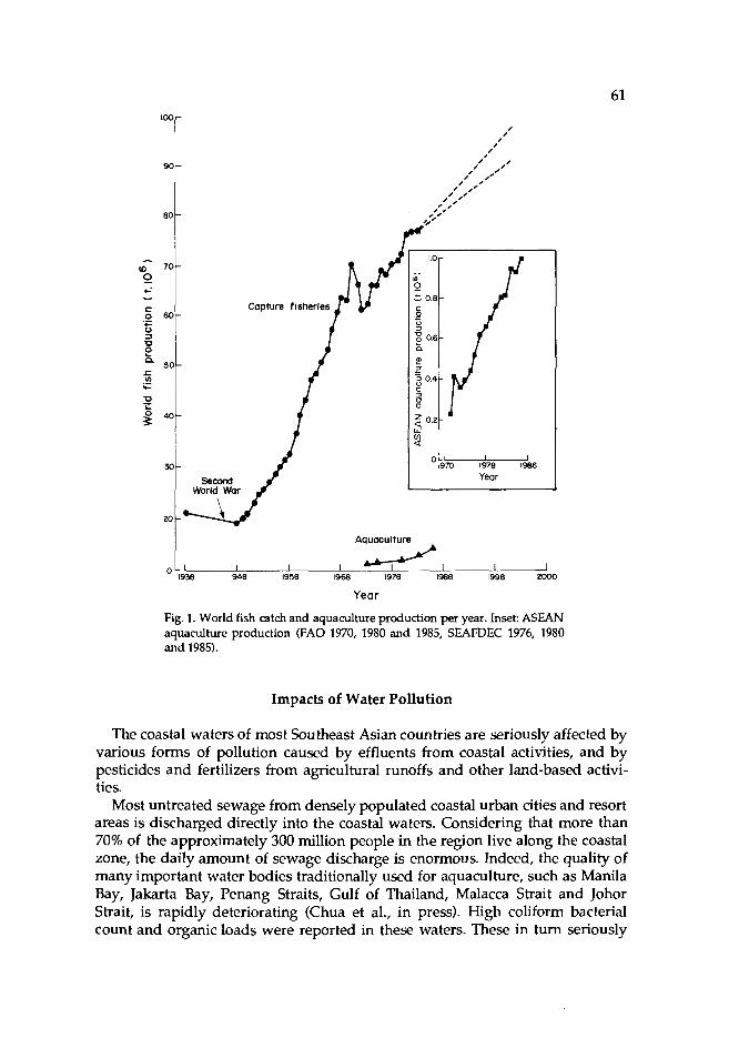
Aquaculture
1 I I I 1938 1948 1958 1968 1978 1988 1998 2000
I 4, Year
Fig. 1. World fish catch and aquaculture production per year. Inset: ASEAN aquaculture production (FA0 1970, 1980 and 1985, SEAFDEC 1976, 1980 and 1985).
Impacts of Water Pollution
The coastal waters of most Southeast Asian countries are seriously affected by various forms of pollution caused by effluents from coastal activities, and by pesticides and fertilizers from agricultural runoffs and other land-based activi- ties.
Most untreated sewage from densely populated coastal urban cities and resort areas is discharged directly into the coastal waters. Considering that more than 70% of the approximately 300 million people in the region live along the coastal zone, the daily amount of sewage discharge is enormous. Indeed, the quality of many important water bodies traditionally used for aquaculture, such as Manila Bay, Jakarta Bay, Penang Straits, Gulf of Thailand, Malacca Strait and Johor Strait, is rapidly deteriorating (Chua et al., in press). High coliform bacterial count and organic loads were reported in these waters. These in turn seriously

62 affected sale of mussels and oysters. Coliform counts were as high as 1.4 x 10⁷/100 rnl in Penang Straits near Penang sewage outfall (Sivalingam 1988, Law and Othman 19851, where groupers cultured in floating cages are prone to Vibrio infection due to fecal microbial contamination (Wong et al. 1979). In Manila Bay, coliform counts exceed 1,000/100 ml, rendering shellfish unfit for human con- sumption. Oysters exported from the region are often being rejected resulting in economic problems among the shellfish growers (Chua et al., in press).
Manufacturing industries along the coasts and garbage on the shores are the main sources of heavy metals entering the coastal area. Heavy metals have been detected in the flesh of bivalves (Sivalingam 1988, Rose11 1985, Hungspreugs 1985, Phillips and Muttarasin 1985). A high percentage of fish and shellfish from Jakarta Bay have heavy metal contents exceeding the standards set by the World Health Organization (Tarrant et al. 1987).
Due to heavy shipping traffic, aquaculture installations along the Straits of Malacca, Johore and Singapore are vulnerable to oil spills from oil tankers. Severe biological impacts resulting in fish kills happen, however, only during major spills, when massive structures are covered with oil, causing depletion of oxygen and tainting of nets and fish (Chua and Mathias 1978).
Pesticides and fertilizers from agricultural runoffs readily enter coastal waters. Chlorinated pesticide residues from rice paddies such as aldrin, dieldrin, lindane and endrin are found in the water column and sediments in Manila Bay and Segara Anakan with levels exceeding allowable limits set by national agencies (Gunnerson and Cuellar 1988, Ludwig 1985).
There are also recent concerns on the increasing occurrences of red tides in the coastal waters in almost all ASEAN countries (Maclean 1989, Chua et al., in press). The toxic dinoflagellates causing red tides in Brunei Darussalam, the Philippines and Sabah (Malaysia) were identified as Pyrodiniurn baharnense var cornpressa; while those in Thailand were probably Profogonyaulax cohorticula (White et al. 1984; Fukuyo et al. 1987). Red tides caused major fish kills in Sabah in 1976 (White et al. 1984), but more importantly, the deadly organisms were ingested by filter-feeding organisms such as mussels and oysters, with fatal consequences to humans who ate them (Maclean 1989). A recent red tide occur- rence (September-October 1988) in the Philippines claimed eight lives, besides incapacitating over 100 persons and causing large economic losses.
Continued deterioration of water quality will upset the ecological balance of coastal ecosystems. One of the obvious impacts is the gradual loss of critical habitats, thereby affecting the recruitment of fish to fishing grounds, and of shrimp fry and broodstocks needed for aquaculture. Hatchery installation is also affected because it requires good quality for seed production.
Recent government efforts to increase construction of dams, reservoirs and other water control structures upstream for freshwater supply and irrigation contribute to changes in the hydrologic cycle and salinity regime of the coastal environment. Such changes may also affect existing aquaculture installations operating in the vicinity. The discharge of low-oxygen freshwater from Chiew Larn Dam into Phum Duang River in Thailand has caused fish kills and may affect the primary productivity of the nearby coastal waters where the country's biggest oyster industry is located (Hungspreugs et al. 1988).
63
Environmental Impacts of Coastal Aquaculture
Coastal aquaculture practices have now emerged as some of the major envi- ronmental issues in Southeast Asia. Rapid development in shrimp aquaculture, cage culture and raft and stake oyster/mussel farming is increasingly seen to: (1) contribute to coastal water quality deterioration; (2) reduce mangrove habitat; and (3) contribute to resource use conflicts (Fig. 2). Aquaculture is more and more considered a major pollutant in temperate countries (Duff 1987, SCPCR 1983). The magnitude of pollution caused by shrimp and fish farming in South- east Asia may even be higher than in the temperate region in view of the areas covered-about 500,000 ha of brackishwater ponds in the ASEAN region alone.
Most mangrove swamps in Southeast Asia have acid sulfate soils which acid- ify the pondwater, especially in newly excavated ponds. Substantial time and funds are needed to stabilize these conditions. Extensive shrimp farm production is usually lower than 1 t/ha/year. Average yields in ASEAN, excluding Singa- pore, range from 150 kg/ha to 550 kg/ha (Csavas 1988). Thus, mangrove land conversion to shrimp farms requires careful re-evaluation.
In the pond preparation phase, pesticides are widely used to eradicate unde- sirable species, but their improper application and untimely discharge can also kill desiraf~k! species. These pesticides include: tobacco dust (nicotine), teaseed cake (saponin), Derris root extract (rotenone), as well as organic pesticides such as Gusathion (an organo-phosphate), Brestan and Aquatin (organo-tin).
Heavy feeding using low-value fish or artificial feeds is widely practiced in intensive and semi-intensive shrimp ponds. The common daily water exchange rate of 30% adds tremendous biological oxygen demand load into the already stressed coastal waters. While precise estimates of the organic load from shrimp farms have yet to be computed, information from a trout farm in Denmark shows that 10 kg of phosphate are released from earthen ponds per year per ton of fish produced (SCPCR 1983).
There are similar situations in cage culture. Intensive feeding and fecal dis- charge from cage fish add to the high organic load of the water around the cul- ture site (Fig. 2).
Cage structures and stakes or rafts used for mussel and oyster farming, when indiscriminately installed in rivers, lagoons or bays, often obstruct navigational routes. More importantly, these structures reduce water current and encourage sedimentation which affects the cultured organisms (Chua et al. 1989). In Sweden, mussel farming induced 10.5 t of dry sediments from a farm size of about 1,500 m2 in 1.5-2 years (SCPCR 1983). Excessive sedimentation in Sapian Bay (Philippines) was attributed to extensive mussel and oyster culture (Young and Serna 1982).
Perhaps the most significant impact of coastal aquaculture is the rapid conver- sion of mangrove areas into shrimp farms and milkfish ponds. The traditional use of the mangrove areas by coastal communities is well-described by Chan (1986):
These coastal communities, which comprise mainly fishermen, have been living within or at the fringes of the mangrove forests for genera- tions. Fishing in the mangrove coastal waters, estuaries and creeks is the

Legend: g. Pesticides and nutrients from q r i i l t u re a Oil SllCks and domestlc wastes from ports h. Alteration of WOStai hydrology caused by freshwater b Domestic wastes fmm uhan settlements discharge from reservoir C. Heavy metals, chemicals from lndustrioi sites I. Pesticides, nutrients orwnic matter Imd from fishfarms d. Solid and domestic wstes from beach resorts j. High organic vmstes ard drugs fmm pbparies e. High suspended solids from sand mining k. High suspended sdids in molluSc forms f. Nutrients and orgmk matter load horn shrimp farms I. Hbh suspended solids and nutrients from coge Crms
Fig. 2. Sources of coastal water pollution caused by human activities, including aquaculture (Chua et al., in press).
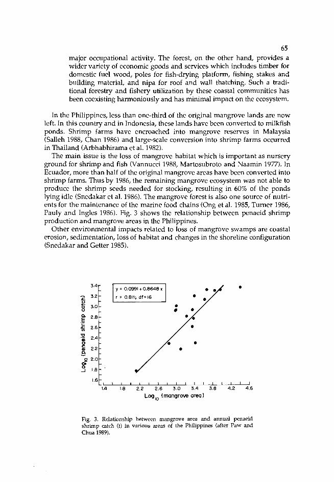
65 major occupational activity. The forest, on the other hand, provides a wider variety of economic goods and services which includes timber for domestic fuel wood, poles for fish-drying platform, fishing stakes and building material, and nipa for roof and wall thatching. Such a tradi- tional forestry and fishery utilization by these coastal communities has been coexisting harmoniously and has minimal impact on the ecosystem.
In the Philippines, less than one-third of the original mangrove lands are now left. In this country and in Indonesia, these lands have been converted to milkfish ponds. Shrimp farms have encroached into mangrove reserves in Malaysia (Salleh 1988, Chan 1986) and large-scale conversion into shrimp farms occurred in Thailand (Arbhabhirama et al. 1982).
The main issue is the loss of mangrove habitat which is important as nursery ground for shrimp and fish (Vannucci 1988, Martosubroto and Naamin 1977). In Ecuador, more than half of the original mangrove areas have been converted into shrimp farms. Thus by 1986, the remaining mangrove ecosystem was not able to produce the shrimp seeds needed for stocking, resulting in 60% of the ponds lying idle (Snedakar et al. 1986). The mangrove forest is also one source of nutri- ents for the maintenance of the marine food chains (Ong et al. 1985, Turner 1986, Pauly and Ingles 1986). Fig. 3 shows the relationship between penaeid shrimp production and mangrove areas in the Philippines.
Other environmental impacts related to loss of mangrove swamps are coastal erosion, sedimentation, loss of habitat and changes in the shoreline configuration (Snedakar and Getter 1985).
1 1 1 1 1 1 1 1 ~ ~ I I I ' ~ J 1.8 2.2 2.6 3.0 3.4 3.8 4.2 4.6
Log ,, (mangrove area
Fig. 3. Relationship between mangrove area and annual penaeid shrimp catch (t) in various areas of the Philippines (after Paw and Chua 1989).

66 Policy Considerations
The conflicts between resource development agencies encouraging coastal aquaculture and resource management agencies exhorting conservation and management of mangroves stem from the lack of adequate, cross-sectoral devel- opment and management planning for sustainable use of the natural resources. Natural resources development in Southeast Asia is often driven by ad hoc eco- nomic forces and usually lacks adequate long-term planning and environmental management.
The pressing policy issues are mangrove conversion for shrimp farming and regulation of aquaculture before they become major threats to the coastal envi- ronment. There must be clear policies and guidelines on these issues. Aquacul- ture activities must be contained within zones carefully selected based on envi- ronmental suitability and appropriateness for the required farming systems. Thus, aquaculture zoning schemes are essential. Their delineation should be the outcome of cross-sectoral consultation and compromises between the resource development and management agencies. Aquaculture zones are similar to agri- culture estates in that government support services must be provided to promote private investments such as roads, electricity, water supply canals, post harvest and marketing facilities. At present, water quality for aquaculture purposes is insufficiently safeguarded from industrial and other forms of pollution. The level and pattern of farming practices should be regulated through appropriate licencing and monitoring systems.
As discussed above, mangroves are now considered important coastal ecosystems, after they had a long time been erroneously perceived as wastelands. Their ecological and economic values were not fully understood or appreciated. This is why mangrove areas have been leased for other economic activities for a very low fee. For example, in Malaysia, an annual fee for Temporary Occupation License (TOL) is about M$124/ha (about US$48/ha) for conversion into shrimp ponds. There is good reason for the use of such areas for traditional shrimp farming as tidal energy is needed for pondwater exchange. Modem shrimp farming, however, utilizes pumps to draw in water from the sea and applies for- mulated feeds. Thus, there is no valid reason for investors to develop shrimp farms in mangrove lands. The only reason is that mangrove land is cheap; hence, the internal rate of retums and profitability are increased.
The economic gains of this conversion have to be carefully assessed vis-8-vis the financial implications of the extensive use of mangroves, ricefields and sugarlands as well as the loss of fisheries resources, the impacts on the coastal ecosystem and reforestration cost.
Finally, the policy for large-scale investment of intensive shrimp farming should be reconsidered. The boom in shrimp farming cannot continue forever. The time will come when production will saturate the export market and shrimp price will drop from its present high average of US$8/kg. Present average production cost of shrimp is US$M/kg. Over 70% of the shrimp produced are exported to Japan (44%) and the USA (33%). According to Hirasawa (1988), de- mand for shrimp in Japan has reached a plateau, masked in part by the appreci- ation of the Japanese yen. Japanese demand may reach 380,000 t although

67 1987 imports were 256,000 t. Recent demand from the USA is much smaller both in quantity and value due to dollar depreciation. In the Philippines, a temporary moratorium on financing loans encouraged by government rural and industrial banks for shrimp farm/hatchery ventures has taken effect recently (R. Guerrero, pers. comm.).
Global shrimp production has increased from 1.7 million t in 1976 to 2.1 million t in 1987. Shrimp production from aquaculture within ASEAN is predicted to attain 200,000 t at the end of the century which will approximately meet the growing import demand of Japan, the USA and the European Economic Community (EEC). However, over the last few years, shrimp production has increased rapidly in many countries. In China, production increased from about 7,000 t in 1982 to over 80,000 t in 1986. In Taiwan, it was more than 60,000 t in 1986. The prediction for Asia as a whole is 800,000 t (Csavas 1988). Shrimp farm expansion in Ecuador and other parts of the world is also bound to increase pro- duction.
Hirasawa (1988) suggested that shrimp prices will fall due to increased pro- duction, and that only those farms with low capital investments and lower pro- duction costs will survive. This will mean that many marginal shrimp farms will have to be abandoned. Governments then, will be left with large tracts of aban- doned farms and burdened by unemployment and loss of foreign exchange earnings. This scenario can be avoided if there is an adequate integrated CRM program to guide the industry.
References
Aksornkoae, S. and A. Saraya. 1986. Effects of tin mining on mangrove ecosystem in Ranong, Thai- land, p. 367-381. In Mangroves of Asia and the Pacific: status and management. Research and Training Pilot Programme on Mangrove Ecosystq in Asia and the Pacific. UNDP/UNESCO Tech. Rep. RAS/79/002.
Arbhabhirama, A., D. Phanturnvanit, J. Elkington and P. Ingkasuwan. 1987. Thailand natural resources profile. Thailand Development Research Institute, Bangkok, Thailand.
Chan H.T. 1986. Malaysia, p. 131-150. In Mangroves of Asia and the Paafic: status and management. Research and Training Pilot Programme on Mangrove Ecosystem in Asia and the Pacific UNDP/UNESCO Tech. Rep. RAS/79/OM.
Cheong, L. 1988. Review of the status of aquaculture in Singapore. Seventh Session of the Indo-Pacific Fisheries Counal Working Party of Experts on Aquaculture, 1-6 August 1988. Bangkok, Thailand.
FC WPA/WP 9.9 p. lang, P., T. Wang, C. M. Kuo and LC. Liao. 1986. The prospects of the grass shrimp culture indus- P(" try in Taiwan, p. 25-29. In J.L. Maclean, L.B. Dizon and L.V. Hosillos (eds.) The First Asian Fish-
eries Forum. Asian Fisheries Society, Manila, Philippines. Cholik, F. 1988. Review of the status of aquaculture in Indonesia. Seventh Session of the Indo-Pacific
Fisheries Counal Working Party of Experts on Aquaculture, 1-6 August 1988. Bangkok, Thailand. IPFC WPA/WP 4.36 p.
Chong, L.P. 1988. Review status of aquaculture in Malaysia. Seventh Sgsion of the Indo-Pacific Fish- eries Council Working Party of Experts on Aquaculture, 1-6 August 1988. Bangkok, Thailand. I FC WPA/WP 6.16 p. a, T.-E. 1986. An overview of the fisheries and aquaculture industries in Asia, p. 1-8. In J.L. Madean, L.B. Dizon and L.V. Hosillos (eds.) The First Asian Fisheries Forum. Asian Fisheries p.' Soaety, Manila, Philippines.
Chua, T.-E. and J.A. Mathias. 1978. Evaluation of the impacts of oil spill on coastal resources, p. 262- 267. In T.-E. Chua and J.A. Mathias (eds.) Coastal resources of West Sabah - an investigation into the impact of oil spill. Penerbit Universiti Sains Malaysia, Penang, Malaysia.

2, T.-E. and J.N. Paw. 1987. A q d t u r e development and coastal zone management in Southeast Asia: conflicts and complementarity, p. 2007-2021. In O.T. Magoon, H. Converse, D. Miner, L.T. Tobin, D. Qark and G. Domurat (eds.) Coastal Zone '87. Vol. 2. Proceedings of the Fifth Sympo- sium on Coastal and Ocean Management, 2629 May 1987. Seattle, Washington. American Society of Civil Engineers, New York.
Chua, T.-E. and S.K. Teng. 1980. Economic production of estuary grouper, Ephinephelus salmoides Maxwell, reared in floating net cages. Aquaculture 20: 187-228.
C a, T.-E., J.N. Paw and F.Y. Guarin. 1989. The environmental impact of aquaculture and the effects xf pollution on coastal aquacultwe development in Southeast Asia. Mar Pollut. Bull. 20(7): 335- 343.
Csavas, I. 1988. Shrimp farming m Asia Seventh Session of the IndmPacific Fisheries Council Work- ing Party of Experts on Aquaculture, 1-6 August 1988. Bangkok, Thailand. IPFC WPA/WP 11.45 P.
Duff, A. 1987. Scottish fish farm pollution. Mar. Pollut. Bull. 18(6): 261 FA0 (Food and Agriculture Organization). 1970. Yearbook of fishery statistics: catches and landings.
Vol. 30. Food and Agriculture Organization of the United Nations, Rome, Italy. FA0 (Food and Agriculture Organization). 1980. Yearbook of fishery statistics: catches and landings.
Vol. 50. Food and Agriculture Organization of the United Nations, Rome, Italy. FA0 (Food and Agriculture Organization). 1985. Yearbook of fishery statistics: catches and landings.
Vol. 60. Food and Agriculture Organization of the United Nations, Rome, Italy. Fukuyo, Y., K. YoshiG, M. Kodama, P. Pholpunthin, S. Wissesang and T. Piyaicarnchana. 1987.
Suspected causative dinoflagdates of paralytic shellfish poisoning in the Gulf of Thailand: iden- tification and toxicity of three Protogonyaular, p. 19. In Abstracts of papers presented at the Inter- national Symposium on Red Tides, Biology, Environment Sdence and Toxicology, 10-14 Novem- ber 1987. Takamatsu, Japan.
Gunnerson, C.G. and M. Cuellar. 1988. Case studies: Manila Bay, p. 307-317. In C.G. Gunnerson (ed.) Wastewater management for coastal cities. The ocean disposal option. World Bank Tech. Pap. No. 77. World Bank, Washington, D.C.
Hirasawa, Y. 1988. Shrimp culture economics in Asia. Seventh Session of the Indo-Pacific Fisheries Council Working Party of Experts on Aquaculture, 1-6 August 1988. Bangkok, Thailand. IPFC WPA/WP 16.28 p.
Hungspreugs, M. 1985. Marine pollution by heavy metals in the East Asian Seas region, p. 239-248. In A.L. Dahl and Czuew-Reid (eds.) Environment and resources in the Pacific UNEP Reg. Seas Rep. and Stud. No. 69. United Nations Environment Programme, Geneva.
Hungspreugs, M., S. Dharmvanij and W. Utoomprurporn. 1988. The water quality of Ban Don Bay. Paper presented at the Technical Workshop on Integrated Tropical Coastal Area Management, 28-31 October 1988. Singapore.
Kungvankij, P. 1975. On the mass production and rearing methods of the larvae of jumbo tiger shrimp Pe~eus lnoMdon (Fabricius). Phuket Mar. Fish. Contrib. 5: 1-11.
Kungvankij, P. 1987. Induction of spawning of sea bass (Lutes calcarifer) by hormone injection and environmental manipulation, p. 120-122. In J.W. Copland and D. Grey (eds.) Management of wild and cultured sea bass/barramundi (Lates cukm'fer): Proceedings of an International Workshop, 24-30 August 1986. Darwin, N.T., Australia. Australian Centre for International Agricultural Research, Australia.
Law, A.T. and A. Othman. 1985. Fecal coliform bacteria distribution in the coastal waters of Port Didcson. Pertanika S(1): 131-134.
Liao, LC. 1970. Experiment on propagation and culture of prawn in Taiwan. IPFC 3C70/Syn. 243: 1- 22.
Ling, S.W. 1977. Aquaculture in Southeast Asia. A historical review. College of Fisheries, University of Washington, Seattle.
Ludwig, H.F. 1985. Final report of the consultant (phase I report). Segara Anakan Environmental Monitoring and Optimal Use Planning Project, Institute of Hydraulic Engineering, Bandung,
A?' donesia.
aclean, J.L. 1989. Inddacific red tide occurrences, 1985-88. Mar. Pollut. Bull. 20(7): 304-310. Maneewon& S. et al. 1981. Propagation of sea bass, Lztes calcm7er (Bloch). National Institute of
Aquaculbe, Songkhla, Thailand. (In 'Ihai, abstract in English). Maneewon& S. et al. 1984. Fry production of seabass, Iates dcarifer (Bloch) at National Institute of
Coastal Aquaculture, p. 7-12. In Report of Thailand and Japan Joint Coastal Aquaculture Research Project, Songkhla, Thailand.

Martosubroto, P. and N. Naamin. 1Y/ / . Itelationship between tidal forest (mangroves) and commer- cial shrimp production in Indonesia. Mar. Res. Indones. 18: 81-86.
Naamin, N. 1986. Impact of "tambak" aquaculture to the mangrove ecosystem and its adjacent areas with special reference to the north coast of West Java, p. 355365. In Mangroves of Asia and the Pacific: status and management. UNDP/UNESCO Tech. Rep. RAS/79/002.538 p. Research and Training Pilot Programme on Mangrove Ecosystem in Asia and the Pacific.
Ong, J.E., W.K. Gong and C.H. Wong. 1985. Variability in organic carbon and nutrient content of leaf litter for different age stands of Xhiwphora apiculuta. Estuarine Research Foundation Symposium,
ew Hampshire, USA. MS. thesis. auly, D. and J. Ingles. 1986. The relationship between shrimp yields and intertidal vegetation d" (mangrove) areas: a reassessment, p. 277-283. In A. Yaiiez-Arancibia and D. Pauly (eds.) Pro-
ceedings of the IREP/OSLR Workshop on the Recruitment in Tropical Coastal Demersal Com- munities, 21-25 April 1986. Campeche, Mexico. Workshop Rep. No. 44. Intergovernmental Oceanographic Commission/United Nations Educational, Saentific and Cultural Organization. My, D. and T.-E. Chua. 1988. The overfishing of marine resources: socioeconomic background in Southeast Asia. Ambio 17(3): 200-206. HJ.N. and T.-E Chua. 1989. An assessment of the ecological and economic impact of mangrove conversion in Southeast Asia. Mar. Pollut. Bull. 20(7): 335343.
Phillips, D.J.H. and K. Muttarasin. 1985. Trace metals in bivalve molluscs from- Thailand. Mar. Environ. Res. 15: 215-234.
Rosell, N.C. 1985. Uptake and depuration of mercury in the green mussel, Perna uiridis Linnaeus (Bivalvia: Mytilidae). Philipp. J. Sa. 114(1-2): 1-29.
Salleh, M.N. 1988. Mangrove forests: unappreciated resources. Paper presented at the ENSEARCH Seminar on the Marine Environment: Challenges and Opportunities, 31 March-2 April 1988. Kuala Lumpur. Institute of Strategic and International Studies, Kuala Lumpur, Malaysia.
SCPCR (Swedish Counal for Planning and Coordination of Research). 1983. The environmental impact of aquaculture. Swedish Council for Planning and Coordination of Research, Stockholm, Sweden.
SEAFDEC (Southeast Asian Fisheries Development Center). 1976. Fishery statistical bulletin for South China Sea area. Southeast Asian Fisheries Development Center, Bangkok, Thailand.
SEAFDEC (Southeast Asian Fisheries Development Center). 1980. Fishery statistical bulletin for South China Sea area. Southeast Asian Fisheries Development Center, Bangkok, Thailand.
SEAFDEC (Southeast Asian Fisheries Development Center). 1986. 1984 fishery statistical bulletin for South China Sea area. Southeast Asian Fisheries Development Center, Bangkok, Thailand.
SEAFDEC (Southeast Asian Fisheries Development Center). 1987. 1985 fishery statistical bulletin for South China Sea area. Southeast Asian Fisheries Development Center, Bangkok, Thailand.
Seow, R.C.W. 1985. Large-scale intensive prawn farming, p. 48-50. In Report on Aquaculture Confer- ence, 9-12 December 1985. Johor Bahru, Malaysia.
Sivalingam, P.M. 1988. Impact of domestic, industrial and agricultural waste disposal on the coastal zone environment of the Strait of Malacca, p. 179-214. In P.R. Burbridge, Koesobiono, H. Dirsch and B. Patton (eds.) Coastal zone management in the Strait of Malacca. Proceedings.of a Sympo- sium on Environmental Research and Coastal Zone Management in the Strait of Malacca, 11-13 November 1985. Medan, Indonesia.
Snedaker, S.C. and C.D. Getter. 1985. Coastal resources management guidelines. Renewable resources - - information service. Coast. Manage. Publ. 2. 205 p. Research Planning Institute, Inc., Columbia, USA.
Snedaker, S.C, J.C. Dickinson 111, M.S. Brown and E.J. Lahmann. 1986. Shrimp pond siting and management alternatives in mangrove ecosystems in Ecuador. 67 p. Report for USAID, Office of Saence Advisor, Washington, D.C.
Tan, C. E., B.H. Tan and T.W. Low. 1985. A case study on commercial cage culture of finfish in Penang. TCP/MAL/4403 Tech. Rep. 4. 52 p. FA0 Technical Cooperation Programme on Assis- tance to the Malaysian Fisheries Development Authority, Malaysia.
Tanomkiat, T. 1982. Programme on cage culture at the Phang Nga Small-scale Fisheriesassisted Project, Phang Nga Province, Thailand, p. 213. In R.D. Guerrero I11 and V. Soesanto (eds.) Report of the Training Course on Small-scale Pen and Cage Culture for Finfish, 26-31 October 1981. Los Baiios, Laguna, Philippines.

70 Tarrant, J., E. Barbier, R.J. Greenberg, M.L Higgins, S.F. Lintner, C. Mackie, L. Murphy and H. Van
Veldhuizen. 1987. Natural resources and environmental management in Indonesia: an overview. United States Agency for International Development, Jakarta, Indonesia.
Teng, S.K., T.-E. Chua and H.C. Lai. 1977. Construction and management of floating net-cages for culturing the estuary grouper, Ephinephelus tauoina (Forskill in Penang, Malaysia, p. 359-371. In Joint South China Sea Programme/Southeast Asian Fisheries Development Center Workshop on Aquaculture Engineering, 27 November- 3 December 1977. Tech. Rep. SCS/GEN/77/15. South China Sea Fisheries Development and Coordinating Programme, Tigbauan, Iloilo. , A.K. 1968. Prawn culture in Singapore. FA0 Fish. Rep. 57(2): 8593.
UO, L.B., B.J. Pudadera, 1.0. Potestas and P. Kungvankij. 1986. Intensification techniques in the 7 extensive culture of Penaeus monodon, p. 93-95. In J.L. Maclean, L.B. Dizon and L.V. Hosillos (eds.) The First Asian Fisheries Forum. Asian Fisheries Society, Philippines.
Trono, G. Jr. 1986. Seaweed culture in the Asia-Pacific region. RAPA Publ. 1987/8. 41 p. Regional Office for Asia and the Pacific, Food and Agriculture Organization of the United Nations, Bangkok, Thailand.
Trono, G. Jr. 1988. Review of the status of aquaculture in the Philippines. Seventh Session of the Indo- Pacific Fisheries Council Working Party of Experts on Aquaculture, 1-6 August 1988. Bangkok, Thailand. IPFC WPA/WP 7.50 p.
Turner, R.E. 1986. Relationships between coastal wetlands, climate and penaeid shrimps yields, p. 267-275. In A. Yaiiez-Arancibia and D. Pauly (eds.) Proceedings of the IREP/OSLR Workshop on the Recruitment in Tropical Coastal Demersal Communities, 21-25 April 1986. Workshop Rep. No. 44. Intergovernmental Oceanographic Commission/United Nations Educational, Scientific and Cultural Organization.
Vannuccl, M. 1986. Conversion of mangroves to other uses: the Cochin backwaters, p. 331-354. In Mangroves of Asia and the Pacific: status and management. UNDP/UNESCO Tech. Rep. RAS/79/002. Research and Training Pilot Programme on Mangrove Ecosystem in Asia and the Pacific.
Vannucci, M. 1988. Synopsis: the UNDP/UNESCO mangrove programme in Asia and the Pacific. Ambio 17(3): 214-217.
White, A.W., M. Anraku and K.K. Hooi. 1984. Toxic red tides and shellfish toxiaty in Southeast Asia. Proceedings of a Consultative Meeting, 11-14 September 1984. Singapore. Southeast Asian Fish- eries Development Center and International Development Research Centre of Canada, Singapore.
Wickins, J.F. 1986. Prawn farming today: opportunities, techniques and development. Outlook Agric. 15(2): 52-60.
Wong, S.Y., B. Ong and T.-E. Chua. 1979. Isolation, identification of causative agent of 'fed boil disease" in grouper (Ephinephelus salmoides) and its possible control by vaccination. International Workshop on Cage and Pen Culture of Fish, 12-22 February 1979. International Development Research Centre/Southeast Asian Fisheries Development Center, Iloilo, Philippines.
Young, A. and E. Serna. 1982. Country report: Philippines, p. 16-19. In B.F. Davy and M. Graham (eds.) Proceedings of the Workshop on Bivalve Culture in Asia and the Pacific,l6-19 February 1982. International Development Research Centre of Canada, Singapore.

The Status of Marine and Coastal Pollution in Southeast Asia
APRILANI SOEGIARTO lndonesian Institute of Sciences
Jakarta, Indonesia
SOEGIARTO, A. 1989. The status of marine and coastal pollution in Southeast Asia, p. 71-75. In T.-E. Chua and D. Pauly (eds.) Coastal area management in Southeast Asia: policies, management strategies and case studies. ICLARM Conference Proceedings 19, 254 p. Ministry of Science, Technology and the Environment, Kuala Lumpur; Johor State Economic Planning Unit, Johore Bahru; and International Center for Living Aquatic Resources Management, Manila, Philippines.
Abstract
A brief review of major physical, climatic and oceanographic features of Southeast Asia is pre- sented, with emphasis on their relationship to pollution-causing factors. Major sources of pollut~on discussed are: sediments, solid waste, sewage, petroleum and derivatives, and industrial wastes. Some measures taken by Southeast Asian countries to deal with coastal and marine pollutmn are outlined.
Introduction
The waters and islands between Asia and Australia and between the Pacific and the Indian Oceans form one geographic unit. In geographical terms, the whole region is part of Asia and is referred to as Southeast Asia. The region con- sists of highly fragmented land interspersed among wide stretches of sea and extremely long coastlines. Physically, the region is divided into the continental part of mainland Asia, which consists of Burma, Thailand and the Indo-Chinese states of Laos, Kampuchea and Vietnam; the rest of the region, including Penin- sular Malaysia, Brunei Darussalam, Singapore, Indonesia and the Philippines, are regarded as archipelagos of Southeast Asia (Chia and MacAndrews 1979).
In oceanographic terms, the waters are part of the Pacific Ocean, which is sep- arated from the Indian Ocean by the islands of Sumatra, Java and the Lesser Sunda (Nusa Tenggara). The Southeast Asian waters consist of the Andaman Sea, Strait of Malacca, Singapore Strait, South China Sea, Gulf of Thailand, Java Sea, Flores Sea, Banda Sea, Arafura Sea, Timor Sea, Celebes Sea, Sulu Sea and
71

72 the Philippine Sea. The whole body of water covers 8.94 million km2, which rep- resents about 2.5% of the world's ocean surface (Soegiarto 1978 and 1985).
Located between the Asian and the Australian continents, the Southeast Asian region is strongly influenced by monsoons. The Southeast Asian waters are thus ideal for studying the effects of the monsoons; both water circulation and the seasonal distribution of its physical, chemical and biological properties are gov- erned by monsoons. The north monsoon in Southeast Asia lasts from December to March; the south monsoon from July to September. The rest of the year repre- sents the transition from north to south and vice versa. The variation of the at- mospheric circulation strongly governs the corresponding variation of the water circulation. Because of the rather high constancy of the monsoon and the regu- larity of their appearances, the ocean currents show similar characteristics for one year to the next. Just as the monsoons change direction twice a year and are practically reversed at the time of their strongest development, the oceanic cir- culation is also reversed over large areas. This complete reversal is typical of the circulation in these waters (Wyrtki 1961, Soegiarto 1978).
Storms and typhoons are observed only over the northern parts of the South China Sea, the Philippines, Andaman Sea and north of Australia. The presence of typhoons has a marked influence on the state of the seas, increasing the wave and swell conditions and changing their direction. Both the state of the sea and the strength and general patterns of currents will influence the potentials and the direction of pollution dispersal in the region.
The marine and coastal areas of the Southeast Asian region are among the world's most productive. Their warm, humid tropical climate and high rainfall allow extensive coral reefs and dense mangrove ecosystems to flourish along the coastline. Due to the economic benefits that can be derived from these rich and diverse ecosystems, the coastal zones of Southeast Asia are densely populated. Over 70% of the population in the region lives in the coastal areas resulting in a rather high level of exploitation of the natural resources and in degradation of the environment. Indeed, population pressure associated with high economic ac- tivities has caused a large-scale destruction and serious degradation of the coastal and marine environment. Increasing pollution, both land- and marine- based, compound the problems of the Southeast Asian region.
Various sources (e.g., Gomez et al. 1988, FAO/IPFC Secretariat 1976, Soegiarto 1980 and 1987), point out that the overall level of pollution is still relatively low. However, there are critical areas in and around highly populated industrial cen- ters. The following is a summary of major pollutants in the coastal and marine waters of Southeast Asia.
Sediment
Rivers transport millions of tons of sediments annually to the coastal areas. They extend the coastline seaward, particularly in the river deltas. This con- tributes to mangrove succession and to the productivity and fisheries in the sur- rounding waters. However, in many localities, sediments block navigation in ports and channels used for shipping and trade; smother coral reefs; and change the physical, chemical and biological characteristics of the surrounding waters.
73 The source of sediments is generally erosion due to bad land management in the watershed region.
Solid wastes
Many large cities are located in coastal areas. Generally, these cities do not yet manage their solid wastes rationally. As a result, a large percentage of these solid wastes is transported by rivers and other surface water runoff to coastal areas and to the open sea, where they create problems and severely stress the coastal and marine environments.
Sewage
Liquid sewage, like solid wastes, is generally discharged raw directly into coastal waters or through rivers and waterways. Elevated fecal coliform levels have been detected around population centers in Southeast Asia. One exception is Singapore, which has waged a concerted effort to curb pollution at the source. Associated with sewage discharge is the process of eutrophication of coastal waters. In recent years, more red-tide phenomena, toxic and nontoxic, have been reported in Southeast Asian waters. Several incidents of paralytic shellfish poi- soning have also been recorded. In a number of cases, the dinoflagellate, Pyro- dinium bahamense var compressa, was identified as the causal organism. Elevated coliform counts in some coastal waters indicate the presence of pathogens. This has led to the closure of some beaches (see also Dobias, this vol.).
Petroleum and their associated products
The Southeast Asian waters are also used extensively for transporting locally produced petroleum (about 2 million barrels/day) and natural gases (about 5 billion ft3/day) from the Middle East and Africa to Japan, USA and other desti- nations. Southeast Asia has its share of oil spills, particularly in the shallow and treacherous Straits of Singapore and Malacca. Some surveys on oil pollution and tarball distributions have been carried out in Southeast Asian waters, e.g., by Bilal (1985). Marcharnd and Roucoche (1981) developed a criterion for detecting hydrocarbon pollution. According to them, oil pollution has occurred if the hy- drocarbon concentration in pg, divided by percent of Co, is 100 or more. Based on this criterion, for example, the sediment around the harbors in Jakarta Bay are polluted by hydrocarbon (see Valencia, this vol., for more information on pollu- tion caused by petroleum products).
Industrial wastes
For easier access, industrial estates have been established in many parts along the coast of Southeast Asia. Except for a few, the industrial estates have been able to contain and manage their industrial wastes. However, in the future, these es- tates could threaten the coastal environment of Southeast Asia if the countries concerned fail to develop proper regulations for waste management.

74 Marine and coastal pollution not only has a negative impact on coastal ecol-
ogy, but also causes economic and financial losses. Here are a few examples (Gomez et al. 1988):
The rnariculture industries in Hong Kong and certain parts of Indonesia suffered considerable losses due to pollution. Hundreds of millions of Singapore dollars had to be invested to restore marine life to the Singapore River and Kallang Basin (see Khoo, this vol.). Clean-up operations for one major oil spill, such as that caused by the Showa Maru in 1975, cost several million US dollars. The ecological damage caused by such oil spills still has to be fully determined, but the the Indonesian government has claimed US$15 million in compensation. Annually, the government must allocate substantial funds to dredge millions of tons of sediment from major rivers, harbors and navigational routes in Indonesia and Malaysia. Thailand and the Philippines face similar problems. Microbial and heavy metal contamination of shellfish have repeatedly resulted in heavy income losses and human health problems.
In order to protect the environment, and for economic reasons, all countries in the region are now taking measures to combat pollution. These measures in- clude: pollution control, environmental impact studies, national and regional legislation to prevent and respond to oil spills and participation in international conventions on the protection of marine and coastal environments. Although stresses on the marine and coastal environments are likely to continue, countries in Southeast Asia have committed more and more of their resources to prevent and combat pollution.
References
Bilal, J. 1985. The state of hydrocarbon pollution in the Southeast Asian seas based on studies in the Southeast Asian Seas region. Environment and Resources in the Pacific. UNEP Reg. Seas. Rep. Stud. No. 69: 217-234.
Chia, L.S.and C. MacAndrews. 1979. Environment problems and development in Southeast Asia, p.3- 14. In C. MacAndrews and L.S. Chia (eds.) Developing economics and the environment: the Southeast Asian experience. MacGraw-Hill, Singapore.
FAO/IPFC (Food and Agriculture Organization/Indo-Pacific Fisheries Commission) Secretariat. 1976. Preliminary review on the state of marine pollution in East Asian waters. Paper presented at the IOC/FAO/UNEP International Workshop on Marine Pollution in East Asian Waters, 7-13 April 1976. Penang, Malaysia.
Gomez, E.D., M. Hungspreugs, A.A. Jothy, K.J. Kuan, R.S.S. Wu, A. Soegiarto and A. Deocadiz. 1988. Report on the state of the marine environment in the East Asian Seas region. 81 p. (Unpubl.).
Marchand, M. and J. Roucoche. 1981. Giteres de pollution par hydrocarbures dans les sediments marins. Etude app1iqui.e a la pollution d u bohlen. Oceanol. Acta 4(2): 171-183.
Soegiarto, A. 1978. Introduction to the regional oceanography of the Southeast Asian waters. Paper presented at the 5th FAO/SIDA Workshop on Aquatic Pollution in Relation to Protection of Living Resources, 17 January-27 February 1977. Manila, Philippines.

Soegiarto, A. 1980. The present state of mangrove ecosystem in Southeast Asia and the impact of pollution: Indonesia. FAO/UNEP Rep. SCS/80WP/94A (Rev.). 65 p. South China Sea Fisheries Development and Coordinating Programme.
Soegiarto, A. 1985. Oceanographic assessment of the East Asian Seas, p. 173-184. In A.L. Dahl and J. Carew-Reid (eds.) Environment and resources in the Pacific. UNEP Reg. Seas Rep. Stud. No. 69.
Soegiarto, A. 1987. Marine and coastal environment problems in Indonesia: an input for the assess ment of the East Asian Regional Seas. 59 p. (Unpubl.).
Wyrtki, K. 1961. Physical oceanography of the Southeast Asian waters. Naga Rep. No. 2: 195 p.
Session 11: Case Studies
The Management of Matang Mangrove Forest Reserves in Peninsular Malaysia
MOHAMED DARUS B. HJ. MAHMUD and HARON B. HJ. ABU HASSAN
Forestry Department Headquarters Kuala Lumpur, Malaysia
DARUS, M.b.Hj.M. and HARON, b.Hj.A.H. 1989. The management of Matang mangrove forest reserves in Peninsular Malaysia. p. 77-84. In T.-E. Chua and D. Pauly (eds.) Coastal area management in Southeast Asia: policies, management strategies and case studies. ICLARM Conference Proceedings 19,254 p. Ministry of Science, Technology and the Environment, Kuala Lumpur; Johor State Economic Planning Unit, Johore Bahru, Malaysia; and International Center for Living Aquatic Resources Management, Manila, Philippines.
Abstract
Since 1950, the Matang mangrove forests in Peninsular Malaysia have been managed, partly or wholly, under a sustained-yield basis particularly for the production of fuelwood and poles. Initially, the forests were under systematic management in the form of a 10-year working plan with a 30-year rotation. Lately, emphasis has been given to managing the forests for the sustained production of edible marine life resources as well. Mangroves have been regarded as a significant contributor to the fisheries industry and to the socioeconomic development of the coastal communities. Priorities in the management of mangrove forests should be considered wisely as there are many socioeconomic ben- efits that can be provided by them. The impact of the activities of all mangrove users on one another must be critically and objectively evaluated and the results applied to improve the multipurpose management of these forests.
Introduction
Mangrove formations are a major feature of many tropical and subtropical coasts. Although they cover a relatively small surface area, mangroves form a prominent forest type and display a distinct structure.
In Peninsular Malaysia, 95% of the mangrove forests, which henceforth will be referred to as "mangroves," occur along the sheltered west coast and the southern tip of the peninsula, in the states of Kedah, Perak, Selangor and Johore. Along the exposed East Coast states, only small patches of mangroves occur at small tidal estuaries in the states of Pahang and Terengganu. Out of the total area, more
77

78 than 82% is considered productive in terms of timber production and most of these are in forest reserves.
Mangroves are considered valuable, both economically and ecologically (Noakes 1952, Haron 1981). Apart from producing timber for fuelwood, particu- larly charcoal and poles, mangroves are important in the sustained production of a number of commercially important fish, prawns, crabs, cockles and other aquatic resources.
This paper outlines the basic management system for the Matang mangroves and shows that, with proper management, these forests can remain economically viable and ecologically sound.
The Matang Mangrove Forest Reserves
The distribution and extent of mangrove forest reserves in Peninsular Malaysia are shown in Table 1.
Table 1. Productive and unproductive mangrove forests (in hectares) in Peninsular Malaysia. (Anon. 1986).
Productive Unproductive Total
Johore 16,754 6,929 23,683 Kedah 7,577 1,248 8,825 Mdacca 227 111 338 Kelantan N. Sembilan Pahang Penang Perak Perlis Selangor Terengganu
Total 81,256 17,078 98,334
The Matang mangroves are located on the northwestern coast of Peninsular Malaysia, lying at latitude of 4O45ON and longitude of 100°35'E. This forest is the most extensive mangrove area in Peninsular Malaysia, representing more than two-fifths of the total mangrove forest area. It comprises 17 reserves, divided into 108 compartments. The total area, however, changes constantly through the con- tinuing processes of erosion and accretion. The present estimated area of Matang mangrove is about 41,000 ha. Of this, 93% is productive forest. The unproductive area of about 7,000 ha comprises mainly new accretion forest of Avicennia species (5,000 ha) and dryland forest (2,200 ha).
79 The species can be identified by their natural zones consisting, from the sea-
ward side, of the Avicennia/Sonneratia zone, followed by a Bruguiera caryphyl-- loides/pamif!ora zone, a Rhizophora zone and a Bruguiera gymnorrhiza zone (Watson 1928). The last zone is a relatively dry area usually covered with Xylocarpus and Pandanus spp.
However, since the beginning of the planned management period, the compo- sition and structure of the Matang mangroves have changed to meet current de- mands and management objectives. More than 80% of the production forest now has at least 60% Rhizophora, out of which more than 65% has pure Rhizophora stands. The remaining species include B, pamiflora, B. gyrnnorrhizu and B. cylin- dric~.
Management
Objectives and plans
The general objective of the management of the Matang mangrove forests is the production of charcoal and poles on a sustained-yield basis.
However, the specific management objectives are as follows: 1. to produce a sustained yield of greenwood for fuelwood, particularly
charcoal, to meet local and export demands; 2. to produce quality poles for industrial use; 3. to protect and preserve the mangrove as habitat for marine resources
and land-based wildlife; 4. to provide livelihood, employment and cheap building materials to the
local communities; 5. to preserve sufficient areas for research and training in mangrove ecol-
ogy and management; and 6. to conserve and protect the foreshores and riverbanks from strong
winds, waves and tidal currents. Management plans exist for the mangroves of Johore, Perak and Selangor, but
the Matang mangroves of Perak are the best managed. Indeed, these mangroves have been managed by the State Forestry Department of Perak since they were constituted as a forest reserve in 1908. Since then, the rotation age has changed four times, varying from 20 to 40 years. The silvicultural systems have also been changed: a minimum girth system of 30 cm diameter at breast height (dbh) was first tried and later superceded by the "mother trees system" to ensure that ade- quate seed trees were evenly distributed throughout the logged areas. Initially, the recommended number of standards was 25 trees/ha regardless of the pres- ence or absence of natural regeneration. In 1925, this number was increased to 50 trees/ha in areas without natural regeneration.
The standards system remained in operation till 1940. From 1950 onwards, the rotation age was changed to 30 years, and a working plan was prepared for each 10-year period. For the first 10-year period (1950-19591, the working plan--the first complete working plan ever published-was prepared by Noakes (1952). The second 10-year plan was revised by Dixon and the third 10-year plan by Dams
80 (1969). The first rotation ended in 1979 when the working plan for the second 30- year rotation was revised. The revision was undertaken by Haron (1981) for the current first 10-year period beginning 1980 to 1989. The current silvicultural sys- tem is a clear-felling system with the retention of 7 standard trees/ha.
Operations
Stand Age. In the Matang mangrove forest, the productive area is divided into three periodic blocks. Each block consists of about 11,600 ha of productive forest. The age of the stand is used as a basis for this division, each period having crops with age classes 21-30 years (Period I), 11-20 years (Period 2) and 1-10 years (Period 3).
A stand analysis showed that about 87% of the forest was 27 years old at the time of final felling (Haron 1981). The younger felling age is unavoidable and is mainly due to the controlled opening of the forest in the firsk half of this century, before the first working plan was formulated. Rehabilitation operations were also delayed in the early 1950s and this resulted in younger stands which were generally less than 30 years old at the beginning of the second rotation in 1980. A similar situation will occur in the second and third period of the current rotation by virtue of the "carry-forward" phenomenon.
However, steps have been taken to achieve uniformity in the age of the stand, at least within each compartment. A uniform stand will facilitate and accelerate operation in the implementation of silvicultural treatments and record-keeping on the history of each compartment.
Rotation Age. The rotation is the time required for the trees to reach the size or volume that corresponds to financial maturity for the end-user. The rotation depends on the growth rate of the trees. For bakau (Rhizophora spp.), for example, which is used for charcoal manufacture at age 25 or less, a 30-year rotation is now considered sufficient to provide time for maturity, considering constraints in rehabilitation operations. However, the rotation age for bakau has changed four times from 1914-1924, starting with 20 years, then 25 years, 30 years and again 40 years in 1924. In 1950, the rotation time was reduced to 30 years. This final figure was based on the mean annual volume increment of the trees in sam- ple plots which indicated that growth of bakau species culminate at about 23 years, thus a shorter rotation age is preferred.
Allocation of felling areas
The Matang mangrove is divided into three periodic blocks, each to be worked within 10 years. The periodic blocks are located in three ranges, namely, Kuala Sepetang range, Kuala Trong range and Sungai Kerang range. Yield regulation in Matang is on an area basis and, due to decline in the expected yield of 177 t/ha, the number of charcoal kilns has to be reduced. At present, the forest can support only 316 charcoal kilns with an allocation of 2.8 ha/kiln/year.
The productive forest available for allocation in Period 1 is 10,521 ha compris- ing 9,522 ha and 999 ha of charcoal and firewood coupes, respectively. The annual coupe is 896 ha for charcoal and 97 ha for firewood and a balance of

81 about 590 ha as reserves for "topping-up" purposes when annual coupe areas have eroded or are considered naturally degraded.
Areas to be worked for firewood consist of the poorer quality forest with lower stand volume. In Matang, however, the so-called "poor" and "rich forests of the pre-1950 period are gradually becoming indistinguishable as all areas were given similar postfelling treatments and tended to respond similarly when located in the same tidal zone. Each firewood contractor is allocated 4.8 ha of mangrove forest per year for supplying domestic firewood, particularly to the state of Penang.
Administration
Administratively, a District Forest Officer manages the Matang mangroves, with the help of an Assistant District Forest Officer. The three ranges are each headed by a Forest Ranger who has a supporting staff which include foresters, laborers and boatmen.
Silvicultural operations
Silvicultural operations in Matang mangroves aim to bring about a highly pro- ductive forest at minimum cost for the production of quality poles and green- wood for charcoal manufacture with due consideration of environmental protec- tion and preservation habitats for marine and other organisms. The silvicultural system in practice is a clear-felling system with the retention of standards. The sequence of operations in the Matang mangroves is as follows:
Year Operation
-1 i. Enumeration operations (4% intensity of all trees 8 cm diameter and above) to obtain information on growing stock, species composition and assessment of premium to be charged for the licence area
ii. Determination of the extent of inundation, dryland and disturbed forests
Final felling Trees of 8 cm diameter and above are clear-felled
for charcoal and firewood using chainsaws. All species are utilized, namely:
B a k u kurap (R. mucronafa) B a k u minyak (R. apiculata) T u m u (B , gymnorrhiza) Berus (B . cylindrica) Tengar (Ceriops tagal) Lenggadai ( B , parviflora) (for firewood only) Seven good trees are marked for retention as
standards for every hectare of a normal coupe. For coupes which border the rivers and seaface, a 3-m buffer

for all trees above 8 cm diameter is left untouched to prevent or reduce erosion as well as for seedling propagation.
Before the licence area is closed, the charcoal/ firewood contractor is required to girdle all non-utilized species such as perepat (S. griffithii), berembang (S. caseolaris) and gedabu (S. ovata). Estimation of areas that need planting. A chemical spraying of Hexazinone (Velpar 90) is used to eradicate ferns (Acrostichum speciosum and A. aureum). Enrichment planting with R. apiculata with 1.2 m by 1.2 m spacing and R. mucronata with 1.8 m by 1.8 m spacing. Planting is carried out, usually between August and December, if stocking of natural regeneration is less than 75%. Inspection of all planting areas to determine survival rate; planting in areas where initial seedlings failed. Thinning I, with a 1.2-m stick. This procedure consists of selecting one good tree, usually near the comer of a compartment or beside a riverbank, to be retained and felling all trees within a radius of 1.2 m from this tree. Trees with good structure are extracted as poles and the malformed ones are left to rot on the forest floor. Thinning 11: The same procedure as in Thinning I, but a 1.8-m stick is used. Final felling
Problems
Problems encountered usually involve administration and management. They are being tackled by the Forestry Department from time to time.
Defemzinafion of Rofafion Age. A 30-year rotation period is practiced in Matang mangrove forest, with two thinnings at years 15-19 and 20-24. About 57% of the available forest in Period I will be less than 29 years old. At the time of final felling, the crop age is 27 years (Haron 1981), and this results in smaller trees and lower yield. There have been suggestions to reduce the rotation age, but this may also lead to smaller trees and lower yield. On the other hand, if the rotation is lengthened, the annual coupe will be reduced and this will affect the charcoal industry.
Regeneration of Residual Stands. More than 75% of the annual coupe requires planting. The causes of failure of natural regeneration are not known even though there are enough seedlings on the ground prior to final felling. More studies are needed to monitor the progress of natural regeneration under differ- ent situations.
Weed Problem. It has been observed that when the forest canopy is removed following clear-felling, the seedling density of B. pannflara (lenggadd--an inferior species occurring in potentially good Rhiwphora areas-invariably increases.

83 Invasion by the piai fern (Acrostichum spp.), particularly in the drier areas, is
also a serious problem. These ferns respond rapidly to full light, forming dense and almost impenetrable thickets up to 34 rn in height. These ferns appear to effectively sieve out waterborne seedlings from creeks and rivers, rendering nat- ural regeneration impossible. Thus, if no natural regeneration occurs within the thickets before final felling, regeneration will be inadequate, except for that from seed trees.
The Forestry Department has taken measures in the logged-over forest areas to eradicate the Acrostichum fern either manually or with chemicals. Spraying Hex- azinone onto the fern thickets is an extremely effective chemical method of eradi- cation. However, Hexazinone is now being restrained since it can also damage natural regeneration among the ferns and may adversely affect mangrove aquatic fauna. Eradicating unwanted weeds, therefore, still remains a problem.
Erosion. Most of the year, the Matang mangroves are exposed to windstorms especially during the sumatras which reach velocities of over 80 km/hour. Though short-lived, these storms, together with strong waves, have caused seri- ous damage to the mangrove forests particularly in areas fronting the coastline, resulting in coastal erosion. The net losses are small, as newly accreted areas of more than 3,000 ha have been formed, largely replacing the good forest stands which have eroded. Attempts to accelerate natural succession by introducing bakau species are being carried out.
Pest. Mangrove reforestation must also include the resolution of this resource's pest problems. In some areas in Matang, crabs are such a menace that normal planting of naked seedlings is impossible. Potted seedlings are being planted to offset crab attack.
Conclusion
Mangrove forest management has found a niche in Malaysian forestry. Man- groves contribute significantly to the socioeconomic well-being of the local com- munities who depend on them for fuelwood, poles and the like for use and income. Mangroves also play an integral and vital role in maintaining catches of fish, shrimp and other seafoods.
As a renewable resource, mangroves can be managed on a sustained-yield basis. The management system that has been developed and practiced has been successful. Mangroves have vital functions and should not be regarded as wastelands or dumping grounds or converted to other uses for quick monetary gain. Such conversions upset the ecosystem and the stability of the remaining area.
It is hoped that with existing expertise in mangrove forest management cou- pled with research, the management of Matang and other mangrove forests will be further improved so that maximum benefit can be derived from them.

References
Anon. 1986. Annual report. Forestry Department Headquarters for Peninsular Malaysia, Kuala Lumpur, Malaysia.
Darus, M.b.Hj. M. 1969. A working plan for Matang mangrove forest reserve, Perak. Perak State Forest Department, Perak, Malaysia.
Haron, H.A.H. 1981. A working plan for the second 30-year rotation of the Matang mangrove forest reserve, Perak. The first 10-year period 1980-1989. Perak State Forest Department, Perak, Malaysia.
Noakes, D.S.P. 1952. A working plan for the Matang mangrove forest reserve. Perak State Forest Department, Perak, Malaysia.
Watson, J.G. 1928. Mangrove forests of the Malay Peninsula. Malay. For. Rec. No. 6.
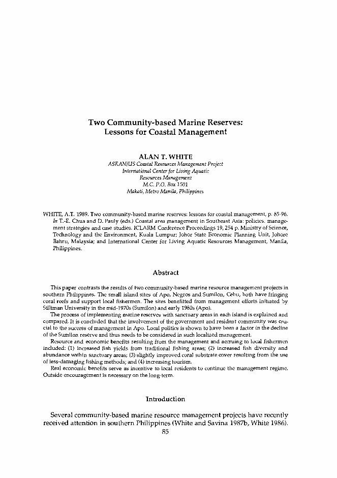
Two Community-based Marine Reserves: Lessons for Coastal Management
ALAN T. WHITE ASEANIUS Coastal Resources Management Project
lnternationnl Center for Living Aquatic Resources Manngement
M.C. P.O. Box 1501 Makati, Metro Manila, Philippines
WHITE, A.T. 1989. Two community-based marine reserves: lessons for coastal management, p. 85-96. In T.-E. Chua and D. Pauly (eds.) Coastal area management in Southeast Asia: policies, manage- ment strategies and case studies. ICLARM Conference Proceedings 19,254 p. Ministry of Science, Technology and the Environment, Kuala Lumpur; Johor State Economic Planning Unit, Johore Bahru, ~ a l a ~ s i a ; and International Center for-Living Aquatic Resources Management, Manila, Philippines.
Abstract
This paper contrasts the results of two community-based marine resource management projects in southern Philippines. The small island sites of Apo, Negros and Sumilon, Cebu, both have fringing coral reefs and support local fishermen. The sites benefitted from management efforts initiated by Silliman University in the mid-1970s (Sumilon) and early 1980s (Apo).
The process of implementing marine reserves with sanctuary areas in each island is explained and compared. It is concluded that the involvement of the government and resident community was cru- cial to the success of management in Apo. Local politics is shown to have been a factor in the decline of the Sumilon reserve and-thus needs to be considered in such localized management.
Resource and economic benefits resulting from the management and accruing to local fishermen included: (1) increased fish yields from traditional fishing areas; (2) increased fish diversity and abundance within sanctuary areas; (3) slightly improved coral substrate cover resulting from the use of less-damaging fishing methods; and (4) increasing tourism.
Real economic benefits serve as incentive to local residents to continue the management regime. Outside encouragement is necessary on the long-term.
Introduction
Several community-based marine resource management projects have recently received attention in southern Philippines (White and Savina 1987b, White 1986).
85

86 These projects are centered on small islands and implemented by a small, private institution (Silliman University, Dumaguete) with external support and advice in the design and implementation phases. The projects have been billed as "commu- nity-based," implying that there was significant input from the communities of fishermen and their families affected by the projects. It has also been implied that the resource management efforts and successes may be attributed to the commu- nity participation on the small islands involved and the nongovemment nature of the implementation and organization phases.
This paper explores the process and results of two such island marine resource management projects. Although outwardly similar in appearance and both located in the Visayas (Fig. I), they are quite different in approach and result. The sites, Sumilon Island, Cebu (Fig. 2) and Apo Island, Negros (Fig. 3), were both targetted for marine resource management in the form of marine reserves in the early 1970s by Silliman University. These two islands, both within a 2-hour boat trip from Dumaguete, were often visited by Silliman University researchers doing marine biological and ecology studies on the surrounding coral reefs. At that time, the researchers became concerned about the plight of the marine habi- tats on both islands because it was clear that, if the trends of destruction and overfishing continued, there would be little left of these small-island coral reefs.
Island
Fig. 1. Project sites in Visayas, Philippines.


88 The problems commonly encountered were blast fishing, small-scale muro-ami fishing, use of fine-mesh nets, and spearing and gleaning which effectively cleaned most of the edible reef organisms from the area.
Sumilon Island was first selected as a site for a marine reserve (Fig. 2). There, only traditional and nondestructive fishing methods were to be allowed and the reef surrounding the island was to be zoned into traditional fishing and non- fishing or sanctuary areas (White 1979). Apo Island was later targetted with a similar scheme in 1979 (Cabanban and White 1981) (Fig. 3). The main difference between the two islands was that Sumilon had no resident community, while Apo was inhabited by about 600 people totally dependent for livelihood on fish- ing the reef and deepwater areas surrounding the island (Savina and White 1986).
This paper summarizes the management efforts on these two islands, analyzes the results, draws conclusions on the methods used to organize and elicit local community participation and clarifies why one management regime was a com- plete failure while the other was a success.
Sites and Their Management
Sumilon Island, Cebu
Sumilon Island was the first well managed marine park in the Philippines. In 1974, the low, small island of 23 ha was declared a municipal marine reserve by the town of Oslob, Cebu, in cooperation with Silliman University which effec- tively managed the island. The 750 m shoreline on the west side was designated as a marine sanctuary and strictly protected; the remaining portion of the reef was a traditional fishing area where no destructive methods were allowed (Fig. 2). The privately owned land portion of the island was not included in the agreement although the university leased several parcels of land fronting the water and built two beach shelters and one field station. The university main- tained a caretaker on the island (until November 1984) to monitor fishing activity and help enforce the reserve regulations (White 1979,1986).
The island reserve management involved cooperation with the fishermen (about 100) in the sense that they agreed not to fish in the sanctuary. The care- taker was also a fisherman from Cebu even though he was supported by Silliman University. He had good rapport with the fishermen and was an important factor in helping convince the fishermen to refrain from destructive fishing and from any activities in the sanctuary area. The reserve regulations were followed and encouraged by various nonformal education programs until 1980.
In December 1980, the Philippine Bureau of Fisheries and Aquatic Resources (BFAR) declared a 'National Fish Sanctuary" at Sumilon which, in effect, gave national recognition to the municipal marine reserve of Oslob, Cebu. This ad- ministrative order was a reaction to the election of a new mayor in Oslob who was not supportive of the local management regime for the island. In fact, in two cases, the mayor personally fished in the Sumilon sanctuary using an illegal and

89 destructive fishing method (muro-ami). The mayor maintained, by disregarding the regulation, that he was "taking back the island for the fishermen." Once the BFAR regulation was in place, it was used several times to discourage illegal entry and fishing but, in 1984, the caretaker left the island after receiving threats of physical harm (White 1986).
After 10 years of effective management and maintenance of the coral reef at Sumilon, there were evident benefits for the coral reef ecosystem and for the fishermen dependent on these. Fish catch assessments which began in 1976 showed that until May 1984, the fishermen extracted an increasing tonnage of reef-fish. Fish yields of 14-24 t/km2/year during the period 1976-1979 were re- ported by Alcala and Gomez (1985) to have increased to 36 t/km2/year in the year ending in April 1984 (Table 1, Fig. 4). Alcala (1981, in press) contended that the high fish yield in the midst of heavy fishing effort was made possible by the sanctuary area. It was pointed out that 85% of the fish caught were reef-dwellers, primarily the fusilier fish, which moved around the island and were abundant in the sanctuary area. The fish yields suggested that the sanctuary was a recruit- ment area for numerous species, some of which circulated around the island.
When the island management broke down in the end of 1984, heavy fishing began in the sanctuary and traditional use areas. The reef was damaged in the process, and there was a dramatic decrease in the biomass of fish in the coral reef; fish yields plurnmetted to about 20 t/km2/year (Alcala, in press) (Table 1, Fig. 5). Although the Sumilon reserve ended in failure, it provided lessons for Apo Island and other community-based projects.
Apo Island, Negros
Apo Island is currently one of three community-managed marine reserves in southern Philippines totally maintained by the people who live on the island (White and Savina 1987b). This small volcanic island of 76 ha was declared a municipal marine reserve in 1985 by the municipal council of the town of Dauin, Negros. A 500 m stretch of prime reef area on the southeast side was made a sanctuary, while the remaining portion of the island reef to 500 m offshore was included in the traditional use area of the marine reserve (Fig. 3).
In 1979, Silliman University extension workers conducted marine conservation and education programs on the island. They introduced to the community the concept of a marine reserve with a sanctuary area patterned after the then suc- cessful Sumilon marine reserve. Dauin, the town with jurisdiction over Apo, endorsed an agreement between the island village, Silliman University and the town council in 1982. Guidelines were suggested for the reserve management and some minimal management and protection were implemented over the next two years.
In 1984, the Marine Conservation and Development Program (MCDP) of Silli- man was initiated to organize community-based marine resource management programs for three small islands, one of which was Apo. The MCDP staff hoped to strengthen the implementation of a marine reserve on the island by directly involving the community in the whole process while giving its members respon- sibility for the outcome. The staff believed that resources could not be protected

90 Table 1. Comparison of habitat quality, area, management, fish yields, fish abundance and species diversity for Sumilon and Apo Islands.
Habitata Percent substrate
Sediment Hard coral Soft coral Total coral
Area (ha) Total reef to 20 m isobath
40 m isobath 60 m isobath
Marine reserve (500 m offshore) Sanctuary (250 m offshore) Sanctuary percent of reef area
Reserve management Date of municipal ordinance and
enforcement Date enforcement ended
Fish yields (t/km2/~ear) 1976 1979 1981 1984 1987
*Fish abundance (per 1,000 m2) 1983 1985 1986
*Species (per 1,000 m2) 1983 1985 1986
*Spedes/1,000 m2 1983 1985 1986
Total no. of species
Sumilon
63.7 25.2 11.1 36.3
50
18.8 22.5
9-74
11-84
14b 24b
36d 20e
24000g 17300g
798 68g
36g 6.7g
1% 4.78
23i
*Extrapolated from a sampled area of 750 m2 eAlcala (in press) aWhite and Savina 1987a f ~ h i t e and Savina 1987a b~lcala 1981 ~ R u s s 1986 CAlcala and Luchavez 1981 h ~ h i t e 1988b d~lca la and Gomez 1985 i ~ h i t e 1988c

W Sumilon
0--0 Apo
%r Violatton of morlne reserve ot Surnllon, Nov 1984
Fig. 4. Change in fish yield reported for Sumilon and Apo Islands, reflecting the effects of different management schemes.
V~olot~on of SOnctuOrY at Sumion, Nov 1984
/. /' lmplerneniai~on of 0 - sanctuary at Apo
Year
Fig. 5. Relative changes in fish abundance in the sanctuaries at Sumilon and Apo Islands, reflecting management. (Note broken ordinate scale.)
or managed on a sustainable basis unless those who exploit them are committed to this goal and involved in management (White and Savina 1987b, White 1988a).
The implementation process of the conservation program on Apo followed five general steps which may be summarized (from White and Savina 1987%) as follows:

Integration into the community included: placement and culturation of two field workers; collection of baseline data on socioeconomics, demog- raphy, attitudes and perceptions of the community and on the marine environment; Education in various formal and nonformal formats using audiovisuals, lectures, demonstrations on science and practical skills like snorkeling; Building of a core group on the island eventually known as the "marine management committee" (MMC) as the issue of managing the marine re- serve became foremost in the minds of interested persons in the commu- nity. The core group grew out of activities sponsored in part by the pro- ject, such as building a community center facing the sanctuary site. This center has since been used for meetings of the management committee and rented out to tourists who come to dive and snorkel on the coral reef. The core group was also responsible for drafting the municipal or- dinance approved by the town council making the island a reserve.
The last two steps, (4) formalizing and (5) strengthening organizations, are more difficult to separate. The main theme of these two has been to provide con- tinuing support, in real and symbolic terms, to the core group and its manage- ment efforts. This was accomplished by helping the group identify new projects such as reforestation, placing giant clams in the fish sanctuary for mariculture, refining the marine reserve guidelines, training of MMC members for guiding tourists to the island, collecting fees for entrance to the sanctuary and initiating alternative income schemes such as mat weaving. In addition, Apo has become a training site for another community-based project whereby the MMC helps con- duct two- or three-day workshops by sharing their experiences from the Apo success. This activity has truly strengthened the core group and solidified s u p port for the marine reserve among the community.
Comparison of Sumilon and Apo Islands
The two islands presented above and their management regimes appear sim- ilar in some ways, especially if viewed from afar. In reality, the situations offer significant differences which have affected the outcome of the marine reserve management at the sites.
Environmentally, the two islands are more similar than not. Although Apo is a volcanic island twice the size of Sumilon and shows a richer topographical diver- sity, the extent and quality of the marine resources per unit area are comparable (Table 1). The fish yields for the two islands were of similar magnitude (about 30 t/km2/year) in the early 1980s before Sumilon reef was violated (Fig. 4).
Demographically, the two islands are quite different in that there was no resi- dent population on Sumilon, while most of the fishermen who fish on the Apo reef live on the island. The fishermen who fish the Sumilon reef come from two communities on Cebu Island, about 3 km away, and thus share the resources with other fishermen. In terms of management, this is significant because the controlling group, the resource users, is not present on the island or at the site of the resource as in Apo.

93
The fishermen groups who use the two islands are both Visayan. They use similar gear and, for the most part, have been exposed to the same cultural and social traditions. The only exception to this is that the Apo fishermen are more versatile in their methods because they also fish in deepwater during the calm season. The Apo fishermen have higher incomes than those from Cebu and have more motorized boats per capita. They are also more skilled in their fishing, judging from their ability to free dive, spear and to seasonally catch large quan- tities of small tuna by long-line trawling in deepwater.
The political situations at the two islands, although superficially the same, have very different histories. Apo Island, under the jurisdiction of Dauin, Negros, has always been somewhat autonomous from the town. Apo is a barangay (village) of the town with its own barangay captain and council. The town of Dauin, rather than trying to influence the Apo residents for its own benefit, has often catered to its needs. The Apo community has been generally treated well by Dauin in an effort to keep Apo within the town's sphere of influence. In contrast, at Sumilon, the town council of Oslob, Cebu, has taken an active hand in the management of the island from 1974 onwards when the mu- nicipal ordinance was passed. From 1974 to 1980, the mayor of Oslob allowed Silliman University to manage the island along the lines of conservation and good fisheries management. This changed in 1980 when the new mayor said that he and the town council would prefer to manage the island themselves. These considerations were little influenced by the fishermen who depended on the island for their livelihood.
The management regimes on the two islands, although based on the same ecological criteria and patterned after the example of Sumilon, were imple- mented using different processes. At Sumilon, Silliman University made most of the decisions about the marine reserve, its rules and implementation. Even though some instruction on basic management principles was given to the fish- ermen in the implementation phase, they were not consulted on how the process should proceed. Instead, they were asked to wait for higher fish yields. Since this did, in fact, come about, the fishermen were happy to cooperate in the marine reserve regulations. Nevertheless, they could not take satisfaction in the results as being their own, nor could the town of Oslob, Cebu. Indeed, only Silliman University could claim for the success. This case is different from that of A p where it was the community which organized and implemented the marine reserve--with the help of the town council in Dauin. The Silliman University project facilitated the process but never claimed direct credit for the outcome. The community was thus able to take credit for the reserve and its success, as well as the responsibility for problems which had arisen since its beginning.
Lessons for Coastal Management
The MCDP on Apo Island and the work of Silliman University on Sumilon both show that it is possible to manage small island coral reef resources in a manner which benefits local users and those interested in sustainable resource use. Benefits measured in terms of fish catch and quality of the coral reef can be

94 accrued with the installation of a regime which: (1) prevents destructive uses of the resource and insures that only ecologically sound fishing methods are permitted; (2) limits the fishing effort by establishing a marine reserve inclusive of a sanctuary where no fishing or collecting is allowed; and (3) monitors the impact of the management and feeds back the results to the resource users in the form of understandable information and real life benefits.
Both programs have shown that it is probably easier to obtain immediate re- sults in terms of resource abundance on small islands where some form of terri- toriality exists and documentation is feasible. Small islands have obvious limits of resource abundance which local fishermen understand and are willing to rec- ognize as prerequisites to a management program for the island. This was true on both Apo and Sumilon where the fishermen readily admitted that they re- ceived benefits from the management in the form of fish yield and that the qual- ity of the coral reef was important in maintaining these benefits (Figs. 4 and 5 ) (White and Savina 1987b, White 1988a and b).
Although there was no resident community on Sumilon, the local fishermen were possessive of the island and its resources and wanted to maintain its pro- ductivity. This became apparent after the reef was destroyed in 1985 and the fishermen complained that they were better off before when the marine reserve was intact. On Apo, the community was able to take more active control over the reef surrounding their island and in effect the management of the resource. They made the decisions about the fate of the area. An example which currently indi- cates this control is the community request (August 1988) to ban scuba diving in the sanctuary area because they have been ineffective at preventing Japanese tourists from taking spearguns into the area.
In this regard, the MCDP at Apo has shown that it is possible to organize a local fishing community to manage their own coral reef resources. It has shown that they will continue to do so if they derive benefits from this activity in a form that they recognize and value, for example, increasing fish yields or revenue from tourists visiting the island.
The vagaries of local government politics have played an important role in the outcome of Sumilon Island. If a sympathetic mayor had been elected in 1980, the program might have been maintained and even improved. As it happened, the elected mayor had ulterior motives and in the name of retrieving the island for the fishermen, took all the fish for himself, and in the process, destroyed the coral reef. This may be an extreme example of one-man-rule and political imbalance, but it is also indicative of what can and does happen in relatively autonomous local governments. On the other hand, it was the small municipal governments which made both programs possible legally, and gave initial and continuing support (in the case of Apo) to the resource management on the islands.
Baseline data and monitoring of the coral reef resources were used as educa- tional tools in both cases to illustrate ta. fishermen the condition of their envi- ronment. This reinforced their management participation in Apo and in refrain- ing from violating the sanctuary on Sumilon. The data on the increase in fish abundance and diversity and the decline of the same on Sumilon have all been used to convince policymakers and government officials, both local and national; about the effectiveness of the marine reserve management. This information, in

95 the form of graphs, slide presentations and published papers, both scientific and lay, has aided in the spread of the management ideas on a regional basis in southern Philippines. The same concepts are now being applied in other places in the country which highlight the value of appropriate research in connection with successful management efforts.
Conclusion
The management of coastal resources in the midst of intense and destructive fishing and overpopulation has no simple answers. Two small programs on two islands have shown that it is possible to engage local fishermen in the sustainable management of their resources if they are given some responsibility in the pro- cess. If the benefits derived from such management accrue to the local residents in a form recognized by them, they will actively participate in the management process. This process needs to include local officials who can be supportive of the management regime and should beware of individuals who may sabotage the program for personal gain. Education is an important component of any such program bothsfor the local residents as well as the government officials and national policymakers. It is also apparent that such an innovative program which gives autonomy to local communities may not be initially implemented by conservative government agencies. Rather, nongovernment groups may have the ideas and drive to follow through on such programs which later can be adopted by government.
Acknowledgements
Work on Sumilon and Apo Islands was made possible by a long-term associa- tion with Silliman University which has encouraged this kind of research. Dr. Angel Alcala, Ms. Felina Tiempo, Ms. Ester Delfin and Ms. Louella Dolar of Sil- liman, have all been very helpful in this regard. East-West Center allowed me to pursue these resource management ideas for my dissertation and ICLARM has contributed to the analysis of these island programs for policy. Dr. Mark Valen- cia, Dr. Joe Morgan, Mr. Random Dubois, Dr. Chua Thia-Eng and Mr. Jay Maclean have all offered assistance at different times.
References
Alcala, A.C. 1981. Fish yield of coral reefs of Sumilon Island, Central Philippines. Nat. Resour. Counc. Philipp. Res. Bull. 36(1): 1-7.
Alcala, A.C. The effect of marine reserves on fisheries yields. UNEP Reg. Seas Rep. Stud. (In press). Alcala, A.C. and E.D. Gomez. 1985. Fish yields of coral reefs in Central Philippines, p. 521-524. In Pro-
ceedings of the Fifth International Coral Reef Congress. Tahiti. Vol. 5. Alcala, A.C. and T. Luchavez. 1981. Fish yield of the coral reef surrounding Apo Island, Negros
Oriental, Central Visayas, Philippines, p. 69-73. In Proceedings of the Fourth International Coral Reef Symposium, May. Manila. Vol. 1.

96 Cabanban, A. S. and A.T. White. 1981. Marine conservation program using non-formal education at
Apo Island, Negros Oriental, Philippines, p. 317-321. In Proceedings of the Fourth International Coral Reef Symposium, May. Manila. Vol. 1.
Russ, G. 1986. Effects of fishing pressure on an assemblage of coral reef fishes. Great Barrier Reef Marine Park Authority, Department of Zoology, University of Sydney, Australia.
Savina, G.C. and A.T. White. 1986. The tale of two islands: some lessons for marine resours man- agement. Environ. Conserv. 13(2): 107-113.
White, A.T. 1979. Sumilon Island as Philippine marine park pilot site: implication for island reef management. Silliman J. 26(2): 215-228.
White, A.T. 1986. Philippine marine park pilot site: benefits and management conflicts. Environ. NConserv.: 355359.
ite, A.T. 1988a. Marine parks and reserves: management for coastal environments in Southeast Asia. International Center for Living Aquatic Resources Management, Manila, Philippines.
White, A.T. 1988b. The effect of community-managed marine reserves in the Philippines on their associated coral reef fish populations. Asian Fish. Sci. l(2): 2742.
White, A.T. 1988~. Chnetodon occurrence relative to coral reef habitats in the Philippines with implica- tions for reef assessment. Paper presented at the Sixth International Coral Reef Symposium, 8-12 August 1988. Townsville, Australia.
White, A.T. and G.C. Savina. 1987a. Reef fish yield and nonreef catch of Apo Island, Negros, Philip pines. Asian Mar. Biol. 4: 67-76.
White, A.T. and G.C. Savina. 1987b. Community-based marine reserves: a Philippine first, p. 2022- 2036. In Proceedings of Coastal Zone '87,26-30 May. Seattle, Washington.

Cleaning Up the Singapore River
KHOO CHIN HEAN Pollution Control Department
Ministry of the Environment Singapore Singapore
KHOO, C.H. 1989. Cleaning u p the Singapore river, p. 97-101. In T.-E. Chua and D. Pauly (eds.) Coastal area management in Southeast Asia: policies, management strategies and case studies. ICLARM Conference Proceedings 19, 254 p. Ministry of Science, Technology and the Environment, Kuala Lurnpur; Johor State Economic Planning Unit, Johore Bahm, Malaysia; and International Center for Living Aquatic Resources Management, Manila, Philippines.
Abstract
Population growth, urbanization and industrial expansion polluted Singapore River and Kallang Basin. In 1977, however, the government embarked on a 10-year comprehensive clean-up program of these water bodies. Various ministries and government agencies were made involved in the program, which was successfully completed. But the major task ahead and challenge are the control of coastal pollution. Among the recommendations to accomplish this are the construction of engineering designs to prevent discharge of solid wastes and wastewater, and public education.
Introduction
Rivers have many uses and thus attract human and industrial activities. With increasing activities around river catchments, there is the danger that the rivers will turn into dumping grounds unless proper management and pollution con- trol are not exercised.
The Singapore Experience
The Singapore River and the Kallang Basin catchments cover one-fifth of Singapore's total land area, of which over half the built-up area is sited. The Kallang Basin drains five main rivers-Rochore River, Whampoa River, Kallang River, Pelton Canal and Geylang River--and these join Singapore River which flows to the sea through the Marina Bay.
97

98 Over the years, with population growth, urbanization and industrial expan-
sion, the waterways have degenerated into open sewers and rubbish dumps as all forms of wastes were indiscriminately discharged into them.
In 1977, the government embarked on a 10-year comprehensive program to clean up the watercourses--to remove the sources of pollution and to eradicate filth and stench permanently from the rivers and canals so that aquatic life could thrive once again. ~ h k was also in keeping with Singapore's clean-and-green image.
Sources of Water Pollution
A field survey initiated in 1977 revealed the following sources of pollution: Pig and duck farms - A total of 600 farms with 75,600 pigs and 500 farms with 125,000 ducks were major sources of pollution. Pig farms were es- pecially pollutive. The Kallang River was laden with pig wastes. Unsewered premises - About 21,000 unsewered premises were popu- lated with squatters. Most had night soil buckets or pit latrines, while others used overhanging latrines which discharged their wastes directly into the streams. These premises emitted foul odor and became breeding places for flies. Street hawkers - Numbering nearly 5,000 within the catchment, they dis- charged their wastes into roadsides enroute to the rivers. Riverine activities (e.g., trading, lighterage cargo handling, boat building and repairing) - Without proper pollution-control facilities, these activ- ities were responsible for the discharge of oil, sullage water, human waste and garbage into the watercourses. Vegetable wholesale activities - FrWvegetable wholesalers in Upper Circular Road operated on the streets, five-footways and vacant land without proper facilities. Discarded vegetables rotted in drains and eventually polluted the river.
Pollution was al& caused by poor housekeeping and indiscriminate discharge of waste and wastewater into open drains (e.g., cooking and washing in open areas outside markets and coffee shops). Backyard industries and motor-repair activities were also sources of pollution.
Action Plan and Progress
The action plan involved the participation of various ministries and govern- ment agencies and was coordinated by the Ministry of the Environment (ENV) (Table 1). This plan called for phasing out pig and duck farms; resettling squat- ters, backyard trades and industries; and resiting street hawkers into food cen- ters.
By 1982, the Primary Production Department had phased out all the pig and duck farms in the catchment of Singapore River and Kallang Basin. The majority of over 26,000 families was resited in public housing built by the Housing and

Table 1. Agenaes and responsibilities involved in cleaning up Singapore River.
Agency Responsibility
Primary Production Department
Housing and Development Board
Urban Redevelopment Authority
Sewerage Department, Ministry of the Environment (ENV)
Hawkers Department (ENV)
Port of Singapore Authority
Drainage Department (ENV), Environmental Health Department (ENV), Parks and Recreation Department
Phasing out of pig/duck farms
Squatter clearance
Redevelopment of rundown urban areas
Extension and provision of sewerage facilities
Resiting street hawkers
Resiting riverine activities
Physical improvement of rivers
Development Board (HDB). Another 2,800 backyard and cottage industries were resettled, mainly in industrial estates built by the Jurong Town Corporation. These new industrial and housing estates are served by modern sanitation and solid waste removal facilities.
Nearly 5,000 street hawkers were resited into food centers built by HDB, the Urban Redevelopment Authority and ENV. These centers were provided with lighting, water supply and wash areas connected to the main sewerage system. By 1986, there were no more street hawkers in Singapore.
Vegetable wholesalers operating in Upper Circular Road were relocated to the new Pasir Panjang Vegetable Wholesale Market which is roofed, sewered and provided with solid waste removal facilities.
The charcoal trade that formerly operated along Geylang River was relocated to Loring Halus with proper pollution control facilities by December 1986.
By September 1983, the lighterage activities of some 800 lighters from Singa- pore River were resited to Pasir Panjang Wharves, where mooring and upgraded facilities were provided by the Port of Singapore Authority.
By 1985, only six out of 64 boatyards remained in Geylang River. The majority had ceased business due to a downturn in the shipping trade and a few relocated to Tuas and Jurong. The six were required to provide pollution control measures.
Cleaning-up and infrastructure
After the sources of pollution had been removed, dredging and removal of ac- cumulated flotsam and rubbish on the riverbeds and along the banks were car- ried out. More than 260 t of rubbish were removed from the riverbanks. After the successful clean-up, physical improvements were carried out in Singapore River and Kallang Basin.
100 In 1986, the Public Works Department improved the riverside walkway along
Singapore River. The Parks and Recreation Department did turfing and land- scaping along the riverbanks. Also, the Drainage Department began work in Kallang Basin. Mud along the banks and dilapidated structures lining the basin were removed. Sand was brought in to form beaches for recreation.
Achievement
The successful completion of the cleaning-up program has resulted in a cleaner environment with about 90% of the pollution identified and eliminated from the catchments. Aquatic life has returned to the rivers once choked with waste. A study by the National University of Singapore in 1986 showed that some 20-30 aquatic species were found in the watercourses.
Analysis of water samples from the rivers showed that organic pollutants have decreased considerably and the level of dissolved oxygen has increased from al- most zero to between 2 and 5 mg/l.
Riverbanks formerly cluttered with boatyards, backyard trades and squatter premises have been transformed into beautiful walkways, landscaped parks or sandy beaches. The water which was formerly murky, polluted and smelly, is now clean and free from offensive odor.
The watercourses have also been harnessed for recreational uses such as wa- terskiing, boating, fishing and river cruises. The riverbank of Singapore is now the scene for night markets and carnivals. These have proven to be entertaining not only for the locals, but for tourists as well.
Long-Term Management and Control
With the major pollutive sources removed, the task ahead is to manage and control pollution. Although Singapore River and Kallang Basin are now biologi- cally clean and alive, the problem of diffuse or nonpoint pollution sources, such as littering and sullage water discharge, still remains. This is because the areas are heavily urbanized. If these sources are not controlled, they will affect the aesthetic value and the water quality of the rivers.
A study into the problem revealed two main causes: engineering design, such as the design of the rubbish chutes and big centers, from which wastewater con- taminated by solid wastes can be discharged into the rivers; and social habits such as littering and illegal dumping.
A committee comprising various government ministries and agencies was formed to look into the engineering-design problem to prevent the discharge of solid waste and wastewater into open drains leading to the rivers. Some of its recommendations were as follows:
1. Existing HDB bin centers should be enlarged to allow loading/unload- ing within sewered areas. There should be a kerb placed on all exit points or doorways so that wastewater generated from washing within the bin centers could be channelled to the sewerage system.
101 2. Roadside drains at intensely urbanized areas should be covered to pre-
vent litter from falling into them. Thus, only rainwater would be col- lected and discharged into the rivers.
3. Gratings should be provided at strategic points such as the discharge points of roadside drains into the rivers to further collect solid wastes.
4. Repair of vehicles should be prevented in the open by awning over re- pair shops and connecting the covered area to sewers via oil interceptors.
5. Refuse bins of adequate capacity should be used in chutes to prevent spillage.
6. Timer-controlled water flushing systems should be used for cleaning refuse chutes to prevent sullage water discharge from excessive use of flushing water.
Public education plays a major role in tackling anti-social habits. Success in developing a system of water pollution control depends much on creating a na- tional sense of responsibility and pride. The general public will be supportive if it realizes the importance and benefits of preserving river resources.
In 1987, a series of activities, with broad public appeal, was held to mark the achievement of bringing life back to the rivers. The events centered around the theme of clean rivers and their benefits to the Singaporean life-style. The need to keep urban river catchments clean was woven into various elements, including fishing and waterskiing competitions.
Information on river pollution and its control was extensively disseminated. Mass media can be used to correct misinformation and to appeal for public coop- eration. Educational films, video shows, posters, exhibitions, lectures for the gen- eral public and well-prepared pamphlets containing detailed information have also proven useful.
An intensive long-term educational program for school children which teaches them the importance of clean rivers has also been drawn up. A continuing edu- cational effort will go a long way in reminding the young that the quality of the environment can be improved if everyone makes it a way of life to keep the watercourses clean.
The ENV in Singapore works closely with the Ministry of Education. Aside from the usual school talks, audiovisual programs, exhibitions and visits are also arranged for students to view the cleaned-up Kallang Basin from tall buildings. The view from these heights is breathtaking. With this visual stimulation comes the subtle lesson that clean habits and anti-pollution measures have beautified Singapore.

Coastal Area Management: A Hawaii Case Study
KEM LOWRY Department of Urban and Regional Planning
Porteus 107 University of Hawaii
Honolulu, Hawaii 96822, USA
LOWRY, K. 1989. Coastal area management: a Hawaii case study, p. 103-115. In T.-E. Chua and D. Pauly (eds.) Coastal area management in Southeast Asia: policies, management strategies and case studies. ICLARM Conference Proceedings 19,254 p. Ministry of Science, Technology and the Environment, Kuala Lumpur; Johor State Economic Planning Unit, Johore Bahru, Malaysia; and International Center for Living Aquatic Resources Management, Manila, Philippines.
Abstract
The US National Coastal Zone Management Act provides generous grants to coastal states that develop and implement coastal management programs consistent with the national act. Hawaii was one of the first states to participate in the program. Hawaii manages coastal resources by means of several laws and programs, but the primary management mechanism is a permit system adminis tered by the counties within a coastal strip around each island. This paper outlines the design and implementation of this permit system.
Introduction
In the US, legal responsibility for environmental management is distributed among the three levels of government: national, state and local. There are three types of national environmental management programs. One is administered directly at the national (or federal) level. Programs at this level include require- ments for environmental impact statements (EIS) for federal activities; manage- ment of national land, national parks (specifically designated wild rivers and national forests); US Corps of Engineer wetlands and navigable waters use per- mits; and fisheries management. While the administration of these programs has important implications for intergovernmental relations, they do not rely directly on the skills, resources or commitment of state and local officials for successful implementation.
103

104 In contrast, some national environmental programs, such as for clean air and
water pollution control, rely on plans and programs mandated by Congress, but administered by state and local officials. These programs are based on the pre- sumption that federally mandated standards and timetables are applicable and needed nationwide. Inducements in the form of grants for treatment facilities and sanctions to encourage compliance are available, as well as fines and threat of national preemption of control.
Intergovernmental conflicts have occurred over the appropriateness of stan- dards, implementation timetables and the actual and potential impacts, including the costs of strict compliance with the law. Legislative and administrative changes in these programs have been made, but the basic structure of federal- state relations has remained intact.
Another type of national environmental management program is character- ized by broad legislative goals and the delegation of substantial authority to state and local governments to develop specific objectives and the means to achieve those objectives. A primary example of this type of program is the National Coastal Zone Management Act (CZMA) of 1972. The CZMA sought to establish a "cooperative" relationship between the federal government and the states. Par- ticipation by the states in the program is voluntary, although there are subs- tantial planning and implementation grants for states that participate. The states develop their own management programs, consistent with general national legis- lative goals and administrative guidelines. The law and guidelines require states to develop their own specific coastal management policies, identify specific inland and seaward areas subject to the management program, develop sufficient legal authority to insure compliance with the program and involve the public in program preparation. Twenty-nine states bordering the Atlantic, the Pacific, the Gulf of Mexico and the Great Lakes continue to participate in the program.
Overview of Hawaii
Hawaii consists of eight major and 16 minor islands extending over 1,700 miles of the North Pacific Ocean. The islands are part of a submerged volcanic range. The eight major islands form a 400-mile arc at the southeastern end of the Hawaiian archipelago and comprise more than 99% of the state's land mass (State of Hawaii-DPED 1978).
Almost half of the land is within 5 miles of the shoreline and most develop- ment is found in this area. There is no point in the state that is more than 29 miles from the ocean.
Because of its physical location and configuration, as well as its climate, Hawaii is rich in valuable coastal ecosystems such as wetlands and reef flats, embayrnents and sheltered coves, sand beaches and coral reefs. They serve im- portant natural functions such as habitat and breeding grounds for wildlife and marine organisms; natural buffers to storm waters: a natural laboratory for sci- entific interest in a biological reservoir; and the basis for the recreation and commercial fishing businesses.
105 These same ecosystems, however, are subject to stresses resulting from activi-
ties occurring in or directly affecting them. These activities deplete nearshore fish and other marine life; destroy coral reefs, fish habitat, wetlands and nearshore upland ecosystems; interfere with natural sand movements; reduce ground wa- ter and recharge areas and pollute coastal waters.
Similarly, Hawaii's recreational resources, especially its beaches, reefs and surfing sites, are exceptional in quality, but are also subject to increasing pres- sures. Almost half of the peak weekend recreational activity in Hawaii occurs at offshore and shoreline areas. The demand for coastal recreational opportunit~es for beach use and water sports is rising due to population growth, increased af- fluence, greater leisure time and increased tourism.
Hawaii's growth patterns have contributed to reduced public access to the shoreline and damage to valued recreational areas. These conditions threaten the capacity of the coastal resources to provide quality recreation expected by the residents and visitors.
Coastal resources are greatly affected by development activities in Hawaii's coastal zone. Some of these activities are crucial to the economy. Since 1970, tourism has been the primary industry. In 1985, more than 6 million tourists came to Hawaii. Tourism accounts for 31% of the household income in the state, supports 37% of all civilian jobs and generates US$500 million in tax revenues (State of Hawaii-DBED 1988). Tourism is highly dependent on the natural and scenic features of Hawaii's environment. Activities such as fishing, boating, scuba-diving, swimming and surfing are totally dependent on coastal locations. Decisions about the appropriate locations of such uses have enormous implica- tions both for the current economic health of the state and for the long-term at- tractiveness of the islands as a place to live and visit.
Hawaii was one of the first states to participate in the natlonal coastal man- agement program. In 1973, the governor designated the Department of Planning and Economic Development (DPED) to be the lead agency responsible for devel- oping Hawaii's coastal program. In 1974, DPED received its first federal grant and began the first of four years of program development.
Meanwhile, a group of citizen activists concerned with the possibility of a rush to develop the shoreline, drafted coastal protection legislation. The draft, mod- elled after California's coastal program, provided for a system of coastal permits to be issued by a coastal commission for all development within a 1,000-yard area inland from the shoreline. The group, a loose coalition of environmental groups, called itself the Shoreline Protection Alliance.
Despite opposition from developers and some state and county officials, the Shoreline Protection Alliance succeeded in getting the legislature to pass a com- promise bill authorizing DPED to continue planning. However, a Special Man- agement Area (SMA) was created which vested management authority for the area in the county government.
The inland designation of the SMAs was left to the discretion of each county, provided that they included an area extending "not less than 100 yards inland from the shoreline including undeveloped lands surrounding bodies of surface water subject to salinity intrusion or tidal influences and the waters themselves."

106 The Shoreline Protection Act also stipulated that no development could occur
in the coastal zone unless the appropriate county had first issued a permit. "Development" was defined to include all land uses other than construction of an isolated single family residence or which significantly affected the coastal zone.
The act established statutory policies and guidelines which the counties were directed to follow when issuing SMA permits. In addition, the act empowered any citizen to ask for a court review of whether county SMA permit decisions complied with the act's policies and guidelines.
While the counties developed provisions for implementing the SMA program, DPED continued to develop proposals to meet the substantive requirements of the national UMA, discussing each phase of the program with a Statewide Citi- zen's Forum (SCF) which members were appointed by the governor from among environmental, industrial, recreation, tourism and other interest groups. Citi- zens' groups were also formed on each island. For more than 18 months, DPED staff, advisory committees, federal officials and consultants met over various as- pects of the Hawaii program. The SCF, in particular, met as frequently as twice a week during the final stages of program development.
The primary work of these committees was to identify and reach consensus about the state's primary coastal problems and to review specific policies devel- oped by DPED and its consultants to deal with these problems. A coastal man- agement policy plan was developed in the fall of 1976 and, after extensive review and revision, was presented to the legislature as the work of the department, the citizen committees and the consultants.
Legislation based on the plan was reviewed by the legislature in 1977. After further compromises and revisions, it was enacted into law. The new law re- tained the basic structure of the previous one, with its county-administered per- mits system in the SMA, but added new objectives and policies.
Coastal Management: The Policy Setting
The 1977 law sets forth broad objectives and policies for the management of recreational, scenic and open space resources, coastal ecosystems, economic uses, coastal hazards and development.
To accomplish these objectives and policies, the act mandates the counties to establish SMA to an inland extent of at least 100 yards and to issue permits for "development within the SMA consistent with guidelines in the law.
The policies of the Shoreline Protection Act are general--regarding the protec- tion of wastal resources and how this is to be balanced against other uses. For example, the policies exhort the counties to "maintain the undeveloped portion of the special management area of the state where needed for recreation, scenic, ed- ucational and scientific uses in a manner that protects resources and is of maxi- mum benefit to the general public."
The Hawaii Coastal Zone Management Act (HCZMA) is more specific in identifying recreation, historic, scenic and open space, coastal ecosystems, haz- ards and economic uses as the resources, areas and activities to be managed. The HUMA identifies specific actions deemed desirable in the management of these
107 resources. With regard to historic resources in the coastal zone, for example, one of the policies calls for the counties to "maximize information retention through preservation of remains and artifacts or salvage operations" (HRS 205A- 2(c)(29)(B)). Similarly, the act exhorts the counties to "preserve valuable coastal ecosystems of significant biological or economic importance" (HRS 205A- 2(c)(4)(B)).
Several observations about the policies can be made. First, the scope of the ob- jectives and policies includes a wide range of resources, areas and activities deemed to be coastal. This may dilute the management attention directed to any particular resource or activity. Second, no priorities are established among re- sources or uses to be managed. For example, it is not clear whether protection of surf sites is more important than concentrating "coastaldependent develop- ment." Third, the language is exhortative rather than directive. For example, the counties are urged, although not required, to minimize disruption or degrada- tion of coastal water ecosystems and to encourage expanded public recreational uses of county-, state- and federally owned or controlled shorelands and waters.
What the policies do accomplish is set a broad framework for CRM. The gen- erality of this framework was, arguably, an inevitable outcome of the policy de- velopment process adopted by DPED and its consultants. This process relied heavily on the identification of coastal problems and policies by committees composed of a wide variety of interest groups. Obtaining the groups' consensus only at the expense of policy specificity was emphasized. Indeed, legislative en- actment of even broad policies proved uncertain until committee members rep- resenting various interests appeared at legislative hearings and lobbied for the passage of the policy package.
Such policy specificity, clarity and priorities are found in the guidelines incor- porated in the law which the counties are required to include in their imple- menting ordinances. These guidelines were included in the original Shoreline Protection Act:
All development in the special management area shall be subject to rea- sonable terms and conditions set by the authority in order to ensure:
Adequate access, by dedication or other means to publicly owned or used beaches, recreation areas, and natural reserves, is provided to the extent consistent with sound conservation principles;
Adequate and properly located public recreation areas and wildlife preserves are reserved;
Provisions are made for solid and liquid waste treatment, disposition, and management which will minimize adverse effects upon SMA;
Alterations to existing land forms and vegetation except crops, and construction of structures shall cause minimum adverse effect to water resource and scenic and recreational amenities and minimum danger of floods, landslides, erosion, siltation, or failure in the event of earthquake.
No development shall be approved unless the authority has first found: That the development will not have any substantial adverse environ-
mental or ecological effect except as such adverse effect is clearly out- weighed by public health and safety. Such adverse effect shall include,
108 but not be limited to, the potential cumulative impact of individual de- velopments each one of which taken in itself might not have a substantial adverse effect and the elimination of planning options; and
That the development is consistent with the findings and policies set forth in this part.
The authority shall seek to minimize, where reasonable: Dredging, filling or otherwise altering any bay, estuary, salt marsh,
river mouth, slough, or lagoon; Any development which would reduce the size of any beach or other
area usable for public recreation; Any development which would reduce or impose restrictions upon
public access to tidal and submerged lands, beaches, portions of rivers and streams within the SMA and to the mean high tide line where there is no beach;
Any development which would substantially interfere with or detract from the line of sight toward the sea from the state highway nearest the coast;
Any development which would adversely affect water quality, exist- ing areas of open water, visible structures, existing and potential fish- eries and fishing grounds, wildlife habitats, or potential or existing agri- cultural uses of land.
The 1977 HUMA added two notable guidelines: No development shall be approved unless the authority has first found:
That the development is consistent with the objectives, policies and SMA guidelines of this chapter and any guidelines enacted by the legis- lature;
That the development is consistent with the county general plan, zoning and subdivision codes and other applicable ordinances (HRS 205- 26(2)(B)(C)).
While these guidelines are clearer and more specific than the policies and ob- jectives, as a whole, the policy package did not satisfy national officials in the Office of Coastal Zone Management (OUM; now called the Office of Coastal Resources Management) who had to approve the state program for eligibility for federal implementation grants. The officials argued that greater policy specificity was required. In a meeting with state officials, an agreement was reached which called for DPED to seek greater policy specificity by adopting guidelines either by legislature or administrative rule-making procedures. However, after reviewing the guidelines prepared by the state's consultants and citizen interest groups, key legislators advised state officials not to seek greater policy specificity through legislature or administrative rule.
In the absence of these guidelines, OCZM officials requested DPED officials to prepare "white papers" which would outline, if only philosophically, the state's interpretation of the objectives and policies. The purpose of the white papers,
109 according to OCZM officials, was to provide policy guidance to local and state agency officials responsible for the management of Hawaii's coastal zone through coastal permit review processes. White papers were never developed and the emphasis shifted to the development of a permit monitoring system.
Since the OCZM officials were not successful in obtaining greater policy speci- ficity in the Hawaii coastal zone management program or, for that matter, in some other states, they pursued a different path to policy specificity. The OCZM identified nine national interest objectives which would henceforth be part of the basis for evaluating the performance of coastal states (Lowry 1985). Congress subsequently adopted these objectives into law.
The process of the development of policies for Hawaii's coastal zone manage- ment program is, in a sense, a case study in the dilemmas confronting those seeking to develop multi-objective management programs which involve dele- gating authority either from legislative bodies to administrative agencies or among administrative agencies at different levels of government. One issue is central to this dilemma: how much policy specificity is needed? Lowi puts the case for greater specificity most succinctly: "Stated in the extreme, the policies (of modern American government) are end-oriented but ultimately self-defeating. Few standards of implementation, if any, accompany delegations of power to administrators. The requirements of standards has been replaced by the re- quirements of participation" (Lowi 1969).
There are, however, other considerations. In the case of Hawaii, most of the participants in the planning process argue that greater policy specificity was not politically possible. Hence, the resultant mix of specific and general policies was viewed as "the best we could do and still get a program through the legislature." In this view, greater policy specificity could only have been achieved by sacri- ficing consensus about the desirability of the program.
The Organizational Setting
Prior to the enactment of the Shoreline Protection Act, Hawaii already had one of the most extensive systems of land use and environmental controh in the United States. At the apex of these systems is the State Land Use Law which placed all land in the state in one of four districts (agriculture, conservation, rural and urban) and established a commission, appointed by the governor, to review petitions by landowners or public agencies for changes in district boundaries (HRS 205). Within the urban districts established by the Land Use Law, the counties exercise the full panoply of planning, zoning, subdivision and other controls characteristic of US cities. In addition, a number of state-mandated county controls affect coastal areas, eg., county permits for coastal development including a 40' coastal setback requirement (HRS 205-32); county erosion control programs subject to review and approval by the State Department of Health (HRS 180C); and county programs for the provision of beach access and park dedication (HRS 46-6).
So extensive is this system that the legislature, in enacting the coastal zone law of 1977, noted that "... Hawaii's environment is both under-managed and over-
110 regulated; that the new regulatory mechanisms must be added on to, but rather combined with the existing system" (Act 188, SLH 1977).
A central issue raised by the literature on implementation is how management authority is distributed among agencies and levels of government. Generally, greater concentrations of authority are viewed as likely to lead to successful im- plementation, if the management authority is concentrated in the hands of those who support the program's goals (Sabatier and Mazmanian 1979). In the case of Hawaii, the legislature continued the organizational arrangements established by the Shoreline Protection Act by making the counties the primary authority for coastal zone management in SMA. This arrangement was consistent with the legislature's professed goal of combining new regulatory mechanisms with the existing system.
The counties were not given exclusive management responsibility in the coastal zone. First, county jurisdiction included only the landward side of the coastal zone. Management authority over uses and activities in nearshore waters was distributed among the State Department of Transportation (boating and recreation), the Department of Land and Natural Resources (submerged lands, fishing docks), the State Department of Health (water quality) and the federal Army Corps of Engineers (dredging). Other agencies have less responsibilities. Giving the counties authority over land uses in SMA was consistent with the then prevailing view that coastal zone management in Hawaii was primarily a problem of controlling land development near the shoreline.
Second, county authority was limited, to a degree, by the geographic scope of SMA. Of course, in urban districts, as defined by the State Land Use Law, county planning and regulatory controls still applied outside SMA. In other areas, state controls would still apply. In some areas outside the urban district, the counties extended the boundaries of SMA inland beyond the 100-yard minimum, thus extending county authority over lands that had previously been subject primar- ily to state agency control.
The Special Area Management Permit Process
The SMA permit process is the key regulatory device for managing Hawaii's coastal resources and activities. Each county has its own procedures for admin- istering the permit system, but the requirements are generally similar. The coun- ties require a permit applicant to describe the proposed development in terms of the state coastal zone management objectives, policies and guidelines. Honolulu also requires that this description include existing and proposed view corridors and plans from the nearest coastal highway, grading requirements and special provisions for disposal of sewage and for accommodating surface drainage from the project and their effects on the coastal zone.
The counties often require information in addition to the basic permit infor- mation. All counties have specific legal authority to require whatever special studies they feel necessary, including an EIS, prior to the acceptance of an SMA permit application. All of these county planning departments sometimes require
111 major permit applicants to submit special analyses on such diverse topics as his- toric sites, hazards, topography, view planes, traffic and water quality.
Counties are required to hold public hearings on SMA permit applications 21- 90 days after each application is accepted.
County planning staff reports are extremely influential in shaping county decisions on SMA major permit applications. When preparing SMA staff reports, the county planning departments have access to information supplied as part of the permit applications. SMA applicants are encouraged to informally discuss proposed developments with county planning staff who frequently suggest modifications before the applications are filed. Other counties and some state agencies, such as the State Department of Health, are usually asked to submit comments on permit applications to the county planning department. Staff re- ports are frequently used to suggest permit conditions to bring the proposed project into compliance with state objectives and policies.
Between 1977 and 1983, county authorities processed 792 major permits and 2,159 minor permits (Lowry and Okamura 1983). Of the former, 319 were on Oahu. What is perhaps most striking is that during this six-year period, about 99% of the applications were approved. This approval rate contrasts sharply with the 76% approval rate of the State Land Use Commission. However, inferences about the apparent ease with which major permits are granted should be made with caution. In 1983, the Director of the Honolulu Department of Land Utiliza- tion, the agency responsible for SMA permit review in Honolulu, addressed this issue in a letter to the Director of the State Department of Planning and Economic Development. He noted that "many projects are not accepted for processing until all major concerns relative to coastal zone management (i.e., method of sewage disposal, drainage, etc.) have been preliminarily resolved with the pertinent technical agency." He added that "approvals are granted with conditions to as- sure the mitigation of potential adverse impacts" (Letter from M. McElroy to Hideto Kono 1983).
Of the major permit applications, 17% were for residential multifamily dwellings, 13% for commercial developments, 11% for hotels, 7% for single fam- ily dwellings and 12% for recreational facilities. Relatively few permits were issued for industrial activities or energy facilities. Hence, one would expect most impacts on coastal resources to be associdted with residential and resort devel- opment. Such activities are likely to involve impacts related to site preparation (particularly grading), location of development (e.g., in hazard areas) and con- flicts with existing uses (e.g., agriculture, scenic views and historic sites).
County-by-county analyses of permit files were conducted to determine the types of activities for which permits were sought and the types of conditions im- posed on applicants (Lowry and Okamura 1983). The results are summarized below.
Recreation
Eighty-six permits were issued for public or private recreational facilities. A portion of these were for recreational uses that were different from, but not nec- essarily incompatible with, planned recreational use for the area. An examination
112 of the conditions imposed by county officials on permits revealed that applicants were sometimes required to dedicate park space or recreational facilities to pub- lic use, to improve existing facilities and to provide showers or rest rooms. How- ever, few conditions relate directly to resolving conflicting uses. Hence, it is difficult to infer from the available data the degree to which coastal policies have provided a basis for resolving use conflicts.
Access to coastal resources, by way of contrast, has been dealt with much more explicitly by the country governments. An analysis of conditions imposed by the counties until 1983 revealed that as a condition of permit approval, 47 applicants (29% of those affecting recreational resources) were required to provide public access to the shoreline; 42 applicants, to provide vehicular access; and 63 appli- cants, to provide public parking. (Because multiple conditions were imposed on some applicants, double counting occurs). These data suggest that the coastal program has had a positive impact on insuring the provision of public access to shoreline recreation areas.
Hazard areas
Prior to 1983, a substantial number of coastal uses were approved in identified coastal hazard areas, particularly on Kauai and Hawaii. Even if a portion of these activities was utilities, baseyards, parks and similar developments which, if flooded, would not result in great losses of life or property, the number of a p proved activities still seems large. The number of approved projects in potential flood areas on Kauai concerned DPED officials so that they raised the issue of po- tential noncompliance with Kauai county officials.
County officials have imposed conditions to mitigate potential flood hazards. They have, for example, required studies to certify that potential flood depth or tsunami run-up does not pose a substantial risk and that the first habitable floor should be above the 100-year flood/tsunami line. The officials have required that structures be floodproofed; that developers conform to federal flood insurance requirements; and that future homeowners be informed of potential flood risks. However, the frequency with which such conditions have been imposed does not seem commensurate with the degree of flood risk. For example, flood-proofing was imposed as a condition in only 13 cases. Conformance with federal flood insurance program regulations was imposed as a condition on 52 permits, 39 of which were in 1981 and 1982. Without a detailed analysis of individual cases, it is not clear what the practical effect of this requirement is, but it does, at least, sug- gest that county officials are beginning to be more attentive to compliance with this policy objective. This may be due to the substantial penalties for noncompli- ance built into the federal flood insurance program.
Historic resources
Grading and other site preparation activities on previously undeveloped or uncultivated land in coastal areas sometimes reveal artifacts and, in a few cases, evidence of settlements. State coastal management policies emphasize the identi- fication of coastal historic resources, information retention and support for other
113 historic resources management. In general, the conditions imposed by county officials support these policies. Archaeological surveys were required as a condi- tion of approval on 30 permits. Fifty-one applicants were asked to stop prepara- tion if historic sites or objects were found. That an archaeologist be present during site preparation was made a condition on eight permits. That historic resources be salvaged was required on 15 permits; and on-site preservation con- ditions, on nine permits. Finally, four developers were required to alter their development. All these suggest some sensitivity to historic resources.
Scenic impacts
The construction of buildings that block view-planes to the shoreline is con- trary to state CRM policies. The construction of multistoried coastal hotels does not necessarily result in adverse visual impacts. The degree of impact depends on the location of the building relative to view-planes, the degree to which the height and bulk of the building is in harmony with surrounding uses and a host of similar considerations.
County officials have imposed a variety of conditions intended to mitigate im- pacts of scenic and open space resources. In particular, they have required some sort of design modification to enhance views as a precondition of approval for 86 permits. Half of these conditions were required by Kauai, which has a strong tradition of imposing controls to manage scenic resources. At present, county approval of design and/or landscaping plans was imposed on 138 permits, while 18 developers were required to alter the proposed bulk of their buildings.
Coastal ecosystem impacts
The permit data reviewed revealed the frequency with which potential impact- generating activities occurred, but not the degree of impact. In terms of fre- quency, extensive coastal grading and similar site preparation activities appear to pose the greatest threats to coastal ecosystems. Grading, grubbing and similar land-disturbing activities increase the probability that sediments will be de- posited on live corals and other habitats resulting in serious degradation. The second most frequent potential impact was the discharge of effluents. Other ac- tivities, such as dredge-and-fill operations, may have more serious impacts as the mere frequencies would indicate; but without an analysis of individual cases, it is difficult to assess their degree.
Both effluent discharge and grading are already subject to detailed controls. Effluent discharge is regulated by the National Pollution Discharge Elimination System (NPDES) administered in Hawaii by the Department of Health. In addi- tion, each county has a state-mandated ordinance which requires county ap- proval of a site-grading plan. The NPDES permit system predates the coastal zone management program, but the grading ordinance was adopted after the en- actment of the coastal zone law. Hence, in the early years of implementation of the program, county officials frequently required developers to employ various erosion controls. SMA permits were also approved on the condition that a sewer system acceptable to the county and the State Department of Health be installed.
114 Developers were also required to create strategies to mitigate the temporary im- pacts of construction activities, to make drainage controls and, in some cases, not to alter natural site drainage patterns.
Conclusions
Some tentative conclusions can be offered regarding the implementation of the SMA permit system by county officials. First, county officials have not denied many applications for an SMA permit. Rather, they have pursued a strategy of trying to resolve objections during the predecision stage and, failing that, to at- tach conditions to the permit to mitigate the most adverse impacts.
Second, impact mitigation efforts appear to vary by county depending on the type and frequency of impact. Hawaii county, for example, appeared to be more likely to attach conditions involving potential impacts to historic resources while Kauai county, to scenic resources.
Finally, the specificity of the policy does not appear to be the major determi- nant in insuring the application of the policy. Program implementation is likely to be successful if the statute (or other policy directive) contains unambiguous policy directives (Sabatier and Mazmanian 1979). It might be expected then, that clear and precise policies would be more successfully implemented than am- biguous policies, assuming that "successful" in this context means consistent with the policy. The Hawaii permit data partially confirm this hypothesis. Some poli- cies, such as those dealing with public access to the shoreline, are specific and measurable. The data show that a variety of conditions have been imposed on permit applications to insure that access is provided. On the other hand, policies dealing with construction in flood hazard areas are also clear and specific, but applications to construct homes and other facilities in areas subject to freshwater flooding or tsunamis have been allowed in some counties, sometimes without even attaching mitigating conditions such as flood-proofing. Even somewhat vague policies, such as those dealing with scenic and historic resources, appear, in some instances to have been more faithfully implemented than those dealing with flood hazards. None of this minimizes the importance of policy specificity. It merely suggests that specificity is not sufficient for successful implementation. Understanding the intention of policies and political commitment to them seems to be critical in determining the likelihood of successful implementation.
Does the implementation of a law, such as Hawaii's coastal zone program, make a qualitative difference in environmental conditions? Answering this ques- tion requires a set of indicators on environmental conditions relevant to CRM as well as a research design that makes it possible to distinguish coastal zone man- agement program impacts from those of other regulatory controls. Generally, such an objective assessment of Hawaii's coastal program is possible, but diffi- cult. It is theoretically possible to determine the amount of beach access that has been dedicated during the period that coastal zone management has been in ef- fect or the number of structures constructed in flood-prone areas. Such data are not readily available, however.
115 In spite of the limited impact data, it is possible to make qualified judgements
about program impacts based on surveys of those familiar with the program. This approach is consistent with other studies of the impacts of multi-objective environmental management programs (Sabatier and Mazmanian 1983).
In January 1983, DPED commissioned a survey of SMA applicants, state and county agency personnel and environmental and civic groups on their impres- sions of the effectiveness of the SMA permit system. From the 231 questionnaires mailed out, 69 responded.
Survey respondents rated the SMA permit system as most effective in insuring adequate beach and shoreline access (82% thought that county programs were "very effective," "moderately effective" or "somewhat effective") and in protecting historic sites and resources (82%). County authorities received positive ratings for managing building heights, mass and view-planes (70%) and for minimizing alterations to land forms and vegetation (70%).
On the other hand, the SMA permit process was rated less highly for protect- ing habitats (61%), mitigating flood hazards (63%), concentrating coastal devel- opment in suitable places (55%) and encouragng noncoastal dependent devel- opment to locate inland (48%). This suggests that the SMA permit process is viewed as effective in mitigating specific impacts of coastal development, but not particularly so in guiding development toward or away from some locations. This is not surprising. Fundamental locational policy is expressed in the Hawaii Land Use Law, in the first instance, and in county general and development plans and in zoning ordinances. The SMA permit process was never viewed by county officials as a means to guide the location of development. Environmental groups, on the other hand, viewed this as a "failure" of the law.
In general, survey respondents viewed the Hawaii coastal management law as a limited success. However, many state and county officials viewed it as a useful management tool--that it raises awareness of coastal issues imposes conditions on coastal developments.
References
Lowi, T. 1969. The end of liberalism. Norton, New York. Lowry, K. 1985. The implementation of federal coastal policy. J. Am. IJlann. Assoc. 50(3): 288-298. Lowry, K. and N. Okamura. 1983. State implementation of a federal environmental mandate: the case
of coastal zone management in ~~awaiiT (Unpubl.) Sabatier, P. and D. Mazmanian. 1979. The conditions of effective implementation: a guide to accom-
plishing policy objectives. Policy Anal. 5: 481-504. Sabatier, P. and D. Mazmanian. 1983. Can regulation work? The implementation of the 1972 Califor-
nia Coastal Initiative. Plenum, New York. State of Hawaii-DBED (Department of Business and Economic Development). 1988. Data book: 1987.
Department of Business and Economic Development, State of Hawaii. State of Hawaii-DPED (Department of Planning and Economic Development). 1978. Draft environ-
mental impact statement for the Hawaii coastal zone management program. Department of Plan- ning and Economic Development, State of Hawaii.

Session 111: Coastal Area Management for Sustainable Development
People's Participation in Coastal Area Management
ELMER M. FERRER allege of Social Work and Community Deuelopment
University of the Philippines Diliman, Q u m City, Philippines
FERRER, E.M. 1989. People's participation in coastal area management, p. 117-127. In T.-E. Chua and D. Pauly (eds.) Coastal area management in Southeast Asia: poliaes, management strategies and case studies. ICLARM Conference Proceedings 19,254 p. Ministry of Saence, Technology and the Environment, Kuala Lumpur; Johor State Economic Planning Unit, Johore Bahm, Malaysia; and International Center for Living Aquatic Resources Management, Manila, Philippines.
Abstract
This paper discusses the need for people's participation in development and coastal zone man- agement and some reasons why this need has been overlooked in the past. Soaety-, agency- and community-level obstacles to people's partidpation are presented with suggestions on how to over- come these. Examples from the Philippines are given.
Introduction
In the past decade, participatory approaches have become increasingly widespread in development programs because of the failure of previous devel- opment paradigms, which generally assigned a passive role to the people in- tended to benefit.
These failures led to the realization that the best measure of development is not so much the abundance of wealth produced, but the quality of life of the poor, the small farmers and fishermen, the urban poor and other marginalized people. Mendoza (1981) wrote: "It is how well we have met their basic needs that determines whether we have developed or not: how well they eat, how they are clothed, what homes they live in, how sound is their health, what education is available to them and their children, how easily they and their produce can move about, what they can do to amuse and recreate themselves, how they provide for their old age, and perhaps, most important, how fully they participate in the economic, social and political life of the society ... "
117

118 Problems in Coastal Areas and Coastal Area Management
Competition for access to and use of the limited and fragile coastal resources in Southeast Asia has increased in recent decades. Some major examples of this are: the fish pens in Laguna de Bay, Philippines; the industrial pollution in Kuala Juru, Malaysia; the plans to build a "tantalum" plant in Phuket, Thailand (Dobias, this vol.) and the trawling ban in Indonesia (Pauly, this vol.).
CRM aims to ensure the wise use of resources on a sustainable basis and to minimize conflicts. The sea is an open access resource, a "commons" available to all with the means and the will to exploit it. Just as pastures can be overgrazed, so can the sea be overfished, and it is this balance between exploitation and a sustainable yield which must be maintained if small-scale fishermen are to pros- per.
Despite the diversity of social, technological and ecological environments in which they operate, small-scale fishermen in most of the developing world face the same double-edged problem: declining catches and increasing operating ex- penses. The communities of small-scale fisherfolks which, during the 1950s and 1960s, adopted the internal combustion engine and nylon netting made them- selves vulnerable to rapidly escalating costs. In many cases, attempts to recover these expenses by using improved crafts and gears have put greater pressure on traditional fishing grounds. At the same time, commercial fishermen, especially trawler operators, have encroached on these inshore fishing grounds, competing directly (and sometimes violently) with small-scale fishermen.
CRM is, to a large extent, concerned with the distribution of resources between competing groups. In this situation, development cannot be viewed as separate from the allocation of an initially common property resource. Therefore, it is es- sential that smal4-scale fishermen organize and participate in the planning and implementation of CRM programs. Their intimate knowledge of local conditions alone amply justifies this. Their important role and the likely failure of schemes in which they are not involved participants, make their early inclusion an added necessity.
Obstacles to people's participation
Development programs in the Third World have a characteristic pattern. Cen- trally designed in national and regional capitals, these programs assume that the poor rural people can do little in their own behalf and require handouts and ex- pert direction from govemment to improve their lot. Korten (1981) identified four major deficiencies of the centralized, service-delivery approach that has contributed to the increasing concern for people's participation in development.
First, the "limited reach of the centralized approach: it is virtually impossible for government personnel to effectively reach every village. Korten showed that only an average of 15-20% of the eligible population in rural areas are reached by government services.
Second, the approach's "inability to sustain necessary local action": projects usually provide new facilities without developing local capacity for their opera- tion and maintenance.

119 Third, its "limited adaptability to local circumstances": generally, government
services are designed by central planners who have minimal knowledge of the needs of the intended beneficiary communities. Often, there is a poor fit between the needs of a given community and the nature of the services offered, resulting in underutilization and/or waste of resources.
Lastly, the approach's "creation of dependency": government programs usu- ally attempt to improve the socioeconomic condition of the poor, not through as- sistance designed to enhance their capacity for self-help, but often by doing for them what they could do for themselves. Too little is done to build from the knowledge and resources which people already have and control. This often results in reinforcing dependence and undermining self-reliance.
These four reasons make a compelling case for incorporating greater people's participation in the planning and implementation of development programs. In order to do this effectively, we must appreciate and understand the obstacles to people's participation.
In her above-cited study on "Community participation: a management per- ception on obstacles and options," Frances Korten describes the types and sources of obstacles to people's participation. They are found within the imple- menting agency, within the community itself, and within society's broader in- stitutions.
Obstacles within the agency
Most development agencies were designed for the centralized, service- delivery approach. Their structures, systems and norms bar meaningful people's participation.
Locus of Decisionmaking. This is generally in national or regional capitals. The basic program design, the budgets for personnel, equipment and support, and the personnel functions are determined at these central levels. Official rhetoric or even genuine policy decisions regarding the use of more participatory ap- proaches will continue to have little effect while this decisionmaking structure is intact.
Attitudes, Values and Skills. Centralized, service-delivery programs are built on the premise that the agency has something to offer to improve people's lives which is not otherwise available to them. While this may be true, particularly in terms of financial resources and technical know-how, the premise tends to in- clude the assumption that knowledge about what is good for the people resides exclusively in the agency--not in the people it services. This assumption creates barriers to participation.
Agency personnel expect the people served to passively accept the expertise of professionals. Active behavior, particularly complaints or suggestions, is likely to be viewed as disruptive.
The above assumption also encourages agency personnel to communicate with, and learn only from, one another--not from the people being served. The former simply do not develop skills in listening to the people and reshaping pro- grams accordingly. Also, skills in "simplifying" technical language are not devel- oped. Consequently, when agency personnel are called on to implement a more

120 participatory approach, they are likely to lack many of the necessary skills.
Evaluation Systems. An organization provides a multitude of signals to its em- ployees about what it expects from them. Through the data collected on their work, the targets set, the training provided, the status accorded various posi- tions, the avenues for promotion, the pay scales, etc., the organization empha- sizes certain accomplishments over others. What is stressed is likely to determine the trade-offs personnel make in deciding how to go about their work. Should they take the time to have the community develop a plan of action, or should they make it themselves to get the task done quickly? Will they get more credit by emphasizing the community's participation, or by emphasizing their own? The signals regarding preferred behaviors in a centralized, servicedelivery agency are usually contrary to those appropriate for a participatory approach. Consequently, when an agency tries to switch from one approach to another, the signals that the existing systems convey become obstacles to generating cornmu- nity participation. Reorienting these systems is a challenge for managers who want to encourage personnel to use a participatory approach.
Stability of Personnel Placement. When programs are centrally designed and personnel are expected to carry out a standard set of activities regardless of loca- tion, individuals can be transferred from one post to another with relative ease. However, when a participatory approach is used, frequent transfers present problems.
If programs are to be jointly developed with the people in ways uniquely suited to their needs, agency personnel must stay long enough to understand those needs and help develop appropriate programs. Also, the stay will enable them to reap the benefits of using the participatory approach which are likely to show up primarily in longer-term results. If agency personnel do not expect to be around when these results become evident, they are less likely to invest time and energy required. Also, given that most agencies do not use the participatory ap- proach, the agency that tries to do so has a long, slow process of inculcating new attitudes and values and developing new skills. If individuals are frequently ro- tated to other agencies, this becomes impossible.
Understanding these needs for change illuminates why simply mandating participation as an official policy is not enough. A transformation within the im- plementing agency itself is required which demands strong leadership, a good understanding of the nature of the needed changes and a lot of time.
Obstacles within the community
A variety of characteristics of the people themselves may hamper efforts to generate their participation in development programs. Professionals seriously pursuing a participatory strategy must learn the nature of these obstacles in the communities and develop mechanisms to overcome or ameliorate them.
Lack of an Appropriate Organization. In many situations, a local organization is needed as a channel through which the local people can participate in the devel- opment and implementation of a program. The program must determine whether an organization is needed and if so, how it can be developed. Thus,

121 there is likely to be a role for a community organizer whose full-time job is to en- sure that there is broad understanding among the local people of the nature of the help being offered and the choices open to them.
Lack of Organizational Skills. Many communities still lack skills in organizing meetings, reaching consensus, choosing capable and honest leaders, keeping records and handling funds. Programs commonly deal with this lack by con- ducting a leadership training.
Poor Communication Facilities. The conditions of many rural areas in developing countries make simple matters, like calling a meeting, major tasks. People with limited literacy are often dispersed over a broad area where there are few roads and no telephones. These slow down organizational work and make participa- tion extremely difficult. One remedy is to restrict the group to a small area where people can readily contact one another. But many functions demand groupings that extend over residential clusters. When this is the case, one solution is to create sub-units from the larger organization and to allocate as many tasks as
ossible to these. Factionalism and Differing Economic Interests. Communities are rarely unified.
Histories of enmity and divergent economic interests may have divided families into conflicting factions. Creating an organization to voice "the community view- point" may be difficult or impossible since the community may have many viewpoints likely to differ from the agency's. In many rural areas, surmounting these problems may be difficult. Community organizers may help by generating peer pressure to move individuals toward community rather than individual or factional interests.
Corruption. Powerful individuals in a community tend to take personal advantage of their influence, corrupting the purpose of the participatory approach and destroying the spirit of cooperative effort. Participation can either curb corruption or provide new opportunities for its practice by community leaders.
An agency must develop various mechanisms to curb corruption or risk losing the broader participation of the community. One way is to insure that all the beneficiaries are aware of the program's purposes, available resources and intended constituency and are sufficiently organized to stand up to pressure in the community. Clearly stated, agency procedures can lift the mask of mystery about how resources are supposed to reach the community and make local dis- tortions of the process difficult. Requiring public access to information can also help.
These problems become relevant when broad-based participation is required. There are programs, however, for which much more limited participation may be adequate. Developing a broad-based organization when only a few individu- als are needed is just as inappropriate as working with a few individuals when a broad-based organization is needed.
Obstacles within a society
The basic problem is that participation is generally pursued as a way of reaching the poorer elements of a society to increase their welfare. This involves,

122 however, a process of a societal change which is bound to conflict with the status quo particularly in the political, legal and bureaucratic arenas. Strategies for dealing with these conflicts must be carefully tailored to a particular society. Some suggestions are summarized in Table 1.
Politics. Organizations are sources of power and a major purpose of commu- nity organizing is to increase the power of the poor to challenge entrenched interests. The potential for conflict is self-evident. Any community organizing activity should be carried out with the recognition that, if the group takes on political characteristics, there is likely to be a backlash which may result in with- drawal of official recognition, loss of resources or even physical harm. Laws. In many contexts, meaningful participation can only be generated if
certain rights of the people expected to participate are recognized. Community forestry programs exemplify this problem. These programs. are caught at an awkward point in the evolution of societal perceptions of forested lands. For centuries, the sparsely inhabited upland areas of many developing countries were resources properly owned and protected by the government. But exploding populations in the lowlands have forced large numbers of people into these areas where they cut trees to cultivate the soil, causing massive soil erosion that exac- erbates floods and droughts, reducing the production potential of these lands.
Governments are beginning to recognize that people living in upland forest areas deserve help and need to be encouraged to preserve the forest. Policing approaches are increasingly seen as futile. Community and social forestry pro- grams which encourage the settlers to plant economically productive trees as a means of livelihood were born out of these new perceptions. But the dilemma is
- that, from a legal and policy standpoint, these settlers they are trying to work with are encroachers on government land. They have no security of tenure and can be made to leave at any time. Hence they have no incentive for long-range planning and investing in planting and tending trees which will not become profitable for several years, unless they are sure they will be allowed to stay and reap the benefits. Yet few national governments are willing to resolve this dilemma by actually releasing government land to private individuals. Program managers need to search for alternative ways to provide sufficient security to pursue the program.
In the Philippines, some creative solutions have been found. For example, one tribal group in Central Luzon has worked out an agreement with the govern- ment to lease a 14,000-ha area for 25 years with an option to renew. With this se- curity, the tribal group has developed programs to preserve and develop large areas of forested land. Other forestry programs have provided permits to indi- viduals or communities, thus validating their rights to use the land--at least tem- porarily. Finding different solutions in various geographical areas appears to be more workable than confronting the deeper issue of land ownership. If these programs are successful, a climate conducive to broader legal and policy changes may develop.
Bureaucracy. One potential source of bureaucratic conflict is the national gov- ernment's tendency to centralize control over resources to keep programs responsive to its changing priorities. It sets up an administrative framework to facilitate this objective and expects individual agencies to work within that

Table 1. Soaetal conflicts and alternative strategies for pursuing partiapation.
Arena Nature of the conflict Alternative strategies
Political Local organizations may also take on political identity and become actors on the na- tional scene. This threatens other political groups which can be expected to be antago- nistic to programs supporting these organizations.
Legal
Bureaucratic
Meaningful partiapation may require legal or quasi-legal recognition of certain rights of the people which may conflict with those rights valued by the society.
National governments want central administrative and budge- tary control as they try to forge national unity and retain national flexibility in use of resources. Participation requires control and flexibility at the community level.
Openly use the political process. Use partners or movements as source of initiative and means for vertical linkage of local organization to national forum. This strategy is possible when the program is relatively independent of government (which is tolerant of politi- cal diversity) or when there is high dependence on government, but politi- cal affiliation of local groups is com- patible with government and the politi- cal situation is sufficiently stable to allow their long-term development.
Insulate local groups from the political process, discouraging political iden- tification and focusing on the local function of the group. This strategy is appropriate when political affiliation of government changes frequently.
Work directly for the development of needed policy and legal frameworks. This strategy is possible where a variety of desired reforms are being under- taken, where values are widely held, or where degree of conflict is small.
Search for existing legal and policy rulings that can be used to create inter- mediary rulings that foster conditions needed for participation. This strategy is appropriate where major unresolved legal/policy issues exist which soaety is not ready to confront.
Define program in ways to maximize flexibility within existing government rules. This strategy is appropriate when government regulations provide for alternative program frameworks that can allow flexibility at local level.
Insulate program from government procedures by developing special status for the former such as government corporation or private organization. This strategy is appropriate when government rules are inflexible, not amenable to change and damaging to participatory approach.

124 framework. Yet the individual agency that pursues a participatory approach needs to allow for greater local control to be responsive to community interests and desires.
The Philippine communal irrigation work exemplifies one aspect of this bureaucratic conflict. Government funding has been tied to specific construction projects and released annually assuming that all work could be completed within one year except for minor feasibility studies. But the participatory approach demands that community organizers and technical people spend substantial time working with the people of a community on how they want their irrigation sys- tem developed. Even in a system of only a few hundred hectares, this takes a minimum of 6-9 months of intensive work. Only when this groundwork is ac- complished can construction work proceed. Yet the preliminary work cannot be done without assurance that construction will, in fact, follow if all goes well. Some flexible means of making funds available is needed so that appropriate pre-planning can be done, followed by construction when it is feasible.
This review of obstacles to participation at the agency, community and societal levels shows the difficulties of the participatory approach. These obstacles are often ignored in program design and management; hence it is not surprising that many efforts to evoke participation do not work.
Success requires major transformation in the way an agency performs its task, in the way the community relates to the agency and in the way the society views the poor and their rights. Such transformations are inevitably slow and filled with setbacks. But the reasons for seeking participation are compelling.
Strategy of People's Participation in Coastal Area Management
In the Philippines, the Central Visayas Regional Project I is a pioneer coastal area management project that has successfully adopted community organizing as one of its methods. The project seeks to address the problem of overfishing with community organization and a series of resource management activities carried out by the fishermen themselves to initiate development of a community-based marine resource management system. According to Bojos and Vusse (1988), the strategies and approaches used in developing a community-based coastal fishery management system include the following:
1. accepting artisanal fishermen as the real day-to-day resource managers; 2. organizing fishing communities to work together to protect and manage
their fishery (and other) resources; 3. involving local government and government agencies to help coordinate
and provide technical support for community efforts; 4. beginning with community organization and a few simple technologies
to establish effective community control over the resource before pro- ceeding to activities which require organized communities and a well- managed environment;
5. minimizing costs to fishermen by utilizing technologies which depend largely on family labor; and

125 6. providing a suitable regulatory framework which encourages positive ef-
forts by communities. After 30 months of implementation, the project has demonstrated the impor-
tance of having resident workers in the barangay (the basic local government unit) and community participation in planning and implementation; and of the need for simple appropriate technologies which meet the people's real needs. The devolution of many decisionmaking powers and financial control to the site level greatly facilitates the development process.
Coastal populations rely on the sea for income and sustenance. For most, farming is a secondary activity. Many community studies reveal that fishermen in coastal communities earn low incomes due to unfavorable terms of exchange with fish traders. Their condition is further aggravated by the increasing prices of commodities they need for production and consumption. Low income prevents them from acquiring the means of production needed to raise productivity, thus forcing them to intensify production to maintain their level of production and consumption. Intensification of production through ecologically destructive methods and gems further depletes the resources, contributing further to the decline of productivity.
A participatory CRM program should work towards greater economic and so- cial equality, better access to services for all, greater and deeper involvement in decisionmaking and the organizing process and the empowerment of people.
Components of the strategy
Coastal area management has two aspects, social and technical. In order to address these two aspects effectively, the strategy for enhancing people's partici- pation should use a combination of three components: community organizing, alternative livelihood and restructuring the bureaucracy.
Community Organizing. The need for organized beneficiary involvement in development projects and programs is now universally recognized. Ample expe- rience exists to demonstrate that, unless beneficiaries are efficiently organized to receive, make protective use of and maintain available facilities and services, programs rarely achieve the intended economic benefits.
Community organizing enhances people's participation. It is the means by which people and resources can be collectively mobilized to improve their socioeconomic status. Organization fosters collective participation such that all members of the community have equal access to project benefits and decision- making. This prevents the local elite from monopolizing benefits or authority and thus reinforcing local stratification and cleavages.
Community organizing is a problem-solving approach which empowers the community with the knowledge and skills to identify and prioritize its needs and problems, and mobilize its human and material resources to act collectively.
Alternative Livelihood. Conservation measures limit fishing effort, either by restricting the area to be fished, or the methods, or both. To implement conser- vation, fishermen must be educated to forego fishing in certain places and to limit their methods to nondestructive ones. They must learn to appreciate and

126 view their fishery/coastal resources in a long-term perspective. Alternative tech- nology and livelihood may be developed and provided to alleviate the living conditions of the coastal population and thus help relieve the pressure on fish- eries.
Alternative livelihood activities cushion the impact of poverty by responding to immediate needs of the people while helping facilitate the implementation of conservation measures. Technoeconomic activities are also undertaken to en- hance the viability of community organizations.
To attain a higher level of productivity to meet basic needs, alternative liveli- hood activities should address the twin efforts of development work: improving the tools of production and creating alternative power structures (e.g., people's organizations, people's councils, etc.). These will pave the way for more partici- pation by the people and will insure that the benefits of production accrue to the rightful beneficiaries.
Alternative livelihood projects should encourage various forms of cooperation among the people. Their participation (access and control) should be encouraged throughout the entire process of technology development and dissemination, and in all phases of project implementation (i.e., problem/needs identification, project planning, organization, staffing, management, supervision, project mon- itoring and control).
Organizational mechanisms which emphasize collective work must be insti- tuted to facilitate management and maintenance of community-based projects. By building village-level capability, development projects can assist organiza- tions in solving the people's immediate and long-term needs.
Lastly, alternative livelihood activities should: 1. respond to the basic needs of the people; 2. maximize the use of local human and material resources (for human re-
sources, their capability and potentials should be given importance; while for material resources, availability, accessibility and potential will should be considered);
3. be sustainable or able to give continuous support to the people's needs; and
4. be ecologically sound, with no adverse effects on the people's health. Restructuring the Bureaucracy. Since the participatory approach to development
represents a departure from the conventional "topdown" centralized approach of government agencies, a restructuring of the government bureaucracy is re- quired. A reorganization is necessary to direct and commit the development agency's administrative structure and operations to the participatory approach. Thus, participation does not remain at the level of development policy rhetoric. The community is allowed a greater share of decisionmaking and control over development activities. Structural and attitudinal obstacles within the develop- ment agency that obstruct substantive community participation are removed.
Agency personnel must perceive the c0mmunity.a~ their active collaborator in development rather than as passive beneficiary with no decisionmaking author- ity in project design and implementation.
They must also reorient their view of their work objective to include the development of the system and the local community's capacity to use and main-

127 tain it. To promote such a change in attitude, development agencies should re- vise their performance standards to provide incentives for working with the community.
However, the most direct means for restructuring is a leadership committed to institute the necessary changes in the development agency's policies and proce- dures so that the participatory approach is advocated and understood at all lev- els of the bureaucracy (Okamura 1986).
Decentralization of Authorify. Power transferred to the community is likely to enhance community participation. For example, in the National Irrigation Agency's Communal Irrigation Program in the Philippines, the community was empowered with decisionmaking control in project activities through the recog- nition of the legal authority of irrigators' associations and of their full responsi- bility for system maintenance and operation.
Another means is the tapping of nongovernmental organizations (NGOs) and people's associations in the delivery of services. For instance, the Philippine gov- ernment, having been enlightened by past experiences, recognizes the significant role which NGOs may play in the development process. This is reflected in the government's policy to harness their participation in development activities and to strengthen their cooperation with government agencies. Specifically, the Philippine Government has adopted the Policy Agenda for People Powered Development which served as the basis for the Government's Midterm Develop- ment Plan (1987-1992) approved in December 1986. The salient features of this policy include: (1) minimum government intervention and greater scope for pri- vate development initiatives; and (2) decentralization of the identification, programming and supervision of projects. The policy explicitly states that the private sector is the engine of growth and greater involvement of people in deci- sionmaking through nongovernment organizations must be promoted.
However, the danger in decentralization of authority is that power transferred to the community may be monopolized by local elites. A measure to prevent this was outlined above.
In summary, community organizing lays the foundation for people's partici- pation, while alternative livelihood and restructuring of the bureaucracy enhance the viability of participatory approaches to coastal area management.
References
Bojos, R.M. and F.J. Vande Vusse. 1988. Artificial reefs in Philippine artisanal fishery rehabilitation. ASEAN Workshop on Artificial Reef Development and Management.
Korten, F.F. 1981. ~ o i m u n i t ~ participation: a management perspective on obstacles and options. In D.C. Korten and F.B. Alfonso (eds.) Bureauaacy and the poor: closing the gap. Asian Institute of Agricultural Extension, Manila.
Mendoza, G.A. 1981. Foreword. In D.C. Korten and F.B. Alfonso (eds.) Bureaucracy and the poor: closing the gap. Asian Institute of Management, Manila.
Okamura, J.Y. 1986. Towards a strategy for popular participation in development. In T.S. Osteria and J. Okamura (eds.) Participatory approaches t b development: experiences in the Philippines. Research Center, De La Salk University, Manila.

A Philippine Approach to the Integration of Coastal Resources Management into Regional Development Planning
JOSEPH M. ALABANZA National Economic and Development
Authority-Region I, Philippines
ALABANZA, J.M. 1989. A Philippine approach to the integration of coastal resources management into regional development planning, p. 129-138. In T.-E. Chua and D. Pauly (eds.) Coastal area management in Southeast Asia: policies, management strategies and case studies. ICLAIiM Con- ference Proceedings 19, 254 p. Ministry of Science, Technology and the Environment, Kuala Lumpur; Johor State Economic Planning Unit, Johore Bahru, Malaysia; and International Center for Living Aquatic Resources Management, Manila, Philippines.
Abstract
This paper discusses regional planning in the Philippines, emphasizing the structures of the agen- cies, particularly the National Economic and Development Authority (NEDA), involved at the national, regional and muniapal/local levels. The integration of coastal zone management into regional planning is introduced, along with the concept of integrated area development.
Introduction
This paper attempts to present how a specific-area CRM plan can be integrated into a regional development planning process (in this case, the Ilocos Region or Region I, Philippines). Normally, a higher level plan serves as a framework for specific plans, whether sectoral, area or even project plans.
There are, however, a number of cases where area plans do not get fully inte- grated into existing planning frameworks. Many of the integrated area develop- ment (IAD) plans in the Philippines, for instance, can be faulted for being for- mulated as "development enclaves". Program/project benefits are conceived within a defined geographic boundary, with the result that, if no complementary development plans are formulated for the area immediately adjoining the project area, unbalanced development may take place between the two areas. In fact, in many areas where IADs have been implemented, there is a strong feeling that singling out an area for focused development is not fair under widespread rural poverty.
129

130 Another issue is the sustainability of area-based projects. Of course, this can be
addressed by program interventions that ensure continuous participation of ben- eficiaries and the mobilization of their resources. Sometimes, sustainability may also require continuous government support beyond the duration of a project. If there is no planned forward integration in existing planning and programming systems, the momentum of change and progress introduced in a project area may be stalled or even reversed.
The scenario may also apply to pilot projects involving multisectoral concerns. Since these are introduced to development strategies that may later be replicated on a wider scale, there is need to situate these in existing development frame- works and structures high up in the institutional ladder as a means to ensure their replicability over a wider area. Moreover, if the project activities are inte- grated into normal agency functions and activities, it may solve the problem of how to regularize functions and activities afforded by a special project to a par- ticular government.
All of the above suggest the need for a plan to integrate special projects, par- ticularly multisectoral area-based ones, into existing planning and policymaking processes and structures.
Overview of Development Planning in the Philippines
Development planning in the Philippines today is a major preoccupation of the government and the private sector at the national, regional and local levels. This development process is being undertaken to combat the country's socioeco- nomic and political problems and the growing scarcity and depletion of its natu- ral resources. While this effort is not entirely new at the national and regional levels, its implementation at the local level remains a serious challenge for poli- cymakers and implementors in view of the need to accelerate development at the grass roots level and stabilize the government's faltering credibility.
National development planning
Efforts on national development planning date back to the creation of the National Economic Council (NEC) in 1935 under Commonwealth Act No. 2. This agency formulated economic policies and prepared broad socioeconomic devel- opment programs. It also studied the country's needs and financial resources and established development priorities and goals for public and private investments. The agency was revitalized after the post-war period, with similar functions.
Two other agencies assisted in implementing the nation's socioeconomic poli- cies and programs: the Presidential Economic Staff, which translated policies formulated by the NEC into workable programs and projects, and the Board of Investments which prepared annual investment priority plans for government support.
This administrative machinery, however, had certain weaknesses which include the following:

131 1. the dispersal of planning functions among several economic planning
bodies and ad hoc councils; 2. the lack of effective coordination among economic planning bodies; 3. the weak link between development planning and government budget-
ing; 4. the need for a closer link between plan formulation and program execu-
tion; and 5 . the need to improve the capacity for sectoral and regional planning. These deficiencies underscored the need to restructure the old administrative
setup and give it a strong capability for designing and implementing develop- ment plans and policies involving all sectors of the economy in a more effective and efficient manner. Moreover, the government recognized that a dynamic and politically strong administrative machinery was needed to manage the country's development.
The answer to this need came with the implementation of the Integrated Reor- ganizational Plan (IRP) under Presidential Decree (PD) No. 1 on 24 September 1972 which abolished these offices: the National Economic Council (NEC), the Presidential Economic Staff (PES), the Fiscal and Financial Policy Committee, the National Development Council, the Inter-agency Technical Committee on Foreign Economic Policy, and the Committee on Regional Development.
These offices were superseded by NEDA which assumed the functions of the abolished entities. The IRP originally provided that NEDA be composed of nine members, with the Secretary of Finance as chairman. Subsequent amendments through PD No. 1-A changed the composition of NEDA, thereby making the President chairman.
After the new Philippine Constitution was ratified on 17 January 1973, the President created NEDA on 24 January 1973 through PD No. 107. This newly constituted body absorbed NEDA as provided for in the IRP and assumed wider responsibilities and functions in all socioeconomic planning and policy formula- tion.
The creation of NEDA provided the proper setting for the effective coordina- tion of various social and economic plans, policies, programs and projects of the country on a national and sectoral basis, thereby ensuring consistency and cohe- siveness in Philippine economic development planning.
NEDA's important functions are to: advise the President on matters concerning the status and progress of the economy; formulate in consultation with the private sector and other government agencies, definite and consistent long-range and annual economic and social development plans and programs; coordinate the formulation and implementation of national policies on fiscal, budgetary, monetary, credit, tariff, investment, production, price, manpower, trade, population, land use, water resources use and other economic matters; establish and maintain working relationships with various international financial institutions and assist government and private entities in tap- ping foreign resources for credit or other forms of assistance; and
132 5. coordinate statistical activities of all government agencies, formulate sta-
tistical standards and methodology, prescribe their use by government agencies and prepare the national income account (these functions, how- ever, were later transferred to the National Statistical Coordination Board).
The NEDA organization has two levels, the NEDA Board and the NEDA Technical Staff. The former is a policy- and decisionmaking unit chaired by the President with Cabinet-level and high officials of the government as members. The NEDA Technical Staff is divided into four main offices, namely: Planning and Policy, Programs and Projects, Statistical Coordination, and Operations, each headed by a Deputy Director General and assisted by an Assistant Director Gen- eral.
Under the reorganized NEDA, however, these four offices were streamlined into three, namely: National Development Coordination Staff, Regional Devel- opment Coordination Staff, and Operations.
Since its creation in 1973, the NEDA Technical Staff has so far been credited with coordinating the preparation of medium-term development plans such as the Philippine Development Plans for 1978-1982,1983-1987,1984-1988 and 1987- 1992.
Regional development planning
In its efforts to improve the quality of life of the Filipino people, the Philippine government has, for over two decades, given a major concern for regionalization. Some efforts in the early 1960s included the creation of the Mindanao Develop- ment Authority, the Central Luzon-Cagayan Valley Authority, the Mountain Province Development Authority, the Laguna Lake Development Authority, the Bicol Development Planning Board, etc. However, it was not until 1972, when the IRP was implemented under PD No. 1, that regionalization was given full com- mitment.
Regionalization was eyed as a timely solution to the development disparities among the regions. Metro Manila appeared to be the focus of development ef- forts, leaving the other regions critically in need of investments. Structural diffi- culties in program and project implementation constrained the prompt delivery of services to the people. Duplication and overlapping of functions among agency irnplementors and the lack of coordination in implementation wasted scarce budgets and physical resources.
The regionalization process, which constituted an innovative approach in solving the country's problems and achieving its development goals, embraced a two-pronged strategy. One was the regionalization of national administration which involved the setting up of regional offices to enhance prompt delivery of services to the people; the other was the regionalization of planning to provide a rational framework for the development of the country's various regions.
The IRP mandated the creation of a Regional Development Council (RDC) in each region. As the extension of NEDA, RDC coordinates the planning and im- plementation of development programs and projects in the region. It translates

133 national goals into specific regional development objectives and prepares long- and short-term socioeconomic development plans for the region.
The RDC is composed of: elected governors of the provinces, mayors of cities comprising the region, regional directors of key government agencies, general managers of the regional or subregional development authorities, if any, and a NEDA representative. This membership, however, has been further expanded to include private sector representatives and mayors of provincial capital towns including the regional center if it is not a city.
To enable RDC to carry out its functions, it is organized into a Council Proper, an Executive Committee and a Technical Staff. Additional structures, however, were created under Executive Order (EO) 308 reorganizing RDC to include the Sectoral Committee (SECOM), Support Committees (SUCOM) and the Regional Consultative Assembly (RCA).
The Council Proper is composed of local elective officials and heads of re- gional and subregional organizations. It is chaired by an elective member with the NEDA representative as Vice-chairman. Membership of government re- gional offices, however, was streamlined under EO 308 up to a department-level representation following the department membership of the NEDA board.
The Executive Committee is the working group of the Council Proper which reviews and recommends regional plans and policies prepared by the Technical Staff. Its Chairman is the Regional Executive Director of the NEDA Regional Office.
The SECOM and the SUCOM are sectoral technical work groups which con- duct technical reviews of sector components of regional plans and policies for consideration and approval by the Executive Committee/RDC Proper.
The Regional Consultative Assembly is composed of congressmen and techni- cal agency representatives from the government and the private sector. Its con- cern is the crystallization of development policy, concepts and ideas to be rec- ommended for approval either by the Executive Committee or the RDC Proper.
The RDCs, which are extensions of the NEDA Board, and the NEDA Regional Technical Staff formulated several medium-term development plans for the re- gions (1983-1987, 1987-1992) and prepared a five-year and annual regional de- velopment investment programs which translated the above-mentioned plans.
Local development planning
Provincial Development Planning. In 1968, provincial development planning was strengthened by President F. Marcos who issued EO 121 creating a Provincial Development Committee in each province to formulate its provincial develop- ment plan and to coordinate the public and private sectors in the implementation of development projects. The committee includes the Provincial Government as Chairman, the heads of government offices/agencies operating in the province and representatives from various economic and social development organiza- tions as members.
The functions and responsibilities of the committee are to: 1. formulate and integrate a realistic development plan for the province in
accordance with the approved national development plan;

set targets, establish priorities, formulate programs and develop projects to satisfy the urgent requirements of the province; formulate guidelines for the systematic and effective coordination of project implementation activities; make recommendations to the President on any matter concerning provincial planning or affecting the plans of activities thereof; coordinate and integrate the diverse efforts of the various public and private entities directly engaged in the implementation of plans and projects leading to the rapid socioeconomic growth of the area; enlist and accept such technical assistance or financial support as it may - - deem essentialto the proper discharge of its tasks; and perform such other functions as may be directed by the President.
In order to achieve an effective performance of the Provincial Development Committee, the organization of the Provincial Development Staff (PDS) was effected to provide technical support through a body composed of: a general planner (Chief) and an economist, an engineer/draftsman, an statistician and a project analyst (all as members). Among the functions of PDS are to formulate the plans of and review other developmental requirements in the province.
Development planning in the provinces focused on formulating provincial and sectoral development plans supported by location-specific and implementable programs/projects popularly known as "Investment Programs". Due to the lim- ited capability of PDS, however, some provinces were not able to formulate comprehensive development plans.
City and Municipal Development Planning. City/Municipal Development Coun- cils were likewise created. Following the structure of the Provincial Development Council, the mayor chairs the council with selected representatives from the gov- ernment and NGOs as members.
The exposure of cities/municipalities to development planning involved preparing a municipal development plan (for those requesting for, or covered by Town Planning Assistance), formulating pertinent zoning ordinances and preparing investment programs. Only very few municipalities, however, formu- lated municipal development plans.
Barangay Development Phnning. Development planning at the lowest adminis- trative or barangay (village) level is a responsibility of the Barangay Development Council. The barangay captain serves as chairman, and agency representatives working in the area serve as members. The council prepares a development plan for the barangay to integrate the various programs and projects in the area. It was felt, however, that development planning at this level needed innovative tech- niques to get active grass roots participation (Ferrer, this vol.). The real challenge of future development planning activities in the Philippines occurs at this level.
Regional Development Planning in the Ilocos
Historical perspective
The impetus for full-scale regional planning was PD No. 1 which empowered the Commission on Reorganization to formulate the Integrated Reorganization
135 Plan. Part VII of the plan dealt with regional planning and development. The five-year development plans covered the periods 1978-1982,1982-1987 and 1987- 1992 (the present medium-term Regional Development Plan).
Letter of Instruction (LOI) 22 created the RDC to oversee the preparation, im- plementation and evaluation of regional development plans. Then and now, the NEDA Regional Office has served as technical staff of RDC.
From the start, the approach has been on a sectoral basis. The Sectoral Task Groups effectively carry out planning, programming and evaluation.
Current practice
The installation of a new government in February 1986 signalled a new era in decentralization. EO 308 (March 1987) reorganized RDC. Alongside a stream- lined membership was the devolution of more powers to the council. Some of the more significant changes were the:
1. inclusion of NGOs in the council; 2. creation of Sectoral Committees and Support Committees to advise the
council; and 3. more clout to RDC, inasmuch as there is no national level action (in most
cases) unless there is an RDC endorsement on any requests/issues raised.
With EO 319 reorganizing and strengthening provincial/city/municipal/ barangay development councils, the structure for decentralized planning was set into motion.
For most other regions in the country, planning has followed a sectoral per- spective. However, in Region I, planning has shifted focus because the region has been subdivided into so-called "homogeneous ecological zones" (HEZs). There are three types of HEZs: upland, lowland and coastal. The nature of intersectoral program packages for each of these HEZs differs because of varying conditions.
The link between RDC and the national government has been established through the assignment of a Cabinet Officer for Regional Development (CORD). The CORD serves to express the sentiments of RDCs at the Cabinet level. The continuing attempts at grass roots participation means that municipalities have been encouraged to formulate their municipal town plans. These plans, in effect, serve as the framework for development and become the basis for municipal in- vestment plans.
CRM Planning Process
One of the major sectors of our environment and resources is the coastal zone. This zone contains vital resources requiring skilled management to solve prob- lems stemming from issues and conflicts over environmental protection, urban development and utilization of resources. It is essential to understand this threatened ecology in order to develop a viable management rationale as part of a development plan.
136 In the CRM planning process, information developed during later stages is
used to check, modify or repeat earlier stages when a significant improvement can be expected and planning time permits. The process is a continuous and dy- namic one which permits the orderly treatment of issues and conflicts. The main steps in the process are:
1. objectives planning which entails needs analysis, policy studies, problem definition and system identification;
2. strategic planning which includes concept formulation and innovation; 3. evaluative planning which includes the physical analysis and economic
and financial evaluation of alternatives; and 4. selection of strategy or problem solution for implementation and the
formulation of the master plan. In the formulation of a sustainable-use Lingayen Gulf (LG)-CRM plan, the
major activities and functions have been drawn within the context of the above- mentioned general planning process. The overall management plan for the Gulf shall include issue-oriented action plans and special area management plans.
Coordinating structure for plan formulation
Planning and implementing solutions for optimal use of the coastal zone must be cast in a management system that includes the total hierarchy of government from national to regional and local jurisdictions. The system should provide ade- quately for the unique requirements of each jurisdiction in its decisionmaking and implementation function.
Development planning for the coastal zone should carefully consider local in- terests, needs, constraints and opportunities within the framework of national policy and objectives. This management structure is premised on the following:
1. that a Planning Committee is needed to provide the overall policy frame for project management and coordination specifically during the plan formulation phase;
2. that the Planning Committee working in close coordination with the RDC/ExCom shall provide day-to-day operations guidance, coordina- tion and project management; likewise, a Regional Planning Team shall be formed consisting of all the Task Leaders of the various Task Groups;
3. that structures, preferably at subnational levels, which coordinate plan- ning and project implementation, should be tapped to provide coordina- tion in the preparation of an area-based, resource management plan re- quiring close interagency coordination and people participation;
4. that the maximum participation of all concerned shall be promoted by mobilizing Task Groups around an issue or area for critical intervention (groups shall consist of technicians in the national and local government, representatives of beneficiary groups, NGOs and private professionals); these groups shall be backstopped technically and administratively by the NEDA Regional Office;
5. that maximum linkage between the research and the planning groups be established and maintained to ensure a coordinated and efficient plan- ning system; and
137 6. that, where possible, all entities that directly or indirectly impact the gulf
and its resources be drawn into the planning process.
Integration of CRM in the Regional Development Process of the Ilocos Region
Planning
The Ilocos Region has a socioeconomic development plan for 1987-1992. Sec- toral plans are likewise formulated in the areas of agriculture, trade and indus- try, infrastructure, social services such as health, education, housing and popu- lation, science and technology, and development administration.
The plan is essentially macrosectoral in scope, and is useful for providing a cohesive policy framework for more detailed sectoral and project planning as well as area planning at subregional levels.
The Lingayen Gulf-CRM plan is being developed in the context of this policy framework, ensuring its consistency with those of the Regional Development Plan. The CRM plan may provide operations substance to the region's macroplan and indicative goals for a specified area (Lingayen Gulf) in the region requiring more focused intervention.
The region is also preparing a Regional Physical Framework Plan (RPFP), in accordance with the thrust to veer away from macrosectoral planning to area- based planning. National planners believe that the macrosectoral nature of de- velopment plans would be appropriate at the national level, owing to their ag- gregative nature. However, at subregional levels, plans should identify more with the area than with the nation, and this therefore requires area-based plan- ning. This latter approach is also seen to be the appropriate mode of planning in support of bottom-up, decentralized planning.
In the region, area-focused planning utilizes the province as the Integrated Area Development (IAD) unit. From this, it is also possible to package a devel- opment program into distinct ecological zones for the upland, lowland and coastal areas of the region. In this regard, the Lingayen Gulf-CRM plan will be the pilot program for the coastal zone IAD; it will be replicated to cover the entire coastal resources of the Ilocos Region.
Programming
This phase in the region's development process attempts to translate the macroplan into operational programs, projects and activities that are sector- as well as area-specific. Given a particular spatial unit as framework (the ecological and/or politico-administrative unit as IAD), programs/projects are identified, developed, packaged and prioritized in response to area needs and resources.
The Lingayen Gulf-CRM plan's programs and projects, identified around ma- jor issues, can represent the substantive plan of intervention for the gulf as a sub- IAD within the coastal zone area. As a package, it can therefore fit into invest- ment programs of the municipalities adjoining the gulf, the provinces of La Union and Pangasinan and finally, the region's investment program.

138 Budgeting
Programs/projects in the region's plan are considered final when the various government agencies prepare their budgets in line with national and regional priorities. The basis for the budget of the agencies is the Annual Investment Pro- gram, the component of the region's five-year investment program for a particu- lar budget year.
The budget proposals are finalized after an examination of their consistency vis-a-vis the IAD investment program.
The Lingayen Gulf-CRM plan is expected to require budgetary support from local and national governments. However, additional funds from external sources will be needed to attain the desired impact on objectives. Assuming the programs/projects have become integral parts of the municipal, provincial and regional investment programs, RDC, using this as frame, evaluates agency bud- getary proposals and ensures the linkage between plans, programs and their budgetary requirements.
Implementation
Both the regional plan and the Lingayen Gulf-CRM plan will require the use of existing implementing institutions and delivery systems. However, the latter plan, being closer to and having been identified with a particular area, will fea- ture an NGO-supported implementation scheme.
Monitoring and evaluation
While monitoring involves tracking the use of project inputs and outputs, evaluation involves determining project effects and impacts on the achievement of goals. The regional development process will be more concerned with outputs and effects on a particular area and population subgroups. Monitoring and eval- uation under the Lingayen Gulf-CRM plan will be concerned with socioeconomic and environmental impacts. As the plan refers to a particular area, results will become inputs to the region's macrosectoral monitoring and evaluation.
Summary and Conclusions
This paper attempted to specify the entry points for linking the Lingayen Gulf- CRM plan with the Ilocos Region's development planning process. Almost all phases of the latter are entry points for the integration of the CRM plan which will ensure sustainability of the plan in terms of government support, and repli- cability of the approach in a region-wide setting.
The plan provides the experience for translating macrosectoral and indicative regional plans into location-specific ones. This framework fits into the investment programming component of the regional planning process, where specific pro- grams and projects are identified utilizing the IAD approach.

Economic Considerations in Evaluating Options for Coastal Resources Management*
MAX AGUERO Internutional Center for Living Aquatic
Resources Manngement M.C. P.O. Box 7501
Makati, Metro Manila, Philippines
AGUERO, M. 1989. Economic considerations in evaluating options for coastal resources management, p. 139-152. In T.-E. Chua and D. Pauly (eds.) Coastal area management in Southeast Asia: poliaes, management strategies and case studies. ICLARM Conference Proceedings 19, 254 p. Ministry of Science, Technology and the Environment, Kuala Lumpur; Johor State Economic Planning Unit, Johore Bahru, Malaysia; and International Center for Living Aquatic Resources Management, Manila, Philippines.
Abstract
This paper discusses the nature and emnomic characteristics of benefits derived from coastal resource exploitation and use, emphasizing.lts multiple and diverse nature. A review of alternative methods and techniques for conducting economic evaluation and their applicability is presented.
Intertemporal, spatial and social distributional issues resulting from the economic characteristics of coastal resources are analyzed, showing potential improvements in social benefits if these issues are properly considered. An appendix providing a graphical framework to integrate resource avail- ability, discount rate and net social benefits to determine appropriate rate of use of resources is also presented.
Introduction
Coastal resources provide a flow of goods and services; some renewable, like fisheries and clean water, others nonrenewable, like iron ore and fossil fuels. Still, there are other kinds of coastal resources such as solar and aeolic energy which, although nonrenewable, provide a renewable flow of services (Just et al. 1982). The spatial distribution of coastal resources is also varied. Some, such as fish and corals, occur in the ocean. Others, such as forests and tourism, are land-based. Still others are in-between--mangroves, port facilities, beaches and sand dunes. Some are living resources. Others, although nonliving, are the result of human activities, such as polluted/clean coastal areas and port facilities.
* ICLARM Contribution No. 570.
139 ''
140 Because of this diversity, coastal resources are the subject matter of a wide
range of disciplinary sciences such as oceanography, marine biology, ocean engi- neering, physics, maritime anthropology, etc. Nonetheless, no single discipline can effectively deal with all of them (Yaiiez-Arancibia and Sanchez-Gil1988).
Coastal resources are economically important because they generate a varying flow of services, benefits or utilities to individuals and society and, as such, they must be used in the most efficient way.
Since the resources and the benefits that society can obtain through resources utilization are finite (limited), a rational allocation process is needed to efficiently solve the underlying "scarcity problem" that an economic society faces, given that resources can be allocated to alternative uses. The common rule (of rationality) for this process is that more benefits are prefemed to less. In terms of resources management, the above proposition implies the need to identify ways for the best intertemporal use of coastal resources, and therefore, design policies for their access and use in a manner that the net benefits (total benefits minus total costs) to society are the greatest possible over time (consideration of present and future use).
In this paper, some of the important economic characteristics and factors that need to be considered in the resource economic evaluation and management are examined, and implications for policy planning are discussed.
The Nature of Economic Benefits from Coastal Resources
Benefits from coastal resources are of multiple nature. Some of these benefits may be obtained directly by immediate use, like taking a swim in a clean beach, climbing a sand dune, using tidal movements to fill a pond, trapping fish or just loading/unloading a boat. Other coastal resources require further transformation or the use of additional resources to access their potential benefits. Examples of these are the exploitation of coastal fishing grounds for commercial purposes, use of mangroves for coastal aquaculture, coastal land/site for port develop- ment, land reclamation, tourism, etc.
Benefits can also be of diverse nature, some of them being the mere fulfillment of recreational or other spiritual needs, while others being the satisfaction of basic human needs like food (fish) and energy (fuel oil).
On the other hand, not all benefits from coastal resources are free and open to everyone. Some of them can be enjoyed directly by a community with no one having exclusive rights (common property/public goods). Other kinds of bene- fits can be accessed and enjoyed only by those allowed by the exclusive owners of the resources (private goods). An example of the first type is the use of parks, beaches, dunes, etc., while the exploitation of oil deposits and the use of port facilities generally subject to privatization fall in the second category, as they can be subjected to the right of some (owners) to preclude or impose charges on their use by others.

141 Economic Characteristics of Coastal Resources
and the Need for Management
Coastal resources have an inherent spatial and temporal dimension with im- portant trade-offs in benefits and costs derived from their geographical and intertemporal rate of use and distribution. Several coastal resources present an "exclusion possibility" on potential benefits in the sense that users from a certain locality may have some natural advantage of preventing or depriving other users from enjoying the benefits. Some examples of this are shared stock of fish, off- shore oil exploitation by neighboring countries from the same pool or the use of a river for waste disposal. On the other hand, the exploitation of some coastal resources has a severe impact on the availability of these resources for future generations. Exhaustible and nonrenewable (or nonrecyclable) resources gener- ally fall into this category. Examples of these are oil deposits, fuel fossils (gas), etc.
Another important characteristic for the evaluation of coastal resources is that benefits m d costs generated by their use are not proportionally distributed among niembers of society. Their allocation, usually done through the market mechanism or tradition, depends on contractual economic, social and cultural arrangements generally determined without appropriate information about the real intrinsic value (not only in monetary terms) of resources as well as their rel- ative value as perceived by different members of society (interpersonal compar- isons). This implies, for instance, that while beach or shore dwellers may highly value clean coastal water, inland industry owners may assign little value to it and will be reluctant to spend funds and effort to treat their wastes before dumping them into the coastal waters. On the same token, the temporal charac- teristic of coastal resources implies that high interest rates in the financial spot market may induce accelerated resource exploitation activities at the expense of high forward prices and future scarcity. Winners accrue benefits today while losers pay tomorrow. Thus, the forces for overexploitation of renewable and nonrenewable resources are not automatically counterbalanced unless regulatory measures are imposed by a management authority or the community itself (self- regulatory).
Finally, those who enjoy the benefits of coastal resources do not necessarily pay the full costs for their use. When externalities are present, several asymme- tries occur in the production and consumption of coastal resources due to ineffi- cient market operation. Many of the externalities, however, are not evident, either because there is no well-developed market for the resource-good or the initial property right system for it is not clearly defined. This is usually found in the use of several kinds of common property and public goods. For example, when rivers (usually common property) are used for waste disposal, the pol- luters generally need not pay the cost imposed on other users suffering from the polluted river. Since compensation does not take place between losers and win- ners of benefits, improper estimates of net benefits can result. Even if provisions for compensation are kept, problems of valuation remain.
Difficulties in defining an acceptable intertemporal level of contaminants in coastal waters and identifying those responsible for the cleanup costs are not
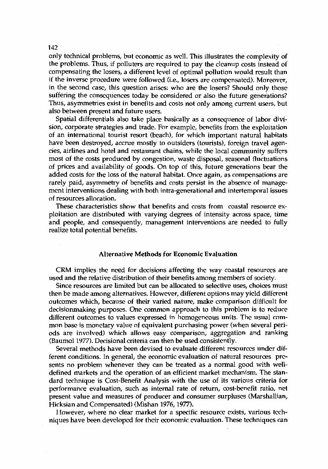
142 only technical problems, but economic as well. This illustrates the complexity of the problems. Thus, if polluters are required to pay the cleanup costs instead of compensating the losers, a different level of optimal pollution would result than if the inverse procedure were followed (i.e., losers are compensated). Moreover, in the second case, this question arises: who are the losers? Should only those suffering the consequences today be considered or also the future generations? Thus, asymmetries exist in benefits and costs not only among current users, but also between present and future users.
Spatial differentials also take place basically as a consequence of labor divi- sion, corporate strategies and trade. For example, benefits from the exploitation of an international tourist resort (beach), for which important natural habitats have been destroyed, accrue mostly to outsiders (tourists), foreign travel agen- cies, airlines and hotel and restaurant chains, while the local community suffers most of the costs produced by congestion, waste disposal, seasonal fluctuations of prices and availability of goods. On top of this, future generations bear the added costs for the loss of the natural habitat. Once again, as compensations are rarely paid, asymmetry of benefits and costs persist in the absence of manage- ment interventions dealing with both intra-generational and intertemporal issues of resources allocation.
These characteristics show that benefits and costs from coastal resource ex- ploitation are distributed with varying degrees of intensity across space, time and people, and consequently, management interventions are needed to fully realize total potential benefits.
Alternative Methods for Economic Evaluation
CRM implies the need for decisions affecting the way coastal resources are used and the relative distribution of their benefits among members of society.
Since resources are limited but can be allocated to selective uses, choices must then be made among alternatives. However, different options may yield different outcomes which, because of their varied nature, make comparison difficult for decisionmaking purposes. One common approach to this problem is to reduce different outcomes to values expressed in homogeneous units. The usual com- mon base is monetary value of equivalent purchasing power (when several peri- ods are involved) which allows easy comparison, aggregation and ranking (Baumol1977). Decisional criteria can then be used consistently.
Several methods have been devised to evaluate different resources under dif- ferent conditions. In general, the economic evaluation of natural resources pre- sents no problem whenever they can be treated as a normal good with well- defined markets and the operation of an efficient market mechanism. The stan- dard technique is Cost-Benefit Analysis with the use of its various criteria for performance evaluation, such as internal rate of return, cost-benefit ratio, net present value and measures of producer and consumer surpluses (Marshallian, Hicksian and Compensated) (Mishan 1976,1977).
However, ,where no clear market for a specific resource exists, various tech- niques have been developed for their economic evaluation. These techniques can

143 be classified into two major categories according to their source of information: those that rely on market information and those that rely on survey or hypo- thetical values (Hufschmidt et al. 1983, Randall 1981), with few methods that rely on a combination of both market and survey data (Freeman 1979). Thus, in cases where resources to be evaluated are "unpriced," such as a public good (e.g., pub- lic beach, coral islands, etc.), the market-oriented approach extrapolates market data from those resources for which information exists and association can be inferred.
Techniques that can rely on market data are many (Hufschmidt et al. 1983, Randall 1981). Important among them are: (1) Market Price (shadow, efficiency or actual price), (2) Market Comparison or Substitute Price, (3) Residual Value Method, (4) Travel-Cost Method, (5) Opportunity Cost Method (ti) and Land- Value Method. All of these methods have been extensively used in the evaluation of various resources (see AFS 1987).
Alternatively, in cases \vhere no bases exist for relevant extrapolation to unpriced (nonmarket) goods, techniques uscd are based on so-called "Contingent Valuation Method". Under this method, information or data are obtained through direct questionnaires (surveys), iterative bidding and expcrirnental techniques, aiming at uncovering consumer preferences. A detailed analysis and classification of various techniques and methods uscd in economic evaluation, especially as applied to environmental policies can be found in Hufschmidt et al. (1983).
Recently, at an important international symposium on Social Assessment of Fisheries Resources in Canada (AFS 1987), methods for evaluating resources were discussed and analyses from various perspectives were made. The consen- sus of the forum was that a Total Value Approach to resource evaluation should be encouraged, implying that future works on resources assessment should not only be interdisciplinary but also be inclusive of the relationships among assigned values, held values and means of aggregating or representing individ- ual values in public choices (Talhelm 1987).
The basic idea behind the Total Value Approach is the integration in the valu- ation process of both use value and intrinsic value of resource(s). The first cate- gory includes values or benefits generated by consumptive uses (such as hunt- ing, fishing, mining, etc.); nonconsumptive uses (such as snorkeling, watching animals and birds, etc.); and indirect uses (such as reading about exotic species of fish, watching pictures and movies about underwater animals, ctc.). The second category includes benefits that are accrued merely because of the existence of a resource (existence value), such as the satisfaction/enjoyment that a conscrva- tionist gets 'from knowing that whales still exist in the Antarctic, and from knowing of the possibility of enjoying the resource in future periods (option value).
Nevertheless, because of externalities, the depletability and the possibility of extinction of some coastal resources, accountability of users, opportunity costs and conflicting objectives in the minds of policymakcrs, the economic valuation of coastal resources presents important elements that need careful consideration and analysis to avoid severe errors.

144 Important Considerations in Economic Evaluation
As pointed out, economic evaluation of coastal resources generally implies the identification of a homogeneous unit into which values of benefits from hetero- geneous resources can be measured. Monetary values are usually used as a common unit. This is usually done through the measurement of the net benefits (total benefits minus costs) that the resource can generate. In so doing, benefits are measured in terms of prices for the various kinds of resources, assuming that market prices or opportunity costs truly reflect the benefits and costs involved. Nonetheless, when dealing with certain kinds of coastal resources such as fish- eries (especially recreational and sport fishing), beach resorts, clean environment, aesthetic services and others, market prices cannot be trusted to provide true indicators of benefit and cost. Several characteristic economic factors tend to prevent the market mechanism from working efficiently and providing the true scarcity value of the resources in question. Consequently, the use of market data may lead to over- or undervaluation and thereby produce an inefficient resource allocation and a suboptimal management strategy.
Moreover, the standard procedure of cost-benefit analysis and the various techniques based on consumer's and producer's surpluses as measures of bene- fits resulting from a given change (policy) pays little attention to individual pref- erences of the user group. Consequently, when equal weights are assigned to all users of a resource (as done by default in cost-benefit analysis), regardless of the initial distribution of wealth and productive factors, or to the relative size of pos- sible subsets within the group, large underestimation of potential benefits (or costs) may result. This is particularly important in developing countries where income, productive factors and wealth are highly concentrated on the hands of few members of society.
Temporal issues
Nonrenewable (depletable) coastal resources have a finite capacity to generate benefits. Their use (and consequently the benefits they provide) in the present is made at the expense of future uses (and benefits). If coastal oil or mineral fossils are extracted and used now, less or nothing is available for future generations. Deciding the appropriate rate of extraction is a fundamental issue where several elements play important roles. From a pure economic point of view, it is an "investment decision" between realizing the benefits today or, in the future, with the rate of discount (interest) being the determinant variable (Herfindahl and Kneese 1974, Clark 1976). Thus, if total benefits from extracting and using the resource today are larger than those obtained if left for future exploitation (net present value of future flow of benefits), then extraction and use should take place in the present. Market forces (including the relevant discount rates and prices) are supposed to provide the necessary data and indicators.
Nonetheless, since future generations are not here to report their valuation of the resources, the corresponding discount rate (measure of the resource valua- tion of future users) is estimated under prevailing conditions of relative scarcity,

145 available commodity mix and income distribution, all of which have strong im- plication in the choice of the appropriate discount rate. Figs. 1 and 2 of the Appendix illustrate this point and show that the net intertemporal social benefits are significantly affected by the choice of discount rate. They also show the pre- cise direction of desirable changes to increase benefits through appropriate man- agement policies.
Figs. 1 and 2 (adapted from Just et al. 1982) show that the destruction of man- grove for shrimp culture, for example, may appear an obvious alternative where employment opportunities are limited and price for shrimp is high relative to production costs. Economic evaluation of this same strategy after production and the improvement of local conditions for resource use will present, in turn, a much higher cost of forgone benefits from the depletion of mangrove resources. The user's cost (forgone future benefits) associated with the decision of destroying the mangrove will probably underestimate the real value of the resource in the future, given the way present evaluation is conducted. Moreover, scarcity values of the resources in the future will be significantly affected by the present extraction rate.
In the case of renewable resources, which are capable of generating benefits ad infinitum, if proper extraction/use rates are respected, the valuation of future benefits will also depend on the rates of discount and user's cost. If renewable resources are exploited beyond the threshold of sustainability (assuming a very low future discount rate), severe scarcity may occur in the future with almost infinite cost on future enjoyment (see Fig. 2 in Appendix).
Spatial issues
As mentioned earlier, the use of certain coastal resources precludes (exclusion possibility) the enjoyment of benefits that other resources can generate. It may also change the distribution of benefits among users of the same resource. For instance, the installation of an oil rig in the vicinity of a beach resort will proba- bly preclude those who would like to swim in clean water. Although total bene- fits generated by the coastal area with the new installation may well increase, it certainly changes the relative distribution of benefits among users of the coastal area as well, all of which need to be considered in the computation of the net benefits (and costs) generated by both resources.
Again, certain kinds of coastal resources extend their domain far inland, like rivers and forests. Use of these resources by one user group in an area may impose severe constraints on its use by potential users in other areas. For instance, the use of river-current for hydroelectric power generation will not only change the discharging flow of the waterways affecting other economic activities along the rivers (fishing, farming, navigation, recreation etc.), but may change the disbibution of benefits from the river or river-generated resources. The medium and long-run implication of this relocation process affects the evaluation of coastal resources. Thus, proper evaluation must consider direct and indirect, local and regional, present and future costs and benefits, as well as changes in the relative distribution of the benefits, spatially and temporally. However, the standard procedure of cost-benefit analysis adds over discounted net benefits

146 without weighing the relative individual values generated by changes induced by policy actions over time and space.
Social issues
Economic evaluation is essentially homocentric in the sense that benefits are evaluated as they are perceived by individuals or groups in a society; "individual preferences determine what is good" (Randall 1987) or what makes benefits pos- itive. This is, in fact, a basic premise behind the theory of demand and its prereq- uisite of "consumer sovereignty". In evaluating coastal resources for management and cost-benefit analysis, the accepted criteria is that the gains be greater than the losses without regard to whether compensation actually takes place or not. This approach neglects important distributional issues resulting from coastal resources development affecting the relative distribution of benefits among the society.
Moreover, CRM requires interventions which generally affect resource users with conflicting interests. On the other hand, management authorities usually tend to pursue a wide range of mutually incompatible objectives (Pauly 1979). This situation warrants an accounting of all factors affecting the current, poten- tial and forgone stream of benefits, rather than pursuing objectives that are diffi- cult to achieve due to their inherent conflicts.
Summary and Conclusion
Because of the multiplicity of uses and diversity of the benefits and costs that coastal resources generate and their various alternative uses, criteria and tech- niques to choose among them are needed. Economic valuation techniques applied to coastal resources provide useful information for national policy design and management
Although some economic evaluation techniques have been successfully used in the development and management of several resources, such as environment, forestry and agriculture, their application to coastal resources is only recent, and several problems still need to be carefully considered. The diversity of the resources in the coastal area and the various intertemporal, spatial and social issues they generate require special attention. Problems resulting from the lack of mechanisms to consider future generations' preferences affecting present deci- sions need careful consideration. Equally important is the development of tech- niques assigning relative weights to individual evaluation.
References
AFS (American Fisheries Soaety). 1987. Trans. Am. Fish. Soc. 116(3): 289-540. Baumol, W.J. 1977. Economic theory and operations analysis. PrenticeHall Inc., New Jersey. Clark, C. 1976. Mathematical bioeconomics. Wiley-Interscience,New York.
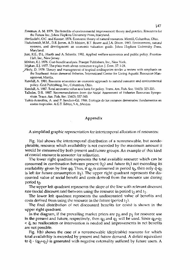
Freeman, A. M. 1979. The benefits of environmental improvement: theory and practice. Resources for the Future Inc., Johns Hopkins University Press, Maryland.
Herfindahl, O.C. and Kneese. 1974. Economic theory of natural resources. Merrill, Columbus, Ohio. Hufschmidt,M.M., D.E. James, A.D. Meister, B.T. Bower and J.A. Dixon. 1983. Environment, natural
systems, and development: an economic valuation guide. Johns Hopkins University Press, Maryland.
Just, R.E., D.L. Hueth and A. Schmitz. 1982. Applied welfare economics and public policy. Prentice- Hall, Inc., New Jersey.
Mishan, E.J. 1976. Cost-benefit analysis. Praeger Publishers, Inc., New York. Mi an, E.J. 1977. The plain truth about consumer surplus. J. Econ. 37: 1-24.
auly, D. 1979. Theory and management of tropical multispecies stocks: a review with emphasis on 6" the Southeast Asian demersal fisheries. International Center for Living Aquatic Resources Man- agement, Manila.
Randall, A. 1981. Resource economics: an economic approach to natural resource and environmental policy. Grid Publishing, Inc., Columbus, Ohio.
Randall, A. 1987. Total economic value as a basis for policy. Trans. Am. Fish. Soc. 116(3): 325-335. Talhelm, D.R. 1987. Recommendations from the Social Assessment of Fisheries Resources Sympo-
sium. Trans. Am. Fish. Soc. 116(3): 537-540. Yafiez-Arancibia, A. and P. Sanchez-Gil. 1988. Ecologia de 10s recursos demersales: fundamentos en
costas tropicales. A.G.T. Editor, S.A., Mexico.
Appendix
A simplified graphic representation for intertemporal allocation of resources:
Fig. l(a) shows the intertemporal distribution of a nonrenewable, but nonde- pletable, resource which availability is not exceeded by the maximum amount it would be consumed by both present and future groups. An example of this kind of coastal resource is seawater for salination.
The lower right quadrant represents the total available resource which can be consumed in combination between present (to) and future (tl) not exceeding its availability given by line qq. Thus, if qo is consumed in period to, then only q-qo is left for future consumption (tl). The upper right quadrant represents the dis- counted value of social benefit and costs derived from the resource use during period to.
The upper left quadrant represents the slope of the line with relevant discount rate (social discount rate) between using the resource in period to and tl.
The lower left quadrant represents the undiscounted value of benefits and costs derived from using the resource in the future (period tl).
The final distribution of net discounted benefits (or costs) is shown in the upper right quadrant.
In the diagram, if the prevailing market prices are po and pl for resource use in the present and future, respectively, then qo and ql will be used. Since qo+ql < q, no reallocation or intervention is needed and improvements in net benefits are not possible.
Fig. l(b) shows the case of a nonrenewable (depletable) resource for which total availability is exceeded by present and future demand. A deficit equivalent to tj - (qO+ql) is generated with negative externality suffered by future users. A

148 solution by "internalization" of user's cost or forgone benefits f r ~ m present con- symption results in improved net benefits with a high~r price, p 0, and quantity, q which provides an objective basis for re2ching p 0 through a tax system or quota imposed on present use (to) up to q 0. Present users lose, while future users gain a larger amount of benefit than that lost by the present users, easily deduced from net producer and consumer surpluses in Fig. l(b).
Fig. l(c) shows the effect on net benefits resulting from an increase of the dis- counting rate to properly account for future users. A change in the slope of the straight line in the left quadrant reflecting a larger valuation for resources used in period tl (future) is represented and the corresponding changes in prices, p 0 and optimal quantity, q .
Fig. 2 shows the allocation of a renewable resource where the available quan- tity grows at a rate g. Thus, total resources left for future use (q-qO) is equal to (q- qo)(l+g). The value of benefits resulting from future use is discounted by the appropriate rate of discount, including the corresponding growth rate. Thus, the slope is equal to (l+g/l+r). The optimal rate of use is determined in the present and future with due consideration of the discounting rate reflecting future pref- erence in a similar way to the preceding figures. As a consequence, the net dis; counted benefits are increased if*present rate of use is controlled at the level q or, price is regulated/driven to p 0.
Figs. 1 and 2
Upper left quadrant: r = Discount rate g = Rate of growth of unextracted resource from to - t i
Upper right quadrant: MSBO = Discounted marginal social benefit of using the resource at current
period to MSBl = Discounted marginal social benefit of using the resource at future
period t l MXCO = Discounted marginal cost of extracting the resource at current
period to MXCl = Discounted marginal cost of extracting the resource at future
period t l $Q = Dollars at current period to QQ = Resource quantity available at current period to
Lower right quadrant: QQ = Resource quantity available at current period to Qtl = Resource quantity available at future period tl qoql = Locus of combinations of maximum quantity of resource use
available so that total use does not exceed
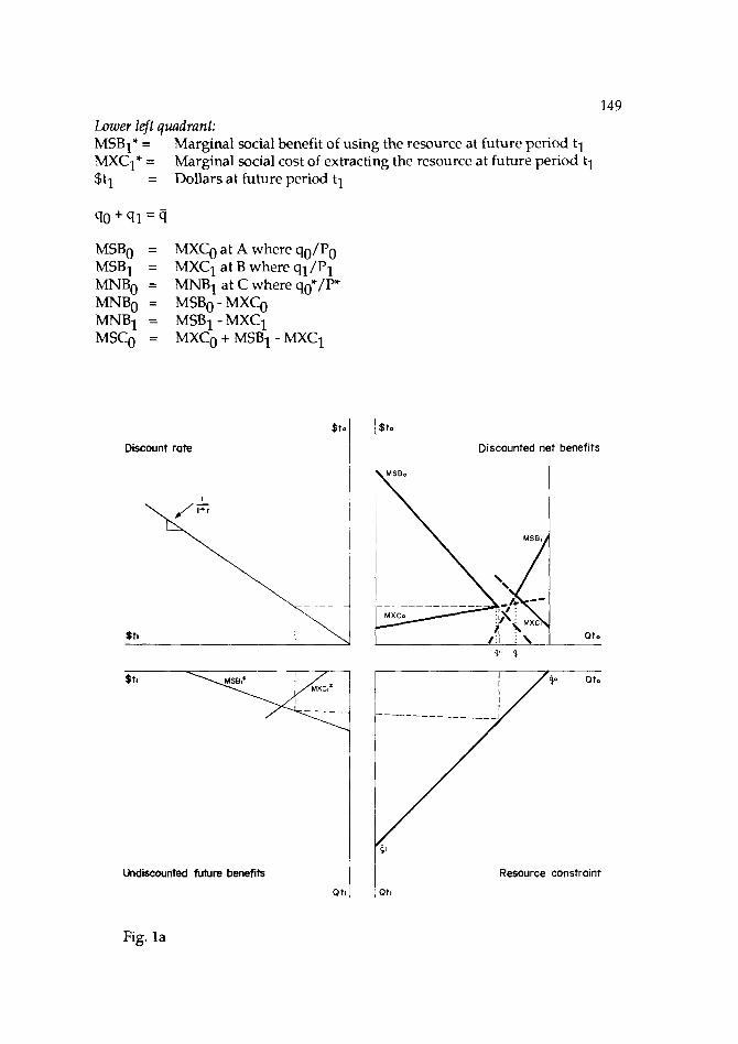
149 Lower left quadrant: MSB1* = Marginal social benefit of using the resource at future period t l MXCle = Marginal social cost of extracting the resource at future period tl $tl = Dollars at future period tl
MSBO = MXCO at A where qo/Po MSBl = MXCl at B where ql/P1 MNBO = MNBl at C where qo*/P* MNBO = MSBO - MXCO MNBl = MSB1 -MXCl MSCO = MXCO + MSBl - MXCl
Discount rote I r 0 / / fro Discounted net benefits
Qt.
Undiscounted future benefits
Fig. l a
Resource constraint
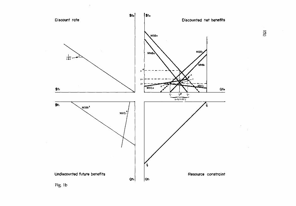
Discount rate
Undiscounted future benefits
Fig. l b
Discounted net benefits
Resource constraint

Stl
Discount rate Discounted net benefits
Resource constraint

Discount and growth rate
'Undiscounted future benefits Qtl
Fig. 2
$to
Discounted net benefits
I
I Qto
Resource constraint

Session IV: Tools for Coastal Area Planning and Management
Coastal Resources: Assessing Alternatives
JOHN A. DIXON Environment and Policy Institute
East- West Center 1777 East- West Road
Honolulu, Hawaii 96848 USA
DIXON, J.A. 1989. Coastal resources: assessing alternatives, p. 153-162. In T.-E. Chua and D. Pauly (eds.) Coastal area management in Southeast Asia: poliaes, management strategig and case studies. ICLARM Conference Proceedings 19, 254 p. Ministry of Science, Technology and the Environment, Kuala Lumpur; Johor State Economic Planning Unit, Johore Bahru, Malaysia; and International Center for Living Aquatic Resources Management, Manila, Philippines.
Abstract
This paper discusses the potential of socioeconomic analysis as a tool in the management of common property natural resources, especially as it allows the evaluation of alternative scenarios. The failure of market forces to account for "externalities" implies that management interventions are needed to ensure long-term use of and long benefits from common property natural resources. This is illustrated by a case study from Bacuit Bay, Palawan, Philippines, where logging-induced erosion has killed coral reefs and negatively impacted fisheries and tourism. Forest conservation could have provided long-term benefits.
Introduction
Coastal resources are diverse and their management is a major challenge. In the ASEAN region, the coastal zone is the site of many major cities (including four national capitals) and large populations. The links between people, resource use, economic growth and well-being are strong in the coastal zone. The patterns of resource use vary from that of small-scale subsistence fishing, to major indus- trial developments, to resort and tourism-based activities. The coastal area is characterized by multiple resources and multiple users. Competition leads to conflict and the need to examine and assess alternatives.
The physical, social and economic forces at work in coastal areas require man- agement. Left alone, competition among resource users may result in overex- ploitation of a resource, negative environmental effects, equity problems with income generation and income distribution and a loss of social welfare.
153

154 Socioeconomic analysis can play a valuable role in evaluating alternative
development scenarios. It can help identify the winners and losers, and the bene- fits and costs associated with a decision on coastal resource use. It cannot make the decision, however. Resource management decisions involve many dimen- sions--economic, social, cultural, political, ecological--and are the realm of resource managers who are usually government officials. Basic strategic deci- sions are frequently made at the political level. Nevertheless, socioeconomic analysis (hereafter referred to as economic analysis) can be valuable in the deci- sionmaking process.
Multiple Resources, Multiple Users
The rich coastal ecosystems in the ASEAN countries are diverse resources that need to be managed. Many resources are interconnected and use of one will have an impact on others. A classic example of this is the mangrove ecosystem and the interactions between the mangrove itself and various forms of aquatic life. In this case, there is a close biological link through the natural ecosystem. Other impacts may be equally important but of a different nature. Coastal mining or logging, for example, can create large quantities of sediment that can smother and kill corals. Coral death will, in turn, affect the reef fishery.
There is no standard list of coastal resources. Table 1 presents a possible list including goods and services provided by coastal resources. Some of the resources are living, others are inanimate. Items can be added or deleted
Table 1. Coastal resources: goods and services.
Resource Location Type of good or service Transition Marketed Nonmarketed
Onshore zone Nearshore good good Service
Mangroves/nipa swamp Aquaculture Capture fishery Coral Seaweed Seagrass Agriculture Minerals Oil and gas Salt Sand Beaches Habitat Land for development Coastal vegetation

155 depending on the locale. For each item, several attributes are noted: location-on- shore, in the land-sea transition zone, or nearshore, and whether or not it is a marketed good or a less tangible "service."
Marketed goods are tangble items that can be enumerated and have a price. Mangrove poles, crabs, fish, sand, salt and petroleum are all examples of mar- keted (or marketable) goods. Services are less tangible or, in some cases, harder to value. For example, the nutrient flow of detritus from a mangrove ecosystem is an important part of the food cycle of many fish and anthropods such as crabs and shrimp. Although not sold in the market, this nutrient flow is a valuable resource that directly affects the productivity of more traditional coastal resource products (e.g., crabs and shrimps). Beaches and a clean environment provide important recreational and tourism services sold indirectly via supporting facili- ties (hotels, restaurants, transportation).
Whether a coastal resource is a good or a service, marketed or nonmarketed, is not important in terms of its function in the coastal ecosystem (and its associated socioeconomic system). The extent to which coastal resources represent easily marketed goods, however, heavily influences resource management decisions. Nonmarketed goods and environmental or ecosystem services are frequently overlooked or their importance played down. This is one of the factors leading to resource management conflicts and poor decisions.
Sources of Conflict
Given the richness and diversity of coastal resources, it is not surprising that there are many conflicting claimants for any given resource. Within the frame- work of socioeconomic analysis, resource use conflicts arise from a number of reasons; these include the nature of common property resources, poorly defined property rights, the existence of economic externalities and the presence of non- marketed goods and services.
Common property resources (CPR) or open-access resources belong to a community or the collective. Examples include marine fisheries, groundwater and certain public coastal areas. No one individual owns the resource or controls its management. Some CPR can be privatized, but at some cost in terms of regulation and enforcement. The main dan- ger with CPR is overexploitation (as in fisheries or groundwater) or con- gestion (for recreational facilities). Closely related to the CPR question is that of property rights. If property rights for a resource are vested in the community, one has a CPR. In many cases, property rights belong to individuals or groups but may be poorly defined or indeterminate. Agricultural lands may be leased out season by season; in other areas, farmers have customary use rights but do not have formal titles. Communities may manage a CPR such as a mangrove in a sustainable way for generations only to find out that they have no legal title and can lose the use of the resource. Political factors may play a role in assigning formal titles to valuable resources.

156 Poorly defined property rights can lead to resource mismanagement, insuffi-
cient investment in maintaining productivity, collection of "political rents," and alienation of traditional resource users. It is usually the poorest members of soci- ety who lose when property rights are changed.
Environmental and economic externalities exist when the actions of one resource user have an impact, positive or negative, on the welfare of another who is not part of the decisionmaking process. Changes in freshwater stream flow, perhaps as a result of irrigation development, may damage a coastal mangrove. Mangrove conversion to an industrial site will affect nearshore fisheries. Coral mining may lead to increased coastal erosion and storm surge damage. In each of these cases, a deci- sion made by one resource user imposes additional costs on others. Since these costs are not taken into account, the level of resource use will be greater than would be the case if all benefits and costs were considered. The existence of nonmarketed goods and services is a final factor leading to resource management problems. As noted in Table 1, numerous goods and services provided by coastal resources are not usually bought and sold in the market. Nutrient flows from a mangrove and habitat benefits from a wetland are both examples of nonmarketed "services". Tourism and recreational benefits depend upon a wide range of environmental services, only some of which are priced.
Although these nonmarketed goods and services contribute to social welfare just as more easily valued, marketed ones do, they tend to be overlooked or ignored in the analysis of options. A mangrove, for exam- ple, may be analyzed as a site for a new industrial development. If the "value" of the mangrove is calculated based solely on the poles and char- coal produced, it will have a low value per hectare.
If, however, the other onsite and offsite benefits of a mangrove are included, it will be seen as an ecosystem of considerable value. Other sites for industrial development may be found to be less costly than the initially chosen, "worthless" mangrove. For more details on the economic analysis of mangroves, see Hamilton and Snedaker (1984). Dixon et al. (1988) provide information on placing economic values on traditionally nonmarketed goods and services.
Whatever the reasons for conflict, coastal zone resources frequently require management plans to guide the pattern and pace of development. In economic jargon, a market failure exists, and, left to purely market (or political) forces, a suboptimal result will come about. This is particularly true if one is concerned with social welfare and long-term sustainable management of coastal resources. All of the market signals (and market imperfections) favor rapid development and overexploitation of coastal resources. These patterns can be the result of very different reasons. Poverty-driven overexploitation by large numbers of coastal residents can be just as destructive as greed-driven resource use by a handful of wealthy and powerful people. In both cases, the results are similar--short-term benefits are extracted at the cost of larger, long-term returns. In economic terms, this is the real challenge of CRM.

157 The Management Challenge
Coastal area management is necessary because of the interactions mentioned earlier and the institutional failures just described. If resource use decisions had no external impacts, there would be no need for outside management. For exam- ple, it is of little concern if a farmer grows corn, rice or vegetables; it is a concern, however, if a coastal resident converts a mangrove to a fishpond or affects the quantity or quality of freshwater flowing into an estuary.
Management, therefore, requires identification of impacts, assessment of bene- fits and costs, and analysis of alternatives. In addition, one has to ask the equity questions: who wins, who loses (if there are losers), and what happens to the resources available for the next generation?
Management is not natural. It is a conscious act of social engineering designed to change. Since markets do not operate perfectly in the coastal environment, one cannot rely on market forces alone. Most of the coastal resource problems seen in the ASEAN region are due to these market failures.
In order to assess alternatives and to design appropriate management plans, therefore, it is necessary to understand a number of important factors:
A management goal must be clearly defined. This will usually combine both social goals (e.g., equity issues) as well as economic growth goals. The onsite as well as offsite impacts must be identified. There should be no artificial division based on "project boundaries." The economic benefits and economic costs must be estimated. In this case "economic" means all benefits and costs measured in a social- welfare context, wherever they occur. Effects that are not traditionally valued in monetary terms should also be assessed and included in the analysis. Sometimes they can be included in monetary terms; in other cases, they are included in a qualitative man- ner. Those who will benefit or be affected by a proposed activity must be identified. The rules and arrangements governing present patterns of resource use, for both traditional and legal institutions, must be understood.
Once these factors have been considered, it is usually possible to identify potential areas of conflict and cohsider alternative patterns of resource use. Development will, of necessity, mean change and some groups will benefit while others will be hurt. The question is, is the sum of the benefits greater than the sum of the costs?
In addition, CRM faces two fundamentally different challenges. One is the decision on whether or not to go ahead with individual projects-a port devel- opment, a tourist hotel, a new aquaculture development. These are the easier decisions because they are discrete projects or activities. Much more difficult is the management of common property resources (e.g., a coastal fishery), where there may be thousands of individuals using the resource. In this case, even if one can identify the problem and the desired solution, implementation becomes a major issue. It may well be that we can make all of the "right" decisions on

158 major coastal resource projects, only to lose the war because of the actions of many individual resource users.
An Example from Palawan, Philippines
A case study from Bacuit Bay, Palawan in the Philippines, illustrates many points raised in this paper. In the example, there are competing users for a set of interlinked resources. The analysis shows that a traditional market solution would impose major social costs on society. The socially optimal management plan, however, may be difficult to implement.
The development in the Bacuit Bay area is one example of the management challenge of coastal resources. This case illustrates why a "market solution" will sometimes produce suboptimal results.
Located just south of El Nido, Bacuit Bay is a valuable marine resource. It sup- ports a substantial fishing industry and is the site of a growing diving-based resort development. The surrounding forested hills contain valuable timber resources (Fig. 1).
I LLogg. Ing concession
Drainage basin --- L-1 Illegal ( ?) logging
Diving resort
Coral reef
Coastline
Fig. 1. Bacuit Bay, Palawan, showing locations of main industries discussed in the text.
In this case, it was not even a coastal resource use that led to the resource problem. Logging was being carried out in the hills surrounding the bay by a large private firm that held a major logging concession in northern Palawan. The Bacuit Bay watershed forms only a small part of the total area given to the firm.

159 Nevertheless, the act of logging and construction of access roads led to substan- tial soil erosion and sedimentation in the bay. This sediment in turn affected the coral, caused coral death and disrupted part of the bay's food chain. These effects caused a decrease in the fish population and in the attractiveness of the bay to sport divers. As such, three major industries come into conflict: logging, fisheries and tourism. Causality was unidirectional: the logging industry affected fisheries and tourism, both of which depended on the bay; they, in turn, had no direct impact on the logging operation.
Referring to the potential "sources of conflict" identified earlier, we see that many of them are present in this case:
Common pvoperty resource. The bay, its coral, fish population and clean water are a common property resource. Traditionally fished by El Nido residents and other fishing communities, the newly developed resort industry was a complementary, nonconsumptive user of the same resource. Both fishermen and resort operators had a stake in maintaining a healthy, productive marine ecosystem. In fact, they had cooperated to protect the bay's fishery resource from overexploitation by outside groups. Property rights. In contrast to the bay's open access nature, the logging concession owner had a legal right to harvest timber from its concession area. It had the approval to harvest and export logs via a temporary earth pier built into the bay. Environmental and economic externalities. Eroded soil from the logging concession enters the bay as suspended sediment. This in turn affects the coral reef, causes coral death in some cases, and disrupts the food chain upon which the bay and reef fish population depend. There is also evi- dence of impact on offshore pelagic species.
These environmental effects have direct economic consequences that are not taken into account by the logging firm. These "economic externalities" include:
decreased fish catch by local, subsistence fishermen; decreased attractiveness of Bacuit Bay to local and foreign divers with a resulting decline in tourism; and possible adverse effects on pelagic fish caught in offshore waters.
In such a resource-use conflict, the market-based, property-right solution tra- ditionally prevails: the logging concession owner harvests the trees and moves on, leaving those dependent on the bay's resources to adjust.
In order to better understand what was really at stake and the impact of alter- native development scenarios, a combined environmental and economic analysis was carried out. Details are presented in Hodgson and Dixon (1988a) and in a two-part series in the Tropical Coastal Area Management newsletter (Hodgson and Dixon 198813; Dixon and Hodgson 1988).
The study examined the benefits and costs of two options: a logging ban with losses by the logging concession holder or continued logging in the Bacuit Ray watershed with resulting losses by the fisheries and tourism industry. Because of difficulty in obtaining cost information for each industry, the study compared gross revenues and their present value under each option.

160 The study used a 10-year time horizon and two discount rates (10% and 15%).
The results are presented in Table 2. Option 1 bans logging and Option 2 allows logging to continue.
Table 2. Gross revenue and present values of three industries under two development options. Option 1: a logging ban; Option 2: continued logging. Tourism, fisheries, and logging industries: 10-year sum of gross revenue, present value of gross revenue (US$1,000) using 10% and 15% discount rates.
Option 1 Option 2 Option 1 minus 2
Gross revenue Tourism Fisheries (with tuna)
Logging Total
Resent value (10%) Tourism Fisheries (with tuna)
Logging Total
Present value (15%) Tourism Fisheries (with tuna)
Logging Total
aTuna revenues (in parentheses) are not used to calculate totals.
The results are striking. The gross revenue under Option 1 is more than double that under Option 2. Since Option 1 prevents further logging in the Bacuit Bay drainage basin, the gross revenue from logging under Option 1 is 0. Fisheries and tourism, however, generate large and continuing benefits. Benefits from tourism are expected to grow over time as demand and markets increase, while benefits from fisheries remain constant. In contrast, Option 2, which allows continued logging, generates smaller and decreasing benefits. After five years, the trees, as well as a significant part of the tourism and fisheries sectors, will be depleted. The modest logging revenue generated under Option 2 is more than offset by the decreased income from tourism and fisheries.
The present value of gross revenue under Option 1, calculated using a 10% discount rate, is almost double that under Option 2. Since all logging production occurs during the first five years, the effect of the higher 15% discount rate on the gross revenue generated from this industry is relatively slight. In comparison, most of the tourism revenue is predicted to accrue during the post five-year tourism expansion period; therefore, tourism revenue is reduced proportionally more than the logging revenue. Even at the higher 15% discount rate, the total present value of gross revenue under Option 1 is still 1.5 times larger than that under Option 2.

161 Policy Implications
The El Nido case illustrates how three legitimate resource users in a coastal environment are linked via the coastal ecosystem. Resource management deci- sions by one industry (in this case, logging) can have serious ecological and eco- nomic impacts on the other industries. Logging creates a classic economic exter- nality--its actions have a negative impact on the fishing and tourism sectors and yet the latter groups have no direct effect on the logging operation.
In situations like this, CRMs must identify the ecological-social-economic interactions and their economic consequences. The economic analysis, done with some fairly simple assumptions and readily available data, provides useful information about the likely economic impacts of the two main options: contin- ued logging or a logging ban.
Although the analysis shows that the "cost" of continued logging in terms of lost fisheries and tourism revenue is large, it will take a political decision to stop further logging in the Bacuit Bay watershed. Normal market forces will not do this-logging will continue and fishing and tourism will suffer. If logging is stopped in El Nido, a modest financing cost to the logging concession holder should result in major present and future benefits from fishing and tourism development. Because of the pattern of employment and distribution of profits, the logging ban will also have favorable equity implications.
The resource use conflicts seen in the Bacuit Bay case are not unique. In most S E A N countries, any major coastal development will directly and indirectly affect other groups using coastal resources. The proposed development can range from an expansion of aquaculture ponds in a mangrove area, to construc- tion of a new port or power plant, to intensive tourism development. Each action will create special concerns. In the Palawan case, the management problem is somewhat simplified because the resource manager can deal with a single entity: the logging concession holder. If instead of a single firm, the deforestation was being done by a thousand illegal settlers, the environmental and economic costs to the bay ecosystem might be the same but the management challenge much larger. However, it is not clear which group is easier to control--a large and per- haps politically powerful logging firm, or thousands of poor, individual settlers.
In all cases, however, CRM is required because the absence of outside inter- vention normal forces (market or otherwise) will lead to resource problems. Whether one calls these problems "conflicts," market failures" or whatever, the result is the same: additional costs are imposed on one group of resource users by another group that benefits. Whether or not these costs are justified by the benefits, and what alternative plan of action may produce better results, must be determined by the broader socioeconomic assessment advocated here.
References
Dixon, J.A. and G. Hodgson. 1988. Economic valuation of coastal resources: the El Nido study. Trop. Coast. Area Manage. 3(2): 5-7.

Dixon, J.A., R.A. Carpenter, L.A. Fallon, P.B. Sherman and S. Manopimoke. 1988. Economic analysis of the environmental impacts of development projects. ~arthscan Publications, London.
Hamilton, L.S. and S.C. Snedaker, editors. 1984. Handbook for mangrove area management. East- West Center, Honolulu.
Hodgson, G. and J.A. Dixon. 1988a. Logging versus fisheries and tourism in Palawan: an environ- mental and economic analysis. EAPI Occas. Pap. No. 7. East-West Center, Honolulu.
Hodgson, G. and J.A. Dixon. 1988b. Measuring economic losses due to sediment pollution: logging versus tourism and fisheries. Trop. Coast. Area Manage. 3(1): 5-8.
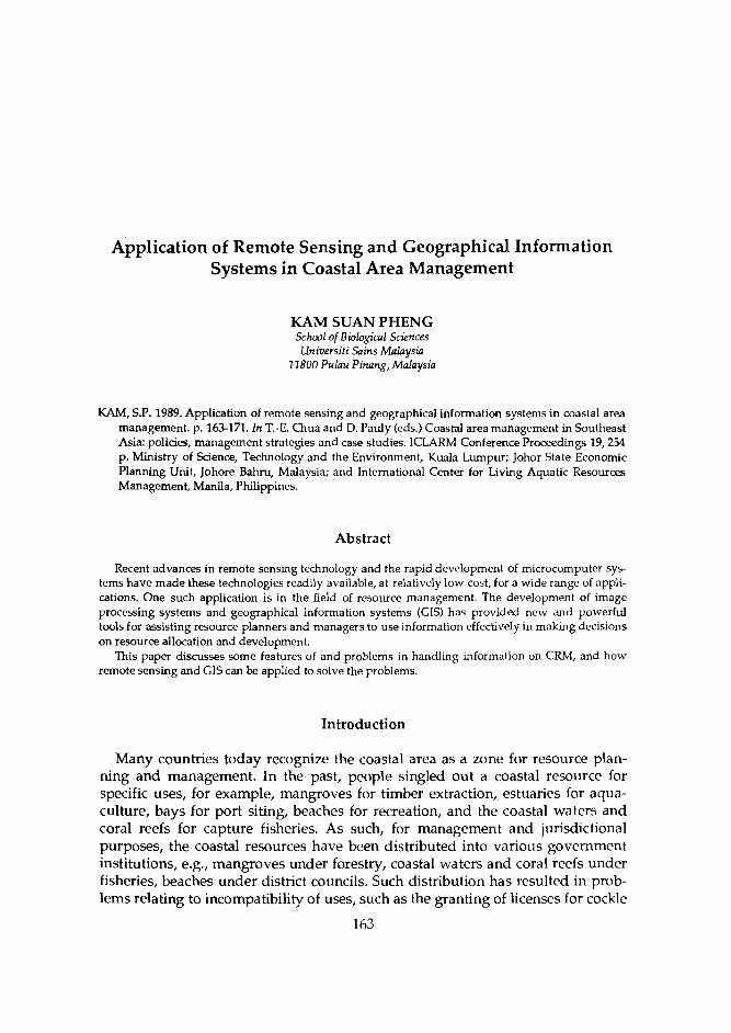
Application of Remote Sensing and Geographical Information Systems in Coastal Area Management
KAM SUAN PHENG School of Biological Sciences Universiti Sains Malaysia
11800 Pulau Pinang, Malaysia
KAM, S.P. 1989. Application of remote sensing and geographical information systems in coastal area management. p. 163-171. In T.-E. Chua and D. Pauly (eds.) Coastal area management in Southeast Asia: policies, management strategies and case studies. ICLARM Conference Proceedings 19,254 p. Ministry of Science, Technology and the Environment, Kuala Lumpur; Johor State Economic Planning Unit, Johore Bahru, Malaysia; and International Center for Living Aquatic Resources Management, Manila, Philippines.
Abstract
Recent advances in remote sensing technology and the rapid development of microcomputer s y s terns have made these technologies readily available, at relatively low cost, for a wide range of appli- cations. One such application is in the field of resource management. The development of image processing systems and geographical information systems (GIs) has provided new and powerful tools for assisting resource planners and managers to use information effectively in making decisions on resource allocation and development.
This paper discusses some features of and problems in handling information on CRM, and how remote sensing and GIs can be applied to solve the problems.
Introduction
Many countries today recognize the coastal area as a zone for resource plan- ning and management. In the past, people singled out a coastal resource for specific uses, for example, mangroves for timber extraction, estuaries for aqua- culture, bays for port siting, beaches for recreation, and the coastal waters and coral reefs for capture fisheries. As such, for management and jurisdictional purposes, the coastal resources have been distributed into various government institutions, e.g., mangroves under forestry, coastal waters and coral reefs under fisheries, beaches under district councils. Such distribution has resulted in prob- lems relating to incompatibility of uses, such as the granting of licenses for cockle
163

1 64 culture on mudflats in the immediate vicinity of an industrial estate with high effluent discharge into the coastal waters.
Today, however, there is a growing realization that the coastal area should be planned and managed for ecological reasons:
1. There are strong ecological linkages among the different coastal ecosys- tem units, so that the destruction of a seemingly non-economic area can have far-reaching impacts on other highly economic resources. For in- stance, mangroves, traditionally regarded as wastelands, are actually nursery and feeding grounds for commercially important fish and crus- taceans. For the coastal zone to support economic activities in the long term, its resources have to be used and managed on a sustainable basis.
2. Coastal resources occur at the interface of land and sea and are, there- fore, influenced by both. For example, pollution of the coastal waters can cause impact on the terrestrial systems within the influence of the sea.
3. Because resources are adjacent to each other, the use of one has an impact on another. For example, bunding to prevent ingress of seawater into agricultural areas inland from mangroves reduces freshwater intru- sion into the mangrove ecosystem, killing mangroves which have adapted to a narrow salinity range of the brackishwater regime.
To conserve coastal resources and to manage coastal development, many countries have taken steps, ranging from resource inventory to creating compre- hensive and integrated coastal management programs which integrate with other resource and economic development programs. Experience shows the following fundamental tasks in creating such management programs:
Assessment of the available coastal resources. This is a necessary, though tedious and continuous, task because no resource planning and alloca- tion can be done without first knowing what are available where, in what quantities and which values are involved. Comprehensive resource inventories have been carried out in a few countries; for example, New Zealand has produced an atlas of coastal resource maps. Socioeconomic assessment of the current use of the resources. This com- plements the physical resource assessment and provides a basis in eval- uating the level of economic exploitation of the resource and the extent of social involvement in each use. Identification of specific issues arising from the use of coastal resources. The issues are often peculiar to the country, state, district or location, and indicate specific potentials, constraints and priorities in resource development. Identification of possible development projects and specific conservation needs within the coastal area. This should be based on a rational evalua- tion of the results of the above tasks. Assessment of the possible impacts of policy decisions on resource allo- cation. This should be done within the overall goal of sustainable resource development.
In carrying out theseatasks, resource planners often rely on a broad range of spatial data in the form of map tabulations and descriptions associated with some geographical location. For example, in identifyng suitable sites for

165 aquaculture, the resource planner needs to identify adequately sheltered coastal locations with suitable soils, optimal water salinity range and acceptable water quality, which are not too distant from transportation networks and consumers. Conceptually, the resource planner will have to map and sieve through the information to locate the most suitable sites for aquaculture (Kapetsky 1988).
However, gathering information for resource studies commonly involves some problems:
There is lack of information, especially scientific data, which are expen- sive and time-consuming to collect. Biological inventories, i.e., listings of the numbers and types of living organisms found in a particular area, and ecological data, i.e., the relationships between living organisms within an area, are often nonexistent. There may be information gaps, either due to incomplete geographical coverage or inadequate frequency of monitoring. For instance, land use mapping in many countries is based on interpretation of aerial pho- tographs, which are expensive to acquire and time-consuming to inter- pret. Thus, land use maps produced by central agencies are often out- dated by the time they are ready, and are not updated often enough to capture rapid changes. On the other hand, available information may not be easily accessible or may be in a form not readily usable. Users of geographic information must often sieve through maps of different scales and do tedious area calculations and cross-tabulations. Mapping out different resource allo- cation scenarios involves many hours of manual map drawing and redrawing.
To a large extent, recent advances in computer technology have provided many institutions with useful tools for information gathering, storage and pro- cessing. However, available tools for resource monitoring and handling of spatial data are still not within the reach of most research and planning institutions in the region.
Remote Sensing Applications
Remote sensing involves the use of a sensor device (e.g., a camera with photo- graphic film, a radiometer which electronically records electromagnetic radia- tion) to take images of earth features. The sensor device is mounted on a plat- form, which can be stationary (such as the top of a tower) or moving (such as an aircraft or satellite). Traditionally, the most common form of remotely sensed data for resource monitoring is the aerial photograph. A camera, normally loaded with black-and-white panchromatic film, is mounted to the base of an aircraft and flown along predetermined flight lines at a predetermined height for a corresponding map scale.
More recently, earth resource satellites, such as the National Aeronautics and Space Administration's E R E , the LANDSAT series, the French SPOT and the Japanese MOS, have been launched to orbit at fixed heights above the earth's

166 surface along predetermined paths which cover most of the earth's surface. Vari- ous kinds of sensors, mainly nonphotographlc, are programmed to capture images of earth features and to beam these signals to relay satellites or directly to ground-receiving stations. The data are recorded in digital form on computer- compatible tapes and can be processed using special software to display the image of selected areas on the earth's surface.
The main advantages of satellite imagery over conventional remotely sensed data, such as aerial photographs are:
1. Synoptic view of the earth's surface. Because these satellites orbit 800-900 km above the earth's surface, a single scene taken by the sensor covers a large area, i.e., 3,600 km2 for SPOT and 34,000 km2 for LANDSAT MSS. A single scene of an aircraft-borne aerial photograph typically covers an order of 1 km2.
2. Repeated coverage of the earth's surface. Since the satellites are in con- tinuous orbits of daily small incremental angles, their tracks systemati- cally cover most of the earth's surface (except the poles) and subse- quently repeat their overpass. For instance, the LANDSAT 4 and 5 satel- lites have a 16-day coverage cycle, while the SPOT satellite completes its orbital cycle in 26 days. This means that a particular point on the earth's surface will be covered once every 16 days by LANDSAT 4 and 5, and every 26 days by SPOT. Such repeated coverage makes it possible to detect short-term temporal changes through more frequent monitoring of the earth's resources.
3. Broad sensing range within the electromagnetic spectrum. Radiometric sensors on the satellites can detect radiation beyond the normal range of sensitivity of photographic film. This detection is useful for specialized applications, such as sensing surface water temperatures to map cur- rents. Vegetation also reflects, highly in the near infra-red range outside the visible light range. It is, therefore, easier to distinguish vegetation on dry land from that in swamps in such an image than in a conventional black-and-white panchromatic photograph. The use of radar in active remote sensing systems for imaging earth resources has a potentially useful application in the tropics because of its ability to overcome the problem of high cloud cover. For instance, radar sensors were recently flown over extensive areas of Kalimantan and other parts of Indonesia to obtain cloud-free imagery for land use interpretation.
4. Digital data can be directly processed on computer. This allows for a flexible range of data-processing techniques to produce thematic maps. For instance, satellite imagery can be used to interpret and digitally clas- sify on computer land use and water turbidity maps.
Some broad generic applications of remote sensing, especially of satellite imagery, in coastal studies include:
1. Land use mapping. The land use pattern of the coastal zone indicates the resources used, the distribution of human settlements, the transportation network and the development pressures. Land-use monitoring of the hinterland of a coastal area provides information on the likely impacts of upstream activities.

167 Mapping and monitoring of a coastal resource. This is especially done if access on the ground is difficult. With improved resolution of the sensors aboard the newer satellites, like the Thematic Mapper on LANDSAT 4 and 5 (30 m resolution), and the Multispectral Scanner (MSS) on SPOT (20 m resolution), the earlier disadvantages of coarse resolution have been overcome to a certain extent. For example, with the 30-m resolution of the SPOT MSS, it is possible to map different vegetation zones within mangrove areas (Blasco et al. 1984). Various aspects of resource moni- toring, such as large-scale damage by fire and diseases as well as illegal forest logging, can be detectcd. Study of water bodies. Various applications range from mapping water depths and turbidity to detection of oil slicks and currents. With special sensors, such as the Coastal Zone Colour Scanner launched with the NIMBUS 7 satellite, narrow bands of electromagnetic radiation which are more relevant to water studies can be used to map water temperatures and concentrations of chlorophvll in the waters.
1 ,
As technology in sensor development advances and becomes widespread, it is envisaged that remote sensing will become a regular source of resource data for coastal area studies and management.
Geographical Information Systems Application
GIs are computerized information systems which allow for the input, storage, analysis, retrieval and modelling of spatial data. Their development paralleled that of remote sensing, computer graphics and computer-assisted mapping. They developed from the need to integrate data output from image processing with conventional sources of spatial data, such as maps, and to analyze and process such information in an effective manner. The advancement in computer graphics and the availability of high-capacity mass storage devices on the microcomputer have made GIs adaptable to microcomputer systems. This has put the more powerful GIs within the reach of most institutions which do not have to incur the high expenditure of the custodial minicomputer and mainframe systems.
These are the advantages in using GIs to handle spatial data for resource applications:
GIs can capture spatial data from traditional sources of information, such as maps and tables of attribute data tagged to georeferenced points. GIs can accept maps of various scales and projections and internally transform different map layers into standard scale and projection, so that overlays are properly registered and output can be standard (Fig. 1). GIs can integrate such spatial information with digital data now made available through remote sensing, image processing and computer car- tography. Thus, various kinds of spatial data can be integrated in an information base which can be easily retrieved and updated from time to time. GIs allow for spatial analyses that are too tedious and time-consuming to be camed out manually. For example, in order to overlay two map
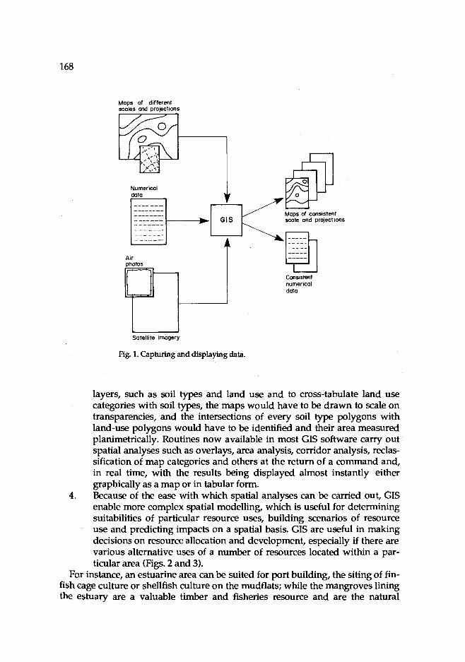
Satellite imagery
Fig. 1. Capturing and displaying data.
layers, such as soil types and land use and to cross-tabulate land use categories with soil types, the maps would have to be drawn to scale on transparencies, and the intersections of every soil type polygons with land-use polygons would have to be identified and their area measured planimetrically. Routines now available in most GIs software carry out spatial analyses such as overlays, area analysis, corridor analysis, reclas- sification of map categories and others at the return of a command and, in real time, with the results being displayed almost instantly either graphically as a map or in tabular form.
4. Because of the ease with which spatial analyses can be carried out, GIs enable more complex spatial modelling, which is useful for determining suitabilities of particular resource uses, building scenarios of resource use and predicting impacts on a spatial basis. GIs are useful in making decisions on resource allocation and development, especially if there are various alternative uses of a number of resources located within a par- ticular area (Figs. 2 and 3).
For instance, an estuarine area can be suited for port building, the siting of fin- fish cage culture or shellfish culture on the mudflats; while the mangroves lining the estuary are a valuable timber and fisheries resource and are the natural
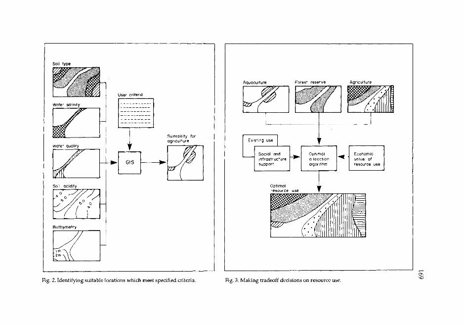
Soil type
User crlterlo
I Water sollnltv I
Water quallty
Sultab~l~ty for agriculture
Bathymetry ~p Fig. 2. Identifying suitable locations which meet specified criteria
Aquaculture Forest reserve Agriculture
mfrostructure olgorlthrn resource use
Fig. 3. Making tradeoff decisions on resource use.
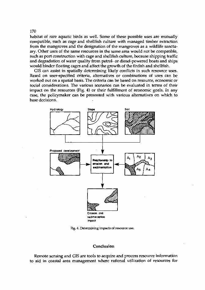
1 70 habitat of rare aquatic birds as well. Some of these possible uses are mutually compatible, such as cage and shellfish culture with managed timber extraction from the mangroves and the designation of the mangroves as a wildlife sanctu- ary. Other uses of the same resources in the same area would not be compatible, such as port construction with cage and shellfish culture, because shipping traffic and degradation of water quality from petrol- or diesel-powered boats and ships would hinder floating cages and affect the growth of the finfish and shellfish.
GIs can assist in spatially determining likely conflicts in such resource uses. Based on user-specified criteria, alternatives or combinations of uses can be worked out on a spatial basis. The criteria can be based on resource, economic or social considerations. The various scenarios can be evaluated in terms of their impact on the resources (Fig. 4) or their fulfillment of economic goals. In any case, the policymaker can be presented with various alternatives on which to base decisions.
Slow Soil
Erosion and sedimenlution impact
Fig. 4. Determining impacts of resource use.
Conclusion
Remote sensing and GIs are tools to acquire and process resource information to aid in coastal area management where rational utilization of resources for

171 long-term sustainability is of major concern. While resource assessment, plan- ning and management are possible even without these tools, such tasks are extremely tedious and time-consuming.
Notwithstanding the other major problem of information availability, spatial analyses are often avoided or minimized because of the difficulty in manual handling of the spatial data. Researchers and planners are generally more com- fortable with massive tables of nonspatial data. In resource analysis, planning and management, the spatial dimension is as important as, if not more important than, nonspatial statistics.
Remote sensing provides an additional source of resource information which can be supplied at greater frequency; while GIs facilitates the use of spatial in- formation in a more effective manner to aid in resource management. In coastal area management, different options for resource use can be made explicit based on various rationales through different combinations of criteria specified by the resource planner, manager or policymaker. The rapid development of remote sensing and GIs technology will, in the near future, make available a wider range of increasingly sophisticated software to deal with spatial data. Coupled with in- creasing expertise in the use of these tools, the prospects are good for more sound decisions to be made in coastal area management from the environmental, social and economic points of view.
Acknowledgment
The author wishes to thank the School of Biological Sciences, Universiti Sains Malaysia, for granting leave and permission to present this paper at this work- shop; and the Department of Fisheries (especially En Hambal Hanafi, Head of the Brackishwater Aquaculture Research Station at Gelang Patah) for the use of the SPOT satellite imagery over South Johor.
References
Blasco, F., F. Lavenu, M.U. Chaudury and Y. Ken. 1984. Mangrove forest resources and human activ- ities in the Ganges Delta (Bangladesh). SPOT Imagery Simulation-Coastal Studies. Sheet 0.C.3, GDTA, France.
Kapetsky, J. 1988. Land and water use planning for aquaculture development. TCP/MAL/6754. Draft Tech. Rep. Food and Agriculture Organization, Rome.

Artificial Reefs: A Practical Means to Enhance Living Marine Resources
M.W.R.N. DE SILVA Department of Fisheries
P.O. Box 2161 Bandar Seri Begawan 1921
Brunei Dancssalarn
SILVA, M.W.R.N. DE. 1989. Artificial reefs: a practical means to enhance living marine resources, p. 173-180. In T.-E. Chua and D. Pauly (eds.) Coastal area management in Southeast Asia: policies, management strategies and case studies. ICLARM Conference Proceedings 19,254 p. Ministry of Science, Technology and the Environment, Kuala Lumpur; Johor State Economic Planning Unit, Johore Bahru, Malaysia; and International Center for Living Aquatic Resources Management, Manila, Philippines.
Abstract
This paper discusses the importance of artificial reefs in attracting fish and other marine life and in increasing their local concentrations-especially with the growing demand for and overexploitation of marine resources. Coral and artificial reefs are compared. The latter's design and placement are re- viewed. Finally, research on these structures is underscored. Also emphasized is the need for proper monitoring of standing crop, yield, fishing effort and recruitment patterns of existing artificial r e e f s information on which rational management of the structures' resources can be made on a sustainable basis.
Introduction
Artificial reefs are structures constructed for habitat enhancement for marine life and shore protection, among other purposes. They may be made up of a vari- ety of materials ranging from discarded tires, granite rocks, wood, old car bodies, plastics, concrete to fiberglass. They exhibit varying life spans (Table I). Artificial reefs are credited to enhance the biological potential of the reef site (Turner el ai. 1969, Fast 1974, Yip and Chou 1987), although there are dissenting views. Gener- ally, fish and other marine organisms aggregate in the vicinity of underwater structures, artificial or natural. These underwater structures contribute to the enrichment of marine life by providing:
1. shaded shelter from strong currents and protection from predators;
173
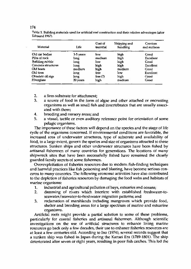
Table 1. Building materials used for artifiaal reef construction and their relative advantages (after Edmund 1967).
Material Cost of Shipping and Crevices
Life material handling and surfaces
Old car bodies Piles of rock Building rubble Concrete structures Old boats Old tires Obsolete oil rigs Fiberglass
3-5 years long long long medium long long 20 years
low medium low high high free free (?) high
high high high high medium low high medium
Good Excellent Good Excellent Good Excellent Good Good
2. a firm substrate for attachment; 3. a source of food in the form of algae and other attached or encrusting
organisms as well as small fish and invertebrates that are usually associ- ated with them;
4. breeding and nursery areas; and 5. a visual, tactile or even auditory reference point for orientation of some
pelagic organisms. The importance of these factors will depend on the species and the stage of life
cycle of the organisms concerned. If environmental conditions are favorable, the increased area of underwater structures, type of substrate and availability of food, to a large extent, govern the species and size of organisms attracted to these structures. Sunken ships and other underwater structures have been fished by artisanal fishermen of many countries for generations. The locations of many shipwreck sites that have been successfully fished have remained the closely guarded family secrets of some fishermen.
Overexploitation of fisheries resources due to modem fish-finding techniques and harmful practices like fish poisoning and blasting, have become serious con- cerns to many countries. The following economic activities have also contributed to the depletion of fisheries resources by damaging the food webs and habitats of marine organisms:
1. industrial and agricultural pollution of bays, estuaries and oceans; 2. damming of rivers which interfere with established freshwater-to-
seawater/seawater-to-freshwater migration patterns; and 3. reclamation of marshlands including mangroves which provide food,
shelter and breeding areas for a large spectrum of marine and estuarine organisms.
Artificial reefs might provide a partial solution to some of these problems, particularly for coastal fisheries and artisanal fishermen. Although scientific investigations on the use of artificial structures to enhance living marine resources go back only a few decades, their use to enhance fisheries resources are at least a few centuries old. According to Ino (1974), several records suggest that a sunken ship was fished in Japan during the Kansei Era (1789-1801). The ship deteriorated after seven or eight years, resulting in poor fish catches. This led the
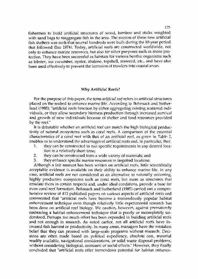
175
fishermen to build artificial structures of wood, bamboo and sticks weighted with sand bags to reaggregate fish in the area. The success of these new artificial fish shelters was such that several hundreds were built during the 10-year period that followed (Ino 1974). Today, artificial reefs are constructed worldwide, not only to enhance marine resources, but also for other purposes such as shore pro- tection. They have been successful as habitats for various benthic organisms such as lobster, sea cucumber, oyster, abalone, topshell, seaweed, etc., and have also been used effectively to prevent the intrusion of trawlers into coastal areas.
Why Artificial Reefs?
For the purpose of this paper, the term artificial reef refers to artificial structures placed on the seabed to enhance marine life. According to Bohnsack and Suther- land (1985), "artificial reefs function by either aggregating existing scattered indi- viduals, or they allow secondary biomass production through increased survival and growth of new individuals because of shelter and food resources provided by the reef."
It is debatable whether an artificial reef can match the high biological produc- tivity of natural ecosystems such as coral reefs. A comparison of the essential characteristics of a coral reef with that of an artificial reef, as given in Table 2, enables us to understand the advantages of artificial reefs and, in particular, that:
1. they can be constructed to suit specific requirements in any desired loca- tion in a relatively short time;
2. they can be constructed from a wide variety of materials; and 3. they enhance specific marine resources in targetted locations. Although a fair amount has been written on artificial reefs, little scientifically
acceptable evidence is available on their ability to enhance marine life. In any case, artificial reefs are not considered as an alternative to naturally occurring, highly productive ecosystems such as coral reefs, but more as structures that emulate them in certain respects and, under ideal conditions, provide a base for even coral reef formation. Bohnsack and Sutherland (1985) carried out a compre- hensive review of 413 published papers on various aspects of artificial reefs and commented that "artificial reefs have become a tremendously popular habitat enhancement technique even though relatively little experimental research has been done on artificial reef biology. We caution, however, against prematurely embracing a habitat enhancement technique that is poorly or incompletely un- derstood. Perhaps too much effort has been expended in building artificial reefs and not enough in research. As noted earlier, not all artificial reefs have in- creased fish harvest or productivity. In many areas, managers have the mistaken belief that they can proceed with large-scale programs without research. Deci- sions are often made based on political expediency, absolute cost, material readily available, navigational considerations, or solid waste disposal problems, without considering biological, economic or social effects." However, they finally concluded that "artificial reefs offer tremendous potential for habitat enhance-
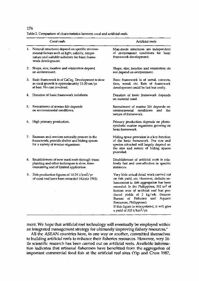
1 76 Table 2. Comparison of characteristics between coral and artificial reefs.
Coral reefs Artificial reefs
Natural structures depend on specific environ- mental factors such as light, salinity, tempe- rature and suitable substrate for basic frame- work development.
Shape, size, location and orientation depend on environment.
Basic framework is of CaCo3. Development is slow as coral growth is approximately 1520 an/yr at best. No cost involved.
Duration of basic framework indefinite.
Recruitment of marine life depends on environmental conditions.
High primary production.
Recesses and crevices naturally present in the framework; provide shelter and hiding spaces for a variety of marine organisms.
Establishment of new coral reds through trans planting and other techniques is slow, time- consuming and of limited application.
Fish production figures of 1@24 t/km2/yr of coral reef have been recorded (Alcala 1981).
Man-made structures are independent of environment conditions for basic framework development.
Shape, size, location and orientation do not depend on environment.
Basic framework is of metal, concrete, tires, wood, etc. Rate of framework development could be fast but costly.
Duration of basic framework depends on material used.
Recruitment of marine life depends on environmental conditions and the nature of framework.
Primary production depends on photo- synthetic marine organisms growing on basic framework.
Hiding space provision is a key function of the basic framework. The size and species attracted will largely depend on the size and nature of hiding spaces provided.
Establishment of artificial reefs is rela- tively fast and cost-effective in specific instances.
Very little actual detail work carried out on fish yield, etc. However, definite en- hancement in fish aggregation has been recorded. In the Philippines, 312 m2 of bottom area of artificial reef has pro- duced yields of 2 kg/wk. (Source: Bureau of Fisheries and Aquatic Resources, Philippines). If this figure is extrapolated, it will give a yield of 333 t /kd/yr .
ment. We hope that artificial reef technology will eventually be employed within an integrated management strategy for ultimately improving fishery resources."
All the ASEAN countries have, in one way or another, committed themselves to building artificial reefs to enhance their fisheries resources. However, very lit- tle scientific research has been carried out on artificial reefs. Available informa- tion indicates that artisanal fishermen have benefitted from the aggregation of important commercial food fish at the artificial reef sites (Yip and Chou 1987,

177 Munro and Polovina 1984, Jothy 1982, Rashid 1982, Alcala 1979), but little quan- titative data are available to substantiate these claims. Groupers (Serranidae), snappers (Lutjanidae) and rabbitfish (Siganidae) are some of the commercially important fish that have been attracted to these artificial reefs. Because of the steady food supply in the form of smaller fish, some pelagic fish such as scom- brids and carangids, tend to aggregate in the vicinity of artificial reefs. A tire reef of 1,500 m3 constructed by the Bureau of Fisheries and Aquatic Resources (BFAR), Department of Agriculture, Philippines, in Calubcub 11, San Juan, Batangas, recruited 41 commercially important species representing 50% of the total species recorded for the area. Fish catches totalling almost 700 kg in 237 fishing operations in 10 months had also been registered. BFAR has also recorded fish yields of 2 kg/week from a tire reef which occupied 312 krn2 bot- tom area off Dumaguete. Table 3 presents information gathered by Alcala (1979) and the Silliman University Marine Laboratory in 1985-1986 on the estimated standing stocks of harvestable fish on artificial reefs in Central Visayas.
Table 3. Estimated standing stocks of harvestable fish in artificial reefs in the Central Visayas, Philippines. Preliminary data were gathered in 1979,1985 and 1986.~
Locality (Province)
Standing stock Reef volume Reef &g/1.3 m3) (m3) material
Bantayan, Dumaguete (Negros Oriental)
Tire
Bantayan, Dumaguete (Negros Oriental)
Bamboo; tire
Sumaliring, Siaton (Negros Oriental)
Bamboo
Cdag-calag, Ayungon (Negros Oriental)
Bamboo
Bagakay, Talibon (Bohol)
Bamboo
Tohpos, E. Villanueva (Siquijor)
Bamboo
Badian (Cebu) Bamboo
aAfter Alcala (1979) and from unpublished data from Silliman University Marine Laboratory.
Fishing trials carried out by the Department of Fisheries, Thailand, on the arti- ficial reefs at Rayong and Phuket using traps, hooks and lines indicate that the reefs were rapidly colonized by an assemblage of adult and juvenile commercial fish species (Munro and Polovina 1984). The bulk of the landed fish was groupers and snappers, while some pelagics (Scombridae and Carangidae) were caught on hook and line.

178 Visual assessments and preliminary fishing trials carried out by the Depart-
ment of Fisheries, Brunei Darussalam, on an artificial tire reef constructed of 9,394 tires in the Two Fathom Rock area, produced encouraging results. A fishing trial on 13 September 1987, using hook and line, landed 78 barracuda weighing 22 kg. Table 4 gives the results of catch statistics of two fish traps deployed on a 25 m x 25 m area of the seabed covered by approximately 40% of tires during three-week-long trials. A control trap kept on the sandy seabed approximately 50 m from the tire reef failed to catch fish during the trial periods. The trials carried out are exploratory and preliminary; many more trials with a statistically accept- able number of traps and sampling plots will be necessary to obtain meaningful results and formulate a strategy to manage the reefs at a sustainable level. Nev- ertheless, the average catch rate of 12.1 kg per trap and the high percentage
Table 4. Weekly catch results in two fish traps placed within an area of 25 m x 25 m covered by 40% twes on the artificial tire reel at Two Fathom Rock, Brunei ~arussalam'~
Weight of fish to nearest 0.5 kg % of Species and grade Trial I Trial I1 Trial 111 Subtotal total
Trap 1 Trap 2 Trap 1 Trap 2 Trap 1 Trap 2 catch
Grade 1
Serra~dae Epnephelus spp. 1.50 6.10 1 .50 3.50 12.60 Plectmpomus spp. - 4 50 4.50
Lutjanidae C m w spp. 0.70 0.70 0.80 2.20 Luganus spp. 3.20 050 0.20 3.90
Slganidae Siganus spp. 0.30 2.70 0.70 0.65 1 .00 5.35
Lethrinidae Lethrinus sp.
Centropomidae Lntes sp. 0.25 0.25
Subtotal 5.70 15.00 3.95 2.35 5.40 32.40 44.5
Grade I1
Pomadasyidae Plectorhynchus spp. 0.30 1.50 2.20 4.00
Nemiptendae Scolopsis sp. 0.40 0.40
Subtotal 0.30 1 90 2.20 4.40 6 0
Grade I11
Pomacanthidae Porncanthus sp. 0.30 0.30
Subtotal 0.30 0.30 05
Grade IV
Sharks 1950 7.00 9.00 35.50
Subtotal 19 50 700 9.00 35.50 49.0
Total 6.00 15.00 6.15 24.05 12.40 9.00 72.64
aImtially, 5 traps had been deployed, but 3 were damaged and the fish escaped.

179 (44.5%) of quality fish in the catch show the reef's potential to enhance the fishery of the area.
Sheehy and Vik (1982) reported that obsolete oil platforms used in building artificial reefs in Florida, USA, enhanced fish stocks and encrusting marine life. Investigations carried out during Phase I of the ASEAN/US Coastal Resources Management Project in Brunei Darussalam indicated that underwater structures associated with oil platforms could harbor a fairly diverse fish and invertebrate community (Chou and White 1987). Two redundant oil rigs, SWA-58 and SWA- 45, 53 m and 46 m in length, respectively, provided by the Brunei Shell Petroleum Company Sendirian Berhad (BSP) to the Fisheries Department were placed horizontally on the seabed at Two Fathom Rock on 28 August 1988. This formed Brunei Darussalam's and probably the region's first artificial reef made of redundant oil rigs. These two oil ri s on the seabed provided an instant artificial 9 reef with a volume of over 1,500 m . Studies on the recruitment of fish and other organisms to this structure are planned for the future.
Design and Placement
Bohnsack and Sutherland (1985) have reviewed the information available on reef design and placement. Although there are no general rules, the following parameters must be carefully considered in design and placement:
1. the amount of reef material deposited and the amount of bottom area covered;
2. the vertical relief; 3. the reefs complexity (design, spatial arrangement, number of chambers
and openings and the amount of interstitial spaces); 4. the texture and composition of reef material; 5. the orientation in relation to fish migration patterns and currents; and 6. the location.
Conclusion
Although there is a dearth of scientific data on the ability of artificial reefs to actually increase the biomass of living marine resources, there is circumstantial evidence of their ability to do so under certain conditions. There is an urgent need for scientific research to provide essential technical, biological and socio- economic information to policymakers. The need for proper monitoring of stand- ing crop, yield, fishing effort and recruitment patterns of existing artificial reefs cannot be overemphasized. The rational management of artificial reef resources on a sustainable basis will depend on the results of such monitoring. This is particularly important in view of the possible role of these structures in actually fostering overexploitation of fishery resources.

180 Acknowledgments
I wish to thank Mr. Matdanan Haji Jaafar, Director of Fisheries, for his support and encouragement; Pengiran Sharifuddin Pengiran Haji Yusof, Deputy Director of Fisheries, for critically reviewing the first draft of this contribution; Mr. James Paw and Dr. Chou Loke Ming, for help received during the preparation of this paper.
References
Alcala, A.C. 1979. Fish standing stock and yield of an artifiaal reef off Bantayan, Dumaguete City, Philippines. Silliman J. 26(4): 25S262.
Alcala, A.C. 1981. Fish yield of coral reefs of Sumilon Island, Central Philippines. Nat. Resour. Counc. Philipp. R e . Bull. 36(1): 1-7.
Bohnsack, J.A. and D.L. Sutherland. 1985. Artificial reef research: a review with recommendations for ture priorities. Bull. Mar. Sci. 37(1): 11-39.
ou, L.M. and A.T. White. 1987. Artificial habitats, p. 60.63. In T.-E. Chua, L.M. Chou and M.S.M. a." Sadorra (eds.) The coastal environmental profile of Brunei Darussalam: resource assessment and management issues. International Center for Living Aquatic Resources Management, Manila, Philippines.
Edmund, N.W. 1967. Old tires: the ideal material for building fish havens. Edmund Scientific Co., New Jersey.
Fast, D.E. 1974. Comparative studies of fish species and their population on artifiaal and natural reefs off southeastern Puerto Rico. University of Puerto Rico, Mayaguez. 90 p. M.S.thesis.
Ino, T. 1974. Historical review of artifiaal reef activities in Japan, p. 21-23. In L. Colunga and R. Stone (eds.) Proceedings of the Artifiaal Reef Conference. Texas A and M University.
Jothy, A.A. 1982. A step towards alleviating the problem of declining fish resources in Malaysian coastal waters, p. 77-81. In Proceedings of the First Marine Science Conference. Malaysian Society of Marine Science, Penang.
M w o , J.L. and J.J. Polovina. 1984. Artificial reef project - Thailand. Report of Consultancy Mission, 24 November - 14 December 1984.
Rashid, R. 1982. The biogenesis of artifiaal reefs, p. 17-20. In J.K. Charles (ed.) Proceedings of the Fourth Annual Seminar: the status and conservation of shallow-water ecosystems in Malaysia. Malaysian Society of Marine Science, Penang.
Sheehy, D.J. and S.F. Vik. 1982. Artificial reefs - a second life for offshore platforms. Pet. Eng. Int: (May): 40-50.
Turner, C.H., E.E. Ebert and R.R. Given. 1969. Man-made reef ecology. Fish. Bull. Calif. Dep. Fish. Game 146.
Yip, W.K. and L.M. Chou. 1987. Man-made reefs. Trop. Coast. Area Manage. 2(3): 5-6.
Information Needs for Coastal Resources Management
RAFAEL D. GUERRERO I11 Philippine Council for Aquatic and Marine
Research and Development Los Bafios, Lagum, Philippines
GUERRERO 111, R.D. 1989. Information needs for coastal resources management, p. 181-183. In T.-E. Chua and D. Pauly (eds.) Coastal area management in Southeast Asia: policies, management strategies and case studies. ICLAW Conference Proceedings 19, 254 p. Ministry of Science, Technology and the Environment, Kuala Lumpur; Johor State Economic Planning Unit, Johore Bahru, Malaysia; and International Center for Living Aquatic Resources Management, Manila, Philippines.
Abstract
Successful coastal resources management (CRM) needs the following information: (1) field data, i.e., baseline information; (2) information relevant to plan formulation; (3) information relevant to policy formulation and implementation; and (4) information for public education. This paper discusses the interactions of these four types.
Introduction
Information is the basic foundation of any management plan. The availability of the right information for a specific need or purpose is essential for national and comprehensive planning. Errors in or lack of information can lead to faulty programs and even disasters.
CRM is a complex activity involving not only many sectors of society but also various types of resources that need to be conserved and/or utilized in sustain- able fashion. According to Linsky (1979), coastal management requires decisions based on the best available information regarding resource allocations. These decisions are data- and information-dependent and thus, require the input of scientists, planners and administrators.
In the formulation of a CRM plan, scientific data are needed in all aspects of the process. The plan is regarded as a state-of-the-art document containing the best information available at the time of its preparation (Clark 1985). After the plan is prepared, it is implemented through government policy guidelines and
181
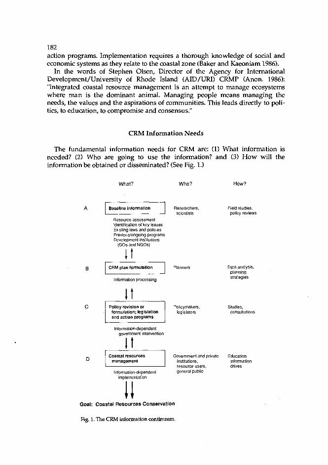
182 action programs. Implementation requires a thorough knowledge of social and economic systems as they reIate to the coastal zone (Baker and Kaeoniam 1986).
In the words of Stephen Olsen, Director of the Agency for International Development/University of Rhode Island (AID/URI) CRMP (Anon. 1986): "Integrated coastal resource management is an attempt to manage ecosystems where man is the dominant animal. Managing people means managing the needs, the values and the aspirations of communities. This leads directly to poli- tics, to education, to compromise and consensus."
CRM Information Needs
The fundamental information needs for CRM are: (1) What information is needed? (2) Who are going to use the information? and (3) How will the information be obtained or disseminated? (See Fig. 1.)
What?
Resource assessment ldentif~cation of key issues Existing laws and policies Previous/ongoing programs Development institutions
(GOs and NGOs)
I t
A Baseline information 1
Who?
Researchers, scientists
B Planners CRM plan formulation
How?
Information processing
Field studies, policy reviews
Data analysis, planning strategies
Policymakers, legislators
c Studies. consultations
Policy revision or formulation; legislation and action programs
Information-dependent government intervention
I Coastal resources management I Information-dependent
implementation
Government and private Education institutions, information resource users, drives general public
Goal: Coastal Resources Conservation
Fig. 1. The CRM information continuum.
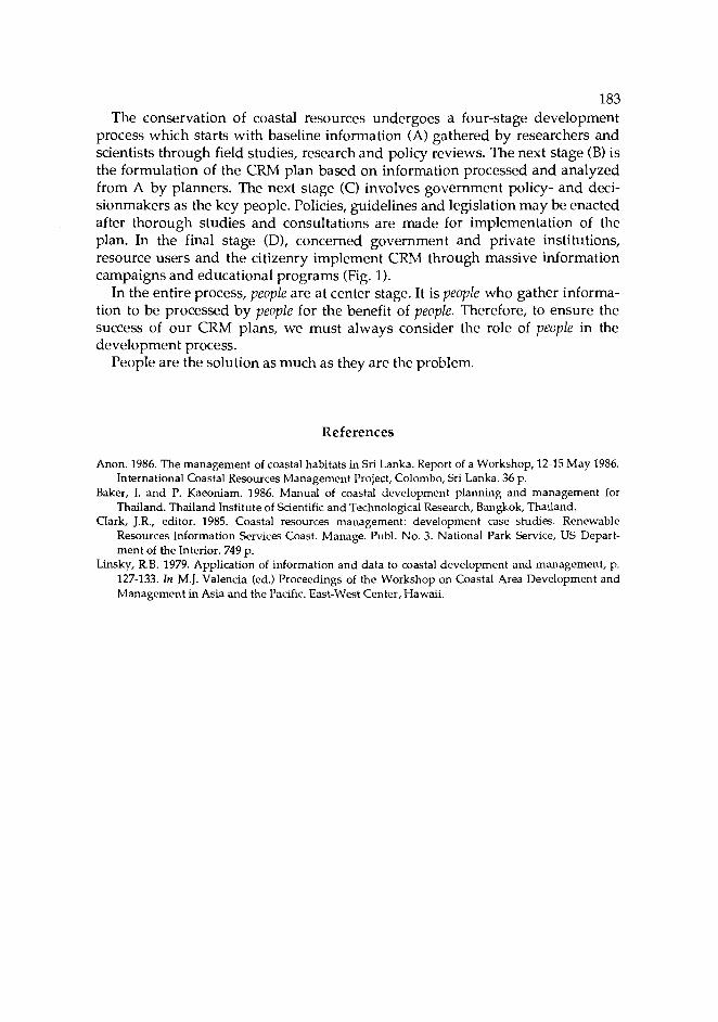
183 The conservation of coastal resources undergoes a four-stage development
process which starts with baseline information (A) gathered by researchers and scientists through field studies, research and policy reviews. The next stage (B) is the formulation of the CRM plan based on information processed and analyzed from A by planners. The next stage (C) involves government policy- and deci- sionmakers as the key people. Policies, guidelines and legislation may be enacted after thorough studies and consultations are made for implementation of the plan. In the final stage (D), concerned government and private institutions, resource users and the citizenry implement CRM through massive information campaigns and educational programs (Fig. 1).
In the entire process, people are at center stage. It is people who gather informa- tion to be processed by people for the benefit of people. Therefore, to ensure the success of our CRM plans, we must always consider the role of people in the development process.
People are the solution as much as they are the problem.
References
Anon. 1986. The management of coastal habitats in Sri Lanka. Report of a Workshop, 12-15 May 1986. International Coastal Resources Management Project, Colombo, Sri Lanka. 36 p.
Baker, I. and P. Kaeoniam. 1986. ~ a n u 3 of coastal development planning and management for Thailand. Thailand Institute of Scientific and Technological Research, Bangkok, Thailand.
Clark, J.R., editor. 1985. Coastal resources management: development case studies. Renewable Resources Information Services Coast. Manage. Publ. No. 3. National Park Service, US Depart- ment of the Interior. 749 p.
Linsky, R.B. 1979. ~ ~ ~ l i c a t i o n of information and data to coastal development and management, p. 127-133. In M.J. Valencia (ed.) Proceedings of the Workshop on Coastal Area Development and Management in Asia and the Pacific. East-West Center, Hawaii.

Community-based Resources Management: The Experience of the Central Visayas Regional Project-I
JESUS C. ALIX Central Visayas Regional Projects Ofice
HVG Arcade, Subangdaku Mandaue City, Cebu, Philippines
ALIX, J.C. 1989. Community-based resources management: the experience of the Central Visayas Regional Project-I, p. 185-190. In T.-E. Chua and D. Pauly (eds.) Coastal area management in Southeast Asia: policies, management strategies and case studies. ICLARM Conference Proceed- ings 19, 254 p. Ministry of Science, Technology and the Environment, Kuala Lumpur; Johor State Economic Planning Unit, Johore Bahru, Malaysia; and International Center for Living Aquatic Resources Management, Manila, Philippines.
Abstract
This paper is the text for an audiovisual presentation which describes how the Central Visayas Regional Project (CVRP)-I in Cebu, Philippines, used community-based resources management methods to address the problems of declining productivity and resource degradation in the uplands and in coastal waters.
Introduction
Cebu City is the capital of the Central Visayas Region and the site of the first Spanish settlements in the Philippines. It is a commercial and cultural center. In the sixteenth century, the Spaniards introduced corn culture from Mexico. Most Visayans still prefer to eat ground corn rather than rice. The region's hilly land- scape, however, provides few lowland areas suited to corn farming.
Over 300 years of Spanish settlement and rapid population growth following World War I1 resulted in near total deforestation of the Central Visayas and extensive corn farming on very steep slopes. The resulting erosion has stripped the slopes of their precious top soil. Harvests and farm incomes have been steadily declining. Rapid rainfall runoff from bare slopes has increased the frequency and intensity of floods and deposited vast quantities of silt on the once productive coral reefs.
185

186 Declining farm incomes have encouraged more people to turn to fishing to
support their growing families. As a result, the vast coastal fishery resource once thought to be inexhaustible has come under steadily increasing pressure.
Living corals from reefs have been collected as souvenirs and for use in construction and handicrafts. Explosives have been used extensively to harvest reefs; as have cyanide and the muro-ami drive-in net, the scareline weights of which destroy coral.
The region's mangrove forests have been overharvested for firewood and building materials. Over 7,000 ha of these mangroves have been converted into brackishwater fishponds which, in the Central Visayas, are all too often unpro- ductive. This unregulated exploitation and destruction of important coastal fish- ery habitats has depleted stocks of spawning fish and degraded their nursery grounds. This, in turn, has reduced the number of young fish entering the fish- ery.
Too many fishermen, both commercial and artisanal, using any and all meth- ods, including fine-mesh nets, harvest fish and other marine life of smaller and smaller sizes. Harvesting fish before they have had a chance to grow to a reason- able size reduces the total harvest. Overfishing has been the downfall of fisheries development programs which have stressed more expensive and efficient gear for more fishermen in declining fisheries.
The unmanaged use of a common resource leads to the abuse of that resource. This is the "tragedy of the commons" and many shallow water fishing areas have been abandoned as no longer productive. Fishermen are forced to go farther and farther from shore and to spend more time and money in search of fish to catch. As a result, many Filipino fishermen have joined the poorest of the poor.
The Central Visayas Regional Project-I
CVRP-I began in 1984 to address the problems of declining productivity and resource degradation in the uplands and in coastal waters using community- based resources management methods in a watershed management approach. The regional nature of the project stresses the need to decentralize government decisionmaking to make it more responsive to the real needs of the people.
CVRP-I recognized from the outset that farmers and fishermen are the real day-to-day managers of their productive resources. They, not the government, make the daily decisions about resource use. They must agree with any proposed changes in resource management as they would be the ones to implement those changes.
Project staff live in the community, no matter how remote, because effective change agents must be a part of the community, not occasional visitors. In addi- tion to the farmers and fishermen, resource managers, the local government, government line agencies and nongovernment organizations (NGOs) must play important support roles in the development process.
CVRP-I is active at five nearshore fisheries sites encompassing 223 km of Central Visayas coastline. Organization starts at the barangay (village) level as the

187 staff assist the community to identify and prioritize needs, aspirations and con- straints to development. Through a series of formal and informal meetings, they develop a barangay profile. The Barangay Development Council is activated and its membership broadened to include all sectors of the community in planning the development process.
High on the list of priorities of every fishing community is the need to increase the disposable income of fishing families. CVRP-I assists with simple, appropri- ate technologies designed to help the community develop and implement a coastal fisheries management system.
Approach and Management
Artificial reefs have proven to be an excellent entry point into the community because the fishermen are directly involved in their construction and placement, and results are quickly apparent. They used bamboo to construct the artificial reefs because it is readily available and familiar. The project provided a simple design which fishermen could construct and place with available tools and boats. The project supplied materials while the fishermen contributed their labor. On their own, the fishermen modified the original design by enlarging modules and increasing the reef volume per bamboo pole used. This decreased the time required for construction and placement.
Artificial reefs provide an immediate three-dimensional structure on the seafloor which attracts reef-associated fish of all sizes, especially fry and finger- lings. These tiny fish find shelter and grow rapidly to the harvestable size.
Sustainable harvests of 10 kg/week from a family-managed artificial reef cluster of 65 m3 are being recorded. The equivalent of 26,000 of the original module or more than 34,000 m3 of bamboo artificial reefs have been constructed and placed by fishermen along 65 km of coastline at CVRP-I sites. Family man- agement of individual artificial reef clusters regulates harvest to prevent over- fishing of the reef system.
While bamboo is an excellent artificial reef material for artisanal fishermen, it rots away within four years and needs to be replaced. A bamboo-reinforced con- crete artificial reef module has been developed to provide a more permanent structure. Although it is more complex to construct, costs are similar and the job can still be done entirely by the fishermen themselves.
Artificial reefs are placed close to shore and represent a low-cost fishing opportunity, especially when harvested with hook-and-line fish traps. In addi- tion to reestablishing a shallow water reef fishery and drawing large pelagic species close to shore again, artificial reefs of this kind demonstrate to fishermen that they themselves can do something to improve their shallow water fishery, a resource many believed had been lost forever.
Mangroves are recognized by most coastal residents as a valuable source of food, building materials and protection from storm-driven wind and waves.
Coastal residents are eager to plant but they lack planting materials and are concerned about their security of tenure over areas they might reforest. CVRP-I

188 provides seedlings and instructions on planning and management of the refor- ested area. The Forest Management Sector of the Department of Environment and Natural Resources surveys individual plots and issues a Stewardship Con- tract or 25-year renewable lease agreement over the reforested area. Under this contract, the person who plants the area is required to manage it to maintain permanent forest cover, but may also engage in selective, sustained yield harvest.
With the project providing planting material and the government assuring security of tenure, coastal residents have reforested more than 650 ha of tidal flats at four project sites. The project is also encouraging sea ranching and farm- ing of traditional mangrove species in reforested areas to bolster income and interest.
Extensive community education on CRM combined with organization of com- posite law enforcement teams helps minimize abuses against the coastal envi- ronment and prevents illegal fishing.
Coral reef management and the establishment of reef sanctuaries are difficult to implement because fishermen are usually reluctant to give up existing fishing grounds for a sanctuary. However, the clear relationship between habitat and fish demonstrated by artificial reefs and the growing confidence of CVRP-I con- vinced communities that they can improve seriously depleted coastal resources through their own efforts. Many other communities were also encouraged to begin coral reef management.
They also learned of the Sumilon Island (Oslob, Cebu) experience where the reef fish catch doubled over five years after 17% of the island's reef area was closed to fishing in 1978. Their interest was strengthened when they visited Apo Island (Dauin, Negros Oriental) where residents have been actively protecting their coral resotirce and managing a reef sanctuary since 1985. Fishermen telling other fishermen about how coral reef management has improved their livelihood is an effective extension technique. Apo residents patrol and protect the coral reefs that form the basis for their productive reef fishery. They do so with the solid backing of the municipal and provincial governments. To date, 11 marine sanctuaries have been established at four CVRP-I sites; 37 more are planned.
By allowing the redevelopment of healthy coral reefs and of reef fish breeding populations within the sanctuary, fish reproduction increases, and new recruits grow undisturbed.
The talarok is a form of payao, a deepwater fish attracting device (FAD). When used by commercial fishing boats with surrounding nets which catch everything, payao contribute to growth overfishing. However, if deepwater FADS are placed 2-4 km from shore, within municipal waters easily reached by paddle or sail- driven banca, and if the fish are harvested only by handline at a rate approxi- mating the growth of the school of fish attracted, they can provide a low over- head, high profit and sustainable fishing opportunity for canoe fishermen.
As fishermen begin to work together to protect and rebuild the coastal envi- ronment, they create a situation which allows safe small-scale sea ranching and farming in addition to the traditional slipper oyster and green mussel culture techniques being developed for rearing a wide variety of valuable native species including giant clams, abalone and black-and-brown-lipped oysters, to mention a

189 few. These species require only a small area of shallow water to produce signifi- cant new income for a fishing family.
Strengthening local government and national line agencies is an integral part of CVRP-I. While farmers and fishermen are the primary implementors of rural development, the local government needs to develop skills and experience in coordinating those efforts. Similarly, government line agencies must provide technical support to the community for a whole range of new resources man- agement techniques.
Although the community-based resources management program being devel- oped under CVRP-I has received positive responses from fishermen, a number of problems remain which can only be solved by the national government. The biggest problem is the need for a revised regulatory system to legally protect investments made by individuals and communities in artificial reefs, sea ranches and farms, municipal marine sanctuaries and FADS. Issuance of permits and licenses must be decentralized to make the system more responsive to local needs.
In addition, new laws are needed to give substance to the provision of the 1987 Philippine Constitution which gives priority to subsistence fishermen in munici- pal waters where competition between commercial and subsistence fishermen is especially severe. Finally, the national government must address the continued illegal conversion of mangroves to brackishwater fishponds and the well- organized and well-protected bands of dynamite and cyanide fishermen.
Conclusion
In summary, CVRP-I is working with fishermen to develop a comprehensive, community-based approach to CRM. The approach employs the people, the real managers of the resources, as implementors. It seeks to establish effective com- munity control over the now abused common resource. The process is taken step by step, with each addressing specific aspects of the overfishing problems and preparing the way for the next step until the transition from a community of hunters abusing a commons to ranchers and farmers carefully managing their productive resources is complete.
Habitat management, in the form of mangrove reforestation, artificial reefs and coral reef management, addresses the problem of recruitment overfishing by helping to re-establish breeding stocks and improving spawning and nursery grounds. Harvest management, through sea ranching, talarok, reef sanctuaries and managed artificial reef clusters, addresses the problem of growth overfishing and eventually must be extended to the entire capture fisheries.
The CVRP-I approach has been warmly accepted by fishermen in the Central Visayas as evidenced by the progress in CRM to date at the project. The region's provincial governments, line agencies and even NGOs working in rural devel- opment have adopted the approach.

190 The ancient Chinese philosopher Lao Tse said:
Give a man a fish and he will eat for a day. Teach a man to fish and he will eat for a lifetime.
While this is most valuable advice, fishermen at CVRP-I sites modernized this proverb:
Give a man a fish and he will eat for a day. Teach a man to fish and he will eat until the resource is depleted. Teach a community to manage its fishery resources and it will prosper for generations to come.
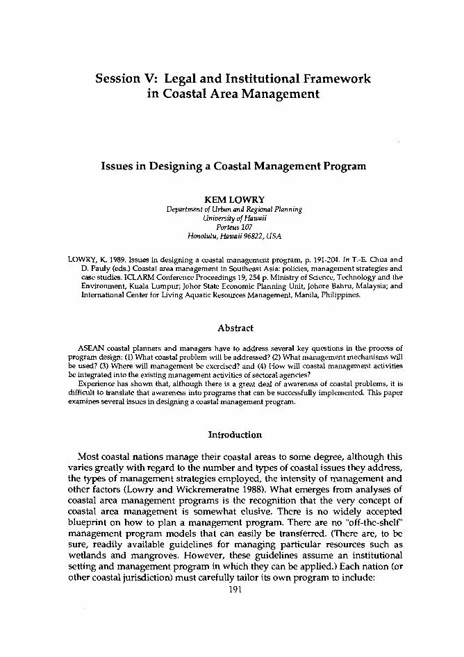
Session V: Legal and Institutional Framework in Coastal Area Management
Issues in Designing a Coastal Management Program
KEM LOWRY Department of Urban and Regional Planning
University of Hawaii Porteus lo7
Honolulu, Hawaii 96822, USA
LOWRY, K. 1989. Issues in designing a coastal management program, p. 191-204. In T.-E. Chua and D. Pauly (eds.) Coastal area management in Southeast Asia: policies, management strategies and case studies. ICLARM Conference Proceedings 19,254 p. Ministry of Science, Technology and the Environment, Kuala Lumpur; Johor State Economic Planning Unit, Johore Bahru, Malaysia; and International Center for Living Aquatic Resources Management, Manila, Philippines.
Abstract
ASEAN coastal planners and managers have to address several key questions in the process of program design: (1) What coastal problem will be addressed? (2) What management mechanisms will be used? (3) Where will management be exercised? and (4) How will coastal management activities be integrated into the existing management activities of sectoral agenaes?
Experience has shown that, although there is a great deal of awareness of coastal problems, it is difficult to translate that awareness into programs that can be successfully implemented. This paper examines several issues in designing a coastal management program.
Introduction
Most coastal nations manage their coastal areas to some degree, although this varies greatly with regard to the number and types of coastal issues they address, the types of management strategies employed, the intensity of management and other factors (Lowry and Wickremeratne 1988). What emerges from analyses of coastal area management programs is the recognition that the very concept of coastal area management is somewhat elusive. There is no widely accepted blueprint on how to plan a management program. There are no "off-the-shelf" management program models that can easily be transferred. (There are, to be sure, readily available guidelines for managing particular resources such as wetlands and mangroves. However, these guidelines assume an institutional setting and management program in which they can be applied.) Each nation (or other coastal jurisdiction) must carefully tailor its own program to include:
191
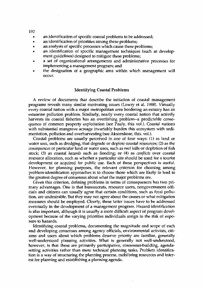
192 an identification of specific coastal problems to be addressed; an identification of priorities among these problems; an analysis of specific processes which cause these problems; an identification of specific management techniques (such as develop- ment guidelines) designed to mitigate these problems; a set of organizational arrangements and administrative processes for implementing a management program; and the designation of a geographic area within which management will occur.
Identifying Coastal Problems
A review of documents that describe the initiation of coastal management programs reveals many similar motivating issues (Lowry et al. 1988). Virtually every coastal nation with a major metropolitan area bordering an estuary has an estuarine pollution problem. Similarly, nearly every coastal nation that actively harvests its coastal fisheries has an overfishing problem--a predictable conse- quence of common property exploitation (see Pauly, this vol.). Coastal nations with substantial mangrove acreage invariably burden this ecosystem with sedi- mentation, pollution and overharvesting (see Aksornkoae, this. vol.).
Coastal problems are usually perceived in one of four ways: (1) as land or water uses, such as dredging, that degrade or deplete coastal resources; (2) as the consequences of particular land or water uses, such as reef kills or depletion of fish stock; (3) as coastal hazards such as flooding; or (4) as conflicts over coastal resource allocation, such as whether a particular site should be used for a tourist development or acquired for public use. Each of these perspectives is useful. However, for planning purposes, the relevant criterion for choosing among problem-identification approaches is to choose those which are likely to lead to the greatest degree of consensus about what the major problems are.
Given this criterion, defining problems in terms of consequences has two pri- mary advantages. One is that bureaucrats, resource users, nongovernment offi- cials and citizens can usually agree that certain conditions, such as fecal pollu- tion, are undesirable. But they may not agree about the causes or what mitigation measures should be employed. Clearly, these latter issues have to be addressed eventually in the development of a management program. Hazard identification is also important, although it is usually a more difficult aspect of program devel- opment because of the varying priorities individuals assign to the risk of expo- sure to hazards.
Identifying coastal problems, documenting the magnitude and scope of each and developing consensus among agency officials, environmental activists, citi- zens and users about which problems deserve priority are familiar, generally well-understood planning activities. What is generally not well-understood, however, is that these are primarily participative, consensus-building, agenda- setting activities rather than mere technical planning tasks. Problem identifica- tion is a way of structuring the planning process, mobilizing resources and inter- est for planning and establishing a planning agenda.

193 Establishing Priorities
Most countries do not have the technical or financial resources to address all coastal problems. Planning and management priorities have to be established. This seems simple enough: a few criteria are developed and applied to the list of coastal problems. Those criteria might include the scope of the problem (measured in miles of coastline, number of people affected or some similar indi- cator) or magnitude of effect (measured in the rate of change in some key indi- cators such as lost revenues, fish stocks, habitat destruction or incidence of hep- atitis among coastal populations).
In practice, establishing priorities is complicated because of: inter-agency disputes about the magnitude and severity of problems; differences over priorities among national and provincial officials; the political importance and visibility of some otherwise "minor" prob- lems; and the widespread acceptance of some adverse coastal conditions as the inevitable costs of development.
Coastal planners can deal with these issues by recognizing that establishing priorities involves negotiation as well as technical analysis. It does not mean ignoring certain problems. It may simply mean that some problems will have to be addressed later in the development of a management program. For example, Sri Lanka's coastal plan emphasizes coastal erosion management, but explicitly indicates that other problems will be more fully addressed in subsequent itera- tions of the plan.
Analysis
Identifying land and/or water use activities causing coastal problems is a major part of the technical analysis associated with coastal management program development. Of course, the purpose of this is to identify aspects of the causal process that lend themselves to intervention.
General links among many coastal problems and causal activities are well- understood and documented. For example, Sorensen et al. (1984) included an appendix in which the links among specific uses and activities, environmental changes and impacts of social concern (problems) are identified for 54 problems. The linkages for one such problem in Sorensen's book are shown below:
Use activity Environmental change Impact Domestic and industrial Estuary pollution Decreased fish sewage and waste disposal particularly adjacent yields
to urban areas
Similar generic coastal causal analysis can be found in Maragos et al. (1983) and other sources.
Of course, most coastal problems are the consequence of multiple activities. In Sri Lanka, for example, coastal erosion is caused by sand and coral mining, reef

194 dynamiting and breaking, improperly sited or designed coastal protection structures, improperly sited coastal buildings and improper removal of coastal vegetation. This analytical task involves identifying the major factors for and the geographic distribution of each problem and the causal agents in the coastal areas.
Identifying Specific Techniques for Managing Problems
No aspect of developing a coastal management program seems to be more complex or confusing than the selection of specific techniques for managing the problems. This can be attributed to uncertainty about the following:
Uncertainty about problem causes is usually the least complex. Fecal pollution or toxic substances in coastal waters can often be traced to specific settlements, industrial facilities or agricultural practices. Coastal engineers can usually iden- tify patterns of shoreline use that contribute to coastal erosion. Depletion of fish stocks, degradation of reefs and contamination of shellfish usually have causes that competent scientific personnel can readily identify. However, understanding problem causes is only one small part of the larger issue of determining the type and intensity of management needed to mitigate the problem. For example, offi- cials in Sri Lanka's Coast Conservation Department (CCD) know that the small- scale, labor-intensive mining of sand in several rivers affects the degree to which beach replenishment can occur naturally near the river mouths. Yet sand is needed for the construction industry and some amount of it can be mined with- out adversely affecting beach replenishment. The challenge is to find the level of mining that can be safely permitted without contributing to coastal erosion.
A second source of uncertainty has to do with which management techniques or sets of techniques are likely to be most appropriate in coastal problem mitiga- tion. Practically, management means trying to influence the behavior of groups and individuals whose activities contribute to the coastal problem. They include large-scale hotel builders, industrialists, miners and aquaculture operators, as -- well as the thousands of villagers who clear mangroves to make charcoal or cre- ate farmland, the fishermen who overfish and others whose small, individual actions can have large, cumulative impacts. In most countries, the personnel in other agencies are among those whose behavior must be modified if coastal problems are to be mitigated or development objectives are to be achieved.
Once coastal problem-causing activities are identified, the next task is to eval- uate alternative mechanisms for modifymg these activities. Management pro- grams usually rely on several management mechanisms, including direct devel- opment activities, regulation, persuasion, incentives, planning, research and monitoring. Direct development activities include the construction of ports, sewage treatment plants, coastal erosion protection works and similar facilities. Persuasive activities include educational workshops, brochures, films, curricula and other activities to educate people about coastal problems. Incentive pro- grams include government grants to local governments to prepare coastal plans and tax reductions to landowners to keep land in open space or to dedicate land to public uses.
195 Planning, research and monitoring are familiar management activities. All the
ASEAN countries practice comprehensive regional planning. Most of these re- gional plans emphasize economic development. But many of them, such as Thailand's Songkhla Lake Basin Plan, include explicit recognition of the envi- ronmental consequences of development activities and suggest various mitiga- tion measures. In recent years, a hybrid of comprehensive planning called special area management planning has appeared (Healy and Zinn 1985). Special area man- agement plans are being developed for smaller areas in which development and environmental protection conflicts are particularly intense. In the ideal special area management planning process, development agencies, environmental pro- tection agencies and nongovernment organizations collaborate in the planning process so that the resultant plan reflects trade-offs between development and environmental protection.
While coastal management programs are based on a mix of management mechanisms, regulatory mechanisms provide the backbone of most programs. Among the several types used are shoreland exclusion zones, coastal permit systems, facility-siting guidelines and zoning schemes.
Shoreland exclusion zones usually refer to programs which specifically pro- hibit or significantly limit uses within a strip or band in the coastal zone. In developing countries, the shoreland exclusion zone is used primarily to insure public access, preserve views and protect shore areas from erosion. The areas subject to shoreland restriction are typically landward to the high water mark. The boundaries of shoreland restricted areas are sometimes of fixed depth such as Hawaii's 40-foot setback area. In other countries or jurisdictions, restricted areas may extend inland to variable depth depending on coastal characteristics. Sri Lanka, for example, has a shoreland restriction area of variable depth depending on the area's erosion rates (Lowry et al. 1988).
Permits are a second common type of management technique (Lowry et al. 1988). In the typical permit system, specific coastal uses within a specified coastal zone or area are subject to permit. Applications for permits usually require in- formation about the proposed activity and the nature of the impacts likely to be generated by the activity. Thirteen states of the US have some sort of state permit system (Healy and Zinn 1985). Several state subdivisions, such as counties in Hawaii, administer permit systems as well. Sri Lanka is the primary example of a developing country with a coastal zone permit system. It requires a permit for all development activities within a 300 m coastal zone. A development activity is defined as:
... any activity likely to alter the physical nature of the coastal zone in any way, and includes the construction of buildings and works, the deposit of wastes, or other materials from outfalls, vessels or by other means, the removal of sand, coral, shells, natural vegetation, seagrass or other substances, dredging and filling, land reclamation and mining or drilling for minerals, but does not include fishing (Coast Conservation Act, No. 57).
Between 1983, when the program was initiated, and 1987, Sri Lanka's CCD approved 764 permits for development activities, about 98% of the total applica- tions (Lowry and Wickremeratne 1988). Many of these permits were approved
196 on the condition that the development activity be modified to minimize its impacts. Indeed, the major advantage of permit systems is that they allow the management agency to discourage undesirable projects before they are submit- ted and to attach conditions to other proposed uses or activities that will reduce or mitigate potential adverse impacts.
Facility-siting guidelines are special requirements for particular projects likely to have major coastal impacts. They have been drawn up for offshore oil facili- ties, major energy facilities and some types of industrial processing plants. Some facility guidelines specify a particular review process with which a project must comply. Others specify minimum outcome standards with regard to emissions and cffluents that the facility must meet. Seven US states have guidelines for spccific types of large, impact-generating projects (Healy and Zinn 1985).
Zoning designations are a familiar regulatory mechanism in industrialized countries. In the typical zoning program, land units are designated for specific categories of use such as agriculture, hotel development, industrial use, residen- tial use, open space and the like. Some zoning programs specify only a few gen- eral categories of use, others may specify 30 or more. Such zoning designations are typically based on the natural characteristics of the site (e.g., slope, soil type), location, adjacent uses and area growth trends. They are designed to anticipate and coordinate future uses rather than respond to specific development propos- als, as permit systems do.
A central task of program design is to assess what mix of these regulatory, planning, persuasive, development and other general management strategies is appropriate for dealing with specific coastal problems. For each problem, there are usually several alternatives. For example, improved management of man- groves may require new regulations governing harvesting, improved enforce- ment by increasing the enforcement staff, education programs aimed at preserv- ing certain mangroves and monitoring of trends in legal and illegal harvesting. The specific mix of management techniques has to be carefully tailored to fit administrative and political conditions in each country. There is no single approach that is likely to be valid.
A third source of uncertainty has to do with the validity of management mechanisms. Every potential coastal management mechanism is based on a set of assumptions about how specific coastal problems are caused and how the spe- cific mechanism will directly or indirectly improve coastal conditions. Shoreland restrictions, for example, are based on assumptions that physical and visual access to and along the ocean can be maintained and coastal erosion reduced by restricting development activities within a specified setback area. Development can be precisely defined to exclude all but essential structures. Those who are to be subject to this regulatory mechanism can also be specified. Thus, the theory of shoreland setbacks as a coastal management mechanism is easy to state and to understand. Will coastal users comply with shoreland restrictions? That depends on a host of factors, including perceptions of legitimacy of the regulations, understanding of the intent, availability of alternative building sites and the willingness of government officials to enforce compliance. Thus, the potential implications of implementing shoreland restrictions are fairly obvious.

197 For many other management mechanisms, however, the full, practical impli-
cations are not obvious until detailed implementation programs have been designed or until actual implementation has begun. An example from Sri Lanka illustrates this point. Offshore coral mining is a major contributing factor to ero- sion along segments of Sri Lanka's coast, particularly the southwest coast where monsoon conditions sometimes result in extensive coastal erosion and flooding of settlements, roads and the major north-south rail link. The coral is converted in kilns to lime for the construction industry. CCD initially pursued a dual strat- egy of educating the population about the consequences and an outright prohi- bition of coral mining. The education strategy worked remarkably well. Sur- veys and workshops indicated that the general population understood the asso- ciation between mining and coastal erosion. The regulatory effort was less effec- tive in the beginning because the police were reluctant to enforce a ban on their fellow villagers and kinsmen. Subsequent regulatory efforts have aimed at dis- mantling the coral processing kilns and finding employment alternatives for miners.
This Sri Lanka example is illustrative for two reasons. First, it is a reminder that there are likely to be implementation problems not fully understood or anticipated during the program design stage. The CCD staff did not anticipate the degree to which the police would be unwilling to vigorously enforce the pro- hibition on coral mining. (The police pointed to wording in the Coast Conserva- tion Act which they said limited their enforcement powers.)
Second, the Sri Lanka example illustrates one strategy for dealing with poten- tial management validity issues. Recognizing that their initial management strat- egy was not working, they drafted amendments to the Coast Conservation Act which shifted management focus from coral miners to kiln operators (a much smaller, more defined group), increased penalties for noncompliance and closed other loopholes in the law. They dealt with the management uncertainty issue by treating this (and other) management mechanisms as experiments or trials to be evaluated and adjusted in response to actual implementation experience.
Coping with the uncertain validity of management mechanisms is likely to be a major challenge to coastal managers in the ASEAN region. Although there is often adequate technical understanding of the linkages between human activities and coastal problems, much less is known about the positive and negative effects of specific management mechanisms in the ASEAN context. In particular, the effectiveness of some regulatory mechanisms used to manage large hotel devel- opments are being adapted in the ASEAN context. Facility-siting regulations can be tailored for the ASEAN context and used effectively to manage the impacts of large chemical and other industrial facilities. In these situations, coastal managers deal with a relatively small, well-defined group of coastal users, frequently government agencies, which can bear the initial costs of impact mitigation. On the other hand, many pressing coastal problems have to do with habitat man- agement: loss of mangroves, reefs, seagrass beds and other habitats; water qual- ity problems; and the like. Many of the coastal users in this context are coastal villagers who live at or near subsistence levels. The large numbers of such users, their geographic dispersion, the persistence of traditional patterns of resource exploitation and the lack of economic alternatives make management difficult.
198 Regulatory mechanisms which rely on enforcement personnel are particularly problematic. There are simply too many coastal users, too few enforcement per- sonnel and too much territory to cover. Management will require a combination of techniques, including regulation (perhaps based on traditional practices of resource management) and education.
Developing valid techniques for the various coastal habitat management problems in the ASEAN region is likely to require a period of experimentation. The development of valid management mechanisms can be facilitated by first recognizing that experimentation may be necessary. Second, there is a need to include coastal users in program design efforts so that their perspectives, knowl- edge of traditional resource use patterns and needs can be incorporated into the design of valid mechanisms. Third, there is a need to explicitly develop an evalu- ation approach that determines not only the success or failure of specific management mechanisms, but also the conditions that foster success.
Organizational Arrangements and Administrative~Processes
Once mechanisms for mitigating coastal problems have been developed, how will they be implemented? Should authority for management be consolidated in a single agency or distributed among a number of agencies?
The organizational and administrative arrangements must consider the exist- ing system by which activities affecting coastal areas are managed. Hence, one of the first steps in designing a coastal management program is to do a reconnais- sance of how problemcausing activities are currently managed. Such a recon- naissance can be organized around several questions. For each problemcausing activity, we want to know:
What laws govern the management of this activity? To what agency or agencies has management been assigned? What additional laws relate to the management of this activity? What other agencies are--or see themselves--as responsible for manage- ment of this activity? What is the strategy of management incorporated in laws or regulations? At what groups is management directed (e.g., hotel developers, fisher- men)? What changes in individual or group behavior does the management activity seek? What criteria are used to issue permits or make other management deci- sions? What information is used to make management decisions? How is it collected? What analytic techniques, if any, are used in making management deci- sions?
Once the existing management framework has been identified, the next task is to identify the legal, organizational and administrative conditions that impede effective management. The questions outlined below focus attention on aspects of management that have been identified in the literature of policy analysis and

199 policy implementation as being particularly important in explaining implemen- tation problems.
How valid is the management strategy? Validity refers to the degree to which management is based on an ade-
quate understanding of causal linkages relating activities to adverse coastal conditions. Does the implementing agency have sufficient legal and administrative authority to manage the problem-causing activity?
As several authors have noted, the more agencies involved, the more difficult it is to get cooperation (Pressman and Wildavsky 1973,1979, Bardach 1977). Even when there is agreement among agencies about ba- sic objectives and inter-agency coordination on specific permits or pro- jects, delays and conflict are likely to result. Hence, we need to know whether management of an activity requires coordination with other agencies. If so, what agencies? Do other agencies have veto power over management recommendations? How committed and skillful are implementing officials? Successful implementation requires substantial political and managerial
skill. Political skill refers to the ability to: develop good working relation- ships with senior officials, present the agency's case persuasively among political officials and in the mass media, win support among program constituents and convince opponents and those at whom the program is directed that they are being treated fairly (Sabatier and Mazmanian 1979). Managerial skill involves careful fiscal management, promoting morale among agency personnel and garnering resources for effective program management. Are technical resources adequate for management?
Coastal management frequently involves complex technical analysis involving hydrology, geology, ecology, engineering and cartography. To manage a particular activity, we must know what information is needed (recognizing there exists a continuum from information that is "minimally necessary" to "optimal information"); whether information is collected for management; what information is collected; what analytic techniques, if any, are used and whether staff have the skills for the required analysis. How effective are existing mechanisms in managing activities with adverse coastal impacts? The basic measure of effectiveness is whether the coastal conditions that
prompted the imposition of the existing management system are im- proving. However, such conditions frequently change gradually and are influenced by many other factors that it is useful to have interim mea- sures of effectiveness. General measures of effort, such as number of sewage treatment plants funded or completed or number of coastal edu- cation workshops offered, are frequently used as indicators of effective- ness when more valid measures are not available. With regard to permit systems, measures of rates of compliance with permit procedures, permit approval rates and information about how noncompliance is treated

provide perspective on how implementation is occurring. Although quantitative indicators of effectiveness are preferred by most evaluators, the insights of knowledgeable observers, both inside and outside the management agencies, usually provide the most useful evaluative information. What government and nongovernment groups and individuals have the biggest stake in management? What is the degree of political support for management among those groups?
These questions are based on the recognition that successful imple- mentation requires the continued political support of key political elites. Obviously, not all those affected by the management program will s u p port it. Those who are regulated are likely to oppose it and appeal to legislators and high administrative officials. Legislative and administra- tive officials must regard the net effect of the program as positive. Their support is likely to be strengthened if there are government and non- government individuals and groups that regard the program as, at least, partially successful. Assessing the degree of political support involves a good deal of qualitative assessment. What are the primary implementation problems as seen by officials directly involved in management?
Officials directly involved in implementation are likely to have a good idea of the strengths and weaknesses of their program. When the in- sights of officials in other agencies are added, along with those of non- government officials interested in the program, a rather complete picture of implementation problems can frequently be developed. What sort of public participation in management occurs? What is the objective of such participation? How effective is it?
The degree and type of public participation in management is likely to depend on the nature of the management mechanisms (e.g., permit sys- terns, development of a special area management plan), time and per- sonnel available to manage a participation program and attitudes about the value of participation. The larger issue is whether the public under- stands and supports the program and, if not, what can be done to foster understanding and support. In some countries, a participation strategy may be minimal, involving only public education efforts. Public partici- pation can also take more intensive forms, such as actual negotiations among the disputants in coastal areas, e.g., among fishermen and other coastal users in Sri Lanka (Sadacharan and Lowry 1987). In any case, in seeking to answer this question, the analyst needs to be aware that con- ventional form of public participation in the US, such as public hearings, represents only the limited form of participation. How, if at all, are changing socioeconomic conditions affecting the over- all political support for the management program?
Changing socioeconomic conditions, such as a recession, can pro- foundly affect political support for the program. A major decline in the price of fish, a tourist boom (or bust) can undermine the program's strength.

201 An organizational and administrative reconnaissance, such as the one outlined
above, is likely to reveal the current state of coastal management. A similar one conducted in the US revealed a number of concerns, including:
lack of coordination among public agencies; insufficient planning and regulatory authority; insufficient database and lack of information for decisionmaking; complex, conflicting and confusing laws; little understanding or knowledge about coastal ecosystems; and eight other problems (Englander et al. 1977).
Most administrative analyses of coastal management find an intricate web of government agencies and programs which exercise authority over coastal areas and activities affecting resources in that area. There are agencies and programs with direct responsibilities in coastal areas such as those dealing with port devel- opment, shoreline erosion control, shipping and navigation, commercial and recreational fishing, mariculture and recreational boating. Other sectoral man- agement agencies have broad responsibilities, some of which are coastal-specific. Examples are agriculture, forestry, fish and wildlife management, flood control, transportation, industrial development, public health and water pollution con- trol.
Given the large number of agencies with legal responsibility for managing activities affecting coastal areas, it is not surprising that differences arise over how resources are to be managed or which agency is responsible for manage- ment. Two types of conflicts are particularly important in this context: jurisdic- tional conflicts and policy conflicts. The former arise when more than one gov- ernment entity has or claims responsibility over a particular coastal resource, activity or impact (Lowry et al. 1988). Jurisdictional conflicts tend to result from the passage of laws or development of programs at different points in time at the same or different levels of government. Such conflicts sometimes result in dis- cord or noncooperation among agencies.
Policy conflicts are generated by inconsistencies in the laws, regulations, pro- grams, or court decisions authorizing or structuring management activities related to coastal resources or activities (Lowry et al. 1988). These policy conflicts are the legacy of a policymaking process reliant upon or dominated by single- purpose legislation.
Management of conflicts in coastal governance has taken several forms. One approach is to treat the distribution of management authority explicit in the structure of coastal management organization. Four basic types of structural arrangements have been characteristic of coastal management, although there are additional permutations and combinations of these types:
centralize authority in a new or existing coastal agency; centralize authority in a new or existing agency and create an inter- agency unit to deal with conflicts; develop a 'lead" agency to direct an inter-agency coordination network; and rely on an inter-agency commission or council of equals or near-equals (Lowry et al. 1988).

202 Of course, the permanent organizational structure that is chosen depends on
much more than the types or frequency of conflict. In particular, the types of problems subject to management, the number of problems to be addressed by the program, the geographic scope of the coastal area to be managed and administrative traditions in the country are all extremely important in deter- mining the permanent organizational structure.
In addition to these structural arrangements, a variety of permanent and ad hoc techniques are used to deal with inter-agency conflicts. These techniques include inter-agency councils, joint permitting, mandatory plan review, consis- tency review, facilitated policy dialogues and mediation.
Inter-agency committees and commissions have been established in the Philippines, Indonesia and Thailand. In the Philippines, for example, 22 agencies . were made part of a Coastal Zone Management Task Force. The task force ad- dresses jurisdictional issues in proposed plans and projects (Tolentino 1983).
Joint permitting is used in several US states to coordinate agency responses to development proposals. It may take the form of coordinating public notices or hearings among two or more agencies. In some states, the process allows for the two agencies to coordinate their reviews and issue a general permit for both agencies.
Thirteen US states use mandatory plan review to achieve inter-agency coordi- nation. The typical model is for a state coastal agency to draw up guidelines on the content of local government plans. Local governments are then required to develop their coastal plans and submit them to the state agency for approval. The program also has a consistency review which requires certain types of federal agency projects, plans and activities to be submitted to state coastal agencies to determine if they are consistent with state program objectives (Lowry and Eichenberg 1987). The review process sometimes initiates a negotiation process which modifies the project or the finding of inconsistencies. The law provides for appeal to the Secretary of Commerce of conflicts that cannot be resolved at the state level.
Facilitated policy dialogues deal with policy conflicts at the planning stage. A neutral facilitator organizes meetings to resolve inter-agency or other conflicts. The facilitator helps the group structure an agendum and guides discussions in an orderly fashion. Facilitated dialogues were used successfully in Massachusetts to deal with complex harbor development and waterfront revitalization issues (Susskind and McCreary 1985). In Sri Lanka, 40 agency representatives and non- government officials participated in a four-day facilitated workshop to develop management priorities for coastal habitats.
Mediation is important in multiparty resource use or site-use disputes. It involves the use of a nonpartisan third party who designs a process which insures that all the relevant parties are represented and identify their interests; and who makes it possible for disputants to invent options that deal with the interests of each party and to design agreements. Mediation has been used in the US (Bingham 1986, Susskind and McCreary 1985) and in some developing coun- tries. It was used successfully in Sri Lanka to deal with a dispute in which fish- ermen were unable to beach their boats because of a sewage outfall construction

203 and another dispute between fishermen and hotel owners (Sadacharan and Lowry 1987).
The Designation of a Management Area
Should a special area be designated as a coastal management area? If so, how large should the area be?
The coastal zone is commonly referred to as the interface or transition space between two environmental domains, the land and sea (Sorensen et al. 1984). Seaward boundaries of the coastal zone are usually defined as a matter of national policy. The landward extent of the coastal zone is more varied. Although political jurisdictions, such as counties and coastal districts, may be used to define the landward extent of the coastal zone, this is not a common response. The most common response in industrialized countries is to designate an inland boundary of arbitrary depth, such as 100 or 1,000 m. The agency man- dated to fix the line is usually authorized to extend it further inland in undevel- oped or particularly sensitive areas. The designation of arbitrary inland bound- aries is commonly used with permit systems to manage coastal activities. Well- defined development activities within the designated coastal area are subject to permits, while those outside the area are not. Arbitrary lines are presumed to be drawn to include most coastal impact-generating activities.
Another approach to coastal area designation is to take it problem-by-problem. Hazard areas, for example, are designated on the basis of flood-prone areas or historic landslide areas. Coastal erosion mitigation areas are established by creating variable setback lines depending on historic rates of erosion in the area. Similar designations can be made for other problems.
Conclusion
The ASEAN nations confront many coastal management problems such as depletion and degradation of habitats, depletion of fish stocks, coastal flooding, water quality problems and the like. However, the social, economic, political and administrative conditions and traditions are sufficiently different that no single coastal management model is likely to be appropriate for all countries in the region.
Although there is no single optimal model, the tasks of program development are very similar. Hence, there is much to be learned from comparing planning and management experiences. Coastal management staff in the region can learn much from each other about why certain management mechanisms are success- ful or unsuccessful and about technical and administrative aspects of program development and implementation.
References
Bardach, E. 1977. The implementation game: what happens when a bill becomes a law. MIT Press, Cambridge, Massachusetts.
Bingham, G. 1986. Resolving environmental disputes. The Conservation Foundation, Washington, D.C.
Englander, E., J. Feldman and M. Hersman. 1977. Coastal zone problems: a basis for evaluation. Coast. Zone Manage. J. 3(3): 217-236.
Healy, R.G. and J.A. Zinn. 1985. Environment and development conflicts in coastal zone manage- ment. J. Am. Plann. Assoc. 50(3): 299-311.
Lowry, K. and H.J.M. Wickremeratne. 1988. Coastal area management in Sri Lanka. Ocean yearbook " 1.
Lowry, K. and T. Eichenberg. 1987. Assessing intergovernmental coordination in the coastal zone. Policy Stud. Rev. q2): 321-329.
Lowry, K., J. Sorensen and M. Silva. 1988. Coastal area management and conflict management, p. 153- 184. In M. Morris (ed.) North-south perspectives on marine policy. Westview, Boulder.
Maragos, J.E., A. Soegiarto, E.D. Gomez and M.A. Dow. 1983. Development planning for tropical coastal ecosystems, p. 229-298. In R. Carpenter ( 4 . ) Natural systems for development. Macmillan, New York.
Pressman, J. and A. Wildavsky. 1973. Implementation. University of California Press, Berkeley. Sabatier, P. and D. Mazmanian. 1979. The conditions of effective implementation: a guide to accom-
plishing policy objectives. Policy Anal. 5: 481-504. Sadacharan, D. and K. Lowry. 1987. Resolving disputes in Sri Lanka's coastal zone. Paper presented
at Coastal Zone '88. Seattle, WA. Sorensen, J.C., S.T. McCreary and M.J. Hershman. 1984. Institutional arrangements for management
of coastal resources. International Affairs Office, United States National Park Service and the United States Agency for International Development.
Susskind, L. and S. McCreary. 1985. Techniques for resolving coastal resource management disputes through negotiation. J. Am. Plann. Assoc. 51(3): 365-374.
Tolentino, A.S. 1983. Philippine coastal zone management: organizational linkages and interconnec- tions. Work. Pap. East-West Center, Honolulu.

Institutional Capabilities and Coordination for Coastal Area Management in Thailand
ARTHORN SUPHAPODOK Office of the National Environment Board
Soi Pracha-sumpun 4, Rama VI Road Bangkok 10400, Thailand
ILYAS BAKER Mahido1 University
Salaya, Nakhom P a t h 73170, Thailand
SUPHAPODOK, A. and I. BAKER. 1989. Institutional capabilities and coordination for coastal area management in Thailand, p. 205-210. In T.-E. Chua and D. Pauly (eds.) Coastal area management in Southeast Asia: poliaes, management strategies and case studies. ICLARM Conference Proceedings 19, 254 p. Ministry of Saence, Technology and the Environment, Kuala Lumpur; Johor State Economic Planning Unit, Johore Bahm, Malaysia; and International Center for Living Aquatic Resources Management, Manila, Philippines.
Abstract
Thai institutional capabilities and coordination in the implementation of the ASEAN/US Coastal Resources Management Project (CRMP) are evaluated under three headings: mandate, organizational structure and professional competence. The Office of the National Environment Board (ONEB) is emphasized because it is the only government agency with mandate, structure and staff appropriate to formulate and coordinate natural resources policies in Thailand.
Introduction
The title of this paper could be reformulated in question form, thus: If Thailand could start the CRMP, also referred to as the Upper South Project, all over again, what would it do differently, and what would it do the same way? Therefore, the essential concern here is with project evaluation. And of the two basic types of project evaluation-outcome evaluation and process or implemen- tation evaluation--we are concerned with the latter.
What follows is a subjective, interim evaluation of the project implementation process so far. There appears to be a need for a more objective or scholarly
205

206 approach if greater efficiency and effectiveness are desired in such matters. The comments of Van Meter and Van Horn (1975) are of considerable relevance to project implementation. According to these two authors:
The implementation process is [usually] assumed to be a series of mun- dane decisions and interactions unworthy of the attention of scholars ... Implementation is [usually seen as being] deceptively simple, it does not appear to involve any great issues.
On the contrary, as the two authors go on to show, project implementation is a complex process, and one of the major difficulties in evaluation is isolating and measuring the important variables.
According to a study of environmental management programs in developing countries carried out by the International Institute for Environment and Devel- opment (IIED 1981), the most important institutional prerequisites for successful implementation are: a clear and broad mandate, an effective organizational structure and a high degree of professional competence within the institution responsible for project implementation. In fact, IIED reports that marginal suc- cess or outright failure could usually be attributed to the absence of at least one of these three prerequisites. These three prerequisites will thus provide useful headings under which we will present Thailand's experience of implementing the ASEAN/US CRMP. The main focus here is the implementation of the Upper South Project planning process and not the implementation of the final CRMP in general.
Mandate
Although ONEB is a newcomer to the Thai institutional scene, and has, according to the Thai National Environmental Quality Act of 1975, purely advi- sory and coordinating functions, it is the only Thai government agency with the mandate to develop or coordinate policies for all environmental and natural resources. At this stage in the planning process, the fact that ONEB cannot actu- ally direct other participating Thai agencies, or does not have authority over them, does not present any real problems. The crucial factor in gaining their cooperation is probably that ONEB's mandate is seen by these agencies to include coordinating their natural resources and environmental management efforts at the national level. Moreover, ONEB is perceived as having wide experi- ence as a coordinating agency, especially in the field of CRMP. So here is ONEB's experience with CRMP to illustrate this point and some implementation problems.
In 1984, ONEB produced "Policy Guidelines and Measures on Environmental Quality Protection for Phuket Province." These were approved by Cabinet Decree in July the same year. The policies halted offshore tin mining in the area adjacent to Patong beach so that ONEB could carry out a survey to formulate water quality standards and ensure safe bathing for tourists. The results indi- cated some complex problems associated with implementing CRMP initiatives. First, the private sector interests which received concessions to conduct offshore tin mining in the area sued the government for breach of contract. Second, the
207 tourism industry, which initially benefitted from the halting of tin mining, grew so rapidly and in such an unregulated manner that it became perhaps an even greater source of pollution and environmental degradation. The lesson here seems to be that CRMP is best carried out in a unified and iterative manner; piecemeal problem-solving is clearly ineffective.
Further efforts at CRMP were at the subregional level with the completion of two plans. The first, the Songkhla Lake Basin Study, initiated by ONEB and the National Economic and Social Development Board (NESDB), is an example of economiccum-environmental planning and contains a coastal area management plan within the overall environmental management plan. The second, the East- em Seaboard Study, is a more conventional subregional economic development plan. It consists of a master plan for various economic and infrastructural devel- opment projects and a comprehensive environmental resource management plan, including a CRM plan. The former was coordinated by ONEB and com- pleted in 1986. As can be inferred from the completion dates, the two plans were not carried out concurrently.
Neither of these subregional CRMP efforts have so far been implemented as a unified management strategy or plan. ONEB is only a coordinating agency in terms of planning and policymaking, not in terms of implementation. Sectoral agencies are left on their own to balance sectoral objectives with national or sub- regional multisectoral objectives. Budgetary constraints have also meant that few recommended programs or projects have been implemented. Another factor impeding the implementation of CRMP policies, guidelines and projects is that Thailand, in its efforts to attain a Newly Industrialized Country status, has given priority to rapid economic development to the detriment of the environment. This, of course, has raised doubts about the sustainability of the resource base and has been instrumental in including a section on CRM, coordinated by ONEB, in the country's Sixth National Economic and Social Development Plan (1987- 1991). Apart from these efforts, ONEB has acted as lead agency in two intema- tional cooperative programs on marine science, not including the Upper South Project. These two programs are the ASEAN-Australia Cooperative Program on Marine Science and the ASEAN-Canada Cooperative Program on Marine Sci- ence.
This breadth and depth of experience has made ONEB the appropriate lead and coordinating agency for the Upper South Project, especially since the project's major output, a CRM plan, is multisectoral. It would be interesting to compare this with the experience of the other ASEAN countries. Malaysia is the only other country where the agency responsible for formulating national envi- ronmental policy (i.e., the Ministry of Science, Technology and the Environment) is acting as lead agency for the ASEAN/US CRMP.
Organizational structure
Fig. 1 presents the project management organization chart. The salient facts of this structure are presented, thus:
1. Committee on the Marine Environment. This national steering comrnit- tee oversees and guides the planning and implementation of all three

Mlnlstry of Sclence, Technology and Energy ' Technical Working
University University Department Depatlment
USAID Technical Advtsor
and Consultants
I Planning Planning Working
I Gmup
Fig. 1. Coastal zone project management organization chart, Thailand.
Commlnee on the Marme Envmnment
, ONE6 (Prolect management)
ASEAN Cooperative Programs on Marine Science and thus, has been able to draw on wide experience for the benefit of individual projects. It is chaired by the Secretary General of ONEB and its members are high- ranking government officials responsible for one or more coastal resources. This, to a large extent, guarantees that the Committee's deci- sions and directives will be implemented by lower tiers in the organiza- tional structure. Unfortunately, there are no formal links between the Upper South Project and the Phuket CRMP, a major CRMP initiative funded by USAID, with ONEB acting as lead agency and the University of Rhode Island providing technical support. Thus, during the first phase at least, a unique opportunity has been missed to share information, experiences and training programs. This is especially regrettable as each project is perhaps even more of a bottom-up planning exercise than the Upper South Project. Both projects are concerned with similar problems of resource use conflicts and resource degradation and similar groups of resource users and managers. Both also share a common legal and insti- tutional context. However, each project team appears to have become too absorbed in its own affairs. Both teams have neglected to ask how they could be of benefit to each other. Technical Working Groups. Four such groups have been formed, each coordinated by ONEB staff. These consist of members drawn from the various sectoral study teams and have two main functions: to review sectoral reports and to integrate two or more reports to formulate inte- grated action plans. The groups are responsible for creating integrated plans for coastal land use-aquaculture-mangroves, fisheries, national parks and other coastal tourism resources, and water quality. They were originally envisaged to consist of members of the various study teams and representatives of the local administrations. However, time and
ONE6 Technical
and Support Staff
-

209 budgetary constraints have made it impossible for them to attend meet- ings regularly.
3. Planning Working Group. This group, again coordinated by ONEB, reviews the integrated action plans and formulates the final CRM plan for the whole Upper South subregion. The group consists of members of the various working groups, a local planning consultant and representa- tives of the local administration concerned. Again, time and budgetary constraints have made it impossible for the local administration repre- sentatives to attend meetings regularly. Greater thought should have been given to participation by local administration representatives at the very beginning of the process.
4. Manpower Shortages. In order to manage the Upper South Project, ONEB has had to draw on staff from various divisions. However, these staff also had their respective routine duties as well, causing some pro- ject tasks to fall behind. Another factor to delays is that temporary staff hired by ONEB at the project's inception have left for permanent posi- tions with other government agencies or higher-paying work with the private sector. Such problems have been partly instrumental in ONEB's recent decision to establish, in the near future, a new Natural Resources Coordination Division.
Professional competence
The sectoral reports of the Upper South Project's first phase are technically competent in terms of methodology and of the quality of data produced. How- ever, many of the reports do not spell out the management implications of their findings. This may have arisen for these reasons:
First, because many of the sectoral study teams are made up of academics who lack planning or management experience, the reports tend to be written with the specialist in mind. Second, ONEB probably did not stress to project participants the need to spell out management implications, formulate clear management objectives and policies and provide a clear rationale for resource conservation. This leads to another weakness in terms of human resources: lack of experience with plan integration.
ONEB's role as coordinator of the early CRMP initiatives was mentioned above; all of these have had substantial expatriate contributions in terms of plan integration. This is Thailand's experience too with socioeconomic development planning. There has been a general reliance on foreign experts to guide the vari- ous sectoral study teams and to take their results and produce an integrated plan. Clearly, considerable effort is needed to produce a core of Thai staff able to perform this task.
A third weakness, in terms of human resources, is that Thailand does not have a sufficiently large body of resource economists to cany out economic evaluation of natural systems. Many important natural systems and environmental quality values are not sufficiently accounted for in Thai development planning, and decisionmakers have an inadequate concept of the costs and the benefits involved.
210 Another important conclusion is the need to educate the general public, local
administration officials, politicians and entrepreneurs on the importance of healthy natural systems which can be utilized on a sustainable basis. This, how- ever, means presenting a message in familiar and persuasive terms, that is, in terms of economics (Hufschrnidt and Dixon 1983). However, none of our sectoral studies contains this kind of evaluation and the integrated plans are also unlikely to contain it.
Conclusion
In answer to the question posed at the beginning: there is perhaps not much that would be done differently. However, changes made would probably have a considerable effect on the overall implementation of the planning exercise. For- mal links with the Phuket CRMP would have facilitated the flow of information and experience between the two project teams, avoided duplication of efforts and strengthened the confidence of project staff. More attention to the weaknesses of project staff, especially in terms of integrated planning and economic valuation, would have led to more efforts in providing training courses in these topics right at the project's inception. This would have obviated some of the confusion and added to project efficiency, and would, in the case of economic valuation, have enabled important findings and plan proposals to be framed in a manner more responsive to the interests of the business community, politicians and decision- makers. Facilitating the participation of staff from the local administrations would also be given greater priority. This way, they would have been able to contribute their unique experiences, providing insights into local environmental conditions and enabling project staff to get a feel of the dynamics of local busi- ness and political activities as they infringe upon environmental and resource management concerns.
It is hoped that this rather personal, interim evaluation will stimulate a deeper, comprehensive and perhaps more scholarly project evaluation that will take into account both process and output factors and will lead to more effective imple- mentation and coordination activities in the field of CRMP.
References
Hufschmidt, M.M. and J. Dixon. 1983. (%st-benefit analysis of natural systems and environmental quality aspects of development. In Y.J. Ahmad (ed.) Managing the environment: an analytical examination of problems and procedures. UNEP Stud. 7. Nairobi.
IIED (International Institute for Environment and Development). 1981. Legal, regulatory and natural resource management in developing countries. United States Agency for International Develop ment and the United States National Park Service Project. 223 p.
Van Meter, D.S. and C.E. Van Horn. 1975. The policy implementation process: a conceptual frame- work. Adm. Soc. 6 (4): 455488.

Session VI: Transfer of Coastal Resources Management Experience
Transferring Implementable Coastal Resources Managemenf: The University of Rhode Island's Experience
WILLIAM V. BRANAN International Coastal Resources Management Project
University of Rhode Island Narragansett, RI, USA
BRANAN, W. V. 1988. Transferring implementable coastal resources management: the University of Rhode Island's experience, p. 211-214. In T.-E. Chua and D. Pauly (eds.) Coastal area management in Southeast Asia: poliaes, management strategies and case studies. ICLARM Conference Proceedings 19, 254 p. Ministry of Saence, Technology and the Environment, Kuala Lumpur; Johor State Economic Planning Unit, Johore Bahru, Malaysia; and International Center for Living Aquatic Resources Management, Manila, Philippines.
Abstract
The University of Rhode Island's (URI) International Coastal Resources Management Project (ICRMP) assists several nations in developing appropriate and sustainable coastal resources man- agement (CRM) programs. As in the United States, the successful formulation, testing and imple- mentation of CRM require a basic recognition that problems exist and that social and political support is needed at the local and national levels. Such support must be created or strengthened by public education aimed at developing an appreciation for the critical function of natural systems. Saentists, educators, land planners, environmentalists and government officials must periodically meet to develop CRM strategies sensitive to currently evolving public and bureaucratic attitudes.
The United States Coastal Zone Management Act of 1972 stimulated a wide exchange of CRM information among universities, state and federal agencies. The act recognized that states and municipalities must make their own critical decisions to reflect local goals and desires. It provided considerable federal funding assistance, advice and encouragement to develop technical plans and policies. State programs which met federal standards were provided with im- plementation funds and the agreement that future federal action would have to be consistent with the approved plans. Exchanges of CRM knowledge have also
211

212 occurred among many nations, and increasingly among those in the MEAN re- gion. The goal for these exchanges, at all levels, is to design and implement poli- cies and programs that balance coastal resource uses with the capacity of the resource base to sustain them.
URI's ICRMP operates in Ecuador, Sri Lanka and Thailand. It assists in the development of CRM programs and in the sharing of insights about experiences of other nations. URI has assisted developing nations in problem-focusing, policy development, local decision processes, special area planning, developing incen- tives for performance and compliance, creation of federal-state-local partner- ships, linking local problems to national issues, resource inventories, conflict resolution, zonation and resource allocation. Many CRM experiences in the US can be transferred to other nations if various cultural, economic and govern- mental differences are considered. URI's role has been to assist in the process of evaluating impacts and formulating CRM options, allowing the host nations to select options in light of national and local goals.
The URI Experience
In the 1960s, several US states began to recognize the need to plan and regulate the use of the coasts, shorelines and aquatic habitats. Some leaders envisioned the need but questioned whether CRM could be implemented because of social, political and economic pressures that favored growth and development. In time, most of the 22 coastal states of the US adopted CRM programs that met federal approval while reflecting local needs. Many policies were borrowed or adapted from other states to fit local circumstances. Today, the US has a more compre- hensive CRM than most believed could be accomplished and, as a result, most coastal waters are cleaner than 25 years ago, in spite of increasing populations.
Yet, over the same period, the country also learned that its CRM problems are far more complicated than previously imagined.
Three basic factors contributed to CRM development in the US: 1. Scientists developed a greater understanding of the environmental sys-
tems involved, i.e., impacts of sewage and related threats to water qual- ity, estimates of storm flows, etc.
2. Environmental, recreational, educational and civic organizations pro- duced the social and economic desire to maintain the environment. In- vestors, often the decisionmakers, had to be shown that environmental protection is the key to maintaining a sustaining, robust economy.
3. Political leaders, interacting with scientists, planners and activists, de- veloped enforceable protective laws and regulation~. This is the essential process whereby society defines its priorities. This process was especially difficult where enforcement was underfunded, and attitudes were di- vided about resource ownership and use.
These three elements reinforced one another and allowed technical options to be formulated and tested in light of local social and economic goals. Remove one and CRM would not have occurred.

213 In other countries, it is believed that the above three elements are also critical,
and that, as in the US: The problem in achieving CRM implementation is usually not technical, but social and political. The role of the planner is to evaluate biological and environmental trends and make suggestions for correcting prob- lems. Local goals and the willingness of citizens and their leaders to cooperate will ultimately dictate whether a technically feasible alternative will suc- ceed or fail. Implementing a technical option where large numbers of people are in- volved is very expensive and time-consuming, especially if they do not understand, agree or cooperate with the objectives. Through a process that includes discussions and workshops among rep- resentatives of all interest groups, various technical options can be eval- uated in light of social, economic and political realities in order to select an option. Such a process prevents the initiation of methods that have no chance of success, produces a consensus among the impact groups and helps derive realistic expectations.
~nvironmental problems exist in the coastal zone because citizen output has been indifferent or adverse, creating inappropriate and uncontrollable resource use. CRM aims to produce cooperative citizen participation:
Local citizens and their leaders must respond to real problems. They must understand the goals of CRM as well as its costs and benefits to them and their children. A process must be derived whereby people contribute input to the de- sign of their local CRM plan. Thus, planning must be both top-down and bottom-up-the national and state governments provide environmental standards and encouragement (often financial), while local citizens working through their government representatives determine appropri- ate details, i.e., highway routes, locations of treatment plants, parks and protected areas, consistent with local objectives and capabilities as well as national standards. It is critical to begin slowly and to develop consensus between citizens and leaders, rather than to move rapidly but with lack of consensus. The role of consultants or advisors, whether local or foreign, is to assist in deriving information that will provide realistic CRM alternatives and their probable outcomes, so that the local decision process can select the preferred alternatives.
coastal resource managers must monitor and react to current, local attitudes about CRM. These attitudes evolve through stages, which can be shortened but not eliminated:
1. Initially, few citizens think much about coastal resources, but they as- sume the sea can provide all needs and absorb all pollutants. As ex- ploitation and improper use increase, the resource base may shrink below sustainable levels. Unfortunately, many countries currently maintain or increase their Gross National Product by reducing the sus- tainability of their environmental resource base.

214 2. Some citizens become aware of problems elsewhere, but assume that
these will not occur locally, or that local changes will be slow and rnan- ageable.
3. As changes (growth, development) accelerate, affected citizens recognize some problems, but place the blame elsewhere. Many feel that the future should not or cannot be directed, that market forces will favor positive changes, that regulations will suffocate opportunity, or that growth pays for the cost of needed infrastructure (roads, sewers, services). The un- derlying causes of environmental degradation are often not acknowl- edged, especially by those who profit by ignoring problems.
4. Planning guidelines are tolerated, but not enforced. Many believe that CRM does not need to be comprehensive, or that *plations would be too expensive, too "anti-economy" or "anti-growth, or would deny indi- vidual freedoms. Here, public officials have difficulty selecting the long- term view for the public good when short-term private profits are sub- stantial.
5. Where there is widespread public education about CRM, there is a growing recognition and acceptance that a comprehensive CRM is desir- able and that a long-term CRM view is a long-term people's view.
6. In a few cases, local citizens develop comprehensive, implementable and enforceable CRM.
As representatives from one organization (university, agency, etc.) advise an- other organization, their cooperative relationship may go through stages that include: zealous optimism, frustrations and doubts, and realistic expectations. The key is in surviving the second stage.
Summary
To achieve CRM, any municipality, province or nation must: 1. start with real problems; 2. involve scientists, citizens and political leaders in a dialogue to pre-test
and build consensus for the preferred management options; 3. begin with simple, manageable tasks that produce visible results and
credibility that CRM can occur; 4. avoid overselling CRM because too much expectation can be detrimental
as unforeseen problems arise; 5. periodically convene informal discussion workshops where representa-
tives from all sides can review progress, consider new issues and evalu- ate new information;
6. keep smiling; the ability to tolerate glitches together is the key to ulti- mate success; and
7. respect people first, knowledge second, techniques third. Finally, URI has been fortunate to work in great countries on great projects
with great people. We wish all projects to have the same fortune.

Coastal Area Management Planning: Thailand's Experience
PAKIT KIRAVANICH Ministry of Science, Technology and Energy
Bangkok, Thailand
SIRIKUL BUNPAPONG ASEANIUS CRMPIThailand
Office of the National Environment Board Bangkok, Thailand
KIRAVANICH, P. and S. BUNPAPONG. 1989. Coastal area management planning: Thailand's experience, p. 215-229. In T.-E. Chua and D. Pauly (eds.) Coastal area management in Southeast Asia: policies, management strategies and case studies. ICLARM Conference Proceedings 19,254 p. Ministry of Science, Technology and the Environment, Kuala Lumpur; Johor State Economic Planning Unit, Johore Bahru, Malaysia; and International Center for Living Aquatic Resources Management, Manila, Philippines.
Abstract
This paper summarizes past and present approaches to coastal resources management (CRM) planning in Thailand. The progressive steps needed to achieve improved coastal area management planning (CAMP) are emphasized, from sectoral plans to regional development plans and finally to integrated CRM.
Introduction
Though CAMP in Thailand was not initiated until the 1980s, individual gov- ernment agencies have developed and implemented sectoral management plan- ning of coastal resources since 1962. Sectoral planning has been routinely used for directing the management of fisheries, mangroves, mineral resources, tourism, harbors/ports development and oil and gas extraction. These plans were incorporated as components of successive five-year National Economic and Social Development Plans (NESDP).
In the mid-1970s, it was recognized that Thailand's extensive but fragile coastal zones, hitherto not much affected by development, were on the verge of accelerated urbanization and industrialization. This condition, if uncontrolled,
215

216 could readily reduce the value of many coastal resources upon which fisheries, mangrove forestry and tourism depend. Accordingly, the Office of the National Environment Board (ONEB) has, over the past 13 years, sponsored progressively increasing efforts to achieve proper "economic-cum-environmental" development of coastal resources. This approach recognizes that economic development must proceed, but that it is feasible, with careful planning to incorporate environmen- tal parameters into the development process to achieve a reasonable balance. Such balance is needed to acquire maximum economic gains with minimum ad- verse effects on precious natural resources and to prevent new environmental problems in the urbanizing/industrializing zones such as inadequate water sup- ply and sanitation resulting in low quality of life for the inhabitants.
National Economic and Social Development Planning
During 1962-1981, the NESDPs were sector-oriented. Responsible agencies in each sector separately prepared detailed plans and projects. Such autonomous planning resulted in a lack of integration between sectors that dealt with com- mon resources, thus exacerbating conflicts between users.
The Fifth National Plan (1981-1986) retained the sector-oriented approach, but included environmental and regional planning for the first time. Its environ- mental sector addressed the deterioration of natural resources, pollution and human settlements. The plan was an effort to integrate economic and social con- cerns with environmental ones in order to sustain the development of natural resources and upgrade environmental conditions. These objectives were to be met at the national level by incorporating environmental parameters into eco- nomic and social development plans and, at the project level, through the for- mulation of Environmental Impact Assessment (EIA). Unfortunately, the plan did not specifically address coastal resources planning and management. It later became evident that the lack of effective central policies, plans and programs to manage coastal resources was a primary cause for continued degradation of these resources.
Consequently, coastal area management was included as a priority program in the present Sixth National Plan (1987-1991) under the Natural Resources and Environment Sector, one of 10 sectors in the plan. The proactive management of natural resources was emphasized as opposed to mere reactive measures to re- habilitate deteriorated resources as presented in the Fifth Plan. The Sixth Plan encourages intersectoral management of coastal resources to attain optimal resource utilization.
Under the Sixth Plan, the relevant objectives for government action are: (1) to develop management policies, plans and strategies for coastal development for sustainable use of coastal resources; (2) to support and promote research, inven- tory and evaluation for assessing resource issues, utilization and development impacts; and (3) to develop plans and strategies for specific coastal resources and conservation areas.

217 National administrative structure
The National Economic and Social Development Board (NESDB) is the na- tional agency primarily responsible for the NESDP. It plays a key role in screen- ing projects before the plan is presented to the Cabinet for approval. Various government agencies are responsible for preparing detailed projects. For coastal and marine resources, these agencies include the Department of Fisheries, the Royal Forest Department, the Department of Mineral Resources, the Land Development Department, the Tourism Authority of Thailand and ONEB.
There is no single national agency responsible for coastal management or which has jurisdiction over both marine areas and coastal lands. For example, the Department of Fisheries manages fisheries resources, while mangrove areas come under the authority of the Royal Forestry Department. Although intersec- toral cooperation has been presented as a major objective, it is rarely achieved. Normally, only when a conflict of interest occurs, do intersectoral concerns receive appropriate attention.
Provincial and Local Planning
Provincial plans
The NESDB provides for the preparation of provincial master plans for coastal land use. The Land Development Committee, established in 1983, is responsible for the plans. These include mainly land use planning for each coastal province based on the existing conditions regarding physical setting, natural resources, socioeconomic structure, land use problems and potentials for resources devel- opment.
At the provincial level, a Subcommittce on Land Classification and Coastal Land Development chaired by the provincial governor, supervises field surveys of local geographical conditions. The subcommittee also reviews and approves the provincial plan, whereupon it is forwarded to the Central Subcommittee on Coastal Land Development and to the Committee on Land Development for final approval. Thus far, 13 provincial plans have been completed. However these are mainly used as background references and are not binding on the operations of the various concerned government agencies. As a result, only one plan has been formally adopted.
Local plans
The Town and Country Planning Division under the Ministry of the Interior prepares land use plans for towns and cities for systematic and orderly growth. In coastal areas, these plans are often used as a regulatory mechanism to prohibit or significantly limit certain types of shoreline development. Application of these plans at major tourism sites is potentially a highly effective strategy. Unfortu- nately, the present planning and proclamation process consumes a great deal of time and is normally proceeded by large-scale development of hotels, bungalows
218 and other tourism-related structures. Nonetheless these restricted zones can pro- vide a partial moratorium on development until more comprehensive coastal area programs are prepared.
Sectoral Plans
Tourism development plans
The Tourism Authority of Thailand (TAT) has prepared master plans for all well-established coastal resorts, i.e., Pattaya, Phuket and KO Samui UICA 1977, PCID 1978, TISTR 1985). The major problem lies not with the lack of planning, but with the fact that integrated tourism development has to rely on the full co- operation of several implementing agencies. Social and environmental factors such as provisions for the security of tourists, control of tourism resources and degradation from offshore mining are beyond the mandate of TAT. Successful tourism development requires concerted efforts by all concerned parties, both public and private (TDRI 1986).
Fisheries development plans
Fisheries development plans prepared by the Department of Fisheries recog- nize the decline in marine fish catch, compounded by the repercussions of the 200-mile Exclusive Economic Zones declared by neighboring countries. The plans note overfishing and illegal fishing practices as major issues confronting fisheries development.
The Fifth Plan, aiming to increase fisheries production at the rate of 5.5% annually, laid down measures and policies to improve fishing efficiency. The plan also initiated conservation measures, such as construction of artificial coral reefs for aquatic fauna of high value. However, the plan failed to consider the coastal system from a holistic perspective, particularly the potential adverse effects of fishing activities and aquaculture development on other activities. For example, the Fifth Plan encouraged significant expansion of coastal aquaculture while also calling for mangrove reforestation programs.
The Sixth Plan has now made it the responsibility of the central government to ensure sustainable and optimal exploitation of the sea's living resources. The plan prescribes conservation and rehabilitation measures to cope with the overall problem of sustainable fisheries resource development.
Marine national park planning
Fourteen marine parks have been created in Thailand specifically to preserve coastal and marine environments. While these areas have helped limit coastal resource degradation, the park system still lacks clearly stated goals to guide operations. Few marine parks have general management guidelines and none has a master plan to clearly detail how development and management will be accomplished over the long term.

219 Regional Economic Development Plans and Coastal Environmental Plans
ONEB's initial efforts at coming to grips with problems related to environmen- tal management of coastal areas involved the preparation, in 1975-1976, of sev- eral manuals of an environmental reconnaissance nature for selected coastal regions undergoing severe development impacts (Ludwig 1975, Ludwig 1976, ONEB 1976). These included:
1. The Pattaya Tourism Resort Region. Pattaya represented Thailand's most rapidly developing tourism region. It is attractive for its scenery and readily accessible from Bangkok, but located in the midst of rapid in- dustrialization projects.
2. The Phuket Region. Phuket held a resource base of great potential for international tourism but was also beset with various development pro- jects, including offshore mining and harbor/port development.
3. The Inner Gulf of Thailand Region. This included the upper part of the Gulf of Thailand which is undergoing rapid development and increasing pollution from the discharges of four major rivers.
Each of the manuals described the existing resources, their uses for supporting development and the problems of degradation resulting from these uses. They also recommended measures for environmental corrective action considered ap- propriate for funding and implementation. The manuals, which might be called "environmental handbooks" for the regions concerned, thus set the stage for many subsequent developments in CAMP.
The Eastern Seaboard Project
The Eastern Seaboard Project was the Thai government's first major interven- tion for planning and managing the development of an emerging urbadindus- trial region (CLAC 1982). This presented a comprehensive and detailed guide for economic development in the Eastern Seaboard (ESB) region along the coast of Thailand's Upper Gulf. The objective was to convert this relatively rural area into an urban/industrial region in order to decentralize development in and around Bangkok. The study report was comprehensive but was essentially an economic development plan with limited attention to environmental parameters.
Subsequently, with assistance from the United States Agency for International Development (USAID), ONEB sponsored the preparation of a comprehensive ESB environmental development plan (SEATEC International and ONEB 1986). Completed in 1986, the plan enabled the preparation of guidelines which included seven major environmental management plans for: (1) regional water resources; (2) coastal resources; (3) regional air quality; (4) community develop- ment; (5) industrial development; (6) watersheds, forests and wildlife; and (6) the Pattaya area specifically. These environmental management plans were aimed at enhancing or supporting continued economic development through provisions for mitigation and control of environmental impacts (Fig. 1).

I. Local/community level
Exlstlng cond~tans and Issues
Watershed forest and w~ldlife
Fig. 1. Implementing the ESB/REMP Project.
proMt description of Budget from the
Pkin I strategies for government and/or (1984-1986)assisted -, enviromental pr0teCtion priwte firm by USAID and JICA from developing project
e Budget from entrepreneur
Plan and strategies for Budget from
wntml and mitigation centrolized/localized
Plan and strategies Master phm cnd on existing environ- government and for control, guideline for mental problems - protection and environmental
corry-out issues management - Natural Resources and
+ Environmental Quality
Monitoring Program
private firm
- 2. Project level wncerned agencies
i
Feasibility study (engineering and economics)
EsB/REMP Project
I -Port Project ond setting criteria for -National Chemical
Fertilizer Project Existing condition ofter submitting to ONE&
-Petrochemical Project Project description within 30 days after -Industrial Eslotes Project Impact evaluation prediction
-Others Mitigation measures
-)
Agency/organization authorizing
operation license, i.e., IEAT, BOI, lndustriol Works Depat-
mgnt, Harbour Department
Construction and 0per0ti0n (by project budget according to regulations in opemtion
license)

221 To ensure proper attention to the implementation of the regional development
plan, including its environmental components, the government took another un- precedented step by creating a special action center within NESDB for this pur- pose. This has made NESDB responsible for managing implementation activities as well as planning for this particular project.
The Songkhla Lake Basin Project
The Songkhla Lake System (SLS) is a chain of lakes over 100-km long in south- eastern Thailand, ranging from an upper lake of unique ecological value, to a central lake rich in fisheries and scenic potentials, to a final lake/estuary adjacent to the sea near the city-port of Songkhla. The extensive lowland areas surround- ing the SLS are extensively used for rice culture, while the coastal area and lakes themselves are important for brackishwater fishing, mangrove harvesting, recre- ation, industrial and urban development and provision of harbor facilities.
The Songkhla Lake Basin Planning Study (SLBPS) arose from concern that projected urban and industrial development could damage water quality and other environmental conditions and that demands for further development of the basin's natural resources would lead to environmental damage and conflicts in resource allocation (JTSC 1985). There was, therefore, an obvious need to guide economic development by incorporating environmental parameters into the de- velopment process so that precious natural resources would not be appreciably affected.
The SLBPS, carried out by NESDB and ONEB as a joint venture with the spon- sorship of the Asian Development Bank (ADB), was Thailand's first regional development planning project giving equal attention to both economic and envi- ronmental parameters (Table 1). The completed plan represents the first truly "economic-cum-environmental" regional development planning project in Asia, as noted by ADB's recent report on guidelines for regional development plan- ning (Ludwig 1988).
Unlike previous plans the SLBPS linked three subplans: natural resources, socioeconomics and environment. It compared alternative development scenar- ios differentiated primarily by levels of assumed government input targetted for the basin. Induced development was selected as the preferred basin strategy for optimal allocation of public, private, national and regional resources. Environ- mental strategies included the setting of environmental quality standards, siting of industries in nonpopulated areas, protected area management, collection and monitoring of baseline data and the adoption of EIA procedures. Discrete objec- tive strategies were integrated to ensure complementarity and substrategies for- mulated. A systematic analysis was performed to identify and discuss linkages to reduce competing sectoral conflicts.
The SLBPS's environmental management plan included a Coastal Zone Man- agement Plan which recommended the use of conservation zones, a zoning scheme divided into industrial and residential subzones, EIAs, baseline studies, a restricted growth strategy for certain coastal areas, a special development plan for the coastal zone related to tourism development and a rehabilitation scheme for the lake's mangroves (Dubois 1987).

Table 1. Integrated development strategies for Songkhla Lake Basin Planning Study.
Sodoeconomic Natural resource Environmental strategies strategies strategies
1. Fully develop primary 1. Intensify primary pro- 1. resource base. duction yields.
2. Maximize downstream 2. Support low-income and 2. processing and value farmer groups. added.
3. Encourage light industry.
4. Broaden tourism base.
5. Develop Hat Yai/ Songkhla as the adminis- trative/services/cultural center of the South.
6. Keep infrastructure abreast of developments.-
3. Diversify primary production.
4. Use land optimally and with a long-term view.
5. Conserve land, water and other resources.
6. Develop underutilized natural resources.
7. Integrated use of re- sources where possible.
8. Combine basin resources with imported resources for optimum value added.
Establish appro- priate standards.
Control pollution at sources.
Locate industries where apprc- priate to mini- mize pollution risk.
Designate impor- tant protection areas.
Monitor trends and collect data.
6. Establish local community awareness.
7. Apply EIA poli- cies and proce- dures.
8. Justify environ- mental protection costs as an eco- nomic benefit.
The Samutprakarn Industrial Project
One of the most serious problems of coastal zone resource degradation in Thailand stems from the heavy concentration of industry in the rapidly industri- alizing region of Samutprakarn Province, located between Bangkok and the Gulf of Thailand. This is the major industrial concentration in the country. Its indus- trial and sanitary waste discharges worsen the water quality of the Chao Phya River which is already heavily polluted by wastes from the Bangkok metropoli- tan region. As a result, the dissolved oxygen concentration of the dry season river flow is usually very low and the discharge of waste into the Inner Gulf has greatly depreciated its rich natural shellfish industry.
223 This problem was evaluated by the Samutprakam Industrial Pollution Control
and Management Study, completed by ONEB in 1986 with ADB assistance (Watson Hawksley/SEATEC International 1986). The study delineated and quantified pollution sources and their impacts on the river and Upper Gulf water quality and on beneficial uses dependent on water quality. It recommended a follow-up action program for management of the industrial/sanitary wastes produced in the region including solid wastes. Solid waste management propos- als were made for both waste collection/treatment systems and for improved regulatory control by means of better use of the EIA and monitoring/enforce- ment processes.
The Upper South Coastal Resources Management Project
An interesting note in the ADB report on regional environmental planning guidelines (Ludwig 1988) calls attention to the fact that the Thai government sponsored three different regional planning projects over roughly the same period of time, i.e., the ESB, Songkhla, and Upper South projects, but that the attention devoted to environmental parameters varied greatly among projects. While the Songkhla Project gave full consideration to environmental parameters, and the original ESB Project some consideration, the original Upper South Plan- ning Study (JICA 1985), completed in 1984, gave it virtually no attention.
The national objectives influencing the Upper South's development are eco- nomic internationalization, decentralization from Bangkok and strengthening of regionally based infrastructure (JICA 1985). The Upper South Plan presented six sector assessments ranging from primary resources to transportation. Despite the significant number of proposed development activities with potentials for affecting coastal resources, the plan's treatment of general environmental ques- tions and specific coastal issues was poor. The treatment of key coastal issues, such as mangrove destruction and mining pollution, was limited to listings of present government approaches and broad-based recommendations.
To help fill the gap in environmental considerations, ONEB undertook a study, with USAID assistance and executed by the International Center for Living Aquatic Resources Management (ICLARM), entitled "Integrated Coastal Re- source Development and Management Planning, Upper South Coastal Zone" (ONEB 1987). The project was initiated with support from the ASEAN/US Cooperative Programme on Marine Science and within ONEB as a focal point. This ongoing project aims to develop CRM strategies and formulate a manage- ment plan which can be implemented at the Upper South region and used as a model development plan for other regions in the country. The primary objectives are as follows: (1) to develop an effective management plan for the Upper South that promotes rational utilization of coastal resources and that can serve as a model for other critical zones; (2) to increase awareness of trends in living coastal resources utilization and impacts from development projects; and (3) to develop institutional arrangements linking applied research to coastal resources planning and management.
For the Upper South Project, the process of CRM planning involves different inputs and participation by various agencies and individuals at the national,

224 provincial and local levels. The framework for the evolution of plans is shown in Fig. 2, while the processes for formulating policies are shown in Fig. 3. Policy directives are being prepared to help define the jurisdiction of institutions in
Institutional framewwk Critical habitat Conservation areas Water quality Fisheries management Tourism guidelines Threatened wildlife
Plans/implementatiin Specific action/zane Pbm for Phoncgga NP,
Mu KO Ang Thong staff training
~epPl/institutional Fisheries Tourism Aquaculture Mangrcwe Pollution control Ecosystem managemen'
& 1 protected area management] (lmplementation/wnflict resolution1
Fig. 2. Content of management planning in the Upper South, Thailand, 1987 - 1988.
Reference to CRM profile I
summarize data and
Fig. 3. Process for planning CRM policies.
225 CRM so that serious overlaps may be eliminated during the implementation phase; to set criteria (on water quality to regulate wastewater discharge, for example); and to establish guidelines (e.g., for pollution control devices used by industry). This process emphasizes the role of local government officials and local leaders as key elements in policy decisionmaking.
Paralleling the preparation of a policy paper, five Working Committees com- posed of representatives from central and local agencies are formulating issue- based action plans. These Working Committees have been assigned to lay out management plans for: (1) water quality, (2) land use/mangroves/aquaculture, (3) fisheries, (4) coral reefs and marine parks and (5) an integrated overall plan.
The ultimate product of the Upper South CRM plan will be an integrated scheme showing how specific actions can be implemented and coordinated. This management scheme will include detailed maps indicating zones and areas of coverage for respective plans. It will also show institutional linkages and how the implementing agencies will complement each other's actions in order to elimi- nate unnecessary overlapping, duplication and ambiguity.
Coastal Resources Management Project
Thailand's Coastal Resources Management Project (CRMP), which began in 1987, is being undertaken by ONEB and NESDB with technical assistance from the University of Rhode Island and funding from USAID. The project's ultimate goal is to formulate policies and plans for nationwide CRM using pilot projects as "testing grounds." The pilot projects will help develop concepts and ap- proaches to enhance future prospects for effective implementation of final national policies/plans.
Pilot projects have been established at the Phuket area and at Tarutao National (marine) Park. They arc taking an issue-oriented approach to overcome problems associated with CRM. During its first year (1987-1988), the Phuket Project estab- lished a Phuket Action Committee chaired by the Governor; convened an ori- entation worlkshop for all project participants; prepared a resource profile; implemented a public education and participation program; and prepared detailed findings and recommendations for Phuket CRM strategies.
Based on studies done by the task teams, management strategies are now being formulated at Phuket for coral reef protection, water quality degradation and social and economic impacts of tourism development. The step-by-step planning process involves: (1) developing consensus on the causes, magnitude and impacts of problems; (2) developing management options for addressing problems; (3) fostering interactions among agencies and the public; (4) estab- lishing a sustainable institutional mechanism for planning and decisionmaking; (5) developing experience in selecting implementable management strategies; and (6) promoting a sense of local stewardship for coastal resources.
The Marine Park Planning and Management component of the CRMP is being carried out along similar lines. As with the development of other aspects of national policy for CRM, the CRMP's approach to developing a national strategy for marine park management is to formulate a policy based on experiences in making the management strategy. This approach initially emphasizes achieving

226 consensus on problem definition and management options rather than simply producing "master plans" or other documents.
In its second year, the project is moving toward a national CRM policy based on a sound understanding of the causes and consequences of trends in resource degradation. A team of government agency representatives and expatriate con- sultants is analyzing long-term trends in the use and conditions of coastal resources, priority needs for public education, public involvement in the man- agement process and governance of the country's coastal resources. A separate effort is considering the requirements for effective CRM problem-solving in Thailand by exploring efforts to solve resource management programs in other areas in terms of problem definition and policy information, program design, implementation experience and organizational performance, evaluation and adjustment mechanisms.
Finally, a policy paper integrating the results of the above elements will be drafted. The policy paper will include: (1) long-term trends in the condition and uses of resources; (2) the economic implications of these trends; (3) sources and causes of local and national problems; (4) current governance efforts; (5) national goals for a CRM strategy; (6) proposed national policies and objectives; and (7) implementation options to achieve local and national success. This paper will be the subject of a national workshop to develop consensus on the nature of prob- lems, their causes, and recommendations for a national policy framework for CRM.
Lessons Learned
Environmental considerations
Although Thailand has used a regional planning approach for many years, environmental considerations have been incorporated into the development planning process only recently. The evolution of the CRM planning process in Thailand has involved discrete phases, not much different from those identified by Rees (1986). They are characterized by the following: (1) little or no attention to environmental considerations (as in the first four NESDP); (2) the use of the EIA process following the project feasibility stage (as in the Fifth NESDP); (3) the incorporation of EIA into feasibility studies (as in the ESB-REMP); and (4) full incorporation of environmental considerations into the development planning process prior to the feasibility stage while continuing to use the EIA tool (as in the SLBPS).
Wide divergence in approaches to regional development planning (RDP), par- ticularly the treatment of environmental issues, has been demonstrated. In some cases, RDPs can serve as de facto CAM plans as indicated by the incorporation of many of the management tools and approaches typical to more dedicated CAM plans. Characteristics typical of CAM approaches were more common in the SLBPS and ESB/REMP approaches where environmental plans were developed either separate from or within the development plans themselves. The Upper South approach was much different from these two projects, reflecting the lack of

227 environmental consideration and collaborative effort between development pro- ject proponents and environment and resources caretaker agencies.
Some constraints have been noted in CAM implementation within the RDP. Economic-cum-environmental RDPs for coastal areas do not in themselves sig- nify active management. The ESB/REMP has been used largely as a reference tool in plan implementation which may or may not connote active CAM. This contrasts with the SLBPS which attempted to integrate specific coastal objectives as subsets of environmental sector objectives into the planning process itself, thus, increasing the likelihood of their implementation (Dubois 1987).
Sectoral planning conflicts
Traditionally, planning and management of resources in Thailand are based on economic sectors and regions. The sectoral approach to development, which includes single-purpose approaches dominated by assessment of resource use potential and based upon exclusive, single-purpose development, has not embraced responsibility for the coastal zone as an entire ecological unit. This sectoral approach has failed to provide effective solutions to the management of fragile coastal resources. It has been difficult to persuade national agencies that multiple-use concepts are a logical alternative which can fulfill competing devel- opment objectives.
There have been attempts to develop closer coordination among various gov- ernment agencies but, due to the absence of legislation or a strong mandate for coordination, the sectoral approach has not shown a sufficient level of intersec- toral interaction for effective resource management on a sound ecological basis. In this approach, many environmental values are ignored or discounted entirely because they may be of concern only to a specific sector.
Uncoordinated development plans have resulted in conflict in management priorities over resources. For example, in the case of high value minerals such as tin, economic pressures to dredge mangrove areas for tin have outweighed envi- ronmental considerations (Adulavidhaya et al. 1982). Tin mining concessions in mangrove areas were granted with little regard to adverse impact on mangrove forests and coastal fisheries which are under jurisdiction of different agencies. To solve this problem, various committees were established; but they have little authority to control operations and firms and little responsibility to formulate long-term resource management plans.
CAM planning constraints
As mentioned, any hindrance to progress in CAM planning is not due to lack of resource development plans, but rather to lack of collaborative effort in implemcnting existing plans. Most resource planning agencies lack the authority and jurisdiction to compel implementing agencies to carry out management strategies as recommended in CAM plans.
Administratively, authority at the provincial level is rather limited. In many cases, the central government has tried to rule by consensus, preparing impor- tant decisions through committees, such as the National Mangrove Committee. It

228 appears that local and regional interests are often not adequately represented. The absence of such input to RDP limits the receptivity of CAM recommenda- tions at the local level and thus, its chances for success.
The key to successful coastal resources development and management pro- grams goes beyond the mandate of a single government agency, such as ONEB. The planning process must include additional steps in the RDP process to iden- tify and integrate concerned agencies and local inputs into CAM plan prepara- tion prior to implementation while preserving the larger RDP framework.
Summary and Conclusion
Thailand is blessed with a long coastline and ample coastal resources; but these resources are vulnerable to degradation from human encroachment, eco- nomic development and pollution. It was recognized in the mid-1970s that the rate of economic development was entering the steep part of a typical "S-curve" phenomenon, and that wisely planned but prompt, actions would be needed to achieve an economic-cum-environmental development balance. These actions would help maintain natural resources to a feasible extent and a decent environ- ment abIe to support an acceptable quality of life for the inhabitants of new urbadindustrial communities.
Beginning with its initial environmental reconnaissance surveys in 1975-1976, which delineated critical problems of coastal resource degradation, ONEB has sponsored and carried out regional environmental coastal management studies leading to a variety of follow-up action programs. However, all this represents only a good beginning. Much remains to be done and, hopefully, the present comprehensive Coastal Resources Management Policy and Planning Program-- an integral part of Thailand's Sixth National Development Plan--will enable us to move ahead successfully onto the next phase of our continuing national coastal management activities.
References
Adulavidhaya, K., S. Aksornkoae, S. Artachindai, S. Rowchai and C. Rougrujipimon. 1982. Thailand: use and development of mangrove and fisheries resources, p. 273-296. In C. Soysa, L.S. Chia and W.L. Collier (eds.) Man, land and sea. Agricultural Development Council, Bangkok.
CLAC (Coopers and Lybrand Associates Consortium). 1982. Eastern Seaboard study: final report. 3 Vols. National Economic and Social Development Board, Bangkok.
Duboiq R. 1987. Promoting integrated approaches to the management of coastal resources within the ASEAN region. Coastal Zone' 87. Seattle, USA.
JICA (Japan International Cooperation Agency). 1977. Pattaya tourism development. 2 Vols. Tourism Authority of Thailand, Bangkok, Thailand.
JICA (Japan International Cooperation Agency). 1985. The sub-regional development study of the upper southern part of Thailand. 7 Vols. National Economic and Social Development Board, Bangkok.
JTSC (John Taylor and Sons Consortium). 1985. Songkhla Lake Basin planning study. 10 Vols. National Economic and Social Development Board, Bangkok, Thailand.
Ludwig, H. 1975. Environmental guidelines for coastal zone management in Thailand - Zone of Pattaya. Office of the National Environment Board, Bangkok, Thailand.

Ludwig, H. 1976. Environmental guidelines for coastal zone management in Thailand - Zone of Phuket. Office of the National Environment Board, Bangkok, Thailand.
Ludwig, H. 1988. Guidelines for regional environmental development planning. Asian Development Bank, Manila, Philippines. (Draft).
Office of the National Environment Board. 1976. Environmental guidelines for coastal zone manage- ment in Thailand - Inner Gulf. Office of the National Environment Board, Bangkok.
Office of the National Environment Board. 1987. Thailand Coastal Resources Management Project (CRMP): Phase 1 work plan and financial plan. Office of the National Environment Board, Bangkok.
PCID (Pacific Consultants International and Design) 103 Ltd. 1978. Master plan and feasibility study: tourism development of Phuket. 2 Vols. Tourism Authority of Thailand, Bangkok, Thailand.
Rees, C. 1986. The Asian Development Bank's approach to environmental planning and management. Paper presented at the Expert Group Workshop on Environmental Planning and Management for Local and Regional Development. Othu and Nagoya, Japan.
SEATEC International and ONEB (Office of the National Environment Board). 1986. Final report: Eastern Seaboard Regional Environmental Management Project. Office of the National Environ- ment Board, Bangkok, Thailand.
TDRI (Thailand Development Research Institute). 1986. The status of coastal and marine resources of Thailand. Swedish Marine Resources Commission, Sweden.
TISTR (Thailand Institute of Scientific and Technological Research). 1985. Master plan for tourism dcvelopment of KO Samui/Surat Thani. Tourism Authority of Thailand, Bangkok, Thailand.
Watson Hawksley/SEATEC International. 1986. Samutprakarn industrial pollution control and man- agement project. Office of the National Environment Board, Bangkok.
Session VII: Sulnmary and Recommendations
Will Coastal Area Management Programs Work in Southeast Asia?
C H U A THIA-ENG International Center for Living Aquatic Resources Management
M.C. P.O. Box 1501 Makati, Metro Manila, Philippines
CHUA, T.-E. 1989. Will coastal area management programs work in Southeast Asia?, p. 231-240. In T.- E. Chua and D. Pauly (eds.) Coastal irea management in Southeast Asia: policies, management strategies and case studies. ICLARM Conference Proceedings 19, 254 p. Ministry of Science, Technology and the Environment, Kuala Lumpur; Johor State Economic Planning Unit, Johore Bahru, Malaysia; and International Center for Living Aquatic Resources Management, Manila, Philippines.
Abstract
Coastal area management (CAM) is a new concept which establishes coordinated strategies for the rational allocation of environmental, institutional and financial resources for the sustainable use and conservation of the coastal area. In addition to adequate planning, the prerequisites for successful implementation of CAM programs (CAMPS) are interagency cooperation, efficient law enforcement, political support, availability of funds and dedicated coastal resources managers. This paper dis- cusses whether a complex program such as CAMP will work in Southeast Asia, where development goals tend to be geared towards the generation of employment, increase in food supply and eradication of poverty.
Introduction
During the Policy Workshop on Coastal Area Management in the ASEAN Region held on 25-27 October 1988 in Johore Bahru, Malaysia, the participants assessed and evaluated the status of coastal resource exploitation and utilization in Southeast Asia, discussed the various issues on multiple-use resource conflicts and examined existing management strategies and institutional efficiency in law enforcement. Reviewed were case studies which can be used as working models
23 1

232 for launching CAMPs in the region. Planning and management approaches and methods were also discussed.
Resource managers and decisionmakers raised various questions concerning the administrative role of the implementing agencies. Some participants expressed skepticism on the implementability of an integrated CAMP; others expressed confidence, though.
As chairman of the last session of the workshop, "Summary and Recommen- dations," I have the privilege to summarize the viewpoints expressed. Unavoid- ably, some of my own views were also incorporated.
There was a consensus that most of the coastal resources are overexploited and that the environmental quality of the coastal areas has seriously degraded. Overfishing (Pauly, this vol.), mangrove destruction (Aksornkoae, this vol.), coral depletion (Gomez, this vol.), beach erosion, pollution (Soegiarto, this vol.) and other multiple-use resource conflicts (Chua et al., this vol.) are some of the management issues that affect sustainable use of the coastal resources. Remedial actions are urgently needed before irreparable, long-term damage occurs. On the other hand, policymakers and resource managers are confronted with the imme- diate need for an improved economy, more employment and increased food sup- ply for their country's growing population.
CAMPs deal with a host of environmental issues and economic activities, and involve many national agencies in implementation. Complex but down-to-earth, CAMPs demand an enormous amount of funds and manpower, political support and community cooperation. Hence, the more fundamental question is: Will CAMPs work in Southeast Asia?
CAMP Operation
The concept of integrated coastal planning and management was introduced in Southeast Asia only in the 1980s. Sectoral planning and management is still the predominant approach. CAMPs, thus, mark a transition in strategy. The follow- ing delineates the process for developing CAMPs (see Fig. 1):
Goals and objectives. The program is a dynamic process--from development to implementation. To begin with, CAMPs must have well-defined goals and ob- jectives which they aim to attain within a specific time frame. It is also important that these goals and objectives reinforce a country's national economic goals.
In developing nations, the general goals of CAMPs are to improve the quality of life of the coastal communities through rational allocation of environmental, sociocultural and institutional resources. Specific activities are directed towards resolving issues such as blast fishing, illegal trawling, mangrove conversion, pollution, unplanned coastal tourism development, etc.
Policies. CAMPs are government programs instituted as an independent authority or commission at the national level, through the local government or under a legal institution of the government. The programs have a legal frame- work in implementing action plans. General policies relating to national goals are set in the planning phase. Specific policies are derived at after careful analysis and thorough evaluation of ecological, social and economic causes and impacts.
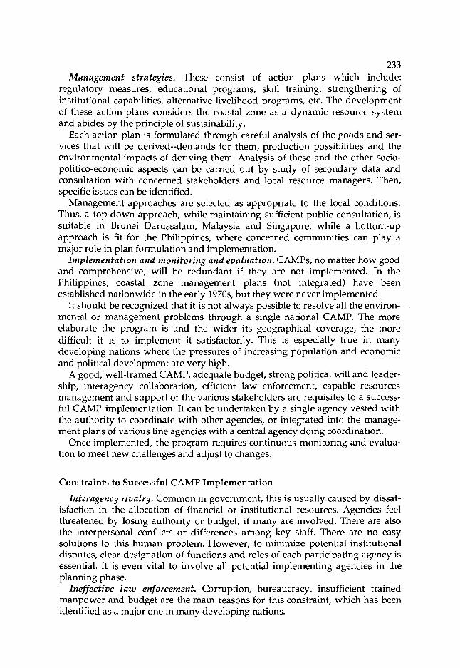
233 Management strategies. These consist of action plans which include:
regulatory measures, educational programs, skill training, strengthening of institutional capabilities, alternative Iivelihood programs, etc. The development of these action plans considers the coastal zone as a dynamic resource system and abides by the principle of sustainability.
Each action plan is formulated through careful analysis of the goods and ser- vices that will be derived--demands for them, production possibilities and the environmental impacts of deriving them. Analysis of these and the other socio- politico-economic aspects can be carried out by study of secondary data and consultation with concerned stakeholders and local resource managers. Then, specific issues can be identified.
Management approaches are selected as appropriate to the local conditions. Thus, a top-down approach, while maintaining sufficient public consultation, is suitable in Brunei Darussalam, Malaysia and Singapore, while a bottom-up approach is fit for the Philippines, where concerned communities can play a major role in plan formulation and implementation.
Implementation and monitoring and evaluation. CAMPS, no matter how good and comprehensive, will be redundant if they are not implemented. In the Philippines, coastal zone management plans (not integrated) have been established nationwide in the early 1970s, but they were never implemented.
It should be recognized that it is not always possible to resolve all the environ- mental or management problems through a single national CAMP. The more elaborate the program is and the wider its geographical coverage, the more difficult it is to implement it satisfactorily. This is especially true in many developing nations where the pressures of increasing population and economic and political development are very high.
A good, well-framed CAMP, adequate budget, strong political will and leader- ship, interagency collaboration, efficient law enforcement, capable resources management and support of the various stakeholders are requisites to a success- ful CAMP implementation. It can be undertaken by a single agency vested with the authority to coordinate with other agencies, or integrated into the manage- ment plans of various line agencies with a central agency doing coordination.
Once implemented, the program requires continuous monitoring and evalua- tion to meet new challenges and adjust to changes.
Constraints to Successful CAMP Implementation
Interagency rivalry. Common in government, this is usually caused by dissat- isfaction in the allocation of financial or institutional resources. Agencies feel threatened by losing authority or budget, if many are involved. There are also the interpersonal conflicts or differences among key staff. There are no easy solutions to this human problem. However, to minimize potential institutional disputes, clear designation of functions and roles of each participating agency is essential. It is even vital to involve all potential implementing agencies in the planning phase.
Ineffective law enforcement. Corruption, bureaucracy, insufficient trained manpower and budget are the main reasons for this constraint, which has been identified as a major one in many developing nations.

Fig. 1. Process for developing CAMPS.
Reject
Formulation 0-0-0 options
:,....:: :ji:i*;. ........ 0 - ....... :::=:::, ......... ......... :::::::2 ....... g-ik! ::!!!!!:: .....
Decisionmaking Reject -- Revision
i:. .1 ... ...a =... ......... ......... ,:;!:;E; :;y<;:; ........ is!:, ...... ......... . .....,... ....... ....... -4
Adoption
0 0-0 testing
u
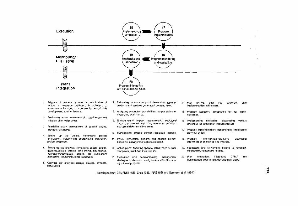
Execution
Monitoring/ Feedbacks and a Program monitoring Evaluation refinement and evaluation
Plans Program integration Integration into nationalllocal plans
1. Triggers of process by one or combination of factors: a. resource depletion; b. pollution; c. environment incident; d. concern for sustainable development; e. other factors.
2. Preliminary action: awareness of coastal issues and initiation of formal process.
3. Feasibility study: assessment of coastal issues, management needs.
4. Setting up the project framework: project formulation, determining coordinating institution, project document.
7. Estimating demands for productslservices: types of products and se~ ices generated; demand level.
6. Analyzing production possibilities: output estimate. strategies, attainments.
9. Environmental impact assessment: ecological impacts of present and future economic activities, ecological risks, sensitive areas.
10. Management options: conflict resolution, impacts.
11. Policy formulation: general and specific policies based on management options selected.
14. Pilot testing: pilot site selection, plan implementation, refinement.
15. Program adoption: acceptance for full imple- mentation.
16. Implementing strategies: developing various strategies for action plan implementation.
17. Program implementation: implementing institution to carry out action.
18. Program monitoringlevaluation: assessing attainment of objectives and impacts.
5. Setting up the analysis framework: coastal profile. 12. Action plans: finalizing specific activity with budget, 19. Feedbacks and refinement: setting up feedback goalslobjectives, targets, time frame, boundaries, manpower, institution involved, etc. mechanism, refinement needed. approacheslscenarios, crileria for evaluation1 monitoring, legallinstitutional framework. 13. Evaluation and decisionmaking: management 20. Plan integration: integrating CAMP into
strategies by decisionmaking bodies, acceptance or nationalllocal government development plans. 6. Carrying out analysis: issues, causes, impacts, rejection of proposal.
constraints.
(Developed from: CAMPNET 1989, Chua 1989, IFlAS 1986 and Sorensen et al. 1984.1

236 CAMPs should address this issue by obtaining the strong commitment of law
enforcement agencies and considering their limitations in the formulation of action plans. These agencies' scope of authority, budget and responsibilities must be delineated.
Lack of political wil l . The inability to obtain support of the political leader- ship will certainly mean that CAMPS will never be implemented. However, this should not be utilized as an excuse for not initiating a program.
How is political commitment obtained? Dialogue between politicians or poli- cymakers and resource managers is necessary to ensure general agreement regarding the goals and objectives of CAMPs. The political leaders should not view CAMPs as "antidevelopment" or just "conservation" but as viable pro- grams that provide long-term solution to multiple-use resource conflicts, alternative livelihood programs, increased food supply, investment and employ- ment opportunities, among others--in addition to the conservation of natural resources/ecosystems and protection of the environment.
The politicians should also realize their roles in CAMPs. While it is true that most of them are more concerned with strengthening their own political power base, many are well-educated, well-read, have concern for the environment and realize the need for resource protection for sustainable use.
Perhaps, the policymakers will be more easily convinced if they are presented with hard figures on the value of the resources that will be derived over time and the potential socioeconomic benefits through adequate management versus the value of the resources that are currently generated without sufficient regulatory measures. The case of logging at the watershed versus tourism and fisheries development in the Coral Bay in the Philippines is a good example of policy options presented to the decisionmakers (Dixon, this vol.).
Lack of alternative livelihoods. The heavy dependence of inhabitants on the coastal resources contributes to the difficulty in the implementation of regulatory measures. Communities and many families are displaced and their livelihoods are affected, unlike in developed nations where only a few stakeholders are affected. Indeed, the magnitude of the problem in developing nations is larger.
One problem cited in the workshop is blast fishing, which cannot be stopped unless there are sufficient, acceptable, alternative livelihoods. These may be coastal tourism, cottage industries, aquaculture and artificial reef development.
Insufficient budget and institutional capabilities. A realistic CAMP is formulated by taking into account the financial and institutional capabilities of the country. A smaller geographical area for CAMP implementation has more chance of success, especially when funding is a major constraint. A good example is the cleaning up of Singapore River Basin which entailed about S$250 million (US$ 125 million) over ten years. The cleaning up included: provision of alternative facilities for lighter trade, charcoal dealers, street hawkers, etc.; expansion of sewage facilities; repairs, refurbishment and dredging of the rivers; and construction of alternative premises designed with pollution control facilities (Khoo, this vol.).
Existing infrastructure and capabilities within many resource development and management agencies should be tapped and optimized. Usually, these insti-

237 tutional resources, especially manpower, are underutilized. Building new institu- tions for CAMP implementation may not always be cost-effective and more often than not contributes to interagency rivalry.
Lack of working examples. Although countries in Asia are beginning to devel- op comprehensive CAMPs, there is not a single such program in the region that can be used as working model--with the possible exception of the cleaning up of Singapore River Basin. Sri Lanka has begun some sort of coastal conservation program more than 15 years ago. However, integrated CAMP was only recently formulated, but unfortunately, was not able to get into effective implementation stage due to civil war. Attempts have been made to introduce integrated CAMP in Songkhla Lake Basin in Thailand (Kiravanich and Bunpapong, this vol.), and in Tokyo and Jakarta Bays. While the Songkhla Lake Basin Project has been com- pleted, full implementation has yet to take place. The projects in Tokyo and Jakarta Bays are still in implementation stage.
Outside Asia, CAMPs have been implemented in a number of coastal states in the USA, Costa Rica, Sri Lanka, Brazil, Oman and Australia. Although none of them can be viewed as fully effective, the programs can be used as partial exam- ples. That there are no working models should not be an excuse for not attempt- ing CAM in developing nations or be a cause for skepticism for its successful implementation.
The question of transferability of CAM strategies either from developed na- tions or among developing nations is still debatable. In terms of magnitude and severity, the environmental problems faced by developing nations are different from those faced by developed nations. Sociocultural and economic conditions and government and legal structures also differ. These differences do not mean, however, that the experiences and planning processes are not transferable. They are essentially the same (Fig. 1). For instance, resource managers, whether from developed or developing nations, still need to resolve problems such as competi- tion between the executive and the legislative branches of government, rivalry among institutions and reconciling local with national interests, etc.
Insufficient public consultation and participation. This has often been cited to be a major cause of failure in CAMP implementation (Ferrer, this vol. and Lowry, this vol.). Is public consultation and participation really necessary? Workshop participants held different views and experiences:
In Thailand, no citizen participation is involved in formulating deci- sions and policies pertaining to coastal resources management. Experi- ence with the City Planning Act of 1975 indicates that public hearing, though a good concept and very helpful in getting public concern, if made mandatory prior to approving it, can cause problems. The evi- dence is that the Department of Town and Country Planning could not get approval of its proposed city plan in the pilot site 10 years after enactment of the said law. The reason is that it is next to impossible to satisfy every sector of the country especially in terms of land use plan and regulation.
In Singapore, authorities formulated policies and made the decisions. Citizen participation was not a major requirement although citizen

238 support and understanding had to be sought in several areas affecting their lives. The trend today is towards greater consultation and citizen participation when authorities formulate policies and make decisions.
Likewise, there are differences in opinion among resource managers and deci- sionmakers, as can be reflected in the following excerpt of a question-and-answer reaction to a paper on people participation in the Philippines presented during the workshop.
Q: I agree in principle with the essence of your message--more people's participation. But you seem to imply that there is a uniformity of opinion in the communities to be affected by development. But, what does the government do in situations when there are strong, even irrec- oncilable differences within the community regarding the development? How should the government handle such situations?
A: Communities are heterogeneous, therefore, conflicts are bound to arise. Majority of the population is poor, thus, if the government is to solve the conflicts, it should resolve them in favor of the poor. Take the case of the conflict between the small fishermen and the commercial trawl fishermen. The government should come up with a policy on whose side it is undertaking the development program.
Q: Is it commonly assumed that there is a great deal of wisdom among the traditional leaders of community-level organizations? But observa- tions reveal that they are just as likely to be voracious, uncaring and exploitative as modern-day leaders. What are your observations?
If you nurture your own leaders you may, in fact, compound the problem by putting in a new set of leaders together with traditional community leaders who may be in direct conflict with each other. Do you agree?
A: In the Philippines, traditional leaders may be classified into two: those who represent or are the economic and political elites and those from the ranks of the poorer section of the community organization. My experience has been that the latter represent the interest of the people.
Community organization is a political activity and is bound to challenge the status quo. If the people do not organize, the government may not always take their interest into consideration. Thus, they may have to get together and indicate their needs and aspirations. These efforts may not necessarily compound the matter. It is when these things are not considered that things are compounded.
The general consensus, however, is that public consultation and participation is a useful process in ensuring that the management plans reflect the feelings and endorsement of the majority of the affected communities.
Will CAMPS Work in Southeast Asia?
Coastal nations in Southeast Asia and other regions are now increasingly con- cerned with: (1) the possible ecological and socioeconomic impacts of global climatic changes; (2) the effective utilization of their Exclusive Economic Zone

239 (EEZ); and (3) the severity of environmental quality degradation and rapid depletion of coastal natural resources. The predicted rise of sea level by 30-150 cm and of temperature by 1.50C-5.50C by the year 2050 will have serious ecolo- gical, economic and social impacts especially in those nations where more than 70% of their entire population lives close to the coast.
The declaration of the EEZ by the coastal nations, following the conclusion of the United Nations Law of the Sea Conference, requires that they undertake ade- quate management of the natural resources under their jurisdiction. Many deve- loping nations, however, are not yet ready to harvest the economic benefits of the EEZ nor have they developed adequate management measures.
Thus, it appears that in the years to come, coastal nations cannot afford to leave the above issues unattended. They have to face the realities. Resource managers and political leaders need to prepare their nations to meet these chal- lenges. They are duty-bound to initiate adequate studies to measure the degree of ecological impacts the above-mentioned environmental changes have on the coastal ecosystems and the scope of implications they have on the economy and livelihoods of the coastal communities. More importantly, political leaders and resource managers have no choice but to develop and implement CAMPs in their countries.
Here are some examples of efforts in the management of coastal resources. The marine reserves in Apo Island (White, this vol.) show that the people can manage their own resources if given responsibility and authority to do so. In Costa Rica, government intervention effectively ensures development of coastal tourism without serious negative impacts on the ecosystem. The Great Bamer Reef in Australia is relatively well managed to cater for multiple uses. Though Singapore has no integrated CAMP, its efforts in rational and effective use of the limited coastal zone and the successful control/regulation on pollution demonstrated a high degree of effective coordination of activities. In practice, integrated management is already taking place.
Considering the above realities and the achievements attained in several attempts to manage the coastal resources, there is no doubt that CAMPs can be developed in the coastal nations of Southeast Asia and that its implementability can improve with more experience and better management capabilities.
Conclusion
Major outcomes of the workshop were the recognition of the significant socio- economic contributions of the coastal resource systems and the agreement to include the coastal zone in local government and national development plans. Economic analysis of benefits and costs should be performed to identify manage- ment options with due consideration to the traditions and the culture of the coastal communities. Traditional management practices should not be ignored; if found effective, they should be integrated into the overall management strate- gies. National goals should be enhanced through CAMP implementation. Differ- ent management approaches are used, depending on the sociocultural and polit- ical conditions of the target site.

Most Southeast Asian nations are preparing management action plans for the following: wetlands (mangroves), coral reefs and seagrasses, watersheds, fisher- ies, aquaculture, water quality, coastal tourism, beaches and islands and marine parks and reserves.
Use of modern planning tools such as remote sensing and geographical infor- mation systems (GIS) (Kam, this vol.) was recommended. The workshop partici- pants also highlighted the need for continuous research on and monitoring of coastal activities. Information generated by consultants and academic researchers was prescribed for retrieval and analysis. These research efforts should be accompanied by information dissemination at all levels of society--from the politicians and resource managers to the grass roots.
The increasing and direct role of multinationals and private sector groups in environmental protection and rational exploitation was underscored.
The workshop participants have formulated policy recommendations for CAM in the region (see next page). From here, policymakers and resource managers can take the initiative to launch CAMPS in their countries.
References
CAMPNET (Coastal Area Management and Planning Network). 1989. The status of integrated coastal zone management: a global assessment. Preliminary summary report of a workshop, 4 9 July 1989. Charleston, South Carolina. Coastal Area Management and Planning Network, Miami, Florida, USA.
7 ua, T.-E. 1989. Developing coastal area management plans in the Southeast Asian region, p. 2192- 2201. In O.T. Magoon, H. Converse, D. Mines, T.L. Tobin and D. Clark (eds.) Coastal Zone '89: Proceedings of the Sixth Symposium on Coastal and Ocean Management. Vol. 5. American Society of Civil Engineers, New York, USA.
IFIAS (International Federation of Institutes for Advanced Study). 1986. Analyzing biospheric changes: lessons learned. International Federation of Institutes for Advanced Study, Maastricht, The Netherlands.
Sorensen, J., C . Jens, S.T. McCreary and M.J. Hershman. 1984. Institutional arrangements for management of coastal resources. National Park Service, US Department of Interior and US Agency for International Development, Washington, USA.
Policy Recommendations for Coastal Area Management in the ASEAN Region
The following are based on the discussion by policymakers, administrators and scientists who attended the Policy Workshop on Coastal Area Management, 25-27 October 1988, Johore Bahru, Malaysia. The workshop was organized by the Association of Southeast Asian Nations (ASEAN) Coastal Resources Management Project (CRMP) funded out of a grant from the United States of America.
Preamble
The workshop participants reviewed the current exploitation of coastal resources and examined the severity of degradation of the coastal environment in the ASEAN region. They were guided by the policy on environmental management endorsed by the 1987 ASEAN Summit Meeting in Manila, Philippines:
In the area of environment, ASEAN shall cooperate in promofing the principle of sustainable development and systematically integrating it into all aspects of dmelopment and shall focus on the need for policy guidelines to protect ASEAN's common resources and environment.
The participants also reviewed the approach and methods adopted by the ASEAN CRMP which is developing integrated and intersectoral coastal area management programs. The group recognized the complexities of the coastal area management issues in ASEAN and fully appreciated the initiative and useful efforts being undertaken by the project.
Most countries in the region rely heavily on the coastal area for food, livelihood and foreign exchange. About 70% of the total ASEAN population lives in the coastal area and is directly or indirectly economically dependent on it. The population will double in most of the countries within the next 25 to 35 years. This economic dependence brings about environmental degradation and overuse of resources which constrain development.
24 1
Management Issues
The participants agreed that the overriding problem is how to maintain the resource base for sustainable production. The most serious management issues of concern are the following:
Overexploitation of fisheries resources Heavy fishing pressure occurs along many coastlines where there is dense human population. In recent years, there have been rapid declines in fish catch rate by small-scale and commercial operators. Conflicts between and among small-scale and commercial fishermen over inshore fishing grounds have increased. Use of mechanical push nets, fine-mesh nets, dynamite and cyanide, along with traditionally acceptable gears, are rapidly depleting fish stocks.
Degradation of coastal and marine ecosystems and habitats More than half of the coral reefs in the Philippines are severely damaged due to destructive fishing and sedimentation. In Indonesia, coral mining is still common. Destructive and heavy fishing, siltation from deforestation, sand mining, use of anchors and pollution all take their toll on coral reefs, seagrass areas, algal beds and beaches. Mangrove habitats are dwindling due to their conversion for human settlement, agriculture, logging, tin mining and aquaculture, especially shrimp farming.
Declining water quality and pollution These are common in many urban coastal areas where large amounts of solid and chemical wastes are flushed into the sea. Upland deforestation, improper agriculture techniques and mining are dumping large amounts of silt into the marine environment. Industries, oil facilities and shipping are generally responsible for increasing pollution.
Endangered marine species and coastal wildlife Vulnerable marine animals are becoming scarce as habitats are degraded. Due to overexploitation, some commercially and biologically important species are nearing local extinction. Biological diversity and gene pools for marine organisms are being reduced, causing severe instability in marine ecosystems.
Low level of institutional capability for integrated coastal area management Existing government structure, institutions and laws are often arranged for unisectoral approaches to management which fail to consider the interrelations of coastal ecosystems, resources and activities. The lack of experience with scientific techniques and lack of knowledge about feasible solutions translate into a weak political will to tackle the problems.

243 Causes of Issues
The first step in solving the above issues is to identify their causes; the major ones are:
High population growth; Poverty as exacerbated by dwindling resources, disturbed fisheries habitats and lack of alternative livelihoods; Large-scale commercial enterprises by organizations outside of the coastal area which displace or do not involve the local people and are motivated to obtain quick profits with little concern for the impact on the coastal environment; Lack of awareness about sustainable coastal area management among coastal people and policyrnakers; Lack of effective economic evaluation of the worth and contribution and ecological role of coastal resources to society; Inadequacies of regulations and laws in aiding coastal area management efforts and enforcement.
Policy Recommendations
Ultimately, the solution to coastal resources degradation will have to be long- term. The following policy recommendations to the resolution of coastal area management issues, however, need to be considered for immediate action to reverse degradation. It is urged that full support be given to the organizations and projects which can help attain these goals.
Coastal area planning has been left out of national development plans because of ignorance about the significance of coastal ecosystems' contributions to the economic and cultural well-being of the population. Coastal areas and their resources should be included in national, regional, provincial and local planning. Unisectoral management has ignored the inter-relationships of various components of coastal ecosystems. The case of-watersheds and ther impact on the coasts in the form of sedimentation and flooding is an example. The development and implementation of wholistic plans on the environment, resources, population and private and government sectors are needed. The overemphasis on economic development in lieu of sustainable use management schemes has caused expensive remedial measures. Focus is needed on ecodevelopment which strengthens and addresses sustainability and requires environmental impact statements in all coastal activities. The importance of resource-user participation in planning and management has been neglected and thus needs more attention.

The complexity of coastal area planning and management indicates that national objectives and plans cannot be easily implemented. It is important to establish general policy guidelines which encourage selected pilot site projects to develop coastal area management plans on a practical scale. A decentralized approach will allow a development plan to be implemented according to particular management objectives and sites. Resource use activities may be managed by applying zonation schemes, permit systems or other regulatory mechanisms. Such mechanisms allow coastal resource managers to focus attention on sensitive or valuable coastal resources and/or on activities likely to have adverse impacts on resources. The increase in population and resulting need for food and resources will require long-term solutions to poverty. Also, as educational levels rise along with the people's awareness on environmental quality, governments will have to address this in wholistic terms to avoid crisis in areas with dense population.
Proposed Guidelines
1. Industrial development and environmental quality Coastal industries should be located in sites which have minimal impact on critical habitats and which do not lower water quality below acceptable standards. Planning for industrial development should include zonation for industries, ports and shipping facilities and standards for water quality maintenance. Environmental impact statements and sustainable use criteria need to be incorporated in planning.
2. Mangrove conversion Zonation schemes that prescribe clear guidelines designating areas for conservation, protection and development are needed. Pilot site modules should be developed as examples for management. Adequate evaluation of the resources, including replacement costs, must be made for use in decisionmaking. Public education is needed to reverse the "wasteland image. Existing mangrove habitats should be included in management plans which provide for sustainable use and/or protection.
3. Shrimpfarming and other coastal aquaculture The use of mangrove habitat for aquaculture must be reconsidered. Land use zonation and water quality for and the environmental impact of aquaculture should be included in local and national development plans.
4. Exploitation of fisheries resources Limitations on open access and entry are needed through management schemes which specify fishing gear; set levels of effort; determine fish stocks and sustainable yields and what constitutes an excess number of fishermen. Laws on fishing and on the jurisdiction of national, provincial

245 and local governments over marine areas need to be clarified and publicized. Alternative livelihood programs for displaced fishermen are needed to relieve excess fishing effort. Foreign intrusion in coastal fishing grounds should be monitored and regulated.
5. Coral reef protection Enforcement of laws on fishing practices needs to be strengthened. Education and community programs to establish local resistance and alternatives to destructive activities must be initiated. Marine parks and reserves at the municipal and community levels must be established in more areas and must involve community leaders for effective management. Regional cooperation to support existing bans on coral trade is required.
6. Reversing the decline of water quality Setting of quality standards is needed. Integration of river and watershed management should be made, if possible, with water quality zones affected by upland activities. Sampling and monitoring must be standardized for the region or at least, on a national basis. Industries and sectors which violate standards should be closely monitored.
7. Preventing coastal erosion artd scdinzentation Initial management and preventive measures should be focused in areas where valuable productive ecosystems, such as coral reefs, seagrasses, mangroves, estuaries and beaches, are affected by erosion and sedimentation. Construction projects which affect coastal dynamics and offshore dredging should be required to submit comprehensive environmental impact statements. All mining and dredging along inshore coastal areas or on coral reefs should be stopped or regulated.
8. Tourism development Plans for this should include guidelines for environmental management on sewage discharge, shoreline erosion, maintenance of beaches, coral reefs and other ecosystems and general zones appropriate for tourism. The local government and communities should be involved in implementation so that human and cultural displacement is minimized. Guidelines for use of marine areas by tourist boats, swimmers and fishermen can be developed.
9. Improving institutional arrangements and capabilities The development of agencies which have jurisdiction over coastal areas and trained personnel to analyze management issues and develop plans is needed. All levels of government should be involved in coastal area management which is interdisciplinary and multisectoral in nature. Training courses on coastal area management and sharing among communities and nongovernmental organizations of experiences in it will improve national and local institutional building.
10. Public awareness Highlighting issues and possible solutions in the media will increase public awareness. Including coastal ecology in the educational
246 curriculum will start molding a generation which understands and respects the need for sustainable use of natural resources. This is a long- term solution to improving public knowledge on coastal area management.
12. Upgrading legislation Many existing laws on coastal area management need to be carefully reviewed and improved, to be more practical and enforceable. Otherwise, these laws should be nuIlified and replaced with better ones.

Appendices
List of Participants
Brunei Darussalam
Awang Dirk bin Haji Belaman Deputy Commissioner Town and Country Planning
Department Old Airport, Barakas Ministry of Development Bandar Serai Begawan 2068
Dato Paduka Awang Haji Mohammad bin Haji Serudin
District Officer Brunei-Muara District Ministry of Home Affairs Bandar Seri Begawan 2030
Awang Matdanan Haji Jaafar Director Department of Fisheries P.O. Box 2161 Bandar Seri Begawan
Dr. M.W. Ranjith N. de Silva National Coordinator ASEAN/US CRMP (Brunei
Darussalam) and Fisheries Officer Department of Fisheries P.O. Box 2161 Bandar Sen Begawan
Indonesia
Dr. Aprilani Soegiarto Deputy Chairman for Natural
Sciences
ASEAN/COST Working Group on Marine Sciences and
Deputy Director-General Indonesian Institute of Sciences Widya Graha J1. Jenderal Gatot Subroto No. 10 Jakarta Selatan
Mr. M. Soepardi Head Cilacap District (Bupati Cilacap) Bupati KDH TK 11 Cilacap Cilacap-Jawa Tengah
Dr. Roesmidi Head Cilacap Planning Board (BAPPEDA) Ketua BAPPEDA TK 11 Cilacap Jln. A. Yani No. 6 Cilacap 53212, Jawa Tengah
Dr. Purwito Martosubroto Director Directorate of Living Resources
Management Directorate General of Fisheries Jln. Harsono, RM No. 3, Gedung B,
Lantai VI Ragman, Pasar Minggu Jakarta Selatan
Prof. Koesoebiono Program Manager Coastal Zone Management Program Environmental Research Centre Bogor Agricultural University PPLH-IPB Kampus IPB Darmaga P.O. Box 145, Bogor
247

248 Malaysia
The Honorable Datuk Amar Stephen K.T. Yong Minister Ministry of Science, Technology and
the Environment 14th Floor, Wisma Sime Darby Jalan Raja Laut 50662 Kuala Lumpur
Tuan Haji Abu Bakar bin Mohd. Noor
Deputy Secretary-General (I) Ministry of Agriculture Wisma Tani Jalan Sultan Salahuddin 50628 Kuala Lumpur
Dato' Mohamed Darus bin Hj. Mahmud
Acting Director-General Forestry Department HQ Jalan Sultan Salahuddin 50660 Kuala Lumpur
Mr. Abdul Rahman bin Jamal Director Regional Economic Development Economic Planning Unit Prime Minister Department Jalan Dato' Onn 50250 Kuala Lumpur
Dato' Ishak Mohd. Yusof Director Johore State Economic Planning
Unit 2nd Floor, Bangunan Kerajaan Bukit Timbalan 80000 Johore Bahru
Datin Paduka Fatimah bte Abdullah Director Johore State Office of Land and
Mines Bangunan Kerajaan
Bukit Timbalan 80000 Johore Bahru
Dr. Abu Bakar Jaafar Chairman National Working Group on
ASEAN Cooperative Programmes on Marine Science and
Deputy Director-General Department of Environment Ministry of Science, Technology and
the Environment 13th Floor, Wisma Sime Darby Jalan Raja Laut 50662 Kuala Lumpur
Puan Halimaton Saadiah bte Hashim
Director State of Johore Department of Town and Country
Planning 4th Floor, Bangunan Kerajaan Bukit Timbalan 80000 Johore Bahru
Ms. Ch'ng Kim Looi National Coordinator ASEAN/US CRMP (Malaysia) and Head Resources Management Unit Fisheries Department Jalan Mahameru, Kuala Lumpur
Mr. Raman Letchumanan Principal Assistant Secretary Ministry of Science, Technology and
the Environment 14th Floor, Wisma Sime Darby Jalan Raja Laut 50662 Kuala Lumpur
Dr. Kam Suan Pheng Lecturer School of Biological Sciences Universi ti Sains Malaysia 1 l8OO Pulau Pinang

Philippines
His Excellency Joaquin Ortega Governor Province of La Union Capitol Building San Fernando, La Union
Mr. Joseph M. Alabanza Director National Economic and
Development Authority (NEDA)- Region I
Don Pedro Building, Pagdaraoan San Fernando, La Union
Dr. Rafael D. Guerrero I11 Chairman Project Steering Committee ASEAN/US Coastal Resources
Management Project and Executive Director Philippine Council for Aquatic and
Marine Research and Development
Los Bafios, Laguna
Dr. Edgardo D. Gomez Director Marine Science Institute University of the Philippines Diliman, Quezon City
Dr. Virginia L. Aprietoa Program Leader ASEAN/US CRMP (Philippines) National Coordinator's Office c/o Bureau of Fisheries and Aquatic
Resources Marcelo Bldg., Quezon Blvd. Quezon City
a ~ e r address as of 1989 is: University of the Philippines in the Visayas, Miag-ao, Iloilo City, Philippines.
Prof. Elmer M. Ferrer Project Leader Socioeconomic and Legal/
Institutional Divisions ASEAN/US CRMP (Philippines) College of Social Work and
Community Development University of the Philippines Diliman, Quezon City
Mr. Jesus C. Alix Officer-In-Charge (Executive
Director) Central Visayas Regional Projects
Office HVG Arcade, Subangdaku Mandaue City, Cebu
Dr. Frederick J. Vande Vusse Fisheries Consultant Central Visayas Regional Project-I
Rural HVG Arcade, Subangdaku Mandaue City, Cebu
Singapore
Mr. Leslie Cheong National Coordinator ASEAN/US CRMP (Singapore) and Head Marine Aquaculture Section Primary Production Department Changi Fisheries Complex 300 Nicoll Drive, Changi Point, Singapore 1749
Dr. Chia Lin Sien Vice Dean and Associate Professor Department of Geography National University of Singapore Kent Ridge Crescent Singapore 0511
250 Mr. Lim Lian Chuan Senior Primary Production Officer Primary Production Department National Development Building Maxwell Road, Singapore 0106
Mr. Khoo Chin Hean Head Pollution Control Department Environment Building 40 Scotts Road, Singapore 0922
Thailand
His Excellency Capt. Yongyuth Bunyawat Governor Province of Phangnga Phangnga City Hall Amphoe Muang, Phangnga 82000
His Excellency Dr. Bunterng Srijanthagapan Vice Governor Province of Krabi Krabi City Hall Amphoe Muang, Krabi 81000
His Excellency Mr. Jainvit Sitthidamrong Vice Governor Province of Surat Thani Amphoe Muang, Surat Thani 84000
Dr. Pakit Kiravanich Deputy Permanent Secretary Ministry of Science, Technology and
Energy Yodhi Road, Bangkok 10400
Mr. Arthorn Suphapodok Project Director ASEAN/US CRMP (Thailand) and Deputy Secretary-General Office of the National Environment
Board
60/1 Soi Pracha-sumpun 4 Rarna VI Road, Bangkok 10400
Dr. Sanit Aksornkoae Professor Department of Silviculture Faculty of Forestry Kasetsart University Bangkok 10903
Mr. Robert J. Dobias Project Manager World Wide Fund for Nature (WWF) Beneficial Use Assessment Project P.O. Box 8-101, Bangkok 10800
United States
His Excellency Mr. Thomas C. Hubbard Deputy Chief of Mission The US Embassy Jalan Tun Abdul Razak Kuala Lumpur, Malaysia
Mr. Jeffrey Beller Economic Section The US Embassy Jalan Tun Abdul Razak Kuala Lumpur, Malaysia
Dr. William V. Branan Technical Coordinator W / N D Coastal Resources
Management Project Coastal Resources Center The University of Rhode Island Narragansett Bay Campus Narragansett, RI 02882 USA
Dr. John A. Dixon Research Associate Environment and Policy Institute East-West Center 1777 East-West Road Honolulu, Hawaii 96848 USA

Dr. Kem Lowry Chairman Department of Urban and Regional
Planning University of Hawaii at Manoa Porteus Hall 107 2424 Maile Way Honolulu, Hawaii 96822 USA
Dr. Mark J. Valencia Research Associate Resource Systems Institute East-West Center 1777 East-West Road Honolulu, Hawaii 96848 USA
Dr. Richard ~ o b i n b SUNY /ITM Program No. 5, Jalan SS 17/1A Subang Jaya 47500 Petaling Jaya, Selangor Malaysia
Mr. Lawrence Ervin AID Representative to ASEAN
b~ffective 18 May 1989: Visiting Scientist, ASEAN/US CRMP, ICLARM. CUSAID ASEAN Regional Office, 37 Soi Somprasong 3, Petchburi Road, Bangkok 10400 Thailand. d3rd Floor, Bloomingdale Building, Salcedo St., Legaspi Village, Makati, Metro Manila, Philippines.
Mr. Noel Ruiz CRM Project Officer
Dr. Max Agiiero N. Research Associate and Project Manager Small-Scale Fisheries Project
Dr. Chua Thia-Eng Senior Scientist and Project Coordinator ASE AN/US CRMP
Dr. Daniel Pauly Senior Scientist and Director Capture Fisheries Management
Program
Dr. Alan T. White Associate Scientist and Technical Advisor ASEAN/US CRMP

Program of Activities
Tuesday, October 25 A.M.
Registration Opening Ceremony Welcome Address: 1r. Goh Kiam Seng, Director General, Department of
Environment Address: Mr. Thomas C. Hubbard, Deputy Chief of Mission, The US Embassy in
Kuala Lumpur Address: The Honorable Datuk Amar Stephen K.T. Yong, Minister, Ministry of
Science, Technology and the Environment, Malaysia Opening Address: The Right Honorable Tan Sri Haji Muhyiddin Haji Mohd.
Yassin, Chief Minister, State Government of Johore
Plenary Session: Coastal Resources in the ASEAN Region: Problems and Directions Keynote Address and Session chaired by The Honorable Datuk Amar Stephen
K.T. Yong Discussion leader: Dr. Chua Thia-Eng Respondents: Dr. Pakit Kiravanich and Dr. Kern Lao y
Brunei Darussalam: Awang Matdanan Haji Iuafar Indonesia: Dr. Purwito Martosubrofo Malaysia: Ms. Ch'ng Kim Looi Philippines: Dr. Rafael D. Guerrero 111 Singapore: Mr. Leslie Cheong - Thailand: Mr. Arthorn Suphapodok
P.M.
Luncheon reception hosted by The Honorable Minister of Science, Technology and the Environment, Malaysia
Session I: Sectoral Management of Coastal Resources and Coastal Development--Problems and Policy Issues Chairperson: Dr. Rafael D. Guerrero III Moderators: Dr. John A. Dixon and Dr. Chia Lin Sien
253 Fisheries Resources Management in Southeast Asia: Why Bother? Dr. Daniel
Pauly Management and Conservation of Mangrove Resources for Coastal Development
in the Southeast Asian Nations. Dr. Sanit Aksornkoae Coral Reef Resources and the ASEANjUS Coastal Resources Management
Project. Dr. Edgardo D. Gomez Petroleum and Minerals: Policy Issues. Dr. Mark 1. Valencia Beaches and Tourism in Thailand. Mr. Robert J. Dobias Coastal Aquaculture Development in ASEAN: The Need for Planning and
Environmental Management. Dr. C h w Thia-Eng, Mr. James N. Paw and Ms. Elsie Tech
The Status of Marine and Coastal Pollution in Southeast Asia. Dr. Aprilani Soegiarto
Wednesday, October 26 A.M.
Session 11: Case Studies Chairperson: Dr. Abu Bakar Jaafar Moderators: Dr. Edgardo D. Gomez and Dr. Max Aguero N . The Management of Matang Mangrove Forest Reserves in Peninsular Malaysia.
Dafo' Mohamed Darus bin Haji Mahmud and Huron bin Haji Abu Hassan Two Community-based Marine Reserves: Lessons for Coastal Management. Dr.
Alan T . White Cleaning Up the Singapore River. Mr. Khoo Chin Hean Coastal Area Management: A Hawaii Case Study. Dr. Kern Lowy
Session 111: Coastal Area Management for Sustainable Development Chairperson: Dr. Kem L o w y Moderator: Prof. Koesoebiono People's Participation in Coastal Area Management. Prof. Elmer M. Ferrer A Philippine Approach to the Integration of Coastal Resources Management into
Regional Development Planning. Dir. Joseph M. AZabanza Economic Considerations in Evaluating Options for Coastal Resources
Management. Dr. Max Aguero N.
P.M.
Session IV: Tools for Coastal Area Planning and Management Chairperson: Dr. Edgardo D. Gomez Moderators: Dr. William V . Branan and Awang Matdanan Haji Jaafar Coastal Resources: Assessing Alternatives. Dr. John A. Dixon Application of Remote Sensing and Geographical Information Systems in Coastal
Area Management. Dr. Kam Suan Pheng Artificial Reefs: A Practical Means to Enhance Living Marine Resources. Dr.
M. W.R.N. De Silva Information Needs for Coastal Resources Management. Dr. Rafael D. Guerrero III
254 Community-based Resources Management: The Experience of the Central
Visayas Regional Project-I. Mr. Iesus C. Alix
Thursday, October 27 A.M.
Session V: Legal and Institutional Framework in Coastal Area Management Chairperson: Dr. Pakit Kiravanich Moderators: Dr. Chia Lin Sien and Dato' Ishak Mohd. Yusof Issues in Designing a Coastal Management Program. Dr. Kern Lowy Institutional Capabilities and Coordination for Coastal Area Management in
Thailand. Mr. Arthorn Suphapodok and Mr. Ilyas Baker
Session VI: Transfer of Coastal Resources Management Experience Chairperson: Dr. Mark J. Valencia Moderator: Dr. Daniel Pauly Transferring Implementable Coastal Resources Management Knowledge: The
University of Rhode Island's Experience. Dr. William V . Branan Coastal Area Management Planning: Thailand's Experience. Dr. Pakit Kiravanich
and Dr. Sirikul Bunpapong
P.M.
Session VII: Summary and Recommendations Chairperson: Dr. C h w Thia-Eng ( A representative from each of the six countries made a short statement on policy considerations for coastal area management. The summary of the workshop pro- ceedings and conclusions were presented for adoption.) Closing Ceremony Note of Appreciation. Dr. Chua Thia-Eng Closing Remarks: The Honorable Datuk Arnar Stephen K.T. Yong