Late Quaternary palaeoenvironment of northern Guatemala: evidence from deep drill cores and seismic...
26
Late Quaternary palaeoenvironment of northern Guatemala: evidence from deep drill cores and seismic stratigraphy of Lake Pete ´n Itza ´ ANDREAS D. MUELLER*, FLAVIO S. ANSELMETTI , DANIEL ARIZTEGUI à , MARK BRENNER§, DAVID A. HODELL – , JASON H. CURTIS§, JAIME ESCOBAR§, ADRIAN GILLI*, DUSTIN A. GRZESIK§, THOMAS P. GUILDERSON**, STEFFEN KUTTEROLF and MICHAEL PLO ¨ TZE àà *Geological Institute, Swiss Federal Institute of Technology ETH Zurich, 8092 Zurich, Switzerland (E-mail: [email protected]) Eawag (Swiss Federal Institute of Aquatic Science & Technology), Department of Surface Waters, 8600 Duebendorf, Switzerland àSection of Earth and Environmental Sciences, University of Geneva, 1205 Geneva, Switzerland §Department of Geological Sciences and Land Use and Environmental Change Institute (LUECI), University of Florida, Gainesville, FL 32611, USA –Department of Earth Sciences, University of Cambridge, Cambridge CB2 3EQ, UK **Center for Accelerator Mass Spectrometry, Lawrence Livermore National Laboratory, Livermore, CA 94550, USA Leibniz Institute for Marine Sciences, IfM-Geomar, 24148 Kiel, Germany ààClayLab, Institute for Geotechnical Engineering, Geological Institute, Swiss Federal Institute of Technology ETH Zurich, 8093 Zurich, Switzerland Associate Editor – Chris Scholz ABSTRACT Long sediment cores were collected in spring 2006 from Lake Pete ´n Itza ´, northern Guatemala, in water depths ranging from 30 to 150 m, as part of an International Continental Scientific Drilling Program project. The sediment records from deep water consist mainly of alternating clay, gypsum and carbonate units and, in at least two drill sites, extend back >200 kyr. Most of the lithostratigraphic units are traceable throughout the basin along seismic reflections that serve as seismic stratigraphic boundaries and suggest that the lithostratigraphy can be used to infer regional palaeoenvironmental changes. A revised seismic stratigraphy was established on the basis of integrated lithological and seismic reflection data from the basin. From ca 200 to ca 85 ka, sediments are dominated by carbonate-clay silt, often interbedded with sandy turbidites, indicating a sediment regime dominated by detrital sedimentation in a relatively humid climate. At ca 85 ka, an exposure horizon consisting of gravels, coarse sand and terrestrial gastropods marks a lake lowstand or partial basin desiccation, indicating dry climate conditions. From ca 85 to ca 48 ka, transgressive carbonate-clay sediments, overlain by deep-water clays, suggest a lake level rise and subsequent stabilization at high stage. From ca 48 ka to present, the lithology is characterized by alternating clay and gypsum units. Gypsum deposition correlates with Heinrich Events (i.e. dry climate), whereas clay units coincide with more humid interstadials. Keywords Guatemala, lake level changes, lake sediments, palaeoclimatology, Pete ´n Itza ´, seismic stratigraphy. Sedimentology (2010) 57, 1220–1245 doi: 10.1111/j.1365-3091.2009.01144.x 1220 ȑ 2010 The Authors. Journal compilation ȑ 2010 International Association of Sedimentologists
Transcript of Late Quaternary palaeoenvironment of northern Guatemala: evidence from deep drill cores and seismic...
Late Quaternary palaeoenvironment of northern Guatemala:evidence from deep drill cores and seismic stratigraphy of LakePeten Itza
ANDREAS D. MUELLER*, FLAVIO S. ANSELMETTI� , DANIEL ARIZTEGUI� , MARKBRENNER§, DAVID A. HODELL– , JASON H. CURTIS§, JAIME ESCOBAR§, ADRIANGILLI*, DUSTIN A. GRZESIK§, THOMAS P. GUILDERSON**, STEFFEN KUTTEROLF��and MICHAEL PLOTZE��*Geological Institute, Swiss Federal Institute of Technology ETH Zurich, 8092 Zurich, Switzerland(E-mail: [email protected])�Eawag (Swiss Federal Institute of Aquatic Science & Technology), Department of Surface Waters,8600 Duebendorf, Switzerland�Section of Earth and Environmental Sciences, University of Geneva, 1205 Geneva, Switzerland§Department of Geological Sciences and Land Use and Environmental Change Institute (LUECI),University of Florida, Gainesville, FL 32611, USA–Department of Earth Sciences, University of Cambridge, Cambridge CB2 3EQ, UK**Center for Accelerator Mass Spectrometry, Lawrence Livermore National Laboratory, Livermore, CA94550, USA��Leibniz Institute for Marine Sciences, IfM-Geomar, 24148 Kiel, Germany��ClayLab, Institute for Geotechnical Engineering, Geological Institute, Swiss Federal Institute ofTechnology ETH Zurich, 8093 Zurich, Switzerland
Associate Editor – Chris Scholz
ABSTRACT
Long sediment cores were collected in spring 2006 from Lake Peten Itza,
northern Guatemala, in water depths ranging from 30 to 150 m, as part of an
International Continental Scientific Drilling Program project. The sediment
records from deep water consist mainly of alternating clay, gypsum and
carbonate units and, in at least two drill sites, extend back >200 kyr. Most of
the lithostratigraphic units are traceable throughout the basin along seismic
reflections that serve as seismic stratigraphic boundaries and suggest that the
lithostratigraphy can be used to infer regional palaeoenvironmental changes. A
revised seismic stratigraphy was established on the basis of integrated
lithological and seismic reflection data from the basin. From ca 200 to ca
85 ka, sediments are dominated by carbonate-clay silt, often interbedded with
sandy turbidites, indicating a sediment regime dominated by detrital
sedimentation in a relatively humid climate. At ca 85 ka, an exposure
horizon consisting of gravels, coarse sand and terrestrial gastropods marks a
lake lowstand or partial basin desiccation, indicating dry climate conditions.
From ca 85 to ca 48 ka, transgressive carbonate-clay sediments, overlain by
deep-water clays, suggest a lake level rise and subsequent stabilization at high
stage. From ca 48 ka to present, the lithology is characterized by alternating
clay and gypsum units. Gypsum deposition correlates with Heinrich Events
(i.e. dry climate), whereas clay units coincide with more humid interstadials.
Keywords Guatemala, lake level changes, lake sediments, palaeoclimatology,Peten Itza, seismic stratigraphy.
Sedimentology (2010) 57, 1220–1245 doi: 10.1111/j.1365-3091.2009.01144.x
1220 � 2010 The Authors. Journal compilation � 2010 International Association of Sedimentologists

INTRODUCTION
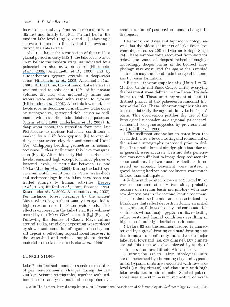
Palaeoenvironmental studies in the lowlands ofPeten, northern Guatemala (Fig. 1), began in the1960s and focused on ancient Maya impact onregional watersheds as well as Holocene climatechange and its implications for Maya civilization(Cowgill et al., 1966; Deevey et al., 1979; Riceet al., 1985; Vaughan et al., 1985; Binford et al.,1987; Leyden, 1987; Brenner et al., 1990; Islebeet al., 1996; Beach et al., 2006; Anselmetti et al.,2007). By the late 1970s, Deevey and colleagueshad begun searching for Pleistocene-age depositsin the Maya heartland to gain insights into Ice-ageclimate shifts in the lowland Neotropics (Deeveyet al., 1983; Leyden, 1984; Leyden et al., 1993,1994). Attention was focused on relatively deeplakes, as most shallow basins in the region wereshown to have first filled with water in the earlyHolocene and were evidently dry during glacialtimes. Recent palaeoenvironmental studies in theregion have focused on obtaining even longer
sediment records to investigate tropical climateand environmental changes on the Yucatan Pen-insula during both glacial and interglacial times,and to explore terrestrial-marine linkages usingpalaeoclimate records from sites around theCaribbean (for example, Cariaco Basin, north ofVenezuela; Haug et al., 2001). Retrieval of longsediment cores from the Neotropical lowlandsbecame a major objective for palaeoenvironmentaland palaeoclimatological studies. Until thepresent study, the longest lacustrine sedimentrecord taken in the region was a core from rela-tively deep (zmax = 32 m), small (area = 2Æ2 km2)Lake Quexil. Collected in 1980, the core pene-trated ca 20 m below the sediment–water inter-face. Unfortunately, the Pleistocene-age section ofthe sequence was poorly dated. Pleistocenedeposits contained few terrestrial macrofossils,and the estimated basal age of the core (36 ka)was based on extrapolation of a radiocarbon datefrom an aquatic snail shell (Leyden et al., 1993).For more than two decades, the Quexil core was
A
BFig. 1. (A) Bathymetric map of LakePeten Itza showing the locations ofall ICDP sites drilled in 2006, and ofall seismic track lines collected inthe 2002 airgun seismic reflectionsurvey. The inset on the rightdisplays a map of the Caribbeanregion showing the Maya Lowlandsin northern Guatemala and thelocation of Lake Peten Itza. (B)Satellite picture of Lake Peten Itza.Note the shallow water area alongthe south shore characterized byturquoise colour indicating in situcarbonate production (Muelleret al., 2009).
The sediment record of Lake Peten Itza 1221
� 2010 The Authors. Journal compilation � 2010 International Association of Sedimentologists, Sedimentology, 57, 1220–1245
the longest continental palaeoclimate record fromthe area.
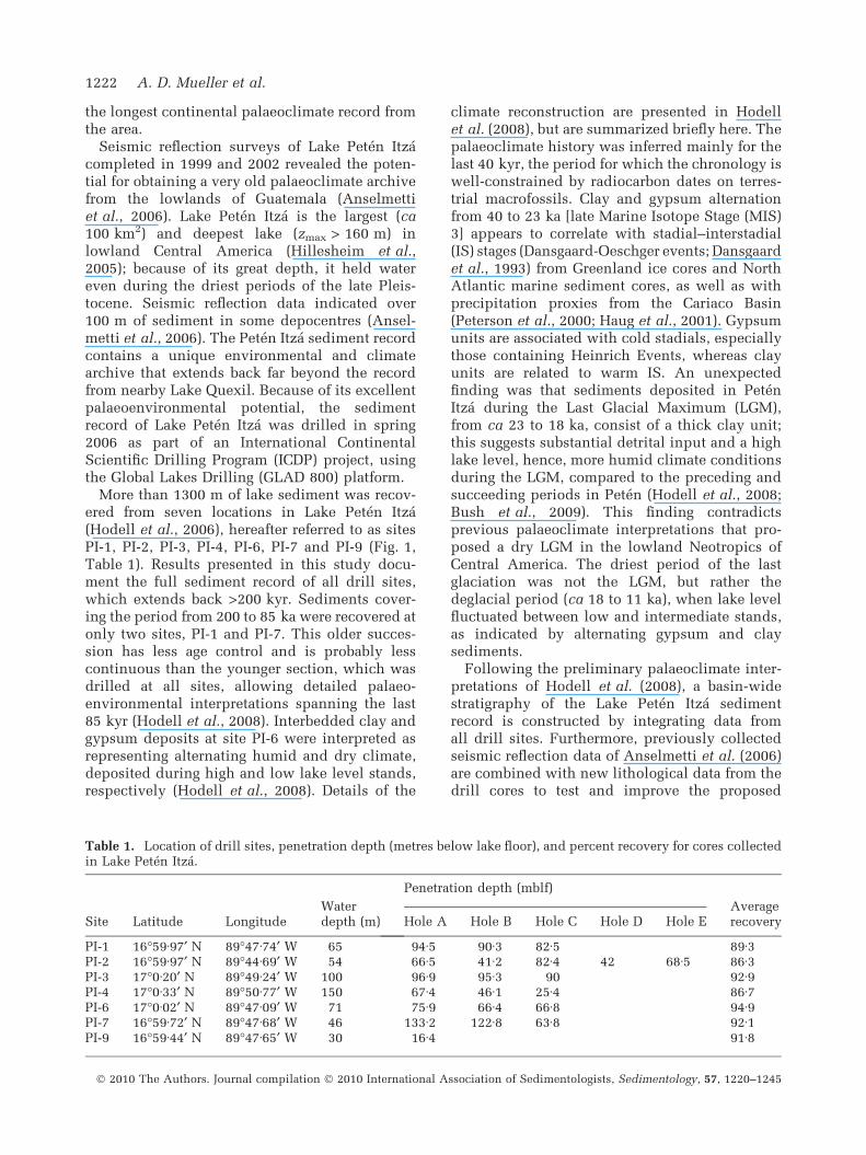
Seismic reflection surveys of Lake Peten Itzacompleted in 1999 and 2002 revealed the poten-tial for obtaining a very old palaeoclimate archivefrom the lowlands of Guatemala (Anselmettiet al., 2006). Lake Peten Itza is the largest (ca100 km2) and deepest lake (zmax > 160 m) inlowland Central America (Hillesheim et al.,2005); because of its great depth, it held watereven during the driest periods of the late Pleis-tocene. Seismic reflection data indicated over100 m of sediment in some depocentres (Ansel-metti et al., 2006). The Peten Itza sediment recordcontains a unique environmental and climatearchive that extends back far beyond the recordfrom nearby Lake Quexil. Because of its excellentpalaeoenvironmental potential, the sedimentrecord of Lake Peten Itza was drilled in spring2006 as part of an International ContinentalScientific Drilling Program (ICDP) project, usingthe Global Lakes Drilling (GLAD 800) platform.
More than 1300 m of lake sediment was recov-ered from seven locations in Lake Peten Itza(Hodell et al., 2006), hereafter referred to as sitesPI-1, PI-2, PI-3, PI-4, PI-6, PI-7 and PI-9 (Fig. 1,Table 1). Results presented in this study docu-ment the full sediment record of all drill sites,which extends back >200 kyr. Sediments cover-ing the period from 200 to 85 ka were recovered atonly two sites, PI-1 and PI-7. This older succes-sion has less age control and is probably lesscontinuous than the younger section, which wasdrilled at all sites, allowing detailed palaeo-environmental interpretations spanning the last85 kyr (Hodell et al., 2008). Interbedded clay andgypsum deposits at site PI-6 were interpreted asrepresenting alternating humid and dry climate,deposited during high and low lake level stands,respectively (Hodell et al., 2008). Details of the
climate reconstruction are presented in Hodellet al. (2008), but are summarized briefly here. Thepalaeoclimate history was inferred mainly for thelast 40 kyr, the period for which the chronology iswell-constrained by radiocarbon dates on terres-trial macrofossils. Clay and gypsum alternationfrom 40 to 23 ka [late Marine Isotope Stage (MIS)3] appears to correlate with stadial–interstadial(IS) stages (Dansgaard-Oeschger events; Dansgaardet al., 1993) from Greenland ice cores and NorthAtlantic marine sediment cores, as well as withprecipitation proxies from the Cariaco Basin(Peterson et al., 2000; Haug et al., 2001). Gypsumunits are associated with cold stadials, especiallythose containing Heinrich Events, whereas clayunits are related to warm IS. An unexpectedfinding was that sediments deposited in PetenItza during the Last Glacial Maximum (LGM),from ca 23 to 18 ka, consist of a thick clay unit;this suggests substantial detrital input and a highlake level, hence, more humid climate conditionsduring the LGM, compared to the preceding andsucceeding periods in Peten (Hodell et al., 2008;Bush et al., 2009). This finding contradictsprevious palaeoclimate interpretations that pro-posed a dry LGM in the lowland Neotropics ofCentral America. The driest period of the lastglaciation was not the LGM, but rather thedeglacial period (ca 18 to 11 ka), when lake levelfluctuated between low and intermediate stands,as indicated by alternating gypsum and claysediments.
Following the preliminary palaeoclimate inter-pretations of Hodell et al. (2008), a basin-widestratigraphy of the Lake Peten Itza sedimentrecord is constructed by integrating data fromall drill sites. Furthermore, previously collectedseismic reflection data of Anselmetti et al. (2006)are combined with new lithological data from thedrill cores to test and improve the proposed
Table 1. Location of drill sites, penetration depth (metres below lake floor), and percent recovery for cores collectedin Lake Peten Itza.
Site Latitude LongitudeWaterdepth (m)
Penetration depth (mblf)
AveragerecoveryHole A Hole B Hole C Hole D Hole E
PI-1 16�59Æ97¢ N 89�47Æ74¢ W 65 94Æ5 90Æ3 82Æ5 89Æ3PI-2 16�59Æ97¢ N 89�44Æ69¢ W 54 66Æ5 41Æ2 82Æ4 42 68Æ5 86Æ3PI-3 17�0Æ20¢ N 89�49Æ24¢ W 100 96Æ9 95Æ3 90 92Æ9PI-4 17�0Æ33¢ N 89�50Æ77¢ W 150 67Æ4 46Æ1 25Æ4 86Æ7PI-6 17�0Æ02¢ N 89�47Æ09¢ W 71 75Æ9 66Æ4 66Æ8 94Æ9PI-7 16�59Æ72¢ N 89�47Æ68¢ W 46 133Æ2 122Æ8 63Æ8 92Æ1PI-9 16�59Æ44¢ N 89�47Æ65¢ W 30 16Æ4 91Æ8
1222 A. D. Mueller et al.
� 2010 The Authors. Journal compilation � 2010 International Association of Sedimentologists, Sedimentology, 57, 1220–1245
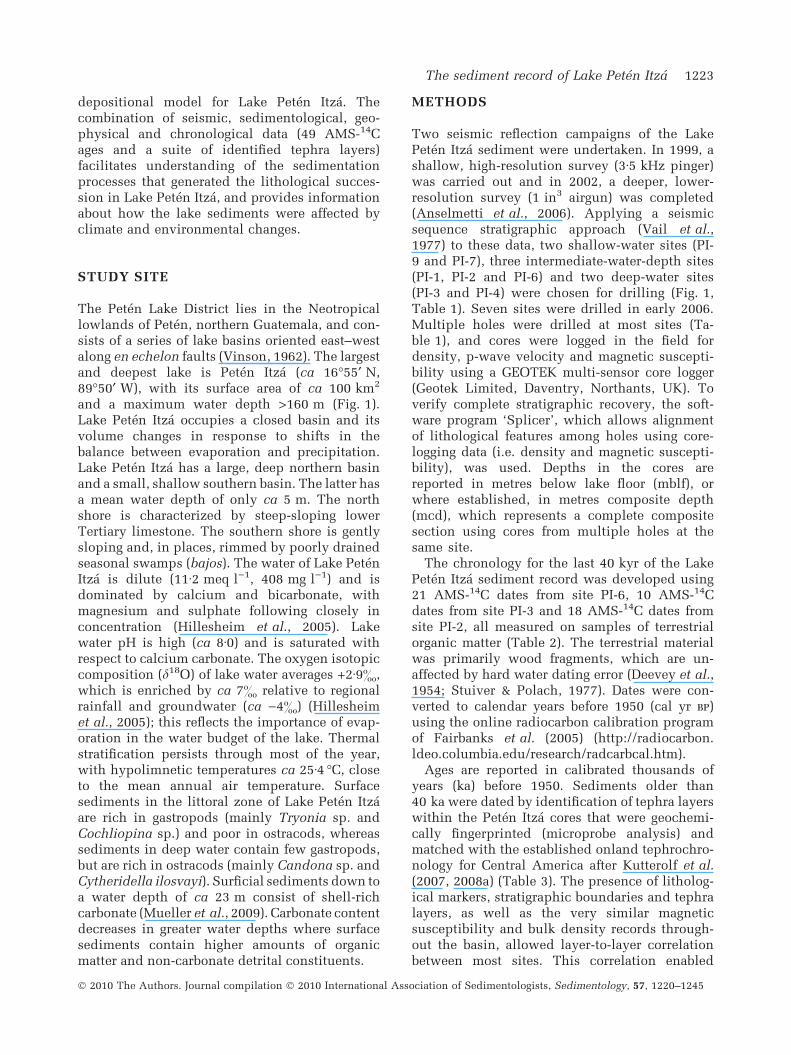
depositional model for Lake Peten Itza. Thecombination of seismic, sedimentological, geo-physical and chronological data (49 AMS-14Cages and a suite of identified tephra layers)facilitates understanding of the sedimentationprocesses that generated the lithological succes-sion in Lake Peten Itza, and provides informationabout how the lake sediments were affected byclimate and environmental changes.
STUDY SITE
The Peten Lake District lies in the Neotropicallowlands of Peten, northern Guatemala, and con-sists of a series of lake basins oriented east–westalong en echelon faults (Vinson, 1962). The largestand deepest lake is Peten Itza (ca 16�55¢ N,89�50¢ W), with its surface area of ca 100 km2
and a maximum water depth >160 m (Fig. 1).Lake Peten Itza occupies a closed basin and itsvolume changes in response to shifts in thebalance between evaporation and precipitation.Lake Peten Itza has a large, deep northern basinand a small, shallow southern basin. The latter hasa mean water depth of only ca 5 m. The northshore is characterized by steep-sloping lowerTertiary limestone. The southern shore is gentlysloping and, in places, rimmed by poorly drainedseasonal swamps (bajos). The water of Lake PetenItza is dilute (11Æ2 meq l)1, 408 mg l)1) and isdominated by calcium and bicarbonate, withmagnesium and sulphate following closely inconcentration (Hillesheim et al., 2005). Lakewater pH is high (ca 8Æ0) and is saturated withrespect to calcium carbonate. The oxygen isotopiccomposition (d18O) of lake water averages +2Æ9&,which is enriched by ca 7& relative to regionalrainfall and groundwater (ca )4&) (Hillesheimet al., 2005); this reflects the importance of evap-oration in the water budget of the lake. Thermalstratification persists through most of the year,with hypolimnetic temperatures ca 25Æ4 �C, closeto the mean annual air temperature. Surfacesediments in the littoral zone of Lake Peten Itzaare rich in gastropods (mainly Tryonia sp. andCochliopina sp.) and poor in ostracods, whereassediments in deep water contain few gastropods,but are rich in ostracods (mainly Candona sp. andCytheridella ilosvayi). Surficial sediments down toa water depth of ca 23 m consist of shell-richcarbonate (Mueller et al., 2009). Carbonate contentdecreases in greater water depths where surfacesediments contain higher amounts of organicmatter and non-carbonate detrital constituents.
METHODS
Two seismic reflection campaigns of the LakePeten Itza sediment were undertaken. In 1999, ashallow, high-resolution survey (3Æ5 kHz pinger)was carried out and in 2002, a deeper, lower-resolution survey (1 in3 airgun) was completed(Anselmetti et al., 2006). Applying a seismicsequence stratigraphic approach (Vail et al.,1977) to these data, two shallow-water sites (PI-9 and PI-7), three intermediate-water-depth sites(PI-1, PI-2 and PI-6) and two deep-water sites(PI-3 and PI-4) were chosen for drilling (Fig. 1,Table 1). Seven sites were drilled in early 2006.Multiple holes were drilled at most sites (Ta-ble 1), and cores were logged in the field fordensity, p-wave velocity and magnetic suscepti-bility using a GEOTEK multi-sensor core logger(Geotek Limited, Daventry, Northants, UK). Toverify complete stratigraphic recovery, the soft-ware program ‘Splicer’, which allows alignmentof lithological features among holes using core-logging data (i.e. density and magnetic suscepti-bility), was used. Depths in the cores arereported in metres below lake floor (mblf), orwhere established, in metres composite depth(mcd), which represents a complete compositesection using cores from multiple holes at thesame site.
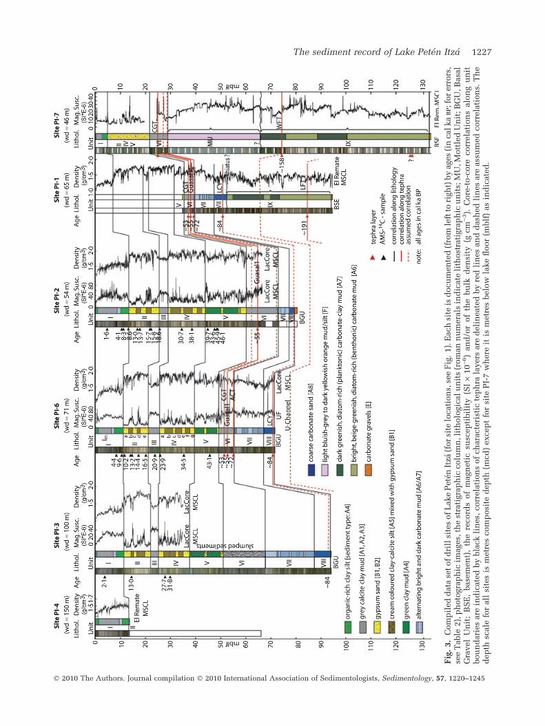
The chronology for the last 40 kyr of the LakePeten Itza sediment record was developed using21 AMS-14C dates from site PI-6, 10 AMS-14Cdates from site PI-3 and 18 AMS-14C dates fromsite PI-2, all measured on samples of terrestrialorganic matter (Table 2). The terrestrial materialwas primarily wood fragments, which are un-affected by hard water dating error (Deevey et al.,1954; Stuiver & Polach, 1977). Dates were con-verted to calendar years before 1950 (cal yr bp)using the online radiocarbon calibration programof Fairbanks et al. (2005) (http://radiocarbon.ldeo.columbia.edu/research/radcarbcal.htm).
Ages are reported in calibrated thousands ofyears (ka) before 1950. Sediments older than40 ka were dated by identification of tephra layerswithin the Peten Itza cores that were geochemi-cally fingerprinted (microprobe analysis) andmatched with the established onland tephrochro-nology for Central America after Kutterolf et al.(2007, 2008a) (Table 3). The presence of litholog-ical markers, stratigraphic boundaries and tephralayers, as well as the very similar magneticsusceptibility and bulk density records through-out the basin, allowed layer-to-layer correlationbetween most sites. This correlation enabled
The sediment record of Lake Peten Itza 1223
� 2010 The Authors. Journal compilation � 2010 International Association of Sedimentologists, Sedimentology, 57, 1220–1245
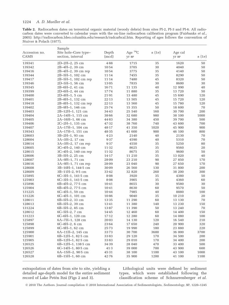
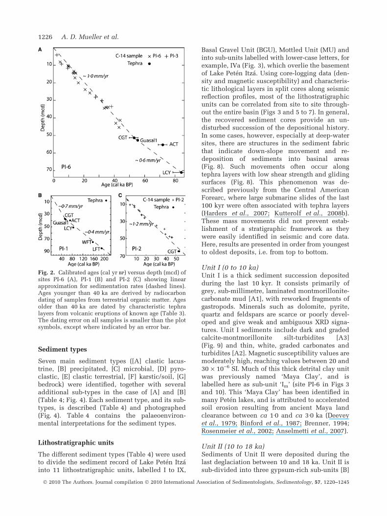
extrapolation of dates from site to site, yielding adetailed age-depth model for the entire sedimentrecord of Lake Peten Itza (Figs 2 and 3).
Lithological units were defined by sedimenttypes, which were established following theclassification scheme of Schnurrenberger et al.
Table 2. Radiocarbon dates on terrestrial organic material (woody debris) from sites PI-2, PI-3 and PI-6. All radio-carbon dates were converted to calendar years with the on-line radiocarbon calibration program (Fairbanks et al.,2005): http://radiocarbon.ldeo.columbia.edu/research/radcarbcal.htm. Reporting of ages follows the convention ofStuiver & Polach (1977).
Accession no.CAMS
SampleSite hole–Core type–section, interval
Depth(mcd)
Age 14Cyr bp
± (1r) Age calyr bp ± (1r)
139341 2D–2H–2, 25 cm 4Æ88 1715 35 1620 50139342 2B–4H–2, 39 cm 10Æ54 3705 30 4040 50139416 2B–4H–2, 39 cm rep 10Æ54 3775 35 4140 50139344 2B–5H–1, 102 cm 11Æ14 7455 35 8290 50139417 2B–5H–1, 102 cm rep 11Æ14 7480 45 8320 50139346 2D–5H–1, 56 cm 13Æ05 7835 30 8600 30139345 2B–6H–2, 41 cm 16Æ71 11 135 40 12 990 40139399 2D–6H–2, 44 cm 17Æ74 11 880 35 13 720 50139400 2D–8H–1, 5 cm 21Æ91 13 480 45 15 690 120139401 2B–8H–1, 132 cm 22Æ13 13 505 45 15 720 120139418 2B–8H–1, 132 cm rep 22Æ13 13 560 45 15 780 120139402 2B–9H–1, 146 cm 25Æ74 15 355 50 18 600 70139403 2B–12H–1, 121 cm 34Æ43 25 540 160 30 700 200139404 2A–14H–1, 115 cm 38Æ66 32 680 980 38 100 1000139405 2A–16H–1, 66 cm 44Æ83 34 380 450 39 700 500139406 2C–2H–1, 135 cm 47Æ32 38 760 740 43 600 700139407 2A–17H–1, 104 cm 48Æ17 41 350 1020 45 900 900139343 2A–17H–1, 151 cm 48Æ35 41 600 900 46 100 800128603 3B–2H–1, 93 cm 4Æ23 2140 40 2130 70128604 3A–3H–2, 17 cm 9Æ37 4590 40 5310 70128614 3A–3H–2, 17 cm rep 9Æ37 4550 35 5250 80128605 3C–4H–2, 140 cm 11Æ32 8625 35 9560 20128615 3C–4H–2, 140 cm rep 11Æ32 8675 35 9600 50128606 3B–5H–2, 25 cm 14Æ17 11 210 35 13 020 40128607 3A–9H–1, 71 cm 28Æ09 23 210 90 27 850 170128616 3A–9H–1, 71 cm rep 28Æ09 23 040 90 27 650 170128608 3B–10H–1, 144Æ5 cm 30Æ09 26 560 130 31 800 200128609 3B–11H–2, 9Æ5 cm 33Æ42 32 820 260 38 200 300125895 6C–3H–1, 141Æ5 cm 8Æ08 3920 35 4380 50125903 6C–3H–1, 141Æ5 cm 8Æ08 3905 35 4360 60125896 6B–4H–2, 77Æ5 cm 10Æ41 8655 30 9580 30125904 6B–4H–2, 77Æ5 cm 10Æ41 8630 60 9570 50131225 6C–4H–1, 59 cm 10Æ44 7985 40 8880 100131226 6C–4H–1, 101 cm 10Æ86 9040 35 10 210 20128611 6B–5H–2, 33 cm 13Æ35 11 290 60 13 130 70128613 6B–5H–2, 39 cm 13Æ41 11 380 140 13 230 150131224 6B–5H–2, 85 cm 13Æ87 11 390 50 13 240 70128612 6C–5H–2, 7 cm 14Æ45 12 460 60 14 400 150131223 6C–6H–1, 120 cm 17Æ12 12 280 60 14 080 100125897 6A–7H–1, 128 cm 20Æ03 14 130 120 16 540 210125898 6C–8H–2, 6 cm 23Æ64 17 650 240 20 900 320125899 6C–9H–1, 62 cm 25Æ73 19 990 180 23 880 220125900 6A–11H–2, 145 cm 33Æ73 30 700 3600 36 000 3700125901 6B–12H–1, 82Æ5 cm 33Æ83 29 120 170 34 500 200125905 6B–12H–1, 82Æ5 cm 33Æ83 29 010 170 34 400 200126525 6B–12H–1, 138Æ5 cm 34Æ39 28 040 470 33 400 500126526 6C–14H–1, 80Æ5 cm 41Æ3 39 000 700 43 900 600126527 6A–15H–2, 90Æ5 cm 45Æ31 38 100 1100 43 100 1000126528 6B–15H–1, 60 cm 42Æ76 35 900 1200 41 100 1100
1224 A. D. Mueller et al.
� 2010 The Authors. Journal compilation � 2010 International Association of Sedimentologists, Sedimentology, 57, 1220–1245

(2003). Sediment samples were taken at selecteddepths for analysis. Smear slides were preparedand studied with scanning electron microscopy.Grain-size distribution was established usinglaser diffraction techniques. Mineralogical com-position was determined by applying the Rietveldtechnique to measured X-ray diffraction (XRD)patterns (Ufer et al., 2008). The Rietveld tech-nique is a full pattern-fitting method that consistsof the calculation of the X-ray diffractogram andits iterative adjustment to the measured XRD-pattern by refinement of phase specific para-meters (Young, 2002).
RESULTS
Core recovery and sediment chronology
A total of 1327 m of lake sediment was recoveredfrom seven sites, with an average core recovery of90Æ6% (Table 1). Samples of terrestrial organicmatter in Peten Itza sediments, dated by radio-carbon, yielded reliable chronologies for depositsyounger than 40 ka. Most ages are in depth order(Hodell et al., 2008; Table 1; Fig. 2). Selectedtephra layers in Peten Itza sediments >40 ka werecompared to the existing Central American tephrastratigraphy (Kutterolf et al., 2008a; Table 3). InPI-6, the CGT Tephra (ca 53 ka) is at 51Æ3 mcd, theGuasal1 Tephra (ca 55 ka) is at 52Æ7 mcd and theACT Tephra (ca 72 ka) is at 55Æ3 mcd (Table 3).The depth of the ACT tephra suggests a consider-
able change in sedimentation rate, and was notincluded in the age-depth model. The age of thebase of the PI-6 core is constrained by an ash layerat 70Æ9 mcd from the ca 84 ka Los Chocoyos (LCYTephra) eruption of the Atitlan Caldera in theGuatemalan highlands (Rose et al., 1999; Kutterolfet al., 2007). This LCY ash layer occurs at 51Æ0mcd in site PI-1 (Fig. 2), implying that sedimentsbelow this marker horizon in PI-1 are much olderthan 84 ka. Thus, the PI-1 core contains a muchlonger record than does PI-6. Indeed, the WFT ashlayer, dated at ca 158 ka, was identified at 72Æ0mcd in PI-1 (Table 3; Fig. 2; Rose et al., 1999;Kutterolf et al., 2008a). The same ash layer wasalso identified in shallow-water core PI-7 at74Æ3 mcd (Fig. 3). Cores from PI-1 and PI-7 havemuch older records than do any of the other sites.At 84Æ2 mcd in site PI-1, ash from the ca 191 kaLFT eruption of Amatitlan was identified (Ta-ble 3; Fig. 2; Rose et al., 1999; Kutterolf et al.,2008a), suggesting a basal age of ca 200 ka.Shallow-water site PI-7, which penetrated to133Æ2 m, contains no identifiable ash layer in the60 m below the WFT tephra. The sedimentationrate, down to an age of ca 53 ka (CGT tephra),averages ca 1Æ0 mm year)1 in site PI-6, ca 0Æ7 mmyear)1 in site PI-1 and ca 1Æ2 mm year)1 in site PI-2(Fig. 2). Below the CGT tephra in cores from PI-6and PI-1, sedimentation rates were somewhatlower, ca 0Æ6 mm year)1 and ca 0Æ4 mm year)1,respectively (Fig. 2). In site PI-2, the sedimenta-tion rate remained relatively constant throughout,ca 1Æ2 mm year)1.
Table 3. Lake Peten Itza sediment tephrochronology.
Tephra
SampleSite hole–coretype–section,position (cm)
Depth(mcd)
Age(cal yr bp) Dating method
Congo Tephra (CGT) 6C–17E–2, 22 51Æ3 53 ± 3 ka Dated by 14C (Kutterolf et al., 2008a)1B–15H–2, 78 37Æ07A–15H–1, 73 25Æ0
Guatemala–El SalvadorTephra 1 (Guasal1)
6A–18E–3, 126 52Æ7 ca 55 ka Dated by stratigraphic interpolation2C–9H–1, 114 64Æ81B–16H–1, 58 38Æ0
Arce Tephra (ACT) 6B–19E–2, 113 55Æ3 72 ± 3 ka Dated by Ar/Ar (Rose et al., 1999)1B–16H–2, 76 39Æ6
Los Chocoyos Tephra (LCY) 6A–24E–2, 49 70Æ9 84 ± 0Æ5 ka Dated by oxygen isotope stratigraphy(Rose et al., 1999)1B–20H–3, 58 51Æ0
W-Tephra (WFT) 7A–30E–3, 84 74Æ3 158 ± 3 ka Dated by Ar/Ar (Rose et al., 1999)
L-Tephra (LFT) 1A–27H–2, 128 84Æ3 191 ± 11 ka Dated by Ar/Ar (Rose et al., 1999)
The sediment record of Lake Peten Itza 1225
� 2010 The Authors. Journal compilation � 2010 International Association of Sedimentologists, Sedimentology, 57, 1220–1245
Sediment types
Seven main sediment types ([A] clastic lacus-trine, [B] precipitated, [C] microbial, [D] pyro-clastic, [E] clastic terrestrial, [F] karstic/soil, [G]bedrock) were identified, together with severaladditional sub-types in the case of [A] and [B](Table 4; Fig. 4). Each sediment type, and its sub-types, is described (Table 4) and photographed(Fig. 4). Table 4 contains the palaeoenviron-mental interpretations for the sediment types.
Lithostratigraphic units
The different sediment types (Table 4) were usedto divide the sediment record of Lake Peten Itzainto 11 lithostratigraphic units, labelled I to IX,
Basal Gravel Unit (BGU), Mottled Unit (MU) andinto sub-units labelled with lower-case letters, forexample, IVa (Fig. 3), which overlie the basementof Lake Peten Itza. Using core-logging data (den-sity and magnetic susceptibility) and characteris-tic lithological layers in split cores along seismicreflection profiles, most of the lithostratigraphicunits can be correlated from site to site through-out the entire basin (Figs 3 and 5 to 7). In general,the recovered sediment cores provide an un-disturbed succession of the depositional history.In some cases, however, especially at deep-watersites, there are structures in the sediment fabricthat indicate down-slope movement and re-deposition of sediments into basinal areas(Fig. 8). Such movements often occur alongtephra layers with low shear strength and glidingsurfaces (Fig. 8). This phenomenon was de-scribed previously from the Central AmericanForearc, where large submarine slides of the last100 kyr were often associated with tephra layers(Harders et al., 2007; Kutterolf et al., 2008b).These mass movements did not prevent estab-lishment of a stratigraphic framework as theywere easily identified in seismic and core data.Here, results are presented in order from youngestto oldest deposits, i.e. from top to bottom.
Unit I (0 to 10 ka)Unit I is a thick sediment succession depositedduring the last 10 kyr. It consists primarily ofgrey, sub-millimetre, laminated montmorillonite-carbonate mud [A1], with reworked fragments ofgastropods. Minerals such as dolomite, pyrite,quartz and feldspars are scarce or poorly devel-oped and give weak and ambiguous XRD signa-tures. Unit I sediments include dark and gradedcalcite-montmorillonite silt-turbidites [A3](Fig. 9) and thin, white, graded carbonates andturbidites [A2]. Magnetic susceptibility values aremoderately high, reaching values between 20 and30 · 10)6 SI. Much of this thick detrital clay unitwas previously named ‘Maya Clay’, and islabelled here as sub-unit ‘Im’ (site PI-6 in Figs 3and 10). This ‘Maya Clay’ has been identified inmany Peten lakes, and is attributed to acceleratedsoil erosion resulting from ancient Maya landclearance between ca 1Æ0 and ca 3Æ0 ka (Deeveyet al., 1979; Binford et al., 1987; Brenner, 1994;Rosenmeier et al., 2002; Anselmetti et al., 2007).
Unit II (10 to 18 ka)Sediments of Unit II were deposited during thelast deglaciation between 10 and 18 ka. Unit II issub-divided into three gypsum-rich sub-units [B]
Fig. 2. Calibrated ages (cal yr bp) versus depth (mcd) ofsites PI-6 (A), PI-1 (B) and PI-2 (C) showing linearapproximation for sedimentation rates (dashed lines).Ages younger than 40 ka are derived by radiocarbondating of samples from terrestrial organic matter. Agesolder than 40 ka are dated by characteristic tephralayers from volcanic eruptions of known age (Table 3).The dating error on all samples is smaller than the plotsymbols, except where indicated by an error bar.
1226 A. D. Mueller et al.
� 2010 The Authors. Journal compilation � 2010 International Association of Sedimentologists, Sedimentology, 57, 1220–1245
Fig
.3.
Com
pil
ed
data
set
of
dri
llsi
tes
of
Lake
Pete
nIt
za
(for
site
locati
on
s,se
eF
ig.
1).
Each
site
isd
ocu
men
ted
(fro
mle
ftto
righ
t)by
ages
(in
cal
ka
bp;fo
rerr
ors
,se
eT
able
2),
ph
oto
gra
ph
icim
ages,
the
stra
tigra
ph
iccolu
mn
,li
tholo
gic
al
un
its
(rom
an
nu
mera
lsin
dic
ate
lith
ost
rati
gra
ph
icu
nit
s;M
U,M
ott
led
Un
it;B
GU
,B
asa
lG
ravel
Un
it;
BS
E,
base
men
t),
the
record
sof
magn
eti
csu
scep
tibil
ity
(SI
·10
)6)
an
d/o
rof
the
bu
lkd
en
sity
(gcm
)3).
Core
-to-c
ore
corr
ela
tion
salo
ng
un
itbou
nd
ari
es
are
ind
icate
dby
bla
ck
lin
es,
corr
ela
tion
sof
ch
ara
cte
rist
icte
ph
rala
yers
are
deli
neate
dby
red
lin
es
an
dd
ash
ed
lin
es
are
ass
um
ed
corr
ela
tion
s.T
he
dep
thsc
ale
for
all
site
sis
metr
es
com
posi
ted
ep
th(m
cd
)excep
tfo
rsi
teP
I-7
wh
ere
itis
metr
es
belo
wla
ke
floor
(mblf
)as
ind
icate
d.
The sediment record of Lake Peten Itza 1227
� 2010 The Authors. Journal compilation � 2010 International Association of Sedimentologists, Sedimentology, 57, 1220–1245

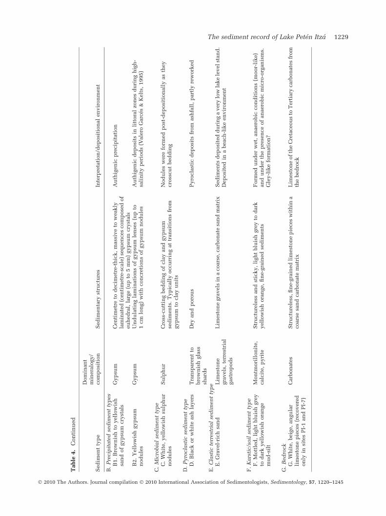
Table
4.
Lake
Pete
nIt
za
sed
imen
tty
pes.
Sed
imen
tty
pe
Dom
inan
tm
inera
logy/
com
posi
tion
Sed
imen
tary
stru
ctu
res
Inte
rpre
tati
on
/dep
osi
tion
al
en
vir
on
men
t
A.
Cla
stic
lacu
stri
ne
sed
imen
tty
pes
A1.
Gre
ym
ud
Mon
tmori
llon
ite,
calc
ite
Very
hom
ogen
ou
s,extr
em
ely
fin
e-g
rain
ed
cla
y,
sub-
mil
lim
etr
ela
min
ati
on
s;ri
ch
infr
agm
en
tsof
rew
ork
ed
gast
rop
od
s
Detr
ital
inp
ut
of
ero
ded
soil
an
dw
eath
ere
dli
mest
on
ein
the
wate
rsh
ed
A2.
Wh
ite
san
dC
alc
ite
Mil
lim
etr
eto
cen
tim
etr
e-t
hic
kfi
nin
gu
pw
ard
silt
ysa
nd
sequ
en
ces
Tu
rbid
ites
deri
ved
from
slop
ein
stabil
itie
sin
the
shall
ow
-wate
rcarb
on
ate
zon
e
A3.
Dark
,gre
ysi
lt-s
an
dM
on
tmori
llon
ite,
calc
ite
Gra
ded
fin
ing-u
pw
ard
sequ
en
ces
(up
to5
cm
thic
k)
ch
ara
cte
rized
by:
(i)
colo
ur
gra
die
nts
from
ad
ark
gre
ybase
toa
ligh
tgre
yto
p;
(ii)
up
ward
-decre
asi
ng
den
sity
;an
d(i
ii)
sharp
,ir
regu
lar
con
tacts
at
the
base
Tu
rbid
ity
cu
rren
tstr
an
sport
ing
ero
ded
soil
from
the
wate
rsh
ed
du
rin
gfl
ood
even
ts
A4.
Dark
gre
en
cla
ym
ud
-sil
tM
on
tmori
llon
ite,
org
an
icm
att
er
Hom
ogen
ou
scla
ym
ud
wit
hsu
b-m
illi
metr
ela
min
ati
on
s.R
ich
inp
lan
kto
nic
dia
tom
s(A
ula
cose
ira
sp.)
Deep
-wate
r,p
ela
gic
en
vir
on
men
t,lo
ww
ate
ren
erg
y
A5.
Cre
am
-colo
ure
dsi
ltM
on
tmori
llon
ite,
calc
ite
Mass
ive
tow
eakly
lam
inate
dsi
ltD
etr
ital
inp
ut
from
ero
ded
soil
an
dli
mest
on
ein
the
wate
rsh
ed
A6.
Bri
gh
t,beig
em
ud
Calc
ite
Fin
ely
lam
inate
d(m
illi
metr
e-s
cale
)m
ud
wit
hso
me
eu
hed
ral
calc
ite
cry
stals
;ri
ch
inben
thon
icd
iato
ms
(Mast
oglo
ia,
Den
ticu
la)
Sh
all
ow
-wate
rto
sub-l
itto
ral
en
vir
on
men
t,ra
rely
au
thig
en
icp
recip
itati
on
A7.
Dark
,bro
wn
-gre
en
ish
mu
dC
alc
ite,
mon
tmori
llon
ite
Hom
ogen
ou
s,fi
nely
lam
inate
d,
org
an
ic-r
ich
mu
d;
rich
inp
lan
kto
nic
dia
tom
s(A
ula
cose
ira
sp.)
Deep
-wate
rto
sub-l
itto
ral
en
vir
on
men
t
A8.
Beig
e-g
reen
ish
silt
-san
dC
alc
ite
Poorl
yso
rted
carb
on
ate
san
d,
inte
rbed
ded
by
up
to5
mm
thic
kfi
nin
g-u
pw
ard
gra
ded
san
dse
qu
en
ces;
wood
rem
ain
s;ri
ch
infr
agm
en
tsof
carb
on
ate
shell
s
CaC
O3
pro
du
cti
on
inh
igh
-en
erg
yen
vir
on
men
tof
the
litt
ora
lzon
e
1228 A. D. Mueller et al.
� 2010 The Authors. Journal compilation � 2010 International Association of Sedimentologists, Sedimentology, 57, 1220–1245
Table
4.
Con
tin
ued
Sed
imen
tty
pe
Dom
inan
tm
inera
logy/
com
posi
tion
Sed
imen
tary
stru
ctu
res
Inte
rpre
tati
on
/dep
osi
tion
al
en
vir
on
men
t
B.
Pre
cip
itate
dse
dim
en
tty
pes
B1.
Bro
wn
ish
toyell
ow
ish
san
dof
gyp
sum
cry
stals
Gyp
sum
Cen
tim
etr
eto
decim
etr
e-t
hic
k,
mass
ive
tow
eakly
lam
inate
d(c
en
tim
etr
e-s
cale
)se
qu
en
ces
com
pose
dof
eu
hed
ral,
larg
e(u
pto
5m
m)
gyp
sum
cry
stals
Au
thig
en
icp
recip
itati
on
B2.
Yell
ow
ish
gyp
sum
nod
ule
sG
yp
sum
Un
du
lati
ng
lam
inati
on
sof
gyp
sum
len
ses
(up
to1
cm
lon
g)
wit
hcon
cre
tion
sof
gyp
sum
nod
ule
sA
uth
igen
icd
ep
osi
tsin
litt
ora
lzon
es
du
rin
gh
igh
-sa
lin
ity
peri
od
s(V
ale
roG
arc
es
&K
elt
s,1995)
C.
Mic
robia
lse
dim
en
tty
pe
C.
Wh
ite,
yell
ow
ish
sulp
hu
rn
od
ule
sS
ulp
hu
rC
ross
-cu
ttin
gbed
din
gof
cla
yan
dgyp
sum
sed
imen
ts.
Typ
icall
yoccu
rrin
gat
tran
siti
on
sfr
om
gyp
sum
tocla
yu
nit
s
Nod
ule
sw
ere
form
ed
post
-dep
osi
tion
all
yas
they
cro
sscu
tbed
din
g
D.
Pyro
cla
stic
sed
imen
tty
pe
D.
Bla
ck
or
wh
ite
ash
layers
Tra
nsp
are
nt
tobro
wn
ish
gla
sssh
ard
s
Dry
an
dp
oro
us
Pyro
cla
stic
dep
osi
tsfr
om
ash
fall
,p
art
lyre
work
ed
E.
Cla
stic
terr
est
rial
sed
imen
tty
pe
E.
Gra
vel-
rich
san
dL
imest
on
egra
vels
,te
rrest
rial
gast
rop
od
s
Lim
est
on
egra
vels
ina
coars
e,carb
on
ate
san
dm
atr
ixS
ed
imen
tsd
ep
osi
ted
du
rin
ga
very
low
lake
level
stan
d.
Dep
osi
ted
ina
beach
-lik
een
vir
on
men
t
F.
Kars
tic/s
oil
sed
imen
tty
pe
F.
Mott
led
,li
gh
tblu
ish
gre
yto
dark
yell
ow
ish
ora
nge
mu
d-s
ilt
Mon
tmori
llon
ite,
calc
ite,
pyri
teS
tru
ctu
rele
ssan
dst
icky,
ligh
tblu
ish
gre
yto
dark
yell
ow
ish
ora
nge,
fin
e-g
rain
ed
sed
imen
tsF
orm
ed
un
der
wet,
an
aero
bic
con
dit
ion
s(m
oor-
like)
an
du
nd
er
the
pre
sen
ce
of
an
aero
bic
mic
ro-o
rgan
ism
s.G
ley-l
ike
form
ati
on
?
G.
Bed
rock
G.
Wh
ite,
beig
e,
an
gu
lar
lim
est
on
ep
ieces
(recovere
don
lyin
site
sP
I-1
an
dP
I-7)
Carb
on
ate
sS
tru
ctu
rele
ss,fi
ne-g
rain
ed
lim
est
on
ep
ieces
wit
hin
acoars
esa
nd
carb
on
ate
matr
ixL
imest
on
eof
the
Cre
taceou
sto
Tert
iary
carb
on
ate
sfr
om
the
bed
rock
The sediment record of Lake Peten Itza 1229
� 2010 The Authors. Journal compilation � 2010 International Association of Sedimentologists, Sedimentology, 57, 1220–1245

Fig. 4. Core photographs showingdifferent sediment types (indicatedby capital letters) including ascanning electron micrograph of anidiomorphic gypsum crystal (upperright panel). For explanations of thesediment types, see Table 4.
1230 A. D. Mueller et al.
� 2010 The Authors. Journal compilation � 2010 International Association of Sedimentologists, Sedimentology, 57, 1220–1245
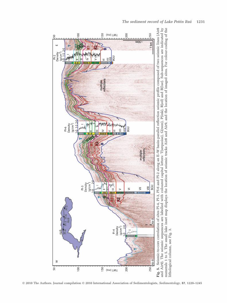
Fig
.5.
Seis
mic
-to-c
ore
corr
ela
tion
of
site
sP
I-4,
PI-
3,
PI-
6an
dP
I-2
alo
ng
an
E–W
basi
n-p
ara
llel
refl
ecti
on
seis
mic
pro
file
com
pose
dof
two
seis
mic
lin
es
(Air
8an
dA
ir9).
Th
ese
ism
icse
qu
en
ces
are
labell
ed
wit
hcolo
ure
dcap
ital
lett
ers
:T
(urq
uois
e),
G(r
een
),P
(in
k),
R(e
d)
an
dB
(lu
e).
Su
b-s
equ
en
ces
are
ind
icate
dby
nu
mera
ls1
to5.
Th
esm
all
lake
inse
tm
ap
dis
pla
ys
the
locati
on
of
seis
mic
tracks
Air
8an
dA
ir9,
an
dth
elo
cati
on
of
imaged
site
s.F
or
colo
ur-
cod
ing
of
the
lith
olo
gic
al
colu
mn
,se
eF
ig.
3.
The sediment record of Lake Peten Itza 1231
� 2010 The Authors. Journal compilation � 2010 International Association of Sedimentologists, Sedimentology, 57, 1220–1245
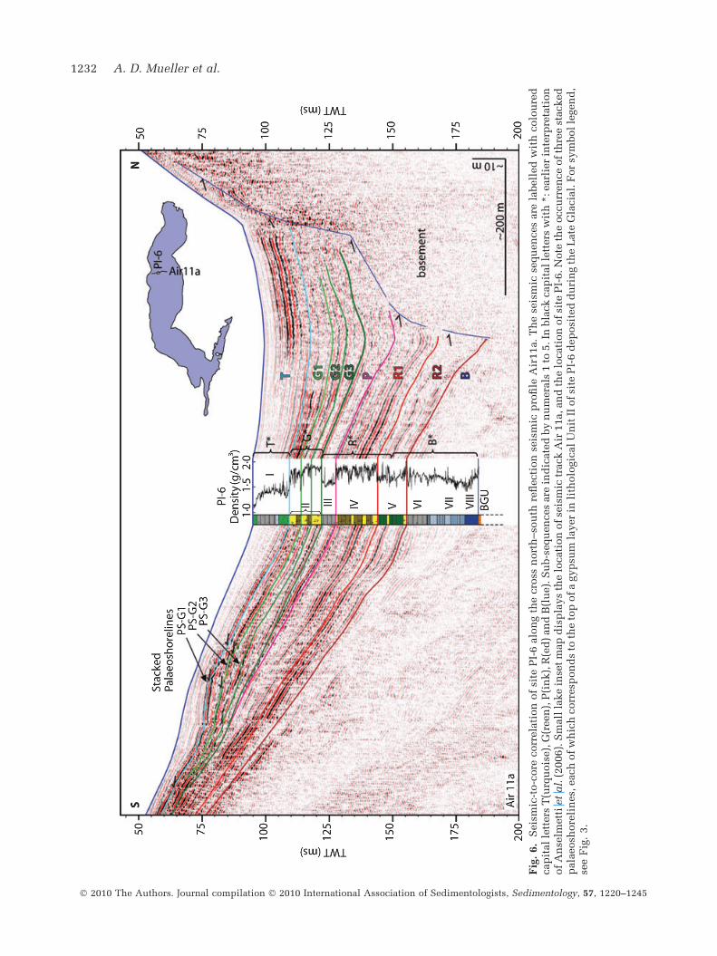
Fig
.6.
Seis
mic
-to-c
ore
corr
ela
tion
of
site
PI-
6alo
ng
the
cro
ssn
ort
h–so
uth
refl
ecti
on
seis
mic
pro
file
Air
11a.
Th
ese
ism
icse
qu
en
ces
are
labell
ed
wit
hcolo
ure
dcap
ital
lett
ers
T(u
rqu
ois
e),
G(r
een
),P
(in
k),
R(e
d)
an
dB
(lu
e).
Su
b-s
equ
en
ces
are
ind
icate
dby
nu
mera
ls1
to5.In
bla
ck
cap
ital
lett
ers
wit
h*:earl
ier
inte
rpre
tati
on
of
An
selm
ett
iet
al.
(2006).
Sm
all
lake
inse
tm
ap
dis
pla
ys
the
locati
on
of
seis
mic
track
Air
11a,an
dth
elo
cati
on
of
site
PI-
6.N
ote
the
occu
rren
ce
of
thre
est
acked
pala
eosh
ore
lin
es,
each
of
wh
ich
corr
esp
on
ds
toth
eto
pof
agyp
sum
layer
inli
tholo
gic
al
Un
itII
of
site
PI-
6d
ep
osi
ted
du
rin
gth
eL
ate
Gla
cia
l.F
or
sym
bol
legen
d,
see
Fig
.3.
1232 A. D. Mueller et al.
� 2010 The Authors. Journal compilation � 2010 International Association of Sedimentologists, Sedimentology, 57, 1220–1245
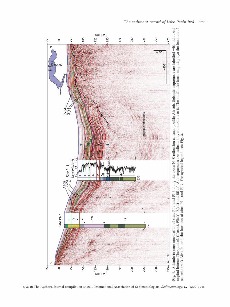
Fig
.7.
Seis
mic
-to-c
ore
corr
ela
tion
of
site
sP
I-1
an
dP
I-7
alo
ng
the
cro
ssN
–S
refl
ecti
on
seis
mic
pro
file
Air
10b.
Seis
mic
sequ
en
ces
are
labell
ed
wit
hcolo
ure
dcap
ital
lett
ers
:T
(urq
uois
e),
G(r
een
),P
(in
k),
R(e
d)
an
dB
(lu
e).
Su
b-s
equ
en
ces
are
ind
icate
dby
nu
mera
ls1
to5.T
he
small
lake
inse
tm
ap
dis
pla
ys
the
locati
on
of
seis
mic
track
Air
10b,
an
dth
elo
cati
on
of
site
sP
I-1
an
dP
I-7.
For
sym
bol
legen
d,
see
Fig
.3.
The sediment record of Lake Peten Itza 1233
� 2010 The Authors. Journal compilation � 2010 International Association of Sedimentologists, Sedimentology, 57, 1220–1245
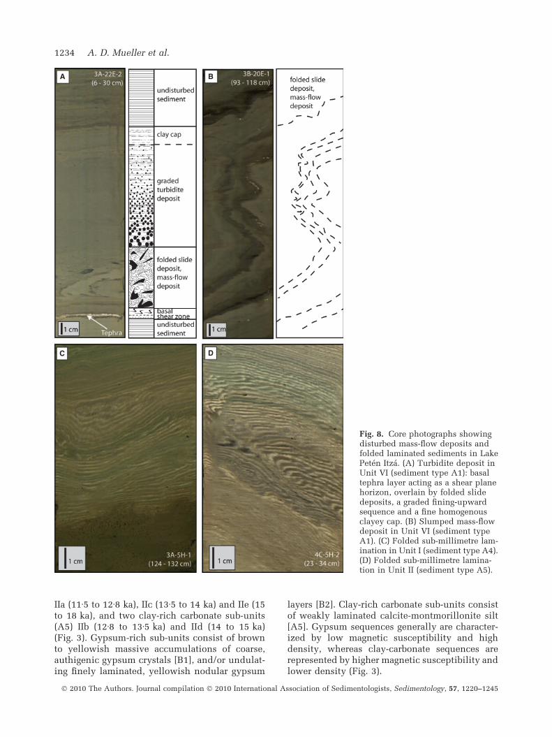
IIa (11Æ5 to 12Æ8 ka), IIc (13Æ5 to 14 ka) and IIe (15to 18 ka), and two clay-rich carbonate sub-units(A5) IIb (12Æ8 to 13Æ5 ka) and IId (14 to 15 ka)(Fig. 3). Gypsum-rich sub-units consist of brownto yellowish massive accumulations of coarse,authigenic gypsum crystals [B1], and/or undulat-ing finely laminated, yellowish nodular gypsum
layers [B2]. Clay-rich carbonate sub-units consistof weakly laminated calcite-montmorillonite silt[A5]. Gypsum sequences generally are character-ized by low magnetic susceptibility and highdensity, whereas clay-carbonate sequences arerepresented by higher magnetic susceptibility andlower density (Fig. 3).
A B
C D
Fig. 8. Core photographs showingdisturbed mass-flow deposits andfolded laminated sediments in LakePeten Itza. (A) Turbidite deposit inUnit VI (sediment type A1): basaltephra layer acting as a shear planehorizon, overlain by folded slidedeposits, a graded fining-upwardsequence and a fine homogenousclayey cap. (B) Slumped mass-flowdeposit in Unit VI (sediment typeA1). (C) Folded sub-millimetre lam-ination in Unit I (sediment type A4).(D) Folded sub-millimetre lamina-tion in Unit II (sediment type A5).
1234 A. D. Mueller et al.
� 2010 The Authors. Journal compilation � 2010 International Association of Sedimentologists, Sedimentology, 57, 1220–1245

Unit III (18 to 23 ka)Unit III, deposited between 18 and 23 ka, coin-cides approximately with the LGM (Mix et al.,2001). This unit is characterized by grey, sub-millimetre-scale laminated mud, consistingmainly of montmorillonite and calcite [A1].Dolomite, pyrite, quartz and feldspar occur astrace minerals. Fragments of reworked gastro-
pods are common in this unit. The finelylaminated clay is often interbedded by darkgrey, graded silt sequences with irregular anderosive bases [A3]. These graded sequences varyin thickness between 1 and 3 cm. ThroughoutUnit III, magnetic susceptibility is high (40 to60 · 10)6 SI), whereas density is low (<1Æ5 gcm)3) (Fig. 3).
Fig. 9. Physical characteristics ofsediment type A3. Top, from left toright: schematic sketch of a finingupward sequence, colour gradientfrom dark base to bright top on corephotograph, fining upward of parti-cle sizes in grain-size analysis, andupcore decreasing density record onX-ray radiograph (light colours =high density); Bottom: XRD diffrac-togram of sediment type A3.
Fig. 10 High-resolution seismic N-Sprofile (Pinger line PI 11) docu-menting seismic sub-sequence Tm
coinciding with lithologicalsub-unit Im (‘Maya Clay’). P/Hboundary, Pleistocene/Holocenetransition; PS-G1, palaeoshorelineG1.
The sediment record of Lake Peten Itza 1235
� 2010 The Authors. Journal compilation � 2010 International Association of Sedimentologists, Sedimentology, 57, 1220–1245

Unit IV (23 to 39 ka)The sediments of Unit IV accumulated between23 and 39 ka. Unit IV is sub-divided into fourgypsum-rich sub-units: IVa (23 to 25 ka), IVc (30to 32 ka), IVe (35 to 36 ka) and IVg (38 to 39 ka),and three clay-rich carbonate sub-units IVb (25 to30 ka), IVd (32 to 35 ka) and IVf (36 to 38 ka)(Fig. 3). Similar to Unit II, gypsum-rich sub-unitsconsist of coarse, massive brownish-yellowishgypsum sand [B1], and/or undulating, laminated,yellowish nodular gypsum layers [B2]. Clay-richcarbonate units consist of massive, cream-coloured silt [A5]. Gypsum beds are characterizedby low magnetic susceptibility and high density,whereas clay has higher magnetic susceptibilityand lower density (Fig. 3).
Unit V (39 to 49 ka)Sediments of Unit V (39 to 49 ka) consist of finelylaminated, dark greenish clay mud, which is richin organic matter [A4]. This unit consists of up to5 cm thick, graded turbidites [A3]. Two se-quences of authigenic gypsum crystals [B1, B2]were deposited, peaking at ca 42 and ca 48 ka(Fig. 3).
Unit VI (49 to 58 ka)Sediments of Unit VI, deposited from 49 to 58 ka,are composed of grey, laminated montmorillonitemud [A1], which is partly mottled with dark,diffuse organic-rich spots. This unit is punctu-ated by graded, dark turbidite sequences of silt[A3]. Sediments of this unit include fragments ofreworked gastropods.
Unit VII (58 to 78 ka)Unit VII consists of sediments that were depos-ited from ca 58 to ca 78 ka. These sediments arecomposed of rhythmic alternations betweenbright-beige sequences of carbonate mud [A6]and darker-brown to greenish, organic-rich se-quences of laminated clay-carbonate mud [A7](Fig. 3). The darker clay bands contain planktonicdiatoms (Aulacoseira sp.), whereas the brightercarbonate bands are rich in benthonic diatoms(Mastogloia and Denticula).
Unit VIII (78 to 85 ka)Sediments of Unit VIII (78 to 85 ka) consist ofcoarse, beige-greenish, poorly sorted carbonatesand-silt with abundant organic macro-remainsand fragments of lacustrine gastropods [A8](Fig. 3). Several distinct white carbonate sandlayers, characterized by high density, are inter-calated within this silty-sandy unit. The sand is
punctuated with hard, solid pieces of limestone,and it is interbedded by up to 5 mm thick, fining-upward, graded sand turbidites. The petrophysicalanalysis of this lithological unit revealed a trendof increasing density from ca 1Æ4 to 1Æ8 g cm)3
and magnetic susceptibility from ca 50 to70 · 10)6 SI.
Basal Gravel UnitSediments of the BGU at the base of sites PI-3,PI-6 and PI-2 consist of solid, large limestonegravels (up to 4 cm) embedded in a poorly sorted,coarse, beige carbonate sand matrix. The gravelsusually are angular, but in some cases arerounded. The sand contains fragments of terres-trial gastropod shells [E]. The petrophysicalanalysis of this lithological unit revealed highdensity (ca 1Æ9 g cm)3) and intermediate to highmagnetic susceptibility (ca 55 · 10)6 SI).
Mottled Unit (ca 85 to ? ka)This unit, which only occurs in shallow-watersite PI-7, intercalated between overlying UnitVI and underlying Unit IX, consists of a morethan 30 m thick, sticky, light-bluish-grey to dark-yellowish-orange, fine-grained mud-silt sequence[F]. The mineralogy of this unit is composedmainly of calcite, montmorillonite and pyrite.The grey sediments of this sequence are oftenmottled with dark black, diffuse spots. TheMottled Unit is characterized by many cracks,which display a reddish hue, probably associatedwith sediment oxidation. This section has inter-mediate magnetic susceptibility, high density,low organic matter (mean ca 1%), and highcalcium carbonate content (mean ca 15%).
Unit IX (? to 200 ka)Unit IX, recovered only at sites PI-1 and PI-7,represents sediments deposited some time beforea hiatus that ended ca 85 ka and at least 200 ka.This unit is characterized by alternations of twokinds of packages and is up to 10 m thick: (i)dark, brown-greenish, finely laminated (milli-metre-scale) carbonate-clay mud [A7]; and (ii)bright beige, very homogenous carbonate mud[A6]. The darker, clay-rich packages are full ofplanktonic diatoms (Aulacoseira sp.), whereasthe lighter, calcite-rich packages are dominatedby benthonic diatoms (Mastogloia and Denticula).Thus, rhythmic alternations between darker andlighter packages suggest fluctuations betweenhigher and lower lake levels, respectively. Sedi-ments of Unit IX are often interbedded with dark,graded turbidites [A3], and they are composed of
1236 A. D. Mueller et al.
� 2010 The Authors. Journal compilation � 2010 International Association of Sedimentologists, Sedimentology, 57, 1220–1245
many millimetre-scale to decimetre-scale defor-mation structures (Fig. 8). Such structures areexpressed in the sediment record as: (i) millimetre-scale folded laminations; or (ii) large slumpstructures, which are visible as prominent defor-mations of thick turbidites (Fig. 8).
Basement (BSE)At sites PI-7 and PI-1, material recovered belowthe sediments of Unit IX is interpreted as repre-senting bedrock [G]. It consists of large, angular,white-beige limestone gravels in a coarse, sandycarbonate matrix.
Seismic stratigraphy
The initial seismic stratigraphy of Anselmettiet al. (2006) was modified and five major seismicsequences (T, G, P, R and B) and several sub-sequences that overlie the acoustic basementwere identified (Figs 5 to 7; Table 5). Capitalletters indicate the colour used to illustrate theseismic reflection that marks the underlyingsequence boundary, i.e. T(urquoise), G(reen),P(ink), R(ed) and B(lue). Sub-sequences are indi-cated by numerals 1 to 5 or, in the case of the‘Maya-Clay’, by ‘Tm’ (Fig. 10).
Core-to-seismic correlation
Core-to-seismic correlation is shown along aneast–west seismic reflection profile, and alongcrossing north–south profiles (Figs 5 to 7). Litho-logical Unit I spans the Holocene and coincideswith uppermost seismic sequence T (Fig. 6). Thebulk of Unit I was deposited in a relatively shortperiod between ca 1Æ0 and 3Æ0 ka, and is repre-sented by the ‘Maya-Clay’ sub-unit (Im) and in theseismic reflection data by sub-sequence Tm
(Fig. 10). The lithological boundary from Unit I(clay) to Unit II (gypsum) at ca 10Æ7 ka isexpressed by a prominent increase in bulk den-sity (from ca 1Æ4 to ca 1Æ7 g cm)3) and a strong,high-amplitude reflection at seismic boundaryT/G (Fig. 6). Sediments of Unit II (10 to 18 ka)consist of three gypsum sub-units (IIa, IIc and IIe)and two clay sub-units (IIb and IId). The top ofeach gypsum sub-unit corresponds to one of threestacked palaeoshorelines (PS) in the seismicrecord at 75 ms (PS-G1, 56 m), 85 ms (PS-G2,64 m) and 90 ms (PS-G3, 68 m) (Figs 6 and 7).Clay-rich sediments of Unit III (18 to 23 ka) arecharacterized by low bulk densities and arerepresented seismically by low-amplitude reflec-tions of seismic sequence P. The sedimentological
transition from Unit III (clay) to Unit IV (gypsum)at 23 ka is expressed by an increase in densityfrom ca 1Æ5 to ca 1Æ9 g cm)3 in the core, whichcorresponds to a strong, high-amplitude reflectionat the P/R sequence boundary. Sediments of UnitIV (23 to 39 ka), consisting of alternating gypsumsub-units (IVa, IVc, IVe and IVg) and clay sub-units (IVb, IVd and IVf), are marked by high-frequency variations in bulk density, and coin-cide approximately with continuous, high-ampli-tude reflections of sub-sequence R1. LithologicalUnit V (39 to 49 ka) correlates with seismicsub-sequence R2. Some areas in sub-sequenceR2 show transparent to chaotic seismic facies,indicating local mass movements that are alsoobserved in lithological Unit V as deformedsediments, on metre to millimetre scales (Fig. 8).The clay-rich mud of Unit VI (49 to 58 ka)represents the upper part of sequence B. Banded,clay-rich and carbonate-rich lacustrine sedimentsof Unit VII (58 to 78 ka) correspond to the middlepart of sequence B. The transition from Unit VIII(78 to 85 ka) to Unit VII at 78 ka corresponds tothe lower part of sequence B and is expressed byan up-core decrease in density from ca 1Æ9 toca 1Æ5 g cm)3 (Fig. 6). Sediments of MU (Site PI-7)and lithological Unit IX, that cover the time spanfrom ca 85 to ca 200 ka in sites PI-1 and PI-7,could not be correlated with the seismic record,as the air-gun source was insufficient to penetrateto this sediment depth (Fig. 7). Consequently,recovery of these deposits was unexpected be-cause they were not imaged by the seismicreflection survey.
DISCUSSION
Comparisons with the seismic model ofAnselmetti et al. (2006)
The entire sediment record from Lake Peten Itzawas used to evaluate and refine the previousseismic stratigraphic work of Anselmetti et al.(2006). In general, the earlier study shows goodagreement with the observations presented in thisstudy (Fig. 6). Nonetheless, there are some signi-ficant differences between the findings of thisstudy and the interpretations of Anselmetti et al.(2006).
1 Whereas Anselmetti et al. (2006) defined fourseismic sequences (T, G, R and B), an additionalmajor seismic sequence P was defined in thisstudy. Sequence P spans the LGM, from 18 to
The sediment record of Lake Peten Itza 1237
� 2010 The Authors. Journal compilation � 2010 International Association of Sedimentologists, Sedimentology, 57, 1220–1245

23 ka. This sequence was added because Unit III(‘LGM-Clay’) stands out, not only with respect toits lithological signature, but because its seismicfacies is characterized by very low reflectionamplitudes that contrast sharply with overlyingand underlying seismic sequences.
2 Sequence G, defined in Anselmetti et al.(2006) as containing two sub-sequences, was sub-divided into three sub-sequences G1, G2 and G3.New evaluation revealed that the three-foldsuccession of gypsum sediments in Unit II (orsequence G) matches three seismically identified,stacked PS (Figs 6 and 7) that were not recog-nized before. The three PS, at )68 m, )64 m and)56 m, thus indicate a stepwise increase inpalaeolake water levels after lowstands during thearid, last deglaciation phase (11 to 18 ka).
3 At sites PI-1 and PI-7, drilling penetratedsignificantly beyond predictions made usingseismic reflection data, i.e. below the apparent‘acoustic basement’. This under-estimation wascaused in part by high-impedance values of theBGU in contrast to the overlying units. Further-more, large limestone clasts in the BGU scatterthe acoustic signal, thereby inhibiting deeperacoustic penetration. Interpretation of the seismicreflection data accurately predicted thesub-surface depth down to the base of Unit VIIIand BGU, which appeared as acoustic basementin the deeper-water sections. The occurrence ofsediments in Unit IX, below the acoustic base-ment, which were undetected seismically, prob-ably is limited to the deeper-water depocentres ofthe lake. In shallow-water areas in contrast, the
Table 5. Seismic geometries and seismic facies of each seismic sequence in the sediment record of Lake Peten Itza,described from the top (young sediments) to the bottom (old sediments).
Sequence TSequence T is composed of a thick (10 to 15 m) succession of acoustically stratified sediments characterized byhighly continuous, low-amplitude reflections. Locally, internal reflections are characterized by higher amplitudesthan those of surrounding reflections. Sequence T is separated from the underlying sequence G by a high-amplitudereflection, which is onlapped by the younger reflections of sequence T. Sequence T reaches a maximum thickness ofca 15 m in the deeper parts of the basin. On the high-resolution pinger seismic lines a mappable subunit (Tm) isrecognized within sequence T. Subsequence Tm is characterized by slightly higher amplitude reflections than therest of sequence T. The thickest part of subsequence Tm reaches values of more than 7 m, coincident with maximumwater depth
Sequence GSequence G is thickest in the deeper parts of the basin, reaching a maximum thickness of ca 20 m. Reflections ofsequence G are characterized by continuous reflections, similar to sequence T, but with higher amplitudes. On theslightly dipping southern part of the basin, the top of sequence G is characterized by a mound-like clear featureoccurring at ca 56 m (75 ms) below modern water level. This feature can be observed throughout the entire Peten Itzabasin and is interpreted as a palaeoshoreline (Anselmetti et al., 2006). Similar to this palaeoshoreline, two otherbuildups at ca 64 m (85 ms) and at ca 68 m (90 ms) below modern lake level are documented, representing twoadditional stacked palaeoshorelines. These three build-ups separate sequence G into three subsequences G1, G2and G3
Sequence PThe depocentre of sequence P, where this unit reaches a maximal vertical thickness of 12 m, is coincident withmaximum water depth (160 m). This sequence is characterized by continuous, low-amplitude reflections. The top ofsequence P is defined by a normal-polarity high-amplitude reflection and the base is defined by an inverse-polarityhigh-amplitude reflection (compared to the normal-polarity lake floor reflection representing a downward increasingimpedance). Sequence P constantly wedges out at a water depth of ca 85 ms two-way-travel (64 m below modern lakelevel). The bottom of this sequence is characterized by an onlap geometry onto the top of sequence R1
Sequence RSequence R is subdivided into an upper Subsequence R1 and a lower subsequence R2 using an inverse-polarity high-amplitude reflection. The reflections of both sequences R1 and R2 are generally higher amplitudes near the basinedges and get weaker with increasing water depth and distance from the basin margin. Some areas show transparentto chaotic seismic facies indicating local mass movements
Sequence BThe oldest seismic-stratigraphic sequence B reaches a maximum thickness of 50 to 60 m where it infills bedrockdepressions. These topographic lows in the bedrock are onlapped by sequence B. In general, the seismic facies ofsequence B is more chaotic compared to the overlying sequences, but occasionally sequence B is also characterizedby seismically stratified reflections
1238 A. D. Mueller et al.
� 2010 The Authors. Journal compilation � 2010 International Association of Sedimentologists, Sedimentology, 57, 1220–1245
seismically mapped acoustic basement may wellrepresent ‘true’ basement, as it is exposed nearbyon the lake shores.
Lake level and sedimentation history of LakePeten Itza
Eleven lithological units (Units I to IX, MU andBGU) were defined in the stratigraphic recordoverlying the BSE of Lake Peten Itza, and repre-sent at least 11 distinct phases of the palaeo-environmental history of the lake. Stratigraphiccorrelation of these lithological unit boundaries(Fig. 3) and seismic reflections (Fig. 5) through-out the basin indicates that the lithology can beused as a reliable proxy for palaeolimnologicaland palaeoclimate inferences. Sedimentologicalresults are interpreted and discussed with respectto past lake and environmental changes, fromoldest to youngest deposits (Fig. 11).
The oldest lacustrine sediments of Lake PetenItza, which overlie the basement, are representedby lithological Unit IX in sites PI-1 and PI-7 andreach a basal age of ca 200 ka, corresponding tothe transition from MIS 7 to MIS 6. This ratheryoung age does not necessarily represent the ageof the initial lake formation. Older sediments mayhave been eroded and redeposited in the deeperparts of the bedrock topography. Due to the lowenergy of the acoustic signal produced by theairgun source used in the seismic reflectionsurvey, seismic energy did not penetrate to bed-rock in these deeper areas; therefore, continuousmapping of the bedrock surface was not possible.In marginal areas of the lake, where the bedrocksurface can be traced with seismic reflection data,the morphology suggests a half graben geometry,with a steep northern border fault and a gentlydipping southern graben shoulder. Both appear tobe enhanced by karstic dissolution processes,which contributed to lake basin formation(Anselmetti et al., 2006). Observed sedimentdeformation and the slumping and sliding ofentire sediment packages (Fig. 8) may be theresult of ongoing tectonic activity. These featuresmay also be a consequence of sediment ‘overload-ing’, produced by lake level changes that alteredgeotechnical properties and decreased slope sta-bilities, or alternatively as a consequence ofdistant seismic events. No evidence of faults (forexample, with surface ruptures) was observed inthe seismic reflection data. Thus, there is nodirect evidence of ongoing tectonic activity in thesub-surface of Lake Peten Itza.
Sandy to silty carbonates [A8], interbedded bynumerous dark, clay-sand turbidites [A3] in unitIX, overlie the basement and indicate high run-offand detrital input from the watershed into thelake. This observation would imply relativelyhumid conditions during the initial transgressionand lake-filling phase. Nevertheless, if the lakebasin and catchment morphology were verydifferent from that of today, perhaps as aconsequence of tectono-karstic alterations, thehydrology of the system may also have differed. Ahydrologically ‘open’ system would not havebeen as susceptible to evaporite formation as thelake is today. Hence, the rather uniform litho-logies could have been produced in an opensystem that was relatively insensitive to E/Pchanges. The lack of major lithological changesin this unit, however, is remarkable, especiallyconsidering the large glacial–interglacial changesand variations in precessionally driven insolationthat occurred during this period.
At shallow-water Site PI-7, Unit IX is overlainby MU, which is composed of a peculiar, >30 mthick succession of bluish to yellowish, carbon-ate-clay-pyrite mud [F] that lacks visible layering.The mottled bluish lithology is reminiscent ofgleyed soil, which usually forms under low-oxygen, high soil-moisture conditions followedby flooding (Gambrell & Patrick, 1978; Reddyet al., 1986). Sediments overlying Unit IX indeep-water areas (for example, sites PI-2, PI-3and PI-6) are represented by the BGU. These BGUsediments represent a partially exposed beachgravel horizon formed during a low lake standbefore 85 ka, when soil formation, represented byMU, was taking place at shallow water site PI-7.Because seismic information below the BGUhorizon is lacking, it is not possible to determinewhether only sites PI-1 and PI-7 contain a pre-85 ka section such as Unit IX, or whether Unit IXis restricted to narrow depressions in the tectono-karstic substrate of Lake Peten Itza. A seismicreflection survey, using a stronger acousticsource, might provide the answer. Because SitePI-4, located near the greatest water depth of themodern lake, was not drilled to bedrock, it is alsouncertain whether the BGU horizon develops intoa conformable succession at greater water depth.In any case, this horizon represents a major lakelevel lowering around 90 ka, most probablycaused by a significant increase in E/P. In thisregard it is noteworthy that lake level lowstands(i.e. climate drying) around this time havealso been inferred for low-latitude African lakes
The sediment record of Lake Peten Itza 1239
� 2010 The Authors. Journal compilation � 2010 International Association of Sedimentologists, Sedimentology, 57, 1220–1245

(for example, Lakes Malawi, Bosumtwi andTanganyika; Scholz et al., 2007).
After deposition of the BGU between 85 and78 ka (ca MIS 5a), a rise in lake level andtransgression are indicated by coarse carbonatesand with large gastropods in Unit VIII [A8].
This lithology represents a shallow, transgres-sional depositional environment with highenergy during the flooding phase. Because sitePI-7 was drilled in shallow water, it was floodedby this transgression at a later date, duringdeposition of Unit VI.
A B
Fig. 11. (A) Compiled data from site PI-6 versus depth (mcd): Radiocarbon and tephra ages in cal ka bp at samplelocations, composite photograph scan, lithological units, stratigraphic column and magnetic susceptibility. Gypsumdeposits (marked by yellow colour and low magnetic susceptibility) are highlighted by grey shading and correlatewith Heinrich Events ‘H’ that occur in the coldest stadials in Greenland (Bond et al., 1992). ‘YD’, Younger Dryas;‘LGM’, Last Glacial Maximum; ‘OD’, Older Dryas. (B) Compiled data from site PI-6 versus age in cal ka bp and MarineIsotope Stage (MIS, from Peterson et al., 2000): magnetic susceptibility (SI · 10)6) with Greenland interstadial (IS)events (Hodell et al., 2008) and schematic lake level curve from Lake Peten Itza based on the presented seismic,lithological and magnetic susceptibility data.
1240 A. D. Mueller et al.
� 2010 The Authors. Journal compilation � 2010 International Association of Sedimentologists, Sedimentology, 57, 1220–1245
The sequence spanning ca 78 to ca 58 ka(ca MIS 4) includes shallower-water and deeper-water sediments (Unit VII) [A6, A7], representingalternating dry and humid climate conditions.Phases of lower lake level were not sufficientlylow or persistent enough to reach CaSO4 satura-tion, which is required to precipitate gypsum.Nonetheless, alternating lake levels are docu-mented in the sediment record (Unit VII) byintercalated bright-beige carbonate [A6], and darkbrown to greenish, carbonate-clay beds [A7]. Thebrighter carbonate-rich bands represent shallow-water conditions containing benthonic, shallow-water diatoms (Mastogloia, Denticula), whereasthe darker clay beds represent deep-water condi-tions containing planktonic diatoms (Aulacoseirasp.).
The time between 58 and 49 ka (early MIS 3)was characterized by relatively humid conditions(i.e. high lake level) as indicated by the highdetrital clay content [A1] Unit VI, suggesting highrun-off and detrital input from the watershedduring times of greater rainfall. Between 49 and39 ka (mid-MIS 3), high lake level stands andhumid conditions continued as indicated by highorganic matter content in the detrital sediments ofUnit V [A4], suggesting higher autochthonousorganic matter production during a period of lesssaline conditions. This overall humid period wasinterrupted by two short, but pronounced lakelevel drops during dry events at ca 48 andca 42 ka. During these two dry events, the volumeof Lake Peten Itza was reduced significantlyand lake waters were more saline than today,causing the first episodes of authigenic gypsumprecipitation [B].
The time between 39 and 23 ka (late MIS 3) wascharacterized by fluctuating high and low lakelevels. In Unit IV, stage variations are docu-mented by gypsum layers [B] during lowstandsthat alternate with cream-coloured, carbonate-clay silt [A5] deposits during highstands. Fourlowstands, at ca 38Æ5, ca 35Æ5, ca 31 and ca 24 kaoccur between three phases of higher lake level.The timing of clay-gypsum oscillations during themiddle and later part of MIS 3 indicates that clayunits correlate with warmer IS events docu-mented in Greenland ice cores, whereas gypsumunits are associated with cold stadials in theNorth Atlantic, especially those containing Hein-rich Events H4, H3 and H2 (Bond et al., 1992;Hodell et al., 2008) (Fig. 11). Similarly, alternat-ing clay-gypsum units during MIS 3 correlateclosely with other circum-Caribbean palaeo-climate records, for instance, the marine Cariaco
Basin record off northern Venezuela (ODP Hole1002C; Peterson et al., 2000; Hodell et al., 2008).These Dansgaard-Oeschger climate cycles (Dans-gaard et al., 1993) are also represented in theseismic data by high-amplitude reflections withinsequence R1 (Fig. 6), which are produced bylithological differences between low-density clayand high-density gypsum sediments.
From 23 to 18 ka, i.e. during the LGM (Mixet al., 2001) (early MIS 2), high lake level (i.e.humid climate) and enhanced erosion are indi-cated by several lines of evidence. Firstly, thesediment is dominated by montmorillonitic clays(Unit III). As montmorillonite is the principalweathering product of tropical soils in Peten(Cowgill & Hutchinson, 1966; Curtis et al., 1998),it suggests a humid climate and pronouncederosion in the watershed. Secondly, the dark-coloured turbidites [A3] represent individualheavy precipitation events. Thirdly, high mag-netic susceptibility values indicate high deposi-tion of clastic material in the lake. Lastly, the baseof sequence P onlaps onto underlying sequenceR1 and there is a basinward-thickening wedge ofseismic sequence P seen on seismic reflectiondata (Fig. 7), with the depocentre of this sequencecoincident with the greatest water depths. Thesefindings are consistent with enhanced detritalinput, suggesting sediment focusing into deeperparts of the basin (i.e. high-density turbiditesfrom underflows). These sedimentological char-acteristics all indicate humid climate during theLGM, which contradicts previous palaeoclimateresults from Peten that proposed the lowlands ofCentral America were dry at that time (Leydenet al., 1993, 1994). Previous inferences, however,were based on the poorly dated sequence fromLake Quexil. Climate mechanisms that may haveproduced a humid climate in Peten during theLGM are discussed in Hodell et al. (2008) andBush et al. (2009).
During the last deglaciation from 18 to 11 ka(late MIS 2, early MIS 1), lake levels fluctuatedbetween low and intermediate stands as indi-cated in Unit II by alternating gypsum [B] andcream-coloured, clay-carbonate units [A5]. Thelithology suggests a generally arid Late Glacial. Inthe seismic record, effective moisture cycles arerecognized by the increased frequency of high-amplitude reflections in seismic sequence G.Three dry events, i.e. lake level lowstands, arerecorded by three gypsum units at ca 16Æ5, ca 14and ca 11Æ5 ka, all of which have a palaeoshore-line in the lake margin areas (PS-G1-3, Figs 6, 7and 11). The elevations of these shorelines
The sediment record of Lake Peten Itza 1241
� 2010 The Authors. Journal compilation � 2010 International Association of Sedimentologists, Sedimentology, 57, 1220–1245
increase successively from 68 m (90 ms) to 64 m(85 ms) and finally to 56 m (75 ms) below themodern lake level (Figs 6, 7 and 11), showing astepwise increase in the level of the lowstandsduring the Late Glacial.
About 11 ka, at the termination of the arid lastglacial period in early MIS 1, the lake level was ca56 m below the modern stage, as indicated by apalaeosol in shallow-water cores (Hillesheimet al., 2005; Anselmetti et al., 2006) and byautochthonous gypsum crystals in deep-watercores (Hillesheim et al., 2005; Anselmetti et al.,2006). At that time, the volume of Lake Peten Itzawas reduced to only about 13% of its presentvolume, the lake was moderately saline andwaters were saturated with respect to gypsum(Hillesheim et al., 2005). After this lowstand, lakelevels rose, as documented in shallow-water coresby transgressive, gastropod-rich lacustrine sedi-ments, which overlie a late Pleistocene palaeosol(Curtis et al., 1998; Hillesheim et al., 2005). Indeep-water cores, the transition from arid latePleistocene to moister Holocene conditions ismarked by a shift from gypsum [B] to organic-rich, deeper-water, clay-rich sediments of Unit I[A4]. Onlapping bedding geometries in seismicsequence T clearly illustrate this lake transgres-sion (Fig. 6). After this early Holocene rise, lakelevels remained high except for minor phases oflowered levels, in particular between 4Æ5 and3Æ0 ka (Mueller et al., 2009) During the last 3 kyr,environmental conditions in Peten watershedsand sedimentology in the lakes have been con-trolled strongly by human activities (Deeveyet al., 1979; Binford et al., 1987; Brenner, 1994;Rosenmeier et al., 2002; Anselmetti et al., 2007).For instance, forest clearance by the ancientMaya, which began about 3000 years ago, led tohigh erosion rates in Peten watersheds. Thiseffect is expressed in the Lake Peten Itza sedimentrecord by the ‘Maya-Clay’ sub-unit (Im) (Fig. 10).Following the demise of Classic Maya culturearound 1Æ0 ka, rapid clay deposition was replacedby slower sedimentation of organic-rich clay andsilt deposits, reflecting tropical forest recovery inthe watershed and reduced supply of detritalmaterial to the lake basin (Islebe et al., 1996).
CONCLUSIONS
Lake Peten Itza sediments are sensitive recordersof past environmental changes during the last200 kyr. Seismic stratigraphy, together with sed-iment core analysis, enabled comprehensive
reconstruction of past environmental changes inthe region.
1 Radiocarbon dates and tephrochronology re-veal that the oldest sediments of Lake Peten Itzawere deposited ca 200 ka (Marine Isotope Stage7a). These samples were recovered from sectionsbelow the zone of deepest seismic imaging;accordingly deeper basins in the bedrock mor-phology may exist, and the age of the sampledsediments may under-estimate the age of tectono-karstic basin formation.
2 Eleven lithostratigraphic units (Units I to IX,Mottled Units and Basel Gravel Units) overlyingthe basement were defined in the Peten Itza sed-iment record. These units represent at least 11distinct phases of the palaeoenvironmental his-tory of the lake. These lithostratigraphic units aretraceable laterally throughout the Lake Peten Itzabasin. This observation justifies the use of thelithological succession as a regional palaeoenvi-ronmental proxy, as suggested by previous stud-ies (Hodell et al., 2008).
3 The sediment succession in cores from theseven drill sites allowed testing and refinement ofthe seismic stratigraphy proposed prior to dril-ling. The predictions of stratigraphic boundaries,in general, were accurate. Seismic data penetra-tion was not sufficient to image deep sediment insome sections. In two cases, reflections inter-preted as acoustic basement were instead agravel-bearing horizon and sediments were muchthicker than anticipated.
4 Sediment deposited between ca 200 and 85 kawas encountered at only two sites, probablybecause of irregular basin morphology with nar-row depressions in the tectono-karstic basement.These oldest sediments are characterized bylithologies that reflect deposition during an initialtransgression, followed by clay and carbonate-richsediments without major gypsum units, reflectingrather sustained humid conditions resulting inhigh run-off and high detrital constituents.
5 Before 85 ka, the sediment record is charac-terized by a gravel-bearing and sand-bearing unitthat forms an unconformity indicative of a majorlake level lowstand (i.e. dry climate). Dry climatearound this time was also inferred by study ofsediments from low-latitude African lakes.
6 During the last ca 50 kyr, lithological unitsare characterized by alternating clay and gypsumunits. Gypsum units are associated with low lakelevels (i.e. dry climate) and clay units with highlake levels (i.e. humid climate). Stacked palaeo-shorelines at )68 m, )64 m and )56 m coincide
1242 A. D. Mueller et al.
� 2010 The Authors. Journal compilation � 2010 International Association of Sedimentologists, Sedimentology, 57, 1220–1245
with gypsum units that indicate a stepwise in-crease in water levels from the lowstands duringthe arid, last deglaciation, 18 to 11 ka.
7 The Holocene lacks gypsum deposits, andwas thus characterized by relatively high lakelevels and humid climate. Human impact duringthe Maya epoch (ca 3Æ0 to 1Æ0 ka) is reflected byrapid clay deposition.
ACKNOWLEDGEMENTS
We thank the many people who assisted us withfield work on the Lake Peten Itza ScientificDrilling Project: Gabriela Alfaro, Jacobo Blijden-stein, Cornelia Bronnimann, Kristina Brady,Mark Bush, Emmanuel Chapron, Erin Endsley,Christina Gallup, Valerie Gamble, StephanieGirardclos, Robert Hofmann, Gerald Islebe, Jen-nifer Mays, Melisa Orozco, Anders Noren, LisethPerez, Silja Ramirez and Florian Thevenon. Weare also grateful to the numerous agencies andindividuals in Guatemala who provided assis-tance to the project including: Universidad delValle, Universidad San Carlos, Ministerio deAmbiente y Recursos Naturales, Consejo Nacion-al de Areas Protegidas, Instituto de Antropologıae Historia, Autoridad Para el Manejo y Desarrol-lo Sostenible de la Cuenca del Lago Peten-Itza,Wildlife Conservation Society, Alex Arrivillaga,Cathy Lopez, Margaret Dix, Michael Dix, Marga-rita Palmieri, David, Rosita, & Kelsey Kuhn, andthe staff at La Casa de Don David, Lico Godoy,Tony Ortiz, Franz Sperisen, Luis Toruno andJulian Tesucun. We also thank our many collab-orators from University of Florida, University ofMinnesota (Minneapolis/Duluth), Geofors-chungszentrum (Potsdam), Swiss Federal Insti-tute of Technology (Zurich), Universite deGeneve, the personnel of DOSECC (Drilling,Observation and Sampling of the Earth’s Conti-nental Crust), and Ruedi Baumann for helptaking the X-rays, Florence Sylvestre for helpdetermining diatoms as well as Irene Brunner(Eawag) for geochemical analyses. The cores arearchived at LacCore (National Lacustrine CoreRepository), Department of Geology and Geo-physics, University of Minnesota-Twin Citiesand we thank Kristina Brady, Amy Myrbo andAnders Noren for their assistance in coredescription and curation. This project wasfunded by grants from the US National ScienceFoundation (ATM-0502030 and ATM-0502126),the International Continental Scientific DrillingProgram, the Swiss National Science Foundation
and the ETH Research Grant TH-1/04-1. Radio-carbon analyses were performed under the aus-pices of the U.S. Department of Energy,Lawrence Livermore National Laboratory undercontract No. W-7405-Eng-48.
REFERENCES
Anselmetti, F.S., Ariztegui, D., Hodell, D.A., Hillesheim, M.B.,Brenner, M., Gilli, A., McKenzie, J.A. and Mueller, A.D.(2006) Late Quaternary climate-induced lake level varia-
tions in Lake Peten Itza, Guatemala, inferred from seismic
stratigraphic analysis. Palaeogeogr. Palaeoclimatol. Palae-oecol., 230, 52–69.
Anselmetti, F.S., Ariztegui, D., Brenner, M., Hodell, D.A.and Rosenmeier, M.F. (2007) Quantification of soil ero-
sion rates related to ancient Maya deforestation. Geology,
35, 915–918.
Beach, T., Dunning, N., Luzzader-Beach, S., Cook, D.E. and
Lohse, J. (2006) Impacts of the ancient Maya on soils and
soil erosion in the Central Maya lowlands. Catena, 65, 166–
178.
Binford, M.W., Brenner, M., Whitmore, T.J., Higuera-Gundy,A., Deevey, E.S. and Leyden, B. (1987) Ecosystems, paleo-
ecology and human disturbance in subtropical and tropical
America. Quatern. Sci. Rev., 6, 115–128.
Bond, G., Heinrich, H., Broecker, W., Labeyrie, L., McManus,J., Andrews, J., Huon, S., Jantschik, R., Clasen, S., Simet,C., Tedesco, K., Klas, M., Bonani, G. and Ivy, S. (1992)
Evidence for massive discharges of icebergs into the North
Atlantic Ocean during the last glacial period. Nature, 360,245–249.
Brenner, M. (1994) Lakes Salpeten and Quexil, Peten, Guate-
mala, Central America. In: Global Geological Record of Lake
Basins (Eds E. Gierlowski-Kordesch and K. Kelts), Vol. 1,
pp. 377–380. Cambridge University Press, Cambridge.
Brenner, M., Leyden, B.W. and Binford, M.W. (1990) Recent
sedimentary histories of shallow lakes in the Guatemalan
savannas. J. Paleolimnol., 4, 239–251.
Bush, M.B., Correa-Metrio, A., Hodell, D.A., Brenner, M.,Anselmetti, F.S., Ariztegui, D., Mueller, A.D., Curtis, J.H.,Grzesik, D., Burton, C. and Gilli, A. (2009) Re-evaluation of
climate change in lowland Central America during the Last
Glacial Maximum using new sediment cores from Lake
Peten Itza, Guatemala. In: Past Climate Variability in South
America and Surrounding Regions (Eds F. Vimeux, F. Syl-
vestre and M. Khodri), pp. 113–128. Springer, Netherlands.
Cowgill, U.M. and Hutchinson, E.G. (1966) La Aguada de
Santa Ana Vieja: the history of a pond in Guatemala. Arch.
Hydrobiol., 62, 335–372.
Cowgill, U.M., Hutchinson, G.E., Racek, A.A., Goulden, C.E.,Patrick, R. and Tsukada, M. (1966) The history of Laguna
de Petenxil, a small lake in northern Guatemala. Mem.
Connecticut Acad. Arts Sci., 17, 1–126.
Curtis, J.H., Brenner, M., Hodell, D.A., Balser, R.A., Islebe,G.A. and Hooghiemstra, H. (1998) A multi-proxy study of
Holocene environmental change in the Maya Lowlands of
Peten, Guatemala. J. Paleolimnol. 19, 139–159.
Dansgaard, W., Johnsen, S.J., Clausen, H.B., Dahl-Jensen, D.,Gundestrup, N.S., Hammer, C.U., Hvidberg, C.S., Steffen-sen, J.P., Sveinbørnsdottir, A.E., Jouzel, J. and Bond, G.(1993) Evidence for general instability of past climate from a
250-kyr icecore record. Nature, 364, 218–220.
The sediment record of Lake Peten Itza 1243
� 2010 The Authors. Journal compilation � 2010 International Association of Sedimentologists, Sedimentology, 57, 1220–1245
Deevey, E.S., Gross, M.S., Hutchinson, G.E. and Kraybill,H.L. (1954) The natural 14C contents of materials from
hard-water lakes. Proc. Natl Acad. Sci. USA, 40, 285–
288.
Deevey, E.S., Rice, D.S., Rice, P.M., Vaughan, H.H., Bren-ner, M. and Flannery, M.S. (1979) Mayan urbanism:
impact on a tropical karst environment. Science, 206,298–306.
Deevey, E.S., Brenner, M. and Binford, M.W. (1983) Paleo-
limnology of the Peten Lake District, Guatemala, III. Late
Pleistocene and Gamblian environments of the Maya area.
Hydrobiologia, 103, 211–216.
Fairbanks, R.G., Mortlock, R.A., Chiu, T.-C., Cao, L., Kaplan,A., Guilderson, T.P., Fairbanks, T.W. and Bloom, A.L.(2005) Marine radiocarbon calibration curve spanning
10,000 to 50,000 years B.P. based on paired 230Th/234U/
238U and 14C dates on Pristine Corals. Quatern. Sci. Rev.,
24, 1781–1796.
Gambrell, R.P. and Patrick, W.H. (1978) Chemical and micro-
biological properties of anaerobic soils and sediments. In:
Plant Life in Anaerobic Environments (Eds D.D. Hook and
R.M.M. Crawford), pp. 375–423. Ann Arbor Science, Ann
Arbor, MI.
Harders, R., Bruckmann, W., Feeser, V., Kutterolf, S., Hensen,C. and Moerz, T. (2007) Are ash layers the controlling factor
on translational sliding? Geophys. Res. Abstracts, 9, 07917.
SRef-ID: 1607-7962/gra/EGU2007-A-07917.
Haug, G.H., Hughen, K.A., Sigman, D.M., Peterson, L.C. and
Rohl, U. (2001) Southward migration of the intertropical
convergence zone through the Holocene. Science, 293,1304–1308.
Hillesheim, M.B., Hodell, D.A., Leyden, B.W., Brenner, M.,Curtis, J.H., Anselmetti, F.S., Ariztegui, D., Buck, D.G.,Guilderson, T.P., Rosenmeier, M.F. and Schnurrenberger,D.W. (2005) Climate change in lowland Central America
during the late deglacial and early Holocene. J. Quatern.
Sci., 20, 363–376.
Hodell, D.A., Anselmetti, F., Brenner, M., Ariztegi, D. and
PISDP Scientific Party (2006) The Lake Peten Itza Scientific
Drilling Project. Sci. Drilling, 3, 25–29.
Hodell, D.A., Anselmetti, F., Ariztegui, D., Brenner, M.,Bush, M.B., Correa-Metrio, A., Curtis, J.H., Escobar, J.,Gilli, A., Grzesik, D.A., Guilderson, T.P., Kutterolf, S. and
Mueller, A.D. (2008) An 85-ka record of climate change in
lowland Central America. Quatern. Sci. Rev., 27, 1152–
1165.
Islebe, G.A., Hooghiemstra, H., Brenner, M., Curtis, J.H. and
Hodell, D.A. (1996) A Holocene vegetation history from
lowland Guatemala. Holocene, 6, 265–271.
Kutterolf, S., Schacht, U., Wehrmann, H., Freundt, A. and
Morz, T. (2007) Onshore to offshore tephrostratigraphy and
marine ash layer diagenesis in Central America. In: Geology,Resources and Hazards (Eds J. Buntschuh and G.E. Alva-
rado), Taylor & Francis/Balkema, London. ISBN 978-0-415-
41648-1: 395-423.
Kutterolf, S., Freundt, A., Perez, W., Morz, T., Schacht, U.,Wehrmann, H. and Schmincke, H.U. (2008a) Pacific off-
shore record of plinian arc volcanism in Central America: 1.
Along-arc correlations. Geochem. Geophys. Geosyst., 9,Q02S01. doi: 10.1029/2007GC001631.
Kutterolf, S., Freundt, A., Schacht, U., Burk, D., Harders, R.,Morz, T. and Perez, W. (2008b). Pacific offshore record of
plinian arc volcanism in Central America: 3. Application to
forearc geology. Geochem. Geophys. Geosyst., 9, Q02S03.
doi: 10.1029/2007GC001826.
Leyden, B.W. (1984) Guatemalan forest synthesis after Pleis-
tocene aridity. Proc. Natl Acad. Sci. USA, 81, 4856–4859.
Leyden, B.W. (1987) Man and climate in the Maya lowlands.
Quatern. Res., 28, 407–414.
Leyden, B.W., Brenner, M., Hodell, D.A. and Curtis, J.H. (1993)
Late Pleistocene climate in the Central American lowlands.
In: Climate Change in Continental Isotopic Records. Am.
Geophys. Union, Geophys. Monogr., 78, 165–178.
Leyden, B.W., Brenner, M., Hodell, D.A. and Curtis, J.H.(1994) Orbital and internal forcing of climate on the Yucatan
Peninsula for the past ca. 36 ka. Palaeogeogr. Palaeoclima-tol. Palaeoecol., 109, 193–210.
Mix, A., Bard, E. and Schneider, R. (2001) Environmental
processes of the ice age: land, oceans, glaciers (EPILOG).
Quatern. Sci. Rev., 20, 627–657.
Mueller, A.D., Islebe, G.A., Hillesheim, M.B., Grzesik, D.A.,Anselmetti, F.S., Ariztegui, D., Brenner, M., Curtis, J., Ho-dell, D.A. and Venz, K.A. (2009) Climate drying and asso-
ciated forest decline in the lowlands of Northern Guatemala
during the Late Holocene. Quatern. Res., 71, 133–141.
Peterson, L.C., Haug, G.H., Hughen, K.A. and Rohl, U. (2000)
Rapid changes in the hydrologic cycle of the tropical
Atlantic during the Last Glacial. Science, 290, 1947–1951.
Reddy, K.R., Feijtel, T.C. and Patrick, W.H. (1986) Effect of
soil redox conditions on microbial oxidation of organic
matter. In: The Role of Organic Matter in Modern Agricul-ture (Eds Y. Chen and Y. Avnimelech), pp. 117–156. Nijhoff,
Dordrecht.
Rice, D.S., Rice, P.M. and Deevey, E.S. (1985) Paradise lost:
classic Maya impact on a lacustrine environment. In: Pre-historic Lowland Maya Environment and Subsistence
Economy, Papers of the Peabody Museum of Archaeology
and Ethnology (Ed. M.D. Pohl), Vol. 77, pp. 91–105. Harvard
University Press, Cambridge.
Rose, W.I., Conway, F.M., Pullinger, C.R., Deino, A. and
McIntosh, W.C. (1999) An improved age framework for late
Quaternary silicic eruptions in northern Central America.
Bull. Volcanol., 61, 106–120.
Rosenmeier, M.F., Hodell, D.A., Brenner, M., Curtis, J.H. and
Guilderson, T.P. (2002) A 4000-year lacustrine record of
environmental change in the southern Maya lowlands,
Peten, Guatemala. Quatern. Res., 57, 183–190.
Schnurrenberger, D., Russell, J. and Kelts, K. (2003) Classifi-
cation of lacustrine sediments based on sedimentary com-
ponents. J. Paleolimnol., 29, 141–154.
Scholz, C.A., Johnson, T.C., Cohen, A.S., King, J.W., Peck,J.A., Overpeck, J.T., Talbot, M.R., Brown, E.T., Kalinde-kafe, L., Amoako, P.Y.O., Lyons, R.P., Shanahan, T.M.,Castaneda, I.S., Heil, C.W., Forman, S.L., McHargue, L.R.,Beuning, K.R., Gomez, J. and Pierson, J. (2007) East African
megadroughts between 135 and 75 thousand years ago and
bearing on early-modern human origins. Proc. Natl Acad.Sci. USA, 104, 16416–16421.
Stuiver, M. and Polach, H.A. (1977) Discussion: reporting of14C data. Radiocarbon, 19, 355–363.
Ufer, K., Stanjek, H., Roth, G., Dohrmann, R., Kleeberg, R. and
Kaufhold, S. (2008) Quantitative phase analysis of bento-
nites with the Rietveld method. Clay Clay Mineral., 56, 272–
282.
Vail, P.R., Mitchum, R.M. and Thompson, S. (1977) Cycles of
relative changes of sea level. In: Seismic Stratigraphy –
Applications to Hydrocarbon Exploration (Ed. C.E. Payton),
AAPG Mem., 26, 83–97.
Valero Garces, B.L. and Kelts, K. (1995) A sedimentary facies
model for perennial and meromictic saline lakes: Holocene
1244 A. D. Mueller et al.
� 2010 The Authors. Journal compilation � 2010 International Association of Sedimentologists, Sedimentology, 57, 1220–1245
Medicine Lake Basin, South Dakota, USA. J. Paleolimnol.,
14, 123–149.
Vaughan, H.H., Deevey, E.S. and Garrett-Jones, S.E. (1985)
Pollen stratigraphy of two cores from the Peten Lake
District. In: Prehistoric Lowland Maya Environment
and Subsistence Economy. Papers of the Peabody
Museum of Archaeology and Ethnology (Ed. M.D.
Pohl), Vol. 77, pp. 73–89. Harvard University Press,
Cambridge.
Vinson, G.L. (1962) Upper Cretaceous and Tertiary strati-
graphy of Guatemala. AAPG Bull., 46, 425–456.
Young, R.A. (2002) The Rietveld method. In: IUCr Mono-
graphs on Crystallography (Ed. R.A. Young), Vol. 5. Oxford
University Press, Oxford.
Manuscript received 22 January 2009; revisionaccepted 16 December 2009
The sediment record of Lake Peten Itza 1245
� 2010 The Authors. Journal compilation � 2010 International Association of Sedimentologists, Sedimentology, 57, 1220–1245