Multibeam bathymetric and sediment profiler evidence for ice grounding on the Chukchi Borderland,...
11
Multibeam bathymetric and sediment profiler evidence for ice grounding on the Chukchi Borderland, Arctic Ocean Martin Jakobsson a,b, T , James V. Gardner a , Peter R. Vogt c , Larry A. Mayer a , Andrew Armstrong a , Jan Backman b , Rick Brennan a , Brian Calder a , John K. Hall a , Barbara Kraft a a Center for Coastal and Ocean Mapping/Joint Hydrographic Center, University of New Hampshire, NH 03824, USA b Department of Geology and Geochemistry, Stockholm University, 106 91 Stockholm, Sweden c Marine Geosciences Division, US Naval Research Laboratory, 4555 Overlook Avenue SW, Washington, DC 20375-5320, USA Received 28 June 2004 Abstract Multibeam bathymetry and 3.5-kHz sub-bottom profiler data collected from the US icebreaker Healy in 2003 provide convincing evidence for grounded ice on the Chukchi Borderland off the northern Alaskan margin, Arctic Ocean. The data show parallel, glacially induced seafloor scours, or grooves, and intervening ridges that reach widths of 1000 m (rim to rim) and as much as 40 m relief. Following previous authors, we refer to these features as bmegascale glacial lineations (MSGLs).Q Additional support for ice grounding is apparent from stratigraphic unconformities, interpreted to have been caused by ice-induced erosion. Most likely, the observed sea-floor features represent evidence for massive ice-shelf grounding. The general ESE/WNW direction of the MSGLs, together with sediment, evidently bulldozed off the Chukchi Plateau, that is mapped on the western (Siberian) side of the plateau, suggests ice flow from the Canada Basin side of Chukchi Borderland. Two separate generations of glacially derived MSGLs are identified on the Chukchi Borderland from the Healy geophysical data. The deepest and oldest extensive MSGLs appear to be draped by sediments less than 5 m thick, whereas no sediment drape can be distinguished within the resolution of the sub-bottom profiles on the younger generation. D 2005 University of Washington. All rights reserved. Keywords: Ice grounding; Chukchi Borderland; Multibeam bathymetry; Iceberg scour Introduction A diversity of hypotheses and speculations exists about past glacial conditions in the Arctic Ocean. These vary from sea-ice-free conditions with limited glaciation on surrounding shelves (Olausson, 1985) to huge floating ice shelves, N1 km thick and fed by large ice caps that occupied the surrounding shelves (e.g., Grosswald, 1980; Hughes et al., 1977; Mercer, 1970). Testing these ideas has been difficult because of the lack of geophysical data and sediment cores, reflecting the limited access to the central Arctic Ocean by surface ships. Over the past 10– 15 years, however, scientific icebreaker and nuclear submarine expeditions have begun to change that picture. Recent geophysical mapping and coring provide evidence that ice has influenced the seafloor of the Arctic Ocean down to 1 km below present sea-level (Fig. 1). For instance, the sediments on the crest of the Lomonosov Ridge show seafloor scours and stratigraphic unconform- ities that reflect up to 50 m of erosion (Jakobsson, 1999; Polyak et al., 2001). Polyak et al. (2001) proposed that these features were caused by the action of a grounded shelf ice. An alternative interpretation is provided by Kristoffersen et al. (2004) who argue that the mapped erosion and scours on the Lomonosov Ridge were formed by grounding of armadas of large icebergs during times of disintegration of the Barents–Kara ice sheet. Features 0033-5894/$ - see front matter D 2005 University of Washington. All rights reserved. doi:10.1016/j.yqres.2004.12.004 T Corresponding author. Department of Geology and Geochemistry, Stockholm University, 106 91 Stockholm, Sweden. Fax: +(46) 8 6747897. E-mail address: [email protected] (M. Jakobsson). Quaternary Research 63 (2005) 150 – 160 www.elsevier.com/locate/yqres
-
Upload
independent -
Category
Documents
-
view
1 -
download
0
Transcript of Multibeam bathymetric and sediment profiler evidence for ice grounding on the Chukchi Borderland,...

www.elsevier.com/locate/yqres
Quaternary Research 6
Multibeam bathymetric and sediment profiler evidence for ice grounding
on the Chukchi Borderland, Arctic Ocean
Martin Jakobssona,b,T, James V. Gardnera, Peter R. Vogtc, Larry A. Mayera, Andrew Armstronga,
Jan Backmanb, Rick Brennana, Brian Caldera, John K. Halla, Barbara Krafta
aCenter for Coastal and Ocean Mapping/Joint Hydrographic Center, University of New Hampshire, NH 03824, USAbDepartment of Geology and Geochemistry, Stockholm University, 106 91 Stockholm, Sweden
cMarine Geosciences Division, US Naval Research Laboratory, 4555 Overlook Avenue SW, Washington, DC 20375-5320, USA
Received 28 June 2004
Abstract
Multibeam bathymetry and 3.5-kHz sub-bottom profiler data collected from the US icebreaker Healy in 2003 provide convincing
evidence for grounded ice on the Chukchi Borderland off the northern Alaskan margin, Arctic Ocean. The data show parallel, glacially
induced seafloor scours, or grooves, and intervening ridges that reach widths of 1000 m (rim to rim) and as much as 40 m relief. Following
previous authors, we refer to these features as bmegascale glacial lineations (MSGLs).Q Additional support for ice grounding is apparent from
stratigraphic unconformities, interpreted to have been caused by ice-induced erosion. Most likely, the observed sea-floor features represent
evidence for massive ice-shelf grounding. The general ESE/WNW direction of the MSGLs, together with sediment, evidently bulldozed off
the Chukchi Plateau, that is mapped on the western (Siberian) side of the plateau, suggests ice flow from the Canada Basin side of Chukchi
Borderland. Two separate generations of glacially derived MSGLs are identified on the Chukchi Borderland from the Healy geophysical data.
The deepest and oldest extensive MSGLs appear to be draped by sediments less than 5 m thick, whereas no sediment drape can be
distinguished within the resolution of the sub-bottom profiles on the younger generation.
D 2005 University of Washington. All rights reserved.
Keywords: Ice grounding; Chukchi Borderland; Multibeam bathymetry; Iceberg scour
Introduction
A diversity of hypotheses and speculations exists about
past glacial conditions in the Arctic Ocean. These vary
from sea-ice-free conditions with limited glaciation on
surrounding shelves (Olausson, 1985) to huge floating ice
shelves, N1 km thick and fed by large ice caps that
occupied the surrounding shelves (e.g., Grosswald, 1980;
Hughes et al., 1977; Mercer, 1970). Testing these ideas
has been difficult because of the lack of geophysical data
and sediment cores, reflecting the limited access to the
0033-5894/$ - see front matter D 2005 University of Washington. All rights rese
doi:10.1016/j.yqres.2004.12.004
T Corresponding author. Department of Geology and Geochemistry,
Stockholm University, 106 91 Stockholm, Sweden. Fax: +(46) 8 6747897.
E-mail address: [email protected] (M. Jakobsson).
central Arctic Ocean by surface ships. Over the past 10–
15 years, however, scientific icebreaker and nuclear
submarine expeditions have begun to change that picture.
Recent geophysical mapping and coring provide evidence
that ice has influenced the seafloor of the Arctic Ocean
down to 1 km below present sea-level (Fig. 1). For
instance, the sediments on the crest of the Lomonosov
Ridge show seafloor scours and stratigraphic unconform-
ities that reflect up to 50 m of erosion (Jakobsson, 1999;
Polyak et al., 2001). Polyak et al. (2001) proposed that
these features were caused by the action of a grounded
shelf ice. An alternative interpretation is provided by
Kristoffersen et al. (2004) who argue that the mapped
erosion and scours on the Lomonosov Ridge were formed
by grounding of armadas of large icebergs during times of
disintegration of the Barents–Kara ice sheet. Features
3 (2005) 150–160
rved.

Figure 1. Overview map showing mapped glacigenic features in the Arctic Ocean and inferred directions of ice movement. Physiographic features include
Chukchi Borderland (CF), Mendeleev Ridge (MR), Lomonosov Ridge (LR), Morris Jesup Rise (MJ), and Yermak Plateau (YP). Ice directions are: orange =
Polyak et al. (2001); red = Jakobsson (2000); yellow = Engels et al. (2003); green = Vogt et al. (1994). Arrows show directions of ice-shelf movement and
lines show general orientations of mapped iceberg scours. Black arrows show glacial iceberg directions and sources of late Quaternary sediments (Phillips
and Grantz, 2001). White contour is the present 1000 m isobath (Jakobsson et al., 2000). Blue solid line is the outline the ice-sheet extension during marine
oxygen isotope stage (MIS) 6 on the Barents and Kara Sea margin (Svendsen et al., 2004). The late Weichselian (MIS 2) limit for the ice sheet extension in
the Barents and Kara Sea is shown with a blue dashed line (Svendsen et al., 2004). The Late Wisconsinan (MIS 2) ice sheet extension from Dyke et al.
(2002) is shown with a gray dashed line.
M. Jakobsson et al. / Quaternary Research 63 (2005) 150–160 151
reflecting the action of grounded ice are also mapped on
the Chukchi Plateau and the Northwind Ridge (Polyak et
al., 2001), the two major topographic highs comprising the
Chukchi Borderland (Hall, 1990). Similar glacial features
had been previously discovered on the Yermak Plateau off
northern Svalbard (Vogt et al., 1994, 1995).
The wide-spread presence of glacially generated fea-
tures on the Arctic seafloor at water depths up to 1 km
have been used to suggest that immense ice shelves
existed during at least some Pleistocene glaciations
(Polyak et al., 2001). Mercer (1970) pointed out the
general similarity in settings between the present-day
Arctic Ocean and West Antarctica, where large ice shelves
are fed from ice streams and expand into the Weddell and
Ross seas. But, with few exceptions, today’s small Arctic
ice shelves are different from the large Antarctic ice
shelves; the former are primarily sustained by basal
accretion of sea-ice and surface accumulation, rather than
being fed from ice streams that emanate from a large
grounded ice cap (Jeffries, 2002). Present climate con-
ditions do not allow basally accreted Arctic ice shelves to
grow much thicker than a few tens of meters (Jeffries,
2002). Consequently, to determine the character of the
Arctic Ocean during Pleistocene glaciations, we must first
determine the spatial extent and thickness of former
floating ice shelves.
Here, we present geophysical data that suggest that
glacier ice was grounded on the Chukchi Borderland at least
once prior to the last glacial maximum (LGM; ~17,000
years ago, Bassinot et al., 1994), possibly during one or
more of the glacial maxima from marine oxygen isotope
stages (MIS) 6 to 4. Multibeam bathymetry is combined
with 3.5-kHz sub-bottom profiles to identify and analyze the
size, frequency, and directions of iceberg scours and glacial
flutes.
The term iceberg scour is henceforth used for seafloor
plowmarks caused by grounding of individual icebergs.
The term flutes or fluting refers to sets of streamlined
parallel seafloor scours, better described as alternating
grooves and ridges, interpreted to have been caused by
the plowing action of a larger coherent ice mass with
under-ice relief. Such a large ice mass is most likely a
grounded but moving ice shelf, or possibly a very large
tabular iceberg. Previous studies of large-scale flutes
formed by the Laurentide ice sheet (Clark, 1993, 1994)
led to the terms megaflute for features with lengths of

Figure 2. Bathymetry of the Chukchi Borderland. The Healy multibeam swath is shown with a rainbow color table to distinguish it from the background
bathymetry, which is from Jakobsson et al. (2000). Boxes A, B, and C outline areas discussed in text. The right side rosette diagrams represent directional
analysis of glacial scours in Areas A, B, and C. Multibeam and sub-bottom profiles are shown in Figures 3A–C and 4A–C respectively. Ice directions are also
inferred on the map from Polyak et al. (2001) for comparison; orange arrows indicate older glacial flutes and yellow a younger generation of flutes (arrows) and
iceberg scours (line).
M. Jakobsson et al. / Quaternary Research 63 (2005) 150–160152
200–2000 m and spacings of 20–400 m, and megascale
glacial lineations for flutes with lengths of 8–70 km,
widths of 200–1300 m, and spacings of 300–5000 m.
Following Shipp et al. (1999), and wishing to avoid
confusion over terminology, we adopt bmegascale glacial
lineationsQ (MSGL) for the large flutes reported in this
paper.
Methods
The new data presented here were collected with a
hull-mounted multibeam echo sounder and 3.5-kHz sub-
bottom profiler during August 30–September 11, 2003 on
the US Coast Guard icebreaker Healy (Fig. 2). Healy is
equipped with a 12-kHz Seabeam 2112 multibeam system

M. Jakobsson et al. / Quaternary Research 63 (2005) 150–160 153
and a 3.5-kHz ODEC Bathy 2000 sub-bottom profiling
system. Bathymetry was collected in ice conditions up to
8/10 between Point Barrow, Alaska and 79830VN (Fig. 2).
Sub-bottom profiles were recorded only during the second
part of the cruise because of hardware problems. About
3000 km of bathymetry was collected, representing a
seafloor area of ~12,400 km2, and about 1000 km 3.5-
kHz data were collected. The multibeam bathymetry
soundings were compiled into digital terrain models
(DTM) with a Polar Stereographic projection and grid-
cell resolutions that range from 25 to 100 m, depending
on the water depth. In general, on the ridge crests, the
resolution of the DTMs are 25 to 50 m, which allows
features with spatial dimensions larger than between ~50
to 100 m to be resolved. The size and orientation of
scours and MSGLs were measured on the DTMs to
determine scour width (the horizontal distance measured
from scour rim to rim) and scour relief (the vertical depth
from the top of the scour rim to the bottom of the scour).
The present water depth at the bottom of the scour is
defined as scour water depth.
Figure 3. Multibeam DTMs from Areas A, B, and C. The location of the
multibeam swaths is shown in Figure 2.
Results
Three areas from the Chukchi Borderland (Areas A, B
and C, Fig. 2) were chosen for discussion because they
contain the main characteristics of the scours. Statistics for
the scours are summarized in Table 1.
Area A
Area A is located on the northern section of the flat-
topped crest of Chukchi Plateau in water depths that range
from slightly more than 500 m to less than 300 m below
present sea level (Fig. 2). The multibeam bathymetry and
sub-bottom profiles reveal a seafloor morphology domi-
nated by scours that at first appear to show an almost
random orientation (Fig. 3A). However, a v2 test for the
presence of a preferred directional trend (e.g., see Davis,
Table 1
Statistics of measured seabed scours and MSGLs in Areas A, B, and C (see Fig.
Area Scour width (m) Scour relief (m
Min–Max Mean Med. Min–Max
Area A 97–500 177 162 1–13
Area B 240–1000 499 432 2–10
Area C 214–913 407 402 4–40
See Figure 2 for directional analysis. MIS 2 water depths were derived using a sea
1986) provides that the null hypothesis: that is, there is no
preferred direction, can be rejected at a significance level
of 1% (on both N = 5 and N = 10 bins in the range (1808,
2)
) Scour water depth (m)
Mean Med. Min–Max Mean Med.
5 5 266–393 297 286
7 7 422–442 433 433
12 7.5 557–760 648 656
MIS 2 Scour water depth (m)
Min–Max Mean Med.
145–272 176 165
301–321 312 312
436–639 527 535
level 121 m below present for the last glacial maximum (Fairbanks, 1989).

Figure 4. Seismic profiles from Areas A thru C. The locations of the profiles are shown in Figure 2.
M. Jakobsson et al. / Quaternary Research 63 (2005) 150–160154
3608]). A polar histogram with 58 bins shows two trends in
the orientation of scours (Fig. 2A). One trend is statisti-
cally well-constrained with an orientation of 0148/1948,whereas the other trend shows a spread of values around a
mean orientation between 1058/2858, virtually perpendic-
ular to the first trend. The 0148/1948 trend suggests a scour
source either from the shallow Chukchi shelf or the central
Arctic Ocean. This trend is offset ~368 from the scour
orientation mapped by Polyak et al. (2001) in an area
where the Chukchi Plateau extends from the shelf at
74850VN (Figs. 1 and 2). The 1058/2858 trend suggests a
scour source from either the Canada Basin side of Chukchi
Borderland or from the direction of Mendeleev Ridge (see
Fig. 1). The widths of the scours range from ~100 to 500
m and scour depths range from ~1 to 13 m (Table 1). The
largest scours are located in the deeper portions of Area A
and trend 1108/2908.The 3.5-kHz sub-bottom profiles from Area A show a
rough, scoured seafloor with abundant hyperbolae along
most of the surface (Fig. 4A). Any sediment drape is
not thick enough to be resolved by the sub-bottom
profiler.
Area B
Area B is located immediately south of Area A and
covers a central portion of Chukchi Plateau with water
depths ranging from deeper than 1000 m to slightly
shallower than 350 m. The scours in this area are wider
and more deeply incised than those found in the shallower
Area A. The scours range in width from 240 m to as much
as 1000 m with a mean of 500 m (Table 1). The scour
orientations are tightly grouped at 1058/2858, parallel to the
mean trend of the larger group of scours observed in Area A
(Fig. 2), which again suggests a scour source from either the
Canada Basin side of Chukchi Borderland or from the
direction of Mendeleev Ridge. A structural basin in the
Chukchi Plateau that trends nearly north–south extends
along the western section of Area B (this basin is delineated
by the 1000-m isobath in Figures 2 and 5). A trough occurs
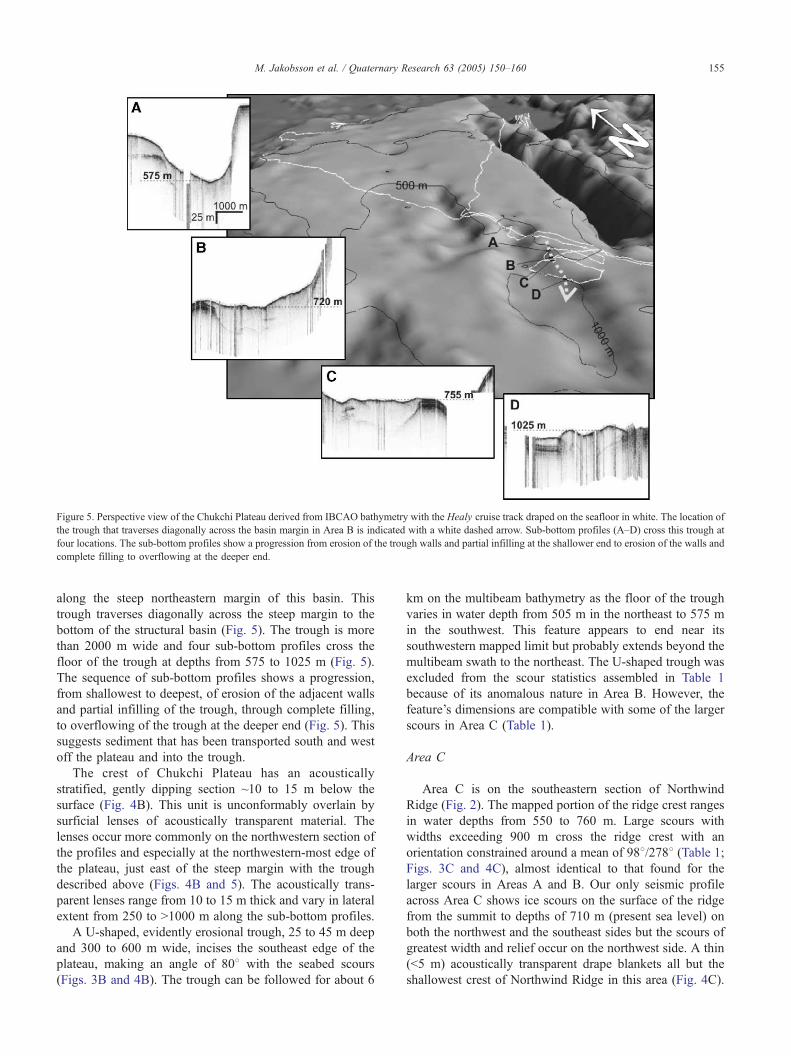
Figure 5. Perspective view of the Chukchi Plateau derived from IBCAO bathymetry with the Healy cruise track draped on the seafloor in white. The location of
the trough that traverses diagonally across the basin margin in Area B is indicated with a white dashed arrow. Sub-bottom profiles (A–D) cross this trough at
four locations. The sub-bottom profiles show a progression from erosion of the trough walls and partial infilling at the shallower end to erosion of the walls and
complete filling to overflowing at the deeper end.
M. Jakobsson et al. / Quaternary Research 63 (2005) 150–160 155
along the steep northeastern margin of this basin. This
trough traverses diagonally across the steep margin to the
bottom of the structural basin (Fig. 5). The trough is more
than 2000 m wide and four sub-bottom profiles cross the
floor of the trough at depths from 575 to 1025 m (Fig. 5).
The sequence of sub-bottom profiles shows a progression,
from shallowest to deepest, of erosion of the adjacent walls
and partial infilling of the trough, through complete filling,
to overflowing of the trough at the deeper end (Fig. 5). This
suggests sediment that has been transported south and west
off the plateau and into the trough.
The crest of Chukchi Plateau has an acoustically
stratified, gently dipping section ~10 to 15 m below the
surface (Fig. 4B). This unit is unconformably overlain by
surficial lenses of acoustically transparent material. The
lenses occur more commonly on the northwestern section of
the profiles and especially at the northwestern-most edge of
the plateau, just east of the steep margin with the trough
described above (Figs. 4B and 5). The acoustically trans-
parent lenses range from 10 to 15 m thick and vary in lateral
extent from 250 to N1000 m along the sub-bottom profiles.
A U-shaped, evidently erosional trough, 25 to 45 m deep
and 300 to 600 m wide, incises the southeast edge of the
plateau, making an angle of 808 with the seabed scours
(Figs. 3B and 4B). The trough can be followed for about 6
km on the multibeam bathymetry as the floor of the trough
varies in water depth from 505 m in the northeast to 575 m
in the southwest. This feature appears to end near its
southwestern mapped limit but probably extends beyond the
multibeam swath to the northeast. The U-shaped trough was
excluded from the scour statistics assembled in Table 1
because of its anomalous nature in Area B. However, the
feature’s dimensions are compatible with some of the larger
scours in Area C (Table 1).
Area C
Area C is on the southeastern section of Northwind
Ridge (Fig. 2). The mapped portion of the ridge crest ranges
in water depths from 550 to 760 m. Large scours with
widths exceeding 900 m cross the ridge crest with an
orientation constrained around a mean of 988/2788 (Table 1;Figs. 3C and 4C), almost identical to that found for the
larger scours in Areas A and B. Our only seismic profile
across Area C shows ice scours on the surface of the ridge
from the summit to depths of 710 m (present sea level) on
both the northwest and the southeast sides but the scours of
greatest width and relief occur on the northwest side. A thin
(b5 m) acoustically transparent drape blankets all but the
shallowest crest of Northwind Ridge in this area (Fig. 4C).

M. Jakobsson et al. / Quaternary Research 63 (2005) 150–160156
The thin scoured section abruptly changes down-slope to a
30-m-thick, acoustically stratified, section at water depths
greater than 760 m (Fig. 4C).
Discussion
Modern arctic ocean icebergs
Present circum-Arctic glaciers that produce icebergs with
a potential to reach the Chukchi Borderland include glaciers
of the high Arctic islands in the Canadian Arctic Archipe-
lago (see Koerner, 2002). The drift track of Fletcher Ice
Island T3, which likely originated from the Yelverton Bay
ice-shelf of Ellesmere Island (Crary, 1960), crossed Area A
as well as the area near 74850VN where ice scours were
discovered during the SCICEX mapping project (Polyak et
al., 2001). T3 was ~14 km long, 8 km wide, and 60 m thick
when the camp was originally established on the ice island
near the North Pole (Hunkins and Tiemann, 1977). Even if
the potential drift paths of icebergs from present glaciers of
the Canadian Archipelago, including the Ellesmere Island
ice shelves, cross the Chukchi Borderland, these glaciers are
not currently capable of producing icebergs thick enough to
ground in the present 300 to 500 m water depths of Area A
(Jeffries, 2002). In contrast, Northern Greenland’s largest
glaciers drain into the Arctic Ocean through outlet glaciers
and form floating ice shelves that range from 120 m to
nearly 800 m thick at the grounding line (Rignot et al.,
1997). However, calved icebergs that escape the narrow
fjords of Greenland’s outlet glaciers would be thinner than
their mother outlet glaciers at the grounding line. In
addition, the northern Greenland continental shelf area west
of about 408W will, given present conditions, prevent
icebergs thicker than 300 m from escaping into the deep
Arctic Ocean because of bathymetric sills shallower than
300 m (Jakobsson et al., 2000).
Interpretation and comparison to previously mapped
glacigenic features
The lack of present sources of N300 m thick icebergs that
could make their way to ground on Chukchi Borderland
indicates that the iceberg scours in Area A are relict features
from glacial periods or early stages of deglaciations.
Measured scour sizes, directional trends, and the absence of
acoustically measurable sediment drape (within the ~0.5-m
resolution of the sub-bottom profiler system) imply that the
majority of the mapped scours in Area A probably were
generated by individual icebergs during the last glaciation. A
~121-m lower eustatic sea level during the last glacial
maximum (Fairbanks, 1989) puts the iceberg scour water
depths at about 176 m in Area A (Table 1). Whereas
individual iceberg scours can explain the smaller features in
Area A, they may not explain the larger features that are
located in more than 300 m present water depth and are
similar in size and direction to the larger scours seen in Areas
B and C. These larger scours of Areas B and C are parallel to
each other, with a general orientation of ESE/WNW (Figs. 2
and 3).
The type of glacier ice that grounded on Chukchi
Borderland and caused the large parallel scours, or
lineations, may be addressed by comparing their dimen-
sions with previous studies of under-ice topography of
large icebergs, floating ice shelves, and the morphology of
glacially scoured or molded seabeds from other areas.
Large icebergs may have significant drafts. For example,
those produced from the glaciers calving into the Scoresby
Sund fjord complex in Eastern Greenland frequently scour
the seafloor to water depths as deep as 550 m and
occasionally deeper (Dowdeswell et al., 1993). These
icebergs commonly leave irregular, generally curving
plowmarks with widths from between a few meters to
occasionally over 20 m (Dowdeswell et al., 1993). The
large scours from the Chukchi Borderland are significantly
wider (Table 1), paralleling and mostly adjoining one
another, with a bflutedQ appearance, suggesting they were
produced by a large coherently moving ice mass rather
than by many individual icebergs moving independently.
The seafloor scour morphology resembles what is known
from subaerial morphology (e.g., Clark, 1993, 1994) and
from multibeam seafloor mapping of areas where large
fast-flowing ice streams have moved over and remolded
underlying sediments. Similar but smaller (in spacing and
relief) lineated seafloor fabric has been reported, for
example by Barnes (1987), Solheim et al. (1990), and
Josenhans and Zevenhuizen (1990). Larger-scale examples
include those mapped in Marguerite Bay on the con-
tinental shelf west of the Antarctic Peninsula (Dowdeswell
et al., 2004), the Ross Sea between the ice-shelf edge and
the continental margin (Shipp et al., 1999), and the mid-
Norwegian continental margin (Ottesen et al., 2002). The
features in Marguerite Bay are 130 to 400 m wide and
have 2 to 6 m of relief. Following Clark (1993, 1994) and
Shipp et al. (1999), Dowdeswell et al. (2004) referred to
the large-scale lineation fabric as bmegascale glacial
lineations.Q The megascale glacial lineations on the mid-
Norwegian shelf are described as a series of streamlined
parallel ridges and depressions with spacing between ridge
tops of 400 to 500 m and a maximum ridge height of 10
m (Ottesen et al., 2002). Very similar but Holocene-aged
MSGLs (300–650 m in width) were mapped by Shipp et
al. (1999) in the Ross Sea. By comparison, the mean scour
width in our areas B and C combined is 453 m and the
mean relief is 9.5 m (Table 2), comparable to the
dimensions of MSGLs in Marguerite Bay, the Ross Sea,
and the mid-Norwegian continental shelf. However, the
paleo-ice streams responsible for creating the latter
MSGLs were largely confined to bathymetric troughs,
whereas the parallel scours of the Chukchi Borderland
occur on the relatively flat Chukchi Plateau and North-
wind Ridge crest.

Table 2
Comparison of megascale glaciation lineation (MSGL) dimensions on the Chukchi Borderland (Areas B and C) with scours/lineations mapped on the Yermak
Plateau (Vogt et al., 1994, 1995) and under-ice topography measured on the Ross Ice Shelf, Antarctica (Shabtaie and Bentley, 1982)
Area Ice thickness (m) Ice underside undulation wavelength (m) Bottom undulation relief (m)
Ross Ice Sheet (Shabtaie and Bentley, 1982) 350–390 1200 (mean) 24–40
Scour water depth—130 m Mapped undulation wavelength (m) Mapped undulation relief (m)
Yermak Plateau 340–765 300–1500, 585 (mean) 2–14, 5 (mean)
Chukchi Borderland (this study; Area B and C) 292–630 240–1000, 453 (mean) 2–40, 9.5 (mean)
The scour depth reported for Yermak Plateau and Chukchi Borderland is estimated using a eustatic sea level 130 m below present to relate to MIS 6 conditions
(Shackleton, 1987).
M. Jakobsson et al. / Quaternary Research 63 (2005) 150–160 157
Although iceberg plowmarks are readily attributed to
iceberg keels dragging through the seafloor sediment, the
nature and origin of parallel scours such as presented in this
and other publications are not well understood. As
suggested by Vogt et al. (1994, 1995), an ocean choked
by icebergs would force all the icebergs to move in
approximately the same direction. Catastrophically, rapid
disintegration of a large floating ice-shelf, perhaps larger
versions of the recent (1995 and 2002) rapid (days)
disintegration of the Larsen A and B ice shelves off the
Antarctic Peninsula (MacAyeal et al., 2003), might thus
produce an iceberg jam, carving parallel scours in the
seabed. This is a plausible mechanism behind the ice
grounding on the Chukchi Borderland that must be
considered. The parallel scours may also have been
produced by relief on the undersides of intact ice shelves
in motion. In this case, the scour relief must be related to the
ice-shelf underside relief. Parallel scours could be produced
by random, unlineated roughness, in the manner of scratches
made in wood by a moving sheet of sandpaper or a wide
plow moving through a field. The scour marks would then
have been made predominately by those protrusions
(bosses) with the greatest relief. Modern ice shelves exhibit
a variety of structural complexities, e.g., rift zones, surface
and bottom crevasses, corrugations, ridge/troughs (Shabtaie
and Bentley, 1982), many of which could be associated with
ice bottom relief and therefore capable of leaving their
traces on the seafloor where such ice shelves ground. The
few existing data on extant large ice shelves (all in
Antarctica) suggest that ice-shelf underside relief is of the
ridge and furrow type, with the undulations more or less
parallel to past glacier flow direction. Shabtaie and Bentley
(1982) used radio-echo sounding to measure underice relief
along a small part of the western Ross Ice Shelf. Their
measurements indicate that the Ross Ice Shelf has a
relatively regularly undulating underside, with a relief
~25–40 m and a mean wavelength of 1200 m where the
shelf is 350 to 390 m thick (Table 2). Although this
wavelength exceeds the widest measured scours on the
Chukchi Borderland, to a first order the under-ice top-
ography measured by Shabtaie and Bentley (1982) is
comparable in width and relief to the scours we report here
(Tables 1 and 2), suggesting that the scours may have been
produced by under-ice relief of past Arctic ice shelves.
In applying these mostly Antarctic findings to the Arctic
MSGLs, we remain uncertain as to whether the parallel
scours were formed by huge (many kilometers wide) tabular
icebergs, calved from Canadian or Eurasian ice shelves, that
were then carried intact into the Arctic Ocean interior, or
whether the scours were formed by ice shelves growing
outwards from the Canadian and West Siberian shelves far
enough to ground on the Chukchi Rise, Yermak Plateau, and
Lomonosov Ridge. In the former case, the under-ice relief
was a relic of glacier kinematics and the observed parallel
scours in the seabed comprise a record of the direction these
undulations were dragged during the grounding process
across the shallow plateaus and ridges. The ice grounding in
this case would not necessarily have occurred in a direction
that paralleled the undulations. Alternatively, the parallel
scours may have been created by undulations generated
when thick ice shelves grew out towards and across
bathymetric highs. We favor the latter interpretation because
both on the Chukchi Plateau (Fig. 4C) and on the Yermak
Plateau (Vogt et al., 1994, 1995), prominent parallel scours
occur on the flanks of the shallowest portions of the rise, but
appear absent on the rise tops, perhaps because of hard, less
erodible substrate on the crest, as in parts of the Ross Sea,
Antarctica (see Fig. 8 of Shipp et al., 1999). However, we
think it is more likely that the rise crests were bice risesQ(comparable to Roosevelt or Berkner Islands in the
Antarctic) with fully grounded glacier ice (e.g., bDQ in
Fig. 1 of Vogt et al., 1995), stationary or moved slowly in a
radial direction. The ice was only slightly grounded but
moving on the flanks (i.e., an area of bice rumplesQ as
defined by Swithinbank et al., 1988), producing the
observed parallel scours. At greater water depths, the shelf
ice was fully afloat, leaving no marks on the seafloor.
Glacier source and timing
Coherent sets of evenly spaced, parallel, streamlined,
low-relief lineations that extend to 700 m present water
depth on the Northwind Ridge of the Chukchi Borderland
were described from the SCICEX interferometric swath
bathymetry and sidescan mapping, and referred to as
bflutesQ (Polyak et al., 2001). The SCICEX track is south
of Area C on the Northwind Ridge and the orientation of the
low-relief lineations there closely matches the orientation of

M. Jakobsson et al. / Quaternary Research 63 (2005) 150–160158
the parallel scours in Areas A, B, and C (Figs. 1 and 2).
Polyak et al. (2001) hypothesized from the SCICEX results
that a major ice-shelf that originated from eastern Alaska or
the western part of the Canadian Arctic Archipelago overran
the Chukchi Borderland to ground and create the features
they described as low-relief lineations. We suggest that all
the mapped larger scours that occur in sets parallel to each
other in Areas A, B, and C are flutes (MSGLs) that have
been formed by a large, spatially coherent ice mass such as a
grounded ice-shelf. However, on the basis of available data
sets, we cannot exclude the possibility of an biceberg jamQcarving parallel scours in the seabed. This was recently
proposed by Kristoffersen et al. (2004) as a likely
explanation to the features first mapped by Jakobsson
(1999) on the Lomonosov Ridge.
Recent analysis of SCICEX sidescan data identified
bedforms along the Alaskan margin that were interpreted to
be caused by grounding glacier ice (Edwards et al., 2003).
The bedforms appear as margin-parallel lineations on the
Alaskan continental slope and are interpreted to have been
formed by a floating ice-shelf or densely packed armadas of
tabular icebergs that moved and carved their path from the
Canadian Arctic Archipelago towards the Chukchi Border-
land (Engels et al., 2003). Provenance studies based on ice-
rafted glacial erratics in sediment cores indicate that as
much as 70% of the glacial erratics in the southern
Amerasian Basin consist of dolostones and limestones that
originated from the Canadian Arctic Islands (Phillips and
Grantz, 2001), thus supporting the interpretation that the
glacier source responsible for the grounding on the Chukchi
Borderland is located in this part of the Arctic.
When did the ice-shelf and iceberg grounding occur on
the Chukchi Borderland? The sediment drape, less than 5 m
thick, that blankets the megaflutes in Area C (Fig. 4C)
suggests that the flutes there are older than the shallower and
smaller-sized scours in Area A. We cannot resolve a
sediment drape on our 3.5-kHz profiles from the MSGLs
in Areas A and B, but due to their similarity to features in
Area C (i.e., size and directional trend), we assume that all
these flute-like lineations are of similar morphological
genesis, albeit possibly of different ages. In other words, at
least two separate generations of glacially derived features
appear to be present on the Chukchi Borderland. The post-
MSGL sediment thickness in Area C resembles that in the
ice-eroded areas of the Lomonosov Ridge crest in the central
Arctic Ocean. There, the bottom of the overlying drape is
dated to MIS 5.5, suggesting that the last major ice
grounding occurred during MIS 6 (185,000 to 130,000 yr
ago, Bassinot et al., 1994) (Jakobsson et al., 2001). It is
difficult to speculate on the age of the large MSGLs in the
Chukchi Borderland solely from the thickness of the sedi-
ment drape derived from the seismic data because of the
large uncertainty in sedimentation rates. However, sediment
cores that were retrieved by the USGS in 1991 from the ice-
grounded areas of southern Northwind Ridge and the
adjacent Chukchi Shelf contain two episodes of glacial
seafloor erosion (Polyak et al., 2003; Polyak, L., personal
communication, 2004). The older episode is found only in
cores located deeper than 450 m, and the post-erosional
deposition is estimated to have begun sometime between
MIS 4 and MIS 6 (Polyak, L., personal communication,
2004). The younger and shallower erosion episode is
estimated to have occurred during the last glacial maximum
(MIS 2, Polyak, L., personal communication, 2004).
Our seismic data provide additional support for the
hypothesis of a glacial-age ice-shelf that moved from the
Canada Basin and grounded on the Chukchi Borderland. The
seismic profiles acquired from the Chukchi Plateau, partic-
ularly those in Area B, show acoustically transparent lenses
of sediment that fill large, shallow scour depressions (Fig.
4B). These lenses are more common on the northwestern
section of the profiles and especially at the northwestern-
most edge of the plateau just in front of the steep margin with
the sediment-filled trough. The sediment lenses may have
formed in conjunction with an ice rise located on the highest
parts of the Chukchi Plateau, which acted as a source for
glacigenic mudflows through the influence of subglacial
meltwater. The lenses may, alternatively, consist of diamic-
ton that resulted from ice plowing over the plateau seabed.
The truncated strata apparent in the seismic profiles from
both Areas B and C provide additional support for an
erosional force that has bulldozed off the uppermost strata of
the Chukchi Plateau and Northwind Ridge crest. The
sediment-filled trough in the steep margin of Area B appears
to have acted as a conduit for such sediment that has been
scraped off the top of the Chukchi Plateau and deposited in
the trough and transported towards the basin floor (Fig. 5).
Together, the presence of the sediment lenses concentrated
on the northwestern section of the Chukchi Plateau, the
sediment fill in the trough, and the directions of the mapped
MSGLs suggest a motion of the grounding ice towards the
northwest, consistent with an ice-shelf origin in eastern
Alaska or/and the western part of the Canadian Arctic
Archipelago—most probably from ice streams emanating
from McClure Strait and Amundsen Gulf.
Conclusions
Recent multibeam bathymetry and 3.5-kHz sub-bottom
profiles imaged glacial features on the Chukchi Borderland
seafloor in the form of iceberg plowmarks, streamlined
(fluted) parallel scours and ridges, referred to here as
bmegascale glacial lineations (MSGL),Q as well as strati-
graphic unconformities interpreted to have been caused by
extensive ice erosion. The size, distribution, and general
ESE/WNW trend of the mapped megascale fluting mor-
phology suggest that massive and thick glacier ice flowed
over the Chukchi Borderland from the Canada Basin side
and grounded in water depths as deep as 760 m below
present sea level. If this ice was in the form of a coherent ice
shelf, then it is likely that local ice rises with fully grounded

M. Jakobsson et al. / Quaternary Research 63 (2005) 150–160 159
glacier ice were formed on the shallowest areas of the
borderland. Two separate generations of glacially derived
features are seen in the geophysical data; a thin (less than 5
m) sediment drape distinguishes the older and more
extensive MSGLs from the younger and shallower-water
lineations and from iceberg plowmarks, on which the
subsequently draped sediment cover is too thin to measure
acoustically. We conclude that our new geophysical data
together with results from previous studies of sediment
provenances (Phillips and Grantz, 2001), seafloor glacial
morphology (e.g., Polyak et al., 2001), and sediment cores
from ice-grounded areas of the Northwind Ridge (Polyak et
al., 2003; Polyak, L., personal communication, 2004) point
to thick floating glacier ice that emanated from northeastern
Alaskan margin or the Canadian Arctic Archipelago (most
likely through McClure Strait or/and Amundsen Gulf) on
one or several occasions between MIS 4 and MIS 6.
However, from the available data sets, we cannot with any
certainty differentiate if the larger features mapped on the
Chukchi Borderland were caused by a large thick ice-shelf
or icebergs with deep drafts moving coherently in an ocean
choked with icebergs. The shallower and younger gene-
ration of MSGLs may have been formed during the latest
glaciation.
Acknowledgments
We gratefully acknowledge NOAA Grant NA97OG0241
for supporting the research efforts of the members of the
Joint Hydrographic Center and the NOAA Ocean Explo-
ration Program for platform support. We also thank the
Captain and crew of icebreaker Healy for their superior
service during the cruise, as well as Dale Chayes and the
cruise science party members that are not authors.
Members of the Healy science team (besides authors 1,
3-7 and 9) included Jessica Abrams, Diane Bentley,
Kathleen Crane, Joan Gardner, Alan Hayashida, Kevin
Kelly, Naja Mikkelsen, Morten Solvsten, and Jeremy
Weirich. Professor Charles Bentley provided valuable
discussions on ice rumples and relief of ice-shelf under-
sides and Professor Leonid Polyak gave insightful com-
ments on an early draft of this manuscript. The 3rd author
was supported by the Office of Naval Research. We thank
the two anonymous reviewers who provided valuable
comments on the manuscript.
References
Barnes, P.W., 1987. Morphologic studies of the Wilkes Land continental
shelf, Antarctica—glacial and iceberg effects. In: Eittreim, S.L.,
Hampton, M.A. (Eds.), The Antarctic Continental Margin: Geology
and Geophysics of Offshore Wilkes Land. Circum-Pacific Council for
Energy and Mineral, Houston, Texas, pp. 175–194.
Bassinot, F.C., Labeyrie, L.D., Vincent, E., Quidelleur, X., Shackleton,
N.J., Lancelot, Y., 1994. The astronomical theory of climate and the age
of the Brunhes–Matuyama magnetic reversal. Earth and Planetary
Science Letters 126, 91–108.
Clark, C.D., 1993. Mega-scale glacial landforms and cross-cutting land-
forms. Earth Science Processes and Landforms 18, 1–29.
Clark, C.D., 1994. Large-scale ice-moulding: a discussion of genesis and
glaciological significance. Sedimentary Geology 91, 253–268.
Crary, A.P., 1960. Arctic ice island and ice-shelf studies. Arctic 13 (1),
32–50.
Davis, J.C., 1986. Statistics and Data Analysis in Geology, second ed. John
Wiley and Sons, New York, pp. 1–645.
Dyke, A.S., Andrews, J.T., Clark, P.U., England, J.H., Miller, G.H., Shaw,
J., Veillette, J.J., 2002. The Laurentide and Innuitian ice sheets during
the last glacial maximum. Quaternary Science Reviews 21, 9–13.
Dowdeswell, J.A., Villinger, H., Whittington, R.J., Marienfeld, P., 1993.
Iceberg scouring in Scoresby Sund and on the East Greenland
continental shelf. Marine Geology 111, 37–53.
Dowdeswell, J.A., O Cofaigh, C., Pudsey, C.J., 2004. Thickness and extent
of the subglacial till layer beneath an Antarctic paleo-ice stream.
Geology 32 (1), 13–16.
Edwards, M.H., Polyak, L., Engels, J.L., Coakley, B.J., 2003. Seafloor
surveys provide circum-basin evidence for thick Pleistocene ice in the
Arctic Ocean. EOS Transactions 84 (46) (Fall Meeting Supplement,
Abstract).
Engels, J.L., Edwards, M., and Polyak, L., 2003. New sidescan sonar
evidence for the westward flow of ice across the Alaska margin, Arctic
Ocean. XVI INQUA Congress, Reno, Nevada, Paper no. 22–8.
Fairbanks, R.G., 1989. A 17,000-year glacio-eustatic sea level record:
influence of glacial melting rates on the Younger Dryas event and deep
ocean-circulation. Nature 342, 637–642.
Grosswald, M.G., 1980. Late Weichselian ice sheets of northern Eurasia.
Quaternary Research 13, 1–32.
Hall, K.K., 1990. Chukchi Borderland. In: Grantz, A., Johnson, L.,
Sweeney, J.F. (Eds.), The Arctic Ocean Region, vol. L. The Geology
of North America, Boulder, pp. 337–350.
Hughes, T.J., Denton, G.H., Grosswald, M.G., 1977. Was there a late Wqrmice sheet? Nature 266, 596–602.
Hunkins, K., Tiemann, W., 1977. Geophysical data summary for Fletcher’s
ice island (T3): May 1962–October 1974. Lamont Doherty Earth
Observatory of Columbia University, Palisades New York, Technical
Report CU-1-77, 1–219.
Jakobsson, M., 1999. First high-resolution chirp sonar profiles from the
central Arctic Ocean reveal erosion of Lomonosov Ridge sediments.
Marine Geology 158, 111–123.
Jakobsson, M., 2000. Mapping the Arctic Ocean: Bathymetry and
Pleistocene Paleocenography. Meddelanden, Stockholm University,
No. 306, p. 1–36.
Jakobsson, M., Cherkis, N.Z., Woodward, J., Coakley, B., Macnab, R.,
2000. A new grid of Arctic bathymetry: a significant resource for
scientists and mapmakers. EOS Transactions 81(9), 89, 93, 96.
Jakobsson, M., Lbvlie, R., Arnold, E.M., Backman, J., Polyak, L., Knutsen,
JO., Musatov, E., 2001. Pleistocene stratigraphy and paleoenvironmental
variation from Lomonosov Ridge sediments, central Arctic Ocean.
Global and Planetary Change 31 (1–4), 1–21.
Jeffries, M.O., 2002. Ellesmere island ice shelves and ice islands. In:
Williams, R.S., Ferrigno, J.G. (Eds.), Glaciers of North America–
glaciers of Canada. U.S. Geological Survey Professional Paper
1386-J-1, pp. J147–J164.
Josenhans, H.W., Zevenhuizen, J., 1990. Dynamics of that Laurentide ice
sheet in Hudson Bay, Canada. Marine Geology 92, 1–26.
Koerner, R.M., 2002. Glaciers of the high Arctic islands. In: Williams, R.S.,
Ferrigno, J.G. (Eds.), Glaciers of North America–glaciers of Canada.
U.S. Geological Survey Professional Paper 1386-J-1, pp. J111–J146.
Kristoffersen, Y., Coakley, B., Jokat, W., Edwards, M., Brekke, H.,
Gjengerdal, J., 2004. Seabed erosion on the Lomonosov Ridge, central
Arctic Ocean: a tale of deep draft icebergs in the Eurasia Basin and the
influence of Atlantic water inflow on iceberg motion? Paleoceanography
19, PA3006, 1–14.

M. Jakobsson et al. / Quaternary Research 63 (2005) 150–160160
MacAyeal, D.R., Scambos, T.A., Hulbe, C.L., Fahnestock, M.A., 2003.
Catastrophic ice-shelf break-up by an ice-shelf-fragment-capsize
mechanism. Journal of Glaciology 49, 22–36.
Mercer, J.H., 1970. A former ice sheet in the Arctic Ocean?
Palaeogeography, Palaeoclimatology, Palaeoecology 8, 19–27.
Olausson, E., 1985. The glacial ocean. Palaeogeography, Palaeoclimatol-
ogy, Palaeoecology 5 (2/3), 291–301.
Ottesen, D., Dowdeswell, J.A., Rise, L., Rokoengen, K., Henriksen, S.,
2002. Glacier-influenced sedimentation on high-latitude continental
margins. Dowdeswell, J.A., Cofaigh, O. Special Publication-Geological
Society of London vol. 203., pp. 245–258.
Polyak, L., Edwards, M.H., Coakley, B.J., Jakobsson, M., 2001. Ice shelves
in the Pleistocene Arctic Ocean inferred from glaciogenic deep-sea
bedforms. Nature 410, 453–457.
Polyak, L., Brachfeld, S., Darby, D., Bischoff, J., Phillips, R.L, Febo, L.A.,
Coakley, B., Edwards, M., Engels, J.L., 2003, Multiple glacial erosion
on the Chukchi Borderland, Arctic Ocean, as indicated by preliminary
data on sediment stratigraphy and sea-floor morphology, XVI INQUA
Congress, Reno, Nevada 23–30 July, Paper No. 68–2.
Phillips, R.L., Grantz, A., 2001. Regional variations in provenance and
abundance of ice-rafted clasts in Arctic Ocean sediments: implications
for the configuration of late Quaternary oceanic and atmospheric
circulation in the Arctic. Marine Geology 172, 91–115.
Rignot, E.J., Gogineni, S.P., Krabill, W.B., Ekholm, S., 1997. North and
northeast Greenland ice discharge from satellite radar interferometry.
Science 276, 934–937.
Shipp, S., Anderson, J., Domack, E., 1999. Late Pleistocene–Holocene
retreat of the west Antarctic ice-sheet system in the ross sea: part 1—
geophysical results. Geological Society of America Bulletin 111,
1486–1516.
Shabtaie, S., Bentley, C.R., 1982. Tabular icebergs: implications from
geophysical studies of ice shelves. Journal of Glaciology 28, 413–430.
Shackleton, N.J., 1987. Oxygen isotopes, ice volume and sea level.
Quaternary Science Reviews 6, 183–190.
Solheim, A., Russwurm, L., Elverhoei, A., Berg, M.N., 1990. Glacial
geomorphic features in the southern Barents Sea: direct evidence
for grounded ice and implications for the pattern of deglaciation
and late glacial sedimentation. In: Dowdeswell, J.A., Scourse, J.D.
(Eds.), Glacimarine Environments: Processes and Sediments, Special
Publication-Geological Society of London vol. 53., pp. 253–268.
Svendsen, J.I., Alexanderson, H., Astakhov, V.I., Demidov, I., Dowdes-
well, J.A., Henriksen, M., Hjort, C., Houmark-Nielsen, M., Hubberten,
H.W., Ingolfson, O., Jakobsson, M., Kj&r, K., Larsen, E., Lokrantz, H.,Lunkka, J.P., Lys3, A., Mangerud, J., Maslenikova, O., Matioushkov,
A., Murray, A., Mfller, P., Niessen, F., Saarnisto, M., Siegert, C.,
Stein, R., Siegert, M.J., Spielhagen, R., 2004. Late Quaternary ice
sheet history of Northern Eurasia. Quaternary Science Reviews 23,
1229–1271.
Swithinbank, C., Brunk, K., Sievers, J., 1988. A glaciological map
of Filchner-Ronne ice shelf, Antarctica. Annals of Glaciology 11,
150–155.
Vogt, P.R., Crane, K., Sundvor, E., 1994. Deep Pleistocene iceberg
plowmarks on the Yermak Plateau: sidescan and 3.5 kHz evidence
for thick calving ice fronts and a possible marine ice sheet in the Arctic
Ocean. Geology 22 (5), 403–406.
Vogt, P.R., Crane, K., Sundvor, E., 1995. Reply. Geology 23, 477–478.