Morphometric analysis of Morar River Basin, Madhya Pradesh, India, using remote sensing and GIS...
13
1 23 Environmental Earth Sciences ISSN 1866-6280 Volume 68 Number 7 Environ Earth Sci (2013) 68:1967-1977 DOI 10.1007/s12665-012-1884-8 Morphometric analysis of Morar River Basin, Madhya Pradesh, India, using remote sensing and GIS techniques Prafull Singh, Jay Krishna Thakur & U. C. Singh
Transcript of Morphometric analysis of Morar River Basin, Madhya Pradesh, India, using remote sensing and GIS...
1 23
Environmental Earth Sciences ISSN 1866-6280Volume 68Number 7 Environ Earth Sci (2013) 68:1967-1977DOI 10.1007/s12665-012-1884-8
Morphometric analysis of Morar RiverBasin, Madhya Pradesh, India, usingremote sensing and GIS techniques
Prafull Singh, Jay Krishna Thakur &U. C. Singh

1 23
Your article is protected by copyright and
all rights are held exclusively by Springer-
Verlag. This e-offprint is for personal use only
and shall not be self-archived in electronic
repositories. If you wish to self-archive your
work, please use the accepted author’s
version for posting to your own website or
your institution’s repository. You may further
deposit the accepted author’s version on a
funder’s repository at a funder’s request,
provided it is not made publicly available until
12 months after publication.
ORIGINAL ARTICLE
Morphometric analysis of Morar River Basin, Madhya Pradesh,India, using remote sensing and GIS techniques
Prafull Singh • Jay Krishna Thakur •
U. C. Singh
Received: 21 June 2011 / Accepted: 29 July 2012 / Published online: 12 August 2012
� Springer-Verlag 2012
Abstract Hydrogeological mapping and drainage analy-
sis can form an important tool for groundwater develop-
ment. Assessment of drainage and their relative parameters
have been quantitatively carried out for the Morar River
Basin, which has made positive scientific contribution for
the local people of area for the sustainable water resource
development and management. Geographical Information
System has been used for the calculation and delineation of
the morphometric characteristics of the basin. The den-
dritic type drainage network of the basin exhibits the
homogeneity in texture and lack of structural control. The
stream order ranges from first to sixth order. The drainage
density in the area has been found to be low which indi-
cates that the area possesses highly permeable soils and
low relief. The bifurcation ratio varies from 2.00 to 5.50
and the elongation ratio (0.327) reveals that the basin
belongs to the elongated shaped basin category. The results
of this analysis would be useful in determining the effect of
catchment characteristics such as size, shape, slope of the
catchment and distribution of stream net work within the
catchment.
Keywords Drainage morphometry � GIS � Morar River
Basin � India
Introduction
Water demand is growing as the world population is
growing and more and more urbanization is taking place
worldwide. On the other hand, water resources are limited,
increasing demand for various water uses and decreasing
access to good-quality water as most of the nearby and
good-quality sources have already been overexploited
(Sharma and Vairavamoorthy 2009; Diwakar and Thakur
2012).
Urban sprawling and population growth in countries like
India, leads to increasing stress on water resources, because
of growing demand for drinking, irrigation and industrial
needs (Singh and al 2011a). The increase in the usage of
water has affected both surface and groundwater supplies,
resulting in an acute water crisis (Thakur et al. 2011). In
addition, low-intensity and erratic monsoons create further
shortages of surface-water supply. As a result, the demand
for groundwater resources has increased tremendously
from year to year, causing a drastic decline of groundwater
levels. Over-exploitation of groundwater has led to the
drying up of the aquifer zones in several parts of the
country. It is, therefore, essential to increase the recharge
of the basin for the water management programme (Ellis
and Revitt 2010; Rao 2008; Eyquem 2007). Assessment of
the characteristics of the drainage basin using quantitative
morphometric analysis can provide information about the
hydrological nature of the rocks exposed within the
drainage basin. A drainage map of a basin provides a
reliable index of permeability of the rocks and gives an
indication of the yield of the basin. The significance of
P. Singh (&)
Amity Institute of Geoinformatics and Remote Sensing,
Amity University, Sector 125, Noida 201303, UP, India
e-mail: [email protected]
J. K. Thakur
School of Environmental Science, Jawaharlal Nehru University,
New Delhi 110067, India
U. C. Singh
Schools of Studies in Earth Science, Jiwaji University,
Gwalior 474011, MP, India
123
Environ Earth Sci (2013) 68:1967–1977
DOI 10.1007/s12665-012-1884-8
Author's personal copy
morphometric analysis of drainage pattern and their inter-
relationship between rock type, structures and drainage
network in different parts of India has been reported
number of workers such as Vaidyanadhan (1962), Subra-
manyan (1974), Sankara and Rao (1985), Moeen and Babu
(1988), Raju et al. (1995), Rao and Babu (1995), Pakh-
mode et al. (2003), Sreedevi et al. (2005), John et al.
(2006), and Manu and Anirudhan (2008).
The development of morphometric techniques was a
major advance in the quantitative description of the
geometry of the drainage basins and its network, which
helps in characterizing the drainage network, comparing
the characteristic of several drainage networks, and
examining the effect of variables such as lithology, rock
structure, rainfall, etc., (Esper 2008; Magesh et al. 2011;
Bali et al. 2012).
The drainage network generally expresses the prevailing
climate, geology, relief, and tectonic framework of a basin
and the interrelationship between basic drainage parame-
ters (Thomas et al. 2012). Geology, relief, and climate are
the primary determinants of running water ecosystem
functioning at the basin scale (Mesa 2006). Recently many
researchers have attempted to generate more precise data
using Geographical Information System (GIS) tools in
different part of the sphere for automated determination of
drainage basin parameters; it has been shown to be effi-
cient, time saving and ideal application of GIS technology.
Some of the recent workers such as Grohmann (2004),
Gangalakunta (2004), Godchild and Haining (2004),
Grohmann et al. (2007), Korkalainen et al. (2007), Yu and
Wei (2008), Hlaing et al. (2008), and Javed et al. (2009)
arrived at the conclusion that GIS is a powerful tool for
evaluating drainage characteristics and continuous moni-
toring. Therefore, more and more data from drainage net-
works of diverse lithology, climate, and tectonic
frameworks are necessary for the meaningful interpretation
of the morphometric parameters.
In the recent past, many researchers have found that GIS
is important tool for analysis of drainage characteristics
from different data sources (Thomasa et al. 2010; Pate and
Dholakia 2010; Kar et al. 2009; Pankaj and Kumar 2009;
Singh PK and Singh UC 2009; Das and Mukherjee 2005).
The foremost advantages of the GIS technique for
drainage analysis over conventional methods of analysis lie
primarily in the fact that the GIS is capable of managing
and processing spatial information in large amounts, effi-
ciently and accurately. They are often viewed as essential
components for management enabling decision-makers to
make more effective and useful decisions (Burrough and
McDonnell 1998). In the present an integrated application
of remote sensing and GIS techniques are used while the
analysis of drainage parameters field based hydrological
conditions are fully taken into consideration but the
correlation of actual groundwater conditions through the
study of hydrogeological conditions and their hydrological
inferences are generally lacking in most of the previous
studies. Finally, combined remote sensing and GIS
approach is amenable to quickly evaluating drainage and
selection criteria as well as assessing post-implementation
outcomes for detailed hydrological studies.
The development of computer-aided mapping tech-
niques for natural resources especially in mapping and
integration of wide range of geoinformation are the most
important progress in natural science. The advantages of
this GIS-based approach over the conventional methods
are its ability to create, manipulate, store, display, ana-
lyze, and use spatial data much quicker and precisely. The
present study employed the same concept on a small river
basin and focuses on the physical characteristics of the
drainage system in order to evaluate the linear, areal, and
relief characteristics. The consequences obtained in the
present study based on drainage basin analysis provide
information for an enhanced perceptive of the hydrologi-
cal characteristics of the basin. The aim of present work is
to investigate and identify various drainage parameters to
understand the geometry of the basin for the conservation
and management of water resources in a sustainable
manner through the use and application of GIS techniques
in morphometric analysis. The main goal of the present
work is to evaluate the various hydrological parameters,
which are important for the water resource management
plan within the basin, and finds the alternative solutions
for water harvesting in the study area through the con-
struction of various suitable structures (check dam, Stor-
age tanks, Recharge shaft) based on observed calculations.
The present work also demonstrates the capability of
satellite-based data and GIS in river morphometry over
conventional approaches.
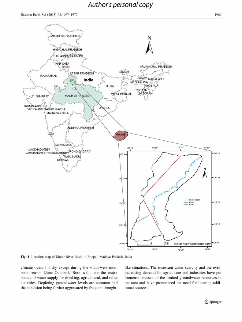
Study area
The study area lies between 26�500 to 26�2500N latitude and
78�1000 to 78�2000E longitude from 160 to 360 m average
mean sea level (AMSL) and is located in the northeastern
part of the Gwalior district in the central India with an area
about 405 km2 (Fig. 1). It is covered in the Survey of India
(SOI) toposheet numbers 54J/3, J/4, J/7 and J/8 on 1:50,000
scale. The climate of the basin is extreme with hot sum-
mers and cold winters. It experiences southwestern mon-
soon rains in June–September with an annual rainfall of
\600 mm. May is the hottest month with a maximum
temperature of 45 �C and minimum temperature 4 �C.
Gwalior is one of the erstwhile princely cities with popu-
lation of over 1.2 million having semi-arid climate marked
by extreme temperatures and erratic rainfall patterns. The
1968 Environ Earth Sci (2013) 68:1967–1977
123
Author's personal copy
climate overall is dry except during the south-west mon-
soon season (June–October). Bore wells are the major
source of water supply for drinking, agricultural, and other
activities. Depleting groundwater levels are common and
the condition being further aggravated by frequent drought-
like situations. The incessant water scarcity and the ever-
increasing demand for agriculture and industries have put
immense stresses on the limited groundwater resources in
the area and have pronounced the need for locating addi-
tional sources.
Fig. 1 Location map of Morar River Basin in Bhopal, Madhya Pradesh, India
Environ Earth Sci (2013) 68:1967–1977 1969
123
Author's personal copy
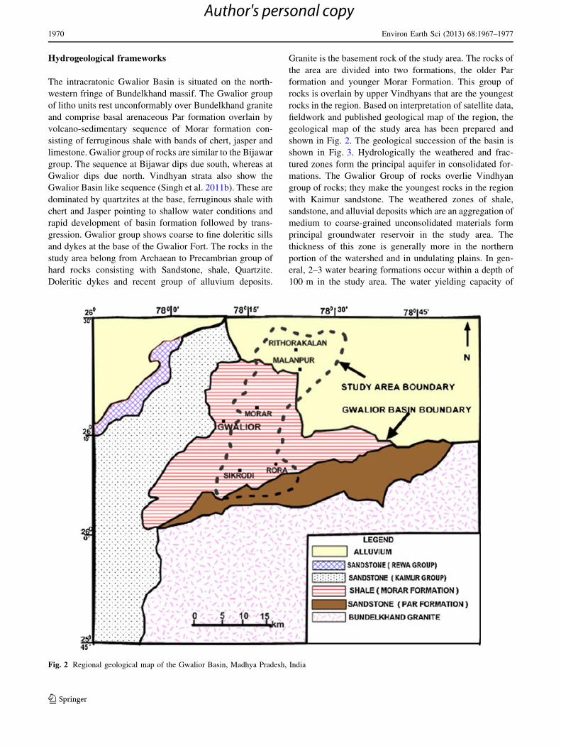
Hydrogeological frameworks
The intracratonic Gwalior Basin is situated on the north-
western fringe of Bundelkhand massif. The Gwalior group
of litho units rest unconformably over Bundelkhand granite
and comprise basal arenaceous Par formation overlain by
volcano-sedimentary sequence of Morar formation con-
sisting of ferruginous shale with bands of chert, jasper and
limestone. Gwalior group of rocks are similar to the Bijawar
group. The sequence at Bijawar dips due south, whereas at
Gwalior dips due north. Vindhyan strata also show the
Gwalior Basin like sequence (Singh et al. 2011b). These are
dominated by quartzites at the base, ferruginous shale with
chert and Jasper pointing to shallow water conditions and
rapid development of basin formation followed by trans-
gression. Gwalior group shows coarse to fine doleritic sills
and dykes at the base of the Gwalior Fort. The rocks in the
study area belong from Archaean to Precambrian group of
hard rocks consisting with Sandstone, shale, Quartzite.
Doleritic dykes and recent group of alluvium deposits.
Granite is the basement rock of the study area. The rocks of
the area are divided into two formations, the older Par
formation and younger Morar Formation. This group of
rocks is overlain by upper Vindhyans that are the youngest
rocks in the region. Based on interpretation of satellite data,
fieldwork and published geological map of the region, the
geological map of the study area has been prepared and
shown in Fig. 2. The geological succession of the basin is
shown in Fig. 3. Hydrologically the weathered and frac-
tured zones form the principal aquifer in consolidated for-
mations. The Gwalior Group of rocks overlie Vindhyan
group of rocks; they make the youngest rocks in the region
with Kaimur sandstone. The weathered zones of shale,
sandstone, and alluvial deposits which are an aggregation of
medium to coarse-grained unconsolidated materials form
principal groundwater reservoir in the study area. The
thickness of this zone is generally more in the northern
portion of the watershed and in undulating plains. In gen-
eral, 2–3 water bearing formations occur within a depth of
100 m in the study area. The water yielding capacity of
Fig. 2 Regional geological map of the Gwalior Basin, Madhya Pradesh, India
1970 Environ Earth Sci (2013) 68:1967–1977
123
Author's personal copy
rocks largely depends on the extent of fracturing, openness,
size of fracture, and nature of the interconnections between
fractures. The area is covered by alluvium, sandstone, and
shale terrains and the occurrence of groundwater in differ-
ent formations varies with the rock type. The thickness of
alluvium varies between 10 and 30 m. It is the most
extensive aquifer in the area. Only one, i.e., phreatic aquifer
comprising fine to medium and coarse-grained sand often
associated with clay having thickness of 2–3 m is encoun-
tered between 4 and 30 MBGL. The contact of alluvium
with shale or sandstone form productive yielding of 2–20
LPS. Isolated patches of shale and sandstone of Gwalior
group are extending generally east west in the northern part
of Morar block. Groundwater occurs mostly in unconfined
conditions, but at places in semi-confined conditions also.
The yield potential in this formation ranges between 1 and 8
LPS. During survey in the area, three pumping tests have
been carried out on the dug wells and tube wells. The
transmissivity in the alluvium area is sufficient to get 2–10
LPS yield. It is observed that specific capacity of wells in
the area ranges from 1.93 to 29.70/min/m.
Methodology
Assessment of the drainage network of a basin using the
quantitative morphometric analysis gives information about
the hydrological background of the rock formation exposed
within the drainage basin. Morphometric analysis of a basin
provides an indication about permeability, storage capacity of
the rocks and gives an indication of the yield of the basin.
Analysis of drainage basins involves the evaluation of drain-
age parameters such as bifurcation ratio, length ratio, drainage
density, drainage frequency, length of overland flow and
stream frequency. Hydrogeological observations, integrated
with drainage analysis, provide useful clues regarding broad
relationships among the geological framework of the basin.
The different applied methods to evaluate drainage
parameters by remote sensing and GIS show an obvious
discrepancy in results, in spite of the similarity in the used
techniques and tools. Thus, the review of past literature
revealed that a standard methodology for drainage basin
delineation and their analysis. In the present an integrated
application of remote sensing and GIS techniques are used
while the analysis of drainage parameters field based
hydrological conditions are fully taken into consideration,
but the correlation of actual groundwater conditions
through the study of hydrogeological conditions and their
hydrological inferences are generally lacking in most of the
previous studies. Finally, combined remote sensing and
GIS approach is amenable to quickly evaluating drainage
and selection criteria as well as assessing post-implemen-
tation outcomes for detailed hydrological studies.
Therefore, the results reveal different levels of agree-
ment using morphometric analysis, which were supposed to
be different from one region to another. Factors controlling
groundwater storage are different in space and time, and the
majority of these factors depend on the following parame-
ters: (1) rainfall availability as the source of water; (2)
drainage characteristics have a role in the distribution of
runoff and indicate an infiltration scheme and it governs the
behavior of water flow on terrain surface vertically and
horizontally; (3) rock type for which the lithologic character
governs the flow and storage management; (4) slope is
another influencing factor, and it controls water flow
energy, which plays a role in facilitating water flow in the
basin. The morphometric analysis can be achieved through
measurements of linear, areal and relief aspects of basin.
The required necessary data sources for morphometric
analysis were carried out through the use of Indian Remote
Group Formation Lithology
Recent Alluvium, Sand silt, laterites, clay, kankar, pebbles,
unconsolidated sediments etc
Kaimur group Medium to coarse grained sandstone.
--------------------------------------------------- Unconformity --------------------------------------------
Morar Formation Shales with limestone bands, ferruginous
chert with iron ore, dolerite dykes
Gwalior Group ------------------------------------- Unconformity -----------------------------------------
Par Formation Orthoquarzite and sandstone ,
sandstone with alternation of shale.
---------------------------------------------- Unconformity --------------------------------------------------
Archaean Bundelkhand Granite Granites and Granite
Gneisses with associated schist, pegmatite veins,
basic dykes and quartz reef
Fig. 3 Geological succession
of the Basin, Madhya Pradesh,
India
Environ Earth Sci (2013) 68:1967–1977 1971
123
Author's personal copy

Sensing Satellite (IRS-1C) LISS III and PAN merged data
and SOI Topographical Sheets (Table 1) of the area. The
SOI toposheets and digital satellite data were geometrically
rectified and georeferenced by taking ground control points
(GCPs) by using UTM projection and WGS 84 datum.
Further, all geocoded images were mosaic using Erdas
Imagine 8.6 image processing software.
Digitization work has been carried out for entire analysis
of basin morphometry using GIS software (Arc GIS
9.3).The order was given to each stream by following
Strahler (1964) stream ordering technique.
The parameters like the number and lengths of streams
of each different order; drainage area, basin perimeter and
total basin length, and width were calculated using ARC
GIS software, drainage density, drainage frequency, shape,
form factor, circulatory ratio, and elongation ratio, etc.,
were calculated from these parameters. The methodologies
adopted for the computation of morphometric parameters
are given in Table 2.
Results and discussions
Quantitative description of drainage network, basin char-
acteristics, and landform analysis has been carried out for
the Morar River Basin. Various parameters like the number
and lengths of streams of different order, drainage area,
basin perimeter and maximum basin lengths were calcu-
lated after cleaning and then topology building of the
drainage layer in GIS software, from these parameters
various drainage characteristics are calculated such as
bifurcation ratio (Rb), drainage density (Dd), stream fre-
quency (Fs) circulatory ratio (Rc), elongation ratios (Re) for
basin evolution studies.
The understanding of streams in a drainage system
constitutes the drainage pattern, which in turn replicates
mainly structural/lithologic controls of the underlying
rocks. The study area possesses dendritic drainage patterns,
despite stream lengths and other hydrological properties.
They are generally characterized by a treelike branching
system, which indicates the homogenous and uniformity.
The designation of stream order is the first step in
morphometric characterization of the basin. In the present
paper, the stream ordering has been ranked based on
hierarchic ranking method proposed by Strahler (1964),
Table 1 Data used for morphometric analysis of Morar River Basin,
Madhya Pradesh, India
Type of data/
software
Details Sources
IRS-ID LISS III
and PAN digital
format
Path/row: 97/53
Date: 22
February, 2008
National Remote Sensing
Center (NRSC),
Hyderabad, India
SOI toposheets Toposheet Nos.
54J/3, J/4, J/7
and J/8
Scale: 1:50,000
Survey of India (SOI),
Dehradun, India
Geological
quadrangle map
Scale: 1:250,000 Geological Survey of India,
Hyderabad, India
Table 2 Methodology adopted for computations of morphometric parameters
S.
no.
Morph metric
parameters
Formula
1 Stream order Hierarchical rank
2 Stream length Length of the stream
3 Mean stream length
(Lsm)
Lsm: Lu/Nu where, Lsm = mean stream length, Lu = total stream length of order ‘‘U’’
Nu = total no. of stream segments of order ‘‘U’’
4 Stream length ratio
(RL)
RL = Lu/Lu – 1 where, RL = stream length ratio, Lu = the total stream length of the order ‘‘U’’, Lu - 1 = the
total stream length of its next lower order
5 Stream frequency
(Fs)
Fs = Nu/A where, Fs = stream frequency, Nu = total no. of streams of all orders, A = area of basin
6 Drainage density
(Dd)
Dd = Lu/A where, D = drainage density, Lu = total stream length of all orders, A = area of basin
7 Drainage texture
(Rt)
Rt = Nu/P where, Rt = drainage texture, Nu = total no, of streams of all orders, P = perimeter (km)
8 Bifurcation ratio
(Rb)
Rb = Nu/Nu ? 1 where, Rb = bifurcation ratio, Nu = total number of stream segments of order ‘‘U’’,
Nu ? 1 = number of segments of the next higher order
9 Form factor Rf = A/Lb2 where, Rf = form factor, A = area of basin (km), Lb
2 = square of the basin length
10 Elongation ratio (Re) Re = Re 2v (A/pi)/Lb where, Re = elongation ratio, A = area of basin (km2), pi = ‘‘pi’’ value, Lb = basin length
11 Circularity ratio (Rc) Rc = 4 9 pi 9 A/P2 where, Rc = circularity ratio, pi = pi value, A = area of basin, P2 = square of the perimeter
12 Relief ratio (Rh) Rh = H/Lb where, Rh = relief ratio, H = total relief of the basin in km, Lb = basin length
1972 Environ Earth Sci (2013) 68:1967–1977
123
Author's personal copy
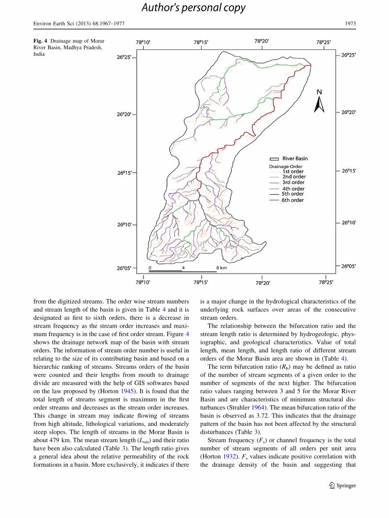
from the digitized streams. The order wise stream numbers
and stream length of the basin is given in Table 4 and it is
designated as first to sixth orders, there is a decrease in
stream frequency as the stream order increases and maxi-
mum frequency is in the case of first order stream. Figure 4
shows the drainage network map of the basin with stream
orders. The information of stream order number is useful in
relating to the size of its contributing basin and based on a
hierarchic ranking of streams. Streams orders of the basin
were counted and their lengths from mouth to drainage
divide are measured with the help of GIS softwares based
on the law proposed by (Horton 1945). It is found that the
total length of streams segment is maximum in the first
order streams and decreases as the stream order increases.
This change in stream may indicate flowing of streams
from high altitude, lithological variations, and moderately
steep slopes. The length of streams in the Morar Basin is
about 479 km. The mean stream length (Lsm) and their ratio
have been also calculated (Table 3). The length ratio gives
a general idea about the relative permeability of the rock
formations in a basin. More exclusively, it indicates if there
is a major change in the hydrological characteristics of the
underlying rock surfaces over areas of the consecutive
stream orders.
The relationship between the bifurcation ratio and the
stream length ratio is determined by hydrogeologic, phys-
iographic, and geological characteristics. Value of total
length, mean length, and length ratio of different stream
orders of the Morar Basin area are shown in (Table 4).
The term bifurcation ratio (Rb) may be defined as ratio
of the number of stream segments of a given order to the
number of segments of the next higher. The bifurcation
ratio values ranging between 3 and 5 for the Morar River
Basin and are characteristics of minimum structural dis-
turbances (Strahler 1964). The mean bifurcation ratio of the
basin is observed as 3.72. This indicates that the drainage
pattern of the basin has not been affected by the structural
disturbances (Table 3).
Stream frequency (Fs) or channel frequency is the total
number of stream segments of all orders per unit area
(Horton 1932). Fs values indicate positive correlation with
the drainage density of the basin and suggesting that
Fig. 4 Drainage map of Morar
River Basin, Madhya Pradesh,
India
Environ Earth Sci (2013) 68:1967–1977 1973
123
Author's personal copy

increase in stream population with respect to increase in
drainage density.
The observed stream frequency (Fs) is 1.88 for the basin,
exhibit positive correlation with the drainage density value
of the area, indicating the increase in stream population
with respect to increase in drainage density (Table 4).
Horton (1932) has introduced the drainage density as an
expression to indicate the closeness of spacing of channels.
The drainage density of the study area have been calculated
and the value is 1.18 (Table 4). The value of Dd suggests
that area have low drainage density. The low drainage
density is likely to result in the area of highly resistant of
permeable subsoil material under dense vegetation and low
relief (Nautiyal 1994). High drainage density is the resul-
tant of weak of impermeable subsurface material, sparse
vegetation and mountainous relief.
Drainage texture (Rt) is one of the important concepts of
geomorphology which means the relative spacing of
drainage lines. According to Horton (1945), RT is the total
number of stream segments of all orders per perimeter of
that area.
Smith (1950) has classified drainage density into five
different classes. The drainage density less than 2 indicates
very coarse, between 2 and 4 is related to coarse, between 4
and 6 is moderate, between 6 and 8 is fine and greater than
8 is very fine drainage texture. The observed, drainage
texture is 6.29 indicates the moderate drainage texture. The
moderate drainage texture and lower value of drainage
density (1.18) indicates the presence of highly resistant
permeable material with low relief (Table 4).
According to Horton (1932), form factor (Rf) may be
defined as the ratio of basin area to square of the basin
length. The observed form factor value of the basin is 0.264
suggesting that the shape of the basin is elongated
(Table 3). The elongated basin with low form factor indi-
cates that the basin will have a flatter peak of flow for
longer duration.
Schumm (1956) defined the elongation ratio (Re) as the
ratio between the diameter of the circle of the same area as
the drainage basin and the maximum length of the basin.
The values of Re generally vary from 0.6 to 1.0 over a wide
variety of climatic and geologic conditions. Values close to
1.0 are typical of regions of very low relief, whereas values
in the range 0.6–0.8 are usually associated with high relief
and steep ground slope (Strahler 1964). These values can
be grouped into three categories namely (a) circular ([0.9),
(b) oval (0.9–0.8), (c) elongated (\0.7). The elongation
ratio of the basin is 0.327, which suggests that the basin
belongs to the elongated shape basin and low relief
(Table 4).
Miller (1953) defined a dimensionless circularity ratio
(Rc) as the ratio of the basin area to the area of circle
having the same perimeter as the basin. Rc influenced by
the length and frequency of streams, geological structures,
land use/land cover, climate, relief and slope of the basin.
Circularity ratios range 0.4–0.5 which indicates strongly
elongated and highly permeable homogenous geology and
the observed circularity ratio of the basin is 0.345 (Table 4)
which indicates that the basin is elongated in shape, has
low discharge of runoff and is highly permeability of the
subsoil condition.
The elevation difference between the highest and the
lowest points on the valley floor of a basin is known as the
total relief of that basin. The relief ratio (Rh) of maximum
relief to horizontal distance along the longest dimension of
the basin parallel to the principal drainage line is termed as
a relief ratio (Schumm 1956). It measures the overall
steepness of a drainage basin and is an indicator of the
Table 3 Linear aspects of the
drainage basinStream
order (w)
No. of
streams
(Nu)
Bifurcation
ratio (RbF)
Mean
bifurcation
ratio (Rbm)
Total length of
streams (km)
Mean length of
the streams (km)
Length
ratio (RL)
I 501 303.49
II 206 2.43 89
III 42 4.90 3.73 29.06 0.628 5.38
IV 11 3.82 8.88
V 2 5.5 9.41
Vi 1 2 39.50
Table 4 Areal aspects of the drainage basin
Basin area
(km2)
Perimeter
(km)
Width
(km)
Form
factor
Elongation
ratio (Re)
Circularity
ratio (Rc)
Drainage
density (km)
Stream
frequency
Drainage
texture
Relief
ratio
404.49 121.27 13.91 0.264 0.327 0.345 1.18 1.88 6.29 0.04
1974 Environ Earth Sci (2013) 68:1967–1977
123
Author's personal copy
intensity of the erosion processes operation on the slope of
the basin. In the present study, the Rh value of the basin
0.04 shows the major portion of the basin having gentle
slope (Table 4).
Hydrological inferences
The quantitative analysis of morphometric parameters is
found to be of immense utility in river basin evaluation,
soil and water conservation and natural resources man-
agement. The morphometric analysis carried out in the
Morar River Basin shows that the basin has low relief and
elongated shape.
The linear pattern of the graphical representation indi-
cates the homogeneous weathering erosional characteristic
of the study area. Elongation ratio, circulatory ratio and form
factor values show that the basin has an elongated shape,
which indicates the low runoff and flatter peak of flow.
Drainage network of the basin exhibits as mainly den-
dritic type, which indicates the homogeneity in texture and
lack of structural control. The linear pattern of the graph-
ical representation indicates the weathering erosional
characteristics of the area under the study. The morpho-
metric parameters evaluated using GIS helped us to
understand various terrain parameters such as infiltration
capacity, runoff, etc. Similar studies in conjunction with
high-resolution satellite data help in better understanding
the landforms and their processes and drainage pattern
demarcations for basin area planning and management.
The morphometric analysis provides information on the
variation in the permeability of the aquifer units exposed in
within the river basin. Artificial recharge and runoff har-
vesting in the area for groundwater development manage-
ment are selected based on small-scale topographic maps.
Recharge sites are particularly unsuccessfully located or
because of these sites are often located in natural ground-
water discharge areas. Drainage analysis form positive
contribution through the advantage of remote sensing and
GIS-based tool in selecting artificial recharge sites. These
analyzed drainage parameters provide comparative indices
of the permeability of rock surfaces in various parts of a
drainage basin. If these information are integrated with the
others hydrological characteristics of the drainage basin,
the strategy of siting recharge and water-harvesting mea-
sures provides better groundwater development and man-
agement plan.
Conclusions
The morphometric analysis carried out for the Morar River
Basin confirms that the basin has low relief and elongated
shape. Drainage network of the basin exhibits as mainly
dendritic type, which indicates the homogeneity in texture
and lack of structural control and to understand various
terrain parameters such as nature of the bedrock, infiltration
capacity, runoff, etc. Lower drainage density and stream
frequency indicates high permeability rate of the subsur-
face formation. The observed drainage parameters reveal
for recharge-related measures and areas where surface-
water augmentation measures can be undertaken for the
water resource management.
Observations derived from the morphometric analysis of
Morar River Basin gives up-to-date information about
various factors such as morphological characteristic of the
basin and important hydrological parameters such as
bifurcation ratio, elongation ratio, drainage density, relief
ratio, and circulatory ratio which are responsible for the
river basin evaluation, watershed prioritization for soil/
water conservation, natural resources management and
groundwater potential targeting for efficient planning and
management.
This analysis can be used for site suitability analysis of
soil and water conservation structures development and
subsequently, these parameters were integrated with other
thematic information viz., land use/cover, land forms,
drainage, slope, and soil in the GIS domain to arrive a
decision regarding a suitable site for having soil and water
conservation structures (nala bund, check dam, and per-
colation tank, recharge shaft, etc.) in the area for ground-
water development and management.
The study reveals that GIS-based approach in quantita-
tive evaluation of drainage parameters and their influence
on landforms characteristics at the basin level are more
appropriate than the conventional methods. Thus, the study
shows that GIS techniques have efficient tools in delinea-
tion of the drainage pattern to understand terrain parame-
ters such as the infiltration capacity, surface run off, etc.,
which helps in better understanding the status of land form
and their processes, drainage management and evolution of
groundwater potential for watershed planning and man-
agement. This will be useful for soil and water conserva-
tion and is a positive scientific contribution for the people
of Morar River Basin area. This work will be useful for
natural resources management at micro-level of any terrain
for the sustainable development by planners and decision-
makers.
Acknowledgments Authors are thankful to the Head of Depart-
ment, School of Studies in Earth Science, Jiwaji University for pro-
viding working facilities. The first author expresses his gratefulness to
the Founder President Dr. Ashok K. Chauhan; Group vice Chancellor
Gen. K.J. Singh and Vice Chancellor Dr. Balvinder Shukla, Amity
University, Noida for constant encouragement. The first author also
thankful to Dr. Madhulika Singh, Director, Amity Institute of Geo-
informatics and Remote Sensing for her valuable suggestion and kind
cooperation. Thanks are also due to the anonymous reviewers for their
many helpful suggestions.
Environ Earth Sci (2013) 68:1967–1977 1975
123
Author's personal copy
References
Bali R, Agarwal K, Nawaz Ali S, Rastogi S, Krishna K (2012)
Drainage morphometry of Himalayan Glacio-fluvial basin, India:
hydrologic and neotectonic implications. Environ Earth Sci
66(4):1163–1174. doi:10.1007/s12665-011-1324-1
Burrough PA, McDonnell RA (1998) Principles of Geographical
Information Systems. Oxford University Press, Oxford, p 333
Das AK, Mukherjee S (2005) Drainage morphometry using satellite
data and GIS in Raigad District, Maharashtra. J Geol Soc India
65:577–586
Diwakar J, Thakur JK (2012) Environmental system analysis for river
pollution control. Water Air Soil Pollut. doi:10.1007/s11270-
012-1102-z
Ellis JB, Revitt DM (2010) The management of urban surface water
drainage in England and Wales. Water Environ J 24:1–8
Esper AMY (2008) Morphometric analysis of Colanguil river basin
and flash flood hazard, San Juan, Argentina. Environ Geol
55:107–111
Eyquem J (2007) Using fluvial geomorphology to inform integrated
river basin management. Water Environ J 21:54–60
Gangalakunta P (2004) Drainage morphometry and its influence on
landform characteristics in a basaltic terrain, central India: a remote
sensing and GIS approach. Int J Appl Earth Obs Geoinf 6:1–16
Godchild MF, Haining RP (2004) IS and spatial data analysis:
converging perspectives. Papers Reg Sci 83:363–385
Grohmann CH (2004) Morphometric analysis in geographic infor-
mation systems: applications of free software. Comput Geosci
30:1055–1067
Grohmann CH, Riccomini C, Alves FM (2007) SRTM based
morphotectonic analysis of the Pocos De Caldas alkaline massif
Southeastern Brazil. Comput Geosci 33:10–19
Hlaing TK, Haruyama S, Aye MM (2008) Using GIS-based
distributed soil loss modeling and morphometric analysis to
prioritize watershed for soil conservation in Bago river basin of
Lower Myanmar. Front Earth Sci China 2:465–478
Horton RE (1932) Drainage basin characteristics. Trans Am Geophys
Union 13:350–361
Horton RE (1945) Erosional development of streams and their
drainage basins: hydrophysical approach to quantitative mor-
phology. Geol Soc Am Bull 56:275–370
Javed A, Khanday MY, Ahmed R (2009) Prioritization of sub-
watershed based on morphometric and land use analysis using
remote sensing and GIS techniques. J Indian Soc Remote Sens
37:261–274
John DD, Subba RN, Srinivasa RKV, Thirupathi RB, Subrahmanyam
A (2006) Drainage characteristics of the Sarada River Basin,
Andhra Pradesh for watershed management. J Indian Acad
Geosci 49:1–6
Kar G, Kumar A, Singh R (2009) Spatial distribution of soil hydro-
physical properties and morphometric analysis of a rainfed
watershed as a tool for sustainable land use planning. Agric
Water Manag 96:1449–1459
Korkalainen THJ, Lauren AM, Kokkonen TS (2007) A GIS based
analysis of catchment properties within a drumlin field. Boreal
Environ Res 12:489–500
Magesh N, Chandrasekar N, Soundranayagam J (2011) Morphometric
evaluation of Papanasam and Manimuthar watersheds, parts of
Western Ghats, Tirunelveli district, Tamil Nadu, India: a GIS
approach. Environ Earth Sci 64(2):373–381. doi:10.1007/
s12665-010-0860-4
Manu MS, Anirudhan S (2008) Drainage characteristics of Achanko-
vil River Basin, Kerala. J Geol Soc India 71:84–850
Mesa LM (2006) Morphometric analysis of a subtropical Andean
basin Tucuman, Argentina. Environ Geol 50:1235–1242
Miller VC (1953) A quantitative geomorphic study of drainage basin
characteristics in the Clinch Mountain area, Virginia and
Tennessee, Technical report, 3, Office of Naval Research.,
Department of Geology, Columbia University, New York, USA
Moeen S, Babu VRRM (1988) Significance of tectonics and grade of
metamorphism on the morphometry of a Precambrian terrain: a
case study of Udayagiri Taluk, Nellore District, Andhra Pradesh.
Indian J Earth Sci 15:209–215
Nautiyal MD (1994) Morphometric analysis of drainage basin, district
Dehradun, Uttar Pradesh. J Indian Soc Remote Sens 22:252–262
Pakhmode V, Himanshu K, Deolankar SB (2003) Hydrological-
drainage analysis in watershed-programme planning: a case from
the Deccan basalt, India. Hydrogeol J 11:595–604
Pankaj A, Kumar P (2009) GIS based morphometric analysis of five
major sub-watershed of Song River, Dehradun district, Uttarak-
hand with special reference to landslide incidences. J Indian Soc
Remote Sens 37:157–166
Pate DP, Dholakia MB (2010) Identifying probable submergence area
of Surat City using digital elevation model and Geographical
Information System. World Appl Sci J 9(4):461–466
Raju NJ, Reddy TVK, Nayudu PT, Reddy GJ (1995) Morphometric
analysis of the Upper Gunjanaeru River Basin, Cuddapah
District, Andhra Pradesh. Nat Geogr J India 41:145–153
Rao NS (2008) A numerical scheme for groundwater development in
a watershed basin of basement terrain: a case study from India.
Hydrogeol J 17:379–396
Rao JU, Babu VRRM (1995) A quantitative morphometric analysis of
Gundalakamma River Basin, Andhra Pradesh. Indian J Earth Sci
22:63–74
Sankara PP, Rao AT (1985) Structural controls of Gosthani River basin
in Visakhapatnam District. Indian J Landsc Syst Ecol Stud 8:51–54
Schumm SA (1956) Evaluation of drainage system and slopes in
Badlands at Perth Amboy, New Jersey. Natl Geol Soc Am Bull
67:597–646
Sharma SK, Vairavamoorthy K (2009) Urban water demand
management: prospects and challenges for the developing
countries. Water Environ J 23:210–218
Singh PK, Singh UC (2009) Water resource evaluation and manage-
ment for Morar River basin, Gwalior District, Madhya Pradesh
using GIS. E-journal Earth Sci India 2:174–186
Singh P, Thakur JK et al (2011a) Assessment of land use/land cover
using Geospatial Techniques in a semi arid region of Madhya
Pradesh, India. Geospatial Techniques for Managing Environ-
mental Resources. Thakur, Singh, Prasad, Gossel, Heidelberg,
Germany, Springer and Capital publication, pp 152–163
Singh P, Kumar S, Singh UC (2011b) Groundwater resource
evaluation in the Gwalior area, India, using satellite data: an
integrated geomorphological and geophysical approach. Hydro-
geol J 19:1421–1429
Smith KG (1950) Standards for grading textures of erosional
topography. Am J Soc 248:655–668
Sreedevi PD, Subrahmanyam K, Ahmed S (2005) The significance of
morphometric analysis for obtaining groundwater potential zones
in a structurally controlled terrain. Environ Geol 47:412–420
Strahler AN (1964) Quantitative geomorphology of drainage basins
and channel networks. In: Chow VT (ed) Handbook of appliedhydrogeology. McGraw-Hill, New York, pp 4–76
Subramanyan V (1974) A quantitative analysis of two drainage basins
around Sagar MP. Indian Science Academy, vol 40, pp 76–99
Thakur JK, Thakur RK, Ramanathan A, Kumar M, Singh SK (2011)
Arsenic contamination of groundwater in Nepal—an overview.
Water 3(1):1–20
Thomas J, Joseph S, Thrivikramji K, Abe G, Kannan N (2012)
Morphometrical analysis of two tropical mountain river basins of
contrasting environmental settings, the southern Western Ghats,
1976 Environ Earth Sci (2013) 68:1967–1977
123
Author's personal copy

India. Environ Earth Sci 66(8):2353–2366. doi:10.1007/s12665-
011-1457-2
Thomasa J, Sabu J, Thrivikramaji KP (2010) Morphometric aspects of
a small tropical mountain river system, the Southern Western
Ghats, India. Int J Digit Earth 3:135–156
Vaidyanadhan R (1962) Effect of uplift and structure on drainage in
the southern part of Cuddapah Basin. J Geol Soc India 3:73–84
Yu D, Wei YD (2008) Spatial data analysis of regional development
in Greater Beijing, China, in a GIS environment. Papers Reg Sci
87:97–117
Environ Earth Sci (2013) 68:1967–1977 1977
123
Author's personal copy