A geometric morphometric analysis of heterochrony in the cranium of chimpanzees and bonobos
Upload
khangminh22Category
view
1download
0
MORPHOMETRIC ANALYSES OF DOLINES – THE PROBLEM OF DELINEATION AND CALCULATION
OF BASIC PARAMETERS
MORFOMETRIČNE ANALIZE VRTAČ – PROBLEM DOLOČANJA OBODA IN RAČUNANJA OSNOVNIH PARAMETROV
Ela ŠEGINA1,*, Čedomir BENAC2, Josip RUBINIĆ3 & Martin KNEZ4
Abstract UDC 551.448:514.113.6(497.572)Ela Šegina, Čedomir Benac, Josip Rubinić & Martin Knez: Morphometric analyses of dolines — the problem of delinea-tion and calculation of basic parametersSo far reported unstable correlations between environmental settings and doline geometry require a revision of doline de-lineating methods and morphometric analyses that follows from such input data. We examine the reliability of the most accessible data sources for doline delineation, namely ba-sic topographic maps at a scale of 1:5,000 and ortho-rectified aerial photographs (digital orthophotos) of 0.5 m resolution. Their reliability has been quantified in the Dinaric karst (Krk Island, NE Adriatic Sea). The adequacy of most commonly used morphometric parameters (viz. elongation and circularity) and their variations applied in previous studies are mathematically verified and practically tested. The simulation of an individual method behaviour performed on polygons with increasing cir-cularity and elongation demonstrated their ranges of validity. The efficiency of a particular method was verified by the ap-plication to the real dataset of dolines. The optimal variation of an individual parameter (circularity = Pcc/Pd; elongation = ε of the best fitting ellipse) is identified and suggested for use in order to provide uniform results and increase the comparabil-ity of future morphometric analyses. Asymmetry (the distance between the centroid of doline ground plan and the centroid of the largest inscribed circle) as an additional parameter for describing doline ground plans has been developed and is pro-posed for further use. Key words: karst, doline delineating, morphometric analyses, measurement errors, Krk Island.
Izvleček UDK 551.448:514.113.6(497.572)Ela Šegina, Čedomir Benac, Josip Rubinić & Martin Knez: Morfometrične analize vrtač – problem določanja oboda in računanja osnovnih parametrovNezanesljivost korelacij med okoljskimi dejavniki in geomet-rijo vrtač je spodbudila pregled do sedaj uporabljenih metod določanja oboda vrtač in primernosti morfometričnih analiz, ki sledijo iz teh podatkov. V prispevku preverjamo zanesljivost najširše dostopnih podatkovnih virov za določanje oboda vrtač, in sicer topografskih kart v merilu 1 : 5000 in ortofotov z ločlji-vostjo 0,5 m. Zanesljivost smo določali na primeru Dinarskega krasa (otok Krk, SV Jadransko morje). Primernost do sedaj naj-pogosteje uporabljenih parametrov (tj. sploščenost in krožnost) in njunih različic, ki se pojavljajo v literaturi, smo matematič-no preverili in preizkusili pri realnem naboru vrtač. Simulacija delovanja posamezne metode na poligonih z naraščajočo krož-nostjo in sploščenostjo je pokazala njihova območja veljavnosti. Učinkovitost metod smo nato preverili še pri realnem vzorcu vrtač, pri katerem smo ugotovili, katera je najprimernejša razli-čica posameznega parametra (krožnost = Pcc/Pd; sploščenost = ε prilegajoče elipse), in jo, da bi zagotovili večjo usklajenost in primerljivost rezultatov, predlagali za nadaljnjo rabo v prihodn-jih morfometričnih analizah vrtač. Kot dodaten parameter za analizo tlorisa vrtač smo razvili in preizkusili indeks asimetrije oboda vrtač, tj.razdaljo med težiščem tlorisa vrtače in težiščem največjega včrtanega kroga.Ključne besede: kras, določanje oboda vrtač, morfometrične analize, merske napake, otok Krk.
1 Miklošičeva 4a, 1230 Domžale, Slovenia, e-mail: [email protected] Faculty of Civil Engineering, University of Rijeka, R. Matejčić 3, 51 000 Rijeka, Croatia, e-mail: [email protected] Faculty of Civil Engineering, University of Rijeka, R. Matejčić 3, 51 000 Rijeka, Croatia, e-mail: [email protected] Karst research institute ZRC SAZU, Titov trg 2, 6230 Postojna, Slovenia, e-mail: [email protected]* Corresponding author
Received/Prejeto: 14.02.2017
ACTA CARSOLOGICA 47/1, 23-33, POSTOJNA 2018
COBISS 1.01

ELA ŠEGINA, ČEDOMIR BENAC, JOSIP RUBINIĆ & MARTIN KNEZ
INTRODUCTION
Even though certain global conditions of doline forma-tion related to climate, elevation, slope inclination, li-thology, and tectonics have been successfully established (Gams 2000), on a regional scale, correlations between the geometry of dolines and environmental factors have often been quite variable or even weak. It was hoped that morphometric studies would reveal direct links between karst landforms and processes, but they have not satis-factory fulfilled such expectations (Day & Chenoweth 2013). Due to rapid data processing, its applicability to extensive and inaccessible areas, and its apparent objec-tivity, the use of remote sensing data in Geographic Infor-mation System (GIS) is proving a very promising method in geomorphology. However, its objectivity is subject to the scale employed, the use of correct algorithms, the interpreter’s subjectivity, and possible measurement and drawing errors.
The importance and the problem of doline up-per rim definition have already been discussed by sev-eral authors (Bondesan et al. 1992; Šušteršič 1994; Ćalić 2009; Telbisz et al. 2009). Even though being the most reasonable definition of doline perimeter, a principle of “an abrupt change in surface slope” (Šušteršič 1994) has seldom been used in practice due to its fieldwork require-ments (Basso et al. 2013). Instead, the focus has been directed towards simplification and automation of the procedure. Previously, the most frequently used meth-ods for doline upper rim delineation involved the use of topographic maps of various scales based on the assump-tion that the uppermost closed contour properly repre-sents the doline perimeter (Bauer 2015; Denizman 2003; Telbisz et al. 2009). Recently, the delineation of dolines has become increasingly focused on automating delinea-tion using digital elevation models (DEMs), combining DEMs and satellite imagery, or combining DEMs and diverse algorithms (e. g., Bauer 2015; Carvalho Júnior et al. 2014; Obu & Podobnikar 2013; Pardo-Igúzquiza et al., 2013; Telbisz et al. 2016).
Besides the question of doline spatial extent, the main obstacle in morphometric analyses of dolines is their irregular geometry. The demand for a certain amount of generalization required for further morpho-metric analyses has led to several approaches which were applied without mathematical examination of their ad-equacy. Various parameters have been applied especially on the basis of doline upper rim (listed in Bondesan et al. 1992). Among them, two basic parameters for describ-ing the perimeter shape of dolines, circularity and elon-gation, have been the most commonly employed (e.g., Basso et al. 2013; Bauer 2015; Denizman 2003; Plan & Decker 2006; Doctor & Young 2013; Carvalho Júnior et
al. 2014; Kobal et al. 2014), but due to the variants of the parameters, the results from different places are difficult to compare.
Circularity describes the irregularity of doline pla-nar shape and defines its deviation from the perfect cir-cle. The morphometric analyses in karst research apply-ing circularity of doline upper rim mostly do not surpass an acquisition of rough results only. Due to the general tendency of dolines toward centricity, the deviation in circularity is theoretically expected to reveal the local differences in “doline-forming” processes, impure karst conditions or underground basis of contemporary doline shaping. Elongation describes the extension of doline planar shape in a particular direction. It is a dual-aspect parameter that describes the degree of elongation and its orientation. It is mostly presumed that its value correlates with a structural predisposition.
Asymmetry has seldom been applied as a parameter for doline investigation. It may provide an insight into re-gional factors of spatially or quantitatively non-uniform removal of karst material such as lithological heteroge-neity, local tectonic stress, ecological and microclimatic factors, etc. It has been previously calculated as a quo-tient between slope lengths in certain directions from the deepest point of a doline (Bárány & Mezõsi 1991), a method that is unsuitable for sediment-bottomed dolines where the deepest point is not possible to determine su-perficially.
Due to the unsatisfactory results of doline morpho-metric studies acquired so far, a discussion on method reliability is required. Difficulties may arise at every stage of data processing: 1) doline definition, 2) doline detec-tion, 3) doline delineation, and 4) the use of suitable pa-rameters in morphometric calculations. In this study, we focus on the issue of doline’s planar shape definition (3) and the use of suitable parameters (4). It is expected that improved delineation methods or at least awareness of their deficiencies, and the use of appropriate mathemati-cal operations will contribute to the uniformity of mor-phometric analyses and lead towards more stable correla-tions between landforms and processes on karst.
METHODS AND TEST SITEThe delineating errors have been identified on the karst relief of Krk Island (367 km²) characterized by differ-ent vegetation types. Morphometric parameters have been tested on a smaller sample of dolines (Fig. 1, Tab. 1) located in a forested area, where preliminary observa-tions indicated the smallest deviations in defining doline shapes (see also paragraph 4.1). All parameters were pro-cessed with ArcGIS 10.2 software.
ACTA CARSOLOGICA 47/1 – 201824

MORPHOMETRIC ANALYSES OF DOLINES — THE PROBLEM OF DELINEATION AND CALCULATION OF BASIC PARAMETERS
On topographic maps at a scale of 1:5,000 the up-per rim corresponded to upper closed contour. On or-tho-rectified aerial photographs (digital orthophotos or DOFs) at resolution 0.5 m, the upper rim followed visual changes in surface representation that are connected to change in surface slope (shadow effect, change in veg-etation). Additionally, upper rims of four dolines located on different vegetation types were determined on-field by the principle of “the abrupt change in surface slope” (Šušteršič 1994). Upper rims were obtained by the use of conventional GPS of the app. 3 m position error, where reference points representing the perimeter of the doline were measured at the interval of 10 m along the rim. By field examination on bare karst surface dolines of any size can be detected – the limiting factor of field recogni-
tion is the depth of the depression which enables distin-guishing the doline from other surface irregularities.
We examined four existing methods for describing circularity and four for describing elongation of a doline planar shape (Tab. 2, Fig. 2). In addition to already pub-lished methods, we generated and tested the circularity as a deviation of the doline perimeter from the largest inscribed circle (Pd/Pic) (circularity method 5).
A new method has been formulated to determine the degree and the direction of doline planar shape asymmetry (Tab. 2, Fig. 2). The distance between doline’s ground plan centroid (Cd) and the centroid of the largest inscribed circle (Cic) indicates the degree of asymmetry, while the orientation of the connecting line between Cd and Cic determines the direction of doline asymmetry.
Fig. 1: Location map of Krk Island, Croatia, with doline distribution and location of the doline dataset used in testing morphometric pa-rameters. DEM: State Geodetic Administration of Croatia, 2004. Geological map modified from Benac et al. (2013).
Total of 110 dolines Min. Max. Mean St. dev.
Pd – doline perimeter (m) 93.87 496.12 224.39 64.33Ad – an area of a doline ground plan (m²) 701.17 19586.63 4336.07 2676.00
Tab. 1: Basic statistics of measured parameters for a total of 110 dolines.
ACTA CARSOLOGICA 47/1 – 2018 25
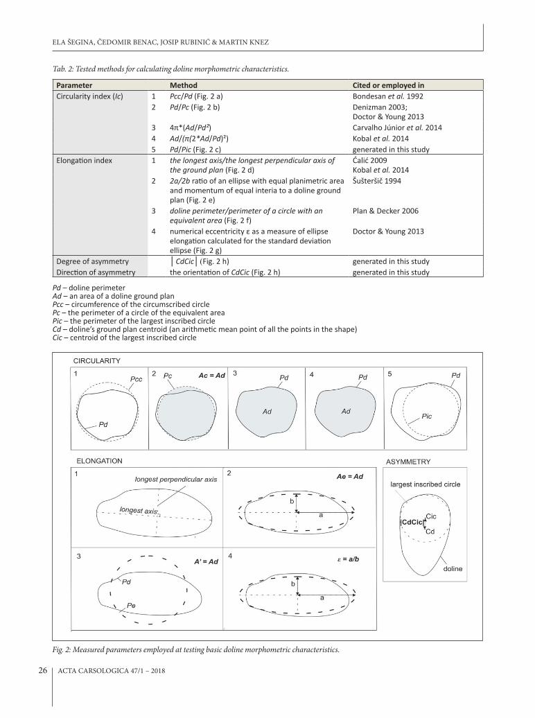
Tab. 2: Tested methods for calculating doline morphometric characteristics.
Parameter Method Cited or employed inCircularity index (Ic) 1 Pcc/Pd (Fig. 2 a) Bondesan et al. 1992
2 Pd/Pc (Fig. 2 b) Denizman 2003; Doctor & Young 2013
3 4π*(Ad/Pd²) Carvalho Júnior et al. 20144 Ad/(π(2*Ad/Pd)²) Kobal et al. 20145 Pd/Pic (Fig. 2 c) generated in this study
Elongation index 1 the longest axis/the longest perpendicular axis of the ground plan (Fig. 2 d)
Ćalić 2009 Kobal et al. 2014
2 2a/2b ratio of an ellipse with equal planimetric area and momentum of equal interia to a doline ground plan (Fig. 2 e)
Šušteršič 1994
3 doline perimeter/perimeter of a circle with an equivalent area (Fig. 2 f)
Plan & Decker 2006
4 numerical eccentricity ε as a measure of ellipse elongation calculated for the standard deviation ellipse (Fig. 2 g)
Doctor & Young 2013
Degree of asymmetry │CdCic│(Fig. 2 h) generated in this studyDirection of asymmetry the orientation of CdCic (Fig. 2 h) generated in this study
Pd – doline perimeterAd – an area of a doline ground plan Pcc – circumference of the circumscribed circle Pc – the perimeter of a circle of the equivalent area Pic – the perimeter of the largest inscribed circle Cd – doline’s ground plan centroid (an arithmetic mean point of all the points in the shape) Cic – centroid of the largest inscribed circle
Fig. 2: Measured parameters employed at testing basic doline morphometric characteristics.
ELA ŠEGINA, ČEDOMIR BENAC, JOSIP RUBINIĆ & MARTIN KNEZ
ACTA CARSOLOGICA 47/1 – 201826

RESULTS AND DISCUSSION
DOLINE DELINEATIONThe main obstacle for the consistent description of do-line planar shapes is the irregularity of their perimeters and insufficient scale of data sources applied for their delineation. Limitations of determining doline upper rims have been defined for procedures based on con-tour concept (topographical maps, but also common procedures of upper rim extraction from DEMs), vis-ual determination from DOFs and field determination (Tab. 3).
Procedures based on contour concept (topograph-ical maps, automatic extraction from DEMs) are unsuc-cessful when the doline upper rim varies in altitude (Fig. 3 a, b) and when contour interval is too wide to capture actual doline upper rim (Fig. 3 c). Field examination on
the test site indicates that even dolines located on a flat surface with rims that are not touching each other are bounded by the vertically irregular rim.
Procedures based on the visual determination from orthophotos are highly dependent on vegetation. They are successful only where a shadow effect or significant change of vegetation due to change in slope inclination is visible (Fig. 4).
Even though field examination is expected to be a most reliable method for doline upper rim determina-tion, it is nevertheless subject to several limitations as inaccessibility, indistinctness of doline upper rim, and GPS error. In case of dense vegetation, the upper rim obtained by GPS could be even less reliable than the one extracted from topographical maps, DOFs or DEMs.
MORPHOMETRIC ANALYSES OF DOLINES — THE PROBLEM OF DELINEATION AND CALCULATION OF BASIC PARAMETERS
Limitations of topographic maps Doline upper rim is characterized by irregular altitude.
Doline upper rim occupies an alti-tude within a contour interval.
Limitations of orthophotos Doline is covered by vegetation that does not produce a shadow effect.
Limitations of field determination Doline upper rim is hardly determin-able due to the absence of an abrupt change of slope.
Doline upper rim is inaccessible due to dense vegetation.
GPS error.
Tab. 3: Limitations of doline upper rim determination methods.
Fig. 3: a) Doline upper rim manu-ally extracted from DEM based on high-resolution LiDAR data and the doline upper rim extracted from DEM by common procedures, fol-lowing the uppermost contour con-cept. The upper rim elevation in case of particular doline vertically varies for even 8 m. b) Doline representa-tion on the topographical map: up-permost closed contour vs. doline pe-rimeter defined on the field. c) Doline perimeter acquired on field occupies an altitude within a contour interval.
Fig. 4: a) Example of well-visible dolines upper rims on the forested surface and b) invisible upper rim on bare karst due to the absence of shadow effect. The upper rim was determined on the field with GPS measurements at the interval of 10 m.
ACTA CARSOLOGICA 47/1 – 2018 27

There is no single approach that would work opti-mally in all circumstances. However, it was established that perimeters defined by orthophotos correspond very well to the actual rims determined by the field sur-vey, but it is only true when the shadow effect is present. While location errors due to GPS positioning are negli-gible, digitized data are subject to shape and especially noticeable size errors (Fig. 5). Other vegetation types as bare karst land and areas covered by bushes and conifer-ous trees could be reliably mapped only by field survey.
We are witnessing the expansion of methods for automated doline delineation and numerous tests of their reliability (Doctor & Young 2013; Bauer 2015; Obu & Podobnikar 2013; Pardo-Igúzquiza et al. 2013; Carvalho Júnior et al. 2014; Kobal et al. 2015; Telbisz et al. 2016). The effort is put in the increase of input data resolution, but the issue never considered is that such methods still follow “the contour principle” instead of actual doline upper rim. Field examination and com-parison of different methods show that vertical irregu-larity of doline upper rim results in considerable shape and especially size deviations. Due to the vertical ir-regularity of doline upper rim, the automation of doline delineation using even high-resolution DEMs remains an unsolved issue.
CIRCULARITYThe simulation of an individual method behaviour per-formed on polygons with decreasing circularity (from n-angles convex polygon (circle) towards irregular concave polygon) (Fig. 6 a) shows that for the convex shapes, the method Pcc/Pd (1) define the circularity with the highest precision among all analyzed methods. In case of highly irregular (concave) polygons this ratio produces false results but as dolines are sub-circular in a planar shape, this is not a matter in issue. The range
of method’s validity is behind the applicability of the method in karst studies. The ratio 4π*Ad/Pd² (3) is a reciprocal of the ratio Ad/π(2*Ad/Pd)² (4) and both give results comparable to the ratio Pd/Pc (2). However, ap-plication to the real dataset of dolines (Fig. 6 b) did not allow the recognition of any region of validity for these three ratios. The ratio Pd/Pic (5) distinguishes between concave and convex polygons but is not as effective in distinguishing among sub-circular shapes (see the re-sult for an 8-angles convex polygon in Fig. 6 a) as the method Pcc/Pd (1).
Choosing the most appropriate index thus primar-ily depends on a doline’s planar shape geometry and the purpose of the morphometric analyses. For the purpose of describing doline sub-circular planar shape in karsto-logical practice, the ratio Pcc/Pd (1) provides the most detailed results. However, one must bear in mind that in the presence of highly irregular (concave) shapes, this ra-tio can produce false results. Spatial representation of a suggested variant of circularity index is presented on a real dataset of 110 dolines (Fig. 7).
ELONGATIONAccording to the simulation of an individual method behaviour performed on polygons with increasing elongation (from circle towards increasingly elongated ellipse, and irregular concave polygon), the method (3) recognizes non-elongated but highly irregular shapes as highly elongated shapes (Fig. 8 a). Application to a real data set (Fig. 8 b) demonstrates that method (2) effectively distinguishes highly elongated, while meth-od (4) is more efficient in distinguishing among sub-circular shapes. Method (1) gives results similar to method (2), but the irregularity of doline perimeter is in some cases causing false deviations in doline elon-gation. Methods based on the best-fitting ellipse ((2)
ELA ŠEGINA, ČEDOMIR BENAC, JOSIP RUBINIĆ & MARTIN KNEZ
Fig: 5: Comparison of doline de-lineation methods on examples from areas with different vegeta-tion types.
ACTA CARSOLOGICA 47/1 – 201828

MORPHOMETRIC ANALYSES OF DOLINES — THE PROBLEM OF DELINEATION AND CALCULATION OF BASIC PARAMETERS
Fig. 6: a) The simulation of methods behaviours performed on polygons with circularity rate decreasing from n-angles convex polygon (circle) towards irregular concave polygon. b) The comparability of calculated circularity indices on the sample of 110 dolines, from most circular (ID = 95) to least circular doline (ID = 87) based on the most efficient method for calculating circularity index Pcc/Pd (1).
Fig. 7: Spatial representation of a suggested variant of circularity in-dex on a real dataset of 110 dolines.
ACTA CARSOLOGICA 47/1 – 2018 29

ELA ŠEGINA, ČEDOMIR BENAC, JOSIP RUBINIĆ & MARTIN KNEZ
Fig. 8: a) The simulation of methods behaviours performed on polygons with elongation rate increasing from circle towards increasingly elongated ellipse and irregular concave polygon. Note that simulations performed by methods 1 and 2 gives the same results and are both presented with orange line. b) The comparability of calculated elongation indices on the sample of 110 dolines, from least elongated (ID = 8) to most elongated doline (ID = 87) based on the most efficient method for calculating elongation index ε of the best-fitting ellipse (4).
Fig. 9: Spatial representation of a suggested variant of elongation in-dex on a real dataset of 110 dolines.
ACTA CARSOLOGICA 47/1 – 201830

MORPHOMETRIC ANALYSES OF DOLINES — THE PROBLEM OF DELINEATION AND CALCULATION OF BASIC PARAMETERS
and (4)), that generalize the irregular planar shape of a doline express its elongation with fewer errors. Due to mainly sub-circular doline planar shapes, the numeri-cal eccentricity ε as a measure of ellipse elongation calculated for the best fitting ellipse (4) appears to be the most efficient method for determination of doline elongation. Spatial representation of a suggested vari-ant of elongation index is presented on a real dataset of 110 dolines (Fig. 9).
ASYMMETRYThe newly generated method for quantitative de-
termination of the degree and the direction of asymme-try was applied to the entire sample of 110 dolines (Fig. 10). Inaccuracy in the direction of asymmetry appears in cases where the shape of a doline is approaching sub-equilateral triangle (dolines 41, 54, 60, 97) or sub-square shapes (doline 64) with several axes of symmetry.
CONCLUSIONS
The exact extent of the spatial influence of dolines in karst systems is an ongoing topic of research in karstol-ogy and is not an issue specifically dealt with here. How-ever, attention was given to the apparently loose and in-consistent doline delineation methods and morphomet-ric analyses applied so far. Conclusions can be summed up in the following points:
Manual delineation using orthophotos is proven to afford a more reliable method for doline delineation than topographic maps and other automated and semi-auto-mated methods using DEMs of any resolution.
Contour-based methods (topographical maps and common procedures for doline upper rim extrac-tion from DEM) are not convenient representation of actual doline upper rim due to the vertical irregularity of doline rim and, in case of topographical maps, due to contour interval that may not capture actual doline perimeter.
In order to direct morphometric studies of dolines toward optimization and comparability on wider scales, a mathematical examination of several commonly used ground plan morphometric parameters was undertaken.
Simulations demonstrated that employed mathematical approaches own different ranges of validity.
For the purpose of describing the circularity of sub-circular planar shapes of dolines the circumference of a circumscribed circle/the perimeter of the doline is the most effective index of circularity. For determining doline elongation, the optimal method is the numerical eccentricity ε of the best-fitting ellipse.
The degree and direction of asymmetry can be satis-factorily described by the distance between the centroid of the largest inscribed circle and the centroid of the doline ground plan.
After examination of some basic principles of doline upper rim determination, and a review of approaches analyzing the planar shape of dolines presented here, the potential significance of parameters as circularity, elongation and asymmetry could finally be established. The uniform employment of adequate parameters and improved delineation methods would lead to greater ac-curacy and global comparability of doline morphomet-ric data and promises more stable correlations between forms and processes on karst.
Fig. 10: Spatial representation of asymmetry index on a real dataset of 110 dolines: a) orientation of asymmetry and b) degree of asymmetry.
ACTA CARSOLOGICA 47/1 – 2018 31

ELA ŠEGINA, ČEDOMIR BENAC, JOSIP RUBINIĆ & MARTIN KNEZ
ACKNOWLEDGEMENTS
We thank most sincerely France Šušteršič for his general review, discussion on the topic, and fruitful com-ments, and Tilen Šetina for his mathematical review. The research was partially funded by the Fund of donors for
postgraduate studies in Mathematics and Science at the Slovenian Academy of Science and Arts, and by The Slo-vene Human Resources and Scholarship Fund.
REFERENCES
Bárány, I. & G. Mezõsi, 1991: Further morphometrical data from some important Hungarian Karst areas.- Proceedings of the Conference on Environmental Changes in Karst Areas. I.G.U.-U.I.S. Quaderni del Dipartimento di Geografia 13. Universita di Padova, Padova, 137-142.
Basso, A., Bruno, E., Parise, M. & M. Pepe, 2013: Mor-phometric analysis of sinkholes in a karst coastal area of southern Apulia (Italy).- Environmental Earth Science, 70, 2545-2559. DOI: http://dx.doi.org/10.1007/s12665-013-2297-z
Bauer, C., 2015: Analysis of dolines using multiple methods applied to airborne laser scanning data.- Geomorphology, 250, 78-88. DOI: http://dx.doi.or-g/10.1016/j.geomorph.2015.08.015
Benac, Č., Juračić, M., Matičec, D., Ružić, I. & K. Pikelj, 2013: Fluviokarst and classical karst: examples from the Dinarics (Krk Island, Northern Adriatic, Croa-tia).- Geomorphology, 184, 64-73. DOI: http://dx.doi.org/10.1016/j.geomorph.2012.11.016
Bondesan, A., Meneghel, M. & U. Sauro, 1992: Morpho-metric analysis of dolines.- International Journal of Speleology, 21, 1–4, 1-55. DOI: http://dx.doi.or-g/10.5038/1827-806X.21.1.1
Carvalho Júnior, O. A., Guimarães, R. F., Montgomery, D. R., Gillespie, A. R., Gomes, R. A. T., Souza Martins, É. & N. C. Silva, 2014: Karst Depression Detection Using ASTER, ALOS/PRISM and SRTM-Derived Digital Elevation Models in the Bambuí Group, Bra-zil.- Remote Sensing, 6, 330-351. DOI: http://dx.doi.org/10.3390/rs6010330
Ćalić, J., 2009: Uvala – contribution to the study of karst depressions (with selected examples from Dinarides and Carpatho-Balkanides).- PhD thesis. University of Nova Gorica, Slovenia, pp. 213.
Day, M. & S. Chenoweth, 2013: Surface roughness of karst landscapes.- In: Shroder, J. (Editor in Chief), Frumkin, A. (Ed.), Treatise on Geomorphology. Ac-ademic Press, San Diego, CA, Karst Geomorphol-ogy, 6, 157-163. DOI: http://dx.doi.org/10.1016/B978-0-12-374739-6.00108-1
Denizman, C., 2003: Morphometric and spatial distribu-tion parameters of karstic depressions, Lower Su-wannee River Basin, Florida.- Journal of Cave and Karst Studies, 65, 1, 29-35.
Doctor, D. H. & J. A. Young, 2013: An evaluation of auto-mated GIS tools for delineating karst sinkholes and closed depressions from 1-meter lidar-derived digital elevation data.- In: Land, L., Doctor, D. H., Stephen-son, J. B. (Eds.) Proceedings of the 13th Multidisci-plinary Conference on Sinkholes and the Engineer-ing and Environmental Impacts of Karst, National Cave and Karst Research Institute, 449-458. DOI: http://dx.doi.org/10.5038/9780979542275.1156
Gams, I., 2000: Doline morphogenetic processes from global and local viewpoints.- Acta Carsologica, 29, 2, 123-138. DOI: https://doi.org/10.3986/ac.v29i2.453
Kobal, M., Bertoncelj, I., Pirotti, F. & L. Kutnar, 2014: Lidar processing for defining sinkhole character-istics under dense forest cover: a case study in the Dinaric mountains.- The International Archives of the Photogrammetry, Remote Sensing and Spa-tial Information Sciences 7, 113-118. DOI: http://dx.doi.org/10.5194/isprsarchives-XL-7-113-2014
Obu, J. & T. Podobnikar, 2013: Algorithm for karst depres-sion recognition using digital terrain models. - Ge-odetski vestnik, 57, 2, 260-270. DOI: http://dx.doi.org/10.15292/geodetski-vestnik.2013.02.260-270
Pardo-Igúzquiza, E., Durán, J. J. & P. A. Dowd, 2013: Au-tomatic detection and delineation of karst terrain depressions and its application in geomorphologi-cal mapping and morphometric analysis.- Acta Car-sologica 42, 1, 17-24. DOI: https://doi.org/10.3986/ac.v42i1.637
Plan, L. & K. Decker, 2006: Quantitative karst morphol-ogy of the Hochschwab plateau, Eastern Alps, Aus-tria.- Zeitschrift für Geomorphologie, NF Suppl. 147, 29-54.
Šušteršič, F., 1994: Klasične vrtače klasičnega Krasa (Classic dolines of classical site).- Acta Carsologica, 23, 123-152.
ACTA CARSOLOGICA 47/1 – 201832

MORPHOMETRIC ANALYSES OF DOLINES — THE PROBLEM OF DELINEATION AND CALCULATION OF BASIC PARAMETERS
Telbisz, T., Dragušica, H. & B. Nagy, 2009: Doline Mor-phometric Analysis and Karst Morphology of Bio-kovo Mt (Croatia) Based on Field Observations and Digital Terrain Analysis.- Hrvatski geografski glasnik, 71, 2, 5-22. DOI: https://doi.org/10.21861/hgg.2009.71.02.01
Telbisz, T., Látos, T., Deák, M., Székely, B., Koma, Z. & T. Standovár, 2016: The advantage of lidar digital terrain models in doline morphometry compared to topographic map based datasets – Aggtelek karst (Hungary) as an example.- Acta Carsologica, 45, 1, 5-18. DOI: https://doi.org/10.3986/ac.v45i1.4138
ACTA CARSOLOGICA 47/1 – 2018 33
Copyright © 2022 FDOKUMEN