mormon.pdf - National Park Service History Electronic Library
301
- - t: • ' ' • ··}l MORMON COLONIZAtION IN SOUTHERN UTAH AND IN ADJACENT PARTS OF ARIZONA AND NEVADA 1851 - 1900 C. GREGORY CRAMPTON 1965 B&WScans tlfB I f)-(p? File: Copito I Reef-
-
Upload
khangminh22 -
Category
Documents
-
view
0 -
download
0
Transcript of mormon.pdf - National Park Service History Electronic Library

-
-
t: •
' '
• ··}l
MORMON COLONIZAtION IN SOUTHERN UTAH
AND IN ADJACENT PARTS OF ARIZONA AND NEVADA
1851 - 1900
C. GREGORY CRAMPTON
1965
B&WScans 7/tAB/~O'f
tlfB I f)-(p?
File: Copito I Reef-

Stock corral., Bulrush Wash.,, Near Pipe Si:ring, the .Arizona. Strip
•

•
•
•
PREFACE
The work that follows constitutes a history of Mormon settlement and colonization in southern and southwestern Utah and in nortions of the neighboring states. The geogranhical bounds of the subject area are somewhat irregular. Draw a line from Salina, in the Sevier Valley, to Capitol Reef National Monument, thence to Lee's Ferry, thence to the North Rim of the Grand Canyon at the ~aibab Plateau, thence to Mt. Dellenbaugh on the Shivwits Plateau, thence to Las Vegas, thence to Pioche, Nevada, thence to Fillmore, Utah, and Salina. This region, blanketed by the atlas sheets appended herewith and covering parts of three states, has a strong historical unity during the period from 1351 to 1900, when it was settled by the Mormons, and almost exclusively hy them. My focus here has been primarily on settlement, _though other matter has been introduced.
~1y basic ourpose in the study has been to cast the history of the region in broad perspective; I have attempted to show that settlement in this one area was a part of the large story of Mormon expansion in the West. Also, within the subject area, I have emphasized the broader trends and directions of frontier expansion. I have not attempted to develop the subse0uent history of settlements once they were founded, and, in a good many cases, I have but mentioned new settlements. Some minor places have not been mentioned at all. To facilitate additional study of individual places, I have cited the basic published literature relating to them. A detai_led, proper-name index has been appended to this work to ease the location of detailed matter relating to specific areas.
I have concentrated most attention on the primary areas of settlement--on those that served as stepping stones to new frontiers-and on areas of settlement in the vicinity of the national parks and monuments. As I have indicated at the end of the last chapter, the reservations under the administration of the National Park Service in the subject area, are adjacent to, or close to, numbers of places of historic interest.
This work is the result of extensive study in libraries and in the field. En route I have enjoyed the association of many persons who have granted assistance in a wide variety of ways. If errors have
iii

•
•
•
crept into the work, I relieve these friends of responsibility for them. I have placed heavy demands on the personnel of the National Park Service all the way from Washington to the regional offices at Santa Fe, to those of the parks and monl.DTlents in the field. In ~ashington, b.C.: Robert M. Utley, Chief, Division of History Studies; at the Southwest Region offices: 1:illiam E. Brown, Regional Historian; Erik K. Reed, Rer.ional Chief, Office of Resource Studies; Charlie R. Steen, Regional Archeologist: Albert H. Schroeder, Archeologist. Grand Can)•on National Park: Howard B. Stricklin, Su-perintendent; ~lerrill D. Beal, Chief Park Naturalist; Norman G. Messinger, Museum Curator; James A. Richardson, District Naturalist; Robert Peterson, District Ranger; Paul E. Mathis and Harold W. Timmons, Park Rangers. Grand Canyon National Monument: John H. Riffey, Supervisory Park Ranger. Zion ~'.ational Park: Frank R. Oberhansley, Sunerintendent: Carl E. Jenson, Chief Park Naturalist: Roland H. Wauer, Suner-visory Park Naturalist. ~rvce Canyon National Park: Louis N. Hallock, Superintendent; John A. Barnett, Jr., Park Naturalist: Canitol Reef National ;·fonument: \Jilliam T. Krueger, Superintendent; Bernard G. Tracy, !1aintenance. Pirc Snrin.~ :·:.:itional 'fonur.ient: Hugh H. Bozarth, Superintendent; Robert W. Olsen, Jr., Park Historian; Lake Me.1rl
:t~ational Recreation Area: Charles A. Richey, Superintendent; Vernon D. Dame, Park N~turalist; Glen Canyon ~ational Recreation Area: Gustav W. Muehlenhaupt, Sunerintendent: Wavne H. Alcorn, Chief Park Naturalist •
A number of other persons in private or public canacity have been most helpful: Merle Adams, Kanab; Juanita Brooks, A. Karl Larson, St. George; 'iilliam D. Johnston, Arizona State Highway Maintenance Camp, Navajo Springs; 13. Sacl~s, Baltimore, ~1aryland; William c. Weeks, Reading, Pennsylvania; E. D. Weeks, Des ~oines, Iowa; Keith \~ipple, Hiko, Nevada; William J. Williams, Regional Public Information Officer, Dureau of Reclamation, Boulder, Nevada; W. L. Rusho, Public Information Office, Bureau of Reclamation, Salt Lake City; Edwin N. Ferdon, Jr., Associate Director, Arizona State Museum, Tucson; Natt N. Dodge, Santa Fe; Elbert B. Edwards, Boulder City; John Harvey Butchart, Professor of Mathematics, Arizona State College, Flagstaff; Maurine Clifford, Public Inquiries Office, U. S. Geological Survey, Salt Lake City; Parker and Hildegard Hamilton, Flagstaff; Reed R. Mathis, St. George: Michael Harrison, Fair Oaks, California; W. L. lleckler, District Engineer; U. S. Geological Survey, Santa Fe; Harriet R. Judd, Kanab.
l.Jilliam and Julia Leithead, Canaan Springs, Colorado City, Arizona; Gustive O. Larson, Brigham Young University, Provo; Elizabeth }lather, Jacob Lake, Arizona; Edwin c. Schafer, Director of Public Relations, Union Pacific Railroad, Omaha, Nebraska; Maurine Whipple, St. George; Charles Kelly, Glen M. Hatch, Wallace R. Mathis and Franklin L. McKean, all of Salt Lake City •
iv

•
•
•
The library research for this report was undertaken at the University of Utah Library, Utah State Historical Society, Church of Jesus Christ of Latter-day Saints Church Historian's Office Library, in Salt Lake City; Dixie College Library, St. George; Las Vegas Public Library; Arizona State College Library, Flagstaff; Museum of Northern Arizona, Flagstaff; Museum of New Mexico, Santa Fe; Department of Library and Archives, Phoenix; Arizona Pioneers Historical Society, Tucson; Bancroft Library, University of California, Berkeley; Nevada Historical Society, Reno. Further research was conducted in the library collections located in the several parks and monuments as indicated in the bibliographical note on page 239. I owe a great deal to the directors and librarians of these institutions for making materials available to me.
I have included a number of photographs and other illustrative materials in this report. I have avoided illustrating very wellknown places and the scenic features of the national parks. Unless otherwise acknowledged, I have taken the photographs in the text. Illustrations on pages 9, 10, 15, 28, 32, 40, 57, and 77 are taken from copyrighted material and permission should be secured if these illustrations are reproduced for public distribution beyond this report.
David E. Miller, Chairman, Department of History, University of Utah, has in a number of ways encouraged the preparation of the report. Julie Pingree Rncl Mary Lynne Marsh Sargent typed the manuscript. John Kitchen, graduate student, University of IJtah, has assisted in certain aspects of the researc:i and he has T'lrepared the index.
This report is submitted in satisfaction of National Park Service Contract Number 14-10-0333-1050, dated June 18, 1963.
v
C. Gregory Crampton Department of History December 28, 1965

•
•
CONTENTS
CHAPTER I BACKGROUNDS
The Mormons and Deseret . Sn.:iin in the Utah Country . The Spanish Trail • Footnotes . . • •
CHAPTER II TUE FIRST MOVES SOUTH, 1847-1851
The Road to California The Iron \fission The Kingdom of God Deseret Iron Co~~any Footnotes . . . • • • .
CHAPTER III NEW EXPANSION AND INDIAi~ TROUBLES
The Outer Cordon Explorations of John D. Lee . The Walker h'ar • Footnotes . • •
CHAPTER IV COLONIZATIO;·! AND \:AR
The Southern Indian Mission . War and Tragedy • . • ~ . Utah Har and Colonization Footnotes • • • • • • • • •
CHAPTER V THE COTTON MISSION
First into Zion • • •• Hamblin to the Hopis The Cotton Mission ••••• Footnotes • • • • • •
vi
1 5
12 1 <)
2Lf
27 33 36 41
45 47 55 60
63 69 73 80
84 91 97
105

•
•
•
CHAPTER VI THE DECADE OF THE 1860's
Frontier Expansion The Black Hawk War
. . . . . . . . . . . Frontier Recession and Peace Footnotes • • • • • • • • • •
. . . . . . . . . . . . . . . . . . CHAPTER VII FRONTIERS OF THE VIRGIN: THE BIG YEARS
Mission to the Muddy • • • • • • • United Order and Orderville • • • • • • • Cooperative Grazing and the Arizona Strip
. . . . . . . . . . . . . . . . Footnotes • • • • • • • • • • • • • . . •. . . . . . . . .
CHAPTER VIII NEW FRONTIERS
Kanab, Paria, and Environs . • . . . Lee's Ferry • . . . . • . Cattle on the Kaib ab • . . • . Footnotes . . . . . . . . . .
CHAPTER IX EAST OF THE HIGH PLATEAUS
New Developments in Dixie • • • • • • • • • • The Upper Sevier and the Paria Amphitheater Escalante and the Fremont River
. . • • • . ~ . . • . . . . . • . • . .
. . . . . . . . . . . . . . . Footnotes . . . • • . • . • . • • . • . . • . . . . .
CHAPTER X NEW FORCES
Footnotes • · •• . . . . . . . . . . . . . . . . BIBLIOGRAPHY • • . . . . . . . INDEX . . . . . . . . . . . . . . . . . . . . ATLAS . . . . . . . . . . . . . . . . . . . . . . . . . .
vii
109 117 125 133
139 151 154 162
166 175 181 191
196 201 207 224
237
239
275
291

•
•
•
ILLUSTRATIONS
Stock corral, Bulrush Wash • • • • • . . • State of Deseret and the Territory of Utah The Escalante Trail, 1776 Miera Map, 1778 • • • Map of the Old Spanish Trail • Spanish Trail in Utah • • • • The Vermilion Cliffs at Short Creek The Echo Cliffs near Lee's Ferry ••. Historic Trails in Southwestern Utah ...•• John D. Lee's drawing of Fort Louisa (Parowan) Utah Territorial Capitol at Fillmore •• Cedar City and Iron Mining locale John D. Lee, Mormon Pioneer Brian Head near Cedar Breaks • . • • • • • Pahute Indian homelands • • • • • • Jacob Hamblin home at Santa Clara Chart of site of Mountain ~eatlows Massacre .• The U .• S. Explorer ••.•.•••••.•
frontispiece 3 9
10 14 15 18 18 28 32 35 4()
48 52 57 67 72
Map showing e~plorations of Ives, Macomb, and Simpson ••.• Chart showing exploration of Jesse N. Smith and others, 1858 Inscriptions dated 1857 near Lee's Ferry ••.•
75 77 87 92 99
113 l2i) 130 142 143 14(,
Ghost town of Harrisburg ••••••••••••• Plat showing location of Northrup an<l Shunesburg . Ruins of Fort Pearce • • • • . . • • • :;Dunn 1369., inscription, ~1t. Dellenbaugh Original plan of Callville . Site of St. Thomas ••. "Lost County of Pahute" Daniel Bonelli •••••. Cana.an Ranch headquarters Ruins at the Grand Gulch 11.ine Pioneer cabin at Paria . . Deseret Telegraoh and Past Office, Rockville • Adobe house at Johnson • . . . • . Stock-uatering basin at Jacob Pools Inscri~tions at House Rock Snring V T Ranch • . . . • . . • • Salt House at Greenland Lake Jacob Lake
viii
149 156 161 169 173 17li 178 182 185 137 188

•
•
•
Ruins at Silver Reef •• Ebenezer Bryce cabin . . Brick home at Escalante • • • • Ruins of cut stone house at Giles Ruins of stone Behunin house at Aldridge •
ix
198 206 210 222 222

•
•
•
CF.APTER I
BACKGROUNDS
The Hamons and Deseret
In broad outline the first settlement of southern Utah and portions of the adjoining states of Ne\rada and Arizona was the result of the raoid expansion of the !-1ormon frontier fol lowing the establishment of the base settlement at Salt Lake City in 1847. Once the Mormons had arrived on the shores of Great Salt Lake in the surmner of that year Brigham Young and the leadershi~ of the Church of Jesus Christ of Latter-day Saints planned to stake out quickly an empire of huge rro~ortions in the intermountain region.
To esca~e persecution, mob action, and the rule of force which had caused them to move from Ohio to Missouri and thence to Nauvoo in Illinois, where the founder of the sect, Joseph Smith, and his brother Hyrum, were murdered in 1844, the Mormons elected to seek isolation in the Rocky Mountains. The epochal trek frOT:l. Illinois and Iowa across the plains and mountains to the Great Basin in 1847 and subsequent years is the best known chapter in Mormon history, and it need not be developed here.l
When the pioneer band arrived in the Salt Lake Valley in July, 1847, the region was nominally a part of the Republic of Mexico but it was within six months transferred to the United States by the Treaty of Guadalupe-Hidalgo ending the ~exican War. Although the Dom{nguez-Escalante party in 1776 had reached the shores of Utah Lake and numerous trading parties operating between New Mexico and California subsequently had crossed the region south of Utah Lake, neither Spain nor Mexico had established any permanent settlements in the Utah country. Indeed the Mormons found themselves in an area far beyond any effective political jurisdiction by Mexico; for some time after their arrival the United States exercised no practical jurisdiction over the region •

•
•
-•
-2-
The first government of t~e nioneer settlement in Salt Lake Valley was 11rovided by the machinery of the Mormon Church; this was called at the time a "theo.;...der:i.ocracy." However, the ~formon leadershi1" was nnxious to extend its rule heyond the confines of actual settleT'lent, and a convention Has cP.lled on March 4, 1849, for the nurnose of crganizing a state or territorial government. By March 12, a constituticn had been written and ratifieC. establishing the provisional State of Deseret (from a Book of Mormon word signifying "honeybee") and providing a government for it. A delegate was sent off to Washington with a petition to Congress requesting adr.lission to the union of states. Con~ress refused to act on the petition, however, and the State of Deseret functioned in a 'Provisional and extra-legal irny until Sentember, 1850 when Congress, as a nart of the omnibus bill knm-m as t.he California, or Great Cornnromise, created the territories of Utah and ·:ew Tfoxico 'l.nd the State of California from the vast area acquirec' from Mexicc
The provisional State of Deseret ere' --d by the s~ontaneous nolitical action of the Hornons in ~farch, 1 ::q, embraced a very large territory including nearly all of the ~resent states of Utah and Nevada, the greater part of Arizona, substantial portions of New Hexico and Colorado, and lesser portions of Idaho and Oregon; in addition, the boundaries were drawn to incorporate a large nortion Qf Southern California which \JOuld provide a corridor to the sea. The boundaries of the State of Deseret were interesting. Though they were not confirmed by Congress in 1850, they enclos~ a region which the !1orrnons staked out, as it were, and then .. .went __ ahead to colonize and settle as rapidly as possible regardless of political bounds. In much of the area of the State the Mormons were the pioneer colonizers. See page 3.
The boundaries of the Territory of Utah as established by Congress in 1850 enclosed an area of something less than half the size of Deseret, but it was still a very large dOI!lain extending from the crest of the Sierra Nevada to the continental divide between the thirty-seventh and forty-second parallels of north latitude. During the years between 1861 and 1868 the territory was reduced radically in size as large portions were cut off by Congress to form parts of the territories of Nevada, Colorado, and Wyoming, The original Nevada Territory in 1861 in fact was formed wholly from the western nortion of Utah Territory. By 1868 the boundaries of Utah had been fixed permanently and coincided with those of the present state.2
Utah remained a territory frOr.:1 1850 to 1896 during which time the Mormons firmly established themselves in settlements throughout the territory and in Nevada, California, Arizona, and New Mexico as well as in territories north of Utah. During this time they made comparatively little progress in settlement in those portions of Colorado adjacent to Utah. Mormon settlement, of course, was not limited to these areas but was extended to other states and territories and missions were sent to foreign lands. The fifty year neriod from

Utah and the State of Deseret
~ ----{ ;:;.:r
t----i !'--1
·~ -·~
-~-~~.--·
,____~----~----"' ,_..._..._...._.._______._ ________ , .
\ \.
'\ \.
\
I I J \ /-/ < 1
.-\ 1-1. I I'.< JS.\
/
.. ~~ .... .,._...
~~~------~--.r~--~-==~-~-~~-·-~
State of Deseret, 1849 Territory of Utah. 1861
• Territory of Utah, Hs~O Territory of Utah, 1862
Territory of Utah. 1866
Territory of Utah, 18611
H l I
w I i

•
•
•
-4-
the time the Morraons arrived in the Great Basin in 1847 to the time when Utah became a state ·in 1896 constitutes the '!"lioneer period in t!1e MoI111on settlement of Utah and the neh;hboring states of Arizona and Nevada (as well as other regions of course). This is clearly true in the re~ion of southern Utah, southern (or southeastern) Nevada, and that oortion of Arizona north of the Colorado River known as the Arizona Strip. Durin~ this period the land was snied out, settlements ·7cre n:lde, the 1 imi ted nrnl,le land and the rancres uere parcel led out. Hagon roads uere onened, a telegre:oh connected the .,,rinci!lal settlements, and hcuses of ~.TOrshiT'I and a tem?le were 'built. In a sentence the ~forrnons ho.d establishec t~ensclves successfully in a country enbracing a "ortion of tl-ie Great R?sin and an adjoirdn~ se~ent of the vast Colora<lo Plateau. ~ey uere pioneers in a wilcernes s that uas po"r in the resources necessary to sustP.in ht!!'.1ar. life 'but rich in varie~ landsc~pes and scenic grandeur.
The ~.forr.ion frontier moved ~dth such momentur.1 throughout the subject region of this study th2t it ~Jas extende<l. into. some areas ~·Tith resources insufficient to supT'lort '!"leo.,le in any nurnhers. The result 11as early retraction and stabilization. r.~ithin the decade, 1875-18115, the nattern of rennanent occunancy had beer detem.inecl.. After that time ex~ansion occurred largely in relation to isolated stimuli such as the develo~ment of r.ines, the coming of the railroad, or the creation of nationRl parl:s anc:! monuments Phich attracteC! increasing numbers of tourists as roads were im...,rovec tn ~ccommodate them. 3
Host of the work of ~·'orrnon colonization during the territorial period ~·1as planned ani:~ directed by Brii:r:ham Younp. As titular head of the Church of Jesus c:irist of Latter.-day Sl>.ints following the · death of Joseph Smith, Younr, lee! his people to the r:reat Basin. There he was elected ~overnor of the provisionRl State of neseret in 1849 and when Congress formed the Territory of Utah in 18.5fl, he was appointed the first ~overnor, an office he helct u~til 1857. T!hile holding these civil offices Brigham Young also continued to serve as ~resident of the ~orrnon Church: his tenure as head of his church ended with his death in 1877. During the course of his active life in the 9est Ilrigham Young initiated, plannec, anrl directed the founding of 358 settlements in Utah anc! in the neighb0ring states anrl territories. Altogether this was A remarl:able achievement. In the history of the American ~Jest planned settlenent is nowhere else found on so lar~e a scale.4 .
Very soon after the pioneer !forrnons arrived in the valley of the Great Salt Lake they began to develop plans for colonization outward from that place. A number of considerations ~·1ere involved. The search for isolation had impelled them west in the first instance. Indeed, at the time it is doubtful if a more completely isolated location, holding any prospect of supporting a large population, could have been found. Yet the Mannon leadership realized that isolation desirable in one way was not in another. It was of course necessary

•
•
••
-5-
to maintain relations with the outside world. Brigham Young expected that a continuing migration of his own people would come to the wilderness Zion and that their numbers would be augmented by converts from abroad. Supply and communication were vital, and there was also the problem of defense in the event of military invasion, or of mob action, or of threat by Indians.
From the east in 1847, there was only one entrance by wagon to Salt Lake and that was the overland route from the Missouri River-the historic road ta Oregon opened a few years before the Motmons traversed it. The Monnon pioneers branched off this route and followed a track to Salt Lake opened by the Donner-Reed Party in 1846. A western gateway to the Motmon settlement, other than the Donner trail, or the Calffornia cut-off of the Oregon Trail, would be highly desirable. But if the Mormons in Salt Lake were to be at all secure, bases, way stations, and resting places, along the roads and supply lines had to be established and maintained. Further strategy called for the founding of a number of distant outposts--an outer cordon of settlements--to be located near the termini or athwart the main routes of travel to Salt Lake. This system of outer settlements and routes connecting them with Salt Lake would also facilitate expansion of settlement from the hub itself. In short, the Mormons expected to develop and protect the principal routes to the eastern part of the Great Basin as they planned, to insure their agricultural self-sufficiency, to appropriate the farming lands in all directions from Salt La!\:e. 5 One of the first routes developed was a road to, California following or parallelin~ most of the way a horse trail opened during t!'le ~1exican period by traders from Santa Fe.
Although the 'lormons were the first ~-:rhites to .settle in the Utah country the men of Spain and ~fexico, and the American fur men, were the first to explore it and to put it on the map. These activities are significant for these early entre?reneurs developed much im~ortant information, they introduced the white man's civilization to the Indian tribes, and they left the first nar.ies on the land.
But it's a short history at that. There is no evidence to suggest that white men penetrated into the country west of the canyon r.ortions of the Colorado River before 1776 when the exploring party headed by Dom{nguez and Escalante made a historic traverse. It is indeed true that ~ome of Coronado's men headed by' Garc{a LO'pez de c{rdenas discovered the Grand Canvon in 1540 less than fiftv vears after the dlscovery of America by Columbus. Again, Juan de Ofi~te in 1605 reached the eastern bank of the Colorado at the mouth of ~ill Williams Fork but like Coronado's men he did not cross the stream.6 After the occupation of New Mexico, particularly after the location of the capital in Santa Fe in 1610, S?ain was in a favorable position to reach

•
•
•
--6-
the Colorado from that sector. :-i.owever, she was sorely pressed much of the time thereafter to hole! the province froM attack hy Indian tribes surrounding it and ii!ithin it anc! control of :·leP Mexico was lost altogether l,•hen the 'Pueblos revolted in 168n, and it was not restored for another seventeen years. Spain had little time or treasure to extend the earlier eXT)lorations of Coronado, Onate, and others, however strong the attractions of the country northwest of New Mexico !':lay have been. Once Alta, or Upper, California was successfully occunied by Spain in 1769, some attrmpts were made to connect that Province with New Hexico. The Dominguez-Escalante expec:lition in 1776 was one of the r.i.ost notable of these ventures as for the first time anywhere above the Needles, Spanish e:imlorers crossed to the right bank of the Colorado. Thus it required 236 years fer Spain to cross the river after Coronado's men looked into the Grand Canyon in 1540.
Francisco Atanasio Domfnguez and Francisco Silvestre V{lez de Escalante, both of the Order of Friars Minor, sought and obtained !'ermission frora the s.,anish colonial government to explore for a roa<l between Santa Fe and Monterey in California. En route they horied to find sites for new settler1ents and for missions among the tribes. ~·Ji th a small entourage, they left Santa Fe at the end of July, 1776, and carried out a ~reat circle of exploration counterclockwise through the four modern states of :::ew !1exico, Colorado, Utah, and Arizona. They did not make it through to California and returned to Santa Fe January 2, 1777.
FrO!ll Santa Fe the explorers followed trails familiar to S:iP-in until they reached the Colorado River some distance nhovc Grand Junction. After that they were on new ~round. :Snterin;; the Uinta· Dasin, they l·~ere the first ~]hites to see the Green River, which they named the San Buenaventura. Going on, the Franciscans crossed from the basin of the Colorado to the Great Basin by way of Snanish Fork Canyon and reached a noint near the shores of Utah Lake on September 23, 1776. They did not visit Salt Lru<e, thouPh the Indians told them of it, which they assumed to be a nart of Utah Lake, called bv them Lake Timpano"?,os, or Timpano~otzis, after ·the Indians living in the vicinity. 7
Leaving Utah Valley, the Franciscan exnlorers turned south to reach the latitude of Monterey in California before continuing their journey to the coast. Their route took them through or near the riresent towns or ~laces: Spanish Fork, Payson, ~~erohi, Levan, Sci".lio, Holden, Pahvant Butte, Clear Lake, Black ~ocE, ::ilfc.rd, '1iner~vi lle, and Cedar City. At a point between ~-Unersvi!.l::? r.~d Cede>.!' City, on October 11, t:i.~ explorers decir~cd to turn !-.:'.c'.: to S.::.nt=: Fe O'·!inr- to t~1e latcr~ess o: t::e sec.son and the uncertain!:y of t 1 :0 distance to t:1e Cnlifo:-nia coast. Continuinr; sauth-:~-'lrc: and closely .,ci.rnUelin~ T). ~.
lli?'.:r.ya~' '.11 (Inte:-stc!!.te 15) the S'!")ar.i11r'Js passed throut!11 or ~ear the nresent tmms of i~_anarr.:iville ~r..~1 TOf!'.!t;!rville ?.n<l~ ci.t t>e Hout1; of

•
•
•
~1-
A~h Creel: on October 14, they crossed a strear.1 named by t!1em the Rio Sulfdreo. This was the Virgin River.
/ Dominguez and Escalante were the first Europeans to see the
Virgin River. They named it the "Sulphurous P.iver" (Rio SulfGreo) from the hot, mineralized water flowing into the river from springs at the mouth of Timpoweap Canyon (where the river breaks through the Hurricane Cliffs). Miera, however, called it the Rio Sulf~reo de las Piramides, or the "Sulphurous River of the Pyra¢ds." This is interesting for the "pyramids" undoubtedly refers to the pyramid-like towers of rocks of Zion National Park and environs which had come into view as the Spanish explorers approached the Virzin River. t.fiera's map quite accurately depicts the towers and the drainage system of the Virgin River. Escalante on October 14, 1776, found the ·climate mild along the Virgin, trees were still in leaf, flowers were blooming and he took note of mesquite trees found only in t~~perate regions. Here vas the first description of Utah's "Dixie" settled eighty-five years after Escalante wTote by the Mormons.
There is nothing in the Escalante diary to indicate that the Spaniards gave the Virgin River any other name than "Rio Sulfureo" or "Rio Sulf\(reo de las Piramides," a name that remained on the maps (though not always identified with the Virgin River) for many years. The name Virgin appears to have been adopted some time after the Escalante expedition and was in connnon usage by the time Fremont came along in 1844. He adopted the Spanish form "Rio Virgen" which was subsequently anglicized to Rio Virgin. It is interesting to note that through the pioneer period the name "Rio Virgin" was more connnonly employed than the "Virgin River. 11 8 See note and maps on pages 8, 9, and 10.
/ Leaving the Virgin River on October 14, 1776, the Dominguez-
Escalante expedition during the next two weeks carried out the first • exploration of the Arizona Strip. Continuing south and traveling under the shadow of the Hurricane Cliffs, the Spaniards endeavored to reach the Colorado in that direction but they uere told by some Indians that they wo.uld within two days travel find themselves in an impassable canyon. They then headed east and ascended the ~urricane Cliffs somewhere near where the "Temple Road" was later built. They crossed the upper Clayhole country and by way of Bull Rush T.:'ash passed through Antelope Valley reaching Kanab Wash some distance below Fredonia. It seems clear that the party passed to the south of Pipe Spring, perhaps coming within five or six miles of it •
.I East of Kanab Wash, Dominguez and Escalante generally followed
the course of Johnson Wash and the tributary White Sage Wash which led them to the northern end of the Kaibab Plateau. They crossed this in the probable vicinity of Buckskin Wash tc> come out in Coyote Valley. On October 24 they camped near the place later known as Jacobs Pools (though they found no water)~ during the day they found water at what was probably House Rock Spring. Both of these places later

• .-
-· •
•
-8-
Notes on Mars on Pages 9 and 10
The map on page 9 is a portion of the map in Herbert E. Bolton, .1!._ageant in the Wilderness (1950) showing his reconstruction of the Dominguez-Escalante route from the vicinity of Scipio, Utah, to a point beyond Oraibe and the other Hopi villages in Arizona. Campsites named by the Spaniards are shown with reference to present locations.
The map on page 10 is a portion of the colored facsimile map drawn by Bernardo de }lieTa y Pacheco, dated l 77P.., and contained in Bolton's Pa~eantin the Wilderness .(1950). It should be compared with the map on uage 9.to relate the data to actual geography. The "Rio Sulfureo de las Piranides" is the Virgin River. The sharp peaks just above the words "Piramides" and "S. Vgolino" are the first gTaphic portrayals of the towers of ?.ion ?iational Park. "Laguna de Miera" is Sevier Lake. The rather broad lines that seem to wander aimlessly about are colorer! on the original and are intended to designate boundaries of Indian tribes •

•
..
•
•
\ .
. Lun.l
·~.las Vegasdel Puerto San Atend'g'rnrs .. .. s Santa Brigida .;_ § ·... ., . Ji . I ~
l MilfJ,J "' San Ruslico t:1
• Mt.f,...._.
.;... ,,...,,. '· ,,. .-"
11Mi11er.-illc
' /
The Escalante Trail 1776
cO,.PIUD IY HERBERT E IOLTOJI oa6 w·-. .,, f a 1an:a:~nw
I
.. __

••
•
• GRADO S JJE LO~

•
•
•
-11-
fi~ured nrominently as stoppin~ and watering points on the wagon road connecting Utah and Arizona. Two days later the Franciscans had worked themselves around the base of the towering Vermilion Cliffs and arrived at the Colorado at the place where just short of a century later John n. Lee established Lee's Ferry. There the S~aniards found themselves boxed in with cliffs behind them and ahead of them and they could not ford the river. Desperate, the friars managed to climb the Echo Cliffs and after wandering for several rlays they found a difficult ford since called the Crossing of the Fathers (now drmmed by Lake Powell). On more familiar ~round they headed fgr the llo!)i and ZUiri villages and reached Santa Fe, January 2, 1777.~
The exploration of Domfnguez and Escalante during the last half of 1776 ~··as an important one in the history of the West. Throughout the territory in the great arc from the Colorado near Grand Junction back to the Colorado again at Lee's Ferry they were in land new to the white men. The remarkable diary of Escalante, the equally remarkable maps made by Miera, and related materials, are fundamental historical docll!!lents for the vast area. Plant life, animals, !!'linerals, land, weather, and the location of Indian tribes are ~iven in detail. However, the im~ortant discoveries made by theRe Snanish explorers did not become puhlic }:nowledge for so::':!e ti:-ae. T11e :-riaps, diary, anC:. other documer.ts, ~1ere not pri~tec!. It ;ras thr; f;cmar. scientist Alexanc!er von i:~umboldt who finally ptfrl:!.is!':ec1. t:·ic results of t!!e expec'ition. In his Political Essay S'!';;_.t_he ;:inp:do~ of. ',7c~! Snair, .•• , (181'llJ) (uri tten in French but quicHy tr~nslc.tec'l to En'.-!lish <>.nr! r>u~lir.;~1ed in four volur.ies Hith separ;ite atlas) l~tir:1Joldt ~-~rote .n. c1etnilec.~ description of t11e northern frontii::?!' of ::e·, s,.,~ir. ('tc:l':ico) 1-.r;.se(1 on documents in the ~overnment
·archives. !:nTTJholdt rii~self cic not visit the frontier reci;ions, and ap~arently he die not ~ee !scalante's diary or '!iera's map, but frcm nccrmdar:' source~ i1e <lid ~ring ''ierP.' s irno~rar>hy into his o~·m · lar":e n~r of •texico, r:lr !-le·· S".'ain. Humboldt's map renained a standard source until his data ~·1ai:; correcterl by further exnloration l~r~elv h·1 the ,hnericnn fur men and bv John Charle!'! i:-rernont. ContenTlC!r~r.; ~·Tit'!; :~.!'l<l relateil to the exnlorations of Domlru~uez and :Ssc~lant~ •»ere those of Francisco H •. Garctfs, also a Fra~ciscan, who ma::'.e the. :First traver!!.e across north central Arizona: this included a visit to the I~avasunai Indians, and othBr regions along the lower Colorac!o, anc in California, 1775-1776. L
After n~fn~uez and E~calante, Snain sent no_more explorers into the country ',1est of the Colorado. After 1776 she became involved indirectly in the Arnerican Revolution and in the international com~lic2tions followin~. Soon she ~..ro.s pla~ued by revolution in her O•·T. r-ossessions and in 1821 :t-1exico inherited from Spain all the vast country ,.mst of the continental divide a.ml south of the fortysecond !'arallel of north latituce. Durin~ the twenty-five years t'.1at '1e:xico held that country there w~.s little frontier expansion ~ut there ~·1as a considerable aMOunt of coT!B!lercial activity •

•
•
•
-12-
::letween 1776 and 1821, uhen sC1verei;;nty over Spain's dominions in ~-!orth America fell to Mexico, there is nracticall•r no evidence that there was anv further exnloration bv Spanish exnlorers ~dthin the country west ~f the Colorado disccye~ed by no'['ll{n~uez and Escalante. But after 1821 :'-1exican traders penetrated the Utah country and traded with the Indians there as an adjunct to their caravan trade ~•hich spanned about two thousand lon~ miles between Santa· Fe and San Gabriel in California.
The far-flung can\van trade mis cmened hy ~~ew Hexican traders ,/
~rho located a hetter trai 1 throui:t,h the Utah country th;m Dominguez and Escalante had done. and they were able to find a route to California '"hi ch the padres had f ai lee" to do. The roarl they o::iened has become J.:noTm as the Sp.2nish Tn'.il t!lou~h it was not develoned until the 1'1exican era. The traders' route from Senta Fe crossed the south\·Testern corner of Colorado, reached. the Colorado at 1'-Ioab, and then cut across lots to the Green ~.iver crossing at Green P..iver, Utah. Another trail came in here from the east, from central Colorado. From the Green ~River crossing tre.clers could follow the Boo!: Cliffs to t~1e base of the uasatch Plateau and cross it bv way of Price P.iver and Spanish Fork Ca!lyon (on t!ie Donfnf?:uez-E~calnnte trail) to Uta~ Lal:e. A mere co!'F.1or. route from the crossing carriecl the trevelers. around the northern end of the San Rafael ST·Tell throuP.;h Castle Valley to Fasatch 'Pass on the lfasatch Plateau. By way of Salina Canyon (Utah State Route 4) one then re2ched the valley of the Sevier ~iver at Salina. A variant of the latter route carried travelers from the eastern alJnroach to Wasatch Pass across the divide beti-reen the ~!asatch Plateau and Thousanr1 L;:i,ke '!>fountain (Utah St:>.te Route 72) to the Fremont River near ~rer.i.ont and thence across the A•,rapa 'Plateau throuci:h Grass Valley to the East Pork of the ~evier River. This nortion of the trail from Fremont naralled the !lresent Ut:>.h State hiQ;hwa'' numbers 211, 62, and 22. No evirlence. has heen found to ~u~~est that ~exican traders followed the·Fremont River throu~h Capitol Reef.11
The route of the Spanish Trail south from Salina followed the Sevier River to Junction where it was joined by the variant route described in the para;:-;rnph ;>.bove. It continued south along t~e C::evier to a poir..t ten r:.iles nort'.1 of Ptin'!uitc:: (Orton J1mction) •_.rhere it turr!ed '!est to cro-ss t1:ie i!arlrn:;unt 'Dlateau D.t itc; narrowest ~l:tc~ ~:-' ~7~~.7 of <:t~t~ Prn1te 21).
3ear Creel'.. a:-1.c ~:l'cb:l:i:;. 1!alle?, !'<lrl'tl le ling Uta~~ The 0lc trail entered Little Salt Lci.ke. or 'Parowan~
U:>ll~~· nort'.·! cf n['.ra;:>on:!:-i and t:-ie~ ryasse2 throu~n or nP~r Parap:onPh. P~ro·.1~n, Cedar City (cr~ssino, the D0n{nguez-Esc!llante trail) to ;:e~~cast le, i'.'.nternrise, Mountain •Jea<lm·rn, C.unloc~:, and ~anta Clara, anc thence b~r a route ~enerally ~~r~llelins u. c::. Hif11T·T<'lV 91 (Interstn.t~ 15) ncrcss !>eaver nar:i Hcuntains to 3eavi:!r Dnn 'Tash P.nc thence to Las V~p:as, San r.<lbrie 1 a.nd Los Anze les. Th is lonr: and circui taus

•
•
•
-13-
route through the Utah country was necessary to avoid hostile Apache Indians who dominated the more direct route across central Arizona. See maps on nages 14-15.
Numbers of variations in the route of the Spanish Trail were developed from time to time, particularly in open areas where cutoffs were feasible. A major cut-off made use of the Crossing of the Fathers found bv Domfnguez and Escalante in 1776. Traveling west from Santa Fe to California, Antonio Armfjo brought a trading narty across this ford in December, 1829, and he probably followed the padres' trail across the Arizona Strip but the route was so rough that it was not used much thereafter; the trail described above was easier if longer and there were more Indians en route with which to trade.12
The Arm(;o exnedition in 1829 marks the opening of regular pack trade between New Mexico and California, a comnerce that lasted twenty years. Traders from New Mexico carried woolens by mule trains to California and there bartered for horses (taey were frequently· stolen animals) and mules which were driven back to Santa Fe. As many as a hundred traders might fonn a caravan and. on the trip from California up to a thousand animals might be driven along the trail. An imnortant adjunct to the trade was a slave traffic carried on with the Ute Indians in central Utah. For guns, horses, and woolen blankets, the slavers traded for Paiute Indian women and children who were taken to New Mexico where they were sold as domestic servants. The Paiutes themselves, living in the southern portion of Utah, sold their ot-m children to the Utes (or with the women sold them to the New Mexicans. This slave trade lasted until after the coming of the Monnons--at least until 1853 and possibly later. 13
Traffic on the Spanish Trail between Santa Fe and Los Angeles was not Umi ted to Mexican traders. · When Mexic;o became independent in 1821, Spanish colonial restrictions were lifted and the doors of the country were thrown open to the commerce of nations. Almost at once trade sprang up between the Missouri frontier of the United States and Santa Fe and numbers of Americans traveled with the caravans from there to California while others ranged north and west from Santa Fe trapping furs. Through the Rockies and into the canyon cotmtry and the Great 3asin, the Mountain Men trapped every stream during the ~reat days of the trade before 1840. They found new routes through the mountains, the canyons and the desert reaches. Indeed, bible-toting Jedediah Smith and companions in 1826, in advance of the opening of the Spanish Trail, traveled from Great Salt Lake to San Gabriel, the first white men to do so. Smith's route rather closely paralled the Dom(nguez-Escalante trace to the
·Virgin River (which Smith named the Adams River after President John Quincy Adams). From there Smith went on down the Virgin to the Colorado and down that stream to the Needles before turning west across the Mojave Desert to California. James o. Pattie and a group of trappers in the same year worked up the Colorado and may

••• THE. OLD SPANISH TRAIL
. AND
THE SANTA FE TRAIL Rouf"e of /Jrewerfon thus • • • • • • • · Alfernofilie Roufe.J thut1 ~pufe of Car.Jon a'f·lf!Jr
teavin9 Brewttr/-on fhu:s · + +++ As determined by
5TALLO VINTON for
OVERLAND WITH KIT GARSON
·"· "· . '· " . , ., .• , la:s~.···
. .,,,,er ."-. .. ···• . ~,, . 14 ,. =· ··<~ ... A.~~li.l
.llM~O. IC/ ' ' . : • :;ii:.,
l(:~~.De~ IF'@~~{U /Aoma$o '-.
. ..··· .. . Los A119t1fes ~!Ca.Jon Ptltas
·~~~.?··········· : !J•n Aroh:t
• ~ ; .. ••
f
• • 1
• • • +
t
' ' 1 , I .... "" I

•
•
•
-15-
Map from an article by Charles Kelly, "Forgotten Trail of the Old
h'est,'' Desert !fagazine, 13 (October, 1950), 19-22, showing the route
of the Spanish Trail through Utah from the Colorado boundary to the
mouth of ·Beaver Dam Wash in Arizona •
•

•
•
•
-16-
have traveled across the Arizona Strip to by-pass the Grand Canyon • However, Pattie's account of the experience is generalized and the trapners" route has not been identified with certainty.
Two other Americans, William Wolfskill and George C. Yount from Santa Fe led a comnany to California in 1830 and are credited with actually opening the main Spanish Trail as described in the paragraph1 above. However, the trail was used mainly by New Mexican caravan traders, and it was an important route of commerce until 1848 when the entire region through which it passed fell into the hands of the United States. Fremont traveled the trail from Los Angeles to Utah Lake in 1844 and laid it down accurately in his great map of 1845. Fremont's 1845 ma~ presented a good many of the findings of the Mountain ~ien (though by no neans all of them) as well as the results of his own explorations which were of considerable importance. Not the least of these was his conclusion that the vast interior between the Hasatch anc the Sierra ~evada was a great basin and he so named it. !117 thi;,s laid to rest the mythical ~eo~raphy, current since the day of Dominguez and Escalante, which hel~ that streams heading in the T!asatch range somehow flowed toward and reached the Pacific ncean. Jedediah Smith and other fur men had disnroved these fictions hefore him but Fremont Dublished t!ie fact for all to read.
Thus by the tine the Morraoni:; arrived in the Great .Basin, the. re?ion they occupie~ was pretty well knot.1ll. Spanish explorers had discovered the land. '~exican caravan traders re'?;ularly crossed it and traded ~-1ith the Indiani:;, American fur men trapped every stream and manned the country on a beaver skin, and Fremont documented .. much of this earlier t-rork in his map and book. Yet the Mormons had the re3ion to themselvei:; and auic1':ly utilized any advantage that fell to them re~ultin~ from the work of those tJho had preceded them. One of their firc:t iloves .,..as to esteblish communication with· California.14

•
•
•
-17-
Note on nhotographs on page 18
The Spanish explorers Don(nguez and Escalante were the first white men to travel thI:ough southwestern Utah and northeastern Arizona. In 1776 the·y viewed the Vermilion Cliffs at several places and the Echo Cliffs overlooking Lee's Ferry •

l
•
I'
I
I I.
18
The Vermilion Cliffs at Short Creek
The Echo Cliffs overlooking the Colorado River below Lee's Ferry I
_J

•
•
•
FOOTNOTES
1 Tie Tf'lost recent treatment of the Momon westwarc trek is by ~inllace Ste~r.er, ~e r.atherin:;:; of Zion, the Story of the Mormon Trll-il_ (1?64). Ju;:mi ta ::»roo1·:s, On tbe ·uomon Frontier: T'r;.e Diarv of i!osea. Stout, li:/;4-1?61 (l\'r-5) is en ~ye-:•itness account of the Horr.1on troubles in ·{ffi;:"O"i_s_::m(1 0f tiie 1 ~Lt~· treJ: ~;est. Leonard Arrinp;ton' s scholarly r;_r2,_"?:!-_j:esir: ::ir.'!cio .... ~n fc<'nonic !~istorv of the Latter-dav Saints_ (1 qsr) 5. ~ <>.~ i:v~is".'er>sP.ble •.1orl'.. on all asnccts of the normon story. :ri~::a.7" ;·. ';oterts, f;_ Cm:iT":rc'1~nsi~ 'Hstcrv of the C~turch of Je~c;-£'.-!'.'i~t- of L::itter-c'::tv Saints, CeT1.tury_ (<inlt Lnke Cit~·, !'leseret News 1're::;~ ~ 193f\), {, vols., is ci. highlv useful ecclesiasticel history. T1·10nn.s ,'.:"'!)ea'c; _T!e ''i::~_S. (1957) is A.n excf!lle~t cb.iective study '.-iy e. c;ociofonist. ~1eh Anclerc;r:m, pescrt Snints, the ·~_m.?...!£,!!.tier_ Utr:.'.1 if. a ?'."ocl ~R.c!:;i;round ,-rod:. Ancreu Love Hef f' i:; iiistorv of Utah fr:i:f tc 186°. edi tet! h" L. E. Creer (1'?4Q) is an excellent one-volmnc ~-t,'~;7:-Cr-;e-~i s '.l'!le· Foundinz of :i.t1 r:rmire: T!1e r:x,loratior. <!.n.Q.. Colo!'!.ization of Utah.. 177f-1~5F (1047). covers o shorter snan. 1I. H. :i·e·r;crc-ft' s .P}5torv of __ t~t_;.h, ic;4o-1G% (HH~9) is henvy on t!1e !)re-Utah history of the 1 1omcn mover:-.ent •
Several !'.'ulti-vol'll!'le "bio~r~..,hicnl" histories of Utah exist nnd t!:ey l"Cssess v:>.ryin'.! stren~ths: Orson i:-. T:'l:litnev, !!istorv of U_t_.'.l]: ••.• (11~0 :?-191J4), l; vols., is cne of the '!"lost d~tail~d;'i·JarM !'I<:ible. er'I., Utah ~ince Statehooc ..•• (1~19-21J), 4 vols.: J. Cecil Alter: Utah ·;,e Ptoriec T)~'l-:!.;;-:-. . (1032). 3 vols., contains many us-:?ful -~focuments; ~~Ri.n Sutton; ~<l •• Utah a. Centennial !!isto_r_~ (1949); 3 vols., l:ns ;:oo(• cli!:!ntcrs en :J.~riculture and economfc life. Andrew Jenson, Uornon ristf'rian, has t.rritten 2 ntt!'ll:ier Of Useful works: L.e:..t_t~r-d~· Snints_ '!io~rnnhical Encvclone4_ia ••• (1901-1936) 4 vols.: Enc,1cloner1ic Eistor«' of t~e Church of Jesus Christ of Latter-dav ~~:ir0:~-(f041)· ~hurcJ::...£b_ronolo~v ••. (1914). There are a-n-umb;r of hio~ranhics of ~ric:;hari Youn~ an<1 other leaders of the Mormon Churc11 r,ot listed here. r.ustive 0. Larson's nutline Historv of ,!.!.t;_nh .~:..d_ the .l.foroons (1CJS8) is useful. ~!illirun ~folder and A:~ussell ~fortensen~ ec!s., Artong the ~!ormon_~. . • (1958) hnve compiled an excellent l'leries of conmentaries by and. about the Mormons. L. II. KirJ.'..·Mtric1~, l'.clrtin~s nf the Universitv of Utah on Utah and the ?E.d...J:~~c_..f...~1 of Jesus Christ of Latter-dav Saints (1954) is an i~nort~nt ~iblio~ranhy.
2 The relations nf !Jtni with the fe-::leral ~overnment and the natior. hefore 1P6° are treated in a scholarlv worl~ by L. P. Creer, r_t_ah !':.11.9. the 'fatiCl_t;. (192Cl), as well as in the works listed in note 1.

•
•
•
3 Studief; ir. the nrogress of the •,toT11\on frontier throughout the ~rea t ~as in a!!d the in ter-reoun t.3.in region are few: they wi 11 be nentioneci latt?.r in this Tmrk. ~fost •1ri tin~ on t:-te history of the ~~omons :relater. to the l~Vi 7 trek and the subsequent es tab lishr.i.ent of 7.icn in the Salt Lake Valley and to smaller episodes in Mormon history. The 'for.non frontier movement was uniriue in American history and it is deserving of nore extended study. Brigham Young's achievemer:t in extending '·formon settlement in the Fest is documented by :rilton P .. Eunter, f.riQ:harn Young the Colonizer (1945).
l · The rr:otives of colonization and settlement beyond Salt Lake
are set out in detail by: Leonard J. Arrington, Great Ilasin Kingdom (1958), Chapter II; Andrew L. Neff, History of Utah, 1847 to 1869, ed. by L. ::. Creer (1940), Chapter XII; Joel E. Ricks, !~Forms and ~·1ethods of Early '!ormon Settlement in Utah and the Surrounding Region, 1847 to 1877" (1%11), Chapter IV.
5 :ierbert E. !Jolton's Coronado, Knight of Puehlos and Plains (1949): see also A, Grove Day, foronado 1s Ouest, the Discovery of the Southwestern States (1964). H. H. Ilancroft's atteI!lpt, in his i~istorv of Utah (18P.9), 1-5, to !'iflve Lo'nez de C£rdenas reach Utah is farfetehed":- The move does Bive Utah a longer ,istory, however • George P. Hammond's Don Juan de Onate, Colonizer of New !1exico, -~-SJ.S-162f, (1953), I, 31, relates 0~ate's triri to the Colorado, an irmortant ir:cident in a busy life.
f: / One of t~1e ~reater ex~lnrations in the American ~-!est, the
nominRuez-~scalante (often called the Escalante exuedition from the diarist nenber of the 'larty) ex!'ledition has received considerable scholarly attention. Eerbert E. I:olton' s edition of Escalante' s diary in J?ageant in the Eilderne~ (1950) is the best, but Eerbert Auerbach's "Father Escalante's Journal," (lq43) contains important rel,ecl documents anc.i M.~.ps. 't'urther ria.ta on the route of the Dom n?,uez-Escalante ex,edi ti on and of the maus TT1ade by Benardo de Hiera y Pacheco, ex!Jedition cartop,rapher, are to he found in Volume IX of the Utah l:istorica.l ()uarterly in articles by Auerbach and J. Cecil Alter. A translation of the diary aunears in H. R. Harris, J:he_ ~-atholic Church in Utah (1909) hut it takes some liberties with the crio.;inal. Further bihlio~raphy of the exnedition is set out in my "The Discovery of the r.reen 'Ri vcr," (1952), 301-302.
7 l='or the itinerary of the expedition from Provo to the Virgin 'P..iver I have been following Bolton's internretation of the Escalante dinrv in !'a~cant in the '·!ilderness (195n), 70-'n. 184-20li; see also his ;,a.~ o.f"The Escalante Trail, 1776," accomnan~•ing this.work. A

•
•
•
-21-
facsimile of the remarkable map drawn by Miera y Pacheco also is to be found in Bolton's book.
8 Under its original S?anish name as the "Rio Sul fifreo de las Piramides" the Virgin River figures rather significantly in the suhsequent cartogranhic history of the Colorado River and the Great ~asin until Fremont's exploration in 1844. See Gloria Griffen Cline, Exnloring the Great Basin (1963), and C. Gregorv Cra.':lpton and Gloria Griffen (Cline), "~e !=:an Buenaventura, :tythicai River of the West" (1956).
()
· Ir: tracin; the route fron the Virgin n.i ver to Lee's Ferry I have ccen generally follouinr, 3olton, Pageant in the h"ilderness (1S-5n), 9:1-119, 204-226. ::'·olton hiT'l.self followed the route through ;:;;uch o: t::is distance, as I hsve done: he published a paper "Escalante in Mxie and the Arizona Strin" (1~2r') reporting his field study. r:scalante's route from Lee's T.'erry to the Crossin8 of the 'Fathers is detailed by D. :::. 'filler, "Discovery of Glen Canyon" (1958)ar.d by Crarnptor., "Historicnl Sites ir. Glen Canyon, Mouth of San Juan P.i ver to Lee's Ferry" (1%0), 1-2'1. See also Cramnton. "Outline '.~istory of t~e Glen Canyon Region, 1776-1?2'.'.!" (1Q59), and "F..istoric Glen Can::ron" ( 1 %0) •
lO The DoMf.~z,uez-Esczlante expP.dition is rlaced in broad ~istorical persnective ~y Cr~M,ton in Standing Up Country, the f_a_!lvon Lands of Utah ancl ArizoE~ (1%4), 43-48. The role of Alexander von Fur..boldt in nakinp; knmm the expe::!i tion discoveries is found in Cranpto!'l, ":-!ur..bcldt's Utah, l~ll" (1958). The geogranhical contributions of ~enardo de ~~iera y Pacheco nre found in the monumental study by Carl I. .. 'heat, 1540-lBH, Mapping the Transrnississipni Hes t, I, !he S~anish Entrada to the Louisiana Purchase, 1540-1804 (1957), 0 4-ll5.
The standard etlition of the 1775-76 Garce's diary is by Elliott Coues, _9n the Tr;1il of a Soanish Pioneer, the Diary and Itinerary pJ Francisco Garcls (1900), 2 vels. Ho~·1ever, a new translation fron ar~other coryy of t~e diary has just appeared: John G;:ilvin, ed., f~~d of Travels in Arizona and California, 177n-177_~ .•• (1965).
11 One of the earliest scholarly studies is by Joseph J. Hill. "The Olcl f·rianish Trail. .• " (l'l21), reprinted wit~ some changes in 1930 "Spanish and 'fexican f.X!'loration and Trade !'!orthwest from Mexico into t!-Je r.reat Rasin." The work by Le~oy R. Hafen and Ann 1·!. Hafen, 9l<l Snani.sh Trai 1 Santa Fe to Los Angeles ••• (1954) is one of scholarshi'T' anc! it will undoubtedly stand as the major ~-~ork on the suh_icct for some tfo1e.
•
•
•
-22-
12 The Pafens, Old Snanish Trail (1954) have puhlished a f.!eneralized rna.n of the trail from Santa Fe to San r-a:iriel and Los Angeles. The ~an also shous the Dom(nguez-Escalante track and the ro~te of Antonio. A~(jo in 1329: the Hafens include ·t!-ie very brief diary of the Arm{jo ex~edition, np., 155-72.
13 The Rafens. Old Snanish Trail (1954). 259-83, have assembled infomation about the-{ndian slave trade. L: H. Creer, "SnanishAmericc:i.n Slave Trade in the Great r.asin, 1800-1853" (1949) gives rnnny details as does ;~illiai.:1 J. Snot', "Utnh Indians anc the Srianish Slave Trade" (1929), who annends nertinent docunents.
14 The ~ur trade f_n t;1e l'tah country a.nc! the Southwest has been rather t'.'lorou~hly studied. T~e En.fens, 91c! Sr>anish Trail_ (1954), ~3-108. relate the trade to the Trail. Dale ~ior!!an's Jedediah Smith ~n_d Oo~ninr, of the ~.;est (1953) is in reality a history·--~f-the~---trade era. ~faurice ~ulli van, J}le Travels of Jedediah Srni th~_?_ p_ocl!!!!~tarv Outline Includin~ the Journal of the Great Amer.t~~~ .~a_t_t}_in_~_e_r: (1934), is an earlier uork h?.sed on narts of Snith' s .iournal. Still another is P. C. Dale, '.f_he Ashle•~-ST!!i th Exnlorations ~nd th_e_ D_i_sEE_~:__o_L::t Central !l.oute to thP Paci fie, 1822-lSn (1941). R. M • noo<l~ury traces ''T11e "Doute c-f J~,:'er~iah ~. Sl"li t!-: i".l 1'12(; fr~r1 tl:e Great Srtlt La1'.C tc t:w Cclor.ado n5.ve!' 11 (lq31). Th.e "!'r:;r!:or.~l Y<'.rrative cf J~.rics 0!1ir-; ... ~r:t~j._c .. , fi:.~t 7'u~lis~cr: i.n 1~31:. ~·'.'~!=; !:e~!--:!.-r.t~~~~y 1'~~-·· T~v·;i.i tes, e(1 ,, i~ io·;c;: '.:'. m.nre r.~cer.t efli ti0n ~·',?.S edi to.cl 1-y ''illi?.!"' r.aet~:i~.~~~ 5_n 19(.~. ce".'Cri?J. .::~<P\':'."t:i.snl~ cf H~~c Route of J::in~f: 'l.
"' r.eccr.t '-io~r;:i"'."'>:• of ~~illJ..2!:..~'0Es1~ni. 1.708-18~§ (l 0 f5) by Iris 7:i~t-ie rT!.~or. t1>lls o~ 1 ~0J.:!"s1·.iU' !:.' ..,ionecr. tre~-. across the ~~nr.ii:;;• Tr~il. Jo':!l c. "'reC1ont' s ~e.,.,ort of thi:? E~:iloriny "S~5~i_t_i_qp_ j:c _ _t1:c ...,oc'··" 1 •our:.tai'1'> in t'"!.e v(!c..r. _1~!"~. and ta 'Yrer:ron P.n_~_::ort]!_
C_?-l~foi:_n_ia ~1'= ver'.rs cf l~l!3-lfl:_ (10l:.)) cont.<tin~ his imnortant nan c!e...,ictinr; the S-r.nnish Trail. A cony of the 1845 Frencmt Ma!' ~·!ith manuscri-:-t notations by Geor::i;e Gib'::is is reproduced h~1 Cc:i.rl I. tr:-ie.<:t in, _1540-1861: ~rannin<"! the Transnississin,,i r~est, II, E_r_9_!!1_ b~His ~me Clark tc r.renont 13~4-1~45 (195~), on.-,. n. 128. TJheat's ~-·or1: is incist'ensar.le for an~' stud:~ cf the .~eo~ra?hical contributions
· nade !):' the fur men. The nan drawn 1-iy -~. A. Ferris in 1836. re~roduced by Paul C. -p;,_illi~s, eel.• Life ir: the ~oc1:•1 liountains ••• by r•, A_!_ F_e_!'.X .. i.§. (1940), is 8 ~ood indication of the intinc:.te knowledge of the Utah country :~os::;essec! "hv the ~!ountain :'\er. at thnt date. r.obert GlR.ss Clel.'tnc' s J]lis PecJ:less ~reed of "fen, t'.1e Tranreri': c>.nc! Fu_r_ J'r2C.ers of t~e Sout~!~•est (1952) is an excellent survey. The !"lap publ:.s~ed by Frenont to acco~nany :1is ~eor:ranhical Henoir. unon ~ ~_a.lifor.FJ-2c (lnL,~) is c-n indication of the state of geographical knm~ledge of the ~·est .i11st at the tine that the ~fom.ons arrived in t~e S~lt L?.l:e 'Talley. Ir.. fact the "Momon Settlemer..ts" are shor.m

•
•
•
on the map. A new edition of the Memoir, together with a facsimile of the map 1 was issued in 1964 with introductions by Allan Nevins and Dale L. Morgan. One of the best accounts of the Spanish Trail
. was written by G. D. Brewerton, who traveled it in 1848 with Kit Carson; see Stallo Vinton, ed., Overland with Kit Carson (1930). A good map of the route is included in this work •

•
•
•
CHAPTER. II
THE FIRST MOVES SOUTH, 1847-1851
Th!_ !2!! !!!, California
Once arrived in the valley of the Great Salt Lake in the summer of 1847 the Mormon pioneers very quickly began to establish contact with distant regions. The first was California. In fact the close tie made during the pioneer period has endured to the present day. Indeed there had been a possibility that the Motmons might have settled in California; one shipload of them had gone around the Horn and landed in San Francisco in July, 1846. Samuel Brannan of this group actually traveled eastward in 1847 to meet the Utah-bound Mormons in au attempt to induce them to go to California. But seeking isolation Brigham. Young refused to act on the suggestion.
Still another group of Mormons arrived in California with the· Mormon Battalion. Recruited in 1846 for service in the Mexican War, this volunteer organization, led by Colonel Philip St. George Cook, marched to Santa Fe and thence by a southern route to California. They arrived in January, 1847, to find the war practically ended.· Mustered out after a year of service the majority traveled eastward by the Humboldt route and arrived at Salt Lake in October where some were rejoined with their families. Some who reenlisted for six months traveled to Utah over the Spanish Trail. Still others found employment at Sutter's Mill and were on hand when gold was discovered on the American River, January 24, 1848. Rather than stay and become engulfed in the gold rush to follow, most of them went to Utah before the year was out and within another two years practically all the Mo%111ons in California had gone to Utah including Sam. Brannan's group.l
With so close a contact with California it was natural that the Mormons should turn to that quarter for plants, seeds, and animals, necessary if they were to establish a self-supporting c(llll!lllUDity at Salt Lake. After the first KoDDon Battalion members arrived there in October, 1847, the church authorities organized a party to take the

•
-.
•
-25-
southern (and thus avoid the snowy passes of the Sierra Nevada) route to California to obtain seeds, cuttings, and cattle, and to advise those members, who had reenlisted for a short term in the Battalion, not to reenlist again but to come to Salt Lake City and bring with them every kind of seeds and roots, and animals. Jefferson Hunt, who had been captain of one of the Battalion companies, particularly urged this action and he, A. L. Lathrop, O. P. Rockwell, E. K. Fuller, and fifteen others were sent on the journey.
Not one of the party had been over the route between Salt Lake and Los Angeles. Miles Goodyear (who was one of the very few permanent white residents in Utah when the Mormons arrived) had been over the trail in 1847 and he described it generally2 but the Mormons found his directions difficult to follow; they got lost frequently and ran out of provisions before they reached Las Vegas. Nearly destitute they reached Rancho de Chino, not far from Los Angeles, forty-five days after leaving Salt Lake, on November 18, 1847. Driving cows and bulls and other stock the party left Chino in February, 1848, and returned to Salt Lake in May. Many head of stock died en route. Behind them another party, consisting of discharged members of the Mormon Battalion and guided by O. Porter Rockwell, drove more stock and brought to Salt Lake a single wagon loaded with grain and fruit cuttings. This was the first w~gon to traverse the route between Los Angeles and Salt Lake. 3
Although no one appears to have made a study of the routes followed by the parties traveling between Salt Lake and Los Angeles in 1847 and 1848, ~he trails used must have been those traversed earlier ty the fur men, Mexican caravans, and by Fremont. By the .end of 1848 enough Mormons had travelled the Salt Lake-Los Angeles route, which most of the way followed the Spanish Trail, to have established its permanency as a corridor from the Great Basin to the sea.
By the end of 1848 the gold rush to California was a reality and within two years after the Mormons had established themselves in isolation at Salt Lake the flood of overland Argonants broke over them. It had taken sometime for the rush to gather momentum. Following the discovery by John Marshall at Sutter's Mill in January, 1848, several weeks passed before the significance of the find was appreciated. There followed a rush during the summer largely limited to those Americans in California at the time and to those in Oregon and within close reach. The fabulous success of some of the "forty-eighters" and the official pronouncements (reported by officers in charge of the military occupation of California and carried in the President's message to Congress in December, 1848) verifying that California was indeed a new El Dorado, led to the great rush of 1849--a rush that continued for ten years. While many of the forty-niners went to California by sea, a great many, especially those in the Mississippi Valley headed west by overland routes. A majority took the well known Oregon Trail; most went to Fort Hall and then branched off near there to take the

•
-•
•
-26-
Humboldt River road to California. Others--particularly those in need of provisions, stock and equipment--branched off at Fort Bridger and arrived at Salt Lake. Thus the Mormons, who had sought isolation in the Great Basin, suddenly found themselves on a main road to California. Although the gold rush of 1849, and of later years, destroyed Mormon isolation it came as a blessing to Mormon economy. The gold rush brought money into the Mormon cODDIJunity as well as tools and equipment of all kinds. The effect of the gold rush was not only to insure the permanency of the Salt Lake settlement but it enabled the Saints to build up their numbers and to extend their settlements through programs of inunigration and colonization. Indeed the years 1849 and 1850 were productive enough to finance a decade of growth.4
The first '49ers arrived in Salt Lake during the early sunmer and went on west to reach the Humboldt River by one of several routes, including the trail across the salt desert west of Great Salt Lake made by the Donner party in 1846. Mindful of the tragedy that had overtaken the Donners when they were stopped at the foot of Sierra Nevada by an early snow, some of the '49ers arriving in Salt Lake City as early as July hesitated before going on west. They were advised by the Mormons that the route south to Los Angeles would be safer • Jefferson Hunt, who had been over the trail twice, was consulted and he consented to guide the gold seekers over the route for ten dollars a wagon. Hunt insisted that it would be best to wait until fall to travel the hot southern deserts and those who wished to join the caravan were required to rendezvous in pastures about Utah Lake. A few parties chose not to wait and went on ahead. The largest train. to take the southern route to California in 1849 was the one guided by Jefferson Hunt. At the start there were 107 wagons, over fourhundred persons, and there were about a thousand animals--horses, mules, and cattle driven along. The party, which did include a number of Mormons, left Utah Lake early in October and arrived in southern California before Christmas, 1849.5
The route chosen by Jefferson Hunt for his long wagon train closely paralled the present U. S. Highway 91 to the vicinity of Beaver. At that point an attempt to locate a reported short cut across the Escalante Desert almost ended in disaster. Continuing on the known route the main party followed U. s. 91 to the later site of Paragonah where the Spanish Trail came in from the east. However, after the abortive attempt to find the short cut near Beaver, some dissension arose and some members of the party were eager to press on more rapidly to California. Accordingly when the wagon train reached a point near the present site of Enterprise, a large majority broke off and headed west to locate a proposed cut-off thought to lead to Walker's Pass at the southern end of the Sierra Nevada • Jefferson Hunt (having had enough in the way of cut-offs after the episode at Beaver) with seven wagons continued south from Enterprise

•
•
•
-27-
and followed the Spanish Trail closely by way of Mountain Meadows, and the present sites of Santa Clara, Littlefield, and Mesquite to Las Vegas and thence to California.
Those who left the Jefferson Hunt group at Enterprise soon found themselves in trouble. Within three days the train became rimrocked on the edge of a canyon at the head of Beaver Dam Wash approximately on the Utah-Nevada bolllldary. This point some of them called ''Mount Misery." Part of the group with pack outfits were able to descend into the canyon and then continue down it to intersect the Spanish Trail at Littlefield; others took an alternate route which brought them into the Trail at the crossing of the Muddy River. Some of those in wagons abandoned them at ''Mount Misery" and continued on using their teams as pack animals. A goodly number of the wagons, however, back tracked and picked up the Hunt road and followed it to California. Another group, sometimes called the "Jay Hawkers," consisting of some twenty-seven wagons found a feasible route by swinging north and then west. Subsequently this party literally blazed a difficult route which took them through the deep trough of Death Valley. En route fourteen men were said to have died from exposure, fatigue, hunger, or thirst.6 See map of routes in southwestern Utah, page 28 •
Before the year 1849 was out, a second wagon train led by Howard Egan, followed the Jefferson Hunt track from Utah Lake to Los Angeles and made the trip in the fast time of fifty days.7
Jefferson H\lllt, Howard Egan, and the others who traveled to California by the southern route in 1849, had opened a wagon road_ to the coast, one that was long enough and difficult in places, but one that could be traveled most of the year. It was not subject to long periods of complete closure by snow as were those trails that crossed th? Sierra Nevada. It offered great promise as the ·Mormon corridor to the sea. Indeed the term Spanish Trail (for its western extension) soon came to be called the Mormon Trail, and this is essentially the route followed by U. S. Highway 91 (Interstate 15) today. Once the Mormon road to California had been chartered the next steps were to establish some stations along the way and to extend settlement to the re~ion through which it passed.
Th~ Iron Mission
Even before the Jefferson Hunt wagon train had reached California Brigham Young sent an exploring party out along the southern route to make an appraisal of the natural resources and to locate sites for settlements in suitable farming areas near the road. On his order a "Southem Exploring Cmnpany" was organized, headed by Parley P. Pratt, and was dispatched on November 23, 1849, to explore the valley of the

-28-
•
• Map showing historic trails through soutb:vestern Utah. The
Spanish Trail and the routes taken by California-bound forty--
niners are indicated. Map illustrated Charles KeJ.:b"'s article,
non Manly 1s Trail to Death Valley," Desert Magazine, February,
1939 •
•

•
•
•
-29-
Sevier River and the region lying to the south of it over the rim of the Great Basin into the drainage of the Virgin River. Fifty men composed the company; twelve wagons were driven to carry supplies. The exploring company was in the field better than two months during which time notes were made on topography, grazing and farming lands, water supply, timber, minerals, and favorable sites for settlement.
Even before Pratt's departure the Mormons had been extending their frontier beyond Salt Lake City. Fort Utah, later Provo, had been founded early in the spring of 1849. Pratt reached San Pete Valley during the first week in December, just a few days after the first settlement had been started at Manti. Continuing south he followed up the Sevier River and with some difficulty crossed the Markagunt Plateau, probably following the Spanish Trail, and went on to Red Creek in the Little Salt Lake Valley near the present site of Paragonah on December 23.8
Pratt left the wagons on Red Creek and with twenty horsemen went on to explore the country toward the south. His party crossed Muddy Creek (later Coal Creek) nejlr the later site of Cedar City and then followed the route that Dom{nguez and Escalante had taken seventythree years before across the rim of the Great Basin and on down to the Virgin River. The explorers traveled down the Virgin to the mouth of the Santa Clara and by that stream followed the Spanish Trail back through Mountain Meadows to the camp on R~d Creek in Little Salt Lake Valley.
The Pratt exploring party found the Virgin River Valley desolate and unattractive, though some good farming land was noted, The COUl'.lt ry seemed to be "thrown together in dreadful confusion." It was in short, "a country in ruins," to use the wording of the expedition diarist. However, frClll a point along the Virgin, the reccrder noted that the view toward the east "was bounded by vast tables of mountains, one rising above another and presenting a level summit at the horizon"--a word picture of the towers of Zion National Park.
Along the Virgin River the explorers noted Indian farms and at the mouth of the Santa Clara they found an Indian Village where corn, pumpkins and squash were being grown by irrigation. And they noticed fragments of glazed and painted Indian pottery along the Virgin at , many places. Even though the Indians had obviously lived along this stream for many years the Pratt party regarded the valley as poor and worthless.
Meanwhile those who remained at the Red Creek camp had carried out a careful reconnaissance of the Little Salt Lake, or Parowan, Valley and the adjoining Cedar Valley, and of the adjacent canyons and mountains. The area was in sharp contrast to the valley of the Virgin. There was good soil and water and timber in the nearby mountains. And off to the

•
•
•
-30-
west they had seen the extensive reaches of the Escalante Desert with much grazing land. Moreover, the explorers had found a hill of iron ore nearby, the Iron Mountain of today. When the two parties were rejoined at Red Creek, on January 8, 1850, Pratt offered up a toast expressing hope that the day would mark the anniversary of the founding of a settlement in Little Salt Lake Valley. After conside9-able hardship the Southern Exploring Company returned to Salt Lake. A year later the first settlement was planted in the valley at Parowan.
Brigham Young quickly seized upon the information developed by Pratt's exploration. While new settlements were being planned for Utah and San Pete valleys close at hand he was most anxious to establish a colony at Little Salt Lake Valley. Not only was it athwart the Mormon Trail to California but the discovery of iron ore there was a fact of great importance to the Mormon economy. The Mormons had arrived at Salt Lake in 1847 with very few tools and supplies of iron and other metals. Some tools and small stocks of iron were being obtained from destitute gold seekrs en route to California but this was scarcely enough to satisfy the needs of the growing Mormon community. Young had planned to import iron from England if necessary but the discovery of the metal on the road to California was a blessing that forestalled such a costly move •
Parley Pratt, who was a member of the legislature of the State of Deseret promptly sponsored a bill to create Iron County noTlong after his return to Salt Lake and Brigham Young issued a call to his churchmen for·volunteers to go on the "Iron Mission." A notice appeared in the Salt Lake Deseret News (Utah's pioneer newspaper which had begun publication June 15, 1850) on July 27, calling for "fifty or more good and effective men" to establish a colony at Little Salt Lake. The article indicated the need for farmers, blacksmiths, carpenters, joiners, millwright, iron workers, stone cutters and masons, bricklayers, a shoemaker, and a tailor. Volunteers were to build an iron foundry, a grist mill, and a saw mill, besides planting crops to support the colony. They were asked to turn in their names to Thomas Bullock or the post office, and to say what wagons, teams, tools, and seed grain each could supply. The article concluded by saying that the mission would leave for the Little Salt Lake Valley immediately after the fall conference of the Church of Jesus Christ of Latter-day Saints in September, 1850.
One hundred and eighteen men, thirty with their families, responded to the call for the Iron Mission. By far the largest colonizing expedition organized to that date it was placed under the command of big, genial, and energetic George A. Smith, one of the original pioneer band to enter Great Salt Lake Valley, a member of the State of Deseret legislature, and an apostle of the Mormon Church. The expedition left from the general rendezvous at Provo on December 15 and arrived at Center Creek in the Little Salt Lake Valley on January 13, 1851.

•
•
•
-31-
The material elements that went into a colonizing expedition to a remote frontier are indicated by a listing of the stock and equipment of the Iron Mission. There were: 101 wagons and 2 carriages; 44 saddles; 368 oxen, 100 horses, 12 mules, 146 cows, 20 beef cattle, 121 chickens, 18 cats, and 14 dogs. Provisions and seed grain were as follows: 56,922 lbs. flour; 35,370 lbs. wheat, 3,846 lbs. corn; 2,163 lbs. oats; 1,267 lbs. barley; 3,240 lbs. potatoes; 1,228 lbs. groceries. Tools and implements consisted of the following: 9 sets of carpenter tools, 4 sets of blacksmith tools, 1 set of irons for a saw mill, 3 sets of whipsaws, 57 plows, 137 axes, 110 spades and shovels, 98 hoes, 72 scythes and cradles, 45 grass scythes, 45 sickles, 436 panes of glass, SS stoves, 190 lbs. of nails. Arms and ammunition were listed as follows: 1 six pound brass cannon, 129 guns, 52 pistols, 9 swords, 1001 rounds of ammunition.
Literally everything necessary to establish a home in the wilderness had to be taken along. The destination of the group would be over two hundred miles from the home base at Salt Lake and there were precious few supplies to be had there in 1850. From the wilderness would come major necessities--lumber, wood, adobe, clay, stone, minerals, water and food--but everything had to be worked by hand to suit it to human use. Doubtless every wagon was packed with a few domestic essentials-iron pots, steel knives, needles and thread, cloth, a violin, paper, looking glass, brushes, a shoe last, coffee grinder, geraniwn seeds. 10
Once arrived at their destination the pioneer band set to work immediately. A site for the settlement was selected on Center Creek and it was given the name Louisa, later changed to Parowan. A large fort fifty-six rods square was laid out; within it there were ninetytwo lots each two by four rods. The lots laid out around the wall of the fort were separated from a public corral in the center by streets four rods wide. Wagons parked on the lots served as living quarters until more suitable dwellings could be built. Over the fort a ninetynine foot flag pole was raised. A road to reach the timber was built up Center Creek Canyon. Some of the first logs went into the construction of a council house built in the shape of a Greek cross with recesses measuring twelve feet by sixteen. The projections with port holes on each side served the needs of defense in the event of Indian attacks. By March 25 sixteen hundred acres of land had been surveyed and of these 400 had been planted in wheat.
Meanwhile the settlers had organized Iron County. The General Assembly of the State of Deseret had elected George Albert Smith as Chief Justice of the new county with authority to complete its organization upon arrival in the Little Salt Lake Valley. Accordingly on January 16, 1851 three days after arrival, the citizenry met and formed a convention to nominate candidates. Two associate justices, a sheriff, recorder, assessor and collector, four magistrates, and four constables were elected the following day. Jefferson Hunt, who

•
•
•
-32-
'"' .~ --{
i. ~ ~i
Pl.an of Fort Louisa ( Parowan ) drawn by John D. Lee
From Gustive O. Larson, " Journal of the Iron County
Mission ••• " ~ Historical Quarterl?, October, 1952 •
VJ.

• .·
•
•
-33-
had arrived from California meanwhile, was elected to represent the county in the House of Representatives of the General Assembly of the State of Deseret. After the election an ox was killed .for a public feast and then the pioneers spent the evening dancing about a huge campfire. At about the same time a militia unit was organized, called the "Iron Battalion." It was composed of one horse company, thirty-five in number; two infantry companies of the same size, and an artillery company of twelve.11
The Kingdom of God
The founding of Parowan in January, 1851, the first of many subsequent settlements near the Mormon Trail to California, was typical of the processes followed in established new cotmnunities on the Mormon frontier. Throughout the literature of the pioneer period one encounters the frequent statement of the Mormon leadership that their goal was to establish the Kingdom of God on earth. As Leonard Arrington states, "Essentially, this meant providing the basis of support, in the Great Basin and contiguous valleys, for the ever-growing membership of the church at home and abroad." The Mormons looked upon the Great Basin as their God-given home even though the environment was not at all favorable to heavy settlement. Indeed in many places survial was almost a full-time occupation. Failure would undoubtedly have been more frequent without deep faith and discipline. and organization and coun:nunity effort. But the success of the first settlements insured the permanency of the Mormon experiment.
11As the Kingdom grew," again to quote Arrington, "many of its shortcomings were converted into advantages. Mountain streams were diverted to water desert soil; the oasis became a favored stopping place for overland emigrants; the spending of overlanders and occupation of troops was utilized in building the region's economy; and the rugged mountains adjacent to the Salt Lake Valley were discovered to contain rich stores of minerals. The building of the Kingdom was partly a process of turning disasters into windfalls, and partly a matter of hewing to the goal of the early church."
The Kingdom of course was expanded by the process of settlement, or colonization. During their first decade in the Great Basin the Mormons founded almost a hundred settlements, many of them along the southern route to California, and before 1900 approximately fivehundred new settlements were founded. The processes of settlement, all sponsored by the church, called for the following sequence of events each of which occurred in the Parowan settlement: exploration by a company (Parley P. Pratt and the Southern Exploration Company) to spy out the land and determine the best site for settlement; a

•
•
•
-34-
"call" was issued to fo.i:m a company to undertake actual settlement (George Albert Smith and company); the founding company was expected to pattern its community life after that in Salt Lake City which had been based on that of the Mormon towns in the Mississippi Valley. In short, Mormon settlement was a planned process and directed altogether by the Church. This was in sharp contrast to much contemporary settlement in the West which was carried out spontaneously by persons in their individual interest.
Colonizing companies were formed of people who were "called" by the church and this was usually done at the semi-annual church conferences held in the spring and fall. Sometimes volunteers were requested for a particular settlement; on other occasions the names of those who were expected to go were actually listed. Men of diverse skills were chosen for each colony and careful consideration was given to locating persons with specialized skills to staff colonies of specialized character, such as the Iron Mission. Difficult, specialized, and important settlements were usually designated as ''missions" and the settlers as "missionaries." To be called on a mission was a special test of faith and most accepted the responsibility even though it was done at heavy cost and economic hardship •
Colonizing companies en route were organized into military fashion by groups of ten, fifty, and one hundred. Captains of hundreds reported to the company leader appointed by the church. Until the new settlement established a civilian basis for conununity life some form of military organization was continued.12
During the course of his lifetime Brigham Young took an energetic interest in the progress of settlement and the extension of the Kingdom of God. As noted above, the large majority of the 500 Mormon settlements established in the nineteenth century were directed by him as president of the church. Eager to see for himself the progress of the southern settlements Young took a thirty-day trip of inspection beginning April 22, 1851. He visited Manti, travelled up the Sevier, and crossed the plateau to the Little Salt Lake Valley. The president saw the results of much community effort on the public works. The walls of the stockade and the meeting house were not yet completed but lots had been drawn within the fort and families in their spare time were putting up more permanent log houses to replace the wagons and gardens had been planted irrigated by water brought into the fort by a ditch. A bowery (a light frame structure covered with boughs) fifty-four by seventy-seven feet had been completed and in this Brigham Young's party was entertained. Over it all from the ninetynine foot pole waved an American flag made on the spot from white English sheeting and various scraps of blue and red material including a Spanish sash. Shortly after Young's departure the first city government was elected and the first job of blacksmithing was done using stone coal mined locally.13

•
•
•
35
The Utah Territorial Capitol at Fillmore. Although designated
the capital in 1851, the building was not completed until 1855.
Only one session of the legislature assembly was held there
(December, 1855 - January, 1856) after which the capital was
returned to Salt Lake City, closer to the center of population •

•
•
•
-36-
During the time of his visit Brigham Young suggested the name Louisa be changed to Parowan a local Paiute Indian name meaning "Evil Water" (from losses by drowning) as applied to Little Salt Lake, a narrow sheet of brackish water several miles long lying in the sink of the valley about five miles northwest of the settlement. Surrounding the lake in pioneer days were many marshes and grassy meadows which provided excellent grazing. As the unflowing streams have been tapped to provide irrigation water, the lake has receded considerably from its former level. The name Little Salt Lake was in use as early as the Pratt exploration in 1850; the name Parowan Lake is in common local usage. Parowan Valley has practically replaced Little Salt Lake Valley in general usage.14
The founding of Parowan in 1851 illustrates another principle of Mormon colonization--the establishment of strategic centers here and there as settlements which it was expected would serve as starting points for further colonization. South of Salt Lake City several such centers were established at an early day. Provo (1849) was one; Manti (1849) and Parowan were others. Fillmore, close to the geographical center of the Territory of Utah, was founded in October, 1851, as another such place. In fact, Fillmore was designated as the territorial capital in 1851, as well as that of a new county, Millard, cut off of Iron County. Both names honored President Millard Fillmore who signed into law the bill creating the Territory of Utah in 1850. One wing of a well-constructed capitol building (still standing and now a state park) Yas completed in 1855 and one session of the Legislative assembly convened there, December, 1855-January, 1856, after which the capital was returned to Salt Lake City, closer to the center of population.15
The wanderings of the territorial government, however, did not affect the importance of Fillmore as one of the strategic centers of settlement.
Deseret Iron Company
The founding of a self-sustaining agricultural settlement at Parowan was the first objective of the Iron Mission; the second was the development of an iron foundry. During the spring and summer months of 1851 most of the available man-hours at the infant town of Parowan were expended in building the fort, council house, and homes, and in planting and harvesting crops in nearby fields. However, those who were detailed to bring timber from the mountains east of the valley discovered coal seams and some exploration of the iron deposits at Iron Mountain, about twenty-five miles southwest of Parowan, were carried out. The local

•
•
•
-37-
coal seemed to work well in the blacksmiths' forges. Once the crops were harvested in the fall the colony turned to the development of the iron industry.
Twenty miles southwest of Parowan, Little Muddy Creek issued from the Markagunt Plateau and watered a grassy valley to the west. When coal was found in the canyon of the Little Muddy, it was renamed Coal Creek. In November, 1851, the site for a new settlement, first called Cedar Fort and later Cedar City, was laid out by George Albert Smith on the banks of the creek not far from the mouth of the canyon. This, the second settlement in Iron County, was in a location comparable to that of Parowan. It stood at the eastern edge of the fertile Cedar Valley (adjoining Parowan Valley) which could be irrigated by water diverted from Coal Creek. There was timber up the canyon of the creek and coal. And it was within about sixteen miles of the major ore deposits at Iron Mowttain.
Meanwhile wtder the direction of Henry Lunt a company of iron miners and manufacturers, converts from England, Scotland, and Wales, had arrived in Parowan and was organized to form the nucleus of the new settlement at Cedar City. They would be reenforced by some of the Parowan people who by now had increased in number to about 360 souls, and by later arrivals. On November 11, 1851, the new settlement was begun. Wagons were placed on a straight line facing south; a crude fort 300 feet square was quickly thrown up to serve as protection and as a corral until more permanent facilities could be built. Acreage near the fort was cleared and an irrigation ditch was built. to convey . water from Coal Creek. In the spring crops were put in. Literally the same processes that were necessary to start a settlement at Parowan were repeated at Cedar City. They were indeed repeated hundreds of times as the Mormons during the last half of the nineteenth century extended the Kingdom of God in the wilderness.
While many built up the fort and the settlement and planted crops in the spring, the iron workers turned to building a foundry, and exploring for additional deposits of coal. New seams were fowtd in Coal Canyon, but they were difficult to reach. The Deseret News on February 7, 1852, carried an article requesting boring equipment to probe for coal in more accessible locations on Coal Creek and the same paper on February 27 stated that blasting powder was much needed. New iron deposits, however, had been found on Coal Creek.
The first iron was made by using a blacksmith bellows; enough nails were turned out to "shoe a horse," though the maker, Francis P. Whitney reported in the Deseret News, February 21, 1852, that he could supply the entire colony with the product. The experiment revealed that the local coal was not suitable nor was the coke made

•
•
•
-38-
from it much better. Wood charcoal would have to be used. But preparation went ahead. Using all available local iron from wagons and equipment a blast furnace was built and lined with brick fired locally. Coal was dug, charcoal made, and the best iron ore was hauled in and broken up with hammers. But progress was slow. Henry Lunt reported to the Deseret ~cws, July 24, 1852, that satisfactory progress on the iron mill was being made, but in the same paper, October 2, John L. Smith reported that iron production was slow to get started though the settlers were working hard at it. At the October conference of the Mormon Church George Albert Smith exhorted the people to move to Iron County. Iron, he said, is the basis of civilization and if Utah is to be self-sufficient, it must develop the iron industry. The October 16, 1852, issue of the Deseret News carrying Smith's article, also reported that Brigham Young had called a hundred families to go to Iron County "where we expect to manufacture iron."16
It was soon apparent that the absence of skilled management, technical know-how, and lack of capital required to sustain a big and complicated business for a long period of time were serious factors. Consequently in April, 1852, Brigham Young had requested Franklin D. Richards and Erastus B. Snow to organize a company in England for the manufact~re of iron in Utah and to find a new lot of converts possessed of technical ability in iron making. Richards and Snow themselves spent time traveling through the British Isles accumulating useful information while they sold subscriptions to stock in the new company. The results on both scores were successful and the Deseret Iron Company was organized at the end of April, 1852, after about $20,000 in stock had been subscribed. Returning to Utah the two men, who had been · appointed principal officers ~n the company, went to Cedar City and bought out the assets and interests of the local iron workers. As governor of the Territory of Utah and President of his church, Brigham Young secured a generous appropriation from both institutions in return for shares of stock in the Deseret Iron Company. 17
Operations were renewed vigorously. During the winter of 1852-53 a new blast furnace was built and it went into operation late in February. By March 7, 2500 pounds of good iron had been produced but 600 bushels of charcoal had been consumed in the process. To avoid this high cost a $6,000 road was built to a coal seam of high quality discovered at a point high on the mountain above Cedar City. J~st as the situation took an optimistic turn, an Indian outbreak known as the Walker War occurred and operations were shut down. If this were not enough, a flash flood in September, 1853, rushed down Coal Creek and caused severe damage to the foundry.
Undaunted, the company set to work again and in 1854 rebuilt and enlarged the foundry and put in new coke ovens. In April, 1855,

•
•
-38a-
operations were started again, the plant ran two weeks before the furnace blew out when the fuel supply ran low. Brigham Young sent more workmen to repair the plant and to stoke the furnaces, but one demoralizing obstacle after another finally broke the company. Although some iron was produced. the company was a great distance from any profit and then in 1857 the advance of Johnston's army and the advent of the Utah War delayed any major operation for another year. Once the war was over the company planned once again to go into production but technical difficulties plagued the operation and the Cedar City foundry was closed permanently in October, 1858. One of the last runs of the blast furnace converted seven loads of cannonballs brought in to Utah by Johnston's army into molasses rollers and other castings. Then the company was dissolved.18
The Iron Mission as a venture in industry was a· failure. Men had labored for nearly a decade and about $150,000 had been spent, to produce some stoves, plowshares, flatirons, and a few pounds of castings, nails and horseshoes. The deposits at Iron Mountain and environs, perhaps the richest and most extensive deposit in the West, produced in 1947, a century after the Mormons arrived in the Great Basin, the huge amount of 2,741,000 tons. Lack of suitable fuel and adequate technological facilities seemed to be at the root of the failure.
Several years passed before there was a revival of iron making in Iron County and·that appears to have been stimulated by the demands for machinery in the mining camps of Silver Reef, Pioche and other places. The record is not clear but it would appear that possibly · as early as 1866 there was some organized iron mining and smelting activity in the Iron Mountain area. The area, including Iron Mountain, Desert Mound, and Iron Springs, was organized into a mining district in 1871; it may have been preceded by the organization of the Pinto Iron District, adjoining it on the south in 1868. Among the companies to appear with adequate capital to carry on operations was the Great Western Iron Mining and Manufacturing Company, later the Great Western Iron Company which was in business on the ground in 1874. This company by then had erected a smelter on Little Pinto Creek around which Iron City soon appeared. First operations utilized coal from the Cedar City area but, as in the earlier smelting, this fuel was found to be poorly suited to the blast furnace. Thereupon the company built three huge beehive charcoal ovens to make fuel for the blast furnaces, but this process, as the Cedar City iron pioneers had already found out, was too expensive and operations soon closed. Although there was a revival in the Iron County mines in 1902-03, the mining of iron ore did not reach significant proportions until 1924, when the Columbia Steel Company near Provo in Utah County blew in the first successful iron blast furnace west of Pueblo, Colorado. Provo, on the direct line

•
•
•
-39-
of the Denver and Rio Grande Western Railroad, was close to the coal fields of Carbon County which produced a good coking coal. By then the iron makers had discovered that it is more economical to have your foundry near the coal fields because you consume more than a ton of coal to produce a ton of iron. But the doughty iron pioneers working under big odds at Cedar City had set a record. They had produced the first iron west of the Mississippi River.19

• -40-
. •>y:J . ·;:
.. ··::
• Map of the Cedar City area showing the locale of iron mining
operations. Fran Clustive o. Larson, "Where Mormons Found a
Mountain of Iron, n Desert Magazine, May, 1953 •
•
TO SALT LAKE CITY
14
\...BR~CE CANYON au.s.a9.._

•
•
•
FOOTNOTES
1 Much has been written on Sam Brannan and on the Mormon Battalion; nearly all works on the Mormon move west touch upon them. Daniel Tyler, A Concise History of the Mormon Battalion is a satisfactory early account first published in 1881 and reissued in 1964. Reva Scott's Samuel Brannan and the Golden Fleece (1944) is one of several biographies of that colorful figure.
2 Goodyear in Utah bridges the gap between the era of the Mountain Men and the coming of agricultural pioneers. His trading post at the site of Ogden established in 1846 gives that town just claim to being Utah's oldest community. See Dale L. Morgan, "Miles Goodyear and the Founding of Ogden" (1953) for a sketch of his life •
3 LeRoy R. and Ann W. Hafen have sketched in the 1847-48 trips between Salt Lake and southern California in their Journals of Forty-niners Salt Lake to Los Angeles ••• (1954), 22-27.
4 Leonard Arrington makes this statement in his Great Basin Kingdom (1958), 63; in Chapter III, "The Harvest of '49" he analyzes the beneficial effects of the gold rush in the struggling Mormon economy.
5 The background and organization of the Jefferson Hunt train, together with contemporary diaries kept by members is found in the Hafens' work, Journals of Fortv-niners Salt Lake to Los Angeles ••• (1954). The pioneer routes west of Salt Lake City, including the Donner Trail across the Salt flats, have been studied by J. Roderic Korns, "West from Fort Bridger" (1951).
6 The progress of the Hunt train to California, and of the several groups that at one time or another were a part of it, or defected from it, is presented with accompanying diaries and notes by the Bafens, Journals of Forty-niners Salt Lake to Los Angeles (1954); additional annotated diaries edited by them appear in a supplementary volume,. • • • Supplement to the Journals of Forty-niners •••

••
~-
•
-42-
(1961). The Hafens include in the former work, pp. 321-23, a complete table of distances of the wagon route between the Temple Square at Salt Lake City and Los Angeles together with exact distances to the eighth of a mile between important points. Measurements were made by a device attached to one of the wagons. Pauline V. Smith, Captain Jefferson Hunt of the Mormon Battalion (Salt Lake City, Nicholas G. Morgan, Sr., Foundation, 1958) is a biography. Certain other diaries, particularly those who went on to Death Valley, have been edited by Margaret Long, The Shadow of the Arrow (1950). Perhaps the best known account of the Death Valley group was written by William L. Manly, Death Valley in '49, first published in 1894. E. I. Edwards, "The Mystery of Death Valley's Lost Wagon Train" (1964), has made a detailed examination of the facts and the literature. Charles Kelly 1 "On Manly' s Trail to Death Valley" (1939) tells of finding names of some of the 1849 party near 1'Mount Misery" at the head of Beaver Dam Wash; he includes a detailed map of the area.
7 The Hafens, Journals Q.f Forty-niners. • • , 307-19, (1954) reproduce Egan's diary from the original; the original, they say, differs considerably from the first printed version edited by W. M. Egan, Pioneering in the West, 1846 to 1878 ••• (1917).
8 The work of the Southern Exploring Company is covered by Milton R. Ht.mter, ·Brigham Young the Colonizer (1945), Chapter V.
9 I have followed here the work of Hunter, Brigham Young the Colonizer (1945), Chapter V, where he discusses the Pratt exploration in detail and quotes extensively from ~he report of the expedition.
10 The official clerk of the Iron Mission was John D. Lee whose 11Journal" covering the progress of the mission from December 10, 1850 to March 1 1 1851, has been edited by Gustive O. Larson (1952). Other sources are: Milton R. Hunter, Brigham Young the Colonizer (1945), 182-84; Gustive O. Larson, Iron County Centennial, 8-9, 42-43, Luella Adams Dalton, History of the Iron County Mission ••• (n.d.), 12-23. All four sources list the supplies and equipment (with some discrepancies) carried by the expedition; the last two list the personnel of the expedition; the Dalton book reproduces portions of Lee's journal of the party en route from Provo. John D. Lee's personal diaries have been edited by R. G. Cleland and Juanita Brooks, A Mormon Chronicle, the Diaries of John D. Lee, 1848-1876 (1955),

•
•
•
-43-
2 vols. However, the diaries for the years, 1851-1857, are missing. A list of those who made up the colony is found in the Deseret News November 16, 1850.
ll Many interesting details of establishing the frontier settlement are found in Gustive O. Larson, ed., "Journal of the Iron County Mission" (1952) and Luella A. Dalton, History of the Iron County Mission (n.d.), 22-29. News about the progress of the colonizing expedition en route and details of the first activities of the new settlement is reported in the Deseret News December 14, 28, 1850; January 11, February 8, 22, March 22, May 17, 31, 1851. The News of February 8 reports the organization of the Iron Battalion. Numbers of these news reports consist of letters written by George Albert Smith. Some of them have been reproduced in the Dalton book.
12 For these paragraphs on the nature of the Kingdom of God and of the colonizing process, I have leaned heavily on Leonard Arrington, Great Basin Kingdom (1958), 38, 88-89; the quotations are from page 38. Lowry Nelson, The Mormon Village ••• (1952), 25-80, has much to say about the origin of Mormon connnunal institutions and of the leadership of the church in their origins and development.
l3 A synopsis of Brigham Young's trip to the southern settlements, April 22 to May 24, 1851, found in the Deseret News, June 28, 1851. Details of progress at Parowan are from Dalton, History of the Iron County Mission (n.d.), 30-41, and from John D. Lee's "Journal of the Iron County Mission," edited by Gustive O. Larson (1952).
14 W.R. Palmer, "Indian Names in Utah Geography" (1928), who lived for many years at Cedar City, was knowledgeable in the Paiute (he insisted it should be "Pah Ute") tongue and compiled a list of Paiute place names. His interpretation of the word Parowan is at variance with R. W. Leigh, Five Hundred Utah Place Names (1961), 53, 74, who states that it derives from "Paragoons" the name of the Paiute people who lived about Little Salt Lake. The name, meaning "marsh" and "marsh people" accounts doubtlessly for the name of Paragonah near Parowan but not founded until 1852. The U. S. W. P.A. Utah Writers' Project, Origins of Utah Place Names (1941), agrees with Palmer on the origin of Parowan •

•
•
•
-44-
15 Joel E. Ricks, "Forms and Methods of Early Mormon Settlement in Utah and Surrounding Region, 1847 to 1877," Utah State University Monograph Series, XI (January, 1964), 41-73, has studied the importance of the strategic centers of settlement. The founding of Fillmore is treated by Milton R. Hunter, Brigham Young the Colonizer (1945), 263-270. See also Stella H. Day and Selrina C. Ekins, comps., 100 Years of History of Millard County ••• (1951).
16 Gustive O. Larson's little work on the Iron County Centennial (1951?), 12-14, and his Cedar City, Gateway to Rainbow Land (1950), 20-21, contain outline sketches of the establishment of Cedar City and the iron industry. Owing to the importance of the industry to the development of Utah, the beginnings are reported fully in the Mormon newspaper (the only one in Utah at the time), the Deseret News.
17 Milton R. Hunter, Brigham Young the Colonizer (1945), 187-194, has extensive details on the formation and operation of the Deseret Iron Company. The articles of incorporation of the company may be seen in the Deseret News, January 22, 1853.
l8 The slow demise of the Deseret Iron Company is recorded in the Deseret News, April 2, December 15, 1853; December 21, 1854, and many subsequent issues, but after 1854 news of the operation is far less prominent. Other matters crowd it off the third (the important) page. Leonard Arrington, Great Basin Kingdom (1958), 122-127, has a scholarly summary; see M. R. Hunter, Brigham Young the Colonizer (1945), 187-194, and Neff's History of Utah, 1847 to 1869, edited by L. H. Creer (1940), 304-10.
19 Once the Deseret Iron Company collapsed the subsequent history of Iron mining and refining in Iron County is not clear: I have found no adequate summary of it. The following references contain some information but they are in factual variance with one another on details: C. K. Leith and E. C. Harder, "The Iron Ores of the Iron Springs District," (1908), 73-74; B. s. Butler, and others, "The Ore Deposits of Utah" (1920), 576; Nell Murbarger, Ghosts of the Glory Trail (1956), 77-80; Gustive o. Larson, "Where the Mormons Found a Mountain of Iron" (1953) •

•
•
•
CHAPTER III
NEW EXPANSION AND INDIAN TROUBLES
J'he ~Cordon
The failure of the Iron industry did not detract from the importance of Cedar City as an agricultural settlement and one of a chain of communities strung along the narrow valleys south of Salt Lake City. Though it did lose population as a result of the iron failure, it was a place to which numbers of displaced Mormons came to live when the outer cordon of settlements in California was abandoned as a result of the Utah Yar in 1857. An important place during the early pioneer period Cedar City, because of its location and resources, matntained a position of prominence through the remainder of the century and emerged as the present "metropolis" of south-western Utah.
The Iron Mission experiment was only one episode in the busy decade, 1847-1857, which was otherwise characterized -by extensive Mormon colonization in the mountains and the valleys of the Rockies, the Great Basin, the Colorado Plateau, and the Pacific Coast. After the founding of Parowan, Cedar City, and Fillmore in 1851, new settlements between them and Manti and those in Utah Valley increased in number nearly every year through the 1850's and later. Most in the 1850's were located in the lower basin of the Sevier River which headed far south in the territory on the extreme southern rims of the High Plateaus and then flowed south 175 miles before it turned abruptly west and then southwest to flow another seventy miles to its own sink--Sevier Lake. Thus Nephi (1851), Mona (1850), Kt. Pleasant (1852), Spring City (1852) Paragonah (1852), Ephraim (1852-53), Holden (1855), and Beaver (1856), appeared in rapid succession.
Apart from what might be called a normal frontier advance into new and attractive areas within rather easy distance of the older and more strategically located centers, the authorities of the Monnon

•
•
•
-46-
Church were persistently concerned with the approaches to their wilderness Zion. In 1855, the Elk Mountain Mission was sent to colonize the narrow valley where the Spanish Trail crossed the Colorado River and to work with the Ute Indians in that quarter. This after all was a historic route into the Utah country and might again be used as a commercial or even as a military route. The mission. however. was abandoned when three of the settlers were killed by Indians. Twenty-two years later Moab was founded on the spot. 1
The Mormons were •re concerned with the western half of the Spanish Trail, which was now looked upon as the Mormon Trail and which offered them a corridor to the sea. The founding of Parowan was one step in securing that corridor and while the experiments in iron making were in progress Brigham Young took steps to establish a California base for the corridor. Young's plan, conceived very soon after the arrival of the Mormons in the Great Basin, was to appropriate as rapidly as possible the best agricultural locations nearby. But the Great Basin kingdom could only be secure if there were outer settlements--an outer cordon~located strategically on the roads leading to Utah. Of all of such routes.that which reached Salt Lake frcm southern California was regarded as the most important for reasons already given. One of the most significant: It offered an all-weather route between the coast and the Kingdom.
Thus the Iron Mission had no more than arrived and dug in at Parowan than Brigham Young. in February, 1851. selected two of the apostles. Amasa M. Lyman and Charles C. Rich. to take a colonizing expedition to southern California to establish a "stronghold for the gathering of the Saints." A large expedition of 520 persons, traveling in several organized companies reached Parowan in mid-April and there was much visiting and gossiping between the two groups as the California- · bowd Saints rested for a time. Going on they reached California early in June and went to work· to build a typical Mormon settlement on the huge {35,509 acres) Rancho de San Bernardino which was purchased by the church for a sum in excess of $77,000. The new settlement took the name of the rancho. It was believed that San Diego would be the best port to serve the new colony and explorations carried out soon after the colony arrived determined the feasibility of the belief. The main outlines of the corridor from Salt Lake to San Diego had now been fixed and there were two settlements--Parowan and San Bernardino-established at strategic places. The church authorities now hoped to establish a string of settlements between Iron County and San Bernardino to secure the corridor.2
By 1851 the Mormons had established themselves at Mormon Station (later Genoa) then in Carson County, Utah Territory, but later Nevada Territory. This place on the central overland road to California was strategically located; it had been started as a private business

•
•
•
-47-
enterprise in 1850 but by 1856 it was officially supported by the church as a strategic center in the outer cordon of settlement.3
Explorations of .:!!!h!1 !!.• Lee
Once the San Bernardino colony was established Brigham Young took steps almost at once to close the gap between the California settlement and Parowan. The first move was to push the Mormon frontier south over the rim of the Great Basin into the valley of the Virgin River. One of the pioneers in the new thrust was John D. Lee who had been clerk during the early days of the Iron Mission.
In his exploration of the Virgin River and of Santa Clara Creek during the· last days of 1849 and the first days of 1850, Parley P. Pratt of the Southern Exploring Company, had reported the land limited but fertile and the climate temperate. The potentialities of a country where grapes and cotton and figs and dates could be grown was not lost on Brigham Young and at the October conference of the church in 1851 a resolution was offered and approved calling for John D. Lee to establish a settlement on the Rio Virgin at the mouth of the Santa Clara where such crops could be raised. There were some delays and before personnel could get away from Parowan a letter was received requesting postponement of the venture until the following year. Nearly all of the wagons were loaded and ready for the start when the letter came. Lee said he was disappointed at the order but went on to say that 11JBSt experience admonished me that to hearken was better than to sacrifice."
However, Lee decided to go ahead and explore the country he expected to colonize later. It would be, he said, "more conducive to the spread of the cause of Zion in the mountains, than to sit by the fireside." In company with eleven men, who elected him captain, and using four wagons to carry supplies, he spent fifteen days, January 27 to February 10, 1852, carrying out a notable exploration, the results of which were reported by Lee and published in the Deseret ~. April 3, 1852. · Lee's companions were c. Duncan, J. Steele, c. Y. Webb, L. and William Barton, J. and Miles Andersen, B. Jones, z. Judd, R. H. Gillespie, and J. H. Dunton. The following paragraphs are a digest and an elaboration of Lee's report.
Leaving Parowan the exploring party went to Coal Creek and observed the rapid progress that the settlers at Cedar Fort (Cedar City) had made in the few weeks since their arrival. Going on six miles Lee came to Shirts' Creek "three feet wide and one foot deep," which empties into a small salt lake near which Peter Shirts had located and was manufacturing salt of a quality not inferior, Lee said, to

•
•
•
-48-
John D. Lee, Mormon explorer, frontiersman and colonizer
courtesy, Utah State Historical Society, Charles Xel'.11'
Collection

•
•
•
-49-
the "Liverpool Blown." Salt of course was an essential and, although the Mormons in the Great Basin with its many salt flats were never very far from this resource, it was necessary for some one to refine it for use. Heading on the Kolob Terrace, Shirts Creek is the next principal stream south of Coal Creek. The name commemorates Peter Shirts (originally Shurtz or Schurtz), one of the original colonists at Parowan and thereafter an insistent frontiersman who was frequently
·found in places remote from remote frontiers. The salt lake or flat, a sink in the southern part of Cedar Valley, was known for sometime as Shirts' Lake or Flat, now usually as Quichipa Lake. Shirts stayed at his location on the creek about a year, selling out to John Hamilton and Peter Fife in 1853. The present location of Hamilton Fort, about half a mile above Shirts' place on Coal Creek, was named after John Hamilton. Thus, another settlement had grown out of the Parowan cormnunity.4
Continuing south Lee and his companions crossed the open divide between the Great Basin and the basin of the Colorado ·which Lee noted was "completely clothed with the most choice, rich mountain grass, timber for fuel in abundance on mountain slopes. The soil is extremely rich, and well adapted for stock raising." Six miles from Shirts' Creek they came to Summit (now Kanarra) Creek a stream five feet wide and a foot deep. Moving on the explorers came to the "North Fork of Ash Creek" and soon found themselves in the rough, brushy country at the foot of the Kolob Terrace and the Hurricane Cliffs above Pintura. Reaching a place near the later site of Pintura they found Ash Creek to be five wide and two feet deep. Here they left their wagons and on foot and horseback went on down the Creek twelve miles which brought them near its junction with the "Levearskin River (so called · by the Spaniards)." Apparently they did not reach the mouth of either stream but, as they could see open country ahead, went back for the wagons and camped at Grapevine Springs. "These springs boil up at the foot of a large sand mound, and moisten about an acre of land, which is completely interlocked with vines."
Lee's reference to 11Levearskin River'' is interesting. This was undoubtedly the present La Verkin Creek, which together with Ash Creek, flows into the Virgin River through a flat a mile west of the town of La Verkin. Here the DomrUguez and Escalante party crossed the Virgin (which they named the Rio Sulf6reo) on October 15, 1776. There has been some confusion about the origin of the name La Verkin. The general supposition has been that it derives from the Spanish name for the Virgin--La Virgen which, in the correct Spanish pronunciation would approximate the English pronunciation of La Verkin. The name (Lee's spelling "levearskin" we may assume is only approximate), already in 1852 ascribed to Spanish sources, seems to substantiate Spanish or Mexican origins of the name. Just who named the creek in the first place has not been determined.5

•
•
•
-50-
The explorers reached the Virgin River in the probable vicinty of the mouth of Dipping Pen Wash after they had traveled five miles from Grapevine Springs (on Grapevine Wash near Leeds?) "mostly over yellow land." The Rio Virgin they found to be about two rods wide and three feet deep. Leaving half of the company here Lee went on downstream three miles to Otter Creek (Quail Creek), a stream thirteen feet wide and a foot deep. Here he saw an abundance of otter and beaver. Fifteen miles below camp the party reached the open country along the river just south of the present site of Washington.
Lee reports on what are now known as the "Washington Fields": "We found ourselves in one of the most pleasant, lovely vallies that the mountains afford; it is about five miles in diameter. The soil is of a lively alluvial nature, and of a dark chocolate color, and easily irrigated; banks of the stream low. The climate is of mild temperature; the sun here rises without being hid behind the mountains, so that its morning and evening smiles are fully appreciated by the favored vegetation of this valley." On February 3, Lee noted that the grapevines and cotton wood were nearly in leaf, that some plants were in bloom. The valley opened out to the south, Lee observed. On the southern side occasional springs a mile or a mile and a half from the river, converted a portion of the valley into a "rich meadow and vineyard for the distance of five miles." As it passed through the valley, Lee noted that the Rio Virgin was a "clear, bold, running stream of about thirteen feet in width and eighteen inches deep."
Iwo miles "over a small range of mountains" brought the explorers in full view of the Santa Clara valley--probably the present "St. George Fields." They found the Santa Clara River one rod wide and twenty inches deep of 11pure, clear water--rich bottoms, though narrow, and heavily timbered for the distance of thirty miles." On the Santa Clara Lee saw about a hundred acres of land that had been cultivated by the "Pintes" (Paiute) Indians. Com and squash were their main crops. Lee said the Indians "Have quite an idea of husbandry." Three of the Indians were seen by the explorers who, professing friendship, met in a council with thirteen others of the tribe. The Indians wanted the whites to settle among them and agreed to be "tue-gee-tickaboo," that is, very friendly.
The explorers continued on up the Santa Clara until they reached the "California Road," that is the Spanish, or Mormon Trail, by which they crossed the Beaver Dam Mountains and reached the Rio Virgin about thirty miles below the mouth of the Santa Clara. Some of the party attempted to follow back up the Virgin to find a possible wagon road below the Santa Clara but they were forced to turn back when they got into the Virgin Narrows. Turning back, the explorers by way of the Mormon Trail reached Parowan on February 10. "To a man," Lee wrote,

•
•
•
-51-
".[we] were highly delighted with the climate and the country." It was a land where, the Indians said, snow does not stay on the ground. This was a notable and important trip. The Lee Party had carefully spied out the land along the Virgin River between the Hurricane Cliffs and the Narrows, as well as the lower section of the Santa Clara. They found the climate in winter to be mild and temperate; they observed the Paiutes as fanners, and they belif!ved a road could be built from Parowan to the Virgin. The Lee report presented an accurate picture of conditions in the Virgin Valley just on the eve of settlement and it probably had much to do in helping the church authorities to formulate plans for extensive settlement in an area where warm weather crops could be grown.6
Still further important explorations were made by John D. Lee and others in June, 1852. The friendly Paiute chief Awannap, or Quinarrah (Kanarra), had from time to time requested the leaders of the Iron Mission to visit his people and when he reported that his men were collected at "Pan-quick" (Panguitch) Lake to receive them, a party of six including J. C. L. Smith, John Steele, and John D. Lee determined to go. Lee on this occasion went along as interpreter. The party traveled up Parowan Canyon and taking the "first left hand fork" came out on top of the mountain at a distance of eighteen miles from Parowan where they could see the village below them and Panguitch lake behind them. It is quite probable they had reached the 11,000+ foot elevation at Brian Head, only two or three miles from Cedar Breaks National Monument, where distant views on all sides are possible. Taking note of fine stands of "pine saw timber" and the "vast quantity of poles (aspens)" the explorers descended by way of a canyon nine miles to Panguitch Lake.
The Indians, about a hundred in number, ran out to greet the whites in a friendly manner and next day some trading took place. The whites traded bread and flour for fish but balked when the Indians wanted powder. Whereupon Chief Kanarra became angry and told the whites they were not his friends. Then speaking to the Indian in his own language, John D. Lee placated the chief so well that protestations of friendship were offered up--presumably without the powder. The explorers took note of the size of the lake ("about six miles in circumference") and listened intently to the descriptions given by the Indians of the valley of the Sevier River east of Panguitch Lake, which, they said, was one of the headwaters of the Sevier. Determined to come back soon and explore the Sevier valley, the explorers returned to Parowan after an absence of three days.7
Accordingly on June 12, a new exploring party composed of J. C. L. Smith, John Steele, John D. Lee, John L. Smith, John Dart, Solomon Chamberlain, P. Meeks, and F. T. Whitney, set out on a trip to the

I .
-52-
•
•
.arian '.~'"l:d, o:·, -:: -.~ .,-~st-:rn rim of the Markagunt Plateau and Within
sight of c,.,,.J.;.i· .r-:,; ak;; ~!ational Monument
I
1. I

•
•
-53-
upper Sevier country. Apparently J. c. L. Smith and John Steele were in charge. The explorers traveled up Little Creek Canyon ("a rough, rocky place") which debouches from the mountains about six miles north of Parowan; it was probably one of the variants of the Spanish Trail across the Markagunt Plateau between the Sevier and Parowan Valleys. Rather than follow the Spanish Trail down Bear Creek apparently the explorers from n~ar the head of Little Creek took an easterly course which brought them down into the valley of the Sevier near the mouth of the lake outlet (Panguitch Creek). They found the stream to be a rod wide and eighteen inches deep. J. C. L. Smith who apparently wrote up the report of the trip said, "There is a good chance for a small colony to settle there, of some 50 or 100 families, who might wish to go into the lumber trade, as this is a good country for timber." They were at the site where Panguitch was later established.
The party then turned up the Sevier and came to Fox Creek, Pleasant Valley, Deer Creek, and Skull Cap Valley and Creek, by which route they reached the headwaters of the "Levier Skin" (Virgin) River. They had probably traveled up the west side of the Sevier and apparently worked up Asay Creek and its tributaries to reach the headwaters of the Virgin west of Long Valley Junction. They then traveled down the Virgin River "about 50 miles" (closer to thirty miles) through Long Valley to the head of Parunuweap Canyon where "on account of the driftwood and narrowness of the passage" they had to leave the valley. The explorers found that a wagon road could be built through the valley where there were some "handsome places for settlements in the narrow but fertile bottom of the stream." Later in these "handsome places" Glendale, Orderville, and Mt. Carmel took root.
Unable to pass through the extremely narrow Parunuweap Canyon the explorers "after considerable difficulty and winding round" reached the "Virgen bottoms," located "within one day's ride of the Colorado." Angus Woodbury, believes these bottoms to have been the Cane Beds area, at the base of the Vermilion Cliffs and on one of the heads of Short Creek on the present Utah-Arizona line. This is plausible. Priddy Meeks, one of the party, wrote a brief account of this venture at a later date. He states that the party left Long Valley not far from the route later called the "Elephant Road," some six or seven miles below Mt. Carmel Junction (on U. s. 89); after leaving the canyon the men turned west for seven or eight miles when they came to an "insurmountable crevice. 11 From the rim of this "we could look down and see the beautiful clear water winding its way through the valley but could not get to it. • • • " They were, Meeks says, hemmed in on all sides save the one they had come over. It is possible that they might have reached Transview Mountain

•
•
•
-54-
between the lower end of Parunuweap Canyon and Shunes Creek where they could have seen the Virgin River issuing from the mouth of the canyon. Indeed they would have had a limited view of the mouth of the North Fork of the Virgin. They may well have been the first whites to catch a close-up view of the mouth of Zion Canyon. Back tracking they turned south to make an easy pass through the Vermilion Cliffs by way of Rose, or Rosy, Canyon, cmcing out in open country on the head of Short Creek.a Smith wrote, "This is fine country, covered with verdure, although there are no streams at this point, but it has the appearance of raining a good deal."
On these bottoms a number of Indians, "very smart, quick and active, almost naked, and with bright intellects" came to meet the explorers. The natives explained that Chief Walker had told them of the whites and after John D. Lee talked to them they were happy to learn that they were not to be killed. Some of these Indians then guided the party to the "jerks of the Virgeon, Levier Skin, and Ash Creek;" they probably followed a route parallel to Utah State Highway 59 to Hurricane and thence along the base of the Hurricane Cliffs a short distance to where the three streams meet. There the whites found a number of Indians raising corn, wheat, squash, beans, potatoes and other crops; in all they had four or five irrigated acres under cultivation which they worked without any tools of any kind besides their hands. The "Piute" chief told the explorers that his people were destitute (despite the crops) and without clothes: or food. When J. D. Lee told the Indians that the Mormons would teach them how to make breadstuffs and clothing, they seemed pleased and invited the whites to settle among them. At Ash Creek the explorers were on the trail made by the Lee party in February and over it they quickly returned to Parowan.9
Gone from Parowan twelve days the exploring party, of which Smith and Steele were in charge, had made a circle tour from Parowan Valley across the Markagunt Plateau, through the upper Sevier Valley, through Long Valley, and around the base of the Vermilion Cliffs to the Virgin River near the later site of Hurricane where they encountered familar trails. In reporting the trip Smith said they had traveled 336 miles. It was an important exploration. The potentialities of a vast area had been cataloged. Timber, water, farming areas, and the condition of the Indians were reported. They had completely encircled the region now enclosed by Zion National Park. The exploration, quite probably the first through much of the area of those who were contemplating settlement, pointed the way for the future expansion of the Mormon frontier. One should keep in mind in passing that the geography of these explorers was a bit mixed. Using Lee's February, 1852 report as a guide, the "Levier Skin" is his "Levearskin," now La Verkin Creek, a tributary of the Virgin River,

•
••
•
-55-
but not the main branch which they were on in Long Valley and which they called the "Levier Skin."
The Walker War
When the Mormons arrived in the Great Basin they found themselves in company with Indians speaking dialects of the Shoshonean language. The Shoshonean tribes in fact occupied a much larger territory which extended north into Oregon, Idaho, Montana, and Wyoming, east into Colorado, and south into northern New Mexico and northern Arizona. During the many centuries the Shoshoneans occupied this vast area certain distinguishing and characteristic differences developed between some of them. The northern and eastern tribes became good hunters and were generally war-like respecting their neighbors. The Utes who once occupied the western slope of Colorado and northern New Mexico and Utah to the eastern rim of the Great Basin were notably aggressive particularly after they got the horse from the Spaniards. In the Great Basin and in northwestern Arizona, southwestern Utah and southern Nevada, the Shoshoneans were far less aggressive and more humble in their goals in life. Within this area the Southern Paiute (Pah Ute, Pahute, Piute, etc.) lived or rather subsisted.
Indeed the Southern Paiutes, who occupied the subject area of this study at the time of the coming of the white men, lived a simple life. They lived in a land less well endowed than their northern and eastern brethe?n. There was little big game and perhaps for that reason the Paiutes were slow to adopt the horse. However, they were isolated from the Spanish settlements where these animals could be bought or stolen and they were costly when acquired from their neighbors the Utes. Food consisted of insects and such small.game as could be caught by hand or in traps or killed with arrows and such roots, plants, and seeds which could be gathered. In a few places, notably in the basin of the Rio Virgin, the Paiutes derived some of their living from agriculture. The making of baskets was well developed with these Indians and they had pottery. They clothed themselves, when the climate dictated, in deerskin and rabbit fur. They lived in wickiups--poles tied together in tepee fashion--covered with brush to shade them in the sunmer and covered with bark and skin to keep them warm in the winter.
As a matter of fact, though they did not develop very sophisticated tastes, the Paiutes efficiently got the most they wanted out of the land with the minimum effort and they were generally on peaceful terms with their neighbors. When the white man came, they saw

•
••
•
-56-
an opportunity to improve their lot and numbers of them hired out as farm hands and became willing and efficient workers. At the same time they learned the ways of the whites.
Cooperation with the white man was not easy for that meant sharing the natural resources, which by Indian methods of harvesting, were no more than enough to support scattered bands and of course the whites wanted to settle on the very lands occupied by the Indians-where the land and the water were the best. As William R. Palmer pointed out, Indian tribal headquarters became the site of the Mormon towns. "Civilization has stepped in their very tracks," Palmer states. He has mapped their home lands.10
,, Until the coming of the Mormons the whites, men-beginning with Dominguez and Escalante, 1776--who visited the Paiutes were transients who, though they disturbed the Paiute economy, did not upset it. After nomlnguez and Escalante the most serious encounter with intTUders was with their cousins the Utes and the foreign traders who traveled the Spanish Trail between Santa Fe and Los Angeles. The slave trade involving Paiute Indians has already been mentioned. It is quite likely that the aggressive Utes whose territory largely dominated the Spanish Trail were responsible for beginning this sordid business and for continuing it down to about the time of the arrival of the Mormons. It is not entirely clear if the Paiutes actually cooperated with the Utes in selling their own women and children into slavery or if they were victimized by the Utes.
It is certain that by 1847 a powerful and wealthy Ute chief Joseph' Walker (Wakara and other spellings) with a number of brothers dominated the Indian world in Utah from Utah Lake southeast and southwest along the Spanish Trail, and, as we have seen, in central Utah south to the Utah-Arizona border. He had risen to prominence as a result of his spectacular horse raiding expeditions into California where he often teamed up with such notables as Peg-leg Smith, frClll the tribute he levied on New Mexican traders using the Spanish Trail, and from the slave trade involving the Paiutes. A colorful and dangerous man, he rode spirited Spanish horses and devised flashing combinations of Mexican and Indian dress. When he was not away on same far-flung raid, he stayed in Utah Valley or San Pete Valley counting his loot, enjoying good meals of fish and game and the company of comely women, of whom, as of horses, he was an excellent judge.
Walker and the Utes viewed the coming of the Mormons with mixed feelings. The invaders appropriated the water, killed the game, and ploughed the soil. Surprisingly few serious incidents occurred, however, until 1853, when the short-lived Walker War began. The generally peaceful relations between the two peoples up to that time

-·
' I I I ~ I I I I I • I I
WHITE PINt
., . .. ____________ ":""
..
-57-
MILLARD
I • ·~li!''r'd1iU H~ I . _. ...
r .. ·· .· .. CLAR!(:'/
...... --•""1--'• Nvt11tNr fiW«t TriNI M.adq:11to'l'tn1
c ........ "'"' ..... ,., 1.. .. a•
,.,.._. . •. ,.. r
..
PAHUTE lt-tOIAN HOME LANDS IN· 1650
1''f
7r:tfrP~ Caitir C~y. """' .
Map from William. R. Palmer, "Pahute Indian Hanelands,"
Utah Historical Quarterll;, Jul;y',, 1933.
·.

•
•
•
-58-
is usually ascribed to the conciliatory policy of the Mormons dictated by two main considerations. One of these wa~ that the Indians of the Americas were held to be the Lamanites who appear prominently in the Book of Mormon. These people, who were of the blood of Israel, had fallen from grace but it was believed they might be redeemed through missionary effort by their latter-day brethern. Secondly, the needs of security called for prudent relations with the Indians. Isolated as they were by hundrede of miles from the nearest white settlements the Mormons during their first years of residence in the Great Basin might have fallen victim to Indian power had the several bands been able to combine forces to eject the intruders.
Whenever the Mormons moved into new country, the first structure up (or the first one that should go up, Brigham Young would say) was the fort, as we have noted in the case of Parowan. Wagon caravans traveling long distances through unoccupied country (as did the first train of the Iron Mission) put their wagons in a big circle at night to keep the stock corralled and to offer some protection against Indian attack. Military companies, such as the Iron Battalion at Parowan, were organized mainly to provide for defense against the Indians.
The settlers in the Iron Mission carefully watched the local Indians as at both Parowan and at Cedar City they had appropriated ground which for many years was the common property of the Paiute bands (called Piedes by the whites of the Iron Mission). George Albert Smith reported to the Deseret News on May 17 and again on July 26, 1851, that no harm had come to the colony from the Indians, though they bothered the cattl~ at times. There were subsequent incidents but apparently Chief Walk~r managed to keep the Paiutes along the Spanish Trail in a state of subjection and no wide spread trouble occurred until Walker himself went to war.
The Walker War had its origins in the inevitable conflict that developed as the whites appropriated ever more of the Ute Indian lands, and by action of the territorial assembly in legalizing Indian slavery in Utah. The latter point requires an explanation. Even after the Mexican Cession in 1848 traders from New Mexico continued to come in to Utah to purchase Paiute Indian slaves which they obtained mainly frCID the Utes. After this had come to the attention of the Utah authorities the territorial assembly on January 31, 1852, adopted a measure permitting white citizens of Utah to acquire and to hold Indian slaves for as long as twenty years. This had the effect of curtailing sale to other than Mormon settlers; the New Mexican traders and the Utes were hard hit. The traders began selling arms and ammunition to the Indians and Walker's men, deprived of profits, grew restless and tense. On July 17, 1853, an Indian was killed at Springville, near Provo, while bartering with a white for food, and this

•
•
•
-59-
incident set off the war. Walker determined to wipe out the Mormon frontier settlements and steal the stock; he began a series of fast raids on the settlements. More damage might have been done save for the rapid movements of the territorial militia--the Nauvoo Legion-under Peter Conover. As it was, twelve white settlers were killed, more were wounded, much stock was stolen, and time away from harvest and town building was lost as the settlers were forced to move into forts and defend theselves. If the war began on an incident, it ended dramatically when Governor Brigham Young met Chief Joseph Walker at Chicken Creek in Juab County near the big bend of the Sevier River. There, after speeches by representatives of the opposing factions, a formal peace was concluded in May, 1854.11
The Walker War was largely confined to the area dominated by the Utes in central Utah and it did not spread extensively into the Paiute area of southern Utah. Once it broke out, however, the Mormon settlers throughout the Indian territory were ordered to fortify themselves and to be prepared for trouble at all times. Some of the smaller settlements were abandoned as their occupants moved to larger more secure places. This was the case at Paragonah, near Parowan, which had been founded in 1852. At the outbreak of the war the settlers moved to Parowan for safety. In September, 1853, the Deseret News reported on October 15, the people at Cedar City were rushing to complete the wall around their fort. Six armed men guarded ·the cattle while work on the iron foundry was postponed. The ~ reported on December 8, 1853 that "General Order Number One" of the Nauvoo Legion called for the organization of companies of "Minute Men" to be attached to each regiment; the same order called for the organization of infantry battalions in Nephi, Fillmore, and in Parowan and Cedar City together. These defenses were. not needed,. however, and with the spring of 1854 came a peace on the Mormon frontier which lasted t.mtil 1865.12
One tragic happening during the conflict was the massacre of most of the men in the railroad surveying party led by Captain John W. Gunnison. One of several teams sent out by the War Department's Topographical Engineers, Gunnison's party had surveyed a route through Colorado and had come into the Great Basin by way of the Green River crossing and thence by the Spanish Trail through Wasatch Pass and Salina Canyon. He went on to the Sevier River near the site of Delta where on October 25, 1853 Gunnison and seven of his party were killed by a savage band of Utes. Gunnison had come through the very center of the "battlefield" between the Utes and whites at the heigth of the war and the Indians were trigger happy. Moreover, the chief of their band had been killed and two had been wounded by a party of emigrants who had passed through their territory a a few days before Gunnison's arrival. Indian custom called for the death of some whites--any whites--in revenge and it was Gunnison's lot to have been where he was at the time.13

•
1-·-.
,._.·-~
.. ~·
•
•
FOOTNOTES
1 The dates of founding of the frontier settlements before 1857 are given in chronological l:f.sts by Milton R. Hunter, Brigham Young the Colonizer (1945), 361-362, map on p. 363. C. G. Crampton, Standing Up Country (1964), 79, 88, has some details on the Elk Mountain Mission.
2 Milton R. Hunter, Brigham Young the Colonizer (1945), 63-85, and A. L. Neff, ~istory of J]tah, L. H. Creer, ed., (1940), 218-223, have details on the San Bernardino colony.
3 In a recent paper, "The Mormons in Carson County, Utah Territory" (1965), Juanita Brooks has written of the settlement at Mormon Station, later Genoa •
4 Luella A. Dalton, ~is~oi;y Q...f ~h~ Iron Gounty Mission (n.d.), 18, lists Peter, George, and Don Carlos Schurtz as members of the Iron Mission. Originally spelled Schurtz, frequent misspelling by others seems to have caused the family to accept the more common spelling of Shirts. A mimeographed History of Peter Shirts ••• (n.d.) has been written by Ambrose Shurtz. Andrew Jensen, Encyclopedic History of the Church of Jesus Christ of Latter-day Saints (1940), 310-311, has details on the history of Hamilton Fort.
5 R. W. Leigh, Five Hundred Utah Place Names (1961), 52, believes La Verkin to be of Spanish origin, but this view is not acceptable to others.
6 As noted above, Lee's report on the exploration was carried in the Deseret News April 3, 1852; his letter was dated at Parowan, February 20, 1852. Angus M. Woodbury, "A History of Southern Utah and its National Parks" (1950), 141, cites a letter by Lee to Brigham Young where certain facts are at variance with Lee's newspaper report. The name, Santa Clara, as applied to an important fork of the Virgin River, and on which the Lee party saw the Paiute agriculturists, is another legacy of the Mexican period in Utah history;

•
•
•
-61-
See R. W. Leigh, Five Hundred Utah Place Names (1961), 88, though he cites no authority for ascribing the name to Spanish origins.
7 The report of this exploration and the one to follow was signed by J. C. L. Smith and John Steele, dated at Parowan, June 26, 1852, and published in the Deseret News, August 7, 1852.
8 Angus M. Woodbury, 11A History of Southern Utah and its National Parks" (1950), 142. Woodbury reproduces a portion of the expedition report with his interpretations of the route, 142-143. J. Cecil Alter, ed., "Journal of Priddy Meeks ••• " (1942), gives some detail on the route not found in the Deseret News, August 7, report of the ex'!)edition.
9 As' indicated in note 7 above, the report of the exploration was signed by J. c. L. Smith (and probably written by him) and John Steele and published in the Deseret News, August 7, 1852. John Steele kept a ''.Journal" (1933) of some of the events in his life, including membership in the Iron Mission, but he says nothing of this 1852 exploration.
lO The late William R. Palmer of Cedar City published a number of useful studies on the Paiute Indians: "Indian Names in Utah Geography (January, 1928); "Utah Indians Past and Present" (April, 1928); "Pahute Indian Government and Law" (1929); 11Pahute Indian Homelands 11 (July, 1933), which contains the map reproduced here. His Pahute Indian Legends (1946), 131-134, contains a glossary of Pahute words and names used in the legends. Palmer .has published some data on Paiute names in the Zion National Park regions, "Further Notes on Paiute Names" (1936); C. G. Presnall, "Paiute Names for Zion Canyon," and other articles published with this (1936) is from data supplied by the Paiute Toney Tillohash.
There is a large amount of literature on the Paiute Indians of southern Utah and northern Arizona. Much of it has been digested by Julian H. Steward in his "Basin-plateau Aboriginal Sociopoli tic al Groups" (1938). F. W. Hodge, ed., "Handbook of American Indians North of Mexico" (1907-1910), 2 vols., is sti 11 very useful. Isabel T. Kelly, "Southern Paiute Bands" (1934) and her "Southern Paiute Ethnography" (1964) are detailed studies; see also Omer C. Stewart, "Culture Element Distribution, XVIII, Ute-Southern Paiute" (1942). Using archeological and historical methods Robert C. Euler has
•
•
•
-62-
extended the history of the Southern Paiute bands to a hypothetical horizon 1150 A.D.; see his "Southern Paiute Archeology" (1964), and Southern Paiute Ethnohistory (1956).
R. F. Heizer, ed., "Notes on the Utah Utes by Edward Palmer, 1866-1877," (1954), and Julian H. Steward, "Notes on Hillers' Photographs of the Paiute and Ute Indians Take on the Powell Expedition of 1873" (1939) report observations made during the white pioneer period in southern Utah and northern Arizona.
11 Nearly all the general works on Utah history have something to say about the Walker War, 1853-54. Walker himself-has attracted two biographers: Paul Bailey, Walkara, Hawk of the Mountains (1954); Conway B. Sonne, World of Wakara (1962). A. L. Neff, History of Utah, edited by L. H. Creer (1940), 370-382, dramatically tells the history of the conflict including the peace negotiations.
12 Brigham Young's orders to take defensive measures and the course of the war in the southern settlements is reported in the Deseret News, July 30, October 1, 15, 29, December 8, 15, 22, 1853; January 26, February 16, March 2, Hay 11, 1854.
13 Gunnison had been with Howard Stansbury in 1849 when the U. S. Topographical Engineers made a survey of Great Salt Lake and he became friendly with the Mormons and wrote a sympathetic book about them, The Mormons, or, Latter-day Saints in the Valley of the Great Salt Lake .•• (1852), the 1860 edition of which carried an account · of his death by Judge W. W. Drmmnond who suggested Mormon culpability in the tragedy. His death and the details of the massacre were sympathetically reviewed in the Deseret News November 12, December l, 15, 1853. Nolie Mumey, John Williams Gunnison ••• (1955), has assembled materials for a biography. W. H. Goetzmann, ~rmv Exploration of the American West, 1803-1863 (1959), has written the history of the accomplishments of the U. S. Topographical Engineers •

•
•
•
CHAPTER IV
COLONIZATION AND WAR
The Southern Indian Mission
Once the Indian troubles had ended there was little to stop the progress of Mormon colonization. If anything. the Walker War intensified interest in new settlement. The war was at its height when the fall conference of the Mormon Church was held in October. 1853. This undoubtedly pointed up the need for more missionary work among the . Indians and so. among other business. the church authorities issued a call for missionaries to work among the Indians of southern Utah. As a result of their explorations the previous year. John D. Lee. J. C. L. Smith. and John Steele had reported that the Paiutes along the Virgin River and the tributary Santa Clara River were friendly and would welcome the Mormons. Moreover. in that tenq>erate region crops of a kind that could not be grown elsewhere would flourish. And it was on that route to the sea which the Monnons regarded as an important corridor.
Consequently a group of twenty-five men were called by the church to form a mission to labor among the Indians in the valley of the Virgin. With respect to relations with the natives an Indian mis,sion varied from that of a colonial mission. In the latter case. the rank and file of settlers were counseled to have no relations with the Indians at all. particularly in barter and trade. Often trouble arose while bartering and so Indian agents. or traders. were appointed in the colonial settlements to negotiate with the natives. In the Indian missions the Mormons were expected to mingle freely with the natives in order to learn as much as possible about their ways while at the same time the missionaries would teach and preach. At the same time of course the members of the mission would have to support themselves. maintain contact with the older settlements. and offer a haven for travelers through the region •

•
•
•
-64-
Those sent on Indian missions were carefully chosen not only for their zeal but for their knowledge of Indian language and psychology, and for their ability as frontiersmen. Scch was the character of the twenty-five men chosen for the Southern Indian Mission. Among them, Jacob Hamblin, Thales Haskell, Ira Hatch, Augustus P. Hardy, Rufus C. Allen, Thomas D. Brown, and others, have become legendary figures in the Mormon Church and in Utah, Arizona, and the Southwest. The missionaries, called in October, 1853, left Salt Lake City in April, 1854, and arrived on May 16 at Harmony which John D. Lee had founded late in 1852.
It will be recalled that John D. Lee in 1851 had been ordered to establish a settlement at the mouth of the Santa Clara but the order was rescinded and Lee instead carried out an exploration of the area instead as already noted in Chapter III. After returning from the second exploration with Smith and Steele which in June took them into Long Valley and again across the Virgin, also noted, Lee apparently decided to proceed with a new settlement. He moved his family from Parowan south over the rim of the Great Basin and settled at a place named Harmony on Ash Creek. The location was very near the confluence of North Ash Creek and Kanarra (or main fork of Ash) Creek. By December, 1853, fifteen men were on hand building a fort which had been completed by the time the missionaries arrived in May, 1854. Meanwhile, back in February, 1852, the territorial legislature while pondering the matter of providing a block of marble for the Washington monument, created a new county out of the older Iron County and called it Washington. In its original form the new county extended from the Rockies to the Sierra Nevada along the southern boundary of the _1 territory; now it encompasses the southwestern corner of the state.
The missionaries were told by Brigham Young to stay at Harmony for a time and they turned to and assisted Lee in building up the settlement. Young himself, after concluding the peace at Chicken Creek ending the Walker War, made a tour of the southern settlements and put in an appearance at Harmony late in May, 1854. During this time the original settlement was abandoned and a new Fort Harmony was laid out four miles north of the older site. Young broke the first ground for the two hundred foot-square fort which was not completed until February, 1855, when all of the settlers were living at the new location. The first meetings of the Washington County government were held there in 1856.
Meanwhile members of the Indian mission had gone to visit the natives living along the Santa Clara and in December, 1854, Hamblin, Haskell, Hatch, Knight, Hardy, and some others vent to lay out a permanent settlement on the Tonaquint (Paiute name for Santa Clara

•
•
•
-65-
River, or Creek). Selecting a site just above the nresent site of Santa Clara, first called Tonaquint Station, or Fort Clara, ·(and later Santa Clara), the pioneers went to work building log cabins constructing a dam across the stream, and digging ditches to get ready for spring olanting. The local Indians, subject to chief Tutsegavit (spelled variously) shared in the labor, as indeed they shared in the planting and in the summer and fall harvest. The whites took care to instruct them in ways of imnroviug their station in life and they also baptized many of the Paiutes of which some eight hundred lived in the vicinitv.
During the course of these beginnings, cotton culture ouite by accident was introduced to the Santa Clara. Jacob Hamblin during the winter became ill and returned to Parowan for treatment. When he returned, he carried a quart of .cotton seeds obtained from Nancy Anderson, a convert to Mormonism from Tennessee who suggested they be planted in the warm climate along the Virgin River. This was done and a good cron matured, samples were sent to Salt Lake City, and enought fibre was obtained to produce several yards of cloth. This was enough to suggest the possibility of embarking on cotton culture on a wide scale •
As more families joined the colony in 1856, a rock fort was built and cotton was again planted. Again a good crop matured. In the spring of 1857 a call was issued by the church authorities for more people to go to the Virgin River valley to raise cotton. Twenty-eight families, largely converts from the southern states, responded. Arriving on May S, 1857, they settled on the present site of Washington and went to work digging ditches, clearing brush and planting. Impressed by the warm climate and the possibilities of cotton culture in the area, these arrivals began calling their new home "Dixie," a name that has endured to the present. The 1857 crop was a near failure, however, and, although this was discouraging to those on the ground, it was not enough to doom cotton culture in Utah's Dixie. Some of those who failed in the new location moved to a point on the Santa Clara just above its mouth where they founded the settlement of Tonaquint. Further exoerimentation led to better results and by 1861 the Indian Mission was outshadowed by a new Cotton Mission.
The missionaries of course had continued the labor of bringing light and learning to the Paiutes about them. On the Santa Clara was concentrated one of the larger Indian populations along the entire trail to California and after the Walker uprising, it was particularly desirable to hold the Indians in a condition of peaceful inclination toward the whites. There was also the delicate matter of explaining to the Indians the presence of increasing numbers of whites in their midst. More and more arrived to share the resources which remained

•
•
-66-
static. It needs to be said, however, that the white man's culture was much more efficient than the Indian way. With his dams and ploughs and tools the white man could make the land produce enough for both where the Indian could only grow enough for himself. Living closely in cooperation with the Indians the Mormons of the Indian Mission created certain bonds between themselves and the Indians. Peace prevailed in the area, the corridor was secure, and new souls were gathered to the church. The mission was so successful that it soon became the base whence further missionary endeavor was extended to remote tribes. Much of this work was entrusted to Jacob Hamblin who was named president of the Southern Indian Mission in 1857, replacing Rufus C. Allen.
The Indians may or may not have regarded the mission as a "success.,. They probably enjoyed the more plentiful crops but they were required to work shoulder to shoulder with the industrious missionaries to produce them. Undoubtedly they tired of this as of exhortations to prayer, to cleanliness, and to improvements in their way of life. As one of them said, "We cannot be good, we must be Piutes. We want you to be kind to us. It may be that some of our children will be good, but we want to follow our old customs." The Mormon reporter who heard this then went on to say that the Indians again began to paint themselves and to abuse their women as they had done before the missionaries arrived.2
Standing high on the skyline west of Fort Harmony and north of Santa Clara and providing the life-giving water for both settlements was the brooding, gray bulk of Pine Valley Mountain (or Mountains). Over ten thousand feet in altitude in places the mountain receives much winter snow. Meltwater drains off into Santa Clara Creek and Ash Creek or comes out in springs about the base of the mountain. That the mountain would be explored soon after the founding of settlements at its base was to be expected. Excellent stands.of timber at the higher levels, and small, open valleys and parks of waving grass, and small streams of clear water greeted those who rode over the mountain slopes in the middle 1850's. To exploit these resources a few villages--offshoots of Harmony and Santa Clara--were soon founded. Pine Valley, near the heads of the Santa Clara, and in the very heart of the mountain, was settled in 1855. The attraction to the pretty valley (whence the mountain takes its name) was the abundant timber nearby which was needed in the lowland settlements. But it quickly became a ranching center as well. Pinto, on the north side of the mountain, on Pinto Creek (and not far from the later site of Iron City on another branch of the creek), and Hamblin at Mountain Meadows, on one of the heads of the Santa Clara, were both settled in 1856, some twenty miles uo the creek from Santa Clara the small settlement

• -67-
• ''::. -.. -' ... -' '• ---~- ~·-
·;>..·/:.....:.~~:~.:-. ·- ... ~
The Jacob Hamblin hcae in Santa Clara, buillt in l.862.
Hlotog:raph taken about 1900 by Carl Weeks. Coarteq of
E. D. Weeks •
•

•
r
•
•
-68-
of Gunlock (named after "Gunlock" Will Hamblin, brother of Jacob) was established in 1857. These were both farming and ranching communities.3
Hamblin was named for Jacob Hamblin who established a ranch at the place. For many years Mountain Meadows had been a resting place on the Spanish Trail. Travelers heading south, particularly during the summer months, would relax for a time on the cool (near 6000 feet) meadows, in preparation for the long, hot deserts ahead. Those who made the long, 400-mile haul from San Bernardino restored themselves and their stock at this welcome haven. In 1857 the pleasant history of Mountain Meadows was interrupted by tragedy.
Meanwhile the Mormons were planning to secure further their southern route to the sea by planting a settlement at Las Vegas. The abundant springs at this place constituted the major good water on the road between Santa Clara Creek and San Bernardino and it had been an important stopping place since the earl~est days of the Spanish Trail. It was an obvious location for a Mormon colony and a company of thirty "Indian Missionaries" under William Bringhurst was called in April to go to the springs and plant a colony. Bringhurst was instructed particularly to work with the Indians to convert them to the Mormon way of life and thus to make the corridor a safer route to trave.1. At the same time the Elk Mountain Mission was sent to establish a colony at the crossing of the Colorado (the later site of Moab) and labor among the Utes who dominated the Spanish Trail coming up from New Mexico.
Bringhurst and his missionaries arrived at Las Vegas, then a part of the Territory of New Mexico, on June 14, 1855. They put in crops immediately and by July 10 the corn was up and doing so well they could see it grow. 11At any rate," Bringhurst reported, "it does grow one and one half inches in twenty-four hours." Some fifty Piede (Paiute) Indians in the vicinity were friendly. The missionaries found both the men and the women dressed alike--" in a perfect state of nudity." Shortly after their arrival the Mormons assembled the local chiefs and made a treaty with them for permission to settle on the Indian lands. Both ~arties agreed to live together in peace and the Indians said they would behave peacefully toward emigrants passing through. However, the Paiutes cited past instances of unprovoked murder conanitted by white men but they agreed to bury these animosities and to try and get on well with the emigrants and the settlers. One of the first things done by the Mormons was to lay out a fort a hundred feet square. A company of infantry, known a% the "Vegas Guards," was organized before the Fourth of July which was celebrated by firing three salutes at daybreak.4

•
•
•
-69-
The mission took on additional importance when a Monnon exploring party discovered some lead deposits about thirty miles southwest of Las Vegas near the Spanish Trail. Samples of the ore were sent to Salt Lake and Brigham Young in February, 1856, called Nathaniel V. Jones and thirty others to go to Las Vegas and engage in mining and refining the metal. The Jones party left in April and soent two months exploring the region in the vicinity of the prospect located on Potosi Mountain in the Spring Mountain range. The prospects apoeared to be flattering although water and stock feed were scarce. Jones spent the rest of the year blocking out ore, building roads, and experimenting with refining processes. A successful blast furnace was out in operation on Christmas, 1856, and during the next two weeks some 9000 pounds of lead were produced from about sixty tons of ore. However, the operation was abandoned in January, 1857. The ore was not rich and it was expensive to produce; in addition the mine was a long way from any source of supply. Most of the lead oroduced from the Potosi mine, one of the first mines in Nevada (though at the time it was in New Mexico) was hauled to Salt Lake City and cast into bullets by the church. Within a short time the new settlement at Las Vegas would also be abandoned. Later, in 1861, the Potosi mines were reopened and worked by non-Mormons.5
War and Tragedy
The Mountain Meadows massacre and the Utah War are related events. The war, if not the massacre, profoundly affected the course of Monnon settlement in Utah and other places in the West. The background of the Utah War is to be found in the disintegration of official relations between the federal government and the Mormon people. When the Monnons trekked to the Great Basin in 1847, the move was regarded with suspicion here and there around the nation. As the Great Basin Kingdom increased rapidly in size, more and more individuals felt compelled to keep a watchful eye on Mormon moves and behavior. Congress, when it formed the territory in 1850, refused to adopt the Mormon name Deseret but chose instead the name Utah (the Spanish name for the Ute tribes was "Yuta").
From the start some of the federal appointees who filled various offices in the territorial government were injudicious. President Millard Fillmore graciously named Brigham Young the first governor of the territory and most of his other appointments were Mormons; consequently, when a county was formed the territorial legislature graciously responded and named it Millard and the county seat, Fillmore. But the president's "gentile" (non-Monnon) appointments were simply the first of a number of trouble makers. Judge Brocchus lectured

•
•
•
-70-
the Mormons on polygamy (before it had been admitted by church officials), Secretary Harris disapproved of the legislative apportionment, and then they and Judge Brandebury packed their bags and left the territory. Before the next set of federal appointees arrived, the Mormons formally embraced polygamy as Church doctrine and this became a principal focus of criticism thereafter.
Mormons generally resented outside rule and as the decade of the 1850's wore on, relations with the federal government worsened. President Pierce with some reluctance reappointed Brigham Young to a second term as territoral governor. In 1856 Congress declined to grant statehood to the territory. When someone entered his office and burned his personal papers, Justice George P. Stiles left the territory and reported in Washington that the Mormons were in a state of rebellion and his colleague on the bench, W. w. Drurmnond, reiterated the charge. In 1856 the Republican Party in national convention called slavery and nolygamy the "twin relics of barbarism" and the Democrat nominee Stephen A. Douglas denounced the Mormons. In view of the alleged rebellion President Buchanan, without checking the veracity of the reports made by federal officials, terminated Young's p:overnorship and dispatched an army of 2500 men--the "Utah Expedition"-under Colonel Albert Sidney Johnston to suppress the revolt, to install a new governor, and to enforce the federal authority. The news of this action reached Utah on July 24, 1857, exactly ten years after the first Mormon band arrived in the Valley of the Great Salt Lake.
The threat of invasion came at a time when the Mormons were passing through a religious revival known as "The Reformation" and fearful for their lives and faith, they set about to defend them.selves. The situation in Utah was taut as zealous Mormons imagined that they would again be harassed and persecuted as they had been in Illinois and elsewhere. The fear was real that undisciplined mobs would follow the army to Utah to murder and pillage. Under these conditions most any incident could easily lead to bloodshed.
In August just as the excitement in Utah was reaching an early peak a wagon train known as the Fancher party arrived in Salt Lake City and then headed south over the Mormon Trail to southern California. The train soon found itself in trouble. Mormons along the way refused to sell the emigrants provisions. Certain members of the party were abusive; some of them boasted of having helped to drive the Mormons out of Missouri. Cattle were turned into Mormon fields and water supplies were fouled. Things on both sides got worse as the train moved along. Finally the Fancher party, consisting of about 140 persons reached Motmtain Meadows and went into camp. Meanwhile numbers of Paiute Indians had been following the train and were becoming belligerent,

•
•
•
-71-
an attitude which the Mormons doubtlessly did not discourage. Indeed the Utah Indians had suffered considerably from time to time at the hands of emigrant parties who often killed them on slight pretext if any at all. This had happened to the bane who retaliated by killing Jolm w. Gunnison and most of his railroad surveying party, as noted elsewhere. The Indians in fact distinguished between the Mormons, who generally treated them well, and the "Mericats" (i.e. Americans, or non-Mormon whites) who they encountered along the emigrant routes.
With connivance of the Mormons the Paiutes on September 8, 1857, attacked the Fancher Company at Mountain Meadows. Several whites were killed but the Indians also lost heavily and withdrew. The Mormons, who hoped that the Indians would destroy the emigrants, were now faced by a dileu:ma: if the company were to survive, Mormon implication in the Paiute attack would become known. It would be better, then, if the entire company were destroyed. Thereupon John D. Lee under a white flag arranged for the surrender of the emigrants with the promise that they would be conducted safely to Cedar City. They were required to put their arms in a wagon and then in single file the emigrants marched off down the road accompanied by armed Mo1:11lons. At the signal the whites and nearby Indians fell upon the unarmed emigrants and within five minutes about 120 people had been killed. Several young children were spared. The whites pledged themselves to secrecy and agreed to lay the blame on the Indians.
There is no space here to develop the aftermath of the bloody crime. After the arrival of Johnston's army, Judge John Cradlebaugh was able finally to implicate a number of the participants. These went into hiding, assumed aliases, and were exconnnunicated from the Mormon Church; John D. Lee went to the Colorado River at the mouth of the Paria River and established Lee's Ferry in that remote soot. Rut Lee was apprehended in 1874 and brought to trial at Beaver but it ended in a hung jury. Eight }lormons voted for acquittal, four non-Mormons for conviction. tn a second trial in 1877, Lee was convicted by an all-Mormon jury. On March 23, 1877, he was taken to Mountain Meadows and executed by a firing squad. Thus Lee paid for the crime, the scapegoat for a good many others who were equally guilty.
Much has been written about the massacre at Mountain Meadows. The definitive study of the subject is by Juanita Brooks, herself a Mormon, whose wise, scholarly, and balanced Mountain Meadows Mas_s..2_cre (1950; second edition, 1963) explains the affair as a natural product of the var hysteria of the time. In her studies of John D. Lee, Mrs. Brooks has done much to rehabilitate the name of the man who became the scanegoat and whose numerous descendants have

•
•
•
-72-
WACION •>ORT {U.11.AP.CE 0).
- DIRECTION OF OfATH1
MAP.CH°>- \!~ ll """WAGONS Dl'llVEJ!.J'Y•
•"'MURDY AHDl""KIOCHT.
+ l'OSITION OS: JOHN 0. Ut. /!\-IRON COUNTY MILITIA.
l'•INDIANS• 1
*MALE EMICiP.ANTS "'t·' :: W•WOMEN ANOClllLORiN.'
-·~;~: .. ~ ..... -- _,(,_._""()_ .t:''f
-~ r ~ \
M'!IOW llfEll Olf llf.\11 !'.fbv11tNO-~AP.S/
Site of Mountain Meadows Massacre
Fran Juanita Broob, !!!! Mountain Meadows Massacre
(1963), 71 •

•
•
•
-73-
borne the stigma of a crime committed by many. In 1961 Lee was reinstated to membership in the Mormon Church. 6
The Utah War did not go well for the United States. As Johnston's Utah Expedition approached Utah in the fall of 1857, Brigham Young determined to resist. Mormon guerillas slowed the army and it was forced to spend the winter near Fort Bridger, then in Utah Territory. In the spring, the army did enter Salt Lake City after a peace was negotiated largely by Thomas L. Kane who had on other occasions befriended the Mormons. But the army remained in Utah and established Camp Floyd some forty miles south of Salt Lake City. It w;s not withdrawn until July, 1361, after the Civil War had begun.
!!!fil!. War and Colonization
Tile coming of the Utah Expedition changed considerably the plans for developing a connecting line of settlements south between Utah and the sea. As Johnston's Army approached Utah in the latter part of 1857, the Mormons·did not know what the final outcome would be. Tilere was danger that the Saints might be forced once again to leave their homes and move from the Great Basin. In any event it would be better, church officials believed, if the distant frontiers were contracted. Accordingly the settlers in the outer cordon settlements were instructed to come "home" to Utah. Defense of the kingdom would surely be easier if the Mormons were not widely scattered and. if a new hegira became necessary, it could be undertaken more effectively. Consequently, the colonists in Carson-.Valley. San Bernardino, Las Vegas, and other outer settlements in Idaho and Wyoming, sold their property, or abandoned it, and moved back to the inner cordon settlements. Once the war ended the Mormon frontier was again extended but it was a more gradual process. New settlements were born of older colonies which were often adjacent. The far flung settlement, which often required a long trek to reach, was after 1857 removed as an instrument of Mormon colonization.
The abandonment of San Bernardino and Las Vegas by the Mormons had the effect of strengthening the settlements in Washington and Iron counties in Utah which now found themselves on the frontier. Those returning to Utah from the outer settlements naturally were inclined to stop at the first Utah towns they reached. Thus Santa Clara, Cedar City, and Parowan by the spring of 1858 fotmd their population rapidly increasing with new arrivals from Las Vegas and San Bernardino. Although the new numbers provided greater defensive strength and labor supply yet they also put something of a strain on the land resources in these areas. The result was further exploration in adjacent regions for places suitable for new settlement. Within

•
•
•
-74-
a few years a number of new Mormon villages appeared on the map8 in southern Utah a.nd in nearby areas in the neighboring states.
It should be pointed out that. although he felt it necessary to abandon the California colony, Brigham Young did not give up the dream of a corridor to the sea. If anything, the war intensified his desire to find a substitute for the Mo?'lllOn Trail. The Colorado River was an obvious choice. Before the war he had considered it as a possibility. In fact with those sent to colonize Las Vegas in 1855 were five men, led by Rufus Allen, who were sent specifically to determine the navigability of the Colorado. The group reached the river and traveled down it two days but the extreme summer heat and rough canyons drove them back before they could do much to determine the feasibility of using large boats on the stream. Interest was not revived apparently until 1857 when the Utah War approached. By then the possibility of using the river as an access into southern Utah had also occurred to the U. S. Army.
Indeed the open hostilities between the United States and the Mormons. 1857-1858, accelerated the exploration of the intermountain West by the Army's Topographical Engineers. The success of the Mormon resistance to Johnston's army in 1857 and the logistical isolation of the federal troops at Camp Floyd near Salt Lake City made it imperative that the War Department seek new supply routes into Utah. The Army, that is, found itself in much the same position in the Great Basin as the Mormons had been upon their arrival a decade earlier.
During the years 1857-1859 the U. s. Topographical Engineers made three important explorations seeking new routes into the Mormon empire: From Camp Floyd Captain J. H. Simpson successfully opened a new road westward across the Great Basin to the Sierra Nevada; from Santa Fe Captain John N. Macomb unsuccessfully attempted to find a route crossing the canyon country near the confluence of the Green and Colorado rivers; Lt. Joseph C. Ives tested the navigability of the Colorado River as far up as Black Canyon where Hoover Dam now stands. In point of time the Ives exploration was first. Ives had built a steel steamboat of shallow draft, the U. s. Explorer. The boat was tested on the Delaware River and then dismantled and shipped to the mouth of the Colorado River where. near Robinson's Landing, in December, 1857, the Exolorer was laboriously assembled.
On January 11, 1858, the Ives party left Fort Yuma and steamed up the Colorado. After an adventurous trip of about two months, the ~,!P.lorer reached Black Canyon where the boat crashed into a submerged rock. This convinced Ives that he had reached the head of steamboat navigation and he turned back after a land ~arty went on up to the mouth of Las Vegas Wash (which Ives thought to be the mouth of the

• i~t· .".·· .. --
•
•
-75-
... . ·~ ... ::~
·~:·~.::i.·: ....
In a steel steamboat, the~· 2· Explorer, Lt. J. c. Ives
in 1858 reached Black Canyon, where Hoover Dam now stc;.nd.s,
before turni.ne back. ~re thus drazri.atically demonstrated the
navigability of the Colorado which encourared the Mormons to
develop this route as a corridor to the sea.
From Joseph c. Ives, Report upon the Colorado River of the West -- ----••• (1861) •

•
•
•
-76-
Virgin River). The Exolorer was sent down to Yuma but Ives with a land party traveled eastward to Fort Defiance in the Navajo country. En route he descended to the Colorado River by way of Diamond Creek canyon and was probably the first man to reach the floor of Grand Canyon.9
By the Mormons. the exploration up the Colorado. coming at the time it did when Johnston's Army was en route to Utah, was regarded as another phase of military invasion of their territory. Although their apprehension over Ives' intentions faded when he turned east overland in March, 1858, the Mormons were on hand to observe his movements as he worked up the river to Black Canyon. Jacob Hamblin. Ira Hatch, Dudley Leavitt, Thales Haskell, Samuel Knight, and others. were working as missionaries among the Mohave Indians along the Colorado between El Dorado Canyon and The Needles late in 1857 and some of them visited with Ives when he came upstream in the ExplC?_rer and may have intrigued with the Indians to resist the explorers if they seemed to be bent upon military conquest.IO
All aspects of the Mormon, or Utah, War were heavily publicized around the nation and Ives' dramatic navigation up the Colorado River to Black Canyon received its share of the press notices. An early exchange reporting Ives' successful navigation up to the Virgin River (which he did not reach) appeared in the Deseret News June 9, 1858, and a much more detailed and longer account in the same paper on July 21, 1858. The latter notice which appeared originally in the San Francisco Alta California on May 20, noted that the Colorado was navigable for a distance of 335 miles above Yuma to the mouth of the "great kanyon" (Black Canyon), which this article repeated was just. below the mouth of the Virgin River.
This was cheerful news to Brigham Young and the church authorities coming as it did at a time when they were casting about for a new southern corridor to the Pacific. Ives had no more than started ··,> .. downstream before Young sent a party under George A. Smith to expl-6~:3 · the Colorado River below the mouth of the Virgin River for suitable locations for settlements. The explorers left Cedar City on March 31, 1858 and traveled down the Colorado River as far as the point where just a few months before Lt. E. F. Beale of the U. S. Army crossed. the river with a caravan of camels en route to California; in fact, there was some liklihood that the camels might have been used in the Utah campaign. The crossing was at a point where Fort Mohave was estabUshed by the Army in 1859. Smith returned without finding any feasible sites for settlements and plans for colonizing the Colorado River were given up if not forgotten.11

•
•
•
-77-
.. ............... -- .. ..
zv~s .aour• ••••••••• •• .M.A.C0 .. 118 lt.Ott'l'I' --------
The Utah War prcnpt.ed important explorations by the U. s.
Topographical Engineers, 18S7-16S9· Chart shOll'S the routes
of Ives, Macc:mab, and Simpson.
Map 13 fran William Ooetzmann, ,.!:!3! lxploration ~ .!!::! Jaerican ~, 1803-1863 (1959) •

•
•
•
-78-
Rather than attempt to extend his empire to isolated points that would be difficult to defend, Brigham Young moved more cautiously to strengthen the frontiers within Utah. As numbers of Saints began returning to Utah from southern California many of them settled in the villages already established in southern Utah. As a result of this, pressure was developed to find new locations to accommodate the new arrivals and there was thus a considerable expansion in the southern Mormon frontier from 1558 onward. Settlement in the same area was greatly accelerated with the calling of the Cotton Mission in 1861.
before leaving the subject of the explorations of the U. S. Topographical Engineers we should say scmething of the explorations for a route for a transcontinentAl railroad. This touches the subject area somewhat though indirectly. The gold rush to California greatly stimulated the demands for such a road and Congress in 1853 authorized the t.:ar .Department to locate a feasible route. The Topographical Engineers undertook surveys along four ~eneral routes--two in the south, one in the north, and a central route. The official survey of the central route fell to Lt. John w. Gunnison whose tragic massacre we have noted above. But there was much interest in the central route, particularly by St. Louis interests who hoped to make their city the eastern terminus. Among the influential Missourians was Senator Thomas Hart Benton who hoped to get his son-in-law, John C. Fremont, appointed to make the official survey. Failing this ~rivate capital was found to send Fremont on an independent survey of the route. Also, Benton persuaded E. F. Beale to travel over the route en route to his new post as Superintendent of Indian Affairs in California.
So, during the year 1853 there were three parties who traveled the central route which took them through Colorado across to the Spanish Trail at the Green River Crossing and thence along the trail to the Great Basin. Beale was the first to start, followed by Gunnison and Fremont, who brought up the rear. Beale entered the Great Basin by Wasatch Pass and traveled south on the Spanish, or Mol:Dlon, Trail to Los Angeles passing through several of the new Mormon towns. Fremont (on his fifth and last western expedition), starting late, entered the Great Basin by a variant of the Spanish Trail over the Awapa Plateau where he was caught by winter. He struggled on across the Markagunt Plateau to reach Parowan in February, 1854, more dead than alive. Another one of the official surveys under Lt. A. W. Whipple traversed a route across northern Arizona. The books written by Heap, who was with Beale, and by Carvalho, who was with Fremont, offer intimate glimpses into frontier life in those villages along the trail to California. Carvalho's Incidents of Travel and Adventure in ~]le Far West is particularly rewarding. Railroads were eventually built paralleling the Wb.ip~le route (Santa Fe, completed in 1883) and

•
•
•
-79-
the Fremont route (in part--San Pedro, Los Angeles and Salt Lake Railroad, later the Union Pacific, completed in 1905).12
•
•
•
FOOTNOTES
1 Much has been written about Washingtoc County--Utah's Dixie.
St. George, the county seat, has long been an ecclesiastical and cultural center of importance and perhaps the benign climate has stimulated those with an inclination to write. Andrew Karl Larson's two books are of ranking importance: The Red Hills of November ••• (1957), and, 'I was Called to Dixie', the Virgin River Basin: Unique Experiences in Mormon Pioneering (1961). Hazel Bradshaw, ed., Under Dixie Sun, A History of Washington County. • • (1950) is a large book containing articles by local authors. The most recent general work is H. Lorenzo Reid, Brigham Young's Dixie of the Desert, Exploration and Settlement (1964). The data here on the founding of Harmony has been taken largely from R. G. Cleland and Juanita Brooks, eds., A Mormon Chronicle ••• I (1955), 132-137. Milton R. Hunter, Brigham Young the Colonizer (1945), 301-314, has a detailed chapter on the Southern Indian Mission •
2 For the quotation and much of the material on the actual establishment of the mission see Milton R. Hunter, Brigham Young the Colonizer (1945), 301-314. A. Karl Larson's chapter on the Santa Clara settlements, 'I was Called to Dixie' (1961), is detailed account of the first and later Mormon activities. ·
3 A. Karl Larson, 'I was Called to Dixie' (1961), 54-60, includes details on these settlements. For data on the founding of Monnon towns and settlements, Andrew Jensen's Encyclopedic History (1941) is one of the best references. The complex Geology of the Pine Valley ~ountains, Utah (1957), has been studied by Earl Ferguson Cook.
4 The details on the beginnings of Mormon settlement at Las Vegas have been taken from reports by William Bringhurst and others in the Deseret News July 18, 25, August 8, 29, 1855. Based on documents, diaries, and other primary doc\Dllents, Andrew Jenson compiled a "History of the Las Vegas Mission" (1925-1926) covering the period from 1855 to 1868. Elbert Edwards, "Early Mormon Settlements in Southern Nevada" (1965), covers the subject to the 1890's •

•
•
•
-81-
5 I have followed Leonard Arrington' s account of the "Lead Mission" in his Great Basin Kingdom (1958), 127-129. The general histories of Nevada are not notably strong on their coverage of the southern, or southeastern, portion of the state, although they do contain some useful information: Myron Angel, ed., History of Nevada with. Illustrations and Biographical Sketches of Prominent Men and Pioneers (1881); Thomas Wren, ed., Nevada, its Resources and People (1904); Sam P. Davis, ed., The History of Nevada (1913). James G. Scrugham, Nevada, A Narrative of the Conguest of a Frantier Land Comprising the Story of Her People from the Dawn of History to the Present Time (1935), I, Chapter XXV, contains a valuable summary of the history of southeastern Nevada by Elbert E. Edwards. Effie Mona Mack, NevadaL a History of the State from the Earliest Times through the Civil War (1936), 143-172, has a section on the Mormon settlement of Nevada. H. H. Bancroft's, History of Nevada, Colorado and Wyoming (1890) should not be overlooked.
6 Nearly all books on Utah history have something to say about the Utah War. Some of them, however, omit mention of the Mountain Meadows massacre. Juanita Brooks has done an important service by placing the unfortunate tragedy in the perspective of the time in which it occurred. One should read A Mormon Chronicle, the Diaries of John D. Lee, 1848-1876 (1955), edited by Cleland and Brooks, and Juanita Brooks, John Doyle Lee, Zealot-Pioneer Builder-Scapegoat (1962), for a full view of the mind of the man.
7 The Utah War has attracted a number of writers. Averam B. Bender, The March of Empire ••• (1952) puts the conflict in its western setting. Norman F. Furniss, The Mormon Conflict, 1850-1859 (1960), is a scholarly stumnary. The following are accounts by those who participated in the war: Leroy R. Hafen and Ann W. Hafen, eds., The Utah Expedition, 1857-1858 ••• (1958); J. Cecil Alter, and Robert J. Dwyer, eds., "Journal of Captain Albert Tracy, 1858-1860," (1945); Otis G. Hammond, ed., The Utah Expedition, 1857-1858, letters of Capt. Jesse W. Gove ••• (1928). Charles P. Roland, Albert Sidney Johnston ••• (1964) is a biography of the officer in charge of the Utah Expedition. The many effects of the war on Utah's economy are traced by L. J. Arrington, Great Basin Kingdom (1958).
8 Deseret News March 10, May 12, 1858, reports the influx of Mormon colonists from California many of whom settled in the southern Utah communities •

•
•
•
-82-
9 Ives' delightful Report upon the Colorado River of the West_ Explored in 1857 and 1858 ••• (1861) is one of the important documents in the history of Colorado River exploration. Publication of the reports of Macanb and Simpson were delayed by the Civil War: J. N. Macomb, Report of the Exploring Exoedition from Santa Fi, New Mexico, to the Junction of the Green and Grand Rivers ••• in 1859 ••• (1876); J. H. Simpson, ••• Report of Explorations across the Great Basin of the Territory of Utah ••• in 1859 (1876). William Goetzmann's, Army Exploration in the West (1959) summarizes the field work of all three explorers. Frederick S. Dellenbaugh, The Romance of the Colorado River ••• (1902), and Lewis R. Freeman, The Colorado River: Yesterday, Today and Tomorrow (1923), are important histories of the exploration of the river. Francis P. Farquhar's The Books of the Colorado River and the Grand Canyon (1953) is a bibliography covering the more imoortant works.
lO In his F~ Qil ~~~ q~~~~~~2 (1955), 106-116, Arthur Woodward makes the suggestion of Mormon intrigue with the Mohave Indians to forestall a possible military invasion •
11 Milton R. Hunter, "The Mormons and the Colorado River" (1939) (and he includes much the same material in his Brigham Young the Colonizer, 79-82) discusses the Mormon reaction to the Ives expedition. Beale's camel expedition is treated by Lewis B. Lesley, Uncle Sam's Camels ••• (1929), and by Harland D. Fowler, Camels to California ••• (1950). The Deseret News, June 2, 1858, carried a letter from Beale to the Secretary of War in which he states the camels might be used in the Utah war.
12 The railroad surveys in the West have been studied by George L. Albright, Official Explorations for Pacific Railroads, 1853-1855 (1921); the U. s. War Department Reports of Exploration and Surveys to Ascertaira the Most Practicable and Economical Route for a Railroad fram the Mississippi River to the Pacific Ocean ••• (1855-1861), 12 volumes, contain the official reports of the four transcontinental surveys and they are a mine of information. Gunnison's report, made by E. G. Beckwith, is in volume two of this set; Whipple's is found in volume three. Gwinn Harris Heap, who traveled with Beale, wrote the Central Route to the Pacific ••• first published in 1854 but it has recently been reprinted with notes and background documents and information by Leroy R. and Ann W. Hafen, eds., (1957). S. N. Carvalho's Incidents of Travel and Adventure in the Far West ••• , the principal

•
•
•
-83-
document to come out of Fremont's fifth expedition. was first published in 1857, but it has been newly issued with a long introduction by Bertram Wallace Korn (1954). Fremont's western explorations are summarized by F. s. Dellenbaugh, Fremont and '49 ••• (1914) •

•
•
•
CHAPTER V
THE COTl'ON MISSION
First into Zion
The decade of the 1860's was a notable one in the history of the settlement of southwestern Utah. Frontier expansion during that time was in large part an outgrowth from earlier settlements most of which we have noted in the prior chapters. But during the last years of the decade of the l8SO's there were a number of new settlements founded in large part as a result of the influx of Mormons from the abandoned colony in California. And there was some movement from Cedar City when iron manufacturing there was finally given up.
Increased population accounted for the formation of Beaver C~unty in 1856. The town of Beaver, the county seat, between Parowan and Fillmore and located on the main road from Salt Lake, was settled largely by people from Parowan. Two years later the population of the place was increased considerably by Saints moving in from California.
An intereRting development took place near Beaver in the fall of 1858 when the Rollins Mine, later known as the Lincoln Mine, was discovered in the Mineral Range west of the·settlement. While prospecting in these motmtains, Isaac Grundy, Jesse N. Smith, Tarlton Lewis, and William Barton discovered some lead ore which assays showed also contained silver and gold. The discovery was made at a critical time. The Potosi lead mines southwest of Las Vegas were not working out well, and the Mormons were badly in need of the metal if they were to fight a war with Johnston's Army then nearing the borders of Utah.
Upon learning of the find Brigham Young called the above men to open the mines and to locate a suitable place for a settlement nearby •

•
•
•
-as-
Thereafter in April, 1859 a company was organized to begin mining, and the town of Minersville was laid out two and a half miles northwest of the ~resent town. The original site was about three miles southwest of the Lincoln Mine located in Lincoln Gulch. Isaac Grundy, president of the mining com~any, was placed in charge of the new settlement. A small smelter to reduce the ore was built near the settlement on the Beaver River and some of the first refined metal was molded into bullets. .The hi~h silver content of the metal was the basis for the renort circulated outside Utah that the Mormons were using silver bullets. Some of the ore was shipped to Salt Lake and refined in more efficient smelters. The first lead mine to be opened in Utah, the Lincoln Mine was not a big producer; the ore apoarently occurred in pockets which were not large. Numbers of other mines in the vicinity were opened subsequently.I
Meanwhile, following the exneriments along the Rio Virgin, interest in cotton growing was increasing and new localities where the nlant mip,ht be cultivated were becoming the object of exploration. Je,!;se N. Smith, who the following year was to lay out the to\.m of Minersville, was on August 15, 1858, called by George A. Smith of Parowan to explore the headwaters of the Rio Virgin in search of a place where cotton would grow. On September 6, Smith set out with a ~arty consisting of eleven men and fifteen animals.
The explorers went uo Parowan Creek to the divide near Cedar Breaks and descended to the Sevier Valley nrobably by Mammoth Creek. They crossed over the divide separating the Great Basin and the Colorado River and ~robably went down the main fork of the Virgin rather than the upper part of Long Valley. On September 9 and 10 the party continued on down Long Valley taking note of the soil resources. At one point they saw a small cave where J. C. L. Smith, who had led a party through the valley in 1852, had inscribed his name and the day June 16, and the year. The Jesse N. Smith narty also cut their names in the cave with an awl. The explorers continued downstream past the point (below the later site of Mt. Carmel) where the Virgin turned to the west and near that nlace they left the canyon on the south side.
During the days September 12-14 Smith and his narty endeavored to work their way along the south rim of Parunuweap Canyon and in so doing they crossed Transview Mountain to Shunesburg Mountain overlooking the narrow valley where Shunes Creek and South Creek joined the Virgin about two miles above the mouth of the North Fork of the Virgin draining Zion Canyon. Smith and some other members of the party found a faint trail leading from the rim of Shunes Mountain to the valley below which they descended; it was a "fearful descent, 11
Smith said later. At the foot of a "perpendicular red cliff of great height" they found a 11beautiful spring, 11 this near a point where
•
•
•
-86-
wild grapes were growing at the head of a little valley opening toward the river.
In Jesse N. Smith's account of the exploration he gives no names but it seems clear that the explorers had happened upon the trail, undoubtedly first used by the Indians, which dropped over the south rim of Shunes Mountain to the bed of Shunes Creek, a trail used later to a considerable extent as a route betwe·en Mormon settlements along the upper Virgin River and those in the Zion Canyon area. A party of the Wheeler Survey in 1872 traversed approximately the same route and Plate IV in Wheeler's final geographical report contains a twopage drawing showing the mouth of the Parunuweap, Shunes Mountain, and the :;Wriggle Trail. •:2
On September 13, whil'e one oarty went down the trail for water, Jesse N. Smith by himself, and another party, went out to find a suitable route to follow. Srlith reached a high point "immediately south across the river chasm from the Pilot House Peak, which stands in the junction of the north and south branches of the Rio Virgin," he notes in his published diary for that day. He was probably on South Mountain-perhaps on D~!·lille Peak--nearly south of Johnson '!ountain and the Watchl"':.:n, standing in the angle of the North Fork and main branch (Smith.' s south hranch) of the Virgin River. On the chart of the exf)edi.tion these armear as Pilot ~fountain. Smith said he could see the river from his elevated viewpoint.but it seemed a!'riarent to him that the ex~cdition could not proceed along a route parallel to the stream.
Thereupon the exnedition backtracked and on Sentember 14 nrobably taking the route later followed hv the· "Elenhant Road" (the same trail taken.by the exploring exnedition. in 1852--Chapter III) they cmne out into open country at 'the base of the Vennilion Cliffs in the Cane Reds area. Turning right, they traveled until sunset when they came to a short creek, the bed of which was d.ry. Turning up the "broad, smooth wash' thev finally found water. This appears on the expedition chart as "Short Creek." It is probably ident i ~~l with the drainage now called by the same name and it is this event that accounts for the origin of that name.
On the fifteenth the explorers apparently attempted to reach the Virgin River by proceeding up Short Creek but were barred from doing so by "cliffs across the canyon" and were forced back. They then paralleled Utah State Highway 59 toward t.Jillow Creek, which Smith notes was later called Gould's place (Wash). Willow Creek Spring near the western point of Gooseberry Mountain, or Mesa, commemorates the earlier name. Swinging around Gooseberry Mountain the explorers turned north and reached the Virgin River at a point above the Narrows

•
• I.
•
uf- U-c
. Jlro Vo C: :r.N" i8 TRJ:.4nf .
c~·- ... 'll;j ••• J
i • ,,;-.~
., / .~ - ;f' : ... o I fl:i
""' '. . ... ·.--.! ._, ... , ....
-87-
·'· 1' ...........
\ '.tV .
\ . ' . \ \.s-.... :... . ... ,.._ ............... ...-...................... ---~, "
n-va ........ ~ s....: ... ,.._.. · \ . I
.
I
I I j . : ff
i -•'I
I"-~.. ~i . . . .·of~~
I· . I '· !
\ I
.... i 'l I I
· 1
r :i ;'l
. I
.-: I !
! ./
I l
I . ; ' '
.·I I I
I J
! -- -:.~~- ~ .. --· ., ·~~~~~----~-~··-··~-·-·J __ ;: .. ;;-.:..-· '_,_,. ··-----.. -.~~
Looking for land suitable for the growing of cotton, Jesse N.
Smith and others in SeptembeT, 1858, examined the upper middle
sector of the valley of the Virgin River. They may have been
the first to enjoy views of Zion Canyon. This manuscript chart·
of the expedition was made available by the L. D. S. ChuTch
Historian's Office Library.

•
•
•
-88-
and below the later site of Virgin where camp was made.3 From that point Jesse N. Smith, S. H. Rogers, G. Summer, and w. E. Dodge walked the Virgin until they reached the stream later called North Creek. They camped there on the sixteenth and next day hiked on upstream perhaps fifteen miles (from the main camp below North Creek) until they could see the mouth of the north fork before turning back. This would have been at a point perhaps a mile above the later site of Rockville. On September 18 the ~ntire party pushed on and dropping down over the Hurricane Cliffs reached the settlement of Toquerville which had been founded the preceding spring.
I have taken some space here to describe the explorations of the Jesse N. Smith party as they constitute an initial examination of the "upper middle" oortion of the valley of the Virgin River and one that has been overlooked by the regional historians. Smith not only obtained some of the first views of Zion Canyon but he made some observations about the potentialities of settlement in the area, none of which were favorable. In his report to George A. Smith, Jesse N. Smith stated that there were perhaps 600 acres which could be brought under cultivation along the fifteen miles of river between the Narrows and the mouth of Zion (neither name yet in use) Canyon. The water was bad, he added, being brackish and laden with mineral salts, this in contrast to Enchanted (Long) Valley where the water was clear and pure. Further, he observed, the Virgin swung back and forth across the narrow valley and there were signs of great freshets. With the rise of a few feet the stream would sweep over all the bottom land for many miles and it would endanger life and property. Indeed, Smith's prediction was entirely correct. Before the year was out settlement had begun in this area and much difficulty was had subsequently as the colonists battled with the unpredictable Virgin.
Smith went on to Washington to visit one named Young who had visited a place southeast of Toquerville called Spring Valley. Young reported that there was little water at the place (not located) but that the Indians were farming 250 acres there. If the ~formons !!loved in, he said, the Indians would have to be bought out. Young also told Smith that sometime previous he had explored the main north fork of the Virgin (Zion Canyon) a "short distance" but he gave it up when it appeared to him as a fanning area that "nothing could be made of it.'' It is quite likely that several individuals from time to time, after the arrival of the first permanent settlers in the general area, worked their way up the Virgin Valley to the mouth of Parunuweap and Zion Canyons. Like Young, who anticipated the Smith narty, they concluded nrohably that "nothing could be made of it." The Smith party returned to Parowan on Sentember 21 where, next day, Jesse N. Smith wrote out a re~ort of the exnloration. He mentioned that Bishop Smith of Cedar City had sent word that a "mountaineer"

•
•
•
-P.9-
had renorted the discovery of a "lar?,e., well-watered valley on the southeast." This mi~ht be an early reference to the Paria River em'!"ty:l.ng into the Colorado at the later site of Lee's Ferry. In a letter to George Alhert Smith on October fi, 1R58, Smith noted that Ne~hi Johnson was nlannin~ to locate a small settlenent in the :.Cottonwoods above.Tokerville. 11 4
During the years 1858, 1859, and 1860 a number of new settlements were undertaken in the Virgin River valley and in the Sevier River valley in the Great Basin. Toquerville had been founded in the spring of 1858 following a reconnaissance of the area the !'receding fall by a grou~ of men from Cedar City. Joshua T. Willis of Harr.iony was placed in charge of the new settlement which was located on lower Ash Creek under the black, beetling brows of the Hurricane Cliffs. It was named after the Paiute chief Toquer who with his band lived nearby. A number of families from the Harmon colony in San Bernardino settled at Toquerville hefore the year was out. Corn, cotton, sugar cane, grapes, and other warm-weather fruits sustained the colony in its first years.S
Toquerville, near the base of an Indian trail that ascended the Hurricane Cliffs became a frontier !'Oint serving the settlements along the uoper middle Virgin. Shortly after the return of the J.esse N. Smith exploring party Nenhi Johnson with some Indians went up the trail and explored the valley as far as the mouth of Zion and Parunuweap Canyons. His report was somewhat more sanguine than Smith's and he was '!'laced in charge of new settlement by Isaac C. Haight of Cedar City. Nephi was a son of Joel H. Johnson, who had been called on the Iron . Mission and who in 1851 located the settlement at Enoch (first called Elkhorn Springs, then Johnson's Settlement, or Fort Johnson, and finally Enoch) between Parowan and Cedar City.
Nephi Johnson found a suitable place for settlement at the mouth of North Creek. A road had to be built over the cliffs formed by the Hurricane Fault before wagons could reach the upper valley and by the middle of December a steep road--since known as Johnson's Twist--had been built over the fault and extended to the site of the new settlement about ten miles above Toquerville. And by then an irrigation canal had been surveyed and a townsite selected. The town, not laid out until the following April, when the first families arrived, was christened Pocketville from a Paiute word for pockets or holes. One contemporary thought it should be called "Holeville." It was later called Virgin or Virgin City. Founder of the settlement, Nephi Johnson remained as president of the community for ten years. Indeed his name, and those of other members of the family, are notables in the pioneering history of southern Utah.6

• ,.. -
•
•
-90-
Virgin City served as a base for further settlement of the valley of the upper middle Virgin. In December, 1859, Nathan C. Tenney, and four other families from that place settled Grafton on the left side of the river. The settlement was wiped out by the floocl of 1862 and a new location was formed about a mile above the pioneer site. For a good uany years Grafton was one of the T!lore ir:iportant settler.ten ts in the area but nearly all property owners have moved from the area leaving it today (1965) virtually a ghost town.
Within a year after the founding of old ~rafton another settlement called Adventure was made on the right, or north, bank of the Virgin a short distance above Grafton. The first settlers, i~o arrived in the autumn of 1860, were Philip Klingensmith nn<l five families from Iron County. The nane was chosen because it wa!== regarded as an adventure to att~mpt a settlement along the \'lrgin River. They were ;ight, the great flood o! 1862 showed the first s~ttlers that the location waB untenahle and they moved upstrerun that s~rinr; about half a mi le 2nd laid out the town of Rockville. 7
~-leam-rhi.le a number of settlements elsewhere 11ithin t!ie subject area we re hcgun durin~ the vears 1850.-1361. At Fort llnrrnon~·, near the head of Ash Creek, the settlers had found that the waters of Ash Creek and its orincipnl tributary, Kanarra Creek, often evanoratecl or sank out of sight before reaching the fort which was not far from the junction of the two strear.is. Therefore~ in the snring of 1861 two new settlements were formed as sor.ie of the Fort Harmony residents moved closer to the heads of these streams. ~·lew Harmony on Ash Creek thu!'l snrang up as an outgrm-1th of the Fort (which was literally washed away in the flood of 1862) as did Kanarraville on Kanarra Creek. The latter settlement was stren~thencd soon after its founding by several families from Toquerville.8 .
In the Great Basin during the same years there was further expansion. Hithin the subject area, Summit, between Parowan and Cedar City dates from the spring of 1859; Kanosh, between Beaver and Fillmore was begun in the same year. The year 1859 also mark!'l the beginning of settlement of the unper valley of the Sevier River, a region which had been explored to a considerable extent but which, beyond the tributary San Pete Valley, had not as yet been settled. The founding of Gunnison in 1859 opened the way for the occupation of the drainage of the Sevier which reached far south to the very rims of the high plateaus of the Markagunt and the Pausaugunt to interlock at its heads i1ith the tributaries of the Colorado--the Paria River, Kanab Creek, and the Virgin River.9 Through the decade of the 1860's most of the imnortant settlements were made in the high but important drainage of the Seviar River •

•
•
•
-91-
In the history of the settlement of southern Utah and all adjacent regions, there were certain well-defined base areas whence colonization proceeded to newer ones. Thus the settlements along the Virgin River in large part grew out of the older Iron County communities and, in a like manner, the Virgin River towns became the bases for further frontier expansion south into Nevada and south and east into Arizona. There was, of course, continued expansion in Utah, notably into the valley of the Sevier and thence across the rims of the High Plateaus into the small valleys of the upper Paria, Escalante, and Fremont rivers. Gradual frontier expansion was especially characteristic after the onset of the Utah War when the leadership of the L.D. S. Church largely gave up the practice of colonizing expeditions which were required to travel long distances to reach a destination. However, before the outcome of the war was certain, iirigham Young not only called back the outer cardon of settlements, as we have seen, but he undertook to explore for additional lands of promise in the event the entire people might be forced into exodus. If his people had to flee, Young was doubtlessly thinking of a move south. The Colorado River offered a possible escape route to the sea; Lt. Ives had detemined the stream to be navigable as high up as Black Canyon near Las Vegas. But there was also the possibility of crossing the Colorado and heading.south through the Kavajo country into central Arizona (then the Territory of I:ew Mexico) largely uninhabited by white men.
The :ionnons already l:new something of the Navajos. In October, 1854, Brigham Young had sent ~·!. D. i:luntington <lown over the Spanish Trail to establish contact witi1 these Indians. Ee found some of them near the San Juan River and though they were not friendly, they were willing to trade. Euntington' s party also stumbled upon some of the nncient ruins in the vicinity of iiovenweep i\:ational :·lonument and his description of them is '!"lrobably one of the first. The Elk ~fountain Hiss ion of 1855 was undertaken after Huntington's return but when three of the missionaries were killed by Indians at the settlement (later site of J\foab), there was no further attempt for a few years to establish relations with the Navajos. Indeed, nearly :tll of that nart of Vtah south of the S"lanish Trail and east of the main fork of the Sevier Valley and the u:ioer Virr,in River--that is, the Enst Fork of the Sevier, the Fremont, Escalante, Paria, Kanab drainci~es, and much of the canyon country east of t~1e Colorado--was unknown to the Mormons when the Utah Har began in 185 7 •

•
•
•
-92-
These naea and the date 18$7, inscribed on rock8 below Parker
Spring near Lee's 1errr, wq docaent ear]1' axplaration of the
area •

•
•
•
-93-
There is some nossibi lity that the trai 1 ~·!hi ch crossed the Colorado at the Crossing of the Fathers may have heen used to some extent from 1848 to 1857, but the record i.s blank indeed. 10 The earliest recorded date in the ?,eneral vicinity of this trail is 1857. This is inscribed on an inconsnicuous boulder some distance helow Parker Spring about three airline miles west of Lee's Ferry Fort, at Lee's Ferry, and at the base of the Vermilion Cliffs. The date follows the two names "C. E. Holladay" a!1d "G. A. Huntington" and is believed to be authentic. If so, this inscri!'tion documents the first known ayinroach by white men to the Lee's Ferry area after the pioneer travers of Dominguez and Excalante late iri 1776. The date 1857, which coincides with the onset of the Utah War, suggest a reconnaissance by Mormon exnlorers, but a check of the available sources, orinted and manuscript, fails to reflect any further information. One, Al Huntington, was knm-m to have been an early scout in this area but the circum-stances of his visit in 185 7 (if it were the same man) have not been ascertained. The whites nrobably had heard from the Ute Indians of the Crossing of the Fathers, not hy that n~e, but as the "Ute Ford,,. or "Old Ute Ford. 11 ll If the Mormons at the end of 185 7 knew anything at all of the country between the later sites of Kanab and Lee's Ferry and/or the Crossin~ of the Fathers, it was simply that, although water was scarce, one could travel eastward and reach the Colorado with little difficulty. They were soon to learn a great deal ahout it for this became the route--a trail roughly paralleling the base of the Vermilion Cliffs to the Colorado River--that served them as their main road into Arizona. Jacob Hamblin opened the way.
Jacob Hamblin is one of the best known names in the pioneering history of southern Utah and northern Arizona. One of the members of the Southern Indian Mission, he had arrived on the Santa Clara in 1854; later he established Hamblin Ranch on Mountain }foadows as a grazing location. In 1857, he was named president of the mission and for twenty-six years thereafter he served his church as missionary, Indian agent, explorer, colonizer, and peacemaker.12
In the fall of 1858, Hamblin was called by Brigham Young to take a company of men and visit the Hopi Indian towns in northeastern Arizona. Living on three mesas drained by northern tributaries of the Little Colorado, the Hopis (usually called the Moquis--a term dis liked by these Indians--in IIarnblin's time) from Coronado's day had been of interest to the white men. However, since they had been brought into the United States as a result of the Mexican cession, they had not been visited by any official exploring party until Lt. J. C. Ives, en route home from his exploration on the Colorado River, stopped in to see them in the spring of 1858. The Mormons probably learned of Ives' visit to the Hopi towns as they had been watching the progress of

•
•
•
-94-
his expedition all the way. Undoubtedly, they had earlier information also supplied mainly through word of mouth by the Utes, notably Chief lfalker and his band, who visited with the Hopis an<l traded with thern.13
Brighron Young instructed Hamblin and his party to learn something of the character and condition of the Hopis a:id to seize upon any Op'!'ortunity to preach to them. The members of the expedition were: Dudley and Thomas Leavitt; Frederick, l!illiam and Jacob (orothers); Hamblin; Samuel !Znight; Ira Hatch; Anc~rew Higgons; f.enjarnin Kuell: Ammon ;1. Tenney; James Davis. Ammon Tenney went along as a Spanish interpr~ter md James Davis as a T~ebh interpretor. The latt~r was included to chec:~ the rumors that there were evidences of Welsh descent runong the Hopis. As one of its overtones, the exnedition was expected to spy out the land for areas that might be suitable for ?fomon settlement.
The ~;;ir:::hlin Hopi Expedition left Santa Clara on October 28 and, accord in;:; to his own account, cronDeci at Pipe S;>ring (or freauent ly Pirie Sorini;s) on October 30. Along with the riarty was the Piute Chief, Nara~uts, of the ~aihah band, who served as guid~ as none of the whites in the party had traveled the route. The trail to Pipe orobahly ~aralleled rather closely Utah State Route 59--Arizona State Route 339, which as far as the Short Creek-Cane Beds area had been kno\m to Mormon exnlorers since 1852. It is, of course, entirely possible that some Hormons had reached this snlendid water source before the Hamblin )"!arty: nure water on the Arizona Strip is a rarity and 1iamblin in his autobiogranhy is so casual about his first visit as to suggest that the 'fllace was i:tlread~_. well known. Ilowever, I have found no documentary evidence of the fact.14
L1hatever may have been the circur1stances of discove.ry by the white men (an unexcavated nrehistoric pueblo below the famous soring suggests occupancy for centuries by Indians) tradition seems to hold that on the occasion of Ha.'Tlblin' s visit in 1858, the spring acquired its name. The story goes that while the party was encamned at the snring, William Hamblin, known as "Gunlock'! \nl l, which some have said was a name given to celebrate his marksmanship with a rifle, bet he could shoot the bottom out of Dudley Leavitt' s pine at twenty-five yards without breaking the bowl. When he did so, the event was commemorated straight away by calling the olace Pine Sprin~. Although this event has not been documented, it is a matter of record that the name was in use by the following year when the second Hamhlin mission to the Hopis passed by on October 18, 1859.15
Leaving Pipe Spring the first Hamblin party traveled on the fourth day to the foot of Buckskin Mountain, later called the Kaibab Plateau,

•
•
•
-95-
where they joined Chief Naraguts' band for a feast of roast rabbit. The chief then guided Hamblin across the northern end of the Kaibab, and, closely paralleling Dominguez and Escalante's tracks made eighty-two years before, they passed through House Rock Valley and around the base of the Paria Plateau to the mouth of the Paria River. They then climbed the Echo Cliffs and reached the Colorado at the Ute Ford, which Hamblin later identified as the Crossing of the Fathers.
~~1en the whites reached the ford, the Paiutes guided them across. The Indians all clasped hands and waded into the water, forming by their bodies a long line. On horseback, the whites followed the shallowest route indicated by the depth of the weaving line of Indians ahead of them. The crossing was made without mishap on November 2, 1858, and the party went on to Oraibe where they were r,iven a banquet of stewed meat, beans, peaches, and piki bread. The explorers visited seven of the Hopi Villages and took note of everything they saw, leaving four of the missionaries to spend the winter and preach to the Indians. Jacob Hamblin and the others returned to Santa Clara by the same route they had taken on the way out. The four missionaries, left with the Hopis, returned home before the end of the winter,
Brigham Young authorized a second trip to the Hopis in 1359 and again Jacob Hamblin ~as placed in charge and given a liberal supply of trade goods to barter with the Indians. Hamblin planned this time to build a boat and ferry the Colorado at the mouth of the Paria and when the party left Santa Clara on October 20, a wagon pulled by an ox team was driven along. The expe<lition failecl to make the crossing at the point, h0\·1ever, and again the Colorado was forded upstream. at the Crossing of the Fathers. Thales Easkell, whose diary documents the trip, and Ha'rion Shelton were left as nissionaries to the Hopis and the rest returned by the: same route reaching Santa Clara on November 25. Unable to make much nrogress with the Indians, the two missionaries returned home sometime later.
Still a third exnedition to the Honis was or~anized by the ?-lormon Church in the fall of 186() and again Jacob Hamblin 1V'as nlaced in charge. This one was better ef!.uipped and enough sunplies were taken along to last a year. The thlrd exnedition, consistin~ of ten men, again failed in the .?.ttemnt to ferry the river at the mouth of the Paria and had to ford at the Crossing of the Fathers. A few days later, · on November 2, on the trail near Tonalea, the narty encountered some hostile l\avajo Indians who killed George Albert Smith, Jr., son of a Hormon anostle anrl first "President of the Iron County !·fission.
Unable to recover the victim's body, Hamblin returned to the settler:ients by· the same route. l·~ith twenty men, he returned to the site of the murder and recovered the remains of young Smith. Again,

••
•
•
-%-
with its ice running, the river was forded both W;\)'S at the Crossing of the Fathers. RetuminP, to the Virgin River early in the year, Hamblin then went on to Salt Lake where the body of Geor~e Albert Smith, Jr. was buried.16
Smith's death near Tonalea was the first casualty in an impending conflict between two frontiers, one Indian, the other white. The Mormons, based along the Virgin River were moving eastward to do missionary work ~.;ith the Hopis, as well as to search for suitable homelands, encountered a vanguard of Navajo Indian~ who were moving westward into the canyon country of the Colorado River to escape the military power of the United States. The Navajos had been troublesome since 1846 when the Americans first arrived in New Mexico and, despite the founding of Fort Defiance in 1850, they had maintained their warlike state. Military expeditions, 1858-60 ranged north and west of Defiance and forced the hostiles into retreat and hiding. It was some of these who stopped Hamblin's party in November, 1860, and killed young Smith. This did not end the trouble; within five years the Mormons themselves were at Har with the !fovajos. Nor did it end Mormon interest in a mission to the Hopi Indians. But after the death of Smith, for a time, the Mormon approach was south across the Colorado from the Virgin River settlements and then around the Grand Canyon from the west by way of the San Francisco peaks.
In terms of further Norman colonization in southern Utah and adjacent portions of Arizona, the first Hamblin expeditions to the Hopis are important. A trail, later used as the main road between Utah and ·Arizona, was opened to the north of the Paria River, where Lee's Ferry was later established, and to the Crossing of the Fathers. The principal water holes, of which there were few, were discovered and marked, and areas where future settlement seemed possible were noted. These included Pipe Spring, Kanab Creek, Johnson Creek, and Paria Creek, all at the base of the lofty Vennilion Cliffs which extend along the Utah-Arizona (New Mexico to 1864) border from Smithsonian Butte to Lee's Ferry. Possibly also, Hamblin may have visited the Paria River on a short-cut route between the northern end of the Kaibab and the Crossing of the Fathers. It was into these areas, visited by Eamblin on his Hopi trips, where settlements first sprang up in the general area along the territorial boundary between the Virgin River towns and the Colorado River. But meanwhile, cotton had become king along the Virgin River •

•
•
•
-97-
The disastrous third exncdition to the Hanis in 1860 was a symntom of the rou?,h and danherous life on the remote frontier in southern :Jtah. To establish a self-sufficient society--a fundamental objective of the normon !Jeon le during the n.ioneer neriod--was a difficult nnd dem;mdin?. ?.ssignment •·1here the hasic natural resources were meager. Actuallv. the best faming l<'lnds and the most denend;i.hle water sunnly ~·lere found at the t-1estern hase of the Uasatch :fountains north ;ind south of Salt Lake City. Those more hounti fully endot..ied <'lre<is ahsorbed most of the pioneer emigrants and, in<leed, the nonulation of Utah todav is largely concentrated in the same regions. Durinr. the early nioneer neriod, the outlying regions were seized to stake out an exclusive kingdom where the Saints could live in neace as they chose, and to nrotect the apnroaches to that kingdom.
The settlements in southwestern Utah were narticularly imnortant in the Mormon plan. Ti1e Iron :-fission was implemented to further selfsufficiency and .:it the same time to create a way station on the road to California and the coast. Although the first experiment was a failure, the second objective remained a vital one. \·Jhen, with the onenin~ of the Utah Har, the California colony at San Bernardino was nulled back, the counties of ~!ashington anrl Iron became the i:iouthern Monn.on fronti.er. Interest in develonin~ a corridor to the Pacific did not lag durin~ the war. Ives' exnloration of the Colorado had demonstrated navagahility of the river to a noint not far from Las Vegas and serious attention was given to developing that nossibility.
Meanwhile, n1..llTlhers of the Saints returning-from San Bernardino, settled at Parowan, Cedar City,. Santa Clara, and this increase in the population necessitated exnloration for new lands to accommodate them. Further, the failure of the iron experiment at Cedar City caused an over-~onulation nrohlem at that nlace. The result was that during the years from 1858 through 1860 there were a number of new settlements founded in the Great Basin between Cedar City and Fillmore, including the new county of Beaver created in 1856; the Mormon frontier with the founding of Gunnison began moving up the Sevier Valley; and there was a spilling over into the basin of the Colorado as a few new hamlets were established along the Virgin River and its tributaries between the mouth of the Santa Clara and Zion Canyon.
But as one reads of the founding of new settlements, the tendency is to exaggerate the numbers of people actually involved. There

•
•
•
-98-
were few, indeed, in the Virgin River villages of ~·:nshington County, although there were a nur.1her of settlements. The principal places witi1 dates of founding before 1%1 were Fort Harmony (1852), Santa Clara (1854), Tonaquint (1856), ;.:ashington (185 7), Toquerville (185~), Grafton (l.')59) nnd Adventure (later itockville, 1%0). This is an i"'.lpressive list, but actually in 1361 there were only seventy-~ine white far1ilies (excludinr, Fort !farrnony) in the en ti re :·1as in of the Virgin River. It · .. 1as ::i tnug:·1 land in which to fTlakc a living, ~.nd nurr.bers of the first sett le rs ~ave
up after cl setback or two and.lcft.17
Those wiin did stay on were encoura·~ed to l:eep en exnerimenting "itli cotton (!rowing after the first successes ,.,ith the nlant at Santa Clara. rlore or less su~cessful crop~ ~ere obtained in all of the v:rgin River settlement:; between Santa Clara a .. r! Grafton. ~·~riting in t .. ~ R_e_~~t:!"_t_~·~E.":-:,!;,
October 20, H'5S, Jar.es }·!c':ni~ht s:·:etchec! nut a lrnr. sumr:iary of the cotton situnti<:>n in the "ir~in ha~i,, .'le:; it w:ts then. J\t Fort Cla-."I (Sant::i Clnra) tl1erP. ~·!ere t~1enty ncres uncler cultivation, nnd t 11e growers were hon in'; to nht,1in tue1'1c tbousnnc! nounds of seer!. At 1 .;;ishin~~ton,
nearly 4no acres hac! been nlanted hut, rn,,rin<~ to salt in the soil w!'lich had ]'.illed nuch of it, onlv 13f1 acrr>~ were r;ood. i'.ut the nlanters at Vashington were exnectinr, 15n,nnn l"lounC:s of seecl cotton. .<\t l!eherville! located on the Virr-in Piver about a ni le belm-1 the mout!1 of the Santa Clara River, thirty acres \•!ere under cultivatfon from ~·ihich 19 .200 nounds nf seed cotton were ex'!'ected. At Toquerville, there were ei~ht acres in cotton but a June hail had destroyed it. Much of McKnight's article was t:il~en un with a descrintion of the difficulties of qrowin~ cotton in the area. Not the least of these, he noted, .was the bad water of the Vi r~in, the mineral content of \.Thi ch killed the nlants.
McKnight ditl not mention Iiarrisville, later calle<l Harrisburg, which '.-Yas settled by ~.foses Hnrris ~·1ho had returned to Utah from San Rernardino in 1858 and wintered in \.'ashington 1858-59. In casting about for a spot to live, Harris chose a point at the mouth of Cottonwood Creek, a Virgin tributary. Floods alonsr, the creek• and also on the VirAin, drove the family out and a new location was found on Ouail Creek at a point where it breaks through the Virgin Anticline. The place ~rew slowly, however, not reachinr, a peak in the development of the limited acreage nearhy until ahout 1868. Today it is completely deserted, but some of the remains of old rock buildings may be seen at the site which is alongside Interstate 15 about two miles south of Leeds.18
The settlement at iieberville was an experiment in cotton growing carried out by the Mormon Church. In January, 1858, the church authorities sent a small company under Josenh Horne to establish a cotton exneriment

• -99-
~-
Ghost town of Harrisburg. Pine Valley Mountain in the distance
•

•
••
-.
-100-
station on the Virgin. Selecting a site about a mile below the mouth of the Santa Clara, the company built a dam on the Virgin to divert water, planted garden crops and fruit trees and cotton and put up a large log cabin. Despite the fact that they had to build a second dam, when floods carried away the first, and despite other serious difficulties, they demonstrated the feasibility again of growing cotton in the area. Six-hundred fifty pounds of ginned cotton was the result of the season! But when the total expenses of the experiment were charged against the product, the cost per pound was $3.40! Joseph Horne reported on the experiment in the Deseret ~' December 1, 1858, and wrote of the difficulties of raising cotton at Heberville. Frost, he indicated, was one of the major hazards. The sorghum crop, however, did very well; two hundred gallons of molasses were obtained from the three acres of cane.
Horne came back to try a second time at Heberville in 1859 and again after some difficulty produced another, and a better crop of cotton; the cost that year was cut to $1.90 per pound! Though still too high, the planters believed that costs could be substantially reduced once population in the area increased. Despite the many drawbacks, said a \triter in the Deseret News, December 28, 1859, the raising of cotton in Washington County was practicable and should be continued.19
Despite the pronounced success of cotton culture in Utah's Dixie, and despite the importance of the product to the Mormon economy, the industry probably would have remained in an experimental stage for some time had it not been for the Civil War which cut off cotton supplies from the South. ~·!ithin a month after the fall of Fort Sumter, Brigham Young and other Church officials in i1.ay, 1861, made a tour of the southern settlements to pay particular attention to the experiments in cotton growing along the Virgin. Young found the settlements pitifully small. Convinced that cotton could be grown economically if there were enough people involved to overcome the obstacles--of which the greatest was a dependable source of irrigation water--the President encouraged the Saints to move to the valley of the Virgin to strengthen the settlements there. Then, during the October conference in 1861, Brigham Young inaugurated a mission to reinforce the struggling settlers in Dixie, to grow cotton, and to lay out a new to'tfm.
The Cotton ~fission was substantial and inmressive. Over three hundred heads of families living along the Wasatch front were called on the mission. They were literally hand-picked men of good character, self-reliant and de~endable and possessing a wide variety of skills. James B. Bleak, who was named historian of the Cotton Mission, in his Annals of the Southern Utah Mission, lists all of the names, addresses, and most of the occupations of the 309 cotton missionaries.

•
..
•
•
-101-
lfuile the call to some missions was regarded as a temporary assignment, that to the Cotton Mission was expected to be permanent. The Dixie settlements founded before 1861 were associated in the minds of many with hardship and suffering and the call to those with well-established homes to move to that forlorn place was not received on every hand with joy and gladness. But the large majority sold out and went to Dixie. In addition, some of those high in the organization of the church, including Apostles Erastus Snow and Orson Pratt, joined the mission as permanent settlers. A small advance company composed of George A. Smith~ Erastus Snow, and others explored the Valley of the Virgin from the mouth of Zion Canyon to the mouth of the Santa Clara before the site for the new town was selected. Named St. George (after Apostle George A. Smith) the place was located between two volcanic ridges and north of the confluence of the Santa Clara and Virgin rivers at a Point where earlier Brigham Young had predicted would be built a city with 11 spires, towers, and steeples."
The first arrival on the site of St. George came on November 28, 1861, and within a few days after the first of December, the majority of the missionaries arrived. They immediately set to work to bring culinary water from East Springs into camp and to tackle the larger problem of bringing water from the Virgin to the low-lying lands between camp and the river. Not all of the missionaries settled at St. George. Some elected to move to the upper middle sector of the valley and to strengthen the struggling colonies at Virgin, Grafton and Rockville; some stopped at Washington; a group of about thirty Swiss families who had come from their native land in 1861 were also called (in addition to the 309 families) on the Cotton Mission, and they moved up to Santa Clara to strengthen that place. The "Swiss Company" was led by Daniel Bonelli, a prominent pioneer in southern Utah and Nevada. Of the original number called on the Cotton Mission in 1861, a census taken the following summer showed that 245 were either residing at St. George or elsewhere in Dixie.20
The subsequent history of St. C.eorge and the Cotton Mission, so ably told by Karl Larson, Juanita Rrooks, Hazel Bradshaw, Lorenzo Reid, and others, will only be briefly sketched here. As in other places, the Saints along the Virgin River struggled year after year in what turned out to he a losing battle with nature though this was not admitteJ for some time.
In Utah's Dixie, Brigham Young and the leaders of the Church hoped to produce not cotton alone but other uarm weather crops like sugar, wine, tobacco, figs, almonds, olives and other products. Hine and tobacco were high on the list of needed items though cotton was foremost. To strengthen the Virgin River settlements and to insure a steady flow of produce, a series of calls were issued by the

•
•
•
-102-
Ci:hurch. In October, 1862, two hundred more farni lies whose heads· were nossessed of many diverse skills and trades, were sent to Dixie. Arrington states that during the early 1860's, some 800 families, numbering about 3,000 rersons, were sent to the southern mission; at least 300 more families, nu;::bering over 1,000 nersons, were sent in the late 1860's and in the 1870's. Some of these, however, established settlements along the Muddy River, a tributarv of the Virgin, about a hundred niles southwest of St. George.21 ·
Rut sheer numbers were not enough to co!)e with n niggardly and recalcitrant enviroru:tent. The missionary vanguard in 1861 had no more than arrived and laid out the town of St. George and begun to clear land and build ditches when the rains came. Starting on Christmas day, 1861, the rain continued intermittently for forty days, an unbelievable record in ~ land of little rain. The Virgin and its tributaries soon hecame roaring, muddy floods which worked great damage nearly everywhere. Host of the T'ioneer settlements were located close to streams and they suffered accordingly. Not only were buildin~s and other property destroyed, but valuable land was cut away by the flood waters. Fort Clara was swe!lt away and the Swiss colony tost its irrigation ditch. Tonaquint at the mouth of the Virgin disappeared and the fields at Heberville were inundated with mud and debris. Grafton disappeared entirely and much land was cut away by flood waters at Virgin. Fort Harmony, built of adobe~ sim~ly dissolved, and there was other damage. No lives were lost, though there were some close calls, but the damage to property and morale was high. Despite the initial setback, the Dixie pioneers of 1861-62 got their cotton planted in time and harvested a first-year crop of 100,000 pounds of seed cotton.
Once sustained production was assured, another problem was to provide adequate nilling machinery. Although some of it was consumed locally, and some sold in Salt Lake City and still more shipped east, the bulk of the 1862 crop could not be marketed for lack of a cotton factory. The result was a decline in Dixie cotton planting after 1862. Other factors like heavy labor, frequent floods, and poor food and sickness, helped to discourage the cotton missionaries. It did help when the price of cotton on the national market began to rise in 1864, but by then it was clear that the mission could not be economically successful until a local factory was built to convert the cotton fiber into cloth and clothing. Unable to sell all the cotton they produced, the Mormons in Dixie were forced to spend more of their time in providing for their own subsistence and thus the basic purpose of the mission was being defeated.
These facts were not lost on the Church officials. A cotton factory had been installed near Salt Lake City, but as the economy

•
•
•
-103-
began to deteriorate in Dixie, the plant was dismantled and installed at Washington in 1866 though not put in operation until 1869. This prospect helped but briefly. Indian trouble following the Black Hawk War forced neglect of crops in some areas. 1-iith the end of the Civil War, the price of cotton the the national market dropped seriously and caused some Church leaders to doubt if Dixie cotton could ever hope to compete.
However, Brigham Young energetically tried to bolster the economy by calling more missionaries and by building a splendid tabernacle in St. George. Begun in 1867, the building \-7as completed within eight years at a cost of about $110,000. Before the tabernacle was completed, ground was broken for the St. George Temple in November, 1861. In April, 1877, the temple was formally dedicated. The first temple·to be built by the Church of Jesus Christ of Latterday Saints west of Nauvoo, the building had cost about half a million dollars. Brigham Young, who had been on hand for the ground-breaking in 1871, returned to St. George every winter (excepting that of 1875-76) to supervise the tabernacle and teople construction, to enjoy the temperate climate of Dixie and to nurse his failing health. He died in Salt Lake City in August, 1877, a few months after the dedication of the St. George temple. i!is winter home in St. r.eorge is preserved as a unit in Dixie State Park.
Brigham Young further proposed to stimulate the economy of Dixie by iMplementing the ~ersistent dream of a corridor to the coast, using the Colorado River. Begun in 1864, this was a failure, as we shall see in the next chapter. !\y the time there ~,,as any hotie of developing a ccmmerce on the Colorado, the Pacific railroad was under construction; when the rails on the first transcontinental line were comnleted at Promontory in :lay, lfllil), all !'rospects for using the Colorado fn coTTlrnerce '·Yere dead.
T~e comrletion of the Pacific railroad r.:eant that Utah cotton uould have to co1'1pete in the national market with freight charges now substantiallv reduced. tven though the cotton at Washington began milling in 1869, skilled help to maintain and oner ate it was scarce and the operation was inefficient. In addition, the old trouble with floods, drouth, alkali, grasshon!"ers, crickets, and Indians, continued to plague the Dixie cotton nlanters and fiber nroductions fell off. By the late 1860's and early 1870's the yield was around a hundred bales a vear. There was some revival during the denression years, 1873-76, and 1893-96, but by the end of the century cotton culture in Dixie was nractically a thing of the past. The cotton factory closed in 1910 •

•
•
-104-
The other specialty crops which had distinguished the Virgin River economy from the rest of Utah suffered a similar fate. Tobacco was not grown extensively, particularly when Church authorities began to counsel nonuse. The grape and wine industry enjoyed some nrosperity from the arrival of the Swiss Company in 1861 who were the first wine makers in the valley. Santa Clara, where the Swiss located, and Toquerville were especially good vineyard locations though gra~es were grown everywhere in the valley, and many turned to this business instead of cotton, as the nroduct was a ~ood cash crop which could be peddled in Nevada mining camps and bartered for needed merchandise elsewhere. The church itself accented wine in ti thing and even entered into wine making itself when it was discovered that the "Lord's tenth" was not always of the best quality. Many homeowners made their own wine, and apparently that not marketed was consumed locally. When it became apparent to the Church authorities that the wine industry was contributing to the degradation of the mission, the manufacture of "Dixie wine" was discouraged and by the end of the century most of the vineyards (and the wine presses) had been destroyed.
One product that did enjoy s.ome sustained success in Dixie was grain-sorghum molasses. "Dixie molasses" was a steady export from the Virgin River settlements; it enjoyed ready acceptance in Utah, Nevada, and elsewhere and it was a standard barter item for grains and breadstuff which were scarce in Dixie. A gallon of molasses would buy a bushel of wheat.
Fruit and melons and vegetables of many kinds grew bountifully . in the warm valleys of the Virgin and these, of course, provided the basic subsistence for the cotton missionaries who often turned to them exclusively in preference to cotton when markets for dried fruit developed on the outside •. Indeed, fruit-growing has persisted as one of the important basic industries along the v·irgin.
By the turn of the nineteenth century when the dreams for specialty crops in Dixie had all but vanished, another crop had been developed which, together with fruit-growing, became one of the economic main-stays of the area. This was alfalfa, locally called in much of Utah, lucern or lucerne. It was introduced into the Virgin River settlement probably before 1861; found to grow very well in Dixie, it became increasingly important as the specialty crops began to fail. Unable to make it in agriculture, numbers of the Dixie pioneers ·began to run herds of sheep and cattle on the public domain. The warm valley of Virgin was excellent wintering ground and dry alfalfa hay was the perfect food for range animals as well as domestic stock. Thus by the openin~ of the twentieth century, the Cotton Nission was history, but some of the major guide lines for Dixie had al ready been drawn.22

•
•
•
-105- .
FOOTNOTES
1 Very little has been written on the history of Minersville beyond the short account in Andrew Jenson Encyclonedic Histo!'.l. (1941), 512-13. Aird G. Herkley, ed., nonurnents tq_~ura.ge, A History of.. ~aver ~_ounty (1948), 209-231, has a chapter on the founding and subsequent history of ~finersville. The U.S., H.P.A. U~al;_, A. ~uid~ !.<?.~he __ Stat~ (1941), 323, has a bit on Minersville, 323; this guide is generally a useful reference with much information on obscure places. In his Journal (1953), Jesse N. Smith 35, tells of laying out the two in April, 1859.
2 Jesse N. Smith wrote an account of the exploration dated at Parowan September 22, 1858, the original of which, together with a chart of the route (reproduced here), is in the L.D.S. Church Historian's Office Library. Another version with differing detail was included in Smith's oublished Journal ••• 1834-1906 (1953), 32-34. George H. Wheeler, Bfil:!ort Unon !)nited States Geogranhical Survey~ H_ill of the .9n~. Hundredth Meridian, I (1889), is a summary of the extensive surveys made in the West by the U .s. Army all under the direction of Captain Wheeler.
3 The route of the Smith party has been reconstructed from the data in the two accounts, and the expedition chart, kent by Jesse N •· Smith. See note 2.
4 Smith's nublished diary (1953), September 12-19, gives a much fuller account of the explorations about Shunes Mountain; his report to George.A, Smith in the L.D.S. Church Historian's Office Library is more complete on the reconnaissance of the region between the Narrows and the mouth of Zion Canyon. Smith's letters of October 6, report the first move toward settlement along the upper middle Virgin. I have not found that any of the writers on the Zion area credit Jesse N. Smith as being one of the first to approach the famous gorge.
5 Larson, l Was Called to Dixie (1961), 29-37, has a thumb nail sketch of the early history of Toquerville; see also, Jenson, Encyclopedi~ History (1941), 883 •

•
•
•
-106-
6 Dalton, History of~ Iron £:ounty Mission (n.d.), 178-185, has a chapter on Enoch and the Johnson family; see also Jenson, Eneyclopedic History '(1941), 230, 916, for data on Enoch and Virgin with additional details on the Johnsons. The humorous suggestion that the settlement be called "Holeville" is found in a letter by Marion T. Shelton to George A. Smith, Harmony, December 18, 1858, Journal History. Angus Woodbury, who was a naturalist at Zion National Park i925-1933, has written, "A History of Southern Utah and Its National Parks" (1944) which is full of detail on the history of settlement along the upper middle Virgin and in Zion Canyon. H. Lorenzo Reid, who also served as a ranger naturalist at Zion, 1931-1943, has written Brigham Young's~ of the Desert (1964), 213-229, and has a surmnary chapter on the history of Zion Canyon. A. Karl Larson, I Was Called to Dixie (1961) 85-100, has a detailed chapter on the pi00eer settl;;ent in the 18SO's and 1860's.
7 For details on Grafton and Rockville I have relied on Larson's excellent l \~a~ Called!.£. Dixie (1961), 95-98. Larson eMnhasizes the difficulties of pioneering in the area; the problem of getting water out of the Virgin, or its tributaries, to the crops in the fields was the most difficult to solve •
8 Larson's l Was Called ~o pixie, (1961) 34-36 is a convenient source for the founding of New Harmony and Kanarraville. See also Dalton, BJstory !2!_ _the _Iron _Countv ;.assion (n.d.), 186-192.
9 A most convenient source for the bare details of .Mormon settlement is Jenson' s Encyclopedic History (1941): the work consists primarily of a history of the world-wide work of the church arranged alphabetically by place.
lO The Hafens, Old Spanish Jrail (1954) have found no use of this trail after the traverse by the Armiso party, 1829-30. The data on H. D. Huntin~ton has been adoT'ted from my own _Standing !l.r_ Country (1964), 85-86.
11 A brief report on the Parker Spring inscri~tion, together with a photograph, appears in C. Gregory Cramnton and W. L. Rusho's, ! Report _ _Q~il!.e_ History of Lee's ~ (1965), 26-27. An earlier photogra~h, showing the names more clearly, has been used here. Hamblin in his account of the first expedition to the Hopis in 1858

•
•
•
-107-
mentions (Little, 1881, 60) the Ute Ford as synonymous with the Crossing of the Fathers which latter term was current when he wrote but not in 1858. Haskell in his "Journal" (Brooks, ed., 1944) for October 27, 1859, mentions the Ute Ford.
12 Jacob Hamblin dictated his brief autobiography to James A. Little, Jacob Hamblin, A Narrative of His Personal Experience, !!!_ i! Frontiersman, Missionary to the Indians and Explorer. • • (1881) It has been reprinted several times. Paul Bailey, Jacob Hamblin, Buckskin Apostle (1948), and Pearson H. Corbett, Jacob Hamblin, the Peacemaker (1952) are biographies both since reprinted.
13 See the works by Paul Bailey, Walkara (1954) and Conway B. Sonne, World pf Wakara (1962) for reference to trading expeditions by Walker to the Hopi Indians.
14 Of course, Hamblin's autobiography was dictated many years after the event to James A. Little (1881); seep. 59 •
15 In his own account (Little, 1881, 59), Jacob Hamblin does not mention the pipe episode. James H. McClintock, ~ormon Settlement i11,Arizona ••• (1921), 98, credits the story to A. W. Ivins who probably was repeating local tradition. · Subsequent writers repeat the story with embellishment as they see fit without any documentation-- . at least I have seen none. Thales Haskell, of the second Hamblin expedition matter-of-factly noted the name in his diary for November.'18, 1859. See Juanita Brooks, ed., "Journal of Thales H. Haskell" (1944).
16 The basic works on Jacob Hamblin cover his several expeditions to the Hopis but there are a number of discrepancies between them. Little, Jacob Hamblin (1881), the explorer's autobiography, Chapter IX-XI, covers the first three trips and the fourth lllldertaken to recover the remains of George Albert Smith, but apart from the murder itself, the details are few. Biographers Bailey (1948) and Corbett (1952) use Little's work as their main source as does L. H. Creer, "The Adventures of Jacob Hamblin in the Region of the Colorado" (1958). Years later Ammon Tenney (MS, L.D.S. Church Historian's Office Library) wrote of the 1858 expeditions. Juanita Brooks has edited the "Journal of Thales H. Haskell" (1944), a detailed diary of the 1859 trip; see also her, "Jacob Hamblin, AJ?ostle to the Indians" (1943) •

• r
••
•
-108-
17 A. Karl Larson's 1 Was Called !Q. Dixie (1961) 11, who cites James G. Bleak, Annals of the Southern Utah Mission. Bleak, who was the historian of the Cotton Mission, prepared a highly useful manuscript, a running chronology, that has never been published. The original is in the L.D.S. Church Historian's Office Library, but abridged copies exist elsewhere. I have used the one in the Utah State Historical Society.
18 A. Karl Larson's, .lR!.§. Called !Q.. Dixie, 78-80, has a capsule history of Harrisburg.
l9 In addition to the three artiCles in the Deseret News relating to cotton culture along the Virgin, A. Karl Larson's, I W~alled to Dixie (1961), 81-84, has a short chapter on the cotton-experime;e- -st:a'ti-on at Heberville. . .
20 Owing to its nature and to its importance in the settlement of ~outhern Utah, and particularly of Washington County, the Cotton Mission has received extensive study by historians. To my mind the best work in the subject, and one which I have retied upon heavily at a number of points, is A. Karl Larson's 1 Was Called to Dixie; Tiie Virgin Ri...!!!,F.. Basin; pnigue Experiences in ~.formon ~J..oneering (1961). See also his Th_Et Red_ Jill.1.it pJ_ !:'lovember, !t Pioneer BiograJ?hY of · Utah's P2.ll.Q.11. ,:rown (1957), ,.,hich besides being a history of Washington, is also a history of the Cotton Mission. Larson has based his works on sound materials and as a long-time resident of St. George, has familiarity with the region and its people and their history. His books are particularly good for the life and times in ·oixie once the settlements had taken root. Arrington's Great Basin Kingdom (1958), 216-223, places the Cotton Mission within the broad perspective. of the entire Mormon economy. Juanita Brooks com.oiled the larger part of an issue of the Utah Historical Ouarterly (1961) commemorating the centennial of "Utah's Dixie, the Cotton Mission." See also the works of Bradshaw, ed. (1950), Reid (1964), and Woodbury (1950). Albert E. Miller's Immorta_l Pioneers {1946), is comparatively brief but useful.
21 Arrington's, Great Basin Kingdom (1958), 216-217.
22 For these paragraphs on the decline of the Cotton Mission, I have relied on Arrington, Great Basin Kingdom (1958), 216-223; Juanita Brooks, "Utah's Dixie, the Cotton Mission" {1961), 201-222; A. Karl Larson's, 1 Was Called to Dixie (1961), especially Chapter 20.

•
~•
•
CHAPTER VI
THE DECADE OF THE 1860'S
Frontier Expansion
Although the Cotton Mission found itself beset with difficulties after its founding in 1861, there was a notable amount of frontier colonization and settlement elsewhere in southern Utah during the 1860's. Moreover, there was a renewal of Mormon interest in southern Nevada and an awakening to the possibilities of the Arizona Strip. Particularly important was the expansion that occurred up to 1865 when the Black Hawk ~ar ended further settlement for a time and even caused a retraction of the frontier.
As we have seen, the major focus of Mormon interest in southern Utah up to 1861 had been in the lands west of the Tushar Mountains,. the Markagunt Plateau, and the Hurricane Cliffs, and in the Virgin River valley. Indeed, these areas continued to be of primary importance but as time passed, the higher and colder valley of the upper Sevier River became of greater interest. The Spanish Trail followed up the Sevier from the vicinity of Salina to the vicinity of Panguitch, and it was, therefore, one of the regions first explored by the whites in Utah. However, prior to 1859, when Gunnison was found~d, no systematic attempt had been made to settle the upper valley.
The occupation of the valley, when it did occur, took ~lace very ra~idly. Most of the principal towns het~.reen Salina on the north and Panguitch were founded in 1R63 and 1R64. This may be explained in part as a result of a quest for land to sup!lort a growing livestock industry. In the decade between the end of the Utah War 2nd the coming of the Pacific Railroad, there was extensive and rapid settlement by the Mormons of the valleys north of Salt Lake •

•
•
•
-110-
During the first decade of settlement in Utah, the !!ormons were more interested in seizing and cleveloping the southern approaches to the Great Basin and the northern v~lleys were relatively neglected. Once the southern thrust was secured, the Saints, after the war, turned northward to open Cache and Bear Lake valleys and thence they noved into the valley of the Snake River. Grain was produced in abundance in these northern valleys and dairy cattle and other domestic stock and range animals thrived there. The same environment was found in the Sevier Valley and as a result, the Monnon frontier rapidly closed over it. Population increasedlocally and a continuin~ flow of emigrants also heln to explain the post-Utah War expansion.
Settlers who moved into the upper Sevier Valley and occupied it so rapidly in 1863 and 1864 very largely came from the older conununities to the north, especially from those in the San Pete Valley, which had been colonized as early as 1849, when Manti was founded. Some of the new settlements were founded by individuals seeking new lands, others were the result of calls by the church. Thus Orson Hyde, presiding anostle in San Pete Valley, issued a call for settlers to go to Salina Creek, an important tributary of the Sevier heading on the Wasatch Plateau. Salina Canyon was on the route of the Spanish Trail where it crossed the plateau between the Sevier Valley and Castle Valley to the east, on the heads of the San Rafael and Fremont Rivers. Following the call, a settlement under the direction of Peter and Niels C. Rasmussen was begun in the fall of 1863 at the place which next year was named Salina after the creek which had been named during the caravan days on the Spanish Trail. Salina is, of course, a Spanish word meaning salty. or saline, and it was derived from the extensive salt deposits in the region which later became the focus of sOJ11e local industrial develo~ment. It is interesting to note that nlUllbers of Scandanavian converts to the Mormon Church came to San Pete Valley to live and as a result, they appear in some numbers in the frontier development of the Sevier Valley.
The occupation of the valley proceeded apace. Late in.the fall of 1863, the beginnings of a settlement were made at Monroe (first called South Bend, later Alma) about twenty-five miles south of Salina. Glenwood (first called Glenn's Cove, and Glencoe), a few miles east of the later site of Richfield, was begun in January, 1864, as the result of a call by Orson Hyde of San Pete. Then in rapid succession, Richfield, Joseph, and Circleville were founded early in 1864. The latter three were begun by individuals seeking new lands rather than by organized missions called by the church. However, the original settlers came from the older conununities in San Pete Valley •

•
•
•
-111-
Panguitch, toward the extreme head of the Sevier, was founded during the spring of 1864, but the founders, under the direction of Jess Nielsen, were from Parowan, Cedar City, Beaver and environs, rather than from San Pete. It was quite natural that the Panguitch area should become a frontier zone of the older settlements west. across the Markagwt. Parties based at Parowan as ·early as 1852 (as we have seen) had visited Panguitch Lake and the Sevier Valley en route to Long Valley, and the region, therefore, was generally known to them. This eastward movement from the pioneer Iron County settlements indeed persisted for people moving from these places supplied many (probably a majority) of the pioneer settlers in the Panguitch area and subsequently in the lands below the rims of the Pansaugunt, along the headwaters of the Paria west of Bryce Canyon, and also along the heads of the Escalante River. Further, it was fram these same areas that missionaries were recruited for the San· Juan Mission, and it was they who took the incredible trek through Hole-in-the-Rock across the canyon lands of the Colorado River to effect the Monn.on settlement of the San Juan River at Bluff, 1879-80.
The above-named settlements constituted the pioneer foundation of the Sevier Valley. As it so often happened in the history of Mormon colonization, the pioneers where beset with trouble. No sooner had the beginning been made along the Sevier, but a serious Indian uprising in 1865, known as the Black Hawk War, broke over them. The war was especially dangerous to the new Sevier settlements, which constituted a vulnerable frontier in south central Utah, and as a result, virtually all of them were abandoned and were not reoccupied until after 1870.1
Indeed, the Black Hawk War was a serious threat to all the southern Utah settlements. Those in the Virgin Basin and environs were even more vulnerable than the communities of the Sevier, as they were the first to be met by the maurauding Navajos, who joined in the war against the whites and crossed the Colorado River to carry the battle to the enemy.
During the first decade of the life of the Cotton Mission, there was some expansion of settlement in the valley of the Virgin (beyond that alreaay mentioned) and in areas east of it along the Utah-Arizona border. The great flood of January, 1862, caused serious dislocations, and it clearly demonstrated the tenuousness of life in the upper middle valley. Numbers of the cotton missionaries under Orson Pratt's direction came into this part of the valley just ahead of the flood; although they lost little, the dislocations caused by· the rampaging waters were such as to force some of them to seek out new locations rather than to settle in the communities already established •

•
•
•
-ll2-
Before the flood, settlements had already heen started at Virgin City at the mouth of North Creek, Duncan's Retreat, Grafton, and Adventure. Joel ll. Johnson settled Mountain Dell as a mill site in 1861. The beginning of settlement at Duncan's Retreat on the right bank of the Virgin about four miles above Virgin City were made by Chapman Duncan and others late in 1861 just before the great flood which washed away most of the lands they hoped to farm. Duncan thereupon sold out and left for a better location. This, according to Karl Larson, is one of the two ex?lanations for the name Duncan's Retreat; the other is that Duncan "retreated !_q_ the ~lace after he built a ditch at Virgin that ran uphill--an expensive mistake." Save for a few foundations along Utah State Highway 15, Duncan's Retreat has disappeared, though it did hold on until about the end of the century.
Grafton, on the left bank above Duncan's Retreat, was entirely washed away by the 1862 flood; another site was found about a mile upstream where a new Grafton shortly rose. Across the river and upstream a short distance, the settlement known as Adventure was located in the fall of 1860. Some of the cotton missionaries traveling with Orson Pratt camred there in December, 1861, and went on upstream about a half mile where they wintered; the flood of 1862 indicated that the location at Adventure was untenable so a new settlement named Rockville was laid out on the soot.
Still more colonists sent on the Cotton !-fission went on above Rockville to look for land. Three families led by James A. Lemon located at a place, later called Northrop (or Northru'P), at the confluence of tl-ie !forth and East, or main, forks of the Virgin River. Actually, the township plot surveyec.l in 1877 shows it to be on the right bank of the :;orth Fork about half a mi le from the confluence and probably east of the present hir,hway, There was a very limited amount of land in the vicinity, anc some of the first settlers moved on up to S11ringdale and Northrop was eventually abandoned.
Shunesburg (or Shonesburg, or Shonesh~rgh) on the J:ast Fork of the Virgin over two miles above the confluence of the East and Horth Fork, just below the mouth of P~runuwean Canyon anc! at the nouth of Shunes Creek, was settled in 1862. A grou!> of people from San Pete Valley, including Oliver 1e?Ulle and others, noved there in January and hou~ht out the holdings of Indian Chief Shones after whom the settlem,:nt was named. The agricultural lands were limi tcd at Shunesburg and fhiods subsequent to settlement reduce<l these. Although a considerable acreage ii:; shown to be uncer cultivation on the township plot surveyed in 1877, the settlement gradually declined until it became a ghost. Built hy the DeHille family, a rock hC'use now with emnty winclows overlooks the site •

-113-
·~- - -· ---------------- ·. -----------------·--:-·-
•
! i
•
•
. .
TOVJNSHIP N~.L;' A~(J/i//J. i1 A NCE N !}lJJli.,d. __ ,. F ,. ,, /I
If
A
1 MERl01AN
St'<' 18_ . Sec.16.
;;--·~·.· . ""lo.II"'__.._._.:... ........ .,,...,.,,... .. ""° ...... ~ .. /·· .. , ,.. .. ,.... . l
. ~ ~ ~ • , .. ; .. 1 i-"' '"''·''"I' ih!t'.'t
Su/*iil11-,·.,,·,.,1:: •
,. -· -··· -. l.~ioi~\.. __ _
·~ t.~.a.:\\.c.~ •• I '
/1.;:,. ~·: { ···:,•1.·,~
. .... -\ ...
' -------·-- --.. ·----... ------ ---
. :' "I ... • ~/ ~
T ,,,, ... .,,~
Portion ot t.-.b.i.p plat., atD"Yfl19C1 in 1877, •ham.ng tll•
looa\1011 or ~ ad Sllomabqh, 'bohb 8iDDe Menloaed •
,. ,.
Ser.M.

•
•
•
-ll4-
Springdale, at the entrance to Zion Canyon, was settled in the fall of 1862, though it is probable, as \foodbury suggests, that a few !'eople may have moved to the site late in 1361. It is generally accepted that Albert Petty, Geor~e Petty, and J. II. ~·:'hitlock, after spending the spring and summer at Shunesburg, were the first settlers and that they moved to the place in the fall. Hrs. Albert Petty is said to have named the new settlement after the large springs in the vicinity. Although a number of new settlers moved in to Springdale in 1863, conditions for farming, though perhaps not as bad as elsewhere along the Virgin, were such that some families soon moved out.
Soon after the occupation of Springdale a few settlers moved on up into Zion Canyon. Joseph Black late in 1861 or sometime in 1862, investigated the upper part of Zion Canyon to look over the farming possibilities. Black praised the canyon (hence the name "Joseph's Glory" applied to it by some of his contemporaries) and upon his advice, Isaac Behunin farmed some land in the vicinity of Zion Lodge where he also built a cabin. ~ehunin moved to Dixie from San Pete County in the fall of 1861 and settled at Northrop; after the flood of January, 1862, he went to Springdale whence he carried on the farming in Zion Canyon. In 1864, Behunin carried on a much more extensive operation; several acres of ground nlanted to fruit trees, corn and vegetables were put under irrigation, and dairy cows,pigs, and chickens were introduced. Soon other settlers moved to Zion; William Heap built a cabin and farmed some land across the river from the Behunins at the mouth of Emerald Cove Canyon while John Rolf, a nolygamist with two families, built two cabins, one above the Behunin location and another at the site of the Grotto· campground. Permanent occupancy of the canyon was assured when a road from Springdale was built to the upper canyon in 1865.
Angus Woodbury states that Zion Canyon was named by Isaac Behunin. This pioneer had witnessed the suffering, travail, and persecutions that his people had endured since the rise of Mormons in New York, and he looked upon the canyon as a place of restful security. Brigh8.Dl Young, upon visiting Springdale on one occasion, seemed less imoressed with the propriety of the name and said it was "not Zion." Hence, the birth of another name which some capriciously applied--"Not Zion.''
The conditions of life along the Virgin River between Virgin and Zion·and Shunesburg were anything but easy; living was less difficult probably in the lower valleys west of the Hurricane Cliffs. The available land within reach of irrigation water was limited and the unpredictable Virgin seemed determined to wash BMay diversion

•
• .'
-115-
dams periodically, especially those built upon foundations of sand. The settlers who lived in the area late in 1861 and afterward were a part of the Cotton Mission and were generally expected to grow that crop. But the Virgin River planters soon discovered, as did their contemporaries in the lower valleys, that they must spend most of their time in providing their own subsistence. Thus they quickly turned to grain and fruit and began to develop the livestock industry which held considerable promise and soon became a mainstay. The upper settlements suffered further as they, like those in the Sevier Valley, were on an exnosed frontier and when the Black Hawk War began, most of them were abandoned as their occupants went to more secure places.2
Although the settlements along the upper middle sector of the Virgin River. were reoccupied after the war, they largely remained static for a time before beginning a slow decline which corresponded with a loss of land and with greater opportunities elsewhere. Thus of the original eight settlements along the river established in the area during the ln50 Is and 1860 's only Virgin' Rocksvi lle' Springdale, and Zion remain (though lands in and adjacent to the other sites are still farmed) as a reminder of this historic frontier movement •
During the oioneer ~eriod there appears to have been very little appreciation expressed for the natural scenery by those who were trying to wrest a living from it. Thus it was that the outsiders-scientists, painters, and writers-who, with their bread coming from other places, .c;aw beauty in the region which, !'ossibly, most of the pioneers did not see. The creation of Zion National Park (as Mukuntuweap National Monument first in 1909) in 1919 has done much to shore up the economy of the four remaining settlements, notably Springdale. Yet, it is remarkably easy to visualize pioneer conditions along the Virgin. The river is still erratic. Along Utah State Highway 15, one may easily see across the stream at a number of places and view the narrow strips of land brought under irrigation. The green fields of alfalfa and the orchards stand out in sharp contrast to the bare rocks, the buttes and mesas, that tower above them on both sides. The settlements have changed, especially Springdale and Zion, but in Virgin and Rockville, the houses face a single street, or at the most two, and numbers of them, albeit perhaps now sprouting television aerials, date back to the pioneer period. Indeed the valley below Springdale might be regarded in some ways as a living museum of the pioneer period.
The expansion of settlement during the 1860's in the Sevier River Valley and in the up~er middle sector of the Virgin was matched

•
•
•
-116-
by a contemporary extension of the frontier eastward from St. George along the Utah-Arizona boundary. Jacob Hamblin's expeditions to the Hopis beginning in 1858 had served to make known the general outline of the region east of the Cane Beds area; that west of it had been seen by the Mormons as early as 1852. The relatively open country at the base of the long line of the Vermilion Cliffs extending from Smithsonian Butte on the west to Lee's Ferry on the east presented few barriers to travel. Imposing barriers were found at either end of the Vermilion Cliffs. The Hurricane Cliffs extended on a north-south axis a hundred miles from Cedar City to the Colorado River. An upthrust on the Hurricane Fault, these cliffs are practically continuous; they are difficult to cross on foot or horseback in most places and very few roads have ever been built across them. On the eastern end of the Vermilions, the Colorado River running in deep canvons through Utah and Arizona, was easily approachable at only a few places: actually, only at Lee's Ferry and the Crossing of the Fathers.
The greatest obstacle to travel, or to any human use of the area bounded by the Vermilion Cliffs, the Hurricane Cliffs, and the Colorado River, was the lack of water. This same generalization has to apply also to the country west of the Hurricane Cliffs to the Virgin River. That portion of this vast region within Arizona (and most of it is) has been known for some time as the Arizona Strip. No perennial streams of any size originate on the Strip. The Virgin and Paria Rivers, and Kanab Creek, head back on Utah's High Plateaus, and these streams, save for the Virgin along its lower course, run through deep canyons as often as through open valleys. The Colorado River, bounding the Strip on the east and south, is nearly everywher~ inaccessible within that distance until it breaks out into the. open below Grand Wash Cliffs. Even springs and water holes are scarce on the Strip. The historical results, as elsewhere in the arid West, were that permanent settlement was never far from permanent water.
The Hamblin trips, 185G-1860, actually crossed that part of the Strip east of the Hurricane Cliffs that was best endowed with water. By comparison with a good many flther regions, including the Wasatch Front, say, or even the Parowan-- Cedar City area, the entlowment was not bountiful. But there was some water at places along the Vermilion Cliffs and during the 1860's men from the St. George area and thereabouts began settling at those places.
The pioneer settlement along the Vermilion Cliffs appears to have been the result of individual enterprise rather than the work of organized groups sent out by the Mormon Church on a missionary call. The explorations of Long Valley by the Smith-Steele party in 1852, and by the Jesse N. Smith group in 1858, probably did something to

•
•
•
-ll7-
awaken interest in the area. Once the Southern Indian Mission had been established in the Virgin Valley, it was quite likely that individuals began looking into the country east and south of Santa Clara and Washington from about 1855 to the time of the call of the Cotton Mission in 1861. Before the settlement of the Sevier Valley, that is to say, before 1863-64, it is fair to assume that such venturings on to the Arizona Strip would have been based at Santa Clara, Washington, and environs. By the time early in January, 1863, when Jacob Hamblin c~ossed the Strip en route home from his fourth visit to the Hopi Indians there was only one settlement, that of W. B. Maxwell who had located a ranch on Short Creek. During the next two years in a movement which with an exception or two has not been well-documented, there were a number of individual settlements established at isolated and widely separated places: Pipe Spring (1863); Moccasin, Kanab (1864); Berryville (later Glendale) (1864); and Winsor (later Mt. Cannel) (1864) in Long Valley; and in 1865 Peter Shirts located on the Paria River some distance below the later site of Paria. All of these ~laces, constituting as they did a most wlnerable vanguard of the Mormon frontier, were abandoned during the Black Hawk War.3
The Black Hawk War
In Utah history. the Black Hawk War, so-called, was the most destructive conflict between the Indians and the whites. It began in 1865 and continued intermittently until 1868, although involvements with the Navajos continued after that date. About seventy lives were lost, a million and a half dollars were spent, and twenty-five Horman frontier settlements were temporarily abandoned. The clash erupted just after a treaty had been worked out between the federal government and the Ute Indians of central Utah calling for their removal to the Uintah Reservation in the Uintah basin in northeastern Utah. Fulfillment by the government was slow, however, and the Indians became tense and uneasy. A conference was held at Manti in April, 1865, to resolve some charges about cattle stealing. On this occasion, a personal fight between one John Leary and a young Ute chief named Yenewood occurred in which the Indian was bested. This incident provoked the war which was carried on by a distinct minority of the Utes; it was the restless, young hotheads, outlaws and renegades who raided the Mormon settlements during the summer of 1865. Although they lost some of their number, they killed in return

•
•
...
•
-ll8-
and ran off east toward the Colorado River with 2,000 stolen cattle to spend the t'l7inter. The war takes its name from Chief Black Hawk, a shadowy figure (not nearly as well known as the earlier Chief Walker) who, as a renegade himself, apparently was able to direct his small force most effectively. The large majority of the Utes, under soberer chiefs, maintained peace with the Uormons during these hostilities. With probably not more than his one hundred followers at any one time, Black Hawk kept up the war, using guerilla tactics mainly, until 1868, when it died down without ~ny decisive action
4 having taken place. However, the war in southern Utah continued.
As we have seen in southern Utah the years from the call of the Cotton Mission to the opening of the war were characterized by a burst of Mormon colonial activity which (as it must have seemed to the local Indians) was going everywhere at once. The influx of so many whites following the Utah War, 1857-58, put heavy pressure on the natural resources and the Indians could see the sources of their own livelihood being swallowed by the advancing whites who appropriated the water, and whose ploughs broke the soil and, more important, wnose livestock destroyed wild seeds and fruits and replaced the deer on the range. Although the Indian Mission, which began work in 1854, had established good relations with the Paiutes along the Virgin, there '"1as present always a latent hostility to the encroachments of the white man. As we have noted elsewhere, left on his own, the Indian would have been han'!)y to continue living as he had for centuries; under Mormon sunervision he worked harder and many nrobably felt that the increase in the standard of living they thus obtained was scarcely worth it.
Moreover, the Mormon explorers seemed bent on finding new trails to open new lands in distant places which could only mean the influx' of more whites as they found such lands. Jacob Hamblin's first trips to the Hopis opened a route across the Colorado to the east, a trail which had been known previously to the Indians but now was open to the aggressive whites. If the Paiutes actually had such thoughts as these, they were entirely justified, for Brigham Young and the Mormons, even though George Albert Smith, Jr. had been killed by the Navajos on the last Hamblin trip, intended to persist in perfecting their relations with the Hopis and, possibly, to send same colonizing missions to that quarter.
Indeed, one may suspect that the large call implementing the Cotton M~ssion, and the later calls, were in part designed to put a large number of people on the Virgin River whose settlements would form the basis for future expansion. In fact, the Cotton Mission had scarcely harvested its first crop of Cotton before Brigham Young

•
-.
-119-
sent Jacob Hamblin on another mission to the Hopis. Anxious to"" keep up the colonial momentum started in Dixie, Young instructed Hamblin to explore the region south of St. George in the hope of finding a route safe from attacks by Navajos, one that was easier and safer and suitable for wagons.
From St. George on November 18, 1862, Hamblin and a party of twenty or twenty-five men, headed south and probably by way of Moqueak (Mokeak, Mokiak) Hash and Wolf Hole they reached the head of Grand Wash. With the ex!"edition were wagons carrying boats to ferry the Colorado. Traveling down the wash through "Sheepets'' (Shivwits, a Paiute group) country. On November 24, they reached the Colorado where there was very poor feed for the animals but "plenty of rocks and sand." They were eighty-six miles from St. George. At a point one mile above the mouth of the wash, they found a place to ferry across which was done safely on November 26.
Leaving the wagons, boats, and a cache of 'supplies at the river (as they expected to return via the same route) the Hamblin party traveled on south about thirty r.iiles and then, turning east, they crossed the Coconino Plateau, passed the San Francisco Peaks, crossed the valley of the Little Colorado, and reached Oraibe on December 13. The expedition stayed at Oraibe only a few days before returning (though three Horrnons were left to carry on r:iissionary labor among the Hopis) to St. George which they reached during the second week in January, 1863. The ~fomons elected to return by way of the Crossing of the Fathers rather than the vay they had come.
l-!ith the party on the return trip caw.e three Hopi visitors who were escorted to Salt Lake City by ilamblin and there were feted and entertained by Brigham Young and other leaders of the Church. Young expressed the desire of sending many more !tormon missionaries to work with the Hopis. Whether the reply was favorable or not, Young prepared to act on the plan and he instructed Hamblin to begin to recruit men to colonize the country beyond the Colorado. Before this work could be started actively, however, l"iamblin escorted the r-;oni visitors back to their homes.
Thus llar.iblin undertook another trip to the land of the P.onis. 1·rith hiT'l this time were five uhites and the Hopi visitors. The party left St. George, MPrch 18, 1863, and it followed the same route south to-the Colorado as that taken the previous fall. At the Colorado a better ferry site was found five miles upstream, and the annroaches on either side were easier. This was later develoned by Harrison Pearce as a principal ferry noint across the Colorado. It has come

•
•
•
-120-
down in history as Pierce's, rather than Pearce's Ferry, however. South of the river the Hamblin party saw some traces of what appeared to be miners' camps. This was probably the case. Gold discoveries led to a rush to El Dorado Canyon on the Colorado, below Las Vegas, in 1862, and the gold mines at Prescott were opened the next year. From these places prospectors fanned out all over the map and possibly the Hamblin party had met some of the vanguard. Turning east, the explorers paralleled the route taken by Hamblin the year before, but they stayed to the north of it. Probably directed by their Hopi guests (as the Hopis had long had contact with the Supais) the Hamblin party dropped in on the Supai Indians, much to their surprise, living in Cataract Canyon. Continuing east, they traveled north of the San Francisco Peaks and reached the Little Colorado where it was in a "deep gulch" out of reach; on April 12 they reached Oraihe. Hamblin returned by approximately the same route, though he foliowed the Beale wagon road south of the San Francisco Peaks. He arrived at St. George May 13, 1863.
The two Hamblin trios to the Hopis undertaken during the time from November, 1862, to May, 1863, were imoortant: An initial exploration of the Arizona Strip south of St. George had been made and a practical route for wagons to and crossing of the Colorado had been found; three passages across northern Arizona south of the Grand Canyon had been made; the Grand Canyon between Grand Wash and the Crossing of the Fathers had been encircled by white men for the first time; the Mormons had a good look at the country drained by the Little Colorado which soon would be colonized by them; relations with the Hopis were further developed. Hamblin, indeed, is deserving of high rank in the roster of Mannon frontiersmen.5
If the Mormons were extending their frontiers to distant parts • successfully, the situation at the home base along the Virgin River was deteriorating. As Hamblin himself said in his autobiography which he dictated to James A. Little: A change had taken place in the mood of the Paiute Indians living about the Mormon settlements; deprived of their customary food by the whites and their cattle, they grew hungry and cool and began to think of ways to rid their land of the white intruders. The outbreak of the Black Hawk War offered such an opportunity, for it coincided with the onslaught of the Navajos who began raiding across the Colorado in 1865, perhaps earlier.
As we have indicated above, the killing of George Albert Smith, Jr., was the first act of violence as two frontiers, that of the Mormons and the Navajos, met head on. The Navajos had been war-like since they were brought under the jurisdiction of the United States and punitive action by federal troups had driven raany of them away from

•
, -
•
•
-121-
their traditional homeland centering about Canyon De Chelly. Open war broke out in 1863, but the Navajos were forced to capitulate to Kit Carson and the New Mexico Volunteers early in 1864. Not all of the Indians surrendered, however; many fled to the canyons of the San Juan River while others moved west toward the Colorado where they learned (if for the first time) that the Mormons had established relations with the Hopis. Short on horses and other livestock, it was quite natural for the Navajos to move across the river and strike at the Mormon frontier where they could replenish their dwindling herds.
The dissatisfaction of the Utes in central Utah, and of the Paiutes in southern Utah and elsewhere reached a boiling point just as the hostile Navajos ber,an approaching the settlements from the east. The resulting outbreaks, conveniently grouped under the heading of the Black Hawk War, were at times related to one another, at times not. Undoubtedly, successful raids by one group lent encouragement to the others. The Paiutes in Headow Valley at Pam~ca (north and west of St. George in Nevaca but at that time in Utah) and in nearby Clover Valley (a tributary of !Ieadow Valley Wash) became unruly in the summer of 1864. Panaca was only a. few niles south of Pioche, a gold-silver c?..rnp which was discovered in lr.63 by Jacob namblin's brother t·:i llirun ~-rho pas guided to the spot by some Paiute Indians. The influx of miners and the arrival of the Homans, t-rho found Panaca earlier in the year, brought on the :Oaiute hostility which grew worse later in 1864. !fone other than Jacob Hamblin, and Andrew Gibbons, who had been •.,ri th him on. ~revious tri!'s, went to pacify the natives in Meadow Ve.lley (~-1hich was in reality a frontie~ of the Virgin River settlements), which he succeeded in doing at least tem~orarily.6
Then early in 1865, some Indians, presumably Navajo, stole a few horses from the Kanab area. Re fore then, though the re cord is not very precise as to when and where, a number of people had moved, from the Virgin River settlements to establish the out~ost at Kanab. As something of a stepping stone between the two areas, Pipe Spring had been staked out by J.M. m1itmore in 1863. The name, Kanab (often s~elled Canab in the 1860's), probably first applied to the creek, was used as early as 1859. There were enough settlers at J(anab and in Long Valley to cause the territorial legislature on January 16, 1864, to create a new county (cut off from Washington County) which was named after Thomas L. Kane, a staunch friend of the Mormon people who had served as a mediator in the Utah Har. 7
Jacob Hamblin to the rescue again. When news of the horse theft at Kanab was reported, Hamblin was requested to cross the Colorado to

•
•
•
-122-
talk with the Navajos and again visit the Hopis and invite them to move across the river and join the Monnons. From the Hopis, Hamblin learned that the friendly Navajo Chief Spaneshanks, who controlled some of the a'!'proaches to the Colorado, had been deposecl by his son who was disposed to raid the Mormon settlements. Responding to Hamblin's invitation, the Hopis said they could not move among the Mormons and besides they fully expected that it would be the Mormons themselves who would move south into the valley of the Little Colorado where they would then be the neighbors of the Hopis. Within ten years, the prophecy was being fulfilled. 8
Thus the Paiutes in southern Utah and Nevada and the Navajos east of the Colorado were already started on the warpath before the Black Hawk War broke out in the Sevier Valley. Doubtless, the successful Ute raids during the summer of 1865 encouraged and emboldened the southern Indians and a general threat was posed to the Honnen frontier which was indeed serious and defensive measures became imperative. In founding their frontier settlements, the Mormons had looked to defenses. The fort, usually large enough to accommodate the entire company, was the first building up in most new communities. When it was not, Brigham Young could be expected to write to the president of the company and instruct him nto fort up 1
' before proceeding further.
Hhere local Indians were hostile or threatening, as in the case of the founding of Parowan and Cedar City, a military organization, such as the "Iron Guards" at Parowan was formed to provide round-the- · clock surveillance; this group in fact provided the nucleus of the Iron Nilitary District which in 1864, as the Indians becar:i.e generally threatening, was extended to include all of Iron, neaver, tJashington and Kane counties. 1'1illiam II. Dane of Parowan was named adjutant. Companies consisting of five platoons of ten nen each, fifty men total, were enrol led in towns where there was enough population. Usually, the first nlatoon was cavalry, the rest infantry. Three companies composed a battalion and about seven battalions a brigade. On Fehruary 16, 1866, Erastus Snow of St. George was naned BrigaclierGeneral of the Iron Hi 1i tary District, a unit of the :Jauvoo Legion, which was the name given to Utah's territcri..;l militia. At the same time brigade headquarters was transferred froL. Parowan to St. George. The Indian campaigns thereafter in southern Utah and adj3cent regions were directed from this headquarters.9
Desnite the threatenin~ situation, there appears to have been a considerable anount of new settlement in the snall valleys of Kane County durinr, the year. However, in sane localities the building of forts proceeded with alacrity. To the considerable numbers of

•
••
•
-123-
settlers at Kanab were added more names in 1865 and the Indian raid early in the year sugp,ested the necessity of a fort which, however, took some time to build: begun in 1865, it was not completed apnarently until about 1867. As in some other areas along the Mormon frontier, Kanab was settled gradually by individuals who went there of their own accord and not in response to a call. As a result, cooperative action of the kind necessary to construct a fort sufficiently large to accommodate the settlers in the community probably proceeded slowly and largely in response to direct Indian threats. When conpleted, the fort at Kanab consisted of a stockade 112 feet square. Along three sides crude cabins were built facing inward toward the enclosure. The south side, and ~robably part of the north side, consisted of large cedar posts set close together and bound together with buckskin cords. Gates were located on the north and south sides. Within the stockade a defensive structure twenty by thirty feet was built of stone.10 For a time the settlement was known as Lower Kanab to distinguish it from Upper Kanab located near the head of the creek.
Kanab Creek heads on the southwestern rims of the lofty (9000+) Paunsaugunt Plateau and within sight of the delicate Pink Cliffs which from those rims (of which Bryce Canyon on the eastern side is the most notable example) is situated the little hamlet of Alton. This place was first settled by Lorenzo W. Roundy and others in 1865 when it was known as Upper Kanab. Actually, the two places are not identical. Unner Kanab, where a few cabins were built the first year of its existence, was located some distance upstream and northwest of Alton. Owin~ to the altitude (ca. 7000') and Indian danger, the pioneer settlers spent the first winter in Kanab (Lower Kanab) some twenty-eight miles downstream. Then in 1866 the people there were called to strengthen the settlements at Berryville and Winsor in Long Valley. The place was reoccupied in 1872; it was later moved to the present site of Alton, so named in 1908 because of the high elevation.11
Long Valley had been known to the Mormons since 1852. In that year the Smith-Steele party (who called it "Enchanted Valley") from Parowan traveled through it as did the Jesse U. Smith party in 1858. It was the reports made by these explorers, undoubtedly, that intrigued John and ~illiam Berry and others of Kanarraville to look over the valley as a prospective rangeland. They visited it first in 1862 and then again in 1864 when they were accompanied by James Andrus of St. George, and Priddy Meeks (who had been with Jesse N. Smith). In 1864 the Berry brothers--John, ~:illiam, Robert, and Joseph--with their families, car.ie into the valley to settle and located at a place first called Berryville (which would seem appropriate)

•
•
••
-124-
and later Glendale. The families went to work putting up log cabins around a square which fonned the outlines of a fort. A nun.her of people moved to the place in 1%5; Rome had been called by the ~lonnon Church to do so. Among them was a remarkable diarist, Hosea Stout.12
Downstream from Glendale about seven miles, Priddy lleeks settled in 1864 some ·time after the '3erry 'tlrothers arrived in Long Valley. He lived there alone with his family for a few months but numbers of new settlers arrived in 1R65 t..•hen the settlement uas named t!insor, after Anson P. Einsor, Dishop of Grafton, whose jurisdiction at the time extendec over the Saints in Long Valley. Later called !-1t. Carmel, Uinsor was vacated during the winter, when Indian trouble treatened; the settlers moved up to the fort at Berryville but they came back again in the spring of 1366.13
Still additional locations •-1ere made east of those on !{;mah Creek and in Lone VRlle:". "Skonter.1-:!'ah" (n nlace of a nunhcr of di~ferent snel J in~s hut noH st.'1hilizerl to Sl:utur.ina~1) was in e:r.:istencc hy ~:ovemhcr", l~F.5. Located P-t the confluence of Tlio~rson ancl Skutumnnh Crce!~s, two of the he.,d5trcaMs (lf Johnson Creei: (ari e.·u; tern tri~rntarv of Yan~b Creek), this w~s nroh"1hly <'l stock-raising locale and !'erhans an out~rowth of tinner ?:o.nnb (Al ton) found~r! the ;renr before. Hut this is uncertain and the name of the nioneer settler or settlers has not coMe to li~ht.14 .
In lR65. Peter Shirts, one of th~ pioneers in t~e Cedar City Area (see Cha~ter III), located on the Paria River. about five Miles below the site of the later settlerient of 'Parin. As t:1is was on one of the Indian trails leading to the Ute Ford, or the Crossing of the Fathers, it is quite nrobable that Shirts May have learned of the farming ~ossibilities along the Paria from Jacob Hamblin who may have traversed the route on one or more of his trios to the ho!'is. In any event Shirts nicked a snot entirely remote from any of the older ~formon settlements: The nearest was Kanab, easily forty miles away. And, Shirts could not have found a nlace nore vulnerable to Indian attack. The nrme of the river and settlement was ~enerally snelled Pahreab in the earlier :oioneer period, though there were many variations in the snelling, but it has now generally (but not universally) stabilized as Paria.15
Then the storm broke. Refore the fort at Kanab was completed some Indians on December 18, 1865, rushed the guard and ~ot away with four horses; at the same time they stole four more belonging to friendly Paiutes. At daylight next morning thirty men--whites and Paiutes gave chase following the trail to the Paria River where they found that the thieves had t"tade away t-li th the horses and cattle

•
•
•
-125-
belonging to Peter Shirts. It was learned from friendly Indians that a large number of Navajos were gathered on the west side of the Colorado River.
Tile next place hit was James M. Whitmore's ranch at Pipe Spring. Whitmore had come to Dixie on the Cotton Mission and, as numbers of other were doing, he began to look into the grazing possibilities of the region. Pipe Spring, known at least as early as the first Hamblin trip to the Hopis in 1858, was a natural location and Whitmore in 1863 surveyed 140 acres around the spring, built a small rock dugout camp house, and put both cattle and sheep on the range nearby. At about the same time William B. Maxwell established claim to Moccasin Springs just north of Pipe about four miles at the mouth of Moccasin Canyon. Maxwell sold the claim to one Rhodes who with Randall and Woodruff Alexander, and possibly others, moved to the spot in 1864.
On January 8, 1866, Indians descended on Pipe Spring and drove off all of Whitmore's sheep. The owner and his herdsman, Robert Mcintyre, went out the next day to look for the animals. It was probably the following day, January 10, that both men were attacked by the Indians and shot and killed by gunshot and arrows. A force of the Iron County Militia some days later found two Paiutes who knew something of the attack and were able to direct the whites to the bodies and to inform them of a Paiute camp fifteen miles east of the spring. A detachment surprised the camp, two Paiutes were killed and five captured. The five were brought back to the point where the bodies lay buried by snow. The five were found to have in their possession some of the property of the murdered men. As this seemed like evidence of guilt the Indians were turned loose and they were shot down as they attempted to escape. The concensus seenll;· to be that the slain Paiutes were innocent; they had received the goods that implicated them from the Navajos who had made good their escape.16
Frontier Recession and Peace
The slaying of Whitmore and Mcintyre was the first blood shed in the war between the whites and Indians in southern Utah and the Arizona Strip. The intensity of feeling by the whites was manifest at the funeral of the two men whose bodies were brought into St. George

•
••
••
-1::!6-
for burial. All husiness was sus~enderl during the day of the funeral, January 23, and over three hundred 'People were present at the last rites. This meant that feeling ran high and that the war would be prosecuted with intensity by the Mormons. Indeed, the situation for the settlers was alarming and dangerous; they could easily lose more of their number unless defensive measures were taken at once. Then on April 2, 1866, Joseph Berry, Robe rt Berry and his wife Isabella, all of Long Valley, were killed by Indians near Haxwe 11' s Ranch at a spot since known as Berry Knolls (one and a half miles south of the tm·m of Short Creek). It was not known whether Paiutes or Navajos were res-ponsible. Peter Shirts from the Paria a short time before had come in and reported that the Navajos were gathering in numbers along the Colorado 'River and that they were expecting to raid the settlements. Renegade "Paiutes were nrobably involved in the outbreak but the Navajos were the main instigators. In the first month of 1866, the Utes in the Sevier Valley were becoming bolder and more menaci~ by the day. The danger to the Mormon frontier was grave and serious.
Martial law was declared. Brigham Young strongly urged that small frontier settlements be abandoned; the people should move to the older towns where they could be made secure. No settlement, he said, should have less than 150 well-armed men. He urged that all livestock be securely guarded as the war would soon end if the Indians could not steal the animals, which was a major objective.
Following this advice, which did not have to be repeated, there was a drastic recession made in the southern Mormon frontier during . the last half of 1866. Practically the entire eastern line of settlements, those in the Sevier Valley, most of those along the upper middle sector of the Virgin, and all of the settlements in Kane County, together with Moccasin and Pipe Spring were then abancioned. Most were vacated in the summer before harvest time and driving their animals along, and with their more valuable possessions in their wagons, the settlers in these new areas returned ''home': to the older towns which they had left, r.iost of them, just about two years previously. The abandoned settlements were not reoccupied until about 1870-1871 after the war was over.
At the same time certain fortifications to protect the older frontier from a possible concerted onslaught by the Indians from the east were built at strategic points. Fort Pearce (often written Pierce).- in Fort Pearce Wash, which drained the country along the Hurricane Cliffs for forty miles and which was one of the natural entrances from the east to the Virgin Valley, was built in 1866. Fort Sanford, located in the Sevier Valley, eight miles north of Panguitch, was also built in 1866. Named in honor of Silas Sanford Smith, major, Iron County Militia, in connnand of the post; it

•
•
•
-127-
it protected the main pass across the Harkagunt Plateau which had been used since Spanish Trail .days as a main route from the Sevier. In 1867, the Hermon Church built Cove Creek Fort, or Cove Fort, between Beaver and Fillmore, on another major pass connecting the Sevier Valley with points west. Still other forts were built at Fillmore, Deseret City, Round Valley, and Corn Creek. After the war, Fort Pearce (about twelve railes southeast of St. George) was abandoned but its rock walls complete with turrets are in an excellent state of preservation. Fort Sanford consisted of a stockade of cedar posts and no trace of its reraains. Cove Fort was much the best built of the three and it r~ains today in private hands as a historical museum. For many years it served as a Churcho~erated station of the Deseret Telegraph line and as a way station and cattle ranch.17
Some of the military car.toaigns carried out by the Iron lfil i tary District are of interest for they have a bearing on colonization and settlement after the war. One of the more important of these was sent out into the field by Brigadier-General Erastus Snow. Captain James Andrus, was given command of a company of cavalry consisting of sixty-two officers and men. Andrus was instructed. to examine the country along the Colorado River from the Buckskin ~fountain (I:aibab Plateau) to the north of the Green River. Ee was to examine all crossings of the Colorado, to learn all he could about the country generally, nnd to chastise the enemy and try to reconcile the friendly Paiutes. The expenition left St. George on Au0ust 16 and traveled by way of Gould's "l'.'.~nch (near the head of Gould's nash before it enters the canyon through the Hurricane Cliffa--prohably established in 1865, or 1866). Pioe S!lring (where they '!"lrocured some beeves), Kanab (already abandoned), Skutumpah, to the Paria (which they called the :?ah Rear) river which they reached in the vicinity of the later site of Cannonville. Near here a party of men was ambushed by Indians and Elijah Averett, Jr., was killed, the only casualty of the exnedition.
At this point the whites of Andrus' corrimand were !'robably the first to enjoy the spectacular views of the rim lands around the Paria amphitheater of which the Pink Cliffs of the Paunsaugunt at Bryce Canyon National Park would have been seen. While encamped here, a detachment under Lt. Joseph Fish, who came from Parowan by way of Panguitch and the valley of the East Fork of the Sevier, joined the Andrus command. Fish had crossed the rim to the Paria by a route parallel.ing Utah State Highway 54 and which, the expedition diarist informs us, was a trail used by the Utes in crossing from the Great Basin to the Ute Ford on the Colorado, known later as the Crossing of the Fathers •

•
•
•
-12P.-
Ruins of Fort Pearce, near St. George, built 1.n 1866 as a
defensiv':I point b protect the Dixie settlements from Indian
attack

•
:•
•
-129-
From the Paria River the military expedition (paralleling Utah 54) reached Potato Valley where Escalante was later founded and then went on to the top of Boulder Mountain. Reaching the extreme southeastern (Bown's Point) projection of that lofty (ca. 10,000') plateau, they surveyed a magnificent expanse of canyon country below them. Satisfied that they could see the mouth of the Green River (they could not--it was eighty miles away) the men turned back. They caught glimpses of the Fremont River east of them as they crossed the Awapa Plateau and dropped down into Grass Valley just above the mouth of Otter Creek where it empties into the East Fork of the Sevier River. Goin~ on through the narrows to the mouth of the East Fork near Junction they turned up the main fork of the Sevier which had been abandoned; the wheat at Circleville was ready for the harvest. but there was no one on hand to do it. On familiar ground now, Andrus' command moved rapidly along and reached St. George a few days later. Franklin B. Woolley, adjutant, filed a report of the explorations together with a chart of the route, which have been published.! .
The war dragged along until 1870; armed patrols with the assistance of friendly Paiute Indians guarded the routes leading from the Navajo country to the Mormon settlements. Even then the Navajos in the rough canyon country often eluded these patrols and units of the militia sent out to punish them after a successful raid. Jacob Hamblin was one of the principals in manning the guard on the eastern harder. During low water when the Colorado River could be forded, Hamblin spent the s~asons of 1867, 1868, and 1069, on guard during which time he was able to strengthen somewhat the Hormons' alliance with the Paiutes. At best, however, the loyalty of the several bands, especially those remote from the Mormon settlements, was uncertain.
In October, 1869, Jacob Hamblin was again sent on a mission to the Hopi Indians to cement good will with them and other Indians and to ascertain if any other tribes were assistinh the Uavajos on their raids on the lfonnon Settlements. Hi th a party of forty r.ten, including some Paiutes, Hamblin crossed the Colorado on rafts at Lee's Ferry. He learned that the Navajos were planning another raid and ~1e quickly returned home again by the Lee's l='erry route. Had he returned by the Crossing of the Fathers (Ute 'Ford) he would have encountered a Navajo raiding party dri vi fig o·.~er a thousand head of stolen stock.19
Just a short time before John W. Po~:ell came down through the canyl"ns of the Colorado on his first voyage. He observed no one at the Crossing of the Fathers and there was no one at the nouth of the !>aria. Plunging on into Grand Canyon, Powell continued his historic

•
• I~
•
-130-
Reed Mathis of St. Georg~ points to the name and date "Dunn
1869" inscribed on basaltic rock ontop of Mt. Dellenbaugh.
If authentic, this n:ight. be a record of the Howland brothers
and Dwm who left the PDwell expedition in Grand Canyon and
walked out only -r.c, meet det.th at the hands o! the Indians.
The men wer£ killed, it is be;lieved, not far !ram Mt.
Dellenbaugh •

•
•..
•
•
-131-
voyage. He was almost through when C. H. Howland, Seneca nowland, and Uilliam Dunn decided they had had enough. They left the ex~edition on August 28 and walked out. And they walked right into a war. They started up what has since been known as Separation Canyon which heads on the western side of the tin of the Shivwits Plateau. P.eaching the rim of the plateau, they headed north hoping to reach the Harmon settlements along the Virgin. On the relatively flat surface of the plateau, the two traveled through miles of juniper and pinion forest, occasionally coming out into the open in park-like meadows, which were often bordered with yellow pine. There was little to guide them beyond direction. A mountain formed by lava, and later named Mt. Dellenbaugh by the Powell survey, soon appeared off to their left. It stood about five hundred feet above the general level and they may have climbed it to take their bearings. On the eastern side of the sUilliilit of }it. Dellenbaugh there is an inscription "Dunn 1869" and the word "water" which night be genuine. If so, this would be the last record left by the luckless trio. Continuing north, the men reached the vicinity of the present 'Parashont Ranch where all three were killed by Shivwits Indians •
Powell made it on through to the mouth of the Virgin with no further serious difficulty and the next September he prevailed on Jacob Hamblin to accompany him to the Shivwi ts country to learn what had happened to his men. The Inrlians admitted the killing done by some of the young hotheads of the band. It turned out that the Howlands and Dunn had been mistaken for some miners who had killed a squaw on the south side of the Colorado. Inasmuch as no one had ever come down the river before, the Indians concluded that Powell's men must have been the miners who fled across the river to escape their crime. The Shivwits explained that when the whites killed their people, the Indians killed the whites.
During the swruner of 1870, prior to meeting Powell, Hamblin had zealously worked for peace among the tribes. He had visited Indians along the Sevier Valley and at Fish Lake and he sought an opportunity to treaty· with the Navajos. The presence of Powell provided that opportunity. Powell was anxious to visit the Hopi Villages, which Eamblin by now knew so well, and he prevailed upon Hamblin to guide him thither. After a goodly stay among the Hopis, Hamblin prevailed on Powell to go with him to Ft. Defiance where c:in November 9, 1370, the two men induced the Navajos to make a peace with the ~formons.
The war was followed by long years of peace during which time a sprightly trade sprang up between the Hormons and the Indians. Har did threaten again in 1873 when some Navajos were kille<l by whites on

•
•
•
-132-
the East Fork of the Sevier but Jacob Hamblin met the war-like chiefs at Moenkopi in January, 1874, and concluded a lasting peace. One of the first to engage in the Indian trade was John D. Lee, who in 1873, opened a ferry on the Colorado downstream thirty-nine miles from the Crossing of the Fathers at a point since known as Lee's Ferry. After the war, the Mormon frontier quickly sprang back to its original bounds and the way was open for the colonization of northern Arizona.20

•
•
•
-133-
FOOTNOTES
1 Although there is a certain unity in the history of the pioneer settlement of the Sevier Valley, so far no historian I have found has discovered it. The res11lt is that one must put the story together using bits and nieces. Milton R. Hunter, ~righam Young the Colonizer (1Q45). 362-364, lists the colonies founded 1858-1867 in chronolo~ical order. Andrew Jensen's _E:ncyclopedic llistor_i (1941) gives details of the founding in each case. The U.S., W.P.A. y_tah _a Guide to the Stat~ (1941) can be useful. The county histories present a larger view but it is still segmented. See h'. E. Lever, E_i_!?_tor.,Y _ _2_f_ San Pete and Ernerv Counties Utal!.. • • (1898); Daughters of Utah Pioneers, ~e ••• Our Fathers, A Centennial Historv 2..t San _l'_ete Cc;>_t~!l_~, (1849-1947); Irvin L. 1:!arnock, Thru the Years, ~ ~J>jlnty_Centennial Historv (1947); Pearl F. Jacobson, ed., .r!.olden J:i.~e-~ from a Rich Field, a Centennial History of Richfield, Uta})._ )._864-1964_; (1964): Ida Chidester and Eleanor Bruhn, eds., Gold~ !!.!:!.s.sets of 'Pioneer Davs. A History of Garfield Countv (1949). llerhert r:. Gre~ory, "Population of Southern Utah," ~<!11.i..£. geograohy, 21 (Jauway, 1945), 29-57, has assembled much data on the history of settlement which he has classified geographically rather than ryolitically.
2 For details on the founding of the settlements along the Virgin River between Virgin and Zion and Shunesburg, I have relied on A. Karl Larson, I Was. Called to Dixie (1961), 85-100, and Angus H. Uoodbury, 11A History of Southern Utah and Its National Parks" (1944)·, 149-160. Hoodbury was a oark naturalist at Zion, 1925-1933, and his local investigations which included interviews with descendents of pioneers, make his work particularly valuable. Larson himself uses Woodbury's work, but he has found a number of primary materials not seen by Woodbury.
3 The history of the Arizona Strip which, culturally. has been closer to Utah than Arizona, has been neglected pretty largely by Arizona historians. Some of the standard works are: H. H. Bancroft, !iistory of Arizona and New Mexico, 1530-1888 (1889); James H. Mcclintock, Arizona, Prehistoric, Aboriginal, Pioneer, Modern (1916), 3 Vols.; Thomas Edwin Farish, Frank c. Lockwood, Pioneer Days in ~~izona (1932); History of Arizona (1915~1918) 8 Vols,; Rufus Kay ~~llys, ~rizona, The History of a Pioneer State (1950); Edward H. Peplow, _!i_istory of Arizona (1958); Madeline Ferrin Pare, Arizona Pageant,

•
•
•
-134-
A _giort History of the 48th State (1965) ; George Wharton James, Arizona the Wonderland ••• (1917), and the U.S., W.P.A. Arizona, A State Guide, have useful information on history. The single best book on the subject in general is James H. McClintock, Mormon Settlement in Arizona (1921). A master's thesis done at the University of Arizona, based upon many primary sources is, Howard E. Daniels, Honnon Colonization in Northern Arizona (1960; it is concerned primarily with the settlemP.nts in the drainage of the Little Colorado). Utah writers, presumably because the Arizona Strip is in Ari~ona, have been slow to attack the area's history.
4 A. L. Neff Is (edited by L. n. Creer)' History of Utah. 398-409' has good account of the Black Hawk Har in central Utah, but he says 1i ttle about the Paiute-Navajo involvement in southern Utah. Peter Gottfredson's H~story of Indian Depredations in Utah (1919) is useful: much of his book deals with the Black Eawk Har and includes reniniscences of participants. Though her: article is somewhat light on the Black r.awk !far, Juanita :Brooks has assembled much material in the "Indian Relations on the Mormon Frontier" (1944). J. r:eci l Atler, ed., "The Mormuns and the Indians" (191..11) has gathered news i tens covering the years, 1851-1875. John ~fayor Resse has studied "The Indian Problem in Utah, 1849-lf.68 (n.d.) John T. \·!oodbury's v_ermilion Cliffs' Refl',ir.iscences of Utah Is Dixie~ (1933) includes sor:ie good data on the Paiutes ahout St. George. l!amilton Gardner, Utah Territorial 1!ilitia (ca. 1956) is an unpublished history containing much material on the Black llawk ~·Jar.
5 Hamblin' s own account of his trios to the I:opis, dictated to Little and published first in lo~l, arc somewhat sketchy though the essential facts nre present. John Steele accompanied !iar.lblin on the first trip and his r.ianuscript diary account is found in the L.D. s. Journal History under date of January 8, 1863. The biographers, nailey (1948) and Corbett (1952) add some details as does Creer, "The Activities of Jacob Hamblin in the Region of the Colorado11
(1958)' 16-18.
6 Data on the !form.on settlements in Nevada is included in Jensen's ~ncyclopedic History (1941). See the detailed study by E. E. Edwards, "Early Mormon Settlements in Nevada" (165) and James A. Little, Jacob Hamblin (1881), 88-89. Helen Bay Gibbons, Saint and §avage (1965), is a popularized biography of Andrew Gibbons, 9rominent Mormon pioneer in southern Utah and Arizona. Juanita Brooks has written a biography of Dudley Leawitt (1942), who was a member of the Southern Indian Mission but who moved to Clover Valley in 1864 when

•
•
-135-
land became scarce along the Santa Clara. A. Karl Larson, _I Was _ Called to Dixie (1961), 159-165, has a summary of the history of the Meadow Valley settlements.
7 The earliest settlement of Kanab and the formation of Kane County is not well-documented. Elsie Chamberlain Carrolls' JUstory_ pf Kane Countx (1960) is a very good county history, but little is said about the organization of the county. Without citing any authority, H. E. Gregory, 11Population of Southern Utah" (1945) 45, says that Levi Savage, a sheepman, was Kanab's first resident settler; he visited the area in 1863 and built a cabin there in 1864.
8 James A. Little, Jacob Hamblin (1881) 89-90.
9 I have followed here Angus H. Woodbury's "A History of Southern Utah and Its National Parks" (1944), 167-168. Many of the original records of the Iron Military District, and other units of the Nauvoo Legion, are on file in the Military Records Section of the Utah State Historical Society.
lO This comes largely from E. C. Carroll, ed., Histo!Y of Kan..!'t fo_untx (1960), 1-6, who lists the settlers at Ka.nab before 1865 as well as some of those who helped build the fort.
ll The data on Upper Kanab and Alton comes from Jenson's valuable Encyclopedic History _(1941), 17-18.
12 On the founding nf Berryville, or Glendale, see Jenson's, :Encyclopedic History (1941), 286 and Carrol, ed., History of Kane County (1960), 364-366. Juanita Brooks, ed., pn the Mormon Frontier 1 The Diary of Hosea Stout, 1844-1861 (1964), 2 Vols., is an excellent contemporary vie\¥ of Uomon life; unfortunately the diary ends abruptly just before Hosea Stout was called on the Cotton Mission in 1861. .
13 The pioneer history of Mt. Carmel is found in Jenson, ~ncyclopedic His torr (1941) 544, and in Carroll,, ed., llisto!Y of 1-'ane County (1960), 387-390 •

•
•
•
-136-
14 I have found nothing on the 1865 settlement of Skutumpah except mention of the Name "Skootern-Pah" in the History of the St. George Stake under date of November 19, 1965, which contains a military order calling for the families at this nlace and at Upper Kanab, and "Pah-Reah" (Faria), to remove themselves to Kanab for protection from the Indians. The date usually given for the settlement of Skutumpah is about 1870, as in H. E. Gregory, "Population of Southern Utah" (1945), 47. It is not mentioned by Jenson (1941).
l5 The incredible pioneering of Peter Shirts is told in the. family i!istorv of Peter Shirts (n.d.) by Ambrose Shurtz, 60-63, and elsewhere, who says that he vas called by !lrighaTTl Youn~ to settle on the Paria.
16 Details on the first settlements at Pipe Spring and Moccasin come from Jenson's, Encyclo~edic History (1941) 522-523, 658-659. Robert P. Olsen, Jr,, historian at 'Pipe, has prenared an excellent summary of the history of "Pi!>e S~ring, Arizona and Thereabouts," ~ournal of Arizona History (Spring, 1965), 11-20, Zorro A. Bradley in 1959 made an archeological excavation of the Whitmore 1363 dugout; his interesting report of the excavation, which contained a historical sketch, is "The !Tbitmore-~fclntyre Dugout ••• "Pl_a..lli..\!, X.XXIII (1960=1961). A nreliminary tynescript re~ort of the excavation is on file at monument headquarteri::, Pipe Spring. There are a nunhcr of versions of the Whitmore-Mcintyre murder: the St. George Stake P.istory (L.D.S. Church Historian's Office) contains copies of the correspondence and orders of the Iron County 'tilitia relating to Indian affairs; see entries July 2e, 1865--January 23, 1C66, for both backr.round events and the anprehension of the Paiutes. Olsen, noted above, and lfoodbury, "A History of Southern Utah and its Natural Parks" (1944), 168, indicate that the innocent were slain and the guilty escaped.
17 The History of the St, George Stake under date of. April 2, 1866, records the killing of the Berrys; dates from !·1ay 6 to June 26, contain letters from Brigham Young and other Church authorities urging evacuation of the frontier, and other letters pertaining to that evacuation.
Fort' building and other strategic O!)erations during the Black H.awk War have been much neglected. I have founa no documentary sources (though they certainly exist) on Fort Pearce; tradition in the St. George

•
•
•
-137-
area has it that the fort was built in 1866. Jenson, Encyclopedi~ History (1941), 257, has a paragraph on Fort Sanford. Arrington, Great Basin Kingdom (1958), 229, documents the history of Cove Fort. The Deseret News, July 12, 1866, notes that forts were being built at Fillmore, Deseret City, Round Valley and Corn Creek.
18 C. Gregory Crampton, ''Military Reconnaissance in Southern Utah, 1866" ytah Historical Quarterly, 32 (Spring, 1964), is Woolley' s report which has been extensively annotated. I have very briefly swmnarized it in the paragraphs above.
19 c. Gregory Crampton and David E. Miller, eds., "Journal of two Campaigns by Utah Territorial Militia against the Navajo Indians, 1869" (1961). These contemporary accounts of two parties (one February-Harch, and another in November) to the Crossing of the Fathers area, have been extensively annotated. James A. Little, Jacob Hamblin (1881), Chapter XV, details Hamblin' s part in the protection of the frontier and the trip to the Hopis. The Deseret News for the years 1865 to 1870 carries many news items on the progress of the r.lack HmJk Har.
20 In Standing Up Country (1964), 92-95, I have summarized the Navajo-Mormon war including the involvement of John \?. Powell. Powell's own interesting account of his visit with Hamblin to the Shivvits country is found in his Exploration of the Colorado River of the ;,Test. Explored in 1869, 1R70, 1871, and 1872 ••• (1375), --111-132. See also his, "An Overland Trip to the Grand Canyon" (1875) and, for his trip to the llopis with Hamblin, "The Ancient Province of Tusayan" (1R75).
·The authenticity of the "Dunn" inscrintion nn Ht. Dellen'"'augh can only be surmised. I visited this remote rilace in July, 1965, in company with 'R.e,...;i R., .'.lnd Wallace, Mathis, of St. George, who operate: the Uathis Ranch about five miles !\'NE of !It. Dellenbaugh. These men had heard of the inscription but had never seen it. To?,ether we locatecl it on the eastern end of a basaltic ridge running along the top of the mountai.n and about 200 feet from the noint of· highest elevation where there is a temporary survey marker. The inscriptions have the appearance of some age and they are certainly in a S'['Ot where a faked signature is unlikelv. However, the "Dunn 1869" as the :->hotograph shows, is ?recec.e..d. by a letter "7hich looks like 11 j." Dunn's name was talliam H. Dunn. The' word "water" and what appears to be the letter "}~" complete the inscription on this surface. There are other inscriptions of later date and appearance on

•
•
•
-138-
rocks nearby. Certainly from the top of ~·tt. Dellenbaugh one may command distant views in four directions: It would have been a natural point to reach if one were lost anywhere in the vicinity.
Ranchers in the vicinity have been familiar with the killing of Powell's men. One of the first to look into the matter was Anthony W. Ivins, a pioneer cattleman on the Arizona Strip, who sometime in the 1880's acquired some water rights on the Shivwits Plateau from the Mohave Land and Cattle Company which µrior to that time had acquired them from the Indians. Ivins, who established the Oak Grove Ranch (about three miles WSW from the Mathis Ranch), hecame familiar with the local Indians and concluded from infonnation supplied by them that one John To-ab was guilty of killing Powell's men and that the crime had been comr:titted on a low junipercovered ridge less than a mile east of the Parashont Ranch and even closer to Uaring' s Wildcat Ranch. Anthony W. Ivins wrote up this conclusion, riTraveling Over Forgotten Trails, A Nystery of Grand Canyon Solved:' (1924) •

•
•
•
CHAPTER VII
FRONTIERS OF THE VIRGIN: THE BIG YEARS
Mission to the Muddy
The border wars between the Mormons and the Utes, Paiutes, and Navajos, 1865-1870, caused a severe setback in the progress of the Mormon frontier in southern Utah and in neighboring parts of Arizona and Nevada. At the same time, the several military campaigns (including Powell's visit to the Shivwits country, (1870) against the.Indians during that time actually introduced the Mormon campaigners to territory they had not seen before. This was notably true in the country between the rims of the eastern High Plateaus Paunsaugunt, Aquarius, or Boulder Mountain, and Thousand Lake Mountain), and the Colorado River. The Andrus expedition of AugustSeptember, 1866 (noted in Chapter VI) spied out nearly all of the · suitable agricultural land in that area--the upper Paria, and Excalante basins, and distant views were had of the upper Fremont River. Once the war was over, the retracted Mot'lllon frontier was . soon reoccupied and quickly extended to new areas. The meager lands east of the High Plateaus were occupied, in some instances, by the very men who had been with Andrus in 1866, and by way of Lee's Ferry, the Mormon frontier was extended into Arizona. The period, 1870 to 1883 was one of extensive colonization and settlement. The course of frontier settlement during this time was well established by the time Brigham Young died in 1877.
About the only place where Brigham Young's plans for Mormon expansion fell through was in opening a corridor to the Pacific. This had been a dream practically from the year that the Mormons arrived in Utah; that the dream was not eventually realized was not owing to the failure of the Mormons but the coming of the Pacific railroad, completed in 1869. But even after the railroad was authorized by Congress and after construction had actually begun, Young persisted

•
•
•
-140-
with projects looking toward the opening of a route between the southern Utah settlements and the Pacific Ocean by way of the Colorado River. Chronologically, the following material is out of place in this chapter, but it bears heavily on subsequent events and has therefore been introduced here.
As we have noted elsewhere, the Ives expedition in 1857-1858 demonstrated the navagability of the Colorado River as far upstream as Black Canyon, a fact that.. was not lost on the leadership of the Mormon Church. The large call to the Cotton Mission in Dixie in 1861 put several hundred people into the Virgin Valley; one can see in this an attempt not only to perfect a self-sufficient economy for Utah, but to place a substantial community at a point which might easily serve as an entreport to the Mormon Kingdom. If the latter was not a primary consideration in the first instance, it became so as hard times hit Dixie in the first years of the cotton experiment. The opening of the Colorado River corridor would provide some economic relief for depressed Dixie and, if successful, it might boom the southern settlements. As we have noted briefly•in Chapter VI, some settlers from Dixie moved west into the upper Meadow Valley in 1863 and later, but the more significant move was south to the lower Virgin River and the Colorado itself.
The Las Vegas Mission and the explorations carrie~ out from there, the investigations made when Ives came up the Colorado and Jacob Hamblin's crossings of the Colorado at the mouth of Grand Wash, 1862-1863, were early Mormon ventures south of Dixie. During the early 1860's there was a considerable amount of gold mining along the Colorado at El Dorado Canyon and elsewhere and these places were supplied by steamboats. In 1864, William H. Hardy established a ferry and landing at aardyville, about nine miles above Fort Mohave, and about a hundred miles below the mouth of Las Vegas· Wash. Early in November, Hardy sent a circular addressed to the citizens of Utah inviting their trade. Merchandise, he said, could be delivered at Hardyville at just slightly over San Francisco prices, a far cry from those in Utah after the high overland freight rates were added.l
During the same month, November, 1864, Brigham Young called a group of men, headed by Anson Call, to locate a suitable road from St. George to the Colorado River and to find a place to establish a warehouse and landing as the first elements in a new settlement. Young planned to bring the church immigration from Europe by way of Panama, the Gulf of California, and the Colorado River to Utah through the entrepact, and, of course, it would also serve the needs of Utah commerce. Anson Call was a prominent pioneer, who had been one of the founders of Fillmore, and with him on the exploration were James David,

•
•
•
-141-
Joseph M. Whitmore, Angus M. Cannon, the veteran Jacob Hamblin, and one of Hamblin's sons. The place, later called Call's Landing, or Callville, or Fort Callville, or Call's Fort, at the mouth of Callville Wash was easily accessible by wagon and it was believed to be at the practical head steamboat navigation. It was about ten miles above Black Canyon, where Ives had been stopped. Before returning to Utah, the explorers went on down the river to Hardy's Landing and Fort Mohave.
Optimistic that the corridor would be opened, and before Call returned, the Deseret Mercantile Association, consisting of Utah merchants, was chartered to handle the river commerce. When Call made a favorable report on the location for a landing, the association named him agent on the Colorado and then it went to work building a road to the river and constructing a large warehouse at the landing. There was much enthusiasm in Utah for the prospects all through 1865, and this was mirrored by the merchants in San Francisco who hoped to·dominate the river commerce. But there seems to have been little freight brought to Call's Landing and by the time the warehouse, which was built of stone, was completed about June 1, 1866, the Mormon-Indian war in the southern settlements had reached such a pitch as to interfere with commerce. By the time the war was over, the Pacific railroad was a reality and the dream of a commercial corridor to the sea by way of the Colorado vanished. With no other reason for existence, in 1869, Callville was abandoned, and the walls still standin~ in the 1930's were submerged by the rising waters of Lake Mead.
As a part of the plan for opening the corridor Brigham Young expected to found some settlements between St. George and the .Colorado River and to this end late in 1864, he called a number of people tomake settlements along the banks of the lower valley of the Virgin River and of the Muddy River, draining the Moapa Valley, an eastern tributary, and elsewhere. This was known as the Muddy Mission. Prior exploration of these areas, which were adjacent to the road between Utah, Las Vegas and California (the Spanish, or Mormon Trail of an earlier day) indicated good possibilities for colonies. These new settlements not only would be located on the road between Dixie and the Colorado, but they would be additional places where cotton and other warm-weather crops could be grown.
Apparently, the first to take a company of settlers into the new colonial field was Henry W. Miller who located in the fall of 1864 at the mouth of Beaver Dams Wash, a tributary of the Virgin, about thirty-five miles by road below St. George. The settlement, called Fort Millersburg, then Beaver Dams (and later Littlefield), was plagued

•
•
•
-142- . .
1·
RAft,OJ CALL VII.I.£ ARIZINA TY
Silualed ont" mil,. J,,.10~. ·f he be1.11I ot• 1111,vi~a.li.on. nf fl,,. Cal .. B.i,; Beute IN n.:e lhe i.n..
I • I I ' •/ I
:i
I~ 1,, ' ..
·1~
·-t+ii-1,,,,, ..
.... ., " . ;,; . ' .. , ; I
i
. ...... , .; ' ,110· .... :
111 .. '" I .. 111
1 :-
:1 ii I . I /, , '1/1.--+-- B.
Original plan of Callviil.e, laid out b;y Amon Call in 1864.
Original in the National Archives, courtesy B. Sachs. Scale
reduced.
' \

•
•
• One of' the first Mormon settlemente on the Muddy 1 st. Thomas was
later covered by the waters of' Lake Mead.. Photo taken by the
Bureau of Reclamation during one o.f the periods when water receded.

•
•
-144-
by floods of the Virgin River and was abandoned in 1867. Not the least of the difficulties came from the numerous beaver in the area who persisted in building dams in the main irrigation canal. 3
The second settlement of the Muddy Mission was laid out on the Muddy River two miles above its confluence with the Virgin River. St. Thomas, named after Thomas S. Smith, had be.en called to begin colonization along the stream. Smith and fourteen others arrived at this place· on January 8, 1865, and promptly cleared a townsite and laid out streets. Nine hundred acres of farmland were surveyed into twenty-acre lots, one of which was given to each of the original settlers and to new arrivals. On March 29, Thomas J. Smith wrote the Deseret News (April 26, 1865) to say that there were over sixty acres planted to wheat, oats and barley, and that about 5,500 fruit trees and vines had been planted.
President Erastus Snow of the Cotton Mission arrived about that time and with Smith as guide the party made a reconnaissance of the valley to locate other sites for settlements. Along the lower twenty-five miles of the Muddy, Smith reported (and it was carried in the Deseret News, May 24, 1865) that 300 families might be settled while another 300 might find homes in the area between St. George and the Muddy. A number of sites for new settlements were located.
St. Joseph (often called St. Joe; later named Logan and finally Logandale) was founded in June, 1865, at a point eight miles up the valley from St. Thomas. Just below this settlement, in 1866, Orawell Simons located and he put up a cotton gin and a grist mill for grinding grains and rock salt found in the vicinity. Indeed, rock salt found near St. Thomas and near the mouth of the Virgin . River became an important "export" from these settlements; there was a substantial market for it in southern Utah and in the mining camps round and about where it was used in the milling of ore. These same salt deposits were the scene of industry by prehistoric Indians who also used the product in an extensive crnmnerce.4
Farther upstream above St. Joseph, and above the narrows separating the Lower Muddy from the Upper Muddy Valleys, West Point was established in 1867 and abandoned in 1870 after the settlement had been plagued with drouth and floods. West Point was located above the present site of Glendale (at the confluence of the Muddy and Meadow Valley Wash) about a mile '9outhwest of the present railroad station of Moapa. Still another town--Overton, between St. Thomas and St. Joseph, was founded in 1869. It eventually became the most prosperous of the Muddy settlements, particularly after 1938 when St. Thomas was flooded by the rising waters of Lake Mead and numbers of the inhabitants moved to Overton •

•
••
•
-145-
In some ways life in the Muddy was not as difficult as other areas within the Mormon Kingdom. For one thing, the Muddy River itself was comparatively easy to control. It was not subject to the rampaging floods that characterized the Virgin and in most places water could be taken out through canals and put on to fields without fear of washouts. And the Muddy actually was a clear stream with no silt problem present. The hot summer climate was disagreeable to some and insects were always plentiful. Malaria was common and numbers died from this and other diseases. Building materials were scarce and the little settlements were made largely of adobe. Transportation problems were among the worst. Roads were practically non-existent; in traveling between St. George and the Muddy~ it was necessary to cross the Virgin many times. This was bad enough in low water; at high water it was next to impossible. The Indian troubles farther north during the Black Hawk War were mirrored to some extent along the Muddy, but the Paiutes in that area seemed content to steal the settlers' cattle for which they were severely punished when caught. Remote, isolated in· the extreme, the Muddy Mission contributed little to the cotton experiment. The missionaries spent their energies largely in developing a subsistence economy. W~th little outside income, they were on the edge of poverty most of the time and continually starved for manufactured goods which they could not afford. At least they did not have to shovel snow in the winter.5
The worst trouble by far to plague the Muddy missionaries was political in character; it arose over jurisdiction of the region settled. In 1850 when Congress established Utah Territory and New Mexico Territory, the thirty-seventh parallel of north latitude was chosen as their comm.on boundary. This line extended from the boundary of California to a point east of the Rio Grande. In 1863~' the Territory of Arizona was created from the western part of New -Mexico but the northern boundary was not changed. In December, 18~A, the Arizona Territorial Legislature divided Mojave County (one of ' the four original counties created in 1864 covering the northwestern part of the territory) and established Pah-Ute County from the extreme northwestern part. The county seat was located at Callville~
Meanwhile Nevada Territory, created from Utah Territory in 1861, had been enlarged by the addition of one degree (about sixty miles) taken from the western side of Uta~. When Nevada became a state in 1864, her first two senators, James W. Nye and William M. Stewart, began to press for even larger boundaries and on May 5, 1866, Congress gave to Nevada still another degree. Moreover, the meridian line which was set at 37° vest of Washington (west about three miles from the meridian of 114° west of Greenwich) vas extended south of the

•
•
•
-146-
Map of the "Lost County of Pahute". Fram J. H. McClintock1
Mormon Settlement in Arizona ••• (1921), 103. -

•
•
•
-147-
thirty-seventh parallel to the Colorado River and Nevada was given all of Pah-Ute County west of the river. Nevada readily accepted the gift, but this did not end de facto jurisdiction by Arizona for some time. The county seat was moved to St. Thomas in 1867 and representatives were sent to the Arizona legislature until 1871. However, Nevada implemented jurisdiction and Lincoln County, organized in 1867 with the county seat at Hiko (moved to Pioche in 1871), began to attempt to collect taxes from the Mormons in the Muddy who thought of themselves as living ir. Arizona.
To complicate matters further, Utah got into the act when the territorial legislature on February 18, 1869, created Rio Virgin County and named St. Joseph the county seat. This action seems a little difficult to understand in view of the location of the Muddy settlements. It may be explained by the general confusion which did exist before any surveys had been made as to the exact locations with respect to the several boundaries. It may have been a desperation move on Utah's part to keep the settlements in that territory. In the same month, February, 1869, Nevada required that all taxes be paid in specie, a condition which the Mormons on the Muddy could not meet.
The end was in sight. A boundary survey in 1870 showed that the settlements were indeed in Nevada and that Utah had no just claim to the area. In 1871, Arizona relinquished all claim to that' part of her territory which Congress had given to Nevada in 1866. Faced with confiscation if they did not pay Nevada taxes (the current assessments as well as back taxes in coin), the Saints were in a bad spot. Then they learned that the leadership of the Monnon Church had released them from the mission if they wished to leave. Most wished to do so. 'When an exploring party returned and reported favorably on Long Valley as a place to live, the Muddy settlers, some two-hundred in number, voted to go back to Utah. Under the direction of Bishop James Leithead and Daniel Stark, the exodus began on February 1, 1871.6
Only a few remained, the most prominent being Daniel Bonelli and his wife who voted against removal. Bonelli, as we have noted elsewhere, in 1861, escorted the Swiss Company to the Cotton Mission in which he played a prominent part. He was one of the pioneer settlers at Millersburg, or Beaver Dams (Littlefield) which the boundary survey of 1870 left in Arizona, but when that place washed out, he moved to St. Thomas in 1868. Thereafter he became one of the region's most articulate boosters and decided to stay as the others left.7 He retained some interests in St. Thomas but shortly moved on down to the mouth of the Virgin River where on

•
••
•
-148-
February 8, 1869, Joseph W. Young and a party of four others had founded Junction City. They planned to farm, fish, and there was hope that a railroad might be built to cross the Colorado River at this point. In 1867, Henry W. Miller and others from the mouth of Grand Wash in a sixteen-foot boat had run the Colorado River to Call's Landing to ascertain if steamers might possibly go above that point. Though their report was negative, they were the first whites to travel this section of the river, and they would have been the possibilities for settlement at the mouth of the Virgin.8
Bonelli moved to Jmiction City (also known as Junctionville) probably in 1871. He bought Stone's Ferry, a flat bottom boat which had been put into operation downstream about two miles at an earlier date. This became known as Bonelli's Ferry and it was for many years a principal crossing of the Colorado River much used by mercurial miners as they rushed about from one diggings to another. A small settlement, known as Rioville, eventually developed at the place and there was a 9osc office there, 1881 to 1906. The site is now under Lake Mead.
During the years 1880-1883 the Mormons began to return to the Muddy and, accepting citizenship in Nevada, restored and rebuilt their communities once more. They became prosperous places, particularly after the arrival of the railroad in 1905, and the authorization of the Boulder Canyon Project in 1928. The completion of Hoover Dam, however, spelled the end of St. Thomas and once more the Mormons left behind their lands as Lake Mead rose to cover them. But at least this time they were paid for the loss by the federal government.
Two additional settlements were established by the Mormons along the lower Virgin. One was Bunkerville on the left bank, founded in 1877 by Edward B\lllker and over twenty others of Santa Clara in Utah, who wished to perpetuate the communal living of the United Order. This way of life, which had been initiated in Utah in 1874, was dying out there and the Bunker company planned to move to a new spot where they could fully demonstrate its possibilities. In 1880, a dozen families from St. George, Pine Valley, and Panaca moved to the Virgin, locating upstream a few miles from Bunkerville on the right bank where the settlement of Mesquite was established. Both communities fought the rampaging Virgin for their very lives. Mesquite lost and was abandoned. Larson points out the argument that Bunkerville was able to stay alive owing to the cooperative spirit of the United Order, not practiced in Mesquite. However, Mesquite was reoccupied in 1894 and has been occupied continuously since. Of the twin cities, Mesquite is the most prosperous now owing to the highway trade, whereas Bunkervi 1 le has grown but slightly. 10

-·
•
-149-
Daniel Bonelli, prominent Mormon pioneer in utah and Nevada,
established a ferry across the Colorado at the mouth of the
Virgin River. Photo courtesy lake Mead National Recreation
Area •

-·
••• .
•
-150-
Before leaving Nevada, a word about Las Vegas. As we have noted above, Las Vegas as a settlement was founded in 1855 by Mormon missionaries who built a fort which was to be an important stronghold and stopping place on the California road. But as a result of the Mormon War, 1857-1858, the colony was recalled and the fort abandoned. But not for long. Federal troops arrived in 1861 and set up an encampment, Fort Baker, to protect travelers between Utah and California during the Civil War. As most of the troops were from California and as many had had mir.ing experience, the men used furlough time to prospect round and about. Some of them soon found their way to El Dorado Canyon draining into the Colorado some forty miles south of Las Vegas where some rich mines were opened in 1861. This brought a rush for prospectors to the area where the Colorado Mining District was organized, and additional rich deposits, such as the Techatticup mine, were located. Indeed it was at this time that the Potosi mine east of Las Vegas was reactivated by nonMormon interests. Mining in the area declined somewhat after the Civil War.
After abandoning Las Vegas, the Mormons did not return for many years. Las Vegas with limited water offered few opportunities for farming and so the Mormons in the 1860's moved to the lower Muddy and Virgin Rivers. Las Vegas remained largely a way station after the war when Camp Baker was abandoned and it continued in this role for some time. In 1882, the buildings and such other properties as there were at the place were acquired by Archibald and Helen T. Stewart. Mrs. Stewart in 1903 sold the property to Senator William A. Clark who had organized the San Pedro, Los Angeles, and Salt Lake Railroad. From that time La$ Vegas changed almost overnight from a sleepy ranch, where occasional travelers might be accommodated, to a busy booming railroad town where sagebrush quickly gave way to town buildings. The town officially began when the railroad company in May, 1905, auctioned off lots as the first trains arrived, The railroad brought a large measure of economic stability to the area it served, which included the Mormon settlements along the Muddy (a spur was built into St. Thomas). As Las Vegas itself grew and offered employment to increasing numbers, many Mormons moved into the railroad town from their settlements in Nevada and southern Utah to take advantage of opportunities not present along the banks of the unpredictable Virgin. It was probably gratifying to the Mormons, those who could remember the tax trouble with Lincoln County, when that County was divided and Clark County formed in 1909,11
The completion of the San Pedro, Los Angeles and Salt Lake Railroad, shortened to read "The Salt Lake Route," built by William A. Clark and the Union Pacific (completed after a merger of both interests in 1903) was a real'ization of the dream the Mormons had

•
•
-.
-151-
long entertained of a corridor from Utah to the Pacific. The last spike was driven on January 30, 1905, near Jean, a point about thirty miles southwest of Las Vegas. The road in Utah kept to the west of the main settlements established through fifty years of Mormon pioneering; actually it passed through very few places of major importance. But stations along the way such as Delta, Milford, Lund, Modena, in Utah, Caliente and Moapa in Nevada, soon became important supply and freight towns and p.~ssenger depots serving an extensive hinterland. A number of spurs and branch lines were built to places like Fillmore, Cedar C:itv and Iron Mountain, Pioche, St. Thomas, and in later years to Bou!der City and Hoover Dam. There was not much of a celebration, actually when the rails were connected in 1905, but when the spur line reached St. Thomas in 1912, a genuine celebration took place complete with a "last" spike made of copper and a barbeque, the whole event presided over by a queen chosen for the occasion. The Mormons along the Muddy were indeed in a position to appreciate the coming of the railroad for it meant to them the end of long and difficult pioneer era. In 1921, the Union Pacific acquired Clark's interest and became a sole owner of the road.12
United Order and Orderville
The return to Utah of the Mormon missionaries from the Muddy River in 1871, coming as it did just after the Black Hawk War ended, gave additional impetus to a reoccupation of the settlements abandoned at the start of the conflict. We will not attempt to give many details of that reoccupation. Working up the Sevier Valley, we may note that Salina was resettled in 1871, Richfield (1870), Monroe (1870) and Panguitch (1871), and other places in the valley were reoccupied at the same time. Along the upper middle Virgin River reoccupation of abandoned settlements took place earlier. Rockville and Virgin were the two places where settlers from neighboring conununities moved to wait out the war. In 1868, when it was deemed that the danger had passed, they moved back to their original homes at Duncan's Retreat, Northrop, Grafton, Shunesburg, Springdale, and Zion.13
Huch more exposed to possible Indian attacks from the east, the settlers in Long Valley all departed for safer places soon after the tragedy that claimed three members of the Berry family and reoccupation did not begin until 1871 when the exiles from the Muddy River began to

•
•
•
-152-
arrive. Quite a few of the original settlers in Long Valley relinquished their claims to land to the arrivals from the Muddy who had had to leave nearly everything behind and were destitute. Reaching Long Valley in early March, 1871, the Mormons from Nevada scattered through the valley and found cabins still standing at Winson and Berryville; these two places were now rechristened Mt. Carmel and Glendale, respectively. Trouble continued to plague these settlers. Grasshoppers ate the first wheat cr1Jp and the frost killed the corn. Many were in rags. There was not enough housing. An epidemic of measles swept the valley and carried off numbers of children. Things got somewhat better in 1872 and 1873 though the lack of adequate clothing persisted. To solve this problem a sheep herd was established at Mt. Carmel under the United Order.
The United Order, presaged by the Mormon cooperatives developed during the late 1860's• particularly at Brigham City north of Salt Lake, was a further attempt to make the Mormon Kingdom selfsufficient at the same time that it required a new dedication. The national Panic of 1873 had a serious effect on Utah when mines, factories, stores and banks were forced to close and this in turn severely depressed prices of agricultural commodities notably so in the southern Utah communities so di~tant from the cash market. And it was at St. George that Brigham Young in February, 1874, proclaimed the United Order of Enoch, as it was called, which actually was an ideal dating back to the early years of the church.
The Mormon communities were requested to extend the ideal of cooperation to all forms of labor and enterprise with the end in view of eliminating individual profit-making, establishing complete self-sufficiency, and human equality. In launching the order at St. George, Brigham Young probably realized that the "perfect society" which it envisioned would have a better chance of success where cooperation had been a necessary concomitant to survival. Through February and March, 1874, the order was widely adopted in southern Utah, where it took several forms. In most connnunities it became mainly a kind of cooperative venture by persons engaged in a common enterprise such as farming, manufacturing, or as was the case at Mt. Carmel, a herding venture. One of the more important achievements of the order was the building of the temple at St. George, and for that matter those at Manti, Salt Lake City, and Logan. In enterprises of this kind the participants pooled their time and resources to carry out the single objective at hand, but they continued in the private ownership of other property including lands and homes. However, a few communities adopted a complete apostolic communism where all real and personal property was deeded to the community. The most interesting of these was Orderville in Long Valley •
•
•
•
-153-
Orderville, three miles above Mt. Carmel, was begun in March 1875 by Mormons from Mt. Carmel who wished to practice the order more fully. The order was established there in March, 1874, but dissension arose which caused the exodus up the valley. After the poverty-stricken conditions on the Muddy and the difficulties of getting started in Long Valley, it probably seemed to those who founded Orderville United Order in 1875 that complete communal living seemed to be the last chance. At any rate, they plunged into it fully. ~and, animals, farming and other tquipment, food and supplies were all turned over to a municipal corporation which was governed by articles of agreement.
Working together, members of the order built a series of apartment houses around the town square and a dining hall in the center where everyone ate together. They constructed offices for the order, shops of various kinds, and common barns and sheds. Newcomers were invited to join up and Arrington states that by 1880, seven hundred people were living in the experiment. Farms, gardens, and orchards, and shops and mills were all communally worked and the products pooled. Excess products were sold in neighboring communities to build up a reserve. Members withdrew food and supplies from common stocks upon need .
The order at Orderville lasted ten years, which was about seven years longer than it endured elsewhere. These were some of the factors causing its decease: new members were so numerous as to overload the resources of the area; discontent of the youthful members of the com.~unity; property management. Moreover, outside influences had a weakening effect. The opening of the Silver Reef mines near. St. George in 1876 produced millions of dollars very few of which came into Orderville. By their neighbors those in the order were held up to ridicule and called old-fashioned because they persisted· in using homemade products rather than buying better clothing and goods from the outside. Then in the early 1880's most of the conununity leaders were driven underground by the anti-polygamy persecutions. In 1885, the order was dissolved and the cormnon property was distributed among the hundred odd families who had stayed with the experiment. The conununity continued,of course, and most of those who participated remembered it as a happy experience. Indeed, Orderville today, which numbers about half the population present during the height of the order, likes to remember itself as the "United Order Town. 11 14

•
•
•
-154-
Cooperative Grazing and the Arizona Strip
While the United Order experiment in communal living was under way in Long Valley,a<lditional resettlement and some new occupation was taking place elsewhere in the region. Thert! was permanent occupation of the vast area east of Kanab Creek to the Paria River P~d the Colorado River including a portion of Buckskin Mountain (I:aibab Plateau) and House Rock Valley as well as that portion of the Arizona Strip west of Kanab Creek. Let us discuss the latter sector fi1 ~ and save the area east of Kanab Creek for the next chapter.
Pipe Spring, for example, just south of the Utah-Arizona bound?-!") a few miles, was reoccupied. The property had been purchased by Brigham Young from J.M. Whitmore's widow and in 1870 it was designated as a major grazing area for the Canaan Cooperative Stock Company organized in that year. Anson P. Winsor was placed in charge of the company's resources at Pipe and he supervised the building of a strong fort at the spot. Begun in 1870, and completed in 1872, the structure, which constitutes the principal building at Pipe Spring National Monument, was built of cut stone quarried nearby and, when completed, acquired the name of "Winsor Castle." In addition to serving the interests of the Canaan Company, Pipe Spring was a herd' ground for church-owned herds, and it became the headquarters for the Winsor Castle Stock Growing Company organized in 1873.
Cattle and sheep were becoming increasingly important in the economy of the Mormons in southern Utah and envi rans, especially so after the coming of the Pacific railroad which bTought the Utah ranges within reach of the national market. Moreover, the opening of mines· in the Great Basin, in Nevada primarily but also in Utah, created an outlet for Utah produce and meat close at hand. Herds, of course, had been brought into all the pioneer communities by the first settlers. Limited grasslands and water in the Virgin River area posed immediate problems. Cooperative herding to keep cows out of unfenced fields was one solution to a serious problem. Public herd grounds and corrals were a frequent sight in Dixie during the 1860's.
But if cooperative herding during the 1860's was general, there was a considerable amount of individual enterprise also. Whitmore's operation at Pipe Spring, that of the Alexanders at Moccasin, and Maxwell's Ranch at Short Creek, are good examples. Still another cattle ranch established in the area in the 1860's was one by Samuel J. Gould on Gould's Wash east of the Hurricane Cliffs •

•
•
•
-155-
The emphasis, however, was on the cooperative herd. This was in accord with the policy of the Mormon Church.which in the late 1860's and early 1870's fostered the cooperative mercantile movement of which the United Order was an outgrowth. Several cooperative livestock companies were formed during this period and the lar~er ones were incorporated. The church itself participated in these companies; one reason for this was to insure the care of and profits from livestock paid to the church as tithing, a common practice at the time.
The Canaan Cooperative Stock Company was probably the largest of the southern Utah cooperatives. Mormons throughout the Cotton Mission bought shares amounting to about $100,000 by investing their animals--cattle, horses, and sheep. James Andrus, prominent officer in the Indian campaigns just passed, was in 1871 made superintendent of the company's onerations which were soon extended over a wide area. It onerated dairies, farms, and meat markets, and hired agents ~~ represent it. Less than two years after its formation, the company declared a 38 1/2 per cent dividend; in 1875 another dividend was 30 ner cent. But these did not hold up. Profits went down as the range was overstocked and the grass dwindled, but the company stayed in business until 1895 •
During the heyday of the Canaan's Company's life, its activities were extended along the Vermilion Cliffs and out over the Arizona Strip to the rim of the Grand Canyon. In an attempt to maintain the high income of the early years, the company resettled some of the places abandoned during the Indian Wars and at the same time, and probably with some thoroughness, explored the Arizona Strip from the Hurricane Cliffs to Kanab Canyon looking for new grazing areas, water holes, and acres where irrigated agriculture might be possible.
The main ranch headouarters of the Canaan Company was located at Canaan Spring, in a cove at the base of the Vermilion Cliffs a few miles west of Short Creek. There a stone ranch house was built probably very soon after the completion of Winsor Castle at Pipe, for that place became the headquarters of still another cooperative, the Winsor Castle Stock Growing Company, organized in 1873. The Canaan Ranch, which may have been a church_ herding ground before the formation of the company, was a central part of a far-flung operation. For example, the company was instrwnental in bringing Upper Kanab back to life after the Indian war. It had been abandoned in 1866; the company bought up nearly all the prior claims and established a dairy ranch there where cheese and butter were produced. A farm was developed at Moccasin; A. Karl Larson mentions the Harris Ranch north and east of Cane Beds and east of Shunesburg, which was owned by the company, and there was another at Antelope Springs •

•
•
•
-156-
-.~.-, ..
Headquarters of the Canaan Cooperative Stock Company, located
at Canaan Spring at the base of the Ver!lli.lion Cliffs. thoto
taken about 1900 by Carl Weeks, courtesy of E. D. Weeks •
·;

•
•
•
-157-
Further, the company established a ranch at Parashont, deep on the Arizona Strip practically on the rim of the Grand Canyon. The ranch was within a rifle shot of the spot where Powell's men were killed in 1869 at the head of Parashont Canyon, a major fork of Andrus Canyon, undoubtedly named after the superintendent of the company. Jacob Hamblin's trip with Powell out to this county in 1870 had made the region known but Powell's subsequent explorations on the Arizona Strip undoubtedly contributed to kr-owledge abo1.1t the grazing and farming potential, or lack of it.
But few areas on the Arizona Strip were endowed with sufficient water to permit farming; there was indeed precious little water for any purpose. Most of the permanent sprin~s were occupied by Paiute clans before the coming of the white men. Tradition in the St. George area relates that the water rights of the Indians were purchased by the whites, often for a pittance. As a result, they were forced to move; many of them went to live ad.i acent to the Monnon settlements along the Virgin River. In 1891 they were, by the federal government, assigned land above Santa Clara which became the Shivwits Indian Reservation. Indeed, the agricultural history of the Arizona Strip is hrief. The McOmie reconnaissance of the area made in 1914 reflected that the only significant agricultural areas were oractical ly within sight of the Arizona-Utah border: Fredonia, Moccasin,· and Short Creek, and Littlefield on the Virgin in the extreme northwest corner; there were a few acres under cultivation at Lee's Ferry. There were from time to time a few acres here and there put under cultivation at springs where the flow was pennanent and large enough to reach the length of more than one furrow, or at the rare place where a small permanent stream might be harnassed. In the twentieth century and after the McOmie investigation, a few places have been dry-farmed satisfactorily, mainly at Cane Beds, the Hurricane Valley (Mt. Trumbull, or "Bundyvi l le") and Toroweap, or Tuweep, Valley.
No, the Arizona Strip has been preeminently cattle and sheep country. Except for the few settlements noted above, practically no settlement has taken place (except of course the comparatively modern developments catering to tourists along U.S. Highway 89A, in the Grand Canyon and certain other activities such as lumbering on the Kaibab Plateau) beyond the establishment of scattered ranches nearly always close to permanent water. The Mormon cooperatives pioneered cattle and sheep raising on the Strip and they must have reaped a big bonanza in beef as they ranged stock out over the nristine ranges. Surely, one of the biggest of these was the Canaan Company which went out of business in 1895 when it sold its assets and properties to B. F. Saunders •

•
•
•
-158-
The Canaan Company was only one of several cooperatives operating in southern Utah and adjoining regions. As noted above, the Winsor Castle Stock Growing Company was organized in 1873 with a capital stock valued at $50,000; the Mormon Church owned the property at Pipe and was the largest stock holder. Brigham Young owned a large block of the stock as did Anson P, Winsor who lived in the fort at Pipe Spring and managed the company's herds which was composed mostly of tithing cattle and horses and the increase therefrom. The Winsor brand was sold to the Canaan Company in 1879, but the church retained title to the Pipe Spring ranch until about some time after 1887 when the Edmunds-Tucker Act was nassed by Congress. This was a punitive law designed to eradicate polygamv; among other things, proceedings were instituted to escheat to the federal government all church property not used strictly for religious purposes. Pipe Spring was one of the properties confiscated; but when the U.S. Marshall in charge would not accent the cattle at a fair price, they were sold to John W. Young who took them to House Rock Valley and started a ranch. Winsor Castle and improvements were sold to Benjamin F, Saunders, the same who later bought the assets of the Canaan Company. Ownership of Pipe Spring passed subsequently through several hands and was bought by the federal government in 1923 from Johnathan Heaton, descendent of a Long Valley pioneer .
There were still other coo~eratives. The Rio Virgin Stock Company, also absorbed by the Canaan Comoany, and the Mohave Stock Company, were smaller outfits. There were cooperatives at Kanab and Orderville, and there were numbers of others. But some individuals also acquired range rights around water holes. A. Karl Larson lists a number of names in this connection: Andrew Sorenson, John Pymm, the Foremaster brothers, James W, Nixon, and Anthony W. Ivins were prominent early cattlemen on the Arizona Strip. William Atkin and his sons at Atkinville on the Virgin River about six or seven miles. below St. George built up a profitable cattle business. Anthony Ivins sold his property to Preston Nutter, a non-Mormon, who acquired a number of springs and other properties in the late 1890's and for a time Nutter was the biggest cattleman on the Arizona Strip. Indeed, by the end of the century the cooperatives had disappeared to be replaced by individual ranchers whose operations, generally, were smaller in scope. Certain factors involved made proft from individual operation possible. Road improvement helped some but perhaps the coming of the railroad at the turn of the century was the greatest single element. This eliminated the long drive to outside markets. It was only necessary to drive to the railroad at Modena (which served most of Dixie and the Arizona Strip--the large corrals may still be seen there), Milford, and elsewhere; and that became unnecessary in later days with the coming of black top and big trucks.15

•
•
•
-159-
Although the development of the livestock industry accounts for the major part of the pioneering on the Arizona Strip, there was some limited mining and lumbering, and a ferry was opened across the Colorado near the mouth of Grand Wash. The decade of the 1870' s was an important one in the mining history of the Rocky Mountain Region. In Utah, Nevada, and Arizona important gold and silver (Silver Reef, for example, near St. George) mines were opened and there was much coming and going by prospectors as they rushed from on.~ new camp to another. The great canyons of the Colorado were effective barriers to such travel and there developed a considerable demand for the ferry crossing at such places where such was possible. Jacob Hamblin had opened a route to the Colorado by way of Grand Wash from St. George on his trips to the ll"r>is in 1862-1863. Hhere he made thE> second crossing in 1863, Harrison Pearce in 1876 opened a ferry. This, upstream some distance fron the mouth of Grand Wash, was located at the mouth of Pearce tfash which heads on the rim of the Shi vwi ts Plateau and breaks through the Grand Wash Cliffs at the very mouth of the Grand Canyon (both names, the wash and the ferry, have been transformed to the incorrect Pierce spelling.) Pearce's Ferry, also known as the Colorado Crossing, comDeted with Bonelli's Ferry, downstream at the north of the Virgin River. Still, another ferry, however, was established across the Colorado about midway between Pearce's and Bonelli's ferries, this by Mike Scanlon in 1881. It was later sold to Tom Gregg. Pearce's Ferry may have gone out of business first. In any event, all three ferry locations were covered by the rising waters of Lake Mead in the 1930's and hv that time probablv all had ceased operation.16 .
There has been a limited a~ount of mining on the Arizona Strin. Prospecting in what is predominantly a sandstone country was undoubtedly stimulated by the boom camp at Silver Reef where from sandstone formation several millions of dollars was produced during the years. from 1875 to 1888. If you could find bonanza in sandstone (virtually unheard of before Silver Reef) there was plenty of opportunity to prospect elsewhere and the Strip came in for its share. Perhaps the single most important mine found on the Strip was the Grand Gulch mine, a copper Producer, which was operating as early as 1878 when several notices about it appeared in the Deseret News. and other papers. This mine and the neighboring (six airline miles to the south of it) Savanac ~ine, also a corner producer, were located atop the Grand lfash Cliffs about sixty airline miles south of St. George. Although the records are very vague, the mines appear to have been opened and develooed, at least initially, by St. George interests. Of course, they may have been discovered by prospectors traveling through Grand Gulch en route to Utah or Arizona by way of Pearce's Ferry. They were narticularly active after the turn of the century until the end of

•
•
•
-160-
World War I., during which time the price of copper was such as to make the chance for profit worth the risk in that remote sector. During that period the ore was freighted by wagon trains to the railroad by way of St. Thomas, a long rough haul through the Grand Wash Cliffs of over forty-five miles.
Lumbering was also an early industry on the Arizona Strip. Practically all of the million board feet of lt:nber used to construct the St. George temple came from ~t. Trumbull in the Pine Mountains on the Uinkaret Plateau, about sixty airline miles south and southeast of St. George. The fine stands of yellow pine on Mt. Trumbull and the neighboring mountains of this volcanic group were undoubtedly discovered by Jacob Hamblin and J. W. Powell during their investigation of the disappearance of the Howlands and Dunn in 1870. Quite probably the early cattlemen, who would have naturally prospected the area for water and grass, confirmed the existence of virgin timber. As the temple (ground breaking, November, 1871) rose above the ground, a road was built some eighty miles to tap the timber supply. The road passed through Hurricane Valley and ascended the steep Hurricane Cliffs at a point since known as the "Temple Road" (T8N R9W SFM). A sawmill was built on the north side of Mt. Trumbull at Nixon Spring named probably after James W. Nixon, who worked on the sawmill and who was an early cattleman in the area. When the temple was completed in 1877, lumbering operations probably slacked off for a time; lesser amounts of lumber for local use were obtained from sources nearer at hand, including the east rim of Zion Canyon where from Cable Mountain millions (Woodbury says) of board feet of lumber were lowered bv cable to the vallev floor and then hauled to the settlements on-down the river.18 ,

•
~-
•
161
Ruins at the Grand Gul.ch Mine, a copµir prospect on the
Arizona Strip •

•
•
•
-162-
FOOTNOTES
1 Deseret News, December 14, 1864.
2 Samuel Bowles, Across the ~ontinent (1866), 92-94, notes the enthusiasm for the prospects of Colorado River commerce among Utah merchants when he visited Salt Lake City with Schuyler Colfax in the summer of 1865. The Deseret News from December, 1864 to mid-1866 carried frequent articles about the prospects of cormnerce through Callville, but there appears to have been precious little freight ever brought through the port. The following issues of the N~ carry stories of importance: December 14 (W. H. Hardy writes of trade), 1864; January 18 (Anson Call explores for site), 25 (Deseret Mercantile Association), March 1 (Callville founded) March 8, 28 (prospects), November 30 (prospects), 1865; April 19, 26, July 12, 26 (prospects). M. R. Hunter, Brigham Young the Colonizer (1945), 82-85, and A. Jenson, Encyclonedic History (1941), 111, have discussions of the Callville e~isode. See also J. H. McClintock, Mormon_ Settlement in Arizona (1821), 110-116.
3 Larson, 1 ~.'as Called to Dixie (1961) 166-168, and McClintoc.k, Mormon Settlement in Arizona (1921), 117-118, indicate that Miller was called to the area in 1863; in a statement carried in the Deseret News, May 24, 1865, Miller said he took a company to Beaver Dam in the fall of 1864.
4 Details on the founding of the Muddv River settlements are found in A. Karl Larson, 1 Was Called to Dixie (1961), 141-149; J. H. McClintock, Mormon Settlement in Arizona (1921), 117-129; E. Edwards, "Early Mormon Settlements in Southern Nevada" (1965); see also A. J. Jenson, Encyclopedic History (1941) under "Muddy," "Moapa," and the name of the individual settlement; Walter Averett's Directorv of Southern Nevada Place Names (1962) is helpful in locating obscure names. Richard Shutler, Jr., "Lost City, Pueblo Grande De Nevada" (1961), 58-61, has an interesting chapter on prehistoric salt mining in southeastern Nevada.
5 A. Karl Larson, I Was Called to Dixie (1961), 142-149, has a
section on pioneer life along the Muddy. See also Elbert Edwards, "Early Mormon Settlements in Southern Nevada" (1965), 32-37 .

-•
•
-163-
6 The most satisfactory exposition of the complicated political
struggle between Nevada, Utah, and Arizona, is by Donald Bufkin, "The Lost County of Pah-Ute" (1964). See also: Mcclintock (1921) 101-104; Larson (1961) 149-155.
7 Enthusiastic letters by Bonelli were published in the Deseret News May 27, August 26, 1868; April 14, August 18, 1869; March 16, 1870.
8 The Oeseret News March 10, 17, 1869, carry accounts of the founding of Junction City by Joseph W, Young and party. Albert E. Miller Immortal Pioneers (1946) 67-70, has an account of the explanation of the Colorado by Henry W. Miller.
9 W. R. Averett, Directory of Southern Nevada Place 13, details the history of Bonelli's Ferry and Rioville. Perkins, Pioneers of the Western Desert ••• (1947) has material on Bonelli and the Mormon settlements along the River.
Names (1962), George E.
some good Virgin
10 A. Karl Larson, I Was Called to Dixie (1961) 168-184, has a good account of the founding, and of the subsequent trials of Bunkerville and Mesquite.
11 Glenn S. Dunnke, "Mission Station to Mining Town: Early Las Vegas" (1953), sketches the history of the place to and beyond the coming of the railroad. The real boom, of course, came with the building of Hoover Dam in the 1930's. Herbert M. Hart, Old Forts of ~he Far West (1965), 70-71, has some information on Fort Baker. Francis H. Leavitt, The Influence of the Mormon People in the Settlement of Clark County (1934) is an important study.
12 The history of the building of the Salt Lake Route and its subsequent history, and also that of the branch lines is found in David L. Myrick, Railroads of Nevada ••• , II, the Southern Roads (1963), 623-683, et. seq. The U.S. W.P.A., Nevada 1 a Guide to the Silver State (1940), 1R2-191, has a section on Las Vegas. Indeed most of the histories of Nevada have little to say about the Las Vegas region before the coming of the railroad •

•
•
•
-164-
13 Reoccupation of the abandoned towns in the Sevier Valley is recorded by A. Jenson, Encyclopedic History (1941), under the name of the individual town. A. Woodbury, "A History of Southern Utah and its National Parks" (1944), 150-164, discusses the settlement and resettlement of the Zion Canyon area. The .D.eseret News., April 18, 1868, reports that people settled at Rocksville because of Indian trouble two years before are returning to their homes in Grafton, Shunesburgh, and Springdale.
14 Much has been written on the United Order and on the experiment at Orderville: L. J. Arrington, Great Basin Kingdom (1958), 321-341, discusses the matter most cogently (I have followed closely his treatment on Orderville, 334-447); A. Karl Larson, I Was Called to Dixie (1961), 290-313, devotes an entire chapter to the "United Order of Enoch" in southern Utah; Joel E. Ricks, "Farms and Methods of Early Mormon Settlement" (1964), 105-114, has a chapter on Orderville; E. C. Carroll, comp., History of Kane County (1960), 263-363, has two long chapters on Orderville containing much human interest material (included are the articles of agreement and rules of order, 271-273); Mark A. Peterson, "The Orderville United Order of Zion'' (1939), and Emma C. Seegmiller, "Personal Memories of the United Order of Orderville, Utah.11 (1939) are important articles.
15 A history of the Mormon livestock industry, particularly that part of it redating to the cooperatives, as it was based in the Virgin River settlements, is a much-needed work. The only satisfactory aooroach to it that I have found is A. Karl Larson, I Was Called To Dixie (1961), Chapter 13. Larson's treatment of the Canaan Company, based in large part on the records of the company,. and another primary material is particularly sound. The detailed history of Pipe Spring as a cattle soread, and its relations to the Mormon Church, come from Larson, op. cit., from Olsen, "Pipe Spring, Arizona, and Thereabouts" (1965), and from a manuscript history of the Pipe Springs Ward, L.D. S. Church Historians' s Office; see also Jenson, Encyclopedic Historv (1941), 112, 658-59. A special issue of the Utah Historical Quarterly, 32 (Summer, 1964), was devoted entirely to the history of Utah's cattle industry. An article in that issue by Virginia N. Price and John T. Darby, "Preston Nutter: Utah Cattleman, 1886-1936" details Nutter's operations on the Arizona Strip. Probably the first official survey of the Arizona Strip made by the State of Arizona was undertaken in 1914 by McOmie, Jacobs, and Bartlett; the report which examined agricultural and other possibilities was published as The Arizona

•
••
•
-165-
Strip • • • (1915) Bert Haskett, "Early History of the Cattle Industry in Arizona," (1935), 33-34, lists the brand 0"7llers of Mohave County, Arizona. For the Shivwits Reservation, see Ella J. Seegmiller, "Shebits Indian Reservation (1939). A substantial portion of the general knowledge included here derives from my own investigation and travel over the Arizona Strip and from conversations with numbers of people who have in several ways filled in the blanks.
16 I have found no satisfactory historical treatment of the early ferry crossings of the lower Colorado. Byrd H. Granger's revision of Will C. Barnes' Arizona Place Names (1960), 219, has a bit on Pearce's and the other ferries. Averett, Directory of Southern Nevada Place Names (1962), 49, 87, has a brief bit on Gregg's and Scanlon's ferries.
17 News about the Grand Gulch Mine begins to appear in the Deseret News in 1878 (April 3, July 24, August 7) though the notices do not suggest an operation of boom proportions; in fact the August 7 notice reports that the mines have closed again. Walter R. Averett, Directory of Southern Nevada Place Names (1962) 47, states that the Grand Gulch was discovered about 1853, which seems much too early.Averett states that steady uroduction at the Grand Gulch began in 1906 and lasted through World War I. In his chapter on "Mining and the Cotton Mission," A. Karl Larson, I Was Called to Dixie (1961) 314-328 has some interesting data on mining including the Grand Gulch area, 326-328. Larson, a resident of St. George, told me that as a youth he worked for a time at the Savanac Mine.
l8 The building of the first Mormon temple in the West at St. George has been well documented. See A. Karl Larson, I Was Called to Dixi~ (1961), 565-592, for details on the building of the St. George tabernacle, temple and the Washington County courthouse, all three historic structures. Kirk M. Curtis, History of the S~. George Temple (1964) contains full technical details of construction with considerable material on lumbering. Arrington, Great Basin Kingdom (1958) 337-341, discusses temple building as an aspect of the United Order. The s~ectacular cable operations, by which sawed lumber was lowered into Zion Canyon from the east rim, are described by Woodbury (1944), 161-164. In the reference library of the visitor center at Zion National Park, there are several items relating to the cable and its builder, David Flanigan .

•
•
•
CHAPTER VIII
NEW FRONTIERS
Kanab, Paria and Environs
Owing to its exposed condition, the settlement at Kanab was abandoned during the war with the Indians, although it was from time to time occupied by military units who completed building the unfinished fort. Once peace returned the place was quickly resettled. As a matter of fact, fave families moved to Kanab in the spring of 1869 and began farming operations. Brigham Young, during one of his several trips to southern Utah, visited Kanab in the spring of 1870 and was much impressed with the locality. Returning to Salt Lake City, Young called a group of fifty-two people to resettle the Kanab area. Led by Levi Stewart, the colonizers reached their new homes on June 14, 1870.1
Brigham Young promised to return to Kanab before the end of the year and requested Stewart to try and locate a more direct road to the settlement which would obviate the necessity of traveling the round-about way through Dixie. Stewart did find a route leading from the head of the Sevier Valley to the head of Long Valley and thence east to the head of Kanab Creek and the settlement at Upper Kanab, thence to Skutumpah on Johnson Creek, and thence down that valley to the base of the Vermilion Cliffs, and thence west about nine miles to Kanab. This road, now Utah State Route 136, was for many years the principal thoroughfare from central Utah to south central Utah and to Arizona.
Brigham Young's party traveled over the new road early in September; 1870. With his party of forty was John W. Powell who was headed for the Arizona Strip where, with Jacob Hamblin, he planned to investigate the disappearance of the Howland brothers and Dunn who had left his river party at Separation Canyon the previous year. John D. Lee also accompanied the Party. Young's company, before going to Kanab, turned

•
•
•
-167-
east at the mouth of Johnson Canyon, and traveled to the Paria River where Peter Shirts had established his farm just before the outbreak of the Indian war.
Shirts had been forced to leave the Paria during the war, but his house was still standing when Young's party reached the spot on September 8. J. D. Lee described the structure as built of stone and roofed with flat slabs of rock. It stood on th~ bank of the Paria with a trench cut from the house to the river, presumably for irrigation. Lee reports that there were thirty or forty acres planted to corn, turnips and other crops by some of the Mormon missionaries and some Indians. Indians were living in the vicinity when Young's party arrived. Young was not at all impressed with the locality, and Lee noted that the settlement was not safely located, as it was likely to be swept away by the first freshet. Although "Peter Shirts Old Fort" is shown on the township (Sec. 4, T425 RlW SL13LM) surveyed in 1877, it has since completely disappeared, a victim of the eccentric Paria River, the behavior of which was quite like that of the Virgin.2
Although Bri~ham Young was not impressed with the Paria River as a locale for settlement, it nonetheless was occupied by land-hungry Mormons even before the year 1870 was over. Along the river for three miles above Shirts' place, to the point where the stream has broken· through the Cockscomb (the upturned strata of the East Kanab monocline) and for about six miles below it, the canyon walls stand back from the stream some distance, leaving rather extensive acreage of alluvial soil in a favorable position for irrigation. The lower end of this valley is now crossed by U.S. Highway 89 between Kanab and Page, Arizona. Within a distance of about two miles below the highway bridge, the Paria drops down into a precipitous canyon through which it runs practically the entire distance to Lee's Ferry on the Colorado. Above the Cockscomb there was another valley of similar . proportions two or three miles in length.
Along this fifteen-mile stretch of the Paria, Mormon settlement was begun in the 1870's, but the three main areas then occupied were later abandoned as too marginal for farming. The most durable of the settlements was Paria (Pahreah, and other spellings) founded before the end of 1870 and located about a mile above the narrows where the river heads through the Cockscomb. Mormon colonists under the leadership of William Meeks laid out a settlement on the left bank, and both sides of the valley were planted to fruit, grain and garden crops. The settlement prospered for several years but gradually the Paria, by persistently changing the channel, ate away much of the farm land •

•
•
•
-168-
Another settlement in 1871 was located below the Cockscomb and near Peter Shirts' old fort where, apparently, there had been some farming even before that time. Gregory refers to this place by the name of Rock House; in 1872 there were eleven families living there and irrigated land was served by a ditch a mile and a half long. But "trouble with the ditch" caused· the settlement to be abandoned in 1874 when the settlers moved up to Paria.
Downstream from Rock House about five miles Adairville was founded in 1873 by Thomas Adair and others. Located on the right bank, the settlers here found that at times the Paria River dried up completely before it reached their ditch, and this made life in that remote ~pot tenuous indeed. Consequently, in 1878 the eight families who were living there at the time packed up their helongings and moved to Paris.
With these additions to the population, Paria became the metropolis of the valley; by 1884 there were 107 Mormon residents at the place together with several gentile cattlemen and numbers of Paiute Indians who worked as sharecroppers in the fields. Life in the community reached a sudden climax in 1885. In 1883 there were bad floods and there were worse ones in 1884. Boiling, muddy water swept across fields, washed away farmhouses, and left the valley a bare wash in places extending from wall to wall. Some of the land protected by buttresses remained, but there was little enough of that. With the land gone, there was nothin~ to do but pull up stake and leave. In September of 1884 only forty-eight people remained an<l there were fewer in 1885. In 1892 there were eight families still living in the village. In 1930 no one was living at Per~a.
Stock raising early became the mainstay of the settlements along the Paria. Indeed, the few buildings remaining today that were constructed during the pioneer era are used by local cattlemen as seasonal camps. Although all traces of Adairville have disappeared, a modern cattle ranch has been built near the site (about a mile north of U.S. 89). This serves as winter headquarters and an acre or two of alfalfa is grown which stands out in sharp contrast to the barren ground on every side and the low ~ray and white cliffs and bluff lining the narrow valley on either side. As said above, all traces of Peter Shirts' fort and Rock House have disappeared.
Although it was probably not much appreciated by the pioneer settlers, Paria was situated in a beautiful location surrounded literally on every side by the multicolored steep slopes of the chinle shale capped by more resistant sandstone. Besides the continuing cattle industry certain additional activities in the area have
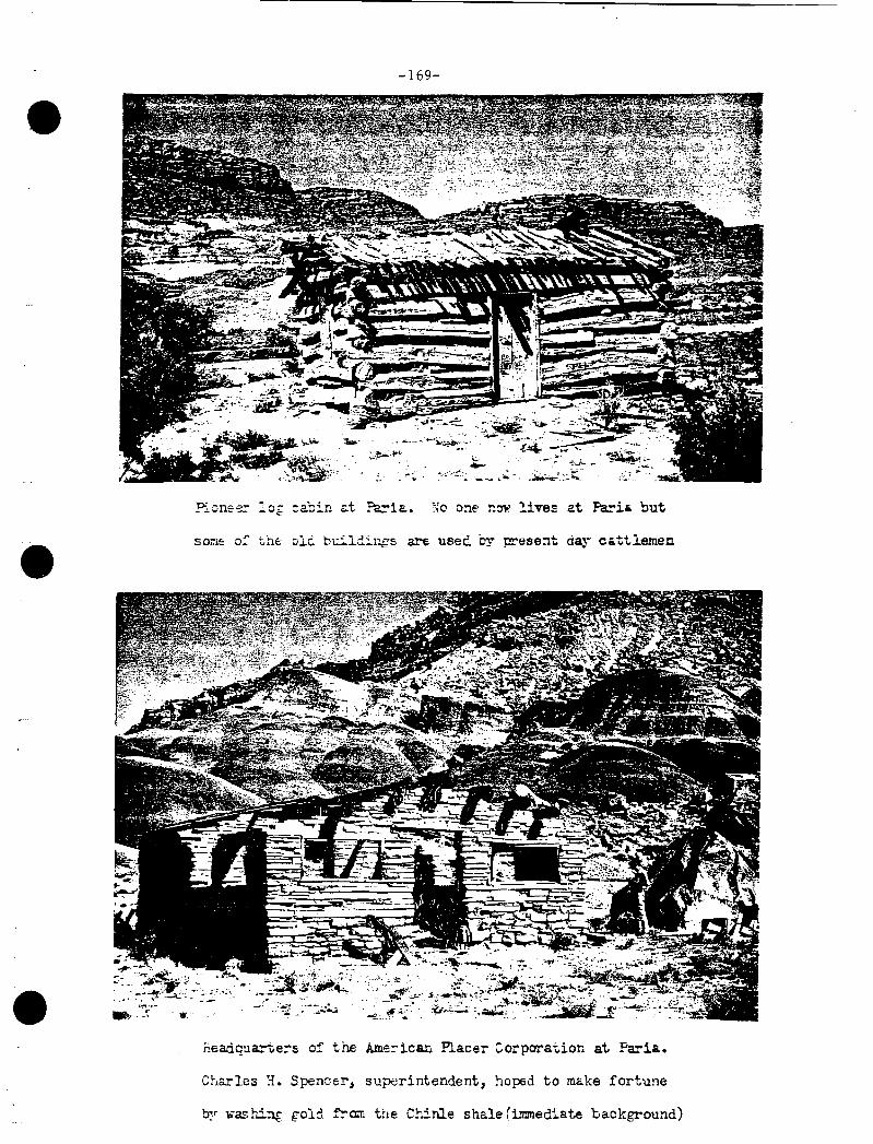
-169-
•
?ione~ lo& cabin c:.t Pa:-ia. :~o one now lives at Pa:-ia but
• som= o: the olC. bu::..ld::..ngs a.re useC. by )Jresent day- cattlemen
·-
• :T:~~~:,r~: ,,, .,., .,,·.,-c *
fi.e;adqua:-ters of the Ame::-ican Placer Corporation at Faria.
Charles H. Spencer, superintendent, hoped to make fortune
by washi:::l{ g-old f!'am the Chinle shale (immediate background)

•
•
•
-170-
infused some life to this interesting place. During the years 1910-1913, the American Placer Corporation attempted to make a profit unresting gold values from the chinle formations at Paria. A headquarters and one or two other buildings were constructed from locally quarried sandstone. It is apparent after an examination of the area that a considerable amount of mining was done. Chinle 5hale was dug out and run through some sort of milling or separating plant at the river's edge. There was an electric plant set up at the site. But the clinle, which when wet forms a sticky gumbo, held onto its gold and the operation (a counterpart of the company's operation was also tried at Lee's Ferry) was a failure. Charles H. Spencer was the one who dreamed of making a fortune from the chinle shale and it was he who organized the American Placer Corporation. At the age of about ninety, Mr. Spencer is still confident that the gold in the clinle can still be obtained. He returns to old Paria occasionally. I have met him there, and also talked to him in Los Angeles; the conversation always turns to the wealth locked up in the clinle. Prospecting for other minerals, notably copper and uranium, has occurred in the area from time to time, but no mines of substantial value have been found.
Within the last few years, old Paria has been discovered by motion picture companies who find that the backdrop of colorful hills is excellent for the making of western movies. A movie set has been built some distance from the river on the bank opposite from the pioneer cemetery, where many who spent their last days on the lonesome frontier, were buried. The names of those interred are recorded on a bronze plaque.3
Old Paria is one of the more interesting historical sites in the subject area. Literally a museum of Mormon pioneering experience, it illustrates very nicely the extremes to which these hardy people would go in seeking out lands to support themselves. Settling on lands that were marginal at best, and this was characteristic of much of Mormon pioneering in southern Utah, they were then forced to leave when the soil disappeared. But as agriculture failed, stock raising became the basis of life in the Paria area as elsewhere. Then there are the remains of mining activity and of modern movie making. Scenically, Paria can scarcely be equalled, and as a geological laboratory, it would be outstanding.
Meanwhile, before Brigham Young left southern Utah in September, 1870, he selected a site for the village of Kanab, "a little east of the fort," and he also laid out the basic plan for the fort to be built at Pipe Spring. Kanab became an important and stable settlement •

•
••
•
-171-
Located on the permanent water of Kanab Creek (there have been periods of drouth when the stream did not reach Kanab) where it breaks through the Vermilion Cliffs there was enough ground that could be brought under the ditch to support a permanent population in some numbers. It was strategically located with respect to east-west travel between Lee's Ferry and the Dixie settlements as well as north-south travel between Arizona and Utah; and, as a result, it became the most important marketing and supply center in southern Utah outside of St. George. And !t served the eastern half of the Arizona Strip as St. George served the western half. The location of U.S. Highway 89 through Long Valley to Kanab was a natural route, though for many years the heavy sand between Kanab drainage and Long Valley was a deterrent to travel; the Johnson Canyon route was preferred. Indeed, Kanab today, as it was long before 1900, is the political and economic capital not only of Kane County, but of half of the Arizona Strip.
Kanab was important enough to merit extending the Deseret Telegraph to the village in 1871. The organization of Deseret Telegraph Company dates back ten years before that date when the transcontinental telegraph reached Salt Lake City. The leaders of the Mormon Church immediately planned to build a line for the . settlements from north to south. The Civil War prevented the Saints from acquiring the necessary wire, insulators and equipment, but during the winter of 1865-1866, the Mormon people subscribed money and contributed teams and teamsters to form a train to transport these supplies from the Missouri Valley. A church school of telegraphy was set up in Salt Lake City, the company was incorporated by the territorial assembly and construction began and proceeded rapidly as men along the line contributed their labor for which they were credited as a church tithe.
The Indian troubles through the years 1865-1870 accelerated the construction of the line which on January 15, 1867, reached St. George. From there it was extended in several directions; one line went to Virgin and thence it was built to Pipe Spring, reaching t.here on December 15. The line was thence extended to Kanab and reached that point--the end of the line--on Christmas Day, 1871. Eliza Luella (Ella) Stewart, daughter of Bishop Levi Stewart of Kanab, was the first telegraph operator at Pipe Spring, said to be the first telegrap~ office in Arizona; she was also the first operator in Kanab where the office was set up in her father's home.
The arrival of the telegraph line in southern Utah and the Arizona Strip was a real boon to the settlers who were now put in

•
•
•
-172-
conununication via Salt Lake City with the rest of the world. It meant an end to the agonizing isolation which troubled the remote settlements and, of course, it put Salt Lake City in immediate touch with.happenings throughout Zion. The Deseret News could now print news while it was still news and not have to wait weeks for letters to come in from the interior. By 1880 the telegraph line with all of its extensions was about 1,000 miles long; 1,200 miles of wire were strung over thousands of rough poles, and there were sixty-eight offices or stations. In 1900, thP company was sold to eastern interests.
Some of the original telegraph poles complete with insulators and wire have been preserved and may be seen in their approximate original location at Pipe Spring. One of the Deseret Telegraph offices still exists in Rockville in a corner to the old Huber home. A sign on the building sti 11 legible reads "Des. Telegraph and Post Office. 114
Once the Deseret Telegraph reached St. George, Brigham Young made frequent trips to Dixie and during the last years of his life, he spent nearly every winter at St. George. From his home in St. George in January, 1871, Young suggested to Joel Hills Johnson that his family settle in Johnson Canyon (then called Spring Canyon) through which Young and his party had passed back in September on their way to Paria, Kanab, and Pipe Spring. In the spring of that year four Johnson hrothers--Joel Hi 11, Joseph Ellis, Benjamin Franklin, and William Derby--moved to the long, narrow, bluff-bound valley where they found excellent ranching conditions and land was taken up at a place since known as Johnson. The place was abandoned during the winter of 1871-1872 for fear of a recrudescence of Indian troubles. Additional families soon came into the green valley, a tributary of Kanab Creek, and the settlement achieved sizeable proportions. A number of rock houses were built and a school hous~ was put up. However, by 1901, only a few families remained at Johnson; today there are fewer though. There are two or three operating ranches in the valley. A two-story adobe house and a log tithing barn and other buildings mark the site of the original settlement at Johnson,5
Meanwhile at Skutumpah on the upper reaches of Johnson Creek, above the White Cliffs, John D. Lee late in 1870 established a saw mill to supply lumber and shingles to the settlements below in Johnson Creek and Kanab and along the Paria and elsewhere. The place had been occupied earlier but abandoned because of the Indian troubles. Lee remained only about a year before going on to establish Lee's Ferry on the Colorado. Skutumpah always remained small in population, probably reaching a peak about 1878. For a time it was known as Clarkston. A cattle ranch today marks the site of the settlement.6

• -173-
•
• Old "Des. Telegraph and Post Office" still standing at Rockville •
Parker Hamilton photograph.

• -174-
• Adobe house at Johnson. on Johnson Creak in lane County
•

•
••
-175-
By the end of the 1870's the pattern of settlement along Kanab and Johnson Creeks, and along the middle and lower reaches of the Paria River, had been established. After that there was some population growth in existing villages but no new settlements, apart from an occasional ranch, were started. And as time went on some of the settle~ents, as those along the Paria, declineJ and even disappeared.
'ihe 0:1ly new settlement founded after thi:, decade was Fredonia located on the creek eight miles ~elow Kanab. The location is below the low line: of Shinarump Cliffs where the valley widens out and where there was a good prosnect for farming if you could get water to the soil. Undoubtedly the prospects here had been examined by Mormons from Kanab, but the uncertainty of the water flow in Kanab Creek discouraged settlement until 18R2. That was the year cf the Edmunds Act which made a crime of polygamy, defined as "unlawful cohabitation," and established fines and jail sentences on conviction.
Polygamous families began to look for homes outside of Utah (where enforcement was likely to be greatest) for new homes, and some of these in 1882 went across the line into Arizona from Kanab and took up claims along Kanab Creek. In 1883 a period of drouth was broken and heavy floods came down the creek. This brightened the prospects for irrigation, and a darn was built. In i835 the town of Fredonia was laid out, but occupation may not have started until this next year; in 1887 there were half a dozen families in the new settlement. Fredonia was strictly a frontier of Kanab and these "twin cities" have long retained a close cultural and ecclesiastical association. In both places there live numbers of descendants of the pioneers of the region. Fredonia has been the home of many who participated in the opening of the Arizona Strip, particularly the· Kaibab region. With a population of about 650 in 1960, Fredonia was the biggest town on the Arizona Strip.7
Lee's Ferrv
lfuile new settlements in the 1870's were being started along Johnson Creek and along the Paria, John D. Lee opened a ferry crossing on the Colorado which has since been named after him. While ?Utting the sawmill in operation at Skutumoah, Lee learned that he had

•
•
•
-176-
been excommunicated from the Mormon Church for his oarticipation in the Mountain Meadows massacre. By friends he was urged "to make yourself scarce, and keep out of the way." Be this action Lee was out into a position where he might have to accept legal responsibility for that crime even though others along with him had been involved. Further, at this time, federal officials in Utah were attempting without benefit of law to eliminate polygamy;and Lee, with several wives, might escape arrest by making himself "scarce."
Accordingly, Lee divided up his property among five of his eight wives and with two of them, Rachel and Ermna, and a number of children, he headed for the Colorado. Receiving advice about a good location from J~cob Hamblin, Lee and his party left Kanab on November 17, 1871, and arrived at the Colorado at the mouth of the Paria River before Christmas, 1871. The Lees called the place Lonely Dell, but the name Lee's Ferry has been more permanent.8
Lee's Ferry was a natural, but difficult, crossing of the Colorado. It was the one place above Pierce's Ferry, at the mouth of the Grand Canyon, and the Green River crossing and the crossing of the Colorado at Moab, both on the Spanish Trail, where the river could be approached with comparative ease. The river here dramatically breaks through the Echo Cliffs, and leaving Glen Canyon behind, it sweeps out into the open briefly with low banks on either side. These approximated two miles on the right and half a mile on the left. The river then tumbled over the mass of boulders at the mouth of the Paria River before it was swallowed by Marble Canyon.
Although one could reach the river's edge at Lee's Ferry without passing through a long tributary canyon, the approaches were by no means easy. The right bank approach was the easiest. Coming in from the west, you followed the base of the Vermilion Cliffs (the old trails and road paralleled the modern road) to the Paria River; above it and below it for some distance the river bank was open and gently sloping. The left bank presented a most difficult approach. A sharply dipoing ridge, known as "Lee's Backbone" rose almost vertically from the river's edge opposite the mouth of the Paria and the open bank of the Colorado was above that ridge. This meant that you had to cross that ridge going to or from the ferry on the left side, and it made access to the ferry very difficult indeed. To avoid this barrier, a ferry below the mouth of the Paria was installed and by constructing an access dugway on the left bank, this was a somewhat less hazardous route. However, it could only be used at low water, as it was located at the very head of Marble Canyon; at high water the ferry boat, which operated without a cable, might easily

-·
:.
-.
-177-
have been swept into the canyon and there would have been no returning. The final solution to left bank access came with the building of a dugway along the base of Lee's Backbone. This road, built in 1898, permitted passage to the upper and safer ferry and was in use until 1928 when ferty service was abandoned.
/
As we have noted earlier, the Dominguez-Escalante expedition in 1776, just ninety-five years before Lee, tried to cross at this point, but failing, it went on up~tream to the Crossing of the Fathers. Jacob Hamblin is the next white of definite record to reach the place and he came through a number of times en route to the Hopi villages to visit the Navajos before actually making a crossing at Lee's Ferry. This was in October, 1869, when forty men ferried themselves across on driftwood rafts. The first Powell expedition camped here one night on the 1869 river voyage but gave the place small notice. Next year on his return east, Powell accompanied Jacob Hamblin to Fort Defiance, and they came this way bringing lumber with them to build a crude boat, the Canon Maid, on which the party crossed the river. Next year the second Powell expedition ended its run in 1871 at Lee's Ferry and began its Grand Canyon run in 1872 from the same point.
It was John D. Lee who established permanent settlement at Lee's Ferry. At a point on the right side of the Paria not far from the mouth of the stream, he built two temporary houses, dmmned the Paria River, and put in crops in the fields between his houses and the river. Lee spent most of the year 1872 getting established at Lonely Dell. He had persistent trouble with the dams on the Paria which washed out; he constructed a permanent residence which still· stands; he inaugurated ferry service in January, 1872, where he ferried some Navajos across the river in an "old boat," probably the f_anon Maid built by Powell and Hamblin two years before; he inaugurated trade with the Navajos and became, actually, one of the first white men to engage in more or less regular trade with those Indians.
Further, during the year 1872, John D. Lee established additional "ranches" at Jacob Pools, and at House Rock Spring, both at the base of the Paria Pl.ateau, the southern escarpment of which forms the Vermilion Cliffs. Both of these were important watering places which had been used by the earlier Hamblin expeditions to the Hopis and they continued as welcome oases in a very arid land until sometime after 1900. The water from Jacob Pools is now brought to a large stock-watering tank and pond not far from the spot where Lee established his "ranch" in 1872. 9 House Rock Spring is no longer used.

•
•
•
-178-
Modern stock-watering bas in at Jacob Pools,. named for Jacob
Hamblin. In 1872, John D. lee established a ranch near the
original spring at a point about half a mile from this place.
Vermilion Cliffs in the distance •

•
•
•
-179-
Ferry service, on an informal basis, began very soon after Lee arrived at Lonely Dell; he probably used the C~non Ma~ and occasionally the Nellie Powell, one of Powell's boats which the explorer had abandoned in 1871 as being too shaken to continue on into Grand Canyon. Formal service was inaugurated on January 11, 1873, when the ~olorado, built on the spot, was launched by John D. Lee. But this boat was lost when a tree fell on it on June 16, 1873. The opening of ferry service across the Colorado was a part of the design of the Mannon Church leaders to begin a series of new colonies in Arizona--in the valley of the Little Colorado. The Hamblin expeditions to the Hopis in the 1850's and 1860's had indicated that this country had a good potential and, as the federal pressure against polygamy was increased in the 1870's, Brigham Young sought new fields to colonize. Lee was encouraged to stay at the site and operate the ferry and the vanguard of the Arizona Mormon migration--a large party under the leadership of Horton P. Haight--was put across before the Colorado was lost. About that time Lee learned that there was a warrant for his arrest and that there were soldiers after him and he exiled himself, moving first to Moenkopi, a Hopi village on the lower part of Moenkopi Wash, a tributary of the Little Colorado, and thence to Moa Ave (Moenave, etc.) about eight miles west of Moenkopi, where Jacob Hamblin had once lived. Lee remained in hiding about ayear but when in the fall of 1874 he returned to his old home at Harmony, he was arrested (at Panguitch, November 7) by the Sheriff of Beaver County on a charge of murder. His arrest and subsequent trials, which resulted in his conviction for murder in the first degree, kept him away from Lonely Dell.
But others followed. John L. Blythe, after the loss of the Colorado, built and launched a ne~ ferry in October, 1873. Brigham Young was determined to colonize Arizona. The Haight party had quickly returned from the Little Colorado with a negative report. During the winter of 1873-1874, Jacob Hamblin opened a wagon road south from Lee's Ferry to the Moa Ave-Tuba City-Moenkopi oasis and in 1874 a smaller party went south to Moenkopi, but owning to Indian trouble it soon returned also. Finally in 1875 Brigham Young sent James S. Brown with a small party to make a report on the Little Colorado. Brown set up headquarters at Moenkopi and then scouted up the river for some distance. His favorable report was the cue for the Mormon Church to issue a call of 200 missionaries to go to Arizona in 1876. Four companies whose members came from many parts of Utah, assembled at Kanab and under the leadership of Lot Smith, Jess O. Ballenger, George Lake, and William C. Allen they made the long trek by way of Lee's Ferry to the Little Colorado Valley above Sunset Crossing where several settlements (St. Joseph, etc.)

•
•
•
-180-
were established. More colonists followed these of 1876 and a permanent foothold by the Saints had been made in Arizona.
Much of the colonial planning undertaken by Brigham Young after 1870 had looked to the widening of Mormon settlement toward the south. As the Mormons were forced to pull out of the Muddy River in Nevada, Young felt that a new route into Arizona would have to be found. It was John D. Lee, ex-communicated and in exile, who finally bridged the Colorado at the ferry named after him and made possible the Arizona immigration. On March 23, 1877, he ~ave up his life to the firing squad at Mountain Meadows just as the news was coming back from Arizona of the successful settlements along the Little Colorado. On August 29, of the same year, Brigham Yound died, having lived to see the realization of one of his most cherished plans. In the thirty years since the arrival of the Monnons in the Breat Basin, Young had directed the permanent ex~ansion of the kingdom energetically and persistently and as a result, there were in existence about 360 Mormon towns, mostly in Utah, Idaho, Nevada, and Arizona, and the total Mormon population at the time was about 140,000 and most of this number lived in the four states (or territories). As an achievement in olanned colonization, it can be scarcely matched.lo
There is more to the history of Lee's Ferry than that of the ferry business, but that is the largest part of the story. Stalwart Emma Batchelor Lee, John D. Lee's wife at Lonely Dell (Rachel lived at Jacob's Pools) operated the ferry until 1877 when the property was acquired by the Mormon Church to insure passage of the migration to Arizona. Warren Johnson as official operator was followed by James Emett who ran the ferry until 1910 when it was sold by the · church to the Grand Canyon Cattle Company. This company turned it over to Coconino County, and the Board of Supervisors of the county operated it until 1928 when service was discontinued.
But other activities through the years brought life to the remote spot. As we have noted, Lee opened trade with the Indians. In 1874 "Lee's Ferry Fort," the most interesting building standing today, was built to serve both the needs of defense and trade with the Navajo Indians. It apparently was never used for defense but was used to some extent as a trading post and for many other purposes down through the years.
During the Glen Canyon gold rush after 1883, Lee's Ferry was a departure point for the mines upstream; here in 1897-1898, the Hoskaninni Company, the biggest gold operation on the Colorado, set up one of its headquarters; here Charles H. Spencer and the American

•
~-
•
-181-
Placer Corporation set about, 1910-1913, to try and separate gold from the chinle shale; here in 1922 the states in the Colorado River basin established, by the Colorado River Compact, Lee's Ferry (a point one mile below the Paria River) as the point of division between the upper and lower basins and they marked out a formula for dividing the waters of the river between them. Indeed, Lee's Ferry is one of the most historic of spots on the Colorado River.11
Cattle on the Kaibab
Although travel from Kanab and Johnson Canyon to Lee's Ferry from 1871 to 1900 seems to be the dominant historical activity in the Arizona Strip east of Kanab Creek there was a considerable amount of development within the Strip itself deserving of mention. As in the western half, the major interest revolved about the livestock industry and it lar~ely focused on the Kaibab Plateau, known during the oioneer period equally well as the Buckskin Mountain, oi Mountains. On a north-south axis, the great elongated dome stands out bold and dark on the horizon visible for practically its entire sixty-mile length from points to the west and to the east (more limited from the east, however, by virtue of the Paria Plateau). The hulking mass caused travelers between the Virgin River and Lee's Ferry to go around the northern end where its abrupt sides were absorbed by the rising level of the general terrain. The present U.S. Highway 89 is forced to do this, as Dominquez and Escalante had done in 1776. Moreover, water was scarce on the Kaibab. The mountain is high (sloping from over 9,000 feet near the southern end to about 5,500 feet at the northern end), and it receives much more snow and rain than the surrounding areas but there is precious little permanent water on the mountain.
Thus early travelers followed a line of springs from Kanab to Lee's Ferry which took them around the northern end of the Plateau. The major watering places were Navajo Wells (Hogon Wells, J. D. Lee called them), also called Sixteen-mile (that many trail miles east of Kanab) Spring, House Rock Spring, and Jacobs Pools. The longest haul was between Navajo Wells and House Rock Spring. As a result, by the time of the heavy Arizona migration in the late 1870' s, a wagon road was developed which crossed the Kaibab roughly following a line drawn approximately southeast of the Navajo Wells. The pull over the

•
••
•
-182-
Mormons traveling to settle in the the valley of the Little
Colorado left these inscriptions at House Rock Spring, one
of the important watering places on the utah-Arizona road •

•
•
•
-183-
steep eastern and western slopes of the Kaibab was hard going but the distance was much shorter.
As a result of all of this travel around and over the Kaibab, the potentialities of the region--timber, agricultural, and grazing-were early perceived. Further, during the Indian campaigns, 1865-1870, the Kaibab was rather thoroughly ex~lored and certain Indian routes across it were carefully patrolled.
Thus, as the Indian war ended and as resettlement in Long Valley and Kanab brought settlers within reach of the mountain, there was bound to be some development. Apart from some lumbering, and nossibly less fannin~, it was the livestock industry that absorbed most of the interest. Indeed, the development of the eastern portion of the Arizona Strip closely paralleled that of the western. Woodbury states that logging began in 1871 when Levi Stewart of Kanab installed a portable steam sawmill at Big Springs, (this in Nail Canyon on the western side of the Kaibab) whi.ch was later moved south to Castle, or Riggs Springs. Stewart's Ranch, and a number of other springs in the orobable vicinity of the sawmill, were in 1872 being used as grazing headquarters, Woodbury adds.12
Certainly the Kaibab offered as splendid a summer range as could be found on the Arizona Strip and it was one to hold a natural appeal to the Mormon cooperatives of the 1870's. The Orderville United Order, which acquired a number of ranches and herds from its members, put a herd on the Kaibab about 1877, and there may have been other cooperative ventures. Local tradition has it that Orderville group ran the first cattle in House Rock Valley, which served as a. winter range. The first summer range of the group is possibly to be identified with the drainage of Orderville Canyon which heads about six miles south of Jacob Lake and runs north on the roof of the plateau for a distance of about twenty miles.
At sometime prior to 1885 the Orderville United Order acquired some cattle from sane non-Monnons who also used the House Rock range and who marked their stock with the VT brand. When the federal government about 1887 attached the church-owned property at Pipe Springs, the church herd was sold to John w. Young (a son of Brigham Young) and taken to Rouse Rock Valley where the VT brand was adopted to mark church cattle. Young, who had already organized a pioneer cattle company in the Flagstaff area, established two headquarters ranches at the eastern base of the Kaibab, one the House Rock Ranch, the other the VT Ranch. At these he ranged the church herd as well as his own.13

•
••
•
-184-
The House Rock Ranch is located on the north side of U.S. Highway 89A where for many years there had heen a roadside service station and store (closed in September, 1865) and where there are to be seen extensive corrals which are still in use. The main building consists of cut-stone structure which was probably the ori~inal headquarters. Known also as "Rock House, 11 this ranch has given rise to some of the confusion that still exists about the origin of the name House Rock. The name derives from the foHowing circumstances. A few dozen yards south of the entrance to the gulch in which House Rock Spring is located there are two large blocks of sandstone fallen together which formed a crude shelter. Men had used it for that purpose and someone had written on the blocks in charcoal, "Rock House Hotel." This was noted by members of J. W. Powell's party in November, 1871. Dellenbaugh says that by then the name to identify the spring and the valley was already in use. Powell adopted it in his maps and the name became permanent.14
House Rock Spring is located at the base of the Vermilion Cliffs near the head of House Rock Valley and about six miles north of House Rock Ranch, the derivation of which name is the same as the spring. To add to the confusion, the U.S.G.S. "House Rock Spring" Quadrangle (1957) locates the spring incorrectly. On that map House Rock Spring (in Sec. 13 T39N R3E SRBLM) is actually Brown Spring; Onemile Spring (in Sec. 3 T39N R3E SRBLM) is the correct location of House Rock Spring. It was in September, 1965, not being used as a water source of cattle.
The VT Ranch is located (in Sec. 31 T37N R4E SRBLM) about thirteen miles just east of south of House Rock Ranch at the mouth of Kane Canyon, a tributary of House Rock Wash. The ranch is also identified as Kane. An attractive cut stone house, frame buildings, and large corrals, all of which are still in use, mark the location. Over the front door on the house are the brand let_ters "VT. 11
Something about the operations of John W. Young has been detailed by Angus Woodbury. In the late 1880's, Young, who was representing the Mormon Church in England attempted to interest the English aristocracy in the Kaibab as a sporting area and hunting ground. When some interest was shown, Young induced Buffalo Bill Cody, who was then in England, to act as a guide for the English sportsmen and to replenish stock for his wild west show from the Kaibab. The party, including Buffalo Bill, Lord Milmey, Lord Ingram, Major MacKinnon, and a nwnber of local people and others, came out by train in the smmner of 1892. They were met at Flagstaff and by way of Lee's Ferry, reached the VT Ranch. The party enjoyed some hunting in the probable vicinity of VT park, which was the sunnner headquarters of the ranch, and also took a trip to the North Rim •

-185-
•
• V T Ranch headquarters on Kane Creek on the east base of the Kaibab
Plateau. Overlooking House Rock Valley, the ranch is still in
active use •
•

•
•
•
-186-
The party left the area by way of Kanab. Nothing came of the venture as the English decided the Kaibab area was too difficult to reach.
John W. Young sold out in 1896 and about the same time the Mormon Church liquidated its herd. Interests from Beaver, Utah, bought the herds and they in turn sold them to B. F. Saunders, who had acquired so much property and stock elsewhere on the Arizona Strip. Saunders used the Bar Z brand on the Kaibab cattle and those elsewhere. Saunders later sold to the Grand r.anyon Cattle Company (E. J. Marshall Company). This company liquidated its interests following the creation of Grand Canyon National Park in 1919. Apparently the Grand Canyon Cattle Company also used the Bar Z brand. It is interesting to note that cattle seen at the Kane Ranch in September, 1965, displayed the same brand.
The Kaibab was a sununer range; the lofty roof was snowed in most winters and there was little year-round activity of any kind during the pioneer period. Perhaps the most important summer range head-quarters on the Kaibab was at beautiful DeMotte Park, so named in 1872 by the Powell expedition after Harvey C. DeMotte, Professor of Mathematics at Wesleyan University, Bloomington, Illinois, a personal friend of Powell's. However, for many years the ten-mile long park -was known as VT Park as this was the summer headquarters for the several outfits based in House Rock Valley. Its use may date back to the time of the Orderville cooperative. The VT Ranch was located in the same area as the present Kaibab Lod~e.15 Certain other remains on the Kaibab document the early cattle days. Perhaps the most prominent of these in the Grand Canyon National Park is the salt cabin at Greenland Lake built, however, after 1900.
There was a limited amount of farming on the Kaibab during the pioneer oeriod. David King Udall tells us that during the year 1878 and 1879 he planted wheat and fruit trees in DeMotte Park on land that had been owned fonnerly by Levi Stewart of Kanab. There may have been fanning at other areas also, but the short growing season and the absence of water precluded any extensive fanning.16
Jacob Lake (also Jacob's Lake), located about three-quarters of a mile southwest of Jacob Lake Post Office on U.S. Highway 89A is a floodwater pond that maintains a fairly constant level though seeoage. Named after Jacob Hamblin, the pond was probably discovered sometime late in the 1860's durin~ the Indian war and was undoubtedly occupied soon thereafter as a stock watering place and where there may have been some limited farming. Woodbury states that Hamblin and Lee built a six-room adobe house at this spot. Barnes states that a sawmill was ooerated here for several vears in the 1880's. The lake is much used ~s a stock watering place. today.17 Jacob Lake also figures in the mining history of the Kaibab.

•
•
•
-187-
Before the establishment of Grand Canyon National Park, cattlemen
ranged stock out to the North Rim. This salt cabin at Greenland
Lake was built SOJlletime shortl;r after the turn of the century •

-188-
•
•• Jacob Lake, Kaibab Plateau
•

•
••
•
-189-
Although the Kaibab Plateau constitutes a massive fold of sandstone beds thousands of feet thick, there has been some mining, largely of copper deposits. The history of prospecting on the plateau dates back to late 1871 when some of Powell's men discovered placer gold at the mouth of Kanab Canyon. This news went out over the Deseret Telegraph from Kanab and produced a mild rush later in the year of men who one way or another found their way into the canyons of the Colorado all the way from Lee's Ferry to Pierce's Ferry. Placer gold was found in a number of places, ~s it was later in Glen Canyon, but the diggings were everywhere so inaccessible and the gold so difficult to separate from the sand, that no single area is known to have been profitably worked~ During the twenty years from 1871 to 1891 certain somewhat more valuable prospects were located in the ancient crystalline rocks of the inner gorge of Grand Canyon from the mouth of the Little Colorado to points below Bright Angel Creek. Some of these were noted by Robert B. Stanton when he made his railroad survey through Grand Canyon, 1889-1890, and further interest in prospecting was a result.
Perhaps the largest organized prospecting party was one formed in 1891. Called the Denver, Colorado Canyon Mining and Improvement Company, the membership consisted of four men who had been with Stanton, and it was headed by J. D. Best. Sometimes known as the Best Expedition, the party left Green River, Utah, and boated through Cataract and Glen Canyons prospecting en route. At Lee's Ferry horses were purchased and the explorers headed for the Kaibab which they used as a base whence explorations were made of the Grand Canyon and the plateau itself. Apparently no good prospects were found and the explorers had returned from~the canyon country by November, 1891. No record of any actual mining by the group has come to light.
One of the inducements to prospecting in the Grand Canyon region was the story of the John D. Lee mine. While in hiding in 1873-1874, the story goes, Lee spent some time in the Grand Canyon and discovered a rich mine of gold. He kept the location secret while under arrest and trial and it was divulged to no one before his execution in 1877. The Lee mine pops up frequently in the literature of Grand Canyon.
Although the Lee mine has not been found, doubtless many prospects were staked out on the Kaibab and at other places notably in the Grand Canyon, but inaccessibility of the north side and the low grade · prospects made operations unprofitable and the most extensive mining in the Grand Canyon area was limited to the south side at such places as Grand View Mine and Copper Canyon.18
On the Kaibab itself copper deposits were located on top of the plateau on the western sid~•running from near the Utah line to the

•
•
•
-190-
edge of the Grand Canyon. These deoosits were found to be best developed near Jacob Lake but the values were too poor to merit refining until the price of copper rose after the turn of the centurv. About 1902 a smelter was built at Ryan on Wann Sorings Creek, on the western side of the Kaibab, and ore from mines at Lanb's Lake, about two miles west of Jacob Lake, was refined there. The mill ran for an undetermined length of time before shutting down. A post office was in operation at Ryan, 1902-1903. Stc>ne foundations and debris mark the site today.19
Indeed, the development of the Kaibab Plateau and, for that matter, the entire Arizona Strip, has been such as to attract little settlement. The principal business throughn11t the area rluring the pioneer era was raising of stock and this has meant primarily cattle rather than sheep. The interesting experiment with raising huffalo in House Rock Valley began in 1905 by Charles Jesse "Buffalo" Jones and James "Uncle Jim" Owens might be given as an exception.20 And, of course, in recent times, with the coming of hard-surface roads, travel and tourism and lumbering account for a pattern of settlement that has developed largely since World War I •

•
•
•
-191-
FOOTNOTES
1 Details on the resettlement of Kanab are found in E. C. Carroll, comp., Hii::torv of Kane County (1960) 7-25; A. M. Woodbury, "A History of Southern Utah and its National Pa:rks" (1944) 179-181.
2 Lee's diary account of his travel with the Brigham Young party to Paria is in Cleland and Brooks, eds., A Monnon Chronic!~: the Diaries of John D. Lee, 1848-1876, (1955), II, 134-140. I have made a close study of the site where Peter Shirts built his fort but found no trace of it. The Paria has shifted its channel numbers of times and the structure undoubtedly was undermined and melted down by the stream at an unknown date.
3 Information about the Paria River settlements comei:: from H. E. Gregory and R. C. Moore, "The Kaiparowits Region, A Geographic and Geologic Reconnaissance. • . " (1931) 30-31; Portions of the scientific matter in the work were updated by Gregory in "The Geology and Geography of the Paunsaugunt Region ••• " (1951), but the historical coverage in the earlier paper is more complete. Gregory should be regarded as one of the important writers of southern Utah and of neighboring portions of Arizona. Although a geologist, he was much interested in history and geography and his several major papers contain valuable data, to an extent seldom found in scientific treatises, on human history. In addition to those papers listed above, the following by Gregory have pertinence to the subject area of this report: "Geology and Geography of the Zion Park Region. • " (1950); "The Navajo Country, a Geographic and Hydrographic Reconnaissance ••. " (1961); with J. C. Anderson) "Geographic and Geologic Sketch of the Capitol Reef Region ••• " (1939). See bibliography of this work for additional citations. Chester R. Longwell, "Memorial to Herbert E. Gregory," (1954) has a bibliography of Gregory's oublications in geology. Further references to the Paria River settlements are found in Carroll, comp., History of Kane Coun~ (1960), 411, and Jenson, Encyclopedic History (1941), 4, 627-628.
4 The background organization of the cooperative Deseret Telegraph Company is discussed by Arrington (1958), 228-232. See A. Karl Larson, J Was Called to Dixie (1961), 523-529, for the excitement attendant upon the arrival of the line in Dixie. Mcclintock (1921) 98-99, says

•
•
•
-192-
that Pipe Spring was the first telegraph office in Arizona. Ella Stewart's experience as pioneer telegraph operator is noted by Levi s. Udall in Pearl Udall Nelson, Arizona Pioneer Mormon (1959), 249. The Deseret News January 3, 1872, reported the arrival of the line at Kanab on December 25, 1871.
5 Jenson, Encyclopedic History (1941) 376, has a capsule history of Johnson settlement; see also Carroll, comp., History of Kane County (1960), 409-410.
6 I have found very little on the history of Skutumpah. Jenson (1941), 783, has a brief paragraph. John D. Lee's identification with the place is to be found in his own diary edited by Cleland and Brooks (195.5), II, 142-149, il• ~·
7 The early history of Fredonia is not clear. The basic accounts contain several discrepancies. See McClintock (1921), 99-100; Jenson (1941) 264; Carroll, comp., (1960), 397-400. Even the origin of the name is in doubt. Some of the above believe it to be a contraction of "free" and the Spanish "dona" (duna) this meaning free women, a name Jenson says, suggested by the Mormon Apostle Erastus Snow. Woodbury (1944), 183, note 85, suggests that it was simply a variant of "freedom" invented as early as 1800.
8 The agony suffered by Lee as a result of his ex-communicatton and the forced necessity of breaking up his families is nowhere hetter stated than by himself in his own diaries edited by Cleland and Brooks, A Mormon Chronicle (1955), II, 135-180.
9 Lee's Ferry figures prominently in the literature of the Colorado River but there is very little of that literature that pertains directly to the history of the spot. A special report on the History of Lee's Ferry, Arizona, was made by C. Gregory Crampton and w. L. Rusho in January, 1965. This paper, done at the request of the Santa Fe Office of the National Park Service, contains a historical summary and detailed notes about and photographs of the major significant remains at this historic spot. Copies (typescript) should be available at Santa Fe and some regional offices. See also, Crampton, "Historical Sites in Glen Canyon, Mouth of San Juan River to Lee's Ferry" (1960), 94-97. John D. Lee's association with the place and with Jacob Pools and House Rock Spring
•
••
•
-193-
is described in his own diary edited by Cleland and Brooks, eds., A Mormon Chronicle (1955), II, 180-209, et. se~. See also Juanita Brooks, "Lee's Ferry at Lonely Dell" (1957).
10 Details about ferry service at Lee's Ferry are found in Crampton and Rusho (1965). Lee's involvement, which was actually brief, is in his own diary by Cleland and Brook:; (1955), II, 209-246; see also Juanita Brooks, John Dovle Lee .. ~ (1962) 319-334. The Mormon interest and move to the Little Colorado is detailed in McClintock (1921), 135 et.~·· and Howard Daniels, Mormon Colonization in Northern Arizona (1960). James S. Brown's autobiograohv, 9iant of the Lord (1960), 465-495, gives some of the details of his scout to the Little Colorado in 1875. The peseret Ne~s, March 28, 1877, carried the news of Lee's execution and the same paper, September 5, reported the death of Brigham Young, both amid reports of the successful founding of the Mormon colonies along the Little Colorado. See Cleland and Brooks (1955), II, and Brooks (1962) for the details of Lee's long imprisonment, trials, and execution. See J. H. Beadle, Western Wilds, and the Men who Redeem Them ••. (1879, and numbers of other editions), Chapter XVIII-XIV, for an account of one of the more articulate travelers to cross the ferry in its earliest days. Brigham Young's achievement as colonizer is surmned up by Milton R. Hunter, (1945).
11 For many details on the history of Lee's Ferry, and appropriate bibliography see Crampton and Rusho (1965); Crampton, "Historical Sites in Glen Canyon, Mouth of San Juan River to Lee's Ferry" (1960), 94-97; Crampton, Standing Up Country (1964), 95-98. Frank McNitt's interesting book on The Indian Traders (1962), 89-106, contains material on Hamblin and Lee as Indian traders.
12 Woodbury, "A History of Southern Utah and its National Parks" (1944). 190.
l3 Information about the history of grazing in the Kaibab is scarce indeed. There is a good deal of oral tradition among folk in Fredonia and Kanab about early days on the Kaibab and I have used this to some extent. Woodbury (1944), 190-191, has some information on the operations of John W. Young. Will C. Barnes, "Arizona Place Names" (1935), 127 (under "Del'fotte Park"), says that the Orderville herd was sold in 1886 to two men, Van Slack and Thompson, who ran the VT brand. On the other hand, Byrd H. Granger in her revision of

•
•
•
-194-
~i_ll C. Barnes Arizona Place Names (1960), 142, states that Van Slack and Thompson lived in Orderville and that the VT ~rand belonged to the Valley Tannery at that place. Alice K. Wilson's History o~ the Arizona Strip (1941) has little to say on grazing; most of her inforr.iation on settlement comes from Barnes (1935).
14 Fredericks. Dellenbaugh, A Canvon Vay~~ (1926), 160 is authority for the derivation of Hcuse Rock. Dellenbaugh was a member of Powell's second voyage and he participated also in the survey of large portions of the Arizona Strip and southern Utah, 1871-1873. ~ee also, H. E. Gregory, ed., "Diary of Almon Narris Thom!)son ..• " (1939), 61. Something of John t-'. Young's Pioneering at Flagstaf<= may be found in Roger E. Kelly, "Flagstaff's Frontier Fort, 1881-1920." (1964).
15 \foodbury (1944), 190-191, relates the story oi the English interests in the Kaibab. He gives the date as 1891. I~wever, in 1928 Ranger Frank J. Winess found a tin can on McKinnon Point (now \·!idforss Point) containing the names of the party among t..Thom t..Tere Col. H. McKinnon and W. F. Cody. The date was November 26, 1892 . The original note paper with the names and a transcription is seen in the historical files, Grand Canyon Visitor Center.
16 Pearl Udall ~elson, Arizona Pioneer Mormon, David King Udall (1959) t 64-65, 67, 239.
17 A. Woodbury (1944) 189-190; Will C. Barnes, "Arizona Place Names" (1935), 223.
18 The interesting history of orospecting and mining in the Grand Canyon has not been written. F. S. Dellenbaugh,~ Canvon ~aM (1926), 174, reoorts the discovery of gold at the mouth of Kanab Creek which set off the 1872 rush. In his diary, A ~lormon Chronicle (1955), II, 184, ~~· -~· John D. Lee notes the arrival of miners at Lee's Ferry. The peseret ~et..Ts Februarv 24, 1872, reoorted placer mining activity above the mouth of the Virgin River. Stanton's ot..Tn account of his railroad survey has been edited by Dwight L. Smith, Down the Colorado •... (1965). Stanton's venture in mining in Glen Canyon, told in his own words has been edited by C. G. Crampton and D•:ight L. Smith, "The Hoskaninni Papers .•. '' 1961. See also Crampton, 'Outline History '' (1959) for data on canyon countr-· nining .

•
•
•
-195-
George Wharton James, In & Around the Grand Canyon_ .•• (1900) has a good deal to say about mining including infonnation on the lost John D. Lee gold mine. In his "Shinuno Quadrangle'' (1914), 93-96, Levi F. Noble tells something of the history of copper prospecting in a portion of Grand Canyon and the Kaibab. Also, see Edwin D. McKee, "Copper Deposits in the Grand Canyon" (1930), and H. R. Lauzon, "Is there Gold in the Canyon" (1934).
l9 E. P. Jennings, "The Copper Deposits of the Kaibab Plateau, Arizona" (1903) is the only study I have found on the subject. Byrd H. Granger, A_~izona Place Names (1960), 85, has a bit on Ryan.
20 The buffalo experiment is told by Robert Easton and Mackenzie Brown, Lord of Beasts, the Saga of Buffalo Jone's (1961) and by Will C. Barnes, "The Bison of House Rock Valley." (1927) •

•
•
•
CHAPTER IX
EAST OF THE HIGH PLATEAUS
New Developments in Dixie
During the years when the Mormons were resettling the places abandoned during the Black Hawk War and further extending their frontier into the Arizona Strip and to the valley of the Little Colorado, there were some new developments in Dixie of considerable interest. The most dramatic of these was the discovery of very rich silver deposits in sandstone beds at Silver Reef near Leeds.
Leeds itself was a Mormon agricultural connnunity which grew out of the older town of Harrisburg about three miles away, The latter place, located just above the gap cut by Quail Creek through the Virgin Anticline, was poorly endowed with good soil and when better lands were found at the new location, Leeds (first called Bennington) was settled in the fall of 1867 when Richard Ashby moved to the site. The history of Leeds would probably have been quite similar to that of other Dixie settlements had it not been for the opening of the big bonanza at Silver Reef less than two miles north of it.
Silver Reef is unique in the mining history of the United States for it is the only known area where commerical amounts of silver ore have been found in sandstone. Between 1875 and 1910, when production ceased, about eight million dollars worth of the metal had been produced. The initial discovery of silver float was made in the area in 1869, but several years ~assed and a considerable amount of prospecting occurred before rich ore was found in place. The Union Mining District was organized in 1871, and a number of claims were recorded but none seems to have been successful. In June, 1874, the Harrisburg ~tining District was organized which included an area 144 miles square centering at Harrisburg .

•
•
•
-197-
It was not, however, until 1875, that the real boom began. In the fall of that year William Tecumseh Barbee discovered rich silver ore on Tecumseh Hill. Before the end of the year Barbee was sending selected ore that ran over five hundred dollars per ton to Salt Lake smelters; shipments of high-grade ore were also made to Pioche in 1876. Population in the new mining camp remained small until the end of 1876; but when the boom collapsed in Pioche, Nevada, a rush of miners--known locally as the "Pioche Stampede"--from there inundated the place and the Silver Reef boom was on.
The period of greatest production at Silver Reef occurred in the years between 1877 and 1888, when operations by the major companies ceased. After that, there was intermittent mining by lessees but that ended in 1909. The camp was pr act i ca lly qui es cent until 1950 when the uranium boom (the silver ore contained minor amounts of copper, uraniwn, and vanadium) revived interest for a time. Today two buildings are still in use in Silver Reef, but numerous picturesque stone walls in ruins are reminders of southern Utah's greatest boom town. Leeds survived the decline but Harrisburg had to give up the ghost.l
The discovery at Silver Reef brought a flood of gentiles to Dixie • This was viewed with alarm by the Mormons, but it turned out to be a considerable blessing to the generally depressed towns of the Cotton Mission. Leeds, especially, benefited, but throughout Dixie there was an economic revival. There was now an excellent cash market for all kinds of produce, fruit, hay, livestock, meat, and Dixie wine was in heavy and constant demand. There was a good market for lumber, _and wood, and even rock salt which came from the settlements on the Muddy and provided those isolated Hormons with one of their few areas of cash income. Moreover, there were good wages to be had working in the mines or in hauling supplies. In similar ways the Mormons in Dixie had benefited from the mining boom at Pioche in Nevada, but Silver Reef, right in their front yard, was even a greater boon economically. By the time the silver bubble burst about 1890, the Dixie towns had reached a stability that was not characteristic of them during the first fifteen years of the Cotton Mission.
Silver Reef had certain other effects worth mentioning. As we have noted elsewhere the silver boom had a corrosive effect on the United Order in Orderville, and it probably caused some dissatisfaction among Mormons in other remote districts. Further, the discovery of silver in sandstone opened up practically the entire Colorado Plateau to prospecting. If silver were found in one place, why not another? Men who would have walked over ·sands tone without looking, now began to look at it more attentively. It is quite probable that Silver Reef

-198-
•
• Ruins of the town of Silver Reef, a unique mining camp in the
United States where sil.ver was found in sandstone •
•
•
~·
•
-199-
had much to do with the interesting prospecting that has taken place in Grand Canyon. We have noted the gold rush to Grand in 1872. Indeed, some gold was.found, and it can be panned out in numbers of places along the Colorado; the greatest placer gold development on the Colorado, however (with the possible exception of some of the diggings along the lower river below Black Canyon), was in Glen Canyon above Lee's Ferry. This began in 1883 and lasted on beyond the turn of the century. The question men asked was, "Where did the gold come from?" After Silver Reef, men were willing to admit that it might have come from the sandstones and prospecting became an important enterprise among men who could choose the vast Colorado Plateau for this field. The end result was the discovery of nothing else like Silver Reef but some copper deposits in Grany Canyon, the Kaibab, and elsewhere were located. Sandstone prospecting also led to certain gold discoveries in laccolithic mountain groups, like the Henry Mountains, in the 1890's.
Prospectors in their wanderings literally discovered many parts of the Colorado Plateau; they were often the first to learn about new regions, they built trails into inaccessible places, and here and there they were the first to find new farming areas. But, being mercurial, the prospectors usually drifted on when they didn't strike it rich and left to others the development of the areas they had pioneered. Perhaps the best example of this is Grand Canyon. Practically all the trails into the canyon from the South Rim, and for that matter the North Rim, were developed by prospectors. Although some of them, as the first tourists began to arrive, turned to mining gold out of people's pockets (always easier), most turned away to continue dreaming about the big bonanza over the horizon.2
It was perhaps an indication of the growing stability and maturity of the Dixie settlements that made it possible to bring water from the Virgin River in two elaborately and expensively-b~ilt canals to the good farming lands on La Verkin and Hurricane benches. These bench lands are found at. the base of the Hurricane Cliffs on either side (north and south respectively) of the Virgin River at the mouth of the canyon cut by the Virgin through these cliffs. Since the first day of the Cotton Mission, these lands had been investigated but the cost of bringing water to them was thought to be too prohibitive. Owing to the height of the lands above the river, a canal possibly several miles long would have to be built through the narrow, rocky canyon and a dam or headgate on the river would be necessary •

•
,.
-200- -
If the project of bringing Virgin River water to these elevated bench lands had been undertaken during an earlier day, it would have been as a result of a call by the Mormon Church. Ilut in November, 1888, when the project was in-fact launched by Thomas Judd and Thomas P. Cottam, it was done by private enterprise. These Men made a survey and in June, 1889, the La Verkin Fruit and Nursery Company was incor?orated to build a dam and canal and to engage in general farming and food processing, including the manufacture of wine and liquor.
The comµany with great difficulty built a. headgate and then a canal along the _precipitous sides of Timpowean Canyon an<l it was necessary further to build an eight hundred-foot tunnel near the ~ouch of the ~anyon. After an expenditure of about $25,000, the irrigation works wE'·--. completed and the first water turned on to the field in 1391. 1-~ leaks irmnediately developed along the rock surfaces of the canal and it was a constant struggle for several years to keep enough water in the canal to irrigate more than a few acres. Finally, the problem of leakage was solved by cement. In 1898, the town of La Verkin was laid out and before the end of the year, several families had moved to the site which previously had been vacant of permanent residents.
A parallel history accounts for the founding of Hurricane on the south side of the Virgin. Probably stimulated by the progress already made by the La Verkin Company, the Hurricane Canal Company · was organized in 1893 to bring water out to the Hurricane Bench. The company encountered even greater construction difficulties than its counterpart and had gone practically to the wall when James Jepson, one of the founders of the project, induced the Mormon Church to subscribe $5,000 in the company's stock, This was in 1902. With this help the last difficult mile of the canal was completed and the first water was turned out on the bench in 1904. The town.site of Hurricane had been laid out earlier, but there were no permanent residents until 1906,
Today La Verkin and Hurricane are among the greenest and most prosperous towns in Dixie; Hurricane is second only t-0 St. George in population. Both towns produce peaches, cherries, apricots, pears, grapes, figs, nuts, melons and garden crops in abundance. In fact, the two areas together, both of which are seen by many of the thousands of the tourists who visit Zion National Park each season, constitute today one of the two most important areas of irrigated land in Dixie. The other is made up of the so-called Washington and St. George fields along the Virgin River adjacent to those towns.3

•
••
•
-201-
The Upper Sevier and the Patia Amphitheater
During the 1870's while the Mormon frontier was moving across the Arizona Strip and on to the basin of the Little Colorado, there was a reoccupation of these settlements in the Sevier Valley abandoned during t~~ Black Hawk War. And during the same decade and on into the 1880's there was a further ex~ansion across the High Plateaus to the upper valleys of the Pari~, Escalante, and Fremont Rivers. This latter movement--an eastward trend altogether--was based wholly in the older settlements of the Sevier Valley, or in those west of the ~larkagunt; some moved from Dixie to the new frontier area.
Practically in unison the settlements along the Sevier River from Salina to Panguitch were reoccupied in 1870 or 1871 immediately following the war. Some Mormons were called by the Church to resettle; others returned to their old homes voluntarily. Some of the original settlers did not return, but it is estimated that the population of the valley in 1872 was considerably in excess of that present in 1866 when most of the settlements were abandoned.
The founding of new communities followed quickly after the reoccupation of the old ones as more people moved to Sevier Valley. In the upper part of the valley, for example, Panguitch was resettled in March, 1871. In the suT'!'lJTl.er of that year G. D. Wilson and a group of fifteen or more families founded Hillsdale close to the river about half rnile east of the present village. In 1872 additional families settled at the mouth of Asay Cree!: uhere Aaron was locatec. and ethers located at the mouth of Hammoth Creek. These locations were not very tenable, however, and by 1900 most of the settlers had moved to better ground where Eatch was founded. Others settled at Spry (first called Orton) ten miles north of Panguitch,4
The altitude and the short groPing season linited the range of crops which could be grown in the upper Sevier Valley but the region was an excellent one for dairying and for the growing of hay which provided winter feed for cattle grazing the public ran~es east and west of the valley. Indeed, the rapid growth of the range cattle an<l sheep industry dur'ng the 1870's and 1880's was an important factor in the rapid expansion of the :1ormon frontier. And the Virgin ranges of the upper Sevier, which heads on the lifty Markagunt, Paunsaugunt, and Sevier plateaus--thrcc of the High Plateaus of the Powell Survey-were among the best in Utah .

•
•
•
-202-
Very soon after the occupation of the valley of the upper Sevier, men began to prospect the neighboring lands to the east, particularly the East Fork of the Sevier which joins the main fork near Junction in Piute County. This valley and the tributary Otter Creek (Otter Creek and the lower portion of the East Fork of the Sevier above the Kingston gorge or narrows form a single geographical unit called Grass Valley) offered a splendid range. This region also was a natural gateway from the Great Basin to the heads of the Paria, Escalante, and Fremont Rivers and as such it had long been used as a thoroughfare--and hunting ground--by the Inrlians. During the Black Hawk War, military campaigners had spied out the land. The Andrus expedition of 1866, for example, had passed through Grass Valley on its return to St. George after an examination of the Colorado drainage east of the High Plateaus, and Lt. Joseph Fish on the outgoing part of the expedition had practically followed Utah State Route 12 and 54 to join the main party in the Paria amphitheater within sight of Bryce Canyon. In 1865, another military expedition under the command of General Warren S. Snow, and based in the San Pete Valley had gone up the main Sevier to Circleville, passed through the narrows of the lower East Fork, trailed through Grass Valley and crossed over to the head of the Fremont in Rabbit Valley. Before returning the militia had engaged some Indians at Red Lake, near Thousand Lake Mountain.5 It was to be expected therefore that, once the war was over, men would seek to occupy the lands discovered during the conflict .
In fact, the rapid advance of the frontier of settlement almost precipitated another conflict between the white and Indians. It seems that four young Navajo Indians in the fall of 1873--three years after conclusion of peace between the ~ormans and Indians--went to Grass Valley to trade with the Ute Indians. Caught in a storm, they took shelter in a cabin belonging to one Will McCarty and killed a calf belonging to the owner for food. When McCarty, a non-Mormon, discovered the Indians in his cabin, without allowing them any explanation, he shot three and wounded the fourth. When the latter after severe hardship managed to return to his tribesmen, there was a clamor for renewed war against the Mormons. It was indeed a serious crisis and was resolved only after Jacob Hamblin, appropriately called the ''Peacemaker," at a conference in January, 18 7 4, at Moenkopi mollified the Navajos and invited them to come to Utah and trade with the Mormons. This was the last serious encounter between the Mormons and the Navajos and it inaugurated a long era of peace during which time there was much trade between the two, a trade that centered in the frontier cmmnunities of Lee's Ferry, Cannonville, and Escalante, east of the High Plateaus.6

•
•
•
-203-
The Grass Valley episode had threatened to upset a genera! peace treaty with the Utes which the Mormons, under a call from Brigham Young, had negotiated at the upper end of Grass Valley in June, 1873. Before these negotiations were completed, the peace party, which consisted of A. K. Thurber, William Jex, and about twenty others, crossed the Awapa Plateau and traveled down through Rabbit Valley to a point named Thurber, after A. K. Thurber. The group also crossed over-Boulder Mountain to the headwaters of the Escalante River and there met a small band of Indians who were invited to attend the council in Grass Valley. A. K. Thurber did much to advertise the Grass Valley area and environs. In a brief article in the ~et f'lews_, November 26, 1873, and a longer one in the same paper for January 14, 1874, he pointed out the opportunities for settlement. Once the threat from the Navajos passed in January, 1874, the way was open for the Mormons to move into the eastern valley of the Sevier and across the High Plateaus into the Colorado river basin.7 Within the space of Cl
year or two the first settlements were made in all three areas. And in all three the expansion of the cattle industry was a major moti-vating factor.
During the 1850's and 1860's the pioneer Mormon settlers of Parowan, Cedar City, and Kanarraville had ranged their cattle on to the lofty Harkagunt Plateau adjacent to these settlements imme~iately to the east. Before 1870 the highest levels of the 'Plateau, found in the vicinity of Cedar Breaks National Monument, as well as the lower Kolob Terrace, a broad region between the pink cliffs of the Markagunt and the white cliffs of Zion Canyon, was a familiar range to those cormnunities.8 And, as we have noted, it was these same settlements that sent the first settlers to the upper Sevier valley.
The Mormon cooperative movement of the late 1860's and 1870's did much to extend rapidly cattle grazing across the High Plateaus as it had on the Arizona Strip. The Kanarra Cattle Company, organized sometime before 1873, was one of the cooperatives that played a prominent part. By 1873, this company, William Herry, superintendent, had extended its operations from the Markagunt across the main fork of the Sevier to the East Fork of the Sevier which heads on the lofty Paunsaugunt Plateau, the eastern rim of which is Bryce Canyon.
In 1374 this company agreed with the cooperative at Beaver, Utah, that the ranges would be divided between the two. Flake Bottoms on the East Fork (near Flake Mountain), it was agreed, would be the dividing line. The Kanarra Company would control the range at the heads nf the Sevier south of a line drawn through the bottoms and to the southern rims of the High Plateaus; the Beaver Co-op would run cattle north of that line. Both planned to run stock over the eastern

•
•
•
-204-
rims of the High Plateaus and to winter in the valleys below. The Kanarra Cattle Company in 1874 had a summer ranch headquarters at Blue Fly (probably at the mouth of Blue Fly Creek, about four miles west of the visitor center, Bryce Canyon National Park) and it wintered stock on the headwaters of the Paria that winter, perhaps earlier.
In any event, it was the cowboys working for the Kanarra Cattle Company, who first became intimately acquainted with the surface of the Paunsaugunt Plateau and the dtainage of the East Fork of the Sevier, and with the country belew the rimlands to the east and south. Reconnaissance trips through the region in 1872 by members of the Powell and Wheeler surveys should, of course, be mentioned but. it was mainly the working Mormon cattlemen of the Kanarra Company who pointed the way to settlement.9
The Paria emphitheater is a huge bowl ringed around on three sides by the Paunsaugunt Plateau, Table Cliff Plateau, and Canaan Mountain. Waters from these lofty escarpments, forming the heads of the Paria River, quickly gather together and before the stream enters a canyon which carries it through the White Cliffs there are a few square miles of land where irrigation is possible. Acting upon advice of cattlemen and of the members of the military expedition who had been in the area in 1866, Mormons began moving into the area as early as 1874. Numbers came from the older settlements to the west-Cedar City and environs, and Dixie. The entrance to the valley was closely parallel to that of Utah Highway 54 which from the rim drops down through Tropic Canyon a thousand feet in about four miles. This was a steep pull for wagons and during the pioneer period, the phrase "under the dump" was connnonly heard. One would say that the Paria settlements were "under the dump," which meant to get there you would travel to the rim and then literally have to be dumped over the edge to the valley below. The first wagons reached the Paria by this route in the summer of 1875.
Between 1874 and 1891 six different settlements were planted in the Paria amphitheater within a radius of four miles of each other. Three-Cannonville, Henrieville,and Tropic--have survived. The first location was made at Clifton in 1874, but in 1877 this was abandoned in favor of Cannonville, a better site about two miles upstream. The next year settlement began on Henrieville Creek,one of the larger forks of the Paria, but the town of Henrieville apparently was not laid out until 1883. Georgetown, not far from the site of Clifton, was located in 1886. Settlement at another Clifton (the name of the original settlement was transferred as the first plac~ was abandoned), also called New Clifton, was begun in 1876. This place, located on

•
•
• '·
-205-
the east side of the Paria, from about 1886 to 1896, when the town expired, was known as Losee. Losee's residents mostly moved to Tropic. Tropic, located practically on Bryce Creek, came into being in 1892 (there was a cabin or two there as early as 1886) when water was brought to the site from the East Fork of the Sevier. The Ahlstrom brothers, Andrew J. Hansen, and others, built a ditch nine miles long from a headgate just below Blue Fly Creek. The ditch reached the rim of the Great Basin at the head of Water Canyon. The natural streambed of this canyon conveyed the water about two miles when it was taken out and diverted by ditch to Tropic and to the fields at Losee. The works were completed on May 23, 1892; some improvements in the system were made later.
The result of this enterprise, one of the few places (perhaps the only place!) where water is diverted from the Great Basin to the drainage of the Colorado (rather than the reverse), has been to make Tropic the most populous and orosperous of the communities of the Paria amphitheater. With a population of about 382, it accommodates more than half of the residents in the valley. Although the year-round climate may not justify the name, Tropic is a pretty, green oasis in the summer. From points on the rim at the heads of Bryce Creek, many thousands of the annual visitors to the national park can see the green fields four miles away below them. And from the Tropic fields the Pink Cliffs form a magnificent backdrop in the distance. The cliffs are not alone a thing of beauty; they give the community its life.
The most famous resident of the Paria Valley, of course, was Ebenezer Bryce who moved there from Pine Valley in Dixie in 1875 or 1876 and settled at the mouth of Bryce Creek a short distance southwest of the town of Tropic. He built a log cabin (no longer standing) and lived at the site until 1880 or 1881 when he moved to Arizona. The creek was named after Bryce who was probably the first to settle there and so, of course, was Bryce Canyon National Park.10
Although there was some lwnbering during the early period, the major industry of the Paria pioneers was stock raising. Many of the first settlers brought stock with them and put them on the virgin ranges. The High Plateaus served as summer ranges and during the winter cattle and sheep were trailed down through the canyon of the Paria River (past the earlier settlements of Paria, Adairville, etc.) to the Wahweap Country bordering on the Colorado River. East Clark Bench, between the Paria and Wahweap Creek (north and west of Glen Canyon City) was one of the important winter ranges where in the 1880's and 1890 1 s the grass was stirrup high. On Wahweap Creek, Lone Rock, which will become an island in Lake Powell, was a favorite camping place for cattlemen who spent the winter on the range •

•
•
-206-
U>g cabin built by Ebenezer Bryce near the mouth or Bryce Creek.
Structure is no longer standi1l'5'. Fhoto courtesy of Bryce CBI\Yon
National Park •

•
•
•
-207-
Escalante and the Fremont River
The location of Escalante is comparable to that of the little towns on the upper Paria. It is ringed around with the high, brooding tablelands of the ldfty Aquarius Plateau which, in local parlance, is called by different names. The southern extension of this great plateau, a narrow peninsula reaching its southern most extension in the Table Cliff Plateau, is called the Escalante Mountain (or Mountains). From the Escalante Mountains (hignest point 10,300') and from Canaan Mountain (9,196'), to the south of it, water drains three ways--to the Paria, to the East Fork of the Sevier, and to the Escalante Basin. Directly north of Escalante stands the dark, flat-topped mass of the main Aquarius, called locally Boulder Mountain. Lavacapped, the rims of the mountain stand just over 11,000 feet above the sea. Waters from its surface drain two ways--to the Escalante, anci to the basin of the Fremont River. Escalante nestles in a cove at the eastern base of Escalante Mountain and at the southern, or rather southwestern, base of Boulder Mountain. The heads of the Escalante-Upper Valley Creek, Pine Creek, and Escalante itself, and others--come together above or at the site of Escalante where there are few hundred acres of open land where irrigation is possible. Below Escalante the river plunges into a canyon where it remains until the Colorado is reached over seventy-five miles away.
The Andrus military expedition of 1866 took note of the acreage at the site and named the place Potato Valley. 11 As noted above, a Mormon peace party under the direction of A. K. Thurber and others found a few Indians living here in 1873 and apparently induced them to attend the general council at Grass Valley that same year. As we have seen, Thurber did much to advertise the Escalante and Fremont Valleys which were open to settlement once the Indian difficulties had ceased.
As we have also noted, cattlemen of the Beaver, Utah, cooperative had staked out more than princely ranges for each east across the High Plateaus. The Beaver company had agreed to use the range north of a parallel down through Flake Bottoms on the East Fork of the Sevier. This gave the Beaver stockmen access to Grass Valley and the approaches to Boulder Mountain and the Fremont Valley. And indeed men from Beaver made the first investigation of the upper Escalante area with a view to actual settlement. In February, 1875, William J, Flake, and others examined Potato Valley and found about a thousand acres available to cultivation and they made an enthusiastic report on their find •

•
•
•
-208-
It appears, however, that the first actual settlers (and most thereafter) came from Panguitch rather than from Beaver, which was some distance away. Hearing of the Flake expedition and its favorable report, a number of men in Panguitch decided quickly to move to Potato Valley to settle. These included A. P. Schow, George Sevy, David Stevenson, Thomas Heaps, Don Carlos Shirts, William Abbey, and Isaac Turnbow, who in June, 1875, brought two wagons over Escalante Mountain. This route which closely parallels a county road between Widtsoe Junction and Utah State Route 54 (five miles above Escalante), was the main access route to the valley until quite recent times. At the pass it reaches an altitude of 9,200 feet and within a distance of three or four miles drops down 1,200 feet to the head of the Escalante River where the going was a little smoot.her. Escalante was even more difficult to reach than the Paria amphitheater. The pioneer band selected a site for a town, staked out claims to the land, and set to work putting up log cabins. The name Don Carlos Shirts is interesting. He was a son of Peter Shirts, whom we have met before near Cedar City and later, on the Paria River. Forced to leave the Paria when the Indians drove him out, Peter moved across the Colorado to the San Juan River about the time his son, Don Carlos, moved to the Escalante. The story of this remarkable family has been told by Ambrose Shurtz, son of Don Carlos.12
When A. H. Thompson and others of the Powell Survey visited Potato Valley on August 4, 1875, he found "four Mormons from Panguitch" who were talking of making a settlement at the place. Thompson suggested the name Escalante, which he had already given to the river, and this was adopted. This commemorates Father Silvestre Velez de Escalante, whose trip through Utah with Dominguez in 1776 we have noted above. It is to be pointed out that Escalante did not come near any part of the Escalante drainage. It was in fact the Andrus expedition of 1866 that made the effective discovery of the stream. If there were only a few Mormons on the spot in the· summer of 1875, a good many more came in the spring and summer of 1876 when the first firm beginnings of settlement were made. By July 14, canals had been dug, a townsite had been surveyed, and a bowery had been erected. And on that date the stars and stripes were raised. With that event, they were only ten days away from celebrating to the day the centennial of the independence of the United States.13
The settlement at Escalante is a classical example of the Mormon village in action. As we have noted a number of times, Mormon settlement was for the most part the result of planning, largely by the church, which expected that the actual settlement itself would proceed cooperatively and along established guide lines. This was notably so

•
•
•
-209-
during the pioneerperiodwhen calls were issued to colonize specific areas. Colonial companies were formed to effect settlement. Upon arrival the company was expected to lay out a townsite after the model of Salt Lake City, which had been taken from the "Plot of the City of Zion" used by the Mormons in the Mississippi Valley before their arrival in Utah. This plan specified a village with wide streets laid out on a square. There was to be a central, public area--this was the area on which the fort, usually the first building up in the earlier period; i.e., before 1873. Lots were large, large enough to support a few domestic animals, garden crops and fruit trees. Thus, liv t.ng on a lot of several acres in town, the Mormon settler could be near his fellows for social, religious, political, economic, and de+,,.;;.. ive purposes. His fields, where farming and dairying took place, wc~-ocated about the edge of town and often at some distance from it, antl these from his village dwelling he visited daily or however regularly was necessary. The village system, adopted nearly everywhere by the Mormons in the West, was an important frontier institution. The formally organized farm village indeed has a limited history in the United States. Lowry Nelson, himself a son of Mormon pioneer villagers, has found in Escalante a classic example of the Mormon village. So few basic changes have taken place in Escalante through the years that the village plan is clearly discernible.14
Escalante and southern Utah figures prominently in the dramatic San Juan Mission, a call by the Mormon Church to settle the San Juan River in southeastern Utah. Up to the time of Brigham Young's death in 1877, Mormon colonization had been pushed vigorously in all parts of the territory except that portion south and east of the Colorado River. In this vast area no Monnon settlement existed in 1877. Roweyer, by then, non-Mormons were approaching the area. Hayden's Survey was publicizing the region, prospectors from Colorado and elsewhere were interested in it, and farmers were beginning to settle along the open valley of the San Juan in northwestern New Mexico, and cattlemen from as far as Texas were beginning to tap the range. And the Ute and Navajo Indians were restive. Moreover, the Mormons probably thought of the southeastern region as another possible corridor to Arizona and New Mexico. After all, the Spanish Trail between Utah and New Mexico had traversed this very region.
A call to fill the San Juan Mission was issued by the Mormon Church at Parowan in December, 1878, and at Cedar City in May, 1879. Under the direction of Silas S. Smith, a scouting and exploring party of over thirty persons left Paragonah in April, 1879, to search for a suitable place to establish a colony. The group traveled by Lee's Ferry to Moenkopi and thence across the Navajo country to the San Juan

•
•
•
-210-
Although there are a number of substantial dwellings at Escalante,
the town still exhibits the mark of a typical Mormon village on
tne uta.h frontier

•
•
••
-211-
River. It was decided to settle at the mouth of Montezuma Creek on the north side of the river where the explorers found two or three families living, among them Peter Shirts. The party then returned to the point of beginning by following the Spanish Trail.
The Smith party had traveled about a thousand miles in a great circle. The colonizing expedition now faced the choice of making a long trek of about five hundred miles no matter which route was selected. Might not a more direct route be found? Before a final decision had been made, Reuben Collett and Andrew P. Schow from Escalante reported that a short cut by way of Escalante was possible. This information was seized upon and the mission decided to cut directly across lots instead of going around. It was agreed to rendezvous at Forty-mile Spring (forty miles southeast of Escalante). There, after making the difficult passage over the Escalante Mountain, the expedition, numbering 550 persons--men, women and children-assembled in October and November, 1879. There the missionaries learned that the country ahead had not been explored: the great gorge of Glen Canyon blocked their passage and no one knew what lay ahead. Then they learned that early snows blocked their return over the High Plateaus behind them •
Rather than spending a winter filled with uncertainty, the pioneer band decided to go ahead. Under the leadership of Silas S. Smith and Platte D. Lyman, these Mormon colonizers performed one of the more remarkable treks in the history of the West. In eighty-three wagons, driving more than a thousand head of stock, they traveled about two hundred miles through country where wagons had never been before. Over most of this distance they had to build roads, many miles of which were in solid rock. Some of the more difficult places were encountered at Hole-in-the-Rock, Grey Mesa, Clay Hill, Grand Gulch and Comb Ridge. In April, 1880, the colonists reached a likely spot on the San Juan some distance downstream from Montezuma Creek. From sheer exhaustion, they stopped and founded their settlement, calling it Bluff. They had planned to be on the road for six weeks. It took them six months. ~
The most spectacular and dramatic place through which the colonists passed was Hole-in-the-Rock on the right side of the Colorado. At a place two and a half miles south of the mouth of the Escalante River the Mormons found a narrow crack in the canyon rim which was enlarged by blasting. Through this and over a steep slope (average grade about 25%--some parts approximated 45%!) a road was built across slick rock (some sections cantilevered) and sand, and the wagons were driven over it. The drop from the rim to the river was just a thousand

•
•
•
-212-
feet. A ferry was built and the wagons were put across to the other side where another steep grade faced them. In fact, the crossing of Glen Canyon was just a beginning.
For about a year after the Hole-in-the-Rock colonizing expedition had crossed Glen Canyon, the road built by the group served as a main link between the settlement at Bluff and the older cormnunities whence the colonists had come. Escalante was the jumping-off place for those outbound and the first settlement within 200 miles to be reached by those inbound. Traffic over the road did go both ways, although this is difficult to believe as one looks at the Hole-in-theRock. David E. Hilier, whose book on Hole-in-the-Rock documents the historic trek, states that scores of wagons were driven up through the Hole.
At best, the route between Escalante and Bluff must have been one of the longest, roughest roads in the West. However, before the end of 1881 a new road had been found across Glen Canyon at Rall's Crossing about thirty-five miles upstream. Charles Hall had built the ferry at Hole-in-the-Rock and it was he who installed the new ferry which he operated until 1884. One also passed through Escalante on this route which crossed the Escalante River at the mouth of Harris Wash and then went on by way of Silver Falls Creek and Muley Twist Canyon to cross the Circle Cliffs and the Waterpocket Fold. It then passed down Hall's Creek to the river. The ferry was located just above the mouth of Hall's Creek. The approaches to the river on both sides were better at this location, but the road across the Escalante River, the Circle Cliffs, and the Waterpocket Fold was incredibly rough. The Hall's Crossing route joined the original road before it reached the Clay Hills.
After 1884, most through traffic ceased on these roads. It was easier traveling east to P,O by way of the settlements along the Fremont River to the Green River.crossing where there was a good ferry. Or, one could even travel east and west by train after 1883 when the Denver & Rio Grande Western between Salt Lake and Denver was completed. The railroad bridge at Green River was within sight of the historic ford known as the Green River crossing.
The pioneer Hole-in-the-Rock and Hall's Crossing roads were not abandoned, however. They were extensively used as entry ways to the Colorado during the Glen Canyon gold rush which began in 1883 and the former was rather frequently used by Navajos, Ute, and Paiutes, who crossed there on trading expeditions which took them to the frontier town of Escalante and to other points. In fact, the Mormons themselves set up a trading operation at Uole-in-the-Rock in 1881, and in 1900. Cowles and Hall built a trading post which they operated for two years.15

•
•
••
-213-
Despite its isolation, Escalante, with enough good land to support it, grew and outdistanced its :rneighbors" on the Paria and on the Fremont River. It is today the most substantial (save Price, Utah, outside of our area) of the towns along the eastern base of the High Plateaus. However, with a population of about seven hundred, the town has not become big enough to lose very much of its pioneer character.
Escalante's nearest neighbor was the village of Boulder located on the southern base of Boulder Mountain, the waters from which on that side drain into the Escalante River. It was settled largely by stockmen from Escalante ancl from the rremont River settlements who found the reg~on to be an excellent range. Johnson and Anderson from Richfield brought five hundred cattle to the area in 1879, but it was ten years before something in the way of permanent settlement was made. In 1889 Amasa M. Lyman, Jr., and John F. Haws started ranches and dairies on Bear Creek and two years later these two men and others took up additi·onal ranches south of Boulder. The present site of Boulder was settled between 1896 and 1898 and it has remained essentially a ranching community. Its rate of growth was very slow until 1935 when the first automobile road reached it from Escalante. Up until then Boulder had been largely a "pack-horse town.'' But even now the population is only about a hundred souls.16
While the Mormons were staking out new areas on the heads of the Paria and Escalante Rivers there was a certain amount of "filling in" in the main Sevier Valley. This was largely a result of normal frontier expansion from the older settlements and little need be said of it here. As a result of substantial growth in the valley as well as the founding of the new settlements east of the High Plateaus, a new county called Garfield, and taken largely from Iron County, was created by the territorial legislature in 1882. The new county included the villages on the headwaters of the Paria and Escalante and it extended to the Colorado River, The county seat was placed at Panguitch.
One unusual occurrence was the discovery of gold at Marysvale in 1868. At the head of Marysvale Canyon on the Sevier, Marysvale had been settled by a few Mormons in 1864 and 1865 but in 1866 it suffered heavily from an Indian attack and was abandoned. Before then, precious metals had been found in the vicinity but not in paying quantities. However, it was probably this knowledge that brought men back to the area in 1868 before the Indian troubles had ended. In that year several claims were staked along Pine Creek and elsewhere at the base of the Tushar Mountains towering above Marysvale on the west. Some of these claims apparently were rich (or thought to

•
•
•
-214-
be) and there was a rush to the district in 1869 when Bullion City '.·:3.s founded in Pine Canyon. The mines, however, failed to pan out during the first boom. nowever, the Silver Reef excitement as we have noted, stimulated prospecting throughout the region and Bullion City again boomed for a few years from 1880 and during this time important discoveries of lead and mercury were made. Later, about 1914, alunite, a source of sulphuric acid, potash, and aluminum, was discovered; and still later, in the 1950's the Marysvale region was intensively prospected for uranium.
Although mining in the Marysvale district has been intermittent, production at times has been higP. enough to produce certain important results. The rush of 1869 was large enough to justify the creation of a new county--Piute, taken largely from Beaver--created in the same year. The county seat was located at Bullion City, but later moved to Junction. Largely attracted by the mining business at Marysvale the Sevier Valley Railroad built up the valley to reach Marysvale in 1900. Later acquired by the D & R G W, Marysvale thereafter served as an important freight terminal serving the upper part of the Sevier and points east to the Colorado River.17
~leanwhile, Circleville, which came within the bounds of Piute County had been resettled after abandonment in 1866. It appears that numbers of non-Mormons, mostly miners, were the first to appear at this place after the Indian War; they were there in 1873 and the Saints did not appear until 1874. Some of those who arrived still later in 1876 founded the settlement of Kingston, after Thomas R. King of Fillmore, who arrived in that year. Kingston was a United Order town from 1877 to 1883; but when the order was dissolved, the. town was moved to its present site near the mouth of the East Fork of the Sevier. It was at one time known as East Fork. Another settlement near by was Junction (first called City Creek) settled bv Mormons in 1879. When the mines failed at Bulli_on City, Junction w~s named the county seat of Piute.18
Junction and Kingston near the mouth of the East Fork of the Sevier were at the gateway to that valley which through the 1870's was the site of new settlement. Grass Valley, above the narrows, was being used as a range by Mormon cattlemen as early as 1873 and from 1874 to 1875 it was a principal rangeland of the Beaver cooperative. Grass Valley was at one time known as "Co-op Valley." It appears that a fe~ non-Mormons were among the first settlers. We have noted above the killing of the three Navajos in Grass Valley by McCarty, and Jenson states that Albert Guiser, also a non-~1ormon, was the first known settler. Guiser settled on Coyote Creek near where the first Mormon settlers in the valley also located. Isaac Riddle, a cattleman from

•
•
••
-215-
Beaver, and his family arrived in 1875, and those who came later established a settlement on the East Fork below the mouth of Coyote Creek. This place, first called Coyote Creek, and in 1877, Marion Ward became the center for a number of ranches extending upstream to the mouth of Black Canyon, It was, as it is today, primarily a ranching and dairying locality. However, in 1880 antimony (stibnite) was discovered in Coyote Canyon about five miles east of the village. A boom period followed for three years; there was another 1906-1907, and another 1916-1917, and as a result of the mining interests, the name was changed to Antimony in 1920 or 1921· at about the same time Coyote Creek was changed to Antimony Creek.l~
Above the narrows of Black Canyon, the East Fork for many miles, even from its head on the tip of the Paunsaugunt, flows through high open country. This was excellent range but as most of it was over 7,500 feet in elevation, few crops would grow. In 1876 Isaac Riddle established a ranch near the mouth of the Sweetwater, a tributary heading near the pass of Escalante Mountain on the road between Panguitch and Escalante, but it was soon abandoned. Several other attempts at ranching were made here, in what has been called John's Vallev, but it was not until 1902 that any kind of success was achieved. When it was discovered that grain would mature, several settlers moved in and a village named Houston (or Winder) was laid out; the name in 1915 was changed to Widtsoe, after John A. Widtsoe, then President of the University of Utah, and a student and advocate of dry farming. The community grew quite rapidly, 1909-1922, but then declined. During World War I another conmiunity at Henderson, or Osiris, was founded downstream about fifteen miles. Attempts to rehabilitate Widtsoe in 1926 were temporarily successful, but the naked facts were that there was insufficient water; S?arse forage prohibited intensive grazing~ and killing frosts could occur anytime. During the depression the federal agencies found the valley to be unsuitable for agriculture of any kind; the government purchased the land and moved the few remaining families away. Nothing but foundations remain at Osiris; a few vacant houses are to be seen at Widtsoe. Apart from these remains and an occasional ranch house, John's Valley is today essentially a rangeland.20
Below Marysvale Canyon on the main branch of the Sevier River, the valley opens out and between the Pavant Range on the west and the Sevier Plateau on the east is perhaps the richest part of the Sevier drainage. The principal towns--Monroe, Richfield, and Salina-were all abandoned during the Indian war but in 1870 and 1871 they were resettled. Additional places in the same general region, either new or resettled, were listed in the Deseret News, January 31, 1872; Annabella, Central City, Jericho, Clear Creek, Rocky Ford, and Glenwood •

•
•
•
-216-
Mormons from this part of the Sevier were in large part the first settlers to move into the upper part of Grass Valley, which is drained by Otter Creek, sometimes called the North Fork of the Sevier. Numbers of the first settlers also came from San Pete County, among them Albert K. Thurber called by Brigham Young in 1873 to settle the Indian problem in the valley. Burrville, near the head of the valley, was occupied in 1873 though abandoned temporarily the same year as a result of the killing of the Navajos farther south in the valley about the same time. It was resettled in 1875 at the same time that Koosharem, six miles to the south, was founded. Although there were some other smaller settlements in Grass Valley such as Plateau and Greenwich, the first two have remained the principal places. Grass Valley retains today much of the atmosphere of the pioneer period. There have been few changes. It is a farming and stockraising area as it has always been. The Koosharem resevoir at the head of the valley assures a steady flow of water to the fields.21
Grass Valley, at the foot of the Awapa Plateau to the east, was the natural gateway to the upper valley of the Fremont River, a tributary of the Colorado. The upper valley had been known for some time. As we have seen, one segment of the Spanish Trail crossed it, the Awapa Plateau, and Grass Valley. The name of the river commemorates Fremont's railroad survey in the winter of 1853-1854. During _ the Indian campaign of 1865 the name Rabbit Valley, which is still ~ in use, was applied. On his first voyage through the Colorado in 1869, J, W. Powell stopped at the mouth of the river, which he named the Dirty Devil, a name that is still applied to the Fremont River below Hanksville.
Even before actual settlement began in Rabbit Valley in 1875 and 1876, further exploration by the Mormons of the Fremont drainage occurred. Indeed, it seems highly unlikely that the Saints would have neglected looking into the possibilities of a region which was so close to the Spanish Trail, the major approach to the kingdom from the southeast. Their concern might well have been first with the heads of the San Rafael River and Castle Valley, through which the Spanish Trail passed between Green River crossing and Wasatch Pass. But the Fremont, one of the heads of which originates in Wasatch Pass, was bound to attract their interest. Indeed, we find that J, D. M. Crockwell made an examination of the Muddy, heading on the Wasatch Plateau, and a major fork of the Fremont, during the surmner of 1871, and he reported the findings of his trip in the Deseret News, September 13, 1871 •

•
•
•
-217-
However, as we have noted, Indian difficulties prevented settlement until after 1873. Once peace was restored, numbers of Mormons entered Rabbit Valley looking for areas suitable for farms and ranches. One of the first of these was Andrew J. Allred who arrived in June, 1874, and ex~lored the country between Fish Lake and the later site of Teasdale. These men took up some claims and the reports they made back in the older towns was enough to attract the first settlers in 1875. Cattlemen, as elsewhere in the country east of the High Plateaus, were among the first to arrive. In June, Albert K. Thurber came into the valley with the Richfield Cooperative herd, among which were tithing cattle belonging to the Mormon Church. According to Andre~ Jenson, one of the cattlemen, Hugh J. McClellan, was the only person to spend the winter of 1875-1876 in the valley. The first actual settlement began in 1876 when Andrew T. Allred moved to Rabbit Valley with his family. Others soon followed and within a few years a number of settlements along the river between Fremont and Fruita had been established.
Allred settled near and below what became the village of Fremont and from this place the Mormon frontier moved rapidly downstream. Between the years 1876 and 1882, a number of settlements popped up along the Fremont all of the way down to Hanksville, a distance of about seventy-five miles. The occupation by the Mormons of the Fremont Valley is a repetition of the frontier processes we have seen elsewhere and it is comparatively uncomplicated. One settlement after another was founded in the march downstream and the basic objectives were land to support farms and dairy cattle and other domestic stock, and rangeland to support cattle and sheep. Between Fremont and Fruita there was some of both, particularly rangelands. The beetling brows of Boulder Mountain on the right (facing downstream) and Thousand Lake Mountain on the left, bespoke lands rich in grass and forage and the river wandered about through an open valley much of the way and it could be diverted easily to irrigate adjoining fields. One drawback was the elevation (mostly over 7,000') which shortened the growing season.
As elsewhere on the Mormon frontier, there were usually a few scattered first dwellings in any given area in Rabbit Valley before named settlements were actually laid out and this results in certain discrepancies in the existing accounts. In her history of Wayne County, Anne Snow states that the people in the upper valley were scattered along the river and that no townsites had been laid out before 1880. However, by that time the first homes had been built at the later townsites of Fremont (1876), Loa (1878), East Loa, later Lyman (about 1879), Thurber, later Bicknell (1875). Thurber was named after A. K. Thurber who brought the Mormon Church herd to this

•
•
•
-218-
location, reportedly in 1875; it is doubtful, however, if permanent settlement began until the next year. Loa, which became the county seat of Wayne County, when it was created by the Utah Territorial Legislature in 1892, was named after the Hawaiian volcano Mauna Loa by Franklin D. Young a Monnon missionary returned from the islands.22 The new county was taken from the eastern part of Piute County.
~/Below the Bicknell Bottoms, the valley narrows as the Fremont River is forced between the narrow gate between the feet of Boulder Mountain on the south and Thousand Lake Mountain on the north. As the traveler moves downstream, red cliffs close in on the left, the fields become narrower and within a few miles the river has dropped into a deep canyon where it emerges very briefly before plunging through Capitol Reef. Three villages were planted in this area during the pioneer period. Settlement at Teasdale dates from 1878 and at Grover from 1880. Both of these villages relied on irrigation water brought from nearby Boulder Mountain. Grover, on Carcass Creek, was first called Carcass; but when it was given a· post office during Cleveland's presidency, the town gratefully changed the name to Grover.23 Torrey, on Poverty Flat and first known as Church Ward, Central, Poplar, Youngstown, and Bonita, which draws water from the Fremont River as well as Thousand Lake Mountain, dates from about 1884.
H.f-f.,,· U. ·rt -f J, ~., ~- Fruita, at the junction of Sulphur Creek and the Fremont River,
and known as Junction until about 1904, and now the "capital" of Capitol Reef National Monument, was surely one of the most dramati-cally locatec;l.:'%'·t~e.,~f~Fmf~,.~7 ... ~tlements. along the Fremont. At th~e : . I,,, ;. mouth of the~' tei C'ar~e, which the nver has cut through the e, • 1
" ~ thousand-foot high ~-5 of Capitol Reef, it enjoys a milder climate (elevation 5,418') ~the country upstream, a fact not lost on nioneer Mormons looking for land. But there were only a few acres at the mouth of Sulphur Creek and only a few along the half-mile stretch of the Fremont between the pointJwhere it left the canyon (cut through Miners Mountain) behind ariCl entered the canyon cut through tpe reef. There was only enough ground to support a few families, but they enjoyed a diversified menu which included several kinds of hardy fruit.
Explorers and scouts preced.ed the first settlers to Fruita who arrived about 1878. Franklin W. Young squatted at the site about that time and his claim was transferred to Samuel Rogers shortly aftenvard. lJeils Johnson is said to have recorded a home site in 1880; his brother John Johnson may have been associated with him at this time. The published record on the first settlers is slim, and this may be owing to the transiency of pioneers who, finding so little

•
•
•
-219-
land, went on to better prospects. Anne Snow in her Rainbow Views indicated this.24
The prospects for farming in other areas adjacent to Capitol Reef were also meager. Outside of the Fremont Valley, Pleasant Creek, heading on Boulder Mountain, breaks through Capitol Reef and at the head of the gorge there was some acreage settled as early as 1881. The first permanent settler was Ephraim K. Hanks, already prominent in Mormon history, who located at the place, known first as Hanks' Place, Floral Ranch, and later as Pleasant Creek. Pleasant Creek was in a beautiful setting but, like Fruita, there was not enough land to support very many people. Below Capitol Reef, where Capitol Wash enters Pleasant Creek, was found to be a good site and in 1886, perhaps earlier, Jorgen C. Smith established a ranch later called Notom. A few families moved to the spot, also known as Pleasant Dale; there was a post office there in the 18BO's but the settlement later declined.ZS
There was some Qining in the Fruita-Capitol Reef area. Miners Mountain, irranediately to the west of Capitol Reef has been prospected for gold, silver, lead, and copper values as early as 1893. Records of mining locations filed in the Recorder's Office in the County Court house at Loa indicate that. However, there seems to have been no sustained activity and apparently no significant deposits have been found.
Land for farming and grazing was the basic resource sought by the pioneer settlers. Although there was little available land in the Capitol Reef country, it did at least offer splendid isolation for numbers of Honnons who sought to continue to live by their own conscience in the face of a supreme court decision of 1879 which found plural marriage to be illegal. Further, Congress in 1882, adopted the Edmunds Act which defined polygamous living as "unlawful cohabitation,'' and U.S. marshals were empowered to enforce the law. Hundreds of Monnons sought exile or hiding rather than submit and as a result during the 1880's, the intricate and rugged canyon country east of the High Plateaus received a good many "cohabs" who sought escape from punitive marshals. Cohab, or Cohabitation Canyon, a hanging valley near Fruita, was one such hiding place, local tradition holds. Though not suitable for permanent habitation, it was an excellent place to retreat when the marshals approached.
The numbers of polygamous Mormons who moved to the wild country east of the High Plateaus have never been counted, but there were probably enough to put more pressure on the available lands than they would support. The result was that Mormon settlement during the 1880's

•
•
-220-
~~s often attempted in places (and in such numbers) which taxed the ~cager resource base beyond its capacity to offer adequate support. To some extent this was true of the lands along the Fremont River beloi.-: tol Reef. Below the reef the bottom lands were narrow and ti1e range land on either side was poor compared with those above the reef, the Henry Mountains being an exception. As settlement of the r.rernont basin progressed and as its resources were over-taxed, the scream beds, particularly where there was a minimum of vegetation to hold them, began to deepen as accelerated run-offs washed away the banks and scoured the channels. The result: Farmers who worked lands that were marginal at best f~und themselves high and dry.
Between 1832 and 1883, a nlll!lber of settlements were founded along the Fremont between Capitol Reef and Hanksville. Within this distance-about thirty-five miles--there were a number of places where grassy bottom lands could be brought under the ditch. Most of the settlers appear to have come into the new region by way of Grass Valley and Rabbit Valley, some of them originating in towns as far away as Kane anC: L'ashington Counties. Passage through the narrow canyons cut ting tnre:ugh the reef was very difficult. The major routes were the gorge of the Fremont River, Capitol Gorge and the canyon of Pleasant Creek • Wagon travel was nearly impossible, particularly along the Fremont River where it was necessary to cross the stream many times in passing through the gorge and the stream bed was full of coarse boulde~s and rocks. In 1884, E. Cutler Behunin, one of the first settlers below the reef, pioneered a wagon road through Capitol Gorge. This generally served as the main route thereafter and has been replaced only recently by the modern highway which passes through the Fremont Gorge.
Settlers below the reef strung out along the river and squatted on the most desirable lands. As their nwnbers increased, names were given to areas where settlement was more or less concentrated. Aldridge~ dating from 1882, described a settled area extending from the eascern boundary of Capitol Reef National Monument several miles down river to the narrows above the mouth of Sandy Creek. The center of the community in the area was about the mouth of Pleasant Creek (and there was settlement along Pleasant Creek up to Notom) where there were some extensive bottom lands.
From the mouth of Sandy Creek to the point where the valley narrows as the river passes between North and South Caineville mesas, was the settlement of Caineville, also dating from 1882. About five years later, a small group of settlers located three miles downstream from Caineville, formed a place called Elephant, or

•
•
•
-221-
Mesa. About ten miles below Caineville. another settlement was founded in Blue Valley, or Giles. This place dates from 1883. Still further downstream. just above the mouth of the Muddy River. Hanksville was founded by Ebenezer Hanks in 1883. The place was known previously as Graves Valley, after John Graves, the first settler, who arrived there in 1882 or earlier.27
The settlements along the Fremont enjoyed some growth for a few years through pioneering, particularly in the area below Capitol Reef ,was one fought with hardship. Most of the difficulties revolved around the uncertainties of irrigation. The Fremont seldom dropped below a minimum flow, but it was subject to floods from spring runoff and from summer cloudbursts. Depletion of the range up country and the ploughing of banks practically to the water's edge, increased the volume of floods and the result was a severe lowering of the stream bed. By the turn of the century, Mormons along the Fremont below the reef found that much of their fann land had. caved away to be washed downstream and that the river itself was dropping below ci1e level of the headgates. The result was a contraction of the original frontier of settlement as p~oule began to ~ave a\11ay •
Save for a scattered ranch, within a decade after the turn of the century only Caineville and Hanksville remained of the original settlements along the Fre~ont below Capitol Reef. Today one may travel along the Fremont though the area called Aldridge and see nothing but the remains of stone foundations or an occasional chimney marking the location of a pioneer farm. One of the best preserved remains in this area is the Behuhtin stone house built in 1892 and still standing near the eastern boundary of Capitol Reef National Eonument. At Giles, the shell of a rock house remains and nearby one may see the line of an abandoned irrigation ditch wandering along the base of the blue cliffs. There are even a few fruit trees, gnarled and broken, which have managed to survive.
Although during the first years the Fremont River settlements were isolated and remote, the completion of the D & R G W in 1883 brought the area reasonably close to the railroad which benefited it somewhat economically. Further, the mining boom in Glen Canyon, 1883-1914, also helped to some extent as the Mormon farms were the nearest source of foodstuffs for the canyon countrv prospectors. Cainesville and Hanksville, particularly the latter. as it was on the route between the rail head at r.reen River and Hite in Glen Canyon, benefited from this business but it was scarcely enough to maintain the entire economy which at best was resting on a marginal basis. 28

-222-
•
Pioneer home at Giles, or Blue Valley
•
• Behunin home at ildridge, an abandoned settlement on the Fremont River

•
•
•
-223-
~his, of course, was true elsewhere on the Mormon frontier. In their zeal the Mormons had endeavored to stake out a kingdom in the wilderness. Here and there, particularly in the areas around the heads of streams tributary to the Colorado, from the Fremont to the Virgin, they moved out into places, which under pristine wilderness conditions would support a given number. But overuse of resources depleted range and land and the frontier was forced to retract. Throughout the region the maximum extension of the agriculturalpastoral frontier, which was the basis of the Mormon economy, had been reached before 1900 and some retraction had already set in. Later extension, such as the Widtsoe experiment, could not be supported by reasons of climate or otherwise, and failed. There have been few changes since 1900. Nearly everywhere you go throughout the subject region today the pattern of pioneer frontier settlement is still clearly discernible •

•
•
•
-22li-
FOOTNOTES
1 Owing to its unique geological character there is a substantial body of technical literature on Silver Reef. The most recent geological study and one which surmnarizes the literature and the history of 111ining in the district is by Paul Dean Proctor, "Geology of the Silver Reef (Harrisburg) Mining District" (1953) • Marietta M. !lariger, _Saga of Three Towns, Harrisburg, Leeds, Silver Reef (l';,D.) points out the intimate relations between the three. See ~ark A. Pendleton's reminiscence "Memories of Silver Reef" (1930). See general summaries by H. L. Reid, .QJxie of the Desert (1964), 199-211; Juanita :1rooks, 'Silver Reef" (1961). A. Karl Larson, I Was Called _to Dixie (1961), 76-80, points out the effect of the boom and bust at Silver Reef on the neighboring towns of Harrisburg and Leeus. :.: • f\. P.:.lt~er, "t:arly Day Trading with Nevada Mining Camps' (1953) poi:-1.:.:s u:i t:1e imnortance ·of mining to the tforrnon econo:'1y.
2 ln my Standing Up Countr-v {1964), 120-146, I have pointed out in SOi:ie detai 1 ti:e role of the prospector as discoverer .
3 A. Karl Larson's cltapters on La Verkin and Hurricane in I '.!a~ C.:.dlui to Dixie (1%1), 376-402, leave little to be said on the sui.Jject.
4 The reoccupation of the upper ~alley cf the Sevier and the founding of new settlements is treated by Chidester and Bruhn, eds., _9-_o.ld~p Nugge~s of Pioneer Days, a History of Garfield County (1949), 17-28, 51, ~· ~~..9..· See also Jenson, ~pcvclopedic History (1941), under the name of the settlement. H. E. Gregory, "Population of Southern Utah (19Li5), 4fi-51, has a concise sununary of settlement along the Sevier.
5 The James Andrus exoedition of 186fi has been discussec1 else
where in this paper: Crampton, "Military Reconnaissance in Southern Utah, 1866; is the basic nublished document covering the expedition. Anne Snow, comp., .Rainbow Views, A History of Wayne County_ (1953), 5-6, has a brief sketch of the Red Lake engagement. I have not located Red Lake. Would it be near Red Canyon, a fork of Pole Canyon on northwe~t side of Thousand Lake Mountain, and near the head of Rabbit Valley? Jenson, Encvclooedic History (1941), 929, states that it is three miles southwest of Thurher (Bicknell) .

•
•
•
-225-
6 The Grass Valley affair and the subsequent settlement with the Navajos is treated with some variation in detail by James A. Little, .J.acob Hamblin (1831), 107-119; Carroll, comp., History of Kane Count_y_ (1960), 48-57; L. H. Creer, "The Activities of Jacob Hamblin in the Region of the Colorado' (1958), 27-28. The council with the Navajos, where Hamblin' s life was in danger, has been dramatically handled by his two biographers, Paul Bailey (1948) and P.H. Corbett (1952).
7 There is an account of the June, 1873, peace treaty with the Utes in Anne Snow, comp., Rainbow Views (1953), 6-9.
8 H. E. C:regory, "Geology of Eastern Iron County" (1950), 6, touches briefly on this subject.
9 Beyond occasional mention of it, I have found little information of the activities of the Kanarra Cattle Company. John R. Davies, as a lad of fourteen, was employed by the company in 1874 and he stayed on a number of years to become superintendent on his twentyfirst birthday. His reminiscences, Among My Memories ••• (n.d.) are a valuable source of information; a portion of these have been published, "From the Journal of John H. Davies" (1951). The information in the two paragraphs above comes from Davies' published account, 308-309. Jenson, Encyclopedic History (1941), 114, notes that the Paria was used as a herd ground by the company before 1874.
10 The history of settlement in the Paria amphitheater is found in a number of works most of which draw heavily on Jenson, £ncyclopedic HistO!.Y (1S41) (under the name of the settlement). See: Chidester and Bruhn, eds., Golden Nuggets of Pioneer Days (1949); L. H. Creer, "Mormon Towns in the Region of the Colorado" (1958) 8-9; H. E. Gregory, "Population of Southern Utah" (1945), 51-52. In the historical files, Visitor Center, Bryce Canyon National Park, there is some material on Paria valley settlement. This includes statements by A. J. Hansen and Ole Ahlstrom, builders of tl1e Tropic ditch, as well as data on Ebenezer Bryce and his family. 1 find there is no agreement between the several accounts as to when Bryce actually arrived on the Paria and when he left it. However, he was surely one of the early pioneers in the valley and probably the first settler on the creek named after him. See also references in note 9 •

•
•
•
-226-
1 -- 1 See Crampton, ed., "Military Reconnaissance in Southern Utah,
1866'' (1964), 154-155, for the first description of the site of Escalante. The militiamen compared the Escalante River at this point with the Vir~in River at Northrop.
12 The first exploration and settlement of Escalante is to be found in the detailed The Escalante Story , •. (1964) by N. G. Woolsey, 26-29. See also L. H. Creer, ';Mormon Towns in the region of the Colorado" (1958), 10-14; Jenson, Encyclopedic History (1941) 235-236; Chidester and Bruhn, ed., Golden Nuggets of Pioneer Davs (1949), 92-102. Ambrose Shurtz, _l!istorv pf Peter Shirts (Shurtz) and
.!:!is Descendents (n.d.), 73-75, passim_., writes of his father, Don 'j.,-Carlos Shirts, and at greater length of his grandfather, Peter Shirts.
13 H. E. Gregorv, ed., ,;Diary of Al:non Harris Thom-rson'' (1939), 124, entry for August 4, 1875, notes the "four ~1ormons from Pangui tell.'' Uellenbaugh, A__Canvon Voyage (1926), 210, notes the naming of the Escalante, probably in 1872. For early settlement of Escalante see authorities in note 12, particularly \foolsey (1964), 31-S5.
l.!; Lowry ~Jelson, The Mormon ~il12g~, A Pattern and Tec_hniaue of ~and SQttlemen~ (1952) is most rewarding. Nelson chooses other viliages for study besides Escalante. The first study of Escalante w<.:s :-:1aue in 1923: he returned in 195~ to see what changes had occurred ir. a ou2rter of a century.
15 David E. Miller's Hole-in-the-Rock • , . (1959) is a detailed scholarly <J.ccount (with eighty-one oages for documentary appendices) o: the historic trek. Detailed on-the-spot studies of both the i!ole-in-the-Rock and Hall's Crossing si tcs have l?een made by C. G. c;ra_-noton, ''l-iistorical Sites in Glen Canyon, Mouth of Hansen Creek tu ::ou::t of San Juan ~Uver'' (1962); in this report a detailed history of t!ae sul.>seouent use of these crossings is given. Hall's Crossing is nm: comnletel:- inundated by Lake Powell as is the lower portion of llolE:-in-the-Rock Crossin~. The "l'.ole" itself on the right bank, and the spectacular slick rock road below it, will not be covered.
16 Boulder's history is found in Jenson, ~ncyclopedic History (1941) 80; Chidester and Bruhn, eds., Golden Nuggets of Pioneer Days (1949), 145-151; Creer, "~!onnon Towns in the Region of the Colorado" (1958), 5-7; U.S. \JPA, Utah_ (1945), 340-341. There are some factual discrepancies to be noted in these sources •

•
••
••
-227-
l7 I have found little satisfactory material on the history of Marysvale and the local mining district. Jenson, ?ncyclooedic History (1941), 480-481, has a few paragraphs. He says little about mining, however, most of which was most likely in the hands of gentiles. Josiah F. Gibbs, Marysvale Red Book .. , (1916) discusses the history of mining up to the first world war when the alunite deposits were discovered.
lB Reliable data on the history of Piute County and its to'Wtls is scarce. I have relied here on Jensen's ~ncyclopedic History (1941), 141-142, 384-385, 401-402. Although Jenson occasionally mentions non-aormon settlement, he does little more than that. Owing to the mining discoveries Piute County received a significant number of gentiles who resided not only at Bullionville and Marysvale but at Circleville and elsewhere in Circle Valley.
19 Chidester and Bruhn, ed., Golden Nuggets of Pioneer Days (1949), 124-133, have a sketch of Antimony. See also Jenson, Encyclopedic History (1941), 24. The Deseret News June 9, 1880, reports a trip to the mines at Antimony five miles east of Coyote Creek. This would indicate that the new mining camp was first given the name later adopted by the farming village in the valley.
20 H. E. Gregory, "Population of Southern Utah," 49-51, has a rather full discussion of the Widtsoe-Henderson experiment. Ile states the first name of the place was Winder; Jenson, Encyclopedic !fistory (1941), 950, gives it as Houston, See also, Chidester and Bruhn, eds., Golden Nuggets of Pioneer Davs (1949), 140-144.
21 On the settlement of Grass Valley see Jenson, Encyclopedic E_istory (1941), 101, 407, 785-788.
22 The broad outlines are easy but the details of the history of the settlement of Rabbit Valley are difficult. No scholarly account exists. Three basic pointed accounts are available: Anne Snow, comp., Rainbow Views, A History of Wayne County (1953); Andrew Jenson, Encyclopedic History (1941), ~nder the name of the individual community; H. E. Gregory and J. C. Anderson, "Geographic and Geologic sketch of the Capitol Reef Region, Utah" (1939), and there are numbers of serious discrepancies between them. Generally, I lean toward the Snow work which seems to be based on much locally acquired information; some original works are alluded to but no bibliography is given •

•
•
•
-228-
23 See sources 1 • ,. 1 • ?.., _ Lls.eu ir. note -~· Again, there are discrep-~:1::i~s in dates.
24 Anne Snow, Rainbow Views (1953), 274. Jenson, Encyclopedic r~_i_S.i.£X.Y.. (1941), 274, states that F. W. Young located at Fruita in 1392; Snow says about 1884; Gregory and Anderson (1939), put him there in 1878. Charles Kelly, who for a number of years was custodian and superintendent of the monument, has written a number of unpublished papers on the history, petroglyphs, Indian names, geography, bibli-ography, places names, archeology, and pioneer register of Capitol Reef National Monument. These papers, on file at the visitor center at Capitol Reef (the one on history is also on file at the NPS office, Santa Fe), reflect that Kelly could find no more reliable sources than the ones cited above. The namP of J, B. Waters and the date 1880 appear on a large talus block at the rear of the schoolhouse at Fruita. Local tradition has it that this was one of the original settlers.
?5 - Jenson, ~ncyclopedic History (1941), 660, has a bit on
Pleasant Creek. Sidney A. Hanks and Ephraim K. Hanks, §couting for ~ne '.·iormons on the Great Frontier (1948) is a popular biography of Ephraim Knowlton Hanks. Golden Leone Jackman and Teton Hanks Jackman, descendants of Ephraim Knowlton Hanks and his wives ••• (1949), is a compilation of genealogical data. Jenson (1941), 660, i1as c:;ta on Pleasant Creek, and 660-661, on Pleasant Dale, or Notom. Snov.•, JLo.inbow Views (1953), 277-281, has a short chapter on l~otom.
26 Snow, Rainbow Views, 284, in an article written by Thisbe Goodwin, is authority for the Behunin road. Charles Kelly in the "Kelly File" of papers at Capitol Reef National Monument, gives the date as 1884. Kelly compiled a list of the names inscribed during the pioneer period on the walls of the canyons of the Fremont River, Capitol Gorge, and Pleasant Creek, and he found many more in Capitol Gorge than in either of the others. This probably indicates the route of heaviest traffic. The Deseret News June 28, 1882, states that numbers of settlers along the Fremont River vere coming from Kane and \iashington counties.
27 Jenson, ~ncvclopedic History (1941) dwells briefly on the history of the Fremont River settlements; see under the names of the individual settlement. Snow, Rainbow Views (1953) 280-304, briefly reviews the history of the river settlement below Capitol Reef. In
•
•
•
-229-
m.!' impc.rtant study of the Henrv ?·fountains, Charles B. Hunt. and s.~aers (1953), 15-21, has a swmnary of settlement along the Fremont ar.d environs to 1900 and later; see also their section on place :-. a.-::.e s , 2 ! - 2 4 •
i ; .. -~· So".le indication of the importance of the Glen Canyon gold rush
t;:;, the peripheral Hormon settlements is indicated in my "Historical Si:es in Cataract and Narrow Canyons, and in Glen Canyon to California I'.ar" (1964); "Outline History of the Glen Canyon Region, 1776-1922"; .~tanding Un Country (1964) •

•
•
•
CIL:i.i.'TER X.
NEW FORCES
The pioneer era in southern Utah, and in those parts of the neighboring states colonized by the Mormons, came to an end within a decade after 1896, the year that Utah was admitted to the union as a state. Certain developments after that time are of considerable interest for the effects they had on the settlements established during the territorial period. For one thing, the general public, bv the end of the century had hecome aware of the region largely through the publications of the Powell and IJheeler survevs and of the U. S. Geological Survey.
Quite probably John Wesley Powell's two voyages of discovery, 1869 and 1871-1372, constitute the best known chanters in the history of the Colorado River. Not so well known is the work undertaken by tbe "Powell Survey," one of four great surveys of the West undertaken by Clarence King, Ferdinand V. Hayden, George M. lfueeler, and John W. Powell, after the Civil War. Congress appropriated funds for the second Powell voyage on the Colorado in 1871 and the Powell Survey· actually began at that time. Powell patterned his field work after the other surveys, which were already at work, and he proposed to undertake a broad geographical and scientific examination of the Colorado Plateau, a region wl1icrt he was forced to share in part with both Wheeler and Hayden. Powell was under the jurisdiction of the Smithsonian Institution until 1874 when his survey, officially named the United States Geographical and Geological Survey of the Rocky ~iountain Region, was transferred to the Department of Interior. In 1879 this organization was transferred to the newly created Geological Survey which, as a matter of fact, technically took over the functions of the four great western surveys.
Before the consolidation Powell and a number of very capable students mapped and made studies of the Colorado Plateau and published books of lasting importance. Certainly, in the development of Powell's mind, the two river trips are of ranking importance. The ideas and

•
•
•
-231-
concepts he developed between 1869 and 1872 found expression later in works on geology, ethnology, land classification, and reclamations. 1'c·.:ell saw the whole region in ways that few have and his first report on Lhe voyages, ffiaae in 1874, contains a broad geological analysis of Lhe Colorado Plateau, a basic work in the scientific literature of the region.
Where Powell found gaps in geological knowledge, he appointed men of high calibre to fill these gaps. Thus Captain C. E. Dutton identified, named, and studied the High Plateaus of south central Utah and northern Arizona before going on to do a parallel study of Grand Canyon. Dutton found the High Plateaus and the Grand Canyon exciting places, and his vivid and dramatic prose reflect his interest. Indeed, his style is of a literary calibre selaom found in government reports. Grove Karl Gilbert contributed an important report on the geology of the Henry Mountains in which he demonstrated the laccolithic origin of that imposing group.
The volumes published by the Powell Survey were highly illusLrated, some by prominent artists like Thomas Horan and W. H. Holmes. Photographs by E. O. Bearman, James Fennernore, and J. K. Hillers were brought into the works. rioreover, the Powell Survey made the first satisfactory maps of the Colorado Plateau. These were done by A. ii. Thompson and associates whose contour maps were the base on which ?owell, Dutton, Gilbert, and E. E. Howell recorded their geological data. By 1882 all the reports of the Powell Survey had been published. This imposing shelf of quarto volumes included: studies by Powell on the river explorations and physical structure of the Colorado basin, on the Uinta Mountains, and on the arid lands of the United States with particular reference to the land of Utah; Gilbert on t:,e Henry llountains; Dutton on the High Plateaus and the GranC:: Canyon.
The Wheeler Survey, officially tbe United States Geographical Survey West of the One Hundredth Meridian, was an undertaking of the Anny Corps of Engineers designed to map and describe the resources of ti;e \.lest. Under the direction of George H. Wheeler, it carried on in the tradition of the Anny's Corns of Topographical Engineers (merged with the Corns of Engineers during the Civil War) which had put into the field men like Fremont, Gunnison, Ives, Macomb, and Simpson. l·lheeler became interested in the Colorado River as the result of reconnaissances through Nevada and Arizona in 1869 and 1871, and he seems to have entered into competition with Powell in the scientific study of it. Wheeler's men mapped nortions of the area north of the Grand Canyon, and his reconnaissance parties crossed the trail of Powell's men on the Dirty Devil, Escalante, and Paria Rivers, and elsewhere. Some of Wheeler's scientists--notably Howell and Gilbert--later transferred to the Powell Survey •

•
•
•
-232-
,:.,l:houp,h ~rneeler exi)lored and mapred in the Colorado River aren, ii;;. •.rn:; at work cli:;ewhere as well so that only a few of the pub lications by :lis parties touch the subject area. The most convenient source is his Final Report (1889) which swnmarizes the entire work of t;H: survev, but there 3!"e also separate volumes on geologv, hot any, zcol::igy, am: zn::heclogv. · .. ':1eeler also n::-epared an atlas of excellent hachured and shaded maps oi which sheets 50, 58, 59, 6h, and 67 blauket the subject area and document the areas of settlement as they were about 1875. h'hile Powell and Wheeler were at wor:~ west of the Colorario River, Havden's United States Ceological and Geographic Survey of the Territories was studying tne country cast of it, restricting his survey, however, largely to Colorado.
The field studies by Powell and Wheeler and the resultant publications were highly significant. They enabled the worlc:i to see for the first time a region in broad outline and intimate dc::ail. The survevs clearly demonstrated that climate, to?o~raphy, and stream behavior i8oosc controls on vegetation and that these conaitions could serve as guides to economic develo?ment. In the absence of important deposits of minerals other than coal, they concluJed that the subject area would be primarily adopted to gra.;;:!.n3 and that farming of ti1e limited agricultural land was fe~sible only under irri~ation. Powell's conclusions here, largely set out in his !)._rid Lands, published in 1879, were facilitated by the pioneerin~ Monnons in southern Utah whose struggle with a meager environment he had a.::iplc opportunity to observe. Ideed, this book contains a chapter by Dutton on the irrigable lands of the valley of the Sevier River and one by Thonpson on the irrigable lands of that portion of Utah drained by the Colorado River and its tributaries. Thompson has something to say about the Mormon experience on the Virgin River, Kanab Creek, Paria, Escalante, and Fremont Rivers. All of the irrigable lands in these areas were located on the accompanying map in the Arici Lanc.ls .• the first really accurate map of Utah. Ideed, the classification .of such lands probably had something to do with the :'1on:;on occupation of the Fremont River b.elow Capitol Reef.
l~'hen the great surveys of the West were consolidated in 1879 to form the Geological Survey, Clarence King was appointed the first director. John h'. Powell was assigned to the Smithsonian Institution anc'. ~•as named first director of the Bureau of American Ethnology, a post he held until the end of his life. \,'hen King resigned from the C:eological Survey in 1881, Powell was annointecl to the directorship of that agency, a position he occupied until 1894. In both of these agencies, Powell, as before, surrouncied himself with brilliant men who went on publishing important scientific monographs, numbers of 1·1hich related to the Colorado Plateau. There were works on ethnology, anthropology, irrigation, reclamation, and conservation, and a good

•
•
•
-233-
many of these studies he directed himself. achievement was to interest the government of the entire nation. a work that has been intensity since his death in 1902.
Powell's greatest in the scientific study carried on with unceasing
Not the least important work of the Geological Survey began during Powell's directorship was· the publication of a series of topographic quadrangles. Utilizing the work of the Powell and Wheeler surveys. and data accumulated by some surveyors sent to the field. a series of these covering the subject area was issued between the years 1385 and 1896. A set of these has been included with this study as they document not only the work of the great survevs, but they indicate the extent of Momon settlement as it was near the end of the pioneer period_. It should be pointed out that these sheets, made with data assembled by reconnaissance methods are not entirely accurate and should he used primarily for historical purnoses. The series of topographic quadrangles (15 minute series) published by the U. S. Geological Survey within the last fifteen years do blanket portions of the subject area with mans of reliable standards,l
As a result of the numerous important publications emanating from the great surveys, and from the Geological Survey, so many of which related to the Colorado Plateau and neighboring regions, some of the first national parks and monuments were established in the region. And, thus in turn, further national interest was focused on tbe area as a result of the creation of a number of such reservations which followed soon after the passage of the Antiquities Act of 1906. For the general region these were: Mesa Verde National Park (1906); Petrified Forest National Monument (1906); Natural Bridges National Monument (1908); Grand Canyon National Monument (1908); Zion National Monwnent (1909--as Mukuntuweap National Monument until 1918); Navajo National Monwnent (1909); Rainbow Bridge National Monument {1910). Roth Grand Canyon and Zion were made national parks in 1919.
After Uorld War I, the nation, disillusioned with the world in general, turned eagerly to embrace the popular slogan: "See America First.· This was made easier as a result of the coming of the age of the automobile. But the national parks and monuments were nearly everywhere remote from the best roads and the National Parks Service. created in 1916, had scarcely been able to provide adequate facilities for the few hardy souls who managed one way or another to reach thes" reservations. Indeed, one of the major reasons 'for the early popul~rity of Grand Canyon was the fact that it became accessible by rail as early as 1901.

•
•
•
-234-
l.Jithin the subject area there was a substantial amount of local interest in developing the tourist business to strengthen the local economy, and this was matched by state and regional booster carnnaigns that sou~ht to attract the touring public. In these the parks and monwnents figured prominently. During the decade of the 1920's the following developments took place: The "Arrowhead Trail" between Los Angeles and Salt Lake (closely parallel to the present U.S. 91) was opened; Pipe Spring National l-1.onument, and Bryce Canyon National Park were established; a bridge was built over :ta::-ble Canyon six miles below Lee's Ferry which put that historic crossing out of business; a roaJ was built across the Kaibab Plateau and a passable road was extended co the North Rim across the top of the Kaibab; the Boulder Canyon project uas authorized by Congress; in 1930, the spectacular Zion-:ic. Carmel Highway was completed.
Still furti1er developr:ients occurred in the 1930's. Zion National Monument (added to Zion ~ational Park in 1956), Grand Canyon National !·lonu:.oent, Cedar ~)reaks :\ational !'1onument, and Capitol Heef :>ational donuraent, were all established; certain roads arid travel facilities were developed; Hoover Dam was conple:teti anci Lake ~lead was formed. But these were depression years anci tourist travel was curtailed as it was durin~ the years of \:orld \far II.
The most substantial boor.1 in the tourist business in southern Utah and adj oinin? re;::ions follo\i1ed the close of the war in 1945. The public, release...: from gas rationing and an.xious to forget the tr:i'.:!,e<ly of ivar, flooded into the parks and other areas as never before, and each year since has seen tile travel increase. Better automobiles and better roads and easy money have put the parks and scenic areas within the reach of milli~ns but have strained the facilities of these public places. Park Service administrators are best able to tell if the numerous improvements scheduled for completion in 1966 (the "Missi~n 66" program) will meet the demands placed upon them by the public.--
~ctunlly, the narks and monuments represent new elements of ~:.rowti1 in a large region where there had been few changes in the characte!' of t!1e econonv since about l'?Wl. Roads, of course, have nut the products of farm and range within reach of distant markets .:i.nd h<!ve sti:wl.'.l.teJ t!1c grooth of industries like lumbering. But the newest--tourism--nay be expected to increase in <lollar value, csfH.::ci~l ly nm: that blacktop roads have been completed to all the national p.3.rks and monuments (save Grand Canyon National ?fonument wn1c11 enjoys a splendid isolation far from the madding crowd) and given ti1c new areas of Lake Powell and Canvonlands National Park •

•
•
•
-235-
Tourists, however, are transients. Although they must have roadside services, facilities, and accommodations, the provision of which stinulatcd the economy of those towns in a position to capitalize on this business, yet the historical appearance of these places has changed very little.. Permanent population gains (if not actual losses) in southern Utah, and in adjacent regions, have been small. Major gain~ are to be found only in places like Las Vegas and in the new town of Page at Glen Canyon Dam. The Dixie Project and the proposed use of coal (in Kane and Garfield Counties) to generate electric power may indicate radical changes.
But as things stand now, the entire subject area looks today much as it did fifty years ago. While the changes are evident, yet most of the towns still bear the stamp of the pioneer ~eriod. And some of the more interesting and significant reminders of Mormon settlement are close to, or even hard by, areas administered by the National Park Service. Some of these are indicated below:
1. ~-rvce Canyon National Par~
Overlooks the Paria amphitheater and the pioneer settlements of Cannonville, Henrieville, and Tropic. Few changes in the first two~ Tropic is the most prosperous. Escalante, a classic Mormon village, is not far away. Site of the abandoned Widtsoe experiment easily reached. Panguitch, main town of the upper Sevier, gateway to Bryce from U.S. 89.
2. s:;apitol Reef National Monument
The monument actually is the dividing point between the relatively prosperous portion of the Fremont Valley above and the poorer section below. The settlement of Aldridge is an excellent example of a community where overpopulation and the loss of soil through erosion forced complete abandonment. The same is true of Giles downstream; Hanksville and Caineville bear pioneer stamp. Junction, Kingston, and Grass Valley, the entrances .to Rabbit Valley, have grown but little since 1900. And the heart of Wayne County--Rabbit Valley-exhibits many log and stone structures (and a number of vacant buildings) dating from the early period.
3. Cedar Breaks Uational ~fonurnent
High on the rim of the Markagunt overlooking the region first occupied by the Mormons in southern Utah--Parowan and Cedar City •

•
•
•
-236-
4. Zion National Park
Rockville and Virgin are excellent reminders of the pioneer !)erioc!. Snuneshurg and Grafton are ghost towns. The traveler on Utah State Route 15 may easily perceive between li.ockville and Virgin the difficulties of pioneer agriculture in the area. Fruit and alfalfa, two of the early and most important crops, still much in evidence. Downstream, St. George is the political, cultural, and ecclesiastical center of great historic importance. Important buildings: temple, tabernacle, court house, Brigham Young's winter home; in neighboring Washington, the old cotton mill; in Santa Clara, the Jacob Hamblin home; Ft. Pearce about twelve miles southeast. Hurricane and La Verkin, results of successful irrigation engineering. Ruins of Silver Reef near Leeds.
5. ~l::_ake :-reaci :fat ional Recreation Are.l!_
The Horman settlements on the Muddy, especially Overton and Logandale, practically on the shores of Lake "'lead. St. Thomas and 1~one l li' s nn<l other river ferries are inundated •
.Settlement of adjacent Toroi.,.eap Valley in the l920's and 1930's. :fo pernanent occunntion today.
7. _?_ioe Snring National Monument
Preserves a splendid building commemorating :1onnon pioneering experience. Nearby Fredonia and Kanab, the latter especially, retains much of its pioneer character. Orderville, the "United Order" town, historically closer to Pipe than to Zion.
3. Grand Canvon ?-!ational Park - North Rim
Certain evidence of use by cattlemen. The Kaibab Plateau, associated with many aspects of the history of the re~ion though there was little permanent occupancy in the pioneer oeriod.
9. G) en Cafl.:!:.OO Ifational Recreation Ar_!!a
Lee 1 s Ferry of primary significance and the Crossing of the Fathers now under Lake Powell. The old Paria townsite another excellent cxamnle of overoooulation and soil erosion. Mining site. All in an area geologically interesting and scenically beautiful, a fact that probably had little anneal to the first settlers •

•
•
•
-237-
FOOTNOTES
1 The work of the Powell and Wheeler surveys does not constitute a part of this study, though the field parties frequently observed the Mormons at work developing new settlements. Powell's Survey, particularly, as we have noted in the preceding chapters, became well acquainted with Mormon pioneering. Powell and his men frequently employed Mormon frontiersmen as guides and packers and at times, information developed by the Powell Survey was useful to the Mormons. Much has been written on the Powell Survey, less on the other great surveys. In the material above, I have rather closely followed portions of my own text in Standing Up Country (1964), 65- 76; the no'tes relating to that treatment, covering the essential bibliography of the surveys are on pages 172-173. For the convenience of readers of this study, I will repeat a few of the more pertinent titles here: Powell's Report of the Exploration in 1873 of the Colorado River of the West ••• (1874) in an early comprehensive review of geology; Powell's Exploration of the Colorado River of the West and its Tributaries, Explored in 1869, 1870, 1871, and 1872 (1875), is a composite report of the 1869 and 1872 river trips plus other data; contemporary records of the 1869 and 1871-1872 voyages, and of certain later explorations fill 'volumes 15 to 17 of the Utah Historical Quarterly • These have not been itemized in the bibliography attached to this work); F. s. Dellenbaugh, a member of the second Powell voyage, published one of the first satisfactory accounts of the trip, A Canyon Voyage (1908, and later editions); Powell, ~eport on the Arid Lands of the United States, With a Detailed ~~count of the Lands of Utah (1879) is a classic study~ W. c. Darrah, Powell of the Colorado (1951) is a comprehensive biography; Wallace Stegner, _l!._eyond the Hundredth Meridian; John Wesley Powell and the Second Opening of the West (1954) enlarges on Powell's national contributions; R. A. Bartlett, Great Surveys of the American West (1962) is a scholarly study of the work of Powell, Wheeler, Hayden, and King. Clarence Dutton's great books are, Report on_~!te Geo..!.2.gy 9._f the High Plateaus of Utah ••• (1880), and "Tertiary History of the Grand Canon District" (1882).
2 Angus Woodbury, "A History of Southern Utah and its National Parks" (1944), 194-2ll, has an excellent section on the modern dcveloornent of Zion, Bryce, and the North Rim of Grand Canyon. Some of the broad asnects of the develonment of man's aporeciation of the scenic beauty of the land are to be found in my §_tanding Up Count!I_ (1964), 149-165. George Wharton James, Arizona the Wonderland_ (1917),

••
•
•
-238-
and Utah, the Land of BlossominB Valley_~ (1922) are excellent examples of the post-war interest in travel at home; they are a part of the publisher's "See American First" series. See also J. Cecil Alter, Jhrough the Heart of the Scenic West (1927) and compare it with T. Mitchell Prudden, On the Great American Plateau ••. (1906). Roderick Peat tie, ed., The Inverted Mountains (1948), is a general review of the scenery, geology, and history of much of the Colorado Plateau with emphasis on modern conditions. Zane Grey's immensely popular novels of adventure in the West were written over a span of about twenty years after 1908. The setting of numbers of them were laid in the canyon country of the Colorado. A New York dentist, he got his start as an outdoorsman in the West with Buffalo Jones on the Kaibab Plateau. See his Tales of Lonely Trails (1922). A realistic novel of Mormon pioneer life centering in the St. George area is Maurine Whipple, The Giant Joshua (1941) •

•
•
•
-239-
BIBLIOGRAPHY
Bibliographical Note. This work is based upon the following titles which constitute an essential bibliography of the subject. A few manuscript titles are included and reference has heen made frequently to the Salt Lake City Deseret New~, the Mormon newspaper which began publication in 1850. The Church of Jesus Christ of Latter-day Saints has undertaken to preserve an extraordinarily complete record of its many activities. The office of the "Church Historian" appears early in the history of the Church and continues to the present time. The Church Historian's Office Library, located in the church office building, 47 East South Temple, Salt Lake City, contains a very extensive archive relating to all phases of Church history, including much material on coloniza-tion and settlement. This archive,of course, is not a public record collection, but permission to use the records is usually granted to researchers of serious purpose •
The records in the Church Historian's Office Library are organized along these broad lines: (1) Journal History. This is virtually a daily record of the activities of the church consisting of transcripts of original documents, minutes, letters, reports, and newspaper articles. (2) Manuscript History of Brigham Young. This consists of a contemporary file of original papers compiled by the official secretaries during the tenure of Brigham Young as President of the Mormon Church, 1844-1877. (3) Manuscript Histories of the stakes and wards. The regional ecclesiastical divisions of the Church also compiled histories, usually in journal form. Often, as in the case of the Cotton Mission, an official historian was designated. These constitute an important on-the-spot, detailed record of local events. (4) Documents of miscellaneous character. This is a large mass of original material consisting of diaries, letters, and other matter filed alphabetically by author. There are certain card indexes to the material in these four categories which facilitate research •

•
•
•
-240-
The Deseret News, 1850-1900, was found to be a source of exceptional value as it contains reports, letters, diaries, and news stories from all parts of Zion. Microfilm copies of the pa~er are to be found at the University of Utah Library, Utah State Historical Society, and the Public Library, all in Salt Lake City. Certain other newspapers, peripheral to the subject area would be of importance for further research: Pioche, Nevada, Record (187o+); Prescott, Arizona, Miner (1864+), Flagstaff, Arizona, foconino Suf!. (1882+). ---
The best general collections for a study of Mormon colonization and settlement in southern Utah and in the neighboring regions are: The University of Utah Library; Utah State Historical Society; Church Historian's Office Library (in addition to the large manuscript archive the library possesses a nearly complete collection of published works involving the Mormons); Brigham Young University Library (Provo); Dixie College Library (St. George), The library at Arizona State College, Flagstaff, is rapidly acquiring a collection of regional materials. The Las Vegas Public Library has a substantial local collection. The Department of Library and Archives, Phoenix, has an excellent collection of material relating primarily to Arizona.
The several regional parks and monuments have collections of considerable value for the study of local history. Copies of officially prepared material are usually to be found in the National Park Service regional headquarters at Santa Fe. In what is usually labelled the "historical file" there are likely to be miscellaneous records--some of high value--in the several parks. Grand Canyon has a good collection of books and miscellaneous records and documents relating to the Colorado River as well as the general region and the park itself. The collections at Zion and Bryce are somewhat more localized. Both have important records relating to local history, The "Charles Kelly" file at Capitol Reef consists of several unpublished papers prepared by Charles Kelly who was one-time custodian and deeply interested in history. Lake Mead has a miscellaneous collection of local historical materials •

•
•
•
-241-
Albright, George Leslie
Official Explorations for Pacific Railroads, ,1853-1855 (Berkeley, University of California Press, 1921)
Alter, J. Cecil
"Father Escalante' s Map," Utah Historical Quarterly, IX (January-April, 1941), 64~72.
------' ed.,
"Journal of Priddy Meeks,Harrisburg, Washington County, Utah Territory, October 22, 1879 ••• " Utah Historical Quarterly, X (1942)' 145-223.
·------' ed.,
"The Mormons and the Indians," Utah Historical Quarterly, XII (January-April, 1944), 49-67 •
~hrough the Heart of the Scenic West {Salt Lake City, Shepard Book Company, 1927)
Utah the Storied Domain: A Documentarv History of Utah's Eventful Career ••• (Chicago and New York, American Historical Society, 1932), 3 vols.
------' and Robert J. Dwyer, eds.,
"Journal of Captain Albert Tracy, 1858-1860," Utah Historical Quarterly, XIII (1945)
Anderson, Nels
Desert Saints, the Mormon Frontier Utah {Chicago, University of Chicago Press, 1942)
Angel, Myron, ed.,
History of Nevada with Illustrations and Biographical Sketches of its Prominent Men and Pioneers (Oakland, California, Thompson and West, 1881) (New edition; Berkeley, California, Howell-North, with an introduction by David F. Myrick, 1958)

•
•
•
-242
Arrington, Leonard J.
Great Basin Kingdom, an Economic History of the Latter-day Saints, 1830-1900 (Cambridge, Mass., Harvard University Press, 1958)
Auerbach, Herbert S.
"Father Escalante' s Itinerary," Utah Historical Quarterly, IX (July-October, 1941), 109-128.
"Father Escalante's Journal with Related Documents and Maps," Utah Historical Quarterly, XI (1943)
"Father Escalante' s Route as Depicted on the Map of Bernardo de Miera y Pacheco," Utah Historical Quarterly, IX (January-April, 1941), 73-80.
Averett, Walter R., Jr •
Directory of Southern Nevada Place Names (Revised Edition, Las Vegas, the Author, 1962)
Bailey, Paul
Jacob Hamblin, Buckskin Apostle (Los Angeles, Westernlore Press, 1948)
!"alkara, Hawk of the Motmtains (Los Angeles, Westernlore Press 1954)
Bancroft, Hubert Howe
••• History of Arizona and New Mexico, 1530-1888 (San Francisco, The History Company, 1889)
••• History of Nevada, Colorado and Wyoming (San Francisco, The History Company, 1890)

•
•
•
-243-
• •• History of Utah, 1540-1886 (San Francisco, The History Company, 1889)
Barnes, Will C.
"Arizona Place Names," University of Arizona Bulletin IV:l, General Bulletin No. 2 (January 1, 1935)
"The Bison of House Rock Valley, 11 Nature Magazine X (October, 1927) t 218-220.
Barlett, Richard A.
Great Surveys of the American West (Nonnan, University of Oklahoma Press, 1962)
Beadle, J. H •
Western Wilds, and the Men Who Redeem Them: An Authentic Narrative, Embracing an Account of Seven Years Travel and Adventure in the Far West; Wild Life in Arizona; Perils of the Plains; Life in Canon and Death on the Desert; Adventures among the Red and White Savages of the West; the Mountain Meadow Massacre; the Custer Defeat; Life and Death of Brigham Young (Cincinnati, Chicago, Jones Brothers & Co., 1879)
Bender, Aver am B.
The March of Empire; Frontier Defense in the Southwest 1848-1860 (Lawrence, University of Kansas Press, 1952)
Bleak, James G.
Annals of the Southern Utah Mission, Book A (MS, L.D.S. Church Historian's Office Library, to 1869; abridged copy Utah Sta~e Historical Society)
Bolton, Herbert E.
Coronado, Knight of Pueblos and Plains (Albuquerque, University of New Mexico Press, 1949)

•
•
•
-244-
Bolton, Herbert E.
"Escalante in Dixie and the Arizona Strip," New Mexico Historical Review, III (January, 1928), 41-72.
Pageant in the Wilderness, the Story of the Escalante Exgedition to the Interior Basin, 1776. Including the Diary 1,Dd Itinerary of Father Escalante Translated and Annotated (Salt Lake City, Utah State Historical Society, 1950)
Bowles, Samuel
Across the Continent: a Summer's Journey to the Rocky Mountains 1 the Mormons, and the Pacific States, with Speaker Colfax (Springfield, Mass., Samuel Bowles, and New York, Hurd & Houghton, 1866)
Bradley, Zorro A.
"The Whitmore-Mcintyre Dugout, Pipe Spring National Monument, Part I: History. Part II: Excavation, 11 Plateau, XXXIII (October, 1960-January, 1961)
Bradshaw, Hazel, ed.,
Under Dixie Sun, a History of Washington County by Those Who Loved Their Forebears (Panguitch, Utah, Washington County Chapter Daughters of Utah Pioneers, 1950)
Brooks, Juanita
Dudley Leavitt, Pioneer to Southern Utah (n. p., 1942)
"Indian Relations on the Mormon Frontier," Utah Historical ~arterly, XII (January-April, 1944), 1-68.
------"Jacob Hamblin, Apostle to the Indians," Arizona Highways, XIX (April, 1943), 31-35 •

•
•
••
. -245-
John Doyle Lee, Zealot-Pioneer-Scapegoat (Glendale, California, Arthur H. Clark Company, 1962)
-------' ed.,
"Journal of Thales H. Haskell," Utah Historical Quarterly, XII (January-April, 1944), 69-98.
"Lee's Ferry at Lonely Dell," Utah Historical Quarterly, XXV (October, 1957), 283-295.
"The Mormons in Carson County, Utah Territory," Nevada Historical §ociety Qµarterly, VIII (Spring, 1965), 4-24.
The Mountain Meadows Massacre (Stanford, Stanford University Press, 1950; second edition, Norman University of Oklahoma Press, 1963)
·----------'ed.,
On the Mormon Frontier, the Diary of Hosea Stout, 1844-1861 (Salt Lake City, University of Utah Press and the Utah State Historical Society, 1964), 2 vols.
"Silver Reef," Utah Historical Quarterly, XXIX (July, 1961), 281-287.
"Utah's Dixie, the Cotton Mission," Utah Historical QuarterlI_, XXIX (July, 1961)
Brown, James S.
9iant of the Lord. Life of a Pioneer (Reprint, Salt Lake City, Bookcraft, 1960)

•
•
-.
Bufkin, Donald
"The Lost County of Pah-Ute," Journal of Arizona Histor_y_, V (Summer, 1964), 1-11.
Butler, B. s., G. F. Loughlin, V. C. Heikes, and others
"The Ore Deposits of Utah," U. S. Geological Survey Professionat ?Jiper 111 (Washington, Government Printing Office, 1920)
Chidester, Ida, and Eleanor Bruhn, eds.,
Golden Nuggets of Pioneer Days, a Historv of Garfield County (Panguitch, Utah, Garfield County News, 1949)
Cleland, Robert Glass
This Reckless Breed of Men, the Trappers and Fur Traders of the Southwes~ (New York, Alfred A. Knopf, 1952)
~~~~~-• and Juanita Brooks, eds.,
A Monnon Chronicle, the Diaries of John D. Lee, 1848-1876 (San Marino, California, Huntington Library, 1955), 2 vols •
Cline, Gloria Griffen
!Xoloring the Great Basin (Norman, University of Oklahoma Press, 1963)
Cook, Earl Ferguson
"Geology of the Pine Valley Mountains, Utah," Utah Geological and Mineralogical Survey Bulletin 58 (Salt Lake City, University of Utah, 1957)
Corbett, Pearson H.
Jacob Hamblin, the Peacemake~ (Salt Lake City, Deseret News Press, 1952)
Coues, Elliott, ed.,
On the Trail of a Spanish Pioneer, the Diary and Itinerary of Francisco Garces, 1775-1776 (New York, Francis P. Harper, 1900), 2 vols.

•
•
•
-2117-
Crampton, C. Gregory
"The Discovery of the Green River," Utah Historical Quarterlv, XX (October, 1952), 299-312.
"Historic Glen Canyon," Utah Historical Quarterly_, XXVIII (July, 1960), 274-289.
"Historical Sites in Cataract and Narrow Canyons, and in Glen Canyon to California Bar," University of Utah AnthropologicaJ. !.~~Number 72, Glen Canyon Series Number 24 (August, 1964)
"Historical Sites in Glen Canyon, Mouth of Hansen Creek to Mouth of San Juan River.'' University of Utah Anthropological Papers, Number 61, Glen Canyon Series Number 17 (December, 1962)
"Historical Sites in Glen Canyon, Mouth of San Juan River to Lee's Ferry," University of Utah Anthropological Papert, Number 46~ Glen Canyon Series Number 12 (June, 1960)
"Humboldt's Utah, 1811," Utah Historical Review, XXVI (July, 1958), 268-81.
, ed. ,
"Military Reconnaissance in Southern Utah, 1866.'' Ytah Historical _Quarterly, 32 (Spring, 1964), 145-161.
''Outline History of the Glen Canyon Region, 1776-1922" University of Utah Anthropological Papers, Number 42, Glen Canyon Series Number 9 (September, 1959)
Standing Un Countrv, the Canyon Lands of Utah and Arizona (New York and Salt Lake City, Alfred A. Knopf, and the University of Utah Press in Association with the Amon Carter Museum of Western Art, 1964}

•
•
•
-248-
------, and Dwight L. Smith, eds.,
"The Hoskaninni Papers; Mining in Glen Canyon, 1897-1902, by Robert B. Stanton," University of Utah Anthropological Papers, Number 54, Glen Canyon Series Number 15 (November, 1961)
------, and Gloria Griffen (Cline)
"The San Buenaventura, Mythical River of the West, .. Pacific Historical Review, XXV (May, 1956), 163-71.
~----~'and w. L. Rusho
A Report on the History of Lee's Ferry, Arizona (MS, National Park Service, Santa Fe, 1965)
Creer, L. H.
"The Activities of Jacob Hamblin in the Region of the Colorado," University of Utah Anthropological Papers, Number 33, Glen Canyon Series Number 4 (May, 1958)
The Founding of an Ep!pire: The Ex2loration and Colonization of Utah. 1776-1826 (Salt Lake City, Bookcraft, 1947)
------' ed.,
~istory of Utah 1847 to 1869 by Andrew Love Neff (Salt Lake City, Deseret News Press, 1940)
''Mormon Towns in the Region of the Colorado,t' University of Utah A~thropological Papers, Number 32, Glen Canyon Series Number 3 (May, 1958)
"Spanish-American Slave Trade in the Great Basin, 1800-1853," New Mexico Historical Review, XX.IV (July, 1949), 171-83.
"Utah and the Nation," Upiversity of Washington Publications in the Social Sciences, 7 (July, 1929)

•
•
-249-
Curtis, Kirk M,
~istory of the St. George Temple (Mimeographed M. S. Thesis, Brigham Young University, 1964)
Dale, Harrison Clifford
The Ashley-Smith Explorations and the Discovery of a Central Route to the Pacific, 1822-1829, with the Original Journals_ (Revised edition; Glendale, California, Arthur H. Clark, 1941)
Dalton, Luella Adams
!'Jstory of the Iron Count.? Mission and Parowan the Mother Town (n. r>., n. d.)
Daniels, Howard E.
'.'fonnon Colonization in Northe~ Arizona (M. A. Thesis, University of Arizona, 1960)
Darrah, William Culp
P2_well of the Colorado (Princeton, Princeton University Press, 1951)
Daughters of Utah Pioneers, San Pete County, Utah
These •.• Our Fathers, a Centennial History of San Pete County, 1849-194( (Springville, Art City Publishing Company, 1947)
Davies, John H.
Among My Memories, Dedicated in Loving Remembrance to Laura Jane and Mary Anne Davies (MS, Bryce Canyon Library, n. d.)
"From the Journal of John H. Davies,:• Heart Throbs of the ¥es~, 12 (1951), 308-319.
Davis, Sam P., ed.,
The History of Nevada (Reno, Nevada, and Los Angeles, Elms Publishing Company, 1913), 2 vols.

•
•
•
-250-
Day, A. Grove
Coronado's Quest, the Discovery of the Southwestern States (Berkeley and Los Angeles, University of California Press, 1940)
Day, Stella H., and Sebrina C. Ekins, comps.,
100 Years of History of Millard County Sponsored by East and West Chapters of Daughters of Utah Pioneers (Springville, Utah, Art City Publishing Company, 1951)
Dellenbaugh, Frederick s.
A Canyon Voyage: the Narrative of the Second Powell Expedition Down the Green-Colorado River from Wyoming 1 and the Explorations on Land in the Years 1871 and 1872 (Second Edition, New Haven, Yale University Press, 1926; First Edition, New York and London, G. P. Putnam's Sons, 1908)
Fremont and '49, the Story of a Remarkable Career and its Relation to the Exploration and Development of Our Western ±erritory, Especially of California (New York and London, G. P. Putnam's Sons, 1914)
The Romance of the Colorado River; the Story of its Discovery in 1540, with an Account of the Later Explorations, and with ~pecial Reference to the Voyages of Powell through the Line o~ Great Canyons (New York and London, G. P. Putnam's Sons, 1902)
Deseret New~, see Salt Lake City, Deseret News
Dumke, Glenn S.
"Mission Station to Mining Town: Early Las VeJ?aS," Pacific Historical Review, XXII (August, 1953), 257-270.
Dutton, C. E.
Report on the Geology of the High Plateaus of Utah, With Atlas. U. S. Geographical and Geological Survey of the Rocky Mountain Region (Washington, Government Printing Office, 1880)

•
•
•
-251-
"Tertiary History of the Grand Canon District," U. S. Geological Survey Monographs, II (Washington, Government Printing Office, 1882)
Easton, Robert, and Mackenzie Brown
Lord of Beasts, the Saga of Buffalo Jones (Tucson, University of Arizona Press, 1961)
Edwards, E. I.
"The Mystery of Death Valley's Lost Wagon Train," in Russ Leadabrand, ed., The Weste;ners Brand Book Number 11 (~os Angeles, Los Angeles Corral, 1964), 181-240.
Edwards, Elbert
"Early Mormon Settlements in Southern Nevada," Nevada Historical Society Quarterly, VIII (Spring, 1965), 25-44.
Egan, William M., ed.,
Pioneering the West 1846 to 1878i Major Howard Egan's Diary, Also Thrilling Experiences of Pre-frontier Life Among Indians.
(Richmond, Utah, Howard R. Egan:Estate, 1917)
Euler, Robert C.
"Southern Paiute Archaeology," American Antiquity, 29 (January, 1964)' 379-381.
Southern Paiute Ethnohistory (Flagstaff, Arizona, Mimeographed, 1956)
Farish, Thomas Edwin
History of Arizona (Phoenix, Filmer Brothers Electrotype Company, 1915-1918), 8 vols.
Farquhar, Francis P.
The Books of the Colorado River & the Grand Canyon, a Selective Bibliography (Los Angeles, Glen Dawson, 1953)

•
•
• .. .
-252-
Fowler, Harlan D.
Camels to California, a Chapter in Western Transportation (Stanford, California, Stanford University Press, 1950)
Freeman, Lewis R.
The Colorado River: Yesterday, To-day and Tomorrow (New York, Dodd, Mead, 1923)
Fremont, John Charles
Geographical Memoir Upon Upper California in Illustration of His Map of Oregon and California Addressed to the Senate of the United States. U. S. 30th Cong., 1st Sess., Sen. Misc. Doc. 148 (Washington, Wendell and Van Benthuysen, 1848)
Report of the Exploring Expedition to the Rocky Mountains in the Year 1842, and to Oregon and North California in the Years 1843-44. U. S. 28th Congress, 2nd Sess., House Ex. Doc. 1~6 (Washington, Blair & Rives, 1845)
Furniss, Nonnan F.
The Mormon Conflict, 1850-1859 (New Haven, Yale University Press, 1960)
Galvin, John, ed.,
A Record of Travels in Arizona and California, 1775-1776, Fr. Francisco Garces, a New Translation (San Francisco, John Howell, 1965)
Gardner, Hamilton
The Utah Territorial Militia (MS, Utah State Historical Society, ca., 1956)
Gibbons, Helen Bay
Saint and Savage (Salt Lake City, Deseret Book Company, 1965)
Gibbs, Josiah F.
Marysvale Red Book; Being a Brief Syntoptical Review of the Vast Resources of the Magnificent Tushar Range • (Marysvale, Utah, n.p., 1916)

•
•
•
-253-
Goetzmann, Willian H.
Army Exploration in the American West, 1803-1863 (New Haven, Yale University Press, 1959)
------, ed.,
The Personal Narrative of James O. Pattie: the 1831 Edition Unabridged (Philadelphia, Lippincott, 1962)
Gottf redson, Peter
~isto!Y of Indian Depredations in Utah (Salt Lake City, Skelton Publishing Company, 1919)
Granger, Byrd H.
Will C. Barnes Arizona Place Name~ (Revised Edition, Tucson, University of Arizona Press, 1960)
Gregory, Herbert E., ed.,
"Diary of Almon Harris Thompson, Geographer, Explorations of the Colorado River of the West and its Tributaries, 1871-1875," Utah Historical QuartertI_, VII (January-July, 1939), 3-138.
"The Geology and Geography of the Paunsaugunt Region, Utah; a Survey of Parts of Garfield and Kane Counties" U. s. Geological Survey Professional Paper 276 (Washington, Government Printing Office, 1951)
"Geology and Geography of.the Zion Park Region, Utah and Arizona; a Comprehensive Report on a Scenic and Historic Region of the Southwest," U. S. Geological Survey Professional Paper 220 (Washington, Government Printing Office, 1950)
"Geology of Eastern Iron County," Utah Geological and Mineralogical Survey _!ulletin Number 37 (February, 1950)

•
•
•
-254-
"Geology of the Navajo Country; a Reconnaissance of Parts of Arizona, New Mexico, and Utah, 11 U. s. Geological Survey Professional Paper 93 (Washington, Government Printing Office, 1917)
"The Navajo Country, a Geographic and Hydrographic. Reconnaissance of Parts of Arizona, New Mexico, and Utah," U. s. Geological Survey Water-supRlY Paper 380 (Washington, Government Printing Office, 1916)
"Population of Southern Utah," Economic Geography, XXI (January, 1945), 29-57.
"The San Juan Country: a Geographic and Geologic, Reconnaissance of Southeastern Utah," Yith contributions by Malcolm R. Thorpe • u. s. Geological Survey Professional Paeer 188 (Washington, Government Printing Office, 1938)
------, and J. c. Anderson
"Geographic and Geologic Sketch of the Capitol Reef Region, Utah," Bulletin of the Geological Society of America, 50 (December, 1939), 1827-1850.
-------' and Raymond c. Moore
"The Kaiparowits Region, a Geographic and Geologic Reconnaissance of Parts of Utah and Arizona, 0 U. s. Geological Survey Professional Paper 164 (Washington, Government Printing Office, 1931)
Grey, Zane
Tales of Lonely Trails (New York and London, Harper & Brothers, 1922)
Gunnison, John Williams
The Mormons. or, Latter-day Saints in the Valley of the <;reat $alt Lake: a History of Their Rise and Progress. Peculiar

•
•
•
-255-
Doctrines, Present Condition and Prospects, Derived from Personal Observation During a Residence among Them (Philadelphia. Lippincott, Grambo & Company, 1852)
Hafen, LeRoy~. and Ann W. Hafen, eds.,
Central Route to the Pacific by Gwinn Harris Heap With Related Material on Railroad Explorations and Indian Affairs by Edward F. Beale, Thomas H. Benton, Kit Carson, and Col. E. A. Bitch~, and in other Documents 1853-54 (Glendale, California, Arthur H. Clark Company, 1957)
The Far West and Rockies General Analytical Index to the Fifteen yolume Series and Supplement to the Journals of Forty-niners Salt Lake to Los Angeles Prepared and Edited with Introduction and Notes (Glendale, California, Arthur H. Clark Company, 1961)
Journals of Forty-niners Salt Lake to Los Angeles with Diaries and Contemporary Records of Sheldon Young, James s. Brown, Jacob Y. Stover. Charles C. Rich, Addison Pratt, Howard Egan, _Hen!,Y W. Bigler, and Others, Edited with Historical Comment (Glendale, California, Arthur H. Clark Company, 1954)
Old Spanish Trail, Santa Fe to Los Angeles, With Extracts f.rom Contemporary Records and Including Diaries of Antonio Armijo and Orville Pratt (Glendale, California, Arthur H. Clark Company, 1954)
------, eds.,
The Utah Expedition, 1857~1858; a Documentary Account of the United States Militar,y Movement mtder Colonel Albert Sidney Johnston, and the Resistance of Brigham Young and the Mormon Nauvoo Legion (Glendale, California, Arthur H. Clark Company, 1958)
Hammond, George P.
Don Juan De Onate, Colonizer of New Mexico, 1595-1628 (Albuquerque, University of New Mexico Press, 1953), 2 vols •

•
•
•
Hammond, Otis G., ed.,
The Utah Expedition, 1857-1858; Letters of Capt. Jesse A. Gove, 10th inf., U. S. A., to Mrs. Gove, and Special Correspondenc~ of the New York Herald (Concord, New Hampshire Historical Society, 1928)
Hanks, Sidney A., and Ephraim K. Hanks
Scouting for the Mormons on the Great Frontier (Salt Lake City, Deseret News Press, 1948)
Harris, w. R.
The Catholic ChuTch in Utah, Including an Exposition of Catholic !._aith by Bishop Scanlan; a Review of Spanish and Missionarv Exoloration; Tribal Divisions; Names and Regional Habits of Pre-European Tribes; the Journal of the Franciscan Explorers and Discoverers of Utah Lake; the Trailing of the Priests from Santa Fe. With a Map of the Route, Illustrations and Delimi-~ations of the Great Basin (Salt Lake City, lntermountain Catholic Press, 1909)
Hart, Herbert M.
Old Forts of the Far West (Seattle, Superior Publishing Comnany, 1965)
Haskett, Bert
"Early History of the Cattle Industry in Arizona," Arizona ~istorical Review, VI (October, 1935), 3-42.
Heizer, Robert F.
"Notes on the Utah Utes by Edward Palmer, 1866-1877 ,'1 University of Utah ~nthropological Papers 17 (Mav, 1964)
Hill, Joseph J.
"The Old Spanish Trail: A Study of Spanish and Mexican Trade and Exploration Northwest from New Mexico to the Great Basin and California, 11 Hispanic American Historical Review, IV (August, 1921), 444-473 •

•
•
•
"Spanish and Mexican Ex'!'lloration and Trade Northwest from New Mexico into the Great Basin," Utah Historical Quarterlv, III (January, 1930), 3-23.
History of St. George Stake (MS, L.D.S. Church Historian's Office Library)
Hodge• Frederick W., ed.•
"Handhook nf American Indians North of Mexico," Bureau of American Ethnology Bulletin 30 (Washington, Government Printing Office, 1907-1910), 2 vols.
Humboldt, Alexander von
P_olitical Essav on the Kingdom of New Spain. Containing R~searches Relative to the Geographv of Mexico, the Extent of .!..~ Surface and its Political Division into Intendancie~h~ Ppysical Asoect of the Countrv, the Ponulation, the State ~{ Agriculture and Manufacturing and Commercial Industrv, the ~~nals Projected between the South Sea and the Atlantic Ocea~ • The Crown Revenues, the Quantity of Precious Metals Which Have Flowed from Mexico into Eur~e and Asia since the Discoverv ~f the New Continent, and the Military Defense of New SnaJ_~.
_W_ith Phvsical Sect ions and Maps, founded on Astronomical 9bservations, and Trigonometrical and Barometrical Mea~urements. Translated from the original French by John Black (London: Longman, Hurst~ Rees, Orme & Brown, 1811), 4 vols.
Hunt, Charles B •• assisted bv Paul Averitt and Ralph L. Miller
"Geology and Geography of the Henry Mountains Region, Utah: A Survey anrl Restudy of One of the Classic Areas in Geology," U. S. Geological Survey Professional Pane~ 228 (Washington, Government Printing Office, 1953)
Hunter, Milton R.
_Brighar.i Young -~he _ _kQl~m.illr (Third Edition; Indenendence, Missouri, (Zion's Printing and Publishing Companv, 1945)
"The Mormons and the Colorado River," _l\!neric1m Historical Review, XLIV (Aoril, 1939), 549-555 .

•
•
•
-258-
Ives, Joseph C.,
Report upon the Colorado River of the West Explored in 1857 and 1858 ••• U. S. 36th Congress, 1st Sess., House Ex. Doc. 90 (Washington Government Printing Office, 1861)
Jaclanan, Golden Leone, and Teton Hanks Jackman
Descendants of Ephraim Knowlton Hanks and His Wives ••• (Reproduced from typewritten copy, Salt Lake City, the Authors, 1959. Copy Utah State Historical Society)
Jacobson, Pearl F.
Golden Sheaves from a Rich Field, a Centennial History of !ichfield, Utah, 1864-1964 (Richfield, Richfield Reaper, 1964)
James, George Wharton
Arizona the Wonderland ••• (Boston, Page Company, 1917)
In & Around the Grand Canyon; the Grand Canyon of the Colorado River in Arizona (Boston, Little, Brown, 1900)
Utah, the Land of Blossoming Valleys ••• (Boston, Page Company, 1922)
Jennings, E. P.
"The Copper-deposits of the Kaibab Plateau, Arizona," Trans~ctions of the American Institute of Mining Engineers, XXXIV (1903)' 839-841.
Jenson, Andrew,
Church Chronology: A Record of Important Events Pertaining to ~he H~story of the Church of Jesus Christ of Latter-day Saints (Second edition; Salt Lake City, Deseret News, 1914)
Encyclopedic History of the Church of Jesus Christ of Latter-day ~~~ (Salt Lake City, Deseret News Press, 1941)

•
•
•
-259-
------• comp.,
"History of the Las Vegas Mission," Nevada State Historical Society Papers, V (1925-1926), 117-284.
Latter-day Saint Biographical Encyclopedia; a Compilation of Biographical Sketches of Prominent Men and Women in the Church of Jesus Christ of Latter-day Saints (Salt Lake City, A. Jenson History Company, 1901-1936), 4 vols.
Jouni.al History of the Church (MS, L.D.S. Church Historian's Office; Transcripts of certain years, Utah State Historical Society)
Kelly, Charles,
"Forgotten Trail of the Old West," pesert Magazine, XIII (October, 1950), 19-22.
"On Manly' s Trai 1 to Death Valley," Desert Magazine, 2 (February, 1939), 6-8, 41, 43.
Kelly, Isabel T.
"Southern Paiute Bands," American Anthropologist, XXXVI (1934), 548-561.
"Southern Paiute Ethnography,'' University of Utah Anthropological Papers, Number 69, Glen Canyon Series Number 21 (May, 1964)
Kelly, Roger E.
"Flagstaff's Frontier Fort, 1881-1920," Plateau 36 (Spring, 1964), 101-106.
Kirkpatrick, L. H.
~oldings of the University of Utah on Utah and the Church of Jesus Christ of Latter-day Saint~ (Salt Lake City, University of Utah, 1954)

•
•
•
-260-
Korn, Bertram Wallace, ed.,
• • • Incidents of Travel and Adventure in the Far West by Solomon Nunes Carvalho (Philadelphia, Jewish Publication Society, 1954)
Korns, J. Roderic ·
"West from Fort Bridger; the Pioneering of Irmnigrant Trails across Utah, 1846-1850; Original Diaries and Journals Edited and with Introductions," Utah Historical Quarterly, 19 (1951)
Kroeber, Clifton, B., ed.,
"The Route of James o. Pattie on the Colorado in 1826, a Reappraisal by A. L. Kroeber with Comments by R. c. Euler & A. H. Schroeder," Arizona and the West, 6 (Summer, 1964), 119-136.
Larson, Andrew Karl
I Was Called to Dixie, the Virgin River Basin: Unique Ex2eriences in Mormon Pioneering (Salt Lake City, Deseret News Press, 1961)
The Red Hills of November, A Pioneer Biography of Utah's Cotton J~ (Salt Lake City, Deseret News Press, 1957)
Larson, Gustive O.
_C~!-lar City, Gateway to Rainbow Land, a Community Portrait (Cedar City, Utah, n. p., 1950)
Iron County Centennial, 1851-1951 (Cedar City, Utah, n. p., 1951)
------' ed.,
"Journal of the Iron County Mission, John D. Lee, Clerk, December 10, 18~0 - March 1, 1851," Utah Historical Quarterly, XX (April-October, 1952), 109-134, 253-282, 353-383 •

•
•
•
-261-
Outline History of Utah and the Mormons (Salt Lake City, Deseret Book Company, 1958)
"Where Mormons Found a Mountain of Iron," Desert Magazine, 16 (May, 1953), 11-14.
Lauzon, H. R.
"Is There Gold in the Canyon," Grand Canyon Nature Not~~. 8 (January, 19 34)
Leavitt, Francis H.
The Influence of the Mormon People in the Settlement of Clark County (M.A. Thesis, University of Nevada, 1934)
Leigh, Rufus Wood
fjve Hundred Utah Place Names. Their Origin and Significanc~ (Salt Lake City, Deseret News Press, 1961)
Leith, C. K., and E. C. Harder
"The Iron Ores of the Iron Springs District, Southern Utah," U. s. Geological Survey Bulletin 338 (Washington, Government Printing Office, 1908)
Lesley, Lewis Burt
Uncle Sam's Camels, the Journal of May Humphrevs Stacey Supplemented by the Report of Edward Fitzgerald Beale (1857-1858) (Cambridge, Harvard University Press, 1929)
Lever, W. H.
History of San Pete and Emery Counties with Sketches of Cities, Towns, and Villages, Chronology of Important Events, Records of Indian Wars, Portraits of Prominent Persons, and Biographies of Representative Citizens (Salt Lake City, Tribune Job Printing Company, 1898)

•
•
•
-262-
Little, James A.
Jacob Hamblin, a Narrative of His Personal Experience as a Frontiersman, Missionat.:y to the Indians and Explorer, Disclosing Interpositions of Providence, Severe Privations, Perilous Situations and Remarkable Escapes ••• (Salt Lake City, Juvenile Instructor Office, 1881)
Lockwood, Frank c.
?ioneer Days in Arizona, from the Spanish Occupation to Statehood (New York, Macmillan Company, 1932)
Long , Margaret ,
The Shadow of the Arrow Illustrated with Photographs and Mags (Second edition; Caldwell, Idaho, Caxton Printers, 1950)
Longwell, Chester R.
''Memorial to Herbert Ernest Gregory, (1869-1952)," Proce~dings Volume of the Geological Society of America, Annual Report for 1963 (May, 1964), 115-124 •
Mack, Effie Mona
~evada, a History of the State from the Earliest Times through the Civil War (Glendale, California, Arthur R. Clark Company, 1936)
McClintock, James H.
Arizona, Prehistoric, Aboriginal, Pioneer, Modern (Chicago, s. J. Clarke Publishing Company, 1916), 3 vols.
Mormon Settlement in Arizona 1 a Record of Peaceful Conquest 9f the Desert (Phoenix, Manufacturing Stationers, 1921)
McKee, Edwin D.
"Copper Deposits in Grand Canyon," Grand Canyon Nature Notes, 4 (July 31, 1930)
McNitt, Frank
!he Indian Traders (Norman, University of Oklahoma Press, 1962)

•
•
•
-263-
Macomb, J. N.
Report of the Exploring Expedition from Santa Fe, New Mexico, ~o the Junction of the Grand and Green Rivers of the Great Colorado of the West, in 1859. Under the Command of J. N. Macomb, with a Geological Report by Prof. J. S. Newberry (Washington, Government Printing Office, 1876)
McOmie, A. M., C. C. Jacobs, and O. C. Bartlett
The Arizona Strio, Report of a Reconnaissance of the Country North of the Grand Canyon (Phoenix, Board of Control, 1915)
Manly, William Lewis
Death Valley in '49 ••• (San Jose, California, Pacific Tree and Vine Company, 1894)
Mariger, Marietta M.
Saga of Three Towns, Harrisburg, Leeds, Silver Reef (Panguitch, Garfield County News, N. D.)
Merkley, Aird G., ed.,
Monuments to Courage, a History of Beaver County (Beaver, Utah, Daughters of Utah Pioneers, 1948)
Miller, Albert E.
Immortal Pioneers, Founders of City of St. George (n. p., Albert E. Miller, 1946)
Miller, David E.
"Discovery of Glen Canyon," Utah Historical Quarterly, XXVI (July, 1958), 220-237.
Hole-in-the-Rocki An Epic in the Colonization of the Great American West (Salt Lake City, University of Utah Press, 1959)
Morgan, Dale L.
Jedediah Smith and the Opening of the West (Indianapolis and New York, Bobbs-Merrill, 1953)

•
•
•
-264-
"Miles Goodyear and the Founding of Ogden," Utah Historical Quarterly. X.XI (July-October, 1953), 195-218, 307-329.
Mulder, William. and A. Russell Mortensen, eds.,
funong the Mormons: Historic Accounts by Contemporary Observers (New York, Alfred A. Knopf, 1958)
Mumey, Nolie
John Williams Gunnison (1812-1853), the Last of the Westenl ~xplorers: a Histoty of the Survey through Colorado and UtaJl w!th a Biosraphv and Details of His Massacre (Denver, Artcraft Press, 1955)
Murbarger, Nell
Ghosts of the Glory Trail (Palm Desert, California, Desert Magazine Press, 1956)
Myrick, David F •
Railroads of Nevada and Eastern California, II, the Southern Roads (Berkeley, Howell-North Books, 1963)
Nelson, Lowery
The Mormon Village, a Pattern and Technigue of Land Settlement (Salt Lake City, University of Utah Press, 1952)
Nelson, Pearl Udall
Arizona Pioneer Mormon, David King Udall, His Story and His Family, 1851-1938, written in collaboration with His Daughter (Tucson, Arizona Silhouettes, 1959)
Nevins, Allan, and Dale L. Morgan, eds.,
Geographical Memoir Upon Upoer California in Illustration of His Map of Oregon and Califonlia by John Charles Fremont, Newly Reprinted from the Edition_of 1848 with Introductions (San Francisco, Book Club of California, 1964)

•
•
•
-265-
Noble, Levi F.
"The Shimuno Quadrangle," U. S. Geological Survey Bulletin 549 (Washington, Government Printing Office, 1914)
O'Dea, Thomas
The Mormons (Chicago, University of Chicago Press, 1957)
Olsen, Robert W., Jr.
"Pipe Spring, Arizona, and Thereabouts," Journal of Arizona History, VI (Spring, 1965), 11-20.
Palmer, William R.
"Early Day Trading· with Nevada Mining Camps," Utah Historical Quarterly, 26 (October, 1958), 353-368.
"Further Notes on Paiute Names," Zion and Bryce Nature Notes, 8 (Se~tember, 1936), 18-20 •
"Indian Names in Utah Geography," Utah Historical QuarterlY_, I (January, 1928), 5-26.
"Pahute Indian Government and Law," Utah Historical Quarterly, II (April, 1929), 35-42.
"Pahute Indian Homelands," Utah Historical Quarterly, VI (July, 1933), 88-102.
Pahute Indian Legends (Salt Lake City, Deseret Book Company, 1946)
''Utah Indians Past and Present," Utah Historical Quarterly, I (April, 1928), 35-52 •
•
•
•
-266-
Pare, Madeline Ferrin
Arizona Pageant, a Short History of the 48th State ••• with the Collaboration of Bert M. Fireman (Phoenix, Arizona Historical Foundation, 1965)
Peattie, Roderick, ed.,
The Inverted Mountains: Canyons of the West. Contributions by Weldon F. Heald, Edwin D. McKee, Harold S. Colton. (New York, Vanguard, 1948)
Pendleton, Mark A.
''Memories of Silver Reef,'' Utah Historical Quarterly, III (October, 1930), 98-118.
"The Orderville United Order of Zion," Utah Historical Quarterly, VII (October, 1939), 141-159.
Peplow, Edward H., Jr •
History of Arizona (New York, Lewis Historical Publishing Company, 1958)
Perkins, George E.
Pioneers of the Western Desert; Romance and Tragedy Along the Old Spanish or Mormon Trail and Historical Events of the Great -"!_e~ (Los Angeles, Wetzel Publishing Company, 1947)
Phillips, Paul c., ed.,
Life in the Rocky Mountains , a Diary of Wanderings on the Sources of the Rivers Missouri, Columbia, and Colorado from February, 1830, to November, 1835, bv w. A. Ferris • • • And ?upplementary Writings by Ferris vith a Detailed Map of th~ Fur Country Drawn by Ferris in 1836, Edited, and with a Life of Ferris, and a History of Exploration and Fur Trade (Denver, Old West Publishing Company, 1940)
Pipe Springs Ward, Coconino County, Arizona (MS, L.D.S. Church Historian's Office Library)

•
•
•
-267-
Powell, John W.
uThe Ancient Province of Tusayan," Scribner's Monthly, XI (December, 1875), 193-213.
Exeloration of the Colorado River of the West and Its Tributaries. Explored in 1869, 1870, 1871, and 1872, Under the Direction of the Secretary; of the Smithsonian Institution (Washington, Govermnent Printing Office, 1875)
"An Overland Trip to the Grand Canon, 11 Scribner's Monthl_y~ X (October, 1875), 659-678.
Report of the E;xplorations in 1873 of the Colorado of the West and Its Tributaries • • • Under the Direction of the Smithsonian Institution (Washington, Government Printing Office, 1874)
Report on the Arid Lands of the United States. with a More Detailed Account of the Lands of Utah (Second edition, Washington, Government Printing Office, 1879)
Presnall, c. c.
"Paiute Names for Zion Canyon,tt Zion and Bryce Nature Notes, 8 (March, 1936), 4-5. Related articles in same issue of this publication.
Price, Virginia N., and John T. Darby
"Preston Nutter: Utah Cattleman, 1886-1936," Utah Historical _ Review·, 32 (Summer, 1964), 232-251.
Proctor, Paul Dean
"Geology of the Silver Reef Mining District, Washington ColUlty, Utah," Utah Geological and Mineralogical Survey Bulletin 44 (April, 1953)

•
•
•
-268-
Prudden, T. Mitchell
On the Great American Plateau, Wanderings Among Canyons and Buttes, in the Land of the Cliff-Dweller, and the Indian of To-day (New York and London, G. P. Putnam's Sons, 1906)
Reese, John Major
The Indian Problem in Utah, 1849-1868 (MS, Master of Science Thesis, University of Utah, n. d.)
Reid, H. Lorenzo
Brigham Young's Dixie of the Desert, Exploration and Settlement (Zion National Park, Utah, Zion Natural History Association, 1964)
Ricks, Joel Edward
"Forms and Methods of Early Mormon Settlement in Utah and the Surrounding Region, 1847 to 1877," Utah State University Monograph Series, XI (January, 1964)
Roberts, Brigham H •
A Comprehensive History of the Church of Jesus Christ of Latter-day Saints, Century_ I (Salt Lake City, Deseret News Press, 1930), 6 vols.
Roland, Charles P.
Albert Sidney Johnston, Soldier of Three Republics (Austin, University of Texas Press, 1964)
Salt Lake City, Deseret News
July 27, November 16, December 14, 28, 1850; January 11, February 8, 22, March 22, May 17, 31, June 28, July 26, 1851; February 7, 21, 27, July 24, August 7, October 2, 16, 1852; January 22, April 2, July 30, October 1, 15, 29, November 12, December 1, 8, 22, 1853; January 26, February 16, March 2, May 11, December 21, 1854; July 18, 25, August 8, 29, 1855; March 10, May 12, June 2, 9, July 21, October 20, December 1, 28, 1858; December 14, 1864; January lB, 25, March 1, 8, 29, May 24, November 30, 1865; April 19, 26, May 24, July 12, 26, 1866; April 18, May 27, August 26, 1868; March 10, 17, April 14,

•
•
•
-269-
August 18, 1869; March 16, 1870; September 13, 1871; January 3, 31, 1872; November 26, 1873; January 14, 1874; March 28, September 5, 1877; April 3, July 24, August 7, 1878; June 9, 1880; June 28, 1882.
Scott, Reva
pamuel Brannan and the Golden Fleece (New York, Macmillan Company, 1944)
Scrugham, James G.
Nevada 1 a Narrative of the Conquest of a Frontier Land ~omprising the Story of Her People from the Dawn of History to the Present Time (Chicago and New York, American Historical Society, 1935), 3 vols.
Seegmiller, Ella J.
11 Shebi t Indian Reservation, 11 Heart Throbs of the West, I (1939), 132-134.
Seegmiller, Emma Carroll
"Personal Memories of the United Order of Orderville, Utah," Ptah Historical Quarterly, VII (October, 1939), 160-200.
Shelton, Marion J.
Marion J. Shelton to George A. Smith, Harmony, December 18, 1858 (MS, Journal History, L.o.s. Church Historian's Office Library)
Shurtz, Ambrose
History of Peter Shirts (Shurtz) and His Descendents (n. p., mimeographed, n. d.)
Shutler, Richard, Jr.
"Lost City, Pueblo Grande De Nevada," Nevada State Museun Anthropological Papers No. 5 (Carson City, State Printing Office, 1962)
Simpson, J. H.
. • • Reoort of Explorations across the Great Basin of the ~_!!rritory of Utah ••• in 1859 (Washington, Government Printing Office, 1876)

•
•
-270-
Smith, Dwight L., ed.,
Down the Colorado from a Manuscript WTitten bv Robert B. Stanton (Norman, University of Oklahoma Press, 1965)
Smith, Jesse N.
Jesse N. Smith to Pres. G. A. Smith, Parowan, September 22, October 6, 1858 (MS, L.D.S. Church Historian's Office Library)
Journal of Jesse Nathaniel Smith, the Life Story of a ~ormon Pioneer, 1834-1906 (Salt Lake City, Jesse N. Smith Family Association, 1953)
Smith, Pauline V.
Captain Jefferson Hunt of the Mormon Battalion (Salt Lake City, Nicholas G. Morgan, Sr., Foundation, 1958)
Snow, Anne, comp.,
Rainbow Views, a History of Wayne County (Springville, Utah, Art City Publishing Company, 1953)
Snow, William J.
11Utah Indians and Spanish Slave Trade," Utah Historical guarterly, II (July, 1929), 67-73.
Sonne, Conway B.
World of Wakara (San Antonio, Texas, Naylor Company, 1962)
Steele, John
"Extracts from the Journal of John Steele/' Utah Historical Quarterly, 6 (January, 1933), 3-28.
Stegner, Wallce
Beyond the Hundredth Meridian; John Wesley Powell and the Second Opening of the West ••• With an Introduction by Bernard DeVoto (Cambridge, Mass., Houghton Mifflin, 1954)

•
•
-271-
Stegner, Wallace
The Gathering of Zion, the Story of the Mormon Trail (New York, McGraw-Hill Book Company, 1964)
Steward, Julian H.
"Basin-plateau Aboriginal Sociopoli ti cal Groups," Bureau of American Ethnology Bulletin 120 (Washington, Government Printing Office, 1938)
"Notes on Hillers' Photographs of the Paiute and Ute Indians Taken on the Powell Expedition of 1873," Smithsonian Miscellaneous f..ollections 98:18 (Washington, Smithsonian Institution, 1939)
Stewart, Omer c.
"Culture Element Distributions, XVIII, Ute-Southern Paiute," Anthropological Record~, VI (Berkeley, University of California Press, 1942)
Sullivan, Maurice S •
The Travels of Jedediah Smith, a Documentary Outline Includin.A the Joumal of the Great American Pathfinder (Santa Ana, California, Fine Arts Press, 1934)
Sutton, Wain, ed.,.
Ytah a Centennial History (New York, Lewis Publishing Company, 1949), 3 vols.
Tenney, Ammon M.
Biographical and Autobiographical Material, 1853-1923 (MS, L.D.S. Church Historian's Office Library)
Tyler, Daniel
A Concise History of the Mormon Battalion in the Mexican War, 1846-1847 (Chicago, Reo Grande Press, 1964)
Thwaites, Reuben G. , ed. ,
The Personal Narrative of James o. Pattie of Kentucky XVIII, Early Western Travels ••• (Cleveland, Arthur H. Clark, 1905)

•
•
•
-272-
United States War Department, Corps of Topographical Engineers
Reports of Explorations and Surveys to Ascertain the Most Practicable and Economical Route for a Railroad from the Mississippi River to the Pacific Ocean, Made under Direction of the Secretary of War, in 1853-56 According to Acts of Congress of March 3, 1853. May 31, 1854, and August 5, 1854 (Washington, Beverley Tucker and George W. Bowman, 1855-1861), 12 vols.
U. S. Work Projects Administration
Arizona, a State Guide (New York, Hastings House, 1940)
Nevada, a Guide to the Silver State (Portland, Oregon, Binsford and Mort, 1940)
Origins of Utah Place Names (Third edition; Salt Lake City, Utah State Department of Public Instruction, 1941)
Utah, a Guide to the State ••• (New York, Hastings House, 1941)
Vinton, Stallo, ed.,
Overland with Kit Carson, a Narrative of the Old Spanish Trail in 1 48 by George Douglas Brewerton Containing Many Illustrations in Line by the Author With an Introduction and Original ~(New York, Coward-Mccann, 1930)
Waesche, H. H.
"The Grand View Copper Project," Grand Canyon Nature Notes, 8 (March, 1934), 250-258.
Warnun, Noble, ed.,
Utah Since Statehood, Historical and Biographical (Chicago and Salt Lake, s. J. Clarke Publishing Company, 1919-20), 4 vols •

•
•
•
-273-
Warnock, Irvin L.
Thru the Years, Sevier County Centennial History (Springville, Utah, Art City Publishing Company, 1947)
Wheat, Carl I.
1540-1861: Mapping the Transmississippi West: I (1957) ~ Spanish Entrada to the Louisiana Purchase, 1540-1804; II (1958) From Lewis and Clark to Fremont, 1804-1845; III (1959) From the Mexican War to the Boundary Surveys, 1846-1854; IV (1960) From the Pacific Railroad Surveys to the Onset of the Civil War, 1855-1860; V (1963) From the Civil War to the Geological Survey (San Francisco, Institute of Historical Cartography, 1957-1963), 5 vols., Vol. Vin two parts.
Wheeler, Geroge M.
Report upon United States Geographical Surveys West of the One Hundredth Meridian ••• I, Geographical Report (Washington, Government Printing Office, 1889) ·
Whipple, Maurine
The Giant Joshua (Cambridge, Kass., Houghton Mifflin, 1941)
Whitney, Orson F.
History of Utah comprising Preliminary Chapters on the Previous History of Her Founders, Account of Early Spanish and American Explorations in the Rocky Mountain Region, The Advent of the Mol:Ulon Pioneers, the Establishment and Dissolution of the Provisional Government of the State of Deseret, and the Subsequent Creation and Development of the Territory (Salt Lake City, George Q. Cannon & Sons, 1892-1904), 4 vols.
Wilson, Alice Kathleen
History of the Arizona Strip to 1913 (M.S. Thesis, Arizona State Teacher's College, Flagstaff, 1941)
Wilson, Iris Higbie
William Wolfskill, 1798-1866. Frontier Trapper to California Ranchero (Glendale, Arthur H. Clark Company, 1965)

•
•
•
-274-
Woodbuey, Angus M.
"A History of Southern Utah and its National Parks,'' Ql!!!. Historical Quarterly, XII (July-October, 1944) 110-223; Revised edition printed separately by the Utah State Historical Society (1950)
11The Route of Jedediah S. Smith in 1826 from the Great Salt Lake to the Colorado River," Utah Historical Quarterj.,x., IV (April, 1931), 35-46.
Woodbury, John Taylor
Vermilion Cliffs, Reminiscences of Utah's Dixie._ (n. p., the Woodbury Children, 1933)
Woodward, Arthur
Feud on the Colorado (Los Angeles, Westernlore Press, 1955)
Woolsey, Nethella Griffin
The Escalante Storyi a History of the Town of Escalante and P..!!scription of the Surrounding !erritory, Garfield County, YJ;ah, 1874-1964 Springville, Utah, N. P., 1964)
Wren, Thomas, ed.,
A.History of the State of Nevada, its Resources and People (New York and Chicago, Lewis Publishing Company, 1904)
Wyllys, Rufus Kay
Arizona, the History of a Pioneer State_(Phoenix, Hobson & Herr, 1950)

•
•
•
-275-
INDEX
Aaron, 201 Abbey, William, 208 Adair, Thomas, 168 Adairville, 168, 205 Adventure, see Rockville Ahlstrom Bros., 205 Aldridge, 220, 221, 235 Alexander, Randall, 125 Alexander, Woodruff, 125 Allen, Rufus C., 64, 74 Allen, William C., 179
~Allred, Andrew J., 217 Allred, Andrew T., 217 Alma, 110 Alton, 123, 124 American Placer Corporation
170, 181 Anderson, ?, 213 Anderson, Nancy, 65 Andrus Canyon, 157
"-'Andrus Expedition, 202, 207, 208 Andrus, James, 123, 127, 129
139' 155 Annabella, 215
'-'Antelope Springs, 155 Antelope Valley, 7 Antimony Canyon, 215
'·4 Antimony Creek, 215 Antiquities Act of 1906, 233 Apache Indians, 13
,'"'Aquarius Plateau, 139, 207 A~id Lands_, 231 Arizona, 91, 132, 139, 145, 141,
158, 171, 175, 179, 180, 181, 205, 231
Arizona Strip, 4, 7, 13, 16, 94, 109, 116, 117, 120, 125, 154, 155, 157, 158, 159, 160, 166, 171, 175, 181, 183, 186, 196, 201, 203
Armijo, Antonio, 13 Army Corps of Engineers, 321
Army Corps of Topographical Engineers, 231
Arrington, Leonard, 33 "Arrowhead Trail," 234 Asay Creek, 53, 201 Ash Creek, 49, 54, 64, 89, 90 Ashby, Richard, 196 Averett, Elijah Jr., 127 Awannap, Paiute Chief, 51, also
called Quinarrah (Kanarra) Awapa Plateau, 129, 203, 216
Ballenger, Jess o., 179 Barbee, William Tecumseh, 197 Bar Z Brand, 186 Beale, Lt. E. F., 76, 78, 120 Bear Creek, 213 Bear Lake, 110 Beaman, E. o., 231 Beaver, Utah, 26, 45, 71, 84, 90,
111, 127, 186, 203, 207, 208, 215 Heaver Co-op, 203 Beaver County, Utah, 84, 97, 122,
179, 214 Beaver Dams, see Littlefield Beaver Dam Mountains, 50 Reaver Dam \.Jash, 27 Beaver River, 85
~Behunin, E. Cutler, 220
--Behunin, Isaac, 114 Bennington, see Leeds Benton, Sen. Thomas Hart, 78 Berry Bros., 124 Berry Family, 151 Berry, Isabella, 126 Berry John, 123 Berry, Joseph, 123, 126 Berry Knolls, 126 Berry, Robert, 123, 126 Berry, William, 123, 203 Rerryville, see Glendale

•
•
•
Best Expedition, 189 Best, J. D., 189 Ilickne 11, 217 Bicknell Bottoms, 218 Big Surings, 183 Bill Williams Fork, 5 Black Canyon, 74, 75, 91, 'v 140, 141, 199, 215 Black Hawk, Chief, 118
vBlack Hawk War, 109, 111, 115, 117, 120, 121, 122, 145, 151, 196, 201, 202
Black, Joseph, 114 Bleak, James B., 100 Blue Fly, 204 Tilue Fly Creek, 204, 205 Blue Valley, 221, see
also Giles Bluff, 111, 221, 212 Blythe, John L., 179 Bonelli, Daniel, 101, 147,
148 Bonelli's Ferry, 148, 159,
236 Bonita, see Torrey Boulder Canyon, 234 Boulder Canyon Project, 158 Boulder City, 151, 213
''Boulder i.1ountain, 129, 139, 203, 207, 213, 217, 218, . 219
Bown's Point, 129 Bradshaw, Hazel, 101 Brandeburg, Judge, 70 Brannan, Samuel, 24 Brian Head, 51 Brigham City, 152 Bright Angel Creek, 189 Bringhurst, William, 68 Brocchus, Judge, 69 Brooks, Juanita, 71, 101 Brown Spring, 184 Brown, Thomas D., 64 Bryce Canyon, 111, 123, 202,
203 Bryce Canyon National Park,
127, 204, 205, 234, 235
-276-
Bryce Creek, 205 Bryce, Ebenezer, 205
'--Buckskin Mountains, 94, 127, 154, 181, see also Kaibab Plateau
Buckskin Wash, 7 Bullion City, 214 Bull Rush Wash, 7 Bullock, Thomas, 30 Bundyville, 157 Bunker, Edward, 148 Bunkerville, 148 Bureau of American Ethnology, 232 Burrville, 216
Cable Mountain, 160 Cache Valley, 110
~Caineville, 220, 221, 235 Caliente, Nevada, 151 California, 84, 97, 141, 145, 150 California Road, see Spanish, or
Mormon Trail Call, Anson, 140 Call's Landing, 141, 148 Callvil le, 145 Callville Wash, 141 Camn Flovd, 73, 74 Canaan Cooperative Stock Company,
154, 155 Canaan Comnany, 157, 158 Canaan Ranch, 155 Canaan Spring, 155 Canaan Mountain, 204, 207 Canab, see Kanab Cane Beds, 53, 86, 94, 116, 155,
157 Cannon, An~us M., 141 Cannonville, 127, 202, 204, 235 ~anon Haid, 177, 179 Canyon de Chelly, 121 Canyonlands National Park, 234
"1 Capitol Reef, 218, 219, 220, 221, 23'2
'\,;Capitol Reef National Monwnent, 218 220, 221, 234, 235
~ Capitol Gorge, 218, 220 Capitol Wash, 219

•
•
•
-277-
Carbon County, 39 Carcass, see Grover Carcass Creek, 218 Cardenas, Garcia Lopez de, 5 Carson County, Utah Territory,
46 Carson, Kit, 121 Carson Valley, 73 Carvalho, S. G., 78 Castle Springs, 183 Castle Valley, 110, 216 Cataract Canyon, 120, 169 Cove Creek Fort, see Cane Fort Cane Fort, 127 Cedar Breab; , 35 Cedar Breaks National Monument,
51, 203, 234, 235 Cedar City, 37, 38, 38a, 39, 45,
47, 58, 59, 71, 73, 76, 86, ?,8. 89. 90. 97. 111, 116. 122. 124, 151, 203, 204, 208, 209, 235
Ce<lar Fort, see Cedar City Cedar Valley, 29, 37 Center Creek, 30, 31 Center Creek Canyon, 31 Central, see Torrey Central City, 215 Chicken Creek, 59, 64 Church Ward, see Torrey Circle Cliffs, 212 Circleville, 110, 129, 214, 202 City Creek, sec Junction Civil ~:3.r, 73, 110, 150, 171,
231 Clark County, :ievacla, 150 Clarl:, '.:il liarn A., 150 Clarkston, 172, see also Skutum-
Clay Uill, 211, 212 Clear Creek, 215 Clifton, 204 Clover Valley, 121 Coal Canyon, 37 Coal Creek, 29. 37, 38a, 47,
49 Cockscomb, 167, 168
Coconino County. 180 Coconino Plateau, 119 Cody, Buffalo Rill, 184 Cohabitation Canvon, 21° Collett, Reuhen, 211 Colorado, 176, 170 Colorado Crossing, see Pearce's
Ferry Colorado Mining District. 150 Colorado Platenu, 197, 230, 231, 232 Colorado River, 71, 74, 85, R9,
91, 93, 96, 97, 111, 116, 118, 119, 120, 121, 122, 125, 126, 127, 12Cl, 139, 141, 127, 148, 150, 154, 159. 167, 176, 180, 181, 189, 199, 203, 2n5, 201, 213, 214, 216, 2~3, 23~. 232
Colorado River Compact, 181 Colorado River, navagability of,
140 Columbia Steel Comnany, 3Sa Comb Ridge, 211 Conover, Peter, 59 Cook, Philip St. George, 24 "Co-op Valley," 214 Copner Canyon. 189 Corn Creek, Fort at, 127 Coronado, Vasquez de, 5, 6, 93 Cottam, Thomas P., 200 Cotton ~ission, 65, 73, 84, 97,·
100, 101, 104, 109, 111, 112, 115' 117 t 118 t 125' 140 t 144 t
147, 155, 1!>7, 199 Cotton, ori~in of in Santa Clara,
65 Cottonwood Creek, 98 Cowles & Hall Trading Post, 212 Coyote Canvon, see Antimony
Canyon Coyote Creek, 214, 215, see also
Antimony Creek Coyote Valley, 7 Cradlebaugh, Judge John, 71 Crockwell, J. D. M., 216
\.Crossing of the Fathers, 11, 13, 93, 95, 96, 116, 119, 12'l, 12'1, 127, 129, 132, 177, 236
•
•
•
-278-
Dame, William H., 122 David, James, 140 Davis, James, 94 Deer Creek, 53 Delta, 151 De Mille, Oliver, 112 De Mille Peak, 86 De Motte, Harvey C., 186 De Motte Park, 186 Denver, 212 Denver~ Colorado Canyon Mining
and Improvement Company, 189 Denver & Rio Grande Western Rail-
road, 39, 212, 221 Derby, William, 172 Deseret, 79 Deseret City, Fort at, 127 Desert Iron Company, 36, 38 Deseret Mound, 38a Deseret, State of, 2 Deseret Telegraph, 127, 171,
172, 189 Diamond Creek Canyon, 76 Dipping Pen Wash, 50 Dirty Devil, 216, 231 Dixie, Utah, 65, 110, 101, 102,
103, 119, 125, 140, 141, 154, 158, 166, 171, 172, 196, 197, 199, 200, 201, 204, 205
Duncan's Retreat, 112, 151 Dunn, William, 131, 166 Dutton, Captain C. E., 231, 232
East Clark Bench, 205 East Fork, see Kingston East Fork of Sevier River, 91 East Loa, see Lyman East Springs, 101 Echo Cliffs, 11, 95, 176 Edmunds-Tucker Act, 158, 175 Egan, Howard, 27 El Dorado Canyon, 76, 120, 140,
150 Elephant, 220 Elephant Road, 53, 86 Elkhorn Springs, see Enoch
"Elk Mountain Mission, 46, 68, 91 Ellis, Joseph, 172 Emerald Cove Canyon, 114 Emett, James, 180 "Enchanted Valley," see Long
Valley Englishmen on the Kaibnb, 185,
186 Enoch, 89 Enterprise, 26 Ephraim, 45
11Dixie Molasses," 104 Dixie Project, 235 Dixie State Park, 103
....., Escalante, 129, 202, 207, 208,
"Dixie Wine,n 104 Dodge, W. E., 88 Dominguez-Escalante Expedition,
1' 5' 6 t 7' 9' 11, 12 t 13 t 16' 29, 49, 56, 93, 95, 177, 181J 208
Dominguez, Francisco Atanasio, see Domingues-Escalante Expedition
Donner-Reed Party, 5, 26 Donner Trail, 5 Drummond, W. W., 70 Duncan, Chapman, 112
209, 211, 212, 213, 215, 235 Escalante Basin, 207 Escalante Creek, 207, 232 Escalante Desert, 30, 26 Escalante, Francisco Silvestre
Velez, see Dominguez-Escalante Expedition
Escalante Mountain, 207, 208, 211, 215
'-'Escalante River, 91, 111, 139, 201, 203, 207, 208, 211, 212, 213, 231
Escalante Valley, 207 Explorer, 76

•
•
•
-279-
Fancher Party, 70 Fancher Company, 71 Fennemore, James, 231 Fife, Peter, 49 Fillmore, Fort at, 127 Fillmore, Utah, 36, 45, 59,
69, 84, 90, 97, 127, 140, 151, 214
Fillmore, Millard, 69 '-Fish, Lt. Joseph, 127, 202 ·,,Fish Lake, 131, 217
Flake Bottoms, 203, 2n1 Flake Mountain, 203 Flake, William J., 207 Flagstaff, 183 Floral Ranch, see Pleasant Creek Foremaster orothers, 158 Fort Baker, 150 Fort Bridger, 26, 73 Fort Clara, 65, 102 Fort Defiance, 76, 96, 131, 177 Fort !fall, 25 Fort Hamilton, 49 Fort Harmony, 66, 90, 98, 102 Fort Johnson, see Enoch Fort Louisa, Plan of, 32 Fort ~lillersburg, see Little-
field Fort Mohave, 76, 140, 141 Fort Pearce, 116, 127, 236 Fort Pearce Wash, 126 Fort Sanford, 126, 127 Fort Sumter, 100 Fort Utah, see Provo Fort Yurnn, Arizona, 74 Forty-Hile Spring, 211 Fox Creek, 53 Franklin, ~enjrunin, 172 Fredonia, 157, 175, 236 Fremont, 217, 231 Fremont Gorge, 220 Fremont, John Charles, 11, 16,
25' 78 \Fremont River, 91, 110, 129, 139,
201, 202, 207, 212, 213, 216, 217, 218, 220, 221, 223, 232
Fremont Route, 79 Fremont's Survey, 216 Fremont Valley, 207, 217, 219,
235 Fruita, 217, 213, 219 Fuller, E. K., 25
Garces, Francisco H. , 11 Garfield, 213 Garfield County, 235 Genoa, 46 Georgetown, 204 Gibbons, Andrew, 94, 121 Gilbert, Grove Karl, 231 Giles, 221, 235, see also Blue
Valley Glen Canyon, 176, 180, 189, 199,
211, 212, 221 CTlen Canyon City, 205 Glen Canyon Dam, 235 Glen Canyon National Recreation
Area, 236 Glencoe, see Glenwood Glentl<lle, 53, 123, 117, 124, 144,
152 Glenn's Cove, see Glenwood Glenwood, 110, 216 Goodvear, Niles, 25 Gooseberry Mountain, 86 Gould, Samuel J., 154 Gould's Ranch, 127 Gould's Wash, 127, 154 Grafton, 90, 9R, 101, 102, 112,
124, 151, 236 Grand Canyon, 5, 76, 96, 120, 129,
155, 157, 159, 176, 177, 179, 189, 190, 199, 231
Grand Canyon Cattle Company, 180, 186
Grand Canyon National Mon1Dllent, . 233' 234' 236 Grand Canyon National Park, 186,
236 Grand Gulch, 211 Grand Gulch Mine, 158, 189

•
•
••
Grand Wash, 119, 120, 140, 148, 159
Grand Wash Cliffs, ll6, 159 Grapevine Springs, 49 · Grapevine Wash, 50
~280-
Hamblin, Jacob (cont'd), 125, 129, 131, 140, 141, 157, 159, 160, 166, 176, 177, 179, 187, 202, 236
Hamblin Ranch, 93 Hamblin, William, 94, 121
·-.,,Grass Valley, 129, 202, 203, 207, Hamilton Fort, 49 214, 216, 220, 221, 235
Graves, John, 221 Great Basin, 85 Great Basin Kingdom, 69 Great Compromise, 2 Great Salt Lake, 1 Great Western Iron Company, 38a Greenland Lake, 186 Green River, 6, 127, 129, 176,
189, 221 Green River Crossing, 78, 212,
216 Green River, Utah, 74, 212 Gregg, Tom, 159 Grey Mesa, 2ll Grover, 218 Grundy, Isaac, 84, 85 Guadalupe-Hidalgo, Treaty of, 1 Guiser, Albert, 214 Gunlock, Utah, 68, name, origin
of "Gunlock" Will, see Hamblin,
William Gunnison, 90, 97, 109, 231 Gunnison, John W., 59, 71, 78
Haight, Horton P., 179 Haight, Isaac E., 89 Hall, Charles, 212 Hall's Crossing, 212 Hamblin, Utah, 66 Hamblin, Utah, origin of
name, 68 Hamblin, Frederick, 94 Hamblin, "Gunlock" Will, 68 Hamblin Hopi Expedition, 94
"lHamblin, Jacob, 64, 65, 66, 68, 76, 93, 94, 95, 96, ll6, ll7, 118, 119, 120, 121, 122, 124,
Hamilton, John, 49 Hanks, Ebenezer, 221
-.....,, Hanks, Ephraim K., 219 Hanks' Place, see Pleasant Creek
'-..JHanksville, 216, 217, 220, 221, 235
Hansen, Andrew J., 205 Harmony, 64, 89, 179 Hardy, Augustus P., 64 Hardy, William H., 140 Hardy's Landing, 141 Hardyvi lle, 140 Harris, Moses, 98 Harris Ranch, 155 Harrisburg, 98, 196, 197 Harrisburg Mining District, 196 Harrisville, see Harrisburg Harris Wash, 212 Haskel, Thales, 64, 76, 95 Hatch, 201 Hatch, Ira, 64, 76, 94 l~avasupai Indians , ll Haws, John F., 213 Hayden, F. V. 232 Hayden's Survey, 209 Heap, William, 114 Heaps, Thomas, 208, Heaton, .Jonathan, 158 Heberville, 98, 100, 102 Henderson, 215 Henrieville, 204, 235 Henrieville Creek, 204
'-'Henry Mountains, 199, 220, 231 High Plateaus, 231 Hiko, Nevada, 147 Hill, Joe, 172 Hillers, J. K., 231 Hillsdale, 201 Hite, 221 Hogon Wells, see Navajo Hells

-·
•
•
-281-
Holden, 45 Hole-in-the-Rock, 111, 211, 212 Holeville, see Pocketville Holladay, c. E., 93 Holmes , W. H. , 2 31 Hoover Dam, 74, 148, 151, 234 Hopi Indians, 94, 95, 96, 97, 116,
117, 118, 119, 121, 122, 124, 125, 129, 131, 159, 177' 179
Hopi Villages, 131, 177 Horne, Joseph, 98, 100 Hoskaninni, 180 House Rock, origin of name, 184 House Rock Ranch, 183, 184 House Rock Spring, 7, 177,
181, 184 House Rock Valley, 95, 154
158, 183, 184, 186, 190 House Rock Wash, 184 Houston, see Widtsoe
Iron County, 30, 31, 37, 3Ra, 46 64, 73, 90, 91, 97, 111, 122, 213
Iron County ~ilitia, 125, 126 ::Iron Guards," 122 Iron Militarv District, 122, 127 Iron Mission, 30, 31, 34, 36, 38a,
45, 51, 58, 89, 95, 97 Iron Mountain 30, 36, 37, 32a, 151 Iron Snrinp,s, 38a Ives, Lt. Josenh f.., 74, 91, 93,
97, 140, 141, 231 Ivins, Anthony, 158
Jacob Lake, 183, 186, 190 Jacob Lake Post Office, 186 Jacob Pools, 7, 177, 180 Jean, Nevada, 151 Jenson, Andrew, 217 Jericho, 215 Jepson, James, 200 Hovenweep National Monument, 91
Howland, C.H., 131, 166 Howland, Seneca, 131, 166 Huber home, 172
vJex, \·!i lliaJ'l, 203 John's Valley, 215 Johnson, Utah, 172
Humboldt, Alexander Von, 11 Humboldt River, 26 Hunt, Jefferson, 25, 26, 27,
31, 33 Huntington, Al, 93 Huntington, G. A., 93 Huntington, W. D., 91 Hurricane, Utah, 54, 200, 236 Hurricane Bench, 200 Hurricane Canal Company, 200 Hurricane Cliffs, 7, 54, 88, 89,
109, 114, 116, 126, 154, 155, 160' 199
Hurricane Fault, 89, 116 Hurricane Valley, 157, 160 Hyde, Orson, 110
Idaho 73 Indian Mission, see
Indian i!ission Ingram, Lord, 184
Southern
Iron Battalion, 33, 58 Iron City, 38a, 66
Johnson Canyon, 167, 171, 172, 181 Johnson Creek, 96, 124, 166, 172,
175 Johnson, Joel Hill, 89, 172 Johnson ~fountain, 86 Johnson, ·:'Nephi, 89 Johnson, \·:arren, 180 Johnson Wash, 7 Johnson's Settlement, see Enoch Johnson's Twist, 89 Johnston's Armv, 38a, 71, 74, 76,
84 Johnston's Utah Expedition, 73 Jones, Charles Jesse :'Buffalo,"
190 Jones, Nathaniel V., 6Q Joseph, Utah, 110 "Joseph's Glory," 114 Juab County, 59 Judd, Thomas, 200 Junction, 129, 202, 214, 235 Junction City, 148 Junctionville, see Junction
City

•
•
•
-282-
Kaibab, 183 Kaibab Lodge, 186 Kaibab, Paiute Band, 94 Kaibab Plateau, 7, 127, 157
181, 184, 186, 189, 190, 199, 234, 236
Kanab, 93, 117, 121, 123, 124,. 127, 158 t 166 t 120' 171, 175 176, 179, 181, 183, 172, 186, 189, 236
Kanab Canyon, 155, 189 Kanab Creek, 90, 91, 96, 116,
123, 124, 154, 166, 171, 172, 175, 181, 232
Kanab Wash, 7 Kanarra Cattle Co., 203, 204 Kanarra Creek, 49, 64, 90 Kanarra, Paiute Indian Chief, 51 Kanarraville, 123, 203 Kane, 184 Kane Canyon, 184 Kane County, 122, 126, 171,
220, 235 Kane Ranch, 186 Kane, Thomas L., 73, 121
""'--,;Kanosh, 90 King, Clarence 230, 232 King, Thomas R., 214 Kingdom of God, 33, 34 Kingston, 214, 235 Kingston Gorge, or Narrows,
202 Klingensmith, Philip, 90 Knight, Samuel, 76, 94
,Kolob Terrace, 203 X' Koosharem, 216
Kuell, Benjamin, 94
Lake George, 179 Lake Mead, 141, 144, 148, 159,
234, 236 Lake Mead National Recreation
Area, 236 Lake Powell, 205, 234, 236
"'< Lamani tes, 58 Lamb's Lake, 190
Larson, Karl, 101, 112, 155 Las Vegas, 25, 27, 68, 69, 73, 74,
84, 91, 97, 120, 141, 150, 151 235
Las Vegas Mission, 140 Las Vegas Wash, 74, 140 Lathrop, A. L. 25 La Verkin, 199, 200, 236 La Verkin Creek, 49, 54 La Verkin Fruit Co., 200 Leavitt, Dudley, 76, 94 Leavitt, Thomas, 94 Leeds, 98, 196, 197, 236 "Lee's Backbone!' 176, 177 Lee, Emma, 176, 180 Lee's Ferry, 18, 71, 89, 96, 116,
129, 132, 139, 157, 167, 170, 171, 172, 175, 176, 177, 180, 181, 184, 189, 199, 202, 209 234, 2'36
Lee's Ferry Fort, 93, 180 .,; Lee, John D. , 11 , 4 7, 29, 50, 51,
54, 63, 64, 71, 73, 132, 166, 167, 175, 176, 177, 179, 180, 181',
Lee, John D., (mine), 189 Lee, Rachel, 176, 180 Leithead, Bishop James, 147 11Levearshkin River, 11 see La Verkin
Creek Lewis, Tarlton, 84 Lincoln Coun~y, Nevada., 147, 150 Lincoln Gulch, 85 Lincoln Mine, see Rollins Mine Little Colorado River, 93, 119,
120, 122, 179, 180, 189, 196, 210
Little Creek Canyon, 53 Littlefield, 141, 147, 157 Little, James A., 120 Little Muddy Creek, see Coal Creek Little Pinto Creek, 38a Little Salt Lake Valley, 29, 30,
34, 36 Logan, 152 Logandale, 144, 147, 179, 236
~Loa, 217, 218, 219

•
•
•
-283-
Lone Rock, 205 Lonely Dell, 176, 179, 180 Long Valley, 53, 85, 88, 111,
116, 117, 121, 123, 124, 126, 147, 151, 152, 153, 154, 158, 166, 171
Los Angeles, 170, 234 Losee, 205 Louisa, see Parowan Loury, John, 117 Lower Kanab, 123 Lund, 151 Lunt, Henry, 37, 38
.!\Lyman, 217 Lyman, Amasa M., 46 Lyman, Amasa M., Jr., 213 Lyman, Platte D., 211
Macomb, Capt. J. N., 74, 231 McCarty, Will, 202, 214 McClellan, Hugh H., 217 Mcintyre, Robt., 125 HacKinnon, Major, 184 McKnight, James, 98 McOrnie, 157 Mammoth Creek, 85, 210 Manly Party (map of route), 20 Manti, 29, 34, 36, 110, 117,
152 Marble Canyon, 176, 234 Markagunt Plateau, 90, 127,
201, 203, 235 '.farshall, John, 25 Marysvale, 213, 214 Marysvale Canyon, 213, 215 Marion Ward, 215 Mauna Loa, 218 Haxwe 11' s Ranch, 154 tfaxwell, William B., 117, 125 Meadow Valley, 121, 140 Headow Valley Wash, 121, 144 Meeks, Priddy, 53, 123, 124 Meeks, William, 167 11Mericats, 11 71 Mesa, 220, 221 Mesa Verde National Park, 233
Mesquite, 148 Mexican War, 1, 24 Miera, 7, 11 Miera' s map, 10 Milford, 151, 158 Millard County, 36, 69 Miller, David E. , 212 Miller, Henry H., 148 Milmey, Lord, 184 Mineral Range, 84 Miner's Mountain, 218, 219 Minersville, 6, 89 "Mission 66," 234 Moapa, 144, 151 Moapa Valley, 141 Moa Ave, 179 Moab, 46, 68, 91, 176 Moccasin, 117, 126, 154, 155, 157 Moccasin Canyon, 125 Moccasin Springs,· 125 Modena, 151, 158 Moenkopi, 132, 179, 202, 209 Mohave Indians, 76 Mohave Stock Co., 158 Mojave County, Arizona, 145 Mokeak Wash, see Moqueak Wash Mokiak Wash, see Hoqueak Wash Mona, 45 Montezuma Creek, 211 Monroe, see Alma Moqueak Wash, 119 Moqui, see Hopi Moran, Thomas, 231 M.orrnon Bnttalion, 24, 25 Mormon Station, 46, also see Genoa Mormon Trail, 27, 30, 33, 46, SO,
70, 74, 141, see also Spanish Trail
Mormon War, 150 Mount Carmel, 53, 85, 117, 123,
124' 152. 153 Mount Dellenbaugh, 131 "Mount Misery,'' see Beaver Dam Wash Mount Pleasant, 45 Mount Trumbull, 157, 160 Mountain Dell, 112 Mountain Meadows, 27, 66, 68, 69,
70, 71, 93, 180

•
•
•
-284-
Mountain Headows ?!assacre, 176 Mountain Men, 13 Muddy Creek, see Coal Creek Muddy Mission, 141, 144 Muddy River, 102, 141, 144, 145,
148, 150, 151, 153, 180, 197, 216, 221, 236
Muddy Valley, 144, 145, 147 ~fuddy 1-iash, 144 Mukuntuweap National Monument,
see Zion National Park Muley Twist Canyon, 212
·Nail Canyon, 183 Naraguts, Paiute Chief, 94, 95 National Park Service, 233, 235 Natural Bridges National
Monument, 233 Nauvoo, 103 Nauvoo Legion, 59 Nauvoo Legion, Iron County, 122
x Navajo Indians, 76, 91, 95, 96, /
. 111, 117, 118, 119, -122, 125, 126, 129, ,......
180,l._202_, 139, 203, 214' 219_1
120, 121, 1 131,; 177'
209"';' 212,
Navajo National Mom.unent. 233 Navajo Wells, lDl Needles, The, 76 Nelson, Lowry, 209 _!iellie Powe~~' 179 Nephi, 45, 59 New Clifton, 204 New Hannony, 90 New ~lexican Traders, 12 New ~exico Territory. 91, 145 New Mexico Volunteers, 121 Nielsen, Jess, 111 Nixon, James W., 160 Nixon Spring, 160 North Ash Creek, 64 North Caineville Mesa, 220 North Creek, CB, 89, 112 North Fork, 85 North Rim, Grand Canyon,
184, 199, 234
Northrop, 114, 151 Northrup, see Northrop Notom, 220 Notom Ranch, 219 "Not Zio.,," 114 Nutter, Preston, 158 Nye, James W., 145
Old Ute Ford, see Crossing of Fathers
Onate, Juan de, 5, 6 Onemile Spring 184 Oraibe, 95, 119, 120 Orderville, 53, 151, 152, 153,
158, 186, 197, 236 Orderville Canyon, 183 Orderville United Order, 153,
183 Orton, see Spry Osiris, see Henderson Otter Creek, 50, 129, 202, 216 )( Overton, 144, 236 Owens, James "Uncle Jim," 190
Page, Arizona, 167, 235 Pahreah, see Paria Pah Rear River, see Paria River Pahute, see Paiute Pah Ute, see Paiute
~ Pah-Ute County, Arizona, 145, 147 Paiute Indians, 13, 50, 51, 54,
55, 56, 58, 63, 65, 66, 68, 70, 71, 95, ll8, 1.20, 121, 122, 124, 125, 126_, 139,.'145, 157, 168, :212, 219 .·
~Palmer, i:illiam R., 56 Panaca, 121, 148
"Panguitch, 53, 109, lll, 126, 12 7, 151, 179, 201, 208, 213, 215 235
Panguitch Creek, 53 Panguitch Lake, 51, 111 Panic of 1873, 152 Paragonah, 26, 29, 45, 59, 209 Para~hont Canyon, 157

•
•
•
Parashont Ranch, 131, 157 ~Paria, 117, 124, 166, 168, 170,
172, 175, 205, 236 Paria Amphitheater, 201, 202,
204, 205, 208, 235 Paria Creek, 96, 205, 232 Paria Plateau, 177, 181
~~aria River, 71, 89, 90, 91, 9 5 ' 96 ' 111, 116 ' 117 ' 124 126, 127, 129, 139 154, 167, 168, 172, 175, 176, 181, 201, 202, 204, 205, 207, 208, 213, 231
Paria Valley, 205 Parker Spring, 93 Parowan, 30, 31, 33, 36, 37,
45, 46, 49, 50, 51, 53i 54, 5 8 ' 5 9 ' 6 4 ' 6 5 ' 7 3 ' 7 8 ' 84 ' 85, 88, 89, 90, 97, 111, 116, 122, 123, 127, 203, 209, 235
Parowan Creek, 85 Parowan Valley, 29, 37, 53, 54 Parunuweap Canyon, 53, 54, 85,
86, 88, 89, 112 Pattie, James Ohio, 13, 16 Pausaugunt Plateau, 90, 111,
123, 127, 139, 201, 204 Pavant Range, 215 Pearce's Ferry, see Pierce's
Ferry Pearce, Harrison, 119, 159 Pearce Hash, 159 Peter Shirts Fort, 167, 168 Petrified Forest National
Monument, 233 Petty, Mrs. Albert, 114 Petty, George, 114 Piede, see Pauite
-285-
Pink Cliffs, 123, 127, 205 Pinto, 66 Pinto Creek, 66 Pinto Iron District, 38a Pintura, 49 Pioche, 38a, 121, 147, 151, 197 "Pioche Stampede," 197 Pipe Spring, 94, 96, 117, 121, 125,
126, 127, 141, 154, 155, 158, 1 70' 171, 172
Pipe Spring National Monument, 154, 234, 236
Piute, see Paiute Piute County, 202, 214, 218 Pleasant Creek, 219, 220 Pleasant Dale, 219, see also Notom Pleasant Valley, 53 "Plat of the City of Zion," 209 Pocketville, 89 Polygamy, 175, 176 Poplar, see Torrey
4Potato Valley~ 207, 208, 219 Potosi Lead Mines, 84 Potosi Mountain. 69
......, Poverty Flat, 218 Powell, John w., 129, 131, 139,
157, 160, 166, 177, 184, 186, 189, 216, 230, 231, 232, 233,
......._,Powell Survey, 201, 204, 208, 230, 231, 233
Pratt, Orson, 101, 111, 112 Pratt, Parley P., 27, 28, 30, 33,
36' 47 Prescott, 120 Price, 213 Promontory, Utah, 103 Provo, 29, 30, 36, 38a Pymm, John, 158
Pierce's Ferry, 120, 159, 176, 189 Pilot House Peak, 86 Pine Canyon, 214 Pine Creek, 207, 213 Pine Mountains, 160 Pine Valley, 66, 148, 205 Pine Valley Mountains, 66
Quail Creek, 98, 196, also see Otter Creek
Quichipa, 49

•
••
•
¥Rabbit Valley, 202, 203, 216, 217, 220
Rainbow Bridge National Monument, 233
Rancho de Chino, 25 Ranch de San Bernardino,
see San Bernardino Rasmussen, Niels c., 110 Rasmussen, Peter, 110 Red Creek, 29, 30
J(Red Lake, 202 Reformation, The, 70 Reid, Lorenzo, 101 Rhodes,?, 125 Rich, Charles, c., 46 Richfield, 110, 151, 213,
215 Richfield Cooperative, 217 Richards, Franklin D. , 38 Riddle, Isaac, 214, 215 Riggs Springs, see Castle
Spring Rio Grande, 145 Rio Sulfureo, see Virgin
River Rioville, Nevada, 148 Rio Virgin, 85 Rio Virgin County, 147 Rio Virgin Stock Co., 158 Robinson's Landing, 74 Rockwell, O. P., 25 Rocky Ford, 215 Rock House, 168, 184 Rock House Hotel, 184 Rockville, 88, 90, 98, 101,
112, 115, 151, 172, 236 Rogers, S. H., 88 Rolf, John, 114 Rollins Mine, 84, 85 Rose (or Rosy) Canyon, 54 Round Valley, Fort at, 127 Roundy, Lorenzo W., 123 Ryan, Arizona, 190
San Bernardino, 46, 68, 73, 89, 97
-286-
San Buenaventura, see Green River San Diego, 46 Sandy Creek, 220 San Francisco, 140, 141 San Francisco Peaks, 96, 119, 120 San Juan Mission, 111, 209 San Juan River, 91, 111, 121, 208,
209, 211 San Pedro, Los Angeles and Salt
Lake R. R. , 150, see also Union Pacific
San Pete, 110, 111 San Pete County, 114, 216 San Pete Valley, 29, 56, 90,
110' 112 ' 202 San Rafael River, 110, 216 Santa Clara (Utah), 65, 66, 73,
94, 95, 97, 98, 101, 104, 117 148, 157, 236
Santa Clara Creek, 47, 64, 66, 68 Santa Clara River, 50, 63, 93, 110 Santa Fe, 74, 78 Santa Fe Trail, map of, 14 Saint George, 101,.102, 103, 116,
119, 120, 121, 122, 123, 125, 127, 129, 140, 141, 144, 145, 148, 152, 153, 157, 159, 160, 171, 172, 200, 202, 236
Saint George fields, 50 Saint George TeMple, 103 Saint Joseph, see Logandale Saint Thomas, 144, 147, 148, 150,
151, 160, 236 Salina, 109, 110, 151, 215 Salina Canyon, 59; 110 Salt Lake City, 26, 73, 74, 84, 85,
96, 97, 102, 103, 119, 152, 166, 171, 172, 197, 209, 212, 234
11 Salt Lake Route," The, 150 Salt Lake Valley, 33 Saunders, Benjamin F., 157, 158,
186 Savanac Mine, 159 Scanlon's Ferry, 159 Scanlon, Mike, 159 Schow, A. P., 208, 211 Separation Canyon, 131, 166 Sevier, 34

•
•
•
-287-
;s{ Sevier, East Fork of, 202, 205,
207' 214 Sevier Lake, 45 Sevier, North Fork of, 216 Sevier Plateau, 201, 215 Sevier River, 29, 51, 59, 89,
90, 91, 109, 111, 127, 129, 132, 202, 213, 216, 232
Vsevier Valley, 53, 85, 90, 91, 97, 110, 111, 115, 117, 122, 126, 127, 131, 151, 166, 201, 203 213, 235
Sevier Valley Railroad, 214 Sevy, George, 208 "Shee!>ets," see Shivwits
Indians Shinarwnp Cliffs, 175 Shirts' Creek, 47, 49 Shirts, Don Carlos, 208 Shirts' Flat, see Quichipa
Lake Shirts' Lake, see Quichipa Lake Shirts, Peter, 47, 49, 117,
124, 125, 126, 167, 208, 211 Shivwits Indinas, 119, 131 Shivwits Indian Reservation, 157 Shivwits Plateau, 131 Shones, Chief, 112 Shonesburg, see Shunesburg Short Creek, 53, 54~ 86, 94,
117, 126, 154, 155, 157 Shoshone Indians, 55 Shunes Creek, 54, 85, 86, 112 Shunes Mountain, 86 Shunesburg, 112, 114, 151, 155
236 Shunesburgh Mountain, 85 Shurtz, Ambrose, 208 Silver Falls Creek, 212 Silver Reef, 38a, 159, 196,
197, 199, 214, 236 Silver Reef Mines, 153 Simons, Orawell, 144 Simpson, Capt. J. H., 74, 231 Sixteen-Hile Snrings, see
Navajo Wells
Skelton, Marion, 95 "Skootem-Pah," see Skutumpah Skull Cap Creek, 53 Skull Cap Valley, 53 Skutumpah, 124, 127, 172, 175 Skutumpah Creek, 124, 166 Smith, George A., 30, 31, 34, 37,
38, 5 8 ' 7 6' 3 5 , 8 8 ' 8 9 ' 101 Smith, George A., Jr., 95, 96,
118, 120 Smith, Hyrum, 1 Smith, J.C. L., 51, 53, 54,
63, 85 Smith, Jedediah, 13, 16 Smith Jesse N., 84, 85, 86, 89,
116' 123 Smith, John L., 38 Smith, Joseph, 1, 4 Smith, Lot , 179 Smith, Peg-leg, 56 Smith, Silas Sanford, 126, 209, 211 Smith-Steele Party, 116, 123 Smith, Thomas J., 144 Smith, Thomas s., 144 Smithsonian Butte, 96, 116 Smithsonian Institution, 230, 232 Snake River, 110 Snow, Anne, 217
\,Snow, Erastus B., 38, 101, 122; Ilrig. Gen., 127; President, 144
Snow, Gen. Warren S., 202 South Bend, see Alma South Caineville Mesa, 220 South Creek, 85 South ~fountain, 86 South Rim, Grand Canyon, 199 Southern Exploring Company, 30, 33 Southern Indian Missions, 64, 65,
66, 93, 117, 118 Southern Paiute Indians, see Paiute
Indians Sorenson, Andrew, 158 Spencer, Charles H., 170, 180
"1spaneshanks, Navajo Chief, 122 Spanfsh Fork, 6

•
•
•
-288-
Table Cliff Plateau, 204, 207 Teasdale, 217, 218 Techatticup Mine, 150 Tecumseh Hill, 197 "Temple Road," 160 Tenney, Ammon M., 94
Canyon Tenney, Nathan c., 90 Texas, 209
1-'Thompson, A. H., 208, 231, 232 \!Thousand Lake Mountain, 139, 202,
217, 218
Spanish Trail, 12, 13, 14, 15, 16, 24, 25, 26, 29, 46, 50, 53, 56, 58, 59, 68, 69, 78, 91, 109, 110, 141, 127, 176, 209, 211, 216, see also Mormon Trail
Spring Canyon, see Johnson Spring City, 45 Springdale, 112, 114, 115,
151 Spring Mountain, 69 Spring Valley, 88 Springville, 58 Spry, 201 Stanton, Robert B., 189 Stark, Daniel, 147 State of Deseret, 31, 30,
33 Steele, John, 51, 52, 54, 63 Stevenson, David, 208 Stewart, Archibald, 150 Stewart, Eliza Luella (Ella),
171 Stewart, Helen T. , 150 Stewart, Levi, 166, 171, 183,
186 Stewart's Ranch, 183 Stewart, William M., 145 Stiles, Justice George P., 70 Stones' Ferry, 148 Stout, Hosea, 124 Summer, G. 88 Sun:mit, 90 Summit Creek, see Kanarra
Creek Sulphur Creek, 218 "Sulphurous River, 11 see Virgin
River Sunset Crossing, 179 Supai Indians, 120 Sutter' s Mill, Mormon Battalion
at, 24, 25 Sweetwater Creek, 215 Swiss Company, 101, 104, 145
Thurber, see Bicknell Thurber, A. K., 203, 207, 216,
217 Timpoweap Canyon, 200 Tobacco as a crop, 104 Tonalea, 95, 96 Tonaquint, 98, 102 Tonaquint River, see Santa Clara
River Tonaquint Station, see Fort Clara Toquer, Paiute Chief, 89 Toquerville, 88, 90, 98, 104 Toroweap Valley, 15 7, 2 36 Torrey, 218 Transview Mountain, 53, 85 Tropic, 204, 205, 235 Tropic Canyon, 204 Tuba City, 179 Turnbow, Isaac, 208 Tushar Mountains, 109, 213 Tutsegavit, Chief, 65 Tuweep Valley, see Toroweap
Udall, David King, 186 Uinkaret Plateau, 160 Uinta Mountains, 231 Uintah Reservation, 117 Union Mining District, 196 Union Pacific, 79, 150, 151 United Order, 148, 151, 152, 154,
155, 197, 214, 236 U. S. Department of Interior, 230

•
•
•
-269-
u. s. Geoaraph.ical and Geological Sur.ey of the Rocky Kountaiu Region, 230
o. s. Geographical Sun.y Vest of the llundredth Keridiu.1 231
o. s. E!J?lorer, 74 u. s. Topoaraphical Erag1naen,
Explorations of, 78 u. s. War Department, 78 Upi>er Kaub, 123 1 155, 166 Upper Sevier. 201 ~ Upper Valley Cr•ek, 207 Utah, 2, 36, 46, 69, 73,145,
230 Dtah Expedition, 70 Dtah Lake, 1, 26 Utah Territorial Legialamre, 218 Utah Valley, 45, 56 Utah War, JSA, 4S, 69. 73, 74,
76, 91, 93, 97, 109, 110, 118, 121
Ute Ford, ••• Croaaing of the 7athers
Virgin Valley, 29, 51, 101, 109, lli, 126, 140
V T Ranch, 184, 186
Wahwe.ap country. 205 Wahweap Creek, 205
-"\<Walker, Joseph (Chief), 54, 56, 58, 59, 94, 118
Walker'• Pae~, 26 ~~Walker War, 38, SS, 56, 58, 59,,
63, 64, 65 Warm Sprlxasa Cr•k, 190 Wuatcb Maunuiua, 97 Wuatcb Pa~•. 59~ 78, 216 Wasat~b Pl&te811• 216 Waabin~ton, Utah. so. 65. 88, 98,
101, 103, 117, 145 . Washington County, 64, 73, 97,
98, 100, 121, 122, 220 Washington Fields, SO watchman, MUU.Ut.aiu, 36
_ Water Canyon, ?05 ~e Indians, ll, 46, 55, 56,
-, 59, S9, 71, 93, 94, 117, 118, 121, 122, 126, 127, 139, 202, 209. 212
"I Watarpock.et Fold, 212 \:.Wayne County, 217, 218, 235
Wel•h Language, 94
Vegas Guard•, 68 Vermilion Cliffs, 11, 18, 53
54, 86, 93, 96, 116, 155, 166, 171, 176, 177, 184
Virgin. Utah, 89, 90, 101, 112, 115, 151, 236
Virgin 8aalD1 111 Virgin Ri•er, 7, 29, 47, 49,
SO, Sl, 53, 54, 55, 63, 6S, 76, 86, 88, 89. 90, 91, 96, 91, 98, 100, 102, 104, 114, llS, 116, 118, 120, 121, 126, 141, 144, 145, 147, 148, 150, 151, 154, 157,159, 167, 171, 181, 199, 200, 223, 232
W.at Point, 144 Wioasoe, 215, 223 Widtaoe Ezperirllent, 235 Widaaoe, John A., 21S Widtaoe Junction, 208 Willia, Joshua T., 89 Wilson G. D., 201 Winder, see Wicltsoe W1naor, 152, see alao Mount Carmel Wiusor, Anson P., 154, 158 Wi118or Castle, 154, 155, 158 Winsor Caatle Stock Craving Co.,
154, lSS, 158 Willow Creek, 86 Willow Creek Spring, 86 Wheeler, c. K., 230, 231, 232
~ Wheeler Surtwy, 86, 204, 230, 231, 233
Whipple Survey, 78

•
••
•
White Cliffs, 204 White Sage Wash, 7 Whitlock, J. H., 114 Whitmore, James M., 125 Whitmore, Joseph M., 141 Whitney, Francis P., 37 Wolfskill, William, 16 Woodbury, Angus, 53, 114 Woolley, Franklin B., 129 Wriggle Trail, 86 Wyoming, 73
'v Yenewood, Ute Chief, 117 Young, Brigham, 1, 4, 5, 24,
27, 30, 34, 36, 38, 3Ba, 46, 47, 58, 59. 64, 69, 70, 73, 74, 76, 78, 84, 91, 93, 94, 95, 100, 101, 114, 118, 119, 122, 126, 139, 140, 141, 152, 154, 158, 167, 168, 170, 172, 179, 180, 183, 203, 209, 216, 236
Young, Franklin D., 216 Young, Franklin W., 218 Young, John w., 158, 183, 184,
186 Young, Joseph W., 148 Youngstown, see Torrey Yount, George C., 16 Yuma, 76
Zion, 115, 151 Zion Canyon, 54, 85, 86, 88,
89, 97, 101, 114, 160, 203 Zion Lodge, 114 Zion-Mt. Carmel Highway, 234 Zion National Monument, 233, 234 Zion National Park, 29, 54, 115,
200' 234. 236
-290-

•
••
•
-291-
ATLAS
Index to topographic maps published by the U. s. Geolo gieal Survey 1
1885-1896. Those sheets within the dark line are attached to this
report. Scale reduced.
f I ././ ·---, --------~ ,/ . .,.
·~ •\ft--{ \ . 0' ) '·,_~'( :
I ·:-;;-1 I / ~o I
.I;.
4-
·,, .. ,. 1
' ,