Monastic settlements in Dayr Abu Hinnis (Middle Egypt): The spatial perspective.
26
BRITISH MUSEUM PUBLICATIONS ON EGYPT AND SUDAN 2 EGYPT IN THE FIRST MILLENNIUM AD Perspectives from new fieldwork edited by Elisabeth R. O’CONNELL PEETERS LEUVEN – PARIS – WALPOLE, MA 2014
Transcript of Monastic settlements in Dayr Abu Hinnis (Middle Egypt): The spatial perspective.
B R I T I S H M U S E U M P U B L I C A T I O N S O N E G Y P T A N D S U D A N 2
EGYPT IN THE FIRST MILLENNIUM AD
Perspectives from new fieldwork
edited by
Elisabeth R. O’CONNELL
PEETERS
LEUVEN – PARIS – WALPOLE, MA
2014
97028_BMPES2_00_voorwerk.indd III 16/10/14 14:27
Contributors ....................................................................................................................................................... VII
Colloquium programme ..................................................................................................................................... IX
Dominic W. RATHBONE
Preface ............................................................................................................................................................... XI
Elisabeth R. O’CONNELL
Settlements and cemeteries in Late Antique Egypt: An introduction ............................................................. 1
I SETTLEMENTS
Anna Lucille BOOZER
Urban change at Late Roman Trimithis (Dakhleh Oasis, Egypt) .................................................................... 23
Penelope WILSON
Living the high life: Late Antique archaeology in the Delta .......................................................................... 43
Wolfgang MÜLLER
Syene (ancient Aswan) in the First Millennium AD ........................................................................................ 59
John Peter WILD and Felicity WILD
Qasr Ibrim: New perspectives on the changing textile cultures of Lower Nubia ........................................... 71
II CEMETERIES
Katja LEMBKE
City of the dead: The necropolis of Tuna el-Gebel during the Roman period ............................................... 83
Peter GROSSMANN
Churches and meeting halls in necropoleis and crypts in intramural churches .............................................. 93
Cäcilia FLUCK
Textiles from the so-called ‘tomb of Tgol’ in Antinoupolis ............................................................................ 115
III SETTLING ROCK-CUT TOMBS AND QUARRIES
Jochem KAHL
Gebel Asyut al-gharbi in the First Millennium AD ......................................................................................... 127
Gillian PYKE
The Christianisation of the Amarna landscape: Conquest, convenience or combat? ..................................... 139
CONTENTS
97028_BMPES2_00_voorwerk.indd V 16/10/14 14:27

VI CONTENTS
Gertrud J. M. VAN LOON and Véronique DE LAET
Monastic settlements in Dayr Abu Hinnis (Middle Egypt): The spatial perspective ..................................... 157
Jane FAIERS
Wadi Sarga revisited: A preliminary study of the pottery excavated in 1913/14 ........................................... 177
IV TEMPLE–CHURCH–MOSQUE
Andreas EFFLAND
‘You will open up the ways in the underworld of the god’: Aspects of Roman and Late Antique Abydos 193
Mansour BORAIK
SCA excavations at Luxor: New discoveries from the First Millennium AD ................................................ 207
Helen FRAGAKI
Reused architectural elements in Alexandrian mosques and cisterns .............................................................. 215
Plates �.................................................................................................................................................................� 233
97028_BMPES2_00_voorwerk.indd VI 16/10/14 14:27
34; Wipszycka 2009, 288–90). Up to the present date,
there are neither known historical or literary sources
nor documentary papyri concerning monasteries or her-
mits in the region of Dayr Abu Hinnis–Dayr al-Barsha
during Late Antiquity and the early Christian period
(3rd–8th century). Yet the archaeological evidence is
abundant.
In the village of Dayr Abu Hinnis, a 5th-century
church (the ‘Old Church’) survives, dedicated to
St John the Short, Abu Yuhannis (or ‘Hinnis’) al-Qasir
(Grossmann 2002, 522–23). The old village church in
Dayr al-Barsha is dedicated to St Bishoi and probably
dates to the 12th or 13th century (Grossmann 1982,
39–42). It is not known whether an older church existed
at this site.
This whole region, designated ‘the Greater Dayr al-
Barsha Region’, is currently under investigation.1
Research and surveys revealed that the hillsides near
Dayr Abu Hinnis and Dayr al-Barsha, which are tradi-
tionally known as monastic communities, form part of
a larger pattern: almost all quarries in the area in
between the two modern villages show remodelling for
habitations and probably also for other functions. This
situation raises questions about the size of the two
known hillside communities, the nature of the settle-
ments in the converted quarries in the area in between
(monastic or secular?) and the position of the churches
in the valley plain. How can we determine the pattern
of habitation in this area?
For this region of Middle Egypt, Father Maurice
Martin S. J. and Barry Kemp propose the model of a
group of hermitages in the hills, dependent on a parent
community in the plain for liturgical functions (church)
and practical matters (food and water—there are no
sources of water in the hills) (Martin 1971, 11; Kemp
Dayr Abu Hinnis and Dayr al-Barsha are neighbour-
ing villages on the east bank of the Nile in Middle
Egypt, a few kilometres south of the ruins of the Roman
city of Antinoupolis, present-day al-Shaykh ꜤIbada
(Fig. 1). To the east of both villages, for c. 5km, the
range of limestone cliffs is dotted with quarries and
tombs dating from dynastic times to the Late Period.
At Dayr Abu Hinnis, a series of New Kingdom lime-
stone quarries with some Late Period additions was cut
into the cliff faces. Almost the entire length of the hill-
side between Dayr Abu Hinnis and Dayr al-Barsha
was exploited for quarrying. Near the latter village,
limestone quarries dating from the New Kingdom to
the Late Period and dynastic tombs are situated in
the northern and southern flanks of Wadi Nakhla
(Gasse 1983; Klemm and Klemm 2008, 85–94; 2009;
Willems et al. 2009, with bibliography).
Travellers and scholars from the 17th century
onwards reported that, in the Christian period, monastic
communities settled in quarries near Dayr Abu Hinnis
and in tombs and quarries near Dayr al-Barsha (Timm
1984–92, 2: 577–85, 692–96; Coquin et al. 1991a,
1991b). As early as the 4th century AD, monks adapted
the existing spaces in the arid hills to a new function
and, where necessary, built additional structures. These
communities show striking similarities to the Palestin-
ian laura: a semi-anchoretic community of monks
dwelling in the hills. In laurae, the monks had inde-
pendent living quarters where they stayed on their own
or in the company of one or two disciples. They met
once a week (Saturday or Sunday) for Mass and a com-
munal meal. Paths connected the living quarters to each
other and to a focal point where communal buildings
for liturgical services or practical requirements (bakery,
water supply) would be located (Harmless 2004, 433–
MONASTIC SETTLEMENTS IN DAYR ABU HINNIS (MIDDLE EGYPT): THE SPATIAL PERSPECTIVE
Gertrud J. M. VAN LOON and Véronique DE LAET
1 The area comprises most of the archaeological concession of the Dayr al-Barsha Project (KU Leuven, Research Group Egyptol-ogy), directed by Harco Willems (http://www.dayralbarsha.com), which also includes al-Shaykh Sa’id. The current research is part of the first author’s EU funded Marie Curie Fellowship
‘A view from heaven: Exploring the potential of remote sensing techniques to study spatial patterns of monastic habitation on the East Bank of the Nile in Middle Egypt’ (FP7-MC-IEF 254243), carried out within the framework of the Dayr al-Barsha Project.
97028.indb 157 16/10/14 14:42

158 G. J. M. VAN LOON AND V. DE LAET
2 The name of the wadi varies in sources and also among the villagers. Its alternative name is ‘Wadi Nakhla’, not to be con-fused with Wadi Nakhla opposite the village of Dayr al-Barsha.
Furthermore, Wadi ‘Ibada, near Antinoupolis, is also called ‘Wadi Gamus’.
Geography
The northern boundary of the range of the Dayr Abu
Hinnis quarries is the Wadi Gamus, a large and deep
wadi giving access to the Eastern Desert (Fig. 2).2 In
the upper part of the southern face of the Wadi Gamus,
there are a few small clusters of gallery quarries. Along
the west-facing cliff face, quarries continue southwards
to line a horseshoe-shaped wadi (Fig. 3). This zone as
a whole is designated Wadi 1, with quarry numbers
DAH 001–48 and DAH 100–101. The quarries con-
tinue, dotting a fan-like wadi designated Wadi 2 with
quarries numbered DAH 200–234, and they also line a
steep narrow wadi further south, designated Wadi 3,
with quarries numbered DAH 300–412 (Fig. 4). From
Wadi 3, there is a stretch of c. 750m along the cliff face
with open cast quarries and, from here, gallery quarries
2005, 54–55). Following this theory, the old churches
in the modern villages would have been part of a prin-
cipal monastic settlement with the converted quarries
in the hills as dependencies.
This contribution will focus on the northern part of
the region, the hill site opposite the village of Dayr
Abu Hinnis, for which data are currently most com-
plete. Geography, history and archaeological finds so
far will provide background information. Setting the
traditional classification aside, the region is seen as a
continuously inhabited landscape in which places and
borders are to be defined. Spatial patterns, the cluster-
ing of habitations and the identification of potential
communities will be explored on the basis of satellite
imagery and Geographic Information System (GIS)
based analyses, an innovative method in this context,
in conjunction with fieldwork.
Fig. 1: Middle Egypt, the Greater Dayr al-Barsha Region (© Dayr al-Barsha Project KU Leuven, courtesy C. Peeters, with adaptations).
97028.indb 158 16/10/14 14:42
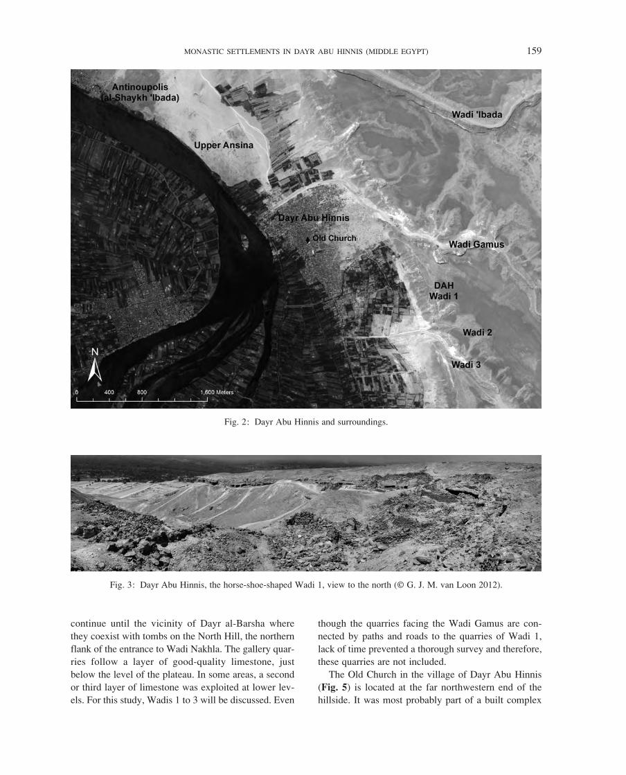
MONASTIC SETTLEMENTS IN DAYR ABU HINNIS (MIDDLE EGYPT) 159
though the quarries facing the Wadi Gamus are con-
nected by paths and roads to the quarries of Wadi 1,
lack of time prevented a thorough survey and therefore,
these quarries are not included.
The Old Church in the village of Dayr Abu Hinnis
(Fig. 5) is located at the far northwestern end of the
hillside. It was most probably part of a built complex
continue until the vicinity of Dayr al-Barsha where
they coexist with tombs on the North Hill, the northern
flank of the entrance to Wadi Nakhla. The gallery quar-
ries follow a layer of good-quality limestone, just
below the level of the plateau. In some areas, a second
or third layer of limestone was exploited at lower lev-
els. For this study, Wadis 1 to 3 will be discussed. Even
Fig. 2: Dayr Abu Hinnis and surroundings.
Fig. 3: Dayr Abu Hinnis, the horse-shoe-shaped Wadi 1, view to the north (© G. J. M. van Loon 2012).
97028.indb 159 16/10/14 14:42
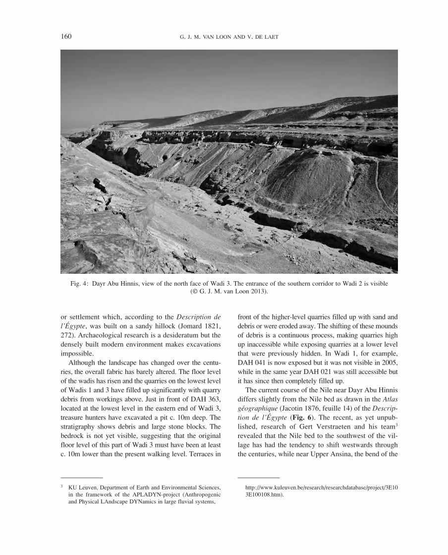
160 G. J. M. VAN LOON AND V. DE LAET
3 KU Leuven, Department of Earth and Environmental Sciences, in the framework of the APLADYN-project (Anthropogenic and Physical LAndscape DYNamics in large fluvial systems,
http://www.kuleuven.be/research/researchdatabase/project/3E10 3E100108.htm).
front of the higher-level quarries filled up with sand and
debris or were eroded away. The shifting of these mounds
of debris is a continuous process, making quarries high
up inaccessible while exposing quarries at a lower level
that were previously hidden. In Wadi 1, for example,
DAH 041 is now exposed but it was not visible in 2005,
while in the same year DAH 021 was still accessible but
it has since then completely filled up.
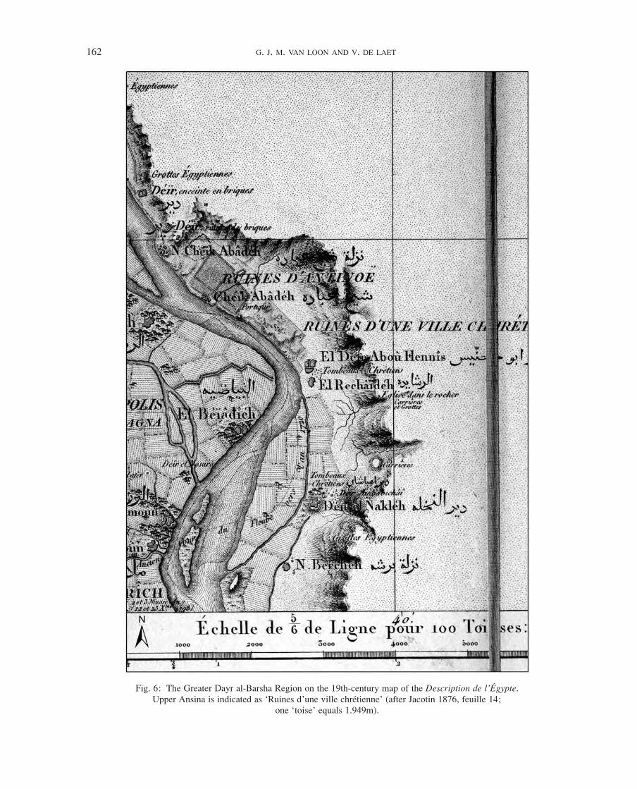
The current course of the Nile near Dayr Abu Hinnis
differs slightly from the Nile bed as drawn in the Atlas�
géographique (Jacotin 1876, feuille 14) of the Descrip-
tion� de� l’Égypte (Fig. 6). The recent, as yet unpub-
lished, research of Gert Verstraeten and his team3
revealed that the Nile bed to the southwest of the vil-
lage has had the tendency to shift westwards through
the centuries, while near Upper Ansina, the bend of the
or settlement which, according to the Description� de�
l’Égypte, was built on a sandy hillock (Jomard 1821,
272). Archaeological research is a desideratum but the
densely built modern environment makes excavations
impossible.
Although the landscape has changed over the centu-
ries, the overall fabric has barely altered. The floor level
of the wadis has risen and the quarries on the lowest level
of Wadis 1 and 3 have filled up significantly with quarry
debris from workings above. Just in front of DAH 363,
located at the lowest level in the eastern end of Wadi 3,
treasure hunters have excavated a pit c. 10m deep. The
stratigraphy shows debris and large stone blocks. The
bedrock is not yet visible, suggesting that the original
floor level of this part of Wadi 3 must have been at least
c. 10m lower than the present walking level. Terraces in
Fig. 4: Dayr Abu Hinnis, view of the north face of Wadi 3. The entrance of the southern corridor to Wadi 2 is visible (© G. J. M. van Loon 2013).
97028.indb 160 16/10/14 14:42

MONASTIC SETTLEMENTS IN DAYR ABU HINNIS (MIDDLE EGYPT) 161
4 Conversions differ: a Roman mile might be 1.472–1.480km, or close to 1.5km.
his fellow brothers spent their lives somewhere in
these quarries but there is, unfortunately, no proof that
they did.
The Old Church in the plain, now part of the village
of Dayr Abu Hinnis, dates back to the 5th century. His-
torical sources in which the church is mentioned are so
far unknown, nor do we know whether the dedication
to St John the Short is ancient (Davis 2008, 12–14, van
Loon forthcoming). It is located approximately 1km
south of the ruins of Upper Ansina, a walled settlement
whose outline is clearly recognisable (Fig. 2). The strip
of land between the church and the old settlement wall
is filled with fields and modern buildings. On the map
of the Description�de�l’Égypte, Upper Ansina is roughly
indicated and continues further south, but the original
size of the settlement is not known (Jacotin 1876,
river has moved a little to the east, thereby eroding the
western boundaries of the settlement. An educated
guess at the course of the Nile during the Late Roman–
early Christian period would place it close to the loca-
tion indicated on the Napoleonic map, leaving a stretch
of land c. 1,250–1,600m wide between the river and the
cliffs bordering the valley.
History
There is, up to now, no historical evidence of
habitation in the hills or in the plain near Dayr Abu
Hinnis. It might be that Palladius, Bishop of Hele-
nopolis, in his Historia� Lausiaca� (HL)� wrote about
hermits and monks in the area to the southeast of the
village (c. AD 419–20):
Having spent four years at Antinoë in the Thebaid, in so
long a time I acquired knowledge also of the local
monasteries. For some 1,200 men are settled round the
city, who live by their hands and are extremely ascetic
(HL�58; Butler 1904, 151; Clarke 1918, 163).
He visited these monks and tells us about the history
and lives of some of them, for example a certain Capi-
ton, who ‘… had completed fifty years in the caves
four miles from the city of Antinoë, and did not come
down from his cave, not even as far as the river Nile,
…’ (HL 58; Butler 1904, 152; Clarke 1918, 164).
These ‘four miles’ are almost certainly Roman miles
and add up to a distance of nearly 6km.4
Palladius does not inform us in which direction the
hermitage of Capiton should be sought, but the fact that
Capiton ‘did not come down from his cave, not even as
far as the river Nile’, points to a location not far from
the river. Therefore, the location should lie in a north-
ern or southern direction, where there are caves, quar-
ries or tombs not far from the Nile. Going north from
the centre of Antinoupolis as the crow flies (following
a stretch of flat desert), we arrive just south of al-
Shaykh Timai, an area where, up to the present, no
monastic activities have been reported (for example,
the area is not mentioned in Timm 1984–92). Going
south for four Roman miles, following paths along the
foot of the hills and going up into Dayr Abu Hinnis, we
are in the quarry area (Fig. 2). Most likely, Capiton and
Fig. 5: Dayr Abu Hinnis, the Old Church. The tower is modern. At present, new buildings surround the church
(© G. J. M. van Loon 2004).
97028.indb 161 16/10/14 14:42
162 G. J. M. VAN LOON AND V. DE LAET
Fig. 6: The Greater Dayr al-Barsha Region on the 19th-century map of the Description�de�l’Égypte. Upper Ansina is indicated as ‘Ruines d’une ville chrétienne’ (after Jacotin 1876, feuille 14;
one ‘toise’ equals 1.949m).
97028.indb 162 16/10/14 14:42
MONASTIC SETTLEMENTS IN DAYR ABU HINNIS (MIDDLE EGYPT) 163
5 In Arabic texts, Antinoupolis is called Ansina or Lower Ansina while Upper Ansina designates the southern sector (Stewart 1991; Grossmann 1969, 144 note 5 and 148, with references).
Although hagiographical sources and documentary
papyri give names of churches and monasteries in and
around Antinoupolis, it has, up to the present, not been
possible to link texts and archaeological remains (for a
preliminary overview, see Timm 1984–92, 1: 116–18).
Likewise, the name of the quarry settlement near Dayr
Abu Hinnis cannot be ascertained.
The 12th- to 13th-century History� of� the� churches�
and�monasteries�of�Egypt does not mention a monastic
community in the hillsides or village of Dayr Abu Hin-
nis (Zanetti 1995; Den Heijer 1996, 77–81; Evetts and
Butler 1895). The list of monasteries of the historian
al-Maqrizi (d.1442) records a church dedicated to
St John the Short in the description of Ansina, but it is
not certain that he meant the old village church (Evetts
and Butler 1895, 309 no. 11; see Timm 1984–92, 2:
579 and 583; Doresse 2000, 2.1: 472). Father Johann
Michael Wansleben or Vansleb (d. 1679) visited the
area in 1673. He lodged in the ‘Monastere d’Abuhennis
il Keßir, ou de Saint Jean le petit’, which was situated
in the plain (Vansleb 1677, 384). A map in his 1675
diary shows the church as the centre of a walled com-
plex (Paris, BnF, Ms. Italian 435, 127; depicted in Mar-
tin 1997, fig. 12). Father Vansleb was much impressed
by the church in the quarries and spent considerable
time visiting the hillside (Vansleb 1677, 384–86, 395–
96). The wall paintings and inscriptions in the quarry
church and the inscriptions and graffiti in the surround-
ing quarries were the main attraction for subsequent
visitors and scholars (Van Loon, forthcoming).
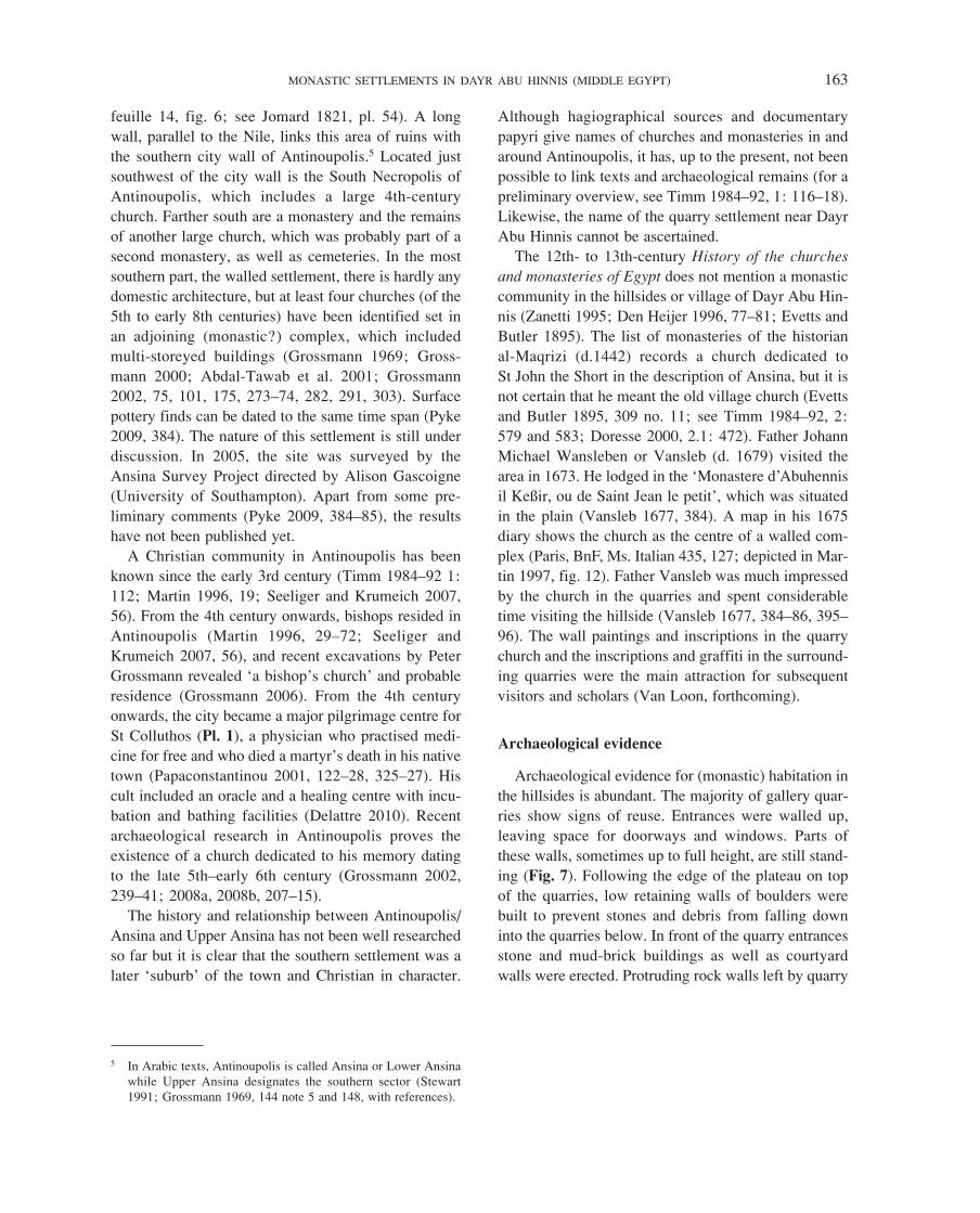
Archaeological evidence
Archaeological evidence for (monastic) habitation in
the hillsides is abundant. The majority of gallery quar-
ries show signs of reuse. Entrances were walled up,
leaving space for doorways and windows. Parts of
these walls, sometimes up to full height, are still stand-
ing (Fig. 7). Following the edge of the plateau on top
of the quarries, low retaining walls of boulders were
built to prevent stones and debris from falling down
into the quarries below. In front of the quarry entrances
stone and mud-brick buildings as well as courtyard
walls were erected. Protruding rock walls left by quarry
feuille 14, fig. 6; see Jomard 1821, pl. 54). A long
wall, parallel to the Nile, links this area of ruins with
the southern city wall of Antinoupolis.5 Located just
southwest of the city wall is the South Necropolis of
Antinoupolis, which includes a large 4th-century
church. Farther south are a monastery and the remains
of another large church, which was probably part of a
second monastery, as well as cemeteries. In the most
southern part, the walled settlement, there is hardly any
domestic architecture, but at least four churches (of the
5th to early 8th centuries) have been identified set in
an adjoining (monastic?) complex, which included
multi-storeyed buildings (Grossmann 1969; Gross-
mann 2000; Abdal-Tawab et al. 2001; Grossmann
2002, 75, 101, 175, 273–74, 282, 291, 303). Surface
pottery finds can be dated to the same time span (Pyke
2009, 384). The nature of this settlement is still under
discussion. In 2005, the site was surveyed by the
Ansina Survey Project directed by Alison Gascoigne
(University of Southampton). Apart from some pre-
liminary comments (Pyke 2009, 384–85), the results
have not been published yet.
A Christian community in Antinoupolis has been
known since the early 3rd century (Timm 1984–92 1:
112; Martin 1996, 19; Seeliger and Krumeich 2007,
56). From the 4th century onwards, bishops resided in
Antinoupolis (Martin 1996, 29–72; Seeliger and
Krumeich 2007, 56), and recent excavations by Peter
Grossmann revealed ‘a bishop’s church’ and probable
residence (Grossmann 2006). From the 4th century
onwards, the city became a major pilgrimage centre for
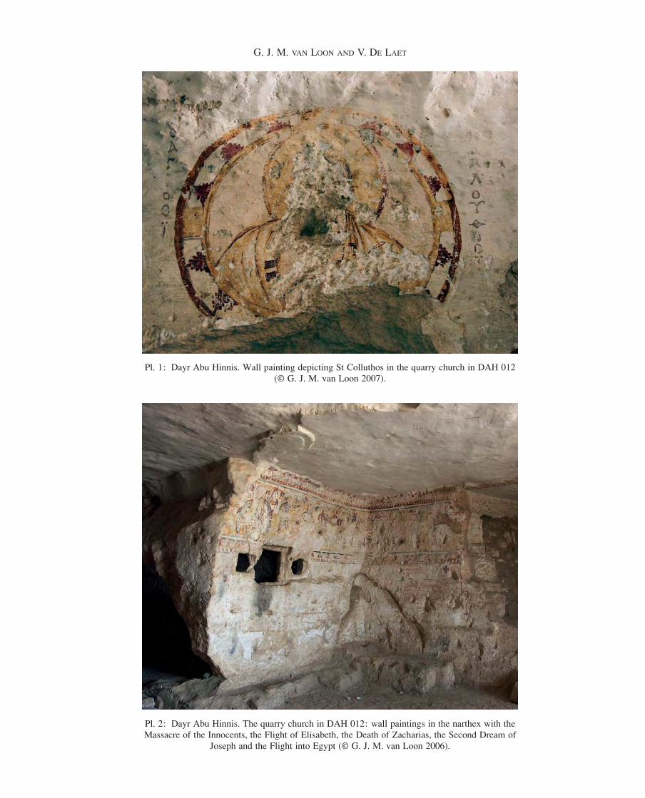
St Colluthos (Pl. 1), a physician who practised medi-
cine for free and who died a martyr’s death in his native
town (Papaconstantinou 2001, 122–28, 325–27). His
cult included an oracle and a healing centre with incu-
bation and bathing facilities (Delattre 2010). Recent
archaeological research in Antinoupolis proves the
existence of a church dedicated to his memory dating
to the late 5th–early 6th century (Grossmann 2002,
239–41; 2008a, 2008b, 207–15).
The history and relationship between Antinoupolis/
Ansina and Upper Ansina has not been well researched
so far but it is clear that the southern settlement was a
later ‘suburb’ of the town and Christian in character.
97028.indb 163 16/10/14 14:42
164 G. J. M. VAN LOON AND V. DE LAET
Lime plaster is less frequently found. Hooks in walls
and ceilings and holes in rock faces and pillars were
destined for pegs or poles to hang lamps, baskets, cur-
tains, hangings, clothes or anything else that might be
suspended. They are difficult to date, and a number of
hooks and holes might date to the quarry exploitation
phase.
In some of the quarries, small decorative sculptures
or sculpted crosses were found, often as part of an
inscription commemorating deceased monks. Figural or
decorative painted decoration is not frequently pre-
served. An exceptional example is the interior of the
church, installed in one of the quarries in Wadi 1,
which is extensively decorated with wall paintings,
provisionally dated to the 6th to 8th centuries (Pls 1,
2). The iconographic programme and inscriptions show
that the quarry church was dedicated to St John the
Baptist (Clédat 1902; Thierry 1998; Zibawi 2003,
58–66; Van Loon and Delattre 2004, 2005, 2006;
operations and loose blocks of limestone were incorpo-
rated into these structures. The quarries were connected
by a path along the front of the cliff, and in places
where the ledge in front of the quarries was too narrow,
ramps, staircases hewn into the bedrock or stepped
worked quarry faces joined the various terraces.
When the interior was judged too large for living,
walls were built to divide or partition off space. When
it was judged too small, two rooms could be connected
by cutting a doorway through internal quarry walls.
Door jambs often show pivot holes for doors and traces
of locks and latches. Windows were cut and generally
provided with wooden tracery, shutters or both. Cup-
boards, niches, jug stands, benches and other fittings
could be crafted, especially at convenient locations in
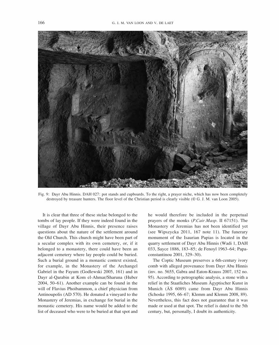
worked quarry faces and pillars (Figs 8, 9). A tamped-
down mud layer or floor tiles covered the debris on the
quarry floor. The interior rock faces often preserve sub-
stantial patches of mud plaster (Marinova et al. 2011).
Fig. 7: Dayr Abu Hinnis. DAH 208: Heavy stone walls with windows close the entrances of a New Kingdom gallery quarry (© G. J. M. van Loon 2007).
97028.indb 164 16/10/14 14:42
MONASTIC SETTLEMENTS IN DAYR ABU HINNIS (MIDDLE EGYPT) 165
6 All Coptic and Greek inscriptions are being collected and stud-ied by Alain Delattre (Brussels, Université Libre). The Syriac and Ge’ez inscriptions are being studied by Lukas Van Rompay, Duke University, NC.
7 The stone slab was originally an altar slab. It was reused as a tombstone, which was, at a later date, used again as an altar slab (Schaten 1999, 129; Boud’hors and Delahaye 2008).
8 The tombstones of Febronia and Pieu belong to a group of stelae with a ‘Totenklage’ formula (Cramer 1941; Schaten 1991; Delattre 2008, 147–49). Sofia Schaten adds ‘Überhaupt ist es so, dass die Grabsteine mit Totenklagen (auch wenn die Herkunft unbekannt ist) meiner Meinung nach nur aus der Region um Antinoopolis stammen können. Wieweit der Radius geht, müsste einmal festgestellt werden’ (pers. comm.).
priest Pieu, dated AD 765, is now in the Coptic Museum
in Cairo (inv. no. 7924, formerly in the Egyptian
Museum, inv. no. 8321: Crum 1902, 76–77; Galtier
1906, 112–15; see Cramer 1941, 7–9, no. 2; SB Kopt. I
780). Archibald Sayce bought two tombstones ‘from the
old cemetery’, which had been reused as building mate-
rial in the village (Sayce 1886, 185–86; SB Kopt. III,
1588–89). The provenance of these stelae is problematic.
It turns out that in 19th- and early 20th-century literature,
‘Dayr Abu Hinnis’ often included Upper Ansina. With-
out a secure provenance, it is impossible to conclude
exactly from where the stelae came.8
Van Loon 2011, forthcoming). The quarries yielded
hundreds of graffiti and inscriptions. They are mainly
written in Greek and Coptic but also include Syriac and
Ge’ez. There are prayers and invocations and a great
many names but unfortunately no dates (Delattre 2003,
in press a; Delattre in Van Loon in press; van Loon
and Delattre forth coming).6
Several tombstones said to have come from Dayr Abu
Hinnis are preserved. In the Old Church, the tombstone
of a woman named Febronia covers the northern altar
(dated 750 AD, Cramer 1941, 5–7: no. 1; Nicacci 1985;�
SB Kopt. I 428).7 The stela of the hegoumenos and arch-
Fig. 8: Dayr Abu Hinnis. DAH 208: interior. The wall has in-built cupboards (© G. J. M. van Loon 2007).
97028.indb 165 16/10/14 14:42
166 G. J. M. VAN LOON AND V. DE LAET
he would therefore be included in the perpetual
prayers of the monks (P.Cair.Masp. II 67151). The
Monastery of Jeremias has not been identified yet
(see Wipszycka 2011, 167 note 11). The funerary
monument of the Isaurian Papias is located in the
quarry settlement of Dayr Abu Hinnis (Wadi 1, DAH
033, Sayce 1886, 183–85; de Fenoyl 1963–64; Papa-
constantinou 2001, 329–30).
The Coptic Museum preserves a 6th-century ivory
comb with alleged provenance from Dayr Abu Hinnis
(inv. no. 5655, Gabra and Eaton-Krauss 2007, 152 no.
95). According to petrographic analysis, a stone with a
relief in the Staatliches Museum Ägyptischer Kunst in
Munich (ÄS 6089) came from Dayr Abu Hinnis
(Schoske 1995, 66–67; Klemm and Klemm 2008, 89).
Nevertheless, this fact does not guarantee that it was
made or used at that spot. The relief is dated to the 5th
century, but, personally, I doubt its authenticity.
It is clear that three of these stelae belonged to the
tombs of lay people. If they were indeed found in the
village of Dayr Abu Hinnis, their presence raises
questions about the nature of the settlement around
the Old Church. This church might have been part of
a secular complex with its own cemetery, or, if it
belonged to a monastery, there could have been an
adjacent cemetery where lay people could be buried.
Such a burial ground in a monastic context existed,
for example, in the Monastery of the Archangel
Gabriel in the Fayum (Godlewski 2005, 161) and in
Dayr al-Qarabin at Kom el-Ahmar/Sharuna (Huber
2004, 50–61). Another example can be found in the
will of Flavius Phoibammon, a chief physician from
Antinoupolis (AD 570). He donated a vineyard to the
Monastery of Jeremias, in exchange for burial in the
monastic cemetery. His name would be added to the
list of deceased who were to be buried at that spot and
Fig. 9: Dayr Abu Hinnis. DAH 027: pot stands and cupboards. To the right, a prayer niche, which has now been completely destroyed by treasure hunters. The floor level of the Christian period is clearly visible (© G. J. M. van Loon 2005).
97028.indb 166 16/10/14 14:42
MONASTIC SETTLEMENTS IN DAYR ABU HINNIS (MIDDLE EGYPT) 167
an indication of the size of the cluster of habitations,
the relationships between clusters, a possible relation-
ship to a plain settlement, or a combination of these
characteristics.
The degree of organisation of a community would
be in keeping with the existence and number of com-
munal services. Contrary to the idealised image that
arises from literary sources (e.g., Apophtegmata�Patrum
or saints’ Lives) of monks sitting in their cells, praying
and meditating while doing handiwork, documentary
papyri and excavations show that in many respects
monks living together in a more or less organised group
bore a resemblance to village communities (Goehring
1999, 39–52). Ewa Wipszycka points out this contrast
throughout her work (e.g., 2011). Although excavations
are mainly carried out in built settlements, which may
have involved another (coenobitic) way of living, there
is no reason to believe that the essential practical char-
acteristics of daily life differed. Monks needed living
quarters, storerooms and kitchens (or cooking and bak-
ing could be organised centrally); they needed to work
to earn a living. They might work in their own quarters,
or there might be workrooms and ateliers. Communal
activities needed communal spaces; administration and
management required accommodation too. Visitors,
fellow brothers or lay people, could be received in pri-
vate quarters or there could be reception rooms. In all
likelihood, a large community involved more organisa-
tion and centralisation of services than a small one and,
consequently, a small community could most probably
do without a number of the aforementioned facilities.
Therefore, the existence of spaces for communal use or
benefit—for example, a church, assembly rooms or
kitchens—points to the presence of a group of people
making use of these amenities.
The�habitation�pattern�in�the�hill�site:�Methodology
The starting point for further research was the con-
struction of a distribution map showing the exact loca-
tion of quarries with signs of reuse. When communal
services could be identified, their position was indi-
cated. Likewise, additional markers of habitation (dec-
oration, inscriptions) were noted.
The construction of such a map allows us to address
various questions. The spread of reused spaces can be
plotted, which may show whether these reused quarries
were clustered. If they were, does the clustering relate
to physical barriers? When the grouping of specific
functions can be marked, core locations may become
Date
In summary, there is almost no historical evidence
for the establishment of monastic communities on the
hillside to the southeast of the village of Dayr Abu Hin-
nis. The archaeological data, however, demonstrate the
settlement of people in abandoned quarries. The village
has an ancient Christian core, dating back at least to the
5th century, but whether or not it was monastic is
unknown. Thus far, it has not been possible to deter-
mine the Late Antique name of either settlement.
The time span of habitation in the hill region cannot
be established yet. The quarry church contains several
layers of plaster with inscriptions and paintings. Murals
painted on the most recent layer of plaster probably
date to the 6th to 8th centuries. None of the inscriptions
include a date. The themes executed in sculpture are
found from the 5th century onwards and can be traced
till, approximately, the 9th century (Van Loon in Van
Loon and Delattre, forthcoming). In 2008, some coins
were found in front of quarries in Wadi 1—stray sur-
face finds. They were analysed by Daniele Castrizio
(Università di Messina, member of the Antinoupolis
Mission of the Istituto Papirologico ‘G. Vitelli’,
Florence, directed by R. Pintaudi) who concluded that
these types of coins came into use in Egypt in the
second half of the 4th century and circulated until the
end of the 9th century (unpublished report ‘Deir Abu
Hinnis 2008: Le monete’). Recently, more coins were
found in Wadis 1 and 3, awaiting conservation and
study. A ceramics survey has been conducted and the
pottery is currently under study.
Spatial organisation
In order to define settlements in this region, first of
all, the landscape must be taken into account. Where
exactly are the quarries situated? Are there natural
boundaries? The physical surroundings (hills, wadis
and cliffs) limited additional building activities and, as
a consequence, restricted the size of a settlement. Fur-
thermore, a more precise definition of a semi-anchoretic
community, or laura, is necessary. What type of build-
ings and other spaces made up such a community (see
Van Loon in press)?
The existence of paths connecting suitable dwelling
spaces is one of the distinct markers of a laura. Paths
or roads also lead to communal facilities; clusters of
dwellings have roads linking them to the outside world.
Therefore, a reconstruction of the road system can give
97028.indb 167 16/10/14 14:42
168 G. J. M. VAN LOON AND V. DE LAET
9 Véronique De Laet prepared the Quickbird-2 (QB) image. For a detailed description of the enhancement techniques used and the development of a road typology on the basis of the spectral information content of satellite imagery in the context of a study of the road system of the Dayr al-Barsha–Dayr Abu Hinnis region, see De Laet in De Laet et al., in press.
10 Surveys were carried out over a number of years, first by Alain Delattre (epigrapher, Brussels, Université Libre) and myself,
later joined by Véronique De Laet. GPS readings in Wadis 2 and 3 (2012–2013) were partly taken by Birgit Schoer (London), Sonja Speck (Heidelberg) and Kylie Cortebeeck (Leuven), assisting Athena Van der Perre’s PhD research on the exploita-tion of the quarries during the New Kingdom (Dayr al-Barsha Project, KU Leuven).
Evidence for ‘building activities’ can be found inside
or in front of the quarry and comprises stone or mud-
brick walls, windows, doorways, floors, cupboards,
benches and niches. ‘Decoration’ includes painting and
sculpture used to decorate a room, church or chapel.
‘Inscriptions’ does not differentiate between languages
but only indicates the presence or absence of inscrip-
tions and graffiti. Decoration and inscriptions provide
information on residents and visitors, or sometimes on
the activities going on in specific rooms.
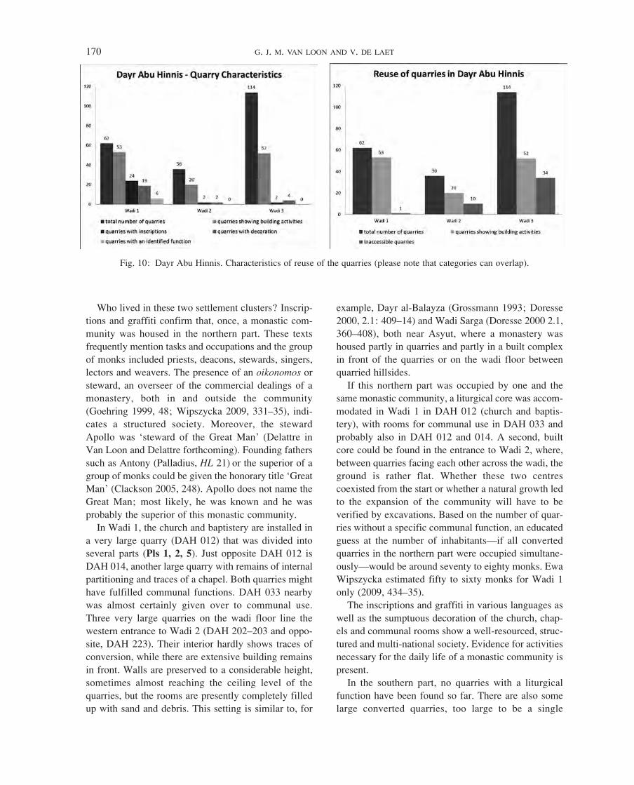
In total, 212 gallery quarries were counted, 62 in
Wadi 1, 36 in Wadi 2 and 114 in Wadi 3. Open cast
quarries with a cavity in the rock face large enough to
have been attractive for settlement are included. Occa-
sionally, a plain open cast quarry was included because
it was incorporated into a building. Forty-five gallery
quarries turned out to be inaccessible (1 in Wadi 1,
10 in Wadi 2 and 34 in Wadi 3). These are located in
very steep cliff faces without safe paths (we did not
have climbing gear) or on the wadi floor. The latter
quarries are now almost completely filled up with sand
and debris.
The features of each individual quarry were set out
in Microsoft Excel and, in conjunction with the GPS
readings, imported into the ESRI/ArcGIS® module
ArcMap. In cases where GPS readings for quarries
were lacking, points were digitised in ArcGIS on the
basis of photographic documentation. With the help of
binoculars and close-up photographs, it was sometimes
possible to distinguish built walls in inaccessible quarry
entrances; further information about their interiors
could not be collected.
Data analysis was performed using selection queries
as implemented in the ArcGIS software. A first move-
ment analysis was done on the basis of visual inspec-
tion (RS analysis of satellite images and observation
of the landscape during survey). GIS-based movement
analysis (Least Cost Pathways) and intervisibility
analysis (Viewshed) will follow at a later date when a
visible. Are such nucleii strategically located? Do they
have easy access from within the settlement, from
outside, or both? Is it possible to distinguish several
communities?
The area was mapped using very high spatial resolu-
tion satellite imagery. Visual inspection of an enhanced
Quickbird-2 image targeted known quarry zones and
signs of reuse (e.g., wall remains in front of the gallery
quarries). With these examples, further quarry zones
could be identified. Moreover, the road system was
traced.9 Since Remote Sensing (RS) provides a spatial
context of the features analysed, it allows the produc-
tion of a basic map to serve as a starting point for the
field survey.
The field survey included taking Global Positioning
System (GPS) readings of the entrances of the gallery
quarries (using a Trimble® GeoExplorer® 2005
GeoXT™ handheld GPS) and the documentation of
characteristics related to their reuse. Based on previous
RS analysis and the survey of Véronique De Laet
(2010–11), roads and paths were examined and their
context recorded.10 Sometimes, GPS positions could not
be fixed due to the inaccessibility of the quarry or a lack
of satellite signal caused by adverse weather conditions
(a sandstorm) or the presence of steep rock faces.
As markers for habitation, three general objective
characteristics were taken into account: ‘building activ-
ities’, ‘decoration’ and ‘inscriptions’. Although quite
broad, these features are sufficient for the purpose of
defining settlements. A fourth characteristic, the func-
tion that can be assigned to a particular space, is an
interpretation: church, chapel, memorial chapel, work-
shop, a communal function, habitation. These charac-
teristics comprise the features that could be observed,
as none of the quarries or the spaces in front of the
quarries were excavated. Trying to define a function on
this basis has limitations: when observations are not
sufficient for identification, it can be said only that the
quarry room, the space in front, or both were settled.
97028.indb 168 16/10/14 14:43

MONASTIC SETTLEMENTS IN DAYR ABU HINNIS (MIDDLE EGYPT) 169
secure date is almost impossible to establish (see De
Laet et al. in press). After the period of quarry exploita-
tion, there were probably three barriers that hindered
transport. The southern corridor of Wadi 2 leading to
Wadi 3 ends in a very steep and high cliff face with a
sheer drop. In the steep rock face, three Late Period
quarries were cut. Likewise, the western corridor of
Wadi 2 and the horse-shoe shape of Wadi 1 both end in
steep vertical cliffs. The latter two vertical rock faces
hamper movement up from and down to the valley
(though one can easily circumvent this area), but the
cliff in Wadi 3 also obstructs inter-site movement.
The changing function of the Dayr Abu Hinnis quar-
ries in the Christian period, from an abandoned indus-
trial site to a settlement, dictated changes to the road
system. Existing roads, tracks and paths were used
according to need while, for new destinations, new
paths could be developed. Road building was almost
certainly no longer necessary since heavy transport had
ceased. The surviving system shows pragmatism and
economy, linking inhabited quarries and quarry areas,
as well as connecting hillside and valley. It most prob-
ably largely dates to the quarry exploitation periods. In
Dayr Abu Hinnis, we have, up to the present date, no
firm evidence for the development of tracks in the
Christian period (Pls 3–5; De Laet et al. in press).
The road map demonstrates that the quarries of
Wadis 1 and 2 and the northwestern group of quarries
of Wadi 3 were well connected with one another and
there were also some easy access roads and paths to the
valley. This leaves the southeastern part of Wadi 3,
including the southeastern corner of the southern cor-
ridor of Wadi 2, as a more or less independent group.
The latter cluster of quarries has no short cuts over the
plateau to Wadi 2. The paths run along the quarries or
down to the wadi floor, with one exception: at the
southwestern point of Wadi 3, the path climbs up to the
plateau and links to a road running parallel to the wadi,
from the valley to the southeast. Since the latter road is
heavily used in modern times, archaeological evidence
is erased. Nevertheless, an ancient provenance of this
track is likely.
Taking into account the location of reused quarries,
physical barriers and the road network, this area can be
divided into a northern and a southern part. The north-
ern region consists of Wadi 1, Wadi 2 and the two lines
of quarries at the northwestern end of Wadi 3. The
southern region comprises the group of quarries in
the southeastern end of Wadi 3, plus the quarries at the
southern end of Wadi 2’s southern corridor.
Digital Elevation Map (DEM) of the region will be
available (in preparation by Marijn Hendrickx, Univer-
siteit Gent, Department of Geography).
The�habitation�pattern�in�the�hill�site:�Analyses
The density of gallery quarries is apparent in Wadis
1 and 3. In Wadi 2, a limited number of gallery quarries
is spread over a relatively large area that is mainly
characterised by open air exploitation (Pl. 3). The pres-
ence of the feature ‘building activities’, whether inside
or in front of the quarry, was taken as the key marker
for settlement. Out of 212 quarries, 125 showed signs
of adjustment (42 quarries were completely inaccessi-
ble; 3 inaccessible quarries showed wall remains; 45
quarries contained no traces of alteration) (Fig. 10).
Looking at the distribution of the converted quarries, it
turns out that the majority of gallery quarries in the
northern part of the area (Wadi 1 and Wadi 2, 73 out
of 98) had been reused. In the southern part, Wadi 3,
52 out of 114 quarries show alterations (Fig. 10, Pl. 4).
A number of quarries in the overall area were without
doubt adapted as habitations, but the greater part of the
reused quarries could not be classified. A function
other than habitation could be ascertained for only a
few quarries: a church with a baptistery, a chapel, a
memorial chapel for the saintly monk Apa Loots
(Delattre in press a; Van Loon in press), a memorial
chapel for Papias the Isaurian, a communal room and a
weaving workshop. These quarries and almost all quar-
ries with inscriptions, graffiti and decoration (paintings
and sculpture) are located in the northern part, in Wadi
1. The richness of decoration in the church and in other
rooms is noticeable. No other churches or chapels have
been found so far (Fig. 10, Pl. 5).
The quarry complex already had a sizeable road net-
work for the transport of stone up to the hills and down
to the valley, as well as for internal movements (Pls 4,
5). The mapped roads and paths are either cut into the
bedrock or consist of weathered desert surfaces of var-
ious widths, with or without a border of boulders; or
they may be a combination of the two, dictated by the
physical conditions. Gaps in tracks could be bridged
with built supports.
Dating roads and paths is difficult. Construction
methods did not alter through the centuries and the
reuse of paths complicates the situation. Some roads,
tracks and ramps can be linked to specific exploitation
phases, which, in their turn, sometimes can be identified
by tool marks, quarry marks and/or inscriptions. A more
97028.indb 169 16/10/14 14:43
170 G. J. M. VAN LOON AND V. DE LAET
example, Dayr al-Balayza (Grossmann 1993; Doresse
2000, 2.1: 409–14) and Wadi Sarga (Doresse 2000 2.1,
360–408), both near Asyut, where a monastery was
housed partly in quarries and partly in a built complex
in front of the quarries or on the wadi floor between
quarried hillsides.
If this northern part was occupied by one and the
same monastic community, a liturgical core was accom-
modated in Wadi 1 in DAH 012 (church and baptis-
tery), with rooms for communal use in DAH 033 and
probably also in DAH 012 and 014. A second, built
core could be found in the entrance to Wadi 2, where,
between quarries facing each other across the wadi, the
ground is rather flat. Whether these two centres
co existed from the start or whether a natural growth led
to the expansion of the community will have to be
verified by excavations. Based on the number of quar-
ries without a specific communal function, an educated
guess at the number of inhabitants—if all converted
quarries in the northern part were occupied simultane-
ously—would be around seventy to eighty monks. Ewa
Wipszycka estimated fifty to sixty monks for Wadi 1
only (2009, 434–35).
The inscriptions and graffiti in various languages as
well as the sumptuous decoration of the church, chap-
els and communal rooms show a well-resourced, struc-
tured and multi-national society. Evidence for activities
necessary for the daily life of a monastic community is
present.
In the southern part, no quarries with a liturgical
function have been found so far. There are also some
large converted quarries, too large to be a single
Who lived in these two settlement clusters? Inscrip-
tions and graffiti confirm that, once, a monastic com-
munity was housed in the northern part. These texts
frequently mention tasks and occupations and the group
of monks included priests, deacons, stewards, singers,
lectors and weavers. The presence of an oikonomos or
steward, an overseer of the commercial dealings of a
monastery, both in and outside the community
(Goehring 1999, 48; Wipszycka 2009, 331–35), indi-
cates a structured society. Moreover, the steward
Apollo was ‘steward of the Great Man’ (Delattre in
Van Loon and Delattre forthcoming). Founding fathers
such as Antony (Palladius, HL 21) or the superior of a
group of monks could be given the honorary title ‘Great
Man’ (Clackson 2005, 248). Apollo does not name the
Great Man; most likely, he was known and he was
probably the superior of this monastic community.
In Wadi 1, the church and baptistery are installed in
a very large quarry (DAH 012) that was divided into
several parts (Pls 1, 2, 5). Just opposite DAH 012 is
DAH 014, another large quarry with remains of internal
partitioning and traces of a chapel. Both quarries might
have fulfilled communal functions. DAH 033 nearby
was almost certainly given over to communal use.
Three very large quarries on the wadi floor line the
western entrance to Wadi 2 (DAH 202–203 and oppo-
site, DAH 223). Their interior hardly shows traces of
conversion, while there are extensive building remains
in front. Walls are preserved to a considerable height,
sometimes almost reaching the ceiling level of the
quarries, but the rooms are presently completely filled
up with sand and debris. This setting is similar to, for
Fig. 10: Dayr Abu Hinnis. Characteristics of reuse of the quarries (please note that categories can overlap).
97028.indb 170 16/10/14 14:43
MONASTIC SETTLEMENTS IN DAYR ABU HINNIS (MIDDLE EGYPT) 171
and Upper Ansina. In the Description�de�l’Égypte, the
village of Dayr Abu Hinnis, much smaller and with the
Old Church in the southwestern part, ‘… touche aux
ruines d’Antinoé’ (Jomard 1821, 272, 324). On the map
of the accompanying Atlas�géographique, the projected
outline of Upper Ansina indeed almost touches the
village (Jacotin 1875, feuille 14). In the more detailed
plan of plate 54, part of this area was sketched as
already cultivated at that time (Jomard 1821). Modern
expansion prevents archaeological research, but the
proximity of the Old Church to the ruined town is
evident.
Furthermore, the similarity of the modern names for
village and quarry settlements (both called ‘Dayr Abu
Hinnis’) suggests a link, for which there is, however,
no historical foundation. The Late Antique name of
both settlements is not yet known.
This model gives a new perspective to the pattern of
habitation in this area. The northern route from the
monastic settlement may have run directly to the south-
ern suburb of Antinoupolis. There may have been con-
nections between one of the number of ecclesiastical
establishments in this quarter and the northern hill
community, but not necessarily the Old Church. The
proximity of this cosmopolitan city was certainly
responsible for the international and rich character of
the northern monastery (see Delattre in press b).
The southern settlement could have functioned inde-
pendently but also needed provisioning. It had a sepa-
rate route from the wadi into the Nile valley, but evi-
dence for a continuation of this road is lacking.
Conclusion
On the basis of geographical research, supplemented
by historical and archaeological study, it can be con-
cluded that the quarry landscape to the southeast of
Dayr Abu Hinnis most probably housed two different
communities. The northern, monastic, community had
a direct road connection to Upper Ansina, on the out-
skirts of Antinoupolis. The 5th-century church in the
modern village of Dayr Abu Hinnis was most probably
part of the latter neighbourhood and did not function
as a parent community of a hill settlement. The identity
of the southern hill community remains—for the
moment—unknown.
Research of spatial patterns such as those outlined in
this paper requires research over a large area. The
inspection of satellite imagery and the application of
spatial analysis using GIS techniques therefore provide
hermitage/habitation and/or with extensive building
remains in front of the entrance but without an identifi-
able function: DAH 346 and 351 in the north face of
Wadi 3 and DAH 370, 374, 381 and 385 in the south
face. Up to the present, only one inscription and a few
crosses have been found in two single quarries. A large
number of quarries in this area were remodelled, but
for what function and who lived there? Based on the
number and size of converted quarries, an educated
guess at the population would be forty to fifty people.
This survey is, unfortunately, not able to answer these
questions and more research is called for.
Connections�between�the�hill�and�the�Nile�valley
As a habitation model for this region, Father Mau-
rice Martin S. J. and Barry Kemp propose the theory
of a parent community in the valley with a group of
hermitages in the hills relying on this parent commu-
nity for liturgical functions (a church) and practical
matters such as food and water (Martin 1971, 11;
Kemp 2005, 54–55). In this case, the Old Church in
the present village would have been the centre of a
main settlement with a group of converted quarries in
the hills as dependencies.
The distribution of reused quarries, in conjunction
with the road system and physical barriers, points to
two communities residing in the hills. Inscriptions in
the northern settlement indicate the presence of a
monastic community. For the southern settlement, there
is no identification yet. The monastic settlement was
large and well-appointed and could exist in its own
right, although provisions and water had to be supplied
from outside. The character of the Old Church in the
village and the assumed complex around it (secular or
monastic) cannot be determined. Written sources are
not available, and archaeological finds said to have
come from Dayr Abu Hinnis have no secure prove-
nance.
There is no evidence of a dependency between the
hillside and valley settlements, either way. One of the
two main routes from the northern settlement into the
valley, the northern one, leads to the neighbourhood of
the Old Church (Fig. 11). A provisioning station at that
spot might be a possibility. In this case, the main com-
munity would have been located in the quarries instead
of in the valley (see Van Loon in press).
Another option, emphasised by the geographical
situation, the settlement pattern in the hills and the
ancient road network, is a link between the Old Church
97028.indb 171 16/10/14 14:43

172 G. J. M. VAN LOON AND V. DE LAET
established hypotheses of habitation patterns in the
area. It represents a point of departure, both for the
application of RS and GIS techniques in this context,
as well as for a better understanding of the monastic
landscape on the east bank of the Nile in Middle Egypt.
Acknowledgements
Special thanks go to Birgit Schoer for correcting the
English.
the ideal tools for investigating such large-scale
research questions. In this way, prior to fieldwork, the
topography of the region can be scrutinised and theo-
ries and models can be developed. A spatial perspective
allows for a better understanding of the landscape.
Fieldwork remains vital, however: models and theories
can only be verified on site.
For the Greater Dayr al-Barsha Region, this new
assessment of settlement in the quarries of Dayr Abu
Hinnis in the Christian period begins to reconsider
Fig. 11: Dayr Abu Hinnis. Road map of the quarry area and village.
97028.indb 172 16/10/14 14:43
MONASTIC SETTLEMENTS IN DAYR ABU HINNIS (MIDDLE EGYPT) 173
——. In press a. L’apport des inscriptions à l’étude des ermi-
tages chrétiens: Deir Abou Hennis et la Montagne
thébaine. In Ermitages�d’Égypte�au�premier�millénaire:�
Actes�du�colloque�international,�Le�Caire�24–26�Janvier�
2009, V. Ghica (ed.). Cairo.
——. In press b. Les rapports entre la ville d’Antinoé et le
monastère du Deir Abou Hennis en Moyenne-Égypte.
In Itinerari�mediterranei.
De Laet, V., G. J. M. van Loon, A. Van der Perre and H. Wil-
lems. In press. Integrated remote sensing investigations
of ancient quarries and road systems in the Greater Dayr
al-Barshā region, Middle Egypt: A study of logistics.
Journal�of�Archaeological�Science.
Den Heijer, J. 1996. Coptic historiography in the Fātimid,
Ayyubid and early Mamluk periods. Medieval�Encoun-
ters 2: 67–98.
Doresse, J. 2000. Les�anciens�monastères�coptes�de�Moyenne-
Égypte�(du�Gebel-et-Teir�à�Kôm-Ishgaou)�d’après�l’ar-
chéologie� et� l’hagiographie. Neges Ebrix. Bulletin de
l’Institut d’Archéologie Yverdonnoise 3–5. Yverdon-
les-Bains.
Evetts, B. T. A. and A. J. Butler. 1895. The� churches� and�
monasteries�of�Egypt�and�some�neighbouring�countries�
attributed�to�Abu�Salih,�the�Armenian. Oxford.
de Fenoyl, M. 1963–64. Une inscription funéraire bilingue.
Bulletin�de�la�Société�d’Archéologie�Copte 17: 57–61.
Gabra, G. and M. Eaton-Krauss. 2007. The�treasures�of�Cop-
tic�art�in�the�Coptic�Museum�and�churches�of�Old�Cairo.
Cairo; New York.
Galtier, E. 1906. Coptica-arabica. Bulletin�de�l’Institut�Fran-
çais�d’Archéologie�Orientale�5: 87–164.
Gasse, A. 1983. Rapport préliminaire d’une mission épigra-
phique à Deir Abou Hennes (Mission IFAO février
1982). Annales� du� Service� des� Antiquités� de� l’Égypte
69: 96–102.
Godlewski, W. 2005. Excavating the ancient monastery at
Naqlun. In Christianity�and�monasticism�in�the�Fayoum�
Oasis, G. Gabra (ed.), 155–71. Cairo; New York.
Goehring, J. E. 1999. Ascetics,�society�and�the�desert:�Stud-
ies�in�early�Egyptian�monasticism. Studies in Antiquity
& Christianity 6. Harrisburg, PA.
Grossmann, P. 1969. Die von Somers Clark in Ober-Anṣinā
entdeckte Kirchenbauten, Mitteilungen� des� Deutschen�
Archäologischen�Instituts�Kairo 24–25: 144–68.
——. 1982. Mittelalterliche� Langhauskuppelkirchen� und�
verwandte�Typen�in�Oberägypten. Glückstadt.
——. 1993. Ruinen des Klosters Dair al-Balaizā in Oberägyp-
ten. Jahrbuch�für�Antike�und�Christentum 36: 171–205.
——. 2000. Zur Rekonstruktion der Südkirche von Antinoo-
polis. Vicino�Oriente 2: 269–81.
——. 2002. Christliche� Architektur� in� Ägypten.� Handbuch
der Orientalistik 62. Leiden.
Bibliography
All papyrological abbreviations are cited according to the
conventions established in John F. Oates, R. S. Bagnall,
S. J. Clackson, A. A. O’Brien, J. D. Sosin, T. G. Wil-
fong and K. A. Worp, Checklist� of� Greek,� Latin,�
Demotic�and�Coptic�papyri,�ostraca�and�tablets.�http://
scriptorium.lib.duke.edu/papyrus/texts/clist.html, last
accessed September 2013.
Abdal-Tawab, A., M. Ghattas and P. Grossmann. 2001. Pre-
liminary report on the excavation of a monastic com-
plex to the south of Antinoopolis. Bulletin�de�la�Société�
d’Archéologie�Copte 40: 35–52.
Boud’hors, A. and G.-R. Delahaye. 2008. Nouvel exemple
d’une pierre d’autel remployée: La stèle de Dorotheos.
In Études�Coptes X:�Douzième�journée�d’études�(Lyon�
19–21� mai� 2005), A. Boud’hors and C. Louis (eds),
103–22. Cahiers de la Bibliothèque Copte 16. Paris.
Butler, C. (ed.). 1904. The� Lausiac� history� of� Palladius� 2.
Texts and Studies 6.2. Cambridge.
Clackson, S. 2005. Coptic and Greek ostraca from Kom el-
Nana. In Late� Roman� pottery� at� Amarna� and� related�
studies, J. Faiers with contributions by S. Clackson,
B. Kemp, G. Pyke and R. Reece, 245–62. Egypt Explo-
ration Society Excavation Memoir�72. London.
Clarke, W. K. Lowther. 1918. The� Lausiac� history� of�
�Palladius. Trans. London.
Clédat, J. 1902. Notes archéologiques et philologiques II:
Deir Abou-Hennîs. Bulletin� de� l’Institut� Français�
�d’Archéologie�Orientale 2: 44–67.
Coquin, R. G., M. Martin, S. J. and P. Grossmann. 1991a.
Dayr Abu Hinnis. In The� Coptic� encyclopedia, A. S.
Atiya (ed.), 3: 701–703. New York.
——. 1991b. Dayr al-Barshah and Dayr al-Nakhlah. In The�
Coptic�encyclopedia, A. S. Atiya (ed.), 3: 794–96. New
York.
Cramer, M. 1941. Die�Totenklage�bei�den�Kopten. Akademie
der Wissenschaften in Wien. Philosophisch-historische
Klasse. Sitzungsberichte 219.2. Vienna.
Crum, W. E. 1902. Coptic� monuments. Catalogue Général
des Antiquités Égyptiennes du Musée du Caire. Cairo.
Davis, S. J. 2008. The Arabic Life of Saint John the Little
by Zacharias of Sakhā (MS. Göttingen Arabic 114). Coptica: 1–185.
Delattre, A. 2003. L’apophtegme de Grégoire de Nysse au
Deir Abou Hennis. Aegyptus 83: 223–27.
Delattre, A. 2008. Textes coptes et grecs d’Antinoé. In
Antinoupolis I: Scavi� e� materiali, G. Bastianini and
R. Pintaudi (eds), 131–62. Florence
——. 2010. Nouveaux textes coptes d’Antinoé. In Proceed-
ings� of� the� Twenty-Fifth� International� Congress� of�
Papyrology,�Ann�Arbor,�Michigan,�July�29–4�August�4,�
2007, T. Gagos and A. Hyatt (eds), 171–74. American
Studies in Papyrology. Ann Arbor, MI.
97028.indb 173 16/10/14 14:43
174 G. J. M. VAN LOON AND V. DE LAET
bourg�12–14� juin�2003), A. Boud’hors, J. Gascou and
D. Vaillancourt (eds), 119–34. Cahiers de la Biblio-
thèque Copte 14. Paris.
——. Forthcoming. Dayr�Abu�Hinnis:�The�hermitages�in�the�
quarries.
Marinova, E., G. J. M. van Loon, M. De Meyer and H. Wil-
lems. 2011. Plant economy and land use in Middle
Egypt during the Late Antique/early Islamic period:
Archaeobotanical analysis of mud bricks and mud plas-
ters from the area of Dayr al-Barshā. In Windows�of�the�
African�past:�Current�approaches�to�African�archaeo-
botany, A. G. Fahmy, S. Kahlheber and A. C. D’Andrea
(eds), 119–36. Reports in African Archaeology 3.
Frankfurt am Main.
Martin, A. 1996. Athanase�d’Alexandrie�et�l’É�glise�d’Égypte�
au�IVe�siè�cle. Rome.
Martin S. J., M. 1971. La� laure� de� Dêr� al� Dîk� à� Antinoë.
Bibliothèque d’Études Coptes 8. Cairo.
——. 1997. Le journal de Vansleb en Égypte. Bulletin� de�
l’Institut�Français�d’Archéologie�Orientale�97: 181–91.
Nicacci, A. 1985. Ancora sulla stele di Febronia a Deir Abu
Hennis. Studia�Orientalia�Christiana.�Collectanea�18:
167–73.
Papaconstantinou, A. 2001. Le� culte� des� saints� en� Égypte,�
des� byzantins� aux� abbassides:� L’apport� des� sources�
papyrologiques� et� épigraphiques� grecques� et� coptes.
Paris.
Pyke, G. 2009. A Coptic conundrum: The painted scene in
the North Church at Ansina. In Beyond� the� horizon:�
Studies� in� Egyptian� art,� archaeology� and� history� in�
�honour� of� Barry� J.� Kemp, S. Ikram and A. Dodson
(eds), 384–95. Cairo.
Sayce, A. H. 1886. Coptic and early Christian inscriptions in
Upper Egypt. Proceedings� of� the� Society� of� Biblical�
Archaeology 8: 175–91.
Schaten, S. 1991. Der Grabstein des Phoibamon. Bulletin�de�
la�Société�d’Archéologie�Copte 30: 112–20.
——. 1999. Wiederverwendete Grabstelen mit Dekor und
Inschrift. Bulletin�de�la�Société�d’Archéologie�Copte 38:
127–34.
Seeliger, H. R. and K. Krumeich. 2007. Archäologie� der�
antiken�Bischofssitze� I:�Spätantike�Bischofssitze�Ägyp-
tens. Sprachen und Kulturen des Christlichen Orients
15. Wiesbaden.
Schoske, S. 1995. Staatliche� Sammlung� Ägyptischer� Kunst�
München. Sonderheft Antike Welt. Mainz am Rhein.
Stewart, R. 1991. Anṣinā. In The� Coptic� encyclopedia,�
A. S. Atiya (ed.), 1: 142–43. New York.
Thierry, N. 1998. Les peintures de Deir Abou Hennis près
d’Antinoé. Solidarité�Orient 207: 5–16.
Timm, S. 1984–92. Das�christlich-koptische�Ägypten�in�ara-
bischer�Zeit.�6 vols. Beihefte zum Tübinger Atlas des
Vorderen Orients, Reihe B (Geisteswissenschaften)
41/1–6. Wiesbaden.
——. 2006. Kirche und mutmassliches Bishofshaus in
Antinoopolis. Aegyptus 86: 207–15.
——. 2008a. Antinoopolis. Zur Area der Kolluthoskirche.
In Antinoupolis�I:�Scavi�e�materiali, G. Bastianini and
R. Pintaudi (eds), 47–59. Florence.
——. 2008b. Antinoopolis, Oktober 2007. Vorläufiger
Bericht über die Arbeiten im Herbst 2007. Aegyptus 88:
207–26.
Harmless, S. J., W. 2004. Desert�Christians:�An�introduction�
to�the�literature�of�early�monasticism. Oxford.
Huber, B. 2004. Die Klosteranlage bei El-Kom el-Ahmar/
Šaruna (Mittelägypten). Bulletin�de�la�Société�d’Archéo-
logie�Copte 43: 45–61.
Jacotin, M. 1876. Atlas�géographique. Paris.
Jomard, E. F. 1821. Ch. XV Description d’Antinoé and
Ch. XVI Description de l’Heptanomide. In Description�
de� l’Égypte� ou� Recueil� des� observations� et� des�
recherches�qui�ont�été�faites�en�Égypte�pendant�l’Expé-
dition�de�l’armée�française, tome IV Antiquités-descrip-
tions, C. L. F. Panckoucke (ed.), 197–436. Paris.
Kemp, B. 2005. Settlement and landscape in the Amarna
area in the Late Roman period. In Late�Roman�pottery�
at�Amarna�and�related�studies, J. Faiers with contribu-
tions by S. Clackson, B. Kemp, G. Pyke and R. Reece,
11–56. Egypt Exploration Society Excavation Memoir�
72. London.
Klemm, R. and D. D. Klemm. 2008. Stones� and� quarries�
in�ancient�Egypt. London.
——. 2009. Pharaonic limestone quarries in Wadi Nakhla and
Deir Abu Hennes, Egypt. In ASMOSIA�VII: Actes�du�VIIe�
Colloque� International� de� l’ASMOSIA,� Thasos,� 15–20�
septembre�2003, Y. Maniatis (ed.), 211–25. Athens.
van Loon, G. J. M. 2011. Priest and father, prophet and mar-
tyr: Zacharias, parent of Saint John the Baptist. In Egypt�
1350�BC–AD�1800:�Art�historical�and�archaeological�
studies� for� Gawdat� Gabra, M. Eaton-Krauss,
C. Fluck and G. J. M. van Loon (eds), 87–108. Sprachen
und Kulturen des Christlichen Orients 20. Wiesbaden.
——. van Loon, G. J. M., with an appendix on inscriptions
by A. Delattre. In press. Patterns of monastic habitation
on the East bank of the Nile in Middle Egypt: Dayr al-
Dik, Dayr Abu Hinnis and al-Shaykh Sa’id. Journal�of�
Coptic�Studies.
——. Forthcoming. The quarry church of Saint John the
Baptist in Dayr Abu Hinnis.
van Loon, G. J. M. and A. Delattre. 2004. La frise des saints
de l’église rupestre de Deir Abou Hennis. Eastern�
Christian�Art 1: 89–112.
——. 2005. La frise des saints de l’église rupestre de Deir
Abou Hennis: Addition et correction. Eastern�Christian�
Art 2: 167.
——. 2006. Le cycle de l’enfance du Christ dans l’église
rupestre de saint Jean Baptiste à Deir Abou Hennis. In
Études� Coptes IX:� Onzième� journée� d’études� (Stras-
97028.indb 174 16/10/14 14:43

MONASTIC SETTLEMENTS IN DAYR ABU HINNIS (MIDDLE EGYPT) 175
——. 2011. Resources and economic activities of the Egyp-
tian monastic communities (4th–8th century). The�Jour-
nal�of�Juristic�Papyrology 41: 159–263.
Zanetti, U. 1995. Abu’l Makarim et Abu Salih. Bulletin�de�
la�Société�d’Archéologie�Copte 34: 85–138.
Zibawi, M. 2003. Images�de�l’Égypte�chrétienne:�Iconologie�
copte. Paris.
Vansleb, J. M. 1677. Nouvelle�Relation�en�forme�de�Journal�
d’un�Voyage�fait�en�Égypte�en�1672�&�1673. Paris.
Willems, H., M. De Meyer, C. Peeters, S. Vereecken,
D. Depraetere, T. Dupras, L. Williams, T. Herbich,
G. Verstraeten, G. van Loon and A. Delattre. 2009.
Report of the 2004–2005 campaigns of the Belgian Mis-
sion to Dayr al-Barsha. Mitteilungen� des� Deutschen�
Archäologischen�Instituts�Kairo 65: 377–432.
Wipszycka, E. 2009. Moines� et� communautés� monastiques�
en�Égypte�(IVe–VIIIe�siècles). Journal of Juristic Papy-
rology Supplement 11. Warsaw.
97028.indb 175 16/10/14 14:43
G. J. M. VAN LOON AND V. DE LAET
Pl. 1: Dayr Abu Hinnis. Wall painting depicting St Colluthos in the quarry church in DAH 012 (© G. J. M. van Loon 2007).
Pl. 2: Dayr Abu Hinnis. The quarry church in DAH 012: wall paintings in the narthex with the Massacre of the Innocents, the Flight of Elisabeth, the Death of Zacharias, the Second Dream of
Joseph and the Flight into Egypt (© G. J. M. van Loon 2006).
97028.indb 278 16/10/14 14:44
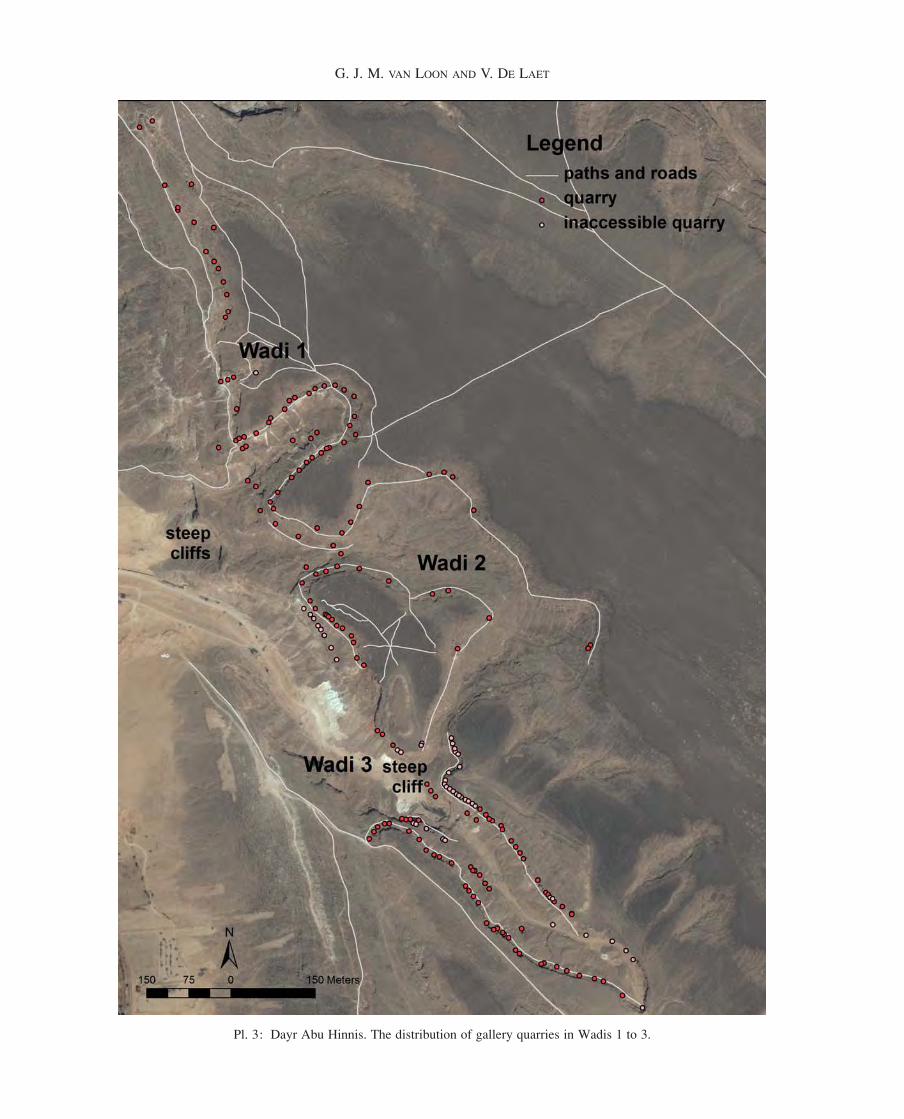
Pl. 3: Dayr Abu Hinnis. The distribution of gallery quarries in Wadis 1 to 3.
G. J. M. VAN LOON AND V. DE LAET
97028.indb 279 16/10/14 14:44
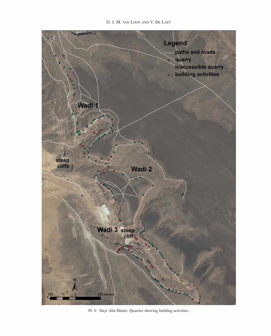
Pl. 4: Dayr Abu Hinnis. Quarries showing building activities.
G. J. M. VAN LOON AND V. DE LAET
97028.indb 280 16/10/14 14:44
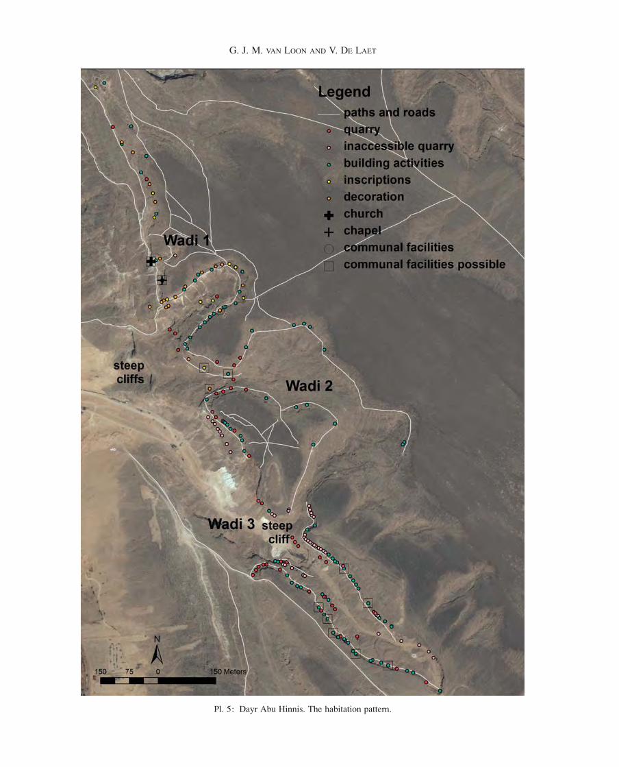
Pl. 5: Dayr Abu Hinnis. The habitation pattern.
G. J. M. VAN LOON AND V. DE LAET
97028.indb 281 16/10/14 14:44