
Model ALADIN as regional climate model for Central and Eastern Europe
20
Stud. Geophys. Geod., 54 (2010), 313332 313 © 2010 Inst. Geophys. AS CR, Prague MODEL ALADIN AS REGIONAL CLIMATE MODEL FOR CENTRAL AND EASTERN EUROPE ALEŠ FARDA 1 , MICHEL DÉQUÉ 2 , SAMUEL SOMOT 2 , ANDRÁS HORÁNYI 3 , VALERY SPIRIDONOV 4 AND HELGA TÓTH 3 1 Czech Hydrometeorological Institute, Prague, Czech Republic ([email protected]) 2 Centre National de Recherches Météorologiques (Météo France/CNRS), GAME/CNRM, Toulouse, France ([email protected], [email protected]) 3 Hungarian Meteorological Service, Budapest, Hungary ([email protected], [email protected]) 4 National Institute of Meteorology and Hydrology, Sofia, Bulgaria ([email protected]) Received: May 6, 2008; Revised: June 7, 2009; Accepted: October 30, 2009 ABSTRACT Results obtained with two versions of the Limited Area Model (LAM) ALADIN over differently sized integration domains (large, intermediate and small) in the European area are presented in order to investigate both the general model performance and the influence of domain choice on the quality of obtained results. The aim is also to illustrate the issues related to the strategy of selection of the optimal integration domain. Each of these studies has been performed with two versions of the ALADIN model: the first one is ALADIN-CLIMATE developed at CNRM/Météo-France, the second one is ALADIN- CLIMATE/CZ prepared at the Czech Hydrometeorological Institute (CHMI). This leaves us with total of six experiments forced by the European Centre for Medium-Range Weather Forecasts (ECMWF) ERA-40 reanalysis data. The west Balkan domain covering Bulgaria is used as an evaluation region for investigation of the temporal and spatial properties of simulated precipitation and temperature fields. This region has been selected for its challenging orography making the results obtained here a valuable source for studies leading to further developments in climate modeling. It was found that size of the domain strongly affects the quality of obtained results. We have found that the largest domain reproduces the spatial characteristics of climate (such as bias) very well, but its use results in a poor representation of temporal aspects, which are however captured very well in experiments over both smaller domains. Our findings suggest that there is no optimal choice of domain size, securing the best results for both spatial and temporal evaluation. Our study also proves that model ALADIN can be efficiently used for climate research purposes, which together with its modest computational demands should make it as an attractive modeling choice for the Central and Eastern European climate research community. K e y w o r d s : ALADIN, climate modeling, domain size, ECMWF, ERA-40 reanalysis
-
Upload
independent -
Category
Documents
-
view
0 -
download
0
Transcript of Model ALADIN as regional climate model for Central and Eastern Europe

Stud. Geophys. Geod., 54 (2010), 313332 313 © 2010 Inst. Geophys. AS CR, Prague
MODEL ALADIN AS REGIONAL CLIMATE MODEL FOR CENTRAL AND EASTERN EUROPE
ALEŠ FARDA1, MICHEL DÉQUÉ2, SAMUEL SOMOT2, ANDRÁS HORÁNYI3, VALERY SPIRIDONOV4 AND
HELGA TÓTH3
1 Czech Hydrometeorological Institute, Prague, Czech Republic ([email protected]) 2 Centre National de Recherches Météorologiques (Météo France/CNRS), GAME/CNRM,
Toulouse, France ([email protected], [email protected]) 3 Hungarian Meteorological Service, Budapest, Hungary ([email protected],
[email protected]) 4 National Institute of Meteorology and Hydrology, Sofia, Bulgaria
Received: May 6, 2008; Revised: June 7, 2009; Accepted: October 30, 2009
ABSTRACT
Results obtained with two versions of the Limited Area Model (LAM) ALADIN over differently sized integration domains (large, intermediate and small) in the European area are presented in order to investigate both the general model performance and the influence of domain choice on the quality of obtained results. The aim is also to illustrate the issues related to the strategy of selection of the optimal integration domain. Each of these studies has been performed with two versions of the ALADIN model: the first one is ALADIN-CLIMATE developed at CNRM/Météo-France, the second one is ALADIN-CLIMATE/CZ prepared at the Czech Hydrometeorological Institute (CHMI). This leaves us with total of six experiments forced by the European Centre for Medium-Range Weather Forecasts (ECMWF) ERA-40 reanalysis data. The west Balkan domain covering Bulgaria is used as an evaluation region for investigation of the temporal and spatial properties of simulated precipitation and temperature fields. This region has been selected for its challenging orography making the results obtained here a valuable source for studies leading to further developments in climate modeling. It was found that size of the domain strongly affects the quality of obtained results. We have found that the largest domain reproduces the spatial characteristics of climate (such as bias) very well, but its use results in a poor representation of temporal aspects, which are however captured very well in experiments over both smaller domains. Our findings suggest that there is no optimal choice of domain size, securing the best results for both spatial and temporal evaluation.
Our study also proves that model ALADIN can be efficiently used for climate research purposes, which together with its modest computational demands should make it as an attractive modeling choice for the Central and Eastern European climate research community.
Ke y wo rd s : ALADIN, climate modeling, domain size, ECMWF, ERA-40 reanalysis

A. Farda et al.
314 Stud. Geophys. Geod., 54 (2010)
1. INTRODUCTION
Global circulation models are the most widespread and successful tools employed for both numerical weather forecast and climate research since the 1980s. However, growing demands on accurate and reliable information on regional and sub-regional scale are not directly met by relatively coarse resolution global models, mainly due to the excessive costs affiliated with the use of the model in very high resolution. This handicap prompted the search for alternative approaches combining both relative cheapness and sufficient accuracy when addressing atmospheric processes at high resolutions (compared to global circulation models). Statistical downscaling is a widely used technique based on statistical identification of characteristic local features using global model information as an input for a prediction of the behavior on the local scale (e.g., Huth, 2002 or Wilby et al., 1998). An alternative to this cheap and approach is a so-called dynamical downscaling aspiring to describe local developments directly by simulation of physical processes acting on the local scale below the resolution of global model (e.g., Giorgi and Mearns, 1999). The latter approach thus allows for accounting of finer-scale processes on physical basis, comparing to a solely statistical downscaling, e.g. greenhouse gas concentration. A regional model, whilst mostly copying internal structure of the global model, is applied for a selected limited area only, in order to limit costs linked to high resolution necessary for description of the processes unresolved by GCMs.
This tool is, however, still relatively new and its fully comprehensive evaluation has not been completed yet (De Elia et al., 2008; Rauscher et al., 2006; Leduc and Laprise, 2009). The impact of the domain size remains an open question for long integrations (Jones et al., 1995; Bhaskaran et al., 1996). To our knowledge, the only study dealing with ten years or longer integration period is quite new (Lucas-Picher et al., 2008) and has been carried out with a model over the American continent. One of the conclusions of this study is the need to redo their experiments with other models and on more domains. In our study, we aim to address the question of model performance with respect to domain size, using two models differing mainly in their physical parameterization packages over three European domains. We focus on temporal and spatial aspects of precipitation and temperature fields during the ten-year-long period. We employ a “perfect boundary” approach by selecting ECMWF ERA-40 re-analysis as initial and lateral boundary conditions for our experiments. In fact, for this purposes it is possibly most often used forcing for Europe up to now providing well-validated large-scale information at resolution of approximately 125 km for the period of 19582002.
In Section 2 basic information on the development of the LAM ALADIN is provided, in Section 3 we introduce basic concepts of the model together with a brief description of its physical parameterizations used in both versions. Our methodology is described in Section 4; the results are presented in Section 5. Their discussion and conclusions are given in Section 6.
2. MODEL HISTORY
Model ALADIN has been proved to be a very effective tool for short-range (typically up to 72 hours) weather forecast during the last decade. Being developed by the

Model ALADIN as Regional Climate Model for Central and Eastern Europe
Stud. Geophys. Geod., 54 (2010) 315
international consortium of European and North African countries under the leadership of Meteo-France it is widely employed by various national meteorological services particularly in Central and Eastern Europe. Given its status as one of the most widespread weather forecast limited area models (LAM) in Europe an effort to investigate its feasibility to be employed for long-range integrations necessary for climate research studies has been launched in several countries during the recent time. The first model evaluations confirmed the ability of model to sustain long-time integrations and to capture climate characteristics during those experiments (Farda et al., 2007). Owing to this fact, climate versions of the ALADIN model have been utilized in the frame of international research projects (e.g. EC FP6 ENSEMBLES and CECILIA).
The basic concept of the model is described in Horányi et al. (1996), its non-hydrostatic version in Bubnová (1995) and more recent physical parameterizations in Gerard (2001). ALADIN is a popular model for the European meteorological services thanks to its combination of modest computational demands and high efficiency. Its origin could be tracked back to the early nineties when it was originally designed as a tool for pure downscaling (dynamical adaptation) of weather forecasts produced by the global model ARPEGE used at Météo-France. The first study investigating ALADIN performance during long-time integration based on a one-month experiment was conducted by Janišková (1995). Results proved that the model is well suited to provide stable and sufficiently realistic results in climate mode without any destructive accumulation of systematic errors. Lately, after the year 2000 tests with that-day version of the model were launched at CNRM/Metéo-France and CHMI independently. Results of those tests confirmed model stability and capability to perform sufficiently realistic long time integrations. Since that time, climate versions of the model ALADIN have been used in more projects on national and international level like EC FP6 ENSEMBLES (Hewitt and Griggs, 2004) or EC FP6 CECILIA (www.cecilia-eu.org).
3. MODEL DESCRIPTION
Contrary to the majority of regional climate models (which are “grid-point” models), ALADIN has been designed as spectral model with the exception that all physical parameterization computations are performed in the conventional grid-point space. This approach also requires employment of effective direct and inverse spectral transformations between spectral and grid-point spaces. For the design of global models the spectral representation can be considered to be the primary choice, especially given the application of spherical harmonics, suitable for fitting to the entire globe. In case of LAM, other basic functions should be considered, such as full harmonics functions (exponential functions periodic in both directions), employed also by ALADIN. In order to guarantee bi-periodicity, a projection of model area on torus is used (Fig. 1). This choice has also an additional implication for the internal organization of the integration area, which means that in addition to the Davies relaxation zone (Davies, 1976), a third zone must be also specified: the so called extension zone, which secures the bi-periodicity of the meteorological fields required by the choice of the basic functions (Fig. 1).
ALADIN, even though a spectral model, is utilizing standard “grid-point” coupling method based on the approach suggested by Davies. However, spectral coupling

A. Farda et al.
316 Stud. Geophys. Geod., 54 (2010)
technique has been experimentally introduced into the model at CNRM/MF and is a subject of intensive studies with aim to introduce it as an equal coupling method in the future (Radu et al., 2008).
Another characteristic feature of ALADIN model is its dynamical core based on semi-implicit semi-Lagrangian (SISL) scheme inherited from the global model ARPEGE and described for example in Temperton et al. (2001). The structure of the core also allows for employment of other variants of the advection scheme including the Eulerian formulations. However, due to its good overall performance together with modest computational demands, SISL scheme remains the most widely used option within ALADIN community.
In this contribution, results obtained from two different model versions are presented: CNRM’s ALADIN-CLIMATE with physical parameterization package derived directly from that one used in GCM ARPEGE-CLIMAT 4 (Déqué, 2007) and ALADIN-CLIMATE/CZ (Farda et al., 2007) based on the numerical weather prediction version in recent operational use at CHMI. The Czech version is working with the physical parameterization packages being developed specifically for future addressing the so-called grey-zone resolution area (37 km resolution range). Whilst sharing the same dynamical core and basic principles and formulations, both model versions differ significantly in their respective physical parameterizations packages, as described below in the text.
3 . 1 . A L A D I N - C L I M A T E
Fouquart and Morcrette radiation scheme (FMR) designed according to the concept of Morcrette (1989) and based on ECMWF model including the effects of 5 greenhouse gases (O3, CO2, CH4, N2O, CFC) and incorporating direct effects of aerosols based on Tegen monthly climatology (Tegen et al., 1997).
Interaction of Soil Biosphere Atmosphere (ISBA) scheme comprising of four layers of soil temperature without a deep relaxation, two soil moisture layers (with parameterization of soil freezing) and a single layer snow model (with variable
Fig. 1. Projection of limited area on torus and its realization in ALADIN (left) and internal structure of ALADIN integration area (right). Letter E stands for extension, I for Davies relaxation and C for central zone.

Model ALADIN as Regional Climate Model for Central and Eastern Europe
Stud. Geophys. Geod., 54 (2010) 317
albedo and density), based on Douville et al. (1995). Vegetation and soil properties are characterized by point and month dependent soil and vegetation properties.
Deep convection scheme designed according to Bougeault (1985) with additionally modified downdraught part of the scheme.
Cloudiness-precipitation and vertical diffusion scheme (Ricard and Royer, 1993) using predefined Bougeault PDF functions (stratiform clouds and precipitation) and based on diagnostic turbulent kinetic energy (TKE) according to Mellor and Yamada (1982).
Gravity wave drag scheme with the parameterization of mountain blocking and lift effects based on mean orography
3 . 2 . A L A D I N - C L I M A T E / C Z
New improved version of ACRANEB radiation scheme described in Ritter and Geleyn (1992), utilizing “ two stream” approach with improved computation in short-wave radiation area based on Net Exchange Rate (NER) formalism. Absorption and diffusion by gases is computed with help of spectral Malkmus band model (Malkmus, 1967) and Padé formula for combination of optical thicknesses of more gases and linear formula for absorption by gray bodies.
ISBA scheme, same as in the case of French version. Deep convection scheme designed according to Bougeault (1985), including the
entrainment and detrainment profiles with description of precipitation processes. Simple diagnostic cloudiness scheme together with large-scale precipitation
parameterization (including evaporation of droplets), described in Gerard (2001). Parameterization of planetary boundary layer (PBL) processes including turbulence
together with shallow non-precipitating convection and vertical diffusion. Gravity wave drag scheme with the parameterization of mountain blocking and lift
effects based on mean orography. Semi-Lagrangian horizontal diffusion scheme with two-dimensional semi-
horizontal interpolators according to Váňa (2008).
4. METHODOLOGY
To assess overall performance of both model versions, three experiments were designed. For their description and basic characteristics refer to Table 1; the integration domains are displayed in Fig. 2. French and Czech versions are distinquished in the name of the experiment: FR in case of French version, CZ for the Czech one. 6 experiments in total were realized (two model versions and three domains). The domain design has been chosen with the aim at comparing model behavior over a) large pan-European (ENS) domain originally designed for ENSEMBLES project (Hewitt and Griggs, 2004), b) intermediate (HUNG) domain covering the wider central part of Europe and c) small west Balkan peninsula (BULG) domain. It was decided to use spatial resolution of 25 km for all domains, as it is a typical resolution for contemporary regional climate models, making a reasonable description of orographic details possible.
ECMWF ERA-40 re-analysis described in Uppala et al. (2005) has been used as lateral boundary conditions. While the ENS experiment runs cover the years 19602000,

A. Farda et al.
318 Stud. Geophys. Geod., 54 (2010)
both remaining experiments were run for 19902000 only. We are going to present bias maps for model Mean Sea Level Pressure (MSLP) fields compared to that of ERA-40 re-analysis for both models in order to illustrate their performance in reproducing characteristic atmospheric circulation features over the European area as captured on ENS domain.
In order to further verify the performance of the models during the summer (JJA) and winter (DJF) seasons, precipitation and 2-m mean temperature biases have been computed. For the validation we have employed the University of East Anglia - Climate Research Unit dataset CRU TS1.2 (Mitchell et al., 2004) in horizontal resolution of 50 km
Table 1. Basic description of domain choices and experiment setups: experiments are further distinguished by adding into the experiment ID.
Experiment ID Projection Geometry Center Time Span Resolution [km]
Time Step [s]
BULG Lambert 53 53 points 26.9E 42.7N 19902000 25 900 HUNG Lambert 109 109 points 19.8E 49.1N 19902000 25 900 ENS Lambert 183 205 points 14.7E 51.3N 19602000 25 900
Fig. 2. Domain choices and their location together with the model orography: ENS is the largest domain, HUNG covers the wider Central European territory whilst the BULG domain extends over east Balkan and western part of Black Sea. The evaluation area over Bulgaria is marked by dots.

Model ALADIN as Regional Climate Model for Central and Eastern Europe
Stud. Geophys. Geod., 54 (2010) 319
(available only over land) in monthly means for the years 19012000. An additional masking has been applied in order to reject the points considered to be over land in CRU but over the sea in the model domain (a typical example are Faeroer Islands). The evaluation is focusing on BULG domain, which means that the outputs from ENS and HUNG experiments are also compared for that area, therefore all the experiments are inter-compared over one region (see Fig. 2). In the current study we choose to focus on the South-East Europe as it is one of the most difficult area to simulate using RCMs in Europe (see Jacob et al., 2007 for example) as well as the area of maximum RCM internal variability (Sanchez-Gomez et al., 2009).
We are also presenting the results of our experiments in the form of temporal Taylor diagrams (Dimitrijevic and Laprise, 2005) designed according to principles in Taylor (2001). This presentation is a transparent graphic tool allowing for a combination of information on temporal aspects of model performance. The parameters are computed from the seasonal mean time series and they are as follows: correlation between the model fields and the observed dataset represented by their spatial average value, the ratio between the variance of the model field and observed data and the normalized centered mean square error of the model with respect to the observed data. This technique allows for direct inter-comparison of model temporal consistency, temporal variability and accuracy measured as the centered MSE against the observational data. The information contained in Taylor diagram should be interpreted in the following way: ratio of model (1a) and dataset (1b) variances is displayed on the radial axis, with standard deviations f (r) of the modeled (measured) field computed as
22
1
1 Tf t
tf f
T
, (1a)
22
1
1 Tr t
tr r
T
, (1b)
where T is the number of time steps, tf and rt represent the spatial average values of model field and reference field, respectively, f and r are the time averages of tf and rt, respectively. The correlation R is then marked on angular axis as:
1
1 Tt t
t
f r
f f r rT
R
. (2)
Finally, the centered MSE ( 2E ) between model and reference field is expressed as a mean square difference of the centered variables normalized by the reference variance ( 2
r ):
2
122
1 Tt t
t
r
f f r rT
E
. (3)
A. Farda et al.
320 Stud. Geophys. Geod., 54 (2010)
5. RESULTS
5 . 1 . M e a n S e a L e v e l P r e s s u r e ( M S L P )
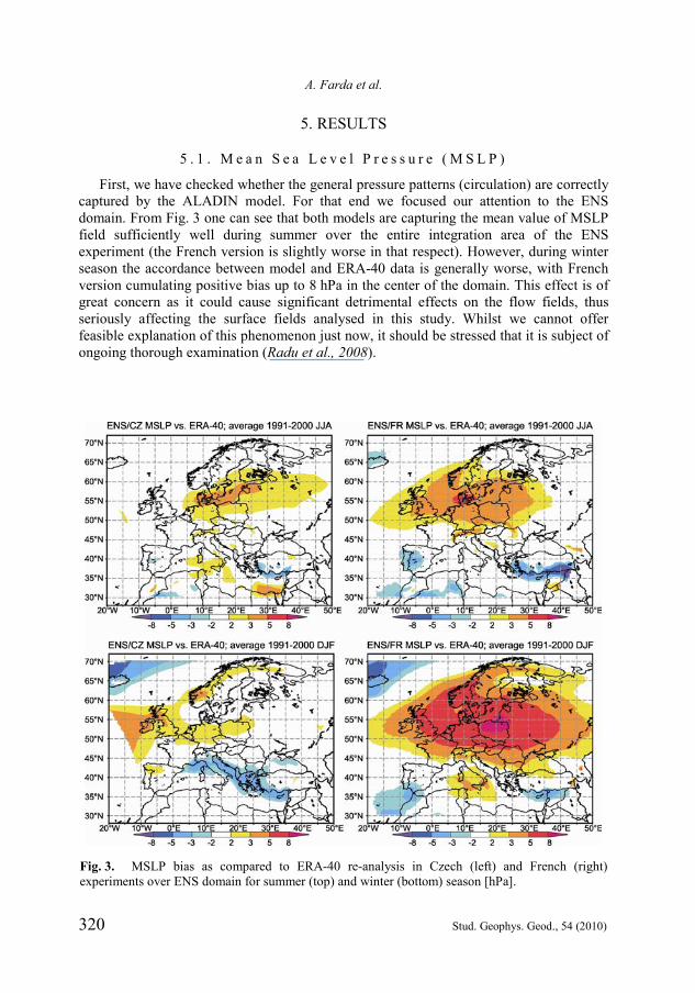
First, we have checked whether the general pressure patterns (circulation) are correctly captured by the ALADIN model. For that end we focused our attention to the ENS domain. From Fig. 3 one can see that both models are capturing the mean value of MSLP field sufficiently well during summer over the entire integration area of the ENS experiment (the French version is slightly worse in that respect). However, during winter season the accordance between model and ERA-40 data is generally worse, with French version cumulating positive bias up to 8 hPa in the center of the domain. This effect is of great concern as it could cause significant detrimental effects on the flow fields, thus seriously affecting the surface fields analysed in this study. Whilst we cannot offer feasible explanation of this phenomenon just now, it should be stressed that it is subject of ongoing thorough examination (Radu et al., 2008).
Fig. 3. MSLP bias as compared to ERA-40 re-analysis in Czech (left) and French (right) experiments over ENS domain for summer (top) and winter (bottom) season [hPa].

Model ALADIN as Regional Climate Model for Central and Eastern Europe
Stud. Geophys. Geod., 54 (2010) 321
Fig. 4. 2-m mean temperature field over the BULG domain compared to CRU for the JJA season [C]. ENS experiment is on upper, HUNG experiment is on the middle and BULG experiment is on the bottom row. Czech model version is at left, the French one is at right.

A. Farda et al.
322 Stud. Geophys. Geod., 54 (2010)
5 . 2 . M e a n T e m p e r a t u r e a n d P r e c i p i t a t i o n F i e l d S p a t i a l P r o p e r t i e s
The results of simulated precipitation and 2-m mean temperature fields were visually compared to CRU dataset are for DJF (winter) and JJA (summer) seasons for each model version over the BULG domain. Additionally, for more objective evaluation, we have also computed RMSE and bias for all the experiments. The evaluation area covers Bulgaria and is defined as a rectangular region (see also Fig. 2) between points 40N, 22E (south-west) and 46N, 32E (north-east). Data over sea has been omitted from the calculations. In case of the bias maps, model data are compared to CRU dataset directly, without any conversion attributed to the different orography between the models and dataset. The possible relative impact of the correction is negligible because all 6 experiments use the same model orography and have the same horizontal and vertical resolutions. Consequently, omitting this correction doesn’t affect the inter-comparison of the simulations, only their relation to CRU.
One can see that both models are showing some positive summer temperature bias over lowlands situated in the northern half of the domain for the ENS experiments (Fig. 4). In addition, cold bias is visible in mountainous areas in the southern half of the domain, which is especially true for the HUNG and BULG domains. The experiments executed for HUNG and BULG domains are generally colder than those for the ENS one. The biggest cold bias between all the experiments can be found for the Czech model over the HUNG domain, but it is largely diminished for the BULG run. The general behavior of the French model is slightly different, while also being colder when comparing to its ENS domain. The biases for the smaller domains are similar.
From Table 2 we could assert on models’ performance in sense of root mean square error value (RMSE) during individual seasons. Regarding the summer temperature errors, both models are rather close to each other for the ENS domain, with RMSE around 1C. The performance is worse in experiments over HUNG domain and the largest differences between the two models can be found over the BULG domain (where the RMSE of the Czech model remains just under the value of 1C whilst the French version shows the increase to 1.66C).
Table 2. Root Mean Square Error (RMSE) over selected Balkan (4046N, 2232 ) area for both models and seasons with respect to CRU data. Best performing experiment results are shown in bold.
Mean Temperature [C] Precipitation [mm/day]
JJA ENS HUNG BULG ENS HUNG BULG Czech 0.88 1.64 0.93 0.50 0.71 0.74 French 1.04 1.32 1.66 0.34 0.81 1.43
Mean Temperature [C] Precipitation [mm/day]
DJF ENS HUNG BULG ENS HUNG BULG Czech 0.95 1.40 1.84 0.39 0.38 0.42 French 1.59 2.25 1.82 0.62 0.29 0.30

Model ALADIN as Regional Climate Model for Central and Eastern Europe
Stud. Geophys. Geod., 54 (2010) 323
Fig. 5. 2-m mean temperature field over the BULG domain compared to CRU for the DJF season [C]. ENS experiment is on upper, HUNG experiment is on the middle and BULG experiment is on the bottom row. Czech model version is at left, the French one is at right.

A. Farda et al.
324 Stud. Geophys. Geod., 54 (2010)
Fig. 6. Precipitation fields over BULG domain compared to CRU for the JJA season [mm/day]. ENS experiment is on upper, HUNG experiment is on the middle and BULG experiment is on the bottom row. Czech model version is at left, the French one is at right.

Model ALADIN as Regional Climate Model for Central and Eastern Europe
Stud. Geophys. Geod., 54 (2010) 325
Fig. 7. Precipitation fields for BULG domain compared to CRU for the DJF season [mm/day]. ENS experiment is on upper, HUNG experiment is on the middle and BULG experiment is on the bottom row. Czech model version is at left, the French one is at right.

A. Farda et al.
326 Stud. Geophys. Geod., 54 (2010)
In winter, the cold bias is present in all 6 experiments, but its value remains lowest for ENS runs (as seen from the visual interpretation of fields at Fig. 5). All 6 runs show remarkably consistent behavior and remain generally close to each other. There is no apparent difference between integrations over both smaller domains. This is, however, valid only for visual evaluation as there are differences, for example, in RMSE value between model versions over HUNG area. Moreover, the assessment based on RMSE (Table 2) shows higher values for the larger domains in case of French model than it is the case of Czech model. Nevertheless, in case of integration over BULG domain both model’s RMSE value is similar at ~1.8C, corresponding with persistent cold model bias as shown on Fig. 5.
The summer precipitation bias remains limited in simulations over ENS domain, but gradually grows and becomes predominantly positive (precipitation excess) with decreasing domain size, leaving the BULG experiments as the wettest ones in both model versions (albeit this effect is more pronounced within the French model). Precipitation patterns remain similar in both models (probably due to the common orography). Additionally, the excessively high precipitation (particularly for BULG experiment) can be attributed to the proximity to the model’s coupling zone and related problems such as unrealistically generated vertical velocities (Fig. 6, bottom row). Assessment of RMSE values reveals similar behavior of models as far as larger domains are concerned, but in case of BULG experiment the RMSE from the French model is almost double than the value extracted from the Czech one. It should be also stressed that values of RMSE grow with decrease of domain size (especially for the French version).
Switching to the winter precipitation (Fig. 7), all experiments except the generally dryer French realization of ENS run (top right) perform qualitatively very well and in good accordance with each other. RMSE values reflect these differences from summer simulations well: RMSEs are smaller than 0.5 mm/day except for the French ENS run where the RMSE reaches the value of 0.62 mm/day as the consequence of the model dry bias. We are tempted to interpret this bias as an impact of the pressure overestimation (illustrated in Fig. 3), which could lead to unrealistically strong advection of continental dry air over the Bulgarian region.
5 . 3 . M e a n T e m p e r a t u r e a n d P r e c i p i t a t i o n F i e l d T e m p o r a l P r o p e r t i e s
Ten years of integration time represent sufficient base for the investigation of temporal characteristics in simulated fields. The values of temporal correlation, mean square error and ratio of the time variances are displayed in the form of Taylor diagrams (Figs. 8 and 9). Fig. 8 shows the properties of temperature fields. Summer situation (left) is characterized by generally high values of time correlation for all domains (ENS and BULG experiments are scoring in the interval 0.7, 0.85tR , with best performance in case of the BULG French realization and worst performance for HUNG experiment executed with the Czech model). In sense of variance and MSE, smaller domains experiments show significantly better results than is the case of ENS domain experiments. It could be also noted that the French model underestimates both variance and MSE for smaller domains, while the Czech model tends to overestimate. This is not, however, valid for ENS domain over which MSE and variance values are unrealistically high.

Model ALADIN as Regional Climate Model for Central and Eastern Europe
Stud. Geophys. Geod., 54 (2010) 327
For winter, the feature to be noted is a good temporal correlation for both HUNG and BULG experiments, 0.9, 0.98tR , with poorer values for ENS experiments. Both temporal variability and standard deviation are significantly reduced compared to the summer season.
In case of precipitation field (Fig. 9), we generally obtained lower values for temporal correlation during summer season (left). ENS domain based experiments are less correlated than experiments executed over both smaller domains. In contrast, HUNG and BULG domains are showing higher values of MSE and overestimated variability. In winter (Fig. 9, right), there is a pronounced difference between large-sized ENS domain on the one side and both smaller domains on the other side. The precipitation from smaller
Fig. 8. Taylor diagram showing temporal characteristics for simulated 2-m mean temperature field. Variability is fitted into the picture. JJA fields are on the left, DJF field are on the right.
Fig. 9. Taylor diagram showing temporal characteristics for simulated precipitation field: variability is fitted into the picture. JJA fields are on the left, DJF field are on the right.

A. Farda et al.
328 Stud. Geophys. Geod., 54 (2010)
domains shows fairly good correlation and very realistic variability in the simulated fields. The accuracy of the model outputs on the large ENS domains is lower in these respects. In case of French realization (still for the ENS domain), the correlation Rt is as low as 0.2 and for the Czech version the correlation of 0.8 is combined with increased values of MSE and variability. As a possible explanation one could suggest that during the summer season the weaknesses in the parameterization of deep convection might be responsible for development of different temporal patterns than the observed one. This is particularly likely in case of large ENS domain where the influence of physical parameterizations on the output fields is generally higher than in case of smaller domains, whose limited area doesn’t provide so much “opportunity” for model physics to affect the fields. The experiments on smaller domains could thus be interpreted as closer to mere downscaling of information obtained from large scale fields provided by the lateral boundary input data. The higher values of variability ratio and MSE are a direct consequence of increased precipitation, which can be observed in the models (smaller domains) during summer (as illustrated in Fig. 6). In case of the small BULG domain, it could be explained as the direct influence of unrealistic generation of vertical velocities in the coupling zone of the model, which affects directly even the interior of this rather limited domain. Another factor could be the complicated orography of this domain with more major mountain ranges adding both to orographically generated precipitation and to the uncertainty in the observed dataset due to the problem of correct precipitation observation in the mountainous area and its representativeness.
Absence of correct level deep convection and faster synoptic systems as interfering phenomena could then explain high correlation values in winter in case of small areas. However, the ENS domain is so large that its generated synoptic situations could already depart from reality, leading to decreased agreement with observed CRU data also in the non-convective season. This phenomenon (if the abovementioned speculation is true) makes a strong argument in favor of spectral coupling (von Storch et al., 2000) as such technique preserves large-scale features of the driving fields (like traveling cyclones) whilst allowing regional model to act on small scale unaddressed by driving data. It should be also noted that in winter the correlation of precipitation in the ENS experiment with the French model is lower than during summer. This indicates either limited universality of suggested explanation, or at least pointing out to the existence of different mechanisms acting during some seasons.
Generally one can conclude that the investigation of the temporal properties has revealed model outputs for both smaller domains as superior to use of pan-European ENS domain. This behavior is again typical for both model versions.
6. DISCUSSION
The novelty of our study is the fact that two climate research centers joined together to investigate properties and quality of results obtained via two versions of the regional climate model over three differently sized domains. The differences in in extension of single domains represent different approaches to the utilization of regional climate models. When assessing the outputs from the ENS domain (covering the area of wider Europe) through medium sized HUNG domain (representing the extended Central

Model ALADIN as Regional Climate Model for Central and Eastern Europe
Stud. Geophys. Geod., 54 (2010) 329
European area) to the small BULG domain (covering the Western Balkan peninsula with the focus on Bulgaria), qualitatively different responses were received when looking at either spatial or temporal aspects of model performance. However, when contemplating our results, we should bear in mind the assymetry of the selected study area with respect to larger domains. It is particularly valid for the ENS domain.
Simulations also revealed some differences between the French and Czech versions: in case of the French model, we observed dry and warm (up to 12C) bias of Celsius over ENS domain, which was weaker or completely reversed over both remaining smaller domains. No such a behavior was observed in case of the Czech model. We believe that the positive pressure anomaly in the French model executed over the ENS domain (which is present neither in any of the Czech experiments nor in French ones executed over the smaller domains) could be considered directly responsible for the aforementioned biases in mean temperature and precipitation.
It was found that the largest domain, ENS, to be the best choice concerning the bias for temperature field when comparing against observed (CRU) dataset. This conclusion is also valid for precipitation in the French model during both seasons and Czech model for summer precipitation. In this point our findings contradict conclusions of Leduc and Laprise (2009). At this stage we cannot offer extensive explanation of this disagreement. Some factors, which could be (or not) responsible are the difference in definitions of large/small integration areas in both studies and possibly the differences between model formulations.
When looking at bias detected in case of both smaller domains, however, we cannot offer similarly clear conclusions in ranking domains and model versions. We should note that both model versions tend to cumulate cold bias during the studied period. In case of precipitation we could once again identify a good accordance between model outputs and measured dataset for the summer season, but this agreement doesn’t persist in smaller domains, which tends to cumulate significant wet bias of up to more than 3 mm/day over the south Carpathian mountain ranges in experiments over the BULG domain. We attribute this result to the effects connected to model coupling zone situated over mountainous landscape. Additionally, proximity of integration borders in the east and south could be held partly responsible for similarities in results retrieved from those domains. During the winter models reasonably agree with each other and to measured dataset over smaller domains. This accordance is slightly worse in case of the ENS domain where the Czech model tends to produce a slight wet bias whilst the French one shows an opposite tendency (dry bias).
Concerning the quality of the simulations in terms of spatial variability, we have revealed that models tend to be slightly cooler and increasingly wet with decreasing domain size. At this stage we suggest that the influence of boundary zone could be responsible at least for a part of the effect in case of middle-sized HUNG domain, whilst in case of small-sized BULG domain it probably affects the whole interior of the domain rendering it too small for realistic climate simulations in the sense of bias reduction.
The interpretation of temporal characteristics associated with simulated fields is not as straightforward as it is in the case of spatial patterns. During the summer, temperature fields seem to be correlated similarly for majority of runs, with notable exceptions of the Czech HUNG experiment (worst performance) and French BULG experiment (best performance). In sense of variance ratio and MSE, the results over smaller domains are

A. Farda et al.
330 Stud. Geophys. Geod., 54 (2010)
better than products of ENS experiments, which yielded unrealistically high values of the former quantity. During the winter, ENS experiments outputs show more realistic values for variance and MSE, albeit with lower correlation than in summer season. Results for smaller domains are very well correlated and remain close to each other. Similarly, precipitation fields retrieved from ENS domain experiments are poorer correlated with observed data than the other two runs. In the winter, the correlation, ratio of variance and MSE indicate good accordance with observed dataset for smaller domains. In summer, we cannot see similar performance: variance ratio and MSE are too high whilst correlation is lower.
Reagarding the temporal aspects of simulated fields, the ENS domain is clearly the worst choice. Use of both smaller domains yields significantly better outcomes. At this stage we can un-authoritatively offer HUNG sized domain as a better choice for studies dealing with temporal aspects of simulated fields. The BULG domain seems to be too small and thus its interior is affected with problems originating from coupling strategy. Considering all the above, we cannot identify a single best domain as the one guaranteeing best model results in every aspect. Instead, our results lead us to believe that no such universal integration area exists. In sense of spatial properties, the quite extensive ENS domain turned out to be the best choice. Nevertheless, when investigating temporal properties of simulated fields, experiments executed over ENS showed poor qualities and were convincingly outperformed by experiments on smaller domains. These conclusions are valid for both model versions.
Our recommendation is that the future studies should be designed with respect to their specific purpose and attempts to design a “universal experiment domain” would negatively impact the quality of the simulation in particular aspects. At this point we should also stress that our findings are based on examination of results obtained with only three different domains over the same region (Europe). To validate the universality of our findings, more extensive studies over more domains in different regions will be needed. Moreover, for the time being we consider our findings to be representative for only the ALADIN model family and it remains to be seen whether the same conclusions could be drawn for different regional climate models.
Acknowledgements: This study was supported by the FP6 EU projects ENSEMBLES (Contract
Number GOCE-CT-2003-505539) and CECILIA (Contract Number 037005.). Furthermore the work was partially supported in Hungary by the Hungarian National Office for Research and Technology (Grant No. 3A/082/2004) and the Janos Bolyai Research scholarship of the Hungarian Academy of Sciences. The authors also would like to express their thanks to Petr Skalák (CHMI) for his kind help with drawing Fig. 2 and help with the proof reading and further to those who have either directly or indirectly helped to carry out this study, particularly many people involved in the ARPEGE/ALADIN community.
References
Bhaskaran B., Jones R.G., Murphy J.M. and Noguer M., 1996. Simulations of the Indian summer monsoon using a nested regional climate model: Domain size experiments. Clim. Dyn., 12, 573587.
Bougeault P., 1985. A simple parameterization of the large-scale effects of cumulus convection. Mon. Weather Rev., 113, 21082121.

Model ALADIN as Regional Climate Model for Central and Eastern Europe
Stud. Geophys. Geod., 54 (2010) 331
Bubnová R., Hello G., Bénard P. and Geleyn J.-F., 1995. Integration of the fully elastic equations cast in the hydrostatic pressure terrain-following coordinate in the framework of ARPEGE/Aladin NWP system. Mon. Weather Rev., 123, 515535.
Davies H.C., 1976. A lateral boundary formulation for multi level prediction models. Q. J. R. Meteorol. Soc., 102, 405418.
de Elia R., Plummer D., Caya D., Frigon A., Côté H., Giguère M., Paquin D., Biner S. and Harvey R., 2008. Evaluation of uncertainties in the CRCM-simulated North American climate: nesting-related issues. Clim. Dyn., 30, 113132.
Déqué M., 2007. Frequency of precipitation and temperature extremes over France in an anthropogenic scenario: model results and statistical correction according to observed values. Glob. Planet. Change, 57, 1626.
Dimitrijevic M. and Laprise R., 2005. Validation of the nesting technique in a regional climate model and sensitivity tests to the resolution of the lateral boundary conditions during summer. Clim. Dyn., 25, 550580.
Douville H., Royer J.-F. and Mahfouf J.-F., 1995. A new snow parametrization for the Météo-France climate model. Part I: Validation in stand-alone experiments. Clim. Dyn., 12, 2135.
Farda A., Štěpánek P., Halenka T., Skalák P. and Belda M., 2007. Model ALADIN in climate mode forced with ERA-40 reanalysis (coarse resolution experiment). Meteorological Journal, 10, 123130.
Gerard L., 2001. Physical parameterizations in ARPÉGE-ALADIN operational model. ALADIN Documentation, Météo-France, 130 pp.
Hewitt C.D and Griggs D.J., 2004. Ensembles-based predictions of climate changes and their impacts. Eos Trans. AAGU, 85, 566.
Horányi A., Ihász I. and Radnóti G., 1996. ARPEGE/ALADIN: A numerical weather predicition model for Central-Europe with the participation of the Hungarian Meteorological Service. Időjárás, 100, 277300.
Huth R., 2002. Statistical downscaling of daily temperature in central Europe. J. Climate, 15, 17311742.
Jacob D., Bärring L., Christensen O.B., Christensen J.H., de Castro M., Déqué M., Giorgi F., Hagemann S., Hirschi M., Jones R., Kjellström E., Lenderink G., Rockel B., Sànchez E.S., Schär C., Seneviratne S.I., Somot S., van Ulden A. and van den Hurk B., 2007. An inter-comparison of regional climate models for Europe: Model performance in Present-Day Climate. Clim. Change, 81, Supplement 1, 3152, doi: 10.1007/s10584-006-9213-4.
Janišková M., 1995. Study of the systematic errors in ALADIN associated to the physical part of the model. Note ALADIN n°7, CNRM, Météo-France, 82.
Jones R.G., Murphy J.M. and Noguer M., 1995. Simulation of climate change over Europe using a nested regional climate model. Part I: assessment of control climate, including sensitivity to location of lateral boundaries. Q. J. R. Meteorol. Soc., 121, 14131449.
Leduc M. and Laprise R., 2009. Regional climate model sensitivity to domain size. Clim. Dyn., 32, 833854, doi: 10.1007/s00382-008-0400-z.
Lucas-Picher P., Caya D., de Elia R. and Laprise R., 2008. Investigation of regional climate models’ internal variability with a ten-member ensemble of ten years over a large domain. Clim. Dyn., 31, 927940, doi: 10.1007/s00382-008-0384-8.
Malkmus W., 1967. Random Lorentz band model with exponential-tailed S-1 line-intensity distribution function. J. Opt. Soc. Am., 57, 323329.
Mellor G.L. and Yamada T., 1982. Development of a turbulence closure model for geophysical fluid problems. Rev. Geophys. Space Phys., 20, 851875.

A. Farda et al.
332 Stud. Geophys. Geod., 54 (2010)
Mitchell T.D., Carter T.R., Jones P.D., Hulme M. and New M., 2004. A comprehensive set of high-resolution grids of monthly climate for Europe and the globe: the observed record (19012000) and 16 scenarios (20012100). Tyndall Centre for Climate Change Research, Working Paper 55 (http://www.ipcc-data.org/docs/tyndall_working_papers_wp55.pdf).
Morcrette J.-J., 1989. Description of the Radiation Scheme in the ECMWF Model. Technical Memorandum 165, ECMWF, 26 pp.
Noilhan J. and Planton S., 1989. A simple parameterization of land surface processes for meteorological models. Mon. Weather Rev., 117, 536549.
Radu R., Somot S. and Déqué M., 2008. Spectral nudging in a spectral regional climate model. Tellus Ser. A - Dyn. Meteorol. Oceanol., 60, 898910.
Rauscher S.A., Seth A., Qian J.-H. and Camargo S.J., 2006. Domain choice in an experimental nested modeling prediction system for South America. Theor. Appl. Climatol., 86, 229246.
Ricard J.-L. and Royer J.-F., 1993. A statistical cloud scheme for use in an AGCM. Ann. Geophys. – Atmos. Hydrosph. Space Sci., 11, 10951115.
Ritter B. and Geleyn J.-F., 1992. A comprehensive radiation scheme of numerical weather prediction with potential application to climate simulations. Mon. Weather Rev., 120, 303325.
Sanchez-Gomez E., Somot S. and Déqué M., 2009. Ability of an ensemble of regional climate models to reproduce the weather regimes during the period 19612000. Clim. Dyn., 33, 723736.
Taylor K.E., 2001. Summarizing multiple aspects of model performance in single diagram. J. Geophys. Research, 106(D7), 71837192.
Tegen I., Hollrig P., Chin M., Fung I., Jacob D. and Penner J., 1997. Contribution of different aerosol species to the global aerosol extinction optical thickness: estimates from model results. J. Geophys. Res., 102, 2389523915.
Temperton C., Hortal M. and Simmons A.J., 2001. A two-time-level semi-Lagrangian global spectral model. Q. J. R. Meteorol. Soc., 127, 111128.
Uppala S.M., Kållberg P.W., Simmons A.J., Andrae U., da Costa Bechtold V., Fiorino M., Gibson J.K., Haseler J., Hernandez A., Kelly, G.A., Li, X., Onogi K., Saarinen S., Sokka N., Allan R.P., Andersson E., Arpe K., Balmaseda M.A., Beljaars A.C.M., van de Berg L., Bidlot J., Bormann N., Caires S., Chevallier F., Dethof A., Dragosavac M., Fisher M., Fuentes M., Hagemann S., Hólm E., Hoskins B.J., Isaksen L., Janssen P.A.E.M., Jenne R., McNally A.P., Mahfouf J.-F., Morcrette J.-J., Rayner N.A., Saunders R.W., Simon P., Sterl A., Trenberth K.E., Untch A., Vasiljevic D., Viterbo P. and Woollen J., 2005. The ERA-40 re-analysis. Q. J. R. Meteorol. Soc., 131, 29613012.
Váňa F., Benard P., Geleyn J.-F., Simon A. and Seity Y., 2008. Semi-Lagrangian advection scheme with controlled damping - an alternative way to nonlinear horizontal diffusion in a numerical weather prediction model. Accepted by Q. J. R. Meteorol. Soc., 134, 523537.
von Storch H., Langenberg H. and Feser F., 2000. A spectral nudging technique for dynamical downscaling purposes. Mon. Weather Rev., 128, 36643673.
Wilby R.L., Wigley T.M.L., Conway D., Jones P.D., Hewitson B.C., Main J. and Wilks D.S., 1998. Statistical downscaling of general circulation model output, a comparison of Methods. Water Resour. Res., 34, 29953008.