Mississippi Mound Trail, Southern Region: Phase I Investigations
207
Mississippi Mound Trail, Southern Region: Phase 1 Investigations Prepared by: Erin Stevens Nelson R. P. Stephen Davis Vincas P. Steponaitis Andrius Valiunas Research Laboratories of Archaeology University of North Carolina at Chapel Hill October 7, 2013
-
Upload
southalabama -
Category
Documents
-
view
1 -
download
0
Transcript of Mississippi Mound Trail, Southern Region: Phase I Investigations

Mississippi Mound Trail, Southern Region:
Phase 1 Investigations
Prepared by:
Erin Stevens Nelson
R. P. Stephen Davis
Vincas P. Steponaitis
Andrius Valiunas
Research Laboratories of Archaeology
University of North Carolina at Chapel Hill
October 7, 2013

ii
Table of Contents
Preface and Acknowledgments…………………………………………………………………iv
Introduction…………………………………………………………………………...…….…….1
Chronology of the Natchez Bluffs Region……………...………………………………………..2
Sites in Issaquena County:
Hardee (22 Is 502)………………………………………………....……………….……..3
Aden (22 Is 509)……………………….……………………………………………..….12
Sites in Warren County:
Haynes Bluff (22 Wr 501)……………………………..…………………………...……22
Dornbusch (22 Wr 510)…………………………..……………………………...………32
Sites in Hinds County:
Pocahontas (22 Hi 500)……………………………………...………………………..….39
Sites in Claiborne County:
Windsor (22 Cb 508)……....…………………………………………………………….48
Bayou Pierre (22 Cb 534)………………………...………………………………..…….59
Mangum (22 Cb 584)………………………………….…………………………………71
Sites in Jefferson County:
Bates #1 (22 Je 514)………………………….………….…………………………….…78
Bates #2 (22 Je 513)………………………………….……….………………………….89
Pumpkin Lake (22 Je 517)…………………………………...……………………..……97
Mount Locust (22 Je 522)……………….......................……………………………….104
Sites in Adams County:
Anna (22 Ad 500)………….……………………………….…………………………..115
Fatherland (22 Ad 501)………….............................................................……...………127
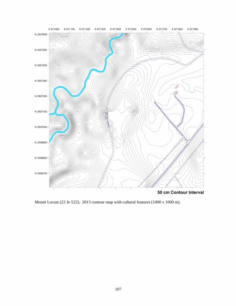
Foster (22 Ad 503)………………………………………………………………….…..138

iii
Emerald (22 Ad 504)………………………………….……………………….……….148
Greenwood (22 Ad 508)……….....................………………………………...………..164
Sites in Wilkinson County:
Lessley (22 Wk 504)……………………………….……………………………...……172
Smith Creek (22 Wk 526)………………………………………...…………………….182
Bibliography……………………………………………………………………………………195

iv
Preface and Acknowledgments
The Mississippi Mound Trail, once completed, promises to be an effective way of bringing
archaeology to the public, a magnet for heritage tourism, and a wonderful vehicle for celebrating
the state’s American Indian heritage. We are very fortunate to have participated in the first phase
of research designed to bring this trail to fruition. It was a rare opportunity to investigate an
extraordinary array of mound sites, and the resulting maps have allowed us to see some of these
sites in more detail than has been possible in a generation, since they were overgrown with trees.
The field work was initiated by Vincas P. Steponaitis, R. P. Stephen Davis, Jr., and Brett H.
Riggs, who got the project up and running during the first weeks, and then continued by Erin
Stevens Nelson, Megan C. Kassabaum, Claire Novotny, Andrius Valiunas, and Harvey Bagwell,
who conducted the total station mapping. Back home in the Research Laboratories of
Archaeology at the University of North Carolina at Chapel Hill, Steve Davis created the
procedure for splicing total station data with existing NED and LiDAR coverage and Andy
Valiunas produced the final maps. The report was written by Erin Nelson and Vin Steponaitis.
This work would not have been possible without the assistance and support of many other
individuals. John O’Hear, Pam Lieb, David Abbott, Robert Benson, and Hank Holmes of the
Mississippi Department of Archives and History were instrumental in planning the work,
arranging the contract, and providing support while the mapping was in progress. Brigid Poole
and Scott Ehrgott played key roles in ironing out the contract’s language, and Lisa-Jean
Michienzi capably handled administrative matters. Throughout the project, Mimi Miller, Trevor
Brown, and Polly Rosenblatt provided logistical support and their usual good advice. Nancy
Hungerford graciously allowed our crew to stay at the Natchez Children’s Home, where we were
wonderfully fed by Yolanda Morgan and helped in innumerable ways by Liz Dunham, Jenny
Harrison, Stephen Washington, and Calvin Wactor. Our friends Smokye and Carol Frank, Robert
and Kathy Prospere, Lee and Sherry Jones, Jim and Sharon Barnett, and Adam Gwin were always
there to keep us out of trouble and in good cheer. And last, but not least, we are most grateful to
all the landowners and land managers who gave access to their properties and allowed us to map
the sites: Leigh Allen IV, Jim Barnett (Mississippi Department of Archives and History), Gene
and Susie Bates, George and Linda Bates, Kenneth Carleton (Mississippi Band of Choctaw
Indians), Jessica Crawford (The Archaeological Conservancy), Jenny Dooley, Ricky Dooley,
Sonny Freeman, Tonette Harris, Lethal Joshua, Christina Smith (National Park Service), Sis
Stowers, Rodger Smith, and Bobby Webb.

1
Introduction
This report compiles information on 19 mound sites located in Issaquena, Warren, Hinds,
Claiborne, Jefferson, Adams, and Wilkinson counties, Mississippi. These sites were chosen for
potential inclusion in the Mississippi Mound Trail (Southern Region), a driving trail for tourists
undertaken jointly by the Mississippi Department of Transportation and the Mississippi
Department of Archives and History. The first phase of this project, the results of which are
reported herein, had two major objectives: (1) to visit and field-check sites in order to determine
their suitability for inclusion on the Mississippi Mound Trail; and (2) to create topographic maps
of each site using high resolution LiDAR data when available, and field mapping as necessary.
Before going into the field, we produced preliminary topographic maps of each site using
available elevation data. These data came from a variety of sources, and with differing degrees of
resolution. For about half the sites, high-resolution LiDAR allowed us to make excellent maps at
the outset, which only had to be field-checked for accuracy. For the rest, our preliminary maps
consisted of low-resolution data from the National Elevation Database (NED), which showed the
general lay of the land but little else. These were the sites that had to be mapped more precisely
in the field.
A crew of archaeologists from the Research Laboratories of Archaeology, University of
North Carolina at Chapel Hill, undertook this fieldwork during the month of February, 2013. At
each site that had to be mapped, we first established georeferenced datums using a Topcon GR-3
multi-frequency, GPS+ receiver. At least two, and usually three of these datums were marked
with copper pipes, flush with the ground surface, and left at the site for future use. We mapped
the mounds and immediately surrounding areas with three Leica total stations (models TCR-307,
TC-407, and TS-02). This high-resolution point cloud was then “grafted” into the lower-
resolution NED data, which covered a wider area, to produce the final map. More detailed
descriptions of all these procedures, along with the LiDAR and NED data, the total station point
clouds, the Surfer files used to produce the contour and relief maps, and all the resulting ArcGIS
layers, can be found in the DVD accompanying this report.
In theory, the sites for which we had LiDAR should have required no additional mapping in
the field. In practice, however, we found two cases in which mounds had accidentally been erased
by the mathematical algorithms used to produce the “bare earth” data. We mapped these missing
features — Mound 1 at Anna and Mound B at Pocahontas — with total stations and grafted them
into the LiDAR using the procedures just described.
We created the final maps at the Research Laboratories of Archaeology after returning from
the field. The contour and relief maps were produced using Surfer, and modern cultural features
were digitized from aerial imagery in ArcGIS.
Two parallel, but different chronologies exist for our study area. For the Natchez Bluffs,
south of Vicksburg, we employ the phases used by Brown (1985), Brain et al. (1995), and
Steponaitis (1981, 2009). For the Lower Yazoo Basin, north of Vicksburg, we use the phase
chronology developed by Phillips (1970) and Williams and Brain (1983).
This report is arranged in the form of a working document, which can be stored in a three-
ring binder and to which new information can easily be added. It contains an entry for each of the
sites investigated, including a review of previous archaeological work and interpretations,
topographic and relief maps, an assessment of current site conditions, recommendations for
further work, and a bibliography of relevant literature. Sites are organized by county, beginning
with the northernmost and moving south.

2
Ceramic phase chronologies for the Natchez Bluffs and Lower Yazoo Basin.

3
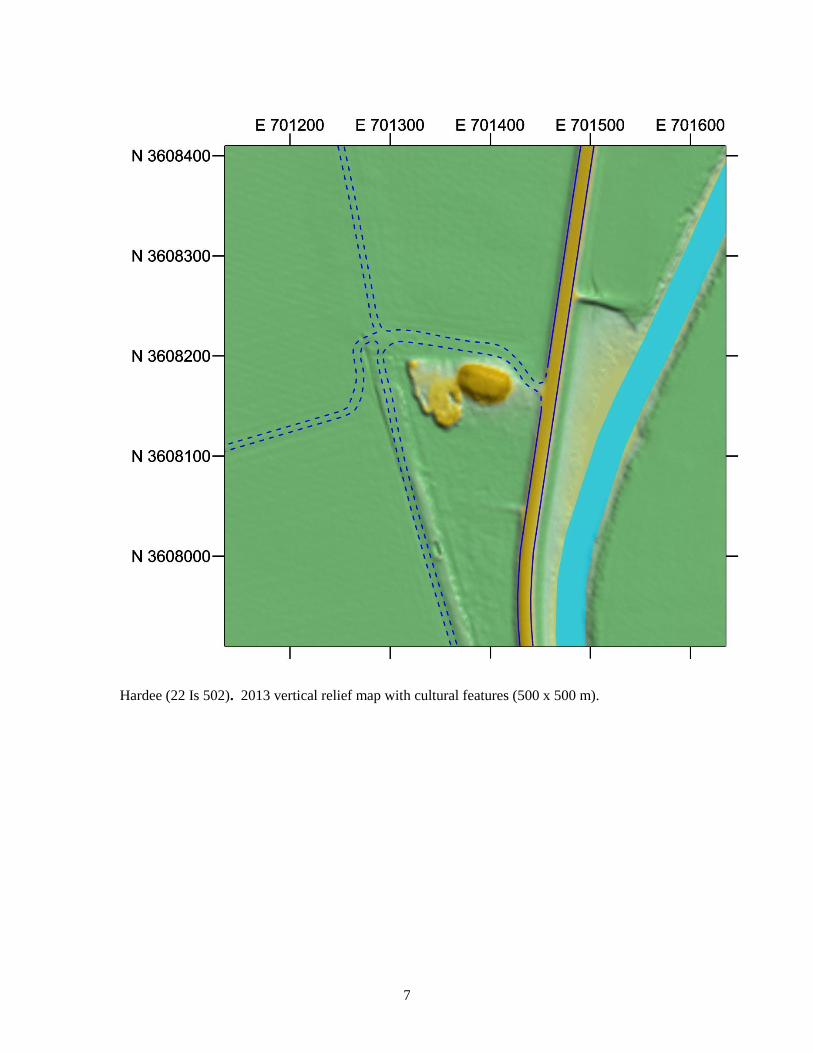
Site Name: Hardee (22 Is 502)
Other: 22-M-8 (LMS)
UTM Location: Copper pipe 3 N 3608170.950 E 701386.346
(NAD83; Zone 15) Copper pipe 4 N 3608164.391 E 701388.344
USGS benchmark N 3608170.647 E 701398.681
USGS Quad map: Onward (15’)
Floweree (7.5’)
Site Description: Hardee originally had three mounds, Mound A being the largest at 4 m in
height. It is a rectangular platform mound and has a possible ramp on the north side. When
surveyed in 1950, Mound B was in cultivation but was 1.5 m high. Mound C had been removed
for road fill. Artifacts from Mound A indicate that the site dates to the Plaquemine period.
History of Work:
In 1950 Warren B. Eames of the Lower Mississippi Survey (LMS) mapped two mounds
and a possible serpentine earthwork at the site. He was told by the landowner that a third
mound had been removed for road fill. The landowner reported that excavations in
Mound A were conducted in 1934 and that burials and pottery had been recovered.
Philip Phillips (1970:474-475) examined the pottery recovered from Mound A and from
Eames’s survey and dated the mound to the Mayersville phase, which in the current
chronology for the Lower Yazoo Basin is equivalent to the Winterville phase.
In 2004 James Lauro conducted a number of shovel tests in advance of a fiber optic line.
The only artifacts recovered were early 20th century.
Current Conditions:
A team from the University of North Carolina visited during February 2013 to assess its
suitability for inclusion on the Mississippi Mound Trail. At that time, Mound A was the only
remaining mound—it looked fairly intact and had a house site with a well as well as a survey
marker on its summit. A possible ramp is still discernible on the north side. Mound B had been
completely reduced by cultivation. Eames’s serpentine earthwork was thought to be part of a
natural levee.
Archival Materials:
Mississippi Department of Archives and History:
Mississippi State survey record.
Report regarding mounds in Issaquena and Sharkey Counties (mentions a site with
mounds in the general vicinity of Hardee).
Peabody Museum, Harvard University:
Perry Aden collection (1934 sherds excavated from Mound A), donated to the LMS.
William Chipman collection, donated to the LMS.
Site file, LMS Archives (Steponaitis et al. 2002).

4
Recommendations: Test excavations and/or coring should be conducted in this mound in order to confirm its date.
The current dating is based on a collection of uncertain provenience, reportedly obtained from
uncontrolled excavations in 1934.
Bibliography:
Lauro, James T.
2004 Cultural Resource Investigations of Six Archaeological Sites Issaquena, Sharkey & Yazoo
Counties, Mississippi. Report 04-296 on file, Mississippi Department of Archives and
History, Jackson.
Phillips, Phillip
1970 Archaeological Survey in the Lower Yazoo Basin, 1949-1955. Papers 60. Peabody
Museum of Archaeology and Ethnology, Harvard University, Cambridge.
Steponaitis, Vincas P., Stephen Williams, R. P. Stephen Davis, Jr., Ian W. Brown, Tristram R.
Kidder, and Melissa Salvanish (eds.)
2002 LMS Archives Online. http://rla.unc.edu/archives/lms1/.

5
Hardee (22 Is 502). 2013 contour map with cultural features (1000 x 1000 m).

6
Hardee (22 Is 502). 2013 contour map with locations of GPS points (GPS), U.S.G.S. benchmark
(USGS), and permanent copper datums (CP) (500 x 500 m). GPS points were established with a
Topcon GR-3 using NAD83 and NAVD88 geographic datums.
7
Hardee (22 Is 502). 2013 vertical relief map with cultural features (500 x 500 m).

8
Hardee (22 Is 502). 2013 oblique relief map with contours (500 x 500 m, 3x vertical
exaggeration).

9
Hardee (22 Is 502). Mound A. View southeast. February 2013.
Hardee (22 Is 502). Mound A as seen from road. View west. February 2013.

10
Hardee (22 Is 502). Location of house foundation on Mound A, with Claire Novotny. View
west. February 2013.

11
Hardee (22 Is 502). 1950 LMS (Eames) sketch map of Hardee. Phillips 1970, Fig. 208.

12
Site Name: Aden (22 Is 509)
Other: 22-M-3 (LMS)
UTM Location: N 3613100 E 702900
(NAD 83; Zone 15)
USGS Quad map: Onward (15’)
Valley Park (7.5’)
Site Description:
Aden has three mounds surrounding a “plaza,” the fourth side being open to Jeff Davis Bayou.
Mound A is 3 m in height and rectangular. Phillips’s 1950 sketch map shows a house on the
northern flank. Mound B is also rectangular and 3 m high. Mound C is 2 m in height but has
been reduced by cultivation. The remains of a house were observed on its summit at the time of
the first LMS visit in 1950. The Lower Mississippi Survey (LMS) reports no evidence of a
village occupation. Aden is the type site for the Coles Creek period Aden phase (AD 850-1000),
although Phillips (1970:365-367) reports a strong early Issaquena component on Mound C, as
well as a later Mississippi period component.
History of Work:
Phillip Phillips of the LMS visited the site in 1950. He made a sketch map and got
surface collections from mounds A and C (Phillips 1970:365-367).
According to the LMS site files, Phillips visited the site again in 1954 and obtained
additional surface samples from Mound C.
National Register of Historic Places nomination, 1988.
Current Conditions:
A team from the University of North Carolina visited during February 2013 to assess its
suitability for inclusion on the Mississippi Mound Trail. At this time Mounds A and B were in
cultivated fields but were covered in trees. Mound A was somewhat eroded on the north side
near the house. Mound B looked quite damaged on the north, east, and south edges, and the
southeast corner was nearly gone. Mound C was visible as a slight rise near the road and was in
active cultivation.
Archival Materials:
Mississippi Department of Archives and History:
Mississippi Archaeological Survey Record.
NRPH nomination (containing a sketch map and photographs of mounds).
Mississippi State University:
Human skull labeled “B # 1/73.”
Peabody Museum, Harvard University:
LMS surface collections (1950 and 1954).
Site file, LMS Archives (Steponaitis et al. 2002).
Recommendations: Test excavations and/or coring should be conducted in the mounds in order to confirm their
construction date. Coring should also be done in the areas between the mounds to see if the

13
apparent absence of village occupation is due to alluviation, i.e., to see if middens are present but
deeply buried by flood deposits.
Bibliography:
Phillips, Phillip
1970 Archaeological Survey in the Lower Yazoo Basin, 1949-1955. Papers 60. Peabody
Museum of Archaeology and Ethnology, Harvard University, Cambridge.
Steponaitis, Vincas P., Stephen Williams, R. P. Stephen Davis, Jr., Ian W. Brown, Tristram R.
Kidder, and Melissa Salvanish (eds.)
2002 LMS Archives Online. http://rla.unc.edu/archives/lms1/.

14
Aden (22 Is 509). 2013 contour map with cultural features (1000 x 1000 m).

15
Aden (22 Is 509). 2013 vertical relief map with cultural features (500 x 500 m).

16
Aden (22 Is 509). 2013 oblique relief map with contours (500 x 500 m).

17
Aden (22 Is 509). Mound A from Valley Park Road. View south. February 2013.
Aden (22 Is 509). Mound B. View southwest. February 2013.

18
Aden (22 Is 509). Approaching Mound A from Valley Park Road. View east. February 2013.

19
Aden (22 Is 509). LMS (Phillips) sketch map 1950. LMS Archives Online (Steponaitis et al.
2002, site files: 22-M-3).

20
Aden (22 Is 509). LMS site map. Phillips 1970, Fig. 142.

21
Aden (22 Is 509). Aerial photo (undated). Labeled “22-M-3 Aden 16-87-14.” LMS Archives
Online (Steponaitis et al. 2002, site files:22-M-3).

22
Site Name: Haynes Bluff (22 Wr 501)
Other: 22-M-5 (LMS)
UTM Location: N 3600700 E 708500
(NAD83; Zone 15)
USGS Quad map: Onward (15’)
Floweree (7.5’)
Site Description: Haynes Bluff originally consisted of one large and four smaller platform
mounds surrounding a plaza. Mounds A and C remain, while Mounds B and D have been
completely destroyed. There is a Coles Creek component at the site and occupation continued
through the Winterville, Lake George, and Wasp Lake phases into the historic Russell phase.
Major mound construction took place at the site well into the protohistoric period, if not later.
Several burials with glass beads and other historic trade goods have been recovered.
History of Work:
Haynes Bluff was recorded by B.L.C. Wailes in June of 1853 as having seven mounds,
the largest 50 ft (15 m) in height (Brown 1998:174). The smaller ones were in
cultivation. He noted that some of the mounds contain human remains. These figures
disagree with later accounts, which put the mound count at four and the height of Mound
A at 30 ft (9 m).
Clarence B. Moore (1908:569-570) excavated at the site in 1907, finding shell-tempered
ceramics and bone in the big mound and a burial with small glass beads in another.
Calvin S. Brown (1926:56) of the Mississippi Geological Survey described celts, circular
stones, points, and trade beads that had been found at the site.
In 1929 James A. Ford and Moreau B. Chambers surveyed the site and conducted tests;
Ford made an additional surface collection in 1932. In his 1936 publication he describes
the big mound as 30 ft (9 m) in height and says that the three small mounds to the south
were nearly obliterated by plowing. He equates the ceramic assemblage with the Tunica
complex.
In 1932 Carl Clausen (1935) dug trenches in several of the mounds, finding burials in
Mound D, one of which contained glass beads (see Brain 1988:196-199).
In 1950 Warren Eames of the Lower Mississippi Survey (LMS) surveyed the site and
collected artifacts from Mounds A, B, and D (Phillips 1970:430-433; Steponaitis et al.
2002). The ceramics collected span the Coles Creek to Late Mississippian periods. He
noted a ramp on the south side of Mound A and some damage to the three other mounds.
In 1967, construction by International Paper obliterated Mound B and severely damaged
Mound D. Some material was salvaged by an amateur archaeologist, Ed Dean, and
subsequently donated to the LMS. At this time, Jeffrey P. Brain noted evidence of Coles
Creek and late Mississippian occupations in a railroad grade that cut through the site
(Brain 1988: 200-201).
In March of 1969 Dean and another amateur (Carroll Kelly) located a burial with
aboriginal and European artifacts north of the mound as well as midden to the west of
Mound A (Brain 1988: 201-203).

23
Phillips (1970:430-433) reanalyzed the LMS collections, noting Aden, Mayersville, and
Deer Creek phase components from Mound B and primarily Mayersville ceramics from
Mound A.
In 1974, Brain (1988:196-252) and the LMS excavated in the Mound A summit and base,
in the area north of Mound B, on top of Mound C, and in the vicinity of Mound D, which
was no longer there. Brain reports that major mound construction took place during the
protohistoric and perhaps the historic period. Russell phase ceramics and historic burials
are present on the Mound A summit and a Russell phase occupation was superseded by
mound construction on Mound C. A trash pit and associated midden in the vicinity of
Mound D dates to the early Russell phase.
Current Conditions:
A team from the University of North Carolina visited during February 2013 to map the site using
a total station and assess its suitability for inclusion on the Mississippi Mound Trail. Mounds A
and C are both clearly visible and there is a marker in front of Mound A. Mounds B and D are
completely gone. Mound A is in good shape but has been damaged by an erosional ditch on the
east corner. Mound C has been significantly damaged by railroad construction and is still eroding
(Baca 1997). A bank branch now sits in the middle of the plaza.
Archival Materials:
Mississippi Department of Archives and History:
Mississippi State Survey record
Photographs (17) in Chambers collection.
Chambers catalog form.
Louisiana State University:
Ford and Chambers collections (cat. nos. 430, 539, 906, 1156-57).
Peabody Museum, Harvard University:
1950 LMS (Eames) collection.
1967 Dean collection.
1974 Brain collection and field notes.
Site file, LMS Archives (Steponaitis et al. 2002).
University of Mississippi:
Brown’s 1926 collections.
North Museum, Lancaster, Pennsylvania:
Clausen’s 1932 collection and original field notes.
Museum of Anthropological Archaeology, University of Michigan, Ann Arbor:
Photographs of Clausen’s 1932 collection and copies of field notes.
Recommendations: Given the extensive previous excavations, no further work is recommended for the purposes of
this project.

24
Bibliography:
Baca, Keith A.
1997 Haynes Bluff Mound C Damage Report. Report 97-153 on file, Mississippi Department of
Archives and History, Jackson.
Brown, Calvin
1926 Archeology of Mississippi. Mississippi Geological Survey, University, Mississippi.
Brown, Ian W.
1998 Benjamin L. C. Wailes and the Archaeology of Mississippi. Mississippi Archaeology
33(2): 157-191.
Brain, Jeffrey P.
1988 Tunica Archaeology. Papers 78. Peabody Museum of Archaeology and Ethnology,
Harvard University, Cambridge.
Clausen, Carl, John H. Macpherson, and Beatrice E. Macpherson
1935 Field Report on Harris Mounds, Warren County, Mississippi. February 15, 1932. Letter
report on file, North Museum of Natural History and Science, Lancaster, Pa.
Ford, James A.
1936 Analysis of Indian Village Site Collections from Louisiana and Mississippi.
Anthropological Study 2. Department of Conservation, Louisiana Geological Survey.
Moore, Clarence B.
1908 Certain Mounds of Arkansas and Mississippi. Journal of the Philadelphia Academy of
Natural Sciences 13: 480-600.
Phillips, Phillip
1970 Archaeological Survey in the Lower Yazoo Basin, 1949-1955. Papers 60. Peabody
Museum of Archaeology and Ethnology, Harvard University, Cambridge.
Steponaitis, Vincas P., Stephen Williams, R. P. Stephen Davis, Jr., Ian W. Brown, Tristram R.
Kidder, and Melissa Salvanish (eds.)
2002 LMS Archives Online. http://rla.unc.edu/archives/lms1/.

25
Haynes Bluff (22 Wr 501). 2013 contour map with cultural features (1000 x 1000 m).

26
Haynes Bluff (22 Wr 501). 2013 vertical relief map with cultural features (500 x 500 m).

27
Haynes Bluff (22 Wr 501). 2013 oblique relief map with contours (500 x 500 m).

28
Haynes Bluff (22 Wr 501). Mound A. View northeast. February 2013.
Haynes Bluff (22 Wr 501). Mound A with historical marker. View northwest. February 2013.

29
Haynes Bluff (22 Wr 501). Mound C. View southwest. February 2013.
Haynes Bluff (22 Wr 501). Mound C as impacted by railroad. View north. February 2013.

30
Haynes Bluff (22 Wr 501). LMS site map. Phillips 1970, Fig. 178.

31
Haynes Bluff (22 Wr 501). Field sketch by Philip Phillips. Brain 1988, Fig. 161c.

32
Site Name: Dornbusch (22 Wr 510)
Other: 22-N-6 (LMS); 22 Wr 673 (associated village site)
UTM Location: GPS point 1 N 3603307.481 E 712376.992
(NAD83; Zone 15) GPS point 2 N 3603308.878 E 712390.725
USGS Quad map: Mechanicsburg (15’)
Eldorado (7.5’)
Site Description: Dornbusch consists of a single rectangular mound approximately 7 m high.
(Phillips [1970:433] reports that it is 2 m high but as all other sources agree this is a typo). Shell
tempered pottery indicates a Plaquemine age for the mound and glass beads reportedly found on
the site indicate a historic component.
History of Work:
James A Ford may have catalogued the site as Simrall in 1929.
The LMS surveyed the site in 1950. They report fine, white laminated deposits in a road
cut on the northeast side of the mound. The landowner said that burials with pots were
recovered during the road cut, but the material could not be located (Phillips 1970:433-
434).
Philip Phillips (1970:434) reports that “a later survey party” found fragments of a shell-
tempered jar that might be from an intrusive burial.
In 1969 Jeffrey P. Brain noted in the LMS site file that glass beads had been found at the
site.
In 1983 MDOT investigated an area along the railroad tracks north of the mound in
advance of a bridge replacement, but no material was recovered (Gray 1983).
In 2008 a pipeline survey was conducted by Deep East Texas Archaeological
Consultants. They noted that a human interment and a shell midden had previously been
found eroding out of a creek bank at the Cornhouse Creek site (22 Wr 673/674),
approximately 300 m north of the mound (Galan 2008:52-54; also see Mississippi state
card for Cornhouse Creek sites). Whether these features are contemporary with the
mound is unknown.
Current Conditions:
A team from the University of North Carolina visited Dornbusch during February 2013 to assess
its suitability for inclusion on the Mississippi Mound Trail. The mound is in trees but is clearly
visible from the road. They made note of erosion on the west corner of the mound and a possible
ramp on the east side.
Archival Materials:
Mississippi Department of Archives and History:
Mississippi State site record.
Peabody Museum, Harvard University:
LMS collections.
Site file, LMS Archives (Steponaitis et al. 2002).

33
Louisiana State University:
Ford’s 1929 “Simrall” collection (LSU cat. no. 904).
Recommendations: Although Mississippi period pottery and glass beads have reportedly been found nearby, virtually
no hard evidence exists as to when the mound itself was built. This earthwork should therefore
be investigated with test excavations and coring to determine its date.
Bibliography:
Galan, Victor
2008 Cultural Resources Survey of the Denbury CO2 Pipeline, Richland and Madison Parishes,
Louisiana; Warren, lssaquena, and Yazoo Counties, Mississippi. Report 08-005 on file,
Mississippi Department of Archives and History, Jackson.
Gray, Bruce J.
1983 Cultural Resources Survey of Proposed Bridge Replacements on Mississippi Highway 3
Between Redwood and the Warren-Yazoo County Line (MSHD Project No. 79-0072-01-
002-10), Warren County, Mississippi. Report 83-157 on file, Mississippi Department of
Archives and History, Jackson.
Phillips, Phillip
1970 Archaeological Survey in the Lower Yazoo Basin, 1949-1955. Papers 60. Peabody
Museum of Archaeology and Ethnology, Harvard University, Cambridge.
Steponaitis, Vincas P., Stephen Williams, R. P. Stephen Davis, Jr., Ian W. Brown, Tristram R.
Kidder, and Melissa Salvanish (eds.)
2002 LMS Archives Online. http://rla.unc.edu/archives/lms1/.

34
Dornbusch (22 Wr 510). 2013 contour map with cultural features (1000 x 1000 m).

35
Dornbusch (22 Wr 510). 2013 contour map with locations of GPS points (GPS). GPS points
were established with a Topcon GR-3 using NAD83 and NAVD88 geographic datums.

36
Dornbusch (22 Wr 510). 2013 vertical relief map with cultural features (500 x 500 m).

37
Dornbusch (22 Wr 510). 2013 vertical relief map with contours (500 x 500 m).

38
Dornbusch (22 Wr 510). View north. February 2013.
Dornbusch (22 Wr 510). Erosion on mound. View north. February 2013.
39
Site Name: Pocahontas (22 Hi 500)
Other: 23-0-1 (LMS)
UTM Location: Md B: Copper pipe 3 N 3596246.193 E 755132.052
(NAD83; Zone 15) Copper pipe 4 N 3596223.734 E 755144.795
Md A: N 3595705 E 754860
USGS Quad map: Jackson (15’)
Pocahontas (7.5’)
Site Description: Pocahontas consists of two mounds and a village site with midden. Mound A
is a platform mound, approximately 20 ft (6.1 m) tall, though it may originally have been taller.
Mound B is a conical burial mound that may originally have been 9 ft (2.7 m) high. Mound A
has been in cultivation and both mounds have been damaged by pothunting activity. Excavated
materials indicate Coles Creek and Plaquemine occupation. Mound A is now part of a roadside
park maintained by the Mississippi Department of Transportation.
History of Work:
Brown (1926:29) described Mound A as 26-30 ft (8-9 m) in height and Mound B as
circular, 9 ft (2.7 m) in height and disfigured by pothunters. He reports abundant pottery
and human bones near Mound A.
James A. Ford and Moreau B. Chambers of the Mississippi Archaeological Survey
recorded the site in 1926. They partially excavated Mound B in 1926 and 1927, finding
6-8 human burials, a human effigy pipe, a copper-covered earspool and a celt (Chambers
1926-1927).
Ford (1936:123-125) reported the dimensions of the two mounds and said that daub,
sherds, flint, animal and human bone were scattered in the fields surrounding Mound A.
Mound A was acquired by the Mississippi State Highway Department in 1956 and is
now preserved as a roadside park.
The Mississippi Archaeological Survey visited the site in 1969, reporting on its condition
in the NRPH nominations for both mounds. Mound A was only 20 ft (6 m) tall at this
time.
In 1974 and 1975 Marc Rucker directed excavations south of Mound A for the
Mississippi State Highway Department in advance of parking lot construction. He
excavated part of a midden-filled borrow pit with material he interpreted as indicating a
Lake George phase component (Rucker 1976; see also Jenkins 2001). Based on the
ceramics illustrated in Rucker’s report, we would assign the midden a date range of ca.
AD 1000-1300 (Steponaitis 1991:219).
In 1998 Keith Baca reported damage caused by pothunters on the top of Mound A (Baca
1998).
Archaeologists from the Cobb Institute of Archaeology conducted geophysical survey,
shovel tests, and test excavations in Mound A in 2004. Excavation on the southwestern
slope of Mound A revealed a number of features, including midden-filled pits, layers of

40
ash, post holes, and human remains. The material suggests a Coles Creek through
Plaquemine occupation (Rafferty et al. 2005).
Current Conditions:
A team from the University of North Carolina visited during February 2013 to map Mound B
with a total station and assess its suitability for inclusion on the Mississippi Mound Trail. Mound
A is as described by others. Mound B is grown up in brush and trees but is visible from the
cemetery road.
Archival Materials:
Mississippi Department of Archives and History:
Mississippi State Survey record.
Separate NRPH nominations for Mound A and Mound B.
Photographs of excavated materials.
Photographs of Mounds A and B in 1969.
Chambers's 1926-1927 field notes and excavated material.
1969 manuscript of Mississippi Archaeological Survey.
Report and photographs of vandalism in 1998.
Miscellaneous correspondence.
Mississippi Department of Transportation:
1974-1975 excavated material from Mound A.
Louisiana State University:
Ford and Chambers’s collection (LSU cat. nos. 5306, 559).
Peabody Museum, Harvard University:
Site file, LMS Archives (Steponaitis et al. 2002).
Recommendations: Both mounds can be roughly dated based on existing collections, although the excavated pottery
from Mound A comes from beside the mound (rather than in it) and the chronological position of
the pottery from Mound B is somewhat ambiguous. If time and resources allow, coring could be
conducted in Mounds A and B to determine (if possible) the number of stages of construction and
to obtain charcoal for radiocarbon dating.
Bibliography:
Baca, Keith A.
1998 Pocahontas Mound A Vandalism Incident. Report 98-281 on file, Mississippi Department
of Archives and History, Jackson.
Brown, Calvin
1926 Archeology of Mississippi. Mississippi Geological Survey, University, Mississippi.
Chambers, Moreau B
1926-1927 [Field notes from excavations of Pocahontas, Mound B. July 15, 1926 and June 6-10,
1927.] Manuscript on file, Mississippi Department of Archives and History, Jackson.

41
Ford, James A.
1936 Analysis of Indian Village Site Collections from Louisiana and Mississippi.
Anthropological Study 2. Department of Conservation, Louisiana Geological Survey.
Jenkins, Cliff
2001 A Reanalysis of Ceramics from Area B at the Pocahontas Mound A Site (22HI500).
Manuscript on file, Cobb Institute of Archaeology, Mississippi State University,
Starkville.
Rafferty, Janet, Jeffrey Alvey, S. Homes Hogue, Evan Peacock, and Robert McCain
2005 Final Report on Archaeological Testing at the Pocahontas Mound A Site (22HI500),
Hinds County, Mississippi. Cobb Institute Archaeological Research Reports, Cobb
Institute of Archaeology, Mississippi State University, Starkville. Report 06-077 on file,
Mississippi Department of Archives and History, Jackson.
Rucker, Marc D.
1976 Archaeological Investigations at Pocahontas Mound A, Hinds County, Mississippi.
Archaeological Excavation Report 3. Mississippi State Highway Department, Jackson.
Steponaitis, Vincas P.
1991 Contrasting Patterns of Missisippian Development. In Chiefdoms: Power, Economy, and
Ideology, edited by Timothy Earle, pp. 193-228. Cambridge University Press,
Cambridge.
Steponaitis, Vincas P., Stephen Williams, R. P. Stephen Davis, Jr., Ian W. Brown, Tristram R.
Kidder, and Melissa Salvanish (eds.)
2002 LMS Archives Online. http://rla.unc.edu/archives/lms1/.

42
Pocahontas (22 Hi 500). 2013 contour map with cultural features (1000 x 1000 m).
43
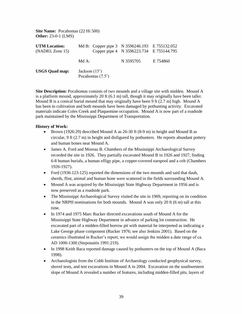
Pocahontas (22 Hi 500). 2013 contour map of Mound B with locations of GPS points (GPS),
fixpoints (FX), and permanent copper datums (CP) (500 x 500 m). GPS points were established
with a Topcon GR-3 using NAD83 and NAVD88 geographic datums.

44
Pocahontas (22 Hi 500). 2013 vertical relief map (1000 x 1000 m)

45
Pocahontas (22 Hi 500). 2013 vertical relief map of Mound A with cultural features (500 x 500
m).

46
Pocahontas (22 Hi 500). 2013 vertical relief map of Mound B with cultural features (500 x 500
m).

47
Pocahontas (22 Hi 500). Mound B. View east. February 2013.
Pocahontas (22 Hi 500). Mound B from cemetery. View south. February 2013.

48
Site Name: Windsor (22 Cb 508)
Other: 25-L-15 (LMS); 22 Cb 535; Freeland Mounds, Daniell Cemetery
UTM Location: GPS point 1B N 3536119.008 E 677311.733
(NAD83; Zone 15) GPS point 2B N 3536116.911 E 677324.395
Copper pipe 3 N 3536080.950 E 677311.190
Copper pipe 5 N 3535953.154 E 677065.201
Copper pipe 6 N 3535978.418 E 677067.332
Copper pipe 7 N 3535942.126 E 677069.677
USGS Quad map: St. Joseph (15’)
St. Joseph (7.5’)
Site Description: Windsor consists of three (possibly four) truncated pyramidal mounds
overlooking Bayou Pierre. Mound A is 10 m tall and has a well-preserved ramp on its eastern
side. Mounds B and C are approximately 5 m tall—Mound C serves as a cemetery for the
Freeland and Daniell families. The fourth possible mound (D) has been cultivated and is a rise
approximately 1 m in height. Based on excavations in Mound A, the site was occupied primarily
during the Plaquemine period Anna and Foster phases. There are also secondary occupations
during the late Coles Creek Balmoral and Gordon phases. The top of Mound A also has a late-
18th-century historic occupation.
History of Work:
Major Samuel S. Forman reported in 1790 that a Colonel Bruin lived in a house atop a
large mound “at Bayou Pierre” and had a barn on another nearby mound (Forman
1888:51-52). The Windsor Mounds overlook Bayou Pierre and the historic town of
Bruinsburg, which makes it likely that the mounds Forman described were the ones at
this site.
The site was briefly described as the “Freeland mound group” in the Natchez Trace
Parkway Survey (National Park Service 1941:140). It was said to have “two or three”
mounds, one of which has the Freeland family cemetery on its summit.
Windsor was visited by Jeffrey P. Brain and the Lower Mississippi Survey (LMS) in
1971. They recorded the height and condition of the four mounds and conducted test
excavations on the summit and at the northwest base of Mound A, which had a lot of
daub on the surface (Brain et al. 1995; Brown 1973:209). The unit atop Mound A
produced a mixture of Indian and late-18th-century European artifacts, the latter probably
associated with Colonel Bruin’s house. The Indian pottery suggests the mound was built
and used during the Anna and Foster phases.
The site was visited in 1972 by Mississippi Department of Archives and History
(MDAH) archaeologists Samuel O. Brookes and Byron Inmon (Brookes and Inmon
1973:6-8).
At the request of MDAH, the Mississippi Research and Development Center produced a
plan for preserving the ruins of Windsor Plantation (Garbo 1974). This report included
the first detailed topographic map of the mounds.
Windsor was included on the National Register of Historic Places in 1978.

49
In 1981 or 1982, James Barnett of MDAH visited the site and noted an encroaching
gully, which had damaged the south corner of Mound C (J. Barnett, personal
communication, 2013).
Current Conditions:
A team from the University of North Carolina visited during February 2013 to assess Windsor’s
suitability for inclusion on the Mississippi Mound Trail. They found the site much as described
by the LMS. Mound C was in the same condition described by Barnett. That is, the gully has not
caused additional discernable damage. Another gully is encroaching on the northwest corner of
Mound A, which is the only mound visible from the road. There’s a pull-off with signage
marking a field road leading partway to Mound C.
Archival Materials:
Mississippi Department of Archives and History:
Mississippi State Survey record.
National Register of Historic Places nomination.
Freeland Burial Ground genealogy, 1977.
1974 sketch map.
Photographs and photograph cross-reference form.
Miscellaneous correspondence.
Peabody Museum, Harvard University:
Site file, LMS Archives (Steponaitis et al. 2002).
1971 surface collections and excavated material; V-203, 204, 205, 206.
Recommendations: LMS investigations in 1971 recovered sufficient evidence for dating Mound A. Similar evidence
should be obtained for Mounds B and C, either through test excavations or coring. Investigations
should also be conducted to see if Mound D is a natural rise or an artificial construction; and, if
the latter, when it was built.
Bibliography:
Brookes, Samuel O., and Byron Inmon
1973 Archaeological Survey of Claiborne County, Mississippi. Mississippi Archaeological
Survey Report 3. Mississippi Department of Archives and History, Jackson.
Brown, Ian W.
1973 Settlement in the Bluff Area of the Lower Mississippi Valley. Senior honors thesis,
Department of Anthropology, Harvard University, Cambridge.
Forman, Samuel S.
1888 Narrative of a Journey Down the Ohio and Mississippi in 1789-90. R. Clarke, Cincinnati.
Garbo, William
1974 Windsor Ruins: A Plan for Historic Site Development, Claiborne County, Mississippi.
Subproject HD-203, Mississippi Research and Development Center, Jackson.

50
National Park Service
1941 Natchez Trace Parkway Survey. Senate Document 148, 76th Congress, 3rd Session, 1940.
Government Printing Office, Washington, D.C.
Steponaitis, Vincas P., Stephen Williams, R. P. Stephen Davis, Jr., Ian W. Brown, Tristram R.
Kidder, and Melissa Salvanish (eds.)
2002 LMS Archives Online. http://rla.unc.edu/archives/lms1/.

51
Windsor (22 Cb 508). 2013 contour map with cultural features (1000 x 1000 m).

52
Windsor (22 Cb 508). 2013 contour map with locations of GPS points (GPS), fixpoints (FX), and
permanent copper datums (CP) (500 x 500 m). GPS points were established with a Topcon GR-3
using NAD83 and NAVD88 geographic datums.

53
Windsor (22 Cb 508). 2013 vertical relief map with cultural features (500 x 500 m).

54
Windsor (22 Cb 508). 2013 oblique relief map with contours (500 x 500 m).

55
Windsor (22 Cb 508). Mound A from road. View southwest. February 2013.
Windsor (22 Cb 508). Gully encroaching on Mound A. View south. February 2013.

56
Windsor (22 Cb 508). Mound C, Freeland-Daniell cemetery. View southeast. February 2013.
Windsor (22 Cb 508). Current sign near Mound C pull-off.

57
Windsor (22 Cb 508). 1971 LMS sketch map showing surface collections and excavation
locations. Brain et al. 1995, Fig. 3.7.

58
Windsor (22 Cb 508). 1974 topographic map of Windsor. Adapted from Garbo 1974.

59
Site Name: Bayou Pierre (22 Cb 534)
Other: 25-L-26 (LMS); 22 Cb 616; 22 Cb 518 possibly refers to Mound D; 22 Cb 548 and
22 Cb 797 are lithic scatters (possibly located in the vicinity of Mound D)
UTM Location: Copper pipe 3A: N 3540219.774 E 688492.768
(NAD83; Zone 15) Copper pipe 6A: N 3540243.976 E 688497.671
Copper pipe 7A: N 3540230.855 E 688482.125
Copper pipe 4D: N 3539628.911 E 687982.131
Copper pipe 5D: N 3539619.585 E 687992.872
Copper pipe 6D: N 3539618.592 E 687984,403
USGS Quad map: St. Joseph (15’)
Widows Creek (7.5’)
Site Description: Bayou Pierre consists of two extant mounds. Mound A is a rectangular
platform mound located on a landform overlooking Bayou Pierre. It is approximately 5 m in
height. Mound D is located 800 m southwest of Mound A. It is a small, pear-shaped mound on
the bluff overlooking a tributary of Bayou Pierre. In 1852 B.L.C. Wailes mapped two additional
mounds (B and C) 27 m north and 90 m northwest of Mound A respectively. Neither is visible
today. LMS surface collections from 1971 indicate strong Balmoral and Anna phase components
as well as minor Hamilton Ridge, Sundown, Ballina, and Gordon phase occupations. Brown
(1973:214) and Brain et al. (1995) suggests that the mounds were probably constructed during the
Anna phase. [There is considerable confusion in the available records regarding the number of
mounds and their locations at Bayou Pierre. For the purposes of this report, the map sketched by
B.L.C. Wailes is considered most accurate].
History of Work:
B.L.C. Wailes mapped four mounds in 1852.
The LMS surveyed and mapped the site in 1971
Brookes and Inmon visited the site in 1973, noting Coles Creek pottery and pothunting
activities on Mound A.
In 1976 Robert D. Hyatt conducted archaeological survey and testing in advance of road
construction immediately west of Mound A. Hyatt (1976) incorrectly believed that
Mound C, directly in the new road’s path, was a natural rise, which led to the mound’s
destruction when the road was built in 1978. The construction of this new road led to the
abandonment of the old road just east of Mound A. Robert C. Wilson (1978) and James
T. Lauro (1978) both reported erosion and construction-related ground disturbance in the
remaining site area north of Mound A.
Robert Thorne and Hugh Curry surveyed the site as part of a proposed road alignment in
2003. They conducted shovel tests but did not find evidence of a midden or of mounds
other than Mound A.
Current Conditions:
A team from the University of North Carolina visited during February 2013 to map the site using
a total station and assess its suitability for inclusion on the Mississippi Mound Trail. Mound A is
in trees but is clearly visible from Old Mill Road. The former roadbed of Old Mill Road has
caused significant damage to the east corner of Mound A. There is also some erosion along the
east flank and a small gully coming in from the old roadbed on the northeast side of the mound.

60
The summit appears to be intact, though Brookes and Inmon reported pothunting in 1973.
Mound D is not visible from the road. Access is through a locked gate on Leigh Allen’s property.
A field road leads right up to the mound and has caused moderate damage to the north side. If
Bayou Pierre were to be included in the Mississippi Mound Trail, it would need to be cleaned up.
Gullies flanking Mound A have been used as trash dumps. The (recent) skeletons of several dogs
have been dumped into the ditch. Additionally, there is so much metal on the site that
magnetometer work would probably not be feasible.
Archival Materials:
Mississippi Department of Archives and History:
Mississippi State site record.
Photographs taken by Robert C. Wilson, dated 1977.
Physical description and site significance by Samuel O. Brookes (1977).
Peabody Museum, Harvard University:
1971 LMS collections (V-201, 215, 216, 217, 229, 230).
Site file, LMS Archives (Steponaitis et al. 2002).
Recommendations:
Test excavations in Mounds A and D should be a high priority, an important question being
whether the two are contemporary, i.e., whether Mound D should be regarded as part of the same
site. Excavations should also be conducted in the area of Mound B to see if any intact deposits
remain and , if so, when they date.
Bibliography:
Brain, Jeffrey P., Ian W. Brown, and Vincas P. Steponaitis
1995 Archaeology of the Natchez Bluffs. Manuscript on file, Research Laboratories of
Archaeology, University of North Carolina, Chapel Hill.
Brookes, Samuel O., and Byron Inmon
1973 Archaeological Survey of Claiborne County, Mississippi. Mississippi Archaeological
Survey Report 3. Mississippi Department of Archives and History, Jackson.
Brown, Ian W.
1973 Settlement in the Bluff Area of the Lower Mississippi Valley. Senior honors thesis,
Department of Anthropology, Harvard University, Cambridge.
Hyatt, Robert D.
1976 Report on Archaeological Testing: Bayou Pierre Site, 22CB534, SE¼, SW¼, Section 12,
T12N, R2E, Claiborne County, Mississippi. June 15, 1976. Letter report prepared for the
Mississippi State Highway Department, Jackson.
Lauro, James T.
1978 Letter to Paul Newsomme, Environmental Coordinator, Mississippi Department of
Archives and History. June 30, 1978. Report 78-087 on file, Mississippi Department of
Archives and History, Jackson.

61
Steponaitis, Vincas P., Stephen Williams, R. P. Stephen Davis, Jr., Ian W. Brown, Tristram R.
Kidder, and Melissa Salvanish (eds.)
2002 LMS Archives Online. http://rla.unc.edu/archives/lms1/.
Thorne, Robert M.
2003 Cultural Resources Assessments for Proposed Road Alignments, Port Gibson to Grand
Gulf, Claiborne County, Mississippi. Report 03-180 on file, Mississippi Department of
Archives and History, Jackson.
Wailes, Benjamin L. C.
1852 Notes on the Aboriginal Monuments and Remains of Mississippi. B. L. C. Wailes papers,
Mississippi Archives Z/0076.000/S. Manuscript on file, Mississippi Department of
Archives and History, Jackson.
Wilson, Robert C.
1978 Site Investigation Report, Bayou Pierre (22-Cb-518), Section 12, Township 12N, Range
2E, Claiborne County, Mississippi. June 8, 1978. Letter report on file, Mississippi
Department of Archives and History, Jackson.

62
Bayou Pierre (22 Cb 534). 2013 contour map of Mounds A and D with cultural features (1000 x
1000 m).

63
Bayou Pierre (22 Cb 534). 2013 contour map of Mound A with locations of GPS points (GPS),
fixpoints (FX), and permanent copper datums (CP) (500 x 500 m). GPS points were established
with a Topcon GR-3 using NAD83 and NAVD88 geographic datums.

64
Bayou Pierre (22 Cb 534). 2013 vertical relief map of Mound A with cultural features (500 x
500 m).

65
Bayou Pierre (22 Cb 534). 2013 contour map of Mound D with locations of GPS points and
permanent copper datums (CP) (500 x 500 m). GPS points were established with a Topcon GR-3
using NAD83 and NAVD88 geographic datums.

66
Bayou Pierre (22 Cb 534). 2013 vertical relief map of Mound D (500 x 500 m).
67
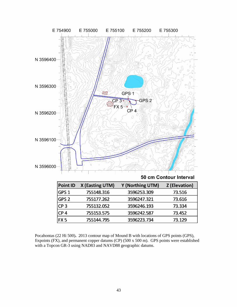
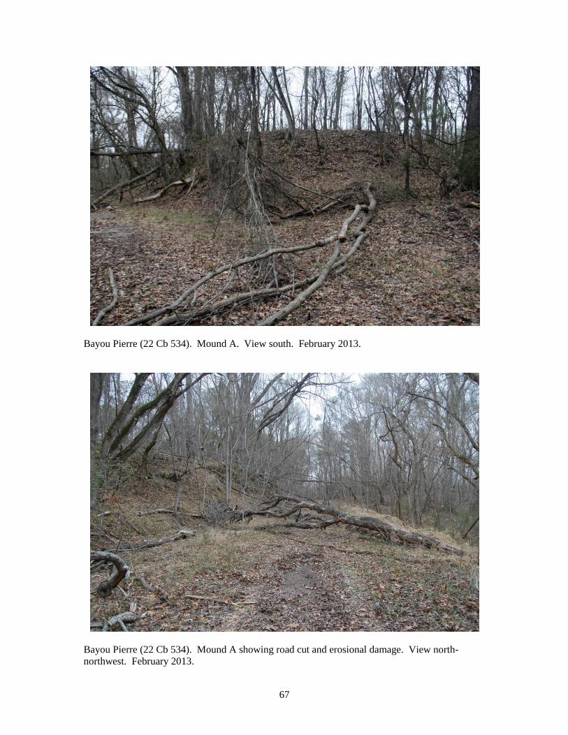
Bayou Pierre (22 Cb 534). Mound A. View south. February 2013.
Bayou Pierre (22 Cb 534). Mound A showing road cut and erosional damage. View north-
northwest. February 2013.

68
Bayou Pierre (22 Cb 534). Mound D. View north. February 2013.
Bayou Pierre (22 Cb 534). Sketch map of the "Tioux group near Port Gibson" by Benjamin L. C.
Wailes, 1852. Note the four mounds lettered A through D. Wailes 1852.

69
Bayou Pierre (22 Cb 534). 1971 LMS map (Brain et al. 1995).
Bayou Pierre (22 Cb 534). Sketch map made by highway archaeologists in 1976, showing the
right-of-way for the proposed new road (Hyatt 1976:Fig. 2). Area B corresponds to Mound B and
Area C, erroneously designated as a "natural rise," is Mound C.

70
Bayou Pierre (22 Cb 534). Sketch map made by Robert Wilson (MDAH) in 1978, showing the
construction-related disturbance north of Mound A (Wilson 1978).

71
Site Name: Mangum (22 Cb 584)
Other: 25-M-1 (LMS)
UTM Location: N 3541400 E 698400
(NAD83; Zone 15)
USGS Quad map: Port Gibson (7.5’)
Site Description: Mangum is a “hilltop cemetery,” consisting of a number of burial features in
or near a natural knoll. Two repoussé copper plates and Plaquemine period ceramics (probably
Gordon, Anna, and Foster phases) have been recovered from burials at the site.
History of Work:
In 1936 Spurgeon P. Mangum found a repoussé copper plate on the chest of a human
adult burial. He subsequently found a number of other burials nearby, and several
ceramic pots, only one of which was preserved.
In 1941 Albert Spaulding of the National Park Service visited the site and made a
preliminary assessment. He described the site as an artificial mound with a prehistoric
cemetery sitting atop a natural ridge, and compared it to Emerald (Spaulding 1941).
John Cotter of the National Park Service conducted four test excavations in 1951,
uncovering 13 additional human burials 40 ft northwest of the knoll (Cotter 1952). He
noted that the pot found by Mangum was similar to those found at Anna.
Charles F. Bohannon (1963) conducted excavations in 1963, uncovering 24 burials and a
second copper plate.
Brookes and Inmon (1973) reported that Mangum was not a mound but a natural knoll.
R.C. Dailey (1974) analyzed Bohannon’s skeletal collection (68-70 individuals).
Misty Penton (1995) wrote a University of Oregon M.A. thesis on the osteological
collections from Mangum under the direction of R.C. Dailey.
We understand that the skeletal materials and grave goods have been repatriated and
reburied at the Mangum site.
Current Conditions:
A team from the University of North Carolina at Chapel Hill visited the site in February of 2013
to assess site conditions and suitability for inclusion on the Mississippi Mound Trail. The site
appears to be a natural bluff remnant but does have a small bump on the top, which could be
cultural. There is a former walkway leading to the summit of the ridge that is now fenced off
(though it could be an inadvertent invitation for visitors to climb the mound). The Natchez Trace
Parkway does not have interpretive signage posted. Directional signage may also be needed as
the exit from the parkway is shared with Grindstone Ford, and it is not clear that you have to
continue past Grindstone Ford and drive back under the Parkway to see Mangum.
Archival Materials:
Mississippi Department of Archives and History:
Mississippi State Survey record.
Photo cross-reference form.

72
Correspondence regarding Mangum’s NRPH nomination (apparently submitted and
returned twice).
Southeast Archaeological Center:
Bohannon’s 1963 collections (now presumably repatriated).
Peabody Museum, Harvard University:
Site file, LMS Archives (Steponaitis et al. 2002).
Recommendations: Given that this site is a natural hilltop, rather than a mound, and that it has a long history of
previous investigations, no further testing is required.
Bibliography:
Bohannon, Charles F.
1963 The Mangum Site: A Plaquemine Necropolis in Claiborne County. Manuscript on file,
Southeast Archeological Center, National Park Service, Tallahassee, Florida.
Brookes, Samuel O., and Byron Inmon
1973 Archaeological Survey of Claiborne County, Mississippi. Mississippi Archaeological
Survey Report 3. Mississippi Department of Archives and History, Jackson.
Cotter, John L.
1952 The Mangum Plate. American Antiquity 18: 65-68.
Dailey, R. C.
1974 Osteological Analysis of the Human Skeletal Remains from the Mangum Site, Natchez
Trace Parkway. Manuscript on file, Southeast Archeological Center, National Park
Service, Tallahassee, Florida.
Penton, Misty
1995 Bioarchaeology and Subsistence in the Lower Mississippi Valley: Mangum Site,
Mississippi. Master’s thesis, Department of Anthropology, University of Oregon,
Eugene.
Spaulding, Albert C.
1941 Memorandum for Acting Superintendent Gardner. May 5, 1941. Manuscript on file,
Southeast Archeological Center, National Park Service, Tallahassee.
Steponaitis, Vincas P., Stephen Williams, R. P. Stephen Davis, Jr., Ian W. Brown, Tristram R.
Kidder, and Melissa Salvanish (eds.)
2002 LMS Archives Online. http://rla.unc.edu/archives/lms1/.

73
Mangum (22 Cb 584). 2013 contour map with cultural features (1000 x 1000).

74
Mangum (22 Cb 584). 2013 vertical relief map with cultural features (500 x 500 m).

75
Mangum (22 Cb 584). 2013 oblique relief map with contours (500 x 500 m, 4x vertical
exaggeration).

76
Mangum (22 Cb 584). View west. February 2013.
Mangum (22 Cb 584). View south. February 2013.

77
Mangum (22 Cb 584). Former path leading to top of ridge. View west. February 2013.

78
Site Name: Bates #1 (22 Je 514)
Other: 26-L-8 (LMS)
UTM Location: Copper pipe 3 N 3531387.042 E 666957.492
(NAD83; Zone 15) Copper pipe 4 N 3531366.660 E 666950.571
Copper pipe 5 N 3531962.815 E 666962.815
USGS Quad map: Fayette (15’)
Church Hill (7.5’)
Site Description: Bates #1 has a single pyramidal mound, approximately 2 m high, with a
possible ramp to the east. The only material recovered from the site is a handful of Addis Plain
sherds, suggesting a probable Plaquemine association, though it is possibly older.
History of Work:
Brain and the LMS mapped and surveyed the site in 1971, collecting a small number of
Addis sherds (Brain et al. 1995; Brown 1973:240).
Chip McGimsey and Joe Saunders cored the mound in 2009 on behalf of the
Archaeological Conservancy. They found that the mound is 2 m in height and was built
in a single episode. Weathering in the upper portions of the core suggest that it may be
much older than Plaquemine.
Current Conditions:
A team from the University of North Carolina visited during February 2013 to map the site using
a total station and assess its suitability for inclusion on the Mississippi Mound Trail. The mound
is much the same as described by the LMS. It is not visible from a public road.
Archival Materials:
Peabody Museum, Harvard University:
1971 LMS collections (V-119).
Site file, LMS Archives (Steponaitis et al. 2002).
Recommendations: As a high priority, test excavations should be conducted in this mound in order to determine its
date and its relationship to Bates #2. Coring in 2009 suggested the possibility that this mound
might have been built during the Archaic period, which adds to the importance of determining its
true age and potentially including it on the Mound Trail.
Bibliography:
Archaeological Conservancy
2009 Soil Core Reveals Data about Bates Mound. American Archaeology 13(2): 50.
Brain, Jeffrey P., Ian W. Brown, and Vincas P. Steponaitis
1995 Archaeology of the Natchez Bluffs. Manuscript on file, Research Laboratories of
Archaeology, University of North Carolina, Chapel Hill.

79
Brown, Ian W.
1973 Settlement in the Bluff Area of the Lower Mississippi Valley. Senior honors thesis,
Department of Anthropology, Harvard University, Cambridge.
Steponaitis, Vincas P., Stephen Williams, R. P. Stephen Davis, Jr., Ian W. Brown, Tristram R.
Kidder, and Melissa Salvanish (eds.)
2002 LMS Archives Online. http://rla.unc.edu/archives/lms1/.

80
Bates #1 (22 Je 514). 2013 contour map with cultural features (1000 x 1000 m).

81
Bates #1 (22 Je 514). 2013 contour map with locations of GPS points (GPS), fixpoints (FX),
and permanent copper datums (CP) (500 x 500 m). GPS points were established with a
Topcon GR-3 using NAD83 and NAVD88 geographic datums.

82
Bates #1 (22 Je 514). 2013 vertical relief map with cultural features (500 x 500 m; 3x vertical
exaggeration).

83
Bates #1 (22 Je 514). 2013 oblique relief map with contours (500 x 500 m, 3x vertical
exaggeration).

84
Bates #1 (22 Je 514). View east. February 2013.

85
Bates #1 (22 Je 514). Mapping the mound (with Claire Novotny). View east. February 2013.

86
Bates #1 (22 Je 514). 1971 LMS site map. Brain et al. 1995, Fig. 2.47.

87
Bates #1 (22 Je 514). LMS 1971 photo. LMS Archives Online (Steponaitis et al. 2002, site
files:26-L-8).

88
Bates #1 (22 Je 514). 2009 V.P. Steponaitis coring field notes. Notes on file at Research
Laboratories of Archaeology, University of North Carolina at Chapel Hill.
89
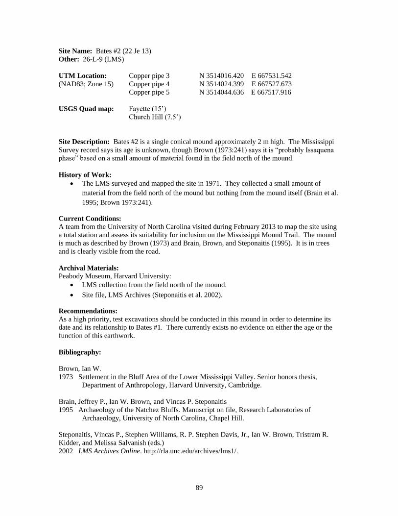
Site Name: Bates #2 (22 Je 13)
Other: 26-L-9 (LMS)
UTM Location: Copper pipe 3 N 3514016.420 E 667531.542
(NAD83; Zone 15) Copper pipe 4 N 3514024.399 E 667527.673
Copper pipe 5 N 3514044.636 E 667517.916
USGS Quad map: Fayette (15’)
Church Hill (7.5’)
Site Description: Bates #2 is a single conical mound approximately 2 m high. The Mississippi
Survey record says its age is unknown, though Brown (1973:241) says it is “probably Issaquena
phase” based on a small amount of material found in the field north of the mound.
History of Work:
The LMS surveyed and mapped the site in 1971. They collected a small amount of
material from the field north of the mound but nothing from the mound itself (Brain et al.
1995; Brown 1973:241).
Current Conditions:
A team from the University of North Carolina visited during February 2013 to map the site using
a total station and assess its suitability for inclusion on the Mississippi Mound Trail. The mound
is much as described by Brown (1973) and Brain, Brown, and Steponaitis (1995). It is in trees
and is clearly visible from the road.
Archival Materials:
Peabody Museum, Harvard University:
LMS collection from the field north of the mound.
Site file, LMS Archives (Steponaitis et al. 2002).
Recommendations:
As a high priority, test excavations should be conducted in this mound in order to determine its
date and its relationship to Bates #1. There currently exists no evidence on either the age or the
function of this earthwork.
Bibliography:
Brown, Ian W.
1973 Settlement in the Bluff Area of the Lower Mississippi Valley. Senior honors thesis,
Department of Anthropology, Harvard University, Cambridge.
Brain, Jeffrey P., Ian W. Brown, and Vincas P. Steponaitis
1995 Archaeology of the Natchez Bluffs. Manuscript on file, Research Laboratories of
Archaeology, University of North Carolina, Chapel Hill.
Steponaitis, Vincas P., Stephen Williams, R. P. Stephen Davis, Jr., Ian W. Brown, Tristram R.
Kidder, and Melissa Salvanish (eds.)
2002 LMS Archives Online. http://rla.unc.edu/archives/lms1/.

90
Bates #2 (22 Je 13). 2013 contour map with cultural features (1000 x 1000 m).

91
Bates #2 (22 Je 13). 2013 contour map with locations of GPS points (GPS), fixpoints (FX),
and permanent copper datums (CP) (500 x 500 m). GPS points were established with a
Topcon GR-3 using NAD83 and NAVD88 geographic datums.

92
Bates #2 (22 Je 13). 2013 relief map with cultural features (500 x 500 m, 3x vertical
exaggeration).

93
Bates #2 (22 Je13). 2013 oblique relief map with contours (500 x 500 m, 3x vertical
exaggeration).

94
Bates #2 (22 Je 13). View northeast. February 2013.
Bates #2 (22 Je 13). View south. February 2013.

95
Bates #2 (22 Je 13). 1971 LMS sketch map. Brain et al. 1995, Fig. 2.48.

96
Bates #2 (22 JE 13). 1971 LMS photograph. LMS Archives Online (Steponaitis et al. 2002, site
files:26-L-9).

97
Site Name: Pumpkin Lake (22 Je 517)
Other: 26-K-88 (LMS); 22 Je 9
UTM Location: Copper pipe 6 N 3513274.490 E 664401.932
(NAD83; Zone 15) Copper pipe 7 N 3513256.994 E 664400.150
USGS Quad map: Natchez (15’)
Pine Ridge (7.5’)
Site Description: Pumpkin Lake consists of a single oval-shaped mound just under 3 m in height
and some artifact scatters in the field immediately to the south. Its ceramic sequence is distinct
from the nearby Coles Creek period Feltus site, dating primarily to the Issaquena phase, with
minor Deasonville, Hamilton Ridge, and Ballina components. Later Emerald and Natchez phase
components are also present, the latter indicated by an 18th century blue glass bead.
History of Work:
Pumpkin Lake was originally designated by Jeffrey P. Brain and the Lower Mississippi
Survey (LMS) in 1971, after determining that it was distinct from the nearby Feltus site.
Brown (1973:237) describes the mound as irregular in shape, while Brain et al. (1995)
say that it is oval in shape and sharply defined. The LMS crew placed a test excavation
in the south flank of the mound, locating material spanning the Issaquena to Emerald
phases, none of which, however, was in situ. It is unclear when the mound was
constructed, but Brain et al. posit a primary occupation in the Issaquena phase.
The site was partially mapped in March 2011by a combined crew of students from the
University of North Carolina at Chapel Hill and Mississippi State University.
Current Conditions:
A team from the University of North Carolina visited during February 2013 to assess its
suitability for inclusion on the Mississippi Mound Trail. The site is as described by the LMS in
1971. The mound is visible across a field from Guidon Road.
Archival Materials:
Mississippi Department of Archives and History:
Mississippi State Survey record.
Peabody Museum, Harvard University:
1971 LMS collection and excavation records.
Site file, LMS Archives (Steponaitis et al. 2002).
Recommendations: As a high priority, test excavations should be conducted in this mound in order to determine its
date. Previous excavations conducted by the LMS yielded ambiguous results, as they seem never
to have reached undisturbed mound deposits.

98
Bibliography:
Brown, Ian W.
1973 Settlement in the Bluff Area of the Lower Mississippi Valley. Senior honors thesis,
Department of Anthropology, Harvard University, Cambridge.
Brain, Jeffrey P., Ian W. Brown, and Vincas P. Steponaitis
1995 Archaeology of the Natchez Bluffs. Manuscript on file, Research Laboratories of
Archaeology, University of North Carolina, Chapel Hill.
Steponaitis, Vincas P., Stephen Williams, R. P. Stephen Davis, Jr., Ian W. Brown, Tristram R.
Kidder, and Melissa Salvanish (eds.)
2002 LMS Archives Online. http://rla.unc.edu/archives/lms1/.

99
Pumpkin Lake (22 Je 517). 2013 contour map with cultural features (1000 x 1000 m).

100
Pumpkin Lake (22 Je 517). 2013 contour map with locations of GPS points (GPS), fixpoints
(FX), and permanent copper datums (CP) (500 x 500 m). GPS points were established with a
Topcon GR-3 using NAD83 and NAVD88 geographic datums.

101
Pumpkin Lake (22 Je 517). 2013 vertical relief map with cultural features (500 x 500 m).

102
Pumpkin Lake (22 Je 517). 2013 oblique relief map with contours (500 x 500 m).

103
Pumpkin Lake (22 Je 517). 1971 LMS map of Pumpkin Lake and Feltus sites. Brain et al. 1995,
Fig. 3.3.
104
Site Name: Mount Locust (22 Je 522)
Other: 26-L-5 (LMS); 22 Je 615 (Mount Locust Cemetery)
*Much work has been done focusing on Mount Locust as the Historic Uniontown Site. This
report highlights the literature related to the prehistoric occupation, of which there is far less.
UTM Location: Copper pipe 3 N 3507025.679 E 671381.081
(NAD83; Zone 15) Copper pipe 4 N 3507033.325 E 671368.310
Copper pipe 5 N 3507010.428 E 671371.869
USGS Quad map: Fayette (15’)
Church Hill (7.5’)
Site Description: Mount Locust consists of two mounds. The first (Mound A) is a flat-topped
rise approximately 2.5 m tall. The Mount Locust House, built in 1779, sits atop its summit. The
second (Mound B) is located to the southwest of the first and is approximately 2 m tall. It is the
location of the Chamberlain family cemetery, in continuous use since the late 18th century. A
midden in the cemetery mound indicates an early Coles Creek (Sundown or Ballina phase)
occupation. Ground-penetrating radar surveys and testing in the field southwest of the house
mound may indicate an additional Anna phase component. Mount Locust was also the location
of the late 18th-early 19
th century hamlet of Uniontown.
History of Work:
Working for the National Park Service (NPS), Albert C. Spaulding and Jesse D. Jennings
conducted excavations in 1940 and 1941, in part to determine whether the Mount Locust
House was located on top of an Indian mound. They concluded that it was probably a
natural knoll, but acknowledged the possibility that the top 1-2 ft (30-60 cm) was an
aboriginal construction. Spaulding (1941:36), who reported on these excavations,
speculated that an oxidized red surface underneath clean loess fill may be a fired mound
surface.
Robert S. Neitzel and Gilman D. Parsons of the Lower Mississippi Survey (LMS)
collected the site in 1971, finding material scattered in the fields surrounding the
plantation. The LMS site card references previous excavations by the NPS.
In July of 1990, a crew from the Southeast Archaeological Center (SEAC), a unit of NPS,
surface collected the slope of the Chamberlain Cemetery mound, finding Coles Creek
period ceramics.
In 1995 the NPS replaced the fence surrounding the Chamberlain Cemetery. Testing and
monitoring by SEAC revealed a Coles Creek period midden within the mound.
Around this time, Eric Chamberlain and Florence Echols Chamberlain, then both living,
agreed to let SEAC excavate their intended grave plots within the Chamberlain Cemetery
prior to their deaths. These excavations took place in February of 1996 and revealed
more of the early Coles Creek (Sundown or Ballina phase) midden (Atkinson 1997). The
excavator, James Atkinson, also determined that soil had been added to the top of the
mound since the mid 19th century. He was unable to say conclusively whether the mound
consisted mainly of a bluff remnant later used by Coles Creek people or whether it was
an aboriginal construction, although in our opinion the stratigraphy strongly indicates the
latter.

105
In 2002 Charles Lawson (SEAC) identified a series of postholes while monitoring the
construction of a handicap accessible walkway southwest of the inn. Plaquemine period
pottery and lithics were associated (Lawson 2002).
In 2003 SEAC conducted a ground-penetrating radar (GPR) survey and limited testing in
the field southwest of the Mount Locust Inn (Lawson 2003; Nickel 2003). The GPR
survey identified one (maybe two) rectangular and five circular anomalies that Lawson
(2003:7) suggests are probably American Indian structures. Test excavations revealed a
pit feature, postholes, and daub presumably originating from Indian structures. Addis-
type ceramics suggest an Anna phase occupation, though it could be earlier.
Current Conditions:
A team from the University of North Carolina visited during February 2013 to map the site using
a total station and assess its suitability for inclusion on the Mississippi Mound Trail. As the site
is a stop along the Natchez Trace Parkway, both mounds are easily accessible to visitors and both
are well-maintained. The interpretive signage at Mount Locust addresses only 18th and 19
th
century use of the site. There is no mention of the mounds.
Archival Materials:
Mississippi Department of Archives and History:
Mississippi State Survey record
Peabody Museum, Harvard University:
1971 LMS collections (V-82)
Southeast Archaeological Center:
1990, 1995, and 1996 collections (accession nos. 1076 and 1190)
Recommendations: Atkinson's 1996 excavations confirmed (in our view) that the Chamberlain cemetery sits atop an
aboriginal mound (Mound B). Coring should be conducted to confirm whether the rise beneath
the Mount Locust House (Mound A) is also an aboriginal construction, and if so to determine its
date.
Bibliography:
Atkinson, James R.
1997 The Chamberlain Cemetery Investigations, Mount Locust, Natchez Trace Parkway,
Jefferson County, Mississippi. Report on file, Southeast Archeological Center, National
Park Service, Tallahassee, Florida.
Lawson, Charles F.
2002 Trip Report on Archaeological Monitoring of the Construction of a Handicap Accessible
Trail at Mount Locust, Natchez Trace Parkway, Mississippi. Oct. 16-Oct. 19, 2002.
Accession 1816. Manuscript on file, Southeast Archeological Center, National Park
Service, Tallahassee.
Lawson, Charles F.
2003 Trip Report on a Geophysical Survey and Archeological Testing on the Grounds of the
Historic Mount Locust Inn at Mile Marker 15 of the Natchez Trace Parkway, April 22-

106
May 2, 2003. Accession 1833. Manuscript on file, Southeast Archeological Center,
National Park Service, Tallahassee, Florida.
Nickel, Robert K.
2003 A Ground Penetrating Radar Survey at the Mount Locust Village Site. Natchez Trace
Parkway, Jefferson County, Mississippi. SEAC Accession 1833. Manuscript on file,
Southeast Archeological Center, National Park Service, Tallahassee, Florida.
Spaulding, Albert C.
1941 Archeological Data. In Mound Plantation, A Historical and Archeological Report, by
Dawson Phelps, pp. 33-48. File no. 845-06.8. Manuscript on file, Natchez Trace
Parkway, Tupelo, Mississippi.
107
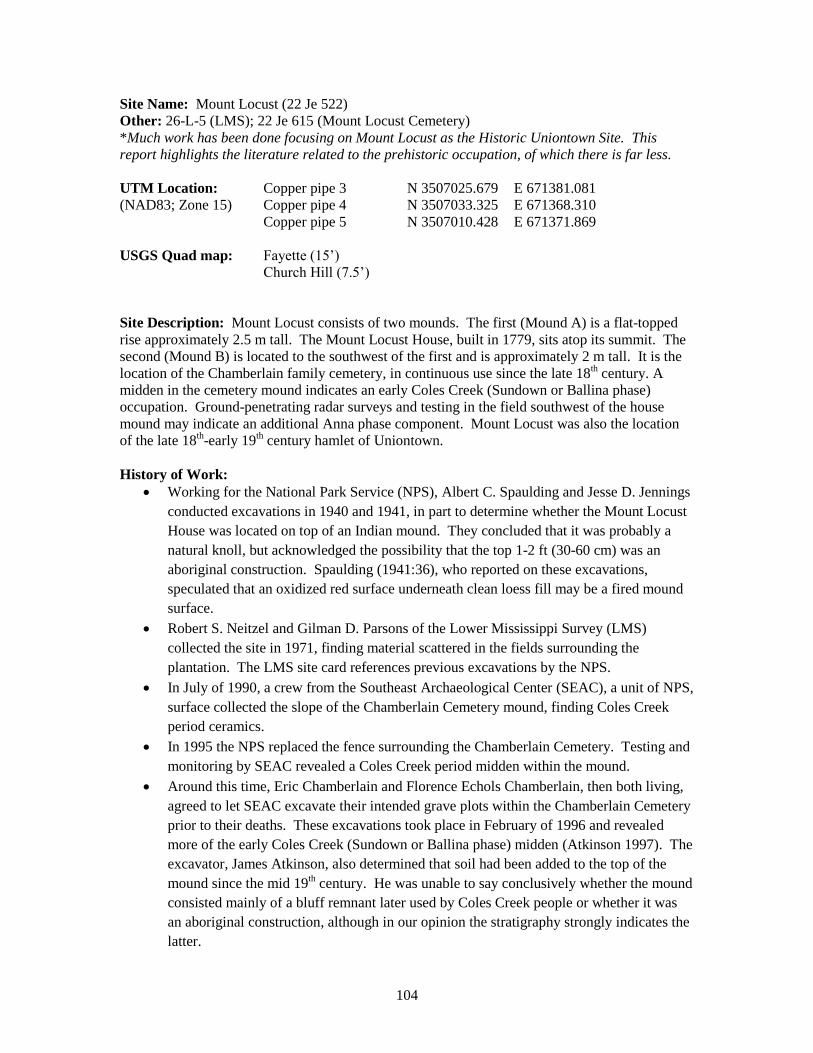
Mount Locust (22 Je 522). 2013 contour map with cultural features (1000 x 1000 m).

108
Mount Locust (22 Je 522). 2013 contour map with locations of GPS points (GPS), fixpoints
(FX), and permanent copper datums (CP) (500 x 500 m). GPS points were established with
a Topcon GR-3 using NAD83 and NAVD88 geographic datums.

109
Mount Locust (22 Je 522). 2013 relief map with cultural features (500 x 500 m; 3x vertical
exaggeration).

110
Mount Locust (22 Je 522). 2013 oblique relief map with contours (500 x 500 m; 3x vertical
exaggeration).

111
Mount Locust (22 Je 522). Mount Locust House Mound from parking area. View west.
February 2013.
Mount Locust (22 Je 522). Mount Locust House Mound, with Andrius Valiunas. View west.
February 2013.

112
Mount Locust (22 Je 522). Chamberlain Cemetery Mound. View northwest. February 2013.
Mount Locust (22 Je 522). Chamberlain Cemetery Mound summit. View southeast. February
2013.

113
Mount Locust (22 Je 522). Chamberlain Cemetery Mound from access road. View north.
February 2013.

114
Mount Locust (22 Je 522). Map showing location of GPR survey conducted by SEAC in 2003,
including anomalies interpreted as Native American structures in Grids 1 and 2. Lawson 2003:8.

115
Site Name: Anna (22 Ad 500)
Other: 26-K-1 (LMS), 22 Ad 1; Voucherie, Robson, Stowers
UTM Location: Copper pipe 5 N 3507812.745 E 656444.158
(NAD83; Zone 15) Copper pipe 6 N 3507824.670 E 656432.686
USGS Quad map: Natchez (15’)
Pine Ridge (7’)
Site Description: Anna has eight (possibly nine) mounds, six of which are arranged around a
plaza on the edge of the bluff overlooking Anna’s Bottom. The largest mound (Mound 3) is 16.4
m high and has a ramp facing east-southeast (oriented toward Mound 5). The site is primarily
Plaquemine, with significant occupations during the Anna and Foster phases (Brain et al. 1995;
Brain 1978:Table 12.3). Gordon phase ceramics are also well represented. There are minor
components of the Panther Lake, Issaquena, and Balmoral phases. A single glass bead suggests
an additional late (Natchez phase) component (Frank 1980).
History of Work:
Benjamin L. C. Wailes visited the site in April of 1853, reporting nine (possibly ten
mounds) as well as human remains (Brown 1998).
Calvin Brown mapped four of the eight mounds (1926:40-42). He reported six mounds
in total.
Warren K. Moorehead (1932:162-163), together with Calvin Brown, conducted a surface
survey and excavations in 1924. They discovered evidence of burned buildings and
stratification in the mounds.
The Mississippi State site card says that Chambers surveyed Anna in 1930.
James A. Ford surface collected the site in 1931 and again in 1935. In his 1936
publication, he described four large pyramidal mounds and mentioned five other reported
mounds that he did not visit. The largest mound was 50 ft (15 m) tall with a ramp on the
east side. He also reported midden scattered on and around the mounds, including
pottery related to the Tunica complex.
J.D. Jennings visited the site in 1940 on behalf of the National Park Service. He noted
that a silo trench had been dug into Mound 5 and that five whole vessels had been
recovered by the landowner. He also said that Mound 3 had been significantly eroded by
grazing and cultivation (Jennings 1940). He also drew a map of the site (Jennings and
Wagner 1940; see below).
The site was briefly described in a Work Projects Administration inventory of
“outstanding” Indian mounds and sites in Mississippi (Work Projects Administration
1940:site 10). The description was largely based on Jennings’s 1940 work.
The site was briefly described in the Natchez Trace Parkway Survey (National Park
Service 1941:140) as having “six mounds, one over 50 feet high.”
In 1947 Philip Phillips visited the site as part of the LMS, making a small collection and
noting silo trenches in Mounds 1 and 5.
On Phillips’s recommendation, John L. Cotter excavated at the site in 1948 (1951a). He
trenched into mound 5 at the south edge of the silo trench, finding a substantial basal

116
midden and four episodes of mound construction, three of which were capped with an
occupational surface.
Designated a National Historic Landmark in 1993.
In 1997 Ian W. Brown directed excavations by the Gulf Coast Survey and the Alabama
Museum of Natural History. These excavations focused on the summit of Mound 3 as
well as an area north of Mound 4. They resulted in three Master's theses under his
direction (Brown 1997; Beasley 1998; Downs 2004; Warhop 2004).
Beasley (1998) reported on the Mound 4 Flats area, including a Foster phase feasting
event as well as an Anna phase structure.
Downs (2004) reported on two Anna phase rectangular wall trench houses on the summit
of Mound 3.
Warhop (2005) reported on a late Foster phase oval structure in the Mound 4 Flats with
evidence of cooking and butchering areas.
Current Conditions:
A team from the University of North Carolina visited during February 2013 to map Mound 1
(which did not show up in the LiDAR data) using a total station and assess its suitability for
inclusion on the Mississippi Mound Trail. All eight mounds are heavily forested. Mound 3 is
visible on the south side of the road while driving southeast up onto the bluff from Anna’s
Bottom. Mound 6 is visible on the north side of the road from either direction. Mounds 4, 6, and
7 have sustained damage from road construction, while Mounds 1 and 5 have been damaged by
silo trenches.
Archival Materials:
Mississippi Department of Archives and History:
Mississippi State Site record.
Photographs of Mound A taken February 2004.
Louisiana State University:
Catalog nos. 587, 396, 1108.
Ford 1931, 1935 material.
Peabody Museum, Harvard University:
Phillips 1947 collection.
Site file, LMS Archives (Steponaitis et al. 2002).
Natchez, Mississippi:
Robert Prospere collection.
Alabama Museum of Natural History:
Brown’s 1997 collection.
Research Laboratories of Archaeology, UNC at Chapel Hill:
Whole pot found in Mound 5 silo trench, 2007.
Southeast Archaeological Center (NPS):
Cotter’s 1948 collections.

117
Recommendations: Coring should be conducted in Mounds 1, 2, 4, 6, 7, and 8 to obtain evidence of constructional
history and dating. None of these mounds have previously been excavated.
Bibliography:
Beasley, Virgil R.
1998 Feasting and Mound Construction at the Mound 4, Block 1 Locale, the Anna Site
(22AD500), Adams County, Mississippi. Master’s thesis, Department of Anthropology,
University of Alabama, Tuscaloosa.
Brain, Jeffrey P.
1978 Late Prehistoric Settlement Patterning in the Yazoo Basin and Natchez Bluffs Region of
the Lower Mississippi Valley. In Mississippian Settlement Patterns, edited by Bruce D.
Smith, pp. 331-368. Academic Press, New York.
Brain, Jeffrey P., Ian W. Brown, and Vincas P. Steponaitis
1995 Archaeology of the Natchez Bluffs. Manuscript on file, Research Laboratories of
Archaeology, University of North Carolina, Chapel Hill.
Brown, Calvin
1926 Archeology of Mississippi. Mississippi Geological Survey, University, Mississippi.
Brown, Ian W. (ed.)
1997 Excavations at the Anna Site (22Ad500), Adams County, Mississippi: A Preliminary
Report. Manuscript on file, Gulf Coast Survey, Alabama Museum of Natural History,
Tuscaloosa.
Brown, Ian W.
1998 Benjamin L. C. Wailes and the Archaeology of Mississippi. Mississippi Archaeology
33(2): 157-191.
Cotter, John L.
1951a Stratigraphic and Area Test at the Emerald and Anna Mound sites. American Antiquity
17:18-32.
Downs, Lauren E.
2004 Plaquemine Culture Structures in the Natchez Bluffs: Architectural Grammar at the Mound
3 Summit Locale, the Anna Site, Adams County, Mississippi. Master’s thesis,
Department of Anthropology, University of Alabama, Tuscaloosa.
Ford, James A.
1936 Analysis of Indian Village Site Collections from Louisiana and Mississippi.
Anthropological Study 2. Department of Conservation, Louisiana Geological Survey.
Frank, Joseph V., III
1980 A European Trade Bead from the Anna Mounds Site, Adams County, Mississippi.
Mississippi Archaeological Association Newsletter 15(3): 5.

118
Jennings, Jesse D., and C. A. Wagner
1940 Sketch Field Map of Anna Mound Group, Anna, Mississippi. Manuscript map on file,
Southeast Archeological Center, National Park Service, Tallahassee.
Moorehead, Warren K.
1932 Explorations near Natchez, Mississippi. In Exploration of the Etowah Site in Georgia, by
Warren K. Moorehead, pp. 158-165. Etowah Papers, Vol. 1. Yale University Press, New
Haven.
National Park Service
1941 Natchez Trace Parkway Survey. Senate Document 148, 76th Congress, 3rd Session, 1940.
Government Printing Office, Washington, D.C.
Steponaitis, Vincas P., Stephen Williams, R. P. Stephen Davis, Jr., Ian W. Brown, Tristram R.
Kidder, and Melissa Salvanish (eds.)
2002 LMS Archives Online. http://rla.unc.edu/archives/lms1/.
Warhop, Jennifer R.
2005 Investigations of a Unique Structure at the Anna Site (22AD500), Mississippi. Master’s
thesis, Department of Anthropology, University of Alabama, Tuscaloosa.
Work Projects Administration
1940 Indian Mounds and Sites in Mississippi, Vol. 1. O.P. 65-1-62-94, W.P. 6374, September,
1940. A Part of the Park, Parkway, and Recreational Area Study for Mississippi, prepared
for the National Park Service, U.S. Department of the Interior.

119
Anna (22 Ad 500). 2013 contour map with cultural features (1000 x 1000 m).

120
Anna (22 Ad 500). 2013 contour map with locations of GPS points (GPS), fixpoints (FX), and
permanent copper datums (CP) (500 x 500 m). GPS points were established with a Topcon GR-3
using NAD83 and NAVD88 geographic datums.

121
Anna (22 Ad 500). 2013 vertical relief map with cultural features (500 x 500 m).

122
Anna (22 Ad 500). 2013 oblique relief map with contours (500 x 500 m).

123
Anna (22 Ad 500). Mound 6. View northwest. February 2013.
Anna (22 Ad 500). Mound 6. View north. February 2013.

124
Anna (22 Ad 500). Mound 3. View south-southeast. February 2013.
Anna (22 Ad 500). View from top of Mound 3 overlooking Anna’s Bottom. View northwest.
February 2013.

125
Anna (22 Ad 500). Silo trench in Mound 5 (with Erin Nelson). View southwest. February 2013.

126
Anna (22 Ad 500). Jennings and Wagner field map, 1940. Natchez Trace Parkway, National
Park Service, Tupelo, Mississippi.

127
Site Name: Fatherland (22 AD 501)
Other: 26-K-2 (LMS); Grand Village of the Natchez Indians; nearby sites 22 Ad 760,
22 Ad 591, 22 Ad 754
UTM Location: Copper pipe/GPS 1 N 3488759.577 E 653809.341
(NAD83; Zone 15) Copper pipe/GPS 2 N 3488735.132 E 653870.855
USGS Quad map: Natchez (15’)
Natchez (7.5’)
Site Description: The Fatherland site has three mounds and a village and is located in the
bottomland on the west side of St. Catherines Creek. Fatherland has been conclusively identified
as the Grand Village of the Natchez Indians visited by Iberville in 1700. Mound A is a low
mound that was severely eroded when first described in the early 20th century. Mounds B and C
were described in late 17th and early 18
th century French accounts as the location of a chief’s
residence and temple respectively. Archaeological excavations of both mounds corroborate this.
Mound B was built in four stages, each with associated structural remains. Mound C was also
built in four stages, the last two of which supported structures; these stages also have burials and
evidence of mortuary ritual. The site dates primarily to the Foster, Emerald and Natchez phases,
with a minor Anna phase occupation (Brain et al. 1995; cf. Brain 1978:Table 12.3).
History of Work:
Fatherland has long been identified as the Grand Village of the Natchez Indians, which
played a prominent role in French Colonial accounts between 1682 and 1730 (for
summaries of these accounts, see Swanton 1911; Albrecht 1944; Neitzel 1965; Brown
1978; Brown 1990; Lorenz 1997; Barnett 2002, 2007; Brain 1982; Galloway and
Jackson 2004).
Bernard Shipp visited the site and mentioned it in his book on The Indian and Antiquities
in America (Shipp 1897:206). At the time of his visit (probably in the 1880s), Mound A
had already been partially destroyed by St. Catherines Creek.
In 1924 Warren K. Morehead described one mound at the site (“upon the land of Mrs.
McKittrick and Mrs. Miner on St. Catherines Creek”). He excavated a trench through
the center of the mound and augered in several locations (Moorehead 1924:3, 1932:160).
The site was visited by James A. Ford, Moreau B. Chambers, and Henry B. Collins in
the years from 1929 to 1931 (Ford 1936:59-65; Neitzel 1965:9). They noted three
mounds as well as a village site on the east side of St. Catherine’s Creek. The village site
was represented by a midden, 6 in (15 cm) thick, visible in a road cut.
In 1930 Chambers, working for the Mississippi Department of Archives and History,
excavated Mound C, locating 25 burials and associated grave goods, including European
material. He also tested Mounds A and B but found no artifacts in either (Neitzel 1965).
Ford (1936:59-65) described Mound A as a low mound almost completely eroded by St.
Catherine’s Creek; Mound B as a pyramidal platform mound, 7 ft (2 m) high; and
Mound C as a burial mound, 4 ft (1.2 m) high, completely excavated by Chambers.
The site was briefly described in the Natchez Trace Parkway Survey as consisting of
three mounds (National Park Service 1941:139-140). A village site across St. Catherines
Creek was said to have “largely eroded away.”

128
At around the same time, the site was also described in a Work Projects Administration
inventory of “outstanding” Indian mounds and sites in Mississippi (Work Projects
Administration 1940:site 12).
From 1962 to 1964 Robert S. Neitzel conducted additional mound excavations on behalf
of the Mississippi Department of Archives and History (Neitzel 1965). He found that
Mound B was constructed in four stages, each with associated domestic structures. The
last of these stages had European trade goods associated. Mound C was found to have
supported a temple structure. Mound A, the smallest, was found to have a late
occupation based on ceramics. Neitzel intended to excavate in the plaza but was
prevented by approximately 6 ft (1.8 m) of colluvial overburden.
After the site was acquired by the state, the mounds were restored to their previously
reported dimensions and the colluvium covering the plaza was mechanically removed.
In 1972 Neitzel conducted excavations in the plaza (Neitzel 1983). He uncovered four
areas of domestic habitation near Mound B, each with superimposed buildings. The
largest building was a single-set post structure that had been destroyed by burning.
Neitzel (1983:131) describes this as “a large and imposing structure near the chief’s
mound” and believes it to be “the residence of an important individual, such as the
Tattoed Serpent or Flour Chief.” Neitzel dates the primary occupation of the Grand
Village to the Foster, Emerald and Natchez phases, with a “transient” Anna phase
occupation also represented.
In 1983 a fifth occupation area was discovered as part of an erosional control project
(Barnett 1984).
Current Conditions:
A team from the University of North Carolina visited during February 2013 to set permanent
copper datums and to assess its current conditions. As a state park, the site is well maintained and
accessible to visitors. There is a visitor’s center and museum on the premises, as well as
interpretive signage throughout the site.
Archival Materials:
Mississippi Department of Archives and History:
Mississippi State Survey record.
National Register of Historic Places nomination.
Chambers’s Mound C excavation material (according to Ford this material was partially
destroyed by a fire).
Material excavated by Neitzel.
Louisiana State University:
Ford, Chambers, and Collins collection: LSU catalog nos. 429, 468, 586m, 842, 843,
1113, 1203, 5273-5285.
Grand Village of the Natchez Indians:
Materials excavated by Chambers and Neitzel (on display).

129
Peabody Museum, Harvard University:
Human effigy figure (cat. no. 79934). This object was found somewhere in Natchez
before 1820, and is presumed to have come from Fatherland (Atwater 1820:215;
Williams 1968:60-62).
Site file, LMS Archives (Steponaitis et al. 2002).
Recommendations: Given the extensive work done previously, no further excavation is required.
Bibliography:
Albrecht, Andrew C.
1944 The Location of the Historic Natchez Villages. Journal of Mississippi History 6(2): 67-88.
Atwater, Caleb
1820 Description of the Antiquities Discovered in the State of Ohio and Other Western States
Communicated to the President of the American Antiquarian Society. Archaeologia
Americana. Transactions and Collections of the American Antiquarian Society 1: 105-
267.
Barnett, James F., Jr.
1984 A New Building Location at the Fatherland Site (Grand Village of the Natchez).
Mississippi Archaeology 19(1).
Barnett, James F., Jr.
2002 The Natchez Indians. Revised edition. Mississippi Department of Archives and History
Popular Report.
Barnett, James F., Jr.
2007 The Natchez Indians: A History to 1735. University Press of Mississippi, Jackson.
Brain, Jeffrey P.
1978 Late Prehistoric Settlement Patterning in the Yazoo Basin and Natchez Bluffs Region of
the Lower Mississippi Valley. In Mississippian Settlement Patterns, edited by Bruce D.
Smith, pp. 331-368. Academic Press, New York.
Brain, Jeffrey P.
1982 La Salle at the Natchez: An Archaeological and Historical Perspective. In La Salle and his
Legacy: Frenchmen and Indians in the Lower Mississippi Valley, edited by Patricia
Galloway, pp. 49-59. University Press of Mississippi, Jackson.
Brown, Ian W.
1978 The Natchez Indians: Archaeological Contributions to Settlement Locations. Paper
presented at the 7th French Regime Symposium, Natchez, Mississippi. Manuscript on
file, Research Laboratories of Archaeology, University of North Carolina, Chapel Hill.
Brown, James A.
1990 Archaeology Confronts History at the Natchez Temple. Southeastern Archaeology 9(1): 1-
10.

130
Dumont de Montigny, Jean François Benjamin
1753 Mémoires historiques sur la Louisiane, contenant ce qui y est arrivé de plus mémorable
depuis l'année 1687. C. J. B. Bauche, Paris.
Ford, James A.
1936 Analysis of Indian Village Site Collections from Louisiana and Mississippi.
Anthropological Study 2. Department of Conservation, Louisiana Geological Survey.
Galloway, Patricia, and Jason Baird Jackson
2004 Natchez and Neighboring Groups. In Handbook of North American Indians, Volume 14,
Southeast, edited by William Sturtevant and Raymond D. Fogelson, pp. 598-615.
Smithsonian Institution Press, Washington, D.C.
Lorenz, Karl G.
1997 A Re-Examination of Natchez Sociopolitical Complexity: A View from the Grand Village
and Beyond. Southeastern Archaeology 16(2).
Moorehead, Warren K.
1924 Field Notes: Natchez, Mississippi Mounds and Village Sites. Manuscript (typewritten) on
file, Robert S. Peabody Museum, Phillips Academy, Andover, Massachusetts.
Moorehead, Warren K.
1932 Explorations near Natchez, Mississippi. In Exploration of the Etowah Site in Georgia, by
Warren K. Moorehead, pp. 158-165. Etowah Papers, Vol. 1. Yale University Press, New
Haven.
National Park Service
1941 Natchez Trace Parkway Survey. Senate Document 148, 76th Congress, 3rd Session, 1940.
Government Printing Office, Washington, D.C.
Neitzel, Robert S.
1965 Archaeology of the Fatherland Site. Anthropological Papers 51(1). American Museum of
Natural History, New York.
Neitzel, Robert S.
1983 The Grand Village of the Natchez Revisited: Excavations at the Fatherland Site, Adams
County, Mississippi, 1972. Archaeological Report 12. Mississippi Department of
Archives and History, Jackson.
Shipp, Barnard
1897 The Indian and Antiquities of America. Philadelphia.
Steponaitis, Vincas P., Stephen Williams, R. P. Stephen Davis, Jr., Ian W. Brown, Tristram R.
Kidder, and Melissa Salvanish (eds.)
2002 LMS Archives Online. http://rla.unc.edu/archives/lms1/.
Swanton, John R.
1911 Indian Tribes of the Lower Mississippi Valley and Adjacent Coast of the Gulf of Mexico.
Bulletin 43. Bureau of American Ethnology, Smithsonian Institution, Washington, D.C.

131
Williams, Stephen (ed.)
1968 The Waring Papers: The Collected Works of Antonio J. Waring, Jr. Papers 58. Peabody
Museum of Archaeology and Ethnology, Harvard University, Cambridge.
Work Projects Administration
1940 Indian Mounds and Sites in Mississippi, Vol. 1. O.P. 65-1-62-94, W.P. 6374, September,
1940. A Part of the Park, Parkway, and Recreational Area Study for Mississippi, prepared
for the National Park Service, U.S. Department of the Interior.

132
Fatherland (22 Ad 501). 2013 contour map with cultural features (1000 x 1000 m).

133
Fatherland (22 Ad 501). 2013 contour map with locations of GPS points marked with permanent
copper datums (CP/GPS) (500 x 500 m). GPS points were established with a Topcon GR-3 using
NAD83 and NAVD88 geographic datums.

134
Fatherland (22 Ad 501). 2013 vertical relief map with cultural features (500 x 500 m).

135
Fatherland (22 Ad 501). 2013 oblique relief map with 50 cm contours (500 x 500 m; 4x vertical
exaggeration).

136
Fatherland (22 Ad 501). Mounds B and C. View SW. February 2013.
Fatherland (22 Ad 501). Mound A. View E. February 2013.

137
Fatherland (22 Ad 501). 1753 Dumont map of Fort Rosalie and environs showing the Grand
Village of the Natchez. Dumont de Montigny 1753, vol. 2, facing p. 94.

138
Site Name: Foster (22 Ad 503)
Other: 26-K-3; 26-K-89 (LMS); Mount Pleasant
UTM Location: Copper pipe 6 N 3497378.720 E 658638.692
(NAD83; Zone 15) Copper pipe 7 N 3497396.197 E 658591.728
USGS Quad map: Natchez (15’)
Washington (7.5’)
Site Description: The Foster site is the type site for the Plaquemine period Foster phase. It
consists of two mounds just over 200 m apart with a “village” or plaza between them. Mound A
is a pyramidal platform mound. The original height of this mound is unknown—there has been a
house on its summit since the 1790s, and it was modified/enlarged to accommodate a veranda in
the early 19th century. Currently, it is approximately 3 m in height. Mound B is smaller and
indeterminate in shape—its southern slope having been eroded by St. Catherine’s Creek.
Excavations in Mound B revealed two episodes of mound construction and a submound midden
with evidence of domestic occupation. Primary occupation occurred during the Plaquemine
period Anna, Emerald, and Foster phases, though the midden beneath Mound B also contained
ceramic material from the Tchula, Marksville, Baytown and Coles Creek periods.
History of Work:
Described by Ingraham in 1835 as having a mound with a plantation house on the
summit.
Calvin Brown (1926) describes the site in much the same way as Ingraham.
Warren K Moorehead visited the site in 1924, recording it as “Mount Pleasant” in his
1932 publication (Fig. 100).
In 1930 Moreau B. Chambers and W.B. Myers surface collected around Mound A; James
A. Ford (1936) described this collection as including Tunica and Natchez types.
Jeffrey P. Brain and the Lower Mississippi Survey (LMS) surveyed the site in 1971 and
excavated in 1971 and 1972. Their excavations in Mound A revealed only early 19th
century fill, indicating an expansion of the mound related to the construction of a
veranda. Their Mound B excavations revealed two stages of mound construction as well
as an underlying midden. The results of the excavation were the subject of a Harvard
senior honors thesis by Vincas P. Steponaitis (1974).
Archaeologists Unlimited of Natchez, Mississippi conducted pedestrian survey and
shovel testing in the field north of Foster Mounds, with negative results near the mound.
Current Conditions:
A team from the University of North Carolina visited during February 2013 to map the site using
a total station and assess its suitability for inclusion on the Mississippi Mound Trail. The site is
currently as described by the LMS and by Steponaitis (1974). Both mounds are visible from the
road, though Mound B could easily be mistaken for a natural feature.
Archival Materials:
Mississippi Department of Archives and History:
Mississippi State survey record.
Twelve photos in Chambers collection.

139
Lousiana State University:
1930 Chambers and Myers collection – LSU cat. nos. 977, 1109.
Peabody Museum, Harvard University:
1971-72 LMS collections.
Site file, LMS Archives (Steponaitis et al. 2002).
Recommendations:
Additional excavations or coring should be conducted in Mound A to gain better evidence on its
constructional history and date.
Bibliography:
Boggess, Elizabeth, David Abbott, Jr., and Douglas H. M. Boggess
2000 Cultural Resources Survey and Assessment of Effect on Sites 22Ad503, 22Ad848, and
Foster Mound House. Report 00-029 on file, Mississippi Department of Archives and
History, Jackson.
Brown, Calvin
1926 Archeology of Mississippi. Mississippi Geological Survey, University, Mississippi.
Ford, James A.
1936 Analysis of Indian Village Site Collections from Louisiana and Mississippi.
Anthropological Study 2. Department of Conservation, Louisiana Geological Survey.
Ingraham, Joseph Holt
1835 The South-West, by a Yankee. 2 vols. Harper & Brothers, New York.
Moorehead, Warren K.
1932 Explorations near Natchez, Mississippi. In Exploration of the Etowah Site in Georgia, by
Warren K. Moorehead, pp. 158-165. Etowah Papers, Vol. 1. Yale University Press, New
Haven.
Steponaitis, Vincas P.
1974 The Late Prehistory of the Natchez Region: Excavations at the Emerald and Foster Sites,
Adams County, Mississippi. Senior honors thesis, Department of Anthropology, Harvard
University, Cambridge.
Steponaitis, Vincas P., Stephen Williams, R. P. Stephen Davis, Jr., Ian W. Brown, Tristram R.
Kidder, and Melissa Salvanish (eds.)
2002 LMS Archives Online. http://rla.unc.edu/archives/lms1/.

140
Foster (22 Ad 503). 2013 contour map with cultural features (1000 x 1000 m).

141
Foster (22 Ad 503). 2013 contour map with cultural features and GPS points (GPS),
fixpoints (FX), and copper pipes (CP) (500 x 500 m). GPS points were established with a
Topcon GR-3 using NAD83 and NAVD88 geographic datums.

142
Foster (22 Ad 503). 2013 vertical relief map with cultural features (500 x 500 m, 3x vertical
exaggeration).
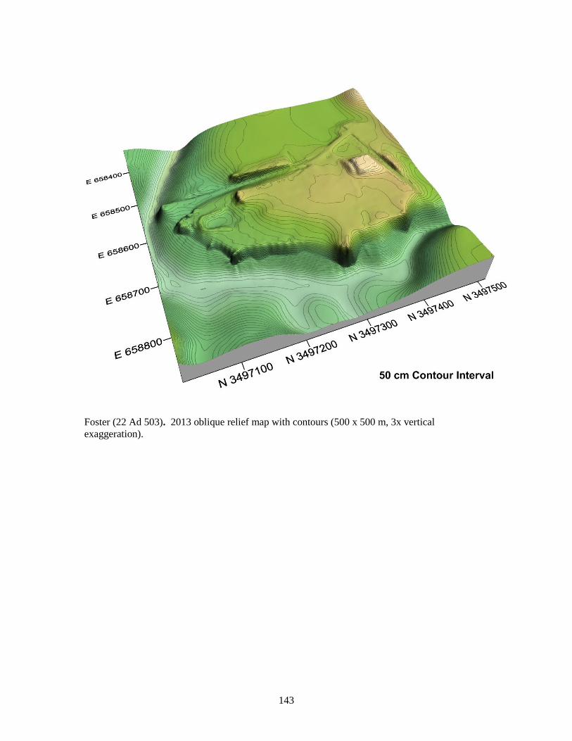
143
Foster (22 Ad 503). 2013 oblique relief map with contours (500 x 500 m, 3x vertical
exaggeration).

144
Foster (22 Ad 503). Mound A. View north. February 2013.
Foster (22 Ad 503). Mound A. View east. February 2013.

145
Foster (22 Ad 503). Mound B. View northeast. February 2013.
Foster (22 Ad 503). Mound B. View east-northeast. February 2013.

146
Foster (22 Ad 503). LMS site map with locations of 1972 excavations. Brian et al. 1995, Fig.
3.46; after Steponaitis 1974, Fig. 20.

147
Foster (22 Ad 503). 1972 photograph of Foster Mound A. View east. Brain et al. 1995, Fig.
3.47.

148
Site Name: Emerald (22 Ad 504)
Other: 26-L-1 (LMS); Selzertown (or Selsertown); 22 Ad 1063 (across road)
UTM Location: Copper pipe 3 N 3501463.601 E 666312.150
(NAD83; Zone 15) Copper pipe 5 N 3501381.717 E 666310.614
Copper pipe 11 N 3501495.939 E 666191.299
USGS Quad map: Fayette (15’)
Church Hill (7.5’)
Site Description: Emerald consists of a large platform with two extant secondary mounds at
either end. Early reports indicate that there were six additional secondary mounds that have since
been destroyed. According to Brain et al. (1995) there were four main occupations at Emerald
separated by three stages of mound construction. The earliest is an Anna phase village on a
naturally sloping ridge, followed by modification of the natural topography to create a broad
platform. Midden on the first stage of this platform indicates a late Anna to Foster phase
occupation with a series of associated burials and perhaps two secondary mounds. A second
major stage of mound construction served as a base for an Emerald phase occupation, including
midden deposits on and off the platform as well as two secondary mounds with buildings on their
summits. The eastern secondary mound had associated domestic refuse while the western had
ceremonial refuse. A final mound construction stage supported enlarged versions of the mounds
on either end as well as six additional secondary mounds. The largest and westernmost mound
was 12 m in height while the easternmost was 7-8 m high. Occupation of the site may have
extended into the historic period (Natchez phase), though no historic artifacts have been found.
History of Work:
Many early 19th-century observers visited the site prior to 1850 and left written accounts;
some also conducted excavations there ( e.g., Hall 1801:51; Brackenridge 1814:278;
Ingraham 1835:vol. 2, 222-226; Monette 1838a; Monette 1838b:230-231; Forshey 1840;
Forshey 1841; Bailey 1842; Bartlett 1848:8-9; Squire and Davis 1848:118; also see
Cotter 1951b). Although there is some variation among the descriptions, they generally
portray the site as a large platform surmounted by eight secondary mounds and
surrounded by a ditch (Steponaitis 1974:22-28; Brain et al. 1995).
Joseph Jones of New Orleans explored Emerald in the late 1880s. According to a
contemporary newspaper account (Anonymous 1889), he “caused to be dug a trench 20
feet long and 20 feet deep,” in which he found charred logs, ashes, human bones and “a
fragment of an old French burr millstone.” Thomas (1894:266) mentions that Jones’s
excavations were placed on the western secondary mound.
Cyrus Thomas (1894) reports that Edward Palmer visited the site in 1884 and that
Middleton surveyed the site in 1887, describing four mounds on an elevated platform.
Their surveys found pottery and burnt clay with cane impressions strewn about the
platform (also see Jeter 1990:13-16).
In the early 20th century Vincent Perrault excavated several burials and 5 limestone pipes
at base of eastern mound (Brown 1926:256-263).
Calvin Brown visited the site in 1917, noting damage from cultivation and erosion. He
recorded two secondary mounds (Brown 1926:36-40).

149
In 1924 Warren K. Moorehead excavated in the platform near Perrault’s earlier
excavations at the base of the eastern mound and discovered a series of occupational
middens separated by layers of fill (Moorehead 1932:161-162).
The site was briefly described in a Work Projects Administration inventory of
“outstanding” Indian mounds and sites in Mississippi (Work Projects Administration
1940:site 2).
The Natchez Trace Parkway Survey briefly described this site as consisting of “only two
mounds, situated upon a natural rectangular plateau-like elevation.” (National Park
Service 1941:140).
In 1948 John Cotter excavated stratigraphic tests in the north and south flanks of the
platform, as well as in the flat southwest of the platform. He discovered that the primary
mound (i.e., “the plateau-like elevation” described above) was partly artificial. He
proposed a Plaquemine date with Coles Creek influences (Cotter 1951a).
The platform and secondary mounds were reconstructed by the National Park Service in
1955.
In 1972, Jeffrey Brain and the LMS survey conducted magnetometer surveys and
excavations in the west mound, the south slope of the east mound, the center of the
platform, and the flat area southeast of the platform (see map attached below). They
confirmed many of Cotter’s conclusions, finding evidence of a basal midden followed by
three distinct stages of mound construction with associated occupations (see site
description above) (Brain 1972; Brain et al. 1995). The results of these excavations were
the subject of a senior honors thesis by Vincas P. Steponaitis (1974).
Emerald was listed to the National Register of Historic Places in 1988 and named a
National Historic Landmark in 1989.
MDOT archaeologists conducted a shovel test survey and surface collections in the
vicinity in 2008 (Underwood et al. 2009).
Current Conditions:
A team from the University of North Carolina visited during February 2013 to map the site using
a total station and assess its suitability for inclusion on the Mississippi Mound Trail. At this time
the site appears as described by Brain et al. (1995). There appears to have been recent cattle
grazing on the surface of the platform and the erosional gully in the south edge of the mound is
still much in evidence. Additionally, there is a large hole in the top of the platform on the south
edge about a third of the way from the pedestrian access towards the eastern mound. It is
approximately 1 m wide and 1 m deep.
Archival Materials:
Mississippi Department of Archives and History:
Mississippi State Survey record.
NRPH nomination.
Peabody Museum, Harvard University:
Material from 1972 LMS excavations.
Site file, LMS Archives (Steponaitis et al. 2002).

150
Southeastern Archaeological Center (NPS), Tallahassee:
Cotter’s 1948 collections.
Milwaukee Public Museum:
Perrault pipes (cat. nos. 16,205-16, 209).
Recommendations: Given the extensive work done previously, no further excavation or coring is required.
Bibliography:
Anonymous
1889 The Mound Builders. The Daily Picayune, June 22, 1889. New Orleans.
Bailey, Samuel
1842 [Description of Ancient Mound near Selsertown.] The Southern Planter: A Monthly
Magazine of Husbandry 1(7-8): 2-4. Natchez, Mississippi.
Bartlett, John Russell
1848 The Progress of Ethnology, An Account of Recent Archaeological, Philological and
Geographical Researches in Various Parts of the Globe, Tending to Elucidate the
Physical History of Man. Transactions of the American Ethnological Society
2(Appendix): 1-151.
Brackenridge, Henry Marie
1814 Views of Louisiana, Together with a Journal of a Voyage up the Missouri River, in 1811.
Cramer, Spear, and Richbaum, Pittsburgh.
Brain, Jeffrey P.
1972 Excavations at Emerald Mound, Natchez Trace Parkway, Mississippi, Summer 1972.
Manuscript on file, Mississippi Department of Archives and History, Jackson.
Brain, Jeffrey P., Ian W. Brown, and Vincas P. Steponaitis
1995 Archaeology of the Natchez Bluffs. Manuscript on file, Research Laboratories of
Archaeology, University of North Carolina, Chapel Hill.
Brown, Calvin
1926 Archeology of Mississippi. Mississippi Geological Survey, University, Mississippi.
Cotter, John L.
1951a Stratigraphic and Area Test at the Emerald and Anna Mound sites. American Antiquity
17:18-32.
Cotter, John L.
1951b Dr. Monette's Observations on Emerald Mound. Journal of Mississippi History 13(1): 31-
40.
Forshey, Caleb G.
1840 [Description of the Great Mound near Washington, Adams County, Mississippi.]
Proceedings of the American Philosophical Society 1(14): 305-306.

151
Forshey, Caleb G.
1841 [Description of the Great Mound near Washington, Adams County, Mississippi.] American
Journal of Science and Arts (1st series) 40: 376-377.
Hall, James
1801 A Brief History of the Mississippi Territory, to Which Is Prefixed, a Summary View of the
Country Between the Settlements on Cumberland-River, & the Territory. Salisbury, NC:
Francis Coupee. (Reprinted in the Publications of the Mississippi Historical Society 9:
539-575 [1906].)
Ingraham, Joseph Holt
1835 The South-West, by a Yankee. 2 vols. Harper & Brothers, New York.
Jeter, Marvin D.
1990 The Palmer-Lewis “Mound Survey” Forays into Tennessee, Mississippi, and Louisiana.
Mississippi Archaeology 25(2): 1-37.
Monette, John W.
1838a Antiquarian Researches — Indian Mounds. South-Western Journal 1(12): 189-191.
Monette, John W.
1838b Indian Mounds; or, American Monuments, in the South-West. South-Western Journal
1(15-16): 228-231.
Moorehead, Warren K.
1932 Explorations near Natchez, Mississippi. In Exploration of the Etowah Site in Georgia, by
Warren K. Moorehead, pp. 158-165. Etowah Papers, Vol. 1. Yale University Press, New
Haven.
National Park Service
1941 Natchez Trace Parkway Survey. Senate Document 148, 76th Congress, 3rd Session, 1940.
Government Printing Office, Washington, D.C.
Squire, Ephriam G., and Edwin H. Davis
1848 Ancient Monuments of the Mississippi Valley. Smithsonian Contributions to Knowledge 1.
Smithsonian Institution, Washington, D.C.
Steponaitis, Vincas P.
1974 The Late Prehistory of the Natchez Region: Excavations at the Emerald and Foster Sites,
Adams County, Mississippi. Senior honors thesis, Department of Anthropology, Harvard
University, Cambridge.
Steponaitis, Vincas P., Stephen Williams, R. P. Stephen Davis, Jr., Ian W. Brown, Tristram R.
Kidder, and Melissa Salvanish (eds.)
2002 LMS Archives Online. http://rla.unc.edu/archives/lms1/.
Thomas, Cyrus
1894 Report on the Mound Explorations of the Bureau of Ethnology. Annual Report 12. Bureau
of American Ethnology, Smithsonian Institution, Washington, D.C.

152
Underwood, John R., Robert J. Myrick, Lizbeth Valasquez, and James H. Turner
2009 Corrected Cultural Resources Survey of Proposed Emerald Mound Access Road to the
Natchez Trace, Adams County, Mississippi. Report 09-1614 on file, Mississippi
Department of Archives and History.
Work Projects Administration
1940 Indian Mounds and Sites in Mississippi, Vol. 1. O.P. 65-1-62-94, W.P. 6374, September,
1940. A Part of the Park, Parkway, and Recreational Area Study for Mississippi, prepared
for the National Park Service, U.S. Department of the Interior.

153
Emerald (22 Ad 504). 2013 contour map with cultural features (1000 x 1000 m).

154
Emerald (22 Ad 504). 2013 contour map with locations of GPS points (GPS), fixpoints (FX)
and copper pipes (CP) (500 x 500 m). GPS points were established with a Topcon GR-3
using NAD83 and NAVD88 geographic datums.

155
Emerald (22 Ad 504). 2013 vertical relief map with cultural features (500 x 500 m).

156
Emerald (22 Ad 504). 2013 oblique relief map with contours (500 x 500 m).

157
Emerald (22 Ad 504). Westernmost secondary mound. View west. February 2013.
Emerald (22 Ad 504). Easternmost secondary mound. View east. February 2013.

158
Emerald (22 Ad 504). Erosional gully in south flank of platform. View North. February 2013.

159
Emerald (22 Ad 504). Hole in top of platform. View southwest. February 2013.

160
Emerald (22 Ad 504). Site map. Thomas 1894, Plate XIV.

161
Emerald (22 Ad 504). Site map by Calvin Brown, 1917. Brown 1926, Fig. 7.
Emerald (22 Ad 504). Topographic map showing National Park Service excavations, 1948.
After Cotter 1951b, Fig. 10.

162
Emerald (22 Ad 504). 1948 Cotter excavation in south flank of platform. Cotter 1951, Fig. 15.
Emerald (22 Ad 504). Cross-section of Cotter’s 1948 excavation on the south flank of Emerald
Mound. Brain et al. 1995, Fig. 3.24; after Cotter 1951, Fig. 11.

163
Emerald (22 Ad 504). Topographic map showing location of 1972 LMS excavations. Brain et al.
Fig. 3.28; after Steponaitis 1974, Fig. 4.

164
Site Name: Greenwood (22 Ad 508)
Other: 26-K-4 (LMS); 22 Ad 777; Henderson; surrounding area is 22 Ad 423; 22 Ad 574
UTM Location: Copper pipe 3 N 3497068.616 E 657534.047
(NAD83; Zone 15) Copper pipe 4 N 3497091.661 E 657542.575
USGS Quad map: Natchez (15’)
Washington (7.5’)
Site Description: Greenwood, also known as Henderson, consists of a single low mound, less
than 2 m in height and of indeterminate shape, though Brain et al. (1995) report that Ford
originally recorded two mounds at the site. Surface collections in the surrounding field as well as
excavations in the south flank of the remaining mound revealed few diagnostic artifacts, but the
mound probably dates to the Coles Creek period Gordon phase or later. Brown (1973:218)
reports a Ballina phase occupation.
History of Work:
James A. Ford recorded two mounds at the site.
Jeffrey P. Brain and the Lower Mississippi Survey (LMS) surveyed and excavated a unit
on the south slope of the mound in 1972. They dug through 75 cm of mound fill that
contained daub, fire cracked rock and Coles Creek period ceramics.
Current Conditions:
A team from the University of North Carolina visited during February 2013 to map the site using
a total station and assess its suitability for inclusion on the Mississippi Mound Trail. The site is
much as described by the LMS in 1972. It stands in a pecan grove just south of a modern pond
and is also in pasture. The mound is technically visible from the road but is at some distance and
is therefore difficult to make out.
Archival Materials:
Mississippi Department of Archives and History:
Mississippi State survey card.
Louisiana State University
LSU cat. no. 1107 (presumably Ford’s collection).
Peabody Museum, Harvard University:
1972 LMS collection: V59, V577, V599, V652.
Site file, LMS Archives (Steponaitis et al. 2002).
Recommendations: Excavations and/or coring should be conducted in the surviving mound to better determine its
date. Coring and/or hand-augering should also be done in the possible mound remnants along the
railroad bed to determine their origin and date.

165
Bibliography:
Brain, Jeffrey P., Ian W. Brown, and Vincas P. Steponaitis
1995 Archaeology of the Natchez Bluffs. Manuscript on file, Research Laboratories of
Archaeology, University of North Carolina, Chapel Hill.
Brown, Ian W.
1973 Settlement in the Bluff Area of the Lower Mississippi Valley. Senior honors thesis,
Department of Anthropology, Harvard University, Cambridge.
Steponaitis, Vincas P., Stephen Williams, R. P. Stephen Davis, Jr., Ian W. Brown, Tristram R.
Kidder, and Melissa Salvanish (eds.)
2002 LMS Archives Online. http://rla.unc.edu/archives/lms1/.

166
Greenwood (Henderson) (22 Ad 508). 2013 contour map with cultural features (1000 x 1000 m).
167
Greenwood (Henderson) (22 Ad 508). 2013 contour map with cultural features and GPS
points (GPS), fixpoints (FX), and copper pipes (CP) (500 x 500 m). GPS points were
established with a Topcon GR-3 using NAD83 and NAVD88 geographic datums.

168
Greenwood (Henderson) (22 Ad 508). 2013 vertical relief map with cultural features (500 x 500
m, 3x vertical exaggeration).

169
Greenwood (Henderson) (22 Ad 508). 2013 oblique relief map with contours (500 x 500 m, 3x
vertical exaggeration).

170
Greenwood (Henderson) (22 Ad 508). Mound at Henderson. View south. February 2013.
Greenwood (Henderson) (22 Ad 508). Mound at Henderson with pond to left. View southeast.
February 2013.

171
Greenwood (Henderson) (22 Ad 508). View of mound from road. View southeast. February
2013.
Greenwood (Henderson) (22 Ad 508). View of mound from across road. View southeast.
February 2013.

172
Site Name: Lessley (22 Wk 504)
Other: 28-K-2 (LMS); 22 Wk 506; 22 Wk 8 (LSU)
UTM Location: Copper pipe 4 N 3448214.341 E 648638.150
(NAD83; Zone15) Copper pipe 5 N 3448200.285 E 648655.529
Copper pipe 6 N 3448203.365 E 648630.139
USGS Quad map: Woodville (15’)
Lessley (7.5’)
Site Description: The Lessley site consists of one large rectangular platform mound as well as
two additional low mounds, one of which has largely been destroyed by an old road bed. The
large mound has a family cemetery surrounded by an iron fence on its summit. There are
additional unmarked graves located at the base of the mound on the northwest side. Surface
collected artifacts from the Mound A area indicate a Plaquemine occupation.
History of Work:
The site was identified and surface collections were made by Fred Kniffen of the
Lousiana State University (LSU) Archaeological Survey in October of 1969.
William Hony of Mississippi State University surveyed the area around Lessley in 1971,
but did not find any artifacts (Hony 1971).
Current Conditions:
A team from the University of North Carolina visited during February 2013 to map the site using
a total station and assess its suitability for inclusion on the Mississippi Mound Trail. While only
Mound A had previously been recorded, we suspected that another mound existed northeast of
the main mound across the road, a suspicion that was strengthened as we collected a few sherds
from the north edge of the road cut. This possible mound has been half destroyed by a road cut
that completely bisects it. Additionally, we identified another possible low mound to the
southwest of the first. The same roadbed that cut through the first mound (B) runs over the top of
the second (C). Both possible mounds are approximately 1.5 m high but B is slightly larger in
area. No artifacts were recovered from the second of the smaller mounds. All three mounds are
visible from the road.
Archival Materials:
Mississippi Department of Archives and History
Mississippi State Survey record.
Louisiana Archaeological Survey site card and artifact inventory (copy).
William Hony's field notes, 1971.
Miscellaneous correspondence.
Hony collection.
Louisiana State University
Kniffen collection.
Louisiana Archaeological Survey site card and artifact inventory (original).

173
Recommendations: As a high priority, test excavations and/or coring should be conducted in the large mound to
determine its constructional history and date. The smaller rises should be investigated to
determine whether they are artificial mounds, and, if so, their dates.
Bibliography:
Hony, William
1971 [Field notes from survey of Wilkinson County. January 20-27, 1971.] Manuscript on file,
Mississippi Department of Archives and History, Jackson.

174
Lessley (22 Wk 504). 2013 contour map with cultural features (1000 x 1000 m).

175
Lessley (22 Wk 504). 2013 contour map with locations of GPS points (GPS), fixpoints (FX),
and permanent copper datums (CP) (500 x 500 m). GPS points were established with a
Topcon GR-3 using NAD83 and NAVD88 geographic datums.

176
Lessley (22 Wk 504). 2013 vertical relief map with cultural features (500 x 500 m).

177
Lessley (22 Wk 504). 2013 oblique relief map with contours (500 x 500 m).

178
Lessley (22 Wk 504). Mound A from the road. View northwest. February 2013.
Lessley (22 Wk 504). Mound A. View northeast. February 2013.

179
Lessley (22 Wk 504). Lessley family graveyard on the summit of Mound A. View southwest.
February 2013.
Lessley (22 Wk 504). Northernmost of two small possible mounds (B), with Harvey Bagwell.
View southeast. February 2013.

180
Lessley (22 Wk 504). Northernmost of two small possible mounds (B) showing road cut, with
Erin Nelson. View southwest. February 2013.
Lessley (22 Wk 504). Southernmost of two small possible mounds (C). View south. February
2013.

181
Lessley (22 Wk 504). Southernmost of two small possible mounds (C). View south. February
2013.

182
Site Name: Smith Creek (22 Wk 526)
Other: 28-J-3 (LMS), 22 Wk 511 (LSU)
UTM Location: Copper pipe 3 N 3446067.023 E 641635.976
(NAD83; Zone15) Copper pipe 4 N 3446077.909 E 641632.207
Copper pipe 5 N 3446088.321 E 641633.525
Copper pipe 16 N 3446136.830 E 641560.115
Copper pipe 17 N 3446150.625 E 641551.836
Copper pipe 18 N 3446151.819 E 641563.512
Copper pipe 25 N 3446018.260 E 641458.649
Copper pipe 26 N 3446011.544 E 641440.477
Copper pipe 27 N 3446029.940 E 641434.748
USGS Quad map: Artonish (15’)
Lake Mary (7.5’)
Site Description:
The site consists of three mounds surrounding an open village or plaza area. Mound A is
approximately 10 m high and to the west, located on the edge of the bluff. Mound B is to the
north and is surrounded by a possible moat with a wide causeway to the south. Mound C is to the
east at the edge of the plaza and abuts Smith Creek. Ford (1936:193) describes “a fairly profuse
accumulation of midden debris not over 10 inches deep.” The site was occupied throughout the
Coles Creek period (Sundown, Ballina, Balmoral, and Gordon phases), with minor Baytown
(Hamilton Ridge phase) and Plaquemine (Anna phase) components.
History of Work:
Thomas Rodney described 9 mounds (five large and four small) in the area in his diary in
1804 (Harell 1945:114; Brain et al. 1995.).
Fred B. Kniffen of the Lower Mississippi Survey (LMS) visited the site in 1932. He
reported that the owner had recently dug ramps in the side of Mound A. He collected
artifacts from the field north of Mound A and from the midden area between Mounds B
and C.
James A. Ford surface collected the site in 1933 and again in 1937 and 1938. In his 1936
publication, he describes the site as a “typical and pure Coles Creek village” and gives
the dimensions of Mounds A, B, and C. His collections are from around Mound A,
between Mounds B and C, and from an 18 in (46 cm) midden exposed in a road cut that
descends to the bluff 220 ft (67 m) east of Mound C. At this time, Mounds B and C were
in cultivation. Mound C was being eroded by Smith Creek.
Philip Phillips of the LMS mapped and surface collected the site in 1956 (Steponaitis et
al. 2002).
The southeast corner of Mound A was removed in 1960 when State Highway 24 was
constructed.
J. Ashley Sibley and the Louisiana Junior Archaeological Society dug four large pits and
a trench in Mound B in the 1960s, exposing a number of burials (Ellis 1963, 1964). Their
excavations were left open.

183
Jeffrey P. Brain and the LMS visited the site again in 1971. They report that at least three
skeletons were “strewn about” the surface of Mound B, presumably from Sibley’s
excavations. They took a substantial collection from the eroded west side of Mound A
and a smaller one from Mound C (Brain et al. 1995; Brown 1973:246).
Later in the 1970s, Joseph “Wilkie” Collins excavated a 6 x 6 ft unit along the southern
edge of the plaza (Boggess and Ensor 1993:27). He encountered a deep midden with
postholes, one of which contained a bear phalange.
In 1993 Elizabeth M. Boggess and Bradley E. Ensor conducted phase 1 and 2
investigations in advance of construction for the Fort Adams Volunteer Fire
Department’s firehouse, which is located immediately south of the mounds (Boggess and
Ensor 1993). They found a deflated scatter of Coles Creek pottery and stone artifacts
which they interpret as a southerly extension of the main site.
Current Conditions:
A team from the University of North Carolina visited during February 2013 to map the site using
a total station and assess its suitability for inclusion on the Mississippi Mound Trail. At this time,
all three mounds are clearly visible from Highway 24. Mound A is right on the edge of the road.
It is highly vegetated but still clearly visible. The terraces cut when the road was built in 1960 are
apparent. Mound B, a platform mound, is east of Highway 24. There is a slumped area on the
south side where the Junior Archaeological League’s excavation trench was as well as a number
of slumped areas on the summit that may be their summit excavation units. Mound C is at the
east edge of the plaza on the edge of the terrace overlooking the floodplain of Smith Creek. It has
the appearance of a ridge mound, that is, long and skinny. A good part of the mound has been
eroded by Smith Creek—it is likely only half or so of the original mound. There is also a small
ridge or rise just south of Mound C, also on the edge of the terrace, which could be an additional
small mound.
Archival Materials:
Mississippi Department of Archives and History:
Four photographs of Sibley’s excavations in Mound B.
Mississippi Archaeological Survey Record, 1970.
Louisiana Archaeological Survey site card and artifact inventory (copy).
National Register of Historic Places nomination, 1977 (with photographs of all three
mounds).
1960 photograph of damage to southeast corner of Mound A.
Miscellaneous correspondence.
Louisiana State University
Kniffen collection (cat. nos. 249-257; 422-426; 1040; 5239).
Louisiana Archaeological Survey site card and artifact inventory.
Northwestern State University of Louisiana, Natchitoches
1967 Sibley collection (to be transferred to MDAH).
Peabody Museum, Harvard University:
Phillips’s “small sherd collection.”
1971 LMS collection.

184
Site file, LMS Archives (Steponaitis et al. 2002).
Recommendations:
As a high priority, test excavations and/or coring should be done in the mounds to gather
evidence on their constructional histories and dates.
Bibliography:
Boggess, Elizabeth M., and Bradley E. Ensor
1993 Archaeological Investigations at the Fort Adams Volunteer Fire Department, Inc.
Firehouse Site: Smith Creek Site 22Wk526. Report on file, Mississippi Department of
Archives and History, Jackson.
Brain, Jeffrey P., Ian W. Brown, and Vincas P. Steponaitis
1995 Archaeology of the Natchez Bluffs. Manuscript on file, Research Laboratories of
Archaeology, University of North Carolina, Chapel Hill.
Brown, Ian W.
1973 Settlement in the Bluff Area of the Lower Mississippi Valley. Senior honors thesis,
Department of Anthropology, Harvard University, Cambridge.
Ellis, Randy
1963 Excavation at Smith Creek, Mississippi Archeological Site. Junior Archaeologist
[Newsletter of the Junior Archaeological Society, Baton Rouge], July 1963, pp. 1-7.
Ellis, Randy
1964 Smith Creek, a Transitional Archeological Site? Junior Archaeologist [Newsletter of the
Junior Archaeological Society, Baton Rouge], September 1964, 12 pp.
Ford, James A.
1936 Analysis of Indian Village Site Collections from Louisiana and Mississippi.
Anthropological Study 2. Department of Conservation, Louisiana Geological Survey.
Steponaitis, Vincas P., Stephen Williams, R. P. Stephen Davis, Jr., Ian W. Brown, Tristram R.
Kidder, and Melissa Salvanish (eds.)
2002 LMS Archives Online. http://rla.unc.edu/archives/lms1/.

185
Smith Creek (22 Wk 526). 2013 contour map with cultural features (1000 x 1000 m).

186
Smith Creek (22 Wk 526). 2013 contour map with locations of GPS points (GPS), fixpoints
(FX), and permanent copper datums (CP) (500 x 500 m). GPS points were established with
a Topcon GR-3 using NAD83 and NAVD88 geographic datums.

187
Smith Creek (22 Wk 526). 2013 vertical relief map with cultural features (500 x 500 m).

188
Smith Creek (22 Wk 526). 2013 oblique relief map with contours (500 x 500 m).

189
Smith Creek (22 Wk 526). Mound A from plaza. View west. February 2013.
Smith Creek (22 Wk 526). Mound A showing terraces cut by 1960 roadway construction. View
west. February 2013.

190
Smith Creek (22 Wk 526). Mound A with V.P. Steponaitis pointing to mound surface visible in
1960 B&W photo. View west-southwest. February 2013.

191
Smith Creek (22 Wk 526). Mound B with surrounding ditch. View northwest. February 2013.
Smith Creek (22 Wk 526). Plaza from top of Mound B showing slump from Sibley’s 1967
trench. View south. February 2013.

192
Smith Creek (22 Wk 526). Mound C. View southeast. February 2013.
Smith Creek (22 Wk 526). Backside of Mound C from Smith Creek floodplain. View southwest.
February 2013.

193
Smith Creek (22 Wk 526). Sketch drawn by Philip Phillips, 1956; "ramps" on Mound A had
been recently bulldozed by the landowner. LMS Archives Online (Steponaitis et al. 2002:site
file, 28-J-3).
Smith Creek (22 Wk 526). LMS sketch map showing collection areas, 1971. Brain et al. 1995,
Fig. 2.58.

194
Smith Creek (22 Wk 526). 1960 photograph of road cut damage to Mound A. View west.
Wilkinson County file, Mississippi Department of Archives and History, Jackson.
Smith Creek (22 Wk 526). March 1970 photograph of Mound A taken by Joseph “Smokye”
Frank of Natchez. View west. Image is a panorama of two separate pictures pasted together.
(Courtesy of Joseph Frank).

195
Bibliography
Albrecht, Andrew C.
1944 The Location of the Historic Natchez Villages. Journal of Mississippi History 6(2): 67-88.
Anonymous
1889 The Mound Builders. The Daily Picayune, June 22, 1889. New Orleans.
Archaeological Conservancy
2009 Soil Core Reveals Data About Bates Mound. American Archaeology 13(2): 50.
Atkinson, James R.
1997 The Chamberlain Cemetery Investigations, Mount Locust, Natchez Trace Parkway,
Jefferson County, Mississippi. Report on file, Southeast Archeological Center, National
Park Service, Tallahassee, Florida.
Atwater, Caleb
1820 Description of the Antiquities Discovered in the State of Ohio and Other Western States
Communicated to the President of the American Antiquarian Society. Archaeologia
Americana. Transactions and Collections of the American Antiquarian Society 1: 105-
267.
Baca, Keith A.
1997 Haynes Bluff Mound C Damage Report. Report 97-153 on file, Mississippi Department of
Archives and History, Jackson.
Baca, Keith A.
1998 Pocahontas Mound A Vandalism Incident. Report 98-281 on file, Mississippi Department
of Archives and History, Jackson.
Bailey, Samuel
1842 [Description of Ancient Mound near Selsertown.] The Southern Planter: A Monthly
Magazine of Husbandry 1(7-8): 2-4. Natchez, Mississippi.
Barnett, James F., Jr.
1984 A New Building Location at the Fatherland Site (Grand Village of the Natchez).
Mississippi Archaeology 19(1).
Barnett, James F., Jr.
2002 The Natchez Indians. Revised edition. Mississippi Department of Archives and History
Popular Report.
Barnett, James F., Jr.
2007 The Natchez Indians: A History to 1735. University Press of Mississippi, Jackson.
Bartlett, John Russell
1848 The Progress of Ethnology, An Account of Recent Archaeological, Philological and
Geographical Researches in Various Parts of the Globe, Tending to Elucidate the
Physical History of Man. Transactions of the American Ethnological Society
2(Appendix): 1-151.

196
Beasley, Virgil R.
1998 Feasting and Mound Construction at the Mound 4, Block 1 Locale, the Anna Site
(22AD500), Adams County, Mississippi. Master’s thesis, Department of Anthropology,
University of Alabama, Tuscaloosa.
Bohannon, Charles F.
1963 The Mangum Site: A Plaquemine Necropolis in Claiborne County. Manuscript on file,
Southeast Archeological Center, National Park Service, Tallahassee, Florida.
Boggess, Elizabeth, David Abbott, Jr., and Douglas H. M. Boggess
2000 Cultural Resources Survey and Assessment of Effect on Sites 22Ad503, 22Ad848, and
Foster Mound House. Report 00-029 on file, Mississippi Department of Archives and
History, Jackson.
Boggess, Elizabeth M., and Bradley E. Ensor
1993 Archaeological Investigations at the Fort Adams Volunteer Fire Department, Inc.
Firehouse Site: Smith Creek Site 22Wk526. Report on file, Mississippi Department of
Archives and History, Jackson.
Brackenridge, Henry Marie
1814 Views of Louisiana, Together with a Journal of a Voyage up the Missouri River, in 1811.
Cramer, Spear, and Richbaum, Pittsburgh.
Brain, Jeffrey P.
1972 Excavations at Emerald Mound, Natchez Trace Parkway, Mississippi, Summer 1972.
Manuscript on file, Mississippi Department of Archives and History, Jackson.
Brain, Jeffrey P.
1978 Late Prehistoric Settlement Patterning in the Yazoo Basin and Natchez Bluffs Region of
the Lower Mississippi Valley. In Mississippian Settlement Patterns, edited by Bruce D.
Smith, pp. 331-368. Academic Press, New York.
Brain, Jeffrey P.
1982 La Salle at the Natchez: An Archaeological and Historical Perspective. In La Salle and his
Legacy: Frenchmen and Indians in the Lower Mississippi Valley, edited by Patricia
Galloway, pp. 49-59. University Press of Mississippi, Jackson.
Brain, Jeffrey P.
1988 Tunica Archaeology. Papers 78. Peabody Museum of Archaeology and Ethnology,
Harvard University, Cambridge.
Brain, Jeffrey P., Ian W. Brown, and Vincas P. Steponaitis
1995 Archaeology of the Natchez Bluffs. Manuscript on file, Research Laboratories of
Archaeology, University of North Carolina, Chapel Hill.
Brookes, Samuel O., and Byron Inmon
1973 Archaeological Survey of Claiborne County, Mississippi. Mississippi Archaeological
Survey Report 3. Mississippi Department of Archives and History, Jackson.

197
Brookes, Samuel O.
1977 Bayou Pierre Report. Manuscript on file, Mississippi Department of Archives and History,
Jackson.
Brown, Calvin
1926 Archeology of Mississippi. Mississippi Geological Survey, University, Mississippi.
Brown, Ian W.
1973 Settlement in the Bluff Area of the Lower Mississippi Valley. Senior honors thesis,
Department of Anthropology, Harvard University, Cambridge.
Brown, Ian W.
1978 The Natchez Indians: Archaeological Contributions to Settlement Locations. Paper
presented at the 7th French Regime Symposium, Natchez, Mississippi. Manuscript on
file, Research Laboratories of Archaeology, University of North Carolina, Chapel Hill.
Brown, Ian W.
1985 Natchez Indian Archaeology: Culture Change and Stability in the Lower Mississippi
Valley. Archaeological Report 15, Mississippi Department of Archives and History,
Jackson.
Brown, Ian W. (ed.)
1997 Excavations at the Anna Site (22Ad500), Adams County, Mississippi: A Preliminary
Report. Manuscript on file, Gulf Coast Survey, Alabama Museum of Natural History,
Tuscaloosa.
Brown, Ian W.
1998 Benjamin L. C. Wailes and the Archaeology of Mississippi. Mississippi Archaeology
33(2): 157-191.
Brown, James A.
1990 Archaeology Confronts History at the Natchez Temple. Southeastern Archaeology 9(1): 1-
10.
Chambers, Moreau B
1926-1927 [Field notes from excavations of Pocahontas, Mound B. July 15, 1926 and June 6-10,
1927.] Manuscript on file, Mississippi Department of Archives and History, Jackson.
Clausen, Carl, John H. Macpherson, and Beatrice E. Macpherson
1935 Field Report on Harris Mounds, Warren County, Mississippi. February 15, 1932. Letter
report on file, North Museum of Natural History and Science, Lancaster, Pa.
Cotter, John L.
1951a Stratigraphic and Area Test at the Emerald and Anna Mound sites. American Antiquity
17:18-32.
Cotter, John L.
1951b Dr. Monette's Observations on Emerald Mound. Journal of Mississippi History 13(1): 31-
40.
198
Cotter, John L.
1952 The Mangum Plate. American Antiquity 18: 65-68.
Dailey, R. C.
1974 Osteological Analysis of the Human Skeletal Remains from the Mangum Site, Natchez
Trace Parkway. Manuscript on file, Southeast Archeological Center, National Park
Service, Tallahassee, Florida.
Downs, Lauren E.
2004 Plaquemine Culture Structures in the Natchez Bluffs: Architectural Grammar at the Mound
3 Summit Locale, the Anna Site, Adams County, Mississippi. Master’s thesis,
Department of Anthropology, University of Alabama, Tuscaloosa.
Dumont de Montigny, Jean François Benjamin
1753 Mémoires historiques sur la Louisiane, contenant ce qui y est arrivé de plus mémorable
depuis l'année 1687. C. J. B. Bauche, Paris.
Ellis, Randy
1963 Excavation at Smith Creek, Mississippi Archeological Site. Junior Archaeologist
[Newsletter of the Junior Archaeological Society, Baton Rouge], July 1963, pp. 1-7.
Ellis, Randy
1964 Smith Creek, a Transitional Archeological Site? Junior Archaeologist [Newsletter of the
Junior Archaeological Society, Baton Rouge], September 1964, 12 pp.
Ford, James A.
1936 Analysis of Indian Village Site Collections from Louisiana and Mississippi.
Anthropological Study 2. Department of Conservation, Louisiana Geological Survey.
Forman, Samuel S.
1888 Narrative of a Journey Down the Ohio and Mississippi in 1789-90. R. Clarke, Cincinnati.
Forshey, Caleb G.
1840 [Description of the Great Mound near Washington, Adams County, Mississippi.]
Proceedings of the American Philosophical Society 1(14): 305-306.
Forshey, Caleb G.
1841 [Description of the Great Mound near Washington, Adams County, Mississippi.] American
Journal of Science and Arts (1st series) 40: 376-377.
Frank, Joseph V., III
1980 A European Trade Bead from the Anna Mounds Site, Adams County, Mississippi.
Mississippi Archaeological Association Newsletter 15(3): 5.
Galan, Victor
2008 Cultural Resources Survey of the Denbury CO2 Pipeline, Richland and Madison Parishes,
Louisiana; Warren, lssaquena, and Yazoo Counties, Mississippi. Report 08-005 on file,
Mississippi Department of Archives and History, Jackson.

199
Galloway, Patricia, and Jason Baird Jackson
2004 Natchez and Neighboring Groups. In Handbook of North American Indians, Volume 14,
Southeast, edited by William Sturtevant and Raymond D. Fogelson, pp. 598-615.
Smithsonian Institution Press, Washington, D.C.
Garbo, William
1974 Windsor Ruins: A Plan for Historic Site Development, Claiborne County, Mississippi.
Subproject HD-203, Mississippi Research and Development Center, Jackson.
Gray, Bruce J.
1983 Cultural Resources Survey of Proposed Bridge Replacements on Mississippi Highway 3
Between Redwood and the Warren-Yazoo County Line (MSHD Project No. 79-0072-01-
002-10), Warren County, Mississippi. Report 83-157 on file, Mississippi Department of
Archives and History, Jackson.
Hall, James
1801 A Brief History of the Mississippi Territory, to Which Is Prefixed, a Summary View of the
Country Between the Settlements on Cumberland-River, & the Territory. Salisbury, NC:
Francis Coupee. (Reprinted in the Publications of the Mississippi Historical Society 9:
539-575 [1906].)
Hony, William
1971 [Field notes from survey of Wilkinson County. January 20-27, 1971.] Manuscript on file,
Mississippi Department of Archives and History, Jackson.
Hyatt, Robert D.
1976 Report on Archaeological Testing: Bayou Pierre Site, 22CB534, SE¼, SW¼, Section 12,
T12N, R2E, Claiborne County, Mississippi. June 15, 1976. Letter report prepared for the
Mississippi State Highway Department, Jackson.
Ingraham, Joseph Holt
1835 The South-West, by a Yankee. 2 vols. Harper & Brothers, New York.
Jenkins, Cliff
2001 A Reanalysis of Ceramics from Area B at the Pocahontas Mound A Site (22HI500).
Manuscript on file, Cobb Institute of Archaeology, Mississippi State University,
Starkville.
Jennings, Jesse D.
1940 Archeological Report on Anna Mound Group, Anna, Mississippi. Manuscript on file,
Southeast Archeological Center, National Park Service, Tallahassee.
Jennings, Jesse D., and C. A. Wagner
1940 Sketch Field Map of Anna Mound Group, Anna, Mississippi. Manuscript map on file,
Southeast Archeological Center, National Park Service, Tallahassee.
Jeter, Marvin D.
1990 The Palmer-Lewis “Mound Survey” Forays into Tennessee, Mississippi, and Louisiana.
Mississippi Archaeology 25(2): 1-37.

200
Lauro, James T.
1978 Letter to Paul Newsomme, Environmental Coordinator, Mississippi Department of
Archives and History. June 30, 1978. Report 78-087 on file, Mississippi Department of
Archives and History, Jackson.
Lauro, James T.
2004 Cultural Resource Investigations of Six Archaeological Sites Issaquena, Sharkey & Yazoo
Counties, Mississippi. Report 04-296 on file, Mississippi Department of Archives and
History, Jackson.
Lawson, Charles F.
2002 Trip Report on Archaeological Monitoring of the Construction of a Handicap Accessible
Trail at Mount Locust, Natchez Trace Parkway, Mississippi. Oct. 16-Oct. 19, 2002.
Accession 1816. Manuscript on file, Southeast Archeological Center, National Park
Service, Tallahassee.
Lawson, Charles F.
2003 Trip Report on a Geophysical Survey and Archeological Testing on the Grounds of the
Historic Mount Locust Inn at Mile Marker 15 of the Natchez Trace Parkway, April 22-
May 2, 2003. Accession 1833. Manuscript on file, Southeast Archeological Center,
National Park Service, Tallahassee, Florida.
Lorenz, Karl G.
1997 A Re-Examination of Natchez Sociopolitical Complexity: A View from the Grand Village
and Beyond. Southeastern Archaeology 16(2).
Monette, John W.
1838a Antiquarian Researches — Indian Mounds. South-Western Journal 1(12): 189-191.
Monette, John W.
1838b Indian Mounds; or, American Monuments, in the South-West. South-Western Journal
1(15-16): 228-231.
Moore, Clarence B.
1908 Certain Mounds of Arkansas and Mississippi. Journal of the Philadelphia Academy of
Natural Sciences 13: 480-600.
Moorehead, Warren K.
1924 Field Notes: Natchez, Mississippi Mounds and Village Sites. Manuscript (typewritten) on
file, Robert S. Peabody Museum, Phillips Academy, Andover, Massachusetts.
Moorehead, Warren K.
1932 Explorations near Natchez, Mississippi. In Exploration of the Etowah Site in Georgia, by
Warren K. Moorehead, pp. 158-165. Etowah Papers, Vol. 1. Yale University Press, New
Haven.
National Park Service
1941 Natchez Trace Parkway Survey. Senate Document 148, 76th Congress, 3rd Session, 1940.
Government Printing Office, Washington, D.C.

201
Neitzel, Robert S.
1965 Archaeology of the Fatherland Site. Anthropological Papers 51(1). American Museum of
Natural History, New York.
Neitzel, Robert S.
1983 The Grand Village of the Natchez Revisited: Excavations at the Fatherland Site, Adams
County, Mississippi, 1972. Archaeological Report 12. Mississippi Department of
Archives and History, Jackson.
Nickel, Robert K.
2003 A Ground Penetrating Radar Survey at the Mount Locust Village Site. Natchez Trace
Parkway, Jefferson County, Mississippi. SEAC Accession 1833. Manuscript on file,
Southeast Archeological Center, National Park Service, Tallahassee, Florida.
Penton, Misty
1995 Bioarchaeology and Subsistence in the Lower Mississippi Valley: Mangum Site,
Mississippi. Master’s thesis, Department of Anthropology, University of Oregon,
Eugene.
Phillips, Phillip
1970 Archaeological Survey in the Lower Yazoo Basin, 1949-1955. Papers 60. Peabody
Museum of Archaeology and Ethnology, Harvard University, Cambridge.
Rafferty, Janet, Jeffrey Alvey, S. Homes Hogue, Evan Peacock, and Robert McCain
2005 Final Report on Archaeological Testing at the Pocahontas Mound A Site (22HI500),
Hinds County, Mississippi. Cobb Institute Archaeological Research Reports, Cobb
Institute of Archaeology, Mississippi State University, Starkville. Report 06-077 on file,
Mississippi Department of Archives and History, Jackson.
Rucker, Marc D.
1976 Archaeological Investigations at Pocahontas Mound A, Hinds County, Mississippi.
Archaeological Excavation Report 3. Mississippi State Highway Department, Jackson.
Shipp, Barnard
1897 The Indian and Antiquities of America. Philadelphia.
Spaulding, Albert C.
1941 Memorandum for Acting Superintendent Gardner. May 5, 1941. Manuscript on file,
Southeast Archeological Center, National Park Service, Tallahassee.
Spaulding, Albert C.
1941 Archeological Data. In Mound Plantation, A Historical and Archeological Report, by
Dawson Phelps, pp. 33-48. File no. 845-06.8. Manuscript on file, Natchez Trace
Parkway, Tupelo, Mississippi.
Squire, Ephriam G., and Edwin H. Davis
1848 Ancient Monuments of the Mississippi Valley. Smithsonian Contributions to Knowledge 1.
Smithsonian Institution, Washington, D.C.

202
Steponaitis, Vincas P.
1974 The Late Prehistory of the Natchez Region: Excavations at the Emerald and Foster Sites,
Adams County, Mississippi. Senior honors thesis, Department of Anthropology, Harvard
University, Cambridge.
Steponaitis, Vincas P.
1981 Plaquemine Ceramic Chronology in the Natchez Region. Mississippi Archaeology 16(2):
6-19.
Steponaitis, Vincas P.
1991 Contrasting Patterns of Missisippian Development. In Chiefdoms: Power, Economy, and
Ideology, edited by Timothy Earle, pp. 193-228. Cambridge University Press,
Cambridge.
Steponaitis, Vincas P.
2009 Cultural Chronology. Manuscript on file, Research Laboratories of Archaeology,
University of North Carolina, Chapel Hill.
Steponaitis, Vincas P., Stephen Williams, R. P. Stephen Davis, Jr., Ian W. Brown, Tristram R.
Kidder, and Melissa Salvanish (eds.)
2002 LMS Archives Online. http://rla.unc.edu/archives/lms1/.
Swanton, John R.
1911 Indian Tribes of the Lower Mississippi Valley and Adjacent Coast of the Gulf of Mexico.
Bulletin 43. Bureau of American Ethnology, Smithsonian Institution, Washington, D.C.
Thomas, Cyrus
1894 Report on the Mound Explorations of the Bureau of Ethnology. Annual Report 12. Bureau
of American Ethnology, Smithsonian Institution, Washington, D.C.
Thorne, Robert M.
2003 Cultural Resources Assessments for Proposed Road Alignments, Port Gibson to Grand
Gulf, Claiborne County, Mississippi. Report 03-180 on file, Mississippi Department of
Archives and History, Jackson.
Underwood, John R., Robert J. Myrick, Lizbeth Valasquez, and James H. Turner
2009 Corrected Cultural Resources Survey of Proposed Emerald Mound Access Road to the
Natchez Trace, Adams County, Mississippi. Report 09-1614 on file, Mississippi
Department of Archives and History.
Wailes, Benjamin L. C.
1852 Notes on the Aboriginal Monuments and Remains of Mississippi. B. L. C. Wailes papers,
Mississippi Archives Z/0076.000/S. Manuscript on file, Mississippi Department of
Archives and History, Jackson.
Warhop, Jennifer R.
2005 Investigations of a Unique Structure at the Anna Site (22AD500), Mississippi. Master’s
thesis, Department of Anthropology, University of Alabama, Tuscaloosa.

203
Williams, Stephen (ed.)
1968 The Waring Papers: The Collected Works of Antonio J. Waring, Jr. Papers 58. Peabody
Museum of Archaeology and Ethnology, Harvard University, Cambridge.
Williams, Stephen, and Jeffrey P. Brain
1983 Excavations at the Lake George Site, Yazoo County, Mississippi, 1958-1960. Papers 74.
Peabody Museum of Archaeology and Ethnology, Harvard University, Cambridge.
Wilson, Robert C.
1978 Site Investigation Report, Bayou Pierre (22-Cb-518), Section 12, Township 12N, Range
2E, Claiborne County, Mississippi. June 8, 1978. Letter report on file, Mississippi
Department of Archives and History, Jackson.
Work Projects Administration
1940 Indian Mounds and Sites in Mississippi, Vol. 1. O.P. 65-1-62-94, W.P. 6374, September,
1940. A Part of the Park, Parkway, and Recreational Area Study for Mississippi, prepared
for the National Park Service, U.S. Department of the Interior.