(Ministry of Road Transport & Highways) Government of India
276
Construction of 6/8 laning of Kanpur-Lucknow Expressway starting from Shaheed Path to Shuklaganj Jn. of NH-27 (Old Name NH-25) in the state of Uttar Pradesh NATIONAL HIGHWAYS AUTHORITY OF INDIA (Ministry of Road Transport & Highways) Government of India Consulting engineers pvt. ltd. India August 2021 Final Environmental Assessment Report and Environmental Management Plan
-
Upload
khangminh22 -
Category
Documents
-
view
0 -
download
0
Transcript of (Ministry of Road Transport & Highways) Government of India

Construction of 6/8 laning of Kanpur-Lucknow Expressway starting from Shaheed Path to Shuklaganj Jn. of NH-27 (Old Name NH-25)
in the state of Uttar Pradesh
NATIONAL HIGHWAYS AUTHORITY OF INDIA(Ministry of Road Transport & Highways)Government of India
Consulting engineers pvt. ltd.
India
August 2021
Final Environmental Assessment Report and Environmental Management Plan


Final Environmental Assessment Report and Environmental Management Plan
Construction of 6/8 laning of Kanpur-Lucknow Expressway starting from Shaheed Path to Shuklaganj Jn. of NH-27 (Old Name NH-25)
in the state of Uttar Pradesh
Page 1| Rev: R0
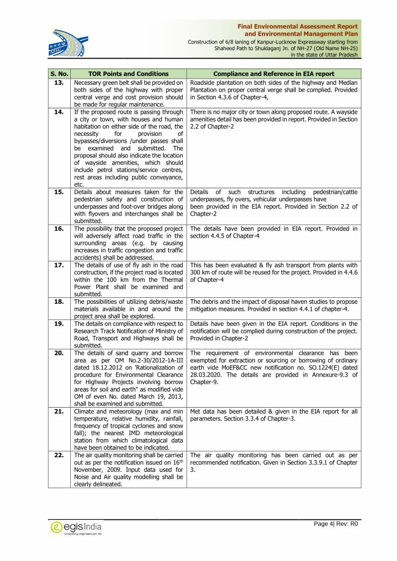
MOEFCC Terms of Reference Compliances The following are the compliances for the Terms of Reference issued by Ministry of Environment, Forest and Climate Change vide letter NO. F.No. 10-65/2018-IA.III dated 12th October 2018 for the Kanpur-Lucknow Expressway.
S. No. TOR Points and Conditions Compliance and Reference in EIA report
1. Suitable arrangements should be made to avoid the congestion at both the exit points of proposed highway.
Suitable structural arrangement is provided to avoid congestion along expressway. The Traffic Management and Rod Safety Plan has been provided. The details are provided in section-2 of Chapter-2, section 4.4.5 of chapter-4 and Annex-9.8 of Chater-9.
2. Water bodies along proposed alignment needs to be surveyed for their conservation and sustainability. Each water body should be clearly identified with its size, any important and threatened species associated with it, its usage by local community along with shape file of each of water body. Impact of proposed project on these water bodies to be identified along with mitigation measures. Emphasis should be given to avoid alignment passing through/over water bodies.
The details of water bodies have been studied and given in EIA report. The details are provided in section 3.3.5 of Chapter-3, section 4.2.9 of chapter-4
3. Certificate from the Chief Wildlife Warden of the state of Chhattisgarh stating that no protected area/animal corridor are situated within the 10 km range of the proposed alignment.
NHAI vide its letters ref. no 25001/NHAI/PIU/ KNP-LKO/ Expressway/ 2018 dated 09.08.2018 approached wildlife department on which CF vide its letter no 283/8-5 dated 10.08.2018 informed that Nawabganj Wildlife Sanctuary (PA) falls within 9Km range of the Proposed alignment. However, the proposed alignment is far away from its final eco-sensitive zone. The details are provided in Section 3.4.3 of Chapter-3
4. Source of water availability to be ascertained for construction and domestic need. Necessary permissions to be obtained from State Authority/ CGWA if any.
The water availability required for the project has been assessed. All necessary permissions shall be obtained for abstraction of water. The details are provided in Section 4.4.6.1 of Chapter-4
5. Rain water harvesting structures to be constructed at the either sides of the road with special precaution of oil filters and de-silting chambers.
129 RWH pits to accommodate between alternate piers of elevated section with oil separation pits and 131 RWH at every 500m section of either side of greenfield expressway is proposed. The details are provided in Section 4.4.9.2 of Chapter-4 and Annex 9.5 of Chapter-9.
6. Social Indicators need to be developed for understand the socio-economic profile of the society/people living around the proposed alignment.
The social impact to understand the socio-economic profile have been assessed and accordingly R&R plan for project have been provided. The details are provided in Chapter-7.
7. Provide compilation of road kill data on existing roads (national and state highways) in the vicinity of the proposed project.
The proposed Expressway is completely new alignment and hence presently there is no traffic. So, at present there is no accident record available for this road. However, during the operation stage there will be provision of Post-Accident Emergency assistance in the project such as highway patrolling vehicle, CCTV Camera at particular locations, ambulances, recovery vane/ Crain, first Aid facilities, etc. The traffic Management and Road Safety plan has been included as Annexure 9.8 of chapter-9.

Final Environmental Assessment Report and Environmental Management Plan
Construction of 6/8 laning of Kanpur-Lucknow Expressway starting from Shaheed Path to Shuklaganj Jn. of NH-27 (Old Name NH-25)
in the state of Uttar Pradesh
Page 2| Rev: R0
S. No. TOR Points and Conditions Compliance and Reference in EIA report
8. The proposed alignment should be such that the cutting of trees is kept at bare minimum and for this the proponent shall obtain permission from the competent authorities.
The trees to be cut will be kept at the minimum level, during construction, proper care will be exercised to avoid additional loss/cutting of trees. To balance the ecological loss, compensatory afforestation will be done as per the clearance condition laid down by the forest department. A general guideline for tree plantation will be followed as per IRC: SP: 21:2009. Details provided in Section 4.2.6 of Chapter-4 and Annexure-9.1
9. ROW should not exceed 70m at any point of the proposed 8-lane alignment as per MoRT&H circular no. NH-15017/21/ 2018 dated 10th May, 2018. Since, the ROW of the proposed alignment shall be reduced from 120m to 70m, therefore it is important to assess the present and projected traffic densities on the highway/ expressway.
The referred MORTH circular is for existing road, hence not applicable for the proposed project
General Condition
1. A brief description of the project, project name, nature, size, its importance to the region/state and the country shall be submitted.
The brief description of project provided in EIA report. Details provided in chapter-1
2. In case the project involves diversion of forests land, guidelines under OM dated 20.03.2013 shall be followed and necessary action be taken accordingly.
Necessary guidelines for diversion of Forest land will be followed & complied. Details/write-up of forest diversion, etc. given in section 4.2.6 of chapter 4
3. Details of any litigation(s) pending against the project and/or any directions or orders passed by any court of law/any statutory authority against the project to be detailed out.
No Litigation. Details provided in section 1.12 of Chapter-1
4. Detailed alignment plan, with details such as nature of terrain (plain, rolling, hilly), land use pattern, habitation, cropping pattern, forest area, environmentally sensitive areas, mangroves, notified industrial areas, sand dunes, sea, rivers, lakes, details of villages, tehsils, districts and states, latitude and longitude for important locations falling on the alignment by employing remote sensing techniques followed by "ground trothing" and also through secondary data sources shall be submitted.
The details are provided in EIA report. Details provided in Chapter-3
5. Describe various alternatives considered, procedures and criteria adopted for selection of the final alternative with reasons.
The project has been assessed based on with and without project scenario. Alternative alignments have been assessed for the recommendation of project alignment. Detailed analysis of alternatives have been provided in Chapter-5
6. Land use map of the study area to a scale of 1: 25,000 based on recent satellite imagery delineating the crop lands (both single and double crop), agricultural plantations, fallow lands, waste lands, water bodies, built-up areas, forest area and other surface features such as railway tracks, ports, airports, roads, and major industries etc. along with detailed ground survey map on 1:2000 scale showing the existing features falling
Land Use Map of the study area of required details have been provided in report. Details are provided in Chapter-3

Final Environmental Assessment Report and Environmental Management Plan
Construction of 6/8 laning of Kanpur-Lucknow Expressway starting from Shaheed Path to Shuklaganj Jn. of NH-27 (Old Name NH-25)
in the state of Uttar Pradesh
Page 3| Rev: R0
S. No. TOR Points and Conditions Compliance and Reference in EIA report
within the right of way namely trees, structures including archaeological & religious, monuments etc. if any, shall be submitted.
7. If the proposed route is passing through any hilly area, the measures for ensuring stability of slopes and proposed measures to control soil erosion from embankment shall be examined and submitted.
The proposed route mainly passes through plain section. The measures for slope stabilisation and soil control measures are provided in EIA report. The details are provided in section 4.4. of chapter-4.
8. If the proposed route involves tunnelling, the details of the tunnel and locations of tunnelling with geological structural fraction should be provided. In case the road passes through a flood plain of a river, the details of micro drainage, flood passages and information on flood periodicity at least of the last 50 years in the area shall be examined and submitted.
The project does not involve tunnelling. Design discharge has been taken as the maximum of the peak flood discharge by different methods provided it does not exceed the next highest discharge more than 50%. If it exceeds, it is restricted to that limit (As per Article 6.2.1 of IRC: SP: 13-2004). Terrain details has been provided in Section 3.3.1 in Chapter 3. Please refer section 2.2.13 of Chapter 2 for details of the CD structures.
9. If the project is passing through/located within the notified ecologically sensitive zone (ESZ) around a notified National Park/Wildlife Sanctuary or in the absence of notified ESZ, within 10 km from the boundary of notified National Park/Wildlife Sanctuary, the project proponent may simultaneously apply for the clearance for the standing committee of NBWL. The EC for such project would be subject to obtaining the clearance from the standing committee of NBWL.
The project neither falls within the Protected Area nor within the notified ESZ of any PA, therefore clearance from the Standing Committee of NBWL is not required. Details of ecological protected area are provided in Section 3.4.3 of Chapter-3.
10. Study regarding the animal bypasses/underpasses etc. across the habitation areas shall be carried out. Adequate cattle pass for the movement of agriculture material shall be provided at the stretches passing through habitation areas. Underpasses shall be provided for the movement of Wild animals.
4 nos. Major Bridge, 14 nos. Minor Bridges, 1 nos. ROBs, 11 nos. VUPs, 8 nos. LVUPs, 11 nos. PUPs, 94 culverts are proposed. The details are provided in Section 2.2 of chapter-2.
11. Study regarding in line with the recent guidelines prepared by Wildlife Institute of India for linear infrastructure with strong emphasis on animal movement and identifying crossing areas and mitigation measures to avoid wildlife mortality.
The project does not fall within 10km of any Tiger /Elephant Reserves. However appropriate measures are taken for the ecological resources. Details provided in Section 3.4.2 of Chapter-3.
12. The information shall be provided about the details of the trees to be cut including their species and whether it also involves any protected or endangered species. Measures taken to reduce the number of the trees to be removed should be explained in detail. The details of compensatory plantation shall be submitted. The possibilities of relocating the existing trees shall be explored.
Details have been provided in the EIA report as per requirement, including tree details, protection measures, compensatory reforestation and avenue plantation, etc. Provided in Section 3.4, and Table 9.1 of Chapter-9
Final Environmental Assessment Report and Environmental Management Plan
Construction of 6/8 laning of Kanpur-Lucknow Expressway starting from Shaheed Path to Shuklaganj Jn. of NH-27 (Old Name NH-25)
in the state of Uttar Pradesh
Page 4| Rev: R0
S. No. TOR Points and Conditions Compliance and Reference in EIA report
13. Necessary green belt shall be provided on both sides of the highway with proper central verge and cost provision should be made for regular maintenance.
Roadside plantation on both sides of the highway and Median Plantation on proper central verge shall be complied. Provided in Section 4.3.6 of Chapter-4,
14. If the proposed route is passing through a city or town, with houses and human habitation on either side of the road, the necessity for provision of bypasses/diversions /under passes shall be examined and submitted. The proposal should also indicate the location of wayside amenities, which should include petrol stations/service centres, rest areas including public conveyance, etc.
There is no major city or town along proposed route. A wayside amenities detail has been provided in report. Provided in Section 2.2 of Chapter-2
15. Details about measures taken for the pedestrian safety and construction of underpasses and foot-over bridges along with flyovers and interchanges shall be submitted.
Details of such structures including pedestrian/cattle underpasses, fly overs, vehicular underpasses have been provided in the EIA report. Provided in Section 2.2 of Chapter-2
16. The possibility that the proposed project will adversely affect road traffic in the surrounding areas (e.g. by causing increases in traffic congestion and traffic accidents) shall be addressed.
The details have been provided in EIA report. Provided in section 4.4.5 of Chapter-4
17. The details of use of fly ash in the road construction, if the project road is located within the 100 km from the Thermal Power Plant shall be examined and submitted.
This has been evaluated & fly ash transport from plants with 300 km of route will be reused for the project. Provided in 4.4.6 of Chapter-4
18. The possibilities of utilizing debris/waste materials available in and around the project area shall be explored.
The debris and the impact of disposal haven studies to propose mitigation measures. Provided in section 4.4.1 of chapter-4.
19. The details on compliance with respect to Research Track Notification of Ministry of Road, Transport and Highways shall be submitted.
Details have been given in the EIA report. Conditions in the notification will be complied during construction of the project. Provided in Chapter-2
20. The details of sand quarry and borrow area as per OM No.2-30/2012-1A-III dated 18.12.2012 on 'Rationalization of procedure for Environmental Clearance for Highway Projects involving borrow areas for soil and earth" as modified vide OM of even No. dated March 19, 2013, shall be examined and submitted.
The requirement of environmental clearance has been exempted for extraction or sourcing or borrowing of ordinary earth vide MoEF&CC new notification no. SO.1224(E) dated 28.03.2020. The details are provided in Annexure-9.3 of Chapter-9.
21. Climate and meteorology (max and min temperature, relative humidity, rainfall, frequency of tropical cyclones and snow fall); the nearest IMD meteorological station from which climatological data have been obtained to be indicated.
Met data has been detailed & given in the EIA report for all parameters. Section 3.3.4 of Chapter-3.
22. The air quality monitoring shall be carried out as per the notification issued on 16th November, 2009. Input data used for Noise and Air quality modelling shall be clearly delineated.
The air quality monitoring has been carried out as per recommended notification. Given in Section 3.3.9.1 of Chapter 3.

Final Environmental Assessment Report and Environmental Management Plan
Construction of 6/8 laning of Kanpur-Lucknow Expressway starting from Shaheed Path to Shuklaganj Jn. of NH-27 (Old Name NH-25)
in the state of Uttar Pradesh
Page 5| Rev: R0
S. No. TOR Points and Conditions Compliance and Reference in EIA report
23. The project activities during construction and operation phases, which will affect the noise levels and the potential for increased noise resulting from this project shall be identified. Discuss the effect of noise levels on nearby habitations during the construction and operational phases of the proposed highway. Identify noise reduction measures and traffic management strategies to be deployed for reducing the negative impact if any. Prediction of noise levels shall be done by using mathematical modelling at different representative locations.
The impact assessment by monitoring, modelling of noise due to project has been conducted in details & as per TOR requirements & guidelines. The findings of prediction noise modelling has been provided in section 4.5.4 of Chapter 4.
24. The impact during construction activities due to generation of fugitive dust from crusher units, air emissions from hot mix plants and vehicles used for transportation of materials and prediction of impact on ambient air quality using appropriate mathematical model, description of model, input requirement and reference of derivation, distribution of major pollutants and presentation in tabular form for easy interpretation shall be examined and carried out.
The air quality impacts study & prediction has been conducted & reported. Details provided in Section 4.5.3 in Chapter 4.
25. The details about the protection to existing habitations from dust, noise, odour etc. during construction stage shall be examined and submitted.
The details provided in EIA report. The details of protection measures have been proposed under mitigation measures provided in section 4.4.7.1 of Chapter 4
26. If the proposed route involves cutting of earth, the details of area to be cut, depth of cut, locations, soil type, volume and quantity of earth and other materials to be removed with location of disposal/ dump sites along with necessary permission.
Details have been provided in the report. The details of estimated quantity of cutting materials as well as material requirement have been given in Section 4.2.1 of Chapter 4.
27. If the proposed route is passing through low lying areas, details of filling materials and initial and final levels after filling above MSL, shall be examined and submitted.
No low lying area as such has been reported.
28. The water bodies including the seasonal ones within the corridor of impacts along with their status, volumetric capacity, quality and likely impacts on them due to the project along with the mitigation measures, shall be examined and submitted.
The details of water bodies has been studied and given in EIA report.
29. The details of water quantity required and source of water including water requirement during the construction stage with supporting data and also classification of ground water based on the CGWA classification, shall be examined and submitted.
Details of source & requirements has been evaluated and given in EIA report.

Final Environmental Assessment Report and Environmental Management Plan
Construction of 6/8 laning of Kanpur-Lucknow Expressway starting from Shaheed Path to Shuklaganj Jn. of NH-27 (Old Name NH-25)
in the state of Uttar Pradesh
Page 6| Rev: R0
S. No. TOR Points and Conditions Compliance and Reference in EIA report
30. The details of measures taken during constructions of bridges across rivers/ canals/major or minor drains keeping in view the flooding of the rivers and the life span of the existing bridges shall be examined and submitted. Provision of speed breakers, safety signals, service lanes and foot paths shall be examined at appropriate locations throughout the proposed road to avoid accidents.
Study details have been in provided in EIA report.
31. If there will be any change in the drainage pattern after the proposed activity, details of changes shall be examined and submitted.
Adequate Cross drainage (CD) structures are provided for more permeably in order to maintain the drainage pattern. Section 2.6 of Chapter 2 gives details of cross drainage structures.
32. Rain water harvesting pit shall be at least 3 - 5 m above the highest ground water table. Provisions shall be made for oil and grease removal from surface runoff.
The RWH pits along with the oil separators have been proposed.
33. If there is a possibility that the construction/widening of road may cause an impact such as destruction of forest, poaching or reduction in wetland areas, examine the impact and submit details.
The project is entirely greenfield alignment. The impact on ecological resources of proposed project has been studied. The details have been provided in Section 4.2.6 of Chapter 4.
34. The details of road safety, signage, service roads, vehicular under passes, accident prone zones and the mitigation measures, shall be submitted.
The Safety provisions for Road users have been adequately addressed in the project. The proposed features are provided in Section 2.6 of Chapter 2 and annexure 9.8 of chapter-9.
35. IRC guidelines shall be followed for widening & upgradation of roads.
The project involves Green Field alignment however relevant IRC guidelines have been followed for the development. Refer Chapter 2 for details on IRC Guidelines.
36. The details of social impact assessment due to the proposed construction of the road, shall be submitted.
The Social Impact Assessment has been conducted & reported in details. Refer Chapter-7
37. Examine the road design standards, safety equipment specifications and Management System training to ensure that design details take account of safety concerns and submit the traffic management plan.
The Safety provisions for Road users have been adequately addressed in the project. Provided in Section 2.6 of Chapter 2 and Annexure 9.8 of Chapter 9
38. Accident data and geographic distribution shall be reviewed and analysed to predict and identify trends - in case of expansion of the existing highway and provide Post accident emergency assistance and medical care to accident victims.
The proposed Expressway is completely new alignment and hence presently there is no traffic. So, at present there is no accident record available for this road. However, during the operation stage there will be provision of Post-Accident Emergency assistance in the project such as highway patrolling vehicle, CCTV Camera at particular locations, ambulances, recovery vane/ Crain, first Aid facilities, etc. The traffic Management and Road Safety plan has been included as Annexure 9.8 and on O.1 in Table 9.2 of Chapter 9
39. If the proposed project involves any land reclamation, details shall be provided of the activity for which land is to be reclaimed and the area of land to be reclaimed.
Not applicable.
40. Details of the properties, houses, business activities etc. likely to be effected by land acquisition and an estimation of their financial losses, shall be submitted.
This has been covered in SIA and R&R report. Details of structure affected in section 7.6 under chapter 7.
Final Environmental Assessment Report and Environmental Management Plan
Construction of 6/8 laning of Kanpur-Lucknow Expressway starting from Shaheed Path to Shuklaganj Jn. of NH-27 (Old Name NH-25)
in the state of Uttar Pradesh
Page 7| Rev: R0
S. No. TOR Points and Conditions Compliance and Reference in EIA report
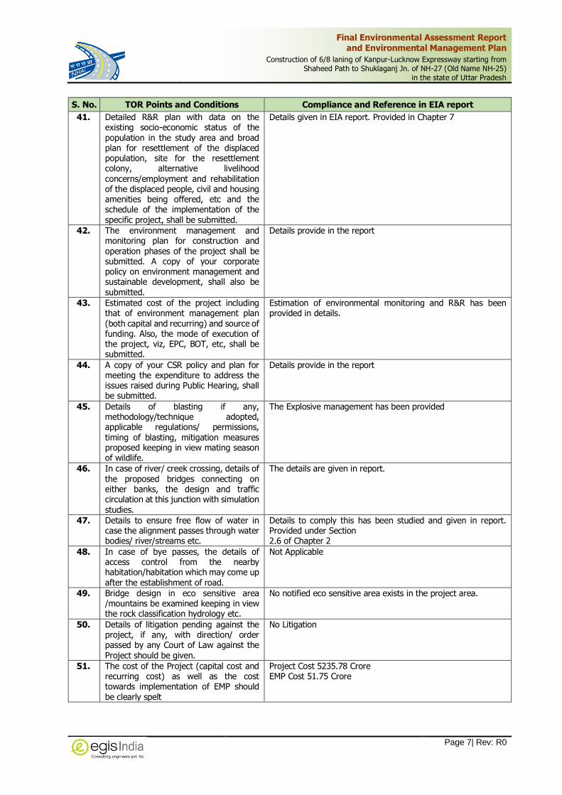
41. Detailed R&R plan with data on the existing socio-economic status of the population in the study area and broad plan for resettlement of the displaced population, site for the resettlement colony, alternative livelihood concerns/employment and rehabilitation of the displaced people, civil and housing amenities being offered, etc and the schedule of the implementation of the specific project, shall be submitted.
Details given in EIA report. Provided in Chapter 7
42. The environment management and monitoring plan for construction and operation phases of the project shall be submitted. A copy of your corporate policy on environment management and sustainable development, shall also be submitted.
Details provide in the report
43. Estimated cost of the project including that of environment management plan (both capital and recurring) and source of funding. Also, the mode of execution of the project, viz, EPC, BOT, etc, shall be submitted.
Estimation of environmental monitoring and R&R has been provided in details.
44. A copy of your CSR policy and plan for meeting the expenditure to address the issues raised during Public Hearing, shall be submitted.
Details provide in the report
45. Details of blasting if any, methodology/technique adopted, applicable regulations/ permissions, timing of blasting, mitigation measures proposed keeping in view mating season of wildlife.
The Explosive management has been provided
46. In case of river/ creek crossing, details of the proposed bridges connecting on either banks, the design and traffic circulation at this junction with simulation studies.
The details are given in report.
47. Details to ensure free flow of water in case the alignment passes through water bodies/ river/streams etc.
Details to comply this has been studied and given in report. Provided under Section 2.6 of Chapter 2
48. In case of bye passes, the details of access control from the nearby habitation/habitation which may come up after the establishment of road.
Not Applicable
49. Bridge design in eco sensitive area /mountains be examined keeping in view the rock classification hydrology etc.
No notified eco sensitive area exists in the project area.
50. Details of litigation pending against the project, if any, with direction/ order passed by any Court of Law against the Project should be given.
No Litigation
51. The cost of the Project (capital cost and recurring cost) as well as the cost towards implementation of EMP should be clearly spelt
Project Cost 5235.78 Crore EMP Cost 51.75 Crore

Final Environmental Assessment Report
and Environmental Management Plan
Construction of 6/8 laning of Kanpur-Lucknow Expressway starting from
Shaheed Path to Shuklaganj Jn. of NH-27 (Old Name NH-25)
in the state of Uttar Pradesh
Page i| Rev: R0
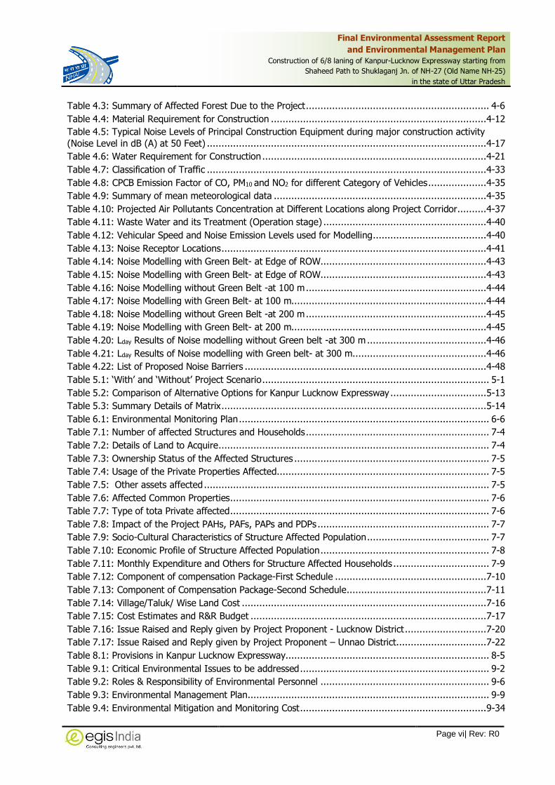
TABLE OF CONTENTS
Chapter Description Page
E EXECUTIVE SUMMARY ...................................................................................... E-1
E.1 Project Description .......................................................................................................... E-1
E.2 Project Intervention ......................................................................................................... E-3
E.3 Key Environmental Laws and Regulations ........................................................................... E-4
E.4 Description of The Environment ........................................................................................ E-7
E.5 Anticipated environmental Impacts and Mitigation measures .............................................. E-13
E.6 Analysis of Alternatives .................................................................................................. E-15
E.7 Environmental Monitoring Programme ............................................................................. E-16
E.8 Social Impact Assessment .............................................................................................. E-16
E.9 Project benefits ............................................................................................................. E-17
E.10 Environmental Management Plan .................................................................................... E-18
1 INTRODUCTION ................................................................................................ 1-1
1.1 Purpose of the Report ...................................................................................................... 1-1
1.2 Details of the Project Proponent ........................................................................................ 1-1
1.3 Location of the Project ..................................................................................................... 1-2
1.4 New Alignment of Kanpur-Lucknow Expressway (‘KLE’) ........................................................ 1-2
1.5 Ecological Sensitivity of the Location of the Project.............................................................. 1-4
1.6 Brief Description of Nature, Size and Category of the Project ................................................ 1-6
1.7 Importance of the Project................................................................................................. 1-6
1.8 Objectives of the Study .................................................................................................... 1-6
1.9 Terms of Reference (TOR Approved by EAC) ...................................................................... 1-6
1.10 Environmental Policies and Legislation ............................................................................... 1-8
1.11 Summary of Statutory Clearance Requirement: ..................................................................1-13
1.12 Litigation Status .............................................................................................................1-15
1.13 Structure of the Report ...................................................................................................1-15
2 PROJECT DESCRIPTION ................................................................................... 2-1
2.1 Project Background ......................................................................................................... 2-1
2.2 Project Configuration ....................................................................................................... 2-1
2.3 Raw Material Required under Project ................................................................................2-18
2.4 Land Requirement ..........................................................................................................2-19
2.5 Traffic Studies ................................................................................................................2-19
2.6 Traffic Projection ............................................................................................................2-23

Final Environmental Assessment Report
and Environmental Management Plan
Construction of 6/8 laning of Kanpur-Lucknow Expressway starting from
Shaheed Path to Shuklaganj Jn. of NH-27 (Old Name NH-25)
in the state of Uttar Pradesh
Page ii| Rev: R0
2.7 Man Power Requirement .................................................................................................2-24
2.8 Proposed Schedule for Approval & Implementation ............................................................2-24
2.9 IRC Specifications to be Followed .....................................................................................2-25
3 DESCRIPTION OF ENVIRONMENT ................................................................... 3-1
3.1 Study Area ..................................................................................................................... 3-1
3.2 Scope of Baseline Studies ................................................................................................. 3-1
3.3 Physical Environment ....................................................................................................... 3-3
3.4 Ecological Resources .......................................................................................................3-39
3.5 Socio – Economic Environment ........................................................................................3-45
4 ANTICIPATED ENVIRONMENTAL IMPACTS AND MITIGATION MEASURES ... 4-1
4.1 Assessment Methodology ................................................................................................. 4-1
4.2 Impacts during Design Stage ............................................................................................ 4-2
4.3 Impacts During Pre-Construction Phase ............................................................................. 4-8
4.4 Impacts During Construction Phase ..................................................................................4-11
4.5 Impacts During Operational Phase....................................................................................4-31
5 ANALYSIS OF ALTERNATIVES .......................................................................... 5-1
5.1 Introduction .................................................................................................................... 5-1
5.2 “With” and “Without” Project Scenario ............................................................................... 5-1
5.3 Alternative in terms of Technology and Site ........................................................................ 5-3
5.4 Summary of Adverse Impact due to each alternative ..........................................................5-13
Salient Features of Recommended Alternative Option-7 ..................................................................5-14
6 ENVIRONMENTAL MONITORING PROGRAMME .............................................. 6-1
6.1 Performance Indicators (PIS) ............................................................................................ 6-1
6.2 Selection of Indicators for Monitoring................................................................................. 6-1
6.3 Monitoring of Performance Indicators ................................................................................ 6-2
6.4 Environmental Monitoring Action Plan ................................................................................ 6-4
6.5 Environmental Reporting System ....................................................................................... 6-4
6.6 Various Committees at Working ........................................................................................ 6-5
6.7 Emergency Procedures ..................................................................................................... 6-5
6.8 Environmental Monitoring Detailed Budget ......................................................................... 6-5
7 ADDITIONAL STUDIES ..................................................................................... 7-1
7.1 Introduction .................................................................................................................... 7-1
7.2 SOCIAL IMPACT ASSESSMENT AND R & R ACTION PLAN ..................................................... 7-1
7.3 Public Hearing and Consultation .......................................................................................7-18
8 PROJECT BENEFITS .......................................................................................... 8-1
8.1 Introduction.................................................................................................................... 8-1
8.2 Improvement in Physical Infrastructure .............................................................................. 8-1
8.3 Improvements in the Social Infrastructure .......................................................................... 8-2

Final Environmental Assessment Report
and Environmental Management Plan
Construction of 6/8 laning of Kanpur-Lucknow Expressway starting from
Shaheed Path to Shuklaganj Jn. of NH-27 (Old Name NH-25)
in the state of Uttar Pradesh
Page iii| Rev: R0
8.4 Corporate Environmental Responsibility.............................................................................. 8-2
8.5 Employment Opportunity .................................................................................................. 8-4
8.6 Other Tangible Benefits .................................................................................................... 8-4
9 ENVIRONMENTAL MANAGEMENT PLAN (EMP) ............................................... 9-1
9.1 Objectives of the EMP ...................................................................................................... 9-1
9.2 Critical Environmental Issues ............................................................................................ 9-2
9.3 Environmental Management Action Plan ............................................................................. 9-8
9.4 Environmental Training .................................................................................................... 9-8
9.5 Environmental Budgeting ................................................................................................9-34
10 DISCLOSURE OF CONSULTANTS ENGAGED ................................................... 10-1
10.1 Preamble .......................................................................................................................10-1
10.2 Environmental Impact Assessment Study – Consultancy Firm ..............................................10-1
10.3 Team of Consultants .......................................................................................................10-1

Final Environmental Assessment Report
and Environmental Management Plan
Construction of 6/8 laning of Kanpur-Lucknow Expressway starting from
Shaheed Path to Shuklaganj Jn. of NH-27 (Old Name NH-25)
in the state of Uttar Pradesh
Page iv| Rev: R0
LIST OF TABLES
Table E.1: Details of Project Alignment .......................................................................................... E-1
Table E.2: Salient Features of the Proposed Project ........................................................................ E-1
Table E.3: Material Requirement for Construction ........................................................................... E-3
Table E.4: Summary of Relevant Environmental Legislations ............................................................ E-4
Table E.5: Summary of Statutory Clearance Requirement of the Project ............................................ E-6
Table E.6: Climatic Condition of Project site at Lucknow and Unnao .................................................. E-8
Table E.7: Rivers/Streams/Reservoirs along Project Corridor ............................................................ E-9
Table E.8: Surface Water Sampling Location ................................................................................ E-10
Table E.9: Ground Water Sampling Location ................................................................................ E-10
Table E.10: Forest Area along the Project Road ............................................................................ E-11
Table E.11: District wise Demographic Profile of the Project Area ................................................... E-12
Table E.12: Land Use of the Study area (1Km) ............................................................................. E-13
Table E.13: Anticipated Environmental Impacts due to the Proposed Project and their Mitigation Measures during Pre-Construction Stage: ................................................................................................... E-13
Table E.14: Impact of the Project PAHs, PAFs, PAPs and PDPs ....................................................... E-17
Table E.15: Environmental Monitoring Plan .................................................................................. E-20
Table 1.1: Salient Features of the Project ...................................................................................... 1-2
Table 1.2: Other Sensitive Features .............................................................................................. 1-4
Table 1.3: Summary of Relevant Environmental Legislations ............................................................ 1-8
Table 1.4: Summary of Statutory Clearance Requirement of the Project ...........................................1-13
Table 2.1: District wise Length Break-up of Proposed Expressway .................................................... 2-1
Table 2.2: Salient Features of the Kanpur-Lucknow Expressway ....................................................... 2-2
Table 2.3: Cross-fall on Different Surfaces ..................................................................................... 2-4
Table 2.4: Proposed Typical Cross Section ..................................................................................... 2-5
Table 2.5: Details of Proposed Connecting Roads ........................................................................... 2-6
Table 2.6: Summary of New Major/Minor Bridges to 8-lane Configuration .......................................... 2-6
Table 2.7: Summary of Fly Over ................................................................................................... 2-7
Table 2.8: Summary of Proposals of New VUPs & PUPs of 8-lane Configuration .................................. 2-8
Table 2.9: Improvement Proposals for Existing Culverts .................................................................. 2-8
Table 2.10: Proposed Culverts in Green field Area of Expressway ..................................................... 2-9
Table 2.11: Major Junctions ........................................................................................................2-11
Table 2.12: Minor Junctions ........................................................................................................2-11
Table 2.13: Details of Railway Over Bridge (ROB) ..........................................................................2-12
Table 2.14: Details of Proposed Viaduct ........................................................................................2-12
Table 2.15: Proposed Pavement Design for Main Carriageway .........................................................2-13
Table 2.16: Pavement composition for Connecting roads ................................................................2-13
Table 2.17: Lined Drain Locations ................................................................................................2-14
Table 2.18: Design Service Volume for Expressway ........................................................................2-14
Table 2.19: Width of ROW available for Green Belt Development.....................................................2-14
Table 2.20: Scope for Highway Lighting as per IRC: SP: 99-2013 ....................................................2-16

Final Environmental Assessment Report
and Environmental Management Plan
Construction of 6/8 laning of Kanpur-Lucknow Expressway starting from
Shaheed Path to Shuklaganj Jn. of NH-27 (Old Name NH-25)
in the state of Uttar Pradesh
Page v| Rev: R0
Table 2.21: Material Requirement for Construction ........................................................................2-18
Table 2.22: Details of Water Requirement.....................................................................................2-18
Table 2.23: Details of Land to be Acquired ....................................................................................2-19
Table 2.24: Homogenous Section for Traffic Survey .......................................................................2-19
Table 2.25: Schedule of Traffic Surveys ........................................................................................2-20
Table 2.26: Annual Average Daily Traffic ......................................................................................2-21
Table 2.27: Projected Growth Rates .............................................................................................2-22
Table 2.28: Mode Year wise Traffic Distribution .............................................................................2-23
Table 2.29: Traffic Projection for Homogeneous Sections KLE .........................................................2-23
Table 2.30: Project Implementation Schedule................................................................................2-24
Table 2.31: Details of IRC/MORTH Codes and Guidelines ................................................................2-25
Table 3.1: Sources of Secondary Data ........................................................................................... 3-2
Table 3.2: Land Use of the Lucknow and Unnao District .................................................................. 3-8
Table 3.3: Land Use of the Study area (1Km) ................................................................................. 3-8
Table 3.4: Monthly Mean Maximum and Mean Minimum Temperature (Deg. C) of the Project Districts (year 2005 to 2015) ...................................................................................................................3-10
Table 3.5: Monthly Rainfall in the Project Districts .........................................................................3-12
Table 3.6: Average Monthly Relative Humidity Levels .....................................................................3-13
Table 3.7: Average Monthly Wind Speed of the Project Districts ......................................................3-13
Table 3.8: Location Details of the Micro Meteorological Station ........................................................3-14
Table 3.9: Water Bodies along the Project Road ............................................................................3-16
Table 3.10: Ground Water Resources of Concerned Blocks .............................................................3-17
Table 3.11: Location of Ambient Air Quality ..................................................................................3-19
Table 3.12: Ambient Air Quality Test Results .................................................................................3-21
Table 3.13: Ambient Noise Monitoring Locations ............................................................................3-23
Table 3.14: Ambient Noise Levels Monitoring Test Results ..............................................................3-24
Table 3.15: Ground Water Sampling Locations ..............................................................................3-25
Table 3.16: Ground Water Quality Test Results .............................................................................3-27
Table 3.17: Surface Water Sampling Locations ..............................................................................3-30
Table 3.18: Surface Water Quality Test Results .............................................................................3-31
Table 3.19: Soil Sampling Locations .............................................................................................3-34
Table 3.20: Physico-chemical Characteristics of Soil along the proposed Project ................................3-34
Table 3.21: Details of Identified Aggregate Quarry for the Project ...................................................3-36
Table 3.22: Description of Soil Borrow Sources ..............................................................................3-36
Table 3.23: Details of Fly Ash Consumption ..................................................................................3-38
Table 3.24: District-wise Forest Coverage along Project Road .........................................................3-40
Table 3.25: Non-Forest Trees falling within Proposed ROW of the project alignment ..........................3-42
Table 3.26: Girth Wise Trees falling within Proposed ROW of the project alignment ...........................3-43
Table 3.27: List of Archaeological Site in Project Districts................................................................3-44
Table 3.28: District wise Demographic profile of the project Area ....................................................3-45
Table 3.29: District wise Literacy Rate of the Project Area ..............................................................3-46
Table 3.30: Percentage Decadal Growth rates ...............................................................................3-47
Table 3.31: SC and ST Population in the Concerned Project District .................................................3-47
Table 3.32: Proportion of workers and non-workers in Lucknow and Unnao Districts .........................3-48
Table 3.33: Occupation profile of Lucknow and Unnao Districts .......................................................3-48
Table 4.1: Details of Land Acquisition as per NH Act, 1956 .............................................................. 4-4
Table 4.2: Rainwater Harvesting Potential of the Proposed Elevated Corridors ................................... 4-5
Final Environmental Assessment Report
and Environmental Management Plan
Construction of 6/8 laning of Kanpur-Lucknow Expressway starting from
Shaheed Path to Shuklaganj Jn. of NH-27 (Old Name NH-25)
in the state of Uttar Pradesh
Page vi| Rev: R0
Table 4.3: Summary of Affected Forest Due to the Project ............................................................... 4-6
Table 4.4: Material Requirement for Construction ..........................................................................4-12 Table 4.5: Typical Noise Levels of Principal Construction Equipment during major construction activity
(Noise Level in dB (A) at 50 Feet) ................................................................................................4-17
Table 4.6: Water Requirement for Construction .............................................................................4-21
Table 4.7: Classification of Traffic ................................................................................................4-33
Table 4.8: CPCB Emission Factor of CO, PM10 and NO2 for different Category of Vehicles ....................4-35
Table 4.9: Summary of mean meteorological data .........................................................................4-35
Table 4.10: Projected Air Pollutants Concentration at Different Locations along Project Corridor..........4-37
Table 4.11: Waste Water and its Treatment (Operation stage) ........................................................4-40
Table 4.12: Vehicular Speed and Noise Emission Levels used for Modelling .......................................4-40
Table 4.13: Noise Receptor Locations ...........................................................................................4-41
Table 4.14: Noise Modelling with Green Belt- at Edge of ROW.........................................................4-43
Table 4.15: Noise Modelling with Green Belt- at Edge of ROW.........................................................4-43
Table 4.16: Noise Modelling without Green Belt -at 100 m ..............................................................4-44
Table 4.17: Noise Modelling with Green Belt- at 100 m...................................................................4-44
Table 4.18: Noise Modelling without Green Belt -at 200 m ..............................................................4-45
Table 4.19: Noise Modelling with Green Belt- at 200 m...................................................................4-45
Table 4.20: Lday Results of Noise modelling without Green belt -at 300 m .........................................4-46
Table 4.21: Lday Results of Noise modelling with Green belt- at 300 m ..............................................4-46
Table 4.22: List of Proposed Noise Barriers ...................................................................................4-48
Table 5.1: ‘With’ and ‘Without’ Project Scenario .............................................................................. 5-1
Table 5.2: Comparison of Alternative Options for Kanpur Lucknow Expressway .................................5-13
Table 5.3: Summary Details of Matrix ...........................................................................................5-14
Table 6.1: Environmental Monitoring Plan ...................................................................................... 6-6
Table 7.1: Number of affected Structures and Households ............................................................... 7-4
Table 7.2: Details of Land to Acquire ............................................................................................. 7-4
Table 7.3: Ownership Status of the Affected Structures ................................................................... 7-5
Table 7.4: Usage of the Private Properties Affected ......................................................................... 7-5
Table 7.5: Other assets affected .................................................................................................. 7-5
Table 7.6: Affected Common Properties ......................................................................................... 7-6
Table 7.7: Type of tota Private affected ......................................................................................... 7-6
Table 7.8: Impact of the Project PAHs, PAFs, PAPs and PDPs ........................................................... 7-7
Table 7.9: Socio-Cultural Characteristics of Structure Affected Population .......................................... 7-7
Table 7.10: Economic Profile of Structure Affected Population .......................................................... 7-8
Table 7.11: Monthly Expenditure and Others for Structure Affected Households ................................. 7-9
Table 7.12: Component of compensation Package-First Schedule ....................................................7-10
Table 7.13: Component of Compensation Package-Second Schedule................................................7-11
Table 7.14: Village/Taluk/ Wise Land Cost ....................................................................................7-16
Table 7.15: Cost Estimates and R&R Budget .................................................................................7-17
Table 7.16: Issue Raised and Reply given by Project Proponent - Lucknow District ............................7-20
Table 7.17: Issue Raised and Reply given by Project Proponent – Unnao District...............................7-22
Table 8.1: Provisions in Kanpur Lucknow Expressway...................................................................... 8-5
Table 9.1: Critical Environmental Issues to be addressed ................................................................. 9-2
Table 9.2: Roles & Responsibility of Environmental Personnel .......................................................... 9-6
Table 9.3: Environmental Management Plan ................................................................................... 9-9
Table 9.4: Environmental Mitigation and Monitoring Cost ................................................................9-34

Final Environmental Assessment Report
and Environmental Management Plan
Construction of 6/8 laning of Kanpur-Lucknow Expressway starting from
Shaheed Path to Shuklaganj Jn. of NH-27 (Old Name NH-25)
in the state of Uttar Pradesh
Page vii| Rev: R0
LIST OF FIGURES
Figure 1.1: Location Map Project Road .......................................................................................... 1-3
Figure 1.2: Proposed Expressway Alignment Marked on Satellite Imagery (Google Earth) .................... 1-5
Figure 2.1: Start and End Points of Proposed Kanpur-Lucknow Expressway ....................................... 2-2
Figure 2.2: Traffic Survey Locations .............................................................................................2-20
Figure 3.1: Physiographic Map of Uttar Pradesh.............................................................................. 3-4
Figure 3.2: Seismic Zones of India ................................................................................................ 3-6
Figure 3.3: Earthquake Zones of Uttar Pradesh .............................................................................. 3-6
Figure 3.4: Land Use of the Study Area (1 Km buffer) ..................................................................... 3-9
Figure 3.5: Monthly Minimum Temperature Variations in Project Districts .........................................3-11
Figure 3.6: Monthly Maximum Temperature Variations in Project Districts ........................................3-11
Figure 3.7: Distribution of Monthly Rainfall and Rainy Days in Project Districts (mm) .........................3-12
Figure 3.8: Variation of Relative Humidity Level in Project Districts ..................................................3-13
Figure 3.9: Monthly Variation of Wind Speed in Project Districts ......................................................3-14
Figure 3.10: Micro Meteorological Stations of the study area ...........................................................3-15
Figure 3.11: Wind Rose Diagram .................................................................................................3-15
Figure 3.12: Natural Drainage Pattern of the Study Area ................................................................3-17
Figure 3.13: Air Quality Monitoring Locations along Project corridor .................................................3-20
Figure 3.14: Noise Quality Monitoring Stations ..............................................................................3-24
Figure 3.15: Ground Water Quality Monitoring Locations ................................................................3-26
Figure 3.16: Surface Water Quality Monitoring Locations ...............................................................3-30
Figure 3.17: Soil Quality Sampling Locations .................................................................................3-34
Figure 3.18: Photographs of Borrow Area Sources .........................................................................3-37
Figure 3.19: Lead Chart for Borrow Area Sources ..........................................................................3-38
Figure 3.20: Typical Cross Section of Embankment with Fly ash ......................................................3-39
Figure 3.21: Lead Chart for Sand, Aggregate and Flyash ................................................................3-39
Figure 3.22: Forest Cover Map of Uttar Pradesh ............................................................................3-40
Figure 3.23: Wildlife Sanctuary, National Park in Uttar Pradesh .......................................................3-41
Figure 4.1: Impact Assessment Process ......................................................................................... 4-2
Figure 4.2: Typical Rainwater Harvesting Pits in Median .................................................................. 4-5
Figure 4.3: Diagram Showing a Typical Silt Fencing .......................................................................4-20
Figure 4.4: Schematic Plan for Disposal of Bituminous Waste ..........................................................4-24
Figure 4.5: A-Weighted Vehicle Noise Emission Levels ....................................................................4-41
Figure 5.1: Kanpur Lucknow Expressway Alternative Alignments ...................................................... 5-5
Figure 5.2: Option-1: West Side of Existing NH-27 .......................................................................... 5-6
Figure 5.3: Option-2: Crossing near Unnao Town ........................................................................... 5-7
Figure 5.4: Option-3: Crossing near Nawabganj.............................................................................. 5-8
Figure 5.5: Option-4: Crossing near Unnao and beyond Mohan ........................................................ 5-9
Figure 5.6: Option-5: East Side of Existing NH (Variant 1) ..............................................................5-10
Figure 5.7: Option-6: East Side of Existing NH (Variant 2) ..............................................................5-11
Figure 5.8: Option-7: East Side of Existing NH (Variant 3) ..............................................................5-12
Figure 7.1: The Organogram for R&R Cell .....................................................................................7-14
Figure 7.2: Public Hearing Photographs for Kanpur-Lucknow Expressway in Lucknow and Unnao District
...............................................................................................................................................7-23

Final Environmental Assessment Report
and Environmental Management Plan
Construction of 6/8 laning of Kanpur-Lucknow Expressway starting from
Shaheed Path to Shuklaganj Jn. of NH-27 (Old Name NH-25)
in the state of Uttar Pradesh
Page viii| Rev: R0
LIST OF ANNEXURES
Annexure-1.1 : Location Map on SOI KLE.pdf
Annexure-1.2 : Approved TOR
Annexure-2.1 : TCS Schedule
Annexure-2.2 : Typical Cross Section
Annexure-3.1 : NABL Certificate
Annexure-3.2 : LULC Maps
Annexure-3.3 : Monthly Average Metrological Data
Annexure-3.4 : DFO Communication on PA
Annexure-3.5 : Tree Enumeration List
Annexure-4.1 : Top Soil Management
Annexure-5.1 : Alternate Analysis Map
Annexure-5.2 : VEC Matrix
Annexure-6.1 : Air Quality Standards 2009
Annexure-6.2 : Noise Standards
Annexure-6.3 : Water Quality Standards-IS10500
Annexure-6.4 : Surface Water Quality Use
Annexure-7.1 : Proceedings of Public Hearing
Annexure-7.2 : List of Villages
Annexure-7.3 : Attendance Sheet of Public Consultation
Annexure-9.1 : Tree Plantation Strategy
Annexure-9.2 : Plant Site Management
Annexure-9.3 : Borrow Area Management
Annexure-9.4 : Quarry Area Management
Annexure-9.5 : Schematic Plan of RWH
Annexure-9.6 : Schematic Plan for Oil Interceptor
Annexure-9.7 : Fly Ash Management Plan
Annexure-9.8 : Traffic Management Plan and Road Safety
Annexure-9.9 : Explosive Management
Annexure-9.10 : EHS
Annexure-9.11 : Construction and Labour Management Plan

Final Environmental Assessment Report and Environmental Management Plan
Construction of 6/8 laning of Kanpur-Lucknow Expressway starting from Shaheed Path to Shuklaganj Jn. of NH-27 (Old Name NH-25)
in the state of Uttar Pradesh
Page E-1| Rev: R0
E EXECUTIVE SUMMARY
E.1 Project Description
The proposed project alignment of Lucknow-Kanpur Expressway is an Access Controlled 6 lane
(expandable to 8 lane) Greenfield project having length of 62.744 km. It starts from Shaheed
Path (Lucknow) of NH-25 and terminating at Shuklaganj Junction (Unnao) of NH-27 (Old NH-25)
in the state of Uttar Pradesh. The project passes through 42 villages with a proposed Right of
Way (ROW) of 90m. The Proposed alignment originates from NH 25, intersects SH 40, SH 38, NH
30, NH 31, AH-1, and terminates at same NH-25. The project corridor is divided into following
sections.
Table E.1: Details of Project Alignment
S. No.
Location Length (km)
District Remarks Start Ch End Ch
1. 11+000 (Shahed Path) 17+575 (LKO Ring Road) 6.575
Lucknow
Expressway will be an elevated section on the existing NH-25 up to a length 16.620 Km
2. 17+575 (LKO Ring Road) 27+620 (Bani) 10.045
3. 27+620 (Bani) 73+744
(Shuklaganj Jn.) 46.124 Unnao Greenfield Alignment
The project stretch of proposed expressway passes along the existing NH-27 where lot of local
traffic gets mixed up with the through traffic. Therefore, it is required to segregate the local
traffic from through traffic by providing an elevated section.
The salient features describing size of operation incl. associated facilities of the proposed project
are summarized below.
Table E.2: Salient Features of the Proposed Project
Sl. No. Items Proposed No’s
1. Project Road
Lucknow-Kanpur Expressway in the state of Uttar Pradesh. The proposed alignment can be divided into 2 parts: Part-1: Elevated section Over Existing Alignment of
NH-25 (Km 11.000 to 27.620 = 16.620Km) Part-2 : New Alignment from Bani Village to Unnao
(Km 27.620 to 73.744 = 46.124 km)
2. Type of Project Hybrid Annuity Model (HAM)
3. Location of Project
State District
Uttar Pradesh Lucknow (16.620 Km) Unnao (46.135 Km)
4. No. of Affected Villages by Land Acquisition
42 Villages (Lucknow-11, Unnao-31)
5. Total Length of the proposed project 62.744 Km
6. Total Area of Land Acquisition 476.7835ha.(Government-46.0695ha;Pvt.-430.7140 ha)
Others
7. Proposed Right of Way (ROW) 90-120m

Final Environmental Assessment Report and Environmental Management Plan
Construction of 6/8 laning of Kanpur-Lucknow Expressway starting from Shaheed Path to Shuklaganj Jn. of NH-27 (Old Name NH-25)
in the state of Uttar Pradesh
Page E-2| Rev: R0
Sl. No. Items Proposed No’s
8. Design Speed 120Kmph
9. Type of Pavement Flexible (bituminous layer)
10. Median width Flush median with 4.5m width
11. No of Traffic Lanes 2 x 3 Lane/2 x 4 Lane
12. Design Speed 120 kmph
13. Emabankment Average 3m on existing grounds with H:V::2:1
14. Elevated Highway (m) 10045m
15. CBR adopted (%) 9.4 to 34.85 and the average CBR is 17.21.
16. Viaduct Lucknow 2
Unnao 0
17. Inter changes Lucknow 1
Unnao 2
18. Major Bridges Lucknow 1
Unnao 3
19. Minor Bridge Lucknow 1
Unnao 24
20. Culverts Lucknow 29
Unnao 65
21. Railway Over Bridge Lucknow 0
Unnao 1
22. Vehicular Underpass/ Flyover Lucknow VUP – 0 LVUP – 0 Flyover – 1
Unnao 11 8 1
23. Cattle/Pedestrian Underpass Lucknow 0 (Entire stretch is elevated)
Unnao 11
24. Bus bays Lucknow
NIL Unnao
25. Truck Lay byes Lucknow Included in Wayside Amenities
areas. Unnao
26. Toll plaza Lucknow 0
Unnao 1
27. Service Road Lucknow 0
Unnao 17
28. Wayside Amenities Lucknow 0
Unnao 2
29. High mast lighting Interchange / Toll Plaza / Slip Road
30. Street lighting
External and Internal Lighting will be as per section-15 of the “Manual”. Street Lighting shall be provided at the locations of toll / ramp plaza, interchanges/slip roads and lighting on structures such as major bridges, ROB’s, Flyovers, Minor Bridges and Underpasses including high mast at toll plaza, interchange/slip roads. A power connection of appropriate load (including load other than illumination such as load of air conditioner, computers, other instruments installed on toll/ramp plaza, load required due to solar plant)shall be taken from state electricity department

Final Environmental Assessment Report and Environmental Management Plan
Construction of 6/8 laning of Kanpur-Lucknow Expressway starting from Shaheed Path to Shuklaganj Jn. of NH-27 (Old Name NH-25)
in the state of Uttar Pradesh
Page E-3| Rev: R0
Sl. No. Items Proposed No’s
20 Horticulture and Landscaping Through Out
22 No of Structures Affected 344 (Lucknow 176, Unnao 168)
23 Total Cost of the Project at current price level (in Cr.)
5235.77
24 Environment Management Cost (in Cr.) 51.75
E.1.1 Raw Material Required under Project
The project shall require significant amount of natural resources such as raw material for the
construction. The details of material are provided as below.
Table E.3: Material Requirement for Construction
Raw Material
/Fuel
Total Quantity for construction
Unit Potential Source Mode of
Transport
Distance of Source from Project Site
(in Km)
Type of Linkage
Soil 1,31,86,694 Cum Nearby Borrow Area Road Within 2 KM
The contractor will make the necessary material supply agreement with the authorized vendor during construction period
Sand 4,95,400 Cum Sand Quarries near Betwa River
Road 75
Cement 4,05,500 MT Authorized Vendors at Lucknow
Road 49
Blue Metal (Aggregates)
19,61,900 Cum Approved Quarry at Kabrai
Road 187
Bitumen 32,000 MT Refinery at Mathura Road 384
Steel 85,944 MT Authorized Vendors, SAIL, Lucknow
Road 49
Fly Ash 13,54,928 Cum TPP within 300 km radius like Unchahar Power Plant
Road Within 100 KM radial distance
Diesel 41,000 KLD Authorized Vendors Road
Water 2,900 KLD
Water is available all along the alignment from underground water mainly through tube wells and as surface water from rivers.
Road 1
After obtaining permission from the regulatory authorities
E.2 Project Intervention
The Environmental Impact Assessment (EIA) Notification 2006, Ministry of Environment and
Forest and Climate Change, Government of India, came into effect from 14th September 2006.
The EIA Notification, 2006 specifies the various development projects requiring prior clearance
from Ministry of Environment and Forests (MoEF&CC). As per Schedule of the notification; the
Highway projects falls under Physical Infrastructure including Environmental Services and have
listed under item no. 7(f), including new highways or expansion of existing highways. The
projects and activities under the notification have been classified into two categories- Category A
and Category B, based on the spatial extent of potential impacts on human health and natural
and manmade resources. In the present case, the proposed expressway is a new National
Final Environmental Assessment Report and Environmental Management Plan
Construction of 6/8 laning of Kanpur-Lucknow Expressway starting from Shaheed Path to Shuklaganj Jn. of NH-27 (Old Name NH-25)
in the state of Uttar Pradesh
Page E-4| Rev: R0
Expressway (NE-6) contained in Uttar Pradesh only Hence, as per EIA notification 2006, the
proposed project falls under Category-A and attracts the conditions of obtaining prior
Environmental Clearance from MoEFCC.
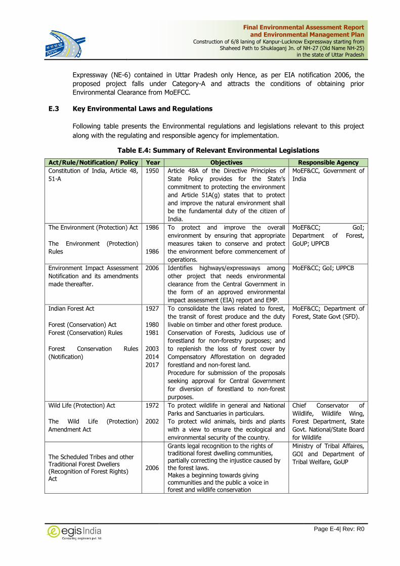
E.3 Key Environmental Laws and Regulations
Following table presents the Environmental regulations and legislations relevant to this project
along with the regulating and responsible agency for implementation.
Table E.4: Summary of Relevant Environmental Legislations
Act/Rule/Notification/ Policy Year Objectives Responsible Agency
Constitution of India, Article 48,
51-A
1950 Article 48A of the Directive Principles of
State Policy provides for the State’s
commitment to protecting the environment
and Article 51A(g) states that to protect
and improve the natural environment shall
be the fundamental duty of the citizen of
India.
MoEF&CC, Government of
India
The Environment (Protection) Act
The Environment (Protection)
Rules
1986
1986
To protect and improve the overall
environment by ensuring that appropriate
measures taken to conserve and protect
the environment before commencement of
operations.
MoEF&CC; GoI;
Department of Forest,
GoUP; UPPCB
Environment Impact Assessment
Notification and its amendments
made thereafter.
2006 Identifies highways/expressways among
other project that needs environmental
clearance from the Central Government in
the form of an approved environmental
impact assessment (EIA) report and EMP.
MoEF&CC; GoI; UPPCB
Indian Forest Act
Forest (Conservation) Act
Forest (Conservation) Rules
Forest Conservation Rules
(Notification)
1927
1980
1981
2003
2014
2017
To consolidate the laws related to forest,
the transit of forest produce and the duty
livable on timber and other forest produce.
Conservation of Forests, Judicious use of
forestland for non-forestry purposes; and
to replenish the loss of forest cover by
Compensatory Afforestation on degraded
forestland and non-forest land.
Procedure for submission of the proposals
seeking approval for Central Government
for diversion of forestland to non-forest
purposes.
MoEF&CC; Department of
Forest, State Govt (SFD).
Wild Life (Protection) Act
The Wild Life (Protection)
Amendment Act
1972
2002
To protect wildlife in general and National
Parks and Sanctuaries in particulars.
To protect wild animals, birds and plants
with a view to ensure the ecological and
environmental security of the country.
Chief Conservator of
Wildlife, Wildlife Wing,
Forest Department, State
Govt. National/State Board
for Wildlife
The Scheduled Tribes and other Traditional Forest Dwellers (Recognition of Forest Rights) Act
2006
Grants legal recognition to the rights of traditional forest dwelling communities, partially correcting the injustice caused by the forest laws. Makes a beginning towards giving communities and the public a voice in forest and wildlife conservation
Ministry of Tribal Affaires,
GOI and Department of
Tribal Welfare, GoUP

Final Environmental Assessment Report and Environmental Management Plan
Construction of 6/8 laning of Kanpur-Lucknow Expressway starting from Shaheed Path to Shuklaganj Jn. of NH-27 (Old Name NH-25)
in the state of Uttar Pradesh
Page E-5| Rev: R0
Act/Rule/Notification/ Policy Year Objectives Responsible Agency
National Forest Policy
National Forest Policy (Revised)
1952
1988
To maintain ecological stability through
preservation and restoration of biological
diversity
Forest Department, GoI
and State Govt.
The Water (Prevention and
Control of Pollution) Act
Water (Prevention and Control of
Pollution) Cess Act
1974
1977
To control water pollution by controlling
discharge of pollutants as per prescribed
standards
Provides for a levy and collection of a cess
on water consumed by industries and local
authorities
CPCB; UPPCB
The Air (Prevention and Control
of Pollution) Act
1981 To control air pollution by controlling
emission of air pollutants as per prescribed
standards
CPCB; UPPCB & Transport
Department; State Govt.
Noise Pollution (Regulation and
Control) Rules
The Noise Pollution (Regulation
and Control) Amendment Rules
2000
2006
To regulate and control noise producing
and generating sources with the objective
of maintaining the ambient air quality
standards in respect of noise.
CPCB; UPPCB, Transport
Department; State Govt.
Mines and Minerals
(Development and Regulation)
Act
Mineral Laws (Amendment) Act
1957
2020
To regulate the mining activities and for
borrowing of ordinary earth for linear
projects like road projects
State Mining department,
UP
Solid Waste Management Rules
(SWM)
2016 For Management and handling of solid
waste during construction
UPPCB
Hazardous and Other Wastes
(Management & Trans boundary
Movement) Rules
2016 Protection to the general public against
improper handling and disposal of
hazardous wastes
UPPCB
Construction and Demolition
Waste Management Rules
2016 To provide responsibility of the waste
generators for the collection, segregation
and other activities involved with the debris
management generated during construction
UPPCB
Batteries (Management &
Handling) Amendment Rules
2010 Management and handling of used lead
batteries i.e. safe disposal of batteries used
during construction
UPPCB
E-Waste (Management) Rules 2016 Effective mechanism to regulate
generation, collection, storage, transport,
import, export, recycling, treatment and
disposal of e-wastes
UPPCB
Biodiversity Act 2002 To provide for conservation of biodiversity,
sustainable use of resources fair and
equitable sharing of the benefits from use
of resources
National Biodiversity
Authority/State Authorities
Fly Ash Notification 2011
2016
Mandate use of fly ash in road construction
within a radius of 300km. For highways
project, flyash to be made available by the
TPP at filling site free of cost up to 100km
and on cost sharing basis up to 300km.
MoEF&CC
National Environmental Tribunal 1995 To provide for strict liability for damages
arising out of any accident occurring while
handling any hazardous substance
National Environmental
Tribunal
The Motor Vehicle Act
1988
To consolidate and amend the laws related
to motor vehicles.
Licensing of driving of motor vehicles,
registration of motor vehicles, with
emphasis on road safety standards and
RTO Office, GoUP, Govt.
of Uttar Pradesh
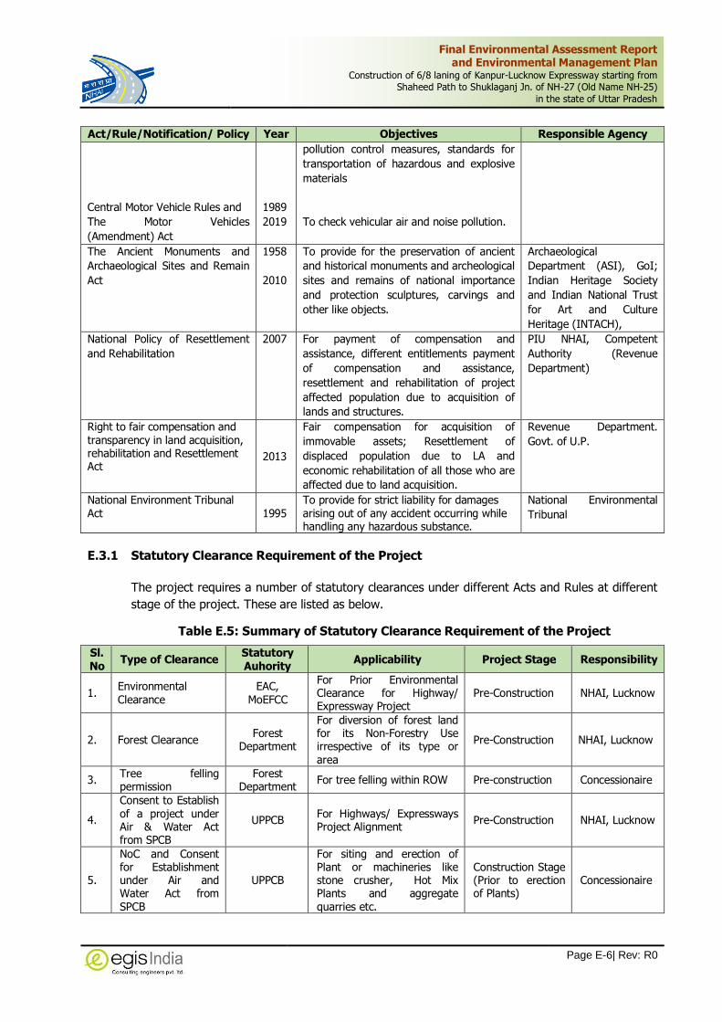
Final Environmental Assessment Report and Environmental Management Plan
Construction of 6/8 laning of Kanpur-Lucknow Expressway starting from Shaheed Path to Shuklaganj Jn. of NH-27 (Old Name NH-25)
in the state of Uttar Pradesh
Page E-6| Rev: R0
Act/Rule/Notification/ Policy Year Objectives Responsible Agency
Central Motor Vehicle Rules and
The Motor Vehicles
(Amendment) Act
1989
2019
pollution control measures, standards for
transportation of hazardous and explosive
materials
To check vehicular air and noise pollution.
The Ancient Monuments and
Archaeological Sites and Remain
Act
1958
2010
To provide for the preservation of ancient
and historical monuments and archeological
sites and remains of national importance
and protection sculptures, carvings and
other like objects.
Archaeological
Department (ASI), GoI;
Indian Heritage Society
and Indian National Trust
for Art and Culture
Heritage (INTACH),
National Policy of Resettlement
and Rehabilitation
2007 For payment of compensation and
assistance, different entitlements payment
of compensation and assistance,
resettlement and rehabilitation of project
affected population due to acquisition of
lands and structures.
PIU NHAI, Competent
Authority (Revenue
Department)
Right to fair compensation and transparency in land acquisition, rehabilitation and Resettlement Act
2013
Fair compensation for acquisition of
immovable assets; Resettlement of
displaced population due to LA and
economic rehabilitation of all those who are
affected due to land acquisition.
Revenue Department.
Govt. of U.P.
National Environment Tribunal Act 1995
To provide for strict liability for damages arising out of any accident occurring while handling any hazardous substance.
National Environmental
Tribunal
E.3.1 Statutory Clearance Requirement of the Project
The project requires a number of statutory clearances under different Acts and Rules at different
stage of the project. These are listed as below.
Table E.5: Summary of Statutory Clearance Requirement of the Project
Sl. No
Type of Clearance Statutory Auhority
Applicability Project Stage Responsibility
1. Environmental Clearance
EAC, MoEFCC
For Prior Environmental Clearance for Highway/ Expressway Project
Pre-Construction NHAI, Lucknow
2. Forest Clearance Forest
Department
For diversion of forest land for its Non-Forestry Use irrespective of its type or area
Pre-Construction NHAI, Lucknow
3. Tree felling permission
Forest Department
For tree felling within ROW Pre-construction Concessionaire
4.
Consent to Establish of a project under Air & Water Act from SPCB
UPPCB For Highways/ Expressways Project Alignment
Pre-Construction NHAI, Lucknow
5.
NoC and Consent for Establishment under Air and Water Act from SPCB
UPPCB
For siting and erection of Plant or machineries like stone crusher, Hot Mix Plants and aggregate quarries etc.
Construction Stage (Prior to erection of Plants)
Concessionaire

Final Environmental Assessment Report and Environmental Management Plan
Construction of 6/8 laning of Kanpur-Lucknow Expressway starting from Shaheed Path to Shuklaganj Jn. of NH-27 (Old Name NH-25)
in the state of Uttar Pradesh
Page E-7| Rev: R0
Sl. No
Type of Clearance Statutory Auhority
Applicability Project Stage Responsibility
6.
NoC and Consent for Operation under Air and Water Act from SPCB
UPPCB
For operating construction plant, crusher, batching plant, HMP and aggregate quarries etc.
Construction Stage (Prior to commencement of Operation of Plants)
Concessionaire
7.
Explosive License from Chief Controller of Explosives
PESO For storing fuel oil, lubricants, diesel etc.
Construction stage (Prior to storing fuel, lubricants and Diesel, etc.)
Concessionaire
8.
Permission for storage of hazardous chemical from SPCB
UPPCB Manufacture storage and Import of Hazardous Chemical
Construction stage (Prior to initiation of any work)
Concessionaire
9. Quarry Lease Deed and Quarry License
Dept. of Mines & Geology
Quarry operation Construction stage (Prior to initiation of Quarrying)
Concessionaire
10.
NOC for extraction of ground water for use in road construction activities
State/Central Ground
Water board Extraction of ground water
Construction stage (Prior to initiation of installation of Bore wells & abstraction of water from such source)
Concessionaire
11.
Permission for use of surface water for construction purpose
Irrigation department
Use of surface water for construction
Construction stage (Prior to initiation of abstraction of water from such source)
Concessionaire
12. Labour license Labour
Commissioner Office
Engagement of Labour Construction stage (Prior to initiation of any work)
Concessionaire
13. Permission for borrowing Earth
SEIAA
Vide MoEFCC S.O.1224 (E) dated 28.03.2020, extraction, sourcing, or borrowing of ordinary earth for linear project has been exempted from the requirement of prior EC.
Construction stage (Prior to initiation of any work)
Concessionaire
14. Permission for Muck/debris disposal.
Revenue Department
As per Construction and Demolition Rule, 2016
Construction stage (Prior to initiation of any work)
Concessionaire
E.4 Description of The Environment
As defined in the scope of works, baseline data on various physical, biological and social aspects
has been collected, analyzed and compiled in order to get the picture of the existing environment
condition in the project area.
E.4.1 Physical Resources
E.4.1.1 Physiography and Soil
The project area is located in the Awadh region of Uttar Pradesh state. The proposed project
passes through administrative boundary of Lucknow & Unnao districts which mainly have flat and
undulated terrain. The geographical extension of the project stretch is 25036’08.26’’ N latitude

Final Environmental Assessment Report and Environmental Management Plan
Construction of 6/8 laning of Kanpur-Lucknow Expressway starting from Shaheed Path to Shuklaganj Jn. of NH-27 (Old Name NH-25)
in the state of Uttar Pradesh
Page E-8| Rev: R0
and 79035’20.46” E longitude to 25034’31.33’’ N Latitude and 79017’42.06’’ E longitude. The
district forms a part of Ganga basin with flat alluvial terrain. The general slope of the district is
southeast. General elevation of the area varies between 114 m to 128 m above mean sea level.
The project area falls under Seismic Zone-III which is moderately active in nature. No Epicentre
of earthquake within the district area has been observed during last 200 years.
In the study area soil exhibits a wide variation in composition texture and appearance. The major
position of the Lucknow district is occupied by soils locally known as "Bhur" or "Silty Sand" on the
ridges whereas Unnao district, 'Reh' or Usar-soil patches are frequently occurring mainly in the
Matiar or clay dominating soils.
E.4.1.2 Climate
The weather, in general, can be said to be humid subtropical climate with dry winters. Generally,
January month of a year experiences lowest temperature and coldest in nature. The lowest
temperature recorded in January as 6.7 0C and maximum temperature recorded in June as 41.4 0C at Lucknow. Lowest Relative humidity level (32.0%) recorded in April in Lucknow and highest
humidity level (80.5%) recorded in August in Unnao during monsoon.
The rainy season is considered from middle of June to the end of September which is followed by
a sultry period from about the end of September to the middle of November.
The winter season commences from the middle of November and ends by the end of the January
followed by a dry hot summer from February to middle of June. Summers are in general full of
gusty winds.
The normal average annual rainfall is about 927 mm in Lucknow and 918 mm in Unnao district.
Among the project districts, Lucknow district receives higher annual rainfall. Climatic condition
averaged on last 10 years’ data has been presented below.
Table E.6: Climatic Condition of Project site at Lucknow and Unnao
S. No.
Month
Monthly Mean Temperature
(Max and Min) Rainfall (in mm)
Relative Humidity (%)
Wind Speed in KmPH
Lucknow Unnao Lucknow Unnao Lucknow Unnao Lucknow Unnao
1 Jan 24.0 6.7 23.6 7.0 20.3 16.5 72.7 71.6 4.5 4.1
2 Feb 28.0 7.5 27.6 8.0 13.3 15.4 60.7 60.9 6.9 6
3 March 35.9 11.2 35.5 11.7 7.9 7 44.5 46.6 10.1 8.3
4 April 39.7 17.1 40 18.3 5 2.8 32 35 12 9.9
5 May 41.0 22.6 41.1 23.4 12.4 10.6 38.6 39.1 12.9 10.6
6 June 41.4 25.4 41.2 26.2 81.7 75.4 60.8 64.2 12 10.1
7 July 36.3 25.7 36 25.8 276.2 264.5 77.4 77.6 10 8.3
8 Aug 33.9 25.3 33.5 25.6 278.8 289.1 79.6 80.5 9.7 8.1
9 Sep 33.7 22.6 33.5 22.9 175.9 176.8 77.7 77.9 7.8 6.8
10 Oct 33.7 16.2 33.5 16.7 47.9 51.1 69.9 68.7 3.2 3.5
11 Nov 31.5 10 31.3 10.5 1.4 1.7 68.4 66.4 2.3 2.5
12 Dec 26.4 7.1 26.3 7.3 6.2 7.1 73.3 72.1 3.2 3
Source: Indian Meteorological Department, Government of India (Period 2005-15)

Final Environmental Assessment Report and Environmental Management Plan
Construction of 6/8 laning of Kanpur-Lucknow Expressway starting from Shaheed Path to Shuklaganj Jn. of NH-27 (Old Name NH-25)
in the state of Uttar Pradesh
Page E-9| Rev: R0
E.4.1.3 Ambient Air Quality
To study the baseline ambient air quality scenario within the project corridor the ambient air
quality has been planned at 4 locations along proposed Kanpur-Lucknow expressway, i.e. Near
Amausi Airport Bus Stop, Near Beekamau Village, Near Neverna Village, Near Harbans Village
ambient air quality scenario within the study area and the post-monsoon sampling of ambient air
will be started in the month of November, 2018. The monitoring stations were selected
considering the spatial relationship of various land uses along the project road, and CPCB
guidelines. The qualitative analysis on various quality parameters associated with transport sector
will be carried out with respect to PM2.5, PM10, SOx, NOx, CO and Hydrocarbon. The mean
concentration of PM2.5 at different monitoring locations varied from minimum 41.88 µg/m3 to
maximum 55.75 µg/m3 whereas the mean concentration of PM10 at different monitoring locations
varied from minimum 74 µg/m3 to maximum 107.88 µg/m3. The mean concentration of SO2 at
different monitoring locations varied from minimum 6.55 µg/m3 to maximum 8.44 µg/m3. The
minimum mean concentration of NO2 at different monitoring locations varied from minimum 23.5
µg/m3 to maximum 29.88 µg/m3 based on 24 hourly samples taken at different locations. The
analysis of test results reflects that concentrations of all the parameters at all the monitoring
locations were well within permissible limit of NAAQS, 2009.
E.4.1.4 Water Resources
The project area is mainly located in Sai-Gomti Sub basin and mainly drained by River Gomati,
River Ganga and their tributary. Apart from these a number of natural streams streams/natural
nallah cross the project section at different locations. These are seasonal in nature and carry
water mainly during rainy season. Most of these rivers and streams flow mainly northwest to
southeast direction. Few irrigation canals are also cross the project section. These irrigation
canals form major source of surface water utilized for irrigation purpose. There are in total 2
major bridges and 30 minor bridges on these streams and rivers. The list of water bodies along
the project corridor is presented below:
Table E.7: Rivers/Streams/Reservoirs along Project Corridor
S. No. Design Chainage Water Bodies
1. 14+805 Canal
2. 28+280 Sai River
3. 30+092 Charia Drain
4. 30+793 Local nala
5. 33+549 Canal (Beekamau)
6. 34+682 Sarai Joga Drain
7. 36+455 Canal (Kantha)
8. 38+110 Local Nalla
9. 39+462 Canal (Sariya)
10. 40+457 Canal (Bachhaura)
11. 41+877 Local Nalla
12. 44+016 Canal
13. 46+210 Sarda Canal
14. 47+297 Local Nalla

Final Environmental Assessment Report and Environmental Management Plan
Construction of 6/8 laning of Kanpur-Lucknow Expressway starting from Shaheed Path to Shuklaganj Jn. of NH-27 (Old Name NH-25)
in the state of Uttar Pradesh
Page E-10| Rev: R0
S. No. Design Chainage Water Bodies
15. 48+774 Canal
16. 50+300 Tributary of Loni River
17. 50+497 Loni River
18. 52+125 Loni River
19. 53+815 Loni River
20. 55+277 Local Nalla
21. 56+630 Canal
22. 58+980 Local Nalla
23. 63+958 Canal
24. 68+649 Local Nalla
25. 72+680 Ganda Nalla
Source: Egis Primary Survey, 2019
Four sampling locations have been identified for physico-chemical characteristics of Surface water
along the project road. The identified location has been given below
Table E.8: Surface Water Sampling Location
Code Location Source Chainage Co-ordinates
SW-01 Sai river near Village Hionra River 29.000 26°38'30.72"N, 80°47'10.64"E
SW-02 Canal Water near Village Raipur Canal 46.250 26°31'22.62"N, 80°41'58.35"E
SW-03 Canal Water near Karnipur Shivpur Village Canal 63.650 26°27'47.37"N, 80°32'38.81"E
SW-04 Pond Water near Village Daulatpur Pond 65.250 26°27'47.08"N, 80°31'41.73"E
The pH along the project road for all the water bodies locations varies from 6.98 to 7.39. The
Total dissolved solids are varying from 146 to 250 mg/l for different locations along the proposed
project road. The Total Suspended Solids vary from 3.3 to 36mg/L. Total hardness (as CaCO3)
varies from 96 to 180 mg/l. DO ranges from 5.8 to 6.8 mg/l, BOD (3 days 270C) varies from less
than<2 to 2.8 mg/l and COD ranges from <4 to 24 mg/l. Faecal coliform (MPN/100ml) is non-
detectable. The other heavy are metals are within desirable limits.
A number of tube wells, open wells and hand pumps are located along the project roads within
corridor of impact. These are used for drinking, domestic and commercial purposes. Water
samples from ground water source at different locations will be collected from three location
listed below.
Table E.9: Ground Water Sampling Location
Sample Code Chainage of the Sampling Station District Chainage Co-ordinate
GW1. Near Amausi Airport Bus Stop Lucknow 12.100 26°46'06.58"N, 80°52'37.06"E
GW2. Beekamau village Unnao 33.600 26°36'25.99"N, 80°45'45.87"E
GW3. Badrak Harbans village Unnao 71.000 26°28'05.02"N, 80°28'19.95"E
E.4.2 Noise Level
The predominant activities along the project road stretch are mainly agricultural. To determine
the ambient noise level, 4 monitoring locations were identified considering the equal distribution
of project road length and land use pattern along the project road. These locations are Near to

Final Environmental Assessment Report and Environmental Management Plan
Construction of 6/8 laning of Kanpur-Lucknow Expressway starting from Shaheed Path to Shuklaganj Jn. of NH-27 (Old Name NH-25)
in the state of Uttar Pradesh
Page E-11| Rev: R0
Amausi Airport Bus Stop, Beekamau Village, Neverna Village. During the monitoring period,
maximum day time equivalent noise level was recorded at commercial area of Amausi Airport Bus
Stop (64.6 Leq dB(A)), followed by Beekamau Village (60.2 Leq dB(A)), Badrak Harbans village
(59.3 Leq dB(A)) and Neverna Village (50.1 Leq dB(A). During night time, maximum equivalent
noise level was recorded at Amausi Airport Bus Stop (49.4 Leq dB(A)) followed by Badrak
Harbans Village (43.9 Leq dB(A)), Residential area of Beekamau (40.9 Leq dB(A)), and least was
recorded at Neverana Village (40.0 Leq dB(A)).
Both day time and night time noise levels at all the monitoring locations were within the
maximum permissible level of residential area. Human activities were prevalent at surrounding
areas of those monitoring stations.
E.4.3 Natural Environment
E.4.3.1 Forests
Generally open shrubs are present apart from the agriculture fields along the project stretch. The
proposed Kanpur Lucknow Expressway is passes 16 km along the existing alignment of NH-25
and the roadside tree plantation within ROW is declared as Protected Forest, hence the felling of
roadside tree and utilization of land shall attract the provisions of Forest (Conservation) Act, 1980
and will require forest clearance for diversion of forest area. The proposed road also crosses
some State Highways, Canals, etc. The plantation along it may declare as protected forest, hence
the felling of roadside tree and acquisition of land shall attract the provisions of Forest
(Conservation) Act, 1980 and will require forest clearance for diversion of forest area. The area
along the existing ROW of the project stretch is dotted with few Reserve forests pockets at 2
locations. Plantation has been done in these forest area and the predominant species in the forest
stretch are Babool, Neem, Bilayati Babool, Ber, Aam Mango and Shisham. The proposed
development of project will require diversion of about 32.4416 Ha of these forest lands. The
breakup of the forest area required from each forest pockets located within the proposed ROW is
given below in below.
Table E.10: Forest Area along the Project Road
S. No
Name of Division Name of Range
Name of the Village RF PF Forest Area (ha.)
1 2 3 4 5 6 6
1 Awadh Forest Division Lucknow Sarojini Nagar
Behsa 0.1479 0.1479
2 Farukabad Chillawan 1.9253 1.9253
3 Amausi 3.9150 3.915
4 Gauri 2.6725 2.6725
5 Gaharu 4.4619 2.1485 6.6104
6 Miranpur Pinvat 2.3010 2.301
7 Banthra Sikanderpur 6.7981 6.7981
8 Khande Dev 1.2751 1.2751
9 Sarai Sajadi 2.4836 2.4836
10 Bani 1.2088 1.2088
Total 4.4619 24.8758 29.3377

Final Environmental Assessment Report and Environmental Management Plan
Construction of 6/8 laning of Kanpur-Lucknow Expressway starting from Shaheed Path to Shuklaganj Jn. of NH-27 (Old Name NH-25)
in the state of Uttar Pradesh
Page E-12| Rev: R0
S. No
Name of Division Name of Range
Name of the Village RF PF Forest Area (ha.)
11
Shivpur Grant 0.1260 0.126
12 Amarsus 2.1402 2.1402
13 Kader Patari 2.3880 2.3880
Total 0.1260 4.6542 4.7802
Grand Total 4.5879 29.5300 34.1179
No significant wild life animals are reported from the site. The faunal population mainly
constituted by domesticated animals like cows, ox, buffalo, goats, sheep, pigs, dogs, etc. There is
no any endangered plant or animal species reported from the project area.
E.4.3.2 Road Side Plantation
There is good plantation on both side of the project road from Km 11+000 to Km 27+260.
Although the Expressway will be an elevated section on the existing NH-25 up to a length 16.620
Km, the development will involve the widening along existing NH-25. Therefore, it will involve a
tree felling during the construction works. However, the felling of trees will be restricted within
the formation width only to minimize the impact on trees. The main tree species observed along
the proposed project alignment are Eucalypytus, Bamboo, Babool, Shisham, Neem, Chilbil, Pakad,
Chitvan, Mango, Pipal, Siris etc.
E.4.4 Socio-Economic Environment
E.4.4.1 Demographic Profile
The demographic features of the project district as per 2011 Census are provided in below table.
The population density is lower in the Unnao district with respect to the State’s population
density. The sex ratio reflects the socio-economic and demographic characteristics of the
population. It is an important indicator of migration and gender equity (in a developing country
context) since it helps to point out the employment opportunity in the districts. There are 912
females for every thousand males in Uttar Pradesh State, while the sex ratios of the Lucknow,
Unnao and Kanpur Nagar districts are 917, 907 and 863 females for every 1000 males
respectively.
Table E.11: District wise Demographic Profile of the Project Area
District / State Total No. of House Hold
Population Sex Ratio
Population Density (no. per sq Km) Total Male Female
Lucknow 8,46,450 45,89,838 23,94,476 21,95,362 917 1,816
Unnao 4,85,595 31,08,367 16,30,087 14,78,280 907 682
Uttar Pradesh 3,32,32,433 19,98,12,341 10,44,80,510 9,53,31,831 912 829
Source: Census of India, 2011 Census
E.4.4.2 Land Use Pattern
The Greenfield stretch of the Lucknow-Kanpur Expressway predominantly passes through
agriculture followed by forest land, water bodies and habitation. The project districts have
medium scale as well as small-scale industries. The best opportunities for developing an industry

Final Environmental Assessment Report and Environmental Management Plan
Construction of 6/8 laning of Kanpur-Lucknow Expressway starting from Shaheed Path to Shuklaganj Jn. of NH-27 (Old Name NH-25)
in the state of Uttar Pradesh
Page E-13| Rev: R0
in these districts is due to its advantages of raw materials, skilled labours, easy finances, power
and having a congenial industrial atmosphere. Along the project corridor the main industry
identified mineral industries, textile, milk products, leather, etc.
The land use map for a buffer length of 1Km around the project roads has been prepared to a
scale of 1:25000 based on recent satellite imagery. It shows features such as agricultural
plantations, water bodies, built-up areas, forest area, contour and other surface features. The
area under different land use for the project is presented in the following table.
Table E.12: Land Use of the Study area (1Km)
S. No. Land Use Area in Ha. Percentage (%)
1. Waterbody 297.7 2.13
2. Scrub Land 1209.9 8.66
3. Barren Land 445.6 3.19
4. Grass Land 1078.9 7.72
5. Airport 154.7 1.11
6. Industry 164.0 1.17
7. Orchard/Trees 1384.3 9.90
8. Crop Land 2677.1 19.15
9. Fallow Land 5344.8 38.24
10. Settlement 1219.4 8.73
Total 13976.4 100.00
Source: Egis Study, 2020
E.4.4.3 Protected Monuments and Properties of Archaeological Value
There are no protected archaeological properties or monuments along the project road alignment.
E.5 Anticipated environmental Impacts and Mitigation measures
E.5.1 Impacts during Design and Pre-Construction Phase
The environmental impacts associated with the pre-construction stages mainly include impacts
due to design and location of the project as well as site preparation for construction. The main
issues involve in the preconstruction stage are acquisition of land and properties, tree felling,
diversion of forest land, encroachment of water tanks & ponds, acquisition of common property
resources, relocation of public utilities etc. Most of the impacts of preconstruction stage are
permanent in nature. The anticipated impacts associated with the preconstruction stage and their
mitigation measures have been presented below
Table E.13: Anticipated Environmental Impacts due to the Proposed Project and their Mitigation Measures during Pre-Construction Stage:
S. No.
Environmental Components/
Issues Impacts Mitigation Measures
1. Acquisition of Land A total area of 476.7835 Ha of land will be required for acquisition for expressway development. Out of total land area 430.714Ha of Private Land, 46.0695Ha of Government Land, will be affected due to acquisition.
The acquisition of land and private properties will be carried out in accordance with the RAP and entitlement framework for the project. Early identification of entitlement for
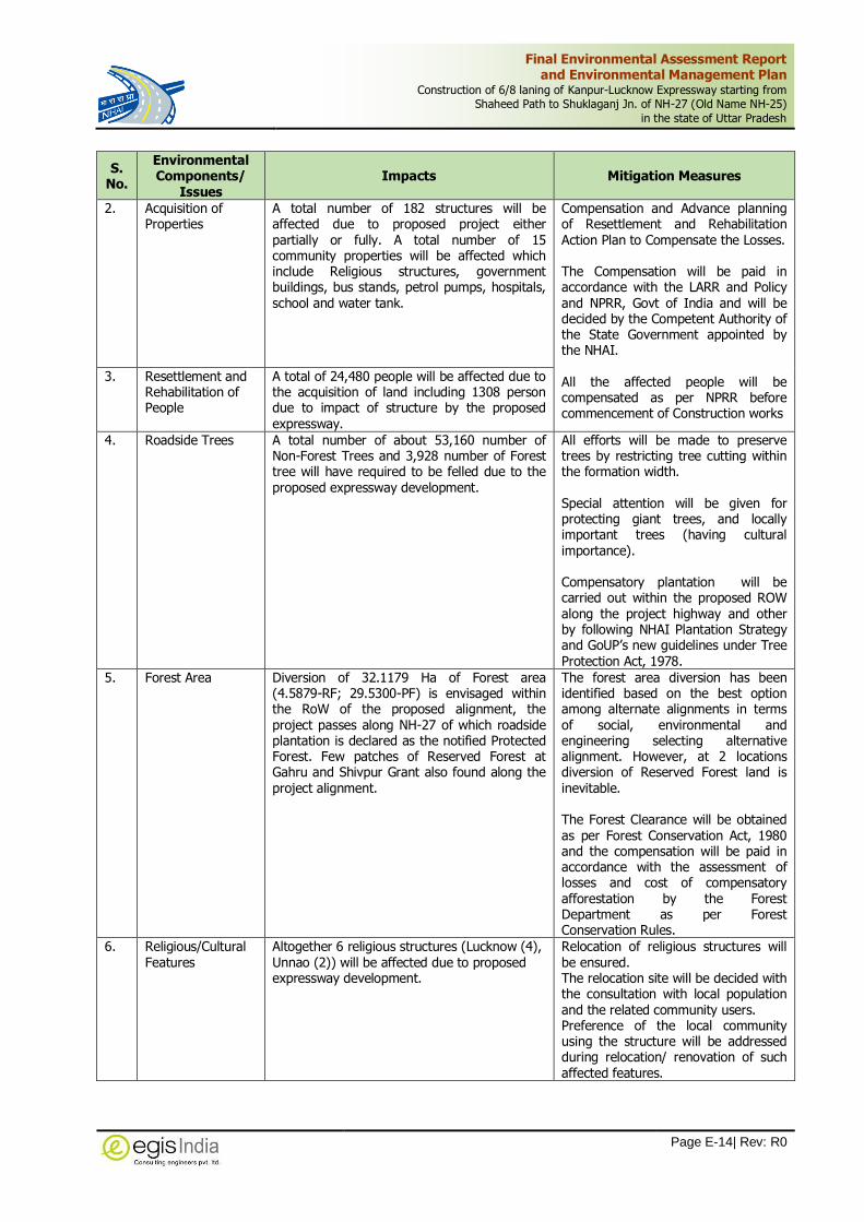
Final Environmental Assessment Report and Environmental Management Plan
Construction of 6/8 laning of Kanpur-Lucknow Expressway starting from Shaheed Path to Shuklaganj Jn. of NH-27 (Old Name NH-25)
in the state of Uttar Pradesh
Page E-14| Rev: R0
S. No.
Environmental Components/
Issues Impacts Mitigation Measures
2. Acquisition of Properties
A total number of 182 structures will be affected due to proposed project either partially or fully. A total number of 15 community properties will be affected which include Religious structures, government buildings, bus stands, petrol pumps, hospitals, school and water tank.
Compensation and Advance planning of Resettlement and Rehabilitation Action Plan to Compensate the Losses. The Compensation will be paid in accordance with the LARR and Policy and NPRR, Govt of India and will be decided by the Competent Authority of the State Government appointed by the NHAI. All the affected people will be compensated as per NPRR before commencement of Construction works
3. Resettlement and Rehabilitation of People
A total of 24,480 people will be affected due to the acquisition of land including 1308 person due to impact of structure by the proposed expressway.
4. Roadside Trees A total number of about 53,160 number of Non-Forest Trees and 3,928 number of Forest tree will have required to be felled due to the proposed expressway development.
All efforts will be made to preserve trees by restricting tree cutting within the formation width. Special attention will be given for protecting giant trees, and locally important trees (having cultural importance). Compensatory plantation will be carried out within the proposed ROW along the project highway and other by following NHAI Plantation Strategy and GoUP’s new guidelines under Tree Protection Act, 1978.
5. Forest Area Diversion of 32.1179 Ha of Forest area (4.5879-RF; 29.5300-PF) is envisaged within the RoW of the proposed alignment, the project passes along NH-27 of which roadside plantation is declared as the notified Protected Forest. Few patches of Reserved Forest at Gahru and Shivpur Grant also found along the project alignment.
The forest area diversion has been identified based on the best option among alternate alignments in terms of social, environmental and engineering selecting alternative alignment. However, at 2 locations diversion of Reserved Forest land is inevitable. The Forest Clearance will be obtained as per Forest Conservation Act, 1980 and the compensation will be paid in accordance with the assessment of losses and cost of compensatory afforestation by the Forest Department as per Forest Conservation Rules.
6. Religious/Cultural Features
Altogether 6 religious structures (Lucknow (4), Unnao (2)) will be affected due to proposed expressway development.
Relocation of religious structures will be ensured. The relocation site will be decided with the consultation with local population and the related community users. Preference of the local community using the structure will be addressed during relocation/ renovation of such affected features.

Final Environmental Assessment Report and Environmental Management Plan
Construction of 6/8 laning of Kanpur-Lucknow Expressway starting from Shaheed Path to Shuklaganj Jn. of NH-27 (Old Name NH-25)
in the state of Uttar Pradesh
Page E-15| Rev: R0
S. No.
Environmental Components/
Issues Impacts Mitigation Measures
7. Severance Severance Problem
A total number of 11 VUP, 8 LVUP, and 2 flyovers have been proposed. 11 no. of Pedestrian/ cattle underpasses have been provided for crossing the road for pedestrians, local traffic and cattle to avoid severance problem.
8. Traffic Safety Accident Hazards
The Adequate number of Vehicular underpasses, Pedestrian/cattle under passes, service roads, geometric corrections, scientifically designed bus stand, traffic signals, zebra crossings, junction improvements, bus bays and truck lay byes, traffic lightings and caution, regulatory and informative signboards have been provided in the project as per IRC codes. During operation there will be provision of highway patrolling, ambulance and recovery vans to deal with emergency situations.
E.5.2 Impact during Construction and Operation Phase
During construction period the major environmental issues will be related to dust generation,
emission of gaseous emissions, borrow area and quarry operations, pollution due to operation of
plants and equipment, contamination of land and soil, contamination of water bodies and public
as well as worker’s health and safety. These anticipated impacts will mainly temporary and
localized in nature and are likely to persist for short duration till the construction activities are
over in a particular area. However, there are some long term adverse impacts due to
construction. These impacts however can be mitigated effectively through proper planning,
scheduling and by application of environmental friendly construction practices. The likely impacts
due to construction activities and operation of the project are explained along with the mitigation
measures.
E.6 Analysis of Alternatives
As the nature of the project is new expressway, the alternative for alignment has been studied in
details. Four key characteristics of each proposed alternative has been determining for a
comparative analysis viz., Spatial requirements, Natural resources (including productive land)
consumption, Human resource benefits & costs (such as resettlement vs. better access to market)
and; Waste production during the construction and operation/maintenance periods.
The analysis of alternatives has been carried out ‘with project’ and ‘without project’
scenarios in terms of potential environmental impacts. Under Project, seven alternate alignments
were studied in order to minimize the ecological impacts such as avoidance of Nawabganj Wildlife
Sanctuary (notified PA), natural habitations and minimize the social impacts such as resettlement
and environmental impacts. Various factors were considering while studying the alignment which
are broadly grouped under main heads such as connectivity, geometrics, cost, economic benefits
and social and environmental impacts.

Final Environmental Assessment Report and Environmental Management Plan
Construction of 6/8 laning of Kanpur-Lucknow Expressway starting from Shaheed Path to Shuklaganj Jn. of NH-27 (Old Name NH-25)
in the state of Uttar Pradesh
Page E-16| Rev: R0
It is assessed that “With” project scenario, positive/beneficial impacts will greatly enhance social
& economic development of the region and improve the environment, when compared to the
“Without” project scenario, which may further deteriorate the existing environment and quality of
life. Hence the “With” project scenario with some reversible impacts is an acceptable option
rather than “Without” project scenario. The implementation of the project therefore will definitely
be advantageous to improve the environmental quality of the sub-region besides to achieve an
all-round development of the economy and progress of the region.
There will be little increase in the pollution levels during construction. Dust and particulate matter
during construction will affect the air quality on a short-term basis but will be temporary in
nature. The proposed project will also have impact due to forest diversion falling with in proposed
ROW, however the total benefits such increase in productivity attributable, benefit to economy,
employment and economic benefit due to compensatory afforestation is higher than the
estimated cost of Forest Diversion. The safety of road users as well as surrounding population will
enhance to great extent due to the project with provisions of service lane, pedestrian crossings,
cattle crossings, traffic lights, truck lay byes, bus shelters, etc. which are adequate in the present
scenario.
E.7 Environmental Monitoring Programme
Monitoring of environmental quality during construction and operation stages reflects the success
of implementation of the mitigation measures. Also it provides a chance to review the suggested
measure and improve upon the measures. To ensure the effective implementation of the
Environmental Management Plan (EMP), it is essential that an effective monitoring plan be
designed and carried out. The environmental monitoring plan covering various performance
indicators, frequency and institutional arrangements for the project in the construction and
operation stages has been prepared.
E.8 Social Impact Assessment
As the proposed project road is entirely a green field alignment except some entry/exit points
near the proposed Inter-changes connecting existing State Highways and National Highways, SIA
and R&R surveys were conducted in the DPR stage.
The social impact assessment was carried out, considering 90 Mtrs. all along the project road
except at the proposed facilities such as Junctions, RoBs, Bridges etc. where additional width has
been considering as per propose design. Most of the land use categories along this section is
mainly agriculture land and at some locations it is either Residential or industrial units’ land and
activities are being carried out by the local residents. The proposed project road passes through
Lucknow and Unnao districts of Uttar Pradesh state. Almost all the settlement is having been
avoided by careful selection of alignment. However, few of the built-up sections the entry/exit
point near proposed major/minor interchanges connecting existing State Highways and National
Highways through which the proposed alignment is passing where some pucca, semi pucca and
kutcha structures are found in with in propose ROW in these sections. The major portion is
predominantly either agricultural land or barren land. In general, the inhabitants occupying lands
for different activities along the proposed road have land titles. This has implications on the
design of the Entitlement Matrix and mitigate measures. Common Property Resources along the

Final Environmental Assessment Report and Environmental Management Plan
Construction of 6/8 laning of Kanpur-Lucknow Expressway starting from Shaheed Path to Shuklaganj Jn. of NH-27 (Old Name NH-25)
in the state of Uttar Pradesh
Page E-17| Rev: R0
sections of the project road include some religious structures, community/village bushy land,
grazing lands, water resources, etc.
E.8.1 Project Affected Persons
The total numbers of affected household’s structures are to be affected due to the proposed
expressway are 1308. The impact of project road would affect as many as 42 villages, 4 talukas /
tehsil and 2 Districts.
As part of the social assessment survey the demographic and socio-economic particulars of the
occupants of the above discussed affected properties is collected. The total number of project-
affected households who will be losing their 327 privately owned affected structures including
Open well, Bore wells and Water Tanks etc.
E.8.2 Socio-economic profile of the affected household
District wise lost no. of the affected family, households, and persons displaced households in
Table E.14
Table E.14: Impact of the Project PAHs, PAFs, PAPs and PDPs
Impact of the Project Lucknow Unnao Total
For Impacted structures
1 No. of PAHs 155 172 327
3 No. of PAFs 248 275 523
2 No. of PAPs 620 688 1308
4 No. of PDHs 151 16 167
5 No. of PDFs 242 26 268
For Land
1 No. of PAHs 1352 4768 6120
3 No. of PAFs 2162 7628 9790
2 No. of PAPs 5408 19072 24480
The total 1308 persons are affected due to acquisition of houses and other assets of which (51.30
%) and (48.70%) each constitute Male and female. Table 7.9 on the analysis of Socio-economic
profile of the surveyed households shows that along the project corridor, there were households
belonging to three religions viz. Hindus (78.59 %) and Muslims (21. 41%). Social group-wise
most of the affected people represents the backward caste (25.69 %) and of the remaining
general castes constitute (52.60%) and Scheduled Castes comprises around 21.71 percent. The
incidences of Scheduled Tribes are not affected along the proposed expressway project road.
Observed across the family pattern majority (62.69 %) of the affected households are nuclear
families and of the remaining 34.25 percent of the affected households live as joint families and
3.06% are Individual families.
E.9 Project benefits
The project will mainly improve the National Road Transport Network. The new expressway will
promote access to markets, materials and opportunities by facilitating movement of persons and
goods, services, commodities, etc. and improve the earning and thereby standard of living. This

Final Environmental Assessment Report and Environmental Management Plan
Construction of 6/8 laning of Kanpur-Lucknow Expressway starting from Shaheed Path to Shuklaganj Jn. of NH-27 (Old Name NH-25)
in the state of Uttar Pradesh
Page E-18| Rev: R0
in turn enhances the demand for transport. The two-way interaction works through a host of
inter-sectoral forward and backward linkages effects and dynamics externalities tends to relocate
industries, services and labours thus help to shape the economic geography of the region.
The Kanpur Lucknow Highway is an important route. The cities are on the East-West corridor
which connects Silchar (West Bengal) in East and Porbandar (Gujarat) in West. Kanpur is on the
Golden Quadrilateral (GQ) national highway network, which connect Delhi in North and Kolkata in
East. The development of this new high speed expressway will reduce the travel time between
Kanpur and Lucknow, and also open up avenues for Industrial and Urban development of the
region, that would add a new dimension to the progress of Uttar Pradesh.
The implementation of the project will have the following direct benefits:
(i) Improved quality of life for the population in the project area.
(ii) Economic boost to the local population by facilitate easy transportation of materials and
having better connectivity for the commercial centers.
(iii) Provides employment facility for the local population.
(iv) The proponent commitment to proactively promote the public interest (PI) by encouraging
community growth and development, and voluntarily eliminating practices that harm the
public sphere under Corporate Environmental Responsibility.
(v) Reduction in Vehicle Operating Cost (VOC) consisting of Fuel Consumption, Lubricating Oil
Consumption, Spare part consumption, tyre consumption and vehicle depreciation.
(vi) The safety aspects associated with the highways will be enhance to great extent due to
provision of service roads, Bus shelters, bays, truck lay byes, pedestrian/cattle crossings,
street lights, guard railings, crash barriers and installation of safety and information
signboards. crossings. The detailed numbers of these facilities are provided under the
table of salient features.
(vii) Plantation along the highway will not only increase the aesthetics of the area but at the
same time will help in alleviating pollution along the highways.
E.10 Environmental Management Plan
Environmental Management Plan (EMP) is the key to ensure effective implementation of
environmental safeguard measures during different stage of the project. The desired results from
the environmental mitigation measures proposed in the project may not be obtained without
proper planning of the implementation of mitigation measures. The project specific EMP has been
formulated for mitigating of offsetting the anticipated adverse impacts arising out of the project
activities. Environmental Management Plan includes EMP Implementation Framework, supervision
monitoring and reporting requirements.
Pre-construction Phase
Pre-construction activities include acquisition of land and structures, relocation of utilities,
removal of trees, relocation of common property resources viz. temple, hand pumps, obtaining
Environmental Clearance, Forest Clearance from MoEF&CC, and Consent to Establish from UPPCB
etc. NHAI, Contractor and concerned departments shall be responsible for those activities.
Final Environmental Assessment Report and Environmental Management Plan
Construction of 6/8 laning of Kanpur-Lucknow Expressway starting from Shaheed Path to Shuklaganj Jn. of NH-27 (Old Name NH-25)
in the state of Uttar Pradesh
Page E-19| Rev: R0
Construction Phase
Construction activities during this phase include setting up of Construction Camp, setting up of
plants namely crusher plant, concrete batching plant, hot mix plant; clearing and grubbing,
collection, storage and utilization of topsoil, identification of borrow pit & aggregate quarry (if
other than those identified by design consultant), operation of the quarry, plantation on either
side of the proposed expressway & at median, environmental protection & monitoring. Contractor
shall be responsible for obtaining consent for establish and operate of those plants. Contractor
shall also be responsible for implementation of the environmental protection measures during
construction. The supervision consultant shall be responsible for monitoring & supervision of the
Contractor’s activities as per Contract & report it to PIU, NHAI time to time. Project
Implementation Unit (PIU) Lucknow, NHAI shall be responsible for regulatory compliance.
Operation Phase
Operation phase activities include monitoring of performance indicators and monitoring of survival
rate of the plantation etc. The PIU and Contractor shall be responsible for those activities.
During Preconstruction stage the responsibility of the implementation of mitigation measures are
the responsibility of mainly Project Implementation Unit of NHAI which is the project proponent
for the project. During Construction the primary responsibility of implementing environmental
safeguards measures is with Concessionaire which will design, construct and own the project till
concession period. The NHAI will be overall responsible for EMP implementation.
A budgetary cost estimated for environmental management activities is INR 51.75 Crores, which
includes various mitigation costs during preconstruction, construction and operation stages,
environmental enhancement measures (INR 47.83 Cr.) as well as environmental monitoring cost
(INR 3.91 Cr.).

Final Environmental Assessment Report and Environmental Management Plan
Construction of 6/8 laning of Kanpur-Lucknow Expressway starting from Shaheed Path to Shuklaganj Jn. of NH-27 (Old Name NH-25)
in the state of Uttar Pradesh
Page E-20| Rev: R0
Table E.15: Environmental Monitoring Plan
Environment Component
Project Stage
Parameters Locations Frequency Estimated Quantity
Amount(Rs)
Air
Construction
PM10 mg/m3, PM2.5 mg/m3, SO2, NOx, CO mg/m3, Fugitive Emission from Hot Mix Plant
Batching Plant, Hot mix Plant and Stone Crusher, Total station = 6 (3 in each package)
Every fortnight in each month for all construction years
360 30,60,000
PM10 mg /m3, PM2.5 mg /m3, SO2, NOx, CO mg/m3
At 2 locations provided in baseline AQ stations along the project alignment consultation with IE. Total locations:=4 (2 in each Package)
Moves with progress of all construction but not less than monthly during all construction year
120 10,20,000
Operation PM10 mg /m3, PM2.5 mg /m3, SO2, NOx, CO mg/m3
At the proposed toll plaza location (Km 35+000) Total Location: 1
Daily (Real time monitoring) through Continuous ambient air quality monitoring system (CAAQMS) till concession
1 2,85,00,000
At 2 locations provided in baseline AQ stations along the project alignment consultation with IC. Total Locations:=2 (In Package-1)
Once in a season for 5 years 40 3,40,000
Surface Water Quality
Construction
pH, temperature, DO, BOD, COD, Oil & Grease, Total Suspended Solid, turbidity, Total Hardness, Chlorine, Iron, Total Coliform.
1 location at labour Camp, 1 at HMP, 2 locations as per baseline SW stations or as directed by IE. Total location: 8 (4 in each Package)
Once in Season for all construction years
80 6,00,000
Operation
pH, temperature, DO, BOD, COD, Oil & Grease, Total Suspended Solid, turbidity, Total Hardness, Chlorine, Iron, Total Coliform
2 locations as per baseline SW stations or as directed by IE Total Location: 4 (2 in each Package)
Once in a season for 5 years 80 6,00,000
Ground Water Quality
Construction pH, Temperature, TSS, Total hardness, Suspended Solid, Chlorine, Iron, Sulphate, Nitrate
2 locations as per baseline GW stations or as directed by IE. Total location: 4 (2 in each package)
Once in season for all construction years
40 3,00,000
Operation pH, Temperature, TSS, Total hardness, Suspended Solid, Chlorine, Iron, Sulphate, Nitrate
2 locations as per baseline GW stations or as directed by IE Total location: 4 (2 in each
Once in season for 5 year 80 6,00,000

Final Environmental Assessment Report and Environmental Management Plan
Construction of 6/8 laning of Kanpur-Lucknow Expressway starting from Shaheed Path to Shuklaganj Jn. of NH-27 (Old Name NH-25)
in the state of Uttar Pradesh
Page E-21| Rev: R0
Environment Component
Project Stage
Parameters Locations Frequency Estimated Quantity
Amount(Rs)
package)
Noise Level
Construction Leq dB (A) (Day and Night) Average and Peak values
At construction yards, Hot Mix Plant, Batching Plant and Stone Crushers and locations as identified by IC Total Location: 10 (5 in each Package)
Every fortnight of a month in for all construction years
600 24,00,000
Operation Leq dB (A) (Day and Night) Avg & Peak values
At toll plaza and least 2 Locations as identified by IC/ NHAI Total Location: 6 (3 in each Package)
Once in Season for 5 year 120 4,80,000
Soil
Construction
Physical Parameter: Texture, Grain Size, Gravel, Sand, Silt, Clay; Chemical Parameter: pH, Conductivity, Calcium, Magnesium, Sodium, Nitrogen, Absorption Ratio
2 locations at storage area and construction camps and or as identified by the IC Total locations: 4 (2 in each package)
Once in Season for all construction years
120 8,40,000
Operation
Physical Parameter: Texture, Grain Size, Gravel, Sand, Silt, Clay; Chemical Parameter: pH, Conductivity, Calcium, Magnesium, Sodium, Nitrogen, Absorption Ratio
At least 2 locations as guided by IE/NHAI Total locations: 2
Once in all construction month for 5 year
80 5,60,000
Operation Survival of saplings/trees ROW and median Once in three months
3,91,30,000


Final Environmental Assessment Report and Environmental Management Plan
Construction of 6/8 laning of Kanpur-Lucknow Expressway starting from Shaheed Path to Shuklaganj Jn. of NH-27 (Old Name NH-25)
in the state of Uttar Pradesh
Page 1-1| Rev: R0
1 INTRODUCTION
1.1 Purpose of the Report
Road development projects are meant for improving the quality of life for people and developing
the country’s economy. It is proposed to develop a new Kanpur-Lucknow Expressway for providing
better and efficient connectivity of the major industrial and commercial city ‘Kanpur’ with state’s
capital city ‘Lucknow’. The present report is Environmental Impact Assessment report prepared for
the Proposed development of Kanpur-Lucknow Expressway. The expressway will have overall
positive impacts in the region by providing effective connectivity and better access to different
economic activities including health facilities, educational facilities etc. Apart from all the positive
impacts of the road projects, there may also be some significant detrimental impacts on nearby
communities and bio-physical environment during construction and operation stage if proper
attention is not paid against potential negative impacts. To account for all these issues,
environmental and social impact assessment is utmost necessary. The objective of this report is to
identify the adverse and positive impacts due to project implementation, suggest avoidance,
mitigation and enhancements measures in project design and to prepare Environmental
Management Plan (EMP) for pre-construction, construction and operation phases of the project.
The main purpose of the report is to conduct environmental impact study for the proposed project
in accordance with the guidelines of MoEF&CC and to address all the stipulated conditions under
TOR approval by MoEF&CC.
1.2 Details of the Project Proponent
National Highways Authority of India (NHAI), an autonomous agency of the Government of India,
is responsible for management of the network of national highways across the country. It is a nodal
agency of the Ministry of Road Transport and Highways (MoRT&H), Government of India. NHAI
vision is to meet the nation’s need for the provision and maintenance of national highways network
to global standards and to meet user expectations in the most time-bound and cost-effective
manner, within the strategic policy framework set by the Government of India and thus promoting
economic well-being and quality of life of the people.
Ministry of Road Transport & Highways, Government of India through National Highways Authority
of India (NHAI) is implementing “Bharatmala Pariyojana”, an umbrella program for the highways
sector. The program envisages development of about 26,000 km length of Economic Corridors,
which along with Golden Quadrilateral (GQ) and North-South and East-West (NS-EW) Corridors are
expected to carry majority of the Freight Traffic on roads. It also focusing on optimizing efficiency
of freight and passenger movement across the country by bridging critical infrastructure gaps
through effective solutions like development of economic corridors, inter-corridor, national corridors
efficiency improvement, border & international connectivity roads, coastal & port connectivity roads
and expressways.
The Kanpur-Lucknow Expressway Project is one of the projects covered under Phase-I of
Bharatmala Pariyojna. For this Project the National Highways Authority of India is the Project
Proponent.

Final Environmental Assessment Report and Environmental Management Plan
Construction of 6/8 laning of Kanpur-Lucknow Expressway starting from Shaheed Path to Shuklaganj Jn. of NH-27 (Old Name NH-25)
in the state of Uttar Pradesh
Page 1-2| Rev: R0
The Project Proponent has appointed M/s Egis India Consulting Engineers Pvt. Ltd. in July 2017 as
their technical consultant for establishing the technical, economic and financial viability of the
project and prepare a Detailed Project Report including Environmental Impact Assessment for the
development of Kanpur-Lucknow Expressway including its spur.
The project is being administered by NHAI’s Project Implementation Unit (PIU) Lucknow, Uttar
Pradesh.
1.3 Location of the Project
Kanpur city is a major industrial and commercial city in Uttar Pradesh. It is used to be called as
‘Manchester of East’ for its industrial production and is considered as commercial capital of Uttar
Pradesh. For connecting Kanpur city with the capital city of Lucknow, there is only one route i.e.
NH-25 (now NH-27), which is now saturated and face huge traffic congestion at several places,
thus causing lots of inconvenience to the traffic plying between Kanpur and Lucknow. Therefore,
there is urgent need for providing an alternate efficient route between these two major cities. So,
a new Kanpur-Lucknow expressway between these two cities has been proposed for the unhindered
fast and safe travel from Kanpur to Lucknow and vice versa.
The proposed project starting from Ch. 11.000 of existing NH-27 at Shaheed Path in Lucknow and
ending at Ch. 73.744 of NH-27 at Shuklaganj Junction in Unnao district in the state of Uttar Pradesh.
The detailed project alignment superimposed on the Survey of India’s Toposheet is provided as
Annexure-1.1
1.4 New Alignment of Kanpur-Lucknow Expressway (‘KLE’)
The proposed project takes off from Km 11.000 of existing NH-27 and then will follow the existing
alignment of NH-27 till its Km 27.620 at Bani Village. Then KLE is proposed to take left turn from
NH-27 to have a greenfield alignment avoiding the Nawabganj and Unnao towns. The new
alignment crosses Sai River and then passes through agricultural lands and various distributaries/
water courses. The details of the location of project is described under Table 1.1.
Table 1.1: Salient Features of the Project
S. No. Particulars Proposed (Design)
1. Village 42 villages; 11-Lucknow, 31-Unnao (Annex-7.1)
2. Tehsil 4 Tehsils viz. in Lucknow- Sarojini Nagar and in Unnao- Unnao, Purwa, Hasanganj
3. District 2 Districts viz. i) Lucknow, ii) Unnao
4. State Uttar Pradesh
5. Pin Code Lucknow (226001) & Unnao (209801)
6. Latitudes & Longitudes of the project/ activity site
Start Point: 26°46'38.27"N, 80°52'56.09"E End point: 26°28'8.26"N, 80°26'46.53"E
7. Survey of India Topo Sheet number 4 Toposheet- G44/7, G44/11, G44/13, G44/14
8. Design High Flood Level (m) 113.46-121.09 m
9. Maximum elevation above MSL Varies 103-130m
10. Seismic Zone Zone-III (Moderate Hazard zone)
11. Nearest Railway station and its nearest distance (in Km)
Amausi Railway Station (Approx. 3.5Km)
12. Nearest Airport and its nearest distance (in Km)
Chaudhary Charan Singh International Airport Amausi, Lucknow (Approx. 50m)
13. Distance from nearest Town/City/District head quarter (in Km)
Lucknow (9Km), Sarojini Nagar (0Km), Purwa (9.5Km), Ajgain, Unnao (7.2Km), Kanpur (11km)
14. Municipal Corporation Lucknow Nagar Nigam
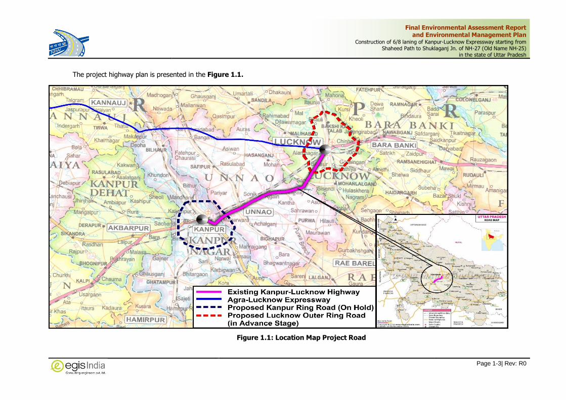
Final Environmental Assessment Report and Environmental Management Plan
Construction of 6/8 laning of Kanpur-Lucknow Expressway starting from Shaheed Path to Shuklaganj Jn. of NH-27 (Old Name NH-25)
in the state of Uttar Pradesh
Page 1-3| Rev: R0
The project highway plan is presented in the Figure 1.1.
Figure 1.1: Location Map Project Road

Final Environmental Assessment Report and Environmental Management Plan
Construction of 6/8 laning of Kanpur-Lucknow Expressway starting from Shaheed Path to Shuklaganj Jn. of NH-27 (Old Name NH-25)
in the state of Uttar Pradesh
Page 1-4| Rev: R0
1.5 Ecological Sensitivity of the Location of the Project
The proposed KLE does not pass through any National Park or Wildlife Sanctuary. However, this
greenfield project will have ecological impact that has been taken into account apart from other
human dimensions such as safety and economic considerations, and ways to utilise the landscape
in an optimum way.
The environmental assessment of the location has been carried out for understanding the ecological
sensitivity of the location of the Project. It has been identified that project alignment does not fall
under any notified protected area or its eco-sensitive zone however the project is passing at a
distance of 9Km from Shaheed Chander Shekhar Azad (Nawabganj) Bird Sanctuary. The Bird
Sanctuary is a notified protected area in Unnao district covering an area of 2.246 sq.km. MoEF&CC
vide its S.O. 3153(E) dated 29.08.2019 has notified its final Eco-sensitive zone of an extent of 100m
uniform around the boundary of Shaheed Chandra Shekhar Azad (Nawabganj) Bird Sanctuary.
Therefore, the proposed project alignment is far away from its final notified eco-sensitive zone. The
other environmental sensitive features are provided under Table 1.2.
Table 1.2: Other Sensitive Features
S. No. Particulars Along the Proposed Project
1 Wildlife sanctuary/ NP or Protected Area or Biosphere reserve or TR or Elephant Reserves
Nil
2 Critically Polluted Area Nil
3 Eco-sensitive area or Eco-sensitive Zone Nil
4 State/UT/International Boundary or Hilly area or areas protected under international convention / national legislation / local legislation or cultural or other related value or wetlands or water bodies or coastal zone
Nil
5 Defence installations Kanpur Air force Station at Chakeri (6.5Km from project end)
6 Protected Monuments & structures Nil
7 Land Use Pattern Land use within 1km buffer from either side of project road: Water Bodies (2.13%), Scrub Land (8.66%), Barren Land (3.19%), Grass Land (7.72%), Airport (1.11%), Industry (1.17%), Orchard/Trees (9.90%), Crop Land (19.15%), Fallow Land (38.34%), Settlement (8.73%) Annexure-3.2
8 Forest Land Diversion 32.4416ha.
9 River crossings 2 Rivers viz. Sai River (Km 28+280) and Loni River (Ch. 50+497, 52+125 and Ch. 53+815)
10 Ponds 1at village Kantha (Ch. 36+793)
11 Terrain Plain terrain
12 Critically Polluted Area or Severely Polluted Area
The project does not fall in any notified polluted area. Nearest is Kanpur’s Polluted Industrial Area (Uttar Pradesh)
13 Green belt development As per IRC SP 21:2009 /MORTH Code/ Guidelines, Green Plantation Policy, 2015 and Green corridor’s terms of reference for plantation by GHD/NHAI
14 EMP Cost 51.74 Cr
The satellite imagery of finalized alignment of proposed expressway is presented in the Figure 1.2
below:

Final Environmental Assessment Report and Environmental Management Plan
Construction of 6/8 laning of Kanpur-Lucknow Expressway starting from Shaheed Path to Shuklaganj Jn. of NH-27 (Old Name NH-25)
in the state of Uttar Pradesh
Page 1-5| Rev: R0
Figure 1.2: Proposed Expressway Alignment Marked on Satellite Imagery (Google Earth)

Final Environmental Assessment Report and Environmental Management Plan
Construction of 6/8 laning of Kanpur-Lucknow Expressway starting from Shaheed Path to Shuklaganj Jn. of NH-27 (Old Name NH-25)
in the state of Uttar Pradesh
Page 1-6| Rev: R0
1.6 Brief Description of Nature, Size and Category of the Project
The proposed project is a Greenfield project for the development of ‘New Expressway’ and therefore
the project activity falls under ‘Category- A’ in Highway Sector under item 7(f) of the EIA notification
2006 and its subsequent amendments.
1.7 Importance of the Project
Lucknow (the ‘Capital’ City) as well Kanpur (the ‘Industrial hub’ city) are both thickly populated
cities. Currently, both are connected by National Highway-25 (New NH-27) traversing a 90 km
length. This existing highway observes a very heavy traffic movement plies every day and presently
takes 2.5hours to shuffle between the cities.
Thus, Government of India envisage a safe, smooth, efficient, and high-speed transport corridor to
develop these cities as twin city. The proposed Expressway will reduce the travel time between
Kanpur and Lucknow, and also open up avenues for Industrial and Urban development of the
region, that would add a new dimension to the progress of Uttar Pradesh. Also it will play a
significant role in reducing the pollution besides savings in vehicle operating costs, less fuel
consumption and decreased cost and time of passenger travel. The proposed project road will give
significant economic impetus to Uttar Pradesh state and will help in changing the socio-economic
condition of the people living in the Lucknow and Kanpur region and generate direct and indirect
employment to the local people.
1.8 Objectives of the Study
The major objective of this study is to establish analyse the project in light of existing and
anticipated environmental condition by studying the developmental activity & process, evaluate the
existing environmental setting along the project corridor and impact area, assess the environmental
impact on the baseline and recommend suitable prevention & mitigation measures.
The EIA study will include:
To fulfil the requirement of Environmental Clearance in accordance to EIA notification, 2006
To study of proposed project in view of anticipated environmental aspects
To establish the baseline environmental, ecological & social aspects
Evaluate the project & baseline to arrive at the probable environmental impacts
Recommendations of necessary environmental control measures.
Preparation of Environmental Monitoring and Management Plan
1.9 Terms of Reference (TOR Approved by EAC)
The recommendations of the environmental screening study carried out by the consultants helped
in finalizing the scope for the EIA study and hence the TOR.
Based on the standard TOR, a draft ToR for the EIA study of proposed project was submitted and
mentioned online on 14th August, 2018 for seeking Terms of Reference (TOR) as per the provisions
of the Environment Impact Assessment (EIA) Notification, 2006 and its subsequent amendments
under the Environment (Protection) Act, 1986. The project case was presented during 197th Meeting
Final Environmental Assessment Report and Environmental Management Plan
Construction of 6/8 laning of Kanpur-Lucknow Expressway starting from Shaheed Path to Shuklaganj Jn. of NH-27 (Old Name NH-25)
in the state of Uttar Pradesh
Page 1-7| Rev: R0
of the Expert Appraisal Committee (MoEF&CC) for projects related to Industrial Estate/Area, SEZ
and Highways projects held on 17th Sep, 2018 at Indira Paryavaran Bhawan, Jor Bagh Road, New
Delhi. MoEF&CC.
As deliberated in the meeting and information provided by the proponent in support of the project,
The EAC committee recommended the project for grant of TOR. As per the recommendation of the
EAC, the Ministry of Environment, Forest and Climate Change vide its letter F. No. 10-65/2018-
IA.III dated 12th Oct, 2018 accorded TOR for 'Construction of 6/8-laning of Kanpur-Lucknow
Expressway starting from Shaheed path (11.000km) to Sukhlaganj Jn. (73.770km) of NH-27 in the
State of Uttar Pradesh by M/s National Highways Authority of India'. The copy of approved TOR is
attached as Annexure – 1.2
1.9.1 Scope of the Study
The Scope of study is as per the details notified in the standard ToR applicable for highways and
specified in additional TOR recommended by EAC of MoEFCC for the project.
To identify the suitable arrangement to avoid congestion at both the exit points of the proposed
highway.
Water bodies along the proposed alignment needs to be surveyed for the conservation and
sustainability.
To estimate on water consumption, treatment and water quality to the provided to work out.
Rainwater harvesting structures provisions and Top soil management
Tree to be planted on the both side of the proposed alignment.
Air Quality monitoring during designing, construction and operational phase. Toll plaza locations
are to be selected for monitoring stations for operational phase.
Fly ash utilization for construction of embankment
Recommendations on resettlement and rehabilitation options for the population effected
Assessment of impacts of vehicular emissions and air quality and river water quality and the
aquatic life.
Assessment of environmental impacts of ancillary activities of projects which are likely to come
up such as garages, petrol pumps and motels etc.
To address to the migratory paths of wild life across project alignment
The EIA study should address to all the phases (acquisition of land, preparation, construction
and operation) of the project while evaluating the impact on environment and drawing up the
management plan
To follow FCA guidelines for affected forests
To propose provision of housing, fuel, safe drinking water and sanitations for the contract
labour.
To identify project activities during construction and operation phases, which will affect the
noise levels and the potential for increased noise resulting from this project.
To prepare environmental management and monitoring plan for all phases of the project viz.
construction and operation

Final Environmental Assessment Report and Environmental Management Plan
Construction of 6/8 laning of Kanpur-Lucknow Expressway starting from Shaheed Path to Shuklaganj Jn. of NH-27 (Old Name NH-25)
in the state of Uttar Pradesh
Page 1-8| Rev: R0
1.10 Environmental Policies and Legislation
The Constitution of India directs the state to endeavour to protect and improve the environment
and safeguard the forests and wildlife of the country. Article 51(g) of the constitution states that it
shall be the duty of every citizen of India to protect and improve the national environment including
forests, lakes, rivers and wildlife and to have compassion for living creatures. The language of the
directive principles of the state policy (Article 48A) also contains a specific provision, which commit
the state to protect environment. The legal environmental framework of the country consists of
several Acts, notifications, rules and regulations to protect environment and wildlife.
Environmental clearance is required only for certain categories of highways/expressways projects
and not all road projects. The EC is required for the project as per regulatory guidelines set out to
by the MoEF&CC.
Enforcement Agencies for Environmental Regulations
a) Ministry of Environment, Forest and Climate Change (MoEFCC)
b) Uttar Pradesh Pollution Control Board (UPPCB)
Environment and Social Legal Framework
Table 1.3 presents Environmental and Social safeguards/regulations and legislations relevant to
this project, which are the responsibility of a number of government agencies.
Table 1.3: Summary of Relevant Environmental Legislations
Act/Rule/Notification/
Policy Year Objectives Responsible Agency
Constitution of India, Article 48,
51-A
1950 Article 48A of the Directive Principles of
State Policy provides for the State’s
commitment to protecting the environment
and Article 51A(g) states that to protect
and improve the natural environment shall
be the fundamental duty of the citizen of
India.
MoEF&CC, Government of
India
The Environment (Protection)
Act
The Environment (Protection)
Rules
1986
1986
To protect and improve the overall
environment by ensuring that appropriate
measures taken to conserve and protect
the environment before commencement of
operations.
MoEF&CC; GoI;
Department of Forest,
GoUP; UPPCB
Environment Impact Assessment
Notification and its amendments
made thereafter.
2006 Identifies highways/expressways among
other project that needs environmental
clearance from the Central Government in
the form of an approved environmental
impact assessment (EIA) report and EMP.
MoEF&CC; GoI; UPPCB
Indian Forest Act
Forest (Conservation) Act
Forest (Conservation) Rules
Forest Conservation Rules
(Notification)
1927
1980
1981
2003
2014
2017
To consolidate the laws related to forest,
the transit of forest produce and the duty
livable on timber and other forest produce.
Conservation of Forests, Judicious use of
forestland for non-forestry purposes; and
to replenish the loss of forest cover by
Compensatory Afforestation on degraded
forestland and non-forest land.
MoEF&CC; Department of
Forest, State Govt (SFD).

Final Environmental Assessment Report and Environmental Management Plan
Construction of 6/8 laning of Kanpur-Lucknow Expressway starting from Shaheed Path to Shuklaganj Jn. of NH-27 (Old Name NH-25)
in the state of Uttar Pradesh
Page 1-9| Rev: R0
Act/Rule/Notification/
Policy Year Objectives Responsible Agency
Procedure for submission of the proposals
seeking approval for Central Government
for diversion of forestland to non-forest
purposes.
Wild Life (Protection) Act
The Wild Life (Protection)
Amendment Act
1972
2002
To protect wildlife in general and National
Parks and Sanctuaries in particulars.
To protect wild animals, birds and plants
with a view to ensure the ecological and
environmental security of the country.
Chief Conservator of
Wildlife, Wildlife Wing,
Forest Department, State
Govt. National/State
Board for Wildlife
The Scheduled Tribes and other Traditional Forest Dwellers (Recognition of Forest Rights) Act
2006
Grants legal recognition to the rights of traditional forest dwelling communities, partially correcting the injustice caused by the forest laws. Makes a beginning towards giving communities and the public a voice in forest and wildlife conservation
Ministry of Tribal Affaires,
GOI and Department of
Tribal Welfare, GoUP
National Forest Policy
National Forest Policy (Revised)
1952
1988
To maintain ecological stability through
preservation and restoration of biological
diversity
Forest Department, GoI
and State Govt.
The Water (Prevention and
Control of Pollution) Act
Water (Prevention and Control of
Pollution) Cess Act
1974
1977
To control water pollution by controlling
discharge of pollutants as per prescribed
standards
Provides for a levy and collection of a cess
on water consumed by industries and local
authorities
CPCB; UPPCB
The Air (Prevention and Control
of Pollution) Act
1981 To control air pollution by controlling
emission of air pollutants as per prescribed
standards
CPCB; UPPCB & Transport
Department; State Govt.
Noise Pollution (Regulation and
Control) Rules
The Noise Pollution (Regulation
and Control) Amendment Rules
2000
2006
To regulate and control noise producing
and generating sources with the objective
of maintaining the ambient air quality
standards in respect of noise.
CPCB; UPPCB, Transport
Department; State Govt.
Mines and Minerals
(Development and Regulation)
Act
Mineral Laws (Amendment) Act
1957
2020
To regulate the mining activities and for
borrowing of ordinary earth for linear
projects like road projects
State Mining department,
UP
Solid Waste Management Rules
(SWM)
2016 For Management and handling of solid
waste during construction
UPPCB
Hazardous and Other Wastes
(Management & Trans boundary
Movement) Rules
2016 Protection to the general public against
improper handling and disposal of
hazardous wastes
UPPCB
Construction and Demolition
Waste Management Rules
2016 To provide responsibility of the waste
generators for the collection, segregation
and other activities involved with the debris
management generated during
construction
UPPCB
Batteries (Management &
Handling) Amendment Rules
2010 Management and handling of used lead
batteries i.e. safe disposal of batteries used
during construction
UPPCB

Final Environmental Assessment Report and Environmental Management Plan
Construction of 6/8 laning of Kanpur-Lucknow Expressway starting from Shaheed Path to Shuklaganj Jn. of NH-27 (Old Name NH-25)
in the state of Uttar Pradesh
Page 1-10| Rev: R0
Act/Rule/Notification/
Policy Year Objectives Responsible Agency
E-Waste (Management) Rules 2016 Effective mechanism to regulate
generation, collection, storage, transport,
import, export, recycling, treatment and
disposal of e-wastes
UPPCB
Biodiversity Act 2002 To provide for conservation of biodiversity,
sustainable use of resources fair and
equitable sharing of the benefits from use
of resources
National Biodiversity
Authority/State
Authorities
Fly Ash Notification 2011
2016
Mandate use of fly ash in road construction
within a radius of 300km. For highways
project, flyash to be made available by the
TPP at filling site free of cost up to 100km
and on cost sharing basis up to 300km.
MoEF&CC
National Environmental Tribunal 1995 To provide for strict liability for damages
arising out of any accident occurring while
handling any hazardous substance
National Environmental
Tribunal
The Motor Vehicle Act
Central Motor Vehicle Rules and
The Motor Vehicles
(Amendment) Act
1988
1989
2019
To consolidate and amend the laws related
to motor vehicles.
Licensing of driving of motor vehicles,
registration of motor vehicles, with
emphasis on road safety standards and
pollution control measures, standards for
transportation of hazardous and explosive
materials
To check vehicular air and noise pollution.
RTO Office, GoUP, Govt.
of Uttar Pradesh
The Ancient Monuments and
Archaeological Sites and Remain
Act
1958
2010
To provide for the preservation of ancient
and historical monuments and
archeological sites and remains of national
importance and protection sculptures,
carvings and other like objects.
Archaeological
Department (ASI), GoI;
Indian Heritage Society
and Indian National Trust
for Art and Culture
Heritage (INTACH),
National Policy of Resettlement
and Rehabilitation
2007 For payment of compensation and
assistance, different entitlements payment
of compensation and assistance,
resettlement and rehabilitation of project
affected population due to acquisition of
lands and structures.
PIU NHAI, Competent
Authority (Revenue
Department)
Right to fair compensation and transparency in land acquisition, rehabilitation and Resettlement Act
2013
Fair compensation for acquisition of
immovable assets; Resettlement of
displaced population due to LA and
economic rehabilitation of all those who are
affected due to land acquisition.
Revenue Department.
Govt. of U.P.
National Environment Tribunal Act 1995
To provide for strict liability for damages arising out of any accident occurring while handling any hazardous substance.
National Environmental
Tribunal
A brief description of relevant laws is given below:

Final Environmental Assessment Report and Environmental Management Plan
Construction of 6/8 laning of Kanpur-Lucknow Expressway starting from Shaheed Path to Shuklaganj Jn. of NH-27 (Old Name NH-25)
in the state of Uttar Pradesh
Page 1-11| Rev: R0
Forest (Conservation) Act, 1980: The Forest (Conservation) Act, 1980 is of particular
significance in case the project corridors require clearance for diversion of forest land for non-forest
purpose inside the Right of Way (RoW) of the road corridors for the development of Kanpur
Lucknow Expressway.
The proposals involving upto forty hectares of forest land and all proposals involving diversion of
forest land for linear projects such as roads, railway lines, transmission lines, pipelines etc.,
irrespective of area of forest land involved, are sent to the concerned Regional Office (in project
case, RO-Lucknow) of the Ministry of Environment, Forest and Climate Change (MoEF&CC). As per
the FC Rules, prior approval of central government under the FC Act is given in two stages
commonly referred to as Stage-I (In Principle agreement) and Stage-II (Formal approval) under
the FC Act respectively.
Wild Life Protection Act, 1972: It has allowed the government to establish a number of National
Parks and Sanctuaries over the past 25 years, to protect and conserve the flora and fauna of the
State.
The Water (Prevention and Control of Pollution) Act, 1974: It resulted in the establishment
of the Central and State Level Pollution Control Boards whose responsibilities include managing
water quality and effluent standards, as well as monitoring water quality, prosecuting offenders
and issuing licenses for construction and operation of any facility. This will include generation of
liquid effluent during construction of road from Civil Engineering activities or from domestic
activities in worker’s colony. There are specific penalties for violation, which include imprisonment
for responsible officials.
The Air (Prevention and Control of Pollution) Act, 1981: The Act empowers Central and
State Pollution Control Boards for managing air quality and emission standards, as well as
monitoring air quality, prosecuting offenders and issuing licenses for construction and operation of
any facility. There are specific penalties for violation, which include imprisonment for responsible
officials. This Act has notified National Ambient Air Quality Standard for different regions e.g.
Industrial, Residential and Sensitive. Air quality during construction and operation phases will be
guided by this specific act.
Environment (Protection) Act, 1986: This Act was passed as an overall comprehensive act “for
protection and improvement of environment”. According to this Act, the Central Government has
the power to take all such measures as it deems necessary or expedient for the purpose of
protecting and improving the quality of environment and preventing, controlling and abating
environmental pollution. Under this act rules have been specified for discharge/emission of effluents
and different standards for environmental quality. These include Ambient Noise Standard, Emission
from Motor Vehicles, Mass Emission Standard for Petrol Driven Vehicles, General Effluent Standards
etc. especially important for road project.
EIA Notification, 2006: The Environment Impact Assessment (EIA) notification 2006, Ministry of
Environment, Forests & Climate Change, Government of India, came into effect from 14th
September 2006. The EIA Notification, 2006 specifies the various development projects requiring
prior clearance from Ministry of Environment, Forests & Climate Change (MoEF&CC). As per
Schedule of the Notification; the Highway project falls under Physical Infrastructure including
Environmental Services and have been listed under item no. 7(f), including new highways or
expansion of existing highways (highways include Expressways). The projects and activities under

Final Environmental Assessment Report and Environmental Management Plan
Construction of 6/8 laning of Kanpur-Lucknow Expressway starting from Shaheed Path to Shuklaganj Jn. of NH-27 (Old Name NH-25)
in the state of Uttar Pradesh
Page 1-12| Rev: R0
the Notification have been classified into two categories- Category A and Category B, based on the
spatial extent of potential impacts on human health and natural and manmade resources. The
highway projects have also been classified into two categories- Category A and Category B based
on the following conditions:
Category A: New National Highways and expansion of existing National Highway greater than 100
Km, involving additional RoW or land acquisition greater than 40 m on existing alignment and 60
m on re-alignment or bypass.
Category B: All State Highway projects and State Highway expansion projects in hilly terrain
(above 1000 m AMSL) and or ecologically sensitive areas.
Moreover, any project or activity specified in Category B will be treated as Category A if located in
whole or in part with in 5 km from the boundary of:
i. Protected areas notified under the Wild Life (Protection) Act, 1972,
ii. Critically Polluted areas as notified by Central Pollution Control Board from time to time,
iii. Eco sensitive areas as notified under section 3 of Environment Protection Act, 1986 such
as Mahabaleshwar, Panchangi, Matheran, Pachmarhi, Dahanu, Doon Valley, and
iv. Inter State boundaries and international boundaries.
Provided that the requirement regarding distance of 10 km of the inter-state boundaries can be
reduced or completely done away with by an agreement between the respective States or U.Ts
sharing the common boundary in the case the activity does not fall within 10 kilometres of the
areas mentioned at item (i), (ii) and (iii) above.
In the present case, the proposed expressway is a new National Expressway contained in Uttar
Pradesh only Hence, as per EIA notification 2006, the proposed project falls under Category-A and
attracts the conditions of obtaining prior Environmental Clearance from MoEFCC.
Fly Ash Notification, 2016
According to the Notification No. S.O. 763 (E), dated 14.09.1999 and its amendment thereafter on
27.08.2003 and notification S.O. 2804(E) dated 3rd November 2009, S.O. 254 (E)dated 25.01.2016
by MoEF&CC, it is mandatory to use fly ash within a radius of 300 kilometers of Thermal Power
Plant. No agency, person or organization shall within a radius of 300 kilometer of Thermal Power
Plant undertake construction or approve design for construction of roads of flyover embankments
in contravention of the guidelines/ specification issued by the Indian Road Congress (IRC) as
contained in IRC specification No. SP: 58 of 2001. Any deviation from this direction can only be
agreed to a technical reason if the same is approved by Chief Engineer (Design) or Engineer-in-
chief of the concerned agency or organization or on production of certificate of “Pond ash not
available” from the Thermal Power Plant(s) located within 300 kilometers of the site construction.
This certificate shall be provided by TPP within two working days from the date of making request
for fly ash.
Statutory Permission for Abstraction of Ground Water
Hon’ble National Green Tribunal, New Delhi vide its order dated the 15th April, 2015 in O.A. Nos.
204/205/206 of 2014 has issued directions to the Central Ground Authority of India, Ministry of
Water Resources, River Development and Ganga Rejuvenation, to ensure that any person operating

Final Environmental Assessment Report and Environmental Management Plan
Construction of 6/8 laning of Kanpur-Lucknow Expressway starting from Shaheed Path to Shuklaganj Jn. of NH-27 (Old Name NH-25)
in the state of Uttar Pradesh
Page 1-13| Rev: R0
tube-well, or any means to extract ground water shall obtain permission from the Authority and
shall operate the same subject to the law in force, even if such unit is existing unit or the unit is
yet to be established. This is applicable for abstraction of ground water for construction project in
Infrastructure Projects. The Central Ground Water Authority, is the Authorised body for regulating
ground water development and management by way of issuing ‘No Objection Certificates’ for
ground water extraction to industries or infrastructure projects or mining projects.
In pursuance of the directions of the Hon’ble National Green Tribunal, New Delhi The Central
Ground Water Authority has notifies the guidelines to regulate groundwater over-exploitation and
conserve the groundwater resources in the country vide their Gazette Notification No. S.O. 3289(E)
dated 24th September 2020, specifying the requirements for NOC for bore-wells established by the
Contractor for abstracting ground water for construction purpose. The applicant has to pay Water
Conservation Fee (WCF) based on the quantum of abstraction required. In safe zones the NOC is
valid upto 5 years.
1.11 Summary of Statutory Clearance Requirement:
The project requires a number of statutory clearances under different Acts and Rules at different
stage of the project. These are listed in Table 1.4.
Table 1.4: Summary of Statutory Clearance Requirement of the Project
Sl. No
Type of Clearance
Relevant Act
Authority Granting
Clearance/ In charge
Applicability When
Required/ Project Stage
Responsibility Remarks
1. Environmental Clearance
EIA Notification, 2006 (incl.
amendment)
under EPA, 1986
EAC, MoEF&CC,
GoI
For Prior EC for Expressway
Project
Pre-Construction
Project Implementation Unit (PIU),
NHAI, Lucknow
Supported by EIA, EMP and Project
Reports
2. Forest Clearance
FCA Act, 1980
State Forest Department
and RO, Lucknow
For diversion
of forest land for its Non-Forestry Use irrespective of its type or
area
Pre-Construction
Project Implementation Unit (PIU), NHAI, Lucknow
Supported
by Forest Diversion Proposal
3.
Tree Cutting & Transportation
permission for Non-Forest Trees
UP Tree Protection
Act, 1976 &
its amendment
2020
Forest
Department
For Cutting of Non-Forest
trees within proposed ROW
Pre-
construction
Project Implementation
Unit (PIU), NHAI, Lucknow
Exact number & location of
trees to be furnished
4.
Consent to Establish of a project/sub-
projects
Air Act, 1974 & Water Act,
1981
UPPCB
For Highways/ Expressways Project
Alignment
Pre-Construction
Project Implementation Unit (PIU),
NHAI, Lucknow
Appropriate
forms, (Form I & Form XIII) with
requisite fees, to be completed
5.
NoC and Consent for establishing
plant/ machineries
Air Act, 1974 & Water Act,
1981
UPPCB
For siting and
erection of Plant or machineries
like stone crusher, Hot Mix Plants and
Construction Stage (Prior to erection of
Plants)
Concessionaire
Appropriate
forms,
(Form I & Form XIII) with
requisite fees, to be completed
Final Environmental Assessment Report and Environmental Management Plan
Construction of 6/8 laning of Kanpur-Lucknow Expressway starting from Shaheed Path to Shuklaganj Jn. of NH-27 (Old Name NH-25)
in the state of Uttar Pradesh
Page 1-14| Rev: R0
Sl.
No
Type of
Clearance
Relevant
Act
Authority Granting
Clearance/
In charge
Applicability
When
Required/ Project Stage
Responsibility Remarks
aggregate quarries etc.
6.
NoC and Consent for Operation under Air and
Water Act from SPCB
Air Act, 1974 & Water Act,
1981
UPPCB
For operating construction plant, crusher, batching plant, HMP
and aggregate quarries etc.
Construction Stage (Prior to commencement of Operation of
Plants)
Concessionaire
Appropriate
forms, (Form I & Form XIII) with
requisite fees, to be completed
7. Installation of Generators
Air
(Prevention and Control of Pollution) Act,
1974
UPPCB For operating construction works
Before Installation
Concessionaire -
8. License for storing Diesel/
Fuel
Petroleum Rules, 2002 (Amended in
the year
2011) of the Petroleum Act, 1934.
Commissioner of Explosives
/PESO
For storing fuel oil, lubricants,
diesel etc.
Construction stage (Prior to storing fuel,
lubricants and Diesel, etc.)
Concessionaire -
9.
Permission for
storage of hazardous chemical from SPCB
UPPCB
Manufacture
storage and Import of Hazardous Chemical
Construction
stage (Prior to initiation of any work)
Concessionaire
If
bituminous is used for the pavement.
10. Quarry Lease Deed and
Quarry License
Mines And Minerals
(development & regulation)
act 1957 and UP State
Mineral Policy 2017
State Dept. of Mines &
Geology
Quarry
operation
Construction stage (Prior to
initiation of Quarrying)
Concessionaire I forms
11.
NOC for extraction of ground water
for use in road construction
activities
Environment (Protection)
Act, 1986 and
CGWB abstraction
rules 2018
Central Ground
Water Board, Lucknow
Extraction of
ground water
Construction stage (Prior to initiation of installation of
Bore wells & abstraction of
water from such source)
Concessionaire
Online Application at
www.cgwa-noc.gov.in
12. Labour Licence
Building & Other
Construction Workers
Act, 1996, UP
Building & Other
Construction Workers
Rules, 2009 and other relevant
labour rules
Labour Commissioner
Office
Engagement of Labour
Construction stage (Prior to initiation of any
work)
Concessionaire
Registration of principal employer, License for contractors,
Renewal of license for contractors
13.
Location/
layout of workers camp,
equipment and storage
yards
EPA, 1986 and The
Building & Other
Construction Workers
Act, 1996, International
UPPCB, District
Health Officer
Labour Health
and Safety
Construction stage (Prior to
initiation of any work)
Concessionaire -
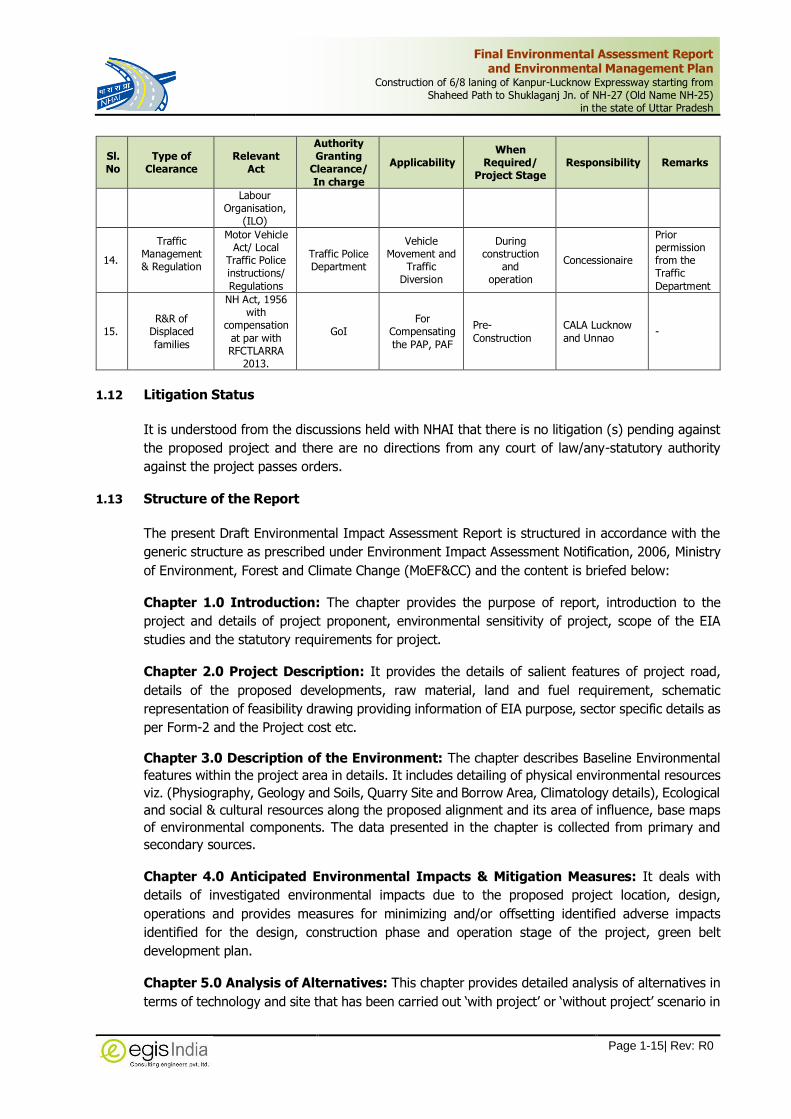
Final Environmental Assessment Report and Environmental Management Plan
Construction of 6/8 laning of Kanpur-Lucknow Expressway starting from Shaheed Path to Shuklaganj Jn. of NH-27 (Old Name NH-25)
in the state of Uttar Pradesh
Page 1-15| Rev: R0
Sl.
No
Type of
Clearance
Relevant
Act
Authority Granting
Clearance/
In charge
Applicability
When
Required/ Project Stage
Responsibility Remarks
Labour Organisation,
(ILO)
14.
Traffic Management & Regulation
Motor Vehicle Act/ Local
Traffic Police instructions/
Regulations
Traffic Police Department
Vehicle Movement and
Traffic Diversion
During construction
and operation
Concessionaire
Prior permission from the Traffic
Department
15. R&R of
Displaced
families
NH Act, 1956 with
compensation
at par with RFCTLARRA
2013.
GoI For
Compensating
the PAP, PAF
Pre-
Construction
CALA Lucknow
and Unnao -
1.12 Litigation Status
It is understood from the discussions held with NHAI that there is no litigation (s) pending against
the proposed project and there are no directions from any court of law/any-statutory authority
against the project passes orders.
1.13 Structure of the Report
The present Draft Environmental Impact Assessment Report is structured in accordance with the
generic structure as prescribed under Environment Impact Assessment Notification, 2006, Ministry
of Environment, Forest and Climate Change (MoEF&CC) and the content is briefed below:
Chapter 1.0 Introduction: The chapter provides the purpose of report, introduction to the
project and details of project proponent, environmental sensitivity of project, scope of the EIA
studies and the statutory requirements for project.
Chapter 2.0 Project Description: It provides the details of salient features of project road,
details of the proposed developments, raw material, land and fuel requirement, schematic
representation of feasibility drawing providing information of EIA purpose, sector specific details as
per Form-2 and the Project cost etc.
Chapter 3.0 Description of the Environment: The chapter describes Baseline Environmental
features within the project area in details. It includes detailing of physical environmental resources
viz. (Physiography, Geology and Soils, Quarry Site and Borrow Area, Climatology details), Ecological
and social & cultural resources along the proposed alignment and its area of influence, base maps
of environmental components. The data presented in the chapter is collected from primary and
secondary sources.
Chapter 4.0 Anticipated Environmental Impacts & Mitigation Measures: It deals with
details of investigated environmental impacts due to the proposed project location, design,
operations and provides measures for minimizing and/or offsetting identified adverse impacts
identified for the design, construction phase and operation stage of the project, green belt
development plan.
Chapter 5.0 Analysis of Alternatives: This chapter provides detailed analysis of alternatives in
terms of technology and site that has been carried out ‘with project’ or ‘without project’ scenario in

Final Environmental Assessment Report and Environmental Management Plan
Construction of 6/8 laning of Kanpur-Lucknow Expressway starting from Shaheed Path to Shuklaganj Jn. of NH-27 (Old Name NH-25)
in the state of Uttar Pradesh
Page 1-16| Rev: R0
terms of adverse environmental impacts of each alternative and its mitigation measures, selection
of alignment including justification
Chapter 6.0 Environmental Monitoring Program: The chapter provides the technical aspects
of monitoring the effectiveness of mitigation measures as per Environmental Monitoring Plan in
Construction Stage and in Operation Stage. The monitoring plans details out the performance
indicators, monitoring parameters, standards, frequency, duration, implementation and
responsibilities required for monitoring and the cost of monitoring the parameters.
Chapter 7.0 Additional Studies- Social Impact Assessment, R&R Plan and Public
Consultation: The Chapter provides the details of information on the of Social Impacts due to the
proposed project and proposed Resettlement and Rehabilitation Plan for compensating the losses
due to the project. It also provides details about the project related additional studies carried out
for the project. The details of Focus Group Discussions carried out and the responses received from
the people are presented in this chapter. Details of public consultation including notice of Public
hearing, supervision, presiding over of the hearing, response received in writing from the person
having plausible stake on the environmental aspect of the project or activity, proceedings and
commitments of the project proponent on the issues raised during the public consultation along
with the time bound action plan.
Chapter 8.0 Project Benefits: This chapter describes Project Benefits from proposed project in
terms of improvement of physical, social infrastructure including local benefits and the wider
regional or national level benefits, Corporate Environmental Responsibilities, employment potential
and other tangible benefits.
Chapter 9.0 Environmental Management Plan (EMP): This chapter comprises a set of
environmental safeguard measures for identifies adverse impacts during different stage of the
project and activities with an objective to offset or reduce adverse environmental impacts to
acceptable levels. The EMP provides action plan of implementation of mitigation measures at
different locations, time frame with responsibility assignments for implementing appropriate
measures at appropriate time for ensuring effectiveness of the proposed safeguard measures.
Adequate budgetary provisions have also been made for implementation and monitoring of the
effectiveness of the suggested measures.
Chapter 10: Disclosure of Consultants Engaged: The Chapter provides information of the
Consultants and experts who were involved in the EIA study of the project.

Final Environmental Assessment Report and Environmental Management Plan
Construction of 6/8 laning of Kanpur-Lucknow Expressway starting from Shaheed Path to Shuklaganj Jn. of NH-27 (Old Name NH-25)
in the state of Uttar Pradesh
Page 2-1| Rev: R0
2 PROJECT DESCRIPTION
2.1 Project Background
Road Transport is considered to be one of the most cost effective and preferred mode of transport,
both for freight and passengers, keeping in view its level of penetration into populated areas. During
the last two decades, India has witnessed significant improvements in its Roads infrastructure.
Today road transport in India carries 67% of the total freight and it has increased more than
doubled over the last 20 years. This is despite the fact that it has about 45% lower freight cost of
rail on per ton per km basis. In addition to freight, it also caters to 87% of passenger traffic.
Thus, considering the trend of massive dependence of trade and commerce on roads, and the
catalytic growth expected from the recent policies to boost manufacturing in India, the creation of
increased high quality and efficient transport infrastructure system is extremely mandatory. Good
roads bring about overall development in the region as it helps in the success of all developmental
activities, be it in the sphere of movement of people or goods, development of agriculture,
commerce, education, health and social welfare, or even maintenance of law and order and
security.
Exemplary economic growth example in the National Capital Region (NCR) comprising Noida,
Greater Noida, Ghaziabad and the resultant prosperity in these satellite towns has inspired the
government to replicate the model in Lucknow and Kanpur Region. The project will help in relieve
traffic congestion and improve the mobility and integration of industrial development, commerce,
and tourism between Lucknow and Kanpur.
2.2 Project Configuration
The proposed project alignment of Kanpur Lucknow Expressway (KLE) is an Access Controlled 6
lane (expandable to 8 lane) Greenfield project having length of 62.744 km. It takes off from
NH-27 at Junction with Shaheed Path (Near Transport Nagar Metro Station) in Lucknow at existing
Km 11.000 and terminates at Km 73.744 of NH-27 at Shuklaganj Junction (Unnao) near Ata village
in the state of Uttar Pradesh. The project alignment passes through 42 villages. The proposed Right
of Way (ROW) of expressway is 90m for main alignment and varies from 90-120m at few locations
such as entry, exit, toll plaza and rest areas. The Proposed alignment originating from NH 27,
intersects SH 40, SH 38, Lucknow Ring Road (under construction), AH 1, NH-31, MDR before meeting
the NH-27 at Shuklaganj Junction in Unnao. The project corridor is divided into following sections
as provided in Table 2.1.
Table 2.1: District wise Length Break-up of Proposed Expressway
S. No.
Design Chainage of KLE Length (km)
District Remarks
Start Chainage End Chainage
1. 11+000 (Shahed Path) 17+575 (LKO Ring Road) 6.575 Lucknow
Expressway will be an elevated section on the existing NH-27 up to a length 16.620 Km 2. 17+575 (LKO Ring Road) 27+620 (Bani) 10.045
3. 27+620 (Bani) 73+744 (Shuklaganj Jn.) 46.145 Unnao Greenfield Alignment

Final Environmental Assessment Report and Environmental Management Plan
Construction of 6/8 laning of Kanpur-Lucknow Expressway starting from Shaheed Path to Shuklaganj Jn. of NH-27 (Old Name NH-25)
in the state of Uttar Pradesh
Page 2-2| Rev: R0
The start and end points are shown in Figure 2.1 below.
Start Point at Amar Shaheed Path Junction End Point near Shuklaganj Junction (NH-27)
Figure 2.1: Start and End Points of Proposed Kanpur-Lucknow Expressway
The salient features describing size of operation incl. associated facilities of the proposed project
are summarized in Table 2.2.
Table 2.2: Salient Features of the Kanpur-Lucknow Expressway
A. General Information
Sl. No.
Items Details of KLE (62.764Km)
In Lucknow (17.300 Km)
In Unnao (45.464 Km)
1. Project Development of new Kanpur-Lucknow Expressway in Uttar Pradesh.
2. Administrative Location Lucknow and Unnao district
Sarojini Nagar Taluka
Hasanganj, Purwa and Unnao Taluk
3. No. of Villages 42 11 31
4. Project Length (in Km) 62.764 17.300 45.464
5. Terrain Plain Plain Plain
6. Major town along Project
Lucknow (9Km), Sarojini Nagar (0Km), Purwa (9.5Km), Ajgain, Unnao (7.2Km), Kanpur (11km)
Lucknow (9Km), Sarojini Nagar (0Km)
Purwa (9.5Km), Ajgain, Unnao (7.2Km), Kanpur (11km)
7. Rivers/Streams/Canals
2 Rivers viz. Sai River (Km 28+280) & Loni River (Ch. 50+497, 52+125 and Ch. 53+815)
Sai River (Km 28+280)
Loni River (Ch. 50+497, 52+125 and Ch. 53+815)
8. Ponds/Tanks/Reservoirs 1 (Ch. 36+793) Nil 1 (Ch. 36+793)
9. Forest Area (ha.) 34.1179 29.3377 4.7802
10. Ecologically Protected areas Nil Nil Nil
11. Archaeological/ Heritage Site Nil Nil Nil
12. Total No. of Structure Affected 344 176 168
13. No. of PAHs due to impacted Structures
327 155 172
14. No. of PAHs due to impacted Land 6120 4768 1352
12. Total Area of Land Acquisition(ha.) 476.7835 46.0695 430.7140

Final Environmental Assessment Report and Environmental Management Plan
Construction of 6/8 laning of Kanpur-Lucknow Expressway starting from Shaheed Path to Shuklaganj Jn. of NH-27 (Old Name NH-25)
in the state of Uttar Pradesh
Page 2-3| Rev: R0
B. General features:
Sl. No.
Items Details of KLE (62.764Km)
In Lucknow (17.300 Km)
In Unnao (45.464 Km)
1. General Right of Way 90-120m 90-120m 90-120m
2. Carriageway
Expressway will be of 6-lane with a lane width 3.75m with flexible (bituminous layer).
4 lane elevated with 4 lane at ground level from Shaheed Path to Lucknow Ring road and 6 lane elevated with 4 lane at the ground level from proposed Lucknow Ring road to Sai Bridge.
The proposed expressway will be of 6-lane with a lane width 3.75m
3. Design Speed 120Kmph
120Kmph (100 Kmph for the elevated section is adopted in correspondence to the plain terrain).
120Kmph
4. Major Bridge 4 1 (28+280) 3
5. Minor Bridge 25 1 (Km 14+800) 24(22 on Main CW and 2 on Connecting Road)
6. Major Junction 4 4 0
7. Minor Junction 14 14 0
8. ROB 1 0 1 (Km 64+462)
9. No of Culvert 94 29 65
10. VUP 11 0 11
11. LVUP 8 0 8
12. Pedestrian/cattle/SVUP 11 Entire stretch is elevated 11
13. Flyover 2 1 (Km 12+415) 1 (Km 55+537)
14. Interchange 3 1 (km 17+580) 2 (Km 65+700, Km 73+744)
15. Wayside Amenities 2 0 2
16. Service/Connecting Road
17 0 17
17. Toll Plaza 1 0 1 (Km 35+000)
18. Viaduct/Elevated Structure
2 2 (14+550 to16+155 & 18+605 to 28+205)
0
19. Bus Shelters 2 2 0
19. Rainwater Harvesting Structure (RWH)
129 RWH between alternate pier of Viaduct and 121 RWH throughout Greenfield alignment at 500m on either side
129 RWH between alternate pier of Viaduct and 34 RWH at 500m on either side
87 RWH at 500m on either side
20. High mast lighting The High mast lighting has been proposed along the project highway locations in interchange locations, Rest area, Toll plaza locations.
21. Horticulture and Landscaping
Throughout the stretch within available space
22. Total Capital Cost (In Cr.)
5235.77 2365.45 2870.32
Other Salient Features
The project alignment from starting point near Shaheed path (Design Km 11+00) to Lucknow ring
road will be an elevated 4-lane and follows the alignment of existing highway having 4 lane divided
carriageway. The ROW of existing NH-27 varies between 30-40m. The elevated structure of
proposed expressway shall be on viaduct accommodating in the existing Median of NH-27. From

Final Environmental Assessment Report and Environmental Management Plan
Construction of 6/8 laning of Kanpur-Lucknow Expressway starting from Shaheed Path to Shuklaganj Jn. of NH-27 (Old Name NH-25)
in the state of Uttar Pradesh
Page 2-4| Rev: R0
Lucknow Ring road to Bani, the expressway will be 6-lane elevated over the existing 4-lane NH-27.
The detail of viaduct is provided in below section.
2.2.1 Design Speed
The project corridor passes through plain. The design speed of 120 Kmph for Expressway in the
greenfield section and 100 Kmph for the elevated section is adopted in correspondence to the plain
terrain.
2.2.2 Right of Way
The proposed Right of Way is 90m considering the recommendation of IRC: SP-99 guidelines for
plain/rolling terrain in normal situation. Elevated structures are proposed on existing NH-27 in urban
area having width of 28m.
For interchanges, toll booth, highway amenities, truck lay byes additional land shall be required.
2.2.3 Cross-fall and Super Elevation
The cross-fall on straight sections of project road carriageway shall be as given in the table below.
Each carriageway shall have unidirectional cross-fall.
Table 2.3: Cross-fall on Different Surfaces
Section Design Standard (%)
Edge strip & Carriageway 2.5
Paved /Surfaced Shoulder 2.5
Earthen Shoulder 3.5
2.2.4 Super Elevation
Super elevation has been limited to 5% for curves with radii 1000m or more. For curves with radii
less than 1000m it has been limited to 7%.
2.2.5 Proposed Carriageway Configuration:
The proposed configuration for the expressway in greenfield section is 6 lane divided carriageway
with 4.5m wide flush median.
In the elevated section, six lane/four lane standards are considered elevated corridor and minimized
acquisitions.
2.2.6 Typical Cross Section
The first 16 km of the proposed alignment follows the existing National Highway – 27 (Old NH-25),
between Km 11+000 to Km 27+620, which passes mostly through built up areas with constrained
ROW. This section is proposed to be developed to six lane/four lane standards with options of
elevated corridor and minimized acquisitions. The remaining section of 47.3 km is proposed to be
developed as expressway, in adherence to the expressway standards on a Greenfield Alignment.
- The existing road is proposed to be developed by retaining the existing median which is placed
approximately centrally within the generally available right of way of 35-40m.

Final Environmental Assessment Report and Environmental Management Plan
Construction of 6/8 laning of Kanpur-Lucknow Expressway starting from Shaheed Path to Shuklaganj Jn. of NH-27 (Old Name NH-25)
in the state of Uttar Pradesh
Page 2-5| Rev: R0
- Elevated sections are developed as per IRC: SP:87-2019 / IRC: SP:84-2019 and beneath that
4 lanes with Paved shoulder. In the elevated sections, lane width has been considered as 3.5m
and paved shoulder is considered as 2.0m.
- In the greenfield section, 6-lane is proposed but embankment has been considered after
extended lane. Side slope has been provided as 1:4 but where extended lane is proposed, side
slope of 1:3 is proposed.
Keeping these basic requirements, various TCS are developed to meet the need of land use along
the project road in reference to the relevant manuals for expressways (IRC: SP:99-2013), six laning
(IRC: SP:87-2019) and four laning (IRC: SP:84-2019). The details of proposed typical cross sections
are provided in Table 2.4 and Annexure 2.2.
Table 2.4: Proposed Typical Cross Section
S. No. TCS Type Cross-section Type Application Length (km)
1 TCS-1 6-lanes expressway in green field section 12.690
2 TCS-2 6-lanes expressway with 2 lane connecting road on one side in green field section and space for future widening
3.708
3 TCS-2A 6-lanes expressway with 2 lane connecting road on both sides in green field section and space for future widening
0.240
4 TCS-3 6-lanes elevated highway with 4-lanes underneath in built-up section in Lucknow
7.970
5 TCS-3A 6-lanes approach section for underpass and elevated highway built-up sections in Lucknow
0.305
6 TCS-3B 4-lanes elevated highway with 4-lanes underneath in built-up section in Lucknow
1.180
7 TCS-3C 4-lanes approach section for underpass and elevated highway built-up sections in Lucknow
0.765
8 TCS-3D 6-lanes elevated highway 1.200
9 TCS-3E 6-lanes approach section for elevated highway built-up sections in Lucknow
0.325
10 TCS-3F 4-lanes approach section elevated highway built-up sections in Lucknow 0.425
11 TCS-4 6-lanes highway in built-up section in Lucknow 3.130
12 TCS-5 6-lanes highway in built-up section with metro line in median in Lucknow 0.990
13 TCS-6 6-lanes expressway at appraoch of unidirectional Flyover 0.810
14 TCS-7 6-lanes expressway in green field section and space for future widening in approach of bridge locations and without connector in VUP/LVUP/PUP
25.632
15 TCS-8 4-lanes expressway at approach of grade separator 0.400
16 TCS-12A 6-lanes expressway with 2 lane IC Ramps on both sides in green field section and space for future widening
1.230
17 Toll Plaza 1.800
Total 62.4
2.2.7 Connecting Road
Connecting roads are provided within ROW to maintain proper circulation of local traffic, continuity
of travel and to facilitate crossing. Entire Lucknow district i.e. from Shaheed Path to Bani Section
follow the existing NH-27 with elevated project road, hence it will be followed to serve local traffic
and access to Lucknow (Amausi) airport. The details of connecting road in greenfield as follow:

Final Environmental Assessment Report and Environmental Management Plan
Construction of 6/8 laning of Kanpur-Lucknow Expressway starting from Shaheed Path to Shuklaganj Jn. of NH-27 (Old Name NH-25)
in the state of Uttar Pradesh
Page 2-6| Rev: R0
Table 2.5: Details of Proposed Connecting Roads
S. No.
Design Chainage (km) Length (m)
Side Remarks From To
1 31480 31600 120 Both TCS-2A
2 31600 31670 70 RHS TCS-2
3 47660 48160 500 RHS TCS-2
4 53630 54880 1250 RHS TCS-2
5 54880 54960 80 Both TCS-2A
6 54960 55310 350 RHS TCS-2
7 56817 57200 383 RHS TCS-2
8 58430 58645 215 RHS TCS-2
9 59100 59520 420 RHS TCS-2
10 60970 61110 140 RHS TCS-2
11 65015 66385 1370 Both TCS-2A
12 71020 71370 350 RHS TCS-2
13 71370 71410 40 Both TCS-2A
14 71410 71440 30 RHS TCS-2
Total Length including both sides (approx. km) 6.928
2.2.8 Grade Separator
Several grade separated structures are proposed in the form of VUPs, PUPs, and Interchanges. The
following are the recommended lateral and vertical clearances for this project highway.
Type Lateral Clearance Vertical
Clearance (m)
VUP/ Flyover/ Interchange
Minimum 20m (7m cw + 2*2.5m shoulder). Shall be higher for major roads with respect to their widths and future widening requirements.
5.5m
LVUP 12m (7m cw + 1.5m raised footpath) and future widening 4.0m
PUP/ CUP 7m 4.0m
A total of 37 grade separated structures (Interchange (3), Elevated (2), Flyover (2), VUP (11), LVUP
(8), PUP (11)) in addition to bridges are proposed to facilitate unhindered, safe movement of
through traffic and effective control of access.
2.2.9 Major & Minor Bridge
Table 2.6: Summary of New Major/Minor Bridges to 8-lane Configuration
S. No. Design
Chainage (km)
Structure Type Span Arrangement #
(m) Carriageway (m)
Deck Width (m)
1 14+805 Minor Bridge* 1x10 9.3x2+1.5m median 33.7
2 28+280 Major Bridge 5 x 30 15 21.25
3 30+092 Minor Bridge 1 x 28.314 15 21.25
4 30+793 Minor Bridge 1 x 10.0 (SQ) 15 21.25
5 31+492 Minor Bridge + Flyover 1x30.0 (SQ) 15 21.25
6 33+549 Minor Bridge + VUP 1 x 34.809 15 21.25
7 34+682 Minor Bridge 1x15 (SQ) 15 21.25
8 36+455 Minor Bridge + LVUP 1 x 39.509 15 21.25

Final Environmental Assessment Report and Environmental Management Plan
Construction of 6/8 laning of Kanpur-Lucknow Expressway starting from Shaheed Path to Shuklaganj Jn. of NH-27 (Old Name NH-25)
in the state of Uttar Pradesh
Page 2-7| Rev: R0
S. No. Design
Chainage (km)
Structure Type Span Arrangement #
(m) Carriageway (m)
Deck Width (m)
9 36+793 Minor Bridge + Flyover 2x20 (SQ) 15 21.25
10 38+110 Minor Bridge 1x10 15 21.25
11 39+462 Minor Bridge+LVUP 1 x 24.438 15 21.25
12 40+457 Minor Bridge + VUP 1 x 46.905 15 21.25
13 41+877 Minor Bridge 1x10 15 21.25
14 44+016 Minor Bridge 1x10 (SQ) 15 21.25
15 46+210 Major Bridge+VUP 2 x 37.741 15 21.25
16 47+297 Minor Bridge 1x10 (SQ) 15 21.25
17 48+774 Minor Bridge 1x15 (SQ) 15 21.25
18 50+300 Minor Bridge 1x10 15 21.25
19 50+497 Minor Bridge 2x 25 15 21.25
20 52+125 Minor Bridge 2x 25 (SK) 15 21.25
21 53+815 Minor Bridge 2x 25 (Sk) 15 21.25
22 55+286 Minor Bridge + VUP 1x30 (SQ) 15 21.25
23 56+630 Minor Bridge 1x10 (SQ) 15 21.25
24 58+980 Minor Bridge 1x8 (SQ) 15 21.25
25 63+958 Major Bridge 3 x 60.0 15 21.25
26 68+649 Minor Bridge 1x25 15 21.25
27 72+680 Major Bridge 3 x 20 (SK) 15 21.25
*This is the only existing bridge requiring widening to 6 lane configuration.
2.2.10 Access Control
The proposed expressway will be completely access controlled and access shall be provided through
interchanges only.
2.2.11 Flyover
Flyovers are provided at crossing between the project road and the NH/SH depending upon lane
configuration and importance of road. All existing four lane road are considered for Flyovers.
Table 2.7: Summary of Fly Over
S. No. Design
Chainage Type of
Structure Span Arrangement # (m)
Total Width (m)
Remarks
1 12+415 Fly Over (1x20.0+1x30.0+1x20.0)x5.5 33.7 UPSIDC, Amausi Bus Depot
2 55+537 Fly Over 24+40+40+24 128 On Ganga Expressway
2.2.12 Underpass (VUPs/LVUPs/PUPs)
There is no existing VUP/ PUP on the proposed alignment highway. As per present study, 11 nos.
of VUPs, 8 nos. LVUPs and 11 nos. of PUPs are proposed on the project highway.

Final Environmental Assessment Report and Environmental Management Plan
Construction of 6/8 laning of Kanpur-Lucknow Expressway starting from Shaheed Path to Shuklaganj Jn. of NH-27 (Old Name NH-25)
in the state of Uttar Pradesh
Page 2-8| Rev: R0
Table 2.8: Summary of Proposals of New VUPs & PUPs of 8-lane Configuration
S. No.
Design Chainage (km)
Proposals
Proposed Span Arrangement
(nos. x c/c of expansion in m)
Proposed Overall Width
(m)
VUPs
1 29+640 New Construction 1x20x5.5 2 x 21.25
2 39+331 New Construction 1x20x5.5 2 x 21.25
3 44+663 New Construction 1x20x5.5 2 x 21.25
4 48+148 New Construction 1x20x5.5 2 x 21.25
5 54+258 New Construction 1x20x5.5 2 x 21.25
6 56+847 New Construction 1x20x5.5 2 x 21.25
7 58+435 New Construction 1x20x5.5 2 x 21.25
8 59+232 New Construction 1x20x5.5 2 x 21.25
9 63+577 New Construction 1x20x5.5 2 x 21.25
10 68+014 New Construction 1x20x5.5 2 x 21.25
11 70+213 New Construction 1x20x5.5 2 x 21.25
LVUPs
1 30+723 New Construction 1x12x4.0 2 x 21.25
2 36+545 New Construction 1x12x4.0 2 x 21.25
3 45+787 New Construction 1x12x4.0 2 x 21.25
4 49+263 New Construction 1x12x4.0 2 x 21.25
5 51+016 New Construction 1x12x4.0 2 x 21.25
6 61+097 New Construction 1x12x4.0 2 x 21.25
7 61+933 New Construction 1x12x4.0 2 x 21.25
8 63+194 New Construction 1x12x4.0 2 x 21.25
PUPs
1 28+857 New Construction 1x7x3.0 2 x 21.25
2 32+343 New Construction 1x7x3.0 2 x 21.25
3 33+156 New Construction 1x7x3.0 2 x 21.25
4 37+297 New Construction 1x7x3.0 2 x 21.25
5 40+656 New Construction 1x7x3.0 2 x 21.25
6 41+337 New Construction 1x7x3.0 2 x 21.25
7 42+776 New Construction 1x7x3.0 2 x 21.25
8 46+600 New Construction 1x7x3.0 2 x 21.25
9 50+065 New Construction 1x7x3.0 2 x 21.25
10 52+568 New Construction 1x7x3.0 2 x 21.25
11 71+400 New Construction 1x7x3.0 2 x 21.25
2.2.13 Culverts
There are 19 existing culverts on the proposed alignment of NH-27. following improvement is
proposed for the existing culverts.
Table 2.9: Improvement Proposals for Existing Culverts
Sr. No.
Chainage Proposed Type of
Structure
Proposed Span
Arrangement
Width on Expressway
(m) Proposal
1 12+300 Box 1 x 1.2 As per TCS Reconstruction
2 12+500 Box 1 x 2.0 As per TCS Reconstruction

Final Environmental Assessment Report and Environmental Management Plan
Construction of 6/8 laning of Kanpur-Lucknow Expressway starting from Shaheed Path to Shuklaganj Jn. of NH-27 (Old Name NH-25)
in the state of Uttar Pradesh
Page 2-9| Rev: R0
Sr. No.
Chainage Proposed Type of
Structure
Proposed Span
Arrangement
Width on Expressway
(m) Proposal
3 13+826 Box 1 x 2.2 As per TCS Widening
4 14+450 Box 1 x 2.0 As per TCS Reconstruction
5 15+550 Box 1 x 3.0 As per TCS Widening
6 16+058 Box 1 x 3.2 As per TCS Widening
7 17+313 Box 1 x 2.6 As per TCS Widening
8 17+675 Box 1 x 6.0 As per TCS Widening
9 18+295 Box 1 x 2.05 As per TCS Widening
10 18+843 Box 1 x 1.55 As per TCS Widening
11 19+300 Pipe & Slab 1.0m Pipe, &
1.5m slab As per TCS Retained & Repairs
12 20+286 Box 1 x 2.0 As per TCS Reconstruction
13 20+500 Box 1 x 2.0 As per TCS New construction
14 21+089 Box 1 x 1.5 As per TCS Widening
15 21+430 Box 1 x 2.0 As per TCS Reconstruction
16 22+030 Box 1 x 3.0 As per TCS Reconstruction
17 22+450 Slab 1 x 5.0 As per TCS Retained & Repairs
18 23+117 Box 1x2.1 As per TCS Widening
19 23+647 Box 1 x 1.5 As per TCS Widening
20 23+934 Box 1 x 2.0 As per TCS Reconstruction
22 24+400 RCC Box 1 x 2.0 As per TCS New construction
22 25+300 RCC Box 1 x 2.0 As per TCS New construction
23 26+200 RCC Box 1 x 2.0 As per TCS New construction
7 New Culverts are proposed at Km 17+580 Interchange’s loops (4) and ramps (3).
Being greenfield alignment in Unnao, there are no existing culverts on the proposed alignment. The
summary of new proposed culverts in green field area given below.
Table 2.10: Proposed Culverts in Green field Area of Expressway
S. No. Culvert Location
(Design chainage) Type of Culvert
Span / opening (No. x Length in m x Height m)
1 29+500 RCC Box 1 x 2.0 x 2.0
2 32+400 RCC Box 1 x 2.0 x 2.0
3 33+300 RCC Box 1 x 2.0 x 2.0
4 35+500 RCC Box 1 x 2.0 x 2.0
5 35+700 RCC Box 1 x 4.0 x 2.0
6 36+400 RCC Box 1 x 2.0 x 2.0
7 37+585 RCC Box 1 x 6.0 x 2.0
8 37+661 RCC Box 1 x 6.0 x 2.0
9 37+737 RCC Box 1 x 6.0 x 2.0
10 37+958 RCC Box 1 x 6.0 x 2.0
11 38+510 RCC Box 1 x 6.0 x 2.0
12 38+620 RCC Box 1 x 6.0 x 2.0
13 38+939 RCC Box 1 x 6.0 x 2.0
14 38+990 RCC Box 1 x 6.0 x 2.0
15 39+282 RCC Box 1 x 6.0 x 2.0
16 39+737 RCC Box 1 x 6.0 x 2.0
17 40+147 RCC Box 1 x 6.0 x 2.0
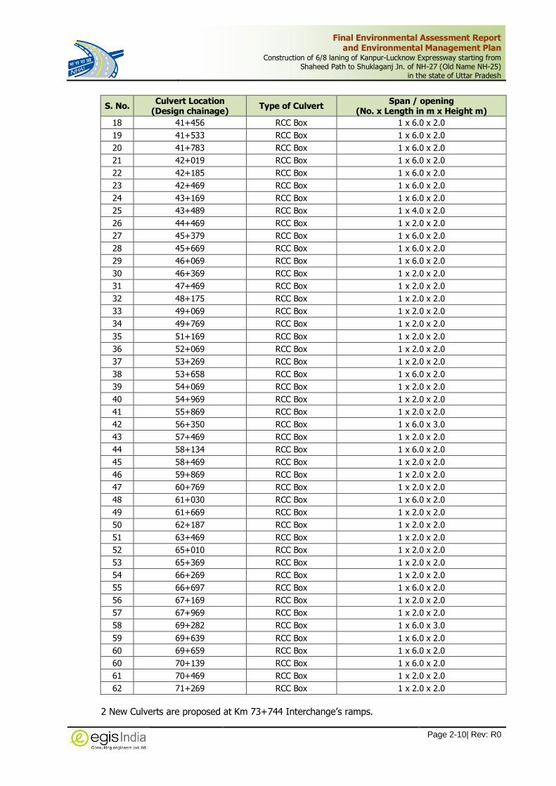
Final Environmental Assessment Report and Environmental Management Plan
Construction of 6/8 laning of Kanpur-Lucknow Expressway starting from Shaheed Path to Shuklaganj Jn. of NH-27 (Old Name NH-25)
in the state of Uttar Pradesh
Page 2-10| Rev: R0
S. No. Culvert Location
(Design chainage) Type of Culvert
Span / opening (No. x Length in m x Height m)
18 41+456 RCC Box 1 x 6.0 x 2.0
19 41+533 RCC Box 1 x 6.0 x 2.0
20 41+783 RCC Box 1 x 6.0 x 2.0
21 42+019 RCC Box 1 x 6.0 x 2.0
22 42+185 RCC Box 1 x 6.0 x 2.0
23 42+469 RCC Box 1 x 6.0 x 2.0
24 43+169 RCC Box 1 x 6.0 x 2.0
25 43+489 RCC Box 1 x 4.0 x 2.0
26 44+469 RCC Box 1 x 2.0 x 2.0
27 45+379 RCC Box 1 x 6.0 x 2.0
28 45+669 RCC Box 1 x 6.0 x 2.0
29 46+069 RCC Box 1 x 6.0 x 2.0
30 46+369 RCC Box 1 x 2.0 x 2.0
31 47+469 RCC Box 1 x 2.0 x 2.0
32 48+175 RCC Box 1 x 2.0 x 2.0
33 49+069 RCC Box 1 x 2.0 x 2.0
34 49+769 RCC Box 1 x 2.0 x 2.0
35 51+169 RCC Box 1 x 2.0 x 2.0
36 52+069 RCC Box 1 x 2.0 x 2.0
37 53+269 RCC Box 1 x 2.0 x 2.0
38 53+658 RCC Box 1 x 6.0 x 2.0
39 54+069 RCC Box 1 x 2.0 x 2.0
40 54+969 RCC Box 1 x 2.0 x 2.0
41 55+869 RCC Box 1 x 2.0 x 2.0
42 56+350 RCC Box 1 x 6.0 x 3.0
43 57+469 RCC Box 1 x 2.0 x 2.0
44 58+134 RCC Box 1 x 6.0 x 2.0
45 58+469 RCC Box 1 x 2.0 x 2.0
46 59+869 RCC Box 1 x 2.0 x 2.0
47 60+769 RCC Box 1 x 2.0 x 2.0
48 61+030 RCC Box 1 x 6.0 x 2.0
49 61+669 RCC Box 1 x 2.0 x 2.0
50 62+187 RCC Box 1 x 2.0 x 2.0
51 63+469 RCC Box 1 x 2.0 x 2.0
52 65+010 RCC Box 1 x 2.0 x 2.0
53 65+369 RCC Box 1 x 2.0 x 2.0
54 66+269 RCC Box 1 x 2.0 x 2.0
55 66+697 RCC Box 1 x 6.0 x 2.0
56 67+169 RCC Box 1 x 2.0 x 2.0
57 67+969 RCC Box 1 x 2.0 x 2.0
58 69+282 RCC Box 1 x 6.0 x 3.0
59 69+639 RCC Box 1 x 6.0 x 2.0
60 69+659 RCC Box 1 x 6.0 x 2.0
60 70+139 RCC Box 1 x 6.0 x 2.0
61 70+469 RCC Box 1 x 2.0 x 2.0
62 71+269 RCC Box 1 x 2.0 x 2.0
2 New Culverts are proposed at Km 73+744 Interchange’s ramps.

Final Environmental Assessment Report and Environmental Management Plan
Construction of 6/8 laning of Kanpur-Lucknow Expressway starting from Shaheed Path to Shuklaganj Jn. of NH-27 (Old Name NH-25)
in the state of Uttar Pradesh
Page 2-11| Rev: R0
2.2.14 Junctions Improvement
Depending on the importance, turning traffic volume, interesting road type (SH/NH) and its
connectivity to major towns or activity center, the major junctions are proposed at the locations
listed below:
Table 2.11: Major Junctions
S. No.
Existing Chainage
(km)
Design Chainage
(km)
Type of Junction
Side Cross Road Proposal
1 11+080 11+080 T Left To Saheed Path At Grade T Junction
2 12+415 12+415 T Right To Nadarganj Uni directional Flyover
3 17+580 17+580 X Both Lucknow Ring Road Interchange
4 25+402 25+402 T Left To Mohanlal Ganj At Grade Junction with Elevated Road
5 26+310 26+310 T Right To Mohan At Grade Junction with Elevated Road
6 - 27+545 T Right To Unnao (NH 25) Elevated Road
7 - 65+692 X Both NH 31 Fly over interchange
8 - 73+744 T Left NH 25(NH 27) Trumpet Interchange
2.2.15 Minor Junctions
Minor junctions are proposed at the location where roads of less importance i.e. village roads, ODRs
meets the highway. These are listed below:
Table 2.12: Minor Junctions
S. No. Existing Chainage
(KM)
Type
T -junction Cross road
1 11+448 T Domestic airport lucknow
2 11+830 T Chillawan
3 11+850 T Local pond
4 12+128 T International airport Lucknow
5 12+540 T UPSIDC
6 13+440 T Shantinagar
7 13+480 T Shantinagar+st.Anglemcollege
8 13+534 T Creative convent college
9 13+642 T Rahimabad/old airport road
10 13+771 T Rahimabad and bijma
11 14+383 + Sarojini nagar, Sainik school colony
12 14+740 + Nattu, Railway station-Amausi
13 14+840 T City convent school
14 16+670 T Sarojini nagar town
15 16+840 T UPSIDC
16 17+040 T National vegetation research centre
17 18+040 T Azadnagar colony
18 18+240 T Tinvat
19 19+140 T Village
20 20+940 + Bijnaur, Orrawan
21 21+240 T Banthara

Final Environmental Assessment Report and Environmental Management Plan
Construction of 6/8 laning of Kanpur-Lucknow Expressway starting from Shaheed Path to Shuklaganj Jn. of NH-27 (Old Name NH-25)
in the state of Uttar Pradesh
Page 2-12| Rev: R0
S. No. Existing Chainage
(KM)
Type
T -junction Cross road
22 21+410 T Village
23 22+620 T Village
24 22+840 T Village
25 22+920 T Haraum
26 23+759 T Village
27 25+440 T Village
28 25+940 T Sarai sahjadi
2.2.16 Railway Over Bridge (ROB)
There is one existing ROBs on the project highway, which is bypassed due to greenfield. New
8-lane ROB shall be provided on greenfield section.
Table 2.13: Details of Railway Over Bridge (ROB)
S. No.
Design Chainage
(km)
Proposed Span Arrangement (nos. x c/c of exp. in m)
Proposed Carriageway Width (m)
Proposed Deck Width
(m)
Proposed Structure Type
1 64+462 1 x 19.487 + 1 x 30.400 + 1 x 18.708
1 x 19.487 2x20.25 2x21.25
RCC/Steel Composite girder
2.2.17 Elevated Superstructures
Elevated structures are proposed on existing NH-27 in urban area. Total deck width of structures
is proposed as per highway requirement.
Table 2.14: Details of Proposed Viaduct
S. No.
Design Chainage
(km)
Proposed Span Arrangement Length (m)
Width of Structure on Expressway
(m)
Proposed Structure Type
1 14+550 to 16+155
27x45 + 3x40 + 6x45 2x10.5 Viaduct-1
2 18+605 to 28+205
45x45+3x40+3x42+39x45+3x42 + 3x45+3x40+9x45+3x40+ 11x45+33+32+33+37+12x45+28+3x26+29+43x45+3x44+
6x45+3x30+45+3x40+3x42+3x40+4x45+40+2x22.5+2x25+7x30 2x14.0* Viaduct-1
*The width of structures at merging locations shall be as per highway Plan & Profile.
2.2.18 Boundary Wall at ROW
Chain link fencing shall be provided all along the Project Expressway at 2 m inside the ROW
boundary and height of fencing shall be 2.5 m above ground. The ROW shall be demarcated by
installing Road Boundary Stones at the edges at 100m interval.
2.2.19 Embankment and Cut Sections
The existing embankment of NH-27 shall be followed in the overlapping section without any
widening. The average embankment observed in this overlapping section is about 0-2m except at
approach of bridges where it varies between 3m to 8m.

Final Environmental Assessment Report and Environmental Management Plan
Construction of 6/8 laning of Kanpur-Lucknow Expressway starting from Shaheed Path to Shuklaganj Jn. of NH-27 (Old Name NH-25)
in the state of Uttar Pradesh
Page 2-13| Rev: R0
In remaining section, the average height of embankment in the greenfield section is 6m. The design
and construction of the road in embankment shall be carried out in accordance with standards
specifications given in IRC: SP-99 latest version.
2.2.20 Pavement Design
As per life cycle cost analysis and considering safeguarding the depleting natural resources, project
location and the strategic importance of the Project expressway, the perpetual pavement with a
design of 20 years is recommended for the Project highway. In our country, the generally adopted
method of design of flexible pavement is based on IRC: 37-2001.
Considering safeguarding the depleting natural resources, economic consideration and latest
developments in pavement technology, flexible and rigid pavement is studied and based on the life
cycle cost analysis, Flexible pavement is proposed.
Table 2.15: Proposed Pavement Design for Main Carriageway
S. No.
Homogeneous Sections
Design CBR %
Design Traffic (MSA)
Pavement Composition
Remarks (Thickness of Layers in mm)
BC* DBM* WMM CTSB GSB Subgrade Total
1 HS-1 (10+980
to 28+500)
10
170 50 135 250 - 200 500 1120
Applicable for 4-lane at
grade section
2 HS-2 (28+500
to 73+744) 150 50 90 155 200 - 500 995
Applicable for 6-lane at green field
section
Table 2.16: Pavement composition for Connecting roads
Section Design
Traffic, MSA Design
CBR (%)
Design Thickness, mm
BC DBM WMM CTSB Total
Greenfield section 10 10 40 50 250 200 540
2.2.21 Drainage
Drainage of road is one of the important components of a road project. Fast disposal of storm water
runoff is a mandate for success of a road project, for technical and environmental considerations.
Inadequate drainage invariably results in reduction of life span of a road, increase in maintenance
cost and in drainage congestion along the countryside leading to submergence of land with
consequent loss of agricultural and other properties.
The longitudinal stretch of a roadside drain originates from a ridge point of natural ground along
the proposed alignment of road and ends to a predetermined outfall, be it a proposed culvert or
any natural drain.
Lined Drain:
In open areas, unlined drains are proposed near RoW limits, sufficiently away from the toe of
embankment. Through built up areas to drain out surface run off from the road and to intercept
sullage from road side properties, lined covered drains are proposed in the following stretches:

Final Environmental Assessment Report and Environmental Management Plan
Construction of 6/8 laning of Kanpur-Lucknow Expressway starting from Shaheed Path to Shuklaganj Jn. of NH-27 (Old Name NH-25)
in the state of Uttar Pradesh
Page 2-14| Rev: R0
Table 2.17: Lined Drain Locations
S. No. Design Chainage (km) Length
(Km) Start End
1 10+980 26+900 15.920
2 31+480 31+670 0.190
3 47+660 48+160 0.500
4 53+630 55+310 1.680
5 56+817 57+200 0.383
6 58+430 58+645 0.215
7 59+100 59+520 0.420
8 60+970 61+110 0.140
9 65+015 66+385 1.370
10 71+020 71+440 0.420
Total Length both sides (Km) 38.768
Drainage Arrangement at Super Elevated Sections
In super elevated sections, lined rectangular longitudinal drains of size 600mm width and 500mm
depth shall be provided to collect runoff of one carriageway and shall be connected to outer drain
by NP4 pipes of diameter 600mm. Alternatively, median cut drains may also be provided to carry
the water from higher carriageway side to the lower.
2.2.22 Capacity of Proposed Expressway
The design service volume for the expressway (LOS-B) shall be 1300PCUs/Hour/Lane as per IRC:
SP:99-2013. The details are presented in Table 2.18.
Table 2.18: Design Service Volume for Expressway
Peak Hour Flow 4 Lane 6 Lane 8 Lane
6% 86,000 1,30,000 1,73,000
8% 65,000 98,000 1,30,000
The traffic projections on the sections of the new expressway (KLE) have been compared with the
design service volume for a 6 lane carriageway and it shows that there is no requirement for the
capacity augmentation of the project highway to 8-lane in next 25 years.
2.2.23 Green Belt Development
The project proposes to develop plantation, landscaping and beautification of expressway along
the expressway as per IRC SP: 21-2009 NHAI OM No. 1.1.24/2017 dated 18.12.2017 regarding
policy guideline for Green Highway project. Accordingly, the chainage wise ROW for the avenue
and median plantation has been provided below:
Table 2.19: Width of ROW available for Green Belt Development
Row Available At Median For Green Belt Development
Sl. No. Chainage
Length (m) Average Width (m)
Total Width (m) From To LHS RHS
1 28+350 34+270 5920 2.25 2.25 4.5
2 35+760 74+150 38390 2.25 2.25 4.5 Total Length 44310 4.5 4.5 9

Final Environmental Assessment Report and Environmental Management Plan
Construction of 6/8 laning of Kanpur-Lucknow Expressway starting from Shaheed Path to Shuklaganj Jn. of NH-27 (Old Name NH-25)
in the state of Uttar Pradesh
Page 2-15| Rev: R0
Row Available At Edges For Green Belt Development
Sl. No. Chainage
Length (m) Average Width (m) Total Width
(m) From To LHS RHS
1 28+860 29+050 190 6 6.5 12.5
2 30+220 30+700 480 13.1 13.1 26.2
3 32+050 32+920 870 10.8 11.2 22
4 34+080 34+480 400 10.5 9.8 20.3
5 34+480 35+250 770 3.8 0 3.8
6 35+250 36+000 750 9.4 10.1 19.5
7 37+250 38+800 1550 12.6 13.1 25.7
8 40+900 42+420 1520 10.8 11.5 22.3
9 42+420 43+150 730 7.9 12.3 20.2
10 43+150 44+120 970 10.5 11.6 22.1
11 45+200 45+650 450 9.6 9.3 18.9
12 46+800 47+650 850 13.2 13.2 26.4
13 47+650 47+800 150 8.5 0 8.5
14 49+300 49+900 600 8.8 6.7 15.5
15 50+100 50+450 350 6.6 0 6.6
16 50+530 50+900 370 8.1 7.9 16
17 51+200 52+250 1050 7.8 8.8 16.6
18 52+250 52+950 700 10.2 10.1 20.3
19 52+950 53+540 590 10.8 10.6 21.4
20 55+700 56+370 670 16.2 16.3 32.5
21 57+250 58+100 850 8.5 8.5 17
22 59+500 60+950 1450 10.2 8.6 18.8
23 61+200 61+650 450 7.3 12.1 19.4
24 62+000 63+080 1080 13.9 10.1 24
25 65+000 65+100 100 9.3 9.3 18.6
26 66+300 66+700 400 8.8 7.6 16.4
27 66+700 67+100 400 5.1 5.2 10.3
28 67+100 67+600 500 9.5 9.2 18.7
29 68+400 68+600 200 3.5 3.6 7.1
30 68+700 69+700 1000 8.9 9.1 18
31 70+780 71+000 220 3.5 3.6 7.1
32 71+000 71+400 400 0 7.5 7.5
33 71+410 71+780 370 11.7 11.2 22.9
34 71+780 73+230 1450 3.5 3.5 7
TOTAL 22880 298.9 291.2 590.1
Row Available At Interchanges For Green Belt Development
Sl. No. Location Total AREA (sqmt.)
0+001 LOOP AND RAMP 23325
0+002 RAMP-1 SIDE 3000
0+003 RAMP-2 SIDE 1880
0+004 RAMP-3 SIDE 2830

Final Environmental Assessment Report and Environmental Management Plan
Construction of 6/8 laning of Kanpur-Lucknow Expressway starting from Shaheed Path to Shuklaganj Jn. of NH-27 (Old Name NH-25)
in the state of Uttar Pradesh
Page 2-16| Rev: R0
2.2.23.1 Expressway Amenities
There are two types of amenities provided in the proposed expressway which are as below:
Rest Area have to be provided at Km 51+600 in LHS and at 60+350 in RHS as wayside amenities
for users of the expressway to enable then to stop, take rest, and refresh themselves so as to ease
fatigue. Parking, garage, restaurants, toilet, fuel station etc. facilities are proposed at the rest areas.
Since the expressway is not open to pedestrians, the bus stops has not been proposed on the
project expressway but buses will be stopped at the rest areas. Truck lay bys are also proposed at
the rest areas.
2.2.23.2 Toll Plaza Configuration
Toll booths are proposed along the project stretch for collection of toll fee. The fee/ electronic toll
collection (ETC) collection system shall be speedy, efficient and user friendly consisting fee
collection through fee through cash or smart card as a back-up. The design of the Toll Plazas is
proposed to aesthetically pleasing and efficient and the fee collection staff should be quick,
courteous and adequately trained before deployment. The total number of toll booths and lanes
shall be such as to ensure the service time of not more than 10 second per vehicle at peak flow
regardless of methodology adopted for fee collection.
As per guidelines 3 x 4 =12 physical lanes on each side is provided. Width of each ETC lane is
3.5m, except for manual/smart card lane, where it shall be 3.2m and the lane width of over
dimensioned vehicles is 4.5m.
Additionally, Toll booth shall comprise Highway Patrol Units, Emergency Medical Services, Crane
services, service area and administrative block etc. Continuous Ambient Air Quality Monitoring
Station (CAAQMS), Weigh in Motion (WIM) systems shall be installed to check the overloading of
vehicles.
2.2.23.3 Lighting Provision
The provision of lighting is being considered along the project. IRC SP:99-2013. Adequate provision
of street lighting has been proposed in the project which are as follows
Table 2.20: Scope for Highway Lighting as per IRC: SP: 99-2013
S. No. Particular Unit Quantity
1 Toll plaza area (TPA) NOS. 1
2 Toll plaza approach (TP APPR.) NOS. 2
3 Toll plaza canopy (CANOPY) NOS. 1
4 Built-up area/Flyover KM. 16
5 Grade separated Structures, Interchanges NOS. 3
6 VUP and LVUP NOS. 33
7 Pedestrian Underpasses (PUP)) NOS. 15
8 Rest area NOS. 2
9 ROB NOS. 1
The followed criteria have been adopted for the lighting provision in the project with different
configuration at different proposed locations:
Toll plaza area will be illuminated with 30m HM and 400W LED lamps.

Final Environmental Assessment Report and Environmental Management Plan
Construction of 6/8 laning of Kanpur-Lucknow Expressway starting from Shaheed Path to Shuklaganj Jn. of NH-27 (Old Name NH-25)
in the state of Uttar Pradesh
Page 2-17| Rev: R0
Toll plaza approach lighting has been provided with twin central arrangement on 12m street
poles and 250 W LED lamps.
Toll plaza canopy will be lighted with 70W LED lamps.
There is provision of street light for MCW of flyover with 250W LED lamps on 12m single
arm pole whereas the underneath road will be provided with 180 W LED lamps mounted
on under surface of the flyover.
Interchange loops/ ramps, MCW and open area will be illuminated with 12m single arm
pole with 180W LED lamps ,12m double arm poles with 250 W LED lamps and 30m HM
with 400W LED lamps, respectively.
VUP/LVUP will be lighted with 70 and 50 W LED lamps respectively.
All PUP will have lights with 20 W LED lamps.
The street lights will be provided at Rest area roads have been with 10m and 9m poles
with 180 W LED lamps.
Lighting system of ROB is based on 12m single arm poles with 250 W LED lamps.
2.2.23.4 Traffic Management Systems
The Advance Traffic Management Systems (ATMS) for the Project is composed of many
components systems. These systems are expected to perform their functions to achieve overall
objective for the efficient, safe and smooth traffic on the Expressway. The ATMS shall be provided
as per Clause-816 of MORT&H Specifications for road and bridge works. The major components
include:
- Traffic Monitor Camera System (TMCS) operated with Solar Power
- Video Incident Detection System (VIDS)
- Local warning flashing lights and Alarm
- Variable Message Sign (VMS) to provide the road & traffic information to the commuters
- Vehicle Speed Detection System (VSDS)
- Meteorological Observation System (MOS)
- Hybrid ETC based Toll Management System (TMS)
2.2.23.5 Crash Barriers, Traffic Control Devices, Road Safety Devices and Road Side Furniture
All safety elements including crash barriers, road signs, road markings, gantries etc. will be of
expressway standards.
2.2.23.6 Components & Activities of the Proposed Project
The development of the road would necessarily entail the following three stages. Each of the stages
would have several activities and sub-activities. The three stages are
Detailed design and Pre-Construction Stage
Construction Stage
Post-Construction, Operations & Maintenance Stage
The sub-activities and activities which would be undertaken in each of the three stages are detailed
in below sections.

Final Environmental Assessment Report and Environmental Management Plan
Construction of 6/8 laning of Kanpur-Lucknow Expressway starting from Shaheed Path to Shuklaganj Jn. of NH-27 (Old Name NH-25)
in the state of Uttar Pradesh
Page 2-18| Rev: R0
2.2.24 Infrastructure Requirement for Expressway Development
During the construction and operations of the expressway, the project would be requiring various
infrastructure such as construction camp, hot mix plant, batching plant, lay down areas and waste
storage area etc. for the development. The infrastructure to be developed and maintained by the
concessionaire.
2.3 Raw Material Required under Project
The project shall require significant amount of natural resources such as raw material for the
construction. The impact of natural resources is provided under Chapter-4. The details of material
are provided as below.
Table 2.21: Material Requirement for Construction
Raw Material
/Fuel
Total Quantity for construction
Unit Potential Source Mode of
Transport
Distance of Source from Project Site
(in Km)
Type of Linkage
Soil 1,31,86,694 Cum Nearby Borrow Area Road Within 2 KM
The contractor will make the necessary material supply agreement with the authorised vendor during construction period
Sand 4,95,400 Cum Sand Quarries near Betwa River
Road 75
Cement 4,05,500 MT Authorized Vendors at Lucknow
Road 49
Blue Metal (Aggregates)
19,61,900 Cum Approved Quarry at Kabrai
Road 187
Bitumen 32,000 MT Refinery at Mathura Road 384
Steel 85,944 MT Authorized Vendors, SAIL, Lucknow
Road 49
Fly Ash 13,54,928 Cum TPP within 300 km radius like Unchahar Power Plant
Road Within 100 KM radial distance
Diesel 41,000 KLD Authorized Vendors Road
Water 2,900 KLD
Water is available all along the alignment from underground water mainly through tube wells and as surface water from rivers.
Road 1
After obtaining permission from the regulatory authorities
Source: Draft DPR by Egis
2.3.1 Details of Water Requirement
The proposed project development will also require a significant amount of water during
construction / installation / commissioning / establishment phase; Operation phase. The details of
water requirement are provided as below:
Table 2.22: Details of Water Requirement
S. No. Details of Water requirement Total Water
Requirement (in KLD)
1 For Road Construction 1,965
2 For Dust Suppression 736
3 For Drinking Purpose 15
4 Domestic & Other uses at Camp sites/ laboratory/ construction sites/ labour camps etc.
184
Total 2,900

Final Environmental Assessment Report and Environmental Management Plan
Construction of 6/8 laning of Kanpur-Lucknow Expressway starting from Shaheed Path to Shuklaganj Jn. of NH-27 (Old Name NH-25)
in the state of Uttar Pradesh
Page 2-19| Rev: R0
Contractor shall abstract surface water from above mentioned surface water bodies and additionally
ground water from the safe water blocks. The details of water bodies are provided in Chapter-3
of the report.
2.3.2 Fly Ash for Construction of Embankment
Fly Ash shall be used to the minimum extent of 30% of total fill material for the embankment
depending upon the availability of fly ash from the identified sources. The use of fly ash in road
construction shall conform to IRC SP: 58-2001. The details are provided in chapter-3
2.4 Land Requirement
District wise break-up of land to be acquired is given under Table 2.23. Total land requirement
for the project works out to be around 476.7835 hectare (including government Land). The land
required includes both private and government land owned by various Government departments
such as revenue department, forest department etc. Government Land required for Acquisition or
diversion will be done through government procedures of inter departmental transfers.
Table 2.23: Details of Land to be Acquired
DISTRICT WISE SUMMARY OF LAND OWNERSHIP
Name of District Area of land to be acquired (in Hect.)
Private land (in Hect.)
Government (in Hect.)
Lucknow 27.8292 15.0341 12.7951
Unnao 448.9543 415.6799 33.2744
Total 476.7835 430.714 46.0695
Source: EGIS SIA Study
2.5 Traffic Studies
To establish the traffic characteristics along the project road, the project road sections have been
divided into 4 homogenous section for the entire Kanpur Lucknow Expressway. The list of
Homogenous sections is given in Table 2.24.
Table 2.24: Homogenous Section for Traffic Survey
S. No.
Proposed Expressway (KLE) NH27
Remarks (KLE) Details
Length (Kms)
Details Length (Kms)
HS-I Shaheed Path – Lucknow Ring Road
5 Shaheed Path – Lucknow Ring Road
5 At grade/ Elevated (using existing alignment)
HS-II Lucknow Ring Road - Bani 10 Lucknow Ring Road - Bani
10 Elevated (using existing alignment)
HS-III Bani – NH-31 42.3 Bani – Unnao 37.2 Green Field (new)
HS-IV NH-31 - Ata 6 Unnao - Ata 7 Green Field (new)
To study the existing traffic characteristics, travel pattern and growth potential, following data has
been collected from primary survey and secondary sources. The traffic surveys locations have been
identified based on the reconnaissance survey and finalized in consultation with the Client. The
detail of surveys and survey locations are presented in Table 2.25 and Figure 2.2. The traffic
surveys are conducted in the month of November 2017. All the traffic surveys are conducted
following the relevant IRC guidelines.

Final Environmental Assessment Report and Environmental Management Plan
Construction of 6/8 laning of Kanpur-Lucknow Expressway starting from Shaheed Path to Shuklaganj Jn. of NH-27 (Old Name NH-25)
in the state of Uttar Pradesh
Page 2-20| Rev: R0
Table 2.25: Schedule of Traffic Surveys
S. No. Survey Location Day Schedule
Classified Volume Count (CVC) Survey
Project Highway (NH 25)
1 Near Banthra 7 days 15/11/2017 to 21/11/2017
2 Near Nawabganj 7 days 14/11/2017 to 20/11/2017
3 Near Ata 7 days 14/11/2017 to 20/11/2017
Alternate Roads
4 Near Shaikhpur Toll Plaza (NH-30) 3 days 22/11/2017 to 24/11/2017
5 Near Korari Khard (NH 31) 3 days 23/11/2017 to 25/11/2017
6 Near Mahajpur (AH 1) 3 days 22/11/2017 to 24/11/2017
Origin – Destination (O-D) Survey
1 Near Nawabganj (NH-27) 24 hours 15/11/2017
2 Near Ata (NH-27) 24 hours 15/11/2017
3 Near Mahajpur (AH-1) 24 hours 24/11/2017
4 Near Shaikhpur Toll Plaza (NH-30) 24 hours 22/11/2017
Turning Moment Count (TMC) Survey
1 Agra - Lucknow Expressway Junction 24 hours 20/11/2017
2 Airport Gate – I 24 hours 20/11/2017
3 Airport Gate – II 24 hours 20/11/2017
4 Nadarganj Junction 24 hours 17/11/2017
5 Junabganj Junction 24 hours 16/11/2017
6 Kati Bagiya Junction 24 hours 19/11/2017
7 Ata Junction 24 hours 16/11/2017
Axle Load (AL) Survey
1 Near Nawabganj (NH-27) 48 hours 15/11/2017 to 16/11/2017
2 Near Ata (NH-27) 24 hours 17/11/2017
Figure 2.2: Traffic Survey Locations

Final Environmental Assessment Report and Environmental Management Plan
Construction of 6/8 laning of Kanpur-Lucknow Expressway starting from Shaheed Path to Shuklaganj Jn. of NH-27 (Old Name NH-25)
in the state of Uttar Pradesh
Page 2-21| Rev: R0
Annual Average Daily Traffic (AADT)
The AADT has been estimated by applying the seasonal correction factor to the observed ADT
which has been established from primary traffic surveys. Table 2.26 presents the Annual Average
Daily Traffic (AADT) at the homogenous traffic sections.
Table 2.26: Annual Average Daily Traffic
Vehicle Type Banthra Nawabganj Ata
Shaikhpur Toll Plaza (NH-30)
Korari Khard (NH-31)
Maharajpur (AH-1)
Project Road Alternate Road
Two Wheeler 12,789 9,389 10,926 8,932 7,101 9,170
Auto 1,410 827 98 602 825 481
Passenger car 15,213 13,378 11,624 12,685 2,417 8,606
Mini Bus 42 64 37 43 3 27
Pvt. Bus 253 234 177 148 36 285
Govt Bus 908 859 1,045 603 24 439
3 wheel Tempo 370 250 321 67 57 236
4 wheel Tempo 1,464 1,559 2,440 1,059 355 1,255
LCV 1,272 1,348 1,970 560 198 1,143
2-Axle 737 943 1,300 393 266 702
3-Axle 2,913 4,302 5,895 721 633 1,504
MAV (5-6 Axle) 2,369 3,955 4,958 611 702 1,558
HCM/ EME 6 7 12 7 3 5
Agricul. Tractor 34 61 27 34 10 31
Agricul. Tractor & Trailer 111 86 89 96 119 96
No
n
Mo
tori
se
d
Ve
hic
les
Cycle Rikshaw 58 10 27 13 10 20
Cycle 917 331 431 647 1,170 703
Animal Hand Drawn
18 18 4 12 2 -
To
ll
Ex
em
pte
d
Ex-Car 26 38 25 37 2 33
Ex-Bus 14 22 19 43 8 17
Ex-trucks 9 10 10 2 - 2
Others 1 - - - - -
Ve
hic
les
Motorised 39,940 37,332 40,973 26,643 12,759 25,590
Non Motorised 994 359 462 672 1,182 723
Total 40,934 37,691 41,435 27,315 13,941 26,313
PC
U Motorised 52,561 60,238 71,088 28,729 14,117 33,276
Non Motorised 689 294 294 422 618 392
Total 53,250 60,532 71,382 29,151 14,735 33,668
Following are the salient findings:
The highest average daily traffic on NH25 is at Ata location of 41,435 vehicles and 71,382
PCU.
2 wheeler and car traffic is the highest at the Banthra Location, showing the urban influence
followed by Ata and Nawabganj locations.

Final Environmental Assessment Report and Environmental Management Plan
Construction of 6/8 laning of Kanpur-Lucknow Expressway starting from Shaheed Path to Shuklaganj Jn. of NH-27 (Old Name NH-25)
in the state of Uttar Pradesh
Page 2-22| Rev: R0
Commercial vehicles are obserbed the highest at Ata with more than 14,135 vehicles which
includes more than 5895 3Axle trucks because of the industries at Unnao
The bus traffic is highest at Ata Location about 1259 buses followed by Banthra Location
with around 1203 buses.
NMT traffic intensity is moderate with cycle traffic more than 300 at all locations and
maximum cycle traffic is observed at Banthra location.
Traffic Growth Rates
The growth rates are estimated as a product of projected growth of the economy and elasticity.
The estimated traffic growth rates for project road are presented in Table 2.27.
Table 2.27: Projected Growth Rates
Vehicle Type up to 2020 2021-2025 2026-2030 2031-2035 >2036
Growth Rates - Realistic
Car 8.0 7.8 7.4 6.2 5.9
Bus 7.4 7.0 6.5 5.3 5.0
LCV 6.4 6.1 5.6 4.6 4.3
2 AT -1.5 -1.5 -1.3 -1.1 -1.0
3AT 7.0 6.7 6.2 5.1 4.8
MAV 6.7 6.4 5.9 4.8 4.6
2 Wheeler 7.1 6.9 6.6 5.4 5.2
LMV Pass 7.7 7.5 7.1 5.9 5.6
Tractor 5.7 5.4 5.0 4.1 3.9
Growth Rates – Optimistic
Car 8.5 8.3 7.9 6.7 6.4
Bus 7.9 7.5 7.0 5.8 5.5
LCV 6.9 6.6 6.1 5.1 4.8
2 AT -1.0 -1.0 -0.8 -0.6 -0.5
3AT 7.5 7.2 6.7 5.6 5.3
MAV 7.2 6.9 6.4 5.3 5.1
2 Wheeler 7.6 7.4 7.1 5.9 5.7
LMV Pass 8.2 8.0 7.6 6.4 6.1
Tractor 6.2 5.9 5.5 4.6 4.4
Growth Rates – Pessimistic
Car 7.5 7.3 6.9 5.7 5.4
Bus 6.9 6.5 6.0 4.8 4.5
LCV 5.9 5.6 5.1 4.1 3.8
2 AT -2.0 -2.0 -1.8 -1.6 -1.5
3AT 6.5 6.2 5.7 4.6 4.3
MAV 6.2 5.9 5.4 4.3 4.1
2 Wheeler 6.6 6.4 6.1 4.9 4.7
LMV Pass 7.2 7.0 6.6 5.4 5.1
Tractor 5.2 4.9 4.5 3.6 3.4

Final Environmental Assessment Report and Environmental Management Plan
Construction of 6/8 laning of Kanpur-Lucknow Expressway starting from Shaheed Path to Shuklaganj Jn. of NH-27 (Old Name NH-25)
in the state of Uttar Pradesh
Page 2-23| Rev: R0
2.6 Traffic Projection
The total traffic forecast for the horizon years is estimated from the base year traffic and estimated
growth rates. The Table 2.28 shows total traffic on New Expressway (Homogeneous sections wise).
Table 2.28: Mode Year wise Traffic Distribution
HS Car Mini Bus Bus 4WT LCV 2 Axle 3 Axle MAV
Total Traffic on NH25 : 2020-2021
I 9956 51 1129 1592 1115 508 2249 1382
II 16450 51 1390 1706 1482 683 3452 2791
III 14466 77 1308 1816 1571 874 5098 4647
IV 12570 44 1464 2843 2295 1205 6985 5825
KLE (New Expressway) Traffic as per Diversion Curves %age’s : 2020-2021
I 5622 0 315 661 596 257 871 433
II 6181 0 303 574 570 337 1677 1259
III 5535 0 298 412 502 331 1576 1163
IV 5987 0 298 412 859 351 1605 1205
Remaining Traffic on NH25 : 2020-2021
I 4334 51 814 930 518 251 1378 949
II 10269 51 1086 1132 913 346 1775 1532
III 8931 77 1011 1404 1069 544 3522 3484
IV 6583 44 1166 2431 1437 854 5380 4620
The estimated traffic forecast for the horizon years on the proposed project road has been
presented in Table 2.29.
Table 2.29: Traffic Projection for Homogeneous Sections KLE
Year
HS-I
(Shaheed Path –
Ring Road)
HS-II
(Ring Road - Bani)
HS-III
(Bani - Rawal)
HS-IV
(Rawal –
Shuklaganj/Ata)
Vehicles PCU Vehicles PCU Vehicles PCU Vehicles PCU
2017-2018
KLE is under construction. 2018-2019
2019-2020
2020-2021 9178 14579 10901 20229 9816 18547 10717 19872
2021-2022 9967 15757 11834 21828 10654 20008 11622 21412
2022-2023 10827 17038 12849 23564 11566 21594 12607 23084
2023-2024 11764 18431 13956 25449 12560 23316 13681 24899
2024-2025 12785 19945 15162 27496 13643 25186 14851 26871
2025-2026 13285 19973 16472 29713 14819 27211 16122 29007
2026-2027 14338 21400 17734 31724 15947 29038 17370 31013
2027-2028 15479 22937 19098 33881 17167 30998 18719 33165
2028-2029 16715 24594 20573 36198 18485 33101 20177 35475
2029-2030 18054 26380 22167 38685 19910 35359 21752 37954
2030-2031 19487 28280 23875 41332 21434 37758 23439 40591
2031-2032 20759 30027 25409 43800 22807 40003 24940 43004
2032-2033 22116 31887 27045 46426 24270 42391 26542 45571
2033-2034 23563 33868 28790 49219 25831 44930 28249 48302
2034-2035 25108 35979 30651 52189 27495 47631 30070 51207

Final Environmental Assessment Report and Environmental Management Plan
Construction of 6/8 laning of Kanpur-Lucknow Expressway starting from Shaheed Path to Shuklaganj Jn. of NH-27 (Old Name NH-25)
in the state of Uttar Pradesh
Page 2-24| Rev: R0
Year
HS-I
(Shaheed Path –
Ring Road)
HS-II
(Ring Road - Bani)
HS-III
(Bani - Rawal)
HS-IV
(Rawal –
Shuklaganj/Ata)
Vehicles PCU Vehicles PCU Vehicles PCU Vehicles PCU
2035-2036 26750 38219 32629 55342 29264 50496 32007 54290
2036-2037 28990 41424 35442 60244 31782 54958 34756 59077
2037-2038 31424 44911 38503 65598 34523 59832 37748 64302
2038-2039 34068 48706 41835 71446 37506 65156 41005 70007
2039-2040 36939 52835 45464 77834 40755 70971 44550 76238
2040-2041 40059 57331 49414 84813 44292 77325 48408 83042
2041-2042 42906 60812 52752 89452 47276 81521 51656 87557
2042-2043 45979 64544 56347 94397 50488 85994 55153 92370
2043-2044 49297 68547 60220 99672 53948 90762 58919 97503
2044-2045 52879 72841 64394 105302 57677 95849 62976 102979
The design service volume for the expressway (LOS-B) shall be 1300PCUs/Hour/Lane as per IRC:
SP:99-2013. The traffic projections on the sections of the new expressway (KLE) have been
compared with the design service volume for a 6 lane carriageway and it shows that there is no
requirement for the capacity augmentation of the project highway to 8-lane in next 25 years.
2.7 Man Power Requirement
The project will generate significant amount of employment. Various categories of temporary and
permanent manpower such as skilled, semi-skilled workers, technicians, engineers, managers and
other professionals for both construction phase and operational phase shall be required. It is
estimated that approx. 1,000 workers will be involved during construction phase whereas during
operation the workers’ strength will be limited and mainly involved in O&M team of concessionaire,
Patrol maintenance team and at toll plazas.
2.8 Proposed Schedule for Approval & Implementation
The project will be executed under “Hybrid Annuity Mode”. The project proponent will appoint
concessionaire for the proposed development and its maintenance upto 20years. Financial Analysis
has been done for the proposed project. The base assumption considered for the project
implementation is as follow.
Table 2.30: Project Implementation Schedule
Construction and Implementation Schedule Time
Concession period 20 Years
Construction Period (months) 30 months (2.5 Years)
Construction Start Year 1st Oct. 2021
Construction End Year 2024
Commercial Operation Date (Open to Traffic) 1st April 2024
In order to facilitate the construction of Kanpur-Lucknow Expressway, the project proponent “NHAI”
has divided the project in 2 packages based on the work activities i.e. construction along the
existing NH-27 and construction in greenfield. The packages are as follows:
• Package 1: Km 11+000 to Km 28+500 (Along Existing Highway)
• Package 2: Km 28+500 to Km 73+744 (Greenfield Highway)
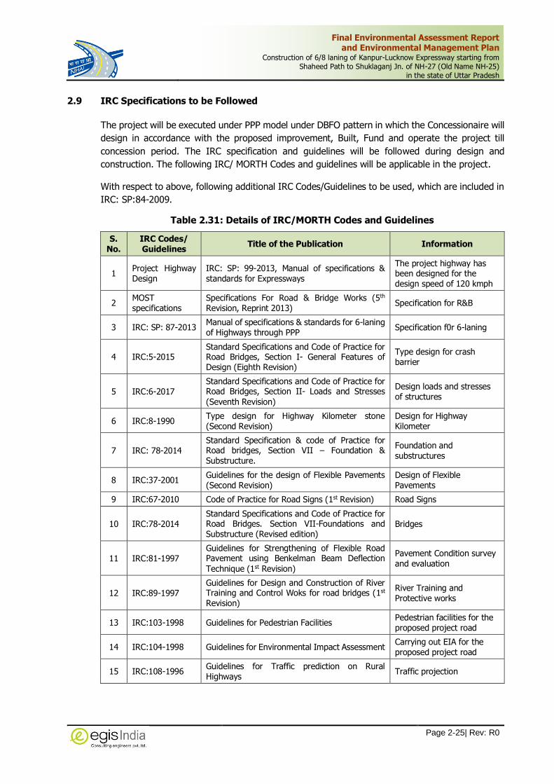
Final Environmental Assessment Report and Environmental Management Plan
Construction of 6/8 laning of Kanpur-Lucknow Expressway starting from Shaheed Path to Shuklaganj Jn. of NH-27 (Old Name NH-25)
in the state of Uttar Pradesh
Page 2-25| Rev: R0
2.9 IRC Specifications to be Followed
The project will be executed under PPP model under DBFO pattern in which the Concessionaire will
design in accordance with the proposed improvement, Built, Fund and operate the project till
concession period. The IRC specification and guidelines will be followed during design and
construction. The following IRC/ MORTH Codes and guidelines will be applicable in the project.
With respect to above, following additional IRC Codes/Guidelines to be used, which are included in
IRC: SP:84-2009.
Table 2.31: Details of IRC/MORTH Codes and Guidelines
S. No.
IRC Codes/ Guidelines
Title of the Publication Information
1 Project Highway Design
IRC: SP: 99-2013, Manual of specifications & standards for Expressways
The project highway has been designed for the design speed of 120 kmph
2 MOST specifications
Specifications For Road & Bridge Works (5th
Revision, Reprint 2013) Specification for R&B
3 IRC: SP: 87-2013 Manual of specifications & standards for 6-laning of Highways through PPP
Specification f0r 6-laning
4 IRC:5-2015 Standard Specifications and Code of Practice for Road Bridges, Section I- General Features of Design (Eighth Revision)
Type design for crash barrier
5 IRC:6-2017 Standard Specifications and Code of Practice for Road Bridges, Section II- Loads and Stresses
(Seventh Revision)
Design loads and stresses of structures
6 IRC:8-1990 Type design for Highway Kilometer stone (Second Revision)
Design for Highway Kilometer
7 IRC: 78-2014 Standard Specification & code of Practice for Road bridges, Section VII – Foundation & Substructure.
Foundation and substructures
8 IRC:37-2001 Guidelines for the design of Flexible Pavements (Second Revision)
Design of Flexible Pavements
9 IRC:67-2010 Code of Practice for Road Signs (1st Revision) Road Signs
10 IRC:78-2014 Standard Specifications and Code of Practice for Road Bridges. Section VII-Foundations and Substructure (Revised edition)
Bridges
11 IRC:81-1997 Guidelines for Strengthening of Flexible Road Pavement using Benkelman Beam Deflection
Technique (1st Revision)
Pavement Condition survey and evaluation
12 IRC:89-1997 Guidelines for Design and Construction of River Training and Control Woks for road bridges (1st Revision)
River Training and Protective works
13 IRC:103-1998 Guidelines for Pedestrian Facilities Pedestrian facilities for the proposed project road
14 IRC:104-1998 Guidelines for Environmental Impact Assessment Carrying out EIA for the proposed project road
15 IRC:108-1996 Guidelines for Traffic prediction on Rural Highways
Traffic projection

Final Environmental Assessment Report and Environmental Management Plan
Construction of 6/8 laning of Kanpur-Lucknow Expressway starting from Shaheed Path to Shuklaganj Jn. of NH-27 (Old Name NH-25)
in the state of Uttar Pradesh
Page 2-26| Rev: R0
S. No.
IRC Codes/ Guidelines
Title of the Publication Information
16 IRC:SP:19-2001 Manual for Survey, Investigation and Preparation for road project (2nd Revision)
Soil test and Investigation
17 IRC:SP:21-2009 Guidelines on Landscaping and Tree Plantation (First Revision)
Landscaping and Avenue plantation
18 IRC:SP:42-1994 Guidelines on Road Drainage Drainage System
19 IRC:SP:55-2001 Guideline for safety in Construction Zone Traffic Safety
20 IRC:SP:58-2001 Guideline for use of Fly ash in Road Embankments
Design of Embankments
21 IRC:SP108-2015 Guidelines on preparation and implementation of EMP
Environmental Management Plan
22 IRC: SP: 93-2017 Guidelines on requirement of Environmental Clearance on Road Project
Environmental Clearance

Final Environmental Assessment Report and Environmental Management Plan
Construction of 6/8 laning of Kanpur-Lucknow Expressway starting from Shaheed Path to Shuklaganj Jn. of NH-27 (Old Name NH-25)
in the state of Uttar Pradesh
Page 3-1| Rev: R0
3 DESCRIPTION OF ENVIRONMENT
Baseline conditions define the characteristics of the existing environment and shape projected
future condition, assuming no project is undertaken. In order to predict the various
environmental impacts likely to arise due to the implementation of this project, it is essential to
establish the baseline environmental status of the project area. Environmental components to be
considered in relation to highway project are a) Land, b) water, c) air and metrological, d)
biological, e) noise f) solid waste management g) socio-economic and health environment. Hence
it is necessary to ascertain the baseline data of these component.
3.1 Study Area
The baseline environmental conditions within the project corridor has been established based on
the secondary information collected from various sources followed by field surveys of the project
area. All the data have been collected and collated to identify a general environmental condition
within the project catchment area and major environmental issues to be taken care off during the
design as well project implementation phase.
The Area of Influence of the Project area has been divided into a core and buffer zone:
Core Zone: The core zone area for the study is project direct corridor of impact and adjacent
area within 500 m on either side of the project alignment.
Buffer Zone: The buffer zone of the study area is in general 10 Km radius on either side of the
project alignment
The primary baseline data has been collected within 500m on either side of the proposed
alignment. The primary data collected from site such as tree details, quality of environmental
attributes (Air, Water, Noise, Soil and meteorology), sensitive receptors, forest area, notified
ecologically protected area, water bodies, built-up areas, industrial areas, cultural sites, etc.
Data from secondary sources have been collected for describing the relevant physical, biological
and socio-economic component along the 15 kilometers on both sides from the center of the road
as per guidelines of Ministry of Environment, Forest and Climate Change, Government of India.
However, the focus of the study was on the areas within and adjacent to the proposed ROW.
3.2 Scope of Baseline Studies
The major objective of this study is to establish present baseline environmental conditions along
the project corridor through available data and information supported by field studies to evaluate
the impacts on relevant environmental attributes due to the construction & operation of the
proposed project.
The specific environmental issues considered are physiography and soils, topography, climate,
borrow area and quarry sites, water resources, drainage pattern, air, noise, soil quality, biological
characteristics social environment and other sensitive environmental sites.

Final Environmental Assessment Report and Environmental Management Plan
Construction of 6/8 laning of Kanpur-Lucknow Expressway starting from Shaheed Path to Shuklaganj Jn. of NH-27 (Old Name NH-25)
in the state of Uttar Pradesh
Page 3-2| Rev: R0
3.2.1 Secondary Baseline Data
Secondary data of the project area was collected from authentic secondary sources like published
literatures from various government agencies, or institutions on physical, biological and social
components of environment. The data was reviewed and verified for establishing existing
environmental and ecological status within the project area. The source of secondary data is
given in Table 3.1.
Table 3.1: Sources of Secondary Data
S. No. Information Source
1. Topo sheets, District Planning Maps
Survey of India, Govt. of India
2. Meteorological data Directorate of Economics and Statistics, Govt. of Uttar Pradesh, Indian Meteorological Department, Govt. of India
3. Geological data Geological Survey of India, Directorate of Mines and Geology, Government of Uttar Pradesh
4. Reserved Forests, Protected Forests and Wildlife Sanctuaries
Department of Forests, Govt. of Uttar Pradesh and State of Forest report, Forest Survey of India
5. Land use Pattern Department of Economics & Statistics, Government of Uttar Pradesh,
6. Groundwater Resources Reports from Central Ground Water Authority and Groundwater Department, Uttar Pradesh
7. Forests Statistics Department of Forests, Govt. of Uttar Pradesh, State of Forest Report, Forest Survey of India
8. Air & Water Quality UP Pollution Control Board and MoEF&CC
9. Wildlife Sanctuary/ National Parks/ Tiger Reserves
Wildlife Department/ Forest department, U.P.
10. Wetland Atlas MoEF&CC, Govt. of India
11. Demographic Profile District Census Handbook, Govt. of India,
12. Archeological Monuments/ Sites Archaeological Survey of India
13 Legislative Acts and Rules Department of Economics & Statistics, Government of Uttar Pradesh, Ministry of Environment and Forest, Govt. of India
14 Census Data of 2011 Census of India, Government of India
15 Statistical Abstract of Uttar Pradesh 2012
Government of Uttar Pradesh
3.2.2 Primary Baseline Data
The primary baseline information on different environmental components were collected through
field survey. Field survey were carried out to collect information on the major environmental
features such as settlement facilities, drainage pattern of the area, forest, trees within RoW of the
alignment, water bodies, river crossing, sensitive receptors, air, water, noise and soil quality etc.
and were studied in detail, which helped in identifying areas of concern along the stretch and
critical issues. Consultation with the local officials and public were carried out also on the salient
environmental features of the project area, etc.
Primary samples surveys for the environmental components, such as air, surface water, noise and
soil characteristics that are critical in the context of the project were carried out. The post-
monsoon sampling was carried out by engaging NABL accredited Environmental Laboratory M/s
Mitra S.K. Private Limited (MSK) in the month of Oct-Nov 2018. The laboratory is accredited by
National Accreditation Board for Testing & Calibration Laboratories (NABL) vide certificate no.TC-

Final Environmental Assessment Report and Environmental Management Plan
Construction of 6/8 laning of Kanpur-Lucknow Expressway starting from Shaheed Path to Shuklaganj Jn. of NH-27 (Old Name NH-25)
in the state of Uttar Pradesh
Page 3-3| Rev: R0
6950 issued on 18.09.2018 and by MOEFCC vide its notification no. s.o.1953(E) dated
02.06.2016. The NABL Accreditation certificate of Laboratory with its validity is provided in
Annexure-3.1.
Description of Existing Environmental Conditions
3.3 Physical Environment
3.3.1 Physiography
Uttar Pradesh is situated between 23o 52'N to 31o 28' N latitude and 77o 51' E and 84o 38'E
longitude. The state has a geographical area of 2,43,290 Km2. Physiographically, the state has
been divided into three geographical regions:
(i) Gangetic Plain
(ii) Bhabar Tarai Region and
(iii) Plateau of South
The Gangetic Plain cover the majority of the area of state. It has been constructed from alluvium
soil. The Bhabar-Tarain Region extends from Saharanpur in the northwest to Kushinagar in the
east. The Plateau of south is extended in the plateau region of Bundelkhand and Baghelkhand in
the south of the state. The great Gangetic Plain in North includes Yamuna-Ganga Doab, Ghagra
and Avadh Plain. The project area falls in the Central Gangetic Plain comprise of Gomti Plain
region.
The proposed project passes through Lucknow & Unnao districts which mainly have flat and
undulated terrain. The geographical extension of the project stretch is 25036’08.26’’ N latitude
and 79035’20.46” E longitude to 25034’31.33’’ N Latitude and 79017’42.06’’ E longitude. General
elevation of the area varies between 114 m to 128 m above mean sea level. Physiographic map
of Uttar Pradesh is given in Figure 3.1.

Final Environmental Assessment Report and Environmental Management Plan
Construction of 6/8 laning of Kanpur-Lucknow Expressway starting from Shaheed Path to Shuklaganj Jn. of NH-27 (Old Name NH-25)
in the state of Uttar Pradesh
Page 3-4| Rev: R0
Source: Uttar Pradesh State Action Plan on Climate Change, 2014, DoE, GoUP
Figure 3.1: Physiographic Map of Uttar Pradesh
3.3.2 Geology and Soil
Geology
The proposed project passes through the Two districts viz. Lucknow and Unnao. It is necessary
to know the geological setup and structural features not only in the project proper but also in the
surrounding area to understand broad geology and structures on Regional scale which will help in
understand or interpret exact Geo-system of the area. The geological formation of the project
districts are as follows:
Project road

Final Environmental Assessment Report and Environmental Management Plan
Construction of 6/8 laning of Kanpur-Lucknow Expressway starting from Shaheed Path to Shuklaganj Jn. of NH-27 (Old Name NH-25)
in the state of Uttar Pradesh
Page 3-5| Rev: R0
Lucknow: The district forms a part of Ganga basin with flat alluvial terrain. General elevation
varies from 103 m to 130 metres above mean sea level. The general slope of the district is
southeast. Geomorphologically the district is divided into two geomorphic units (i) Older flood
plains & (ii) Active flood plain. Older flood plains are represented by two level of terraces viz.
Erosional terrace (Te) occupying at higher level and Depositional terrace (Td) at lower
depressions. Older flood plain exists between elevation of 103 and 110 m amsl. Both the terraces
are developed on the either side of Gomti river. Erosional Terrace is also developed along Sai
Nadi. Active flood plains are restricted to present day bank line of the rivers. These are
represented by land forms like point bars channel bars and lateral bars. Quaternary sediments
have been divided upto older & newer alluvium. The older alluvium is comprised of grey to brown
coloured silt clay and sand with or without Kankar of middle to late Pleistocene age. The Newer
alluvium overlies the older alluvium and has been sub divided into terrace alluvium and channel
alluvium & belongs to Holocene age. The newer alluvium comprises of light Khaki grey silt, clay
and fine to medium and coarse grained grey sand which is micaceous in nature.
Project Area

Final Environmental Assessment Report and Environmental Management Plan
Construction of 6/8 laning of Kanpur-Lucknow Expressway starting from Shaheed Path to Shuklaganj Jn. of NH-27 (Old Name NH-25)
in the state of Uttar Pradesh
Page 3-6| Rev: R0
Unnao: The Unnao district is a part of the Central Ganga alluvial plain mainly constituted of clay,
silt, sand, gravel and kankar sediments of Quaternary age. These alluvial deposits of the area
may be broadly classified into newer and older litho-units on the basis of sedimentary
constitution, depositional and developmental geological history.
The older alluvial litho-unit is mainly constituted of the cyclic sedimentary formations of oxidized
clay, silt and grey to brown sand occasionally mixed with kankar and ferro-magnesium nodules.
The major part of the study area is occupied by this litho-unit. This litho-unit had developed in
the river-channel depositional environment between Middle to Upper Pleistocene Age. The
Varanasi older alluvial plain is the main litho geomorphic unit developed in this older alluvium.
This older alluvial unit may be further classified into clayey and sandy facies, as per their
sedimentary constitution. The newer alluvium litho-unit constitutes mainly the present flood plain
channel alluvium & sand bars etc. The newer alluvium had developed mainly during the Holocene
period. This litho-unit is also constituted of the cyclic sedimentary formations of oxidized clay, silt
and grey fine to medium grained sand.
Seismicity
According to Global Seismic Hazard Assessment Program (GSHAP) data, the state of Uttar
Pradesh falls in a region of moderate to high seismic hazard. Historically, parts of this region have
experienced seismic activity in the M5.0-6.0 range. As per the 2002 Bureau of Indian Standards
(BIS) map, the proposed project road falls in Zone III (moderate Hazard zone) which is
comparatively stable zone. No Epicentre of earthquake within the district area has been observed
during last 200 years. The seismic zone map of India and Uttar Pradesh are given in Figure 3.2
and Figure 3.3 respectively.
Source: Seismic Zone Map of India, 2014 (GSHAP)
Figure 3.2: Seismic Zones of India Figure 3.3: Earthquake Zones of
Uttar Pradesh
Soils The soil formations of the project district are as follows:
Project
Road

Final Environmental Assessment Report and Environmental Management Plan
Construction of 6/8 laning of Kanpur-Lucknow Expressway starting from Shaheed Path to Shuklaganj Jn. of NH-27 (Old Name NH-25)
in the state of Uttar Pradesh
Page 3-7| Rev: R0
Lucknow: Soils in the district exhibits a wide variation in composition texture and appearance.
The major position of the district is occupied by soils locally known as "Bhur" or "Silty Sand" on
the ridges. "Matiyar" or "Clay Soils" occurs along topographic lows and "Dumat or Loamy soils" in
the level lands. Clay is dominant in the areas where "Reh" (Usar) prevails. Along the river valleys,
a very fertile soil called "Dumat" is prevalent which is youngest.The district soil map of NBSS
provided below indicates that the project road in district passes through Deep, fine soils and
slightly eroded associated with loamy soils, slightly eroded.
Unnao: The main soil types of the district are Bhur or Sandy soils, Matiar or clayey soils and
Dumat or Loam. The Loam or Dumat soils are occurring in the plain, Bhur on the ridges and the
Matiar in the topographic lows. The 'Reh' or Usar-soil patches are frequently occurring mainly in
the Matiar or clay dominating soils. The district soil map of NBSS provided below indicates that
the project road in district passes through Deep loamy soils, slightly eroded.
Project Road
Project Road

Final Environmental Assessment Report and Environmental Management Plan
Construction of 6/8 laning of Kanpur-Lucknow Expressway starting from Shaheed Path to Shuklaganj Jn. of NH-27 (Old Name NH-25)
in the state of Uttar Pradesh
Page 3-8| Rev: R0
3.3.3 Land Use
The project falls in Lucknow and Unnao. The Land use pattern of these districts are presented in
Table 3.2.
Table 3.2: Land Use of the Lucknow and Unnao District
S. No.
Land Use Lucknow Unnao
Area (in ha.) In % Area (in ha.) In %
1 Geographical area 2,52,800 100.0% 4,55,800 100.0%
2 Reporting land for Utilization 2,51,596 99.5% 4,60,222 101.0%
3 Forest area 12,000 4.7% 17,001 3.7%
4 Land under non-agricultural use 55,129 21.8% 55,455 12.2%
5 Permanent pastures and other land under trees and plants, etc.
4,989 2.0% 6,081 1.3%
6 Cultural wasteland 4,916 1.9% 10,483 2.3%
7 Barren and uncultivable land 6,549 2.6% 11,539 2.5%
8 Current and other fallow land 30,212 12.0% 45,831 10.1%
9 Net area sown 1,37,801 54.5% 3,13,832 68.9%
Source: Statistical Diary, Uttar Pradesh, 2015
Land Use Map within 1Km buffer
The land use map for a buffer length of 1Km around the project roads has been prepared to a
scale of 1:25000 based on recent satellite imagery. It shows features such as agricultural
plantations, water bodies, built-up areas, forest area, contour and other surface features. The
Greenfield stretch of the Kanpur-Lucknow Expressway predominantly passes through fallow land
followed by agriculture, habitation, forest, and water bodies.
Annexure-3.2 shows the stretch wise project area under different land use/land covers within
1Km buffer length of the project roads.
Table 3.3: Land Use of the Study area (1Km)
S. No. Land Use Area in Ha. Percentage (%)
1. Waterbody 297.7 2.13
2. Scrub Land 1209.9 8.66
3. Barren Land 445.6 3.19
4. Grass Land 1078.9 7.72
5. Airport 154.7 1.11
6. Industry 164.0 1.17
7. Orchard/Trees 1384.3 9.90
8. Crop Land 2677.1 19.15
9. Fallow Land 5344.8 38.24
10. Settlement 1219.4 8.73
Total 13,976.4 100.00
Source: Egis Study, 2020

Final Environmental Assessment Report and Environmental Management Plan
Construction of 6/8 laning of Kanpur-Lucknow Expressway starting from Shaheed Path to Shuklaganj Jn. of NH-27 (Old Name NH-25)
in the state of Uttar Pradesh
Page 3-9| Rev: R0
Waterbody, 2.13
Scrub Land , 8.66
Barren Land , 3.19
Grass Land , 7.72
Airport , 1.11Industry , 1.17
Orchard/Trees , 9.9
Crop Land , 19.15
Fallow Land , 38.24
Settlement , 8.73
Figure 3.4: Land Use of the Study Area (1 Km buffer)
It can be seen from Table 3.3 and Figure 3.4 that the area of project site is predominated by
fallow area (38.24%), Crop Land (19.15%) and Settlement covers about (8.73%) of the total
area.
3.3.4 Climate
The State has three distinct regions namely, the Shiwalik region in the north, Gangetic plains in
the central region and Vindhyan hills in the south. Uttar Pradesh has a humid subtropical climate
with dry winters. The annual rainfall ranges between 1,000 mm to 1,200 mm and the annual
temperature varies from 5°C to 46°C.
The proposed alignment passes through 2 districts. The project districts fall in sub-tropical
climatic region. The region experiences three distinct seasons viz.
Winter Season (November - February),
Summer Season (March – Mid June) and
Monsoon Season (Mid-June – October).
Daily District Normal for the years 2005-2015 have been procured from the National Climate
Centre office of the Additional Director General of Meteorology (Research), Indian Meteorological
Department (IMD), Pune in Oct, 2018 for the project districts. The details have been provided by
IMD Pune in CD-ROM containing daily normal of seven meteorological parameters, viz. rainfall,
maximum temperature, minimum temperature, mean temperature, relative humidity, total cloud
amount and wind speed.
Temperature
Generally, January month of a year experiences lowest temperature and coldest in nature. As
months proceed, temperature keeps on rising and months of May and June experiences highest
temperatures and thereafter maximum temperature keeps on falling. The lowest temperature
recorded in January as 6.70C and maximum temperature recorded in June as 41.4 0C at Lucknow.

Final Environmental Assessment Report and Environmental Management Plan
Construction of 6/8 laning of Kanpur-Lucknow Expressway starting from Shaheed Path to Shuklaganj Jn. of NH-27 (Old Name NH-25)
in the state of Uttar Pradesh
Page 3-10| Rev: R0
Monthly maximum and minimum temperatures of the project districts are presented in Table
3.4. Monthly Mean Maximum and Monthly mean minimum of Lucknow and Unnao are provided in
Annexure-3.3.
Table 3.4: Monthly Mean Maximum and Mean Minimum Temperature (Deg. C) of the Project Districts (year 2005 to 2015)
Month Lucknow Monthly Mean Unnao Monthly Mean
Max. Min. Max. Min.
January 24 6.7 23.6 7.0
February 28 7.5 27.6 8.0
March 35.9 11.2 35.5 11.7
April 39.7 17.1 40 18.3
May 41.0 22.6 41.1 23.4
June 41.4 25.4 41.2 26.2
July 36.3 25.7 36.0 25.8
August 33.9 25.3 33.5 25.6
September 33.7 22.6 33.5 22.9
October 33.7 16.2 33.5 16.7
November 31.5 10 31.3 10.5
December 26.4 7.1 26.3 7.3
Source: Daily District Normal (2005 -2015), IMD, PUNE
24
28
35
.9
39
.7 41 41
.4
36
.3
33
.9
33
.7
33
.7
31
.5
26
.4
6.7 7.5
11
.2
17
.1
22
.6 25
.4
25
.7
25
.3
22
.6
16
.2
10
7.1
27
.6
35
.5
40 41
.1
41
.2
36
33
.5
33
.5
33
.5
31
.3
26
.3
0
5
10
15
20
25
30
35
40
45
J A N F E B M A R A P R M A Y J U N J U L A U G S E P O C T N O V D E C
TE
MP
IN
0C
MONTHS
Monthly Mean Maximum & Mean Minimum Temperature (0C) of the Project Districts(Lucknow and Unnao) (Year 2005 to 2015)
Lucknow Monthly Mean Max.
Lucknow Monthly Mean Min.
Unnao Montly Mean Max.
Unnao Montly Mean Min.
Monthly temperature variations of the study area are presented in Figure 3.4 and Figure 3.5
below:

Final Environmental Assessment Report and Environmental Management Plan
Construction of 6/8 laning of Kanpur-Lucknow Expressway starting from Shaheed Path to Shuklaganj Jn. of NH-27 (Old Name NH-25)
in the state of Uttar Pradesh
Page 3-11| Rev: R0
0
5
10
15
20
25
30
J A N F E B M A R A P R M A Y J U N J U L A U G S E P O C T N O V D E C
TEM
P IN
0C
MONTHS
Variation in Monthly Mean Minimum Temperature (0C) of the Project Districts
Figure 3.5: Monthly Minimum Temperature Variations in Project Districts
0
5
10
15
20
25
30
35
40
45
JA
N
FE
B
MA
R
AP
R
MA
Y
JU
N
JU
L
AU
G
SE
P
OC
T
NO
V
DE
C
TEM
P I
N 0C
MONTHS
Variation in Monthly Mean Maximum Temperature (0C) of the Project Districts
Lucknow MonthlyMean Max.
Unnao Montly MeanMax.
Figure 3.6: Monthly Maximum Temperature Variations in Project Districts
Rainfall
The daily district normal have been assessed and it is identified that the total annual rainfall is
927 mm in Lucknow and 918 mm in Unnao district based on 10 years’ data from 2005 to 2015.
Among the project districts, Lucknow district receives higher annual rainfall. Monthly total rainfall
averaged on last 10 years’ data has been presented in Table 3.5 below and monthly variations
and rainy days are depicted in Figure 3.7.

Final Environmental Assessment Report and Environmental Management Plan
Construction of 6/8 laning of Kanpur-Lucknow Expressway starting from Shaheed Path to Shuklaganj Jn. of NH-27 (Old Name NH-25)
in the state of Uttar Pradesh
Page 3-12| Rev: R0
Table 3.5: Monthly Rainfall in the Project Districts
Months Lucknow Unnao
Rainfall (in mm) Rainy Days Rainfall(in mm) Rainy Days
January 16.5 1.4 16.5 1.4
February 15.4 1.3 15.4 1.3
March 7 0.8 7 0.8
April 2.8 0.4 2.8 0.4
May 10.6 0.9 10.6 0.9
June 75.4 3.6 75.4 3.6
July 264.5 11.9 264.5 11.9
August 289.1 12.9 289.1 12.9
September 176.8 7.3 176.8 7.3
October 51.1 1.9 51.1 1.9
November 1.7 0.2 1.7 0.2
December 7.1 0.6 7.1 0.6
Annual 927 45 918 43.2
Source: Indian Meteorological Department, PUNE (2005 – 2015)
0
2
4
6
8
10
12
14
0
50
100
150
200
250
300
350
No
. o
f D
ays
Ra
infa
ll in
mm
Months
Monthly Rainfall and Rainy Days in the Project Districts (Lucknow and Unnao)
Lucknow Rainfall Unnao Rainfall
Lucknow RainyDays Unnao RainyDays
Figure 3.7: Distribution of Monthly Rainfall and Rainy Days in Project Districts (mm)
Relative Humidity (%)
Relative Humidity data of the project districts for 10 years has been collected from IMD, Pune. It
is observed that April month experiences the driest month of a year. As months proceed, relative
humidity starts increasing and highest humidity level is observed in August month of year and
gradually humidity level starts falling. Lowest humidity level (32.0%) recorded in April in Lucknow

Final Environmental Assessment Report and Environmental Management Plan
Construction of 6/8 laning of Kanpur-Lucknow Expressway starting from Shaheed Path to Shuklaganj Jn. of NH-27 (Old Name NH-25)
in the state of Uttar Pradesh
Page 3-13| Rev: R0
and highest humidity level (80.5%) recorded in August in Unnao. Average monthly relative
humidity levels are presented in Table 3.6 below.
Table 3.6: Average Monthly Relative Humidity Levels
DISTRICT MONTHLY RELATIVE HUMIDITY (%)
JAN FEB MAR APR MAY JUN JUL AUG SEP OCT NOV DEC
Lucknow 72.7 60.7 44.5 32.0 38.6 60.8 77.4 79.6 77.7 69.9 68.4 73.3
Unnao 71.6 60.9 46.6 35.0 39.1 64.2 77.6 80.5 77.9 68.7 66.4 72.1
Source: Indian Meteorological Department, Pune (Year 2005 – 2015)
The graphical presentation of average relative humidity (%) of the study area has been depicted
in Figure 3.8 below:
0.0
10.0
20.0
30.0
40.0
50.0
60.0
70.0
80.0
90.0
Jan Feb Mar Apr May Jun Jul Aug Sep Oct Nov Dec
Mo
nth
ly A
vera
ge R
H (
%)
Months
Relative Humidity (in %) of the Project Districts (Lucknow and Unnao)
Lucknow Unnao
Figure 3.8: Variation of Relative Humidity Level in Project Districts
Wind Speed
Wind speed data of the project districts for 10 years has been collected from IMD. It is observed
that November month of the year experiences lowest wind speed of a year. As months proceed,
wind speed keeps on increasing slowly and highest wind speed is recorded in May, subsequently
wind speed starts falling. Lowest wind speed (2.3 Kmph) recorded in Nov in Lucknow and highest
wind speed (12.9 Kmph) is recorded in May in Lucknow. Average monthly wind speed is
presented in Table 3.7 below:
Table 3.7: Average Monthly Wind Speed of the Project Districts
District Wind Speed in kmph
Jan Feb Mar Apr May Jun Jul Aug Sep Oct Nov Dec
Lucknow 4.5 6.9 10.1 12.0 12.9 12.0 10.0 9.7 7.8 3.2 2.3 3.2

Final Environmental Assessment Report and Environmental Management Plan
Construction of 6/8 laning of Kanpur-Lucknow Expressway starting from Shaheed Path to Shuklaganj Jn. of NH-27 (Old Name NH-25)
in the state of Uttar Pradesh
Page 3-14| Rev: R0
District Wind Speed in kmph
Jan Feb Mar Apr May Jun Jul Aug Sep Oct Nov Dec
Unnao 4.1 6.0 8.3 9.9 10.6 10.1 8.3 8.1 6.8 3.5 2.5 3.0
Source: Indian Meteorological Department, Pune (Year 2005-2015)
Average monthly wind speed (%) of the study area has been presented in Figure 3.9 below:
0
2
4
6
8
10
12
14
Jan Feb Mar Apr May Jun Jul Aug Sep Oct Nov Dec
Win
d S
pee
d i
n K
m/H
r
Months
Wind Speed in kmph
Lucknow Unnao
Figure 3.9: Monthly Variation of Wind Speed in Project Districts
Micro Meteorological Observation at the Site
To collect site-specific meteorological data like maximum and minimum temperature, rainfall,
humidity, cloud cover, wind speed and wind direction, wireless weather stations with data logger
were installed at three locations along the project alignment. The data was recorded between
October, 2018 to November, 2018. The location details are given in Table 3.8 below.
Table 3.8: Location Details of the Micro Meteorological Station
Sl. No. Village and Coordinate District Design Chainage
1 Near Beekamau Village
(26°37'43.7124"N 80°46'40.1016"E) Unnao 31.000
Micro Meteorological stations of the project area is given in Figure 3.10.

Final Environmental Assessment Report and Environmental Management Plan
Construction of 6/8 laning of Kanpur-Lucknow Expressway starting from Shaheed Path to Shuklaganj Jn. of NH-27 (Old Name NH-25)
in the state of Uttar Pradesh
Page 3-15| Rev: R0
Figure 3.10: Micro Meteorological Stations of the study area
Wind rose diagram has been produced from the data received from the micro meteorological
station located Near Beekamau Village at Km 31+000. Analysis of wind rose diagram shows that
during the monitoring period wind mostly flows West north direction and wind speed is restricted
within 10 kmph. The annual wind rose diagram of the districts have been provided in Annexure:
3.3
WRPLOT View - Lakes Environmental Software
Near Beekamau Village (MET-1) 26°37'43.7124"N, 80°46'40.1016"E
NORTH
SOUTH
WEST EAST
2.99%
5.98%
8.97%
12%
14.9%
WIND SPEED
(m/s)
>= 11.10
8.80 - 11.10
5.70 - 8.80
3.60 - 5.70
2.10 - 3.60
0.20 - 2.10
Calms: 2.27%
Figure 3.11: Wind Rose Diagram

Final Environmental Assessment Report and Environmental Management Plan
Construction of 6/8 laning of Kanpur-Lucknow Expressway starting from Shaheed Path to Shuklaganj Jn. of NH-27 (Old Name NH-25)
in the state of Uttar Pradesh
Page 3-16| Rev: R0
3.3.5 Surface Water Bodies and Drainage Pattern
Major source of Surface Water in Uttar Pradesh are rivers flowing from northwest to southeast
direction. The surface water hydrology in project area is drained mainly by River Gomati, River
Ganga and their tributary. River Sai and Lone crosses the proposed project road. Apart from
these rivers a number of streams and minor or major irrigation canals cross the proposed road.
There are in total 2 major bridges and 30 minor bridges on these streams and rivers. The list of
water bodies along the project corridor is presented in Table 3.9.
Table 3.9: Water Bodies along the Project Road
S. No. Design Chainage (Km) River/Canal/Drain
1 14+805 Canal
2 28+280 Sai River
2 30+092 Charia Drain
3 30+793 Locall Nalla
4 31+492 Locall Nalla
5 33+549 Canal
6 34+682 Sarai Joga Drain
7 36+455 Canal
8 36+793 Pond
9 38+110 Local Nalla
10 39+462 Canal
11 40+457 Canal
12 41+887 Local Nalla
13 44+016 Canal
14 46+210 Canal
15 47+297 Local Nalla
16 48+774 Canal
17 50+300 Local Nalla
18 50+497 Loni Nadi
19 52+125 Loni Nadi
20 53+815 Loni Nadi
21 55+277 Local Nalla
22 56+630 Canal
23 58+980 Local Nalla
24 63+958 Canal
25 68+649 Local Nalla
26 72+680 Ganda Nalla

Final Environmental Assessment Report and Environmental Management Plan
Construction of 6/8 laning of Kanpur-Lucknow Expressway starting from Shaheed Path to Shuklaganj Jn. of NH-27 (Old Name NH-25)
in the state of Uttar Pradesh
Page 3-17| Rev: R0
--- Project Alignment,― Water Shed Boundary, D Drainage Network
Source: Bhuvan
Figure 3.12: Natural Drainage Pattern of the Study Area
3.3.6 Ground Water Resources
As per the CGWB’s district brochure, the Water level fluctuation in Bani village reported between
6.32 mbgl to 7.89 mbgl. In urban area depth to water generally remains more than 20 mbgl. The
ground water sources are tube wells in the project area & the ground water is recharged by the
canals.
In Unnao district, Water level fluctuation at Hasanganj, Kantha, Purwa & Unnao reported between
1.70 to 3.90mbgl at Kantha and 7.75 to 8.75 mbgl at Unnao. Taluka wise resources and
categorization of ground water are given in Table 3.10. The area along the project alignment
falling in safe zone of ground water utilization except for the area falling within Sarojini Nagar block
which is classified as semi-critical category.
Table 3.10: Ground Water Resources of Concerned Blocks
Sl. No.
Assessment Units – Blocks
Net Annual Ground Water
Availability (in ham)
Existing Gross
Ground Water Draft for all Uses
(in ham)
Net Ground Water Availability for
Future Irrigation Development (in
ham)
Stage of Ground Water Development
(in %)
Category of Block
Concerned Blocks of Lucknow District
1. Mohanlalganj 10195.40 7718.80 2133.90 75.71 Safe
2. Sarojani Nagar 8181.13 7116.11 733.55 86.98 Semi Critical
Concerned Blocks of Unnao District
1 Hasanganj 10805.922 8955.91 1593.08 82.88 Safe
2 Nawabganj 6812.991 6123.9 368.70 89.89 Safe
3 Purwa 9047.943 7866.96 1082.793 86.95 Safe
Source: Dynamic Ground Water Resources, Ground Water Brochure of Lucknow & Unnao District, CGWB, GOI
River Ganga
River Gomti

Final Environmental Assessment Report and Environmental Management Plan
Construction of 6/8 laning of Kanpur-Lucknow Expressway starting from Shaheed Path to Shuklaganj Jn. of NH-27 (Old Name NH-25)
in the state of Uttar Pradesh
Page 3-18| Rev: R0
3.3.7 Climate Change
It is now widely recognised that climate change poses an emerging challenge to sustainability of
social and economic development, livelihoods, and environmental management across the globe.
It is assessed that that South Asia is among the world’s most physically and economically
vulnerable to climate change and extreme weather event. According to Global Climate Risk Index
2020 based on analysis of the impacts of extreme weather events and associated socio-economic
data, it is identified that India the 5th most vulnerable countries in the world. The rank has
increased from the 14th spot in 2017 to 5th in 2018 in the global vulnerability ladder.
India is highly vulnerable to climate change because of high physical exposure to climate related
disasters (65% is drought prone, 12% is flood prone, 8% susceptible to cyclones). The increasing
vulnerability is due to increase in severe rainfall, heavy flooding and landslide.
UP and Climate Change Vulnerability
UP, India’s fifth largest state and its most populous, is diverse in geography and culture. The
population is largely rural and its occupation is agrarian. As per Uttar Pradesh State Action Plan on
Climate Change, the climate sensitivity of agriculture is very high in the state and high level poverty,
rapid urbanization coupled with flood, heat waves and cold waves makes it one of the most
vulnerable areas in India. As per the projection, annual rainfall is predicted to increase by 15% to
20% in the 2050’s as compared to the baseline and the increase is higher towards 2080’s (25% to
35%). Inter annual variability is higher towards 2080’s. There is also predicted increase in
maximum temperature 1.8 0C to 2.1 0C during that period. Combined vulnerability index that is
largely linked to natural resource driven sectors shows all the districts in the Bundelkhand and
Vindya regions are highly vulnerable to climate change, as is Kaushambi from the central plains and
two districts of the north-eastern plains. The less or moderately vulnerable districts were observed
mainly in the western plains, Midwestern plains, Bhabhar and Tarai zones, and the south-western
semi-arid regions. Mixed pattern is seen in the central, eastern, and north-eastern plains.
GHG Emission in UP
As per 2005 inventory, Uttar Pradesh is the highest emitting state of India emits and contributes
nearly 14% of national greenhouse gases (GHG). Fossil fuel consumption, power generation and
agricultural activities are the major factors responsible for this. Sonbhadra, Rae Bareli and
Gautam Buddha Nagar are the three highest emitting districts during 2005, contributing to 27%,
5% and 4% GHG emissions of the state respectively.
3.3.8 Uttar Pradesh’s Climate Change Trend
a) Temperature
Rise and fall in temperature have direct impact on flora, fauna, health, water, etc. As per
State Action Plan on Climate change, Uttar Pradesh shows a large spatial as well as temporal
variability. The spatial pattern of trends in maximum annual temperature shows marginal
negative (decreasing) trend over most part of the north east UP and mean annual
temperature shows significant positive (increasing) trends over most part of the north east
and central part of UP. Rise in maximum temperature is appreciably higher during monsoon
months whereas rise in minimum temperature is appreciably higher that maximum

Final Environmental Assessment Report and Environmental Management Plan
Construction of 6/8 laning of Kanpur-Lucknow Expressway starting from Shaheed Path to Shuklaganj Jn. of NH-27 (Old Name NH-25)
in the state of Uttar Pradesh
Page 3-19| Rev: R0
temperature in northern plain. Also inter annual variation is higher during winter and post
monsoon seasons.
Both maximum and minimum temperature show rising trend towards 2050’s and 2080’s
compared to baseline. The increase in about 2 0C towards 2050 and about 4.5 0C during
2080’s
b) Precipitation
Variability in the precipitation and its long trends have a strong relationship in several sectors
agriculture, forestry, fishery, water resources, etc. Average number of rainy days in the state
during the south-west monsoon is about 45 days and varies from 30days to 60 days whereas
the post monsoon (Winter) rain is about 3 days. Coefficient of variation is higher during the
months of November, December, January and February.
Annual rainfall predicted to increase by 15% to 20% in the 2050’s as compared to the
baseline and the increase is higher towards 2080’s (25% to 35%). Inter annual variability is
higher towards 2080’s.
3.3.9 Environmental Quality
3.3.9.1 Ambient Air Quality
To study the baseline ambient air quality scenario within the project corridor the ambient air
quality was measured at 4 locations on Kanpur Lucknow Expressway. The ambient air quality
monitoring was carried out with a frequency of twice a week for one month between October to
November 2018 with respect to Particulate Matter (size less than 10µm) or PM10, Particulate
Matter (size less than 2.5 µm) or PM2.5, Sulphur dioxide (SO2), Oxides of Nitrogen (NOX), Carbon
Monoxide in accordance with Bureau of Indian Standards (BIS), CPCB guidelines and MoEF&CC
guidelines.
Table 3.11: Location of Ambient Air Quality
S. No
Station Code
Location Chainage
(Km) Co-ordinates Land use District
Distance from
proposed Project
alignment
Height of monitoring
Location (m)
1. AQ-1
Near Amausi Airport Bus Stop along NH-27
12+100 26°46'06.58"N, 80°52'37.06"E
Commercial and mix activities
Lucknow 20m on LHS 3m
2. AQ-2 Near Beekamau Village
33+600 26°36'25.99"N, 80°45'45.87"
Rural Settlement
Unnao 450m on LHS 4m
3. AQ-3 Near Neverna Village
58+400 26°28'57.02"N, 80°35'30.35"
Rural Settlement Unnao
350m on LHS (Near Neverna
Village) 7m
4. AQ-4 Near Harbans Village
71+000 26°28'05.02"N, 80°28'19.95"
Rural Settlement Unnao
1.4Km on LHS (Near Badarka
Village) 3m
The monitoring stations were selected considering the spatial relationship of various land uses
along the project road, Meteorological condition; The assumed regional influences on

Final Environmental Assessment Report and Environmental Management Plan
Construction of 6/8 laning of Kanpur-Lucknow Expressway starting from Shaheed Path to Shuklaganj Jn. of NH-27 (Old Name NH-25)
in the state of Uttar Pradesh
Page 3-20| Rev: R0
background air quality, the areas where impact would most likely be greatest, traffic congestion
zones and CPCB guidelines. Locations of ambient air quality monitoring stations are given in
Table 3.11 and Figure 3.13.
Figure 3.13: Air Quality Monitoring Locations along Project corridor
Particulate Matter (size less than 10µm) or PM10 and Particulate Matter (size less
than 2.5 µm) or PM2.5: PM2.5 & PM10 Fine Dust Sampler was deployed for ambient air quality
monitoring during the monitoring period. The Fine Dust Sampler were located at suitable concrete
slab roof top in the study area at different locations. The 24 hourly samples from different
sampling locations were then collected by following gravimetric method.
Sulphur dioxide: To determine the concentration of Sulphur dioxide in ambient air, Modified
West and Gaeke Method as per IS: 5182 Part II was employed. 24 hourly samples were collected
during the monitoring period from different sampling locations. SO2 from air was absorbed in a
solution of Potassium Tetrachloromercurate kept in glass impinger by passing the air through gas
sampler attached with the Respirable Dust Sampler. Each sample was estimated by colourimetric
method using Para-rosaline and formaldehyde to form the intensely colored para-rosaniline
methylsulphonic acid. The absorption was measured in a spectrophotometer and compared with
calibration curve.
Oxides of Nitrogen (NOx): NOx in ambient air was measured by employing the prescribed IS:
5182 Part VI (Jacob and Hochheiser modified method). 24 hourly samples were collected from
different sampling locations during the sampling period. Ambient air was bubbled through Sodium
Hydroxide and Sodium Arsenite solution to form stable solution of Sodium Nitrite. Nitrite ion
produced is reacted with phosphoric acid, sulphanilamide and NEDA reagent to form highly
coloured azo dye, the absorbance of which is measured colourimetrically at 540 nm.
Carbon Monoxide (CO): The concentration of Carbon monoxide in the ambient air was
measured as per IS: 5182 Part X. The 1hourly air samples from different sampling locations were
collected in a sealed Glass tube. Subsequent analysis was done at laboratory using Gas
Chromatographic technique.
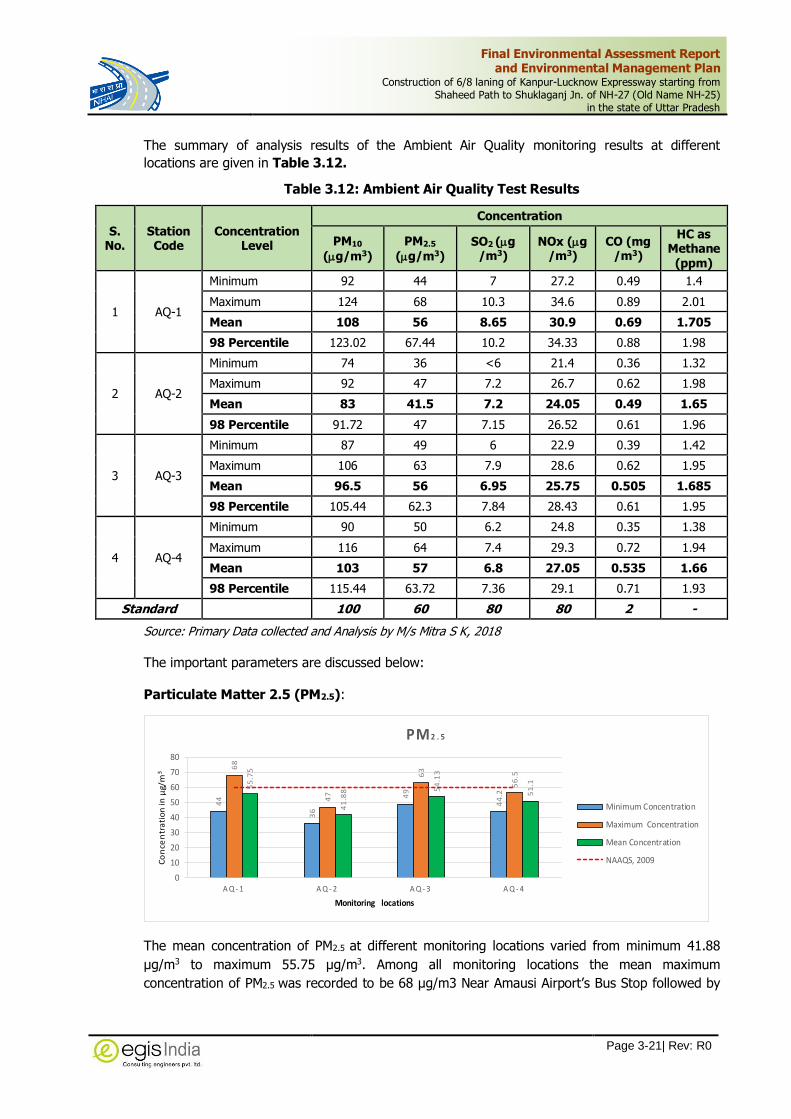
Final Environmental Assessment Report and Environmental Management Plan
Construction of 6/8 laning of Kanpur-Lucknow Expressway starting from Shaheed Path to Shuklaganj Jn. of NH-27 (Old Name NH-25)
in the state of Uttar Pradesh
Page 3-21| Rev: R0
The summary of analysis results of the Ambient Air Quality monitoring results at different
locations are given in Table 3.12.
Table 3.12: Ambient Air Quality Test Results
S. No.
Station Code
Concentration Level
Concentration
PM10
(g/m3)
PM2.5
(g/m3) SO2 (g
/m3) NOx (g
/m3) CO (mg
/m3)
HC as Methane
(ppm)
1 AQ-1
Minimum 92 44 7 27.2 0.49 1.4
Maximum 124 68 10.3 34.6 0.89 2.01
Mean 108 56 8.65 30.9 0.69 1.705
98 Percentile 123.02 67.44 10.2 34.33 0.88 1.98
2 AQ-2
Minimum 74 36 <6 21.4 0.36 1.32
Maximum 92 47 7.2 26.7 0.62 1.98
Mean 83 41.5 7.2 24.05 0.49 1.65
98 Percentile 91.72 47 7.15 26.52 0.61 1.96
3 AQ-3
Minimum 87 49 6 22.9 0.39 1.42
Maximum 106 63 7.9 28.6 0.62 1.95
Mean 96.5 56 6.95 25.75 0.505 1.685
98 Percentile 105.44 62.3 7.84 28.43 0.61 1.95
4 AQ-4
Minimum 90 50 6.2 24.8 0.35 1.38
Maximum 116 64 7.4 29.3 0.72 1.94
Mean 103 57 6.8 27.05 0.535 1.66
98 Percentile 115.44 63.72 7.36 29.1 0.71 1.93
Standard 100 60 80 80 2 -
Source: Primary Data collected and Analysis by M/s Mitra S K, 2018
The important parameters are discussed below:
Particulate Matter 2.5 (PM2.5):
44
36
49
44
.2
68
47
63
56
.5
55
.75
41
.88 5
4.1
3
51
.1
0
10
20
30
40
50
60
70
80
A Q - 1 A Q - 2 A Q - 3 A Q - 4
Co
nce
ntr
ati
on
in µ
g/m
3
Monitoring locations
PM2 . 5
Minimum Concentration
Maximum Concentration
Mean Concentration
NAAQS, 2009
The mean concentration of PM2.5 at different monitoring locations varied from minimum 41.88
µg/m3 to maximum 55.75 µg/m3. Among all monitoring locations the mean maximum
concentration of PM2.5 was recorded to be 68 µg/m3 Near Amausi Airport’s Bus Stop followed by

Final Environmental Assessment Report and Environmental Management Plan
Construction of 6/8 laning of Kanpur-Lucknow Expressway starting from Shaheed Path to Shuklaganj Jn. of NH-27 (Old Name NH-25)
in the state of Uttar Pradesh
Page 3-22| Rev: R0
Near Neverna Village (63 µg/m3), and lowest at Beekamau Village (41.88 µg/m3). At all these
locations, the mean concentration of PM2.5 was within permissible limit of NAAQS, 2009 i.e. 60
µg/m3 during the study period.
Particulate Matter 10 (PM10):
92
74
87 90
12
4
92
10
6 11
6
10
7.8
8
83
.75
96
.75
10
3
0
20
40
60
80
100
120
140
A Q - 1 A Q - 2 A Q - 3 A Q - 4
con
cen
tra
tio
n i
n µ
G/m
3
Monitoring Location
PM1 0
Minimum Concentration
Maximum Concentration
Mean Concentration
NAAQS, 2009
Overall the mean concentration of PM10 at different monitoring locations varied from minimum 74
µg/m3 to maximum 107.88 µg/m3. Among all monitoring locations the mean maximum
concentration of PM10 was recorded to be 107.88 µg/m3 at Amausi Airport’s Bus Stop, followed
by Harbans Village (116µg/m3), Near Neverna Village (96.75µg/m3) and lowest near Beekamau
Village (83.75µg/m3). The mean concentration of PM10 at Bekamu and Neverna village are within
permissible limit however the mean concentration at Amausi Airport and Harbans Village are
above permissible limit of NAAQS, 2009 i.e. 100 µg/m3 during the study period. The AAQ-1
location falls in the main Lucknow city area full of commercial activities and heavy traffic load on
existing NH-27. Similarly, the air sample collected near NH-27 at Harbans village showed slightly
higher PM10 concentration (103 µg/m3) compared to prescribed standard. The concentration may
be attributed due to the heavy traffic movement on NH-27 and openly exposed area.
Sulphur Dioxide (SO2):
7 6 6 6.21
0.3
7.2 7.9
7.48.4
4
6.5
5
6.8
6.8
3
0
10
20
30
40
50
60
70
80
90
A Q 1 A Q 2 A Q 3 A Q 4
Con
cen
trat
ion
in µ
g/m
3
Monitoring Location
SO 2
Minimum Concentration
Maximum Concentration
Mean Concentration
NAAQS, 2009
The mean concentration of SO2 at different monitoring locations varied from minimum 6.55 µg/m3
to maximum 8.44µg/m3. The analysis of test results reflects that concentrations of all the
parameters at all the monitoring locations were well within permissible limit of NAAQS, 2009.

Final Environmental Assessment Report and Environmental Management Plan
Construction of 6/8 laning of Kanpur-Lucknow Expressway starting from Shaheed Path to Shuklaganj Jn. of NH-27 (Old Name NH-25)
in the state of Uttar Pradesh
Page 3-23| Rev: R0
Oxides of Nitrogen (NOx):
27
.2
21
.4
22
.9
24
.834
.6
26
.7
28
.6
29
.3
29
.88
23
.5
25
.48
26
.75
0
10
20
30
40
50
60
70
80
90
A Q 1 A Q 2 A Q 3 A Q 4
Conc
entr
atio
n in
µg/
m3
Monitoring Location
NO 2
Minimum Concentration
Maximum Concentration
Mean Concentration
NAAQS, 2009
The mean concentration of NO2 at different monitoring locations varied from minimum 23.5
µg/m3 to maximum 29.88 µg/m3 based on 24 hourly samples taken at different locations. The
analysis of test results reflects that concentrations of NO2 at all the monitoring locations were well
within permissible limit of NAAQS, 2009. Among all the monitoring locations the concentration of
34.6 µg/m3 NO2 was observed in Lucknow City.
3.3.9.2 Ambient Noise Level
The existing scenario of the noise levels has to be monitored at various locations to have an idea
about the baseline conditions of noise levels. These locations considered are same as those
mentioned in ambient air quality monitoring.
The predominant activities along the project road stretch are mainly agricultural. To determine
the ambient noise level, 4 monitoring locations were identified considering the equal distribution
of project road length and land use pattern along the project road. The data were collected
between October to November 2018. The noise levels were monitored continuously for 24 hours
with one-hour interval by using Data Logger Noise Meter. In Table 3.13 provides the description
of the ambient noise monitoring locations along with area/class, while the noise monitored
calculated separately for day time and night time. The mean daytime equivalent noise level was
determined for the duration from 6:00 AM to 10:00 PM. Similarly mean night time noise level was
recorded from 10:00 PM to 6:00 AM. Ambient noise results for LDay and LNight are presented in
Table 3.14. Noise Monitoring Locations are depicted in Figure 3.14.
Table 3.13: Ambient Noise Monitoring Locations
S. No
Station Code
Location District Land-Use Chainage
(Km) Co-ordinates
1. NQ-1 NQ-1 (Near Amausi Airport Bus Stop along NH-27)
Lucknow Commercial and
mix activities 12.100
26°46'06.58"N, 80°52'37.06"E
2. NQ-2 NQ-2 (Beekamau Village) Unnao Rural Settlement 33.600 26°36'25.99"N, 80°45'45.87"E
3. NQ-3 NQ-3 (Neverna Village) Unnao Rural Settlement 58.400 26°28'57.02"N, 80°35'30.35"E
4. NQ-4 NQ-4 (Badrak Harbans Village) Unnao Rural Settlement 71.000 26°28'05.02"N, 80°28'19.95"E)

Final Environmental Assessment Report and Environmental Management Plan
Construction of 6/8 laning of Kanpur-Lucknow Expressway starting from Shaheed Path to Shuklaganj Jn. of NH-27 (Old Name NH-25)
in the state of Uttar Pradesh
Page 3-24| Rev: R0
Figure 3.14: Noise Quality Monitoring Stations
Table 3.14: Ambient Noise Levels Monitoring Test Results
Station Code
Category of Area/Zone
Equivalent Noise Level (Leq dB(A))
Day time Noise Level Night time Noise Level
LMax LMin Leq 98
percentile LMax LMin Leq
98 percentile
NQ-1 Commercial 70.2 52.4 64.6 69.9 41.2 55.8 49.4 54.90
NQ-2 Residential Area 67.0 47.2 60.2 66.2 10.1 11.4 40.9 11.4
NQ-3 Residential Area 54.5 41.8 50.1 54.4 36.4 42.8 40 42.5
NQ-4 Residential Area 74.6 49.9 59.3 72.6 43.2 54.2 43.9 54.0
Ambient Air Quality Standards in respect of Noise as per CPCB, 2000
Zone
Day Time
Night Time
Industrial 75.0 70.0
Commercial 65.0 55.0
Residential 55.0 45.0
Silence 50.0 40.0
* Day time is from 6 am to 10 pm whereas night time is from 10 pm to 6 am ** Silence zone is defined as area up to 100 meters around premises of hospitals, educational institutions and courts. Use of vehicles horns, loud speakers and bursting of cracking are banned in these zones
Source: Sampling and analysis by M/s Mitra S K Private Limited

Final Environmental Assessment Report and Environmental Management Plan
Construction of 6/8 laning of Kanpur-Lucknow Expressway starting from Shaheed Path to Shuklaganj Jn. of NH-27 (Old Name NH-25)
in the state of Uttar Pradesh
Page 3-25| Rev: R0
0
10
20
30
40
50
60
70
Commercial Residential Area Residential Area Residential Area
NQ-1 NQ-2 NQ-3 NQ-4
Equ
iva
len
t No
ise
Leve
l (L
eq d
B(A
))
Locations
Noise
Equivalent Noise Level (Leq dB(A)) Day time Noise Level Leq
Equivalent Noise Level (Leq dB(A)) Night time Noise Level Leq
During the monitoring period, maximum day time equivalent noise level was recorded at
commercial area of Amausi Airport Bus Stop (64.6 Leq dB(A)), followed by Beekamau Village
(60.2 Leq dB(A)), Badrak Harbans village (59.3 Leq dB(A)) and Neverna Village (50.1 Leq dB(A).
During night time, maximum equivalent noise level was recorded at Amausi Airport Bus Stop
(49.4 Leq dB(A)) followed by Badrak Harbans Village (43.9 Leq dB(A)), Residential area of
Beekamau (40.9 Leq dB(A)), and least was recorded at Neverana Village (40.0 Leq dB(A)).
Both day time and night time noise levels at all the monitoring locations were within the
maximum permissible level of residential area. Human activities were prevalent at surrounding
areas of those monitoring stations.
Noise levels at only one commercial station NQ1 is within limit.
3.3.9.3 Ground Water Quality
There are many hand pumps, open wells, lined wells, bore wells coming along the proposed KLE.
Keeping in view the importance of ground water, three ground water samples were taken for
physico-chemical analysis along the project road. Table 3.15 provides site plan of the ground
water sampling locations and their sources while the results are presented in Table 3.16. The
locations of ground water sampling are shown on Google Earth given in Figure 3.15.
Table 3.15: Ground Water Sampling Locations
Sample Code
Chainage of the Sampling Station District Source Chainage Co-ordinate
GW1. Near Amausi Airport Bus Stop Lucknow TubeWell 12.100 26°46'06.58"N, 80°52'37.06"E
GW2. Beekamau village Unnao TubeWell 33.600 26°36'25.99"N, 80°45'45.87"E
GW3. Badrak Harbans village Unnao TubeWell 71.000 26°28'05.02"N, 80°28'19.95"E

Final Environmental Assessment Report and Environmental Management Plan
Construction of 6/8 laning of Kanpur-Lucknow Expressway starting from Shaheed Path to Shuklaganj Jn. of NH-27 (Old Name NH-25)
in the state of Uttar Pradesh
Page 3-26| Rev: R0
Figure 3.15: Ground Water Quality Monitoring Locations
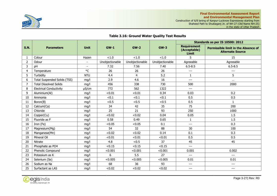
Final Environmental Assessment Report and Environmental Management Plan
Construction of 6/8 laning of Kanpur-Lucknow Expressway starting from Shaheed Path to Shuklaganj Jn. of NH-27 (Old Name NH-25)
in the state of Uttar Pradesh
Page 3-27| Rev: R0
Table 3.16: Ground Water Quality Test Results
S.N. Parameters Unit GW-1 GW-2 GW-3
Standards as per IS 10500: 2012
Requirement (Acceptable)
Limit
Permissible limit in the Absence of Alternate Source
1 Colour Hazen <1.0 <1.0 <1.0 5 15
2 Odour - Unobjectionable Unobjectionable Unobjectionable Agreeable Agreeable
3 pH - 7.32 7.56 7.40 6.5-8.5 6.5-8.5
4 Temperature °C 26 26 26 --- ---
5 Turbidity NTU 4.4 4 5.2 1 5
6 Total Suspended Solids (TSS) mg/l 2.9 4.6 16 --- …
7 Total Dissolved Solids mg/l 456 338 730 500 2000
8 Electrical Conductivity µS/cm 772 562 1322 ---
9 Aluminium(Al) mg/l <0.01 <0.01 0.34 0.03 0.2
10 Ammonia mg/l <0.1 <0.1 <0.1 0.5 0.5
11 Boron(B) mg/l <0.5 <0.5 <0.5 0.5 1
12 Calcium(Ca) mg/l 34 42 35 75 200
13 Chloride mg/l 25 21 93 250 1000
14 Copper(Cu) mg/l <0.02 <0.02 0.04 0.05 1.5
15 Fluoride as F mg/l 0.58 0.49 0.65 1 1.5
16 Iron (Fe) mg/l <0.05 <0.05 0.1 --- 0.3
17 Magnesium(Mg) mg/l 54 32 88 30 100
18 Manganese(Mn) mg/l <0.02 <0.02 0.14 0.1 0.3
19 Mineral Oil mg/l <0.01 <0.01 <0.01 0.5 0.5
20 Nitrate mg/l 4.8 <0.5 37 45 45
21 Phosphate as PO4 mg/l <0.15 <0.15 <0.15 ---
22 Phenolic Compound mg/l <0.001 <0.001 <0.001 0.001 0.002
23 Potassium as K mg/l 6 5.5 27 --- ---
24 Selenium (Se) mg/l <0.005 <0.005 <0.005 0.01 0.01
26 Sodium as Na mg/l 68 36 93 --- ---
25 Surfactant as LAS mg/l <0.02 <0.02 <0.02 --- ---

Final Environmental Assessment Report and Environmental Management Plan
Construction of 6/8 laning of Kanpur-Lucknow Expressway starting from Shaheed Path to Shuklaganj Jn. of NH-27 (Old Name NH-25)
in the state of Uttar Pradesh
Page 3-28| Rev: R0
S.N. Parameters Unit GW-1 GW-2 GW-3
Standards as per IS 10500: 2012
Requirement (Acceptable)
Limit
Permissible limit in the Absence of Alternate Source
27 Silver mg/l <0.005 <0.005 <0.005 0.1 0.1
28 Sulphate mg/l 24 6 93 200 400
29 Total Alakalinity mg/l 561 418 566 200 600
30 Total Hardness mg/l 308 240 456 200 600
31 Total Kjeldahl Nitrogen mg/l <0.3 <0.3 <0.3 --- <0.3
32 Zinc(Zn) mg/l 0.07 <0.02 2.5 5 15
33 Cadmium (Cd) mg/l <0.001 <0.001 <0.001 0.003 0.003
34 Lead (Pb) mg/l <0.005 <0.005 0.008 0.01 0.01
35 Mercury (Hg) mg/l <0.001 <0.001 <0.001 0.001 0.001
36 Total Chromium(Cr) mg/l 0.02 <0.01 <0.01 0.05 0.05
37 Arsenic(As) mg/l <0.005 <0.005 <0.005 0.01 0.05
38 Total Coliform MPN/100ml Not Detected Not Detected Not Detected Not Detectable Absent
39 Faecal Coliform MPN/100ml Not Detected Not Detected Not Detected Not Detectable Absent
Source: Sampling and analysis by M/s Mitra S K Private Limited

Final Environmental Assessment Report and Environmental Management Plan
Construction of 6/8 laning of Kanpur-Lucknow Expressway starting from Shaheed Path to Shuklaganj Jn. of NH-27 (Old Name NH-25)
in the state of Uttar Pradesh
Page 3-29| Rev: R0
0
100
200
300
400
500
600
700
800
pH TOTALHARDNESS
ALKALINITY TDS TSS SULPHATE NITRATE SODIUM POTASSIUM
GROUND WATER
GW-1 GW-2 GW-3
The test results of ground water samples collected from the study area reflects that the quality of
ground water is generally fit for drinking. Test results have been compared with respect to BIS
10500: 2012 and findings are noted below:
The pH was within acceptable limit and found between 7.56 to 7.32. The Total Dissolve Solid
varied from 338 mg/l to 730 mg/l. At Badrak Harbans Village water sample (GW-3) shows higher
TDS than the maximum acceptable limit of 500 mg/l but lower than maximum permissible limit of
2000 mg/l. Total hardness (as CaCO3) ranged from 308 mg/l to 456 mg/l at different locations
within the study area. Again samples from Badrak Harbans village exceeded the acceptable limit
of 200 mg/l but within permissible limit of 600 mg/l. The water sample from Amausi Airport Bus
stop (GW-1) also showed slightly higher total hardness compare to the acceptable limit of 200
mg/l but within the permissible limit of 600 mg/l. Magnesium is ranges between 12.2 to 38.02
mg/l. Badrak Harbans (GW-3) village and Amausi Airport(GW-1) shows that available Magnesium
ranges between 32 mg/l and 88 mg/l respectively which is higher than the acceptable limit of 30
mg/l but is lower than the maximum permissible limit of 100 mg/l in absence of alternate source.
The Ammonia is less than 0.1 mg/l than the permissible limit of 0.5mg/l. Concentration of
chloride is ranging between 21 mg/l to 93 mg/l which is well within Desirable and permissible
limit. Aluminum is detected 0.34 mg/l at Badrak Harbans village which is higher than permissible
limit of 0.2 mg/l. Total Alkalinity is ranges at 418 mg/l to 566 mg/l which is higher than desirable
limit of 200mg/l but within the permissible limit of 600mg/l.
The fluoride content was found between 0.49 mg/l to 0.65 mg/l which is lower than the
maximum acceptable limit of 1.0 mg/l. The Arsenic is below detection limit for the all three
locations, i.e. 0.01mg/l. All other measured parameters including heavy metal contents were
observed well within the acceptable limit.
3.3.9.4 Surface Water Quality
The project road crosses river, Nallas, local streams and Channels. The river Sai is Perennial River
in the project area and cross the project alignment. Project area situated in the Sai-Gomti Sub
basin. The detailed list of Water resources including surface water bodies, ground water
resources is given as Table 3.17. The surface water sampling locations are shown on Google
Earth in Figure 3.16 and detailed in Table 3.17. Surface water quality test results are in Table
3.18.

Final Environmental Assessment Report and Environmental Management Plan
Construction of 6/8 laning of Kanpur-Lucknow Expressway starting from Shaheed Path to Shuklaganj Jn. of NH-27 (Old Name NH-25)
in the state of Uttar Pradesh
Page 3-30| Rev: R0
Table 3.17: Surface Water Sampling Locations
Code Location Source Chainage Co-ordinates
SW-01 Sai river near Village Hionra River 29.000 26°38'30.72"N, 80°47'10.64"E
SW-02 Canal Water near Village Raipur Canal 46.250 26°31'22.62"N, 80°41'58.35"E
SW-03 Canal Water near Karnipur Shivpur Village Canal 63.650 26°27'47.37"N, 80°32'38.81"E
SW-04 Pond Water near Village Daulatpur Pond 65.250 26°27'47.08"N, 80°31'41.73"E
Figure 3.16: Surface Water Quality Monitoring Locations

Final Environmental Assessment Report and Environmental Management Plan
Construction of 6/8 laning of Kanpur-Lucknow Expressway starting from Shaheed Path to Shuklaganj Jn. of NH-27 (Old Name NH-25)
in the state of Uttar Pradesh
Page 3-31| Rev: R0
Table 3.18: Surface Water Quality Test Results
S.N. Parameters Unit
Water Sampling Location
SW-1 (Sai River) SW-2 (Raipur Canal
Water) SW-3 (Shivpur Canal
Water) SW-4 (Daulatpur Pond
Water)
1 Aluminium ( as Al ) mg/l 1.7 1.5 0.1 0.7
2 Ammonia mg/l <0.1 <0.1 <0.1 <0.1
3 Arsenic( as As) mg/l <0.005 <0.005 <0.005 <0.005
4 Biochemical Oxygen Demand (as BOD) mg/l 2.8 <2.0 <2.0 <2.0
5 Boron (as B) mg/l <0.5 <0.5 <0.5 <0.5
6 Cadmium (as Cd) mg/l <0.001 <0.001 <0.001 <0.001
7 Calcium (as Ca) mg/l 42 26 21 24
8 Chemical Oxygen Demand (COD) mg/l 24 12 12 <4.0
9 Chloride (as Cl ) mg/l 27 16 18 11
10 Cobalt (as Co) mg/l <0.05 <0.05 <0.05 <0.05
11 Colour Hazen <1 <1.0 <1.0 <1
12 Conductivity us/cm 449 249 255 297
13 Copper (as Cu) mg/l <0.02 <0.02 <0.02 <0.02
14 DO mg/l 6.8 6.2 6.4 5.8
15 Dissolved Iron mg/l 0.05 <0.05 <0.05 <0.05
16 Fluoride ( as F ) mg/l 0.24 0.17 <0.1 0.15
17 Lead (as Pb ) mg/l <0.005 <0.005 <0.005 <0.005
18 Magnesium (as Mg) mg/l 18 10 10 12
19 Manganese (as Mn) mg/l 0.06 <0.02 <0.02 0.11
20 Mercury (as Hg ) mg/l <0.001 <0.001 <0.001 <0.001
21 Nickel (as Ni ) mg/l <0.02 <0.02 <0.02 <0.02
22 Nitrate (as NO3 ) mg/l 2.7 0.6 <0.5 0.9
23 Nitrite ( as NO2 ) mg/l <0.01 <0.01 <0.01 <0.01
24 Odour None Unobjectionable Unobjectionable Unobjectionable Unobjectionable
25 Petroleum Hydrocarbon mg/l <0.001 <0.001 <0.001 <0.001
26 Phenol mg/l <0.001 <0.001 <0.001 <0.001

Final Environmental Assessment Report and Environmental Management Plan
Construction of 6/8 laning of Kanpur-Lucknow Expressway starting from Shaheed Path to Shuklaganj Jn. of NH-27 (Old Name NH-25)
in the state of Uttar Pradesh
Page 3-32| Rev: R0
S.N. Parameters Unit
Water Sampling Location
SW-1 (Sai River) SW-2 (Raipur Canal
Water) SW-3 (Shivpur Canal
Water) SW-4 (Daulatpur Pond
Water)
27 Phosphate (as PO4) mg/l 0.21 <0.15 <0.15 0.17
28 Potassium (as K) mg/l 4 2.6 2.3 7.5
29 Salinity (w.r.t. KCleq salinity 35) None 0.26 0.14 0.15 0.17
30 Sodium (as Na) mg/l 24 14 13 16
31 Sulphate ( as SO4 ) mg/l 28 19 22 26
32 Surfactants (LAS) mg/l <0.02 <0.02 <0.02 <0.02
33 Temperature °C 26 27 27 27
34 Total Chromium ( as Cr ) mg/l 0.02 <0.01 <0.01 <0.01
35 Total Dissolved Solids (as TDS) mg/l 250 150 146 166
36 Total Hardness (as CaCO3 ) mg/l 180 108 96 108
37 Total Kjeldahl Nitrogen mg/l <0.3 <0.3 <0.3 <0.3
38 Total Suspended Solid (as TSS) mg/l 23 36 3.3 6.2
39 Turbidity N.T.U. 17 17 5.9 5.6
40 Zinc (as Zn) mg/l 0.03 0.02 <0.02 0.04
41 pH value at 25 °C None 6.98 7.26 7.39 7.25
42 Faecal coliform MPN/100ml Not Detected Not Detected Not Detected Not Detected
43 Total coliform MPN/100ml Not Detected Not Detected Not Detected Detected
Source: Sampling and analysis by M/s Mitra S K Private Limited

Final Environmental Assessment Report and Environmental Management Plan
Construction of 6/8 laning of Kanpur-Lucknow Expressway starting from Shaheed Path to Shuklaganj Jn. of NH-27 (Old Name NH-25)
in the state of Uttar Pradesh
Page 3-33| Rev: R0
6.9
8
17
23
6.8
2.8
24
7.2
6
17
36
6.2
2
12
7.3
9
5.9
3.3
6.4
2
12
7.2
5
5.6 6.2
5.8
2
4
P H T U R B I DI T Y T S S D O B O D C O D
SURFACE WATER
SW-1 SW-2 SW-3 SW-4
The pH along the project road for all the water bodies locations varies from 6.98 to 7.39. The
Total dissolved solids are varying from 146 to 250 mg/l for different locations along the proposed
project road. The Total Suspended Solids vary from 3.3 to 36mg/L. Total hardness (as CaCO3)
varies from 96 to 180 mg/l. DO ranges from 5.8 to 6.8 mg/l, BOD (3 days 270C) varies from less than
<2 to 2.8 mg/l and COD ranges from <4 to 24 mg/l. Faecal coliform (MPN/100ml) is non-
detectable however Total coliform was detected in water sample collected from pond (SW-4). The
other heavy are metals are within desirable limits.
Classification of Water
Designated-Best-Use Class of water
Criteria
Drinking Water Source without conventional treatment but after disinfection
A Total Coliforms Organism MPN/100ml shall be 50 or less
pH between 6.5 and 8.5
Dissolved Oxygen 6mg/l or more
Biochemical Oxygen Demand 5 days 20C 2mg/l or less
Outdoor bathing (Organised)
B Total Coliforms Organism MPN/100ml shall be 500 or less
pH between 6.5 and 8.5
Dissolved Oxygen 5mg/l or more
Biochemical Oxygen Demand 5 days 20C 3mg/l or less
Drinking water source after conventional treatment and disinfection
C Total Coliforms Organism MPN/100ml shall be 5000 or less
pH between 6 to 9
Dissolved Oxygen 4mg/l or more
Biochemical Oxygen Demand 5 days 20C 3mg/l or less
Propagation of Wild life and Fisheries
D pH between 6.5 to 8.5 Dissolved Oxygen 4mg/l or more
Free Ammonia (as N) 1.2 mg/l or less
Irrigation, Industrial Cooling, Controlled Waste disposal
E pH between 6.0 to 8.5
Electrical Conductivity at 25C micro mhos/cm Max.2250
Sodium absorption Ratio Max. 26
Boron Max. 2mg/l
Below-E Not Meeting A, B, C, D & E Criteria
Source: Designated Best Use Water Quality Criteria, CPCB

Final Environmental Assessment Report and Environmental Management Plan
Construction of 6/8 laning of Kanpur-Lucknow Expressway starting from Shaheed Path to Shuklaganj Jn. of NH-27 (Old Name NH-25)
in the state of Uttar Pradesh
Page 3-34| Rev: R0
3.3.9.5 Soil Quality
Soil analysis has been carried out for different soil samples collected from different locations
along the proposed project alignment to understand the Soil characteristics along the project
road. Three numbers of soil samples from adjacent agricultural land were collected in the month
of October 2018. The soil sampling locations with respect to the proposed project road has been
presented in Table 3.19. Soil Quality test results is given in Table 3.20. Soil quality monitoring
locations are depicted in Figure 3.17.
Table 3.19: Soil Sampling Locations
Code Location Co-Ordinates Chainage
SQ-1. Near Amausi Airport Bus Stop 26°46'06.58"N, 80°52'37.06"E 12.100
SQ-2. Beekamau village 26°36'25.99"N, 80°45'45.87"E 33.600
SQ-3. Badrak Harbans village 26°28'05.02"N, 80°28'19.95"E 71.000
Figure 3.17: Soil Quality Sampling Locations
Table 3.20: Physico-chemical Characteristics of Soil along the proposed Project
S.N. Parameters Unit SQ-1 SQ-2 SQ-3
1 Bulk Density gm/cc 1.21 1.33 1.25
2 Clay % 38 18 22
3 Electrical conductivity (1:2.5) at 25 °C μS/cm 474 405 588
4 Iron (as Fe) mg/kg 13 59 <5.0
5 Lead (as Pb ) mg/kg 14 4.6 6.3
6 Moisture Retention capacity % 32 21 24
7 Nitrogen (as N) mg/kg 857 370 431
8 Organic Matter % 1.2 0.34 0.53
9 Phosphorus (as P) mg/kg 7.7 7.8 9.5

Final Environmental Assessment Report and Environmental Management Plan
Construction of 6/8 laning of Kanpur-Lucknow Expressway starting from Shaheed Path to Shuklaganj Jn. of NH-27 (Old Name NH-25)
in the state of Uttar Pradesh
Page 3-35| Rev: R0
S.N. Parameters Unit SQ-1 SQ-2 SQ-3
10 Porosity % 52 41 46
11 Potassium (as K) mg/kg 174 41 104
12 Sand % 20 60 50
13 Silt % 42 22 28
14 Texture None Silty clay
loam Sandy loam
Loam
15 Total Organic Carbon % 0.69 0.2 0.31
16 Infiltration rate mm/hr 8 22 14
17 pH value (1:2.5) at 25 °C None 6.98 7.28 7.24
Source: Sampling and Analysis by M/s Mitra S K Private Limited
A NPK ratio of 4:2:1 is generally considered ideal and accepted for macro-level monitoring of
consumption of plant nutrients for the country as a whole. However, it is difficult to trace the
genesis of this NPK ratio (National Academy of Agricultural Research). The results received from
the monitoring of soil quality shows that phosphorous quantity in the soil is very low compared
the expected ratio.
The analysis results reflect that pH level the soil in the study area is normal to saline with pH
ranging from 6.98 to 7.28. The soil texture mainly varies from Silty Clay Loam to loam along the
proposed project alignment. Organic carbon content in the soil varies between 0.2% to 0.69%.
Electrical conductivity is normal and favorable for germination as all the samples have results
below 1000 µS/ cm. The moisture retention capacity varies from 21 to 32% among all the soil
samples taken along the project road.
3.3.10 Quarry Site and Borrow Areas
Quarry Areas
Road construction requires earth, stones and sand embankment and pavement construction.
These raw materials are to be obtained from surrounding areas, which are suitable from quality
point of view. For the required quantity of stone 2 numbers of operational approved quarries

Final Environmental Assessment Report and Environmental Management Plan
Construction of 6/8 laning of Kanpur-Lucknow Expressway starting from Shaheed Path to Shuklaganj Jn. of NH-27 (Old Name NH-25)
in the state of Uttar Pradesh
Page 3-36| Rev: R0
have been identified. The stone quarries are devoid of any significant environmental features.
Sufficient quantities of metals are available in these quarries. Details of the suitable stone
quarries are given table below:
Table 3.21: Details of Identified Aggregate Quarry for the Project
S. No.
Nearest Existing Chainage (km)
Side Location Details
Lead (Km) Name Of Crusher
1 74+000 LHS Kabrai (UP) 144 Ashirwad Gram udyog sansthanCrusher
2 74+000 LHS Jhansi (UP) 242 -
Borrow Areas
The soils to be used, as sub-grade, select sub-grade and shoulder materials need to be hauled
from designated borrow areas.
For identification of borrow areas following criteria has been adopted:
Sufficient quantity of suitable soil is available from the borrow pit;
The borrow areas are as close to the project road as far as possible;
The loss of productive and fertile agricultural soil is minimum; and
There is minimum loss of vegetation.
A summary description of the private borrow areas indicating their location with respect to project
highway chainage, approximate distance from the source to the nearest point on the Project
highway, estimated available quantity of soil are given at Table 3.22 and photographs as below
in Figure 3.18.
Table 3.22: Description of Soil Borrow Sources
Source ID Location Chainage (Km) Side Lead (m)
Quantity (m3)
BA-01 Ranipur Village 29+500 LHS 200 21600
BA-02 Patkapur Village 29+750 LHS 1000 5400
BA-03 Nokhe Lal Khera 33+200 LHS 200 21600
BA-04 Near Bachhaura 40+200 LHS 1500 33750
B.A-5 Manikapur 43+700 RHS 400 33750
B.A-6 Tiwari Khera 53+200 RHS 800 5400
B.A-7 Naverna 57+000 LHS 2000 21600
B.A-8 Jagjeewanpur Village 68+000 RHS 200 21600
The photographs of borrow area sources are as follows.

Final Environmental Assessment Report and Environmental Management Plan
Construction of 6/8 laning of Kanpur-Lucknow Expressway starting from Shaheed Path to Shuklaganj Jn. of NH-27 (Old Name NH-25)
in the state of Uttar Pradesh
Page 3-37| Rev: R0
BA-01 @29+500 L/S ,Lead 200 m BA-02 @29+750 L/S ,Lead 1 km
BA-03@33+200L/S ,Lead 200 m BA-04@40+200 L/S ,Lead 1.5 km
BA-06@53+200 R/S, Lead 800 m BA-08@68+000 R/S, Lead 800 m
Figure 3.18: Photographs of Borrow Area Sources
All the borrow areas are uncultivated land devoid of any significant environmental features. Only
scattered bushy vegetation can be observed over these areas. The location plan along with lead
of the identified quarries and borrow areas are presented in the following Figure 3.19.

Final Environmental Assessment Report and Environmental Management Plan
Construction of 6/8 laning of Kanpur-Lucknow Expressway starting from Shaheed Path to Shuklaganj Jn. of NH-27 (Old Name NH-25)
in the state of Uttar Pradesh
Page 3-38| Rev: R0
Source: Primary Survey Data
Figure 3.19: Lead Chart for Borrow Area Sources
3.3.11 Fly Ash
Fly Ash is a lightweight material, which may be used for construction of embankment, sub-grades
etc. singly or by mixing with suitable admixtures. The fly ash is laid in alternate layers with soil
and earth blankets are also provided on the side slopes for the confinement of the materials as
per IRC: SP: 58-2001 – Guidelines for use of Fly ash in Road Embankment. The Fly Ash shall be
used to the minimum extent of 30% of total fill material for the embankment depending upon the
availability of fly ash from the identified sources. Although there are 3 thermal power plants
namely Panki TPP, Unchahar TPP and Rosa Thermal Power plant in Shahjahanpur located within
300km radius of project. However, the availability of fly ash has been checked and the required
quantity can be available from Unchahar thermal power plant
Table 3.23: Details of Fly Ash Consumption
S. No.
Name of the nearby Thermal Power Plant
Side Quantity of Fly Ash that can be
utilized in cum Average lead of Project
from the Plant
1 Unchahar (11+000) LHS 13,54,928 116 KM
Generally, the Greenfield alignment shall be constructed at approximately 2 to 3m from the
ground level which may be more at bridge approaches and at ROB locations. Fly ash can provide
technically viable, environmentally sound & cost effective alternative to natural borrow soil.
Fly ash Embankment Considered in Design
The embankment is designed as a composite structure with fly ash in the core and earth cover on
the sides and at the top of embankment. However, special emphasis is required to be placed on
the provision of earth cover for fly ash embankments since ash is easily erodible. The thickness of
earth cover may be in the range of 1-3 m depending on height and slope of the embankment. In
regions of moderate to high seismic activity, analysis of embankment stability should consider
liquefaction potential of the ash fill. TCS of Embankment with Fly ash is given in Figure 3.20. For
details, refer chapter 5

Final Environmental Assessment Report and Environmental Management Plan
Construction of 6/8 laning of Kanpur-Lucknow Expressway starting from Shaheed Path to Shuklaganj Jn. of NH-27 (Old Name NH-25)
in the state of Uttar Pradesh
Page 3-39| Rev: R0
Figure 3.20: Typical Cross Section of Embankment with Fly ash
The lead chart indicating the approximate distance of Stone Aggregate (AS), Sand (S) and Fly ash
to the nearest point on the project expressway is given in below.
Figure 3.21: Lead Chart for Sand, Aggregate and Flyash
3.4 Ecological Resources
3.4.1 Forest Cover in Proposed District
The proposed project is located in Lucknow and Unnao districts of the State of Uttar Pradesh. As
per Indian State of Forest Report 2019, the recorded forest area of the Uttar Pradesh is 16,582
km2. Forest cover of Lucknow District is 14.99% and Forest cover of Unnao is 5.80%. Forest
cover map of the State is shown in Figure 3.22.
The forest cover in the concerned project districts as per India State Forest Report 2019 is given
in Table 3.24.
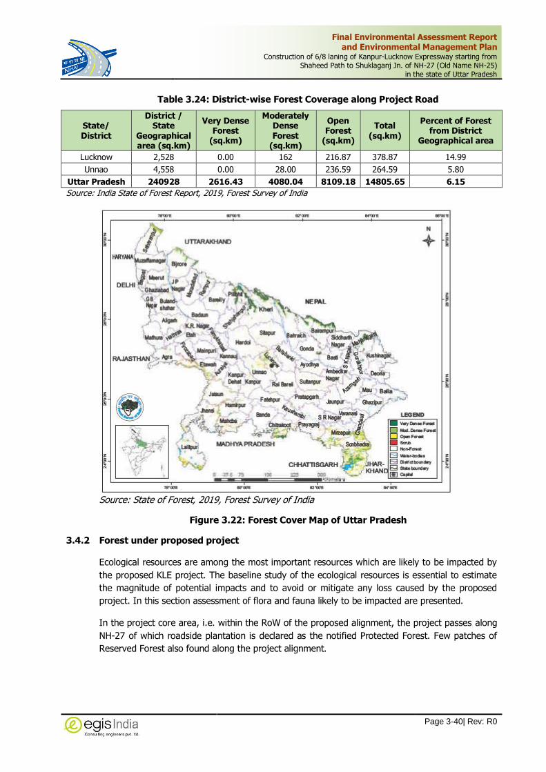
Final Environmental Assessment Report and Environmental Management Plan
Construction of 6/8 laning of Kanpur-Lucknow Expressway starting from Shaheed Path to Shuklaganj Jn. of NH-27 (Old Name NH-25)
in the state of Uttar Pradesh
Page 3-40| Rev: R0
Table 3.24: District-wise Forest Coverage along Project Road
State/ District
District / State
Geographical area (sq.km)
Very Dense Forest
(sq.km)
Moderately Dense Forest
(sq.km)
Open Forest
(sq.km)
Total (sq.km)
Percent of Forest from District
Geographical area
Lucknow 2,528 0.00 162 216.87 378.87 14.99
Unnao 4,558 0.00 28.00 236.59 264.59 5.80
Uttar Pradesh 240928 2616.43 4080.04 8109.18 14805.65 6.15
Source: India State of Forest Report, 2019, Forest Survey of India
Source: State of Forest, 2019, Forest Survey of India
Figure 3.22: Forest Cover Map of Uttar Pradesh
3.4.2 Forest under proposed project
Ecological resources are among the most important resources which are likely to be impacted by
the proposed KLE project. The baseline study of the ecological resources is essential to estimate
the magnitude of potential impacts and to avoid or mitigate any loss caused by the proposed
project. In this section assessment of flora and fauna likely to be impacted are presented.
In the project core area, i.e. within the RoW of the proposed alignment, the project passes along
NH-27 of which roadside plantation is declared as the notified Protected Forest. Few patches of
Reserved Forest also found along the project alignment.

Final Environmental Assessment Report and Environmental Management Plan
Construction of 6/8 laning of Kanpur-Lucknow Expressway starting from Shaheed Path to Shuklaganj Jn. of NH-27 (Old Name NH-25)
in the state of Uttar Pradesh
Page 3-41| Rev: R0
3.4.3 Ecologically Protected Area
It is identified that project alignment neither falls within any protected area notified under Wildlife
act, 1972 or Environmental (Protection) act, 1986 nor their eco-sensitive zone. However, for
confirmation on the location of project, NHAI vide its letters ref. no 25001/NHAI/PIU/KNP-
LKO/Expressway/2018 dated 09.08.2018 approached Wildlife Department. The Conservation of
Forest, Endangered Project, U.P. vide its letter no 283/8-5 dated 10.08.2018 confirmed that the
project is located at a distance of 9 Km from Shaheed Chander Shekhar Azad (Nawabganj) Bird
Sanctuary in Unnao district. The copy of the letter of NHAI, The Conservator of Forest and a
reference copy of final ESZ notification is enclosed as Annexure-3.4
The Proposed project is located at a distance of 9.0km from the outer boundary of Nawabganj
Bird Sanctuary towards Southern direction at Km 33+900. The Bird Sanctuary is a notified
protected area in Unnao district covering an area of 2.246 sq.km. MoEF&CC vide its S.O. 3153(E)
dated 29.08.2019 has notified its final Eco-sensitive zone of an extent of 100 metres uniform
around the boundary of Shaheed Chandra Shekhar Azad (Nawabganj) Bird Sanctuary. Therefore,
the proposed project alignment is far away from its eco-sensitive zone.
There are seven villages falling in Eco-sensitive zone of this Sanctuary are namely Ravanhaar,
Rampur araarh, Pachiyawa, Jhakhari, Bardai hata, Bhawanipur, Jangpur. The proposed alignment
does not pass through any of these villages.
The map of Uttar Pradesh depicting sanctuary and national park is given in Figure 3.23.
Figure 3.23: Wildlife Sanctuary, National Park in Uttar Pradesh
Tiger /Elephant Reserves: There is not any tiger reserve or elephant reserve located within 10
km radius of the project alignment.
Wild Animal Migratory Route/ Elephant corridor: There is no designated migratory route
for wild animals neither elephant corridor within the study area.

Final Environmental Assessment Report and Environmental Management Plan
Construction of 6/8 laning of Kanpur-Lucknow Expressway starting from Shaheed Path to Shuklaganj Jn. of NH-27 (Old Name NH-25)
in the state of Uttar Pradesh
Page 3-42| Rev: R0
3.4.4 Flora and Fauna
The tree survey was carried out within proposed right of way of the KLE, which revealed that
there are many species of trees.
Flora within proposed RoW
There are 53,160 number of Non-Forest Trees and 3,928 number of Forest Trees in Lucknow and
Unnao district located within Proposed Right of Way of Project road. The major tree species are
Eucalypytus, Bamboo, Babool, Shisham, Neem, Chilbil, Pakad, Chitvan, Mango, Pipal, Siris etc. A
details of Non-Forest and Forest trees in Girth Wise are provided in Annexure-3.5
Table 3.25: Non-Forest Trees falling within Proposed ROW of the project alignment
Tehsil Name of the Village No of Tree
(1) Sarojini Nagar
(1) Behsa -
(2) Farukabad Chillawan 63
(3) Amausi 53
(4) Gauri 208
(5) Gaharu 1654
(6 Natkur 12
(7) Miranpur Pinvat 89
(8) Banthra Sikanderpur 0
(9) Khande Dev 11
(10) Sarai Sajadi 11
(11) Bani 475
(2) Hasanganj
(1) Bajehara 816
(2) Hinora 1974
(3) Hasnapur 1970
(3) Purwa
(1) Saharawan 5722
(2) Kashi Pur 1417
(3) Beekamau 1335
(4) Kantha 4649
(5)Sariya 793
(6) Bachhaura 14984
(7) Kudikapur 9
(8) Manikapur 36
(9) Medpur 71
(10) Raipur 1572
(11) Turi Chabinath 11
(12) Turi Raja Sahib 1617
(4) Unnao
(1) Pathakpur 81
(2) Taura 1170
(3) Jagetha 2217
(4) Padri Khurd 775
(5) Jargaon 1012
(6) Gauri Shankar Pur Grant 1
(7) Neverna 1101
(8) Shivpur Grant 5262
(9) Aderwa 781
(10) Behta 723

Final Environmental Assessment Report and Environmental Management Plan
Construction of 6/8 laning of Kanpur-Lucknow Expressway starting from Shaheed Path to Shuklaganj Jn. of NH-27 (Old Name NH-25)
in the state of Uttar Pradesh
Page 3-43| Rev: R0
Tehsil Name of the Village No of Tree
(11) Mohuddeen Pur 10
(12) Amarsus 668
(13) Karaundhi 0
(14) Ata 0
(15) Banthar 0
(16) Kader Patari 1
Total 53,160
Table 3.26: Girth Wise Trees falling within Proposed ROW of the project alignment
Type of Forest Diameter (in cm)
0-30 31-60 61-90 91-120 121-150 >150 Total
Forest Trees 1,048 658 757 555 309 501 3,928
Non Forest Trees 2,0427 2,0180 4,625 4,616 1,721 1,591 53,160
Fauna
In the study area no endangered species found. Common fauna and avifauna observed in the
area. The abandoned scrub jungles do not provide much cover for any of the species of wild
animals like tiger, elephant.
Observed fauna and avifauna in the study are local apart from domestic animal. Following list of
fauna reported:
Jungle cat
Field Mouse
Mongoose
Cobra
Garden lizard
Squirrel
Many terrestrial birds are either observed or reported in the study area list below:
India crow
Parrot
Pigeon
Sparrow
Saras
3.4.5 Critically Polluted Areas
The project does not fall in any notified polluted area, However Kanpur is a critical polluted area
as per letter no B-29012/ESS (CPA)/2015-16 dated on April 26, 2016 which is approximately 5.3
km away from the end point of the proposed project alignment. Its CEPI Score for Industrial
Areas/Cluster monitored during 2018- *CEPI Score: 89.46 (Air: 66.00, Water: 85.00, Land:
45.00).

Final Environmental Assessment Report and Environmental Management Plan
Construction of 6/8 laning of Kanpur-Lucknow Expressway starting from Shaheed Path to Shuklaganj Jn. of NH-27 (Old Name NH-25)
in the state of Uttar Pradesh
Page 3-44| Rev: R0
As per the EIA Notification, it is a General condition that “Any project or activity specified in
Category B1 will be appraised at the Central Level, if located in whole or in part within 5 km from
the boundary of Critically Polluted Areas or Severely Polluted Areas”. The project is already
attracting the Category-A condition as per EIA notification and listed in “Orange Category
industry” of CPCB however appropriate mitigation measures are being provided while considering
higher CEPI score in nearby area.
3.4.6 Archaeological Site
Archaeological monuments identified in the project districts Lucknow and Unnao as per the list of
protected monuments by Archaeological Survey of India are as provided in Table 3.27. There
are 13 number of protected sites located in Lucknow District and three in Unnao district. The
table reflects that the project alignment neither located in 100m of prohibited zone not located
within 300 m of regulated zone of any of the Archaeological sites/monuments
Table 3.27: List of Archaeological Site in Project Districts
Sl. No. Archaeological Site (Protected Monuments) District
1 Alambagh bhavan and Gate Lucknow
2 Lal Baradari Lucknow
3 Badi Chhatri Manzil Lucknow
4 Farhat Baksh Kothi (next to Bara Chattar Manzil (Umbrella Palace) Lucknow
5 Roshan-ud-Daulah Kothi Lucknow
6 Hulaskheda Fort Lucknow
7 Dahiar ka Tila Lucknow

Final Environmental Assessment Report and Environmental Management Plan
Construction of 6/8 laning of Kanpur-Lucknow Expressway starting from Shaheed Path to Shuklaganj Jn. of NH-27 (Old Name NH-25)
in the state of Uttar Pradesh
Page 3-45| Rev: R0
Sl. No. Archaeological Site (Protected Monuments) District
8 Dadupur ka Tila Lucknow
9 Natwadih Lucknow
10 Chaturbhurj Baba Deva Sthan Lucknow
11 Mandak Maharani Devasthana Lucknow
12 Devra Thakur Devasthana Lucknow
13 Janaki Charan Baba (Dhopi Maharani Devastana) Lucknow
14 Hasanpir tila(Hanuman Gadhi) Unnao
15 Sachan kot ka Tila Unnao
16 Ancient mound at Ugu Unnao
Source: Archaeological Survey of India.
3.5 Socio – Economic Environment
The project alignment is located in Lucknow and Unnao District. The project area falls in the
Tehsil of Sarojini Nagar of Lucknow District and Hasanganj, Purwa and Unnao of Unnao District.
The alignment passes through 11 village area Lucknow District and 31 villages in Unnao District.
3.5.1 Demographic Profile
The Population of Uttar Pradesh according to the 2011 census stands at about 200 million, making
it the 1st most populated state in India. The density of population per sq. Km. is 829. Population
Growth rate of about 15.1% percent of Unnao district and 25.8% of Lucknow district. The
population of the state is rising considerably due to rapid efforts towards development and
progress. The sex ratio in Uttar Pradesh is 912 per 1000 male. The state is moving towards
development at a rapid rate and has emerged as one of the prime economical contributors to the
revenue of India as a whole.
Lucknow district: In 2011, Lucknow had population of 45,89,838 of which male and female
were 23,94,476 and 21,95,362 respectively as per 2011 census, Lucknow.
As per 2011 census, it shows that the population density is 1,816 people per sq. km. The sex
ratio is 917 per 1000 male.
Unnao District: Unnao had population of 31,08,367 of which male and female were 16,30,087
and 14,78,280 respectively as per 2011 census.
The density of Unnao district as per census of India 2011 is 682 people per sq. km. The sex ratio
is 907 per 1000 male. The demographic features of the project districts as per 2011 Census are
provided in Table 3.28.
Table 3.28: District wise Demographic profile of the project Area
State/ District Geographical Area (Sq Km)
Population Female per 1000 Males
Population Density/ Sq Km Total Male Female
Lucknow 2,528.0 45,89,838 23,94,476 21,95,362 917 1816
Unnao 4,558.0 31,08,367 16,30,087 14,78,280 907 682
Uttar Pradesh 243,290 199,812,341 104,480,510 95,331,831 912 829
Source: Census of India, 2011

Final Environmental Assessment Report and Environmental Management Plan
Construction of 6/8 laning of Kanpur-Lucknow Expressway starting from Shaheed Path to Shuklaganj Jn. of NH-27 (Old Name NH-25)
in the state of Uttar Pradesh
Page 3-46| Rev: R0
2%2%
96%
Demographic Profile of the District
Lucknow
Unnao
Uttar Pradesh
3.5.2 Literacy Rate
Literacy rate in Uttar Pradesh has seen upward trend and is 67.7 percent as per 2011 population
census. Of that, male literacy stands at 77.3 percent while female literacy is at 57.2 percent.
In actual numbers, total literates in Uttar Pradesh stands at 114,397,555 of which males were
68,234,964 and females were 46,162,591.
Table 3.29 represent literacy rate in concerned district of project area. Significant rise in literacy
rate in all the districts and state has been recorded in 2011 compared to the year 2001.
Table 3.29: District wise Literacy Rate of the Project Area
State / District Population (Literacy Rate in %)
Male Female Total
Lucknow 17,42,440 (82.6) 13,84,820 (71.5) 31,27,260 (77.3)
Unnao 10,53,063 (75.1) 7,20,521 (56.8) 17,73,584 (66.4)
Uttar Pradesh 6,82,34,964 (77.3) 4,61,62,591 (57.2) 11,43,97,555 (67.7)
Source: Census of India, 2011
77.3
66.4 67.774.04
0
10
20
30
40
50
60
70
80
90
Lucknow Unnao Uttar Pradesh India
Lite
racy
Ra
te i
n %
District/UP/India
Literacy Rate in %
Population (Literacy Rate in %) Male Population (Literacy Rate in %) Female
Population (Literacy Rate in %) Total

Final Environmental Assessment Report and Environmental Management Plan
Construction of 6/8 laning of Kanpur-Lucknow Expressway starting from Shaheed Path to Shuklaganj Jn. of NH-27 (Old Name NH-25)
in the state of Uttar Pradesh
Page 3-47| Rev: R0
3.5.3 Population Growth Rate
The total population growth in this decade (2001-2011) was 15.60%. The project districts i.e.,
Lucknow and Unnao registered the growth rates of 25.8 % and 15.1 % respectively during this
decade. Table 3.30 indicates percentage of decadal growth rates in the state of Uttar Pradesh
and the districts Lucknow and Unnao during the 2001-2011.
Table 3.30: Percentage Decadal Growth rates
District / State Percentage Decadal Growth Rates
2001-2011
Lucknow 25.8
Unnao 15.1
Uttar Pradesh 20.2
Source: Census of India, 2011
0 5 10 15 20 25 30
Lucknow
Unnao
Uttar Pradesh
Percentage Decadal Growth Rates (2001-2011)
3.5.4 Scheduled Castes / Tribes
Table 3.31 depicts the population details of Scheduled Castes (SC) Scheduled Tribes (ST) in the
concerned districts. All the concerned districts have higher population of Scheduled Castes (SC)
than those of Scheduled Tribes (ST).
Table 3.31: SC and ST Population in the Concerned Project District
District/ State
Population
Scheduled Castes (SC) Scheduled Tribes (ST)
Total Male Female Total Male Female
Lucknow 9,48,294 4,98,799 4,49,495 7,506 4,036 3,470
Unnao 9,48,588 4,94,487 4,54,101 2,926 1,558 1,368
Source: Census of India, 2011
3.5.5 Work Participation
The occupational classification as per 2011 Census shows that the total workers in the Lucknow
and Unnao districts. It has been noted from the Table 3.32, that both project districts have
more than half of the total population are non-workers.

Final Environmental Assessment Report and Environmental Management Plan
Construction of 6/8 laning of Kanpur-Lucknow Expressway starting from Shaheed Path to Shuklaganj Jn. of NH-27 (Old Name NH-25)
in the state of Uttar Pradesh
Page 3-48| Rev: R0
Table 3.32: Proportion of workers and non-workers in Lucknow and Unnao Districts
Description
Lucknow Unnao
Total Male Female Total Male Female
Total Workers 15,42,806 12,26,399 3,16,407 11,24,744 8,51,014 2,73,730
Main Workers 11,52,285 9,69,574 1,82,711 7,61,831 6,45,197 1,16,634
Marginal Workers 3,90,521 2,56,825 1,33,696 3,62,913 2,05,817 1,57,096
Non-Workers 30,47,032 11,68,077 18,78,955 19,83,623 7,79,073 12,04,550
Source: Census of India, 2011
0
500000
1000000
1500000
2000000
2500000
3000000
3500000
Total Workers Main Workers MarginalWorkers
Non Workers
Total Work Participation in Project District
(Lucknow and Unnao)
Lucknow Unnao
3.5.6 Occupation Profile
The occupation classification showed that of the total number of workers, the main workers
comprise of cultivators Table 3.33 gives the district wise details of the occupation across gender
of main worker and marginal worker.
Table 3.33: Occupation profile of Lucknow and Unnao Districts
Occupation (Proportion to total workers)
Lucknow Unnao
Total Male Female Total Male Female
MAIN & MARGINALWORKER
Cultivators 1,75,578 1,41,327 34,251 4,50,123 3,59,318 90,805
Agricultural labourers 2,03,029 1,52,990 50,039 3,32,663 2,27,669 1,04,994
Household Industries 99,863 73,998 25,865 49,243 30,898 18,345
Other workers 10,64,336 8,58,084 2,06,252 2,92,715 2,33,129 59,586
Source: Census of India, 2011

Final Environmental Assessment Report and Environmental Management Plan
Construction of 6/8 laning of Kanpur-Lucknow Expressway starting from Shaheed Path to Shuklaganj Jn. of NH-27 (Old Name NH-25)
in the state of Uttar Pradesh
Page 3-49| Rev: R0
0
2,00,000
4,00,000
6,00,000
8,00,000
10,00,000
12,00,000
Cultivators Agriculturallabourers
HouseholdIndustries
Other workers
Occupation (Proportion to total workers) in Project
District (Lucknow and Kanpur)
Lucknow Total Unnao Total
Agriculture
Agriculture remains the main occupation of the people of all the project districts. All the
agricultural activities depend on the monsoon rain, Bore-well and Canal. Major crops cultivated in
the project districts include cereals and millets, pulses and oilseeds.
Lucknow: Nearly 56% of total area of district is under active cultivation. The main crops of
district are Rabi and Kharif. Zaid is sown in a very limited area. The agriculture intensity is
153.50%. Out of three main crops, Rabi crop dominate over Kharif & Zyad. The cultivated area of
Rabi crop is 102318 hectares. Kharif 76278 hectares and of Zaid is 37049 hectares. The main
crops are as follow:
Rabi Crops- Wheat, Barley, Masoor, Gram, Pea, Arhar & Mustard etc.
Kharif Crops- Paddy, Jwar. Millet, Maize, Urad, Moong, Til, groundnut etc.
Zaid Crops- Paddy, Maize, Urad, Moong, Potato, Union etc.
Unnao: The district has 305439 hect. net cultivated area which is about 66% of the total area of
the district. About 57% area of the net cultivated area is under cultivation more than once. The
cropping intensity of the district is about 157%. The Rabi, Kharif, other (Jayad), Sugarcane, Arhar
and Groundnut crops are sown in the district.


Final Environmental Assessment Report and Environmental Management Plan
Construction of 6/8 laning of Kanpur-Lucknow Expressway starting from Shaheed Path to Shuklaganj Jn. of NH-27 (Old Name NH-25)
in the state of Uttar Pradesh
Page 4-1| Rev: R0
4 ANTICIPATED ENVIRONMENTAL IMPACTS AND MITIGATION MEASURES
The existing environmental conditions of the project location have been described in the Chapter
3. In this chapter, the potential impacts, the impact of proposed project on the environment have
been identified & evaluated by analyzing its impacts on various environmental attributes. The extent
of impacts has been assessed for different stages of the project viz.
Design (Planning) and Pre construction stage,
Construction stage and
Operation stage
Accordingly, mitigation measures have been suggested. A mitigation hierarchy approach has been
followed to anticipate and avoid risk and impacts. where avoidance is not possible, minimize or
reduce risks and impacts to acceptable level and significant residual impacts are compensated for
or offset as per technical and financial feasibility.
4.1 Assessment Methodology
Environmental impacts are assessed in terms of the direct and indirect nature of the impact, extent,
duration and significance. The level of assessment of each potential impact was based on the
important environmental issues identified during baseline environmental studies and the proposed
improvement and activities of the project.
The impacts of major infrastructure projects can be divided into two principal categories. First direct
impacts which result from physical presence of the facilities and the way they are designed built
and operated. Second, indirect impacts, which stem from the construction and economic activities
surrounding construction and the induced development resulting from new project.
Proposed Kanpur-Lucknow expressway project may influence various environmental and social
components at different stages of the project viz; Pre-construction/ Design phase, Construction
phase and Operation phase. The impacts may be direct or indirect and may be beneficial or adverse
with respect to the environment. The major works associated with the construction phase mainly
are site clearance, earth work, excavation, dumping of soils and waste materials and road
construction activities and associated works like mobilization of constructional equipment, setting
up of labour camps, transportation and storage of materials, etc. These activities have potential
impacts on physical, biological as well as social environment. The impacts may be short term and
temporary or long term and permanent.
Impact identification and assessment starts with scoping and continues with EIA Process. The
principal EIA steps comprises of:
Impact prediction: to determine what could potentially happen to resources/receptors as a
consequence of the projects and its associated activities.
Impact evaluation: to evaluate the significance of the predicted impacts by considering their
magnitude and likelihood of occurrence, and the sensitivity, value and/or importance of the
affected resource/receptor.
Mitigation and enhancement: to identify appropriate and justified measures to mitigate
negative impacts and enhance positive impacts.

Final Environmental Assessment Report and Environmental Management Plan
Construction of 6/8 laning of Kanpur-Lucknow Expressway starting from Shaheed Path to Shuklaganj Jn. of NH-27 (Old Name NH-25)
in the state of Uttar Pradesh
Page 4-2| Rev: R0
Residual impact evaluation: to evaluate the significance of impacts assuming effective
implementation of mitigation and enhancement measures.
Figure 4.1: Impact Assessment Process
Impact Characteristic Terminology is given below:
Characteristic Definition Designation
Type
A descriptor indicating the relationship of the
impact to the project (in terms of cause and
effect)
Direct
Indirect
Induced
Extent
The “reach” of the impact (e.g., confined to a
small area around the Project Footprint, Area of
Influence projected for several kilometers, etc.)
Local (up to 50m on either side of ROW)
Medium (500m on either side of ROW i.e. AOI)
High ( beyond AOI)
Duration
The duration of impact is based on the time taken
by an environmental component to recover back
to current state
Temporary
Short-term
Long-term Permanent
Scale
The size of the impact i.e. Intensity (e.g., the size
of the area damaged or impacted, the fraction of
a resource that is lost or affected, etc.)
A qualitative description of “intensity” in terms
of low, moderate and high
4.2 Impacts during Design Stage
The major impact associated with the design phase deals with the impacts of land use, alternative
alignment, geometric design. The baseline study shows that the project is a greenfield alignment
and passing mainly through agrarian land-use. The design of alignment also decides the acquiring
or impacting land and properties, water bodies, cultural sites, etc. Based on the baseline
environmental conditions, the effort has been made to offset the design related impacts by finalizing
alignment to avoid settlement areas and other sensitive environmental features and making suitable
adjustment in the project alignment. All the human settlement area has been avoided in order to
avoid large scale population displacement. Similarly, all the sensitive environmental features have
been avoided. Wherever it was not possible and adequate design measures have been provided to
minimize the impact. The following sections discuss about the potential environmental impacts and
its mitigation measures:

Final Environmental Assessment Report and Environmental Management Plan
Construction of 6/8 laning of Kanpur-Lucknow Expressway starting from Shaheed Path to Shuklaganj Jn. of NH-27 (Old Name NH-25)
in the state of Uttar Pradesh
Page 4-3| Rev: R0
4.2.1 Impact on Physiography
The proposed alignment initially follows the existing highway NH-27 for a length of approx. 16Km
and will be an elevated expressway on the same alignment of NH-27. Whereas, the remaining
section of Kanpur-Lucknow Expressway is entirely a new greenfield alignment. The proposed
alignment mainly passes through plain terrain. The average embankment height is 6m except for
the approaches at the structures. This is a permanent change in the topography of the area along
proposed road. As a result, there will be localized modification in the drainage pattern. However,
compare to the country terrain, it may not be significant. Adequate number of cross drainage
structures have been provided based on hydrological studies in order to ensure free flow of water
and avoidance of water logging and flooding around the project road.
4.2.2 Impact on Land Use Change
Like any other project, the proposed expressway will be requiring land within its proposed ROW.
The baseline study indicates that the predominant land use in the project alignment is crop land,
followed by fallow land. This will cause diversion of land to Expressway development from its
current use resulting into change in land use. Acquisition of agricultural, fallow, barren, tree
plantation etc. land will be needed for the construction of proposed expressway to meet the design
specification. The right of way would involve most of the sections of crop land and fallow land.
Thus, the major significant loss of agricultural land and fallow land is anticipated.
As per the Manual for Expressway IRC SP: 99-2013, for Expressway require general Right of Way
in the range from 90m to 120m. To keep the acquisition of land and structures to minimum, 90 m
RoW has been proposed for KLE for the Greenfield section. As per the baseline, the project will
mainly pass through agriculture land use therefore a significant permanent impact on the land use
is anticipated. Although most of the water bodies and forest patched have been avoided, few of
the water bodies, few patches of forest land and cultural sites, etc. is also anticipated.
Mitigation Measures:
In order to reduce the impact, avoidance of land having significant environmental feature is
considered. As described in Chapter-5, 7 alternate alignments were studied in order to minimize
the ecological impacts such avoidance of Nawabganj Wildlife Sanctuary (notified PA), natural
habitations and minimize the social impacts such as resettlement and environmental impacts.
Various factors were considering while studying the alignment which are broadly grouped under
main heads such as connectivity, geometrics, cost, economic benefits and social and environmental
impacts. The selection of alignment has been done in such a manner that the acquisition of land is
restricted to minimum and the loss of residential and commercial structures are minimum.
It is identified that Alternate option-7 is having better connectivity covering the engineering
geometrical requirement with minimum loss of residential and commercial structure. Although the
project alignment passes through 42 villages. The village settlements have been avoided in order
to avoid mass displacement of people.
As mentioned in the previous section, the Right of way has been kept to minimum to reduce impact
on land. The geometric consideration of the expressway has been made with due consideration of
minimum risk of accidents of road users, safety of surrounding areas, road user’s comfort, and
impact on resettlement. The expressway is designed for six lanes but all the structures are proposed
for eight lanes for future widening.

Final Environmental Assessment Report and Environmental Management Plan
Construction of 6/8 laning of Kanpur-Lucknow Expressway starting from Shaheed Path to Shuklaganj Jn. of NH-27 (Old Name NH-25)
in the state of Uttar Pradesh
Page 4-4| Rev: R0
4.2.3 Impact on Land and Properties
The project requires acquisition of 476.7835 ha of land area would be required. The project
alignment is passing through 42 revenue villages, out of which 11 affected villages are in Lucknow,
31 villages in Unnao district. Table 4.1 represents the district wise estimated land requirement for
acquisition for the project. Most of the land belongs to private land. The details of land acquisition
and its village wise break-up of lands required for acquisition has been given in Table 4.1.
Table 4.1: Details of Land Acquisition as per NH Act, 1956
S. No.
Clause of NH Act, 1956
Description Gazette Notification (Date
Lucknow Unnao
1 3a Appointment of CALA S.O. 1298(E). (21.03.2018)
2 3A Declaration of its intention to acquire land
Sarojini Nagar Tehsil S.O. 1478(E). (15.05.2020)
Hasanganj Tehsil S.O. 1531(E). (20.05.2020) Purwa Tehsil S.O. 1531(E). (20.05.2020) Unnao Tehsil S.O. 1531(E).(20.05.2020)
3 3D Central Government declaration of land to be acquired Under Process
The proposed project development land acquisition will have impact on structures falling within
such land. It is assessed that a total of 182 structures including 167 private structure, 9 Government
and 6 religious structures will be affected. The details of Project affected person and families due
to impact on Land acquisition and structures are provided in Chapter-7.
4.2.4 Impact on Water Environment
4.2.4.1 Impact on Discharge and Drainage Pattern
Baseline study of the project area reflects that the project alignment will mainly crosses Sai river
and Loni river with few nalas / streams and major or minor irrigation canals. Out of 2 rivers, only
Sai river is perennial in nature. The high embankment of expressway will not only potentially
obstruct or alter the local drainage pattern but at the same time can obstruct the water flow of
river and streams, if proper design measures are not provided. Inadequate cross drainage
structures can obstruct the natural drainage of the area and invariably results in reduction of life
span of a road, increase in maintenance cost and in drainage congestion along the countryside
leading to submergence of land with consequent loss of agricultural and other properties. In
addition, the pavement area of the road will create impervious layer causing increase in runoff
water.
Mitigation Measures:
The information on terrain, topographic features, soils, materials, drainage, hydrology etc., have
collected and analyzed for integrating with the design.
However, to minimize the impacts on flow of river or streams, 94 culverts to allow free flow of
water on either sides. In addition to these cross drainage structures longitudinal toe drains will also
be provided which will regulate the runoff water.
In order to avoid any major alternation of drainage pattern, the hydrology of the area has been
studied and runoff discharge has been estimated. Based on these studies, 94 number of balancing

Final Environmental Assessment Report and Environmental Management Plan
Construction of 6/8 laning of Kanpur-Lucknow Expressway starting from Shaheed Path to Shuklaganj Jn. of NH-27 (Old Name NH-25)
in the state of Uttar Pradesh
Page 4-5| Rev: R0
culverts have been proposed to maintain sufficient drainage outlets for runoff over the carriageway.
A total number of 4 major bridges and 25 minor bridges have been provided across all river and
streams/nalla and canal features. In addition, roadside longitudinal drains originating from a ridge
point of natural ground along the proposed alignment of road have been proposed with connectivity
to a predetermined outfall for culvert or any natural drain.
4.2.4.2 Impact on Ground water
The baseline study reveals that water table along the project area varies between 6m-10m below
ground level. The greenfield section of the project will have impact on water percolation within
formation width due to formation of impervious layer of road. This will also increase the run-off
water. Considering the significance of impact, rainwater harvesting structures have been proposed
within project. This will help in overall improvement of water table in the area along the project
road.
Mitigation Measures
Rainwater Harvesting Structure
For Surface Rainwater Runoff, the Rainwater harvesting potential of pavement surface of the
elevated corridor has been assessed and accordingly the provision of Rainwater harvesting
structure to harvest the surface runoff and its grounding with suitable treatment is proposed.
Table 4.2: Rainwater Harvesting Potential of the Proposed Elevated Corridors
S. No.
Length of Elevated
Section (m)
Width (m)
Carriageway Area (Sq. m)
Annual Rainfall in Lucknow (in m)
Rainwater harvesting
potential (m3/Yr)
1 1605 21 33,705 0.927
31,245
2 9600 28 2,68,800 2,49,178
Total 11205 - 102,507 - 80,425
(* Length x Width of corridor x Annual rainfall in m (assumed annual rainfall per year) x Coefficient of runoff)
The rainwater from pavement surface will be collected through rain drain pipes and made to pass
through stabilization tank fitted with specialized oil skimmers for removal of silt, grit and floating
oil residues. Rain water harvesting pits will be accommodated in the middle of median structure.
The treated water will be led into series of percolation pits located in the median of at-grade roads
for groundwater recharge. There will 129 Rainwater harvesting pits to accommodate between
alternate piers.
Figure 4.2: Typical Rainwater Harvesting Pits in Median
In Greenfield, 131 RWH structures are proposed at every 500 m on either side of the
expressway.

Final Environmental Assessment Report and Environmental Management Plan
Construction of 6/8 laning of Kanpur-Lucknow Expressway starting from Shaheed Path to Shuklaganj Jn. of NH-27 (Old Name NH-25)
in the state of Uttar Pradesh
Page 4-6| Rev: R0
4.2.5 Impact on Ecological Resources
4.2.5.1 Impact on Ecologically Protected Area
The baseline study clearly reflects that the project does not fall in any notified ecologically protected
area (PA) such as Wildlife Sanctuary, National Park, Tiger Reserve, elephant corridor, biosphere
reserves, mangrove areas, etc. nor any eco-sensitive zone of PA. However, the Proposed project is
located at a distance of 9.0km from the outer boundary of Shaheed Chandra Shekhar Azad
(Nawabganj) towards Southern direction at Km 33+900. The Bird Sanctuary is a notified protected
area in Unnao district covering an area of 2.246 sq.km vide notification no.2332/XIV-2-48/83 dated
07.08.1984. MoEF&CC vide its S.O. 3153(E) dated 29.08.2019 has notified its final Eco-sensitive
zone of an extent of 100 metres uniform around the boundary of Shaheed Chandra Shekhar Azad
(Nawabganj) Bird Sanctuary. Therefore, the proposed project alignment is far away from its eco-
sensitive zone.
The sanctuary is basically an open sheet of water forming a habitat of variety of migratory and
resident birds. There is no other waterbody/wetland exist forming habitat towards the proposed
project. Moreover, the alignment passes primarily through agricultural land-use area which has
limited trees in the field. Therefore, the anticipated adverse impacts on bird’s habitat is not
significant and does not require any mitigation measures.
4.2.5.2 Impact on Forest
The baseline study of biological environment within the proposed alignment of KLE revealed that
the project alignment passes through few of the forest patches at different locations. The forest
consists of open dry deciduous category. The project alignment passes through RF area for a small
length 0.49 Km, as a result the diversion of 4.5879 ha. of reserved forest land would be required.
In addition, there are notified roadside declared Forest located along the existing highway sections
of NH-27 and crossings of NH-31 and Railway line. The elevated structure of KLE follow the same
alignment of NH-27 and to accommodate the proposed development within ROW beyond the
existing formation width requiring cutting of roadside plantation. Since, roadside plantation along
NH-27 is notified as declared protected forest, tree felling will attract provision of FCA, 1980.
Similarly, the project alignment will cross NH-31 and Railway line at Amaras Village, ROW of which
is also notified as Protected forests. Hence at these proposed junctions /crossing will also attract
the provision of forest conservation act, 1980. As a result, diversion of 27.8537 ha. of protected
forest land will be required. So, overall 32.4416 ha. of Forest land will be affected due to the project.
The detailed break up of Forest land is provided under Table 4.3.
Table 4.3: Summary of Affected Forest Due to the Project
S. No.
Name of Division Name of Range Name of the Village Affected Forest Area (ha.)
RF PF Forest
Area (ha.)
1 2 3 4 5 6 6
1
Awadh Forest Division Lucknow
Sarojini Nagar
Behsa 0.1479 0.1479
2 Farukabad Chillawan 1.9253 1.9253
3 Amausi 3.9150 3.915
4 Gauri 2.6725 2.6725
5 Gaharu 4.4619 2.1485 6.6104
6 Miranpur Pinvat 2.3010 2.301
7 Banthra Sikanderpur 6.7981 6.7981

Final Environmental Assessment Report and Environmental Management Plan
Construction of 6/8 laning of Kanpur-Lucknow Expressway starting from Shaheed Path to Shuklaganj Jn. of NH-27 (Old Name NH-25)
in the state of Uttar Pradesh
Page 4-7| Rev: R0
S. No.
Name of Division Name of Range Name of the Village Affected Forest Area (ha.)
RF PF Forest
Area (ha.)
8 Khande Dev 1.2751 1.2751
9 Sarai Sajadi 2.4836 2.4836
10 Bani 1.2088 1.2088
Total 4.4619 24.8758 29.3377
11
Shivpur Grant 0.1260 0.126
12 Amarsus 2.1402 2.1402
13 Kader Patari 2.3788 2.3788
Total 0.1260 4.6542 4.7802
Grand Total 4.5879 29.5300 34.1179
Mitigation Measures
NHAI shall obtain permission for diversion of affected forest land under FCA 1980. NHAI shall
consult forest department for providing double degraded forest land in extent to the area
proposed for diversion. User Agency shall bear the cost of compensatory afforestation to
carrying out afforestation on the suitable land given to the forest department. NHAI shall also
pay net present value and other charges as per demand note of the Awadh Forest Division and
Social Forestry Division Unnao.
No construction activity will be initiated prior to forest clearance.
4.2.6 Impact on Common Public Utilities
Several types of utilities serving local and regional needs are falling under ROW will need to be
relocated from their present position due to the proposed widening alignment. These services are
mainly electric poles, transformers, OFC lines, wells and bore wells and water supply pipelines which
may be required to be relocated at some locations. Such type of impacts due to the construction
of proposed Expressway is inevitable.
Mitigation Measures:
All community utilities and properties i.e., water supply lines, electric poles, transformers
telephone poles, OFC cables falling within the proposed formation width will be relocated before
start of construction.
The PIU-NHAI will relocate these properties in consultation and written agreement with the
agency/ owner/community.
Environmental considerations with suitable/required actions including health and hygiene
aspects will be kept in mind while relocating all community utilities and resources
All the shifting of utility must be completed in minimum possible time with advance intimation
to the affected community along with schedule of relocation. An alternate arrangement to be
provided for the essential services such as water supply during the period of relocation.
The PIU/ Concessionaire will prepare a contingency plan to include actions to be done in case
of unintentional interruption of services. In case of disruption of water supply, alternative
supply, through tankers, shall be provided.

Final Environmental Assessment Report and Environmental Management Plan
Construction of 6/8 laning of Kanpur-Lucknow Expressway starting from Shaheed Path to Shuklaganj Jn. of NH-27 (Old Name NH-25)
in the state of Uttar Pradesh
Page 4-8| Rev: R0
4.2.7 Impact on Protected Monument and Archaeological Site
The baseline study revealed that the project does not fall within any regulated or prohibited area
of historical monument or site of archaeological importance, therefore any impact on such features
is not anticipated due to the project.
4.3 Impacts During Pre-Construction Phase
The construction phase, in general, has adverse influence on all the components of environment.
Most of these impacts are primarily due to negligent practices but are short lived and reversible in
nature. A proper care is essential to minimize the adverse impacts to the possible extent to facilitate
the restoration of the environment and can be discussed under following sub-heads.
The standard expressway construction works involve are site clearance, excavation, filling of earth
materials and sub grade materials, laying of bituminous mixtures, handling of hazardous materials
like bitumen, diesel, etc., dumping of unusable debris materials, transportation of materials from
production site to construction site, and other constructional activities and associated works like
mobilization of constructional equipment, setting up of different construction plants, setting up of
workforce camps, quarrying, transportation of materials, material storage etc. These activities have
certain impacts of various magnitudes on different components of environment. The anticipated
impacts due to all these activities have been described below.
4.3.1 Impact due to arrangement for temporary land for Establishing Camp/Plant/ Temporary diversion
The proposed project shall be requiring temporary land sites for setting up temporary construction
activities areas such as construction camp, material storage location, disposal area, labour camp
and diversion routes etc. The need for establishment is limited to construction/implementation
phase however if the site selection is not proper, this may have an impact on surrounding
properties, vegetation as well as communities. These temporary sites shall be required for a short
period till construction phase however the uncontrolled activities due to the equipment’s may
impose accidental risks, health risks due to air and water pollution and dust, and noise leading to
social conflicts, shortages of amenities, and crime. The impact would be moderate localized short
term negative.
Mitigation Measures
The Concessionaire as per prevalent rules will carry out negotiations with the landowners for
obtaining their consent for temporary use of lands for worker’s camp, construction sites/hot
mix plants/traffic detours etc.
The Concessionaire will submit the legal agreement/ written Consent letter from the owner of
the land for using for specific purpose along with its rehabilitation plan as agreed by the owner.
Local communities will be continuously consulted regarding location of construction camps,
access and hauling routes and other likely disturbances during construction.
The Concessionaire will ensure that the site is properly restored to the satisfaction of the land
owner prior to handling over to the owner and shall submit satisfactory certificate from the
Land Owner.

Final Environmental Assessment Report and Environmental Management Plan
Construction of 6/8 laning of Kanpur-Lucknow Expressway starting from Shaheed Path to Shuklaganj Jn. of NH-27 (Old Name NH-25)
in the state of Uttar Pradesh
Page 4-9| Rev: R0
4.3.2 Impact due to establishment of Construction Camps/Workers Camp and Storage Areas
Establishment of camp may pose risk of public safety, health hazards, pollution, and security etc.
if the site selection is not proper and the basic facilities are not extended at the camp site. Normally
the priority is given to locate such camp site near the project location. However, if it is deemed
necessary to locate elsewhere, the sites selection for such camp should be based on the
consideration which will not have impact on surrounding properties, vegetation, irrigation, and
drinking water supply systems. Setting up of camp in residential areas will be avoided in order to
avoid accidental risks, health risks due to air and water pollution and dust, and noise, and to prevent
social conflicts, shortages of amenities, and crime. The impact is medium in magnitude and short
term in nature that are reversible by following mitigation measures.
Mitigation Measures:
Construction work camps shall be located at least 500 m away from residential areas and 200m
away from water bodies. Material stockpiles shall be protected by bunds during the monsoon
to arrest the silt laden runoff into drains.
All the trees falling within all temporary establishment areas camp sites, stock yard, plant site,
borrow area will be preserved from damage. The Concessioirire will maintain a record of all
the trees in such areas which will be verified time to time by IE/PIU-NHAI.
Provisions of facilities to avoid toxic waste and solid wastes dumping/discharge into water
bodies.
The Construction camp will be provided with necessary sanitation arrangements and basic
facilities.
Impervious platforms in proper bounded manner with adequate EHS and fire safety
arrangement for storage of fuel.
There should be provision of containment of spillage of petroleum product during maintenance,
operation and repair of vehicle plants and equipment such as Oil Interceptor for wash down
and refueling area.
The concessionaire will provide a plan for restoration of all the temporary sites after completion
of operations at that site.
4.3.3 Impact on Trees within Right of Way
The present project will have varying levels of impacts on the roadside plantations throughout the
project stretch. This impact is viewed critical due to the duration required for its reversal and
sometimes it is irreversible. The roadside trees not only provide a healthy aesthetics to the road
users but also provide shade and protect the users from harmful effects of contaminants by
absorbing them through vegetation canopy. The cutting of trees along the road will result into
reduced buffering of air pollutants, hotter, drier microclimate along the project road. Baseline study
reflects that there is no significant bird nest observed on the roadside trees, so cutting of tree will
have only minor impacts on avifauna population. It is proposed to carry out compensatory
plantation along the road in the available space within RoW which will in the long term improve the
environmental condition along the road.

Final Environmental Assessment Report and Environmental Management Plan
Construction of 6/8 laning of Kanpur-Lucknow Expressway starting from Shaheed Path to Shuklaganj Jn. of NH-27 (Old Name NH-25)
in the state of Uttar Pradesh
Page 4-10| Rev: R0
The baseline studies showed that there is no any endangered or protected tree species located
within the project area. The predominant tree species to be felled include Aam, Babool, Beri, Bilayti
Babool, Eucalyptus, Pakad and Neem etc. in different girth classes.
Mitigation Measures
Species such as Eucalyptus, Popular, Sirish, Prosopis, Dhak, Ber, Shahtut, Aru, Cassurina,
Babool, Subabool, Bakain, Kathber, Jamun, Sehjan, Amla does not require any permission for
felling.
Permission of cutting of trees will be obtained from the line department, i.e. Forest Department
for species such as Mango, Neem, Mahua, Sal, Peepal, Bargad, Khair, Sagun, Beejasaal, Chilbil.
As per agreement with the seller of the affected land, seller has to obtain permission from the
Forest Department for felling of trees.
All efforts will be made to preserve trees by restricting tree cutting within the formation width.
Special attention will be given for protecting giant trees, and locally important trees (having
cultural importance)
Compensatory plantation will be carried out along the space available within right of way. It is
estimated that about 57,370 trees shall be planted for the entire length of the project. If the
space within ROW is inadequate for plantation, the remaining trees shall be carried out in
consultation with forest department.
A general guideline for tree plantation will be followed as per IRC-SP: 21:2009 and as per Tree
Plantation Strategy of Environmental Management Plan (Chapter-9).
Median plantation has also been proposed. These plantations will not only compensate the loss
but at the same time will enhance the aesthetic along the expressway and enhance the
pollution alleviation capacity of the area.
The avenue plantation program will be promptly adopted to restore and further enrich the loss of
vegetation.
4.3.4 Provision for disclosure of Information
The project information pertaining to its implement require to be property disclosed for making its
information accessible to interested and affected parties. Communicating such information in
understandable language to the stakeholder is important first (and ongoing) step in the process of
stakeholder engagement. In order to implement, Concessionaire require following commitment.
Organize implementation information meeting in the vicinity of project site for general public
to consult & inform people about plans covering overall construction schedule, safety, use of
local resources, traffic safety & management plan of debris disposal, drainage protection,
pollution abatement & other plans, measures to minimize disruptions, damage &
inconvenience to roadside users & people along the road
Locally relevant information such as Traffic Safety & Management Plan, Environment
Management Measures, Enhancement Details, Enhancement Drawings, List of Common
Property Resources, Complaints & Suggestion Book, Name & Address of the contact person,
typical design cross–sections, etc. shall be disclosed by the Concessionaire/Contractor
through IE/NHAI

Final Environmental Assessment Report and Environmental Management Plan
Construction of 6/8 laning of Kanpur-Lucknow Expressway starting from Shaheed Path to Shuklaganj Jn. of NH-27 (Old Name NH-25)
in the state of Uttar Pradesh
Page 4-11| Rev: R0
The Concessionaire / Contractor shall organize orientation sessions & regular training
sessions during all stages of the Project. This shall include on-site training (general as well
as in the specific context of a sub- project). These sessions shall involve all staff of NHAI,
Concessionaire / Contractor & IE involved in the implementation of EMP
4.3.5 Procurement of Stone crushers, hot-mix plants, WMM Plant, Batching plants etc.
The construction of expressway shall be requiring various roach construction machine and
equipment’s for preparing the raw material into a usable material such as Hot Mix Plant, Stone
Crusher, Road Roller excavator, Trucks/Dumpers, Paver, graders etc. These machineries will have
its bearing on surrounding environment especially on air quality subject to emission level of
machinery. The impact can be minimized by following avoidance measures.
Specifications of hot mix plants & batching plants, other construction vehicles, equipment &
machinery to be procured will comply to the relevant Bureau of Indian Standard (BIS) norms
& with the requirements of the relevant current emission control legislations defined by
CPCB/State pollution control board
All discharge standards promulgated under the Environmental Protection Act – 1986 shall be
strictly adhere to. All vehicles, equipment, and machinery used for construction shall confirm
to the relevant Indian Standard.
The air pollution control devices for emission and dust control such as wet scrubbers, dual
cyclone, multi-cyclone and bag filters are to be properly installed so as to ensure optimum
efficiency to achieve the standards.
Water Sprinkling system for controlling dust should be installed along with HMP, WMM,
Batching plant etc.
The height of the exhaust stack of all the DG sets will be maintained above the roof level of
the surrounding building in order to dispose the exhaust above building height. The height
of the exhaust DG sets shall be determined by using formula:
H=h+0.2√KVA
Where H = Height of the Exhaust Stack in m and h = Height of Building in m and KVA is the
capacity of DG Set
The Contractor will establish noiseless and low emission DG sets. The DG sets will be fitted
in Acoustic enclosures.
Raised impervious platform will be provided along with catch drains around the platform for
storage of bituminous material and other petroleum products. The outlet of the drain will be
provided with oil and grease trap to avoid contamination of surrounding lands and waterways
4.4 Impacts During Construction Phase
4.4.1 Impact on Land
4.4.1.1 Impact due to Borrow Area and Quarry Operations
The road construction will be requiring additional earth, stones and sand for embankment and
pavement construction. In order to fulfil its requirement of soil and aggregates, the material will be
extracted from different borrow area. Extraction of materials in an unregulated manner can disrupt
natural land contours and vegetation resulting in accelerated erosion, disturbance in natural
drainage patterns, ponding and water logging, breeding areas for mosquitos and unhygienic

Final Environmental Assessment Report and Environmental Management Plan
Construction of 6/8 laning of Kanpur-Lucknow Expressway starting from Shaheed Path to Shuklaganj Jn. of NH-27 (Old Name NH-25)
in the state of Uttar Pradesh
Page 4-12| Rev: R0
environment. The impacts are short term in nature, medium in magnitude and reversible therefore
appropriate mitigation measure are required for minimizing the adverse impacts.
Table 4.4: Material Requirement for Construction
Raw Material
Total Quantity for construction
Unit Potential Source
Soil 1,31,86,694 Cum Nearby Borrow Area
Sand 4,95,400 Cum Sand Quarries near Betwa River
Cement 4,05,500 MT Authorized Vendors at Lucknow
Blue Metal (Aggregates)
19,61,900 Cum Approved Quarry at Kabrai
Bitumen 32,000 MT Refinery at Mathura
Steel 85,944 MT Authorized Vendors, SAIL, Lucknow
Fly Ash 13,54,928 Cum TPP within 300 km radius like Unchahar Power Plant
Diesel 41,000 KLD Authorized Vendors
Water 2,900 KLD Water is available all along the alignment from underground water mainly through tube wells and as surface water from rivers.
A total number of 2 operational Stone quarries are located around the project area and detail are
given in Chapter 3. Adequate quantity of gravel quarries is situated near the project alignment
within a distance of 200 m to 2.0 Km. Thus, the lead from source to site shall not be much. Sand
sources are identified from locations. Details are given in Chapter 3.
Mitigation Measures:
The Concessionaire will ensure that proper excavation techniques are used to improve stability
and safety of the borrow area.
The excavation shall be carried out in such a way that the area does not inundate during
monsoons or generate cesspools of water to become mosquito-breeding sites.
The depth of the pits shall be so regulated that the sides of the excavation will have a slope
not steeper than 1 vertical to 4 horizontals, from the edge of the final section of the bank.
The quarry material will be obtained from licensed sites only, which operate with proper
environmental clearances, including clearances under the Air Act. The copy of statutory
clearance including environment clearance of the quarry of that Agency to be submitted to the
IE/ PIU-NHAI before source approval.
The quarry operation shall be undertaken within the purview of the rules & regulations in force.
If the Contractor wants to open a new Quarry, then he has to obtain necessary statutory
clearance from SEIAA and lease license from Directorate of Geology and Mines.
All the quarries will be approved by the Engineer based on both material and environmental
considerations.
The Concessionaire shall ensure scheduling the movement of transport carrying material to and
from the site during non-peak hours.
The trucks carrying all the dusty material, red earth, moorum and fly ash/ pond, ash shall be
covered with a tarpaulin and provided with adequate free board to prevent spillage.
End boards shall be provided in loaders to prevent spillage.
Stockpiling of material shall be properly planned so as to ensure that no traffic jam takes place
on the highway.

Final Environmental Assessment Report and Environmental Management Plan
Construction of 6/8 laning of Kanpur-Lucknow Expressway starting from Shaheed Path to Shuklaganj Jn. of NH-27 (Old Name NH-25)
in the state of Uttar Pradesh
Page 4-13| Rev: R0
4.4.2 Impact on Soil
4.4.2.1 Stripping, Stacking and Preservation of Top Soil
The site clearance process includes excavation and vegetation clearance which ultimately induces
vegetation loss as well as loss of top soil. Since vegetation clearance shall be confined to the
minimum area required for construction activities within the ROW. The area affected beyond the
RoW would be very limited. The activities associated with the site preparation and excavation plus
movement of vehicles and equipment can disturb the surrounding lands. Construction of
expressway shall effect permeability of underlying sub soils and the ground water flow to the river
due to on compaction land within right of way, movement of road traffic etc.
Further, all exposed un-surfaced areas within the ROW such as earthen shoulders, slopes, median,
fills and the space between toe of embankment and the ROW boundary remain prone to erosion
by wind or surface run-off causing air pollution, siltation of drains and discharge of silt loads into
rivers and streams. This will have significant impact on the surrounding.
Mitigation Measures:
Cross drainage structures have been proposed across the alignment. Details are providing in
Chapter 2.
The area shall be made erosion proof by various measures such as
Pitching or turfing of embankment slopes
Turfing the shoulders
Turfing or vegetating the cut slopes
Desilting the drains and using the silt material wherever possible
Vegetating or mulching the un-surfaced area and the median with plants and shrubs
The Top Soil Management will be required during all phase of project and provided in Annexure-4.
4.4.2.2 Contamination of Soil
Contamination of soil during construction stage is primarily due to construction and allied activities.
The sites where construction vehicles are parked and serviced are likely to be contaminated because
of leakage or spillage of fuel and lubricants. Pollution of soil can also occur in hot-mix plants from
leakage or spillage of asphalt or bitumen. Refuse and solid waste from labour camps can also
contaminate the soil. Contamination of soil during construction might be a major long-term residual
negative impact. Unwarranted disposal of construction spoil and debris will add to soil
contamination. This contamination is likely to be carried over to water bodies in case of dumping
being done near water body locations. However, by following mitigation measures such as
maintenance of vehicles and machines and fuel refilling is carried out in a confined area can avoid
contamination of soil to a great extent. The provision for oil interception chamber is suggested in
EMP for treating the waste water generated from vehicle washing, refilling and maintenance areas.
Fuel storage and refilling sites should be kept away from cross drainage structures and important
water bodies. All spoils shall be disposed off as desired and the site shall be fully cleaned before
handing over. These measures are expected to minimise the impact on soil contamination.
Construction of temporary berms, sediment basins, slope drains and use of temporary mulches

Final Environmental Assessment Report and Environmental Management Plan
Construction of 6/8 laning of Kanpur-Lucknow Expressway starting from Shaheed Path to Shuklaganj Jn. of NH-27 (Old Name NH-25)
in the state of Uttar Pradesh
Page 4-14| Rev: R0
fabrics or other control measures necessary to control soil erosion and sedimentation will be done
at site.
4.4.2.3 Compaction of Soil
Compaction of soil may be anticipated due to the movement of construction vehicles and heavy
machines. Thus regulation of movement of heavy equipment and vehicles shall be essential to
prevent this.
Mitigation Measure:
The excavation activities and vegetation clearance will strictly be limited to formation width
only.
All the usable excavated materials will be re-used as fill materials and aggregates.
Fill materials for the embankments are to be arranged from places located outside ROW.
The movement of construction vehicles and equipment will be restricted to only designated
route.
Designated storage site for fill materials and adequate stockpiling to prevent erosion and runoff
related problem.
4.4.3 Impact on Air Quality
The air quality parameter is the most common environmental feature, which is being affected by
any road construction activity. The major indicators of Ambient Air Quality relevant to the road
project are the concentration of PM10, PM2.5, SO2, NOx, CO in the atmosphere.
Significant amount of dust would be generated due to site clearance and excavation activities,
exhaust of mobile and stationary construction equipment, stone crushing plant, batching plant,
HMP, demolition, embankment and grading activities, transportation of earth materials and
dumping of spoils, which have potential deterioration of air quality during the process. The
emissions will be limited to the activity area and its surrounding and dispersed rapidly. Impact will
be limited local short term negative.
The improper sanitation at worker camps and waste disposal usually lead to odour problem. The
above mentioned problems related to the deterioration of air quality, however, impact will be
moderate local short term negative.
Mitigation Measures for Dust Control at Construction Sites
Water will be sprayed during construction phase, in earth handling sites, asphalt mixing sites
and other excavation areas for suppressing fugitive dust.
Water sprinkling and transporting construction materials with tarpaulin coverage during the
construction stage.
During the sub-grade construction, sprinkling of water will be carried out on regular basis
during the entire construction period especially in the winter and summer seasons.
Anti-Smog Guns mounted on truck to be provided for suppression of dust during construction
phase and shall use the treated water.
Final Environmental Assessment Report and Environmental Management Plan
Construction of 6/8 laning of Kanpur-Lucknow Expressway starting from Shaheed Path to Shuklaganj Jn. of NH-27 (Old Name NH-25)
in the state of Uttar Pradesh
Page 4-15| Rev: R0
In case fly ash is used, dust emission during its loading and unloading, storage at open place
and handling for road construction shall be suppressed by regular water sprinkling.
Dust emission from stock piles of excavated material will be controlled either by covering the
stockpiled materials or water spraying over it.
Fine materials to be completely covered, during transport and stocking
Special attention will be given when working near educational institutions and health centers
and settlement areas.
As soon as construction is over all the surplus earth will be utilized properly all loose earth will
be removed from the site.
Mulching at Labor Camp Areas and Usage of suitable dust palliatives
Mitigation measures for Plants & Equipment:
The Stone crusher plant, Hot mix plant and Wet Mix Plant will be located sufficiently away from
settlement towards downwind direction and will conform to the siting and operation
requirements under Environmental (Protection) Rules, 1986.
Proper management of all Plant sites having stone crusher unit, Hot mix plants, Batch mix
plant, stockyards.
All the vehicles used during the construction stage to have valid PUC certificate
Provision of effective air pollution control systems in stone crushers, Hot mix Plant, Batch mix
plants such as Dust containment cum suppression system for the equipment, Construction of
wind breaking walls along periphery of plant sites, construction of the metaled roads within
the premises, regular cleaning and wetting of the ground within the premises, etc.
Fly ash to be transported in Wet Form to avoid fugitive dust
There shall be no dumping of fly ash in the agricultural land or near to water bodies.
Mitigation Measure for Gaseous Pollution:
All the Construction vehicles and machineries will be regularly maintained to conform to the
emission standards stipulated under Environment (Protection) Rules, 1986.
Asphalt mixing / Stone Crusher plans should be located at list 800 m away from any habitation
or sensitive environmental site and at least 250 m away from highway towards downwind
direction.
Construction technology should be less energy intensive to reduce GHG emission.
All the DG sets will conform to the emission standards as stipulated under Environment
(Protection) Rules, 1986.
The workers working at asphalt mixing and subsequent application of asphalt mix on road
surface will be provided with heat resistant shoes and masks.
Usage of warm mix asphalt technology for less energy consumption as well as less release of
pollutant
Promotion of clean technologies and regular maintenance of equipment & Machineries to
reduce the gaseous pollution

Final Environmental Assessment Report and Environmental Management Plan
Construction of 6/8 laning of Kanpur-Lucknow Expressway starting from Shaheed Path to Shuklaganj Jn. of NH-27 (Old Name NH-25)
in the state of Uttar Pradesh
Page 4-16| Rev: R0
Mitigation measures for Fly Ash Utilization and its handling and transportation
The material for fly ash embankment shall be obtained from Coal based Thermal Power Station
located within 300 km radius of the project location by the Contractor.
The Contractor has to follow the provisions of Fly Ash Notification, 2016 for utilisation of Fly
Ash in construction.
The fly ash handling and transportation of the same shall be done as per section 4.6 of IRC:
SP:58-2001.
Fly ash shall be delivered to the site in covered dump truck to minimize loss of moisture and
dusting. Haulage of fly ash material shall proceed only when sufficient spreading and re-
compaction plant is operating at the place of deposition.
The stockpiling of fly ash if required shall be done by taking proper precautions to avoid
dusting.
The transportation of fly ash will be carried out only in covered vehicle. Only wet fly ash will
be transported to the site.
Traffic movements shall be restricted to those areas which are kept moist to prevent dispersing
ash into air by tyres of passing vehicles.
The approved ash ponds will be cleared of vegetation by dozing into heaps. The fill material
will be dug out by hydraulic excavator/JCB, loaded into tippers trolleys and transported for
construction of embankment in layers.
The tippers will be directed to systematically unload embankment fly ash material to facilitate
spreading by dozer / hydraulic motor grader / tractor dozer.
The fly ash will be stacked in containment area only and away from settlement area.
The time period of stacking of fly ash will be minimized by scheduling the transportation of fly
as per work plan in a particular section
The fill material will be watered to optimum moisture content to achieve the desired density
and compacted by using vibratory rollers. The fill material will be laid in suitable layers and
compacted to the required level of compaction mentioned in the specifications
A general guideline for fly ash utilization and its handling has been provided under Annexure 9.7.
4.4.4 Impacts on Noise Quality
Noise is common occupational hazard in construction areas of expressways. Operation of heavy
machineries; movement of heavy vehicles, stone crushing aggregate mixing activities generates
high noise increasing the ambient noise level in the surrounding. The behavior of truck drivers also
plays roles in increasing the noise level by the injudicious frequent use of blow horns. Especially in
the settlement area this can pose a problem.
Workers working near the noise generating equipment and plants are likely to be exposed to high
noise level. The acceptable limits (for 8-hour duration) of the equivalent noise level exposure during
one shift is 90 dB(A). Hence, noise generated due to various activities in the construction camps
may affect health of the workers if they are continuously exposed to high noise level. For reasons
of occupational safety, exposure to impulses or impact noise should not exceed 140 dB (A) (peak

Final Environmental Assessment Report and Environmental Management Plan
Construction of 6/8 laning of Kanpur-Lucknow Expressway starting from Shaheed Path to Shuklaganj Jn. of NH-27 (Old Name NH-25)
in the state of Uttar Pradesh
Page 4-17| Rev: R0
acoustic pressure). Exposure to 10,000 impulses of 120 dB (A) are permissible in one day. The
noise likely to be generated during excavation, loading and transportation of material will be in the
range of 90 to 105 dB (A) and this will occur only when all the equipment operates together and
simultaneously. This is however, is a remote possibility. The workers in general are likely to be
exposed to an equivalent noise level of 80 to 90 dB (A) in an 8-hour shift, for which all statutory
precautions should be taken into consideration. However, careful planning of machinery selection,
operations and scheduling of operations can reduce these levels. A typical Noise generation due to
different activities has been given in the Table 4.5.
Table 4.5: Typical Noise Levels of Principal Construction Equipment during major construction activity (Noise Level in dB (A) at 50 Feet)
Activities and Equipment Noise Levels in dB(A)
CLEARING
Bulldozer Front end loader Dump truck Jack hammer Crane with ball
80 72 - 84 83 - 94 81 - 98 75 - 87
EXCAVATION AND EARTH MOVING
Bulldozer Backhoe Front end loader Dump truck Jack hammer Scraper
80 72 - 93 72 - 84 83 - 94 81 - 98 80 - 93
STRUCTURE CONSTRUCTION
Crane Welding generator Concrete mixer Concrete pump Concrete vibrator Air compressor Pneumatic tools Bulldozer Cement and dump trucks Front end loader Dump truck Paver
75 - 77 71 - 82 74 - 88 81 - 84
76 74 - 87 81 - 98
80 83 - 94 72 - 84 83 - 94 86 - 88
GRAND AND COMPACTING
Grader Roller
80 -93 73 - 75
PAVING
Paver Truck Tamper
86 - 88 83 - 94 74 - 77
LANDSCAPING AND CLEAN UP
Bulldozer Backhoe Truck Front end Loader Dump Truck Paver
80 72 - 93 83 - 94 72 - 84 83 - 94 86 - 88
Source: CPCB, Govt. of India

Final Environmental Assessment Report and Environmental Management Plan
Construction of 6/8 laning of Kanpur-Lucknow Expressway starting from Shaheed Path to Shuklaganj Jn. of NH-27 (Old Name NH-25)
in the state of Uttar Pradesh
Page 4-18| Rev: R0
It is evident from the above table that the operation of construction machinery e.g. hot-mixer,
bulldozer, loader, backhoes, concrete mixer, etc. will lead to rise in noise level to the range between
80-95 dB (A). Vehicles carrying construction materials will also act as the noise sources. The
magnitude of impact from noise will depend upon types of equipment to be used, construction
methods and also on work scheduling. However, the noise pollution generated due to different
construction activities is a temporary affair. Each type of activity can generate different type and
levels of noise that continue for a short period during the operations of those activities.
Mitigation Measures:
All noise generating equipment will be installed sufficiently away from settlement areas.
Provision for stationary machines and equipment with acoustic enclosures and silencers,
Noise limits for construction equipment used in this project (measured at 1m from the edge
of the equipment in free field) such as compactor, roller, front loader, concrete mixer,
crane(moveable), vibrator and saws shall not exceed 75dB(A), as specified in
Environmental (Protection) Act, 1986
Provision of mandatory acoustic enclosure /acoustic treatment of room for stationary DG
sets (5KVA and above). The acoustic enclosure/acoustic treatment of the room should be
designed for minimum 25 dB (A) insertion loss for meeting the ambient noise standards,
whichever is on the higher side. The DG set should be provided with proper exhaust muffler
with insertion loss of minimum 25 dB (A)
Vehicle, equipment and construction machineries shall be monitored regularly with
particular attention to silencer and mufflers.
Workers in the vicinity of high noise levels must wear ear plug, helmets and should be
engaged in diversified activities to prevent prolonged exposure to noise levels of more than
90 dB(A).
Noise to be monitored as per monitoring plan and if the noise level at any time found to
be higher than immediate measure to reduce noise in that area will be ensured.
Noise standards of industrial enterprises will be strictly enforced to protect construction
workers from severe noise impacts. All the workers working very close to the noise
generating machinery shall be provided Earplugs to avoid any ill impacts on their health.
An awareness program will be organized for drivers and equipment operators to make them
aware of the consequences of noise and to act properly at site.
Noisy Construction shall not be allowed upto a distance of 100m from sensitive receptor
location between 9am to 6 pm
Noise Barrier to be installed at specific location
Noise Barrier:
To reduce noise and vibrations, plantation and compound wall as noise barriers (Wall of 2m height)
is proposed. As per research carried out in the developed countries, a masonry wall has Noise
Reduction Coefficient (NRC) value between 0.2 to 0.5. Most of the sensitive receptors have their
own compound wall. However, costing of the boundary wall has been calculated considering that
compound wall need to be constructed afresh. The feasibility of extending the existing boundary
wall will be checked by the contractor during construction phase. The plantation along the
compound wall will act as additional facility to inhibit noise disturbance. Shade and flowering trees

Final Environmental Assessment Report and Environmental Management Plan
Construction of 6/8 laning of Kanpur-Lucknow Expressway starting from Shaheed Path to Shuklaganj Jn. of NH-27 (Old Name NH-25)
in the state of Uttar Pradesh
Page 4-19| Rev: R0
shall be planted within the boundary of the sensitive receptor, between the building line and the
compound wall.
4.4.5 Impacts on Water Resources
4.4.5.1 Contamination of Surface Water from Construction and Allied Activities:
Activities near the water body may result into contamination of water if appropriate preventive
measures are not taken. The waste water from construction sites, campsites, vehicles/equipment
servicing centers, stockyards may carry different types of contaminants and may get way into
nearby water bodies thereby contaminating water. Staking of construction materials like earth,
stones, cement, etc. or spoils near water bodies or along waterways may result into siltation
problem of the water ponds/water tank. Such impacts however can be minimized through proper
site management and work plan. Following mitigation measures will minimize the impacts on impact
on surface water bodies: Project alignment intersects 2 rivers at 4 locations are impacted due to
the proposed project.
Activities near the water body may result into contamination of water if appropriate preventive
measures are not taken. The waste water from construction sites, vehicles/equipment servicing
centres, stockyards may carry different types of contaminants and may get way into nearby water
bodies thereby contaminating water. Staking of construction materials like earth, stones, cement,
etc. or spoils near water bodies or along waterways may result into siltation problem of the water
ponds/water tank if proper care is not taken. Such risks of contamination of water is moderate and
medium duration. till the construction period is those sections and at the allied sites. The
contamination of river water or stream is not retained in the local area, but the contamination may
pose risk in the downstream away from the contamination points. Further, the contamination of
waterbodies and siltation affects the water usages in downstream, and is also risky for water fauna
including fishes. This type of risks is medium term, long distance and moderate to significant in
nature if proposed care is not taken.
The baseline study shows that the ground water table along the project stretch of both the project
road section is shallow varying from 1.70 bgl to 7.89 bgl, which increases the vulnerability of ground
water contamination due to construction and allied activities. Disposal of scarifies bituminous
materials, discharge of waste water, discharge of effluents from vehicle/ equipment service centre,
waste oils, chemicals, etc. directly over surrounding land will potentially impact the ground water
in the area.
Mitigation Measures
Silt fencing shall be provided along impacted ponds intersecting within direct impact zone
intercepting highways to prevent siltation in waterbody.
All necessary precautions will be taken to construct temporary or permanent drains to prevent
water pollution due to increased siltation and turbidity.
The precautionary measures to prevent the wastewater generated during construction from
entering into canals, water bodies or the irrigation system and avoid construction works close
to canals or water bodies during monsoon.
All wastes arising from the project will be disposed off, as per SPCB norms, so as not to block
the flow of water.

Final Environmental Assessment Report and Environmental Management Plan
Construction of 6/8 laning of Kanpur-Lucknow Expressway starting from Shaheed Path to Shuklaganj Jn. of NH-27 (Old Name NH-25)
in the state of Uttar Pradesh
Page 4-20| Rev: R0
No construction materials/ spoils will be stored along the water bodies and adequate provision
will be made for preventing spillage of materials into these water bodies.
Contaminated discharges containing oil/grease contributed by vehicle/parking repair area and
workshops and construction sites shall be collected and treated using Oil interceptors.
Both ground water and surface water quality shall be monitored as per the monitoring plan.
Silt Fencing: The silt fencing consists of geo textile with extremely small size supported by a wire
mesh mounted on a panel made up of angle / wooden frame and post. It is expected a single
person will be able to drive the angles by pressing from the top. The frame will be installed at the
edge of the water body along which construction is in progress. The number of such units to be
installed shall be decided depending upon the length of the water body along the side of the road
construction.
Figure 4.3: Diagram Showing a Typical Silt Fencing
Oil interceptor: Oil and grease from road run-off is another major concern during construction as
well as operation. During construction, discharge of oil and grease is most likely from workshops,
oil and waste oil storage locations, and vehicle parking areas of construction camps. Waste having
hazardous properties will be stored in designated area only. The arrested products shall be disposed

Final Environmental Assessment Report and Environmental Management Plan
Construction of 6/8 laning of Kanpur-Lucknow Expressway starting from Shaheed Path to Shuklaganj Jn. of NH-27 (Old Name NH-25)
in the state of Uttar Pradesh
Page 4-21| Rev: R0
as per MoEF&CC and UPPCB guidelines. The location of all fuel storage and vehicle cleaning area
will be at least 500 m from the nearest drain / water body. A schematic plan of Oil Interceptor for
Removal of Oil & Grease from Surface Runoff Water is described under Environmental Management
Plan (Chapter 9)
4.4.5.2 Impact due to Water Requirement for Construction:
As described in Chapter-3, The surface water hydrology in project area is drained mainly by River
Gomati, River Ganga and their tributary. River Sai and Lone crosses the proposed project road.
Water is available all along the alignment from underground water mainly through tube wells and
as surface water from rivers. As per assessment water requirement for construction and other
purposes during peak period would be about 2,900 KL/day. The detailed break up of water
requirement is given in Table 4.6.
Table 4.6: Water Requirement for Construction
S. No.
Details of Water requirement Total Water
Requirement (in KLD)
1 For Road Construction 1965
2 For Dust Suppression 736
3 For Drinking Purpose 15
4 Domestic & Other uses at Camp sites/ laboratory/ construction sites/ labour camps etc.
184
Total 2,900
It is assumed that entire section shall start construction simultaneously. The water demands for
the construction work may pose severe stress on the community water supply if the water for
construction and allied activities are taken from the same source as the project area is a water
stressed area and water supply sources are limited.
The main source of water for construction and other related activities will be a mixture of surface
water source and ground water source. Most of the rivers and water tanks along the project corridor
are rain fed and contain water only for a brief period. Surface water may be used to meet the water
requirement for the project. However, groundwater may be used by installing bore wells at different
locations such at camp sites and plant sites. Separate water supply arrangement for construction
and allied works will be made in from ground water/surface water source away from public water
supply source so that there is no interference with the normal public water supply.
The water for the construction will be taken after taking prior permission from Competent Authority
and comply with all the requirements of State Ground Water Authority/ Irrigation Department. The
Contractor will take all the measures in order to minimize wastage of water during the construction.
As per CGWA classification, Sarojini nagar Block in Lucknow district falls in semi critical zone and
whereas remaining part falls in safe zone. The estimated water requirement is for the entire project
length and the abstraction of water will not be confined to a single location but will be extended at
different locations, therefore pressure on a single aquifer will not be significant. The critical / semi-
critical zone will be avoided for abstraction of water for construction purpose.
Mitigation Measures:
The Source of water for construction shall be identified by the Contractor depending upon the
location of construction sites, construction camp and plant site locations in consultation with

Final Environmental Assessment Report and Environmental Management Plan
Construction of 6/8 laning of Kanpur-Lucknow Expressway starting from Shaheed Path to Shuklaganj Jn. of NH-27 (Old Name NH-25)
in the state of Uttar Pradesh
Page 4-22| Rev: R0
line department and NHAI and will obtain all necessary statutory permits for usage of water
before start of abstraction of water.
There should be provision of rain water harvesting at camp site and plant site to reduce
pressure on ground water.
Recycling of water at sprinklers system will be ensured to avoid wastage of water.
4.4.5.3 Impacts due to Siltation of Water bodies and degradation of Water Quality
No permanent impact is anticipated on water quality due to the project. Construction activity may
temporarily deteriorate surface water quality near the alignment through increase in turbidity as
well as in oil and grease. These impacts are temporary in nature and will be handled through the
proposed mitigation measures:
Silt fences shall be planned such that each recharge pit will have one silt fence to prevent silt
from entering the nearest water bodies and also prevent choking of recharge pit by the silt
coming from runoff water and increase the life of recharge pits.
Silt fence are mounted in guiding drains at a distance of 3 to 5 M in the upstream direction
depending on the gradient of the guiding drains. However, any proposal for change in number
and location silt fences by the Concessionaire shall be checked and approved by the Authority
Engineer. Sand / silt removal facilities such as sand traps, silt traps and sediment basins should
be provided to remove sand / silt particles from run-off.
All water and liquid wastes arising from construction activities will be properly disposed off and
will not be discharged into any water body without adequate treatment.
Littering or unauthorized discharge will not be permitted.
Permission of the Authority Engineer and the concern regulatory authorities will be obtained
for disposal of the waste as the designated disposal point.
The stream course and drain will be kept free from dumping of solid wastes and earth materials.
The construction materials and debris will be stored away from water bodies or water ways
and only on the designated sites along the construction zones.
4.4.6 Impacts of Construction Wastes
4.4.6.1 Impact due to Disposal of Debris
Clearing and grubbing and excavation of the land within the extent of formation width of the
proposed alignment are the primary activity to prepare the bed for road construction. The
excavation activity will lead into generation of excavated materials which would mainly soil mixed
with pebbles and rocks in the project area. Most of these materials will be re-used as fill materials,
aggregates and for construction of retaining walls.
4.4.6.2 Construction and Demolition Waste
Construction and Demolition waste shall be generated during the project construction phase. Those
wastes shall be utilized by the Concessionaire depending upon suitability. However, Concessionaire
shall dispose those wastes as per construction and demolition waste management rules 2016.

Final Environmental Assessment Report and Environmental Management Plan
Construction of 6/8 laning of Kanpur-Lucknow Expressway starting from Shaheed Path to Shuklaganj Jn. of NH-27 (Old Name NH-25)
in the state of Uttar Pradesh
Page 4-23| Rev: R0
Disposal of scarified bituminous materials:
For construction of roadworks, it will be required to scarify the existing bituminous layer from the
existing pavement. The scarified bituminous materials have potential deleterious impacts on
agriculture land leading to fertility loss as well as to deteriorate the water quality due to
contamination of waterbody if it is disposed off randomly. To avoid such type of impacts, it is
recommended to dispose off the scarified bituminous waste in scientific manner in designated
disposal pits. Scarified bitumen generated out of scarification of existing pavement is used for
approach roads by mixing it with fresh bitumen or other granular materials to achieve the required
strength followed by profiling and compaction.
The left out portion of the scarified bitumen is disposed safely in a clay lined pit. or as directed and
approved by the Authority Engineer. A typical clay lined bitumen disposal pit with standard
dimensions has been worked out. The dimension of the bitumen disposal pit may change provided
the clay lining of required thickness is adhered.
For mitigating such risks and impacts following measures have been recommended:
Locating the bitumen disposal sites is the sole responsibility of the Concessionaire with the
approval of Independent Engineer.
Selection of bitumen disposal site is avoided in the quarry regions. If the disposal site has to
be located in the abandoned quarry, region is suitably treated to seal the fractures and fissures.
Disposal sites shall be located at least 1000 m away from sensitive locations like Settlements,
Water body notified forest areas, Sanctuaries or any other sensitive locations.
Disposal sites do not contaminate any water sources, rivers etc. for this, site should be located
away from water body and disposal site should be lined properly to prevent infiltration of water.
Permission from the Village/local community is to be obtained for the Disposal site selected.
Concessionaire will resolve all claims arising out of waste disposal at his own cost
Concessionaire need to plan the bitumen disposal in the following way
Identify the disposal area.
Prepare a Concessionaires bitumen disposal plan with design drawings for each identified area
and get it approved by the Independent Engineer.
Need to photograph the land use and condition of the area during pre, during, post project
implementation stages.
Construct all required structures (e.g. retaining wall) along with clay lining and measures to
prevent the seepage of bitumen leachate.
The dumpsites filled only up to the ground level with compaction of the materials in layers after
disposal.
The 30 cm top layer of disposal pit shall be provided with good earth suitable for development
of vegetation/plantation.
After leveling, the site could be suitably rehabilitated by planting local species of grass (Turfing),
shrubs and other plants as decided by the Authority Engineer.

Final Environmental Assessment Report and Environmental Management Plan
Construction of 6/8 laning of Kanpur-Lucknow Expressway starting from Shaheed Path to Shuklaganj Jn. of NH-27 (Old Name NH-25)
in the state of Uttar Pradesh
Page 4-24| Rev: R0
A typical cross section of the disposal pit is provided in following figure
Figure 4.4: Schematic Plan for Disposal of Bituminous Waste
4.4.7 Impacts on Flora & Fauna
During the baseline study, no endangered species found within and along the proposed RoW. The
abandoned scrub jungles and scattered trees in agricultural land use do not provide much cover
for any of the species of wild animals in the study area. Few animals like jungle cats, nilgai are
observed which are ubiquitous in nature. Animals like rodents and mongoose living in agricultural
areas may be impacted. The alignment does not pass through any natural habitat of wild animals.
Therefore, the impact on the wildlife is not significant.
The temporary impact may be in the visual appearance of the trees and shrubs as construction
activity may lead to deposition of dust cover over the leaves and foliage. The impact is low and
temporary during construction period and gets washed away with the first monsoon shower. The
project is passing through forest land and requiring diversion for its non-forest purpose.
Mitigation Measures
Vegetation will be removed from the construction zone before commencement of construction.
All works will be carried out such that the damage or disruption to flora other that those
identified for clearing is minimum.
Only ground cover/shrubs that impinge directly on the permanent works or necessary
temporary works will be removed with prior approval from the IE/PIU-NHAI
The Concessionaire, under any circumstances will not cut or damage trees. The contractor will
stack construction material/debris sufficiently away from tree line. All the tree within borrow
area will be preserved by keeping at least 1m radius around tree.
If any tree felling is unavoidable other than permitted tree, the Concessionaire will identify the
same and obtain requisite permission from the forest department prior to cutting and a copy
of the permission letter to be submitted to the IE for approval of cutting.
The Concessionaire will obtain permission of cutting the scheduled trees as defined by the
Forest Department under the Tree Protection Act and carry out compensatory plantation will
be carried out by the Concessionaire for in the ratio of 1:10 trees at their own cost as per latest
amendment on Uttar Pradesh Protection of Trees Act, 1976.

Final Environmental Assessment Report and Environmental Management Plan
Construction of 6/8 laning of Kanpur-Lucknow Expressway starting from Shaheed Path to Shuklaganj Jn. of NH-27 (Old Name NH-25)
in the state of Uttar Pradesh
Page 4-25| Rev: R0
The Concessionaire will stack the construction materials, debris or any excavated materials and
machines sufficiently away from tree-line so as to avoid damage to the tree during handling of
these materials.
The Concessionaire will provide cooking gas or kerosene oil to the workforce for cooking. No
fire woods will be allowed.
4.4.8 Impact on Social Environment
4.4.8.1 Employment Generation
About 1000 workers shall be required during entire construction period of 2.5 years. Out of entire
work force, most of them shall be consisting of unskilled and semi-skilled workers. The local people
shall also get opportunity to participate for employment during construction period.
4.4.8.2 Impact due to Labour Influx
The Concessionaire engage migrant labours if the concessionaires do not fine adequately qualified
labours requiring specific skill. During peak period the total labour require for the entire project is
estimated to be around 1000, Considering 60% labour as migrant labour the labour camp will be
require for 600 labour during peak period. The labour influx not only enhances the risks of conflicts
with local population as well as poses additional pressure on the local resources and social
infrastructures, such risks will be moderate in nature. Such situation arises when the contract does
not provide proper facilities at camp/construction sites.
Mitigation Measures:
The concessionaire will preferably engage local labour force
Project to assess and manage labour influx risk based on risks identified in the EIA. Depending
on the risk factors and their level, appropriate site-specific Labour Influx Management Plan
and/or a Workers’ Camp Management Plan.
The Concessionaire will provide all the required resources to the migrant labourers to avoid
pressure on social infrastructure, such as water supply, sanitation arrangements, etc.
Project will incorporate social and environmental mitigation measures into the civil works
contract. The responsibilities for managing these adverse impacts will be clearly reflected as a
contractual obligation, with a mechanism for addressing non-compliance.
4.4.8.3 Impact on Occupational Health & Safety
The Construction workers will be continuously exposed to dust and gaseous emission during
construction activities. The construction industry falls in hazardous category and there is always
risks of accidents to the labours. However, this type of risks of Occupational hazards can be
managed with implementation of proper safety at site
Mitigation Measure
The Concessionaire will comply with the requirements of all national, state and local core labor
laws on working conditions and safety during construction.
The Concessionaire shall develop and implement site-specific Health and Safety (H&S) Plan
including SoP for preventing spread of COVID-19 epidemic which will include measures such

Final Environmental Assessment Report and Environmental Management Plan
Construction of 6/8 laning of Kanpur-Lucknow Expressway starting from Shaheed Path to Shuklaganj Jn. of NH-27 (Old Name NH-25)
in the state of Uttar Pradesh
Page 4-26| Rev: R0
as: (a) excluding public from the site; (b) ensuring all workers are provided with and use
Personal Protective Equipment; (c) H&S training for all site personnel; (d) documented
procedures to be followed for all site activities; and (e) documentation of work-related
accidents
The Concessionaire will provide adequate good quality Personal Protective Equipment (PPE)
to all the workers working at construction zones and Plant sites and will ensure that these
PPEs are used by workers at all time during works.
Safe access to the work site and safe working conditions to be maintained throughout the
working period
Adequate drainage, sanitation and waste disposal will be provided at workplaces.
Proper drainage will be maintained around sites to avoid water logging leading to various
diseases
Adequate sanitation and waste disposal facilities will be provided at construction camps by
means of septic tanks, soakage pits etc.
A health care system will be maintained at construction camp for routine checkup of workers
and avoidance of spread of any communicable disease
Readily available First Aid kit bearing all necessary first aid items will be proved at all the work
sites and should be regularly maintained.
Ensure that qualified first-aid can be provided at all times. Equipped first-aid stations shall be
easily accessible throughout the site
The Concessionaire will provide H&S orientation training to all new workers to ensure that they
are apprised of the basic site rules of work at the site, personal protective protection, and
preventing injuring to fellow workers;
The Concessionaire will organize awareness program on occupational health and safety
aspects as well as on HIV AIDS and sexually transmitted diseases (STDs) and COVID-19 on
periodic basis through authorized agency
Preventive measures require to be followed to avoid or minimize transmission of communicable
diseases that may be associated with the influx of temporary or permanent project labour for
workers on periodic basis.
Secure all installations from unauthorized intrusion and accident risks;
Ensure the visibility of workers through their use of high visibility vests when working in or
walking through heavy equipment operating areas;
4.4.8.4 Worker’s Camp
Construction workers are a much neglected group in the country. Unless the workers are provided
proper amenities to live at the construction site the environmental issues of road construction
cannot be properly met. Apart from labour camps, separate Construction Camps will also be
established where various plants and equipment as well as offices and residential units for technical
and non-technical staff are located and often labour camps are also provided in the same premises.
Location of the Construction camp also has certain impacts on surrounding environment if not
properly managed.
At labour and construction camps lot of wastes are generated. These wastes are refuge from the
plants, and equipment, waste water and other domestic waste. These wastes are solid as well as

Final Environmental Assessment Report and Environmental Management Plan
Construction of 6/8 laning of Kanpur-Lucknow Expressway starting from Shaheed Path to Shuklaganj Jn. of NH-27 (Old Name NH-25)
in the state of Uttar Pradesh
Page 4-27| Rev: R0
liquid waste mainly refuse water and kitchen waste. The disposal of such waste material to the
surrounding land can potentially damage the land and would generate health risk to not only
surrounding area but within the premises itself. Improper drainages system within the premises
also creates insanitation condition thereby enhancing health risk.
Altogether, the peak demand of labours will be about 1000 comprising of both local as well as
migrant labours. The migrant labours will be accommodated in labour camps. Considering the
participation of 60% migrant labour, 600 labours would be staying in the worker camp. So the
estimated water demand for the camp site would be 81 KLD and waste water likely to be generated
is estimated to be 72.9 KLD.
Mitigation Measures:
The Construction/labour camps will be established only on area approved by Independent
Engineer/ NHAI.
The worker’s/labour camp will be located away from water bodies, schools and residential
areas. The camp will be constructed with proper accommodation facilities.
The workers camp will be provided with drinking water supply system so that local water
sources are not disturbed.
The Contractor will provide and maintain all the basic facilities at campsite including proper
beds for workers, water for domestic use, potable water of adequate storage capacity, toilet
and bathing facilities separately for male and female workers, washing facilities, Sanitation and
sewerage system, cooking facilities, lighting, security, waste collection and disposal facilities,
medical facilities including first aid facilities etc. as per the provisions of Building and the other
Construction Workers (Regulation of Employment and Conditions of Service) Act, 1996. The
labour camps will also be provided with crèche if kids area staying at camp with laboureres,
labour rest areas at all construction zone etc as required under BOCW Act. The contractor will
tie up with local doctor/health centre for treatment of their workers and dealing with edidemic
situation.
The camp should be provided with fuel for cooking like kerosene and /or LPG to avoid any
cutting of trees for fuel wood.
All camps will be provided with proper sanitation facilities, separate toilets and bathrooms for
female and male workers, septic tanks with soak pits of sufficient size, dust bins etc.
Waste water from domestic uses and solid wastes will be disposed of without violating
environmental norms. The measures will be site specific.
The labour camps will be provided with crèche, first aid facilities, etc. as required under Factory
Act.
After completion of construction, the concessionaire will dismantle the camp and restore it to
the original condition of the area before handing over the site to the land owner.
No open discharge of waste water generated from kitchen, bathroom and washing areas will
be allowed. The contractor will provide proper drainage network at camp site to regulate the
waste water discharge from kitchen, bathroom and washing areas. The drain carrying the waste
water from kitchen and bathroom will be connected with soakpits with sufficient capacity. The
waste water from washing areas, kitchen and bathroom may be utilised for use in irrigation
and watering for dust control mesures after primary treatment.
The waste water generated from flushing will be managed through septic tank with soak pits
and waste water generated from domestic demand (excluding flushing water) will disposed

Final Environmental Assessment Report and Environmental Management Plan
Construction of 6/8 laning of Kanpur-Lucknow Expressway starting from Shaheed Path to Shuklaganj Jn. of NH-27 (Old Name NH-25)
in the state of Uttar Pradesh
Page 4-28| Rev: R0
through soak pits without violating the environmental norms and design for the soak pits and
septic tank will be approved by the Engineer.
4.4.8.5 Community Health and Safety
Health and safety are of major concern during the construction as well as operational phases. The
impact on health and safety can be envisaged for both workers at site and road users as well as
inhabitants of nearby areas.
Emission of gaseous pollutants and dusts are major result of various processes like material
treatment, operation of hot mix plant, stone crushing, and asphalt preparation. This emission effect
is only for short term till the construction work is over but the effect may be significant from the
point of view that the workers are directly exposed to these emissions. Apart from this, safety risks
to construction workers, primarily in the areas of storage and handling of dangerous materials, and
in operation of heavy machinery close to traffic, slopes, power line and water courses, are also
involved during the construction works.
The dust and gaseous pollutant generation within the congested area during the construction works
will adversely affect the health of people residing in the close proximity of the expressway.
Excavation of borrow pits on both the sides of Expressway within and outside the existing ROW
can create unhealthy aesthetics and also enhance the risk of malaria. These areas provide ideal
breeding zones for flies and insects. Stagnancy of water in borrow pits located nearby settlements
during rains may enhance the possibility of spreading of diseases. The vehicles and equipment
operation increase the chances of collision with vehicles, pedestrians and livestock. The poor
sanitation and poorly manages dispose off the waste may cause increase in communicable diseases.
Mitigation Measures:
The plants and equipment will be installed sufficiently away from the settlement.
All the construction equipment and vehicles will conform to the emission standards stipulated
by the CPCB.
Safe working techniques will be followed up and all the workers will be trained
All the workers will be provided with proper personal safety equipment at construction as well
as plant site
Proper caution signage, barricading, delineators etc. will be installed at Construction zone and
temporary diversions
Proper traffic management will be ensured at the Construction zone as per IRC.
An Emergency Response system in case of any incidence will be developed and implemented
Periodical health check facility will be provided at camp sites.
First Aid and Health Check ups
The proposed project is a construction of expressway that will be involving a large workforce for
its development. The concessionaire shall provide, erect and maintain necessary (temporary) living
condition for it. Health problems of the workers should be taken care of by providing basic health
care facilities through health centers temporarily set up for the construction camp.
Health ATM, an intelligent health kiosk can provide a convenient access to primary and preventive
healthcare services. The workers at construction camp can be walk-in to the nearby Health ATM

Final Environmental Assessment Report and Environmental Management Plan
Construction of 6/8 laning of Kanpur-Lucknow Expressway starting from Shaheed Path to Shuklaganj Jn. of NH-27 (Old Name NH-25)
in the state of Uttar Pradesh
Page 4-29| Rev: R0
for a quick health assessment, consult with the doctor via telemedicine, and receive prescription
and health reports instantly. The Health ATM be able to conduct a quick preventive health screening
or a face-to-face conversation with a healthcare professional via the video screen. The details of
Health ATM are provided in Environmental Management Plan (EMP).
During Construction Phase
The concessionaire requires to install Health ATM at Concessionaire’s Base Camp with provision of
its daily operation and annual maintenance facilities. One female staff require to be trained for
operating Health ATM.
During Operation Phase
Installation of Health ATMs as well as project starting point (near Lucknow airport) and project end
point (at Unnao area) with provision of its daily operation and its annual maintenance facilities for
5 years. One female staff require to be trained for operating each Health ATM.
4.4.9 Other Environmental Concerns of Construction Phase
Various other environmental impacts during construction stage include:
4.4.9.1 Obstruction to Accessibility
During construction of expressway, cross water and side drain temporary blockage of access or
interference with the access to the properties located along the right of way may occur, causing
inconvenience to the road users and other general public and enhances the accident risk if not
managed properly. Such impact can be avoided through proper planning of works and good
engineering practices. Safe and convenient passage for vehicles, pedestrians and livestock to and
from roadsides and property accesses connecting the proposed expressway shall be ensured by
providing temporary access. Adequate signages and barricades shall be raised at the expected
bottlenecks for safe movement of people. The Concessionaire shall provide early information to the
affected people. On completion of the works, all-temporary obstructions to access shall be cleared
away, all rubbish and piles of debris that obstruct access should be cleared.
The concessionaire will provide safe and convenient passage for vehicles, pedestrians and livestock
to and from roadsides and property accesses connecting the project road, providing temporary
connecting road.
The concessionaire will also ensure that the existing accesses will not be undertaken without
providing adequate provisions to the prior satisfaction of the IE.
The concessionaire will take care that the cross roads are constructed in such a sequence that
construction work on the adjacent cross roads are taken up one after one so that traffic movement
in any given area not get affected much.
4.4.9.2 Traffic Management During Construction
Short term impact associated with the project will be traffic diversion and management during
construction phase. Construction activities will cause hindrance to some extent to the existing traffic
flow. There is possibility of accident hazards during construction phase of the proposed expressway
project. So there will be requirement for diversion of existing traffic at some of the construction

Final Environmental Assessment Report and Environmental Management Plan
Construction of 6/8 laning of Kanpur-Lucknow Expressway starting from Shaheed Path to Shuklaganj Jn. of NH-27 (Old Name NH-25)
in the state of Uttar Pradesh
Page 4-30| Rev: R0
sites during construction phase. It needs to be mentioned that though there are no direct impacts
on the natural environment due to disruption/diversion of such services, but diversion can also lead
to adverse impacts if not planned properly. Rapid restoration of diverted services can help in
minimizing the severity of impacts arising out due to diversions of existing services.
Mitigation Measures:
Detailed Traffic Control Plans will be prepared traffic diversion planning and traffic management
at construction site in accordance with IRC: SP:55-2014 (Guidelines on Traffic Management in
Work Zones) and submitted to the IE/PIU-NHAI for approval, five days prior to commencement
of works on any section of road. The traffic control plans shall contain details of temporary
diversions, traffic safety arrangements for construction under traffic, details of traffic
arrangement after cessation hazardous materials and arrangement of flagmen. Proper
preventive measures will be taken during the construction activities at the construction sites. A
detailed guideline in provided under Annexure- 9.8
Reduce speed through construction zones.
Construction of bridges/culverts will be carried out prior to construction of new carriageway at
the first stage.
Proper warning signs will be displayed at construction sites.
Traffic Management plan especially at sensitive receptors having direct impact.
Flagman (with red & green flags) near to the approaching traffic crossings.
Ensuring of running surface to be maintained especially during monsoon seasons.
4.4.9.3 Equipment Servicing and Fueling
On large Expressway projects, thousands of liters of diesel and many other petroleum products are
transported and used throughout the work site every day. Construction equipment generates large
amount of waste oil, and its proper handling is critical, since improper storage and leakage can
result in the contamination of land and water bodies. Even the spillage can affect surface water
bodies by the road sector project.
Mitigation Measures:
The vehicle and equipment service centers will be established away from any water body or
agricultural land.
Proper bunding with appropriate containment will be provided at the equipment and vehicle
servicing centers. The spent wash from the service center will be put in separate soak pits and
sand pits
All the fuel and chemical storage will be sited on an impervious base within an embankment
and secured by fencing. The storage area will be located away from water course or wetland.
4.4.9.4 Disruption of Services
Local services, including water supply lines, irrigation line, drainage, ditches and streets are
commonly cut during road earthworks. These activities are required by the local people for crop
production, drinking water supply and access, and have the potential to damage road work too.
These services are often either inadequately reconnected or not reins led at all.

Final Environmental Assessment Report and Environmental Management Plan
Construction of 6/8 laning of Kanpur-Lucknow Expressway starting from Shaheed Path to Shuklaganj Jn. of NH-27 (Old Name NH-25)
in the state of Uttar Pradesh
Page 4-31| Rev: R0
Mitigation Measures:
The Concessionaire will arrange their own source to cater for their water requirement for
construction and other activities and will not interfere with the local water supply system
All irrigation canals, water supply lines and stand pipes, drainage and streets will be maintained
during construction or if necessary, temporary services shall be arranged of the owner/ user’s
permission for temporary cessation will be gained.
All the Services will be progressively reinstalled as soon as road excavation has been completed.
4.4.9.5 Aesthetics
Disturbance of landscape aesthetics due to excavation of borrow pits, extensive quarrying, disposal
site of spoils, is expected during the constructional phase. However, it is only temporary one and
it can be restored with proper management plans within a short period such as roadside plantation,
etc. During operational phase this will be enhanced with the activities associated with the
maintenance of landscape such as plantation programme, by providing road side amenities, parks
etc.
Mitigation Measures:
The site will be cleaned immediately after the construction activity is over.
The debris materials will be disposed off only at identified area for disposal and proper
leveling will be done after disposing the materials and shall be covered with top soil and
some plantation will be done at the disposal site
The borrow area will be rehabilitated as per site condition. It can either be developed as
ponds, backfilled and leveled machine with the surrounding terrain.
Landscape development
Provision of stepped access to the edge of water and providing flat boulders for washing
Stone pitching for slope stabilization
4.5 Impacts During Operational Phase
During operation stage, the main sources of environmental impacts are the increased traffic volume
and speeds. The increase in traffic volume and speed may enhance the safety risk. A sudden change
in the traffic volume is expected due to this proposed expressway as it opened to Public Traffic as
there was no road earlier. The project also provides the opportunities of the restoration of
vegetation around the vicinity of the worksite and by expressway by implementing the
compensatory plantation programme, which will not only enhance the aesthetic view but can also
help in reclamation of soil. During operational phase this will be enhanced with the activities
associated with the maintenance of landscape such as plantation programme, by providing roadside
amenities, parks etc.
During the operational phase when the plantation works will be adequately implemented which will
enhance the aesthetic as well as hygienic environment thereby reducing the chances of diseases
due to vehicular emission. Access controlled Expressway will ensure smooth plying of the vehicles.
Various impacts during operation phase are discussed below:

Final Environmental Assessment Report and Environmental Management Plan
Construction of 6/8 laning of Kanpur-Lucknow Expressway starting from Shaheed Path to Shuklaganj Jn. of NH-27 (Old Name NH-25)
in the state of Uttar Pradesh
Page 4-32| Rev: R0
4.5.1 Impact on Air Quality
The baseline data shows that all pollutants are well within permissible limit at all monitoring
locations. The impact on air quality due to the project operation has been assessed through
prediction modeling CALINE 4.
The California Line Source Dispersion Model, CALINE4 (1989), uses traffic emissions, site geometry
and meteorology to predict air pollutant concentrations within 500 meters of the roadways.
Predictions can be made for carbon monoxide, nitrogen dioxide and suspended particles. Options
for modeling near intersections, parking lots, elevated or depressed freeways, and within canyons
are given. CALINE4 is based on Gaussian diffusion equation and employs mixing zone concept to
characterize pollutant dispersion over the roadway. CALINE4 divides an individual link into series of
elements from which incremental concentrations are computed and summed. Each element is
modeled as an "equivalent" finite line source (FLS) positioned normal to the wind direction and
centered at the element midpoint. Element size increases with distance from the receptor to
improve computational efficiency. Incremental downwind concentrations are computed using the
crosswind Gaussian formulation for a line source of finite length:
𝐶 =𝑄
𝜋𝜎𝑧𝑢 . ∫ 𝑒𝑥𝑝 [−
1
2(
𝑦
𝜎𝑦)
2
] 𝑑𝑦𝑦2−𝑦
𝑦1−𝑦.
Where q is the linear source strength, u is the wind speed, 𝜎𝑦 and𝜎𝑧, is the horizontal and vertical
Gaussian dispersion parameters, and y1 and y2 are the FLS endpoint y-coordinates. CALINE 4 treats
the region directly over the highway as a zone of uniform emissions and turbulence called mixing
zone. This “mixing zone” is defined as the region over the traveled way plus 3m (approximately
two vehicle widths) on either side. The additional width accounts for the initial horizontal dispersion
imparted to pollutants by the vehicle wake. Within the mixing zone, the mechanical turbulence
created by moving vehicles and the thermal turbulence created by hot vehicle exhaust are treated
as significant dispersive mechanisms.
CALINE-4 model can be run for Standard and Worst case conditions to predict the increment in
pollutants concentration due to the proposed activity.
Standard - Calculates 1-hr average CO, NO2, or PM concentrations at the receptors. The user
must input a wind direction on the Run Conditions tab.
Worst-Case Wind Angle - Calculates 1-hr average CO or PM concentrations at the receptors.
The model selects wind angles that produce the highest concentrations at each of the receptors.
This is the most appropriate choice for most users.
Traffic Data
The CALINE4 model uses the existing and projected traffic volumes to predict the pollutant
concentration. Traffic data is also used to calculate emission factors for all class of vehicles. The
proposed Kanpur Lucknow Expressway, comprising of 4 homogeneous sections, starts at km
11+000and ends at km 73+744. Traffic forecast for each homogeneous section was made for
design period (2020-2045).
Traffic forecast for each homogeneous section was made for design period (2020-2045). For 1-
hour worst case prediction modeling, hourly traffic volumes were estimated using Annual Average
Daily Traffic (AADT) estimated for design period of 2020-2045. The traffic study of the project
reported total 7 vehicle classes plying on the road including 2-wheelers, car, bus, LCV, 2AV, 3AV

Final Environmental Assessment Report and Environmental Management Plan
Construction of 6/8 laning of Kanpur-Lucknow Expressway starting from Shaheed Path to Shuklaganj Jn. of NH-27 (Old Name NH-25)
in the state of Uttar Pradesh
Page 4-33| Rev: R0
and MAV. These vehicles were reassigned into 5 broad categories as per input requirement for CL4
model run, as per the scheme given in Table 4.7.
Table 4.7: Classification of Traffic
Input for CALINE4 model Class of vehicles
2-Wheelers All 2-Wheelers
Auto All Cars, Jeeps, Vans, Taxi
Bus All buses
LCV All LMVs, LCVs, Agri. Vehicles
HCV All 2AV, 3AV, MAV HCM Axle
Section HS1
Year 2w Auto Car Mini Bus Bus LCV 2Axle 3Axle MAV Vehicles
Elevated
2020 6283 343 730 369 983 471 9178
2025 9730 462 849 291 1384 568 13285
2030 14759 630 1191 286 1872 749 19487
2035 20500 814 1609 290 2613 923 26750
2040 30803 1038 2282 327 4152 1456 40059
2045 45671 1267 2718 314 5029 1749 56749
Ground
2020 11416 1425 5677 51 831 518 251 1386 949 22670
2025 15892 1819 7395 71 1137 643 213 1718 1307 30410
2030 21629 2321 9141 96 1536 749 158 2273 1723 39899
2035 28082 2963 11356 124 1982 814 130 2685 2197 50664
2040 36183 3781 11207 158 2530 709 72 2544 2451 60036
2045 46621 4826 9766 201 3287 972 66 3434 3142 72803
Section HS2
Year 2w Auto Car Mini Bus Bus LCV 2Axle 3Axle MAV Vehicles
Elevated
2020 6755 303 570 337 1677 1259 10901
2025 10482 444 810 394 2692 1651 16472
2030 15927 605 1135 388 3643 2176 23875
2035 22131 782 1532 398 5111 2675 32629
2040 33296 999 2170 458 8212 4279 49414
2045 49592 1219 2586 439 9927 5130 68894
Ground
2020 14270 1584 11860 51 1104 913 346 1784 1532 33608
2025 19866 2021 16277 71 1520 1174 290 2068 2137 45639
2030 27038 2580 21562 96 2056 1445 207 2717 2817 60790
2035 35104 3292 28004 124 2653 1689 166 3020 3625 78008
2040 45230 4202 33025 158 3385 1806 79 2065 3610 93962
2045 58278 5363 38184 201 4376 2322 71 3062 4747 117092

Final Environmental Assessment Report and Environmental Management Plan
Construction of 6/8 laning of Kanpur-Lucknow Expressway starting from Shaheed Path to Shuklaganj Jn. of NH-27 (Old Name NH-25)
in the state of Uttar Pradesh
Page 4-34| Rev: R0
Section HS1
Year 2w Auto Car Mini Bus Bus LCV 2Axle 3Axle MAV Vehicles
Section HS3
Year 2w Auto Car Mini Bus Bus LCV 2Axle 3Axle MAV Vehicles
Greenfield
2020 5947 298 502 331 1576 1163 9816
2025 9233 436 712 386 2528 1525 14819
2030 14033 595 995 381 3421 2010 21434
2035 19498 769 1339 390 4797 2471 29264
2040 29323 981 1888 448 7702 3950 44292
2045 43767 1198 2252 430 9312 4737 61695
Existing NH
2020 10477 928 10669 77 1037 1069 544 3531 3484 31982
2025 14584 1185 14630 107 1426 1391 427 4498 4782 43247
2030 19850 1512 19368 145 1928 1740 382 5969 6303 57471
2035 25771 1930 25134 187 2488 2076 332 7207 8018 73477
2040 33206 2463 29677 238 3176 2327 239 7471 9183 88385
2045 42785 3144 34264 304 4108 2950 224 9867 11709 109844
Section HS4
Year 2w Auto Car Mini Bus Bus LCV 2Axle 3Axle MAV Vehicles
Elevated
2020 6399 298 859 351 1605 1205 10717
2025 9943 435 1228 360 2575 1580 16122
2030 15124 594 1734 420 3484 2082 23439
2035 21018 768 2356 418 4887 2560 32007
2040 31634 980 3371 482 7848 4094 48408
2045 47288 1196 4007 462 9488 4909 67350
Ground
2020 12192 110 9415 44 1188 1437 854 5390 4620 35382
2025 16972 140 12633 62 1639 1844 759 7049 6327 47596
2030 23100 179 16292 84 2216 2261 631 9379 8339 62698
2035 29991 229 20751 108 2860 2633 578 11558 10589 79561
2040 38643 292 23317 138 3650 2787 465 12939 12371 94921
2045 49791 372 25060 177 4713 3593 438 16788 15708 117027
Road Geometry
The Proposed Right of Way (PROW) of Kanpur Lucknow Expressway is 90 m. The project shall be
developed into 6-lane divided expressway. A representative link near each ambient air baseline
monitoring station was selected for air quality modeling.
Surface Roughness Length
Surface roughness length equal to 10 cm (rural setting) is used for modeling.
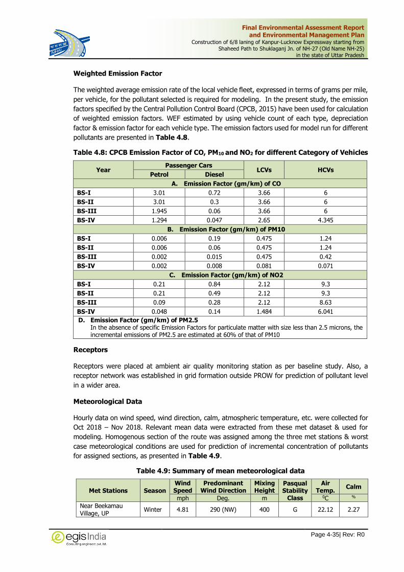
Final Environmental Assessment Report and Environmental Management Plan
Construction of 6/8 laning of Kanpur-Lucknow Expressway starting from Shaheed Path to Shuklaganj Jn. of NH-27 (Old Name NH-25)
in the state of Uttar Pradesh
Page 4-35| Rev: R0
Weighted Emission Factor
The weighted average emission rate of the local vehicle fleet, expressed in terms of grams per mile,
per vehicle, for the pollutant selected is required for modeling. In the present study, the emission
factors specified by the Central Pollution Control Board (CPCB, 2015) have been used for calculation
of weighted emission factors. WEF estimated by using vehicle count of each type, depreciation
factor & emission factor for each vehicle type. The emission factors used for model run for different
pollutants are presented in Table 4.8.
Table 4.8: CPCB Emission Factor of CO, PM10 and NO2 for different Category of Vehicles
Year Passenger Cars
LCVs HCVs Petrol Diesel
A. Emission Factor (gm/km) of CO
BS-I 3.01 0.72 3.66 6
BS-II 3.01 0.3 3.66 6
BS-III 1.945 0.06 3.66 6
BS-IV 1.294 0.047 2.65 4.345
B. Emission Factor (gm/km) of PM10
BS-I 0.006 0.19 0.475 1.24
BS-II 0.006 0.06 0.475 1.24
BS-III 0.002 0.015 0.475 0.42
BS-IV 0.002 0.008 0.081 0.071
C. Emission Factor (gm/km) of NO2
BS-I 0.21 0.84 2.12 9.3
BS-II 0.21 0.49 2.12 9.3
BS-III 0.09 0.28 2.12 8.63
BS-IV 0.048 0.14 1.484 6.041
D. Emission Factor (gm/km) of PM2.5 In the absence of specific Emission Factors for particulate matter with size less than 2.5 microns, the incremental emissions of PM2.5 are estimated at 60% of that of PM10
Receptors
Receptors were placed at ambient air quality monitoring station as per baseline study. Also, a
receptor network was established in grid formation outside PROW for prediction of pollutant level
in a wider area.
Meteorological Data
Hourly data on wind speed, wind direction, calm, atmospheric temperature, etc. were collected for
Oct 2018 – Nov 2018. Relevant mean data were extracted from these met dataset & used for
modeling. Homogenous section of the route was assigned among the three met stations & worst
case meteorological conditions are used for prediction of incremental concentration of pollutants
for assigned sections, as presented in Table 4.9.
Table 4.9: Summary of mean meteorological data
Met Stations Season Wind Speed
Predominant Wind Direction
Mixing Height
Pasqual Stability
Class
Air Temp.
Calm
mph Deg. m 0C %
Near Beekamau Village, UP
Winter 4.81 290 (NW) 400 G 22.12 2.27

Final Environmental Assessment Report and Environmental Management Plan
Construction of 6/8 laning of Kanpur-Lucknow Expressway starting from Shaheed Path to Shuklaganj Jn. of NH-27 (Old Name NH-25)
in the state of Uttar Pradesh
Page 4-36| Rev: R0
4.5.1.1 Prediction of Air Pollution Levels
The line source air emission predictions were made for hourly traffic conditions near each ambient
air monitoring station. The maximum baseline concentration values recorded were used for
estimation of the cumulative concentration values. Predictive modeling for all 4 homogeneous
sections was run for 2020, 2025, 2030, 2035, 2040 & 2045. The following assumptions are made
in prediction of pollution levels - There are no major grade differences in the project area and
terrain is plain and Contribution to pollution levels from any other future activities have not been
considered in the modeling. The year wise predicted worst-case incremental concentrations and
cumulative concentrations of pollutants are presented in Table 4.10.

Final Environmental Assessment Report and Environmental Management Plan
Construction of 6/8 laning of Kanpur-Lucknow Expressway starting from Shaheed Path to Shuklaganj Jn. of NH-27 (Old Name NH-25)
in the state of Uttar Pradesh
Page 4-37| Rev: R0
Table 4.10: Projected Air Pollutants Concentration at Different Locations along Project Corridor
S.
No Station
Carbon Monooxide (CO) (1-hour mg/m3)
Particulate Matter <10µm (PM10 ) (24-hours µg/m3)
Particulate Matter <2.5µm (PM2.5) (24-hours µg/m3)
Nitrogen dioxide (NO2) (24-hours µg/m3)
Baseline
Conc.
(Max.)
Predicted
Incremental
Conc.
Predicted
Cummulative
Conc.
Baseline
Conc.
(Max.)
Predicted
Incremental
Conc.
Predicted
Cummulative
Conc.
Baseline
Conc.
(Max.)
Predicted
Incremental
Conc.
Predicted
Cummulative
Conc.
Baseline
Conc.
(Max.)
Predicted
Incremental
Conc.
Predicted
Cummulative
Conc.
Predicted Pollutant Concentrations – Year 2020
1 AQ1 0.89 0.8 1.69 124 0 124 68 0 68 34.6 0 34.6
2 AQ2 0.62 0.8 1.42 92 0 92 47 0 47 26.7 0 26.7
3 AQ3 0.62 0.8 1.42 106 0.1 106.1 63 0.05 63.05 28.6 0 28.6
4 AQ4 0.72 0.8 1.52 116 2.5 118.5 64 1.36 65.36 29.3 0 29.3
Predicted Pollutant Concentrations – Year 2025
1 AQ1 0.89 0.8 1.69 124 0.00 124 68 0.00 68 34.6 0.00 34.6
2 AQ2 0.62 0.8 1.42 92 0.00 92 47 0.00 47 26.7 0.00 26.7
3 AQ3 0.62 0.8 1.42 106 0.10 106.1 63 0.05 63.05 28.6 0.00 28.6
4 AQ4 0.72 0.8 1.52 116 3.60 119.6 64 1.96 65.96 29.3 0.00 29.3
Predicted Pollutant Concentrations – Year 2030
1 AQ1 0.89 0.8 1.69 124 0.00 124 68 0.00 68 34.6 0.00 34.6
2 AQ2 0.62 0.8 1.42 92 0.00 92 47 0.00 47 26.7 0.00 26.7
3 AQ3 0.62 0.9 1.52 106 0.10 106.1 63 0.05 63.05 28.6 0.00 28.6
4 AQ4 0.72 0.9 1.62 116 5.20 121.2 64 2.84 66.84 29.3 0.00 29.3
Predicted Pollutant Concentrations – Year 2035
1 AQ1 0.89 0.8 1.69 124 0.00 124 68 0.00 34.6 0.00 34.6
2 AQ2 0.62 0.8 1.42 92 0.00 92 47 0.00 26.7 0.00 26.7
3 AQ3 0.62 0.9 1.52 106 0.10 106.1 63 0.05 28.6 0.00 28.6
4 AQ4 0.72 0.9 1.62 116 7.00 123 64 3.82 29.3 0.00 29.3

Final Environmental Assessment Report and Environmental Management Plan
Construction of 6/8 laning of Kanpur-Lucknow Expressway starting from Shaheed Path to Shuklaganj Jn. of NH-27 (Old Name NH-25)
in the state of Uttar Pradesh
Page 4-38| Rev: R0
S.
No Station
Carbon Monooxide (CO) (1-hour mg/m3)
Particulate Matter <10µm (PM10 ) (24-hours µg/m3)
Particulate Matter <2.5µm (PM2.5) (24-hours µg/m3)
Nitrogen dioxide (NO2) (24-hours µg/m3)
Baseline
Conc.
(Max.)
Predicted
Incremental
Conc.
Predicted
Cummulative
Conc.
Baseline
Conc.
(Max.)
Predicted
Incremental
Conc.
Predicted
Cummulative
Conc.
Baseline
Conc.
(Max.)
Predicted
Incremental
Conc.
Predicted
Cummulative
Conc.
Baseline
Conc.
(Max.)
Predicted
Incremental
Conc.
Predicted
Cummulative
Conc.
Predicted Pollutant Concentrations – Year 2040
1 AQ1 0.89 0.8 1.69 124 0.00 124 68 0.00 68 34.6 0.00 34.6
2 AQ2 0.62 0.8 1.42 92 0.00 92 47 0.00 47 26.7 0.00 26.7
3 AQ3 0.62 1.0 1.62 106 0.20 106.2 63 0.11 63.11 28.6 0.00 28.6
4 AQ4 0.72 1.0 1.72 116 10.40 126.4 64 5.67 69.67 29.3 0.01 29.31
Predicted Pollutant Concentrations – Year 2045
1 AQ1 0.89 0.8 1.69 124 0.00 124 68 0.00 68 34.6 0.00 34.6
2 AQ2 0.62 0.8 1.42 92 0.00 92 47 0.00 47 26.7 0.00 26.7
3 AQ3 0.62 1.0 1.62 106 0.20 106.2 63 0.11 63.11 28.6 0.00 28.6
4 AQ4 0.72 1.0 1.72 116 14.30 130.3 64 7.80 71.8 29.3 0.01 29.31
NAAQ
Standards 4 mg/m3 100 µg/m3 60 µg/m3 80 µg/m3
Final Environmental Assessment Report and Environmental Management Plan
Construction of 6/8 laning of Kanpur-Lucknow Expressway starting from Shaheed Path to Shuklaganj Jn. of NH-27 (Old Name NH-25)
in the state of Uttar Pradesh
Page 4-39| Rev: R0
4.5.1.2 Interpretation of Results
The above results are calculated under worst-case conditions of traffic, emission rates, meteorology
and baseline monitoring data. The actual incremental concentrations, under standard conditions,
shall be lower than the predicted concentrations levels. Contribution of other future activities to
pollution levels have not been considered in the modelling. However, with newer technologies,
better engines, and better fuel availability and by imposing stringent emission norms, the lower
incremental concentration levels may be achieved.
The worst-case cumulative concentrations for CO and NO2 for all forecasted years at all 4
monitoring locations are within the prescribed NAAQ standards.
The worst-case cumulative concentration for PM10 and PM2.5 for all forecasted years at all 4
monitoring locations exceeded the prescribed NAAQ standards. The reason for this is high
baseline concentration levels.
4.5.1.3 Recommendations
It is recommended that as per the traffic survey & the measured road widths along the entire
transportation route, there is no need for widening as the current road is having sufficient carrying
capacity to accommodate the additional traffic. The vehicles used for transportation of rejects
should be covered with tarpaulin, be spill proof, have their PUC certificates, be well maintained and
the drivers sensitized to their specific work to minimize accidents and pollution.
No settlement of people, sensitive receptors or recreational areas should be established /
planned in close proximity of road.
During night time, special pollution protection mask shall be provided to workers working close
to the project road during operation phase. Necessary arrangements for medical attention
should be in place for emergencies.
Thick plantation should be carried out along the road.
Vehicle speed limits should be enforced strictly.
Stringent vehicular emission norms shall be applied on all categories of vehicles, especially
heavy vehicles to contain emission from vehicle exhausts.
Regular maintenance of vehicle shall be carried and periodically checked for violation emission
norms.
4.5.2 Impacts on Water Quality and Resources
During the operation phase, the possibility of degradation of water quality is very remote. The
impact on the surface water quality during operation can be expected due to accidental spillage.
However, the probability of such accidents is minimal since utmost care has been taken for the
enhancement of road safety measures and other safety related facilities are taken care of in the
design stage. Periodic monitoring of water quality will be done at selective location of proposed
project.
4.5.3 Waste Water Management (During Operation)
The proposed project is expressway development therefore waste water shall mainly be generated
from the wayside amenities such as rest area wherein restaurants shall operate. It will be
responsibility of those business establishments to manage their waste water. The estimated waste
water generated and its treatment is provided under Table 4.11.

Final Environmental Assessment Report and Environmental Management Plan
Construction of 6/8 laning of Kanpur-Lucknow Expressway starting from Shaheed Path to Shuklaganj Jn. of NH-27 (Old Name NH-25)
in the state of Uttar Pradesh
Page 4-40| Rev: R0
Table 4.11: Waste Water and its Treatment (Operation stage)
Type / Source
Quantity of Waste Water
Generated (KLD)
Treatment Capacity
(KLD)
Treatment Method
Mode of Disposal
Quantity of Treated
Water Used in Recycling/ Reuse (KLD)
Quantity of Discharged
Water (KLD)
Washing facility, toilet and urinals
3 3 Septic tank with soak
pits
Biological Decomposition and reuse for Tree Watering
3 0
4.5.4 Impact on Noise Quality
To understand the impact on noise environment due to the proposed project at different locations
along the project alignment, future prediction has been made with the application of mathematical
modeling.
4.5.4.1 Prediction of Traffic Noise Levels
For future predicting the noise levels The Federal Highway Administration Traffic Noise Model
(FHWA TNM) has been used.
The Federal Highway Administration Traffic Noise Model (FHWA TNM) computes a predicted noise
level through a series of adjustments to a reference sound level. In the TNM, the reference level is
the Vehicle Noise Emission Level, which refers to the maximum sound level emitted by a vehicle
passing by at a reference distance of 15 meters (50 feet). Adjustments are then made to the
emission level to account for traffic flow, distance, and shielding. The vehicular noise emission
levels vary significantly with vehicle speed. The A-weighted noise emission levels as a function of
speed for autos (cars), medium trucks (LCV), heavy trucks (HCV) and buses under cruise conditions
and traveling over average pavement.
The vehicular noise emission levels vary significantly with vehicle speed. Figure 4.5 shows the A-
weighted noise emission levels as a function of speed for autos (cars), medium trucks (LCV), heavy
trucks (HCV) and buses under cruise conditions and traveling over average pavement.
For prediction of noise levels due to traffic on proposed project, the vehicular speeds used for
different class of vehicles are given in Table 4.12 and are taken in accordance to the design speed.
Table 4.12: Vehicular Speed and Noise Emission Levels used for Modelling
Vehicle Type Cars LCVs HCVs Buses
Vehicular Speed 120 km/hr 80 km/hr 80 km/hr 80 km/hr

Final Environmental Assessment Report and Environmental Management Plan
Construction of 6/8 laning of Kanpur-Lucknow Expressway starting from Shaheed Path to Shuklaganj Jn. of NH-27 (Old Name NH-25)
in the state of Uttar Pradesh
Page 4-41| Rev: R0
(Source – FHWA Traffic Noise Model ®, Version 1.0 Technical Manual)
Figure 4.5: A-Weighted Vehicle Noise Emission Levels
Road Geometry
The Right of Way (RoW) of proposed project is 90m. The project shall be developed into 6-lane
divided carriageway. For prediction of noise levels, a representative straight section of one-
kilometer length having RoW width of 90 m, 3+3 lane carriageway (7.5 m width both sides) was
taken in FHWA-TNM.
Receptors
The FHWA-TNM2.5 predicts A-weighted hourly equivalent noise levels at receptor points along the
road. The receptor points were fixed at ambient noise monitoring stations as per baseline study.
Table 4.13: Noise Receptor Locations
# Baseline Location Rcv # X Y
NQ1 Near Amausi Airport Bus Stop 1 79264 26167
NQ2 Near Beekamau Village 2 79305 25990
NQ3 Near Neverna Village 3 80374 25522
NQ4 Near Harbans Village 4 80548 25426
Assumptions used for Modeling
i. Noise Modelling has been done in worst case scenario i.e. with zero shielding from any other obstacle / trees / barrier etc.
ii. No significant change in the vehicle characteristics is considered during the design period;
iii. The representative section is considered as straight with zero gradient;
iv. The traffic along the road sections is assumed to flow simultaneously in both the carriageways in opposite directions;
v. Both carriageways are assumed to carry equal traffic;
Final Environmental Assessment Report and Environmental Management Plan
Construction of 6/8 laning of Kanpur-Lucknow Expressway starting from Shaheed Path to Shuklaganj Jn. of NH-27 (Old Name NH-25)
in the state of Uttar Pradesh
Page 4-42| Rev: R0
vi. There is no major grade difference in the project area. All the receptors are located at same ground level as the road section;
vii. Noise from other sources apart from traffic on proposed highway is not accounted for in the model; and
viii. The default ground type is considered as hard soil.
4.5.4.2 Predicted Noise Levels
The predicted hourly equivalent noise levels are logarithmically combined to calculate LDAY and
LNIGHT noise. The results noise modeling superimposed on baseline noise levels at ambient noise
monitoring locations for day and night times are presented in Table 4.14 to Table 4.21 below.

Final Environmental Assessment Report and Environmental Management Plan
Construction of 6/8 laning of Kanpur-Lucknow Expressway starting from Shaheed Path to Shuklaganj Jn. of NH-27 (Old Name NH-25)
in the state of Uttar Pradesh
Page 4-43| Rev: R0
Results at the edge of PROW
Table 4.14: Noise Modelling with Green Belt- at Edge of ROW
S. No. Chainage Land Use Leq
(Baseline)
Year 2020 2025 2030 2035 2040 2045
Pre Cum Pre Cum Pre Cum Pre Cum Pre Cum Pre Cum
Lday Results of Noise modelling without Green belt -at edge of ROW
NQ1 12.100 Commercial 64.6 57.5 65.4 58.5 65.6 59.1 65.7 60.7 66.1 61.8 66.4 63.1 66.9
NQ2 33.600 Residential 60.2 62.6 64.6 63.2 65.0 63.9 65.5 64.9 66.2 65.7 66.8 66.8 67.6
NQ3 58.400 Residential 50.1 54.8 56.1 57.3 58.1 58.1 58.7 59.1 59.6 60.5 60.9 61.4 61.7
NQ4 71.000 Residential 59.3 48.4 59.6 50.1 59.8 51.0 59.9 52.1 60.1 52.8 60.2 54.2 60.5
Lnight Results of Noise modelling without Green belt -at edge of ROW
NQ1 12.100 Commercial 49.4 44.7 50.7 46.0 51.9 47.4 53.2 48.6 54.5 49.9 55.8 51.2 57.1
NQ2 33.600 Residential 40.9 48.6 49.3 50.3 52.8 51.3 55.2 52.6 57.1 54.1 58.8 55.2 60.4
NQ3 58.400 Residential 40.0 43.3 44.9 44.8 47.9 46.0 50.1 46.9 51.8 47.9 53.3 49.1 54.7
NQ4 71.000 Residential 43.9 37.7 44.8 38.6 45.8 39.5 46.7 40.7 47.7 41.9 48.7 43.5 49.8
(Noise levels in db(A)
Table 4.15: Noise Modelling with Green Belt- at Edge of ROW
S. No. Chainage Land Use Ldn
2020 2025 2030 2035 2040 2045
Pre Cum Pre Cum Pre Cum Pre Cum Pre Cum Pre Cum
Lday Results of Noise modelling with Green belt- at edge of ROW
NQ1 12.100 Commercial 64.6 46.0 64.7 46.8 64.7 47.3 64.7 48.6 64.7 49.4 64.7 50.5 64.8
NQ2 33.600 Residential 60.2 50.1 60.6 50.6 60.6 51.1 60.7 51.9 60.8 52.6 60.9 53.4 61.0
NQ3 58.400 Residential 50.1 43.8 51.0 45.8 51.5 46.5 51.7 47.3 51.9 48.4 52.3 49.1 52.6
NQ4 71.000 Residential 59.3 38.7 59.3 40.1 59.4 40.8 59.4 41.7 59.4 42.2 59.4 43.4 59.4
Lnight Results of Noise modelling with Green belt -at edge of ROW
NQ1 12.100 Commercial 49.4 35.8 49.6 36.8 49.8 37.9 50.1 38.9 50.4 39.9 50.8 41.0 51.2
NQ2 33.600 Residential 40.9 38.9 43.0 40.2 44.9 41.0 46.4 42.1 47.7 43.3 49.1 44.2 50.3
NQ3 58.400 Residential 40.0 34.6 41.1 35.8 42.2 36.8 43.3 37.5 44.3 38.3 45.3 39.3 46.3
NQ4 71.000 Residential 43.9 30.2 44.1 30.9 44.3 31.6 44.5 32.6 44.8 33.5 45.1 34.8 45.5
(Noise levels in db(A)

Final Environmental Assessment Report and Environmental Management Plan
Construction of 6/8 laning of Kanpur-Lucknow Expressway starting from Shaheed Path to Shuklaganj Jn. of NH-27 (Old Name NH-25)
in the state of Uttar Pradesh
Page 4-44| Rev: R0
Results for 100 m
Table 4.16: Noise Modelling without Green Belt -at 100 m
S. No. Leq Day
2020 2025 2030 2035 2040 2045
Pre Cum Pre Cum Pre Cum Pre Cum Pre Cum Pre Cum
Lday Results of Noise modelling without Green belt -at 100 m
NQ1 64.6 52.1 64.8 53.0 64.9 53.7 64.9 55.2 65.1 56.4 65.2 57.6 65.4
NQ2 60.2 57.1 61.9 57.8 62.2 58.5 62.4 59.4 62.8 60.3 63.2 61.3 63.8
NQ3 50.1 49.4 52.8 51.9 54.1 52.6 54.5 53.7 55.2 55.0 56.2 56.0 57.0
NQ4 59.3 42.9 59.4 44.6 59.4 45.6 59.5 46.6 59.5 47.4 59.6 48.7 59.7
Lnight Results of Noise modelling without Green belt -at 100 m
NQ1 49.4 39.3 49.8 40.5 50.3 41.9 50.9 43.2 51.6 44.4 52.3 45.8 53.2
NQ2 40.9 43.2 45.2 44.8 48.0 45.9 50.1 47.1 51.9 48.6 53.6 49.8 55.1
NQ3 40.0 37.8 42.0 39.4 43.9 40.5 45.6 41.5 47.0 42.4 48.3 43.7 49.6
NQ4 43.9 32.2 44.2 33.2 44.5 34.0 44.9 35.3 45.3 36.4 45.9 38.0 46.5
Table 4.17: Noise Modelling with Green Belt- at 100 m
S. No. Leq Day 2020 2025 2030 2035 2040 2045
Pre Cum Pre Cum Pre Cum Pre Cum Pre Cum Pre Cum
Lday Results of Noise modelling with Green belt- at 100 m
NQ1 64.6 41.7 64.6 42.4 64.6 43.0 64.6 44.2 64.6 45.1 64.6 46.1 64.7
NQ2 60.2 45.7 60.4 46.2 60.4 46.8 60.4 47.5 60.4 48.2 60.5 49.0 60.5
NQ3 50.1 39.5 50.5 41.5 50.7 42.1 50.7 43.0 50.9 44.0 51.1 44.8 51.2
NQ4 59.3 34.3 59.3 35.7 59.3 36.5 59.3 37.3 59.3 37.9 59.3 39.0 59.3
Lnight Results of Noise modelling with Green belt -at 100 m
NQ1 49.4 31.4 49.5 32.4 49.6 33.5 49.7 34.6 49.8 35.5 50.0 36.6 50.1
NQ2 40.9 34.6 41.8 35.8 42.8 36.7 43.7 37.7 44.7 38.9 45.7 39.8 46.7
NQ3 40.0 30.2 40.4 31.5 41.0 32.4 41.5 33.2 42.1 33.9 42.7 35.0 43.4
NQ4 43.9 25.8 44.0 26.6 44.0 27.2 44.1 28.2 44.2 29.1 44.4 30.4 44.5
(Noise levels in db(A)

Final Environmental Assessment Report and Environmental Management Plan
Construction of 6/8 laning of Kanpur-Lucknow Expressway starting from Shaheed Path to Shuklaganj Jn. of NH-27 (Old Name NH-25)
in the state of Uttar Pradesh
Page 4-45| Rev: R0
Results for 200 m
Table 4.18: Noise Modelling without Green Belt -at 200 m
S. No. Leq Day
2020 2025 2030 2035 2040 2045
Pre Cum Pre Cum Pre Cum Pre Cum Pre Cum Pre Cum
Lday Results of Noise modelling without Green belt -at 200 m
NQ1 64.6 45.8 64.7 46.7 64.7 47.4 64.7 48.9 64.7 50.1 64.8 51.3 64.8
NQ2 60.2 50.8 60.7 51.5 60.7 52.2 60.8 53.1 61.0 54.0 61.1 55.0 61.4
NQ3 50.1 43.1 50.9 45.6 51.4 46.3 51.6 47.4 52.0 48.7 52.5 49.7 52.9
NQ4 59.3 36.6 59.3 38.3 59.3 39.3 59.3 40.3 59.4 41.1 59.4 42.4 59.4
Lnight Results of Noise modelling without Green belt -at 200 m
NQ1 49.4 33.0 49.5 34.2 49.6 35.6 49.8 36.9 50.0 38.1 50.3 39.5 50.6
NQ2 40.9 36.9 42.3 38.5 43.9 39.6 45.2 40.8 46.6 42.3 48.0 43.5 49.3
NQ3 40.0 31.5 40.6 33.1 41.3 34.2 42.1 35.2 42.9 36.1 43.7 37.4 44.6
NQ4 43.9 25.9 44.0 26.9 44.1 27.7 44.2 29.0 44.3 30.1 44.4 31.7 44.7
Table 4.19: Noise Modelling with Green Belt- at 200 m
S. No. Leq Day
2020 2025 2030 2035 2040 2045
Pre Cum Pre Cum Pre Cum Pre Cum Pre Cum Pre Cum
Table 6c – Lday Results of Lday Results of Noise modelling with Green belt- at 200 m
NQ1 64.6 36.6 64.6 37.4 64.6 37.9 64.6 39.1 64.6 40.1 64.6 41.0 64.6
NQ2 60.2 40.6 60.2 41.2 60.3 41.8 60.3 42.5 60.3 43.2 60.3 44.0 60.3
NQ3 50.1 34.5 50.2 36.5 50.3 37.0 50.3 37.9 50.4 39.0 50.4 39.8 50.5
NQ4 59.3 29.3 59.3 30.6 59.3 31.4 59.3 32.2 59.3 32.9 59.3 33.9 59.3
Lnight Results of Noise modelling with Green belt -at 200 m
NQ1 49.4 26.4 49.4 27.4 49.4 28.5 49.5 29.5 49.5 30.5 49.6 31.6 49.6
NQ2 40.9 29.5 41.2 30.8 41.6 31.7 42.0 32.6 42.5 33.8 43.0 34.8 43.6
NQ3 40.0 25.2 40.1 26.5 40.3 27.4 40.5 28.2 40.8 28.9 41.1 29.9 41.4
NQ4 43.9 20.7 43.9 21.5 43.9 22.2 44.0 23.2 44.0 24.1 44.1 25.4 44.1
(Noise levels in db(A)

Final Environmental Assessment Report and Environmental Management Plan
Construction of 6/8 laning of Kanpur-Lucknow Expressway starting from Shaheed Path to Shuklaganj Jn. of NH-27 (Old Name NH-25)
in the state of Uttar Pradesh
Page 4-46| Rev: R0
Results for 300 m
Table 4.20: Lday Results of Noise modelling without Green belt -at 300 m
S. No. Leq Day
2020 2025 2030 2035 2040 2045
Pre Cum Pre Cum Pre Cum Pre Cum Pre Cum Pre Cum
Lday Results of Noise modelling without Green belt -at 300 m
NQ1 64.6 42.1 64.6 43.1 64.6 43.7 64.6 45.3 64.7 46.4 64.7 47.7 64.7
NQ2 60.2 47.1 60.4 47.8 60.4 48.5 60.5 49.5 60.6 50.3 60.6 51.3 60.7
NQ3 50.1 39.4 50.5 41.9 50.7 42.6 50.8 43.7 51.0 45.0 51.3 46.0 51.5
NQ4 59.3 33.0 59.3 34.7 59.3 35.6 59.3 36.6 59.3 37.4 59.3 38.7 59.3
Lnight Results of Noise modelling without Green belt -at 300 m
NQ1 49.4 29.3 49.4 30.6 49.5 31.9 49.6 33.2 49.7 34.4 49.8 35.8 50.0
NQ2 40.9 33.2 41.6 34.9 42.4 35.9 43.3 37.2 44.2 38.6 45.3 39.8 46.4
NQ3 40.0 27.8 40.3 29.4 40.6 30.6 41.0 31.5 41.5 32.4 42.0 33.7 42.6
NQ4 43.9 22.3 43.9 23.2 44.0 24.0 44.0 25.3 44.1 26.5 44.1 28.0 44.2
(Noise levels in db(A)
Table 4.21: Lday Results of Noise modelling with Green belt- at 300 m
S. No. Leq Day
2020 2025 2030 2035 2040 2045
Pre Cum Pre Cum Pre Cum Pre Cum Pre Cum Pre Cum
Lday Results of Noise modelling with Green belt- at 300 m
NQ1 64.6 33.7 64.6 34.5 64.6 35.0 64.6 36.2 64.6 37.1 64.6 38.2 64.6
NQ2 60.2 37.7 60.2 38.2 60.2 38.8 60.2 39.6 60.2 40.2 60.2 41.0 60.3
NQ3 50.1 31.5 50.2 33.5 50.2 34.1 50.2 35.0 50.2 36.0 50.3 36.8 50.3
NQ4 59.3 26.4 59.3 27.8 59.3 28.5 59.3 29.3 59.3 29.9 59.3 31.0 59.3
Lnight Results of Noise modelling with Green belt -at 300 m
NQ1 49.4 23.4 49.4 24.5 49.4 25.5 49.4 26.6 49.5 27.5 49.5 28.6 49.5
NQ2 40.9 26.6 41.1 27.9 41.3 28.7 41.5 29.8 41.8 30.9 42.1 31.8 42.5
NQ3 40.0 22.2 40.1 23.5 40.2 24.5 40.3 25.2 40.4 25.9 40.6 27.0 40.8
NQ4 43.9 17.8 43.9 18.6 43.9 19.2 43.9 20.2 44.0 21.2 44.0 22.4 44.0
(Noise levels in db(A)

Final Environmental Assessment Report and Environmental Management Plan
Construction of 6/8 laning of Kanpur-Lucknow Expressway starting from Shaheed Path to Shuklaganj Jn. of NH-27 (Old Name NH-25)
in the state of Uttar Pradesh
Page 4-47| Rev: R0
4.5.4.3 Interpretation of Results
i. The maximum noise levels predicted in year 2045 at Beekamau Village. The noise level
increase in 25 years’ design period is not significant when proper green belt/barrier is in
place, in comparison to more than four times increase in traffic volume.
ii. The maximum sound levels for all projection years were observed near the edges of
proposed ROW. These levels decrease as the distance increases. Consider shielding effect
during modelling and the real time noise levels are lower due to dissipation of sound
energy.
iii. The results imply that there may be consistently high noise levels throughout the day and
night. Such consistent high level of noise may create nuisance in the residential and
sensitive land use areas and may damage hearing capacity of people living close to the
road.
iv. The predicted noise levels along the project road are higher than prescribed noise levels
for commercial, residential and silence zones.
v. Assuming road corridor as an industrial stretch, the noise levels even up to year 2045 shall
remain compliant to the ambient noise quality levels. However, wherever the road corridor
is passing through settlement areas, the noise level will exceed the noise standards for
residential land use. Hence, mitigation measures should be carefully designed for both day
and night time exposure.
vi. However, it can be safely concluded that under actual conditions with shielding effect, the
noise level will be lower than predicted.
Proposed Mitigation Measures:
i. No settlement of people should be established within 300m distance from project road.
Bypasses / realignments shall be designed at least 300m away from existing/proposed
residential areas as per regional master plan.
ii. Noise barrier are recommended at all locations where residential and silence zone are falling
between 15m to 300m distance from the project road.
iii. Thick plantation of tall trees with dense foliage should be carried out along the road on
both sides to provide natural barrier to noise produced from highway.
iv. During operation phase, protective ear plugs shall be provided to workers working close to
the project road. Necessary arrangements for medical attention should be in place for
emergencies.
v. Vehicle speed limits should be enforced strictly as the noise levels tend to increase at higher
speeds.
vi. Regular maintenance of vehicle shall be carried and periodically checked for violation noise
level norms.
Provision of Noise Barrier:
Although all the settlement area has been avoided by adjusting the project alignment away from
settlement area, few of the village settlements are located within 500 m from the edge of the
proposed ROW. Keeping in view the predicted high noise levels along the project alignment, noise
Final Environmental Assessment Report and Environmental Management Plan
Construction of 6/8 laning of Kanpur-Lucknow Expressway starting from Shaheed Path to Shuklaganj Jn. of NH-27 (Old Name NH-25)
in the state of Uttar Pradesh
Page 4-48| Rev: R0
barriers will be proposed to be provided along the expressway in order to minimize the impacts on
high noise levels due to the traffic movement on the Expressway. The length of nearby settlement
areas has been calculated and proposed length of noise barriers is given in the following Table 4.22.
Table 4.22: List of Proposed Noise Barriers
Side Length (m)
Construction of noise barrier(s) all along the elevated corridor. Polycarbonate sheet of 6 mm thickness for a total height of 1.5 m (inclusive of crash barrier height) erected with the help of revetment to steel angle (ISA 80x80x10 mm) with a spacing of 1 m from angle to angle embedded up to a depth of 0.8 m into crash barrier.
16,000
Noise Barrier along the Villages falling near Greenfield alignment 2,900
Total 18,900
4.5.5 Human Use Values
Both land use and aesthetics are in fact, likely to improve due to afforestation and proper
landscaping. Proper engineering design like raising of embankment, provision of sufficient number
of culverts will ensure the reduction of the chances frequent road damages due to water logging
and runoff water during rains and landslide. The provision of parking space, way side amenities,
rest area, toilets and drinking water will also help in smooth and comfortable flow of traffic and
better acceptability of the project by the community.
4.5.6 Road Safety
The proposed Kanpur Lucknow Expressway is new 6-laned Expressway with design speed 120 Km/hr.
The road safety aspect has to be addressed adequately. As the road is fully access controlled, there
is no access throughout the project length so there will not be any exposing of the road to accident
hazards due to intermingling and obstruction to the Expressway traffic and also proper segregation
of the traffic with the provision of VUP, PUP, and CUP in those crossing areas. However careful
thoughts have been given for pedestrians, cattle’s, vehicles, at cross roads with the Expressway. With
the provision of systematic pedestrian and cattle crossings, traffic lighting system, bus shelters,
wayside amenities which have been integrated with the project, the safety of road users as well as
local public will definitely be enhanced to a great extent. The general objectives are for the
concessionaire to make the proposed Expressway as safe as possible for all users. The concessionaire
shall follow all relevant Indian publications on road safety, especially the IRC Expressway manual
2013.
A formalized safety audit procedure must be followed by the concessionaire during the detailed
design and during the Construction and post construction periods.
4.5.7 Conclusion
From the above discussions it can be clear that the project does not conflict with any significant
issues except for acquisition of land and properties, diversion of forest land, and tree cutting within
Row. These issues can be successfully resolved/mitigate through proper planning and
management. The adverse impacts envisaged due to the project during construction stage are
mostly increase in air pollution levels, dust generations, noise pollution and to some extent
interference with traffic movement due to diversions but are localized of short duration during the
construction period and are manageable with proper Mitigation Plan. The project, on the other
hand, shall yield positive impacts by virtue of better accessibility, better safety for road users and
local population, more economic opportunity, better health and education facility, etc.

Final Environmental Assessment Report and Environmental Management Plan
Construction of 6/8 laning of Kanpur-Lucknow Expressway starting from Shaheed Path to Shuklaganj Jn. of NH-27 (Old Name NH-25)
in the state of Uttar Pradesh
Page 5-1| Rev: R0
5 ANALYSIS OF ALTERNATIVES
5.1 Introduction
Sound and sustainable highway project involve the consideration of two types of alternatives.
One as alternative solutions to the transportation problem and other as alternative designs for a
selected project.
The first is an early planning period where general environmental impact from alternative
solutions to a road transportation problem are identified and compared, resulting in the selection
of an environmentally acceptable project option. This analysis should identify the preferred
solution to the transportation problem for which the planning activity was initiated. The second
stage is at the project design level, where the optimal or preferred project design is selected in
terms of alignment, grade, pavement treatment, median type etc.
In describing the project and its alternatives, four key characteristics of each proposed alternative
should be determined before a comparative analysis can be undertaken. The four characteristics
are
Spatial requirements
Natural resources (including productive land) consumption
Human resource benefits & costs (such as resettlement vs. better access to market) and;
Waste production during the construction and operation/maintenance periods
The analysis of alternatives has been carried out ‘with project’ and ‘without project’ scenarios in
terms of potential environmental impacts. Under Project, seven alternate alignments were studied
in order to minimize the ecological impacts such as avoidance of Nawabganj Wildlife Sanctuary
(notified PA), natural habitations and minimize the social impacts such as resettlement and
environmental impacts. Various factors were considering while studying the alignment which are
broadly grouped under main heads such as connectivity, geometrics, cost, economic benefits and
social and environmental impacts.
5.2 “With” and “Without” Project Scenario
The development of proposed expressway will not only help in development by providing a
connectivity to the National Capital Region, Delhi through “Agra-Lucknow Expressway” and
“Yamuna Expressway” but it will also provide smooth movement of traffic and linking with other
roads of the country. Keeping in view, the site conditions and the scope of development of the
area, the ‘With’ and ‘Without’ project scenarios has been compared for the lone existing
alignment and is represented in Table 5.1.
Table 5.1: ‘With’ and ‘Without’ Project Scenario
Component “With” Project Scenario “Without” Project Scenario
Carriageway The carriageway will be construct to 6-lane configuration with paved and earthen shoulders on either side. This will ensure seamless traffic flow
The Freight traffic will traverse through existing NH-27 area and further lead to traffic congestion.

Final Environmental Assessment Report and Environmental Management Plan
Construction of 6/8 laning of Kanpur-Lucknow Expressway starting from Shaheed Path to Shuklaganj Jn. of NH-27 (Old Name NH-25)
in the state of Uttar Pradesh
Page 5-2| Rev: R0
Component “With” Project Scenario “Without” Project Scenario
Traffic Congestion
The new road will be capable of ensuring uninterrupted free flow traffic. This will ensure the faster connectivity, free from long route trucks that do not need to enter just for passage. The environment parameters of the region will significantly improve besides saving in vehicle operating cost.
The heavy traffic will continue to move through the NH-27 thereby mixing with the city traffic and increase the traffic congestion.
Road Safety
There will be a decrease in the number of road accidents after development of the new expressway, as there will be adequate space for plying vehicles to cross and overtake. The city traffic will be separate with through commercial traffic and thereby ensure adequate safety to light city vehicles.
Mix of city traffic with through commercial traffic lead to traffic congestion in all arterial roads. This leads to many road accidents. As per the community consultation, many accidents are taking place on the existing road stretches due to mix traffic. With increase in traffic, the situation may worsen.
Environmental Quality
The free flow of traffic on the new highway will improve the environmental quality, as the emissions from the plying vehicles will reduce due to seamless flow. There will be temporary increase in dust and emissions during the construction phase only and is reversible.
Environmental quality will further deteriorate due to pollution and high emission from slow traffic movement and congestions. With increase in traffic, the pace of degradation of environment will only hasten.
Vegetation Cover
Removal of existing trees and vegetation within PROW will occur however the proposed avenue and median plantation (in 1:10 of scheduled tree cut) with healthy and new young trees throughout the project stretch will increase the vegetation
No felling of existing trees and vegetation. The old trees may become a safety hazard to the road users with passage of time.
Transportation Facilities
Free flow interchanges, VUPs/LVUPs, and truck lay byes proposed along the project road for convenience of people. Thus, the travel quality will drastically improve on the road conditions.
Bad travel quality.
Economic Development
Economic activities will automatically improve once the new road is developed around the Kanpur and Lucknow. It will also benefit farmers, as they will be able to sell their produce in distant markets due to improved transportation.
The economic activity will remain static and local and will improve only at a laggard pace.
Employment Opportunities
The proposed construction of project road will provide Economic Benefit due to direct and indirect Employment with permanent employment of approx. 700 person and temporary Employment (Skilled/ unskilled and Semi-skilled) of approx. 3,00,000 man days.
No such opportunity
Development Potential
There will be higher potential for development in this area due to improvement in access and consequent increase in economic activity. Essential community infrastructures like drainage system, water supply, electricity, transportation etc. will come as consequence of current development.
Development activity will be greatly hampered due to inadequate connectivity.
With the above comparison it can be concluded that “With” project scenario, positive/beneficial
impacts will greatly enhance social & economic development of the region and improve the
environment, when compared to the “Without” project scenario, which may further deteriorate
the existing environment and quality of life. Hence the “With” project scenario with some
reversible impacts is an acceptable option rather than “Without” project scenario. The
implementation of the project therefore will definitely be advantageous to improve the

Final Environmental Assessment Report and Environmental Management Plan
Construction of 6/8 laning of Kanpur-Lucknow Expressway starting from Shaheed Path to Shuklaganj Jn. of NH-27 (Old Name NH-25)
in the state of Uttar Pradesh
Page 5-3| Rev: R0
environmental quality of the sub-region besides to achieve an all-round development of the
economy and progress of the region.
There is little increase in the pollution levels during construction. Dust and particulate matter
during construction will affect the air quality on a short-term basis but will be temporary in
nature. The proposed project will also have impact due to forest diversion falling with in proposed
ROW, however the total benefits such increase in productivity attributable, benefit to economy,
employment and economic benefit due to compensatory afforestation is higher than the
estimated cost of Forest Diversion. The safety of road users as well as surrounding population will
enhance to great extent due to the project with provisions of service lane, pedestrian crossings,
cattle crossings, traffic lights, truck lay byes, bus shelters, etc. which are adequate in the present
scenario.
5.3 Alternative in terms of Technology and Site
5.3.1 Technology Used
The project has carried out the topographical survey based on the modern survey techniques
such as LIDAR survey and DGPS along existing roads and proposed expressway.
The pavement design of flexible pavement is also based on the latest IRC: 37-2012 as compare
to general pavement design in country by IRC: 37-2001 codes. The overlay design has been
carried out based on the procedure of IRC: 81-1997.
5.3.2 Analysis of Alternatives for Site (Selection of Alignment)
The existing NH-27 sees heavy traffic movement everyday as it connects the state capital
Lucknow with Kanpur, known as an industrial Centre. While selecting the alignment Two major
governing factors for selection are:
i. Connectivity to Airport at Lucknow “Amausi Airport”
ii. Connectivity to Delhi-Agra-Lucknow Expressway for a direct high speed connectivity to
Kanpur to New Delhi (National Capital Region)
Considering the future development and faster connectivity to both the cities, various strategies
have been considered for identification of optional alignment.
Strategy Description
A Improve the exiting NH-27 to Expressway Standard.
B Improve the existing geometry of NH-27 to Expressway Standard with bypass options for Unnao & Nawabganj.
C New alignment of Expressway is greenfield alignment.
Based on above strategies NHAI has identified 7 alternative alignments based on the pre-feasibility studies of proposed expressway.
The initial site and ground reconnaissance by the consultants revealed that by and large this
selected alignment is acceptable, except at some locations.
5.3.3 Methodology adopted for finalizing the alignments
Satellite Imaginaries, Topographical maps of Survey of India were studied to understand the
terrain, water bodies, forest areas and any major channel etc. at macro level. Besides, thematic

Final Environmental Assessment Report and Environmental Management Plan
Construction of 6/8 laning of Kanpur-Lucknow Expressway starting from Shaheed Path to Shuklaganj Jn. of NH-27 (Old Name NH-25)
in the state of Uttar Pradesh
Page 5-4| Rev: R0
maps relative to soils, land capability, drainage, relief etc. were also scanned to have better
appreciation of these factors. Reinforced with the generalized information from maps, site visits
were made to study the details at micro level. Site visits included thorough inspections of areas
on both sides of urban stretches covering the study of terrain, land uses, environmental sensitive
features and developmental activities.
The coordinates of the features were taken as control points by hand held GPS instrument.
These were marked on maps prepared on the basis of Satellite Imaginaries, topographical maps
and village maps. This was followed by another site visit by multidisciplinary team consisting of
Highway Engineer, Social Expert, Geotechnical Engineer and Environmental Expert to verify the
feasibility of these alternative alignments and to record impacts on natural environment (water
bodies/wet lands, rivers/water crossings, forests etc.), social environment (agricultural land,
intensity of development, resettlement problems etc.), cultural environment (archeological
properties, temples/shrines, mosques, funeral ground etc.). This process was repeated and
refinements made in alternative alignments.
Detailed information such as land use, type of soil, rock cutting, no. of trees, irrigation wells,
`utilities, stream crossings, structures, road crossings, details of pond etc. were collected
Preliminary discussions with local administration and local public were conducted to gather more
details on probable alignment options. Detailed topographical survey of proposed alignments
approved by the client has been carried out. It is quite likely that some adjustment in the
approved alignment might be necessitated due to site conditions during detailed topographical
survey and design.
5.3.4 Alignment Selection
Alignment selection was carried out on the basis of evaluation of various alternatives for the
proposed expressway. The improvement of the existing alignment was included as an alternative.
Both qualitatively and quantitatively evaluation has been done for various factors influencing the
selection process. These factors can be broadly grouped under main heads such as geometrics,
cost, economic benefits and social and environmental impacts. The qualitative evaluation rates
the alternative as less desirable, desirable, more desirable and most desirable against each factor.
Alignment has been proposed keeping in view the following objectives:
1. There is no funeral ground, mosque, temple or any religious places and water bodies coming
in the way of the proposed alignment.
2. Should avoid marshy ground, steep terrain, unsuitable hill features and areas subject to
severe climatic conditions, flooding and inundation
3. The length should be as short as possible
4. It should have minimum impact on the existing public utilities and settlements
5. It should not disturb the existing drainage system
6. The alignment should be devoid of sharp curves and it should have better shape.
7. The alignment should be located away from the existing built up area and should not conflict
with future planned development
8. It should connect important villages and towns

Final Environmental Assessment Report and Environmental Management Plan
Construction of 6/8 laning of Kanpur-Lucknow Expressway starting from Shaheed Path to Shuklaganj Jn. of NH-27 (Old Name NH-25)
in the state of Uttar Pradesh
Page 5-5| Rev: R0
9. Traffic capacity and safety should be optimized
10. The alignment should preserve environmental and maintain ecological balance.
11. The proposed alignment also discussed with various stakeholders, district level officers, and
NHAI. Seven options proposed and all options discussed with its merits and demerits. The
details are given in Figure 5.1.
Figure 5.1: Kanpur Lucknow Expressway Alternative Alignments
5.3.5 Description of each Alternatives
The proposed project has assessed 7 alternative alignments in order to minimize the ecological
impacts such avoidance of Nawabganj Wildlife Sanctuary (notified PA), natural habitations and
minimize the social impacts such as resettlement and environmental impacts. Various factors
were considering while studying the alignment which are broadly grouped under main heads such
as connectivity, geometrics, cost, economic benefits and social and environmental impacts. The
description of each alternative are as follow:

Final Environmental Assessment Report and Environmental Management Plan
Construction of 6/8 laning of Kanpur-Lucknow Expressway starting from Shaheed Path to Shuklaganj Jn. of NH-27 (Old Name NH-25)
in the state of Uttar Pradesh
Page 5-6| Rev: R0
5.3.5.1 Alternative Option-1: West Side of Existing NH-27
Figure 5.2: Option-1: West Side of Existing NH-27
Advantages Disadvantages
Better connectivity from west side traffic (Jhansi, Orai etc.)
Shortest route (51kms).
Will also connect NH 91 (Kanpur Aligarh Road)
Alignment is beyond 10 km from the Bird Sanctuary
ROB and Major bridge - one each only
Land Acquisition less compared to other options
Distance from AH 1 via Kanpur Ring road is maximum than other options.
Connectivity with Lucknow city traffic is poor
No saving in travel time for Lucknow Kanpur Traffic

Final Environmental Assessment Report and Environmental Management Plan
Construction of 6/8 laning of Kanpur-Lucknow Expressway starting from Shaheed Path to Shuklaganj Jn. of NH-27 (Old Name NH-25)
in the state of Uttar Pradesh
Page 5-7| Rev: R0
5.3.5.2 Alternative Option-2: Crossing near Unnao Town
Figure 5.3: Option-2: Crossing near Unnao Town
Advantages Disadvantages
Will connect the Unnao via existing NH.
Length is 55 km only.
Better connectivity for traffic from Unnao.
Suitable for Delhi - Varanasi traffic.
It will also connect Raebareli Road
Four NH / SH crossings
Connectivity with Lucknow city traffic is poor
No saving in travel time for Lucknow Kanpur Traffic

Final Environmental Assessment Report and Environmental Management Plan
Construction of 6/8 laning of Kanpur-Lucknow Expressway starting from Shaheed Path to Shuklaganj Jn. of NH-27 (Old Name NH-25)
in the state of Uttar Pradesh
Page 5-8| Rev: R0
5.3.5.3 Alternative Option-3: Crossing near Nawabgunj Town
Figure 5.4: Option-3: Crossing near Nawabganj
Advantages Disadvantages
It is Shorter Route than other options except
Option 1, Length is 54kms.
It will also connect Raebareli road
It can further be connected to Lucknow Airport
via existing NH
There are four NH / SH crossings
Connectivity with Lucknow Airport is poor
Passing within 10 km of Bird Sanctuary so
Wild Life Clearance will be required and will
take time
There is no distance or travel time saving for
Lucknow Kanpur Traffic

Final Environmental Assessment Report and Environmental Management Plan
Construction of 6/8 laning of Kanpur-Lucknow Expressway starting from Shaheed Path to Shuklaganj Jn. of NH-27 (Old Name NH-25)
in the state of Uttar Pradesh
Page 5-9| Rev: R0
5.3.5.4 Alternative Option-4: Crossing near Unnao and beyond Mohan
Figure 5.5: Option-4: Crossing near Unnao and beyond Mohan
Advantages Disadvantages
Alignment is better than option 2
Length is 65 km
It will connect the Unnao via existing NH
Better connectivity for traffic from Unnao.
Suitable for Delhi - Varanasi traffic
It will connect Raebareli Road also
There are four NH / SH crossings
Connectivity with Lucknow Airport is poor
There is no distance or travel time saving for Lucknow Kanpur Traffic

Final Environmental Assessment Report and Environmental Management Plan
Construction of 6/8 laning of Kanpur-Lucknow Expressway starting from Shaheed Path to Shuklaganj Jn. of NH-27 (Old Name NH-25)
in the state of Uttar Pradesh
Page 5-10| Rev: R0
5.3.5.5 Alternative Option-5: East Side of Existing NH (Variant 1)
Figure 5.6: Option-5: East Side of Existing NH (Variant 1)
Advantages Disadvantages
This option is suitable for long distance traffic i.e. Delhi – Varanasi traffic
It will connect Lucknow Airport via existing NH so connectivity for airport is good compare to the other options
It will also connect the Raebareli road.
Alignment length is less than Options 6 and 7. Length is 64 km.
There is only one major bridge
There are four NH / SH crossings
Travel time saving of 20-30 minutes for Lucknow Kanpur Traffic

Final Environmental Assessment Report and Environmental Management Plan
Construction of 6/8 laning of Kanpur-Lucknow Expressway starting from Shaheed Path to Shuklaganj Jn. of NH-27 (Old Name NH-25)
in the state of Uttar Pradesh
Page 5-11| Rev: R0
5.3.5.6 Alternative Option-6: East Side of Existing NH (Variant 2)
Figure 5.7: Option-6: East Side of Existing NH (Variant 2)
Advantages Disadvantages
Elevated section between proposed Lucknow Ring roads and Sai river.
There is travel time saving of 25-30 min
Spurs to NH 25 on Kanpur side will ease traffic within Kanpur.
Expressway will have alternative traffic dispersal points
Spur to Agra Expressway will provide alternative route on east side from traffic emerging from Lucknow
Airport traffic will be benefitted
Alignment Length (62 km) with elevated section; therefore, cost is high
Expressway is connected to NH 25 but no direct connection to proposed 6 lane road
High Land Acquisition cost

Final Environmental Assessment Report and Environmental Management Plan
Construction of 6/8 laning of Kanpur-Lucknow Expressway starting from Shaheed Path to Shuklaganj Jn. of NH-27 (Old Name NH-25)
in the state of Uttar Pradesh
Page 5-12| Rev: R0
5.3.5.7 Alternative Option-7: East Side of Existing NH (Variant 3)
Figure 5.8: Option-7: East Side of Existing NH (Variant 3)
Advantages Disadvantages
Elevated section between proposed Lucknow Ring roads and Sai river
There is travel time saving of 30-40 min
Spurs to NH 25 on Kanpur side will ease traffic within Kanpur. Expressway will have alternative traffic dispersal points
Connected with proposed 6 lane road (NH 91 bypass) towards Kanpur – benefit to more user
Spur to Agra Expressway will provide alternative route on east side from traffic emerging from Lucknow
Airport traffic will be benefitted
Alignment Length (63 km) with elevated section; therefore, cost is high
High Land Acquisition cost
All the 7 alternate alignments were compared in order to minimize the ecological impacts, natural
habitations and minimize the social impacts such as resettlement and environmental impacts.
Various factors were considering while studying the alignment which are broadly grouped under
main heads such as connectivity, geometrics, cost, economic benefits and social and
environmental impacts. A comparison of alternative option is as below:

Final Environmental Assessment Report and Environmental Management Plan
Construction of 6/8 laning of Kanpur-Lucknow Expressway starting from Shaheed Path to Shuklaganj Jn. of NH-27 (Old Name NH-25)
in the state of Uttar Pradesh
Page 5-13| Rev: R0
Table 5.2: Comparison of Alternative Options for Kanpur Lucknow Expressway
Components
Alternative Alignment Options
Alt-1 Alt-2 Alt-3 Alt-4 Alt-5 Alt-6 Alt-7
West side of existing NH
Crossing near Unnao
town
Crossing near
Nawabganj
Crossing near Unnao and
beyond Mohan
East side of Existing NH-27
(Variant 1) (Variant -2) (Variant 3)
Recommended
Length (km) 51 55 54 65 64 62 62.744
Geometry Good Good Good Very Good Average Average Good
Airport Connectivity
Average Average Average Average Good V Good Very Good
Length from AH-1 27 19 19 16 19 19 11
Length from NH 25 6 2 2 5 2 2 0
NH/SH crossing 3 4 3 4 4 4 4
ROB 1 2 2 2 2 1 1
Major Bridges 1 2 2 1 1 2 2
R & R Issue Minor Average Average Average Average Major Major
Dist. from PA (Km) >10 >10 <10 >10 >10 >10 >10
Forest (in ha.) 0.7 2.2 8.2 2.3 2.2 35.96 34.12 (87% of area is roadside PF)
Civil Cost (Crore) 2040 2200 2160 2600 2560 3145 3185
LA Cost 510 550 540 650 640 620 630
R & R Cost 51 55 54 65 64 62 63
Total Cost (Crore) 2601 2805 2754 3315 3264 3827 5235
Main Issue Connectivity with Lucknow city is very poor
Connectivity with Lucknow city is very poor
Passing near to WLS
Connectivity with Lucknow Airport is poor
Connectivity with Lucknow city is very poor
Expressway is connected to NH 27 but no direct connection to 6L road
Expressway is having better geometry and connectivity to Lucknow, Airport, AH-1 etc.
Assumptions: All the options have been compared with the following assumptions
Civil Cost Rs. 40 Cr. per km
LA cost Rs. 10 Cr per km (Rs 25 lakh per hectare, 100m ROW, 4 times Land cost as per govt. guidelines)
R&R cost 10-15% of the LA cost
Interchanges All NH/SH crossings, VUP/PUP: all cross roads
Further, Consultant has conducted walk through survey, and preliminary social and environment
impact study on the proposed alignment and the alignment has been firmed up to remove all
obstacles along the alignment.
5.4 Summary of Adverse Impact due to each alternative
A matrix has developed considering the Natural Environment, Biological Environment, Physical
Environment, Social Environment and Engineering details as the governing aspects. A scoring
criterion developed based on the attributes assigned to each aspect. The alignment options given

Final Environmental Assessment Report and Environmental Management Plan
Construction of 6/8 laning of Kanpur-Lucknow Expressway starting from Shaheed Path to Shuklaganj Jn. of NH-27 (Old Name NH-25)
in the state of Uttar Pradesh
Page 5-14| Rev: R0
in Table 5.3. The Matrix for individual aspects for all proposed options of alignment given in
Annexure 5.2. The summary score details are given in Table 4.1 below.
Table 5.3: Summary Details of Matrix
Scoring Criterion Total
Weight
Option- 1
Option- 2
Option-3
Option-4
Option-5
Option-6
Option-7
Score Score Score Score Score Score Score
Natural Environment 80 26 26 23 21 23 18 14
Biological Environment 80 13 10 15 17 10 12 9
Physical Environment 50 - - - - - - -
Social Environment 60 30 23 30 23 24 16 10
Engineering 130 94 97 100 93 91 84 82
Total 400 163 156 168 154 148 130 115
The Score criteria to illustrate impact category adopted are as below
Score out of 400 Score Limit (%) Impact Category
Less than 120 <30 Low
120 to 200 30 – 50 Medium
200 to 320 50-80 High
More than 320 >80 Very High
Based on above matrix, it is evident from the result that Option-7 is recommended to be taken
forward. Therefore, it is identified that alignment along existing NH-27 in Lucknow is having
better connectivity covering the engineering geometrical requirement in Alternative-7 whereas
other option does not provide a direct faster connectivity to the capital city of Lucknow. The
project will also bypass the Unnao and Nawabganj and therefore Alternative-7 is finalized by the
Hon’ble Dy. CM, Uttar Pradesh based on the traffic dispersal and to provide an alternative
connection, harmonized with the Lucknow Master plan, 2031 and development near Kanpur. The
alignment will also have taken less right of way for lesser mass displacement, ecological impact
and project cost. After detailed consideration, it was concluded that Option-7 alignment will be a
viable option from Engineering and economic point of view among the other options and have
minimum social and ecological impact thus Option-7 is recommended by NHAI (HO) Land
evaluation committee meeting and approved vide its letter no. NHAI/PIU/LKO/DPR Expressway/
2020/274 dated 09.06.2020
Salient Features of Recommended Alternative Option-7
New connectivity between Kanpur and Lucknow will comprise of new expressway in
greenfield, elevated section and improved at-grade existing highway. The details are given in
table below.
Start point will be on existing NH-27 at the junction of Shuklaganj road going towards Trans
Ganga.
End point is on NH-27 at junction with Shaheed Path T-Junction (near Amausi airport)
Total length from start to end point will be 62+755 km
Three Interchanges are proposed; (1) at start point with junction with existing NH-27 (2) at
junction with existing NH-27 and Lucknow Ring road (3) At Unnao - Rae Bareli (NH 31) road.

Final Environmental Assessment Report and Environmental Management Plan
Construction of 6/8 laning of Kanpur-Lucknow Expressway starting from Shaheed Path to Shuklaganj Jn. of NH-27 (Old Name NH-25)
in the state of Uttar Pradesh
Page 6-1| Rev: R0
6 ENVIRONMENTAL MONITORING PROGRAMME
Environmental monitoring provides an essential tool to make necessary recommendations and
adopt suitable control strategies so that the hazard of increasing environmental pollution load
could be minimized and a relief be extended to the people including labours in case of any
damage caused under occupational health hazards. The monitoring is necessary for the following
reasons:
To see what impacts have occurred
To evaluate the performance of mitigation measures proposed in the EMP
To ensure that the conditions of approval are adhered to;
To suggest improvements in management plan, if required
To see that benefits expected from the EA are achieved as the project proceeds.
To satisfy the legal and community obligations.
This chapter covers the technical aspects of monitoring the effectiveness of mitigation measures
(including measurement methodologies, data analysis, reporting schedules, emergency
procedures and budget).
6.1 Performance Indicators (PIS)
The physical, biological and social components, which are significant in affecting the environment
at critical locations, have been suggested as Performance Indicators. The following specific
environmental parameters can be qualitatively measured and compared over a period of time and
therefore selected as Performance Indicators for monitoring due to their regulatory importance
and the availability of standardized procedures and relevant expertise.
Environmental condition indicators to determine efficacy of environmental management
measures in control of air, noise, water and soil pollution and Plantation;
Environmental management indicators to determine compliance with the suggested
environmental management measures.
Operational performance indicators have also been devised to determine efficacy and utility of
the mitigation/enhancement designs proposed
6.2 Selection of Indicators for Monitoring
The environmental parameters that may be qualitatively and quantitatively measured and
compared over a period of time, due to their importance and the availability of standardized
procedures and expertise, have been selected as Performance Indicators (PIs). Physical,
biological and environmental management components identified as of particular significance in
affecting the environment at critical locations have been suggested as Performance Indicators.
The Performance Indicators shall be evaluated under three heads as:

Final Environmental Assessment Report and Environmental Management Plan
Construction of 6/8 laning of Kanpur-Lucknow Expressway starting from Shaheed Path to Shuklaganj Jn. of NH-27 (Old Name NH-25)
in the state of Uttar Pradesh
Page 6-2| Rev: R0
S. No. Performance indicators Description of Item Project Stage
1 Construction Facilities such as HMP, Batching Plant, Camp sites etc.
No. of locations identified for the construction camp and construction plant sites
No. of locations approved Lay-outs approved
No. of sites for which site restoration and rehabilitation has been completed
Pre-Construction
2 Public Safety and Workers Safety
PPE Kit ratio, No. of safety training No of Mock drills Barricading of excavated area and working
sites. Night time visibility etc.
3
Ambient Air Quality, Noise levels, Water Quality and Soil testing schedules and mitigation measures to avoid any exceed from permissible limits
Environmental parameter monitoring in accordance with the frequency and duration of monitoring as well as the locations as per the Monitoring Plan given in above table
Construction and Operation
4 Muck Disposal Sites
Quantity of debris and spoils to be disposed off
No. of locations finalized for Debris disposal
Quantity of debris and spoils disposed off No. of locations for which rehabilitation
works have been completed
Construction
5 Ecology Monitoring of Tree felling Survival Rate of Roadside Plantation &
Compensate Plantation
Construction and Operation
6 Borrow Area
No. of Borrow Areas identified and verified No. of sites for which restoration plans
have been prepared No. of Sites restored and rehabilitated No. of sites handed over
Construction and Operation
7 Quarries
No. of Quarry Areas identified and verified No. of sites for which restoration plans
have been prepared No. of sites restored and rehabilitated No. of sites handed over
Construction and Operation
For each of the environmental condition indicator, the monitoring plan specifies the parameters to
be monitored, location of the monitoring sites, frequency and duration of monitoring. The
monitoring plan also specifies the applicable standards, implementation and supervising
responsibilities.
6.3 Monitoring of Performance Indicators
6.3.1 Monitoring of Concessionaire / Contractor's Facilities, Plant and Equipment
All issues related to negative environmental impacts of the Concessionaire facilities; Plant and
equipment are to be controlled through:
The Concessionaire self-imposed quality assurance plan
Regular / periodic inspection of the Concessionaire plant and equipment Monthly
appraisal of the Concessionaire by IE/PIU-NHAI

Final Environmental Assessment Report and Environmental Management Plan
Construction of 6/8 laning of Kanpur-Lucknow Expressway starting from Shaheed Path to Shuklaganj Jn. of NH-27 (Old Name NH-25)
in the state of Uttar Pradesh
Page 6-3| Rev: R0
Reporting system: Other environmental impacts are to be regularly identified and noted
on the monthly appraisal inspection made to review all aspects of the Concessionaire
operation. The IE will also review the non-compliance and action taken report on non-
compliances noted in the previous review.
6.3.2 Ambient Air Quality (AAQ) Monitoring
Ambient air quality parameters which are recommended for monitoring of the development of
new expressway are Particulate Matter (Size less than 10 micron or PM10 g /m3), Particulate
Matter (Size less than 2.5 micron or PM2.5 g/m3), Sulphur Dioxide (SO2), Oxides of Nitrogen
(NOx) and Carbon Monoxide (CO). These parameters are to be monitored at selected locations
such as construction zones, plant and machinery sites, crusher sites, excavation works, etc.
starting from the commencement of construction activity. Data should be generated once in a
season at the selected monitoring locations in accordance with National Ambient Air Quality
(NAAQ) Standards 2009 through NABL accredited laboratory (Annexure-6.1. During operational
stage continuous ambient air quality monitoring system at toll plaza will be established with
display screen to record and display the real time data on ambient air quality as per NAAQS
standards (The online data will be connected and preserved with computer systems kept in
control room).
The Environmental Monitoring Programme has been detailed out in Table 6.1-Environmental
Monitoring Plan for Successful implementation of the Environmental Monitoring Program. The
Monitoring Consultant to request the Concessionaire / Contractor to submit the monitoring
schedule for approvals and commence all the initial tests for monitoring of air, water quality, soil
and noise levels early in the contract to establish the 'baseline' i.e. to assess the existing
conditions prior to effects from the Construction activities being felt.
6.3.3 Ambient Noise Monitoring
The measurement for monitoring the noise levels to be carried out at sensitive locations and at
construction and plants sites along the project alignment in accordance to the Ambient Noise
Standards formulated by Central Pollution Control Board (CPCB) (Annexure 6.2). Sound
pressure level would be monitored on twenty-four-hour basis. Noise shall be recorded at “A”
weighted frequency using digitized noise monitoring instrument.
6.3.4 Water Quality
Water quality of local water resources that is used by local community shall be monitored. The
physical and chemical parameters recommended for analysis of water quality relevant to road
project are pH, total solids, total suspended solids, total dissolved solids, COD, BOD, DO, Oil and
Grease, Chloride, Iron, etc. The monitoring of the water quality will be carried out at all locations
identified along the project alignment during construction and operation phase. Monitoring
parameters will be as per IS-10500-2012 (Annexure-6.3) for ground water quality and for
surface water quality as per CPCB Guidelines for used based surface water classification
(Annexure-6.4).
6.3.5 Soil Quality
The soil quality of the surround fields close to the construction site and plant site will be
monitored to understand the impact of soil quality. The physico-chemical parameters

Final Environmental Assessment Report and Environmental Management Plan
Construction of 6/8 laning of Kanpur-Lucknow Expressway starting from Shaheed Path to Shuklaganj Jn. of NH-27 (Old Name NH-25)
in the state of Uttar Pradesh
Page 6-4| Rev: R0
recommended for analysis are physical Parameter: Texture, Grain Size, Gravel, Sand, Silt, Clay;
Chemical Parameter: pH, Conductivity, Calcium, Magnesium, Sodium, Nitrogen, Absorption Ratio.
6.3.6 Tree Survival Rate
Roadside plantation of trees and their management will be an important environmental activity
for the management group. These activities will include selection of plant, development of
nurseries, protection of plant, interaction with roadside communities for plantation management
and their maintenance, etc.
To ensure the proper maintenance and monitoring of the compensatory/avenue plantation, a
regular maintenance and monitoring of the survival rate of the planted trees is being proposed up
to a period of 5 years from the operation of the project.
6.3.7 Monitoring of Earthworks Activities
Most of the environmental problems related to the construction works are anticipated to be
associated with the earthworks, particularly for the Quarries and Borrow Areas. The
concessionaire requires to maintain a detailed record of borrow area approvals, record of
available quantity and its use, record of environmental features with in borrow area and its
approaches etc. The guidelines and procedures adopted to minimize the environmental impacts of
opening, operating and closing of Quarries and Borrow areas are presented in EMP. Other
environmental effects associated with the earthworks include the development of adequate
temporary drainage to minimize detrimental effects (e.g. erosion) due to run-off, and safety
aspects related to Works implementation.
6.4 Environmental Monitoring Action Plan
The monitoring action plan covering various performance indicators, frequency and institutional
arrangements of the project in the construction and operation stages is given in Table 6.1.
6.5 Environmental Reporting System
Monitoring and evaluation are important activities in implementation of all projects. Monitoring
involves periodic checking to ascertain whether activities are going according to the plans. It
provides the necessary feedback for project management to keep the programme on schedule.
The reporting system will operate linearly with the Concessionaire, who will report to
Independent Engineer (IE), who will in turn report to the Project Implementation Unit (PIU). All
reporting by the Concessionaire and Independent Engineer shall be on monthly/quarterly/annual
basis. The ultimate responsibility and accountability for environmental safeguard rests with the
Project Proponent. The PIU shall be responsible for preparing targets for each of identified EMP
activities.
The compliance monitoring and the progress reports on environmental components may be
clubbed together and submitted to the PIU regularly during the implementation period. The
operation stage monitoring reports may be annual or biennial provided the project Environmental
Completion Report shows that the implementation was satisfactory. Otherwise, the operation
stage monitoring reports will have to be prepared as specified in the said project Environmental
Completion Report.

Final Environmental Assessment Report and Environmental Management Plan
Construction of 6/8 laning of Kanpur-Lucknow Expressway starting from Shaheed Path to Shuklaganj Jn. of NH-27 (Old Name NH-25)
in the state of Uttar Pradesh
Page 6-5| Rev: R0
6.6 Various Committees at Working
Project site management has to form various committees to implement the EMP smoothly. To
address and resolve the issues related to Safety, Health, Environment, mess, labour camp,
Employees grievances and public grievances. Concessionaire should constitute in-house
committees to monitor and record the meetings. The information about all these committees
must be displayed at strategic locations such as camp site, plant site etc. All the must be
informed during their induction training. These following suggestive committees will meet on
periodical basis:
a) HSE Committee
b) Grievance Committee
c) Emergency Response Team
d) POSH Committees
6.7 Emergency Procedures
Concessionaire will prepare Emergency Response Plans for all work sites as a part of the Safety
procedures. The plan shall integrate the emergency response plans of the contractor and all other
sub-contractors.
Each Emergency Response Plan shall detail the procedures, including detailed communications
arrangements, for dealing with all emergencies that could affect the site. This include where
applicable, injury, sickness, evacuation, fire, chemical spillage, severe weather and rescue.
Emergency plans and Fire Evacuation plans shall be prepared and issued. Mock drills shall be held
on a regular basis to ensure the effectiveness of the arrangements and as a part of the
programme, the telephone number of the local fire brigade should be prominently displayed near
each telephone on site
The Emergency Response Plan is prepared to deal with emergencies arising out of such as Fire
and Explosion, Road accidents, epidemic condition such as COVID, malaria etc.
6.8 Environmental Monitoring Detailed Budget
A separate budgetary provision for each package has been made for implementation of
Environmental Monitoring Plan. The environmental monitoring cost is estimated on the basis of
the length and existing environmental scenario of the proposed project. A budget allocation of Rs
82.20 lakhs has been proposed for against environmental monitoring during construction phase
(2.5 year) and Rs 309.1 lakh during operational phase of the proposed project. The details are
provided in Table 6.1 in the Chapter Environmental Management Plan.

Final Environmental Assessment Report and Environmental Management Plan
Construction of 6/8 laning of Kanpur-Lucknow Expressway starting from Shaheed Path to Shuklaganj Jn. of NH-27 (Old Name NH-25)
in the state of Uttar Pradesh
Page 6-6| Rev: R0
Table 6.1: Environmental Monitoring Plan
En
vir
on
me
nt
Co
mp
on
en
t
Pro
ject
Sta
ge
Monitoring Parameters Institutional Responsibilities
Parameters Standards Special
Guidance Locations Frequency Duration
Action Plan in
case criteria
exceeds
Implementation Supervision
Air
Co
nstr
ucti
on
PM10 g/m3,
PM2.5 g/m3,
SO2, NOx, CO
mg/m3, Fugitive
Emission from
Hot Mix Plant
National
Ambient Air
Quality
Standard
(CPCB, 18th
Nov, 2009)
The sampler to
be located 50m
from the plant in
downwind
direction. Use
Method
specified by
CPCB for
analysis
Batching Plant,
Hot mix Plant
and Stone
Crusher,
Total station
= 6 (3 in each
package)
Every fortnight
in each month
for all
Construction
years
Continuous
24 hours
(CO
monitoring
for 8 hr.)
Check and
modify control
device like bag
filter/ cyclones
of HMP
Contractor through
NABL approved
monitoring agency
IE & PIU-
NHAI
PM10 g /m3,
PM2.5 g /m3,
SO2, NOx, CO
mg/m3
The sampler to
be located
within 4m in
downward
direction. Use
Method
specified by
CPCB for
analysis
At 2 locations
provided in
baseline AQ
stations along
the project
alignment
consultation
with IE.
Total
locations:=4
(2 in each
package)
Moves with
progress of
construction
but not less
than monthly
during all
Construction
year
Continuous
24 hours
(CO
monitoring
for 8 hr.)
Regularity in
maintenance of
Vehicle and
their renewed
PUC
Certificates,
Water
Sprinkling, and
tarpaulin cover
during
transportation
of material.
Contractor through
NABL approved
monitoring agency
IE & PIU-
NHAI

Final Environmental Assessment Report and Environmental Management Plan
Construction of 6/8 laning of Kanpur-Lucknow Expressway starting from Shaheed Path to Shuklaganj Jn. of NH-27 (Old Name NH-25)
in the state of Uttar Pradesh
Page 6-7| Rev: R0
En
vir
on
me
nt
Co
mp
on
en
t
Pro
ject
Sta
ge
Monitoring Parameters Institutional Responsibilities
Parameters Standards Special
Guidance Locations Frequency Duration
Action Plan in
case criteria
exceeds
Implementation Supervision
Op
era
tio
n
PM10 g /m3,
PM2.5 g /m3,
SO2, NOx, CO
mg/m3
The calibration
procedures for
analyzers shall
conform to US
EPA
methodologies
and shall include
calibration
checks.
At 2 locations provided in baseline AQ stations along the project alignment consultation with IC. Total locations:=2 (In Package-1)
Once in a season for 5 years
Continuous
24 hours
(CO
monitoring
for 8 hr.)
Regularity in
maintenance of
Vehicle and
their renewed
PUC
Certificates,
Water
Sprinkling, and
tarpaulin cover
during
transportation
of material.
Contractor through
NABL approved
monitoring agency
PIU-NHAI
PM10 g /m3,
PM2.5 g /m3,
SO2, NOx, CO
mg/m3
The calibration
procedures for
analyzers shall
conform to US
EPA
methodologies
and shall include
calibration
checks.
At the proposed toll plaza location (Km 35+000) Total Location: 1 (In Package-2)
Daily (Real time monitoring) through establishment of Continuous ambient air quality monitoring system (CAAQMS) till concession
Continuous
24 hours
NHAI through
approved
monitoring agency
by Continuous
ambient air quality
monitoring system
(CAAQMS)
PIU-NHAI

Final Environmental Assessment Report and Environmental Management Plan
Construction of 6/8 laning of Kanpur-Lucknow Expressway starting from Shaheed Path to Shuklaganj Jn. of NH-27 (Old Name NH-25)
in the state of Uttar Pradesh
Page 6-8| Rev: R0
En
vir
on
me
nt
Co
mp
on
en
t
Pro
ject
Sta
ge
Monitoring Parameters Institutional Responsibilities
Parameters Standards Special
Guidance Locations Frequency Duration
Action Plan in
case criteria
exceeds
Implementation Supervision
Su
rfa
ce
Wate
r Q
ua
lity
Co
nstr
ucti
on
pH,
temperature,
DO, BOD, COD,
Oil & Grease,
Total
Suspended
Solid, turbidity,
Total Hardness,
Chlorine, Iron,
Total Coliform.
Surface Water
Quality
Standard as
per used
based
classification
for Surface
Water as per
CPCB
Guidelines.
(Ref IS:
10500, 2012)
Grab Sample
collected from
source and
analyze as per
standard
methods for
examination of
water and waste
water.
1 location at labor Camp, 1 at HMP, 2 locations as per baseline SW stations or as directed by IE Total location: 8 (4 in each package)
Once in Season for all Construction years
Grab
Sampling
Check and
modify petrol
interceptors, silt
fencing devices
Contractor through
NABL approved
monitoring agency
IE & PIU-
NHAI
Op
era
tio
n
pH,
temperature,
DO, BOD, COD,
Oil & Grease,
Total
Suspended
Solid, turbidity,
Total Hardness,
Chlorine, Iron,
Total Coliform
2 locations as per baseline SW stations or as directed by IE Total location: 4 (2 in each Package)
Once in a season for 5 years
Grab
Sampling
Check and
modify petrol
interceptors, silt
fencing devices
NHAI through
NABL approved
monitoring agency.
PIU-NHAI

Final Environmental Assessment Report and Environmental Management Plan
Construction of 6/8 laning of Kanpur-Lucknow Expressway starting from Shaheed Path to Shuklaganj Jn. of NH-27 (Old Name NH-25)
in the state of Uttar Pradesh
Page 6-9| Rev: R0
En
vir
on
me
nt
Co
mp
on
en
t
Pro
ject
Sta
ge
Monitoring Parameters Institutional Responsibilities
Parameters Standards Special
Guidance Locations Frequency Duration
Action Plan in
case criteria
exceeds
Implementation Supervision
Gro
un
d W
ate
r Q
ua
lity
Co
nstr
ucti
on
pH,
Temperature,
TSS, Total
hardness,
Suspended
Solid, Chlorine,
Iron, Sulphate,
Nitrate
Ground Water
Quality
Standard as
per IS:
10500, 2012
2 locations as per baseline GW stations or as directed by IE. Total location: 4(2 in each Package)
Once in season for all Construction years
Grab
Sampling
Check and
modify petrol
interceptors, silt
fencing devices
Contractor through
NABL approved
monitoring agency
IE & PIU-
NHAI
Op
era
tio
n
pH,
Temperature,
TSS, Total
hardness,
Suspended
Solid, Chlorine,
Iron, Sulphate,
Nitrate
2 locations as per baseline GW stations or as directed by IE Total location: 4 (2 in each Package)
Once in season for 5 year
Grab
Sampling
Check and
modify petrol
interceptors, silt
fencing devices
NHAI through
NABL approved
monitoring agency.
PIU-NHAI

Final Environmental Assessment Report and Environmental Management Plan
Construction of 6/8 laning of Kanpur-Lucknow Expressway starting from Shaheed Path to Shuklaganj Jn. of NH-27 (Old Name NH-25)
in the state of Uttar Pradesh
Page 6-10| Rev: R0
En
vir
on
me
nt
Co
mp
on
en
t
Pro
ject
Sta
ge
Monitoring Parameters Institutional Responsibilities
Parameters Standards Special
Guidance Locations Frequency Duration
Action Plan in
case criteria
exceeds
Implementation Supervision
No
ise
Leve
l
Co
nstr
ucti
on
Leq dB (A) (Day
and Night)
Average and
Peak values
Ambient
Noise
Standard
(CPCB, 2000)
Free field at 1m
from the
equipment
whose noise
levels are being
determined.
At construction yards, Hot Mix Plant, Batching Plant and Stone Crushers and locations as identified by IE Total Location: 10 (5 in each Package)
Every fortnight of a month for all Construction years
Readings to
be taken at
60 seconds
interval for
every hour
and then
Leq are to
be obtained
for Day time
and Night
time
Check and
modify
equipment and
devices used to
protect noise
level
Contractor through
NABL approved
monitoring agency
IE & PIU-
NHAI
Op
era
tio
n
Leq dB (A) (Day
and Night)
Average and
Peak values
Equivalent noise
levels using an
integrated noise
level meter kept
at within a
distance of 5m
from the edge
of pavement.
At toll plaza and least 2 Locations as identified by IE/ NHAI Total Location: 6 (3 in each Package)
Once in Season for 5 year
Readings to
be taken at
60 seconds
interval for
every hour
and then
Leq are to
be obtained
for Day time
and Night
time
- NHAI through
NABL approved
monitoring agency.
PIU-NHAI

Final Environmental Assessment Report and Environmental Management Plan
Construction of 6/8 laning of Kanpur-Lucknow Expressway starting from Shaheed Path to Shuklaganj Jn. of NH-27 (Old Name NH-25)
in the state of Uttar Pradesh
Page 6-11| Rev: R0
En
vir
on
me
nt
Co
mp
on
en
t
Pro
ject
Sta
ge
Monitoring Parameters Institutional Responsibilities
Parameters Standards Special
Guidance Locations Frequency Duration
Action Plan in
case criteria
exceeds
Implementation Supervision
So
il
Co
nstr
ucti
on
Physical
Parameter:
Texture, Grain
Size, Gravel,
Sand, Silt, Clay;
Chemical
Parameter: pH,
Conductivity,
Calcium,
Magnesium,
Sodium,
Nitrogen,
Absorption
Ratio
- 2 locations at
storage area
and
construction
camps and or
as identified by
the IC
Total
locations: 4
(2 in each
location)
Once in a
Season for all
Construction
Years
- - Contractor through
NABL approved
monitoring agency
IE & PIU-
NHAI
Op
era
tio
n
Physical
Parameter:
Texture, Grain
Size, Gravel,
Sand, Silt, Clay;
Chemical
Parameter: pH,
Conductivity,
Calcium,
Magnesium,
Sodium,
Nitrogen,
Absorption
Ratio
At least 2
locations as
guided by
IE/NHAI
Total
locations: 4
(2 in each
Package)
Once in a
season
excluding the
monsoon for 5
year
- - NHAI through
NABL approved
monitoring agency.
PIU -NHAI

Final Environmental Assessment Report and Environmental Management Plan
Construction of 6/8 laning of Kanpur-Lucknow Expressway starting from Shaheed Path to Shuklaganj Jn. of NH-27 (Old Name NH-25)
in the state of Uttar Pradesh
Page 6-12| Rev: R0
En
vir
on
me
nt
Co
mp
on
en
t
Pro
ject
Sta
ge
Monitoring Parameters Institutional Responsibilities
Parameters Standards Special
Guidance Locations Frequency Duration
Action Plan in
case criteria
exceeds
Implementation Supervision
Co
nstr
ucti
on
Sit
es a
nd
C
on
str
ucti
on
Ca
mp
s
Co
nstr
ucti
on
Monitoring of:
Storage Area
Drainage
arrangements
Sanitation in
Construction
Camps
To the
satisfaction of
the employer
and the
standards
Storage and
camps area
Quarterly in
the
construction
stage
- Concessionaire PIU -NHAI
Tre
e P
lan
tati
on
/ G
ree
nb
elt
Deve
lop
me
nt
Co
nstr
ucti
on
Planting of tree
and shrubs as
per the median
and ROW and
its monitoring
for the survival
90% Tree
Survival Rate
Plantation
should start by
the end of 2nd
year before
monsoon so that
the sapling and
trees survive.
Data to be
collected,
analyzed and
filed with IE and
NHAI
ROW and
median
(Completed
section as laid
down in DPR)
Inspection
once in
3months.
Sapling should
have particular
height for
particular
species before
plantation as
guided by
IE/IC
- Replacement of
Dead tree with
healthy saplings
of same
species,
repairing of
tree guards,
fencing etc.
Contractor IE, PIU -
NHAI
Op
era
tio
n
Survival of
saplings/trees
90% Tree
Survival Rate
Survival data to
be collected and
analyzed and
filed with NHAI
ROW and
median
Once in three
months
5 years Replacement of
Dead tree with
healthy saplings
of same species
NHAI PIU-NHAI

Final Environmental Assessment Report and Environmental Management Plan
Construction of 6/8 laning of Kanpur-Lucknow Expressway starting from
Shaheed Path to Shuklaganj Jn. of NH-27 (Old Name NH-25)
in the state of Uttar Pradesh
Page 7-1| Rev: R0
7 ADDITIONAL STUDIES
7.1 Introduction
The development of project is mainly for freight movement across cities and to improve the socio-
economic condition of local communities. The community support and need of people were
obtained though detailed consutation with stakeholders. Public consultation was carried out as an
integral component of project.
As per the conditions of the Terms of Reference given by EAC for preparation of the EIA/EMP
Report (Appendix-1.2), following suggested studies/activities were:
Social Impact Assessment and R&R Action Plan Public Hearing and Consultation
Separate study reports have been prepared for Socio-economic and R&R Study. A summary of the
above mentioned studies is given in this chapter.
7.2 SOCIAL IMPACT ASSESSMENT AND R & R ACTION PLAN
7.2.1 Scope of the Study
The scope of the study includes:
Carry out Structure Verification Survey of the structures likely to be affected and Socio-
Economic Survey of the Project Affected Persons (PAPs) to get the base line information
about the level of impact and to get the base line socio economic status of the PAPs.
Carry out Census Survey of the structures are to be affected and Socio-Economic Survey
of the Project Affected Persons (PAPs) to get the base line information about the level of
impact and to get the base line socio economic status of the PAPs
Conducting Social Impact Assessment including Rehabilitation and Resettlement (R&R)
studies
Preparation of Social Impact Assessment (SIA) report and Resettlement Action Plan (RAP)
Social Impact Assessment and Resettlement& Rehabilitation Action Plan study will be carried out
in accordance with the Scope of Work defined in the terms of reference (ToR) and RFCT LARR
2013 for carrying out land acquisition and will take R&R measures for mitigating adverse impacts
in line with the RFCT-LARR 2013. For the impact study both quantitative and qualitative data will
be utilised for the assessment of resettlement impacts on the affected population.
Census and socio-economic survey among the project affected households;
Consultations with Key Officials, Community representatives and various stakeholders at
locations with habitations will be conducted. Apart from this documentation of such
consultations; which shall also include list of people attended & the questions raised will
be carried out.

Final Environmental Assessment Report and Environmental Management Plan
Construction of 6/8 laning of Kanpur-Lucknow Expressway starting from
Shaheed Path to Shuklaganj Jn. of NH-27 (Old Name NH-25)
in the state of Uttar Pradesh
Page 7-2| Rev: R0
Focus group discussions with different affected communities will be conducted to identify
the key social issues and their possible suggestions
7.2.2 Methodology
Social Impact Assessment (SIA) and resettlement action plan (RAP) is based on the primary and
secondary data sources. Secondary data source includes Gazetteer of project districts, maps and
Primary Census Abstract (PCA), 2011. A questionnaire was used to conduct census and socio-
economic survey.
The primary purpose for preparing Resettlement Action Plan (RAP) is to assess the socio-
economic condition of the Project Affected Persons (PAPs) in order to minimise and provide
mitigative measures. Since the displacement is indispensable, rehabilitation shall be done in
such a manner so that the standard of living of PAPs is restored. Special attention will be
paid to the vulnerable groups. RAP has provisions to ensure that PAPs are compensated a t r
eplacement v alue for t he assets lost and to enable them to regain or improve their socio-
economic s tatus enjoyed prior to the project. The RAP is a live document and will be updated
as and when necessary. Implementation of the RAP will be done on data so modified. Acquisition
of land as per NH act and compensation as per the Right to Fair Compensation and Transparency
in Land Aqcuisition, Rehabilitation and Resettlement Act-2013 (LA and R&R Act – 2013) has
been aplied for the project.
7.2.3 Objective of the Study
The objective of the social Impact assessment is to create a baseline database on social aspects
containing the features and population with in the COI, and road as well as the structures likely
to be affected by the the proposed ROW. The report aims to highlight the social problems and
suggests general and typical mitigation measures to alleviate social problems that the project-
affected people may face such as loss of livelihood, displacement and loss of access to
community facilities through construction of service roads, underpasses and other facilities.
7.2.4 Social Impacts and Rehabilitation Issues
As the proposed project road is entirely a green field alignment except some entry/exit points
near the proposed Inter-changes connecting existing State Highways and National Highways, SIA
and R&R surveys need to be conducted in the DPR stage. The community consultations were
carried out. The attendence sheet of consultation is provided under Annexure 7.2. The key social
issues considered would be as below.
Loss of fertile agricultural land;
Loss of structures used for residential, commercial and other purposes and associated
loss of livelihood i.e., loss of livelihood due to impacts on sources of earning;
Loss of other properties and assets such as boundary walls, hand pumps, bore wells,
dug wells, pump houses, ponds etc.;
Disruption of livelihood due to affected fertile agriculture land of agriculturists;
Loss of common property resources such as religious places, Samadhi, graveyard,
cremation places, water resources, passenger shelters, etc;
Land use along the proposed Green field expressway Project Road

Final Environmental Assessment Report and Environmental Management Plan
Construction of 6/8 laning of Kanpur-Lucknow Expressway starting from
Shaheed Path to Shuklaganj Jn. of NH-27 (Old Name NH-25)
in the state of Uttar Pradesh
Page 7-3| Rev: R0
The social impact assessment was carried out, considering 90 Mtrs. all along the project road
except at the proposed facilities such as Junctions, RoBs, Bridges etc. where additional width has
been considering as per propose design. Most of the land use categories along this section is
mainly agriculture land and at some locations it is either Residential or industrial units’ land and
activities are being carried out by the local residents. The proposed project road passes through
Lucknow and Unnao districts of Uttar Pradesh state. Almost all the settlement is has been avoided
by carefull selection of alignment. However, few of the built-up sections the entry/exit point near
proposed major/minor interchanges connecting existing State Highways and National Highways
through which the proposed alignment is passing where some pucca, semi pucca and kutcha
structures are found in with in propose ROW in these sections. The major portion is
predominantly either agricultural land or barren land. In general, the inhabitants occupying lands
for different activities along the proposed road have land titles. This has implications on the
design of the Entitlement Matrix and mitigative measures. Common Property Resources along
the sections of the project road include some religious structures, community/village bushy land,
grazing lands, water resources, etc.
7.2.5 Benefits of the Project
The main of objective of the project is to improve the performance of the National road transport
network. All the road users including the affected persons (PAPs) will benefit from the proposed
improvement through increased comfort and reduced travel time. The society will benefit
economically from the saving in vehicle operating costs due to enhanced speed and better
geometric. The project also will open up the areas adjacent to the project road to increased
economic activity. The project is expected to bring quite a few benefits viz.
Fast and safe connectivity resulting in savings in fuel, travel time and total transportation
cost to public.
To reduce traffic on NH-25 which is already congested and runs through the major
settlement like Amausi Airport, Sarojani Nagar, Gauri Bajar, Banthara Market, Nababganj
and Unnao.
Reduce pollution and carbon footprint of vehicles travelling between Lucknow and Kanpur
cities
Employment opportunity to people while constructing expressway
Development of local industry, agriculture and handicrafts etc.
Quick Transportation of processing and marketing of perishable agricultural produce
Better approach to Medical & Educational services and quick transportation of perishable
goods like fruits, vegetables and dairy products improved quality of life of the area etc.
Enabling farmers for easy movement in project area for agricultural, horticultural and milk
products rapidly to major cities lucknow, unnao and Kanpur.
7.2.6 Negative Social Impact
The project alignment is passing through 42 villages (Annexue-7.2) spread over one state
(Uttar Pradesh). As per the social survey assessment and base line verification survey, few
private structures are either partially/completely affected generally. In addition to this other asset
such as Bore Wells, Wells, Hand Pumps, Pump Houses etc, are likely to be affected.

Final Environmental Assessment Report and Environmental Management Plan
Construction of 6/8 laning of Kanpur-Lucknow Expressway starting from
Shaheed Path to Shuklaganj Jn. of NH-27 (Old Name NH-25)
in the state of Uttar Pradesh
Page 7-4| Rev: R0
Since the project is green field project there will be acquisition of private land and structures
through out the alignment. This will lead to negative impact on the people whose property will be
acquired. A total no. of 344 structures shall be affected which are used for either residential or
commercial purposes. Table 7.1 provides information on District wise number of affected
structures.
Table 7.1: Number of affected Structures and Households
Sl. No. Name of the Distrcit State No. of Structures
1 Lucknow Uttra pradesh
176
2 Unnao 168
Total 344
7.2.7 Preparation of Land Acquisition Report/Plan
As part of preparation of Land Acquisition (LA) Report /Plan, firstly after identifying the villages
along the entire proposed project road, latest available Village maps were collected from the
respective District offices / tahasil Offices. After collecting the same reference points were
collected along the project roads at common identifiable locations (both On Village Revenue Maps
as well as on ground). The entire alignment has been superimposed on revenue village maps of
all the affected villages to identify the survey no. of affected land and subsiquntelly their
ownership.
As part of the preparation of Land Plan Schedules (LPS), after identifying the Survey Numbers
and each survey number details such as type of land, nature of land and other relevant data was
collected from the respective tahasil offices.
7.2.8 Estimates of Land Requirements
District wise break-up of land is given in Table 7.2. Total land requirement for the project works
out to be around 476.7835 Ha (including Government Land) for the project. The land required
includes both private and government land and owned by various Government departments such
as revenue department, Government Land required for Acquisition will be done through
government procedures of inter departmental transfers.
Table 7.2: Details of Land to Acquire
DISTRICT WISE SUMMARY OF LAND OWNERSHIP
Name of District Area of land to be acquired (in Hect.)
Private land (in Hect.)
Government (in Hect.)
Lucknow 27.8292 15.0341 12.7951
Unnao 448.9543 415.6799 33.2744
Total 476.7835 430.714 46.0695
7.2.9 Structures Affected with in proposed expressway
As per social survey total no. of 182 structures will be affected due to the project. The details of
affected structures have been described in the following sub sections:

Final Environmental Assessment Report and Environmental Management Plan
Construction of 6/8 laning of Kanpur-Lucknow Expressway starting from
Shaheed Path to Shuklaganj Jn. of NH-27 (Old Name NH-25)
in the state of Uttar Pradesh
Page 7-5| Rev: R0
7.2.10 Ownership of the Affected Structures
The estimated number of structures identified and verified of which are affected completely or
partially along the proposed project road in the states of (Uttar Pradesh), is about 182 structures
including compound walls, the total affected structures, 167 are private (91.76%), 9 are
Government (4.94%) Community structures affected in the form of religious 5 (3.30%).
Ownership wise details of affected structures are presented in below Table 7.3.
Table 7.3: Ownership Status of the Affected Structures
Sl. No.
Ownership No % of total
1 Private 167 91.76
2 Government 9 4.94
3 Religious 6 3.30
Total 182 100.00
7.2.11 Impact on Private Properties
The estimated land requirements are resulting will be shifted of about 167 private structures of
the total affected structures, 52 (31.14%) are residential, 54 (32.34%) are commercial and
Residential cum commercial are 37 (22.16) A considerable number 24 (14.37%) of affected
structures are found to be Other Assets (Bath rooms, Cattle sheds, Arch, Compound walls etc.)
The usage wise details of all private structures affected are presented in below Table 7.4.
Table 7.4: Usage of the Private Properties Affected
Sl. No.
District
No. of Affected Structures Others
Residential Commercial Residential
cum commercial
(Incl. Bath rooms, Cattle sheds, Arch, Compound walls
etc.)
1 Lucknow 43 52 36 20
2 Unnao 9 2 1 4
Grand Total 52 54 37 24
The estimated number is other assets affected in Lucknow District 4 and 156 are Unnao District.
Details of the other assets are presented in below Table 7.5.
Table 7.5: Other assets affected
Sl No. Usage No. % to total Lucknow Unnao
1 Open well 2 1.25 0 2
2 Bore well 148 92.50 2 146
3 Water Tanks 10 6.25 2 8
Total 160 100.00 4 156
7.2.12 Impact on Common Property Resources
Only 6 temple common properties are affected in Lucknow District 4 and 2 are Unnao District.
Details of the common propertie such as religious places are presented in below Table 7.6.

Final Environmental Assessment Report and Environmental Management Plan
Construction of 6/8 laning of Kanpur-Lucknow Expressway starting from
Shaheed Path to Shuklaganj Jn. of NH-27 (Old Name NH-25)
in the state of Uttar Pradesh
Page 7-6| Rev: R0
Table 7.6: Affected Common Properties
Sl. No. Usage No % to total
1 Religious Places 6 100
Total 6 100
7.2.13 Typoloogy of affected structures
Out of 178 residencial and commercial private structres, 115 structures are Pucca structers where
as 49 are semi pucca and only 13 are Kucha structures. The district wise break-up of typology of
affected private properties presented in below Table 7.7.
Table 7.7: Type of tota Private affected
Sl. No.
District No. of private Affected Structures
Total % of Total Pucca Semi Pucca Kutcha
1 Lucknow 131 14 6 151 90.42
2 Unnao 12 2 2 16 9.58
Grand Total 143 16 8 167 100.00
7.2.14 Project Displaced Structures
All the 167 private affected structures falling in the proposed ROW will require to be displaced.
7.2.15 Usage of Displaced Structures
As regards the usage of the displaced structures majority are used for either residential or
commercial purposes.
7.2.16 Affected Mobile Vendors and Road Side Kiosks
There are some mobile vendors and kiosks are affected with in proposed ROW under existing
road
7.2.17 Socio-Economic Profile of Affected Population
7.2.18 Project Affected Persons
The total numbers of affected household’s structures are to be affected due to the proposed
expressway are 1308. The impact of project road would affect as many as 42 villages, 4 talukas /
tehasil and 2 Districts.
As part of the social assessment survey the demographic and socio-economic particulars of the
occupants of the above discussed affected properties is collected. The total number of project-
affected households who will be losing their 327 privately owned affected structures including
Open well, Bore wells and Water Tanks etc.
7.2.19 Socio-economic Profile of the Affected Household
District wise lost no. of the affected family, households, and persons displaced houselolds in
Table 7.8.
Final Environmental Assessment Report and Environmental Management Plan
Construction of 6/8 laning of Kanpur-Lucknow Expressway starting from
Shaheed Path to Shuklaganj Jn. of NH-27 (Old Name NH-25)
in the state of Uttar Pradesh
Page 7-7| Rev: R0
Table 7.8: Impact of the Project PAHs, PAFs, PAPs and PDPs
Impact of the Project Lucknow Unnao Total
For Impacted structures
1 No. of PAHs 155 172 327
3 No. of PAFs 248 275 523
2 No. of PAPs 620 688 1308
4 No. of PDHs 151 16 167
5 No. of PDFs 242 26 268
For Lands
1 No. of PAHs 1352 4768 6120
3 No. of PAFs 2162 7628 9790
2 No. of PAPs 5408 19072 24480
The total 1308 persons are affected due to acquisition of houses and other assets of which (51.30
%) and (48.70%) each constitute Male and female. Table 7.9 on the analysis of Socio-economic
profile of the surveyed households shows that along the project corridor, there were households
belonging to three religions viz Hindus (78.59 %) and Muslims (21. 41%). Social group-wise most
of the affected people represents the backward caste (25.69 %) and of the remaining general
castes constitute (52.60%) and Scheduled Castes comprises around 21.71 percent. The
incidences of Scheduled Tribes are not affected along the proposed expressway project road.
Observed across the family pattern majority (62.69 %) of the affected households are nuclear
families and of the remaining 34.25 percent of the affected households live as joint families and
3.06% are Individual families.
Most of the households are staying with in proposed expressway ROW from a long time where in
nearly 56% of them are living since more than 20 years. About 23% of them are found to have
settled in the last 4-6 years. Details are presented in table below. Analysis on literacy level of the
affected PAPs shows that, around 80.43 percent of them are literates. During the survey, some of
the owners/occupants of the structures are not available and the respondent is not in a position
to give the details of the concerned head of the Household.
Table 7.9: Socio-Cultural Characteristics of Structure Affected Population
Item Description No % of total
Population PAPS
Male 671 51.30
Female 637 48.70
Total 1308 100
Religious Group PAHs
Hindu 257 78.59
Muslim 70 21.41
Total 327 100.00
Social Group PAHs
General 172 52.60
OBC 84 25.69
SC 71 21.71
ST 0 0.00
Total 327 100.00
Family Type PAHs Joint 112 34.25
Nuclear 205 62.69

Final Environmental Assessment Report and Environmental Management Plan
Construction of 6/8 laning of Kanpur-Lucknow Expressway starting from
Shaheed Path to Shuklaganj Jn. of NH-27 (Old Name NH-25)
in the state of Uttar Pradesh
Page 7-8| Rev: R0
Item Description No % of total
Individual 10 3.06
Total 327 100.00
Years of stay PAPs
Up to 1 year 84 6.42
2 to 4 years 139 10.63
5 to 6 years 165 12.61
7 to 9 years 196 14.98
10 and above years 724 55.35
Total 1308 100.00
Education level of PAPS
Illiterate 256 19.57
Literate 50 3.82
1-5 class 260 19.88
6-7 Class 162 12.39
8-9 Class 262 20.03
SSC 144 11.01
Inter 86 6.57
Degree 58 4.43
PG 30 2.29
Total 1308 100.00
7.2.20 Economic Profile along the Project Road
Occupation wise, most of them are engaged into Trade/Business where around (33.04%0 of the
households are doing Busines followed by agriculture (28.44%), agriculture and Non-Agricultural
Labours (5.51%) and other occupations sucha as Agricultural Labours, private service and others.
Details are presented in Table 7.10 below.
The income levels of majority of the households fall under middle income families (37.31 percent)
who are earning between Rs. 50000 to Rs. 100000 per annum. The incidence of lower income
families is about 41.28 percent who earn less than Rs. 50000 per annum. Of the remaining,
around 7.34 percent of Households are earning between Rs. 300000 to Rs. 500000 per annum.
Along the project road around 5.50 percent of households are high income families who are
earning more than Rs. 500000 per annum.
Table 7.10: Economic Profile of Structure Affected Population
Item Description Number of HH % of total
Occupation of HH
Agriculture 93 28.44
Trade/Business 108 33.03
Petty shop keeping 28 8.56
Agri labour 8 2.45
Non-Agri labour 10 3.06
HH Industries/Artisan activity 28 8.56
Govt service 18 5.50
Pvt.service 16 4.89
Professional 0 0.00
Self employed 18 5.50
Others 0 0.00

Final Environmental Assessment Report and Environmental Management Plan
Construction of 6/8 laning of Kanpur-Lucknow Expressway starting from
Shaheed Path to Shuklaganj Jn. of NH-27 (Old Name NH-25)
in the state of Uttar Pradesh
Page 7-9| Rev: R0
Item Description Number of HH % of total
Total 327 100.00
Annual income (Rs)
Up to 50000 135 41.28
>50000 to100000 122 37.31
>100000 to 300000 28 8.56
>300000 to 500000 24 7.34
>500000 18 5.50
Total 327 100.00
The expenditure pattern for the affected households shows that a majority of them are having an
average monthly expenditure between Rs. 6000 to Rs. 10000 per month. Details are given in
Table 7.11. Majority of the affected persons (61.77%) reportedly hold the ration cards given for
Above Poverty Line (APL) families.
Table 7.11: Monthly Expenditure and Others for Structure Affected Households
Monthly Expenditure (Rs)
Description No. of HHs % of HH
<4000 44 13.46
4000 to 6000 38 11.62
6000 to 10000 183 55.96
>10000 62 18.96
Total 327 100
Ration Card
BPL 125 38.23
APL 202 61.77
Total 327 100.00
7.2.21 Land Acquisition and Resettlement and Rehabilitation (R & R) Act, 2013
Right to Fair Compensation and Transparency in Land Acquisition, Rehabilitation and
Resettlement Act 2013
• The Ministry of Rural Development, Government of India (GOI) in August 2013 approved a
Right to Fair Compensation and Transparency in Land Acquisition, Rehabilitation and
Resettlement Act 2013. Following are some of the highlights of the Land Acquisition Bill:
• Payment of compensations that is up to 4 times the market value in rural areas and 2 times
the market value in urban areas.
• To address historical injustice, the Bill applies retrospectively to cases where no land
acquisition award has been made.
• No land can be acquired in Scheduled Areas without the consent of the Gram Sabhas.
• No one shall be dispossessed until and unless all payments are made and alternative sites for
the resettlement and rehabilitation have been prepared.
• Compensation to those who are dependent on the land being acquired for their livelihood.
• In cases where PPP projects are involved or acquisition is taking place for private companies,
the Bill requires the consent of no less than 70 per cent and 80 per cent respectively (in both
cases) of those whose land is sought to be acquired.
• To safeguard food security and to prevent arbitrary acquisition, the Bill directs States to
impose limits on the area under agricultural cultivation that can be acquired.
• In case land remains unutilised after acquisition, the new Bill empowers states to return the
land either to the owner or to the State Land Bank.

Final Environmental Assessment Report and Environmental Management Plan
Construction of 6/8 laning of Kanpur-Lucknow Expressway starting from
Shaheed Path to Shuklaganj Jn. of NH-27 (Old Name NH-25)
in the state of Uttar Pradesh
Page 7-10| Rev: R0
• No income tax shall be levied and no stamp duty shall be charged on any amount that
accrues to an individual as a result of the provisions of the new law.
• Where acquired land is sold to a third party for a higher price than 40 per cent of the
appreciated land value (or profit) will be shared with the original owners.
• In every project those losing land and belonging to the SC or ST will be provided land
equivalent to land acquired or two and a one-half acres, whichever is lower (this is higher
than in the case of non-SC/ST affected families) -Where the affected families belonging to the
SC and the ST are relocated outside of the district then they shall be paid an additional 25
rehabilitation and resettlement benefits to which they are entitled in monetary terms along
with a one-time entitlement of fifty thousand rupees.
• The policy does recognize some significant principles. It requires projects to (a) minimize
displacement and to identify non-displacing or least-displacing alternatives; (b) plan the
resettlement and rehabilitation of APs including special needs of tribals and vulnerable
sections; (c) provide a better standard of living to PAFs; and (d) facilitate harmonious
relationships between the requiring body and PAFs through mutual cooperation.
Compensation to Land Owners:
The First Schedule: The following components shall constitute the minimum compensation
package to be given to those whose land is acquired and to tenants referred to in Clause (3) of
Section 3 in a proportion to be decided by the appropriate Government.
Table 7.12: Component of compensation Package-First Schedule
Sl. No.
Component of compensation Package in respect of land
acquired under the Act Manner of Determination of Value
Date of Determination
of Value
1 2 3 4
1 Market Value of Land To be Determined as provided Under section 26.
2 Factor by which the market Value is to be Multiplied in the case Of rural areas.
1.00 (one) to 2.00 (Two) based on the distance of project from urban area, as may be notified by the appropriate Government.
3 Factor by which the market Value is to be Multiplied in the case Of Urban l areas
1.00 (One)
4 Value of assets attached to Land or building
To be Determined as provided Under section 29.
5 Solatium
Equivalent to one hundred per cent. Of the market valueOf land mentioned against serial number 1 multiplied by the Factor specified against serial number 2 for rural areas or serial number 3 for urban areas plus value of assets attached to land or building against serial number 4 under column (2).
6 Final award in rural areas
Market value Of land mentioned against serial number 1 multiplied by the Factor specified against serial number 2 plus value of assets attached to land or building against serial number 4 under column (2) plus Solatium mentioned against serial number 5 under column (2).
7 Final award in Urban areas
Market valueOf land mentioned against serial number 1 multiplied by the Factor specified against serial number 3 plus value of assets attached to land or building against serial number 4 under column (2) plus Solatium mentionedagainst serial number 5 under column (2).
8 Other Component, if any, to be Included.

Final Environmental Assessment Report and Environmental Management Plan
Construction of 6/8 laning of Kanpur-Lucknow Expressway starting from
Shaheed Path to Shuklaganj Jn. of NH-27 (Old Name NH-25)
in the state of Uttar Pradesh
Page 7-11| Rev: R0
The Second Schedule: Elements of Rehabilitation and Resettlement Entitlements for all the
Affected Familes (Both Land Owners and the Families whose Livelihood is primarily dependent on
Land Acquired) in addition to those provided in the First Schedule.
Table 7.13: Component of Compensation Package-Second Schedule
Sl. No.
Elements of R&R
Entitlements Entitlement/Provision
Whether Provided or not (if provided, details to be given
1 2 3 4
1
Provision of housing units in case of displacement
(1) If a house is lost in rural Areas, a constructed house shall be provided as per Indira Awas Yojana specifications. If a house Is lost in urban areas. a constructed house shall be provided, which will be not less than 50 sq mts in plinth area.
(2) The benefits listed above shall also be extended to any effected family which is without homestead land and which has been residing in the area continuously for a period of not less than three years preceding the date of notification of the affected area and which has been involuntarily displaced from such area.
Provided that any such family in urban areas which opts not to take the house offered, shall get a one-time financial assistance for house construction, which shall not be less than one lakh fifty thousand rupees:
Provided further that if any affected family in rural areas so prefers, the equivalent cost of the house may be offered in lieu of the constructed house:
Provided also that no family affected by acquisition shall be given more than one house under the provisions of the Act.
Explanation. – The houses in urban areas may, if necessary, be provided in multi-storied building complexes.
2 Land for Land
In the case of irrigation project, as far as possible and in lieu of compensation to be paid for land acquired , each affected family owning agricultural land in the affected area and whose land has been acquired or lost, or who has, as a consequence of the acquisition or loss of land, been reduced to the status of a marginal farmer or landless, shall be allotted, in the name of each person included in the records of rights with regard to the affected family, a minimum of one acre of land in the command area of the project for which the land is acquired:
Provided that in every project those persons losing land and belonging to the Scheduled Castes or the Scheduled Castes or the Scheduled Tribes will be provided land equivalent to the land acquired or two and a one-half acre, whichever is lower.
3 Offer for Developed Land
In case the land is acquired for urbanization purposes, twenty per cent. of the developed land will be reserved and offered to land owning project affected families, in proportion to the area of their land acquired and at a price equal to the cost of acquisition and the cost of development: Provided that in case the land owning project affected family wishes to avail of this offer, an equivalent amount will be deducted from the land acquisition compensation package payable to it.
4 Choice of Annuity or Employment
The approapriate Government shall ensure that the affected families are provided with the following options:
(a) where jobs are created through the project, after providing suitable training and skill development in the required field, make provision for employment at a rate now lower than the minimum wages provided for in any other law for the time being in force, to at least one member per affected family in the project or arranges

Final Environmental Assessment Report and Environmental Management Plan
Construction of 6/8 laning of Kanpur-Lucknow Expressway starting from
Shaheed Path to Shuklaganj Jn. of NH-27 (Old Name NH-25)
in the state of Uttar Pradesh
Page 7-12| Rev: R0
Sl. No.
Elements of R&R
Entitlements Entitlement/Provision
Whether Provided or not (if provided, details to be given
1 2 3 4
(b) one time payment of five lakh rupees per affected family; or
(c) annuity policies that shall pay not less than two thousand rupees per month per family for twenty years, with appropriate indexation to the Consumer Price Index for Agricultural Labourers.
5
Subsistence grant for displaced families for a period of one year
Each affected family which is displaced from the land acquired shall be given a monthly subsistence allowance equivalent to three thousand rupees per month for a period of one year from the date of award.
In addition to this amount, the Scheduled Castes and the Scheduled tribes displaced from Scheduled Areas shall receive an amount equivalent to fifty thousand rupees.
In case of displacement from the Scheduled Areas, as far as possible, the affected families shall be relocated in a similar ecological zone, so as to preserve the economic opportunities, language, culture and community life of the tribal communities.
6
Transportation cost for displaced families
Each affected family which is displaced shall get a one-time financial assistance of fifty thousand rupees as transportation cost for shifting of the family, building materials, belongings and cattle.
7 Cattle Shed/Petty Shops cost
Each affected family having cattle or having a petty shop shall get one-time financial assistance of such amount as the appropriate Government may, by notification, specify subject to a minimum of twenty-five thousand rupees for construction of cattle shed or petty shop as the case may be.
8
One –time grant to artisan, small traders and certain others
Each affected family of an artisan, small trader or self-employed person or an affected family which owned non-agricultural land or commercial, industrial or institutional structure in the affected area, and which has been involuntarily displaced from the affected area due to land acquisition, shall get one-time financial assistance of such amount as the appropriate Government may, by notification, specify subject to a minimum of twenty-five thousand rupees.
9 Fishing rights In cases of irrigation or hydel projects, the affected families may be allowed fishing rights in the reservoirs, in such manner as may be prescribed by the appropriate Government.
10 One-Time Resettlement Allowance
Each affected family shall be given a one-time “Resettlement Allowance “of fifty thousand rupees only.
11 Stamp duty and registration fee
(1) The Stamp duty and other fees payable for registration of the land or house allotted to the affected families shall be borne by the Requiring Body.
(2) The land for house allotted to the affected families shall be free from all encumbrances.
(3) The land or house allotted may be in the joint names of wife and husband of the affected family.
7.2.22 Institutional Arrangement
The action plan provides a detailed mechanism for the appropriate organisation and
implementation of the plan. A social cell will be created which will be responsible for the
implementation of the action plan. There will be a Land A cquisition Officer, who will be
supported by concern revenue officer and PD NHAI for the projectThe district level committees

Final Environmental Assessment Report and Environmental Management Plan
Construction of 6/8 laning of Kanpur-Lucknow Expressway starting from
Shaheed Path to Shuklaganj Jn. of NH-27 (Old Name NH-25)
in the state of Uttar Pradesh
Page 7-13| Rev: R0
SLO/ADM Revenue will be set up to facilitate the finalization of replacement value and all
grievances of the project affected peoples.
Institutions for planning & implementation of RAP vary substantially in terms of their respective
roles & capacity. Timely establishment & involvement of appropriate R&R institutions would
significantly facilitate achievement of objectives of the R&R programme. The main R&R
institutions would include:
- NHAI
- Local Administration
- Line departments
- NGO
- DLC/GRC
- Training Institutions
- M&E Agency
7.2.23 Resettlement Institutions and Framework
NHAI has an Environmental and Social Development Unit (ESDU) at the corporate level. The
ESDU at apex level has overall responsibility for policy guidance, coordination and planning,
internal monitoring and overall reporting. The ESDU headed by General Manager (GM)
(Environment), h as o ne De puty General Manager (DGM) (Environment) . An Independent
Monitoring and Evaluation Agency would be appointed which will work in close association with
ESDU/PIU.
NHAI will initiate the following activities to commence and implement the RAP:
• Establish PIU and field office
• Appointed of SLO/CALA with proven track records for the smooth
implementation of R&R activities as stated;
• Orientation and awareness seminars for project implementation Unit (PIU).
• Appointment of external monitoring and evaluation consultants.
Effective RAP implementation will require institutional relationships & responsibilities, rapid
organizational development & collaborative e fforts by NHAI, state government and district
administrative. It will provide means & mechanism for coordinating the delivery of the
compensation & assistance entitled to those who will suffer loss. On behalf of NHAI, SLO/CALA
will a ssure the responsibility for representing the social impact & resettlement component of the
project. The SLO/CALA will also be responsible for disseminating the information to the public &
providing additional opportunities for public comment.
The SLO/CALA at the apex level will have overall responsibility for policy guidance, coordination,
and contingency during project implementation.
The Organogram for the R&R cell is given in Figure 7.1.

Final Environmental Assessment Report and Environmental Management Plan
Construction of 6/8 laning of Kanpur-Lucknow Expressway starting from
Shaheed Path to Shuklaganj Jn. of NH-27 (Old Name NH-25)
in the state of Uttar Pradesh
Page 7-14| Rev: R0
Member
Chief General Manager
General Manager (ESDU)
Manager (R&R)
Manager (Environment)
Independent M&E Agency
Project Director PIU
DSLO/ADM
Grievance Redressal Committee
Project Affected Persons (PAPs)
District Level Committee
Figure 7.1: The Organogram for R&R Cell
7.2.24 Roles and Responsibilities
The role and responsibilities of the various offices in R&R implementation is presented below:
7.2.25 At Corporate Level: The Chief General Manager (CGM)
In-charge of overall project activities and participate in the State Level Committees to facilitate
land acquisition, pre- construction activities and implementation of R&R activities.
District Level Committee (DLC)
RAP will be implemented through District Level Committees that will be established in each
district i.e. Banglore Rural and Kolar. The committee would include District Magistrate or his
representative, District Land Acquisition Officer, Head of Village of Panchayat, representative

Final Environmental Assessment Report and Environmental Management Plan
Construction of 6/8 laning of Kanpur-Lucknow Expressway starting from
Shaheed Path to Shuklaganj Jn. of NH-27 (Old Name NH-25)
in the state of Uttar Pradesh
Page 7-15| Rev: R0
of affected villages including women, representative of revenue department, line
departments, PWD, people’s representatives, NGO and representatives of affected
population. The formation of DLCs would be facilitated by NGOs. The functions of the DLC
will be as follows: (i) to meet regularly to review the progress of land acquisition/ R&R;
The DLC would also: (i) meet regularly at pre-decided dated specifically for grievance
redressing purpose; (ii) help in amicable settlement of disputes at community level; (iii)
carry forward the ones which are not reconciled to the Grievance Redressal Committee (iv)
co-ordination with local govt. authorities & field offices.
7.2.26 Grievance Redress Cell
There is a need for an efficient grievance redressal mechanism, which will assist the PAPs in
resolving queries and complaints. Any disputes will be addressed through the grievance redressal
mechanism concern appointed CALA at District leval.
Formation of Grievance Redressal Cell (GRC) is most important f or g rievance redressal and it is
anticipated that most, if not a ll grievance, are se ttled by the GRC. Detailed investigation will be
undertaken which may involve field investigation with the concerned PAPs. The GRCs are
expected to resolve the grievances of the eligible persons within a stipulated time. The decision of
the GRCs is binding, unless vacated by court of law.
The GRCs will continue to function, for the benefit of the PAPs, during the entire life of the
project including the defects liability periods. The response time prescribed for the GRCs is 15
days. The GRC will meet once in a fortnight to expedite redressal of grievances.
People are not debarred from moving to the court for issues including those related to R&R
Entitlement. However, it is expected that the GRCs will play a very crucial role in redressing
grievances of the PAPs, and will help the implementation of the project as scheduled.
7.2.26.1 Constitution of Grievance Redressal Committee (GRC)
The committee will comprise of representatives of local NGOs; public representatives (viz.,
Member of Parliament, Member of Legislative Assembly, etc.) from respective district;
representative of women group, squatters and vulnerable PAFs; line department and affected
persons especially women as well as the representative of respective district administration.
Minimum participation of women in GRC will be 33%. At least two persons from each group will
be there in the GRC. The functions of the GRC will be:
• To provide support for the PAPs on problems arising out of Land/ Property acquisition;
• To record the grievances of the PAPs, categorizes and prioritize and solve
them within a month;
• To inform PIU of serious cases within an appropriate time frame; and
• To report to the aggrieved parties about the development regarding their grievance.
7.2.26.2 Project Implementation Unit (PIU)
This unit will coordinate the process for land acquisition. Relocation and rehabilitation, distribution
of project provided assistance and PAPs access to government programs with help of concern
District SLO/ CALA officer.

Final Environmental Assessment Report and Environmental Management Plan
Construction of 6/8 laning of Kanpur-Lucknow Expressway starting from
Shaheed Path to Shuklaganj Jn. of NH-27 (Old Name NH-25)
in the state of Uttar Pradesh
Page 7-16| Rev: R0
7.2.27 Implementation Arrangements and Schedule
All the proposed activities related to the implementation of RAP would be completed based on a
specific time frame devised after the consultations with the NHAI. The implementation of the RAP
will be completed after the approval of the design. However, all the R&R activities will be
completed before the construction work of the road begins.
7.2.28 Land Cost
Land costs have been taken as per the (Circle Rate) collected from District Offices. Final Land
cost per Ha Was arrived as an average maximum values across all the project villages all along
the project road. Unit wise details provided in below Table 7.14.
Table 7.14: Village/Taluk/ Wise Land Cost
Sl. No.
District Taluka Village
Acquired Land Area in Ha. Circle Rate per
Ha.
Land Compensation as per ( LARR
Act-2013) Total Govt. Private
1
Lucknow Sarojini Nagar
Farukabad Chillawan
1.0046 0.3406 0.6640 124000000 164672000
2 Amausi 0.8320 0.6050 0.2270 95000000 43130000
3 Gauri 1.4273 0.7914 0.6359 95000000 120821000
4 Gaharu 11.3468 7.1242 4.2226 95000000 802294000
5 Natkur 1.9708 1.7526 0.2182 14000000 6109600
6 Miranpur Pinvat 1.4260 0.7060 0.7200 16500000 47520000
7 Banthra Sikanderpur
0.0380 0.0000 0.0380 13200000 2006400
8 Khande Dev 0.8430 0.2770 0.5660 13200000 29884800
9 Sahrai Sajadi 0.2760 0.0880 0.1880 13200000 9926400
10 Bani 8.6647 1.1103 7.5544 13200000 398872320
Sub Total 27.8292 12.7951 15.0341
1625236520
1
Unnao Hasanganj
Bajehara 2.2047 0.3338 1.8709 4700000 35172920
2 Hinora 7.1021 1.1365 5.9656 4700000 112153280
3 Hasnapur 8.471 1.1985 7.2725 2200000 63998000
Sub Total 17.7778 2.6688 15.1090
211324200
1
Unnao Purwa
Saharawan 20.9268 1.1156 19.8112 1300000 103018240
2 Kashi Pur 7.9534 0.731 7.2224 1300000 37556480
3 Beekamau 13.2817 0.175 13.1067 1300000 68154840
4 Kantha 44.4995 1.8958 42.6037 1600000 272663680
5 Sariya 6.7784 0.807 5.9714 1100000 26274160
6 Bachhaura 13.2997 0.7919 12.5078 1100000 55034320
7 Kudikapur 15.4524 0.0150 15.4374 1100000 67924560
8 Manikapur 10.4896 0.5253 9.9643 1100000 43842920
9 Medpur 4.3564 0.2886 4.0678 1100000 17898320
10 Raipur 5.6279 0.018 5.6099 1100000 24683560
11 Turi Chabinath 4.9805 0.2944 4.6861 1100000 20618840
12 Turi Raja Sahib 14.5535 0.9214 13.6321 1100000 59981240
Sub Total 162.1998 7.579 154.6208
797651160
1
Unnao Unnao
Pathak Pur 3.9343 0.7977 3.1366 1200000 15055680
2 Taura 9.6647 0.6055 9.0592 3500000 126828800
3 Jagetha 15.4261 1.4800 13.9461 1200000 66941280

Final Environmental Assessment Report and Environmental Management Plan
Construction of 6/8 laning of Kanpur-Lucknow Expressway starting from
Shaheed Path to Shuklaganj Jn. of NH-27 (Old Name NH-25)
in the state of Uttar Pradesh
Page 7-17| Rev: R0
Sl. No.
District Taluka Village
Acquired Land Area in Ha. Circle Rate per
Ha.
Land Compensation as per ( LARR
Act-2013) Total Govt. Private
4 Padri Khurd 20.7170 2.3990 18.3180 3000000 219816000
5 Jargaon 15.2265 3.9800 11.2465 1200000 53983200
6 Gaurishankarpur Grunt
7.9130 0.4710 7.4420 1200000 35721600
7 Neverna 41.4951 4.0580 37.4371 3500000 524119400
8 Shivpur Grunt 9.4404 1.5098 7.9306 1200000 38066880
9 Mohiuddinpur 2.6440 0.1100 2.5340 1200000 12163200
10 Aderwa 19.0185 1.4040 17.6145 1400000 98641200
11 Behta 15.7161 1.034 14.6821 4200000 246659280
12 Kurari Kalan 23.7977 1.35 22.4477 4500000 404059302
13 Amarsus 14.2486 1.4726 12.7760 3000000 153312000
14 Karaundi 11.6180 0.457 11.1610 1200000 53572800
15 Ata 29.9270 1.3150 28.6120 5000000 572240000
16 Banthar 9.9160 0.361 9.5550 8700000 332514000
17 Kader Patari 18.2737 0.222 18.0517 9200000 664302560
Sub Total 268.9767 23.0266 245.9501 3617997182
Grand Total 476.7835 46.0695 430.7140 6252209062
Source- District Circle Rate (Government of Uttar Pradesh).
7.2.29 R&R Budget
The estimated budget for resettlement action plan for the project which include land acquisition
cost, structures cost as per the Right to Fair Compensation and Transparency in Land Acquisition,
Rehabilitation and Resettlement Act2013. The resettlement cost estimate for this project includes
eligible compensation as per entitlement matrix and support cost for RAP implementation.
Contingency provisions of about 10% of the total cost of R & R component is considered in the
budget. The total private land need to be acquired for the proposed Expressway is 430.714
Hectares especially for widening of existing road and Green field alignment. The agricultural land
price has been calculated on the basis of District Circle Rate in the respective village. The R&R
budget is presented in Table 7.15.
Table 7.15: Cost Estimates and R&R Budget
S. No.
Item Unit (Hect.) Land
Compensation as per Circle Rate
Land Compensation as per ( LARR Act-
2013)
1 Land Compensation District Lucknow 15.034 690565780 1625236520
Land Compensation District- Unnao 415.680 1156743136 4626972542
Sub Total 430.714 1847308916 6252209062
2 Replacement cost for Structures Unit In Sq.
mtr. Rate Sq mtr
/unit (Rupees) Amount
a Replacement cost for Pucca 8260.86 15,000 123912900
b Replacement cost for Semi Pucca Structure 4220.00 12,000 50640000
c Replacement cost for Kutcha structure 2565.50 7,000 17958500
d Boundary Wall (Running mts.) 1250.30 2500 3125750
e Bore well (No.) 160.00 56000 8960000
Sub Total 16456.66 - 204597150

Final Environmental Assessment Report and Environmental Management Plan
Construction of 6/8 laning of Kanpur-Lucknow Expressway starting from
Shaheed Path to Shuklaganj Jn. of NH-27 (Old Name NH-25)
in the state of Uttar Pradesh
Page 7-18| Rev: R0
S. No.
Item Unit (Hect.) Land
Compensation as per Circle Rate
Land Compensation as per ( LARR Act-
2013)
3 CPR-compensation for Community/Properties
In Sq. mtr. Rupees Amount
1 Replacement Cost for CPRs 1817.60 12000 21811200
2 Community Boundary Wall (Running mts.) 324.50 2500 811250
Sub Total 2142.1 22622450
Total (1+2+3 ) 6479428662
4 R&R assistance 10% of the total Cost 647942866
GRAND TOTAL ( 1+2+3+4) 7127371528
Source- District Circle Rate (Government of Uttar Pradesh).
7.2.30 Monitoring and Evaluation
The action plan establishes the provisions for Monitoring and Evaluation (M & E). The social cell
of the Project Implementing unit will undertake the monitoring progress and an external agency
will be contracted for annual evaluation of the project.
7.3 Public Hearing and Consultation
Public Consultation through Public hearing is required for the project as per EIA Notification, 2006
and its amendment thereafter. It is conducted for understanding the concerns of local affected
persons and others who have plausible stake in the environmental impacts of the project or
activity are ascertained with a view to taking into account all the material concerns in the project
or activity design as appropriate.
In Compliance to the TOR of MoEFCC vide its letter no. 10-65/2018-IA.III dated 12.10.2018,
NHAI vide its letter. NHAI/PIU/LKO/KNP-LKOExpress/AK/2021/3134 dated 01.03.2021 submitted
request application to the Member Secretary, UPPCB for conducting the Public Hearing for
project. The requisite hard copies and soft copies of draft Environmental Impact Assessment
report and summary EIA report in English and Hindi prepared in accordance to TOR has also been
submitted. Subsequently member secretary directed its concerned regional office of UPPCB in
Lucknow and Unnao for holding the public hearing as per the procedure laid down in EIA
Notification. Simultaneously the above draft EIA Report along with the Summary EIA report to the
following authorities within whose jurisdiction the project is located:
S.No Lucknow Unnao
1. DM, Lucknow DM, Unnao
2. Zila Panchayat Office, Lucknow Zila Panchayat Office Unnao
3. District Indutries office, Lucknow District Indutries office, Unnao
4. RO (Lucknow), MOEFCC RO (Lucknow), MOEFCC
5. RO (Lucknow), UPPCB RO (Unnao), UPPCB
6. HO, UPPCB, Lucknow HO, UPPCB, Lucknow
The Public Hearing was arranged by the Uttar Pradesh Pollution Control Board (UPPCB) in a
systematic, time bound and transparent manner for public participation for the project. Major
purpose of the hearing is to appraise the stakeholders on potential environmental impacts and
collect their feedback so that adequate safeguards can be considered during the planning phases.

Final Environmental Assessment Report and Environmental Management Plan
Construction of 6/8 laning of Kanpur-Lucknow Expressway starting from
Shaheed Path to Shuklaganj Jn. of NH-27 (Old Name NH-25)
in the state of Uttar Pradesh
Page 7-19| Rev: R0
7.3.1 Notice of Public Hearing
UPPCB finalized the time and venue for conduct of Public Hearing and advertised the same in one
major National Daily and one Regional Vernacular State Language. The details of Notice of Public
hearing are as follow:
Notice of Public Hearing (published in Newspaper)
Date of Public
Hearing District PH Venue Officer Who Attended Public Hearing
10.03.2021 13.04.2021 Lucknow Tehsil Office - Sarojini Nagar, Lucknow
Sh. Ram Araj Yadav, ADM(CALA-I), Lucknow (Chairman)
Dr. Ram Karan, RO UPPCB-Lucknow
Sh. Utkarsh Shukla, Manager(T), PIU NHAI Lucknow
12.03.2021 22.04.2021 Unnao Vikas Bhawan, Unnao
Sh. R.K. Singh, ADM Unnao- (Chairman)
Sh. Rajendra Prasad, AEE UPPCB Lucknow
Sh. Utakrsh Shukla, Manager(T), PIU NHAI Lucknow
The proceedings of Public hearing in Lucknow and Unnao district is enclosed as Annexure-7.1
7.3.1.1 Proceedings of Public Hearing
In all, 42 villages (11 in Lucknow and 31 in Unnao district) people including the concerned officer
and affected villagers, others attended the public hearing. The team of technical and
environmental experts from the consultant along with Representative of National Highways
Authority of India attended the public hearing to understand the issues/ queries from local public
on project and to reply to their queries. Dr. Surjeet Singh Deepak and Mr. Sandeep Bhardwaj,
Representative from M/s EGIS India (EIA Consultant) delivered presentation to public in Hindi in a
manner to give better understanding of the developmental activity along with the related
anticipated environmental and social impacts. The concerns raised by local affected peoples were
adequately replied by the Project Proponent.
Lucknow
The proceedings of the public hearing conducted at Tehsil Office-Sarojini Nagar was conveyed by
the Member Secretary, UPPCB, vide letter No. H62594/Vrat-5/NOC-1010/21 dated 22.06.2021.
The forwarding letter and proceedings including newspaper advertisement for public notice,
issues raised and answers provided, attendance sheet and photographs are enclosed as
Annexure 7.1.
All the issues/ aspects discussed during public hearing have been covered in EIA and EMP
Reports of the Project. Chairman of Public Hearing informed that, the proposed expressway is a
part of Bharatmala Pariyojna and helps overall economic development of the area. NHAI
explained about the importance of project and engineering features proposed under project. He
also informed that a detailed environmental impact assessment has been conducted to cover the
environmental aspects of the project and to address the anticipated impacts due to the project.
The EIA Consultant presented the finding of the EIA studies and proposed mitigation measures
and environmental enhancement measures in the project. It was also informed that, the project
will take care of mitigation measures during construction and operation phase to minimize
environmental problems in the project area. Chairman being competent authority for land

Final Environmental Assessment Report and Environmental Management Plan
Construction of 6/8 laning of Kanpur-Lucknow Expressway starting from
Shaheed Path to Shuklaganj Jn. of NH-27 (Old Name NH-25)
in the state of Uttar Pradesh
Page 7-20| Rev: R0
acquisition for project assured that, the issues related to compensation will be addressed.
Majority of the affected villagers welcomed the project and given their consent.
Table 7.16: Issue Raised and Reply given by Project Proponent - Lucknow District
S.No Issue Reply
1 Shri Jagnayak Singh Chauhan, Former Gram Pradhan, Village– Bani enquired about the compensatory tree to be planted in lieu of road side tree cutting due to project He also enquired about the impact on the pond situated in Bani village
The representative of NHAI informed that tree plantation will be carried out as per the prevailing Forest department guidelines under FCA, 1980 and State local law i.e. UP Tree Preservation Act, 1976. For Compliance of Statutory Condition
S.No. Description No. of Trees
1. Proposed CA for 65ha @2X 65,000
2. No of Tree in Forest Land @3,762 trees
i) - For Scheduled Tree 1800 tree @ 1:10 as
per UP Gazette no. 24/81-5-2020-07-93 dt. 07.01.2020
18,000
ii) - For Non-Scheduled Tree 2128 tree
@1:2
4,256
3. No. of Scheduled Tree in Non-Forest Land @ 2647 trees @1:10
26,470
Total 1,13,726
Apart from other statutory requirement the plantation will also be carried out as per IRC SP 21:2009 and Green Highways (Plantation, Transplantation, Beautification & Maintenance) Policy 2015 on available ROW of about 57,370 no. Therefore, a grant total of 1,71,096 trees will be planted. Further very few nos. of species upto 60cm girth size (mainly ficus) of 555 in Non-Forest area and 815 in Forest area are proposed for transplantation in available forest land adjoining ROW as deposit work. It was also informed that project section at pond location has a provision of elevated viaduct and therefore no impact on the pond is anticipated.
ui Sh. Rajendra Singh Lodhi, Former Councilor, Lucknow enquired about the process of demolition of structures after acquisition of land for project. He also requested about the compensation for structures. He also enquired whether there be project’s construction activities during night time in market surrounding area in order to reduce the local pollution What will be the Width of project road? He also enquired about the unregistered old constructed houses at Gauri Baazar area.
The Chairman of Public Hearing Committee informed that the valuation of Kuccha and Pucca houses will be done as per LARR Act, 2013 and compensation for land will be paid for cost of twice the area of the land. It was informed that demolition can be done by owner themselves after completion of acquisition process NHAI will undertake appropriate measures to reduce the pollution and put effort for construction activities in night time as per the prevailing guidelines. Night time construction activities will be avoided near habitation areas and sensitive sites.
It was informed that elevated viaduct of 28.5m width and length shall be provided for the expressway development whereas the at grade road width will be within 37.7m ROW. In general, the ROW will be of 90m in Greenfield. It was further informed that, physical verification will be carried out in Gauri Baazar and accordingly the valuation will be done for compensation and accordingly

Final Environmental Assessment Report and Environmental Management Plan
Construction of 6/8 laning of Kanpur-Lucknow Expressway starting from
Shaheed Path to Shuklaganj Jn. of NH-27 (Old Name NH-25)
in the state of Uttar Pradesh
Page 7-21| Rev: R0
S.No Issue Reply
compensation will be provided to Land Owner for Land and House Owner for Houses.
3. Sh. Rakesh Kumar Singh, Village Miranpur, Sarojini Nagar, Lucknow informed that in general drain provision is given but no end connectivity is provided for the water discharge which result in water logging. He requested about what are the provision made for avoiding such circumstances and enquired whether VUP or FOB provision are provided over service roads.
Longitudinal lined drains have been proposed in urban area the outfall of which will be connected with the nearest C/D structures and waterways to address such issues. In rural /open areas unlined longitudinal drains have been proposed. In addition, a total number of 94 culverts are provided to maintain the natural drainage pattern as per geo-hydrological studies. There is provision of Rainwater harvesting system connecting with longitudinal drain for recharging the groundwater by regulating the surface run off. In Lucknow section the proposed expressway will be elevated expressway following the existing alignment of NH-27. The runoff water from the elevated structures will be regulated through the pipes connected with parallel drains between the piers. The capacity of the pipe has been analyzed based on hydrological studies roof catchment analysis. During construction period, all preventive measures will be taken to avoid blockage of water and flooding of surrounding areas of construction zone. This has already been incorporated in Environmental Management Plan which will be binding on the Contractor In the project 4 nos. Major Bridge, 14 nos. Minor Bridges, 11 nos. VUPs, 8 nos. LVUPs, 11 nos. PUPs and 2 flyovers is being designed as per traffic survey for the safety of road users as well as pedestrians.
4. Mr. Ratnesh Kumar Singh, Gauri Baazar, Lucknow enquired that since project construction activity will take approximate 2.5 years, what will be traffic management plan for passage of traffic during the construction period.
The representative of NHAI informed that additional side road will be developed and expanded before pier formation of elevated viaduct at median, this will help in facilitating traffic diversion for the project. The Concessionaire will develop comprehensive traffic management plan during construction period for ensuring minimum interference with the normal traffic. Moreover, the public will be informed in advance about the traffic diversion.
The gathering informed that, they do not have any environmental issues due to proposed
Kanpur-Lucknow Expressway and support proposed Kanpur-Lucknow Expressway.
In conclusion, the Chairman Shri Ram Araj Yadav, Additional Deputy Magistrate, Lucknow District
informed that, the education and road are the basic requirement for development of any region.
Government has bought this project for the overall development of wellbeing and continuous
monitoring of grievances shall be undertaken during the progress of Kanpur-Lucknow
expressway. Sir, also informed that, the project will take care of mitigation measures during
construction and operation phase to minimize environmental problems in the project area. he also
assured that, the issues related to compensation will be addressed. Chairman thanked gathering
for co-operation for successful completion of public hearing.
Regional Officer, concluded the public hearing with vote of thanks.

Final Environmental Assessment Report and Environmental Management Plan
Construction of 6/8 laning of Kanpur-Lucknow Expressway starting from
Shaheed Path to Shuklaganj Jn. of NH-27 (Old Name NH-25)
in the state of Uttar Pradesh
Page 7-22| Rev: R0
Unnao
The proceedings of the public hearing conducted at Vikas Bhawan, Unnao was conveyed by the
Member Secretary, UPPCB, vide letter No. H62594/Vrat-5/NOC-1010/21 dated 22.06.2021. The
forwarding letter and proceedings including newspaper advertisement for public notice, issues
raised and answers provided, attendance sheet and photographs are enclosed as Annexure 7.1.
All the issues/ aspects discussed during public hearing have been covered in EIA and EMP
Reports of the Project. Chairman of Public Hearing informed that, the proposed expressway is a
part of Bharatmala Pariyojna and helps overall economic development of the area. It was also
informed that, the project will take care of mitigation measures during construction and operation
phase to minimize environmental problems in the project area. She also assured that, the issues
related to compensation will be addressed. Majority of the affected villagers welcomed the project
and given their consent.
Table 7.17: Issue Raised and Reply given by Project Proponent – Unnao District
S.No Issue Reply
1 Mr. Surendra Kumar, resident, Unnao requested about basis of compensation provision of the land acquired for the project.
Representative of NHAI, informed that the Land acquisition will done as per the guidelines of National Highways Act, 1956 and the compensation shall be fixed as per Right to Fair Compensation and Transparency in Land Acquisition, Rehabilitation and Resettlement (RFCTLARR) Act 2013, where compensation of twice the circle rate in urban area and four times in rural area will be provided.
2 Sh. Tirath Raj Srivastava, Village-Banther Unnao requested about the land acquisition compensation and the the basis of payment for houses, shops ets. located along the road.
Chairman of Public hearing committee that basis of compensation will made as per the circle rate of that area and shall be paid as per the government procedures.
3. The Chairperson requested the audience to submit their representations pertinent to environmental issues
No written representation received.
Eventually, AEE for Regional Office Unnao with permission of Chairman thanked gathering for co-operation for successful completion of public hearing.

Final Environmental Assessment Report and Environmental Management Plan
Construction of 6/8 laning of Kanpur-Lucknow Expressway starting from
Shaheed Path to Shuklaganj Jn. of NH-27 (Old Name NH-25)
in the state of Uttar Pradesh
Page 7-23| Rev: R0
Public Hearing- Lucknow District
Public Heaing –Unnao District
Figure 7.2: Public Hearing Photographs for Kanpur-Lucknow Expressway in Lucknow and Unnao District


Final Environmental Assessment Report and Environmental Management Plan
Construction of 6/8 laning of Kanpur-Lucknow Expressway starting from Shaheed Path to Shuklaganj Jn. of NH-27 (Old Name NH-25)
in the state of Uttar Pradesh
Page 8-1| Rev: R0
8 PROJECT BENEFITS
8.1 Introduction
Expressway project main objective to improve the National Road Transport Network. The
expressway will promote access to markets, materials and opportunities by facilitating
movement of persons and goods, services, commodities, etc. and improve the earning and
thereby standard of living. This in turn enhances the demand for transport. The two-way
interaction works through a host of inter-sectoral forward and backward linkages effects and
dynamics externalities tends to relocate industries, services and labours thus help to shape the
economic geography of the region.
Thus considering the trend of massive dependence of trade and commerce on roads, and the
catalytic growth expected from the recent policies to boost manufacturing in India, the creation of
increased high quality and efficient transport infrastructure system is extremely mandatory. Good
roads bring about overall development in the region as it helps in the success of all
developmental activities, be it in the sphere of movement of people or goods, development of
agriculture, commerce, education, health and social welfare, or even maintenance of law and
order and security.
The proposed expressway will reduce the travel time between Kanpur and Lucknow, and also
open up avenues for Industrial and Urban development of the region, that would add a new
dimension to the progress of Uttar Pradesh.
8.2 Improvement in Physical Infrastructure
During the last two decades India has witnessed significant improvements in road infrastructure.
Highways can now facilitate higher speed and volume of transportation due to their increased
capacity. Today road transport in India carries 65 per cent of freight and it has more than
doubled over the last 20 years. This is despite about 45% lower freight cost of rail on per ton per
km basis. In addition to freight, it also caters to 80% of passenger traffic.
Thus considering the trend of massive dependence of trade and commerce on roads, and the
catalytic growth expected from the recent policies to boost manufacturing in India, the creation of
increased high quality and efficient transport infrastructure system is extremely mandatory. Good
roads bring about overall development in the region as it helps in the success of all
developmental activities, be it in the sphere of movement of people or goods, development of
agriculture, commerce, education, health and social welfare, or even maintenance of law and
order and security.
The Kanpur Lucknow Highway is an important route. The cities are on the East-West corridor
which connects Silchar (West Bengal) in East and Porbandar (Gujarat) in West. Kanpur is on the
Golden Quadrilateral (GQ) national highway network, which connect Delhi in North and Kolkata in
East. The development of this new high speed expressway will reduce the travel time between
Kanpur and Lucknow, and also open up avenues for Industrial and Urban development of the
region, that would add a new dimension to the progress of Uttar Pradesh.
Final Environmental Assessment Report and Environmental Management Plan
Construction of 6/8 laning of Kanpur-Lucknow Expressway starting from Shaheed Path to Shuklaganj Jn. of NH-27 (Old Name NH-25)
in the state of Uttar Pradesh
Page 8-2| Rev: R0
The benefits that will be accrued with the implementation of this top most priority project of Uttar
Pradesh are, Accelerated Convenient transportation between Western Uttar Pradesh and State
Capital Lucknow, significant savings in fuel and better pollution control, social and economic
development of the areas covered under the Project, encouragement to agriculture, commerce,
tourism & industrial development, accelerated business facilities among important cities like,
Kanpur, Unnao and Lucknow, conducive for development of agriculture producing areas of Unnao
and Kanpur as well as Growth Centres and Industrial units for various products of the areas
covered under the project as an Industrial Corridor. This Expressway shall also catalyse
development and setting up Handlooms, Food Processing, Cold Storages, Warehousing and Milk
based industries and will also provide opportunities for setting up new Industrial Training
Institutes, Educational Institutes, Medical Institutes and possibilities of establishment of New
Satellite/Smart Cities shall increase.
The Proposed alignment originates from NH 25, intersects SH 40, SH 38, NH 30, NH 31, AH 1,
and terminates at NH-25. This can contribute economic development by encouraging attraction
of business to site equipped with good access and by improving the travel efficiencies of the
existing business and to start new avenues. This also helps in developing the following:
Development of new Industries
Development of new Educational Institutions and Hospitals/Health Centres
Development of Real Estates
Development of Infrastructure projects
Development of IT parks
Development of Special Economic Zones
8.3 Improvements in the Social Infrastructure
The developments due to this project play a significant role in changing the socio -economic
condition of the living of people of a region through dynamic externalities that such
development often generates. This would in turn lead to changes in the level of well-being and
human development, through their benefit in consumption level, education attainment, health
status, etc.
8.4 Corporate Environmental Responsibility
Corporate Environment responsibility (CER) is a form of corporate self-regulation integrated into a
business model. CER policy functions as a built-in, self-regulating mechanism whereby business
monitors and ensures its active compliance with the spirit of the law, ethical standards, and
international norms. The Corporate Environment Responsibility is a proactive process to
sustainable development approaches. It demands that businesses manage the economic, social
and environmental impacts of their operations to maximize the benefits and minimize the
downsides The goal of CER is to embrace responsibility for the organisation’s actions and
encourage a positive impact through its activities on the environment, consumers, employees,
communities, stakeholders and all other members of the public sphere. Key CER issues include
governance, environmental management, stakeholder engagement, labour standards, employee
and community relations, social equity, responsible sourcing and human rights. The activities
proposed under the CER based on the issues emerged during the public hearing or social need
assessment, time bound action plan, budgetary provision

Final Environmental Assessment Report and Environmental Management Plan
Construction of 6/8 laning of Kanpur-Lucknow Expressway starting from Shaheed Path to Shuklaganj Jn. of NH-27 (Old Name NH-25)
in the state of Uttar Pradesh
Page 8-3| Rev: R0
Furthermore, CER-focused development activities would proactively promote the public interest
(PI) by encouraging community growth and development, and voluntarily eliminating practices
that harm the public sphere, regardless of legality. CER is the deliberate inclusion of PI into
corporate decision-making that is the core business of the company or firm, and the honouring of
a triple bottom line: people, planet, profit. CER describes an organization’s commitment to be
accountable to its stakeholders. The responsibility for implementation of CER will lie with the
NHAI.
NHAI has followed the MoEF&CC OM F.NO.22-65/2017-IA.III dated 30.09.2020 and addressed
the concerns raised during the public consultation as part of EMP. The following activities have
been considered under Corporate Environment Responsibility.
Avenue Plantation:
Avenue plantation (plantation of trees on an above the statutory requirement) may be taken up
in the affected villages under CER programme. The trees have multiple benefits to the society
and environment. There are various reasons for which the plantation services hold high
importance.
• Trees clean the air: Trees help cleanse the air by intercepting airborne particles, reducing
heat, and absorbing pollutants such as carbon monoxide, sulphur dioxide, and nitrogen
dioxide.
• Trees are Effective Sound Barriers: Trees, planted at strategic points in a neighborhood
or around your house, can mitigate major noises from crowded roads, railway stations
and airports.
• Trees Produce Oxygen: A mature leafy tree, in a few months, produces as much oxygen
as that required by 10 people for one year.
• Trees become dustbins for harmful gases: a tree absorbs and locks away carbon dioxide,
and other harmful gases which warm the environment. An urban forest is a carbon
storage area that can lock up as much carbon.
• Trees Shade and Cool: Shade from trees reduces the need for fan, coolers and air
conditioning in summer.
• Trees Fight Soil Erosion: Trees fight soil erosion, conserve rainwater, and reduce water
runoff and sediment deposit after storms.
• Trees help in lowering the dust levels and pollution levels in the cities.
• Trees decrease respiratory problems: Children staying in areas and localities with trees
have much less breathing problems that children staying in localities which have no trees.
• There are number of tree species having high economic values such as fruit bearing
trees, Timber yielding trees, species having medicinal values, etc.
• The tree provides shelter for a number of animals especially birds.
The local population can be encouraged to participate in plantation programme. The plant
saplings may be distributed to the villagers of affected villages for plantation and management of
trees. The local body may be consulted for the land area for plantations. Suitable species in
consultation with the people can be identified for plantation.

Final Environmental Assessment Report and Environmental Management Plan
Construction of 6/8 laning of Kanpur-Lucknow Expressway starting from Shaheed Path to Shuklaganj Jn. of NH-27 (Old Name NH-25)
in the state of Uttar Pradesh
Page 8-4| Rev: R0
Road Safety Awareness Campaign:
The human and economic damage caused by road crashes is largely preventable. Lack of
knowledge and awareness regarding road traffic rules and regulations, violation of traffic rules,
driver behavior, etc. are the main reasons for majority of accidents. Drivers, for instance, are
often not conscious of the inherent risks of high travel speeds, and overcrowded passenger
buses. This problem can be mitigated with public awareness campaigns, improved driver training
and testing.
Road user error is believed to be a factor for 95 percent of all road accidents, improving road
user behavior should always be priority. With the ability to educate and influence the general
public, road safety publicity is needed in order to:
• Create awareness of road accident threats and vulnerability of certain road users,
including children;
• Educate road users as to what constitutes road user behavior;
• Change attitudes and beliefs to more positive road safety approach; and
• Inform road users of change in traffic regulations or operating conditions
The NHAI can organize periodical Road Safety Awareness programmes for the road users and
local populations living adjacent to the Expressway.
8.5 Employment Opportunity
The project will generate significant amount of employment. Various categories of temporary and
permanent manpower such as skilled, semi-skilled workers, technicians, engineers, managers and
other professionals for both construction phase and operational phase shall be required. The
details of estimates are provided in table below.
Manpower Requirement
Permanent employment during construction 700
Permanent employment during operation 300
Temporary employment during construction 1000
Temporary employment during operation -
No. of working days 1095 days
Total manpower 2300
8.6 Other Tangible Benefits
8.6.1 Road Safety
Presently the existing road carries one of the highest traffic carrying corridors in India. In order to
cater the future traffic demands, and faster connectivity NHAI has proposed to provide standard
four-lane dual carriageway configuration of Kanpur Lucknow Expressway for faster traffic flow and
also to enhance the safety aspect of the Expressway. There will be segregation of local traffic from
those of through traffic by providing grade separators in all the major settlement area,
improvement of sharp curves, etc. The main objective of the proposed project is to ensure:
Enhanced safety of the though traffic, the road users and the people living close to
the Expressway.

Final Environmental Assessment Report and Environmental Management Plan
Construction of 6/8 laning of Kanpur-Lucknow Expressway starting from Shaheed Path to Shuklaganj Jn. of NH-27 (Old Name NH-25)
in the state of Uttar Pradesh
Page 8-5| Rev: R0
Enhanced operational efficiency of the expressway.
Fulfilment of the access needs of the local population.
Minimal adverse impact on the road users and the local population due to construction.
Feasible and constructible options for the project with least cost options.
To meet the project objective following provisions have been included in the proposed project:
Construction of Access Controlled Expressway: Construction of 6-lane divided
carriageway facility throughout the project length with access controlled facility. The
following facilities are to be provided in Table 8.1.
Table 8.1: Provisions in Kanpur Lucknow Expressway
Sl. No. Items Proposed
1. ROW 90 m
2. Carriageway Overall formation width of 38.50 m including 6.0 m raised median
(median includes 0.75m of edge strip on either side). The paved width
shall be 15.00m (3-lane width of 11.25m + 3.0m paved shoulder +
0.75 m edge strip) on both side of the median. Earthen shoulder of
2.0m width shall be provided beyond paved shoulders on either side.
3. Design Speed 120 Kmph
4. Major Bridge 4 Nos.
5. Minor Bridge 25 No
6. ROB 1 No.
7. Fly Over 2 No.
8. VUP/VOP 11 No.
9. LVUP (Pedestrian/ Cattle Underpass)
LVUP- 8 Nos
PUP- 11 Nos
10. Wayside amenities 2 No.
11. Toll Plaza 1 No.
12. Interchange 3 No
13. Street Light External and Internal Lighting will be as per section-15 of the
“Manual”. Street Lighting shall be provided at the locations of toll /
ramp plaza, interchanges/slip roads and lighting on structures such as
major bridges, ROB’s, Flyovers, Minor Bridges and Underpasses
including high mast at toll plaza, interchange/slip roads. A power
connection of appropriate load (including load other than illumination
such as load of air conditioner, computers, other instruments installed
on toll/ramp plaza, load required due to solar plant)shall be taken
from state electricity department
14. High Mast Light The High mast lightings have been proposed along the project
locations in interchange locations, Rest area and Toll plaza.
Others: Comprehensive Highway Traffic Management System, User Facilities, Roadside
Furniture and safety features, lighting. Street lights at all the settlement areas, additional guard
railings and crash barriers, traffic signboards, etc.
With the provisions of the above features, the road safety will definitely be enhanced to a
great extent, thereby minimizing the vulnerability of the area to accident hazards.

Final Environmental Assessment Report and Environmental Management Plan
Construction of 6/8 laning of Kanpur-Lucknow Expressway starting from Shaheed Path to Shuklaganj Jn. of NH-27 (Old Name NH-25)
in the state of Uttar Pradesh
Page 8-6| Rev: R0
8.6.2 Reduction in Vehicle Operating Cost (VOC)
Vehicle Operating Cost (VOC) will be reduced when the road is of improve quality. Fuel
consumption, wear and tear of tyres, suspension will be benefited when a geometric of the road
is improved. VOC consist of the following components:
Fuel consumption
Lubricating oil consumption
Spare part consumption
Tyre consumption
Vehicle depreciation
8.6.3 Environmental Benefits
The proposed Kanpur Lucknow Expressway project will ensure the smooth flow of traffic,
which reduces the emissions and noise level. Apart from these, plantation will be carried out
throughout the project road, which will increase the aesthetic of the project road. Rest areas
with various facilities are proposed for the Expressway users.
8.6.4 Indirect Benefits
In addition to the direct benefits, there are number of indirect benefit attributed to the
Expressway project. Lowering transportation cost for users and improving access to goods and
services enables new and increased economic and social activities. The indirect benefits
include changes in land use and development, changes in decision on residential area or
colonies where land are less expensive or more desirable, changes in development of business
in order to take advantage of improved speed and reliability in the transportation system.
These benefits hence lead to increase property values, increased productivity, employment and
economic growth.

Final Environmental Assessment Report and Environmental Management Plan
Construction of 6/8 laning of Kanpur-Lucknow Expressway starting from Shaheed Path to Shuklaganj Jn. of NH-27 (Old Name NH-25)
in the state of Uttar Pradesh
Page 9-1| Rev: R0
9 ENVIRONMENTAL MANAGEMENT PLAN (EMP)
The present chapter details the Environmental Management Plan for the proposed project section
of Kanpur Lucknow Expressway. The Environmental Management Plan is based on the
Environmental Impact Assessment study carried out for the project
The Environmental Management Plan (EMP) consists of the set of mitigation, monitoring and
institutional measures to be taken during the design, construction and operation stages of the
project to eliminate adverse environmental impacts, to offset them, or to reduce them to
acceptable levels. Procedures apart, the principles on which EMP is based are as under:
1. Adverse impact of environment is an externality, which needs to be internalized
2. Construction technology to be less energy intensive to reduce GHG emission
3. No indiscriminate exploitation of natural resources
4. Disposal of debris and waste should not pollute land, air and water
5. Landscapes should be improved rather defaced
6. Recycling of waste in general for use in construction for helping the larger cause of
environment.
7. Communities should not suffer construction
The plan also includes the actions needed for the implementation of these measures. The major
components of the Environmental Management Plan are
Mitigation of potentially adverse impacts
Monitoring during project implementation and operation
Institutional Capacity Building and Training
Implementation Schedule and Environmental Cost Estimates
Integration of EMP with Project planning, design, construction and operation.
9.1 Objectives of the EMP
The main aim of the Environmental Management Plan is to ensure that mitigation measures of
various adverse impacts identified during Environmental Impact Assessment are implemented in
effective manner. The objectives of the EMP are to:
Define the environmental management principles and guidelines for the preconstruction,
construction and post construction phases of the development of expressway;
To define the mechanism for ensuring implementation of practical mitigation measures in
most effective manner on road improvement works and ancillary sites (Quarry and borrow
areas) to prevent or mitigate any negative environmental impacts and to enhance the
positive issues;
To establish Institutional arrangement for implementation including the roles and
responsibilities of all parties involved in the implementation of environmental controls and;
Establish monitoring and reporting system for facilitating appropriate implementation of EMP.

Final Environmental Assessment Report and Environmental Management Plan
Construction of 6/8 laning of Kanpur-Lucknow Expressway starting from Shaheed Path to Shuklaganj Jn. of NH-27 (Old Name NH-25)
in the state of Uttar Pradesh
Page 9-2| Rev: R0
9.2 Critical Environmental Issues
The critical environmental components along the proposed project corridor were identified on the
basis of the assessment of the potential impacts. These issues need to be addressed carefully in
the Environmental Management Plan. The most critical issues identified at various locations along
the proposed project corridor are described in the following Table 9.1.
Table 9.1: Critical Environmental Issues to be addressed
S. No.
Critical Environmental Issues
Location Key Responsibility
1. Resettlement & Rehabilitation Issue
All along the proposed stretch PIU-NHAI
2. Impact on other Private Assets
Throughout the project stretch. PIU-NHAI
3. Removal of trees Throughout the project stretch. PIU-NHAI
4. Diversion of Protected Forest
Notified PF land along the NHs and SHs and Railway line in which the proposed Expressway crosses RF pockets falling within the proposed right of way.
5. Impact of religious features At the location of Temples, Mosques and shrine
PIU-UPPWD, NGO
6. Deterioration of Ambient Air Quality during Construction due to fugitive dust and gaseous emission
Throughout the Construction zone, allied sites such as plant site, borrow areas, quarry, stockyards, etc. More pronounced in Built-up areas
Concessionaire Contractor will carry out periodical monitoring of Environmental attributes as per environmental monitoring plan through NABL accredited laboratory
7. Contamination of Waterbodies
Ponds. River and Irrigation canals
Concessionaire Contractor will carry out periodical monitoring of Environmental attributes as per environmental monitoring plan through NABL accredited laboratory
8. Enhanced Noise Pollution In built up areas as per above during construction
Concessionaire Contractor will carry out periodical monitoring of Noise level as per environmental monitoring plan through NABL accredited laboratory
9. Traffic Safety More pronounced in settlements area of Lucknow and along the overlapping section of NH-27 as well as cross roads.
Concessionaire/Contractor
10. Solid Waste/ debris disposal & Land slide
Throughout the project stretch Contactor during Construction & Defect liability period
11. Occupational Health & Safety
Work Sites Contactor during Construction period till demobilization of Workforce
12. Labor Influx
Camp Site Contactor during Construction period till demobilization of Workforce
13. Community Health & Safety More pronounced in major
settlement areas as mentioned above
Contactor during Construction
14 Disruption to access from houses and shops to roads;
In built up areas and market areas
Contactor during Construction
15. Impacts on Public Utilities: Disruption of services
Location of utilities PIU-NHAI and Line Department

Final Environmental Assessment Report and Environmental Management Plan
Construction of 6/8 laning of Kanpur-Lucknow Expressway starting from Shaheed Path to Shuklaganj Jn. of NH-27 (Old Name NH-25)
in the state of Uttar Pradesh
Page 9-3| Rev: R0
9.2.1 Administrative aspects for EMP Implementation and its Effectiveness Monitoring
NHAI (Project Proponent) require to prepare and implement the environmental management plan
in compliance with the statutory Environmental Clearance for the project. The clearance shall be
accorded on the submission of EIA by NHAI. Commitments made by the NHAI while submitting
the EIA proposal and the condition attached by MOEFCC while according the clearance from the
basis for the preparation of an Environmental Management Plan (EMP) which shall be
implemented during project execution and operation by the contracting agencies and monitored
by Project Authorities.
9.2.2 Project Proponent’s Environmental Policy
NHAI (Project proponent) has its own clear cut “Environmental and Social Accountability
Policy” dated 24.08.2009. The policy cross-refers to the National Environmental policy, National
R&R policy and other social policies as well. As per the policy, the proponent commits to
demonstrate continual improvement in its environmental and social performance, while
developing and maintaining cost effective, time bound and world class highway infrastructure in
the country. The policy has been followed under Kanpur-Lucknow Expressway, right from
conceptualisation of project to preparation of bid and shall be followed during implementation
stage. The copy of policy is provided under Annexure-9.12
9.2.3 Key Players of EMP Implementation
The EMP implementation structure, following key players are involved in EMP implementation
during construction stage:
NHAI
Independent Engineer (IE)
Concessionaire
Contractors engaged by the Concessionaire
9.2.4 Organization Structure of Environment Management Department / Cell
NNHHAAII
IInnddeeppeennddeenntt EEnnggiinneeeerr
CCoonncceessssiioonnaaiirree
CCoonnttrraaccttoorr

Final Environmental Assessment Report and Environmental Management Plan
Construction of 6/8 laning of Kanpur-Lucknow Expressway starting from Shaheed Path to Shuklaganj Jn. of NH-27 (Old Name NH-25)
in the state of Uttar Pradesh
Page 9-4| Rev: R0
9.2.5 Roles and Responsibility
9.2.5.1 NHAI Responsibilities and Authorities
This sub-section has defined the responsibilities and authorities of each of the person of
Concessionaire who are involved in supervision, monitoring and reporting of EMP compliance.
Role & Responsibility of NHAI:
The NHAI at Project level has established Project Implementation Unit headed by the Project
Director. Under the Project Director, it is recommended to have Environmental and R&R Nodal
Officer, who will responsible for liasioning with different regulatory authority for activities related
to forest clearance, wildlife clearance, environmental clearance, tree felling permissions, follow up
with CALA for land acquisition, community consultation, grievance redressal, etc. The PIU is
responsible for:
Obtaining statutory clearances (Environmental, Forest, Wildlife Clearance, etc.) for the project
Laisoning and Co-ordination with line departments for utility shifting
CTE for the Project
Acquisition of land and properties
Disbursement of compensation to the affected persons
Ensuring incorporation of EMP including conditions given by MoEF&CC while according
environmental clearance/forest clearance of project
Monitoring & supervising all the construction activities and compliance of the Environmental
and social safeguard measures at site in accordance with the contract specifications and
conditions of the statutory clearances.
Periodical report submission on compliance status on conditions of EC to Regional Office of
MoEFCC.
Recording and resolving public grievances
Role & Responsibility of Independent Engineer:
The NHAI will appoint Independent Engineer for the project for each package in order to monitor
and provide technical guidance to the Concessionaire on all the technical aspects including
implementation of environmental mitigation measures and safety. The responsibility of IE is to
support concessionaire for ensuring compliance monitoring, compliances and monitor the overall
progress of work and providing technical guidance on different issues including implantation of
EMP and compliances of all statutory clearances such as EC, FC, CTE/CTO, Labour licenses etc.,
review of records and reports of concessionaire.
The concessionaire has to engage one exclusive Environmental Expert having relevant
qualification and experience in implementation of similar project for dealing with implementation
of Environmental safeguard measures at different sites till concession period including
construction as well as operation period. He will prepare periodical monitoring reports on EMP
implementation and compliance with environmental clauses of Contract Agreement. The specific
role of concessionaire environmental officer is described under Table 9.2.

Final Environmental Assessment Report and Environmental Management Plan
Construction of 6/8 laning of Kanpur-Lucknow Expressway starting from Shaheed Path to Shuklaganj Jn. of NH-27 (Old Name NH-25)
in the state of Uttar Pradesh
Page 9-5| Rev: R0
The Independent Engineer has following responsibilities towards Environmental and safety
aspects:
Review and approve all the documents including C-EMP, Safety Plan, drawings etc.
prepared by the Concessionaire to execute the works
Compliance monitoring of various works and providing technical guidance to the
Concessionaire and providing suggestions for corrective actions
Monitoring of corrective action taken at site
Certifying the works and payments
Preparation of progress and compliance reports
Role & Responsibility of Concessionaire
The Concessionaire has to appoint 1 environmental officer and 1 Safety Officer for ensuring
implementation of all the mitigation measures set forth in EMP, environmental clearance, other
statutory clearance related to environmental safeguard, contract specification etc. for the entire
concession period including construction. The activities to be performed by the
Concessionaire/contractor to implement the EMP shall comprise the following:
Preparation of C-EMP and Safety Plan for the project in accordance with EMP of project and
condition provided in project’s statutory clearance and technical specifications.
Apply for and obtain all the necessary clearances from the agencies concerned after finalizing
the locations of the sites.
Selection of material sources (quarry, water, sand etc.).
Selection, design and layout of construction areas, hot mix and batching plants, labour camps
etc.
Responsible for implementation of environmental mitigation measures in accordance with the
contract specifications and conditions stipulated in different statutory clearances.
Ensuring compliance with the labour standards and welfare measures.
Environmental monitoring as per EMOP.
Planning traffic diversions and detours including arrangements for temporary land utilization
on lease basis. Providing and maintaining all the diversions in traffic worthy condition at all
the time.
Implementation of all the safety measures at construction zones, plant sites, stockyards,
camp site and all the allied sites of activities
Plant and maintain of flowering, shade, medicinal, ornamental & fruit bearing trees in suitable
area for the entire duration of the concession period Planting and maintenance of
ornamental, medicinal & flowering plants and shrubs for the entire duration of the concession
period.
Assisting employer in preparation of reports for onward submission to statutory bodies.

Final Environmental Assessment Report and Environmental Management Plan
Construction of 6/8 laning of Kanpur-Lucknow Expressway starting from Shaheed Path to Shuklaganj Jn. of NH-27 (Old Name NH-25)
in the state of Uttar Pradesh
Page 9-6| Rev: R0
To ensure all the environmental and safety compliance by all the contractors engaged by
concessionaire at all time during construction and maintenance.
9.2.5.2 Specific Roles and Responsibility of Environmental Personnel
Specific Roles & Responsibility of PIU-NHAI, IE and Concessionaire for implantation of EMP are as
follow:
Table 9.2: Roles & Responsibility of Environmental Personnel
Position Roles & Responsibilities
Environmental
Officer, PIU-NHAI,
Finalize the Bid document by confirming integration of EMP provision related to works, condition stipulate din clearances and other environmental safeguard measures in the
contract documents
Coordinate with regulatory agencies like Environment and Forest Departments, UPPCB,
Labour Dept. and other line departments.
Prepare regular reports on progress on EMP implementation across the project with
inputs from the IE’s environmental specialist
Training on environmental aspects for internal and external capacity building
To ensure the NHAI’s Environmental and Social Policy Implementation
To prepare and timely submit the six monthly Environmental Clearance (EC) Compliance to MoEF&CC
To ensure the timely submission done by the concessionaire against statutory conditions.
Facilitate interaction between environmental teams to allow cross-fertilization of ideas, successes and learnings P
Participate in and facilitate consultations with stakeholders
Environmental
Expert, Independent
Engineer
To ensure compliance of all Environmental Safeguard Measures by Concessionaire and contractors in accordance with the EMP stipulated under contract specifications.
Review of C-EMP and recommendation for its approval
Review of all the records and reports pertaining to environment safeguard submitted by concessionaire.
Assist the Environmental Specialist in the PIU-NHAI to follow-up with state government departments
Oversee and report to the PIU-NHAI on implementation of EMP provisions included in the works contract
Act as a resource person in trainings based on experience on implementing this project and previous relevant work
Providing technical guidance on environmental safeguard.
Environmental
Office & Safety
Officer,
Concessionaire
Lead the implementation of EMP measures included in the Contract
Day-to-day ensure implementation of all the mitigation measures provided in EMP.
Identification of Non-Conformances on Environmental compliances by the contractor and accordingly issuance of Corrective Action for it compliance.
Checking of Corrective Action
Report on progress and shortcomings of the measures implemented to Environmental Specialist of IE
Preparation of Periodical progress report on environmental compliances.
Organizing training on Environmental Aspects of the project, safety issues, health related issues like COVID, HIV AIDS, STDs etc.
Regular checking of all the environmental provisions like efficiency and maintenance

Final Environmental Assessment Report and Environmental Management Plan
Construction of 6/8 laning of Kanpur-Lucknow Expressway starting from Shaheed Path to Shuklaganj Jn. of NH-27 (Old Name NH-25)
in the state of Uttar Pradesh
Page 9-7| Rev: R0
Position Roles & Responsibilities
related to environmental safeguards.
Periodical monitoring of EMP
Monitoring and recording of performance Indicators and ensure corrective measures.
Environmental,
Health & Safety
Officer, Contractor
Responsibility for implementing the environmental and safety safeguard as per EMP
To support concessionaire’s Environmental Officer and Safety Officer and ensuring compliances of instructions
To obtain and submit all the statutory clearance to the concessionaire
He has to maintain daily check report of environmental measures
Train the workers and employee by organising training programs on environmental, safety and health awareness
Prepare the HSE Training program as per the site specific requirement
9.2.6 Reporting System
Reporting system provides necessary feedback for project management to ensure quality of the
works and that the program is on schedule. The rationale for a reporting system is based on
accountability to ensure that the measures proposed as part of the Environmental Management
Plan get implemented in the project. Reporting system for the suggested monitoring program
operates at two levels as:
Reporting for environmental condition indicators and environmental management
indicators
Reporting for operational performance indicators at the Chief operation officer to site
level.
The reporting system will operate linearly – contractor who is at the lowest rung of the
implementation system reporting to the Concessionaire, who in turn shall report to IE and the
NHAI. All reporting by the Concessionaire shall be on a monthly/Quarterly basis, while the
reporting time of the contractor shall be decided upon by the Concessionaire.
9.2.6.1 Concessionaire Reporting System
Concessionaire require to commit to attend all the environmental stipulated conditions laid down
in NOC, license and other clearances by concerned authority in order to comply all legal and
statutory requirements. The concessionaire should operate on the project in such a manner that
there is no damage to the property, natural ecosystem and public health & hygiene in the entire
activity area.
This will be achieved by incorporation of following:
i. Organization set-up for responsibility of EHS management System
ii. Sound Management Planning in execution of works
iii. Strong Commitment for remedial actions on Environmental Management Plan
iv. High degree Commitments on Pollution Prevention and Abatement
v. Prompt actions for the safeguards of natural ecosystem and environment

Final Environmental Assessment Report and Environmental Management Plan
Construction of 6/8 laning of Kanpur-Lucknow Expressway starting from Shaheed Path to Shuklaganj Jn. of NH-27 (Old Name NH-25)
in the state of Uttar Pradesh
Page 9-8| Rev: R0
vi. Commitment for continuous monitoring and reporting on environmental aspects
vii. Occupational, Health and Safety for staffs and workers
viii. Prompt actions on the safety for road –users and Personnel safety for workers
ix. Addressing grievances redress and approach
x. Training and participation
9.3 Environmental Management Action Plan
This section describes the Environmental Management Action Plan for the proposed project
during different stages of project. The Environmental mitigation measures have been
incorporated at all the stages of the project right from Designing phase to Construction and
Operational Phase. All care has been taken to have minimum impact on trees and ground cover,
to keep impacts on people at a minimum, to keep land acquisition at a minimum, to provide
maximum safety to the Expressway users and to provide mitigation measures to all expected
environmental degradation during design stage itself. Further to this the Management Plan has
been formulated for implementation of environmental mitigation measures to be carried out by
the Concessionaire and to ensure that the provisions of the EMP are strictly followed and
implemented by strengthening implementation arrangements to prevent and minimize the
adverse environmental impacts during Construction phase of the project. EMP has also addressed
certain environmental measures to be taken to prevent further deterioration of environment
components and to improve the safety of the Expressway users and roadside communities during
Operational Stage of the Project.
Appropriate measures have also been identified for action during various stages of the project,
viz., Design and Pre-Construction, Construction and Operational phases. The measures identified
for all three phases, are tabulated in Table 9.3 which describes the nature of the potential
environmental impact, the measures, which have or will be taken, the timeframe in which they
are taken, the implementing agency and responsible organization.
9.4 Environmental Training
The Project Implementation Unit (PIU) & the EO, in addition to implementing and monitoring
different environmental attributes, will also be actively involved in imparting training and raising
environmental awareness level of Construction Engineers/Contractors and the other staff
members/workers so as to enable them to take the environmental aspects into consideration as
and when required. In the long term, the PIU can impart additional and specialized training in the
environmental management of the road system. A budgetary provision of Rs. 12,00,000 has been
made for imparting Environmental Training.

Final Environmental Assessment Report and Environmental Management Plan
Construction of 6/8 laning of Kanpur-Lucknow Expressway starting from Shaheed Path to Shuklaganj Jn. of NH-27 (Old Name NH-25)
in the state of Uttar Pradesh
Page 9-9| Rev: R0
Table 9.3: Environmental Management Plan
Sl. No.
Environmental Issue
Location / sources
Mitigation Measures
Institutional responsibility
Implementing Organization Responsible Organization (Supervision)
Pre-Construction Phase
Pre-construction activities by PIU, NHAI
P.1 Clearances & approvals
For construction
works
Secure the following licenses & NOCs prior to start of construction activity (but not limited to) Type of Clearance
The Concessionaire will obtain all necessary statutory licenses and permits related to environmental safeguards such as Labour License, NOC for establishing and operating Stone crusher units, Hot Mix Plant,
WMM Plant, Batching Plant, Authorization for storing spent oils Permission for Borrow Area Environmental Clearance and Mining lease for self-operating stone
quarry NOC from Ground Water Authority for establishment of borewell for
abstraction of ground water for construction and camp site Explosive license for storing Diesel at their site beyond thresholds limit
as per rule PUC for all the construction vehicles Any other applicable license and permits as per prevailing rules related
to environmental safeguards The Concessionaire will ensure that the contractor, at all time, will comply
with the conditions stipulated under the licenses and permits. From time to time the concessionaire will ensure the validity of the licenses
and permits and their renewals. The Concessionaire will submit all the statutory permits & licenses to the IE/PIU-NHAI prior to commencement of activities.
Concessionaire/ Contractor IE, NHAI
P.2 Ecologically Sensitive areas
i.e. PF/RF
Diversion of Forest land
1) Tree felling to be carried out after obtaining prior permission from the Divisional Forest Officer (DFO)
NHAI through Forest Department
NHAI, Forest Dept.

Final Environmental Assessment Report and Environmental Management Plan
Construction of 6/8 laning of Kanpur-Lucknow Expressway starting from Shaheed Path to Shuklaganj Jn. of NH-27 (Old Name NH-25)
in the state of Uttar Pradesh
Page 9-10| Rev: R0
Sl. No.
Environmental Issue
Location / sources
Mitigation Measures
Institutional responsibility
Implementing Organization Responsible Organization (Supervision)
P.3 Land Acquisition ROW 1) To correct some inherent deficiencies LA involved in all the project roads at few locations. Land acquisition shall be as per procedure laid down by the Govt. of Uttar Pradesh and LARR, 2013
NHAI NHAI and Land Acquisition
dept.
P.4 Clearance of Encroachment /
Squatters
ROW 2) Advance notice shall be given to the encroachers & squatters present, who need to be relocated as per RAP. All R&R activities will be completed prior to initiation of civil works.
PIU-NHAI NHAI and local Admin.
dept.
P.5 Tree Cutting ROW 1) Design modifications done to reduce the number of trees to be felled 2) Trees within the proposed widening area shall be felled along with some
which pose potential safety hazard 3) Tree felling only after obtaining clearances from the Forest Dept. 4) The required number of trees will be planted along the 5) proposed project road by following Plantation Strategy and Guidelines for
Landscaping and Tree Plantation IRC: SP:21-2009. 6) Felling of only those trees which are absolutely important for road safety
and Stacking, transport & storage of the wood will be done as per Uttar Pradesh State forest guidelines.
7) A general compensatory plantation scheme is presented in ANNEXURE 9.1
NHAI through concessionaire from Non-Forest Trees and
Forest department for Forest Trees
NHAI and Forest
Department
P.6 Preservation of Trees
ROW No tree will be cut beyond the proposed toe line. All efforts will be made to preserve trees
Concessionaire/ Contractor NHAI
P.7 Relocation of Community
Utilities & CPRs
Along the Project Road
1) PIU will obtain necessary permission for shifting of utilities from line department. The line department will prepare shifting plan in consultation with the PIU/Contractor’s work schedule and will shift the utilities at the cost of project.
2) Prior intimation to the local public in the area where shifting is scheduled will be ensured well in advance by the line department and PIU.
3) In general practice, the cost for utility shifting is borne by the project owner i.e. PIU- NHAI and the shifting activity is taken by the line department. Making alternate arrangement for ensuring uninterrupted service is prime responsibility of line department.
4) Shifting activities shall be avoided during festival season. If it is unavoidable, the alternate arrangement will be made by the line department.
NHAI through line department NHAI

Final Environmental Assessment Report and Environmental Management Plan
Construction of 6/8 laning of Kanpur-Lucknow Expressway starting from Shaheed Path to Shuklaganj Jn. of NH-27 (Old Name NH-25)
in the state of Uttar Pradesh
Page 9-11| Rev: R0
Sl. No.
Environmental Issue
Location / sources
Mitigation Measures
Institutional responsibility
Implementing Organization Responsible Organization (Supervision)
5) All the utilities will be restored in advance prior to the start of construction works. The required mitigation measures would be to instruct in advance the relevant owners of these utilities to shift those before construction starts to avoid disruption of local services.
6) Environmental considerations with suitable/required actions including health and hygiene aspects will be kept in mind while relocating all community utilities and resources
7) In case of disruption of water supply during relocation activities, alternative supply, through tankers, shall be provided by the line department.
P.8 Relocation of affected
Cultural & Religious Properties
Along the Project Road
1) Community Consultation shall be carried out for identification of suitable preferred sites for relocation of religious properties.
2) Religious property resources such as shrines, temples & mosques will be preferably relocated beyond the RoW if affected
3) Cultural properties affected to be relocated as per SIA and RAP. NHAI / NGO with help of local admin will finalize the shifting of CPR
Concessionaire/ NGO / NHAI NHAI
P.9 Implementation Information Meeting &
Disclosure of Information
Project road The Concessionaire commit for implementation as below 1) Organize implementation information meeting in the vicinity of project site
for general public to consult & inform people about plans covering overall construction schedule, safety, use of local resources, traffic safety & management plan of debris disposal, drainage protection, pollution abatement & other plans, measures to minimize disruptions, damage & inconvenience to roadside users & people along the road
2) Locally relevant information such as Traffic Safety & Management Plan, Environment Management Measures, Enhancement Details, Enhancement Drawings, List of Common Property Resources, Complaints & Suggestion Book, Name & Address of the contact person, typical design cross–sections, etc. shall be disclosed by the Concessionaire/Contractor through IE/NHAI
Concessionaire/ Contractor IE, NHAI
P10 Orientation of Implementing Agency & Contractors
The Concessionaire / Contractor shall organize orientation sessions/induction training & regular training sessions during all stages of the Project. This shall include on-site training (general as well as in the specific context of a sub- project). These sessions shall involve all staff of NHAI, Concessionaire / Contractor & IE involved in the implementation of EMP
Concessionaire/ Contractor
IE, NHAI

Final Environmental Assessment Report and Environmental Management Plan
Construction of 6/8 laning of Kanpur-Lucknow Expressway starting from Shaheed Path to Shuklaganj Jn. of NH-27 (Old Name NH-25)
in the state of Uttar Pradesh
Page 9-12| Rev: R0
Sl. No.
Environmental Issue
Location / sources
Mitigation Measures
Institutional responsibility
Implementing Organization Responsible Organization (Supervision)
Conducting quarterly HIV/AIDS Awareness Programme through authorised agency and testing for on site for not less than 90% of all workers including migrant and local labours employed by the main contractor or sub-contractors as well as willing persons from local community through local specialised agency with approval from Engineer-In-Charge
Training on Implementation of EMP through IE (Every 3 month)
Field Verification and Modification of the Contract Documents
P11.1 Joint Field Verification Assessment
The Environmental Nodal Officer NHAI, Environmental Expert of IE, and the Concessionaire/Contractor shall carry out joint field verification to ascertain any possibilities of saving trees, environmental and community resources, if these activities are to be taken up by the construction Contractor.
Concessionaire / Contractor IE, NHAI
P11.2 Impacts due to Changes/ Revisions
The Concessionaire in consultation with Environmental Specialist of IE shall identify and assess potential adverse environmental impacts due to changes proposed by him, and prepare the Environmental management measures and submit to the IE/authority for review before implementing the same.
Concessionaire / Contractor IE, NHAI
P.11.3 Procurement of HMP & Batching
Plants, other Construction
Vehicles, Equipment & Machinery
For constructio
n works
The Concessionaire shall follow the 1) Specifications of hot mix plants & batching plants, other construction
vehicles, equipment & machinery to be procured will comply to the relevant Bureau of Indian Standard (BIS) norms & with the requirements of the relevant current emission control legislations defined by CPCB/State pollution control board
2) All discharge standards promulgated under the Environmental Protection Act – 1986 shall be strictly adhere to. All vehicles, equipment, and machinery used for construction shall confirm to the relevant Indian Standard.
Concessionaire/ Contractor IE, NHAI

Final Environmental Assessment Report and Environmental Management Plan
Construction of 6/8 laning of Kanpur-Lucknow Expressway starting from Shaheed Path to Shuklaganj Jn. of NH-27 (Old Name NH-25)
in the state of Uttar Pradesh
Page 9-13| Rev: R0
Sl. No.
Environmental Issue
Location / sources
Mitigation Measures
Institutional responsibility
Implementing Organization Responsible Organization (Supervision)
P.11.4 Setting up of Hot mix Plants & Batching
Plant
For constructio
n works
The Concessionaire/Contractor Project shall obtain
1) All discharge standards promulgated under the Environmental Protection
Act – 1986 shall be strictly adhere to. All vehicles, equipment, and
machinery used for construction shall confirm to the relevant Indian
Standard.
2) The air pollution control devices for emission and dust control such as wet
scrubbers, dual cyclone, multi-cyclone and bag filters are to be properly
installed so as to ensure optimum efficiency to achieve the standards.
3) Water Sprinkling system for controlling dust should be installed along with
HMP, WMM, Batching plant etc.
4) The height of the exhaust stack of all the DG sets will be maintained above
the roof level of the surrounding building in order to dispose the exhaust
above building height. The height of the exhaust DG sets shall be
determined by using formula:
H=h+0.2√KVA
Where H = Height of the Exhaust Stack in m and h = Height of Building in
m and KVA is the capacity of DG Set
5) The Contractor will establish noiseless and low emission DG sets. The DG
sets will be fitted in Acoustic enclosures.
6) Raised impervious platform will be provided along with catch drains around
the platform for storage of bituminous material and other petroleum
products. The outlet of the drain will be provided with oil and grease trap
to avoid contamination of surrounding lands and waterways
7) A general guideline given in ANNEXURE-9.2 may be followed for establishing the plants sites, operation and pollution control measures to be adopted at site.
Concessionaire/ Contractor IE, NHAI

Final Environmental Assessment Report and Environmental Management Plan
Construction of 6/8 laning of Kanpur-Lucknow Expressway starting from Shaheed Path to Shuklaganj Jn. of NH-27 (Old Name NH-25)
in the state of Uttar Pradesh
Page 9-14| Rev: R0
Sl. No.
Environmental Issue
Location / sources
Mitigation Measures
Institutional responsibility
Implementing Organization Responsible Organization (Supervision)
P 12 Labour Requirements
Camp Site The concessionaire / contractor preferably will use unskilled labour drawn from local communities to give the maximum benefit to the local community.
Concessionaire/ Contractor IE, NHAI
P 13 Construction on Camp Locations Selection, Design
& Lay out
The Concessionaire shall approvals 1) Layout of construction camp will be as per approval of IE Resident
Engineer and environmental Specialist. Construction camps will not be proposed within 500 m from the nearest settlements to avoid conflicts and stress over the infrastructure facilities with the local community. Location for stockyards for construction materials will be identified at least 1000 m from water courses.
2) The sewage and solid waste for the camp will be designed, built and operated so that no order is generated. Labour camp should be in compliance with the Factory Act, the building and other construction workers (regulation of employment and conditions of service) Act, 1996 and all other relevant legislation shall be strictly adhering to. Details provided in Annexure-9.11
Concessionaire/ Contractor Environmental Specialist of IE ,
NHAI
P 14 Arrangements for Temporary Land
Requirement
The Concessionaire / Contractor shall follow as per prevalent rules will carry out negotiations with the landowners for obtaining their consent for temporary use of lands for construction camp /construction/ borrow areas etc.
Concessionaire/ Contractor Environment Specialist of IE,
NHAI
P15 Environmental Conditions
Project road vicinity
1) The Concessionaire shall undertake seasonal monitoring of air, water, and noise and soil quality through an approved monitoring agency.
2) The parameters to be monitored, frequency and duration of monitoring as well as the locations to be monitored shall be as per the Monitoring Plan finalized with Environmental Specialist of IE.
Concessionaire/ Contractor Environment Specialist of IE ,
NHAI
Construction / Maintenance Phase
C1 : Site Clearance
C.1.1 Clearing & Grubbing
Within ROW The Concessionaire shall take all measures for the protection of ecosystem and environment under the direction of the IE.
1) Vegetation will be removed, if required before commencement of construction. All works will be carried out such that the damage or disruption to flora other than those identified for cutting is minimized.
2) Only ground cover/shrubs that impinge on the permanent work or necessary temporary work will be removed.
Concessionaire/ Contractor IE, Regulatory Authorities,
NHAI

Final Environmental Assessment Report and Environmental Management Plan
Construction of 6/8 laning of Kanpur-Lucknow Expressway starting from Shaheed Path to Shuklaganj Jn. of NH-27 (Old Name NH-25)
in the state of Uttar Pradesh
Page 9-15| Rev: R0
Sl. No.
Environmental Issue
Location / sources
Mitigation Measures
Institutional responsibility
Implementing Organization Responsible Organization (Supervision)
3) The Contractor under any circumstances will not cut or damage trees outside of the construction zone. Trees identified for removal will be cut only after receiving clearance from the forest department & after that the receipt of NHAI ‘s written confirmation in this regard.
4) Vegetation only with girth of over 30 cm will be considered as trees.
C.1.2 Disposal of debris from dismantling
structures & excavation of the
existing road surface & pavements
Within ROW The Concessionaire responsible for debris generated due to the excavation of the existing road will be suitably reused in the proposed construction, subject to the suitability of the materials & approval from the IE as follows: 1) The sub-grade of the existing pavement may be used as embankment fill
material. 2) The existing sub base material may be recycled as sub base of any haul
road or access road. 3) The existing bitumen surface may be utilized for the paving of access
roads & paving works in construction sites & campus, temporary traffic diversions, haulage routes etc.
4) The Contractor shall identify disposal sites and will report to the Project Manager. This location will be checked on site & accordingly approved prior to any disposal of waste materials.
5) All arrangement for transportation during construction including provision, 6) maintenance, dismantling & clearing debris, will be considered incidental
to the works & will be planned & implemented by the Contractor. 7) Debris generated from other construction activities shall be disposed such
that it does not flow into the surface water bodies or form mud puddles in the area. No debris will be staged on the road or culvert/bridges locations.
Concessionaire/ Contractor IE Regulatory Authorities,
NHAI
C.1.3 Other Construction Wastes Disposal
Along the Project Road and Camp site
The pre-identified disposal locations will be part of Comprehensive Waste Disposal Solid Waste Management Plan to be prepared by the Concessionaire / Contractor in consultation and with approval of Environmental Specialist of IE. Any non- compliance shall be made good by the concessionaire at his own cost.
1) Location of disposal sites will be finalized prior to initiation of the works on any particular section of the road, if disposal is envisaged.
2) The Environmental Specialist of IE will approve these disposal sites after conducting a joint inspection on the site with the Contractor.
Concessionaire/ Contractor Environmental Specialist of IE,
NHAI
Final Environmental Assessment Report and Environmental Management Plan
Construction of 6/8 laning of Kanpur-Lucknow Expressway starting from Shaheed Path to Shuklaganj Jn. of NH-27 (Old Name NH-25)
in the state of Uttar Pradesh
Page 9-16| Rev: R0
Sl. No.
Environmental Issue
Location / sources
Mitigation Measures
Institutional responsibility
Implementing Organization Responsible Organization (Supervision)
3) Contractor will ensure that any spoils or material unsuitable for embankment fill will not be disposed off near any water course or agricultural land. Such spoils from excavation can be used to reclaim borrow pits and low-lying areas located in barren lands along the project road (if is so desired by the owner/community and approved by the Environmental Specialist of IE).
4) Non-bituminous wastes will be dumped in borrow pits covered with a layer of the soil to ensure that borrow pit is restored to original use. No new disposal site shall be created as part of the project, except with prior approval of the Environmental Specialist of IE.
5) All waste materials will be completely disposed and the site will be fully cleaned and certified by Environmental Specialist of IE before handing over.
6) The contractor at its cost shall resolve any claim, arising out of waste disposal or any noncompliance that may arise on account of lack of action on his part.
7) No bituminous waste will be, in any circumstances, disposed off in forest area, ponds, waterways or natural depressions.
C.1.4 Stripping, stocking and preservation of top soil
Camp site and Borrow Area
In agricultural areas or in any other productive soil areas as directed by the engineer. The top soil from all areas of cutting and all areas to be permanently covered will be stripped to a specified depth of 150 mm and stored in stockpiles of height not exceeding 2m. A portion of the temporarily acquired area and/or Right of Way will be earmarked for storing topsoil. The Concessionaire shall identify the locations for stock piling will be pre-identified in consultation and with approval of Environmental Specialist of IE. Any non- compliance shall be made good by the concessionaire at his own cost. The concessionaire shall be following precautionary measures will be taken to preserve them till they are used:
1) Stockpile will be designed such that the slope does not exceed 1:2 (vertical to horizontal), and height of the pile is restricted to 2 m. To retain soil and to allow percolation of water, the edges of the pile will be
Concessionaire/ Contractor IE , NHAI

Final Environmental Assessment Report and Environmental Management Plan
Construction of 6/8 laning of Kanpur-Lucknow Expressway starting from Shaheed Path to Shuklaganj Jn. of NH-27 (Old Name NH-25)
in the state of Uttar Pradesh
Page 9-17| Rev: R0
Sl. No.
Environmental Issue
Location / sources
Mitigation Measures
Institutional responsibility
Implementing Organization Responsible Organization (Supervision)
protected by silt fencing. 2) Stockpiles will not be surcharged or otherwise loaded and multiple
handling will be kept to a minimum to ensure that no compaction will occur. The stockpiles shall be covered with gunny bags or vegetation.
3) It will be ensured by the Contractor that the top soil will not be unnecessarily trafficked either before stripping or when in stockpiles.
Such stockpiled topsoil will be utilized for –
1) Covering all disturbed areas including borrow areas, only in a case where there are to be rehabilitation
2) Dressing of slopes of road embankment 3) Agricultural fields of farmers acquired temporarily land.
C.1.5 Accessibility Project road 1) The concessionaire / contractor will provide safe and convenient passage for vehicles, pedestrians and livestock to and from roadsides and property accesses connecting the project road, providing temporary connecting road.
2) The contractor will also ensure that the existing accesses will not be undertaken without providing adequate provisions to the prior satisfaction of the IE.
3) The concessionaire / contractor will take care that the cross roads are constructed in such a sequence that construction work on the adjacent cross roads are taken up one after one so that traffic movement in any given area not get affected much.
Concessionaire/ Contractor IE , NHAI
C.1.6 Planning for Traffic Diversions
& Detours
Project road Any temporary traffic diversions need to be constructed after approval from the Employer & under the supervision of the IE.
1) n the construction zones the Contractors shall provide adequate traffic safety measures conforming to the of Manual of Specifications and Standards for Expressways (IRC: SP:99-2013)
2) Detailed Traffic Control Plans will be prepared by the contractor & approved by the IE seven days prior to commencement of works on any section of road. The traffic control plans shall contain details of temporary diversions, traffic safety arrangements for construction under traffic, details of traffic arrangement after cessation of work each day, safety
Concessionaire/ Contractor IE, NHAI

Final Environmental Assessment Report and Environmental Management Plan
Construction of 6/8 laning of Kanpur-Lucknow Expressway starting from Shaheed Path to Shuklaganj Jn. of NH-27 (Old Name NH-25)
in the state of Uttar Pradesh
Page 9-18| Rev: R0
Sl. No.
Environmental Issue
Location / sources
Mitigation Measures
Institutional responsibility
Implementing Organization Responsible Organization (Supervision)
measures for night time traffic & precaution for transportation of hazardous materials & arrangement of flagmen.
3) The concessionaire / contractor will provide specific measures for safety of pedestrians, school children’s (close to project road) & workers at night as part of traffic control pans & ensure that the diversion/detours are always maintained in usable condition, particularly during the monsoon to avoid disruption to traffic flow shall occur.
4) The Concessionaire will also inform local community of changes to traffic routes, conditions & pedestrian access arrangements with assistance from the Local Admin & Executive Engineer of NHAI.
5) The temporary traffic detours will be kept free of dust by sprinkling of water at a sufficient frequency & as required under specific conditions (depending on weather conditions, construction in the settlement areas & volume of traffic).
Safety of Children Entering or Exiting Schools: - The Concessionaire shall take all necessary measures for the safety of children.
1) Where the work site is within 500m of a school entrance, the concessionaire / contractor shall provide a specific traffic management plan that clearly demonstrates the extra steps to mitigate risk for school children passing through the work site. The details for Traffic Management Plan and Road Safety provided in Annexure-9.8
C 2: Procurement of Construction Material
C.2.1 Borrow Areas Borrow area used for
project road
Borrowing within the RoW is prohibited 1) Finalizing borrow areas for borrowing earth & all logistic arrangements as
well as compliance to environmental requirements, as applicable, will be the sole responsibility of the Concessionaire. The details provided in Annexure-9.3
2) The Concessionaire / Contractor shall not start borrowing of earth from any borrow area until the formal agreement is signed between landowner & Contractor & same is to be approved from the Appraisal Committee the
Concessionaire/ Contractor IE, NHAI

Final Environmental Assessment Report and Environmental Management Plan
Construction of 6/8 laning of Kanpur-Lucknow Expressway starting from Shaheed Path to Shuklaganj Jn. of NH-27 (Old Name NH-25)
in the state of Uttar Pradesh
Page 9-19| Rev: R0
Sl. No.
Environmental Issue
Location / sources
Mitigation Measures
Institutional responsibility
Implementing Organization Responsible Organization (Supervision)
copy of agreement shall be submitted to the IE. 3) Planning of haul roads for accessing borrows areas will be undertaken
during this stage. The haul roads shall be routed to avoid agricultural areas as far as possible & will use the existing village roads wherever available.
4) The concessionaire will be finalizing soil borrowing earth and all logistic arrangements as well as compliance to environmental requirements, in respect of excavation and borrow areas as stipulated, from time to time MoEFCC and the local bodies, as applicable, shall be the sole responsibility of the Concessionaire.
5) The Concessionaire shall facilitate inspection of all borrow areas to the Environmental Specialist of IE for the Environmental compliance.
6) Any non – compliance shall be made good by the concessionaire at his own cost.
Degradation of Borrow Areas
1) The concessioner shall not be dug borrow pits continually. The location, shape and size of the borrow area shall be as approved by the Engineer. No borrow area shall be opened without permission of the Engineer.
2) If borrow pits along the road the Concessionaire shall take permitted by the Engineer, these shall not be dug continuously and shall confirm to MoRT&H specifications.
3) The Concessionaire Committee Borrow pits shall be re-developed as per MoEF&CC guidelines.
C.2.2 Quarry Establishment of Quarry site
The Concessionaire shall obtain materials from approved quarries only after consent of the DoM or other concerned authorities, as per the state mining rules. The details provided in Annexure-9.4
1) No quarrying activity is envisaged for the project. However, if required, Contractor will procure all necessary permissions for procurement of material from the Mining Department, District Administration & State Pollution Control Board & shall submit a copy of the approval & the rehabilitation plan to NHAI through the IE.
2) The Concessionaire / Contractor shall also work out haul road network & report these details to the Project Manager who will inspect & in turn report to IE/ NHAI before approval.
Concessionaire/ Contractor IE, NHAI

Final Environmental Assessment Report and Environmental Management Plan
Construction of 6/8 laning of Kanpur-Lucknow Expressway starting from Shaheed Path to Shuklaganj Jn. of NH-27 (Old Name NH-25)
in the state of Uttar Pradesh
Page 9-20| Rev: R0
Sl. No.
Environmental Issue
Location / sources
Mitigation Measures
Institutional responsibility
Implementing Organization Responsible Organization (Supervision)
C.2.3 Arrangement for Construction Water
Construction camp & Project road
1) The Concessionaire / Contractor shall use ground / surface water as a source of water for the construction & where necessary set up own bore well facility for construction work.
2) The Concessionaire shall avoid disruption/disturbance to other water users, the Contractor will extract water from fixed locations & consult with the IE/Project Manager before finalising the locations.
3) The Concessionaire / Contractor shall provide a list of locations & type of sources from where water for construction will be extracted.
4) The Concessionaire / Contractor will need to comply with the requirements of the State Ground Water Department for the extraction & seek their approval for doing so & submit copies of the permission to the Project Manager, IE & the NHAI.
Concessionaire/ Contractor IE, NHAI
C.2.4 Sand Riverbeds 1) The Concessionaire shall commit the sand will be procured from identified approved sand mines or vendors
2) The Concessionaire / Contractor shall obtain copy of the Lease agreement of the supplier & submit this to IE & the Executive Engineer-NHAI before procuring the sand.
Concessionaire/ Contractor IE, NHAI
C.3 Pollution
C.3.1 Air Pollution Construction plants, equipment
& vehicles
1) The Concessionaire shall take every precaution to reduce the level of dust from construction plants, construction sites involving earthwork by sprinkling of water, encapsulation of dust source.
2) The Concessionaire shall procure the construction plants and machinery, which shall conform to the pollution control norms specified by MoEF/CPCB/ UPPCB. The details are provided in Annexure- 9.2
3) The Concessionaire shall ensure that all vehicles, equipment and machinery used for construction are regularly maintained and confirm that pollution emission levels comply with the relevant statutory requirements of CPCB and/Motor Vehicles Rules.
4) The Concessionaire ensure that all vehicles used at project road shall have valid Pollution under Control (PUC) Certificates displayed as per the requirement of the Motor Vehicles Department for duration of the Contract.
5) The Concessionaire shall submit all vehicles, machineries and equipment
Concessionaire /Contractor IE, NHAI

Final Environmental Assessment Report and Environmental Management Plan
Construction of 6/8 laning of Kanpur-Lucknow Expressway starting from Shaheed Path to Shuklaganj Jn. of NH-27 (Old Name NH-25)
in the state of Uttar Pradesh
Page 9-21| Rev: R0
Sl. No.
Environmental Issue
Location / sources
Mitigation Measures
Institutional responsibility
Implementing Organization Responsible Organization (Supervision)
PUC certificates to the IE 6) The Concessionaire shall take responsible for setting up the Construction
plant site following points must be considered & maintained. - 1.5 km away from settlement, school, hospital on downwind
directions - 1.5 km from any archaeological site - 1.5 km from ecologically sensitive areas i.e. forest, NP, sanctuary - 1.5 Km from rivers, streams & lakes 500 m from ponds - 500 m from National Highway, 250 m from State Highway, 100 m
from District roads & other roads 7) The Concessionaire shall be obtaining Consent-for-Establishment (CFE) &
Obtaining Consent-for-Operation (CFO) under Air & Water Acts from the UP State Pollution Control (UPPCB). - Ensure adequate stack height for HMP as may be stipulated in
CFE - Install emission control devices such as bag house filters, cyclone
separators, water scrubbers etc. - Greenbelt along the periphery of plant site
8) All existing highways and roads –used by vehicles of the Concessionaire or any of his joint-venture or supplies of materials or plant and similarly roads which are part of the work shall be kept clean and clear of all dust/mud or other extraneous materials dropped by such vehicles or their tyres
The Contractor will submit the details of fly ash utilization plan in construction along with handling, handling and transportation plan. 1) Fly ash shall be handled and stocked by following the statutory norms and
the Guidelines as per IRC: SP:58-2001 2) On daily basis it will be ensured that all dumpers carrying fly ash are fully
covered by tarpaulin 3) Fly ash from hoppers or silos must be conditioned with water at power
plant to prevent dusting enroute. 4) As far as possible stockpiling of Fly ash should be avoided, but in case
stockpiling at site is inevitable, adequate precautions should be taken to

Final Environmental Assessment Report and Environmental Management Plan
Construction of 6/8 laning of Kanpur-Lucknow Expressway starting from Shaheed Path to Shuklaganj Jn. of NH-27 (Old Name NH-25)
in the state of Uttar Pradesh
Page 9-22| Rev: R0
Sl. No.
Environmental Issue
Location / sources
Mitigation Measures
Institutional responsibility
Implementing Organization Responsible Organization (Supervision)
prevent dusting by spraying water on stockpiles at regular intervals and by providing covers of tarpaulins or a thin layer of soil or other granular material not subject to dusting.
5) The Traffic movement may be restricted to those areas which are kept moist to prevent tyres of passing vehicles dispersing ash into the air.
6) Fly Ash utilisation plan for the project road is given in ANNEXURE 9.7.
Dust during earth works or from spoil dumps
1) All earth – work shall be carried out keeping in view for minimization of dust fumes confirming to the CPCB norms and acceptable to the engineer.
2) The Concessionaire shall maintain adequate moisture at surface of any earthwork layer completed or non-completed to avoid dust emission.
3) The Concessionaire shall ensure stockpiling spoil at designated areas & at least 5 m away from traffic lane.
4) Concessionaire has to ensure anti-smog guns for controlling dust.
Concessionaire/ Contractor IE, NHAI
Storage of maintenance
materials
The Concessionaire shall take Proper stockpiling & sprinkling of water and usage of anti-smog guns as necessary
Concessionaire/ Contractor IE, NHAI
C.3.2 Water Pollution Clearing of water ways of cross
drainage works including bridges
& clearing of longitudinal side
drains
All necessary measures shall be taken to prevent earthwork, stonework, materials and appendage as well as the method of operation from impending cross – drainage at rivers, streams, water canals and existing irrigation and drainage system.
1) The Concessionaire Shall Clearance of waterway will be undertaken before onset of monsoon i.e. early in the month of June.
2) Debris generated due to clearing of longitudinal side drains & waterways of cross drainage will be stored above high flood level & away from waterway, & reused on embankment slope or disposed at designated areas.
Flooding: 1) The Concessionaire shall take all measure and as directed by the
Environmental Specialist of IE to prevent temporary or permanent flooding of the site or any adjacent area.
2) The scope for prevention of flooding includes prevention of loss of use, loss of access any land or property thereon resulting from flowing or stagnate water as direct/indirect impact of construction
Concessionaire/ Contractor IE, NHAI

Final Environmental Assessment Report and Environmental Management Plan
Construction of 6/8 laning of Kanpur-Lucknow Expressway starting from Shaheed Path to Shuklaganj Jn. of NH-27 (Old Name NH-25)
in the state of Uttar Pradesh
Page 9-23| Rev: R0
Sl. No.
Environmental Issue
Location / sources
Mitigation Measures
Institutional responsibility
Implementing Organization Responsible Organization (Supervision)
Construction Waste: 1) All measures will be taken to prevent the wastewater, produce in
construction camp, entering directly into streams, water bodies or the irrigation system and all precaution shall be taken as directed by the Environmental Specialist of IE.
2) The discharge standards promulgated under the Environmental Protection Act, 1986 shall be strictly adhere to. All waste arising from the project is to be disposed off in a manner that is acceptable to the State Pollution Control Board (SPCB) and the Engineer.
Rain Water Harvesting 1) The Contractor will construct Rain water harvesting pits at an average
distance of 500 m which will be connected with longitudinal drains within ROW
2) The pits should be at least 3-5 m above the highest ground water table. 3) The Contractor shall submit a detailed layout plan for all such sites in
consultation with Central Ground Water Board and approval of the Engineer (IE) shall be necessary prior to their establishment. Concessionaire to construct RWH at Plant Sites as well during their construction period and all the building such as toll plazas, Rest area etc.
4) The concessionaire to construct RWH between piers of elevated viaduct. 5) The schematic diagram of Rain water harvesting pit is presented as
ANNEXURE 9.5.
Construction vehicles
1) The Concessionaire Shall Avoiding cleaning / washing of construction vehicle in any water body.
2) The work shall be carried out in such a manner that pollution of natural watercourse, ponds, tanks and reservoirs is avoided.
3) The Concessionaire shall arrange for collection, storing and disposal of oily wastes to the pre-identified disposal sites. Approval taken by Environmental Specialist of IE. All spills and collected petroleum wastes shall be disposed off in accordance with petroleum rules and PCB guidelines.
4) Only controlled blasting shall be carried out, if necessary for extraction of stone materials in strict compliance with the statutory norms and
Concessionaire/ Contractor IE, NHAI

Final Environmental Assessment Report and Environmental Management Plan
Construction of 6/8 laning of Kanpur-Lucknow Expressway starting from Shaheed Path to Shuklaganj Jn. of NH-27 (Old Name NH-25)
in the state of Uttar Pradesh
Page 9-24| Rev: R0
Sl. No.
Environmental Issue
Location / sources
Mitigation Measures
Institutional responsibility
Implementing Organization Responsible Organization (Supervision)
specification. Explosive Management is given in Annexure 9.9
C.3.3 Noise Pollution & Vibration
Construction camp & workers
camp
1) The Concessionaire shall take Minimum distance of 1.5 km from river, stream & lake & 500 m from ponds.
2) Locate facilities in areas not affected by flooding & clear of any natural or storm water courses.
3) The ground should have gentle slope to allow free drainage of the site. 4) The camp must have impervious flooring to prevent seepage of any leaked
oil & grease into the ground. The area should be covered with a roof to prevent the entry of rainwater.
5) Degreasing can also be carried out using mechanical spray type degreaser, with complete recycle using an enclosure with nozzles & two sieves, coarse above & fine below, may be used
6) A separate vehicle washing ramp shall be constructed adjacent to the workshop for washing vehicles, including truck mounted concrete mixers, if any.
Sanitation into water bodies: 1) Sanitation of soil into the water bodies will be prevent as far as possible.
The Concessionary shall take all reasonable measures. 2) The Concessionaire shall take all necessary precaution and construct
temporary/permanent devises to prevent water pollution (due to sanitation and increase of turbidity).
Concessionaire/ Contractor IE, NHAI
Throughout Project Corridor,
Construction Vehicles, Plants &
Equipment
1) At the construction sites within 150 m of the nearest habitation, noisy construction work such as crushing, operation of DG sets, use of high noise generation equipment shall be stopped during the night time between 10.00 pm to 6.00 am. Working hours of the construction activities shall be restricted around educational institutions/Health Centers (silent zones) up to a distance of 100 m from the sensitive receptors i.e., School, Health Centers and Hospitals etc.
Site Controls: 1) The Concessionaire shall take all vehicles & equipment will be fitted with
silencers &/or mufflers which will be serviced regularly to maintain them in good working condition & conforming to the standard of 75dB (A) at 1m
Concessionaire/ Contractor IE, NHAI

Final Environmental Assessment Report and Environmental Management Plan
Construction of 6/8 laning of Kanpur-Lucknow Expressway starting from Shaheed Path to Shuklaganj Jn. of NH-27 (Old Name NH-25)
in the state of Uttar Pradesh
Page 9-25| Rev: R0
Sl. No.
Environmental Issue
Location / sources
Mitigation Measures
Institutional responsibility
Implementing Organization Responsible Organization (Supervision)
from surface of enclosure. 2) The Concessionaire shall have carried out Noise standard at processing
sites, e.g. Aggregate crushing plants, batching plant, hot mix plant will be strictly monitored to prevent exceeding of noise standards.
Scheduling of Project Activities: 1) Operations will be scheduled to coincide with period when people would
least likely to be affected. Construction activities generating noise level more than 75 dB (A) will be avoided between 10 P.M. & 6 A.M. near residential areas.
Protection devices: 1) The Concessionaire shall be provided to the workers operating in the
vicinity of high noise generating machines (ear plugs or ear muffs). 2) Construction equipment & machinery will be fitted with exhaust silencers.
During routine servicing operations, the effectiveness of exhaust silencers shall be checked and if found to defective shall be replaced. Notwithstanding any other conditions of contract, noise level from any item of plant (s) must comply with the relevant legislation for levels of sound emission. Non-complaint plant shall be removed from the site.
3) Maintenance vehicles, equipment’s and machinery shall be regular and proper, to the satisfaction of the Engineer, to keep nice from these at a minimum.
4) Source-control through proper maintenance of all equipment. 5) Use of properly designed engine enclosures & intake silencers. 6) Vehicles & equipment used will confirm to the prescribed noise pollution
norms. 7) Movements of heavy construction vehicles & equipment near public
properties will be restricted.
C.3.4 Land Pollution Spillage from plant &
equipment at construction
camps
1) The Concessionaire shall be providing impervious platform & oil & grease trap for collection of spillage from construction equipment vehicle maintenance platform.
2) Collection oil & lubes drips in container during repairing construction equipment vehicles.
3) The Concessionaire shall be providing impervious platform & collection tank
Concessionaire/ Contractor IE, NHAI

Final Environmental Assessment Report and Environmental Management Plan
Construction of 6/8 laning of Kanpur-Lucknow Expressway starting from Shaheed Path to Shuklaganj Jn. of NH-27 (Old Name NH-25)
in the state of Uttar Pradesh
Page 9-26| Rev: R0
Sl. No.
Environmental Issue
Location / sources
Mitigation Measures
Institutional responsibility
Implementing Organization Responsible Organization (Supervision)
for spillage of liquid fuel & lubes at storage area. 4) The Concessionaire shall be providing bulk bituminous storage tank instead
of drums for storage of bitumen & bitumen emulsion. 5) The Concessionaire shall be providing impervious base at bitumen &
emulsion storage area & regular clearing of any bitumen spillage for controlled disposal & Reusing of bitumen spillage if any.
6) The Concessionaire shall have carried out disposing non-usable bitumen spills in a deep trench providing clay lining of 300 mm at the bottom & filled with soil at the top (for at least 0.5 m) to encourage vegetation growth.
7) The Concessionaire shall have carried out all the waste oil collected, from skimming of the oil trap as well as from the drip pans, or the mechanical degreaser shall be stored in accordance with the Environment Protection (Storage & Disposal of Hazardous Wastes) Rules, 1989.
8) All waste material shall be completely disposed as desire and the site shall be fully cleaned before handing over. The Environmental Specialist of IE will certify in this regard.
9) The Contractor will provide oil receptors connected with longitudinal drains in a manner that can regulate the runoff water as well as extract the oil and grease from the runoff water before entering the rainwater harvesting pits or nearby water bodies or agriculture fields. A typical schematic plan may be followed for construction oil receptors at strategic locations as per ANNEXURE 9.6.
If dumping of waste is envisaged and any claim arising out of disposal shall be made good by the concessionaire at his own cost.
Domestic SW & liquid waste
generated at camps
1) The Concessionaire shall have carried out collecting kitchen waste at separate bins & disposing of in a pit at designated area.
2) The Concessionaire shall carried out collecting plastics in separate bins & disposing in deep trench at designated area/s covering with soil.
Concessionaire/ Contractor IE, NHAI
C.3.5 Drainage Within ROW 1) The Concessionaire shall ensure that no construction materials like earth, stone, or similar is disposed off in a manner that may block the flow of water of any water course & cross drainage channels.
2) The Concessionaire shall take all necessary measures to prevent any
Concessionaire/ Contractor IE, NHAI

Final Environmental Assessment Report and Environmental Management Plan
Construction of 6/8 laning of Kanpur-Lucknow Expressway starting from Shaheed Path to Shuklaganj Jn. of NH-27 (Old Name NH-25)
in the state of Uttar Pradesh
Page 9-27| Rev: R0
Sl. No.
Environmental Issue
Location / sources
Mitigation Measures
Institutional responsibility
Implementing Organization Responsible Organization (Supervision)
blockage to the water flow. In addition to the design requirements, Contractor will take all required measures as directed by the Project Manager to prevent temporary or permanent flooding of any site or any adjacent area.
C.3.6 Siltation of Water Bodies &
Degradation of Water Quality
Borrowing of earth for
embankment construction
1) The Concessionaire shall not excavate beds of any stream/canals/ any other water body for borrowing earth for embankment construction.
2) If required Contractor will construct silt fencing at the base of the embankment construction where these are adjacent to water bodies & around the stockpiles at the construction sites close to water bodies. The fencing will be provided prior to commencement of earthwork & maintained in an effective state until the stabilization of the embankment slopes has occurred.
3) The Concessionaire shall ensure that construction materials containing fine particles are stored in a suitable enclosure such that sediment-laden water does not drain into any nearby watercourse.
Concessionaire/ Contractor IE, NHAI
C.4 Accidents Project road 1) The Concessionaire shall provide, erect & maintain barricades, including sign boards, road marking, traffic lights for night traffic & flagmen as required by the Environmental Engineer of IE for the information and protection of traffic approaching or passing through the section of the highways under improvement.
2) All signs, barricade, pavement marking shall be as per MoRT&H specification. Before taking up construction on any section of the highway, a traffic control plan shall be devised to the satisfaction of the Environmental Specialist of IE.
Concessionaire/ Contractor IE, NHAI
C.5 Public Health & Safety
Project road 1) The Concessionaire shall have carried out debris generated will be disposed to the satisfaction of Environmental Specialist of IE and NHAI.
2) The Concessionaire shall carried out Monitoring of air, water, noise & land during construction & operational phase.
Concessionaire/ Contractor IE, NHAI
C.6 Risk from Operations
Project road 1) The Concessionaire shall comply with all the precautions as required for the safety of the workmen as per the International Labour Organisation (ILO) Convention No. 62 as far as those are applicable to this contract.
2) The Concessionaire shall supply all necessary safety appliances such as safety goggles, helmets, masks, etc. to the workers & staff.
Concessionaire /Contractor IE, NHAI

Final Environmental Assessment Report and Environmental Management Plan
Construction of 6/8 laning of Kanpur-Lucknow Expressway starting from Shaheed Path to Shuklaganj Jn. of NH-27 (Old Name NH-25)
in the state of Uttar Pradesh
Page 9-28| Rev: R0
Sl. No.
Environmental Issue
Location / sources
Mitigation Measures
Institutional responsibility
Implementing Organization Responsible Organization (Supervision)
3) The Concessionaire shall comply with all regulation regarding safe scaffolding, ladders, working platforms, gangway, stairwells, excavations, trenches & safe means of entry & egress.
4) Minimise significant hazards, where elimination & isolation are both impractical No child labour shall be utilized in the project.
C.7 Risk caused by Force’ Majure
Project road 1) Contactor will prepare a detailed Risk and Disaster Management Plan covering construction and operation stage.
2) The Concessionaire shall take all reasonable precaution to prevent danger of the workers & the public from fire, flood, drowning, etc.
3) The Concessionaire shall take all necessary steps for prompt first aid treatment of all injuries likely to be sustained during the course of work.
Concessionaire /Contractor IE, NHAI
C.8 First Aid & Public Health
Project roads, construction camps & site offices etc.
1) The Concessionaire shall provide at every workplace, a readily available first aid unit including an adequate supply of sterilised dressing material & appliances will be provided as per the BOCW Rules and Acts 1996.
2) The Concessionaire shall provide workplaces, remote & far away from regular hospitals will have indoor heath units with one bed for every 250 workers. Suitable transport (Emergency Ambulance) will be provided to facilitate take injured or ill person(s) to the nearest applicable hospital. At every workplace & construction camp, equipment & nursing staff shall be provided.
3) The Concessionaire must have MOU with the nearest Hospitals for emergency treatment of injured or ill person(s).
4) Provision for first health check-up shall be carried out prior to induction of the personnel into the construction work site.
5) The Concessionaire Safety and Environment committee shall provide periodic Training programmes for engineers/workers regarding health and safety during construction l at site level.
Concessionaire /Contractor IE, NHAI
C.9 Safety Measures During
Construction
Project road, construction
site etc.
1) All relevant provisions of the Factories Act, 1948 & The Building & other Construction Workers (regulation of Employment & Conditions of Service) Act, 1996 will be adhered at site.
2) The Concessionaire committee for adequate safety measures for workers during handling of materials at site will be taken up.
3) The Concessionaire shall maintain the register will include the trade name,
Concessionaire /Contractor IE, NHAI

Final Environmental Assessment Report and Environmental Management Plan
Construction of 6/8 laning of Kanpur-Lucknow Expressway starting from Shaheed Path to Shuklaganj Jn. of NH-27 (Old Name NH-25)
in the state of Uttar Pradesh
Page 9-29| Rev: R0
Sl. No.
Environmental Issue
Location / sources
Mitigation Measures
Institutional responsibility
Implementing Organization Responsible Organization (Supervision)
physical properties & characteristics, chemical ingredients, health & safety hazard information,
4) safe handling & storage procedures, emergency & first aid procedures for the product.
C.9.1 Traffic Management and Safety
Project Road 1) The Concessionaire shall ensure that temporary bridges constructed for diversion of traffic are as per norms and safe and approved by Environmental Specialist of IE.
2) The Concessionaire shall take all necessary measures for the safety of traffic during construction and provide, erect and maintain such barricades, including sign, markings, flags, lights, warning boards and flagmen as proposed in the Traffic Control/Management Plan/Drawings and as required by the Environmental Specialist of IE for the information and protection of traffic approaching or passing the bridge/structure under construction or through the temporary diversion.
3) The Concessionaire shall ensure that all signs, barricades markings are provided as per the standards & specifications. Before taking up of construction on any bridge site, a Traffic Control Plan shall be devised and implemented to the satisfaction of the Environmental Specialist of IE.
Concessionaire/ Contractor IE, NHAI
C.10 Hygiene Camp site 1) The Concessionaire committee for all temporary accommodation must be constructed & maintained in such a fashion that uncontaminated water is available for drinking, cooking & washing. The construction camp shall have a clean hygienic environment and adequate health care shall be provided for the work force.
2) The Concessionaire committee for Latrines shall be provided with septic tank for the workers & labours inside the camps.
3) The Concessionaire shall provide garbage bins must be in the camps & regularly
4) emptied & the garbage disposed off in a hygienic manner. 5) The Concessionaire committee for adequate health care is to be provided
for the work force. Unless otherwise arranged for by the local sanitary authority, the local medical health or municipal authorities.
6) The Concessionaire has responsible on completion of the works, all such temporary structures shall be cleared away, all rubbish burnt, septic tank
Concessionaire/ Contractor IE, NHAI

Final Environmental Assessment Report and Environmental Management Plan
Construction of 6/8 laning of Kanpur-Lucknow Expressway starting from Shaheed Path to Shuklaganj Jn. of NH-27 (Old Name NH-25)
in the state of Uttar Pradesh
Page 9-30| Rev: R0
Sl. No.
Environmental Issue
Location / sources
Mitigation Measures
Institutional responsibility
Implementing Organization Responsible Organization (Supervision)
& other disposal pits filled in & effectively sealed off & the outline site left clean & tidy, at Contractor’s expense, to the entire satisfaction of Employer.
C.11 Transmission of Diseases & HIV/
AIDS prevention & control
Workers/ labourers
Camp along the project
1) The Concessionaire shall carried out awareness among workers to prevent transmission of diseases between the local inhabitants & the labourers engaged for the works, including sexually transmitted diseases.
2) The Concessionaire shall engage a professional agency an NGO for implementing the guidelines laid down in the World Bank policy & communicate to NHAI project office.
3) The Concessionaire shall extend necessary support to the appointed agency by deputing the workmen to attend the awareness creation programmes.
Concessionaire/Contractor IE, NHAI
C.12 Prevention of Mosquito Breeding
Workers/ labourers Camp
along the project
The Concessionaire shall be taken measures to prevent breeding at site. The measures to be taken shall include: 1) Empty cans, oil drums & other receptacles, which may retain water shall be
deposited at a central point & shall be removed from the site regularly. 2) Still waters shall be treated at least once every week with oil in order to
prevent mosquito breeding. 3) Contractor equipment & other items on the site, which may retain water,
shall be stored, covered or treated in such a manner that water could not be retained.
4) Water storage tanks shall be provided. 5) Posters in Hindi, & English which draw attention to the dangers of
permitting mosquito breeding shall be displayed prominently on the site. 6) Contractor at periodic interval shall arrange to prevent mosquito breeding
by fumigation / spraying of insecticides
Concessionaire/Contractor IE, NHAI
C.14 Contractor’s Demobilization
C.13.3 Clean-up Operations,
Restoration & Rehabilitation
At Construction Camp Sites
The Concessionaire shall prepare site restoration plans, which will be approved by the Environmental Specialist of IE. The clean-up and restoration operations are to be implemented by the Concessionaire prior to demobilization. The Concessionaire will clear all temporary structures; dispose all garbage, night soils and POL (Petroleum, Oil and Lubricants) wastes as per Comprehensive Waste Management Plan and as approved by IE. All disposal pits or trenches
Concessionaire/ Contractor IE, NHAI

Final Environmental Assessment Report and Environmental Management Plan
Construction of 6/8 laning of Kanpur-Lucknow Expressway starting from Shaheed Path to Shuklaganj Jn. of NH-27 (Old Name NH-25)
in the state of Uttar Pradesh
Page 9-31| Rev: R0
Sl. No.
Environmental Issue
Location / sources
Mitigation Measures
Institutional responsibility
Implementing Organization Responsible Organization (Supervision)
will be filled in and effectively sealed off. Residual topsoil, if any will be distributed on adjoining/ proximate barren land or areas identified by the Concessionaire and approved by the Environmental Specialist of IE in a layer of thickness of 75 mm-l50 mm. At the end of bridge/structure sites shall be left clean and tidy at the Concessionaire’s expense to the satisfaction to the Environmental Specialist of IE.
Operation Stage
O.1 Monitoring Operation
Performance
Through Out
Project
The Concessionaire shall monitor the operational performance of the various mitigation/ enhancement measures carried out as a part of the project. The indicators selected for monitoring include the survival rate of trees; utility of enhancement provision made under the project; status of rehabilitation of borrow areas; and effectiveness of noise barriers.
Concessionaire IE, NHAI
O.2 Maintenance of Drainage
Through Out
Project
The Concessionaire shall ensure that all drains (side drains, median drain and all cross drainages) are periodically cleared especially before monsoon season to facilitate the quick passage of rainwater and avoid flooding.
Concessionaire IE, NHAI
O.3 Pollution Monitoring
Through Out
Project
The concessionaire will establish Continuous Ambient Air Quality Monitoring System (CAAQMS) at toll plaza with display system
The periodic monitoring of the ambient air quality through Ambient Air Quality, noise level, water (both ground and surface water) quality, soil quality in the selected locations as suggested in Environment monitoring plan through approved monitoring agency.
Concessionaire to ensure at least 2 mobile anti-smog guns (having throw range of 30-100 m) at all time for suppressing the dust.
Whenever the dust emission increase above critical level, anti-smog guns shall be used.
Concessionaire IE, NHAI
O.4 Soil Erosion & Monitoring of Borrow Areas
Through Out
Project
The Concessionaire shall committee visual monitoring and inspection of soil erosion at borrow areas, quarries (if closed and rehabilitated), embankments and other places expected to be affected, will be carried out once in every three months as suggested in monitoring plan.
Concessionaire IE, NHAI
O.5 Changes in Land Use Pattern
Through Out
Project
Necessary hoardings will be erected indicating the availability of ROW and legal charges for encroachment of RoW. Budgetary provisions are to be made to control the ribbon development along project road.
Concessionaire IE, NHAI

Final Environmental Assessment Report and Environmental Management Plan
Construction of 6/8 laning of Kanpur-Lucknow Expressway starting from Shaheed Path to Shuklaganj Jn. of NH-27 (Old Name NH-25)
in the state of Uttar Pradesh
Page 9-32| Rev: R0
Sl. No.
Environmental Issue
Location / sources
Mitigation Measures
Institutional responsibility
Implementing Organization Responsible Organization (Supervision)
O.6 Removal of Dead Animals
Through Out
Project
The Concessionaire should remove dead animals lying on the road and buried away from the nearby residences.
Concessionaire IE, NHAI
O.7 Public awareness on Noise levels
and Health Affects
Through Out
Project
Public will be advised to construct the noise barriers such as walls, double glazed windows and tree plantation between the roads and their property The Concessionaire shall carried out public awareness is necessary regarding the human health through the newspapers and consultations and distribution of pamphlets during the operation stage.
Concessionaire IE, NHAI
O.8 EHS
Public Health Check-up Health &
Safety
Project site office and
camps
1) Provision for last health check-up the Concessionaire shall be carried at least a month before the discharge of the personnel from the construction site
2) The Concessionaire committee for Periodic Training programmes for engineers/workers regarding health and safety during construction shall be provided at site level.
Concessionaire/ Contractor IE, NHAI
Project Road, At Work sites,
camp sites and other allied sites.
The Concessionaire shall comply with the requirements of the Environmental, Health, and Safety (EHS), Guidelines of the World Bank Group, April 2007 and the statutory norms of safety during construction. The relevant ones are general guidelines available on the internet. The details provided in Annexure-9.10
The Concessionaire shall carry out adequate drainage, and waste disposal will be provided at workplaces.
The Concessionaire shall be maintained proper drainage around sites to avoid water logging leading to various diseases.
The Concessionaire shall provide adequate sanitation and waste disposal facilities will be provided at construction camps by means of septic tanks, soakage pits etc.
The Concessionaire shall carry out a health care system will be maintained at construction camp for routine checkup of workers and avoidance of spread of any communicable disease.
Safety of workers undertaking various operations during construction will be ensured by the Concessionaire shall be providing appropriate Personnel Protective Equipments (PPEs) such as helmets, masks, safety goggles, safety belts, ear plugs etc.
Concessionaire/ Contractor IE, NHAI
Final Environmental Assessment Report and Environmental Management Plan
Construction of 6/8 laning of Kanpur-Lucknow Expressway starting from Shaheed Path to Shuklaganj Jn. of NH-27 (Old Name NH-25)
in the state of Uttar Pradesh
Page 9-33| Rev: R0
Sl. No.
Environmental Issue
Location / sources
Mitigation Measures
Institutional responsibility
Implementing Organization Responsible Organization (Supervision)
The Concessionaire responsible for the electrical equipment will be checked regularly.
The Concessionaire shall commit to provide at every work place, a readily available first aid unit including an adequate supply of dressing materials, a mode of transport (ambulance), nursing staff and an attending doctor.
The Concessionaire shall organize awareness program on HIV aids and Sexually transmitted diseases (STDs) for workers on periodic basis.
Tool Box meeting shall be held at least once a week in order to brief workers about safety, do’s and don’ts during construction
Toolbox safety meetings are on the job meetings and shall keep employees alert to work related accidents and illness.
A toolbox meeting helps alert employees to workplace hazards, and by preventing accidents, illness and on the job injuries.
The meeting should involve group of people who work together and face same sort of injury risks.
Toolbox meeting improve workplace safety and health, provide information and instructions, improve consultation and help identify hazards and deciding what action needs to be taken to reduce this risks.

Final Environmental Assessment Report and Environmental Management Plan
Construction of 6/8 laning of Kanpur-Lucknow Expressway starting from Shaheed Path to Shuklaganj Jn. of NH-27 (Old Name NH-25)
in the state of Uttar Pradesh
Page 9-34| Rev: R0
9.5 Environmental Budgeting
The environmental budget for the various environmental mitigation measures and monitoring proposed in the EMP are given presented in Table 9.4.
Some of the provisions of budget for environmental protection measures are the part of engineering cost and Resettlement and Rehabilitation Cost and
hence they have not been included here.
Table 9.4: Environmental Mitigation and Monitoring Cost
Component Item Unit Quantity Rate (Rs.) Amount (INR)
A. ENVIRONMENTAL MITIGATION COST:
Pre-Construction Stage
Tree Felling in Non-Forest Area
Tree Cutting within PROW No. - Covered under
Engineering Cost
-
Common Property Resource (CPR)
Shifting of Common Property Resource (CPR) No. - Part of R&R
Cost -
Utilities Shifting Shifting of utilities such as Electric Poles, Cables, Telephone lines, Water pipes, etc. No. - Part of
Engineering Cost
-
R&R Compensation to PAFs No. - Part of R&R
Cost -
Construction Stage
Muck Disposal Carting away the unserviceable materials from work site to the nearest disposal site (up to a lead of 5km) and disposing the same in disposal pits or borrow areas including depositing unserviceable materials in layers and manual compaction.
Cum 6087.12 88 5,35,667
Water Sprinklers as Dust Suppression Measures to control dust at construction sites
Regular water sprinkling (at least 4 times) per day at all construction sites for suppression of visible dust levels. Note: This item is to be operated after the completion of earthwork to suppress the visible dust levels. Cost of watering during compaction of earthwork is deemed to be already covered under civil works.
Km 62.755 12000 7,53,060
Tree cutting Along the project road
Clearing and grubbing of Plantation with in ROW Km Throughout Part of
Engineering Cost
-
Tree Plantation along the project road
Compensatory Plantation and avenue plantation for scheduled trees including 5 years’ maintenance, including pit preparation, healthy tree saplings of minimum 3 ft. height, irrigation facilities and bamboo tree guards. This include avenue plantation for
No. 1,71,096 1500 26,66,44,000

Final Environmental Assessment Report and Environmental Management Plan
Construction of 6/8 laning of Kanpur-Lucknow Expressway starting from Shaheed Path to Shuklaganj Jn. of NH-27 (Old Name NH-25)
in the state of Uttar Pradesh
Page 9-35| Rev: R0
Component Item Unit Quantity Rate (Rs.) Amount (INR)
Greenbelt development within ROW (incl. a total of 2,647 Non-Forest scheduled tree plantation in 1:10 ratio and addition 32,900 trees in available space)
Tree Translocation at suitable site within a distance of 5 km from the existing tree including uprooting, cutting roots, pruning branches and planting in a trench of 50 * 50 m wide trench having a depth of 1 to 2 m. including excavation at transplantation location and backfilling and levelling of uprooted site.
No. 1370 50000 6,85,00,000
Landscaping / Plantation in the median Km Entire length
1,00,00,000
Slope /Embankment protection
Turfing of embankment with grasses and herbs Part of Engineering costs -
Rain Water Harvesting Structure
a) Construction of recharge pits along the median (pier line) at each pier location of Viaduct and within the selected water bodies along the project road to facilitate percolation of runoff water in to the ground as per approved design and drawing as developed by Central Ground Water Board.
No. 129 100,000 1,29,00,000
b) Rain Water Harvesting Structure at every 500 meter intervals along the project road
No - Part of
Engineering Cost
-
Noise Barrier
a) Construction of noise barrier(s) all along the elevated corridor. Polycarbonate sheet of 6 mm thickness for a total height of 1.5 m (inclusive of crash barrier height) erected with the help of revetment to steel angle (ISA 80x80x10 mm) with a spacing of 1 m from angle to angle embedded up to a depth of 0.8 m into crash barrier.
m 16000 5,000.00 8,00,00,000
b) Noise Barrier along the Villages falling near Greenfield alignment m 2900 5,000.00 1,45,00,000
Environmental issues at construction sites
Sanitation Arrangement at Camp at 2 locations in each package Lump sum
- Lump Sum 160,00,000
Silt Fencing RM 1680 500 8,40,000
Providing Oil Interceptors at the fuel/oil storage camps or construction camps. No. 2 20,000 40,000
Septic Tank with Soak Pit (Considering 1 Labour Camp in each package) No. 2 2,00,000 4,00,000
Truck Mounted Anti-smog Gun for suppression of dust by treated water collected from STP to curb dust pollution
No. 3 35,00,000 1,05,00,000
Training Programme to the Concessionaire’s Staff (Orientation Program)
Lump Sum 3,00,000
Awareness Programmes during Construction Stage Lump sum
Lump Sum 6,00,000
Awareness Programmes during Operation Stage
Lump Sum 3,00,000
Provision of Cross drainage & side drainage structures
Part of Engineering

Final Environmental Assessment Report and Environmental Management Plan
Construction of 6/8 laning of Kanpur-Lucknow Expressway starting from Shaheed Path to Shuklaganj Jn. of NH-27 (Old Name NH-25)
in the state of Uttar Pradesh
Page 9-36| Rev: R0
Component Item Unit Quantity Rate (Rs.) Amount (INR)
Cost
General Borrow area management and maintenance of haul roads related to borrow areas
Part of Engineering
Cost
Environmental enhancement
1. Improvement/restoration of water bodies adjacent to the corridor with desilting, soil erosion control measures and catchment area development, etc.
Lump sum
Part of Engineering
Cost 50,00,000 2. Improvement of Parks adjacent to the corridor
3. Median Plantation and plantation at left over lands at government offices, hospitals, schools and military lands.
Enhancement of Cultural Features No. - Part of R&R
Cost -
Solar lights at Toll Plaza
Part of Engineering
Cost
Vertical Garden on the pillars in order to reduce the heat effect (nearby Airport) Sq.m 3500 600 21,00,000
Provision of Provision of metal beam crash barrier for safety and protection along the canal running parallel to road
Part of Engineering
Cost
Provision of Informatory Sign Board for Environment Protection
Part of Engineering
Cost
Occupational and Public Health
Health ATM incl. maintenance & its recurring cost (3 units) No. 3 13,00,000 39,00,000
Female Operator at Health ATM (3 no @25,000pm for 5 years) No 3 15,00,000 45,00,000
Total Amount in (Rs) 47,83,12,727

Final Environmental Assessment Report and Environmental Management Plan
Construction of 6/8 laning of Kanpur-Lucknow Expressway starting from Shaheed Path to Shuklaganj Jn. of NH-27 (Old Name NH-25)
in the state of Uttar Pradesh
Page 9-37| Rev: R0
A. ENVIRONMENTAL MONITORING COST:
(i) Environmental Monitoring Cost During Construction Stage (2.5 Years)
Environment Component
Parameters Locations Frequency Estimated Quantity
Rate Per Sample
(Rs.)
Total cost (INR)
Air
PM10 g/m3, PM2.5 g/m3, SO2, NOx, CO mg/m3, Fugitive Emission from Hot Mix Plant
Batching Plant, Hot mix Plant and
Stone Crusher, Total station = 6
(3 in each package)
Every fortnight in each month for all construction years
360 8,500 30,60,000
PM10 g /m3, PM2.5 g /m3, SO2, NOx,
CO mg/m3
At 2 locations provided in baseline
AQ stations along the project
alignment consultation with IE.
Total locations:=4 (2 in each
Package)
Moves with progress of all construction but not less than monthly during all construction year
120 8,500 10,20,000
Surface Water Quality
pH, temperature, DO, BOD, COD, Oil & Grease, Total Suspended Solid, turbidity, Total Hardness, Chlorine, Iron, Total Coliform.
1 location at labour Camp, 1 at HMP, 2 locations as per baseline SW stations or as directed by IE Total location: 8 (4 in each Package)
Once in season for all construction years
80 7,500 6,00,000
Ground Water Quality
pH, Temperature, TSS, Total hardness, Suspended Solid, Chlorine, Iron, Sulphate, Nitrate
2 locations as per baseline GW stations or as directed by IE. Total location: 4 (2 in each package)
Once in season for all construction years
40 7,500 3,00,000
Noise Level Leq dB (A) (Day and Night) Average and Peak values
At construction yards, Hot Mix Plant, Batching Plant and Stone Crushers and locations as identified by IC Total Location: 10 (5 in each Package)
Every fortnight in each month for all construction years
600 4000 24,00,000
Soil
Physical Parameter: Texture, Grain Size, Gravel, Sand, Silt, Clay; Chemical Parameter: pH, Conductivity, Calcium, Magnesium, Sodium, Nitrogen, Absorption Ratio
2 locations at storage area and construction camps and or as identified by the IC Total locations: 4 ( 2 in each package)
Once in month for all construction years
120 7000 8,40,000
Total Environmental Monitoring Cost During Construction Stage (2.5 Years) Rs 82,20,000

Final Environmental Assessment Report and Environmental Management Plan
Construction of 6/8 laning of Kanpur-Lucknow Expressway starting from Shaheed Path to Shuklaganj Jn. of NH-27 (Old Name NH-25)
in the state of Uttar Pradesh
Page 9-38| Rev: R0
(ii) Environmental Monitoring Cost During Operation Stage (5 Years)
Environment Component
Parameters Locations Frequency Estimated Quantity
Rate Per Sample (Rs.)
Amount
Air PM10 g /m3, PM2.5 g /m3, SO2, NOx, CO mg/m3
At 2 locations provided in baseline AQ stations along the project alignment consultation with IC. Total Locations:=2 (In Package-1)
Once in a season for 5 years 40 8,500 3,40,000
At the proposed toll plaza location (Km 35+000) Total Location: 1 (In Package-2)
Daily (Real time monitoring) through establishment of Continuous ambient air quality monitoring system (CAAQMS) till concession
2,50,00,000 70,000 per year 2,85,00,000
Surface Water Quality
pH, temperature, DO, BOD, COD, Oil & Grease, Total Suspended Solid, turbidity, Total Hardness, Chlorine, Iron, Total Coliform
2 locations as per baseline SW stations or as directed by IE Total Location: 4 (2 in each Package)
Once in a season for 5 years 80 7,500 6,00,000
Ground Water Quality
pH, Temperature, TSS, Total hardness, Suspended Solid, Chlorine, Iron, Sulphate, Nitrate
2 locations as per baseline GW stations or as directed by IE Total Location: 4 (2 in each Package)
Once in season for 5 year 80 7,500 6,00,000
Noise Level Leq dB (A) (Day and Night) Average and Peak values
At toll plaza and least 2 Locations as identified by IC/ NHAI Total Location: 6 (3 in each Package)
Once in season for 5 year 120 4000 4,80,000
Soil
Physical Parameter: Texture, Grain Size, Gravel, Sand, Silt, Clay; Chemical Parameter: pH, Conductivity, Calcium, Magnesium, Sodium, Nitrogen, Absorption Ratio
At least 2 locations as guided by IE/NHAI Total Location: 4 (2 in each Package)
Once in season for 5 year 80 7000 5,60,000
Total Environmental Monitoring Cost During Operation Stage Rs. 3,09,10,000
Grand Total (Environmental Mitigation Cost + Environmental Monitoring Costs for Construction Phase (2.5 Years) and Operation Phase Rs. 51,74,42,726

Final Environmental Assessment Report and Environmental Management Plan
Construction of 6/8 laning of Kanpur-Lucknow Expressway starting from Shaheed Path to Shuklaganj Jn. of NH-27 (Old Name NH-25)
in the state of Uttar Pradesh
Page 10-1| Rev: R0
10 DISCLOSURE OF CONSULTANTS ENGAGED
10.1 Preamble
This chapter provides information & experience of consultancy firm and professionals engaged in
preparation of EIA report.
10.2 Environmental Impact Assessment Study – Consultancy Firm
The National Highways Authority of India (NHAI) has appointed M/s Egis India Consulting
Engineers Pvt. Ltd. as consultants for the preparation of Detailed Design Report for the Kanpur
Lucknow Expressway under Bharatmala Pariyojna. The scope of study included the EIA study for
the project.
The Egis India Consulting Engineers Pvt. Ltd. is Accredited Consultant for conducting EIA studies.
The Consultant has got provisional accreditation in ‘Sector- 34: Highways, railways, transport
terminals, mass rapid transport systems’.
10.3 Team of Consultants
Sr. No. EC/ Functional Area Expert Name of Expert Name of Associate
Expert
1. EIA Coordinator Dr S S Deepak
2. Associate Coordinator Sandeep Bhardwaj
3. Air Pollution Monitoring, Prevention & Control (AP)
Dipanker Majumder Sandeep Bhardwaj/ Debashis Pal
4. Meteorology, Air Quality modeling and prediction
Dipankar Majumder
5. Water Pollution (WP) Sanjeev Kumar Sandeep Bhardwaj /Arvind Rajput
6. Noise and Vibration Debashis Pal -
7. Solid Waste (SW) Sajal Bhowmik Sajal Bhowmik
8. Socio-economy (SE) Himanshu Shekhar Piyush Upadhyay
9. Land Use and Land Change (LULC)
Mohan Zade -
10. Ecology and Biodiversity (EB) Dr S S Deepak/Sajal Bhowmick Sandeep Bhardwaj
11. Soil Conservation (SC) Vinay Rathi -
12. Risk Hazard (RH) Sajal Bhowmick Arvind Rajput