Aboriginal resources change through time in New England upland wetlands, south-east Australia
Upload
khangminh22Category
view
2download
0

MINERAL RESOURCES
OF
WESTERN AUSTRALIA
DEPARTMENT OF MINES PERTH, WESTERN AUSTRALIA
1980
Issued under the authority of the Hon. P. V. Jones, M.L.A. Minister for Mines
89686-1

Since the publication of the last issue of this booklet in 1966 a major expansion of mineral production in Western Australia has been achieved. Deposits of iron, nickel, natural gas, bauxite, heavy mineral sands, uranium and diamond are now being worked or are known to be commercial.
Over the period 1966 to 1971, following the initial discovery of nickel sulphide at Kambalda, a speculative boom in base metal exploration developed that could only be likened to the gold rush days around the turn of the century. Although not all of the exploration activity in this period was well directed, many new discoveries were made as a result of the ready availability of risk capital.
In the wake of the boom it is mainly the true prospectors that remain-the individual, to whom the still sparsely populated areas of the State hold an irresistible appeal and the chance of rich bonanza, and the established and dedicated mining companies for whom exploration is a necessary and vital part of the minerals industry. 1 am confident that the persistence of these prospectors will be rewarded with yet further discoveries of economic mineral deposits. Western Australia, with an area of over 2.5 million square kilometres, has a wide diversity of rocks representing all geological periods, and vast areas have been incompletely prospected.
This booklet presents an up to date account of the minerals that are, or have been, economically exploited in Western Australia. The information has been drawn from many sources including the previous edition of this booklet (1966), exploration company brochures and annual reports, press cuttings and records at the Department of Mines.
P. V. JONES, M.L.A., Minister for Mines.

CONTENTS
Page
INTRODUCTION ............................................................................ 5
GEOLOGY AND MINERAL DISTRIBUTION .............................
WATER SUPPLY ............................................................................
MINING LAW .................................................................................
DEPARTMENT OF MINES SERVICES .......................................
METALS
ALUMINIUM ........................................................................... ANTIMONY. ARSENIC and BISMUTH ................................ BERYLLIUM ............................................................................ COPPER .................................................................................... GOLD ........................................................................................ IRON ......................................................................................... LEAD ......................................................................................... LITHIUM .................................................................................. MANGANESE .......................................................................... MOLYBDENUM ...................................................................... NICKEL ..................................................................................... RUBIDIUM and CAESIUM ..................................................... SILVER ..................................................................................... TANTALUM and NIOBIUM ................................................... TIN ............................................................................................ TUNGSTEN .............................................................................. URANIUM and THORIUM .................................................... VANADIUM ............................................................................. YTTRIUM and RARE-EARTH ELEMENTS ......................... ZINC ..........................................................................................
5
10
11
16
19
21
22
22
24
21
33
35
36
31
38
43
43
44
45
41
48
49
50
50

Page
NON-METALS and INDUSTRIAL MINERALS
ABRASIVES .............................................................................. AGGREGATE and DIMENSION STONE .............................. ASBESTOS ................................................................................ CLAYS ...................................................................................... COAL ......................................................................................... DIATOMITE ............................................................................. FERTILIZERS .......................................................................... GEMSTONES ........................................................................... GYPSUM ................................................................................... HEAVY MINERAL SANDS .................................................... LIMESTONE and LIMESANDS .............................................. MICA ......................................................................................... PETROLEUM ........................................................................... PIGMENTS and FILLERS ....................................................... REFRACTORIES .....................................................................
53
54
56
58
62
66
66
67
71
72
74
76
76
78
81
SALT ......................................................................................... 83
SILICA SANDS ........................................................................ 85
SULPHUR ................................................................................. 88
INDEX .............................................................................................. 90

Western Australia, with an area of 2 527 635 square kilometres, is one third of the Australian continent. It is the most sparsely populated of all the states and at June, 1978 had a population of 1222 300 persons, over half of whom lived in the Perth metropolitan area. The largest country towns are Kalgoorlie (20 800), Bunbury (20 830), Geraldton (19 240) and Albany (19 120).
Most of the rural population is in the southwestern corner of the State, an arable and generally fertile region which receives an annual rainfall of between 350 mm and 1 300mm. Primary production from this region consists mainly of wheat, wool, meat, timber, fruit, dairy products and vegetables.
In the drier central areas of the State, where the rainfall is generally less than 250 mm per annum, much of the country is taken up in pastoral leases and most mining areas are within this semi-arid zone.
The Kimberley region in the north is also mainly pastoral country. This is a hot tropical zone with annual rainfall ranging from 1300 mm on the north coast to about 250 mm in the southern area.
Recent years have seen increased development of secondary industry in Western Australia and this trend is certain to continue in the future. At present, however, the economy of the State is still predominantly dependent on primary production with mining, agricultural and pastoral activities of major importance.
Gold mining initially occupied a pre- eminent position in the Western Australian mineral industry and still accounts for a significant part of the total recorded value of mineral production. In recent years, however, its relative importance has declined as new mineral fields have been developed.
Such development has taken place with iron ore, nickel, bauxite, oil and mineral sands.
Since 1950 the tempo of geological exploration has been greatly accelerated, particularly in the fields of base metals and petroleum.
There are few areas of the earth which offer prospects comparable with those of Western Australia for the discovery of major ore deposits. This book gives an outline of the range and diversity of the State’s mineral resources.
GEOLOGY AND MINERAL DISTRIBUTION In broad outline the geological structure
of Western Australia is simple. Most of the central and southern part of
the State is underlain by Precambrian rocks of both Archaean and Proterozoic age which comprise the Western Shield. Upon this there have been marginal transgressions of younger Palaeozoic and Mesozoic sediments.
An extensive zone of Proterozoic rocks forms the greater part of the Kimberley Division in the far north of the State. This is separated from the central Precambrian zone by the broad sedimentary Canning Basin.
The Western Shield, which covers an area of nearly 1300000 square kilometres, includes two blocks of Archaean rocks.
These are the oldest rocks in the continent, their age having been indicated by radiometric methods, at between 2400 and 3 500 million years.
The larger southern Archaean block, which is called the Yilgarn Block, includes all the eastern and central goldfields and extends almost to the south coast. Its western termination is marked by the Darling Fault.
The Yilgarn Block is flanked on the eastern and southern sides by Proterozoic rocks which probably continued beneath the Eucla Basin to the east.
The smaller northern Archaean block, termed the Pilbara Block, is separated from the Yilgarn Block by a deep geosynclinal
5

trough infilled with a great thickness of Proterozoic sediments and volcanics. In past literature these Proterozoic rocks have often been referred to as the Nullagine System but are now known as the Fortescue, Hamersley and Wyloo Groups (together comprising the Mt. Bruce Supergroup), the Bresnahan and Mt. Minnie Groups, and the Bangemall Group.
The majority of the important mineral deposits in the State, other than coal and hydrocarbons, are either directly associated with, or derived from, the Precambrian rocks.
The younger sedimentary basins between and around the Precambrian zones total 976 000 square kilometres in area.
The Canning Basin, between the Kimberley and Pilbara blocks, covers 458 000 square kilometres and is underlain by sediments ranging from Ordovician to Cretaceous in age.
The Carnarvon Basin flanks the western boundary of the Precambrian rocks between Onslow and the Murchison River. It includes Silurian, Permian, Mesozoic and Tertiary sediments distributed over an area of some 103 500 square kilometres.
The Perth Basin, extending along the lower west coast from Northampton to Cape Leeuwin, is mainly underlain by Mesozoic and Tertiary sediments with a capping of Quaternary coastal limestone.
The Eucla and Officer Basins lie on the eastern side of the Yilgarn Block and together occupy an area of 400000 square kilometres. The Eucla Basin contains Tertiary and Mesozoic sediments, whereas the Officer Basin to the north is mainly infilled with older Palaeozoic or Proterozoic sediments.
Palaeozoic sediments occupy the Bonaparte Cucf and Ord Basins in the Kimberley Division.
Coal and petroleum (oil and gas) are the principal economic minerals derived from the sedimentary rocks in the State. The major sedimentary basins are still being explored for petroleum particularly in their off-shore parts.
Unlike the eastern side of the continent, Western Australia has had no orogenic
cycles in post-Precambrian time. Palaeozoic and later sediments are flat-lying, or, at the most, only very gently folded. The same applies to great areas of the Proterozoic rocks.
The Archaean rocks, in contrast, are generally strongly folded and metamorphosed to varying degrees in different parts of the State. Some of the older Proterozoic sediments are strongly folded and intruded by granites in restricted geosynclinal troughs.
The extensive Precambrian areas have been deeply weathered throughout the greater part of post-Precambrian time. This has produced a gently undulating, monotonous terrain broken only be erosion residuals of the more resistant elements in the geological succession.
MINERAL PROVENANCE The Archaean areas of the State include a
wide diversity of rock types and geological environments and there is a correspondingly wide range in the types of mineral deposits which are found within them.
Gold tends to be concentrated in the “greenstone belts” within the Archaean blocks. These belts are principally composed of metasediments and volcanics with abundant intrusions of basic and acid sills and dykes.
Jaspilites and concordant basic intrusions in the sediments and lavas are two of the commonest host rocks for gold mineralization. The jaspilites are the most resistant rocks in the Archaean terrain and form bold, sinuous ridges which can sometimes be followed continuously for scores of kilometres. These ridges attracted the attention of early prospectors and gold was found either within the jaspilites or in the associated metasediments or volcanics.
The recently discovered Telfer gold prospect near Paterson Range is noteworthy. The gold occurs in a quartz/pyrite reef, generally conformably within shale beds in a predominantly sandstone succession of early to middle Proterozoic age.
Concordant intrusive and layered mafic and ultramafic rocks in some of the gold bearing areas contain economic deposits of
6

nickel sulphides as segregated or disseminated ore bodies. The largest deposits occur in the eastern goldfields in a zone between Wiluna and Norseman. Smaller deposits have been found elsewhere in the Yilgarn Block as well as in the Pilbara Block and the east Kimberley area. All are sulphide deposits associated with mafic/ultramafic rocks. A sub-economic lateritic type nickel deposit occurs at Wingelinna near the junction of the Western Australia - South Australia - Northern Territory borders.
Archaean jaspilites are the host rocks for a number of iron deposits such as those of Koolyanobbing, Tallering Peak and Mt. Goldsworthy.
The largest iron deposits in the State occur in association with banded iron formations of the older Proterozoic Hamersley Group rocks in the Hamersley Iron Province. However, unlike their Archaean counterparts, these younger iron formations carry no gold mineralization. In soine places in the Pilbara region the Proterozoic rocks also contain blue asbestos (crocidolite) and manganese deposits some of which have been mined.
The largest manganese deposits in the Pilbara area occur in association with a particular group of manganese-rich sediments in the upper part of the Proterozoic succession.
White asbestos (chrysotile) is common in serpentine rocks in the Archaean of the Pilbara, as at Nunyerri, Lionel and Soansville. In other areas these same rocks carry important concentrations of chromite, as at Coobina.
Copper is confined to Archaean and Proterozoic rocks. The most important concentrations are in metasedimentary belts within the Archaean at Whim Creek and at Ravensthorpe. Most deposits are of the quartz-copper-gold vein type but at Whim Creek the ore occurs as a well-defined stratiform lode in slate.
Promising prospects recently discovered at Golden Grove and Teutonic Bore have copper with subsidiary silver and zinc in acid volcanic assemblages. An appreciable quantity of copper is produced as a by- product from refining of nickel ores from Kambalda.
Tin and its common associates, tantalum and niobium, are derived from pegmatites arising from a particular group of Archaean granites which are best developed in the Pilbara. These pegmatites, in places, carry important concentrations of beryllium and lithium minerals.
Lead is most abundant in shear zones in Proterozoic gneiss and granulite in the Northampton Block. It also occurs in Proterozoic volcanics in the Pilbara, is associated with Proterozoic dolomite and slate in the Ashburton Valley, and has been found in Phanerozoic rocks in the Kimberley region.
Silver accompanies lead in the Proterozoic and Phanerozoic occurrences but is much less abundant in the Northampton deposits. I t is an important by-product of gold mining.
Zinc is a constituent of most lead ores in the State but has rarely achieved commercial proportions. Future production from copper-zinc deposits is likely to be more significant.
Magnesite and vermiculite occur as economic deposits in ultrabasic Archaean rocks and are products of weathering or metamorphism.
Talc is mined from deposits of metamorphosed dolomite in Proterozoic rock at Three Springs and Mount Seabrook.
Mineral beach sands, including ilmenite, rutile, zircon, leucoxene and monazite occur in deposits of Pleistocene to Recent age. The heavy minerals, concentrated by natural processes in these sands, are derived from Precambrian granite, gneiss and basic rock in the southwest province of the State.
Bauxite is formed by the weathering of Precambrian granites and other igneous and metamorphic rocks near the western margin of the Yilgarn Block. Climatic conditions were apparently favouable in that area during the Tertiary period when the deposits are believed to have formed. Bauxite has been formed in a similar manner above basalt in the Mitchel Plateau area in the West Kimberley region.
In calcrete deposits, developed in places along Tertiary drainage channels, secondary uranium minerals may occur. The Yeelirrie
I

MINERAL PRODUCTION IN WESTERN AUSTRALIA FOR THE PERIOD 1973-1978
Mineral
Alumina (from bauxite) ........................
Bentonite ...........................................
...................
................... White, ball clay, and kaolin ..............
Coal ......................................................
..................
Diatomaceous earth ................ Emerald (carats) ................................... Feldspar .................... Garnet sand ..............
Gold (kilograms) .................................. Gypsum ................................................ Iron ore ................................................
Lead ..................................................... Limestone ............... Lithium ore Magnesite.. ...................... Manganese ore ..................................... Mica (kilograms) .................................. Heavy mineral sands
Rutile ................................................ Zircon ...................................... Xenotime ........
...................
Ochre ............................................ Oil crude (barrels) .......................... Natural gas (’OOO cubic metres) ............ Palladium (kilograms Platinum (kilograms) Ruthenium (kilograms) Salt ....................................................... Semi-precious stones (kilograms) .......... Silve Tant Talc Tin ........................................................ Tungsten ores (kilograms) .................... Vermiculite ...........................................
Total Value ...................................
Quantity (tonnes)
15 988 080 69 1
19 216 242
29 618
3 050 409 086 227 346
1 397 007 6 024
1 1 761 387 892
6 069 313 20
15 822 3 931
643 962 075
52 359 822 642
488 440 018
6 923 054 512 303
101 5 782 991
222 29 026 58 747
121 063
5 445 028 26 422 71 015
337 584 634 338
132 2 375 532
431 985 1347
75 665 692 4 334 265
I071 416 33
22 010 927 130 330 12 266
974 423 266
4 358 140
1879
....
Value $ Australian
1 198 990 100 1 378 888 1418 340
43 837 639 128
37 753 685 260 578 805 669 973
55 859 103 695 002
3-400 392 5 695 221
8 434 500
26 743 99 976 45 774
736 765 21 1 401 494
2 479 993 4464017597
48 310 857 25 483 136
17 512 7 592 633
3 482 739 694
1016 396 1637
98 061 674 4 322 874 8 350 781
64 492 672 51 849 554
97 821 I031354307
34 852 008 22 607
247 885 533 52 528 058
1 956 605 1 909 253
51 640 118 093 945
76 055 961 677
8 521 753 10 626 890 16 623 608
1108 19 283
7831 930869
Remarks
Incomplete
Nickel by-products Other ores and concentrates
Incomplete
Includes pellets; overseas and
Local smelting at Kwinana For pig-iron production at
1 ncomplete
interstate export
Wundowie
. Total value $227 175 376
Concentrates Ore
Nickel by-products
occurrence is a mineable deposit of this type. Detrital uranium minerals have been identified in younger sediments in salt lakes that are developed along the Tertiary drainage channels. Primary vein-type uranium-copper mineralization in Precambrian rocks is also known, the most promising locality being at Mundong Well.
Since the initial flow of oil at Rough Range in 1953 (which was subsequently proved to be sub-economic) there have been a number of important petroleum
discoveries in the Perth and Carnarvon Basins. In the currently producing Barrow Island Oilfield the main reservoir is the Lower Cretaceous “Windalia Sand” in the Muderong Shale, below which there are five other minor reservoirs, four of which are in Upper Jurassic rocks. Farther north, in the offshore Carnarvon Basin, three major gus/condensate fields (North Rankin, Goodwin and Angel) and the West Tryal and Tidepole structures have reservoir rocks variously ranging in age
REFERENCE
Generalized from Gedogical Map of Western Awtrillil) 1979
Goological Survey of Wertern Auslrslia 1979
* I loo 200 3w 1
L,bm.fr..

from Middle Triassic to Upper Jurassic. The source rocks, in which the hydrocarbons were originally developed, are thought to be mainly Jurassic. The Dongara Gasfield has reservoir rocks ranging from Lower Permian to Lower Triassic.
Generally therefore, known Western Australian petroleum resources were generated in Jurassic rocks and are now found in reservoir rocks ranging from Lower Permian to Cretaceous age.
The sub-bituminous coal deposits at Collie, Irwin River and Eradu occur in coal measures of Permian age. Jurassic coal is being investigated near Cataby north of Perth.
Although Western Australia was intensively prospected for gold in the early, days, there are few areas of the State which have been exhaustively prospected for their total mineral potential. The recent discovery of diamonds in the Kimberley region is an example of a mineral resource which had previously remained undetected.
Recent years have seen a diversification in mineral search, initially actuated by shortage of vital commodities, the creation of new markets, and the increasing use of rarer metals and mineral products. New industries have been established on the basis of mineral discoveries and this should be a continuing trend.
Minerals already play a dominant role in the States economy and are certain to do so for many years to come.
The total value of mineral production in Western Australia recorded since 1886 to December 1978 is $ I 1 844 644 523.
ORDER OF PRODUCTION VALUE FOR T H E PERIOD 1973-1978
Iron ............... .................... Alumina ........................................ Nickel and by-products ................. Petroleum .....................................
Coal .............................................. T i n ................................................
......... ..........
$ 4537811590 I198990100 I079244443
300413 591 221 175 376 21 1 401 494 118 093 945 103 695 002
16 623 608 10 626 890
9% 57.94 15.31 13.78 3.84 2.90 2.70 1.51 1.32 0.2 I 0. I4 0.35
WATER SUPPLY
About 80 per cent of Western Australia has less than 380mm of rainfall and over 1 400 rnm evaporation annually which, by international standards, classifies the climate as arid or semi-arid. As a result of this and the lack of topographic relief over the State (highest point 1251 metres) there are few perennial rivers. All watercourses other than in the extreme southwest of the State shrink to unconnected pools in the dry season.
Dams have been constructed on intermittent streams where demand for water has made damming economically feasible. Most streams flowing westward
water is regarded as one of the most important “mineral” resources in Western Australia.
From a water supply viewpoint, the State
I . A very large arid to semi-arid central area, comprising 80 per cent of the State, which has an uncertain rainfall of less than 380mm a year and mostly under 250 mm, with high evaporation rates.
2. The Kimberley Division, an area of summer monsoonal rainfall.
may be divided into three parts:
through the Darling Fault Scarp have been 3. The South-West Division (broadly dammed to provide reticulated water for
west of a line joining Geraldton the Perth Metropolitan area as well as the and Hopetoun) with winter rains northern and eastern agricultural areas
extending as far east as Kalgoorlie. and watercourses which together provide sufficient water for most However surface catchment supplies are agricultural and domestic uses. nearing the limit of their development and -
underground water is increasingly sought to In the arid central area shallow meet future requirements. Underground unconfined groundwater is sometimes too
10

saline even for stock watering purposes but by careful selection small supplies of reasonable quality water can usually be found in most pastoral and agricultural areas. In the trunk drainages of the larger northern intermittent rivers such as the Gascoyne, Ashburton, Cane, Robe, Fortescue, Yule, Turner and De Grey, good supplies of potable water can be found in the deep alluvial sands of the usually dry river beds. Carnarvon and Port Hedland currently rely on such supplies. Another important underground water source in the arid central area is calcrete developed in the broad valleys of an ancient drainage pattern that is preserved over Precambrian rocks in many places over the Western Shield. Calcrete is a lime-rich rock that has formed in river valley alluvium by chemical precipitation of lime under certain pre- existing climatic and stream gradient conditions. It now occurs at or near the surface as a variously massive or nodular layer that is sometimes cavernous or at least porous at its lower interface with alluvium and acts as an upper aquiclude. Bores in calcrete frequently yield excellent supplies of good quality water and such sources have been extensively investigated as potential suppliers of water for projected mineral dressing plants. In some places such calcrete aquifers are already used to irrigate pastures.
Much of the arid central zone is underlain by sedimentary rocks which often yield large supplies of deep pressure water. In the southwestern part of the Canning Basin, within 150 kilometres of Port Hedland, recent drilling and testing has shown that 32000 cubic metres per day of water with a salinity of less than 1000 milligrams/litre can be extracted from the bore field which can probably be extended. Similarly artesian and sub-artesian water is
available in many other places in the other sedimentary basins.
In the Kimberley Division, with summer monsoonal rainfall ranging annually from 500 to 1270 mm, the Ord River has been dammed near Kununurra to give a ponded volume of 18400 million cubic metres (nine times as large as the volume of water in Port Jackson at Sydney Harbour). This water is used for irrigation of cotton and oilseed crops on nearby alluvial plains. In the deeply incised Kimberley plateau there are numerous other favourable locations for damsites should further large supplies be needed. The pastoral industry relies on semi-permanent river pools supplemented by shallow groundwater bores.
In the other high rainfall area, the South- West Division, deep artesian and sub- artesian water is available at depths up to 700 metres in the Perth Basin and this is already extensively used to supplement surface catchments for reticulated water at Geraldton, Perth, Bunbury and Busselton. Industrial users, such as the alumina refinery at Pinjarra and the titania plant at Australind near Bunbury, rely heavily on such supplies. Shallow wells and bores provide small domestic and stock supplies in the agricultural areas and, where salinity problems are encountered, shallow earth tanks are used to collect runoff over clayey soils.
The importance of water supplies in this predominantly arid State cannot be overestimated and thirteen hydrogeologists of the Mines Department, often working in co-operation with other Government Departments and private companies, are constantly engaged to search for and evaluate new underground water supplies and monitor existing supplies to guard against over-exploitation and pollution.
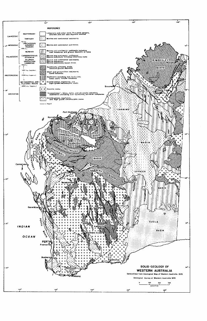
MINING LAW The exploitation of minerals is controlled
and encouraged by the State’s mining laws, which are based on the previous experience of other countries, and designed to meet local natural and social conditions.
Petroleum Act, 1967
Petroleum (Submerged Lands) Act,
Mines Regulation Act, 1946
Coal Mines Regulation Act, 1946
Mining Development Act, 1902
Mine Workers’ Relief Act, 1932
1967
The most important of the Acts now in force are:
Mining Act, 1904
11

Explosives and Dangerous Goods Act, 1961
The following are a few of the salient features of the Mining Act.
All minerals are held to be primarily the property of the Crown, excepting those in certain minor areas alienated before 1899 and the titles to which include mineral rights to the owners.
A person desiring to search for gold and minerals must first provide himself with a Miner’s Right which is obtainable at all Mines Department offices throughout the State for the sum of fifty cents.
A Miner’s Right entitles the holder to peg, apply for, and, in due course hold, most types of mining tenements. It also gives him standing in Warden’s Courts, which are held in Perth and in each of the more important mining centres. Where practicable, mining tenements must be pegged in the shape of rectangular parallelograms with the length not being more than twice the width.
Other conditions regarding the more commonly used mining tenements, are briefly set out hereunder:
GOLD Prospecting Area
Maximum area: (a) if within a proclaimed Gold or Mineral Field-9.712 hectares; (b) if outside a proclaimed field- 19.425 hectares
Fee: $1.00
Term: 12 months renewable for a further 6 months
Labour Conditions: if in (a) above-1 man for every 4.856 hectares or part of 4.856 hectares; if in (b) above-1 man for every 9.712 hectares or part
Note: No-one is permitted to hold an interest in more than one Prospecting Area at a time, nor is
12
he allowed to hold a Prospecting Area within a radius of 1.609 kilometres of any lease or claim in which he has any interest.
Gold Mining Lease
Maximum area: 9.712 hectares (except in special circumstances)
Rent: 50 cents per acre (0.405 hectares) for first year. $2.00 per acre (0.405 hectares) per year thereafter
Survey fee: Up to $77.00 according to area and locality
Term: 21 years renewable for a further 21 years
Labour Conditions: 2 men for first year, thereafter 1 man for every 2.428 hectares or part, with a minimum of 2 men.
Dredging Claim
(Only applicable in lakes, swamps, marshes, or rivers and the land adjoining, or on the foreshore of and under the ocean).
Maximum area: 121.406 hectares Rent: 50 cents per acre (0.405 hectares)
Registration: 50 cents
Survey fee: Related to area, locality and ratio of length to breadth
Term: No fixed period-continues as long as the conditions are complied with
Labour Conditions: 3 men for every 40.469 hectares or part.
per year
Note: The minimum width of a Dredging Claim at right angles to the shore edge or bank shall not be less than 301.8 metres except in the case of a river Dredging Claim on which there is no restriction in width, but the length is limited to 9.656 kilometres.
COAL Prospecting Area
Maximum area: 1 214.06 hectares-on Crown land; 129.499 hectares-private property
Fee: $1.00
Term: 12 months renewable for a
Labour Conditions: 3 men for every
further 6 months
404.686 hectares or part.
Coal Mining Lease
Maximum area: 129.499 hectares (except in special circumstances)
Rent: 5 cents per acre (0.405 hectares) per year
Survey fee: Up to $204.00 according to area and locality
Term: 21 years renewable for a further 21 years
Labour Conditions: First year-1 man for every 24.281 hectares; second year-2 men for every 24.281 hectares, thereafter 3 men for every 24.281 hectares.
OTHER MINERALS
Prospecting Area Same conditions as for gold.
Mineral Lease Maximum area: 121.406 hectares
Rent: $2.00 per acre (0.405 hectares)
Survey fee: Up to $198.00 according to
Term: 21 years renewable for a further
per year
area and locality
21 years
Dredging Claim
Same conditions as for gold.
TEMPORARY RESERVES
To encourage mineral exploration in areas where there is no evidence of existing prospecting activity, the Minister for Mines may create Temporary Reserves over larger tracts of ground than are available for the conventional tenements described earlier, and grant occupancy rights. Currently the specifications for a Temporary Reserve are as follows:
Maximum area: For gold 121.4 hectares; iron 129.5 square kilo- metres; other minerals 200 square kilometres
Annual Fee: For gold $50.00; coal $500 and $5 per square kilometre; all other minerals $loo0 and $10 per square kilometre (or part) per annum
Annual Expenditure Commitments (for each Temporary Reserve): For gold, with or without other minerals $3000; coal $100 per square kilometre with a minimum of $10000; other minerals $200 per square kilometre with a minimum of $20 000
Term: For iron renewable annually; other minerals renewable annually for up to five years, with compulsory reduction of 50% in area at the end of the third and fourth years.
Labour Conditions: 2 men for first year, thereafter 1 man for every 2.428 hectares or part with a minimum of 2 men.
Note: Any number of Leases, Claims and Reserves may be applied for and tenements can be surrendered at any time.
Mineral Claim
Maximum area: 121.406 hectares PRIVATE LAND
Rent: 50 cents per acre (0.405 hectares)
Registration: 50 cents
The mineral rights in any private land per year can be ascertained by inquiry at the
Department of Mines, Perth. - The holder of a Miner’s Right who
desires to search for gold or minerals on private land must first obtain a Permit to
Survey fee: Up to $198.00 according to area and locality
Term: No fixed period-continues as Enter from the Warden of the locality
A fee of $5.00 and an approved locality Labour Conditions: 3 men for every plan showing the private land concerned
(limited to 10 adjoining locations), should
long as conditions are complied concerned. with
40.469 hectares or part.
13

accompany the application. A deposit against damage to the private land may also be required.
The Permit is limited to a period of 30 days and it entitles the holder to enter on private land, search for gold or minerals, detach one or more samples up to an aggregate weight of 12.7 kilograms from any vein or lode outcropping at the surface and such other samples as may be agreed upon by the owner or occupier, and mark out a mining tenement, but not to mine or otherwise disturb the surface.
The conditions relating to mining tenements on private land are the same as on Crown land, except that:
The holder of a Prospecting Area is limited to working 6 acres at a time and must mark out such working area when pegging his Prospecting Area. The term of a Prospecting Area is 6 months, renewable for a further 3 months.
Before any mining tenement can be granted on private land the applicant must enter into a compensation agreement with the owner or occupier and file such agreement with the Department of Mines.
The owner or occupier is entitled to compensation for loss of use of, and damage to, the surface of his land and for damage to any improvements.
If agreement cannot be reached, either party may apply to the Warden’s Court to have the compensation determined. In such cases the other party is notified to attend the Court.
MINING TENEMENTS GENERALLY
Provided exemption from the conditions has not been granted, then in all cases where labour conditions are not being properly fulfilled, or a mining tenement is not being used for the purpose for which it was granted, any holder of a Miner’s Right may apply for forfeiture of such a tenement.
The application is heard in open Warden’s Court. If successful, the applicant is usually granted 14 days preferent right to peg and apply for the ground.
THE MINING ACT, 1978.
Following several years of intermittent Parliamentary and public debate, an Act to Consolidate and Amend the Law relating to Mining and f o r incidental and other purposes received Royal Assent on December 8, 1978. This, the Mining Act , 1978, shall come into operation on a date to be proclaimed. Meanwhile the regulations necessary for practical administration of the new Act are being prepared.
In broad terms the Mining Act, 1978 seeks to encourage mineral exploration and mining by providing for only five mining tenements, the maximum size, duration and conditions for which should meet the present-day needs of both the developers and the State.
The five tenements are as follows:
Prospecting Licence
Maximum area: 200 ha
Term: 2 years
Purpose: Prospecting and limited production.
Exploration Licence
Maximum area: 200 square kilometres
Term: 5 years with 50% reduction in
Purpose: Exploration and testing.
4th and 5th years
Mining Lease
Maximum area: 10 square kilometres
Term: 21 years, renewable.
Purpose: Production.
General Purpose Lease
Maximum area: 250 ha
Term: as for Mining Lease
Purpose: Specified purposes directly connected with mining operations on a Mining Lease.
Miscellaneous Licences
Maximum area: none specified
Term: as for Prospecting Licence, Exploration Licence or Mining Lease in respect of which it is granted
Purpose: Various purposes such as access to mining tenements.
14

Generally the holder of a Prospecting Licence, Exploration Licence or Mining Lease has exclusive right to explore for or mine all minerals except iron ores which may be specifically included. However, when an Exploration Licence has been in force for a period of twelve months, a Prospecting Licence not exceeding 10 ha in area may be granted for gold and precious stones over ground already held under an Exploration Licence.
The Mining Act, 1978 requires that the holder of a Prospecting Licence, Exploration Licence or Mining Lease shall comply with the prescribed expenditure conditions unless exemption is granted. These expenditure conditions should discourage prolonged holding of ground for purposes not directed towards active prospecting or production. It is in this respect and in the reduction from 39 to 5 classes of tenements that the Mining Act, 1978 mainly differs from the Mining Act, 1904 that will continue in force until repealed by proclamation of the new Act.
PETROLEUM
Exploration and development of petroleum resources on Western Australian land and beneath adjoining Australian territorial waters is governed by the Petroleum Act, 1967 and the Petroleum (Submerged Lands) Act, 1967 respectively. These acts are basically similar in that they both provide for two principal tenures. The following briefly describes the Exploration Permit (E.P.) and Production Licence (P.L.) available under the Petroleum Act with the different provisions of the Petroleum (Submerged Lands) Act in parenthesis immediately after.
A permit grants to the holder petroleum exploration rights over an area of up to 200 (400) contiguous blocks (a block is a
graticular section being 5 minutes of arc of latitude by 5 minutes of arc of longitude) which is valid for a term of 5 (6) years and renewable for terms of 5 years over progressively reduced areas. Areas are made available for application as exploration permits by advertisement in the Government Gazette, and all applications received are considered on their individual merits. Applicants are required to submit details of their proposed exploration work and expenditure for the initial term together with particulars of their technical qualifications and financial resources. An application fee of $1 000 is payable and the successful applicant is required to enter into a $5000 security for due compliance with the conditions of the permit and observance of the provisions of the Act. Annual rental is payable, calculated at $5 per block, with $100 being the minimum rental payable.
Upon the discovery of petroleum within a permit a “location” of up to nine blocks including the discovery block is declared. The establishment of a location is a means of setting aside and identifying a specific number of blocks from which a Production Licence can be selected.
The permittee has two years from the date the location is declared in which to apply for a Production Licence. This period may be extended for a further two years at the discretion of the Minister for Mines (Designated Authority).
There is a specific requirement that the licensee shall carry out approved works within the licence area to the value of not less than $100000 per block per year. This figure may be offset in subsequent years by the value of petroleum produced in the preceding year. The term of a licence is 21 years with renewal provisions. Annual rental is calculated at $3000 per block and a security of $50 000 may be required.
15
The main purpose of the Department of Mines is to administer some 18 Acts of Parliament covering all aspects of the mining industry. To do this the Department is organized into branches, some of which, under existing policy, are able to render additional services to the public, not related directly to the execution of a particular Act.
These services are intended to assist in the investigation, evaluation and development of the mineral deposits of the State. Briefly they are as follows:
The State Mining Engineer’s Branch, situated at Mineral House, provides advice on development of prospects and existing mines, on ventilation problems, on mining methods and equipment, and undertakes departmental drilling projects for water and minerals in co-operation with the Geological Survey Branch.
the geology of Western Australia available for sale or reference.
A display of economic ores is maintained to assist the identification of ore minerals and a large specimen collection may be made available for reference purposes.
The State Batteries Branch operates and maintains 15 batteries at widely separated localities within the State at which prospectors may have their ores crushed and treated.
Most batteries are equipped to undertake assays of gold ore as a service to prospective users of the battery facilities.
The Survey Examinations and Drafting Branch at Mineral House conducts, free of charge, searches into the ownership of mineral rights on private property. It supplies copies of plans showing the mining tenements in any area of the State and has
Investigations on ground vibration available for inspection the underground
The Statistics Section will, on At the larger mining centres the branch application, supply detailed production
figures for mining groups or individual
producers of minerals and total production, quantity, and value of minerals since the year 1899.
resulting from mining operations are plans of abandoned gold mines. carried out.
maintains compressors and rock drills for
use of this are made through the local Mining Registrars.
The Government Chemical Laboratories
hire at nominal charges. Applications for leases. It has available lists of principal
in Plain Street carries out mineral determinations, assays and analyses of Western Australian raw materials for fees which may be waived for prospectors receiving assistance from the Mines Department and for pensioners. The Laboratories also analyse and advise on the quality of underground waters.
The conditions under which such work is undertaken can be obtained from the Laboratories.
A comprehensive collection of minerals is available for reference.
The Geological Survey Branch at Mineral House identifies Western Australian rocks and advises on regional geology and detailed geology where such work has been done, on underground water
Mineral House at 66 Adelaide Terrace, Perth, Western Australia 6000, is the headquarters of the Department of Mines, housing the Administrative and most other Divisions. The Government Chemical Laboratories immediately adjoin in Plain Street. A display area on the ground floor of Mineral House illustrates the principal economic ores produced in Western Australia as well as typical rocks and minerals found in the State. The library on the fifth floor is available for reference use by the public. The location of the main public enquiry points are: first floor-Mining tenements and General, staffed from 9.00 am to 4.00 pm; fifth floor-Geological, staffed from 8.15 am to 4.30 pm Monday to Friday.
and on the occurrence of economic Written communications addressed to minerals in the State. The Under Secretary for Mines at the
The results of most works are published address above are assured of prompt and there is a large amount of literature on attention.
16

METALS

REFERENCE
Lithiwn Ma"gM*Se Molybdenum Nickel Tantalum 1," T"M/St*" Uranium Vanadium Vttrium&LRan, Earths 26°C
- RAILWAYS
RE zr

ALUMINIUM
Bauxite, the principal ore of aluminium is composed of various hydrated oxides of aluminium. Of these, gibbsite is the most common.
Bauxite is commonly associated with the processes of lateritization and any laterite containing more than 30 per cent of alumina constitutes a potential ore of the metal.
The aluminous character of the Western Australian laterites was recognized early in this century. However, only in the past few decades have systematic investigations of the grade and distribution of the bauxite deposits been undertaken.
The main areas of bauxitic laterite extend eastwards up to 50 kilometres from the Darling Scarp and occur between New Norcia and Walpole, a distance of 450 kilometres.
The bauxite is a residual capping derived from the underlying rocks by a complex of
weathering processes. I t consists essentially of hydrated oxides of aluminium and iron with silica in varying proportions. Gibbsite is the principal aluminium mineral in these deposits.
The bauxite capping develops on acid igneous rocks and on aluminous sediments. It ranges between 1 and 10 metres thick and in many localities is sufficiently consistent in thickness and grade to constitute an economic deposit.
In 1957 Western Mining Corporation began an exploration programme to evaluate the Darling Range bauxite deposits. In the following year they were joined by Broken Hill South Ltd. and North Broken Hill Ltd. to form a new company Western Aluminium N.L.
By 1960, 37 million tonnes of bauxite had been proved and the amenability of this ore to alumina extraction by the Bayer (caustic soda leach) process had been established by
Loading bauxite at a typical Alcoa quarry in the Darling Range

overseas testing. The financial and technological resources of the Aluminium Company of America were then sought and subsequently Alcoa of Australia (W.A.) Ltd. has confirmed its intention to build an extract alumina in Western Australia under an agreement with the State Goverment.
The first quarry at Jarrahdale, 48 kilometres southeast of Perth, was opened in 1963 to supply bauxite to a newly constructed alumina refinery 51 kilometres by rail to the west at Kwinana on Cockburn Sound. This refinery commenced operations in 1964 with an annual alumina production capacity of 200 000 tonnes which has been successively increased to its current capacity of about 1.4 million tonnes per year.
Quarrying commenced in 1972 at a new site, Del Park, 89 kilometres south- southeast of Perth, to supply a second refinery 6.7 kilometres by conveyor belt westwards at Pinjarra. This refinery had an initial annual alumina production capacity of 600000 tonnes, which has since been increased to over 2 million tonnes to treat ore from an additional quarry at Huntly.
Currently, alumina is shipped from Kwinana to the Alcoa of Australia Ltd. smelting and fabricating works at Point Henry near Geelong in Victoria, and to overseas buyers in Japan, Bahrain, Iran, U.S.A. and Argentina. An export terminal has been constructed at Bunbury from which most of the Pinjarra production is shipped. Bunbury will also be the shipping point for alumina produced from a proposed third refinery at Wagerup. In 1978, 3470380 tonnes of alumina valued at $277630400 was produced by Alcoa of Australia Ltd.
The Jarrahdale No. 1 site has now been mined out and, after contouring and reafforestation, has been developed in part as a recreational picnic area named Langford Park. A new quarry, Jarrahdale No. 2, has been opened about 5 kilometres northwestwards. Another quarry has also been opened at Huntly to provide ore for the Pinjarra refinery.
The Alcoa of Australia Ltd. operation, which has bauxite resources exceeding 2 OOO million tonnes, is the only current producer in Western Australia. Attempts by two other companies, with ore reserves to the
north and east of the Alcoa agreement area, to establish operations have so far been unsuccessful, although recently Alwest Ltd. has confirmed its intention to build an alumina refinery at Worsley to treat bauxite from its Mt. Saddleback deposit. Changing local and world economic conditions together with environmental constraints have been the main impediments.
The Darling Range bauxite is not high grade by world standards. The alumina content of the crude ore is generally between 30 and 40 per cent, with silica and iron as the main impurities. Although the silica content is high, most of it is in the form of unreactive quartz which does not interfere with the refining process. The iron oxide content is generally within the range of 10 to 25 per cent.
Texturally the ore is very varied. The highest grade material is white to cream coloured and porous, with little obvious iron impurity. The bulk of the ore however contains nodules and pisoliths of iron oxides set in a matrix of gibbsite with small quartz grains.
Although the laterite host rock extends over many hundred square kilometres, bauxite ore, as defined by its alumina content, occurs in laterally discontipuous bodies with an area1 extent ranging from 4 to 25 hectares. A typical vertical section shows 30 cms of overburden and 4 metres of ore, the upper third of which is “hardcap” which has to be broken with explosives when mining.
Another major deposit of bauxite, some of which has a soda-soluble alumina content as high as 55 per cent, occurs as a lateritic deposit overlying basalt on the Mitchell Plateau south of Admiralty Gulf in the northwest of the Kimberley Division. A consortium headed by Alumax Bauxite Corporation has proved ore reserves of 1 210 million tonnes but despite the quantity and quality of the ore and the proximity of a deep-water port site at Port Warrender, the present-day lack of cheap power, projected infrastructure costs and the state of the world market together prevent economic development of the ore body. However, with improvement in any of these factors the deposits could be a viable producer.
20

ANTIMONY, ARSENIC AND BISMUTH
Antimony Antimony produced in Western Australia
as a by-product of gold mining amounts to I 1 105 tonnes of concentrate containing 5 430 tonnes of metal.
Antimony was first recognised in Western Australia at Mallina in the North- West Division and prior to 1940 the only ore exported was from this and three adjacent localities, Peawah, Sherlock Crossing and Mt. Negri.
The ore from Mallina and Peawah is mainly stibnite, from Sherlock both stibnite and stibiconite and from Mt. Negri mainly stibiconite. In each locality the antimony minerals were associated with bunches of gold in quartz veins.
The average grade of four parcels of ore from The Star Mine at Mt. Negri was 57 per cent antimony and eight grams of gold per tonne.
Assays of picked stibnite ore from Mallina have assayed from 29 to 44 per cent antimony, with a trace to over 183 grams of gold per tonne.
Auriferous stibnite occurs at Middle Creek, 15 miles east of Nullagine, and has been worked at the Blue Spec Mine. A total of 3075 tonnes of antimony concentrates with a metallic content of 1490 tonnes valued at $1 545 906 was produced as a by-product of gold mining in this area before production ceased in 1978.
Antimony concentrates were produced for many years as a by-product from the Moonlight-Wiluna gold mines with production amounting to as much as 356 tonnes per year. Handpicked ore from Wiluna assayed 57 per cent antimony and carried 15 grams of gold and 12 grams of silver per tonne.
Stibnite occurs in appreciable quantities at Mt. Magnet and Youanmi.
Arsenic
Arsenopyrite, associated with gold mineralization, has been the sole source of arsenic in Western Australia. The most
productive centre has been the gold mines at Wiluna where the ore averaged about one per cent arsenic;
The need for arsenic during the Second World War helped keep the Wiluna mines working. To 1949, a total of 39291 tonnes of white arsenic (As,O,) valued at $1 494 360 had been recovered as a by- product in the metallurgical treatment of the gold ores at Wiluna.
The gold mines at Meekatharra used to produce large quantities of arsenical gold concentrates, typical samples of which contained between 25 and 65 per cent of arsenopyrite. These were roasted to extract the gold and the white arsenic recovered as a by-product.
Another producer of arsenical ore was the Transvaal Mine at Southern Cross. Below 42 metres the ore was heavily charged with arsenopyrite with typical samples assaying up to 26 per cent arsenic and 1 1 per cent sulphur. For some years this ore was shipped to Victoria where it was roasted, and the white arsenic so produced used in fungicides and insecticides.
Bismuth
Native bismuth, as well as the carbonates, sulphide, and telluride, are not uncommon in small quantities in gold ores, particularly in the Pilbara, Yalgoo and Coolgardie Goldfields. There is a current small production of bismuth from Yinnietharra in the Gascoyne Goldfield where bismuth carbonates occur as thin and irregular veins in the quartz of a large pegmatite dyke.
The largest production in the past from any individual centre has come from Melville in the Yalgoo Goldfield. It is recorded that about 5 tonnes of concentrates valued at $2 OOO was produced. The principal ore is a carbonate, bismutite, which occurs in masses up to several kilograms in weight in association with scheelite in quartz veins and in detrital deposits.
21

BERYLLIUM
Beryl (beryllium aluminium silicate) is the common source of the metal beryllium and occurs in pegmatite veins widely distributed throughout Western Australia. Localities of occurrence include Wodgina, Mt. Francisco, Tabba Tabba, Roebourne, Yinnietharra, Melville, Poona, Dalgaranga, Rothsay, Balingup, Mt. Edon, Mt. Dale, Green bushes, Londonderry and Ravensthorpe.
Before World War I 1 only an insignificant tonneage was produced but, owing to the increased demand for beryllium for use in beryllium-copper alloys, several hundred tonnes of beryl was produced during the war years.
Since World War I 1 production has fluctuated appreciably, reaching peaks of about 350 tonnes in 1957 and 160 tonnes in 1973. N o beryl is being mined at present.
During the past decade, price received has varied between about $15 and $31 per unit of BeO, with a minimum acceptable grade of 10 per cent BeO.
The main producing field has been the Pilbara Goldfield, with Wodgina as the main locality. The Wodgina beryl is massive, either white and pinkish white or grey, and shows no crystal forms.
Following the discovery of commercial pegmatites in the Dalgaranga area northeast of Yalgoo, the Yalgoo Goldfield became a major producer.
Another field which showed promise was the West Pilbara Goldfield, where beryl
occurs in pegmatites in a disseminated form which probably requires either cheap labour or mechanical concentration to work profitably.
Production from the Gascoyne Goldfield reached a peak in 1960 when over 96 tonnes was won. A single crystal found 18 kilometres north of Yinnietharra homestead yielded 23 tonnes of beryl. I t measured about 8 metres long with a maximum girth of 2 metres.
As far as is known, this is the largest crystal that has been recorded in Australia, though falling far short of the giant crystals reported from Argentina and the United States.
When broken the Yinnietharra beryl gives clean lumps often of a characteristic ice-green colour and showing clear and opaque patches.
The beryl mined at Poona occurs in a large pegmatite which is not the host rock for the emerald obtained nearby. I t is in massive fluted crystals white to pale pink in colour and of good commercial grade.
The feldspar quarry at Londonerry is the main source of beryl from the Coolgardie Goldfield. It is an opaque white varity occuring chiefly in pockets.
Other minerals containing beryllium known to occur in Western Australia include gadolinite, helvite, chrysoberyl euclase, bityite and bavenite.
COPPER
Copper has never figured largely in mineral production figures for Western Australia. To the end of 1978 only 467632 tonnes of copper ore has been won since production commenced in 1853. The overall average grade of this ore was 11.22 per cent copper and the total State production is little over 1 per cent of total Australian mine production.
Most Western Australian ore has been mined for smelting and extraction of
metallic copper but in the period 1950 to 1970 some 89000 tonnes of selected semi- soluble ores and concentrates were used directly as additive to fertilizers for application to copper deficient soils.
Currently, by-product copper, from nickel ore mined in the Eastern Goldfields region forms the only substantial and continuing production, the copper content from this source over the period 1968-1978 being 1 1 552 tonnes.
22

Copper deposits are widespread in the Precambrian rocks of Western Australia but few of them have produced much ore. The largest mines were at Ravensthorpe, Whim Creek, Anaconda and Thaduna, all of which are now inactive. However, despite the modest production history and the unstable nature of the international copper market, exploration interest has remained keen and several important prospects have been discovered in the last ten years.
In a recent examination of all the significant copper occurrences in Western Australia it was found useful to classify them into six types, the characteristic features of which are described below.
Type 1 . Stratabound massive copper-zinc deposits in volcano-sedimentary sequences. Felsic volcanic rocks are commonly found around or near type 1 deposits, and such rocks have been and still are being intensely prospected. The major minerals in these deposits are massive iron sulphides, which commonly mask the presence of the copper minerals at the surface. Zinc and lead minerals may also be present. The deposits formed at the same time as the enclosing volcanic and sedimentary rocks were laid down. Dense, metal-rich brine solutions discharged onto the ancient sea-floor from cracks in the Earth’s crust, and deposited rich layers of minerals in hollows on the sea-floor. The deposits were then covered by more rock layers, and during later earth movements they may have been contorted and metamorphosed. This is the case for most type 1 deposits in the State.
The largest exploited type 1 deposit is at Whim Creek in the Pilbara. Mine production amounts to 1 1 285 tonnes of contained copper, with remaining resources of 1 million tonnes of sulphide mineralization averaging 1.5 1 per cent copper and 1.33 per cent zinc plus 1.65 million tonnes of oxidized mineralization averaging 1.68 per cent copper. The largest unexploited deposit is at Golden Grove in the Murchison, where resources of 13.5 million tonnes averaging 3.59 per cent copper have been indicated from the boring of 77 diamond drillholes. A similar but smaller and more zinc-rich deposit was recently discovered at Teutonic Bore in the Northeastern Goldfields. Resources have been estimated at between 2 and 3 million tonnes averaging 3.5 per cent copper and
9.5 per cent zinc, plus 150 grams per tonne of silver.
The Mons Cupri and Whundo-Yannery Hills mines and the Koongie Park (Halls Creek) prospect are also type 1 deposits.
Type 2. Disseminated copper mineralization in sedimentary or volcanic rocks. Specks of copper minerals (where present in more than average concentrations) in black shale, siltstone, sandstone, limestone and basalt constitute type 2 deposits. Many such deposits have been found in the last 20 years but none has yet been of commercial importance. The copper minerals may have been deposited with the enclosing rocks or redeposited from circulating ground water. Both cases are known from the eastern part of the Kimberley Basin and the Ord Basin.
Type 3. Cupriferous quartz veins and shears. Copper minerals in quartz veins, or disseminated in shears, tension cracks or faults make up the very common type 3 deposits. Because these deposits are generally in narrow, steeply inclined bodies which have a low copper content (less than 2 per cent) where unweathered, they are mainly only of commercial interest when deeply weathered and enriched in oxidized copper minerals, (e.g. Thaduna, Kumarina and Ilgarari) or when accompanied by gold or silver (e.g. Ravensthorpe, Roebourne and Gabanintha). The enclosing rocks are typically basic igneous or sedimentary rocks. The mines in the Ravensthorpe area have produced 19929 tonnes of copper metal contained i n 196 8 4 9 tonnes of copper ore and concentrates. This is nearly one third of the State’s total production. The Elverdton-Desmond mine at Kundip was by far the largest and most productive mine in the area, the deepest workings reaching a vertical depth of 227 metres when the mine was reworked in 1958-1971. Many of the Ravensthorpe deposits, though clearly in veins and faults, occur in felsic volcanic rocks. This fact, together with the presence of cobalt-rich pyrite and minor amounts of sphalerite, suggests that original type 1 mineralization may have been modified and mobilized to result in what are now type 3 deposits. This possibility has encouraged recent exploration activity in the area.
Kathleen Valley, Wheal Fortune and Narra Tarra mines are other noteworthy type 3 occurrences.
23

Type 4. Stockwork copper and copper- molybdenum mineralization. Branching networks of fractures and veins are referred to as stockworks, and in type 4 deposits these stockworks occur within and envelop felsic porphyry intursions. Disseminated mineralization is also present. There are some similarities with “porphyry-copper’’ type deposits in a few examples. The stockworks contain quartz, iron and copper minerals, and molybdenite in some cases (e.g. Coppin Gap prospect). In general, to be of commercial interest such deposits need to be both large and amenable to open cut mining, because the amount of copper present in bulk is very low (less than 1 per cent). The largest exploited deposit of this type is at Copper Hills mine, south of Marble Bar. In the period 1952-1963, 15 505 tonnes of mainly cupreous (oxidized) ore and concentrates averaging 12.7 per cent copper were produced. Most of the enriched mineralization has been mined, and the primary sulphides appear to contain less than 1 per cent copper on average.
Type 5 . Copper-nickel mineralization in basic complexes. Type 5 deposits are rare, most being recorded from the Halls Creek Province. Iron sulphides are dominant with lesser amounts of copper and nickel sulphides, commonly present as disseminations with rare bands, lenses or pipes of massive sulphides. Nickel is
typically up to 3 times more abundant than copper. The deposits are generally small in size and occur in basic intrusions containing small amounts of ultrabasic rocks. The Sally Malay prospect is of this type.
Type 6. Nickel-copper mineralization in ultrabasic rocks. In type 6 deposits, nickel is at least 10 times more abundant than copper, and the enclosing rocks are exclusively ultrabasic, commonly forming tabular units in volcanic rock sequences. The best known examples are the nickel mines at Kambalda, Agnew, Windarra, Spargoville, Nepean and Redross.
Deposits of types 2 and 3 are the most abundant, but types 1 and 3 are the most important commercially. Type 4 mineralization is rare and is largely restricted to the eastern Pilbara Block (e.g. Coppin Gap) with one example (Mt. Angelo South) in the Halls Creek Province. Deposits of types 5 and 6 (e.g. Sally Malay and Kambalda respectively) are most important for their nickel content. Those of type 5 contain appreciable copper, and a small amount of copper is extracted as a by-product of nickel mining of type 6 deposits.
The numerous other localities where copper deposits occur in this State are described in Mineral Resources Bulletin No. 13 of the Geological Survey.
GOLD
Until 1966 gold held a pre-eminent position in the mineral economy of Western Australia but it was then surpassed in annual production value by iron ore, and later by a number of other mineral commodities.
Since gold was first discovered in Western Australia in 1883 a total of 2 143 460 kilograms has been won to the end of 1978. The value of this production is $1 332 451 864.
20000 and 27000 kilograms per year over the period 1947 to 1965, since when there has been a reduction to the 1977 level of 10747 kilograms due to closure of some of the mines on the Golden Mile.
The discovery of gold in Western Australia was delayed for a considerable time after the first settlements were established because gold generally occurs far from the coast in inhospitable and arid country.
The peak of annual gold production was Although there were reports of in 1903, when 64222 kilograms was discoveries prior to 1883 it was only in that produced. Production declined to a low of year that a report on the Kimberley 1 1 731 kilograms in 1929, then recovered to Division by the Government Geologist, Mr hold a relatively steady level of between Hardman, led to the establishment of a
24

goldfield there. The first production from hosts of gold mineralization in different the area was recorded in 1886, but the field areas. However, in any one locality a proved to be a poor one. particular rock type is often favoured.
Mr Hardman’s explorations were undertaken in consequence of reports of gold at Nicol Bay and East Kimberley by a prospecting party headed by Phi1 Saunders. Saunders, it appears, should therefore be given the credit of being the first to discover authenticated gold country in Western Australia.
Meanwhile two men, Anstey and Greaves, had found gold at Eenuin, not far from the much later discovered Bullfinch centre. A consequent rush to the Yilgarn field resulted in the important discovery of Frazer’s Reef at Southern Cross in 1887.
Prospecting became general over the entire State and in 1892 Bayley and Ford made a phenomenal discovery at Coolgardie. The richness of the find drew worldwide attention to the Western Australian goldfields. Gold was found at Kalgoorlie by Hannan in 1893 and by 1900 almost all the gold fields now known had been opened.
The boundaries of the proclaimed gold fields in Western Australia include an area of over a million square kilometres. The most important mining centres have been Kalgoorlie, Leonora, Mt. Magnet, Cue, Meekatharra, Wiluna, Laverton, Norseman, Lawlers, Menzies and Coolgardie.
Present production comes from three large mines at Kalgoorlie, Telfer and Norseman, and from a number of small mines or prospecting operations elsewhere.
NATURE AND DISTRIBUTION OF
With the important exception of Telfer, the main gold deposits in Western Australia occur in association with Archaean rocks which make up the greater part of the Yilgarn Block in the southern and central parts of the State. The age of the gold mineralization has been dated by radiometric methods at about 2400 million
GOLD DEPOSITS
A common host rock is banded iron formation (BIF), which has been a favoured locus of deposition in such important fields as Mt. Morgans, Laverton, Mt.Magnet and in many of the ore bodies in the Southern Cross area. It is likely that many of the BIF ore bodies have been enriched to economic grade by processes of supergene concentration.
In the Kalgoorlie area, and particularly within the Golden Mile, mineralization is best developed within stratiform quartz dolerites. These are believed to be concordant or semi-concordant sills intrusive into a pre-existing series of altered lavas and sediments. Similar mineralization within quartz dolerites is found at the Great Fingall Mine near Cue and at Wiluna.
Most goldfields have extensive intrusions of ultrabasic rocks in the enclosing lavas and metasediments. These are often a favoured host. Examples may be found at Bayley’s Mine at Coolgardie, Ingliston Consols at Meekatharra and the Emu Mine at Agnew.
Basaltic pillow lavas are common hosts as at Norseman and Coolgardie and in the “calc-schist” ores at Kalgoorlie.
Bedded rocks, either of pyroclastic or normal clastic sedimentary origin, which occur within sequences of basaltic lavas, are host rocks for gold in some mines in the Southern Cross area and in the Sons of Gwalia Mine at Leonora.
Apart from the notable exception of Kalgoorlie, most gold deposits in the Yilgarn Block are close to granite intrusions and in a few cases the mineralization is within the granite itself.
The principal gold lodes of Western Australia are within shear and shatter zones of the host rocks. Along these fracture zones, which have presumably acted as channels for ore-forming fluids, gold has been deposited. It is accompanied by quartz. carbonate minerals, sulphides of base metals and, at Kalgoorlie, some gold years.
The Archaean rocks include altered occurs in telluride minerals. lavas, basic and acid intrusives, Carbonatization and other metasomatic metasediments and banded iron formations changes in the host rocks are common over (BIF). All these rock types are favoured varying widths.
25

Aerial view of the open cut a t the Telfer Gold Mine
Sulphides are ubiquitous associates of gold mineralization in the Archaean rocks. However, the relative proportion and type of sulphide varies greatly in different localities. The commonest is pyrite, but pyrrhotite, arsenopyrite, stibnite and galena have been recorded.
In some areas, such as Wiluna and at the Blue Spec Mines at Nullagine, arsenic and antimony sulphides have been the’ sources of important economic by-products of the gold mining. The Kalgoorlie mines are distinguished by the high content of tellurides in some of the richest ore.
In the Pilbara, gold mineralization is similarly associated with the Archaean rocks of the Pilbara Block and particularly with the Warrawoona Group rocks.
In the Halls Creek area most of the gold occurs within metasediments of the Halls Creek Group which is of older Proterozoic age.
In Western Australia Proterozoic rocks have hitherto yielded only a minor gold production, the most noteworthy area being the Ashburton Valley, but the more recently discovered Telfer gold prospect near Paterson Range is in quartz saddle reefs in folded older to middle Proterozoic sandstone and shales. Gold ore reserves available for open-cut mining are 3.83 million tonnes at a grade of 8.78 grams per tonne. Production at Telfer commenced during 1917.
Alluvial gold deposits are rare in Western Australia, owing to the combination of aridity and a flat terrain over
26

a long period. Much of the so-called alluvial gold is eluvial, representing superficial concentration by wind and rain action close to the source rock. A deep lead, probably of Tertiary age, was worked at Kanowna to a depth of 100 feet below the present surface.
Surface enrichment is a common feature of most gold lodes in the State. Deep erosion and capillary movement of near- surface water, such as characterizes semi- arid lands, has favoured this enrichment.
Many prospects have yielded a high production from the near-surface levels but failed to live at depth. This is particularly so in the case of deposits within banded iron formations, which seem especially prone to superficial enrichment.
The redeposited gold in the upper zones of enrichment is generally lower in silver than that of deeper levels. The purest native gold in the world is in the upper levels of the telluride-bearing mines at Kalgoorlie and has a fineness of 999.1. Most of the gold in the State is from 850 to 950 fine.
There are 19 proclaimed gold fields in Western Australia. Of these the East Coolgardie Goldfield, which includes the Kalgoorlie mines, has been the most prolific producer and has accounted for more than half the total gold won in Western Australia.
Production from the various fields and total State production as reported by producers to the Mines Department are shown in the following tables supplied by the Statistical Compiler.
TOTAL GOLD PRODUCTION OF VARIOUS GOLDFIELDS T O E N D OF 1977
Goldfield Kilograms 1 244 620
Murchison 191 611 Mount Margaret ................................... 156 236 Dundas. ............ ................... 115 752 East Murchison 114 709
81 430 77 131
Pilbara 28 126 25 235 24 653
Peak Hill 10 324
3 963 973 915
Ashburton 394 Gascoyne. 230 State Generally (including South West
........................
Coolgardie. ........................................... 58 175 ..................................................
.............................................. Yalgoo .................................................. 8 445
............................................. .............................................
Mineral Field) ................................... 489
Total ........................ 2143411
TOTAL GOLD PRODUCTION IN DECENNIAL PERIODS
Period Prior to 1897 ................. 1897- 1900.. ..................... l901-l910 .............................................. 191 1-1920 .......................................
1941-1950 .............................................. I95 1- 1960. ...................................... 196 1- 1970. ......................................
1974 .............................................. 1975 .............................................. 1976 ............................... 1977 ....... 1978 .......
Total ........................
Kilograms 15 773
134 000 531 658 325 83 1 I39 008 261 773 207 36 1 253 944 199 454 10 734 10 418 8 587 6 584 7 105 7 091
10 747 13 332
2 143 460
Production records for individual mines within the various goldfields are obtainable from the Mines Department. Geological descriptions of mines and mining fields are available in the publications of the Geological Survey.
IRON
The iron ore deposits of Western Australia rank among the largest in the world and in the last decade have been developed to the extent that Australia is now the largest exporter of ore (in terms of contained iron) in the world. Most of this ore is derived from the Western Australian Hamersley Iron Province.
The iron potential of Western Australia was recognized as long ago as 1890 but at that time there was no overseas demand for ore from a country so remote from the
major steel producing centres in Europe and North America. Consequently little attempt was made to search for ore bodies within the obviously prospective banded iron formations.
Apart from a lateritic iron deposit near Coates Siding, from which small quantities of ore were taken for use as a flux in the early lead smelter at Fremantle, the earliest known deposit was at Yampi Sound. Here high-grade ore occurs on Koolan, Cockatoo
27

and Irvine Islands and pearling luggers reserve covering the Koolyanobbing operating in this area used the ore for deposit. All other iron ore, known or yet to ballast. be discovered was reserved to the Crown
In 1920 the Queensland State Government financed drilling on Cockatoo Island for a proposal to ship iron ore to Queensland for smelting with local coal. The proposal was eventually abandoned and the leases passed to a company controlled by Broken Hill Pty. Ltd.(B.H.P.), Australia's only iron and steel producer.
Brasserts Ltd. of England purchased the leases on Koolan Island in 1936 and began to test and develop the deposit for export of ore to Japan who by then was emerging as a major consumer. But before production began, the Commonwealth Government, fearing the inadequacy of known iron ore reserves for national needs, imposed an embargo in 1938 on export of iron ore from Australia. The Yampi leases reverted to the Crown.
Meanwhile, in the course of other prospecting, exploration and development, numerous other iron ore bodies had been discovered. These included Koolyanobbing, Ellarine Hills (Goldsworthy), Tallering Peak, Mt. Gibson and many others, all within steeply dipping Archaean banded iron formations, which form conspicuous strike ridges in the Western Australian Goldfields.
The State Government in 1945, established a small charcoal-fired blast furnace at Wundowie as a war-time measure to overcome a local shortage of pig iron. Ore was first obtained from Coats Siding but quantity and grade were never satisfactory and soon after commencement ore had to be brought from Koolyanobbing.
and for the next 9 years it was not possible to obtain any kind of tenure for ground containing iron ore.
Concurrently the State conducted a drilling programme designed to upgrade the reserves of what were then considered to be the more economically attractive deposits at Cioldsworthy, Tallering Peak and Koolyanobbing. As reserves were upgraded, representations were made to have the export embargo lifted, and on December 20, 1960 the Commonwealth Government announced that it would give limited approval for the export of iron ore from deposits other than those held by B.H.P.
Shortly afterwards the State Government called for applications to develop the Goldsworthy and Tallering Peak areas for temporary reserves each with a maximum area of 129.5 square kilometres (50 square miles). This heralded a period of intensive prospecting and exploration which soon became concentrated on the northwest of the State and the Hamersley Range area in particular. Here the potential of the widespread banded iron formations had long been known but ore bodies had not been delineated. In 1961, with tenure now available and Japan as an obvious customer for ore, large high-grade ore deposits were identified within a short time, particularly by the few people familiar with this rugged and inaccessible area.
The State Government later concluded agreements with the successful explorers for development of these ore bodies and the companies concerned then received export permits from the Australian Government, which, due to the abundance of iron ore
A second f U f ~ ~ e was brought into found, no longer restricted export permits to a portion of the ore proved, as was originally proposed.
develop the mines, negotiate sales contracts,
operation around 1955 and the production rate rose to 70000 tonnes per year of high
'Old to Agnew 'lough Ltd' Purity Pig iron* The Operation was Despite feverish activity to prove and
who, faced with a market for the product, reduced Output to 45090 tonnes in 1977 and ceased Pig iron production in
construct railways and port facilities, and build townships at mine and port sites, the first export ore was not shipped until April 1966. This was from a newly discovered and October 1978.
As part of an agreement in 1952 with the relatively small deposit of ore at State Government whereby the B.H.P. Co. Koolanooka near Morawa. Goldsworthy Pty. Ltd. were to establish a steel rolling ore was first exported in May 1966 and mill and later to smelt ore at Kwinana, the Hamersley Iron shipped its first contract company was granted leases covering the parcel from Tom Price in August of the Yampi Sound deposits and a temporary same year.
28

Drilling blast holes preparatory to firing the bench-Aft. Tom Price iron mine
Mt. Newman Mining Co. Ltd. commenced exporting ore from its Whaleback deposit in 1969, and in 1972 Cliffs W.A. Mining Co. Pty. Ltd. brought its Pannawonica deposit into production and Hamersley Iron Pty. Ltd. opened its second mine at Paraburdoo.
Currently there are nine open-cut iron mines operated by five companies and up to six other deposits are ready for development if markets can be finalized. Production in 1978 totalled 82.5 million tonnes of direct shipping lump ore, fines, sintered fines and pellets, almost all containing 60 per cent or more of iron and less than 0.06 per cent phosphorus.
There are three main types of Western Australian iron ore:
hematite enrichment ore pisolitic limonite ore sedimentary ore
These are currently being mined in the approximate proportions 20:2: 1 . Another
category of ferruginous material is variously referred to as scree ore, conglomerate ore, detrital ore, or canga, but although there are proposals to develop this material in the future, only a very small amount has yet been mined as ore. Again, there are huge quantities of potentially beneficiable banded iron formation or taconite available, that elsewhere in the world is mined as ore, but under the prevailing economic conditions in Western Australia taconite cannot be classed as ore.
Hematite enrichment ore, commonly referred to as hematite-goethite ore, is the most important ore type in Western Australia. It occurs stratigraphically within Archaean banded iron formations (BIF’s) of the Pilbara and Yilgarn Blocks, and within Proterozoic BIF’s of the Hamersley Basin immediately south of the Pilbara Block.
The Archaean BIF’s consist of thin alternating laminae of red or white chert
29

(silica) and either magnetite or hematite, with other minerals in very minor amounts outside areas of high metamorphism. The BIF’s occur interbedded with metasedimentary and metavolcanic rocks in tightly folded and steeply dipping ‘greenstone’ belts, and as BIF is generally resistant to weathering it often crops out as a prominent strike ridge in an otherwise subdued topography. Most individual BIF units are no thicker than 1Om with the thickest about 65 m but locally, due to fold repetitions, apparent thickness maybe greater. The length of persistent outcrop may reach 75 km but is usually less. Within the BIF, and generally at localities of intense folding or faulting, iron enrichment and silica removal has occurred to form iron ore bodies. Such Archaean hematite enrichment ore bodies occur in the Pilbara Block at Goldsworthy, Shay Gap, Sunrise Hill and Kennedy Gap, and in the Yilgarn Block at Tallering Peak, Mt. Gould, Mt. Hale, Mt. Taylor, Weld Range, Mt. Gibson, Koolyanobbing Range, Bungalbin Range, Mt. Manning Range and Mt. Windarling.
The Proterozoic banded iron formations occur in the oval-shaped Hamersley Basin which had an original depositional area of some 150000 square kilometres and now, after reduction by erosion has an outcrop area of some 100 000 square kilometres. The rock assemblage within this basin is known as the Mt. Bruce Supergroup which consists of the basal Fortescue Group, comprising thick lavas intercalated with mainly volcanoclastic sediments, the Hamersley Group, in which the dominant rock type is banded iron formation, and the uppermost Wyloo Group comprising mainly terrigenous clastic sediments. The depositional age of the Mt. Bruce Supergroup ranges between 2 400 and 1800 million years.
The Hamersley Group is remarkable for the thickness and lateral persistence of banded iron formations within it. Individual laminae less than a millimetre thick have been correlated over a distance of 300 km. The oldest BIF unit within the Hamersley Group is the Marra Mamba Iron Formation which has an approximate average thickness of 180 m. The intermediate Brockman Iron Formation consists of the Dales Gorge Member
(150 m) separated by the Whaleback Shale Member from the overlying Joffre Member (370 m), The uppermost Boolgeeda Iron Formation is 210metres thick and differs from the older iron formations in that it is more massive, is intensely magnetic, and that to date no significant enrichment to iron ore has been found within it. Other minor BIF’s occur within the Hamersley Group but they are of no commercial significance as they are relatively thinly dispersed among other rock types.
The most intensively studied unit is the Dales Gorge Member of the Brockman Iron Formation within which the earliest discovered Proterozoic iron ore bodies at Mt. Tom Price, Whaleback and Paraburdoo occur. The Dales Gorge Member consists of 17 banded iron formation units alternating with 16 shale units with an aggregate thickness ratio of BIF to shale of 3:1. The total thickness of the Dales Gorge Member at its type section is 143.2 metres and the iron content of the BIF member averages about 31 per cent. The most obvious feature of the BIF is the regularly alternating chert rich and iron rich bands approximately 1 to 2 cms thick that give the striped appearance to the freshly broken rock. This scale of banding is called meso- banding. A smaller scale of banding (between 0.3 and 1.7mm), known as microbanding, is evident on closer inspection particularly of the chert mesobands. Again variations in silica and iron content define the laminae. The largest scale of banding (macrobands) is defined by the alternation of 16 shales within 17 BIF’s mentioned earlier.
Despite the amount of research undertaken on the Dales Gorge Member, the process by which the BIF units with only 31 per cent iron become enriched to approach pure iron oxides containing over 60 per cent iron, is not fully understood. Where enrichment has occurred, the thickness of the Dales Gorge Member is almost halved but without loss of identity of any of the banding scales mentioned earlier. Clearly an in-situ removal of silica and other minor constituents has occurred and calculations from compositions, densities, and stratigraphic thickness relationships show that additional iron, constituting up to 50 per cent of that initially present in the BIF, has been introduced. Palaeomagnetic evidence
30
suggests that this took place in the interval 1600 to 1300 million years, immediately after the main folding of the Hamersley Basin at about 1700 million years. The currently held view is that the silica removal/iron enrichment was accomplished by deep ground water movement resulting from the widespread operation of hydrological systems of a type now existing only in locally peculiar circumstances.
The other BIF unit in the Brockman Iron Formation, the Joffre Member, averages 335 metres in thickness and it is similar to the Dales Gorge Member in many respects. Notable differences are the considerably lesser development of shales, coarser mesobanding and the development of a greater variety of post-depositional, pre- lithification modification structures known as chert pods. Also, enrichment to ore within the Joffre Member is relatively rare despite the fact that the unenriched iron content is only very slightly less than that for the Dales Gorge Member.
The Marra Mamba Iron Formation (lowest unit of the Hamersley Group) is about 180 m thick but variations between 15 m and 230m have been observed in different parts of the Hamersley Basin. It is subdivided into three informal units: a lower BIF member, which contains numerous bands of shale, chert and dolomite; a middle shaly member with dominant black shales, some banded iron formation and a few bands of dolomite; and an upper BIF member made up of banded iron formation with subordinate chert and shale. The thickness ratios from bottom to top of these three members are approximately 18:5:8. In mesoband composition the Marra Mamba Iron Formation has closer affinity with the Joffre Member than with the Dales Gorge Member, but in enrichment potential it almost parallels the latter. In recent years several major potential ore bodies have been discovered in the upper BIF member of the Marra Mamba Iron Formation, the best known being the Marandoo deposit (Rhodes Ridge Mining) and Mining Area C (Goldsworthy Mining). Further discoveries of this type are likely. Marra Mamba ore contains a higher proportion of goethite to hematite than Dales Gorge Member ore and consequently yields a lower percentage of direct-shipping lump ore after mining,
crushing and sizing. However fines can be sintered, and as there is a tendency for smelters to prefer a sintered feed, Marra Mamba ores are likely to gain an appreciable part of the export ore market in future years. Further, Dales Gorge Member ores in some deposits have a phosphorus content in excess of the 0.06 per cent currently acceptable, whereas most Marra Mamba ores discovered to date are within this phosphorus limit.
The hematite enrichment ores mined in the Hamersley Basin correspond closely in composition to a theoretical mix of 70 per cent hematite, 23 per cent goethite, 5 per cent kaolin and 2 per cent quartz, to yield a composition of about 63.5 per cent Fe, 4.3 per cent SO,, 2.0 per cent A1,0, and 3 per cent loss on ignition. Phosphorus, averaging 0.05 per cent is the most commercially significant trace constituent. Archaean hematite, enrichment ores have a slightly higher iron content, with lower Al,O,and S O , and a very low phosphorus content.
By contrast with hematite enrichment ore, pisolitic limonite ore i s of Tertiary age and occurs along drainage lines with catchments in the Hamersley Range area. Typically, pisolitic limonite ore forms cappings, up to 60m but usually less than 30m thick, on elongate discontinuous mesas whose flat summits stand up to 75 m above the level of the present rivers, along the line of which they mainly lie. Such mesas are particularly well developed within the drainage basin of the Robe River but they have a wide distribution within and around the northern margin of the Hamersley Iron Province.
The ore consists of pisoliths (small spherical particles with concentrically laminated structure) mostly 1 t3 3 mm in diameter, and is composed of varying proportions of limonite, goethite, maghemite and hematite, closely packed in a variable matrix of the same minerals, together with minor amounts of clay, calcite and chalcedony. The ore may be earthy or very hard and has a compositional range: Fe, 40 to 60 per cent; H,O, 7.5 to 11 per cent; SO, , 3.7 to 7 per cent; AI,O,, 1.8 to 4.5 per cent; P, 0.015 to 0.05 per cent; S, 0.02 to 0.07 per cent; with minor manganese and titanium.
There is no reason to doubt the common sense interpretation, clearly suggested by
31

the disposition of the ore, that it accumulated by the fixation of iron in the beds of sluggish flat-floored meandering rivers which drained the Hamersley Iron Province in the Tertiary Age. Recent rejuvenation of the drainage system has removed much of the pisolite leaving remnant mesas that are still extensive enough to comprise a major ore source.
Sedimentary ore, the last of the three broad categories listed earlier, occurs only in the Yampi Sound area in the West Kimberley region. There, ore is locally developed within the Yampi Member of the Pentecost Sandstone, a formation of the older Proterozoic Kimberley Group. The Yampi Member is best developed, and only has economically extractable iron ore on Koolan and Cockatoo Islands, where it has a thickness of at least 450 metres and consists of quartzite, sandstone, conglomerate and shale in beds up to a few metres thick which are arranged in cycles 10 to 45 m thick. Hematite is a common component of each lithologic cycle but tends to predominate in the uppermost bed of each cycle. The orebodies are those stratigraphic units thick enough and rich enough in hematite to be mineable, and range in thickness up to 40 m and 2 km in
LOW PHOSPHOR US UP TO 0.08% P
length. As a result of tight folding of the succession the ore bodies dip steeply and the operating company (Dampier Iron Pty. Ltd.-a subsidiary of B.H.P.), having mined much of the ore by open cut methods is currently investigating the economics of underground mining in the down dip extension of the ore beneath the sea bed. If this proposal is proceeded with, the first underground mine for iron ore in Western Australia will be established. The ore is often friable and even powdery in places but a hard surface crust is usually present. The approximate compositional range of the ore is: Fe, 57 to 69 per cent; SiO, 0.4 to 6.0 per cent; A1,0, 0.2 to 6.0 per cent; H20, 0.4 to 6.0 per cent; P, 0.02 to 0.05 per cent; and TiO, 0.4 per cent. It is generally accepted that the ore originated by the detrital accumulation of hematite as one component of normal clastic sedimentation under favourable localized conditions of deposition.
Iron ore resource estimates have increased over the last decades from a few hundred million tonnes to the current figure 37000 million tonnes. Much of the ore is hematite-goethite type containing greater than 60 per cent Fe, as shown in the accompanying table of reserves.
HIGH PHOSPHORUS ABOVE 0.08% P
3 198 3025 2887 197 . . . . . . . .
121
MINERALIZATION
1277 1173 . . . . . . . . 112 8 . . . . 25 8818
907 2302 333 3763 . . . . . . . . 468 350 8 123
. . . . . . . . . . . . . . . . 70 . . . . 338
120 . . . . . . . . . . . . 4654 6653 3568 1069 19 148 Pisolitic .............................................. Miscellaneous sedimentary and scree
ore .................................................. TOTALS ................................
110 257 3 198 3025 2887 197 . . . . . . . .
95 121
60% Fe 55 to 60% 50 to 55% 60% Fe 55 to 60% TO- and liigher ~ F i ~ F i ~ and ; * j r ~ F i In- ~ L s
Indi- In- Indi- In- Indi- In- In&- In- Indi- cated ferred cated ferred cated ferred cated Iferred cated ferred
6 25 . . . . . . . . 57 70 25 I 1 561
120 . . . . . . . . . . . . 4654 6653 3568 1069 19 148 1277 1173 . . . . . . . . 112 8 . . . . 25 8818
907 2302 333 3763 . . . . . . . . 468 350 8 123
2 . . . . . . . . . . . . . . . . 70 . . . . 50 338
(million [onncs) I (million tonnes) I (million tonnes) I (million tonnes) I (million tonnes) I
6290 3600 2312 3500 333 3763 4823 6801 4061 1505 36988 6290 3600 2312 3500 333 3763 4823 6801 4061 1505 36988
These resource figures include only ore formation (taconite) containing only 30 per bodies that have been variously geologically cent iron is mined and a beneficiated ore mapped, sampled and drilled to the level of produced. In the Hamersley Iron Province investigation demanded by the accepted the Brockman Iron Formation alone has definitions of the terms “indicated” and 6.4 x 10’2 million tonnes in outcrop section “inferred” ore. available for extraction by open cut
methods, accepting an overburden ratio of 6:l and pit wall batter of 45 degrees. To
North America, unenriched banded iron this could be added similar material in the
32
In other parts of the world, particularly

Marra Mamba and Boolgeeda Iron Formations and the possibility of deeper mining. Again, in the Yilgarn and Pilbara Blocks some 2000 million tonnes of Archaen taconites have been examined for possible beneficiation. However, at the moment, with such large reserves and production running at only 90 million tonnes per year, it seems almost pointless to speculate on the dimension of resources except perhaps to those concerned with future supplies on a global scale.
To bring Western Australia to the forefront as an exporter of iron ore, an estimated $1 800 million had been invested by companies with producing mines by the end of 1976. Expansion by the existing operators has kept pace with demand and several new companies, with proven deposits are having difficulty in entering the
market. Proposals to establish a “jumbo” steel plant in Western Australia, by a consortium of Australian and overseas steel producers, have had to be shelved temporarily as a result of escalating establishment costs and a general decline in world steel demand.
Iron ore production and export is of great value to Western Australia. In 1978, 82.5 million tonnes, valued at $957 million and providing $45 million in royalties to the State were produced. About 85 per cent of the exported ore goes to Japan to supply over 45 per cent of its requirements; the remainder goes mainly to European countries. Australia currently provides about 10 per cent of the world’s iron ore requirements and, with the vast resources available in Western Australia, will continue to be one of the leading producers.
LEAD
Commercial lead ore was first discovered in Western Australia in 1848 on the lower Murchison River. It has since been found and worked in many other localities in the State.
The principal lead minerals are galena (lead sulphide), cerussite (lead carbonate), anglesite (lead sulphate) and pyromorphite (lead chlorophosphate).
Most Western Australian lead ore occurrences are in Precambrian igneous and metamorphic rocks. An exception is the occurrence at Narlarla in the Kimberley region where the mineralization is within Devonian limestone at the northern edge of the Canning Basin.
The most important deposits are those within the Northampton Block, at Galena, Northampton and Narra Tarra. Other important deposits occur at Braeside in the eastern Hamersley Basin, Kooline and Wyloo in the Ashburton Trough, and Uaroo in the Gascoyne Province.
To the end of 1978 a total of 489720 tonnes of lead ore and concentrates had been produced in the State. Of this total
over 450000 tonnes had been won from the Northampton Block. The total production is valued at $10 636 394.
There has been little production from Northampton since 1970. The principal mines in the field were the Baddera, Narra lar:a, Surprise and Protheroe.
In the early days of the field the Geraldine Mine at Galena and the Uga, Nooka, Wheal Ellen and Wheal May at Northampton were large producers. The Grand Junction Mine at Galena was controlled by Wiluna Gold Mines Ltd. which railed the ore to its gold smelting plant at Wiluna. The Gurkha and Galena mines were important producers during the 1950s.
Lead mineralization in the Northampton Block is entirely restricted to the Proterozoic rocks. The lodes occur in shear zones in gneiss and granulite associated with veins of quartz, and range up to 1 0 m wide with solid lenticles of galena up to one metre thick. The ore shoots are as
89686-3 33

much as 270m long. Sphalerite, Galena has been recorded in stratabound chalcopyrite, pyrite and barite are common sulphide deposits at Mons Cupri, Whim mineral associates. Creek, Big Stubby and Lennon Find.
The Northampton Block is traversed by numerous dolerite dykes and there may be a genetic connection between the lodes and the basic intrusions.
The Uaroo Mine in the northern Gascoyne Province has produced about 3400 tonnes of lead concentrates which, unlike those of the Northampton field, contain a high silver content of about 350 grams/tonne. Elsewhere in the Province small lead productions have been recorded from deposits at Monte Carlo, Thowagee, and Mangaroon, and lead minerals are reported from numerous other localities. Within the Ashburton Trough, galena- bearing quartz veins intrude the cleavage and bedding planes of meta-greywacke at Kooline and Ashburton Downs. The Wyloo deposits in the same area occur in quartz veins cutting Lower Proterozoic dolomite.
Important production amounting to 4 815 tonnes of lead concentrates was obtained from the Braeside area of the Hamersley Basin. Here the lead deposits occur in a number of parallel to sub-parallel quartz reefs intrusive into basic amygdaloidal lavas of the older Proterozoic Fortescue Group.
The reefs occur in a mineralized zone some 6.5 kilometres wide extending over a known distance of 33 kilometres from Barker Well south to Ragged Hills. Most of the reefs are fairly small with patchy mineralization but the largest, at the Ragged Hills Mine, has an overall length of about 300 m, of which some 150 m has been mined to a depth of 45 m.
The mineralized reef ranges in width from 0.6m to 2.3 m with an apparent decrease in width at depth. Galena and
At Narlarla, near Napier Downs Station on the northern edge of the Canning Basin, two lead lodes in Devonian limestone have been worked on a small scale. These carry a high proportion of zinc and average 100 grams of silver per tonne. No. 1 Ore Body was worked out for a total production of about 600 tonnes of ore. Production continued on No. 2 Ore Body to 1966 when 11 000 tonnes of lead-zinc concentrate had been produced. The ore was of good grade containing between 27 and 68 per cent lead plus zinc over sections between 2.1 and 9.7 m thick.
At the Sorby Hills, about 90km east of Wyndham in the Bonaparte Gulf Basin, East Kimberley, economically promising silver-lead-zinc mineralization has been located in shallow-dipping Palaeozoic limestones. The deposits are analogous with those at Narlarla which are regarded as being of the Mississippi Valley type from which a considerable proportion of North American lead production is derived. Reserves estimates have not yet been announced.
In the Lower Proterozoic Biscay Formation, within the Halls Creek Province, stratiform zinc-lead-copper gossans have been found about 34 kilometres northeast of Halls Creek. Despite extensive testing of the Ilmars and Little Mount Isa Prospects, no economic ore body has been found, but the broad similarity of the geological environment with that of the major copper-lead-zinc deposits at Mount Isa, Queensland, suggest that the Biscay Formation may be prospective.
cerussite are the predominant lead minerals. Sphalerite occurs at lower levels of the mine. Copper and vanadium mineralization is present in some reefs at the northern end of the Braeside field.
Galena-bearing quartz veins of slight economic importance occur at Kununurra in the Kimberley Basin, Bulloo Downs and Maroonah in the Bangemall Basin and at Mundijong and Norseman in the Yilgarn
In the Pilbara Block, lead ore has been won from small galena-bearing quartz veins at Andover, Doolena Gap, Nunyerry and Detailed information on the lead deposits various other localities. The main in Western Australia can be found in production (190 tonnes of concentrate) Geological Survey Mineral Resources came from a stockwork of quartz veins in Bulletin 9 “The lead, zinc and silver the Comstock Mine near Whim Creek. deposits of Western Australia”.
B k k .
34

LITHIUM
Lithium products are used for lithium- based greases, ceramics and glasses, welding and brazing fluxes, air conditioning, alkaline batteries, atomic energy research, synthetic rubber industry, pharmaceuticals and in light-weight alloys.
The relatively high cost of lithium products has restricted their use where substitutes can be found.
There are several substantial deposits of lithium minerals in Western Australia and a host of recorded occurrences which have not yet been evaluated. Up to the present there has been only minor production. To the end of 1978 total production of lithium ores had amounted to 8042 tonnes of petalite and 108 tonnes of spodumene. The most recent production was derived from the large pegmatite dyke at Londonderry, south of Coolgardie, and from the Ravensthorpe area.
Pegmatite dykes are the usual host rocks for lithium minerals. The most common minerals are petalite (lithium aluminium silicate), lepidolite (lithium mica), spodumene (lithium aluminium silicate) and the phosphates of the amblygonite- montebrasite series. Other rarer recorded minerals are zinnwaldite (lithium iron mica), lithiophillite (lithium manganese phosphate) and eucryptite (lithium aluminium silicate).
The Londonderry pegrnatite contains a significant proportion of petalite and lepidolite. This dyke was worked principally for feldspar but a substantial tonnage of petalite was mined together with the feldspar and used as required within Australia. The Londonderry petalite contains about 4.2 per cent Li,O and reserves amount to many thousands of tonnes.
Reserves of lepidolite in the Londonderry pegmatite have been estimated to amount to at least 2 500 tonnes. The lepidolite averages about 3.9 per cent Li,O. Zinnwaldite occurs in another pegmatite dyke, 1.6 kilometres north of the main quarry at Londonderry, and contains about 3.5 per cent Li,O.
The extensive spodumene-bearing pegmatites at Cattlin Creek near Ravensthorpe, and at Mt. Marion, south of
Kalgoorlie, have been evaluated and very large reserves have been proved.
The Ravensthorpe pegmatite contains large prisms of spodumene up to 0 .7 metres long. Drilling and costeaning have indicated reserves of 1.3 million tonnes of ore containing 16 per cent spodumene. The lithia content of such ore amounts to 1.26 per cent. The coarse grain size of the Ravensthorpe spodumene would permit a relatively cheap separation from the other minerals by sink-float methods. The spodumene contains about 6 per cent Li,O.
Lepidolite has also been reported in pegmatites at Wodgina, Stannum, Mt. Francisco, Tabba Tabba, Tambourah, Yandil, Sir Samuel, Melville, Barrambie, Poona, Mt. Day, Ubini, Davyhurst, Cocanarup, Ravensthorpe and numerous other localities. The most promising deposits appear to be those of Wodgina, Melville and Lofidonerry.
Large masses of lithiophillite occur in two pegmatite veins at Wodgina. The least weathered samples contain between 7 and 8 per cent of Li,O.
Western Australia is in a position to supply large quantities of lithium minerals should the demand increase and if entry can be gained into the overseas market.
In the Mt. Marion pegmatite the general tenor of ore is similar to that of Ravensthorpe. Drilling and sampling of the pegmatite has indicated reserves of 1.5 million tonnes averaging 1.7 per cent Li,O. The Mt. Marion spodumene is finer grained than that of Ravensthorpe and concentration would be more expensive. Fine grinding and froth flotation would probably be necessary to produce a saleable product.
Large deposits of spodumene also occur in the Pilbara Block at Pilgangoora where reserves of 2.6 million tonnes averaging 1.2 per cent Li,O have been indicated.
Amblygonite and montebrasite are found in pegmatites at Ubini, Dalgaranga and Ravensthorpe. At Ubini masses up to 150 kilograms have been obtained but the total quantity present is not large. Ablygonite contains about 9.3 per cent Li,O and 48 per cent P,O,.
35
From 1948 to about 1967, most Australian production of manganese ores come from small scattered deposits in the eastern Pilbara and Peak Hill districts of Western Australia. However, since 1967, increasing production from Groote Eylandt (Northern Territory) has made most deposits uneconomic, and few are now worked intermittently to meet occasional orders.
Production began at the Horseshoe mine near Peak Hill in 1922, but did not become significant until 1948. The eastern Pilbara deposits were unknown until some high- grade deposits were pegged in 1952 and ore has been mined there since 1954. Prospecting activity was stimulated in the Pilbara as a result of the high price gained for this ore overseas in 1954. Peak annual production of 205620 tonnes was attained in 1970, since when mining activity has declined appreciably, with only 2267 tonnes being produced in 1977.
The total ore mined in the State to the end of 1978 was 1936 738 tonnes with an average grade of about 47 per cent Mn and a total value of $41 609 606.
The ore bodies range in size from a few tonnes to several thousand and, in rare cases, hundreds of thousands of tonnes. Most of the deposits are in the 500 to 5000 tonnes range.
The State’s total resources of ore with a manganese content above 40 per cent is in excess of three million tonnes but it is probable that much of this is in the 40 to 45 per cent range.
The largest deposits are those at Ripon Hills, Woodie Woodie, Balfour Downs and Horseshoe. In addition, there are large deposits of ferromanganese ore in the eastern Pilbara. Resources are put at about 380 million tonnes with 25 to 52 per cent Fe, and 2 to 19 per cent Mn.
EASTERN PILBARA DEPOSITS
In this area all of the manganese deposits are on, or in, sediments of Proterozoic age or on Tertiary rocks in areas of Proterozoic sediments making up the eastern parts of the Hamersley and Bangemall Basins.
With some notable exceptions the deposits in this area have been formed by
supergene enrichment of manganiferous sediments. Rainfall and shallow underground water have caused the removal of silica, lime etc. from the sediments and concentrated the manganese in the form of oxides.
It appears that these supergene processes took place in two distinct geological periods. The first was in the Proterozoic, before the deposition of the middle Proterozoic Manganese Group, and the second was during the Tertiary Period.
The principal source rocks of the manganese are the Carrawine (Wittenoom) Dolomite and Marra Mamba Iron Formation (older Proterozoic) and the Noreena and Balfour Shales (middle Proterozoic).
The resulting ore bodies are generally tabular or mound-shaped. The tabular bodies have a surface area of several hectares and a depth rarely exceeding 15 metres. The main deposits at Ripon Hills and Balfour Downs are of this type. Original bedding structures are often preserved in the ore.
Mound-shaped ore bodies have a small surface area and are more than 3 metres thick. They are either remnants of tabular ore bodies, surface enrichments over steeply dipping rocks, or are the result of direct deposition from solution in surface waters. The deposits at Skul l Springs and Bee Hill are typical of this type.
Cavity-filling ore bodies, such as those in dolomite at Mt. Sydney and Woodie Woodie, have only a small surface area but are more than 15 metres deep. The ore has been deposited from solution in cavities which were formed previously by solution. It is probable that some replacement of the dolomite by manganese oxides has also taken place.
The main ore minerals are cryptomelane, braunite and pyrolusite, while bixbyite and hausmannite have also been identified in ores from this province. The main gangue minerals are hematite and quartz.
Total production from the eastern Pilbara area to the end of 1978 was 1 368 250 tonnes at an average grade of
36

49.1 per cent Mn. This included several thousand tonnes of lower grade material from Nimingarra.
All of the workings are open cuts, usually less than 15 metres deep. Beneficiation is achieved by crushing, screening and hand-picking, following selective mining. No chemical treatment is used.
The larger deposits of ferromanganese ore, such as Mt. Rove and Ripon Hills, are developed on the unconformity between the Carrawine Dolomite and the overlying Manganese Group. Below the unconformity, the dolomite is extensively weathered to chert breccia, which is the host rock of the ore. The manganese was probably concentrated from within the dolomite but it is also possible that it was leached downwards from overlying manganiferous shales.
PEAK HILL MANGANESE DEPOSITS
Although there is evidence of supergene enrichment of Middle Proterozoic manganiferous shales on Mulgul station, in the northeast part of the area, all of the deposits from which ore has been produced are on older Proterozoic rocks of the Nabberu Basin.
The ore bodies have been formed by deposition from solution of manganese dioxide, on the Tertiary land surface. The source rocks for the manganese were probably the ferruginous and manganiferous sediments which form part of the basin sequence.
Most of the ore produced (568 397 tonnes at a grade of 42.2 per cent Mn to the end
of 1978) was mined from the Horseshoe deposits.
The southern deposit a t Horseshoe was worked from 1948 and its reserves are now depleted. The ore is mostly massive, with some pisolite, with layers and lenses of ferruginous (limonitic) material. The shape and disposition of the ore body indicate that the deposit was laid down in an old river channel. The presence of coarse river sand between the ore and the underlying Proterozoic rocks supports this theory.
The northern deposit is similar in all respects to the main deposit except that it is smaller.
Several thousand tonnes of high grade ore have been mined from Mt. Fraser and there are still several thousands of tonnes left. Some small deposits a t Peak Hill have also been worked. The most recent production has come from dumps.
OTHER DEPOSITS
In the southern part of the Shield, manganese deposits have been tested at Mt. Chester, Hamersley Gorge and Naendip. High grade ore is present, but no large ore bodies are known.
A deposit at Laverton was tested at depth and found to be too low in grade and too small.
There are several other small occurrences in the State but none has proved economic.
More detailed information concerning individual manganese deposits can be found in Bulletin No. 116 of the Geological Survey of Western Australia.
MOLYBDENUM
The only commercial production of molybdenum ores in Western Australia has come from the Mt. Mulgine deposit in the Yilgarn Block. Here, between 1917 and 1922, 79 tonnes of molybdenite (molybdenum sulphide) was mined from quartz veins and from erratic disseminations in granite adjacent to the veins. Elsewhere in the Yilgarn Block,
molybdenite has been recorded from a number of quartz veins, but not in commercial quantities.
Recent exploration in the Pilbara Block has disclosed large, low-grade copper- molybdenum disseminations in granodiorite stocks. The principal locality is Coppin Gap, 50 kilometres northeast of Marble Bar.
31

The principal use of molybdenum is in in the use of purified molybdenum the production of steel, particularly disulphide as a lubricant has had an impact stainless steel, Of the molybdenum steels on the demand. produced most are used in automobiles, Further information on molybdenum in with lesser amounts in pipelines, tools, the State can be found in Mineral electrical Parts, machine tooh and Resources Bulletin No. 11 of the Geological petroleum production. Recently an increase Survey of Western Australia.
NICKEL
Australia supplies 11 per cent of the World’s annual mine production of nickel, which gives the nation fourth ranking after Canada, the U.S.S.R., and New Caledonia. Western Australia provides about 66 per cent of Australia’s contribution in terms of contained nickel. All ore and concentrates produced in Western Australia consist of nickel-iron sulphides; that mined in 1978 contained 53810 tonnes of nickel. Copper and stnall amounts of cobalt, silver and platinum-group metals are extracted as by- products.
Of the total State nickel production, 80 per cent has come from the mines operated by Western Mining Corporation at Kambalda-St. Ives, south of Kalgoorlie. Ore reserves at Kambalda in 1977 were estimated to be 22.23 million tonnes averaging 3.19 per cent nickel. I n late 1978 production commenced from the State’s only other large, currently economically mineable deposit at Perseverance (Agnew) in the Northeastern Goldfields. Drill indicated reserves here are 45 million tonnes averaging 2.05 per cent nickel. Near Coolgardie two small nickel mines are
operating at Nepean and Spargoville. Nickel mines now closed, which formerly produced ore, are those at Carr Boyd, Scotia, Redross, South Windarra and Mt. Windarra. A nickel smelter is situated at Kalgoorlie and a refinery operates at Kwinana.
The presence of nickel minerals in gold- bearing veins in the Eastern Goldfields had been noted as early as 1910, but not until the early 1950’s were nickel deposits sought in the State. The first discovery was in the Wingelinna area of the Blackstone region, near the W.A.-S.A.-N.T. border junction. Nickel occurs as the silicate mineral garnierite in laterite developed over sheared ultrabasic rocks of the Giles igneous complex. Resources have been estimated at 56 million tonnes averaging 1.25 per cent nickel; this does not constitute an economic deposit in such a remote area.
I n the early 1960’s, Western Mining Corporation, already with nickel prospecting experience at Wingelinna, was searching for base metals in ultrabasic rocks in the area between Kalgoorlie and Norseman. Somewhat fortuitously in 1964,
ANNUAL PRODUCTION OF NICKEL ORE AND CONCENTRATES, COPPER AND COBALT B Y - PRODUCTS,
WESTERN AUSTRALIA 1967-1978
Year
1967 ................... 1968 ................... 1969 ................... 1970 ................... 1971 ................... 1972 ................... 1973 ................... 1974 ................... 1975 ................... 1976 ................... 1977 ................... 1978 ................... Totals .................
Nickel Ore Br Concentrates
Tonnes
2 288.98 45 997.40 68 729.68
310446.23 386 255.91 309 180.00 353 172.49 437 048.61 481 846.00 530 826.00 527 129.00 463 94 I .00
3 921 861.30
Average Nickel
Content Yo
12.94 11.92 11.46 10.34 9.46
10.23 11.40 10.95 10.84 10.93 10.73 11.47
10.77
Contained Nickel Tonnes
296.19 5 482.89 7 876.42
32 094.42 36 532.85 31 643.83 40 246.48 47 854.65 52 230.63 58 036.87 56 578.48 53 810.00
422 683.71
Contained Copper Tonnes
...... 741.93 933.35
2 125.30 954.11 724.61 372.00 267.00 678.00
1419.97 1830.90 1 501.42
11 552.59
Contained Cobalt Tonnes
...... 92.83 87.39
338.06 205.67 193.53 131.43 135.00 57.28
194.80 200.66 172.29
1808.94
38

two prospectors, Messrs Cowcill and Morgan, recalled that specimens collected much earlier near the old Red Hill Westralia gold mine at Kambalda and submitted to the Kalgoorlie School of Mines for determination of suspected radioactive mineral content, had contained abnormally high nickel values. They brought these specimens to the attention of the company exploration geologists who related them to limonitic gossans developed at the base of a complex ultrabasic rock body. A diamond drill hole, designed to intersect the gossan below the level of oxidation, encountered almost 3 metres of massive sulphides containing 8.3 per cent nickel, in January 1966. The company announced the discovery of a significant deposit of massive nickel sulphides on April 4, 1966.
After further geological, geochemical, and geophysical work, shaft sinking began at the discovery site (Lunnon shoot) in July 1966 and the first ore was raised in March 1967. Since this date (to the end of 1978) some 11 million tonnes of ore averaging 3 per cent nickel have been mined which contained 331 779 tonnes of nickel metal.
The company’s spectacular success at Kambalda, coupled with an abnormally high demand (and price) for nickel on world markets and a generally buoyant Australian economy, initiated a speculative boom in nickel exploration in the late 1960’s that could be likened only to the gold fever that pervaded the State in the 1890’s. Vast tracts of country were claimed as tenements for nickel and other base metal exploration by individual prospectors, Australian companies (many floated solely for the purpose), and international mining companies with world wide interests. Ground with evidence of basic and ultrabasic rocks was the most keenly sought, but at the height of the boom much ground was pegged that had little or no prospectivity. The speculative boom peaked around 1970 and declined quite suddenly in 1972.
Although some of the exploration expenditure over this period was poorly directed, and of the better directed efforts most were unsuccessful, numerous significant finds were made. Most of the deposits listed in the accompanying table
were discovered before 1972. Of the three grades of resources listed in this table, only sulphide deposits containing more than 1 per cent Ni could generally be regarded as ore. All grades in Western Australian deposits comprise some 9 per cent of known world resources.
The Western Australian sulphide nickel deposits are restricted to the Archaean rocks of the Yilgarn and Pilbara Blocks, with the sole exception of the Sally Malay deposit which occurs in the eastern arm of the Halls Creek Province. Geologically these deposits can be grouped into three types based on the amount of copper accompanying the nickel mineralization, and on the nature of the host rock containing the deposit. These deposit types are as follows: Type 1. Intrusive dunite deposits are mainly disseminated (5 to 20 per cent sulphides), low to medium grade deposits in very ultrabasic rocks, nickel : copper ratios are generally in the range 25 to 60:l; examples are Mt. Keith and Perseverance (includes some massive ore).
Type 2. Volcanic peridotite deposits are disseminated (10 to 65 per cent sulphides) and massive (80 to 90 per cent sulphides), medium to high grade deposits in slightly less ultrabasic rocks, nickel : copper ratios are in the range 10 to 20:l; examples are Kambalda-St. Ives and Nepean.
Type 3. Layered gabbro-peridotite deposits are disseminated and massive medium grade deposits in differentiated igneous intrusions, nickel : copper ratios are less than 10:l; examples are Sally Malay and Carr Boyd Rocks.
Types 1 and 2 account for the bulk of the State’s sulphide nickel resources. The two main producing deposits are the Perseverance (type 1) and Kambalda (type 2).
The Perseverance deposit is 330 km north of Kalgoorlie and was discovered in May 1971. Here most nickel sulphides are within the Perseverance ultrabasic intrusion, which is emplaced in steeply west-dipping quartzo- feldspathic metasediments and amphibolites. Where the sulphides occur the ultrabasic body is wider than elsewhere, forming a lens approximately 3 km long and up to 650m wide. The eastern
39
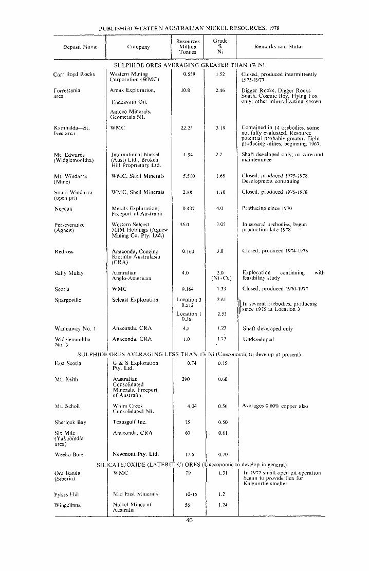
Deposit Name Company
Carr Boyd Rocks
Resources Grade Million % Remarks and Status Tonnes Ni
Forrestania area
SULPHIDE
Kambalda-St. Ives area
ORES AVERAGING LI
Mt. Edwards (Widgiemooltha)
N i (Uneconomic
Mt. Windarra (Mine)
South Windarra (open pit)
Nepean
to develop at present)
Redross
0.75
0.60
0.50
0.50
0.6 1
0.70
neconomic t
Sally Malay
Scotia
Spargoville
Wannaway No. I
Widgiemooltha No. 3
SULPHIDE O R E S AVERAGING (
Western Mining Corporation (WMC)
Amax Exploration,
tndeavour Oil,
Amoco Minerals, Geometals NL
WMC
International Nickel (Aust) Ltd., Broken Hill Proprietary Ltd
WMC. Shell Minerals
WMC, Shell Minerals
Metals Exploration, Freeport of Australia
Western Selcast MIM Holdings (Agnew Mining Co. Pty. Ltd.)
Anaconda, Conzinc Riotinto Australasia (CRA)
Australian Anglo- American
WMC
Selcast Exploration
Anaconda, CRA
Anaconda, CRA
East Scotia
Mt. Keith
Mt. Scholl
Sherlock Bay
Six Mile (Yakabindie area)
Weebo Bore
G & S Exploration Pty. Ltd.
Australian Consolidated Minerals, Freeport of Australia
Whim Creek Consolidated NL
Texasgulf Inc.
Anaconda, CRA
Newmont Pty. Ltd.
0.559
10.8
22.23
1.54
5.510
2.88
0.437
45.0
0.160
4.0
0.164
Location 3 0.512
Location I 0.36
4.5
I .O
S T H A N 1
0.74
290
4.04
75
60
17.5
SILICATE/OXIDE (LATER1 1C) ORES ( Ora Banda
Mid East Minerals
40
EATER THAN 1% Ni 1.52
2.46
3.19
2.2
I .68
1.10
4.0
2.05
3 .O
2.0 (Ni+Cu)
1.53
2.6 1
2.53
I .23
1.23
Closed, produced intermittently
Digger Rocks, Digger Rocks South, Cosmic Boy, Flying Fox only; other mineralization known
1973-1977
Contained in 14 orebodies, some not fully evaluated. Resource potential probably greater. Eight producing mines, beginning 1967.
Shaft developed only; on care and maintenance
Closed, produced 1975-1978. Development continuing
Closed, produced 1975-1978
Producing since 1970
In several orebodies, began production late 1978
Closed, produced 1974-1978
Exploration continuing with feasibility study
Closed, produced I9 70- 1977
I n several orebodies, producing since 1975 at Location 3
Shaft developed only
Undeveloped
1.31
1.2
1.24
Averages 0.60% copper also
develop in general) I n 1977 small open pit operation begun to provide flux for Kalgoorlie smelter

Underground nickel ore mining at Kambalda
boundary of the lens is marked by a wide zone of sheared and brecciated rock associated with the steeply west-dipping Perseverance fault. The lens consists of a core of dark olivine rock (dunite) surrounded by an envelope of dunite converted to serpentinite.
Overall the ultrabasic lens dips steeply westward, but a prominent embayment of ultrabasic into metasediments along the western contact forms a steeply south- plunging trough structure containing several ellipse-shaped depressions. Three such depressions in this trough contain the nickel ore shoots numbered 1 , 2 and 3, which consist of 15 to 20 per cent disseminated sulphides and average about 1.9 per cent Ni. Massive sulphides averaging more than 4 per cent Ni occur as planar sheet-like bodies within faults cutting through the lens and the metasedimentary country rocks. The largest sheet occurs within a fault extending more than 500m into these rocks, where it is known as shoot 1A. The massive sulphides are largely pyrrhotite
L
(Fe,S,) and pentlandite ((Fe, Ni),S,) which form a matrix to numerous inclusions of wall rock fragments, commonly surrounded by pentlandite banding. Disseminated sulphides are largely either pentlandite and pyrite (FeS,), or pyrrhotite and pentlandite. Above a depth of 400m these minerals are variably altered to supergene pyrite, pentlandite, magnetite and marcasite.
Initially supergene (altered) nickel ore from 1A shoot is being mined from a decline to give a projected production of 300000 tonnes of ore per year. This ore is now concentrated at the mine, road hauled to Leonora and then railed to the Kalgoorlie smelter. A shaft is being sunk to examine the deeper ore shoots, which are expected to boost ore production to 700000 tonnes per year in 1982.
The Perseverance mine is located 37 km by road northeast from the old gold mining centre of Agnew, and the newly constructed township of Leinster, which will accommodate some 1 0 people, is about 17 km south-§outhw~§t o f the mine.

Most of the Kambalda nickel deposits are clustered around the Kambalda dome which has a core of basaltic metavolcanic rocks and forms a prominent group of low hills rising above the plain and nearby Lake Lefroy. The dome is broadly elliptical with its long axis trending north-northwest. Some outlying small deposits occur 15 to 35 km to the south-southwest on the south side of the lake.
The metabasalt core is overlain by an ultrabasic rock sequence which in plan appears as a 20 km-long circumferal belt around the core. Both metabasalt and ultrabasic rocks have been faulted and intruded by younger acid to intermediate rocks.
About 80 per cent of the nickel ore is located at the base of the ultrabasic sequence in contact with the footwall metabasalt and is referred to as contact ore. This contact plunges at 20 to 25' to the north-northwest and south-southeast and dips at 40 to 65' along the flanks of the dome. The remainder occurs in orebodies within the ultrabasic sequence, up to 100m above the basal contact, and is referred to as hangingwall ore. This type of ore is only important in the western half of the dome and at Jan mine south of the lake. Most contact ore forms narrow north- northwest-trending sheets nearly coincident with fault-bounded depressions or troughs in the contact. Typical exposures show a layer of massive sulphides (averaging 8 to 20 per cent Ni) overlain by a thicker, more continuous layer of disseminated ore containing 20 to 65 per cent sulphides. The combined thickness is usually less than 3 m, but can exceed 8m. The major primary sulphide minerals are pyrrhotite and pentlandite. Millerite (NiS) is important in Otter and Gibbs shoots. Alteration of primary sulphides to supergene violarite and pyrite may extend to depths of 200 m.
So far, twelve deposits have been developed to production stage. Some 11 million tonnes of ore has been mined at Kambalda-St. Ives (to end of 1978). Ore is extracted by vertical shafts (total about 2 500 m) servicing the Lunnon, Durkin-Gibbs, Juan, Jan, and Long shoots, and 1 in 9 declines (total about 32 000 m) into Otter-Juan, Fisher, McMahon, Ken, Gellatly-Wroth, and
Hunt shoots. The excessive length (nearly 4 km) of the Juan decline necessitated the sinking of an ore haulage shaft which became operational in mid-1976. The Edwin shoot, south of the lake, is serviced by an underlay (inclined) shaft. Most mined out areas (stopes) are filled hydraulically with sand from surface stockpiles.
The annual production of about one million tonnes of ore averaging 3.0 per cent Ni (as mined) is first enriched in the surface treatment plant. The froth flotation process is used to concentrate about 90 per cent of this nickel into only 20 per cent of the original weight of the ore, allowing 80 per cent of the mined rock to be discarded. The resulting concentrate containing about 12 per cent Ni and 1 per cent Cu is rich enough for flash smelting at the Kalgoorlie smelter or ammoniacal leaching at the Kwinana Refinery.
At the end of 1977 the total workforce at the Kambalda mines (not including Kalgoorlie smelting operations) was 1 260 and the estimated population of the twin townships of Kambalda and Kambalda West was 4 600.
The Kwinana nickel refinery, 32 km south of Perth, began operations in May 1970. Concentrates, and ground nickel matte from the smelter, are subjected to high temperature and pressure leaching (Sherritt Gordon process) which releases the nickel, copper and cobalt. Products are nickel briquettes (99.8 per cent Ni), nickel powder, copper sulphide (60 per cent Cu, 20 per cent S, and 1 per cent Ni), mixed nickel and cobalt sulphide (30 per cent Ni, 20 per cent CO, 30 per cent S), and fertilizer grade ammonium sulphate.
The Kalgoorlie smelter was commissioned in December 1972. It has recently been expanded to cope with the output of the Perseverance mine. The smelter consists of thee basic units: a flash furnace which accepts concentrates and silica flux; an electric slag cleansing furnace; and a converter. The flash furnace produces molten sulphides containing up to 50 per cent total nickel and copper. This matte is upgraded to a high grade sulphide matte containing 70 per cent Ni and 5 per cent Cu, which is granulated and transported to Kwinana for further refining or direct export.
42

RUBlDlUM AND CAESIUM
Rubidium and caesium are the two heaviest alkali metals. They have common mineral sources and properties which may lead to similar uses. At present research is being done to establish new uses.
Both have uses as getters in electronics and as scavengers in metallurgy. In photomultiplier tubes, in infra-red lamps, telescopes and spectrometers and in some scintillation counters both have applications, although caesium is more often used. They have a potential use in plasma-type generators and in ionic-type rocket fuels. Each has a number of other minor or potential uses, particularly in pharmacy.
Rubidium and caesium production in the past has been entirely as by-products of the lithium industry using lepidolite ore and some by-product pollucite (hydrous caesium aluminium silicate) from South African pegmatites.
The name ALKARB is given to a product from the end liquors resulting from the extraction of lithium from lepidolite. This contains mixed alkali carbonates, including 23 per cent rubidium carbonate and 2 per cent caesium carbonate, and is used in the glass and ceramic industries.
Lithium pegmatites in Western Australia do not contain lepidolite carrying rubidium and caesium in the same concentration as the South African mineral. However small quantities of the metals have been detected in local beryl, lepidolite, muscovite and zinnwaldite. Significant concentrations are also reported from greisen and pegmatite. The figures for these are shown in the following table.
Mineraland Locality
Beryl, Yinnietharra .................
Lepidolite, Tabba Tahba Lepidolite, Wodgina
Lepidolite, Londonderry .........
Zinnwaldite, Ubini ..... Muscovite, Greenbush Feldspar, Greenbushes ... Greisen, Binneringie ................ Pegrnatites,Greenbushes .......... Pegrnatite, Moolyella Pegrnatite, Balingup ................
To the end of 1978, Western Australia had produced 429459 kg of silver valued at $9572223. About 98 per cent of this total was obtained as a by-product of gold mining. The remainder came from treatment of lead-zinc ores (1 per cent), copper ores (0.7 per cent) and nickel ore (0.1 per cent). About half of the silver derived from gold mining originated in the Golden Mile at Kalgoorlie, being extracted from ore averaging 2 grams per tonne (g/t) silver (Ag). Other gold mining centres which contributed important quantities of silver are Norseman, Big Bell, Day Dawn, Leonora and Bullfinch. Gold-bearing quartz veins at Comet Vale contain from 300 g/t to 7 500 g/t Ag.
l u bidium Oxide Rb,O
Percent. Trace
1.42 Trace
1.42-2.02 1.12 1.46 1.72 2.34 1.10 1.10 0.30 0.50 0.60
0.08-0.94 0.20 0.16
Iaesiurn Oxide cs,o Percent.
1.72 0.26
Trace 0.25
Trace Trace Trace Trace
0.72-0.92
Trace .... ....
0.03 .... .... ....
No occurrence of pollucite has been recorded in Western Australia, although its close similarity to quartz makes it possible that it has been overlooked.
SILVER
Most lead-zinc ores in the northern part of the State carry appreciable silver. Concentrates from Uaroo, Kooline, Ragged Hills and Narlarla contain respectively 350 g/t, 225 g/t, 200 g/t and 105 g/t Ag. Lead- zinc ores from the Northampton field are poor in silver, most concentrates containing only a few grams per tonne of the metal. Some particularly rich galena-bearing quartz veins occur in the Kimberley Division.
The greater part of the silver derived from copper mining came from the Ravensthorpe centre where typical ore contains about 2.5 g/t Ag. However, some
43

copper deposits elsewhere in the State are appreciably more argentiferous, with particularly silver-rich samples coming from Lennons Find, North Shaw, Roebourne, Uaroo and Wodgina.
The copper/zinc ore bodies at Golden Grove and Teutoric Bore also carry appreciable amounts of silver which would be produced as a co-product.
Silver minerals so far recognized in the State include chlorargyrite (AgCl) in gold ores at North Pole, Menzies, Kalgoorlie and Red Hills; in lead ore at Tambourah, Mt. Edgar and Uaroo; and in copper ore at Henry River and Stockyard Creek. Hessite and sylvanite occur in gold ore at Kalgoorlie; and petzite is found in gold ore at Kalgoorlie and Mulgabbie. Cosalite, an argentiferous lead bismuth sulphide has been recorded at Comet Vale.
TANTALUM AND NIOBIUM
Tantalum and niobium are two of the rarer metals which are finding increasing application in modern technology. Both metals are capable of forming high-strength temperature-resistant alloys and com- pounds.
Tantalum is used in electronic components, metal working machinery, chemical equipment and aerospace application.
Niobium or columbium, as it is called in the U.S.A., is used principally as an alloying constitutent in steels which are required to retain their physical properties at very high temperatures and also where high resistance to corrosion is necessary. Niobium steels are extensively used in jet engine turbines and in rocket components.
Tantalite, (Fe, Mn) Ta,,O,, and columbite, (Fe, Mn) Nb,O,, are the two end-members of an isomorphous series. However, in nature the pure end-member compositions are rarely attained.
Most natural tantalites contain an appreciable quantity of niobium and most columbites a certain amount of tantalum. The minerals are classified as tantalites, columbo-tantalites, tantalo-columbites and columbites as the proportion of tantalum to niobium decreases. These minerals also vary in the proportion or manganese to iron. Further complexity in composition results from the inclusion of calcium, antimony, bismuth and rare-earth elements within the molecules.
In Western Australia a wide range of the tantalits-columbite isomorphous series has been recorded but there is a predominance of the tantalum-rich minerals.
Most commercial production has been of tantalite, mangano-tantalite, tapiolite, columbite and mangano-columbite.
Western Australia has been one of the world’s leading producers of tantalite, the greater part of which has been a by-product of tin mining. To the end of 1978 a total of 2 677 tonnes of tantalite and tantalo- columbite concentrates had been produced and was valued at $12 267 571.
The more important productive localities have been Greenhushes, Shaw River and Wodgina with respective yields of about 60, 20 and 10 per cent of the State total. Other centres of minor production are Tabba Tabba, Strelley, Moolyella, Coondina and Pilgangoora in the Pilbara Goldfield, Poona, Dalgaranga and Warda Warra in the Murchison Goldfield, and Londonderry in the Coolgardie Goldfield.
Tantalum and niobium minerals have been recorded from a host of localities but in the majority of cases these occurrences are of mineralogical interest only. All tantalite occurrences are related to pegmatite dykes and no disseminations in granite have been recorded.
At Greenbushes, tantalite (including stibiotantalite) and tantalo-columbite is recovered from Recent and Tertiary tin- bearing gravels, and from large kaolinized pegmatite dykes. The Shaw River deposits comprise shallow cassiterite-bearing alluvium and eluvium located near swarms of albite pegmatites.
At the world famous Wodgina locality the tantalite lode is a large pegmatite dyke consisting of albite, quartz, microcline, muscovite and lepidolite. The tantalite is
44
associated with the albite and is concentrated near the walls of the dyke in large bunches or scatters of crystals. A single mass weighing 250 kilograms has been recovered.
The tantalite is erratically distributed throughout the pegmatite and much barren rock must be removed during mining. Rich alluvial concentrations of tantalite occur in the scree below the dyke and these have provided the greater part of the production. This dyke system was also mined for its beryl content.
The tantalite from Wodgina has the following approximate composition: Ta,O,, 67 per cent; Nb,O,, 15 per cent; MnO, 13
Tin ore was first discovered in Western Australia at Greenbushes in 1888. It has since been found in numerous other localities in the State, the most important centres outside of Greenbushes being in the Pilbara region.
Cassiterite is derived from albitized pegmatites associated with the Archaean granites. Formerly, the bulk of production came from eluvial or detrital accumulations near the host pegmatites or from alluvial concentrations in present and past drainage channels, with only a small contribution from primary deposits. However, open-cut mining of weathered pegmatite at Greenbushes has yielded most of the State’s tin concentrate produced in recent years. Tantalite and columbite are common associates of cassiterite in both the primary and secondary deposits.
To the end of 1978 the total amount of tin concentrate produced in Western Australia was 35 31 1 tonnes valued at $46 354 792. By far the greater part of this production was derived from the Greenbushes and Pilbara mining areas.
Pilbara tin fields Tin has been worked at many places in
the Pilbara Block. Moolyella, Cooglegong, Eleys, Pilgangoora, Wodgina, Stannum, Mt. Francisco, Coondina, Abydos, Tabba Tabba, Strelley and Friendly Creek have been the most important localities. Of these
TIN
45
per cent; FeO, 2 per cent. Owing to the predominance of manganese this mineral is classified as a mangano-tantalite.
Marketing conditions have fluctuated greatly for tantalum and niobium minerals since the end of World War 11, but generally tantalite assaying higher than 60 per cent Ta,O, finds a ready market, while that containing between 30 per cent and 60 per cent Ta,O, is usually saleable.
Minerals near the columbite end of the isomorphous series, that is, those with high Nb,O, content but very low in Ta,O, may sell only with difficulty and at prices muck lower than for tantalite.
Moolyella has supplied the greatest quantity of tin in the past and is still the most important productive area.
At Moolyella the cassiterite is widely disseminated in a host of pegmatite veins, related to a granite stock, which intrudes a migmatitic granite. The individual veins themselves have yielded little cassiterite. However, erosion over a long period has resulted in rich detrital and alluvial concentrations of cassiterite in the valleys and drainage channels within the mineralised area.
To the end of 1978 the Moolyella field had produced a total of 7 9 1 8 tonnes of tin concentrate.
Between Eleys and Cooglegong (Spear Hill) a large region known as the Shaw River tin field carries alluvial and eluvial cassiterite close to outcrops of mineralized pegmatite, and next to Moolyella, this area has been the most important producer.
The most notable production from primary sources has been from the Mt. Cassiterite vein at Wodgina. Over 300 tonnes was obtained from this vein system and a quantity of detrital tin was taken from the hill slopes below the veins.
Rich pegmatites have also been worked at Tabba Tabba.
The most recent tin find in the Pilbara is at Coondina where cassiterite shed from

Open cut tin mining at Greenbushes
pegmatites was mined from present-day creeks and an old, probably Tertiary, stream bed. Another old stream system is mined for tin at Friendly Creek.
Lack of water has handicapped the development of many potentially productive areas in the Pilbara. Conditions for the accumulation of underground water are generally poor and in the drier years water supplies are inadequate for mining and concentration purposes. In present-day workings the tin gravels, after screening, are treated in cones for the primary concentration.
Greenbushes tin field In terms of total production Greenbushes
has been the most important tin field in the State. The most vigorous period of the life of the field was between 1889 and 1920 when over 10000 tonnes of tin concentrate were produced, including nearly 500 tonnes of lode tin.
Greatest output during the period was achieved between 1903 and 1908 with an annual production exceeding 500 tonnes and with a maximum of 783 tonnes in 1906. Rising tin prices stimulated new interest in
the field in 1965, when large reserves of lower grade secondary ores were demonstrated. These were mined for a time by dredging, but eventually this operation was abandoned in favour of open cut mining of weathered pegmatite. Since 1965, 6 905 tonnes of concentrate have been produced from Greenbushes, with a peak production of 1504 tonnes in 1972. Total production is 19 297 tonnes of concentrate valued at $25 588 455 to 1978.
At Greenbushes, cassiterite with associated tantalite occurs in a number of large pegmatite dykes cutting gneiss and amphibolite. Richer sections, including some greisens, were formerly mined as ‘lodes’.
Two distinct types of alluvium have been distinguished in this area.
The Old Alluvium consists of a series of lenticular clay, sand; grit, pebble and boulder beds with a maximum known thickness of 30 metres. It is the principal source of secondary cassiterite that occurs in the coarser elastic beds, which are generally overlain by laterite.
46

The Recent Alluvium is confined to the drainage channels of the present creeks, and largely represents a redistribution of the Old Alluvium. It is not covered by laterite and is generally low in tin content.
In the early days of the field most of the tin was won by small parties of men puddling the rich pockets near the surface. Some of the pockets carried up to 30 kg/cubic metre. In later years, dredging yielded most of the tin won and as many as 16 dredges (actually floating hydraulic sluice plants) were operating in 1919.
The grade of the deposits ranged between 1.5 and 1.8 kg of cassiterite per cubic metre and the assay values of the concentrates were 68 to 70 per cent tin.
Kimberley Division A little alluvial tin has been obtained
near Mt. Dockrell and some narrow veins of pegmatitic quartz have been worked at Federal Downs. These veins also carry some tungsten minerals.
Other areas Tin-bearing gravels and pegmatites have
been worked at Coodardy and Poona in the Murchison and more recently in the Norseman area. Small quantities of detrital tin have been found in association with tantalum-bearing pegmatites at Dalgaranga and Londonderry, and near Ubini in the Coolgardie area.
Though the metal tungsten is sometimes referred to as wolfram, the name tungsten is more widely used.
Tungsten ore minerals have been recorded at a great number of localities in Western Australia but, to the end of 1978, production of tungsten ores and concentrates had amounted to only 482 tonnes valued at $270 342. The principal ores of tungsten are scheelite (calcium tungstate), and wolframite (iron and manganese tungstates). Wolframite forms a series from ferberite (iron tungstate) to htibnerite (manganese tungstate).
Wolframite commonly occurs in granite pegmatites or in quartz veins emanating from granite intrusions. Scheelite is often found in the same environment.
In the Pilbara Block one of the most important productive localities of wolframite has been Cookes Creek. The wolframite occurs in quartz veins cutting Archaean metasediments surrounding the Cookes Creek granite pluton. About 26 tonnes of wolframite concentrates were derived from this area in 1951-52 together with about 1% tonnes of scheelite concentrates. At Callie Soak, in the Murchison Province, about 9 tonnes of mixed scheelite and wolframite concentrates were mined from pegmatite veins traversing the granite.
TUNGSTEN
47
Scheelite is a common mineral in many of the gold-bearing quartz veins and there has been a small production from many localities either by direct mining from the veins or by re-treatment of sands after gold extraction. Scheelite has been recovered from the zones of gold mineralization at the Edna May Mine at Westonia, the Sons of Gwalia at Leonora and from the Sons of Erin Mine at Higginsville. A scheelite- bearing quartz reef was worked at Norseman for the production of nearly eight tonnes of concentrates.
At Comet Vale, scheelite is present in the auriferous quartz-calcite veins and as impregnations in the enclosing actinolite rock. This area offers prospects of a large tonnage of low grade ore.
Scheelite occurs in association with bismuth ores at Melville in mineralized shear zones in greenstone schists. There has been a small production of wolframite from Clara Hill in the Halls Creek Province and from the Yandanhoo Hills about 10 kilometres north of Mt. Gibson.
Wolframite has also been recorded at Wodgina, Friendly Creek, Kangan, Split Rock, Poona, Abbotts, Coodardy, Mt. Mulgine, Warriedar, Grass Valley, Boyagarra and Ora Banda.

AN IU
Radioactive minerals have been known as constituents of Western Australian pegmatites since about 1911. The most spectacular specimens are a series of breakdown products of thorogummite (previously named rnaitlandite), nicolayite and pilbarite. They vary in colour through zones of black, orange and yellow and occur in isolated patches in the pegmatites at Wodgina.
At Cooglegong, yttrotantaiite, tanteuxenite and tantalopolycrase carry respectively 2, 3 and 7 per cent of uranium oxide (UO,) with corresponding amounts of radium. Tanteuxenite at Woodstock carries 4 per cent UO,.
The majority of columbites from the Pilbara carry about 0.5 per cent UO,.
As a result of the interest shown in uranium following World War 11 , . fault zones containing minor showings of radioactive minerals such as torbernite and autunite were located near Halls Creek, and a uranium-bearing conglomerate was
found in the Killi Killi Hills, 230 km southeast of Halls Creek.
The discovery of the Yeelirrie deposit in 1971 sparked off further exploration for uranium which resulted in the discovery of a number of other small occurrences.
Five types of uranium occurrences have been reported from Western Australia.
Type 1. Secondary carnotite deposits in calcrete. Calcrete, a siliceous limestone deposit filling Tertiary stream channels in inland parts of the State, contains uranium in a number of localities. The best known deposit is at Yeelirrie where carnotite (potassium uranyl vanadate) has been confirmed over an area about 6000 metres long and 500 metres wide with an average depth of 8 metres. I t contains an estimated 46 000 tonnes of U,O, in ore averaging 0.15 per cent U,O,, and comprises the State’s only present uranium deposit for which mining plans have been announced. Other deposits in calcrete are reported from Lake Way, Yamarna, Lake Raeside, Lake
Samp~ing benches in test pit at Yeelirrie.

Maitland and Lake Austin, but apart from possible development at Lake Way, none are of present economic importance.
Type 2. Diagenetic concentrations in Proterozoic congLomerates. Proterozoic conglomerates are an important source of uranium in Canada (Blind River) and South Africa (Witwatersrand), but in Western Australia, minor occurrences only of uranium are recorded in conglomerate. The Hardey Sandstone in the Pilbara region contains weakly radioactive pyritic gold-bearing conglomerates in which uraninite and pitchblende are associated with thucholite pellets. In the Killi Killi Hills, grit and pebbly arkose at the base of the Gardiner Sandstone contains possibly diagenetic uranium associated with rare earths in xenotime and florencite grains.
Type 3. Primary deposits in veins. The most significant uranium-bearing vein deposit is Mundong Well where pitchblende and kasolite (lead uranium silicate) are associated with copper, lead and zinc minerals. Grades of over 40 kg of U,O, per tonne have been reported.
Uranium minerals have been recorded from copper-lead deposits at Ashburton Downs, and from fault zones in a number of places in the Kimberley region.
Type 4. Secondary concentrations in sandstone. Uraniferous sandstones are important sources of uranium in the U.S.A. and some companies have sought similar
deposits in W.A. in both Proterozoic and Phanerozoic sandstones. The best result has been obtained in the Bresnahan Basin where uranyl phosphates of sub-economic grade were discovered.
Type 5. Concentrations in Recent lake sediments. Geologically young sediments beneath salt lakes in the interior of the State have been found to contain uranium. Isolated samples from Lake Barlee are reported to contain about 4 kg of U,O, per tonne.
‘Yellowcake’ (sodium or ammonium diuranate), the saleable concentrate derived from uraniferous ore, has not yet been produced in Western Australia apart from a small test batch from Yeelirrie ore by Western Mining Corporation. A pilot scale plant is proposed at Kalgoorlie to test commercial scale concentration that may eventually be established at Yeelirrie.
Thorium occurs as the minerals monazite and xenotime in heavy mineral concentrates found on many modern and ancient shore lines in Western Australia. It has also been found in a number of radioactive conglomerates of Proterozoic age in the Pilbara and Kimberley regions.
Western Australian production of thorium-bearing minerals to the end of 1978, amounting to 50404 tonnes of monazite and 263 tonnes of xenotime, was recovered as co-products from heavy mineral sand mining.
VANADIUM
Vanadium is one of the rare metals and is Coates Siding. Investigations to assess the used principally as an alloying constituent ore potential of these and other deposits in certain types of steel requiring have demonstrated that there are several exceptional toughness, hardness and hundred millon tonnes of ore containing -resistance to impact and abrasion. between 0.7 and 1.3 per cent V,O,.
Extensive low-grade deposits of this metal have been recognized in Western Australia but there has been no commercial production to date.
Vanadium occurs in intimate association with magnetite as layers within large anorthositic gabbro intrusions in many places in Western Australia. The largest deposits discovered to date are at Balla Balla, the Jameson Range, Barambie and
The Coates Siding deposit, 65 kilometres east of Perth, is currently being assessed by Agnew Clough Ltd. The company states that extraction techniques have been devised to give a satisfactory product.
The vanadium deposits of Western Australia are described more fully in Mineral Resources Bulletin No. 1 1 issued by the Geological Survey of Western Australia.
896864 49
Yttrium is found in nature with the rare- earth elements. The rare-earth elements are a group of chemically similar elements of atomic numbers 57 to 71 with identical outer electron orbits. Common practice is to divide the rare-earths into two groups: the light elements lanthanum 57 to gadolinium 64, and the heavy elements terbium 65 to lutenium 71.
Uses of yttrium and rare-earth metals are in petroleum cracking catalysts, in metallurgy for the production of lightweight alloys, in the ceramics and glass industries and in the production of arc carbons.
Occurrences of rare-earths and yttrium- bearing minerals are numerous in Western Australia. The two most important minerals are monazite, a phosphate of cerium and lanthanum with yttrium, and xenotime, essentially yttrium phosphate carrying rare-earth elements. Both are produced commercially in the Cape1 and Eneabba areas and are described in the section on Heavy Mineral Sands. Other minerals of yttrium and rare-earths include euxenite, a niobate and titanate of yttrium, erbium, cerium and uranium, fergusonite, a niobate and tantalate of yttrium and erbium with cerium and other metals in varying amounts, gadolinite, a silicate of yttrium, beryllium and iron, and yttrotantalite, a niobate and tantalate of yttrium and rare-earths.
Generally the yttrium and rare-earth minerals are won from eluvium and
alluvium derived from pegmatite dykes. Only rarely do the minerals occur in economic concentrations in the dykes themselves. With the exception of the monazite and xenotime recovered from heavy mineral sands in the Southwest of the State, most occurrences are from the Pilbara Block which is pre-eminently a rare-earth province. Eluvial and alluvial deposits have been reported and sometimes mined from many Pilbara localities including Abydos, Woodstock, Mount Francisco, Wodgina, Cooglegong, Dead Bullock Well, Hillside, Tambourah, Tabba Tabba and Nullagine. Localities at which the host pegmatite has been mined are Cooglegong and Dead Bullock Well (gadolinite) and Hillside (tanteuxenite).
n unusual xenotime deposit was discovered in 1973 at a locality about 250km south of Wyndham in the Halls Creek Province. Here the xenotime occurs as veinlets or pods in quartz veins of probable hydrothermal origin occupying pre-existing fractures in quartzites of the Red Rock Beds.
The greatest production of monazite and xenotime is from heavy mineral sand deposits in the Perth Basin. In 1978, production of monazite amounted to 5 760 tonnes from the Bunbury-Busselton area and 4697tonnes from Eneabba. Xenotime production i s variable but averages about 20 tonnes per year.
Zinc has been obtained in Australia only as a by-product mining.
Sphalerite is especially abundant in the lead ores at Narlarla, Braeside, and several of the Northampton mines. Typical sulphide ore from Narlarla contained 40.8 per cent zinc, 13.9 per cent lead and 0.4 per cent copper.
Zinc carbonate ore was min Andover and assayed 38.2 per cent zinc, 3.5 per cent lead and 0.2 per cent copper.
In all 2935 tonnes of zinc has been recovered as a by-product of lead mining and a further 20 tonnes of zinc ore has been produced for use as fertilizer.
SULPHIDE DEPOSITS Important (but as yet unexploited)
quantities of zinc occur with copper in stratabound sulphide deposits at Golden Grove, Teutonic Bore, Mons Cupri, Murrin Murrin and Ravensthorpe.
50

NON-M ETALLIC AND
INDUSTRIAL MINERALS
51
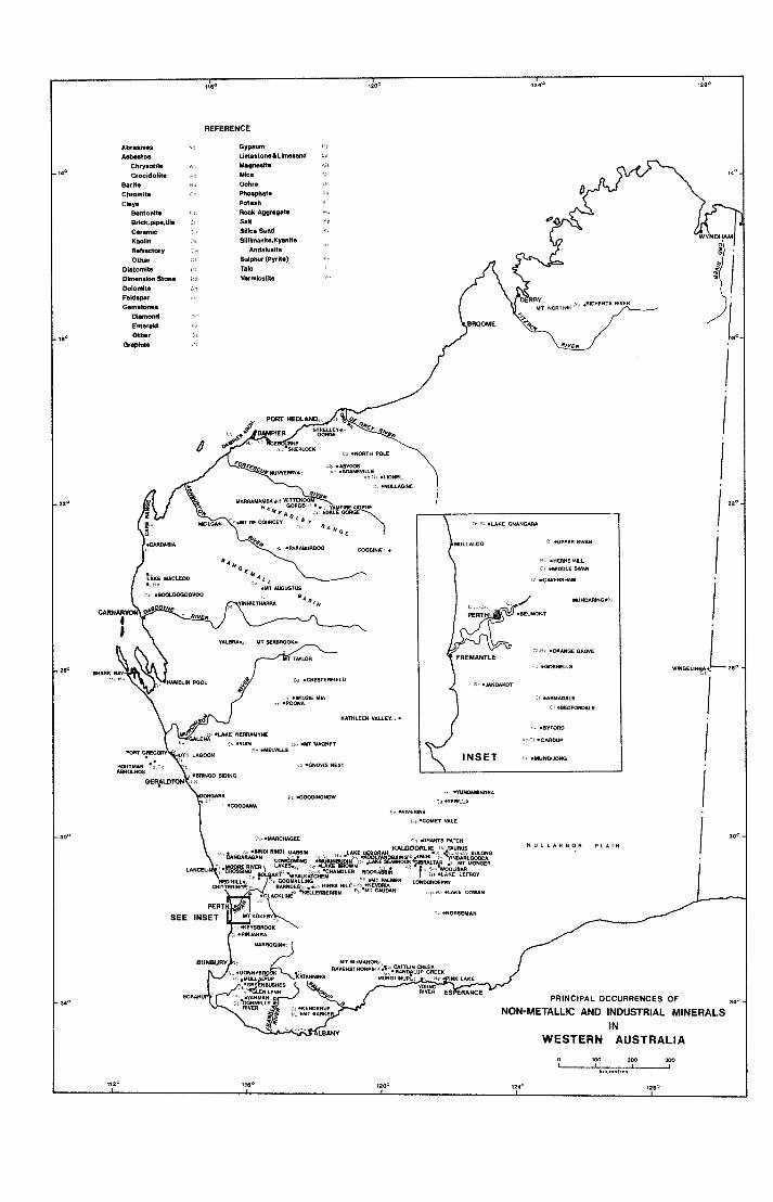
REFERENCE
C F .MIANGEWlDVE FREMANTLE
\ - .006NELLJ
,120
bc W W E T VALE
C .YIRCHbSEE Y 'GRANTS PATCH N U L L I R B O R P L A I N
I____! 34 PRINCIPAL OCCURRENCES OF
NON-METALLIC AND INDUSTRIAL MINERALS IN
WESTERN AUSTRALIA
I I I

ABRASIVES
Imported artificially produced abrasives meet the greater part of the demands of Australian abrasives consumers. In recent years, however, price increases of some artificial abrasives have improved the competitiveness of natural materials. Natural abrasive minerals found in Western Australia include corundum (aluminium oxide), garnet, feldspar, topaz, novaculite, and sandstone suitable for grindstones. Diatomite, discussed elsewhere, has been used as an abrasive of the softer type.
CORUNDUM
Corundum occurs at a number of localities in Western Australia and emery (an impure iron-rich rock containing corundum) has been recorded at three, but there has been no sustained production of either commodity. The total recorded output of corundum is 64 tonnes valued at $1 310, and of emery, 21 tonnes with a value of $750.
At Kathleen Valley in the East Murchison Goldfield, a massive granular rock, carrying 70 per cent corundum admixed principally with andalusite, occurs in Archaean schist. By description some hundreds of tonnes are available. In 1952, 55 tonnes was produced for use as a refractory material.
Deposits of corundum-bearing rock occur in the basin of the Richenda River in the West Kimberley Goldfield in the country around Mount Broome and Mount Rose. Available descriptions of these deposits vary, but one describes the material as being potentially the most important deposit of emery in Australia. From the few analyses on record it appears that the material classed as emery is a rock in which corundum and diaspore are the principal components. About 21 tonnes of material reputed to have good abrasive quality was obtained from Mount Broome in 1942 and 1954. Little is known of the extent of these deposits but reserves are thought to be several hundred tonnes.
Corundum is also known to occur in veins at Abydos, Ubini, Gibralter and Nevoria, and has been found as pebbles in soil near Jacobs Well and ;)angin, about 150 km east of Perth.
GARNET
Although garnet occurs at numerous localities in the State there has been little interest shown in it until recently when an extensive deposit of garnetiferous (almandine variety) beach and dune sand was located at Port Gregory near the mouth of the Hutt River. The operators, Target Minerals N. L., propose to establish a 12000 tonne per year production of 95% garnet concentrate. By the end of 1978, 479 tonnes had been produced mainly for consumer testing. Garnet is harder than quartz and performs better as a blasting sand for cleaning metal surfaces. In this application garnet is also favoured because it greatly reduces the silicosis health hazard known in the use of quartz sands.
FELDSPAR
Feldspar, although consumed mainly by the ceramics and glass industries, is also used as an abrasive, and a significant proportion of the State’s production has been for this purpose. Until its closure in 1975 a large quarry at Londonderry produced most of the State’s total of 75 498 tonnes feldspar valued at nearly $600000 to the end of 1976. Locally, the feldspar formerly used in glass manufacture has been replaced by alumina and the current 650 tonne annual average feldspar production is mostly finely ground for use in mild abrasive soaps and cleansers. Operating mines at Goodingnow and Mukinbudin extract lump orthoclase feldspar from pegmatite dykes which are also widespread elsewhere in Western Australia.
OTHER ABRASIVES
Minor sources of abrasive are represented by topaz which has been obtained from Londonderry and elsewhere and used as flints in tube mills; novaculite, formed by metamorphism of Precambrian shale at Cardup and used for oil stones; and Donnybrook Sandstone from which first class low-speed grinding wheels have been made.
53
AGGREGATE AND DIMENSION STONE
AGGREGATE
Few deposits of natural aggregate, such as river gravels, shingles and coarse sands, are known in Western Australia and the bulk of the aggregate used in concrete, road construction and railway ballast is obtained by crushing igneous and metamorphic crystalline rocks. Abundant suitable materials of this kind occur close to the principal urban centres of the State. Materials such as limestone and lateritic gravel are widely used as substitutes for conventional aggregate in road construction.
Total crushed and broken stone (aggregate) production in Western Australia for the year ended June 1976 was 3.807 million tonnes.
Crushed rock aggregate for the Perth Metropolitan region is supplied from three well established large quarries located along the Darling Fault scarp at Herne Hill, Orange Grove and Gosnells, and a fourth quarry recently opened at Byford.
Historically, the major quarry product was crushed dolerite, a hard, dark, fine- grained rock occurring in numerous dykes intruded into the crystalline rocks of the Yilgarn Block. However, as quarries originally opened on dolerite dykes were extended, increasing amounts of granite (typically an even-grained granodiorite) were extracted. Granite is now by far the more important product and is preferred to dolerite in all major aggregate applications.
Resources of suitable rock in the Perth area are vast, but such environmental factors as the unsightliness of quarries, and the need to keep them separate from areas of urban development, restricts access to much of the material. However, available reserves in the Metropolitan area are considered to be adequate.
Crushing and screening of granite and dolerite produces a large quantity of undersized material variously referred to as secondary screened products, quarry fines or fine aggregate. A significant quantity of this material is used in concrete mixes replacing coarse sand which is scarce around Perth. Quarry fines are also often
54
used to assist consolidation of road foundations.
Annual aggregate production from the three major quarries is currently estimated at 2.3 million tonnes of which 1 . 1 million tonnes is crushed granite, 0.2 million tonnes is crushed dolerite and 1.0 million tonnes is fine granite. The proportion of crushed dolerite is likely to decline in the future.
About 70 per cent of the crushed granite produced is used as a strengthener and filler in concrete. Relatively small quantities of hard-rock aggregate are used in road sub- base construction, as cheaper Tamala (Coastal) Limestone and lateritic gravel can adequately serve this purpose. Until recently crushed dolerite was the preferred stone for bituminised road surfacing but increasing quantities of crushed granite are now being used as it has been found to maintain a better non-slip surface. Annual consumption of crushed rock for metropolitan road surfacing is estimated to be 0.25 million tonnes.
Crushed granite i s also used as railway ballast but as this is only required to maintain existing lines there is a small annual demand for about 55 000 tonnes.
Blast furnace slag, used extensively elsewhere as a substitute for crushed rock in concrete and road construction is rarely used in Perth.
Crushed white quartz from quarries at Gosnells and Mukinbudin is used in exposed aggregate panels as an external wall cladding and for a variety of other purposes such as surfacing for freeway acceleration and deceleration lanes, rendering for swimming pools and other applications where colour or resistance to abrasion are important.
Small quantities of crushed granite and dolerite are also used as a drainage medium in the foundations of light buildings and in leach drains.
Numerous quarries have been opened close to country centres in Western Australia to supply aggregate for local needs. Some have been developed only to supply particular construction projects (such as the vast railway and urban

Aerial view of Readymix granite quarry at Gosnells
building programmes associated with iron ore development in the northwest of the State). Others, notably at Geraidton, Bunbury, Kellerberrin, Albany and Kalgoorlie are more or less continuous producers. Although gravel for aggregate use has been screened from the beds of some north-western rivers, most aggregate throughout the State i s obtained by crushing a variety of crystalline rock types.
The mineral vermiculite, when exfoliated, provides a low density material with excellent ,thermal and acoustic insulation properties. Expanded vermiculite i s used as a light-weight aggregate with suitable binder for wall and ceiling panels. Production of vermiculite has been reported from three localities in Western Australia.
At Bulong, 32 km east of Kalgoorlie, vermiculite occurs in a sheared talc- carbonate rock. There are two veins, the larger being about 75 cm wide. The vermiculite contained in the veins expands to 10 to 15 times on heating and was worked intermittent~y up to 1956.
At Young River, 103 km east of Ravensthorpe, verrniculite occurs in irregular seams in a shear zone 6.4 km long and 0.8 km wide in metamorphosed ultrabasic rocks. The vermiculite as mined has an average density of 1212 kg/cu. metre decreasing to 90-160 kg/cu. metre after e~foliation. Reserves are not known, but the mineral appears widely distributed. Intermitt~nt mining took place between 1939 and 1953 and 244 tonnes was produced in 1978.
Vermiculite has been worked in two almer. The host rocks
mphibolites. The vermiculite lenses and streaks up to 10 dispersed in adjacent areas.
Reported production between 1973 and 1975 totalled 919 tonnes.
reported occurrences of vermiculite stralia are at Comet Vale, arvel Loch, Bridgetown,
angin, Goomalling, Mullalying, Northampton and Wellington
55

Shale suited for conversion into expanded aggregates for use in low density concrete occurs in the Precambrian Cardup Group. It is characterized by a dark blue or grey appearance amongst the white and red brick making shales. It has a high illite content and sufficient carbon and iron oxide to produce intumescence at the softening point which lies between 1 100" and 120OOC. Treatment in this temperature range in rotary kilns gives an aggregate ranging in bulk density from 560 to 720 kg/cubic metre.
DIMENSION STONE
The quantity of stone produced for monumental and facing work in Western Australia is small. However, large quantities of uncrushed rock used in a variety of applications are included in dimension stone and account for all but about 1500 tonnes produced of this category.
Much of the stone used in monumental work is imported, but the light-grey medium grained granite obtained from Mundaring is also widely used. In the past, before the advent of reinforced concrete, substantial quantities of stone were used in building construction but this use declined sharply later.
Tamala (Coastal) Limestone was the stone first used for wall construction after European settlement in 1829 and its use as a foundation material for brick walled domestic dwellings was retained until around 1950 when concrete largely took its place. Limestone use is now restricted to
retaining and feature walls. Another building material once extensively used in public and commercial buildings was Donnybrook Sandstone but present demand is small and intermittent.
Granite for use as a facing stone on external walls and for internal feature panels has been obtained from Mundaring, Watheroo, Kalgarin and Albany. Toodyay Quartzite, a grey-green flaggy quartzite with micaceous partings is still popular for indoor and outdoor feature stonework and in 1976 some 524 tonnes was produced.
Spongolite, a lightweight freestone consisting almost entirely of siliceous sponge spicules, is quarried from outcrops extending sporadically from Mount Barker to Ravensthorpe. Production from three quarries near Mount Barker and one near Ravensthorpe is used mainly for farm dwellings and amounts to about 100 tonnes per year. Similar local use is made of a coquina shell limestone from Hamelin Pool in the Shark Bay area.
Locally obtained rock boulders are used in the construction of groynes and causeways, as rip rap (a layer of broken rock placed along the toe of dam walls and spillways to prevent erosion), and as fill for a variety of other construction purposes. The amount of material required annually varies considerably according to the number and size of current projects.
Total dimension and building stone production for the year ended June 1976 was 82000 tonnes, compared with a high of 326 000 tonnes in 1971-72.
ASBESTOS
Four types of asbestos have been mined in Western Australia. Crocidolite, the most important variety, is restricted to Lower Proterozoic iron formations within the Hamersley Range. The State's deposits of this mineral are second only in size to those in South Africa. Chrysotile was mined from seams in serpentinite at a number of places within the Archaean Pilbara Block, and from metamorphosed dolomite near Meilga in the Proterozoic
56
Bangemall Basin. The mineral is also known from the Yilgarn Block, but so far not in commercial quantities. Anthophyllite deposits occur mainly in metamorphosed ultramafic rocks in the southwest of the Yilgarn Block, although a small amount was mined from Bulong in the Eastern Goldfields. About 1 tonne of tremolite was produced from Nunyerry in the Pilbara Block. Details of production of all four types of asbestos are given below.
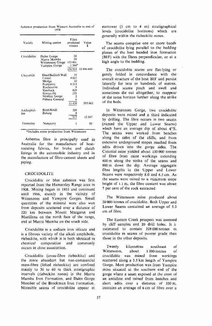
Asbestos production from Western Australia to end of 1978
Fibre
tonnes $ Variety Mining centre produced Value
Crocidolite Dales Gorge 30 Marra Mamba 59 Wittenoom Gorge 153 461 Yampire Gorge =*
33496645
Chrysotile DeadBullock Well 35 Lionel 4 015 Meilga 10 Nunyerry 6 313 Roebourne 5 Sherlock 829 Soansville 235
Pilbara General ___ 6 Strelley Gorge 2
1 1 450 993663 - Anthophyl- Bindi Bindi 509
8 lite Bulong - 517 13547
Tremolite Nunyerry 1 50
-
*Includes some production from Wittenoom
Asbestos fibre is principally used in Australia for the manufacture of heat- resisting fabrics, for brake and clutch linings in the automobile industry and in the manufacture of fibro-cement sheets and piping.
CROCIDOLITE
Crocidolite or blue asbestos was first reported from the Hamersley Range area in 1908. Mining began in 1933 and continued until 1966, mainly in the vicinity of Wittenoom and Yampire Gorges. Small quantities of the mineral were also won from deposits scattered over a distance of 220 km between Mount Margaret and Marillana on the north face of the range, and at Marra Mamba on the south side.
Crocidolite is a sodium iron silicate and is a fibrous variety of the alkali amphibole, riebeckite, with which it is both identical in chemical Composition and commonly occurs in close association.
Crocidolite (cross-fibre riebeckite) and the more abundant but non-commercial mass-fibre (felted riebeckite) are confined mainly to 30 to 60 m thick stratigraphic intervals (riebeckite zones) in the Marra Mamba Iron Formation, and Dales Gorge Member of the Brockman Iron Formation. Mineable seams of crocidolite appear at
narrower (5 cm to 4 m) stratigraphical levels (crocidolite horizons) which are generally within the rieheckite zones.
The seams comprise one or more bands of crocidolite lying parallel to the bedding planes of the host handed iron formation (BIF) with the fibres perpendicular, or at a high angle to the bedding.
The crocidolite seams are flat-lying or gently folded in concordance with the overall structure of the host BIF and persist laterally for tens or hundreds of metres. Individual seams pinch and swell and sometimes die out altogether, to reappear at the same horizon further along the strike of the beds.
In Wittenoom Gorge, two crocidolite deposits were mined and a third indicated by drilling. The fibre occurs in two seams (named the Upper and Lower Seams) which have an average dip of about 4"s. The seams were worked from benches along the sides of the cliffs, and from extensive underground stopes reached from adits driven into the gorge sides. The Colonial mine yielded about 130 OOO tonnes of fibre from mine workings extending 600m along the strike of the seams and 900m down the dip. Average aggregate fibre lengths in the Upper and Lower Seams were respectively 8.0 and 6.5 cm. As the seams were mined to a minimum stope height of 1.1 m, the fibre content was about 7 per cent of the rock extracted.
The Wittenoom mine produced about 20 000 tonnes of crocidolite. Both Upper and Lower Seams contained an average of 5.3 cm of fibre.
The Eastern Creek prospect was assessed by cliff samples and 20 drill holes. It it estimated to contain 228 OOO tonnes oi crocidolite in seams of poorer grade than those in the other deposits.
Twenty kilometres southeast of Wittenoom, about 1 OOO tonnes of crocidolite was mined from workings scattered along a 5.5 km length of Yampire Gorge. Most production was from Yampire mine situated at the southern end of the gorge where a seam exposed at the crest of an anticline and mined from benches and short adits over a distance of 550m, contains an average of 6cm of fibre over a
57
height of 1.7 m. Holes drilled to test the seams to the east of the mine showed the grade to decrease abruptly.
At the Marra Mamba centre, five deposits of crocidolite were worked in a narrow belt extending from 5 km east to 14.5 km west of Mount Brockman station homestead. They lie in three stratigraphic horizons within the Marra Mamba Iron Formation and are mainly on the limbs of folds. The deposits tend to be rich but of small size. One exposure in the uppermost seam contains up to 25 cm of fibre and another on the lowermost seam, 18 em. The central seam is more persistent and uniform, but of lower grade.
Other seams have been mined or prospected for blue asbestos in the Brockman Iron Formation at Dales Gorge, Junction Gorge, Bee Gorge, Range Gorge, Calamina Gorge and on a tributary of Marillana Creek. Small deposits are widespread in the Marra Mamba Iron Formation, most notably at Kungarra Gorge.
CHRYSOTILE
Chrysotile asbestos has been recorded at many localities in the Pilbara and West Pilbara Goldfields in the Archaean rocks adjacent to the Proterozoic sediments of the Hamersley Range.
The principal workings have been at Nunyerry, Lionel, Sherlock and Soansville. There has been minor production from Roebourne, Cooglegong, Dead Bullock Well, Lalla Rookh, Tambourah and Eginbah.
To the end of 1978 a total of 11 450 tonnes of chrysotile valued at
$993 663 had been produced, mainly from the Pilbara and West Pilbara Goldfields.
All these chrysotile deposits are related to zones of shearing in serpentine rocks which themselves are derived from the alteration of ultrabasic igneous rocks.
At Lionel and Soansville the asbestos occurs in a multitude of sub-parallel veinlets in well defined lode channels. Mineralized zones up to 270m long at Lionel and up to 395 m long at the Soansville centre have been prospected.
An excellent feature of these deposits is the general high proportion of long fibre which is of good spinning quality. The deposits at Soansville are exceptional in this regard, fibre lengths of up to 20cm having been recorded, with the average grade of the export material consisting of fibre within the range of 3.5 to IOcm.
The Silver Sheen mine near Meilga on the Ashburton River yielded excellent quality chrysotile from lodes formed at the contacts of dolerite dykes intruding middle Proterozoic dolomite.
Anthophyllite asbestos has been found near Round Hill, Bindi Bindi and Goomalling in a belt of basic rocks. These are interbedded with granites and gneisses running from northeast to north-northeast of Perth. It is only at Bindi Bindi that these deposits have been worked.
TREMOLiTE
Tremolite asbestos was produced from near the contact of granite and ultrabasic rocks at Nunyerry.
CLAYS
Western Australia is currently self- sufficient in clays suitable for use in the manufacture of structural clay products although reserves of some essential materials are limited. Refractory and ceramic clays are also available but some specialized clays (notably kaolin and bentonite) which require extensive refining, have to be imported, because the local
market is too small to justify the establishment of costly processing facilities to upgrade indigenous raw materials.
In this publication clays are categorized by end-use (with the exception of kaolin and bentonite, which have a variety of applications). Some overlap will be noted, as materials from the same source may be used in more than one application. The
58

detail of available statistics for clay production in estern Australia is incomplete and some of the figures are confused by variations in nomenclature such as that production reported for “fire- clay”, part of which is in fact used in brick, pipe, and tile production.
Total clay production in Australia in the year to 30 June 1976 was 1781 000 tonnes of which approxiately 75 per cent was consumed in brick, pipe and tile production in Perth. Other available data are given in the relevant sections below.
alluvial clays: (a) Swan valley ............... (b) Canning valley (c) Mundijon~-Byford .....
..........
BRICK, PIPE AND TILE CLAY
Western Australian brick, vitrified clay pipe, and clay roofing tile production is mainly concentrated in the Perth Metropolitan Area. Most raw materials used are obtained locally, although increasing quantities are transported from adjacent areas.
Small-scale brick production has occurred at a number of other centres and five country brickworks are still operating.
In the Perth metropolitan area five brickworks (two at Middle Swan and one
268 000 79 000 347 000 8 000 8 000
65 000 .... 65 000 ....
ange Grove, Armadale and d a pipe and tile plant (at
Caversham), are in operation.
All clay products require the blending of a variety of clays to obtain a mix with the desired physical properties. The table below
of raw materials used in , pipe and tile production
and an estimate of the tonnages of each used during 1975.
Guildford Formation
Cardup shalejslate .......... 1 233000 I .... I 233000
White clay: (a) Red Hill .................... 185 000 9 000 194 000 (b) Other ........................ I 80000 I 10 000 1 90000
schists .......................... Chiltering & Toodyay
Muchea Cretaceous
Queen’s Gardens, Hay Street east-site of Perth’s first clay pits

Guildford Formation alluvial clays vary considerably both between and within the major river valleys and alluvial flats. Fine- grained sand-free plastic clay suitable for pipe and tile manufacture appears to be confined to the valley of the Swan River where small irregular lenses occur in a matrix of coarser sandy clays and sands. Plastic clay is being worked at Belmont, Caversham and in the Upper Swan area, but competition from other land uses (notably urban development, viticulture and recreation) has greatly reduced the available reserves, and a shortage of this material may develop in 10 to 15 years.
Lenses and beds of sandier clay are exploited at Middle Swan and Upper Swan for use in brick-making.
Guildford Formation sediments elsewhere in the Metropolitan Region are typically sandy to gritty slightly plastic clays with interbedded sands. Some in the Helena and Canning Valleys, and in the alluvial flats to the west of Mundijong and Byford has been mined for brick manufacture but extraction is now restricted to a small pit at Orange Grove and two small pits near Mundijong.
The clay potential of the Guildford Formation elsewhere in the environs of Perth is poorly known.
Slates and shales of the Proterozoic Cardup Group crop out discontinuously along the foot of the Darling Scarp between Gosnells and Mundijong. The shale, when mixed with more plastic clay, is an excellent brick-making material. Current extraction is from pits at Gosnells, Byford and Cardup.
Pockets of kaolinized granite and dolerite on the Darling Range are worked as sources.of white clay for use as a colour controller in brick, pipe and tile manufacture. Extraction was previously concentrated in the Kalamunda and Glen Forrest areas, but urban expansion has forced manufacturers to locate more distant sources. Current extraction is from pits at Red Hill, Bedfordale and east of Keysbrook.
Weathered and kaolinized Archaean schists and gneisses in the Toodyay and Chittering areas are worked for white, micaceous (rarely refractory) clay for use in metropolitan brick, pipe and tile production.
Increasingly large quantities of brick- making materials are obtained from Lower Cretaceous siltstones and claystones in an area about 5 km east of Muchea.
Reserves of all metropolitan brick, pipe and tile making materials, except Swan Valley plastic clay, are large, and provided they can be protected from sterilization by urban or other development, adequate supplies will be available for the foreseeable future.
In areas remote from Perth, clays suitable for brick-making have been extracted from: Lower Cretaceous shales at Irwin; weathered Eocene siltstone and claystone at Dalyup River and near Albany; Permian clays and shales at Mingenew; alluvial clays at Geraldton, Northam, Dale River, Wagin and Waterloo; weathered granitic rocks at Mount Barker, Katanning, Narrogin, Wagin, Manjimup, Corrigin, Pinjarra and Chandler; and weathered ultramafic schist at Coolgardie.
Although large quantities of bricks have been manufactured outside the Perth Metropolitan Region, current production is restricted to brickworks at Albany, Geraldton, Katanning, Narrogin and Pinjarra. No production statistics are available.
CERAMIC CLAY
The main source of clay at present being used for the production of whiteware porcelain and pottery is a lacustrine deposit 16 km west of Goomalling. Here four beds of white laminated clay ranging from 30 cm to 2 m thick are interbedded with sands and grit. The top horizon is the most plastic and has the best bonding characteristics but is slightly iron-stained and is suitable for refractory use. The other horizons are cleaner and used for whiteware and porcelain. Production in the five years 1972 to 1976 totalled 3 313 tonnes.
A similar deposit is known at Bolgart. The clay, which occurs underlying sands, is highly plastic.
A deposit of kaolinitic lacustrine clay near Mount Kokeby (described later under KAOLIN) is suitable for whiteware and earthenware. Small quantities of ceramic (pottery) clay have been obtained from a
60

30 cm thick layer of white clay occurring about 10 km north-west of Kalgoorlie. Kaolinitic clays in the Collie area have a potential use for earthenware.
Residual kaolins from many parts of the southwest of Western Australia may yield clays suitable for use in whiteware or earthenware.
REFRACTORY CLAY
One of the best known deposits of refractory clay is at Clackline, about 80 km by rail east-northeast of Perth.
The deposit comprises kaolinized mica schist, sillimanite schist, garnet schist, pegmatite and dolerite dykes.
The white, grit-free clay deriving from the dolerite is suitable for the manufacture of whiteware but is used mainly admixed with the quartz-mica clay for the manufacture of refractory firebricks, boiler linings and seatings.
An analysis of the kaolinized sillimanite schist gave the following percentage figures: SO,, 63.8; A1,0,, 26.2; Fe,O,, 0.60; MgO, 0.22; Na,O, 0.09; K,O, 1.76; TiO,, 0.58. The relatively high titanium content contributes to the specking noticed when this clay is fired at high temperatures. Production of refractory clay from Clackline over the period 1972 to 1976 totalled 9 096 tonnes.
Refractory clay has also been worked from kaolinized granitized Precambrian sediments in the Glen Forrest area. Production has now ceased.
A siliceous kaolin, highly refractory and rich in fine quartz grit, occurs at Collie. Used mixed with more plastic clays, this material produced a good quality siliceous firebrick. Other refractory kaolins are found at Gutha, Jimperding, Kalamunda, Three Springs and Toodyay.
White refractory sedimentary clays occur at Donnybrook, Newlands, Kendenup and Goomalling.
KAOLIN
Although high-quality kaolin for use in paper manufacture, and other filling and extending applications has been reported from a number of centres in Western Australia, no large-scale production has yet occurred.
Residual kaolin derived from in-situ weathering of feldspar contained in granitic (and some sedimentary) rocks occurs widely in Western Australia, notably in the southwest of the State.
Extensive drilling has been carried out over a broad area of kaolinized coarse- grained granite about 20 km north of Gabbin. The deposit averages 1 1 m thickness of white clay with 43 per cent quartz grit (plus 300 mesh B.S.S.). With suitable treatment a high-quality kaolin could be obtained.
Other localities where kaolin is known to occur and which have been tested to some extent are: Greenbushes where relatively small deposits of kaolin of variable quality are associated with tin-bearing granite pegmatites; 16 km west-southwest of Yuin homestead where the kaolin is derived from deep-weathering of quartz-muscovite schists; west of Tambellup where large reserves of good quality kaolin have been proved but there is no current exploration; 5 km south-southwest of Bromus where a 20 metre thick kaolin deposit with good brightness but poor paper coating properties occurs; 26 km east-northeast of Brookton; and small deposits in the Beverley-Mount Kokeby area.
Small quantities of kaolin for filling purposes have been obtained from weathered granitic rocks and pegmatites at Mukinbudin, Glen Forrest, Cue and Piawaning. The only production reported over the period 1972 to 1976 was 132 tonnes from Mukinbudin.
The only significant deposit of transported (or sedimentary) kaolin known in Western Australia is near Mount Kokeby. Here kaolin occurs in a lacustrine deposit of Pliocene age. The kaolin horizon being worked is 2 to 5 metres thick, underlying a variable thickness of quartz sand, laterite gravel and gritty clay. The composition is: kaolin (78 per cent), quartz (12 per cent) and mica (7 per cent). This kaolin is used as a filler in paint, plastics and rubber, and as an extender in medical preparations and insect dusts. Reported production for the period 1975 to 1978 totalled 2 949 tonnes.
61

BENTONITE
In the Marchages-Gunyidi area, there are a number of clay pans which are of interest as commercial sources of bentonite.
The quality is uneven and careful selection is necessary to ensure a uniform product. Grades are available with a bentonitic index as high as 90 per cent; lower grades contain large proportions of halloysite.
Some analytical figures obtained on a typical Marchagee bentonite are (percentages): SiO,, 46.8; A1,0,, 5.01; Fe,O,, 2.62; MgO, 18.2; CaO, 5.15; Na,O, 1.34; K,O, 0.28.
The clay mineral of the deposits is essentially the montmorillonite- type clay saponite.
Bentonite from the Marchagee area has been used in oil drilling muds, as a bonding agent for foundry sands, and to a lesser extent, as a sealing agent in earthen dams,
Total bentonite production from the area for the period 1972 to 1976 was 3068 tonnes.
A bentonitic clay at Cardabia, about 160km south of North West Cape, occurs as part of a Cretaceous sequence covering about 95 square kilometres. Reserves have
been estimated at about 300 million tonnes. The clay consists of saponite mixed with kaolinite and illite.
An analysis of the Cardabia material showed, i n pe rcen tages : S iO, , 53.5; AI,O,, 17.7; Fe,O,, 8.38; MgO, 2.22; CaO, 0.18; Na,O, 1.53; K,O, 1.29; TiO,, 0.67.
Bentonitic clays have also been reported near Rocky Pool (59 km east of Carnarvon), at Bardoc (48 km north- northwest of Kalgoorlie) and at Woodanilling, Goomalling, Coliie, Jennacubbine and Mumballup.
MISCELLANEOUS CLAYS
Large quantities of clay were extracted from Guildford Formation sediments in the Perth region for use as a source of alumina in cement-making. However, bauxitic laterite from the Darling Range is now preferred and production of cement clay is limited.
An interesting deposit of soft, white very plastic clay composed mainly of halloysite occurs about 38 km north of Boorabbin.
Attapulgite, one of the fuller’s earth clays used in decolorising oils, fats and waxes, and as an industrial grease and wax absorbant, has been reported from Lake Nerramyne, 140 km northeast of Geraldton.
The coal resources of Western Australia, although small, are adequate for immediate needs and have been a great asset in the industrial development of the State.
The only coal yet proved to be commercially extractable is at Collie, about 160 km south-southeast of Perth. Here the coal occurs in seams up to 13.7 m thick in places beneath only shallow overburden, and is being won by both open-cut and underground mining methods.
Collie coal has a heating value as mined of about 20 megajoules per kilogram (MJ/kg), and is a sub-bituminous black coal of relatively low quality compared with black thermal coals of eastern Australia.
However, Collie coal is practically smokeless in use and its low ash content (average as mined 4 per cent), and free burning character, make it very suitable for mechanical firing.
Most Collie coal output is now used for electricity generation. The State’s major base load power station of 240 megawatts built in 1965, is on the coalfield close to the largest open-cut mine at Muja, and expansion of this station by a further 400 megawatts is in progress.
The first coal discovered in Western Australia in 1846 was in the bed of the Irwin River, 80 km southeast of Geraldton. This field was investigated but not
62

developed because of the poor quality of the coal.
The Collie coalfield was discovered in 1883 and production began in 1898.
The coal measures occur in a depression near the western margin of the Darling Plateau about 200 m above sea level, and 40 km east of Bunbury, the nearest port.
A ridge of basement Precambrian rocks almost divides the basin into two unequal parts. The eastern portion is subdivided into the Shotts Sub-basin (northern part) and Muja Sub-basin. The larger western portion is known as the Cardiff Sub-basin. Throughout these basins, major slumping and faulting of the coal measures is present, and has adversely affected the coal seams for mining purposes.
The seams worked in the Cardiff
geophysical investigation of the Collie thickness, and some fourteen areas, coalfield was initiated by the Western comprising 17 separate collieries and open Australian Government in 1946. This was cuts, have been mined at time in the followed by an extensive drilling past. Today, three mines, operated by
Western Collieries Ltd., produce coal from programme, between 1950 and 1956, in which 14 125 m of core drilling was the middle and upper coal
members of this sub-basin. completed.
The first systematic geological and Sub-basin range between 1.8 and 4.3 in
As a result of this investigation the geological structure and boundaries of the coal field were mapped, new coal seams were located and reliable estimates of the coal resources were made. All present production at Collie is from areas and new seams located during this geological investigation.
The Collie coal basin covers an area of about 230 square kilometres and lies within the Precambrian shield. The basin is considered to have originated from glacial erosion during the early -Permian as the floor of the basin is a glacially striated pavement of Arcbaean rocks.
First deposited was a tillite, followed by a I fluvioglacial sequence of mudstone, siltstone and minor sandstone known as the Stockton Formation, which is up to 260 m thick. Over this formation was deposited the Collie Coal Measures, which are in places over 1000 m thick, and comprise poorly consolidated sandstone, conglomerate, shale and clay, together with coal seams. Three main periods of coal formation are recognized, and these coal- bearing units, 50 to 350 m thick, are separated by barren sediments 60 to 300m thick. The coal measures are overlain by Tertiary (‘Eocene) lacustrine and fluviatile deposits, up to 30 m thick, called the Nakina Formation. These sediments, together with later laterite and alluvium, completely mask the coal measures, so that the coal seams do not crop out at the surface.
In the eastern part of the field, seams from all three members have been mined in the past and seven collieries or open cuts operated at one time. Today, coal is extracted only from the uppermost, or Muja Member, in the Muja ‘Sub-basin. Here, eight seams from 1 to 13.4m thick, are extracted in the field’s largest open-cut mine, worked by Griffin Coal Mining Co. Ltd.
The detailed Government survey and drilling programme at Collie enabled an estimate to be made of Collie coal resources and reserves. The total identified resources are 1915 million tonnes and from this, extractable reserves total 405 million tonnes.
EXTRACTABLE COAL RESERVES-COLLIE COALFIELD
(as at 1978) Measured .......................................... 161 million tonnes Indicated .......................................... 201 million tonnes Inferred .............................................. 43 million tonnes
Total ............................................. 405 million tonnes
About 16 km southeast of the southern boundary of the Collie Coalfield there is another occurrence of coal near Wilga. Originally the Wilga Basin was thought to cover 65 square kilometres but recent work suggests that there are actually two small basins each of about 14 square kilometres.
The geological occurrence is similar to Collie although the basins are at a higher elevation on the Precambrian shield and are probably not more than 300m deep. The Permian sediments and coal seams may
63

View of the Muja open-cut coal mine at Collie
correlate with the top or Cardiff Member of the Cardiff Sub-basin at Collie.
Most of the eleven seams intersected in boreholes and shafts are less than 1.8 m thick and lenticular, the thickest being 3 m. Quality is similar to or poorer than Collie coal, the ash content ranging from 3 to 20 per cent and heating value ranging from 18 to 22 MJ/kg. The thinness of seams and the presence of faults have prevented development to date.
Lower Permian coal seams at Irwin River, southeast of Geraldton, have been drilled and tested by adits. The seams are lenticular and faulted. The coal is of poor quality with an average ash content of 17.5 per cent and an average heating value as mined of about 16.3 MJ/kg.
Upper Permian coal seams occurring at Eradu have also been tested by bores and shafts, which show that the seams are lenticular and that the coal is low grade. Analysis of the thickest known seam (5.3m) showed that, on a 30 per cent moisture basis, the coal contained 17.7 per cent ash and had a heating value of 14.1 MJ/kg.
Thin Permian coal seams have been located in drillholes in the Fitzroy area of the Canning Basin, but extensive search over the years by exploration companies has not revealed an economic deposit.
Permian coal seams have also been located at depth in the Perth Basin, between Busselton and Augusta. They were first discovered in oil wells drilled in 1965- 1966, and have been named the Sue Coal Measures, from Sue No. 1 well where they occur between 1 2 0 0 and 2 900m depth. About 70 thin coal seams totalling about 85 m of coal occur in this well. Exploration to locate these seams at mineable depths has taken place in recent years.
The Eneabba No. 1 Well, which was drilled in 1961 for oil exploration in the northern part of the Perth Basin, intersected numerous seams of coal over the drill depth intervals 575 to 745 m and 1790 to 2086m in the Lower Cretaceous-Upper Jurassic Yarragadee Formation and in the Lower Jurassic Cockleshell Gully Formation respectively.
The Yarragadee Formation seams were thin and lignitic, but a section of potential
64

economic interest occurred in the Cockleshell Gully Formation from 1944 to 1963 m depth. This was a 20m thick, banded coal seam containing at least 12m of coal. Analysis of chips from drilling gave a high heating value of 28.1 MJ/kg, and indicated weak coking properties. This coal-bearing member occurs in outcrop and at shallow depth in the Eneabba-Hill River region, 30 to 100km south of the well, where, however the coal seams do not show any coking properties. This region is being actively explored at present. In 1970 a deposit containing about 38 million tonnes of coal to 90m depth was discovered by Taylor Woodrow International, close to Eneabba. This coal averages 17.4 per cent ash, with a heating value of 18.28 MJ/kg. This deposit is too small to be economically mined at present. No other deposits have yet been identified.
There have been numerous reports of coal occurrences elsewhere in the sedimentary basins of Western Australia
but investigations have shown that in most instances the occurrence consists of thin coal or lignite associated with shale. With the exception of thin seams in the Permian of the Carnarvon Basin, and in the Fitzroy area, these occurrences are most likely to be Jurassic, Cretaceous or Tertiary in age, and are mainly lignites.
Several occurrences have been recorded in the southern part of the Perth Basin, such as at Fly Brook (dated as Late Jurassic), the Vasse River, near Wonnerup, and at Donnybrook, Bibilup, and Nannup, these latter being either Jurassic or Cretaceous. The coal occurring locally along the south coast, such as at Nornalup and in the Pallinup and Fitzgerald Rivers, are lignites within the Tertiary Bremer Basin. Recent discoveries of peat south of Norseman, dated as Late Eocene (Tertiary), are also part of the Bremer Basin sequence.
A peat deposit at Cowerup Swamp is drained, shredded, bagged and sold for
TYPICAL ANALYSES O F SOME WESTERN AUSTRALIAN COALS
Locality
PERMIAN Collie Coalfield-
Hebe Colliery .................................... Muja Open Cut ................................. Western No. 2 Collie Burn .... Cardiff. .......... Westralian. ........................................ Proprietary ........................................ Stock ton .........
No. 2 bore, 2.7 m seam ..................... No. 2 bore, 2 m seam ........ No. 2 bore, 1.8 m seam .....
Irwin River, 1.8 m seam .................... Eradu, 4.9 m seam ............................. Sue No. 1 well, 1409 m ..................... Sue No. I well, 2 802 rn .....
Eneabba No. 1 well, I 960 m ............. Eneabba-Taylor Woodrow ..............
Wilga Coal
Other Areas-
J U RASSlC
.....
.....
Donnybrook ...................................... ......................................
Nornalup .......... ... Fitzgerald River, GSWA bore I ........ Fitzgerald River, GSWA bore M ......
28.7 27.6 28.3 23.0 24.3 17.5 21.5 22.5
19.4 27.5 28.0
29.4 30.0
10.2* 2.2*
3.1* 22.1 20.0 44.4
36.3 36.5
19.7 51.3 47.1
1.8 2.4 3.0 4.0 7.6 7.9 6.2 6.2
7.5 8.9 7.9
17.9 17.7 15.1 11.7
14.2 17.4 9.8 3.8
13.5 4.6
28.8 16.0 24.5
Volatile matter
per cent
26.4 27.1 27.1 33.1 25.8 26.3 26.0 26.6
41.4 37.0 33.7
31.7 20.7 34.4 23.2
34.9 27.7 31.9 23.1
21.7 32.1
34.6 19.5 17.1
.-
Fixed carbon
per cent
43.1 42.9 41.6 39.9 42.3 48.3 46.3 44.7
31.7 26.6 30.4
21.0 31.6 40.3 62.9
47.8 32.8 38.3 28.7
22.6 26.8
16.9 13.3 10.8
~~~
Specific Energy
M J / k
20.75 20.86 20.24 22.24 20.06 23.14 22.12 21.52
20.61 18.21 19.0
13.91 14.10 21.72 28.92
28.10 18.28 20.68 14.28
14.12 16.37
10.64 9.10 8.09
* Air dried drill cuttings; coal recovered by flotation at sp. gr. 1.59; at sp. gr. 1.58 for the Eneabba No. I well cuttings.
89686-5 65

horticultural use. Further extensive deposits of peat are known immediately to the southeast in Lake Muir and Byenup lagoon. Peat also occurs in lakes and swamps near the Perth Metropolitan area.
Coal Production from Collie first exceeded 1 million tonnes per annum in 1964. Over two million tonnes was mined in 1975, and estimated requirements for the future indicate that annual production may exceed 8 million tonnes within 10 years. The total value of Collie coal produced to date is almost $250million, of which $125 million has been paid in only the last 10 years.
COAL PRODUCTION WESTERN AUSTRALIA
Period Prior to 1890
1891- 1900 1901-1910 19 1 1- 1 920 1921-1930 193 1 - 1940 1941-1950 195 1- 1960 1961- 1970
1971 1972 1973 1974 1975 1976 1977 1978
TOTAL
Tonnes Nil
179 074 1 627 533 3 346 218 4 813 996 5 247 018 6 544 727 9 002 400
10 228 536 1 190429 1 167 544 1 171 069 1 446 048 2 113 979 2 268 728 2 358 006 2 403 503
Value $A Nil
165 094 1 479 754 3 703 666 7856 110 6 535 466
14 414 096 52 556 604 45 155 193
5 734 353 5 907 162 7 048 726 9 144 982
15 073 668 20 468 874 23 172 093 28 642 245
55 108 808 247 058 686
DlATOMlTE
Diatomite consists mainly of an accumulation of protective silica shells formed by single-celled microscopic plants. The shape of the siliceous particles largely determines the end uses for processed diatomite. These include use as a filtration medium, a mild abrasive and for thermal insulation.
Diatomite occurs in numerous small lakes and swamps in interdunal depressions in the Perth Basin, Occurrences have been noted between Northampton and Waroona.
Most of the 548 tonnes of calcined diatomaceous earth valued at $16 491
produced in Western Australia to the end of 1978 has been won from Lake Gnangara immediately north of Perth. This material has mainly been used in the lesser valued abrasive and insulation applications.
In recent years a local company (Mallina Mining and Exploration N.L.) has found deposits extending intermittently much farther northwards, some of which contain diatomite suitable for filtration purposes. Drilling to estimate reserves and some beneficiation tests have been completed and efforts are continuing to find markets for a potential range of products covering all applications.
FERTI LlZERS
PHOSPHATES
Deposits of guano were mined for many years, principally during the last century, from various islands off the Western Australian coast. Much of the guano was removed by foreign vessels without Government approval, and the reported production of 120 433 tonnes is considerably less than the actual production.
Islands, and on Ashmore and Black Hawk Reef's. The last recorded production was from Pelsart Island in the Houtman Abrolhos during 1944 and 1945, when the British Phosphate Commission mined 10 869 tonnes of guano and rock phosphate. The remaining reserves of guano and rock phosphate on islands off the Western Australian coast are believed to be very small.
The main guano deposits were on the Houtman Abrolhos archipelago, on Jones, Phosphatic horizons occur in sedimentary Stewart, Lesueur, Browse, and Lacepede rocks in the Phanerozoic basins of Western
66

Australia, but none are known to be of economic importance. The main occurrences are in the Late Cretaceous Molecap Greensand near Dandaragan in the Perth Basin, and in the Late Jurassic Langey Shale on the Fitzroy River in the Canning Basin.
There has also been some interest in the occurrence of phosphate nodules on the sea floor, principally on the outer continental shelf and upper continental slope off the Kimberley coast. However, these are not regarded as having economic significance.
POTASH
Potash has been produced in Western Australia from the mineral alunite, and from brines at Lake MacLeod.
Alunite is known to occur in a number of salt lakes in the area east of Perth. The principal deposits are at Lake Chandler, where alunite forms 50 to 80 per cent of the mud in a layer up to 2 m thick. A treatment plant was erected at Lake Chandler in 1943 to produce potash from
alunite in the form of glaserite. The plant closed down in 1950 after producing a total of 9 218 tonnes of glaserite.
Texada Mines Pty. Ltd. established a large solar salt industry at Lake MacLeod utilizing the brines which occur below the surface of the lake in association with a thick bed of halite containing small amounts of potash salts. A plant to produce 200000 tonnes per year of langbeinite was completed in 1974. However, only 9 0 0 0 tonnes has been produced because of economic factors. The project is now controlled by Conzinc Riotinto of Australia Ltd. through their majority shareholding in Dampier Salt Ltd.
There has also been some interest in the potash potential of bedded evaporites of Silurian age in the Carnarvon Basin (Yaringa Evaporite Member of the Dirk Hartog Formation) and of Silurian or Early Devonian age in the Canning Basin (Carribuddy Formation). However, no potash concentrations of economic significance have been found in these deposits.
GEMSTONES
Included under this heading are precious, semi-precious, and ornamental stones used for jewellery, lapidary work and collectors’ items. To date there has been only a small reported production value of gemstones but it is known that much material has been taken from small findings on ground not held as mining tenements and is consequently not reported.
The authenticated occurrence of diamond and emerald in several localities gives some encouragement to the belief that commercial deposits of these precious gemstones may be discovered in the future. In the field of semi-precious and ornamental stones, there are many varieties available from widespread localities; common opal and cryptocrystalline silica forms are the most abundant.
Diamond Some 17 small diamonds were found in
the course of treating gold-bearing conglomerates near Nullagine around 1895. Subsequent activities in the period 1900- 1933 yielded a further 33 stones including one of 3.5 carats. Systematic prospecting for diamond in this locality commenced in 1965 since which time a further 20 stones have been found.
The host rock was originally thought to be the Lower Proterozoic Beatons Creek Conglomerate but it is now known that a 3 metre-thick basal conglomerate within the Tertiary Brooks Hill Beds is the host of the more recently recovered diamonds. No kimberlite, the primary source rock of diamond, has been found in the Nullagine region.
67

In the Kimberley region, Miocene volcanic plugs and craters containing lamproitic rocks with suggested genetic relationship to kimberlite, have been known for nearly 40 years; but it has only been since 1967 that purposeful diamond exploration has been considered. Between 1967 and 1971 three independent groups searched for diamond in the general vicinity of the lamproite intrusives, testing both the volcanic rock and recent alluvium in the nearby Fitzroy and Lennard River beds. Nine small industrial grade diamonds with an aggregate weight of 1.65 carats were said to have been obtained from the.bed of the Lennard River some 12km upstream from its junction with the Barker River.
Currently, three other groups are continuing the search on a larger scale in the Kimberley region. Several million dollars have been spent to date and it is now established that kimberlitic bodies are more numerous and widespread than earlier suspected. In the course of bulk sampling and prospecting activities during 1978 by the Ashton Joint Venture Group, an aggregate weight of 473 carats of mixed quality diamond has been recovered. The largest diamond weighed 5.7 carats but most others are of fractional carat size. Although it has been established that kimberlite plugs containing some gem quality diamond exist, it is too early to attempt an assessment of the commercial viability of the prospects. Further extensive exploration and bulk testing are in progress in the Kimberley region and the search for kimberlite bodies has spread to other shield margin areas in the State.
Emerald
Emerald is the variety of beryl (beryllium aluminium silicate) which contains a small amount of chromium oxide, and is coloured green. It must be transparent to be of gem quality.
This mineral was discovered at Poona in 1912. Here the Archaean schists are traversed by numerous pegmatites carrying green translucent beryl. Where the pegmatites intrude the ultrabasic host the immediate wall rock of the pegmatite is altered to biotite schist containing greener, more translucent beryl, sometimes attaining gem quality.
Official records show that the State’s total emerald production to the end of 1978 has been 38317 carats with a sale value of $35 498, most of this production being from the Poona centre. However, despite these unimpressive records, there is little doubt that first quality emerald has been, and will continue to be, won although the individual stones are generally small.
In a geological environment identical with that at Poona, emerald has been found at Melville 30 km north of Yalgoo, and in the Pilbara at Wodgina, Calverts White Quartz Hill and McPhees Patch. The most recent discovery is at Wonder Well near the Riverina centre, 40 km west of Menzies where 3695 carats valued at $5 803 were produced in 1977.
The blue-green transparent variety of beryl is known as aquamarine and can be faceted into a very attractive jewel. Small quantities have been found in parcels of beryl but generally it has been too shattered and flawed to be of value. The two main centres for this variety are Yinnietharra in the Gascoyne Goldfield and Spargoville, about 30 miles south of Coolgardie.
A few small specimens taken to Idar- Oberstein in Germany in 1959 were not highly valued owing to their small size, fractured nature and poor colour. A single crystal of aquamarine, almost unblemished, measuring 25 mm in both diameter and length was found at Jilbadji in 1957.
Heliodor is the name given to the yellow transparent variety of beryl. A portion of a crystal about 13 mm in diameter was found in a pegmatite at Katterup.
Morganite is a pink variety of transparent beryl. A few samples of this rare type have been found at Poona but not associated with the emerald workings.
Opal
Small quantities of precious opal are known to have been obtained from two localities in Western Australia but there is no official record of production. In 1904, at a location 4.8 km north-northeast of Coolgardie, both black and white precious opal were recovered from a network of veinlets transecting Archaean graphitic rocks. The deposit was apparently depleted within a year and interest in the occurrence
68

lapsed until the 1960’s when a lapidarist was able to produce some doublets and triplets on site from the same locality. The area is not currently worked.
Another precious white opal prospect was discovered in 1972, about 6 km southwest of Karonie Railway Siding on Cowarna pastoral station. The geological environment is similar to that at the Coolgardie occurrence. So far as is known, only a few dozen stones including solids, doublets and triplets were cut and polished from rough material found in the course of exploratory work, but the value of these is not recorded.
Common opal, which covers all varieties other than precious, occurs in widespread localities in Western Australia. Most common opal is opaque and unattractive but there are many varieties with coloration and patterning that cut and polish to yield jewellery stones of considerable appeal.
Favoured collecting localities are Grants Patch (vari-coloured ‘breccia’ opal); Bulong (‘moss’ or ‘lace’ opal); Mundiwindi (‘flame’ or ‘fire’ opal-a honey brown transparent variety without play of colours); Widgiemooltha (red, white and black opal); Paris Mining centre (yellow to mauve variegated opaque opal); Yarra Yarra Creek on Byro Station (cat’s eye or opalized chrysotile, yellow to brown, green and white opalized serpentine or ‘scenic’ opal); Lionel (cat’s eye and opalized serpentine); Ord Range, Wittenoom and other Hamersley Range localities (tiger eye or opalized crocidolite); Poona (‘moss’ and vari-coloured opaque opal); Kennedy Range (opalized indurated sedimentary rocks known locally as ‘Mookaite’); a few kilometres north of Norseman (‘gold lace’ opal and translucent greenish ‘moss’ opal); and numerous other localities.
Deep weathering of ultrabasic rocks (particularly serpentinites) almost invariably produces common opal in the resultant soil profile, and, as ultrabasic rocks are also the favoured host of nickel sulphide ore bodies, many common opal finds are located in the main eastern goldfields nickel province between Wiluna and Norseman.
Cryp tocrys talline Silica
A similar association with ultrabasic rocks applies to the occurrence of
chrysoprase of which 122 202 kg is the pre- 1977 recorded production.
This production is from only two localities, namely the Wingelinna centre and the Taurus group in the Bulong District, but many other production localities in the eastern goldfields are known. At these places, secondary magnesitic concretionary cappings occur, within which chrysoprase is found as thin sub-horizontal irregular layers and nodules with deposition related to an earlier weathering profile. Typical of such occurrences are those at Comet Vale, Yerilla (9.6 km east-southeast of Yerilla Station homestead), Grants Patch, Lake Rebecca, and Yundamindra (9.6 km east- northeast of Yundamindra Station homestead). At Wingelinna the chrysoprase occurs in a nickeliferous laterite. Chrysoprase has been used as a substitute for jade in oriental carvings and in this appiication slab thickness and uniformity is of greater importance than colour intensity. Translucent deep green chrysoprase is also cut cabochon style for jewellery purposes, and selected top quality specimens, with lesser thickness but good colour depth, uniformity and translucency, may sell at $100 per kg in the rough and in excess of $1 per carat in finished form. Most cutting and polishing is done overseas in Hong Kong, Taiwan or Bangkok.
Other varieties of cryptocrystalline siliceous material such as chalcedony, chert, jasper, prase and the like are found at widely scattered localities throughout Western Australia. The Upper Proterozoic Coomberdale Chert, deposited as impure carbonate sediments, is now (following almost total silicification), a sequence of bedded chert and orthoquartzite up to 1 800 m thick, including minor siltstone, claystone and sandstone beds. In the Moora locality orange, apricot and cream coloured cherts and fine-banded metasediments have been used for baroque jewellery. Some fine-grained pale grey cherts could be stained for use as artificial onyx.
Jasper and ribbon jasper are found in the siliceous parts of the jaspilites within the Yilgarn and Pilbara Archaean Blocks. The Weld Range is one of the best collecting localities for black and red ribbon jasper, specimens showing plicated folding being readily found.
69

A banded hematite-chert-tiger eye rock, known as ‘tiger iron’, is obtained from Archaean banded iron formation in the Ord Range. The whole rock is sufficiently well silicified to accept a fine polish and slabs of about 1 cm thickness are used in a wide variety of ornamental applications.
A fine-grained quartzite bed in the Archaean succession near Spargoville derives its green colour from accessory sericite and possibly fuchsite to form prase, of which some 4000kg was produced before 1973.
Agate Agate is of widespread occurrence in
vesicles and geodes in the Cambrian Antrim Plateau Volcanics northeasterly from Halls Creek, and weathers out from basalts in other localities such as Mount Herbert, Balfour Downs, Bamboo Springs, and Ilgarari. Good quality red and white banded agate has been found as nodules in sedimentary rocks on Wandagee Station.
Amethyst
Amethyst, once regarded as a precious stone, has regained some of its popularity as a gemstone in recent years but without greatly appreciating in value other than for exceptional specimens. The main producing locality was M. C. 65, 8 km southeast from Mount De Courcey, where 18787 kg was produced in the period 1967 to 1970. Present day production is from M.C. 444, 21 km southwest of Mount Augustus, where 4 163 kg was produced in the period 1971 to 1972. At M.C. 65 the amethyst occurs in a quartz vein cutting the Lower Proterzoic Duck Creek Dolomite. Most production from both localities must have been of inferior quality stone (poor colour intensity or parti-coloured) as the average recorded price is 82 cents per kilogram. However, some good gem quality material is reported to have been won.
Tourmaline
Dravite (brown translucent to transparent tourmaline), to the value of $15 593 from 8 640 kg raised, has been produced from M.C. 82 (7 km north of Yinnietharra Homestead); and at M.C. 364 (14 km north-northwest of Y innietharra Homestead) 827 kg of shorl (black opaque
tourmaline) realized $ 1 657 in 1972. Both varieties have been sold as specimen material only. Transparent gem quality tourmaline has not been found at these localities but at Cattlin Creek, near Ravensthorpe, zoned pink and green crystals approaching gem grade have been collected.
Miscellaneous
Selected hard massive crystalline hematite, reputedly collected at iron mines in the Hamersley Iron Province, is cut and polished to a lustrous blue-black ornamental stone which is particularly attractive in a silver setting.
Corundum in coloured translucent forms (mainly blue) has been found at numerous localities, the most interesting being Jacobs Well, and Dangin in the southwestern part of the State, and Byro Station in the northwest. The gem varieties sapphire and ruby have not been found.
Prehnite occurs in vesicles and joints in basalts of the Antrim Plateau Volcanics in the East Kimberley region. Zoisite is found east of Roebourne and rhodonite and jade are said to occur in the same general locality. Petalite in translucent and rarely transparent forms has been found at Londonderry along with pale blue semi transparent topaz. A transparent blue gem quality topaz has been found at Melville but the straw coloured variety has never been reported.
A partly silicified siltstone with unusual, identically repeated, red patterns on an off- white background is known locally as Zebra Rock’. It occurs in a few localities within the Ranford Formation near the man-made Lake Argyle behind the Ord River Dam in the east Kimberley region. The best examples were obtained from outcrops that are now beneath the lake surface. Although Zebra Rock is not used as a gemstone, it cuts into attractive artifacts for the display shelf.
A rock marketed as ‘Pilbara Jade’ has been obtained from near Lionel, 25 km north of Nullagine in the Pilbara region, but examination has determined it to be a massive green chlorite. The colour ranges
70

from black through shades of green with some white patches. The texture however, is sufficiently uniform for the whole to accept
a high polish and the material is a worthy addition to the range of Western Australian gemstones.
STATE TOTAL
GYPSUM
162 116 109 229 122 371 105 102 159 537
Numerous deposits of gypsum are known in Western Australia, but relatively few are regarded as economic under existing conditions. Most of the known commercial deposits are located in the southwest of the State on or around salt lakes in areas of internal drainage where the average annual rainfall ranges from 250 to 375 mm. However, since 1960, important deposits have been found in the Shark Bay area and north of Lake MacLeod. These deposits have accumulated in cut-off arms of the sea and they now constitute the biggest potential source of commercial gypsum in the State.
Most of the gypsum used in Western Australia was supplied from sources in the southwest. The bulk (75 per cent or more) is used in the manufacture of plaster of Paris, with the other major use being in cement. Small quantities are used for agricultural purposes. Production from Shark Bay is exported.
The following table shows gypsum production reported to the Mines Department for the years 1974-1978.
BARRED BASIN DEPOSITS
The Shark Bay deposits occur in the vicinity of Brown Inlet and Useless Inlet, west of Freycinet Estuary. In this area several isolated deposits of layered gypsum have resulted from evaporation of sea water in minor barred basins at the heads of relict inlets. Present production is from an area about 6 km south of Useless Loop.
A flat basin extending for some 15 km north of Lake McLeod near the mouth of the Lyndon River contains extensive deposits of bedded gypsum. Dunal deposits have accumulated in some areas around the edges of the basin. Reserves are believed to be large, but no production has yet been reported.
I n the Dongara area massive bodies of crystalline gypsum, probably formed by the recrystallization of dunes built up around the edges of barred basins, are reported at Dooka and Cliff Head, respectively 1 1 km and 32km south of Dongara. The full extent of the deposits is not known.
LAKE DEPOSITS
Gypsum occurs in association with, and is a direct product of evaporation from many of the salt lakes in the drier regions of the State. Most of these lakes show evidence of some gypsum but comparatively few have economic deposits. The economic deposits all lie within the 250 mm to 375 mm rainfall belt.
The commonest occurrence of gypsum is in the form of dunes of seed gypsum aroung the southeastern and eastern edges of the lakes. Some of the gypsum remains on the lake flats and is also more abundant on the eastern side of the flats, owing to the influence of the prevailing winds.
The gypsum dunes are sometimes up to 6 m high and 100m wide. However, most are only a metre or so high and 20m or less wide.
Locality
Shark Bay Cowcowing Lakes Lake Seabrook Lake Brown Baandee Lake Hillman Yelbeni Lake Wallambin
1974
74 609 46 190 19 920 17 736 3 559 .... ....
102
49 293 40 220 20 492 31 919 20 073 27 338 18 172 22 900
....
1977
25 281 27 814 30 536 20 934
. . I .
237 200
....
86 077 18 046 26 173 19 246
71

Seed gypsum on the lake flats forms in banks up to 30cm high or may underlie most of the lake bed to a depth of 15cm. Kopi (flour and earthy gypsum) often occurs on a second dune parallel to the seed gypsum dune.
The lakes are the centres for deposition and concentration of gypsum which is carried into the lakes in solution in the intermittent streams. Evaporation of the water during summer results in the deposition of gypsum, together with salt, in the lake bed.
Further gypsum is deposited near the surface of the lake bed by capillary action from the water table below the lake bed. The crystals deposited on the surface are usually small, owing to rapid evaporation. Those below the surface are larger and better formed.
Westerly and northwesterly winds redistribute the broken and weathered crystals in dunes at the lake margins and economic concentrations occasionally result.
Deposits containing inferred reserves of more than 1 million tonnes of high-grade gypsum (more than 90 per cent CaS0,.2H20) are a t Cowcowing Lakes, Lake Brown, Lake Seabrook, Lake Cowan and Chandler. Numerous other lakes in low-rainfall areas of the southwest contain smaller or lower-grade gypsum deposits. A large deposit of lower-grade gypsum (80 to 90 per cent CaS0,.2H20) at Yarra Yarra Lakes has inferred reserves of 10 million tonnes. A large deposit of variable grade occurs on Boologooro Station, east of Lake MacLeod.
HEAVY MINERAL SANDS
Currently and potentially productive deposits of heavy mineral-bearing beach and dune sands extend intermittently along the Swan and Scott Coastal Plains from Eneabba, 250 km north of Perth, to near Augusta in the southwestern tip of Western Australia.
At present there are nine mineral sand mines operating in Western Australia, owned by six mining companies. Three of these mines are near Eneabba and six are centred on Capel. In 1978 the State produced 1 329 014 tonnes of concentrates valued at $58 358 767. This total included ilmenite, 986 095 tonnes; zircon, 151 297 tonnes; rutile, 114 643 tonnes; leucoxene, 13 273 tonnes; monazite, 10 457 tonnes; upgraded ilmenite, 53236 tonnes; and 13 tonnes of xenotime. The heavy mineral fraction of the sands, which has a density greater then 2.85 tonnes per cubic metre, may comprise as little as 3 per cent of the sands as mined. Within this fraction ilmenite is the most common mineral (65 to 90 per cent), the remainder being made up by rutile, zircon, leucoxene, monazite and other minerals of no commercial value.
Ilmenite, rutile and leucoxene are used in the manufacture of titanium oxide
pigments. Zircon is used for its refractory properties as a lining in furnaces and ladles for handling molten metals. Monazite is an important source of rare earth elements and thorium which are used in the manufacture of colour television sets and exhaust scrubbers.
Most of the heavy minerals produced in Western Australia are exported to Japan, Europe and America. However some ilmenite, mined from Capel, is processed by Laporte Titanium (Australia) Ltd. at Australind (near Bunbury), into pigments and other products.
Probably the most characteristic feature of Western Australian mineral sand mining is that most production comes from ancient or fossil shorelines, now some distance from the present coast. This is in contrast to Eastern States deposits which are entirely on the present coast. In Western Australia only a small proportion of the production of heavy minerals has come from present-day beaches and dunes.
The oldest shoreline mined in Western Australia is now between 7 and 30 kilometres inland, at the foot of a prominent late Tertiary marine scarp, which marks the landward margin of the
72

Mining sand at Allied Minerals’ Eneabba p i t .
Swan and Scott Coastal Plains. A second shoreline of intermediate age is at the foot of a subdued marine scarp, now 5 to 7 kilometres from the coast. The youngest shoreline is the present-day coast. About 70 per cent of the State’s mineral sand production has come from the intermediate shoreline deposits near Capel. However, as the more recently discovered Eneabba mineral sands are developed, an increasingly greater proportion of future production will be obtained from ths oldest shoreline.
Geologically the ancient mineral sand deposits are similar to those forming at the present time at Wonnerup Beach and Koombana Bay. In such places the present coast receives a consistent southwesterly swell which builds up the sand on the beach, whereas northwesterly storms periodically destroy the beach and remove most of the sand to expose the underlying rocks. These agencies, together with the winnowing effect of wind, are considered to have operated along the coast of Western Australia throughout the latter part of the
Cainozoic era, and to have been directly responsible for the formation of the major heavy mineral deposits.
Buried river channels and estuaries, or backwater swamps, can be identified near all the fossil mineral sand deposits. It is believed that the rivers brought in the supply of heavy minerals, and that some preliminary concentration was effected in the swamps and estuaries.
Relatively little time is required for mineral sand deposits to form. This is convincingly demonstrated by the wreck of a whaler, the ‘North America’ which was found partly buried in the Koombana Bay mineral sand deposit. The ship is known to have been wrecked in the 1840’s suggesting that individual lenses of mineral sands can be deposited in a few hundred years.
The mining of the mineral beach sands is a relatively simple process since both overburden and ore can be handled with heavy earth-moving equipment or by dredging.
73

The heavy minerals are initially concentrated by wet gravity methods, using Humphrey spirals and shaking tables. Ilmenite, the principal magnetic constitutent of the sands, is separated electromagnetically and the non-magnetic rutile and zircon fractions treated electrostatically.
Western Titanium Ltd have established the first ilmenite upgrading plant in the
world at Capel. This process essentially converts ilmenite (54 per cent TiO,) to synthetic “rutile” (92 per cent TiO,).
REVIEW
A review of the heavy mineral deposits of Western Australia has been published in Mineral Resources Bulletin No. 10 of the Geological Survey of Western Australia.
LIMESTONE AND LIMESANDS
Limestone and limesands in Western Australia are mined for use as metallurgical flux, in portland cement manufacture, glass manufacture, iron-ore pelletizing, road construction, as an agricultural fertilizer, and as building stone. Total production for the year ending June 30, 1976 was 1.236 million tonnes of limestone for use in industrial and agricultural applications, and 1.594 million tonnes of crushed and broken limestone, more than half of which is used in road construction in the Perth area.
The bulk of this production was obtained from the Tamala (Coastal) Limestone within 40 km of Perth, and from limestone deposits in the Pilbara. Local needs such as agriculture and road construction have led to the establishment of quarries elsewhere in the State but these are generally small and worked intermittently according to demand.
TAMALA (COASTAL) LIMESTONE
The Tamala Limestone comprises lithified calcarenite dunes which are exposed along the western and southern coasts of Western Australia. It has been extensively exploited for limestone in the vicinity of Perth, but elsewhere extraction has been on a small scale only.
The limestone is formed of shell fragments and quartz grains, usually cemented by calcium carbonate, although poorly lithified sections are known. In many places, redeposition has led to the formation of a carbonate rich cap-rock which commonly forms a resistant layer on hill tops. The carbonate content of the Tamala limestone varies considerably and some local zoning is discernible.
Although there are large quantities of limestone suitable for roadmaking and building stone (specified minimum calcium carbonate content 65 per cent), only limited amounts of stone suitable for cement manufacture and flux are known. The main impurity in the limestone is silica which ranges from 2 to 50 per cent. Originally limestone for portland cement was obtained only from caprock, but the use of bauxite in the manufacturing process has enabled manufacturers to utilise lower quality stone. The minimum grade now required is 80 per cent calcium carbonate. Other limestone specifications include a maximum of 5 per cent (and preferably less than 2 per cent) silica for iron smelting, and a minimum calcium carbonate content of 75 per cent for use in soil conditioning.
Other uses include glass manufacture, for which a high-grade limestone, low in iron, sulphur and phosphorus is required, and the burning of caprock to produce builders’ lime and lime putty.
In the Perth area reserves of limestone for road construction are large, and adequate supplies are available for industrial users. However, urban development has already sterilized substantial quantities of stone and care will be required in the planning of future development to conserve long-term sources of supply close to Perth.
Outside the Perth region, quarrying of limestone, notably for road construction, is on a much smaller scale and little information on quality and reserves is available. In the Albany area, potential limestone resources are reported at Elleker, Torbay, Herald Point and south of Princess

Royal Harbour. Reserves of limestone suitable for metallurgical purposes have been located in similar lime-cemented dune sands (the Bossut Formation) in the Dampier Archipelago.
OTHER LIMESTONE RESOURCES
Limestone occurs in parts of the Proterozoic Mount Bruce Supergroup in the Hamersley Basin, but the extent and consistency of these deposits are not known.
Devonian reef complexes in the Kimberley region contain significant limestone reserves but no analytical data are available.
The Newmarracarra Limestone (of Jurassic age) in the area around Bringo Siding, east of Geraldton, contains some limestone which may be suitable for industrial applications. Chalk has been recorded from the Gingin Chalk and Toolonga Calcilutite (both Upper Cretaceous). The Gingin Chalk has been used for agricultural purposes, and the Toolonga Calcilutite occurring in an area 145 km south-southeast of Carnarvon, has been proposed as a source of industrial lime, although no chemical data are available.
The Nullarbor and Abrakurrie Limestones in the Eucla Basin are both relatively pure, and large quantities are available. The Nullarbor Limestone near Naretha was exploited until 1966, to provide metallurical and building lime in Kalgoorlie.
Large reserves of metallurgical grade limestone have been located in the Trealla Formation and the Mandu Calcarenite in the Cape Range area.
LIMESANDS
Limesands have been recorded from many Western Australian coastal areas. The sands are composed of shell fragments, with quartz as the only major impurity. They commonly have a higher magnesium carbonate content than the Tamala Limestone, making them unsuitable for some industrial applications.
Limesand suitable for metallurgical purposes has been located in the Dampier
Archipelago and adjacent sections of the Pilbara coast. Large quantities of limesand are extracted from this area for use in iron ore pelletising and other applications. Production reported in 1974-78 totalled 436 468 tonnes.
High-quality (90 per cent calcium carbonate) limesands are reported from Pelsart Island and it is considered likely that other islands in the Houtman Abrolhos may also contain limesand reserves.
Fine-grained foraminiferal sands occur between Dongara and Denison, extending some distance from the coast.
Dunes along the coast near Lancelin and Mullaloo contain significant quantities of limesand which are suitable for industrial purposes. The Mullaloo sands are exploited on a small scale for use in glass production. Large reserves of moderate-quality limesand are reported at Mount Moke on Garden Island near Fremantle.
The Boranup sand patch, 15 km north of Augusta, is estimated to contain approximately 100 million tonnes of limesand averaging about 80 per cent CaCO,, 6 to 7 per cent MgCO, and 10 per cent insolubles in addition to some lower grade reserves.
SHELL DEPOSITS
Shell deposits have been dredged from the bed of the Swan River near Perth and are now being obtained from the floor of Cockburn Sound near Kwinana, for use in cement manufacture.
Shell deposits are also reported from Princess Royal Harbour, Oyster Harbour and the Kangan River in the Albany area, although it is considered that the grade and extent of the deposits do not justify exploitation. A coquina shell deposit at Hamelin Pool has been mined for building stone at various times, and is suitable for industrial purposes although quality varies considerably. Shell deposits are reported from the beds of Leschenault Inlet and Lake Clifton, but no details are available.
MARL
Marls are reported in the beds of a number of lakes in the Swan Coastal Plain but lime content quality varies considerably. Small quantities of mar1 from
75

the bed of Lake Clifton were used in burned to produce lime in some gold cement manufacture in 1924-25. mining areas of Western Australia.
Deposits are usually small and less than 5 TRAVERTINE m thick. Production has been reported from Travertine, formed as a weathering Southern Cross, Marvel Loch, Wiluna and
product over lime-rich mafic rocks, was Moyagee.
MICA
Mica species recorded in Western Australia include muscovite (potassium mica), lepidolite (lithium mica), zinnwaldite (lithium iron mica), biotite (magnesium iron mica) and phlogopite (magnesium mica). Of these only muscovite has been produced economically.
Biotite and muscovite both have use, when ground, as a filler in paints, linoleums, asphalt roofing, rubber and some plastics. Lepidolite is of value as a potential ore of lithium (see Lithium).
The exploitation of sheet mica requires careful mining and a great deal of manual labour in its preparation for market. The mica ‘books’ have to be split and trimmed by hand with little prospect that assistance could be rendered by machinery.
Expect for the period of emergency during World War 11, when good quality sheet mica was produced at Yinnietharra,
Australian demand is met from overseas sources at prices which would not cover Australian mining costs.
Good grades of muscovite mica occur in pegmatites associated with feldspars and quartz at a number of localities in Western Australia. The ‘books’ are of sporadic occurrence, which makes mining difficult and estimates of quantity uncertain.
In addition to that at Yinnietharra, sheet mica deposits of small commercial importance also occur at Mullalyup, Ajana, Northampton, Bellinger, Collie, Pippingarra and Napier Downs (Barker River). Mica from Yinnietharra and Mullalyup has been used locally. A limited demand exists for fine ground mica for use as a filler.
More detailed information is available in the Department of Mines, Mineral Resources of Western Australia, Bulletin No. 2 ‘Mica’.
PETROLEUM
In Western Australia oil is produced from the Barrow Island field in the northern Carnarvon Basin, and gas from the Dongara and Mondarra fields in the northern Perth Basin. These fields are held by West Australian Petroleum Pty. Ltd. (Wapet). Major offshore gas-condensate discoveries have also been made in the North West Shelf, but these have yet to be developed commercially.
The Barrow Island oil discovery was made in 1964, and commercial production began in 1967. The main field occurs in the Lower Cretaceous “Windalia Sand
Member” of the Muderong Shale at depths of around 650m. This reservoir has only low permeabilities, and production is stimulated by fracturing and water injection. The “Windalia Sand Member” covers some 100 square kilometres and has a production thickness of 13.4 metres. In October 1977 production amounted to about 4 9 5 0 cubic metres per day having reached i peak of 7900 cubic metres per day during 1970. It is estimated that about 40.5 million cubic metres of the 120.6 million cubic metres of oil originally in place in this unit will be recovered. Of this
76

Flaring gas while production testing from “Ocean Digger” at Goodwyn No. 4 Well on the North West Shelf:
amount 24.33 million cubic metres had been produced to the end of 1978. Minor oil production at Barrow Island is also obtained from sandstones within the Jurassic Dingo Claystone.
Gas was found at Dongara in 1966 and at Mondarra in 1968. These fields are supplying gas to Perth and its adjoining industrial area, production having begun in 1971 from Dongara and in 1972 from Mondarra. To the end of 1978 total production amounted to about 5 570 million cubic metres of which 90 per cent is being supplied by Dongara.
The Dongara field occurs in a faulted anticlinal structure on the west side of the Mountain Bridge Fault. Production is from the Lower Triassic Dongara Sandstone Member of the Kockatea Shale and from the Permian Wagina Sandstone, Carynginia
Formation, and Irwin River Coal Measures at depths of around 1 6 0 0 m . Original estimated recoverable reserves amounted to about 1 1 070 million cubic metres of gas, of which 4 760 million cubic metres had been produced to June 1978. There is also minor oil production from a thin oil column below the gas at Dongara.
The Mondarra field also occurs in a faulted anticline, and production is from the same Triassic and Permian units as at Dongara. Original gas reserves were estimated to be 610 million cubic metres and 420 million cubic metres had been produced by June 1978. A smaller field occurs nearby at Yardarino, and this is expected to be developed commercially during 1978. Gas production from the Dongara and Mondarra Fields currently runs at 60 million cubic metres per month
77

through a 415 km-long 36 cm-diameter pipeline from Dongara to Perth, Kwinana and Pinjarra. Depletion of the field is expected by 1987.
Small gas production has also been obtained from the Gingin and Walyering fields in the Perth Basin, but both have now been abandoned. The producing horizons in these fields were low-permeability sandstones in the Lower Jurassic Cockleshell Gully Formation.
The major gas-condensate discoveries in the offshore northern Carnarvon Basin (North West Shelf) were made by the Woodside consortium at North Rankin in 1971, Goodwyn in 1971, and Angel in 1972, and by Wapet at West Tryal Rocks in 1973. All except the Angel field occur on the Rankin Platform, a major structural uplift near the western margin of the continental shelf. The reservoir sandstones there form part of the Mungaroo Formation and these are capped by Lower Cretaceous shales, which provide the seal and give drape closure. The Angel field occurs in the Dampier Sub-basin, in Upper Jurassic to Lower Cretaceous sandstone equivalent to the Barrow Formation.
Total proved and probable recoverable reserves in the four potentially economic fields are estimated to exceed 415 000
million cubic metres of gas and 57 million cubic metres of condensate.
North Rankin is the largest gasfield in Australia, and it is classed as a giant by world standards. The discovery well encountered some 310 m of reservoir sandstone over a gross interval of 564m, between depths of 2 687 m and 3 251 m. Estimated reserves of this field amount to 242 700 million cubic metres of gas and 29.2 million cubic metres of condensate.
The North Rankin field will be the first of those to be developed in the offshore Carnarvon Basin. Two production platforms are expected to be erected over the field in 125 metres of water and these will be linked by pipeline to the coast and to Perth. Plans have been announced for a liquified natural gas plant to be erected on the Pilbara coast near Dampier, and the gas will be exported possibly to Japan and the United States. A feasibility study for the project began in 1977.
Major interest in the Carnarvon Basin is now centred on the Exmouth Plateau area, west of the Rankin Platform. This is an extensive uplift in water 800 to 2000m deep, and the stratigraphy is believed to resemble that of the Rankin Platform. Active exploration is also in progress offshore in the Bonaparte Gulf, Browse, and Perth Basins, and onshore in the Canning and Perth Basins.
PIGMENTS AND FILLERS
Pigments are used in such manufactured commodities as paint, plastic, paper, linoleums, printing inks, bricks and other building material primarily to impart colour, or opacity to the finished product. The purpose of fillers or extenders is generally to provide a substitute in part for some higher priced component, without significant reduction in strength or finish. Often a material will be found that meets the requirements of both pigment and filler. The use of kaolin (described earlier under Clays) in paper manufacture is such an example. Both pigments and fillers are generally inert substances required in a finely ground form.
Fillers, which are a low-priced commodity, are seldom produced
artificially, whereas pigments are often obtained by complex manufacturing processes. In Western Australia both natural and artificial pigments and natural fillers are produced.
NATURAL PIGMENTS
Ochres, which are clayey materials with a high iron oxide content, occur at scattered localities in the State and small commerical productions have been recorded from time to time.
The oldest and best known deposit is at Wilgie Mia, 64 km northwest of Cue in the Weld Range. Here, for countless generations, the Aboriginal people gouged out soft red ochre which occurs as
78

concordant seams within a steeply dipping Archaean banded iron formation. From the ochre a crude form of paint was made with which they ornamented their bodies and implements on ceremonial occasions. After World War I1 the deposit was pegged as a mineral claim and subsequently an adit was driven through the hill to cut the ochre seams near the floor of the older pit. Some 9210 tonnes of good quality red pigment has since been mined commercially. However, the significance of this site to the Aboriginal people is recognized and the original cave-like opening has been preserved.
A similar, but smaller and poorer quality, red ochre deposit occurs 3 km west- southwest at Little Wilgie Mia.
Red oxide is the term applied to red pigment consisting predominantly of hematite in a finely divided form with only minor amounts of clay or other minerals. Yellow ochre is similar to red ochre except in that the colour is derived from finely divided limonite or goethite. Sienna is slightly darker than yellow ochre and umber is yellowish brown to greenish brown due to the presence of manganese oxides as well as iron oxides. The colour of sienna and umber may change to a brighter or darker hue on heating.
Because of the widespread occurrence in Western Australia of Archaean and Proterozoic banded iron formations, red oxide, red and yellow ochre and sienna are likely to occur in many places. Some known localities are: red oxide-Marrilana Station, Hamersley Range, Kalgoorlie, Boddington, Mogumber, Toodyay and Carbarup; red ochre-Cossack, Kalgoorlie, Kanowna, Widgiemooltha, Geraldton, Nangetty, Carnamah, Balkuling, Mount Monger and Kendenup; yellow ochre-Carbarup, Kalgoorlie, Meekatharra, Cossack and Kendenup; sienna- Jarrahwood, Geraldton, Beverley, Balkuling, Carbarup, Kundip and Cossack.
Some of the ferruginous manganese ores of the Ravensthorpe and Eyre Ranges near the south coast can be ground into good umbers, and ground manganese ore from the east Pilbara area is used to colour clay bricks a deep chocolate brown.
PREPARED PIGMENTS
Both galena and barite have been used in the past in the preparation of paint bases of good density, but emphasis on non- poisonous paints has brought titanium dioxide into prominence as the principal white pigment and opacifier. Titanium dioxide is manufactured from ilmenite which is the major constituent of the heavy mineral sands that occur abundantly in the southwest of the State. The treatment plant of Laporte Australia Pty. Ltd. at Australind could annually treat some 8 000 tonnes of locally produced ilmenite but market demand for the finished titanium white has never been strong enough to fully utilize the design capacity. The titanium dioxide produced at Australind is sold in Australia and exported overseas, but it accounts for only a small proportion of the total ilmenite produced.
NATURAL FILLERS
Minerals that have been or are being mined for use as fillers in Western Australia include kaolin, diatomite, mica, feldspar, talc, and barite. The first four are described elsewhere (kaolin under the heading clays; feldspar under abrasives).
Talc has been reported from numerous localities in Western Australia and is currently produced from two mines at an aggregate rate of 120 000 tonnes per year. This represents about 80 per cent of total Australian production, most of which is exported. Steatite is the purest form of massive talc which is a hydrous magnesium silicate. Soapstone is the name often given to the more common massive talc that contains impurities such as serpentine, chlorite, dolomite, magnesite and quartz.
Finely ground talc has a wide variety of applications that make use of its properties of opacity, chemical inertness, softness, high fusion point, low electrical and thermal conductivity, low powder density, and capacity to absorb certain types of oils.
Small quantities of talc have been won from Mount Monger (60 km southeast of Kalgoorlie), Glen Lynn (8 km south of Bridgetown), and a locality 14 km south- southwest of Bolgart; and talc is known to occur at Mount Taylor, Mount Gould, near Ravensthorpe, Meaneys Bridge (24 km north of Bridgetown), Culham (124 km
79

north of Perth), and Moora. The current producing mines are at Coodawa (8.8 km east-northeast of Three Springs and Mount Seabrook (140 km northwest of Mee ka thar r a) .
At Coodawa the talc deposit has been formed by metasomatism of dolomitic limestone beds within the Proterozoic Coomberdale Chert, which in the mine locality have a gentle domal attitude. Beneath soil and talc rubble, which extends to a depth of 6 m, there is a lenticular bed of pale, brown weathered talc up to 6 m thick that contains various types of stromatolitic structures of organic origin. Below this lies massive, white to green, poorly laminated to massive talc which in places is stained with manganese and iron oxides. Both massive and stromatolitic talc beds are locally sheared. The talc beds are underlain by thin, crossbedded quartzites with only minor talc development.
By selective mining and sorting after the primary crushing stage, an excellent lump steatite is produced along with lesser grades that have an almost identical composition but which when ground are slightly off-
white. The 1978 production by Three Springs Talc Pty. Ltd. totalled 80 756 tonnes but the deposit is now nearing the end of its economic life.
Immediately north of Mount Seabrook, a white talc deposit with inferred reserves exceeding 6 million tonnes, occurs as a lens within Precambrian metasedimentary schists. The talc was formed by metamorphism of sandy dolomite at the locus of intense deformation. In 1972 Westside Mines N.L. commenced open-cut mining on this deposit and 1978 production was almost 40000 tonnes. The talc body contains coarse quartz inclusions that are removed by subsequent treatment at the company’s Fremantle dressing plant. The product is a high-grade micaceous talc suitable for paper coating, paint extender, cosmetics and other general industrial filling applications.
Barite, also known commercially as barytes, is a heavy mineral (specific gravity about 4) used mainly to increase the density of the drilling mud in oil-well drilling practice. It also has application as a filler in paper and cloth to impart weight and body. A former use as lithopone (barium
View of the M t . Seabrook talc mine.

and zinc sulphates) in paints has now been replaced by titanium dioxide.
The principal Western Australian deposit of barite is at the North Pole mining centre in the Pilbara. Here, barite, which was originally deposited in an Archaean sedimentary rock sequence, has been mobilized and injected into a series of radial and concentric fractures formed in overlying volcanic rocks when the sequence was domed upwards by a small intrusive granitic pluton. The barite now appears as numerous dykes and veins arranged more or less symmetrically around the apex of the dome. The deposit, which has aggregate inferred reserves of several million tonnes, is worked by Dresser Minerals International Inc. and since their mining commenced in 1976, 19216 tonnes has been produced to the end of 1978.
At Chesterfield, 48 km west-northwest of Meekatharra, some 5 845 tonnes of good white barite was won from a dyke cutting
Archaean mafic volcanic rocks before production ceased in 1971. From three near-vertical veins cutting Proterozoic quartzite 6.3 km east of Cranbrook 2 4 4 6 tonnes of barite have been produced in intermittent periods. Smaller amounts of barite have been won from Gnow’s Nest 22.5 km south-southeast from Yalgoo; a Locality 8 km southeast of Coonana; from the Northampton-Galena area where barite is associated with some of the galena veins; and from Paraburdoo from whence 475 tonnes was produced in 1975.
Other localities at which barite is known but has not been produced commercially are Holdens Find, 75 km north of Meekatharra; Jimblebar; 22.5 km southeast of Prairie Downs station homestead; Cardup, 4 0 km southeast of Perth; and 5.6 km north-northeast of Cardabia Pool.
Total production of barite to the end of 1978 has been 29 035 tonnes valued at $ 1 492 880.
REFRACTORIES
MAGNESITE
Magnesite is widespread in the State and is generally associated with weathering and alteration of basic and ultrabasic rocks. Local demand is limited and most of the material has been sent to the Eastern States or overseas for use in furnace linings.
Production to the end of 1978 amounted to 50376 tonnes and came mostly from Ravensthorpe, Coolgardie and Bulong. Other similar, but smaller, deposits occur at Lawlers, Eulaminna, Siberia and Comet Vale.
The most extensive production has been from Bandalup Creek, 32 kilometres east of Ravensthorpe. The magnesite is concentrated in superficial sands overlying Archaean metamorphic rocks. It is believed that magnesium-rich fluids, derived from the weathering of basic and ultrabasic rocks in the underlying sequence, have permeated into the sands above.
The magnesite is cryptocrystalline and ranges from soft and chalky to hard and
nodular. The nodular variety is a white, porcelain-like form that provides the best ore. The MgCO, content of shipped ore averages close to 96 per cent and estimated reserves of 5.5 million tonnes of high purity magnesite were reported in 1971.
Several lenses of magnesite occur immediately east of Coolgardie in association with weathered serpentinite. Around 1 6 0 0 tonnes of ore was produced sporadically between 1913 and 1956, together with a few tonnes in more recent times.
DOLOMITE
Dolomite occurs as extensive sedimentary deposits in the Proterozoic Hamersley and Bangemall Basins, but these have not been exploited. The Wittenoom and Duck Creek Dolomites in the Hamersley Range are close to the industrial areas of the Pilbara and may be worked in the future.
To the end of 1978, Western Australia’s total production of 3 096 tonnes has all
89686-6 81

come from Mt. Magnet, where residual dolomitic kankar deposits overlie metabasalts.
CHROMITE
Western Australia possesses the largest chromite deposit in Australia. This is at Coobina, near the eastern end of the Ophthalmia Range, 60 kilometres southeast of Newman.
About 150 distinct lenses and pods of chromite occur within a deformed serpentinite that probably represents the disrupted basal portion of a large stratiform body. The lenses form a rough network and have a considerable range in dimensions. The smaller lenses are 6 to 10 metres long and 1 to 2 metres wide, whereas some of the larger ones are over 120 metres long and 10 metres wide.
The chromite contains between 40 and 50 per cent Cr,O, and mining operations between 1952 and 1957 produced 14650 tonnes of ore. Insufficient detailed work has been done on the laterally and vertically discontinuous chromite lenses to assess ore reserves.
GRAPHITE
Graphite, occurring as flakes and small lenses in Precambrian metasediments, gneisses and pegmatites, has been recorded from many localities, particularly in the southwest of the State, However, only 156 tonnes has been produced.
Investigations have been made on deposits at Munglinup, Donnelly River, Kendenup and Yalbra (Glenburgh). Other noteworthy deposits occur in the Northampton Mineral Field, the lower Pallinup River and at Katanning.
At Munglinup, 72 kilometres southeast of Ravensthorpe, zones of graphitic schist up to 100 metres wide occur in a folded sequence of metamorphic rocks. the richest material occurs in veins and lenses, up to 7 metres wide, that contain 16 to 36 per cent flake graphite, with between 43 and 68 per cent available carbon. Between 1953 and 1956, 138 tonnes of graphite was produced.
The graphite from the Donnelly River, 20 kilometres west of Manjimup, is extremely fine-grained and occurs as three major
lenses within a 122 metre-wide zone of kaolinized, chloritic schist. There was minor production of 18 tonnes between 1940 and 1943.
The Kendenup deposits, about 12 kilometres north of Mt. Barker, were worked sporadically from 1875. No production figures are available, but a few tonnes were marketed. The main zone is 6 metres wide, but varies in quality.
Near Yalbra, 250 kilometres northwest of Meekatharra, extensive areas of graphitic gneiss are developed in a Lower Proterozoic sequence of high-grade gneisses. The graphite occurs as small flakes and amorphous patches associated with chlorite and tremolite.
KYANITE, SILLIMANITE AND ANDALUSITE
The alumino-silicate minerals kyanite, sillimanite and andalusite are fairly common throughout the State, particularly in the high-grade metamorphic terrains in the southwestern part of the Yilgarn Block.
Kyanite occurs at Yanmah, 20 kilometres northwest of Manjimup, where it forms fairly pure lenses in a sequence of Archaean metasedimentary rocks. The main deposit, which is 180 metres long and 4 to 20 metres wide, contains kyanite of up to 90 per cent purity. Eluvial kyanite boulders occur 8 kilometres to the north-northeast at Ross’s Swamp. Of the total official kyanite production of 4283 tonnes, 64 tonnes came from Ross’s Swamp and the remainder from Yanmah.
Kyanite is locally abundant in schists and gneisses at Goyamin Pool and Wattle Flat in the Chittering Valley. It is also present near Hopetoun, 41 kilometres south of Ravensthorpe, and at Hawkstone Creek, 154 kilometres northeast of Derby. Detrital kyanite occurs in the Woolibar area, 33 kilometres southeast of Kalgoorlie, where it comprises about 23 per cent of the host material.
Sillimanite, associated with kyanite, forms almost pure lenses in schists and gneisses at Goyamin Pool in the Chittering Valley. At Clackline, 68 kilometres east-
82
northeast of Perth, refractory bricks are Andalusite amenable to concentration made from kaolinized, sillimanite-bearing has been recorded from Marvel Loch, schist, but the only recorded production of Jimperding Hill, near the Ninghanboun sillimanite is 2 tonnes in 1948. Hills, and in the West Kimberley.
SALT
During the decade 1960-1970 the complexion of Western Australia’s salt industry underwent a complete change as a result of the commissioning of large-scale solar evaporation plants drawing both on seawater and lake brines.
A substantial increase in output has been in response to demands of the Japanese market. Production of salt in 1978 was 3 888 065 tonnes valued at $27 410 412 and should amount to over two-thirds of the Australian total for that year. A measure of the expansion of the industry can be gathered when this figure is compared with the State’s estimated output for the period from 1934 to 1961 of 155 000 tonnes.
Thick bedded Silurian halite has been intersected at depth in the Canning and Carnarvon Basins, but no economic deposits of salt within sedimentary strata, other than those occurring in salt lakes, are known in Western Australia. Traditional sources of the State are shallow coastal lagoons where salt is harvested following summer evaporation, and dry salt lakes of the southern interior, such as Lake Lefroy, in which crusts of salt are formed following occasional rainstorms. The earliest salt workings were on Rottnest island where up to 700 tonnes were won in a season from maritime lagoons before operations ceased in 1947.
Pre-eminent among producers now are solar salt operations in the northwestern part of the State, where conditions are admirably suited to solar production. Along the coasts extensive intertidal flats have configurations convenient for damming, impermeable mud floors, and a tidal range sufficient to ensure adequate brine intake. Evaporation is high, rainfall is low with comparatively long seasons free from precipitation, and there is a general absence of flooding. Development of the solar salt industry has been assisted by deep water port facilities constructed for the export of iron ore, and more importantly by the proximity of the Japanese market.
Four solar salt plants have been established in the northwest of the State since 1967. Of these, three draw on seawater, namely the plants at Shark Bay, Port Hedland and Dampier, while the fourth extracts brines from Lake MacLeod.
In 1967, the first regular shipment of industrial salt from the State to Japan was made by Shark Bay Salt Pty. Ltd., from a solar salt plant which had then been under construction for 4 years at Useless Loop. Useless Loop, a shallow tidal inlet of the Freycinet Estuary approximately 6 km long, is enclosed by levees through which seawater is led into a system of evaporation and crystallizer ponds along an asbestos- cement lined channel. Difficulties were experienced with soil permeability, and crystallizing ponds had to be lined with plastic sheeting. The plant capacity was to have been 100 000 tonnes per year initially, rising to some 500000tonnes in 1972, but this target has not yet been reached.
Further areas of concentrating ponds have been developed in Useless inlet, a tidal estuary a few kilometres southwest of Useless Loop, the concentrated brine being transferred by open flume to crystallizers at Useless Loop. The particularly high purity salt is shipped from Topper Island in Shark Bay.
Leslie Salt Company operates a solar plant on coastal flats a few kilometres east of Port Hedland. Seawater is pumped into concentrators and circulated through the system by gravity, the resultant brines being fed to crystallizers. Construction commenced in 1965, and in 1969 the first shipment was made from Port Hedland. Annual production is planned to expand to some 1 250 000 tonnes.
investigations for a solar plant over coastal flats a few kilometres southwest of Dampier commenced in 1965, and by December 1971 the field was officially commissioned. The first shipment of salt left a new port at Mistaken Island near
83

Aerial view of the Dampier Salt crystallizing ponds at Lake MacLeod.
Dampier for Japan in April 1972. The field is being developed progressively by Dampier Salt Ltd. to some 2000000 tonnes annually, subject to markets being secured.
Texada Mines Pty. Ltd. established a large salt industry utilizing the natural brine resources in the southern section of Lake MacLeod, an elongate depression lying to the north of Carnarvon. Lake MacLeod is separated from the ocean by a narrow (3 to 15 km) barrier ridge and has an area of some 3000km2. Although the operation was primarily proposed to produce potash, very little was won and only salt has been sold.
At various times in the Quaternary, the basin was a marine gulf. It is now set in an arid environment adjacent to a low relief hinterland, and run-off entering the basin is limited to small streams flowing only after cyclonic rains. Within the basin, a sequence of Pleistocene and Recent marine and terri- genous sediments is overlain by an evaporite sequence at least 12 m thick, which includes salt, gypsum and sylvite.
Natural brine is recovered from shallow wells from depths of 4 m to 6m, and is circulated by gravity through an evaporating pan system. A typical approximate analysis of the brine is as follows.
Per cent
magnesium ......................................................... 1.14 potassium ........................................................... 0.34
............................................................ 1.52
Prospecting operations commenced in 1965 and the first shipment of salt through the company port at Cape Cuvier was in April 1969. The Lake MacLeod operation is now owned by Dampier Salt Ltd.
In the southern part of the State, the more important coastal centres where significant production has been sustained are Hutt Lagoon, and the deposit at Lake Spencer (Pink Lake) about 2 km west of Esperance. Salt has been harvested
84

intermittently from Hutt Lagoon from the earliest settlement of the area. Many thousands of tonnes of salt have been won from Lake Spencer which was formerly the State’s chief source of supply. This natural salt is exceptionally pure, with sodium chloride exceeding 99 per cent on a dry weight basis.
Of the inland salt lakes of the southern interior, Lake Lefroy near Widgiemooltha has been the source of largest production. In 1968, Lefroy Salt Pty. Ltd. commenced large-scale production and first exported
salt to Japan through Esperance in 1970. West Australian Salt Supply Pty Ltd has exported Lake Lefroy salt through Fremantle. Lakes near Norseman and Wyalkatchem have been scenes of salt harvesting and Lake Deborah is reported to be a potentially important source of salt.
Total salt production to the end of 1978 was 29 million tonnes valued at $140 million. Most of this total derives from the four solar salt operations established in the preceding 10 years in the northwest of the State.
SILICA SANDS
Sand is possibly the most abundant mineral commodity available in Western Australia. Vast areas in the arid interior of the State are covered by sand dunes and most of the soils in the remaining areas are predominantly sandy. There are few localitics where sand could not be readily obtained if needed.
Sand is used for many purposes including building, land fill, glass making and impact finishing (sand blasting), the composition and physical properties (grain size and shape) of sand determining its suitablility for a particular application. The greatest demand for this industrial mineral is in the
at the foot of the Darling Range the middle Pleistocene Bassendean Sand occurs. This has been almost completely leached of calcium carbonate leaving subdued hummocks of quartz (silica) sand with intervening swamps.
In the Tamala Limestone and Bassendean Sand decomposing vegetation in interdunal swamps has slightly acidified the groundwater and thus accelerated the process of lime removal. Bordering such swamps there are a number of deposits of high-purity quartz sand.
CONSTRUCTION SAND Perth Metropolitan region, within which over half of the State’s population is concentrated.
Various sands for construction purposes comprise by far the greatest used category in Western Australia. Clean silica sand
Perth is located on the Swan Coastal Plain bounded on the west by the coastline and on the east by the Darling Range which is the topographic expression of the Darling Fault. Within this 20 to 30 kilometre wide zone there are three principal units from which sand is obtained. The youngest is the Safety Bay Sand, a Recent unit which consists of lime-rich (up to 80 per cent CaCO,) sand in dunes and associated beach ridges along the coast. Immediately inland is the late Pleistocene Tamala Limestone (formerly known as the Coastal Limestone) a weakly lithified sandy eolian limestone which readily weathers to a siliceous sand where in some places the
from the Bassendean Sand is used to manufacture sand-cement bricks, paving blocks and roofing tiles and another industry produces bricks by steam autoclaving a sand and lime mixture. Sand, occasionally with some loam or artificial fertilizer added, is used extensively as a topdressing for domestic and public grassed areas and a smaller quantity is used by nurserymen for potting mixtures. Sands, predominantly from the Bassendean Sand, are suitable for concrete and mortar mixing and are extracted at an estimated two million tonnes per year. A moderate proportion of this output is used in hot asphalt mixes for road surfacing.
lime content has been leached out. Between Huge quantities of sand with less critical the Tamala Limestone and alluvial deposits specifications are taken from all source
85
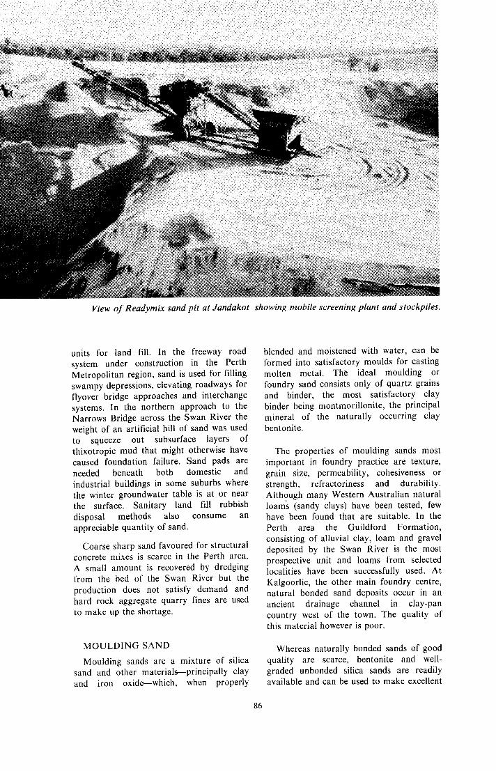
View of Readymix sand pit at Jandakot showing mobile screening plant and stockpiles.
units for land fill. In the freeway road system under construction in the Perth Metropolitan region, sand is used for filling swampy depressions, elevating roadways for flyover bridge approaches and interchange systems. In the northern approach to the Narrows Bridge across the Swan River the weight of an artificial hill of sand was used to squeeze out subsurface layers of thixotropic mud that might otherwise have caused foundation failure. Sand pads are needed beneath both domestic and industrial buildings in some suburbs where the winter groundwater table is at or near the surface. Sanitary land fill rubbish disposal methods also consume an appreciable quantity of sand.
Coarse sharp sand favoured for structural concrete mixes is scarce in the Perth area. A small amount is recovered by dredging from the bed of the Swan River but the production does not satisfy demand and hard rock aggregate quarry fines are used to make up the shortage.
MOULDING SAND
Moulding sands are a mixture of silica sand and other materials-principally clay and iron oxide-which, when properly
dended and moistened with water, can be Formed into satisfactory moulds for casting molten metal. The ideal moulding or foundry sand consists only of quartz grains and binder, the most satisfactory clay binder being montmorillonite, the principal mineral of the naturally occurring clay bentonite.
The properties of moulding sands most important in foundry practice are texture, grain size, permeability, cohesiveness or strength, refractoriness and durability. Although many Western Australian natural loam; (sandy clays) have been tested, few have been found that are suitable. In the Perth area the Guildford Formation, consisting of alluvial clay, loam and gravel deposited by the Swan River is the most prospective unit and loams from selected localities have been successfully used. At Kalgoorlie, the other main foundry centre, natural bonded sand deposits occur in an ancient drainage channel in clay-pan country west of the town. The quality of this material however is poor.
Whereas naturally bonded sands of good quality are scarce, bentonite and well- graded unbonded silica sands are readily available and can be used to make excellent
86

synthetic moulding sands. The bentonite from Marchagee 240 kilometres north of Perth is strong and, if carefully selected and processed, is an excellent binder. There are abundant supplies of unbonded silica sands available from the Bassendean Sand. By selecting the locality, well-graded sands in the coarse-medium and medium grain size ranges can be obtained. However, for improved finish on non-ferrous and light iron castings a much finer sand is obtained from a deposit on the Moore River at the point where it is crossed by the Yanchep-Lancelin Road some I 5 kilometres north of Perth.
Ignition loss ........................................... After ignition-
................................. 0, ............................
O v e r l . 0 0 m m ................................. Over0 .75mm ................................. Over 0.50 m m .................................
Grain size-
Mineral Resources Bulletin No. 5- “Moulding Sands”-gives much more detailed information on the properties and testing of foundry sands and presents the results of a survey of some Western Australian materials.
(1)
R 0.70
97.4 0.51
0.3 5.4
31.0
GLASS SAND
Most of the sand from the Bassendean Sand unit is suitable for the production of bottle glass and in places there are patches of cleaner sand from which good quality clear colourless glass can be manufactured. The figures in columns (1) and (2) of the accompanying table are typical of common sands on which bottle manufacture was based in the eastern part of the city. Currently however, sand for this purpose is being drawn from near Lake Gnangara, 18 kilometres north of the works site.
Sand for better quality glassware is irregularly distributed over the Bassendean Sand but is most likely to be found in the
vicinity of peaty swamps. A good example is provided by the deposit at Lake Gnangara. On ignition this sand is pure white, even-grained and, in addition to the principal constituents shown in column (3), has the following typical percentage compositions: alumina 0.14, titania 0.007, chromic oxide 0.001, lime and magnesia. nil and a trace of potash.
In other areas east and southeast of Perth such as Bassendean, Bayswater, Canning Vale, Maddington, Jandakot and Forresdale, all within a 30 kilometre radius of the city, silica sands well within the standard specifications for high-class glass sands are available. Good white sands are also known at Gingin, 80 kilometres north of Perth and at Albany on the south coast.
In recent years a steady trade in glass sands to Japan has been developed and current annual export production amounts to approximately 140 000 tonnes.
IMPACT FINISHING SANDS
In sand used for sand blasting the most important property is grain impact strength. Small amounts of sand for this purpose are obtained by screening portions of the Bassendean Sand. Because of the health hazards recognized in the use of air- borne silica, the amount of sand used for this purpose is likely to decline.
The grade and extent of silica sand resources in the Perth Metropolitan area is shown on Geological Survey maps “Silica Sand Resources-Perth and Environs” at a scale of 1 mile to an inch.
PARTIAL ANALYSES OF SELECTED GLASS SANDS
(2)
% 0.40
98.4 0.34
0.2 8.1
32.4 46.7
3.8 8.8
I 1
( I ) East Perth. (2) Belmont. (3) Gnangara Lake. Gingin. (7) Albany.
1.40
97.1
none 0.1
89.0 52.8 9.8 4.0 5.1 1.0 1 1.6 I 0.9
none
0.1 I 2.0 I
(4) Bassendean. (5) Herdsman Lake. (6)
87

SULPHUR
Over 150000 tonnes of sulphur is used annually in Western Australia for production of sulphuric acid needed to convert rock phosphate to the fertilizer superphosphate. The State’s agricultural lands are predominantly phosphorous deficient and superphosphate is almost essential in most areas to keep crop yields and pasture growth at acceptable economic levels.
Currently sulphur is wholly imported mainly from Canada, where discovery of large reserves of sour natural gas in the 1960s progressively lowered world sulphur prices. Local and eastern Australian crude oils and natural gases contain very little sulphur.
There are no commercial deposits of elemental sulphur in Western Australia and it is unlikely that any will be found. Uneconomic occurrences are known from south of Geraldton at Point Moore, Leander Point and Cliff Head, soft Quaternary sandstones from the last two localities containing respectively 14.2 and 12 per cent free sulphur. Small quantities of sedimentary free sulphur have also been noted in subsurface Tertiary beds at Cannington near Perth.
There is however an abundance of sulphur in combined form, most importantly as metal sulphides and, of lesser economic importance, as the hydrated calcium sulphate, gypsum, from which sulphur can be extracted by roasting with clay to give a by-product cement.
The iron sulphide pyrite was mined for its sulphur content between 1942 and 1968 from the Iron King Mine at Norseman. Over this period 2.305 million tonnes of ore yielded sulphuric acid containing 481 507 tonnes of sulphur. On closure of the mine some 1.3 million tonnes of ore remained unmined. This production was sup- plemented by pyritic concentrates produced as a by-product from gold mining at Kalgoorlie over the period 1956 to 1970 when 246 305 tonnes of sulphide concentrates containing 92 926 tonnes of sulphure were railed to Fremantle for acid production.
Earlier, in 1911 to 1922, some 24 700 tonnes of sulphur was obtained from
smelting 76 000 tonnes of copper sulphide ore from Eulaminna and Murrin Murrin mining centres.
Pyrite lodes, suitably free from arsenic, are known in several other localities. In the lower levels of the Whim Creek copper mine there are large bodies of sulphide, a bulk sample of which was found to contain 41.8 per cent sulphur, 34.4 per cent iron, 0.7 per cent copper and 1.3 per cent zinc.
In the Great Victoria gold mine at Nevoria there is a sulphide lode consisting of variable proportions of pyrrhotite and pyrite, with a sulphur content of about 20 per cent in the main sulphide-bearing portion of the lode.
Some of the Archaean banded iron formations (see IRON section) have in places a limonitic surface expression which usually indicates pyrite at depth (below the water table. Of this type is the Mt. Caudan lode at Parker Range. It proved to be about 21 metres wide with sulphide in 3 metre sections varying from 19 to 27 per cent sulphur content. This was almost all present as pyrrhotite which would be capable of magnetic concentration to 35 per cent sulphur. Possible ore reserves of 17 million tonnes have been estimated for this body.
Similarly at Mt. McMahon in the Ravensthorpe Range a bore disclosed a lode 30 metres wide. Two analyses showed sulphur, 35.9 and 30.7 per cent, the richer one carrying 44.3 per cent iron, 0.03 per cent copper and no arsenic.
At Koolyanobbing, analyses of samples representative of drill-hole penetration of the pyritic ore body at Dowds Hill and ‘Ore body A’ show sulphur percentages of 30.7 and 38.6 respectively. Both of these bodies are of considerable extent.
At Yindarlgooda, some 47 kilometres east-northeast of Kalgoorlie, possible reserves of pyrite and pyrrhotite have been estimated at 50 million tonnes.
Another potential source of sulphur is the iron sulphide (predominantly pyrrhotite) %
associated with the nickel/copper sulphides in the majority of nickel ores of Western Australia (see NICKEL section). Under the present conditions however, it is not economic to attempt recovery.
88

REFERENCE
PETROLEUM F
COAL c 1E';'3*,l
W l T S (2

Page Abrasives ...................... 53 Aggregate ..................... 54 Aluminium .................... 19 Amblygonite ................. 35 Amethyst ...................... 70 Andalusite ..................... 82 Anglesite ....................... 33 Antimony ...................... 21 Arsenopyrite ................. 21 Asbestos ....................... 56
Barite ...................... 79. 80 Bauxite ..................... 7, 19 Bentonite ...................... 62 Beryl ....................... 22, 43 Bismuth ........................ 21 Bismutite ...................... 21 Braunite ........................ 36
Caesium ........................ 43 Carnotite ...................... 48 Cassiterite ..................... 45 Cerussite ....................... 33 Chromite ...................... 72 Chrysotile ............ 7. 56. 58 Clays ............................ 58 Coal .................... 6. 12. 62 Columbite ..................... 44 Copper ................ 7. 22. 34 Corundum ............... 53. 70 Cosalite ......................... 44 Crocidolite .......... 7. 56. 57 Cryptomelane ............... 36
Diamond ....................... 67 Diatomite ...................... 66 Dimension stone ...... 54. 56 Dolomite ................. 31. 81
Emerald ........................ 68
Feldspar ........................ 53 Fillers ........................... 78
Galena ..................... 33. 79 Garnierite ..................... 38 Gemstones .................... 67 Gibbsite ........................ 19 Goethite ........................ 31 Gold .................... 6, 12, 24 Granite ......................... 56 Graphite ....................... 82 Gypsum ........................ 71
INDEX
Heavy mineral sands ......................... 72
Hematite ................. 29. 32 Hessite .......................... 44
Ilmenite .................... 7. 72 Iron .......................... 7. 27
Kaolin ........................... 61 Kyanite ......................... 82
Lead ......................... 7, 33 Lepidolite .......... 35, 43, 76 Leucoxene ................. 7, 72 Limonite ....................... 31 Limesands ..................... 75 Limestone ................. 56, 74 Lithium ......................... 35
Maghemite .................... 31 Magnesite ................. 7. 81 Manganese ................ 7. 36 Marl ............................. 75 Mica ............................. 76 Mining law ................... 11 Molybdenum ........... 24. 37 Monazite ............. 7. 50. 72 Muscovite ................ 43. 76
Natural gas ................... 77 Nickel ....................... 7. 38 Niobium ................... 7. 44 Novaculite .................... 53
Ochres .......................... 78 Opal .............................. 68
Peat .............................. 66 Pentlandite .................... 41 Petalite .................... 35. 70 Petroleum ............ 6. 15. 76 Petzite ........................... 44 Phosphate
fertilizers ................... 66 Pigments ....................... 78 ‘Pilbara Jade’ ................ 70 Potash
fertilizer .................... 67 Production
statistics ........... 8. 10. 27 Prehnite ........................ 70
Pyrite ............................ 88 Pyrolusite ...................... 36 Pyromorphite ................ 33 Pyrrhotite ..................... 88
Rare-earths ................... 50 Refractories .................. 81 Rhodonite ..................... 70 Rubidium ...................... 43 Rutile ........................ 7. 72
Salt ............................... 83 Sand ............................. 85 Scheelite ....................... 47 Shale ............................. 56 Silica sands ................... 85 Sillimanite .................... 82 Silver ........................ 7. 43 Spodumene ................... 35 Spongolite ..................... 56
Sulphur ......................... 88 Stibnite ......................... 21
Sylvanite ....................... 44
Talc .......................... 7. 79 Tantalite ....................... 46 Tantalum .................. 7. 44 Tapiolite ....................... 44 Tellurides ...................... 26 Thorium ........................ 48 Tin ............................ 7. 45 Topaz ....................... 53. 70 Tourmaline ................... 70 Travertine ..................... 76 Tremolite ...................... 58 Tungsten ....................... 47
Uranium ............... 7. 8. 48
Vanadium ..................... 49 Vermiculite ............... 7. 55 Violarite ........................ 42
Water supply ................ 10 Wolframite ................... 47
Xenotime ................ 50, 72
Yttrium ......................... 50
‘Zebra rock’ .................. 70 Zinc ............... 7. 23. 34. 50 Zircon ....................... 7. 72
WlLLlAM C BROWN . Government Printer . Western Australia 8968611 0/79-3M-L/2350
Copyright © 2022 FDOKUMEN