Aboriginal resources change through time in New England upland wetlands, south-east Australia
12
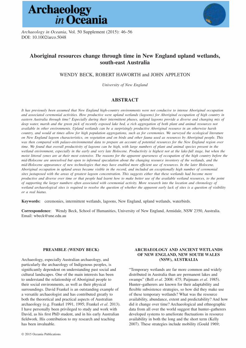
Aboriginal resources change through time in New England upland wetlands, south-east Australia WENDY BECK, ROBERT HAWORTH and JOHN APPLETON University of New England ABSTRACT It has previously been assumed that New England high-country environments were not conducive to intense Aboriginal occupation and associated ceremonial activities. How productive were upland wetlands (lagoons) for Aboriginal occupation of high country in eastern Australia through time? Especially during their intermittent phases, upland lagoons provide a diverse and changing mix of deep water, marsh and the green pick of recently exposed lake bed, a rich aggregation of both plant and animal resources not available in other environments. Upland wetlands can be a surprisingly productive Aboriginal resource in an otherwise harsh country, and would at times allow for high population aggregations, such as for ceremonies. We surveyed the ecological literature on New England lagoon characteristics, on vegetation and on birds and other fauna used as resources by Aboriginal people. This was then compared with palaeo-environmental data to prepare an account of potential resources for the New England region over time. We found that overall productivity of lagoons can be high, with large numbers of plant and animal species present in the wetland environment, especially in the early and very late Holocene. Productivity is highest not at the lake-full stage, but when the moist littoral zones are at their most extensive. The reasons for the apparent sparseness of occupation of the high country before the mid-Holocene are unresolved but open to informed speculation about the changing resource inventory of the wetlands, and the mid-Holocene appearance of new technologies that may have enabled more efficient use of resources. In the later Holocene, Aboriginal occupation in upland areas became visible in the record, and included an exceptionally high number of ceremonial sites juxtaposed with the areas of greatest lagoon concentration. This suggests either that these wetlands had become more productive and diverse over time or that people had learnt how to make better use of the available wetland resources, to the point of supporting the larger numbers often associated with ceremonial activity. More research into the location and chronology of wetland archaeological sites is required to resolve the question of whether the apparent early lack of sites is a question of visibility or a real hiatus. Keywords: ceremonies, intermittent wetlands, lagoons, New England, upland wetlands, waterbirds. Correspondence: Wendy Beck, School of Humanities, University of New England, Armidale, NSW 2350, Australia. Email: [email protected] PREAMBLE (WENDY BECK) Archaeology, especially Australian archaeology, and particularly the archaeology of Indigenous peoples, is significantly dependent on understanding past social and cultural landscapes. One of the main interests has been to understand the relationship of Aboriginal people to their social environments, as well as their physical surroundings. David Frankel is an outstanding example of a versatile archaeologist and has contributed greatly to both the theoretical and practical aspects of Australian archaeology (e.g. Frankel 1991, 1995; Frankel et al. 2013). I have personally been privileged to study and work with David, as his first PhD student, and in his early Australian fieldwork. His contribution to my research and teaching has been invaluable. ARCHAEOLOGY AND ANCIENT WETLANDS OF NEW ENGLAND, NEW SOUTH WALES (NSW), AUSTRALIA “Temporary wetlands are far more common and widely distributed in Australia than are permanent lakes and swamps” (Bell et al. 2008: 475; Paijmans et al. 1985). Hunter–gatherers are known for their adaptability and flexible subsistence strategies, so how did they make use of these temporary wetlands? What was the resource availability, abundance, extent and predictability? And how did it change over time? Archaeological and ethnographic data from all over the world suggest that hunter–gatherers developed systems to ameliorate fluctuations in resource availability in both the long and the short term (Kelly 2007). These strategies include mobility (Gould 1969; Archaeology in Oceania, Vol. 50 Supplement (2015): 46–56 DOI: 10.1002/arco.5048 © 2015 Oceania Publications
Transcript of Aboriginal resources change through time in New England upland wetlands, south-east Australia
Aboriginal resources change through time in New England upland wetlands,south-east Australia
WENDY BECK, ROBERT HAWORTH and JOHN APPLETON
University of New England
ABSTRACT
It has previously been assumed that New England high-country environments were not conducive to intense Aboriginal occupationand associated ceremonial activities. How productive were upland wetlands (lagoons) for Aboriginal occupation of high country ineastern Australia through time? Especially during their intermittent phases, upland lagoons provide a diverse and changing mix ofdeep water, marsh and the green pick of recently exposed lake bed, a rich aggregation of both plant and animal resources notavailable in other environments. Upland wetlands can be a surprisingly productive Aboriginal resource in an otherwise harshcountry, and would at times allow for high population aggregations, such as for ceremonies. We surveyed the ecological literatureon New England lagoon characteristics, on vegetation and on birds and other fauna used as resources by Aboriginal people. Thiswas then compared with palaeo-environmental data to prepare an account of potential resources for the New England region overtime. We found that overall productivity of lagoons can be high, with large numbers of plant and animal species present in thewetland environment, especially in the early and very late Holocene. Productivity is highest not at the lake-full stage, but when themoist littoral zones are at their most extensive. The reasons for the apparent sparseness of occupation of the high country before themid-Holocene are unresolved but open to informed speculation about the changing resource inventory of the wetlands, and themid-Holocene appearance of new technologies that may have enabled more efficient use of resources. In the later Holocene,Aboriginal occupation in upland areas became visible in the record, and included an exceptionally high number of ceremonialsites juxtaposed with the areas of greatest lagoon concentration. This suggests either that these wetlands had become moreproductive and diverse over time or that people had learnt how to make better use of the available wetland resources, to the pointof supporting the larger numbers often associated with ceremonial activity. More research into the location and chronology ofwetland archaeological sites is required to resolve the question of whether the apparent early lack of sites is a question of visibilityor a real hiatus.
Keywords: ceremonies, intermittent wetlands, lagoons, New England, upland wetlands, waterbirds.
Correspondence: Wendy Beck, School of Humanities, University of New England, Armidale, NSW 2350, Australia.Email: [email protected]
PREAMBLE (WENDY BECK)
Archaeology, especially Australian archaeology, andparticularly the archaeology of Indigenous peoples, issignificantly dependent on understanding past social andcultural landscapes. One of the main interests has beento understand the relationship of Aboriginal people totheir social environments, as well as their physicalsurroundings. David Frankel is an outstanding example ofa versatile archaeologist and has contributed greatly toboth the theoretical and practical aspects of Australianarchaeology (e.g. Frankel 1991, 1995; Frankel et al. 2013).I have personally been privileged to study and work withDavid, as his first PhD student, and in his early Australianfieldwork. His contribution to my research and teachinghas been invaluable.
ARCHAEOLOGY AND ANCIENT WETLANDSOF NEW ENGLAND, NEW SOUTH WALES
(NSW), AUSTRALIA
“Temporary wetlands are far more common and widelydistributed in Australia than are permanent lakes andswamps” (Bell et al. 2008: 475; Paijmans et al. 1985).Hunter–gatherers are known for their adaptability andflexible subsistence strategies, so how did they make useof these temporary wetlands? What was the resourceavailability, abundance, extent and predictability? And howdid it change over time? Archaeological and ethnographicdata from all over the world suggest that hunter–gatherersdeveloped systems to ameliorate fluctuations in resourceavailability in both the long and the short term (Kelly2007). These strategies include mobility (Gould 1969;
bs_bs_banner
Archaeology in Oceania, Vol. 50 Supplement (2015): 46–56DOI: 10.1002/arco.5048
© 2015 Oceania Publications
Myers 1991; Tonkinson 1978), technology (Attenbrowet al. 2009; Hiscock 1994; Hiscock et al. 2011) andexchange (Cashdan 1992; Thomson 1949), as well asdietary diversification. Although humans do not respondmechanistically to environmental variation, the availabilityof food and water does significantly constrain humandecisions (Johnson 2014; Middleton 2012). Studies ofhunter–gatherer demography also indicate that prehistorichunter–gatherers do have resource thresholds, which couldbe marked by periods of population collapse and recovery(Davidson 1990; Williams et al. 2010). In this paper, weaim to investigate the resource potential of unique episodicwetlands in the New England region of eastern Australia,and together with existing palaeoclimatic information,construct a speculative sequence of occupation for theregion.
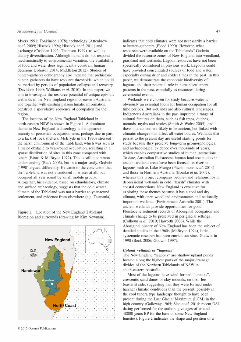
The location of the New England Tableland innorth-eastern NSW is shown in Figure 1. A dominanttheme in New England archaeology is the apparentscarcity of persistent occupation sites, perhaps due in partto a lack of rock shelters. McBryde in the 1970s stressedthe harsh environment of the Tableland, which was seen asa major obstacle to year-round occupation, resulting in asparse distribution of sites in this zone compared withothers (Binns & McBryde 1972). This is still a commonunderstanding (Beck 2006), but in a major study, Godwin(1990) argued differently. He came to the conclusion thatthe Tableland was not abandoned in winter at all, butoccupied all year round by small mobile groups.Altogether, his evidence, based on ethnohistory, climateand surface archaeology, suggests that the cold winterclimate of the Tableland was not a barrier to year-roundsettlement, and evidence from elsewhere (e.g. Tasmania)
indicates that cold climates were not necessarily a barrierto hunter–gatherers (Flood 1990). However, whatresources were available on the Tablelands? Godwindivided the resource zones of New England into woodland,grassland and wetlands. Lagoon resources have not beenspecifically considered in previous work. Lagoons couldhave provided concentrated sources of food and water,especially during drier and colder times in the past. In thispaper, we demonstrate the economic biodiversity oflagoons and their potential role in human settlementpatterns in the past, especially as resources duringceremonial events.
Wetlands were chosen for study because water isobviously an essential focus for human occupation for alltime periods. But wetlands are also cultural landscapes.Indigenous Australians in the past imprinted a range ofcultural features on them, such as fish traps, ditches,mounds, myths and stories (Smith & Wobst 2005), andthese interactions are likely to be ancient, but linked withclimatic changes that affect all water bodies. Wetlands thatpersist to the present day are useful starting points forstudy because they preserve long-term geomorphologicaland archaeological evidence over thousands of years,which enables comparative studies of human interactions.To date, Australian Pleistocene human land-use studies inancient wetland areas have been focused on riverinelagoons such as Lake Mungo (Fitzsimmons et al. 2014)and those in Northern Australia (Bourke et al. 2007),whereas this project compares people–land relationships indepressional wetlands in cold, “harsh” climates withcoastal connections. New England is evocative forexploring these themes because it has a cool and dryclimate, with open woodland environments and nationallyimportant wetlands (Environment Australia 2001). Theancient wetlands provide opportunities for goodPleistocene sediment records of Aboriginal occupation andclimate change to be preserved in periglacial settings(Colhoun et al. 2010; Haworth 2006). While theAboriginal history of New England has been the subject ofdetailed studies in the 1960s (McBryde 1974), littlesystematic research has been carried out since Godwin in1990 (Beck 2006; Godwin 1997).
Upland wetlands or “lagoons”The New England “lagoons” are shallow upland pondslocated along the highest parts of the major drainagedivides of the Northern Tablelands of NSW insouth-eastern Australia.
Most of the lagoons have wind-formed “lunettes”,crescentic sand dunes or clay mounds, on their lee(eastern) side, suggesting that they were formed underharsher climatic conditions than the present, possibly inthe cool tundra type landscape thought to have beenpresent during the Last Glacial Maximum (LGM) in thehigh country (Galloway 1965; Slee et al. 2014: recent OSLdating performed for the authors give ages of around48000 years BP for the base of some New Englandlunettes). Figure 2 indicates the shape and position of a
Figure 1. Location of the New England TablelandBioregion and surrounds (drawing by Kim Newman).
Archaeology in Oceania 47
© 2015 Oceania Publications
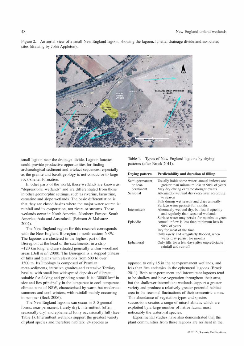
small lagoon near the drainage divide. Lagoon lunettescould provide productive opportunities for findingarchaeological sediment and artefact sequences, especiallyas the granite and basalt geology is not conducive to largerock-shelter formation.
In other parts of the world, these wetlands are known as“depressional wetlands” and are differentiated from thosein other geomorphic settings, such as riverine, lacustrine,estuarine and slope wetlands. The basic differentiation isthat they are closed basins where the major water source israinfall and its evaporation, not rivers or streams. Thesewetlands occur in North America, Northern Europe, SouthAmerica, Asia and Australasia (Brinson & Malvarez2002).
The New England region for this research correspondswith the New England Bioregion in north-eastern NSW.The lagoons are clustered in the highest part of theBioregion, at the head of the catchments, in a strip∼120 km long, and are situated generally within woodlandareas (Bell et al. 2008). The Bioregion is a stepped plateauof hills and plains with elevations from 600 to over1500 m. Its lithology is composed of Permianmeta-sediments, intrusive granites and extensive Tertiarybasalts, with small but widespread deposits of silcrete,suitable for flaking and grinding stone. It is ∼30000 km2 insize and lies principally in the temperate to cool temperateclimate zone of NSW, characterised by warm but moderatesummers and cool winters, with rainfall mainly occurringin summer (Beck 2006).
The New England lagoons can occur in 3–5 generalforms: near-permanent (rarely dry); intermittent (oftenseasonally dry) and ephemeral (only occasionally full) (seeTable 1). Intermittent wetlands support the greatest varietyof plant species and therefore habitats: 24 species as
opposed to only 15 in the near-permanent wetlands, andless than five endemics in the ephemeral lagoons (Brock2011). Both near-permanent and intermittent lagoons tendto be shallow and have vegetation throughout their area,but the shallower intermittent wetlands support a greatervariety and produce a relatively greater potential habitatarea in the seasonal fluctuations of their concentric zones.This abundance of vegetation types and speciessuccessions creates a range of microhabitats, which areexploited by a large number of native fauna, mostnoticeably the waterbird species.
Experimental studies have also demonstrated that theplant communities from these lagoons are resilient in the
Figure 2. An aerial view of a small New England lagoon, showing the lagoon, lunette, drainage divide and associatedsites (drawing by John Appleton).
Table 1. Types of New England lagoons by dryingpatterns (after Brock 2011).
Drying pattern Predictability and duration of filling
Semi-permanentor near-permanent
Usually holds some water; annual inflows aregreater than minimum loss in 90% of years
May dry during extreme drought eventsSeasonal Alternately wet and dry every year according
to seasonFills during wet season and dries annuallySurface water persists for months
Intermittent Alternately wet and dry, but less frequentlyand regularly than seasonal wetlands
Surface water may persist for months to yearsEpisodic Annual inflow is less than minimum loss in
90% of yearsDry for most of the timeOnly rarely and irregularly flooded, when
water may persist for monthsEphemeral Only fills for a few days after unpredictable
rainfall and run-off
48 New England upland wetlands
© 2015 Oceania Publications
face of drought, with most species surviving for 7 yearsbetween rains, and some for as long as 12 years (Brock2011). Table 1 (Brock 2011) shows that the pattern ofwater filling and drying for lagoons in New England canbe used as a classification scheme, although most lagoonshave been disturbed by European agricultural activities.Another factor in variability is size. Lagoons on the NewEngland Tableland range from less than 0.5 ha in size upto 430 ha (the Mother of Ducks lagoon, near Guyra) (Bellet al. 2008).
The evidence suggests that at least some of theselagoons have been present in one of their three phases wellback into the Pleistocene, with an age of ∼20000 years BPobtained from the sediments of one of the larger ones,Little Llangothlin Lagoon (Woodward et al. 2014), withpollen and phytoliths from this age indicating the presenceof wetland vegetation. In wet periods, for instance in a LaNiña phase of the Southern Oscillation weather pattern,boggy conditions would be widespread throughout theTableland surface, especially in the low-evaporationconditions of the highest country, where there is also theleast erosion and most intact late Tertiary basalt flows.Cracking clays and other products of basaltic erosion suchas duricrust formation have impeded drainage andencouraged ponding on an already flat landscape. In themore glacial climate of the late Pleistocene, there wouldhave been much increased periodic wetting and drying andstronger westerly winds working together to removematerial from the lake floor to build marginal aeolianfeatures such as dunes (lunettes) on the downwind shore(Bowler 1970; Dodson 1987). Wave action during lake-fullperiods would consolidate dune formation by buildingbeaches and berms. Thus the lagoons, although shallow,were probably able to maintain themselves over longgeological time periods through alternating cycles ofdeflation and accretion, whereas other types of lakes inmore consistently wet climates rapidly fill with sedimentto become dry land.
Archaeological sites on the TablelandsHunter–gatherers of the past have inhabited all of NewEngland for thousands of years, but little is known ofPleistocene occupation. New England is rich in megafaunaremains, especially Diprotodon optatum, which may haveattracted any passing hunter–gatherers, assuming that therewas a temporal overlap between humans and Diprotodon(Horton & Connah 1981). Horton and Connah (1981)carefully investigated a megafauna site at ReddestoneCreek near Glen Innes, but rejected the possibility of anage overlap with humans. They were, unfortunately, unableto obtain any age determination for the strata containingeither humans or megafauna. Nonetheless, they reportedartefacts as deep as half a metre down the excavationprofile (of a 6 m2 quadrant), with 13 flakes sitting on topof the stratum containing megafauna bones. Given theslow rate of deposition in similar upland mires and pondsin the region (Woodward et al. 2011), this might indicate aPleistocene age for the more deeply buried artefacts.
However, the oldest known site (near Bendemeer, onthe southern edge of the Tableland) has an uncalibratedage of only 4300 years (McBryde 1977: 227).Archaeology and linguistics suggest that the Tableland hasbeen most heavily occupied from about 4000 years ago(Beck 2006; Hoddinott 1967; McBryde 1974). Thearchaeology sustaining this belief is based on finds ofsurface or near-surface artefact scatters (Beck 2006), withvery little found at greater depth, excepting that of Hortonand Connah (1981). From the mid-Holocene, coastalpopulations from the east and south-east are believed tohave migrated to the Tableland and formed relationshipsover time with western peoples. This statement is based onanalysis of the linguistic relationships between coastal andTableland languages (Crowley 1997). Three landscapethemes have been identified by Beck (2006): ceremonialactivities; patterns of behaviour associated with living in acold climate; and group movement. These have made NewEngland in the past 4000 years distinctive as a region.However, there are no models for occupation before thatperiod.
The New England Tableland was, however, not entirelycut off from other highland sites: in the ethnohistoricalrecord, connections were reported between the northernpart of New England and the Bunya mountain region inSouth Queensland (Reynolds 1976), thus indicating howgeographically extensive ceremonial activity andassociated alliances can be (Godwin 1997). It may nothave been until the late Holocene that Bunya pine(Araucaria bidwillii), with its nutritious nut harvest, weresufficiently abundant to attract people from as far away asNew England, but it indicates that effective occupation ofNew England was probably always associated with astrategy of connections with locations outside the region(Godwin 1997). Thus Macpherson (1904) and Hoddinott(1967) described the strong linguistic and culturalconnections between the Banbai people, who lived in someof the highest parts of the Tableland, around the lagoons,and the coastal Gumbaynggir people around present-dayCoffs Harbour. Likewise, in 1830 Richard Craig, arunaway convict from the Moreton Bay penal camp, foundno difficulty transferring with the approval of his hostsbetween clans from the north coast of NSW to theTableland and back again to the coast at Port Macquarie(O’Keeffe 1976), presumably taking advantage of alreadyexisting alliances. Gardner (1854: 34) mentionedmovement and interchange of Guyra Aborigines with thosefurther west, and MacDonald (1840) noted the presence ofcoastal Aborigines at a Tableland ceremony. This stronglysuggests an ongoing exchange of resources and peoplebetween the Tableland, the western rivers and especiallythe coast, still surviving at and shortly after contact.
Ceremonial places – bora rings, carved trees and stonearrangements – occur more frequently than in otherregions, and in clusters (Beck 2006). Over 100 ceremonialsites have been recorded and six large clusters identified(Godwin 1990). The region is unlikely to have beencompletely without people at any time of year, although
Archaeology in Oceania 49
© 2015 Oceania Publications
some places may have been infrequently visited (seeethnohistorical population estimates of local peoples inGardner 1854; MacDonald 1840, 1845; Oxley 1820). TheTableland was cold in winter, but not abandoned (Oxley1820: 288–90). The inhabitation was patterned, notrandom. Activities in the landscape were focused at placeswhere people lived and worked (quarries, camp sites andceremonial sites), with a preference for locales withclustered resources, such as lagoons, and also along tracksand pathways, where they moved among sites for bothritual and secular purposes, as perhaps indicated byisolated artefacts and natural routes through the gorgecountry. Food and material resources were exploitedaccording to their availability, and the movements for otherpurposes of the social group. Some ceremonial places(such as bora grounds) were visited and revisited by largegroups of people (Gardner 1854), being parts of thelandscape imbued with meaning. The Tableland has acalculated density of 112 sites per 100 ha (mostly isolatedartefacts), compared with figures of 1–35 sites per 100 hain coastal and coastal hinterland samples. This implies thatthe Tableland has a surprisingly high site density overall(Beck 2006), which deserves investigation.
However, as yet we have very little information aboutthe chronology of sites, including lagoon sites, but recentpalaeo-ecological work and OSL age determinationssuggest that these natural features have persisted for over40000 years (N. Jankowski, University of Wollongongdating laboratory, pers. comm.). We have carried outarchaeological surveys of a sample of 14 lagoons rangingfrom 2 ha to 400 ha in size, and ranging from thenorthernmost to the southernmost distribution, and havefound stone artefacts adjacent to eight of these lagoons.The stone artefacts include backed microliths, ground edgeaxes and a grindstone. Scarred trees, axe-grinding groovesand a quarry are also found within 200 m of lagoons.Further investigations, including subsurface excavations,are planned.
LAGOONS AS ABORIGINAL RESOURCES
Lagoons were potentially diverse sources of food and fibreresources for Aborigines arriving on the NorthernTableland and provide a clustering of resources that arenot available elsewhere in the region. Biomass is probablyhighest when the lagoons are relatively shallow and/orfluctuating. This may be due to the rich invertebrate fauna,which breeds at this time (owing to the absence of fishpredators), and the increased plant growth, both of whichsupport waterbird populations (Cibilic & White 2011).This is also similar to findings of increased human use ofLake Mungo when the lake levels were fluctuating: “thegreater density of archaeological traces occurs in unitscorresponding to fluctuating or oscillating lake levels”(Fitzsimmons et al. 2014: 361). The explanation is thatregular wet pulses recharge the lake system and increaseits productivity and enhance accessibility of foodresources. For instance, fish may also have become
trapped in the low-oxygen waters and been more easilycaught (Long et al. 2014: 84). However, unlike theWillandra Lakes, which are overflow lakes from theLachlan River system, the New England lagoons arehydrologically discrete, and fill and flood from bothregular summer cyclonic rains from Queensland (Hobbs &Jackson 1977) as well as intense east coast lows, whichcan sometimes develop in winter and bring rare heavysnowfalls to the eastern highlands.
The resources of the lagoons generally are water, stone(especially silcrete) for artefacts, plants and fauna,including birds, mammals, amphibians and reptiles. Eelsare the only fish found naturally in large numbers in thesecooler waters, and only in the lagoons on the eastern(Pacific Ocean) side of the Great Divide (Park 1986).Many of the flora and fauna are specific to these still-waterwetlands and would not be common in other water bodies,such as those streams running off the Tablelands to theeast and west.
WaterbirdsThe most detailed study of animals and birds has beencarried out at Little Llangothlin Nature Reserve, which is amedium-sized lagoon in the central New England region(Cibilic & White 2011), and also the site where the mostdetailed palaeo-ecological reconstruction has recently beenundertaken (Woodward et al. 2014). At least 48 species ofwaterbird have been observed within this site. Ducks andcoots, such as grey teal (Anas gracilis), chestnut teal (Anascastanea), Eurasian coot (Fulica atra) and Pacific blackduck (Anas superciliosa), are the most abundant waterbirdsrecorded at the site, with recorded maximum counts of 600or above. Black swan (Cygnus atratus) and purple swamphen (Porphyrio porphyrio) have also occurred at the site,with maximum recorded numbers above 400 for eachspecies per day. A variety of other ducks have been seen inlarge numbers, with over 100 individuals recorded –Australasian shoveler, blue-billed duck and hardhead.Waterbirds such as straw-necked ibis, whiskered tern andblack-winged stilt are also recorded in large numbers. Atleast 21 species of waterbird breed at the site (Briggs1979). For example, 50 pairs of swans have been observedreturning annually to this lagoon for breeding. Overall, themost common species from this list, which have beenhunted by Europeans in Australia, are Australian shelduck(Tadorna tadornoides), Pacific black duck (Anassuperciliosa), grey teal (Anas gracilis), chestnut teal (Anascastanea), Australasian shoveler (Anas rhynchotis),pink-eared duck (Malacorhynchus membranaceus), manedduck (Chenonetta jubata) and hardhead (Aythya australis)(Briggs 1993). All of these were available to Aboriginalhunters.
Both waterbirds and their eggs would provide economicresources for Aboriginal hunters. Most waterbirds inAustralia do not have regular migratory patterns but moveaccording to wetland availability (Frith 1959). Lagoonsvary on the Tableland from permanent/near-permanent toephemeral, so waterfowl visitation varies with rainfall
50 New England upland wetlands
© 2015 Oceania Publications
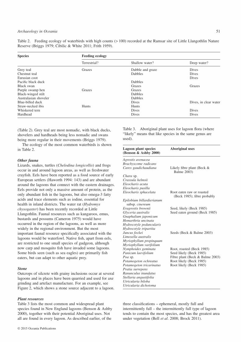
(Table 2). Grey teal are most nomadic, with black ducks,shovelers and hardheads being less nomadic and swansbeing more regular in their movements (Briggs 1979).
The ecology of the most common waterbirds is shownin Table 2.
Other faunaLizards, snakes, turtles (Chelodina longicollis) and frogsoccur in and around lagoon areas, as well as freshwatercrayfish. Eels have been reported as a food source of earlyEuropean settlers (Haworth 1994: 143) and are abundantaround the lagoons that connect with the eastern drainages.Eels provide not only a massive amount of protein, as theonly abundant fish in the lagoons, but also omega-3 fattyacids and trace elements such as iodine, essential forhealth in inland districts. The water rat (Hydromyschysogaster) has been recently recorded at LittleLlangothlin. Faunal resources such as kangaroos, emus,bustards and possums (Cameron 1975) would haveoccurred in the region of the lagoons, as well as morewidely in the regional environment. But the mostimportant faunal resource specifically associated with thelagoons would be waterfowl. Native fish, apart from eels,are restricted to one small species of gudgeon, althoughnow carp and mosquito fish have invaded some lagoons.Some birds seen (such as sea eagles) are primarily fisheaters, but can adapt to other aquatic prey.
StoneOutcrops of silcrete with grainy inclusions occur at severallagoons and in places have been quarried and used for axegrinding and artefact manufacture. For an example, seeFigure 2, which shows a stone source adjacent to a lagoon.
Plant resourcesTable 3 lists the most common and widespread plantspecies found in New England lagoons (Benson & Ashby2000), together with their potential Aboriginal uses. Notall are found in every lagoon. As described earlier, of the
three classifications – ephemeral, mostly full andintermittently full – the intermittently full type of lagoontends to contain the most species, and has the greatest areaunder vegetation (Bell et al. 2008; Brock 2011).
Table 2. Feeding ecology of waterbirds with high counts (> 100) recorded at the Ramsar site of Little Llangothlin NatureReserve (Briggs 1979; Cibilic & White 2011; Frith 1959).
Species Feeding ecology
Terrestrial? Shallow water? Deep water?
Grey teal Grazes Dabble and graze DivesChestnut teal Dabbles DivesEurasian coot DivesPacific black duck DabblesBlack swan Grazes GrazesPurple swamp hen Grazes GrazesBlack-winged stilt DabblesAustralasian shoveler DabblesBlue-billed duck Dives Dives, in clear waterStraw-necked ibis Hunts HuntsWhiskered tern Dives DivesHardhead Dives Dives
Table 3. Aboriginal plant uses for lagoon flora (where“likely” means that like species in the same genus areused).
Lagoon plant species(Benson & Ashby 2000)
Aboriginal uses
Agrostis avenaceaBrachyscome radicansCarex gaudichaudiana Likely fibre plant (Beck &
Balme 2003)Chara sp.Crassula helmsiiEleocharis acutaEleocharis pusillaEleocharis sphacelata Root eaten raw or roasted
(Beck 1985); fibre probablyEpilobium billardierianum
subsp. cinereumEragrostis brownii Seed, likely (Beck 1985)Glyceria australis Seed eaten ground (Beck 1985)Gnaphalium japonicumHemarthria uncinataHydrocotyle peduncularisHydrocotyle tripartitaJuncus fockei Seeds (Beck & Balme 2003)Limosella australisMyriophyllum propinquumMyriophyllum varifoliumNymphoides geminata Root, roasted (Beck 1985)Panicum laevifolium Seed likely (Beck 1985)Poa sp. Fibre plant (Beck & Balme 2003)Potamogeton ochreatus Root likely (Beck 1985)Potamogeton tricarinatus Root likely (Beck 1985)Pratia surrepensRanunculus inundatusStellaria angustifoliaUtricularia bilobaUtricularia dichotoma
Archaeology in Oceania 51
© 2015 Oceania Publications
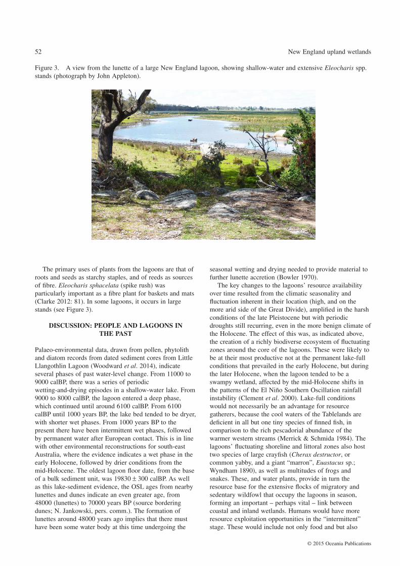
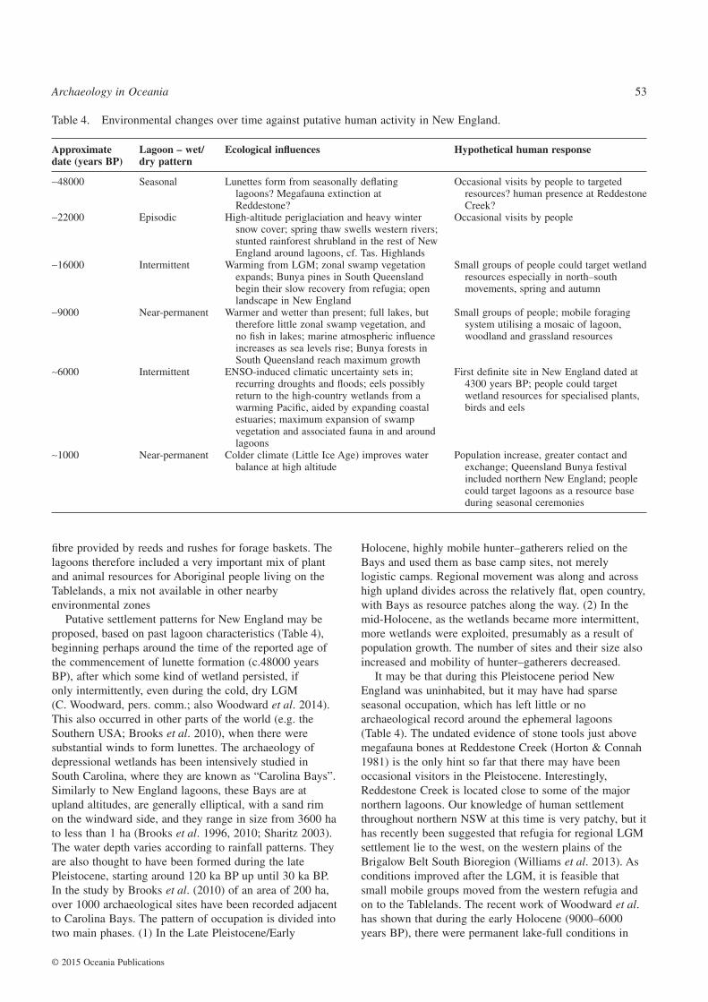
The primary uses of plants from the lagoons are that ofroots and seeds as starchy staples, and of reeds as sourcesof fibre. Eleocharis sphacelata (spike rush) wasparticularly important as a fibre plant for baskets and mats(Clarke 2012: 81). In some lagoons, it occurs in largestands (see Figure 3).
DISCUSSION: PEOPLE AND LAGOONS INTHE PAST
Palaeo-environmental data, drawn from pollen, phytolithand diatom records from dated sediment cores from LittleLlangothlin Lagoon (Woodward et al. 2014), indicateseveral phases of past water-level change. From 11000 to9000 calBP, there was a series of periodicwetting-and-drying episodes in a shallow-water lake. From9000 to 8000 calBP, the lagoon entered a deep phase,which continued until around 6100 calBP. From 6100calBP until 1000 years BP, the lake bed tended to be dryer,with shorter wet phases. From 1000 years BP to thepresent there have been intermittent wet phases, followedby permanent water after European contact. This is in linewith other environmental reconstructions for south-eastAustralia, where the evidence indicates a wet phase in theearly Holocene, followed by drier conditions from themid-Holocene. The oldest lagoon floor date, from the baseof a bulk sediment unit, was 19830 ± 300 calBP. As wellas this lake-sediment evidence, the OSL ages from nearbylunettes and dunes indicate an even greater age, from48000 (lunettes) to 70000 years BP (source borderingdunes; N. Jankowski, pers. comm.). The formation oflunettes around 48000 years ago implies that there musthave been some water body at this time undergoing the
seasonal wetting and drying needed to provide material tofurther lunette accretion (Bowler 1970).
The key changes to the lagoons’ resource availabilityover time resulted from the climatic seasonality andfluctuation inherent in their location (high, and on themore arid side of the Great Divide), amplified in the harshconditions of the late Pleistocene but with periodicdroughts still recurring, even in the more benign climate ofthe Holocene. The effect of this was, as indicated above,the creation of a richly biodiverse ecosystem of fluctuatingzones around the core of the lagoons. These were likely tobe at their most productive not at the permanent lake-fullconditions that prevailed in the early Holocene, but duringthe later Holocene, when the lagoon tended to be aswampy wetland, affected by the mid-Holocene shifts inthe patterns of the El Niño Southern Oscillation rainfallinstability (Clement et al. 2000). Lake-full conditionswould not necessarily be an advantage for resourcegatherers, because the cool waters of the Tablelands aredeficient in all but one tiny species of finned fish, incomparison to the rich pescadorial abundance of thewarmer western streams (Merrick & Schmida 1984). Thelagoons’ fluctuating shoreline and littoral zones also hosttwo species of large crayfish (Cherax destructor, orcommon yabby, and a giant “marron”, Euastacus sp.;Wyndham 1890), as well as multitudes of frogs andsnakes. These, and water plants, provide in turn theresource base for the extensive flocks of migratory andsedentary wildfowl that occupy the lagoons in season,forming an important – perhaps vital – link betweencoastal and inland wetlands. Humans would have moreresource exploitation opportunities in the “intermittent”stage. These would include not only food and but also
Figure 3. A view from the lunette of a large New England lagoon, showing shallow-water and extensive Eleocharis spp.stands (photograph by John Appleton).
52 New England upland wetlands
© 2015 Oceania Publications
fibre provided by reeds and rushes for forage baskets. Thelagoons therefore included a very important mix of plantand animal resources for Aboriginal people living on theTablelands, a mix not available in other nearbyenvironmental zones
Putative settlement patterns for New England may beproposed, based on past lagoon characteristics (Table 4),beginning perhaps around the time of the reported age ofthe commencement of lunette formation (c.48000 yearsBP), after which some kind of wetland persisted, ifonly intermittently, even during the cold, dry LGM(C. Woodward, pers. comm.; also Woodward et al. 2014).This also occurred in other parts of the world (e.g. theSouthern USA; Brooks et al. 2010), when there weresubstantial winds to form lunettes. The archaeology ofdepressional wetlands has been intensively studied inSouth Carolina, where they are known as “Carolina Bays”.Similarly to New England lagoons, these Bays are atupland altitudes, are generally elliptical, with a sand rimon the windward side, and they range in size from 3600 hato less than 1 ha (Brooks et al. 1996, 2010; Sharitz 2003).The water depth varies according to rainfall patterns. Theyare also thought to have been formed during the latePleistocene, starting around 120 ka BP up until 30 ka BP.In the study by Brooks et al. (2010) of an area of 200 ha,over 1000 archaeological sites have been recorded adjacentto Carolina Bays. The pattern of occupation is divided intotwo main phases. (1) In the Late Pleistocene/Early
Holocene, highly mobile hunter–gatherers relied on theBays and used them as base camp sites, not merelylogistic camps. Regional movement was along and acrosshigh upland divides across the relatively flat, open country,with Bays as resource patches along the way. (2) In themid-Holocene, as the wetlands became more intermittent,more wetlands were exploited, presumably as a result ofpopulation growth. The number of sites and their size alsoincreased and mobility of hunter–gatherers decreased.
It may be that during this Pleistocene period NewEngland was uninhabited, but it may have had sparseseasonal occupation, which has left little or noarchaeological record around the ephemeral lagoons(Table 4). The undated evidence of stone tools just abovemegafauna bones at Reddestone Creek (Horton & Connah1981) is the only hint so far that there may have beenoccasional visitors in the Pleistocene. Interestingly,Reddestone Creek is located close to some of the majornorthern lagoons. Our knowledge of human settlementthroughout northern NSW at this time is very patchy, but ithas recently been suggested that refugia for regional LGMsettlement lie to the west, on the western plains of theBrigalow Belt South Bioregion (Williams et al. 2013). Asconditions improved after the LGM, it is feasible thatsmall mobile groups moved from the western refugia andon to the Tablelands. The recent work of Woodward et al.has shown that during the early Holocene (9000–6000years BP), there were permanent lake-full conditions in
Table 4. Environmental changes over time against putative human activity in New England.
Approximatedate (years BP)
Lagoon – wet/dry pattern
Ecological influences Hypothetical human response
∼48000 Seasonal Lunettes form from seasonally deflatinglagoons? Megafauna extinction atReddestone?
Occasional visits by people to targetedresources? human presence at ReddestoneCreek?
∼22000 Episodic High-altitude periglaciation and heavy wintersnow cover; spring thaw swells western rivers;stunted rainforest shrubland in the rest of NewEngland around lagoons, cf. Tas. Highlands
Occasional visits by people
∼16000 Intermittent Warming from LGM; zonal swamp vegetationexpands; Bunya pines in South Queenslandbegin their slow recovery from refugia; openlandscape in New England
Small groups of people could target wetlandresources especially in north–southmovements, spring and autumn
∼9000 Near-permanent Warmer and wetter than present; full lakes, buttherefore little zonal swamp vegetation, andno fish in lakes; marine atmospheric influenceincreases as sea levels rise; Bunya forests inSouth Queensland reach maximum growth
Small groups of people; mobile foragingsystem utilising a mosaic of lagoon,woodland and grassland resources
∼6000 Intermittent ENSO-induced climatic uncertainty sets in;recurring droughts and floods; eels possiblyreturn to the high-country wetlands from awarming Pacific, aided by expanding coastalestuaries; maximum expansion of swampvegetation and associated fauna in and aroundlagoons
First definite site in New England dated at4300 years BP; people could targetwetland resources for specialised plants,birds and eels
∼1000 Near-permanent Colder climate (Little Ice Age) improves waterbalance at high altitude
Population increase, greater contact andexchange; Queensland Bunya festivalincluded northern New England; peoplecould target lagoons as a resource baseduring seasonal ceremonies
Archaeology in Oceania 53
© 2015 Oceania Publications
Little Llangothlin Lagoon, in high country near Guyra(Woodward et al. 2011). Evidence for more intensiveoccupation close to the lagoons may appear when theclimate deteriorates after 6000 years BP and the lagoonsenter their fluctuating mode. During this drier phase,which lasted until 1000 calBP, the use of the countrygenerally may not have been intense. However, in the last1000 years use of the lagoons may have intensified, basedon widespread scatters of surface artefacts around lunettesand lagoons (Beck 2006). As ceremonial sites (earthernbora rings and some stone arrangements) are alsogenerally clustered close to high-country lagoons, thissuggests that they served as logistic support foraggregation sites for ceremonies. Ceremonial sites areunusually frequent on the higher parts of the Tablelandclose to the larger lagoons. An example of the clusteringof resources is at Boorolong Creek, which rises near the40 ha Dittons Lagoon, perched on the Great Divide, andruns close to major ceremonial sites at Black Mountain,the latter used as a case study by McBryde (1974).East–west movement in this area is facilitated by thecreeks, which provide convenient routes from the lagoonsdown off the high country to the eastern coast and thewestern river plains. Despite the paucity of hard evidencefor actual travel and migration routes, work on axedistribution by Binns and McBryde (1972) shows links tothe west and linguistic work shows links to the east coast(Crowley 1997; Hoddinott 1967). It may be that the earlieroccupiers came from the west and the later ones migratedsouth along the north coast, then inland, as Crowleysuggests, as part of an expansion that seemed to be aresponse to increasing environmental difficulties andsea-level change. New England cannot be seen in isolationfrom the surrounding regions, north, south, east and west.Push–pull factors always drive human migration to someextent. The high Tableland would have taken more time torecover from the harshness of the LGM, whereas it wouldhave been relatively more attractive from themid-Holocene. Part of this attractiveness would haveincluded lagoon environments. Late Holocene droughtwould have affected the western plains more harshly thanthe cooler Tableland, and sea-level rise and advance in theeast would have put pressure on and displaced coastalpeople. The Tableland was and is well placed to connectall the surrounding regions, and the greater theconnections through ceremonial and trade links, the morethe vicissitudes of life in an unusual bioregion forAustralia could be ameliorated.
CONCLUSION
The overall productivity of New England lagoons is highwhen the numbers of plant and animal species present inthe wetland environment are stimulated by alternatewetting and drying. The wetland species have a highpersistence through time, and historical evidence (e.g.Cameron 1975; Rodwell 2006) indicates that there was amuch richer native fauna in the nineteenth century than
today. This might be one explanation why there is littleevidence of human activity in the lake-full conditions ofthe Holocene Optimum, while signs of occupation increasefrom the late Holocene, with its drier, more uncertainclimate. Lake-full conditions in this high country wouldnot necessarily mean more lacustrine resources, as thereare no large cool-water native fish in south-east Australiaother than eels. However, the eel migration may have onlydeveloped in the late Holocene, when the ocean wasbrought closer by sea-level rise and the east Australiancurrent assumed its present form (Brassington et al. 2011:540). Recurring drought following wet periods wouldconcentrate game around the larger lagoons, to theadvantage of hunters, whereas in consistently well-watereddecades, the game would spread out over a wide area,making hunting difficult. The lagoons and the climaterecords that they contain allow us to speculate for the firsttime about the Aboriginal occupation of New England inthe early Holocene and Pleistocene, which provides newinformation, and guides the future field testing of thesehypotheses.
The seemingly benign conditions of the early Holocenemay not, then, have been so benign for humans, but whatundoubtedly made the later climatically uncertain periodmore viable were the responses of the people, the greatersocial connectivity through ceremonial activity, which mayhave been both a cause and effect of the spread of newtechnologies that could allow people to adapt to changedconditions. The lagoons were the only natural resourcefeature on the Tableland capable of supporting the largenumbers of people likely to be involved in ceremonies.Increased ceremonial activity in the later Holocene couldhave been facilitated by the consumption and exchange ofsome of the essential foods obtained from the lagoons inlocations that made travel most convenient, as well asfacilitating the exchange of such food items from distantplaces that might help to overcome local dietarydeficiencies. Ceremonial and exchange activity hadreached such an intensity that by historical times thepeople of the northern part of New England wereventuring as far as the Bunya Mountains in southernQueensland, indicating networks among highland peoplethat could be used to mitigate any local resource failure.
As the climate entered a more pronounced cycle ofdrought- and flood-dominated periods, the ecosystems ofthe highland lake lunette systems responded with anincreased diversity of fauna and flora. Greater difficultiesand greater opportunities appeared to coincide with newtechnologies, more extensive art activity and aninvigorated ceremonial network on the part of Aboriginalpeople, the sum of which was perhaps better able to dealwith climatic uncertainty. The wetland systems representedby the lagoons, perched high on the watersheds of theGreat Divide, come into their own as transit stations fornot only migratory wildlife moving from the coast to theinland and back, but Aboriginal people were also able totake full advantage of these isolated islands of resourceabundance.
54 New England upland wetlands
© 2015 Oceania Publications
ACKNOWLEDGEMENTS
Parts of this work were supported by an ARC DiscoveryGrant DP 120102316. We acknowledge the assistance ofAnaiwan Local Aboriginal Land Council, Armidale LocalAboriginal Land Council, Glen Innes Local AboriginalLand Council and Guyra Local Aboriginal Land Council,as well as R. Fullagar, K. Kiernan and A. McConnell, forsupport during fieldwork and elsewhere.
CONFLICT OF INTEREST
Authors declare they have no conflict of interests for thisarticle.
REFERENCES
Attenbrow, V., Robertson, G. and Hiscock, P. 2009. Thechanging abundance of backed blades in southeasternAustralia: A response to Holocene climate change? Journal ofArchaeological Science 36: 2765–2770.
Beck, W. 1985. Technology, Toxicity and Subsistence, AustralianAboriginal Plant Food Processing. Unpublished PhD thesis,La Trobe University, Melbourne, Vic.
Beck, W. 2006. Aboriginal archaeology. In A. Atkinson, J. Ryan,I. Davidson and A. Piper (eds), High Lean Country: Land,People and Memory in New England, Ch. 8, pp. 88–97.Allen and Unwin, Sydney, NSW.
Beck, W. and Balme, J. 2003. Dry rainforests: A productivehabitat for Australian hunter–gatherers. Australian AboriginalStudies 23 (2): 4–20.
Bell, D.M., Hunter, J.T. and Haworth, R.J. 2008. Montane lakes(lagoons) of the New England Tablelands Bioregion.Cunninghamia 10 (3): 475–492.
Benson, J.S. and Ashby, E.M. 2000. Vegetation of the Guyra1:100 000 map sheet New England Bioregion, New SouthWales. Cunninghamia 6: 747–872.
Binns, R.A. and McBryde, I. 1972. A Petrological Analysis ofGround-edge Artefacts from Northern New South Wales.Australian Institute of Aboriginal Studies, Canberra.
Bourke, P., Brockwell, S., Faulkner, P. and Meehan, B. 2007.Climate variability in the mid to late Holocene Arnhem LandRegion, North Australia: Archaeological archives ofenvironmental and cultural change. Archaeology in Oceania42 (3): 91–101.
Bowler, J.M. 1970. Late Quaternary Environments: A Study ofLakes and Associated Sediments in Southeastern Australia.Unpublished PhD thesis, ANU, Canberra.
Brassington, G.B., Byrne, M., Holbrook, N.J. and Malcolm, H.A.2011. The strengthening East Australian Current, its eddiesand biological effects – an introduction and overview. DeepSea Research 58: 538–546.
Briggs, S.V. 1979. Daytime habits of waterbirds at fourswamps on the Northern Tablelands of NSW. Emu 79:211–214.
Briggs, S.V. 1993. Ducks, hunters and rainfall at two sites insouthern inland NSW. Wildlife Research 20: 759–769.
Brinson, M.M. and Malvarez, A.I. 2002. Temperate freshwaterwetlands: Types, status and threats. EnvironmentalConservation 29 (2): 115–133.
Brock, M.A. 2011. Persistence of seed banks in Australiantemporary wetlands. Freshwater Biology 56: 1312–1327.
Brooks, M.J., Taylor, B.E. and Grant, J.A. 1996. Carolina Baygeoarchaeology and Holocene landscape evolution on theUpper Coastal Plain of South Carolina. Geoarchaeology 11:481–504.
Brooks, M.J., Taylor, B.E. and Ivester, A.H. 2010. CarolinaBays: Time capsules of culture and climate change.Southeastern Archaeology 29: 146–163.
Cameron, A.W. 1975. Changes in the wild life community of theWaterloo Valley between 1866 and 1975. In Proceedings of aWorkshop on Agriculture, Forestry and Wildlife: Conflict orCo-existence? pp. 19–25. The University of New England,Armidale, NSW.
Cashdan, E. (ed.) 1992. Risk and Uncertainty in Tribal andPeasant Economies. Westview, Boulder, CO.
Cibilic, A. and White, L. 2011. Ecological Character Descriptionfor Little Llangothlin Nature Reserve, a Wetland ofInternational Importance. Report prepared for the Departmentof Sustainability, Environment, Water, Population andCommunities, Canberra. WetlandCare Australia, Ballina,NSW.
Clarke, P.A. 2012. Australian Plants as Aboriginal Tools.Rosenberg Publishing, Dural Delivery Centre, NSW.
Clement, A.C., Seager, R. and Cane, M.A. 2000. Suppression ofEl Niño during the mid-Holocene by changes in the earth’sorbit. Paleoceanography 15: 731–737.
Colhoun, E., Kiernan, K., Barrows, T.T. and Goede, A. 2010.Advances in Quaternary studies in Tasmania. In P. Bishop andB. Pillans (eds), Australian Landscapes, pp. 165–183. SpecialPublication No. 346. Geological Society, London.
Crowley, T. 1997. Chipping away at the past: A northern NSWperspective. In P. McConvell and N. Evans (eds), Archaeologyand Linguistics: Aboriginal Australia in Global Perspective,pp. 275–295. Oxford University Press, Melbourne, Vic.
Davidson, I. 1990. Prehistoric Australian demography. In B.Meehan and N. White (eds), Hunter–gatherer DemographyPast and Present, pp. 41–58. Oceania Monograph No. 39.University of Sydney, Sydney.
Dodson, J.R. 1987. Mire development and environmental change,Barrington Tops, NSW, Australia. Quaternary Research 27:73–81.
Environment Australia. 2001. A Directory of Important Wetlandsin Australia, 3rd edn. Environment Australia, Canberra.
Fitzsimmons, K., Stern, N. and Murray-Wallace, C. 2014.Depositional history and archaeology of the central LakeMungo lunette, Willandra Lakes, southeast Australia. Journalof Archaeological Science 41: 349–364.
Flood, J. 1990. Archaeology of the Dreamtime: The Story ofPrehistoric Australia and Her People. Yale University Press,New Haven, CT.
Frankel, D. 1991. Remains To Be Seen, Archaeological Insightsinto Australian Prehistory. Longman Cheshire, Sydney,NSW.
Frankel, D. 1995. The Australian Transition: Real and perceivedboundaries. Antiquity 69 special volume 265: 649–655.
Frankel, D., Webb, J.M. and Lawrence, S. (eds) 2013.Archaeology in Environment and Technology: Intersectionsand Transformations. Routledge, New York.
Frith, H.J. 1959. Ecology of wild ducks in inland Australia. InA.R. Keast, L. Crocker and C.S. Christian (eds),Biogeography and Ecology in Australia, pp. 383–395. Junk,Den Haag.
Galloway, R.W. 1965. Late Quaternary climates in Australia.The Journal of Geology 73 (4): 603–618.
Gardner, W. 1854. Production and Resources of the Northern andWestern Districts of New South Wales. Mitchell Library ms.A176-1/2.
Archaeology in Oceania 55
© 2015 Oceania Publications
Godwin, L. 1990. Inside Information: Settlement and Alliance inthe Late Holocene of North-eastern NSW. Unpublished PhDthesis, University of New England, Armidale.
Godwin, L. 1997. Little big men: Alliance and schism innorth-eastern New South Wales during the late Holocene.In P. McConvell and N. Evans (eds), Archaeology andLinguistics: Aboriginal Australia in Global Perspective,pp. 297–309. Oxford University Press, Melbourne, Vic.
Gould, R. 1969. Yiwara: Foragers of the Australian Desert.Scribners, New York.
Haworth, R.J. 1994. European Impact on Lake Sedimentation inUpland Eastern Australia: Case Studies from the NewEngland Tablelands of New South Wales. Unpublished PhDthesis. University of New England, Armidale.
Haworth, R.J. 2006. The rocks beneath. In A. Atkinson, J. Ryan,I. Davidson and A. Piper (eds), High Lean Country: Land,People and Memory in New England, pp. 88–97. Allen andUnwin, Sydney, NSW.
Hiscock, P. 1994. Technological responses to risk inHolocene Australia. Journal of World Prehistory 8:267–292.
Hiscock, P., Clarkson, C. and Mackay, A. 2011. Big debates overlittle tools: Ongoing disputes over microliths on threecontinents. World Archaeology 43 (4): 653–664.
Hobbs, J.E. and Jackson, I.J. 1977. Climate. In D.A.M. Lea, J.J.J.Pigram and L.M. Greenwood (eds), An Atlas of New England,Volume 2: The Commentaries, pp. 75–93. University of NewEngland, Armidale.
Hoddinott, W.G. 1967. The Bainbai language of northern NewSouth Wales. Oceania 38: 56–60.
Horton, D.R. and Connah, G.E. 1981. Man and megafauna atReddestone Creek, near Glen Innes, northern New SouthWales. Australian Archaeology 13: 35–52.
Johnson, A.L. 2014. Exploring adaptive variation amonghunter–gatherers with Binford’s frames of reference. Journalof Archaeological Research 22: 1–42.
Kelly, R.L. 2007. The Foraging Spectrum: Diversity inHunter–Gatherer Lifeways. Percheron Press, New York.
Long, K., Stern, N., Williams, I.S., Kinsley, L., Wood, R.,Sporcic, K., Smith, T., Fallon, S., Kikkonen, H., Moffat, I.and Grun, R. 2014. Fish otolith geochemistry, environmentalconditions and human occupation at Lake Mungo, Australia.Quaternary Science Reviews 88: 82–95.
MacDonald, G.J. 1840. Letter to the Governor of New SouthWales. Unpublished ms., The University of New EnglandArchives, Armidale.
MacDonald, G.J. 1845. Official Government Reports, NewEngland District. State Library ms., Sydney.
Macpherson, J. 1904. Ngarrabul and other Aboriginal tribes.Journal and Proceedings of the Linnaean Society of NewSouth Wales 27: 637–647.
McBryde, I. 1974. Aboriginal Prehistory in New England.Sydney University Press, Sydney.
McBryde, I. 1977. Determinants of assemblage variation inNew England prehistory. In R.V.S. Wright (ed.), StoneTools as Cultural Markers, pp. 223–225. Prehistoryand Material Culture Series, No. 12. Australian Instituteof Aboriginal and Torres Strait Islander Studies(AIATSIS), Canberra and Humanities Press, AtlanticHighlands, NJ.
Merrick, J.R. and Schmida, G.E. 1984. Australian FreshwaterFishes: Biology and Management. John R. Merrick, NorthRyde, NSW.
Middleton, G.D. 2012. Nothing lasts forever: Environmentaldiscourses and the collapse of past societies. Journal ofArchaeological Research 20: 257–307.
Myers, F. 1991. Pitupi Country, Pintupi Self. University ofCalifornia Press, Berkeley, CA.
O’Keeffe, M. 1976. The runaway convicts of Moreton Bay.Journal of the Historical Society of Queensland 10 (1):52–71.
Oxley, J. 1820. Journals of Two Expeditions into the Interiorof New South Wales, Undertaken by Order of the BritishGovernment in the Years 1817–19: With Maps and Views ofthe Interior, Or Newly Discovered Country. J. Murray,London.
Paijmans, K., Galloway, R.W., Faith, D.P., Fleming, P.M.,Haantjens, H.A., Heyligers, P.C., Kalma, J.D. and Loffler, E.1985. Aspects of Australian Wetlands. Technical Paper No. 44.CSIRO Division of Water and Land Resources, BlackMountain, ACT.
Park, A. 1986. Incredible voyagers. Australian Geographic (2):24–33.
Reynolds, H. 1976. The other side of the frontier: EarlyAboriginal reactions to pastoral settlement in Queenslandand northern New South Wales. Historical Studies 17:50–63.
Rodwell, M. 2006. Ollera and Its People: A Social and CulturalHistory of a New England Pastoral Station 1838–1914.Unpublished PhD thesis, University of New England,Armidale.
Sharitz, R.R. 2003. Carolina Bay Wetlands: Unique habitats ofthe southeastern United States. Wetlands 23 (3): 550–562.
Slee, A., Schulmeister, J., Gontz, A., Kiernan, K., Haworth, R.J.and Barrows, T. 2014. Evidence for significant snow coverand freeze–thaw action at 30 degrees south in easternAustralia during the last glaciation. Unpublished report.
Smith, C. and Wobst, M. (eds) 2005. Indigenous Archaeologies:Decolonising Theory and Practice. Routledge, London.
Thomson, D.F. 1949. Economic Structure and the CeremonialExchange Cycle in Arnhem Land. Macmillan, Melbourne.
Tonkinson, R. 1978. The Mardudjara Aborigines. Holt, Rinehart& Winston, New York.
Williams, A.N., Ulm, S., Goodwin, I.D. and Smith, M. 2010.Hunter–gatherer response to late Holocene climate variabilityin northern and central Australia. Journal of QuaternaryScience 25 (6): 831–838.
Williams, A.N., Ulm, S., Cook, A.R., Langley, M.C. and Collard,M. 2013. Human refugia in Australia during the Last GlacialMaximum and Terminal Pleistocene: A geospatial analysis ofthe 25–12 ka Australian archaeological record. Journal ofArchaeological Science 40 (12): 4612–4625.
Woodward, C., Chang, J., Zawadzki, A., Shulmeister, J.,Haworth, R., Collecutt, S. and Jacobsen, G. 2011. Evidenceagainst early nineteenth century major European inducedenvironmental impacts by illegal settlers in the New EnglandTablelands, south eastern Australia. Quaternary ScienceReviews 30: 3743–3747.
Woodward, C., Shulmeister, J., Bell, D., Haworth, R.J., Jacobsen,G. and Zawadzki, A. 2014. A high resolution record ofHolocene climate and hydrological changes from LittleLlangothlin Lagoon, southeastern Australia. The Holocene 24(12): 1665–1674.
Wyndham, W.T. 1890. Australian Aborigines: Varieties of foodand methods of obtaining it. Journal and Proceedings of theRoyal Society of New South Wales 24: 112–120.
56 New England upland wetlands
© 2015 Oceania Publications

Copyright of Archaeology in Oceania is the property of Wiley-Blackwell and its content maynot be copied or emailed to multiple sites or posted to a listserv without the copyright holder'sexpress written permission. However, users may print, download, or email articles forindividual use.