
mid-air collision avoidance (maca) - Joint Base Charleston
23
437 th Airlift Wing Joint Base Charleston, SC MID-AIR COLLISION AVOIDANCE (MACA) November 2017 437 AW Flight Safety Office Joint Base Charleston, SC Tel: 843-963-5600 Fax: 843-963-4030 [email protected] http://www.jbcharleston.jb.mil/About-Us/Library/Mid-Air-Collision-Avoidance/
-
Upload
khangminh22 -
Category
Documents
-
view
2 -
download
0
Transcript of mid-air collision avoidance (maca) - Joint Base Charleston
437th Airlift Wing Joint Base Charleston, SC
MID-AIR COLLISION AVOIDANCE (MACA)
November 2017
437 AW Flight Safety Office Joint Base Charleston, SC
Tel: 843-963-5600 Fax: 843-963-4030 [email protected]
http://www.jbcharleston.jb.mil/About-Us/Library/Mid-Air-Collision-Avoidance/

This pamphlet was developed to promote flying safety and to minimize the potential for midair and near midair collisions in the vicinity of Joint Base Charleston, Charleston International Air-port and all airports in the local area. The potential for midair and near midair collisions has in-creased significantly throughout the United States in recent years and will continue to increase. As airspace continues to become more congested we must all make a personal and professional commitment to flight safety. This pamphlet provides useful information about the types of aircraft stationed at or transiting Charleston as well as diagrams of 437th Airlift Wing flying areas, air traffic control airspace and special use airspace in the vicinity of Charleston. It is not intended to be used for navigational purposes nor to replace FAA approved navigational charts. This pamphlet is published by the 437 Airlift Wing Airspace Manager and the Flight Safety Of-fice. If you have any questions about the information in this pamphlet please call;
Airspace Manager: 910-394-7650 Flight Safety Office: 843-963-5600 http://www.jbcharleston.jb.mil/About-Us/Library/Mid-Air-Collision-Avoidance/
HISTORY, MISSION, AIRCRAFT Joint Base Charleston is part of the Air Mobility Command, a worldwide network of bases trans-porting people and equipment to combat locations. The base is located 16 miles northwest of the peninsular city of Charleston, South Carolina. It is a joint-use airfield meeting the needs of both the United States Air Force and the local Charleston community. The base is home to the 628th Air Base Wing, 437th Airlift Wing (AW) and the 315th Airlift Wing (USAF Reserve). There are 3 active duty strategic airlift units operating over 50 C-17A Globemaster III aircraft. There are approximately 50 civilian airfields around the Charleston area. Commercial air carri-ers, executive aircraft, and general aviation aircraft extensively use Charleston International Air-port. The aircraft found in the local airspace range from ultra-light aircraft to supersonic fighters to heavy airlifters.

MID AIR COLLISION AVOIDANCE
Pilots are always required to “see and avoid” other aircraft. In congested airspace, pilots know they must remain extremely vigilant to avoid a mid-air collision. In uncongested airspace the threat of a mid-air collision may seem more remote. In either airspace, the legal responsibility to see and avoid other aircraft is the same. FAR Part 91.113(b) states, “[w]hen weather conditions permit, regardless of whether an opera-tion is conducted under instrument flight rules or visual flight rules, vigilance shall be main-tained by each person operating an aircraft so as to see and avoid other aircraft. When a rule of this section gives another aircraft the right-of-way, the pilot shall give way to that aircraft and may not pass over, under, or ahead of it unless well clear.” This is the basis for the VFR see and avoid rule--failure to comply can lead to FAA sanctions including suspension or revocation of your license. In Administrator v. Roderick, a helicopter and Cessna 185 collided in flight near Denali, Alaska. The Cessna 185 pilot received a 60 day suspension for failure to see and avoid the helicopter. The pilot stated he did not see the helicopter until the last minute but this testimony was no de-fense. The Roderick court cited Administrator v. Arellano stating, “board precedent unequivo-cally establishes that a pilot need not be aware that he has flown impermissibly close to another aircraft in order to be found to have violated [the FAR]” (emphasis added). In the skies near Charleston, the rules remain the same. The coastline from Beaufort to Myrtle Beach is a spectacular area to fly, seemingly uncongested. But it is also an area with potential for mid-air collisions. This area contains Military Training Routes, or “low-level” routes, including “VR-1041” (see the map to the right). Military aircraft fly these routes in good and bad weather at altitudes as low as 300 feet above ground level at speeds in excess of 400 miles per hour and can be in formations as large as 18 aircraft. (Other low level routes are IR-35 and IR-36 which are also shown at right.) This route also contains several military airports, international airports and smaller civil airfields within several miles of the coast. Though the area may seem uncon-gested, there are still numerous threats for mid-air collision. Your safety and your compliance with FAR Part 91.113(b), mandates maintenance of a vigilant scan for other aircraft. Recent studies of midair collisions involving aircraft by the National Transportation Safety Board (NTSB) determined that:
· Most of the aircraft involved in collisions are engaged in recreational flying, not on any type of flight plan. · Most midair collisions occur in VFR weather conditions during weekend daylight hours. · The vast majority of accidents occurred at or near uncontrolled airports and at altitudes below 1000 feet. · Pilots of all experience levels were involved in midair collisions, from pilots on their first solo ride, to 20,000-hour veterans. · Flight instructors were on board the aircraft 37 percent of the accidents in the study. · Most collisions occur in daylight with visibility greater than 3 miles.
Here's how you can contribute to professional flying and reduce the odds of becoming involved

in a midair collision. 1. PLAN AHEAD: Thoroughly review your intended route of flight before walking out to your airplane. Review NOTAMS and charts to identify possible conflict areas. 2. SEE AND AVOID: Practice the "see and avoid" concept at all times regardless of whether the operation is conducted under Instrument (IFR) or Visual (VFR) Flight Rules. 3. Under IFR control, don't always count on ATC to keep you away from other aircraft. They're human, and can make mistakes. 4. Understand the limitations of your eyes and use proper visual scanning techniques. Remem-ber, if another aircraft appears to have no relative motion, but is increasing in size, it is likely to be on a collision course with you. 5. CLEAR: Execute appropriate clearing procedures before all climbs, descents, turns, training maneuvers, or aerobatics. 6. Be aware of the type of airspace where you operate and comply with the applicable rules. 7. Traffic advisories should be requested and used when available to assist the pilot’s own visual scanning -- advisories in no way lessen the pilot’s obligation to see and avoid. 8. Adhere to the necessary communications requirements. If not practical to initiate radio con-tact for traffic information, at least monitor the appropriate frequency. 9. COMMUNICATE: Make Frequent position reports along your route and AT UNCON-TROLLED AIRPORTS BROADCAST YOUR POSITION AND INTENTIONS ON COM-MON TRAFFIC ADVISORY FREQUENCY (CTAF). 10. BE SEEN: Make your aircraft as visible as possible - turn on exterior lights below 10,000 MSL and landing lights when operating within 10 miles of any airport, in conditions of reduced visibility, where any bird activity is expected or under special VFR clearance. 11. SQUAWK: If the aircraft is equipped with a transponder, turn it on and adjust it to reply on both Mode 3/A and Mode C (if installed). Transponders substantially increase the capability of radar to see all aircraft and the MODE C feature enables the controller to quickly determine where potential traffic conflicts exist. Even VFR pilots who are not in contact with ATC will be afforded greater protection from IFR aircraft receiving traffic advisories. IN ACCORDANCE WITH FAR PART 91.413, WHILE IN CONTROLLED AIRSPACE, EACH PILOT OPERATING AN AIRCRAFT EQUIPPED WITH AN OPERABLE ATC TRANSPONDER MAINTAINED SHALL OPERATE THE TRANSPONDER, INCLUDING MODE C IF INSTALLED, ON THE APPROPRIATE MODE OR AS ASSIGNED BY ATC. IN CLASS G AIRSPACE, THE TRANSPONDER SHOULD BE OPERATING WHILE AIRBORNE UNLESS OTHERWISE REQUESTED BY ATC.
12. Above all, AVOID COMPLACENY. VISION IN FLIGHT The most advanced piece of flight equipment in any aircraft is the human eye, and since the number one cause of Midair Collisions is the failure to adhere to the see-and-avoid concept, effi-cient use of visual techniques and knowledge of the eye’s limitations will help pilots avoid colli-sions. Your vision’s clarity is influenced by some characteristics of the objects you are viewing, including: a. Your distance from the object b. The size, shape, and movement of the object c. The amount of light reflected by the object d. The object’s contrast with the surrounding environment You cannot see all objects in your field of vision with equal clarity. Visual acuity is best in a central area of about 10 to 15 degrees and decreases steadily toward the periphery of the visual field. A similar limitation of the eyes is binocular vision. For the brain to believe what is being seen, visual cues must be received from both eyes. The mind seldom believes that the object is really there if it is visible to one eye but obstructed from the other by a strut or windshield frame. A visual limitation that few pilots are aware of is the time the eyes require to focus on an ob-ject. Focusing is all automatic reaction, but to change focus from a nearby object, such as an in-strument panel, to an aircraft one mile away, may take two or more seconds. DETECTION OF OBJECTS Detection of objects while airborne depends on six conditions: (1) Image size - portion of the visual field filled by the object (2) Luminance - degree of brightness of the object (3) Contrast - difference between object and background brightness, color, and shape (4) Adaptation - degree to which the eyes adjust to surrounding illumination (5) Motion - velocity of the object, the observer, or both (6) Exposure time - length of the time the object is exposed to view IMAGE SIZE An aircraft seen at long range appears not as an identifiable shape but rather as a dark dot. Air-craft detection is different depending on whether it is day or night. During the day, the further the object falls from the fovea (center of vision), the larger the image must be to be noticed. At night, detection is sometimes superior if the target image falls on the peripheral retina (off cen-ter), rather than the fovea. An example is the phenomenon of dim light disappearing as the ob-server looks directly at it and reappearing when looked at peripherally. LUMINANCE AND CONTRAST Luminance and contrast are basically one in the same. An object is more visible when it is suffi-ciently brighter or darker than its background – in other words, there is contrast.
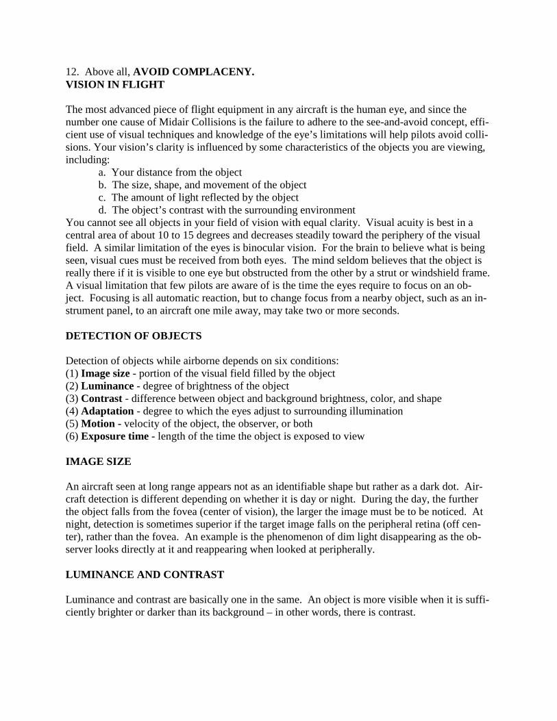
In addition to brightness and contrast, color and shape differences offer visual cues to detect air-craft. When an object and background have contrasting colors (yellow and blue, green and red, black and white), detection becomes easier. Similarly, when objects are long and thin as opposed to round and flat, they are easier to detect. An aircraft seen in profile is easier to notice than a head-on aircraft of equal area.
ADAPTATION The eye requires at least 30 minutes in darkness to distinguish objects under low illumination. Conversely, when the eyes have been accustomed to darkness, they need to adapt to bright light. MOTION Against a stationary irregular background, an aircraft needs only to move a few minutes of arc-per-second to reveal its presence to an alert observer. However, against a featureless back-ground, like a cloudless blue sky, the aircraft’s perceived motion must be 10 times faster to be noticed. What complicates the detection of relative motion is the fact that while flying, your eyes are also constantly moving. EXPOSURE TIME An aircraft that darts in and out of clouds presents a special challenge to the viewer. When an aircraft is not continuously exposed to view, the pilot has to judge its speed and direction in order to follow its path behind a cloud or the horizon. A small, slow-moving object that presents little contrast against its background can be easily lost during intermittent observation.
PHYSIOLOGICAL FACTORS As your eyes become fatigued, they grow less efficient at the task of seeing airborne aircraft. Only well-rested eyes can assure good vision. Structural parts, windshield/canopy distortion, poor cockpit lighting, dirty windshield, and instrument glare can limit a pilot’s vision even fur-ther. Complete darkness, fog, total overcast, and cloudless blue skies all present the viewer with a mo-notonous field. In such conditions, normal eyes constantly try to focus on infinity by actually fo-cusing on a point 1 to 2 meters away. This is called search myopia and reduces the pilot’s chances of seeing a distant aircraft. Try to focus on objects at the maximum range you expect to see aircraft-focus on the ground at about 4 to 8 NM and move your gaze up to the sector of the sky to be searched. Attempt to avoid frequent re-focusing in and out of the cockpit. About one-third of a second is required for the eyes to focus at each fixation. Your airborne searching scan should be slow and methodical. Learn to scan the visual field by dividing the area up into sectors, about 30 degrees each. Fix

your gaze in that sector for a second or two. Investigate any movement, then move to the next sector. If you have trouble focusing at long ranges, try squinting. Squinting compresses the eye-ball and changes its focal length allowing long-range aircraft to come in focus. At lower altitudes the easiest aircraft to see is on the horizon. Shadows sometimes help pilots to detect another aircraft. To spot the aircraft, look from the shadow to the sun. The lower the air-craft, the closer it is to its shadow. LOCATING YOUR BLIND SPOT With the right eye closed, look at the right of the upper figure. Move the paper back and forth about one foot from the eyes; the circle on the left will disappear. At that point it is projected on the blind spot. With the right eye closed, look at the cross at the right of the lower figure. When the white space falls in the blind spot, the black line appears to be continuous. This phenomenon helps us under-stand why we are not ordinarily aware of the blind spot. It is important to realize that all of us have blind spots. The potential for a mid-air collision lies within this blind area. At one mile this area could be 800 feet by 500 feet and at 5 miles the area may be 4/5 of a mile. The blind spot will vary depending on aircraft type and different face structures. A way to compensate for the blind spot is to move the head around while looking and look more than once in a given direction. GUIDE TO AN EFFECTIVE SCAN Your best defense against midair collisions is an effective scan pattern. There is no perfect scan, and no single scan technique that is best for all pilots. The most important thing is for each pilot to develop a scan that is both comfortable and workable. The first step to scanning properly is knowing where to concentrate your search. Instead of try-ing to look everywhere, concentrate on the area’s most critical to you at any given time. In the traffic pattern especially, clear yourself before every turn and always watch for other traffic com-ing into the pattern. On descent and climb out, make gentle S-turns to see if anyone is in your way. Also make clearing turns before attempting maneuvers such as pylons and S-turns about a road. During the very critical final approach stage, do not forget to look behind and below to avoid tunnel vision. Pilots often rivet their eyes to the point of touchdown. In normal flight, you can generally avoid the threat of a midair collision by scanning 60 degrees to the left and right of your central viewing area. Vertically, you will be safe if you scan 10 de-grees up and down from your flight vector. This will allow you to spot any aircraft that might prove hazardous to your own flight path, whether it is level with you, below and climbing, or above and descending. This method enables you to detect any movement in a single block. It
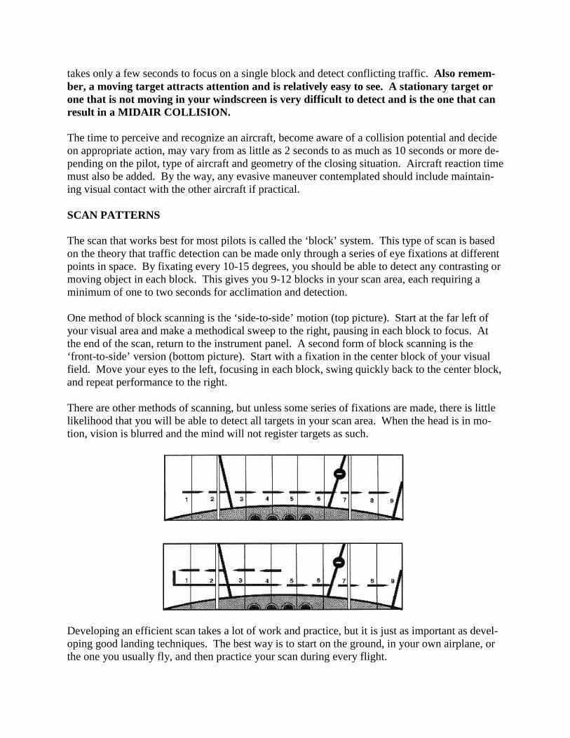
takes only a few seconds to focus on a single block and detect conflicting traffic. Also remem-ber, a moving target attracts attention and is relatively easy to see. A stationary target or one that is not moving in your windscreen is very difficult to detect and is the one that can result in a MIDAIR COLLISION. The time to perceive and recognize an aircraft, become aware of a collision potential and decide on appropriate action, may vary from as little as 2 seconds to as much as 10 seconds or more de-pending on the pilot, type of aircraft and geometry of the closing situation. Aircraft reaction time must also be added. By the way, any evasive maneuver contemplated should include maintain-ing visual contact with the other aircraft if practical. SCAN PATTERNS The scan that works best for most pilots is called the ‘block’ system. This type of scan is based on the theory that traffic detection can be made only through a series of eye fixations at different points in space. By fixating every 10-15 degrees, you should be able to detect any contrasting or moving object in each block. This gives you 9-12 blocks in your scan area, each requiring a minimum of one to two seconds for acclimation and detection. One method of block scanning is the ‘side-to-side’ motion (top picture). Start at the far left of your visual area and make a methodical sweep to the right, pausing in each block to focus. At the end of the scan, return to the instrument panel. A second form of block scanning is the ‘front-to-side’ version (bottom picture). Start with a fixation in the center block of your visual field. Move your eyes to the left, focusing in each block, swing quickly back to the center block, and repeat performance to the right. There are other methods of scanning, but unless some series of fixations are made, there is little likelihood that you will be able to detect all targets in your scan area. When the head is in mo-tion, vision is blurred and the mind will not register targets as such.
Developing an efficient scan takes a lot of work and practice, but it is just as important as devel-oping good landing techniques. The best way is to start on the ground, in your own airplane, or the one you usually fly, and then practice your scan during every flight.
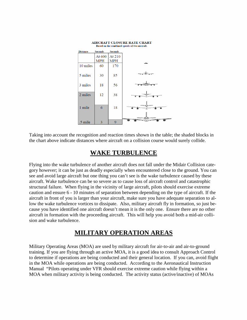
Taking into account the recognition and reaction times shown in the table; the shaded blocks in the chart above indicate distances where aircraft on a collision course would surely collide.
WAKE TURBULENCE Flying into the wake turbulence of another aircraft does not fall under the Midair Collision cate-gory however; it can be just as deadly especially when encountered close to the ground. You can see and avoid large aircraft but one thing you can’t see is the wake turbulence caused by these aircraft. Wake turbulence can be so severe as to cause loss of aircraft control and catastrophic structural failure. When flying in the vicinity of large aircraft, pilots should exercise extreme caution and ensure 6 - 10 minutes of separation between depending on the type of aircraft. If the aircraft in front of you is larger than your aircraft, make sure you have adequate separation to al-low the wake turbulence vortices to dissipate. Also, military aircraft fly in formation, so just be-cause you have identified one aircraft doesn’t mean it is the only one. Ensure there are no other aircraft in formation with the proceeding aircraft. This will help you avoid both a mid-air colli-sion and wake turbulence.
MILITARY OPERATION AREAS
Military Operating Areas (MOA) are used by military aircraft for air-to-air and air-to-ground training. If you are flying through an active MOA, it is a good idea to consult Approach Control to determine if operations are being conducted and their general location. If you can, avoid flight in the MOA while operations are being conducted. According to the Aeronautical Instruction Manual “Pilots operating under VFR should exercise extreme caution while flying within a MOA when military activity is being conducted. The activity status (active/inactive) of MOAs

may change frequently. Therefore, pilots should contact FSS within 100 miles of the area to ob-tain accurate real-time information concerning the MOA hours of operation. Prior to entering an active MOA, pilots should contact the controlling agency for traffic advisories”.
NEAR MIDAIR COLLISION REPORTING Definition: A near midair collision (NMAC) as defined by the AIM (7-6-3) is “an incident as-sociated with the operation of an aircraft in which a possibility of collision occurs as a result of proximity of less than 500 feet to another aircraft, or a report is received from a pilot or a flight crew member stating that a collision hazard existed between two or more aircraft.” Although the AIM mentions a definitive 500-foot proximity in this definition, it goes on to allow the pilot or flight crew member to make a determination as to if a collision hazard existed regard-less of how close the aircraft came to one another. Therefore, use your judgment and make an honest assessment. If you believe a collision hazard existed, report it. It’s your responsibility! Reporting a NMAC: First of all, you must inform ATC by using the following verbiage. “I wish to report a near midair collision.” This is in accordance with the AIM 7-6-3. A “Man that was close!” will not necessarily convey your intent. Properly notifying ATC will ensure the nec-essary data is saved. NMACs are reported on FAA Form 8020-21, “Preliminary Near Midair Collision Report,” and should contain the following information: • Date, time, and location of the NMAC • Fix or facility nearest the NMAC • The NMAC location in respect to the fix or facility • Aircraft information, such as make, model, and registration number • Type of flight rules during the NMAC • The aircraft altitude during the NMAC • A brief description of the NMAC, along with comments Your participation in the reporting process is highly encouraged and essential for improvements in the air traffic system and mishap prevention. Recent years have shown a reduction in NMAC reporting. This does not necessarily mean a re-duction of incidents, just a reduction in reporting. Therefore, a reduction in reporting should not lull anyone into a false sense of security that the threat of a midair collision is any less real. Why then are fewer NMACs reported? The following excerpt provides an explanation: “The reporting of a Near Midair Collision is voluntary and depends in part on the individual’s perception of a situation. A report does not necessarily involve the violation of regulations or an error by air traffic controllers, nor does it necessarily represent an unsafe condition. Significant factors in-fluencing the submission of a report may include the proximity of the aircraft involved, the ele-ment of surprise in the encounter, or the heightened alertness of the flight crew to the possibility of a Near Midair Collision because of the publicity surrounding a near, or actual, midair colli-sion. Some Near Midair Collisions, including those which may involve unsafe conditions, may not be reported. Some reasons are the failure to see the other aircraft or to perceive accurately the distance from another aircraft due to restricted visibility or the relative angle of approach. Others are the fear of penalty, or lack of awareness of the NMAC reporting system.” (Aviation Safety Statistical Handbook - October 2002) Your participation in the reporting process is
highly encouraged and essential for improvements in the air traffic system and mishap preven-tion.
AVIATION SAFETY REPORTING SYSTEM (ASRS)
The FAA initiated ASRS in 1975 and provides the necessary funding. In order to maintain objec-tivity and anonymity, NASA sets policies and administers the program through a private contrac-tor obtained through competitive bidding. The current contractor is Battelle Memorial Institute. Reports sent to the ASRS are held in strict confidence. More than 300,000 reports have been sub-mitted to date and no reporter's identity has ever been breached by the ASRS. ASRS de-identi-fies reports before entering them into the incident database. All personal and organizational names are removed. Dates, times, and related information, which could be used to infer an iden-tity, are either generalized or eliminated. The FAA will not use information obtained through ASRS for enforcement actions. If the FAA has information from other sources concerning viola-tions they will take appropriate action. However, because they consider the filing of a “NASA” report as “indicative of a constructive attitude” and that such an attitude tends to “prevent future violations” (Advisory Circular 00-46D), the FAA won’t impose any civil penalties or certificate suspensions. You must meet the following criteria to be eligible for immunity: • Violation was not deliberate • Not a criminal offense • No mishap occurred • No violation within five years prior to the date of occurrence • Incident was properly reported. Within 10 days after the violation, complete and deliver or mail a written report of the incident or occurrence to NASA under ASRS Obtain ASRS report forms and additional information from http://asrs.arc.nasa.gov. Bottom line – ASRS promotes aviation safety and offers immunity from disciplinary action, a win – win situation. Please consider using this reporting system. NOTE: Tragic events are usually preceded by warnings, such as close calls, almost accidents or accidents/incidents in which tragedy was narrowly averted. These close calls need to be reported, recorded, communicated, and in many instances investigated to prevent future tragedies from oc-curring. It is every aviator’s responsibility, for the good of humanity and the promotion of avia-tion to detect, report, and eliminate potential hazards
AIR TRAFFIC CONTROL ENVIRONMENT RADAR The continuing development of more sophisticated and automated equipment has given rise to the notion among some airmen that controllers are watching their every move en route and will
always be able to warn other aircraft, particularly those flying IFR, of their presence. This mis-conception is deadly. The adoption of radar for air traffic control brought with it a series of increased capabilities. Ra-dar’s added capability encourages some of us to overlook the fact that current radar is not all en-compassing in its coverage, radar does not pick up all aircraft at all times, and radar is primarily used to separate IFR traffic. As radar found its way into air traffic control, ground clutter became an increasingly serious problem for terminal radar. Some of today’s most sophisticated black box circuitry is aimed at reducing this phenomenon. Modern radar does a magnificent job compared to the old days, but clutter is still there. One way of reducing ground clutter to a minimum is to weaken radar’s sen-sitivity to distant aircraft targets. The person affected in this trade-off is the pilot flying an air-plane with the weakest radar-reflecting properties. This group includes many small general avia-tion airplanes flying IFR without active transponders. In some situations, these aircraft are not “painted” on the radarscope even though they are within range of the transmitter. SECURITY BLANKET Some pilots think of IFR as a security blanket. They say to themselves, “I’m on an IFR flight plan, so air traffic control will tell me about all the traffic I might encounter.” So they settle back in their seat feeling safe. There are examples of mid-air collisions involving IFR and VFR air-craft and even between IFR aircraft to dispel this myth.
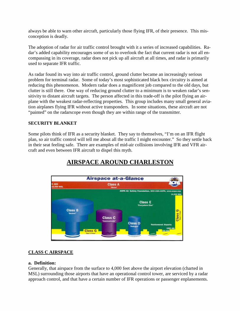
AIRSPACE AROUND CHARLESTON
CLASS C AIRSPACE a. Definition: Generally, that airspace from the surface to 4,000 feet above the airport elevation (charted in MSL) surrounding those airports that have an operational control tower, are serviced by a radar approach control, and that have a certain number of IFR operations or passenger enplanements.

Although the configuration of each Class C airspace area is individually tailored, the airspace usually consists of a 5 NM radius core surface area that extends from the surface up to 4,000 feet above the airport elevation, and a 10 NM radius shelf area that extends from 1,200 feet to 4,000 feet above the airport elevation. b. Outer Area: The normal radius will be 20NM, with some variations based on site specific requirements. The outer area extends outward from the primary airport and extends from the lower limits of ra-dar/radio coverage up to the ceiling of the approach control's delegated airspace, excluding the Class C airspace and other airspace as appropriate. c. Charts: Class C airspace is charted on Sectional Charts, IFR En Route Low Altitude, and Terminal Area Charts where appropriate. d. Operating Rules and Pilot/Equipment Requirements: 1. Pilot Certification: No specific certification required. 2. Equipment: (a) Two-way radio, and (b) Unless otherwise authorized by ATC, an operable radar beacon transponder with automatic altitude reporting equipment. 3. Arrival or Through Flight Entry Requirements: Two-way radio communication must be estab-lished with the ATC facility providing ATC services prior to entry and thereafter maintain those communications while in Class C airspace. Pilots of arriving aircraft should contact the Class C airspace ATC facility on the publicized frequency and give their position, altitude, radar beacon code, destination, and request Class C service. Radio contact should be initiated far enough from the Class C airspace boundary to preclude entering Class C airspace before two-way radio com-munications are established. e. Air Traffic Services: When two-way radio communications and radar contact are established, all participating VFR aircraft are: 1. Sequenced to the primary airport. 2. Provided Class C services within the Class C airspace and the outer area. 3. Provided basic radar services beyond the outer area on a workload permitting basis. This can be terminated by the controller if workload dictates. CLASS D AIRSPACE a. Definition: Generally, that airspace from the surface to 2,500 feet above the airport elevation (charted in MSL) surrounding those airports that have an operational control tower. The configuration of each Class D airspace area is individually tailored and when instrument procedures are pub-lished, the airspace will normally be designed to contain the procedures. b. Operating Rules and Pilot/Equipment Requirements:
1. Pilot Certification: No specific certification required. 2. Equipment: Unless otherwise authorized by ATC, a two-way radio is required. 3. Arrival or Through Flight Entry Requirements: Two-way radio communication must be estab-lished with the ATC facility providing ATC services prior to entry and thereafter maintain those communications while in the Class D airspace. Pilots of arriving aircraft should contact the con-trol tower on the publicized frequency and give their position, altitude, destination, and any re-quest (s). Radio contact should be initiated far enough from the Class D airspace boundary to preclude entering the Class D airspace before two way radio communications are established. c. Charts: Class D airspace areas are depicted on Sectional and Terminal charts with blue segmented lines, and on IFR En Route Lows with a boxed [D]. d. Operating Rules and Pilot/Equipment Requirements: Arrival extensions for instrument approach procedures may be Class D or Class E airspace. As a general rule, if all extensions are 2 miles or less, they remain part of the Class D surface area. However, if any one extension is greater than 2 miles, then all extensions become Class E. e. Separation for VFR Aircraft: No separation services are provided to VFR aircraft. CLASS E AIRSPACE a. Definition: Generally, if the airspace is not Class A, Class B, Class C, or Class D, and it is controlled airspace, it is Class E airspace. b. Operating Rules and Pilot/Equipment Requirements: 1. Pilot Certification: No specific certification required. 2. Equipment: No specific equipment required by the airspace. 3. Arrival or Through Flight Entry Requirements: No specific requirements. c. Charts: Class E airspace below 14,500 feet MSL is charted on Sectional, Terminal, World, and IFR En Route Low Altitude charts. d. Vertical limits: Except for 18,000 feet MSL, Class E airspace has no defined vertical limit but rather it extends upward from either the surface or a designated altitude to the overlying or adjacent controlled airspace. e. Separation for VFR Aircraft: No separation services are provided to VFR aircraft.
MILITARY TRAINING ROUTES

Generally, MTRs are established below 10,000 feet MSL for operations at speeds in excess of 250 knots. A variety of aircraft fly these routes and operate either VFR or IFR at speeds up to 500 KIAS and altitudes from 300 feet AGL to several thousand feet. Charleston C-17 aircraft most commonly use the following MTRs: IR035, IR036, and VR1041. You can see these on the enclosed map. MTRs with four numbers (e.g. VR1041, etc) identify MTRs with no segment above 1,500 feet AGL. MTRs that include one or more segments above 1,500 AGL are identi-fied by three numbers (e.g. IR036, IR035, etc.). VR1041 runs along the South Carolina coast. The coastline can be extremely hazardous! Besides military aircraft flying on VR1041, be on the lookout for sightseeing civil traffic, U.S. Coast Guard helicopters, banner-towing aircraft, and parasailing.
Non-participating aircraft are not prohibited from flying within an MTR but are encouraged to limit the time they operate within them. Exercise extreme caution when flying through or near these routes. Pilots should contact a Flight Service Station (FSS) within 100 NM of a MTR to obtain current information on route usage. The information available includes: time of scheduled activity, altitudes in use, and route width.
MACA TIPS The Charleston area has a higher than normal potential for midair collision but no matter where you fly, here are some ideas that you can use to help reduce the midair collision hazard: When you see a military aircraft look for more! They usually fly in flights of 2 or more and may be up to a mile apart in a non-standard formation. Preplan your flight activity so as to become aware of areas of greatest aircraft activity (airports, MOAs, TCAs, etc.). When possible, plan the flight to avoid these areas. Fly IFR or use VFR advisories. This will provide two benefits. First, you will help make other aircraft aware of where you are (through air traffic control advisories). Second, the controllers can tell you where conflicting traffic is. Controllers cannot keep track of all traffic and they are only responsible for separating IFR flights. Maintain a see-and-avoid attitude. 82 percent of near midair collisions occur at 7500 feet and below; plan to fly above this alti-tude during the cruise portion of your trip. Make your transponder work for you and have it on when you are flying. Even if you are not talking to a RADAR facility, it helps them see you and issue traffic for other aircraft. Other air-craft with Traffic Collision Avoidance System (TCAS) can also see you if your transponder is on. Consider using landing or taxi lights when you are flying at lower altitudes (even during daylight conditions). They make you more visible to other aircraft.
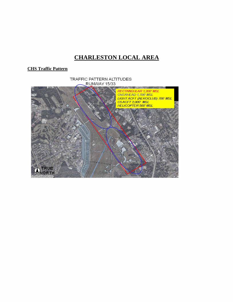
CHARLESTON LOCAL AREA CHS Traffic Pattern
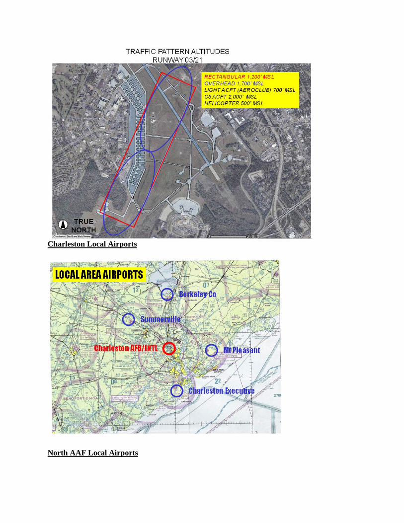
Charleston Local Airports
North AAF Local Airports
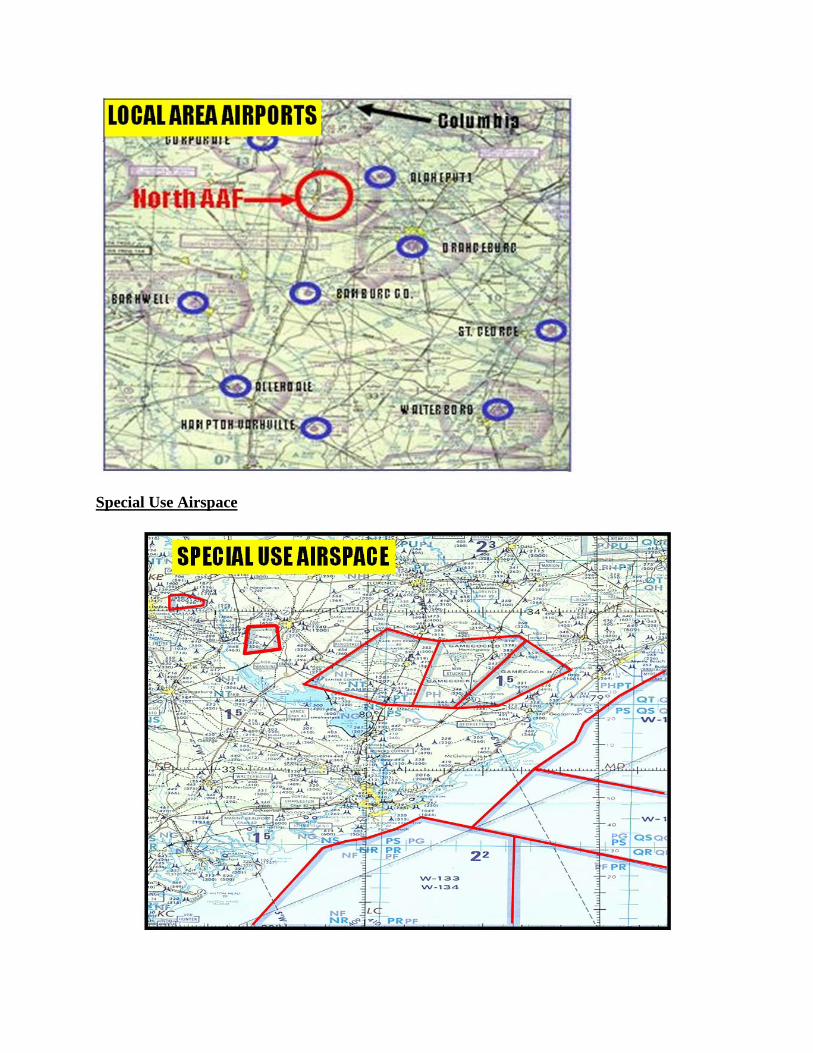
Special Use Airspace

Military Training Routes
IR 035IR 036
KCHS
LOCAL IR ROUTES
Date Last Reviewed: 15 Jan 08OPR: 437 OSS/OSAM

C-130 HERCULES
SPEEDS DIMENSIONS Departure: 200 KIAS Length: 100 Feet Local Area: 200 KIAS Wingspan: 133 Feet Low Level: 300’ AGL/250 KIAS Height: 39 Feet

C-17 GLOBEMASTER III
SPEEDS DIMENSIONS Departure: 200 KIAS Length: 174 Feet Local Area: 250 KIAS Wingspan: 170 Feet Low Level: 300’ AGL/340 KIAS Height: 55 Feet
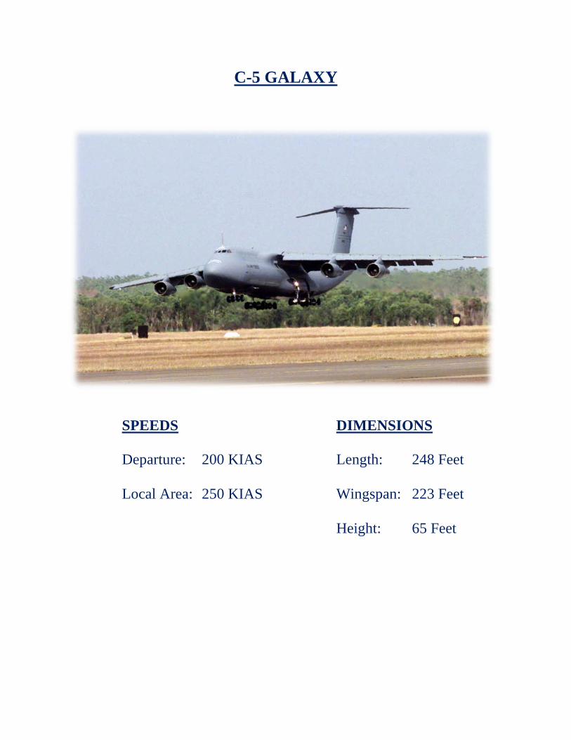
C-5 GALAXY
SPEEDS DIMENSIONS Departure: 200 KIAS Length: 248 Feet Local Area: 250 KIAS Wingspan: 223 Feet Height: 65 Feet

Frequently Seen Transient Aircraft
F-16 Falcon KC-135 Stratotanker
KC-10 Extender C-21 Learjet
F/A-18 Hornet UH-60 Blackhawk