METHODOLOGICAL PROPOSAL TO IDENTIFY IRRIGATION CANALS USING DIATOMS AS BIOMARKERS: PEÑAS COLORADAS...
22
Physical, Chemical and Biological Markers in Argentine Archaeology: Theory, Methods and Applications Edited by Débora M. Kligmann Marcelo R. Morales BAR International Series 2678 2014 BAR S2678 2014 KILGMANN & MORALES (Eds) PHYSICAL, CHEMICAL AND BIOLOGICAL MARKERS 2768 Kligmann and Morales cover.indd 1 15/10/2014 09:45:28
-
Upload
universidadnacionaldejujuyconicet -
Category
Documents
-
view
3 -
download
0
Transcript of METHODOLOGICAL PROPOSAL TO IDENTIFY IRRIGATION CANALS USING DIATOMS AS BIOMARKERS: PEÑAS COLORADAS...

Physical, Chemical and Biological Markers in Argentine Archaeology: Theory, Methods and Applications
Edited by
Débora M. KligmannMarcelo R. Morales
BAR International Series 26782014
BA
R S2678 2014
KILG
MA
NN
& M
OR
ALES (Eds)
PHY
SICA
L, CH
EMIC
AL A
ND
BIO
LOG
ICA
L MA
RK
ERS
2768 Kligmann and Morales cover.indd 1 15/10/2014 09:45:28

Physical, Chemical and Biological Markers in Argentine Archaeology: Theory, Methods and Applications
Edited by
Débora M. KligmannMarcelo R. Morales
BAR International Series 26782014

Published by
ArchaeopressPublishers of British Archaeological ReportsGordon House276 Banbury RoadOxford OX2 [email protected]
BAR S2678
Physical, Chemical and Biological Markers in Argentine Archaeology: Theory, Methods and Applications
© Archaeopress and the individual authors 2014
ISBN 978 1 4073 1322 1
Printed in England by Information Press, Oxford
All BAR titles are available from:
Hadrian Books Ltd122 Banbury RoadOxfordOX2 7BPEnglandwww.hadrianbooks.co.uk
The current BAR catalogue with details of all titles in print, prices and means of payment is available free from Hadrian Books or may be downloaded from www.archaeopress.com
I
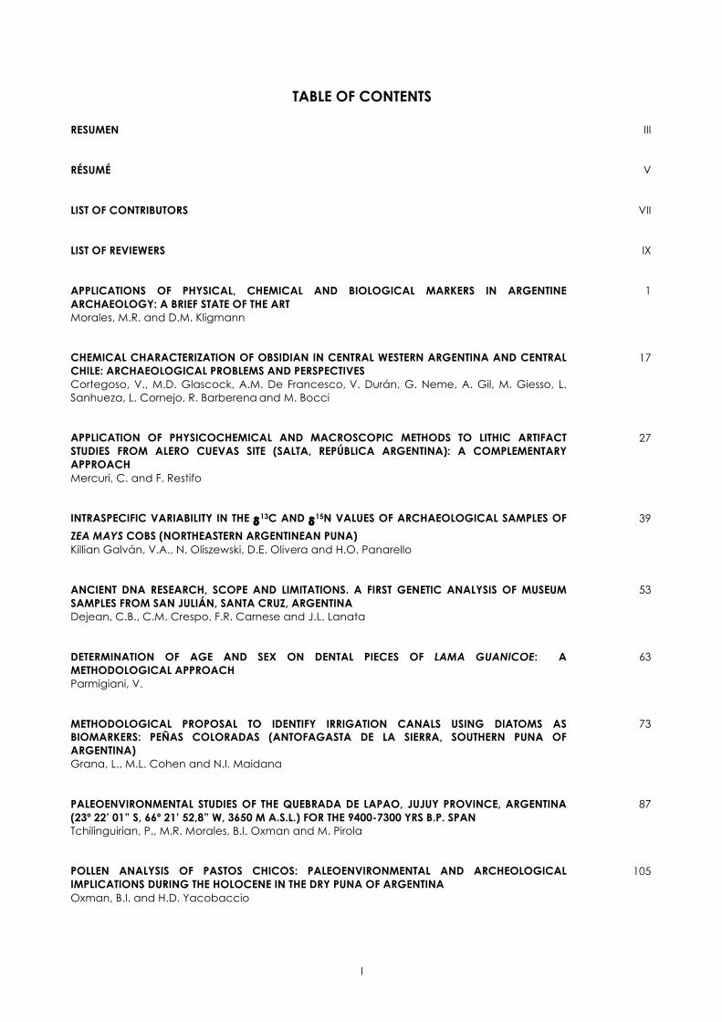
TABLE OF CONTENTS
RESUMEN
III
RÉSUMÉ
V
LIST OF CONTRIBUTORS
VII
LIST OF REVIEWERS
IX
APPLICATIONS OF PHYSICAL, CHEMICAL AND BIOLOGICAL MARKERS IN ARGENTINE ARCHAEOLOGY: A BRIEF STATE OF THE ART Morales, M.R. and D.M. Kligmann
1
CHEMICAL CHARACTERIZATION OF OBSIDIAN IN CENTRAL WESTERN ARGENTINA AND CENTRAL CHILE: ARCHAEOLOGICAL PROBLEMS AND PERSPECTIVES Cortegoso, V., M.D. Glascock, A.M. De Francesco, V. Durán, G. Neme, A. Gil, M. Giesso, L. Sanhueza, L. Cornejo, R. Barberena and M. Bocci
17
APPLICATION OF PHYSICOCHEMICAL AND MACROSCOPIC METHODS TO LITHIC ARTIFACT STUDIES FROM ALERO CUEVAS SITE (SALTA, REPÚBLICA ARGENTINA): A COMPLEMENTARY APPROACH Mercuri, C. and F. Restifo
27
INTRASPECIFIC VARIABILITY IN THE δ13C AND δ15N VALUES OF ARCHAEOLOGICAL SAMPLES OF
ZEA MAYS COBS (NORTHEASTERN ARGENTINEAN PUNA) Killian Galván, V.A., N. Oliszewski, D.E. Olivera and H.O. Panarello
39
ANCIENT DNA RESEARCH, SCOPE AND LIMITATIONS. A FIRST GENETIC ANALYSIS OF MUSEUM SAMPLES FROM SAN JULIÁN, SANTA CRUZ, ARGENTINA Dejean, C.B., C.M. Crespo, F.R. Carnese and J.L. Lanata
53
DETERMINATION OF AGE AND SEX ON DENTAL PIECES OF LAMA GUANICOE: A METHODOLOGICAL APPROACH Parmigiani, V.
63
METHODOLOGICAL PROPOSAL TO IDENTIFY IRRIGATION CANALS USING DIATOMS AS BIOMARKERS: PEÑAS COLORADAS (ANTOFAGASTA DE LA SIERRA, SOUTHERN PUNA OF ARGENTINA) Grana, L., M.L. Cohen and N.I. Maidana
73
PALEOENVIRONMENTAL STUDIES OF THE QUEBRADA DE LAPAO, JUJUY PROVINCE, ARGENTINA (23º 22’ 01” S, 66º 21’ 52,8” W, 3650 M A.S.L.) FOR THE 9400-7300 YRS B.P. SPAN Tchilinguirian, P., M.R. Morales, B.I. Oxman and M. Pirola
87
POLLEN ANALYSIS OF PASTOS CHICOS: PALEOENVIRONMENTAL AND ARCHEOLOGICAL IMPLICATIONS DURING THE HOLOCENE IN THE DRY PUNA OF ARGENTINA Oxman, B.I. and H.D. Yacobaccio
105

II
IN PURSUIT OF THE FIRE. CONTRIBUTIONS OF MICROCHARCOAL ANALYSIS TO THE ARCHAEOLOGY OF THE AMBATO VALLEY (CATAMARCA) Lindskoug, H.B.
117
ON STEWS AND SEDIMENTS: CONTRIBUTIONS OF EXPERIMENTAL FIELD AND LAB ARCHAEOLOGY TO THE STUDY OF SEDIMENTOLOGICAL MODIFICATIONS Kligmann, D.M. and I.J. Lantos
131
VII
LIST OF CONTRIBUTORS
BARBERENA, RAMIRO CONICET - Laboratorio de Geoarqueología, Facultad de Filosofía y Letras, Universidad Nacional de Cuyo, Mendoza, Argentina. BOCCI, MARCO Università della Calabria, Italy. CARNESE, FRANCISCO R. Sección Antropología Biológica, Instituto de Ciencias Antropológicas, Facultad de Filosofía y Letras, Universidad de Buenos Aires - Centro de Estudios Biomédicos, Biotecnológicos, Ambientales y Diagnóstico, Universidad Maimónides, Buenos Aires, Argentina. COHEN, MA. LORENA CONICET - Instituto Superior de Estudios Sociales, Instituto de Arqueología y Museo de la Universidad Nacional de Tucumán, Tucumán, Argentina. CORNEJO, LUIS Universidad de Chile, Chile. CORTEGOSO, VALERIA CONICET - Universidad Nacional de Cuyo, Mendoza, Argentina. CRESPO, CRISTIAN M. CONICET - Centro de Estudios Biomédicos, Biotecnológicos, Ambientales y Diagnóstico y Fundación de Historia Natural Félix Azara. Departamento de Ciencias Naturales y Antropológicas, Universidad Maimónides, Argentina. DE FRANCESCO, ANNA MARÍA Università della Calabria, Italy. DEJEAN, CRISTINA B. Sección Antropología Biológica, Instituto de Ciencias Antropológicas, Facultad de Filosofía y Letras, Universidad de Buenos Aires - Centro de Estudios Biomédicos, Biotecnológicos, Ambientales y Diagnóstico y Fundación de Historia Natural Félix Azara, Departamento de Ciencias Naturales y Antropológicas, Universidad Maimónides, Buenos Aires, Argentina. DURÁN, VICTOR CONICET - Universidad Nacional de Cuyo, Mendoza, Argentina. GIESSO, MARTÍN Northeastern Illinois University, Illinois, USA. GIL, ADOLFO CONICET - Museo de Historia Natural de San Rafael, Mendoza, Argentina.
GLASCOCK, MICHAEL D. Research Reactor Center, University of Missouri, Columbia, USA. GRANA, LORENA CONICET - Departamento de Biodiversidad y Biología Experimental, Facultad de Ciencias Exactas y Naturales, Universidad de Buenos Aires, Buenos Aires, Argentina. KILLIAN GALVÁN, VIOLETA A. CONICET - Instituto de Geocronología y Geología Isotópica - Universidad de Buenos Aires, Buenos Aires, Argentina. KLIGMANN, DÉBORA M. CONICET - Instituto de Arqueología, Facultad de Filosofía y Letras, Universidad de Buenos Aires, Buenos Aires, Argentina. LANATA, JOSÉ L. CONICET - Instituto de Investigaciones en Diversidad Cultural y Procesos de Cambio, Universidad Nacional de Río Negro, Argentina. LANTOS, IRENE J. CONICET - Museo Etnográfico, Facultad de Filosofía y Letras, Universidad de Buenos Aires, Buenos Aires, Argentina. LINDSKOUG, HENRIK B. CONICET - Museo de Antropología, Facultad de Filosofía y Humanidades, Universidad Nacional de Córdoba, Argentina. MAIDANA, NORA I. CONICET - Departamento de Biodiversidad y Biología Experimental, Facultad de Ciencias Exactas y Naturales, Universidad de Buenos Aires, Buenos Aires, Argentina. MERCURI, CECILIA CONICET - Instituto de Arqueología, Facultad de Filosofía y Letras, Universidad de Buenos Aires, Buenos Aires, Argentina. MORALES, MARCELO R. CONICET - Instituto de Arqueología, Facultad de Filosofía y Letras, Universidad de Buenos Aires, Buenos Aires, Argentina. NEME, GUSTAVO CONICET - Museo de Historia Natural de San Rafael, Mendoza, Argentina. OLISZEWSKI, NURIT CONICET - Instituto Superior de Estudios Sociales -Universidad Nacional de Tucumán, Tucumán, Argentina.
VIII
OLIVERA, DANIEL E. CONICET - Instituto Nacional de Antropología y Pensamiento Latinoamericano - Universidad de Buenos Aires, Buenos Aires, Argentina. OXMAN, BRENDA I. CONICET - Instituto de Arqueología, Facultad de Filosofía y Letras, Universidad de Buenos Aires, Buenos Aires, Argentina. PANARELLO, HÉCTOR O. CONICET - Instituto de Geocronología y Geología Isotópica - Universidad de Buenos Aires, Buenos Aires, Argentina. PARMIGIANI, VANESA CONICET - Centro Austral de Investigaciones Científicas, Tierra del Fuego - Facultad de Ciencias Naturales y Museo, Universidad Nacional de La Plata, Buenos Aires, Argentina.
PIROLA, MALENA Instituto de Arqueología, Facultad de Filosofía y Letras, Universidad de Buenos Aires, Buenos Aires, Argentina. RESTIFO, FEDERICO CONICET - Instituto de Arqueología, Facultad de Filosofía y Letras, Universidad de Buenos Aires, Buenos Aires, Argentina. SANHUEZA, LORENA Universidad de Chile, Chile. TCHILINGUIRIAN, PABLO CONICET - Instituto Nacional de Antropología y Pensamiento Latinoamericano - Universidad de Buenos Aires, Buenos Aires, Argentina. YACOBACCIO, HUGO D. CONICET - Instituto de Arqueología, Facultad de Filosofía y Letras, Universidad de Buenos Aires, Buenos Aires, Argentina.

IX
LIST OF REVIEWERS
BARBA PINGARRÓN, LUIS A. Instituto de Investigaciones Antropológicas, Universidad Nacional Autónoma de México, México. BARBERENA, RAMIRO CONICET - Laboratorio de Geoarqueología, Facultad de Filosofía y Letras, Universidad Nacional de Cuyo, Mendoza, Argentina. BORRERO, LUIS A. CONICET - Instituto Multidisciplinario de Historia y Ciencias Humanas, Departamento de Investigaciones Prehistóricas y Arqueológicas, Buenos Aires, Argentina. DE NIGRIS, MARIANA CONICET - Instituto Nacional de Antropología y Pensamiento Latinoamericano, Buenos Aires, Argentina. DÍAZ PARDO, CAROLINA A. Instituto de Ecología y Biodiversidad, Laboratorio de Paleoecología, Departamento de Ciencias Ecológicas, Facultad de Ciencias, Universidad de Chile, Santiago, Chile. ESCOLA, PATRICIA S. CONICET - Escuela de Arqueología, Universidad Nacional de Catamarca, Catamarca, Argentina. FRANCO, NORA V. CONICET - Instituto Multidisciplinario de Historia y Ciencias Humanas, Departamento de Investigaciones Prehistóricas y Arqueológicas, Buenos Aires, Argentina. HUCKLEBERRY, GARY A. Department of Geosciences, University of Arizona, Tucson, USA. JOLY, DELPHINE UMR 6566, Bât 24-25, Campus de Beaulieu, Université de Rennes 1, Rennes, France. KORNSTANJE, ALEJANDRA CONICET - Instituto de Arqueología y Museo, Tucumán, Argentina.
LAZZARI, MARISA Archaeology Department, Exeter University, UK. LEMA, VERÓNICA S. CONICET - Departamento Científico de Arqueología, Laboratorio 1, Museo de Ciencias Naturales de La Plata, Buenos Aires, Argentina. LÓPEZ, GABRIEL CONICET - Instituto de Arqueología, Facultad de Filosofía y Letras, Universidad de Buenos Aires, Buenos Aires, Argentina. LUNA, LEANDRO CONICET - Museo Etnográfico J. B. Ambrosetti, Facultad de Filosofía y Letras, Universidad de Buenos Aires, Buenos Aires, Argentina. MONDINI, MARIANA CONICET - Laboratorio de Zooarqueología y Tafonomía de Zonas Áridas, Instituto de Antropología de Córdoba, Museo de Antropología, Universidad Nacional de Córdoba, Córdoba, Argentina. RATTO, NORMA Museo Etnográfico J. B. Ambrosetti, Facultad de Filosofía y Letras, Universidad de Buenos Aires, Buenos Aires, Argentina. SCHITTEK, KARSTEN Seminar für Geographie und ihre Didaktik, Universität zu Köln, Germany. SELDES, VERÓNICA CONICET - Instituto Nacional de Antropología y Pensamiento Latinoamericano, Buenos Aires, Argentina. TRIPALDI, ALFONSINA CONICET - Instituto de Geociencias Básicas, Aplicadas y Ambientales, Departamento de Ciencias Geológicas, Facultad de Ciencias Exactas y Naturales, Universidad de Buenos Aires, Buenos Aires, Argentina. ZANGRANDO, ATILIO F.J. CONICET - Centro Austral de Investigaciones Científicas - Laboratorio de Antropología, Tierra del Fuego, Argentina.
PHYSICAL, CHEMICAL AND BIOLOGICAL MARKERS IN ARGENTINE ARCHAEOLOGY: THEORY, METHODS AND APPLICATIONS. Débora M. Kligmann & Marcelo R. Morales (Eds.). BAR International Series, Archaeopress, Oxford.
METHODOLOGICAL PROPOSAL TO IDENTIFY IRRIGATION CANALS USING DIATOMS AS BIOMARKERS: PEÑAS COLORADAS (ANTOFAGASTA DE LA SIERRA,
SOUTHERN PUNA OF ARGENTINA)
Lorena Grana1 2, Ma. Lorena Cohen1 3 and Nora I. Maidana1 2
1 CONICET, 2 Dpto. de Biodiversidad y Biología Experimental, FCEyN, UBA - Buenos Aires, 3 Inst. Superior de Estudios Sociales - Inst. de Arqueología y Museo de la UNT - San Miguel de Tucumán
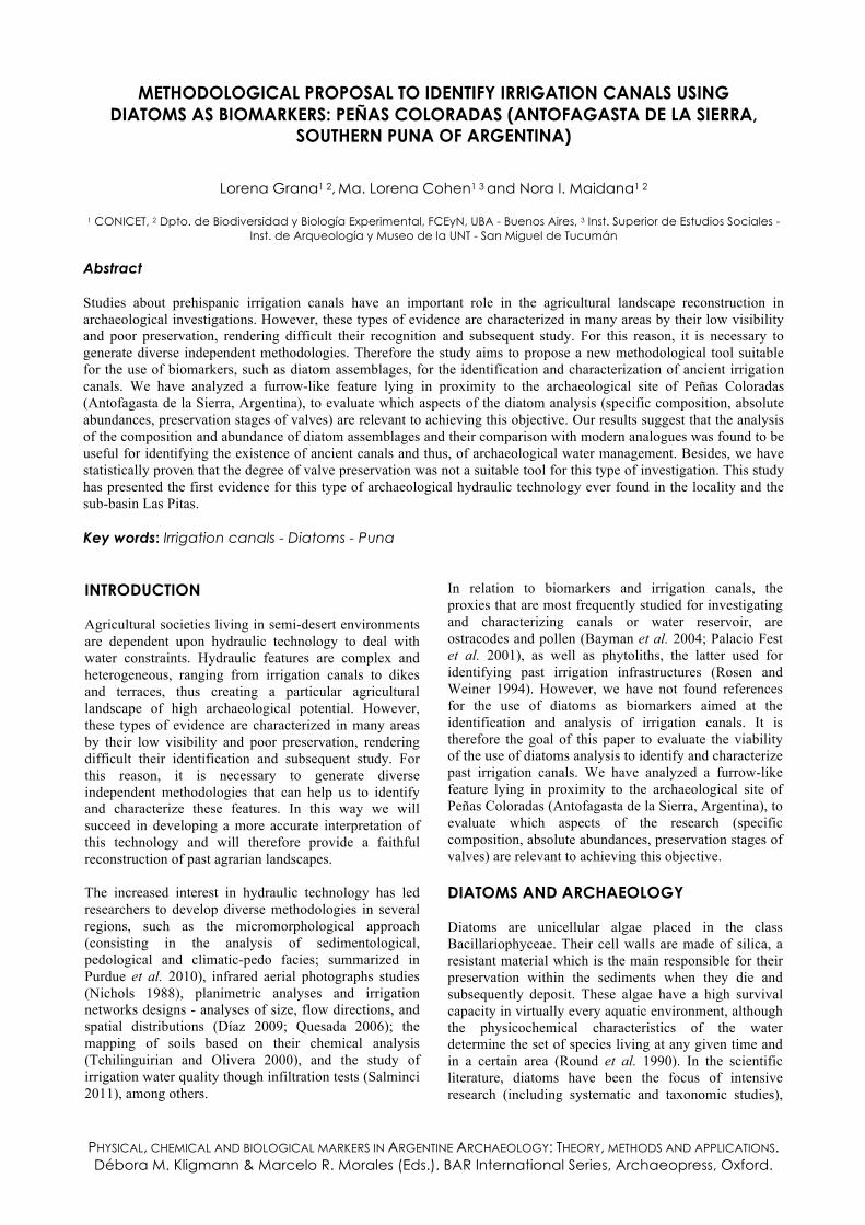
Abstract Studies about prehispanic irrigation canals have an important role in the agricultural landscape reconstruction in archaeological investigations. However, these types of evidence are characterized in many areas by their low visibility and poor preservation, rendering difficult their recognition and subsequent study. For this reason, it is necessary to generate diverse independent methodologies. Therefore the study aims to propose a new methodological tool suitable for the use of biomarkers, such as diatom assemblages, for the identification and characterization of ancient irrigation canals. We have analyzed a furrow-like feature lying in proximity to the archaeological site of Peñas Coloradas (Antofagasta de la Sierra, Argentina), to evaluate which aspects of the diatom analysis (specific composition, absolute abundances, preservation stages of valves) are relevant to achieving this objective. Our results suggest that the analysis of the composition and abundance of diatom assemblages and their comparison with modern analogues was found to be useful for identifying the existence of ancient canals and thus, of archaeological water management. Besides, we have statistically proven that the degree of valve preservation was not a suitable tool for this type of investigation. This study has presented the first evidence for this type of archaeological hydraulic technology ever found in the locality and the sub-basin Las Pitas. Key words: Irrigation canals - Diatoms - Puna INTRODUCTION Agricultural societies living in semi-desert environments are dependent upon hydraulic technology to deal with water constraints. Hydraulic features are complex and heterogeneous, ranging from irrigation canals to dikes and terraces, thus creating a particular agricultural landscape of high archaeological potential. However, these types of evidence are characterized in many areas by their low visibility and poor preservation, rendering difficult their identification and subsequent study. For this reason, it is necessary to generate diverse independent methodologies that can help us to identify and characterize these features. In this way we will succeed in developing a more accurate interpretation of this technology and will therefore provide a faithful reconstruction of past agrarian landscapes. The increased interest in hydraulic technology has led researchers to develop diverse methodologies in several regions, such as the micromorphological approach (consisting in the analysis of sedimentological, pedological and climatic-pedo facies; summarized in Purdue et al. 2010), infrared aerial photographs studies (Nichols 1988), planimetric analyses and irrigation networks designs - analyses of size, flow directions, and spatial distributions (Díaz 2009; Quesada 2006); the mapping of soils based on their chemical analysis (Tchilinguirian and Olivera 2000), and the study of irrigation water quality though infiltration tests (Salminci 2011), among others.
In relation to biomarkers and irrigation canals, the proxies that are most frequently studied for investigating and characterizing canals or water reservoir, are ostracodes and pollen (Bayman et al. 2004; Palacio Fest et al. 2001), as well as phytoliths, the latter used for identifying past irrigation infrastructures (Rosen and Weiner 1994). However, we have not found references for the use of diatoms as biomarkers aimed at the identification and analysis of irrigation canals. It is therefore the goal of this paper to evaluate the viability of the use of diatoms analysis to identify and characterize past irrigation canals. We have analyzed a furrow-like feature lying in proximity to the archaeological site of Peñas Coloradas (Antofagasta de la Sierra, Argentina), to evaluate which aspects of the research (specific composition, absolute abundances, preservation stages of valves) are relevant to achieving this objective. DIATOMS AND ARCHAEOLOGY Diatoms are unicellular algae placed in the class Bacillariophyceae. Their cell walls are made of silica, a resistant material which is the main responsible for their preservation within the sediments when they die and subsequently deposit. These algae have a high survival capacity in virtually every aquatic environment, although the physicochemical characteristics of the water determine the set of species living at any given time and in a certain area (Round et al. 1990). In the scientific literature, diatoms have been the focus of intensive research (including systematic and taxonomic studies),

Grana, L. et al. Methodological proposal to identify irrigation canals using diatoms…
74
paying special attention to their ecological relationships and their palaeoecological significance (Mannion 1987). In the last three decades, the relationship between diatoms and certain archaeological issues has become increasingly evident (Battarbee 1988; Cameron 2007; Fernández and Maidana 2008; Juggins and Cameron 1999; Mannion 1987; Martínez Macchiavello et al. 1999). These analyses can be applied at a range of spatial and temporal scales to place archaeological materials in their broader environmental and cultural context, and they have been proved to be a useful tool in archaeological discussions. In summary, diatom analysis can focus on three major subjects: a) palaeoenvironmental reconstructions, b) site formation processes, and c) archaeological records, the first one being the most common approach found in archaeological studies (Cameron 2007; Ognjanova-Rumenova 2008). Palaeoenvironmental reconstructions have been applied elsewhere at local (e.g. Fernández and Salemme 2010) and regional scales (e.g. Grana 2007; Morales 2010) to contextualize and better understand the cultural processes within a well-known archaeological landscape. They can also be found in evaluations of the human cultural impact on past environments. These reconstructions are most frequently aimed at understanding prehistoric agricultural impacts on lakes (e.g. Bradshaw et al. 2006) and, to a less extent, at analyzing the impact of hunter-gatherer settlements on aquatic ecosystems, e.g. the activity of prehistoric Inuit whalers in Arctic Sea (e.g. Hadley et al. 2010). A different approach consists in the application of diatom analysis to the study of archaeological sediments in order to determine site formation processes or to identify differentiated areas of activity within the sites (e.g. Kligmann 2003; Mannion 1987). In the last decades, diatom analysis has been increasingly used by archaeologists in clay provenance studies and the development of pottery typologies. The identification of the diatom assemblages contained in the clay and the water used in ceramic manufacturing, has made it possible for researchers to identify local clay sources (e.g. Jansma 1990), and to calculate the distance between these clay sources and the archaeological sites (e.g. Solá and Morales 2007). In this line of research, Cameron (2007) has proposed the use of diatoms for identifying the material sources and the manufacturing techniques used in ancient building construction. But these analyses have been criticized by some authors, who postulate that they present important limitations. As an example, Kligmann and Calderari (2012) have stressed the fact that there are different moments in the production chain of ceramic, in which the diatoms could be incorporated, so they could interfere in our interpretation of procedence of clay. The study of diatoms has also shed light into the analysis of coprolites (both human and nonhuman) from prehistoric settlements. It has normally been used together with other microfossil analysis (such as phytoliths or pollen) to provide information relating to
seasonal occupation and the palaeoenvironmental conditions of the sites (e.g. Horrocks et al. 2003). Diatom investigation has also proven to be efficient in elucidating issues related to agricultural societies. For instance, diatoms found in mortars have been used to identify wet milling (e.g. Babot 2009), while those found in fields have aided researchers in the reconnaissance and the classification of agricultural practices (e.g. Korstanje and Cuenya 2010). We have found further examples of diatom studies applied to the localization and characterization of hydric features associated with archaeological sites, such as the turf-based structures from the Viking Age (e.g. Barthust et al. 2006), the water wells (e.g. Neely et al. 1995), and the agricultural terraces in prehispanic Mesoamerica (e.g. Trombold and Israde-Alcantara 2005). However, we have not found much evidence for the use of diatoms related to the investigation of earlier canals. An exception to this trend is Cameron (2007) who, in his paper, cites previous diatom studies of early Romano-British ditches aimed at the exploration of past water flows, tidal influences, and maintenance activities on the infrastructures. Within this line, the research presented by Beneš et al. (2002) focuses on the drainage ditches of a moat, which surrounded the old fortifications in Prague, stressing the evolution of medieval ditches and pits and the increment of water pollution through time. No further information has been found in the revised literature that concerns diatom analysis and the identification of past irrigation canals. PEÑAS COLORADAS ARCHAEOLOGICAL SITE AS A CASE STUDY Taking into account the scarcity of research involving diatoms and past drainage features, we have chosen an archaeological locality named Peñas Coloradas, in Antofagasta de la Sierra (26º 02’ 26.92’’ S and 67º 22’ 00.86’’ W, Figure 1), as a case study to critically test the applicability of this approach for investigating these past agricultural features. Antofagasta de la Sierra is a basin located above 3400 m a.s.l. in Catamarca province (Northwestern Argentina). This is an extremely dry environment, which is part of the Salt Puna, characterized by its extreme conditions of aridity and environmental instability. Today, water in this area is a limiting factor. Thus, we can postulate that irrigation features have played an important role in the agricultural and pastoral activities of past human groups living in this area. Olivera et al. (2004) have suggested that by ca. 1000 years BP the extremely dry environment of this area (average annual precipitation < 200 mm) could have favored the incorporation, at that time, of new agricultural strategies focused on artificial irrigation on a steeper terrain. However, it seems that the effects of this drought were not so severe in the sub-basin of Las Pitas River (Figure 1), since wetlands located upstream showed less reduction and changes of moisture

PHYSICAL, CHEMICAL AND BIOLOGICAL PROXIES IN ARGENTINE ARCHAEOLOGY: THEORY, METHODS AND APPLICATIONS
75
(Tchilinguirian and Olivera 2009). In the southern part of Punilla River, the most important in this geological basin, there is evidence of prehispanic farming fields (Bajo del Coypar I) covering almost 800 ha. (Olivera and Vigliani 2000-2002; Vigliani 2005). It has been proposed
that this extensive agricultural production system began at the end of the Late Regional Process (ca. 1000 BP) at the same time as the development of the main regional urban center, named La Alumbrera (Olivera and Vigliani 2000-2002).
Figure 1: Map of the region Antofagasta de la Sierra and the location of Peñas Colorada site. The archaeological site of Peñas Coloradas lies in the eastern mid-lower basin of the subsidiary river Las Pitas. The surrounding hills are formed of up to four different types of ignimbrite rocks called Peñas Coloradas 1, 2, 3, and 4. This middle course of Las Pitas River is well known by locals for its topography and productivity, which enables herding and agricultural activities in a small scale. It was during the morphological study of this archaeological locality using satellite images that we discovered a furrow-like structure, which is the object of analysis in this paper (Figure 2). Peñas Coloradas has been mentioned in the archaeological literature mainly for its high concentration of rock art (Aschero 1999, 2000; Aschero et al. 2006; Martel 2009, 2010; Martel and Aschero 2007), although other archaeological aspects and areas of the site are currently under study, such as Peña Colorada 3 (Cohen 2010). Its peak, called Peña Colorada 3 cumbre (PC3c; Figure 2), has been dated in 850 ± 60 years BP (Later Period) following reoccupation (Cohen 2009b). This place consists of 22 architectural structures of various shapes. Based on their localization and visual relation, Cohen (2010) has proposed that this was a place with a restricted access and where one could have a visual control over the basin without being seen by those standing below. This particular visual characteristic of the landscape has been related to the visual control of its resources, such as pastures, crops and water, and also the traffic along the basin.
The existence of a productive landscape near PC3c can be inferred from a number of features identified in its close periphery: a) the presence of several big mortars, b) the agricultural shovels found on its surface (Elias 2010), and c) a single row of stones, probably an ancient agro-pastoral square structure. We have photographic evidence for the latter, obtained by Weisser in 1923, where a complete squared structure in a sector at the foot of the Peña Colorada, near the furrow, is visible (Figure 3) (Cohen 2009b). In addition, we have identified another row of stones, which follows the direction of the furrow. We consider here that they could be contemporary and also, that they could have been part of the exploited landscape of Peña Colorada 3 site, basing our hypothesis on the visual relation of features mentioned above (see more in Cohen 2009a, 2009b, 2010)1. The furrow feature stretches along the terraced plain on a flat surface, which shows a minimal negative slope towards the river, located 10 m below. Its outline could be come off the actual active canal, which lies in front of site Peñas Coloradas 1 and 2. However, today it is impossible to see the complete furrow because it is interrupted by a local road. In addition, the owner of the land, who lives a short distance from the site, affirms that he built the modern canal which is used today. However, he does not know the origin of the ancient furrow, so we can therefore assumed that it has an earlier origin. Nevertheless, we have not succeeded in estimating the

Grana, L. et al. Methodological proposal to identify irrigation canals using diatoms…
76
age of this feature. Thus, its chronology remains hypothetical, and is based only on the already mentioned archaeological context.
Figure 2: Satellite image of Peñas Coloradas site and
location of the furrow. Two different sections are evident in the furrow: section A (SA, 3.10 m wide) and section B (SB), which is shallower and wider (14.20 m wide) and was highly modified by eolian erosion, especially in its eastern side (Figure 4). Up to present, researchers have only found indirect indicators of irrigation technology, such as models of hydraulic systems sculpted on rocks in the sites of Punta de la Peña 9 and 4, near Peñas Coloradas (Aschero et al. 2009). Thus, the find of this type of feature for the first time in sub-basin Las Pitas, is of great importance. Therefore, we are particularly interested in testing the hypothesis of the use of the furrow as an irrigation canal through the analysis of the diatom assemblages recovered from several places of this feature. MATERIALS AND METHODS To obtain the sediment samples, we traced two transects perpendicular to the main axis of the furrow in sections A and B (Figure 5). We determined initially a number of sampling points along each transects. Considering every section of the furrow as if they were part of true water bodies, we designed sampling strategy looking for different environmental situations (without influences of water or sporadic inundation, marginal environment, and permanent influence of water). After this, we chose several sampling points: two external points (E-1 and E-
2) located one meter out of each margin of the furrow; two in the upper part of each bank (BU-1 and BU-2); two in the lower part of each bank (BL-1 and BL-2); and finally one more point in the middle of the furrow (C). In sampling points E and C, we took two samples, one in the surface (EU and CU, 0-5 cm) and another in the subsurface (EL and CU, 5-10 cm) with the aim of exploring the possible effects of wind erosion and to evaluate changes of minimum and maximum flood (Figure 5). In total, we have analyzed 16 sediments samples of the furrow. In order to improve our interpretations on the evolution and characteristics of this particular feature, additional samples, coming from two modern irrigation canals that are currently under different use, were taken using the same methodology. We have compared the diatom assemblages found in the two sections of the furrow with those of the two irrigation canals (Figure 6). The irrigation canal, named here Canal 1 (C1, 3.35 m wide), is used all year long according to communal regulations. It was sampled five days after the last time it was used. The other sampled irrigation canal (C2, 18 m wide) is only used in winter to redirect the river, mainly to prevent water freezing in the surrounding meadow (vega) and to allow for livestock grazing (Ovis sp and Lama glama) to continue. When consulted, local inhabitants said that the large amplitude of this canal is natural, and it is due to the combined action of water and ice. All modern samples were fixed in situ with formaline (4%). In the laboratory, 3g of each sediment sample were processed following the standard protocol of Battarbee (1986), using H2O2 and heating; clay particles were partially removed by decantation. Permanent slides were mounted with Naphrax®. Diatom valves and fragments were examined under a Polivar Reichert Jung light microscope using 100x oil immersion objective. Relative abundances were calculated counting all the valves and fragments along three selected transects in each slide. Valve densities were calculated using the aliquot method (Battarbee 1986). In order to undertake the taxonomic identification, a number of morphological and morphometrical features of the valves have been considered: the length of the apical and transapical axes, striae density, the presence or absence of raphe, stigmata, and apical pore fields, among others. Specific taxonomic and ecological references have been consulted (Krammer and Lange-Bertalot 1986, 1988, 1991a, 1991b; Lange-Bertalot 2000; Lowe 1974; Round et al. 1990; Straub 1990; Van Dam et al. 1994, etc.), together with the local floras (Díaz and Maidana 2006; Maidana and Seeligmann 2006; Rumrich et al. 2000; Seeligmann and Maidana 2003; Seeligmann et al. 2008). Two cluster analyses have been performed to compare the diatom composition of the two modern canals with each of the two sections of the furrow (Square Euclidean distance index, minimum distance grouping method; MVSP 3 - Kovach Computing Services). Only samples

PHYSICAL, CHEMICAL AND BIOLOGICAL MARKERS IN ARGENTINE ARCHAEOLOGY: THEORY, METHODS AND APPLICATIONS
77
Figure 3: Squared structure near the furrow; taken by Weisser in 1923 (photographic record of Natural Science
Museum of La Plata, Argentina).
Figure 4: Sectors of the furrow: Sector A (SA) and Sector B (SB).
Figure 5: Transects laid perpendicular to the main axis of the furrow showing the different sampling
points. coming from the center and the exterior parts of the canals have been used. Like in many other archaeological contexts, the interpretation of the information obtained from the diatoms in this feature has not only been based on the species composition but also on the degree of preservation of the frustules. Therefore, we have analyzed the percentage of non-fragmented and fragmented valves as well as the variations in diatom diversity in the different sampled sites in the furrow.
For evaluating the relationship between the number of broken and unbroken valves and their localization in the canal, we have plotted the percentages of the two types of siliceous elements mentioned and performed a Pearson's X2 Test (X2
0,95) to check the statistical significance of the results (Zar 1974). Our null hypothesis was that the number of broken and unbroken valves is independent of the type of sampling site considered. The alternative hypothesis was that there exist a relationship between broken and unbroken valves and the sampling points. RESULTS AND DISCUSSION Diatom Analysis in Two Sections of the Furrow In the 16 studied samples we have identified 65 diatom taxa in SA and 59 in SB. The majority of the identified taxa were cosmopolitan and characteristic of shallow aquatic environments (Table 1, Figures 7 and 8). In SA samples, Fragilaria capucina var. vaucheriae, an opportunistic planktonic species, dominate in the center of the furrow, together with some scarce epiphytic taxa.
Grana, L. et al. Methodological proposal to identify irrigation canals using diatoms…
78
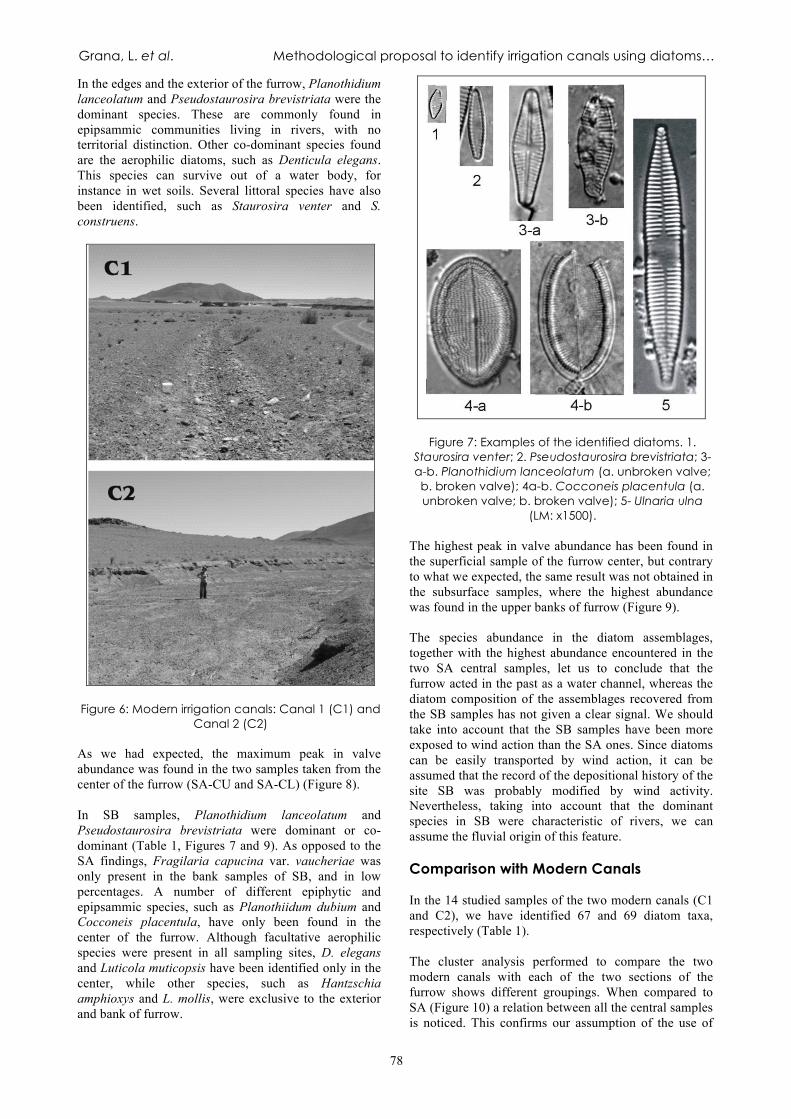
In the edges and the exterior of the furrow, Planothidium lanceolatum and Pseudostaurosira brevistriata were the dominant species. These are commonly found in epipsammic communities living in rivers, with no territorial distinction. Other co-dominant species found are the aerophilic diatoms, such as Denticula elegans. This species can survive out of a water body, for instance in wet soils. Several littoral species have also been identified, such as Staurosira venter and S. construens.
Figure 6: Modern irrigation canals: Canal 1 (C1) and
Canal 2 (C2) As we had expected, the maximum peak in valve abundance was found in the two samples taken from the center of the furrow (SA-CU and SA-CL) (Figure 8). In SB samples, Planothidium lanceolatum and Pseudostaurosira brevistriata were dominant or co-dominant (Table 1, Figures 7 and 9). As opposed to the SA findings, Fragilaria capucina var. vaucheriae was only present in the bank samples of SB, and in low percentages. A number of different epiphytic and epipsammic species, such as Planothiidum dubium and Cocconeis placentula, have only been found in the center of the furrow. Although facultative aerophilic species were present in all sampling sites, D. elegans and Luticola muticopsis have been identified only in the center, while other species, such as Hantzschia amphioxys and L. mollis, were exclusive to the exterior and bank of furrow.
Figure 7: Examples of the identified diatoms. 1. Staurosira venter; 2. Pseudostaurosira brevistriata; 3-a-b. Planothidium lanceolatum (a. unbroken valve; b. broken valve); 4a-b. Cocconeis placentula (a. unbroken valve; b. broken valve); 5- Ulnaria ulna
(LM: x1500). The highest peak in valve abundance has been found in the superficial sample of the furrow center, but contrary to what we expected, the same result was not obtained in the subsurface samples, where the highest abundance was found in the upper banks of furrow (Figure 9). The species abundance in the diatom assemblages, together with the highest abundance encountered in the two SA central samples, let us to conclude that the furrow acted in the past as a water channel, whereas the diatom composition of the assemblages recovered from the SB samples has not given a clear signal. We should take into account that the SB samples have been more exposed to wind action than the SA ones. Since diatoms can be easily transported by wind action, it can be assumed that the record of the depositional history of the site SB was probably modified by wind activity. Nevertheless, taking into account that the dominant species in SB were characteristic of rivers, we can assume the fluvial origin of this feature. Comparison with Modern Canals In the 14 studied samples of the two modern canals (C1 and C2), we have identified 67 and 69 diatom taxa, respectively (Table 1). The cluster analysis performed to compare the two modern canals with each of the two sections of the furrow shows different groupings. When compared to SA (Figure 10) a relation between all the central samples is noticed. This confirms our assumption of the use of

PHYSICAL, CHEMICAL AND BIOLOGICAL MARKERS IN ARGENTINE ARCHAEOLOGY: THEORY, METHODS AND APPLICATIONS
79
the SA furrow as an irrigation canal. As it was the case in the previous analysis of diatom assemblages in the two sections of the furrow, when comparing the modern canals with the SB samples (Figure 11), there is no clear differentiation between the central and the external samples. The two major groups are made up of samples
coming from both the exterior and the center of the furrow. This supports the already mentioned hypothesis of the wind influence in SB diatom assemblage composition.
Figure 8: Relative abundance (%) of species in SA (UNIDPE: unidentified diatoms). Unbroken and Broken Valves in Relation to Sampling Points We assume that, when the water flow is over, the center of the shallow channel would be more protected than both its edges and the external sections from the physical damages caused by wind activity and water movements. Taking this into account, we would expect the unbroken valves to be more abundant than the broken ones in all the central samples. In fact, independently of the current use of canals C1 and C2, the percentages of unbroken valves in the center were higher than in other locations within the same canals (Figure 12a), an observation which was statistically confirmed by the results of the Pearson's X2 Test (Table 2). Therefore, we have accepted the assumption that such a distribution is a direct consequence of running waters in that canals. Surface and subsurface SA samples show a similar distribution of broken and unbroken valves percentages (Figure 12b), but the results of the
Pearson's X2 Test are different: in surface samples the distribution is independent, whereas in the subsurface ones it varies according to the sampling site (Table 2). Surface and subsurface SB samples show a completely different pattern of distribution of unbroken and broken valves (Figure 12c). As opposed to the situation seen in the SA samples, here the results of Pearson's X2 Test indicate that the distribution is independent of the sampling site in the surface samples but dependent in the sub surficial samples (Table 2). In sum, while the signal of the presence of running waters is clear in the modern canals we sampled, we have not obtained statistically significant results from the two sections of the ancient furrow. The data obtained from the samples coming from two sectors of the furrow suggest that the determination of the percentage of broken and unbroken valves might not be the most suitable method for identifying ancient canals.

Grana, L. et al. Methodological proposal to identify irrigation canals using diatoms…
80
Table 1: Presence and absence of the identified diatom taxa with their codes.

PHYSICAL, CHEMICAL AND BIOLOGICAL MARKERS IN ARGENTINE ARCHAEOLOGY: THEORY, METHODS AND APPLICATIONS
81
Figure 9: Relative abundance (%) of species in SB (UNIDPE: unidentified diatoms).
Figure 10: Dendrogram produced by cluster analysis of the diatom species composition in both the center and the external samples C1, C2, and SA.
It is likely that the erosion processes are responsible for the differences between the percentages seen in the two sectors of the furrow and those noticed in the modern canals. Therefore, we conclude that this line
of analysis for investigating ancient canals is unreliable, at least until a significant number of replicated studies are available to statistically validate this supposition.

Grana, L. et al. Methodological proposal to identify irrigation canals using diatoms…
82
Figure 11: Dendrogram produced by cluster analysis of the diatom species composition in both the center and the external samples C1, C2, and SB.
Table 2: Results of the Pearson's X2 Test. Df= degrees of freedom; H0= null hypothesis; R= rejected, NR= not
rejected. CONCLUSIONS The results of the statistical analysis of the unbroken and the broken valves obtained from different sampling points of the same feature are not significant, hence this analysis is not a suitable tool for researching past canal features. Our negative results are probably a consequence of continuous erosion on all sampled points, being this eolian action on exposed sectors, or hydric action of flux, which modified the signal given by the water activity. Nevertheless, the analysis of the composition and abundance of diatom assemblages and its comparison with modern analogues were found to be useful for identifying the existence of ancient canals and thus, of archaeological water management. Both sectors of the furrow could be of fluvial origin. However, SA is the only sector where a clear signal of its channel function was found, partly due to its close similarity with modern canals. In addition, the highest diatom concentrations and the highest percentages of planktonic or tychoplanktonic species were obtained from the center of the furrow, which is the main sector
for the permanence of stagnant water during the intervals when the canal became inactive. This study has presented the first evidence for this type of archaeological hydraulic technology ever found in the locality and the sub-basin Las Pitas. The correct identification of past water management together with the archaeological context of Peñas Coloradas has enabled us to conclude that this locality was part of a productive agropastoral landscape. We hope that these results will encourage further interdisciplinary analyses, which include other aquatic organisms, such as ostracods or chrysophytes. A phytolithic and palynological approach, in particular, would enable us to answer new questions, for example, whether the water was conducted to crop products for human consumption or livestock (pasture). A multiproxy analysis would also be a great aid for better understanding site-formation processes and the role of erosion in this type of hydric features. ACKNOWLEDGEMENTS We thank to Dr. R. Lombardo (FCEyN-UBA, CONICET) and Lic A. de Olmos (FFyL-UBA) for helping with the statistic analysis, to M.Sc. A. García Suárez (University of Reading) and Lic. M. Fernández (CADIC-CONICET) for helping with the English version and their commentaries, and Lic D. Echazú, Lic M.J. Ramon Mercau and Ms. S. Bustos for their continued support.

PHYSICAL, CHEMICAL AND BIOLOGICAL MARKERS IN ARGENTINE ARCHAEOLOGY: THEORY, METHODS AND APPLICATIONS
83
Figure 12: Distribution of broken (dotted lines) and unbroken (black lines) valves percentages through different
sampled points: a- C1 and C2; b- SA; c- SB. REFERENCES ASCHERO, C. 1999. El arte rupestre del desierto Puneño y el Noroeste Argentino. In Arte Rupestre en los Andes de Capriconio, pp. 97-135. Museo Chileno de Arte Precolombino, Santiago de Chile. 2000. Figuras humanas, camélidos y espacios en la interacción circumpuneña. In Arte en las Rocas. Arte Rupestre, Menhires y Piedras de Colores en Argentina, edited by M.M. Podestá and M. De Hoyos, pp. 15-44. Sociedad Argentina de Antropología and Asociación Amigos del INAPL, Buenos Aires. ASCHERO, C., A. MARTEL AND S. LÓPEZ CAMPENY 2006. Tramas en la piedra: rectángulos con diseños geométricos en Antofagasta de la Sierra (Puna meridional, Argentina). In Tramas en la Piedra. Producción y Usos del Arte Rupestre, edited by D. Fiore and M.M. Podestá, pp. 141-156. World Archaeological Congress, Sociedad Argentina de
Antropología and Asociación Amigos del INAPL, Buenos Aires. BABOT, M. 2009. La cocina, el taller y el ritual: explorando las trayectorias del procesamiento vegetal en el Noroeste Argentino. Darwiniana 47(1): 7-30. BATHURST, R., D. ZORI AND J. BYOCK 2010. Diatoms as bioindicators of site use: locating turf structures from the Viking Age. Journal of Archaeological Science 37(11): 2920-2928. BATTARBEE, R. 1986. Diatom analysis. In Handbook of Holocene Palaeoecology and Palaeohydrology, edited by B.E. Berglund, pp. 527-570. Chichester, John Willey & Sons. 1988. The use of diatom analysis in archaeology: a review. Journal of Archaeological Science 15(6): 621-644.
Grana, L. et al. Methodological proposal to identify irrigation canals using diatoms…
84
BAYMAN, J., M.R. PALACIOS-FEST, S.K. FISH AND L.W. HUCKEL 2004. The paleoecology and archaeology of long-term water storage in a Hohokam reservoir, southwestern Arizona, U.S.A. Geoarchaeology 19(2): 119-140. BENEŠ, J., J. KAŠTOVSKÝ,, R. KOČÁROVÁ, P. KOČÁR, K. KUBEČKOVÁ, P. POKORNÝ AND P. STAREC 2002. Archaeobotany of the Old Prague Town defense system, Czech Republic: Archaeology, macro-remains, pollen, and diatoms. Vegetation. History and Archaeobotony 11: 107-119. BRADBURY, J., S. COLMAN AND R. REYNOLDS 2004. The history of recent limnological changes and human impact on Upper Klamath Lake, Oregon. Journal of Paleolimnology 31: 151-165. Cameron, N. 2007. Use in archaeology. Encyclopedia of Quaternary Science, pp. 523-529. Elias, S.A. Ed., Elsevier. JUGGINS, S. AND N. CAMERON 1999. Diatoms and archaeology. In The Diatoms: Application for the Environmental and Earth Sciences, edited by E.F. Stoermer and J.P. Smol, pp. 389-401. Cambridge University Press, Cambridge. COHEN, M.L. 2009a. Perspectivas espaciales desde el sitio Punta de la Peña 3 cumbre (PC3-c) Antofagasta de la Sierra. Catamarca. Actas del 1° Congreso Latinoamericano y 2° Nacional de Arqueometría 2: 477-487. Comisión Nacional de Energía Atómica (CNEA), Bs. As. 2009b. Fotografías y algo mas… imágenes de Antofagasta en 1923 como aporte para el planteo de hipótesis y la búsqueda de evidencias contrastadoras. Libro de Resúmenes de las VIII Jornadas de Comunicaciones de la Facultad de Cs. Naturales e I.M.L. y 1º Interinstitucional, pp. 109. 2010. Prácticas sociales, estrategias de visibilidad y construcción de la cartografía social durante el lapso ca. 1000-1500 AD en Antofagasta de la Sierra, Catamarca. Perspectivas desde el Sitio Peñas Coloradas 3 Cumbre. Unpublished PhD Dissertation, Facultad de Filosofía y Letras, Universidad de Buenos Aires. DÍAZ, A. 2009. Historias de tierra y agua: introducción a los espacios agrícolas prehispánicos de Laguna Blanca. El caso de estudio de la aldea arqueológica Piedra Negra (Dpto. Belén, Provincia de Catamarca). Unpublished Graduate Thesis, Escuela de Arqueología, Universidad Nacional de Catamarca. DÍAZ, C. AND N.I. MAIDANA 2006. A new monoraphid diatom genus: Haloroundia. Nova Hedwigia 130: 177-184.
Elías, A. 2010. Informe de análisis de material lítico del sitio Peñas Coloradas 3 Bajo. Ms. FERNÁNDEZ, M. AND N.I. MAIDANA 2008. Diatomeas: su utilidad en el estudio de la Arqueología de Patagonia. (Poster). VII Jornadas de Arqueología de la Patagonia, pp. 28. Ushuaia. FERNÁNDEZ, M. AND M. SALEMME 2010. Resultados preliminares sobre el análisis de diatomeas en sitios de la Meseta central de Santa Cruz (Patagonia Argentina). Libro de Resúmenes del V Simposio del Hombre Temprano en América, pp. 116. La Plata. GRANA, L. 2007. Diatomeas fósiles: un acercamiento a la relación entre la sociedad y el ambiente durante el Holoceno en Antofagasta de la Sierra, Puna Meridional. Unpublished Graduate Thesis, Facultad de Filosofía y Letras, Universidad de Buenos Aires. HADLEY K., M. DOUGLAS, R. MCGHEE, J. BLAIS AND J. SMOL 2010. Ecological influences of Thule Inuit whalers on high Arctic pond ecosystems: a comparative paleolimnological study from Bathurst Island (Nunavut, Canada). Journal of Paleolimnoloy 44: 85-93. HORROCKS M., G. IRWIN, M. MCGLONE, S. NICHOL
AND L.J. WILLIAMS 2003. Pollen, phytoliths and diatoms in prehistoric coprolites from Kohika, Bay of Plenty, New Zealand. Journal of Archaeological Science 30(1): 13-20. JANSMA, M.J. 1990. Diatoms from Neolithic excavations on the former island of Schokland, Ijselmeerpolders. The Netherlands. Diatom Research 5(2): 301-309. KLIGMANN, D.M. 2003. Procesos de formación de sitios arqueológicos: tres casos de estudio en la Puna Meridional Catamarqueña Argentina. Unpublished PhD Dissertation, Facultad de Filosofía y Letras, Universidad de Buenos Aires. KLIGMANN, D.M. AND M. CALDERARI 2012. Diatoms and ceramic provenance: a cautionary tale. Archaeometry 54(1): 129-143. KRAMMER, K. AND H. LANGE-BERTALOT 1986. Bacillariophyceae 1. Teil: Naviculaceae. In Süsswasserflora von Mitteleuropa, edited by H. Ettl, J. Gerloff, H. Heynig and D. Mollenhaue. G. Fischer Verlag, Jena. 1988. Bacillariophyceae. 2. Teil: Bacillariaceae, Epithemiaceae, Surirellaceae. In Süsswasserflora von Mitteleuropa, edited by H. Ettl, J. Gerloff, H. Heynig and D. Mollenhaue. G. Fischer Verlag, Jena.
PHYSICAL, CHEMICAL AND BIOLOGICAL MARKERS IN ARGENTINE ARCHAEOLOGY: THEORY, METHODS AND APPLICATIONS
85
1991a. Bacillariophyceae. 3. Teil: Centrales, Fragilariaceae, Eunotiaceae. In Susswasserflora von Mitteleuropa, edited by H. Ettl,, J. Gerloff, H. Heynig and D. Mollenhauer. G. Fischer Verlag, Jena. 1991b. Bacillariophyceae. 4. Teil: Achnanthaceae, Kritische Ergänzungen zu Navicula (Lineolatae) und Gomphonema. In Süsswasserflora von Mitteleuropa, edited by H. Ettl, J. Gerloff, H. Heynig and D. Mollenhauer. G. Fischer Verlag, Jena. LANGE-BERTALOT, H. 2001. Diatoms of Europe 2. Navicula sensu stricto. 10 Genera Separated from Navicula sensu lato. Frustulia. A.R.G. Gantner Verlag. LOWE, R. 1974. Environmental requirements and pollution tolerance of freshwater diatoms. EPA-670/4-74-005 Environmental Monitoring Series. CEPA, Cincinnati MAIDANA, N.I. AND C. SEELIGMANN 2006. Diatomeas (Bacillariophyceae) de Ambientes Acuáticos de Altura de la Provincia de Catamarca , Argentina II. Boletín de la Sociedad Argentina de Botánica 41: 1-13. MANNION, A. 1987. Fossil diatoms and their significance in archaeological research. Journal of Archaeology 6: 131-147. MARTEL, A. 2009. Arte rupestre: construcción y significación del espacio en la Puna meridional argentina (Antofagasta de la Sierra, Catamarca). In Crónicas sobre la Piedra. Arte Rupestre de las Américas, edited by M. Sepúlveda, L. Briones and J. Chacama, pp. 271-280. Ediciones Universidad de Tarapacá, Arica. 2010. Arte Rupestre de Pastores y Caravaneros. Estudio Contextual de las Representaciones Rupestres durante el Período Agroalfarero Tardío (900 d.C. - 1480 d.C.) en el Noroeste Argentino. Unpublished PhD Dissertation, Facultad de Filosofía y Letras, Universidad de Buenos Aires. MARTEL, A. AND C. ASCHERO 2007. Pastores en acción: imposición iconográfica vs. autonomía temática. In Producción y Circulación Prehispánicas de Bienes en el Sur Andino. Colección Historia Social Precolombina, compiled by A.E. Nielsen, M.C. Rivolta, V. Seldes, M.M. Vázquez and P.H. Mercolli, Tomo 2, pp. 329-349. Editorial Brujas, Córdoba. MARTÍNEZ MACCHIAVELLO, J.C., G. DE LA FUENTE AND
N. RATTO 1999. La utilización del análisis de diatomeas (Bacillariophyta) en la investigación arqueológica: una perspectiva interdisciplinaria. Arqueología 9: 49-69.
MORALES, M. 2010. Arqueología Ambiental del Holoceno Temprano y Medio en la Puna Seca Argentina. Unpublished PhD Dissertation, Facultad de Filosofía y Letras, Universidad de Buenos Aires. NEELY, J.A., S.C. CARAN, B.M. WINSBOROUGH, F. R. SORENSEN AND S. VALASTRO 1995. An early Holocene hand-dug water well in the Tehuacan Valley of Puebla, Mexico. Current Research in the Pleistocene 12: 38-40. NICHOLS, D. 1988. Infrared aerial photography and prehispanic irrigation at Teotihuacan: the Tlajinga canals. Journal of Field Archaeology 15(1): 17-27. OGNJANOVA-RUMENOVA, N. 2008. Palaeoenvironment and archaeology: The use of diatom analysis in archaeology. In Geoarchaeology and Archaeomineralogy, edited by R.I. Kostov, B. Gaydarska, M. Gurova, pp. 291-294. Sofia. OLIVERA, D. AND S. VIGLIANI 2000-2002. Proceso cultural, uso del espacio y producción agrícola en la Puna Meridional Argentina. Cuadernos 19: 459-481. PALACIOS-FEST, M.R., J.B. MABRY, F. NIALS, J.P. HOLMLUND, E. MIKSA AND O.K. DAVIS 2001. Early irrigation systems in Southeastern Arizona: The ostracode perspective. Journal of South American Earth Sciences 14: 541-555. PURDUE L., W. MILES, K. WOODSON, A. DARLING AND
J.F. BERGER 2009. Micromophological study of irrigation canal sediments: Landscape evolution and hydraulic management in the middle Gila River Valley (Phoenix Basin, Arizona) during the Hohokam occupation. Quaternary International 216: 129-144. QUESADA, M. 2006. El diseño de las redes de riego y las escalas sociales de la producción agrícola en el 1er milenio DC (Tebenquiche Chico, Puna de Atacama). Estudios Atacameños 31: 31-46. ROSEN, A. AND S. WEINER 1994. Identifying ancient irrigation: a new method using opaline phytoliths from emmer wheat. Journal of Archaeological Science 21(1): 125-132. ROUND, F.E., R.M CRAWFORD AND D.G. MANN 1990. The Diatoms: Biology and Morphology of the Genera. Cambridge University Press, Cambridge. RUMRICH, U., H. LANGE-BERTALOT AND M. RUMRICH 2000. Iconographia Diatolmologica 9. Diatomeen der Anden von Venezuela bis Patagonien/Tierra del Fuego, edited by H. Lange-Bertalot. A.R.G. Gantner Verlag K.G., Germany.

Grana, L. et al. Methodological proposal to identify irrigation canals using diatoms…
86
SALMINCI, P. 2011. Espacios Residenciales y Productivos. El Paisaje Arqueológico de Antofagasta de la Sierra entre los Siglos XI y XVI d.C. Unpublished PhD Dissertation, Facultad de Filosofía y Letras, Universidad de Buenos Aires. SEELIGMANN, C. AND N.I. MAIDANA 2003. Diatomeas de la provincia de Catamarca (Argentina). Boletín de la Sociedad Argentina de Botánica 48(1-2): 39-50. SEELIGMANN, C., N.I. MAIDANA AND M. MORALES 2008. Diatomeas (Bacillariophyceae) de humedales de altura de la Provincia de Jujuy - Argentina. Boletín de la Sociedad Argentina de Botánica 43(1-2): 1-17. STRAUB, F. 1990. Diatomées et reconstitution des environnements préhistoriques. Archéologie Neuchathloise 10, Hauterive-Chapréveyers 4: 17-30. SOLÁ, P. AND M. MORALES 2007. Indicadores biológicos y mineralógicos en un tiesto estilo “Incaico” hallado en Susques, Puna argentina. Intersecciones en Antropología 8: 361-364. TCHILINGUIRIAN, P. AND D. OLIVERA 2000. De aguas y tierras: aportes para la reactivación de campos. Relaciones de la Sociedad Argentina de Antropología XXV: 99-117. 2009. Geomorfología, paleoambientes Holocenos y geoarqueología: sitios Corral Grande y Arroyo Las Pitas. Antofagasta de la Sierra, Prov. de Catamarca, Puna Meridional. Arqueometría 1° Congreso Latinoamericano y 2° Nacional de Arqueometría, Vol II, pp. 544-551. Bs. As. TROMBOLD, C. AND I. ISRADE-ALCANTARA 2005. Paleoenvironment and plant cultivation on terraces at La Quemada, Zacatecas, Mexico: the pollen, phytolith and diatom evidence. Journal of Archaeological Science 32(3): 341-353 VAN DAM, H., A. MERTENES AND J. SINKELDAM 1994. A coded checklist and ecological indicator values of fresh water diatoms from the Netherlands. Journal of Aquatic Ecology 28: 117-133. VIGLIANI, S. 2005. El sitio bajo del Coypar II: Las evidencias más tempranas (ca. 1000 AP) del proceso agropastoril en la puna meridional Argentina (Antofagasta de la sierra, Catamarca). Andes 16: 325-350. ZAR, J. 1974. Biostatical Analysis. 3rd edition. Prentice-Hall. Englewood Cliffs, N.J.
1 The main problem we face regarding the research of past irrigation features is the difficulty entailed in dating them. There are different suitable methodologies such as the direct measuring of organic materials associated with canals, luminescence dating (Purdue et al. 2009), and indirect measuring involving the ceramics associated with canal features, which we would later relate to 14C samples from other sites to establish a chronology (Quesada 2006). So far, we have not been able to establish any of these associations, so we have therefore considered the archaeological context of the site to provide an estimated date for the features. Nevertheless, we hope that future excavations of the furrow will bring datable finds to light.