Canals, colonies and class Complete Book.pdf
342
-
Upload
khangminh22 -
Category
Documents
-
view
0 -
download
0
Transcript of Canals, colonies and class Complete Book.pdf
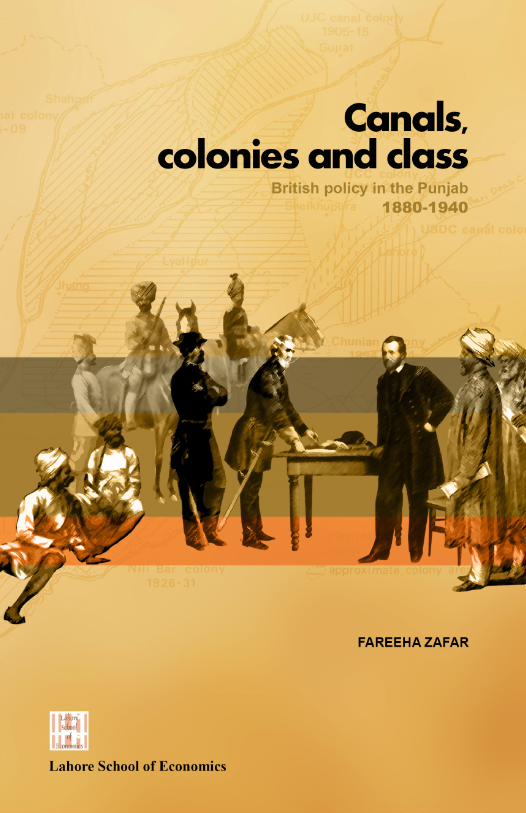
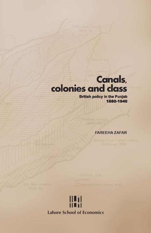
Canals, colonies and class British policy in the Punjab 1880-1940
The construction of the Punjab’s canal network by the British and the extent to which they irrigated and colonised the region remain unmatched in any other part of the world – even today. Canals, colonies and class examines the development of canal irrigation and its eff ect on rural structures in the Punjab at a district level. It looks at how access to this technology among diff erent rural classes created specifi c relations of production in the province. Government policy in the context of changing colonial demands and decisions altered patterns of irrigation and agriculture such that the increasing commercialisation of production, land ownership and tenurial r elations became central to class formation in twentieth-century Punjab.
Fareeha Zafar is Professor of Development Studies at the Lahore School of Economics. She has a PhD in geography from the School of Oriental and African Studies (University of London). Her research interests include gender, education and the Pakistani diaspora.

British policy in the Punjab1880-1940
Lahore School of Economics
© 2017 Lahore School of Economics All rights reserved. ISBN: 978-969-7502-03-5
First printing April 2017.
The views expressed in this volume are those of the author and do not necessarily reflect the views of the Lahore School of Economics. Cover illustration by Abdur Rahman.
Lahore School of Economics Intersection of Main Boulevard, Phase VI, DHA, and Burki Road, Lahore 53200, Pakistan www.lahoreschoolofeconomics.edu.pk

To my parents, Zakia and Rahman.


iii
Preface
This book is based on research conducted during 1977–80 for my doctoral thesis. It examines the impact of perennial canals on the rural structures of the Punjab between 1890 and 1940. The objective was to seek evidence in the changing policies of the colonial government towards colonisation and their impact on the landscape, production patterns, tenancy relations and class structure.
Some of the questions raised in this work have been studied in the past, but with few attempts to synthesise these issues. Where such a synthesis exists, the supporting historical evidence lacks depth. This study demonstrates a close link between the change in rural structures – in particular, the formation of classes – and the development of the irrigation system, based on a detailed investigation of the historical material. With the advent of the new technology, the role of environment in determining the land tenure system declined in importance. This aspect is analysed by comparing the colonised and the old proprietary village lands within the canal colony districts.
Guided by the needs of revenue and export demand, the colonial government extended the cultivated area and used local power structures to direct the production and related activities of the small cultivator. To achieve these objectives, the administration relied on large landowners, whose formation it encouraged. The commercialisation of agriculture, high land prices and an increasing tendency towards wage labour in the canal-irrigated areas benefitted the richer sections of rural society. Canal construction within a
iv
colonial framework did not reduce the dependence of the small cultivator on local institutions, while the burgeoning class of agricultural labourers not only faced a changing agrarian environment, but also rising prices and declining living standards. The accepted view that the British government was an advocate of the Punjab peasant is, therefore, questioned.
v
Acknowledgements
I would like to express my deepest thanks to my late father, a career engineer in the Indian Service of Engineers, whose work on the East Jumna Canal and several other projects in the canal colonies inspired me to explore these issues. To my late mother, I owe thanks for always encouraging me to read, and to my husband for his cheerful companionship during the more difficult periods of writing. I would like to acknowledge the members and staff of the India Office Library for their unfailing patience in providing me with the required sources and materials.

vii
Units of currency and measurement
as annas (16as to the rupee) lb pound maund approx. 82.3 lb Re rupee Rs rupees seer approx. 2 lb (40 seer to the
maund)

ix
Glossary
Abadi Inhabited village or settlement Abadkar Horse-breeding colonist Abi Land irrigated by overflow from a river or canal Abiana Water tax Arhti Dealer Atraf Plural of taraf Bajra A variety of millet Bangar Upland tract Bania Village shopkeeper or moneylender; also a caste
name. Bar The highest part of a doab Barani Dependent on rainfall Batai Rent paid in the form of the division of the crop
(crop-sharing) Bhai chara A form of village tenure: a coparcenary estate
held in severalty Bhusa Straw Bet Land beyond the flooded area, but still moistened
by percolation from the river Bund Embankment Chaharam Part of one fourth of the ruler’s share of the
produce to an individual or family of influence Chahi Irrigated from a well Chahi-abi Irrigated partly from a well and partly from
overflow from a river or canal Chahi-nehri Irrigated partly from a well and partly from a
canal Chahi-sailabi Irrigated partly from a well and partly from a river
in flood
x
Chak A block of land; sometimes a village Chakdar Inferior owner in south-west Punjab Chakota Lump grain rent or rent consisting of a fixed
amount of grain in the rabi season and a fixed amount of cash in the kharif season
Chargah Grazing and fuel reserve land Charri Jowar grown for fodder Chaudhri Rural notable Cho Small stream Desi Native Dhok Hamlet Doab Land that lies between two rivers Dofasli Double-cropped land on which crops are grown
in both the kharif and rabi seasons Ghee Clarified butter Gur Sugarcane; raw sugar Hithar Riverain Inam Officially granted right to land or the land
revenue of an area Inamdar The holder of an inam Jagir Officially granted right to a given tract of land (a
Mughal revenue term) Jagirdar The holder of a jagir Jagirdari A form of tenure (see jagir) Jajmani A system under which kamins and menials were
granted small pieces of land to attract them to the colony areas
Jhallar A Persian wheel by which water is raised from a stream or canal
Jok Equivalent to 10 acres of land Jowar A variety of millet Kallar Barren land; also applied to reh efflorescence or
saline soil; collective term for saline-alkaline soils.
Kamin Village artisan or servant
xi
Kankut Realisation of landlord’s share of produce in cash after appraising its amount and value
Kanungo Supervisor of patwaris Kardar Official revenue collector Kasht-barani Rain-fed cultivation Khadir Floodplain Khalis In its pure form Khalisa Liable to revenue, taxpaying land Kharaba The portion of a crop that has failed to mature Kharachh Cess realized by landlord in addition to rent Kharif Autumn Khudkasht Cultivated by the owner Killa Equivalent to 1 acre of land Killabandi Substitution of rectangular fields of uniform size
of one killa each for the irregular fields of different size into which the lands of a village were ordinarily divided
Lambardar Village headman, officially appointed representative of a village community
Lambardari Charge assigned over a village Lawa Reaper Lekha-mukhi Contract under which the debtor surrenders his
crop to a moneylender who bears the associated expenses
Lichh Fee paid in recognition of a proprietary title Maash A small pulse Mahal Estate Mahsul Share of produce due to the state, now share of
produce taken by person who pays the revenue in money
Malba Common village tax Malik Owner or leading man in a section of a tribe Malik adna Inferior proprietor Malik ala Superior proprietor Malikana Fee paid in recognition of a proprietary title
xii
Malik-qabza A person who owns the land in his possession, but has no share in the common property of the village community.
Mandi Market town Manjha Centre Maund A measure of weight and capacity, equivalent to
approx. 82.3 lb Mauza Village Moth A small pulse Moong A small pulse Muafi Revenue-free Muafidar The holder of an assignment of land revenue Mukaddim Superior proprietor, also leading man or headman
in a village community. Naib tehsildar
The deputy or assistant of the tehsildar
Nakdi A form of rent paid in cash Nala Drain or water-course Nazarana An abatement from the revenue of an estate
retained by the government in awarding a land revenue assignment to an individual
Nehri Irrigated from a canal Pachotra A surcharge of 5 percent on the revenue paid to
the village headman Paggu Small cuts made in the side of a canal Pattidar Proprietary leaseholder Pattidari A form of village tenure: proprietary lease Patwari Village accountant or registrar Rabi Spring Rais Capitalist Rakh Preserve; scrub forest. Rawa Upland tract Reh Saline efflorescence that crystallises in the dry
season on the surface and in the upper strata of salt-affected soils
xiii
Rohee Drainage lines Ryot Peasant, tenant Ryotwari A form of settlement in which the occupant of
each holding is under a separate engagement with the government, as distinguished from the village settlement in force in northwest India
Sadr Chief, principal; used in connection with administrative institutions.
Sadr tirniguzar
Chief collector of grazing fee
Safaid posh Landed gentry Sailab Flooded or kept permanently moist by the river Sailaba As above Sanad A deed of grant Sarawan Grant for breeding camels Sardar Chieftain Seer A measure of weight, one-fortieth of a maund Senji A variety of clover Shamilat Village common land Takavi A loan granted by the government to a landowner
for agricultural purposes Talukdar A superior proprietor and dominant member of
rural society who has been appointed revenue officer
Talukdari Charge assigned for collecting revenue Taraf Small holding, intensively cultivated and located
near towns Tehsil Administrative subdivision of a district Tehsildar Subordinate official of the revenue administration
in charge of a tehsil Tirni The charge levied on the use of grazing land Toria Rapeseed Tumandar Leader of a nomadic or grazing tribe Utar Intermediate tract between riverain and upland
area
xiv
Warisi Hereditary Zabti Cash rent levied on the cultivation of certain
crops Zaid Extra (crop) Zail A group of estates over which a representative is
appointed (see zaildar) Zaildar A man of influence appointed to have charge of a
zail Zaildari Charge assigned over a zail Zamindar Landowner; a dominant member of local society
appointed the local revenue official under the Mughal administration; defined as ‘proprietor’ under British rule
Zamindari A form of village tenure
Contents
Preface iii Acknowledgements v Units of currency and measurement vii Glossary ix
Chapter 1 Introduction 1
Chapter 2 The ecological impact of canal construction 17 Pre-perennial canal landscape 18 Perennial canal construction 24 New irrigation patterns and problems 31
Chapter 3 Canals and colonisation 43 Demarcation of canal colonies 43 Colonisation policy 48 Expansion of the transport network 57 Emergence of market towns 59 Demographic changes 60
Chapter 4 Colonial agricultural policy 65 Extension of cultivation 67 Transformation of cropping patterns 74 Changes in production 87 Developments in agriculture 91
Chapter 5 The commodity market economy and class 99 Commercialisation of agriculture 99 New trading patterns 107 Colony status and class 113
Chapter 6 Land tenure systems 127 Pre-British tenurial system 128 Land revenue settlements 133 Land assessment and control of wasteland policies 141 New land tenure systems 144
Chapter 7 The emergence of a land market 161 Determination of land revenue 161 The rental value of land 171 Indebtedness and land alienation 186 The growth of the land market 200
Chapter 8 Social change 211 Rural society 211 Patterns of land ownership 219 Irrigation and holding size 232 Delineation of the rural classes 244
Chapter 9 Conclusion 261
Bibliography 277
Appendices
Appendix 1 Chronology of canal construction in the Punjab canal colony districts 299
Appendix 2 Chronology of the agricultural conditions and general economic health of the Punjab, 1877/78 to 1940/41 300
Appendix 3 Chronology of historical events and legislation 304
Index 307
Tables and figures
Unless otherwise stated, all tables refer to the study area of the Punjab canal colony districts. Table 1: Inundation canals located in the Punjab canal colony
districts 22 Table 2: Major canal systems, net income and profitability 28 Table 3: Area irrigated by canals, 1924/25 29 Table 4: Canal-irrigated and total irrigated areas 32 Table 5: Percentage of irrigated area irrigated by different means 33 Table 6: Upper Jhelum Canal Colony, allotment of land, 1913 53 Table 7: Upper Jhelum Canal Colony, allotment of land, 1925 55 Table 8: Percentage variation of population in relation to density 64 Table 9: Total cropped acreage, irrigated area, and
canal-irrigated area 68 Table 10: Changes in cropped area, irrigated area and
canal-irrigated area 70 Table 11: Cultivated land, by irrigation means 72 Table 12: Relationship between area sown and fallow land 79 Table 13: Total double-cropped area 79 Table 14: Area under fodder crops 82 Table 15: Cotton acreage 83 Table 16: Rate of change in the area under different crops 84 Table 17: Relationship between sown area, wheat area and
area under food grains 85 Table 18: Acreage under oilseeds and sugarcane 86 Table 19: Rabi as a percentage of total harvest 87 Table 20: Proportion of cultivated area under wheat and cotton 103 Table 21: Estimated production of major crops 104 Table 22: Export of selected agricultural products from the Punjab 110 Table 23: Movement of cotton in the Punjab 111 Table 24: Changes in the price of wheat 115 Table 25: Wheat price and production rate of change 116 Table 26: Rate of change in cultivated area, in areas under
wheat, food grains and cotton, and in population 117
Table 27: Cotton production and price trends 120 Table 28: Rate of change in land, revenue, population,
cultivated area and irrigated area, 1890/91 to 1940/41 168 Table 29: Total land revenue 169 Table 30: Rate of change in land revenue and wheat price 171 Table 31: Change in area held by tenants paying rent in kind 181 Table 32: Proportion of tenant-cultivated area held by
tenants-at-will paying rent in kind 183 Table 33: Total land transfers 195 Table 34: Land sales and mortgages 200 Table 35: Changes in the price of land 205 Table 36: Proportion of area held under different tenures,
1891/92 221 Table 37: Cultivating owners and co-sharers as a proportion
of the rural population, share of cultivated land held by owners and cultivated area per owner, 1930/31 228
Table 38: Changes in cultivating occupancy (percentage of land held by different classes of cultivator) 229
Table 39: Total area per holding and per owner in Multan district, 1899/1900 233
Table 40: Change in size of cultivated holdings 241 Table 41: Different landholding sizes in Lyallpur tehsil 243 Table 42: Change in cultivated area per head of population,
1891–1931 254 Table 43: Ranking the size of the dominant class by cultivated
area, tenant-cultivated area, rural population density and land price, 1931 274
Figure 1: The process of colonisation in the Punjab 48 Figure 2: Provincial administrative structure of the Punjab 213
Chapter 1
Introduction
When the British annexed the Punjab in 1859, they encountered a landscape unlike any of the areas they had previously annexed in India. Numerous rivers intersected the largely uninhabited and uncultivated wastelands of the doabs (the land between two rivers), providing hideouts for the nomadic and pastoral tribes roaming these areas, creating a potentially unstable and dangerous adversary.
In this environment, the settlement of the disbanded Sikh army, disarmed by the British forces, posed a serious problem. The administrative response to the issue was to construct a perennial canal – the Upper Bari Doab Canal – through the manjha (centre) of Lahore and other districts of East Punjab. The Public Works Department was created in 1854 for this purpose and the decision made to borrow money for irrigation works under the head of ‘extraordinary’ expenditure.1 Although the physical landscape of the Punjab was admirably suited to the construction of large canals, the government was hesitant to experiment with large speculative ventures and preferred to rely on railways as the best (and more lucrative) way of opening up the sparsely populated doab areas. It was not till the 1880s that the colonisation of potentially irrigable
1 Prior to this in India, irrigation had been the responsibility of the East India Irrigation Company and the Madras Irrigation Company. See: Her Majesty’s Government, Report from the select committee on East India (public works), together with the proceedings of the committee, minutes of evidence and appendix (London: HM Stationery Office, 1878), 2–7.
Fareeha Zafar
2
doab areas was linked to canal construction, making it financially feasible and indeed profitable to construct canals.
While there is consensus on the prime reason for constructing the Upper Bari Doab Canal – that is, the settlement of disbanded Sikh soldiers2 – arguments for the delay in not following through with an expanded perennial canal system tend to vary. Michel cites the poor working of the Upper Bari Doab Canal and other canals in eastern Punjab as the main reason, and stresses that inadequate technology and the unprofitability of the scheme hindered further construction.3
Paustian, though conscious of the dubious nature of the project’s financial prospects, holds that, “since the initiative for expansion of irrigation canals came entirely from the government in power, it is difficult to present valid criticism of this profit motive in the policy relating to the expansion of canal irrigation.”4 Siddiqi relates this to the preference given to railway construction,5 which brought in rapid returns compared to canal irrigation, while Trevaskis carries the argument further with the contention that, “with the advent of railways, roads were neglected. In fact, the perverted political economy of the period even saw through-roads as being harmful because they competed with a wealth-producing railway, only such advantages as had a money-value being then recognised as wealth.”6
2 Aloys Arthur Michel, The Indus rivers: A study of the effects of Partition (New Haven, CT: Yale University Press, 1967), 60. 3 Michel, Indus rivers, 76. 4 Paul W. Paustian, Canal irrigation in the Punjab: An economic inquiry relating to certain aspects of the development of canal irrigation by the British in the Punjab (New York: Columbia University Press, 1930), 54. 5 Abdul Jameel Siddiqi, ‘Canal irrigation, agricultural development and social change in West Pakistan (1880–1965)’ (unpublished PhD thesis, University of Wisconsin-Madison, 1965), 62. 6 Hugh Kennedy Trevaskis, The land of the five rivers (London: Oxford University Press, 1928), 225.
Canals, colonies and class: British policy in the Punjab 1880–1940
3
Consequently, for two decades, the need to boost the precarious agricultural production in most parts of the Punjab remained under discussion. Only in the 1880s was the administration finally convinced that the Punjab was suitable for testing perennial irrigation technology, which held the promise of raising production to unprecedented levels. Following this policy, first the Chaj and then the Rechna doabs were covered by an intricate perennial canal system. The new technology reached its peak with a triple canal system integrating three rivers and their intervening doabs, and paved the way for the Sutlej Valley Project and Thal scheme. This second phase of canal construction has been ascribed by Michel to government policy aimed at “famine relief and valuation of Crown Waste Lands.”7 Siddiqi goes further in linking the construction of canals after 1882 to the process of colonisation itself.8 Hirashima rules out famine relief as the overriding motive for canal construction policy, pointing to both economic and political considerations as being the main causes.9
The immediate effect of constructing the major perennial canals was, therefore, to extend the area under cultivation. From 1890, when the canal-irrigated area of the Punjab canal colony districts was less than a million acres, it increased to over 8 million acres by 1940. Agricultural production rose merely by the application of canal water to the dry doabs of the Punjab districts. Thus, the total cropped area grew from 4.43 million acres in 1890/91 to 11.95 million acres by 1940/41, of which 82 percent was irrigated. In looking at the general levels of agricultural productivity in the Punjab, we can conclude that, till 1920, agricultural production increased
7 Michel, Indus rivers, 76. 8 Siddiqi, ‘Canal irrigation,’ 76–77. 9 Shigemochi Hirashima, The structure of disparity in developing agriculture: A case study of the Pakistan Punjab (Tokyo: Institute of Developing Economies, 1978), 23.
Fareeha Zafar
4
at a faster rate than population, but after this, the balance between the two was destroyed.10
With increased and more regular supplies of water, the production of cash crops improved. Cotton and sugarcane in the kharif (autumn) and wheat and oilseeds in the rabi (spring) season emerged as the major revenue-earning and export crops. The large-scale cultivation of commercial crops and a railway network geared to export requirements drew the peasant production of the Punjab canal colony districts into the orbit of the international monetary system. Prices of agricultural produce were no longer controlled by local supply and demand patterns, but by the convolutions of the world market. The two world wars and 1929 depression caused greater fluctuations in the prices of agricultural products than local market shocks.
Although keeping the Punjab peasantry content was regarded as crucial to maintaining an easy, stable rule, the British government’s reliance on the landed classes led it to make large land grants to landlords, capitalists and other representatives of the landed gentry in the colonies. The principles most important in the post-annexation period were “patriarchal rule by an all-powerful district officer, strict religious impartiality, and a self-conscious defence of the village-community, the landed aristocracy, and the peasant cultivator as the base of continued British rule.”11
The importance of the peasantry, highlighted by the passage of the Alienation of Land Act 1900, was based on the fact that they represented stable agricultural communities as opposed to the migratory nomadic grazing tribes – who 10 George Blyn, Agricultural trends in India, 1891–1947: Output, availability, and productivity (Philadelphia, PA: University of Pennsylvania Press, 1966). 11 Norman Gerald Barrier, ‘Punjab politics and the disturbances of 1907’ (PhD thesis, Duke University, 1966), 4.
Canals, colonies and class: British policy in the Punjab 1880–1940
5
suffered under the British – and the burgeoning urban classes who would have been in direct competition with British economic interests in the Punjab.12 The large number of peasant grants made in the initial stages of colonisation was, therefore, a way of inducing the cultivating classes to remain quiescent and continue with their hereditary occupation. They were equally necessary to bolster agricultural production dependent on the peasant cultivator and tenant.
It was possible to create new tenurial forms in the colony areas, but in those districts already settled and populated, summary land settlements combined with other laws regulating land rights had destroyed the old rural social system, whereby claims on the production from the land were customarily recognised. In their place appeared economic and legal constraints conferring the right to land ownership on a few. Possession of land gave it a value and, as such, it became a commodity that could be bought or sold. The determination of rights divided the rural population into landowners, occupancy tenants, tenants at will, landless agricultural labourers, and village menials and servants. Both these factors combined to raise the value of land, which became valuable collateral for obtaining loans.
The canal colonies, which comprised the areas irrigated by the new perennial canals, consisted mainly of Crown wasteland. The few local inhabitants of these areas engaged in nomadic herding and grazing as well as sporadic scattered cultivation. The motive for building the canals was, however, to bring in a class of ‘superior agriculturists’ from the best agricultural tribes of the province and settle them in the colonies to produce ‘superior crops’ of wheat and cotton. The major portion of the colony lands was initially allotted in small
12 Petrus H. M. van den Dungen, ‘Changes in status and occupation in nineteenth-century Punjab,’ in Soundings in modern South Asian history, ed. Donald A. Low (London: Camelot Press, 1968), 76.
Fareeha Zafar
6
grants to peasants with the status of tenants-at-will, to be converted to occupancy tenure after a period of five years with the government as the landlord. The rest of the land was given in large grants of varying size to yeomen, capitalists and grantees paying nazarana (reduced revenue) as well as being distributed by sale or auction. Village menials were attracted to the colonies by small grants of land. The greater security of canal irrigation water in the colonies gave a higher value to colony land, leading to inflated land prices.
The system followed in determining land rights in the Punjab during the revenue settlements was based on Regulation VII of 1822 in operation in the Northwestern Provinces. However, in the early years after annexation, the Punjab was a nonregulation province, making it possible to manoeuvre around the strict letter of the law. Once the Indian Penal Code was extended to the Punjab in 1862 and the first Punjab Tenancy Act 1868 was passed, the rights of various classes to the land became more firmly fixed. The need to establish these rights arose from the British authorities’ desire to establish clear-cut relations in the Punjab for regulating the system of land revenue collection. By turning the land into a commodity accompanied by a fairly high revenue demand to be paid in cash, together with an unimaginative interpretation of the law, the British succeeded in plunging the majority of the Punjab peasantry into debt.
Legislative and administrative measures were required to manage various aspects of canal irrigation and colonisation. Rules for the lease of government wasteland were sanctioned by the Government of India in 1885 and this legitimised its control over the wastelands of the Punjab that were to be transformed into the canal colonies. Revenue assessments of canal-irrigated lands were regulated by Act XXX of 1871 and the Northern India Canal and Drainage Act 1873. As canal irrigation was extended by degrees, the need to gain full advantage from future extensions had already been taken care
Canals, colonies and class: British policy in the Punjab 1880–1940
7
of by the principle of short-period revenue settlement. James Thomason had been the architect of this scheme in the Northwestern Provinces, which Edward A. Prinsep then developed into the fluctuating assessments applied to the Upper Bari Doab Canal-irrigated districts.13
As the land became ready for colonisation, legislation was needed to establish the relationship between the colonists and the government. This was partly covered by the Punjab Tenancy Act 1887 and partly by the Government Tenants (Punjab) Act 1893, whereby numerous tenancies-at-will were created with the government as landlord. However, both acts were deficient when it came to actual settlement of disputed tenancies. Administrators such as Malcolm Lyall Darling and Septimus Smet Thorburn argued that, without first solving the indebtedness problem and restricting land sales to moneylenders, most cultivation in the Punjab would pass into the hands of nonagriculturists, causing production to deteriorate and fuelling discontentment and unrest among the peasantry. The problem of indebtedness was one of the most serious facing the Punjab administration, as “the gradual economic decline of the classes upon whom the British relied for political support, the aristocracy and the zamindars (landowners), posed the final and probably the most serious political problem for the Punjab Government.”14
Both these classes belonged to the agricultural tribes of the province. The contribution of the peasantry to the Indian army in human terms and the strategic position of the Punjab in the Indian empire could not be ignored. Attempts to reduce the power of the bania (moneylender) under the Land Improvements Loan Act 1883 and the Agriculturists Loan Act 1884 failed because the laws operated too narrowly.
13 James McCrone Douie, Punjab settlement manual, 3rd ed. (Lahore: Superintendent, Government Printing Press, 1915), 22. 14 Barrier, ‘Punjab politics,’ 67.
Fareeha Zafar
8
Meanwhile, new lands were being brought under the plough and new communities being set up as a result of canal irrigation. The Alienation of Land Act 1900 aimed to limit the land passing out from the agricultural classes to the nonagricultural tribes. The small urban class agitations were easily dealt with and feudal structures strengthened in the Punjab by restricting the sale of land to the agricultural tribes.
At the same time, the lack of enough agitation against the Alienation of Land Act had prompted the government to make further sales of land difficult and improve the conditions of the landed aristocracy with the Punjab Pre-emption Act (Act II) 1905, the Court of Wards Act and the Agricultural Debt Limitations Act. Additionally, the government altered its earlier policy on the distribution of wastelands. While in the earlier colonies, settlers had been given the right to purchase rights to the land, “subsequent loss of land and [the] government’s fear that this loss would increase in the future resulted in the decision to end the sale of land to colonists,” beginning with the Chenab Colony.15
Till such time as good land was available for cultivation, these stringent conditions were accepted by the colonists. However, as the supply of fertile land on canal branches dwindled and the subdivision of holdings began to take effect, the system of fines imposed by the government on defaulters of colony settlement conditions was challenged. To remedy all the drawbacks and defects of previous legislation, the Colony Bill was introduced in 1906. The failure of this bill and the need for subsequent legislative measures embodied in the Colonisation of Government Lands (Punjab) Acts of 1912 and 1920, were the result of attempts by the Punjab government
15 Norman Gerald Barrier, ‘The Punjab disturbances of 1907: The response of the British government in India to agrarian unrest,’ Modern Asian Studies 1, no. 4 (July 1967): 357.
Canals, colonies and class: British policy in the Punjab 1880–1940
9
not to sell proprietary rights to colony settlers to reduce the subdivision of landholdings.
British disregard of the commercial and trading classes was based on their small numerical strength and the government’s perception of the limited role they could play in contributing to the stability of the state and its revenue as compared to the peasantry. This suggests that, while the urban and trading classes were showing their capacity for organisation and agitation, and the landholders their passivity, the British pushed up the rural foundations of their rule.16 Apart from this, there were the economic consequences of a local commercial class competing with British interests at this stage. This became more evident later, when the sale and marketing of commercial crops from the canal colonies was channelled through mandi (market) towns and auctions to large commercial concerns such as Messrs. Forbes, Forbes, Campbell and Co. and Messrs. Tata Sons and Co. Bombay, which had become part of the colonial extractive machinery. Local institutions such as the Department of Agriculture played an important role in these activities. Such actions reflected the contradictions inherent in the colonial government’s desire to see capitalist agriculture develop without the accompanying growth of the capitalist class in the Punjab.
The government looked to the landlords to provide the initiative and enterprise for agricultural development. This gave the latter control over the village banks and cooperative societies, which they used for their own benefit rather than to uplift the large cultivating classes. The deterioration in the conditions of the cultivating classes is evident in the decrease in size of their holdings. Investigations show that, in 1925, while 58.3 percent of agricultural holdings were less than five
16 Petrus H. M. van den Dungen, The Punjab tradition: Influence and authority in nineteenth-century India (London: Allen & Unwin, 1972), 281.
Fareeha Zafar
10
acres each and occupied 12 percent of the total cultivated land, holdings of more than 25 acres each occupied 46 percent of the land.17 The Board of Economic Inquiry Report of 1939 reveals that the position after about 15 years was worse. If we follow Darling’s estimate of 15 acres as an economic holding, then in 1925, 58.3 percent of the land, and in 1939, almost 64 percent of all holdings in the Punjab, were uneconomic.18
The situation in the canal colonies was somewhat different because land grants were larger, but the growing difference between small and large holdings had serious implications for the cultivating classes. As holdings became smaller, more and more cultivators were reduced to the level of tenants and agricultural labourers. Moreover, the contractual inferiority of the peasant, and the usual concentration of three commercial functions in the hands of individuals – as the purchaser of produce, supplier of credit and vendor of consumption goods – resulted in any surplus being transferred to the intermediary rather than remaining available for reinvestment.19 Only the large landowner had the staying power to avail himself of the facilities offered by the mandis and later the cooperative societies.
Whereas the technical aspects of canal irrigation and related agricultural production have been at the forefront of several studies, the impact of canal irrigation on rural structures in their entirety is a relatively under-examined
17 Hubert Calvert, The size and distribution of agricultural holdings in the Punjab, The Board of Economic Inquiry, Punjab, Rural Section Publications 4 (Lahore: Civil and Military Gazette Press, 1925). 18 Malcolm Lyall Darling, The Punjab peasant in prosperity and debt (Mysore City: Oxford University Press, 1925). 19 Andrew Pearse, ‘Metropolis and peasant: The expansion of the urban-industrial complex and the changing rural structure,’ in Peasants and peasant societies, ed. Teodor Shanin (Harmondsworth: Penguin, 1971), 73.
Canals, colonies and class: British policy in the Punjab 1880–1940
11
area.20 It is important to look at technical innovations in the context of their economic and social impact as well as the policy decisions regarding such developments. Whitcombe’s appraisal of the agrarian conditions of the United Provinces under British rule and her critique of the canal system shows one direction such studies can take:
Whatever ecological revolution the canals brought or helped to bring, most farmers’ techniques were not adapted to deal with such sudden and radical changes. Nor did the canal provide them with a greater degree of control over the means by which they continued to cultivate; local power was paramount, as the double status of maliks as canal officials so clearly showed. In fact, maliks’ haqs were capable of almost indefinite extension.21
It was, therefore, only natural that, “only that minority of the rural population already in a position of prosperity and sufficient power to maintain some independence of action had access to the benefits of innovation.”22 She concludes that the canals had proven to be a costly experiment and that the problems they caused were not restricted to over-cropping, salination and the destruction of wells. While she accepts that these problems were caused partly by the fact that the canals were constructed in areas where agriculture was already established under a system of irrigation from wells, colonial policy and its constraints remain paramount in her analysis.
The other study relating technological innovation with social structures is by Hirashima, who looks at the process of agricultural transformation in terms of the structure of disparity
20 Elizabeth Whitcombe, Agrarian conditions in Northern India: The United Provinces under British rule, 1860–1900, vol. 1 (Berkeley, CA: University of California Press, 1972). 21 Whitcombe, Agrarian conditions, 90. 22 Whitcombe, Agrarian conditions, 119.
Fareeha Zafar
12
in agriculture in the western half of British Punjab23 (what is now the Pakistani Punjab). Because of his focus on disparity, he examines canal irrigation, agricultural growth and land tenure as almost dissociated elements of the agrarian structure, and his study of the colonial period as a prelude to current forms of disparity in agriculture. A similar study carried out in South India in the state of Kerala by Varghese also examines the pattern of land tenure and its relationship with agrarian change. He concludes that it becomes necessary to study the past to comprehend the present as many archaic forms of land relations still exist.24
Ali’s work on British imperial policy in the Punjab from 1885 to 194725 comes closest to the analyses presented in this book. His work also takes the Punjab canal colony districts as the locus of class change, but he does not address the impact of canal irrigation on the landscape of the canal colonies in much detail. Neither does he examine the linkages between variations in production and the cultivating classes.
The policies of the colonial government on canal construction, colonisation and landownership, and the impact of canal irrigation on other forms of irrigation, agricultural production, rent, revenues and tenurial relations form the content of this book. Within this framework, we consider not only canal irrigation technology in its full magnitude, but also its economic and social impact in the context of the political forces operating at the time.
The starting point is the period of extensive canal irrigation, which began in 1882 and ended once the major canals had been constructed through the doabs. These canals 23 Hirashima, Structure of disparity. 24 T. C. Varghese, Agrarian change and economic consequences: Land tenures in Kerala, 1850–1960 (Calcutta: Allied Publishers, 1970). 25 Imran Ali, The Punjab under imperialism, 1885–1947 (Princeton, NJ: Princeton University Press, 1988).
Canals, colonies and class: British policy in the Punjab 1880–1940
13
irrigated vast areas deficient in rainfall, which extended cultivation not only in the canal colonies, but also in other parts of the districts in which they were located. By 1940, therefore, the canal colonies of the Punjab had become part of these districts. In the colonies, it was possible to encourage the growth of crops for which there was a demand within and outside the country. Export and revenue demands combined to create a production pattern based on the cultivation of cash crops. The setting up of agricultural institutions to promote the cultivation of such crops and the creation of mandis as collection points for the increased production, provided the economic framework within which property and class relations developed in the Punjab canal colony districts between 1880 and 1940.
The colonisation of comparatively uninhabited areas gave the government a chance to create land tenure patterns and social structures from which it would benefit. After having first established the right to land ownership and freedom of land transfer, it later denied both to the peasant classes in the colony areas. The government was also unwilling to control the rising price of land and, consequently, the growth of the agricultural landlord who was helped by the control on land transfer. Meanwhile, the peasant classes faced declining landholdings, changing customary agrarian relationships and fluctuating prices of agricultural produce.
The area focused on includes the doabs through which the perennial canals were constructed between 1849 and 1940. We examine the canal colonies within the nine districts in which they were located. The selection of these districts was determined by the availability of comprehensive time-series data for districts, tehsils26 and assessment circles; very little data was available on the specific tracts forming the colonies. Moreover, as soon as the colonies began to function, that is,
26 Administrative subdivision of a district.
Fareeha Zafar
14
once most of the land had been allotted to settlers, they were amalgamated into the districts in which they were located. In two cases, new districts were formed to cope with the increased production, revenue and population that resulted from the extension of canal irrigation. The extent of the study area and the main features of canal irrigation are shown in Figure 1 (see chap. 3).
The construction of canals in the Punjab by the British and the singularly large areas irrigated and colonised remains unmatched in any other part of the world even today. This achievement on the part of engineers, administrators and the people of the Punjab canal colony districts in the early twentieth century cannot be underrated. As such, the area remains one of great interest to academics and researchers. The aim of this research study is to fill the gap that exists in the literature on the Punjab canal colony districts. While other writers have looked at the construction of canals and formation of colonies, there has been no in-depth study of these colonies in the context of the districts in which they were located. The present study thus analyses the development of canal irrigation and its effect on rural structures in each district of the study area. The regional patterns that emerge as a consequence are pertinent to understanding the current situation in these districts.
This research also aims to provide an integrated framework for studying the impact of technology in a region. It focuses on the availability of this technology to different rural classes and assesses the potential of each class to use the technology under specific relations of production. The role of government policies and institutions and the difference between rhetoric and action is also basic to this approach. Owing to the historical nature of this research, a key constraint was the availability of relevant data, especially on incomes and wage levels in rural areas. This compelled one to rely at times on the general observations of settlement and
Canals, colonies and class: British policy in the Punjab 1880–1940
15
assessment officers and associated phenomena, rather than on documented facts and figures. I have attempted, therefore, only to indicate trends and avoid making value judgements where such was the case.
The rest of the book is divided into seven chapters followed by a conclusion. Chapter 2 examines the effects of canal construction on the Punjab landscape. It looks at the changing policies of the colonial government regarding the construction of the large perennial canals, and assesses the resulting changes in the pattern of irrigation. Chapter 3 is concerned with the process of colonisation, and examines the growth of the colonies in the context of changing colonial demands and decisions. Chapter 4 looks at the opportunity provided by canals in determining colonial agricultural policy. Chapter 5 analyses the immediate effect of canal irrigation, that is, the extension of cultivation, cropping patterns, changes in production and land ownership, and the growth of agricultural institutions. The effect of shifting to commercial agriculture and the growth of a local and international commodity market economy on the cultivating classes form part of this chapter.
Chapter 6 examines tenurial patterns and policy between 1849 and 1931 as these affected the colony areas. This provides a background for Chapter 7, which studies the changes in land values, land revenue, rent and tenurial relations under British policy towards land tenure, ownership and transfer. The introduction of canal irrigation in a district and the changes associated with this are closely followed in the different aspects of land tenure. Chapter 8 is concerned with the impact on society in terms of changing power relations and the process of class formation following the construction of canals in the Punjab.

Chapter 2
The ecological impact of canal construction
Irrigation had been the mainstay of civilisations in the Punjab since ancient times. In more recent times, both the Mughals and Sikhs had relied on some form of irrigation works with inundation canals and wells being the most important. When the province was annexed by the British in 1849, the landscape of the Punjab canal colony districts was marked by the remains of disused wells, old irrigation channels and cuts where these had fallen into ruin due to shifting river courses. This was accompanied by migration and political unrest. The old irrigation patterns combined with the systematic arrangement of rivers and doabs, and the overall dry climate of the area had created clearly distinguishable ecological zones in each district. These zones determined land use patterns, of which crop cultivation and grazing were the most prominent. Cultivation was clearly dependent on the available water supply, i.e., from rivers, wells, inundation canals and rainfall.
It is against this backdrop that colonial policy on the development of perennial irrigation works in the Punjab canal colony districts is viewed. The location of the canal projects, the scale of their operation and the development of new irrigation patterns completely changed the landscape of the Punjab. The changes were both positive and negative. On the one hand, the area under irrigation and cultivation increased greatly; on the other, over-irrigation and seepage from canals and their branches resulted in waterlogging and salinity. The government’s response to both kinds of changes was conditioned by the entire process of colonisation.
Fareeha Zafar
18
Pre-perennial canal landscape
With the annexation of the Punjab, the British colonial government was confronted by an area not unlike the United Provinces in many respects, but one with more environmental and ecological gradations. The superficial monotony of the large submontane tracts, vast river plains and wide expanses of semi-desert area27 was broken by the varying depth of the water-table and soil formations and, in some cases, by the quality of the water itself. The Punjab derives its name from the five rivers that flow across the province from the northeast to the southwest. Most of the canal colony districts were located between pairs of rivers, which created a series of parallel zones with associated soil gradations and water-table depths as the distance from the rivers increased.28 The ecological zones thus formed were the sailaba, bet, bangar and bar.29 The bar areas were the most extensive and consisted of the highest and driest parts of the doabs, with the water-table at a depth of more than 50 feet.
The nature of rainfall created further variations. Levels of rainfall diminished from the eastern to the western side of the province – from 30 inches in the Gujrat district to less than 10 inches in the districts of Jhang and Multan. In addition to the main rivers, smaller rivers or nalas, the old beds of the Ravi, Beas and Sutlej rivers and other natural depressions acted as
27 Ahmad Hasan Khan, Census of India, 1931, Punjab, report vol. 17, part 1 (Lahore: Civil and Military Gazette Press, 1933). 28 The districts were demarcated in a way to enable them to benefit from at least one, if not two or three, rivers at the same time, and therefore included large parts of the doabs within their boundaries. In the Punjab, the doabs from west to east are the Sindh-Sagar, Chaj, Rechna and Bari doabs. 29 Sailaba describes the land along the riverbank that is permanently moist and liable to flooding. Bet is the land beyond the flooded area, but still moistened by percolation from the river. Bangar refers to the area beyond the reach of the river with water at a depth suitable for the construction of wells. The bar area forms the highest part of the doab and is generally very dry with the water-table deep below the surface of the land.
Canals, colonies and class: British policy in the Punjab 1880–1940
19
drainage lines, causing local soil differences.30 By and large, the soils were a mixture of clay and sand (loam); alkaline soils, referred to locally as kallar, were prevalent over wide areas.31 In the submontane district of Gujrat, stony soils were associated with the hill torrents that cut across the district and the high, unproductive ravines of the Pabbi Hills accounted for further variations.32
Characteristics peculiar to each river made them generally suitable for different types of irrigation. Compared to the Chenab River, which carried large amounts of sand, the Jhelum was more suited to canal construction. On the other hand, the river Ravi, with a deficient winter water supply, was only adequate for the construction of cuts and jhallars from its banks.33 The Sutlej River had an abundant water supply, but was prone to heavy flooding – a situation aggravated by its straight course and the level land, which resulted in repeated shifts and changes of the riverbed. Inundation canals constructed from the Sutlej, therefore, needed constant maintenance and attention, while those constructed from the Chenab required regular cleaning.
Prior to British rule, ecological variations made it necessary to develop a dual economic pattern in the rural
30 R. H. Davies, R. E. Egerton, R. Temple and J. H. Morris, Report on the revised settlement of the Lahore district in the Lahore division (Lahore: Government of the Punjab, 1860), 2. 31 Kallar is the collective term for saline-alkaline soils. For a detailed account, see John Augustus Voelcker, Report on the improvement of Indian agriculture (London: Eyre and Spottiswoode, 1893), 51–52. 32 Hector Mackenzie, Report on the revised settlement of the Goojerat district in the Rawulpindee division (Lahore: Hope Press, 1861), 22. 33 Jhallars are Persian wheels by which water is raised from a stream or canal. On average, a jhallar could irrigate between 25 and 30 acres of land. Compared to wells, jhallar irrigation had the advantage of (i) being cheaper, (ii) irrigating a larger area and (iii) requiring fewer oxen and less labour. On the other hand, the supply of water from a jhallar was more uncertain as it depended on the volume of water in the canal or river.
Fareeha Zafar
20
areas of the canal colony districts. Settled cultivation and grazing existed in clearly defined areas, the former controlled by the availability of water and the latter by spontaneous vegetation growth. The sailaba, bet and bangar zones were devoted largely to the cultivation of crops while the bar provided large areas of wasteland and jungle for grazing and herding. In the eastern districts, higher rainfall allowed the simultaneous pursuit of cultivation and herding.
On the whole, marginal and unreliable rainfall and the dependence on animals for ploughing and drawing water from wells resulted in a fair degree of sophistication in irrigation and cultivation techniques. Whereas barani (rain-fed) cultivation was restricted to the submontane districts and other hollows and depressions capable of retaining rainwater naturally or by protective embankments, irrigated cultivation was confined mainly to river valleys where natural flooding from the rivers was combined with inundation canals, wells34 and jhallars to increase the area irrigated and the supply of water.35
Wells, however, were by far the most important and common means of irrigation.36 Although they watered small areas, they were relatively cheap to construct, especially where the water-table was not very low. A good well drawn by six oxen could comfortably irrigate about 15 acres of land in the bangar zone and 25 acres in the khadir (floodplain) zone.37 Only on the bar was the construction of wells hampered by the low depth of the water-table and the brackish quality of the water, restricting cultivation to scattered wells and in years of good rainfall to water-retentive patches of
34 The area irrigated varied considerably from place to place, depending on the depth of the well. 35 Henry Monckton, Report on the revised settlement of the Jhung district in the Mooltan division (Lahore: Hope Press, 1860), appendix A, 24. 36 Irfan Habib, The agrarian system of Mughal India (1556–1707) (London: Asia Publishing House, 1963), 27. 37 Monckton, Jhung district, appendix A, 24.
Canals, colonies and class: British policy in the Punjab 1880–1940
21
soil.38 Like wells, the considerable use of inundation channels and canals dates back to the Mughal period.39 Repeated shifts of the rivers in the soft, level alluvium had created numerous abandoned channels and these natural depressions were used for canal construction. Ranging from small water cuts leading for a few miles from the rivers to large inundation canals from the Sutlej, Ravi and Chenab rivers, fringed by jhallars and wells, they helped irrigate many of the canal colony districts. Thus, all the best villages had the benefit of canal irrigation.40
At the time of annexation, the irrigation facilities available in the canal colony districts comprised mainly wells and inundation canals. Wells were used not only in areas of deficient rainfall, as in the southern and western districts, but also in regions of marginal sufficiency. Where cultivation required both rainwater and irrigation water, as in the central Punjab districts and even in other parts of the province, they were not an uncommon feature.41
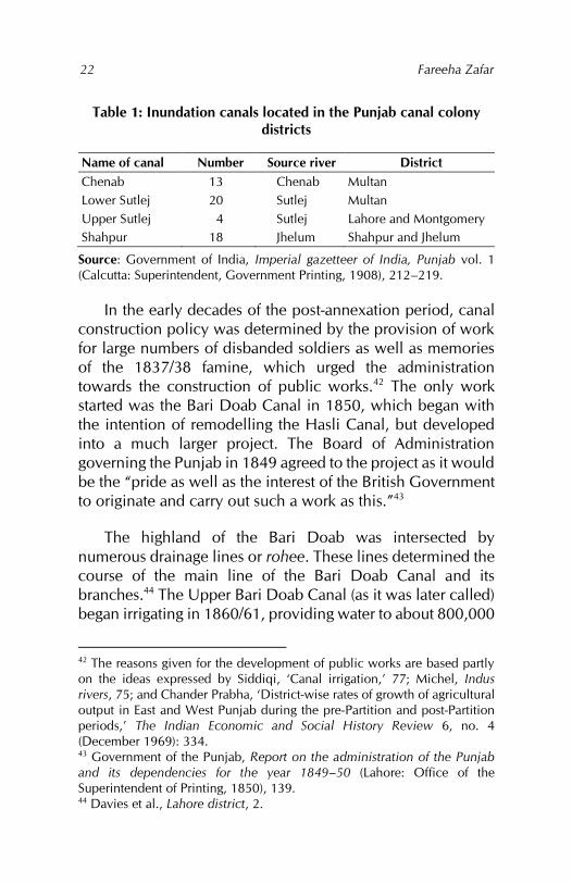
Inundation canals were, however, more localised, dependent as they were on the volume of water in the rivers during the flood season. The number of canals, obtained from reports and gazetteers of the period immediately following annexation, is given in Table 1. The only perennial canal in existence at the time was the Hasli Canal, constructed by the Mughals from the river Ravi to irrigate the districts of Lahore and Amritsar and the city of Lahore. It had fallen into complete disuse under the Sikhs.
38 C. Ouseley and W. G. Davies, Report on the revised settlement of the Shahpoor district in the Rawulpindee division, 1866 (Lahore: Punjab Printing Co., 1866), 7. 39 Habib, Agrarian system, 35. 40 Monckton, Jhung district, appendix A, 24. 41 Clive J. Dewey, ‘The agricultural output of an Indian province: The Punjab, 1870–1940’ (paper presented at the Institute of Commonwealth Studies, London, April 1972), 3.
Fareeha Zafar
22
Table 1: Inundation canals located in the Punjab canal colony districts
Name of canal Number Source river District Chenab 13 Chenab Multan Lower Sutlej 20 Sutlej Multan Upper Sutlej 4 Sutlej Lahore and Montgomery Shahpur 18 Jhelum Shahpur and Jhelum
Source: Government of India, Imperial gazetteer of India, Punjab vol. 1 (Calcutta: Superintendent, Government Printing, 1908), 212–219.
In the early decades of the post-annexation period, canal construction policy was determined by the provision of work for large numbers of disbanded soldiers as well as memories of the 1837/38 famine, which urged the administration towards the construction of public works.42 The only work started was the Bari Doab Canal in 1850, which began with the intention of remodelling the Hasli Canal, but developed into a much larger project. The Board of Administration governing the Punjab in 1849 agreed to the project as it would be the “pride as well as the interest of the British Government to originate and carry out such a work as this.”43
The highland of the Bari Doab was intersected by numerous drainage lines or rohee. These lines determined the course of the main line of the Bari Doab Canal and its branches.44 The Upper Bari Doab Canal (as it was later called) began irrigating in 1860/61, providing water to about 800,000
42 The reasons given for the development of public works are based partly on the ideas expressed by Siddiqi, ‘Canal irrigation,’ 77; Michel, Indus rivers, 75; and Chander Prabha, ‘District-wise rates of growth of agricultural output in East and West Punjab during the pre-Partition and post-Partition periods,’ The Indian Economic and Social History Review 6, no. 4 (December 1969): 334. 43 Government of the Punjab, Report on the administration of the Punjab and its dependencies for the year 1849–50 (Lahore: Office of the Superintendent of Printing, 1850), 139. 44 Davies et al., Lahore district, 2.
Canals, colonies and class: British policy in the Punjab 1880–1940
23
acres of land distributed among three Punjab districts, including Lahore.45 Most parts of these districts had been settled and cultivated for a long time. Marginally sufficient rainfall of about 20 inches, supplemented by irrigation from wells, had resulted in fairly substantial populations and a well-developed agricultural pattern. The construction of the canal attracted even more people to these districts, so that rather than opening up new areas for settlement and cultivation and reducing the pressure on the land, its impact was to intensify cultivation and overcrowding.
Several problems associated with the Upper Bari Doab Canal, such as the erosion of the canal bed, which required constant modification and enlargements of the original scheme, discouraged the government from undertaking further irrigation work. The Canal Department was loath to clear and maintain the canals, the administration’s view being that this was the responsibility of cultivators and landlords.46 Wells were similarly neglected.
In its despatches to the Government of India, the Public Works Department repeatedly stressed that the administration was responsible for undertaking irrigation works in the Punjab. Since the government was following the inherited land revenue system, which allowed it to absorb a substantial part of cultivators’ income, it was also bound under the same system to take “a more than corresponding share of the proper duties of a landlord.”47 At this stage, however, the British government’s policy on the financial aspects of irrigation in the Punjab was limited to obtaining loans in Britain at very high rates of interest. This required local governments to give
45 Septimus Smet Thorburn, The Punjab in peace and war (Edinburgh and London: William Blackwood & Sons, 1904), 264. 46 Charles A. Roe, Report on the revised settlement of the Multan district of the Punjab, 1873–80 (Lahore: W. Ball, 1883), 4. 47 Government of India, Public Works Department, ‘Public works despatch to India’, no. 51, para 19, 22 May 1873, in Selections from despatches.

Fareeha Zafar
24
their loan requirements every year as well as complete plans of any projects.48 Under such a policy, no large projects could be undertaken without the permission of the secretary of state.49 The North India Canal and Drainage Bill 1869, which gave the government the right to construct canals in any part of the province, did not receive complete approval from the secretary of state.50
As a result, during the 1860s and 1870s, all projects connected with the construction of perennial canals were turned down as unfeasible by the Government of India and the secretary of state. As yet, colonisation was not visualised as one of the aims of canal construction. Suggestions to improve irrigation in the Bari Doab, for which the Upper Bari Doab Canal was inadequate, were turned down on the grounds that the area was thinly populated.51 Similar suggestions for the Rechna and Chaj doabs also met with no success; the existing irrigation from inundation canals and wells was considered sufficient.
Perennial canal construction
Several factors were responsible for the change in government policy on the construction of canals. By the 1880s, many inundation canals had silted up due to neglect, production had not increased and the construction of railways for purely military purposes was proving too costly. Meanwhile, large areas of uncultivated and uninhabited land, which the government owned and could claim as its property,
48 Government of India, Finance Department, ‘Financial despatch to India’, no. 101, 5 March 1869, in Selections from despatches. 49 Government of India, Public Works Department, ‘Public works despatch to India’, no. 116, 25 November 1869, in Selections from despatches. 50 Government of India, Public Works Department, ‘Public works despatch to India’, no. 4, 11 January 1870, in Selections from despatches. 51 Government of India, Public Works Department, ‘Public works despatch to India’, no. 76, 8 September 1873, in Selections from despatches.
Canals, colonies and class: British policy in the Punjab 1880–1940
25
lay unused. The rationale for constructing canals was as follows: (i) the pastoral, nomadic and peripatetic people of the doabs could be settled and converted into sedentary agriculturists; (ii) the extension of cultivation would result in increased land revenue; (iii) the colonisation of sparsely populated areas by immigrants from other districts would relieve overcrowding in the latter; (iv) the fact that most land to be irrigated by the canals was Crown property would allow the government to create agricultural communities of its choosing; (v) the increased production resulting from irrigation could be used to meet the scarcity in other parts of the province; and (vi) the loyalty of the Punjab peasant, known for his martial spirit, could be won with the construction of public works, especially canals.52 This insecurity of agricultural production, based on irregular supplies of water, eventually led to a change in policy.53
Nevertheless, the experience of the Upper Bari Doab Canal and others in eastern Punjab, in terms of the low rate of profit derived from perennial canals, continued to hinder their construction. In 1882, a scheme for constructing canals as part of colonisation was put forward: this included the construction of four inundation canals, two from the Sutlej and one each from the Ravi and Chenab rivers. These schemes were based on “a high probability of a speedy influx of cultivators to occupy the wastelands.”54 Only two of the schemes were developed. In 1882, work began on the Sidhnai Canal, constructed from the river Ravi. Although it had a weir, it was for all practical purposes an inundation canal as there was little water left in the Ravi in winter once it had flowed into the Upper Bari Doab Canal.55 The Sidhnai Canal was expected 52 Alfred Deakin, Irrigated India: An Australian view of India and Ceylon, their irrigation and agriculture (London: W. Thacker and Co., 1893), 199. 53 F. B. Wace, The Punjab colony manual, rev. ed. (Lahore: Superintendent, Government Printing Press, 1933), 2. 54 Wace, Punjab colony manual, 1. 55 Wace, Punjab colony manual, 3.
Fareeha Zafar
26
to irrigate about 200,000 acres in the Multan district. The deficiency of water in the canal led to the construction of three small subsidiary canals in 1890/91 in the same area. The Sidhnai Canal was the only canal to be constructed entirely out of imperial funds. The other scheme to be developed was the Sohag-Para scheme, based on extending the Lower Sohag-Para inundation canal from the river Sutlej in the Montgomery district.56
In choosing between the Chenab and Jhelum rivers, the rich and fertile effects of the Jhelum waters were overridden by the quick and reliable returns guaranteed by extending irrigation from the Chenab into the extensive Rechna Doab – its wasteland had already been appropriated by the government and colonisation was assured through migration from the congested eastern districts of the Punjab.57 Proposals for the Lower Chenab Canal had been put forward as early as 1866. The scheme was revised in 1872, but the Government of India refused to sanction it on the grounds of insufficient estimates and uncertain financial results.58 A modified version, the Chiniot Inundation Project, was shelved for similar reasons in 1877.
The Famine Commission of 1880 had recommended the separation of public works into ‘protective’, ‘productive’ and ‘minor’ categories. When, “in 1882, the Government of India called for a statement of the project under consideration which were likely to prove sufficiently remunerative to be classed in the category of productive public works,”59 the Lower Chenab Canal qualified under this classification. Proposals for the large project put forward in 1877 were disregarded in favour of the smaller Ramnagar Canal, which opened in 1887. It was a failure 56 See Appendix 1 for a chronology of canal construction in the Punjab canal colony districts. 57 Thorburn, Punjab in peace, 271. 58 Wace, Punjab colony manual, 6. 59 Wace, Punjab colony manual, 6.
Canals, colonies and class: British policy in the Punjab 1880–1940
27
from the start, silting up after the first floods. Following this, the Lower Chenab Canal was constructed the same year as an inundation canal from the Khanki headworks on the Chenab; in 1892, it was converted into a perennial canal. The canal was intended to irrigate an area of about 1.1 million acres in the Gujranwala and Jhang districts, but proved much more valuable, irrigating at its peak in 1892/93 an area of approximately 2.5 million acres.60
The Lower Jhelum Canal had a similarly long history, the first proposals for its construction having been put forward as early as 1847. It was not constructed until 1897 despite having been sanctioned in 1888. The delay was caused by indecision concerning the scope of the canal: the area of Crown waste it was to irrigate was considerably smaller than the area watered by the Lower Chenab Canal. When it was finally constructed, the canal commanded 1.5 million acres, of which about 400,000 acres were Crown property.
A proposal to amalgamate the Lower Jhelum Canal with the existing Shahpur inundation canals had to be abandoned as no agreement could be reached with the private owners on the proprietary rights of the areas affected.61 The actual cultivators of the area were interested in the project, but the completion of the Shahpur branch of the Lower Jhelum Canal was abandoned in 1916 with a stalemate between the Irrigation Department and the Punjab government. The private canal owners also turned down the government’s offer to buy the canals; on its side, the government was not satisfied with the revenue estimates of the project.62 The economic success
60 The Upper Chenab Canal irrigated 650,000 acres of land in the Sialkot, Gujranwala and Sheikhupura districts; the Upper Jhelum Canal irrigated 350,000 acres in the Gujrat district and the Lower Bari Doab Canal served an area of 2,600 square miles in the Lahore, Montgomery and Multan districts. 61 Paustian, Canal irrigation, 58. 62 Government of the Punjab, Punjab canal gazetteer, Lower Jhelum Canal vol. 1 (Lahore: Punjab Government Printing Office, 1921), 3.
Fareeha Zafar
28
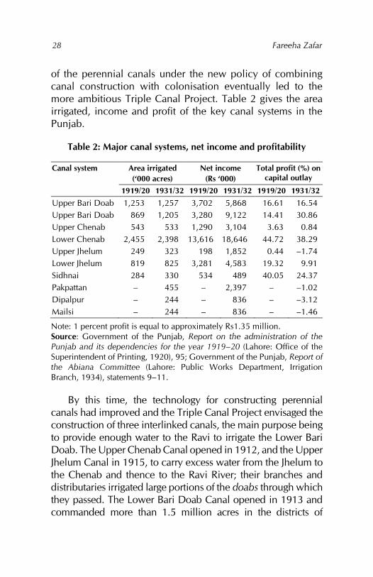
of the perennial canals under the new policy of combining canal construction with colonisation eventually led to the more ambitious Triple Canal Project. Table 2 gives the area irrigated, income and profit of the key canal systems in the Punjab.
Table 2: Major canal systems, net income and profitability
Canal system Area irrigated (‘000 acres)
Net income (Rs ‘000)
Total profit (%) on capital outlay
1919/20 1931/32 1919/20 1931/32 1919/20 1931/32 Upper Bari Doab 1,253 1,257 3,702 5,868 16.61 16.54 Upper Bari Doab 869 1,205 3,280 9,122 14.41 30.86 Upper Chenab 543 533 1,290 3,104 3.63 0.84 Lower Chenab 2,455 2,398 13,616 18,646 44.72 38.29 Upper Jhelum 249 323 198 1,852 0.44 –1.74 Lower Jhelum 819 825 3,281 4,583 19.32 9.91 Sidhnai 284 330 534 489 40.05 24.37 Pakpattan – 455 – 2,397 – –1.02 Dipalpur – 244 – 836 – –3.12 Mailsi – 244 – 836 – –1.46
Note: 1 percent profit is equal to approximately Rs1.35 million. Source: Government of the Punjab, Report on the administration of the Punjab and its dependencies for the year 1919–20 (Lahore: Office of the Superintendent of Printing, 1920), 95; Government of the Punjab, Report of the Abiana Committee (Lahore: Public Works Department, Irrigation Branch, 1934), statements 9–11.
By this time, the technology for constructing perennial canals had improved and the Triple Canal Project envisaged the construction of three interlinked canals, the main purpose being to provide enough water to the Ravi to irrigate the Lower Bari Doab. The Upper Chenab Canal opened in 1912, and the Upper Jhelum Canal in 1915, to carry excess water from the Jhelum to the Chenab and thence to the Ravi River; their branches and distributaries irrigated large portions of the doabs through which they passed. The Lower Bari Doab Canal opened in 1913 and commanded more than 1.5 million acres in the districts of
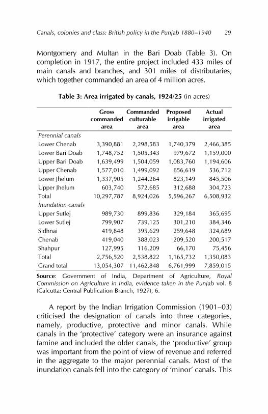
Canals, colonies and class: British policy in the Punjab 1880–1940
29
Montgomery and Multan in the Bari Doab (Table 3). On completion in 1917, the entire project included 433 miles of main canals and branches, and 301 miles of distributaries, which together commanded an area of 4 million acres.
Table 3: Area irrigated by canals, 1924/25 (in acres)
Gross commanded
area
Commanded culturable
area
Proposed irrigable
area
Actual irrigated
area Perennial canals Lower Chenab 3,390,881 2,298,583 1,740,379 2,466,385 Lower Bari Doab 1,748,752 1,505,343 979,672 1,159,000 Upper Bari Doab 1,639,499 1,504,059 1,083,760 1,194,606 Upper Chenab 1,577,010 1,499,092 656,619 536,712 Lower Jhelum 1,337,905 1,244,264 823,149 845,506 Upper Jhelum 603,740 572,685 312,688 304,723 Total 10,297,787 8,924,026 5,596,267 6,508,932 Inundation canals Upper Sutlej 989,730 899,836 329,184 365,695 Lower Sutlej 799,907 739,125 301,210 384,346 Sidhnai 419,848 395,629 259,648 324,689 Chenab 419,040 388,023 209,520 200,517 Shahpur 127,995 116.209 66,170 75,456 Total 2,756,520 2,538,822 1,165,732 1,350,083 Grand total 13,054,307 11,462,848 6,761,999 7,859,015
Source: Government of India, Department of Agriculture, Royal Commission on Agriculture in India, evidence taken in the Punjab vol. 8 (Calcutta: Central Publication Branch, 1927), 6.
A report by the Indian Irrigation Commission (1901–03) criticised the designation of canals into three categories, namely, productive, protective and minor canals. While canals in the ‘protective’ category were an insurance against famine and included the older canals, the ‘productive’ group was important from the point of view of revenue and referred in the aggregate to the major perennial canals. Most of the inundation canals fell into the category of ‘minor’ canals. This
Fareeha Zafar
30
distinction affected the allocation of funds for construction and maintenance and acted against the inundation canals.63
The dissolution of the commission in 1921 and the passage of the Government of India Act in 1919 – resulting in constitutional changes under which irrigation became a provincial subject – “removed the previously existing restrictions on the powers of the provincial governments to undertake protective schemes of irrigation.”64 At the same time, as a provincial subject, irrigation was to be administered by the reserved side of the local governments. This meant that, under the new constitution, they were responsible for providing funds for all new works, but with specific limitations on their power. These included the sanction of the secretary of state as necessary for capital expenditure on irrigation if (i) the project affected the interests of more than one government, (ii) the estimate was larger than Rs5 million, (iii) the revised estimate was more than 15 percent of the original or (iv) a second revised estimate was required. The Government of India, therefore, had greater control over irrigation matters than over other reserved subjects.65
Under this new policy, the Sutlej Valley Project was started in 1921 to replace the existing Sutlej inundation canals. The area to be irrigated under this project stretched across the Punjab into the states of Bahawalpur and Bikaner; the cost of the project was to be shared by the three regions. Within the Punjab districts of Montgomery and Multan – both British areas – 1 million acres (of which 854,000 acres were Crown waste) were to receive perennial irrigation and 2.7
63 While the commission recommended extending and increasing small inundation canals, it was aware that its recommendations would not be followed because inundation canals were not as remunerative. 64 Government of India, Department of Agriculture, Report of the Royal Commission on Agriculture in India (Bombay: Government Central Press, 1928), 333. 65 India, Department of Agriculture, Commission on Agriculture, 347.
Canals, colonies and class: British policy in the Punjab 1880–1940
31
million acres (of which 350,380 acres were Crown waste) were to be under nonperennial irrigation.66 The three canals in the Punjab – the Pakpattan, Dipalpur and Mailsi canals – were opened for irrigation between 1926 and 1928. Of these, only the Pakpattan Canal provided perennial irrigation to the colony through which it passed.
During the 1930s, lack of provincial coordination slowed down the construction of irrigation schemes in the Punjab.67 While some were awaiting sanction, others were dependent on the adjustment between the provinces. It was not until 1939/40 that the Haveli Project was implemented, under which two canals were constructed: the Haveli Canal, leading out of the Chenab River at Trimmu and joining up with the Sidhnai Canal system, and the Rangpur Canal, leading off from the eastern bank of the Chenab to irrigate that portion of the Jhang and Lyallpur districts not reached by the Lower Chenab Canal.
New irrigation patterns and problems
The construction of canals created fundamental changes in the irrigation patterns of the Punjab canal colony districts. Canal irrigation superseded all other forms of irrigation and the total irrigated area had increased rapidly. This did not occur without problems, some of which were technical while others related to canal irrigation policies.
The immensity of the areas affected by the construction of perennial canals brought about immediate changes in patterns of irrigation. This is evident both within each district and for the Punjab canal colony districts generally. As each canal was constructed, the irrigated area rose rapidly; by 1900, canal irrigation already accounted for more than 50 percent of all 66 Wace, Punjab colony manual, 24. 67 Government of India, Department of Agriculture, Royal Commission on Agriculture in India, evidence taken in the Punjab vol. 8 (Calcutta: Central Publication Branch, 1927), ii.
Fareeha Zafar
32
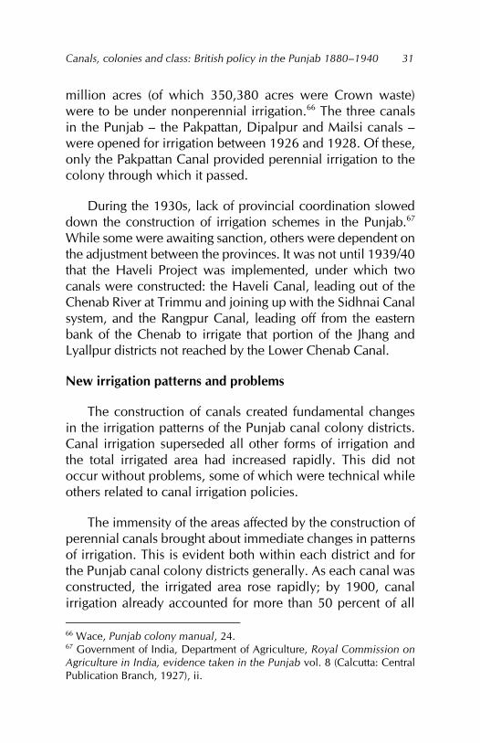
irrigation, with more than 2 million acres of land in the canal colony districts receiving irrigation from canals. Within 20 years, this had increased to 5.8 million acres, that is, more than 80 percent of all irrigation was being carried out by canals (Table 4).
Table 4: Canal-irrigated and total irrigated areas
Period Canal-irrigated area
Total irrigated area
% Canal-irrigated
1890/91 957,162 2,717,202 35 1900/01 2,211,971 3,746,998 59 1910/11 4,383,432 5,797,452 76 1920/21 5,860,944 7,265,727 81 1930/31 7,205,230 9,018,635 80 1940/41 8,027,915 9,791,639 82
% Change % Change 1890/91–1900/01 131 38 1900/01–1910/11 98 55 1910/11–1920/21 34 22 1920/21–1930/31 23 24 1930/31–1940/41 11 9 1890/91–1940/41 739 260
Source: Government of India, Department of Statistics, Agricultural statistics of British India (Calcutta: Superintendent, Government Printing).
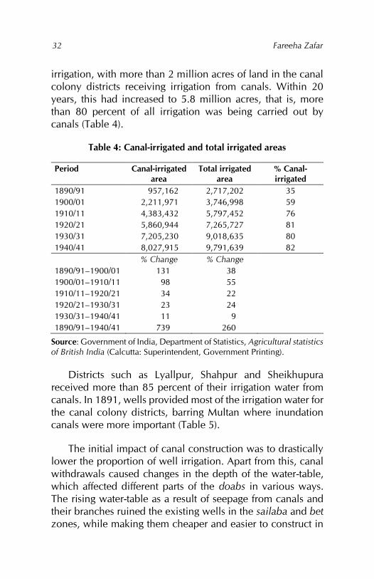
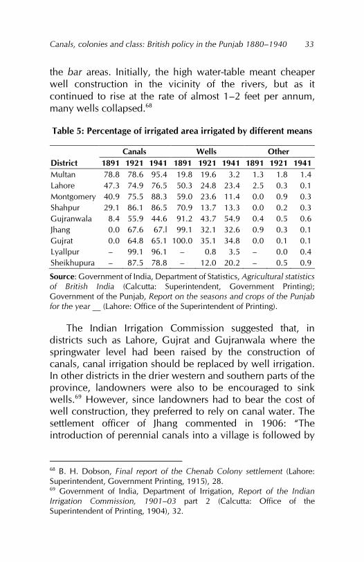
Districts such as Lyallpur, Shahpur and Sheikhupura received more than 85 percent of their irrigation water from canals. In 1891, wells provided most of the irrigation water for the canal colony districts, barring Multan where inundation canals were more important (Table 5).
The initial impact of canal construction was to drastically lower the proportion of well irrigation. Apart from this, canal withdrawals caused changes in the depth of the water-table, which affected different parts of the doabs in various ways. The rising water-table as a result of seepage from canals and their branches ruined the existing wells in the sailaba and bet zones, while making them cheaper and easier to construct in
Canals, colonies and class: British policy in the Punjab 1880–1940
33
the bar areas. Initially, the high water-table meant cheaper well construction in the vicinity of the rivers, but as it continued to rise at the rate of almost 1–2 feet per annum, many wells collapsed.68
Table 5: Percentage of irrigated area irrigated by different means
Canals Wells Other District 1891 1921 1941 1891 1921 1941 1891 1921 1941 Multan 78.8 78.6 95.4 19.8 19.6 3.2 1.3 1.8 1.4 Lahore 47.3 74.9 76.5 50.3 24.8 23.4 2.5 0.3 0.1 Montgomery 40.9 75.5 88.3 59.0 23.6 11.4 0.0 0.9 0.3 Shahpur 29.1 86.1 86.5 70.9 13.7 13.3 0.0 0.2 0.3 Gujranwala 8.4 55.9 44.6 91.2 43.7 54.9 0.4 0.5 0.6 Jhang 0.0 67.6 67.l 99.1 32.1 32.6 0.9 0.3 0.1 Gujrat 0.0 64.8 65.1 100.0 35.1 34.8 0.0 0.1 0.1 Lyallpur – 99.1 96.1 – 0.8 3.5 – 0.0 0.4 Sheikhupura – 87.5 78.8 – 12.0 20.2 – 0.5 0.9
Source: Government of India, Department of Statistics, Agricultural statistics of British India (Calcutta: Superintendent, Government Printing); Government of the Punjab, Report on the seasons and crops of the Punjab for the year __ (Lahore: Office of the Superintendent of Printing).
The Indian Irrigation Commission suggested that, in districts such as Lahore, Gujrat and Gujranwala where the springwater level had been raised by the construction of canals, canal irrigation should be replaced by well irrigation. In other districts in the drier western and southern parts of the province, landowners were also to be encouraged to sink wells.69 However, since landowners had to bear the cost of well construction, they preferred to rely on canal water. The settlement officer of Jhang commented in 1906: “The introduction of perennial canals into a village is followed by
68 B. H. Dobson, Final report of the Chenab Colony settlement (Lahore: Superintendent, Government Printing, 1915), 28. 69 Government of India, Department of Irrigation, Report of the Indian Irrigation Commission, 1901–03 part 2 (Calcutta: Office of the Superintendent of Printing, 1904), 32.
Fareeha Zafar
34
the dismantlement of all commanded wells which were previously at work…”70
Inundation canals were also affected as the diversion of river water into perennial canals lowered the level of water in the rivers, which almost dried up in the kharif season.71 For example,
the net result of the opening of the Chenab Canal on the inundation canals taking out from the River Chenab has, therefore, been that the level of the water has been lowered in April by about 9 inches and in October by one and a half feet, and the working period has been shortened by about 10 days.72
Some inundation channels closed when their mouths were blocked by the construction of embankments along the canals. The sailaba area irrigated by the natural overflow of the rivers during floods also decreased, in some cases leading to the ruin of riverain villages.73 This was mainly because the rivers normally carried rich silt-bearing water that would spread out on either side of the river during a flood. The diversion of water into canals reduced this beneficial effect as well as reducing the supply of water itself.74
As a supplement to canal irrigation, well irrigation remained important in most of the canal colony districts. In Gujranwala, it was equally important and, in 1941, even surpassed canal irrigation. With the extension of many of the canal systems, Punjab relied increasingly on wells to meet the 70 E. R. Abbott, Settlement report of the Jhang district, 1906 (Lahore: Civil and Military Gazette Press, 1907), 3. 71 E. D. Maclagan, Final report of the revision of settlement of the Multan district, 1895–1901 (Lahore: Civil and Military Gazette Press, 1901), i. 72 Government of the Punjab, Department of Revenue and Agriculture, Proceedings, irrigation no. 05351, 15 July 1902, para 16. 73 Harikishan Kaul, Census of India, 1911, Punjab, report vol. 14, part 1 (Lahore: Civil and Military Gazette Press, 1912), 53. 74 Government of the Punjab, Report on the seasons and crops of the Punjab for the year 1908–09 (Lahore: Office of the Superintendent of Printing, 1909), 10.
Canals, colonies and class: British policy in the Punjab 1880–1940
35
deficiencies of canal water supply, even to the extent of making the construction of wells compulsory for land grants in some of the colony areas.75 In the nonperennially irrigated areas, rabi cultivation depended on wells. Thus, in the Sohag-Para and Sidhnai canal areas, all land grants were made conditional on sinking wells.76 The Sutlej Valley Project was also based on the construction of a substantial number of wells to support the partially perennial and partially nonperennial irrigation from that scheme.
The sophistication of the technology developed during the period of canal construction was not matched by parallel advances in countering the drawbacks of perennial supplies of water. Canal engineers had not devised any method of disposing of the surplus water from the canals back into the rivers. Instead, they created depressions along the canals bounded by earthen embankments; these formed reservoirs that closed the mouths of inundation channels and aggravated the problem of seepage, resulting in high water-tables and soil salinisation.77 Faulty canal alignment also resulted in waterlogging, as in the case of the Upper Chenab Canal, which was “banked up above the level of the surrounding country and leaked water throughout its course.”78
Even towards the end of the nineteenth century, there were complaints regarding the spreading of reh79 and unhealthy conditions due to excessive canal irrigation. The
75 Wace, Punjab colony manual, 230. 76 Wace, Punjab colony manual, 230. 77 Paustian, Canal irrigation, 79. 78 Hugh Kennedy Trevaskis, The Punjab of today: An economic survey of the Punjab in recent years (1890–1925), vol. 1 (Lahore: Civil and Military Gazette Press, 1931), 265. 79 Reh is described as “an efflorescence of soda salts, which appears as a white crust on the surface of the soil and renders it unculturable. The salts are principally impure carbonate of soda but sulphate of soda also occurs largely and with them are found common salt of lime and magnesia” (Voelcker, Improvement of Indian agriculture, 51).
Fareeha Zafar
36
situation became more serious in 1908 when, during a heavy monsoon, the drainage system broke down completely and many villages in the Hafizabad and Chiniot tehsils were inundated. An enquiry brought to the forefront other areas similarly affected, establishing a connection between seepage from canals, obstructions of the natural drainage80 and waterlogging.81 As early as 1860, the obstruction of nalas by the embankment of the North-Western Railway through Gujrat district had led to the flooding of the land.82 A more severe case was that of Sheikhupura district where the old passage of the Deg nala was blocked by the Raya branch of the Upper Chenab Canal, leaving the entire countryside covered by a sheet of water.
In the natural hydrological environment of the Punjab before perennial irrigation, the upper halves of the doabs had very low water-tables. In the centre of the Rechna Doab, the water-table was more than 100 feet deep; in the centre of the Chaj Doab, it was 70 feet deep and in the centre of the Bari Doab, it was under 70 feet. In the lower halves of the doabs, the water-table was higher and its depth diminished downstream until it merged with the rivers. By 1910, there was a general rise in the water level throughout the irrigated regions, ranging from less than 10 feet near the tail-end of the canal system to more than 40 feet near the bifurcation points in the upper parts of the doabs.83 80 Before the introduction of canal irrigation, the monsoon run-off would drain into the rivers through natural channels or nalas. 81 R. G. Kennedy, Waterlogging of the soil in the vicinity of Punjab irrigation canals, and measures for the prevention of waterlogging Punjab irrigation paper no. 20 (Lahore: Irrigation Board, 1920). 82 W. G. Waterfield, Report on the second regular settlement of the Gujrat district, Panjab (Lahore: Central Jail Press, 1874), 7. 83 The settlement report for the Lahore district for 1935–39 noted that, since the last settlement of the district in 1912–16, more than 10 percent of the cultivated area had been lost through waterlogging and salinity. The total affected area was 43,000 acres, i.e., 3 percent of the total district, out of which 28,469 acres were cultivated. The affected area was spreading along the bed of the old Beas River and near the mainline of the Lower Bari Doab Canal. See: G. E. B. Abell, Final
Canals, colonies and class: British policy in the Punjab 1880–1940
37
In the areas above the main canals, the water-table rose due to seepage from these canals, which were aligned transversely to the direction of pre-irrigation groundwater movement.84 Moreover, the permeability of the soils favoured canal leakage. Because of the low content of organic matter, these soils required slow watering to allow the passage of oxygen; practice to the contrary resulted in the development of alkali salts.85 The hot, dry climate contributed to the accumulation of salts on the surface of the land by allowing increased evaporation.
The canals had been designed with regard to area it was ‘permissible’ to irrigate,86 which in most cases was 60 percent of the allotted area and 75 percent in the case of the Lower Chenab Canal.87 The demands of colonisation led to the waiving of irrigation limits, as in the case of the Lower Jhelum Canal, where the limit had been fixed at 40 percent in the riverain area to prevent waterlogging, but was applied only in the case of old proprietary village lands and not colony
report of the fifth regular settlement report of the Lahore district, 1935–39 (Lahore: Superintendent, Government Printing, 1943), 4. 84 D. W. Greenman, W. V. Swarzenski and G. D. Bennett, Groundwater hydrology of the Punjab, West Pakistan, with emphasis on problems caused by canal irrigation (Washington, DC: US Government Printing Office, 1967), 39. 85 The settlement report for the district of Lyallpur, 1915, noted that the Lyallpur colony possessed all features favourable to an increase of earth-salts: (i) insufficient rainfall, (ii) little or no lateral movement whereby the salts might granulate to a lower level, (iii) sandy soil, (iv) a wide range of temperatures to assist weathering and (v) surface irrigation (Dobson, Chenab Colony, 56). By 1940, the area affected by salinity in the Rakh branch colony circle of the Sheikhupura and Lyallpur districts was 6,164 acres in 1933, 7,853 acres in 1935 and 12,791 acres in 1937 in the kharif season. See: S. K. Kirpalani, Final settlement report of the Lyallpur district and the Rakh branch colony circle of Sheikhupura district, 1940 (Lahore: Superintendent, Government Printing, 1940), 4. See also Trevaskis, Punjab of today, 310. 86 For a detailed account of the designed permissible area of irrigation, see Wace, Punjab colony manual, 227. 87 Kirpalani, Lyallpur district, 3.
Fareeha Zafar
38
grants.88 For a canal to pay its way and bring in more revenue, water was given for valuable crops such as wheat, cotton and sugarcane, which required frequent watering.89
Over-irrigation of this nature meant that not enough water was available in other instances, particularly in areas situated at the tail-end of canals, which were prone to water shortages.90 Water seepage also reduced the quantity of water in the canals and they could not cater to the intensified irrigation that had been planned.91
Evidence given before the Royal Commission on Agriculture in India in 1927 by Col. E. H. Cole of Coleyana Estate Ltd in Okara, Montgomery district, pointed out that,
The zamindar is often accused by the Irrigation Department of wasting water and often he does waste it, hut the greatest waste of water is by the Irrigation Department itself. The distributaries are constructed to carry the maximum full supply and no more. There is no drainage and no escape outlet to take up water not required.92
The administration’s initial response to the problem of waterlogging and salinity was to shut off the canal water supply to the affected areas. Since 1908, when the problem of waterlogging first arose, irrigation committees and experts had 88 Government of the Punjab, Gazetteer, Lower Jhelum Canal, 32. 89 Trevaskis, Punjab of today, 301. 90 Experiments conducted on the Upper Bari Doab Canal in the rabi season showed that, out of 100 cubic feet of water entering the head of the canal, only 28 cubic feet were used. Of the rest, 20 cubic feet were lost in canals and branches, 60 cubic feet in the distributaries and 21 cubic feet in village water-courses. A further 25 cubic feet were wasted during the irrigation process itself (India, Department of Agriculture, Agriculture, evidence taken in the Punjab, 4). 91 Michel, Indus rivers, 97. 92 India, Department of Agriculture, Agriculture, evidence taken in the Punjab, 287.
Canals, colonies and class: British policy in the Punjab 1880–1940
39
suggested various remedies: (i) restricting water supplies, (ii) excavating drains, (iii) pumping out water from the subsoil, (iv) lining the canals and (v) constructing siphons and culverts.93 In March 1910, a decision by the Committee on Waterlogging to construct a siphon under the main Upper Chenab Canal was not followed; instead, the canal was waterproofed. In six years, only 6 miles of the channel were lined; eventually, the high cost of the experiment deemed it unsuitable. In 1917, a conference on waterlogging was held in Lahore; the following year, a drainage board was constituted to deal with the matter. However, it was not until 1920, when the problem became progressively more serious, that the construction of drains was adopted as the major remedy.
The success of drains in resolving the immediate drainage problem can be judged from the fact that canal water supplies were resumed to villages that had been cut off from canal water due to waterlogging. Drains, however, proved to be only a temporary solution and even the setting up of the Waterlogging Board in 1928 could not postpone the effects of the Triple Canal Project: the problem of waterlogging and salinity had become pronounced in the Chaj and Rechna doabs by the 1940s.94 The Irrigation Research Institute set up in Lahore in 1930 proposed the use of tubewells not only for providing irrigation water, but also for pumping out water from the subsoil. The first experimental tubewell was constructed near Lahore in 1940 to relieve waterlogging in the area and a land reclamation board constituted. It had taken the administration more than three decades to sanction the first major project combining tubewell irrigation with tubewell drainage at Rasul in 1944.95
93 Michel, Indus rivers, 457. 94 Michel, Indus rivers, 457. 95 Michel, Indus rivers, 458.
Fareeha Zafar
40
Another problem that developed almost from the inception of canal irrigation was the irregularity and deficiency in the supplies of canal water.96 This was partly related to the volume of water in the rivers, which in turn depended on the amount of rainfall as well as the withdrawals from rivers by the perennial canals. Deficiencies in water supplies increased as the canals and their branches were extended beyond the scope of the original plans. As a result, the amount of water available for irrigation in the whole canal system decreased. Although the construction of the Triple Canal Project was an attempt to remedy this, the demand for canal water accelerated with the cultivation of crops that required large amounts of water. Moreover, the profits derived from the sale of canal water and from the wasteland irrigated by the canals prompted the government to go ahead with extension schemes.
Attempts were also made to regulate the supplies of canal water by remodelling outlets to incorporate the adjustable proportional module whereby water was given and charged for by volume rather than acreage. However, this further decreased supplies of water, especially to smaller cultivators and tenants, as any outlet on which the module was fixed had to serve an area of 700–800 acres. Tenants with small holdings in this position as small shareholders on a watercourse were placed at the mercy of the landlord, the major shareholder.97
Many of the problems connected with canal irrigation were an outcome of the Irrigation Department’s concern with collecting revenue from the sale of canal water.98 In the Punjab,
96 Government of the Punjab, Report on the seasons and crops of the Punjab for the year 1920–21 (Lahore: Office of the Superintendent of Printing, 1921), 3. 97 India, Department of Agriculture, Agriculture, evidence taken in the Punjab, 12, 17. 98 India, Department of Agriculture, Agriculture, evidence taken in the Punjab, 287.
Canals, colonies and class: British policy in the Punjab 1880–1940
41
where the importance of irrigation was almost supreme, little scientific research was carried out in that direction:
The waterlogging of land as a result of defective irrigation was forced on the attention of the Government so long ago as 1832, and the long history of the West Jumna Canal, one of the oldest in India, has afforded ample lessons in hydraulic engineering. The experience thereby gained, however, was not sufficient to prevent the recurrence of the evil in the new canal colonies of the Punjab.99
It was only in 1924 that a scientific research officer for irrigation was appointed in the Punjab and in 1928 the Government of India constituted a Central Irrigation Board. Till then, however, most of the Punjab canal colonies had been formed and considerable areas in the colonies that had not yet been allotted were being allocated to and reserved for colonists whose grants had been affected by waterlogging and salinity.
Before the British annexed the Punjab, the means of irrigation had been largely privately owned. The colonial government not only had complete control of the canals, but also the land that was to receive canal water. It was therefore able to extend the facilities of canal irrigation to those classes whose development it favoured. While the small lessees of government wasteland had their leases terminated, those who had leased large areas were allowed to buy the same land under favourable conditions.
Many small owners of wells and sailaba holdings in the riverain villages were ruined by the fall in the level of the rivers, following the construction of canals. The regulation of water supplies and remodelling of water outlets to reduce
99 India, Department of Agriculture, Commission on Agriculture, 349.
Fareeha Zafar
42
deficiencies in the supply of canal water benefited only the large landowners. The profit motives of the Irrigation Department caused delays in the construction of drains and, later, tubewells, which appeared to be the most successful means of dealing with the problem. Meanwhile, cultivators from the affected areas were compensated in the form of land grants in the colonies while land was still available for allotment. Thus, canal irrigation, while providing far greater amounts of water than previously conceived and irrigating an immensely large part of the Punjab canal colony districts, gave the more powerful sections of rural society a chance to extend their holdings and obtain greater benefits from the development of this resource. The process of colonisation that accompanied canal construction made sure that a privileged class of landholders was established in the region.
Chapter 3
Canals and colonisation
Colonisation was envisaged as the settlement of large areas of wasteland, most of it owned by the government and irrigated by the newly constructed perennial canals, with settlers brought in from outside the colonies. The decision to develop agricultural communities made it necessary to organise the colonies into rural and urban or commercial sections. The rural areas were formed into villages; farming land was allotted, granted and sold in different plot sizes to accommodate landlords, yeomen farmers and peasants. The basis on which land grants were made varied from colony to colony and was affected by financial, economic and political considerations on the part of the administration. The urban areas were created by the formation of mandis or market towns connected by railways.
Demarcation of canal colonies
It is difficult to separate the British government’s decisions regarding colonies and the construction of canals per se in the Punjab. That said, while the feasibility and costs of construction controlled the latter, the colonisation process (though dependent on the availability of canal water) proceeded on quite different lines once the canal branches had been constructed and even before water became available for cultivation.
The first attempt at colonisation in India was in the Hariana and Bhattiana territories to settle disbanded soldiers on the land in 1818. Similar proposals for colonisation by the Punjab government in 1856 to accommodate Sikh soldiers included
Fareeha Zafar
44
extending the cultivated area in the already populated and cultivated manjha area of the Lahore and Amritsar districts.100 The existing Hasli inundation canal was enlarged, extended and converted into the Upper Bari Doab Canal, but a new colony was not formed.
Further attempts at colonisation were not made till the 1880s when a clearly defined colonisation policy was developed. The process began in 1886 with the extension of the older inundation canals. The first irrigated areas to be colonised were those served by the two Sutlej inundation canals, the Upper and Lower Sohag-Para, which irrigated the eastern part of Montgomery district. The Sohag-Para Colony covered 86,315 acres of government land. There were further extensions to this scheme in 1906 and it was finally amalgamated into the Sutlej Valley Project in 1924.
At the same time, the Sidhnai Canal was used in colonising 175,702 acres of wasteland in the Multan district. More than half the area of the Sidhnai Colony consisted of government or Crown land. The Lower Chenab Canal gave rise to the Chenab Colony.101 Colonisation began in 1892 with the completion of the Khanki headworks on the river Chenab and the construction of the main canal branches, which assured permanent supplies of water. Although the original intention was to colonise and irrigate the central bar areas of the Lower Rechna Doab, where the water-table was below 40 feet and covered an area of 2,544,133 acres (all of which was government wasteland), it was decided to extend irrigation first to the area between the river and the bar (40,000 acres), where the conditions of the existing cultivation were precarious.
100 Government of the Punjab, Report of the Colonies Committee, 1907–08 (Lahore: Civil and Military Gazette Press, 1908), 2. 101 The Chenab Colony included most of the Jhang district and part of the district of Gujranwala. The district of Lyallpur, formed in 1904, emerged from this colony and the latter ceased to be administered as a colony in 1907.
Canals, colonies and class: British policy in the Punjab 1880–1940
45
Another consideration at this point was that labour would have been attracted to the canal-irrigated bar land, thereby leading to decreased production in the other parts.102 The first major allotments of land were made between 1892 and 1896 and from 1904 to 1906 on the Jhang and Gugera branches. These branches were extended between 1924 and 1929, leading to the colonisation of additional areas. By 1930, a total of 1.9 million acres had been allotted to settlers, with large areas remaining allotted under temporary conditions.
The Chunian Colony was formed between 1894 and 1904. In 1892, the question of extending irrigation from the tail of the Upper Bari Doab Canal to some Lahore district rakhs (scrub forests) was considered. When, in 1894, it was ascertained that more than 15,000 acres of Crown wasteland could be commanded by these extensions in the Chunian tehsil and profitability assured, the scheme was implemented despite there being a shortage of water for the extensions.103
In 1902, colonisation work began on 1,531,000 acres of land in the Shahpur district served by the Lower Jhelum Canal. Of this area, only 437,751 acres were owned by the government. The history of this scheme went back to 1847 when it was originally suggested, but it received serious consideration only in 1897. Even then, changes were effected and the scope of the colony extended considerably. Its originality lay in the fact that it was almost entirely devoted to horse breeding.104 Major allotments of colony land were completed within four years, with some minor ones being made as late as 1930.
About the same time, the Jhang Colony was formed. Allotment began in 1905; by 1909, 18,000 acres of land had
102 India, Department of Irrigation, Irrigation Commission, 8–9. 103 Abell, Lahore district, 2. 104 Wace, Punjab colony manual, 17.
Fareeha Zafar
46
been distributed to colonists. As most of the area was not commanded by canals and was unculturable, it was resumed so that, by the end of 1919, only 9,000 acres had been allotted. This increased to 14,560 acres by 1929. The area of the Jhang Colony was only administered like a colony, otherwise
neither the foundation of towns or markets under government control nor the mere distribution of a small area of government lands to neighbouring zamindars has per se anything to do with colonisation. The chaks [blocks of land] in which settlers have been located are composed of government waste and privately owned land intermixed.105
The next phase, aimed at colonising the Lower Bari Doab, envisaged the formation of three colonies based on the construction of three separate but interlinked canals. The Triple Canal Project (as it was called) gave rise to the Upper Jhelum Canal Colony, comprising 350,000 acres of land in Gujrat district; the Upper Chenab Canal Colony, covering more than 500,000 acres in the districts of Gujranwala and Sheikhupura; and the Lower Bari Doab Canal Colony, which extended over 2,600 square miles of practically uncultivated wasteland in the Okara, Montgomery and Khanewal tehsils of the Montgomery and Multan districts. The Lower Bari Doab Canal Colony was by far the largest colony to be formed and included 1,450,000 acres of Crown wasteland. Allotments of colony land began in 1913 and carried on intermittently till 1930.
The Upper Chenab Canal Colony had an irrigable area of 600,000 acres, but of this, only 80,000 acres were government wasteland, also in scattered pieces. The allotment of land began in 1915, and by 1920, 64,846 acres of Crown waste had been allotted. Of this, nearly half was to get water only in the kharif season and for just 25 percent of the irrigable area. The Upper 105 Wace, Punjab colony manual, 18.
Canals, colonies and class: British policy in the Punjab 1880–1940
47
Jhelum Canal Colony had an irrigable area of 322,000 acres, of which only 43,000 acres were Crown waste, all of it located in the Phalia tehsil of Gujrat district. Colonisation began in 1905 and continued till 1915 when it was found that the actual area available for allotment was less than originally expected. The scheme of allotment was changed in 1917 and finally completed by 1921. The immensity of the triple colonies can be gauged from the fact that the total area commanded by the canals was 45 million acres, of which almost 4 million acres were irrigated.106
The last colony to be formed was the Nili Bar Colony, connected with the conversion of some of the Sutlej inundation canals into perennial ones under the Sutlej Valley Project. A distinctive feature of the colonisation scheme was that, unlike previous schemes, a very large proportion of land was to be sold by auction.107 Allotments of colony land began in 1926 and were completed by 1931.
The colonies retained a separate status until they were amalgamated with the districts of which they were a part. As colonies, they were administered by the colony officer whose appointment under the Government Tenants (Punjab) Act III of 1893 gave him and his assistant the grade of deputy commissioner. Both fell directly under the settlement commissioner in status. The colonisation officer was an influential figure, empowered to deal independently with all matters pertaining to the colony, such as irrigation, agriculture, cooperatives, banking, the police, public health, buildings and roads.108 As soon as a large part of the colony area had been allotted and the district administration was able to cope with the larger population and cultivated area now within its boundaries,
106 Darling, Punjab peasant, 131. 107 Wace, Punjab colony manual, 24. 108 Government of the Punjab, Gazetteer of the Chenab Colony, 1904 (Calcutta: Bengal Secretariat Book Depot, 1905), 124.
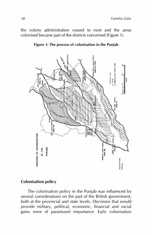
Fareeha Zafar
48
the colony administration ceased to exist and the areas colonised became part of the districts concerned (Figure 1).
Figure 1: The process of colonisation in the Punjab
Colonisation policy
The colonisation policy in the Punjab was influenced by several considerations on the part of the British government, both at the provincial and state levels. Decisions that would provide military, political, economic, financial and social gains were of paramount importance. Early colonisation
Canals, colonies and class: British policy in the Punjab 1880–1940
49
policy was shaped by military considerations. The construction of the Upper Bari Doab Canal through the manjha of the districts of Lahore and Amritsar was seen to provide stability to the area. As such,
The wooded wilds of the Central Doabs, the haunts of thieves and plunderers, were to be intersected by roads, the people were to be disarmed, the forts and strongholds were to be dismantled.109
However, at this stage, the construction of large canals was not seen as providing quick military gains. Instead, railways appeared to be the more tried and trusted method of penetrating the newly acquired territory to establish control. For the next three decades, therefore, attention was focused on constructing railways to provide easy access to British troops through the Punjab to the Northwestern Frontier, with colonisation based on canal construction shelved for the time being.
Once the purely military objectives had been attained and the Punjab districts put under land settlements, the need for colonisation retreated still further into the background. The events of 1857 helped tip the balance in favour of railway construction vis-à-vis colonisation. With the Punjab quiescent during the 1860s and 1870s, the burden on the railways decreased and they no longer appeared to be as advantageous as before. To make them more profitable, increased agricultural production was necessary.
The government’s policy of noninterference in irrigation and cultivation had resulted in static and, at times, deteriorating conditions of production, with some inundation canals falling into complete disuse. At the same time, scarcity continued to occur in different parts of the province. The report of the Famine Commission in 1880 highlighted the role
109 Government of the Punjab, Administration, 1849–50, 30.
Fareeha Zafar
50
of canals as the answer to the problem. The economic feasibility of colonising the bar areas seemed assured if the best agriculturists of the province could be gathered in the colonies to produce large amounts of crops throughout the year on the assurance of a perennial water supply.
The Sidhnai and Sohag-Para colonies can be seen as an attempt at colonisation by converting the existing inundation canals into perennial ones. A policy for the allotment of colony land was also being formulated slowly. In the two above-mentioned colonies, while some land was given to locals, the remainder was settled largely by peasant colonists from the best agricultural tribes of the congested districts in eastern Punjab. In later extensions of these colonies, however, most land was allotted to settlers from well-to-do families outside the area. The system of allotment was to give the land to colonists under tenancy conditions with the right to purchase proprietary rights to the land after a period of five years.
In the second phase of colonisation under which the Lower Chenab Canal Colony was formed, the colonisation policy changed. Differences between the administrators – that is, the lieutenant governor and the financial commissioner – were resolved in favour of the latter’s views on allotment principles based on granting only tenancy rights to peasant colonists.110
While the colonisation and allotment of land had been carried out under the original conditions, these were changed by the provincial government in 1899. This was prompted by the fact that cultivators in the Punjab had begun to sell agricultural land for debt while the customary laws of inheritance led to the subdivision of holdings. Opinion within the Punjab was very strong on the whole question of indebtedness and the transfer/sale of land to nonagriculturalists.
110 Government of the Punjab, Colonies Committee, 8.
Canals, colonies and class: British policy in the Punjab 1880–1940
51
The very basis of economic progress, that is, the advance of agriculture, was seen to be in jeopardy. Moreover, it was felt that colonisation could be used to better advantage.
Almost all the land commanded by the Lower Chenab Canal was Crown property, giving the government a free hand in making grants. By taking away the right to acquire proprietary rights from the largest section of the grantees – the peasant colonists – the government attempted to halt the sale and transfer of land to nonagriculturists, which, it felt, would lead to instability as the agricultural communities became landless and the nonagricultural sections of society became stronger.
The Alienation of Land Act was passed in 1900 to stem this tide throughout the Punjab. At the same time, colonisation policy was aimed at allowing liberal grants to well-to-do sections of rural society. The yeomen and capitalist grants as well as special service and reward grants met this purpose. Nonagricultural landlords were accommodated in the colonies through auctions of colony land. The Chunian Canal Colony, formed in 1892 in the Lahore district, was established with the idea of selling the bulk of the land by auction, with some reserved for military rewards and sale to zamindars from neighbouring areas.
However, this scheme of the provincial administration was not accepted by the Government of India, which felt that the original principles of colonisation should not be violated. They arrived at a compromise, giving 36,000 acres in the first instance and a further 51,000 acres in 1904–06 to peasant colonists from the Lahore district. Another 84,500 acres were also sanctioned for auction during the latter period.111
On the other hand, giving land in the colonies to nomads and grazier tribes that had originally inhabited the bar areas
111 Wace, Punjab colony manual, 15.
Fareeha Zafar
52
created special colonisation conditions. One such condition was the loyalty clause, first suggested in 1904, and included as a condition to tenancy in the peasant horse-breeding grants made to Biloch tribes. Their inclination to lift cattle, etc., was brought out in the need for such a clause. A similar reason was given for introducing this clause into the peasant grants made in the Lower Bari Doab Canal Colony, where the pastoral tribes of the bar areas were to be settled in the Montgomery and Multan districts.
In 1916, this clause was extended to the peasant grantees of the Lower Bari Doab and Upper Jhelum Canal colonies. By 1918, all future grants of this nature were to include the loyalty clause.112 As a result, many pastoral tribesmen wishing to obtain grants in the colonies had to admit to cattle lifting and other such crimes to prove their association with the notified agricultural tribes of the Punjab as set down under the Land Alienation Bill.113 The political benefits to be derived from various types of grants to military and civilian personnel, reward grants for help in the criminal administration of the districts, landed gentry grants, and yeomen and capitalist grants had become an established fact (see Table 6).
In 1901, the scope of colonisation was extended on the recommendation of the Commission on Horse and Mule Breeding to raising large numbers of camels, horses and mules for the army.114 Britain’s involvement in wars with India’s neighbours as well as at the international level prompted this aspect of colonisation policy. Extensions of the Lower Chenab Canal Colony were allotted on camel service
112 Wace, Punjab colony manual, 80–82. 113 Government of the Punjab, Report on the Punjab colonies for the year ending 30th September 1940 (Lahore: Civil and Military Gazette Press, 1940), 139. 114 Government of the Punjab, Department of Revenue and Agriculture, Proceedings, general no. 3693, 10 October 1901.
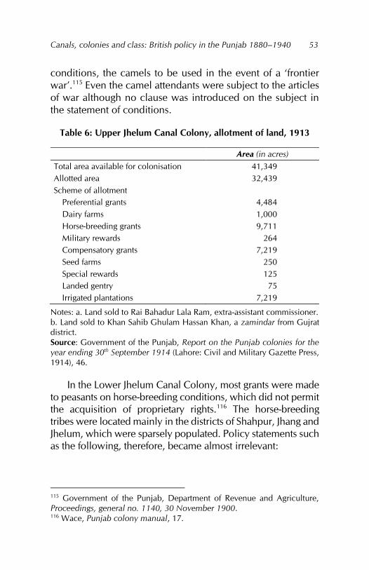
Canals, colonies and class: British policy in the Punjab 1880–1940
53
conditions, the camels to be used in the event of a ‘frontier war’.115 Even the camel attendants were subject to the articles of war although no clause was introduced on the subject in the statement of conditions.
Table 6: Upper Jhelum Canal Colony, allotment of land, 1913
Area (in acres) Total area available for colonisation 41,349 Allotted area 32,439 Scheme of allotment
Preferential grants 4,484 Dairy farms 1,000 Horse-breeding grants 9,711 Military rewards 264 Compensatory grants 7,219 Seed farms 250 Special rewards 125 Landed gentry 75 Irrigated plantations 7,219
Notes: a. Land sold to Rai Bahadur Lala Ram, extra-assistant commissioner. b. Land sold to Khan Sahib Ghulam Hassan Khan, a zamindar from Gujrat district. Source: Government of the Punjab, Report on the Punjab colonies for the year ending 30th September 1914 (Lahore: Civil and Military Gazette Press, 1914), 46.
In the Lower Jhelum Canal Colony, most grants were made to peasants on horse-breeding conditions, which did not permit the acquisition of proprietary rights.116 The horse-breeding tribes were located mainly in the districts of Shahpur, Jhang and Jhelum, which were sparsely populated. Policy statements such as the following, therefore, became almost irrelevant:
115 Government of the Punjab, Department of Revenue and Agriculture, Proceedings, general no. 1140, 30 November 1900. 116 Wace, Punjab colony manual, 17.
Fareeha Zafar
54
On the Chenab Canal the first object has always been to get good colonists for the Government land. It has been a secondary, though no doubt an important consideration that congested districts should be relieved of their excess population. The same principles should no doubt be kept in mind in selecting colonists for the Jhelum Canal.117
Further changes were effected in 1902, when the original scheme of getting peasant colonists to raise mares on their grants of one square of land failed as the area was too small to support this scheme and the peasants declined to take up such grants. In their place, large grants were made to rich horse-breeders on nazarana conditions and the rule of primogeniture also applied in their case.118 This served to resolve the disagreement between the settlement commissioner, who opposed the condition of raising mares for peasant grantees, and the financial commissioner, who thought the scheme was feasible.119
Horse-breeding conditions continued to be applied to peasant grants in the Upper Jhelum Canal Colony as well. In 1917, of the total acreage allotted, almost one quarter was conditional to horse breeding. In the Lower Bari Doab Canal Colony, the plan to dispose of colony land envisaged more than half the area being allotted subject to these conditions, although this was reduced when the actual allotments were made. Apart from these conditional grants, the demands of the Military Department of India were met by creating remount depots, horse runs, government grass farms, irrigated forest plantations and reserves for grazing purposes in the canal colony districts (see Table 7). 117 Government of the Punjab, Department of Revenue and Agriculture, Proceedings, irrigation no. 304, 29 March 1901, para 33. 118 Government of the Punjab, Department of Revenue and Agriculture, Proceedings, irrigation no. 1610–1616, 1902, para 3. 119 Government of the Punjab, Report on the Punjab colonies for the year ending 30th September 1903 (Lahore: Civil and Military Gazette Press, 1903), 3.
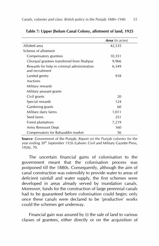
Canals, colonies and class: British policy in the Punjab 1880–1940
55
Table 7: Upper Jhelum Canal Colony, allotment of land, 1925
Area (in acres) Allotted area 42,535 Scheme of allotment
Compensatory grantees 10,351 Ghoripal grantees transferred from Shahpur 9,966 Rewards for help in criminal administration and recruitment
6,349
Landed gentry 918 Auctions Military rewards Military peasant grants Civil grants 20 Special rewards 124 Gardening grants 60 Military dairy farms 1,011 Seed farms 251 Forest plantations 7,219 Army Remount Dept. 160 Compensatory for Bahauddin market 56
Source: Government of the Punjab, Report on the Punjab colonies for the year ending 30th September 1926 (Lahore: Civil and Military Gazette Press, 1926), 70.
The uncertain financial gains of colonisation to the government meant that the colonisation process was postponed till the 1880s. Consequently, although the aim of canal construction was ostensibly to provide water to areas of deficient rainfall and water supply, the first schemes were developed in areas already served by inundation canals. Moreover, funds for the construction of large perennial canals had to be guaranteed before colonisation could begin; only once these canals were declared to be ‘productive’ works could the schemes get underway.
Financial gain was assured by (i) the sale of land to various classes of grantees, either directly or on the acquisition of
Fareeha Zafar
56
proprietary rights; (ii) the sale of canal water, collected in the form of water tax or abiana; and (iii) increased land revenue from the canal-irrigated land. This did not appear to be sufficient, however, and direct sales and auction of colony land became part of future colonisation policy. In the Chunian Colony and its extensions of about 50,000 acres, land was successfully auctioned at Rs50.3 per acre.120 In the Lower Jhelum Canal Colony, because of the emphasis on horse breeding, auctioned land was less than 5 percent of the total allotted area. Although the original plan for the Lower Chenab Canal Colony did not include much land for auction, in its later extensions during the 1920s, even the kamin’s squares were resumed for auction.121 In the extension of the Jhang Colony, more than 50,000 acres were auctioned.122
In the Upper Chenab Canal Colony, the administration proposed disposing of colony land in two ways: (i) by direct sale at Rs50 per acre, payable in instalments; and (ii) at Rs60 per acre, with tenancy conditions for five years, a renewable agreement and the right to purchase in instalments. Wace (1933) reports that,
considerable difficulty, however, was experienced in persuading these grantees to settle down. The land was unpromising and the irrigation inadequate.123
Despite this, according to the 1924 annual report on the colonies, the area auctioned was one third of the allotted land of the colony lying in the Lyallpur district and one quarter of the allotted land in the Gujranwala district.124 The area auctioned rose further in the case of the Lower Bari Doab 120 Wace, Punjab colony manual, 14. 121 A kamin was a village artisan or servant. 122 Government of the Punjab, Report on the Punjab colonies for the year ending 30th September 1925 (Lahore: Civil and Military Gazette Press, 1925), 4, 20. 123 Wace, Punjab colony manual, 21. 124 Government of the Punjab, Punjab colonies, 1925, 6.
Canals, colonies and class: British policy in the Punjab 1880–1940
57
Canal Colony, but it was in the Nili Bar Colony that the auction policy was most unambiguously implemented: more than 50 percent of the colony area was auctioned, as reported in 1924 by the colonisation officer:
The feature of the colonisation scheme which marks it out from previous schemes is the very high proportion of land which it is proposed to sell by auction, the proportion of the total for sale was originally 30 percent, but in the finally sanctioned scheme it accounts to very nearly 50 percent of 90,000 acres.125
In all further extensions of the existing colonies, larger areas were reserved for auction and direct sale.
Expansion of the transport network
The policy of constructing railways was followed rigorously. The location of these railroads on three sides of the triangular Punjab plains, connecting the structure to Delhi at one end and to Peshawar via Lahore at the other, led to the conclusion that:
the purpose for which the Punjab railways have been designed are in only a very minor degree commercial; they are mainly political and military and have indeed avowed inference to the possibility of an invasion from a basis of operations westward of Afghanistan.126
Before 1880, railway construction was the responsibility of the state government. Construction at this stage depended on raising capital through direct borrowings, which entailed heavy expenditure on government. The stipulation of the 125 Wace, Punjab colony manual, 24. 126 William Thomas Thornton, Indian public works and cognate Indian topics (London: Macmillan and Co., 1875), 93.
Fareeha Zafar
58
secretary of state for India requiring ‘productive’ works to yield a minimum return of 4 percent on the capital outlay slowed down the construction of railways for strategic purposes.127 Further railway construction had to await a change in policy with the opening of the canal colonies.
The next stage of railway construction, therefore, was connected to the formation of the Lower Chenab Canal Colony. The Rechna Doab was opened up by the railway passing through its centre and linked to the mainline of the North-Western Railway. As each new colony was formed, railroads were run through the centre of the doabs as well as connecting one doab with the other.128 During 1901 and 1911, most railways constructed were for commercial purposes and this was also the most hectic period of railway construction. In the next decade, the constraints of war and financial stringency resulted in only small extensions to the existing railway network. Between 1921 and 1931, the Lower Bari Doab Railway was reconstructed and other branch lines completed.
Roads followed a similar pattern. The Grand Trunk Road followed the route of the North-Western Railway from Delhi to Lahore and northwards to Peshawar, and was, barring a few exceptions, the only metalled road in the province. Unmetalled roads were more numerous but those serving as feeder roads were poorly maintained129 while the rest could only be traversed by camels, donkeys, horses and mules. The canal banks also afforded passage into the interior of the doabs.
127 Rashid Ahmad Malik, ‘Irrigation development and land occupance in the Upper Indus Basin’ (unpublished PhD thesis, Indiana University, 1963), 5. 128 Abbott, Jhang district, 12. 129 M. F. O’Dwyer, Final report on the revision of the settlement of Gujranwala district, 1889–1894 (Lahore: Civil and Military Gazette Press, 1894), 8.
Canals, colonies and class: British policy in the Punjab 1880–1940
59
As such, interior communications within the districts were very poor. The doabs were crisscrossed by numerous canals and their branches and distributaries, but there were few bridges or ferries across them.130 Village roads constructed using village funds were the worst: many villages were simply cut off from one another during the monsoon season, with internal communications dependent on carts drawn by pack animals. The Punjab canal colony districts were connected with neighbouring provinces by rail and road, through which large quantities of goods were transported eastwards to the northwest provinces and south towards Karachi.131 River traffic, which had flourished at one time, slowly declined, first due to competition from the railways and then once the canals opened up, which lowered the water level in the rivers.132 Consequently, railways displaced the rivers as the main lines of commerce in the Punjab.
Emergence of market towns
Railways and roads were used to link up the mandis formed in the colonies to help collect and export agricultural produce. In each colony, land was reserved for establishing several mandis. In the Lower Jhelum Canal Colony alone,
markets or mandis have been established at certain railway stations, such as Phullarwan, Bhalwal, Sargodha, Sillianwala and Shah Jiwana. These marts have been built to facilitate the export of agricultural produce, and are managed by Committees of Chowdris. The Agents of European Export merchants purchase the produce from traders, middlemen, and
130 Ahmad Hasan Khan, Final settlement report of the canal-irrigated tract of the Gujrat district (Lahore: Superintendent, Government Printing, 1929), 6. 131 Roe, Multan district, 13. 132 Abbott, Jhang district, 13.
Fareeha Zafar
60
cultivators, and despatch their purchases to Karachi or Bombay for export.133
The commercial aspect of the formation of mandis was also evident in that many of the larger grantees in the Lower Chenab Canal Colony did not think it worthwhile to take up the liberal grants they were offered. The colony itself did not become a popular destination with all classes until the railway had been constructed as far as Lyallpur.134
Lyallpur was established as a market town in 1896, followed by Sangla, Chiniot Road and Gojra in 1899, and by Toba Tek Singh in 1900. The growth of these markets “threw the stream of traffic eastwards to the railway instead of westwards to the river as before.”135 The Upper Jhelum Canal Colony gave rise to Mandi Bahauddin, and the Upper Chenab Canal Colony to the towns of Hafizabad, Sangla Hill, Nankana Sahib and Warburton. In the 1920s and 1930s, the Lower Bari Doab Canal Colony was responsible for the establishment of mandis in Arifwala, Okara, Pakpattan and Dipalpur in the district of Montgomery, and the Burewala, Vihari, Dunyapur, Lodhran, Shujabad, Talamaba and Khanewal mandis in the district of Multan. The large number of mandis located along the railways and the emphasis on commercial production meant that peasant families’ production of raw materials and food crops was replaced by the colonists’ commodities produced for the imperial market.
Demographic changes
In the middle of the nineteenth century, the central and western districts of the Punjab – some of which later became the canal colony districts – were sparsely inhabited by small
133 Government of the Punjab, Gazetteer, Lower Jhelum Canal, 34. 134 Wace, Punjab colony manual, 13. 135 Government of the Punjab, Assessment report of the Chenab nehri circle of the Jhang district, May 1904, 10.
Canals, colonies and class: British policy in the Punjab 1880–1940
61
numbers of cultivators and nomadic herders and graziers. Given the nature of their activities, the latter were more mobile and moved freely from district to district, especially in times of famine and scarcity. Even the small cultivators and landless classes made use of this freedom when needed. Limited cultivation owing to the scarcity of rainfall kept the population small, aided by epidemics and other natural calamities.
Population was concentrated in small villages along rivers and other watercourses, while wells gave rise to isolated units of settlement. The eastern districts of Gujrat, Gujranwala and Lahore, having experienced longer periods of stable settlement, combined with rainfall of more than 20 inches, were more densely populated than districts in the dry western part of the Punjab. The perennial canals led to rapid growth in population. Each district served by a canal showed a sharp rise in population in the decade following the construction of canals. The cumulative effect of in-migration by colonists and the resulting natural increase in population became evident after 1921:
The number of persons, who come from outside and settle in the Punjab, or of those who leave the Province, to settle elsewhere, is infinitesimal as compared with the numbers of migrants to canal colonies.136
The policy of inhabiting the colonies with settlers from outside became evident with the formation of the Lower Chenab Canal Colony, or the Chenab Colony as it was called. The colony comprised the whole of the Lyallpur and Jhang districts as well as the Khangah Dogran and Hafizabad tehsils of Gujranwala district. The balance of migration, i.e., the difference between emigration and immigration, showed a
136 Khan, Census of India, 1931, part 1, 118.
Fareeha Zafar
62
gain of 531,697 persons for the Chenab Colony in 1901 from within the Punjab province:
(i) More than 100,000 persons from Sialkot district
(ii) More than 50,000 persons from Jullunder, Montgomery and Amritsar districts
(iii) More than 25,000 persons from Hoshiarpur, Lahore, Gurdaspur and Gujrat districts
(iv) More than 10,000 persons from Ludhiana, Ferozepur and Shahpur districts
As can be seen, emigration to the Chenab Colony was from both noncolony as well as colony districts of the Punjab. Settlers continued to migrate to the colony (later, Lyallpur district) in large numbers throughout the period 1901–31 as the colony expanded. In 1911, the figure for the total number of immigrants in the district was 608,847. The other district that showed net gains from migration during this period was Lahore, but in this case, the migration was driven by colonisation and irrigation as well as the growth of Lahore as the Punjab’s major urban centre. Multan district also gained from immigration during 1891–1931, with the Sidhnai and Lower Bari Doab colonies attracting immigrant settlers from outside the study area as well as other colony districts.
The other canal colony districts showed greater variation in migrant population patterns. Jhang district was the main loser in the balance between emigration and immigration despite increased irrigation and colonisation. It lost a substantial proportion of its population (62,000 persons) during 1891–1931, mostly to the Chenab Colony.
Montgomery followed an almost similar pattern except for a small increase in the balance in 1891, connected with the Sohag-Para Colony, and in 1921, with the formation of the Lower Bari Doab Colony when it gained more than 39,000
Canals, colonies and class: British policy in the Punjab 1880–1940
63
persons. In 1911, Montgomery district lost 65,000 persons to other colonies in the Punjab province, with the Chenab Colony being the major gainer.
In Gujranwala and Shahpur districts, the balance of migration closely followed the colonisation process. Gujranwala was a net gainer between 1901 and 1911, even though it lost to the other Punjab colonies in 1901. The formation of Sheikhupura in 1921 was reflected in an overall loss of population for Gujranwala in 1931. Shahpur district showed a gain in population from migration after 1911, with the formation of the Lower Jhelum Colony when it also received settlers from other colony districts. The total number of immigrants to the colony was 141,073 in 1911. Gujrat district showed a similar trend to Jhang district in that it was a net loser in the balance of migration during 1891–1931. The formation of the Upper Chenab Colony reduced the extent of emigration from the district, but could not reduce effectively the pressure on the land.
Migration to the canal colonies and the movement of population within the Punjab canal colony districts was significant for two reasons. First, it reflected the increased mobility of the agricultural classes, both as a result of colonisation policy as well as the overall impact of irrigation in the region. Second, it provided a basis for the changing class relations in the region apropos of colonisation as against the already settled parts of the districts.
The population of the canal colony districts increased quickly once settlers had migrated to these areas. The growth rates for population and the canal-irrigated areas correspond closely, both showing an upward trend since 1891 across all the Punjab canal colony districts. The percentage variation in population relative to density also reflects clearly the impact of colonisation in the region. The effect of large-scale migration to the Chenab Colony in the district of Lyallpur
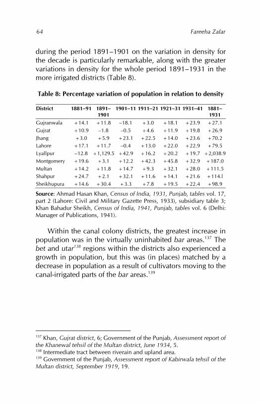
Fareeha Zafar
64
during the period 1891–1901 on the variation in density for the decade is particularly remarkable, along with the greater variations in density for the whole period 1891–1931 in the more irrigated districts (Table 8).
Table 8: Percentage variation of population in relation to density
District 1881–91 1891–1901
1901–11 1911–21 1921–31 1931–41 1881–1931
Gujranwala +14.1 +11.8 –18.1 +3.0 +18.1 +23.9 +27.1 Gujrat +10.9 –1.8 –0.5 +4.6 +11.9 +19.8 +26.9 Jhang +3.0 +5.9 +23.1 +22.5 +14.0 +23.6 +70.2 Lahore +17.1 +11.7 –0.4 +13.0 +22.0 +22.9 +79.5 Lyallpur –12.8 +1,129.5 +42.9 +16.2 +20.2 +19.7 +2,038.9 Montgomery +19.6 +3.1 +12.2 +42.3 +45.8 +32.9 +187.0 Multan +14.2 +11.8 +14.7 +9.3 +32.1 +28.0 +111.5 Shahpur +24.7 +2.1 +32.1 +11.6 +14.1 +21.6 +114.l Sheikhupura +14.6 +30.4 +3.3 +7.8 +19.5 +22.4 +98.9
Source: Ahmad Hasan Khan, Census of India, 1931, Punjab, tables vol. 17, part 2 (Lahore: Civil and Military Gazette Press, 1933), subsidiary table 3; Khan Bahadur Sheikh, Census of India, 1941, Punjab, tables vol. 6 (Delhi: Manager of Publications, 1941).
Within the canal colony districts, the greatest increase in population was in the virtually uninhabited bar areas.137 The bet and utar138 regions within the districts also experienced a growth in population, but this was (in places) matched by a decrease in population as a result of cultivators moving to the canal-irrigated parts of the bar areas.139
137 Khan, Gujrat district, 6; Government of the Punjab, Assessment report of the Khanewal tehsil of the Multan district, June 1934, 5. 138 Intermediate tract between riverain and upland area. 139 Government of the Punjab, Assessment report of Kabirwala tehsil of the Multan district, September 1919, 19.
Chapter 4
Colonial agricultural policy
The British overlooked agriculture in the Punjab for several decades. Compared to the Sikh rulers, who had given all help possible to cultivators in the form of well and canal construction and clearance as well as loans and other forms of assistance (albeit to extract greater revenue), the British administration left cultivators to fend for themselves.140 As a result, the number of wells declined throughout the province, canals and other water cuts and channels were closed for want of clearance and cultivators were forced to turn to the bania to meet their cash requirements, which included payment of the land revenue.141
Production remained more or less static and the condition of peasants deteriorated. Agriculture depended on the success and timely arrival of the monsoon rains or their failure. The areas of barani cultivation were the most susceptible, but even areas of irrigated cultivation expanded or contracted with the volume of water in the rivers, inundation canals and wells. Even more important than the extent of cultivated area was the area on which the crops matured and were finally harvested. Failure, delay, excess and water shortages could all affect the crop at any stage of production.142 While the effects of a year of good harvests could seldom be carried over to the next by a population living at subsistence level, the disasters of bad harvests had a
140 J. H. Morris, Report on the revised settlement of the Goojranwala district in the Lahore division (Lahore: Punjabee Press, 1860), 38. 141 O’Dwyer, Gujranwala district, 25. 142 See Appendix 2 for a chronology of agricultural conditions in the Punjab.
Fareeha Zafar
66
cumulative effect that could plunge the bulk of the rural population into debt, adding to the ranks of the landless.
The perennial canal came as a technical advancement, a break-through in the agricultural practices of the day. Its supremacy over the inundation canal lay in its ability to control the supply of water and thereby provide water during low-rainfall months. The success of the canal also depended, however, on the volume of water in the rivers, and thus, indirectly, a rainfall shortage or excess could still damage agricultural production, albeit to a smaller extent.
Furthermore, the presence of canals encouraged cultivators to plant crops on as much land as possible. Any reduction in canal water supplies, therefore, meant a decrease in the area matured and loss of production. The increase in the cultivated area irrigated by canals was offset partially by a decrease in the cultivated area irrigated by wells and other methods. This complete reliance on canals resulted in the neglect of supplementary means of irrigation vital in a region where conservation and the careful use of water were as critical as its availability. Whereas well and sailaba irrigation had promoted the diligent use of a scarce resource and careful farming that did not deplete the soil of nutrients, canal irrigation prompted the use of water on a lavish scale.143
Agriculture provided the basis for the settlement procedure and the maintenance of land records. The revenue demand was based on the determination of land ownership as well as the amount of production of each crop. With the formation of the canal colonies, the emphasis shifted entirely to increasing crop production. In 1906, the provincial Agricultural Department was reorganised with the aim of conducting the future development of agriculture on scientific lines. The first two
143 Voelcker, Improvement of Indian agriculture, 73.
Canals, colonies and class: British policy in the Punjab 1880–1940
67
decades of the twentieth century saw canals as the major factor of technological advance in agriculture.
Cropping patterns also changed to fit in with the extensive cultivation of wheat, cotton and sugarcane, which emerged as the staple products of the canal colonies. The phenomenal increase in agricultural production and its linkage to international markets caused a shift towards cultivating commercial crops. Market towns or mandis were created to collect and export agricultural produce. Upheavals in the international market affected domestic prices, which in turn had an impact on wages, thereby transforming the economic life of the region.
Extension of cultivation
The immediate result of canal irrigation was to extend the area under cultivation. This manifested itself in two ways: (i) by providing irrigation to areas hitherto unsettled or uncultivated for lack of sufficient water or rainfall; and (ii) by providing water to areas already under cultivation, converting areas from barani to irrigated areas, thereby extending the period during which cultivation could be carried out as well as assuring regular and larger supplies of water to areas irrigated by other means.
Whereas the former affected Crown wasteland and, as such, included the bar sections of the doabs east of the Jhelum, the latter encompassed land already owned by cultivators, which was located between the bars and immediate vicinity of the rivers. Initial experiments with canals in eastern Punjab had not envisaged colonisation; these schemes had been carried out in areas already settled and cultivated, resulting to some extent in more intensive cultivation. The true impact of the canals can best be gauged from the extension of cultivation in the canal colony districts.
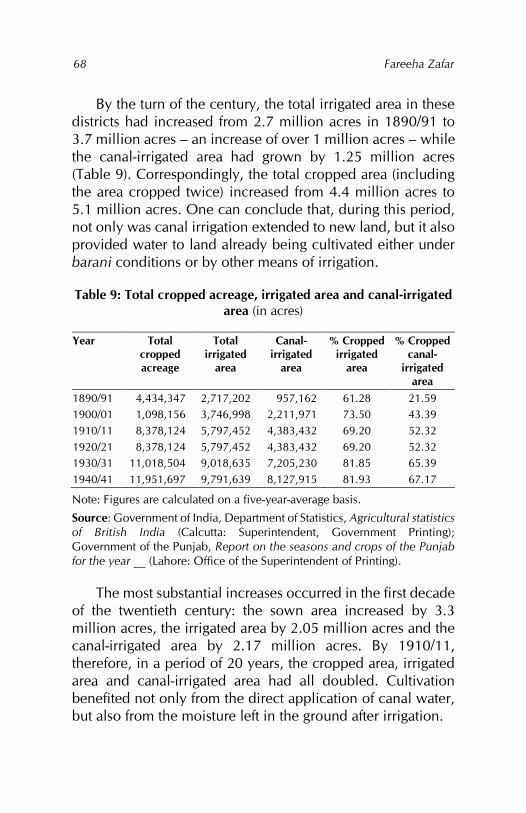
Fareeha Zafar
68
By the turn of the century, the total irrigated area in these districts had increased from 2.7 million acres in 1890/91 to 3.7 million acres – an increase of over 1 million acres – while the canal-irrigated area had grown by 1.25 million acres (Table 9). Correspondingly, the total cropped area (including the area cropped twice) increased from 4.4 million acres to 5.1 million acres. One can conclude that, during this period, not only was canal irrigation extended to new land, but it also provided water to land already being cultivated either under barani conditions or by other means of irrigation.
Table 9: Total cropped acreage, irrigated area and canal-irrigated area (in acres)
Year Total cropped acreage
Total irrigated
area
Canal-irrigated
area
% Cropped irrigated
area
% Cropped canal-
irrigated area
1890/91 4,434,347 2,717,202 957,162 61.28 21.59 1900/01 1,098,156 3,746,998 2,211,971 73.50 43.39 1910/11 8,378,124 5,797,452 4,383,432 69.20 52.32 1920/21 8,378,124 5,797,452 4,383,432 69.20 52.32 1930/31 11,018,504 9,018,635 7,205,230 81.85 65.39 1940/41 11,951,697 9,791,639 8,127,915 81.93 67.17
Note: Figures are calculated on a five-year-average basis.
Source: Government of India, Department of Statistics, Agricultural statistics of British India (Calcutta: Superintendent, Government Printing); Government of the Punjab, Report on the seasons and crops of the Punjab for the year __ (Lahore: Office of the Superintendent of Printing).
The most substantial increases occurred in the first decade of the twentieth century: the sown area increased by 3.3 million acres, the irrigated area by 2.05 million acres and the canal-irrigated area by 2.17 million acres. By 1910/11, therefore, in a period of 20 years, the cropped area, irrigated area and canal-irrigated area had all doubled. Cultivation benefited not only from the direct application of canal water, but also from the moisture left in the ground after irrigation.
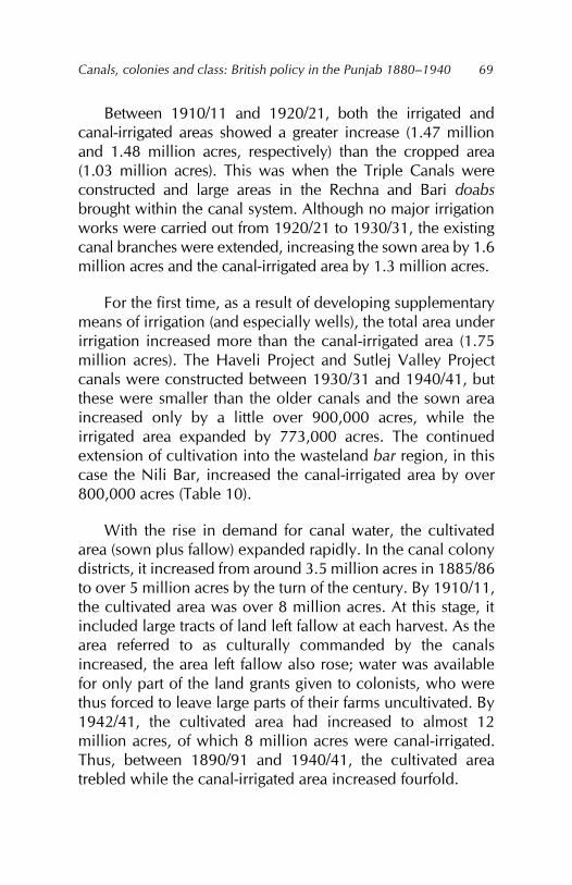
Canals, colonies and class: British policy in the Punjab 1880–1940
69
Between 1910/11 and 1920/21, both the irrigated and canal-irrigated areas showed a greater increase (1.47 million and 1.48 million acres, respectively) than the cropped area (1.03 million acres). This was when the Triple Canals were constructed and large areas in the Rechna and Bari doabs brought within the canal system. Although no major irrigation works were carried out from 1920/21 to 1930/31, the existing canal branches were extended, increasing the sown area by 1.6 million acres and the canal-irrigated area by 1.3 million acres.
For the first time, as a result of developing supplementary means of irrigation (and especially wells), the total area under irrigation increased more than the canal-irrigated area (1.75 million acres). The Haveli Project and Sutlej Valley Project canals were constructed between 1930/31 and 1940/41, but these were smaller than the older canals and the sown area increased only by a little over 900,000 acres, while the irrigated area expanded by 773,000 acres. The continued extension of cultivation into the wasteland bar region, in this case the Nili Bar, increased the canal-irrigated area by over 800,000 acres (Table 10).
With the rise in demand for canal water, the cultivated area (sown plus fallow) expanded rapidly. In the canal colony districts, it increased from around 3.5 million acres in 1885/86 to over 5 million acres by the turn of the century. By 1910/11, the cultivated area was over 8 million acres. At this stage, it included large tracts of land left fallow at each harvest. As the area referred to as culturally commanded by the canals increased, the area left fallow also rose; water was available for only part of the land grants given to colonists, who were thus forced to leave large parts of their farms uncultivated. By 1942/41, the cultivated area had increased to almost 12 million acres, of which 8 million acres were canal-irrigated. Thus, between 1890/91 and 1940/41, the cultivated area trebled while the canal-irrigated area increased fourfold.
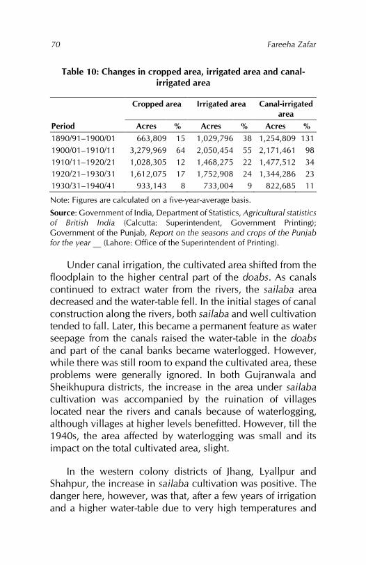
Fareeha Zafar
70
Table 10: Changes in cropped area, irrigated area and canal-irrigated area
Cropped area Irrigated area Canal-irrigated area
Period Acres % Acres % Acres % 1890/91–1900/01 663,809 15 1,029,796 38 1,254,809 131 1900/01–1910/11 3,279,969 64 2,050,454 55 2,171,461 98 1910/11–1920/21 1,028,305 12 1,468,275 22 1,477,512 34 1920/21–1930/31 1,612,075 17 1,752,908 24 1,344,286 23 1930/31–1940/41 933,143 8 733,004 9 822,685 11
Note: Figures are calculated on a five-year-average basis.
Source: Government of India, Department of Statistics, Agricultural statistics of British India (Calcutta: Superintendent, Government Printing); Government of the Punjab, Report on the seasons and crops of the Punjab for the year __ (Lahore: Office of the Superintendent of Printing).
Under canal irrigation, the cultivated area shifted from the floodplain to the higher central part of the doabs. As canals continued to extract water from the rivers, the sailaba area decreased and the water-table fell. In the initial stages of canal construction along the rivers, both sailaba and well cultivation tended to fall. Later, this became a permanent feature as water seepage from the canals raised the water-table in the doabs and part of the canal banks became waterlogged. However, while there was still room to expand the cultivated area, these problems were generally ignored. In both Gujranwala and Sheikhupura districts, the increase in the area under sailaba cultivation was accompanied by the ruination of villages located near the rivers and canals because of waterlogging, although villages at higher levels benefitted. However, till the 1940s, the area affected by waterlogging was small and its impact on the total cultivated area, slight.
In the western colony districts of Jhang, Lyallpur and Shahpur, the increase in sailaba cultivation was positive. The danger here, however, was that, after a few years of irrigation and a higher water-table due to very high temperatures and
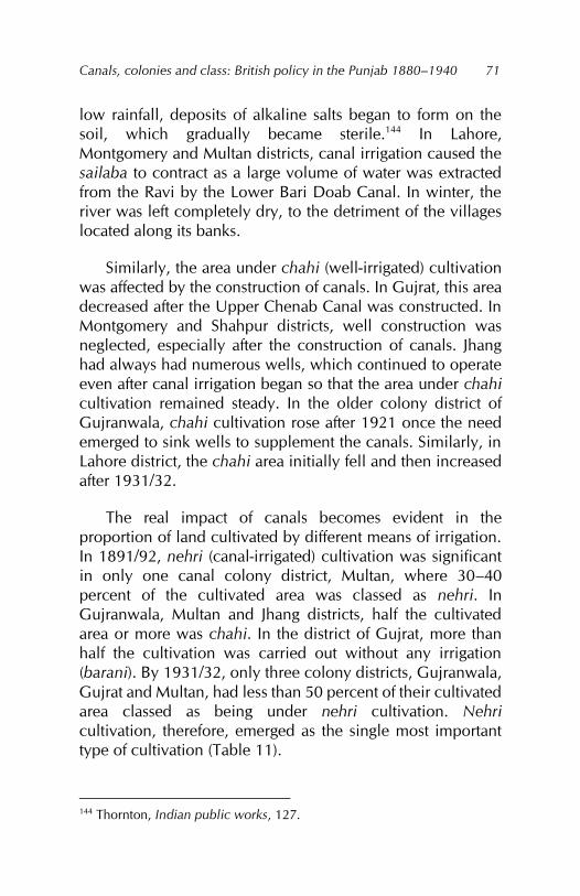
Canals, colonies and class: British policy in the Punjab 1880–1940
71
low rainfall, deposits of alkaline salts began to form on the soil, which gradually became sterile.144 In Lahore, Montgomery and Multan districts, canal irrigation caused the sailaba to contract as a large volume of water was extracted from the Ravi by the Lower Bari Doab Canal. In winter, the river was left completely dry, to the detriment of the villages located along its banks.
Similarly, the area under chahi (well-irrigated) cultivation was affected by the construction of canals. In Gujrat, this area decreased after the Upper Chenab Canal was constructed. In Montgomery and Shahpur districts, well construction was neglected, especially after the construction of canals. Jhang had always had numerous wells, which continued to operate even after canal irrigation began so that the area under chahi cultivation remained steady. In the older colony district of Gujranwala, chahi cultivation rose after 1921 once the need emerged to sink wells to supplement the canals. Similarly, in Lahore district, the chahi area initially fell and then increased after 1931/32.
The real impact of canals becomes evident in the proportion of land cultivated by different means of irrigation. In 1891/92, nehri (canal-irrigated) cultivation was significant in only one canal colony district, Multan, where 30–40 percent of the cultivated area was classed as nehri. In Gujranwala, Multan and Jhang districts, half the cultivated area or more was chahi. In the district of Gujrat, more than half the cultivation was carried out without any irrigation (barani). By 1931/32, only three colony districts, Gujranwala, Gujrat and Multan, had less than 50 percent of their cultivated area classed as being under nehri cultivation. Nehri cultivation, therefore, emerged as the single most important type of cultivation (Table 11).
144 Thornton, Indian public works, 127.
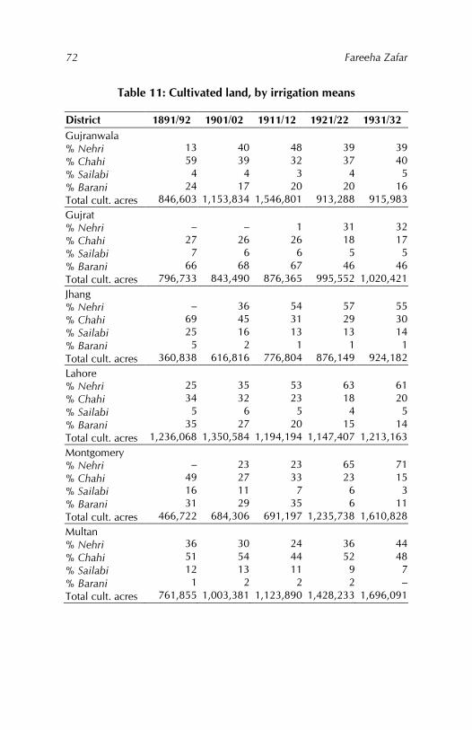
Fareeha Zafar
72
Table 11: Cultivated land, by irrigation means
District 1891/92 1901/02 1911/12 1921/22 1931/32 Gujranwala % Nehri % Chahi % Sailabi % Barani Total cult. acres
13 59
4 24
846,603
40 39
4 17
1,153,834
48 32
3 20
1,546,801
39 37
4 20
913,288
39 40
5 16
915,983 Gujrat % Nehri % Chahi % Sailabi % Barani Total cult. acres
–
27 7
66 796,733
–
26 6
68 843,490
1
26 6
67 876,365
31 18
5 46
995,552
32 17
5 46
1,020,421 Jhang % Nehri % Chahi % Sailabi % Barani Total cult. acres
–
69 25
5 360,838
36 45 16
2 616,816
54 31 13
1 776,804
57 29 13
1 876,149
55 30 14
1 924,182
Lahore % Nehri % Chahi % Sailabi % Barani Total cult. acres
25 34
5 35
1,236,068
35 32
6 27
1,350,584
53 23
5 20
1,194,194
63 18
4 15
1,147,407
61 20
5 14
1,213,163 Montgomery % Nehri % Chahi % Sailabi % Barani Total cult. acres
–
49 16 31
466,722
23 27 11 29
684,306
23 33
7 35
691,197
65 23
6 6
1,235,738
71 15
3 11
1,610,828 Multan % Nehri % Chahi % Sailabi % Barani Total cult. acres
36 51 12
1 761,855
30 54 13
2 1,003,381
24 44 11
2 1,123,890
36 52
9 2
1,428,233
44 48
7 –
1,696,091
Canals, colonies and class: British policy in the Punjab 1880–1940
73
District 1891/92 1901/02 1911/12 1921/22 1931/32 Shahpur % Nehri % Chahi % Sailabi % Barani Total cult. acres
13 36 10 41
653,621
19 29
8 44
789,286
60 11
5 23
1,237,194
57 10
5 29
1,399,714
53
9 5
33 1,564,045
Sheikhupura % Nehri % Chahi % Sailabi % Barani Total cult. acres
– – – – –
– – – – –
– – – – –
74 15
3 8
1,074,320
72 16
3 8
988,370
Note: Figures below 1 percent are not included.
Source: Government of the Punjab, Report on the land revenue administration of the Punjab for the agricultural year ending 30th September 1892 (Lahore: Civil and Military Gazette Press, 1892); Government of the Punjab, Punjab district gazetteers for 1901/02 to 1931/32 (Lahore: Civil and Military Gazette Press).
That chahi cultivation reportedly accounted for 40–50 percent of the cultivated area in districts such as Multan and 20–40 percent in Gujranwala is explained by the fact that the revenue reports classed all types of chahi land (such as chahi-nehri, chahi-abi and chahi-sailabi) together. As a result, the area under chahi cultivation was over-reported and the area under nehri cultivation, in particular, under-reported. Only in Gujrat did barani cultivation account for over 40–50 percent of the total cultivated area.
While changes in the type of cultivated land were taking place, the government let out large areas in the colonies that had not been brought under permanent perennial irrigation or where the water supply was still deficient and more canal branches and channels had to constructed. This land was let out to tenants for temporary cultivation. The practice increased as colonisation was extended to all the doabs so that the culturable commanded area of the canals remained larger than the area irrigable. In 1932, approximately 10 percent of
Fareeha Zafar
74
the permanently allotted area in the colonies was under temporary cultivation. Lack of water resulted in greater crop failure and the kharaba (percentage failure) allowed on temporarily cultivated land was at least twice that for land under permanent cultivation.145
In the early stages of canal construction, the rationale for letting out land for temporary cultivation was connected to the shortage of water. Later, this continued when the government found it could not auction off such land146 or when it had to provide for inhabitants of waterlogged areas. Such persons were given land they could cultivate temporarily while their village land was undergoing reclamation. However, since the land was leased for only a year, tenants were unable to reap the reward of their investment or care of the land, and the practice resulted in the poor use of all such land.147 Additionally, only part of the land allotted was actually cultivated as land revenue was charged only on the land under crops.
Transformation of cropping patterns
Before colonisation, crop loss was largely due to the deficiency or excess of moisture throughout the Punjab. Rainfall was capricious, both in amount and distribution. Moisture deficiency, when it occurred, meant that the area sown would shrink or that the growing crop would fail; in bad seasons, it resulted in both. If the rains failed at seed time, the unirrigated land marked the extent to which the sown area had shrunk, but well-irrigated crops were also affected. Heavy rainfall was harmful to crops cultivated on light, sandy soils, although it
145 Government of the Punjab, Report on the Punjab colonies for the year ending 30th September 1932 (Lahore: Civil and Military Gazette Press, 1932). 146 Government of the Punjab, Report on the Punjab colonies for the year ending 30th September 1933 (Lahore: Civil and Military Gazette Press, 1933), 29. 147 Trevaskis, Punjab of today, 285.
Canals, colonies and class: British policy in the Punjab 1880–1940
75
improved the chances of the rabi harvest.148 Specialised crops such as indigo, sugarcane and vegetables were grown mostly on well-irrigated land in small, carefully manured fields. Farmers also followed scientific methods in cultivating and tilling their land: this included ploughing the land repeatedly, using manure, crop rotation, cultivating special crops to improve soil fertility and preparing dofasli (double-cropped) land where conditions permitted.149
Pressure on the land was low, so most cultivation was single-cropped, with rabi and kharif harvests alternating on the same land, allowing it to remain fallow for several months. Almost all land remained fallow for one year out of three. The best lands around cities and villages were most intensively cultivated, producing between three to four crops a year of vegetables and grain, and good yields of rice, poppy, indigo, tobacco, sugarcane and cotton from small, heavily manured fields irrigated mainly by wells and in some areas by canals.150 The tail of the canal was the choicest area for cultivation, where the level of the canal was above the land and flush irrigation was possible simply by making small cuts or paggu in the sides of the canal. Indigo, as the major revenue-earning crop, was widely cultivated on such land and its production increased after inundation canals were built in Multan district under the administration of Diwan Sawan Mull.151
The rabi staples were wheat and barley, their cultivation depending heavily on the monsoon rains and in the case of wheat also on irrigation. The kharif staples – cotton, millet (bajra and jowar), rice, pulses (moong, moth, maash) and
148 James McCrone Douie, Punjab land administration manual (Lahore: Civil and Military Gazette Press, 1908), 88. 149 Habib, Agrarian system, 26; Government of the Punjab, Administration, 1849–50, 7. 150 Monckton, Jhung district, appendix B, 1–2. 151 J. H. Morris, Report of the revised settlement of the Mooltan district, 1860 (Lahore: Government of the Punjab, 1860), appendix F.
Fareeha Zafar
76
indigo – depended almost entirely on irrigation, although bajra, jowar and pulses also grew under barani conditions in the northern districts as did cotton under special conditions.152 The spontaneous growth of fruit trees, especially dates, along the riverbanks and in groves around wells not only added to the cultivators’ diet, but were also an important item of trade.153 The choice of crops cultivated varied with the incidence of rainfall, soil conditions and market demand.154
As part of the crop rotation, fodder crops such as charri (a kharif crop) and turnips (a rabi crop) were cultivated in the sailaba and bet zones, where cattle were brought from the bar in the hot summer. Besides this, every village had almost half its area as wasteland where free grazing was possible during the rainy season.155 The area under cultivation in the canal colony districts at this stage comprised very small tracts of culturable wasteland and the wide swathes of the bars covered with grass and open jungle supported an immense number of animals.156 So important was herding that, in years of scarce rainfall, the area under valuable crops was sacrificed to fodder crops.157 Many of the bar areas were surplus producers of ghee (butter), milk and wool, and these products were traded regularly for food crops in low-lying areas. This trading pattern was also followed between the drier western districts and the more cultivated, settled districts in eastern Punjab.
As the canals extended to the interior of the doabs, fears expressed as far back as 1849 regarding the availability of the bars’ vast grazing and forest areas materialised. The government had proposed reserving at least 20 percent of the
152 Ouseley and Davies, Shahpoor district, 23. 153 Monckton, Jhung district, appendix E, 30. 154 Ouseley and Davies, Shahpoor district, 20. 155 Monckton, Jhung district, 29. 156 B. H. Baden-Powell, The land-systems of British India, vol. 2 (1892; reprint, Delhi: Oriental Publishers, 1974), 11, 536. 157 Douie, Punjab land administration, 190.
Canals, colonies and class: British policy in the Punjab 1880–1940
77
gross area of each village in the canal colonies as chargah (grazing and fuel reserve land). This was reduced to 10 percent in practice and consisted of the worst land, as such, serving neither purpose.158 At the same time, the graziers and nomads who inhibited the bar areas – having developed an economy that combined animal rearing with some wheat cultivation in suitable areas – were forced to adapt to more intensive means of cultivation. Given that they were unfamiliar with this, agricultural practice suffered.159 This was particularly true of the districts to the west of Lyallpur, where pastoralism was more suited to areas with low rainfall (15 inches) and light, sandy soils.
Cultivation in these western canal districts also suffered by virtue of their location at the tail-end of the large canals where regular and adequate water supplies were always a problem. Moreover, the scarcity of water reduced the cultivation of fodder and the number of animals declined steadily. With the reduction of grazing land in the canal colonies, the volume of twigs and leaves used for manuring also decreased.
The area left fallow at every harvest also declined as canal irrigation demanded more intensive use of land. Changes in the cropping pattern and crop rotation further exhausted the soil, and the export of bones, hides and skins on the one hand and oilseeds on the other removed a valuable source of manure from the Punjab.160 Although other factors, such as the pressure of population and the decrease in the size of holdings, were also responsible, the availability of canal water and the associated need to make canals profitable resulted in the maximum use of the land. Fallowing, as a part of the
158 Government of the Punjab, Colonies Committee, 30. 159 Malcolm Lyall Darling, Rusticus loquitur, or the old light and the new in the Punjab village (London: Oxford University Press, 1930), 238. 160 Voelcker, Improvement of Indian agriculture, 103.
Fareeha Zafar
78
rotation system, thus slowly declined.161 Some writers consider this an indication of the move towards intensive farming.162 If it was so, however, it was a spontaneous response to the changing agrarian environment as a result of canal irrigation. While over 50 percent of the sailaba and bet were under cultivation, the percentage fell considerably in the bangar and bar areas.
Fallowing could not disappear from the cropping pattern because of the continued dependency on rainfall. While the cultivated area was fast extending into the wastelands, the area left fallow increased.163 Larger areas were left fallow where there were not enough water channels, but these were included in the cultivated area of the canal colonies. The area left fallow increased from 12.2 percent (of the cultivated area) in 1890/91 to almost 18 percent by 1920/21. It was only after 1921, when most of the best land had been brought under the plough and new varieties of wheat and cotton became popular that the extent of fallow land decreased substantially. By 1940/41, fallow land constituted only 10 percent of the cultivated land (Table 12).
On the other hand, the availability of irrigation water during the dry part of the year increased the area that was double-cropped. While there was relatively little change in the proportion of area sown more than once to the total area sown, the average area double-cropped almost trebled between 1890/91 and 1910/11; by 1940/41, it was more than 1.5 million acres (Table 13). While most of this increase was
161 K. S. Ahmad, ‘The agricultural geography of the Punjab’ (unpublished PhD thesis, University of London, 1939), 6. 162 Clive J. Dewey, ‘The official mind and the problem of agrarian indebtedness in India, 1870–1910 (unpublished PhD thesis, University of Cambridge, 1972), 3. 163 Statistics for fallow land are exceptionally unreliable: sometimes, land left uncultivated for three years was considered fallow and sometimes it was included under ‘culturable waste’.
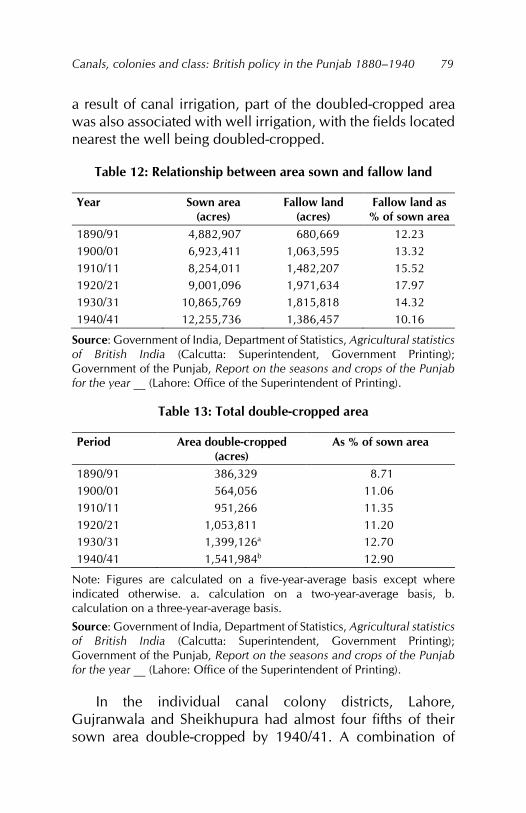
Canals, colonies and class: British policy in the Punjab 1880–1940
79
a result of canal irrigation, part of the doubled-cropped area was also associated with well irrigation, with the fields located nearest the well being doubled-cropped.
Table 12: Relationship between area sown and fallow land
Year Sown area (acres)
Fallow land (acres)
Fallow land as % of sown area
1890/91 4,882,907 680,669 12.23 1900/01 6,923,411 1,063,595 13.32 1910/11 8,254,011 1,482,207 15.52 1920/21 9,001,096 1,971,634 17.97 1930/31 10,865,769 1,815,818 14.32 1940/41 12,255,736 1,386,457 10.16
Source: Government of India, Department of Statistics, Agricultural statistics of British India (Calcutta: Superintendent, Government Printing); Government of the Punjab, Report on the seasons and crops of the Punjab for the year __ (Lahore: Office of the Superintendent of Printing).
Table 13: Total double-cropped area
Period Area double-cropped (acres)
As % of sown area
1890/91 386,329 8.71 1900/01 564,056 11.06 1910/11 951,266 11.35 1920/21 1,053,811 11.20 1930/31 1,399,126a 12.70 1940/41 1,541,984b 12.90
Note: Figures are calculated on a five-year-average basis except where indicated otherwise. a. calculation on a two-year-average basis, b. calculation on a three-year-average basis.
Source: Government of India, Department of Statistics, Agricultural statistics of British India (Calcutta: Superintendent, Government Printing); Government of the Punjab, Report on the seasons and crops of the Punjab for the year __ (Lahore: Office of the Superintendent of Printing).
In the individual canal colony districts, Lahore, Gujranwala and Sheikhupura had almost four fifths of their sown area double-cropped by 1940/41. A combination of
Fareeha Zafar
80
canal irrigation, well irrigation and heavier rainfall compared to the other canal colony districts appear to be the reason for this increase. For the other districts, the increases were smaller. In terms of the actual area sown more than once, Montgomery registered an increase of more than 200,000 acres between 1890/91 and 1940/41, with Multan, Gujranwala and Sheikhupura districts following close behind. Between 1910/11 and 1940/41, the district of Lyallpur, with over 98 percent of its cultivated area under canal irrigation, actually experienced a decline in the area double-cropped, reflecting the often wasteful use of water from the Lower Chenab Canal.
Crop rotation varied not only with the type of soil, but also with the source of irrigation water.164 In the canal colonies, however, wheat and cotton were most commonly rotated, the former being the most profitable rabi crop and the latter the most valuable kharif crop. A rotation system based entirely on the cultivation of wheat and cotton (with a short fallow period in between) was by no means the best option – there was not enough time to prepare the soil for cotton – but peasant cultivators with small holdings had practically no choice in the matter.
The main zaid (extra) kharif crop was oilseeds; from the different varieties grown in the Punjab, toria (rapeseed) fitted best into the rotation pattern with American cotton and wheat. Its cultivation increased with the growth of the canal colonies, its advantage being that it was harvested at the time the kharif revenue had to be paid, thus fitting perfectly into the system of cash crop cultivation. Other cereals apart from wheat, such as bajra, jowar and maize, were grown largely for use as fodder crops; charri (bajra cut in its green state) was the most popular in the canal colonies and was also a source of food in times of scarcity. However, the consumption of wheat increased at the
164 Ahmad, ‘Agricultural geography,’ 382.
Canals, colonies and class: British policy in the Punjab 1880–1940
81
expense of other food grains and, together with gram and pulses, became people’s staple diet.
For the canal to pay its way and bring in land revenue, preference was given to cash crops such as cotton, sugarcane, oilseeds and wheat, all of which required frequent watering.165 The Punjab soil needed slow watering and the excessive use of canal water in the initial stages produced large patches of alkali land within a few years so that the productivity of the soil began to decline.166 The cultivation of other crops such as rice, maize and senji (clover), which also required more water, was restricted mainly to well-irrigated land. Gram, which as a crop enriched the soil, was cultivated only as a barani crop even though it could benefit from the moisture left in the soil after an irrigated crop. Meanwhile, canal irrigation was being carried out to its maximum, with plans to provide water for 75 percent cropping intensity being replaced by 100 percent intensity in most colony districts. To ensure this intensity, it was necessary to restrict the cultivation of crops that required large amounts of water to areas irrigated by kharif channels and wells. These included sugarcane, maize, toria, charri and vegetables.
Changes in the cropping pattern, combined with the depletion of natural manure sources, could have proved disastrous to the fertility of the soil but for the increased role of fodder crops in the rotation system. This was driven by several factors: (i) the reduction of grazing grounds; (ii) the compulsory rearing of mules, camels and horses in the colonies; and (iii) the demand for milk by the growing market towns established in the colony districts to collect and export agricultural produce for the colonial government.
Fodder crops were cut from the top and their roots ploughed back into the soil: green manuring was thus the
165 Trevaskis, Punjab of today, 235. 166 Trevaskis, Punjab of today, 301.
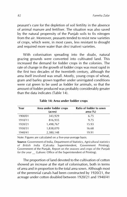
Fareeha Zafar
82
peasant’s cure for the depletion of soil fertility in the absence of animal manure and fertiliser. The situation was also saved by the natural propensity of the Punjab soils to fix nitrogen from the air. Moreover, peasants tended to resist new varieties of crops, which were, in most cases, less resistant to drought and required more water than desi (native) varieties.
With colonisation spreading into the doabs, natural grazing grounds were converted into cultivated land. This increased the demand for fodder crops in the colonies. The rate of change in the growth of fodder crops was most rapid in the first two decades of the twentieth century, although the area itself involved was small. Mostly, young crops of wheat, gram and barley grown together under unirrigated conditions were cut green to be used as fodder for animals, so that the amount of fodder produced was probably considerably greater than the data indicates (Table 14).
Table 14: Area under fodder crops
Year Area under fodder crops (acres)
Ratio of fodder to sown area (%)
1900/01 343,929 6.75 1910/11 816,935 9.75 1920/21 1,498,767 15.93 1930/31 1,838,070 16.68 1940/41 2,380,148 19.91
Note: Figures are calculated on a five-year-average basis.
Source: Government of India, Department of Statistics, Agricultural statistics of British India (Calcutta: Superintendent, Government Printing); Government of the Punjab, Report on the seasons and crops of the Punjab for the year __ (Lahore: Office of the Superintendent of Printing).
The proportion of land devoted to the cultivation of cotton showed an increase at the start of colonisation, both in terms of area and in proportion to the total area sown. Although most of the perennial canals had been constructed by 1920/21, the acreage under cotton doubled between 1920/21 and 1940/41
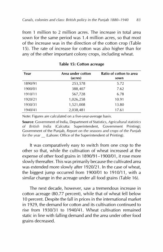
Canals, colonies and class: British policy in the Punjab 1880–1940
83
from 1 million to 2 million acres. The increase in total area sown for the same period was 1.4 million acres, so that most of the increase was in the direction of the cotton crop (Table 15). The rate of increase for cotton was also higher than for any of the other important colony crops, including wheat.
Table 15: Cotton acreage
Year Area under cotton (acres)
Ratio of cotton to area sown
1890/91 253,578 5.72 1900/01 388,407 7.62 1910/11 567,728 6.78 1920/21 1,026,258 10.91 1930/31 1,521,008 13.80 1940/41 2,038,481 17.61
Note: Figures are calculated on a five-year-average basis.
Source: Government of India, Department of Statistics, Agricultural statistics of British India (Calcutta: Superintendent, Government Printing); Government of the Punjab, Report on the seasons and crops of the Punjab for the year __ (Lahore: Office of the Superintendent of Printing).
It was comparatively easy to switch from one crop to the other so that, while the cultivation of wheat increased at the expense of other food grains in 1890/91–1900/01, it rose more slowly thereafter. This was primarily because the cultivated area was extended more slowly after 1920/21. In the case of wheat, the biggest jump occurred from 1900/01 to 1910/11, with a similar change in the acreage under all food grains (Table 16).
The next decade, however, saw a tremendous increase in cotton acreage (80.77 percent), while that of wheat fell below 10 percent. Despite the fall in prices in the international market in 1929, the demand for cotton and its cultivation continued to rise from 1930/31 to 1940/41. Wheat cultivation remained static in line with falling demand and the area under other food grains decreased.
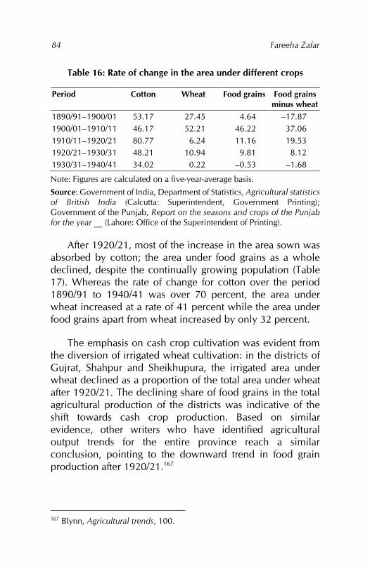
Fareeha Zafar
84
Table 16: Rate of change in the area under different crops
Period Cotton Wheat Food grains Food grains minus wheat
1890/91–1900/01 53.17 27.45 4.64 –17.87 1900/01–1910/11 46.17 52.21 46.22 37.06 1910/11–1920/21 80.77 6.24 11.16 19.53 1920/21–1930/31 48.21 10.94 9.81 8.12 1930/31–1940/41 34.02 0.22 –0.53 –1.68
Note: Figures are calculated on a five-year-average basis.
Source: Government of India, Department of Statistics, Agricultural statistics of British India (Calcutta: Superintendent, Government Printing); Government of the Punjab, Report on the seasons and crops of the Punjab for the year __ (Lahore: Office of the Superintendent of Printing).
After 1920/21, most of the increase in the area sown was absorbed by cotton; the area under food grains as a whole declined, despite the continually growing population (Table 17). Whereas the rate of change for cotton over the period 1890/91 to 1940/41 was over 70 percent, the area under wheat increased at a rate of 41 percent while the area under food grains apart from wheat increased by only 32 percent.
The emphasis on cash crop cultivation was evident from the diversion of irrigated wheat cultivation: in the districts of Gujrat, Shahpur and Sheikhupura, the irrigated area under wheat declined as a proportion of the total area under wheat after 1920/21. The declining share of food grains in the total agricultural production of the districts was indicative of the shift towards cash crop production. Based on similar evidence, other writers who have identified agricultural output trends for the entire province reach a similar conclusion, pointing to the downward trend in food grain production after 1920/21.167
167 Blynn, Agricultural trends, 100.
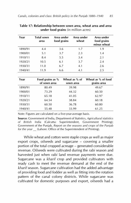
Canals, colonies and class: British policy in the Punjab 1880–1940
85
Table 17: Relationship between sown area, wheat area and area under food grains (in million acres)
Year Total sown area
Area under food grains
Area under wheat
Area under food grains
minus wheat 1890/91 4.4 3.6 1.7 1.9 1900/01 5.1 3.7 2.3 1.4 1910/11 8.4 5.5 3.4 2.1 1920/21 10.5 6.1 3.7 2.4 1930/31 11.0 6.7 4.1 2.6 1940/41 11.9 6.6 4.1 2.5
Year Food grains as %
of sown area Wheat as % of
sown area Wheat as % of food
grains area 1890/91 80.49 39.98 49.67 1900/01 73.29 44.32 60.50 1910/11 65.18 41.05 62.97 1920/21 64.54 38.84 60.18 1930/31 60.50 36.78 60.80 1940/41 55.48 33.99 61.25
Note: Figures are calculated on a five-year-average basis.
Source: Government of India, Department of Statistics, Agricultural statistics of British India (Calcutta: Superintendent, Government Printing); Government of the Punjab, Report on the seasons and crops of the Punjab for the year __ (Lahore: Office of the Superintendent of Printing).
While wheat and cotton were staple crops as well as major export crops, oilseeds and sugarcane – covering a smaller portion of the total cropped acreage – generated considerable revenue. Oilseeds were cultivated during the rabi season and harvested just when rabi land revenue payments were due. Sugarcane was a kharif crop and provided cultivators with ready cash to meet the revenue demand at the end of the kharif season. Sugarcane cultivation had the added advantage of providing food and fodder as well as fitting into the rotation pattern of the canal colony districts. While sugarcane was cultivated for domestic purposes and export, oilseeds had a
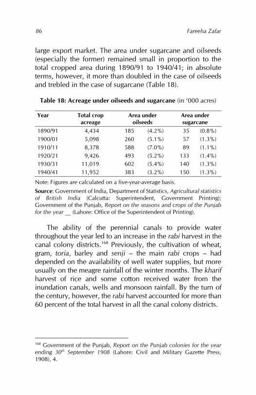
Fareeha Zafar
86
large export market. The area under sugarcane and oilseeds (especially the former) remained small in proportion to the total cropped area during 1890/91 to 1940/41; in absolute terms, however, it more than doubled in the case of oilseeds and trebled in the case of sugarcane (Table 18).
Table 18: Acreage under oilseeds and sugarcane (in ‘000 acres)
Year Total crop acreage
Area under oilseeds
Area under sugarcane
1890/91 4,434 185 (4.2%) 35 (0.8%) 1900/01 5,098 260 (5.1%) 57 (1.3%) 1910/11 8,378 588 (7.0%) 89 (1.1%) 1920/21 9,426 493 (5.2%) 133 (1.4%) 1930/31 11,019 602 (5.4%) 140 (1.3%) 1940/41 11,952 383 (3.2%) 150 (1.3%)
Note: Figures are calculated on a five-year-average basis.
Source: Government of India, Department of Statistics, Agricultural statistics of British India (Calcutta: Superintendent, Government Printing); Government of the Punjab, Report on the seasons and crops of the Punjab for the year __ (Lahore: Office of the Superintendent of Printing).
The ability of the perennial canals to provide water throughout the year led to an increase in the rabi harvest in the canal colony districts.168 Previously, the cultivation of wheat, gram, toria, barley and senji – the main rabi crops – had depended on the availability of well water supplies, but more usually on the meagre rainfall of the winter months. The kharif harvest of rice and some cotton received water from the inundation canals, wells and monsoon rainfall. By the turn of the century, however, the rabi harvest accounted for more than 60 percent of the total harvest in all the canal colony districts.
168 Government of the Punjab, Report on the Punjab colonies for the year ending 30th September 1908 (Lahore: Civil and Military Gazette Press, 1908), 4.
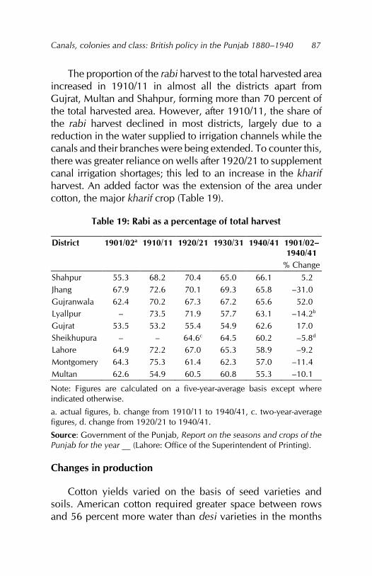
Canals, colonies and class: British policy in the Punjab 1880–1940
87
The proportion of the rabi harvest to the total harvested area increased in 1910/11 in almost all the districts apart from Gujrat, Multan and Shahpur, forming more than 70 percent of the total harvested area. However, after 1910/11, the share of the rabi harvest declined in most districts, largely due to a reduction in the water supplied to irrigation channels while the canals and their branches were being extended. To counter this, there was greater reliance on wells after 1920/21 to supplement canal irrigation shortages; this led to an increase in the kharif harvest. An added factor was the extension of the area under cotton, the major kharif crop (Table 19).
Table 19: Rabi as a percentage of total harvest
District 1901/02a 1910/11 1920/21 1930/31 1940/41 1901/02–1940/41
% Change Shahpur 55.3 68.2 70.4 65.0 66.1 5.2 Jhang 67.9 72.6 70.1 69.3 65.8 –31.0 Gujranwala 62.4 70.2 67.3 67.2 65.6 52.0 Lyallpur – 73.5 71.9 57.7 63.1 –14.2b Gujrat 53.5 53.2 55.4 54.9 62.6 17.0 Sheikhupura – – 64.6c 64.5 60.2 –5.8d Lahore 64.9 72.2 67.0 65.3 58.9 –9.2 Montgomery 64.3 75.3 61.4 62.3 57.0 –11.4 Multan 62.6 54.9 60.5 60.8 55.3 –10.1
Note: Figures are calculated on a five-year-average basis except where indicated otherwise.
a. actual figures, b. change from 1910/11 to 1940/41, c. two-year-average figures, d. change from 1920/21 to 1940/41.
Source: Government of the Punjab, Report on the seasons and crops of the Punjab for the year __ (Lahore: Office of the Superintendent of Printing).
Changes in production
Cotton yields varied on the basis of seed varieties and soils. American cotton required greater space between rows and 56 percent more water than desi varieties in the months
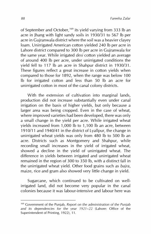
Fareeha Zafar
88
of September and October,169 its yield varying from 333 lb an acre in Jhang with light sandy soils in 1930/31 to 567 lb per acre in Gujranwala district where the soil was a heavier clayey loam. Unirrigated American cotton yielded 240 lb per acre in Lahore district compared to 300 lb per acre in Gujranwala for the same year. While irrigated desi cotton yielded an average of around 400 lb per acre, under unirrigated conditions the yield fell to 117 lb an acre in Shahpur district in 1930/31. These figures reflect a great increase in cotton yields when compared to those for 1892, when the range was below 100 lb for irrigated cotton and less than 50 lb an acre for unirrigated cotton in most of the canal colony districts.
With the extension of cultivation into marginal lands, production did not increase substantially even under canal irrigation on the basis of higher yields, but only because a larger area was being cropped. Even in the case of wheat, where improved varieties had been developed, there was only a small change in the yield per acre. While irrigated wheat yields increased from 1,000 lb to 1,100 lb an acre, between 1910/11 and 1940/41 in the district of Lyallpur, the change in unirrigated wheat yields was only from 480 lb to 500 lb an acre. Districts such as Montgomery and Shahpur, while recording small increases in the yield of irrigated wheat, showed a decline in the yield of unirrigated wheat. The difference in yields between irrigated and unirrigated wheat remained in the region of 300 to 350 lb, with a distinct fall in the unirrigated wheat yield. Other food grains such as bajra, maize, rice and gram also showed very little change in yield.
Sugarcane, which continued to be cultivated on well-irrigated land, did not become very popular in the canal colonies because it was labour-intensive and labour here was
169 Government of the Punjab, Report on the administration of the Punjab and its dependencies for the year 1921–22 (Lahore: Office of the Superintendent of Printing, 1922), 11.
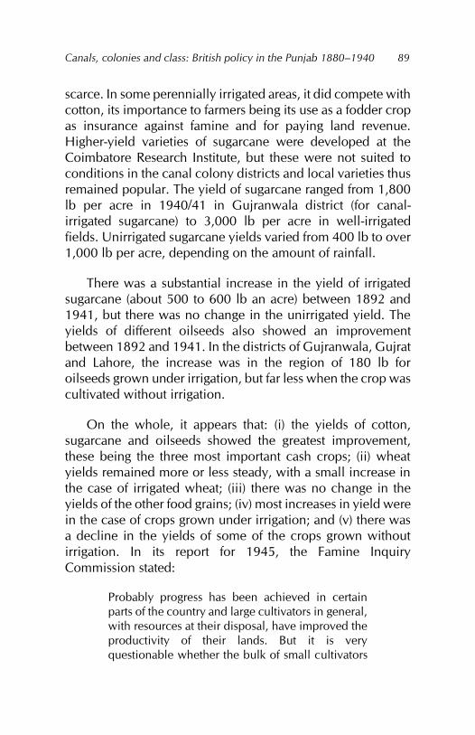
Canals, colonies and class: British policy in the Punjab 1880–1940
89
scarce. In some perennially irrigated areas, it did compete with cotton, its importance to farmers being its use as a fodder crop as insurance against famine and for paying land revenue. Higher-yield varieties of sugarcane were developed at the Coimbatore Research Institute, but these were not suited to conditions in the canal colony districts and local varieties thus remained popular. The yield of sugarcane ranged from 1,800 lb per acre in 1940/41 in Gujranwala district (for canal-irrigated sugarcane) to 3,000 lb per acre in well-irrigated fields. Unirrigated sugarcane yields varied from 400 lb to over 1,000 lb per acre, depending on the amount of rainfall.
There was a substantial increase in the yield of irrigated sugarcane (about 500 to 600 lb an acre) between 1892 and 1941, but there was no change in the unirrigated yield. The yields of different oilseeds also showed an improvement between 1892 and 1941. In the districts of Gujranwala, Gujrat and Lahore, the increase was in the region of 180 lb for oilseeds grown under irrigation, but far less when the crop was cultivated without irrigation.
On the whole, it appears that: (i) the yields of cotton, sugarcane and oilseeds showed the greatest improvement, these being the three most important cash crops; (ii) wheat yields remained more or less steady, with a small increase in the case of irrigated wheat; (iii) there was no change in the yields of the other food grains; (iv) most increases in yield were in the case of crops grown under irrigation; and (v) there was a decline in the yields of some of the crops grown without irrigation. In its report for 1945, the Famine Inquiry Commission stated:
Probably progress has been achieved in certain parts of the country and large cultivators in general, with resources at their disposal, have improved the productivity of their lands. But it is very questionable whether the bulk of small cultivators
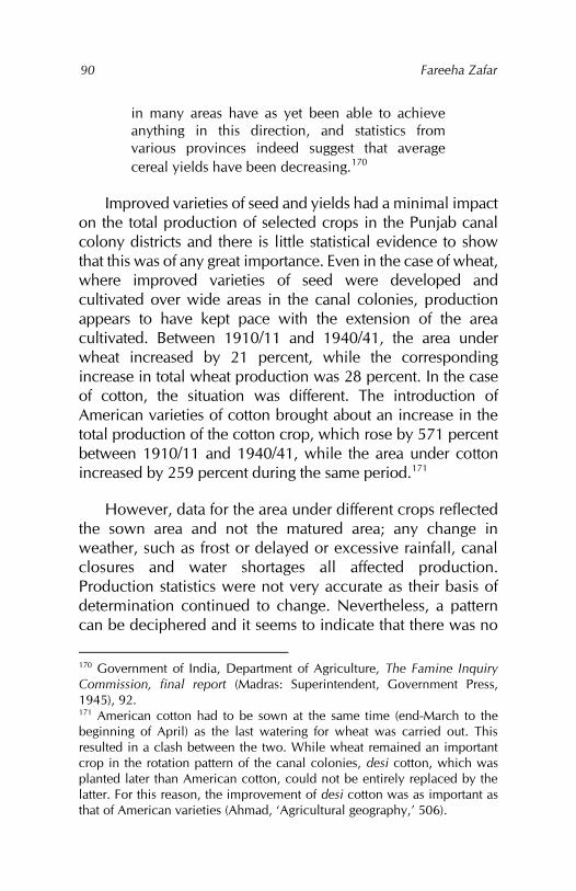
Fareeha Zafar
90
in many areas have as yet been able to achieve anything in this direction, and statistics from various provinces indeed suggest that average cereal yields have been decreasing.170
Improved varieties of seed and yields had a minimal impact on the total production of selected crops in the Punjab canal colony districts and there is little statistical evidence to show that this was of any great importance. Even in the case of wheat, where improved varieties of seed were developed and cultivated over wide areas in the canal colonies, production appears to have kept pace with the extension of the area cultivated. Between 1910/11 and 1940/41, the area under wheat increased by 21 percent, while the corresponding increase in total wheat production was 28 percent. In the case of cotton, the situation was different. The introduction of American varieties of cotton brought about an increase in the total production of the cotton crop, which rose by 571 percent between 1910/11 and 1940/41, while the area under cotton increased by 259 percent during the same period.171
However, data for the area under different crops reflected the sown area and not the matured area; any change in weather, such as frost or delayed or excessive rainfall, canal closures and water shortages all affected production. Production statistics were not very accurate as their basis of determination continued to change. Nevertheless, a pattern can be deciphered and it seems to indicate that there was no
170 Government of India, Department of Agriculture, The Famine Inquiry Commission, final report (Madras: Superintendent, Government Press, 1945), 92. 171 American cotton had to be sown at the same time (end-March to the beginning of April) as the last watering for wheat was carried out. This resulted in a clash between the two. While wheat remained an important crop in the rotation pattern of the canal colonies, desi cotton, which was planted later than American cotton, could not be entirely replaced by the latter. For this reason, the improvement of desi cotton was as important as that of American varieties (Ahmad, ‘Agricultural geography,’ 506).
Canals, colonies and class: British policy in the Punjab 1880–1940
91
substantial change in productivity apart from that resulting from the extension of canal irrigation.
Data for the total production of selected crops (in terms of actual weight) cultivated in the Punjab canal colonies shows that, out of the food grains, rice registered a high increase from 1910/11 to 1920/21, although the actual amount involved was small. In terms of tonnage, wheat was by far the most important crop produced during this period. Barley and gram also increased substantially. Of the cash crops, cotton showed a 127 percent increase, with gur (sugarcane) registering an increase of 53.9 percent. Other food grains such as jowar, bajra and maize showed a negative change.
Between 1920/21 and 1930/31, the rate of increase slowed down for all crops except bajra, which rose by 105 percent. Barley appeared to decline, as it was mostly cultivated under barani conditions. Between 1930/31 and 1940/41, wheat – the major food grain and cash crop – increased by over 14 percent, with most other food grains registering a decrease. Jowar rose by 74 percent, however, emerging as the major crop to be used both as food and fodder. Gur and cotton both increased in production: gur rose by 17 percent, but cotton, which remained immensely popular, rose by 125 percent at almost the same rate as during 1910/11 to 1920/21. Compared to the desi varieties, American cotton showed an even higher increase of 187 percent.
Developments in agriculture
The colonial government was slow to develop a concrete policy on agriculture. Its policy of noninterference in agricultural improvements could not succeed in a region where rainfall was scanty and famine common, and where changes in land tenure as well as revenue demand and collection were rapidly impoverishing the peasantry by plunging them into debt. The first Land Improvement Act 1871 was a half-hearted measure by the government to provide loans for small
Fareeha Zafar
92
improvements on the land. However, these improvements, including the sinking of wells – which was in the grasp of the individual cultivator – were taxed, thereby crushing the incentive to use takavi.172 Any other private improvements, such as planting trees or constructing embankments, were also taxed, which was a bar to agricultural development.
This legislation was superseded by the Land Improvement Act 1883, which was again deficient when it came to giving loans for wells, even in times of famine.173 At the same time, the Agricultural Loan Act 1884 was promulgated to combat the role of the bania in the village society of the Punjab. Its sphere was, however, very limited: the act extended mainly to the purchase of seed and cattle when what cultivators really needed was the availability of ready cash to pay the land revenue in times of scarcity.174 Writing at the time on the indebtedness of Muslim agriculturists in particular, Thorburn gives the following reasons for their impoverishment: (i) a fixed land assessment that did not take into account the vagaries of Nature; (ii) the freedom of contract instituted by the British in a society that was geared to certain unwritten restrictions on the free sale of land; (iii) the creation of a property in land; and (iv) the application of the English judicial system to the agricultural conditions of India, which benefited the rich and shrewd at the expense of the poor and ignorant.175
So far, the measures taken were aimed at making agriculturists less dependent on banias rather than bringing about any positive improvement in agriculture itself. The expansion of perennial canal irrigation on a large scale in the 1880s to create the colonies as the granary of India demanded
172 A government loan for agricultural purposes. 173 Government of the Punjab, Report on the land revenue administration of the Punjab for the agricultural year ending 30th September 1900 (Lahore: Civil and Military Gazette Press, 1900), 1. 174 Government of the Punjab, Land revenue, 1900, 1. 175 Trevaskis, Land of the five rivers, 333.
Canals, colonies and class: British policy in the Punjab 1880–1940
93
a simultaneous leap forward in agricultural practice. This did not happen. The creation of the Imperial Department of Agriculture in 1881 and proposals to establish provincial agriculture departments in 1882 went unnoticed, mainly because the aims were vague and directed at general issues such as agricultural inquiry, agricultural improvement and famine policy.
The success in increasing production by extending the cultivated area during the 1880s and 1890s drove into the background issues such as the growing indebtedness of cultivators, falling yields and the imposition of special conditions attached to most colony grants, all of which were inhibiting the development of agriculture. It was only in the beginning of the twentieth century that the negative impact of canal construction was recognised by the Famine Commission (1901) and Irrigation Commission (1901–03), which not only stressed the development of other means of irrigation to supplement canal water, but also suggested reorganising the agriculture departments on a scientific basis with the aim of increasing food supplies.176 In 1905, the Government of India took steps to allocate funds to the provincial departments of agriculture for research experiment, education and demonstration in new and improved agricultural techniques. To promote such activities, an agricultural college was set up in Lyallpur in 1908 in the Chenab Canal Colony. At the same time, a cooperative credit movement was started so that the program could become self-financing.
The 1910s and 1920s produced very few changes in agricultural techniques and production. Large canals were still being constructed and the need to overhaul the system was not recognised. Waterlogging and salinity began to emerge as a problem to be reckoned with in future; only the repeated complaints and petitions of the affected villages led to an
176 India, Department of Agriculture, Famine Inquiry, 98.
Fareeha Zafar
94
inquiry into the problem, which was accepted as an inevitable consequence of canal irrigation. As the area affected at this stage was so small and overall production continued to increase, the issue did not merit attention.
The overall policy in the canal colonies remained the same: to maximise the production of wheat, cotton, sugarcane and other cash crops. Colonial policy towards agriculture is best seen from the government’s attitude to the cultivation of cotton, which was developed as the major nonfood cash crop of the canal colonies. While desi cotton was grown for both internal use and export, American cotton was grown purely for export. To increase the production of cotton, it was obvious to the government that
the evolution of superior strains of cotton of higher value and greater outturn and improvements in marketing arrangements should place cotton in a better position to compete with other crops.177
American cotton, particularly the type known as 4F, was developed to meet the demand for long-staple cotton in Lancashire. Granting large land grants in the canal colonies had already created a class of large landholders178 who were willing to cooperate with the Department of Agriculture in distributing the new seeds.179 The area under 4F spread from 80 acres in 1917, when it was introduced, to 300,000 acres by 1919. Implementation of this policy at the time was a result of the decrease in American cotton in the world market and Lancashire’s dependency on long-staple cotton from India and Egypt.
177 Government of India, Department of Agriculture, Report of the Indian Cotton Committee, 1919 (Calcutta: Office of the Superintendent of Printing, 1920), 22. 178 Including a few very large English landholders. 179 India, Department of Agriculture, Indian Cotton Committee, 21, 190.
Canals, colonies and class: British policy in the Punjab 1880–1940
95
The Indian Cotton Committee was set up in 1917 to facilitate the production of cotton in India, its aim being also to restrict the movement of cotton, lint and waste by rail and sea to mills and ports for export. Together with the fact that there were restrictions on colony land being used by private owners to set up ginning factories, it became obvious that the government wanted to keep the commercialisation of cotton in its own hands.180 The previous principles of free trade were explained away by the statement of the Cotton Committee:
We have pointed out that the cotton trade is not in a position to cope with the numerous abuses which have been so detrimental to the reputation of Indian cotton in the past without assistance from Government and that a policy of laissez-faire in such matters is no longer possible or desirable…181
Within the Punjab itself, antagonism was directed at the preferential treatment given to the canal colonies by the Department of Agriculture. The deputy commissioner of Gurgaon district explained this to the Royal Commission of Agriculture in India thus:
The Agriculture Department is hardly a provincial agricultural department at all. It might best be described as a ‘canal colonies Wheat and Cotton Improvement Department’, with sidelines in other things.182
Agriculture had formed part of the settlement procedure and maintenance of land records, possibly because determining land ownership and the amount of production of each crop was key to extracting the revenue. With the
180 India, Department of Agriculture, Indian Cotton Committee, 194. 181 India, Department of Agriculture, Indian Cotton Committee, 221. 182 India, Department of Agriculture, Agriculture, evidence taken in the Punjab, 64.

Fareeha Zafar
96
formation of the canal colonies, the emphasis shifted entirely to increasing crop production. In 1906, the provincial agricultural department was reorganised with the aim of conducting the future development of agriculture on scientific lines. The first two decades of the twentieth century saw canal construction as the main factor of technological advance in the field of agriculture.
Despite its high-sounding aims, the Department of Agriculture did not contribute anything significant. In any case, at this stage, technology was imported. Conditions in the Punjab were very different from those in Britain and other parts of Europe and America, and the technology imported from there in the form of implements, crops or farming techniques failed in the Punjab. For example, the total number of ploughs increased with the extension of the cultivated area and greater availability of water supplies, which demanded more frequent ploughing of land. As such, the number of ploughs increased in the canal-irrigated districts, but the number of cultivated acres per plough fell. In addition, it was the native plough that gained popularity, being more suitable and cheaper than the iron plough introduced by the colonial government through the Department of Agriculture. The latter exposed too much soil to the sun and was only suitable for areas with heavy rainfall and heavy soils. Similarly, the introduction of the steam plough in the canal colonies was a complete failure.
Similar failures occurred in the introduction of Egyptian cotton and American cotton and wheat varieties. Nonetheless, the agricultural college at Lyallpur continued to experiment with seed selection under the supervision of the inspector general of agriculture in India who was transferred to Lyallpur for this purpose.183
183 The American varieties of cotton yielded the poorest results: they matured late and had a lower percentage of fibre, although the staple was
Canals, colonies and class: British policy in the Punjab 1880–1940
97
What did prove successful during this period were innovations in local agricultural implements and the manufacture of small, practical and cheap implements suited to the needs of the cultivators:
The plough that looks ‘like a half-open penknife’ and just scratches the soil; the hand-sickle made more for a child than a man; the old-fashioned winnowing tray that woos the wind to shift the grain from the chaff; and the rude chopper with its waste of fodder, are undisplaced from their primitive and immemorial functions. Hoes, drills, harrows, reapers, fodder cutters and winnowing machines are all there waiting to be sold, but those who buy are only a handful …. the difficulty is largely one of expense, and it is always a question how far a man with a few acres is prudent in acquiring expensive implements and machines; nor is the local blacksmith always equal to the repairs that in India are persistently required.184
In spite of this, the Menston plough, the harrow, the fodder cutter and the iron cane-crusher were slowly gaining acceptance.185 It was evident, therefore, that the implements being developed – the Behea sugar mill, the saw gin for cutting cotton and the chaff cutter – were those that increased the production of the major canal colony crops: cotton, sugarcane, wheat and fodder.186
longer and finer than local cotton. See: Government of the Punjab, Annual report of the experimental farm, Lyallpur, for the kharif and rabi seasons 1902–03 (Lahore: Civil and Military Gazette Press, 1903). 184 Malcolm Lyall Darling, The Punjab peasant in prosperity and debt, 4th ed. (New Delhi: NBW, 1977), 149–150. 185 Darling, Punjab peasant, 4th ed., 150. 186 Dewey, ‘Official mind,’ 12.

Chapter 5
The commodity market economy and class
Contrary to common belief, famine was relatively unknown in the Punjab as the province itself was not a food-scarce area. Increased production was viewed initially as an end in itself as it would result in large amounts of revenue for the government. However, the rising prices of agricultural produce in the international market after 1900 and the demand for cash crops such as wheat, cotton and oilseeds necessitated a more scientific approach to crop selection.
Commercialisation of agriculture
Changes in the cropping pattern and the greater emphasis placed on the cultivation of wheat and cotton resulted in the production of improved seed varieties for these two crops. Imported seeds, however, did not adapt well to the local environment of the canal colonies and the indigenous or desi varieties of wheat and cotton tended to fit better into the existing rotation system with gram and barley.
The demand for imported varieties lay entirely outside the Punjab. The reluctance of local cultivators to use these is borne out by the fact that, despite the introduction of a wheat variety known as Punjab 11 and of American cotton in 1910, their use was limited to a very small area. Even then, it spread only after the Department of Agriculture raised large quantities of these ‘improved seeds’ on experimental farms and, in the first instance, distributed them free to cultivators in the canal colonies. Even so, cultivation was limited to the canal colonies, with the new variety produced only for export, as borne out by the following statement:
Fareeha Zafar
100
The growth of the popularity of American cotton is striking, the area under this crop, namely 192,865 acres, having more than doubled in two years. It is possible that there is really some difficulty in the manipulation, and that country cotton will retain the popularity for use in the cottage, but it is curious to hear that Punjab 11 wheat is, like American cotton, grown for export alone, being considered indigestible for home consumption.187
Failure of the foreign varieties finally resulted in the development of hybrid types adapted to local conditions in the 1930s. Their cultivation spread throughout the colonies. Even so, there was a tendency to reduce the area under American cotton, which required more water and good weather conditions to mature.188
The new, improved seed varieties, including certain high-yield varieties, could bring about increases in production only to a certain extent and only when grown under the best conditions on the best soils. The more popular varieties were Punjab 11, introduced in 1913, and Punjab 8A, in 1917. The first was more suited to areas under canal irrigation and had higher yields – 1.5–2 maunds189 more than Punjab 8A. It proved to be the most popular as it gave a higher yield of both grain and straw.
Most of the other high-yield varieties developed were suitable only for well irrigation as they ripened late and required frequent watering and deep ploughing, which was more suited to the heavier soils of the eastern districts of the Punjab. While wheat grown on canal-irrigated land in Lyallpur district yielded
187 Government of the Punjab, Report on the administration of the Punjab and its dependencies for the year 1919–20 (Lahore: Office of the Superintendent of Printing, 1920), 24. 188 Government of the Punjab, Punjab colonies, 1940, 9. 189 The maund standardised in British India was roughly equivalent to 82.3 lb.
Canals, colonies and class: British policy in the Punjab 1880–1940
101
about 1,070 lb per acre, on well-irrigated land the yield was 1,250 lb. By 1935/36, the area under improved varieties of wheat across the Punjab was 3,436,800 acres, of which 3,161,700 acres were planted with Punjab 8A and 24,600 acres with Punjab 11.
The first attempt to grow American cotton 3F and 4F dated back to 1884, but the crop became popular only in Multan district in 1910. 4F cotton was a success in the Lower Chenab Canal Colony, while 285F cotton was introduced in the Lower Bari Doab Canal Colony as it required more water. American cotton was also popular in the Nili Bar Colony. Cotton cultivation was restricted to six canal colony districts (Lyallpur, Multan, Lahore, Sheikhupura, Jhang and Shahpur), being challenged by sugarcane in the northeast, where the latter was a safer crop and yielded a sound cash return, and by the scarcity of water in the southwest.
The process of seed selection was ultimately replaced by hybridisation, and it was in this direction that the Department of Agriculture achieved some success. Cotton and wheat were experimented with most: many different improved seed variations were developed, with the canal colonies providing a location to test these experiments.
Punjab 11 and Punjab 8A emerged as the most successful wheat types, while the most famous Indian cotton of all time, Punjab 4F,190 was also developed. However, the cultivation of 4F not only required larger inputs of water, but also careful seed selection, which individual small peasant farmers could not undertake. The collective efforts of the Department of Agriculture and the larger landowners, who devoted part of their farms to producing these seeds, combined with international demand for long-staple cotton helped spread the
190 David Milne, A brief outline of the agricultural conditions in the Punjab (Lahore: Superintendent, Government Printing Press, 1928), 9–10.
Fareeha Zafar
102
cultivation of 4F. Ordinary peasants, who sold their cotton by weight and not length of fibre, did not stand to gain anything.
The spread of improved varieties of wheat and cotton was aided by the conditions attached to land grants in the canal colonies, which included the cultivation of certain varieties of crops. Tenants were forced to follow a certain crop rotation or grow certain varieties of crops so that a sufficient quantity of the superior varieties could be produced to allow the landowners to obtain value for quality.191
The emphasis on wheat, cotton and sugarcane cultivation, especially in the canal colonies, led to the neglect of other crops that had been prominent in the rotation system and were greatly important in the barani and well-irrigated areas. Local district administrators, giving evidence before the Royal Commission on Agriculture in India in 1927, accused the Lyallpur Agricultural College of being concerned only with the development of cultivation in canal-irrigated areas and ignoring the development of crops on well-irrigated land or dry crops such as jowar and barley that were vital to the economy of the barani areas.192
By 1920/21, almost half the cultivated area was under wheat and cotton. The rate of growth in cotton acreage surpassed even that of wheat: by 1940/41, for every 2 acres of wheat cultivated, there was 1 acre of cotton and together they accounted for more than half the cultivated area. This was to benefit only the large producers and trading classes (Table 20).
Production figures are available only from 1905/06 onwards and even then, for a few selected crops. Moreover, changes in the method of estimation as well as the practice of 191 India, Department of Agriculture, Agriculture, evidence taken in the Punjab, 14. 192 India, Department of Agriculture, Agriculture, evidence taken in the Punjab, 61.
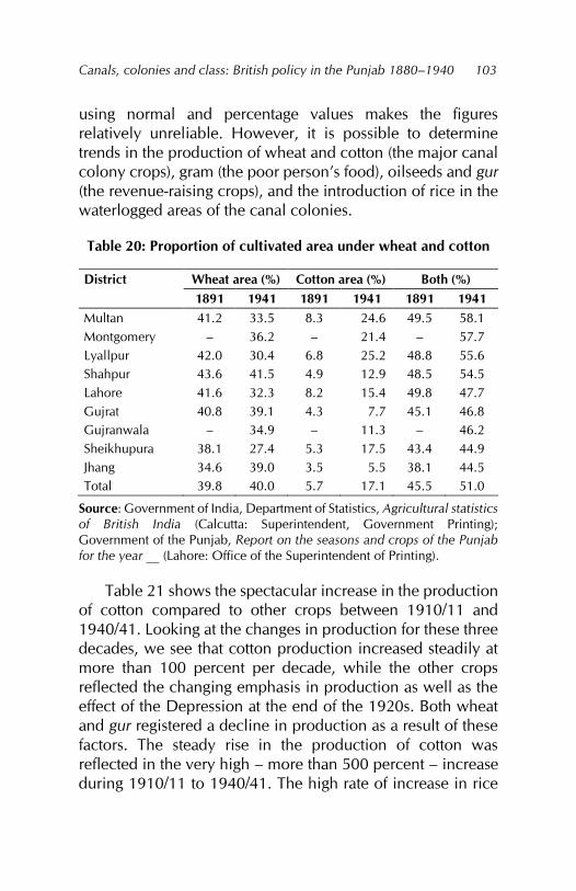
Canals, colonies and class: British policy in the Punjab 1880–1940
103
using normal and percentage values makes the figures relatively unreliable. However, it is possible to determine trends in the production of wheat and cotton (the major canal colony crops), gram (the poor person’s food), oilseeds and gur (the revenue-raising crops), and the introduction of rice in the waterlogged areas of the canal colonies.
Table 20: Proportion of cultivated area under wheat and cotton
District Wheat area (%) Cotton area (%) Both (%) 1891 1941 1891 1941 1891 1941
Multan 41.2 33.5 8.3 24.6 49.5 58.1 Montgomery – 36.2 – 21.4 – 57.7 Lyallpur 42.0 30.4 6.8 25.2 48.8 55.6 Shahpur 43.6 41.5 4.9 12.9 48.5 54.5 Lahore 41.6 32.3 8.2 15.4 49.8 47.7 Gujrat 40.8 39.1 4.3 7.7 45.1 46.8 Gujranwala – 34.9 – 11.3 – 46.2 Sheikhupura 38.1 27.4 5.3 17.5 43.4 44.9 Jhang 34.6 39.0 3.5 5.5 38.1 44.5 Total 39.8 40.0 5.7 17.1 45.5 51.0
Source: Government of India, Department of Statistics, Agricultural statistics of British India (Calcutta: Superintendent, Government Printing); Government of the Punjab, Report on the seasons and crops of the Punjab for the year __ (Lahore: Office of the Superintendent of Printing).
Table 21 shows the spectacular increase in the production of cotton compared to other crops between 1910/11 and 1940/41. Looking at the changes in production for these three decades, we see that cotton production increased steadily at more than 100 percent per decade, while the other crops reflected the changing emphasis in production as well as the effect of the Depression at the end of the 1920s. Both wheat and gur registered a decline in production as a result of these factors. The steady rise in the production of cotton was reflected in the very high – more than 500 percent – increase during 1910/11 to 1940/41. The high rate of increase in rice
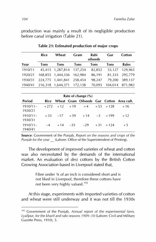
Fareeha Zafar
104
production was mainly a result of its negligible production before canal irrigation (Table 21).
Table 21: Estimated production of major crops
Rice Wheat Gram Rabi oilseeds
Gur Cotton
Year Tons Tons Tons Tons Tons Bales 1910/11 45,415 1,287,814 137,254 82,852 53,127 129,965 1920/21 168,855 1,444,336 162,984 86,191 81,333 295,779 1930/31 224,775 1,441,841 258,454 98,247 79,200 389,137 1940/41 216,318 1,644,371 172,138 70,093 104,014 871,982
Rate of change (%)
Period Rice Wheat Gram Oilseeds Gur Cotton Area cult. 1910/11–1920/21
+272 +12 +19 +4 +53 +128 +16
1910/11–1930/31
+33 –17 +59 +14 –3 +199 +12
1910/11–1940/41
–4 +14 –33 –29 +31 +124 +5
Source: Government of the Punjab, Report on the seasons and crops of the Punjab for the year __ (Lahore: Office of the Superintendent of Printing).
The development of improved varieties of wheat and cotton was also necessitated by the demands of the international market. An evaluation of desi cottons by the British Cotton Growing Association based in Liverpool stated that,
Fibre under ¾ of an inch is considered short and is not liked in Liverpool, therefore these cottons have not been very highly valued.193
At this stage, experiments with imported varieties of cotton and wheat were still underway and it was not till the 1930s
193 Government of the Punjab, Annual report of the experimental farm, Lyallpur, for the kharif and rabi seasons 1909–10 (Lahore: Civil and Military Gazette Press, 1910), 5.
Canals, colonies and class: British policy in the Punjab 1880–1940
105
that a breakthrough was made by developing hybrid seed varieties. The desi varieties had fitted better into the existing rotation pattern because a rotation based on American cotton and wheat tended to exhaust the soil and required large quantities of water.
Cash crops such as toria, a rabi oilseed, also suffered in this competition from cotton, as both crops required water at the same time. However, toria production continued as it provided cash when the land revenue payment was due.194 Canal irrigation and the commercialisation of agriculture weeded out completely the production of items such as ghee, indigo and senji, except for small local production.195 Although indigo was a cash crop and widely and successfully cultivated in many of the Punjab canal colony districts, its cultivation was deliberately discouraged due to the development of synthetic dyes in Europe and Britain at the time. Such changes were viewed as a move towards specialisation in agriculture in the canal colony districts.196 The resulting imbalances created in the economic environment of these districts were of little concern to the British.
By 1920/21, only those products supported by the Cooperative Department and the Department of Agriculture were widely cultivated.197 The provision of improved seed varieties – initially provided free, but later sold at above-market rates to farmers – brought in further profits to the departments concerned.198 Rice cultivation in the district of
194 Mian Abdul Aziz, Final report of the fourth regular settlement of the Jhang district, 1928 (Lahore: Superintendent, Government Printing, 1928), 15. 195 H. W. Emerson, Final settlement report of the Multan district (Lahore: Superintendent, Government Printing, 1921), 23. 196 Dewey, ‘Agricultural output,’ 1. 197 J. D. Penny, Final settlement report of the Jhang and Gugera branch circles of the Lyallpur district 1920–24 (Lahore: Superintendent, Government Printing, 1924), 17. 198 The seeds were sold at 4as per maund – more than the market price. In this way, the government usually made a profit; if there was a loss, it was very
Fareeha Zafar
106
Sheikhupura, where canal irrigation had created the problem of a rising water-table right from the beginning, can be viewed in the same light. The moist ground was diverted to the cultivation of rice, although it was only the large landowners receiving a substantial part of the batai (the rent from crop sharing) who profited, while self-cultivating petty owners and tenants got very little.199
On the other hand, the continued and, in fact, increased cultivation of sugarcane was for entirely different reasons. Even though sugarcane was grown at a loss in many districts, it could compete with wheat and cotton because (i) it fitted into the labour slack period, (ii) there was local demand for gur, (iii) it was used as cattle fodder and (iv) the sale of gur occurred at the time farmers needed ready cash to pay the revenue demand after the kharif harvest.
The administration appears, therefore, to have encouraged the cultivation and production of two types of crops: (i) those for which there was great demand in the country, but more so in Britain; and (ii) those that helped small cultivators pay the land revenue200 promptly and without much difficulty.201 While wheat and cotton fell into the first category, oilseeds and sugarcane belonged to the second. Food crops such as maize, jowar and bajra were partly diverted towards providing the increased fodder requirements under the system of compulsory animal rearing to meet the army’s needs and the decline in grazing grounds. In times of scarcity and drought,
small. In 1924/25, the profit from the sale of cotton seed was Rs24,378 and from the sale of wheat seed it was Rs10,200 (India, Department of Agriculture, Agriculture, evidence taken in the Punjab, 178). 199 Sheikh Nur Mohammad, Final settlement report of the Sheikhupura district (certain portions excepted), 1923–27 (Lahore: Superintendent, Government Printing, 1927), 21. 200 The land revenue demand for the year was collected in two instalments: one at the time of the rabi harvest and the other at the kharif harvest. 201 Dobson, Chenab Colony, 60.
Canals, colonies and class: British policy in the Punjab 1880–1940
107
the decrease in the cultivation of fodder crops was met entirely by these crops.
New trading patterns
To meet the increased production of the canal colonies, local avenues of trade – the traders, dealers, shopkeepers and banias – extended their operations. The formation of mandis along the newly constructed railway lines through the colonies and the regular auctions of agricultural produce by the Department of Agriculture did not touch most small cultivators. In any case, their individual production was small and they were forced to sell this out of necessity, in most cases, to local shopkeepers or peripatetic dealers with whom they had long-standing accounts. In 1928, the Royal Commission on Agriculture in India, writing about the sale of agricultural products (particularly cash crops) by cultivators and the help given by the Department of Agriculture, stated,
it cannot be said that they have been able to give him substantial help in securing the best possible financial returns for his improved quality and his increased outturn... his interests have, therefore, in the main been left to the full play of economic forces and they have suffered in the process. For he is an infinitely small unit as compared with distributors and with the consumers become every year more highly organised and more strongly consolidated. It is their interest to secure from the producers the raw material they handle or acquire at the lowest possible price. Marketing is the sole business of the distributors, whereas from the point of view of the cultivators, it is apt to be regarded as subsidiary to production.202
The creation of mandis went hand in hand with canal irrigation and the construction of railways. All three 202 India, Department of Agriculture, Commission on Agriculture, 388.
Fareeha Zafar
108
developments combined pushed more and more of the agricultural production into the export market. Cash crop production, particularly that of cotton, was also channelled into the export market by implementing controls such as the Cotton Transport Act 1928, which empowered the provincial government to prohibit the movement of cotton from one district to another.203 This meant that cotton could be bought up easily by dealers and traders and conveyed to the mandis.
Cultivators could sell their produce in several different ways: (i) to the village bania or shopkeeper, (ii) to a peripatetic dealer or the representative of a firm sent to the village to buy the produce, (iii) at the mandi directly through an arhti (dealer), (iv) in the case of cotton, directly to the ginning factory, and (v) in cooperative commission shops established during the 1930s, if the cultivator belonged to the cooperative.204
Larger landholders could derive the full benefit of the mandis, to which they could not only transport their produce, but also had enough staying power to store the grain till they got a good price for it. Smaller cultivators with their small production did not have these options and sold most of their produce to the village shopkeeper at a low price immediately after the harvest.205 Only in a few favoured localities, such as Lyallpur district, were cultivators able to carry their produce to the mandi in their own carts and dispose of it at a better price.206
There also, peasant farmers suffered from the absence of standardised weights and the expense of mandi charges. The
203 Vera Anstey, The economic development of India, 4th ed. (London: Longmans, Green and Co., 1952). 204 Ahmad, ‘Agricultural geography,’ 618. 205 Government of the Punjab, Assessment report of the Multan and Shujabad tehsils of the Multan district, January 1921, 21. 206 India, Department of Agriculture, Commission on Agriculture, 388; Government of the Punjab, Assessment report of the Jaranwala tehsil of the Lyallpur district, November 1936, 11.
Canals, colonies and class: British policy in the Punjab 1880–1940
109
bulk of the produce was still sold to local shopkeepers, banias and peripatetic traders who took it to the mandis.207 Cultivators were unable to meet the cost of transport and mandi charges from their limited production. In the poorer villages, the situation was worse, as for example in those villages inhabited by the Janglis208 or other cultivators of ‘the less progressive type’. Village shopkeepers usually took all the produce as a matter of course and credited the cultivators in their books at a price fixed for the harvest, supplying them from time to time with such cash as they might need to pay the land revenue or to purchase items the shopkeepers could not supply themselves.209
Marketing crops such as cotton was a complicated procedure. The cotton was first sold to the banias, who sold it to up-country dealers, who in turn sold it to bigger dealers or large exporting firms or ginners dealing in cotton. The ginners took the cotton, ginned it, pressed it and sold it to the mills or it went to Bombay and other ports for consumption there or for export.210 American cotton, all of which was exported, was also auctioned by the Department of Agriculture, which could accept or reject bids and so could channel the raw cotton to large export firms. To expedite the export of food grains from the colonies, a huge grain elevator was constructed at Lyallpur, which was only useful for loading in bulk onto the railways or ships.211
The commercialisation of agriculture in the canal colony districts, while affecting cultivators’ choice of crops for production, did not appreciably increase their control over the sale and marketing of this production. The mandis were 207 Khan, Gujrat district, 6; Government of the Punjab, Assessment report of the Okara tehsil of the Montgomery district, May 1934, 22. 208 ‘Jangli’ was one of the names by which the nomadic and pastoral tribes of the bar areas were known. 209 Government of the Punjab, Khanewal tehsil, 1934, 12. 210 India, Department of Agriculture, Indian Cotton Committee, 233. 211 Government of the Punjab, Administration, 1921–22, 30.
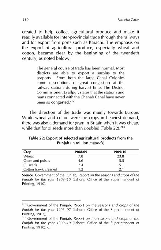
Fareeha Zafar
110
created to help collect agricultural produce and make it readily available for inter-provincial trade through the railways and for export from ports such as Karachi. The emphasis on the export of agricultural produce, especially wheat and cotton, became clear by the beginning of the twentieth century, as noted below:
The general course of trade has been normal. Most districts are able to export a surplus to the seaports... From both the large Canal Colonies come descriptions of great congestion at the railway stations during harvest time. The District Commissioner, Lyallpur, states that the stations and marts connected with the Chenab Canal have never been so congested.212
The direction of the trade was mainly towards Europe. While wheat and cotton were the crops in heaviest demand, there was also a demand for gram in Britain when it was cheap, while that for oilseeds more than doubled (Table 22).213
Table 22: Export of selected agricultural products from the Punjab (in million maunds)
Crop 1908/09 1909/10 Wheat 7.8 23.8 Gram and pulses 4.6 5.5 Oilseeds 2.4 5.1 Cotton (raw), cleaned 1.2 2.1
Source: Government of the Punjab, Report on the seasons and crops of the Punjab for the year 1909–10 (Lahore: Office of the Superintendent of Printing, 1910).
212 Government of the Punjab, Report on the seasons and crops of the Punjab for the year 1906–07 (Lahore: Office of the Superintendent of Printing, 1907), 5. 213 Government of the Punjab, Report on the seasons and crops of the Punjab for the year 1909–10 (Lahore: Office of the Superintendent of Printing, 1910), 6.
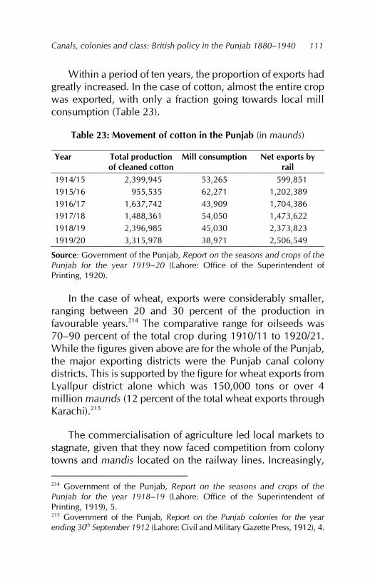
Canals, colonies and class: British policy in the Punjab 1880–1940
111
Within a period of ten years, the proportion of exports had greatly increased. In the case of cotton, almost the entire crop was exported, with only a fraction going towards local mill consumption (Table 23).
Table 23: Movement of cotton in the Punjab (in maunds)
Year Total production of cleaned cotton
Mill consumption Net exports by rail
1914/15 2,399,945 53,265 599,851 1915/16 955,535 62,271 1,202,389 1916/17 1,637,742 43,909 1,704,386 1917/18 1,488,361 54,050 1,473,622 1918/19 2,396,985 45,030 2,373,823 1919/20 3,315,978 38,971 2,506,549
Source: Government of the Punjab, Report on the seasons and crops of the Punjab for the year 1919–20 (Lahore: Office of the Superintendent of Printing, 1920).
In the case of wheat, exports were considerably smaller, ranging between 20 and 30 percent of the production in favourable years.214 The comparative range for oilseeds was 70–90 percent of the total crop during 1910/11 to 1920/21. While the figures given above are for the whole of the Punjab, the major exporting districts were the Punjab canal colony districts. This is supported by the figure for wheat exports from Lyallpur district alone which was 150,000 tons or over 4 million maunds (12 percent of the total wheat exports through Karachi).215
The commercialisation of agriculture led local markets to stagnate, given that they now faced competition from colony towns and mandis located on the railway lines. Increasingly, 214 Government of the Punjab, Report on the seasons and crops of the Punjab for the year 1918–19 (Lahore: Office of the Superintendent of Printing, 1919), 5. 215 Government of the Punjab, Report on the Punjab colonies for the year ending 30th September 1912 (Lahore: Civil and Military Gazette Press, 1912), 4.
Fareeha Zafar
112
carts in place of pack animals and men were carrying produce to these sites. The large rise in the number of carts in the canal colony districts reflects the same trend. The smaller commercial classes (shopkeepers and traders) and large producers needed faster, more efficient methods of transport to carry the cash crop production to the mandis. Small cultivators and tenants, who had previously supplemented their income though the sale of grazing products such as ghee and wool, found these avenues closed to them once cultivation was extended into what were natural grazing grounds. They turned to plying carts: from producers of subsidiary agricultural products, they were converted into part-time wage labourers.
The whole process of agriculture thus became market-oriented, with the mandis becoming centres of supplies to meet the demands of both cultivation and the cultivators. New technology – agricultural implements, improved seeds and small irrigation technology – was made available at the mandis so that the countryside became dependent on the market towns. To buy the products of this new technology required cash, which peasants could acquire only by growing and selling wheat, cotton, sugarcane, oilseeds, tobacco and vegetables. The old artisan production, which could be exchanged or ‘bought’ for a few maunds of wheat or maize, fell victim to colonisation.
To carry this increased production to the market, peasants needed carts, which again had to be bought for cash from the mandis. The number of carts rose rapidly in the canal colonies: from about 13,500 in 1889/90, they had tripled by 1903/04 and numbered over 95,000 by 1939/40. Among the canal colony districts, Lyallpur registered the largest increase in the number of carts.
The export of all surplus agricultural production left landowners with little to pay the dues of the village artisans. This,
Canals, colonies and class: British policy in the Punjab 1880–1940
113
combined with the availability of everyday articles in the mandis (items previously made by the village artisans) led to a decline in the number of artisans. Moreover, the commercialisation of agriculture required faster, more efficient implements that the village peasant economy was not geared to produce. The mandis acted as exchange points for commodities and the comparatively self-sufficient village economy was replaced by a dependent commodity market economy.
Colony status and class
The Punjab’s colony status as part of India and the potential of canal irrigation to increase cash crop cultivation quickly drew the production of these districts into the orbit of international price controls. In the canal colony districts, while production had been mainly for local consumption with, at best, an occasional surplus finding its way into neighbouring districts, the price mechanism had operated based on regional supply and demand. As the volume of agricultural commodities being produced for the market increased, the price paid to the producer as well as the price of these commodities in the world market, began to vary.
The administration’s policy on prices was one of noninterference, which left ordinary cultivators open to the play of economic forces in which they were often the losers. Before perennial canal irrigation, the prices of agricultural produce tended to vary mainly with harvest conditions. Even after the formation of the canal colonies, the price obtained by cultivators for their produce depended on the nature of each harvest and was accordingly referred to as the village harvest price.
Small cultivators invariably sold their produce at harvest time, having neither the capacity to store the crop nor hold onto it till the price level rose. As a result, they would receive the lowest price for their produce. Crop prices sanctioned by the financial commissioner at each harvest were fixed
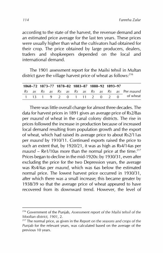
Fareeha Zafar
114
according to the state of the harvest, the revenue demand and an estimated price average for the last ten years. These prices were usually higher than what the cultivators had obtained for their crop. The price obtained by large producers, dealers, traders and shopkeepers depended on the local and international demand.
The 1901 assessment report for the Mailsi tehsil in Multan district gave the village harvest price of wheat as follows:216
1868–72 1873–77 1878–82 1883–87 1888–92 1893–97 Rs as Rs as Rs as Rs as Rs as Rs as Per maund
of wheat 1 13 1 9 2 0 1 11 2 0 2 0
There was little overall change for almost three decades. The data for harvest prices in 1891 gives an average price of Rs2/8as per maund of wheat in the canal colony districts. The rise in prices followed the increase in production because of increased local demand resulting from population growth and the export of wheat, which had raised its average price to about Rs2/11as per maund by 1910/11. Continued exports raised the price to such an extent that, by 1920/21, it was as high as Rs4/14as per maund – Re1/10as more than the normal price at the time.217 Prices began to decline in the mid-1920s: by 1930/31, even after excluding the price for the two Depression years, the average was Rs4/4as per maund, which was 6as below the estimated normal price. The lowest harvest price occurred in 1930/31, after which there was a small increase; this became greater by 1938/39 so that the average price of wheat appeared to have recovered from its downward trend. However, the level of
216 Government of the Punjab, Assessment report of the Mailsi tehsil of the Mooltan district, 1901, 2. 217 The normal price, as given in the Report on the seasons and crops of the Punjab for the relevant years, was calculated based on the average of the previous 10 years.
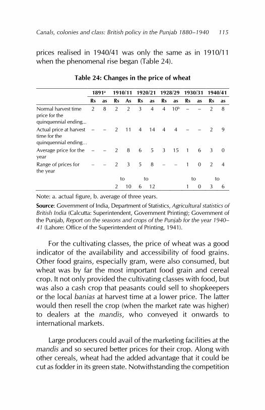
Canals, colonies and class: British policy in the Punjab 1880–1940
115
prices realised in 1940/41 was only the same as in 1910/11 when the phenomenal rise began (Table 24).
Table 24: Changes in the price of wheat
1891a 1910/11 1920/21 1928/29 1930/31 1940/41 Rs as Rs As Rs as Rs as Rs as Rs as
Normal harvest time price for the quinquennial ending...
2 8 2 2 3 4 4 10b – – 2 8
Actual price at harvest time for the quinquennial ending…
– – 2 11 4 14 4 4 – – 2 9
Average price for the year
– – 2 8 6 5 3 15 1 6 3 0
Range of prices for the year
– – 2 3 5 8 – – 1 0 2 4
to to to to 2 10 6 12 1 0 3 6
Note: a. actual figure, b. average of three years.
Source: Government of India, Department of Statistics, Agricultural statistics of British India (Calcutta: Superintendent, Government Printing); Government of the Punjab, Report on the seasons and crops of the Punjab for the year 1940–41 (Lahore: Office of the Superintendent of Printing, 1941).
For the cultivating classes, the price of wheat was a good indicator of the availability and accessibility of food grains. Other food grains, especially gram, were also consumed, but wheat was by far the most important food grain and cereal crop. It not only provided the cultivating classes with food, but was also a cash crop that peasants could sell to shopkeepers or the local banias at harvest time at a lower price. The latter would then resell the crop (when the market rate was higher) to dealers at the mandis, who conveyed it onwards to international markets.
Large producers could avail of the marketing facilities at the mandis and so secured better prices for their crop. Along with other cereals, wheat had the added advantage that it could be cut as fodder in its green state. Notwithstanding the competition
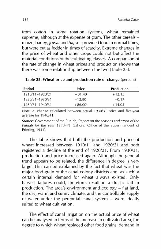
Fareeha Zafar
116
from cotton in some rotation systems, wheat remained supreme, although at the expense of gram. The other cereals – maize, barley, jowar and bajra – provided food in normal times, but were cut as fodder in times of scarcity. Extreme changes in the price of wheat and other crops could not but affect the material conditions of the cultivating classes. A comparison of the rate of change in wheat prices and production shows that there was some relationship between the two (Table 25).
Table 25: Wheat price and production rate of change (percent)
Period Price Production 1910/11–1920/21 +81.40 +12.15 1920/21–1930/31 –12.80 –0.17 1930/31–1940/31 +86.00a +14.05
Note: a. change calculated between actual 1930/31 price and five-year average for 1940/41.
Source: Government of the Punjab, Report on the seasons and crops of the Punjab for the year 1940–41 (Lahore: Office of the Superintendent of Printing, 1941).
The table shows that both the production and price of wheat increased between 1910/11 and 1920/21 and both registered a decline at the end of 1920/21. From 1930/31, production and price increased again. Although the general trend appears to be related, the difference in degree is very large. This can be explained by the fact that wheat was the major food grain of the canal colony districts and, as such, a certain internal demand for wheat always existed. Only harvest failures could, therefore, result in a drastic fall in production. The area’s environment and ecology – flat land, the dry, warm and sunny climate, and the controllable supply of water under the perennial canal system – were ideally suited to wheat cultivation.
The effect of canal irrigation on the actual price of wheat can be analysed in terms of the increase in cultivated area, the degree to which wheat replaced other food grains, demand in
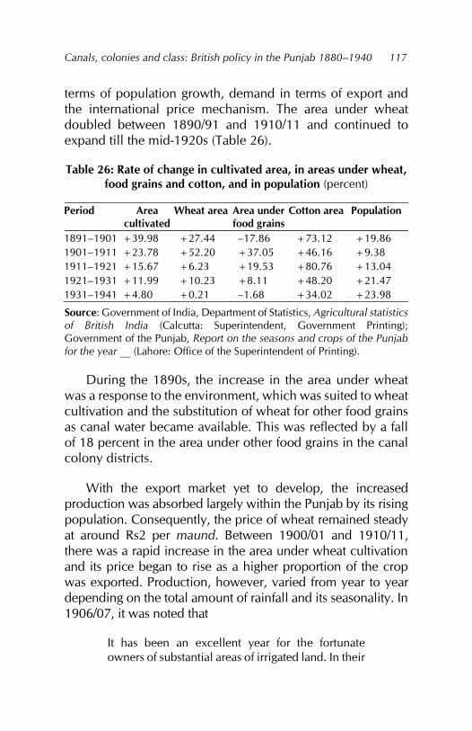
Canals, colonies and class: British policy in the Punjab 1880–1940
117
terms of population growth, demand in terms of export and the international price mechanism. The area under wheat doubled between 1890/91 and 1910/11 and continued to expand till the mid-1920s (Table 26).
Table 26: Rate of change in cultivated area, in areas under wheat, food grains and cotton, and in population (percent)
Period Area cultivated
Wheat area Area under food grains
Cotton area Population
1891–1901 +39.98 +27.44 –17.86 +73.12 +19.86 1901–1911 +23.78 +52.20 +37.05 +46.16 +9.38 1911–1921 +15.67 +6.23 +19.53 +80.76 +13.04 1921–1931 +11.99 +10.23 +8.11 +48.20 +21.47 1931–1941 +4.80 +0.21 –1.68 +34.02 +23.98
Source: Government of India, Department of Statistics, Agricultural statistics of British India (Calcutta: Superintendent, Government Printing); Government of the Punjab, Report on the seasons and crops of the Punjab for the year __ (Lahore: Office of the Superintendent of Printing).
During the 1890s, the increase in the area under wheat was a response to the environment, which was suited to wheat cultivation and the substitution of wheat for other food grains as canal water became available. This was reflected by a fall of 18 percent in the area under other food grains in the canal colony districts.
With the export market yet to develop, the increased production was absorbed largely within the Punjab by its rising population. Consequently, the price of wheat remained steady at around Rs2 per maund. Between 1900/01 and 1910/11, there was a rapid increase in the area under wheat cultivation and its price began to rise as a higher proportion of the crop was exported. Production, however, varied from year to year depending on the total amount of rainfall and its seasonality. In 1906/07, it was noted that
It has been an excellent year for the fortunate owners of substantial areas of irrigated land. In their
Fareeha Zafar
118
case, enhanced prices have amply compensated for slightly reduced outturns. It has been a year of trial for everybody else.218
Between 1910/11 and 1920/21, although the area under wheat cultivation increased slowly, its price rose to phenomenal levels (Rs5 per maund) due to increased wheat exports and demand in the international market. The continued variations in wheat production from year to year meant that a year of reduced cropping could result in very high prices and, combined with the export demand, would benefit only large producers and grain dealers.219 Until 1920/21, the acreage under wheat increased faster than the population growth rate. The rise in wheat prices was thus due to increased demand (internal and external) and the very high prices for all agricultural produce in the international market.
After 1920/21, the population of the Punjab canal colony districts rose rapidly, but this was not matched by a similar increase in the acreage under wheat. The price of wheat also declined after 1926/27 and slumped in 1929/30 when the international market suffered a sharp decline. Wheat growers suddenly faced very low prices. It appeared, therefore, that the price of wheat was no longer regulated by internal supply and demand mechanisms, but by changes in the international market. This trend had begun to emerge as far back as 1890, when the settlement officer for Shahpur district stated that “the extension of the export trade though Karachi to Europe regulates the price of wheat throughout the Punjab, and the future of the wheat trade depends on harvests in America and Russia.”220
218 Government of the Punjab, Seasons and crops, 1906–07, 8. 219 L. Middleton and S. M. Jacob, Census of India, 1921, Punjab and Delhi, report vol. 15, part 1 (Lahore: Civil and Military Gazette Press, 1923), 66. 220 J. Wilson, Final report on the revision of settlement of the Shahpur district in the Punjab, 1887–94 (Lahore: Civil and Military Gazette Press: 1894), 9.
Canals, colonies and class: British policy in the Punjab 1880–1940
119
The rise in prices due to increased exports affected the cultivating and landowning classes in different ways. When landowners were unaffected by the circumstances that led to high prices, the labouring classes obtained a share in the general prosperity.221 Proprietors of large holdings gained the most when the weather was favourable.222 In a good agricultural year, the surplus production was hoarded by large producers to be sold when the price peaked.223
The sudden and sharp changes in the price of wheat affected cultivators to the extent of their capacity to hold out for higher prices. The tenant class was severely affected as the value of their share of the harvest was drastically lowered, while they still had to meet the increased cost of cultivation. Small peasant owner-cultivators also suffered for similar reasons. Only the large producers, the landlords, remained unaffected in the sense that, although the value of their share had fallen, they were still able to make a profit. There was little improvement in the condition of the agricultural labourer classes who, despite receiving cash wages that enabled them to buy grain at cheaper rates, had to pay more for other essentials.
Before the formation of the canal colonies, cotton was cultivated over small areas in most districts. In Gujranwala, the price of cotton varied from around Rs2/14as per maund during 1853–67 to Rs3/10as during 1873–78, remaining steady till 1892.224 In the district of Gujrat, the price of cotton was slightly higher. Even as early as the 1890s, it was noted that the benefits of rising prices accrued to mortgagers, large
221 Government of the Punjab, Report on the seasons and crops of the Punjab for the year 1907–08 (Lahore: Office of the Superintendent of Printing, 1908), 8. 222 Government of the Punjab, Seasons and crops, 1908–09, 11. 223 Government of the Punjab, Report on the seasons and crops of the Punjab for the year 1910–11 (Lahore: Office of the Superintendent of Printing, 1911), 11. 224 O’Dwyer, Gujranwala district, 50.
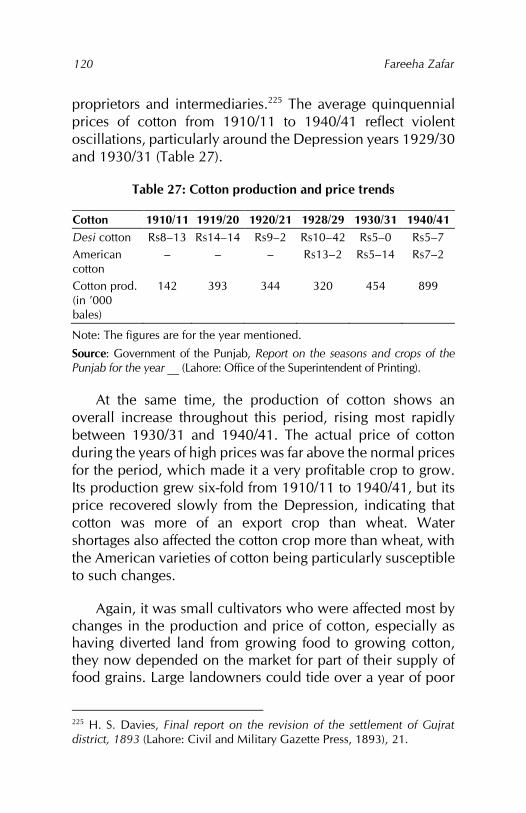
Fareeha Zafar
120
proprietors and intermediaries.225 The average quinquennial prices of cotton from 1910/11 to 1940/41 reflect violent oscillations, particularly around the Depression years 1929/30 and 1930/31 (Table 27).
Table 27: Cotton production and price trends
Cotton 1910/11 1919/20 1920/21 1928/29 1930/31 1940/41 Desi cotton Rs8–13 Rs14–14 Rs9–2 Rs10–42 Rs5–0 Rs5–7 American cotton
– – – Rs13–2 Rs5–14 Rs7–2
Cotton prod. (in ’000 bales)
142 393 344 320 454 899
Note: The figures are for the year mentioned.
Source: Government of the Punjab, Report on the seasons and crops of the Punjab for the year __ (Lahore: Office of the Superintendent of Printing).
At the same time, the production of cotton shows an overall increase throughout this period, rising most rapidly between 1930/31 and 1940/41. The actual price of cotton during the years of high prices was far above the normal prices for the period, which made it a very profitable crop to grow. Its production grew six-fold from 1910/11 to 1940/41, but its price recovered slowly from the Depression, indicating that cotton was more of an export crop than wheat. Water shortages also affected the cotton crop more than wheat, with the American varieties of cotton being particularly susceptible to such changes.
Again, it was small cultivators who were affected most by changes in the production and price of cotton, especially as having diverted land from growing food to growing cotton, they now depended on the market for part of their supply of food grains. Large landowners could tide over a year of poor
225 H. S. Davies, Final report on the revision of the settlement of Gujrat district, 1893 (Lahore: Civil and Military Gazette Press, 1893), 21.
Canals, colonies and class: British policy in the Punjab 1880–1940
121
harvests easily, besides which they were in a much better position to get a good price for their cotton in the mandi, while small cultivators were dependent on local shopkeepers and peripatetic traders.
The benefit of the high prices of agricultural produce between 1910/11 and 1926/27 accrued mainly to (i) large landlords, (ii) intermediaries (traders, merchants, village shopkeepers and banias), (iii) small landowners and, to less extent, (iv) tenants. This benefit was, however, short-lived; the impact of the fall in prices on the poorer sections of rural society – in particular, small peasant owners and tenants – was very great. Consequently, by bringing the Punjab canal colony districts within the orbit of international price mechanisms, canal irrigation exposed the cultivating classes to the vacillations of the international market and hastened the deterioration of those classes that existed on the margins. Only those classes that had the advantage of surplus production could profit from the high prices and weather any falls in the price of agricultural produce.
As we have already seen, the commercialisation of agriculture in the canal colony districts reduced certain avenues of subsidiary production of items such as ghee and wool – those connected with widespread grazing activities. This reduction forced cultivators to adopt other ways of supplementing their income, which included plying carts and other forms of part-time wage labour. Canal construction, the formation of the colonies and the construction of mandi towns all required labour. This led to changes in the wage levels operating in the canal colony districts, where the demand for tenants and agricultural labour had already attracted the menial classes and tenants from other districts. Perennial canal irrigation also increased the work of, and demand for, certain types of agricultural labour throughout the year.
Although these factors affected the wages of agricultural and wage labour in the canal colony districts, as the whole
Fareeha Zafar
122
economy was based on the production of crops, the rise and fall in the prices of agricultural produce had a greater effect on the wage level of those classes that lived solely by the sale of their labour. Included among the marginal classes were the landless agricultural labourers of the canal colony districts. Before the introduction of widespread canal irrigation, they had been part of the village communities by the function they performed. This included kamins, village servants and those who worked on others’ land at harvest time or whenever extra labour was required by the landowners; their numbers were relatively small and their services essential.
The impact of canal irrigation on these classes was mixed. A positive outcome was that irrigation from canals required large numbers of labourers; many who were finding it near impossible to survive on the services mentioned above converted into wage labourers. The need for tenants and agricultural labour to help cultivate the newly irrigated land attracted these classes from other districts to the canal colonies where they saw a better chance of survival.
The demand for labour translated into higher wages for such work. However, many of the supplements that such labourers received in the noncolony areas – grain, fodder and even a small plot of land to cultivate for their personal use – were not forthcoming in the canal-irrigated areas, owing to the high value of agricultural land and its produce. The benefit of higher wages was reduced by the need to purchase food grains and other essential items of day-to-day use, the prices of which had also risen.
It was estimated that agricultural labourers were paid 1.5as per day at annexation and 2–3as per day in 1889. This shows that, between 1849 and 1889, the wages of agricultural labour doubled, but remained low.226 Based on a wages survey carried out in 1909 in selected villages in the Punjab, the 226 Government of the Punjab, Seasons and crops, 1909–10, 8.
Canals, colonies and class: British policy in the Punjab 1880–1940
123
wages of agricultural labour were found to be, on average, 4as a day, with wages of around 6as a day common in the districts of Lyallpur, Shahpur and Jhang. Since 1889, the wages of village artisans and ploughmen had, therefore, doubled.
If we look at the price of wheat for the same period, we find a similar increase. We can assume that, since wages and prices were rising at the same level, there was little overall improvement in the conditions of the agricultural labour class. At the same time, the influx of agricultural labour can be explained by
a marked rise in the prices of food grains, heavy mortality from plague among the labouring classes and a much greater demand for labour, with large extension of cultivation, the expenditure of vast sums on irrigation works, public building, and communications, activity in the building, and communication, activity in the building trade in towns and villages and the starting of new factories and industrial concerns.227
There are almost no studies on rural labour, the wages surveys being mainly concerned with urban labour. Nevertheless, some information on the rural areas can be derived from these surveys and from population censuses for the period. The First Regular Wages Survey, carried out in 1912, stated that a general rise in wages had occurred in all districts since the preliminary survey in 1909, excepting Lyallpur, where wages had remained stationary, given the flux of labourers.228 The Second Regular Wages Survey conducted in 1917 estimated that labourers’ cost of living (based on the average price of grain) had risen. Their expenditure on food had increased by 30 percent on average, and the price of cloth and
227 Government of the Punjab, Seasons and crops, 1909–10, 8. 228 Government of the Punjab, Report on the first regular wages survey of the Punjab, taken in December 1912 (Lahore: Civil and Military Gazette Press, 1913), 2.
Fareeha Zafar
124
other important items in the family budget had also risen. Thus, in many cases, the increase in wages had not kept pace with the increase in the cost of living.229
What was apparent at the time, however, was that high prices had “increased the prosperity of the agricultural classes and the profits of many traders and contractors, and this led to an increased demand for labour.”230 The 1921 census also stated that, until 1917, the rise in prices had kept pace with wage rises; it was after then that the situation changed.231 The census report maintained that the immense rise in prices since 1917 was unlikely to have been fully reflected in wages. As far as rural wages were concerned, which were usually accompanied by payment in kind, even if the wage level between 1921 and 1917 was expressed in maunds of wheat per month, all classes of wage labour in the rural areas had been subject to a decrease.232
At the same time, a gradual decrease in the payment of grain wages was noticeable,233 which meant that wage labour and/or agricultural labour had to rely on the market for their food requirements. The rise in prices of agricultural produce, especially since 1910/11, clearly indicated that the higher wages they may have commanded, given the demand for labour – consequent to the construction of canals – were spent on food grains.234 Similarly, tenants and small peasant cultivators, who depended on the village shopkeepers and/or banias for their requirements, were unable to reap any profit from this rise in prices.
229 Government of the Punjab, Report on the second regular wages survey of the Punjab, taken in December 1917 (Lahore: Civil and Military Gazette Press, 1918), 6. 230 Government of the Punjab, Second regular wages survey, 7. 231 Middleton and Jacob, Census of India, 1921, part 1, 20. 232 Middleton and Jacob, Census of India, 1921, part 1, 70. 233 Government of the Punjab, First regular wages survey, 3. 234 Government of the Punjab, Second regular wages survey, 3.
Canals, colonies and class: British policy in the Punjab 1880–1940
125
As mentioned above, it was the traders, contractors and landlords who benefited fully from the rise in prices of agricultural produce. The increase in wages remained at best commensurate with the increase in prices until 1927/28, when a decline in wages began. In his report for the year ending 30 June 1931, the director of land records in Punjab remarked: “... wages of agricultural labour have gone down to some extent though not in proportion to the decline in prices.”235
The extreme oscillations in the prices of staple food grains made it difficult to estimate whether real wages were tending to fall or rise. It was realised, however, that wages tended to follow prices, but at a slower rate.236 Canal irrigation had also resulted in a change in the conditions of labour. For example, the method of payment for ploughmen, usually paid at harvest time and not every month, varied from one locality to another. In the canal areas, they had to work harder and were continually occupied, with no slack season. Consequently, their wages were higher.237 The custom of supplementing wages in the form of an acre of land given free or at a nominal rent to ploughmen to cultivate for themselves was dying out as a result of the high value of irrigated land.
The wages surveys did not have much information on rural conditions, except to say that: “The only general results that can be deduced are that wages have risen, have become more competitive and tend to differentiate more between qualities of labour and local demand.”238 Therefore, it was not clear at all whether the conditions of the labouring class had improved, the rise in wages being at best matched by the rise
235 Khan, Census of India, 1931, part 1, 47. 236 Government of the Punjab, Report on the third regular wages survey of the Punjab, taken in December 1922 (Lahore: Civil and Military Gazette Press, 1923), 4. 237 Government of the Punjab, Third regular wages survey, 8. 238 Government of the Punjab, Third regular wages survey, 9.
Fareeha Zafar
126
in the price of food grains. At the same time, the rise in prices of other necessities, such as cloth and fuel, caused great hardship to the poorer classes, to the extent that the government was forced to open shops selling such items at their retail price in times of distress.239
The findings of the Fourth Regular Wages Survey in 1927 were important in that it was carried out at a time when the prices of agricultural produce were at their highest. According to the survey, the wages of unskilled labour and of ploughmen had also decreased in most of the Punjab canal colony districts.240 After the Depression, the slump in prices of agricultural produce was followed by a decline in wages. Although economic forces stabilised in 1932, the wages compared to 1927 were lower.241 The conversion of pure cash wages had continued.
By 1937, when the Sixth Regular Wages Survey was undertaken, the wages of unskilled labour had risen while those of ploughmen had fallen further. This reflected the deteriorating condition of many owners who had turned to self-cultivation, thereby lowering the demand for this type of agricultural labour.242 With the fall in prices of food grains, the villages surveyed showed an increase in the cash-plus-supplement wage compared to pure cash wages.243
239 Government of the Punjab, Administration, 1919–20, 59. 240 Government of the Punjab, Report on the fourth regular wages survey of the Punjab, taken in December 1927 (Lahore: Civil and Military Gazette Press, 1928), 4. 241 Government of the Punjab, Report on the fifth regular wages survey of the Punjab, taken in December 1932 (Lahore: Civil and Military Gazette Press, 1933), 3. 242 Government of the Punjab, Report on the sixth regular wages survey of the Punjab, taken in December 1937 (Lahore: Civil and Military Gazette Press, 1938), 4. 243 Government of the Punjab, Sixth regular wages survey, 6.
Chapter 6
Land tenure systems
Prior to the British, the system of land tenure in the Punjab had evolved under various conditions under which past administrations had allowed cultivators to hold land. Under the Mughals and Sikhs, land rights were established in the form of jagirs or revenue assignments whereby a jagirdar or assignee was given the right to the revenue of a particular area. Such rights were inheritable, though existing largely at the whim of the ruler. The importance of land revenue and its collection at different levels required a vast network, creating numerous intermediaries between the state and the people.
At the village level, rights to the land were recognised if a well had been sunk or an embankment (bund) constructed on the land, and in case of the cultivation of wasteland. Rights to cultivation were also recognised and depended on how long the land had been occupied and cultivated. These rights were also inheritable. Several different classes of cultivators existed based on these rights. The Sikh administration had ignored many of these customary rights, relying more on the cultivators themselves. In the eastern canal colony districts in particular, this had reduced landed rights not based on self-cultivation.
The British found it impossible to accept an implied form of land ownership. Their primary concern was also to collect land revenue, which could be carried out only once it was decided who was responsible for payment. Through a series of land revenue settlements, the rural population of the Punjab canal colony districts was divided into landowners and tenants, with the former responsible for paying the land revenue. Ownership was recognised as both individual and
Fareeha Zafar
128
resting in village communities. Some previous ownership rights ignored by the Sikhs were recognised and several tenurial categories created. The land revenue demand was based on previous Sikh estimates and was, in most cases, equal to these. In many cases, the old collections of land revenue were also maintained by the British.
The impact of canal irrigation on land tenure patterns is evident from the number of changes that occurred in the districts. On land revenue assessment, it was notable in the introduction of fluctuating land assessments. As the canals were constructed and production from the canal-irrigated areas increased, the system of fixed land revenue settlement no longer remained suitable. The extension of canals into the wasteland prompted legislation establishing the government’s rights to these lands.
The impact of water in determining land rights had existed prior to the British in the form of rights to wells, embankments and private canals. The larger perennial canals, however, did not allow for private ownership and the emphasis shifted from ownership rights to rights to irrigation water. However, by far the greater impact of canal irrigation on land tenures was on the development of colony tenures in the government-owned wastelands of the Punjab canal colony districts. The system of land grants, the conditions under which land was held by the colony tenants from the government, and special services grants gave the government a chance to create different tenurial patterns in these areas.
Pre-British tenurial system
In the Punjab, land and often its production determined the importance given to any area by its administration. The Mughals, Sikhs and later the British were all interested in the proportion of the production they could acquire for their own use. This proportion – whether determined in cash or kind,
Canals, colonies and class: British policy in the Punjab 1880–1940
129
whether referred to as share, due, rent or revenue – had been an important factor in creating the kind of rural society, rural institution and changes in agricultural production and techniques characterising various phases of the Punjab’s history.
The idea of the state having rights to a part of the agricultural production of a region had developed over the centuries, while the prosperity of the cultivating classes depended on the share of the harvest left to them. There existed, therefore, a cultivating and producing section of the population on the one hand and expropriating classes on the other. The bulk of the Punjab’s rural population were producers – petty cultivators who, no matter how much they produced, could only keep a small proportion of the inferior grains needed to sustain them at a low level of living. The expropriators in general were the king, his family, courtiers, petty chiefs, large landholders and other persons favoured by the ruler. The collectors of the produce were appointed from among these categories and they further appointed local men to carry out actual collection.
It is not to be supposed, however, that the cultivators were all at the same economic and social level. Indeed, they comprised four different classes varying from the rich peasant to the ordinary peasant, down to the poor peasant who needed credit to cultivate his land, and finally the indigent or landless cultivator.244 In India, landless cultivators or labourers had long existed under the caste system, which condemned members of certain castes to a life of servitude, thus creating a permanent agricultural labour force.
The dependency of a section of cultivators on credit meant the existence of a class of persons whose occupation was 244 Irfan Habib recognises five social classes in the rural areas: (i) the zamindars, moneylenders and grain merchants, (ii) the rich peasants, (iii) the majority of peasants, (iv) the poor peasants who could not cultivate without credit and (v) the totally landless labour (Habib, Agrarian system, 120).
Fareeha Zafar
130
moneylending. In the Punjab, an area vulnerable to natural calamities, the position of the moneylenders was an important one. Their only constraint was the poverty of their victims who had little collateral against which large sums of money could be advanced. Nonetheless, while the position of peasants was difficult, they were free to move from one place to another in times of oppression and famine, and this proved to be an important factor in their relationship with the social and physical environment.245
The organisation of land was controlled largely by the central authorities. In the Mughal period, the Punjab east of the river Chenab was a zabti246 province, given in assignments and jagirs to local chiefs and persons associated with the court. These amounted to proprietary rights even though they existed at the whim of the ruler. In the southwestern districts, where central control was weak, the Biloch chiefs or tumandars were virtual rulers as they parcelled out land to lesser chiefs and other members of their tribes.247 At the village level, land rights were determined on a hereditary basis in the eastern districts, while in the dry southwestern districts, sinking a well, building a bund or cultivating wasteland were also considered a basis for proprietorship.
Within the peasantry, as the production of crops for the market increased, caste and fraternal bonds loosened, with the richer peasants and landowners in their roles as headmen and lambardars becoming more powerful while their distance from the ordinary peasant increased.248 The repercussions of these social differences were reflected in the struggle against
245 Habib, Agrarian system, 117. 246 Zabti rent or revenue was paid on certain crops in the form of cash. 247 Government of the Punjab, Gazetteer of the Dera Ghazi Khan district, 1883–4 (Lahore: Civil and Military Gazette Press, 1884). 248 Headmen, lambardars, chaudhris and mukaddims all belonged to the same class: they managed the revenue collection for the government and village affairs for the community, and were given inams in lieu of their services.
Canals, colonies and class: British policy in the Punjab 1880–1940
131
the environment: large landowners and talukdars249 were able to construct private inundation canals, wells and embankments, and block the heads of ravines, thus bringing large areas under cultivation.250 At a lower level, the peasants’ share consisted of a part share in a well or embankment, seriously limiting the size of their holdings.251
Environmental variations were also reflected in the formation of village communities. In the arid south and west of the province, no such communities existed, and wells and embankments formed the basis of an individual and isolated pattern of settlement. In the northern districts and the regions of the Salt Range, village communities consisted of the landlords and jagirdars residing in one large central abadi (inhabited village) surrounded by a string of dhoks (hamlets), populated by a body of rent-paying tenants.252 The number of such dhoks in a village was often as large as 15 to 20. Tenants were divided into two categories: (i) those with rights to the land based on long occupation and (ii) those who had come in later or from surrounding areas to work, and were thus of an inferior status.
In the southeastern part of the province, the more self-sufficient village communities existed under jagirdari and bhai
249 Superior proprietor, appointed revenue officer. 250 It should be noted, however, that both the Mughals and their Muslim predecessors had initiated the construction of canals for general use. 251 For example, assuming a rich proprietor had eight wells or 40 embankments, the smallest holding needed to support a cultivator proprietor was a quarter-share in a well or two embankments. However, the tenant cultivator had only one jok, which was equal to 10 acres (one well was divided across four joks and he had a quarter-share in a well (see: Government of the Punjab, Dera Ghazi Khan, 1883–4, 65). 252 Government of the Punjab, Gazetteer of the Jhelam district, 1883–4 (Lahore: Civil and Military Gazette Press, 1884), 45, 54.
Fareeha Zafar
132
chara tenures.253 Two-thirds of the Lahore district was given out in jagirs.254 Under the Mughals, free grazing rights in all wasteland, easy access to fuel and timber in the bar areas and the combination of agricultural work with manufacturing processes (such as flour milling, rice husking and the manufacture of ghee and cloth) combined to make the life of the peasant tolerable and the village communities stable.255
The decline of Mughal rule was accompanied by a period of devastation and destruction and inter-tribal wars, which left their mark on the landscape in the form of deserted village sites and silted inundation canals and wells. Under the Sikhs, most land rights were ignored, affecting the eastern part of the province. Old warisi (hereditary) and proprietary rights were ignored; cultivation and actual possession of land became the criteria for ownership. Some land was given in jagirs256 and inams to chiefs and rajas, but the rest (khalisa)257 was farmed out in the form of villages to kardars (official revenue collectors). The Sikhs were concerned with obtaining the maximum revenue from cultivators and thus gave them all help possible in clearing canals, sinking wells and bringing wasteland under cultivation as well as in the matter of loans.258 As a result, village communities existed as integrated entities.
Government reserves of wasteland or rakhs were formed and the rural population was charged a fee or tirni for grazing on these.259 The Sikh land revenue demand was generally about
253 A jagirdari tenure was a rent-free holding where the jagirdar had the right to collect revenue for himself. A bhai chara tenure referred to villages owned jointly with every person owning the land in his possession. 254 Davies et al., Lahore district, 12. 255 Habib, Agrarian system, 57. 256 E. G. Wace, Report of the land revenue settlement of the Hazara district of the Punjab, 1868–74 (Lahore: Central Jail Press, 1876), 111. 257 Khalisa was state-owned land given over to kardars, who were the revenue collectors. 258 Davies et al., Lahore district, 23. 259 Monckton, Jhung district, appendix A.
Canals, colonies and class: British policy in the Punjab 1880–1940
133
half of the gross produce, but it was considerably less in the frontier areas beyond the Indus River and in the southwest of the Punjab.260 Land revenue was assessed by crop appraisal (kankut) in poorer areas and in money terms in the irrigated and fertile areas. Generally, there was enough grain left for the cultivators to maintain their households till the next harvest. As there was no credit or money or civil courts, serious indebtedness was impossible.261
The establishment of direct relations between the government and revenue-paying cultivators reduced the number of intermediaries between the state and the peasantry. Together with restrictions on the growth of a powerful landlord class, this created a society more equitable than in any other part of India.262 In the last years of Sikh rule, however, anarchy prevailed in the Punjab and some of the old tenurial relationships were re-established.
Land revenue settlements
The British thus faced a complexity of land tenure systems. The task of sorting these out was complicated by their disregard in the first instance and, later, by their willingness to recognise hereditary claims rather than existing ones in many areas. This led to the creation of new tenurial forms in the northern districts of the Punjab. By and large, the British sought to classify and demarcate tenurial relationships through a process of land settlements whereby a record of rights to the land was framed under which the government settled the person or persons who were to be responsible for paying the land revenue.
260 Government of the Punjab, Administration, 1849–50, 82. 261 Septimus Smet Thorburn, Musalmans and moneylenders in the Punjab (Edinburgh and London: William Blackwood & Sons, 1886), 12. 262 Baden-Powell, Land-systems, 11, 617.
Fareeha Zafar
134
The haste and urgency with which the summary settlements263 of the districts were carried out revealed the importance the British attached to land revenue, as it was these settlements that established who owned the soil, from whom the revenue was to be collected, its amount and who would collect it. Section 61 of the Land Revenue Act 1871 declared that, “the landowners shall be liable for the land revenue.”264 While the practices of previous governments could be followed in fixing the amount of land revenue or the government’s share in the production from the land, determining land rights was more difficult. Ownership in the Punjab had always been customarily determined, with land possession and/or cultivation being more important than ownership. As such, the different sections of the rural population had fixed rights to the produce of the land, also determined by tradition and custom and based on their services to the village community.265
The British followed the principles laid out by Regulations VII and XI of 1822 in operation in the Northwestern Provinces to determine and fix cultivators’ rights in the Punjab. Accordingly, the cultivating body was categorised as (i) proprietors or owners, (ii) occupancy tenants or (iii) tenants-at-will. The first category included those persons who could show some evidence of being in possession of and having rights to the land they owned or cultivated. They were differentiated as (i) talukdars, (ii) landlords (represented by either an individual or a joint body of village co-sharers), (iii) superior proprietors or malik-ala, (iv) inferior proprietors or malik-adna, and (v) malik-qabza, a new category created by
263 A summary settlement was defined in the First Land Revenue Act XXXIII of 1871 as “a provisional settlement made pending a first regular settlement.” Legally, an officer making a record of rights at a first regular settlement could alter any entry made at a summary settlement simply because he considered it incorrect (Douie, Punjab settlement, 23). 264 Douie, Punjab settlement, 52. 265 Douie, Punjab settlement, 63.
Canals, colonies and class: British policy in the Punjab 1880–1940
135
the British. Whereas the talukdars held the position of overlord, which at the minimum was represented as a mere rent charge, village landlords had complete rights to their land. Where grades of proprietary rights existed, the right of superior proprietors was recognised by apportioning them a percentage of the land revenue as well as control of the wasteland, while inferior proprietors retained actual possession of the land.
The rights of outsiders who had acquired land in a village were embodied in the tenure of malik-qabza, introduced in the northern districts of the Punjab. The rest of the cultivating body were reduced to the status of tenants. Within this category, some tenants, the occupancy tenants, were recognised as having some rights based on their having cultivated the same land for a period of at least 12 years. This secured them continued tenure as tenants and was also recognised as carrying with it inheritable rights.
Most tenants were, however, classed as tenants-at-will of the landowner. Their tenure was normally renewed every year on terms agreed to between tenant and landowner, but the former had no real control over the amount of rent charged or if the landlord wanted to resume the land for his own use. The obliteration of customary rights also left tenants open to easy eviction, while the likelihood of their acquiring occupancy rights in the future drove the proprietors into evicting them prematurely in large numbers, especially just before the settlement. This practice became an attendant feature of all settlements.
At the village level, proprietary rights translated into responsibility for payment of the land revenue, which could rest with individuals, groups or entire village communities. The administration report for the province in 1872/73 described accurately the difference between the existing proprietary parties:
Fareeha Zafar
136
The greater mass of the landed property in the Punjab is held by small proprietors, who cultivate their own land in whole or in part. The chief characteristic of the tenure generally is that these proprietors are associated together in village communities, having, to a greater or less extent, joint interests, and under our system of cash payments limited so as to secure certain profit to the proprietors, jointly responsible for the payment of the revenue assessed upon the village lands.266
While in some cases,
All land is common, and what the proprietors themselves cultivate is held by them as tenants of the community. Their rights are regulated by their shares in the estate both as regards the distribution of profits… It is, however, much more common for the proprietors to have their own separate holdings in the estate, and this separation may extend so far that there is no land susceptible, of separate appropriation which is not the separate property of an individual of family.267
In other cases,
reference is made, not to share in the land, but to share in a well or other source of irrigation; and there are many cases in which no specification shares are acknowledge, but the area in the separate possession of each proprietor is the sole measure of his interest.268
Furthermore,
In some cases the separate holdings are not permanent in their character – a custom existing by
266 Baden-Powell, Land-systems, 626–627 267 Baden-Powell, Land-systems, 627. 268 Baden-Powell, Land-systems, 628.
Canals, colonies and class: British policy in the Punjab 1880–1940
137
which the lands separately held can be redistributed in order to readdress inequalities which have grown up since the original division.269
While the British did not interfere with the organisation of village communities as they existed ‘from time immemorial’, in some localities communities were constructed from motives of convenience in the application of the system of settlement. Changes were introduced mainly in the hill districts of the northeast and the arid regions of the southwest, where these communities did not exist as coherent units, but were represented by scattered hamlets, often inhabited by a single family. In the Multan division, for example,
the well was the true unit property; but where the proprietors of several wells lived together for the mutual protection, or their wells were sufficiently near to be conveniently included within one village boundary, the opportunity was taken to group them into village communities.270
Certain changes in the shape and extent of the village communities did not alter the overall form of tenurial pattern signifying the relationship between proprietors and the state, on which the payment of revenue was based. These continue in their old forms as (i) zamindari tenures, (ii) bhai chara tenures, (iii) pattidari (proprietary lease) tenures, (iv) jagirs, assignments, muafis (revenue-free tenures) and grants.
While the first three categories were revenue-paying individuals or bodies, the last included the different types of revenue-free relationships. Of the three revenue-paying categories, the zamindari tenures were the simplest and most of the small peasant proprietors of central and eastern Punjab
269 Baden-Powell, Land-systems, 628. 270 Baden-Powell, Land-systems, 629.
Fareeha Zafar
138
fell into this category. The bhai chara and pattidari tenures did not exist in their true or perfect form. It was more common to find them existing side by side with one lapsing into the other as ownership changed. Under the British, the bhai chara tenures flourished and tended to replace the pattidari forms, especially where the village communities were of longer standing. In a pattidari tenure, the share regulated the revenue payable, while in a bhai chara tenure, the revenue payable regulated the share.271
The British used revenue relationships to accommodate the rights of chiefs, talukdars, muafidars and individuals they wanted to reward. Thus, while individual fortunes waxed and waned, the overall position of the recipients of such favours remained the same under the British. This guaranteed the status quo of the large landlord class, both as an economic and political entity.
Prior to the British, the land revenue to which the government was entitled was obtained from the cultivators in both cash and kind (mahsul). For cultivators in the Punjab, this took the form of rent – a charge for the use of the land – and developed several different forms: batai, zabti, nakdi and chakota rents.272 Based on the previous Sikh estimates of the land produce, the land revenue demand was a fixed share of the produce equivalent to between one third and two fifths of the crop.273 During the summary settlement, the British pitched their demand equal to, if not higher than, the Sikh demand at between half to two thirds of the net assets. While the Sikh demand was realised mainly in kind and consequently adapted itself to seasonal fluctuations, the
271 Douie, Punjab settlement, 66. 272 Chakota rents comprised a lump grain rent or rent consisting of a fixed amount of grain in the rabi harvest and a fixed amount of cash in the kharif harvest. Nakdi rents were paid in cash. 273 Douie, Punjab settlement, 24.
Canals, colonies and class: British policy in the Punjab 1880–1940
139
British converted this into a fixed cash demand, which increased the burden on the cultivating classes, who were forced to sell their crops immediately after the harvest to meet the revenue demand.
Apart from land revenue, cultivators also paid other cesses, most of which had carried over. These included the malba or common village tax, and other taxes levied for expenses by the government as, for example, the zaildari cess and tax for drainage operations as well as the local rate for village development, which came later. These were payable by all landowners and thus formed part of the rent taken from occupancy tenants. Some tenants also paid an additional sum or malikana, which was due to the landowner. Apart from these, other residents of the village paid certain cesses imposed by and payable to the landowning body.274
Prior to the British, the function of collecting the revenue had developed into a right appropriated by the privileged who, as representatives of the state, were entitled to part of the rent the cultivators paid for using the land, the ultimate owner of which was the state. In most cases, the British retained the same lambardars, zaildars and headmen who collected the revenue, granting them not only a percentage of the land revenue payable in the form of cess by the cultivating body, but in some cases, grants of land as well. Thus, an intermediary class grew up between the actual cultivators and the administration, strengthened by the fact that the government relied on this class to assess the capability of the cultivated land and, therefore, the amount of land revenue payable. The creation of the patwari as keeper of the village records added a new dimension to village administration and politics.
The summary settlements were severe by all standards. Several good harvests following annexation led the peasantry
274 Douie, Punjab settlement, 49.
Fareeha Zafar
140
to accept these harsh terms, but in 1851, as the prices of agricultural produce fell with increasing cultivation,275 there was a general clamour against the settlement from all districts. The need to lower the revenue demanded was met by the regular land settlement and by revising the summary settlements in those districts where regular operations had not yet started. The eastern districts of the Punjab were first to come under regular settlement. As this happened just before 1850, the revenue assessments were still based on the general consideration, with the standard of assessment decreasing gradually from two thirds to half of the net assets as the settlement progressed.
That the British continued to rely on Sikh estimates is apparent from the fact that, “the dues which the landowners received from their tenants were simply the equivalent of the revenue in grain which Sikh kardars had taken from the tillers of the soil.”276 Additionally, “the difference in the nature of the various classes of land was determined by enquiry from landowners, and sometimes by the making of a few experimental cuttings.”277 As most of the settlement officers and administrators of the Punjab were brought in from the Northwestern Provinces, they tended to rely on experience rather than local facts.278 Moreover, at this stage, framing the record of rights was more important than the correct assessment of land.
At the same time, the Mutiny of 1857 had considerable influence on the determination of land rights. The earlier policy of accepting the cultivator in possession as the proprietor was replaced, where possible, by free acceptance
275 The increase in cultivation was due not only to good harvests, but also political security and the return of the disbanded Sikh army to agricultural pursuits. 276 Douie, Punjab settlement, 25. 277 Douie, Punjab settlement, 26. 278 Douie, Punjab settlement, 27.
Canals, colonies and class: British policy in the Punjab 1880–1940
141
of older claims of inheritance, and the levelling effects of Sikh tenures removed by restoring hereditary landowning families. The Mutiny also affected revenue demand, although there was a difference of opinion as to whether a further decrease or increase in demand would help. Supporters of a higher assessment argued that the leaders of the peasantry could be won over by more jagirs and inams. This view was in line with the general attempt to re-establish the landlord and aristocratic families.
While no uniform policy was followed in reducing the revenue demands, the financial commissioner, and prior to him, the Board of Administration, were expected to sanction each new settlement. The gap between the theoretical and actual basis for assessments was, therefore, not eliminated. A further softening in the government’s attitude towards landlord families was reflected in the terms of the malikana settlement. The tenant classes suffered both the increase in amount as well as the strict imposition of its payment after 1857. The administration’s increasing reliance on the landlord class furthered its importance in promoting colonial interests.
Land assessment and control of wasteland policies
By the mid-1860s, most districts in the Punjab had come under regular settlement; in some, second settlement had already been initiated. The Punjab fell in the category of ‘temporary settlements’, whereby the amount of land revenue was revised every 20 to 30 years according to prices and improvements on the land. In framing revenue rates, land was classified based on soil quality and type of irrigation.279 Although some settlement officers were of the view that the policy of charging high revenue rates on irrigated land had been carried too far and discouraged the development of private irrigation works, especially wells, the situation was
279 Douie, Punjab settlement, 26.
Fareeha Zafar
142
more complex regarding the canal irrigation schemes constructed by the government.
The British settlement officer Edward A. Prinsep’s views were influenced by two factors: his experience as settlement officer of Sialkot, a district dependent on rainfall and well irrigation, and the policy discussions regarding land assessment in connection with the Ganges Canal in the Northwestern Provinces. The basis of this scheme was:
That irrigated land must not be assessed too heavily.
The separation of land tax from water advantage tax, the latter to be known as abiana or the water advantage rate.
In the case of wells, the land tax was to be small and fixed either permanently or long enough to allow the proprietor to benefit from the construction of the well. In the case of canals, the tax was to be light and fluctuating.
Based on the half-net-assets principle, the share of the state at one sixth of the gross produce was a very fair amount and should be used to frame the produce estimate for determining the land revenue.280
Clearly, these proposals aimed to limit the state’s share of the revenue from districts dependent on well irrigation, but “the plan of a fluctuating canal water-advantage rate had the great merit of securing to the state a fair share of the profits arising from the rapid expansion of canal irrigation.”281 Although the well-irrigated districts provided the larger proportion of land revenue, the government was not willing to accept this argument. As a result, Prinsep’s scheme was rejected entirely and attempts even made to reverse his actions in some districts.
280 Douie, Punjab settlement, 30. 281 Douie, Punjab settlement, 31.
Canals, colonies and class: British policy in the Punjab 1880–1940
143
Nevertheless, as the emphasis on canal irrigation increased during the 1870s, the old principles of assessment were found to be untenable and Prinsep’s scheme was used to assess canal-irrigated lands and embodied in the Land Revenue Act XXX of 1871 and the Northern India Canal and Drainage Act VIII 1873. The method of fluctuating assessments was also extended to inundation canals and sailaba tracts in the western districts of the Punjab. Both irrigated and barani lands in the new canal colonies also came under fluctuating assessments, while some form of fluctuation was included in assessments wherever cultivation was insecure, which also included areas affected by alluvion and diluvion.
At the regular settlements, the government had claimed ownership of all wasteland and asserted its title by levying fees for grazing. In this, the British followed largely the policy established by their predecessors. The Durranis and Sikh rulers had both claimed all wasteland – which included most of the bar areas of central and southwestern Punjab – as state property and any grazing on the bar was subject to the payment of tirni, collected through the local tribes’ leaders.
In the first few decades of their rule, the British followed a lax policy on wasteland, especially in the eastern part of the Punjab where they divided it up among the village communities. In this sense, they created the idea of property in wasteland or shamilat (common land). The situation in the rest of the province was different. Here, the area of rough jungle, scantily peopled by nomads and graziers, was very large and there were no regular village communities in existence. The state’s appropriation of the wasteland brought with it the double benefit of the grazing fee collected by the sadr tirniguzars (chief collectors) and imposed on each animal grazed as well as revenue from the land leased out temporarily for cultivation.
Fareeha Zafar
144
In central Punjab, where the population divided its attention equally between agriculture and cattle grazing, some wasteland was apportioned to each landowner and the rest demarcated as government rakhs.282 These rakhs were to provide the villages and government with fuel resources from the forest reserves in the plain areas, while the wasteland portion was leased out on easy terms, making it easier to reclaim by cultivation. In the early years, these leases carried the promise of ownership in the event of permanent cultivation. However, with the construction of the Upper Bari Doab Canal and the expectation of increased cultivation and the accruing land revenue, these leases were reduced to annual leases and tenants could be ejected at any time by the government. The state’s right to the wastelands of the Punjab had been clearly spelled out in the First Land Revenue Act XXXIII of 1871.283
New land tenure systems
The importance of irrigation sources in determining the pattern of land tenure is undeniable. Before perennial canals were extended to the wastelands and doabs, rights in wells and embankments and over the water from inundation canals were recognised, as was the right of communities to the waters of small streams or chos in northeastern Punjab.
While some of these rights were directed towards the irrigation facility itself, such as rights in a well, others pertained to the area cultivated by irrigation. The most significant were the rights to wells in the arid southwest of the province, where tenants were always on the lookout to construct a well so that they could claim permanent tenancy on the land on which the well was constructed. For their part,
282 Douie, Punjab land administration, 266. 283 See Appendix 3 for for a chronology of legislation relevant to agriculture and colonisation in the Punjab.
Canals, colonies and class: British policy in the Punjab 1880–1940
145
landowners were equally keen to pre-empt any such activity. The size of the cultivated area and thus the size of holdings on which the government made its revenue assessments depended largely on the irrigation facility available. For example, well irrigation was usually associated with small holdings and most cash crops produced were liable to a cash assessment rather than the batai system or division-of-crops method followed in the case of ordinary and inferior crops.
In the riverine areas and where irrigation was by inundation canals, the amount of water available for irrigation depended partly on the rainfall and partly on the volume of water in the rivers and therefore the canals. This meant that the supply of water was subject to large variations, such that the land revenue was payable on the actual crop harvested. Thus, despite being high in the pre-British period, the revenue rates were flexible in the event of seasonal variations – this reduced the burden of payment on cultivators. The location and shape of holdings, especially in the riverain area, was also determined by the proximity of water. Most cultivated plots were demarcated perpendicular to the river, allowing them to benefit or lose equally from their proximity to the river.
The connection between irrigation and land tenure in the canal colonies stemmed from the importance of water for cultivation in a semi-arid region. Rights to wells and embankments, the construction of private canals by large landowners and the encouragement given to developing such irrigation works by various governments had left their mark on the tenurial systems prevailing in the Punjab. Thus, rights to land were informal, but rights to a well or part of a well were recognised and hereditary.
While recognising these rights, the British also emphasised rights to the land through various legislative measures. Isolated wells with their small holdings were grouped together to form village communities, creating a division between
Fareeha Zafar
146
agriculturists and nonagriculturists. This fixed people’s field of movement and activity, thereby adversely affecting the balance between agricultural and pastoral activity. Meanwhile, changes in the supply of water were ignored by the fixed land revenue assessment system and private inundation canals were not given the same attention as before.284 The lease and grant of colony land, therefore, gave the government a chance to support those classes of landowners and cultivators that would benefit the state. Compared to other means of irrigation, the perennial canals affected the tenurial patterns of much larger areas.
Being a small unit of irrigation, wells had always been privately owned. This ownership could rest with one or more individuals, the latter recognised as a part-share in a well. Under the Mughals and Sikhs, the zamindars had also been encouraged to excavate small canals and cuts, which were the property of those through whose lands they traversed. After annexation, some of these inundation canals remained in private hands while others were acquired in stages by the government as they were remodelled, enlarged or converted into perennial canals.
The Northern India Canal and Drainage Act VII of 1873, and later the Punjab Minor Canals Act III of 1905, gave the government complete control of river water.285 The question of rights to this water consequently became an administrative problem focusing on how the water was to be distributed between villages and individual holdings and in what proportion. With its control over canals and wastelands
284 The policy of fixing the revenue by the type of land and not the crop grown on it had developed during the 1820s and 1830s in other parts of India under pressure from English economists who wanted the Indian cotton crop to be easily available for Lancashire’s mills. See Eric Stokes, The peasant and the Raj: Studies in agrarian society and peasant rebellion in colonial India (London: Cambridge University Press, 1978), 93. 285 Only the Shahpur inundation canals remained in private hands.
Canals, colonies and class: British policy in the Punjab 1880–1940
147
complete, the government set about establishing the tenurial pattern of the colony areas.
The British followed a policy of leasing out wasteland to cultivators and leaving them to reclaim it on their own. Rules regulating the lease of government wastelands were promulgated in 1850, 1868 and 1882, but little permanent extension of cultivation took place. At the same time, the sale of such land that could be proved as having been permanently reclaimed was controlled by various acts passed in 1863, 1865, 1876 and 1882. The government aimed to bring about an increase in the area under cultivation, but laissez-faire principles demanded complete noninterference on its part in helping cultivators do so.
With the construction of the perennial canals and the conversion of the doab wastelands into canal colonies, the role of water acquired a new dimension in influencing tenurial relationships. The high cost of constructing canals on land that was already Crown property determined the relationship between the colonists and the state. The wastelands were divided into villages and the land of each village fit for cultivation was brought under irrigation and granted to external settlers.
These grants took different forms: (i) whole villages were let out to capitalists on payments, (ii) land was granted to persons favoured by the government and (iii) separate plots in each village were granted to colonists who were required to live there and build houses. Most grantees were given the rights of occupancy tenants. In some cases, residence and cultivation were necessary to retain the grant; in others, horse and camel breeding and the cultivation of certain crop varieties were enforced.286
286 Middleton and Jacob, Census of India, 1921, part 1, 9.
Fareeha Zafar
148
The first allotments of colony lands were made by means of deeds of lease. These were modelled on the Rules for Lease of Government Wastelands sanctioned by the Government of India in 1885. At this stage, the colonisation policy was to settle the wasteland irrigated by the Sohag-Para Canal and the Sidhnai Colony with colonists from the congested districts of eastern Punjab and “well-to-do yeomen of the best class of agriculturists who will cultivate their own holdings with the aid of their families and the usual menials, and will constitute healthy agricultural communities of the best Punjab type.”287 How and whether these settlers acquired permanent land rights in the colony remained a secondary consideration.
With the opening of the Lower Chenab Canal, colonisation began on a much larger scale than hitherto envisaged. Accordingly, government policy underwent a change. Sir James Lyall, the lieutenant governor of the Punjab, favoured granting proprietary rights to tenants in the colonies, but Denzil Ibbetson, the officiating financial commissioner in 1890, opposed this. Eventually, his ideas were accepted by the Punjab government. Special colony legislation was considered necessary to remove discrepancies between the interpretation of tenant rights under the Punjab Tenancy Act 1868 and the 1885 rules for leasing government wastelands. In view of the peculiar conditions of these tenancies under the government, it was necessary to have “unfettered rights of making contracts to suit the special circumstances of the case”, otherwise the government might find itself involved in “most undesirable and disastrous litigation with its own tenants.”
A second factor was the need for a simple form of statutory agreement operating by its own force between the government and its tenants. The old procedure of a separate deed of lease for each tenancy was not tenable in the case of a colony. Finally, it was vital to secure by special law the
287 Wace, Punjab colony manual, 1.
Canals, colonies and class: British policy in the Punjab 1880–1940
149
protection of tenants’ right to occupancy, which the government proposed to create in the Lower Chenab Canal Colony against attachment or sale.288
Thus, what was considered undesirable in 1882, when the canal colonies were first given concrete shape, became law in 1893 with the passage of the Government Tenants (Punjab) Act III. The act created a new class of tenants on special terms in government-irrigated lands. All peasant grantees – and these formed the majority of colonists – were to have the status of tenants-at-will and were known as Crown tenants in the first instance, with the option of acquiring occupancy rights after ten years. They could, however, never become actual owners of the land they cultivated.
The alienation of land by these government tenants was also prohibited unless sanctioned by the financial commissioner. This was an attempt to pre-empt the problem of land alienation, which was acute in the rest of the province. However, by the time the act became effective in June 1899, most of the Lower Chenab Canal Colony had already been allotted under the old scheme and its conditions. The act was also deficient when it came to other types of grants and tenancy succession. The Alienation of Land Act 1890 further reduced its credibility.
In the first phase of colonisation, the government’s emphasis was on settling the newly irrigated areas: it selected agriculturists who could prove the venture into perennial canal construction a success. In the Sohag-Para and Sidhnai colonies, most land was allotted to peasant grantees comprising both locals as well as immigrants from other districts. The policy of allotting more colony land to outsiders and immigrants to reduce congestion in the eastern Punjab districts was developed after 1887 and affected later land
288 Government of the Punjab, Colonies Committee, 3.
Fareeha Zafar
150
grants in these two colonies as well. The allotment of land to the indigenous population was considered a mistake so that, in allotting land in the Lower Chenab Colony, it was deemed necessary to give “full effect to the declared desire of government that the wastelands should be awarded to well-chosen and industrious agriculturists of the adjacent overpopulated districts.”289 This change was also prompted by the shortage of tenants – a “want which was exaggerated when the existing tenants were enticed away from the older estates by the attractions offered by canal-irrigated land.”290
The establishment of the Lower Chenab Colony thus represented the second phase of colonisation: the stress on ‘superior agriculture’ and the creation of ‘superior’ villages was a product of the unexpected success of the Lower Chenab Canal. The share of the colony’s peasant grantees was around 80 percent of the colonised area, while the rest of the land was divided among service grantees and members of the Depressed Classes.291
The colonial government also created ‘superior grants’ of land to yeomen, capitalists, nazarana-paying grantees and the landed gentry, thus perpetrating the same stratification of agricultural classes as existed in other parts of the Punjab.292 These grants were made for several reasons: (i) to create leadership in the colonies, (ii) to reward government servants, (iii) to attract influential persons to the colonies, (iv) that such grantees would provide a basis for agricultural improvements and (v) that the government would be able to get a better price for colony land than was otherwise possible.
Land grants in the colony were demarcated in squares. Peasant grantees received one square per family while 289 Wace, Punjab colony manual, 88. 290 Wace, Punjab colony manual, 88. 291 Mainly tenants and landless agriculturists. 292 Wace, Punjab colony manual, 115.
Canals, colonies and class: British policy in the Punjab 1880–1940
151
yeomen received between four and five squares; capitalist grants ranged from 20 to 60 squares. By contrast, village menials or kamins received only two acres each, and this on condition they remained in the service of the village community.293 ‘Superior grants’ were also different in that grantees could purchase proprietary rights after five years – rights that were denied to all other classes. In this way, at this early stage, the canal colonies remained free from traditional tenures of the pattidari and bhai chara variety.294 The land grants were made directly to individuals who, in the first instance, became Crown tenants.
The productive capacity of the new perennial canals was used not only to increase the area under cultivation and thus crop production, but also to raise large numbers of horses, camels and mules for the British army – a need sharpened by the outbreak of the Boer War in 1899 and the continual threat from Afghanistan.295 Government control over the canals and the colonies based on them allowed the state to direct the use of the land. The Horse and Mule Breeding Commission set up in 1901, therefore, fully supported government suggestions and recommended that all further grants in the colonies be based on the conditional breeding of camels, horses and mules.
The third phase of colonisation began with the opening of the Lower Jhelum Canal in 1901, when land grants in the Lower Chenab Doab were tied to the condition of breeding horses. The colony was devoted almost entirely to horse breeding and most grants were made to peasants on this condition, which did not permit the acquisition of proprietary rights.296 A similar scheme for breeding camels on the Gugera branch of the Lower Chenab Canal failed, where small tracts 293 Wace, Punjab colony manual, 115. 294 R. Ahmad, ‘Land systems in the Punjab as affected by British rule between 1849 and 1901’ (unpublished PhD thesis, University of Oxford, 1963), 59. 295 Trevaskis, Punjab of today, 278. 296 Government of the Punjab, Colonies Committee, 17.
Fareeha Zafar
152
of one third of a square per camel were granted to the Biloch. The failure was due partly to the camel’s inability to adapt to a restricted area and to the grant being too small. The leading men of the Biloch, the chaudhris, with grants of three squares apiece, met the necessary conditions with difficulty. Later, on the recommendation of the Colonies Committee, these grants were disbanded and the chaudhris’ grants converted into mule breeding and lambardari grants, while the Biloch share reverted to ordinary peasant grants.
A significant feature of the camel service grants was the rule of primogeniture. This was inherited by the horse-breeding grants and proved successful, partly because the grant per mare was larger. Additionally, a fair number of colonists were selected from the western districts of the Punjab, where grazing and herding were prevalent, although this selection was as much based on their occupation as on their belonging to Mussalman tribes that had been underrepresented in the colonies and found a strong advocate in Thorburn. Horse-breeding grants were extended to the Lower Bari Doab Canal Colony as well, with the difference that, here, peasant grantees were given a separate horse-breeding rectangle in addition to the grant. A few very large private grants were also given to this effect.
As the colonisation policy evolved, the proportion of peasant grantees began to decline. In the Lower Jhelum Canal Colony, 75 percent of land went to the peasants; in the Lower Bari Doab Canal Colony, this declined to 67 percent. The British found it difficult to accept their failure to develop the yeomen as progressive farmers and landlords and continued the policy of ‘civil grants’ to members of zamindari families who had considerable holdings of their own or had made money in government service in some colonies.297
297 Government of the Punjab, Colonies Committee, 116.
Canals, colonies and class: British policy in the Punjab 1880–1940
153
The Punjab Colonisation of Land Act 1893 had not been clear on government tenants acquiring transferable rights in property. Several factors created a disconnect, including the introduction of harsher measures of imposing fines for not fulfilling colony conditions, the decrease in good land available on the Lower Chenab Canal for allotment and the addition of more stringent conditions for allottees in the Chenab Colony.
The final blow was the introduction of the Colony Bill in 1906, many of its provisions clearly abrogating conditions already agreed on with the lessees in the Chenab Colony, such as those forbidding the transfer of property by will and legalising fines. The bill was pushed through by Ibbetson and Wilson of the Punjab government, with the consent of the Government of India and the India Council in London against the views of former Punjab administrators. The moment chosen to apply the bill was also inopportune: failed harvests combined with an increase in the occupier’s rate on the Bari Doab Canal as well as other local causes of discontent in different colonies led to open agitation. The Punjab government, convinced that its patronage of the peasantry would pay off, tried to remove only the superficial causes of the disturbance. Its misunderstanding of the situation eventually forced the Government of India to suspend the Colony Bill until further investigation and the Punjab Canal Colony Committee was set up to study the existing colonisation procedure.298
The recommendations of the committee presented in 1908 were incorporated in the Colonisation of Government Lands (Punjab) Act of 1912. In most cases, granting proprietary rights to government tenants was allowed. The exceptions were generally in the case of service grants, criminal tribesmen and special purpose grants. The act also recognised
298 Barrier, ‘Punjab disturbances,’ 353–383.
Fareeha Zafar
154
that the sanad – the piece of paper conferring occupancy status on tenants while other classes of colonists were given full freedom to purchase proprietary rights – was useless. As a result, most peasant grantees could now buy occupancy rights after a period of five to ten years and having fulfilled all the auxiliary conditions relating to the grant.299 Amendments to the act resulted in the passage of the Colonisation of Government Lands (Punjab) Act 1920. The colonisation policy that had prevailed for over two decades was forced to change.
With a decline in the proportion of peasant grants, the quantity and quality of land given to indigenous people and tribes deteriorated. In the Jhang and Chunian colonies, the worst land had been allotted to them.300 Ostensibly, the Punjab government continued to speak for them, but when it came to actual allotment, they had been allotted very small grants as, for example, in the Upper Jhelum Colony.301 In the Lower Bari Doab Colony, it was originally intended to reserve 80,000 acres for local cultivators and nomads of the bar, “but even with this area at his disposal the colonisation officer soon
299 The Colonies Committee report for 1907/08 recommended the following on granting proprietary rights: (i) an exception in the case of the Jhelum Colony service grants (ii) only if all colonisation requirements were fulfilled, (iii) the payment for proprietary rights to be equal to not more than 20 years’ malikana with (iv) an exception in the case of the criminal tribesmen of the Lower Bari Doab Colony, who could only acquire occupancy rights after 15 years, (v) annual military reward grantees could acquire proprietary rights after seven years, (vi) camel sarawan grantees in the Lower Bari Doab Colony could acquire proprietary rights after 12 years, (vii) an exception in the case of service grantees of all kinds, including lambardars, (viii) an exception in the case of tenants with special purpose grants and (ix) peasant grantees of the Upper Chenab Colony could acquire proprietary rights after five years. 300 Refers to the grants of kasht-barani (rain-fed cultivation) land in the Lower Jhelum Colony. 301 Wace, Punjab colony manual, 89.
Canals, colonies and class: British policy in the Punjab 1880–1940
155
found that he would be unable to meet all the claims except by making individual allotments on a very small scale.”302
Subsequently, when it was discovered that the area of immediately cultivable land was far smaller than had been anticipated, the amount available for distribution to local inhabitants had to be cut down. Many reasonable claims remained unmet. To some extent, outstanding claims could be met, but the land available for allotment to such claimants was of poor quality.303 Where the amount of Crown waste was small, the allotments to indigenous people were negligible.
Meanwhile, a new category, that of the auction purchaser, had emerged to allow capitalist elements to intrude further into the colonies. The first instance of colony land being auctioned was in the Chunian Colony where, in 1866, more than 10,000 acres were auctioned. As further extensions from the Upper Bari Doab Canal were planned, both the lieutenant governor and the financial commissioner of the Punjab pointed out that “sale to capitalists would bring in far greater pecuniary returns than leases to occupancy tenants,”304 thus advocating the outright sale of proprietary rights. The Government of India disagreed with the policy of the Punjab government and suggested it follow the old principles of leasing land to peasant colonists. The matter was settled by allocating the land to zamindars of the Lahore district. Small areas of land continued to be auctioned without any definite policy till 1908, when the Colonies Committee recommended replacing capitalist grants with the auction of colony land to capitalists. It was also a way of bypassing the Alienation of Land Act.
302 Wace, Punjab colony manual, 90. 303 Wace, Punjab colony manual, 90. 304 Government of the Punjab, Colonies Committee, 14.

Fareeha Zafar
156
Although small areas of colony land had been available for sale and/or auction from the start, as colonisation policy developed, the auction of colony land became a permanent feature. Auction purchasers are usually combined with capitalists in the available statistics for the disposal of colony land. This is significant in that most land that was auctioned was bought by persons belonging to the capitalist or rich landlord class.
Early policy on the auction of colony land has been summed up well in the government proceedings for 1896. The policy of auctioning land was weighed against the leasing of land to Crown tenants on occupancy terms in the Chunian tehsil. While the Punjab government was in favour of auctioning it to capitalists, the Government of India felt it was important to keep to the original purpose of colonisation – leasing land to peasants for cultivation.305 The fact that local zamindars were refused permission to buy the land at low rates and that a large part of the area was auctioned at a high price was indicative of the direction in which the government was moving.
In the last phase of colonisation, the formation of the Nili Bar Colony, horse-breeding grants were discredited to make way for the auction of colony land on a large scale.306 In this case, more than half the perennially irrigated land was auctioned to provide a quick return on capital expenditure, create openings for nonagriculturists and indicate the value of colony land in the market. Sale by private treaty with
305 Government of the Punjab, Department of Revenue and Agriculture, Proceedings, general no. 3692/311-2, 26 September 1896. 306 The colonisation officer stated in 1924: “The feature of the colonisation scheme which marks it out from previous schemes is the very high proportion of land which it is proposed to sell by auction; the proportion of the total allotable area in the perennial zone destined for sale was originally 33%, but in the finally sanctioned scheme it amounts to very nearly 50% or 390,000 acres.”
Canals, colonies and class: British policy in the Punjab 1880–1940
157
individuals had already been made legal. In this way, apart from large capitalist and yeomen grantees, auction purchasers also entered the list of large landowners in the canal colonies as buyers of large areas of colony land.
The irrigated part of the colonies was subject to colony rules and regulations, but the un-commanded area (which was considerable) continued to be leased out for temporary cultivation under the government’s policy on wasteland in the rest of the province. No effort was made to help the lessees of such land. If they effected any improvements on the land, they were required to hand these over along with the land at the end of their term of lease. Every colony also contained portions of inferior bara land, which it was impossible to cultivate without irrigation. Again, the government policy was to shift the responsibility for reclamation to the tenants.
In the early days of the Lower Chenab Colony, the tenants of land leased for temporary cultivation were required to pay a fourth of the value of the gross produce as rent. In the Lower Jhelum Colony, this was fixed at one half to three times the consolidated rate.307 In the case of the Lower Bari Doab Colony, land was leased to whoever was willing to give the highest consolidated rate per acre, leading to a substantial increase in revenue.308
While there were many reasons for temporary cultivation, ranging from water shortages to an inability to auction the land, it continued and increased because the added malikana yielded large profits for the government. For example, in the Lower Jhelum Colony in Jhang, 13,500 acres were given out
307 A consolidated rate was substituted for land revenue and malikana. 308 In the case of temporary cultivation of the colony, it “continued to bulk largely in the economy of the colony.” The old flat rate of Rs1 per acre malikana was substituted for the differential scale of malikana ranging from Rs2 to Rs16 per acre, resulting in a very large increase in the land revenue. See: Government of the Punjab, Administration, 1919–20, 24.
Fareeha Zafar
158
for temporary cultivation, the profits from which – plus the water rate and land revenue – gave the government a net profit of Rs300,000.309 In the Nili Bar Colony, where large areas were ultimately reserved for sale, temporary cultivation brought in four times the land revenue of similar land under permanent cultivation.310 Despite attempts to abolish this system, it continued and led to much corruption among irrigation and revenue staff.311
During the early period of colonisation, the assessment system varied from colony to colony. Land revenue was assessed on canal-irrigated land and combined with water revenue, supplemented by the imposition of malikana levied by the state as the owner of the land. The general revenue demand, therefore, consisted of the occupier’s rate, land revenue, malikana and cesses assessed under different heads. The Irrigation Department’s share consisted of the occupier’s rate and the owner’s rate, but colonists were generally charged only the former or abiana.312 Malikana was charged till proprietary rights were gained; the amount varied and the Colonies Committee recommended considering this amount “in the light of interest on the capitalised value of the land and also as a basis on which to fix the sale price.”313 All assessment was fluctuating; attempts to fix it failed because it was difficult to maintain a regular supply of water in the canals even after all the canals and their branches had been constructed.
309 Government of the Punjab, Punjab colonies, 1925, 28. 310 Wace, Punjab colony manual, 214. 311 In 1900, the Department of Irrigation had raised an objection in the case of the Lower Chenab Colony to reduce the assessment of temporarily cultivated land to that of permanently cultivated land. The leasing of land for temporary cultivation was abolished in the Lower Bari Doab Colony after instances of corruption had developed (Wace, Punjab colony manual, 213–214). 312 Wace, Punjab colony manual, 185–208. 313 Wace, Punjab colony manual, 202.
Canals, colonies and class: British policy in the Punjab 1880–1940
159
As most colonists were government tenants, it could be argued that the land revenue they paid was rent paid by them to the owner of the land – the state. To clarify the situation, rules governing the revenue of colony lands were formulated in 1930. Under these, after proprietary rights had been granted, the assessment of colony land was to be made under Section 59 of the Land Revenue Act while the tenancy conditions would only determine what part of the rent could be considered land revenue.314 It was hoped that these regulations would reduce the direct involvement of the state in the tenurial system. Both the assessment of colony land and the leasing out of areas for temporary cultivation in the colonies gave the government immense profits in the form of increased revenues from the sale of canal water as well as in the form of land revenue.
In short, the tenurial system in the Punjab was designed to yield the maximum land revenue demanded by the state. Under the Mughals and Sikhs, the collection of land revenue and the powers of revenue collectors at different levels determined the social and political status of the richer sections of rural society. While rights to the land were recognised under local customary laws, the Sikhs had defined these rights based on actual cultivation, which had prevented the growth of a strong landlord class in the Punjab.
The British established proprietary rights to the land through a system of land settlements, creating two broad categories of owners and tenants, with the former responsible for paying the land revenue. Different classes of owners were recognised based on actual possession of the land as well as ancestral rights. Tenants were divided into two categories: those with some rights to the land they cultivated and those with no rights at all. While proprietary rights to wells had been recognised as the units of irrigation involved were small, private ownership of
314 Wace, Punjab colony manual, 201.

Fareeha Zafar
160
inundation canals was replaced by government control of all canals under the Punjab Minor Canals Act 1905. In the case of perennial canals, landowners and cultivators only had some right to the supplies of irrigation water.
Chapter 7
The emergence of a land market
For the British administration, a clear definition of tenurial categories and classes in the canal colonies was necessary to determine the responsibility for payment of land revenue. While the land revenue was paid by landowners or proprietors, tenants shared in this through the payment of rent. Many different forms of rent existed in the Punjab, the primary being batai, or payment in kind, as well as to a smaller extent, payment in cash and kind at revenue rates. Historical factors, the location of the land (such as whether it was near an urban area) and the nature of the proprietary body determined the prevalent form of rent. Together with a general increase in the amount of rent, the construction of canals extended the area under cultivation as well as the rent-paying area.
Determination of land revenue
The land rights fixed under Regulation VII of 1822 and higher rents also affected the value of land. The increasing demand for land led to widespread transfers and sales of land, of which a high proportion was cultivated. The problem came to the government’s notice with the passage of the Deccan Relief Act in 1897, but in the Punjab nothing was done till 1890 when the Alienation of Land Act was passed to restrict the sale and transfer of land. In the colony areas, other restrictions were placed on the transfer of land, mainly by restricting the rights of ownership to certain classes of grantees.
The root of the problem lay in the land tenure system, which forced cultivators, especially tenants, to take recourse to the bania and/or agricultural moneylender. The problem of
Fareeha Zafar
162
land alienation was closely related to the price of land. The land rights fixed not only increased land transfers, but also increased the price of land after 1880 and there was little doubt that only large landowners would benefit from the high price of agricultural land. Thus, nonagricultural landlords before 1900 and agricultural landlords after 1900 could raise the price of land to levels where they would be the only purchasers. This was evident in the result of auctions of colony land where the main buyers were, among others, landlords and government officials. The accumulative tendencies of large landlords were aided by the process of land subdivision and fragmentation, which forced the proprietors of small uneconomical holdings to sell them.
At the time of annexation, four different tenure types were recognised by the British government as existing in the Punjab. These were:
The descendants of ancient proprietors, including those who had in most cases lost possession of the land they had owned, but their rights to the land was recognised in the form of a seer315 or less in a maund at harvest time from the actual cultivators.
The present proprietors of the soil, who were individuals or co-parcenary communities (brotherhoods of the same clan) that owned the land and paid revenue on it. While some of these proprietors were self-cultivators, others rented the land to tenants-at-will or to occupancy tenants. The profit or rent of the proprietors ranged from a right to collect the revenue to a portion of the crop.
Hereditary cultivators or occupancy tenants whose tenure was indistinguishable from proprietors except that they were not allowed to sink wells or sell, mortgage or transfer the land, but could sublet it. In some areas, they were
315 One fortieth of a maund.
Canals, colonies and class: British policy in the Punjab 1880–1940
163
given the right to sink wells, in which case they were known as chakdars and their rent was a quarter of the produce, divided between the owner of the well and the proprietor.
Tenants-at-will, who were generally permanent if they resided in the village, but were less secure if they lived in the neighbouring area and cultivated on the condition of keeping half the crop.316
While the first two categories were made responsible for paying land revenue to the government, the second two were rent-paying categories. Whether the land was cultivated by tenants or by owners themselves, the British administration, like its predecessor, as supreme overlord entitled itself to half the rent as received by nonworking landlords, and so the land revenue was less in the form of tax and more related to rent.317
The amount of land revenue varied with the fertility of land, which was initially based on different types of soil and later became dependent on the type and amount of irrigation received by any holding. For example, chahi land was always more heavily assessed than sailaba land and the latter was more heavily assessed than barani land. Nehri land, especially after the construction of the perennial canals, was usually assessed after chahi land in value. The Punjab Settlement Manual states that
soil, rainfall, depth of water, climate, and the character of cultivation, to which may be added the action of government as an excavator of canals – produce notable variations in the agriculture of the different tracts. The amount of irrigation, the high or low style of farming, the crops sown, and the certainty to their yielding a harvest, nearly
316 Government of the Punjab, Administration, 1849–50, 80–104. 317 Middleton and Jacob, Census of India, 1921, part 1, 7.
Fareeha Zafar
164
everything in fact on which the amount of revenue land can pay depends, springs from theses causes.318
Revenue assessment was also based on the type of crop grown, with crops being classed as superior or inferior or divided into different classes. Cash crops thus came under heavy assessment, given the reduction in grazing and the fact that these crops were usually divided between the cultivators and the landlord. As the revenue assessment was based on the area sown, its amount varied from year to year. Even so, the area under matured crops was never the same as the area sown, and in a year of bad harvests, the payment of land revenue was possible only by incurring debts.
The government’s share of net assets319 was established at one half: this was the maximum limit on the assessment of an estate as well as the standard of assessment so that any lower assessment had to be accounted for.320 The rental value of the land was also taken into consideration in forming revenue assessments of any area. Rates based on cash rents were simple to calculate, but the produce estimate based on batai and zabti rents was more difficult to evaluate; while most of the cultivated area remained under batai rents, only rough estimates could be formed. Moreover, the government had no control over the rents charged by landowners as they varied with the relative strength and bargaining power of the landlord and tenant classes. Land revenue based on such rent rates was, therefore, not an accurate assessment of the value of the land.
318 Douie, Punjab settlement, 153. 319 The net assets of an estate mean the average surplus the estate will yield after deducting the expenses of cultivation. A full, fair rent paid by a tenant-at-will, while sometimes falling short of net assets, is generally in practice and for the purposes of assessment taken as a near enough approximation. Net assets also include any income the proprietors might derive from the spontaneous products of their wasteland and cultivated lands and, strictly speaking, any dues of whatever sort they receive in their capacity as landowners. 320 Douie, Punjab settlement, 157.
Canals, colonies and class: British policy in the Punjab 1880–1940
165
Land revenue assessment in the Punjab was based on the principles of fixed assessment as laid down by the colonial governor James Thomason for the Northwestern Provinces. With the extension of large-scale perennial central irrigation into regions of insecure rainfall in the Punjab after 1880, this system was replaced by that of fluctuating assessments. Thereon, fluctuating assessments were imposed on every area that came under canal irrigation. The principle behind these assessments was that, while the rates adopted for each revenue assessment circle321 were decided on beforehand, the acreage to which they were applied varied considerably with the character of the seasons. Consequently, as soon as canal water was made available to the canal colonies, they became subject to fluctuating assessments.
The overall success of this method and the fact that it was adaptable to changing conditions compared to the rigidity of fixed assessments, led to its implementation in some barani areas as well, where previously the fixed assessments method had broken down in times of rain failure or floods. In 1904/05, barani fluctuating assessments were imposed on areas of barani cultivation in the Jhang and Gujrat districts and in the Lower Chenab and Jhelum canal colonies at the same time.
Fluctuating assessments were not always greeted with enthusiasm. The assessment officer of the joint river circle of Jhang recommended that there should be no change in the system of assessment as
the circle has thriven on its fixed demand. The bigger men [emphasis added] certainly would dislike any change, and probably no one is anxious for one.322
321 An assessment circle is a group of estates homogeneous enough to admit of a common set of rates being used as a general guide to calculating the demands that can fairly be imposed on them. 322 Government of the Punjab, Assessment report of the Chenab, Jhelum and joint circles of Jhang district, May 1905, paragraph 28.
Fareeha Zafar
166
Under Thomason’s rules in the Temporarily Settled Provinces, revenue settlements were made for a period of 30 years. In the Punjab, this period was often 20 years, as changes in land conditions – chiefly due to canal irrigation – required corresponding changes in the land settlements, especially if the government was to derive the full benefit of such improvements.
While in most cases, the Summary Settlements had been severe (especially in the chahi areas) and many had consequently broken down, the Regular Settlements were more reasonable, although the revenue was never reduced, remissions were seldom allowed and even suspensions of revenue were ordered only in extreme cases. Even in cases of inundation canal failure, the land tax was never reduced, although the abiana would be partly reduced.323 Till the 1870s, most settlements were faulty in that they did not consider the possibility of change in sailab and canal irrigation.324
The pitch of the revenue demand itself was such that it could be met easily in years of good agricultural conditions. In the Punjab, however, in a period of five years, usually one was above average, two were average and two were below average. Consequently, small landowners often had to resort to moneylenders to pay the revenue on time.
With the extension of irrigation and the consequent increase in soil productivity, the land revenue per cultivated acre began to rise. In 1890/91, all areas were assessed at under Rs2 per cultivated acre and even this rate was limited to the districts of Multan and Jhang (including the area that later formed the Chenab Canal Colony districts and still later the 323 Charles A. Roe and W. E. Purser, Report on the revised land revenue settlement of the Montgomery district in the Mooltan division, 1874 (Lahore: Central Jail Press, 1878), 145. 324 P. J. Fagan, Final report of the revisions of settlement, 1892–99 of the Montgomery district (Lahore: Civil and Military Gazette Press, 1899), 7.
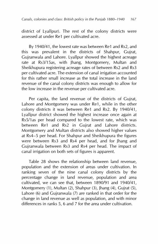
Canals, colonies and class: British policy in the Punjab 1880–1940
167
district of Lyallpur). The rest of the colony districts were assessed at under Re1 per cultivated acre.
By 1940/41, the lowest rate was between Re1 and Rs2, and this was prevalent in the districts of Shahpur, Gujrat, Gujranwala and Lahore. Lyallpur showed the highest acreage rate at Rs3/15as, with Jhang, Montgomery, Multan and Sheikhupura registering acreage rates of between Rs2 and Rs3 per cultivated acre. The extension of canal irrigation accounted for this rather small increase as the total increase in the land revenue of the canal colony districts was enough to allow for the low increase in the revenue per cultivated acre.
Per capita, the land revenue of the districts of Gujrat, Lahore and Montgomery was under Re1, while in the other colony districts it was between Re1 and Rs2. By 1940/41, Lyallpur district showed the highest increase once again at Rs5/1as per head compared to the lowest rate, which was between Re1 and Rs2 in Gujrat and Lahore districts. Montgomery and Multan districts also showed higher values at Rs4–5 per head. For Shahpur and Sheikhupura the figures were between Rs3 and Rs4 per head, and for Jhang and Gujranwala between Rs3 and Rs4 per head. The impact of canal irrigation on both sets of figures is apparent.
Table 28 shows the relationship between land revenue, population and the extension of areas under cultivation. In ranking seven of the nine canal colony districts by the percentage change in land revenue, population and area cultivated, we can see that, between 1890/91 and 1940/41, Montgomery (1), Multan (2), Shahpur (3), Jhang (4), Gujrat (5), Lahore (6) and Gujranwala (7) are ranked in that order for the change in land revenue as well as population, and with minor differences in ranks 5, 6 and 7 for the area under cultivation.
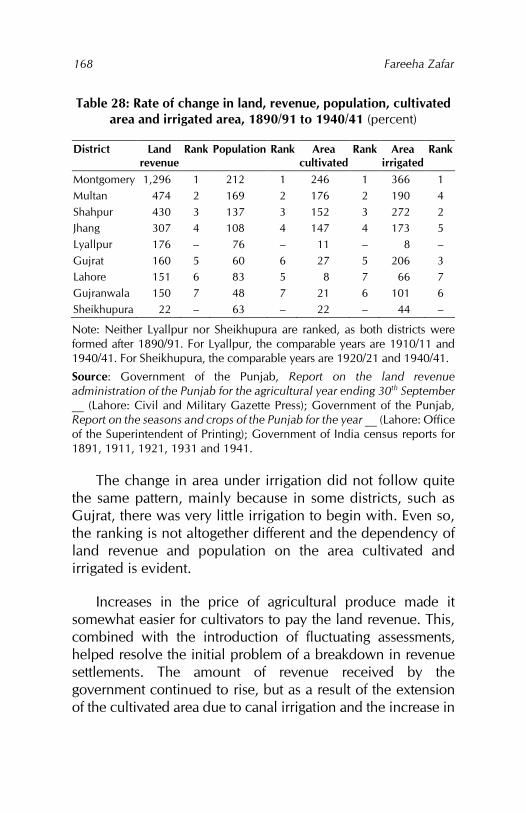
Fareeha Zafar
168
Table 28: Rate of change in land, revenue, population, cultivated area and irrigated area, 1890/91 to 1940/41 (percent)
District Land revenue
Rank Population Rank Area cultivated
Rank Area irrigated
Rank
Montgomery 1,296 1 212 1 246 1 366 1 Multan 474 2 169 2 176 2 190 4 Shahpur 430 3 137 3 152 3 272 2 Jhang 307 4 108 4 147 4 173 5 Lyallpur 176 – 76 – 11 – 8 – Gujrat 160 5 60 6 27 5 206 3 Lahore 151 6 83 5 8 7 66 7 Gujranwala 150 7 48 7 21 6 101 6 Sheikhupura 22 – 63 – 22 – 44 –
Note: Neither Lyallpur nor Sheikhupura are ranked, as both districts were formed after 1890/91. For Lyallpur, the comparable years are 1910/11 and 1940/41. For Sheikhupura, the comparable years are 1920/21 and 1940/41.
Source: Government of the Punjab, Report on the land revenue administration of the Punjab for the agricultural year ending 30th September __ (Lahore: Civil and Military Gazette Press); Government of the Punjab, Report on the seasons and crops of the Punjab for the year __ (Lahore: Office of the Superintendent of Printing); Government of India census reports for 1891, 1911, 1921, 1931 and 1941.
The change in area under irrigation did not follow quite the same pattern, mainly because in some districts, such as Gujrat, there was very little irrigation to begin with. Even so, the ranking is not altogether different and the dependency of land revenue and population on the area cultivated and irrigated is evident.
Increases in the price of agricultural produce made it somewhat easier for cultivators to pay the land revenue. This, combined with the introduction of fluctuating assessments, helped resolve the initial problem of a breakdown in revenue settlements. The amount of revenue received by the government continued to rise, but as a result of the extension of the cultivated area due to canal irrigation and the increase in
Canals, colonies and class: British policy in the Punjab 1880–1940
169
rent rates325 rather than because land productivity had improved. The higher prices obtained from these crops was an additional factor in the higher assessment of the productivity of the land on which the land revenue was based.
The largest increases in land revenue took place in those districts where most of the area had been government wasteland, converted into large colonies with the help of the canals. As Table 29 shows, by 1910/11, Lyallpur district, with over 90 percent of its cultivated area under canal irrigation, was paying Rs2 million in land revenue; by 1920/21, it was contributing nearly Rs6 million in revenue.
Table 29: Total land revenue (Rs ‘000)
District 1880/81 1890/91 1900/01 1910/11 1920/21 1930/31 1940/41 Lyallpur – – – 2,149 5,937 5,868 5,924 Multan 565 966 1,411 1,437 2,321 2,873 5,545 Montgomery 276 345 624 480 3,334 2,941 4,810 Shahpur 379 489 617 1,232 2,303 2,294 2,590 Sheikhupura – – – – 1,902 1,915 2,328 Lahore 563 721 1,019 1,070 1,632 1,603 1,808 Gujrat 585 651 843 864 1,715 1,483 1,693 Jhang 267 399 1,107 1,170 1,451 1,226 1,625 Gujranwala 492 648 1,035 1,597 1,464 1,265 1,617
Source: Government of the Punjab, Report on the land revenue administration of the Punjab for the agricultural year ending 30th September __ (Lahore: Civil and Military Gazette Press).
The district of Montgomery was paying over Rs3 million and both Multan and Shahpur, over Rs2 million. By 1940/41, both Lyallpur and Multan were paying more than Rs5 million in land revenue, with Montgomery following close behind at Rs4.8 million. Shahpur and Sheikhupura were paying between Rs2 million and Rs3 million in revenue by 1940/41
325 As estimated by the extension of irrigation water supplies and the change in the type of crops cultivated.
Fareeha Zafar
170
and the districts of Lahore, Gujrat, Gujranwala and Jhang, under Rs2 million.
As most of the canal construction activity had been completed by 1920/21, increases in land revenue after this were mainly a result of changes in the cropping pattern and the increased cultivation of wheat and cotton. However, the impact of the Sutlej Valley Project canals on the extension of cultivation in the districts of Montgomery and Multan became clear from the rapid increase in the land revenue of both districts between 1930/31 and 1940/41.
The relationship between land revenue and the prices of agricultural produce was not subdued. It acquired prominence at the time of the Depression and the rapid fall in the prices of agricultural produce in the late 1920s. Table 30 shows this aspect of change in the amount of land revenue and the changing price of wheat. In the canal colony districts, the amount of land revenue, therefore, depended mainly on the extension of cultivation and application of canal water to the cultivated area. The resulting increase in land productivity was reflected in the total amount of revenue obtained by the government from the canal colony districts – approximately Rs28 million in 1939/40. Consequently, per acre of cultivated land, the revenue demand was not very high.
The effect of cash crops and their prices on the revenue demand was felt only after 1920/21 when extension of the area cultivated slowed down. However, the land revenue continued to be assessed on the area sown and not on the area matured. This, combined with uncertain rainfall, an irregular supply of canal water and the vacillating prices of agricultural produce made it particularly difficult for small proprietors and tenant cultivators to meet their revenue obligations, whether directly or in the form of increased rents.
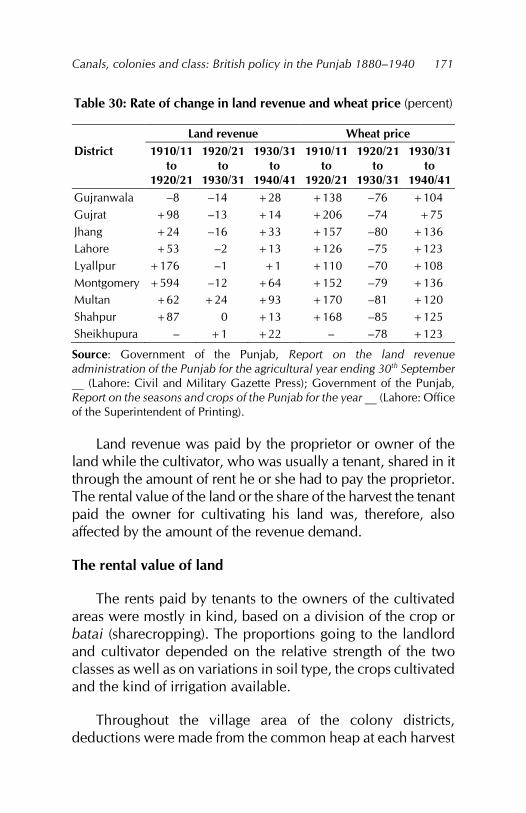
Canals, colonies and class: British policy in the Punjab 1880–1940
171
Table 30: Rate of change in land revenue and wheat price (percent)
Land revenue Wheat price District 1910/11
to 1920/21
1920/21 to
1930/31
1930/31 to
1940/41
1910/11 to
1920/21
1920/21 to
1930/31
1930/31 to
1940/41 Gujranwala –8 –14 +28 +138 –76 +104 Gujrat +98 –13 +14 +206 –74 +75 Jhang +24 –16 +33 +157 –80 +136 Lahore +53 –2 +13 +126 –75 +123 Lyallpur +176 –1 +1 +110 –70 +108 Montgomery +594 –12 +64 +152 –79 +136 Multan +62 +24 +93 +170 –81 +120 Shahpur +87 0 +13 +168 –85 +125 Sheikhupura – +1 +22 – –78 +123
Source: Government of the Punjab, Report on the land revenue administration of the Punjab for the agricultural year ending 30th September __ (Lahore: Civil and Military Gazette Press); Government of the Punjab, Report on the seasons and crops of the Punjab for the year __ (Lahore: Office of the Superintendent of Printing).
Land revenue was paid by the proprietor or owner of the land while the cultivator, who was usually a tenant, shared in it through the amount of rent he or she had to pay the proprietor. The rental value of the land or the share of the harvest the tenant paid the owner for cultivating his land was, therefore, also affected by the amount of the revenue demand.
The rental value of land
The rents paid by tenants to the owners of the cultivated areas were mostly in kind, based on a division of the crop or batai (sharecropping). The proportions going to the landlord and cultivator depended on the relative strength of the two classes as well as on variations in soil type, the crops cultivated and the kind of irrigation available.
Throughout the village area of the colony districts, deductions were made from the common heap at each harvest
Fareeha Zafar
172
before the division of the crop for kamins and menials.326 Their share, which was determined by custom and the relative importance of the work they carried out, generally ranged between 10 and 20 percent of the total crop. Further reductions for fodder were governed by local conditions, the availability of natural pastures and tenants’ bargaining position. The remaining produce was divided between the owner and the cultivator. The rent rate was usually calculated after all the deductions had taken place and varied considerably with the productivity of the land, irrigation facilities, the two parties’ fodder needs and other considerations such as who was responsible for paying the land revenue and malikana, for procuring seed and clearing water channels and for paying the water rates.327
As mentioned earlier, certain classes of land were rated higher than others and this too varied from one locality to the next. Abi and sailaba land were rated the highest and, consequently, very high rates (usually half batai) were imposed in some areas. This was because the sailab did not fail very often and production was therefore more or less certain in areas under sailaba irrigation. For similar reasons, chahi-sailabi and nehri land were also rated highly.
The evolution of money rents in the Punjab was a gradual process and did not exist in many parts of the province at the time of annexation. In the area forming the canal colony districts, cash rents – as separate from revenue rates – were unheard of in most areas and were prevalent only in small
326 Kamins and menials included potters, carpenters, blacksmiths, barbers, weight-men, crop guardians, leather workers, sweepers, fishermen and woodcutters. Their share varied between 10 and 20 percent of the total crop. 327 For example, in Lodhran and Mailsi tehsils, where over a large part of the area one third was taken in batai, the tenants usually provided the labour and the landlord the expenses for clearing water channels (see: Government of the Punjab, Assessment report of the Lodhran and Mailsi tehsils of the Mooltan district, April 1901, paragraph 10).
Canals, colonies and class: British policy in the Punjab 1880–1940
173
portions of cultivated land, generally where cultivation was insecure. In such areas, they were divided into separate soil rents and lump rates. More often, they formed part of the chakota rents that were very popular in the Multan and Montgomery districts. These included a variety of types – lump grain rents, lump cash rents and lump grain plus lump cash rents – and were relatively high.328
With the introduction of large-scale canal irrigation, two important changes took place. First, rent rates rose, especially in the colony areas.329 Second, the area under in-kind rents increased in proportion to the area under cash rents and rents paid at revenue rates. A third factor in the initial stages was the creation of complex rent payment patterns as various adjustments to the amount paid by owners and tenants were adapted to equalise the burden of the water rate.330 The rise in rent rates was a result of the high price of irrigation water (usually met by tenants) and the higher land productivity due to irrigation and any improvements to the land carried out by tenants. All these factors automatically benefitted the landlord, who shared in the increased production through a larger share of the batai. Moreover, under the batai system, tenancies were yearly and the rotation and choice of crops were determined largely by the owner.331
In the two canal colonies formed during the 1890s, rent rates increased in the areas under irrigation. The assessment report for Multan in 1896 stated that, “except in the Sidhnai tracts where the canal has revolutionised previously existing arrangements, there does not appear to have been any
328 Douie, Punjab settlement, 173–178. 329 Government of the Punjab, Land revenue, 1900, 33. 330 Government of the Punjab, Assessment report of the Jhelum nehri circle of the Jhang district, March 1906, 22. 331 India, Department of Agriculture, Agriculture, evidence taken in the Punjab, 499.
Fareeha Zafar
174
appreciable rise in rents since settlement.”332 Similarly, in the Lower Sohag-Para circle in Pakpattan tehsil, landlords not only charged a higher rent than in other circles, they also shared less of the divisible produce with their menials.333 The 1899/1900 Punjab land revenue report gauged the intensity of this increase as applied to all areas, irrigated and unirrigated:
It is becoming the universal custom for the owner or government tenant to take the produce and half the total annual government demand from his tenant or sub-tenant.334
Since canal construction was carried out in stages, lower rent rates prevailed in areas where there was a demand for tenants to break up new land.335 With emigration to the colony tracts, tenants held a relatively strong position in the Chunian tehsil in Lahore district. The rent rates were usually half on nehri and some barani land, but around a third on the remaining nehri and sailaba land.336
In some areas, the proximity of the canals increased the bargaining position of the tenants, who could threaten to migrate to the colony area. In Mailsi tehsil, for example, most rent rates were one-third batai with half-rates operating in some nehri areas, given the proximity of the Lower Bari Doab Canal.337 The fall in batai rates recorded in some canal circles
332 Government of the Punjab, Reassessment of the Mooltan district, April 1896, paragraph 9. 333 Government of the Punjab, Assessment report, tehsil Pakpattan, Montgomery district, September 1898, paragraph 6. 334 Government of the Punjab, Land revenue, 1900, 33. 335 Government of the Punjab, Department of Revenue and Agriculture, Proceedings, proposed reassessment of the Montgomery district no. 349, 4 December 1890, paragraph 2. 336 Government of the Punjab, Assessment report of the Chunian tehsil, including the Chunian Colony of the Lahore district, October 1914, 36. 337 Government of the Punjab, Assessment report of the Mailsi tehsil of the Multan district, January 1920, paragraph 11.
Canals, colonies and class: British policy in the Punjab 1880–1940
175
was associated with tenants paying fluctuating canal rates plus cesses (these figures were not included in the rent estimates) whereby their landlord’s share was not only more, but also went unrecorded because he obtained additional malikana that increased his share by about 2–3 percent.338 On the whole, the actual increase in rents remained low till the turn of the century. Colonisation was still in its early stages and the scarcity of tenants forced many lessees of government land to rent their land to relatives at comparatively low rates.339
Within a period of 20 years (approximately the time between two settlements), the area under half-batai increased from 61 to 87 percent in the Kabirwala tehsil of Multan district. By 1912, in the Bhera bar area of Shahpur district, the rent rate throughout the circle was half-batai. In the colony area, this meant that half the produce and bhusa (straw), half the land revenue demand and half the water rate was payable by the tenant.340 By 1915, the practice of taking half the produce as the landlord’s share and half the land revenue demand from the tenant had extended to two fifths of the land paying rent by crop division in the Punjab.341
Variations in the batai pattern were more common in practice than in theory. Theoretically, the consolidated rates and cesses were payable by the lessee. In practice, in the case of tenant cultivation (except where half-batai was due), the tenant and not the lessee paid the water rates and, in several cases, the land revenue rates and cesses as well. In the latter case, lessees
338 Government of the Punjab, Assessment report of the Dipalpur tehsil, Montgomery district, December 1897, paragraph 7. 339 In the Sohag-Para Colony in 1895/96, 46.22 percent of the cultivated land was in the hands of lessees and 53.6 percent in the hands of their tenants-at-will (see: Government of the Punjab, Assessment report, Lower Sohag-Para Canal colony, Montgomery district, January 1899, 8). 340 Government of the Punjab, Assessment report of the area within the limits of the Lower Jhelum Canal in the Shahpur district, November 1911, 17. 341 Douie, Punjab settlement, 180.
Fareeha Zafar
176
would pay out of the batai received only the fixed malikana charge levied at Re1 per 10 acres. Where the batai was half, lessees would pay the entire consolidated rates and cesses. Malikana, or the extra proprietary fee, was generally charged in addition to the batai as in the rest of the Sohag-Para circle. The average rates were not lower – and were in fact slightly higher in the colony – than in the older proprietary villages.342
Most arrangements between landlords and tenants on the payment of revenue, rent and cesses appeared to benefit the former. Even small increases in the rates of batai generally favoured the landlord, who then increased his share with additional payments in the form of zamindari kharachh and lichh.343 With time, this practice became more common.
The improved productivity of the land associated with canal irrigation allowed landlords to increase their income by demanding all or a portion of the canal advantage or canal owner’s rate.344 The colonies report for 1913/14 noted that, when the land revenue was increased, colonist lessees managed to shift the enhancement onto the tenants. In theory, owners were expected to bear the entire enhancement345 but the government had no way of controlling the rents they charged to compensate for the higher revenue demanded by the state due to irrigation and increased production.346 In some cases, landowners enforced higher rents in imitation of the canal areas despite the difficulty of obtaining tenants. In the canal-irrigated areas, the initial shortage of tenants was replaced by an excess due to migration and population
342 Government of the Punjab, Lower Sohag-Para Canal, 1899, 9. 343 Kharachh refers to a cess realised by the landlord in addition to rent. Lichh is a fee paid in recognition of a proprietary title. 344 Douie, Punjab settlement, 170. 345 Government of the Punjab, Report on the Punjab colonies for the year ending 30th September 1914 (Lahore: Civil and Military Gazette Press, 1914), 4. 346 Government of the Punjab, Assessment report of the area commanded by the Lower Jhelum Canal in the Shahpur district, May 1909, 20.
Canals, colonies and class: British policy in the Punjab 1880–1940
177
increase: this lowered the bargaining power of the tenant class in the matter of rents.
In areas where irrigation had commenced before the colonisation process and a comparatively small exodus of tenants took place, rent rates remained favourable to the landlord.347 Where a very large area was under batai cultivation, in spite of plague and other adversities the advantage remained with the landlord.348 Higher rents on nehri land in particular also forced tenants to pay from their profit on stock.349 Thus, landlords whose share of fodder and straw had fallen considerably as a result of reduced grazing facilities in the canal colonies were able to compensate for the reduction while their tenants’ dependence simply increased.350 In areas where fodder crops were a large proportion of the total produce, the scarcity of tenants caused by their exodus to neighbouring canal colonies raised their bargaining position; in the event they demanded the entire fodder crop, the landlord would have to take a larger share of the balance to make any perceptible profit.351
Another barrier to the development of competitive rent rates was the continued dependence of most cultivators on the bania, to whom they sold their crop in lieu of cash to meet their revenue obligations and seed requirements.352 Tenants were usually small proprietors, indebted proprietors or menials.353 On estates managed by agents, such as the Hajiwah estate in Mailsi
347 Government of the Punjab, Lower Jhelum Canal, 1911, 23. 348 Government of the Punjab, Assessment report of the Gujrat tehsil of the Gujrat district, October 1913, 15. 349 Abbott, Jhang district, 19. 350 I. C. Lall, Final report on the Hafizabad settlement, Gujranwala district, 1902 to 1907 (Lahore: Civil and Military Gazette Press, 1908), 28. 351 Government of the Punjab, Revision of the assessment of the bet circles of the Montgomery and Gugera tehsils of the Montgomery district, March 1896, 3. 352 Aziz, Jhang district, 22. 353 Government of the Punjab, Gujrat tehsil, 1913, 15.
Fareeha Zafar
178
tehsil, tenants’ need for money and seed bound them in debt from the time they started work there. As the rent rates were high, tenants were reduced to a lifetime of indebtedness.354 By comparison, the Janglis and Hitharis – who belonged to the pastoral tribes that had been dispossessed of free access to grazing land – were more liberal landlords and generally provided seed to the weaker class of tenants.
The connection between the rising prices of agricultural produce and rising rents also became apparent during the 1910s. By increasing the area under in-kind rent, landlords benefited from the larger profits obtained from the high prices of wheat and cotton. For example, in Kasur tehsil, in-kind rents grew by 11 percent between 1891 and 1914, allowing landlords to secure a substantial share of the profits due to the rise in prices.355 This situation continued till 1928/29 when the Depression led to a slump in agricultural prices. With prices continuing to fall, the Abiana Committee was set up in 1934 to determine whether it was necessary to readjust the occupier’s rate and, if so, how this might be done while affecting provincial revenues as little as possible.356
Theoretically, a reduction in the abiana (occupier’s rate) would benefit the party responsible for payment: either the tenant or landlord (by increasing profits or net rent in the latter’s case). In real terms, landlords would benefit from the situation either way because the supply of tenants was greater than the demand. This also explained the high pitch of rents throughout the canal colony districts as:
354 Government of the Punjab, Assessment reports of the Upper and Lower Jhang branch circles of the Lower Chenab Canal, Chenab Colony, March 1909, 20. 355 Government of the Punjab, Assessment report of the Kasur tehsil of the Lahore district, February 1914, 28. 356 Government of the Punjab, Report of the Abiana Committee (Lahore: Public Works Department, Irrigation Branch, 1934), 2.
Canals, colonies and class: British policy in the Punjab 1880–1940
179
otherwise it would be impossible for a landlord to secure roughly half the produce of the land leaving the tenant to meet nearly all the cost of cultivation from the other half, and the landlord’s position is particularly strong in canal-irrigated areas where the production of crops is notoriously easy as compared with barani areas.357
Cash rents in the colony villages far exceeded those in the old proprietary estates. In 1926, Shahpur district recorded a difference of 41 percent between the two.358 Landlords adopted several techniques whereby they could either benefit directly from the rental arrangement or pass on their share of the water rate and other payments to their tenants. These included shifting the enhancement in land revenue to the tenant in the form of increased rents and other payments.
In the early stages of colonisation, landlords managed to circumvent the pressure of tenant scarcity by leasing land to poorer relatives. In the later stages, the increase in the number of tenants in the colony areas improved landlords’ bargaining position. They were also able to compensate for their reduced share of fodder in the canal-irrigated areas through higher rents. The fact that tenants required cash and incurred revenue payment costs and additional expenditure during the early stages of colonisation made them vulnerable to banias and the agents of large capitalist grantees, who held them in perpetual debt afterwards, further reducing their bargaining power. Landlords could increase their share of the profits through higher rents during periods of rising agricultural prices. When prices began to fall, they were still able to make a profit from their share of the rent.
357 Government of the Punjab, Abiana Committee, appendix 5, 13. 358 Ram Chandra, Final settlement report of the portion of the Shahpur district under fluctuating assessment (Lahore: Superintendent, Government Printing, 1925), 12.
Fareeha Zafar
180
The increase in area under in-kind rent in most of the canal colony districts reflected the weakening power of the tenant class as a whole and a general rise in the share of the produce received by landlords.359 In the Punjab, cash-paying tenants were protected by the provisions of the Tenancy Act of 1868 against any rent enhancement until they had been compensated for improvements they had made to the land, but this did not apply to tenants paying in kind.360 It also accounted for tenants’ indifference to such improvements on rented holdings. The batai system tied them down to a specific system of rotation because the continuance of their tenancy depended on the landowner, who could thereby dictate which crops were to be cultivated.
The area under in-kind rent increased at the expense of the khudkasht (owner-cultivated) area. Since the data on land occupancy and land under different kinds of rent is given for the cultivated area, any increase in the cultivated area due to canal irrigation was reflected in the increase in the area under tenant cultivation and in-kind rent. The area under revenue rates and cash rent showed an increase, but this was too small to affect the general trend in rents.
Between 1891/92 and 1931/32, for the combined colony districts, the total cultivated area given by the revenue records increased from 5.08 million to 10.86 million acres (Table 31). During the same time, the area cultivated by tenants increased from 2.69 million to 6.90 million acres, that is, at a rate of 157 percent. The area under tenants paying rent in kind increased from 2.03 million to 5.18 million acres at almost the same rate (156 percent). However, the area under tenants-at-will paying rent in kind increased from 1.96 million to 5.13 million acres – an increase of 161 percent. Taken as a proportion of the total cultivated area, the area under in-kind rent increased from 40
359 Government of the Punjab, Mooltan district, 1896, paragraph 9. 360 India, Department of Irrigation, Irrigation Commission, 57.
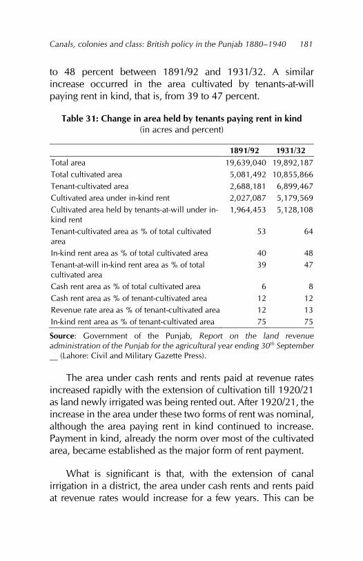
Canals, colonies and class: British policy in the Punjab 1880–1940
181
to 48 percent between 1891/92 and 1931/32. A similar increase occurred in the area cultivated by tenants-at-will paying rent in kind, that is, from 39 to 47 percent.
Table 31: Change in area held by tenants paying rent in kind (in acres and percent)
1891/92 1931/32 Total area 19,639,040 19,892,187 Total cultivated area 5,081,492 10,855,866 Tenant-cultivated area 2,688,181 6,899,467 Cultivated area under in-kind rent 2,027,087 5,179,569 Cultivated area held by tenants-at-will under in-kind rent
1,964,453 5,128,108
Tenant-cultivated area as % of total cultivated area
53 64
In-kind rent area as % of total cultivated area 40 48 Tenant-at-will in-kind rent area as % of total cultivated area
39 47
Cash rent area as % of total cultivated area 6 8 Cash rent area as % of tenant-cultivated area 12 12 Revenue rate area as % of tenant-cultivated area 12 13 In-kind rent area as % of tenant-cultivated area 75 75
Source: Government of the Punjab, Report on the land revenue administration of the Punjab for the agricultural year ending 30th September __ (Lahore: Civil and Military Gazette Press).
The area under cash rents and rents paid at revenue rates increased rapidly with the extension of cultivation till 1920/21 as land newly irrigated was being rented out. After 1920/21, the increase in the area under these two forms of rent was nominal, although the area paying rent in kind continued to increase. Payment in kind, already the norm over most of the cultivated area, became established as the major form of rent payment.
What is significant is that, with the extension of canal irrigation in a district, the area under cash rents and rents paid at revenue rates would increase for a few years. This can be
Fareeha Zafar
182
attributed to the increase in the area cultivated by occupancy tenants who usually paid the rents mentioned above. In many cases, new lessees in canal-irrigated areas were given the status of occupancy tenants; within five to ten years, they were either able to purchase proprietary rights and become owners of their grant or become tenants-at-will if they were unable to buy these rights. This was most notable in the case of Jhang district between 1895/96 and 1905/06 with the formation of the Chenab Colony and in the districts of Montgomery and Multan between 1921/22 and 1931/32.
On the other hand, the area under in-kind rents appeared to increase steadily, particularly in the three eastern districts of Lahore, Gujrat and Gujranwala from 1891/92 to 1931/32. The other districts showed greater vacillations due to the changing tenancy conditions under colony tenures and grants. By the 1920s, however, the upward trend was clearly discernible in all districts.
The overall high proportion of the area cultivated by tenants under in-kind rents also needs to be emphasised. Records for 1931/32 show that, in three districts (Montgomery, Jhang and Multan), more than half the total cultivated area was under batai. In another three districts (Gujranwala, Sheikhupura and Shahpur), the area under batai was between 40 and 50 percent of the cultivated area. In the remaining districts (Lahore, Gujrat and Lyallpur), just under 40 percent of the total cultivated area paid rent in kind.
Although Jhang, Multan and Montgomery had the highest percentage of cultivated area under in-kind rents in 1931/32, they registered an overall decrease in the area under in-kind rents during 1891/92 to 1931/32 (Table 32). This was caused by the following related factors. First, the cultivated area in these districts was very small in 1891/92 – below 20 percent of the total area in each case. Between 1891/92 and 1931/32, the three districts experienced the highest increase in their
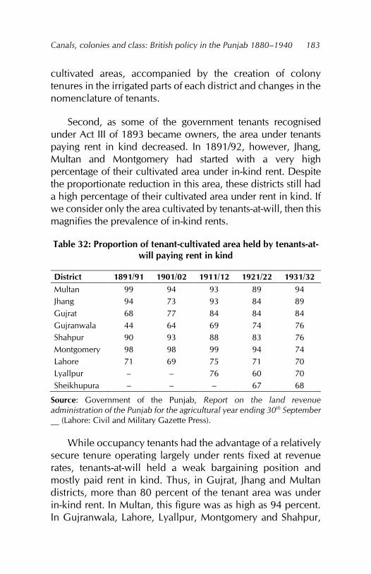
Canals, colonies and class: British policy in the Punjab 1880–1940
183
cultivated areas, accompanied by the creation of colony tenures in the irrigated parts of each district and changes in the nomenclature of tenants.
Second, as some of the government tenants recognised under Act III of 1893 became owners, the area under tenants paying rent in kind decreased. In 1891/92, however, Jhang, Multan and Montgomery had started with a very high percentage of their cultivated area under in-kind rent. Despite the proportionate reduction in this area, these districts still had a high percentage of their cultivated area under rent in kind. If we consider only the area cultivated by tenants-at-will, then this magnifies the prevalence of in-kind rents.
Table 32: Proportion of tenant-cultivated area held by tenants-at-will paying rent in kind
District 1891/91 1901/02 1911/12 1921/22 1931/32 Multan 99 94 93 89 94 Jhang 94 73 93 84 89 Gujrat 68 77 84 84 84 Gujranwala 44 64 69 74 76 Shahpur 90 93 88 83 76 Montgomery 98 98 99 94 74 Lahore 71 69 75 71 70 Lyallpur – – 76 60 70 Sheikhupura – – – 67 68
Source: Government of the Punjab, Report on the land revenue administration of the Punjab for the agricultural year ending 30th September __ (Lahore: Civil and Military Gazette Press).
While occupancy tenants had the advantage of a relatively secure tenure operating largely under rents fixed at revenue rates, tenants-at-will held a weak bargaining position and mostly paid rent in kind. Thus, in Gujrat, Jhang and Multan districts, more than 80 percent of the tenant area was under in-kind rent. In Multan, this figure was as high as 94 percent. In Gujranwala, Lahore, Lyallpur, Montgomery and Shahpur,
Fareeha Zafar
184
the corresponding figure was above 70 percent, with Sheikhupura not far behind at 68 percent.
The proportion of the cultivated area under cash rents had always been small in parts of the Punjab. Given that the concept of cash rents had penetrated the province from the east, they were better known in the eastern districts. Before large-scale canal irrigation in the colony districts, cash rents had prevailed in areas of insecure cultivation and in areas that were not irrigated at all such as the bar circles in Gujranwala and Lahore districts. In the Hafizabad and Khangah Dogran tehsils in Gujranwala in 1904, more than 50 percent of the rents paid on barani land were in cash.
An equally high proportion of the cultivated area under chahi irrigation also paid cash rents, largely because the owners found it difficult to retain tenants on well-irrigated land if they wanted a share of the produce as rent. As a result, they could only keep their tenants on at continued low cash rents.361 Cash rents were also prevalent in parts of Montgomery and Multan: in the former, they were imposed on areas of kasht-barani by the government at a rate of Re1 per acre or double that if cultivation was being carried out without permission.362 In Mailsi tehsil in Multan district, the presence of a strong Hindu community with a large number of moneylenders provided the raison d’etre for cash rents as most mortgagor tenants paid their mortgagees in cash.363
Cash and chakota rents were generally very high. This was explained by the fact that
361 Government of the Punjab, Assessment report of the Hafizabad and Khangah Dogran tehsils, Gujranwala district, September 1904, 25. 362 Government of the Punjab, Assessment report of the Montgomery tehsil, Montgomery district, April 1894, 12. 363 Government of the Punjab, Mailsi tehsil, 1901, 13.
Canals, colonies and class: British policy in the Punjab 1880–1940
185
The tenants pay the revenue and the owners take the malikana which is generally a full one. The economic results fall short of the pure cash and chakota rents, because the latter include all lands owned by nonagriculturists who often force higher rents and also because owners on the spot keep raising their rents whenever possible.364
Within the irrigated circles of the canal colony districts, there was an increase in the area under cash rents, but it is worth noting that this was not accompanied by a decrease in the area under batai.365 Lyallpur district recorded the largest percentage of area under cash rents, with the increase being as high as 10 percent in a period of seven years. In the same districts, the colony chaks recorded larger areas under cash rents than other circles.
In nehri areas, the average cash rent per acre also increased:
It will be seen that there has been a general rise in cash rents, smallest in the case of chahi lands, great on nehri lands in the Bar Circles, and substantial in the case of all other rents. It is also clear that these rents, low as they are, leave a good margin of profit in the Bar Circles after payment of revenue and cesses and a fair margin in the canal-irrigated villages of the Bangar Circle but in the non-irrigated villages of these Circles they are not sufficient to pay the government.366
Cash rents also increased near urban areas, being charged on crops such as vegetables. In the Lahore circle, cash rents 364 Government of the Punjab, Assessment report of the Gujranwala tehsil of the Gujranwala district, January 1912, 18. 365 Government of the Punjab, Assessment reports of the Jhang (I, II and III circles) and Gugera branches of the Chenab Colony, November 1910; Government of the Punjab, Assessment report on the Rakh branch circle, Lower Chenab Canal Colony, March 1913, statement 3. 366 Government of the Punjab, Hafizabad and Khangah Dogran, 1904, 31.
Fareeha Zafar
186
accounted for 75 percent of all rents compared to approximately 20 percent for the rest of the tehsil.367 In Gujrat district, the increase in the area under cash rents in the Phalia tehsil was related to the fact that most occupancy tenants paid rent in cash compared to tenants-at-will who paid in kind.368 Until the 1930s, cash rents increased throughout the colony districts. The Depression of 1929 resulted in a price slump, affecting the area under cash rents. This was most apparent in the case of Lyallpur tehsil where the cultivated area under cash rents fell from 37 percent in 1922/23 to only 19 percent in 1932/33.369
A very high percentage of the area cultivated by occupancy tenants was under rents paid at revenue rates and in cash, which underscores the strength of this class of tenants compared to tenants-at-will. While the proportion of the area under such rents increased as irrigation spread, its ratio to the total cultivated area did not change very much. Therefore, even with the extension of irrigation and cultivation, a larger portion of the cultivated area remained under rent in kind. Another category of tenants that paid rent in cash to its creditors at times was mortgagor tenants and it is to this aspect of land transfer and sale that we now turn.
Indebtedness and land alienation
Classifying and fixing rights to land under the system of revenue settlements pursued by the British in the Punjab gave land the value of a commodity. The determination of these rights was based on Regulation VII of 1822 as applied to the United Provinces. With the annexation of the Punjab in 1849,
367 Government of the Punjab, Assessment report of the Lahore tehsil of the Lahore district, August 1915, 29. 368 Government of the Punjab, Assessment report of the Phalia tehsil of the Gujrat district, October 1915, statement 13. 369 Government of the Punjab, Assessment report of the Lyallpur tehsil of the Lyallpur district, November 1936, statement 7.
Canals, colonies and class: British policy in the Punjab 1880–1940
187
this formed the basis for the district land settlements. Later, these rights – and especially those of the different categories of tenants – were spelled out in the Tenancy Act XXVIII of 1868. Conferring heritable and transferable rights on certain classes of proprietors and tenants introduced the practice of land sales, transfers and mortgages in the Punjab.
Under the Mughals and Sikhs, ownership had remained obscure and customary.370 In times of need, cultivators obtained small, limited loans from the banias based on their meagre production and/or other assets in the form of animal stock and personal possessions. There was no legislative machinery allowing banias to press for payment of their debt. They gained, therefore, by having regular and permanent debtors whom they did not try to dispossess, as the land itself would in any case have been of little value to them. The interest they charged, together with the increasing sums of money their debtors were forced to borrow, ensured a steady income.
Moreover, the relationship between the banias and peasants was not regulated by the need to develop agriculture. It was thus to the benefit of the former that peasants remained able to pay both the land revenue as well as their debt with interest. The system of joint ownership was also stronger and thus the alienation of land was very restricted.371
Under the land settlements, property rights were better defined and a “more complete recognition of the force of contracts, and the obligations on the courts of justice to enforce them” was established.372 With this, the possession of
370 Trevaskis, Land of the five rivers, 234. 371 Government of the Punjab, Department of Revenue and Agriculture, Proceedings, note on land transfer and agricultural indebtedness in India, October–December 1895, 4, 372 Satis Chandra Ray, comp. Agricultural indebtedness in India and its remedies, being selections from official documents (Calcutta: Calcutta University Press, 1915), 21.
Fareeha Zafar
188
land itself acquired a new value as ownership of the land could be mortgaged for large sums of money. Civil courts patterned on the English legal system had been established in the Punjab in 1866 and when the suits for debt were handed over to them in 1874/75, rigid application of the law inevitably favoured the banias who could acquire increasingly large areas of cultivated land. The actual cultivators and tillers of the soil were reduced to the status of tenants and agricultural labourers.
Moneylenders grew more powerful under colonial administration not only with the establishment of the civil courts, which eroded the authority of the village community (that had protected peasants from dispossession by the banias), but also because the civil courts were stricter about enforcing payment of debt than previous governments. Furthermore, the law of pre-emption, which gave relatives and members of the village community first right to buy any land that came up for sale, did not apply to usufructory mortgage (the mortgage of land for debt) except where recorded by the village papers.373 The courts’ rigid enforcement of the law for the settlement of debts hastened the transfer of agricultural land into the hands of the moneylenders. Also excluded from its application were lekha-mukhi contracts under which debtors surrendered their crop to a bania who would pay all expenses for them, deduct interest and credit the balance towards the payment of the debt. These terms reduced landholders to the position of tenants, with peasant proprietors of entire districts “reduced to serfdom.”374 This fact was not reflected in the agricultural statistics enumerating all data connected with land transfers and sales.
Other factors contributing to increasing alienations of land were the rigidity of the land revenue, its payment in cash and
373 Trevaskis, Land of the five rivers, 21. 374 Thorburn, Musalmans and moneylenders, 83.
Canals, colonies and class: British policy in the Punjab 1880–1940
189
famine conditions, which occurred at repeated intervals during the latter half of the nineteenth century. Until the development of the canal colonies, land revenue was fixed on the assumption that years of plenty would help compensate for periods of scarcity. This never happened. In fact, peasants could seldom pull out of a season of poor harvests and, consequently, their debt tended to accumulate faster, eventually leading to increased land sales and mortgages.
The attitude of the administration to the problem at this stage has been best summed up by the settlement officer of Gujranwala district:
The people understand that the assessment is something fixed or rigid, and even when the harvests fail, they have only too many facilities for raising money by pledging their credit or mortgaging their land.375
Indebtedness and land alienation were, therefore, not only acceptable, but also encouraged; the existence of the moneylenders saved the government from having to provide credit facilities to the cultivators.
In the barani bar areas as well, the uncertainty and unreliability of rainfall inevitably forced peasants to depend on the banias. Loss of crops and the death of cattle were primary reasons for the sale or mortgage of land. In the chahi and sailabi areas, the problem was exaggerated by the administration’s misconception that secure supplies of water meant secure cultivation. Chahi areas were very heavily assessed, given the intensity of cultivation and the high value of crops being grown, such as sugarcane, vegetables and indigo. In such areas, any reduction in well water affected land transfers and sales as land revenue was assessed on the area
375 O’Dwyer, Gujranwala district, 22.
Fareeha Zafar
190
sown, not the area matured. Particularly in regions of uncertain rainfall, if a well fell into disuse or if the cattle died, the fixed cash assessment tended to break down.
The productive power of the land had risen, but there was a corresponding increase in cultivation expenses and small cultivators were left with no surplus for bad days. Consequently, they had to resort to borrowing: any zamindar who happened to run into debt once could “never get out of it until his land” was sold off and he was “reduced to a deplorable condition.”376 The situation was aggravated by the absence of any rules for remission of the land revenue or for changing tenurial forms. In the case of a changeover from zamindari to pattidari tenure, the loss accruing to a person from his well could not be compensated for by the profits obtained by the person who had sunk the well.
Well and sailaba cultivation was mostly associated with small holdings, the owners of which had comparatively limited staying power as against the proprietors of larger holdings.377 Inundation canal irrigation was also unreliable: while a large part of the cultivation in Multan, Montgomery, Lahore and Shahpur districts depended on it, considerable differences in the sown and matured areas resulted in most cases, with peasants bearing the brunt of the loss.
Serious land alienation began in 1868 and attracted the attention of the government in the 1870s.378 The indebtedness of the Deccan ryots (peasants) led to the passage of the Deccan Relief Act in 1879. When this was followed by famine the same year, the Famine Commission of 1880 suggested extending the Act to other provinces. Although the moneylending classes resisted its implementation 376 Government of the Punjab, Department of Revenue and Agriculture, Proceedings, general no. __, 1888, paragraph 4. 377 Government of the Punjab, Lodhran and Mailsi, 1901, paragraph 22. 378 Punjab, Revenue and Agriculture, Proceedings, land transfer, 1895.
Canals, colonies and class: British policy in the Punjab 1880–1940
191
successfully, the problem of indebtedness and the resulting alienations of land that followed had come to the forefront.379
The 1880s marked the beginning of perennial canal construction on a large scale and the conversion of the bar areas into irrigated colonies. The demands of the colonies plunged its new peasantry into debt right from the start. The peasants needed credit to fit into the new environment and cash to pay for the canal water. The frequent problems associated with obtaining regular supplies of canal water meant relying on wells.
In the Sohag-Para Colony (Montgomery district), numerous wells were needed to maintain the increased area brought under cultivation by the canals. Without a corresponding decrease in the rates they had to pay, many tenants absconded and landowners began falling into debt as they had to pay the takavi borrowed by the latter. Takavi was used mainly for constructing irrigation channels and very little was left for the demands of cultivation and revenue.380 Both the Land Improvement Loans Bill and the Agricultural Loans Bill were deficient in that the former only gave short-term loans and those only to proprietors and tenants,381 while the effectiveness of the latter, it was felt, would remain limited
until the cause which prevent the people from improving their lands are removed, namely in the case of tenants the want of security that the profits which are derivable from their improvements will not be appropriated by the landlord.382
379 Trevaskis, Punjab of today, 25. 380 Government of the Punjab, Department of Revenue and Agriculture, Proceedings, irrigation no. 314C, 18 September 1891. 381 Ray, Agricultural indebtedness, 44. 382 Ray, Agricultural indebtedness, 55.
Fareeha Zafar
192
Although the government realised that constructing wells in canal-irrigated areas was costly and thus had to be phased over a certain period, it refused kharaba in cases where such wells had not been constructed, leading to further hardship for the cultivating classes.383
As early as 1888, official records had noted that transfers of landed property were less common in chahi or barani villages than in canal villages because the proprietors of canal villages could borrow money more easily.384 The certainty of perennial supplies of irrigation water was responsible for the superiority of the canal village as banias were sure of getting either their money or the land if cultivators failed to meet their debts. The extension of irrigation had also curtailed the area available for grazing so that, in the event of famine or successive bad harvests or floods, cultivators were forced to sell their land when their cattle died.385
With land becoming a saleable and transferable commodity, its demand increased. During the 1860s and 1870s, political stability contributed to increased agricultural production. The development of infrastructure such as roads and railways also increased the value of and demand for land. At the same time, the land revenue was less severe in the canal colonies compared to other provinces and this left large landholders with a surplus that could only be invested in buying land. The data shows that, where there were more members belonging to moneylending tribes such as the Aurora, Kamboh and Mahtam, as in the districts of Montgomery and Multan, there was greater alienation of land.386
383 Government of the Punjab, Department of Revenue and Agriculture, Proceedings, irrigation no. __, 1892. 384 Punjab, Revenue and Agriculture, Proceedings, general, 1888, paragraph 5. 385 O’Dwyer, Gujranwala district, 24. 386 Punjab, Revenue and Agriculture, Proceedings, Montgomery, 1890, paragraph 2.
Canals, colonies and class: British policy in the Punjab 1880–1940
193
Increased production resulted in surplus money in the hands of large landholders. The dearth and curtailment of local investment channelled this surplus towards moneylending.387 The transfer of land from the agricultural classes to the moneylending classes – who were in most cases nonagricultural – accelerated. In the canal colonies, they managed to obtain land by buying out small peasants as well as through the direct purchase of land at auctions.
The colonial policy of giving direct grants to large landholders in the form of capitalist grants added to the concentration of land. The Punjab revenue proceedings are replete with debates on the problem of agricultural indebtedness in the Punjab. The impact of canal irrigation on land alienation is clearly brought out by the divisional deputy commissioners:
It is often in rich canal-irrigated village[s] that the most extensive alienations have occurred. There the value of land has risen from Rs10 to Rs20 per acre to Rs100 with a great demand for land.388
The new class of agricultural capitalists attracted by the canal colonies also provided loans to cultivators in areas where agriculture was still precarious and dependent on inundation canals. This was especially prevalent in areas such as Multan, which relied on a mixture of perennial and nonperennial irrigation.389 In the district of Montgomery, most alienations of land were to the Auroras. The assessment officer of Pakpattan tehsil noted:
In this tehsil owing to the much larger area owned by Auroras, it is even more difficult than in Dipalpur to distinguish satisfactorily between the moneylender and the agriculturist, and as in that
387 Trevaskis, Land of the five rivers, 314. 388 Government of the Punjab, Department of Revenue and Agriculture, Appendix to proceedings, agriculture, 15 August 1889. 389 Government of the Punjab, Mooltan district, 1896, paragraph 6.
Fareeha Zafar
194
tehsil it must be borne in mind that the amount of alienation in favour of true agriculturist who have no other occupation than agriculture is not so extensive as appears at first sight… In this tehsil there are very few true agriculturists who are in a position to take land on sale or mortgage, and I put the percentage of alienation in favour of persons who carry on moneylending, whether in combination with agriculture, or not, at 65 in the case of sales and at 85 in that of mortgages.390
Consequently, canal irrigation added to the existing factors favouring the growth of the moneylending class. Until the turn of the century, the data shows an upward trend in land transfers and sales in the existing canal colony districts. The only exception was Montgomery where the number of alienations slowly fell, possibly because the area under cultivation was very small – only 15 percent of the total area cultivated. In Multan, the increase was very rapid: under the Sikhs, many large grants had been given to the moneylending classes which then extended their holdings at the expense of small landowners under British rule.
Irrigation facilities in the form of inundation canals and channels may also have contributed to this acquisitiveness. Increased activity on the part of the nonagricultural moneylending class was also evident in the year preceding the Alienation of Land Act as it became evident that legal measures were going to be taken to reduce the transfer of land (Table 33). It was not till the end of the nineteenth century that measures were taken in this direction. It is worth noting that the legislation focused not on the problem of indebtedness, but on the transfer of land through sales and mortgages from the agricultural classes to the nonagricultural tribes.
390 Government of the Punjab, Pakpattan, Montgomery district, 1898, 54.
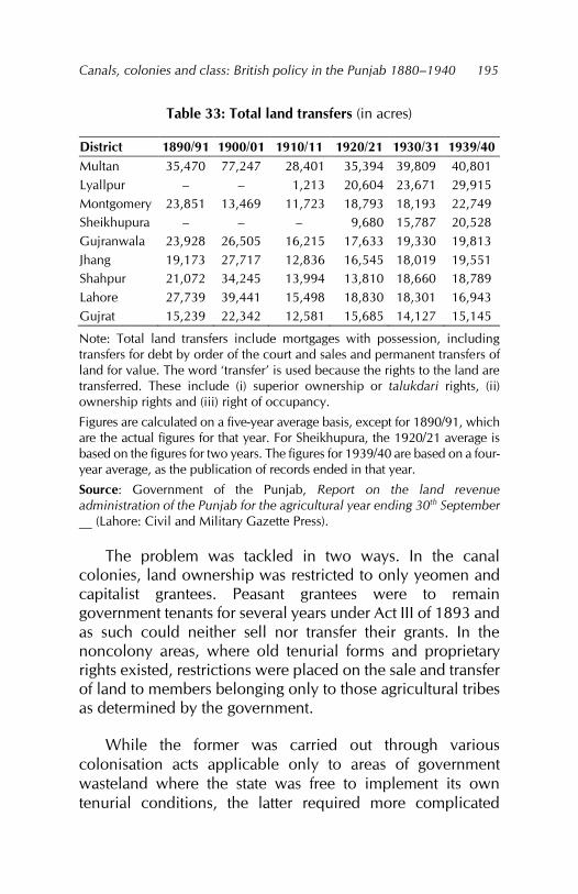
Canals, colonies and class: British policy in the Punjab 1880–1940
195
Table 33: Total land transfers (in acres)
District 1890/91 1900/01 1910/11 1920/21 1930/31 1939/40 Multan 35,470 77,247 28,401 35,394 39,809 40,801 Lyallpur – – 1,213 20,604 23,671 29,915 Montgomery 23,851 13,469 11,723 18,793 18,193 22,749 Sheikhupura – – – 9,680 15,787 20,528 Gujranwala 23,928 26,505 16,215 17,633 19,330 19,813 Jhang 19,173 27,717 12,836 16,545 18,019 19,551 Shahpur 21,072 34,245 13,994 13,810 18,660 18,789 Lahore 27,739 39,441 15,498 18,830 18,301 16,943 Gujrat 15,239 22,342 12,581 15,685 14,127 15,145
Note: Total land transfers include mortgages with possession, including transfers for debt by order of the court and sales and permanent transfers of land for value. The word ‘transfer’ is used because the rights to the land are transferred. These include (i) superior ownership or talukdari rights, (ii) ownership rights and (iii) right of occupancy.
Figures are calculated on a five-year average basis, except for 1890/91, which are the actual figures for that year. For Sheikhupura, the 1920/21 average is based on the figures for two years. The figures for 1939/40 are based on a four-year average, as the publication of records ended in that year.
Source: Government of the Punjab, Report on the land revenue administration of the Punjab for the agricultural year ending 30th September __ (Lahore: Civil and Military Gazette Press).
The problem was tackled in two ways. In the canal colonies, land ownership was restricted to only yeomen and capitalist grantees. Peasant grantees were to remain government tenants for several years under Act III of 1893 and as such could neither sell nor transfer their grants. In the noncolony areas, where old tenurial forms and proprietary rights existed, restrictions were placed on the sale and transfer of land to members belonging only to those agricultural tribes as determined by the government.
While the former was carried out through various colonisation acts applicable only to areas of government wasteland where the state was free to implement its own tenurial conditions, the latter required more complicated
Fareeha Zafar
196
legislation to cover the entire Punjab and was embodied in the Alienation of Land Act of 1900.
Both measures were applied in the canal colonies, with colony legislation taking preference over the Alienation of Land Act in colony areas. For a time, there was a sharp decrease in the total area transferred in the form of sales and mortgages. Within a decade or less, however, an upward trend had reappeared and a new category of moneylender had emerged.
Both measures for restricting land alienation were directed against the nonagricultural moneylender, the purpose being to protect the agricultural classes against the loss of their land to nonagriculturists. They did not touch on the cause of the need for credit, which remained as acute. In the canal colonies, the need to develop the land grants initially and to pay in cash for the canal water supplied by the Irrigation Department required a certain amount of credit. Moreover, even perennial canal irrigation was not always completely reliable. The growth in importance of the agricultural moneylender was thus ensured under the new conditions.
Agricultural moneylenders belonged to the Punjab’s rich landlord class. Jagirdars, inamdars and other recipients of government favour – including those who had aided the administration during the events of 1857 as well as the descendants of large landowners recognised by British tenancy laws at the time of annexation – were landowners who had enough surplus from agricultural production to invest in moneylending. In the canal colonies, the system of granting land to influential people of the provinces, such as existing large landholders and government officials, and the extension of canal irrigation to previously uncultivated estates soon increased the number of landlords belonging to the agricultural tribes.
Canals, colonies and class: British policy in the Punjab 1880–1940
197
Compared to nonagricultural moneylenders, agricultural moneylenders had a direct interest in the land itself and would consequently try and compel their clients to sell it. Thus, soon after the Alienation of Land Act 1900 was passed, land transfers – particularly transfers under mortgages with possession – increased from agriculturists to other members of agricultural tribes:
This is probably due to a rooted disposition on the part of the smaller and poorer owners to part altogether with their land in any circumstances, coupled with the pressure of wealthy agriculturalists intent on increasing their holdings at any price or an any terms.391
Agricultural moneylenders were thus attracted to the canal-irrigated areas. In the area irrigated by the Sidhnai Canal in Multan tehsil, for example, they held most of the mortgaged land392 while in the Chenab circle of Jhang district, the Auroras were the dominant landlords.393 Canal irrigation had attracted many tenants and petty proprietors from other districts and their lands were quickly absorbed by this new class of moneylender. The agricultural moneylenders were thus able to extend their holdings at the expense of small proprietors and were considered a greater menace than nonagricultural moneylenders.394 Additionally, the Alienation of Land Act did not stop the banias from operating, who were now forced to concentrate their moneylending in the noncolony areas.395 As a result, the Act provided no relief to peasant proprietors at all.
391 Government of the Punjab, Jhelum nehri circle, 1906, 13. 392 Government of the Punjab, Mooltan district, 1896, paragraph 6. 393 Government of the Punjab, Chenab, Jhelum and joint circles, 1905, paragraph 8. 394 India, Department of Agriculture, Famine Inquiry, appendix 3. 395 Government of the Punjab, Assessment report of the Kachhi circle of the Jhang district, October 1905, 9.
Fareeha Zafar
198
The first decade of the twentieth century saw increased alienations to the banias in regions of precarious cultivation and inundation from rivers. On the other hand, in the canal colonies, the Alienation of Land Act 1900 was weakened further by the provision of numerous alienable grants. The restrictions on transferring or selling rights to the land applied only to government tenants. All other types of grants, including different service grants, yeomen grants, capitalist grants and land obtained through auction, were exempt from these restrictions.
It was suggested that one sixth of the land available for grants be set aside for the capitalists and of it, a fair proportion should be auctioned.396 There was also no restriction on who could acquire this land. The nonagricultural moneylending class thus gained a foothold in the colonies and their numbers rose with an increase in the amount of land made available for auction in each colony.
Realising the peasantry’s need for credit (especially in the canal colonies) if agricultural production was to progress, the cooperative movement was initiated in 1902. The fall in the number of land alienations during 1915–30 in the districts of Gujranwala, Lahore, Jhang and Shahpur and between 1920 and 1930 in Gujrat, Lyallpur, Montgomery and Multan could be attributed to this movement.
Equally, it might be traced to the general increase in agricultural productivity due to canal irrigation and the high prices obtained for agriculture produce during this period. It may also have been a result of the greater diversity of creditors, both agencies and individuals, which included the traditional bania, cattle dealers, petty shopkeepers and cooperative societies. This reduced the need for outright sale or transfer of land, with a land mortgage being sufficient collateral.
396 Wace, Punjab colony manual, 107.
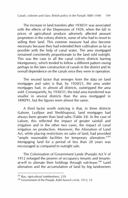
Canals, colonies and class: British policy in the Punjab 1880–1940
199
The increase in land transfers after 1930/31 was associated with the effects of the Depression of 1929, when the fall in prices of agricultural produce adversely affected peasant proprietors in the colony districts, some of who had to resort to selling their land. This extreme measure had also become necessary because they had extended their cultivation as far as possible with the help of canal water. The area mortgaged remained consistently proportionate to the land sold outright. This was the case in all the canal colony districts barring Montgomery, which tended to follow a different pattern owing perhaps to the later construction of canals in the district and its overall dependence on the canals once they were in operation.
The second factor that emerges from the data on land mortgages and sales is that, by 1920/21, the area under mortgages had, in almost all districts, outstripped the area sold. Consequently, by 1930/31, the total area transferred was smaller in several districts than the area mortgaged in 1890/91, but the figures were almost the same.
A third factor worth noticing is that, in three districts (Lahore, Lyallpur and Sheikhupura), land mortgages had always been greater than land sales (Table 34). In the case of Lahore, this reflected the impact of greater rainfall and irrigation and in the other two cases, the impact of canal irrigation on production. Moreover, the Alienation of Land Act, while placing restrictions on sales of land, had provided “ample reasonable facilities for temporary alienation.”397 Mortgaging land for a period of less than 20 years was encouraged as compared to outright sale.
The Colonisation of Government Lands (Punjab) Act V of 1912 enlarged the powers of occupancy tenants and tenants-at-will to alienate their holdings through sub-lease.398 Land alienation and the accumulation of land by big landowners
397 Ray, Agricultural indebtedness, 219. 398 Government of the Punjab, Rakh branch circle, 1913, 15.
Fareeha Zafar
200
also contributed to the increasingly high prices of land in the canal colonies, augmenting accumulation of this kind.
Table 34: Land sales and mortgages (in ‘000 acres)
District 1890/91 1900/01 1910/11 1920/21 1930/31 1938/39 Land sales
Gujranwala 9.9 16.5 14.7 5.6 5.3 6.7 Gujrat 2.9 7.5 4.8 4.4 3.7 5.1 Jhang 6.9 25.5 6.0 13.3 5.8 6.7 Lahore 11.8 9.9 6.7 4.6 4.4 7.8 Montgomery 8.4 6.1 3.8 18.7 8.0 12.2 Multan 17.3 33.5 17.5 21.5 13.3 19.9 Shahpur 5.8 22.6 9.5 7.6 7.1 10.0 Lyallpur – – 1.1 5.6 8.6 8.3 Sheikhupura – – – 4.0 4.3 6.3
Land mortgages Gujranwala 14.1 11.1 10.3 9.9 11.3 12.4 Gujrat 12.3 1.6 8.2 12.4 9.8 8.3 Jhang 12.3 19.8 8.3 5.4 9.7 9.4 Lahore 15.9 19.6 12.9 12.9 17.0 12.1 Montgomery 15.4 4.6 3.5 5.1 6.8 9.4 Multan 18.2 16.6 9.5 21.1 18.4 13.5 Shahpur 15.3 15.0 7.5 6.5 9.9 8.9 Lyallpur – – 0.7 5.9 20.9 16.7 Sheikhupura – – – 5.5 10.9 12.5
Note: The figures are the actual figures for those years.
Source: Government of the Punjab, Report on the land revenue administration of the Punjab for the agricultural year ending 30th September 1940 (Lahore: Civil and Military Gazette Press, 1940).
The growth of the land market
During the 1880s and 1890s, not only did land alienation increase rapidly, but the introduction of canal irrigation and the emphasis on agriculture and cultivation also combined to raise the value of and demand for land. In 1890/91, the price of land was Rs30 per acre in almost all the Punjab canal colony
Canals, colonies and class: British policy in the Punjab 1880–1940
201
districts; by 1900/01, it was above Rs30 per acre in all districts except Montgomery. Within the districts, the change was as great. In the bar areas, land prices rose phenomenally. In the Hafizabad tehsil, while the average price of land in the Bangar circle rose from Rs11 per acre to Rs20 per acre during 1887–92 to 1900–03, in the bar circle the price increased from Rs12 to Rs34 for the same period.
The rise in the price of land was entirely disproportionate to the rise in prices of agricultural produce, which increased very slowly till 1910. The reason lay in the demand for land, generated not only by the improved quality of the land itself, but also by the absence of other investment options. In these circumstances, canal-irrigated land or even land that hoped to obtain canal water in the foreseeable future was valued very highly.399 In the colony areas, for example, as soon as colony
399 The issue of rising land prices in the Punjab has been raised in several studies, among which Calvert relies on the land prices given in the 1931 census and Mukerji gives the same figures. Calvert lists seven reasons for the increase in land prices: (i) the fixing of land revenue prices, which gave an assured margin of profit to cultivators; (ii) real improvements in land such as wells and bunds; (iii) increased profits from land due to irrigation and railways; (iv) the fragmentation of land whereby small plots were bought by small peasants; (v) the scarcity value of land; (vi) the dearth of other secure investments and (vii) speculation in land. See: Hubert Calvert, The wealth and welfare of the Punjab: Being some studies in Punjab rural economics (Lahore: Civil and Military Gazette Press, 1922). Mukerji states: “In Punjab the monetisation of its rural economy and the commercialisation of its agriculture aided and assisted by institutional and structural reforms, set the pace for the development of a full-fledged land market and progressive increase in land prices over time.” See: Karunamoy Mukerji, ‘Land prices in Punjab,’ in Trends of socioeconomic change in India, 1871–1961, ed. M. K. Chaudhuri (Simla: Indian Institute of Advanced Study, 1969), 529–546. Hirashima stresses (i) the greater propensity for holding land among the farming community, (ii) the investment of surplus, (iii) the lack of other investment outlets and (iv) the power and prestige attached to land as being the main causes for the rise in the price of land in the Punjab. See: Hirashima, Structure of disparity.

Fareeha Zafar
202
grantees had paid for their leases, land prices were exaggerated to enhance the value of the land for resale. In the Sidhnai canal-irrigated area, leases sold by the government at the rate of Rs3 per acre were resold at Rs56 per acre.400 In the riverine villages, on the other hand, especially where canal construction had depleted the river water supply, the rise in price was smaller.
This was apparent in the case of the Chenab circle of the Hafizabad tehsil, which was adversely affected by the construction of the Lower Chenab Canal. In districts such as Jhang, where the rainfall was low and extremely unreliable, the mere possibility of regular supplies of irrigation water inflated the price of land. Thus:
As soon as it became known that canal irrigation was to be afforded to the circle, speculative purchasers at once bought up any land which was in the market, and many owners in the northern part of the tehsil were unable to withstand the temptation afforded by the sight of ready money.401
The losers of land in such cases were mostly small landowners while the buyers were large landlords and, in the case of Jhang district, belonged to both agricultural and nonagricultural tribes. In Shahpur district, most such speculation was in undivided common land that was to be irrigated by the new Jhelum Canal. Much fighting was expected when the land was partitioned as many of the
None of these arguments take into consideration the rising population and the consequently greater demand for land in districts such as Lahore, Lyallpur and Gujrat. The policy of auctioning land in the colony areas is also ignored as playing a role in increasing the price of land nor is the impact of the Alienation of Land Act addressed. 400 Government of the Punjab, Assessment report of the Kabirwala tehsil of the Montgomery district, November 1899, 34. 401 Government of the Punjab, Jhelum nehri circle, 1906, 14.
Canals, colonies and class: British policy in the Punjab 1880–1940
203
speculators were pleaders and government officials.402 The very high price paid for such land was evident in the Jhang settlement officer’s statement that the average price given by the figures for the sale of land in 1899, although double that for the period 1894–98, was less than the actual increase that took place.403
The impact of the Alienation of Land Act on land prices was to raise them even further. As it became more difficult for nonagriculturists to acquire land, they were ready to pay even higher prices for land whenever and wherever an opportunity arose. The average price paid by members of agricultural tribes was less than by others and this resulted in the practice of fictitious land prices being quoted to defeat pre-emption claims.404 Thus, the average price paid by agriculturists in the Khangah Dogran tehsil was Rs21 per acre for all kinds of land and Rs54 per acre for cultivated land.405
Large landlords from the agricultural tribes were equally responsible for helping to raise the price of land. In the 1916 assessment report for the Bhera, Shahpur and Sargodha tehsils, noted for their big landlord families, the settlement officer stated:
The habit of exaggerating sale price in order to defeat pre-emption is commoner than it was. There are of course other influences which affect prices. For instance, it is very noticeable fact that in each of the quinquennial periods since the last Settlement, the prices paid by agriculturists were almost identical in Bhera and Shahpur, though all other statistics point to superiority of land generally in the former tehsil. The explanation seems to be that would-be purchasers in Shahpur are the
402 Government of the Punjab, Land revenue, 1900, 13. 403 Government of the Punjab, Jhelum nehri circle, 1906, 14. 404 Government of the Punjab, Chenab, Jhelum and joint circles, 1905, paragraph 11. 405 Government of the Punjab, Hafizabad and Khangah Dogran, 1904, 16.
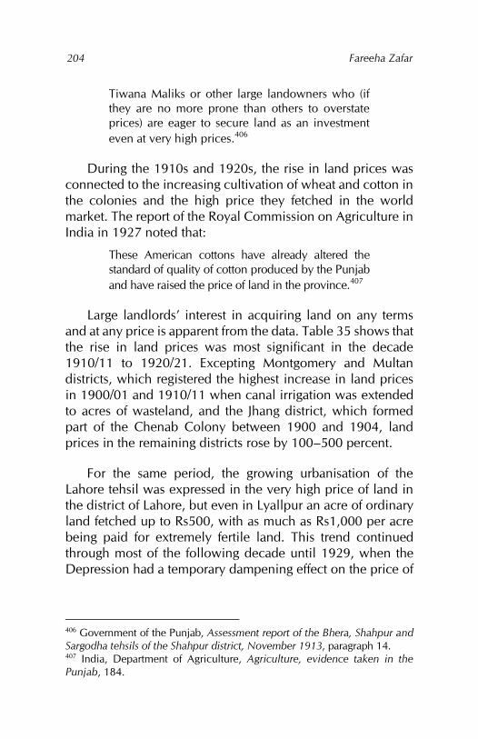
Fareeha Zafar
204
Tiwana Maliks or other large landowners who (if they are no more prone than others to overstate prices) are eager to secure land as an investment even at very high prices.406
During the 1910s and 1920s, the rise in land prices was connected to the increasing cultivation of wheat and cotton in the colonies and the high price they fetched in the world market. The report of the Royal Commission on Agriculture in India in 1927 noted that:
These American cottons have already altered the standard of quality of cotton produced by the Punjab and have raised the price of land in the province.407
Large landlords’ interest in acquiring land on any terms and at any price is apparent from the data. Table 35 shows that the rise in land prices was most significant in the decade 1910/11 to 1920/21. Excepting Montgomery and Multan districts, which registered the highest increase in land prices in 1900/01 and 1910/11 when canal irrigation was extended to acres of wasteland, and the Jhang district, which formed part of the Chenab Colony between 1900 and 1904, land prices in the remaining districts rose by 100–500 percent.
For the same period, the growing urbanisation of the Lahore tehsil was expressed in the very high price of land in the district of Lahore, but even in Lyallpur an acre of ordinary land fetched up to Rs500, with as much as Rs1,000 per acre being paid for extremely fertile land. This trend continued through most of the following decade until 1929, when the Depression had a temporary dampening effect on the price of
406 Government of the Punjab, Assessment report of the Bhera, Shahpur and Sargodha tehsils of the Shahpur district, November 1913, paragraph 14. 407 India, Department of Agriculture, Agriculture, evidence taken in the Punjab, 184.
Canals, colonies and class: British policy in the Punjab 1880–1940
205
land. Within a few years, however, land prices began to rise and the upward trend re-emerged.
Table 35: Changes in the price of land (in Rs per acre)
Land sales 1890/91 1900/01 1910/11 1920/21 1930/31 Lahore 25 84 241 1,511 1,291 Lyallpur – – 180 466 533 Gujrat 55 72 124 266 404 Shahpur 22 47 77 356 329 Gujranwala 21 35 39 178 272 Multan 19 29 75 171 248 Jhang 29 36 77 116 242 Montgomery 12 12 60 157 220 Sheikhupura – – – 162 213
Rate of change (%)
1890/91 to 1900/01
1900/01 to 1910/11
1910/11 to 1920/21
1920/21 to 1930/31
Lahore 236 187 527 –15 Lyallpur – – 159 14 Gujrat 31 72 115 52 Shahpur 114 64 362 –8 Gujranwala 67 11 356 53 Multan 53 159 128 45 Jhang 24 114 51 109 Montgomery 0 400 162 40 Sheikhupura – – – 31
Source: Government of the Punjab, Report on the land revenue administration of the Punjab for the agricultural year ending 30th September __ (Lahore: Civil and Military Gazette Press).
Yet another factor that pushed up land prices in the colony areas was the regular auctioning of land carried out by the government. Usually, the land auctioned was of good quality and this, coupled with the fact that the nonagricultural classes were eager to move into these areas or to extend their existing holdings there, helped raise the price of land.408
408 The result of an auction sale of colony land in 1899 in the Chenab Colony near Lyallpur is indicative of the type of agriculturist who bought land. In this
Fareeha Zafar
206
The average price of land in the district of Jhang as part of the Chenab Colony in 1900/01 was Rs36 per acre. Even if the land auctioned was assumed to be of the best quality, the auction price was high. The size of plots offered for auction also determined who would purchase them, although not always. In the case cited above, one plot was more than 600 acres, two were more than 500 acres, while in all, 13 plots were more than 100 acres large. Apart from this, the landlords who bought large plots were often interested in acquiring as many small plots located nearby to enlarge their estate as much as possible.
Even where the land was not of good quality or irrigation less secure, small purchasers would bid for the land. Their attempts to enter the land market only served to raise the bids of the capitalists even when the land was not worth the price being offered.409 The result was that the government usually received more money than it had expected. The willingness of affluent landlords to buy land at any cost also gave the government an opportunity to decide in favour of certain individuals. For example,
Experience in the Chenab Canal Colony has shown that there is no dearth of men who are only too ready and willing to purchase land even at a full price and that it is a mark of the favour of government to let one man buy in preference to another.410
instance, the Hon. Baba Khem Singh Bedi acquired 545 acres of land at Rs127 per acre while Sodhi Ram Narain Singh of Anandpur bought 568 acres at Rs125 an acre and Nawab Muhammad Ali Khan Kazilbash bought 611 acres at Rs182 an acre. All three were large landlords. 409 Government of the Punjab, Report on the Punjab colonies for the year ending 30th September 1902 (Lahore: Civil and Military Gazette Press, 1902), 4. 410 Government of the Punjab, Department of Revenue and Agriculture, Proceedings, irrigation no. __, October 1901, paragraph 5.
Canals, colonies and class: British policy in the Punjab 1880–1940
207
The policy of auctioning part of colony land therefore raised the price of land considerably, especially because of the competition among a few rich persons.411 It also became apparent that the same people bought the large plots offered for sale at different auctions, while many small plots were bought by the same person in order to accumulate a large holding.412 The policy of offering small plots was aimed at the needs of small proprietors, but in practice these were brought at very high prices by capitalists. In most cases, the original small bidders gave up competing once they found that a large landlord had acquired most of a mauza or village.413
The higher price of auctioned land compared to the best land in the same locality was evident in the result of auction sales on the Jhelum Canal. The best land was sold by the owner at Rs100–110 an acre on average in 1902, while the price realised at auction was Rs153 an acre. The Punjab administration report for 1901/02 went so far as to state that
Of all the economic facts of the decades perhaps the most remarkable is this rise in the market price of agricultural land. The sale and mortgage transactions entered in the village records indicate an enhancement of 40 per cent within the last ten years.414
The highest land prices undoubtedly prevailed in the colony areas and were realised at auctions. This tendency continued throughout the period of colony formation and was a significant feature of each new colony. In 1920, a résumé of all auction
411 Government of the Punjab, Department of Revenue and Agriculture, Proceedings, general no. 308, 20 February 1899. 412 Government of the Punjab, Department of Revenue and Agriculture, Proceedings, irrigation no. 655, 27 March 1899. 413 Punjab, Revenue and Agriculture, Proceedings, irrigation, 1899. 414 Government of the Punjab, Report on the administration of the Punjab and its dependencies for the year 1901–02 (Lahore: Office of the Superintendent of Printing, 1902).
Fareeha Zafar
208
sales between 1914 and 1920 showed that, while the average price per acre offered was Rs281, the highest bid was Rs1,105 per acre by the grantee of a cattle farm in the Okara tehsil of Montgomery district.415 The rising price of cotton contributed largely to the rise in land prices during this period.
The price of auctioned land was thus always higher than the average price of land in the surrounding areas.416 Some of the evidence collected for the Royal Commission on Agriculture in India in 1927 also points to the fact that the price demanded for land auctioned in the colonies was out of the reach of the middle and lower peasants and so, only the capitalists and big landlords could benefit from this policy.417 Where land was auctioned in lots of one or two squares, capitalists were discouraged from buying there because, if an agricultural landlord bought the land adjacent, they would not be able to expand. In this way, agricultural landlords could develop at the expense of the capitalists. In either case, it was the landlord class that benefitted at the expense of the peasant farmers.418
All evidence points to the fact that, with the rise in the price of land, it was the large landowners and landlords that benefitted by enlarging their holdings: they were the only class that had enough ready money. Since they could raise the price of land to levels at which they would be the only buyers in the market, small peasants or landless agricultural labourers had no chance of competing whatsoever.
415 Government of the Punjab, Department of Revenue and Agriculture, Proceedings, irrigation no. 499, 20 March 1920, paragraph 4. 416 Government of the Punjab, Okara tehsil, 1934, 25. 417 India, Department of Agriculture, Agriculture, evidence taken in the Punjab, 624. 418 India, Department of Agriculture, Agriculture, evidence taken in the Punjab, 663.
Canals, colonies and class: British policy in the Punjab 1880–1940
209
This was also evident from the results of land auctions in colony areas, including government wasteland. Smaller purchasers were not only outbid, but also frightened away at the thought of having for a neighbour a large landlord who might later dispossess them or buy them out by other means if he failed at the time of the auction. The big landlords also wanted to concentrate their holdings in contiguous areas and this also discouraged small landlords from buying land between two large landholdings or entire chaks that belonged to the same landlord. The field was therefore left clear for the landlords: together with the subdivision of holdings, which often reduced those of small proprietors to uneconomic levels, they could enlarge their holdings at the expense of the peasant proprietor.

Chapter 8
Social change
The changes in the agrarian economy discussed in the previous chapters, combined with the system of land tenure and colonisation policy, altered the social fabric of rural Punjab. In the canal colony districts, these changes occurred at the administrative level, which became increasingly dependent on the owners of landed property and within the different landowning and cultivating classes.
The impact of canal irrigation on the former was noticeable in the way the administrative structure was reorganised to give the government the benefits of increased cultivation and production. In the latter case, canal irrigation not only raised the value of land and made land ownership more desirable, but the differential system of land grants in the colonies also increased the existing disparity in land holdings. The organisation of land based on cultivation, size of holding and ownership showed considerable variation within the canal colonies. This, combined with the policy to promote the growth and development of certain classes of landowner at the expense of others, provided the basis for the formation of different classes in rural society.
Rural society
Colonial administration in the Punjab – and indeed in the whole of India – was concerned primarily with extracting land revenue. The development of the revenue system and the relationship between the state and revenue paying sections of rural society has already been looked at. Here, we look at how the administrative structure was organised to facilitate the
Fareeha Zafar
212
collection of land revenue in the canal colony districts, how rural society was organised and the impact of canal irrigation on customary village practices.
The Punjab’s administrative structure remained almost unchanged when the province became a lieutenant governor’s province in 1859. The importance of land revenue and its collection made the position of the financial commissioner the second most important at the provincial level, with the Department of Land Revenue holding a pivotal position.419 At the district level, the most important person was the collector of land revenue or the deputy commissioner, who represented the government for many purposes. As chief magistrate of the district, he had local responsibility for maintaining law and order. He also coordinated the activities of various government agencies in his area and was the point of contact between the government and the people. The collector was thus not only the head of the district administration, but also looked after the “moral and material welfare of the people, apart from his duties as a revenue officer.”420
All these functions were a carryover from pre-British times. The collector’s representatives at the tehsil level (the tehsildars) and at the village level (the patwaris) also occupied highly important positions in the revenue administrative structure. To aid the collector, chief magistrates, extra magistrates, tehsildars, talukdars and appointees to various boards and committees were all selected from the powerful landowning families of the Punjab, popularly referred to as the ‘Punjab chiefs’.421
419 India, Department of Agriculture, Famine Inquiry, 363. 420 India, Department of Agriculture, Famine Inquiry, 364. 421 Lepel Henry Griffin, The Panjab chiefs: Historical and biographical notices of the principal families in the Lahore and Rawalpindi divisions of the Panjab, vol. 1 (Lahore: Civil and Military Gazette Press, 1890).
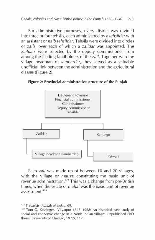
Canals, colonies and class: British policy in the Punjab 1880–1940
213
For administrative purposes, every district was divided into three or four tehsils, each administered by a tehsildar with an assistant or naib tehsildar. Tehsils were divided into circles or zails, over each of which a zaildar was appointed. The zaildars were selected by the deputy commissioner from among the leading landholders of the zail. Together with the village headman or lambardar, they served as a valuable unofficial link between the administration and the agricultural classes (Figure 2).
Figure 2: Provincial administrative structure of the Punjab
Each zail was made up of between 10 and 20 villages, with the village or mauza constituting the basic unit of revenue administration.422 This was a change from pre-British times, when the estate or mahal was the basic unit of revenue assessment.423
422 Trevaskis, Punjab of today, 69. 423 Tom G. Kessinger, ‘Vilyatpur 1848–1968: An historical case study of social and economic change in a North Indian village’ (unpublished PhD thesis, University of Chicago, 1972), 117.
Lieutenant governorFinancial commissioner
CommissionerDeputy commissioner
Tehsildar
Zaildar
Village headman (lambardar)
Kanungo
Patwari
Fareeha Zafar
214
British administration in the rural areas thus operated at two levels. At the official level, the village was linked to the tehsil through the patwari or village registrar, who maintained the revenue records and agricultural statistics and managed a circle consisting of small groups of villages. A certain number of circles (usually 20) were combined into a kanungo. Payments to patwaris and village headmen took the form of a percentage of the land revenue. In the case of the latter, this was calculated on the land revenue collected and not the actual revenue demand. Suspension or remission of the land revenue, therefore, involved a corresponding suspension or remission of the surcharge or pachotra. This explains why headmen were reluctant to allow for such remissions and suspensions and why kharaba deductions were so few even though the headman was supposed to be a representative of the landowning body.424
The unofficial links between the agricultural communities and the state were similar to those under the Sikhs and Mughals. The British continued their predecessors’ policy of creating intermediaries who were responsible for conveying government directives to the people and reporting any unrest or discontent on the part of the peasantry to the administration. The old Sikh chaharams, under which the recipients of such favours were granted one fourth of the revenue of an estate or village, were converted into inams.425 Inamdars were required to perform certain functions for the government in return for these favours. A combination of unofficial heads – such as the zaildars (formerly known as chaudhris) and village headmen or lambardars – and the
424 Douie, Punjab land administration, 117. 425 Inams varied in size, from the large lambardari inams to smaller safaid posh inams. The term was used for the grant of land or a portion thereof or all the land revenue of an area to persons the government felt were useful to it. Generally, such persons belonged to the leading families of the province (Griffin, Panjab chiefs, vol. 2, 323).
Canals, colonies and class: British policy in the Punjab 1880–1940
215
official administration created a powerful system for keeping the Punjab peasantry under control.
The mass of the rural village population comprised the peasantry – a term wide enough to include small peasant proprietors as well as part-tenant-part-proprietors and tenants. Even the kamins with their minute plots of land in the canal colonies – insufficient as these were to provide a livelihood, but bound into the village production system – fell under the umbrella of the peasantry. At the other end of the spectrum were the large landowners or landlords, who held considerable areas of land that could not be cultivated without the help of the different peasant classes, agricultural labourers or the landless wage-labour class. Situated between the two were the lambardars and zaildars with above-average landholdings supplemented with the political power attached to their offices. Consequently, the economic power of the landlords and the political power of the zaildars and lambardars combined to keep the peasantry at subsistence level.
Prior to the British and even in the early decades of British rule in the Punjab, the landlord and jagirdar exercised a kind of de facto rule over the peasantry. British policy and legislation in the province, while reducing the role of the jagirdar in this exercise, strengthened that of the landlord who, once included in the lower echelons of the rural administrative structure, acquired a de jure control over the peasantry. Landlords belonged to the old class of assignees, grantees, chiefs, headmen and farmers of the Mughal and Sikh times, who became fused with the body of large landholders created by the British after annexation. With the spread of canal irrigation and the formation of colonies, control over the peasantry was exercised by the recipients of capitalist and yeomen grants, auction purchasers and inamdars, for whom a certain percentage of the land was regularly earmarked.
Fareeha Zafar
216
The importance of land revenue in the canal colonies was evident from the fact that liability to pay land revenue featured in all statements of conditions on which the government was prepared to allot land in a colony.426 Village communities were, therefore, entered as being jointly owned (even where this was not the case) to determine the revenue-paying authority. There were also attempts to reproduce in these village communities the jajmani system of the older settled areas by granting small pieces of land to kamins and menials to attract them to the colony areas.
This was partly successful – to some degree because land acquisition turned the kamins into part-time cultivators and because wage labour was gaining prominence. Canal irrigation, therefore, led to the development of a different kind of village structure where the old customary ties of dependence and protection between tenants and kamins on the one hand and landowners on the other were missing.
By the end of the 1910s, this change was noticeable in the most developed colony. Writing in his assessment report for 1910/11, the revenue officer noted:
For some time, the Chenab Colony has been facing an economic revolution. The ranks of the kamins and daily labourer thinned by plague and enriched by payments in kind in years of good prices are arranged against the landowners who try to resist any advance on old customary rates of payment fixed at a period of which the conditions have now changed. As far as the daily labourer is concerned, the landlord has been worsted and daily labourers hire has gone up all over the colony. As far as the kamin is concerned, however, other ties bind him to the agricultural community which seems so far to
426 F. C. Bourne, Final settlement report of the Lower Bari Doab Colony, 1927–35 (Lahore: Superintendent, Government Printing, 1936), 7.
Canals, colonies and class: British policy in the Punjab 1880–1940
217
have prevented him from pushing his claims to a pitch which would cause the landowner to increase his emoluments by a substantial amount. The village where the kamins dues were attested four years ago by me, I find on enquiry the same dues still prevailing [...] some kamins are being replaced by machinery; and reaping machines in some chaks have entirely ousted the lawa or reaper who used to take such a substantial share of the rabi crop.427
A village survey carried out in 1928 reported further changes in customary village practices:
The old custom regarding payment seems to be falling into disuse and the village menial is becoming more and more a person paid for each job that he does, instead of receiving an annual payment for all work, which they may be called upon to do.428
The change to payment for work in cash instead of kind in the canal colonies was a result of the increased cultivation of cash crops in these areas. At the same time, the increase in value of cash crops in particular and agricultural produce in general led to an increase in the rent demanded by owners in colony areas.429 Where tenants refused to pay the enhanced rents, they were ejected. In the Gujranwala district, it was noted that:
Processes for ejectment are never necessary in the old district, the supply of tenants is too small, and the ties of custom too hard to break. In the colony,
427 Government of the Punjab, Jhang (I, II and III circles), 1910, 7. 428 Board of Economic Inquiry, Punjab, An economic survey of Gaggar Bhana, a village in the Amritsar district of the Punjab, Punjab village surveys no. 1 (Lahore: Civil and Military Gazette Press, 1928), 21. 429 Government of the Punjab, Report on the land revenue administration of the Punjab for the agricultural year ending 30th September 1918 (Lahore: Civil and Military Gazette Press, 1918), 11.
Fareeha Zafar
218
however, there is reason to expect a large increase in this class of work in the near future.430
With the spread of canal irrigation, the status of the kamin or village artisan began declining slowly from that of a village servant to that of a hired worker. The high value of canal-irrigated land made its cultivation and ownership imperative, for which the village community and its old relationships between kamins, cultivators and owners could be sacrificed. For small landowners, it became more profitable to cultivate with the help of seasonally hired agricultural labourers in place of tenants who were more likely to demand cultivating and occupancy rights. Moreover, the higher rents demanded by owners in canal-irrigated areas were a deterrent for the tenant class. This change made the position of tenants and kamins less secure so that the mechanism of demand and supply became operative in their case as well.
At the same time, the most prosperous class – the large landholders – tended to strengthen its position further by acquiring more land, especially canal-irrigated land. In many cases, this was helped by the positions that landholders held as assistant commissioners, revenue collectors, members of various organisations and heads of village banks and cooperative societies. However, a large proportion of land remained under the ownership of peasant proprietors who, in many cases, played a dual role – that of owner and tenant at the same time – as their holdings became smaller and more uneconomical. Canal irrigation, therefore, led to a change in the customary agrarian relationships, with power – political, economic and social – clearly resting in the ownership of land.
430 Government of the Punjab, Land revenue, 1900, 35.
Canals, colonies and class: British policy in the Punjab 1880–1940
219
Patterns of land ownership
Under the British, the establishment of rights to the land created the raison d’etre for land ownership. As we have already seen, in the Punjab, the earlier Sikh rulers had given importance to the cultivation, and not possession, of land per se. Privileged rights to land were exercised in the form of revenue assignments extending over estates and villages. The value of owning land, therefore, was realised under British rule. With the idea of autonomous possession, social, economic and political prestige came to be determined by the extent of land owned. Land ownership thus became the basis of the social relationship existing in rural society.
The importance given to land ownership by the British administration in the Punjab made it a reliable indicator of individual autonomy. However, freedom of possession in a region of unreliable rainfall and insufficient water supply, resulting in uncertain harvests, made it easier for peasant proprietors to sell or mortgage their land in times of need. The increasing value of land made it a sought-after commodity and moneylenders and landlords extended their holdings at the expense of the small owner. Changes in land ownership, therefore, became a significant indicator of shifts in the social structure of the canal colony districts. With the extension of canal irrigation and the cultivation of cash crops, land productivity increased and land ownership acquired new meaning as an indicator of wealth, income and economic status.
While ownership patterns determined the relationship between landlords, peasant proprietors, tenants and cultivators, the relationship between owners and the state was determined by the nature of the tenurial form under which land was held from the government. Towards the end of the nineteenth century, most land in the Punjab was owned or held from the government under zamindari, pattidari or bhai chara tenures, as discussed earlier. While many large estates
Fareeha Zafar
220
were held under khalis zamindari (the pure form thereof) tenure, most others were under bhai chara tenure.431 Estates that were not village communities were held mostly under zamindari or single-owner tenure and paid high land revenues.432
Apart from these, in the colony areas, government land was leased out directly to lessees without ownership rights as well as under proprietary terms, resembling the ryotwari433 system of Bombay and Madras. The size of such grants varied considerably. In Gujrat, Gujranwala and Jhang, the area leased without ownership rights was much larger per owner than in Lahore and Montgomery, where proprietary leases tended to be bigger.
In 1890/91, the most popular and prevalent form of tenure under which land was held from the government was bhai chara.434 Almost all the area in Lahore and Montgomery districts and more than 85 percent of the area in Gujrat, Jhang, Multan and Shahpur was under bhai chara tenure (Table 36). Only in Gujranwala was the pattidari form the most important, affecting more than 85 percent of the area. In Lahore, just under half the area was under pattidari tenure. Zamindari tenure was of greatest importance in the district of Montgomery, accounting for approximately 25 percent of the land. The area held under zamindari tenure, therefore, varied
431 Government of the Punjab, Gazetteer of the Gujrat district, 1892–93 (Lahore: Civil and Military Gazette Press, 1893); Government of the Punjab, Gazetteer of the Gujranwala district, 1893–94 (Lahore: Civil and Military Gazette Press, 1894); Government of the Punjab, Gazetteer of the Lahore district, 1883–4 (Lahore: Civil and Military Gazette Press, 1884). 432 Government of the Punjab, Gazetteer of the Gujrat district, 1883–4 (Lahore: Civil and Military Gazette Press, 1884). 433 Under the ryotwari system, peasants were given ownership rights and paid taxes directly to the British government. The revenue rates were 50 percent on lands that were dry and 60 percent on irrigated land. 434 In India, bhai chara tenures were prevalent in regions of uncertain rainfall and scanty population (Stokes, Peasant and the Raj, 83).
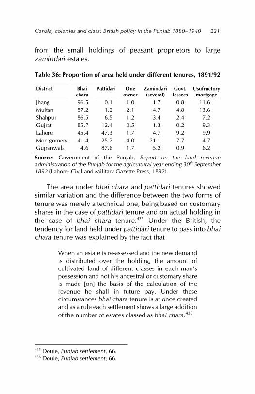
Canals, colonies and class: British policy in the Punjab 1880–1940
221
from the small holdings of peasant proprietors to large zamindari estates.
Table 36: Proportion of area held under different tenures, 1891/92
District Bhai chara
Pattidari One owner
Zamindari (several)
Govt. lessees
Usufructory mortgage
Jhang 96.5 0.1 1.0 1.7 0.8 11.6 Multan 87.2 1.2 2.1 4.7 4.8 13.6 Shahpur 86.5 6.5 1.2 3.4 2.4 7.2 Gujrat 85.7 12.4 0.5 1.3 0.2 9.3 Lahore 45.4 47.3 1.7 4.7 9.2 9.9 Montgomery 41.4 25.7 4.0 21.1 7.7 4.7 Gujranwala 4.6 87.6 1.7 5.2 0.9 6.2
Source: Government of the Punjab, Report on the land revenue administration of the Punjab for the agricultural year ending 30th September 1892 (Lahore: Civil and Military Gazette Press, 1892).
The area under bhai chara and pattidari tenures showed similar variation and the difference between the two forms of tenure was merely a technical one, being based on customary shares in the case of pattidari tenure and on actual holding in the case of bhai chara tenure.435 Under the British, the tendency for land held under pattidari tenure to pass into bhai chara tenure was explained by the fact that
When an estate is re-assessed and the new demand is distributed over the holding, the amount of cultivated land of different classes in each man’s possession and not his ancestral or customary share is made [on] the basis of the calculation of the revenue he shall in future pay. Under these circumstances bhai chara tenure is at once created and as a rule each settlement shows a large addition of the number of estates classed as bhai chara.436
435 Douie, Punjab settlement, 66. 436 Douie, Punjab settlement, 66.
Fareeha Zafar
222
Consequently, to facilitate the collection and imposition of land revenue, the British administration ignored the customary division of shares and replaced this with the actual holding in possession. Land ownership rested in four different classes of agriculturists and nonagriculturists: (i) those who were noncultivating (rent receivers), (ii) self-cultivators who leased out part of their land, (iii) self-cultivators and (iv) those who were rent receivers and tenants at the same time.
The noncultivating rent-receiving category included among its ranks peasant proprietors as well as large landlords (often absentee) belonging to both the nonagricultural and agricultural tribes of the Punjab. Some occupancy tenants and tenants-at-will rented land and then leased it out for cultivation, but were not considered part of the landowning class. The second category, self-cultivating owners who leased out part of their land, were referred to as well-to-do peasant proprietors. The third category, that of the self-cultivator, included small peasant proprietors. The fourth category, that of the rent receiver and tenant, referred to the very small peasant proprietors who had uneconomical holdings which they preferred to rent out and, in turn, work as tenants on somebody else’s land. The Punjab peasant proprietor usually belonged to the third and fourth categories, being a self-cultivating proprietor in one holding and a tenant in the other.
In Multan and Montgomery districts, some landlords in the first category belonged to the Muhammadan tribes of the Sayyids, Koreishis and Pathans. The majority belonged to the Hindu tribes of the Khatris and Auroras437 (both moneylenders by profession)438 and included some Sikh landlords. The
437 The Khatris and Auroras paid more than 25 percent of the land revenue of the tehsil. As they were not self-cultivating, all the land they owned was rented out to tenants (Government of the Punjab, Pakpattan, Montgomery district, 1898, paragraph 10). 438 Government of the Punjab, Assessment report of the Mooltan and Shujabad tehsils of the Mooltan district, 1900, 37.
Canals, colonies and class: British policy in the Punjab 1880–1940
223
Muhammadan tribes were largely self-cultivating landlords belonging to the second and third categories. Consequently, with increased alienations of land in the last two decades of the nineteenth century, land passed out from the landowning self-cultivating tribes into the hands of the nonagricultural rent-receiving category.
It was, therefore, not uncommon to find a large number of comparatively new villages – some of considerable size but many quite small – that were held by single owners and single families of owners.439 The presence of a large number of noncultivating landlords resulted in the greater part of these districts being cultivated by tenants.440 Within these districts, however, where cultivation was insecure, as in the rawa (upland tract) circle, most land was owner-cultivated or khudkasht and the Hindu proprietary body in such areas was comparatively weak.441
By the end of the nineteenth century, alienations had left only the very large proprietors of land secure:
The mass of the old Mohammadan proprietors in the Mooltan District are not well off. They are, perhaps best off in the Kabirwala and Mailsi tehsils, where a good deal of land is held by large proprietors, such as Sher Shah Khaaga, and Ruku-ud-din Kureishi, in the Kabirwala Tehsil, and the Khangwani Pathans and the family of Ghulam Muhammad Daultana in the Mailsi Tehsil. Some of these large proprietors are well-to-do and prosper. In the Mooltan Tehsil the large agriculturists are with a few exceptions, in a struggling state, and in the Lodhran and Shujabad Tehsils, where the bulk
439 Government of the Punjab, Mailsi tehsil, 1901, 28. 440 Area cultivated by tenants: 82 percent in Pakpattan, 90 percent in the Khanwah circle and 85 percent in the Sohag circle (Government of the Punjab, Pakpattan, Montgomery district, 1898, paragraph 10). 441 Government of the Punjab, Mailsi tehsil, 1901, 43.
Fareeha Zafar
224
of the Mohammadan proprietary body was composed of men with small estates, and where the staple product was indigo, given great profits in some years and entailing losses in others, the landholders, as will be seen by the record of alienations, have been largely expropriated and their lands taken by the moneylending classes.442
This old proprietary body comprised mainly rent receivers, which the Alienation of Land Act 1900 attempted to preserve. In the districts of Jhang and Shahpur, rent-receiving landlords belonged largely (and, in some areas, entirely) to the Muhammadan agricultural tribes. Here, an attempt was made to preserve the large landlords by giving them assignments of land revenue. For example, in the Chenab nehri circle in Jhang, the most important jagir was the grant of one fifth of the land revenue of nine villages of the Rajoa estate in Chiniot tehsil to three Sayyids of the village, with succession reserved for one successor each.443 Generally, the Sayyid holdings were very large and most superior ownership tended to reside with them.444 In Shahpur, the strongest landowning tribe in terms of resources and acquisitiveness was that of the Tiwana Rajputs:
The Maliks have greatly enlarged their borders both by purchase and mortgage, the Alienation of Land Act has cleared the market for them, and they are adding to their estates yearly. Their control of 7 canals gives them a position of great prestige throughout the countryside, and their profits from water-rents are very considerable.445
In the eastern districts of Gujrat and Lahore, the preponderance of small holdings precluded the existence of a significant number of large rent-receiving landlords. Moreover,
442 Government of the Punjab, Mooltan district, 1896, paragraph 5. 443 Government of the Punjab, Chenab nehri circle, 1904, 8. 444 Government of the Punjab, Chenab, Jhelum and joint circles, 1905, 19. 445 Government of the Punjab, Bhera, Shahpur and Sargodha, 1913, 13.
Canals, colonies and class: British policy in the Punjab 1880–1940
225
the Sikhs’ recognition of the rights of cultivation and not inheritance had discouraged the development of large landed properties in these districts and in the district of Gujranwala.
Thus, while the development of the different tenurial forms under which land was held from the government was indicative of the nature of the main purpose of British administration in the Punjab, i.e., the collection of land revenue, it did not explain the hierarchy of landed interests existing in the canal colony districts. Actual ownership of land determined the relative strength of the various landowning classes, among which landlords belonging to both the agricultural and nonagricultural tribes were strongest. This was so especially in the districts of Multan, Montgomery, Jhang and Shahpur, where their position was preserved through revenue assignments and the Alienation of Land Act. In the eastern districts, the development of large landed properties had been discouraged under the Sikh rulers and most land was held by small peasant proprietors.
The extension of the perennial canals into the interior of the doabs after 1880 increased the influence of landlords whose lands were in areas receiving canal water. Even the existing small private inundation canal areas acquired a new importance. In the Shahpur district, for example, the influence of the Nun families who owned the Hakim Khanwala canals increased with the cultivation of good-quality cotton and grain.446
The increase in the area owned by large proprietors led to an increase in tenancy as their holdings required more labour. Referring to the impending construction of the Lower Jhelum Canal in the district, the assessment officer of the Jhelum nehri circle in Jhang noted that the relative percentage of tenant cultivators was somewhat higher than was usual in purely chahi circles in the upland and was likely to increase further
446 Government of the Punjab, Bhera, Shahpur and Sargodha, 1913, 13.
Fareeha Zafar
226
with the introduction of canal irrigation.447 Both the Sayyids and Hindus also increased their holdings in the area to be covered by the northern and southern branches of the Lower Jhelum Canal.448
Colonial policy provided opportunities for yeomen and capitalist grantees, nazarana-paying grantees and auction purchasers in the colony areas. Most of them were leading zamindars of the province. With already developed holdings in other areas, few of them resided in their colony grants and when they did, “endless dissension... a negligible khudkasht area, a migratory and discontented peasantry” resulted.449 In the early colonies, there was no clause of permanent residence and, consequently, the yeomen and capitalists became absentees. The same procedure was followed in the colonisation process on the Jhang and Gugera branches of the Lower Chenab Canal in granting land to yeomen.
The Colonies Committee of 1908 recommended that the residence clause be made necessary, but only for government tenants till they became proprietors. Nazarana-paying grantees had no such condition attached to their grants and could nominate an agent to live on their grants. These recommendations were accepted by the Punjab government and the Government of India and included in Section 12 of the Colonisation of Government Lands (Punjab) Act 1912. The growth of absentee landlordism in the colonies was thus ensured and the advantages that could have accrued from such capitalist and yeoman grants were considerably reduced.450
Adding to the nonself-cultivating landlords were the large number of safaid posh (landed gentry) grants and rais chaks 447 Government of the Punjab, Jhelum nehri circle, 1906, 21. 448 Government of the Punjab, Jhelum nehri circle, 1906, 13. 449 Government of the Punjab, Rakh branch circle, 1913, 14. 450 Wace, Punjab colony manual, 73–75.
Canals, colonies and class: British policy in the Punjab 1880–1940
227
(awarded to capitalists), particularly in the newly created Lyallpur district. These grantees cultivated only through tenants and, with the grant of proprietary rights, many became absentee landlords.451 Where such grants were in large number, the average owner-cultivated area showed a decline. The numerous grants to tumandars and the landed gentry in the Tulumba circle of Khanewal tehsil in Multan, 100 percent of which was irrigated, had a similar effect.452
Table 37 shows the percentage of the rural population classed as owner cultivators and co-sharers, as given in the 1931 census. The small number of these classes in the main canal colony districts is striking. Barring Gujrat, which had almost half its rural population classed as owners and co-sharers, the remaining districts had less than 25 percent in this category. In Gujrat district, the cultivated area per owner was about 5 acres, increasing to 20 acres in the case of Montgomery district. From this, we can infer that the cultivated area per owner was larger in the more irrigated districts while the number of owners was smaller.
The inclusion of large grants in the colony areas lends support to this statement: the yeoman grants ranged from four to five squares (112 to 140 acres approximately) and the capitalist grants from 6 to 20 squares (168 to 560 acres approximately).453 Moreover, as discussed earlier, landlords extended their existing holdings by hundreds of acres at auctions of colony land. The chiefs of many of the pastoral and nomadic tribes were also accommodated in the canal-irrigated
451 Government of the Punjab, Assessment report of the Jhang branch circle of the Lyallpur district, November 1921, 16. 452 Government of the Punjab, Khanewal tehsil, 1934, 22. 453 A square varied in size from approximately 25 to 28 acres in different colonies. For our purposes of calculation, we use the 28-acre estimate.
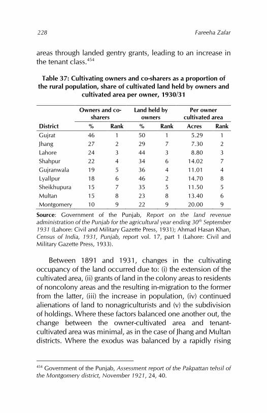
Fareeha Zafar
228
areas through landed gentry grants, leading to an increase in the tenant class.454
Table 37: Cultivating owners and co-sharers as a proportion of the rural population, share of cultivated land held by owners and
cultivated area per owner, 1930/31
Owners and co-sharers
Land held by owners
Per owner cultivated area
District % Rank % Rank Acres Rank Gujrat 46 1 50 1 5.29 1 Jhang 27 2 29 7 7.30 2 Lahore 24 3 44 3 8.80 3 Shahpur 22 4 34 6 14.02 7 Gujranwala 19 5 36 4 11.01 4 Lyallpur 18 6 46 2 14.70 8 Sheikhupura 15 7 35 5 11.50 5 Multan 15 8 23 8 13.40 6 Montgomery 10 9 22 9 20.00 9
Source: Government of the Punjab, Report on the land revenue administration of the Punjab for the agricultural year ending 30th September 1931 (Lahore: Civil and Military Gazette Press, 1931); Ahmad Hasan Khan, Census of India, 1931, Punjab, report vol. 17, part 1 (Lahore: Civil and Military Gazette Press, 1933).
Between 1891 and 1931, changes in the cultivating occupancy of the land occurred due to: (i) the extension of the cultivated area, (ii) grants of land in the colony areas to residents of noncolony areas and the resulting in-migration to the former from the latter, (iii) the increase in population, (iv) continued alienations of land to nonagriculturists and (v) the subdivision of holdings. Where these factors balanced one another out, the change between the owner-cultivated area and tenant-cultivated area was minimal, as in the case of Jhang and Multan districts. Where the exodus was balanced by a rapidly rising
454 Government of the Punjab, Assessment report of the Pakpattan tehsil of the Montgomery district, November 1921, 24, 40.
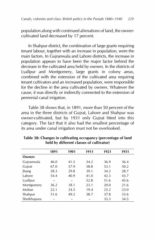
Canals, colonies and class: British policy in the Punjab 1880–1940
229
population along with continued alienations of land, the owner-cultivated land decreased by 17 percent.
In Shahpur district, the combination of large grants requiring tenant labour, together with an increase in population, were the main factors. In Gujranwala and Lahore districts, the increase in population appears to have been the major factor behind the decrease in the cultivated area held by owners. In the districts of Lyallpur and Montgomery, large grants in colony areas, combined with the extension of the cultivated area requiring tenant cultivators and an increased population, were responsible for the decline in the area cultivated by owners. Whatever the cause, it was directly or indirectly connected to the extension of perennial canal irrigation.
Table 38 shows that, in 1891, more than 50 percent of the area in the three districts of Gujrat, Lahore and Shahpur was owner-cultivated, but by 1931 only Gujrat fitted into this category. The fact that it also had the smallest percentage of its area under canal irrigation must not be overlooked.
Table 38: Changes in cultivating occupancy (percentage of land held by different classes of cultivator)
1891 1901 1911 1921 1931 Owners Gujranwala Gujrat Jhang Lahore Lyallpur Montgomery Multan Shahpur Sheikhupura
46.0 67.0 28.3 54.4
– 36.2 22.1 51.6
–
41.5 57.9 29.8 40.9
– 18.1 24.5 49.2
–
34.2 58.8 39.1 41.0 52.8 23.1 19.4 38.7
–
36.9 53.1 34.2 42.3 51.6 20.0 25.2 37.8 35.3
36.4 50.2 28.7 43.7 45.6 21.6 23.0 33.6 34.5
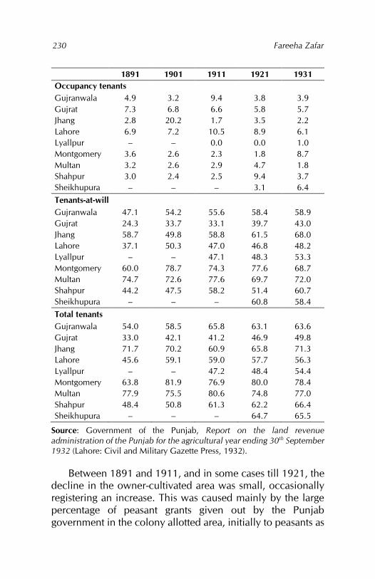
Fareeha Zafar
230
1891 1901 1911 1921 1931 Occupancy tenants Gujranwala Gujrat Jhang Lahore Lyallpur Montgomery Multan Shahpur Sheikhupura
4.9 7.3 2.8 6.9 –
3.6 3.2 3.0 –
3.2 6.8 20.2 7.2 –
2.6 2.6 2.4 –
9.4 6.6 1.7 10.5 0.0 2.3 2.9 2.5 –
3.8 5.8 3.5 8.9 0.0 1.8 4.7 9.4 3.1
3.9 5.7 2.2 6.1 1.0 8.7 1.8 3.7 6.4
Tenants-at-will Gujranwala Gujrat Jhang Lahore Lyallpur Montgomery Multan Shahpur Sheikhupura
47.1 24.3 58.7 37.1
– 60.0 74.7 44.2
–
54.2 33.7 49.8 50.3
– 78.7 72.6 47.5
–
55.6 33.1 58.8 47.0 47.1 74.3 77.6 58.2
–
58.4 39.7 61.5 46.8 48.3 77.6 69.7 51.4 60.8
58.9 43.0 68.0 48.2 53.3 68.7 72.0 60.7 58.4
Total tenants Gujranwala Gujrat Jhang Lahore Lyallpur Montgomery Multan Shahpur Sheikhupura
54.0 33.0 71.7 45.6
– 63.8 77.9 48.4
–
58.5 42.1 70.2 59.1
– 81.9 75.5 50.8
–
65.8 41.2 60.9 59.0 47.2 76.9 80.6 61.3
–
63.1 46.9 65.8 57.7 48.4 80.0 74.8 62.2 64.7
63.6 49.8 71.3 56.3 54.4 78.4 77.0 66.4 65.5
Source: Government of the Punjab, Report on the land revenue administration of the Punjab for the agricultural year ending 30th September 1932 (Lahore: Civil and Military Gazette Press, 1932).
Between 1891 and 1911, and in some cases till 1921, the decline in the owner-cultivated area was small, occasionally registering an increase. This was caused mainly by the large percentage of peasant grants given out by the Punjab government in the colony allotted area, initially to peasants as
Canals, colonies and class: British policy in the Punjab 1880–1940
231
government tenants who later acquired proprietary rights. By 1921, however, the extension of the cultivated area had slowed down. Coupled with high increases in population after this period, the initial benefits of colonisation were lost.
It can thus be said that, in the colonies, the decrease in the area cultivated by owners and the increase in tenancy was a result of the extension of the cultivated area, the large size of grants, absentee landlordism and a decline in the number of occupancy tenants. In the older settled districts, it was brought about by the exodus of cultivators to the canal-irrigated areas as well as by continued alienations to nonagriculturists. The increase in population and diminishing size of holdings also converted many owners into part-owner-part-tenants.455 Canal irrigation brought in the practice of cultivation by poor relatives in the place of tenants. In the old proprietary estates and holdings, tenancy was more prevalent, whereas in the colony areas, lessees tended to cultivate with the help of relatives, often ejecting their tenants to do so. This practice raised the percentage of owner-cultivated land in the colony chaks as relatives were counted as self-cultivators.456
The pattern of land ownership that emerged in the canal colonies was based on differential land allocation in the form of varying sizes of land grants in the colony areas. Whereas a large part of the colony area was allocated in the form of small peasant grants, the remainder was reserved in one way or another for the large landowning classes, who could extend their holdings in different ways such as by buying out small peasant grants.
Data on the extent of ownership is scanty. What is available, deals only with the cultivated area, that is, the area assessed for land revenue. Changes in the cultivating occupancy of the land, therefore, show that the area cultivated 455 Government of the Punjab, Gujrat tehsil, 1913, paragraph 11. 456 Government of the Punjab, Upper and Lower Jhang, 1909, 8.
Fareeha Zafar
232
by tenants tended to increase while the owner-cultivated area had decreased in all the canal colony districts by 1930/31. In districts with a large extent of wasteland, canal irrigation helped maintain the existing proportions of owner-cultivated and tenant-cultivated areas till the 1920s. However, the initial allocation of large areas to peasant grantees as government tenants and the subsequent change in their status from tenants to proprietors altered these land proportions, especially in districts such as Montgomery and Multan.
The extent of owner-cultivated and tenant-cultivated areas provides an overall view of occupancy and land ownership patterns in the canal colony districts. However, it is necessary to look at the actual size of holdings to obtain an in-depth picture of the level of disparity in land ownership and holdings.
Irrigation and holding size
Within the Punjab, the size of holdings varied with different aspects of the physical environment, the area’s settlement history, population density, land tenure patterns and type of irrigation available. Generally, holdings were smaller in the riverine areas compared to the bar regions, where they incorporated large areas of uncultivated land. Land holdings dependent on well irrigation were also smaller: their size was controlled by the area a well could irrigate, which usually ranged from 15 to 30 acres, whereas in regions irrigated by inundation canals, there was no such limit.
In the eastern districts of Gujrat, Gujranwala and Lahore, where the land had been used for a long time, subdivision combined with greater rainfall had resulted in smaller holdings than in the other colony districts. The construction of perennial canals added another dimension to this aspect of land organisation by creating large areas of irrigated cultivable land in the doab wastelands, where the administration had a free hand in forming holdings of varying size.
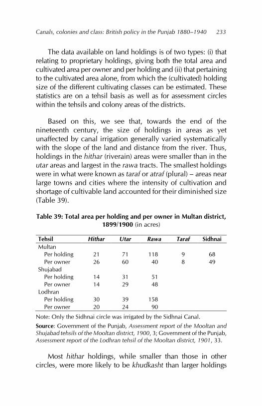
Canals, colonies and class: British policy in the Punjab 1880–1940
233
The data available on land holdings is of two types: (i) that relating to proprietary holdings, giving both the total area and cultivated area per owner and per holding and (ii) that pertaining to the cultivated area alone, from which the (cultivated) holding size of the different cultivating classes can be estimated. These statistics are on a tehsil basis as well as for assessment circles within the tehsils and colony areas of the districts.
Based on this, we see that, towards the end of the nineteenth century, the size of holdings in areas as yet unaffected by canal irrigation generally varied systematically with the slope of the land and distance from the river. Thus, holdings in the hithar (riverain) areas were smaller than in the utar areas and largest in the rawa tracts. The smallest holdings were in what were known as taraf or atraf (plural) – areas near large towns and cities where the intensity of cultivation and shortage of cultivable land accounted for their diminished size (Table 39).
Table 39: Total area per holding and per owner in Multan district, 1899/1900 (in acres)
Tehsil Hithar Utar Rawa Taraf Sidhnai Multan
Per holding Per owner
21 26
71 60
118 40
9 8
68 49
Shujabad Per holding Per owner
14 14
31 29
51 48
Lodhran Per holding Per owner
30 20
39 24
158 90
Note: Only the Sidhnai circle was irrigated by the Sidhnai Canal.
Source: Government of the Punjab, Assessment report of the Mooltan and Shujabad tehsils of the Mooltan district, 1900, 3; Government of the Punjab, Assessment report of the Lodhran tehsil of the Mooltan district, 1901, 33.
Most hithar holdings, while smaller than those in other circles, were more likely to be khudkasht than larger holdings
Fareeha Zafar
234
where less of the area was owner-cultivated. However, where cultivation was scattered and centred on wells, the rawa holdings were also small and generally khudkasht.457 Within these divisions, well holdings were generally small so that districts where wells were the primary source of irrigation tended to have more small holdings.458 Rainfall was an important factor in that its sufficiency for raising a crop determined the holding size.459
Within the canal colony districts, the average size of holdings showed considerable variation. During the 1890s in the district of Multan, the average size of holdings was large even in the taraf circle (more than 4 acres), although Montgomery district to the east generally had smaller holdings (on average, 4.6 acres in the Montgomery tehsil). In the older settled districts of Lahore, Gujranwala and Gujrat to the northeast, holdings were among the smallest to be found anywhere in the study area. For example, in the Kharian tehsil of Gujrat district, the average size was 1.3 acres.
Well irrigation, high rural densities and subdivision practices had, over generations, reduced holdings to very small dimensions.460 In Gujranwala district, for example:
There are many owners who own large areas and in more than one village, but in the great many villages the holdings are too small for comfortable living and there is great pressure on the land.461
In the western districts of Shahpur and Jhang, the average holding was larger, but cultivated holdings were only a quarter
457 Government of the Punjab, Mailsi tehsil, 1901, 28. 458 Douie, Punjab land administration, 4. 459 Ahmad, ‘Agricultural geography,’ 281. 460 Government of the Punjab, Gujrat tehsil, 1913, statement 6. 461 Government of the Punjab, Assessment report of the Chenab circle, Hafizabad tehsil, Gujranwala district, May 1905, 8.
Canals, colonies and class: British policy in the Punjab 1880–1940
235
the size of total holdings. In other districts, the difference was one third to one half. Consequently, only a small part of each holding was khudkasht. Within the districts, where the soil was poor or the water brackish, holdings tended to be larger than elsewhere. This was particularly the case in the Manjha Khara circle of Lahore tehsil where, as the circle had large holdings, the tehsil average was raised to 2.7 acres in 1915.462 Where canal irrigation was less important, as in the Gujrat district, the pattern of the rawa circles with the largest holdings was maintained, even in 1916. For example, in the Phalia tehsil bar circle, the average owner holding was 28 acres while the tehsil average was only 15 acres.463
The impact of perennial canal irrigation on the extension of cultivation was to greatly increase the size of holdings, particularly of cultivated holdings. Previously, holdings had not been clearly demarcated, chiefly in the bar wastelands. This was especially true of areas where grazing was carried out widely, so that a large part of the natural pastures was assumed to belong to certain village communities and tribes. With the spread of canal irrigation and laying out of canal branches and channels, it was found imperative to introduce killabandi whereby fields were more systematically and clearly demarcated.464
Killabandi was initially applied in government wastelands and later in areas where canal irrigation was beginning, but its 462 Government of the Punjab, Lahore tehsil, 1915, statement 13. 463 Government of the Punjab, Phalia tehsil, 1915, 9. 464 The Punjab Settlement Manual defines killabandi as “the substitution of rectangular fields of uniform size of one killa each, the irregular fields, some minute, others inconveniently large, and all of haphazard shape, into which the lands of a village are ordinarily found to be divided. The actual size of the killa is of minor importance, and it differs according to the size of the square or rectangle of which it is always the twenty-fifth part” (Douie, Punjab settlement, appendix 14). The size of a square in the case of the Chenab Colony was taken as 27.7 acres, but later the prescribed measurement became 1,100,990 feet, which was equal to 25 acres, so that each killa was equal to an acre.
Fareeha Zafar
236
success led to the system being extended into the old proprietary cultivated estates. Eventually, it became a condition of perennial canal irrigation. Canal irrigation also meant that cultivated fields were now aligned methodically with irrigation channels. The size of holdings was also more clearly defined.
In some of the areas under irrigation from inundation canals such as the Sohag-Para and Khanwah, the size of holdings was above the average (more than 10 acres in the Sohag-Para Colony). It was only when colonies began to be formed out of the wasteland that the holding size increased considerably. Government lessees in the Sohag-Para Colony received grants of more than 20 acres and even their tenants cultivated holdings of around 8 acres.465 In the Sidhnai Colony, the average cultivated holding size was double that of the other circles in the Kabirwala and Multan tehsils in which the colony was located.
In the Montgomery tehsil, the average size of holdings was small but, at the same time, the largest holding was that of Baba Khem Singh: he had managed to acquire several villages in the Khanwah-Sohag circle for himself and his dependents, the Mahtams, who cultivated the grant for him.466 Owners of private canals had, even in pre-British days, acquired large proprietary holdings. One of the largest was the owner of the Hajiwah Canal in the Mailsi tehsil of Multan district, who was succeeded by only four sons so that their average holding size remained very large at 691 acres per owner or 901 acres per holding.467
Canal irrigation altered the systematic pattern of holding size by slope and distance from the river. As most rawa 465 Government of the Punjab, Lower Sohag-Para Canal, 1899, statement 13. 466 Government of the Punjab, Pakpattan, Montgomery district, 1898, paragraph 10. 467 Government of the Punjab, Mailsi tehsil, 1901, 28.
Canals, colonies and class: British policy in the Punjab 1880–1940
237
holdings were usually located at the tail of the canal or its branches, they tended to remain large.468 Nonetheless, in most irrigated areas, the difference between the rawa, utar and hithar circles was reduced. Particularly in the older settled areas of Hafizabad and Khangah Dogran tehsils in Gujranwala district, holdings in the nonirrigated or barani villages were the smallest. The difficulty in comparing size, however, is explained by the fact that the
figures are neither quite correct nor do they give a proper idea of the state of affairs. There are some villages with very small holdings and some have abnormally large holdings, and some owners own in several villages.469
As a result of the large size of grants in canal-irrigated areas and even in those irrigated by inundation canals, holdings were larger than in other areas. However, including large holdings in canal-irrigated zones in the tehsil and district averages raised the latter and misrepresented the true picture, which was of large holdings in canal-irrigated circles and smaller ones in the older proprietary areas. The average canal-irrigated holding in the canal colony districts was judged to be between 10 and 20 acres. If the assessment circles were considered individually, a sharp difference emerged between the size of older proprietary holdings and those granted to new government tenants and lessees in the colony areas. Even in these circles, as government tenants and lessees acquired ownership rights, their inclusion among the proprietors raised the average size of total proprietary holdings, which appeared to be larger than they were.
The economic size of holdings in the Hafizabad and Khangah Dogran tehsils of Gujranwala district was 6–10 acres. Furthermore, with holdings of less than 5 acres, the 468 Government of the Punjab, Lodhran tehsil, 1901, 41. 469 Government of the Punjab, Hafizabad and Khangah Dogran, 1904, 140.
Fareeha Zafar
238
owners managed to survive, but only by being tenants in neighbouring villages. The average size of holdings for irrigated land was 10–20 acres. Any larger holding required the employment of tenants. With irrigation, there were, therefore, only a few villages in these tehsils where holdings were too small for subsistence.470
Cash rents operating in the different circles within the district of Gujranwala show that, while rents had increased in all circles since the last settlement and the increase had been greater in the canal-irrigated circles, the incidence of land revenue per acre was smaller on irrigated land than on barani areas. This made it easier for those holding irrigated land to subsist, while those in nonirrigated areas could not even meet the government demand.471
By the 1920s, therefore, the size of holdings in the noncolony parts of the districts was diminishing steadily, while the larger holdings in the canal-irrigated circles remained at steadier levels. The continued extension of the cultivated area could absorb the increase in population, a factor that was absent in the noncolony and noncanal-irrigated areas of the districts. For example, in the Mailsi tehsil, holdings in the utar and hithar circles averaged 33 and 42 acres per owner holding, respectively. By contrast, the rawa holdings per owner had become much smaller (only 13 acres).472
Essentially, the tehsil was one of large owners and the small decrease in the total area per owner and holding due to the increase in population was more than offset by the extension of the cultivated area. Consequently, the average size of cultivated holdings increased. By the end of the 1920s, the most common size for holdings in the colonies was half a
470 Government of the Punjab, Hafizabad and Khangah Dogran, 1904, 15. 471 Government of the Punjab, Hafizabad and Khangah Dogran, 1904, 31. 472 Government of the Punjab, Mailsi tehsil, 1920, 15.
Canals, colonies and class: British policy in the Punjab 1880–1940
239
square, that is, about 14 acres.473 By the 1930s, further changes had become evident in the size of holdings. In the district of Gujrat, holdings decreased further in size, with the average cultivated holding in the unirrigated part of the district being as small as 1.8 acres.474 In the canal-irrigated area of the Phalia tehsil in Gujrat, however, the average size of owner holdings was relatively large (12 acres) and even the average owner-cultivated holding was about 9 acres.475
In the newly formed Khanewal tehsil of Multan district, the difference between holdings in the older proprietary areas and the colony areas persisted. In the bet areas of the tehsil, for example, while the khudkasht average holding size was 3 acres, the land cultivated by grantees and lessees in the colony area showed an average holding size of 31 acres. This was explained by the number of large tumandari grants made in the colony areas as well as by the fact that many old owners,
in addition to their ancestral holding had taken considerable areas of Crown wasteland from the Government on long lease on condition of sinking wells. These Tahud-khahi lessees were generously treated on colonisation and much of the area leased to them was converted into colony grants. There are many such grants amidst the fertile land of the Tulumba circle... The area concerned runs to several thousands of acres.476
Similarly, in the district of Lyallpur, the original grants were relatively large so that, even after a period of ten years, there was very little change in the holding size of the different
473 India, Department of Agriculture, Agriculture, evidence taken in the Punjab, 209. 474 Government of the Punjab, Assessment report of areas under irrigation in Gujrat and Kharian tehsils, Gujrat, August 1927. 475 Government of the Punjab, Assessment report of the Phalia tehsil of the Gujrat district, September 1927. 476 Government of the Punjab, Khanewal tehsil, 1934, 6.
Fareeha Zafar
240
classes of cultivators. The average holding size was about 18 acres, according to the evidence given by Malcolm Lyall Darling to the Royal Commission for Agriculture in 1927. The restriction placed on subdivision as a result of inheritance during the early days of colonisation was no doubt partly responsible for this as well.477
However, canal irrigation could not bring about an increase in the size of holdings in all areas. In the Sharakpur tehsil of Gujranwala district, where owner holdings were very small, with many owners eking out a living as cultivating tenants, there was no room for expansion and canal irrigation could not increase such holdings to any appreciable extent.478 Similarly, in the Manjha Khara circle of Kasur tehsil in the district of Lahore, land subdivision had created extremely small holdings.479 Consequently, the development of canal irrigation in the already settled and congested areas of the eastern canal colony districts led to a rapid reduction in the size of land holdings.
Between 1891/92 and 1931/32, the impact of canal irrigation on the average size of cultivated holdings differed across the canal colony districts (Table 40). In the three eastern districts of Lahore, Gujrat and Gujranwala, the effect of irrigation was both negligible and, in parts, conducive to decreasing the size of holdings, given the long settlement history and dense population of these areas. The small size of the average cultivated holding – 3 acres in the district of Gujrat in 1891/92 – had fallen to 1.6 acres by 1931/32. The corresponding decrease for the district of Lahore was from 5.2
477 Government of the Punjab, Jaranwala tehsil, 1936; Government of the Punjab, Lyallpur tehsil, 1936. 478 Government of the Punjab, Assessment report of the Sharakpur tehsil of the Gujranwala district, May 1912, 14. 479 Government of the Punjab, Kasur tehsil, 1914, 17.
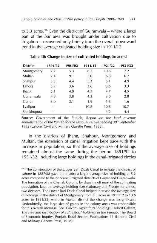
Canals, colonies and class: British policy in the Punjab 1880–1940
241
to 3.3 acres.480 Even the district of Gujranwala – where a large part of the bar area was brought under cultivation due to irrigation – recovered only briefly from the overall downward trend in the average cultivated holding size in 1911/12.
Table 40: Change in size of cultivated holdings (in acres)
District 1891/92 1901/02 1911/12 1921/22 1931/32 Montgomery 7.7 5.3 6.5 10.6 7.2 Multan 7.4 9.1 7.0 6.8 6.7 Shahpur 5.5 4.4 5.3 5.1 4.9 Lahore 5.2 3.6 3.6 3.6 3.3 Jhang 5.1 4.9 4.7 4.7 4.5 Gujranwala 4.9 3.8 4.3 3.0 2.8 Gujrat 3.0 2.1 1.9 1.8 1.6 Lyallpur – – 10.8 10.8 10.7 Sheikhupura – – – 4.2 4.4
Source: Government of the Punjab, Report on the land revenue administration of the Punjab for the agricultural year ending 30th September 1932 (Lahore: Civil and Military Gazette Press, 1932).
In the districts of Jhang, Shahpur, Montgomery and Multan, the extension of canal irrigation kept pace with the increase in population, so that the average size of holdings remained almost the same during the period 1891/92 to 1931/32. Including large holdings in the canal-irrigated circles
480 The construction of the Upper Bari Doab Canal to irrigate the district of Lahore in 1887/88 gave the district a larger average size of holding at 5.2 acres compared to the noncanal-irrigated districts of Gujrat and Gujranwala. The formation of the Chenab Colony, by drawing off most of the cultivating population, kept the average holding size stationary at 4.7 acres for almost two decades. The Lower Bari Doab Canal helped increase the average size of holdings in the district of Montgomery from 6.5 acres in 1911/12 to 10.6 acres in 1921/22, while in Multan district the change was insignificant. Undoubtedly, the large size of grants in the colony areas was responsible for this overall increase. See: Calvert, Agricultural holdings; Hubert Calvert, The size and distribution of cultivators’ holdings in the Punjab, The Board of Economic Inquiry, Punjab, Rural Section Publications 11 (Lahore: Civil and Military Gazette Press, 1928).
Fareeha Zafar
242
helped maintain the existing average size of cultivated holdings at 6–8 acres in Montgomery and Multan and 4–5 acres in Jhang and Shahpur.
In the district of Lyallpur, where 99 percent of the irrigated area was under canals and virtually all the area cultivated was irrigated, several factors accounted for the large size of holdings (more than 10 acres): (i) the large grants made in the Chenab Colony, (ii) strict restrictions on alienations and sales in the early years of colonisation and (iii) the fact that most of the colony area had been uncultivated, unoccupied government waste.
Generally, owner holdings were larger than those of tenants in the canal colony districts, but where tenants were difficult to get, their holdings were also as large and sometimes even larger.481 In the Chenab Colony, for example (transformed into the Lyallpur district in 1904), the holdings of owners and occupancy tenants were normally included together in the records. They were considerably larger than those of government tenants (of 1893) and other tenants-at-will working for the above-mentioned classes of landholder. Within a period of seven years, however, these holdings showed an appreciable fall in size (Table 41).
Tenant holdings were not only smaller than owner holdings, but they also ranged from being economically cultivable units to absurdly small pieces of land. In the Multan and Montgomery districts, holdings were reasonable at about 7–8 acres, but in the older settled districts they ranged between 1 and 3 acres. The very small size of such holdings suggests that many owner proprietors were tenants in turn to other owners so that they could make a living from cultivation.
481 Government of the Punjab, Lodhran and Mailsi, 1901.
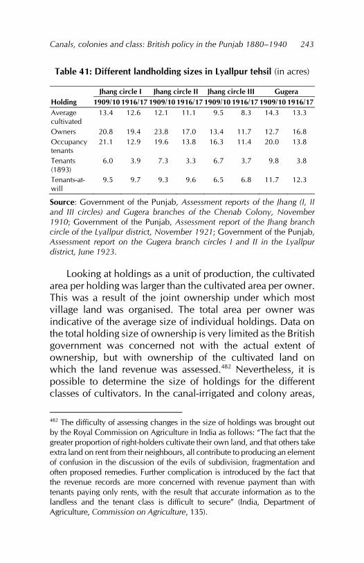
Canals, colonies and class: British policy in the Punjab 1880–1940
243
Table 41: Different landholding sizes in Lyallpur tehsil (in acres)
Jhang circle I Jhang circle II Jhang circle III Gugera Holding 1909/10 1916/17 1909/10 1916/17 1909/10 1916/17 1909/10 1916/17 Average cultivated
13.4 12.6 12.1 11.1 9.5 8.3 14.3 13.3
Owners 20.8 19.4 23.8 17.0 13.4 11.7 12.7 16.8 Occupancy tenants
21.1 12.9 19.6 13.8 16.3 11.4 20.0 13.8
Tenants (1893)
6.0 3.9 7.3 3.3 6.7 3.7 9.8 3.8
Tenants-at-will
9.5 9.7 9.3 9.6 6.5 6.8 11.7 12.3
Source: Government of the Punjab, Assessment reports of the Jhang (I, II and III circles) and Gugera branches of the Chenab Colony, November 1910; Government of the Punjab, Assessment report of the Jhang branch circle of the Lyallpur district, November 1921; Government of the Punjab, Assessment report on the Gugera branch circles I and II in the Lyallpur district, June 1923.
Looking at holdings as a unit of production, the cultivated area per holding was larger than the cultivated area per owner. This was a result of the joint ownership under which most village land was organised. The total area per owner was indicative of the average size of individual holdings. Data on the total holding size of ownership is very limited as the British government was concerned not with the actual extent of ownership, but with ownership of the cultivated land on which the land revenue was assessed.482 Nevertheless, it is possible to determine the size of holdings for the different classes of cultivators. In the canal-irrigated and colony areas,
482 The difficulty of assessing changes in the size of holdings was brought out by the Royal Commission on Agriculture in India as follows: “The fact that the greater proportion of right-holders cultivate their own land, and that others take extra land on rent from their neighbours, all contribute to producing an element of confusion in the discussion of the evils of subdivision, fragmentation and often proposed remedies. Further complication is introduced by the fact that the revenue records are more concerned with revenue payment than with tenants paying only rents, with the result that accurate information as to the landless and the tenant class is difficult to secure” (India, Department of Agriculture, Commission on Agriculture, 135).
Fareeha Zafar
244
the size of holdings was easier to establish as the land had been given in grants after 1880. Even here, existing landlords extended their holdings by hundreds of acres under capitalist and yeoman grants as well as the special consideration they were given by the administration. Owners of private canals were also able to benefit from the extension of perennial canals and acquired large holdings.
Delineation of the rural classes
The Punjab Tenancy Act of 1868 had given legality to the hastily put together tenurial categories under the summary land revenue settlements. Under this act, the relationship of the revenue collector and revenue payer was changed to that of landlord and tenant and the status of the Punjab peasant degraded to that of a tenant-at-will.483 The result was termed an equipoise between the relative position of landlord and tenant which, it was felt, would be a fatal mistake to disturb.484 Clearly, landlord proprietors were regarded as the most important class in the community.
The term ‘landlord proprietor’ was, however, seldom used. More commonly, such landowners in the Punjab were called ‘peasant proprietors’. This term was misleading: although it did not “imply the absence of classes which monopolise land or the absence over the production cycle of the need to borrow,” the impression it conveyed was of an independent producer, which in most cases the Punjab peasant was not.485 Peasants’ continued dependence on the village shopkeeper or bania for a credit supply, the provision of consumption goods and the sale of their produce explained their contractual inferiority.486 483 Punjab, Revenue and Agriculture, Proceedings, land transfer, 1895. 484 Government of the Punjab, Department of Revenue and Agriculture, Proceedings, revenue no. 113/345, 21 March 1882. 485 Harriet Friedmann, ‘Household production and the national economy: Concepts for the analysis of agrarian formations,’ Journal of Peasant Studies 7, no. 2 (1980): 171. 486 Darling, Rusticus loquitur, 16.
Canals, colonies and class: British policy in the Punjab 1880–1940
245
In this way, any surplus the peasant economy might have generated was transferred to the intermediary.
The increasing cultivation of cash crops, stimulated by the high price of canal water, the higher prices of commercial crops (especially cotton) and pressure from the Agriculture Department to use improved varieties of seed for these crops increased peasants’ need for credit. This had to pay for (i) the land revenue, (ii) water rates, (iii) improved seeds, (iv) food for the household and (v) any agricultural stock they had previously raised but been forced to abandon once grazing grounds had diminished. Canal irrigation, therefore, increased peasants’ need for credit as well as their dependence on the agencies that supplied it.
Attempts to settle the nomadic and grazing tribes and convert them into agricultural communities were accompanied by myopic, prejudiced interpretations of intra-tribal relationships. The leaders of the tribes or tumandars were raised to the status of large landowners while the rest of the tribe were reduced to the level of menials, agricultural labourers or tenants. With the colonisation of the bar rakhs and other areas where canals were constructed, such groups were compensated for the curtailment of their grazing and cultivating rights with small plots of land as and when water became available close to where they lived. The colony officers regarded this as a concession that seemed
likely to be attended with good results, since it gives a somewhat unruly and criminal class an inducement to settle down on the lands. At the same time, it does not raise them above their natural conditions, which is that of menials and tenants and their services will continue to be available in these capacities to the proprietors of the old villages.487
487 Government of the Punjab, Punjab colonies, 1902, 26.
Fareeha Zafar
246
Elsewhere, such tribes had to admit to criminal offences to prove their residence in a district and so, qualify for land grants. Similarly, the Biloch graziers, who migrated seasonally from western Punjab to the rivers and bar areas were not given land under the camel service grantee scheme in the Chenab Colony, but as criminal grantees even though their occupation was raising camels as well as other animals.488
All land not demarcated as belonging to a village and, in some cases, even part of the reserved village wasteland had been appropriated by the government as Crown waste. Canal construction and the accompanied extension of cultivation into these areas had greatly restricted the natural grazing grounds. The assessment officer for the Gugera circle II in the Lower Chenab Colony assessed the situation thus:
The advent of canal irrigation dealt a deadly blow to those who live by breeding camels. The Bar camel became unhealthy and infertile, grazing grounds have vanished and the ravages of suwa have decimated the ranks of the four grantee camel corps every summer.489
The depletion of these grazing grounds and inadequate assimilation of graziers into the colonies’ agricultural community pushed them into the ranks of wage labourers, agricultural labourers and, at best, tenants. Their occupational abilities, having been termed ‘criminal and unruly’, were thus wasted. Even where, during later colonisation in the Chenab Colony, the small abadkar (horse-breeding colonist) proved successful compared to the larger grantees, the government ended up supporting the landlord class vis-à-vis the peasant
488 Government of the Punjab, Gazetteer, Chenab Colony, 126. 489 Government of the Punjab, Assessment report of the Gugera branch, circle II, Lower Chenab Canal, May 1912, 18.
Canals, colonies and class: British policy in the Punjab 1880–1940
247
cultivator by buying less stock and encouraging stock farms in the colony.490
Peasants were also discouraged from raising animals for their own use. In the Chunian tehsil during the 1890s, most Crown wasteland was used for grazing purposes. When these rakhs were offered for auction, local zamindars’ demand that they be allowed to purchase the land in instalments at a lower price was turned down. They were also refused occupancy tenant rights to the land.491 On the other hand, a policy of establishing large stock farms was adopted. Such farms formed part of the activities of the Department of Agriculture as well as private individuals from the privileged landed class who were encouraged in this venture. British policy towards grazing grounds tended, therefore, to advantage a certain class in the canal colony districts.
The fact that the Punjab had shifted on from the stage of ‘ultra-landlordism’ had nothing to do with the British. The Sikhs before them had ignored many privileged rights to the land and treated those of the cultivator as paramount, thereby reducing disparity among the rural classes. Even so, many forms of landed class privilege remained that the British administration did not do away with. In some cases, certain earlier forms were removed without fundamentally weakening the class character of landed privilege.492 For example, most chaudhris, mukkadims and jagirdars were converted into
490 Government of the Punjab, Report on the administration of the Punjab and its dependencies for the year 1911–12 (Lahore: Office of the Superintendent of Printing, 1912), 10. 491 Government of the Punjab, Department of Revenue and Agriculture, Proceedings, general no. 117, 25 February 1895, paragraphs 6–7. 492 Burton Stein, ‘Privileged landholding: The concept stretched to cover the case,’ in Land tenure and peasant in South Asia, ed. Robert Eric Frykenberg (New Delhi: Orient Longman, 1977), 75.
Fareeha Zafar
248
inamdars while smaller forms of privilege were grouped under safaid posh inams.
Despite the administration’s efforts to emphasise its patronage of the Punjab peasantry, the policy of the British favouring privileged landholding is easily recognised. It was only in the brief period between 1849 and 1857 that jagirdars were considered undesirable elements in rural society. After the events of 1857, the new government quickly realised that granting favour to this class of landowner would have immense benefit. Not only was jagirdari continued under other names, but those landlords who had lost out in the struggle against the rising nonagricultural landowner (capitalist or moneylender) through their own extravagance were also given opportunities to better their means. Such opportunities were afforded
during the last few years to several of the leading men of the Mooltan District, for instance, to the late Mehr Shah of Kauranga and Sultan Hiraj, who obtained valuable grants on the Sidhnai canal, and Ghulam Muhammad Daultana of Ludan, who has been permitted to construct a private canal, and has been given substantial grants of land in its vicinity. Also it is no doubt good policy to treat a man like Macha with reasonable consideration as he possesses much influence among the nomads of the Bar, and is in a position to render good service to government in many ways.493
Canal irrigation gave the government the added opportunity to bestow favour on the landed classes through direct grants as well as by auctioning colony land priced at a level out of the Punjab peasant’s reach.494 At the same time, the state could make commercial gains beyond its 493 Government of the Punjab, Department of Revenue and Agriculture, Proceedings, revenue no. 146C, 10 July 1891, paragraph 4. 494 India, Department of Agriculture, Agriculture, evidence taken in the Punjab, 624.
Canals, colonies and class: British policy in the Punjab 1880–1940
249
expectations. The proceedings of the Revenue and Agriculture Department for 1893 stated that, in the auction of land on the Chenab Canal, all the land was bought by sardars and big government officials. The price they paid was around Rs40 to Rs48 per acre, which was higher than the government reserve price.495 Another method of realising very high prices for auctioned land was to offer small plots for auction instead of a large area in one lot. Capitalists who were interested in acquiring an estate were thus forced to buy numerous small plots at higher prices.496
It was difficult for the administration to support its policy of discriminating against peasant proprietors – whatever the size of the lots offered for auction, the area’s peasant proprietors and cultivators were not likely to be able to compete with the capitalists.497 The results of an auction of land on the Jhelum Canal, for example, showed that the minimum price of any particular square was determined not by the large capitalist, but by the competition among small buyers, whereas the maximum price was fixed by the competition among large capitalists. Furthermore,
This class does not find it profitable to acquire small areas and generally wants 10 or 20 squares, if not an entire chak. As the land is offered in small lots they are often obliged to bid very high prices, indeed, in order to get possession of the necessary area.498
In fact, there was no competition between the capitalist and the peasant, but there was contention between the capitalist and the agricultural landlord. The Alienation of Land Act had restricted the sale of land to nonagriculturists by agricultural 495 Government of the Punjab, Department of Revenue and Agriculture, Proceedings, irrigation no. 90, 4 February 1893. 496 Punjab, Revenue and Agriculture, Proceedings, irrigation, 1901. 497 Punjab, Revenue and Agriculture, Proceedings, general, 1895, paragraph 8. 498 Government of the Punjab, Department of Revenue and Agriculture, Proceedings, irrigation no. 191, 18 October 1902, paragraph 3.
Fareeha Zafar
250
tribes. When land was auctioned in the colonies in lots of one or two squares, capitalists were discouraged from buying these because, if an agricultural landlord bought the adjacent lot, they would not be able to expand.499
In this way, the growth of the capitalist landlord was checked while that of the agricultural landlord was encouraged. It was only possible for large landlords or capitalists to pay very high prices for canal-irrigated land.500 Besides the auction of land, large landlords were also given grants of land on special conditions such as horse breeding.501 The value of these canal-irrigated grants was enormous and by bringing large landlords into the field of stock farming, the small peasant was further squeezed out.
This practice also led to the development of absentee landlordism. For example, in the Jhelum Colony, colonists chosen from the Shahpur, Gujrat and Gujranwala districts belonged to families of lambardars, pattidars and even zaildars, that is, they were of better standing than peasant colonists. As some were Sayyids and Koreishis, who were not self-cultivators but were good horse breeders, they tended to be absentee landowners.502
499 India, Department of Agriculture, Agriculture, evidence taken in the Punjab, 663. 500 This is supported by the case of Mahla Singh, a grantee of nine cattle farms in the Okara tehsil of Montgomery district, who bid Rs1,105 per acre for a lot of about 16 acres in Chak Muhammad Shah in the Gugera distributary area. He already owned other land in the neighbourhood and bought three other lots in the chak at prices over Rs1,000 per acre (see: Punjab, Revenue and Agriculture, Proceedings, irrigation, 1920, paragraph 4). 501 In one instance, 15 squares of land were allotted on horse-breeding conditions to Malik Muhammad Hayat Khan Nun, a landlord in Shahpur district who was also the extra assistant commissioner. A lot of 15 squares was granted to another landlord of the same district, Malik Khan Muhammad Tiwana. See: Government of the Punjab, Department of Revenue and Agriculture, Proceedings, general no. 1218A, 14 October 1904. 502 Government of the Punjab, Punjab colonies, 1902, 24.
Canals, colonies and class: British policy in the Punjab 1880–1940
251
Other categories of grantees who were absentee landlords were the tumandars of Dera Ghazi Khan district and most representatives of important families of the Punjab who had received landed gentry grants in the colony areas.503 In districts that were previously considered essentially small-owner districts, such as Lahore, the auction of government wasteland after the construction of canals resulted in the creation of large holdings, while the important families of the district all found themselves owners of substantial properties as a result of auctions and grants from the government.504
The benefits of canal irrigation were also unequally shared by landlords and tenants. The Revenue Proceedings for 1904 stated:
Whereas the latter have been paying the occupiers’ rates the former have paid practically nothing except the dry revenue although their profits have increased immensely.505
Thus, despite the continuing need for credit, the position
as far as the large landowners are concerned is good. They are not as a rule heavily encumbered with debt, they can obtain high prices for their produce and they have learned from experience the wisdom of improving their lands by the sinking of wells. The large amount of capital that has been expended on well construction since the last settlement is, in itself, a proof of the substantial profits obtainable from land, and although the smaller owners and most of the cultivators do not
503 Bourne, Lower Bari Doab Colony, 4. 504 R. C. Bolster, Final report of the fourth regular settlement of the Lahore district, 1912–16 (Lahore: Superintendent, Government Printing, 1916), 4. 505 Government of the Punjab, Department of Revenue and Agriculture, Proceedings, revenue no. 183, 12 May 1903, paragraph 13.
Fareeha Zafar
252
get their fair portion of these profits, they get a larger share than they did.506
Canal irrigation, therefore, enabled the larger landowners to make greater profits, which provided them the capital to invest in land. The very high prices they paid for canal-irrigated land in turn led them to recoup their losses by exacting a high rate of rent from their tenants.507 While there is no record of any enquiry into rack-renting in the Punjab, the fact that, in all canal-irrigated areas, the landlord’s share was half the produce and he paid half the land revenue, with most cultivation expenses falling to the share of the tenant, reflects on the former’s strong position in the canal colonies.
The change in status of the peasant from revenue payer to tenant-at-will was accompanied by insecure tenure. The very small percentage of area cultivated by occupancy tenants showed landowners’ antipathy towards this class of tenant, whose rights of tenure were recognised by the Punjab tenancy laws. The administration was also reluctant to grant occupancy status to tenants-at-will, favouring as it did the landowning class.508 Moreover, it was believed that many small proprietors of land also rented land from other owners and so, fell into the category of owners-cum-tenants or part-tenants. In this way, since most cultivators owned some land, they qualified as ‘peasant proprietors’.
Tenurial categories and statistics, however, did not allow for this class of owner and there is little evidence in the land revenue settlement reports and assessment reports to prove it. The more crucial question was how much land a peasant proprietor owned and not merely that he owned a small piece of land. The Department of Revenue, being concerned with 506 Government of the Punjab, Mailsi tehsil, 1920, paragraph 10. 507 Government of the Punjab, Administration, 1901–02, viii; Darling, Rusticus loquitur, 265. 508 Punjab, Revenue and Agriculture, Proceedings, revenue, 1882.
Canals, colonies and class: British policy in the Punjab 1880–1940
253
the payment of land revenue, was not interested in such ownership patterns.
If we take the figures for the cultivating occupancy of the land, then in 1891/92, three of the seven Punjab canal colony districts had more than 50 percent of the cultivated land being cultivated by tenants-at-will.509 An enquiry carried out by the Board of Economic Enquiry in the 1930s explains the tenant’s position thus: “Sometimes the tenant is working at an actual loss and often on a very low margin of profit.” It also questions the ability of the tenant to survive without a subsidiary source of livelihood, such as plying carts or daily labour. Consequently, landlords assumed a very strong position in relation to the rent they charged, especially in canal-irrigated tracts where tenants were easiest to procure.510
By 1931/32, seven of the nine canal colony districts had more than half their cultivated land being tilled by tenants-at-will (Table 42). Even if some tenants-at-will were assumed to own part of the land they cultivated, this proves several points: (i) the cultivated area tilled by tenants-at-will had increased; (ii) as the size of holdings had diminished or, in some districts, remained the same, the number of tenants-at-will had increased; (iii) more cultivators were finding it necessary to supplement their land holdings by taking land on rent in the capacity of tenants-at-will; and (iv) the increase in population had reduced the cultivated area per head in all districts and this had added to the increase in the number of tenants. 509 Frykenberg notes that the term ‘peasant’ in the Indian context was used for the lowest serf or outcast labourer almost in a condition of debt bondage or slavery to the high-caste ‘peasant elite’ or ‘peasant proprietor’ or ‘peasant landlord’ ruling agrarian villages individually or corporately. The term ‘peasant proprietor’ is thus misleading, including as it does cultivators belonging to several different social classes. The British, in references to the ‘peasant’ usually referred to the peasant proprietor as, for them, the landowning peasant class was an important category. See: Robert Eric Frykenberg, Land tenure and peasant in South Asia (New Delhi: Orient Longman, 1977). 510 Government of the Punjab, Abiana Committee, 13.
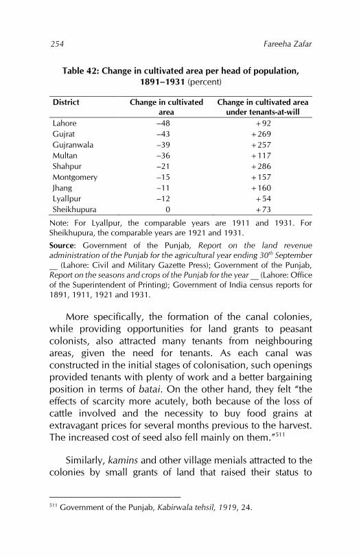
Fareeha Zafar
254
Table 42: Change in cultivated area per head of population, 1891–1931 (percent)
District Change in cultivated area
Change in cultivated area under tenants-at-will
Lahore –48 +92 Gujrat –43 +269 Gujranwala –39 +257 Multan –36 +117 Shahpur –21 +286 Montgomery –15 +157 Jhang –11 +160 Lyallpur –12 +54 Sheikhupura 0 +73
Note: For Lyallpur, the comparable years are 1911 and 1931. For Sheikhupura, the comparable years are 1921 and 1931.
Source: Government of the Punjab, Report on the land revenue administration of the Punjab for the agricultural year ending 30th September __ (Lahore: Civil and Military Gazette Press); Government of the Punjab, Report on the seasons and crops of the Punjab for the year __ (Lahore: Office of the Superintendent of Printing); Government of India census reports for 1891, 1911, 1921 and 1931.
More specifically, the formation of the canal colonies, while providing opportunities for land grants to peasant colonists, also attracted many tenants from neighbouring areas, given the need for tenants. As each canal was constructed in the initial stages of colonisation, such openings provided tenants with plenty of work and a better bargaining position in terms of batai. On the other hand, they felt “the effects of scarcity more acutely, both because of the loss of cattle involved and the necessity to buy food grains at extravagant prices for several months previous to the harvest. The increased cost of seed also fell mainly on them.”511
Similarly, kamins and other village menials attracted to the colonies by small grants of land that raised their status to
511 Government of the Punjab, Kabirwala tehsil, 1919, 24.
Canals, colonies and class: British policy in the Punjab 1880–1940
255
‘agriculturists’ joined the ranks of tenants.512 Many of the nomads and graziers inhabiting the wastes of the bar turned to cultivation when the areas in which they lived and grazed were converted into canal colonies. They too became tenants, as did the Janglis, the name given to some of the nomad tribes. As the Janglis were mostly given inferior land at the tail-end of the canals and nonperennial areas, their cultivation was inferior and their small grants forced them into the rank of tenant.513
Lack of security of tenure for tenants-at-will precluded any improvements to the land they rented for cultivation.514 This in turn constrained their social mobility. After 1920, in many colony areas the land reserved for kamin and menial grants was auctioned instead. Under these circumstances, the kamins and village menials became agricultural and wage labourers. Canal irrigation created opportunities for the tenant classes to supplement their income with daily labour required by the extension of cash crops such as cotton, sugarcane and oilseeds as well as by plying carts carrying agricultural produce to the markets. These often proved to be the mainstay of their existence. Thus, while some tenants fell into the category of part-owners and part-tenants, many were part-tenants and depended partly on daily labour.
The impact of canal irrigation was evident in the case of the kamins, menials and other village servants attached to the village production system in the Punjab. As one of the aims of colonisation policy was to inhabit the newly formed colonies with colonists from outside, that is, from the congested districts of eastern Punjab, local inhabitants were often ignored and asked to stay where they were and not move to the areas where canal irrigation water was being made available. When this happened in the Chenab Canal Colony, 512 Government of the Punjab, Punjab colonies, 1903, i. 513 Government of the Punjab, Department of Revenue and Agriculture, Proceedings, development no. 298D, 21 January 1926, paragraph 3. 514 Government of the Punjab, Administration, 1921–22, 283.
Fareeha Zafar
256
the original inhabitants refused and moved to the canal villages where they joined the ranks of farm labourers, artisans and menials.515
Many of the nomads and graziers of the bar who could not become tenants of the colonists – who preferred to cultivate through poor relatives – turned to wage labour, as did members of the Depressed Classes,516 particularly the Christians and Ods,517 who were given minute plots of land on which they could not support a family.518 The Depressed and Criminal Classes were, in many cases, not even included in the lists of agricultural tribes drawn up when the Alienation of Land Act was passed. As a result, they did not qualify for land grants and had no option but to work as menials and labourers.519 Moreover, the high price of land and the shift from food grain to cash crop cultivation combined to increase the need for credit, thereby weakening the bargaining position of the agricultural labour class.520
Thus, while some policies were not directly aimed at the economic suppression of the tenant and landless labourer class, there were others in which this intention was clearly spelled out. It was in the canal-irrigated areas that this bias was expressed most openly. The process of rural class formation in the Punjab canal colony districts was deepened, first, by the institutional changes carried out by the British colonial government in the form of various tenancy laws and the Alienation of Land Act and, second, by the technological
515 Thorburn, Punjab in peace, 284. 516 Their official name was the ‘Scheduled Castes’. 517 ‘Od’ (as with ‘Jangli’) was one of the names by which the nomadic and pastoral tribes of the bar areas were known. 518 Bourne, Lower Bari Doab Colony, 4. 519 Government of the Punjab, Department of Revenue and Agriculture, Proceedings, revenue no. 1364, 26 May 1928. 520 Daniel Thorner, The agrarian prospect in India, 2nd ed. (New Delhi: Allied Publishers, 1976), 14.
Canals, colonies and class: British policy in the Punjab 1880–1940
257
innovation of the perennial canal system on which the formation of the canal colonies was based.
In the first instance, the ownership of land was defined and given legality; different tenurial categories were formed and their rights defined. The Alienation of Land Act 1900 created further distinctions between the region’s agricultural and nonagricultural tribes, distinguishing between them by cultivation and not ownership. Whereas representations were accepted from some of the more powerful tribes that had been excluded in this exercise, those from the Depressed Classes and poorer classes were ignored. In the second instance, canal irrigation policy curtailed peasants’ freedom to cultivate wasteland. Instead, this land was appropriated by the government, formed into colonies and the colony land either sold or auctioned to buyers or given in grants of varying size to peasants, yeomen and capitalists. Some land was also leased out directly to cultivators.
The combined effect of these changes was to entrench agricultural landlords firmly within the rural social structure. Their position was bolstered by the economic value and social status attached to land ownership and increased as the price of land (particularly irrigated land) rose. The production of cash crops and the high prices these obtained further increased the value of their holdings. Several other factors – the opportunity to extend these holdings with high bids for auctioned land in the colonies, the formation of cooperatives and agricultural banks that provided easy avenues of credit, the policy of special grants made in the form of stock farms, dairy farms and experimental farms, and landlords’ inclusion in the administrative structure – combined to make agricultural landlords very powerful. Added to this was the government’s bias in favouring them over capitalist (nonagricultural) landlords.
The development of canal irrigation enabled agricultural landlords to buy land from small peasants who were offered very high prices, which they often could not resist. Moreover,
Fareeha Zafar
258
the competition from a strong neighbour deterred them from holding onto their land. Large landlords were also able to acquire land from peasant proprietors or tenants by raising rents, while the high canal water rates often forced peasants to sell their land. The former were in a far better position to use the facilities offered in the form of improved seeds, markets and the choice of cultivating crops that fetched the highest prices.
Similarly, the rich peasant proprietors gained from these changes and employed agricultural labourers for a wage in place of tenants. Their growth was connected directly to the technology of the perennial canal and the grant of land in the colonies, often in addition to land they owned in other parts of the region. The possession of two to four squares of irrigated land – if they were yeomen grantees – was more than enough for them, especially when they cultivated cotton and oilseeds, were resident cultivators and looked after the grant themselves.
Peasant proprietors who relied entirely on self-cultivation benefitted from canal irrigation in the early stages, while their grants were between one and two squares. However, canal closures, variable weather conditions and the subdivision of holdings combined to keep them on the edge of subsistence. Their cultivation (choice of crops) was affected by what their neighbours grew and directions from the Department of Agriculture as well as by fluctuations in the prices of agricultural produce, which prevented them from improving their condition. Pressure and competition from the larger landlords often pushed them down into the ranks of the poor peasants.
Poor peasants who were either proprietors-cum-tenants or just tenants benefitted the least from canal irrigation. Their ownership of land was too limited to allow them to extract the profits associated with cash crop production, cooperatives, takavi facilities and the like. Indeed, the cultivation of cash crops forced poor peasants to buy food grains at high prices as they had little ‘holding-out’ power. Their farming requirements (seed, animals and agricultural implements), revenue and rent
Canals, colonies and class: British policy in the Punjab 1880–1940
259
obligations and the sale of their produce compelled them to depend on the local shopkeepers or banias.
Nor was the batai system in their favour: poor peasants had to share half the harvest produce with the owner of the land. In canal-irrigated areas, it became the general rule for landlords and their tenants to share equally the produce and the incidence of land revenue at each harvest. Besides, the policies of the administration were directed at maintaining tenants in this capacity. The annual report of the Punjab colonies for 1912/13 stated:
The menials and tenants-at-will and shopkeepers will not be allowed to purchase any proprietary right at present. In cases where these people have occupied sites in the colonists’ compounds the proprietary rights of the whole compound will be given to the colonist and the menials inhabiting therein will be considered under them.521
There was thus little chance for this class of cultivators to improve their position. They were forced to remain tenants, with few rights and working for a landlord. Consequently, a distinctly exploitative relationship between the landlord and the tenant was firmly established throughout the canal colonies.
The rural administrative structure was altered to facilitate the collection of land revenue, for which the existing chain of official and unofficial links was formalised between villages and the province. Members of the Punjab’s major landowning families were appointed to these offices. In the new canal colonies, the system of land grants was used to create landlords who could be incorporated into the administration. Rural society, therefore, consisted of landlords and officials at one end of the spectrum and the mass of the peasantry at the other. 521 Government of the Punjab, Report on the Punjab colonies for the year ending 30th September 1913 (Lahore: Civil and Military Gazette Press, 1913), 12.
Fareeha Zafar
260
The increase in tenancy and agricultural labourers in the canal colonies brought about changes in the customary agrarian relationships between the two main classes, that is, landlords and cultivators, with power – political, economic and social – resting in the ownership of land. Land ownership for the purpose of land revenue payment was determined under zamindari, pattidari and bhai chara forms of tenure as well as under direct lease from the government in the colony areas. Ownership itself could be classified by cultivation. The noncultivating landlords, who were to be found mainly in the western districts of the Punjab, were preserved by the administration through jagirs and inams. With the extension of the perennial canals, irrigated land acquired a new importance from which existing landlords were quick to benefit.
Colonisation policy itself provided room for large landowners in the colony areas and for the creation of absentee landlordism. Changes in the cultivating occupancy of the land between 1891 and 1931 showed an overall increase in tenancy. Combined with the extension of the cultivated area, this pointed to a change in the size of holdings and the concentration of land in fewer hands.
The effect of canal irrigation on the average size of cultivated holdings differed across the nine Punjab canal colony districts. The systematic pattern of holding size by slope and distance from the river was altered by canal irrigation, while the system of different sizes of land grants in the colonies introduced further changes in the pattern of land holdings. While the average size of holdings decreased steadily in noncolony parts, in the colony areas the regulation of the size of grants made by the administration created large holdings. This difference in size remained even though there was an overall decrease in the size of holdings with the increase in population and subdivision of holdings. Owner holdings were larger than those rented by tenants and, together with the very large holdings of landlords, indicated disparities in the pattern of land ownership.
Chapter 9
Conclusion
The perennial canals cannot simply be viewed as a technological development or their impact measured in terms of the quantitative expansion of production. It is just as important to analyse the policies that determined the changes. In this context, the role of canals as an element of change in transforming the socioeconomic structures of the Punjab has been a primary one. Prior to the British presence, irrigation in the province was practiced by different means, of which wells and inundation canals were the most important. Wells were widely distributed and more reliable suppliers of water throughout the year, albeit to a limited area, which resulted in the careful cultivation of valuable crops on small fields. Inundation canals, on the other hand, were operative only during the rainy season and the irrigated area varied greatly with the amount of rainfall.
Shortly before and after annexation, minor attempts were made to convert the existing canals into perennial systems in eastern Punjab. This area was already densely settled and cultivated, with a developed system of well irrigation. Excepting the Upper Bari Doab Canal, the other projects were near failures, hampered by inadequate or defective technical know-how while the original schemes were amputated for lack of capital. Further canal construction had to wait until these drawbacks were removed by developments in hydraulics and engineering, the availability of British capital and a disposition to invest it in the canals of the Punjab.
In the early decades of British rule, canal construction suffered in comparison to railway construction, which was
Fareeha Zafar
262
considered more remunerative. Other means of communication were also pushed aside, deemed either too slow or too unimportant in developing the links between the Punjab and the outside world. River traffic declined slowly and perennial canal construction delivered it the final blow. In 1882, after the report of the Famine Commission and once the success of the financial implications of the canals were guaranteed, other sources of irrigation fell into neglect. Even the recommendations of the Irrigation Commission (1901–03) did nothing to change the situation.
Canal irrigation development in the Punjab was viewed by the British government as a means of extending cultivation and increasing agricultural production. Any additional advantages to be gained from it in the form of river transport or generation of electricity, or even long-term irrigation planning through the storage of water, were completely ignored. It was only much later, because of waterlogging and the decrease in supplies of canal water – with the extension of the colonies and the construction of numerous canal branches and distributaries – that well and inundation irrigation were recognised as a necessary adjunct to canals. Moreover, the colonial government’s decisions were influenced by the opinion of landlords and landowners; it tended to ignore the requests and complaints of the tenant and cultivating classes. The extension of canal irrigation and cultivation to millions of acres of land in the doab areas made the small decrease in the cultivated area resulting from the destruction of wells, inundation canals and sailaba irrigation look insignificant. At the same time, residents of the affected villages could be absorbed readily into the new areas being colonised.
In the colonies, the practice of granting land without reserving any for communal purposes – as originally planned – resulted in indiscriminate irrigation practices, leading to waterlogging and erosion, greater demand for canal water (especially for valuable crops such as wheat and cotton) and
Canals, colonies and class: British policy in the Punjab 1880–1940
263
the destruction of forests and grazing grounds. Thus, the ecological balance between cultivation and grazing was destroyed by the perennial canals and subsequent colonisation, as the area selected to form colonies had been used by nomadic and pastoral tribes as natural pastures. Furthermore, the division of the rural population into agriculturists and nonagriculturists resulted in the separation of cultivation and pastoral activity – functions that had been closely linked in a region of scanty and marginal rainfall.
The British army’s need for animals resulted in many colony land grants being made conditional on raising better breeds of camels, horses and mules. The need for farm animals in the colonies themselves led people to set up cattle farms in some areas. The local nomadic tribes, however, who were professional graziers, were given few opportunities to participate in these schemes. Instead, they were compelled to take up cultivation, usually on inferior land at the tail-end of the canals with the result that their production was poor and their herds of livestock suffered from the shortage of grazing land. The dispossession of these tribes becomes evident from the fact that, whereas they had used the land freely for grazing and sporadic cultivation, post-colonisation they were only given inadequate grants of land to cultivate.
The process of colonisation was guided by political, economic and social factors on the part of the British government. The political motives for the colonisation schemes were (i) the settlement of Sikh soldiers, (ii) the political stabilisation of the doab areas, which the railways could not accomplish on their own, and (iii) the need to rally support among the agricultural classes whose importance in replenishing the ranks of the army was paramount. These motives were inextricably linked with economic considerations such as (i) the un-remunerative aspects of railway construction in isolation, (ii) the need for increased production for areas of scarcity and for the army, (iii) the
Fareeha Zafar
264
prospect of increased land revenue and, later, (iv) the financial profits to be derived from the sale of colony land. At the same time, the social benefits of colony formation were also apparent to the government in (i) the form of land grants that could be used to obtain allies and friends, and (ii) the perpetuation and growth of feudal classes and institutions in decided preference to urban and commercial interests.
Government policy towards colonisation also reflected the differences and change in the views of administrators and policymakers, which created confusion and discontent. The more egalitarian principles of colonisation were submerged by commercial and colonial interests. In the districts already settled, the British government had not appropriated large areas of wasteland, but left them the responsibility of village communities and/or individuals. In the colonies, however, it had appropriated all land. The areas colonised consisted primarily of Crown property and the administration controlled the distribution and allotment of colony land.
The construction of perennial canals had already given the government complete control over the means of irrigation. Ownership of private canals having been terminated with their amalgamation into the perennial schemes, it was possible to direct canal water to the holdings and estates of favoured individuals and lessees. The government was thus able to derive the full benefit not only of selling canal water, but also colony land while keeping most cultivators in the position of state tenants. The agitations against and consequent failure of the Colonies Bill of 1907, however, was an indication of the extent to which the Punjab peasant could be pushed.
The infusion of perennial canal technology into the Punjab’s wastelands created a dynamic situation that the British government was anxious to control to maintain the existing form of social relations. The relationship between land tenure and irrigation had been apparent in the case of
Canals, colonies and class: British policy in the Punjab 1880–1940
265
wells, embankments, inundation channels and the like, but the area affected by these forms of irrigation was small. In the case of perennial canals, the tenurial patterns over large areas were affected. The policy of the colonial government continued to favour the privileged landed classes, with only the nomenclature of some reward grants and concessions being changed.
The administration report on the Punjab for 1849/50 outlined the government’s policy on the Punjab as being conservative. Its aim was to interfere only to preserve and not to change or destroy.522 While the extension of cultivation helped maintain the overall person–land rates in the Punjab canal colony districts for several decades, the administration attempted to control social and political aberrations through legislation. The Alienation of Land Act and the different acts relating to wasteland and colonisation passed between 1880 and 1920 are indicative of this aspect of colonial policy.
Both these measures, however, failed to protect small owners against large landholders. The Alienation of Land Act restricted land from passing out from agriculturists to nonagriculturists, but did not place any restraints on land transfer among the agricultural classes, nor did it concern itself with the problem and causes of indebtedness. Meanwhile, in the colonies, new facilities offered in the form of irrigation water, marketing and credit created new goals and aspirations for the colonists.
The need for alternative sources of credit – especially after the Alienation of Land Act limited the activities of the bania – and the demand for credit among the cultivating population of the colony areas gave rise to the cooperative movement. In this connection, the Cooperative Credit Societies Bill introduced in
522 Government of the Punjab, Administration, 1849–50, 12.
Fareeha Zafar
266
1903 was enacted in 1904 to help agriculturists obtain credit by 523pledging their production as security to obtain loans.
The main limitations of the credit societies lay in that they catered only to members and failed to bring down the
524moneylending rate of the bania. Moreover, these societies and other village banks were all controlled by landlords whose power over peasant cultivators simply increased. Government loans to proprietors in the form of takavi were used mainly for the construction of irrigation channels; little remained for the needs of cultivation and revenue. As a result, the bania continued to meet the day-to-day credit needs of the cultivators.
At the same time, the continued demand and need for credit gave rise to agricultural moneylenders who usually belonged to the agricultural landlord class and on whose activities no limitations were placed. The government also encouraged the policy of land mortgages in place of land sale; again, no restrictions were placed on mortgaging land to obtain credit.
Cultivators were unequally equipped in the competition to appropriate the new facilities in the colony areas: the existing economic differences among classes were amplified in accordance with the potential of each group to appropriate these facilities. The application of the kharaba system or remission of land revenue was further indicative of the class bias apparent in the whole pattern of colonisation. For example, referring to kharaba,
Many poor peasants maintain that it is only the more vocal and influential cultivators who derive benefit from it. The fact that many inferior villages of Jangli cultivators situated far away on the fringes of Samundari and Toba Tek Singh tehsil have never
523 Khan, Census of India, 1931, part 1, 54. 524 Middleton and Jacob, Census of India, 1921, part 1, 72.
Canals, colonies and class: British policy in the Punjab 1880–1940
267
been allowed a single acre of Kharaba lends colour to this complaint.525
The system of differential land grants followed in the allotment of colony land made room for both agricultural and nonagricultural landlords. While the former gained from the protection of the Alienation of Land Act, the latter extended their holdings by buying land at auctions. Moreover, capitalists, yeomen and nazarana-paying grantees could now buy proprietary rights on easy terms and the land offered for sale at auction was not tied to any conditions. The Act was thus bypassed in the colony areas by the direct sale or auction of land. The desire for land in the colonies on the part of the capitalists and nonagriculturists meant that, along with the agricultural landlords, they acquired almost all the land at auctions.
The demand for land in the Punjab was accentuated by canal irrigation, which increased its productivity. The acquisitive nature of the moneylending classes was also given a fillip by canal irrigation, which raised the value of land. Increased demand and competition among a few rich individuals was reflected in the rise of land prices, which rose even further with the increase in price of agricultural produce and the continued auction of colony land. The higher price of colony land compared to the price of land in the old proprietary villages is proof of this.
Moreover, the policy of auctioning small plots of land – ostensibly to give small landowners a chance to buy in the open market – was used as a means of obtaining high prices for such land by the government. The capitalists and landlords who wanted large estates were easily able to outbid small proprietors and this translated into very high land prices. Compared to the agricultural landlords, the capitalists were
525 Kirpalani, Lyallpur district, 4.
Fareeha Zafar
268
prepared to pay even higher prices to obtain land, for which they had fewer opportunities available.
The conditional nature of the peasant grants made it possible for the Department of Agriculture and the Irrigation Department to promote the cultivation of certain crops using improved varieties of seed by giving more canal water for them. By 1920/21, almost half the cultivated area was under wheat and cotton. The cultivation of two types of crops was encouraged: revenue-paying crops and those for which there was export demand. At the same time, the increased cultivation of cash crops such as cotton, sugarcane, oilseeds and wheat was accompanied by a decline in the production of food grains. The export of these crops from the canal colony districts – even during recurring periods of scarcity in other parts of the province – resulted in high prices of agricultural produce throughout the Punjab.526 In the matter of prices, however, the government maintained a strict policy of noninterference.
Among the crops, wheat production continued at high levels despite changes in price because of the fixed local demand. Cotton, however, was more sensitive to international price changes, being largely an export crop. This was accomplished by placing restrictions on the setting up of ginning factories on colony land, which channelled cotton production into the export market. Until the mid-1920s, the overall economic position of the Punjab canal colony districts in terms of wheat production, canal irrigation and population growth was satisfactory. By the end of this period, the prices of agricultural products had slumped, population had increased rapidly and wheat production and the extension of canal irrigation had levelled off. The effect of international demand on agricultural prices in the colony districts exposed the region to the convolutions of the world market. In this situation, the small peasant producer was an insignificant
526 Middleton and Jacob, Census of India, 1921, part 1, 41.
Canals, colonies and class: British policy in the Punjab 1880–1940
269
entity and only the large producer and trader could use these changes to their benefit.
Thus, while landlords and large landholders could increase the land in their possession and benefit from the increased production and export of agricultural produce, particularly of wheat and cotton, small peasant proprietors were subject to several controls. Their status as government tenants in the first instance required certain obligations to the state, many of which – such as raising camels and horses – often proved impossible. The cultivation of cash crops increased their dependency on the market (in the guise of shopkeepers) and the cultivating prices of agricultural produce made their position very insecure. Although most legislation in the canal colony districts dealt with land tenure and was on the basis that peasant proprietors formed the largest component of rural society, few safeguards existed for them, especially if they were tenants-at-will.
The strength of the tenant class depended on the share of the batai and that of other classes due to the landlord. With the extension of canal irrigation, the most common pattern of batai in the canal-irrigated areas was for half the batai and half the land revenue to be paid by tenants. Initially, the construction of canals improved the bargaining position of tenants who could take advantage of alternative employment and the scarcity of labour, but this was countered to some extent by landlords leasing land to poor relatives. In the later stages of canal construction, when labour was no longer scarce, most arrangements between landlords and tenants regarding the payment of revenue, rent and classes worked out to benefit the former. The increase in the area under rent paid in kind (cultivated mainly by tenants-at-will) vis-à-vis the area under rent at revenue rates and in cash (cultivated by occupancy tenants) was also an indication that occupancy tenants now held a stronger position.
Fareeha Zafar
270
Most peasant proprietors in the Punjab were both owners of land as well as tenants. This resulted from the small uneconomic holdings that forced peasant cultivators to take additional land on rent. The conditions of the Punjab required a holding to be between 10 and 15 acres to be economic: in most districts, the average was far below this figure. With the spread of canal irrigation, the size of holdings became larger, reducing the differences caused by the slope of the land and distance from the river. However, cultivated holdings accounted for only a quarter to half the total holdings, depending on the conditions of cultivation and the supply of irrigation water. While the extension of cultivation continued, the average size of holdings remained large. This was apparent in the difference between the size of holdings in the colony areas and the old proprietary areas within the canal colony districts.
Assessment and settlement officers sympathetic to the needs of the cultivators revealed that excluding very small holdings yielded a larger average holding size in the tehsils. In some cases, where the very large holdings were also excluded, a much lower average was obtained. This was presented as an argument for offering land at reasonable prices to those zamindars who wanted land and had a right to it as residents.527 The government, however, was more concerned with the pecuniary returns rather than satisfying the demands of small cultivators. In the same way, on the rights of kamins, the British policy was to give them just enough incentive to remain in the service of the village community. Thus, it was ordered that, in giving them small plots of land,
the lands should be leased subject to the same demands for land revenue, cesses and water revenue as in the case of peasant grants, but no
527 Government of the Punjab, Department of Revenue and Agriculture, Proceedings, general no. 206, 1895, 4.
Canals, colonies and class: British policy in the Punjab 1880–1940
271
occupancy rights would be allowed as the leases would be held from year to year.528
Moreover, the kamins’ squares were always combined with the area reserved for the lambardar. Since the lambardars had the authority to give land to the kamins, it became difficult to estimate precisely the latter’s share. The kamins, therefore, formed part of the landless labour class of the Punjab colony districts. The lower classes, village menials, Janglis, Ods, Christians and the Depressed and Criminal Classes remained similarly disadvantaged, swelling the ranks of the tenants, agricultural labourers and wage labourers.
The demand for labour in the colony areas attracted village menials and tenants from other parts of the province. While the demand for certain types of agricultural labour (for example, ploughmen) increased, many village artisans replaced by products from the mandis were reduced to wage labour. Generally, the level of wages in the colony districts kept pace with the price of agricultural produce, but the reduction and elimination of additional supplements – as the traditional village economy broke down – reduced the real value of higher wages.
The colonial government’s policy of support for the Punjab peasant was strictly limited to owner-proprietors and attempted to keep the tenant and labouring classes in the service of the village communities. On the other hand, although jagirdars as a class were undermined by the British, as a section of feudal lords they were reconstructed as landlords and subordinated to the colonial state by being incorporated at the lower levels of the administration.
The landed class used its position in the administration to acquire further grants of land and its ranks were broadened by
528 Punjab, Revenue and Agriculture, Proceedings, irrigation, 1893.
Fareeha Zafar
272
the inclusion of chiefs and leaders of nomadic and grazing tribes who were elevated to the position of large landlords by the creation of tumandari and talukdari grants. The large size of such grants and the fact that those who held them had diverse functions created favourable conditions for the perpetuation of absentee landlordism – already encouraged by the number of capitalist and landed gentry grants in the colony districts. This was reflected by an increase in the area registered as owner-cultivated as against the area cultivated by tenants.
Within each canal colony district, the dominance of different agricultural classes can be assessed by combining the extent of cultivation with the area cultivated by tenants and setting this against the density of the rural population and average price of land. By 1931, it was clear which classes had emerged as the dominant ones in each district. Jhang, Montgomery, Multan and Shahpur had the highest percentage of cultivated area under tenants, but among the lowest percentage of area cultivated and lowest rural densities. The price of land was also lower than in the other districts. These factors indicated the presence of a strong landlord class (both large and powerful) – one that, in the case of Shahpur, increased the price of land to such high levels that they would be the only purchasers. As discussed earlier, this method was used successfully in other canal colony districts as well.
The districts of Lahore and Lyallpur, given their high productivity and extensive canal irrigation, also experienced the highest land prices, but the high rural density and low percentage of area cultivated by tenants combined to create a small landlord class. Gujranwala and Sheikhupura, both with a median rural density, extent of tenant cultivation and total cultivated area, had a preponderance of rich peasant proprietors. Gujrat was clearly a small-peasant-proprietor district, with a high percentage of cultivated area, very high land prices and the smallest percentage of area under tenant cultivation. The high price of land suggested that the peasant proprietors were in danger of being bought out
Canals, colonies and class: British policy in the Punjab 1880–1940
273
by the richer sections of rural society in the district and from neighbouring areas.
Even in 1891, Jhang, Montgomery, Multan and Shahpur were districts of large landlords. On the other hand, Gujranwala could have been called a small-landlord district and Gujrat and Lahore were largely peasant proprietor districts. The rise in population and cultivated area had, however, increased the proportion and therefore the relative strength of these classes by 1931. The impact of canal irrigation was, therefore, to maintain as far as possible and to intensify the existing class relations.
Looking at the overall increase in area cultivated by tenants between 1891 and 1931, we find that Shahpur, Multan and Montgomery head the list (Table 43). These three districts also show the greatest increase in irrigation. While the largest decrease in the cultivated area per head between 1891 and 1931 was in Lahore, Gujrat and Gujranwala, the greatest increase in the area cultivated by tenants-at-will was in Shahpur, Gujrat and Gujranwala. Thus, despite the increase in the area under irrigation and cultivation in Gujrat, the position of peasant proprietors in this district was clearly being undermined and their slow descent into the ranks of tenants and the landless seemed inevitable.
In Shahpur district, the increase in tenancy was an indication of the increase in the large landlord class, while in Gujranwala, the system of grants of colony land led to the growth of rich peasant proprietors. In the district of Lahore, the increase in the tenant-cultivated area was small, but the decrease in cultivated area per head was the highest for the period. The growth of the small landlord appears to be the pattern of class formation emerging in this district.
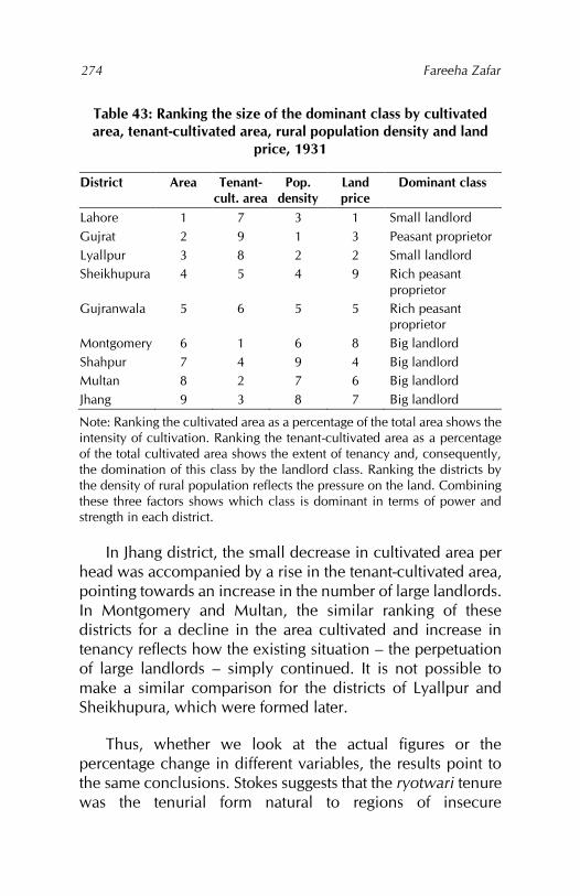
Fareeha Zafar
274
Table 43: Ranking the size of the dominant class by cultivated area, tenant-cultivated area, rural population density and land
price, 1931
District Area Tenant-cult. area
Pop. density
Land price
Dominant class
Lahore 1 7 3 1 Small landlord Gujrat 2 9 1 3 Peasant proprietor Lyallpur 3 8 2 2 Small landlord Sheikhupura 4 5 4 9 Rich peasant
proprietor Gujranwala 5 6 5 5 Rich peasant
proprietor Montgomery 6 1 6 8 Big landlord Shahpur 7 4 9 4 Big landlord Multan 8 2 7 6 Big landlord Jhang 9 3 8 7 Big landlord
Note: Ranking the cultivated area as a percentage of the total area shows the intensity of cultivation. Ranking the tenant-cultivated area as a percentage of the total cultivated area shows the extent of tenancy and, consequently, the domination of this class by the landlord class. Ranking the districts by the density of rural population reflects the pressure on the land. Combining these three factors shows which class is dominant in terms of power and strength in each district.
In Jhang district, the small decrease in cultivated area per head was accompanied by a rise in the tenant-cultivated area, pointing towards an increase in the number of large landlords. In Montgomery and Multan, the similar ranking of these districts for a decline in the area cultivated and increase in tenancy reflects how the existing situation – the perpetuation of large landlords – simply continued. It is not possible to make a similar comparison for the districts of Lyallpur and Sheikhupura, which were formed later.
Thus, whether we look at the actual figures or the percentage change in different variables, the results point to the same conclusions. Stokes suggests that the ryotwari tenure was the tenurial form natural to regions of insecure
Canals, colonies and class: British policy in the Punjab 1880–1940
275
agriculture,529 where there was plenty of land but few hands to work it, while the landlord forms (whether zamindari or pattidari) were suited to regions of secure agriculture. Based on this argument, it is possible to say that the introduction of perennial canal irrigation in the Punjab secured the region against famine. This factor stimulated the growth of a landlord class helped by the restrictions on the alienation of land to nonagriculturists and the large grants in colony areas to favoured classes and individuals.
The technology of perennial canals was thus used by the colonial government to slow down changes in the relations of production, which by their very nature were “constrained in more permanent forms of behaviour and grounded in custom and laws.”530 On the other hand, changes in technology and production – that is, the means of production – did occur. The changing agrarian relationships were reflected in personal ties being replaced by market relations through the mobilisation of land, labour, means of production and credit. The combination of railway and canal construction aided the spatial integration of the canal colony districts with the international economy, while they became disarticulated within the national economic space. This was evident from the antagonism of the settlement officers of the other districts towards institutions developed in the Punjab, such as the Department of Agriculture, which concerned itself only with the canal colonies.
The Punjab canal colony districts are also a good example of the “non-developmental nature of colonial policies and
529 Eric Stokes, ‘Dynamism and enervation in North Indian agriculture: The historical dimension’ (paper presented at the Institute of Commonwealth Studies, London, 1976). 530 Wlodzimierz Wesolowski, Classes, strata and power (London: Routledge and Kegan Paul, 1979), 12.
Fareeha Zafar
276
actions.”531 After an initial period of growth in output, the economy stagnated. In the final analysis, one might add that, even today, the canal colony districts – despite the infusion of new technologies – display many of the features and face many of the same problems encountered in the earlier part of the twentieth century. The introduction of technology is, therefore, not enough. The redistribution and reallocation of resources as well as radical changes in the distribution of the fruits of increased production appear to be the decisive issues.
531 Tapan Raychaudhuri, ‘A reinterpretation of nineteenth-century Indian economic history?’ The Indian Economic and Social History Review 5, no. 1 (March 1968): 78.

Bibliography
Ahmad, K. S. ‘The agricultural geography of the Punjab.’ Unpublished PhD thesis, University of London, 1939.
Ahmad, R. ‘Land systems in the Punjab as affected by British rule between 1849 and 1901.’ Unpublished PhD thesis, University of Oxford, 1963.
Ahmad, Saghir. Class and power in a Punjabi village. New York and London: Monthly Review Press, 1977.
Alavi, Hamza. ‘The rural elite and agricultural development in Pakistan.’ In Rural development in Bangladesh and Pakistan, edited by Robert D. Stevens, Hamza Alavi and Peter J. Bertocci, 290–316. Honolulu: University Press of Hawaii, 1976.
Ali, Imran. The Punjab under imperialism, 1885–1947. Princeton, NJ: Princeton University Press, 1988.
Anstey, Vera. The economic development of India, 4th ed. London: Longmans, Green and Co., 1952.
Baden-Powell, B. H. The land-systems of British India, vol. 2. 1892. Reprint, Delhi: Oriental Publishers, 1974.
Barrier, Norman Gerald. ‘Punjab politics and the disturbances of 1907.’ PhD thesis, Duke University, 1966.
Barrier, Norman Gerald. ‘The Punjab disturbances of 1907: The response of the British government in India to agrarian unrest.’ Modern Asian Studies 1, no. 4 (July 1967): 353–383.
Bhatia, Bal Mokand. Famines in India: A study in some aspects of the economic history of India (1860–1945). New York: Asia Publishing House, 1963.
Fareeha Zafar
278
Blyn, George. Agricultural trends in India, 1891–1947: Output, availability, and productivity. Philadelphia, PA: University of Pennsylvania Press, 1966.
Calvert, Hubert. The wealth and welfare of the Punjab: Being some studies in Punjab rural economics. Lahore: Civil and Military Gazette Press, 1922.
Calvert, Hubert. The size and distribution of agricultural holdings in the Punjab, The Board of Economic Inquiry, Punjab, Rural Section Publications 4. Lahore: Civil and Military Gazette Press, 1925.
Calvert, Hubert. The size and distribution of cultivators’ holdings in the Punjab, The Board of Economic Inquiry, Punjab, Rural Section Publications 11. Lahore: Civil and Military Gazette Press, 1928.
Chaudhuri, M. K., ed. Trends of socioeconomic change in India, 1871–1961. Simla: Indian Institute of Advanced Study, 1969.
Chowdhry, Prem. ‘Rural relations prevailing in the Punjab at the time of enactment of the so-called ‘Golden Laws’ of agrarian legislation of the late thirties.’ The Panjab Past and Present 10, no. 2 (1976): 462–479.
Darling, Malcolm Lyall. The Punjab peasant in prosperity and debt. Mysore City: Oxford University Press, 1925.
Darling, Malcolm Lyall. The Punjab peasant in prosperity and debt, 4th ed. New Delhi: NBW, 1977.
Darling, Malcolm Lyall. Rusticus loquitur, or the old light and the new in the Punjab village. London: Oxford University Press, 1930.
Deakin, Alfred. Irrigated India: An Australian view of India and Ceylon, their irrigation and agriculture. London: W. Thacker and Co., 1893.
Canals, colonies and class: British policy in the Punjab 1880–1940
279
Dewey, Clive. J. ‘The official mind and the problem of agrarian indebtedness in India, 1870–1910.’ Unpublished PhD thesis, University of Cambridge, 1972.
Dewey, Clive J. ‘The agricultural output of an Indian province: The Punjab, 1870–1940.’ Paper presented at the Institute of Commonwealth Studies, London, April 1972.
Dewey, Clive J. ‘Social mobility and social stratification amongst the Punjab peasantry: Some hypotheses.’ Paper presented at the Institute of Commonwealth Studies, London, March 1976.
Douie, James McCrone. Punjab land administration manual. Lahore: Civil and Military Gazette Press, 1908.
Douie, James McCrone. Punjab settlement manual, 3rd ed. Lahore: Superintendent, Government Printing Press, 1915.
Epstein, Trude Scarlett. Economic development and social change in South India. Manchester: Manchester University Press, 1962.
Feder, Ernest. ‘Latifundia and agricultural labour in Latin America.’ In Peasants and peasant societies, edited by Teodor Shanin, 83–97. Harmondsworth: Penguin, 1971.
Field, C. D. Landholding, and the relations of landlord and tenant, in various countries. Calcutta: Thacker, Spink and Co., 1883.
Friedmann, Harriet. ‘Household production and the national economy: Concepts for the analysis of agrarian formations.’ Journal of Peasant Studies 7, no. 2 (1980): 158–184.
Frykenberg, Robert Eric. Land tenure and peasant in South Asia. New Delhi: Orient Longman, 1977.
Fareeha Zafar
280
Greenman, D. W., W. V. Swarzenski and G. D. Bennett. Groundwater hydrology of the Punjab, West Pakistan, with emphasis on problems caused by canal irrigation. Washington, DC: US Government Printing Office, 1967.
Griffin, Lepel Henry. The Panjab chiefs: Historical and biographical notices of the principal families in the Lahore and Rawalpindi divisions of the Panjab, vols. 1–2. Lahore: Civil and Military Gazette Press, 1890.
Griffiths, Percival Joseph. The British impact on India. London: Frank Cass & Co., 1965.
Gupta, Sulekh Chandra. Agrarian relations and early British rule in India: A case study of ceded and conquered provinces (Uttar Pradesh) (1801–1833). London: Asia Publishing House, 1963.
Habib, Irfan. The agrarian system of Mughal India (1556–1707). London: Asia Publishing House, 1963.
Hasan, F. R. M. ‘Ecology and rural class relations in Bangladesh: A study with special reference to three villages.’ Unpublished PhD thesis, University of London, 1980.
Hirashima, Shigemochi. The structure of disparity in developing agriculture: A case study of the Pakistan Punjab. Tokyo: Institute of Developing Economies, 1978.
Kessinger, Tom G. ‘Vilyatpur 1848–1968: An historical case study of social and economic change in a North Indian village.’ Unpublished PhD thesis, University of Chicago, 1972.
Kurien, Christopher T. Poverty, planning and social transformation. Bombay: Allied Publishers, 1978.
Canals, colonies and class: British policy in the Punjab 1880–1940
281
Malik, Rashid Ahmad. ‘Irrigation development and land occupance in the Upper Indus Basin.’ Unpublished PhD thesis, Indiana University, 1963.
Mamdani, Mahmood. Politics and class formation in Uganda. London: Heinemann, 1977.
Marenco, Ethne K. The transformation of Sikh society. New Delhi: Heritage Publishers, 1976.
Mathur, Yaduvansh Bahadur. British administration of Punjab (1849–75). Delhi: Surjeet Book Depot, 1973.
Melotti, Umberto. Marx and the Third World. London: Macmillan, 1977.
Michel, Aloys Arthur. The Indus rivers: A study of the effects of Partition. New Haven, CT: Yale University Press, 1967.
Milne, David. A brief outline of the agricultural conditions in the Punjab. Lahore: Superintendent, Government Printing Press, 1928.
Moreland, William Harrison. The agrarian system of Moslem India. 1929. Reprint, Delhi: Oriental Books, 1968.
Mukerji, Karunamoy. ‘Land prices in Punjab.’ In Trends of socioeconomic change in India, 1871–1961, edited by M. K. Chaudhuri, 529–546. Simla: Indian Institute of Advanced Study, 1969.
Paustian, Paul W. Canal irrigation in the Punjab: An economic inquiry relating to certain aspects of the development of canal irrigation by the British in the Punjab. New York: Columbia University Press, 1930.
Pearse, Andrew. ‘Metropolis and peasant: The expansion of the urban-industrial complex and the changing rural structure.’ In Peasants and peasant societies, edited by Teodor Shanin, 69–80. Harmondsworth: Penguin, 1971.
Fareeha Zafar
282
Poff, Basil J. ‘Land management and modernization in a Punjab canal colony: Lyallpur, 1890–1939.’ Paper presented at the Institute of Commonwealth Studies, London, February 1974.
Prabha, Chander. ‘District-wise rates of growth of agricultural output in East and West Punjab during the pre-Partition and post-Partition periods.’ The Indian Economic and Social History Review 6, no. 4 (December 1969): 333–350.
Ray, Satis Chandra, comp. Agricultural indebtedness in India and its remedies, being selections from official documents. Calcutta: Calcutta University Press, 1915.
Raychaudhuri, Tapan. ‘A reinterpretation of nineteenth-century Indian economic history?’ The Indian Economic and Social History Review 5, no. 1 (March 1968): 77–100.
Saini, B. S. The social and economic history of the Punjab, 1901–1939 (including Haryana and Himachal Pradesh). New Delhi: Ess Ess Publications, 1975.
Shanin, Teodor. ‘Peasantry as a political factor.’ In Peasants and peasant societies, edited by Teodor Shanin, 238–263, Harmondsworth: Penguin, 1971.
Siddiqi, Abdul Jameel. ‘Canal irrigation, agricultural development and social change in West Pakistan (1880–1965).’ Unpublished PhD thesis, University of Wisconsin-Madison, 1965.
Stein, Burton. ‘Privileged landholding: The concept stretched to cover the case.’ In Land tenure and peasant in South Asia, edited by Robert Eric Frykenberg, 67–77. New Delhi: Orient Longman, 1977.
Stokes, Eric. ‘Dynamism and enervation in North Indian agriculture: The historical dimension.’ Paper
Canals, colonies and class: British policy in the Punjab 1880–1940
283
presented at the Institute of Commonwealth Studies, London, 1976.
Stokes, Eric. The peasant and the Raj: Studies in agrarian society and peasant rebellion in colonial India. London: Cambridge University Press, 1978.
Stone, Ian. ‘Canal irrigation and agrarian change: A preliminary investigation in the Ganges Canal tract in the district of Muzaffarnagar, United Provinces, 1840–1900.’ Paper presented at the Social Science Research Council Conference on Indian Economic and Social History, Cambridge, 1975.
Thorburn, Septimus Smet. Musalmans and moneylenders in the Punjab. Edinburgh and London: William Blackwood & Sons, 1886.
Thorburn, Septimus Smet. The Punjab in peace and war. Edinburgh and London: William Blackwood & Sons, 1904.
Thorner, Daniel. The agrarian prospect in India, 2nd ed. New Delhi: Allied Publishers, 1976.
Thornton, William Thomas. Indian public works and cognate Indian topics. London: Macmillan and Co., 1875.
Trevaskis, Hugh Kennedy. The land of the five rivers. London: Oxford University Press, 1928.
Trevaskis, Hugh Kennedy. The Punjab of today: An economic survey of the Punjab in recent years (1890–1925), vol. 1. Lahore: Civil and Military Gazette Press, 1931.
van den Dungen, Petrus H. M. ‘Changes in status and occupation in nineteenth-century Punjab.’ In Soundings in modern South Asian history, edited by Donald A. Low, 25–59. London: Camelot Press, 1968.
Fareeha Zafar
284
van den Dungen, Petrus H. M. The Punjab tradition: Influence and authority in nineteenth-century India. London: Allen & Unwin, 1972.
Varghese, T. C. Agrarian change and economic consequences: Land tenures in Kerala, 1850–1960. Calcutta: Allied Publishers, 1970.
Voelcker, John Augustus. Report on the improvement of Indian agriculture. London: Eyre and Spottiswoode, 1893.
Wace, F. B. The Punjab colony manual, revised ed. Lahore: Superintendent, Government Printing Press, 1933.
Washbrook, David A. ‘Economic development and social stratification in rural Madras: The ‘dry region’ 1878–1929.’ In The imperial impact: Studies in the economic history of Africa and India, edited by Clive J. Dewey and A. G. Hopkins, 68–82. London: Athlone Press, 1978.
Washbrook, David A., and Christopher J. Baker. South India: Political institutions and political change 1880–1940. New Delhi: Macmillan Company of India, 1975.
Wesolowski, Wlodzimierz. Classes, strata and power. London: Routledge and Kegan Paul, 1979.
Whitcombe, Elizabeth. Agrarian conditions in Northern India: The United Provinces under British rule, 1860–1900, vol. 1. Berkeley, CA: University of California Press, 1972.
British parliamentary papers
Report from the select committee on East India (public works), together with the proceedings of the committee, minutes of evidence and appendix. London: HM Stationery Office, 1878.
Canals, colonies and class: British policy in the Punjab 1880–1940
285
Government of India, census reports
Kaul, Harikishan. Census of India, 1911, Punjab, report vol. 14, part 1. Lahore: Civil and Military Gazette Press, 1912.
Kaul, Harikishan. Census of India, 1911, Punjab, appendices to the imperial tables vol. 14, part 3. Lahore: Civil and Military Gazette Press, 1912.
Khan, Ahmad Hasan. Census of India, 1931, Punjab, report vol. 17, part 1. Lahore: Civil and Military Gazette Press, 1933.
Khan, Ahmad Hasan. Census of India, 1931, Punjab, tables vol. 17, part 2. Lahore: Civil and Military Gazette Press, 1933.
Maclagan, E. D. Census of India, 1891, Census of the Punjab and its feudatories, the report on the census vol. 19, part 1. Calcutta: Office of the Superintendent of Printing, 1892.
Maclagan, E. D. Census of India, 1891, Census of the Punjab and its feudatories, imperial tables and supplementary returns for the British territory vol. 20, part 2. Calcutta: Office of the Superintendent of Printing, 1892.
Middleton, L., and S. M. Jacob. Census of India, 1921, Punjab and Delhi, report vol. 15, part 1. Lahore: Civil and Military Gazette Press, 1923.
Middleton, L., and S. M. Jacob. Census of India, 1921, Punjab and Delhi, tables vol. 15, part 2. Lahore: Civil and Military Gazette Press, 1923.
Rose, H. A. Census of India, 1901, The Punjab, its feudatories and the North-West Frontier Province, the report on the census vol. 17, part 1. Simla: Government Central Printing Office, 1902.
Fareeha Zafar
286
Rose, H. A. Census of India, 1901, Imperial tables, I–VIlI, X–XV, XVII and XVIII for the Punjab, with the native states under the political control of the Punjab government and for the NWFP vol. 17-A. Simla: Government Central Printing Office, 1902.
Sheikh, Khan Bahadur. Census of India, 1941, Punjab, tables vol. 6. Delhi: Manager of Publications, 1941.
Government of India, departmental publications
Department of Agriculture. Report of the Indian Cotton Committee, 1919. Calcutta: Office of the Superintendent of Printing, 1920.
Department of Agriculture. Report of the Royal Commission on Agriculture in India. Bombay: Government Central Press, 1928.
Department of Agriculture. Royal Commission on Agriculture in India, evidence taken in the Punjab vol. 8. Calcutta: Central Publication Branch, 1927.
Department of Agriculture. The Famine Inquiry Commission, final report. Madras: Superintendent, Government Press, 1945.
Department of Irrigation. Report of the Indian Irrigation Commission, 1901–03 part 2. Calcutta: Office of the Superintendent of Printing, 1904.
Department of Statistics. Agricultural statistics of British India (annual, 1890/91 to 1904/05). Calcutta: Superintendent, Government Printing.
Finance Department. ‘Financial despatch to India’, no. 101, 5 March 1869, in Selections from despatches.
Imperial gazetteer of India, Punjab vol. 1. Calcutta: Superintendent, Government Printing, 1908.
Canals, colonies and class: British policy in the Punjab 1880–1940
287
Public Works Department. ‘Public works despatch to India’, no. 116, 25 November 1869, in Selections from despatches.
Public Works Department. ‘Public works despatch to India’, no. 4, 11 January 1870, in Selections from despatches.
Public Works Department. ‘Public works despatch to India’, no. 51, 22 May 1873, in Selections from despatches.
Public Works Department. ‘Public works despatch to India’, no. 76, 8 September 1873, in Selections from despatches.
Government of the Punjab, annual reports for selected years
Annual report of the experimental farm, Lyallpur, for the kharif and rabi seasons __. Lahore: Civil and Military Gazette Press.
Report on the administration of the Punjab and its dependencies for the year __. Lahore: Office of the Superintendent of Printing.
Report on the land revenue administration of the Punjab for the agricultural year ending 30th September __. Lahore: Civil and Military Gazette Press.
Report on the Punjab colonies for the year ending 30th September __. Lahore: Civil and Military Gazette Press.
Report on the seasons and crops of the Punjab for the year __. Lahore: Office of the Superintendent of Printing.
Fareeha Zafar
288
Government of the Punjab, assessment reports532
Assessment report of the Montgomery tehsil, Montgomery district, April 1894.
Revision of the assessment of the bet circles of the Montgomery and Gugera tehsils of the Montgomery district, March 1896.
Reassessment of the Mooltan district, April 1896.
Assessment report of the Dipalpur tehsil, Montgomery district, December 1897.
Assessment report, tehsil Pakpattan, Montgomery district, September 1898.
Assessment report, Lower Sohag-Para Canal colony, Montgomery district, January 1899.
Assessment report of the Kabirwala tehsil of the Montgomery district, November 1899.
Assessment report of the Mooltan and Shujabad tehsils of the Mooltan district, 1900.
Assessment report of the Lodhran tehsil of the Mooltan district, 1901.
Assessment report of the Mailsi tehsil of the Mooltan district, 1901.
Assessment report of the Lodhran and Mailsi tehsils of the Mooltan district, April 1901.
Assessment report of the Chenab nehri circle of the Jhang district, May 1904.
Assessment report of the Hafizabad and Khangah Dogran tehsils, Gujranwala district, September 1904.
Assessment report of the Chenab circle, Hafizabad tehsil, Gujranwala district, May 1905.
532 Listed in chronological order.
Canals, colonies and class: British policy in the Punjab 1880–1940
289
Assessment report of the Chenab, Jhelum and joint circles of Jhang district, May 1905.
Assessment report of the Kachhi circle of the Jhang district, October 1905.
Assessment report of the Jhelum nehri circle of the Jhang district, March 1906.
Assessment reports of the Upper and Lower Jhang branch circles of the Lower Chenab Canal, Chenab Colony, March 1909.
Assessment report of the area commanded by the Lower Jhelum Canal in the Shahpur district, May 1909.
Assessment reports of the Jhang (I, II and III circles) and Gugera branches of the Chenab Colony, November 1910.
Assessment report of the area within the limits of the Lower Jhelum Canal in the Shahpur district, November 1911.
Assessment report of the Gujranwala tehsil of the Gujranwala district, January 1912.
Assessment report of the Gugera branch, circle II, Lower Chenab Canal, May 1912.
Assessment report of the Sharakpur tehsil of the Gujranwala district, May 1912.
Assessment report on the Rakh branch circle, Lower Chenab Canal Colony, March 1913.
Assessment report of the Gujrat tehsil of the Gujrat district, October 1913.
Assessment report of the Bhera, Shahpur and Sargodha tehsils of the Shahpur district, November 1913.
Assessment report of the Kasur tehsil of the Lahore district, February 1914.
Assessment report of the Chunian tehsil, including the Chunian Colony of the Lahore district, October 1914.
Fareeha Zafar
290
Assessment report of the Lahore tehsil of the Lahore district, August 1915.
Assessment report of the Phalia tehsil of the Gujrat district, October 1915.
Assessment report of Kabirwala tehsil of the Multan district, September 1919.
Assessment report of the Mailsi tehsil of the Multan district, January 1920.
Assessment report of the Multan and Shujabad tehsils of the Multan district, January 1921.
Assessment report of the Jhang branch circle of the Lyallpur district, November 1921.
Assessment report of the Pakpattan tehsil of the Montgomery district, November 1921.
Assessment report on the Gugera branch circles I and II in the Lyallpur district, June 1923.
Assessment report of areas under irrigation in Gujrat and Kharian tehsils, Gujrat, August 1927.
Assessment report of the Phalia tehsil of the Gujrat district, September 1927.
Assessment report of the Okara tehsil of the Montgomery district, May 1934.
Assessment report of the Khanewal tehsil of the Multan district, June 1934.
Assessment report of the Jaranwala tehsil of the Lyallpur district, November 1936.
Assessment report of the Lyallpur tehsil of the Lyallpur district, November 1936.
Canals, colonies and class: British policy in the Punjab 1880–1940
291
Government of the Punjab, departmental publications and gazetteers
Board of Economic Inquiry, Punjab. An economic survey of Gaggar Bhana, a village in the Amritsar district of the Punjab Punjab village surveys no. 1. Lahore: Civil and Military Gazette Press, 1928.
Gazetteer of the Chenab Colony, 1904. Calcutta: Bengal Secretariat Book Depot, 1905.
Gazetteer of the Dera Ghazi Khan district, 1883–4. Lahore: Civil and Military Gazette Press, 1884.
Gazetteer of the Gujranwala district, 1893–94. Lahore: Civil and Military Gazette Press, 1894.
Gazetteer of the Gujrat district, 1883–4. Lahore: Civil and Military Gazette Press, 1884.
Gazetteer of the Gujrat district, 1892–93. Lahore: Civil and Military Gazette Press, 1893.
Gazetteer of the Jhelam district, 1883–4. Lahore: Civil and Military Gazette Press, 1884.
Gazetteer of the Lahore district, 1883–4. Lahore: Civil and Military Gazette Press, 1884.
Kennedy, R. G. On the distribution of water for irrigation by measurement Punjab irrigation paper no. 12. Lahore: Irrigation Board, 1906.
Kennedy, R. G. Waterlogging of the soil in the vicinity of Punjab irrigation canals, and measures for the prevention of waterlogging Punjab irrigation paper no. 20. Lahore: Irrigation Board, 1920.
Kennedy, R. G. The sale of water for irrigation by volumetric rates Punjab irrigation paper no. 24. Lahore: Irrigation Board, 1921.
Fareeha Zafar
292
Punjab canal gazetteer, Lower Jhelum Canal vol. 1. Lahore: Punjab Government Printing Office, 1921.
Punjab canal gazetteer, the Triple Canals vol. 2. Lahore: Punjab Government Printing Office, 1921.
Report of the Abiana Committee. Lahore: Public Works Department, Irrigation Branch, 1934.
Report of the Colonies Committee, 1907–08. Lahore: Civil and Military Gazette Press, 1908.
Report on the famine in the Punjab during 1869–70. Lahore: Punjab Printing Co., 1870.
Government of the Punjab, settlement reports
Abbott, E. R. Settlement report of the Jhang district, 1906. Lahore: Civil and Military Gazette Press, 1907.
Abell, G. E. B. Final report of the fifth regular settlement report of the Lahore district, 1935–39. Lahore: Superintendent, Government Printing, 1943.
Aziz, Mian Abdul. Final report of the fourth regular settlement of the Jhang district, 1928. Lahore: Superintendent, Government Printing, 1928.
Bolster, R. C. Final report of the fourth regular settlement of the Lahore district, 1912–16. Lahore: Superintendent, Government Printing, 1916.
Bourne, F. C. Final settlement report of the Lower Bari Doab Colony, 1927–35. Lahore: Superintendent, Government Printing, 1936.
Brandreth, Arthur. Report on the settlement of the district of Jhelum in the Rawulpindee division. Lahore: Hope Press, 1865.
Canals, colonies and class: British policy in the Punjab 1880–1940
293
Chandra, Ram. Final settlement report of the portion of the Shahpur district under fluctuating assessment. Lahore: Superintendent, Government Printing, 1925.
Davies, H. S. Final report on the revision of the settlement of Gujrat district, 1893. Lahore: Civil and Military Gazette Press, 1893.
Davies, R. H., R. E. Egerton, R. Temple and J. H. Morris. Report on the revised settlement of the Lahore district in the Lahore division. Lahore: Government of the Punjab, 1860.
Dobson, B. H. Final report of the Chenab Colony settlement. Lahore: Superintendent, Government Printing, 1915.
Emerson, H. W. Final settlement report of the Multan district. Lahore: Superintendent, Government Printing, 1921.
Fagan, P. J. Final report of the revisions of settlement, 1892–99 of the Montgomery district. Lahore: Civil and Military Gazette Press, 1899.
Khan, Ahmad Hasan. Final settlement report of the canal-irrigated tract of the Gujrat district. Lahore: Superintendent, Government Printing, 1929.
Kirpalani, S. K. Final settlement report of the Lyallpur district and the Rakh branch colony circle of Sheikhupura district, 1940. Lahore: Superintendent, Government Printing, 1940.
Lall, I. C. Final report on the Hafizabad settlement, Gujranwala district, 1902 to 1907. Lahore: Civil and Military Gazette Press, 1908.
Mackenzie, Hector. Report on the revised settlement of the Goojerat district in the Rawulpindee division. Lahore: Hope Press, 1861.
Mackenzie, Hector. Report on the revision of the settlement of the land tax and tirnee revenue in the Cis-Indus
Fareeha Zafar
294
portion of the Dera Ismail Khan district, comprising the Leia and Bukkur tehseels, 1862. Lahore: Hope Press, 1865.
Maclagan, E. D. Final report of the revision of settlement of the Multan district, 1895–1901. Lahore: Civil and Military Gazette Press, 1901.
Mohammad, Sheikh Nur. Final settlement report of the Sheikhupura district (certain portions excepted), 1923–27. Lahore: Superintendent, Government Printing, 1927.
Monckton, Henry. Report on the revised settlement of the Jhung district in the Mooltan division. Lahore: Hope Press, 1860.
Morris, J. H. Report on the revised settlement of the Goojranwala district in the Lahore division. Lahore: Punjabee Press, 1860.
Morris, J. H. Report of the revised settlement of the Mooltan district, 1860. Lahore: Government of the Punjab, 1860.
O’Dwyer, M. F. Final report on the revision of the settlement of Gujranwala district, 1889–1894. Lahore: Civil and Military Gazette Press, 1894.
Ouseley, C., and W. G. Davies. Report on the revised settlement of the Shahpoor district in the Rawulpindee division, 1866. Lahore: Punjab Printing Co., 1866.
Penny, J. D. Final settlement report of the Jhang and Gugera branch circles of the Lyallpur district 1920–24. Lahore: Superintendent, Government Printing, 1924.
Roe, Charles A. Report on the revised settlement of the Multan district of the Punjab, 1873–80. Lahore: W. Ball, 1883.
Canals, colonies and class: British policy in the Punjab 1880–1940
295
Roe, Charles A., and W. E. Purser. Report on the revised land revenue settlement of the Montgomery district in the Mooltan division, 1874. Lahore: Central Jail Press, 1878.
Wace, E. G. Report of the land revenue settlement of the Hazara district of the Punjab, 1868–74. Lahore: Central Jail Press, 1876.
Waterfield, W. G. Report on the second regular settlement of the Gujrat district, Panjab. Lahore: Central Jail Press, 1874.
Wilson, J. Final report on the revision of settlement of the Shahpur district in the Punjab, 1887–94. Lahore: Civil and Military Gazette Press: 1894.
Government of the Punjab, wages survey reports533
Report on the first regular wages survey of the Punjab, taken in December 1912. Lahore: Civil and Military Gazette Press, 1913.
Report on the second regular wages survey of the Punjab, taken in December 1917. Lahore: Civil and Military Gazette Press, 1918.
Report on the third regular wages survey of the Punjab, taken in December 1922. Lahore: Civil and Military Gazette Press, 1923.
Report on the fourth regular wages survey of the Punjab, taken in December 1927. Lahore: Civil and Military Gazette Press, 1928.
533 Listed in chronological order.
Fareeha Zafar
296
Report on the fifth regular wages survey of the Punjab, taken in December 1932. Lahore: Civil and Military Gazette Press, 1933.
Report on the sixth regular wages survey of the Punjab, taken in December 1937. Lahore: Civil and Military Gazette Press, 1938.
Punjab, Department of Revenue and Agriculture, proceedings534
Proceedings, revenue no. 113/345, 21 March 1882.
Proceedings, general no. __, 1888.
Appendix to proceedings, agriculture, 15 August 1889.
Proceedings, proposed reassessment of the Montgomery district no. 349, 4 December 1890.
Proceedings, revenue no. 146C, 10 July 1891.
Proceedings, irrigation no. 314C, 18 September 1891.
Proceedings, irrigation no. __, 1892.
Proceedings, irrigation no. 90, 4 February 1893.
Proceedings, general no. 206, 1895.
Proceedings, general no. 117, 25 February 1895.
Proceedings, note on land transfer and agricultural indebtedness in India, October–December 1895.
Proceedings, general no. 3692/311-2, 26 September 1896.
Proceedings, general no. 308, 20 February 1899.
Proceedings, general no. 197, 15 March 1899.
Proceedings, irrigation no. 655, 27 March 1899.
534 Listed in chronological order.
Canals, colonies and class: British policy in the Punjab 1880–1940
297
Proceedings, general no. 1140, 30 November 1900.
Proceedings, irrigation no. 304, 29 March 1901.
Proceedings, general no. 3693, 10 October 1901.
Proceedings, irrigation no. __, October 1901.
Proceedings, irrigation no. 05351, 15 July 1902.
Proceedings, irrigation no. 191, 18 October 1902.
Proceedings, revenue no. 183, 12 May 1903.
Proceedings, general no. 1218A, 14 October 1904.
Proceedings, irrigation no. 499, 20 March 1920.
Proceedings, development no. 298D, 21 January 1926.
Proceedings, revenue no. 1364, 26 May 1928.

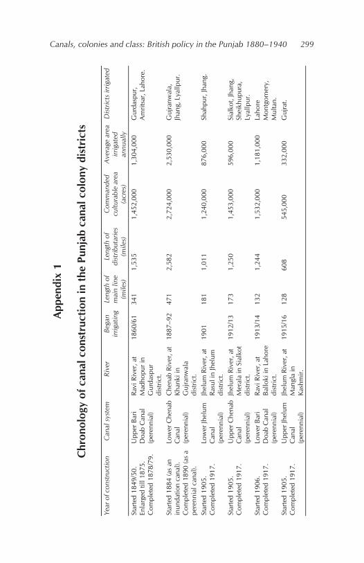
Canals, colonies and class: British policy in the Punjab 1880–1940
299
App
endi
x 1
Chr
onol
ogy
of c
anal
con
stru
ctio
n in
the
Punj
ab c
anal
col
ony
dist
rict
s
Year
of c
onst
ruct
ion
C
anal
sys
tem
Ri
ver
Bega
n irr
igat
ing
Leng
th o
f m
ain
line
(mile
s)
Leng
th o
f di
strib
utar
ies
(mile
s)
Com
man
ded
cultu
rabl
e ar
ea
(acr
es)
Ave
rage
are
a irr
igat
ed
annu
ally
Dis
tric
ts ir
rigat
ed
Star
ted
1849
/50.
En
larg
ed ti
ll 18
75.
Com
plet
ed 1
878/
79.
Upp
er B
ari
Doa
b C
anal
(p
eren
nial
)
Ravi
Riv
er, a
t M
adho
pur i
n G
urda
spur
di
stric
t.
1860
/61
341
1,53
5
1,45
2,00
0 1,
304,
000
Gur
dasp
ur,
Am
ritsa
r, La
hore
.
Star
ted
1884
(as
an
inun
datio
n ca
nal).
C
ompl
eted
189
0 (a
s a
pere
nnia
l can
al).
Low
er C
hena
b C
anal
(p
eren
nial
)
Che
nab
Rive
r, at
Kh
anki
in
Guj
ranw
ala
dist
rict.
1887
–92
471
2,58
2
2,72
4,00
0 2,
530,
000
Guj
ranw
ala,
Jh
ang,
Lya
llpur
.
Star
ted
1905
. C
ompl
eted
191
7.
Low
er Jh
elum
C
anal
(p
eren
nial
)
Jhel
um R
iver
, at
Rasu
l in
Jhel
um
dist
rict.
1901
18
1 1,
011
1,
240,
000
876,
000
Shah
pur,
Jhan
g.
Star
ted
1905
. C
ompl
eted
191
7.
Upp
er C
hena
b C
anal
(p
eren
nial
)
Jhel
um R
iver
, at
Mer
ala
in S
ialk
ot
dist
rict.
1912
/13
173
1,25
0
1,45
3,00
0 59
6,00
0 Si
alko
t, Jh
ang,
Sh
eikh
upur
a,
Lyal
lpur
. St
arte
d 19
06.
Com
plet
ed 1
917.
Lo
wer
Bar
i D
oab
Can
al
(per
enni
al)
Ravi
Riv
er, a
t Ba
lloki
in L
ahor
e di
stric
t.
1913
/14
132
1,24
4
1,53
2,00
0 1,
181,
000
Laho
re
Mon
tgom
ery,
M
ulta
n.
Star
ted
1905
. C
ompl
eted
191
7.
Upp
er Jh
elum
C
anal
(p
eren
nial
)
Jhel
um R
iver
, at
Man
gla
in
Kash
mir.
1915
/16
128
608
54
5,00
0 33
2,00
0 G
ujra
t.
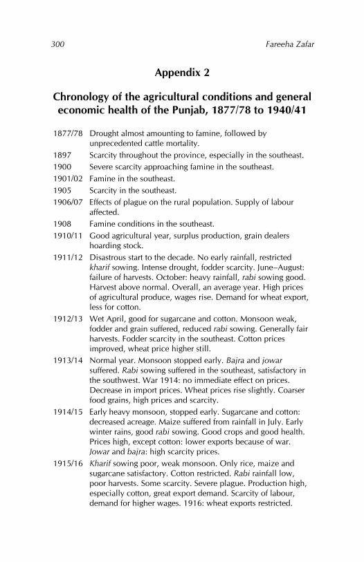
Fareeha Zafar
300
Appendix 2
Chronology of the agricultural conditions and general economic health of the Punjab, 1877/78 to 1940/41
1877/78 Drought almost amounting to famine, followed by unprecedented cattle mortality.
1897 Scarcity throughout the province, especially in the southeast. 1900 Severe scarcity approaching famine in the southeast. 1901/02 Famine in the southeast. 1905 Scarcity in the southeast. 1906/07 Effects of plague on the rural population. Supply of labour
affected. 1908 Famine conditions in the southeast. 1910/11 Good agricultural year, surplus production, grain dealers
hoarding stock. 1911/12 Disastrous start to the decade. No early rainfall, restricted
kharif sowing. Intense drought, fodder scarcity. June–August: failure of harvests. October: heavy rainfall, rabi sowing good. Harvest above normal. Overall, an average year. High prices of agricultural produce, wages rise. Demand for wheat export, less for cotton.
1912/13 Wet April, good for sugarcane and cotton. Monsoon weak, fodder and grain suffered, reduced rabi sowing. Generally fair harvests. Fodder scarcity in the southeast. Cotton prices improved, wheat price higher still.
1913/14 Normal year. Monsoon stopped early. Bajra and jowar suffered. Rabi sowing suffered in the southeast, satisfactory in the southwest. War 1914: no immediate effect on prices. Decrease in import prices. Wheat prices rise slightly. Coarser food grains, high prices and scarcity.
1914/15 Early heavy monsoon, stopped early. Sugarcane and cotton: decreased acreage. Maize suffered from rainfall in July. Early winter rains, good rabi sowing. Good crops and good health. Prices high, except cotton: lower exports because of war. Jowar and bajra: high scarcity prices.
1915/16 Kharif sowing poor, weak monsoon. Only rice, maize and sugarcane satisfactory. Cotton restricted. Rabi rainfall low, poor harvests. Some scarcity. Severe plague. Production high, especially cotton, great export demand. Scarcity of labour, demand for higher wages. 1916: wheat exports restricted.
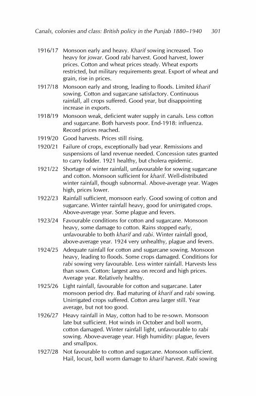
Canals, colonies and class: British policy in the Punjab 1880–1940
301
1916/17 Monsoon early and heavy. Kharif sowing increased. Too heavy for jowar. Good rabi harvest. Good harvest, lower prices. Cotton and wheat prices steady. Wheat exports restricted, but military requirements great. Export of wheat and grain, rise in prices.
1917/18 Monsoon early and strong, leading to floods. Limited kharif sowing. Cotton and sugarcane satisfactory. Continuous rainfall, all crops suffered. Good year, but disappointing increase in exports.
1918/19 Monsoon weak, deficient water supply in canals. Less cotton and sugarcane. Both harvests poor. End-1918: influenza. Record prices reached.
1919/20 Good harvests. Prices still rising. 1920/21 Failure of crops, exceptionally bad year. Remissions and
suspensions of land revenue needed. Concession rates granted to carry fodder. 1921 healthy, but cholera epidemic.
1921/22 Shortage of winter rainfall, unfavourable for sowing sugarcane and cotton. Monsoon sufficient for kharif. Well-distributed winter rainfall, though subnormal. Above-average year. Wages high, prices lower.
1922/23 Rainfall sufficient, monsoon early. Good sowing of cotton and sugarcane. Winter rainfall heavy, good for unirrigated crops. Above-average year. Some plague and fevers.
1923/24 Favourable conditions for cotton and sugarcane. Monsoon heavy, some damage to cotton. Rains stopped early, unfavourable to both kharif and rabi. Winter rainfall good, above-average year. 1924 very unhealthy, plague and fevers.
1924/25 Adequate rainfall for cotton and sugarcane sowing. Monsoon heavy, leading to floods. Some crops damaged. Conditions for rabi sowing very favourable. Less winter rainfall. Harvests less than sown. Cotton: largest area on record and high prices. Average year. Relatively healthy.
1925/26 Light rainfall, favourable for cotton and sugarcane. Later monsoon period dry. Bad maturing of kharif and rabi sowing. Unirrigated crops suffered. Cotton area larger still. Year average, but not too good.
1926/27 Heavy rainfall in May, cotton had to be re-sown. Monsoon late but sufficient. Hot winds in October and boll worm, cotton damaged. Winter rainfall light, unfavourable to rabi sowing. Above-average year. High humidity: plague, fevers and smallpox.
1927/28 Not favourable to cotton and sugarcane. Monsoon sufficient. Hail, locust, boll worm damage to kharif harvest. Rabi sowing
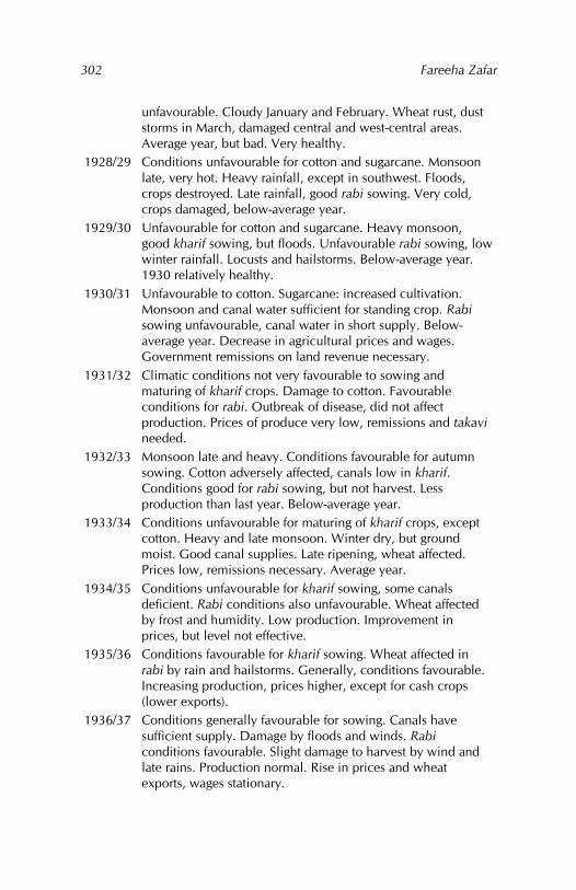
Fareeha Zafar
302
unfavourable. Cloudy January and February. Wheat rust, dust storms in March, damaged central and west-central areas. Average year, but bad. Very healthy.
1928/29 Conditions unfavourable for cotton and sugarcane. Monsoon late, very hot. Heavy rainfall, except in southwest. Floods, crops destroyed. Late rainfall, good rabi sowing. Very cold, crops damaged, below-average year.
1929/30 Unfavourable for cotton and sugarcane. Heavy monsoon, good kharif sowing, but floods. Unfavourable rabi sowing, low winter rainfall. Locusts and hailstorms. Below-average year. 1930 relatively healthy.
1930/31 Unfavourable to cotton. Sugarcane: increased cultivation. Monsoon and canal water sufficient for standing crop. Rabi sowing unfavourable, canal water in short supply. Below-average year. Decrease in agricultural prices and wages. Government remissions on land revenue necessary.
1931/32 Climatic conditions not very favourable to sowing and maturing of kharif crops. Damage to cotton. Favourable conditions for rabi. Outbreak of disease, did not affect production. Prices of produce very low, remissions and takavi needed.
1932/33 Monsoon late and heavy. Conditions favourable for autumn sowing. Cotton adversely affected, canals low in kharif. Conditions good for rabi sowing, but not harvest. Less production than last year. Below-average year.
1933/34 Conditions unfavourable for maturing of kharif crops, except cotton. Heavy and late monsoon. Winter dry, but ground moist. Good canal supplies. Late ripening, wheat affected. Prices low, remissions necessary. Average year.
1934/35 Conditions unfavourable for kharif sowing, some canals deficient. Rabi conditions also unfavourable. Wheat affected by frost and humidity. Low production. Improvement in prices, but level not effective.
1935/36 Conditions favourable for kharif sowing. Wheat affected in rabi by rain and hailstorms. Generally, conditions favourable. Increasing production, prices higher, except for cash crops (lower exports).
1936/37 Conditions generally favourable for sowing. Canals have sufficient supply. Damage by floods and winds. Rabi conditions favourable. Slight damage to harvest by wind and late rains. Production normal. Rise in prices and wheat exports, wages stationary.
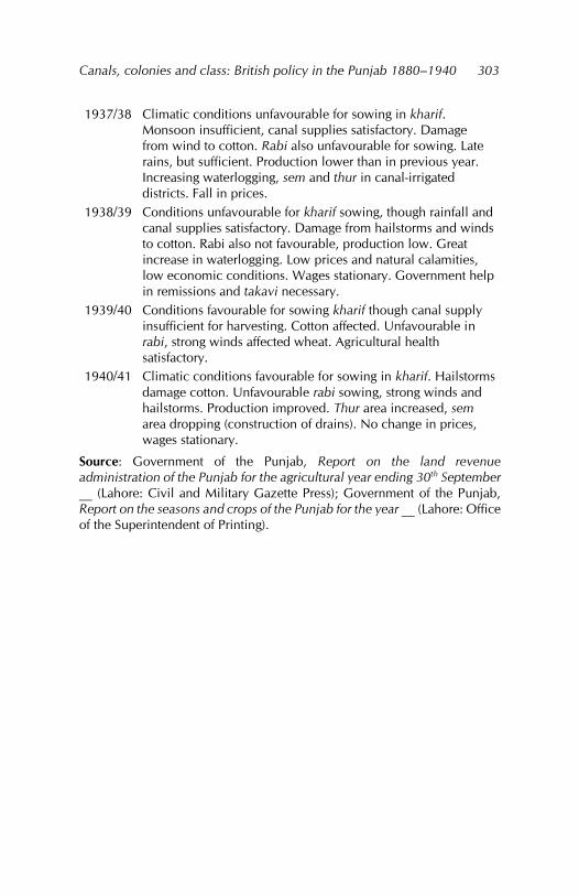
Canals, colonies and class: British policy in the Punjab 1880–1940
303
1937/38 Climatic conditions unfavourable for sowing in kharif. Monsoon insufficient, canal supplies satisfactory. Damage from wind to cotton. Rabi also unfavourable for sowing. Late rains, but sufficient. Production lower than in previous year. Increasing waterlogging, sem and thur in canal-irrigated districts. Fall in prices.
1938/39 Conditions unfavourable for kharif sowing, though rainfall and canal supplies satisfactory. Damage from hailstorms and winds to cotton. Rabi also not favourable, production low. Great increase in waterlogging. Low prices and natural calamities, low economic conditions. Wages stationary. Government help in remissions and takavi necessary.
1939/40 Conditions favourable for sowing kharif though canal supply insufficient for harvesting. Cotton affected. Unfavourable in rabi, strong winds affected wheat. Agricultural health satisfactory.
1940/41 Climatic conditions favourable for sowing in kharif. Hailstorms damage cotton. Unfavourable rabi sowing, strong winds and hailstorms. Production improved. Thur area increased, sem area dropping (construction of drains). No change in prices, wages stationary.
Source: Government of the Punjab, Report on the land revenue administration of the Punjab for the agricultural year ending 30th September __ (Lahore: Civil and Military Gazette Press); Government of the Punjab, Report on the seasons and crops of the Punjab for the year __ (Lahore: Office of the Superintendent of Printing).
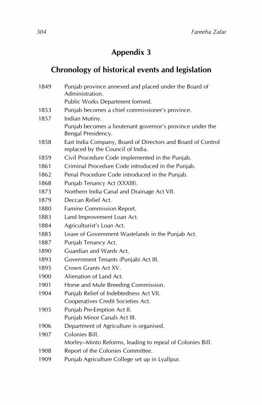
Fareeha Zafar
304
Appendix 3
Chronology of historical events and legislation
1849 Punjab province annexed and placed under the Board of Administration. Public Works Department formed.
1853 Punjab becomes a chief commissioner’s province. 1857 Indian Mutiny.
Punjab becomes a lieutenant governor’s province under the Bengal Presidency.
1858 East India Company, Board of Directors and Board of Control replaced by the Council of India.
1859 Civil Procedure Code implemented in the Punjab. 1861 Criminal Procedure Code introduced in the Punjab. 1862 Penal Procedure Code introduced in the Punjab. 1868 Punjab Tenancy Act (XXXIII). 1873 Northern India Canal and Drainage Act VII. 1879 Deccan Relief Act. 1880 Famine Commission Report. 1883 Land Improvement Loan Act. 1884 Agriculturist’s Loan Act. 1885 Lease of Government Wastelands in the Punjab Act. 1887 Punjab Tenancy Act. 1890 Guardian and Wards Act. 1893 Government Tenants (Punjab) Act III. 1895 Crown Grants Act XV. 1900 Alienation of Land Act. 1901 Horse and Mule Breeding Commission. 1904 Punjab Relief of Indebtedness Act VII.
Cooperatives Credit Societies Act. 1905 Punjab Pre-Emption Act II.
Punjab Minor Canals Act III. 1906 Department of Agriculture is organised. 1907 Colonies Bill.
Morley–Minto Reforms, leading to repeal of Colonies Bill. 1908 Report of the Colonies Committee. 1909 Punjab Agriculture College set up in Lyallpur.
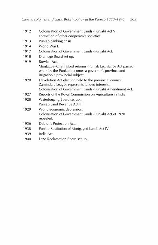
Canals, colonies and class: British policy in the Punjab 1880–1940
305
1912 Colonisation of Government Lands (Punjab) Act V. Formation of other cooperative societies.
1913 Punjab banking crisis. 1914 World War I. 1917 Colonisation of Government Lands (Punjab) Act. 1918 Drainage Board set up. 1919 Rowlett Act.
Montague–Chelmsford reforms: Punjab Legislative Act passed, whereby the Punjab becomes a governor’s province and irrigation a provincial subject.
1920 Devolution Act election held to the provincial council. Zamindara League represents landed interests. Colonisation of Government Lands (Punjab) Amendment Act.
1927 Reports of the Royal Commission on Agriculture in India. 1928 Waterlogging Board set up.
Punjab Land Revenue Act III. 1929 World economic depression.
Colonisation of Government Lands (Punjab) Act of 1920 repealed.
1936 Debtor’s Protection Act. 1938 Punjab Restitution of Mortgaged Lands Act IV. 1939 India Act. 1940 Land Reclamation Board set up.

Index
A
abiana, 56, 142, 158, 166, 178 Abiana Committee, 178 absentee landlordism, 226, 231,
250, 260, 272. See also under landlords, landowners
agricultural classes, 8, 63, 124, 150, 193, 194, 196, 213, 263, 265, 272
agricultural labour, 119, 121–124, 126, 129, 256, 271. See also agricultural labourers
agricultural labourers, 5, 10, 122, 188, 208, 215, 218, 245, 246, 258, 260, 271. See also agricultural labour landless, 5, 122, 208. See
also landless labour agricultural policy
colonial, 91, 94 under Sikh rule, 65
agricultural produce export demand for, 118, 268 local demand for, 106, 114,
125, 268 prices of, 4, 13, 99, 113,
121, 122, 124–126, 140, 168, 170, 178, 199, 201, 258, 267–269, 271
transport, by cart, 108, 112, 255
agricultural production changes in, 3, 49, 67, 84,
108, 129, 192 surplus, 112, 119, 121
agricultural technology, 96, 97, 112, 275. See also under agriculture
agricultural tribes, 5, 7, 50, 52, 195–197, 203, 222, 224, 250, 256
agriculture commercialisation of, 15,
99, 105, 109, 111, 113, 121
improved techniques, 93 technological advances in,
67, 96 Alienation of Land Act 1900, 4,
8, 51, 155, 194, 196–199, 202, 203, 224, 225, 249, 256, 257, 265, 267
B
bania, 7, 65, 92, 108, 161, 177, 188, 198, 244, 265, 266. See also moneylenders
Bari Doab, 22, 24, 29, 36 Bari Doab Canal, 22. See also
Upper Bari Doab Canal barley, 75, 82, 86, 91, 99, 102,
116 Beas River, 18, 36
Fareeha Zafar
308
bhai chara tenure, 132, 137, 138, 151, 219–221, 260
Board of Administration, 22, 141
British annexation of the Punjab, 1, 6, 17, 18, 21, 41, 122, 139, 146, 162, 172, 186, 196, 215, 261
British army, need for animals, 52, 106, 151, 263. See also camel breeding, horse breeding
C
camel breeding, 52, 81, 147, 151, 246, 269
camel service grants, 52, 152, 246
canal colony districts demarcation of, 43–48 increased production of,
107 migration to, 26, 61–63,
176, 228 settlers, 8, 9, 14, 43, 45, 46,
50, 61–63, 147, 148. See also colonists
canal water sale of, 40, 56, 159 supply of, 35, 38–40, 42,
66, 77, 96, 170 canals
area irrigated by, 3, 63, 68–70, 102, 122, 128, 176, 179, 182, 192, 197, 202, 218, 228, 231, 237, 239, 252, 256, 259, 269
construction of, 1–3, 12, 14, 15, 17, 19, 21, 22, 24, 26, 28, 31–33, 35, 41–43, 49, 55, 61, 65, 70, 71, 74, 93, 96, 124, 131, 161, 170, 174, 199, 202, 251, 261, 269, 275
seepage from, 17, 32, 35–38, 70
canals, types of inundation, 17, 19–22, 24–
27, 29, 30, 32, 34, 35, 44, 47, 49, 50, 55, 65, 66, 75, 86, 131, 132, 143–146, 160, 166, 193, 194, 198, 225, 232, 236, 237, 261, 262, 265
perennial, 1–3, 5, 13, 15, 18, 21, 24, 25, 27–29, 31, 33, 34, 40, 43, 55, 61, 66, 82, 86, 92, 113, 116, 128, 144, 146, 147, 149, 151, 160, 163, 191, 196, 225, 229, 232, 235, 236, 244, 257, 258, 260–265, 275
private, 27, 128, 145, 236, 244, 264
capitalist agriculture, 9 capitalist grants, 51, 52, 151,
155, 193, 198, 227 capitalists, 4, 6, 147, 150, 155,
156, 193, 198, 206–208, 226, 227, 249, 250, 257, 267
cash crops, 81, 89, 91, 94, 99, 105, 107, 145, 164, 170,
Canals, colonies and class: British policy in the Punjab 1880–1940
309
217, 255, 268. See also commercial crops cultivation or production of,
4, 13, 80, 84, 112, 113, 217, 219, 245, 256–258, 269
caste system, 129 Chaj Doab, 3, 18, 24, 36, 39 Chenab Colony, 8, 44, 61–63,
153, 182, 204–206, 216, 235, 241, 242, 246. See also Lower Chenab Canal Colony
Chenab River, 19, 21, 25–28, 31, 34, 44, 130
class formation, 15, 256, 273 colonial government, 9, 12,
15, 18, 41, 81, 91, 96, 150, 256, 262, 265, 271, 275
colonial interests, 5, 9, 141, 264 colonial land revenue
administration, 6, 7, 92, 127–128, 133–141, 214, 216, 219–222, 225, 243, 247, 248
Colonies Committee, 152, 155, 158, 226
Colonisation of Government Lands (Punjab) Act 1912, 8, 153, 199, 226
Colonisation of Government Lands (Punjab) Act 1920, 154
colonisation policy, 44, 48, 50–52, 56, 63, 148, 152, 154, 156, 211, 255, 260
colonists, 7, 8, 41, 46, 54, 60, 61, 69, 147–149, 152, 154, 158, 159, 250, 255, 256, 259, 265
colony grants, 38, 93, 226, 239 colony land
allotment of, 45–47, 50, 53–56, 146, 148, 150
auction of, 56, 155, 156, 162, 227, 267
commercial classes, 9, 112. See also trading classes
commercial crops, 4, 9, 67, 245. See also cash crops
cooperative movement, 93, 198, 265
cooperative societies, 9, 10, 198, 218
cotton American variety, 80, 87,
88, 90, 91, 94, 96, 99–101, 105, 109, 120, 204
as a cash crop, 4, 94, 95, 99 changes in acreage, 83, 84,
87, 90, 94, 102, 103 changes in price, 119, 120 changes in yield, 88, 89,
91, 103, 120 cultivation of, 67, 80, 97,
101 desi variety, 87, 88, 90, 91,
94, 99, 104, 105 for export, 85, 94, 95, 101,
106, 111, 120, 268, 269 irrigation needs, 38, 75, 81,
87, 101 marketing of, 109 new or improved varieties,
78, 99, 101 credit, peasants’ need for, 129,
191, 196, 198, 245, 251, 256, 266
creditors, 186, 198 crop rotation, 75–78, 80, 81,
85, 90, 99, 102, 105, 116, 173, 180
Fareeha Zafar
310
cropping patterns, changes in, 67, 74, 77, 78, 81, 99, 170
Crown property, 25, 27, 51, 147, 264
Crown tenants, 149, 151, 156 Crown wasteland, 5, 27, 30,
31, 45–47, 67, 155, 239, 246, 247
cultivated area per head, 253, 254, 273, 274
cultivating classes, 5, 9, 10, 12, 15, 115, 116, 121, 129, 139, 192, 211, 233, 262
cultivating rights, 127, 245 cultivation
barani, 20, 65, 71, 73, 76, 81, 91, 154, 163, 165, 184, 192
chahi, 70, 71, 73, 163, 166, 172, 184, 185, 189, 192, 225. See also under wells
extension of, 15, 25, 67, 69, 88, 90, 93, 123, 147, 170, 181, 186, 235, 246, 262, 265, 270
intensity of, 81, 174, 189, 233, 274
khudkasht, 180, 223, 226, 233, 235, 239. See also self-cultivation
sailaba, 70, 190 self-cultivation, 126, 127,
258. See also under cultivators, types of
tenant cultivation, 175, 180, 272
cultivators, types of landless, 129 owner cultivators, 227
self-cultivators, 106, 162, 222, 223, 231, 250
small, 61, 89, 106, 107, 120, 121, 190, 270
tenant cultivators, 170, 225, 229
customary rights, 127, 135
D
Darling, Malcolm Lyall, 7, 10, 240
debt, 6, 10, 50, 66, 91, 97, 178, 179, 187–191, 195, 251, 253. See also indebtedness
debtors, 187, 188 Department of Agriculture, 9,
66, 93, 95, 96, 99, 101, 105, 107, 109, 247, 258, 268, 275
Depressed Classes, 150, 256, 257, 271
double-cropping, 75, 78–80
E
ecological zones, 17, 18 export crops, 4, 86, 120, 268
F
fallowing, 77, 78 famine, 22, 29, 61, 89, 91, 92,
99, 130, 189, 190, 192, 275
Famine Commission of 1880, 26, 49, 190, 262
Canals, colonies and class: British policy in the Punjab 1880–1940
311
flooding, 18–20, 36. See also floods
floods, 21, 27, 34, 165, 192 fodder crops, 76, 80–82, 89,
107, 177 food crops, 60, 76, 106. See
also food grains food grains, 81, 83–85, 88, 89,
91, 109, 115–117, 120, 122–126, 254, 258, 268
G
government tenants, 149, 153, 159, 183, 195, 198, 226, 231, 232, 237, 242, 269
grantees capitalist, 179, 195, 226 peasant, 52, 54, 149, 150,
152, 154, 232 yeomen, 151, 157, 195,
226, 258, 267 graziers, 51, 61, 77, 143, 246,
255, 256, 263. See also grazing tribes
grazing fee, 132, 143 grazing land, decline in, 77,
81, 82, 106, 112, 178, 245–247, 263
grazing rights, 132, 245 grazing tribes, 4, 245, 272
H
herding, 5, 20, 76, 152 hereditary rights, 130. See also
inheritable rights Horse and Mule Breeding
Commission, 151
horse breeding, 45, 53, 54, 56, 147, 151, 250
horse-breeding grants, 52, 152, 156
I
Ibbetson, Denzil, 148, 153 inam, 130, 132, 141, 214, 260.
See also revenue assignments indebtedness, 7, 50, 92, 93,
133, 178, 190, 193, 194, 265. See also debt
Indian Cotton Committee, 95 Indian Irrigation Commission
of 1901, 29, 33, 93, 262 inheritable rights, 127, 135, 141.
See also hereditary rights irrigation
by canals, 2, 6, 8, 10, 12, 14, 15, 21, 31, 33–36, 40–42, 66–68, 70, 71, 77–81, 87, 88, 94, 100, 104–107, 113, 116, 121, 122, 125, 128, 142, 143, 165–169, 176, 180, 190, 193, 194, 197–199, 200, 202, 204, 211, 212, 215, 216, 218, 226, 229, 231–233, 235, 236, 240, 245, 246, 248, 251, 252, 255, 257, 258, 260, 262, 267, 268, 270, 272, 273
by wells, 32–34, 79, 80, 100, 142, 145, 232, 234, 261. See also under wells
Fareeha Zafar
312
colonial policy on, 2, 11, 17 excessive, 35, 81. See also
over-irrigation extension of, 14, 91, 128,
166, 167, 181, 186, 192, 196, 219, 241, 262, 268, 269
large-scale, 165, 173, 184 over-irrigation, 17, 38 perennial, 17, 30, 31, 36,
73, 193 sailaba, 66, 172, 262 technology, 2, 3, 12, 14,
28, 35, 112, 258, 264, 275, 276
under Mughal and Sikh rule, 17, 21, 146
Irrigation Department, 27, 38, 40, 42, 158, 196, 268
J
jagirdar, 127, 131, 132, 215, 247, 248, 271. See also landlords, landowners
jagirdari tenure, 131, 132, 248 jagir, 127, 130, 132, 137, 141,
224, 260. See also revenue assignments
Jangli tribes, 109, 178, 255, 256, 266, 271. See also nomadic tribes
Jhelum River, 19, 26, 28, 67
K
kamin, 56, 122, 151, 172, 215, 216, 218, 254, 255, 270, 271. See also village artisans, village menials
kharif harvest, 75, 86, 87, 106, 138
L
land, types and characteristics barani, 67, 68, 102, 143,
165, 174, 179, 189, 237, 238
fertile, 8, 204, 239 left fallow, 69, 75, 77, 78.
See also fallowing organisation of, 130, 211 owner-cultivated, 180, 223,
227–232, 234, 239, 272 productivity of, 169, 170,
173, 219 rental value of, 164, 171 sailaba, 18, 20, 32, 34, 41,
70, 71, 76, 78, 143, 174 sown, 68, 69, 74, 79, 82,
85, 90 tenant-cultivated, 163, 180–
183, 223, 228, 232, 253, 272–274
total cropped area, 3, 68, 86
land alienation, 149, 162, 186, 187, 189, 190, 192, 193, 196, 199, 200, 275
land grants, 4, 10, 35, 42, 43, 69, 94, 102, 128, 150, 151, 196, 211, 231, 246, 254, 256, 259, 260, 263, 264, 267. See also colony grants colonial policy on, 193, 265
Land Improvement Act 1871, 91
Land Improvement Act 1883, 92
Canals, colonies and class: British policy in the Punjab 1880–1940
313
land ownership disparity in, 211, 232, 247 joint ownership, 187, 216,
243 land prices, 6, 13, 162, 200–
208, 256, 257, 267, 272 land rights, precolonial
under Mughal rule, 127, 130, 132
under Sikh rule, 127, 128, 132, 159, 187, 194, 247
land subdivision, 8, 9, 50, 162, 209, 228, 232, 234, 240, 258, 260
land tenure and ownership, precolonial under Mughal rule, 127,
128, 130, 159, 214, 215 under Sikh rule, 128, 141,
143, 187, 194, 214, 215, 219, 225
land transfers, 13, 51, 161, 162, 186, 188–190, 193–195, 197–199, 244, 265
land use patterns, 17 landed classes, 4, 248, 265 landed gentry grants, 52, 150,
226–228, 251, 272. See also safaid posh inam
landholdings average size of, 234, 236–
243, 260, 270 cultivated, 234–236, 238–
242, 260, 270 large, 10, 119, 209, 235,
237, 241, 244, 251, 260, 270
size of, 77, 145, 231–244, 253, 260, 270
small, 40, 80, 145, 190, 221, 224, 234, 237, 240, 270
landless labour, 129, 256, 271 landlord class, 133, 138, 141,
156, 159, 196, 208, 246, 266, 272–275. See also landowning classes
landlord proprietors, 244 landlords. See also landowners
absentee, 227, 251 agricultural, 162, 208, 257,
267 large, 121, 138, 162, 202,
206, 207, 209, 222, 224, 250, 272–274
nonagricultural, 51, 162, 267
noncultivating, 223, 260 small, 209, 272, 273
landowners absentee, 222, 226, 227,
250, 251 large, 10, 42, 106, 120,
131, 145, 157, 162, 196, 199, 204, 208, 215, 245, 251, 260
noncultivating, 222, 223, 260
small, 121, 166, 194, 202, 218, 267
landowning classes, 119, 225, 231
landowning families in the Punjab, 141, 212, 259
Lower Bari Doab, 28, 46 Lower Bari Doab Canal, 27,
28, 36, 71, 174, 241
Fareeha Zafar
314
Lower Bari Doab Canal Colony, 46, 52, 54, 57, 60, 62, 101, 152, 154, 157, 158
Lower Chenab Canal, 26, 27, 31, 37, 44, 51, 58, 60, 61, 80, 101, 148–151, 153, 202, 226
Lower Chenab Canal Colony, 50, 52, 56, 58, 60, 61, 101, 149, 150, 157, 158, 246. See also Chenab Colony
Lower Jhelum Canal, 27, 37, 45, 151, 225
Lower Jhelum Canal Colony, 53, 56, 59, 152
Lyall, James, 148 Lyallpur Agricultural College,
93, 96, 102
M
maize, 80, 81, 88, 91, 106, 112, 116
malikana cess, 139, 141, 154, 157, 158, 172, 175, 176, 185
mandi, 9, 10, 13, 43, 59, 60, 67, 107–109, 111–113, 115, 121, 271. See also market towns
market towns, 43, 59, 60, 81, 112. See also mandi
markets commodity, 15, 99, 113 export, 86, 108, 117, 268 international, 67, 83, 99,
104, 118, 121 local, 4, 111 world, 4, 94, 113, 204, 268
moneylenders, 7, 129, 130, 133, 161, 166, 184, 188, 189, 193, 196, 197, 219, 222, 248, 266. See also bania
moneylending, 130, 190, 192–194, 196–198, 224, 266, 267
moneylending classes, 193, 194
N
natural pastures, 172, 235, 263 nazarana rates, 6, 54, 150,
226, 267 Nili Bar Colony, 47, 57, 101,
156, 158 nomadic tribes, 1, 25, 109,
227, 245, 256, 263, 272. See also Jangli tribes, nomads
nomads, 51, 77, 143, 154, 248, 255, 256
nonagriculturists, 7, 51, 146, 156, 185, 196, 203, 222, 228, 231, 249, 263, 265, 267, 275
O
occupancy rights, 135, 149, 154, 218, 271
occupancy tenants, 5, 134, 135, 139, 147, 155, 162, 182, 183, 186, 199, 222, 231, 242, 252, 269
Od tribe, 256, 271 oilseeds, 4, 77, 80, 81, 85, 86,
89, 99, 103, 104, 106, 110–112, 255, 258, 268
Canals, colonies and class: British policy in the Punjab 1880–1940
315
over-cropping, 11 ownership rights, 128, 195,
220, 237
P
pastoral activity, 146, 263 pastoral tribes, 1, 52, 109, 178,
256, 263 pattidari tenure, 137, 138, 151,
190, 219–221, 260, 275 patwari, 139, 212, 214 payment in kind, 124, 161,
181. See also under rents peasant colonists, 50, 51, 54,
155, 250, 254 peasant cultivators, 4, 5, 80,
124, 247, 266, 270 peasant grants, 5, 52, 54, 55,
152, 154, 230, 231, 268, 270
peasant proprietors, 138, 188, 197, 199, 209, 215, 218, 219, 221, 222, 225, 244, 249, 252, 253, 258, 269, 270, 272–274
population, changes in, 61, 64, 114, 117, 118, 228, 229, 231, 238, 241, 253, 260, 268, 273
post-annexation, 4, 22 Prinsep, Edward, 7, 142, 143 privileged rights, 219, 247 proprietary rights, 9, 27, 50,
51, 53, 56, 130, 132, 135, 148, 151, 153–155, 158, 159, 182, 195, 227, 231, 259, 267
Public Works Department, 1, 23
Punjab Canal Colony Committee, 153
Punjab Tenancy Act 1868, 6, 148, 244
R
rabi harvest, 75, 86, 87, 106, 138
railways, construction of, 2, 24, 49, 57, 58, 107, 261, 263
Ravi River, 18, 19, 21, 25, 28, 71
Rechna Doab, 3, 18, 24, 26, 36, 39, 44, 58, 69
rents batai, 106, 138, 145, 161,
164, 171–177, 180, 182, 185, 254, 259, 269
cash rents, 164, 172, 173, 179, 181, 184–186, 238
in-kind, 173, 178, 180–183 revenue assessments, 6, 140,
145, 164 fixed, 146, 165 fluctuating, 7, 143, 158,
165, 168 pre-colonial, 213
revenue assessment circles, 13, 233, 237
revenue assignments, 127, 130, 137, 219, 224, 225. See also inam, jagir
revenue collection, 6, 130, 159, 212, 214, 225, 259
revenue demand, 6, 66, 85, 91, 106, 114, 128, 132, 138, 139, 141, 158, 166, 170, 171, 175, 214
Fareeha Zafar
316
under Sikh rule, 128, 132, 138, 140, 159
revenue settlements, 6, 127, 133, 166, 168, 186, 244
rice, 75, 81, 86, 88, 91, 103, 106, 132
Royal Commission on Agriculture in India, 38, 102, 107, 204, 208
Rules for Lease of Government Wastelands, 148
rural classes, 14, 244, 247 rural population, 5, 11, 66,
127, 129, 132, 134, 227, 228, 263, 272, 274
rural society, 42, 51, 121, 129, 159, 211, 219, 248, 269, 273
ryotwari tenure, 220, 274
S
safaid posh inam, 214, 248. See also landed gentry grants
salinity, 17, 36–39, 41, 93 seed varieties
hybrid, 100, 101, 105 improved, 90, 99–102,
104, 105, 245, 268 service grants, 152–154, 198 Sidhnai Canal, 25, 31, 44, 197 Sidhnai Colony, 44, 148, 149,
236 Sikh soldiers, resettlement of,
1, 2, 43, 140, 263 soils, 19, 37, 74, 77, 82, 87,
96, 100 fertility of, 75, 81, 82, 163 salinisation of, 11, 35
sugarcane as a cash crop, 4, 85, 101,
106, 255, 268 changes in acreage, 86 changes in yield, 75, 89, 91 cultivation of, 67, 75, 88,
94, 97, 106, 112 irrigation needs, 38, 81
Sutlej River, 18, 19, 21, 25, 26 Sutlej Valley Project, 3, 30, 35,
44, 47, 69, 170
T
tenancy conditions, 50, 56, 159, 182
tenant rights, 148, 247 tenants-at-will, 6, 134, 135,
149, 162, 164, 175, 180–183, 186, 199, 222, 242, 244, 252–255, 259, 269
Thomason, James, 7, 165, 166 Thorburn, Septimus Smet, 7,
92, 152 traders, 59, 107–109, 112,
114, 121, 124, 125 trading classes, 9, 102 Triple Canal Project, 28, 39,
40, 46, 69
U
Upper Bari Doab Canal, 1, 2, 7, 22–25, 38, 44, 45, 49, 144, 155, 241, 261
Upper Chenab Canal, 27, 28, 35, 36, 39, 71
Upper Chenab Canal Colony, 46, 56, 60, 63, 154
Upper Jhelum Canal, 27, 28
Canals, colonies and class: British policy in the Punjab 1880–1940
317
Upper Jhelum Canal Colony, 46, 47, 53–55, 60
urban areas, 43, 161, 185 urban classes, 5, 8, 9
V
village artisans, 56, 112, 218, 271. See also kamin
village menials, 5, 6, 151, 254, 255, 271. See also kamin
W
wage labour, 121, 124, 216, 256, 271. See also wage labourers
wage labourers, 112, 122, 246, 255, 271
wages of agricultural labour, 121,
122, 125 ploughmen, 123, 125, 126 unskilled labour, 126 village artisans, 123
wasteland, 1, 6, 8, 20, 25, 26, 40, 41, 43, 44, 46, 69, 76, 78, 127, 128, 130, 132, 135, 141, 143, 144, 146, 147, 148, 150, 157, 164, 169, 195, 204, 209, 232, 235, 236, 246, 251, 257, 264, 265
waterlogged areas, 70, 74, 103 waterlogging, 17, 35–39, 41,
70, 262 water-table, 18, 20, 32, 35–37,
44, 70, 106
wells construction of, 18, 20, 33,
35, 71, 251 destruction of, 11, 262 land irrigated by, 75, 81,
88, 101, 102, 184 rights to, 128, 144, 145,
159 wheat
as a cash crop, 4, 91, 94, 99 changes in acreage, 83, 84,
90, 102, 103, 117, 118 changes in price, 114–119,
123 changes in yield, 88–91,
100, 103 consumption of, 80 cultivation of, 67, 77, 80,
82, 97, 118, 268 for export, 85, 106, 111,
117, 269 irrigation needs, 38, 75, 81,
100 new or improved varieties,
78, 88, 90, 99, 101
Y
yeomen grants, 6, 51, 52, 150, 198, 215, 226, 257
Z
zamindar, 7, 46, 51, 129, 146, 155, 156, 226, 247, 270
zamindari tenure, 137, 152, 176, 190, 219, 220, 221, 260, 275


Canals, colonies and class British policy in the Punjab 1880-1940
The construction of the Punjab’s canal network by the British and the extent to which they irrigated and colonised the region remain unmatched in any other part of the world – even today. Canals, colonies and class examines the development of canal irrigation and its eff ect on rural structures in the Punjab at a district level. It looks at how access to this technology among diff erent rural classes created specifi c relations of production in the province. Government policy in the context of changing colonial demands and decisions altered patterns of irrigation and agriculture such that the increasing commercialisation of production, land ownership and tenurial r elations became central to class formation in twentieth-century Punjab.
Fareeha Zafar is Professor of Development Studies at the Lahore School of Economics. She has a PhD in geography from the School of Oriental and African Studies (University of London). Her research interests include gender, education and the Pakistani diaspora.