
methodical recommendation applied for classification of ...
70
METHODICAL RECOMMENDATION APPLIED FOR CLASSIFICATION OF MINERAL RESOURCES AND CERTAIN TYPE DEPOSITS’ RESERVES OF MONGOLIA (SALT) ULAANBAATAR 2021
-
Upload
khangminh22 -
Category
Documents
-
view
0 -
download
0
Transcript of methodical recommendation applied for classification of ...

METHODICAL RECOMMENDATION
APPLIED FOR CLASSIFICATION OF MINERAL RESOURCES AND CERTAIN TYPE DEPOSITS’ RESERVES OF MONGOLIA
(SALT)
ULAANBAATAR 2021
Unofficial translation
2
Disclaimer
This publication has been funded by the Australian Government through the Department of Foreign Affairs and Trade. The views expressed in this publication are the author's alone and are not necessarily the views of the Australian Government. The Australian Government neither endorses the views in this publication, nor vouches for the accuracy or completeness of the information contained within the publication. The Australian Government, its officers, employees, and agents, accept no liability for any loss, damage or expense arising out of, or in connection with, any reliance on any omissions or inaccuracies in the material contained in this publication.
This publication is intended to provide general information only and before entering into any particular transaction users should: rely on their own enquiries, skill and care in using the information; check with primary sources; and seek independent advice.
Australia Mongolia Extractives Program is supported by the Australian Government and implemented by Adam Smith International.
Unofficial translation
3
The recommendation is developed by the School of Geology & Mining, Mongolian University of Science and Technology on the order of the Ministry of Mining and Heavy Industry of Mongolia, with support of the Australian-Mongolian Extractives Program (AMEP) implemented by the Australian Government (Adam Smith International).
The recommendation is approved by the Decree No. XX-202X of the Mineral Resources Professional Council on date of 3 June 2021, approved by the Minister of Mining and Heavy Industry by the order no.... .
The METHODICAL RECOMMENDATION applied for classification of mineral resources and certain type deposits’ reserves of Mongolia
SALT
Authors: Batkhishig.B (PhD) Geologist Ukhnaa.G (PhD) Consultant geologist, professor, School of Geology and
Mining Engineering, MUST This recommendation is designed for employees of enterprises and organizations operating
in the sector of subsoil/land use, regardless of their departmental affiliation (or subordination) and ownership.
The application of the “METHODICAL RECOMMENDATION…” will useful to be provided geological information, the completeness and quality of which are sufficient to make decisions on further exploration or on the involvement of reserves of explored deposits in industrial development, as well as the design of new or reconstruction of existing enterprises for the extraction and processing of minerals.
This recommendation has been funded by the Australian Government through the Department of Foreign Affairs and Trade. The views expressed in this publication are the author's alone and are not necessarily the views of the Australian Government.
Editorial Board: Leader:
Bat.B (PhD) Head of Geological policy department, MMHI and Consultant geologist Members:
Ukhnaa.G (PhD) Consultant geologist, and professor Dejidmaa.G (PhD) Consultant geologist Jamsrandorj.G (PhD) Consultant geologist
Altankhuyag.D (PhD) Consultant geologist, and associate professor Secretary:
Byambajav.Ch Specialist of Geological study and planning division, Geological Policy Department, MMHI
Expertized by: Sumiya.J Consultant geologist Aley.M (Ph.D.) Consultant geologist, professor, School of Geology and
Mining Engineering, MUST Oyuntsetseg.Ts (Ph.D.) Consultant geologist, associate professor, School of
Geology and Mining Engineering, MUST
Unofficial translation
4
CONTENT
Introduction 1. Basic Terms 2. Grouping deposits’ complexity of geological setting for exploration purposes 3. Geological setting of deposit and studies of ore mineral component 4. Study of ore technological characteristics 5. Studies of hydrogeological, engineering-geological, geo-ecological and other natural
conditions of deposit 6. Reserve estimation and resource evaluation 7. Study degree of deposit 8. Re-estimation and registration of deposit reserves
References Appendixes
Basic Terms …………………………………………………………………………… 2 Grouping deposits’ complexity of geological setting for exploration purposes ……… 8 Geological setting of deposit and studies of ore mineral component ………………… 8 Study of ore technological characteristics ……………………………………………. 19 Studies of hydrogeological, engineering-geological, geo-ecological and other natural conditions of deposit ………………………………………………………………….. 23 Reserve estimation and resource evaluation ………………………………………….. 26 Study degree of deposit ………………………………………………………………. 31 Re-estimation and registration of deposit reserves …………………………………… 34 References ……………………………………………………………………………...36 Appendixes …………………………………………………………………………….
Unofficial translation
5
Introduction
The recommendation was produced in accordance to a number of provisions of relevant law, decrees and regulations as follows: “Regulations on Mineral prospecting and exploration activities” approved by order #A/20, 2018 by the Mining & Heavy Industry Minister, as well as a provision approved by a Mining Minister order #203, 2015, which specifies that “The present recommendation for classification of mineral resources and deposit reserves can be applicable to a mineral resource in compliance with any recommendations for a certain type of mineral on the basis of its characteristics”.
The recommendations provides the practical assistance for entities who own exploration and mining licenses, geologists, prospectors, miners in the exploration of salt deposits, organizations to compile a final report on reserve estimation, to have the estimated reserves registered to the state mineral resource register and update reserve data.
We would like to thank the staff of the Australia Mongolia Extractives Program (AMEP) for their financial support and assistance.
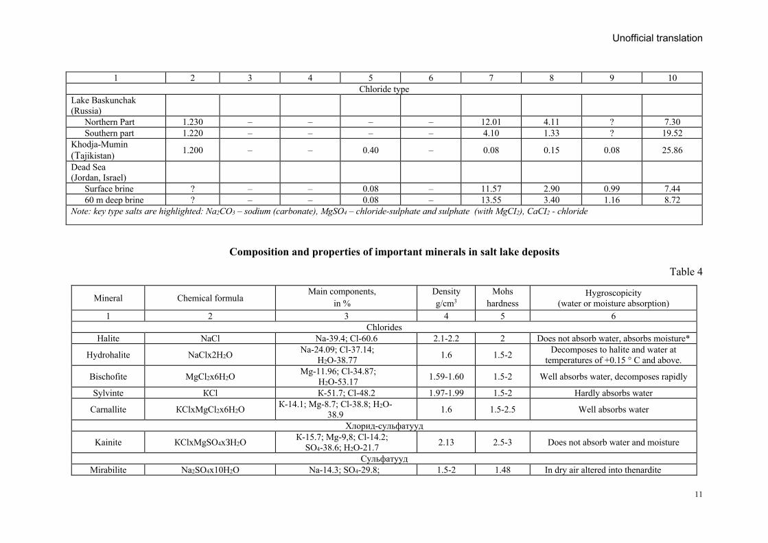
One. Basic terms 1.1. Mineral salts are alkaline (sodium and potassium) and sub alkaline (magnesium, calcium)
metals that combine with hydrochloric acid (NCl) to form chlorine salts or chlorides (NaCl, KCl, MgCl2, CaCl2), to combine with sulfuric acid (H2SO4) to form sulfate salts or sulfates (Na2SO4, K2SO4, MgSO4), that combine with (CO3, HCO3) to form carbonate salts and carbonates (Na2CO3) or bicarbonate (NaHCO3). They are natural compounds easily soluble in water.
This natural compound exists in nature with a physicochemical pattern those changes from a solid state to a liquid state and from a liquid state to a crystalline solid state.
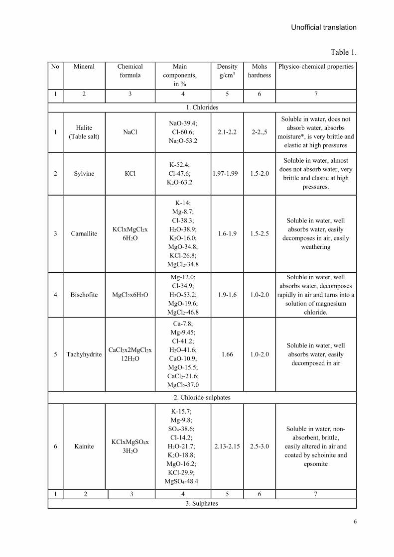
Those potassium carbonate (K2CO3), bicarbonate (KHCO3), and sodium and potassium nitrate salts (NaNO3 and KNO3) are very rare because they are easily soluble in water. All salt crystals are normally appearing translucent or white in their pure state, but impurities may give them red, yellow, brown, gray, blue, and other colors. The main salt minerals, their composition and properties are shown in Table 1.
Composition and properties of main salt minerals
Unofficial translation
6
Table 1.
No Mineral Chemical formula
Main components,
in %
Density g/cm3
Mohs hardness
Physico-chemical properties
1 2 3 4 5 6 7
1. Chlorides
1 Halite (Table salt) NaCl
NaO-39.4; Cl-60.6;
Na2O-53.2 2.1-2.2 2-2.,5
Soluble in water, does not absorb water, absorbs
moisture*, is very brittle and elastic at high pressures
2 Sylvine КСl K-52.4; Cl-47.6;
K2O-63.2 1.97-1.99 1.5-2.0
Soluble in water, almost does not absorb water, very
brittle and elastic at high pressures.
3 Carnallite KClxMgCl2x 6H2O
K-14; Mg-8.7; Cl-38.3;
H2O-38.9; K2O-16.0; MgO-34.8; KCl-26.8;
MgCl2-34.8
1.6-1.9 1.5-2.5
Soluble in water, well absorbs water, easily
decomposes in air, easily weathering
4 Bischofite MgCl2x6H2O
Mg-12.0; Cl-34.9;
H2O-53.2; MgO-19.6; MgCl2-46.8
1.9-1.6 1.0-2.0
Soluble in water, well absorbs water, decomposes
rapidly in air and turns into a solution of magnesium
chloride.
5 Tachyhydrite CaCl2x2MgCl2x 12H2O
Ca-7.8; Mg-9.45; Cl-41.2;
H2O-41.6; CaO-10.9; MgO-15.5; CaCl2-21.6; MgCl2-37.0
1.66 1.0-2.0 Soluble in water, well absorbs water, easily
decomposed in air
2. Chloride-sulphates
6 Kainite KClxMgSO4x 3H2O
K-15.7; Mg-9.8;
SO4-38.6; Cl-14.2;
H2O-21.7; K2O-18.8; MgO-16.2; KCl-29.9;
MgSO4-48.4
2.13-2.15 2.5-3.0
Soluble in water, non-absorbent, brittle,
easily altered in air and coated by schoinite and
epsomite
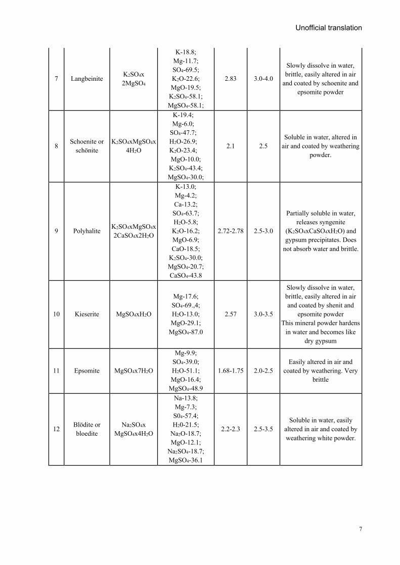
1 2 3 4 5 6 7 3. Sulphates
Unofficial translation
7
7 Langbeinite K2SO4x 2MgSO4
K-18.8; Mg-11.7; SO4-69.5; K2O-22.6; MgO-19.5;
K2SO4-58.1; MgSO4-58.1;
2.83 3.0-4.0
Slowly dissolve in water, brittle, easily altered in air
and coated by schoenite and epsomite powder
8 Schoenite or schönite
K2SO4xMgSO4x4H2O
K-19.4; Mg-6.0;
SO4-47.7; H2O-26.9; K2O-23.4; MgO-10.0;
K2SO4-43.4; MgSO4-30.0;
2.1 2.5 Soluble in water, altered in
air and coated by weathering powder.
9 Polyhalite K2SO4xMgSO4x 2CaSO4x2H2O
K-13.0; Mg-4.2; Ca-13.2; SO4-63.7; H2O-5.8; K2O-16.2; MgO-6.9; CaO-18.5;
K2SO4-30.0; MgSO4-20.7; CaSO4-43.8
2.72-2.78 2.5-3.0
Partially soluble in water, releases syngenite
(K2SO4xCaSO4xH2O) and gypsum precipitates. Does
not absorb water and brittle.
10 Kieserite MgSO4xH2O
Mg-17.6; SO4-69.,4; H2O-13.0; MgO-29.1;
MgSO4-87.0
2.57 3.0-3.5
Slowly dissolve in water, brittle, easily altered in air and coated by shenit and
epsomite powder This mineral powder hardens
in water and becomes like dry gypsum
11 Epsomite MgSO4x7H2O
Mg-9.9; SO4-39.0; H2O-51.1; MgO-16.4;
MgSO4-48.9
1.68-1.75 2.0-2.5 Easily altered in air and
coated by weathering. Very brittle
12 Blödite or bloedite
Na2SO4x MgSO4x4H2O
Na-13.8; Mg-7.3; S04-57.4; H20-21.5;
Na2O-18.7; MgO-12.1;
Na2SO4-18.7; MgSO4-36.1
2.2-2.3 2.5-3.5 Soluble in water, easily
altered in air and coated by weathering white powder.
Unofficial translation
8
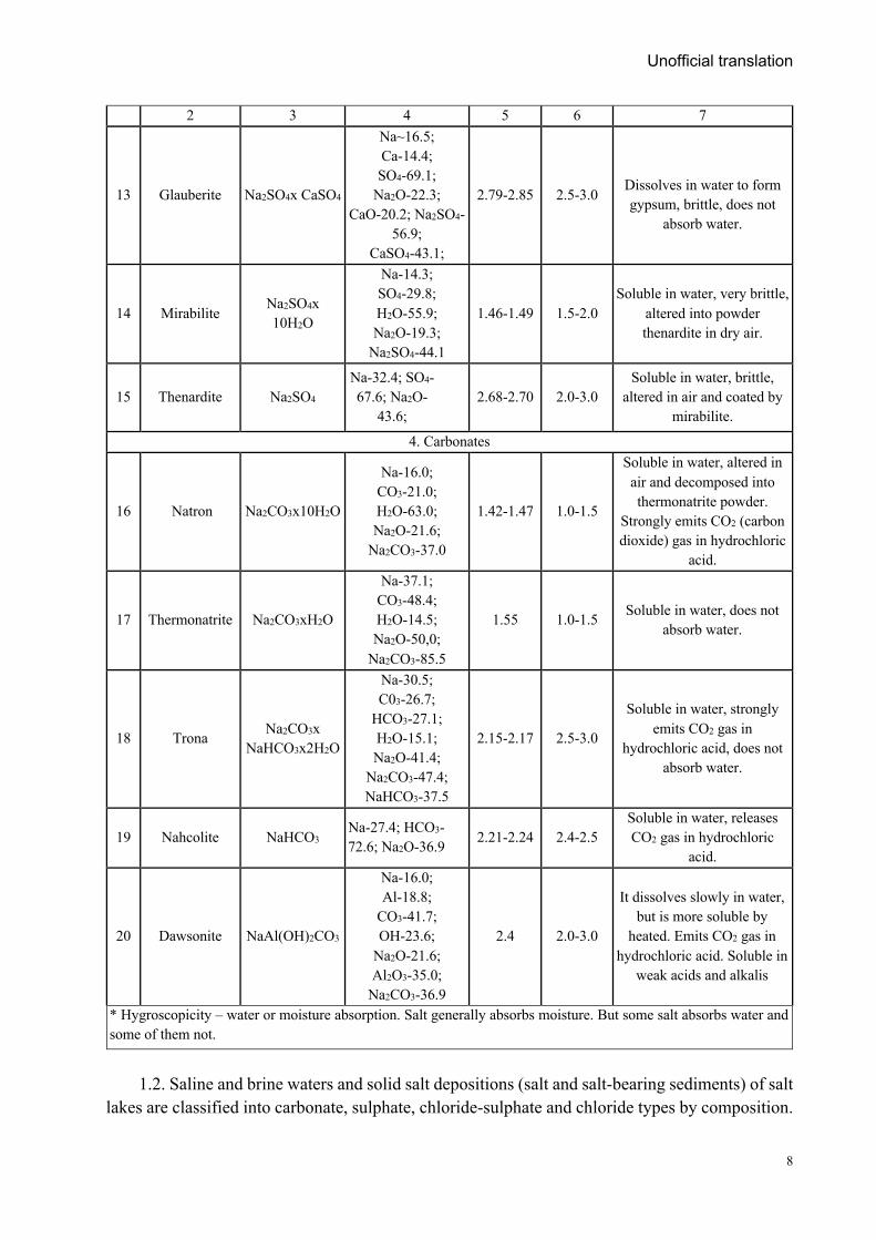
2 3 4 5 6 7
13 Glauberite Na2SO4x CaSO4
Na~16.5; Ca-14.4; SO4-69.1;
Na2O-22.3; CaO-20.2; Na2SO4-
56.9; CaSO4-43.1;
2.79-2.85 2.5-3.0
Dissolves in water to form gypsum, brittle, does not
absorb water.
14 Mirabilite Na2SO4x 10H2O
Na-14.3; SO4-29.8; H2O-55.9; Na2O-19.3;
Na2SO4-44.1
1.46-1.49 1.5-2.0 Soluble in water, very brittle,
altered into powder thenardite in dry air.
15 Thenardite Na2SO4 Na-32.4; SO4-67.6; Na2O-
43.6; 2.68-2.70 2.0-3.0
Soluble in water, brittle, altered in air and coated by
mirabilite.
4. Carbonates
16 Natron Na2CO3x10H2O
Na-16.0; CO3-21.0; H2O-63.0; Na2O-21.6;
Na2CO3-37.0
1.42-1.47 1.0-1.5
Soluble in water, altered in air and decomposed into thermonatrite powder.
Strongly emits CO2 (carbon dioxide) gas in hydrochloric
acid.
17 Thermonatrite Na2CO3xH2O
Na-37.1; CO3-48.4; H2O-14.5; Na2O-50,0;
Na2CO3-85.5
1.55 1.0-1.5 Soluble in water, does not absorb water.
18 Trona Na2CO3x NaHCO3x2H2O
Na-30.5; C03-26.7;
HCO3-27.1; H2O-15.1; Na2O-41.4;
Na2CO3-47.4; NaHCO3-37.5
2.15-2.17 2.5-3.0
Soluble in water, strongly emits CO2 gas in
hydrochloric acid, does not absorb water.
19 Nahcolite NaHCO3 Na-27.4; HCO3-72.6; Na2O-36.9 2.21-2.24 2.4-2.5
Soluble in water, releases CO2 gas in hydrochloric
acid.
20 Dawsonite NaAl(OH)2CO3
Na-16.0; Al-18.8;
СО3-41.7; OH-23.6;
Na2O-21.6; Al2O3-35.0;
Na2CO3-36.9
2.4 2.0-3.0
It dissolves slowly in water, but is more soluble by
heated. Emits CO2 gas in hydrochloric acid. Soluble in
weak acids and alkalis
* Hygroscopicity – water or moisture absorption. Salt generally absorbs moisture. But some salt absorbs water and some of them not.
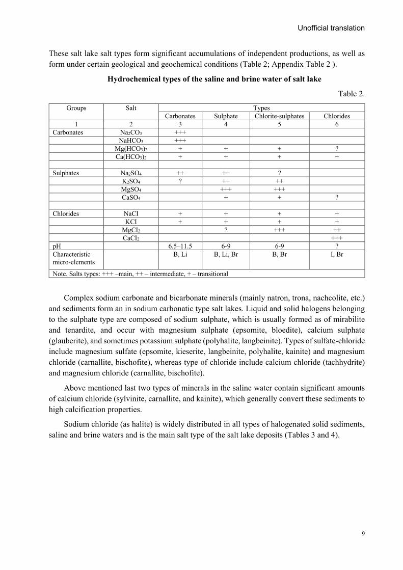
1.2. Saline and brine waters and solid salt depositions (salt and salt-bearing sediments) of salt
lakes are classified into carbonate, sulphate, chloride-sulphate and chloride types by composition.
Unofficial translation
9
These salt lake salt types form significant accumulations of independent productions, as well as form under certain geological and geochemical conditions (Table 2; Appendix Table 2 ).
Hydrochemical types of the saline and brine water of salt lake
Table 2.
Groups Salt Types Carbonates Sulphate Chlorite-sulphates Chlorides
1 2 3 4 5 6 Carbonates Na2CO3 +++ NaHCO3 +++ Mg(HCO3)2 + + + ? Са(НСО3)2 + + + + Sulphates Na2SO4 ++ ++ ? K2SO4 ? ++ ++ MgSO4 +++ +++ CaSO4 + + ? Chlorides NaCI + + + + KCI + + + + MgCI2 ? +++ ++ CaCI2 +++ pH 6.5–11.5 6-9 6-9 ? Characteristic micro-elements
В, Li В, Li, Br В, Br I, Br
Note. Salts types: +++ –main, ++ – intermediate, + – transitional
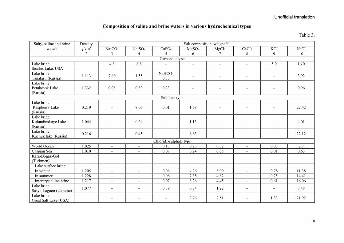
Complex sodium carbonate and bicarbonate minerals (mainly natron, trona, nachcolite, etc.) and sediments form an in sodium carbonatic type salt lakes. Liquid and solid halogens belonging to the sulphate type are composed of sodium sulphate, which is usually formed as of mirabilite and tenardite, and occur with magnesium sulphate (epsomite, bloedite), calcium sulphate (glauberite), and sometimes potassium sulphate (polyhalite, langbeinite). Types of sulfate-chloride include magnesium sulfate (epsomite, kieserite, langbeinite, polyhalite, kainite) and magnesium chloride (carnallite, bischofite), whereas type of chloride include calcium chloride (tachhydrite) and magnesium chloride (carnallite, bischofite).
Above mentioned last two types of minerals in the saline water contain significant amounts of calcium chloride (sylvinite, carnallite, and kainite), which generally convert these sediments to high calcification properties.
Sodium chloride (as halite) is widely distributed in all types of halogenated solid sediments, saline and brine waters and is the main salt type of the salt lake deposits (Tables 3 and 4).
Unofficial translation
10
Composition of saline and brine waters in various hydrochemical types
Table 3.
Salty, saline and brine waters
Density g/cm3
Salt composition, weight % Na2СО3 Na2SO4 CaSO4 MgSO4 MgCI2 CaCI2 KCI NaCI
1 2 3 4 5 6 7 8 9 10 Carbonate type
Lake brine Searles Lake, USA
4.8 6.8 – – – – 5.0 16.0
Lake brine Tanatar I (Russia) 1.113 7.60 1.55 NaHCO3
0.83 – – – – 3.92
Lake brine Petuhovsk Lake (Russia)
1.332 0.08 0.89 0.23 – – – – 0.96
Sulphate type Lake brine Raspberry Lake (Russia)
0.219 – 8.06 0.01 1.68 – – – 22.42
Lake brine Kulundinskoye Lake (Russia)
1.044 – 0.29 – 1.13 – – – 4.01
Lake brine Kuchuk lake (Russia) 0.216 – 0.45 – 6.63 – – – 22.12
Chloride-sulphate type World Ocean 1.025 – – 0.13 0.23 0.32 – 0.07 2.7 Caspian Sea 1.010 – – 0.07 0.24 0.05 – 0.01 0.63 Kara-Bogaz-Gol (Turkmen)
Lake surface brine: In winter 1.205 – – 0.06 4.26 8.09 – 0.78 11.38 In summer 1.228 – – 0.06 7.35 4.62 – 0.75 14.41 Intercrystalline brine 1.217 – – 0.07 8.26 4.45 – 0.61 16.06 Lake brine Sasyk Lagoon (Ukraine) 1.077 – – 0.89 0.74 1.22 – – 7.48
Lake brine Great Salt Lake (USA) – – – 2.76 2.51 – 1.33 21.92
Unofficial translation
11
1 2 3 4 5 6 7 8 9 10 Chloride type
Lake Baskunchak (Russia)
Northern Part 1.230 – – – – 12.01 4.11 ? 7.30 Southern part 1.220 – – – – 4.10 1.33 ? 19.52
Khodja-Mumin (Tajikistan) 1.200 – – 0.40 – 0.08 0.15 0.08 25.86
Dead Sea (Jordan, Israel)
Surface brine ? – – 0.08 – 11.57 2.90 0.99 7.44 60 m deep brine ? – – 0.08 – 13.55 3.40 1.16 8.72
Note: key type salts are highlighted: Na2CO3 – sodium (carbonate), MgSO4 – chloride-sulphate and sulphate (with MgCI2), CaCI2 - chloride
Composition and properties of important minerals in salt lake deposits
Table 4
Mineral Chemical formula Main components,
in % Density g/cm3
Mohs hardness
Hygroscopicity (water or moisture absorption)
1 2 3 4 5 6 Chlorides
Halite NaCl Na-39.4; Сl-60.6 2.1-2.2 2 Does not absorb water, absorbs moisture*
Hydrohalite NaClх2Н2О Na-24.09; Сl-37.14; Н2О-38.77 1.6 1.5-2 Decomposes to halite and water at
temperatures of +0.15 ° C and above.
Bischofite MgCl2х6Н2О Mg-11.96; Сl-34.87; Н2О-53.17 1.59-1.60 1.5-2 Well absorbs water, decomposes rapidly
Sylvinte КСl К-51.7; Сl-48.2 1.97-1.99 1.5-2 Hardly absorbs water
Carnallite КСlхMgCl2х6Н2О К-14.1; Mg-8.7; Сl-38.8; Н2О-38.9 1.6 1.5-2.5 Well absorbs water
Хлорид-сульфатууд
Kainite КСlxMgSO4xЗН2О К-15.7; Mg-9,8; Сl-14.2; SO4-38.6; Н2О-21.7 2.13 2.5-3 Does not absorb water and moisture
Сульфатууд Mirabilite Na2SO4х10H2O Na-14.3; SO4-29.8; 1.5-2 1.48 In dry air altered into thenardite
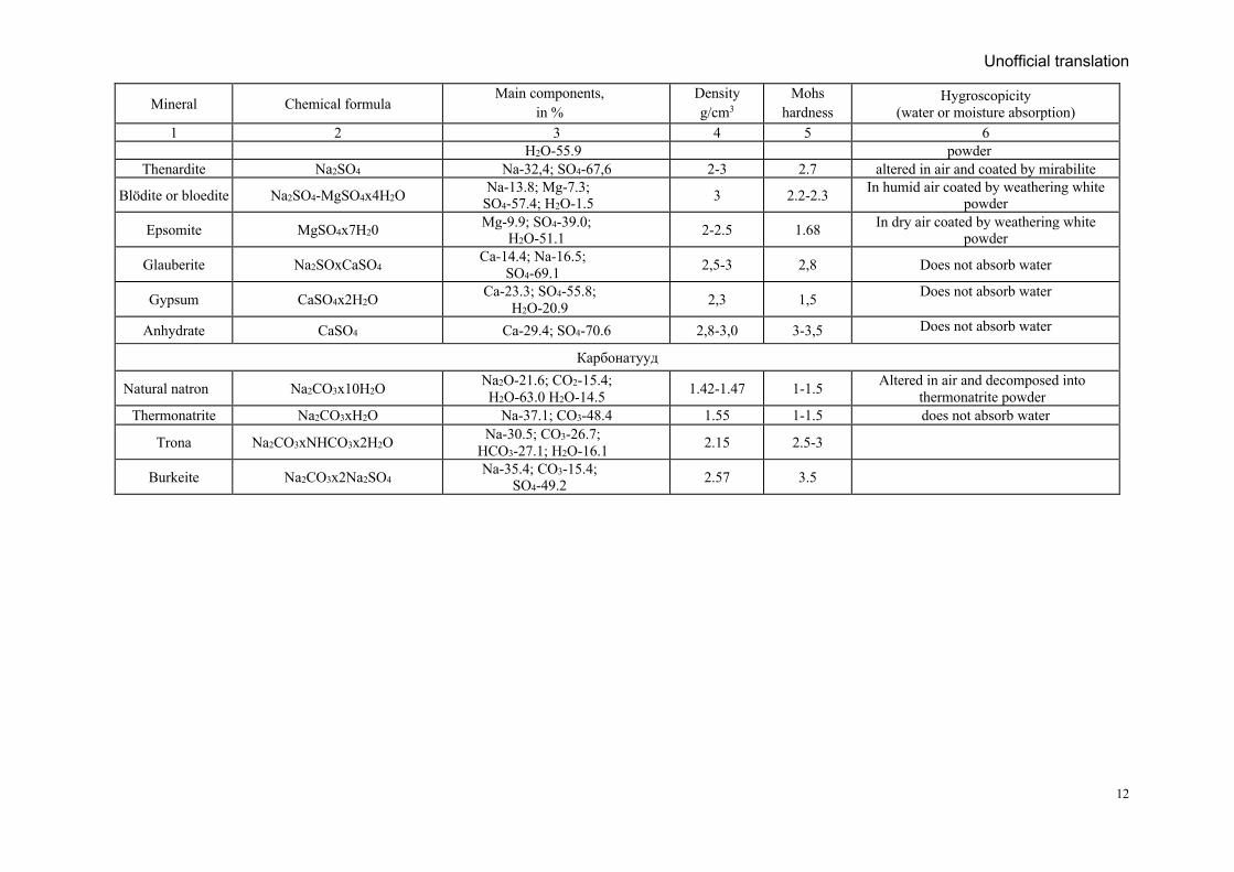
Unofficial translation
12
Mineral Chemical formula Main components,
in % Density g/cm3
Mohs hardness
Hygroscopicity (water or moisture absorption)
1 2 3 4 5 6 Н2О-55.9 powder
Thenardite Na2SO4 Na-32,4; SO4-67,6 2-3 2.7 altered in air and coated by mirabilite
Blödite or bloedite Na2SO4-MgSO4х4Н2О Na-13.8; Mg-7.3; SO4-57.4; H2O-1.5 3 2.2-2.3 In humid air coated by weathering white
powder
Epsomite MgSO4х7Н20 Mg-9.9; SO4-39.0; H2O-51.1 2-2.5 1.68 In dry air coated by weathering white
powder
Glauberite Na2SOхCaSO4 Ca-14.4; Na-16.5; SO4-69.1 2,5-3 2,8 Does not absorb water
Gypsum CaSO4х2Н2О Ca-23.3; SO4-55.8; H2O-20.9 2,3 1,5 Does not absorb water
Anhydrate CaSO4 Ca-29.4; SO4-70.6 2,8-3,0 3-3,5 Does not absorb water
Карбонатууд
Natural natron Na2CO3х10H2O Na2O-21.6; CO2-15.4; H2O-63.0 H2O-14.5 1.42-1.47 1-1.5 Altered in air and decomposed into
thermonatrite powder Thermonatrite Na2CO3хH2O Na-37.1; CO3-48.4 1.55 1-1.5 does not absorb water
Trona Na2CO3хNHCO3х2H2O Na-30.5; CO3-26.7; HCO3-27.1; H2O-16.1 2.15 2.5-3
Burkeite Na2CO3х2Na2SO4 Na-35.4; CO3-15.4; SO4-49.2 2.57 3.5
Unofficial translation
13
Based on actual composition (chemical and salt minerals) of natural and technological types (varieties) of salts, the traditional or most appropriate extraction and processing methods are selected and used in salt production.
1.3. Lake brine deposits include salt lakes, and their area, volume, resources (including saline and brine waters and salt in the lake bottom sediment), salt composition, feed source and the stability of the hydrologic regime of the lake are determine the industrial importance and the mining conditions.
1.4. According to the evolution of the brine existing state, salt lakes classified as "brine", "dry" and "dried". A brine lake is a lake with surface brine throughout the year. A dry (playa) lake is a lake that has surface brine only during the humid season. A dried lake is a lake without surface brine. Salt deposits are usually covered with sandy or other fluffy sediments.
1.5. Salt lake brine is classified as surface brine and bottom brine. Surface brine covers the solid sediments of the lake bottom and forms salts on them, while the bottom brine nourishes and maintains these sediments. Depending on the season, the surface brine’s volume, salinity and salt composition fluctuate.
The bottom brine is divided into intercrystalline brine and brine in the silt (lake bottom sediment). Intercrystalline brine fills the voids and pores in the salt layer. Brine in the silt is brine that dilutes the lake bottom silt layer.
1.6. The salt deposits on the bottom of the lake are separated by clayey and sandy layers, forming strata and lenses like formations. The total thickness of those salt formations range from a few meters to tens of meters, and the thickness is unstable, especially in lakes associated with the origin of salt-dome (diapir).
1.7. The salt deposits on the bottom of the lake are classified as fresh/extract, seasonal, and core-salt. Fresh and salt are salts that crystallize from surface water during one season of the year. It can also be returned to the solution during this crystallization. Fresh salt layers are only a few centimeters thick and rarely reach tens of centimeters. During the year, if some or all of the fresh salt is left completely insoluble and a new layer of salt accumulates on it the following year, the previous fresh salt is called seasonal salt. Its thickness is 0.75 m, sometimes more. Previously precipitated seasonal or fresh salt recrystallizes that called core-salt. This core-salt can composed of several layers of different salts (halite, mirabilite, bloedite and tenardite). The total thickness of core-salt layers range from a few centimeters to 7 m, and up to 80 m in lakes associated with the origin of salt-domes. In the case of core salt, the crystals are completely well-formed.
1.8. Modern lake and lagoon salt deposits are classified as brine, core-salt, and buried salt deposits. The salt reserves of the salt lake are mainly composed of the surface and bottom brines and sometimes fresh salts, and in rare cases old-core salts which are dissolved in the brine and crystallized during the appropriate season. Surface brine covers the lake, while bottom brine feed the lake sediments (salt layers, silt, sand, and clay). The intercrystalline brine is a liquid salt.
Stable lakes. If the hydrochemical regime (volume, salinity and composition) of the surface brine does not change over many years, it is considered a stable lake. Its physicochemical and technological properties do not change.
Unofficial translation
14
Examples of stable salt lakes are the chloride-sulphate type Lake Bolshoe Yarovoe (Russia) and Lake Sasyk-Sivash (Ukraine); sulphate type Great Salt Lake (USA); chloride type the Dead Sea (Israel, Jordan); carbonate type the Lake Chad (Republic of Chad). Examples of unstable salt lakes include the chloride-sulphate type of the Lake Ebeiti Lake (Russia) and Sivash (Ukraine).
The salt reserves of the core lakes are consist of surface and bottom brine and fresh and seasonal salts covering the lake surface. The evolution of the fluid regime of these lakes is similar to that of brine lakes. Its entire surface brine evaporates and loses its stability, became similar to the stage of a dry lake regime. Seasonal salt bodies are similar in composition to the hydrochemical type of brine and have the same physicochemical activity as salt accumulation.
In all types of lakes, the thermal crystallization (evaporation of brine) occurs first, followed by sodium chloride (halite), followed by bloedite (in sulphate and sulphate-type lakes), trona, burkeite, and other salts (in sodium lakes) form with or in combination with halite.
Sodium sulphate (mirabilite) and sodium carbonate (natron) crystallize more frequently during hot and cold cycles (due to hot and cold season). In this case, the individual types of salts (type-determining salts) accumulate in the same way as the stable precipitation of halite. The deposition of salts are forming solid strata, strata-lens, lens-like bodies (thickness and quality are stable or unstable), and sometimes the composition of the salt scattered in the sandy and silty sediments remains the same or diverse. The thickness of the salt bodies vary from tens of centimeters to 1 m, rarely up to 10 m, and the distribution area varies from tens to tens of square kilometers. Core-salt precipitations of sodium chloride in the Baskunchuk (Russia), Zhaksy-Kylysh, Big Kalkaman (Kazakhstan) lakes, glassy mirabilite in the Lake Kuchuk (Russia), trona in the Lake Magadi (Kenya), and potassium-magnesium salts in the Lake Tsaidam (China), occur respectively.
Salt resource of the buried salt deposits are composed of bottom brine (brine in the silt and intercrystalline brine), and it’s covering saline clay and salt sediments (core-salt bodies), and intercrystalline brine between the buried salt layers and fresh, seasonal and surface brine.
The intercrystalline brine, which constantly interacts between the salt sediments and brine, is of great industrial importance as it has the largest salt reserves and the most stable composition. Examples of such deposits include chloride-sulphate buried deposit of the Kara-Bogaz-Gol bay and sodium buried deposit of the Searle’s Lake (USA).
1.9. Demand for salt mining, salt and its products continuously grow to time. In terms of marketable importance, sodium, potassium, magnesium (in small amounts, calcium) salts and their products still occupy an important place.
1.10. Of the sodium salts, sodium chloride (table salt) is the most common. The table salt is used for food, animal feeding and technical purposes. Salt for food and animal feed is used as a food preservative and as a vital supplement to animal feed. About 30-40% of table salt is used for these purposes and for medical purposes.
1.11. Salt is an essential food additive and its quality is determined by the requirements of national standards such as MNS 5046: 2019 food iodized salt, MNS CAC 150: 2007 food salt, MNS CAC 150: 2014 food salt. According to the Mongolian national standard MNS 5046: 2019, sodium chloride (NaCl) content of iodized salt for food is not less than 97%, and should not exceed
Unofficial translation
15
SO4 1.5%, Mg+ 0.5%, Fe 0.04%, Ca+ 0.7%, insoluble residue (IR) 1%, moisture 3%, I 25-35 mg/kg, granular 2.5 mm, contaminant mixtures of As 0.5 mg/kg, Cu 2 mg/kg, Pb 1-2 mg/kg, Zn 10 mg/kg, Cd 0.5 mg/kg, Hg 0.1-0.5 mg/kg and radiation pollution 100 bk/l. While, according to the requirements of Russian standards GOST 51574-2000 and GOST 13830-91, the content of sodium chloride in table salt is not less than 97.07%, the contaminant is Ca + 0.5-0.65; Mg+ 0.10-0.25; K+ 0.1-0.2; SO4 1.2-1.5; Fe2O3 0.01; insoluble residue 0.45-0.65; H2O should not exceed 0.35 (%).
Highest grade and fine-grained varieties of the salt are used food, and medium and coarse salt is used for salting and canning. Salt used in animal husbandry and fertilizers is regulated by MNS 1786: 1973 standard in Mongolia and OST 18-87-77 standard in Russia. Sodium chloride salt used in the processing of raw hides and skins in the tannery shall meet the requirements of MNS 0430: 1987.
1.12. Naturally occurring salt is called a sedimentary salt, whereas artificially precipitated from brine in special simulated reservoirs classified as garden salt. If the sedimentary and artificially precipitated salt is mined from large deposits, usually use salt harvesters, stone cutters and other equipment. For mechanical mining use, the thickness of the salt body should be at least 0.25 m. For example, salt from Buuri Lake in the Tseel and Tsogt soums of Gobi Altai and Santmargats and Devteer lakes in Zavkhan, can be used mechanically and with a salt harvester. The salt from Sangiin Dalai Lake in Dornod and Khukh Ereg Lake in Uvs are still used effectively by hand harvesting.
When mining table salt, the contaminated clay needs to be washed away. Salt contaminated with sludge is easily removed washed with brine. This is called the 1st enrichment of the natural method. The washed salt is drain on a special platform. As a result, the intercrystalline brine flows and dries. This is called the 2nd enrichment of the natural method. These two methods are widely used in our Mongolia.
In Eastern Siberia and Yakutia, table salt is usually extracted in winter, by freezing brine with a salinity of more than 22% in a special artificial reservoir at minus 15-21 degrees Celsius. Winter salt crystallizes at minus temperature and summer salt at plus temperature. Crystallized winter salt is easy to separate, sodium chloride brine which is not crystallized, is used to separate by boiling or evaporating. In other words, salt factories are based on the principle that different salts can be produced by the thermal method.
The following products are produced for the processing of lake salt. These include:
- Fine-grained, evaporated salt (evaporated from the brine or saline water); - Powdered salts (sedimentary and artificial precipitated) of various grain sizes (0.8 mm
to 4.5 mm); - Molded (weighing 3-50 kg), granular and powdered (particle size up to 40 mm) salt; - Salt bars; - Salt briquettes (with and without microelements) for livestock use.
1.13. Technical salts (sodium chloride content 96-97%) are used for the production of chlorine, caustic and calcined soda, sodium diversity and chlorine-containing series products. Calcined soda (Na2CO3) is extracted from sodium chloride and calcium carbonate (limestone and
Unofficial translation
16
lime), and according to GOST-5100-85, Na2CO3 content not less than 97%, meets the requirements of first and second grade, A and B high grades.
The main consumers of crystalline soda are the glass industry (up to 50%), the chemical industry (20-25%) and the non-ferrous metallurgy (refining), detergents, enamels and other industries. Crystalline soda is used for medicinal and food purposes.
Calcined soda is produced from natural crystalline soda (trona, nachcolite and brine) in the United States and several other countries because of its simple technology, low environmental impact, low production costs, and high quality products. In Russia and the Commonwealth of Independent States (CIS), natural lake soda is mined in small quantities due to its limited reserves.
Synthetic and natural sodium bicarbonate neutralizes any acid, so it is made into a weakly alkaline aqueous solution and is not harmful to tissues when watered by plants or given to animals. Therefore, in addition to technical purposes, it is actively used in the food, pharmaceutical, cosmetic and water industries, as a feed additive, and as a soap and detergent.
Calcium chloride is used in the road industry (to prevent road icing and dust removal), refrigerators (up to 20% in the United States), the oil industry (15%), concrete admixtures (5%) and others. Metallic calcium is used in the manufacture of antifriction alloys, electrical cable coatings, chromium and other elements, and as a gas absorber in electric vacuum devices.
Technical calcium chloride is produced in three categories: white powder or granular form (top and first grade - CaCl2); white to dark gray colored, molten – powder; and granular or flaky form, liquid - clear or slightly turbid aqueous solution.
Artificial calcium chloride, like natural calcium chloride, is increasingly being used in the road industry to combat icing and dust, as an additive in refrigerators and concrete, and in many other industries, such as the oil industry, such as sulphate treatment. It is also used in the manufacture of antifriction alloys for the reduction of uranium, thorium, chromium, vanadium, zirconium and rare earth metals, as a gas absorber in electrical vacuum equipment, and for the production of metallic calcium by electrolysis.
Ammonium chloride is often used as a fertilizer for rice planting. Other types of ammonium chloride are produced in the form of crystals and granules for composting and technical purposes.
Requirements for the quality of caustic soda for use in chemical, petrochemical, non-ferrous metallurgy and other industries are regulated in Russia by GOST 22-63-79.
1.14. Sodium sulfate is extracted from natural raw materials (mirabilite, tenardite, glauberite, and sulphate and chloride-sulphate brine) and is divided into classes A and B, containing at least 97 and 94% Na2SO4, respectively, in accordance with GOST 6318-77. They are most commonly used in the manufacture of detergents, household chemicals, glass, cellulose, chlorine-free potassium fertilizers, and in the pharmaceutical industry (sodium sulfate decahydrate or Glauber's salt).
Sodium sulfate (mainly mirabilite) is extracted from the solid sediments and brine of lakes in Russia (Kuchuk) and Turkmenistan (Kara-Bogaz-Gol). The best way to extract mirabilite is through artificial reservoir brine. In the case of the Lake Kuchuk, the sodium sulphate reserve is a core-salt liquefied in mirabilite (glassy mirabilite) brine.
Unofficial translation
17
Mirabilite crystallized from natural brine must meet the requirements of GOST 20434-75. The production requirements for the quality of anhydrous sodium sulphate extracted from natural salt shall meet the standards of GOST 6318-77.
Natural tenardite is mined from the sediments of sulphate Lake. It is dissolved and artificially recrystallized to remove impurities such as other salt, silt, and sand. Pure natural tenardite is mined from Zhaksy-Kylysh Lake. After it is piled and dried, it becomes suitable for factory use.
1.15. Potassium and potassium-magnesium salts. Potassium and magnesium play an important role in the growth of animal and plant tissues. Together with phosphorus and nitrogen, they are an important element in plant nutrition and greatly increase biological productivity. Potassium and potassium-magnesium concentrates and ordinary fertilizers are made in the agricultural chemical industry. Potassium chloride technical conditions shall meet the requirements of GOST4568-83.
Sodium sulfates of salt lakes are existing in brine, usually form of bloedite and epsomite layers and lens-like bodies, when mixed with other salts, magnesium chlorides are usually present in brine. Potassium sulphate (rarely) and potassium-magnesium fertilizers are used for the production of potassium sulfate and kalimagneses. Potassium compounds are processed to produce caustic potash, potash (potassium carbonate), potassium nitrate, bromine, and potassium iodide. Potassium-sodium alloys (potassium 40-90%), which are liquid at room temperature, are used as heat sources in nuclear reactors, and potassium peroxide (K2O4) as a source of oxygen for the combustion of chlorine compounds and the production of titanium in high-temperature smelting equipment.
1.16. True magnesium salts and their products are used in metallurgy (caustic magnesite, refractory materials), chemical, electrical, construction (Sorel cement), leather, rubber (softener), stone carving, photography (strong light reflector), medicine. Enriched carnallite must have at least 31.8% MgCl2 (by GOST 16109-70) and bischofite (by GOST 7759-73). Magnesium chloride is used in the manufacture of defoliants (chemicals that strengthen plant cells) in the manufacture of detergents, synthetic zeolites and organic products of magnesium.
Magnesium chloride saline solution is used for mine excavation and road slippage protection, dust suppression, sulfur fuel oil soot reducer, cement hardening, drilling mud preparation, quick mix preparation of molds, and protein-vitamin extracts for therapeutic purposes. Magnesium sulfate (epsomite) is commonly used in agriculture, light industry, and ferrous metallurgy. Metal magnesium is used in aerospace and automotive industries to make aluminum and light alloys, as well as in high-strength steels, and in the production of titanium, vanadium, zircon, uranium, and other metals.
1.17. Boron, bromine and lithium are extracted during the processing of lake solid salts and brine deposits. Boron is commonly found in carbonate and rarely sulphate type lakes, bromine is found in sulphate and chloride type lakes, and lithium is commonly found in carbonate and chloride seldomly sulphate type lakes. In recent years, lithium mined from intercrystalline brine of sodium lakes and Searle's Lake, USA. This is due to the increased the lithium equipment and finds new technologies for the production of aluminum.
Unofficial translation
18
1.18. Significant salts types for the production are: 1) rock salt, 2) potassium salt, 3) potassium-magnesium salt, 4) magnesium salt, 5) sodium sulfate, and 6) crystalline soda. The most common are natural rock salts and potassium salts, which form independent deposits or occur as separate layers in other salt deposits. Potassium-magnesium salt layers (carnallite, kainite, langbeinite) often coexist with potassium salt (sylvinite) layers, and sometimes form mixed (mixed salt) layers, so this recommendation includes potassium and potassium-magnesium salts together. Independent deposits of magnesium salts (bischofite), sodium sulfate, and crystalline soda are rare.
1.19. Salt deposits and basins are divided into two main types depending on the salt source: marine and terrestrial/continental. Salts from marine-type deposits (potassium, potassium-magnesium, magnesium, and rock salt) often accumulate in ocean-related depressions, while in continental conditions, they often accumulate in intermountain depressions and syncline structures. Continental-type deposits are formed in closed depressions fed by river runoff. These types of salt deposits (sodium sulfate and crystalline soda) are rare and have limited production value.
1.20. In case of natural salts, the requirements of the above standards and specifications for lake sediments or brine deposits are not common in the world. The production value of lake sediments and brine is assessed on the basis of the development of benchmarks for each lake deposit to be exploited, the specifics of salt mining and processing are taken into account, and the standards and specifications of the products are complied.
1.21. The primary and basic form of rock salt deposits is stratiform and lens, and their size and formation structure are depends on the size of the basin and the environment of the deposition. As a result of subsequent geological processes, the original shape of the salt layer is often altered and destroyed. As a result of the transition (flow) of the salt layer, various shapes, sometimes very complex structures; sometimes the overlaying layer is broken and salt layers penetrates the rock. Therefore, it is difficult to study and use the anticline section and salt-dome structure. The mass of salt in the nucleus of these salt-dome structures is often strongly folded and falls steeply.
1.22. In rock salt deposits, a structure commonly known as a “salt mirror” (the top of the salt dome and diapir structure is eroded by tectonic or groundwater action to form a salt mirror.) is common, and residual solubility products of salt and salt-bearing rocks remain in the form of "caps". Depending on the composition, there are "cap" structures classified as gypsum, gypsum-clay, gypsum-carbonate and the other compositions. Faults and fractures and cavities in the “cap” structure form a saturated solution, and the salt mirror or erosion level becomes a waterproof screen horizon, so these salt-saturated solutions appear on the surface as salt springs.
In rock salt deposits, karst and cavities are observed up to a depth of 300 m and are usually most developed in the periphery of the diapir.
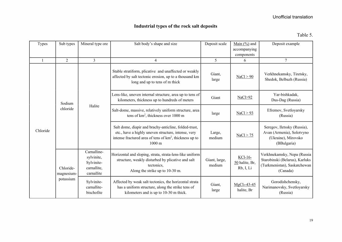
1.23. Table 5 provides a brief overview of the industrial types of the rock salt deposits.
Unofficial translation
19
Industrial types of the rock salt deposits
Table 5.
Types Sub types Mineral type ore Salt body’s shape and size Deposit scale Main (%) and accompanying components
Deposit example
1 2 3 4 5 6 7
Chloride
Sodium chloride
Halite
Stable stratiform, plicative and unaffected or weakly affected by salt tectonic erosion, up to a thousand km
long and up to tens of m thick
Giant, large
NaCl > 90 Verkhnekamsky, Tiretsky, Shedok, Belbazh (Russia)
Lens-like, uneven internal structure, area up to tens of kilometers, thickness up to hundreds of meters Giant NaCl>92 Yar-bishkadak,
Dus-Dag (Russia)
Salt-dome, massive, relatively uniform structure, area tens of km2, thickness over 1000 m large NaCl > 93
Efremov, Svetloyarsky (Russia)
Salt dome, diapir and brachy-anticline, folded-trust, etc., have a highly uneven structure, intense, very
intense fractured area of tens of km2, thickness up to 1000 m
Large, medium
NaCl > 75
Seregov, Iletssky (Russia), Avan (Armenia), Solotvyno
(Ukraine), Mirovsko (BBulgaria)
Chloride-magnesium-potassium
Carnalline-sylvinite, Sylvinite-carnallite, carnallite
Horizontal and sloping, strata, strata-lens-like uniform structure, weakly disturbed by plicative and salt
tectonics, Along the strike up to 10-30 m.
Giant, large, medium
KCl-16-50 halite, Br,
Rb, I, Li
Verkhnekamsky, Nepa (Russia Starobinski (Belarus), Karluks (Turkmenistan), Saskatchewan
(Canada)
Sylvinite-carnallite- bischofite
Affected by weak salt tectonics, the horizontal strata has a uniform structure, along the strike tens of
kilometers and is up to 10-30 m thick.
Giant, large
MgCl2-43-45 halite, Br
Gorodishchensky, Narimanovsky, Svetloyarsky
(Russia)
Unofficial translation
20
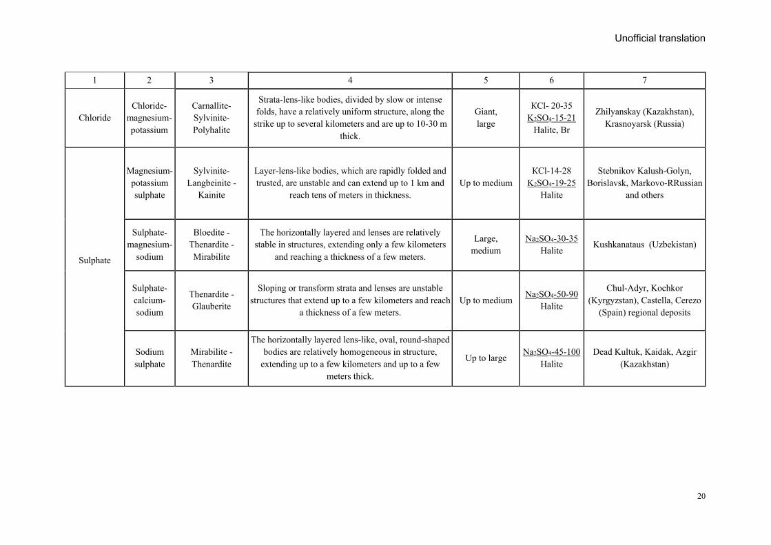
1 2 3 4 5 6 7
Chloride Chloride-
magnesium-potassium
Carnallite-Sylvinite-Polyhalite
Strata-lens-like bodies, divided by slow or intense folds, have a relatively uniform structure, along the
strike up to several kilometers and are up to 10-30 m thick.
Giant, large
КСl- 20-35 K2SO4-15-21
Halite, Br
Zhilyanskay (Kazakhstan), Krasnoyarsk (Russia)
Sulphate
Magnesium-potassium sulphate
Sylvinite-Langbeinite -
Kainite
Layer-lens-like bodies, which are rapidly folded and trusted, are unstable and can extend up to 1 km and
reach tens of meters in thickness. Up to medium
КСl-14-28 K2SO4-19-25
Halite
Stebnikov Kalush-Golyn, Borislavsk, Markovo-RRussian
and others
Sulphate-magnesium-
sodium
Bloedite - Thenardite - Mirabilite
The horizontally layered and lenses are relatively stable in structures, extending only a few kilometers
and reaching a thickness of a few meters.
Large, medium
Na2SO4-30-35 Halite
Kushkanataus (Uzbekistan)
Sulphate-calcium-sodium
Thenardite - Glauberite
Sloping or transform strata and lenses are unstable structures that extend up to a few kilometers and reach
a thickness of a few meters. Up to medium
Na2SO4-50-90 Halite
Chul-Adyr, Kochkor (Kyrgyzstan), Castella, Cerezo
(Spain) regional deposits
Sodium sulphate
Mirabilite -Thenardite
The horizontally layered lens-like, oval, round-shaped bodies are relatively homogeneous in structure,
extending up to a few kilometers and up to a few meters thick.
Up to large Na2SO4-45-100
Halite Dead Kultuk, Kaidak, Azgir
(Kazakhstan)
Unofficial translation
21
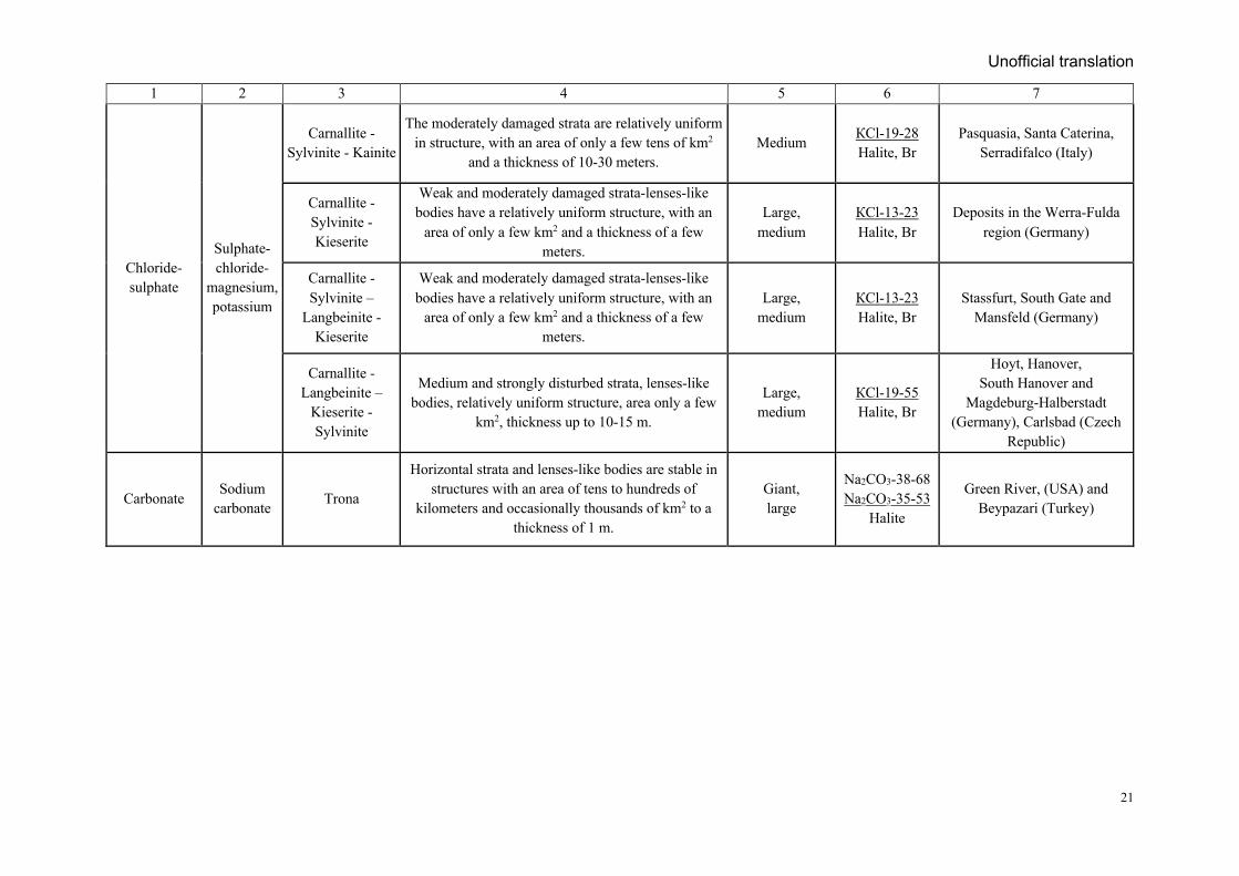
1 2 3 4 5 6 7
Chloride-sulphate
Sulphate-chloride-
magnesium, potassium
Carnallite -Sylvinite - Kainite
The moderately damaged strata are relatively uniform in structure, with an area of only a few tens of km2
and a thickness of 10-30 meters. Medium
КСl-19-28 Halite, Br
Pasquasia, Santa Caterina, Serradifalco (Italy)
Carnallite -Sylvinite -Kieserite
Weak and moderately damaged strata-lenses-like bodies have a relatively uniform structure, with an
area of only a few km2 and a thickness of a few meters.
Large, medium
КСl-13-23 Halite, Br
Deposits in the Werra-Fulda region (Germany)
Carnallite -Sylvinite –
Langbeinite - Kieserite
Weak and moderately damaged strata-lenses-like bodies have a relatively uniform structure, with an
area of only a few km2 and a thickness of a few meters.
Large, medium
КСl-13-23 Halite, Br
Stassfurt, South Gate and Mansfeld (Germany)
Carnallite - Langbeinite –
Kieserite - Sylvinite
Medium and strongly disturbed strata, lenses-like bodies, relatively uniform structure, area only a few
km2, thickness up to 10-15 m.
Large, medium
КСl-19-55 Halite, Br
Hoyt, Hanover, South Hanover and
Magdeburg-Halberstadt (Germany), Carlsbad (Czech
Republic)
Carbonate Sodium
carbonate Trona
Horizontal strata and lenses-like bodies are stable in structures with an area of tens to hundreds of
kilometers and occasionally thousands of km2 to a thickness of 1 m.
Giant, large
Na2CO3-38-68 Na2CO3-35-53
Halite
Green River, (USA) and Beypazari (Turkey)
Unofficial translation
22
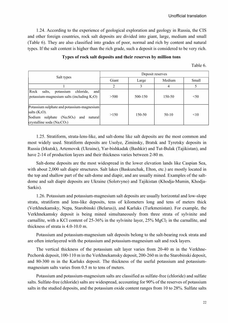
1.24. According to the experience of geological exploration and geology in Russia, the CIS and other foreign countries, rock salt deposits are divided into giant, large, medium and small (Table 6). They are also classified into grades of poor, normal and rich by content and natural types. If the salt content is higher than the rich grade, such a deposit is considered to be very rich.
Types of rock salt deposits and their reserves by million tons
Table 6.
Salt types Deposit reserves
Giant Large Medium Small 1 2 3 4 5
Rock salts, potassium chloride, and potassium-magnesium salts (including K2O)
>500 500-150 150-50 <50
Potassium sulphate and potassium-magnesium salts (K2O). Sodium sulphate (Na2SO4) and natural crystalline soda (Na2CO3)
>150 150-50 50-10 <10
1.25. Stratiform, strata-lens-like, and salt-dome like salt deposits are the most common and most widely used. Stratiform deposits are Usolye, Ziminsky, Bratsk and Tyretsky deposits in Russia (Irkutsk), Artemovsk (Ukraine), Yar-bishkadak (Bashkir) and Tut-Bulak (Tajikistan), and have 2-14 of production layers and their thickness varies between 2-80 m.
Salt-dome deposits are the most widespread in the lower elevation lands like Caspian Sea, with about 2,000 salt diapir structures. Salt lakes (Baskunchak, Elton, etc.) are mostly located in the top and shallow part of the salt-dome and diapir, and are usually mined. Examples of the salt-dome and salt diapir deposits are Ukraine (Solotvyno) and Tajikistan (Khodja-Mumin, Khodja-Sarkis).
1.26. Potassium and potassium-magnesium salt deposits are usually horizontal and low-slope strata, stratiform and lens-like deposits, tens of kilometers long and tens of meters thick (Verkhnekamsky, Nepa, Starobinski (Belarus)), and Karluks (Turkmenistan). For example, the Verkhnekamsky deposit is being mined simultaneously from three strata of sylvinite and carnallite, with a KCl content of 25-36% in the sylvinite layer, 25% MgCl2 in the carnallite, and thickness of strata is 4.0-10.0 m.
Potassium and potassium-magnesium salt deposits belong to the salt-bearing rock strata and are often interlayered with the potassium and potassium-magnesium salt and rock layers.
The vertical thickness of the potassium salt layer varies from 20-40 m in the Verkhne-Pechorsk deposit, 100-110 m in the Verkhnekamsky deposit, 200-260 m in the Starobinski deposit, and 80-300 m in the Karluks deposit. The thickness of the useful potassium and potassium-magnesium salts varies from 0.5 m to tens of meters.
Potassium and potassium-magnesium salts are classified as sulfate-free (chloride) and sulfate salts. Sulfate-free (chloride) salts are widespread, accounting for 90% of the reserves of potassium salts in the studied deposits, and the potassium oxide content ranges from 10 to 28%. Sulfate salts
Unofficial translation
23
are relatively less common than chloride salts, accounting for only 10% of the studied potassium salt reserves, and potassium oxide content is 7-12%. Sulfate salts contain complex minerals, some of which contain more than 12 salt minerals. An important use of sulfate salts is to produce chlorine-free potassium fertilizers. Sulfate salts are most common in the southern Carpathian (kainite and langbenite) and Caspian (polyhalite salts) potassium salt basins.
1.27. The main representatives of magnesium salt deposits are carnallite and bischofite strata-like and lens-like deposits. The largest carnallite deposit in Russia is Verkhnekamsky which is interlayered by several sylvinite and carnallite layers with other salt layers. It is including layer B (average thickness 8 m) with sylvinite and carnallite composition. The the carnallite section is content MgCl2 20-25% and KCI 21%.
In recent years, a preliminary assessment of the Gorodishchensky (Gorodishchensky, Narimanovsky, Svetloyarsky) group deposits of bischofite has been carried out and experimental mining started by underground leaching method. MgCl2 content is 43-45% and the salt layer thickness varies from 2-3 to 60-120 m.
1.28. Large deposits of sodium sulfate and natural crystalline soda have not yet been identified in Russia. Large deposits of trone (Na2CO3•NaHCO3•2H2O), Egyptian salt, dawsonite NaAlCO₃(OH), and sodium bicarbonate nahcolite are mined in USA (Green River), Turkey (Beyupazari), and China (Henan). This kind of deposits is accumulated in the intercontinental basins, in the arid continental climate.
1.29. Potassium-magnesium and magnesium salts contain bromine, rubidium, lithium, cesium and boron as useful accompanying compounds. Industrial grades sulfur deposits are found in anhydrite-carbonate salt deposits, and boron deposits are found in the “cap” structure (salt-dome) of some salt deposits.
Currently, bromine is extracted from potassium-magnesium salts in Germany (Zielitz) and France (Amelia). In the 1970s, small amount of rubidium was extracted from Bereznikovsky's titanium-magnesium trial plant, and between 1940 and 1988, about 1,000 tons of bromine were extracted from the alkali at the Solikamsky Gallery.
In the world practice, rubidium extracted from mica and pollucite, and its content is relatively high compared to salt deposits. Bromine is extracted from the iodine-bromine containing water associated with petroleum deposits, as well as from saturated Dead Sea brine and other natural water sources.
1.30. The technological properties and production value of the saline water, brine and the bottom salt of lake deposits are determined by their salt composition (hydrochemical type) and the content of useful accompanying compounds.
The standard content of sodium-carbonate is should not be less than 0.5% (5-6 g/l) and 0.3% in total salt, in the surface brine of the Mikhailov type (Tanatar Lake) and Petuhovsk Lake deposits.
In the case of sulphate chloride’s permissible concentration of surface brine in the Kuchuk deposit shall not be less than the following percentages: sodium sulphate 4.7%, sodium chloride 12.7%, magnesium chloride 3.6% and bromine 0.027%.
Unofficial translation
24
Chloride-sulphate type Kora-Bogaz-Gol bay buried salt deposit is produced sodium sulphate (mirabilite) to be 105 kg/m3, 55-150 kg/m3 for medium-sized boreholes and 250 kg/m3 for summer season.
The cut-off content for the open pit mining is 3%, for the crystalline soda bonded with sodium carbonate in the bottom sediments of Tanatar Lake. The actual content of sodium carbonate in the standard sediments is set at an average of 7.1-7.3%, and the content of sodium chloride and sulphates should not exceed 0.8-0.9%.
Sodium sulphate content in mirabilite deposits with is very high and fluctuates greatly, such as 17.9% in the silt of the Lake Ebeiti (Omsk region), up to 51% in Kara Chagan (Kazakhstan), 69% in the tenardite of Great Ajbulat Lake, 93% in Lake Teniz (Kazakhstan).
The unique Kuchuk deposit (up to 5 m thick and more than 150 km2 in area) has a very complex structure consisting of several salt bodies: glassy mirabilite (more than 75% mirabalite, not more than 10% in silt), clayey mirabilite (mirabilite 50-75%, clayey more than 10%), mirabilite-gypsum silt (sludge more than 50%) and the average minable (standard) content of sodium sulphate is 41.92% in glassy mirabilite, 2% in sodium chloride, 0.5% in gypsum and water-insoluble residue is 3.2%. Mirabilite core-body been used for decades as a stable source of sodium sulphate in the lake's surface brine.
According to their physical and mechanical properties, table salt is classified as solid rock salt, granular salt and karatuz (gray rock salt lumps). Natural solid rock salt that have fine-grained salt or salt aggregate (compressive strength up to 400-500 kg/cm2). Granular salt composed unbound medium to large crystals of halite, it is called also kosher salt or chunky salt. The Central Asian countries call it karatuz (gray rock salt lumps), which means black salt in Mongolian, the space between the crystals of a medium-sized crystal is filled with silt.
The natural state of the lake salt does not meet the requirements for food and technical salts. At the Baskunchuk Lake deposit, the sodium chloride content is approximately 95%, therefore during the extraction with a salt combine, it is washed with its own brine to produce high-quality table salt and qualified technical salt. At the Burlin salt mine, 86% of fresh and seasonal salts, and 77% of sodium chloride in the core-salts were washed by brine during the mining process, and piled on the shore to dry. Result of this process, the salt content increases to 98-99%, while the contaminant mixture meets the requirements of the second grade of table salt.
Artificially precipitated salt in special simulated reservoirs is relatively simple and economically valuable than the naturally occurring salt deposit. The basis for their maximum use is to control the stability of climatic factors, physicochemical properties of brine, their salinity and temperature and to determine the stages of salt formation and to define the extraction from the reservoir. This method used for all hydrochemical types of lake deposits.
The physico-chemical process is carried out in the following stages to increase the salt precipitation. The first stage is carried out in the preparatory (preparation) artificial reservoir, and the second stage in the final or precipitating (settling) reservoir. Salt mining is done by end-of-sedimentation reservoir with a salt mining combine, and very rarely by hand.

Unofficial translation
25
In parallel with the crystallization of salt in the reservoir, selective or complex treatment of bottom sediments and brine and from that all macro components and accompanying elements (boron, lithium, etc.) are extracted and regulated for the production of marketable products.
The classic examples salt extraction of artificial reservoirs are sodium sulphates from the buried brine of the Kara-Bogaz-Gol Bay (extracted with magnesium salt and bromine) and Kuchuk Lake; potassium and sodium sulphates, table salt and other products from the Great Salt Lake brine; and potassium and magnesium chlorides and bromine from the Dead Sea basin. In order to increase the efficiency of artificial salt reservoirs, hydrochemical and hydrogeological regimes need to be balanced, and all reservoirs are constructed on the basis of temporary and long-term preliminary assessments.
The main disadvantages of artificial reservoirs are that the wind blows salt out of from the lakes and reservoirs, besides pollutes by wind-transported sludge.
Two. Grouping deposits’ complexity of geological setting
for exploration purposes
2.1. Following the Instruction "Classification and guide of Mineral Reserves Mineral Resources of Deposits" that approved by the order No. 203 of the Minister of Mining of Mongolia, dated on September 11th, 2015, and depending on size of ore body, shape and thickness, changes of internal structure and quality of salt deposit, the rock salt deposits belong to any one of I, II, III and IV groups; and the lake salt deposits belong to any one of I, II and III groups.
2.2. Rock salt deposits
Group I deposits:
I.a. This group includes a deposit (a large part of a deposit) that stretches for tens of kilometers, has a stable salt quality along its thickness, and consists of large stratiform bodies.
I.b. This group includes a deposit that stretches for several kilometers, has layered-meshed complexes, and is stable in salt quality according to its thickness (a large branch of the deposit).
Group II deposits:
II.a. The composition of salt bodies in the form of layered lenses varies according to their thickness, but the quality of salts is relatively stable in the size of the lenses.
II.b. This group includes salt domes, diapirs, and dome-like deposits, and are unstable salt quality, structure of salt bodies and thickness.
II.c. This group includes simple stratiform salt deposits with difficult mining conditions.
Group III deposits:
Small-scale deposits with complex morphology associated with salt-dome structures, with immediate changes in salt composition, quality, and distribution of contaminants, and structures.
Group IV deposits:
This group includes salt composition and content, contaminant compounds, salt bodies’ structure and thickness is very unstable, small body deposits.
Unofficial translation
26
Group III and IV deposits have complex geological settings, and it is difficult to separate salt layers and to geometrize natural formations, therefore only high-value salt deposits are of industrial significance.
2.3. Lake salt deposits
Group I deposits:
I.a. The group includes the lake surface brine, and its composition and salinity have been very stable for many years.
I.b. The salt contained in the lake bottom sediment, its thickness and salt contents are stable in both spatially and temporally; and the intercrystalline brine and the surface brine deposits that their composition, salinity and depth are very stable for many years.
Group II deposits:
II.a. Salt is composed mainly of surface brine, and its depth, composition, and salinity vary little over the many years.
II.b. The salt content and composition of bottom sediments are relatively stable in total thickness, but the depth, composition, and salinity of intercrystalline and surface brines have changed dramatically over the many years.
II.c. The thickness of the bottom sediments salt changes significantly within a few meters, forming a “mound” that is filled with silt and brine. This includes surface brine lakes too.
Group III deposits:
Salt thickness and content are unstable in both spatially and temporally, and many small lake deposits that have a local importance.
2.4. The classification of a deposit (and its part) is determined by the degree of complexity of the geological formation of the main ore body, which contains at least 70% of the total reserves of the deposit.
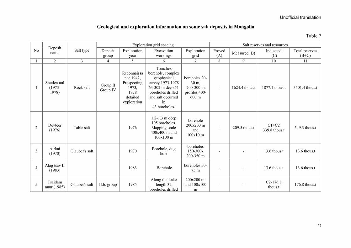
Information of geological settings, mineral composition, deposit groups, and exploration grids used in the exploration of salt deposits in Mongolia are shown in (Table 7).
In the case of isolated salt deposits formed in small ponds not exceeding a few tens of meters, exploration will carried out regardless of the above variants of exploration grids, a small number of 3-5 excavations and boreholes will be located in the deep and peripheral parts of the reservoir/pond. Then, it is possible that statistical methods based on field productivity can be used to resources estimation in the lake basin using resource estimation data based on exploration.
Unofficial translation
27
Geological and exploration information on some salt deposits in Mongolia
Table 7
No Deposit name Salt type
Exploration grid spacing Salt reserves and resources Deposit group
Exploration year
Excavation workings
Exploration grid
Proved (А) Measured (В) Indicated
(С) Total reserves
(В+С) 1 2 3 4 5 6 7 8 9 10 11
1 Shuden uul
(1973-1978)
Rock salt Group II Group IV
Reconnaissance 1942,
Prospecting 1973, 1978
detailed exploration
Trenches, borehole, complex
geophysical survey 1973-1978 63-302 m deep 51 boreholes drilled and salt occurred
in 43 boreholes.
boreholes 20-30 m,
200-300 m, profiles 400-
600 m
- 1624.4 thous.t 1877.1 thous.t 3501.4 thous.t
2 Devteer (1976) Table salt 1976
1.2-1.3 m deep 105 boreholes. Mapping scale 400х400 m and
100х100 m
borehole 200х200 m
and 100х10 m
- 209.5 thous.t С1+С2 339.8 thous.t 549.3 thous.t
3 Airkai (1970) Glauber's salt 1970 Borehole, dug
hole
boreholes 150-300х
200-350 m - - 13.6 thous.t 13.6 thous.t
4 Alag tsav II (1983) 1983 Borehole boreholes 50-
75 m - - 13.6 thous.t 13.6 thous.t
5 Tsaidam nuur (1985) Glauber's salt II.b. group 1985
Along the Lake length 32
boreholes drilled
200х200 m, and 100х100
m - - С2-176.8
thous.t 176.8 thous.t
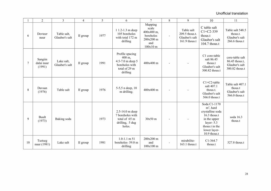
Unofficial translation
28
1 2 3 4 5 6 7 8 9 10 11
6 Devteer nuur
Table salt, Glauber's salt II group 1977
1 1.2-1.3 m deep 105 boreholes
with total 172 m drilling
Mapping scale
400х400 m, boreholes
200х200 m and
100х10 m
-
Table salt 209.5 thous.t. Glauber's salt 161.9 thous.t
С table salt С1+С2-339 thous.t Glauber's salt 104.7 thous.t
Table salt 548.5 thous.t.
Glauber's salt 266.6 thous.t
7 Sangiin
dalai nuur (1991)
Lake salt, Glauber's salt II group 1991
Profile spacing 400 m,
4.5-7.0 m deep 5 boreholes with total of 29 m
drilling
400х400 m - -
С1 core-table salt 86.45
thous.t Glauber's salt 300.82 thous.t
core-table salt 86.45 thous.t, Glauber's salt 300.82 thous.t
8 Davsan (1976) Table salt II group 1976 5-5,5 n deep, 10
m drilling. 400х400 m - -
С1+С2-table salt 407.1 thous.t.
Glauber's salt 566.0 thous.t
Table salt 407.1 thous.t
Glauber's salt 566.0 thous.t
9 Buult (1973) Baking soda 1973
2.5-14.0 m deep 7 boreholes with
total of 65 m drilling, 5 dug
holes.
30х50 m - -
Soda С1-1170 m3, hard
crystalline soda 16.3 thous.t in the upper layer- 5.3
thous.t in the lower layer-10.9 thous.t
soda 16.3 thous.t
10 Tsetseg nuur (1981) Lake salt II group 1981
1.0-1.1 m 51 boreholes- 59.0 m
drilling
200х200 m and
100х100 m - mirabilite-
163.1 thous.t С1-364.7
thous.t 527.8 thous.t
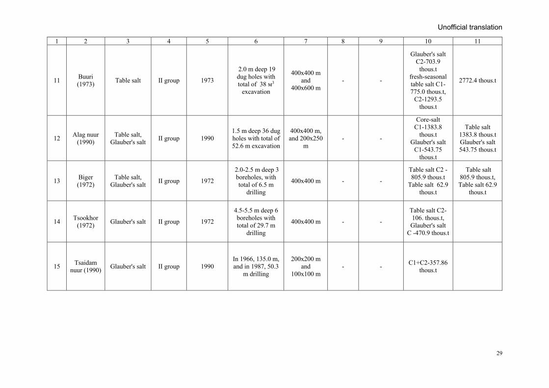
Unofficial translation
29
1 2 3 4 5 6 7 8 9 10 11
11 Buuri (1973) Table salt II group 1973
2.0 m deep 19 dug holes with total of 38 м3
excavation
400х400 m and
400х600 m - -
Glauber's salt С2-703.9
thous.t fresh-seasonal table salt С1-775.0 thous.t,
С2-1293.5 thous.t
2772.4 thous.t
12 Alag nuur (1990)
Table salt, Glauber's salt II group 1990
1.5 m deep 36 dug holes with total of 52.6 m excavation
400х400 m, and 200х250
m - -
Core-salt С1-1383.8
thous.t Glauber's salt
С1-543.75 thous.t
Table salt 1383.8 thous.t Glauber's salt 543.75 thous.t
13 Biger (1972)
Table salt, Glauber's salt II group 1972
2.0-2.5 m deep 3 boreholes, with total of 6.5 m
drilling
400х400 m - -
Table salt С2 - 805.9 thous.t
Table salt 62.9 thous.t
Table salt 805.9 thous.t, Table salt 62.9
thous.t
14 Tsookhor (1972) Glauber's salt II group 1972
4.5-5.5 m deep 6 boreholes with total of 29.7 m
drilling
400х400 m - -
Table salt С2-106. thous.t, Glauber's salt
С -470.9 thous.t
15 Tsaidam nuur (1990) Glauber's salt II group 1990
In 1966, 135.0 m, and in 1987, 50.3
m drilling
200х200 m and
100х100 m - - С1+С2-357.86
thous.t
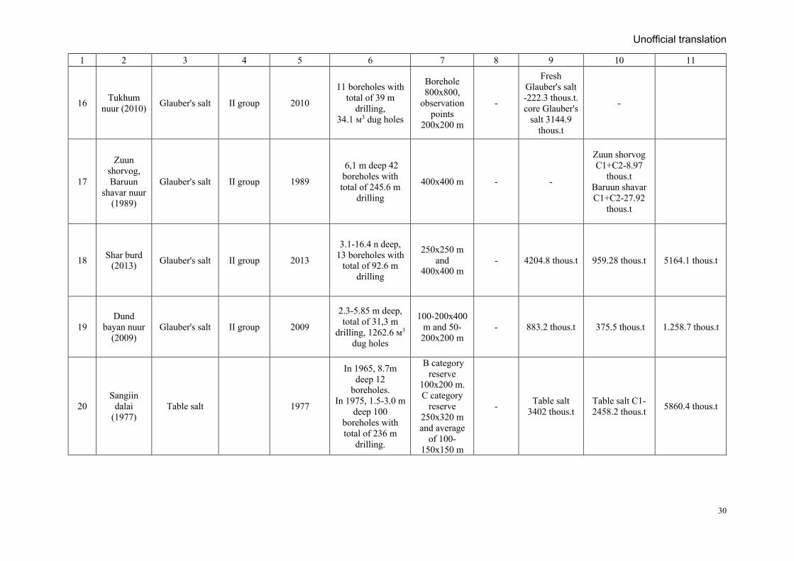
Unofficial translation
30
1 2 3 4 5 6 7 8 9 10 11
16 Tukhum nuur (2010) Glauber's salt II group 2010
11 boreholes with total of 39 m
drilling, 34.1 м3 dug holes
Borehole 800х800,
observation points
200х200 m
-
Fresh Glauber's salt -222.3 thous.t. core Glauber's
salt 3144.9 thous.t
-
17
Zuun shorvog, Baruun
shavar nuur (1989)
Glauber's salt II group 1989
6,1 m deep 42 boreholes with total of 245.6 m
drilling
400х400 m - -
Zuun shorvog С1+С2-8.97
thous.t Baruun shavar С1+С2-27.92
thous.t
18 Shar burd (2013) Glauber's salt II group 2013
3.1-16.4 n deep, 13 boreholes with
total of 92.6 m drilling
250х250 m and
400х400 m - 4204.8 thous.t 959.28 thous.t 5164.1 thous.t
19 Dund
bayan nuur (2009)
Glauber's salt II group 2009
2.3-5.85 m deep, total of 31,3 m
drilling, 1262.6 м3 dug holes
100-200х400 m and 50-200х200 m
- 883.2 thous.t 375.5 thous.t 1.258.7 thous.t
20 Sangiin
dalai (1977)
Table salt 1977
In 1965, 8.7m deep 12
boreholes. In 1975, 1.5-3.0 m
deep 100 boreholes with total of 236 m
drilling.
В category reserve
100х200 m. С category
reserve 250х320 m and average
of 100-150х150 m
- Table salt 3402 thous.t
Table salt С1-2458.2 thous.t 5860.4 thous.t
Unofficial translation
31
Three. Geological setting of deposit and studies of ore mineral component
3.1. For the explored deposits, it is necessary to have a topographic map, the scale of which would correspond to its size, the peculiarities of the geologic settings and local landscape- geomorphological conditions. Usually 1:10000 - 1:50000 scale topographic maps are drawn up for a salt deposit. All exploration and operational workings’ excavations (boreholes, trenches, open pit and vertical shafts of underground mines etc.), profiles and stations of detailed geophysical observations, as well as natural outcrops of salts and salt bearing rocks should be instrumentally tied. Subsurface mining works and boreholes must be plotted on the plan maps as indicated by engineering survey work (markscheider work). For boreholes, the coordinates of the points of intersection of the roof and the bottom of the salt body should be calculated and their locations have to be plotted on plans and plane of sections. Surveying plans of mining horizons are usually drawn at scale 1:200 to 1:1000, consolidated (unified) plans – at scale not smaller than 1:1000.
3.2. Geologic maps, geologic sections and plan maps are created on the scale of 1:2000 and 1:10000 depending on the size and complexity of deposits and geologic sections, plans, projection planes and if necessary, block diagram and 3D-models should be produced to study the geologic settings. Geological and geophysical surveys determine the salt body volume, shape, ore-forming conditions, structure, extension, characteristics, mineralization, distribution of minerals, host rock characteristics, fold structure, tectonic faults and their relations to the ore body to justify the final estimation of reserves. Apparently, it is necessary to justify the geological boundaries of the deposit and prospecting criteria that determine the location of prospective area within assessed resources in P1-category are estimated.
It should be noted that the geological and mineral resources map of the deposit area with a scale of 1:25 000-50 000 shows the geological structure of the deposit as well as the prospect of discovering a new deposit. In addition, the results of geophysical surveys conducted in the area should be reflected in the geological map of the scale.
3.3. Exploration of rock salt deposits is carried out to the depths mainly by column drilling, surface and borehole geophysical survey methods. The internal structure, location, shape, and size of deep salt bodies are determined by comparing boreholes, but in insufficient conditions some types of operational excavations are required.
Borehole and dug hole excavations are commonly used to explore the salt lake deposits at the bottom of the lake, while surface brine exploration is carried out by hydrogeological sampling and depth measurements.
Exploration methods, such as the amount and ratio of excavations and boreholes, types of excavations, methods and types of drilling, form and density of exploration grids, types and methods of sampling, allow estimating resources according to the categories appropriate to the geological composition of the deposit. The exploration methodology will be determined based on the geological settings of the deposit, the availability of excavation, drilling, geophysical techniques and equipment selected for exploration, and the experience of exploration and mining of similar deposits. In complex geological conditions, it is possible to use exploration tunnels,
Unofficial translation
32
vertical shaft penetrations and test hydrogeotechnological salt extraction during the exploration phase.
For deposits with high variability of key parameters determining the geological conditions (salt layer shape, internal structure changes, intense tectonic erosion, high gas content), to determine the quality and technological parameters of the mineral after the salt mine has been cut by a vertical mine, and detailed excavations and underground drilling are recommended to identify areas for priority mining. For example, all Verkhnekamsky salt deposits are being explored by underground drilling. If the results of the additional exploration work differ significantly from the results of the previous exploration work, appropriate changes shall be made in the select of exploration techniques and technologies.
3.4. Surface geophysical survey methods will be used to determine the lithological classification in geological section, boundaries of the distribution area of the salt strata, to determine the structure and thickness of the overburden, to study the surface relief of the salt strata, to detect major tectonic faults and karsts and cavities, and to study the hydrogeological features of the deposit. As salt-bearing strata differ from the host rock in terms of electrical conductivity, density, and radioactivity, therefore selection of appropriate surface and borehole geophysical complex methods should be used.
In order to increase the reliability and credibility of drilling information, need to select optimal complex geophysical study of the borehole.
Based on a complex carotaj (well logging) study in all boreholes, will control lithological classification of the geological section, salt body’s thickness, overburden rock structure and thickness, surface relief of the salt layers, tectonic faults and depressions. Thus, the drilling data should be confirmed by geophysical surveys (using the results of carotaj studies) and compared with the results of boreholes with maximum core recovery. If there is a significant difference between the geological and geophysical data, the cause should be identified and reported in the resource estimate report.
Exploration of salt deposits is usually carried out with large diameters (90-112 mm) borehole, in order to increase the core recovery.
Special concentrated saline solution (magnesium chloride saturated with table salt) is usually used in the drilling mud, while drilling in the lake without the use of special detergents is carried out with the addition of lake brine. The chemical composition and salinity of the drilling mud should be tested at the deposit to determine the type of salt in the deposit and whether their composition is changing.
During the exploration drilling of the salt lake deposit, it is possible to use bailer for core recovery in case of cavernous fracture occurs. Each borehole used in the exploration of the salt lake deposit was thoroughly sealed after drilling in a variety of ways, depending on the geological formation of the deposit, the silt layer of the lake bottom, and water pressure. It is possible to use a saline solution from the bottom of the lake to prepare the mix for borehole sealing.
Drilling technology should provide a core recovery of at least 90% for sylvinite and potassium sulphate salts at each sampling interval, and at least 80% for carnallite and bischofite rocks. The reliability of the core recovery should be monitored regularly by weight and volume.
Unofficial translation
33
Large-diameter drill cores are cut in half, and one half for laboratory samples to study the raw material technology, and the remainder is processed to prepare chemical analysis samples. The second half of the core is written in sequence and saved.
Angle azimuth and zenith of wells are measured continuously at each 20 m of interval of vertical drill holes with the depth of more than 100 m, and all types of adits. The measurement result is plotted in geological sections, plane maps and ore thickness calculation. If the diamond boreholes are intersected with subsurface excavation, the crossed point is examined by engineering survey line (markscheider). The angle between borehole and mineralization interval must be no less than 30o. The inclination is given artificially to intersect the ore body with a steep dipping.
The depth of the borehole intercepting a steeply sloping or slow sloping, thick ore body, the slope angle and the distance between the boreholes are designed to form a complete cross section of the ore body along the exploration line. If the salt body is found in a trench at the surface, in a borehole or in an underground excavation, all exploration work is combined with the underground section to identify all the layers of salt.
All boreholes have been drilled to the thickness of the salt layers or to the level of development of the deposit. If the depth of the salt body cannot be determined, deep shallow boreholes will need to be planned and drilled to determine the full depth of the salt deposit.
3.6. Open and underground excavations (if necessary, a combination thereof) are used to determine the internal structure, shape, and geological conditions of a salt body, and to verify technological sampling, geophysical surveys, and drilling data. Excavations provide basic information and detailed research on a given area or deposit.
3.7. The location of exploration workings and the distance between them shall be determined taking into account geological settings such as salt body location, size, structural-morphological type, geological structure and thickness, salt composition, salinity, aquifer thickness above the salt layer.
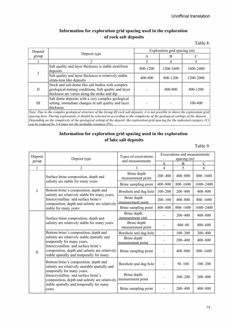
Tables 8 and 9 show the density of exploration grids used in salt exploration in Russia and the CIS.
As above mentioned, Table 7 provides information of geological settings, mineral composition, deposit groups, and exploration grids used in the exploration of salt deposits in Mongolia. This information can be taken into account when planning geological exploration work, but is not mandatory. This is because it may be more appropriate for each deposit to be selected based on an analysis of the geological, geochemical, geophysical, and operational data of the parts studied, or by comparing the densities of exploration grids for similar deposits.
Due to Mongolia's geodynamic conditions and the lack of large seawater reservoirs, Group I rock salt and lake salt deposits have not been discovered or are unlikely to be discovered due to their complex geological structure. Therefore, in the case of the small or medium-sized deposits, complexity of geological setting, which are likely to be common, it is necessary to conduct a study to optimize (usually thicken) the spacing of the exploration grid in relation to the geological setting of the deposit.
Unofficial translation
34
Information for exploration grid spacing used in the exploration of rock salt deposits
Table 8.
Deposit group Deposit type
Exploration grid spacing (m) А В C
1 2 3 4 5
I
Salt quality and layer thickness is stable stratiform deposits 800-1200 1200-1600 1600-2400
Salt quality and layer thickness is relatively stable strata-lens like deposits 400-800 800-1200 1200-2000
II Stock and salt-dome like salt bodies with complex geological-mining conditions, Salt quality and layer thickness are varies along the strike and dip
- 400-800 800-1200
III Salt dome deposits with a very complex geological setting, immediate changes in salt quality and layer thickness
- - 100-400
Note: Due to the complex geological structure of the Group III rock salt deposits, it is not possible to showt the exploration grid spacing here. During exploration, it should be selected in according to the complexity of the geological settings of the deposit. Depending on the complexity of the geological setting of the deposit, the exploration grid spacing for the indicated category (C) can be reduced by 2-4 times for the probable resource (P1).
Information for exploration grid spacing used in the exploration
of lake salt deposits Table 9.
Deposit group Deposit type Types of excavations
and measurements Excavations and measurements
spacing (m) А В С
1 2 3 4 5 6
I
Surface brine composition, depth and salinity are stable for many years
Brine depth measurement point 200–400 400–800 800–1600
Brine sampling point 400–800 800–1600 1600–2400 Bottom brine’s composition, depth and salinity are relatively stable for many years, Intercrystalline and surface brine’s composition, depth and salinity are relatively stable for many years
Borehole and dug hole 100–200 200–400 400–800 Brine depth
measurement point 200–100 400–800 800–1600
Brine sampling point 400–800 800–1600 1600–2400
II
Surface brine composition, depth and salinity are relatively stable for many years
Brine depth measurement oint – 200–400 400–800
Brine depth measurement point – 400–00 800–600
Bottom brine’s composition, depth and salinity are relatively stable spatially and temporally for many years, Intercrystalline and surface brine’s composition, depth and salinity are relatively stable spatially and temporally for many years
Borehole and dug hole – 100–200 200–400 Brine depth
measurement point – 200–400 400–800
Brine sampling point – 400–800 800–1600
Bottom brine’s composition, depth and salinity are relatively unstable spatially and temporally for many years, Intercrystalline and surface brine’s composition, depth and salinity are relatively stable spatially and temporally for many years
Borehole and dug hole – 50–100 100–200
Brine depth measurement point – 100–200 200–400
Brine sampling point – 200–400 400–800
Unofficial translation
35
Note: Due to the complex geological structure of the Group III lake salt deposits, it is not possible to showt the exploration grid spacing here. During exploration, it should be selected in according to the complexity of the geological settings of the deposit. Depending on the complexity of the geological setting of the deposit, the exploration grid spacing for the indicated category (C) can be reduced by 2-4 times for the probable resource (P1).
One of the features of salt exploration is that the possibility of compacting the exploration grid spacing is limited. This is because water infiltrates into the salt layer through the borehole, creating an aquifer and complicating exploration. Therefore, when exploring salt deposits (especially potassium-magnesium), try to achieve full results with as few holes as possible. To this end, efforts are made to improve the quality of drilling information by optimizing borehole placement, increasing core recovery, and using geophysical surveys. If it is necessary to control the location of the impermeable surface above the salt layer, additional holes can be drilled without penetrating the salt layer.
3.8. The special nature of the exploration of rock salt deposits is, if shorten the exploration grid spacing, the more holes penetrate the water-bearing horizon and transfer water to the salt body, which complicates the conditions of exploitation. With this in mind, need to do the fewest possible boreholes are drilled, maximum core recovery, and all information is obtained with the help of geophysical surveys. After this, protects the salt body from water by cementing the borehole from the entrance to the end with Portland-500, which hardens easily.
3.9. Exploration in some parts of the deposit should be more detailed to confirm resource assurance. The number and size of the detailed parts were determined by the deposit explorers in consultation with the Mineral Resources Professional Council (MRPC) experts and confirmed by the pre-feasibility study of the deposit.
The reserves can be estimated Proved (A) category in the detailed parts and horizons of the Group II deposit, and Measured (B) category in the detailed parts of the Group III deposits.
In the detailed study parts of Group III deposits, it is recommended that the exploration grid be at least twice the density of the Indicated (C) category resource grid.
In reserve estimation on parts that subjected to survey in detail, the exploration grid has to ensure the density is sufficient to substantiate the optimal interpolation using geostatistical modeling methods like as inverse distance weighting, Kriging and others. In the parts that subjected to survey in detail, should reveal the morphology of the salt bodies that containing main reserves, the details of the location conditions, and the main characteristics of the dominant salt. Such parts are should be located within the resource area to be mined in the first place. If the parts to be mined in the first place are unique, that they do not represent the whole deposit in terms of geological setting, ore quality and mining-geological conditions, it is necessary to identify and study the areas that meet the requirements. The number and size of the detailed parts are determined for each area of the deposit.
The all geological information of the detailed parts will be used for: to assess the complexity of the deposit; to select the exploration equipment’s, methods and exploration grids shape and spacing and their correspondence to the geological structure of the deposit; parameters used for the resource estimation; assess the accuracy of the sampling results, and to assess the mining-
Unofficial translation
36
condition of the whole deposit. In the case of deposits on going mining, the results will be used for pre-mining exploration and production.
3.10. All exploration workings and surface outcrops of the salt body should be documented. The results of the sampling shall be verified against the original geological record.
The Location of the salt layers will be compared with the findings in the exploration borehole sections. During the core documentation the location and thickness of the salt layers in the section should be compared with the carotaj (well logging) data. To do this, the core should be documented in color photographs.
Specially appointed commission has to monitor completeness and quality of primary geological documentation, which meets compliance with deposit’s geological features, correctness of determination of the spatial position of the structural elements, the preparation of sketches and their descriptions in the prescribed manner.
Furthermore, it should be controlled and assessed quality of geological and geophysical sampling (consistency of cross-section and weight of samples, their position corresponding to the peculiarities of the geological structure of the deposit, the completeness and continuity of sampling, the presence and results of control testing), the representativeness of mineralogical and engineering-hydrogeological studies, the determination of volume weight, sample processing and quality of analytical work.
3.11. All salt bodies detected in exploration workings and natural outcrops shall be sampled. The sampling method, the length of the sample interval, the initial weight of the sample, and the distance between the samples should be selected based on internal structure, thickness, degree of homogeneity and quality of salt layers and of natural forms of the salt. The salt layer occurs in all exploration workings should be sampled to its full thickness. Non-salt rocks layers between the salt layers and the salt layers, as well as the underlying and overlaying rocks are should to be sampled. Samples should be collected from each layers of different in salt composition and contaminant content. Sampling interval in a homogeneous layer is 1-2 m and it is possible to increase it up to 3-5 m in thicker homogeneous layers, but should not increase the sampling interval in the contact of the salt layers.
If it is not possible to separate very thin layers of non-salt rocks layers, they should be sampled together and the composition of their dissolved parts should be studied in advance. To select the sampling interval, based on the logging information is much more respected.
In the case of the lake salt deposit, it is possible to determine the conditions of salt layers to solidifies and dissolves by testing both the brine and saline water. Soil, bottom clay and water samples will be taken from boreholes in the salt lake recharge basin and the results will be used to identify aquifers of the lake recharge, and regime observations. Samples were also taken from all rivers and streams flowing into the lake, overflowing glaciers and dumps.
The sampling method should be give most accurate and credible results and must be efficient and cost-effective. The several sampling methods to be tested and requires consideration of their accuracy and the credible of the results. If sampling methods (core, channel, and chip, etc.) are selected, the accuracy of the sampling, processing methods shall be evaluated in appropriate methodology and recommendations.
Unofficial translation
37
In order to reduce the labor and cost required for sampling and sampling intervals should be determined in advance using logging or nuclear geophysical (electro-resistance, thermal, gamma-gamma, neutron activity, etc.) data. Geophysical sampling of salt deposits and use of their results in resource calculations will be guided by the “Guidelines for performing and reporting electrical, magnetic, gravimetric and aerial geophysical mapping in the territory of Mongolia, 2017”.
Core sampling from borehole and channel sampling from trenches.
A drill core with constant diameter (8-16 mm) shall be split in two parts along the axis by rock saw and all parts including the dust will be sampled, while a small diameter core shall be included in the sample as a whole. Drill core with different size of recovery and different characteristics shall be sampled separately. If the core is damaged, all materials should be included in the sample. The diameter of the channel sample to be taken from the exploration workings is usually 5x3 cm, and this size can be increased to 5x10 cm for obviously heterogeneous salts bodies. In the summer, when the air temperature in the shade is +35 - +400, the documentation and sampling of the salt minerals containing crystalline water, will necessary to do in the room condition
Salt minerals are usually absorb large amounts of moisture and are easily alters, therefore sampling should performed shortly after drilling was completed. High-moisture salts (carnallite, bischofite) and easily decomposable salts (kainite, langbeinite) should be covered with wax (paraffin) or placed in a sealed glass container and stored in a cool place. Samples of sylvinite or rock salt may be stored in a plastic bag until tested.
3.12. Salt lake sampling is carried out using a hydrochemical sampling method. Sampling and depth measurements cover the entire lake water with different depths and the sampling grid should evenly cover the surface of the lake. Sampling should include all types of brine and saline water. In the area of the lake shoreline, have to compact the sampling grid, and small isolated waters pools from the lake, downstream and lower reaches of the rivers all should be sampled.
Sampling from low-thickness (up to 1 m) brine layer, one sample from the focal point is sufficient. If the brine layer is thick, the brine should be sampled from the deepest part (10-20 cm above the brine and the bottom of the lake) of brine layer.
The brine sampling documentation should include the location, depth, date, time, temperature and density of the brine sample, as well as, if brine precipitates the amount of precipitation should be noted. Brine sampling is performed with the help of a specially designed sampler. In some cases, over-saturated brines evaporate and form new sediments at the bottom of the bottle, before analysis. Therefore, a comparative description of brine at the sampling site and at state of just before analysis should be provided.
3.13. Intercrystalline brine sampling is performed by borehole drainage after drilling. This sampling is carried out to in a specific interval (1-2 m) from the strata containing brine, to determine the brine yield, rock infiltration coefficient, and brine composition. Sampling is done during drilling and or after drilling when the brine composition is stable.
Sampling should be performed prior to cutting their layers to prevent contamination of salt by pressurized water which is usually located below the bottom sediment of salt lakes. The temperature and density of each brine sample should be determined. The temperature is
Unofficial translation
38
determined by measuring the depth of the sample. However, the brine density should be measured immediately near the borehole at the time of sampling. This is because over-saturated brines can also change its initial density due to changes in water temperature. The study of the brine layer between the salt crystals should also determine the porosity of the salt grains.
3.14. For long-term storing and transporting of surface brine and the intercrystalline brine results in precipitation of mirabilite, magnesium salts, crystalline soda, and glauberite due to temperature drop. In some cases, long-term storage results in the formation of salts layers with different densities in brine samples. Therefore, before repeated density measurements and analysis, the brine sample should be stirred well and warmed until the sediment at the bottom of the bottle is completely melted. The brine samples should be sent for analysis without delay.
3.15. Hydrochemical sampling will be carried out in appropriate methodology from the surface and groundwater, to study water supply conditions of the lake. Hydrochemical studies of large rivers flowing into the lake should be carried out regularly for a certain period of time, while hydrochemical studies of temporary streams and small streams should be carried out once. Sampling shall be carried out through a sampling grid evenly spaced from the lower, middle and upper reaches of the river. The number of samples should be more than 30. Groundwater sampling will be carried out in from the boreholes located in the groundwater flow area, to monitor aquifer strata and groundwater regime.
3.16. It is not uncommon for brine which is heavily contaminated with lake silt, to emit high levels of gases derived from organic matter in the sludge, usually methane. In this case, the gas sampling shall be performed according to the established methodology.
3.17. Regularly monitor each method and technique used to identify the main types of salt and the quality and accuracy of the sample.
Responsibility of the determination of the salt layer contacts, the location of the samples from different geological formation, the sample size, and the actual weight of the sample, the selected interval of channel sample or the core recovery (variation of rock density not more than ± 10-20%) should be monitored for compatibility all time.
In order to control the core sampling, it is necessary to determine the effect of salt dissolution in the drilling mud. To analyze the core recovery changes due to the salt solubility, and compare the content of soluble components, then based on the average content need to do indirect evaluation.
The control of the core sampling is verified by comparing the results of the channel, sparr and grouped samples from the exploration workings, as well as the results of borehole logging.
The salt content and salt resources of the mining deposit should be compared with those determined by column drilling and exploration workings (at the salt strata or reserve calculation blocks). The amount of samples for controlling purpose must be sufficient for making statistical analysis to reveal random or regular error, and determining correction quotient if necessary.
3.18. Sample processing is performed according to the scheme developed by the formula Q = kd2 for each deposit. The value of the coefficient k used for sample processing is usually equal
Unofficial translation
39
to 0.1 for salt deposits. k = 0.2 will be used for the potassium-magnesium salts with variable composition or the contaminant compound bearing salts.
Permissible sample processing schemes and k-coefficients should be monitored and approved for similar deposits or experimental studies. Samples should be processed using elimination methods of selected salt mineral or waste.
3.19. The chemical and mineralogical composition of the salt needs to be carefully studied in order to assess how the contaminant compound affects the quality of the primary and secondary product and the industrial significance. The content of all components identified in the salt sample shall be determined by using national standards or approved laboratory methods.
Mg2+, Ca2+, SO2-, Cl-, water and moisture absorption, crystallization water, water-insoluble and acid-insoluble residues are determined for all samples of industrial (KCl) potassium and potassium-magnesium salts. For all samples of rock salts and sodium sulphate salts, determine the of Na+, Ca+, Mg+, SO42-, Cl-, and H2O, and depending on the purpose need to determine water-insoluble residue and the acid-insoluble residue. The Na+ content is determined by calculation. Sodium analysis should be performed by flame photometry.
The content of CO32 ~ and HCO3 ~ is determined in grouped samples of the rock salt, potassium and magnesium salt deposits, while for all samples in sodium sulfate and natural soda deposits. For Natural sodium deposits determine Na+, K+, Ca2+, Mg2+, SO42-, Cl-, H2O, and water-insoluble and acid-insoluble residues.
The AI2O3 content determination by aqueous extraction method and water-insoluble and acid-insoluble residues should be analyzed for the dawsonite bearing and dawsonite rocks. Brightly colored and heavily contaminated salt samples should analyze for iron content.
Determine the bitumen in the salt layer with a mixture of organic matter.
In addition to the above elements, should analyze content of the bromine, boron, lithium, rubidium and cesium in the grouped samples of carnallite-bearing rocks.
For all samples of the lake brine and saline water, determine the of Na+, Ca+, Mg+, SO42-, Cl-
, H2O, insoluble residues and Br content. Some samples are determined for the content of Fe, CaCO3 and MgCO3.
In addition to identifying all components and compounds in the lake silt sample, Fe2O3 and S content analysis will be performed to determine whether the clay can be used for therapeutic (balneological) purposes.
Spectral analysis of Br, B, Li and other compounds can be performed to study some types of salts and useful accompanying compounds in the brine. In case of a large number of brine (saline water) samples, better to carry out hydrochemical analysis in the field site, for pre-determination of key contents. It may reduce the cost of expensive laboratory tests.
Chemical analysis of salt is performed on an ionic basis and converted to a salt composition, calculated as a percentage. For some multi-mineral salt deposits, the mineral composition of the salt has been determined. The result of ionic state analysis of brine should be used to evaluate the
Unofficial translation
40
hydrochemical regime of water, and the results should be expressed in units of moles, or in mg/l, g/l, and so on.
Grouped samples shall be selected from sections of the same level of grinding, of the same weight, from duplicates of conventional samples, from intersections of exploration sections, and from each type of non-homogeneous saline section. The interval length of a grouped sample of a thick, homogeneous salt layer shall be equal to the thickness of the salt layer and the samples weight shall be proportional to the length.
The principle of grouping the conventional samples is based on the total number of grouped samples, as well as the characteristics and production requirements of the components identified in each case.
3.21. It is necessary to regularly monitor the quality of the assay analysis and process the results in a timely, according to appropriate procedures. It is important that geological monitoring of samples be carried out during the exploration of the deposit, regardless of laboratory analysis. The monitoring shall include the results of the assay analysis of all primary and accompanying and contaminant components. Laboratory quality control shall use standard specimens with a guaranteed content and with certificate of origin, as well as blank and duplicate samples. Internationally accredited laboratories shall be used to prepare standard samples with a guaranteed grade for each type of salt.
3.22. To determine random error, samples taken from the remains of the analyzed samples are submitted to the laboratory where the previous samples were analyzed prior to the next season.
Also, external assay control is conducted by a laboratory certified for external control in order to reveal the regular errors and give assessment. The assay samples remained after taking for the internal control are sent to external laboratory control. A standard assay which has got the same composition as the target sample assay can be included in the group of samples submitted for external control.
All assay samples should be able to represent all types and contents of the salt. If too high content is identified, the assay (group of assay) should be sent for internal laboratory control.
3.23. The assay amount for external and internal laboratory control must be capable of being represent each classification of content identified during the analysis period (a quarterly, semi-annually, annually). The classification on content should correspond to the requirements for reserve estimation standard. In case of enormous amount of samples analyzed (more than 2000 per year), 5% of total samples should be submitted to external control. On the other hand, in case of few quantities, at least 30 samples from each type of ore should be sent to external laboratory control.
3.24. For each content group, internal and external controlling information will be processed at regular intervals (quarterly, semi-annually, annually) for each type of analysis and for the laboratory that performed the main analysis. The systematic error assessment based on the results of the standard sample analysis shall be performed in accordance with the methodology for statistical processing of the assay analytical data.
Unofficial translation
41
In the case of random error (relative average square) determined by the results of the internal control not exceed the values given in Table 10. In case of excess, the results of the main analysis of the content group and the results of the analysis of all samples at the time of the analysis at that laboratory shall be considered invalid. The analysis of the samples shall be repeated with internal control. The laboratory that performed the basic test must explain the cause of the error and take appropriate action to correct it.
3.25. In case of regular errors detected by external control, arbitration control is carried out in a laboratory that accredited in international level and certified to such a kind of activities. Duplicates of ordinary and external assay control samples, stored in the lab, (in exceptional cases, the remains of analytical samples) are submitted to arbitration control. 30-40 samples from each group for which systematic discrepancies are revealed are subject to control. If there are standard sample assay results similar to the samples under study, they should also be included in the encrypted form in the batch of samples submitted for arbitration. For each standard sample assay results, 10-15 control tests should be obtained.
When the arbitration analysis confirms the systematic differences, it is necessary to find out their causes and develop measures to eliminate them, as well as to decide whether it is necessary to re-analyze all samples of this class and the period of operation of the main laboratory or to introduce an appropriate correction factor into the results of the main analyses. Without arbitration analysis taken by Laboratory with International Accreditation, the introduction of correction factors is not allowed.
3.26. Any errors at the stages of delineation of ore contact due to results of sampling, processing, and monitoring and determination of parameters should be evaluated.
3.27 Volume weight and moisture content of salt are the key parameters used to estimate the reserves and they must be determined for each natural and industrial (technological) type, non-standard layer, type and variety of salt.
At least 10 to 20 samples of each type shall be taken to determine the volume weight by laboratory methods. Because the salt is soluble in water, consequently kerosene is used for hydrostatic weighing of the sample. Samples determined by volume weight and moisture shall be subjected to mineralogical analysis to determine all primary compounds. When calculating the volume weight of potassium, magnesium salts and natural crystalline soda reserves, it is necessary to take into account the relationship between the volume weight and content of some minerals of potassium, magnesium, soda and sulphate.
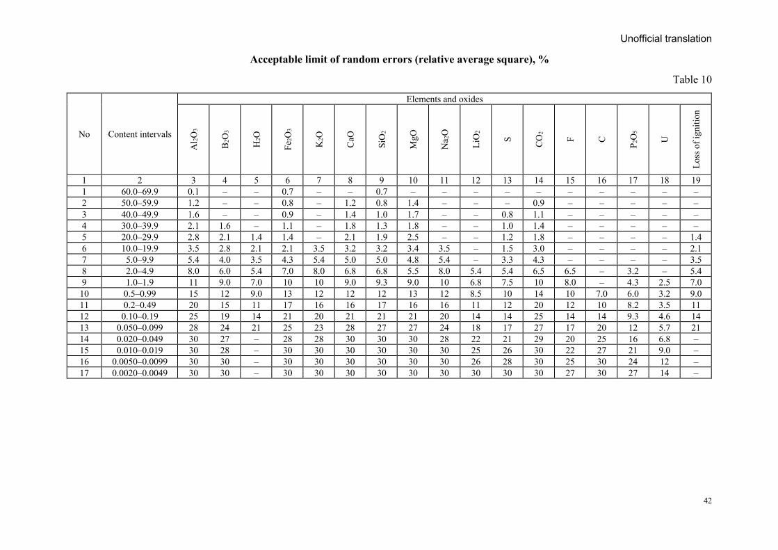
Unofficial translation
42
Acceptable limit of random errors (relative average square), %
Table 10
No Content intervals
Elements and oxides
Al 2O
3
B2O
3
H2O
Fe2O
3
K2O
CaO
SiO
2
MgO
Na 2
O
LiO
2
S CO
2
F C
Р 2О
5
U
Loss
of i
gniti
on
1 2 3 4 5 6 7 8 9 10 11 12 13 14 15 16 17 18 19 1 60.0–69.9 0.1 – – 0.7 – – 0.7 – – – – – – – – – – 2 50.0–59.9 1.2 – – 0.8 – 1.2 0.8 1.4 – – – 0.9 – – – – – 3 40.0–49.9 1.6 – – 0.9 – 1.4 1.0 1.7 – – 0.8 1.1 – – – – – 4 30.0–39.9 2.1 1.6 – 1.1 – 1.8 1.3 1.8 – – 1.0 1.4 – – – – – 5 20.0–29.9 2.8 2.1 1.4 1.4 – 2.1 1.9 2.5 – – 1.2 1.8 – – – – 1.4 6 10.0–19.9 3.5 2.8 2.1 2.1 3.5 3.2 3.2 3.4 3.5 – 1.5 3.0 – – – – 2.1 7 5.0–9.9 5.4 4.0 3.5 4.3 5.4 5.0 5.0 4.8 5.4 – 3.3 4.3 – – – – 3.5 8 2.0–4.9 8.0 6.0 5.4 7.0 8.0 6.8 6.8 5.5 8.0 5.4 5.4 6.5 6.5 – 3.2 – 5.4 9 1.0–1.9 11 9.0 7.0 10 10 9.0 9.3 9.0 10 6.8 7.5 10 8.0 – 4.3 2.5 7.0 10 0.5–0.99 15 12 9.0 13 12 12 12 13 12 8.5 10 14 10 7.0 6.0 3.2 9.0 11 0.2–0.49 20 15 11 17 16 16 17 16 16 11 12 20 12 10 8.2 3.5 11 12 0.10–0.19 25 19 14 21 20 21 21 21 20 14 14 25 14 14 9.3 4.6 14 13 0.050–0.099 28 24 21 25 23 28 27 27 24 18 17 27 17 20 12 5.7 21 14 0.020–0.049 30 27 – 28 28 30 30 30 28 22 21 29 20 25 16 6.8 – 15 0.010–0.019 30 28 – 30 30 30 30 30 30 25 26 30 22 27 21 9.0 – 16 0.0050–0.0099 30 30 – 30 30 30 30 30 30 26 28 30 25 30 24 12 – 17 0.0020–0.0049 30 30 – 30 30 30 30 30 30 30 30 30 27 30 27 14 –
Unofficial translation
43
All volume weight determination procedures (sample selection, measurement, weighing, and calculation) should be systematically monitored. The volume weight of rocks and salts can also be determined from density gamma-gamma logging data.
3.28. Chemical, mineralogical and petrographic composition and structural-textural features and physical properties of salts are determined by mineralogical, mineralogical-petrographic, physical and chemical analytical methods, based on these results, all natural and production (technology) types of salts well be identified, and their ratios, enriching or re-processed methods will be predicted. Petrographic description for the each salt mineral should be done, and their distribution and location ratios and quantities were must evaluated.
The relationship between salt minerals and non-salt minerals should be described and the size of salt crystals, their growth and intergrowth, dissolution, deposition characteristics, and gas and liquid inclusion contents should be recorded. The final evaluation of the (technological) type and variety of salt production is based on the results of technological sampling.
Four. Study of technological properties of salts
4.1. The technological properties of the rock salt, lake salt, lake brine and saline waters are studied in laboratory and semi-industrial conditions.
Due to the difficulty of obtaining enough material by core sampling from exploration drilling of rock salt deposits, salt technology research cannot be carried out at semi-industrial conditions, therefore laboratory technology research is usually carried out. If there is comparable experience of semi-industrial level, technological properties, its results can be compared with laboratory tests.
In case of, the salt materials of the proposed salt deposit are very different from the standard salt requirements, and absence of technical conditions and production experience, then technological testing shall be carried out according to a special program developed by the miners and consumers.
Sampling for technological testing shall be carried out in accordance with the “Methodological Recommendations for Technological Sampling of Mineral Deposits”. If this type of recommendation is not developed, it will be of the same quality as in other countries, for example, the Russian “Solid minerals and rocks. Technological testing in the process of geological exploration, 1998”.
4.2. Samples taken for the technology testing are fully representative with the chemical and mineral composition, structure, texture, physic-mechanical and other properties; the average content is also representative for the primary, accompanying and contaminants compounds of the main salt layers or entire deposit; types of salt (rock salt, lake salt, brine and saline water) should be in the same quality.
4.3. Technological mapping can be done to classify and differentiate all types and varieties of salt technology. The density of the technological mapping grid is selected depending on the location and sequence of the salt layers and their types interrupted in space. Technological mapping of the deposit should also be carried out in accordance with relevant guidelines. In the absence of a recommendation for this type of work, a similar recommendation, the Russian “Solid minerals and rocks. Geological-technological mapping, 1998” is available.
Unofficial translation
44
All natural types of salt in the deposit must be fully included in the mineralogical-technological and low-tech sampling taken by a certain grids.
As a result of this sampling, geological-technological classification of salt deposits was carried out, salt technology (production) types and varieties were classified and spatial changes of composition and physical-mechanical properties in salt raw material, and technological properties were identified within the salt technology (production) types. The all these results should be plotted in the geological-technological maps of the deposit, stratigraphic sections and plan maps.
For natural (mineralogical) types of salt raw materials, their mineralogical composition, structural-texture features, shape and size of salt crystals, growth-crystallization state, their size, mechanical impurities in crystals, fluid inclusions, hardness, solubility, salt water and moisture absorption were described using mineralogical-petrographic, chemical, physical and other research methods.
Documentations and descriptions of the individual minerals, and their spatial distribution should be described. The mineral composition of insoluble residues should determine. The average mineral content of the salt can be determined from studies of averaged samples. A detailed study of the mineral composition of the salt determined the content of calcium carbonate and magnesium carbonate with insoluble residues. It should be noted that the use of relevant graphs and nomograms in the calculation of mineral content simplifies the calculation.
During the mineralogical research, the primary, accompanying and contaminant compounds should determine, and the balance of their distribution in the mineral forms needs to be clear.
Samples for laboratory testing are usually taken from individual parts of the deposit, from the second half of the drill core, which was extracted during the exploration of the salt layers. The number of laboratory technology samples to be selected for the type and variety of salt depends on the stability of the salt content in them.
If the deposit is planned to be developed by hydraulic methods, samples of salt and unsalted rock layers will be carried out from the drill cores and rock mass. If the brine is intended to be used in the production of chlorine and caustic soda (sodium hydroxide) raw materials, the emission of hydrogen from the amalgam sample of the saturated solution shall be determined.
Laboratory technology research of salt mining should include all types of salt production (technology) of the deposit, define the main parameters of the processing technology, evaluate the quality of the products and select the optimal mode of mineral processing technology. To this end, rock salts have the least sludge waste and it is important to determine the optimal crushing rate to ensure full disclosure of the salt minerals. The possibility of using sludge-generating wastes during the beneficiation process, the method of decontamination of industrial wastewater has been identified.
Enlarged laboratory technology tests and semi-industrial technology tests are performed to monitor and validate the results of laboratory technology tests.
The purpose and direction of the salt semi-industrial technology test, the sample size and the sampling methodology shall be selected in accordance with the programs and agreements
Unofficial translation
45
developed jointly by the mineral exploration, mining, raw material consumers and technology testing project organizations.
Enlarged laboratory and semi-industrial technology tests were performed on samples capable of representing the average salt content of all types of salt production (technology), including chemical and mineral composition, structural-textural features, physical and other properties, and conditions of host rock contamination. In order to meet the above conditions for the representativeness of salt technology properties, changes in salt quality parameters should be studied in all directions of the deposit space (along the dipping, striking and thickness of the body) and calculated in the sample. Saline rocks with non-standard grades and salt-bearing rock layers that cannot be distinguished by reference resource estimates shall be sampled in the technological sample.
4.4. If the lake salt layer is covered with surface brine, or if the upper part of the salt layer is permeable to brine, conditions have been identified for salt enrichment due to brine leaching during salt extraction. In this case, the amount of salt concentration generated during the extraction process is determined by a comparative study of the salt content in the natural environment and the salt content extracted after brine washing.
For sulphate and carbonate salts (soda), the parameters of the recrystallization process have been studied and an appropriate technological scheme has been developed. To do this, the chemical composition of the salt and the natural crystallization of the salt are determined using isothermal and polythermal diagrams of the equilibrium medium of the saline solution. Using these diagrams, it is possible to determine the temperature regime for the extraction of salts from the saline solution with the required composition and the ratio of the salt compounds in the solution.
4.5. The study of the mineral composition and technology of the raw salt materials has sufficiently studied for complex use of the all mineral and to develop a technological scheme for its processing.
To conducting research to determine the main directions for the processing and use of salt minerals, a comprehensive study should be conducted to identify other areas in which it can be used, including a study to identify areas where waste from mining can be used.
4.6. Research to determine the quality of certain types of rock salt and the requirements for the study of products produced during its processing shall be carried out in accordance with established norms, standards and technical conditions.
4.7. The NaCl content of the table salt deposits varies from 76.9 to 98.9% in certain deposits. The content of calcium sulphate and contaminant compounds should not exceed 0.1-6.2%, and the content of insoluble residues such as magnesium carbonate, calcium carbonate, clays and bitumen should not exceed 10-20%.
The content of NaCl in table salt and technical salts, which are mined as crystalline salts, varies from deposit to deposit, but should average 98.1-98.5%.
In the case of salt leaching, the insoluble residue remains in the borehole and the NaCl content of the extracted water reaches 92-98.5% due to the high NaCl content.
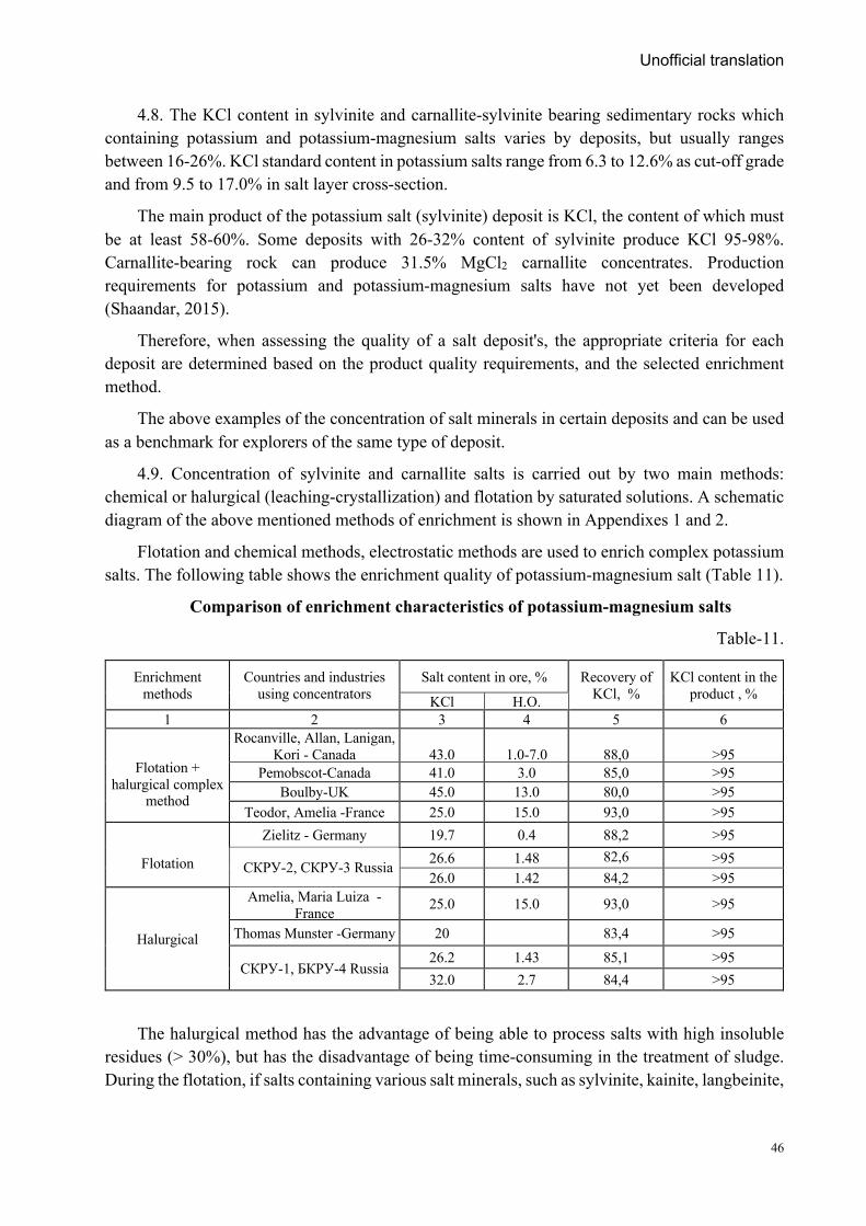
Unofficial translation
46
4.8. The KCl content in sylvinite and carnallite-sylvinite bearing sedimentary rocks which containing potassium and potassium-magnesium salts varies by deposits, but usually ranges between 16-26%. KCl standard content in potassium salts range from 6.3 to 12.6% as cut-off grade and from 9.5 to 17.0% in salt layer cross-section.
The main product of the potassium salt (sylvinite) deposit is KCl, the content of which must be at least 58-60%. Some deposits with 26-32% content of sylvinite produce KCl 95-98%. Carnallite-bearing rock can produce 31.5% MgCl2 carnallite concentrates. Production requirements for potassium and potassium-magnesium salts have not yet been developed (Shaandar, 2015).
Therefore, when assessing the quality of a salt deposit's, the appropriate criteria for each deposit are determined based on the product quality requirements, and the selected enrichment method.
The above examples of the concentration of salt minerals in certain deposits and can be used as a benchmark for explorers of the same type of deposit.
4.9. Concentration of sylvinite and carnallite salts is carried out by two main methods: chemical or halurgical (leaching-crystallization) and flotation by saturated solutions. A schematic diagram of the above mentioned methods of enrichment is shown in Appendixes 1 and 2.
Flotation and chemical methods, electrostatic methods are used to enrich complex potassium salts. The following table shows the enrichment quality of potassium-magnesium salt (Table 11).
Comparison of enrichment characteristics of potassium-magnesium salts
Table-11.
Enrichment methods
Countries and industries using concentrators
Salt content in ore, % Recovery of KCl, %
KCl content in the product , % KCl Н.О.
1 2 3 4 5 6
Flotation +
halurgical complex method
Rocanville, Allan, Lanigan, Kori - Canada
43.0
1.0-7.0
88,0
>95
Pemobscot-Canada 41.0 3.0 85,0 >95 Boulby-UK 45.0 13.0 80,0 >95
Teodor, Amelia -France 25.0 15.0 93,0 >95
Flotation
Zielitz - Germany 19.7 0.4 88,2 >95
СКРУ-2, СКРУ-3 Russia 26.6 1.48 82,6
>95 26.0 1.42 84,2 >95
Halurgical
Amelia, Maria Luiza - France 25.0 15.0 93,0 >95
Thomas Munster -Germany 20 83,4 >95
СКРУ-1, БКРУ-4 Russia 26.2 1.43 85,1 >95 32.0 2.7 84,4 >95
The halurgical method has the advantage of being able to process salts with high insoluble residues (> 30%), but has the disadvantage of being time-consuming in the treatment of sludge. During the flotation, if salts containing various salt minerals, such as sylvinite, kainite, langbeinite,
Unofficial translation
47
and polyhalite, which vary in solubility, may result in some of them (sylvinite and kainite) being incompletely dissolved and discarded with the washing liquid.
MgCl2 is a compound that harmfully affects the quality of potassium salts. Its limit content should not exceed 5% for flotation salts and 15% for halurgical method.
Due to the high vapor capacity of the halurgical method, the equipment can be easily corroded, while the flotation method requires a lot of electricity for fine crushing, therefore method of electric separation is always required as an adjunct.
To increase the emission of sodium chloride in salts with a high carnallite content (> 3%), the concentrating salt must first be thoroughly washed in a cold solution with a high sodium chloride and potassium chloride content.
Electrostatic and electrocoronal enrichment methods are widely used in salt processing plants in Germany, France and Canada. In Canada, a gravitational enrichment method is used to enrich sylvinite-langbeinite salts to produce langbineite. In Belarusian plants, the gravitational method is used to separate low-grade sylvinite in a magnetic suspension medium.
The most promising gravitational methods for salt enrichment are magnetic hydrodynamic separation (MGD-separation) and Ferro hydrostatic separation (FHS-separation). Concentration by magnetic hydrodynamic separation and Ferro hydrostatic separation methods not only classifies salt and other mineral grains in the working medium, but also classifies them electromagnetically.
Conversion methods are used for the extraction of more expensive and rare raw materials from rock rocks and saline solutions in addition to the main raw materials. This method is based on the chemical treatment of sodium chloride, potassium chloride and other soluble salts to obtain sodium and potassium carbonates and sulphates. An example of this is the production of soda ash by hydraulic (halurgical) treatment of sodium chloride with ammonia (Solve method).
4.10. Recently, due to the intensive use of leaching geotechnological methods in salt mining, the issue of processing the saline water has become an important issue. In Saskatchewan, Canada, sylvinite is mined hydraulically, with an average content of 13.4% potassium chloride and 18.8% sodium chloride in saline water. Under industrial conditions, this saline solution is evaporated by hot steam. After separation of the sodium chloride powder crystals formed by the evaporation of saline water, the solution with the remaining concentrated sodium chloride suspension is concentrated by centrifugation. After drying in a drum dryer, products with a sodium chloride content of more than 98.9% are sieved into fine-grained (-3.33 - +1.17 mm), coarse-grained (-2.38 - +0.28 mm), standard (-1.65 - +0.1 mm) products. As well as produce table salt.
The Cane Creek mine in Utah, USA, is filled with saline water with a density of 1.24 g m3, containing 11.5% potassium chloride and 20.1% sodium chloride. The saline water is pumped into a sedimentation basin and then evaporated to precipitate sylvinite containing 37% sylvinite and 54% halite. Sylvinite sludge is enriched by flotation to produce commercial products.
Usolye “Sibsol” company in Russia processing saline water which contains NaCl 307.6 g/l, CaSO4 4.8 g/l, CaCl2 0.162 g/l, Ca(HCO3)2 0.075 g l and MgCl2 0.399 g/l, respectively. After purification, fine-grained sodium chloride is evaporated in a vacuum crystallizer. The final product
Unofficial translation
48
is produced by drying the powder crystals after separating them from the original solution on a vacuum sieve. The remaining brine is recycled along with the saline water. After several cycles of treatment, if the contaminants and insoluble residues in the source solution exceed the appropriate level, the source solution is placed in the sludge tank.
Electrolysis is a more advanced form of electrochemical treatment of saline solutions. This method places a concentrating solution in the center chamber of a three-chamber electrolysis chamber and cathodes in the two outer chambers to precipitate anions and cations from the solution. The salt in the solution is removed to the cathodes by an electric current, which purifies the solution in the middle chamber. This method is widely used in countries such as Japan to extract saline water from the sea and then for salt production.
The study of salt accompanying compounds, like other minerals, was conducted in accordance with the requirements of the “Methodological Recommendations for the Comprehensive Study of Mineral Deposits and the Estimation of Accompanying Compounds of Mineral Reserves”. If this type of recommendation is not developed, it is possible to use the Russian "Recommendations for the comprehensive study of sites and the calculation of reserves of associated useful minerals and components, 2007". In addition, direction of the use of circulating water used in the concentrator and the waste generated during the treatment process has been identified, and recommendations have been developed for the treatment of industrial water.
Five. Studies of hydrogeological, engineering-geological, geo-ecological and other
natural conditions of deposit
The study on the hydrogeological condition of the deposit will be followed the “Thematic, medium and large scale hydrogeological mapping, guidelines and requirements for hydrogeological survey of deposits during mineral exploration” which is approved by the Order No. A/237 of the Minister of Mining and Heavy Industry dated December 12, 2017.
5.1. Hydrogeological study of rock salt deposits. The hydrogeological conditions of the deposit area will be studied in detail and hydrogeological maps (depending on the geological settings and size of the deposit) on a scale of 1: 1000-1: 10000 will be prepared.
Hydrogeological maps (permeability maps-operational geotechnological maps) and sections should include the following information: basic hydrogeological conditions of the deposit, the permeability of the salt layers and host rocks, and the geotechnological conditions of the permeability and lithological characteristics of the industrially important strata and the impermeability layer, its thickness, the groundwater layer, and the characteristics of the aquifer above and below the production layers.
5.2. Hydrogeological surveys should identify the main aquifers that are at risk of being completely submerged in the deposit, identify areas and zones that contain large amounts of water, and decide how to use or remove the mine water.
For each aquifer and horizon, its thickness, lithological composition, collector types, feeding conditions, other water-bearing zones, horizons and their relationship to surface water, groundwater statistics, dynamic level location and other parameters must be determined. The feasibility study should identify the potential inflow of water into the excavations, make
Unofficial translation
49
recommendations for groundwater protection and the impact of groundwater on the slope stabilization of the mine, and assess the following: These include:
- Determining the hydrogeological parameters of the aquifer (infiltration coefficient, water transfer coefficient, water intake, etc.) by drilling and pumping hydrogeological boreholes,
- Determination of chemical composition, bacteriological condition, concrete structure, corrosive properties of metals and polymers, useful and polluting compounds in the water, chemical composition of mine water and waste water from the mines involved in the flooding of the deposit,
- Assess the possibility of using the mine water for water supply and extracting mineral resources from it, and assess the potential impact of the deposit on the groundwater accumulation reservoir in the vicinity of the deposit;
- Advise on the need for further detailed research and assess the environmental impact of the mine water;
- Identify potential sources of domestic and technical water supply for future mining and processing industries.
If it is planned to use the water discharged from the mine, the assessment of the use water resources will be done in accordance with the relevant normative and methodological documents.
During exploration, the following geotechnical studies and developments are required at the deposit. These include:
- Water permeability, filtration, collector properties of aquifers and aquifer feeding conditions, seepage conditions, interaction of aquifers and surface water, chemical and gaseous composition of groundwater, temperature etc. should be reflected in the plan and section;
- Hydrogeological parameters: water permeability and piezoelectric conductivity, as well as groundwater pressure, macro-voids in the water supply system (karst cavities, fracture zone, etc.) and their changes should be in noted in the plan and section,
Rock salt production deposits are waterless and highly waterproof. However, post-sedimentation and technogenic saline solution accumulation may occur after hydraulic backfilling during operation. In this case, appropriate research should be conducted and the saline solution removed from the work area.
5.3. Hydrogeological study of the lake salt deposit. In order to assess the salt and brine and saline water resources of a lake in dynamic equilibrium, it is necessary to study the hydrology, hydrogeology, and hydrochemical regimes of the salt lake, including the stability of the brine and saline water and bottom salt composition.
Changes in the state of a salt lake over time (lake regime) are usually cyclical and repeated with various changes over a long period of time.
5.4. The hydrogeological regime of a salt lake depends on the geological settings of its recharge basin and drainage basin, the presence of surface and groundwater and chemical composition.
Unofficial translation
50
Salt lakes, which are fed by groundwater throughout the year, are more stable than surface ones. Groundwater accounts for more than 20% of the salt balance of most salt lakes.
Groundwater often enters the sediments at the bottom of the lake in the form of springs, discharges into them and forms "windows" of various sizes, such as streams.
5.5. The hydrological regime of a salt lake (fluctuations in the level and thickness of the saline water) depends on changes in the amount of incoming water and the amount of evaporation. Surface brine depths in salt lakes are usually 0.5-1 m and occasionally more than 5 m. The amount of brine varies throughout the year in different regions and lakes. The maximum fluctuations in surface brine level typical in a small lakes or lakes with very uneven feeding, which are located in the periphery of the arid climate zone and it can reach up to 1 m. In the "dry" lakes, changes in surface brine level fluctuations are much smaller and usually do not exceed 0.5 m. In the spring season, the surface brine disappears, and the intercrystalline brine crystals settles 3-5 cm below the surface of the salt layer; but in summer season it reaches 10-12 cm, and in some lakes 30 or even 60 cm.
5.6. The hydrochemical regime of salt lakes is determined by the chemical composition, the compositions of surface and bottom brines, and the amount of salinity and the ratio of salts in the liquid and solid phases.
The greatest changes in the chemical composition of brine and salt ratio occur in spring and summer. During the summer, salt deposition is most pronounced when the brine content increases due to increased evaporation. In the spring, the process of dissolution (partial or complete) of salts precipitated in the brine by groundwater and surface water, or the formation of salt minerals is slowed down.
In the autumn-winter period, the chemical composition of brine changes little, and the formation of salts slows down. However, mirabilite crystallizes the most in winter due to a sharp decrease in its solubility at low temperatures. In summer, complete or partial dissolution slows crystallization.
The condition and regime of the lake affect things such as salt extraction, drainage, and irrigation.
5.7. The assessment of the conditions of exploration and mining of lake deposits is based on the study of changes in the salt balance of the lake water on a monthly, quarterly, annual and long-term basis. For this purpose, systematic monitoring of fluctuations in brine levels between surface and intercrystalline brines, their salinity and temperature, chemical composition, and changes in brine salinity should be performed over a period of 2-3 years. If the results of the observations in those years differ significantly, the observations should be continued for another 1-2 years.
In some cases (where sufficient long-term observation data from the nearest meteorological stations are available) the lake regime observation period can be reduced to 1 year. Observation posts on salt lakes should determine both the amount of freshwater in the lake as a whole and the areas that change the most during the year.
Unofficial translation
51
5.8. The number of observation posts depends on the size of the lake. The main surface water monitoring station should be integrated with groundwater sources near the lake, springs on the lake shore, and evaporation monitoring points.
Observations of brine status at these posts should be combined with integrated meteorological observations of air temperature, humidity, wind direction, speed, air pressure, and precipitation at different altitudes (usually 0.1; 1 and 2 m). In large lakes, it is necessary to monitor the flow and movement of brine into the lake.
Observational studies of lake deposits at the bottom brine should be expanded by systematically studying the intercrystalline brine status. Regular monitoring of intercrystalline brine levels at different depths, density, temperature, composition, and salinity are usually performed in a single well.
In fresh brine lakes, it is necessary to determine the onset, duration, and end of precipitation, solubility of the salt, the thickness of the new brine layers in different parts of the lake, and to take samples for analysis.
5.9. To study the groundwater level, it is usually necessary to drill a hole or dig a trench along an exploration line located perpendicular to the lake shoreline, in order to detect the depth of the aquifer along the shoreline and the lake bottom. These boreholes will be used for complex hydrogeological surveys and to clarify the lithology of salt bearing rock at the bottom of the lake.
Surface and lake bottom aquifers need to be studied in detail (their thickness, location conditions, feeding conditions, water chemical composition, statistical and piezometric levels, aquifer rock permeability, flow velocity) and their interactions, as well as surface water and brine interactions needs to be determined. The impact of groundwater on the formation of lake salt deposits should be identified and the possibility of distinguishing between them and surface water explored deposits should be assessed.
5.10. In all cases, in addition to the study of salt lakes, systematic monitoring of the lake's hydrogeology, hydrology, hydrochemical regime, and climatic parameters is required during subsequent development. The optimal frequency of regime observations (once every 3 days, once every 10 days, and even once a month) is determined at the beginning of the exploration work.
During exploration, meteorological data should be collected over a sufficiently long period of time to predict the estimated resource stability over the course of the season and throughout the development period.
Given that most salt lakes have not been fully studied, stationary observations should be repeated every 10 to 15 years at reduced rates.
5.11. Along with the forecast of the natural stability of the salt lake resources and regime, it is necessary to predict the redistribution of salt in the deposit as a result of future development and the changes that may lead to their change (quality, corrosion, karst and cavities formation, etc.).
To predicting the salinity of the salt lake regime and the sustainability of natural resources, future development needs to predict how the redistribution of salt in the deposit, salt quality, siltation, and deformation will change.
Unofficial translation
52
Based on the preliminary estimates, it is recommended to suggest the optimal mining method and optimal capacity to ensure long-term sustainable mining of lake salt.
Based on the results of the hydrogeological survey, recommendations will be made for the development of the mine project on the following issues. These include: drying of geological formations, drainage, and use of discharged water, water supply sources, and environmental protection.
5.12. Engineering-geological (geotechnical) survey. Engineering and geological surveys of deposits during exploration are intended to provide the information needed to develop a mining project (calculation of the main volume of open pit and benches, drilling and blasting and anchorage work passport, etc.) and to ensure safe access to mining operations.
Engineering-geological surveys should study the physical and mechanical properties (rock strength properties, elasticity of rocks) that determine the strength of saline aquifers, host rocks, and sediments under natural conditions and water saturation. It is also necessary to study the thickness and structural changes of the impermeable layer above the salt layer, as well as the degree of "cap" structure of the salt dome. In the case of steep vertical strata, it is necessary to determine their depth in the places where the surface salt mirror slip (salt diapir structure) is interrupted.
5.13. Special attention should be paid to the conditions of exploitation of potassium-magnesium and potassium salt deposits in hydrogeological and mining-technical conditions. Underestimating them can lead to accidents at the mine or flooding of the mine. At the current level, the processing of sylvinite and carnallite layers will be carried out according to geomechanical calculations, taking into account the load on the safety columns between the chambers and the allowable deviation of the salt layer in the overlapping part of the useful layer. In this case, the density of the tailings, the processing distance of the salt, and the formation of the decomposition zone within the salt layer are taken into account. Geomechanical calculations will limit mining in areas identified as having structural changes.
Within a rock salt deposit, it is classified into 4 groups based on the formation and complexity of the internal fracture zone. Exploration and mining activities are not permitted in the Group 1 zones, only one layer of salt can be mined in the Group 2 zones, and mining is possible with some restrictions in the Groups 3 and 4 zones.
The internal fracture zones are usually closely related to the process of rock salinization of sylvinite and carnallite.
5.14. In mountainous areas, conditions that may complicate exploration and mining activities, such as landslides, floods, and landslides, need to be explored.
In permafrost areas, the temperature regime of permafrost rocks, the upper and lower boundaries of permafrost strata, thawing boundaries, depth distribution, and physical properties of rocks during thawing, seasonal freezing and thawing depths are determined.
5.15. In deposits where natural gas (methane, hydrogen sulphide, etc.) has been identified, the composition and content of the gas are studied in terms of changes in the size and depth of the
Unofficial translation
53
deposit. The impact of rock fractures on the gas source and gas content, and the direction and pattern of gas movement should be studied.
5.16. Mining of rock salt deposits is usually done by open pit mining and underground mining. The most convenient and widespread exploration system is the camera (panel-block) system. This depends on the depth of the deposit, the solubility of the salt in the water, and the ability of the salt mineral to absorb moisture.
Recently, geotechnology for leaching salt from surface boreholes has been widely used in many deposits, including in Russia. In Russia, the mine is operating at depths of up to 600 m (in Germany up to 1400 m), geotechnically at depths of up to 1600 m (sylvinite deposit in Saskatchewan, Canada), and potassium salt leaching at depths of 2400 m (Michigan Salt Basin, USA).
In Russia, experiments on the extraction of magnesium salts (bischofite) by underground leaching have been carried out at the Gorodishchensky group of deposits, which have solved the following problems.
Determine the level of salt solubility of the salt layer and achieve the maximum salt content in the saline solution;
- Potential for salt production from one borehole and one mining area;
- Camera stability and surface subsidence (the typical camera scheme used in the bischofite deposit test is shown in Appendix 3).
In the case of lake salt deposits, it is necessary to study how surface and groundwater regimes, brine levels, lake recharge regimes and salinity status may affect non-exploration and development activities in the area (irrigation, rehabilitation, dam construction, etc.).
It is also important to assess the impact of the development of salt lakes on the condition of adjacent areas (e.g., wind-blown salt from reservoirs, salt evaporation, etc.) and to provide an overview of industrial waste storage areas.
If there are other brine lakes in the vicinity, their use as temporary and permanent storage facilities should be explored, if necessary, to consider the appropriateness of using their brine to regulate the hydrochemical regime of the lakes used and to refill salt reserves.
5.17. The main purpose of geoecological research is to provide necessary information on environmental protection measures during the implementation of mining projects.
The following research has been conducted in the field of geoecology. These include: determining baseline indicators of environmental conditions (radiation levels, surface and groundwater and air quality, soil cover, flora and fauna, etc.); predicted types of chemical and physical effects on the environment during the construction of the proposed facility (surface dust, mine effluent, concentrator effluent runoff, surface and groundwater and soil contamination, and airborne contaminants etc.,) to determine, the amount to be used from natural resources to meet production needs (forest areas, water for technical purposes, lands required for primary and secondary production, overburden and host rocks, non-standard ore stockpiles, etc.); assessment
Unofficial translation
54
of the nature and intensity of the impact on the environment, the dynamics of the sources of pollution and the boundaries of their impact zones.
The use of traditional technologies for the processing and extraction of salt can lead to the formation of large amounts of salt waste, which should be recommended for storage. Recommendations should be made for the method of "screening" tailings and sludge and, if necessary, for the absorption and disposal of liquid tailings at great depths.
In order to protect the geo-ecological environment of the lake salt deposit, it is necessary not to mow the reeds around the deposit, not to use it as pasture for livestock, and not to move rocks and build fences.
5.18. Particular attention should be paid to predicting the environmental impact of the exploration of lake salt deposits. It is necessary to study the process of changing the natural landscape of the area, changing the regime and composition of surface and groundwater, water and air pollution, economic turnover, and possible negative impacts on soil fertility.
5.19. It is necessary to study the possibility of using the area where the new deposit is found to be free of salt and other minerals to build industrial and residential and civil buildings, as well as to store waste and create empty stone stockpiles. These should be non-farmland and non-forested land. The availability of local construction materials should be explored and feasibility studies should be conducted on the feasibility of using ready-made construction materials from the stripping of the deposit as flood rock.
5.20. Factors affecting human health (effects on the lungs, high levels of radiation, distribution of tendon minerals, geothermal conditions, etc.) have been identified.
Research will be conducted in accordance with relevant methodological recommendations to rehabilitate land disturbed for rock salt mining and processing, to establish suitable land for wastewater disposal, to use waste industrially, to organize circulating water supply, and to create other conditions.
In order to solve the problems related to the rehabilitation of the lake salt deposit, it is necessary to determine the thickness of the soil cover, conduct agrochemical study of fluffy sediments, determine the level of impact of sediments and the possibility of vegetation formation. Recommendations should be made for subsoil/land protection, environmental remediation, and biological rehabilitation.
5.21. If there are deposits or mines operating in the deposit area with similar hydrogeological and engineering-geological conditions, the data obtained during their mining should be used to determine the irrigation and engineering-geological conditions of the new planned mine.
5.22. The hydrogeology, engineering-geology, geocryology, mining-geology and other natural conditions of the mining period were studied using the necessary geological, geophysical and other methods to provide the initial information needed to develop the deposit and land development project. In the case of highly complex hydrogeology, engineering-geology and other natural conditions during mining, the scope, duration and procedure of the survey work shall be agreed with the land user and the project organization if special work is required.
Unofficial translation
55
Future mining and processing plants need to be assessed for potential sources of drinking and industrial water supply.
If the types of minerals within the reservoir and covering sediments, such as mineralized groundwater and brine, form individual bodies, their industrial significance and potential applications should be studied to the acceptable level.
Six. Reserve estimation and resource evaluation
6.1. Reserve estimation and resource assessment on aluminum ore deposit is completed in accordance to the requirements of the “Classification and guideline of mineral resources and reserves of deposits, 2015”.
6.2. Deposit reserves are calculated in blocks. The reserves are calculated by and it is characterized by following items: the same degree of exploration parameters and study level determining the quantity and quality of mineral resources; homogeneity of the geological structure or approximately the same or similar degree of variability in the thickness, internal structure of the salt bodies, the salt composition, the main indicators of the quality and technological properties of the salt; stability of salt-body positions, the reserve blocks of the salt bodies located in the same structural element (on the same limb or in core of fold, or in same tectonic block, limited by faults); and common mining and technology conditions of operation. In the case of lake salt and brine, the reserves are calculated by classifying the resource blocks by the lake basin and its parts, by separating the bottom brine, surface brines, and intercrystalline brines.
In the case of lake salt, the resources are classified according to the solid and liquid conditions of the salt. Brine resources can be calculated by volume (thousand m3) and mass (thousand tons).
Reserves are classified according to the natural and technological types and varieties of salt identified during the exploration, as well as mining methods and technologies, and according to the level studied, in the following categories.
6.3. Proved (A) category reserves are calculated for the group I deposit that meets the requirements for the same category reserves. In addition, for Group II deposits, based on exploration and production data, it is possible to estimate the reserves in the mined and prepared areas with a Proved (A) category.
In the case of a deposit belonging to a Proved (A) category resource, the spatial location, shape, size, internal structure, non-standard content within the stratiform and lens-like bodies’ spatial location, mineral quality indicators and their spatial variation patterns are determined. The high level of confidence has been studied and established. The sediments of the lake bottom should be classified for ultimate, by structurally as stratiform and lens-like layers etc., and by origin (fresh, seasonal and core-salt bodies’ salts, sedimentary salts, precipitation salts, etc.) of the sediments.
Proved (A) category reserves do not include on blocks with high-pressure roofing rock, composite structures, and sodium salt-potassium and magnesium salts.
Proved (A) category reserves reserves for brine is also calculated for Group I deposits, and the following criteria are used in the resource criteria.
Unofficial translation
56
- The chemical composition, salinity, depth of placement, depth of the brine should be determined based on sufficient number of samples and measurements.
- Within the distribution area (lake basin) of the brine, the lake regime of changes of the above parameters should be studied annually and seasonally (winter, summer).
- Results of long-term observations and measurements should be used to determine the amount to which the brine is diluted with surface or groundwater.
- Provide long-term research data that can predict changes in brine composition and resources during the mining period.
In Group II deposits, it is possible to estimate the salt reserves with a Proved (A) category based on the exploration and production data and in the areas studied to meet the requirements of the category.
The range of Proved (A) category reserves is limited by exploration workings and boreholes and, in the case of lake brine, by the location of sampling and measurement parameters.
6.4. Measured (B) category reserves are calculated for the areas that have been explored to meet the same category criteria for Group I and Group II deposits.
In the part of the deposit belonging to the Measured (B) category reserves, are the large stratiform and lenses with the general pattern of location and their reserves have been determined with one version. It is possible to use different variants in the area of the section with small changes, as long as it does not affect the general layout. The location of tectonic faults and the amplitude of their shifts were determined. Statistically assessed the karst and cavities, non-standard salt layers within the reserve block, and the size and location of the host rock. Reserves should be classified as much as possible to distinguish the types and varieties of salt production (technology). If this is not possible, their spatial location and resource ratios are statistically assessed.
For the deposit and/or part of the deposit developing by geotechnological methods, its Measured (B) category reserves shall be calculated within the scope of test pumped boreholes, or if there is experience of geotechnical mining in the same condition as the deposit, it shall be carried out in areas that have been leached and confirmed by laboratory tests.
In the case of Group II deposits, the Measured (B) category reserves block is usually limited by boreholes and excavations. Extrapolation may be performed at a distance of not more than half of the Measured (B) category exploration grid, if confirmed by geological data.
The most of the reserves of the Group II deposit has to be estimated at the Measured (B) category at the exploration stage.
Based on the pre-mining exploration and production data of the Group III deposit; and if the level of exploration information that meets the requirements of the Measured (B) category in the detailed parts of the Group III deposit; it is possible to estimate the reserves in the Measured (B) category.
The following parameters have been identified for the calculation of brine and its salt reserves for the Measured (B) categories.
Unofficial translation
57
- Changes in the chemical composition and salinity of brine are determined by the systematic studies.
- Changes in the hydrochemical and hydrogeological regime of the salt lake over many years have been assessed.
- The distribution areas and average depths of brine are estimated at its maximum and minimum levels.
- The area with the highest groundwater intake in the lake was identified through a few numbers of boreholes.
6.5. Indicated (C) category reserves shall be calculated for areas that have been explored to meet the requirements of this category for Group I, II, III and IV deposits.
In the case of Group I and II deposits, the remaining reserves in the marginal and deep parts of the high- category resource have been explored to meet the Indicated (C) grade reserve requirements, while the Indicated (C) category reserves is estimated by geologically justified extrapolation based on borehole data.
For Group III and IV deposits, the main resource estimation grade is the Indicated (C) category, and also, if the exploration results meet the grade requirements. For Group III deposits, the Indicated (C) category reserve is limited to exploration excavations and boreholes. Based on the complexity of the geological setting of the deposit, the range of the Indicated (C) category reserves can also be determined by extrapolation to a distance of not more than half of the grade exploration grid.
In the Indicated (C) category reserves of the deposit and its parts: general pattern of the salt deposition and salt-bearing strata; depth and average thickness of the salt layers; assessment of the non-standard salt layers and overburden within the part of the reserve; and the spatial distribution of the industrial (technological) types and varieties of salts and their ratio should be determined.
In order to estimate brine reserves at an Indicated (C) category, hydrogeological and hydrochemical regimes were determined by special measurements, changes in brine salinity and composition were assessed, and depth and boundary changes in brine distribution were determined annually and perennially.
6.6. At the periphery parts and depth levels of the deposit, the resource is assessed on a Probable resources (P1) category based on a small number of boreholes and measurement data.
The boundaries of the Probable resources will be determined by extrapolation based on the results of geological settings, geophysical and hydrochemical studies of the deposit. If no reserves have been estimated for the deposit under study, the value of the Probable resources (P1) will be based on the geological and structural conditions of the salt accumulation and the formation of the lake basin.
It has been noted above that the amount of extrapolation for reserves in Measured (B) and Indicated (C) categories and for Probable resources (P1) category should be different for each category. Extrapolation should not be carried out in case of the thinning and branching of the salt strata, weakening of salt quality, decreasing situation of mining and geological conditions.
Unofficial translation
58
6.7. If the intercrystalline and surface brines and buried brines are to be independent exploration and mining objects, their exploration and resource classification shall be based on the “Guidelines for the classification of groundwater resources”. It is also possible to use the Russian “Methodological Recommendations on the Application of the Classification of Operating Reserves and Forecast Resources of Subsurface Water to Industrial Water Areas, 2007” in the same content as the above recommendations.
In the case of lake salt deposits, the individual salt depositions and brines are classified, their reserves are calculated separately according to the above-mentioned guidelines, and the salt content and quantity of other components are assessed and the lake salt-water balance is determined.
6.8. Statistical estimations of the stability of the salt layers thickness, changes in contents of useful components and minerals, and salinity coefficients are can be used to classify reserves of the deposit.
6.9. Feasibility studies precede mining operation on the basis of geological reserves estimated. In results of the feasibility study completion, part of the geological reserves located within frame of the deposit and remaining after dedication of mining waste and pollution is presenting the production reserves, which is divided into Proved (A’) and Probable (B’) reserves according to requirements of “Classification and guideline of mineral resources and reserves of deposits”.
6.10. Reserves that prepared for the development, on-going mine, ready to mine for use, and remaining in the protective core of the mine and main excavations are calculated and classified according to the relevant categories.
6.11. Reserves under the buildings, settlements, reservoirs, and agricultural lands, historical, archeological and paleontological sites shall be classified according to their respective categories and included in the resources.
6.12. Resource estimates are made on a regular basis based on the results of pre-mining exploration and production stages, and their results should be compared with reserves estimated at the exploration stage with appropriate methodologies and recommendations. In the absence of a comparative research methodology, a similar Russian “Methodological Recommendations for Comparing Data Exploration and Development of Solid Mineral Resources, 2007” is available.
Comparisons can be made using geological-mining survey data and calculations if there are significant discrepancies in the results of exploration and mining that do not affect the feasibility study of the mining industry.
The results of this comparative study will determine the cause of the resource gap and decide whether to use a coefficient related to the amount of resources to be mined in the future.
6.13. The study was conducted to determine the importance of the accompanying production which is contained in rock salt, overlapping sediments and other by-products of salt deposits, based on the “Methodological Recommendations for Comprehensive Study of Mineral Deposits and Estimation of Complementary Mineral Resources”. If this type of recommendation is not developed, a similar recommendation can be used, the Russian “Methodological
Unofficial translation
59
Recommendations for the Comprehensive Study of Locations and the Calculation of Reserves of Related Mineral Reserves and Components, 2007”.
In case of reserve estimation completed by using specific software, the primary data file (exploration coordinates, borehole inclination data, lithology, stratigraphic contacts, sampling results etc.), calculations for error corrections, and model construction results (block sections, reserve boundary, plan map or reserve estimation parameters based on geological sections, vertical and horizontal projection of ore body, block sections and workface sections) are possible to be controlled, revised and updated. The produced documents and computer-generated graphics must meet the requirements of this type of document.
All primary data (sampling data, coordinates of samples or ore intersections, analytical expressions of structural function-variograms, etc.) should be sufficient for the exploration work to accurately identify the detailed micro-parts of the deposit.
Seven. Study degree of deposit
All types of salt deposits (in the case of large deposits, some parts of them) are classified into the assessed deposits and explored deposits, based on their study degree.
7.1. An assessed deposit is a deposit that has been studied at the level of prospecting-evaluation to determine whether further exploration work will be carried out on the deposit. The following key issues have been identified in the assessed deposit. These include:
- Identify the mineral types of the deposit, size and production significance, and identify the most promising areas for exploration planning.
- The standards parameter for resource assessment and resource estimation are selected based on feasibility studies or by comparing standards parameters with similar deposits with similar geological settings and mining conditions.
- The resource estimated in Identified resources (P1) category for most of the deposits.
- Reserves were estimated at Indicated (C) category in a minor part of the deposit that has been studied in detail.
- Based on an enlarged assessment, to predicted future mining methods and systems.
- The quality of mineral concentrates is determined by comparative methods and based on laboratory studies, and a scheme of enrichment system is proposed.
- The investment required building future mining and processing plants, the cost of production and other economic indicators are determined on the basis of a comparative assessment.
- Assessment of water supply for industrial and domestic use based on the hydrogeological conditions of the district and the assessment of existing water points.
- Assess the mining impact on the environment and develop suggestions to protect the environment from pollution.
7.2. For the evaluated deposits, experimental extracting production and processing may be carried out in order to conduct a detailed study of the shape of the salt bodies and chemical composition and the technological scheme of salt beneficiation. This should be carried out in areas
Unofficial translation
60
that are representative of the majority of the deposit and contain the most common salt bodies in the deposit, during the period up to 3 years with the official permission from the relevant authorities of mining and natural environment issues.
The experimental extracting production has to be made to clarify the more specific characteristics of the geologic settings of the salt body (change in internal structure and shape), and the proper mining-geological and geo-technical conditions, as well as the salt enrichment and processing methods (identifying natural and production types of salt and determine their ratio, enrichment character and semi-industrial test). These issues can be solved when the salt bodies area revealed by excavations with high depth and length. This experimental work will be carried out when introducing new methods in mining of mineral resource such as during borehole extraction of loosened and sparse ores and mining-out new non-traditional types of ore.
In addition, in the case of large and very large deposits, it is necessary to test and improve the technological scheme developed in small concentrators before the construction of large factories.
7.3. In order to implement the conditions and relevant procedures for putting the explored deposits into production, to obtain necessary and sufficient information for the feasibility study, and to develop a project to build a mining plant and renovate such plants, the deposit reserves, ore quality, technological parameters, hydrogeological and mining -technical and ecological conditions should be studied through boreholes and excavations. The explored deposits must meet the following requirements at the level of study:
- It is possible to classify most of the resources in the category corresponding to the complexity group of the geological structure of the deposit;
- Industrial type of mineral resources and technological properties of salts should be studied in detail to develop an optimal mode of ore technology processing, extract complex minerals that are of industrial importance, to determine the trend to use factory waste, and to provide the rational version of storage;
- By-products and useful component-containing complexes such as cover sediment and underground water should be sufficiently studied and evaluated to the extent sufficient for estimating their reserve, classifying them as geological reserve or resources based on standard, and determining their quantity and potential use.
- Hydrogeology, engineering-geology, geocryology, geo-technical and other natural conditions should be studied in sufficiently accurate providing the initial data necessary for the project development of the deposit, taking into account the requirements of environmental legislation and safety of mining operations;
- The accuracy of data on the geological structure, forming condition and morphology of ore bodies, the quality and quantity of reserves, should be confirmed at the detailed areas that can represent the entire deposit, as well as in each specific case, the size and location of this area should be determined depending on their geological characteristics;
- To give recommendation with appropriate normative documents to minimize and mitigate the expected negative ecological consequences considering the potential impacts on the environment due to the deposit exploitation;
Unofficial translation
61
- The conditional parameters to be used for reserve estimation should be established on the basis of feasibility study that allow for determination of industrial significance and scale of the deposit;
Land users (license holders) and experts agree on the possibility of mining from Group I and II Indicated (C) category deposits, based on salts deposition, geological settings stability of salt layers thickness, location condition, content and distribution of compounds, and experience of similar deposits.
Reserves of the explored deposit shall be registered in the Mineral Resources Professional Council and shall be included in the deposit prepared for mining if the feasibility study for mining and processing of the deposit is developed.
Eight. Re-estimation and registration of reserve
8.1. Re-estimation and registration of reserves in accordance with the established procedure is carried out at the initiative of the subsoil/land user, as well as control and supervisory organizations in cases of a significant change in ideas about the quality and quantity of reserves of the deposit and its geological and economic assessment as a result of additional exploration and mining operations.
8.2. At the initiative of the license holder, re-estimation and registration of reserves are carried out to the deposit in following cases due to the economic situation has deteriorated dramatically:
- In case of substantial non-confirmation of previously approved reserves and its certain part and their quality;
- In case of steady fall (20% or more) of the product price in significant value when the production level of prime cost is stable;
- Changing industry requirements for the quality of mineral raw materials;
- When the total amount of reserve during completing, mining stage exploration and mining operation, the unapproved amount of deducted and deductible reserves, and also the amount of reserve that cannot be extracted due to technical and economic reasons, are higher (20% and more) and lower than a normative of regulation on the deduction of mineral reserves from the balance sheet of the mountain industry.
8.3. At the initiative of the supervisory and professional inspection organizations, the re-estimation and registration of reserves are carried out to the deposit in following cases such as the license holder (state)’s right has been violated, and especially unreasonable reductions in the taxable base:
- Increase in deposit’s reserves, compared with previously approved or registered by 30% and more;
- A significant and stable increase in world prices for the products of the enterprise (more than 30% of the conditions laid down in the condition of feasibility studies);
- Development and introduction of new technologies that significantly improve the production capacity;
Unofficial translation
62
- Identifying in the ores or host rocks, valuable components or harmful impurities that were not previously taken into account when assessing the deposit and designing the enterprise.
8.4. Economic issues of production due to temporary causes (complication in geology, technology, hydrogeology and mining conditions, temporary drop of price in the world market etc.,) are solved by the assistance of conditional mechanism of exploitation so, re-estimates, re-approval and registration of reserves are not required.
References
Regulation for prospecting and exploration of minerals resources. Approved by the Order No. A / 270 of the Minister of Mining and Heavy Industry dated February 5, 2018.
Guideline for classification of mineral resources and deposits’ reserves”. 2015. Appendix 9, Mining Minister Order#203 dated on September 15, 2015
Methodological recommendations for comparing data from exploration and development of solid mineral deposits. FGU GKZ, Moscow, 2007
Methodological recommendations for the application of the Classification of reserves of deposits and predicted resources of solid minerals. Salt. FGU GKZ, Moscow, 2007.
Methodological recommendations for the application of the Classification of reserves of deposits and predicted resources of solid minerals. Lake salts. FGU GKZ, Moscow, 2007.
Methodological recommendation for a comprehensive study of deposits and calculation of reserves of associated minerals and components, FGU GKZ, Moscow, 2007, 15 pp.
Methodological recommendations on the application of the Classification of exploitable reserves and predicted groundwater resources to industrial water deposits. Moscow, FGU GKZ, Moscow, 2007.
Guidelines for conducting geophysical survey. Guidelines and requirements for conducting and reporting electrical, magnetic, gravimetric and aerial geophysical mapping in the territory of Mongolia. 2019. Order A/237 of the Minister of Mining and Heavy Industry dated December 12, 2017.
Sumiya, J. Salt resources of Mongolia. Ulaanbaatar, 2011.
Instructions for thematic and medium, large-scaled hydrogeological mapping and hydrogeological study during mineral exploration work of deposit and its requirement” Order #A/237 of Ministry of Mining and Heavy Industry dated on 12 December 2017
Solid minerals and rocks. Geological and technological mapping. STO RosGeo 09-002-98, No. 17/6. 1998 44 pp.
Solid minerals and rocks. Technological testing in the process of geological exploration. STO RosGeo 09-001-98, No. 17/6. 1998.20 pp.
Shaandar P. Salt and glassy mirabilite. Book: Non-metallic minerals. UB., 2015. X 430-493.
Appendixes
Definition of quality change of Basic indicators of solid mineral deposits
Unofficial translation
63
Quantitative indicators of basic mineralization quality changes can be used to classify a deposit as a complex geological formation. The following explanations are provided for the quantitative assessment of some of the key indicators required to classify the deposit as a complex geological formation and for the corresponding group of deposits. These include:
1. Mineralization coefficient Kx is used to separate the elementary blocks of reserves of the interrupted mineralized deposit. It is defined by the following formula:
Here: linear size of ore parts that crosscut by cut by excavation working and borehole,
linear size of the total parts that crosscut by cut by excavation working and borehole.
2. Coefficient of complexity of the deposit is determined by the following formula:
Here: number of excavation works and boreholes that crosscut the ore,
number of excavation works and boreholes that did not crosscut the ore.
3. The change in the thickness of the ore body is determined by the following formula:
Here: coefficient of variation of ore body thickness,
Dispersions of ore body thickness.
Average thickness of ore bodies.
4. Changes in the content of a useful component are determined by the following formula:
Here: coefficient of variation of the useful content,
Dispersion of changes in the content of profitable plants, Average content of useful content
Quantitative values of changes in the basic properties of mineralization
Table-6
Deposit group Deposit Complexity indicators of Geological Settings
Shape of ore body Content, %
%
1 2 3 4 5
-il-L
-q
хгx
x
NNNq+
=
-xN
-хгN
mV mm
s=
-mV
-ms
-m
аV аа
s=
-аV-аs-а
xK qmV aV
Unofficial translation
64
Group I 0.9-1.0 0.8-0.9 < 40 < 40
Group II 0.7-0.9 0.6-0.8 40-100 40-100
Group III 0.4-0.7 0.4-0.6 100-150 100-150
Group IV <0.4 <0.4 >150 >150
Appendix-2
Standard for products derived from mineral salts
and specifications (Mongolia, Russia)
MNS 5046:2019 Iodized salt for food General technical requirements.
MNS 3262:1990 Salt prepared from natural deposits MNS CAC 150:2014 Edible salt. Technical requirements MNS 1992:1983 Ingredients of feed salt and baking soda
Identify MNS 0430:1987 Sodium chloride salt MNS 1786:1973 Animal feed salt IEC 60721-2-5:2016 Classification of environmental conditions. In natural
occurring environmental conditions. Dust, sand, salt vapor
MNS2220:1986 Methods of food salt analysis MNS 3-076:1983 Standard requirements of rock salt ГОСТ Р 51575-2000 Table salt ГОСТ Р 51574-2000 Table salt (Iodized) ТУ 9192-049-00209527-98 Livestock salt ТУ 211-018-05778557-2004 Concentrates of grades A, B, C and D “Galite” ТУ 2152-076-05778557-97 Salt "Kamsk" ТУ 6-12-9 Sodium chloride solution ТУ 2152-067-00209527-98 Technical sodium chloride ГОСТ 2156-76 Sodium carbonate ГОСТ 5100-85 Calcined technical soda (Technical requirements) ГОСТ 6318-77 Technical sodium sulfuric acid ГОСТ 21458-75 Crystalline sodium sulfate ТУ 6-13-10-77 Technical purified sodium chloride ГОСТ 2263-69 Technical caustic soda ГОСТ 450-77 Technical calcium chloride ТУ 2111-004-05778557-2000 Crushed sylvinite
Unofficial translation
65
ГОСТ 4568-95 Potassium chloride ТУ 6-13-12-79 Agricultural potassium sulfur ТУ 113-13-13-82 Mixed potassium salt 40% СТОСПЭКС 001-98 Potassium chloride H-grade СТОСПЭКС 001-98 Potassium chloride O, C and G grades ТУ 2111-017-05778557-2003 Mineral concentrate "Sylvine" ТУ 1714-069-05778557-93 Enriched carnallite ТУ 2111-013-05778557-2002 Carnallite ore ТУ 6-13-20-79 Magnesium chloride technical solution ТУ 2184-082-05778557-98 Potassium-magnesium concentrate ТУ 113-13-22-84 Potassium chloride in coarse grains for agriculture ТУ 113-13-17-83 Potassium sulfate for fertilizers ТУ 6-13-12-79 Potassium sulphate technical requirements ТУ 6-13-11-79 Technical requirements for kalimagnesis ТУ 113-13-8-83 Natural kainite
Appendix-3
Sylvite enrichment scheme
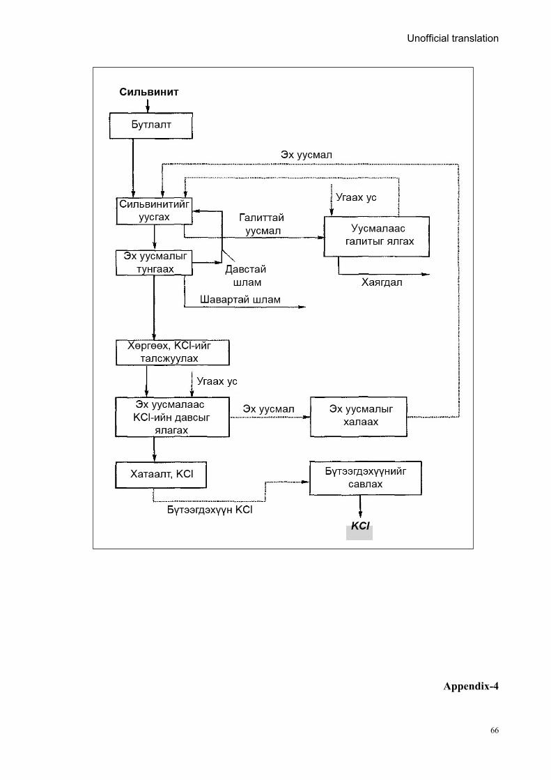
Unofficial translation
66
Appendix-4
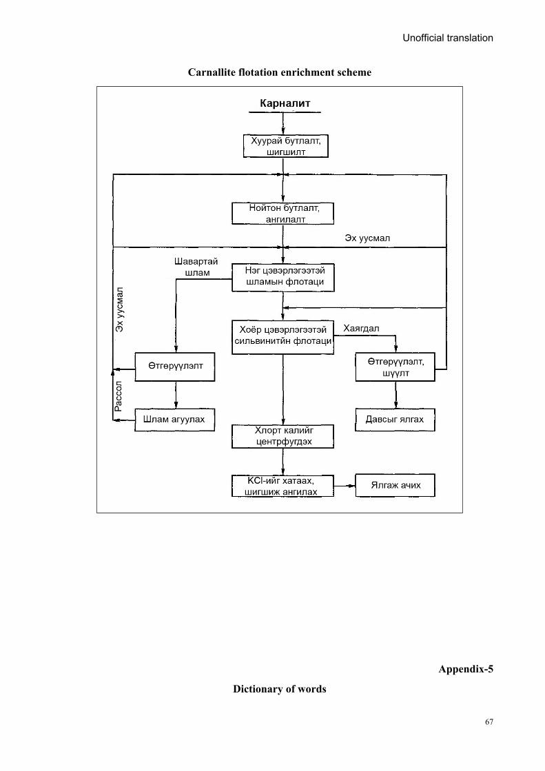
Unofficial translation
67
Carnallite flotation enrichment scheme
Appendix-5
Dictionary of words
Unofficial translation
68
English Russian Mongolian
1 2 3 Saline water Рассол Ув ус, рассол, шорвог уусмал (хэт
ханасан уусмал) Brine Рапа Ураг ус, рап, шорвог ус Brinish lake Рапное озеро Ураг устай нуур Surface brine Поверхостьная рапа Гадаргуугийн ураг ус Bottom brine Донная рапа Ёроолын ураг ус Intercrystalline brine Межкристальная рапа Талст хоорондын ураг ус brine in the silt Иловая рапа Лаг шаврын ураг ус Dry lake Сухое озеро Хатдаг нуур, ширгэсэн нуур, төхөм
нуур Dried lake Подпесочное озеро Элсэнд дарагдсан нуур, ширгэсэн
нуур цайдам нуур Stable lake Стабильные озера Тогтвортой нуур Unstable lake Нестабильные озера Тогтворгүй нуур Core lake Корневые озера Сан нуурууд, төрмөл нуур Buried lake Погребенные месторождения Дарагдмал ордууд Lagoon Лагун Нуурмаг, лагуун Salt bearing rocks Галогенные породы Давсны гаралтай чулуулаг Chlorides Хлориды Хлоридын давсууд, хужир, нохийд Sulphates Сульфаты Сульфатын давснууд, шүү,
шүүрэхүүд Carbonates Карбонаты Карбонатын давснууд, шүнчирүүд Natron, crystalline soda, natural soda
Натрон Соод, хужир, аман хужир, Na2CO3
Salt marsh Соланчак Мараа Soil salinity Соланец Марз Glauber's salt (mirabilite) Глауберова соль (мирабилит) Шүү, мирабилит, глауберит зэрэг
натрийн сульфат давсууд Glassy mirabilite Мирабилита-стеклеца Шилэн мирабалит, мөсөн шүү,
молор давс Caustic potash Каустик кали Идэмхий кали, Potash Поташ Карбонат кали, үнсэн хужир Potassium nitrate Калийн селитра Догшин шүү, дарин шүү, нитрат,
KNO3 Fresh salt Новосадка Уураг давс, нялх давс Seasonal salt Старосадка Өнжмөл давс, хагд давс Type-determining salts Типоопредляющие соли Биеэ даасан төрлийн давсууд Naturally occuring sedimentary salt Самосадочная соль Тунамал давс, өөрөө тунаж суудаг
давс artificially precipitated salt Садочная соль Тунадасжуулсан, ургуулсан давс,
үржүүлсэн давс Core salt Корневая соль Хур давс, сан давс Core salt layer Корневая залежь Хур биет, хэвтэш, оршдос Silted salt Заиленная соль Лаг шаврын бохирдолтой давс Fine-grained, evaporated salt Мелкокристаллическую
выварочную соль Нарийн ширхэгт, чанамал давс
Powdered salt Молотая соль (самосадочную и садочную)
Нунтагласан давс (тунамал ба тунадасжуулсан)
Molded salt Кусковая соль Цутгаж хэвлэсэн цулдам давс, хэлтэлсэн давс
Salt bars Солеблоки Давсан гулдмай
1 2 3 Salt briquette Брикетированную соль Шахмал давс Solid rock salt Чугунка Ширмэн хатуу давс Granular salt Гранатка Сул сэвсгэр давс
Unofficial translation
69
karatuz (gray rock salt lumps) Каратуз Дэлэн давс, хар давс Temporary basin Оперативные бассейн Түр усан сан long-term basin Долгосрочные бассейн Урт хугацааны усан сан Salt-dome Купол Бүнхэр Diapir Диапир Диапир, шток, хөнтрүү атираа Gypsum Гипс Гөлтгөнө Karst, cavities Карст Үүр хөндийлж Plan map План Дэвсгэр зураг Projection Проекц Тусгал Hygroscopicity, absorption Гигроскопичность Чийг таталт, ус шингээлт Filtration Фильтрационные Шүүрүүлэх Collection Коллекторские Цуглуулах Water permeability Водопроницаемость Ус нэвчүүлэх чанар Halurgical enrichment method Галургический метод
обогащения Баяжуулалтын галургийн арга
Salt hygroscopicity Гигроскопичность соли Давсны гигроскоп чанар Magnetic hydrodynamic separation (MGD-separation)
Магнитногидродинамическая сепарация
Соронзон гидродинамик сепарац (СГД-сепараця)
Ferrohydrostatic separation (FHS-separation)
Феррогидростатическая сепарация (ФГС-сепарация)
Феррогидростатик сепараци (ФГС-сепараци)
Comparative definitions of some names
Appendix Table- 2
Salinity Mongolian Russian English
<0.05% <0.5‰ Цэнгэг ус Пресная вода Fresh water
(Sea water) 0.05-3% 0.5-30‰ Давсжсан ус Солоноватая вода Brackish water
(Salt lake) 3-5%
30-50‰ Ув ус Минерализованная вода, рассол
Saline water (Hypersaline lake, Salt pan)
>5% (max 26%-28%) >50‰ Ураг ус Рапа Brine
(Brine pool)
Unofficial translation
70
Australia Mongolia Extractives Program 2A Temple View Residence Suhbaatar District-1 Ulaanbaatar Mongolia T: +976 7000 8595
www.amep.mn facebook.com/AMEP2 Twitter.com/AusMonXtractive