meeting of the EAC held on 17-18 May, 2018 for appraisal of ...
65
Page 1 of 65 MOM 30 th EAC 17-18 May, 2018_Coal Minutes of the 30 th meeting of the EAC held on 17-18 May, 2018 for appraisal of Coal mining projects at Indira Paryavaran Bhawan, Ministry of Environment, Forest and Climate Change, New Delhi-3 A. The 30 th meeting of the Expert Appraisal Committee (EAC) for Thermal & Coal mining projects was held on 17-18 May, 2018 in the Ministry to consider the proposals relating to coal mining sector. The lists of participants and the project proponents are at Annexure-I & II respectively. B. Confirmation of minutes There being no comments from any of the members of the Committee, minutes of the 28 th meeting of the EAC held on 17-18 April, 2018 were confirmed. C. Details of the proposals considered during the meeting, deliberations made and the recommendations of the Committee, are explained in the respective agenda items as under:- Agenda No.30.1 Jayant Opencast Coal mine Expansion project from 15.5 MTPA to 25 MTPA in an area of 3177 ha of M/s Northern Coalfields Limited located in District Singrauli (Madhya Pradesh) - for EC [IA/MP/CMIN/62083/2017, F.No.J-11015/12/2017-IA.II(M)] 30.1.1 The proposal is for grant of environmental clearance for Jayant Opencast Coal mining Expansion project from 15.5 MTPA to 25 MTPA in an area of 3177 ha of M/s Northern Coalfields Limited located in District Singrauli (Madhya Pradesh). 30.1.2 The details of the project, as per the documents submitted by the project proponent, and also as informed during the meeting, are reported to be as under:- (i) The project with its capacity of 15.5 MTPA in the mine lease area of 2704 Ha was earlier granted EC vide letter J-11015/382/2008-IA.II (M) dated 10th December, 2008. (ii) ToR for the project was granted vide letter no. J-11015/12/2017-IA.II (M) dated 15.06.2017. (iii) The latitudes and longitudes of the project are 24 o 06‟26.08” N to 24 o 11‟40.86” N and 82 o 38‟2.01” E to 82 o 40‟55.64” respectively. (iv) Joint Venture: No joint venture (v) Coal Linkage :Singrauli Super Thermal Power Station (SSTPS) of NTPC through their own MGR system and other consumers by Public Railway (vi) Employment generated/to be generated: 2690(Sanctioned manpower as per EPR- option -II) Present Manpower is 2074 as on 31.03.2018 (vii) Benefits of the project: The project will be able to supply planned quantity of coal to Singrauli Super Thermal Power Station (SSTPS) of NTPC through their own MGR system, other thermal power stations of the nation and other consumers by Public Railway system, thus meeting the energy requirement of the country. The land usage of the project will be as follows:
-
Upload
khangminh22 -
Category
Documents
-
view
1 -
download
0
Transcript of meeting of the EAC held on 17-18 May, 2018 for appraisal of ...

Page 1 of 65 MOM 30
thEAC 17-18 May, 2018_Coal
Minutes of the 30th meeting of the EAC held on 17-18 May, 2018 for appraisal of Coal mining projects at Indira Paryavaran Bhawan, Ministry of Environment, Forest and Climate Change,
New Delhi-3 A. The 30th meeting of the Expert Appraisal Committee (EAC) for Thermal & Coal mining projects was held on 17-18 May, 2018 in the Ministry to consider the proposals relating to coal mining sector. The lists of participants and the project proponents are at Annexure-I & II respectively. B. Confirmation of minutes There being no comments from any of the members of the Committee, minutes of the 28 th meeting of the EAC held on 17-18 April, 2018 were confirmed. C. Details of the proposals considered during the meeting, deliberations made and the recommendations of the Committee, are explained in the respective agenda items as under:- Agenda No.30.1
Jayant Opencast Coal mine Expansion project from 15.5 MTPA to 25 MTPA in an area of 3177 ha of M/s Northern Coalfields Limited located in District Singrauli (Madhya Pradesh) - for EC [IA/MP/CMIN/62083/2017, F.No.J-11015/12/2017-IA.II(M)] 30.1.1 The proposal is for grant of environmental clearance for Jayant Opencast Coal mining Expansion project from 15.5 MTPA to 25 MTPA in an area of 3177 ha of M/s Northern Coalfields Limited located in District Singrauli (Madhya Pradesh). 30.1.2 The details of the project, as per the documents submitted by the project proponent, and also as informed during the meeting, are reported to be as under:- (i) The project with its capacity of 15.5 MTPA in the mine lease area of 2704 Ha was earlier granted EC vide letter J-11015/382/2008-IA.II (M) dated 10th December, 2008. (ii) ToR for the project was granted vide letter no. J-11015/12/2017-IA.II (M) dated 15.06.2017. (iii) The latitudes and longitudes of the project are 24o06‟26.08” N to 24o11‟40.86” N and 82o38‟2.01” E to 82o40‟55.64” respectively. (iv) Joint Venture: No joint venture (v) Coal Linkage :Singrauli Super Thermal Power Station (SSTPS) of NTPC through their own MGR system and other consumers by Public Railway (vi) Employment generated/to be generated: 2690(Sanctioned manpower as per EPR- option -II) Present Manpower is 2074 as on 31.03.2018 (vii) Benefits of the project: The project will be able to supply planned quantity of coal to Singrauli Super Thermal Power Station (SSTPS) of NTPC through their own MGR system, other thermal power stations of the nation and other consumers by Public Railway system, thus meeting the energy requirement of the country. The land usage of the project will be as follows:

Page 2 of 65 MOM 30
thEAC 17-18 May, 2018_Coal
Pre Mining
Sl. No.
Land Use Within ML Area (ha)
Outside ML Area (ha)
Total
1. Tenancy Land (Agricultural land)
1481.54 NIL 1481.54
2. Forest Land 1180.17 NIL 1180.17
3. Waste Land - NIL -
4. Grazing Land - NIL -
5. Surface Water Bodies
- NIL -
6. Settlements - NIL -
7. Others (Government land)
515.46 NIL 515.46
Total 3177.00 NIL 3177.00
Post Mining
Sl. No.
Land use during Mining Operation
Land Use (ha)
Plantation Water Body
Public Use
Others Total
1. External OB Dump 118.65 - - - 118.65
2. Top Soil Dump Top soil will be completely used in reclamation of dumps
3. Excavation 1589.00 251.00 - - 1840.00
4. Roads and Railways
96.75 - - - 96.75
5. Built up area (Infrastructure & colony)
82.00 - 261.90 - 343.90
6. Green Belt 93.30 - - - 93.30
7. Undisturbed Area (Safety Zone, Waste land, vacant land and Mudwani dam)
625.20 59.20 - - 684.40
Total 2604.90 310.20 261.90 - 3177.00
(viii) Total net geological reserve is 339.03 MT. The mineable reserve 313.61 MT, extractable reserve is 313.61 MT(figures as on 31.03.2016). The per cent of extraction would be 92.20%. (ix) The average product mix coal grade of all the seams is G-10. The stripping ratio is 2.99Cum/tonne. The average Gradient is 2° to 4°. Thickness of all the three seams occurring in the

Page 3 of 65 MOM 30
thEAC 17-18 May, 2018_Coal
ML area is tabulated as under:-
Coal Seam Thickness
From To
Purewa Top 4.00 13.07
Purewa Bottom 8.69 18.54
Turra 13.90 23.61
(x) Total estimated water requirement is 11654 cum/day. The level of ground water ranges from 1.16 m to 21.55 m below ground level (From August, 2014 to May, 2016). (xi) The method of mining would be opencast mining deploying dragline and shovel-dumper. (xii) There are 2 external OB dump with quantity of 60.00 Mcum in an area of 118.65 ha with height of 90 meter above the surface level and 2 internal dump with Quantity of 1758.58 Mcum in an area of 1589ha. (xiii) The final mine void would be in 251ha with depth varying from 30 to 40 m. and the total quarry area is 1840 ha. Backfilled quarry area of 1589 ha shall be reclaimed with plantation. Proposed void shall be converted into a water body. (xiv) The life of mine is 16 years(Balance life as on 1.04.2018). (xv) Transportation: Coal transportation in pit: from mine pit to crusher by rear dumpers/tippers, Surface to Siding: By belt conveyors through CHP and through tippers and siding to loading point: By Automatic loading system through Silo. (xvi) There is R & R involved. There is 1599number of PAFs. (xvii) Cost: Total capital cost of the project is Rs. 2725.66Crores (including 942.57 crores of existing 10MTPA project). CSR Cost Rs. 2/- per tonne of coal production. R&R Cost is Rs. 753.94Crores. Environmental Management Cost Rs. 355.57 crore(Capital as per EPR‟16). (xviii) Approvals:
Date of approval of EPR from NCL board – 1st march 2016 communicated vide letter No. NCL/Board/08 (202)/19 dated 9th April, 2016 and from CIL board – 2nd may 2017 communicated vide letter No. CIL/XI (D)/04112/2017/17160 dated 16.05.2017.
Date of approval of Mine closure plan: Mine closure Plan is an integral part of EPR, approved on dt 2.05.2017 by CIL board.
Application for renewal/NOC for ground water clearance has been processed for enhanced production capacity of 25 MTPA on 13.07.2017.
(xix) Wildlife issues: There are no national Parks, wildlife sanctuary, biosphere reserves found in the 10 km buffer zone. (xx) Total forest area involved is 1180.00 ha (including safety zone and all types of forest land). Forest Clearance has been obtained for the same. (xxi) Total afforestation plan shall be implemented covering an area of 118.65 Ha at the end of mining.Density of tree plantation 2500 is trees/Ha of plants. (xxii) There is court case/violation pending with the project proponent. (xxiii) The public hearing was held on 13th December, 2017 for expansion capacity of 25 MTPA. The issues raised during the public hearing included Rehabilitation & employment of oustees, social & economical problem of oustees and affected population like availability of drinking water, electricity and employment. (xxiv) The baseline data has been generated for pre-monsoon season for the period 15.03.2016 to 15.06.2016 and all the air, water, noise and other parameters were found to be within permissible limit.

Page 4 of 65 MOM 30
thEAC 17-18 May, 2018_Coal
(xxv) The EAC in the meeting held on 31.05.2017 for grant of TOR to the project prescribed to carry out some studies. The mandated studies and the action taken report on the same are as follows:
Sl. No.
Study prescribed by EAC
Action taken by the project with results.
1. Cumulative impact of all the existing industrial activities in the study area and also those in the pipeline/proposed, shall be studied to arrive at a comprehensive picture and planning of adequate environmental safeguards.
The Cumulative Impact Assessment Study has been done considering nearby running and upcoming mines namely, Jayant Expansion OCP, Dudhichua OCP, Krishnashila OCP, Bina OCP and Block-B OCP for incremental capacity of 35.58 MTPA, and it has been observed that after replacement of road transportation by rail and conveyors and taking the additional control measuresproposed in the report the absolute predicted values of PM10 will lie within the permissible limit at all the locations.
2. For baseline air quality assessment, additional monitoring stations (4-5 nos.) in the downwind areas need to be set up and included in the air quality modelling.
Baseline study for Dudhichua OCP was done in the same period in which the same was carried out for Jayant OCP. Therefore for air quality modeling 4 stations of Dudhichua baseline report were used in addition to the baseline stations of Jayant OCP. The AQIP study for the project establishes that the absolute value of PM10 and PM2.5 will remain under limit with the prescribed additional and existing control measures.
3. Ecological restoration and mine reclamation to be done with local/native species found in the area.
Emphasis is being given on ecological restoration and mine reclamation by planting local/native species found in the area. Planting indigenous species which have better ecological synthesis with the natural environment at the same time this provides timber, fodder, fruits, other edible items, medicinal herbs as well as other plant produce of economic values. NCL has started Ecological Restoration of mined out areas in Krishnashila and Nigahi Projects on 5.0 ha OB dump to convert degraded mined out areas into productive ecosystem as to enhance biodiversity with the technical guidance and assistance from FRI, Deharadun. Also, NCL has plan to carry out Ecological Restoration study, to prepare comprehensive road map for ecological restoration works on OB dumps of NCL projects. Therefore, in the Jayant Expansion the Eco-Restoration plan of OB dumps is being prepared by FRI/ICFRE, Dehradun and will be submitted shortly. Site visit by ICFRE has already been done in March 2018.

Page 5 of 65 MOM 30
thEAC 17-18 May, 2018_Coal
(xxvi) The calendar programme of coal production proposed: Note: Peak production shall be achieved in the years where the geo-mining conditions are favorable and by increasing efficiency and no. of working days to meet the overall demand of coal on NCL. (xxvii) The certified compliance report submitted to RO and the action taken report by the project was already discussed in EAC meeting held on 31.05.2017 for grant of TOR to the project. (xxviii) The Public consultation was held on 13thDecember, 2017 at Jayant Project. A total of 409 people attended the public hearing meeting,among them 356 people belong to lease area. The views/issues raised by public & comments/ reply of the PP is given below:
Sl No. Issues raised by the Public Action taken/to be taken by NCL
1. Rehabilitation & employment of oustees, social & economical problem of oustees and affected population like availability of drinking water, electricity and employment.
Rehabilitation of affected families will be taken up on priority as per CIL R&R policy. The project will provide drinking water to the needy families and scope of employment in out-sourced company and contractors after proper survey. Project authorities shall ensure the availability of
Years Coal (Mt)
(Actual) 14-15 11.85
(Actual) 15-16 14.40
(Actual) 16-17 15.40
Yr-1 17-18 16.00
Yr-2 18-19 18.00
Yr-3 19-20 20.00
Yr-4 20-21 20.00
Yr-5 21-22 20.00
Yr-6 22-23 20.00
Yr-7 23-24 20.00
Yr-8 24-25 20.00
Yr-9 25-26 20.00
Yr-10 26-27 20.00
Yr-11 27-28 20.00
Yr-12 28-29 20.00
Yr-13 29-30 20.00
Yr-14 30-31 17.00
Yr-15 31-32 14.50
Yr-16 32-33 8.00
Yr-17 33-34 4.71
Sub total Yr-1 Yr-17 298.21
G. Total 339.86

Page 6 of 65 MOM 30
thEAC 17-18 May, 2018_Coal
Drinking water to the affected families and Free medical facilities to the affected families shall be examined in consultation with the NCL, HQ.
2. Siltation and pollution of GBP Sagar through Purewa and Balianalla and related health hazards to the population. Publicity of R&R Policy and planting of Neem and fruit bearing trees along road side. Also, the other issues raised in written regarding R&R, pollution and flyash utilization notification in mines etc.
Jayant Project follows “Zero Discharge” system (except in monsoon) and no water is discharged outside the project. There is no official record for the major health hazards to the nearby population. Project distributes fruit bearing plants to villagers, employees and local people. Also, regular plantation including fruit bearing are planted by MPRVVN on plain and OB dump area. MoEFCC in a meeting held on 26.07.2017 on the issue, agreed to consider the constraints and revise the notification. Written issues/complaints received by MP pollution control Board and reply by Project proponent has been included in the public hearing details submitted to MOEFCC.
(xxix) Jayant OCP is catering to most of the critical and super critical thermal power plants. It has already achieved its sanctioned EC production capacity of 15.5 MTPA and is under non-producing state for the want of EC for higher production capacity. In view of the shortage of coal in the country and rising demand of the power, it is requested to accord the EC on priority basis in National interest. 30.1.3 During deliberations on the proposal, the Committee noted the following:- The proposal is for grant of EC to the expansion of Jayant Opencast Coal mining project from 15.5 MTPA to 25 MTPA of M/s Northern Coalfields Limited in a total area of 3177 ha located in District Singrauli (Madhya Pradesh). Out of the total lease hold of 3177 ha, 1180.17 ha is the forest land (including safety zone and all types of forest land). Forest Clearance for 1162.17 ha has been obtained in stages. The remaining 18 ha of forest land has been acquired from Nigahi project under the CBA Notification No.1430 dated 19th June, 2000, and stage-II forest clearance has been obtained for the same. Earlier, the project for expansion of Jayant OCP from 12.5 to 15.5 MTPA in mine lease area of 2704 ha was granted EC by the Ministry vide letter dated 10thDecember, 2008. The ToR for the project was granted on 15th June, 2017 and the public hearing was conducted by the State Pollution Control Board on 13th December, 2017. Main issues raised therein included rehabilitation & employment of oustees, social & economical problem of oustees and affected population like availability of drinking water, electricity and employment. The project report for expansion of Jayant OCP was approved in 202ndM/s NCL Board meeting held on 1st March, 2016 and by Coal India Board vide letter dated 16th May, 2017. 30.1.4 TheEAC,in the first instance, insisted for clarifications and inputs in respect of the following: -

Page 7 of 65 MOM 30
thEAC 17-18 May, 2018_Coal
Discrepancy in respect of total forest area involved under the project, whether 1180 ha or 1180.17 ha. The same needs to be firmed up and the land use pattern/details to be revised accordingly.
More area to be acquired under the project involves additional forest land of 18 ha, carved out of Nigahi Opencast Coal Mining project. As such, the parallel proposal for amendment in the EC for Nigahi OCP also needs to be submitted.
Coal production during previous years, especially from the year 2000-01 up to 2007-08, has been consistently more than the reported sanctioned capacity of 9 MTPA, which clearly signifies violation of the EIA Notification, 2006 and needs to be addressed at this stage vis-à-vis the orders of Hon’ble Supreme Court and/or extant statutory provisions.
The EAC, after detailed observations, deferred the project for the needful on the above lines. Agenda No.30.2 Cluster-IV (5 mixed mines) Coal Mining Expansion Project from 3.706 MTPA to 9.55 MTPAin ML area of 1123.79 ha of M/s Bharat Coking Coal Limited located in District Dhanbad (Jharkhand) -For further consideration of EC [IA/JH/CMIN/20227/2013, F.No.J-11015/372/2013 -IA.II(M)] 30.2.1 The proposal is for grant of environmental clearance for Cluster-IV (5 mixed mines) Coal Mining Expansion Project from 3.706 MTPA to 9.55 MTPA in ML area of 1123.79 ha of M/s Bharat Coking Coal Limited located in District Dhanbad (Jharkhand) 30.2.2 The proposal was considered by the EAC in its 29th meeting held on 15 -16 January, 2015, 49th meeting held on 7-8 January, 2016, 17th meeting held on 31st August, 2017 and 26th EAC held on 15-16 February, 2018. The EAC, after detailed deliberations, recommended the proposal for grant of environmental clearance to the project for expansion of Cluster-IV (Group of 5 mixed mines) Coal Mining project from 3.706 MTPA to 7.34 MTPA (Normative)/9.55 MTPA (Peak) of M/s Bharat Coking Coal Ltd in ML area of 1123.79 ha located at Tehsil Baghmara, District Dhanbad (Jharkhand), under the provisions of the Environment Impact Assessment Notification, 2006 and subsequent amendments/circulars thereto subject to the compliance of the terms & conditions and environmental safeguards mentioned below:- (i) The environmental clearance shall be valid up to 31st March, 2019. Further extension/ continuance of the project shall be based on evaluation of the action taken on each of the observations of this Ministry‟s Regional Office during their site visit on 22nd August, 2016. (ii) The project proponent shall obtain Consent to establish from the State Pollution Control Boards of Jharkhand for the proposed peak capacity of 9.55 MTPA prior to commencement of the increased production. (iii) Transportation of coal from face to Coal Handling Plant and silos shall be carried out through conveyor belts, and then to the TPP by rail. (iv) Mitigative measures to be undertaken to control dust and other fugitive emissions all along the roads by providing sufficient numbers of water sprinklers. (v) Controlled blasting techniques should be adopted to control ground vibration and fly rocks. (vi) Sufficient coal pillars shall be left un-extracted around the air shaft (within the subsidence

Page 8 of 65 MOM 30
thEAC 17-18 May, 2018_Coal
influence area) to protect from any damage from subsidence, if any. (vii) Solid barrier shall be left below the roads falling within the block to avoid any damage to the roads and no depillaring operation shall be carried out below the township/colony. (viii) Depression due to subsidence resulting in water accumulating within the low lying areas shall be filled up or drained out by cutting drains. (ix) Regular monitoring of subsidence movement on the surface over and around the working area and impact on natural drainage pattern, water bodies, vegetation, structure, roads and surroundings should be continued till movement cases completely. In case of observation of any high rate of subsidence movement, appropriate effective corrective measures should be taken to avoid loss of life and materials. Cracks should be effectively plugged with ballast and clay soil/suitable materials. (x) Garland Surface drains (Size, gradient and length) around the safety areas such as mine shaft and low lying areas and sump capacity should be designed keeping 50% safety margin over and above the peak sudden rain fall and maximum discharge in the area adjoining the mine sites. Sump capacity should also provide adequate retention period to allow proper settling of silt material. Sufficient number of pumps of adequate capacity shall be deployed to pump out mine water during peak rain fall. (xi) The company shall obtain approval of CGWA for use of groundwater for mining operations at its enhanced capacity of 9.55 MTPA. (xii) Continuous monitoring of occupational safety and other health hazards, and the corrective actions need to be ensured. (xiii) The fire dealing operations by excavating out fire should be expedited.
30.2.3 As perrecommendation of the EAC, proposal was processed and submitted for approvalof the competent authority. Meanwhile, the project proponent has requested for correction in minutes of the meeting dated 15th February, 2018, with the details as under:-
Condition Proposed Justification
The environmental clearance shall be valid up to 31st March, 2019. Further extension/ continuance of the project shall be based on evaluation of the action taken on each of the observations of this Ministry’s Regional Office during their site visit on 22nd August, 2016.
This condition specified in the MOM of EAC may be waived off in view of excavation of large quantum of fiery coal in line with implementation of Jharia Master Plan.
Since Coal mine fire is dynamic, it is very difficult to assess actual extent of fire in the Jharia Coalfield. Issuance of EC for a specified time-frame may lead to interruption in dealing with fire and may aggravate the situation further .The matter is required to be appraised, time to time, to HPCC of Ministry of Coal and Hon‟ble Supreme Court monitoring implementation of Jharia Master Plan. The compliance is already submitted and deliberated in EAC meeting dated 30.08.2018
Transportation of coal from face to Coal Handling Plant and silos shall be carried out through conveyor belts, and then
Transportation of coal from face to Coal heap shall be carried out by truck. Further, the coal transportation from
1. Areas affected with fire and subsidence cannot support installation of conveyor belt
2. There is fire hazard involved in Transportation of fiery coal through belt

Page 9 of 65 MOM 30
thEAC 17-18 May, 2018_Coal
to the TPP by rail. Coal heap to Coal Handling Plant shall be carried out through covered trucks.
Given the proposed correction/modification in minutes of the meeting of substantive nature, it was decided to the take the proposal again to the EAC for their reconsideration. 30.2.4 The EAC after detailed deliberation took note of fire hazards in Jharia Coalfield and recommended for waving of the condition regarding coal transportation through conveyor belt till August, 2021 i.e. in consonance with implementation of fire dealing operations under the Jharia Master Plan. Accordingly, the condition shall be revised as under: ‘Transportation of coal from face to Coal heap shall be carried out by truck. Further, the coal transportation from Coal heap to Coal Handling Plant shall be carried out through covered trucks.’ Regarding validity of the EC (presently recommended up to 31st March, 2019), the Committee opined that the same was premature for the present and could be placed before the Committee at a later stage.However, the minutes may be revised to effect validity of EC for a period of one year in place of 31st March, 2019 recommended earlier. Meanwhile, as desired, the concerned Regional Office may be asked for fresh site visit to verify the actions taken by the project proponent on their earlier observations during site visit madeon 22nd August, 2016. Agenda No.30.3 Suliyari Opencast Coal Mining project of 6MTPA in an area of 1298 ha of M/s Andhra Pradesh Mineral Development Corporation Limited located in District Singrauli (MP) - For ToR [IA/MP/CMIN/73904/2018, F.No.J-11015/35/2018-IA.II(M)] 30.3.1 The proposal is for grant of terms of reference for Suliyari Opencast Coal Mining project of 6.0 MTPA in an area of 1298 ha of M/s Andhra Pradesh Mineral Development Corporation Limited located in District Singrauli (MP). 30.3.2 The details of the project, as per the documents submitted by the project proponent, and also as informed during the meeting, are reported to be as under: - (i) Itis agreenfieldproject of capacity 5MTPA (Normative) / 6 MTPA (Peak) in anarea of 1298 ha. (ii) Suliyari ML area is bounded between latitude(s)23°55'28" to 23°58'15"Nandlongitude(s)82°18'52‟ to 82°20'58"Erespectively. (iii) JointVenture:There isnoJV (iv) CoalLinkage: Suliyari Coal Block has been allocated by Ministry of Coal (MoC) to Andhra Pradesh Mineral Development Corporation Limited (APMDC) for sale of coal, under the provisions of The Coal Mines (Special Provisions) Act, 2015. (v) Employment generated / to be generated: Total manpower requirement will be 1157. Out of which, manpower of APMDC is 168 whereas manpower proposed to be deployed by MDO is 989.

Page 10 of 65 MOM 30
thEAC 17-18 May, 2018_Coal
(vi) Benefitsoftheproject: (i) The project will increase the supplyofcoaltocatertheneedofIndia'sincreasing domesticdemands (ii) it willaddtorevenuegenerationoftheDistrict/State, (iii) it willreduceparalyzing powershortageshinderinggrowth,foreigninvestmentandproductivity; (iv) it willgenerateadditional employment, bothdirectandindirect, (v) APMDCshall provide,school buildings,busshelters, medical facilities and other amenities to local villages. (vii) Thetotal land area is 1298 ha. Mining lease area proposed in the Mining Plan is 1298 ha. The land usage of the project will be as follows: Pre-Mining
S.No. Land use Within MLArea
(ha)
Outside ML Area (ha)
Total
1. Agricultural Land 251.860 Nil 251.860
2. ForestLand 259.239 Nil 259.239
3. Wasteland 396.720 Nil 396.720
4. GrazingLand Nil Nil Nil
5. SurfaceWater Bodies 46.060 Nil 46.060
6. Settlements 51.990 Nil 51.990
7. Other (Specify*) 292.131 Nil 292.131
Total 1298.000 Nil 1298.000
* Barren tenancy land Post-Mining:
Sl. No
Landuse during mining
Post mining land use
Plantation Water Body
Public use
Undisturbed area
Total
1. External OB dump * - - - - 0.000
2. Top Soil dump * - - - - 0.000
3. Excavation * 1286.390 - - - 1286.390
4. Roads - - - - 0.000
5. Built-up area - - - - 0.000
6. Safety zone/ rationalisation area
11.610 - - - 0.000
7. Undisturbed area - - - - 0.000
Total 1298.000 0.000 0.000 0.000 1298.000
* shall come under excavation area
Page 11 of 65 MOM 30
thEAC 17-18 May, 2018_Coal
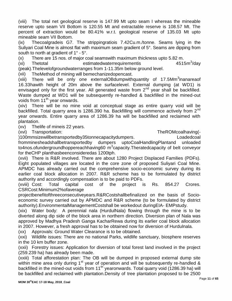
(viii) The total net geological reserve is 147.99 Mt upto seam I whereas the mineable reserve upto seam VII Bottom is 120.55 Mt and extractable reserve is 108.57 Mt. The percent of extraction would be 80.41% w.r.t. geological reserve of 135.03 Mt upto mineable seam VII Bottom. (ix) Thecoalgradeis G7. The strippingratiois 7.42Cu.m./tonne. Seams lying in the Suliyari Coal Mine is almost flat with maximum seam gradient of 5°. Seams are dipping from south to north at gradient of 1° - 5°. (x) There are 15 nos. of major coal seamswith maximum thickness upto 5.82 m. (xi) Thetotal estimatedwaterrequirementis 4515m3/day (peak).Thelevelofgroundwaterranges from 1-11.35m below ground level. (xii) TheMethod of mining will bemechanizedopencast.
(xiii) There will be only one externalOBdumpwithquantity of 17.5Mm3inanareaof
16.33hawith height of 20m above the surfacelevel. External dumping (at WD1) is envisaged only for the first year. All generated waste from 2nd year shall be backfilled. Waste dumped at WD1 will be subsequently re-handled & backfilled in the mined-out voids from 11th year onwards. (xiv) There will be no mine void at conceptual stage as entire quarry void will be backfilled. Total quarry area is 1286.390 ha. Backfilling will commence actively from 2nd year onwards. Entire quarry area of 1286.39 ha will be backfilled and reclaimed with plantation. (xv) Thelife of mineis 22 years. (xvi) Transportation: TheROMcoalhaving(-)100mmsizewillbetransportedby35tonnecapacitydumpers. Loadedcoal fromminesheadshallbetransportedby dumpers uptoCoalHandlingPlantand unloaded to4nos.ofundergroundhoppereachhaving60 m3capacity.Theratedcapacity of belt conveyor for theCHP planthasbeenconsideredas 1200tph. (xvii) There is R&R involved. There are about 1280 Project Displaced Families (PDFs). Eight populated villages are located in the core zone of proposed Suliyari Coal Mine. APMDC has already carried out the comprehensive socio-economic survey during its earlier coal block allocation in 2007. R&R scheme has to be formulated by district authority and accordingly compensation is to be paid to PDFs. (xviii) Cost: Total capital cost of the project is Rs. 854.27 Crores. CSRCost:Minimum2%ofaverage projectbenefitofthreeconsecutiveyears.R&RCostshallbefinalized on the basis of Socio-economic survey carried out by APMDC and R&R scheme (to be formulated by district authority).EnvironmentalManagementCostshall be workedout duringEIA- EMPstudy. (xix) Water body: A perennial nala (HurdulNala) flowing through the mine is to be diverted along dip side of the block area in northern direction. Diversion plan of Nala was approved by Madhya Pradesh Ganga KacharRewa during its earlier coal block allocation in 2007. However, a fresh approval has to be obtained now for diversion of Hurdulnala. (xx) Approvals: Ground Water Clearance is to be obtained. (xxi) Wildlife issues: There are no national Parks, wildlife sanctuary, biosphere reserves in the 10 km buffer zone. (xxii) Forestry issues: Application for diversion of total forest land involved in the project (259.239 ha) has already been made. (xxiii) Total afforestation plan: The OB will be dumped in proposed external dump site within mine area only during 1st year of operation and will be subsequently re-handled & backfilled in the mined-out voids from 11th yearonwards. Total quarry void (1286.39 ha) will be backfilled and reclaimed with plantation.Density of tree plantation proposed to be 2500

Page 12 of 65 MOM 30
thEAC 17-18 May, 2018_Coal
trees/ ha of plants. (xxiv) There are no court cases/violation pending with the project proponent. (xxv) Baseline data collection for the Month of April, May & June 2018 has been started. 30.3.3During deliberationson the proposal,theCommitteenotedthefollowing:- The proposal is for ToR to SuliyariOpencast Coal Mine of capacity 5 MTPA (Normative)/6 MTPA (Peak) of M/s Andhra Pradesh Mineral Development Corporation Limited (APMDC) in an area of 1298 ha located in District Singrauli (Madhya Pradesh). Total project area includes 259.239 ha of forest land. Application for Stage-I FC has been made online FP/MP/MIN/28619/2017 dated 21st August, 2017. Pursuant to the order of Hon‟ble Supreme Court, the said coal mine/block of M/s Andhra Pradesh Mineral Development Corporation Limited was earlier cancelled in the year 2004, and later allotted to the same company by O/o the Nominated Authority in the Ministry of Coal vide Allotment order dated 29th September, 2016. Mining Plan along with the Mine Closure Plan for the project has been submitted to Ministry of Coal (MoC) for approval vide letter no. APMDC/Suliyari/2017-18/1779 dated 4th April, 2018. Baseline data collection would be during the period April to June, 2018. 30.3.4 The EAC, after detailed deliberations, recommended the proposal for grant of ToR to the Suliyari Opencast Coal Mining project of 6.0 MTPA in an area of 1298 ha of M/s Andhra Pradesh Mineral Development Corporation Limited located in District Singrauli (MP), and for preparation of EIA/EMP reports with public consultation subject to compliance of all conditions as specified/notified in the standard ToR applicable for opencast coal mines, along with the additional conditions as under: -
Stage-I forest clearance for diversion of 259.239 ha of forest land shall be obtained from the concerned regulatory authority.
For proper baseline air quality assessment, adequate monitoring stations (4-5 nos.) in the downwind areas need to be set up and included in the air quality modeling.
Ecological restoration and mine reclamation plan to be prepared with afforestation of local/native species found in the area.
Agenda No.30.4 Gevra Coal Washery expansion project from 6.25 MTPA to 16.25 MTPA of M/s ACB (India) Ltd. in an area of 10.67 ha located in District Korba (Chhattisgarh)-For TOR [IA/CG/CMIN/74544/2018, F.No.J-11015/36/2018-IA.II(M)] 30.4.1 The proposal is for grant of terms of reference for Gevra Coal Washery expansion project from 6.25 MTPA to 16.25 MTPA of M/s ACB (India) Ltd. in an area of 10.67 ha located in District Korba (Chhattisgarh) 30.4.2 The details of the project, as per the documents submitted by the project proponent, and also as informed during the meeting, are reported to be as under:-

Page 13 of 65 MOM 30
thEAC 17-18 May, 2018_Coal
(i) It is expansion project. (ii) The latitude and longitude of the project site are :
Point No. Latitude Longitude
1. 22° 21‟ 44.70” N, 82° 33‟ 35.36” E
2. 22° 21‟ 44.05” N 82° 33‟ 35.41” E
3. 22° 21‟ 58.43” N 82° 33‟ 25.69” E
4. 22° 21‟ 53” N 82° 33‟ 29” E
5. 22° 21‟ 36.37” N 82° 33‟ 23.98” E
(iii) Joint Venture: There is no joint venture. (iv) Coal Linkages: Coal will be source from nearby coal mines of Kusmunda, Gevra and Dipka open cast mines of South Eastern Coal Fields Limited. (v) Employment generated / to be generated: Approximately 150 persons during construction period and approximately 400 persons during operation. (vi) Benefits of the project: The management is committed to uplift the standards of living of the villagers by providing employment to local people & taking up CSR activities in consultation with local gram panchayat based on need-based assessment to be carried out with village panchayat. (vii) Land usage of the project site: Proposed site is of flat terrain without any surface structures. Part of the land is already owned by ACBIL. Remaining land is in the process of acquisition / diversion. (viii) The Land use breakup of 30.06 acres of project land is as given below:
S. No. Description Area in ha % area
1 Plant area 2.45 22.94
2 Roads, ramp and pavement 1.85 17.44
3 Service buildings 1.41 13.20
4 Raw coal, stacking area 1.26 11.76
5 Plantation inside the plant area 3.21 30.03
6 Vacant place 0.49 4.63
Total 10.67 100.00
(ix) The source of water for the existing 6.25 MTPA coal washery is 2 x 30MWplant of M/s A C B (India) Ltd located at Chakabuda. And water supplied through a pipeline laid by Gevra Coal washery.The source of water for the proposed 10 MTPA coal washery will be Waste water of 2x135MW power plant of M/s ACB (India) Ltd located at Kasaipali. And water will be supplied through a pipeline which will be laid by the by Gevra Coal washery adjacent to the existing pipeline ,as both the power plants are adjacent to each other. (x) Technology: HM Cyclone and Jig (xi) Transportation: Raw coal will be transported by tipping trucks from the coal mines up to coal washery and dumped in the truck receiving hopper at washery end. The washed coal, linked to thermal power stations, will be transported by trucks up to railway siding at Junadih which will be about 1.5km and loaded in rail wagons of Indian railways with the help of loaders.Rejects will be transported by trucks to 2x30MW and 2x135MW power plants owned by ACB (India) Ltd which are located at a distance of approximately 3.0 to 4.0km for consumption. The balance of the rejects will be sold to the thermal power stations with CFBC/ FBC/AFBC boilers.

Page 14 of 65 MOM 30
thEAC 17-18 May, 2018_Coal
(xii) No Rehabilitation and Resettlement required. (xiii) Cost: Total project cost has been estimated as Rs.163.37 Cr. Environment management cost will be Rs. 3.46 Cr. (xiv) Water body: No river/nallah flows near or adjacent to the project site. However, there is a pond nearby and also Kholar Nallah (2.65Kms.), ArihanNadi (7.5 Kms.), Hasdeo River (12.5 Kms.), LilagarNadi (6.1 Kms), SalihaNala (3.0 Kms)are flowing within 10 Km. radius of the Project site. (xv) Wildlife issues: There are no national Parks, wildlife sanctuary, biosphere reserves in the 10 km buffer zone.Achanakmar Tiger reserved is located at a distance of 56.5 kms. (xvi) Forestry issues: No forest land involved. (xvii) Total afforestation plan shall be implemented covering an area of 3.21 ha. (xviii) There are no court cases/violation pending with the project proponent. 30.4.3 During deliberations on the proposal, the Committee noted the following:- The proposal is for grant of terms of reference to the Gevra Coal Washery expansion project from 6.25 MTPA to 16.25 MTPA of M/s ACB (India) Ltd. in an area of 10.67 ha located in District Korba (Chhattisgarh) with no forest land involved.
The proposal is for Coal Washery using HM Cyclone and Jig technology. Raw coal is to be sourced through mines of M/s SECL namely, Dipka, GevraKusmunda and other mines and the washed coal shall be supplied to the customers by road with covered trucks up to the proposed site. The source of water for the existing 6.25 MTPA coal washery is 2 x 30 MW plant of M/s A C B (India) Ltd located at Chakabuda. And water supplied through a pipeline laid by Gevra Coal washery. The source of water for the proposed 10 MTPA coal washery will be Waste water of 2x135MW power plant of M/s ACB (India) Ltd located at Kasaipali. And water will be supplied through a pipeline which will be laid by the by Gevra Coal washery adjacent to the existing pipeline, as both the power plants are adjacent to each other. 30.4.4 The EAC, in the first instance and in view of the proposal directly linked with operational status of the 2x30 MW & 2x135 MW rejects based thermal power plant, recommended for the following:-
Site visit to be conducted by a sub-committee of members of the Committee,
Compliance status of the conditions stipulated in the EC for 2x30 MW washery rejects based TPP at Chakabuda and EC for 2x135 MW TPP at Kasaipali, to be submitted through the concerned Regional Office of the Ministry.
Water balance for the 2x30 MW TPP at Chakabuda and 2x135 MW TPP at Kasaipali.
Details of coal transportation during last 10 years including coal procurement from the nearby mines, dispatch of washed coal to the consumers, usage of washery rejects, etc, duly authenticated by the Coal Controller.
The proposal was deferred for the needful on the above lines. Agenda No.30.5

Page 15 of 65 MOM 30
thEAC 17-18 May, 2018_Coal
Siarmal Opencast Project of 50MTPA in ML area of 2475.47 ha of M/s Mahanadi Coalfield Limited located in District Sundargarh(Odisha)-For extension/amendment in ToR [IA/OR/CMIN/24164/2014, F.No.J-11015/230/2014-IA.II(M)] 30.5.1 The proposal is for amendment in the ToR including extension in validity of ToR for Siarmal Opencast Project of (40.0 MTPA normative and 50.0 MTPA peak) in a total Project area of 2475.47 ha (of which the ML area is 2185.47 Ha) of M/s Mahanadi Coalfield Limited, located at District-Sundargarh, Orissa. 30.5.2 The details of the project, as per the documents submitted by the project proponent, and also as informed during the meeting, are reported to be as under:- (i) The ToR for the project was granted vide letter No.J-11015/230/2014-IA.II(M) dated 20thFebruary, 2015 for preparation of EIA/EMP report along with the public hearing. Now, the request is for extension in validity of ToR by one year and amendment in the said ToR in respect of change in land area as given in the table:
Sl.No. Particulars Total Area in ha
Old New
1. Forest 409.99 349.709
2. Non-forest 1775.48 1940.745
3. Mining lease area (1+2) 2185.47 2290.45
4. Rehabilitation and residential colony 210.0 210.0
5. Diversion of Sundargarh-Raigarh Road 28.0 28.0
6. Rail link from the project site to Jharsuguda 52.0 52.0
7. Out side Mining lease area 290.0 290.0
Total land 2475.47 2580.45
The amendment sought in the earlier granted TOR is as under:-
S. No.
Page/ Point No.
Point as written in ToR
Correction/ Amendment requested in the ToR
1 page1/ subject
Siarmal Opencast Project of (40.0 MTPA normative and 50.0 MTPA peak in an ML area of 2475.47 ha); latitude and longitude of the project are 22o 01‟ 19” to 22o 03‟ 59.99” North and 83o 37‟ 09”to 83o 42‟ 59.58”) M/s Mahanadi Coalfield Limited, located at DistrictSundargarh (Odisha).
Siarmal Opencast Project of (50.0 MTPA) in an ML area of (2290.45 ha); latitude and longitude of the project are 22o 01‟ 19” to 22o 03‟ 59.99” North and 83o 37‟ 09”to 83o 42‟ 59.58”) M/s Mahanadi Coalfield Limited, located at DistrictSundargarh (Odisha).
Page1; It is the new open cast mine It is the new open cast mine project having

Page 16 of 65 MOM 30
thEAC 17-18 May, 2018_Coal
sl.2(ii) project having total project area of 2475.47 ha and mining lease area of 2185.47 ha.
total project area of 2580.45 ha and mining lease area of 2290.45 ha.
Page1; sl.2(v)
Pre Mining(as per ToR)
Sl. No
Item Forest (Ha.)
Non-Forest (Ha.)
Total Area (Ha.)
1. Quarry excavation 249.58 1296.74 1546.32
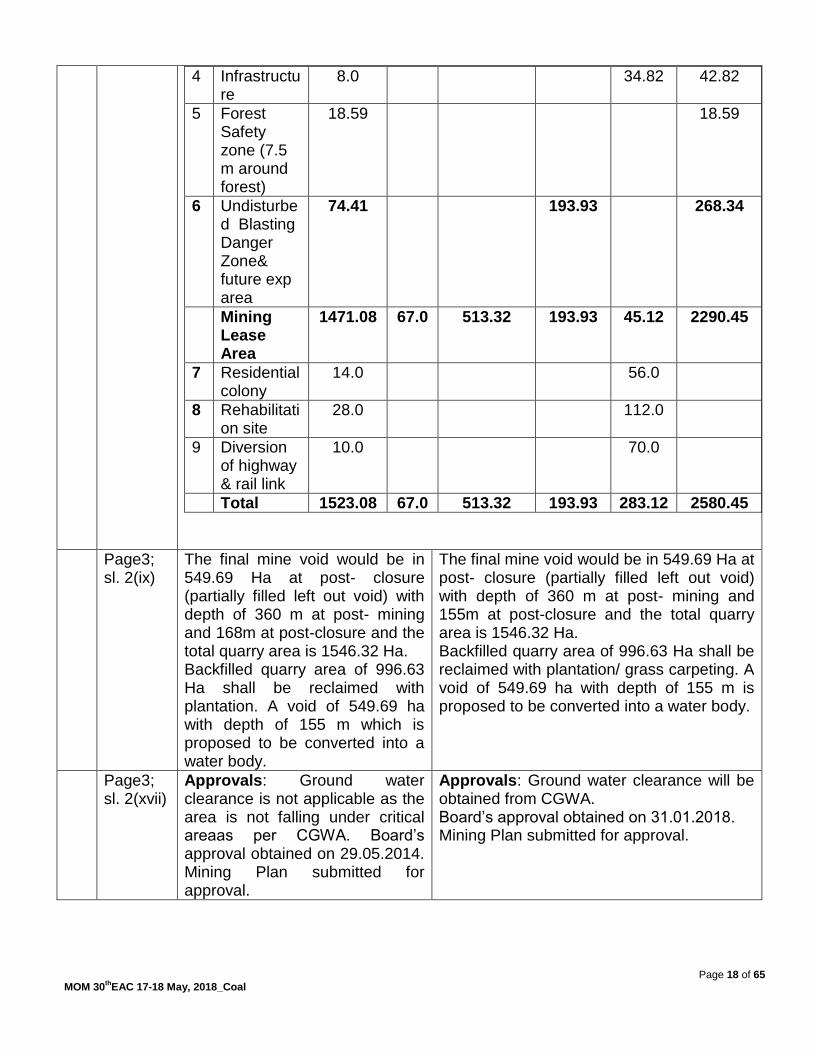
2. External OB Dump 17.40 367.44 384.84
3. Embankment 25.92 30.41 56.33
4. Infrastructure 116.62 6.58 123.20
5. Forest Safety zone (7.5 m around forest)
0.47 0.47
6. Undisturbed Blasting Danger Zone
10.93* 74.31 74.31
Mining lease area 409.99 1775.48 2185.47
7. Residential colony - 70.00 70.00
8. Rehabilitation site - 140.00 140.00
9. Diversion of highway
- 28.00 28.00
10. Rail link from project to Jharsuguda
- 52.00 52.00
Total outside mine lease area
- 290.00 290.00
*Not considered for diversion
Sl. No
Item Forest (Ha.)
Non-Forest (Ha.)
Total Area (Ha.)
1. Quarry excavation 249.58 1296.74 1546.32
2. External OB Dump 17.40 368.68 386.08
3. Embankment 18.0 10.3 28.3
5. Safety zone 3.93 14.662 18.592
6. Infrastructure,Undisturbed Blasting Danger Zone incl future exp area
60.799 250.358 311.157
Mining lease area 349.709 1940.74 2290.45
7. Residential colony - 70.00 70.00
8. Rehabilitation site - 140.00 140.00
9. Diversion of highway - 28.00 28.00
10. Rail link from project to Jharsuguda
- 52.00 52.00
Total outside mine lease area
- 290.00 290.00
*Not considered for diversion
Pre Mining(Amendment sought)

Page 17 of 65 MOM 30
thEAC 17-18 May, 2018_Coal
Post Mining (as per ToR)
Sl#
Category Land Use in Ha
Plantation
Water body
Dip side slope & haul road
Undisturbed
Built-up area
Total
1 Quarry excavation
1234.00*
67.00 245.32 - - 1546.32
2 External OB Dump
384.84* - - - - 384.84
3 Embankment 11.30 - - 45.03 - 56.33
4 Infrastructure 24.70 - - - 98.50 123.20
5 Forest Safety zone (7.5 m around forest)
0.47 - - - - 0.47
6 Undisturbed Blasting Danger Zone
14.90 - - 59.41 - 74.31
Mining Lease Area
1670.21 67.00 245.32 104.44 98.50 2185.47
7 Residential colony
14.00 - - - 56.00 70.00
8 Rehabilitation site
28.00 - - - 112.00 140.00
9 Diversion of highway
5.60 - - - 22.40 28.00
10
Rail link from project to Jharsuguda
10.40 - - - 41.60 52.00
Total 1728.21 67.00 245.32 104.44 330.50 2475.47
Post Mining (amendment sought)
Sl#
Category Land Use in Ha
Plantation /grass carpeting
Water body
Dip side slope & haul road
Undisturbed
Built-up area
Total
1 Quarry excavation
966.0 67.0 513.32 1546.32
2 External OB Dump
386.08 386.08
3 Embankment
18.0 10.3 28.3
Page 18 of 65 MOM 30
thEAC 17-18 May, 2018_Coal
4 Infrastructure
8.0 34.82 42.82
5 Forest Safety zone (7.5 m around forest)
18.59 18.59
6 Undisturbed Blasting Danger Zone& future exp area
74.41 193.93 268.34
Mining Lease Area
1471.08 67.0 513.32 193.93 45.12 2290.45
7 Residential colony
14.0 56.0
8 Rehabilitation site
28.0 112.0
9 Diversion of highway & rail link
10.0 70.0
Total 1523.08 67.0 513.32 193.93 283.12 2580.45
Page3; sl. 2(ix)
The final mine void would be in 549.69 Ha at post- closure (partially filled left out void) with depth of 360 m at post- mining and 168m at post-closure and the total quarry area is 1546.32 Ha. Backfilled quarry area of 996.63 Ha shall be reclaimed with plantation. A void of 549.69 ha with depth of 155 m which is proposed to be converted into a water body.
The final mine void would be in 549.69 Ha at post- closure (partially filled left out void) with depth of 360 m at post- mining and 155m at post-closure and the total quarry area is 1546.32 Ha. Backfilled quarry area of 996.63 Ha shall be reclaimed with plantation/ grass carpeting. A void of 549.69 ha with depth of 155 m is proposed to be converted into a water body.
Page3; sl. 2(xvii)
Approvals: Ground water clearance is not applicable as the area is not falling under critical areaas per CGWA. Board‟s approval obtained on 29.05.2014. Mining Plan submitted for approval.
Approvals: Ground water clearance will be obtained from CGWA. Board‟s approval obtained on 31.01.2018. Mining Plan submitted for approval.

Page 19 of 65 MOM 30
thEAC 17-18 May, 2018_Coal
Page3; sl. 2(xix)
Forestry issues: Total forest area involved 409.99 ha for mining. Applied for forest clearance. Forest clearance is in process (State Sl. No.:703/14 dt: 14/08/2014).
Forestry issues: Total forest area involved 349.709 ha for mining. Applied for forest clearance. Forest clearance is in process Submitted online on 28-03-2018
Page3; sl. 2(xxi)
Total afforestation plan shall be implemented covering an area of 109.73 ha at the end of mining. With a density of tree plantation 2500 nos trees/ ha of plants.
Total afforestation plan shall be implemented covering an area of 580.99 ha at the end of mining With a density of tree plantation 2500 nos trees/ ha of plants &remaining 586.64 Ha is proposed to be converted into grass land/ Agriculture.
Page5; sl. 3
....Siarmal Opencast Project of (40.0 MTPA normative and 50.0 MTPA peak in an ML area of 2475.47 ha); latitude and longitude of the project are 22o 01‟ 19” to 22o 03‟ 59.99” North and 83o 37‟ 09”to 83o 42‟ 59.58”) M/s Mahanadi Coalfield Limited, located at DistrictSundargarh (Odisha).
....Siarmal Opencast Project of (50.0 MTPA in an ML area of 2290.45 ha); latitude and longitude of the project are 22o 01‟ 19” to 22o 03‟ 59.99” North and 83o 37‟ 09”to 83o 42‟ 59.58”) M/s Mahanadi Coalfield Limited, located at DistrictSundargarh (Odisha).
The project proponent, in support of their proposal, further informed as under:- (ii) There was delay in preparation of land schedule & authentication from Tahesildar. After authentication & DGPS survey of forest land it was observed that there is change in land Area. (iii) There is an increase of 104.98 ha. The forest land is now 349.709 ha against 409.99 ha earlier. (iv) The revised KML file has been submitted. (v) The Baseline data (Air, Water, Noise & Soil) has been regenerated for the period from November, 2017 to February, 2018. (vi) The Mining Plan as per the new land area has been approved by the MCL Board in its 198th meeting held on 31-01-2018. (vii) Though there is increase in ML area there is a decrease in forest land. Therefore it is requested to recommend the already approved ToR with above mentioned amendments & extension of validity of ToR by one year for conduct of Public Hearing & submission of final EIA EMP. 30.5.3 During deliberations on the proposal, the Committee noted the following:- The proposal is for amendment and extension of validity of ToRdated 20th February, 2015 for Siarmal Opencast Project of 40MTPA (normative)/50MTPA (peak) of M/s Mahanadi Coalfield Limited in a total area of 2475.47 ha (mine lease area 2185.47 ha)located at DistrictSundargarh (Odisha). The ToR was initially valid for a period of 2 years, which was auto-extended up to 20thFebruary, 2017 as per the provisions of this Ministry‟s OM dated 7th October, 2014, the instant proposal is for

Page 20 of 65 MOM 30
thEAC 17-18 May, 2018_Coal
extending validity of the ToR for a further period of one year i.e. up to 20th February, 2019. The committee found the request of the project proponent in conformity with this Ministry‟s OMs dated 7thOctober, 2014 & 29th August, 2017. 30.5.4 The EAC, after deliberations and in view of the extant provisions facilitating extension of ToR validity beyond 3 years, recommended for extension of validity of ToR for a further period of one year i.e. up to 20thFebruary, 2019. The Committee also recommended for amending the said ToR or issuing the revised ToRdue to increase in project area from 2475.47 ha (forest area 409.99 ha) to 2580.45 ha (forest area 349.709 ha) with the capacity remaining the same at 50 MTPA. Additional ToR:
Assessment of Carrying capacity of the surrounding ecosystem around the proposed mine.
A final Mine Closure Plan with appropriate land use pattern akin to pre-mining conditions may be proposed. In case of any futureconsideration of mining of dip most coal seams deep seated, a mining plan coupled with geological plan may be proposed with detailing.
Agenda No.30.6 Dulanga Opencast Coal Mining Project of 7 MTPA in an area of 785.37 ha of M/s NTPC Limited located in Ib Valley Coalfields, District Sundergarh (Odisha) -For amendment in EC [IA/OR/CMIN/10821/2007, F.No.J-11015/1140/2007-IA.II(M)] 30.6.1 The proposal is for grant of amendment in Environmental Clearance for Dulanga Opencast Coal Mining Project of 7 MTPA in an area of 785.37 ha of M/s NTPC Limited located in Ib Valley Coalfields, District Sundergarh (Orissa). 30.6.2 The details of the project, as per the documents submitted by the project proponent, and also as informed during the meeting, are reported to be as under:- (i) EC was granted to the project vide letter No. J-11015/1140/2007 IA-II(M) dated 3rd March, 2014 . (ii) Amendment to the EC has been issued vide letter dated 9th February, 2016. (iii) The amendment in Environmental clearance has been sought w.r.t. supply of coal from Dulanga Coal Mining Project of NTPC Ltd. to linked Darlipali STPP and to Lara STPP, as an interim arrangement, through road transportation instead of MGR systemwith the details as under:-
EC Condition No.
EC Condition
Amendment Sought Reasons for seeking amendment:
4(A)(ix) Transport of coal to Darlipali TPS
Transport of coal to Darlipali TPS located at a distance of about 10 Km and Lara STPP of
Coal production from Dulanga CMP (linked mine

Page 21 of 65 MOM 30
thEAC 17-18 May, 2018_Coal
located at a distance of about 10 Km shall be by MGR
NTPC Ltd. shall be by Road as an interim arrangement for a period of 15 months (January, 2019 – March, 2020) and 17 months (May, 2018 – September, 2019) respectively.
for Darlipali STPP) has started,
Commissioning of Darlipali STPP is expected by December, 2018,
Delayed construction of MGR system between Dulanga CMP and Darlipali STPP due to delay in land acquisition,
Lara STPP is in advanced stage of commissioning and commencement of coal production from its linked Talaipali CMP is expected by November, 2019.
4(A)(xviii) The entire transportation of 21,210 TPD of coal from the mine to the linked Darlipali Super Thermal Power Plant shall be by MGR only with wagon loading by Silo. Transportation of coal by road is not permitted.
The entire transportation of 21,210 TPD of coal from the mine to the linked Darlipali Super Thermal Power Plant and Lara STPP of NTPC Ltd. (interim arrangement for a period from May, 2018 to September, 2019) shall be by Road. Transportation of coal by road is permitted only for a limited period as interim arrangement.
30.6.3 The Committee, in view of implementation schedule of Darlipali TPP (first unit of 800 MW reported to becompleted by December, 2018), confined its deliberations on the proposal for coal transportation from Dulanga OCP to Lara STPP through two routes viz. Route-3 of 117.86 km and Route-4 of 90.67 km respectively. The Committee was not inclined to allow coal transportation by road till improvement in the existing road conditions, blacktopping and/or adequate shouldering/widening of the roads in the entire stretch on Route-3 & Route-4 from Dulanga Coal Mine to Lara STPP. To ensure the same, the Committee desired for certification in this regard from the concerned State authorities. However, for the present and given the status of preparedness of Route-3 (117.86 km long), the Committee recommended for coal transportation of 2000 tonnes per day (200 trucks to &fro) through Route-3 up to September, 2019 as an interim arrangement only or till commissioning of Darlipali TPP, whichever is earlier. Meanwhile, all efforts shall be made to start production of coal from its linked Talaipalli coal mine and complete the associated MGR system by March, 2020. Agenda No.30.7 Dhankasa Underground coal mining project of 1.20 MTPA in a total area of 582.651 ha of M/s Western Coalfields Limited located in Pench-Kanhan Coalfields, District Chindwara (Madhya Pradesh)-For EC [IA/MP/CMIN/72632/2008, F.No.J-11015/451/2008-IA.II(M)]

Page 22 of 65 MOM 30
thEAC 17-18 May, 2018_Coal
30.7.1 The proposal is for grant of Environmental Clearance for Dhankasa Underground coal mining project of 1.20 MTPA in a total area of 582.651 ha of M/s Western Coalfields Limited located in Pench-Kanhan Coalfields, District Chindwara (Madhya Pradesh). 30.7.2 The details of the project, as per the documents submitted by the project proponent, and also as informed during the meeting, are reported to be as under:- (i) Dhankasa UG mine Project is located in Chhindwara district of Madhya Pradesh and is under the administrative control of Pench Area of M/s Western Coalfields Ltd. The proposed Dhankasa UG mine is in the north-eastern part of Pench-Kanhan Valley Coalfield in Chhindwara district. The mine can be approached through a 6 km long kutcha hill/forest road from Naheriya U/G Project. Naheriya U/G Project can be approached from Khirsadoh / Parasia by an all-weather road, nearly 30km via Shivpuri and Thesgora mines. Naheriya U/G Project can also be accessed from Singhori village located 20 km from Chhindwara on Chhindwara-Narsingpur road. Parasia and Chhindwara are the nearest rail heads for Dhankasa Block. (ii) The project lies between Latitudes N 22o17'39" and N 22 o19' 33" and Longitudes E 78o59'04" and E 79o01'13". The area is covered in the Survey of India Topo-sheet No. 55 N/3 (RF 1:50,000). (iii) TOR for Dhankasa UG mine for peak capacity of 1.20 MTPA over ML area of 582.65 ha was granted vide MoEF letter no. J-11015/451/2008-IA.II(M) dated 11.12.2008. Subsequently, as per TOR, Public Hearing was conducted on 02.03.2009. The final EIA/EMP was then submitted to MOEF&CC. It was discussed last EAC which was held on 26th- 27th September, 2011 wherein it was recommended for grant of EC subject to submission of Stage-I FC. and the same was communicated vide letter No. J-11015/451/2008-IA.II(M) dated 08.06.2012. (iv) From the above it is can be ascertained that study of baseline environment, conduct of Public Hearing and Final EMP was completed & submitted well within the validity of ToR and the same was accepted by the then EAC Committee by recommending for grant of Conditional EC for the said project. (v) Subsequently, on the basis of the recommendations of the Forest Advisory Committee, in principal/stage-1 approval of the central government has been granted for diversion of 385.841 ha forest land (including 340.148 ha forest land and 45.693 ha of revenue forest land) for Dhankasa UG Project vide letter No. 8-45/2017-FC dated 02.01.2018. (vi) In compliance to the condition of the EAC for furnishing of Stage - I FC, WCL has secured Stage-I FC for the forest land (revised 385.841 ha) involved in the said project and submitted for grant of EC which was earlier recommended by EAC. Thus in compliance of the MoEF& CC‟s directive issued vide its letter no.J-11015/457/2008-IA.II(M) dated 08/06/2012, the copy of Stage-I FC, secured from MoEF& CC vide its letter dated 02/01/2018, has been submitted to MoEF& CC for grant of EC. (vii) Since the Baseline studies, Public Hearing and Final EMP was submitted well within the validity of ToR, submission of Stage – I FC may be considered as additional information submitted towards compliance of conditional recommendation of EAC for grant of EC dated 08/06/2012. It may be worthwhile to mention here that, the location, name of the project and the basic mining parameters including the total land area involved, method of mining - underground, the proposed entry into mine - incline, method of extraction- caving and transportation - through road & rail remain same as already recorded in MoEF& CC. (viii) The Production from Dhankasa U/G Mine will not only bridge the gap to the extent of planned production but will also establish a new mass production technology for underground mines and thus there will be an augmentation in underground production. Dhankasa UG mine has potential to produce 1.00 MTPA, 1.25 MTPA (Peak) coal production.

Page 23 of 65 MOM 30
thEAC 17-18 May, 2018_Coal
(ix) In the meantime, the Project Report for the subject project was recast including the Mining Plan and has been approved by WCL Board for production capacity of 1.00 MTPA normative and 1.25 MTPA peak with land area of 582.651 ha in its 281stmeeting of WCL Board held on 19th September, 2016 as communicated vide letter no WCL/BD/SECTT/281/2016/612. (x) Dhankasa block lies between Sonpur and Naheriya Blocks and Jamunia Block forms the south western boundary. North-south flowing Junapaninalla and east-west flowing Dhankasanalla pass along the western and southern boundaries of the block. (xi) The geo-mining parameters are placed below:-
A General-Particulars Value
1 Geo. Block Area (km2) 7.40
2 Mining Area (km2) 5.50
3 No. of BHs intersections (Mining Area) 73
4 BH Density BHs/ Sq.Km(Mining Area) 13.30
5 Addl BHs proposed for a density of 15 BH/Sq.Km
11 nos
B Details with respect to Seams Seam-II Pack Seam-IVB/Comb
1 Mining Area (km2) 3.97 5.18
2 Workable Avg. Thick. Range (m) 3.5 - 4.5 3.5 - 4.75
3 Seam Gradient (Average) 1 in 13 1 in 14
4 Average Parting with upper seam (m) - 4.0 - 8.0
5 Net Extractable Reserves- (Mt) 8.14 10.86
6 Total Reserves (Mt) 19.00
7 Avg. Grade & GCV of Seams – K.Cal/Kg & Grade
4562 G10
5605 G6
8 Gassiness (anticipated) Deg. - I Deg. - I
9 Immediate roof Shale , coal bands &
Sandstone
Intercalations of Shale &
Sandstone
10 Immediate floor Intercalations of Shale & Sandstone
Aranaceous Shale &
Sandstone
(xii) The calendar programme for production is as follows: The target production of 1.0 MTPA from Dhankasa UG mine will be generated by operating 2 nos. of Continuous Miner districts. It is proposed to work both the seams simultaneously as these seams are contiguous in nature.
YEARWISE SCHEDULING OF PRODUCTION
Year PRODUCTION (MT)
CM-1 CM-2 TOTAL
Year-1 - - -
Year-2 - - -

Page 24 of 65 MOM 30
thEAC 17-18 May, 2018_Coal
(xiii) The land usage of the project will be as follows:
The total land requirement for Dhankasa UG project is 582.651 Ha out of which Forest Land
covers an area of 385.841 ha, Tenancy Land 181.465 Ha & Govt. land 15.345 Ha. Out of the total 581.651 ha, 549.131 ha land is involved for mining purpose and the remaining 33.52 Ha land for approach road, colony, infrastructures and rationalization of plots etc. The total land base to be acquired under All Rights, Surface Rights & Mining Rights is 294.293 Ha, 33.52 Ha and 254.838 Ha respectively.
The breakup of total land requirementi.e. 582.651 Ha is summarized below
Type of Rights Govt. Land
(Ha) Tenancy
Land (Ha) Forest Land
(Ha) Total (Ha)
All Rights 1.463 85.903 206.927 294.293
Surface Rights - 33.520 - 33.520
Mining Rights 13.882 62.042 178.914 254.838
Total 15.345 181.465 385.841 582.651
This being an underground mine, minimal degradation of surface features is anticipated. The plantation is likely to be carried out along the transportation route and no change is anticipated in the post mining land use pattern. (xiv) The total extractable reserves of Dhankasa UG mine for both the seams works out to be 19.00 Mt (Seam-II Pack -8.14& Seam-IVB/Comb-10.86 as per R.P.R (May 2016).
Year-3 0.33 0.33 0.66
Year-4 0.50 0.50 1.00
Year-5 0.50 0.50 1.00
Year-6 0.50 0.50 1.00
Year-7 0.50 0.50 1.00
Year-8 0.50 0.50 1.00
Year-9 0.50 0.50 1.00
Year-10 0.50 0.50 1.00
Year-11 0.50 0.50 1.00
Year-12 0.50 0.50 1.00
Year-13 0.50 0.50 1.00
Year-14 0.50 0.50 1.00
Year-15 0.50 0.50 1.00
Year-16 0.50 0.50 1.00
Year-17 0.50 0.50 1.00
Year-18 0.50 0.50 1.00
Year-19 0.50 0.50 1.00
Year-20 0.34 0.50 0.84
Year-21 - 0.50 0.50
Year-22 - 0.50 0.50
Year-23 - 0.50 0.50
Total 19.00

Page 25 of 65 MOM 30
thEAC 17-18 May, 2018_Coal
(xv) The average grade of Seam-II Pack is G10 while that of Seam-IV B/Comb is G6. The weighted average grade of the entire extractable reserves of Dhankasa UG mine for the whole life of mine works out to be G7 with a GCV value of 5208 K.Cal/Kg. (xvi) The makeup water in Dhankasa U/G mine is likely to be just sufficient to cater to the clean water requirement of continuous miner packages, water spraying in LHD district and for the pneumatic roof bolters. (xvii) The method of mining would be combination of Continuous Miner technology and Bord& Pillar method of mining. (xviii) The total life of Dhankasa UG Mine works out to be 23 years with a target capacity of 1.0 MTPA. (xix) Coal from the underground will be brought to surface by belt conveyor. The coal transportation from the proposed mine will be by rail. The coal from Pit – head will be transported up to the railway siding at EDC outside the lease hold of the mine at a distance of 36.00 km by road. (xx) There is no villagelocated within the mine boundary. Hence no shifting of villages or rehabilitation is proposed. One time Monetary Compensation for the tenancy land losers in lieu of employment has been considered for 50% of total tenancy land (50% of 119.424 ha=59.712 ha) @ Rs 5.00 lacs /acre . For the balance land, WCL may consider to offer employment in lieu of monetary compensation if the land losers are not willing to accept monetary compensation subject to provisions of new R& R policy of CIL. (xxi) The total capital investment in Departmental option works out to Rs 458.0660 crores. The capital required for environmental protection measures as provided in the approved mining plan is Rs. 118 lakhs including provision of 1 Continuous Air Quality Monitoring Stations (CAQMS). In addition to the capital cost , Rs 6 /t under revenue head has been kept to cater for plantation & green belt development, environmental monitoring, social development , miscellaneous pollution control measures etc. (xxii) On perusal of water level data of dugwells around Dhankasa Block, depth to water table in unconfined aquifer varies from 0.60m to 7.50m bgl in post monsoon months.As per the information collected, the water table fluctuation ranges between 2m and 5m. (xxiii) Approvals: NOCfor Ground Waterto be applied.Mine closure plan is an integral part of the Project report including mining plan. The Recast Project Report including mining plan has been approved by WCL board vide WCL/BD/SECTT/281/2016/612 dated 29.09.2016. (xxiv) Subsidence:Caving is proposed as method of extraction in this report. The depth of the mine varies from around 105m to 280m. The surface topography is hilly in nature and major portion is covered with forest. Subsidence Prediction studies were carried out by CMPDI (HQ). (xxv) Wildlife issues: There is no national Park, wildlife sanctuary, biosphere reserve in the 10 km buffer zone. (xxvi) Public Hearing was conducted on 02.03.2009 for 582.65 ha land area. (xxvii) In an underground mine plantation is taken up in areas which are under All Right or under Surface Right. The area thus available is very small and considering all features within this small area, a very little space is made available for plantation. Moreover, the anticipated level of pollution is also significantly less since except for surface transport of coal no other mining activity is made on surface. As such requirement of plantation for arresting the air and noise pollution is also significantly less. Density of tree plantation is 2500 trees/ha. (xxviii) There is no court cases/violation pending with the project proponent.
30.7.3 During deliberations on the proposal, the Committee noted the following:-
(a) The proposal is for environmental clearance to Dhankasa Underground coal mining project

Page 26 of 65 MOM 30
thEAC 17-18 May, 2018_Coal
of 1.2 MTPA in a total area of 582.651 ha of M/s Western Coalfields Limited located in Pench-KanhanCoalfields, District Chindwara (Madhya Pradesh). (b) Out of the total project area of 582.651 ha, forest land involved is 385.841 ha. Stage-I forest clearance has been obtained vide letter dated 2nd January, 2018 for its diversion to non-forestry purposes. (c) Mining Plan was approved by CIL Board vide letter dated 17th August, 2016.Mine closure plan is an integral part of the approvedMining Plan. (d) Terms of reference for the project was granted on 11th December, 2008 and the public hearing was conducted by SPCB on 2nd March, 2009. The proposal for environmental clearance was first considered by the EAC in its meeting held on 28-29 October, 2009, wherein the Committee expressed concerns over the coal mine (one of 68 coal blocks/mines in PenchKanhan Coalfield) located between the Pench and Satpura Tiger Reserves and thus requiring clearance, if any, under the Forest (Conservation) Act, 1980 and/or the Wildlife (Protection) Act, 1972. (e) Based on the report prepared by the WII Dehradun and subsequent recommendations of the Forest Advisory Committee, the decisions taken by the Ministry regarding EC & FC to coal mining projects in Pench-Kanhan Coalfield in District Chhindwara (MP) vide OM dated 17th June, 2011, included the following:- (i) As per the boundary of the viable wildlife corridor between Pench and Satpura tiger Reserves identified by the WII, Dehradun, out of the total 68 coal blocks located in Pench-Kanhan Coalfield, ten coal blocks bearing number 55 (Rakhikol), 58 (Nandan-II), 50 (Bansi), 60 (Dahu North), 61 (Rakhinala), 62 (Dahu Extn), 63 (Koyalwari), 64 (Tandsi South), 65 (Tandsi North), 66 (Tambia), 67 (Tandsi-III) and 68 (Dhanwa) are located within the migratory corridor between Pench and Satpura tiger Reserves. (ii) The minimum width of the corridor identified by the WII Dehradun is approx 3 km. (iii) No approval under the Forest (Conservation) Act, 1980 or the Environment (Protection) Act, 1986 may be accorded for undertaking mining in any of the said ten coal blocks located within the above corridor. (iv) In case mining is already being undertaken in any of the said ten coal blocks located within the migratory corridor, no approval under the Forest (Conservation) Act, 1980 or the Environment (Protection) Act, 1986, for renewal of mining lease may be accorded. The mining in these mines shall be closed after expiry of the current mining lease after reclamation of the mined over area. The operating mines may be analyzed and monitored for compliance of conditions having bearing with movement of wildlife.
(f) Having resolved that the Dhankasa coal mine is not located within the migratory corridor between Pench and Satpura Tiger Reserves, the proposal for environmental clearance was again considered by the EAC in its meeting held on 18-19 July, 2011 &26-27 September, 2011. The Committee recommended the project for grant of EC in its meeting held on 26-27 September, 2011. However, there being no stage-I forest clearance for the forest land of 385.841 ha, the proposal was not taken forward and the project proponent were asked by the Ministry vide letter dated 8th June, 2012 to furnish the stage-I FC to process the matter further.

Page 27 of 65 MOM 30
thEAC 17-18 May, 2018_Coal
(g) Now the proposal has been submitted after obtainingStage-I forest clearance vide letter dated 2nd January, 2018 for its diversion to non-forestry purposes, as provided under the Ministry‟s OM dated 18th May, 2012. 30.7.4 The Committee, after detailed deliberations,observed that the public hearing was held on 2nd March, 2009, and a long period has since been lapsed. Therefore,public comments/suggestions from the project affected people (PAP) may be invited by publishing the notice inlocal newspapers/ company website and providing 4 weeks’ timefor the public to submit their comments/suggestions for further course of action. Agenda No.30.8 Nandan-II Underground Coal Mining Expansion Project of 0.405 MTPA with increase in land area from 543.50 ha to 656.14 ha) of M/s Western Coalfields Limited, located at Dist. Chhindwara, Madhya Pradesh)-For EC [IA/MP/CMIN/ 20237/2013, F.No.J-11015/371/2013-IA.II(M)] 30.8.1 The proposal is for grant of Environmental Clearance for Nandan-II Underground Coal Mining Expansion Project of 0.405 MTPA with increase in land area from 543.50 ha to 656.14 ha of M/s Western Coalfields Ltd., located at Dist. Chhindwara, Madhya Pradesh. 30.8.2 The details of the project, as per the documents submitted by the project proponent, and also as informed during the meeting, are reported to be as under:- (i) The Form-1 for proposed Nandan UG mine (in Dhau North Block) was prepared based on the Project Report and submitted to MOEF&CC vide O.M. No. 43011/51/2011-CPAM dated 14.01.2011. The Form - I was discussed in the EAC in its meeting held on 18-19 April, 2011. Subsequently Terms of Reference (TOR) was issued by MOEF vide its letter no. J-1101/26/2011- IA.II(M) dated 30.05.2011.Thereafter, MOEF&CC vide its O.M. No F.No. 11-164/2010- FC dated 17.06.2011 identified twelve coal blocks viz. 55 (Rakhikol), 58 (Nandan- II), 59 (Bansi), 60 (Dhau North), 61 (Rakhinala), 62 (DhauExtn.), 63 (Koyalwari), 64 (Tandsi South), 65 (Tandsi North), 66 (Tambia), 67 (Tandsi -III) & 68 (Dhanwa) falling in the proposed viable Tiger Corridor between Satpura Tiger Reserve and Pench Tiger Reserve. (ii) Proposed Dhau North Block (bearing no. 60) was falling in the twelve identified blocks. Based on the aforesaid O.M. dated 17.06.2011, MOEF vide its letter no. J – 11015/26/2011-IA.II (M) dated 27.07.2011 had withdrawn the TOR issued earlier.Subsequently, the matter was pursued with MOEF and FAC in its meeting held on 17th September, 2012 had recommended that the Chairman, FAC along with the representatives of NTCA, WII, WWF - India, Coal India Limited and Chief Wild Life Warden, Madhya Pradesh may inspect the area in and around the 58 coal blocks located within the Pench-Kanhan Coalfield and migratory corridor identified between Pench&Satpura Tiger Reserve to have firsthand assessment of flora & fauna available in the area. (iii) Thereafter, MOEF vide its O.M. No. F-11-164/2010- FC dated 25.03.2013 has circulated the revised decision of the Ministry on the mining in each of the twelve coal blocks located within the said migratory corridor. (iv) Subsequently, WCL applied for allocation of the block toMinistry of Coal,which vide its letter dated 2nd July 2013 has assigned the block to WCL. Subsequently, WCL submittedapplication for TOR for obtaining Environmental Clearance as per EIA Notification, 2006 and TOR was received

Page 28 of 65 MOM 30
thEAC 17-18 May, 2018_Coal
vide J-11015/371/2013.IA-II (M) dated 23.05.2014 for expansion of Mine lease area from 543.00 ha to 656.14 ha with the same existing EC production capacity of 0.405 MTPA(Peak). Additional Area of 112.64 ha is to be acquired under mining right. Environmental Clearance for 543.50 ha already exists. Additional area of 112.64 ha is being proposed for acquisition. Further, validity ofToR has been extended by MoEF&CCvide letter No. J-11015/371/2013-IA-II(M) dated 19th May 2017 up to 23rd may 2018. (v) Nandan II UG Extension coal mine Project is located in Chhindwara district of Madhya Pradesh State and is under the administrative control of Kanhan Area of Western Coalfields Ltd. The proposed Nandan II UG Extension (in Dhau North Block) mine is in the western part of KanhanArea in Chhindwara district. The mine can be approached through a 1.5 km long road from Nandan-I U/G Project which is in turn connected to Damua by 3km long all weather road. Damua is linked by a tar road of 40 km to Parasia. Hirdagargh railway station is nearest toNandan-II UG Extension mine. (vi) The project lies between Latitudes N 22o12'03" and N 22o13'28" and Longitudes E 78o24'54" and E 78o28'09". The area is covered in the Survey of India Topo-sheet No. 55 J/8 (RF 1:50,000). (vii) TOR for Nandan II UG Extension mine for a capacity of 0.405 MTPA with increase in land areafrom543.50 ha to 656.14 ha was granted vide MoEF letter no. J-11015/371/2013-IA.II(M) dated 23.05.2014 and extension of validity of ToR was granted vide MoEF letter no. J-11015/371/2013 – IA.II(M) dated 19.05.2017. Subsequently, as per TOR, Baseline monitoring was carried out during winter season of 2015-16 and Public Hearing was conducted on 13.07.2017. The final EIA/EMP was then submitted to MOEF&CC. (viii) The land usage of the project will be as follows: The total land requirement for Nandan II UG Extension project is 656.14 Ha (additional area of 112.64 ha) out of which Forest Land covers an area of 261.23 Ha, Tenancy Land & Govt. land 394.91 Ha. Out of the total 656.14 Ha, 620 Ha land is involved for mining purpose and the remaining 35.5 Ha land for surface rights .The breakup of total land requirement i.e.656.14 Ha is summarized below
Land Description
Mining Right
Surface Rights
Total
Forest Old EC 206.2 206.2
Additional 55.03 55.03
Sub Total 261.23 261.23
Government+ Agricultural
Old EC 301.8 35.5 337.30
Additional 57.61 - 57.61
Sub Total 359.41 35.5 394.91
Grand Total 620.64 35.5 656.14
(ix) The total extractable reserves of Nandan II UG Extension for the seam III works out to 2.074 Mt for Continuous Miner option and 2.251 Mt for LHD option. (x) The make of water in mine is likely to be sufficient to cater to the clean water requirement of Continuous Miner packages, water spraying in LHD district and for the pneumatic roof bolters. (xi) The method of mining would be combination of Continuous Miner technology and Bord& Pillar method of mining.

Page 29 of 65 MOM 30
thEAC 17-18 May, 2018_Coal
(xii) The total life of Nandan II UG Extension works out to 9 years (2 years gestation period) with a target capacity of 0.405MTPA. (xiii) Coal from the underground will be brought to surface by belt conveyor. The coal transportation from the proposed mine will be by road. (xiv) No villages are involved within mine boundary. Hence no shifting of villages or rehabilitation is proposed. (xv) The total Capital investment in Departmental option works out to Rs43.5245 Crores. The capital required for environmental protection measures as provided in the EMP is Rs. 25 lakhs. In addition to the Capital cost Rs.6 per tonneunder revenue head has been kept to cater for Plantation & Green belt development, Environmental Monitoring, Social development, Miscellaneous Pollution control measures etc. (xvi) Employment generated / to be generated is estimated to be 340 nos (xvii) On perusal of water level data of dugwells around Nandan II Extension Mine, depth to water table in unconfined aquifer varies from 0.80m to 8.95m bgl in post monsoon months. (xviii) Approvals: NOCfor Ground Waterhas been submitted.Mine closure plan has been approved by WCL board vide dated 06.02.2014. Forest Clearance application for additional 57.618 ha has been submitted. (xix) Subsidence:Caving is proposed as method of extraction in this report. The depth of the mine varies from around 200 m to 400m. The surface topography is mostly flat and some portion is covered with revenue forest. Subsidence Prediction studies have been carried out by CMPDI (HQ). (xx) Wildlife issues: There are no national Parks, wildlife sanctuary, biosphere reserves found in the 10 km buffer zone.The mine incline is located in the non-forest land near the boundary of the Tiger Corridor between Satpura Tiger Reserve and Pench Tiger Reserve. (xxi) Public Hearing was held on 13.07.2013for 656.14 ha land area.
S. No.
Name & Address
Issues Raised Comments of the Applicant
1 Vinod Durve, Village Chhikatbari
The petitioner has requested that his forefather had land near Mine no2 and when mine was in working condition there was some work related to earth work because of which there are pits in the land. Hence it is requested to give a solution for the above problem
The petitioner is requested to provide details regarding Khasra number and map and report from patwari for the land being referred. Only then a suitable reply can be given.
2 KaganshaDurve, Village Chhikatbari
The lease of land used for stock Magazine has expired. Haow the lease has been extended. Give reasons
Stock magazine requires licence regarding explosives which is obtained and renewed regularly. Regarding lease, a letter from Additional Solicitor General, Govt. of India states that the lease period of the mines may be considered to be extended till 2030
3 KaliramNare, Village Chhikatbari, Post- Nandan, Ward no. 03
There has been shortage of water in village Chhikatbari. There is water in Mine no.2 which could be supplied to Village Chhikatbari so that farmers of Chhikatbari could
It is agreed to supply mine water discharge to neary by Chikatbarri village for use in domestic purposes.

Page 30 of 65 MOM 30
thEAC 17-18 May, 2018_Coal
be benefited
4 Mahaveer Singh, Nandan Ward 06, P.O. Nandan, Pin-480554
If the mining is done in this mine on contractual basis, then it is requested that the unemployed youth of your villages should be given priority for employement
Coal production in the mine shall be done through departmental mode only. However, if ancillary works like drilling, roof-bolting etc. are done on contract basis, the management will request the contractor to give priority to the unemployed youth of the nearby villages of the mine.
5 Shakeel Khan,Damua
Mine should be opened so that the local youth could get employment and outsiders should not be employed.Coalprojc
Coal production in the mine shall be done through departmental mode only. However, if ancillary works like drilling, roof-bolting etc. are done on contract basis, the management will request the contractor to give priority to the unemployed youth of the nearby villages of the mine.
6 Rajesh Nabba, Village – Ray Jamun, Nandan, Tehsil- Junnardeo, jilaChhindwara
In 1963, I have given 7 acres 0.8 decimal of land to WCL, but still date I have not given employment.
Regarding the same matter, the petitioner had filed a case in MP High Court and matter is pending before court, the petitioner is also aware of the same.
7 BabbanSahani, PankhaDafai, Nandan-2, Ward no.1
Mine should be opened, there is no objection.
No comments required
8 RampalKashyap
Mine should be opened, there is no objection.
No comments required
9 Rajesh Dhurve, PankhaDafai, Nandan-2, Ward no.1
Mine should be opened, there is no objection.
No comments required
10 Sajid Ali, Duggabagh, Chhiktabari Panchayat
Mine should be opened, there is no objection.
No comments required
11 JhanakDhurve, S/o NathanshaDhurve&ShivanandDhurve S/o
My land Khasra No. 120 in Mine no.2 village Chikatbarri was taken on lease for 30 years by WCL in 1982 and now the lease has completed 35 years. I request the
If mine working involves private land, WCL acquires the land from the individual owner and provided appropriate compensation / employement as per applicable rules / regulations. The land of the petitioner

Page 31 of 65 MOM 30
thEAC 17-18 May, 2018_Coal
TilakshaDhurve, Village-Chikatbarri
respected collector to help me in getting back my land.
i.e. Khasra No.120, land area of 5.058 Ha was acquired through Addl. Collector, Chhindwara (Ref.No.33/A-67/86-87 dated 11-07-1987). Regarding lease, a letter from Additional Solicitor General, Govt. of India states that the lease period of the mines may be considered to be extended till 2030.
12 DayaramDhurve, Gram Panchayat Chikatbarri, PO Nandan Tehsil JunnardeoJilaChhindwara (M.P)
Road has been constructed by WCL on my land and I have not received the compensation yet, I request the management to help me in getting the compensation.
The petitioner is requested to provide details regarding Khasra Number and map and report from Patwari for land being referred. Only then a suitable reply can be given.
13 DevichandSuryavanshi, Ghodawari Colliery
Information sought regarding tendering stage, work order & details of contractor of Dhau North through press.
Tender has been issued for drifting work in Nandan II UG mine for extension into Dhau North Block. However, the tender has not been finalised and work has not yet been awarded to any contractor.
14 Praveen Pandey, Village-Nandanpur
We don‟t have any objection, the mine should be started as soon as possible.
No comments required.
15 Sharad Kumar Ghadwar, Nandan B Type quarter no. 57
The initiative of starting the work of Dhau North is good work by the company, due to which this area can be prevented from being shut down. So this project should be started immediately.
No comments required.
16 VikramTekam, Village Chikatbarri
I don‟t have any objection, youths should get employment, thus mine should be opened.
No comments required.
17 Adarkasha Narre, Village Chikatbarri
We don‟t have any objection in starting the mine. Youths of our area should get employment.
No comments required.
18 SukhmanDhurve, Village Chikatbarri
We don‟t have any objection in starting the mine. Youths of our area should get employment.
Coal production in the mine shall be done through departmental mode only. However, if ancillary works like drilling, roof-bolting etc. are done on contract basis, the management will request the contractor to give priority to the unemployed youth of the nearby villages of the mine.

Page 32 of 65 MOM 30
thEAC 17-18 May, 2018_Coal
19 Suresh Kashyap, Damua Ward no.1, Damua
The underground mine of Dhau should be started as soon as possible. Our ward resident don‟t have any objection.
No comments required.
20 RamkumarMalviya, Village - Nandan
1. More & more trees should be planted for environment. 2. Mine should be started immediately
1. Plantation is carried out depending on the availability of land for plantation. Generally plantation in mine lease hold is done with a plant density of 2500 nos. per hectare as specified in Environmental Clearance. 2. No comments required.
21 EjajKhan, Nandan, Damua Ward no 6
If there is some political hindrance in starting the mine then youths & common people of your area should be informed through this public hearing so that we can face the problem together with local people cooperation.
No comments required.
22 Gram Panchayat, Chiktabarri
The ground water level has gone down in Chikatbari village due to mining. So, it is requested from WCL to provide drinking water in summer to villagers
After starting the project, the mine water would be given to the nearby villages for use for domestic purpose only.
23 Gram Panchayat, Chiktabarri
The road from mine no.2 to gram panchayat Chikatbarri is in bad condition, so the villagers are facing problems. Therefore it is requested from management to construct road between mine no.2 & village chikatbarri.
As mentioned by Astt. Distric Mining officer present in the Public Hearing, fund for construction of road could be taken from district mineral fund by Gram Panchayat and the work can be carried out
24 Raj Maskole, Village Chikatbarri Ward no.2
Most of the house in our village are damaged due to mining activity. The inspection of the site should be done again and we should be given compensation for repairing of our houses.
The depth of working in underground mine is more than 250 m and the blasting done is of very low intensity which does not have any effects on the surface.
(xxii) In an underground mine plantation is taken up in areas which are under All Right or under Surface Right. The area thus available is very small and considering all features within this small area, a very little space is made available for plantation. Moreover, the anticipated level of pollution is also significantly less as except for surface transport of coal no other mining activity is made on surface. As such requirement of plantation for arresting the air and noise pollution is also significantly less. Density of tree plantation is 2500 trees/ ha of plants.

Page 33 of 65 MOM 30
thEAC 17-18 May, 2018_Coal
(xxiii) Baseline air quality values at ambient air quality monitoring stations are in range of 25-77 ug/m3 for PM10/RPM, 15-41 ug/m3 for PM2.5, 5.5-19.3 ug/m3 for SOx and 8.2-26.5 ug/m3 for NOxand thus meeting the prescribed standards. (xxiv) There is no court cases/violation pending with the project proponent. 30.8.3 During deliberations on the proposal, the Committee noted the following:-
(a) The proposal is for environmental clearance to extension of Nandan-II Underground coal mining project of 0.405 MTPA with increase in mine lease area from 543.50 ha to 656.14 ha(additional area of 112.64 ha in Dhau North Block)of M/s Western Coalfields Limited located in Pench-Kanhan Coalfields, District CHhindwara (Madhya Pradesh). (b) Earlier, the Ministry had granted environmental clearance vide letter dated 17th October, 2006 to Nandan Underground Coal Mine Project [includes Nandan-I (Block-53)&Nandan-II (Block-58)] of 0.405 MTPA in a total mine lease area of 543.50 ha. Presently, there is no mining activity in both the coal blocks. However, consent to operate has been obtained with its validity up to 16th October, 2017. (c) Out of the total project area of 656.14 ha, forest land involved is 261.23 ha. Stage-I forest clearance for the additional forest land of 55.03 ha is yet to be obtained for its diversion to non-forestry purposes. Mining Plan for the project was earlier approved by M/s WCL Board on 25th September, 2009. (d) Based on the report prepared by the Wild Life Institute of India Dehradun and subsequent recommendations of the Forest Advisory Committee, the decisions taken by the Ministry regarding EC & FC to coal mining projects in Pench-Kanhan Coalfield in District Chhindwara (MP) vide OM dated 17th June, 2011, included the following:- (i) As per the boundary of the viable wildlife corridor between Pench and Satpura tiger Reserves identified by the WII, Dehradun, out of the total 68 coal blocks located in Pench-Kanhan Coalfield, twelve coal blocks bearing number 55 (Rakhikol), 58 (Nandan-II), 50 (Bansi), 60 (Dahu North), 61 (Rakhinala), 62 (Dahu Extn), 63 (Koyalwari), 64 (Tandsi South), 65 (Tandsi North), 66 (Tambia), 67 (Tandsi-III) and 68 (Dhanwa) are located within the migratory corridor between Pench and Satpura tiger Reserves. (ii) The minimum width of the corridor identified by the WII Dehradun is approx 3 km. (iii) No approval under the Forest (Conservation) Act, 1980 or the Environment (Protection) Act, 1986 may be accorded for undertaking mining in any of the said twelve coal blocks located within the above corridor. (iv) In case mining is already being undertaken in any of the said ten coal blocks located within the migratory corridor, no approval under the Forest (Conservation) Act, 1980 or the Environment (Protection) Act, 1986, for renewal of mining lease may be accorded. The mining in these mines shall be closed after expiry of the current mining lease after reclamation of the mined over area. The operating mines may be analyzed and monitored for compliance of conditions having bearing with movement of wildlife.
(e) In case of Nandan-II (Block-58) and Dhau North Block (Block-60), the Ministry vide OM dated 25th March, 2013 regarding mining in twelve coal blocks located within the said migratory

Page 34 of 65 MOM 30
thEAC 17-18 May, 2018_Coal
corridor, provides as under:- „As the 60-Dhau North Block has been notified as a non-CIL Block, instead of using the existing incline of the Nandan-II Block for its mine, as was initially planned, new incline(s) and associated infrastructure such as roads, crushers, office and residential buildings etc, will be required to be created for its working. Creation of the new infrastructure will create avoidable additional disturbances in the corridor. The sub-committee, therefore, recommends that mining in the block may be allowed, only if the said block is notified as CIL Block, and is allotted to the CIL for working through the existing incline of the Nandan-II block.‟ (f) Pursuant to the Ministry‟s OM dated 25th March, 2013, the Ministry of Coal vide their letter dated 2nd July, 2013 has assigned theDhau North block to M/s Western Coalfields Ltd to explore/develop the coal block and start mining operations through existing infrastructure and incline of Nandan-II UG mine. (g) Terms of reference for the project was granted on 23rd May, 2014 (extended on 19th May, 2017) and the public hearing was conducted by SPCB on 13th July, 2017. (h) The Ministry‟s Regional Office at Nagpur has carried out the site visit on 28th October, 2015 and submitted the monitoring report on compliance status of EC conditions vide letter dated 18th November, 2015. The same was found in order. 30.8.4 The Committee, after detailed deliberations, recommended for grant of environmental clearance to extension of Nandan-II Underground coal mining project of 0.405 MTPA with increase in mine lease area from 543.50 ha to 656.14 ha (additional area of 112.64 ha in Dhau North Block) of M/s Western Coalfields Limited located in Pench-Kanhan Coalfields, District CHhindwara (Madhya Pradesh), subject to submission of stage-I forest clearance for diversion of 55.03 ha of forest land, specific and general conditions as applicable, and the additional conditions as under:
The project proponent shall obtain consent to establish from the State Pollution Control Board of Madhya Pradesh for the proposed capacity of 0.405 MTPA prior to commencement of production.
Transportation of coal from face to Coal Handling Plant/ silos shall be carried out through conveyor belts.
Sufficient coal pillars shall be left un-extracted around the air shaft (within the subsidence influence area) to protect from any damage from subsidence, if any.
Solid barrier shall be left below the roads falling within the block to avoid any damage to the roads and no depillaring operation shall be carried out below the township/colony.
Depression due to subsidence resulting in water accumulating within the low lying areas shall be filled up or drained out by cutting drains.
Regular monitoring of subsidence and its differential movement on the surface over and above the working area impacting natural drainage pattern, water bodies, vegetation, structure, roads and surroundings should be continued till movement ceases completely. In case of observation of any high rate of subsidence movement, appropriate effective corrective measures should be taken to avoid loss of life and materials. Cracks should be effectively plugged with ballasts and clay soil/suitable materials.

Page 35 of 65 MOM 30
thEAC 17-18 May, 2018_Coal
Sump capacity should also provide adequate retention period to allow proper settling of silt material. Sufficient number of pumps of adequate capacity shall be deployed to pump out mine water during peak rain fall.
The company shall obtain approval from CGWA for use of groundwater for mining operations at its capacity of 0.405 MTPA.
Mitigative measures to be undertaken to control dust and other fugitive emissions all along the roads by providing sufficient numbers of water sprinklers.
Continuous monitoring of occupational safety and other health hazards, and the corrective actions need to be ensured.
Agenda No.30.9 Murpar Underground Coal Mine Expansion Project (Phase-I) of capacity 0.28 MTPA in an area of 482.09 ha, by M/s Western Coalfields Limited located in District Chandrapur of (Maharashtra)-For EC amendment [IA/MH/CMIN/8123/2001, F.No.J-11015/25/2001-IA.II(M)] 30.9.1 The proposal is for grant of amendment in Environmental Clearance for Murpar Underground Coal Mine Expansion Project (Phase-I) of capacity 0.28 MTPA in an area of 482.09 ha, by M/s Western Coalfields Limited located in District Chandrapur (Maharashtra). 30.9.2 The details of the project, as per the documents submitted by the project proponent, and also as informed during the meeting, are reported to be as under:- (i) The EC for the project was granted vide letter No.J-11015/25/2001-IA.II(M) dated 23rd January, 2018. Now, the request is for amendment in the EC conditions as per the reasons given below:
ECLetter Condition No.
EC Condition Modification requested
Reason for Modification
4. (point 2) Transportation of coal from face to Coal Handling Plant and silos shall be carried out through conveyor belts, and then to the TPP by rail.
The condition may be modified as: “Transportation of Coal from face to surface shall be carried out through conveyor belts and then to TPP through tarpaulin covered trucks by road / rail”.
As per the approved mining plan and Addendum EIA/EMP submitted to MoEF& CC, It was mentioned that at present, no coal handling plant exists in the mine. The coal brought from mine face by the belt conveyor installed in the incline is discharged on the ground. This coal is then loaded on trucks with the help of Payloader. The same system may continue for Murpar U/G Expansion Mine. However, a proper Coal Handling Plant/Arrangement will be proposed in the Project Report for Murpar U/G

Page 36 of 65 MOM 30
thEAC 17-18 May, 2018_Coal
ECLetter Condition No.
EC Condition Modification requested
Reason for Modification
Expansion Mine (Phase-I + Phase-II).
30.9.3The Committee, after deliberations, recommended the proposal for amendment in the environmental clearance dated 23rd January, 2018, as proposed by the project proponent and mentioned in the table at para 30.9.2 above. All other terms and conditions stipulated in the EC dated 23rd January, 2018, shall remain unchanged. Agenda No.30.10 Durgapur Extension Deep OC Phase-II of 3 MTPA of M/s Western Coalfields Limited in a total area of 1622.50 ha located in District Chandrapur (Maharashtra)- For Amendment in EC [IA/MH/CMIN/62601/2008, F.No.J-11015/56/2008-IA.II(M)] 30.10.1 The proposal is for grant of amendment in Environmental Clearance for Durgapur Extension Deep OC Phase-II of 3 MTPA of M/s Western Coalfields Limited in a total area of 1622.50 ha located in District Chandrapur (Maharashtra). 30.10.2 The details of the project, as per the documents submitted by the project proponent, and also as informed during the meeting, are reported to be as under:- (i) The EC for the project was granted vide letter No.J-11015/56/2008-IA.II(M) dated 10th November, 2017. Now, the request is for amendment in the EC conditions as per the reasons given below:
EC Letter Condition No.
EC Condition Modification requested
Reason for Modification
(b) Land Reclamation (ii)
Final mine void depth should not be more than 40 m. The void area should be converted into water body. The remaining areas should be backfilled up to the ground level and covered with thick top soil. The land after mining
The condition may be modified as: Final mine void should be in conformity with the post mining land-use plan, which remains an integral part of the approved mining plan and the EIA/EMP submitted to MoEF& CC.
As per approved mining plan, EIA/EMP and as recorded in the EC in point no. (x) There are eight external OB dumps with quantity of 116.85 Mm3 in an area of 461.38 ha and 3 internal dumps with quantity of 202.59 Mm3 in an area of 485.68 ha. The final mine void would be in 175 ha with depth of 150 m. In view of above, final mine void depth upto 40m and complete backfilling of void, Plantation & converting land for agriculture

Page 37 of 65 MOM 30
thEAC 17-18 May, 2018_Coal
EC Letter Condition No.
EC Condition Modification requested
Reason for Modification
should be restored for agriculture or forestry purpose.
purpose is not technically feasible.
30.10.3The Committee after deliberation recommended the proposal for amendment in the environmental clearance granted dated 10th November, 2017, as proposed by the project proponent and mentioned in the table at para 30.10.2 above. All other terms and conditions stipulated in the EC dated 23rd January, 2018, shall remain unchanged. Agenda No.30.11 Giral Lignite Mining project of 1 MTPA in an area of 2655.70 ha of M/s Rajasthan State Mines & Minerals Limited located in District Barmer (Rajasthan)-For EC amendment [IA/RJ/CMIN/21938/2014, F.No.J-11015/94/2014-IA.II(M)] 30.11.1 The proposal is for grant of amendment in Environmental Clearance for Giral Lignite Mining project of 1 MTPA in an area of 2655.70 ha of M/s Rajasthan State Mines & Minerals Limited located in District Barmer (Rajasthan). 30.11.2 The details of the project, as per the documents submitted by the project proponent, and also as informed during the meeting, are reported to be as under:- (i) The EC for the project was granted vide letter No.J-11015/94/2014-IA.II(M) dated 12th March, 2015. Now, the request is for amendment Original Area and the demarcated area by the Department of Mines and Geology, Government of Rajasthan in the EC (ii) Department of mines and Geology Government of Rajasthan had sanctioned a mining lease near village Giral in district Barmer Rajasthan for an area of 2655.70 ha to M/s RSMML in the year 1994. Environmental clearance for Giral Lignite Mines was also approved and granted for the same area i.e. 2655.70 ha by MOEF&CC on 12th March, 2015.
(iii) During the renewal of the Mining Lease due to closing error in demarcation conducted by Department of mines and Geology Government of Rajasthan the original area 2655.70 ha was reduced to 2639.823 ha.
(iv) Despite the fact that the area was reduced the position of lease piller were remain in the same position as it was earlier.
EC letter point no.
As mentioned in EC letter dated 12-03-2015 Changes required Justification
Subject Giral Lignite Mines project (1 MTPA in an ML area of 2655.70ha., Latitude N-26
o 01‟ 24” to
26o
05‟ 16” and longitude E-71o 13‟ 47” to 71
o
Giral Lignite Mines project (1 MTPA in an ML area of 2639.823 ha., Latitude N-26
o 01‟ 24” to
26o
05‟ 16” and longitude E-71o 13‟ 47” to 71
o
Due to Closing Error
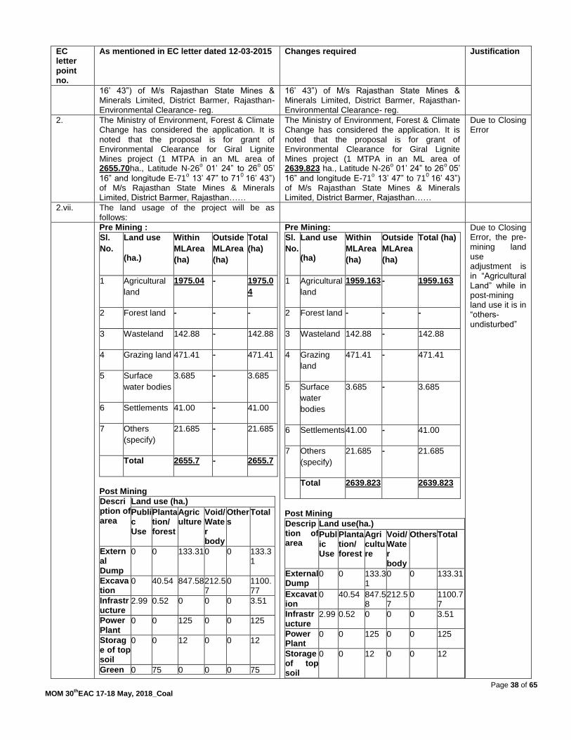
Page 38 of 65 MOM 30
thEAC 17-18 May, 2018_Coal
EC letter point no.
As mentioned in EC letter dated 12-03-2015 Changes required Justification
16‟ 43”) of M/s Rajasthan State Mines & Minerals Limited, District Barmer, Rajasthan- Environmental Clearance- reg.
16‟ 43”) of M/s Rajasthan State Mines & Minerals Limited, District Barmer, Rajasthan- Environmental Clearance- reg.
2. The Ministry of Environment, Forest & Climate Change has considered the application. It is noted that the proposal is for grant of Environmental Clearance for Giral Lignite Mines project (1 MTPA in an ML area of 2655.70ha., Latitude N-26
o 01‟ 24” to 26
o 05‟
16” and longitude E-71o 13‟ 47” to 71
0 16‟ 43”)
of M/s Rajasthan State Mines & Minerals Limited, District Barmer, Rajasthan……
The Ministry of Environment, Forest & Climate Change has considered the application. It is noted that the proposal is for grant of Environmental Clearance for Giral Lignite Mines project (1 MTPA in an ML area of 2639.823 ha., Latitude N-26
o 01‟ 24” to 26
o 05‟
16” and longitude E-71o 13‟ 47” to 71
0 16‟ 43”)
of M/s Rajasthan State Mines & Minerals Limited, District Barmer, Rajasthan……
Due to Closing Error
2.vii. The land usage of the project will be as follows:
Pre Mining :
Sl.
No.
Land use
(ha.)
Within
MLArea
(ha)
Outside
MLArea
(ha)
Total
(ha)
1 Agricultural
land
1975.04 - 1975.0
4
2 Forest land - - -
3 Wasteland 142.88 - 142.88
4 Grazing land 471.41 - 471.41
5 Surface
water bodies
3.685 - 3.685
6 Settlements 41.00 - 41.00
7 Others
(specify)
21.685 - 21.685
Total 2655.7 - 2655.7
Post Mining
Description of area
Land use (ha.)
Public Use
Plantation/ forest
Agriculture
Void/ Water body
Others
Total
External Dump
0 0 133.31 0 0 133.31
Excavation
0 40.54 847.58 212.57
0 1100.77
Infrastructure
2.99 0.52 0 0 0 3.51
Power Plant
0 0 125 0 0 125
Storage of top soil
0 0 12 0 0 12
Green 0 75 0 0 0 75
Pre Mining:
Sl.
No.
Land use
(ha)
Within
MLArea
(ha)
Outside
MLArea
(ha)
Total (ha)
1 Agricultural
land
1959.163 - 1959.163
2 Forest land - - -
3 Wasteland 142.88 - 142.88
4 Grazing
land
471.41 - 471.41
5 Surface
water
bodies
3.685 - 3.685
6 Settlements 41.00 - 41.00
7 Others
(specify)
21.685 - 21.685
Total 2639.823 2639.823
Post Mining
Description of area
Land use(ha.)
Public Use
Plantation/ forest
Agriculture
Void/ Water body
Others Total
External Dump
0 0 133.31
0 0 133.31
Excavation
0 40.54 847.58
212.57
0 1100.77
Infrastructure
2.99 0.52 0 0 0 3.51
Power Plant
0 0 125 0 0 125
Storage of top soil
0 0 12 0 0 12
Due to Closing Error, the pre-mining land use adjustment is in “Agricultural Land” while in post-mining land use it is in “others-undisturbed”

Page 39 of 65 MOM 30
thEAC 17-18 May, 2018_Coal
EC letter point no.
As mentioned in EC letter dated 12-03-2015 Changes required Justification
Belt
Effluent Treatment plant
0 0 1 0 0 1
Others 0 0 0 1205.12
1205.12
Total 2.99 116.06
1118.9 212.57
1205.12
2655.7
Green Belt
0 75 0 0 0 75
Effluent Treatment plant
0 0 1 0 0 1
Others- undisturbed
0 0 0 1189.243
1189.243
Total 2.99 116.06 1118.9
212.57
1189.243
2639.823
3.iii.b) Moreover, only 1380.13 Ha of land has been acquired so far in three stage against total lease area of 2655.70 Ha. …
(b) Moreover, only 1380.13 Ha of land has been acquired so far in three stage against total lease area of 2639.823 Ha. …
Due to Closing Error
4. ….…. The Ministry of Environment, Forest & Climate Change hereby accords environmental clearance for the above-mentioned Giral Lignite Mines project (1 MTPA in an ML area of 2655.70ha.; Latitude N-26
o 01‟ 24” to 26
o 05‟
16” and longitude E-71o 13‟ 47” to 71
0 16‟ 43”)
of M/s Rajasthan State Mines & Minerals Limited, District Barmer, Rajasthan……
….…. The Ministry of Environment, Forest & Climate Change hereby accords environmental clearance for the above-mentioned Giral Lignite Mines project (1 MTPA in an ML area of 2639.823ha.; Latitude N-26
o 01‟ 24” to 26
o
05‟ 16” and longitude E-71o 13‟ 47” to 71
0 16‟
43”) of M/s Rajasthan State Mines & Minerals Limited, District Barmer, Rajasthan……
Due to Closing Error
A. Specific Conditions
xxvii. A progressive afforestation plan shall be implemented covering an area of 892.38 Ha at
the end of mining. Which includes reclaimed External O.B dump area (157.28 Ha), Internal O.B dump area (660.10 Ha), Green belt (75.00
Ha) and in township located outside the lease by planting native around 1000 plants per Ha. ………….
A progressive afforestation plan shall be implemented covering an area of 1221.95 Ha
at the end of mining. Which includes reclaimed External O.B dump area (133.31 Ha), Internal O.B dump area (888.2 Ha), Green belt (75.00
Ha) and in township located outside the lease by planting native around 1000 plants per Ha. ………….
1221.95 from
2.xxiii of EC letter 133.31 from
2.vii, 2.xii, 3.x of EC letter 888.2 from
2.xii, 2.xiii of EC letter
Xxviii. An estimated total of 5023.805 Mm3
of OB will
be generated during the entire life of the mine. Out of which 386.855 Mm
3 of OB will be
dumped in three external OB Dumps in an earmarked area covering 157.28 Ha of land with height of 30 meter in 3 lifts. 4636.95 Mm
3
of will be three internal OB dump in covering an area of 660.10 Ha with height of 12 meters
each lift. The maximum height of external OB dump for hard OB will not exceed 90 m.
…………………
An estimated total of 466.9 MBcumof OB will
be generated during the entire life of the mine. Out of which 26.95 MBcumof OB will be
dumped in three external OB Dumps in an earmarked area covering 133.31 Ha of land
with height of 30 meter in 3 lifts. 439.95MBcumof will be three internal OB dump in covering an area of 888.2 Ha with
height of 12 meters each lift. The maximum height of external OB dump for hard OB will not exceed 30 m. …………………
All figures from 2.xii of EC letter except 466.9 which is
sum total of 26.95+439.95
xxxiii. Of the total quarry area of 883 Ha the backfilled quarry area of 660.10 Ha shall be
reclaimed with the plantation and a void of 222.90 Ha at a depth of 40 m ……………….
Of the total quarry area of 1100.77 Ha the backfilled quarry area of 888.2 Ha shall be
reclaimed with the plantation and a void of 212.57 Ha at a depth of 44-80 m
……………….
1100.77 from
2.vii of EC letter 888.2 from
2.xii, 2.xiii of EC letter 212.57 from
2.vii, 2.xiii, 3.iii of EC letter 44-80 from 2.xiii of EC letter
30.11.3The Committee after deliberations, suggested the project proponent to first revise the Mining Plan. The same needs to be approved by the Ministry of Coal and then the proposal for

Page 40 of 65 MOM 30
thEAC 17-18 May, 2018_Coal
amendment in environmental clearance to be submitted. The proposal was, therefore, not taken forward. Agenda No.30.12 Jagannath Opencast Coal mine Expansion Project from 6.0 MTPA to 7.5 MTPA with increase in ML area from 430.736 ha to 553.946 ha of M/s Mahanadi Coalfields Ltd located in District Angul (Odisha) - For EC [IA/OR/CMIN/57703/2016, F.No.J-11015/177/2005-IA.II(M)] 30.12.1 The proposal is for grant of Environmental Clearance for Jagannath Opencast Coal mine Expansion Project from 6.0 MTPA to 7.5 MTPA with increase in ML area from 430.736 ha to 553.946 ha of M/s Mahanadi Coalfields Ltd located in District Angul (Odisha). 30.12.2 The details of the project, as per the documents submitted by the project proponent, and also as informed during the meeting, are reported to be as under:- (i) The earlier EC was accorded to this opencast coal project vide letter No.J/11015/177/2005-IA-II (M) dt: 29th September 2005 for 6.0 MTPA in a ML area of 430.736 ha. TOR for the project was granted on 16th August, 2017. An amendment in ToR for exemption of PH was issued by MoEF&CC vide letter dated 28thDecember, 2017. (ii) The latitude and longitude of the project are 20O 58‟ 42‟‟ to 20O 56‟ 14‟‟ N & 85O 07‟ 10‟‟ to 85O 9‟ 55‟‟ E respectively. (iii) Joint Venture: There is no joint venture. (iv) Coal Linkage: NTPC Talcher Thermal Power Plant, Other Power Plants & Basket Linkage (v) Employment generated / to be generated: 534(Existing) + 185 (Expansion) direct employment opportunity. Beside above indirect employments will also be generated. (vi) Benefits of the project: (a) Improvement in Physical Infrastructure (b) Improvement in Social Infrastructure (c) Increase in employment potential (d) Contribution to the Exchequer (both State and Central Govt.) (e) Post mining enhancement of Green Cover (f) Improvement of Electrical Power Generation and availability of electricity for 24x7 in rural areas (j) overall economic growth of the country. (vii) The total land area is 578.426 ha. Mining lease area as per approved Mining Plan is 553.946 ha. The land usage of the project will be as follows: Pre-Mining:
Sl. No.
Type of Land Within ML area (Ha)
Outside ML area (Ha)
Total Area (Ha)
Existing Additional Existing Additional Existing Additional
1 Agricultural 0.000 106.75 0.00 0.00 0.000 106.750
2 Waste land 144.110 13.93 11.27 13.21 155.380 27.140
3 Forest Land 80.206 2.53 0.00 0.00 80.206 2.530
4 Grazing 0.000 0.00 0.00 0.00 0.000 0.000
5 Surface water bodies
55.000 0.00 0.00 0.00 55.000 0.000
6 Others 151.42 0.00 0.00 0.00 151.420 0.000

Page 41 of 65 MOM 30
thEAC 17-18 May, 2018_Coal
(afforestation by Jagannath OCP)
Total: 430.736 123.21 11.27 13.21 442.006 136.420
Post- Mining:
Sl. No.
Land use during Mining
Land Use (Ha)
Plantation Water Body
Grass land
Undisturbed Total
1 External OB dump
36.47 - -- - 36.470
2 Top soil dump will be spread over the backfilled area
3 Excavation 229.15 227.401 20.175 -- 476.726
4 Built up area 8.15 -- -- 32.60 40.750
Total 273.77 227.401 20.175 32.60 553.946
Core Area:
Sl. No.
Particulars Existing (in ha) Additional (in ha)
Forest Non-forest
(Govt. & tenancy)
Total (ha)
Forest Non-forest
(Govt. & tenancy)
Total (ha)
Grand Total (ha)
A Break-up of mining lease area:
1 Quarry excavation
80.206 273.310 353.516 2.53 120.68 123.21 476.726
2 External Dumps (In old Jagannath OCM only)
0.000 36.470 36.470 0.000 0.000 0.000 36.470
3 Infrastructure like workshop, store, CHP & land between infrastructure (In old Jagannath OCM)
0.000 40.750 40.750 0.000 0.000 0.000 40.750
Sub-total (A) (Mining lease area)
80.206 350.530 430.736 2.53 120.680 123.21 553.946
B Break-up of area out side mining lease area (in ha):

Page 42 of 65 MOM 30
thEAC 17-18 May, 2018_Coal
1 Land for rehabilitation colony
0.000 11.270 11.270 0.000 13.210 13.210 24.480
Sub-total (B) 0.000 11.270 11.270 0.000 13.210 13.210 24.480
Grand Total (A+B)
80.206 361.800 442.006 2.53 133.890 136.42 578.426
(viii) The total geological reserve is 82.97 MT. The mineable reserve 72.14 MT, extractable reserve is 72.14 MT. The per cent of extraction would be 100 %. (ix) The coal grade is G-12 (Average). The stripping ratio is 1.09 Cum/tonne. The Gradient varies from 3o to 5o. There are four seams with six sections having thickness ranging 4.29 to 36.55 m. (x) The total estimated water requirement is 2219.30m3/day. The level of ground water ranges from 0 .80 m to 13.27 m below ground level. (xi) The Method of mining would be Opencast. (xii) There are two external OB dumps with Quantity of 5.51 Mm3 in an area of 36.40 ha with height of 30 m above the surface level and two internal dump with Quantity of 158.43 Mm3 in an area of 249.325 ha. (xiii) The final mine void would be in 227.401 ha with depth varying from 48 to 165 m. and the Total quarry area is 472.726 ha. Backfilled quarry area of 229.15 ha shall be reclaimed with plantation & 20.175 Ha to be converted to grass land. A void of 227.401 ha with depth upto 165 m (max.) which is proposed to be converted into a water body. (xiv) The seasonal data for ambient air quality has been documented and all results at all stations are within prescribed limits. (xv) The life of mine is 10 Years. (xvi) Transportation: Coal transportation from face to pit top by tippers/ dumpers, Surface to TTPS by closed conveyor, surface to siding by tippers and Siding to loading by pay loader . (xvii) There is R & R involved. There are 230 PAFs for this expansion of project. (xviii) Cost: Total capital cost of the project is Rs. 409.08 Crores. CSR Cost 2% of the average net profit of the company for the three immediate preceding financial years. Environmental Management Cost Rs. 6.27 Crores (additional Capital cost). (xix) Water body: Bangarujhor is about 100 m (North), Brahmani river is about 7.5 km (East), Nandirajhor is about 6km (South), Singharajhor is about 6.5 km (North-West). (xx) Approvals: Board‟s approval obtained in the 189th Board Meeting held on 18th April, 2017. Mining plan has been approved by MoC vide letter no. 34012/(04)/2011-CPAM Dtd. 16th May 2017. Mine closure plan is an integral part of mining plan. (xxi) Wildlife issues: There are no national Parks, wildlife sanctuary, biosphere reserves found in the 10 km buffer zone. (xxii) Forestry issues: Total forest land 82.736 ha in ML area of 553.946 ha. Forest clearance for 82.736 Ha (58.096 Ha & 24.64 Ha) have been obtained on 9thNov, 2005 and 7th Feb, 2014 respectively. (xxiii) Total afforestation plan (plantation/ grass carpeting) shall be implemented covering an area of 249.325 ha at the end of mining. Since the mine is surrounded on all sides by mines there is no Green Belt proposed around this mines. Density of tree plantation 2500 trees/ha of plants. (xxiv) There are no court cases/violation pending with the project proponent for proposed expansion. (xxv) Public Hearing: Exempted, an amendment ToR for exemption of PH is issued by MoEF&CC vide letter dated 28thDecember, 2017.

Page 43 of 65 MOM 30
thEAC 17-18 May, 2018_Coal
30.12.3 During deliberations on the proposal, the Committee noted the following:- The proposal is for grant of EC to the project for expansion of Jagannath Opencast Coal Mine from 6MTPA to 7.5 MTPA with increase in project area from 442.006 ha (ML area 430.736 ha) to 578.426 ha (ML area 553.946 ha) of M/s Mahanadi Coalfields Limited located in Tehsil Talcher, District Angul (Odisha). Earlier, the project for its capacity of 6 MTPA in mine lease area of 430.736 ha was accorded EC vide letter dated 29thSeptember, 2005. Total project area of 578.426 ha includes forest area of 82.736 ha, for which Stage-II FC has been obtained vide letter 9th November, 2005 & 7th February, 2014.The additional area of 123.21 ha has been carved out of the existing Bharatpur OCP for which the revised Mining Plan is yet to be approved by the board of M/s Mahanadi Coalfields Ltd and/or the Ministry of Coal. Also, the proposal for amendment in environmental clearance for the Bharatpur OCP is to be submitted accordingly. ToR for the project for expansion from 6 MTPA to 7.5 MTPA in a total area of 578.426 ha was granted on 16thAugust, 2017, followed by amendment on 28th December, 2017 for exemption from public hearing. The said exemption was granted considering the public hearing for the additional land of 123.210 ha (presently a part of the adjoining Bharatpur OCP of 20 MTPA in an area of 1324.80 ha) was earlier conducted by the SPCB on 15th January, 2007. Mining Plan was approved by MCL Board on 18th April, 2017 and by Ministry of Coal vide letter dated 16thMay, 2017. Mine Closure Plan is an integral part of Mining Plan. Baseline Data was generated for the period of 3rd November, 2017 to 2nd February, 2018. Baseline air quality values at ambient air quality monitoring stationsare in the range of 23.66-58.84 ug/m3 for PM2.5, 59.82-95.74ug/m3 for PM10, SO2 from 7.40-25.40 ug/m3 and NOx from 12.41-35.97 ug/m3, and thus meeting the prescribed standards. The cumulative study has been done considering nearby running and upcoming mines/expansion of mines and other industries. It has been observed that cumulative values of PM10(considering average baseline data) are well within permissible limit except at Danara. To further reduce the incremental values of PM10 at Danara, a thick green belt is proposed between the siding and Danara Village. Presently, construction of new silos is under process. After commissioning of conveyor belt and silos, ambient air quality is likely to be improved further. The Ministry‟s Regional Office at Bhubaneswar has carried out the site visit on 23rd December, 2016 and submitted the monitoring report on compliance status of EC conditions vide letter dated 5thApril, 2017. Apart from many conditions reported to be partially completed, the Regional Office had observed that effective measures were required to be taken on certain issues to ensure satisfactory compliance status, which included the following:-
It has been found that Pas have transferred chunk of land to Annta OCP in year 2008 without taking required statutory permission from competent authority.
It has been found that the management of OB dumps including retaining wall, toe wall, catch drains, height of OB and its slope, plantation (including density), etc is very poor in

Page 44 of 65 MOM 30
thEAC 17-18 May, 2018_Coal
conditions. Therefore, time bound action shall be prepared and executed with utmost dedication.
It has been found that almost 20 year old internal OB dumps shall not properly reclaimed.
It has been found that water sprinklers and bag filters atre not installed in CHP area for controlling of fugitive emission.
It has been found that the safety measures are not upto the mark. Most of the worker working without required PPEs in dusty/noisy area.
It has been found that safety zone and (7.5 m) and plantation o the approached road not be dine so far in most of the places. Plantation in other area need to be palced as per CPCB guideline and condition mentioned in ECs.
It is required to construct metalled haul roads within the lease area,
It has been found that Pas have not implemented suitable ran water harvesting measures. It should be implemented before monsoon period.
It has been found that established ETP is not properly managed
It has been found that Pas have not yet, submitted that detail of work and expenditure made under community development as CSR schemes.
It has been found that PAs have not yet submitted the details of work and expenditure made under Environmental Protection measures
The project has not submitted information regarding compliance of commitments and recommendations made in the EIA/EMP report during presentation to the EAC and also not submitted compliance of commitments made during public-hearing.
As desired by the RO the action taken report on the non-compliance was first submitted on 15th April, 2017 and then on 10th May, 2018. However, the comments of RO, Office are still awaited. Coal production during the period 2010-11 is reported to be 6.33 MTPA i.e. more than the sanctioned capacity of 6 MTPA, and as such amounts to non-compliance of the EC conditions. 30.12.4 The EAC, after deliberations, took serious note of the non-compliances of the EC conditions, and insisted for fresh report by the Regional Office and/or examination of the action taken report vis-à-vis their observations during earlier site visit on 23rd December, 2016. The Committee desired for the present status and recommendations of the Regional Office to take the proposal forward. The Committee further desired that the Ministry may take necessary action on non-compliance of the EC conditions, especially excess coal production during the period 2010-11. The project involves additional area of 123.21 ha to be acquired from BharatpurOpencast Coal Mining project. As such, the parallel proposal for amendment in the EC for BharatpurOCP also needs to be submitted. Agenda No.30.13 30.1 Discussion on any other item.

Page 45 of 65 MOM 30
thEAC 17-18 May, 2018_Coal

Page 46 of 65 MOM 30
thEAC 17-18 May, 2018_Coal
Annexure 1
PARTICIPANTS IN 30th EXPERT APPRAISAL COMMITTEE (EAC) (THERMAL & COAL
MINING) MEETING HELD ON 17th - 18th MAY, 2018 ON COAL SECTOR PROJECTS.
Sl.
No.
List Of Participants Expert Appraisal Committee (Coal
Mining)
1. Dr. Navin Chandra Chairman
2. Dr. Narmada Prasad Shukla Member
3. Dr. Jai Krishna Pandey Member
4. Dr. Manjari Srivastava Member
5. Dr. S K Paliwal Member
6. Prof. S K Sinha Member
7. Shri S.D.Vora Member
8. Shri N.S.Mondal Member
9. Shri S. K. Shrivastva Member Secretary

Page 47 of 65 MOM 30
thEAC 17-18 May, 2018_Coal
Annexure 2
PARTICIPANTS IN 30th EXPERT APPRAISAL COMMITTEE (EAC) (THERMAL & COAL
MINING) MEETING HELD ON 17th-18th MAY, 2018 ON COAL SECTOR PROJECTS.
30.1 Jayant Opencast Coal Mining of M/s Northern Coalfields Limited. . 1. Shri P M Prassad
2. Shri R.K.Mchepalno 3. Shri C.Goswami 4. Shri D.Srivastava 5. Shri. Ashok Prasad 6. Shri S.Kumar
30.2 Cluster-IV (Group of 5 Mixed Mining) of M/s Bharat Coking Coal Limited. . 1.Shri D.Gangopadhyay
2.Shri EVR Raju 3.Shri Kumar Ranjeev 4.Shri Raju Srivastava
5.Shri Ritesh Ranjan 6.Shri Navin Kumar
30.3 Suliyari Opencast Coal Mining of M/s APMDC Limited 1. Shri HD Nagaraja
2. Shri A Laxman 3. Shri M.K.Mukhopadhyay 4. Shri P Bajaj 5. Shri G.R.Verma
30.4 Gevra Coal Washery of M/s ACB (India) Ltd.
1 Shri Tushar 2.Shri V B Sahay
3.Shri K.K.Das 4.Shri Rajesh S Srivastava 30.5 Siarmal Opencast Project of M/s Mahanadi Coalfilds Limited
1. Shri O.P.Singh 2. Shri A.K.Samantaray 3. Shri C.Jagadev 4. Shri R.C.Sahoo 5. Shri S.K.Srivastava 6. Shir Raji Joshna 7. Shri N.K.Singh 8. Shri M.G.Brahmaputra

Page 48 of 65 MOM 30
thEAC 17-18 May, 2018_Coal
9. Shri S.K.Bhar 10 Shri N.Kala
30.6 Dulanga Opencast Coal Mining of M/S NTPC Limited
1. Shri Reju Danial 2. Shri R.K.Badera 3. Shri C.R.Bariu 4. Shri K.S.Sundaram 5. Shri P.R Rao 6. Moh. Abdul Hasib Ansari 7. Smt. Marisha Sharma
30.7 Dhankasa Undergraound Coal Mining of M/s Western Coalfields Limited 30.8 Nandan –II Undergraound Coal Mining of M/s Western Coalfields Limited 30.9 Murpar Undergraound Coal Mining of M/s Western Coalfields Limited 30.10 Durgapur Extension Deep OC Phase-II of M/s Western Coalfields Limited
1. Shri T.N Jha 2. Shri K.Chakraborty 3. Shri S.C.Shankar 4. Shri R.M.Wanere 5. Shri U.S.Shah 6. Shri Sundeep Sharma
30.11 Giral Lignite Mining of M/s Rajasthan State Mines & Minerals Limited . 1. Shri K.C.Shankar
2. Shri Mukesh Chaturvedi 3..Shri P.R.Gehlot 4..Shri S.C.Sharma 5 .Smt. Marisha Sharma
30.12 Jagannath Opencast Coal Mining of M/s Mahanadi Coalfilds Limited 1. Shri O.P.Singh 2. Shri A.K.Samantaray 3. Shri C.Jagadev 4 Shri R.C.Sahoo 5. Shri S.K.Srivastava 6. Shir A.Sinha 7. Shri N.K.Singh 8. Shri M.G.Brahmaputra 9 .Shri S.K.Bhar
30.13 Discussion on any other item
****
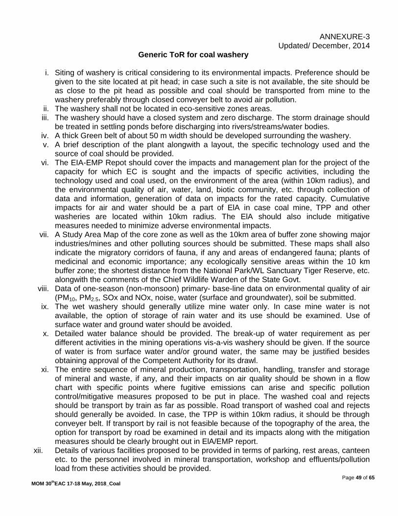
Page 49 of 65 MOM 30
thEAC 17-18 May, 2018_Coal
ANNEXURE-3 Updated/ December, 2014
Generic ToR for coal washery
i. Siting of washery is critical considering to its environmental impacts. Preference should be given to the site located at pit head; in case such a site is not available, the site should be as close to the pit head as possible and coal should be transported from mine to the washery preferably through closed conveyer belt to avoid air pollution.
ii. The washery shall not be located in eco-sensitive zones areas. iii. The washery should have a closed system and zero discharge. The storm drainage should
be treated in settling ponds before discharging into rivers/streams/water bodies. iv. A thick Green belt of about 50 m width should be developed surrounding the washery. v. A brief description of the plant alongwith a layout, the specific technology used and the
source of coal should be provided. vi. The EIA-EMP Repot should cover the impacts and management plan for the project of the
capacity for which EC is sought and the impacts of specific activities, including the technology used and coal used, on the environment of the area (within 10km radius), and the environmental quality of air, water, land, biotic community, etc. through collection of data and information, generation of data on impacts for the rated capacity. Cumulative impacts for air and water should be a part of ElA in case coal mine, TPP and other washeries are located within 10km radius. The ElA should also include mitigative measures needed to minimize adverse environmental impacts.
vii. A Study Area Map of the core zone as well as the 10km area of buffer zone showing major industries/mines and other polluting sources should be submitted. These maps shall also indicate the migratory corridors of fauna, if any and areas of endangered fauna; plants of medicinal and economic importance; any ecologically sensitive areas within the 10 km buffer zone; the shortest distance from the National Park/WL Sanctuary Tiger Reserve, etc. alongwith the comments of the Chief Wildlife Warden of the State Govt.
viii. Data of one-season (non-monsoon) primary- base-line data on environmental quality of air (PM10, PM2.5, SOx and NOx, noise, water (surface and groundwater), soil be submitted.
ix. The wet washery should generally utilize mine water only. In case mine water is not available, the option of storage of rain water and its use should be examined. Use of surface water and ground water should be avoided.
x. Detailed water balance should be provided. The break-up of water requirement as per different activities in the mining operations vis-a-vis washery should be given. If the source of water is from surface water and/or ground water, the same may be justified besides obtaining approval of the Competent Authority for its drawl.
xi. The entire sequence of mineral production, transportation, handling, transfer and storage of mineral and waste, if any, and their impacts on air quality should be shown in a flow chart with specific points where fugitive emissions can arise and specific pollution control/mitigative measures proposed to be put in place. The washed coal and rejects should be transport by train as far as possible. Road transport of washed coal and rejects should generally be avoided. In case, the TPP is within 10km radius, it should be through conveyer belt. If transport by rail is not feasible because of the topography of the area, the option for transport by road be examined in detail and its impacts along with the mitigation measures should be clearly brought out in ElA/EMP report.
xii. Details of various facilities proposed to be provided in terms of parking, rest areas, canteen etc. to the personnel involved in mineral transportation, workshop and effluents/pollution load from these activities should be provided.

Page 50 of 65 MOM 30
thEAC 17-18 May, 2018_Coal
xiii. Impacts of CHP, if any, on air and water quality should also be spelt out alongwith Action Plan.
xiv. O.M.no.J-ll0I3/25/2014-IA.I dated 11th August, 2014 to be followed with regard to CSR activities.
xv. Details of Public Hearing, Notice(s) issued in newspapers, proceedings/minutes of Public Hearing, points raised by the general public and response/commitments made by the proponent along with the Action Plan and budgetary provisions be submitted in tabular form. If the Public Hearing is in the regional language, an authenticated English translation of the same should be provided. Status of any litigations/ court cases filed/pending, if any, against the project should be mentioned in EIA.
xvi. Analysis of samples indicating the following be submitted: Characteristics of coal prior to washing (this includes grade of coal, other
characteristics of ash, S and heavy levels of metals such as Hg, As, Pb, Cr etc). Characteristics and quantum of coal after washing. Characteristics and quantum of coal rejects.
xvii. Details of management/disposal/use of coal rejects should be provided. The rejects should be used in TPP located close to the washery as far as possible. If TPP is within a reasonable distance (10 km), transportation should be by conveyor belt. If it is far away, the transportation should be by rail as far as possible.
xviii. Copies of MOU/Agreement with linkages (for stand-alone washery) for the capacity for which EC is being sought should be submitted.
xix. Corporate Environment Responsibility: a) The Company must have a well laid down Environment Policy approved by the
Board of Directors. b) The Environment Policy must prescribe for standard operating process/procedures
to bring into focus any infringements/deviation/violation of the environmental or forest norms/conditions.
c) The hierarchical system or Administrative Order of the company to deal with environmental issues and for ensuring compliance with the environmental clearance conditions must be furnished.
d) To have proper checks and balances, the company should have a well laid down system of reporting of non-compliances/violations of environmental norms to the Board of Directors of the company and/or shareholders or stakeholders at large.
xx. A detailed action Plan for Corporate Social Responsibility for the project affected people and people living in and around the project area should be provided.
xxi. Permission of drawl of water shall be pre-requisite for consideration of EC. xxii. Wastewater /effluent should confirm to the effluent standards as prescribed under
Environment (Protection) Act, 1986 xxiii. Details of washed coal, middling and rejects along with the MoU with the end-users should
be submitted.
***

Page 51 of 65 MOM 30
thEAC 17-18 May, 2018_Coal
ANNEXURE -4
GENERIC TOR FOR AN OPENCAST COALMINE PROJECT for EC
(i) An EIA-EMP Report shall be prepared for...... MTPA rated capacity in an ML/project area of.....ha based on the generic structure specified in Appendix III of the EIA Notification, 2006.
(ii) An EIA-EMP Report would be prepared for..... MTPA rated capacity to cover the impacts and environment management plan for the project specific activities on the environment of the region, and the environmental quality encompassing air, water, land, biotic community, etc. through collection of data and information, generation of data on impacts including prediction modeling for..... MTPA of coal production based on approved project/Mining Plan for.....MTPA. Baseline data collection can be for any season (three months) except monsoon.
(iii) A toposheet specifying locations of the State, District and Project site should be provided. (iv) A Study area map of the core zone (project area) and 10 km area of the buffer zone (1:
50,000 scale) clearly delineating the major topographical features such as the land use, surface drainage pattern including rivers/streams/nullahs/canals, locations of human habitations, major constructions including railways, roads, pipelines, major industries/mines and other polluting sources. In case of ecologically sensitive areas such as Biosphere Reserves/National Parks/WL Sanctuaries/ Elephant Reserves, forests (Reserved/Protected), migratory corridors of fauna, and areas where endangered fauna and plants of medicinal and economic importance found in the 15 km study area should be given.
(v) Land use map (1: 50,000 scale) based on a recent satellite imagery of the study area may also be provided with explanatory note on the land use.
(vi) Map showing the core zone delineating the agricultural land (irrigated and un-irrigated, uncultivable land as defined in the revenue records, forest areas (as per records), along with other physical features such as water bodies, etc should be furnished.
(vii) A contour map showing the area drainage of the core zone and 25 km of the study area (where the water courses of the core zone ultimately join the major rivers/streams outside the lease/project area) should also be clearly indicated in the separate map.
(viii) A detailed Site plan of the mine showing the proposed break-up of the land for mining operations such as the quarry area, OB dumps, green belt, safety zone, buildings, infrastructure, CHP, ETP, Stockyard, township/colony (within and adjacent to the ML), undisturbed area -if any, and landscape features such as existing roads, drains/natural water bodies to be left undisturbed along with any natural drainage adjoining the lease /project areas, and modification of thereof in terms of construction of embankments/bunds, proposed diversion/re-channelling of the water courses, etc., approach roads, major haul roads, etc should be indicated.
(ix) In case of any proposed diversion of nallah/canal/river, the proposed route of diversion /modification of drainage and their realignment, construction of embankment etc. should also be shown on the map as per the approval of Irrigation and flood control Department of the concerned state.
(x) Similarly if the project involves diversion of any road/railway line passing through the ML/project area, the proposed route of diversion and its realignment should be shown in the map along with the status of the approval of the competent authority.
(xi) Break up of lease/project area as per different land uses and their stage of acquisition should be provided.

Page 52 of 65 MOM 30
thEAC 17-18 May, 2018_Coal
LANDUSE DETAILS FOR OPENCAST PROJECT should be given as per the following table:
Sl. No.
Landuse Within ML area (ha)
Outside ML area (ha)
Total
1. Agricultural land
2. Forest land
3. Wasteland
4. Grazing land
5. Surface water bodies
6. Settlements
7. Others (specify)
TOTAL
(xii) Break-up of lease/project area as per mining plan should be provided. (xiii) Impact of changes in the land use due to the project if the land is predominantly
agricultural land/forestland/grazing land, should be provided. (xiii) One-season (other than monsoon) primary baseline data on environmental quality - air
(PM10, PM2.5, SOx, NOx and heavy metals such as Hg, Pb, Cr, As, etc), noise, water (surface and groundwater), soil - along with one-season met data coinciding with the same season for AAQ collection period should be provided.
(xiv) Map (1: 50, 000 scale) of the study area (core and buffer zone) showing the location of various sampling stations superimposed with location of habitats, other industries/mines, polluting sources, should be provided. The number and location of the sampling stations in both core and buffer zones should be selected on the basis of size of lease/project area, the proposed impacts in the downwind (air)/downstream (surface water)/groundwater regime (based on flow). One station should be in the upwind/upstream/non-impact/non-polluting area as a control station. The monitoring should be as per CPCB guidelines and parameters for water testing for both ground water and surface water as per ISI standards and CPCB classification wherever applicable. Observed values should be provided along with the specified standards.
(xv) Study on the existing flora and fauna in the study area (10km) should be carried out by an institution of relevant discipline. The list of flora and fauna duly authenticated separately for the core and study area and a statement clearly specifying whether the study area forms a part of the migratory corridor of any endangered fauna should be given. If the study area has endangered flora and fauna, or if the area is occasionally visited or used as a habitat by Schedule-I species, or if the project falls within 15 km of an ecologically sensitive area, or used as a migratory corridor then a Comprehensive Conservation Plan along with the appropriate budgetary provision should be prepared and submitted with EIA-EMP Report; and comments/observation from the CWLW of the State Govt. should also be obtained and furnished.
(xvi) Details of mineral reserves, geological status of the study area and the seams to be worked, ultimate working depth and progressive stage-wise working scheme until the end of mine life should be provided on the basis of the approved rated capacity and calendar plans of production from the approved Mining Plan. Geological maps and sections should be included. The Progressive mine development and Conceptual Final Mine Closure Plan should also be shown in figures. Details of mine plan and mine closure plan approval of

Page 53 of 65 MOM 30
thEAC 17-18 May, 2018_Coal
Competent Authority should be furnished for green field and expansion projects. (xvii) Details of mining methods, technology, equipment to be used, etc., rationale for selection
of specified technology and equipment proposed to be used vis-à-vis the potential impacts should be provided.
(xviii) Impact of mining on hydrology, modification of natural drainage, diversion and channeling of the existing rivers/water courses flowing though the ML and adjoining the lease/project and the impact on the existing users and impacts of mining operations thereon.
(xix) Detailed water balance should be provided. The break-up of water requirement for the various mine operations should be given separately.
(xx) Source of water for use in mine, sanction of the Competent Authority in the State Govt. and impacts vis-à-vis the competing users in the upstream and downstream of the project site. should be given.
(xxi) Impact of mining and water abstraction from the mine on the hydrogeology and groundwater regime within the core zone and 10 km buffer zone including long-term monitoring measures should be provided. Details of rainwater harvesting and measures for recharge of groundwater should be reflected in case there is a declining trend of groundwater availability and/or if the area falls within dark/grey zone.
(xxii) Impact of blasting, noise and vibrations should be given. (xxiii) Impacts of mining on the AAQ and predictions based on modeling using the ISCST-3
(Revised) or latest model should be provided. (xxiv) Impacts of mineral transportation within the mining area and outside the lease/project
along with flow-chart indicating the specific areas generating fugitive emissions should be provided. Impacts of transportation, handling, transfer of mineral and waste on air quality, generation of effluents from workshop etc, management plan for maintenance of HEMM and other machinery/equipment should be given. Details of various facilities such as rest areas and canteen for workers and effluents/pollution load emanating from these activities should also be provided.
(xxiv) Effort be made to reduce/eliminate road transport of coal inside and outside mine and for mechanized loading of coal through CHP/ Silo into wagons and trucks/tippers.
(xxv) Details of waste OB and topsoil generated as per the approved calendar programme, and their management shown in figures as well explanatory notes tables giving progressive development and mine closure plan, green belt development, backfilling programme and conceptual post mining land use should be given. OB dump heights and terracing based on slope stability studies with a max of 28o angle as the ultimate slope should be given. Sections of final dumps (both longitudinal and cross section) with relation to the adjacent area should be shown.
(xxvi) Efforts be made for maximising progressive internal dumping of O.B., sequential mining , external dump on coal bearing area and later rehandling into the mine void.--to reduce land degradation.
(xxvii) Impact of change in land use due to mining operations and plan for restoration of the mined area to its original land use should be provided.
(xxviii) Progressive Green belt and ecological restoration /afforestation plan (both in text, figures and in the tabular form as per the format of MOEFCC given below) and selection of species (native) based on original survey/land-use should be given.
Table 1: Stage-wise Landuse and Reclamation Area (ha)

Page 54 of 65 MOM 30
thEAC 17-18 May, 2018_Coal
S.N. Land use Category
Present (1st Year)
5th Year
10th Year
20th Year
24th Year (end of mine life)*
1. Backfilled Area(Reclaimed with plantation)
2. Excavated Area (not reclaimed)/void
3. External OB dump Reclaimed with plantation)
4. Reclaimed Top soil dump
5. Green Built Area
6. Undisturbed area (brought under plantation)
7. Roads (avenue plantation)
8. Area around buildings and Infrastructure
TOTAL
* As a representative example Table 2 : Stage Wise Cumulative Plantation
S.N. YEAR* Green Belt
External Dump
Backfilled Area
Others(Undisturbed Area/etc)
TOTAL
1. 1st year
2. 3rd year
3. 5th year
4. 10th year
5. 15th year
6. 20th year
7. 25th year
8. 30th year
9. 34th year(end of mine life)
10. 34- 37th Year (Post-mining)
* As a representative example
(xxix) Conceptual Final Mine Closure Plan and post mining land use and restoration of land/habitat to the pre- mining status should be provided. A Plan for the ecological

Page 55 of 65 MOM 30
thEAC 17-18 May, 2018_Coal
restoration of the mined out area and post mining land use should be prepared with detailed cost provisions. Impact and management of wastes and issues of re-handling (wherever applicable) and backfilling and progressive mine closure and reclamation should be furnished.
Table 3: Post-Mining Landuse Pattern of ML/Project Area (ha)
S.N. Land use during Mining
Land Use (ha)
Plantation Water Body
Public Use
Undisturbed TOTAL
1. External OB Dump
2. Top soil Dump
3. Excavation
4. Roads
5. Built up area
6. Green Belt
7. Undisturbed Area
TOTAL 110
(xxx) Flow chart of water balance should be provided. Treatment of effluents from workshop,
township, domestic wastewater, mine water discharge, etc. should be provided. Details of STP in colony and ETP in mine should be given. Recycling of water to the max. possible extent should be done.
(xxxi) Occupational health issues. Baseline data on the health of the population in the impact zone and measures for occupational health and safety of the personnel and manpower in the mine should be given.
(xxxii) Risk Assessment and Disaster Preparedness and Management Plan should be provided. (xxxiii) Integration of the Env. Management Plan with measures for minimizing use of natural
resources - water, land, energy, etc. should be carried out. (xxxiv) Cost of EMP (capital and recurring) should be included in the project cost and for
progressive and final mine closure plan. (xxxv) Details of R&R. Detailed project specific R&R Plan with data on the existing socio-
economic status of the population (including tribals, SC/ST, BPL families) found in the study area and broad plan for resettlement of the displaced population, site for the resettlement colony, alternate livelihood concerns/employment for the displaced people, civic and housing amenities being offered, etc and costs along with the schedule of the implementation of the R&R Plan should be given.
(xxxvi) CSR Plan along with details of villages and specific budgetary provisions (capital and recurring) for specific activities over the life of the project should be given.
(xxxvii) Corporate Environment Responsibility: a) The Company must have a well laid down Environment Policy approved by the
Board of Directors. b) The Environment Policy must prescribe for standard operating process/procedures
to bring into focus any infringements/deviation/violation of the environmental or forest norms/conditions.

Page 56 of 65 MOM 30
thEAC 17-18 May, 2018_Coal
c) The hierarchical system or Administrative Order of the company to deal with environmental issues and for ensuring compliance with the environmental clearance conditions must be furnished.
d) To have proper checks and balances, the company should have a well laid down system of reporting of non-compliances/violations of environmental norms to the Board of Directors of the company and/or shareholders or stakeholders at large.
(xxxviii) Details on Public Hearing should cover the information relating to notices issued in the newspaper, proceedings/minutes of Public Hearing, the points raised by the general public and commitments made by the proponent and the action proposed with budgets in suitable time frame. These details should be presented in a tabular form. If the Public Hearing is in the regional language, an authenticated English Translation of the same should be provided.
(xxxix) In built mechanism of self-monitoring of compliance of environmental regulations should be indicated.
(xl) Status of any litigations/ court cases filed/pending on the project should be provided. (xli) Submission of sample test analysis of Characteristics of coal: This should include details
on grade of coal and other characteristics such as ash content, S and heavy metals including levels of Hg, As, Pb, Cr etc.
(xlii) Copy of clearances/approvals such as Forestry clearances, Mining Plan Approval, mine closer plan approval. NOC from Flood and Irrigation Dept. (if req.), etc. wherever applicable.
FOREST CLEARANCE: Details on the Forest Clearance should be given as per the format given:
TOTAL ML/PROJECT AREA (ha)
TOTAL FORESTLAND (ha)
Date of FC
Extent of forestland
Balance area for which FC is yet to be obtained
Status of appl for. diversion of forestland
If more than , provide details of each FC
***

Page 57 of 65 MOM 30
thEAC 17-18 May, 2018_Coal
ANNEXURE -5
GENERIC TORs FOR AN UNDERGROUND COALMINE PROJECT
(i) An EIA-EMP Report shall be prepared for...... MTPA rated capacity in an ML/project area of.....ha based on the generic structure specified in Appendix III of the EIA Notification, 2006.
(ii) An EIA-EMP Report would be prepared for..... MTPA rated capacity to cover the impacts and environment management plan for the project specific activities on the environment of the region, and the environmental quality encompassing air, water, land, biotic community, etc. through collection of data and information, generation of data on impacts including prediction modeling for..... MTPA of coal production based on approved project/Mining Plan for.....MTPA. Baseline data collection can be for any season (three months) except monsoon.
(iii) A Study area map of the core zone (project area) and 10 km area of the buffer zone (1: 50,000 scale) clearly delineating the major topographical features such as the land use, surface drainage pattern including rivers/streams/nullahs/canals, locations of human habitations, major constructions including railways, roads, pipelines, major industries/mines and other polluting sources. In case of ecologically sensitive areas such as Biosphere Reserves/National Parks/WL Sanctuaries/ Elephant Reserves, forests (Reserved/Protected), migratory corridors of fauna, and areas where endangered fauna and plants of medicinal and economic importance found in the 15 km study area should be given.
(iv) Map showing the core zone delineating the agricultural land (irrigated and un-irrigated, uncultivable land as defined in the revenue records, forest areas (as per records), along with other physical features such as water bodies, etc should be furnished.
(v) A contour map showing the area drainage of the core zone and 25 km of the study area (where the water courses of the core zone ultimately join the major rivers/streams outside the lease/project area) should also be clearly indicated in the separate map.
(vi) A detailed Site plan of the mine showing the proposed break-up of the land for mining operations such as the quarry area, OB dumps, green belt, safety zone, buildings, infrastructure, CHP, ETP, Stockyard, township/colony (within and adjacent to the ML), undisturbed area -if any, and landscape features such as existing roads, drains/natural water bodies to be left undisturbed along with any natural drainage adjoining the lease /project areas, and modification of thereof in terms of construction of embankments/bunds, proposed diversion/re-channelling of the water courses, etc., approach roads, major haul roads, etc should be indicated.
(vii) Original land use (agricultural land/forestland/grazing land/wasteland/water bodies) of the area should be provided as per the tables given below. Impacts of project, if any on the land use, in particular, agricultural land/forestland/grazing land/water bodies falling within the lease/project and acquired for mining operations should be analyzed. Extent of area under surface rights and under mining rights should be specified.
S.N ML/Project Land use
Area under Surface Rights(ha)
Area Under Mining Rights (ha)
Area under Both (ha)
1. Agricultural land
2. Forest Land

Page 58 of 65 MOM 30
thEAC 17-18 May, 2018_Coal
3. Grazing Land
4. Settlements
5. Others (specify)
Area under Surface Rights
S.N. Details
Area (ha)
1. Buildings
2. Infrastructure
3. Roads
4. Others (specify)
TOTAL
(viii) Study on the existing flora and fauna in the study area (10km) should be carried out by an
institution of relevant discipline. The list of flora and fauna duly authenticated separately for the core and study area and a statement clearly specifying whether the study area forms a part of the migratory corridor of any endangered fauna should be given. If the study area has endangered flora and fauna, or if the area is occasionally visited or used as a habitat by Schedule-I species, or if the project falls within 15 km of an ecologically sensitive area, or used as a migratory corridor then a Comprehensive Conservation Plan along with the appropriate budgetary provision should be prepared and submitted with EIA-EMP Report; and comments/observation from the CWLW of the State Govt. should also be obtained and furnished.
(ix) Details of mineral reserves, geological status of the study area and the seams to be worked, ultimate working depth and progressive stage-wise working scheme until the end of mine life should be provided on the basis of the approved rated capacity and calendar plans of production from the approved Mining Plan. Geological maps and sections should be included. The Progressive mine development and Conceptual Final Mine Closure Plan should also be shown in figures. Details of mine plan and mine closure plan approval of Competent Authority should be furnished for green field and expansion projects.
(x) Details of mining methods, technology, equipment to be used, etc., rationale for selection of specified technology and equipment proposed to be used vis-à-vis the potential impacts should be provided.
(xi) Impact of mining on hydrology, modification of natural drainage, diversion and channeling of the existing rivers/water courses flowing though the ML and adjoining the lease/project and the impact on the existing users and impacts of mining operations thereon.
(xii) One-season (other than monsoon) primary baseline data on environmental quality - air (PM10, PM2.5, SOx, NOx and heavy metals such as Hg, Pb, Cr, As, etc), noise, water (surface and groundwater), soil - along with one-season met data coinciding with the same season for AAQ collection period should be provided.
(xiii) Map (1: 50, 000 scale) of the study area (core and buffer zone) showing the location of various sampling stations superimposed with location of habitats, other industries/mines, polluting sources, should be provided. The number and location of the sampling stations in both core and buffer zones should be selected on the basis of size of lease/project area, the proposed impacts in the downwind (air)/downstream (surface water)/groundwater regime (based on flow). One station should be in the upwind/upstream/non-impact/non-polluting area as a control station. The monitoring

Page 59 of 65 MOM 30
thEAC 17-18 May, 2018_Coal
should be as per CPCB guidelines and parameters for water testing for both ground water and surface water as per ISI standards and CPCB classification wherever applicable. Observed values should be provided along with the specified standards.
(xiv) Impact of mining and water abstraction from the mine on the hydrogeology and groundwater regime within the core zone and 10 km buffer zone including long-term monitoring measures should be provided. Details of rainwater harvesting and measures for recharge of groundwater should be reflected in case there is a declining trend of groundwater availability and/or if the area falls within dark/grey zone.
(xv) Study on subsidence including modeling for prediction, mitigation/prevention of subsidence, continuous monitoring measures, and safety issues should be carried out.
(xvi) Detailed water balance should be provided. The break up of water requirement as per different activities in the mining operations, including use of water for sand stowing should be given separately. Source of water for use in mine, sanction of the Competent Authority in the State Govt. and impacts vis-à-vis the competing users should be provided.
(xvii) Impact of choice of mining method, technology, selected use of machinery and impact on air quality, mineral transportation, coal handling & storage/stockyard, etc, Impact of blasting, noise and vibrations should be provided.
(xviii) Impacts of mineral transportation within the mining area and outside the lease/project along with flow-chart indicating the specific areas generating fugitive emissions should be provided. Impacts of transportation, handling, transfer of mineral and waste on air quality, generation of effluents from workshop etc, management plan for maintenance of HEMM and other machinery/equipment should be given. Details of various facilities such as rest areas and canteen for workers and effluents/pollution load emanating from these activities should also be provided.
(xix) Effort be made to reduce/eliminate road transport of coal inside and outside mine and for mechanized loading of coal through CHP/ Silo into wagons and trucks/tippers.
(xx) Details of various facilities to be provided to the workers in terms of parking, rest areas and canteen, and effluents/pollution load resulting from these activities should also be given.
(xxi) The number and efficiency of mobile/static water sprinkling system along the main mineral transportation road inside the mine, approach roads to the mine/stockyard/siding, and also the frequency of their use in impacting air quality should be provided.
(xxii) Impacts of CHP, if any on air and water quality should be given. A flow chart showing water balance along with the details of zero discharge should be provided.
(xxiii) Conceptual Final Mine Closure Plan and post mining land use and restoration of land/habitat to the pre- mining status should be provided. A Plan for the ecological restoration of the mined out area and post mining land use should be prepared with detailed cost provisions. Impact and management of wastes and issues of re-handling (wherever applicable) and backfilling and progressive mine closure and reclamation should be furnished.
(xxiv) Greenbelt development should be undertaken particularly around the transport route and CHP. Baseline data on the health of the population in the impact zone and measures for occupational health and safety of the personnel and manpower for the mine should be submitted.
(xxv) Cost of EMP (capital and recurring) should be included in the project cost and for progressive and final mine closure plan.
(xxvi) Details of R&R. Detailed project specific R&R Plan with data on the existing socio-economic status of the population (including tribals, SC/ST, BPL families) found in the

Page 60 of 65 MOM 30
thEAC 17-18 May, 2018_Coal
study area and broad plan for resettlement of the displaced population, site for the resettlement colony, alternate livelihood concerns/employment for the displaced people, civic and housing amenities being offered, etc and costs along with the schedule of the implementation of the R&R Plan should be given.
(xxvii) CSR Plan along with details of villages and specific budgetary provisions (capital and recurring) for specific activities over the life of the project should be given.
(xxviii) Corporate Environment Responsibility: a) The Company must have a well laid down Environment Policy approved by the
Board of Directors. b) The Environment Policy must prescribe for standard operating process/procedures
to bring into focus any infringements/deviation/violation of the environmental or forest norms/conditions.
c) The hierarchical system or Administrative Order of the company to deal with environmental issues and for ensuring compliance with the environmental clearance conditions must be furnished.
d) To have proper checks and balances, the company should have a well laid down system of reporting of non-compliances/violations of environmental norms to the Board of Directors of the company and/or shareholders or stakeholders at large.
(xxix) Details on Public Hearing should cover the information relating to notices issued in the newspaper, proceedings/minutes of Public Hearing, the points raised by the general public and commitments made by the proponent and the action proposed with budgets in suitable time frame. These details should be presented in a tabular form. If the Public Hearing is in the regional language, an authenticated English Translation of the same should be provided.
(xxx) In built mechanism of self-monitoring of compliance of environmental regulations should be indicated.
(xxxi) Status of any litigations/ court cases filed/pending on the project should be provided. (xxxii) Submission of sample test analysis of Characteristics of coal: This should include details
on grade of coal and other characteristics such as ash content, S and heavy metals including levels of Hg, As, Pb, Cr etc.
(xxxiii) Copy of clearances/approvals such as Forestry clearances, Mining Plan Approval, mine closer plan approval. NOC from Flood and Irrigation Dept. (if req.), etc. wherever applicable.
Details on the Forest Clearance should be given as per the format given:
Total ML /Project Area (ha)
Total Forest Land (ha)
Date of FC Extent of Forest Land
Balance area for which FC is yet to be obtained
Status of appl. For diversion of forest land
If more than one provide details of each FC

Page 61 of 65 MOM 30
thEAC 17-18 May, 2018_Coal
ANNEXURE-6
GENERIC TORs FOR AN OPENCAST-CUM-UNDERGROUND COALMINE PROJECT
(i) An EIA-EMP Report would be prepared for a combined peak capacity of .....MTPA for OC-cum-UG project which consists of .... MTPA in an ML/project area of ..... ha for OC and .... MTPA for UG in an ML/project area of ..... ha based on the generic structure specified in Appendix III of the EIA Notification 2006.
(ii) An EIA-EMP Report would be prepared for..... MTPA rated capacity to cover the impacts
and environment management plan for the project specific activities on the environment of the region, and the environmental quality encompassing air, water, land, biotic community, etc. through collection of data and information, generation of data on impacts including prediction modeling for..... MTPA of coal production based on approved project/Mining Plan for.....MTPA. Baseline data collection can be for any season (three months) except monsoon.
(iii) The ToRs prescribed for both opencast and underground mining are applicable for opencast – cum-underground mining.
***

Page 62 of 65 MOM 30
thEAC 17-18 May, 2018_Coal

Page 63 of 65 MOM 30
thEAC 17-18 May, 2018_Coal
30th EAC (THERMAL & COAL MINING PROJECTS) MEETING SCHEDULED FOR 17-18 May, 2018.
AGENDA
Venue: Bhramaputra Conference Hall, 1st Floor, Vayu Wing,
Indira Paryavaran Bhawan, Jorbagh, New Delhi-110003.
Pl. check the MoEF website: http://environmentclearance.nic.in/Report/Default3.aspx Important Note: i. Please send the information as per Annexure 1 by E-mail in word format and also a
signed & scanned copy, to the Member-Secretary at [email protected] at least one week prior to the EAC meeting.
ii. Please send soft copies of all project-related documents that have been uploaded onto the MOEFCC website to EAC members by e-mail [indicating agenda item numbers] immediately upon receiving this communication, and send hard copies of the same documents [indicating agenda items] to all the EAC members, at least one week prior to the meeting and ensure the receipt of same.
iii. Non receipt of the project will lead to deferment of the project. iv. Please also provide a hard copy of presentation to the EAC Members during the
meeting. v. The Project Proponent should carry the KML/Shape Files of the mine lease area at the
time of presentation before EAC and to present on the details of mine lease online to show the present status of mine lease
vi. The KML/Shape files should be emailed on the below mentioned email addresses at least 10 days prior to the meeting
vii. The Project Proponent to show the transportation route of minerals on maps during presentation.
viii. Without this information, EAC has discretion to invite the proponent for the meeting. ix. No consultant is permitted into the meeting who has no accreditation with Quality
Council of India (QCI) /National Accreditation Board of Education and Training (NABET) as per the MoEF OM dated 2nd December, 2009
COAL MINING PROJECTS
Time: 10.00 AM: Thursday: 17th May, 2018
30.1 Jayant Opencast Coal mine Expansion project from 15.5 MTPA to 25 MTPA in an
area of 3177 ha of M/s Northern Coalfields Limited located in District Singrauli
(Madhya Pradesh) - for EC
[IA/MP/CMIN/62083/2017, F.No.J-11015/12/2017-IA.II(M)]

Page 64 of 65 MOM 30
thEAC 17-18 May, 2018_Coal
30.2 Cluster-IV (5 mixed mines) Coal Mining Expansion Project from 3.706 MTPA to 9.55
MTPA in ML area of 1123.79 ha of M/s Bharat Coking Coal Limited located in District
Dhanbad (Jharkhand) -For further consideration of EC
[IA/JH/CMIN/20227/2013, F.No.J-11015/372/2013 -IA.II(M)]
30.3 Suliyari Opencast Coal Mining project of 6.0 MTPA in an area of 1298 ha of M/s
Andhra Pradesh Mineral Development Corporation Limited located in District
Singrauli (Madhya Pradesh) - For TOR
[IA/MP/CMIN/73904/2018, F.No.J-11015/35/2018-IA.II(M)]
30.4 Gevra Coal Washery expansion project from 6.25 MTPA to 16.25 MTPA of M/s ACB
(India) Ltd. in an area of 17.39 ha located in District Korba (Chhattisgarh)-For TOR
[IA/CG/CMIN/74544/2018, F.No.J-11015/36/2018-IA.II(M)]
30.5 Siarmal Opencast Project of 50.0 MTPA peak in an ML area of 2475.47 ha of M/s
Mahanadi Coalfield Limited located in District Sundargarh, (Orissa)-For
extension/Amendment in TOR
[IA/OR/CMIN/24164/2014, F.No.J-11015/230/2014-IA.II(M)]
30.6 Dulanga Opencast Coal Mining Project of 7 MTPA in an area of 785.37 ha of M/s
NTPC Limited located in Ib Valley Coalfields, District Sundergarh (Orissa) -For EC
amendment
[IA/OR/CMIN/10821/2007, F.No.J-11015/1140/2007-IA.II(M)]
Time: 10.00 AM: Friday: 18th May, 2018
30.7 Dhankasa Underground coal mining project of 1.25 MTPA in a total area of 582.651
ha of M/s Western Coalfields Limited located in Pench-Kanhan Coalfields, District
Chindwara (Madhya Pradesh)-For EC
[IA/MP/CMIN/72632/2008, F.No.J-11015/451/2008-IA.II(M)]
30.8 Nandan-II Underground Coal Mining Expansion Project of 0.405 MTPA with increase
in land area from 543.50 ha to 656.14 ha) of M/s Western Coalfields Ltd., located at
Dist. Chhindwara, Madhya Pradesh )-For EC
[IA/MP/CMIN/ 20237/2013, F.No.J-11015/371/2013-IA.II(M)]
30.9 Murpar Underground Coal Mine Expansion Project (Phase-I) of capacity 0.28 MTPA
in an area of 482.09 ha, by M/s Western Coalfields Limited located in District

Page 65 of 65 MOM 30
thEAC 17-18 May, 2018_Coal
Chandrapur of (Maharashtra)-For EC amendment
[IA/MH/CMIN/8123/2001, F.No.J-11015/25/2001-IA.II(M)]
30.10 Durgapur Extension Deep OC Phase-II of 3 MTPA of M/s Western Coalfields
Limited in a total area of 1622.50 ha located in District Chandrapur (Maharashtra) -
For Amendment in EC
[IA/MH/CMIN/62601/2008, F.No.J-11015/56/2008-IA.II(M)]
30.11 Giral Lignite Mining project of 1 MTPA in an area of 2655.70 ha of M/s Rajasthan
State Mines & Minerals Limited located in District Barmer (Rajasthan)-For EC
amendment
[IA/RJ/CMIN/21938/2014, F.No.J-11015/94/2014-IA.II(M)]
30.12 Jagannath Opencast Coal mine Expansion Project from 6.0 MTPA to 7.5 MTPA with
increase in ML area from 430.736 ha to 553.946 ha of M/s Mahanadi Coalfields Ltd
located in District Angul (Odisha) - For EC
[IA/OR/CMIN/57703/2016, F.No.J-11015/177/2005-IA.II(M)]
30.13 Discussion on any other item.