Wallingford Conservation Area Appraisal
50
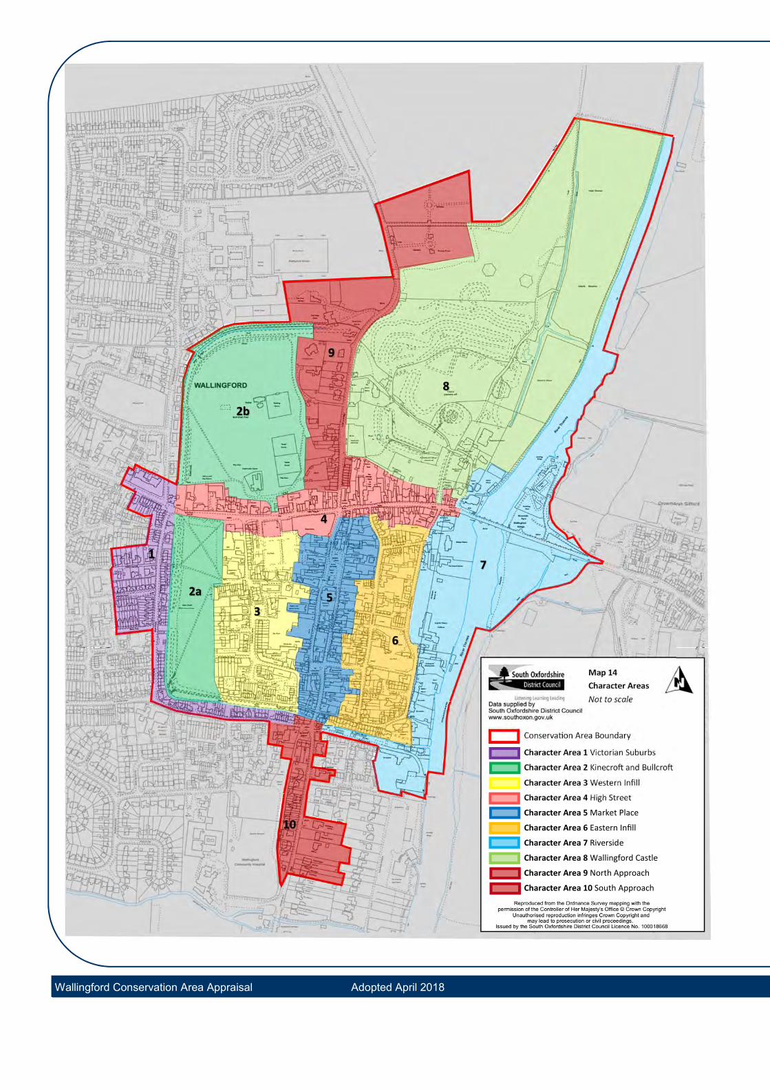
Wallingford Conservation Area Appraisal Wallingford Conservation Area Appraisal Adopted April 2018 37 There are ten sub character areas for Wallingford Conservation Area proposed: 1. Victorian Suburbs: Croft Road and St Johns Road 2. The Saxon Embankments: Kinecroft and Bullcroft 3. Western Infill: Goldsmiths Lane environs 4. High Street 5. Market Place and the commercial centre 6. Eastern Infill: Wood Street environs 7. Riverside 8. Wallingford Castle 9. Northern Approach: Castle Street 10.Southern Approach: Reading Road and Squires Walk Character Areas are identified on Map 14 The character areas identify historically, visually and physically distinct parts of the conservation area. Key influences in shaping the distinctive character areas include the archaeological influence and route progression through the town as well as distinctive periods of building and expansion. Each area will be discussed in turn in terms of its’ prevalent qualities as follows: Buildings Plots and Siting Boundary Treatments Activity and Uses Materials and Local Details Key Buildings Open Spaces, Trees and Greenery Views Issues and Opportunities 6. Character Analysis Local Detail within Character Area 7, Riverside: A memorial to Sir William Blackstone on the south wall of St Peters Church.
-
Upload
khangminh22 -
Category
Documents
-
view
2 -
download
0
Transcript of Wallingford Conservation Area Appraisal

Wallingford Conservation Area Appraisal
Wallingford Conservation Area Appraisal Adopted April 2018 37
There are ten sub character areas for Wallingford Conservation Area proposed:
1. Victorian Suburbs: Croft Road and StJohns Road
2. The Saxon Embankments: Kinecroftand Bullcroft
3. Western Infill: Goldsmiths Lane environs
4. High Street
5. Market Place and the commercial centre
6. Eastern Infill: Wood Street environs
7. Riverside
8. Wallingford Castle
9. Northern Approach: Castle Street
10.Southern Approach: Reading Road andSquires Walk
Character Areas are identified on Map 14
The character areas identify historically, visually and physically distinct parts of the conservation area. Key influences in shaping the distinctive character areas include the archaeological influence and route progression through the town as well as distinctive periods of building and expansion.
Each area will be discussed in turn in terms of its’ prevalent qualities as follows:
Buildings
Plots and Siting
Boundary Treatments
Activity and Uses
Materials and Local Details
Key Buildings
Open Spaces, Trees and Greenery
Views
Issues and Opportunities
6. Character Analysis
Local Detail within Character Area 7, Riverside:
A memorial to Sir William Blackstone on the
south wall of St Peters Church.
Map 14 Character Areas Not to scale
Conserva on Area Boundary
Character Area 1 Victorian Suburbs
Character Area 2 Kinecro and Bullcro
Character Area 3 Western Infill
Character Area 4 High Street
Character Area 5 Market Place
Character Area 6 Eastern Infill
Character Area 7 Riverside
Character Area 8 Wallingford Castle
Character Area 9 North Approach
Character Area 10 South Approach
1
2b
2a
9
8
6
5 3
10
7
Wallingford Conservation Area Appraisal Adopted April 2018
4

Wallingford Conservation Area Appraisal
Wallingford Conservation Area Appraisal Adopted April 2018 39
6.1 Character Area 1: Victorian Suburbs: Croft Road and St Johns Road
Summary This sub-area lies outside the town’s Saxon ramparts on St Johns Road and Croft Road. The special interest of the area is found in the short rows of late 19th century terraced houses representative of
speculative housing built after the arrival of the railway in 1866 and the subsequent gradual development of land between the defended town and the railway station. The houses are notable for their variety in design, details and decorative brickwork.
Buildings Buildings are generally two storeys high, two bays wide and two rooms deep, sometimes with additional projections to the rear. The terraces are typically arranged so that the doorways are positioned in pairs with flanking bay windows. The majority of buildings are in terraces within which each unit mirrors the adjacent unit. Some good detailing is provided on corner buildings such as 30
Croft Road and 12 Croft Road but the arrangement is otherwise back-to-back.
The key defining element in this character area are the rows of houses in Croft Villas, Egerton Road, South View, Brookside (St John’s Road) and Nos. 17-31 (odd) and Nos. 30-46 (even) Croft Road. Croft Villas (north side) are the earliest post-railway buildings. Egerton Road (south side), nos. 30-46 (even) Croft Road and South Vieware the most intact and well-detailedterraces in the area with only limited loss oforiginal architectural details.
Prevalent qualities making this area
19th century and early 20th centuryterraced houses
Individuality of dwellings and specu-lative groups of houses visually ex-pressed in decorative features
Prevalent use of red and grey brick-work and slate roofs
Development follows a consistentand organised back-to-back patternin blocks or along street frontagesnot confined by Medieval town lay-out
The view along South View is channelled by the
terrace and shared green space to their frontages
but is well preserved and an attractive break from
areas where vehicles dominate

Wallingford Conservation Area Appraisal
Wallingford Conservation Area Appraisal Adopted April 2018 40
Plots and siting Many buildings are situated immediately onto the pavement without a front garden, however the majority are set back from the pavement by a few metres to provide small front gardens. The width of the plot corresponds to the status of the building; the larger semi-detached Croft Villas have plots double the width of the terraced buildings elsewhere.
Boundary Treatments Plots with front gardens are bounded by low brick walls, some topped with railings such as at 30-46 Croft Road. The original low red brick walls in South View have round brick copings. The chequered terracotta tile paths survive and are very attractive original features. Croft Villas and 1-13 Egerton Road are fronted by low level hedging.
Activity and uses The area is now almost entirely in residential use. The school on Station Road is now converted to residential use. The Fire Station continues to be used for its original purpose as does The Cross Keys Public House.
Views There are general dynamic views throughout the area the best of which are those along South View, Egerton Road and to Station Road.
Materials and Local details Decorative brickwork: red brick and buff
brick alternating to form window and doorsurrounds, quoins and string courses
Dog-tooth brickwork, string courses andarch window and door details
Uniform brick chimneys with brick bandsand large clay pots forming pleasingrhythms and prominent roofscapes
Original windows are timber framed,single glazed vertical sliding sashes withglazing bars (varying configurations)
Shared timber porches supported oncarved timber brackets
Canted bay windows Welsh slate roofs but some clay tiles on
older buildings Distinctive timber decorative
bargeboards to Croft Villas
Attractive detailing including canted bay windows
with carved brick window heads, shared porches on
timber brackets and geometric patterned tile front
paths are important decorative features that survive
in this character area
Wallingford Fire Station: a distinctive and
decorative yet functional design

Wallingford Conservation Area Appraisal
Wallingford Conservation Area Appraisal Adopted April 2018 41
Key Buildings The Cross Keys Public House, The grade II listed former Wallingford School (c1877), Station Road, is striking in terms of its size, scale and use of bright red brick.
The former fire station in Station Road, dated 1924, is a well-considered functional building with a decorated Dutch gable and strong quoin detailing contributes to an attractive façade which addresses the street well.
The terraces generally are good examples of small scale post-railway building.
Issues and Opportunities
Historic character has been somewhatdiluted by late 20th century houses.modern accretions such as disfiguringoverhead wires and satellite dishes couldbe discreetly located away from principalfrontages.
Replacement of timber windows withuPVC is eroding the fine Victoriandetailing and should be avoided. Whereopenings are upgraded, suitable timberreplacements should be considered
Cumulative loss of architectural featuresand detail
Artificial stone cladding
Addition of roof lights on front or
prominent roof slopes Unsympathetic repair/replacement of
original front boundaries which could be repaired or restored to preserve consistent character
Former Wallingford School, now converted to residential use
The Plough, former public house

Wallingford Conservation Area Appraisal
Wallingford Conservation Area Appraisal Adopted April 2018 42
6.2 Character Area 2: The Saxon Embankments: Kinecroft and Bullcroft
Summary This character area covers the large expanses of open public space on the western quarters of the Saxon Town, Kinecroft (2a) being in the southwest portion and Bullcroft (2b) being in the northwest portion. The Kinecroft was historically used for grazing animals. In 2008 archaeological investigations revealed traces of a row of
12th century timber buildings, which continued the line of Church Lane. The Bullcroft is the site of the former Priory of Holy Trinity dissolved by Cardinal Wolsey in the 16th century. The land was donated to the public in 1914. Both spaces are formally designated as Scheduled Monuments for their high historic and archaeological interest.
The two areas of land are enclosed on two sides by the well treed Saxon embankments. The Kinecroft is crossed by tarmac footpaths and both areas have footpaths on top of the embankments. Both spaces are regularly mown and have the sense of well-kept urban parks. The Bullcroft is a managed recreational area part of which is occupied by tennis courts, children’s play areas, a bowling green and timber-clad buildings that house a pavilion and community centre. Both spaces have a peaceful atmosphere in which birdsong prevails over the sound of traffic.
Buildings A curiosity in the south west corner of the Bullcroft is a late 18th century stone pillar which is listed grade II. It was moved here from the Market Place in 1921, where it reputedly marked the spot where bulls were baited. The Bullcroft has an early 20th
Prevalent qualities making this area distinct
Large areas of open lawned spaceproviding valued spaces for public recreation
Archaeological interest appreciablein the prominent Saxon defensiveenclosure
Aesthetic value of unspoilt long andshort views across open lawns tothe built edge of Wallingford andmature tree topped banks
Important views from the Bullcroft toSt Mary’s church spire
The gates, piers and gatehousemarking the entrance to the Bullcroft
A historic stone pier (relocated fromMarket Place and associated withBull baiting) in the south west cornerof the Bullcroft creates a curiouspoint of interest

Wallingford Conservation Area Appraisal
Wallingford Conservation Area Appraisal Adopted April 2018 43
century lodge house with a red brick lower storey with a rendered upper storey, and a first floor oriel adds to its charm. Three brick gate piers topped with stone ball finials mark a pedestrian and vehicular entrance beside the lodge. An inscribed stone on one of the gate piers records the fact that the Bullcroft was presented to the Borough of Wallingford in 1914.
Boundary Treatments Both areas are enclosed on two sides by the Saxon embankments and ditches that are well treed providing a dense green boundary. On the Kinecroft’s High Street boundary there are a series of heavy iron bollards and railings which allows valuable pedestrian movement into and out of the site. On its western boundary, buildings tend to form the boundary of the field with the openings to Church Lane protected by similar bollard fencing. Further south of this boundary, boundaries tend to become less consistent and in places are formed of modern close board fencing, diluting the appearance of the area.
Activity and Uses The Kinecroft and Bullcroft provide amenity and diverse recreational uses which are a great community asset to Wallingford and form an important part of the town’s life.
Open spaces, trees and greenery There are no trees within the central areas of the parks which enables games and other outdoor pursuits to take place. However, both spaces are bound by the Saxon ramparts which are topped with mature trees. The crofts are large green spaces that are enjoyed by the town’s residents and visitors.
Views There are key views towards the spire of St Peter’s Church from the path skirting the edge of the Bullcroft and from the Kinecroft down Church Lane towards St Marys Church tower. Both spaces by means of their openness allow panoramic views of the town to be experienced from their embankments. On the Bullcroft, the town and outlying suburban development is largely hidden from view by mature trees. Trees in the Kinecroft perform a similar role in views south but more urban form is visible and the edge of the town can be viewed in conjunction with the distance Chiltern Hills which form a backdrop on the skyline.
Bullcroft embankment (left) provides a route around
the open space which is used for recreation
Public footpaths run through the Kinecroft, leaving
the central space open with vistas towards the tree-
lined northern boundary

Wallingford Conservation Area Appraisal
Wallingford Conservation Area Appraisal Adopted April 2018 44
Issues and Opportunities The timber-clad buildings beside the
Bullcroft entrance have a temporaryappearance
The erosion of the historic earth banks byvisitors exploring off the main pathspresents an opportunity to undertake treemanagement and repairs whilstencouraging new routes through thecrofts
The encroachment of fencing fromresidential plots into the Saxon ditches(south side of Kinecroft)
Littering within the ditches is a problemand requires regular clearing
Modern boundary treatments whereresidential plots meet the park should notencroach onto the scheduled monument
6.3 Character Area 3: Western Town Wall infill: Goldsmiths Lane environs
Summary This character area covers the built area between the Kinecroft and the High Street centring on Goldsmiths Lane. This area has a mixed character and appearance with a strong connection to the town’s industrial past. Robust utilitarian buildings relating to the former industrial uses in the area contrast with modest workers housing elsewhere which range in date from the 17th Century to the present day. Present uses are mainly residential but there is a community centre in the Victorian school and a public house at the edge of the Kinecroft.
Goldsmiths Lane and Church Lane form part of the original 10th century street
Prevalent qualities making this area
Landmark industrial buildings and com-plexes from the 18th- 19th centuries
Small scale terraces and vernacular cot-tages from 17th century to present day
Predominantly brick construction butsome rendered timber framed buildings:fairly varied
Sense of being a less formal workingback-land of Wallingford
Key views of St Mary’s Church tower can be seen all
the way from the Kinecroft, by Kinecroft Terrace and
at the junction between Goldsmiths Lane and
Church Lane

Wallingford Conservation Area Appraisal
Wallingford Conservation Area Appraisal Adopted April 2018 45
layout. It was reputedly the location of the town’s mint where coins were struck from Saxon times and the location of the town’s market yards from 1155. Towards the end of the 18th century a vigorous industrial centre of iron working and brewing had formed around Goldsmiths Lane.
Buildings Some prominent buildings survive from the 18th and 19th centuries including Wilder’s ironworks, Hunts Mill, Wallingford Brewery and the Mint which are prominent and architecturally distinctive. The industrial units have mostly been converted to residential use. The yards of these buildings and remaining portions of land have been infilled from the 18th century to the present day mostly with modest terraces of workers cottages. There is also an impressive Victorian school, which is an important focal point both in terms of activity and in its architectural contribution.
Many of the industrial buildings and the later 18th and 19th century cottages and terraces are not formally listed but are identified as local interest buildings and are described individually within the Appendix documents.
Plots and siting The area to the west side of Goldsmiths Lane consisted of larger plots occupied by
the larger industrial sites. As housing was needed, small portions of these plots were gradually siphoned off and divided. The size of plots for housing varies across this
portion of the character area but they generally form narrow strips with buildings sited nearer to the frontage (with the exception of Beansheaf Terrace). In the 20th century as industry declined, many of the larger parcels of land occupied by industrial sites were more intensively subdivided to provide housing and the industrial buildings either demolished or converted to mixed residential use.
To the east side of Goldsmiths Lane and including Church Lane, the plots are constricted by the larger open areas of former burgage plots (now forming car parks) and are much shallower in depth. Buildings are sited onto the street without a front garden with the exception of Goldsmiths Terrace.
Boundary Treatments
Where buildings do have space in front of them, the boundary treatments generally consist of low brick walls. At the school site there are higher brick walls with brick saddleback copings and a number of historic walls of former High Street buildings were retained when Waitrose redeveloped the area. Overall,many of the boundary treatments are either absent, of poor quality or are fairly inconsistent.
Kinecroft Terrace are an attractive group that
frame the view from Church Lane into the Kinecroft
Frontage enclosure along Beansheaf Terrace pre-
serves the character of this group along with pat-
tern of narrow front gardens behind

Wallingford Conservation Area Appraisal
Wallingford Conservation Area Appraisal Adopted April 2018 46
The development of the area was strongly influence by the land use of its industrial past. Today the area, although remaining a fairly busy vehicle thoroughfare, is a comparatively quiet residential area. Most of the activity seems to relate to the use of Church Lane as a pedestrian connection between housing west of the Kinecroft and the Market Place.
Materials and Local Details
Flemish bond brickwork under clay tiledroofs
English bond brickwork at WallingfordBrewery, the school and The Mint
Arch-headed and bulls-eye windows onindustrial buildings
Traditional casement windows on
domestic buildings
Gabled dormer windows which sit on thewall plate/eaves Kinecroft Terrace
Key Buildings
Despite the presence of undistinguished late 20th and 21st century developments, local interest buildings complement the area’s listed buildings to create a notable historic character. Kinecroft Terrace, although modest in scale, is an important
visually prominent terrace. Article 4 Directions have ensured the survival of original windows, doors and roof materials. The dormers and chimneys are particularly prominent and provide rhythm and skyline interest. The brewery complex makes a positive contribution to the character of this part of the Conservation Area, not only as a valuable historic survival but as a local landmark. The brewery manager’s house (No. 46 High Street) complements the High Street’s key listed buildings on the opposite side of the road.
Attractive building conversion of the Wilders
Foundry has preserved local detailing
An attractive but unplanned view along the southern
burgh embankment in front of Croft Terrace links this
area with Character Area 2 and the Kinecroft
Activity and Uses

Wallingford Conservation Area Appraisal
Wallingford Conservation Area Appraisal Adopted April 2018 47
At Hunts Mill, the pyramidal roof of the hop kiln has an obvious industrial scale when compared to the surrounding modest domestic buildings. In contrast, the former Wilders Foundry building displays eccentric and decorative brickwork with a pleasing rhythm of arched window openings which enliven the streetscene.
Open spaces, trees and greenery
There are two large open spaces now occupied by car parks (Waitrose and Council Carpark) to the north and to the south of Church Lane. These are necessary and functional but contribute little to the special interest of the Conservation Area. This character area has limited greenery and tree scape save for a few mature trees along Church lane and at those to the rear of 7 St Martins Street visible from the Council car park.
Views
There is a key view down Kinecroft Terrace and along Church Lane towards the solid 17th century stone tower of St Mary’s. The roof of the hop kiln to the former brewery site is a local landmark and adds interest to the skyline. Views of this within the immediate and surrounding area are unplanned but no less impressive or interesting.
Issues and Opportunities
• Replacement of timber windows withuPVC erodes the historic character ofdwellings which could be improved withappropriate replacements
• Cumulative loss of architectural featuresand detail
• The inactive frontage of 14-16 GoldsmithsLane and associated garaging to side
• Loss of frontage enclosures or lack ofthem such as at St Albans Court entrancewhich could be sensitively reconstructed
• 20th century infill housing that does notaddress local distinctiveness
Former industrial buildings characterise Goldsmiths
Lane, although nearly all have now been converted
Other views within the area are dynamic views through the street scene. In particular, the transition down the enclosed section of Goldsmiths Lane from the High Street towards the junction with the Kinecroft and Church Lane looking up towards the Kinecroft and forwards to the distant Goldsmiths Terrace and down Church Lane transforming from narrow to more open streets.

Wallingford Conservation Area Appraisal
Wallingford Conservation Area Appraisal Adopted April 2018 48
6.4 Character Area 4: High Street Summary This character area comprises the building plots facing the High Street leading from the bridge to the Old Saxon west gate. It is bounded to the north side by the castle grounds (east) and by the Bullcroft (west) and backs the development of the Town Centre to the south. This is one of the oldest routes and contains many of the town’s finest historic buildings many of which still occupy long, narrow burgage plots.
High Street is the principle east-west route through the old Saxon layout of the town being a direct continuation of the river crossing. Its strategic importance as a route through the town from two key defensible points remained legible on the first edition OS map of 1878 which notes that ‘West Gate’ was situated at the west end of the High Street where it interrupts the Saxon Ramparts and ‘East Gate’ was situated on the south side of the river crossing.
Buildings On the eastern portion of the High Street, building facades, which range from bold architectural statements to more modest townhouses and vernacular structures, are the dominant form within the street scene.
Prevalent qualities making this area distinct
Closed and narrow street scenewith building facades cheek-by-jowl
High quality, smart frontages withsash windows and other decora-tive details dating from 17th to19th Century
Predominantly brick but somerendered/timber framed andsome higher status stonework
Western portion of the High Street looking east: A more open street scene with larger detached buildings lining the northern side. St Peters Church spire visible over Waitrose building
The George Hotel (left) with its gabled and jettied
frontage. Grade II* listed

Wallingford Conservation Area Appraisal
Wallingford Conservation Area Appraisal Adopted April 2018 49
These buildings range in date from the 17th Century to the 20th Century. Buildings are generally two storeys high, many with attic accommodation however many larger and grander buildings have a third storey. Those nearest the bridge are generally lower of one and a half or two storeys only.
The western portion has a much sparser quality with larger detached buildings on the northern side. Most are significant historic buildings such as Flint House and Stone Hall. However, these are interspersed with some well-detailed early 20th century detached houses. The large Waitrose building and its carpark dominate on the south side, followed by the complex of buildings forming The Mint and the imposing Brewery owners house at No.46.
Plots and siting The eastern end of the High Street retains a distinctly complex historic character with a dense and varied linear form of buildings lining the narrow road edge. Both sides of the road retain evidence of their former burgage plot divisions. The plots are long and narrow with each frontage building cheek-by-jowl to the next.
To the rear, extensions and outbuildings sprawl into the plots in diminishing size.
Separate buildings have also been sited here such as Bear Lane house which faces onto the service lane rather than the High Street. The only building to break the established character is St Nicholas House which is positioned raised and away from the frontage with a generous front garden fronted by railings.
To the western end of the High Street the development pattern initially continues with a dense urban grain to its northern side. After the entrance to the Bullcroft, plots become shallower and wider with buildings either sitting on the frontage or just set back from it. In this area, much of the backland space has been infilled with new buildings which has subdivided the original plots.
The southern half of this portion of the High Street is dominated by the large plot accommodating Waitrose supermarket and its carpark. Evidence of former plot boundaries are preserved by the retention of historic walls within the car park.
Activity and uses The eastern portion of the High Street is predominantly in residential use with businesses proliferating nearer the Market Place junction. Many buildings accordingly have shopfronts at ground floor level. The
Eastern portion of High Street looking towards the bridge: the varied architectural character of the street scene is unified by consistent street positioning. Glimpsed views of St Peters Church spire within the roofscape.
Preserving evidence of former uses: 87 High Street with retained historic shuttered shopfront

Wallingford Conservation Area Appraisal
Wallingford Conservation Area Appraisal Adopted April 2018 50
two major coaching inns were located here; The Lamb and The George both of which survive. In the western portion of the High Street, the commercial activity continues to a lesser extent and residential buildings become predominant.
In spite of the building of the alleviating peripheral road, this main street continues to be congested with vehicular activity, particularly where four-way traffic is controlled at the central crossroads and at the entrance to the Waitrose carpark.
Materials and Local Details Some historic shopfronts survive and are of interest, notably the detailing of No.25 and the shuttered shopfront of No. 86 High Street. 16 High Street is an excellent example of signage that is sympathetic to the building and its wider historic context.
Flint House’s flint walls with stone quoins and mullion windows are noteworthy as brick characterises this area. The best examples of brickwork can be found here with mellow reds and dark vitrified headers laid often in Flemish bond. The area also has many rendered timber framed buildings or those which have been re-fronted in brick. Examples of multi-paned vertical sliding sash windows are typical throughout.
Key Buildings There are many historically important buildings on the High Street including the timber framed buildings of The George Hotel and Nos. 12; 17,18 & 19 and 94 High Street. Calleva House is one of the most prestigious houses in Wallingford and addresses the street with a grandiose Baroque frontage. There are many historic buildings of more modest appearance which add to the variety of the street scene and contribute to the special interest of the whole.
Of particular note are the corner buildings which carefully ‘turn’ corners by the provision of architectural embellishments to more than one frontage. Good examples include No. 1 Castle Street, the Lamb Arcade and No.28 High Street. On the eastern side, 51, 52, 53 and 46 High Street are large detached buildings that are imposing within the more modest street scene. Most buildings within this area are listed or identified as local interest buildings and are described within the Appendix documents.
Open Spaces Open space and trees are not significant features in this urban area although there are trees in some large private rear
gardens. The front ‘garden’ of no. 90 High Street is a unique space in a street which is otherwise lined with a continuously built-up frontage. A small non-native tree (Magnolia Grandiflora) makes a valuable contribution to this otherwise urban town centre location. There are other mature trees in some large private rear gardens which add to the more domestic character of the street.
Signage in historic places: 16 High Street with traditional hand painted signage and shopfront
Wallingford Conservation Area Appraisal
Wallingford Conservation Area Appraisal Adopted April 2018 51
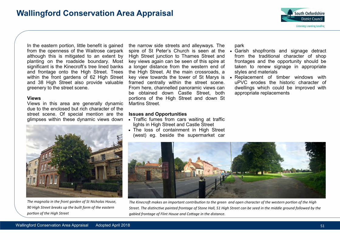
In the eastern portion, little benefit is gained from the openness of the Waitrose carpark although this is mitigated to an extent by planting on the roadside boundary. Most significant is the Kinecroft’s tree lined banks and frontage onto the High Street. Trees within the front gardens of 62 High Street and 38 High Street also provide valuable greenery to the street scene.
Views Views in this area are generally dynamic due to the enclosed but rich character of the street scene. Of special mention are the glimpses within these dynamic views down
the narrow side streets and alleyways. The spire of St Peter’s Church is seen at the High Street junction to Thames Street and key views again can be seen of this spire at a longer distance from the western end of the High Street. At the main crossroads, a key view towards the tower of St Marys is framed centrally within the street scene. From here, channelled panoramic views can be obtained down Castle Street, both portions of the High Street and down St Martins Street.
Issues and Opportunities Traffic fumes from cars waiting at traffic
lights in High Street and Castle Street The loss of containment in High Street
(west) eg. beside the supermarket car
park Garish shopfronts and signage detract
from the traditional character of shopfrontages and the opportunity should betaken to renew signage in appropriatestyles and materials
Replacement of timber windows withuPVC erodes the historic character ofdwellings which could be improved withappropriate replacements
The magnolia in the front garden of St Nicholas House,
90 High Street breaks up the built form of the eastern
portion of the High Street
The Kinecroft makes an important contribution to the green and open character of the western portion of the High
Street. The distinctive painted frontage of Stone Hall, 51 High Street can be seed in the middle ground followed by the
gabled frontage of Flint House and Cottage in the distance.

Wallingford Conservation Area Appraisal
Wallingford Conservation Area Appraisal Adopted April 2018 52
Character Area 5: Market Place
Summary The Market Place forms the lower half of the north to south spine through the town and includes St Mary’s Street, St Martin’s Street, Market Place and St Leonard’s Square. This area is the commercial heart of the town containing the majority of the primary shopping frontage and forms an important focus for the town. The area extends from High Street to the position of the former
southern gate to the Saxon town. It covers the developed part of the southeast quarter of the defended town which has always been the most urban part of the Saxon burh.
Historically this character area may have been a broader street of the proportions which can seen at the Market Square and St Leonard’s Square. The central portion may have been filled in with buildings early on to create two smaller streets either side; St Martin’s Street and St Mary’s Street. The southern exit out of the Saxon town was further west than it is today at the point of Mill Lane.
St Mary’s Street divides into three lengths of different character. At its north end (between High Street and Market Place),
the pedestrianised street has an intimate character arising from the domestic scale of the shopfronts which, for the most part, have a ‘traditional’ appearance. The street has a slight kink and narrows at the north end and leads southward down the length of St Mary’s Street to greenery in St John’s Green.
The middle section of St Mary’s Street between the Town Hall and St Leonard’s Square is still commercial in character but has a less ‘town centre’ feel. Historic buildings on either side maintain the quality of the frontages. In contrast to Market Place, St Leonards Square gives priority to traffic. The open space which is enclosed by buildings is completely covered with tarmac except for a small roundabout colourfully planted with flowers.
Prevalent qualities making this area distinct
Busy civic and commercial centre ofthe town
Closed and narrow street scenewith building facades cheek-by-jowl
High quality, frontages with sashwindows and other decorativedetails dating from 16th to 19thCentury
Predominantly brick but somerendered/timber framed and somehigher status stonework
The Methodist Chapel and Free Library on St Leonard’s Square

Wallingford Conservation Area Appraisal
Wallingford Conservation Area Appraisal Adopted April 2018 53
Buildings The buildings in this character area vary widely in age and architectural style providing a dense and varied historic frontage to the public realm. Many buildings have a classical Georgian symmetrical frontages, sash windows and rendered or brick facades. Many of these frontages conceal medieval cores but little visible timber framing remains exposed. Within this fashionable part of the town, buildings are a little taller than elsewhere, ranging from two and a half to three storeys high with varying bay width. This height decreases in some areas of St Martins Street.
The predominant visible building material is
brick- most often laid showing grey vitrified headers with red brick dressings. Also common rendered façades. Stone is used more here than elsewhere in the town but it remains the exception and is used almost exclusively for civic, religious buildings and high status dwellings. Notable features on many buildings in the area are their shopfronts. Historic shopfronts such as Champions and the glazed stall riser of The Dolphin illustrate the quality of the shopfronts at ground floor level.
Plots and siting Narrow medieval burgage plots survive to the rear of many of the frontage buildings on the east side of the character area. Although
buildings have extended back into these spaces much of this area remains open space and adds positively to the hierarchy of the frontage buildings and the sense of space in neighbouring character areas. These cannot be appreciated from St Marys Street which is well enclosed.
Within the central infilled sections to the Market Place, the plots are completely built over with the exception of St Mary’s Churchyard. Development has a tendency to provide a frontage to St Mary’s rather than St Martin’s, although this balance is being addressed within contemporary development schemes to enliven the St Martin’s Street side.
Wallingford Market Place: The wide open space is enclosed by high buildings. The Town Hall, St Mary’s Church, War
Memorial and water fountain form important focal points within this central space St Mary’s Street in the northern pedestrianised portion
looking south

Wallingford Conservation Area Appraisal
Wallingford Conservation Area Appraisal Adopted April 2018 54
On the western side of St Martin’s Street, building plots are very fragmented but show distinct signs of having once formed burgage plots similar to their eastern counterparts. Buildings again are narrow and positioned on the frontage, extending back for some way. This pattern is less prevalent in the portion between St Mary’s and St Leonard’s Square where plots appear to be much shallower.
Boundary Treatments There are few boundary treatments within this area; buildings are usually sited directly onto the pavement. The heights of the buildings relative to the width of the roads provides a clear sense of enclosure and definition to the Market Place and St Leonard’s Square, which would be diminished if punctuated by large gaps.
St Mary’s Church has a boundary wall enclosing its land; this is a low flint retaining wall with stone coping in the portions enclosing the rear churchyard. A notable boundary treatment is that outside 6-9 St Leonards Square consisting of spearhead railings with urn finial posts. Railings can also be seen on the southern portion of St Marys Street. Within Mill Lane there are high brick walls and flint walls with brick dressings and saddleback copings.
Activity and uses This character area forms the busiest pedestrian area forming the principal shopping frontage of the town and hosts the key civic functions. A wide range of shops provides a lively street scene. Many of these are independent shops rather than chain stores. The pedestrianisation of part of St Mary’s and the Market Place has encouraged a burgeoning coffee culture with outdoor seating which adds to the activity on the streets. The southern portion is less pedestrian friendly and much quieter by comparison to the Market Place. Overall, the whole area is less trafficked than the High Street.
Materials and Local Details Buildings around the Market Place range in type, building material and design. There is a mix of stone (No. 24 and Corn Exchange), render (No. 3, No. 23), painted brick (No.17, No. 19) and red/grey brick (No. 5, No. 16). Clay and slate roofs contribute to a lively roofscape of gables and parapets. Sash windows typical throughout although some vernacular survivals have timber or metal casements with leaded lights (No.23) Shopfronts at ground floor level, most being of traditional appearance and construction
St Mary’s Street on the southern portion looking south:
the flint boundary wall of St Mary’s Churchyard in the
foreground (right)
St Martin’s Street from the Town Hall looking northwards

Wallingford Conservation Area Appraisal
Wallingford Conservation Area Appraisal Adopted April 2018 55
Key Buildings The Town Hall (grade I), stands at the southern end of the market place and is a well preserved 17th century building which dominates and provides a civic focus. The War Memorial (1921, grade II), the water fountain (1885, grade II) and the 1930s K6 telephone kiosk add interest to the Market Place and enhance the setting of the Town Hall. St Mary’s Church tower positioned behind the Town Hall was built partly from the spoil of the castle stone in the mid-17th century. The Corn Exchange (grade II) now a theatre and cinema presents one of the few wholly stone facades in the town but is notable for its cast iron vaulted interior created locally at Wilder’s Ironworks.
Within this character area timber framed buildings are less prevalent and accordingly are very noticeable within the street scene by means of their smaller scale. Of note are Nos. 52, 53 St Mary’s Street which are two mid-17th century timber-framed houses, No. 16 St Mary’s Street which is 17th century jettied building. No. 6 St Mary’s Street is similarly a jettied timber framed structure but of 16
th century date and listed at grade
II*.
Non-conformist chapels make a key architectural contribution in the southern portion of the character area, particularly the
Methodist Chapel and adjoining Free Library on the prominent junction at St Leonards Square. St Mary’s Arcade, a conversion of a former police station, has some architectural and historic interest and makes a positive contribution to the street scenes on both the St Martin’s and St Mary’s sides. The Methodist Church and chapels on St Mary’s Street also make a strong contribution to the street scene. Many buildings within this area are listed and others have been identified as local interest buildings described within the Appendix documents.
Open Spaces, Trees and Greenery Within this tightly-knit town-centre location, the principal open spaces are the urban squares of Market Place, the churchyard of St Mary’s and St Leonard’s Square. There just one significant tree amongst the central spine of this urban Character Area; a large copper beech in St Mary’s Churchyard.
Views One of the most important key views within Wallingford is from the Market Place towards the Town Hall and St Mary’s Church tower. From here panoramic views can be appreciated with views of fine historic buildings all around the square.
Views from St Leonard’s Square are lower
key and of smaller scale. Of note is the panoramic view around St Leonards Square with an additional channelled view down New Street. The openness of the former cattle market allows framed views out of the conservation area to the treed banks of the Thames and distant Chiltern Hills. Elsewhere, the narrow streets provide dynamic views of individual or short rows of buildings which can be admired, particularly along St Mary’s Street.
Issues and Opportunities • Non-traditional signage and shopfronts
should be renewed with traditionaldesign and materials; some signage isoverly modern which takes away fromthe historic character and quality of thestreet scene
• Replacement of timber windows withuPVC at upper levels erodes thehistoric character of buildings whichcould be improved with appropriatereplacements

Wallingford Conservation Area Appraisal
Wallingford Conservation Area Appraisal Adopted April 2018 56
Character Area 6: Eastern infill: Wood Street environs
Summary This character area occupies the south east corner of the former Saxon Burh including Wood Street, St Peter’s Street, New Road and part of Thames Street. Unlike all other parts of the Wallingford Conservation Area, St Leonard’s has a village character, with small scale buildings clustered around and dominated by St Leonard’s Church.
The southern half of the town was developed early on due to the domination of the northern portion of the town by castle and priory. Wood Street as it was known from 1300 was the southern continuation of a northern route (alongside The George Hotel) from the castle grounds as was Thames Street. St Leonard’s Lane (formerly
Oak House on New Road: a prominent and important building within the character area which formerly looked directly onto Wood Street
Little Fish Street) also dates to the early layout of the Saxon town. Much of this area remained a back land working site being bound by the rear of the Market Place plots and the working wharfs at the riverside. These were partly infilled in the 19th and 20th centuries to provide some frontage to Wood Street.
Buildings There is a variance in the character of buildings within the northern and southern portion of this area. The northern portion
Prevalent qualities making this area dis-tinct
Quieter residential quarter with rem-nants of historic industrial and minorcommercial ‘backland’ site activities
More open and less densely devel-oped with less regular urban plan,
Northern end has some higher statustown houses in stone and brick
Southern end contains more vernacu-lar and modest housing, predominantlybrick with some clunch stone and flint.Has the sense of a village rather thantown centre location.

Wallingford Conservation Area Appraisal
Wallingford Conservation Area Appraisal Adopted April 2018 57
has larger, high-status dwellings whereas the southern portion consists largely of modest two storey cottages with a less urban character.
On the north eastern side of Wood Street and St Peter’s Street are some prestigious buildings dating from the 18th to the 19th century constructed of brick and one of stone; including 9, 11 12 & 13 Wood Street and 1 St Peter’s Street. They range from two to three storeys in height and from three bays to eight bays in width. Notable features include the use of sash windows with keystoned or voussoir brick lintels.
The southern portion (with the exception of 1-6 St Leonard’s Lane) consists of simpletwo and three bay cottages of a two storeysbuilt up to the road edge. Nos. 18-23 StLeonard’s Lane maintain this modest scaleand simplicity of design in their single storeyappearance, though they have made use oftheir location on top of the Saxon earthworkin order to disguise an additional storeybeneath the level of the lane.
In contrast to other parts of Wallingford, the use of brick here is more simply detailed than elsewhere in the town and unusually in the case of Anchor House, painted brickwork also features. Detailing is limited, with only a few instances of dentil courses
on the slightly higher status cottages such as Nos.10 and 11 St Leonard’s Lane. There is a mixture of window types, mostly set flush to walls and often tucked under eaves. The variation of window styles, shapes and locations enhances the informal character of the area.
As in other parts of Wallingford, the oldest and most prestigious parts of this character area can be easily identified by their use of limestone rubble and flint such as St Leonard’s Church (11th century) where it is employed in a distinctive herringbone pattern. Timber framing is evident at the former Row Barge and its adjoining terrace.
Plots and siting The rear of St Mary’s Street formed long narrow burgage plots the ends of which were severed to create building plots with a frontage to Wood Street. Plots are accordingly shallow and fairly narrow. Within the central portions there is much less regularity some running the full depth of the parcel of land similar to the burgage plot system and others allocated smaller areas. Generally buildings are sited towards the road frontages. Thames Street is inactive for a large part and forms the backs of plots or otherwise conceals larger plots behind high walls. Overall, land division in these areas is more generous and there is
Outbuildings of Market Place plots fronting Wood Street
Roughly coursed flint Grey vitrified headers with red brick dressings
Grey and red brickwork in varying bonds

Wallingford Conservation Area Appraisal
Wallingford Conservation Area Appraisal Adopted April 2018 58
evidence of more land-intensive uses (cattle market, light industrial) having formed the initial division of land. On St Leonard’s Lane development is more tight knit with a few more spacious plots on the north side. Generally plots are quite small, and the lengths of continuous frontage combined with important sections of walling creates a strong sense of enclosure.
Boundary Treatments
Boundary treatments are of particular note within this area. The high brick, flint and clunch walls on Wood Street and Thames Street are particularly interesting and tell us much about the former uses and divisions of these spaces. The use of close board timber fencing has generally had a negative impact on the character of the area. A good set of cast iron railings to the churchyard, made locally by Wilders foundry, form an attractive and traditional boundary to the east, and a low flint wall with brick dressings and half round capping forms a good quality traditional boundary to the roadside. There are various other boundary treatments of varying quality including some historic brick walls, distinctive locally made metal kerbs and 19th century railings, all contributing to the sense of enclosure in this area.
Activity and Uses The area is predominantly residential although there remains remnants of
commercial activity at the garage and the short parade of shops beside the junction with St Peter’s Street and the council car park within the former cattle market. There are two former public houses along St Leonard’s Lane, the Row Barge at No. 14 which retains its hanging sign and footbridge access from Lower Wharf, and Anchor House at No. 6. These buildings, which point to a time when this area was a busy industrial part of Wallingford rather than the quiet residential area seen today, are important and should be protected from development which would further erode their unique character.
Key Buildings The terraces along the south side of St Leonard’s Lane make an important and positive contribution to the character of the conservation area. The small group of buildings comprising Nos. 9-11 and 13 St Leonard’s Lane to the immediate west of the church are well detailed and their informal relationship to the road enhances the village -like character. Other important buildings are the 18th and 19th century houses lining Wood Street and St Peters St.
Open Spaces, Trees and Greenery The most noticeable open space is the former cattle market which is enclosed by brick and flint walls. Cattlemarket Car Park
Northern portion of Wood Street: larger residential buildings occupy its eastern side
7 & 8 St Leonards Lane: smaller cottage type dwellings characterise the southern portion of this character area

Wallingford Conservation Area Appraisal
Wallingford Conservation Area Appraisal Adopted April 2018 59
leaves a hole in the townscape but development is characteristically less dense on the east side of Wood Street as the built form of the town becomes more spacious near to the riverside.
An important open space is St Leonard’s churchyard which establishes the setting of the church. Trees within the churchyard and surroundings are important in their both number and scale. Another important space, though not one which is directly accessible or necessarily open, is the earthwork ditch which runs parallel but south of St Leonard’s Lane. This is important in defining the extent of the Saxon defended town, but it also creates a natural green lung within what is otherwise quite a built up area and has some additional value for nature conservation.
Views St Leonard’s tower is dominant in views looking east along St Leonard’s Lane and looking south along Thames Street. The church and its tower dominates the surrounding buildings creating a strong focal point. From the east bank of the Thames, there is also a key view.
From the Cattle market Car Park there are panoramic views of the buildings in the immediate area and some glimpses through
to greenery on the east side of the Thames. A feature of note within this view is the golden cupola of Middle Wharf’s boathouse. There also key views from this same aspect of St Leonard’s church tower, St Mary’s Church Tower and St Peter’s Church spire; possibly one of the few locations within the conservation area where all three churches can be seen, although the foreground provided by the car park diminishes this to some extent. Dynamic views can be gained along many of the streets, in particular along St Leonard’s Lane from the narrow alleyway from the High Street and along Wood Street and St Peter’s Street.
Issues and Opportunities Cherwell Close (cul-de-sac) fails to
follow the historic form of development Replacement of timber windows with
uPVC erodes the historic character ofdwellings which could be improvedwith appropriate replacements
Cumulative loss of architectural features and detail
Insensitive means of enclosurethrough the use of close boardedfences could be renewed in morecharacteristic masonry walls orrailings.
New development should respect thecharacter of the area in terms ofdesign, scale and materials
The junction of St Leonards Lane and Thames
Wood Street looking north: buildings on the west
side sit at the ends of the former Market Place
burgage plots

Wallingford Conservation Area Appraisal
Wallingford Conservation Area Appraisal Adopted April 2018 60
Character Area 7 Riverside
Summary The riverside character area is bounded by the Thames to the east and by the modern-day line of Thames Street to the west. This narrow strip of development is perhaps the most visually prominent part of the town, incorporating the bridge and landmark spire of St Peter’s Church, with the river and flood plain to the east allowing long views of the grand houses and their private grounds along the western bank of the Thames.
Thames Street was historically an informal riverside path and formed part of a thriving commercial, industrial and trading centre of
the town. The northern part of Thames Street was rerouted away from the river in the 18th century to accommodate a larger house and grounds to Castle Priory but formerly continued in the line of Castle Lane.
By the 18th century the Thames had developed some popularity as a place of beauty and of leisure rather than exclusively a useful means for trade and large houses were constructed facing the river. Remnants of the former commercial use of this area survives in the older buildings such as those at St Lucian’s, 5-8 Thames Street which retain former warehouses and semi-industrial buildings.
Unlike any of the other character areas, the riverside has a distinctly dual personality. When viewed from outside, from the river or the bridge, large classically inspired houses, separated by spacious grounds and mature trees, dominate the river banks, creating a unique and attractive setting to the town beyond. By contrast, the character along Thames Street is dominated by a sense of enclosure created by the long stretches of wall and structures built up to the street.
Buildings The prestigious riverside houses tend to be of three storeys with parapets or very
Prevalent qualities making this area dis-tinct
The River Thames is the focus of thebuildings on the riverside eitherthrough use or by design
High status houses fronting the riverand backing Thames Street well en-closed within large plots
Surviving functional historic buildingsassociated with industry and trademany of which are vernacular in char-acter
Large areas of open space alongsidethe towpath and within RiversideMeadows on eastern bank

Wallingford Conservation Area Appraisal
Wallingford Conservation Area Appraisal Adopted April 2018 61
shallow pitched roofs, and with the exception of Bridge House, present rendered elevations with sash windows to the river. These are generally rendered or in stone. Architecturally they tend towards a classical style associated with the 18
th
century onwards.
There is otherwise a good distribution of brick building, usually laid in Flemish bond with grey vitrified headers. The use of brick seems to be more reserved for buildings of later date or those associated with former commercial uses. The warehouse on the edge of the river at Wharf House, 5-7 Thames Street and the buildings at Lower Wharf all tend to be one and a half to two storeys in height, often with full or half-hipped roofs.
Plots and siting Residential plots along the river frontage are generally quite wide with buildings positioned parallel to the road and away from the river’s edge. Buildings generally face towards the river rather than onto the road and present a blank elevation to Thames Street/Castle Street. By contrast, the older former working buildings tend to sit in narrower plots and are usually positioned side onto the road with their gables fronting the river.
Boundary Treatments Particularly long stretches of high brick, flint, and chalk clunch boundary walls enclosing Thames Street are of particular note. The Flemish bond brickwork to the walls surrounding Bridge House are distinctive both on the Thames Street elevation and that forming the boundary with the bridge. Spearhead iron railings atop a low brick wall surround the Boat House with stone piers defining the entrance. On its riverside elevation is stone balustrading similar to the design of the balustrading on the central portion of Wallingford Bridge. The river frontages are otherwise left open with lawns of gardens meeting the retaining wall of the river edge. There are no significant boundaries on the eastern side of the river, particularly in the southern portion where the river banks are not retained giving it a particularly unspoilt appearance.
Activity and Uses There are a few remaining clues to the riverside’s working past. The former maltings, now Wallingford Boat Club, along with Wharf House, St Lucian’s and Broughton Mill, have similar visual characteristics including remnants of the louvers over the storage areas and drying kilns, high level openings and loft doors
evidencing their past uses. There is also a mysterious hatch in the high wall to Riverholme may also be associated with trade use of the Thames. The character area is otherwise largely occupied by
Wharf House warehouse The Boat House pub
Brick and clunch stone walls along Thames Street

Wallingford Conservation Area Appraisal
Wallingford Conservation Area Appraisal Adopted April 2018 62
houses many of which are particularly large and imposing. These houses tend to be designed to be seen from the river and in turn optimise views from the house to the river. Leisure activities associated with the river such as boating and bathing continue to be supported by the Boathouse public house and Riverside Park.
Key Buildings Most striking in views from the bridge are the brick warehouse building belonging to Wharf House, The ‘Boathouse’ pub in Arts and Crafts style with a first floor viewing platform, St Peter’s Church and Bridge House both of which are very distinctive landmarks. From Thames Street, smaller cottages like Nos. 2 & 3 Thames Street make a positive contribution to the character area and frame the entrance into Bridge House. Nos. 5-7 Thames Street provide a similar enhancement at the entrance to Castle Priory although have as much interest in their own right with No.7 having the remains of the malthouse cowl on its ridge.
Cromwell Lodge is a particularly attractive double fronted building, reputedly the house that Cromwell stayed in during the siege of Wallingford in 1646.
Riverside, Riverholm and Middle Wharf which in the 19th Century formed one
dwelling called ‘The Retreat’ has a grand ballroom facing the Riverside. Also notable is its boathouse that has a striking golden cupola which was added to the statutory list at grade II in 2009. The building is not only significant for its high architectural quality but is also an important remnant of the Late Victorian influences of recreational pursuits.
Lastly of particular interest is St Lucians (formerly called Old Wharf House) and its associated complex of buildings, which include warehouses, a malthouse and a kiln. St Lucians itself is a grade II* listed building of timber frame construction dating to the 16th century. The building represents a much earlier phase of building than other large houses within the character area and accordingly is architecturally vernacular being timber framed and rendered with a steep clay tile roof. Nos. 1, 2 and 3 Lower Wharf, combined with St Lucian’s Cottage and St Lucians form an attractive and important group framing an important former commercial approach to the Thames.
Open Spaces, Trees and Greenery The mature tree-lined landscape settings of the grand riverside properties are extremely important to this character area in establishing the riverside setting of the town. With the exception of a few discreet ancillary structures and a couple of decorative boathouses on the river’s edge,
Grade II listed Bridge House. St Peters Church
spire is hidden from view by tall trees.
A key view from the eastern river bank of grade II* listed
St Leonards Church tower with the grade II listed
boathouse of Riverside

Wallingford Conservation Area Appraisal
Wallingford Conservation Area Appraisal Adopted April 2018 63
the plots here remain large, open and green, in direct contrast to the concentrated development seen elsewhere in Wallingford. Trees frame many riverside views and on Thames Street, the east side is particularly well enclosed by trees, which screen Castle Priory from pedestrian view.
On the eastern bank of the Thames are two important amenity spaces; Riverside Park to the north of the bridge and the open fields to the south of the bridge. Riverside Park is the location of the town’s open-air swimming and paddling pools set out in the 1930s and which remain a popular attraction in the summer months. As with the western bank of the Thames, trees are dotted along the eastern bank creating a green frame for views along the river.
The area to the south of the bridge has particularly high value as an open space with a very open rural quality. It also has an additional important role in the setting of the bridge, being the only point from which large sections of the earliest 13th century structure can be still seen. Openness on either side of the bridge permits views of almost its entire length, helping viewers to appreciate its grand scale, its series of changes over the centuries and also its vital relationship with Wallingford.
Views The views from Wallingford Bridge have high significance. There are panoramic views from here of the town’s riverside edge including distinctive buildings such as Bridge House, St Peters Church, The Boat House and Wharf House and then around to the river and town’s landscape setting and the Chiltern hills beyond. Some of these views from this position would have been planned and strategic views, particularly those outwards from the town-side of the bridge which would have formed an important defensive position from the west gate. There are also key views from here, particularly of St Peter’s Church where the curvature of the apse and spire can be seen in completeness. Dynamic views from the river or the opposite towpath are also of high importance as a historic means of approaching the town.
Issues and Opportunities Trees are beginning to obscure views
of historic buildings as seen from theeast bank of the Thames
Walls of non-traditional appearanceare a break with character alongThames Street
Proliferation of signage at The BoatHouse could be reduced and usedmore effectively so as not to detract
from the character of the building and river front.
The River Thames and Wallingford Bridge viewed from
the north western bank looking south

Wallingford Conservation Area Appraisal
Wallingford Conservation Area Appraisal Adopted April 2018 64
6.8. Character Area 8: Wallingford Castle and Meadow
Summary This character area focuses on the ruins and surrounding grounds of Wallingford Castle. The earthworks and remaining masonry of the Castle, including the whole
of the Scheduled Monument, are included. The area contains the Castle Gardens, buildings associated with demolished Castle House, the Castle meadows, Queen’s Arbour and King’s Meadow, the remains of St Nicholas’s College and a small area of old and new development along Castle Lane. Castle Street and Bear Lane define the western extent of this character area and the river forms the eastern boundary.
There are two distinct areas: Firstly, the open meadows to the north and east of the character area which contain the earthworks of the castle, the historic masonry and ditch
from the Saxon defences as well as the Kings Meadow and Queen’s Arbour. This area has had several key roles in the town’s history. The most significant is that of the Norman motte and bailey imposed into the Saxon street plan, which led to the building of a large castle that underwent several phases of remodelling and enlargement until its demolition in 1652.
View from the Castle motte across the ruins of the College of St Nicolas towards the town and to the distant Chiltern Hills
Prevalent qualities making this area
Remains of the Castle and Collegeof St Nicholas are a unique historicresource within the district
Huge area of public open space thatis a well managed Green HeritageSite in receipt of the Green FlagAward
Influence of Victorian county housebuilding remains with the distinctwalls, gates and lodges in the built-up areas of the town
Relationship of the town to the rurallandscape and riverside is mosttangible here

Wallingford Conservation Area Appraisal
Wallingford Conservation Area Appraisal Adopted April 2018 65
Second, the area of more formal landscaping known as Castle Gardens, south of Castle Lane, which was the former garden of the Victorian house built by the Hedges family and includes the remains of the middle bailey and the College of St Nicholas. Castle House was built in 1837 and demolished in 1972 during which time the Hedges undertook considerable structural planting to enhance the setting of their house, which has resulted in the planned parkland setting to the castle ruins seen today.
Buildings Although the predominant character of this area is its open, buildings do make a strong contribution to the open space and vice-versa. The materials present in the castle ruins, the ruins of the College of St Nicholas and the twentieth-century buildings along Castle Lane provide insight to the historic use of building materials in Wallingford. Overall the use of stone is more prevalent, possibly showing a reuse of stone from the demolished castle. The Castle and College ruins in this area are predominantly a mix of limestone or more local clunch stone. Evidence of later repairs in brick or flint are also present in some of the remains.
Domestic buildings on the portion of Castle Lane off the High Street consist of a farm
group consisting of barns, a farm house and cottage. Remains of 19th Century farm buildings are a mix of stone and brick with clay tile roofs and the 20th century structures are predominantly brick or render. This small group is distinctive for their vernacular characteristics and rural village qualities. This area has subsequently been infilled with 20th Century development, Thameside Mansion; a particularly imposing structure within the area.
The Victorian phase of development surviving from Castle House on Castle Street and the entrance gates and lodge on the High Street give an insight into the appearance of the demolished Gothic mansion which formerly occupied the area south west of the motte. These show an increased use of knapped flint or red and grey brickwork with stone or red clay brick banding for architectural detail.
Boundary treatments There is a considerable mix of boundary treatments in this character area: 19th century knapped flint, brick and
stone walls surrounding the landscapedcastle gardens
Stone and brick retaining walls along theSaxon ditches and ramparts particularlyalong Castle Lane as it becomes asunken path through the site
Two boundaries and entrances to CastleHouse from High Street and CastleStreet: C19 ashlar stone entrances andcoursed limestone rubble boundarywalls. Pedestrian entrances with hoodmoulds flank a central vehicular opening.On High Street entrance piers arecrenelated whilst Castle Street piers aretopped with Gothic caps and carvedtrefoil detailing.
Metal estate railings with hedging onCastle Meadow’s boundaries to CastleStreet, post and rail fencing with nativehedging and elsewhere post and wirefencing with more rural or agriculturalcharacter
Activity and Uses The remaining agricultural buildings of Farm
Monument within All Hallows Graveyard on Castle Street

Wallingford Conservation Area Appraisal
Wallingford Conservation Area Appraisal Adopted April 2018 66
Cottage and Castle Barn along Caste Lane, now converted to residential use, are an important reference to the areas ever changing uses throughout its history. The buildings, despite conversion, retain much of their agricultural character and the strong boundary wall provides an important physical reminder of how the area has been divided in the past.
The castle grounds although historically having royal and military connections, became the grounds of a private residential dwelling in the 19th century. South Oxfordshire District Council acquired the site in 1999 and now manages the space for the public as an active area for nature conservation. The area is a peaceful place much used by residents and visitors albeit much quieter than the Kinecroft and Bullcroft to the east.
Key Buildings The lodge and former Coach House set further east of the 19th century wall survive and are an important reference to the influence that Victorian housebuilding had on the town.
The survival of the graveyard to the former All Hallows Church is of considerable local interest and contains a grade II listed monument to Thomas Bennett (c.1616).
Thameside Mansion is a notable building quite different to the surrounding character. It encroaches into the castle site and is visually dominant within views of the site somewhat compromising openness.
Open spaces, trees and greenery The main characteristic of this area is its openness and its relationship to the wider rural landscape and vitally important river valley setting of Wallingford. The former Castle defences are mixed and interwoven with a Victorian landscaped garden - the location of the trees and their relationship with the Castle and Castle House are particularly important to the character of the open spaces.
The spaces are also defined by the survival of historic fabric from remains of the Castle walls and buildings. Of striking interest is Castle Lane Path, a ditch between Castle Gardens and the ruins of St Nicholas’s College and the meadows to the north with ruins of the Castle. The motte, despite being heavily vegetated, still affords excellent views of the town.
Many of the trees form part of the 19th century planned landscape, planted to create a striking ‘natural’ setting for the now demolished Castle House. In the upper meadows, pines and oaks are planted in a
Channelled views from Castle Lane looking east towards Farm Cottage: note the high stone walls enclosing the lane
Views across the castle grounds from Castle Street: the tree lined boundary is sparse. Estate railings allow views across the meadows towards the river
Wallingford Conservation Area Appraisal
Wallingford Conservation Area Appraisal Adopted April 2018 67
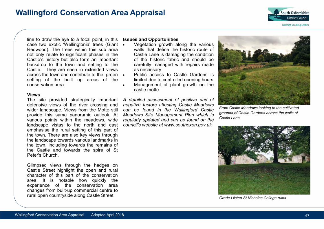
line to draw the eye to a focal point, in this case two exotic ‘Wellingtonia’ trees (Giant Redwood). The trees within this sub area not only relate to significant phases in the Castle’s history but also form an important backdrop to the town and setting to the Castle. They are seen in extended views across the town and contribute to the green setting of the built up areas of the conservation area.
Views The site provided strategically important defensive views of the river crossing and wider landscape. Views from the Motte still provide this same panoramic outlook. At various points within the meadows, wide landscape vistas to the north and east emphasise the rural setting of this part of the town. There are also key views through the landscape towards various landmarks in the town, including towards the remains of the Castle and towards the spire of St Peter's Church.
Glimpsed views through the hedges on Castle Street highlight the open and rural character of this part of the conservation area. It is notable how quickly the experience of the conservation area changes from built-up commercial centre to rural open countryside along Castle Street.
Issues and Opportunities Vegetation growth along the various
walls that define the historic route ofCastle Lane is damaging the conditionof the historic fabric and should becarefully managed with repairs madeas necessary
Public access to Castle Gardens islimited due to controlled opening hours
Management of plant growth on thecastle motte
A detailed assessment of positive and of negative factors affecting Castle Meadows can be found in the Wallingford Castle Meadows Site Management Plan which is regularly updated and can be found on the council’s website at www.southoxon.gov.uk
From Castle Meadows looking to the cultivated
grounds of Castle Gardens across the walls of
Castle Lane
Grade I listed St Nicholas College ruins

Wallingford Conservation Area Appraisal
Wallingford Conservation Area Appraisal Adopted April 2018 68
6.9. Character Area 9: Northern Approach: Castle Street
Summary This character area consists of the parcels of land served by Castle Street which is the only road north of the High Street within the Saxon town. It extends beyond the position of the former ‘north gate’ of the town to Park Farmhouse and the Victorian cemetery.
Castle Street is formed of two distinct phases; the portion from the High Street to No.16 which is formed of a fairly dense accumulation of buildings from the early 18th century to the late 19th century. Some of these optimise their proximity to the busy High Street junction and are in commercial use. The portion to the north is almost
exclusively later 19th and early 20th century housing with the exception of Park Farmhouse which forms an earlier farmstead. Beyond this is the graveyard and cemetery extension dating from the late 19th century which aligned with the later phases of town expansion.
Buildings Buildings are generally two storeys high with some of the grander buildings rising to three storeys in height. This is interspersed with gaps where entrances to the sides and rear of properties are provided and the occasional drop in roof height where an
12-16 Castle Street: The lower portion of the streethas a much denser urban grain with buildingssituated directly onto the pavement
Prevalent qualities making this area distinct
Dense linear development followedby generous late 19th and early20th century villas
Well-preserved Georgian and semi-vernacular domestic architecturaldetails
Eccentric Victorian and Edwardianarchitecture
Remains of outlying post-medievalfarm site
Suburban 19th century cemetery/funerary site

Wallingford Conservation Area Appraisal
Wallingford Conservation Area Appraisal Adopted April 2018 69
lower outbuilding fronts the road such as the former ancillary structures to 8 Castle Street.
In the southern portion of Castle Street, brickwork is often with laid with grey headers with brick dressings or buildings are rendered, sometimes lined out to mimic the appearance of stone. This portion present a classical form of architectural treatment on their principal facades with windows aligned on upper and lower storeys and some with central doors with pilaster and pediment details. Roofs are predominantly clay tile with some lesser use of slate and walls are generally brick. Some buildings have parapets, which conceal the roof from the street and give prominence to the façade. Windows are almost exclusively vertical sashes in varying configurations. There are many original windows and particularly fine examples of 18th century 6/6 and 8/8 sash windows.
Nos.8-20 Castle Street and The Old School House demonstrate an eclectic use of materials and architectural detailing typical of the architectural approach of the late Victorian and Edwardian periods. Red brick is embellished with render, applied timber framing and stonework detailing. The Old School House is the most elaborate and unique expression of this period within this
area, referencing a multitude of historical architectural treatments to great effect.
Plots and siting In the lower portion of Castle Street, buildings occupy fairly long and narrow plots similar to the burgage plot model and are sited directly at the frontage of the plot onto the pavement. This pattern generally continues until No.16 Castle Street which has a much wider plot with a large garden to the side. The development pattern subsequently changes where an open
parcel of land has been divided in a more regimented manner to provide plots of equal size to accommodate large semi-detached and detached houses. These houses are set back from the road to provide small front gardens contrasting within the street scene with the enclosed area nearer the High Street junction which is dominated by built form at the road edge. Beyond this is Park Farmhouse, which constitutes the remains of an historic outlying farm group which is positioned far back from the road within fairly extensive grounds. 20th and 21st century infilling has also been carried out with new buildings being sited within the former rear gardens of the frontage plots.
Boundary Treatments The type of boundary varies according to function and location. The cemetery is bounded by a long brick and flint wall of particularly good quality and gateways are defined by piers and elaborate wrought ironwork gates. The sizeable properties on the west side of Castle Street are set back behind low brick walls supplemented with an evergreen hedge. These are preceded by a long stretch of high brick wall forming the boundary of 16 Castle Street. Boundary treatments are otherwise more prevalent on the eastern side of the street outside of this character area belonging to the former Castle House site and Castle Meadows.
The Old School House: Former Victorian school with rich architectural embellishment
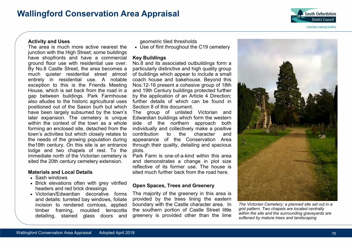
Wallingford Conservation Area Appraisal
Wallingford Conservation Area Appraisal Adopted April 2018 70
Activity and Uses The area is much more active nearest the junction with the High Street; some buildings have shopfronts and have a commercial ground floor use with residential use over. By No.8 Castle Street, the area becomes a much quieter residential street almost entirely in residential use. A notable exception to this is the Friends Meeting House, which is set back from the road in a gap between buildings. Park Farmhouse also alludes to the historic agricultural uses positioned out of the Saxon burh but which have been largely subsumed by the town’s later expansion. The cemetery is unique within the context of the town as a whole forming an enclosed site, detached from the town’s activities but which closely relates to the needs of the growing population during the19th century. On this site is an entrance lodge and two chapels of rest. To the immediate north of the Victorian cemetery is sited the 20th century cemetery extension.
Materials and Local Details Sash windows Brick elevations often with grey vitrified
headers and red brick dressings Victorian/Edwardian decorative forms
and details: turreted bay windows, foliateincision to rendered cornices, appliedtimber framing, moulded terracottadetailing, stained glass doors and
geometric tiled thresholds Use of flint throughout the C19 cemetery
Key Buildings No.8 and its associated outbuildings form a particularly distinctive and high quality group of buildings which appear to include a small coach house and bakehouse. Beyond this Nos.12-16 present a cohesive group of 18th and 19th Century buildings protected further by the application of an Article 4 Direction; further details of which can be found in Section 8 of this document. The group of unlisted Victorian and Edwardian buildings which form the western side of the northern approach both individually and collectively make a positive contribution to the character and appearance of the Conservation Area through their quality, detailing and spacious plots. Park Farm is one-of-a-kind within this area and demonstrates a change in plot size reflective of its former use. The house is sited much further back from the road here.
Open Spaces, Trees and Greenery
The majority of the greenery in this area is provided by the trees lining the eastern boundary with the Castle character area. In the southern portion of Castle Street little greenery is provided other than the lime
The Victorian Cemetery: a planned site set out in a grid pattern. Two chapels are located centrally within the site and the surrounding graveyards are softened by mature trees and landscaping

Wallingford Conservation Area Appraisal
Wallingford Conservation Area Appraisal Adopted April 2018 71
trees located between 8a and 8 Castle Street.
Views through this gap to the trees on the Bullcroft also form an important green backdrop. Further up the street, the area opens up. The wide garden of 16 Castle Street forms a valuable break from the built up area of the town as it opens up and becomes much greener. Within this garden is a large horse chestnut tree which is very prominent within the street scene. This site is generally more tree covered which contributes to an important sense of openness.
The front gardens of the subsequent gardens have high hedged boundaries behind low brick walls which continue the dominance of green on the frontage. No. 21 Castle Street is a modern dwelling and has two large trees flanking its front entrance as does The Rectory at 22 Castle Street. Park Farmhouse is well treed. Its southern boundary forms the edge of the Saxon town and is marked by a dense line of trees. Its open front boundary allows views across its lawned gardens interspersed with mature trees that have the additional protection of a tree preservation order.
The northern boundary is marked by a dense massing of mature trees. This open space provides a necessary relief from the
town and marks the lowering density of built form as it transitions from the built up area to the surrounding landscape. The Victorian cemetery site forms a designed landscape within which trees form an important feature within the open space. This is more sparsely repeated in the new cemetery to the north.
Views There are dynamic views through the area the street scene with glimpsed views across castle meadows in the northern portion. Nearer the High Street Junction there is a longer key view of the Town Hall and St Mary’s Church tower. Of note is the transition from open green space to the dense built up frontages of the town which can be first seen on approach to the town from The Old School House looking south.
Issues and Opportunities Modern close board fences on frontages
at 17 Castle Street and The Old Rectory Poorly detailed 20th century
development/conversion of 6 and 7Castle Street
Inconsistent and untraditional signageschemes on shopfronts 3 and 4 CastleStreet
Applied tile cladding, uPVC & aluminiumwindow and flat roof box dormers to 2Castle Street
Quaker Meeting House entrance. Note the variety of
brick bonds and colours as well as the clunch stone
and flint banding of 12 Castle Street’s side elevation

Wallingford Conservation Area Appraisal
Wallingford Conservation Area Appraisal Adopted April 2018 72
6.10 Character Area 10: Southern Approach: Reading Road and Squires Walk
Summary The southern approach consists of the linear form of development extending south of the Saxon town’s south gate. This comprises St Johns Green, Squires Walk and Reading Road. This area may have been the location of one of Wallingford’s earliest settlements and is likely to have high archaeological interest.
Historically, the south gate is understood to have been positioned further west than the current route out of the Saxon town, more closely aligning with Squires Walk than Reading Road. When the road was turnpiked in 1764, the crossing by Broughton Mill was upgraded and Reading Road, became the principal approach to the town. The result is that development preceding this change faces Squires Walk
whilst later buildings tend to face towards the Reading Road.
A later phase of development in the area is the late 19th and early 20th century development of the land east of the Reading Road (within the proposed boundary extension), which consists of large houses situated within large plots.
Buildings There are multiple phases that make up the built form in the Squires Road portion dating from the post medieval period to the mid- 20th century. Accordingly, architectural style
Squires Halt and Coachmakers Cottage, Squires Walk: modest vernacular cottages.
Prevalent qualities making this area distinct
Dense development of SquiresWalk ‘island’ with variedappearance resulting from range ofbuilding ages from post-medieval topresent day
Late 19th and early 20th centuryvillas within large plots

Wallingford Conservation Area Appraisal
Wallingford Conservation Area Appraisal Adopted April 2018 73
ranges from vernacular timber buildings to Georgian classicism and the more eclectic style associated with the Victorian and Edwardian periods. In terms of size and status, there is much variation, from workers cottages to larger high status houses and villas each presenting a level of detail relevant to their age and status.
Most buildings are two storeys in height although there is variety on the eastern side of Reading Road within the street scene. The change in the predominant route over time has meant that the Reading Road once formed the back of some plots , the evidence of which can be seen in the outbuildings that are sited on the Reading Road frontage. The Squires Walk street scene is similarly affected by this development pattern. In some instances, the rear elevations of Squires Road properties have been architecturally embellished to provide a more attractive front to the Reading Road elevation.
On the eastern side of Reading Road (and some infill plots on the western side), later phases of Victorian and Edwardian buildings provide a more consistent character to the area (within the proposed boundary extension). These are typically larger two and a half to three storey buildings of three
to six bays set within spacious plots. Architectural embellishments typical of the era are used to great effect including double height bay windows, turreted roofs and elaborate applied detailing and decoration.
Plots and siting The buildings between Squires Walk and Reading Road occupy rectangular plots set at right angles to the road. Buildings pre-dating the 19th Century face Squires Walk are sited nearer to the frontage, sometimes directly onto the roadside of Squires Walk. They also tend to occupy narrower plots than those facing Reading Road.
Buildings facing the Reading Road are set back with shallow front gardens. By contrast, on the eastern side of the street (within the proposed boundary extension), the plot sizes are more generous referencing the earlier croft divisions. These plots are similarly set at right angles to the road and are rectangular in shape. Buildings are sited far back from the frontage with large front driveways and generous rear gardens. There are wide gaps between buildings due to the generous plot widths.
Boundary Treatments The western side of Squires Walk is bounded by a long stretch of high flint wall
Aldestowe and Fynamore, Reading Road: early 20th century semi-detached houses
1 & 2 The Chilterns, Reading Road: late 19th Century semi-detached houses

Wallingford Conservation Area Appraisal
Wallingford Conservation Area Appraisal Adopted April 2018 74
with brick copings and piers. In places it is interspersed with sections of chalk clunch stone and replacement areas of brick. On its southern end the boundary is formed by a low section of railings which allow views across the recreation ground from the enclosed street. Squires Walk appears as a ‘hollow way’ with a high bank on its western side topped with trees which in places form an important boundary feature enclosing the road. On the eastern side of Squires Walk boundary treatment is irregular with buildings, brick walls, modern close board fences, sections of hedge providing a mixed road frontage.
To the west side of Reading Road brick walls form the predominant boundary treatment. To the northern portion can be seen an older wall of mixed brick, flint and chalk clunch stone construction not dissimilar to that found of Squires Walk. This has a saddleback coping with drip tile. Beyond this boundary treatments become fairly inconsistent with much close board fencing and modern and old brick wall.
To the east side of Reading Road (within the proposed boundary extension) the front boundaries are particularly prominent given the set back of buildings from the road. These boundaries are notable for their use of hedging which provides a dense green
road frontage. The raised ground level on this side is supported by low retaining walls in flint, limestone or brick with a saddleback coping.
Activity and Uses The character area is almost solely in residential use with the exception of Ptolemy House which is in office use. Historically a wider range of uses may have been located here given its location on a busy trade route into the town.
Materials and Local Details Multiple chimney stacks, many with
decorative mouldings and multiple pots Dormer windows and gabled frontages Canted bay windows, some double
height and turreted Use of red, buff and grey bricks to add
surface decoration to facades Decorated eaves and cornices: modillion
detailing, dentilled brick courses
Key Buildings The majority of buildings in this character area are historically and/or architecturally interesting but are not formally listed and have accordingly been identified as local interest buildings. Examples of key buildings in this area are Ptolemy House, 1-3 St Johns Green, Angiers Almshouses and Chalmore House; the varied nature of these
13-17 Reading Road (as viewed from ReadingRoad) : The terrace originally faced Squires Walkand their rear gardens back Reading Road
6-8 Reading Road : 19th century terrace facing
Reading Road

Wallingford Conservation Area Appraisal
Wallingford Conservation Area Appraisal Adopted April 2018 75
give an idea of the variety of building types and ages that can be found in this character area. This by no means diminishes the contribution made by the many smaller cottages and other villas, which individually and as a group make a high contribution to the special character of this part.
Open Spaces, trees and greenery Much of the greenery in this area is provided by trees along boundaries; especially those on the western side of Squires Walk and those forming the frontages on the eastern side of Reading Road. Of note also is the contribution of gardens generally to the green character of this area. 1-3 St Johns Green contain mature trees which are very visible within the street scene and there is a tall tree within the front garden of 2 The Chilterns. Hedgerows elsewhere add positively to the predominance of greenery on the street frontage. A tree of note and an area of important open space is the small area of lawned space on St Johns Green. The tree is a memorial tree and forms a particularly important visual focal point as well as having important historical and communal value.
Views There are general dynamic views through the area; Squires Walk provides an interesting pedestrian walkway with much visual interest and the west side of Reading Road provides dynamic views of both the eastern and western stretch of the character area. One significant view within the conservation area is from St Marys Street towards St Johns Green. Another is the key view from St John’s Green down Lower Wharf towards St Leonards Church. St John’s Green provides panoramic views of the immediate area which is framed by important buildings with much architectural and historical interest.
Issues and Opportunities Concrete block retaining wall to Squires
Walk western boundary detracts from theattractive areas of brick wall
Close board fencing to Squires Walk andReading Road boundaries
Poorly detailed extensions, flat roofgarages particularly to Squires Walk
Replacement of timber windows withuPVC erodes the historic character ofdwellings which could be improved withappropriate replacements
Alterations that detract from originaldesign compromise the historic characterof properties in this area
St John’s Green: (from left to right) Lower Wharf, Ptolemy House, Angiers Almshouses, Reading Road, 1-3 St Johns Green and the entrance to Squires Walk with St John’s House to the right (out of view). A memorial lime tree in the center of the green is a recent replacement of an oak tree which celebrated the Golden Jubilee of Queen Victoria in 1887.

Wallingford Conservation Area Appraisal
Wallingford Conservation Area Appraisal Adopted April 2018 76
Following a comprehensive review of the Conservation Area boundary between September and December 2016, the designated boundary was changed. The changes rationalised and excluded those areas that no longer met the criteria for designation and included new areas that met the criteria as ‘areas of special architectural or historic interest, the character or appearance of which it is desirable to preserve or enhance’. The changes are itemised below:
1. In Character Area 1 the residential building west of the Fire Station was excluded from the boundary. It is of modern construction and does not meet the criteria of special historic and architectural interest to warrant inclusion in the conservation area.
2. In Character Area 2 the area of land formerly part of the curtilage of Park Farmhouse and now in use by the school was excluded from the designated boundary. Alteration to utilitarian school use means that the land no longer contributes in the same manner to the setting of Park Farmhouse and its historic
farmland setting. The boundary was revised to follow the Bullcroft boundary and includes Wallingford Footpath 17 which lies around the perimeter.
3. In Character Area 2 the boundary was extended to align with the physical boundary of Bullcroft rather than the area covered by the Scheduled Monument designation. The revised boundary includes a narrow area of land on the north west corner of the Bullcroft which includes Wallingford Footpath 17 and which forms part of the extended embankment and ditch system (Black Ditch) This has high historic/archaeological interest.
4. In Character Area 10 the 1980s residential plots to the south of St John’s House were excluded from the boundary. The boundaries of these modern houses do not follow the historic curtilage of St Johns House and the new buildings do not have historical or architectural interest. The boundary was revised to exclude these and to follow the open space and the remaining curtilage of St Johns House which includes a small stable range accessed from Squires Walk
5. In Character Area 10 the boundary was revised to include specific plots on the eastern side of Reading Road. The buildings occupying these plots are of late 19th and early 20th century date and are considered to meet the criteria as Local Interest Buildings, possessing architectural and historic interest sufficient for inclusion within the conservation area boundary. This residential extension to the town built during the late 19th and early 20th centuries comprises many high quality buildings with rich architectural detailing characteristic of the period and local vernacular. The properties included in the boundary are Blair House, Chalmore House, Herries, Ecclesbourne, The Firs, Aldestowe and Fynamore.
Inclusion within the designated boundary results in some changes to permitted development rights and to tree protection. Details of these changes can be found on the Planning Portal online or by contacting the council. The extent of the proposed revised conservation area boundary can be seen on Map 1.
7. Boundary Changes

Conservation Area Boundary Changes Not to scale
Adopted Conservation Area Boundary
Former Conservation Area Boundary
Wallingford Conservation Area Appraisal Adopted April 2018

Wallingford Conservation Area Appraisal
Wallingford Conservation Area Appraisal Adopted April 2018 78
In general, Wallingford is a well-kept, vibrant town with attractive areas of public open space, streets and lanes. The public realm is fairly well maintained.
The Council can initiate improvements and control development in the conservation area. However, the success of conservation area designation and its future management will depend upon the co-operation and enthusiasm of stakeholders including residents, statutory undertakers and business owners to work with the council in achieving common aims and objectives. These are listed below:
General The council will aim to: Promote awareness of the special value
of the conservation area and encouragepromotion of the special character andappearance through works ofpreservation or enhancement;
Encourage statutory undertakers toretain, repair and re-instate historicstreet surfaces, grass verges and banks,street furniture, railings, signage andlighting; reduce street clutter includingwirescape in Character Areas 1, 3, 7 and10 and rationalise street furniture;
Support stakeholders in a reassessment
of listed buildings in Wallingford
Encourage high quality, energy efficientdesign which aims to: fit in with theestablished 'grain' of the conservationarea and be sympathetic to it. HeritageAppraisals and Impact Assessmentsalong with Design and AccessStatements will assist this process;
Encourage the regular maintenance andrepair of buildings walls, railings andmeans of enclosure in the conservationarea with appropriate traditionalmaterials and finishes including theremoval of inappropriate and harmfulcement renders and plasters;
Seek to reinforce the special quality ofhistoric buildings through the use oftraditional materials and constructiontechniques, including the use of limemortars, plasters and renders andpainted timber windows and doors;
Encourage regular tree/hedge management with re-planting where appropriate;
Proposals for development shouldenhance or better reveal the significanceof the conservation area, includingresponding to views both in, out andaround the conservation area and in itswider setting.
8. Future Management of the Conservation
Preserving special details: The front porches of
Sayer Millward Terrace, inset from the façade with
decorative tiled floors

Wallingford Conservation Area Appraisal
Wallingford Conservation Area Appraisal Adopted April 2018 79
Specific
Stakeholders should jointly aim to:
• Ensure that the numerous historicboundary walls that enclose lanes,pavements and public car parks areappropriately maintained and conservedto preserve their historic value andprotect public safety;
• Preserve those features of consistenthistoric detail, pattern and character thatcontribute positively to localdistinctiveness such as the Iron Kerbson Wood Street. This includes therepair and retention of original windows,doors, stained glass, paving tiles andboundary treatments that, for example,unite the nineteenth-century terracesof Croft Road, South View and EgertonRoad;
• Locate new or replace existing externalequipment such as satellite dishes,electricity and telephone wires or meterboxes discreetly away from the principalstreet frontage elevations, especially onpairs and terraces;
• Carefully consider the addition ofrooflights. Where they are used, theyshould be located on rear roof slopes inorder to preserve the special unclutteredappearance of front roof slopes;
Work together to avoid furtherencroachment of residential property
boundaries and fences into the Saxon ditches and embankments;
Avoid the erosion of the historic earthbanks by visitors exploring off the mainpaths;
Ensure appropriate shop frontagereplacement or reinstatement iscompliant with the traditional shopfrontdesign guide. The council will seek toensure alterations to shop frontagesrespond to local distinctiveness;
Look for opportunities for newdevelopment within the conservationarea, such as appropriate infill, to ensurethat the character of the area, its specialinterest, character and appearance ispreserved, enhanced or otherwise betterrevealed in line with current national andlocal policy, informed by this document.
The designation of a Conservation Area is intended to manage change not prevent it. Where policy permits development, it is important that new housing preserves or enhances the character of the area. As such, proposals should be of high quality, responding to the site context and ensuring that a holistic approach is taken to the site including landscaping, boundary treatments, together with enhancing the contribution of open space and enclosure.
This document, the council’s Design Guide (November 2016), national guidance and the council’s local plan policies should be referred to when bringing forward sites for development within and in the setting of the Conservation Area.
Spring View: The importance of preserving historic
details such as paving tiles and repairing or
reinstating such features when lost.

Wallingford Conservation Area Appraisal
Wallingford Conservation Area Appraisal Adopted April 2018 80
Article 4 Direction
An Article 4 Direction was served across six sites in Wallingford on 14 May 1971 (see Map). This direction was served in those areas where the historic character was worthy of additional protection from erosion that would otherwise occur through development that is deemed to be permitted by the Town and Country Planning General Permitted Development Order. The direction removes specific permitted development rights in order to preserve those features that contribute positively to the local distinctiveness of those areas.
The serving of the direction in 1971 means that those works covered by the direction are no longer permitted and planning permission is required to be obtained from the local authority before undertaking any works covered by the direction.
Planning Permission is required for development as described below comprised within Class I(1) and (2) referred to in the first schedule:
1. The enlargement, improvement or otheralteration of a dwellinghouse so long as thecubic content of the original dwellinghouse(as ascertained by external measurement)is not exceeded by more than 1,750 cubicfeet or one-tenth whichever is the greater,subject to a maximum of 4,000 cubic feet;provided that the erection of a garage,
stable, loosebox or coach-house within the curtilage of the dwellinghouse shall be treated as the enlargement of the dwellinghouse for the purpose of this permission.
2. The erection, construction or placing,and the maintenance, improvement or otheralteration, within the curtilage of adwellinghouse, of any building or enclosure(other than a dwelling, garage, stable,loosebox or coach-house) required for apurpose incidental to the enjoyment of thedwellinghouse as such, including thekeeping of poultry, bees, pet animals, birdsor other livestock for the domestic needs orpersonal enjoyment of the occupants of thedwellinghouse.
AND Development comprised within Class II(1) referred to in the First Schedule to thesaid Order and not being developmentcomprised within any other Class i.e.
1. The erection or construction of gates,fences, walls or other means of enclosurenot exceeding 4 feet in height whereabutting on a highway used by vehiculartraffic or 7 feet in height in any other case,and the maintenance, improvement or otheralteration of any gates, fences, walls orother means of enclosure.
2. The painting of the exterior of anybuilding or work otherwise than for thepurpose of advertisement, announcement or
direction.
Further detail about Article 4 Directions and making planning applications can be found on the council’s website.
Preserve historic character : the uniformity of a
terrace is an important part of its special character.
An Article 4 can require that the painting of a
building’s exterior needs planning permission

Map 15 Article 4 Direction Areas Not to scale
Existing Conservation Area Boundary
Article 4 Direction Areas
Wallingford Conservation Area Appraisal Adopted April 2018

Wallingford Conservation Area Appraisal
Wallingford Conservation Area Appraisal Adopted April 2018 82
9. References and useful InformationWallingford
Beasley, David, Wallingford Through Time, Amberley, 2013
Beasley, David, Wallingford at War, Amberley, 2010
Christie, N, Transforming Townscapes: From Burh to Borough: the Archaeology of Wallingford AD800-1400, Society for Medieval Archaeology Monograph, 2013.
Cromarty, A.M. & Barclay A, The Archaeology of the Wallingford Bypass, Thames Valley Landscapes Monograph series, 2006
Hedges, John Kirby, The History of Wallingford, 1881
Pevsner, Nicholas, Buildings of England, Berkshire, 2010 (reprint by Simon Bradley and Geoffrey Tyack)
The Victoria County History, Berkshire, Vol IV, 1924, pp 361-365
Wallingford Castle Meadows Management Plan, www.earthtrust.org.uk / www.southoxon.gov.uk
Wallingford Museum, www.wallingfordmuseum.org.uk
Conservation and Planning Information
Brereton, C, The Repair of Historic Buildings: Principles and Methods, English Heritage, 1995
Design Council, Commission for Architecture and the Built Environment, (Design Council CABE) Design and Access Statements, How to write, read and use them 2016
Ekwall, E, The Concise Oxford Dictionary of Place Names, Repr.1984
Friar, Stephen, Batsford Companion to Local History, 1991
Historic England, Conservation Area Designation, Appraisal and Management: Historic England Advice Note 1, 2016
Historic England, Conservation Principles, 2008
Historic England, Local Heritage Listing: Historic England Advice Note 7, 2016
Historic England, Understanding Place: Historic Area Assessments: Principles and Practice, 2010
Historic England, Understanding Place: Historic Area Assessments in a Planning and Development Context, 2012
Historic England, Valuing Places, Good practice in Conservation Areas, 2011
Hunt, R and Suhr, M, Old House Handbook, SPAB, 2008
The Statutory List of Buildings of Special Architectural or Historic Interest via www.historicengland.org.uk
www.designcouncil.org.uk
www.buildingconservation.com
www.planningportal.gov.uk
www.whitehorsedc.gov.uk
Legislation and Policy
Ancient Monuments and Archaeological Areas Act 1979
Enterprise and Regulatory Reform Act 2013
Planning (Listed Buildings and Conservation Areas) Act 1990
Town and Country Planning Act 1990
National Planning Policy Framework (NPPF) 2012
South Oxfordshire Local Plan 2033 (emerging)
South Oxfordshire Local Plan 2011
South Oxfordshire Core Strategy 2012
Wallingford Neighbourhood Plan (emerging: area designated May 2015)

Wallingford Conservation Area Appraisal
Wallingford Conservation Area Appraisal Adopted April 2018 83
10. Listed Buildings (Grade I, Grade II*, Grade II)Thames Street
II Boathouse East of Middle Wharf
II 8 Thames Street (Cromwell Lodge and attached wall)
II Gatepier 20m south-east of Castle Priory College
II 1 Thames Street (The Cottage and at-tached walls)
II Chest Tomb 1m south-east of Church of St Peter
II Chest Tomb 3m north-east of Church of St Peter
II Pier 15m west of Castle Priory College
II 10 & 11 Thames Street
II 5, 6 & 7 Thames Street (RAF Benson and Wallingford Boat Clubs)
II Gatepier 20m south of Castle Priory Col-lege
II Former Stable Block 20m south of Bridge House
II* Church of St Peter
II Pier 16m west of Castle Priory College
II* Castle Priory College
II Bridge House
II Chest Tomb to Burgess Family 1m south of Tower of Church of Saint Peter
II 12 & 12A Thames Street and attached gatepier
Wood Street
II 38 & 39 Wood Street (with 5 St Leonard’s Lane)
II 12 Wood Street (Suffolk House)
II 31 Wood Street (St Boniface)
II 9 & 10 Wood Street
II 18 Wood Street
II 11 Wood Street
II 17 Wood Street
St Leonard’s Lane
II 5 St Leonard’s Lane (with 38&39 Wood Street)
II 6 St Leonard’s Lane (Anchor House)
II Row Barge Public House
II 7 & 8 St Leonard’s Lane
II* Church of St Leonard
High Street
II Cross Keys Public House
II 82 High Street
II 90 High Street (St Nicholas and attached railings)
II* Wallingford Bridge
II 5 High Street (Thames House)
II 21 High Street
II 12 High Street
II 26 High Street
II* 83 High Street (The George Hotel)
II 13, 14 & 15 High Street
II 61 High Street
II Wall 20m north east of Cross Keys Public House
II 51 & 51a High Street
II Railing 7m south of 90 High Street (St Nicholas)
II* 94 High Street (St Michael’s House)
II 102 High Street (Town Arms)
II 6 High Street (Calleva House)
II 4 High Street
II 52 & 53 High Street (Flint House and Flint Cottage)
II 89 High Street
II 92 & 93 High Street
II 100 High Street and attached gateway
II 7-11 High Street
II 79, 80 & 81 High Street
II 88 High Street
II 30 High Street
II 25 High Street
II* 17, 18 & 19 High Street
II 16 High Street
II Pillar in Bullcroft Park 35m north east of Cross Keys Public House

Wallingford Conservation Area Appraisal
Wallingford Conservation Area Appraisal Adopted April 2018 84
II K6 Telephone Kiosk by the bridge
Church Lane
II 1 Church Lane
II 4 Church Lane (Falcon Cottage)
II 10 Church Lane
II 13 & 14 Church Lane
Castle Street
II 1 Castle Street
II Gatepier 90m east of Park Farmhouse
II South Cemetery Chapel (listed on the A329)
II North Cemetery Chapel (listed on the A329)
II Lodge, Walls and Gates to Wallingford Cemetery (listed on the A329)
II Monument to Thomas Bennet in All Hal-lows Churchyard
II The Lamb Arcade
II 8 & 8B Castle Street
II* Friends Meeting House
II 12 Castle Street (Strafford House)
II Chest Tomb to Button Family in All Hal-lows Churchyard
Castle Lane
I Remains of St Nicholas’s College
I Fragment of Castle Wall
I Remains of Queen’s Tower
II Wharf House
St Mary’s Street
II 37 St Mary’s Street (Coachmaker’s Arms Public House)
II 52 & 53 St Mary’s Street
II 59 St Mary’s Street
II 26 St Mary’s Street
II 18 & 19 St Mary’s Street
II 12 & 13 St Mary’s Street
II 6 St Mary’s Street
II 5 St Mary’s Street
II 45, 46-50 St Mary’s Street (Pettits)
II 36 St Mary’s Street (and 1 Mill Lane)
II 7 St Mary’s Street
II 1 & 2 St Mary’s Street
II* 6 St Mary’s Street
II 3 & 4 St Mary’s Street (The Dolphin Public House)
II 24 & 24A St Mary’s Street
II 34 St Mary’s Street
II 42 St Mary’s Street
II 54, 55 & 56 St Mary’s Street
II 57 & 58 St Mary’s Street
II 28 & 29 St Mary’s Street
II 23A & 23B St Mary’s Street
II 20 & 21 St Mary’s Street
II 16 St Mary’s Street
St Leonard’s Square
II 6, 7, 8 & 9 St Leonard’s Square
II 4 & 5 St Leonard’s Square (Pettits)
Reading Road
II 20 Reading Road (High Trees)
II Angier’s Almshouses
II 21 & 22 Reading Road
II Milestone 1mile south of Angier’s Alms-houses
Market Place
II 13 Market Place
I Town Hall
II 3 Market Place
II 1 Market Place
II 12 Market Place
II 14 Market Place
II* Church of St Mary le More
II 9 Market Place
II 4 Market Place (Lloyds Bank)
II Drinking Fountain 40m north of the Town Hall

Wallingford Conservation Area Appraisal
Wallingford Conservation Area Appraisal Adopted April 2018 85
II 15 Market Place
II War Memorial and Surround 15m north of the Town Hall
II Corn Exchange Theatre
II 24 Market Place
II K6 Telephone Kiosk outside the Town Hall
Lower Wharf
II St Lucian’s Cottage
II* St Lucians and attached former maltings
St Martin’s Street
II 22 & 23 St Martin’s Street
II 7 St Martin’s Street
II 6 St Martin’s Street
II 4 St Martin’s Street
Station Road
II Wallingford Upper School
Mill Lane
II 1 Mill Lane (and 36 St Mary’s Street)
St John’s Green
II 5 St John’s Green (St John’s Cottage)
II 4 St John’s Green (St John’s House)
II 1-3 St John’s Green
Bear Lane
II Wall 20m west of Bear Lane House
II Bear Lane House
II 1-4 Beansheaf Terrace
Goldsmiths Lane
II 3-10 The Mint
Wallingford Conservation Area Appraisal
Wallingford Conservation Area Appraisal Adopted April 2018
For further information and advice on
Conservation Areas please contact:
South Oxfordshire District Council, 135
Eastern Avenue, Milton Park, Milton,
OX14 4SB
Tel: 01235 422600
Email: [email protected]
This document will be available in large
copy print, audio cassette, Braille or
languages other than English subject to
reasonable requests.
Copies of this document can be
downloaded from www.southoxon.gov.uk