Mapping the sea. Thalassopolitics and Disobedient Spatial Practices
12
151 Chapter 11 Mapping the sea Thalassopolitics and disobedient spatial practices Lorenzo Pezzani In late March 2011, 72 sub-Saharan migrants left Tripoli onboard a rubber dinghy in an attempt to reach the small Italian island of Lampedusa. After covering approximately half the distance, the boat ran out of fuel and started drifting in the open sea. Despite reporting their position to the Italian Coast Guard (the organisation later informed its Maltese colleagues and NATO, which, at the time was engaged in the military operations in Libya) and being spotted and approached by at least one patrol aircraft, a military helicopter, two fishermen’s boats and a military vessel, no one intervened to rescue the group. After two weeks of drifting, with no water or food onboard, 63 had people died, and the nine survivors landed back on the Libyan coast. The story of this boat has been widely reported by the international press and has come to be known as the case of the boat that was ‘left to die’. 1 Despite the horrific circumstances of this case, these situations are hardly uncommon. In fact, since the late 1980s, with the implementation of increasing restrictions on the entry of non-European migrants into EU territory, more and more migrants began resorting to clandestine, ‘illegalised’ ways of entering the EU. The increasing militarisation of borders and the contextual blocking of the easiest and most frequently used routes, though, did not decrease the number of arrivals, but instead forced migrants to resort to more dangerous means of entry, including embarking on unseaworthy vessels. It has been estimated that, between 1988–2012, more than 13,000 deaths have occurred at the maritime borders of the EU, and more than 6,000 in the Sicily Channel alone. Markus Rediker reminds us how, in the eighteenth century, the slave ship became a strange and potent device that was both a ‘war machine, mobile prison, and
-
Upload
goldsmiths -
Category
Documents
-
view
0 -
download
0
Transcript of Mapping the sea. Thalassopolitics and Disobedient Spatial Practices

151
Chapter 11
Mapping the seaThalassopolitics and disobedient spatial practices
Lorenzo Pezzani
In late March 2011, 72 sub-Saharan migrants left Tripoli onboard a rubber dinghy in an attempt to reach the small Italian island of Lampedusa. After covering approximately half the distance, the boat ran out of fuel and started drifting in the open sea. Despite reporting their position to the Italian Coast Guard (the organisation later informed its Maltese colleagues and NATO, which, at the time was engaged in the military operations in Libya) and being spotted and approached by at least one patrol aircraft, a military helicopter, two fishermen’s boats and a military vessel, no one intervened to rescue the group. After two weeks of drifting, with no water or food onboard, 63 had people died, and the nine survivors landed back on the Libyan coast.
The story of this boat has been widely reported by the international press and has come to be known as the case of the boat that was ‘left to die’.1 Despite the horrific circumstances of this case, these situations are hardly uncommon. In fact, since the late 1980s, with the implementation of increasing restrictions on the entry of non-European migrants into EU territory, more and more migrants began resorting to clandestine, ‘illegalised’ ways of entering the EU. The increasing militarisation of borders and the contextual blocking of the easiest and most frequently used routes, though, did not decrease the number of arrivals, but instead forced migrants to resort to more dangerous means of entry, including embarking on unseaworthy vessels. It has been estimated that, between 1988–2012, more than 13,000 deaths have occurred at the maritime borders of the EU, and more than 6,000 in the Sicily Channel alone.
Markus Rediker reminds us how, in the eighteenth century, the slave ship became a strange and potent device that was both a ‘war machine, mobile prison, and

Lorenzo Pezzani
152
factory’, which produced race (by transforming a ‘motley crew of sailors [into] white men’ and ‘a multi-ethnic collection of Africans [into] black people’), as well as economic value by ‘[doubling] slaves’ value as they moved from a market on the eastern Atlantic to one on the West’.2 Similarly today, the so-called barconi – the overcrowded and unseaworthy boats used by migrant attempting to reach Europe – have become the perfect machine to produce subjects ‘ready-made for over-exploitation on the informal labour markets of late capitalism’.3 In the moment in which they set sail and start their ‘clandestine’ trip, they become the place where previous experiences, skills and desires are rendered innocuous, and all residual rights, including being rescued if in distress, are stripped away. If migrants happen to escape death and reach the ‘other side’, they will make it to shore with a ‘diminished status’ that will accompany them during any further movement across Europe. This is, one could say, the very function of the border regime, or, at least, the productive outcome of the various rationalities that are part of it.
Despite its brutal effects, the nuance and precision of how the border regime operates is quite sophisticated. The 63 migrants who died in the boat that left Tripoli were not killed by the murderous deeds of a specific agency or individual; their deaths were the result of the inaction of many. In an almost too literal example of biopolitical governmentality, here power is exercised not only by actively protecting the life of certain populations, but also by causing the death of others simply by abstaining from any form of intervention.
This systemic violence, especially when it happens across the overlapping and conflicting boundaries of maritime jurisdictions, is often dispersed among multiple actors and partial regimes of liability, which makes locating and isolating individual responsibility in a traditional sense increasingly difficult. When the survivors confronted maritime rescue agencies with claims of non-assistance, the various actors present in the area at the time of the incidents dodged responsibility by denying their connection and arguing that even if some degree of involvement had been established, it would have been another organisation’s responsibility to carry out the rescue operation. Those critical of these practices may ask the question of how it might have been possible to hold someone accountable for the violations of migrants’ rights at sea. How could any dissident practice respond to this challenge and try to put an end to years of impunity? What tools could be used? And what are the risks?
***
It was in the context of the left-to-die case, and with these questions in mind that a coalition of NGOs formed with the aim of seeking direct responsibility for these deaths.4 The deaths of migrants at sea have been documented and denounced for a number of years. However, the fact that a record number of deaths occurred in 2011 in the Sicily Channel while some of the most powerful surveillance devices were deployed in the frame of the military operations against Colonel Qaddafi in the Mediterranean, prompted many activists to make a call for action. This was an occasion to fight the old battle with different means. This is also where my personal involvement began.
Together with Charles Heller, a colleague at the Centre for Research Architecture, and the architectural practice Situ Studio, I have spent the past year and a
Lorenzo Pezzani

Mapping the sea
153
half collaborating with the coalition of NGOs on a project called Forensic Oceanography. When our work began in the summer of 2011, we were immediately faced with one arduous issue. How could we reconstruct the chain of events and produce evidence of what happened? Although the survivors’ testimonies would often converge on the essential points, witnesses were quite confused in terms of temporal and spatial locations. But anything different would have been in fact difficult to imagine, as these people spent several days in the open sea in extremely precarious physical conditions and with virtually no points of reference. Moreover, the fact that clandestine border crossing is always forced, by definition, to happen in hiding means that, except for the alleged perpetrators and victims, there are no witnesses of what happens on the high seas. Events happen ‘out there’, beyond the critical scrutiny of a broader public.
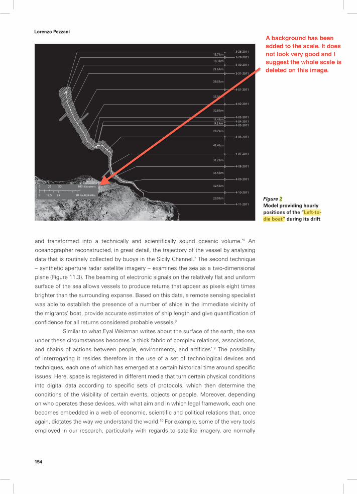
What we finally produced was a 73-page report that is currently being used for various legal actions, particularly for a complaint lodged in Paris regarding the non-assistance of people in danger at sea.5 By mobilising a wide range of digital mapping and modelling technologies, and by relying on a quite peculiar assemblage of human and non-human testimonies, we tried to reconstruct and map, as accurately as possible, what happened to this vessel (Figure 11.1). In the absence of external witnesses, the team corroborated survivors’ testimonies by interrogating the very environment where these events took place: the sea itself. This was performed thanks to two different techniques that extracted information by looking at the sea and its physical features in different ways. First, drift modelling analyses the sea as a complex and three-dimensional volume constantly stirred by tides, winds and currents (Figure 11.2) Whereas ocean depths have long remained unknown places, ‘the opaque ocean of the 1850s [has been] in the course of a century densely depicted in physical terms
Figure 11.1 Map summarizing the events concerning the so-called ‘left-to-die boat’ case. The map reconstructs the trajectory of the boat across NATO’s maritime surveillance area, closely monitored in the frame of the 2011 military operations in Libya, and indicates the different search and rescue regions of various coastal states.
Lorenzo Pezzani
Full stop missing after bracket
Lorenzo Pezzani
.
Lorenzo Pezzani
Lorenzo Pezzani
Lorenzo Pezzani
Lorenzo Pezzani
154
Figure 2 Model providing hourly positions of the “Left-to-die boat” during its drift
13.7 km3-28-2011
3-29-2011
3-30-2011
3-31-2011
4-01-2011
4-02-2011
4-03-20114-04-20114-05-2011
4-06-2011
4-07-2011
4-08-2011
4-09-2011
4-10-2011
4-11-2011
18.3 km
21.6 km
39.5 km
35.0 km
32.8 km
11.4 km9.2 km
28.7 km
41.4 km
31.2 km
31.5 km
32.5 km
29.0 km
0 50 10025 Kilometers
0 25 5012.5 Nautical Miles
and transformed into a technically and scientifically sound oceanic volume.’6 An oceanographer reconstructed, in great detail, the trajectory of the vessel by analysing data that is routinely collected by buoys in the Sicily Channel.7 The second technique – synthetic aperture radar satellite imagery – examines the sea as a two-dimensional plane (Figure 11.3). The beaming of electronic signals on the relatively flat and uniform surface of the sea allows vessels to produce returns that appear as pixels eight times brighter than the surrounding expanse. Based on this data, a remote sensing specialist was able to establish the presence of a number of ships in the immediate vicinity of the migrants’ boat, provide accurate estimates of ship length and give quantification of confidence for all returns considered probable vessels.8
Similar to what Eyal Weizman writes about the surface of the earth, the sea under these circumstances becomes ‘a thick fabric of complex relations, associations, and chains of actions between people, environments, and artifices’.9 The possibility of interrogating it resides therefore in the use of a set of technological devices and techniques, each one of which has emerged at a certain historical time around specific issues. Here, space is registered in different media that turn certain physical conditions into digital data according to specific sets of protocols, which then determine the conditions of the visibility of certain events, objects or people. Moreover, depending on who operates these devices, with what aim and in which legal framework, each one becomes embedded in a web of economic, scientific and political relations that, once again, dictates the way we understand the world.10 For example, some of the very tools employed in our research, particularly with regards to satellite imagery, are normally
Lorenzo Pezzani
Lorenzo Pezzani
Lorenzo Pezzani
Lorenzo Pezzani
A background has been added to the scale. It does not look very good and I suggest the whole scale is deleted on this image.

Mapping the sea
155
used by various European border polices to intercept migrants attempting to reach the coasts of Europe.
This ‘aesthetic’ condition then, which determines the threshold between visibility and invisibility, becomes a field of political struggle, and the very spatiality of maritime spaces has largely hinged on the possibility of knowing this, thus raising several questions about how we know a certain space and the role this knowledge plays.11
It is in this context that critical spatial practices can offer an opportunity for dissidence and resistance. As the Forensic Oceanography project shows, the reconstruction and spatialisation of violations of migrant rights can work as a tool in the struggle to end the impunity that has characterised the violence of the border regime in the Mediterranean for the past twenty years. Paradoxically architecture, the most ‘terrestrial’ of disciplines, seems to offer the very tools for a new reading of the ocean, which in turn, opens up new spaces for political action. But venturing into this new terrain means also leaving behind the apparent safety of terrestrial areas, where legal and political orders seems to be intimately related to stable locations and orientations,12 and entering the liquid terrain of maritime jurisdictions that are crisscrossed by different and often incongruous forms of governance. Once the steady grounds of fixed territorialities are left, things gets muddled up, and oppositions thought to be unshakable begin to blur.
***
29_9
29_829_7
29_6
29_5
29_429_3
29_229_1
29_0 29_23
29_22
29_21 29_20
29_1829_19
29_1729_16
29_1529_14
29_13
29_12
29_11
29_10
0 50 10025 Kilometers
0 20 4010 Nautical Miles
Id Length Con!dence
29_0 75m 80%
29_1 75m 70%
29_2 75m 95%
29_3 75m 80%
29_4 75m 70%
29_5 75m 90%
29_6 225m 95%
29_7 75m 80%
29_8 75m 70%
29_9 75m 80%
29_10 75m 80%
29_11 150m 95%
29_12 150m 95%
29_13 75m 80%
29_14 300m 95%
29_15 150m 95%
29_16 75m 80%
29_17 75m 95%
29_18 300m 95%
29_19 75m 80%
29_20 75m 80%
29_21 75m 70%
29_22 150m 95%
29_23 225m 95%
Figure 3 Synthetic aperture radar (SAR) data vessel detection for 29 March 2011 with corresponding table of returns documenting estimated length of vessel and confidence. The resolution of the data recorded by the Envisat-1 satellite allows for high confidence detection of ships 75 meters and longer
Lorenzo Pezzani
Lorenzo Pezzani
Lorenzo Pezzani
Lorenzo Pezzani
The scale here should be moved down to the limits of the black area corresponding to the satellite image, in the position indicated by the red rectangle

Lorenzo Pezzani
156
Our attempt to reconstruct past events by interrogating the sea seems to go against the widespread belief that the ocean, as an empty surface in constant movement, cannot bear any trace of history. If geography expresses, in its very etymology, the possibility to write and therefore read the surface of the earth, the sea seems to stand as the absolute opposite. This idea is well engrained in popular culture. Henri David Thoreau, for instance, wrote in 1864 that
we do not associate the idea of antiquity with the ocean, nor wonder how it looked a thousand years ago, as we do of the land, for it was equally wild and unfathomable anyways. The Indians left no traces on its surface, but it is the same to the civilised man and the savage. […] The ocean is a wilderness reaching round the globe, wilder than the Bengal jungle, and fuller of monsters.13
Almost a century later, Roland Barthes echoed this claim when he described the sea as a ‘non-signifying field [that] bears no message’.14 Mircea Eliade also noted that
in water everything is ‘dissolved’, every ‘form’ is broken up, everything that has happened ceases to exist; nothing that was before remains after immersion in water, not an outline, not a ‘sign’, not an event.15
But it was not only writers who expressed this belief; the inability to decipher the sea has a long politically charged history as well. Carl Schmitt famously described the sea as an anarchic space in which the impossibility of drawing long-standing and identifiable boundaries made it impossible for European states to establish durable legal order or found claims of sovereignty. ‘The sea,’ he wrote, ‘has no character, in the original sense of the word, which comes from the Greek charassein, meaning to engrave, to scratch, to imprint.’16 On this note, Schmitt based the fundamental distinction on which geopolitics has been grounded for many years: the binary division between a solid land where territories can be clearly demarcated and a sea where borders cannot be maintained, which is therefore free.
In fact, this historically specific notion of freedom of the sea emerged much earlier, precisely at the time of the so-called Battle of Books (1580 –1650). This dispute is usually narrated, in its abridged version, as the opposition between the progressive vision of a free sea expressed by the Dutch jurist Hugo Grotius, author of Mare liberum ( The Free Sea),17 and the parochial defence of maritime control formulated by the English scholar John Selden, author of Mare clausum (The Closed Sea).18 But this apparent contrast conceals a deeper convergence, as both thinkers, who were writing from the perspective of states that at the time were effectively challenging Iberian maritime supremacy, share in fact ‘a conception of the inextricably political and coercive nature of the sovereign, trading, mercantilist state.’19 Selden, by noting that ‘mare clausum can go only so far as one can assert affective control’,20 endorses the idea of freedom for the high seas as ‘a space […] that lay […] beyond the possession of any one political-economic actor’.21

Mapping the sea
157
Far from functioning as a claim of commonality, the concept of the ‘freedom of the seas’ has been used for centuries to claim freedom of competition and the right to dispose of a space of commerce or military activity. The very principle was coined:
to justify [the Netherlands’] right to seize a Portuguese ship in Southeast Asia. In a later era, the United Kingdom used the principle to justify the interdiction of ships engaged in the slave trade. And today, it is being used to discipline Somali maritime robbers.22
It was, in this sense, a problematic but effective notion that had to be maintained through active intervention of the various powers that claimed it. As Philip Steinberg has written:
freedom requires policing and mobility requires fixity, and both of these activities require continual efforts to striate the ideally smooth ocean.23
The necessity to streamline maritime trade and exert military control over the ocean, combined with the more recent emergence of the ocean itself as not only a leisure area, but an important resource for extractive and fishing industries, as well as a natural environment to protect, has required and facilitated the development of oceanographic science in an endeavour where the close connection between the scientific, the military, the economic and the political is impossible to disentangle. So if on the one hand the fiction of the sea as an ‘empty surface for movement’ is still very much operational, at the same a more articulated knowledge of the sea has allowed its subdivision and partial appropriation into multifarious regimes of quasi-sovereignity.24
***
The much travelled and exploited waters of the Mediterranean are a perfect example of this kind of spatial fragmentation. Different search and rescue regions, territorial waters, contiguous zones, exclusive economic zones, fishing preservation areas, maritime patrol areas and zones for offshore oil prospecting coexist and often overlap with each other. If we observe this situation from the perspective of migrations and of their management, a disintegration of space appears again very clearly. The already-mentioned rows that have arisen among Mediterranean states over the responsibility for rescuing migrants in distress at sea, as well as over the duty to disembark rescued migrants, reveals that the sea itself – far from being a lawless, empty expanse – is crisscrossed by multiple lines that delineate contested areas of responsibility. The paradox here is that within the malleable framework of international law, it is not the lack of regulations that allows for divergent interpretations, but their conflicting nature and their expanse across a plurality of actors and legal rationalities, which in turn, have been used as the very means to evade responsibility. This situation is not just the unintended result of the ‘unfinished’ appropriation of the sea under the impulse of increasing interactions across oceans and a growing drive to consider maritime areas themselves as resources; this fragmented territoriality of the sea has become
Lorenzo Pezzani
Lorenzo Pezzani
This comma has to be deleted
Lorenzo Pezzani
Lorenzo Pezzani

Lorenzo Pezzani
158
a deliberately productive spatial model that has opened up then a field of possibilities constantly harnessed by different actors.25
This understanding of maritime spaces complicates two opposite but interconnected visions. On the one hand, the rhetoric of flow – often used by globalisation enthusiasts, which sees in a frictionless sea the medium of circulation par excellence; on the other, the image of the insurmountable border, epitomised by the image of the ‘Fortress Europe’ that is often invoked in campaigns against the increasing violence of European anti-immigration policies. Instead, the sea becomes here an increasingly jellylike, three-dimensional mass that:
can oscillate between states of fluidity, enabling the passage of people, forms and ideas and states of solidity, blocking passage under given political and historical circumstances.26
This means that the already mentioned sea/land is no longer valid.27 Or, rather, ‘the division […] is still applicable. No longer, however, does it ground two separate and distinct global orders’.28
***
What the Forensic Oceanography Project indicates is that lines can indeed be traced in the sea, which are then left and read. ‘Geophysically, the ocean is anything but an undifferentiated, two-dimensional surface, but the problem is that the “places” it is made of are themselves dynamic and mobile’29 Scientifically, the possibility of understanding and controlling the dynamic forces that shape the ocean (weather human, oceanographic, or meteorological) hinge on the ability to draw (partial) lines and strategically exercise some sort of control over those parts.
Similarly, all agencies aiming at controlling or managing migration try to make the phenomenon of migration more knowable, predictable and ultimately governable. Knowing and regulating movement are then in both cases almost indistinguishable acts. In the case of migrants, though, this power immediately holds a more precise political meaning, as it is by moving (and by moving undetected) that they can contest the geographic, economic or social place that was assigned to them. But the analogy around modes of operation of maritime governance does not end here. In the same way that lines traced on the sea do not imply the definition of a stable, insurmountable boundary (but rather the partial definition of a patchy territoriality), the governance of migration does not try to stop movement. It instead attempts to make its ‘turbulence’ productive by extracting value from the spatial and temporal inconsistencies this movement emits. 30
What becomes apparent, therefore, is what Foucault called the power–knowledge nexus – the strict relation that ties any knowledge production with systems of dominance. As the French philosopher writes, ‘there is no power relation without the correlative constitution of a field of knowledge, nor is there knowledge that does not presuppose and constitute at the same time power relations.’31 It is here that the attempt to map migration shows its most problematic side, and the paradox of
Lorenzo Pezzani
Lorenzo Pezzani
Lorenzo Pezzani
The world "binary" has to be inserted where the mark is
Lorenzo Pezzani
Lorenzo Pezzani
Lorenzo Pezzani
Lorenzo Pezzani
The "P" should not be capitalized

Mapping the sea
159
dissidence becomes immediately apparent: all activist groups, NGOs and human rights organisations, while trying to contest state agencies’ monopoly on the knowledge of what happens to migrants at sea, somehow possess the mutual the desire to shed light on the border crossing – the very means by which migration is controlled.
And what now starts to appear is a rather muddled epistemological field in which a clear-cut division between those who detain a certain kind of knowledge (and hence power) and those who contest that very knowledge (and hence power) is increasingly blurred. Here, the border itself should be understood as an apparatus producing different kinds of knowledges that ground both a politics of control (the attempt to unveil the patterns of clandestine migration) and the possibility of resistance (the possibility to document the violence that is produced by the militarisation of borders). Moreover, migrants themselves produce and spread through informal networks a specific knowledge of the border that is always in excess on any attempt to govern it. In the videos of the sea crossings recorded with mobile phones, in the phone calls to friends and relatives during the crossings, in the mobilisations of the relatives of the migrants disappeared at sea who are struggling to shed light on what has happened to their family members, these mobile knowledges become tools in the struggle for justice and an immanent form of resistance insofar as they make movement possible.32
Operating within this field then, means coming to terms with the fact that dissidence cannot content itself with a notion of critique-as-debunking.33 Rather than trying to sustain an impossible position of absolute opposition, the Forensic Oceanography Project seeks to strategically infiltrate the cracks of the border regime to turn the means of surveillance against itself. Then the knowledge of the border can be used to account for the violence therein produced.
But how could a dissident practice still operate within this complex field without risking complacence with the same power it tries to undermine?
The strategy that some groups have adopted, and that we have ourselves followed in our project, could be referred to as a ‘disobedient gaze’, or the attempt to not disclose what the regime of migration management attempts to unveil (clandestine migration) but to unveil that which it attempts to hide (i.e., the political violence on which it is founded). In this sense, we can understand mapping projects such as Forensic Oceanography, as well as the maps produced by NGOs including Migreurop, as dissident projects that attempt to make a certain political problem emerge by expanding the aesthetic and technological possibility in order to see and document the violations of the rights of migrants and transform the volume of the sea into an arena of conflict.34 By carefully navigating among the paradoxes that characterise their field of intervention, these projects attempt to disrupt the Mediterranean’s ‘partition of the sensible’ in a way that echoes the description of the conflict over public space given by Rancière, who said that a police injunction addressed in a public space regarding anything suspicious is ‘Move along! There is nothing to see here!’. He continues:
The police says that there is nothing to see on a road, that there is nothing to do but move along. It asserts that the space of circulating is nothing other than the space of circulation. Politics, in contrast, consists in transforming
Lorenzo Pezzani
Lorenzo Pezzani
Lorenzo Pezzani
Lorenzo Pezzani
The "But" should not be starting a new paragraph

Lorenzo Pezzani
160
this space of ‘moving-along’ into a space for the appearance of a subject: i.e., the people, the workers, the citizens.35
And, we might add, the migrant.In the anti-totalitarian context, dissidence has been mainly understood as
the possibility to exercise one’s freedom of speech in the face of an oppressive power, which thereby contributes to unveiling the brutality of a regime. However, these new spatial practices reconfigure a different form of critical engagement. By addressing an event (the death of migrants at sea) whose occurrence has not been questioned, but the possibility of proving responsibility is at stake, they demand new aesthetic and epistemological protocols for creating evidence, and new political and legal tools to seek accountability across dispersed and overlapping legal jurisdictions. Such practices cannot claim any transcendent independence from their fields of operation, and they must confront the fact that they operate in the same immanent field of power where no absolute exterior exists. What they could and should claim though, is an autonomy of practice i.e., as a well-known refrain from the tradition of Italian Operaism goes, the possibility of operating at the same time ‘within and against’.
Acknowledgements
Although initially conceived as a single-authored conference paper drawing from a collaborative project (Forensic Oceanography, conceived together with Charles Heller and Situ Studio), this chapter includes several ideas that have been collaborated on and discussed together with Charles Heller so many times that it has become increasingly impossible to distinguish individual contributions. Moreover, the Centre for Research Architecture at Goldsmiths College has not only been the institutional home of this project, but also the place where its theoretical foundations have been forged through long and engaged discussions with its members. To all of them goes my gratitude.
Notes
1 Stefano Liberti, ‘La NATO dov’era?’, Il Manifesto, 14 April 2011. http://www.ilmanifesto.it/approfondimenti/immigrazionenaufragio-63-morti-risposta-nato/immigrazionenaufragio-63-morti/; Emiliano Bos, ‘Quell’elicottero che non è tornato a salvarci’, RSI, 15 April 2011. http://info.rsi.ch/home/channels/informazione/info_on_line/2011/04/15--Lelicottero-che-non--tornato-a-; Jack Shenker, ‘Aircraft carrier left us to die, say migrants’, The Gaurdian 8 May 2011. http://www.guardian.co.uk/world/2011/may/08/nato-ship-libyan-migrants.
2 M. Rediker, The slave ship: A human history (London: John Murray, 2007) pp.9–10. 3 F. Schneider, ‘The scandal: Notes on the autonomy of the image’. In Uncorporate Identity (Lars Muller
Publishers, 2009), p. 388 4 On 9 June 2011, the French NGO GISTI sent out a public call which led to the formation of a coalition
of NGOs (constituted primarily by CIRÉ, FIDH, GISTI, LDH, and Migreurop) that sought accountability for the non-assistance of migrants at sea during and in the aftermath of Arab Spring in general and in the case of the ‘left-to-die boat’ in particular.
5 See: http://www.forensic-architecture.org/publications/report-on-the-left-to-die-boat. 6 S. Höhler, ‘Depth records and ocean volumes: Ocean profiling by sounding technology, 1850–
1930’. History and Technology, 18(2) (2002), pp. 119–154, quoted in S. Helmreich, Alien Ocean:
Lorenzo Pezzani
The following piece of the quote should be added where indicated: “It consists in refiguring the space, of what there is to do there, what is to be seen or named therein”.The following sentence (crossed-out) can be erased.
Lorenzo Pezzani
Lorenzo Pezzani
Lorenzo Pezzani
Lorenzo Pezzani

Mapping the sea
161
Anthropological Voyages in Microbial Seas, (Berkeley and Los Angeles: University of California Press, 2009) p. 35.
7 Richard Limeburner, Senior Research Specialist in the Department of Physical Oceanography at Woods Hole Oceanographic Institution (Massachusetts, USA).
8 Lawrence Fox III, Humboldt State University Emeritus Professor of Remote Sensing, who was recruited for us by GIScorps.
9 E. Weizman, Forensic architecture: Notes from fields and forums (Hatje Cantz, 2012). 10 For an interesting exploration of this web of relations, see L. Kurgan, Close up at a distance: Mapping,
technology, and politics (New York: Zone Books, 2013). 11 By ‘aesthetics’ I am not referring here to a philosophy of beauty, but rather to Jacques Rancière’s
understanding of aesthetics as an eminently political activity. According to the French philosopher, politics hinges first and foremost on ‘the partition of the sensible’ which he defines as the distribution and redistribution of times and spaces, places and identities, that way of framing and re-framing the visible and the invisible, of telling speech from noise and so on. See J. Rancière, The politics of aesthetics: The distribution of the sensible (London: Continuum International, 2006).
12 C. Schmitt, The nomos of the earth in the international law of the Jus Publicum Europaeum (New York: Telos Press, 2003).
13 H.D. Thoreau, ‘Cape Cod’, available at: http://www.gutenberg.org/etext/34392 (accessed February 8, 2013).
14 Quoted in S. Helmreich, ‘Nature/culture/seawater’. American Anthropologist, 113(1) (2011), pp. 132–144.
15 Quoted in Helmreich, ‘Nature/culture/seawater’. 16 Schmitt, The nomos of the earth, pp. 42–43. 17 H. Grotius, Mare liberum; sive, De iure quod Batavis competit ad Indicana commercia dissertatio
(Lugduni Batavorum: Ex officina L. Elzevirri, 1609). 18 J. Selden, Ioannis Seldeni Mare clausum, seu, De dominio maris libri duo (London: Excudebat Will.
Stanesbeius, pro Meighen, 1635). 19 C. Miéville, Between equal rights: A Marxist theory of international law (London: Haymarket Books,
2006). 20 P. E. Steinberg, The social construction of the ocean (Cambridge: Cambridge University Press, 2001)
p. 97 21 Ibid. p.105 22 P.E. Steinberg, ‘Free sea’, in S. Legg, ed. Spatiality, sovereignty and Carl Schmitt: Geographies of the
nomos (London and New York: Routledge, 2011) p. 268 23 Ibid p. 271. 24 bid. p. 270. 25 For instance, Brett Neilson and Ned Rossiter consider ‘[maritime] logistics as a technology of
governance that works with [the normative fragmentation of work at sea], sometimes operating in its gaps but more often optimizing and calibrating its inherent discrepancies’. They mention for instance how ‘flags of convenience utilize certain forms of sovereign power – those vested in the states that issue them – to temporarily and partially remove vessels from the control of states and to subject them to forms of governance implicit in logistical practice and planning’. B. Neilson and N. Rossiter, ‘Still waiting, still moving: On labour, logistics and maritime industries, in D. Bissell & G. Fuller, eds. Stillness in a mobile world (London and New York: Routledge, 2010).p. 53. It should also be remembered that the liquid territoriality of the sea has increasingly been used as a spatial model for various forms of governance that operate below and above the level of the state. See for instance L. Bialasiewicz, P. Giaccaria, A. Jones and C. Minca, ‘Re-scaling “EU”rope: EU macro-regional fantasies in the Mediterranean’. European Urban and Regional Studies, 20(1) (2013), pp. 59–76.
26 Vyjayanthi Rao, ‘Speculative seas’ in Güven Incirlioglu and Hakan Topal (eds) The sea-image: Visual manifestations of port cities and global water (New York: Newgray, 2011), p. 124.
27 Paul Hirst has already remarked how ‘land and sea do differ in certain basic ways [but] neither is a constant: the salience of both and their relative value alter through time with changing technology, cultures and institutions […]. In this sense, we can only talk about spaces like the sea historically and specifically’. P. Hirst, Space and power: Politics, war and architecture (Cambridge and Malden, MA: Polity Press, 2005) p.76. Carl Schmitt himself had already recognised how new spatial dimensions introduced by technological advancements like air travel and radio communication had already made the land–sea binary obsolete. Carl Schmitt, ‘Land and sea’, retrieved at: http://www.counter-currents.com/2011/03/carl-schmitts-land-sea-part-1/.
28 Neilson and Rossiter, ‘Still waiting, still moving’, p. 53 29 Steinberg, ‘Free sea’, p. 270. 30 This does not only mean that contingent border zones pop up, move and are suppressed according
to changing needs, but also that contemporary borders are limits that strive to regulate the timing and speed of migratory movements. ‘This aspect of delay or temporal control of migration is [a] feature of the emerging border regime that needs to be remarked. Whether it involves processes of administrative detention or the creation of stand-offs [...], the strategy of delay is pivotal to regulating

Lorenzo Pezzani
162
the timing and speed of migratory movements. [...] Often temporal borders produce an interval of time in which procedures of selection and filtering can be executed, either in entirely technocratic ways or through violent interventions. On other occasions, they result from jurisdictional differences in which the gaps and discrepancies between legal borders become uncertain and contested.’ B. Neilson, ‘Between governance and sovereignty: remaking the borderscape to Australia’s north’. Local-global journal, 8 (2010), available at: http://mams.rmit.edu.au/56k3qh2kfcx1.pdf (accessed April 5, 2011) p.126.
31 M. Foucault, Discipline and punish: the birth of the prison (New York: Pantheon Books , 1977) p. 27. 32 I am referring here to the ‘infrastructures of connectivity’ that Papopoulos and Tsianos call
‘mobile commons’. D. Papadopoulos and V.S. Tsianos, ‘After citizenship: autonomy of migration, organisational ontology and mobile commons’. Citizenship Studies, 17(2) (2013), pp. 178–196.
33 B. Latour, ‘Why has critique run out of steam? From matters of fact to matters of concern’. Critical inquiry, 30(2) (2004), p. 225.
34 See Migreurop, Atlas des migrants en Europe (Paris: Armand Colin, 2009). 35 J. Rancière, D. Panagia and R. Bowlby, ‘Ten theses on politics’, Theory & Event, 5(3) (2001). Available
at: http://muse.jhu.edu/ (accessed July 23, 2013).