Mapping the digital Douala: lights and shadows of an African city.
13
Mapping the digital Douala: lights and shadows of an African City. Marta Pucciarelli, Sara Vannini, Lorenzo Cantoni 1 1 New Media in Education Lab – Università della Svizzera italiana Abstract: The topic of access to knowledge and information and communication technologies (ICTs) in Africa has been intensively discussed in discourses related to the digital divide and democratization. In this vein, this paper addresses the relation between two interconnected representations - virtual and physical - of a very specific African urban context, the city of Douala. In this study, the city is interpreted as a macro-community enacted by micro-communities of practices, which are constituted by people who perform the same commercial or public activity, or who live in the same neighborhood. The study focuses, then, on the analysis of the websites of socio-economic activities which have an online presence and that, thus, are reachable in the virtual realm. By promoting their activities, these websites contribute to constitute the image of the digital Douala. The paper, then, portrays not only on the extension of available information (including both the parts of the city which are extensively represented and the parts that are left in the shadow), but also the micro- communities that have a presence online: who they are, where their online presence is produced, and in which areas of the city they are situated. Outcomes provide an energetic and dynamic picture of the city which define a clear digital divide in-between sectors and areas. While the digital Douala confirms to hold economic and commercial images and narratives, it also presents an irregular and unregulated development and a scarce involvement of the public sector into the social well-being of its inhabitants. Keywords: Access to information in Africa, Douala, Digital city, Digital mapping, ICT4D I. Introduction Since the World Summit of Information Society (WSIS 2003), the topic of access to knowledge and to information and communication technologies (ICTs) in Africa, and its relationship with democratization and social equality, has been intensively discussed. The Internet has been seen as both a development enabler and as an undemocratic instrument of power, increasing, rather than bridging, the already vast divides between the richest and the poorest in this world (Unwin 2009, forth; Van Zyl 2013). Divides and differences among social groups are described by development and ICT for Development (ICT4D) frameworks by employing temporal and spatial metaphors. The poorest are said as being at the bottom of the pyramid or left behind in technological advancements, confined in remote areas where they are unreachable and information arrives only too late, and they are compared to a globalized, connected and advanced world (Graham 2008). Spatial and geographical studies offer an interesting perspective on how communities in developing countries are benefitting – or not – from being connected, and how their voices are audible online at a global level. For some communities, the combination of virtual and physical spaces into “hybrid places” (Graham 2008) is more and more a common reality. These are the communities whose voices are contributing to shaping the discourses around their geographies. However, other spaces endure silent, in a digital shadow. Nonetheless, development theorists have not fully explored many of the issues related to technologically augmented/altered spaces (Graham 2008), and much remains to be done to
Transcript of Mapping the digital Douala: lights and shadows of an African city.

Mapping the digital Douala: lights and shadows of an African City.
Marta Pucciarelli, Sara Vannini, Lorenzo Cantoni 1 1New Media in Education Lab – Università della Svizzera italiana
Abstract: The topic of access to knowledge and information and communication
technologies (ICTs) in Africa has been intensively discussed in discourses related to the digital divide and democratization. In this vein, this paper addresses the relation between two interconnected representations - virtual and physical - of a very specific African urban context, the city of Douala. In this study, the city is interpreted as a macro-community enacted by micro-communities of practices, which are constituted by people who perform the same commercial or public activity, or who live in the same neighborhood. The study focuses, then, on the analysis of the websites of socio-economic activities which have an online presence and that, thus, are reachable in the virtual realm. By promoting their activities, these websites contribute to constitute the image of the digital Douala. The paper, then, portrays not only on the extension of available information (including both the parts of the city which are extensively represented and the parts that are left in the shadow), but also the micro-communities that have a presence online: who they are, where their online presence is produced, and in which areas of the city they are situated. Outcomes provide an energetic and dynamic picture of the city which define a clear digital divide in-between sectors and areas. While the digital Douala confirms to hold economic and commercial images and narratives, it also presents an irregular and unregulated development and a scarce involvement of the public sector into the social well-being of its inhabitants.
Keywords: Access to information in Africa, Douala, Digital city, Digital mapping, ICT4D
I. Introduction
Since the World Summit of Information Society (WSIS 2003), the topic of access to knowledge and to information and communication technologies (ICTs) in Africa, and its relationship with democratization and social equality, has been intensively discussed. The Internet has been seen as both a development enabler and as an undemocratic instrument of power, increasing, rather than bridging, the already vast divides between the richest and the poorest in this world (Unwin 2009, forth; Van Zyl 2013).
Divides and differences among social groups are described by development and ICT for Development (ICT4D) frameworks by employing temporal and spatial metaphors. The poorest are said as being at the bottom of the pyramid or left behind in technological advancements, confined in remote areas where they are unreachable and information arrives only too late, and they are compared to a globalized, connected and advanced world (Graham 2008).
Spatial and geographical studies offer an interesting perspective on how communities in developing countries are benefitting – or not – from being connected, and how their voices are audible online at a global level. For some communities, the combination of virtual and physical spaces into “hybrid places” (Graham 2008) is more and more a common reality. These are the communities whose voices are contributing to shaping the discourses around their geographies. However, other spaces endure silent, in a digital shadow.
Nonetheless, development theorists have not fully explored many of the issues related to technologically augmented/altered spaces (Graham 2008), and much remains to be done to

understand how spaces are influenced by the intersections between the digital and the physical, between culture, place, and the cyber world (Zook and Graham 2007a).
In this vein, this paper constitutes the first step of a larger research aimed to study the image of the digital and the physical Douala, Cameroun’s largest city and its economic and commercial capital. It will describe: (i) the evolution of the city’s online presence; (ii) areas, boundaries, and landmarks that are visible vs. invisible online; and (iii) the relationship between the digital and the physical Douala, as perceived by people who physically experience the city.
As a first step in such study, this paper will focus on the analysis of the online information produced in the city, and published on websites of socio-economic activities – businesses, private and public institutions operating into the city – which are present online to be reachable in this additional realm, and to promote their activities. In this study, we interpret the city as a macro-community enacted by people and defined by practices, a community composed by micro-communities of practices (Lave and Wenger 1991; Wenger 1998) constituted by people who perform the same commercial or public activity, or who live in the same neighborhood.
By implementing websites about their own activities, producers of online content are actively participating to the definition of the online image of the city. Therefore, they will be considered as proxy to show the overall process of content production and distribution within the city itself. User generated content on social media will not be considered for this paper because its focus is to analyze the content produced by socio-economic activities of Douala. The data gathered will be analyzed to be further used to inform visual representations of situated practices of content production and distribution. This study aims at better understanding which are the micro-communities that have a presence online; where is their online presence produced, and in which areas of the city they are situated.
II. Related works
Since access to technology and the Internet has become a “democratic” and almost “taken for granted” commodity, especially in the Western world, the way we experience physical places has also changed. “Hybrid spaces” (Zook and Graham 2007b), combinations of physical and virtual spaces where the cyberspace influence the perception and navigation of the physical one, have been generated and shaped by geographic information systems (GIS), geo-located Internet searches, and digital maps, as well as by “virtual doubles” of physical places and activities. “The use of information ranked and mapped in cyberspace to navigate and understand physical places […] is a socially constructed process that embodies a range of political, economic, and cultural considerations” (ibid. p. 466).
This intersection between the digital and the material is described by Graham (Graham 2013) with four notions that zoom in onto the topic: a palimpsest, augmented reality, codes, and DigiPlaces. First, as “medieval writing blocks that could be reused while still retaining traces of earlier inscriptions” (Graham 2013 p.1), places, and cities in particular, are described to have a palimpsest: “Cities are incessantly made and remade, and layered with historical, contemporary, tangible, intangible, visible, invisible, material, and virtual elements” (ibid. p.1). Second, the way hybrid places are experienced is influenced by augmented reality, i.e. virtual information, which is, therefore, power-laden. According to the author, “we should be increasingly concerned with the ways in which augmented inclusions and exclusions, visibilities and invisibilities will shape digital representations. As we experience not just the city, but the augmented city, digital geographic representations don’t just influence how we think about places, but also, in a very real sense, influence how we move through, interact with, and enact place” (ibid. p.3). Third, our experience of the place is mediated also by the digital data that is virtually generated, that is publicly exposed to and used by researchers, policy makers and practitioners. This is what Graham calls “code”. Here we can see the very base of so-called smart cities: city organizations that leverage on digital traces being constantly be left by objects, sensors, and human beings (a concept closely connected with the one of “big data” and “web of things” or “3.0”). Finally, the notion of DigiPlace: “a way of

imagining the highly subjective and individualized experiences of the melding of cities and information” (ibid. p.5).
“Hybrid spaces”, or “DigiPlace”, do affect how people experience and understand geographies, distorting their representations of places in often non-transparent ways (Zook and Graham 2007a). At the same time that it creates hybrid spaces, the Internet can alter “relational positionality” of spaces (Graham 2008). If we think how a commodity chain can be modified through online disintermediation, thus bringing places closer, or how networks can ignore in-between spaces, we understand how the Internet has been frequently regarded not only as a developmental enabler, but also as “an economic and social revolution with the ability to fundamentally reshape the globe” in geographical terms (Graham 2008, 775).
Access to the Internet is not, however, universal. Despite countless efforts to bridge the digital divide in the last 25 years, differences in possibilities and capacity to access physical, digital, human and social resources that are needed for the integration of ICTs in social practices, are still an issue for many communities throughout the globe (Kleine and Unwin 2009; Warschauer 2002, 2004). For many, the digital divide is at the basis of differences to take part to the information and knowledge society, while ICTs are seen – more or less critically – as instruments to achieve socio-economic development (Unwin 2009; Heeks 2008). Yet, the so announced promising benefits of the Internet era are still unattainable for the poorest and most remote populations (Graham 2008), and not a few scholars believe ICTs to have enhanced socio-economic differences between the hyper-connected richest and the remotest, under-skilled poorest (Unwin 2009). Altered relational positionalities of spaces can transcend distances and leave in an even darkest shadow any jump-over in-between connected realities.
Graham also suggests that, as the ways in which places are represented online influence the way we perceive and interact with them, “the informational shadows of cities truly matter” (Graham 2013, p. 5). At points, these informational shadows can become informational voids: the lack of online content about, and contributions from a place can indicate – and further contribute to – its marginalization, as well as the “disempowerment” of its people. Questioning which are the voices that will be the loudest, and which are the ones that are – still – silent becomes, then, fundamental to understand the geography of development (Graham 2013).
Many communities in Africa are not online: connectivity and access is still an issue for many African countries, and many people do not use online content (not to mention its production). In Douala, in particular, even for accessing basic historical information about the city, the predominance of orality over the printed and digital media is evident. However, at the same time, we are assisting to the rise of digital media over print media as prevalent means of information access, and to the growing role of private institutions in information production and distribution (Pucciarelli, Sabiescu, Cantoni 2013). So, who are the ones, then, who speak, thus influencing the online image of Douala? Who are, instead, the ones who do not have a voice?
Observing online presence of various players (be they companies, institutions, services etc.) and their relationships with the space of the city allows to rethink to the concept of space as “spacing”, i.e. as a “processual and performative, open-ended and multiple environment” (Beyes and Steyaert 2012).
In this study, we interpret the city as a macro-community enacted by people and defined by practices, and composed by micro-communities of practices (Wenger 1998), constituted by people who perform the same commercial or public activity, or who live in the same neighborhood. The same way, the digital environment of the city is enacted by online content creators, who can be grouped in micro-communities of practice, according to the activities they perform. What is, then, the image they contribute to produce about Douala? And how much of Douala is represented online, and how much remains in the shadow?

III. The case study: Douala
Douala is the largest city of Cameroon, inhabited by three million people. The city is the major economic and commercial hub of the country, due to the presence of its strategic harbor on the Atlantic Ocean, and to its active role as trade intermediary of Cameroon and of the whole central Africa. Since the independence of Cameroun, in 1960, a non-regulated economic development has started in Douala, enhanced by a substantial lack of regulations by national and local authorities. This resulted in a rapid, uncontrolled, and horizontal urbanization of Douala, where different social groups converged. From an urban point of view, before the independence, the city was clearly divided in two areas: the colonizers settled along the coast and in the area of the commercial harbor, while the locals were forced to move into the inner part of the city (Njoh 2007).
Nowadays, the city is formally divided into six administrative districts, forming a total of 118 neighborhoods. However, the urban plan still reflects the polarization between wealthy and poor communities of Douala. The wealthy area includes the administrative and commercial centers - respectively Bonanjo and Akwa – and some residential neighborhoods: the historical Bonapriso and Bali, and the new residential area located in the North East of the city – Bonamoussadi, Kotto, Makepe and Logpom. The remaining neighborhoods are mainly built as informal settlements, and characterized by a lack of public services (such as regular electricity, access to water, sewers, and paved roads), widespread poverty and diffused unemployment (Loe and Meutchehé Ngomsi 2004). This situation generates a complex and competitive urban landscape. In 2000, the International Monetary Fund and the World Bank qualified Cameroon as a Heavily Indebted Poor Country (IDA and IMF 2000) and in 2007, 40% of population in Cameroon was found to be below the national poverty line (The World Bank 2007). At present, Cameroon does not fulfill the Millennium Development Goal of providing universal access to education.
IV. Methodology
Data collection For the data collection process, all the socio-economical activities based in Douala, which
are formally listed in the municipality register, have been considered. Douala Zoom (2010-2011) is the only printed and available register that provides basic information about the formally registered socio-economical activities in Douala: the information it provides includes the name, telephone number, address, email, and position on the neighbourhoods’ maps of each activity. Furthermore, all activities are classified in categories.
Each activity was checked from May 2014 to July 2014, in order to understand which ones were online, using the Google search engine on three different Top Level Domains (TLD): Cameroon (google.cm), France (google.fr), and Italy (google.it). The online research was conducted using as keywords the name of the activities, the neighborhood, and the city (e.g.: Sodepa, Bonendale, Douala). Only the first page of Google results was considered, and only official websites or social networks’ public pages providing updated content on the activity were considered as a relevant online presence. The presence of activities on online catalogues (such as qalaoo.cm, douala.franceserv.fr, obossoo.com, fr.businesslist.co.cm) was not included for two main reasons: 1. The information provided there is the same given by the Douala Zoom
register; 2. The presence of activities there is not directly controlled and managed by
the activities themselves, while this research focuses on how the micro-‐communities of Douala voluntarily decide to be online and to invest their time in building their own online image (in a direct way), and the one of the digital city (in an indirect way).

After recording the online presence of Douala activities on a database, they have been classified as local, national or international according to their origin/head-quarter. We have classified as local all the businesses where the main headquarter is in Douala; as national, the activities where the headquarter is in another city of Cameroun; and as international, when the headquarter is in a foreign country. This was due to the need to understand whether producing and online image of the activity depended on the voluntary choice of local companies, or was simply a matter of following the standards of an international company, something that might have been fully managed from outside the city and the country itself.
The overall process resulted in a database organizing information under the following sections:
• Category of the activity • Name of the activity • Neighbourhood • Address • Online presence • Link to the website • Link to the social media • Origin of the activity
Finally, a map of Douala was produced, that geo-localizes the information recorded in the database. The map aims to visualize the areas of the city that are represented online: the original map used was provided by the Douala cartographic center, and modified according to the locations of the online activities recorded in the database.
Data cleaning Before being analyzed, data in the database needed to be cleaned: many activities were
reported more than once, as they belonged to different categories or have branches in different areas of the city.
If the same activity was repeated in two different categories, only the most fitting category was kept (e.g.: a medical clinic was reported in both “clinic” and “surgery”: only the category “surgery” was kept, as it better represented the selected activity). If the same activity was repeated in more than two categories, only the most general one was kept (e.g.: a medical clinic was reported in “clinic”, “surgery”, “gynecology”, etc.: in this case, only the category “clinic” was kept).
When the same activity was repeated in the same category but in more neighborhoods of the city, all instances were kept, so that it was possible to geo-localize their online presence on the map.
Data analysis The total number of existing activity categories in Douala is 327. The categories were
grouped into 20 macro-categories, which from now on will be called micro-communities. Defining the 20 macro-categories was necessary for the analysis of the data, as it permits to reduce the spectrum of existing activities in Douala and to better represent their presence online.
A descriptive analysis was performed on the data, in order to analyze the image of Douala from three perspectives, answering to three main questions about the city: 1. Which are the micro-‐communities that have the strongest presence online,
and which offer a digital image of the city are? 2. What is the geographical origin of each socio-‐economic activity that has a
presence online? Is the community that (indirectly) defines the virtual image of Douala local, national or international? Where do the voices that speak about Douala in the virtual environment come from?

3. Which territories of the city are promoted by the concerned micro-‐communities? Which is the visibility and invisibility level of the neighborhoods of Douala? What can it depend on?
Data regarding the online activities were, then, reported on a map, in order to highlight visible and invisible areas of the city.
V. Outcomes
This section provides a detailed account of the most frequently represented categories of socio-economical activities of Douala in the online environment. Visible and invisible micro-communities, as we defined them, are reported based on the level of their online presence and in relation to the total available online resources. In addition, their online presence is analysed from a geographical perspective, highlighting the relationship between the origin of the activity and the neighbourhoods of the city that appear most frequently.
Visible and invisible categories According to Douala Zoom, in Douala there are a total of 4’527 socio-economic
activities formally registered, only 12.2% of which (corresponding to 552 activities) are represented online. In 89.7% of the cases, online activities are present through a website, while in the remaining 10.3% cases they are promoting their presence through dedicated and updated social media pages, in particular on Facebook and Twitter.
As reported in the methodology, some of the socio-economical activities have their headquarter in a neighbourhood and different branches in other areas of Douala. Thus, the analysis was performed on a total of 4’835 socio-economic instances, so to include 308 branches, and on a total of 716 online instances.
All 4’835 socio-economical activities were categorized into 20 macro-categories – or micro-communities – defined by regrouping the 327 categories already provided by the Douala Zoom register into more general ones. In a further step, all activities present online were analysed in order to record their origins.
Table 1 lists all micro-communities and reports their online presence: (i) within their category; (ii) within the total of available online resources; and (iii) according to their local, national or international origins. A descriptive analysis of the results follows.
Table 1. Online representation and origin of socio-economical activities of Douala
organized in micro-community.
Micro-community
N. of instances with a website
% online presence within micro-community
% online presence of the micro-community within the total available websites and social media pages
Origin of the activity (only the most represented)
Bank and insurance 139 36.1 19.4
Local (36.7%) International (35.3%)
International organization 14 31.8 2.0 International
(100.0%)

Micro-community
N. of instances with a website
% online presence within micro-community
% online presence of the micro-community within the total available websites and social media pages
Origin of the activity (only the most represented)
Career 12 29.3 1.7 Local (66.7%) Communication
and media 43 28.0 6.0 Local (51.2%)
Transport 26 27.9 3.6 International (57.7%)
Industrial production and distribution
100 23.3 14.0 Local (61.0%)
Social services 10 21.3 1.4 National (60.0%)
Technology 49 19.4 6.8 Local (55.1%) Urban
environment 19 16.9 2.7 Local (100.0%)
Education 58 16.6 8.1 Local (87.9%) Hospitality 40 13.6 5.6 Local (85.0%)
Art and culture 6 11.7 0.8 Local (100.0%)
Retailer 76 11.4 10.6 Local (60.5%)
Import-export 27 10.9 3.8 International (59.3%)
Security 6 10.0 0.8 Local (50.0%) Maintenance 13 6.2 1.8 Local (92.3%) Professionals 43 7.3 6.0 Local (81.4%)
Entertainment 4 6.4 0.6 Local (100.0%)
Health 25 5.2 3.5 Local (72.0%) Public
administration 6 4.9 0.8 Local (66.7%)
The micro-communities most frequently represented within the online landscape are Banks
and Insurances (19.4%), Industrial Production and Distribution (14.0%) and Retailers (10.6%). If we add also Import-Export (3.8%), we can notice that almost half of the micro-communities that are present online (47.8%) belong to finance and commerce, confirming and supporting the diffused narrative of the city as the economic and commercial capital of the country. Members of the micro-community Bank and Insurance are also those with the higher online representation within their own micro-community. Indeed, more that one third of Banks and Insurances (36.1%) appear to be present online. Differently, Retailers are represented on the total activities in a larger number if compared to the Import-Export micro-community. Nevertheless, they have almost the same importance, in terms of online presence, within their own micro-community.
Another interesting result concerns the four least frequent micro-communities in the online landscape: Entertainment, Art and Culture, Security, and Public Administration. As for Entertainment, it seems strange how activities such as nightclubs and bars are so little

promoted online. Contrarily to what one westerner could imagine, this does not mean these activities do not exist, nor that they are not popular: their channels of promotion pass through other, probably more informal, communication streams. Differently, the micro-community Art and Culture appears 11.7% of the times online, although there are very few institutions providing these kinds of services. This fact suggests how the diffusion of the city’s cultural identity is quite valued in comparison to the micro-communities Retailers and Import-Export.
A very similar account is to be done also for the micro-community Security. Douala is considered one of the most dangerous cities in Africa in terms of safety (Pucciarelli 2014; Loe and Meutchehé Ngomsi 2004). In general, this micro-community is not very visible in the virtual environment. Yet, information relating to security in Douala appears 10.0% of the times within its own micro-community, similarly to retailers and import and export.
We could expect that the categories of Hospitality, Communication and Media, and Technology reported higher frequencies within their own categories, considering the audience they are addressing and their very own nature. At the same time, it is surprising the high frequencies of the categories Career, Education, and Social services. This suggests a shift among the local population (the young generation in particular) from an oral culture to a digital culture when searching information (Pucciarelli, Sabiescu, and Cantoni 2013).
Finally, the micro-community Public Administration is one of the least frequent both in terms of general representation (0.8%) and within its micro-community (4.9%), thus suggesting a high prevalence of the private sector on the public sector in terms of communication with both the local and the international online public.
Local, national and international In this section, we will present which are the voices behind the online presence of
socio-economical activities in Douala; by doing so we will indirectly contribute to provide the digital image of the city. In order to do this, all the activities that have an online presence were classified either as local, national or international.
Obviously, national and international businesses have branches in Douala. In such cases, being present online is not strictly related to a voluntary decision of the community living and working in Douala: the image of the city, in these cases, depends by national or international choices, often responding to specific standards of online communication.
Figure 1 shows the online socio-economical activities in Douala according to their local, national or international origins.
Figure 1 The origins of the online presence of businesses in Douala.

The digital image of Douala is provided mainly by local communities (59.1%), living and operating in the city. In particular, the digital image produced by the micro-communities Art and Culture, Entertainment, and Urban Environment (the latter includes businesses operating in the field of buildings and public works, draining, water treatment, town and land planning) is 100.0% local.
However, almost one third of the city online presence (27.1%) depends on international communities, confirming the important role of international trade within Douala. Online micro-communities in Douala depending on international communities (see Table 1) mostly include Bank and Insurance, International Organizations (specifically embassies and consulates), Transport, and Import-Export. Once again, these results confirm the narrative of the city as an economic and commercial metropolis, and highlight the fundamental role of its geographical position for trading within and outside central Africa.
Finally, 13.8% of the online representation of Douala is given by national voices. Besides reconfirming the economic and commercial importance of the city, this means that Social Services is the most represented micro-community from a national point of view. This is a first indicator of the lack of information about the real-living condition of the inhabitants of this economic capital. This can be also seen by the lack of public administration services as it’s quite interesting that only 66.7% are represented by local voices, while the remaining part is represented equally (16.7% each one) by national and international voices.
This data suggests that, on the one hand, the digital Douala is characterised by an economic and commercial image while, on the other hand, the city is also characterised by an irregular and unregulated development and by a scarce interest and involvement of the public sector into the social well being of its inhabitants.
The next section will move in this direction, highlighting the geographical image of the city produced by its micro-communities, as well as the invisible layer of the city, which emerges by the visual representation of their online presence.

Visible and invisible neighbourhoods
Figure 2 Map of visible and invisible online neighborhoods of Douala Douala’s urban territory is composed by 118 neighborhoods, in 53 of which formally
registered socio-economic activities exist. Only 36 of them, instead, have a presence online, constituting 30.5% of the total number of neighborhoods.
The neighborhood that appears most frequently online is Akwa (in black in Fig. 2). Akwa is one of the historical areas of the city: it faces the harbor of Douala and it is considered the commercial center of the city. 256 online socio-economic activities are present within the neighborhood, corresponding to 35.8% of the total online activities analyzed. 19 out of 20 micro-communities are present in Akwa (Public Administration is the only one missing): the ones that appear most frequently are retailers, banks, and legal branches of import-export activities and industrial production and distribution.
The second neighborhood in terms of online presence is Bonanjo (in dark grey in Fig. 2), another historical and prestigious neighborhood of Douala, which is considered its administrative center. A total of 104 activities have an online presence in Bonanjo, corresponding to 14.5% of the total, and constituted most of all by banks, hospitality activities, professionals (lawyers in particular), and legal branches of transportation activities.
After the loud Akwa and Bonanjo, whose presence online corresponds to 50.3% of the whole online presence of the city of Douala, and whose voices are, therefore, the loudest, we can find neighborhoods that are represented by a range of 21 to 100 online activities. These are the neighborhoods of Bonapriso (57), Bonaberi (47), Deido (40), Bassa (37), Bali (34), and Bonamoussadi (30).
With the exception of Bonamoussadi, prestigious residential area outside of the city, which has been expanding considerably in the last 10 years, all the other neighborhoods traditionally belong to the Sawa ethnic groups, the most powerful traditional family authorities within the city. Chiefs of the families and holders of the traditional political power do live here (the Bell in Bali, the Ndumbe in Bonaberi, the Deido and the Bassa in the neighborhoods named after them). While the neighborhoods of Bonaberi and Bassa are essentially industrial areas, the
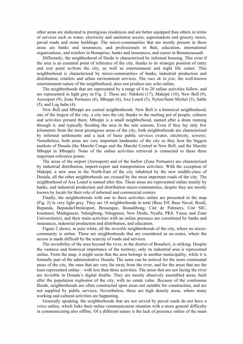
other areas are dedicated to prestigious residences and are better equipped than others in terms of services such as water, electricity and sanitation access, supermarkets and grocery stores, paved roads and stone buildings. The micro-communities that are mostly present in these areas are banks and insurances, and professionals in Bali, education, international organizations, and retailers in Bonapriso, banks and insurances, and career in Bonamoussadi.
Differently, the neighborhood of Deido is characterized by informal housing. This even if the area is an essential point of reference of the city, thanks to its strategic position of entry and exit point to/from the city, as well as entertainment and night life center. This neighborhood is characterized by micro-communities of banks, industrial production and distribution, retailers and urban environment services. The rues de la joie, the well-known entertainment nature of the neighborhood, does not produce any echo online.
The neighborhoods that are represented by a range of 4 to 20 online activities follow, and are represented in light grey in Fig. 2. These are: Ndokoti (17), Maképé (10), New Bell (9), Aereoport (9), Zone Portuaire (6), Mboppi (6), Axe Lourd (5), Nylon/Saint Michel (5), Sable (5), and Log baba (4).
New Bell and Mboppi are central neighborhoods. New Bell is a historical neighborhood, one of the largest of the city, a city into the city thanks to the melting pot of people, cultures and activities present there. Mboppi is a small neighborhood, named after a drain running through it, and typically flooding the area in the rain seasons. Even if they lay only few kilometers from the most prestigious areas of the city, both neighborhoods are characterized by informal settlements and a lack of basic public services (water, electricity, sewers). Nonetheless, both areas are very important landmarks of the city as they host the biggest markets of Douala (the Marché Congo and the Marché Central in New Bell, and the Marché Mboppi in Mboppi). None of the online activities retrieved is connected to these three important reference points.
The areas of the airport (Aereoport) and of the harbor (Zone Portuaire) are characterized by industrial distribution, import-export and transportation activities. With the exception of Maképé, a new area in the North-East of the city inhabited by the new middle-class of Douala, all the other neighborhoods are crossed by the most important roads of the city. The neighborhood of Axe Lourd is named after this. These areas are represented online mainly by banks, and industrial production and distribution micro-communities, despite they are mostly known by locals for their role of informal and commercial centers.
Finally, the neighborhoods with one to three activities online are presented in the map (Fig. 2) in very light grey. They are 18 neighborhoods in total (Base Elf, Base Naval, Beedi, Bepanda, Bepanda/Ominisport, Bessengue, Bonadibong, Cité de Palmiers, Cité SIC, koumassi, Madagascar, Ndongbong, Ndogpassi, New Deido, Nyalla, PK8, Yassa, and Zone Universitaire), and their main activities with an online presence are constituted by banks and insurances, industrial production and distribution, and education.
Figure 2 shows, in pure white, all the invisible neighborhoods of the city, where no micro-community is online. These are neighborhoods that are considered as no-zones, where the access is made difficult by the scarcity of roads and services.
The invisibility of the area beyond the river, in the district of Bonaberi, is striking. Despite the vastness and historical importance of the territory, only its industrial area is represented online. From the map, it might seem that the area belongs to another municipality, while it is formally part of the administrative Douala. The same can be noticed for the more continental areas of the city, the ones that are very far away from the river, and for the areas that are the least represented online – with less than three activities. The areas that are not facing the river are invisible in Douala’s digital double. They are mostly abusively assembled areas, built after the population explosion of the city, with no estate value. Because of the continuous floods, neighborhoods are often constructed upon areas not suitable for construction, and are not supplied by public services. Nevertheless, these are high density areas, where many working and cultural activities are happening.
Generally speaking, the neighborhoods that are not served by paved roads do not have a voice online, which links their online communication situation with a more general difficulty in communicating also offline. Of a different nature is the lack of presence online of the main

markets of the city. The markets, which are among the most important landmarks of commercial and social activities of African cities and located in easily accessible, but poor, areas of the city, are very rarely used to promote their neighborhoods online.
VI. Conclusion
This research has attempted to provide a picture of the online presence of socio-economical activities – businesses, private and public institutions – operating into the city of Douala in Cameroun. By doing so, and by organizing such data according to sectors and geography, an additional layer has been added to the city map. It enriches the understanding of Douala in several ways, showing which different communities and neighborhoods are emerging in the online realm, and – at the same time – which ones are lagging behind or, to avoid any judgmental image, are staying outside of the web.
In anthropomorphic terms, we might call this a picture of a city in its Internet infancy, a picture that shows energy and dynamics, and at the same time limits and hindering factors, which are drawing a quite clear digital divide in-between sectors and areas. This paper agrees with recent critical studies on the imbalanced role of ICTs in developing countries (Graham 2014, Unwin forth) unveiling a specific case in which the image of the digital Douala is enhancing rather than leveraging the digital gap between whose have and whose have not access to ICTs.
Future research should add time to this still image, depicting not only how it is now, but able also to capture the temporal and spatial evolution of the digital Douala. It should also include further sources of information, including user generated contents by citizens as well as other online contents covering the city (e.g.: newspapers) and published by internal or external publishers. In addition, locals and foreigners could be asked to provide their own image and interpretation of the digital Douala, so to add further breadth and depth to the provided image.
VII. References
Beyes, Timon, and Chris Steyaert. 2012. “Spacing Organization: Non-Representational Theory and Performing Organizational Space.” Organization.
Graham, Mark. 2008. “Warped Geographies of Development: The Internet and Theories of Economic Development.” Geography Compass 2 (3): 771–89. doi:10.1111/j.1749-8198.2008.00093.x.
Graham, Mark. 2013. The Virtual Dimension. In M. Acuto and W. Steele, Global City Challenges: Debating a Concept, Improving the Practice, 2013. London: Palgrave. 117-139. Available at SSRN:http://ssrn.com/abstract=2212824
Graham, Mark and Hogan, Bernie and Straumann, Ralph K and Medhat, Ahmed, Uneven Geographies of User-Generated Information: Patterns of Increasing Informational Poverty (January 21, 2014). Annals of the Association of American Geographers, Forthcoming. Available at SSRN: http://ssrn.com/abstract=2382617
Heeks, Richard. 2008. “ICT4D 2.0: The Next Phase of Applying ICT for International Development.” Computer 41 (6): 26–33. doi:10.1109/MC.2008.192.
IDA, and IMF. 2000. “Cameroun. Preliminary Document on the Enhanced Initiative for Heavily Indebted Poor Countries.” http://siteresources.worldbank.org/INTDEBTDEPT/PreliminaryDocuments/20224154/Cameroon-Preliminary.pdf.
Kleine, Dorothea, and Tim Unwin. 2009. “Technological Revolution, Evolution and New Dependencies: What’s New about ict4d?” Third World Quarterly 30 (5): 1045–67. doi:10.1080/01436590902959339.
Lave, Jean & Etienne Wenger. 1991. Situated learning: Legitimate peripheral participation. Cambridge university press.

Loe, Mamert Florent, and Albert Claude Meutchehé Ngomsi. 2004. “Diagnostic de la delinquance urbaine de Douala”. Villes Plus Sûres.
Njoh, Ambe J. 2007. “Planning in the Cameroons and Togoland.” In Planning Power: Town Planning and Social Control in Colonial Africa, 127–44. Routledge.
Pucciarelli, Marta. 2014. Douala. Final Report. Mobile Access to Knowledge. Culture and Safety in Africa.
Pucciarelli, Marta, Amalia Sabiescu, and Lorenzo Cantoni. 2013. “What Do We Know about Douala. Access to Information with and about the Largest Cameroonian City.” In Proceedings of the 7th International Development Informatics Association (IDIA) Conference:, 167–84. Bangkok, Thailand: J. Steyn & A. G. Van der Vyver.
The World Bank. 2007. “World Development Indicators: Poverty Rates at National Poverty Lines”. Statistic. World Bank. http://wdi.worldbank.org/table/2.7.
Unwin, Tim, ed. 2009. ICT4D: Information and Communication Technology for Development. 1st ed. Cambridge, UK: Cambridge University Press.
Unwin, Tim. forth. The dialectics of development. In: Lorenzo Cantoni & James Danowsky, Handbook of Communication Science: Communication and technology. Berlin: Mouton de Groutyer.
Van Zyl, Izak. 2013. “Technology Encounters and the Symbolic Narrative”. Doctoral dissertation, Lugano, Switzerland: Università della Svizzera italiana - USI. http://doc.rero.ch/record/208833.
Wenger, Etienne. 1998. Communities of practice: Learning, meaning, and identity. Cambridge university press.
WSIS. 2003. Declaration of Principles: Building the Information Society: A Global Challenge in the New Millennium. Geneva: World Summit of the Information Society (WSIS). http://www.itu.int/wsis/docs/geneva/official/dop.html.
Zook, Matthew A., and Mark Graham. 2007a. “The Creative Reconstruction of the Internet: Google and the Privatization of Cyberspace and DigiPlace.” Geoforum, Theme Issue: Geographies of Generosity, 38 (6): 1322–43. doi:10.1016/j.geoforum.2007.05.004.
Zook, Matthew A., and Mark Graham. 2007b. “Mapping DigiPlace: Geocoded Internet Data and the Representation of Place.” Environment and Planning B: Planning and Design 34 (3): 466–82.