Down deep in the holler: chasing seeds and stories in southern Appalachia
Upload
independentCategory
view
0download
0
Chasing shadows: The Castleton Medieval Hospital Project
Survey and excavation relating to the site of the Medieval Hospital, Castleton, Derbyshire 2007 – 2012
March 2014
By C. Merrony, A. Stafford, S. Stein, C. Cumberpatch, T. Cockrell, A. Bloxam, and S. McGuire
Department of Archaeology University of Sheffield
Northgate House West Street
Sheffield S1 4ET

i
Castleton Medieval Hospital 2009-2012

ii
Castleton Medieval Hospital 2009-2012
CONTENTS
List of illustrations and tables
iv
Non-technical summary
vi
1 Introduction
1
2 Aims
1
3 Survey and trench location rationale
2
4 Methodology: Walkover survey Geophysical survey Earthwork survey Excavation
4
5 Site location and land use
5
6 Archaeological and historical background
5
7 Results: 7.1 Survey 7.1.1 Walkover survey – Howsitch Tongue 7.1.2 Geophysical survey 7.1.3 Earthwork survey 7.2 Excavation 7.2.1 Trench 1 (2009) 7.2.2 Trench 2 (2009) 7.2.3 Trench 3 (2009) 7.2.4 Trench 4 (2009) 7.2.5 Trench 5 (2010) 7.2.6 Trench 6 (2010) 7.2.7 Trench 7 (2010) 7.2.8 Trench 8 (2010) 7.2.9 Trench 9 (2010) 7.2.10 Trench 10 (2010) 7.2.11 Trench 11 (2010) 7.2.12 Trench 12 (2011) 7.2.13 Trench 13 (2011) 7.2.14 Trench 14 (2011) 7.2.15 Trench 15 (2011) 7.2.16 Trench 16 (2011) 7.2.17 Trench 17 (2011) 7.2.18 Trench 18 (2011) 7.2.19 Trench 19 (2011) 7.2.20 Trench 20 (2012)
8 8 12 21
23 25 26 26 27 28 29 30 31 34 36 37 44 44 45 45 46 47 47 49
iii
Castleton Medieval Hospital 2009-2012
7.2.21 Trench 21 (2012) 7.2.22 Trench 22 (2012) 7.2.23 Additional test pits
54 57 59
8 Discussion
61
9 Conclusions and recommendations
63
10 Copyright
65
11 Archive
65
12 Acknowledgements
65
13 Bibliography and sources 66
Appendices:
App 1 Context summary 69
App 2 Pottery analysis 104
App 3 Geoarchaeological analysis 111
App 4 Osteological analysis 112 App 5 Technical information 119

iv
Castleton Medieval Hospital 2009-2012
LIST OF ILLUSTRATIONS AND PLATES
Illustrations
1 Location of survey area and excavated trenches within the Spital Field
2 Location of structure discovered in 1999
3 Location of the Spital Field and the survey areas outside of the Spital Field
4 Results of the survey of the Howsitch Tongue area
5 Greyscale plot of the results of the magnetometer survey in the Spital Field
6 Greyscale plot of the results of the standard resistance survey in the Spital Field
7 Greyscale plot of the results of the shallow resistance survey in the Spital Field
8 Greyscale plot of the results of the standard and shallow resistance surveys in the Spital Field shown together for comparison
9 Closer view of the greyscale plot of the shallow resistance survey in the Spital Field
10 Greyscale plot of the results of the resistance survey in the Bullock Field
11 Greyscale plot of the results of the resistance survey in the grounds of Losehill Hall
12 Closer view of the greyscale plot of the resistance survey in the grounds of Losehill Hall
13 John Barnatt’s 1993 plan of the results of his walkover survey
14 Spittle field names recorded in 1819
15 View of trench 1 from the east
16 View of trench 2 from the south-east
17 View of trench 3 from the south
18 View of trench 4 from the south
19 View of trench 5 from the west
20 View of trench 6 from the west
21 View of trench 7 from the south
22 View of trench 8 from the south
23 View of trench 9 from the east
24 View from the south of the section through the enclosing bank in trench 9
25 View of the northern part of trench 10 from the south
26 View of the northern part of trench 10 from the east
27 View from the west of the section through the central mound in trench 12
28 View from the south of wall 12007

v
Castleton Medieval Hospital 2009-2012
29 View from the south of the junction of walls 12004 and 12010
30 View from the east of the sondage in the north-western part of trench 12
31 The human cranium deposit in 12018 prior to its excavation and lifting
32 View of trench 14 from the south
33 View of trench 16 from the south
34 View of trench 17 from the south
35 View of trench 19 from the north
36 Aerial view of trench 20 and 21 under excavation
37 Working photograph of trench 20
38 View of the main east-west wall in trench 20 from the south
39 View from the north of the stone block near the northern section of trench 20
40 View from the south-west of hearth 20059
41 View from the south of the western part of trench 21
42 View from the east of the western section through the bank in trench 21
43 View from the east of trench 21 after heavy rain
44 View from the west of trench 22 showing its typical condition in 2012
45 View from the west of test pit 1 in Losehill Hall grounds
46 View from the south of test pit 2 in Losehill Hall grounds
Tables
1 Summary of visible features identified in the Howsitch Tongue survey

vi
Castleton Medieval Hospital 2009-2012
NON-TECHNICAL SUMMARY
A series of archaeological investigations have been undertaken within and close to the Spital Field, Castleton, Derbyshire between 2007 and 2012. This has included a programme of geophysical, topographic and walkover survey and also, during 2009 to 2012, four seasons of trial excavation in order to identify and explore the suggested site of the Medieval Hospital of St. Mary in the Peak. The location of the trial excavations were based on the results of the earlier geophysical and topographic survey and on documentary evidence relating to the medieval hospital. The documentary evidence, combined with extant earthwork features, had earlier led to part of the Spital Field being Scheduled as an Ancient Monument in 1999.
The excavation work undertaken between 2009 and 2012 comprised 22 excavated areas (fig. 1). These included 10 evaluation trenches and 12 smaller test pits. In addition to this a further 2 test pits were excavated near to the Spital Field, in the grounds of Losehill Hall. The excavation and survey work was completed by members of the Castleton Historical Society and the Hope with Aston Historical Society, students from the Department of Archaeology at the University of Sheffield, local school children and also other local volunteers including members of ARTEAMUS. The project has been funded by the Heritage Lottery Fund (through a grant awarded to the Castleton Historical Society). This fieldwork is running in parallel with a programme of documentary research being undertaken by the Historical Society.
The evaluation trenches have produced remarkably little in situ evidence of medieval activity and so far no structures which can be firmly dated to the medieval period. This is an unexpected result given that the majority of the trenches excavated during 2010, 2011 and 2012 were excavated within the Scheduled Area. The results significantly challenge our understanding of the Scheduled Area’s status. Earthworks and structural features do exist within the Scheduled Area; however the balance of evidence (which is limited) supports a Post-Medieval date for the earthworks and the structures.
In contrast to the earthworks and buried structures, medieval material has been recovered from a layer which underlies the surviving structures and which also contains occasional and irregularly distributed disarticulated human remains. It is not yet clear where this material has been derived from and it does point towards the possibility that the cemetery of the hospital is located within or near to the Scheduled Area. While the extensive excavations within the Scheduled Area have proved inconclusive there were deposits within cut features exposed during the 2012 season which could not be investigated due to the very poor weather encountered during the summer of 2012. It is necessary to return to this area in the future to open up a suitable area towards the southern part of trench 20 in order to investigate these deposits and provide as complete a picture as possible for the development, function and date of the structures and features that survive within the Scheduled Area and for any underlying deposits. It is vital to gain an understanding of the structures and deposits in order to properly evaluate

vii
Castleton Medieval Hospital 2009-2012
whether or not the Scheduled Area covers an area which contains some or all of the hospital or associated features such as the cemetery. If the initial impression (that the main hospital complex is not located within the Scheduled Area) is confirmed then the documentary evidence will need to be re-evaluated and work will need to be developed further in adjacent areas (such as the grounds of Losehill Hall and the nearby caravan park), in order to eventually identify the actual location of the hospital.
Altogether in the 24 excavated areas a total of 362 square metres have been excavated.

Castleton Medieval Hospital 2009-2012 1
1 INTRODUCTION
This document is a report on archaeological fieldwork undertaken to investigate the site of the Medieval Hospital of Saint Mary in the Peak at Castleton in Derbyshire (Scheduled Monument No. 29938). Documentary evidence has long been used to suggest that the likely location of the hospital was within a field, to the north-east of the village, known as the ‘Spital Field’. An area within the Spital Field, where there are visible earthworks, was designated a Scheduled Ancient Monument in 1999. As a result of an initiative by the Castleton Historical Society it was proposed that an archaeological investigation of the site should be undertaken in order to verify the presence of archaeological remains and to assess the character and quality of these remains. Consequently a geophysical survey was undertaken in 2007/8 by members of the Society with support from the University of Sheffield. The inconclusive results of this survey did not support the hypothesis that the remains of significant structures compatible with a medieval hospital were surviving within the Scheduled Area.
A programme of further geophysical and topographic survey work and small scale excavation was then begun in order to investigate whether remains of the Hospital were extant within the Spital Field or in other nearby fields to the north and west. This work has been undertaken by members of the Society along with staff and students from the Department of Archaeology at the University of Sheffield, members of ARTEAMUS, local school children and other local volunteers. The work undertaken has developed through discussions between the participants and both Sarah Whiteley of the Peak District National Park and Tim Allen of English Heritage.
The programme of work has developed to include work both within and around the Scheduled Area within the Spital Field along with work in the grounds of Losehill Hall to the north and in fields both to the east of Losehill hall grounds (Gaultern Thorn) and to the west of Losehill Hall grounds (Bullock Field and the Howsitch Tongue area). The results of this programme of survey and excavation (which has taken place between early 2009 and July 2012) are the focus of this report.
2 AIMS
The general aims of the archaeological field project are:
to investigate the archaeological remains of the Hospital of Saint Mary in the Peak in order to establish the location and extent of the Hospital and its holdings and to enhance our understanding of its development and use;
to establish the character and date of surviving archaeological deposits and structures relating to the hospital and its holdings;
to relate the surviving archaeological remains to the documentary evidence for the Hospital;
to provide an insight in to the lifestyle, demography and health of the people who lived, worked and died in the hospital.
The specific objectives of the programme of fieldwork are:
to determine the position, extent and degree of preservation of archaeological features within the Spital Field;
to determine the extent and survival of associated archaeological deposits in the wider landscape around the Spital Field;

Castleton Medieval Hospital 2009-2012 2
to provide opportunities for the participation of residents of Castleton, other local inhabitants, university students and school children to participate in the archaeological process and increase their understanding of Castleton’s past;
to provide opportunities for training a wide range of participants in a variety of archaeological skills.
3 SURVEY AND TRENCH LOCATION RATIONALE
The primary focus of the fieldwork has been the northern part of the Spital Field on the terrace above the flood plain. In this area there are visible earthworks of a holloway, enclosure and platforms towards the north-western corner of the field. In the central northern and north-eastern part of the field there is visible ridge and furrow. The geophysical survey area within the Spital Field covered the north-western to central part of the field in order to cover the whole of the area where the earthworks suggested there may be an enclosure and other structures (including the whole of the Scheduled Area). The geophysical survey within the Spital Field also extended far enough east to cover a part of the visible ridge and furrow to try to establish whether there are features present in addition to the ridge and furrow.
Utilising the same grid as the geophysical survey, in 2009 four trenches were positioned (outside the Scheduled Area) in order to investigate features either identified on the geophysical survey and/or visible on the ground. The lack of archaeological deposits and material in the trenches in 2009 resulted in the excavation of a further seven trenches in 2010 which attempted to provide a broader view of the terrace above the flood plain. This included trenches to the east towards Marston Farm as there was a possibility that the documentary evidence suggested that this may have been the location of the Hospital. The trenches in 2010 also included a trench near the western margin of the field and two trenches within the Scheduled Area. The results from the 2010 trenches produced very little archaeological material and only one unexpected structure - a wall exposed in the northern end of trench 10.
Figure 1: Location of excavated areas and survey grid within the Spital Field. (© Crown Copyright/database right 2012. An Ordnance Survey/EDINA supplied service).

Castleton Medieval Hospital 2009-2012 3
Trench locations in 2011 followed two foci. Firstly trench 12 was an expansion of the 2010 trench within the Scheduled Area that revealed the undated wall. This was intended to investigate the structure that this wall formed a component of, in order to establish whether or not this was medieval and if it was then whether or not this formed part of the Hospital of Saint Mary in the Peak. A further seven small trenches were excavated outside the Scheduled Area to further explore whether archaeological deposits or structures exist on the upper terrace in general. Some of these trenches were also located close to an area excavated in 1999 (which had been excavated in advance of pipeline construction) which produced a structure which was described as a possible ice house or oven (Malone, 2011). Medieval pottery was found in the same area as this structure. These trenches were intended to establish whether the structure had been completely destroyed by the pipeline construction and also to see if further deposits may survive outside of the route of the pipeline which also contained medieval material.
Trench locations in 2012 further extended the investigation of the Scheduled Area in the area where structural remains had been revealed in 2010/2011. The two trenches within the Scheduled Area extended the area investigated to the north and south of trench 12. A further trench was excavated in an area to the west of the Scheduled Area. This trench was located in a lower area on the terrace above the flood plain and extended the area of a test pit from 2011(trench 19) which had revealed a series of possible archaeological deposits. The locations of the survey grid and the excavated trenches are shown in Figure 1.
Beyond the Spital Field further survey work was undertaken. Areas to the north and north-west of the Spital Field have been investigated. In 2010 a walkover survey of an area to the north-west of the Spital Field (north of the village of Castleton) known as Howsitch Tongue was undertaken. This was as a result of information from local residents of material being recovered from this area and because the documentary evidence shows that there are a number of field names north of the modern road which include in their names the word ‘Spital’. Further information regarding this walkover survey is given in the appropriate section below.
In December 2009 a geophysical survey was conducted over the whole of a long, narrow field which lies immediately across the modern road from the Scheduled Area. This is known as the Bullock Field and this field is also close to the area of Spital field names from the documentary evidence.
In 2011 permission was obtained to undertake work in the grounds of Losehill Hall, immediately north of the Spital Field on the other side of the modern road. A large portion of the area immediately to the north of the road is a caravan park and not currently available for archaeological investigation; however a strip of pasture within the grounds of Losehill Hall was available and a geophysical survey and a walkover survey were conducted of this area. This is in the area where documentary evidence shows Spital field names.
The final area so far investigated was a walkover survey and molehill inspection in the field immediately east of the grounds of Losehill Hall (east of the caravan park) which is also across the road from the north-east corner of the Spital Field. This field is known as Gaultern Thorn and has a low ridge running east-west across its central part. This ridge may be an earlier route for the Hope to Castleton road and if this is the case then this could have a significant effect on the interpretation of the documentary evidence.
More detailed information about the rationale for each survey/excavation is given with the discussion of the results for each area below.
Castleton Medieval Hospital 2009-2012 4
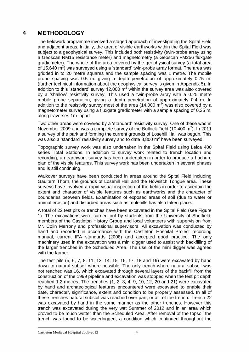
4 METHODOLOGY
The fieldwork programme involved a staged approach of investigating the Spital Field and adjacent areas. Initially, the area of visible earthworks within the Spital Field was subject to a geophysical survey. This included both resistivity (twin-probe array using a Geoscan RM15 resistance meter) and magnetometry (a Geoscan FM256 fluxgate gradiometer). The whole of the area covered by the geophysical survey (a total area of 15,640 m2) was surveyed using a ‘standard’ twin-probe array format. The area was gridded in to 20 metre squares and the sample spacing was 1 metre. The mobile probe spacing was 0.5 m. giving a depth penetration of approximately 0.75 m. (further technical information about the geophysical survey is given in Appendix 5). In addition to this ‘standard’ survey 12,000 m2 within the survey area was also covered by a ‘shallow’ resistivity survey. This used a twin-probe array with a 0.25 metre mobile probe separation, giving a depth penetration of approximately 0.4 m. In addition to the resistivity survey most of the area (14,000 m2) was also covered by a magnetometer survey using a fluxgate gradiometer with a sample spacing of 0.25 m. along traverses 1m. apart.
Two other areas were covered by a ‘standard’ resistivity survey. One of these was in November 2009 and was a complete survey of the Bullock Field (10,400 m2). In 2011 a survey of the parkland forming the current grounds of Losehill Hall was begun. This was also a ‘standard’ resistivity survey and to date 8,800 m2 have been surveyed.
Topographic survey work was also undertaken in the Spital Field using Leica 400 series Total Stations. In addition to survey work related to trench location and recording, an earthwork survey has been undertaken in order to produce a hachure plan of the visible features. This survey work has been undertaken in several phases and is still continuing.
Walkover surveys have been conducted in areas around the Spital Field including Gaultern Thorn, the grounds of Losehill Hall and the Howsitch Tongue area. These surveys have involved a rapid visual inspection of the fields in order to ascertain the extent and character of visible features such as earthworks and the character of boundaries between fields. Examination of exposed areas of soil (due to water or animal erosion) and disturbed areas such as molehills has also taken place.
A total of 22 test pits or trenches have been excavated in the Spital Field (see Figure 1). The excavations were carried out by students from the University of Sheffield, members of the Castleton History Group and local volunteers with supervision from Mr. Colin Merrony and professional supervisors. All excavation was conducted by hand and recorded in accordance with the Castleton Hospital Project recording manual, current IFA standards (2008) and accepted good practice. The only machinery used in the excavation was a mini digger used to assist with backfilling of the larger trenches in the Scheduled Area. The use of the mini digger was agreed with the farmer.
The test pits (5, 6, 7, 8, 11, 13, 14, 15, 16, 17, 18 and 19) were excavated by hand down to natural subsoil where possible. The only trench where natural subsoil was not reached was 16, which excavated through several layers of the backfill from the construction of the 1999 pipeline and excavation was stopped when the test pit depth reached 1.2 metres. The trenches (1, 2, 3, 4, 9, 10, 12, 20 and 21) were excavated by hand and archaeological features encountered were excavated to enable their date, character, significance, extent and condition to be properly assessed. In all of these trenches natural subsoil was reached over part, or all, of the trench. Trench 22 was excavated by hand in the same manner as the other trenches. However this trench was excavated during the very wet Summer of 2012 and in an area which proved to be much wetter than the Scheduled Area. After removal of the topsoil the trench was found to be waterlogged, a condition which continued throughout the

Castleton Medieval Hospital 2009-2012 5
2012 fieldwork season. Due to the soft nature of the underlying deposits and the flooded nature of the trench, the excavation of this trench was abandoned without the underlying deposits being investigated.
In addition to the trenches excavated within the Spital Field two further test pits were excavated. These were located in the area adjacent to the entrance to the driveway of Losehill Hall and were excavated down to the underlying undisturbed natural subsoil.
A full written, drawn and photographic record was made of each area. Individual contexts were assigned to observed deposits. All finds, except obviously modern brick, plastic and metalwork, were retained for further analysis. Photographs were taken in colour digital, and in 35mm monochrome print format. Survey tie-in was undertaken during the course of the evaluation to fix the trenches in relation to the buildings and to the National Grid (located on the 1:2500 map of the area).
5 SITE LOCATION AND LAND USE
Castleton is situated at the west end of the Hope Valley in the Peak District close to the boundary between the Millstone Grit Group of Carboniferous sedimentary rocks which make up the Dark Peak (to the north and east) and the Carboniferous Limestone of the White Peak. The village is approximately 20 kilometres west of Sheffield and lies in the valley bottom between about 175 and 190m.A.O.D. and commands the route along the Hope Valley to the Winnats and Mam Tor passes to the west.
The Spital Field (SK 1563 8330) lies to the north-east of the village and is located between the Hope – Castleton road (turnpike) and the Peakshole Water river (see figure 1). The northern part of the field lies on a terrace above the flood plain of the river (which covers the southern part of the Spital Field). The majority of the earthwork features (and the resulting archaeological attention) lie on the river terrace. The whole field is currently under permanent pasture (apart from a small enclosed area of mature trees near the centre of the field).
The other areas surveyed are all also permanent pasture. Howsitch Tongue is centred on SK 1511 8345 and is the area to the north of the village, over the mill bridge and bounded by the Peakshole Water on the south and Robinlands Lane on the south-west and north-west sides. The eastern boundary is with the track which is the continuation of Squires Lane. The Bullock Field is centred on SK 1542 8344 and is located between the grounds of Losehill Hall to the east and Squires Lane to the west. The area within the grounds of Losehill Hall are centred on SK 1544 8355 and lie south of the hall itself. The field known as Gaultern Thorn is immediately east of the caravan park and north of the modern road (opposite the entrance to Marston Farm) and centred on SK 1575 8346.
6 ARCHAEOLOGICAL AND HISTORICAL BACKGROUND
The hospital of the ‘Castle of the Peak’ was reputedly founded by the wife of one of the William Peverels, putting its foundation before 1153. It continued to operate with a succession of wardens as a hospital or ‘spyttelhowse’ until 1543 or soon after when it was valued at 40s in the Valor Ecclesiasticus. The two earliest documents referring to Spital Field are a grant and a Charter from the early 14th century.
Place name evidence supports the general location of the hospital (eg Spital Bridge, Spital Field), and a Parliamentary Survey describes boundaries of the lands of the

Castleton Medieval Hospital 2009-2012 6
“Hospitall of the High Peake” that are strongly suggestive of the current Spital Field, (the description is given as...“bounded on the South by the Peakes Arse River, East by a Comon feild knowne by the name of Over Maston, north by the Highway that leadeth to Hope and west partly by the said River, and partly by the said highway….”). The former position of the “Highway” between Castleton and Hope is contentious but a lease of 1729 puts the (pre-turnpike) highway in approximately its current position at least in relation to 1848 field names in Hope. A feofment of 1688 from the same document describes “…one rood of land in Spittlefield the lane leading from Castleton to South...”, and may refer to an additional minor route to Castleton or alternatively to the previously mentioned “Highway” (if Spittlefield also extended north of the present Castleton Road). An 1819 survey shows fields named “Great Spital”, “Little Spital”, and “Spital Pingle” north of Castleton Road and in the current grounds of Losehill Hall.
The supposed site of The Hospital of the Peak was scheduled on 15 February 1999 (Scheduled Monument No. 29938). The Scheduled Monument contains the obvious surface features to the south of Castleton road and opposite Losehill Hall lodge. Unfortunately there is little evidence for the specific function or plan of the hospital. The VCH History of “The Hospital of St Mary in the Peak” states that the hospital was founded for “certain infirm poor of the district” but does not expand on this statement. In the Augmentations a grant to Thomas Babyngton mentions that following its dissolution the hospital included a “mansio” with a “little chapel annexed to that house”, and the Parliamentary Survey describes “a messuage and certaine parcells of land called or knowne by the name of the Hospitall of the High Peake” that still remained a century later in 1654.
Figure 2: Possible location of structure plus the route of the water management pipeline overlain on the resistivity survey and site grid (© Trent and Peak Archaeological Trust).
During the construction of a water management pipeline in 1999 Trent and Peak archaeological Trust conducted excavations in the Spital Field. The route of the pipeline was mostly down along the floodplain to the south of the terrace on which the Scheduled Area now sits. This work did identify a structure which has been

Castleton Medieval Hospital 2009-2012 7
interpreted as a possible ice house or oven (see figures 1 and 2). Significant amounts of Medieval pottery were recovered from a pit which was cut by the ‘ice house/oven’ structure (Malone, 2011 and D. Garton pers. comm.).
No other archaeological work has been conducted in the Spital Field. However a trench for a new electrical supply to the caravan park was excavated during 2007. This trench ran along the path adjacent to Castleton Road, including the section immediately adjacent to the northern fence of the Spital Field. This trench was less than 1 metre to the north of the Spital Field fence (and therefore within 1 metre of the edge of the Scheduled Area) and was the subject of a watching brief undertaken by Archaeological Research Services. No archaeological deposits or material were revealed anywhere by the excavation of this trench, including in the part of the trench that was adjacent to the Spital Field.
A walkover survey of the grounds of Losehill Hall immediately to the north of the Spital Field was conducted by John Barnatt in 1993. This resulted in a sketch plan of visible earthworks and other features. This demonstrated that the grounds of Losehill Hall (to the south of the hall buildings) is primarily covered in ridge and furrow.
Figure 3: Map showing the locations of the Spital Field and the survey areas outside of the Spital Field (© Crown Copyright/database right 2011. An Ordnance Survey/EDINA supplied service).

Castleton Medieval Hospital 2009-2012 8
7 RESULTS
7.1 Survey
7.1.1 Walkover survey – Howsitch Tongue
A walkover survey of the area known as Howsitch Tongue was undertaken on 16th and 17th June 2009. The area surveyed is shown in the map above (figure 3). The purpose of the survey was to seek evidence for the use of this landscape during the period of the existence of Castleton Hospital. If Medieval features can be identified then the survey was to identify areas for future more detailed research.
A summary of findings is given in the table at the end of this section (table 1). The field codes used (and indications of features identified) are shown in figure 4. Fields A, B, C, D, I, F, G, and J were permanent pasture with short grazed grass. Field H was given over to arable and field K consists of a sports playing field. Field E consists of waste ground with longer grass and some small cultivated, horticultural plots.
All of the above fields, with the notable exception of field H, displayed the characteristic signs of ridge and furrow agriculture. This probably represents the arable cultivation system prior to the enclosure of the fields in the late 18th century. The precise date of the ridge and furrow (medieval or post-medieval) cannot be ascertained from this survey. Comparison with other studies suggest that ridge and furrow in the North or North Midlands of England is likely to be very late medieval or early post-medieval in origin, however no direct dating evidence is yet available for the Castleton ridge and furrow.
All of the fields, with the exception of sportsfield, field K, are broadly rectilinear pattern in shape, consistent with the orientation of the ridge and furrow and with larger open fields being broken in to smaller units during enclosure. The ridge and furrow field systems do not all follow the same orientation. There are three distinctive blocks of ridge and furrow. In fields A and B the ridge and furrow runs from the south-west to north-east. The ridge and furrow in fields C, F and G runs roughly perpendicular to that in fields A and B. The third orientation of ridge and furrow (in fields K, E, D and J) are orientated about 30o further west of north than the ridge and furrow in C, F and G (see figure 4). It should be noted that the ridge and furrow in field D is much more clearly delineated than elsewhere. This may suggest greater longevity of use; however, comparison with the other fields with ridge and furrow in the same orientation suggests that this is more likely to be the result of less modern disturbance in field D compared to other fields. The better preserved ridge and furrow in field D should be considered probably more representative of the original condition of the ridge and furrow at abandonment than the relatively faint examples in other fields.
The three blocks of ridge and furrow and the irregular boundary between them suggests that this open field system may have developed in a series of phases rather than being laid out in a single planned form. However the evidence from the survey is very limited. Further information about the date, character and development of the ridge and furrow could only be investigated through a programme of excavation.

Castleton Medieval Hospital 2009-2012 9
Figure 4: Results of the survey of the Howsitch Tongue area. The orientation of ridge and furrow is shown in red. Letter codes refer to the field codes used in the text (© Crown Copyright/database right 2011. An Ordnance Survey/EDINA supplied service).
Inspection was made of the boundaries of the fields within the Howsitch Tongue area. It had been noted that the boundaries were a mixture of old (and often collapsing) drystone walls, hedges and fences. The survey of the boundaries was in order to establish if any surviving older boundaries could be recognised. No fields are completely enclosed by drystone walls, the most complete being field D which is enclosed by walls on three sides. However it should be noted that several of the fence and hedge boundaries are on the banks of streams. The streams for natural boundaries and in most cases the boundaries along the stream edge appear relatively new. However the stream does not appear to have necessarily been a boundary in the past. The ridge and furrow in fields C and F, which are on the same alignment and as a result appear to have been a single open field are ‘separated’ by a stream, suggesting that the stream was not taken to be a boundary in the past. In some places, such as on the north boundary of field C, hedge and fence boundaries continued the lines of incomplete and partially collapsed stone walls. On the extreme east end of the north boundary of fields F and G evidence was found for the former existence of a gate of the kind to be found in drystone walls, although there was no surviving section of wall attached to the gate. However at the extreme west end of this boundary a remnant of walling was noted. An important point about this northern boundary of fields F and G is that the hedge and fence sit on top of a bank which runs across the slope. This bank appears to be a lynchet or similar feature and thus marks this boundary out as having been demonstrably in existence for a significant

Castleton Medieval Hospital 2009-2012 10
length of time. No other banks, breaks in slope or lynchets associated with boundaries were identified in this survey. The differences in the current construction of the boundaries has not shown any clear association with age (except perhaps the lynchet at the north end of F/G). The walling is likely to be post-medieval and its collapse the product of lack of maintenance in the 20th century.
Visible features noted within the fields include a single pit near the north-west edge of field A, which contained traces of charcoal, and a series of four similar pits located in consecutive furrows in the southern third of field C, forming a linear arrangement (shown in blue in figure 4). They clearly post date the creation (and abandonment) of the ridge and furrow field systems, cutting in to those features. What might be worthy of note is that field A is known locally as Lime Kiln Close. However there is no documentary or other evidence to explain this name. While there are no visible remains of a Lime Kiln now (although see below for an ashlar block found in this field) it may be that one or more of these pits somehow relate to this activity and therefore a case can be made that these pits should be subjected to further investigation. An alternative interpretation, suggested by the current landowner, for these pits is that they may be the burial sites of livestock or of ponies (that are the main grazing animal in the area now).
Field H had been harvested at the time of surveying, allowing confirmation that no ridge and furrow is visible in this field. This field has no earthwork features; however a substantial patch of greener vegetation, roughly circular in form, was visible in the south-west part of the field (shown in green in figure 4).
Smaller finds were rare. A single block of ashlar masonry was found in field A, close to the northern boundary. A small body sherd of modern white glazed pottery was found on the eroding bank of the stream in the south east corner of field D and a single sherd of black glazed pottery of 18th or 19th century date was recovered from a mole hill towards the north-west corner of field D.
The findings described above suggest that activity in this area has consisted of three broad phases; arable agriculture using a ridge and furrow cultivation system in large open fields. This is common in England during the late Medieval and early post-Medieval periods. There 3 identifiable field units, although these are of unknown date. At least part of one of these units shows significant height of the surviving earthworks which suggests that part of this system at least was in use for a significant period of time (unlike the ridge and furrow in the Spital Field, see below). The arable cultivation was succeeded by enclosed fields. This change may have occurred during or close to the late 18th century as a planned act of enclosure. The survival of the earlier ridge and furrow field systems within this landscape confirm that these smaller fields were not ploughed, but must have been pasture. The final phase is the current primarily pasture system (apart from field H, which is currently arable and this has destroyed evidence of whether there was an earlier arable then pasture sequence in this field). The current pasture is now primarily for horses and ponies. The other exception is field K, now used for sporting activities, but which preserves faint traces of ridge and furrow revealing its earlier use for arable.
Further work could be conducted in Lime Kiln Close, both geophysical survey and possible excavation in order to examine whether any evidence exists for Lime Kilns here. The other major area for further work would be to excavate a sample of the areas of ridge and furrow in order to establish for how long and when this form of arable cultivation was active. A comparison could then be made with other areas of surviving ridge and furrow (Spital Field, grounds of Losehill Hall, etc.) to establish a more complete picture of the late Medieval/early post-Medieval organisation of the landscape immediately surrounding the village. Fields currently under arable should be fieldwalked to recover material related to Medieval or earlier use of the land.

Castleton Medieval Hospital 2009-2012 11
FIELD CURRENT LANDUSE
VISIBLE FEATURES BOUNDARY INFORMATION
OTHER OBSERVATIONS
A PASTURE SHALLOW RIDGE & FURROW (SW-NE)
S - DRY STONE WALL; NW – 50% HAWTHORN HEDGE/50% DRY STONE WALL
1 SHALLOW PIT AT NW CORNER, TRACES OF CHARCOAL; ASHLAR BLACK BY NW BOUNDARY; STREAM AND LOW LYING WET AREA AT EAST END
B PASTURE SHALLOW RIDGE & FURROW (SW-NE)
SE – 50% HAWTHORN HEDGE/50% DRY STONE WALL; NW – FENCE; NE – MATURE TREES + FENCE
OLD STREAM BED AND WET GROUND TO NE
C PASTURE RIDGE & FURROW (SE – NW)
S – DRY STONE WALL; E – DEEP STREAM CHANNEL & FENCE; N - FENCE WITH SOME REMAINS OF DRY STONE WALL
4 PITS IN A SW – NE LINE IN A FURROW
D PASTURE DEEP RIDGE & FURROW (SE – NW)
SW –HAWTHORN HEDGE + FENCE – REMNANT WALL ON BANK VISIBLE; NE & W - DRY STONE WALL WITH 2 FORMER (BLOCKED) ENTRANCES; SE DEEPLY EMBANKED STREAM CHANNEL WITH TREES ALONG W SIDE
SINGLE SHERD OF WHITE GLAZED POT SE CORNER; SINGLE SHERD 18
TH/19
TH
CENTURY BLACK GLAZED WARE NW CORNER
E MOSTLY DISUSED, BUT WITH SOME HORTICULTURAL ACTIVITY
RIDGE & FURROW (SE – NW) – FAINT (NOT CONTINUOUSLY VISIBLE)
SE & SW – STREAM, DRY STONE WALL AND FENCE; NE & NW - DRY STONE WALL
F PASTURE RIDGE & FURROW (SE – NW)
S – TREES & STREAM; W STREAM & FENCE; E – HAWTHORN HEDGE; N –
GATEPOSTS AT NE CORNER; REMNANT OF WALL OR POSSIBLY BRIDGE AT NW

Castleton Medieval Hospital 2009-2012 12
MATURE TREES & FENCE
CORNER
G PASTURE RIDGE & FURROW (SE – NW)
S – TREES & STREAM; W – HAWTHORH HEDGE & FENCE; E – FENCE WITH SHORT SECTION OF REMNANT DRY STONE WALL TO NORTH
NORTHERN BOUNDARY OF AREA G IS A PRONOUNCED BREAK IN SLOPE (LYNCHET?) WITH HEDGE AND MATURE TREES. THIS LOOKS LIKE A MUCH OLDER BOUNDARY THAN MOST.
H ARABLE PATCH OF LUSH VEGETATION ON W SIDE OF FIELD
S – MATURE TREES AND FENCE; W STREAM & TREES
I PASTURE RIDGE & FURROW (FAINT) (SE – NW)
FENCES & STREAM
J PASTURE RIDGE & FURROW (SE – NW)
SE – STREAM; OTHERS – FENCE
K PLAYING FIELDS RIDGE & FURROW (SE – NW)
NE – STREAM AND FENCE; OTHERS - FENCE
Table 1: Summary of visible features identified in the Howsitch Tongue survey.
7.1.2 Geophysical survey
Three areas of geophysical survey have been completed around the hospital site at Castleton. All areas have been surveyed using a Geoscan RM15 resistivity meter. Part of the Spital Field survey area has also been surveyed using a Geoscan FM256 Fluxgate Gradiometer. Details of the equipment used are given in Appendix 5.
Spital Field
The first area to be surveyed (between late 2007 and during 2008) was the north-western part of the Spital Field and this survey covered 14,400 m2. This area has been extended eastwards in 2009 and 2010 to cover a total area of 15,640 m2. The whole area so far surveyed was covered by a standard resistivity survey. In addition to this 12,000 m2 was covered by a shallow resistivity using a twin-probe array with a 0.25 metre mobile probe separation and 14,000 m2 was covered by a magnetometer survey using a fluxgate gradiometer. The initial survey was considered in an earlier report prior to any excavation being undertaken (Merrony, 2008). However in order to inform the discussion of the trenches (see below) a short discussion of the earlier Spital Field survey is given here along with a discussion of the more recent geophysical surveys. Please note that larger versions of the plots of the results of the geophysical survey are given in the ‘Illustrations section’ in the Appendix.

Castleton Medieval Hospital 2009-2012 13
Figure 5: Greyscale plot of the results of the magnetometer survey in the Spital Field (© Crown Copyright/database right 2011. An Ordnance Survey/EDINA supplied service).
The most straightforward survey in the Spital Field to consider is the magnetometer survey. A greyscale plot of the results of the magnetometer survey is shown in Figure 5. It is clear they are dominated by 4 strong dipole anomalies. The largest of these anomalies enters the Spital Field close to the boundary between the pasture field and the area of trees in the north-west corner. It then runs for approximately 30 metres and then turns to the east and runs across the Spital Field to pass just north of the building and clump of trees in the middle of the Spital Field. This anomaly is marked A on Figure 5 and this clearly corresponds to an oil pipeline which runs across this field and the route of which is visible as a slight dip running across this field. It should be noted that this oil pipeline, which was constructed in 1955, runs right across the Scheduled Area (which of course was not in place until 1999). The actual width of the pipeline is narrower than the magnetic anomaly. The actual cut for the pipeline appears to be only approximately 1 metre wide; however the metal pipe is creating an anomaly in excess of 5 metres across and more than +/- 2000 nT in strength.
Also entering the Spital Field from the main road, but in this case running south-west towards the Peakshole Water is a further linear anomaly (marked B on Figure 5). This is not as substantial as the oil pipeline anomaly; however it has a strength of up to +/- 150 nT and creates an anomaly up to 3 metres wide. This must again be a modern service pipe or cable; however it is not certain exactly what is causing this anomaly. It should be noted that this pipe or cable also runs right across the Scheduled Area, although again this was no doubt constructed well before the site was Scheduled.
In addition to the two linear anomalies there are two circular dipole anomalies (marked C on Figure 5) in the southern part of the survey area. These are strong anomalies, again in excess of 2000 nT, and forming anomalies over 5 metres across. These anomalies both correspond with cast iron inspection covers visible on the ground. These are probably related to the new water management relief pipe constructed in 1999.
These strong magnetic anomalies dominate the results of the magnetometer survey.

Castleton Medieval Hospital 2009-2012 14
There are some very weak anomalies such as one on the northern margin of the survey area in the region of the entrance in to the field. This weak anomaly corresponds to an area of brick and other rubble hard standing constructed by the farmer to reinforce the entrance to the field. Consequently all anomalies identified in the magnetometer survey are associated with modern activity, either pipeline/cable construction or agricultural. The most important archaeological observation to be made from these results is the presence of 2 linear disturbances running through a significant part of the Scheduled Area. Both of these were constructed long before the Scheduling of this site; however there can be no doubting that they will have destroyed any archaeological deposits in the areas they run through and therefore will have had a significant impact on the potential survival of archaeological deposits within what became the Scheduled Area.
The standard resistivity survey (0.5 metre separation of the mobile probes) covered a larger area than the magnetometer survey. A greyscale plot of the results from the standard resistivity survey is shown in Figure 6.
Figure 6: Greyscale plot of the results of the standard resistivity survey in the Spital Field (© Crown Copyright/database right 2011. An Ordnance Survey/EDINA supplied service).
The standard resistivity survey confirms the presence of the pipeline/modern services shown in the magnetometer survey. Although the resistivity survey will actually be revealing the trench the pipeline/cable is running through rather than responding to the pipeline/cable itself. A third service trench is also shown running north-south, just to the west of the building/clump of trees in the centre of the Spital Field. These features are shown in red on Figure 6. The results also suggest that a drain or similar feature may run down the holloway which is visible within the Scheduled Area (the holloway is marked in light blue and labelled F on Figure 6).
The standard resistivity survey revealed several areas of high resistance which could be related to stone structures or spreads of rubble. These area of high resistance are labelled A and B on Figure 6. There is also a linear high resistance feature (labelled C and marked with a yellow dashed line on Figure 6) which may be an enclosing

Castleton Medieval Hospital 2009-2012 15
bank or wall. Features A, B and C have been investigated with trenches and are discussed below. There are also some further high resistance features visible further to the east close to the building/clump of trees in the middle of the Spital Field. As a result of the excavations in areas A and B it is likely that these additional areas of high resistance are the result of variations in the underlying geology.
The line of the 1999 pipeline is also visible on the results of the standard resistivity survey, although it is not a clear feature but only a broad zone of lower resistance readings (indicated by dark blue arrows on Figure 6). Visible as an area of high resistance readings is the area of hard standing at the entrance to the field that was visible as a weak magnetic feature in the magnetometer survey. This is an area of hard packed brick and other rubble placed by the farmer to reinforce the entrance area.
Running parallel to the modern road (and close to the boundary fence) is an earthwork bank. This is visible, although only weakly in the resistivity survey (the western part is labelled as D on Figure 6). The bank is broken by the modern entrance to the field and by the holloway and these breaks are visible in the results of the survey.
The parallel lines of high and low resistance readings produced by ridge and furrow are visible running roughly north-south in the eastern part of the survey area. These correspond to visible earthworks which cover the whole of the eastern part of the upper terrace of the Spital Field. The only part of the upper terrace not to have visible ridge and furrow is the area of earthworks in the north-western part of the Spital Field which were Scheduled in 1999.
Within the area of earthworks that form the Scheduled Area there are surprisingly few clear anomalies. The earthworks include a clear bank on the north and east sides of the area, some roughly rectangular platforms which could be building platforms and an oval mound near the centre of the area. The enclosing bank is faintly visible; however none of the other earthwork features correspond clearly with any features within the geophysical survey. The only geophysical features which may relate to visible features other than the holloway and enclosing banks are a small area of indistinct high resistance readings in the same area as the oval mound. It should be noted however that even with this feature the correlation is poor, as the geophysical anomaly extends significantly further to the south-west than the mound.
While there are few features on the standard resistivity survey which are clearly identifiable with possible archaeological deposits or structures there are some features which were interpreted as possibly relating to archaeological structures/deposits. These features have been investigated with trenches and are discussed below.
In an attempt to provide additional clarity, the western part of the survey area was surveyed a second time with the resistivity meter, but this time with the mobile probe separation reduced to 0.25 m. This limits the depth penetration of this survey to approximately 0.35-0.40 m. or half the depth the standard resistivity survey was reaching. A greyscale plot of the results of this survey is shown in Figure 7 and a comparison of the standard and shallow survey results presented in figure 8.
Castleton Medieval Hospital 2009-2012 16
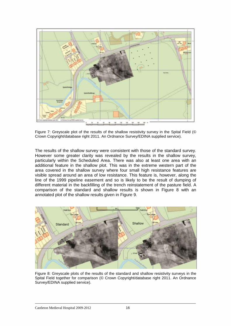
Figure 7: Greyscale plot of the results of the shallow resistivity survey in the Spital Field (© Crown Copyright/database right 2011. An Ordnance Survey/EDINA supplied service).
The results of the shallow survey were consistent with those of the standard survey. However some greater clarity was revealed by the results in the shallow survey, particularly within the Scheduled Area. There was also at least one area with an additional feature in the shallow plot. This was in the extreme western part of the area covered in the shallow survey where four small high resistance features are visible spread around an area of low resistance. This feature is, however, along the line of the 1999 pipeline easement and so is likely to be the result of dumping of different material in the backfilling of the trench reinstatement of the pasture field. A comparison of the standard and shallow results is shown in Figure 8 with an annotated plot of the shallow results given in Figure 9.
Figure 8: Greyscale plots of the results of the standard and shallow resistivity surveys in the Spital Field together for comparison (© Crown Copyright/database right 2011. An Ordnance Survey/EDINA supplied service).

Castleton Medieval Hospital 2009-2012 17
Within the Scheduled Area the shallow survey provides what appears to be some more detail. The first feature which certainly does appear with greater clarity is the bank which encloses the main level area (within the Scheduled Area) on its north and east sides. In particular, the section of the bank running along the east side (parallel with the holloway) is much more clearly visible on the shallow survey (marked ‘o’ on Figure 9).
On the main platform within the Scheduled Area there are 3 features of interest. Between the central mound and the enclosing bank on the east side is a curving high resistance feature (marked ‘p’ on Figure 9) forming an arc running approximately 20 metres north-south. There is a break of slope in this area visible on the surface of the field which has been interpreted as one side of a possible building platform. However this break of slope is not curved and so it is not likely that the visible break of slope is a strong candidate for the origin of this curving high resistance feature.
In the centre of the platform a high resistance feature is visible in results of the standard survey (marked E on Figure 6 and discussed above). This feature extends to the south-west of the mound that is visible in the centre of the level area. In the shallow survey there is a similar, but not identical, feature (marked ‘q’ on Figure 9) which has a more rectangular appearance. This feature may also be described as ‘T-shaped’, however its orientation does not match that of the feature in the standard survey. The ‘upright’ of the T now runs roughly north-south with a line of high resistance readings running perpendicular to this at its north end (forming the cross of the T). In addition to this there is another (weaker) line of high resistance readings also perpendicular to the north-south line at its southern end (running to the east only). This line appears to join up with a small area of high resistance readings which run north-south and were also visible on the standard survey. Together this gives a small set of linear high resistance features with a regular pattern consistent with structural remains. If these are related to structural remains then it is likely from the geophysical data that they are very near the ground surface and do not extend to any significant depth. If they are related to structures then these structures are likely to be incomplete, with just some fragments of walls surviving. Of course an alternative interpretation is that these are dumps of material or the last remnant of rubble spreads and the apparent regular orientation and relationship of the linear features is coincidental. The shallow nature of something like the last remnant of a rubble pile or spread would be consistent with the lack of appearance of these features on the standard survey. It seems less likely that wall remains would be visible on the shallow survey and yet not visible on the standard survey. The discrepancy in the orientation of the features on the shallow and standard surveys is perhaps also more consistent with irregular dumps or spreads of material rather than walls or wall foundations. This area has more recently been subject to excavation and the results of the excavations are discussed below and a comparison made between the excavated results and the geophysical surveys.
One further high resistance feature is visible within the Scheduled Area in the results of the shallow survey. A small L-shaped feature is visible towards the north side of the level platform just ‘inside’ the enclosing bank (marked ‘r’ on Figure 9). It is possible that this feature represents a fragment of surviving wall or wall foundation. However, the same limitations as with feature ‘q’ also apply here.

Castleton Medieval Hospital 2009-2012 18
Figure 9: Closer view of the greyscale plot of the results of the shallow resistivity survey in the Spital Field with annotations as used in the text (© Crown Copyright/database right 2011. An Ordnance Survey/EDINA supplied service).
The geophysical surveys within the Spital Field have yielded inconclusive results. The confidence of the Scheduling Statement along with the visible earthworks within the field had resulted in an expectation that clear evidence for stone buildings, other walls and perhaps paths or yard areas would be produced by the geophysical surveys. The surveys have, however, not produced clear evidence for any buildings, nor for a clear enclosed area or for paths or other features. There are areas of high resistance readings outside the Scheduled Area which could relate to buildings or rubble spreads, however within the Scheduled Area the results do not support the hypothesis that substantial structural remains survive. The lack of clear geophysical features also calls in to question whether any of the visible earthworks relate to stone structures. The lack of clarity for the bank and mound within the Scheduled Area suggest that these are earthen features. Similarly the other breaks in slope and features that have been interpreted as building platforms are not visible on the surveys and this challenges this interpretation. It is clear from the results of the geophysical surveys that the only way of gaining a significant understanding of both the visible earthworks and the areas of high resistance will be through targeted excavation. The results of these excavations are discussed in section 7.2 below.
One thing that is clear from the results of the geophysical surveys is that several trenches cross the Spital Field for pipes, drains or cables. These include at least 2 which, while constructed prior to the scheduling of the site, do run through what is now the Scheduled Area and will have caused significant disturbance to any archaeological deposits within those parts of the Scheduled Area.

Castleton Medieval Hospital 2009-2012 19
Bullock Field
The second area surveyed was during November 2009 in the Bullock Field on the north side of the modern road. This survey covered the whole field, resulting in a survey area of 10,400 m2. The area was covered by a standard resistivity survey. A greyscale plot of the results of this survey is shown in Figure 10.
Figure 10: Greyscale plot of the results of the resistivity survey in the Bullock Field with annotations as used in the text (© Crown Copyright/database right 2011. An Ordnance Survey/EDINA supplied service).
The survey is dominated by clear evidence for ridge and furrow running along the long axis of the field. This ridge and furrow shows clearly the typical increasing curve towards the southern end of the field and is a good example of how ridge and furrow can still be visible on a geophysical survey in a field where it has almost been completely flattened by modern ploughing.
The other clear feature on this survey is a linear low resistance feature running north-west to south-east across the field near the southern end. This is shown on the plot (by the blue arrow) and is clearly the trench for a modern pipe or cable. The oil pipeline (visible in the magnetometer plot from the Spital Field) runs through this field and this may be the trench which contains it.
There is one further feature and this is a weak high resistance feature near the middle of the field which appears to form 3 sides of a rectangle. This is shown on figure 10 in light blue. This is such a weak feature that it is not possible to interpret it with confidence. This may be an earlier enclosure underlying the ridge and furrow; however the evidence is not conclusive as this is very weak and it is a high resistance feature. An earlier enclosure would only survive as a filled-in ditch under the ridge and furrow and this would normally be expected to appear as a low resistance feature. While high resistance ditches are possible they are unusual and the high resistance nature of this feature does make it even less certain than is already the case that it may be an enclosure pre-dating the ridge and furrow. However this interpretation remains a possibility.

Castleton Medieval Hospital 2009-2012 20
Losehill Hall grounds
The third area surveyed was part of the grounds of Losehill Hall which was surveyed during June and July 2011 and covered an area of 8,800 m2. This area was also covered by a standard resistivity survey. It should be noted that this survey was conducted after a prolonged period of very dry weather resulting in very low soil moisture. It did rain at times during the survey, however the amounts were small and will have made little impact on the very dry soils within the parkland of Losehill Hall. The greyscale plot of the results of this survey is shown in Figure 11.
Figure 11: Greyscale plot of the results of the resistivity survey in the grounds of Losehill Hall (© Crown Copyright/database right 2011. An Ordnance Survey/EDINA supplied service).
A more detailed plot of the results is given in Figure 12. Ridge and furrow is again visible in this plot, although here it is not clear. This ridge and furrow is visible in the field as earthworks and has an orientation which matches that in the adjacent Bullock Field.
However the dominant feature of the results of this survey is the effect of the trees. There are many mature trees in the survey area (particularly near the centre) and the plot shows that these have clearly caused the soil to become very dry in the areas around them. The central part of the survey area demonstrates this very clearly with large high resistance ‘circles’ around the dummy readings that represent the trunks of these mature trees. In addition to the trees there is a large area of dumped wood among the trees near the centre of the survey area which has resulted in part of the area not being surveyed. Away from the central area the trees are generally smaller; however there are still several examples where these trees have a ring of higher

Castleton Medieval Hospital 2009-2012 21
readings surrounding them. This must be the result of the dry weather conditions and the trees extracting soil moisture creating zones of extremely dry soil around their roots. Usually in resistivity surveys trees do not have as obvious an effect as this and it seems likely that if this survey was repeated during a period of more normal weather conditions the effect of the trees would be substantially reduced. The obvious approach here is to repeat and expand this survey in the future when weather conditions are more conducive to successful resistivity surveying among mature trees.
Figure 12: Closer view of the greyscale plot of the results of the resistivity survey in the grounds of Losehill Hall with annotations as used in the text (© Crown Copyright/database right 2011. An Ordnance Survey/EDINA supplied service).
7.1.3 Earthwork/topographic survey
Three areas of visible earthworks have been subject to survey work. The north-western part of the Spital Field has visible earthworks which have resulted in part of the field being designated as a Scheduled Ancient Monument.
There are visible earthworks in the grounds of Losehill Hall. These were recorded during a walkover survey in 1993 by John Barnatt (see Figure 13). In 2011 part of this area was covered by a geophysical survey (see above) and a brief topographic survey.

Castleton Medieval Hospital 2009-2012 22
Figure 13: John Barnatt’s 1993 plan of the results of his walkover survey
A brief earthwork survey was undertaken in 2011 of the field to the east of the caravan park (the field is known as Gaultern Thorn). Further consideration of the ridge feature in Gaultern Thorn and the possibility that it represents a pre-turnpike route for the Hope to Castleton road has resulted in a proposal to undertake further work within this field (and the adjacent caravan park). The results of this proposed

Castleton Medieval Hospital 2009-2012 23
work will be discussed in a future report and consequently the limited survey work so far completed will not be described in detail here.
Faint evidence for further ridge and furrow is also visible in other areas including the Bullock Field; however these areas have not been surveyed in detail.
Figure 14: Spittle field names recorded in 1819
7.2 Excavation
7.2.1 Trench 1
Trench 1 was 20 metres by 2 metres and excavated across an area of ridge and furrow immediately to the east of the area of earthworks that have been identified as the site of the Medieval hospital. The trench ran across one complete ridge and the furrows on either side of this ridge, then up at each end on to the next ridge to the east and west. The excavation of this trench did not reveal any significant depth to the deposits in the furrows, suggesting that the ridge and furrow that is visible across the eastern part of the Spital Field was not in use as arable land for very long. This is
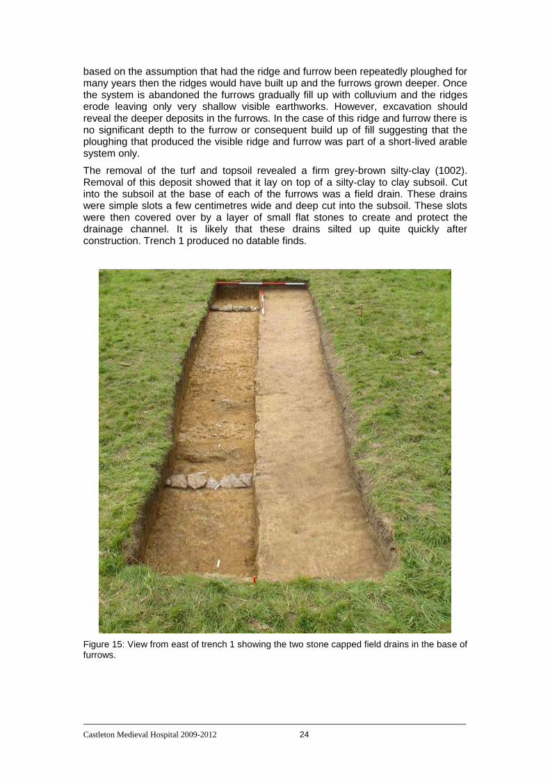
Castleton Medieval Hospital 2009-2012 24
based on the assumption that had the ridge and furrow been repeatedly ploughed for many years then the ridges would have built up and the furrows grown deeper. Once the system is abandoned the furrows gradually fill up with colluvium and the ridges erode leaving only very shallow visible earthworks. However, excavation should reveal the deeper deposits in the furrows. In the case of this ridge and furrow there is no significant depth to the furrow or consequent build up of fill suggesting that the ploughing that produced the visible ridge and furrow was part of a short-lived arable system only.
The removal of the turf and topsoil revealed a firm grey-brown silty-clay (1002). Removal of this deposit showed that it lay on top of a silty-clay to clay subsoil. Cut into the subsoil at the base of each of the furrows was a field drain. These drains were simple slots a few centimetres wide and deep cut into the subsoil. These slots were then covered over by a layer of small flat stones to create and protect the drainage channel. It is likely that these drains silted up quite quickly after construction. Trench 1 produced no datable finds.
Figure 15: View from east of trench 1 showing the two stone capped field drains in the base of furrows.

Castleton Medieval Hospital 2009-2012 25
7.2.2 Trench 2
Trench 2 was 4 metres by 2 metres and located so that it lay over a feature that was both defined in the resistivity survey (a high resistance feature – feature C in figure 6) and visible on the ground as a low bank. This low bank (and geophysical feature) curved up from the floodplain along the east side of the holloway which runs north-south through the earthworks. The geophysical feature then continues up on to the level area of the river terrace to the east of the holloway. The feature then has a gap in it and then continues north-eastwards across the river terrace for approximately 20 metres. The visible bank and the associated geophysical feature look like a boundary with a possible gateway allowing access from the holloway up on to a part of the river terrace where another high resistance feature was located (this was investigated in trench 3 – see below).
The excavation of trench 2 revealed friable silty deposits (2001 and 2002) making up the visible bank and overlying firm silty-clay subsoil. The excavation of trench 2 confirms that the visible back is an earthen bank, however the complete lack of datable artefacts or any other features associated with/underlying the bank results in very little additional information beyond the location of this bank, which is already visible on the ground. The excavation of trenches 2 and 3 also suggest that the continuation of the feature as a geophysical feature may be illusory and a chance alignment of a variation in the underlying geology with this earthen bank which then gives the impression of a feature continuing up on to the river terrace when in fact no such continuation exists.
Figure 16: View from south-east of trench 2 after removal of 2001 and 2002.

Castleton Medieval Hospital 2009-2012 26
7.2.3 Trench 3
Trench 3 was 4 metres by 4 metres and excavated in order to be able to investigate an area of high resistance readings in the resistivity survey (feature B in figure 6). Removal of the turf and topsoil revealed a friable light brown sandy-silt subsoil (3002). As the excavation continued, changes occurred in this subsoil with bands with of varying proportions of stone and with changes in colour from light yellow-brown through red-brown to dark grey (3003 to 3005). At no time, however, were either structures or deposits defined which could have had an origin as a result of past human actions. The various bands within the subsoil may be explained by natural processes during the subsoil deposition and development. No artefactual material was recovered from this trench and the high resistance feature visible in the greyscale plot is likely to have been produced by the different bands within the subsoil/geology that have differing moisture holding properties.
Figure 17: View from south of trench 3 after excavation. The variably coloured lenses and the bands with stone can be seen in the base of the trench and the section.
7.2.4 Trench 4
Trench 4 measured 4 metres by 2 metres and was located to investigate an area of high resistance with a linear low resistance feature running through it (feature A in figure 6), in the north-west corner of the Spital Field (and apparently running in to the area of trees in the north-west corner). Removal of the turf and topsoil revealed two grey brown silty clays with variable amounts of stone (4002/4003). These overlay the natural subsoil, which is a hard, light orangey-brown silty-clay with stone inclusions (4005/4008).
Cut into the natural deposits was a clear ditch cut filled with a very variable series of grey-brown to grey silty clays containing many small stones and some post-medieval artefactual material. The ditch cut (4006) was an irregular V-shape, but in places with a flattened base. The fills (4004 and 4007) were only moderately firm (with softer patches) and very variable in colour, stone content and artefactual content. This ditch and its fills are clearly associated with the linear low resistance feature in the resistivity survey.
Castleton Medieval Hospital 2009-2012 27
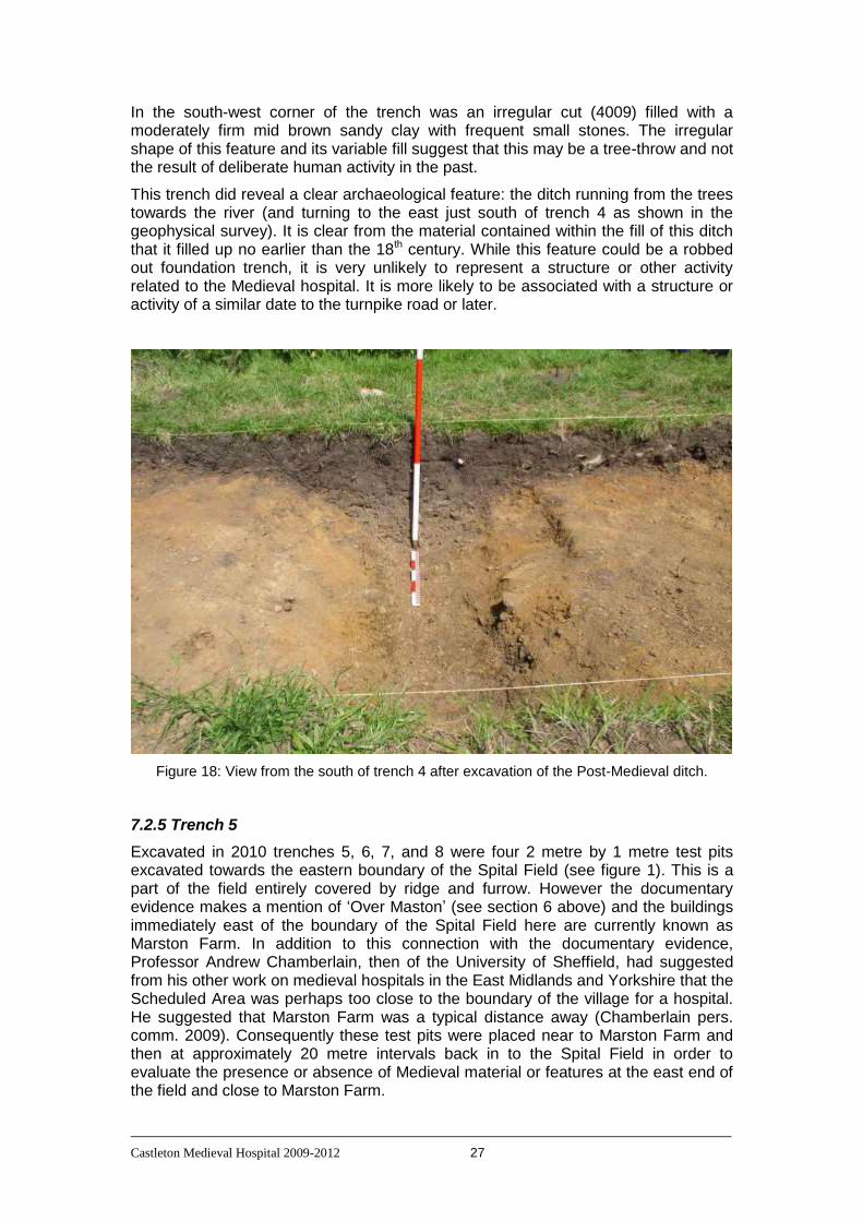
In the south-west corner of the trench was an irregular cut (4009) filled with a moderately firm mid brown sandy clay with frequent small stones. The irregular shape of this feature and its variable fill suggest that this may be a tree-throw and not the result of deliberate human activity in the past.
This trench did reveal a clear archaeological feature: the ditch running from the trees towards the river (and turning to the east just south of trench 4 as shown in the geophysical survey). It is clear from the material contained within the fill of this ditch that it filled up no earlier than the 18th century. While this feature could be a robbed out foundation trench, it is very unlikely to represent a structure or other activity related to the Medieval hospital. It is more likely to be associated with a structure or activity of a similar date to the turnpike road or later.
Figure 18: View from the south of trench 4 after excavation of the Post-Medieval ditch.
7.2.5 Trench 5
Excavated in 2010 trenches 5, 6, 7, and 8 were four 2 metre by 1 metre test pits excavated towards the eastern boundary of the Spital Field (see figure 1). This is a part of the field entirely covered by ridge and furrow. However the documentary evidence makes a mention of ‘Over Maston’ (see section 6 above) and the buildings immediately east of the boundary of the Spital Field here are currently known as Marston Farm. In addition to this connection with the documentary evidence, Professor Andrew Chamberlain, then of the University of Sheffield, had suggested from his other work on medieval hospitals in the East Midlands and Yorkshire that the Scheduled Area was perhaps too close to the boundary of the village for a hospital. He suggested that Marston Farm was a typical distance away (Chamberlain pers. comm. 2009). Consequently these test pits were placed near to Marston Farm and then at approximately 20 metre intervals back in to the Spital Field in order to evaluate the presence or absence of Medieval material or features at the east end of the field and close to Marston Farm.

Castleton Medieval Hospital 2009-2012 28
Trench 5 was excavated among the trees which stand along the eastern margin of the Spital Field and was very close to the boundary wall between the Spital Field and Marston Farm (see Fig. 1). This test pit revealed a small amount of post-medieval artefactual material in the friable, mid grey-brown sandy clay topsoil (context 5001). This test pit was the only one to produce any significant amount of post-medieval artefactual material; however the material was all from the topsoil and as this test pit is the very close to Marston Farm it is reasonable to assume this material is largely derived from relatively recent activities taking place in Marston Farm. There was significant disturbance of the lower (subsoil) layers by tree roots in this trench.
Figure 19: View (looking east) of trench 5 after completion of the excavation. Marston Farm is visible in the background behind the boundary wall (with its stock fence reinforcement). This wall/fence is the eastern boundary of the Spital Field.
7.2.6 Trench 6
Trench 6 was 2 metres by 1 metre and approximately 20 metres west of trench 5. This placed this test pit out in to the clear area of the pasture field within the area of visible ridge and furrow. The test pit revealed evidence of ridge and furrow with, as in trench 1, the furrows being very shallow (as the boundary between 6002 and 6003).

Castleton Medieval Hospital 2009-2012 29
The topsoil/turf layer (6001) was a friable grey-brown sandy clay. This overlay a compact light orange-brown layer (6002) which marked the base of the ridge and furrow deposit. Below this lay an undisturbed subsoil (6003) which comprised a firm light orange-brown silty clay. No identifiable artefactual material was recovered from this test pit.
Figure 20: View (looking east) of trench 6 after completion of the excavation.
7.2.7 Trench 7
Trench 7 measured 2 metres by 1 metre and was excavated in the eastern part of the Spital Field, west of trench 6 (see Fig. 1). Similarly to trench 6 this trench revealed evidence of the ridge and furrow that is visible as a surface feature in this part of the field (as the boundary between 7002 and 7003). The topsoil/turf layer (7001) was a friable dark grey-brown sandy clay. This overlay a firm mid orange-brown silty-clay layer with occasional stones (7002) which marked the base of the ridge and furrow deposit. Below this lay an undisturbed subsoil (7003) which comprised a firm light orange-brown silty clay.
A single sherd of late medieval pottery was recovered from the topsoil (7001) in this trench. This is the only sherd of medieval pottery that was recovered during the 2010 excavations. Consequently there is no reasonable suggestion that there are any definable medieval structures or activity, beyond the cultivation of the field, within the eastern part of the Spital Field. This is an area of ridge and furrow and was no doubt an agricultural field in the Medieval period (although the result from trench 1,
Castleton Medieval Hospital 2009-2012 30
supported by those from trenches 6, 7 and 8) suggest it was pasture most of the time. Consequently occasional sherds or other medieval artefacts would be expected as part of a ‘background’ level of material. It is surprising, in fact, that so few sherds of medieval or post-medieval pottery have been recovered from the excavated areas. This is probably due to the field being pasture for most of that time and therefore not subject to manuring or any other activity likely to spread material from the farmyard or village on to the field. It is not reasonable to place any great significance on the single medieval sherd from trench 7.
Figure 21: View (looking north) of trench 7 after completion of the excavation.
7.2.8 Trench 8
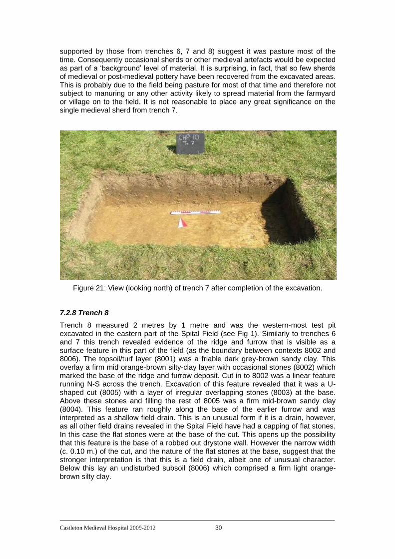
Trench 8 measured 2 metres by 1 metre and was the western-most test pit excavated in the eastern part of the Spital Field (see Fig 1). Similarly to trenches 6 and 7 this trench revealed evidence of the ridge and furrow that is visible as a surface feature in this part of the field (as the boundary between contexts 8002 and 8006). The topsoil/turf layer (8001) was a friable dark grey-brown sandy clay. This overlay a firm mid orange-brown silty-clay layer with occasional stones (8002) which marked the base of the ridge and furrow deposit. Cut in to 8002 was a linear feature running N-S across the trench. Excavation of this feature revealed that it was a U-shaped cut (8005) with a layer of irregular overlapping stones (8003) at the base. Above these stones and filling the rest of 8005 was a firm mid-brown sandy clay (8004). This feature ran roughly along the base of the earlier furrow and was interpreted as a shallow field drain. This is an unusual form if it is a drain, however, as all other field drains revealed in the Spital Field have had a capping of flat stones. In this case the flat stones were at the base of the cut. This opens up the possibility that this feature is the base of a robbed out drystone wall. However the narrow width (c. 0.10 m.) of the cut, and the nature of the flat stones at the base, suggest that the stronger interpretation is that this is a field drain, albeit one of unusual character. Below this lay an undisturbed subsoil (8006) which comprised a firm light orange-brown silty clay.

Castleton Medieval Hospital 2009-2012 31
Figure 22: View (looking north) of trench 8 after the removal of 8001, 8002 and 8004. This view shows the line of stones (8003) at the base of cut 8005 (the upper part of which is visible in the north section).
Trenches 6, 7 and 8 all showed evidence of the ridge and furrow. As with trench 1 the furrows were shown to be very shallow. No other archaeological features or deposits were revealed in these test pits. The only artefactual material was a small amount of Post-Medieval artefactual material recovered from the topsoil of trench 5 and a single sherd of abraded medieval pottery from the topsoil of trench 7.
7.2.9 Trench 9
Trench 9 was 10 metres by 2 metres and placed just inside the Scheduled Area, across the line of the holloway and the associated bank on its western side. The trench extended from the centre of the holloway eastwards through the bank and into the interior of what appears to be an enclosed space (with a bank enclosing at least 2 sides). The holloway is a clear feature that runs from near the modern road southwards across the river terrace and down on to the floodplain, heading towards the river. It does not continue as a visible feature across the floodplain. This feature may have been cut by the turnpike road and if so is an earlier track running from the area that is now the grounds of Losehill Hall to a ford across the river (which is only a small stream at this point high up in the valley). The bank which runs parallel to the holloway is continuous with a bank that runs parallel to the modern (turnpike) road. This bank, at its southern end, turns to the west and forms a little over 2 sides of a rectangle (approximately 40 metres east-west and 25 metres north-south). There is no visible evidence that the bank ever continued further and formed a complete enclosure for the space. The holloway, the adjacent bank, a mound in the centre of the rectangular area and several slight platforms and hollows within this area are the reason this part of the field was designated as a Scheduled Ancient Monument in 1999.
The complete lack of Medieval artefactual material in trenches 2, 3 and 4 cast doubt on the validity of the interpretation of these visible earthwork features as remnants of the Medieval hospital. In particular trench 2 was located adjacent to the southern
Castleton Medieval Hospital 2009-2012 32
edge of the Scheduled Area and particularly importantly was just downhill from the area of visible earthworks. The complete lack of Medieval artefactual material in trench 2 made it difficult to accept that just a few metres upslope was a series of buildings related to a Medieval hospital which had been active for perhaps as long as 400 years.
In order to explore whether the visible earthworks are related to the Medieval hospital trenches 9 and 10 were excavated. Upon removal of the turf and topsoil from trench 9 several deposits were revealed. In the ‘interior’ of the enclosed area (the western part of trench 9) was a friable orange brown sandy clay with occasional small stones (9003). Excavation of a section through 9003, in the ‘interior’ of the enclosed area, revealed a gradual change to a compact light grey-brown silty clay which was interpreted as the natural subsoil (9007). There were no cut features or other deposits within this part of trench 9.
A 1 metre wide section of the holloway fill was excavated. The holloway fill (9009) was a compact dark orange-brown sandy clay with very occasional small rounded pebbles. 9009 proved to continue down throughout the holloway (9010) and it was disappointing that no visible stratigraphy survived within this context.
A 1 metre wide section of the bank was also excavated. The upper part of the bank was a friable, light grey-brown sandy loam (9002) with some angular stones. Excavation of the bank revealed a series of irregular layers and lenses with variable proportions of stones and varying in colour from grey-brown to orange-brown to a very light yellow-brown. The variability and shape of these deposits are compatible with material being thrown up from the holloway side to form the bank. The final interpretation being that the cut interpreted as a holloway is (at least in this area) a deliberate construction as it is the source for the bank material. It is not reasonable, however, to completely alter the interpretation of the holloway and now refer to it as a ditch created to provide material for the bank. This is because the holloway extends well beyond the limits of this adjacent bank. It is clear the holloway extends north of the bank (appearing to be truncated by the modern road) and also extends all the way down slope to the floodplain of the Peakshole Water. The small size of the bank would not account for the removal of such a large amount of material, nor would it be reasonable to suggest that the continuation of the cut downslope away from the enclosed area could be a source for material for the enclosing bank. If material for an enclosing bank was the primary function of the cut then it would seem more likely that the cut would follow the bank round as it turns west on the south side of the enclosed area. Even though it seems likely that the bank material was derived from the line of the adjacent holloway, the primary origin of the holloway remains most likely to have been as a trackway running from area that is now the grounds of Losehill Hall down to the floodplain and river.
No Medieval artefactual material was recovered from trench 9. A small number of small iron objects were recovered from the topsoil. Apart from one small horseshoe, these were of indeterminate shape, probably nails or similar discarded iron items. Overall there was very little artefactual material recovered at all (and nothing datable) from trench 9; again it is difficult to accept that this trench lies on the edge of a series of Medieval buildings occupied for several centuries.

Castleton Medieval Hospital 2009-2012 33
Figure 23: View from east of trench 9 after excavation
Figure 24: View from south of section through the bank in trench 9
Castleton Medieval Hospital 2009-2012 34
7.2.10 Trench 10
Trench 10 was originally 10 metres long but this was extended to 12.5 metres in order to further investigate features revealed during the process of excavation. The trench was 2 metres wide and it was located in the centre of the Scheduled Area (see figure 1). Trench 10 included the southern side of the small mound in the centre of the Scheduled Area and ran southwards from this across a level area that has been described as a possible platform.
Removal of the turf and topsoil revealed an extensive spread of stones (10002). These stones were very variable in size, shape and material. This rubble spread included fossil-rich limestone, gritstone, limestone without fossils and other material. Some stones in this spread were cut, but most were irregular angular stones varying from quite small (less than 10 cm.) to large (30 cm+). The variability in the character and distribution of the stone strongly suggested that this was a dump of mixed stone not a collapse or spread of stone from a single coherent structure. The topsoil and the upper surface of the rubble spread produced a few sherds of modern (19th – 20th century) pottery. Towards the southern end of the trench was a band of smaller stones that appeared slightly different to the general spread, but not so different that they were defined as a separate context.
Removal of this irregular spread of stones revealed some more consistent underlying deposits. In the southern and central part of the trench removal of the stones revealed a compact yellowish-red silty sand containing occasional small stones (10006/10007). This deposit contained some pieces of animal bone with butchery cut marks. Underlying this deposit in the northern part of the trench were some flat slabs of stone (10008) laid on a consistent level. These stones were irregular and the coverage was not continuous. However the suggestion from the remaining stones was that this had been a rough flagged surface, which had been disturbed or partially removed prior to it being covered by the sandy deposit and then the irregular rubble spread.
At the north end of the trench removal of the irregular rubble revealed a more consistent deposit of stone (10004) and subsequently a surviving section of walling (10005). The face of the wall had the remnant of a white render or whitewash on it down to a point where the wall stepped out. It is likely that the wider section at the base is the foundation and the step represents a point at or a little above the original ground level, with the wall above this level rendered. The nearby stone slabs lay slightly below this level, but not so far below that this could not have resulted from the slope of the ground. It is likely that the stone slabs are the remnant of a floor or yard surface associated with this wall.

Castleton Medieval Hospital 2009-2012 35
Figure 25: View from the south of the wall (10005) at the north end of trench 10. Also visible are two stones from the surface (10008) and the narrow linear cut (10009/10010) running parallel to and in front of the wall. At the base of the photograph is part of the rubble spread (10002)
Trench 10 revealed the southern face of this wall. It was thought that the north face of the wall was just visible at the very northern edge of the trench. As this was only discovered on the last day of the excavation in 2010 it was not possible to extend the trench to confirm this.
To the south of the southern face of this wall (10005) were some faint features visible including a linear cut (10009/10010) running parallel to the face of the wall. It was originally thought that this may be a foundation trench for the wall; however this was not the case as the cut proved to be an irregular shallow channel. It may be that this was some kind of simple drain underlying a floor surface that does not survive in this area.

Castleton Medieval Hospital 2009-2012 36
Figure 26: View from the east of the wall at the north end of trench 10. This view shows the overlying rubble spread in the section.
While it is clear that there is a surviving wall and parts of a floor or yard surface within trench 10 the evidence so far does not support a medieval date for this wall or surface. The only datable material from trench 10 was post-medieval pottery. This material was recovered from deposits which are stratigraphically later than the wall and therefore do not provide a date for the wall’s construction. However the broader argument has to return to the complete lack of medieval material. It is difficult to accept that this wall represents part of the medieval hospital when no medieval artefactual material is present. On the other hand only a very small area adjacent to this wall was excavated in this trench and so there has not been an adequate or complete investigation of this structure.
The lack of this wall showing as a feature in the resistivity survey is surprising as it is so close to the modern ground surface. It is likely that this lack of visibility in the resistivity data is due to the broader irregular rubble spread overlying the wall and surrounding it. The wall presumably does not hold moisture significantly less well than the surrounding rubble.
The mound, overlying the wall, is very small; only extending for less than 2 metres to the west and east of trench 10. It is possible that the wall revealed only survives as a short section of what was once a much longer wall. A more extensive excavation across the area of this wall will be necessary to provide an adequate opportunity to understand this feature. Therefore it is of some concern that only a very short length of the wall may survive as this may make it very difficult to develop a robust interpretation of this structure, including its date and purpose. This can only be confirmed however with the undertaking of the necessary additional excavation to extend the area at the north end of trench 10 (see trenches 12 and 20 below).
7.2.11 Trench 11
Trench 11 was another 2 metre by 1 metre test pit. This one was excavated on the sloping edge of the river terrace towards the west end of the field. This test pit was excavated to investigate the area that may have been in the vicinity of the ‘ice house’ feature that was excavated when the water management pipeline was constructed (Malone, 2011). At the time of the excavation we did not have good location information for the ‘ice house’ feature. As can be seen from figure 1, the trench was placed approximately 15 metres west of the ‘ice house’ location.
Removal of the turf and topsoil in trench 11 revealed a lens of ashy deposit (11002). Underlying this was a compact light orange-brown sandy silt which rapidly merged

Castleton Medieval Hospital 2009-2012 37
into the underlying shale bedrock. No artefactual material was recovered from trench 11. The only evidence for human activity here is the lens of ash which could mark the location of a small fire in the past or, because this area slopes significantly, it may be the dumping of a small load of ash from the level ground of the river terrace above.
7.2.12 Trench 12
Trench 12 was 10 metres by 10 metres and was excavated in 2011 so it overlapped the north end of trench 10 (excavated in 2010) and therefore would allow further investigation of the wall revealed at the north end of trench 10 as well as any other features associated with this wall. The trench also covered the whole of the mound that is at the centre of the enclosed area and the trench extended northwards until it was close to the base of the bank that forms the northern boundary of the enclosed area (see Fig. 1).
Figure 27: View from the west of the section through the central mound in trench 12, showing context 12008 which underlay the stone spread (12002) and which makes up the main body of the central mound.
Removal of the turf and topsoil revealed two spreads of rubble. The major spread (12002) was across the central mound and extended south-west and south-east towards the southern corners of trench 12. The other spread (12003) was a fairly discrete area in the central part of the northern third of the trench. Both of these spreads were made up of very variable and irregular stones strongly indicating that these were a mixture of material brought and deposited on to the site and not the result of the collapse of any single structure. It was suspected at this point that the central mound would consist entirely of rubble as a continuation of the main rubble spread and that the central mound represented a dump of rubble against the wall (that had been revealed in trench 10); a dump of rubble which had subsequently spread further across the area. However this proved not to be the case. Both 12002

Castleton Medieval Hospital 2009-2012 38
and 12003 proved to be quite thin spreads of stone, between 0.05 and 0.10 metre thick. 12002 overlay a friable dark red-brown silty clay redeposited soil (12008) which contained some small stones and some large sherds of medieval pottery. This deposit (which makes up the bulk of the central mound) had been dumped against the wall that was revealed in 2010. It had also spread over the top of what must, therefore, have been an already partially demolished wall.
Removal of 12003 revealed a wall built of irregular unfaced blocks (12007) and two areas of stone. In particular, the area of stone to the east of the wall contained stones of a similar character to those in wall 12007. This area of stones was given the context number 12011 and it is very likely that 12011 is a remnant of the collapse of wall 12007. The stone to the west of wall 12007 (which was given the context number 12012) was made of similar but smaller stones and may also be part of the collapse of 12007 or perhaps what was left from some collapse after larger stones had been removed for some other use. Further excavation in this area revealed that wall 12007 was not standing on any well constructed foundation, but was sitting directly on a firm mid red-brown sandy clay (12018). The character of wall 12007 and its poor foundation point towards this wall having been a field or enclosure wall rather than part of a building. However trench 12 only revealed a short straight length of this wall and this is not adequate to provide any form of functional interpretation.
Figure 28: View from south of wall 12007 showing collapse to the east of the wall and the lack of any foundation to this irregular block dry-stone construction wall
Removal of the turf and topsoil (12001) and the stone layer (12002) in the south-western part of the trench, revealed a number of deposits and possible walls. The backfill from trench 10 was also removed. Once these masking deposits had been removed the wall that had been seen at the northern end of trench 10 was again visible. This wall was given the context number 12010 during the excavation of trench 12. It became clear during the 2011 excavations that wall 12010 had once extended further to the west, but had at some point in time been demolished up to roughly the point at which it met a later north-south wall which was also revealed in this part of trench 12. This wall at first appeared as a line of stones (12004) running north from the southern section of trench 12 (i.e. towards the line of the wall 12010). This wall (12004) was made of more irregular stones than wall 12010, but had a well finished face on the eastern side. Also revealed was more stone in a line continuing the line of 12004. However this stone was a mixture of different types of stone and different sizes. This line of stone had a quite different character to 12010 and so was given a separate context number (12015). 12015 abutted both of its adjacent walls (12010 and 12004).

Castleton Medieval Hospital 2009-2012 39
Figure 29: View from south of the junction of wall 12010 (running east-west) and wall 12004 (running north-south) showing possible doorway partially filled by the irregular stones of blocking 12015.
Walls 12004 and 12015 were just a few centimetres west of the western edge of trench 10 and had almost been revealed during the 2010 excavations. Removal of this small amount of material revealed the eastern face of this north-south wall. It looked probable from this view that wall 12015 was in fact later blocking filling a gap (possible doorway) between 12004 and 12010. There was stone underlying 12015 which, while poor quality, did appear to form a link from 12004 to 12010 (it also abutted 12010) and was a possible doorway threshold. Further confirmation of this could only be obtained by the removal of the deposits masking the western face of this north-south wall; the deposits in the south-western corner of trench 12. One important point to note was that the plaster/mortar render on the south side of 12010 (which had been first noted in 2010) continued round the corner formed by the junction of 12010 and 12015. It is clear that wall 12004 had been built up against wall 12010 forming a doorway at the northern end of 12004. This doorway had then been blocked by the construction of 12015 and only then was the room formed by these walls given the plaster/mortar rendering. It is not certain when the western

Castleton Medieval Hospital 2009-2012 40
continuation of 12010 was demolished. It may have been when wall 12004 and the doorway were constructed (if the doorway was an external door). However it is possible that this doorway led in to another room which was completely demolished once the doorway was blocked by the construction of blocking wall 12015 and that the removal of the western continuation of wall 12010 only occurred after 12015 was constructed. What is clear is that the east-west wall 12010 did not originally have a plaster/mortar render. This covering was only added after the creation of the blocking 12015 and whatever change in the form and function of the building which required the blocking had occurred.
Across most of the rest of the south-western corner of trench 12 was a friable dark brown/black silty clay with frequent small stones and very small pieces of plaster/mortar (12013). This deposit was similar to the matrix which held the stones in 12003, but with far fewer stones. This deposit contained several sherds of post-medieval pottery. This deposit overlay further similar deposits which contained fewer stones but were of a similar dark brown or dark red-brown silty clay matrix. These deposits were given context numbers 12016 and 12017; however it is probable that all three of these deposits (12013, 12016 and 12017) are components of the same overall event whereby topsoil and stones were brought in to the site from elsewhere and given the similar character of these deposits to deposit 12008, it is possible that all these deposits represent a single event where material has been brought on to the site of the (by that time) ruined building and dumped (over the remains of the ruined building).
Removal of the dark deposits in the south-west corner of trench 12 revealed a firm dark orange-brown clay (12020). This looks like a deposit of disturbed or redeposited natural and lay on top of a patch of soft degraded plaster or mortar pieces (12023). Underlying these deposits was a firm dark red-brown sandy clay (12024) which appeared to run under the walls (12004, 12010 and 12015). It should be noted that the walls were not dismantled and so it cannot be proven that this deposit does run under the walls. However the deposit is identical to a deposit (12027) that was found at the base of the excavation to the east of wall 12004/12015 and also very similar to the deposit (12006) to the north of wall 12010. It is seems very likely that a layer of firm mid to dark brown sandy clay underlies the structural remains and other archaeological deposits across the whole of trench 12. This deposit (12006, 12024, 12027 and also probably 12009 and 12018) is an archaeological deposit as pottery and bone were recovered from it; however it is featureless and may be the result of disturbance/reworking of the underlying natural (12014) rather than the introduction of material from elsewhere. Further discussion of this deposit is undertaken below.
The south-eastern quarter of trench 12, which was largely covered by the spread 12002 and which contains any eastward continuation of wall 12010, was not excavated as time did not permit this. A two metre by one metre sondage was excavated, however, in the north-west part of the trench. This was in an area with no visible features, but which was covered by deposit 12006. The sondage was excavated to investigate whether 12006 was the underlying natural or another archaeological layer. The sondage revealed no features although the deposit did change slightly from the firm mid red-brown sandy clay (12006) to a harder more clay-rich mid brown deposit which contained some small stones (12009) and finally to a hard reddish-yellow clay (12014) which was interpreted as undisturbed natural. Deposit 12009 did produce some worked flint and some sherds of pottery and so clearly was still an archaeological layer.

Castleton Medieval Hospital 2009-2012 41
Figure 30: View from the east of the sondage in the north-western part of trench 12 which investigated deposits 12006 and 12009 to reveal the natural underlying subsoil (12014)
Similarly the area around wall 12007 in the centre of the northern part of the trench was excavated. This required the removal of 12011 and 12012 and revealed the foundation of wall 12007. This excavation also investigated a mid red-brown sandy clay (12018). However as the excavation continued it became clear that this context was not separate from the broader deposit of mid red-brown sandy clay that had been defined as 12006 and it was clear that although this deposit below 12011 had been given a separate number it was in fact part of the broader deposit 12006.
From the area to the south-east of 12007/12011 excavation of the featureless sandy clay deposit (12006/12018) revealed two areas which contained scatters of bones. In both areas fragments of both human and animal bones were found. In one area a large part (the upper cranium) of a human skull was recovered. This was lying upside down among other fragments of bones.
Figure 31: The human cranium in deposit 12018 prior to its lifting

Castleton Medieval Hospital 2009-2012 42
Neither of these groups of bones were contained within a visible cut, nor did they appear to have been deliberately arranged or deposited. However it is difficult to provide another explanation for the presence of this bone material other than through the excavation of two shallow pits and then the material being dumped in to them. It seems unlikely that disturbance of deposit 12006 could have resulted in the chance incorporation of a piece of bone the size of a half complete human skull. It is possible to imagine the smaller bones and fragments of bones having become incorporated into soft, disturbed ground by chance. However this is not a feasible process by which the complete upper part of a human skull could have become buried here. The only other possible source for the material could be underlying features or deposits which contained the human remains and medieval artefactual material which have acted as the course for the material incorporated in to deposit 12006/12018. However the excavation of the sondage in the north-western part of the trench did not reveal any evidence of significant underlying archaeological deposits. Whatever the process by which the bone material become incorporated in to deposit 12006/12018 was; it is clear that the evidence revealed in 2011 does not constitute a cemetery. These are not in situ burials. However it does suggest that a cemetery may be nearby as it seems unlikely that large pieces of relatively fragile human bone would have been moved far to be buried here without significant further fragmentation. While we still have no confirmation that the hospital had a cemetery this discovery does increase the likelihood that a cemetery for the hospital did exist and that it is located either within or not very far from the Scheduled Area (or at least not far from the area covered by trench 12).
The area south of wall 12010 and east of wall 12004/12015 was largely covered in 2010 by trench 10. However trench 12 explored further in to this area. Once the backfill from trench 10 had been removed the flagstones (context 10008 in trench 10) were revealed again and given the context number 12025 for the trench 12 record. These flagstones may be the remnant of a floor surface associated with the walls and the plaster/mortar render. However, there is no direct stratigraphic or physical relationship between the flagstones and the walls and the orientation of the flagstones in relation to the walls does not support this interpretation. The flagstones were laid on to a firm red-brown sandy clay (12027) which is the same deposit which runs underneath the nearby walls. Cut in to the underlying sandy clay are two linear cuts. These run east-west approximately parallel with (but south of) wall 12010. Cut 12022 is a shallow vertically-sided and flat bottomed cut with its northern edge parallel and within 5 centimetres of the southern face of wall 12010. 12022 is filled by a firm red-brown sandy clay (12021). No artefactual or other material was recovered from 12021 and the function of this cut is unclear. Its shallow nature suggests that it is not a drain and it may be a slot to hold a timber beam or similar as the base of something built up against wall 12010. However the evidence is very limited and no firm interpretation is possible. Cutting in to 12021 is a shallow u-shaped (again flat-bottomed) cut which also has its long axis east-west, running parallel to wall 12010. However this cut is broader than 12022 and its northern edge is a little over 15 centimetres from the face of wall 12010. 12026 is filled by firm mid orange-brown clay which appears to be redeposited natural. Again no artefactual material was recovered from this deposit and its function remains unclear. A small patch of soft degraded mortar/plaster was also found underlying 12002 and lying up against wall 12004 in the south west corner of the area to the east of wall 12004. This was similar in character to deposit 12023 found on the other side of wall 12004. However in both cases they appear to be just stray pieces of plaster/mortar which have fallen and been left. In neither case is there any indication that these are in situ deposits, for example remnants of a mortar floor.
Trench 12 revealed the most substantial structural remains so far found in the Scheduled Area. It is clear that a wall (12010) ran east-west near the southern end of

Castleton Medieval Hospital 2009-2012 43
the trench. It is not clear if this was originally a well constructed boundary wall or part of a building as we do not have either end of it. It is clear that it extended further west than it currently survives and that this truncation of the wall is associated with a north-south running wall (12004/12015) that abuts its southern face. Wall 12004 was constructed abutting wall 12010 but leaving a gap consistent with a doorway in the corner formed by the junction of 12004 and 12010. This opening/doorway was blocked with irregular stones (12015) and the southern face of 12010 and eastern face of 12004/12015 was rendered or plastered at this point (perhaps explaining why the blocking was of such poor quality irregular stones, as it was known that it would not be seen). At this point it is clear that this structure is a building and trench 12 has revealed the north-west corner of it. However this does not prove that wall 12010 was originally a building wall, it could have been a well constructed boundary wall and the later walls formed a ‘lean-to’ construction up against the south side of this boundary wall. Of course it also does not prove that wall 12010 was not originally part of a building and is the only surviving component of that building which has otherwise been completely destroyed. It is possible that the walls excavated survive precisely because they came to be covered by the dumped deposits. The truncation of the walls may have had a final phase after the importation of the dumped deposits which resulted in the abrupt southern end for wall 12007 and the irregular (truncated) end of wall 12010. Had the dumped material not been imported on to the site perhaps none of these earlier structural remains would have survived.
In the north part of the trench is a field or enclosure wall running towards the bank which runs parallel to the modern road. This wall appears to have collapsed or been demolished by pushing over (primarily to the east). Very little can be said about this wall except that it probably originally ran further south and has been truncated. It is assumed here that it runs further north and its relationship to the enclosing bank approximately a metre further north will need to be established by further excavation.
Overlying these walls are a series of imported (dumped?) deposits. The largest deposit is the topsoil-like deposit (12008) which makes up the bulk of the central mound. This looks to be topsoil with some stones either originally in it or mixed in and also containing large sherds of unabraded medieval pottery. However this deposit overlies the east-west wall (12010) and has the character of a deposit (cartload/s) dumped against a low, ruined wall. It is likely that this material was brought here temporarily to be used for some unknown purpose, but was never removed. Although this deposit contains medieval pottery all the indications are that this deposit was brought on to the site in the post-medieval period. Overlying this is the spread of stone (12002/12003). Again this has the character of a dumped deposit as its shape in plan is very irregular and its boundaries are poorly defined. It is possible to see this deposit as another deposit brought on to the site for an unknown use with this thin spread of stone being the remnant of the material after most of it had been removed for this unknown purpose. It is possible that all this importation of material is contemporary with the creation of the surrounding enclosure bank (which has not yet revealed any datable material), the whole series of deposits representing a period of major movement and storage of soil and stone (in the post-medieval period) for an unknown purpose.
Underlying all these deposits is the sandy clay layer (12006/12024/12027 plus probably 12018 and 12009). This contains occasional abraded sherds of medieval pottery and human and animal bone. These deposits are featureless and may be formed from disturbance of the subsoil for some reason such as cultivation. However it seems probable at this stage that some deliberate burial of material has also taken place, as represented by the surviving upper part of a human skull. It must also be noted that the material contained in this layer could be being derived from deposits which lie below this layer; however the excavation so far has not revealed any

Castleton Medieval Hospital 2009-2012 44
evidence of significant or suitable underlying deposits which could be the source of the pottery and bone being found in this layer. It is not yet clear exactly what activities have resulted in these deposits and their contents; however they do represent the only securely medieval deposits on the site. As such they do provide a terminus post quem for the structures above; however the precise date of the structures and the later dumping remain imprecisely defined.
7.2.13 Trench 13
Trench 13 was a test pit which measured 2 metres by 1 metre and was excavated at on the edge of the floodplain at the base of the slope up to the river terrace. Trenches 13, 14, 15, 16 and 17 were all excavated on the floodplain and the adjacent terrace above the floodplain in the approximate area where the stone feature had been found in the excavations which took place in advance of the construction of the pipeline in 1999. These trenches were excavated in order to assess the area where disturbance had occurred as a result of the pipeline that was constructed in 1999 and to define any areas where undisturbed archaeological deposits may survive.
Removal of the turf and topsoil in trench 13 revealed a parallel sided feature running NW to SE across the trench. This turned out to be a vertically-sided cut (13003) filled by a soft dark olive brown loam with frequent small angular limestone inclusions (13002). This is certainly a modern drain cut and the fill includes crushed limestone aggregate to improve drainage in the upper fill of the cut. 13003 cut through some dark sandy-silt deposits typical of natural alluvial deposits to be expected on a floodplain such as this. The first of these alluvial deposits encountered was a dark yellowish-brown sandy silt containing occasional large stones (13004). The clay content of the alluvial deposits increased with depth and this resulted in another context number being issued (13005); however upon reflection it was clear that the excavation had been cutting through undisturbed alluvial silts on the floodplain.
7.2.14 Trench 14
Trench 14 was a test pit which measured 2 metres by 1 metre and was excavated at the base of the slope of the terrace above the floodplain. Trenches 13, 14, 15, 16 and 17 were all excavated on the floodplain and the terrace above the floodplain in the approximate area where the stone feature had been found in the excavations which took place in advance of the construction of the pipeline in 1999.
Removal of the turf in trench 14 revealed a very dark brown to black clayey silt topsoil containing occasional stones of small to medium size. This deposit continued until at least 30 centimetres depth where there were patches of a dark red silty clay within the broader very dark brown matrix. A context number (14002) was allocated to this part of the profile although there was no overall change to the matrix of the deposit (just the appearance of these red patches). The origin of these red patches was not clear; perhaps they were related to burning or the breakdown of organic material. Whatever their origin there was no evidence that these were of archaeological significance or that the trench was exploring archaeological deposits. The excavation continued through some further silty alluvial deposits (14003) and eventually encountered more clay-rich deposits (14004 and 14005), all of which were interpreted as natural alluvial deposits.
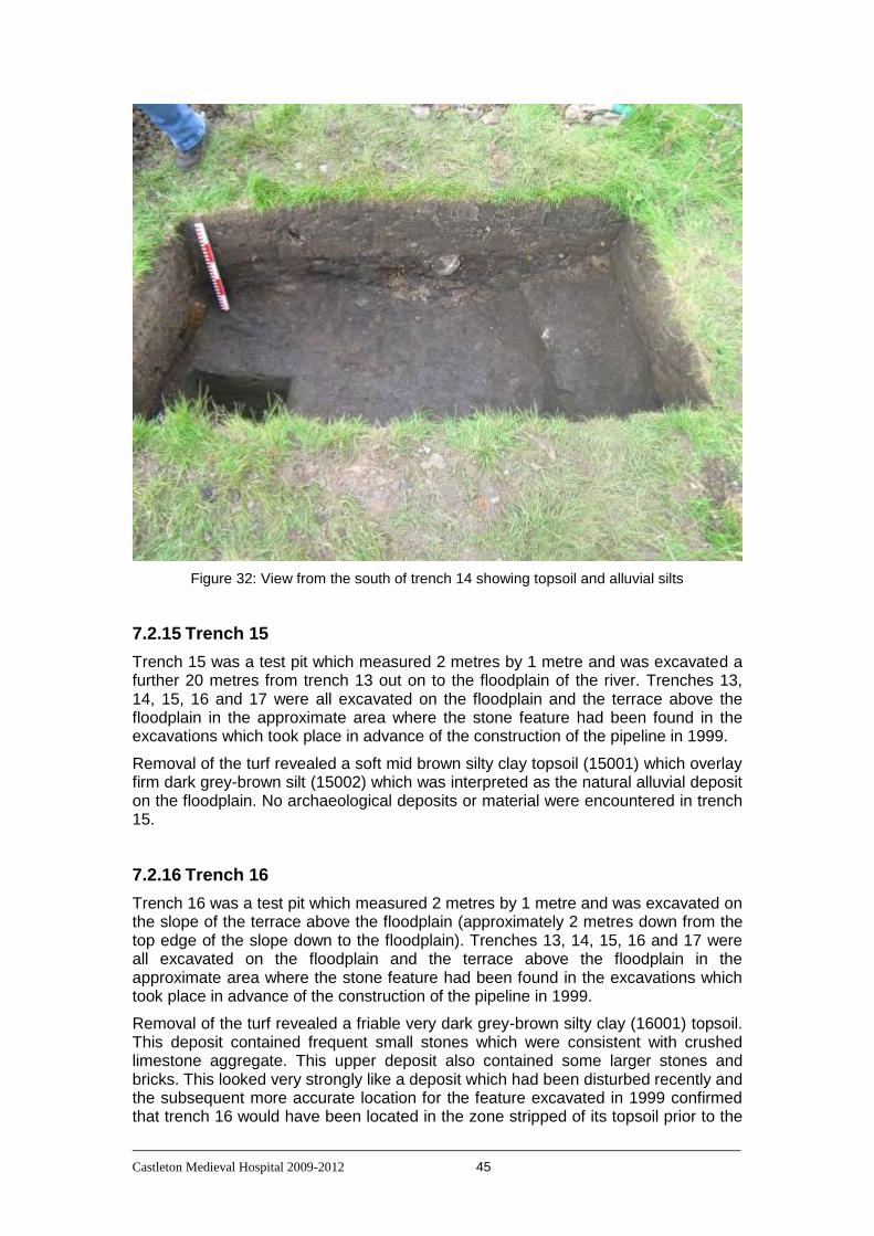
Castleton Medieval Hospital 2009-2012 45
Figure 32: View from the south of trench 14 showing topsoil and alluvial silts
7.2.15 Trench 15
Trench 15 was a test pit which measured 2 metres by 1 metre and was excavated a further 20 metres from trench 13 out on to the floodplain of the river. Trenches 13, 14, 15, 16 and 17 were all excavated on the floodplain and the terrace above the floodplain in the approximate area where the stone feature had been found in the excavations which took place in advance of the construction of the pipeline in 1999.
Removal of the turf revealed a soft mid brown silty clay topsoil (15001) which overlay firm dark grey-brown silt (15002) which was interpreted as the natural alluvial deposit on the floodplain. No archaeological deposits or material were encountered in trench 15.
7.2.16 Trench 16
Trench 16 was a test pit which measured 2 metres by 1 metre and was excavated on the slope of the terrace above the floodplain (approximately 2 metres down from the top edge of the slope down to the floodplain). Trenches 13, 14, 15, 16 and 17 were all excavated on the floodplain and the terrace above the floodplain in the approximate area where the stone feature had been found in the excavations which took place in advance of the construction of the pipeline in 1999.
Removal of the turf revealed a friable very dark grey-brown silty clay (16001) topsoil. This deposit contained frequent small stones which were consistent with crushed limestone aggregate. This upper deposit also contained some larger stones and bricks. This looked very strongly like a deposit which had been disturbed recently and the subsequent more accurate location for the feature excavated in 1999 confirmed that trench 16 would have been located in the zone stripped of its topsoil prior to the

Castleton Medieval Hospital 2009-2012 46
construction of the pipe. The deposits revealed in trench 16 were consistent with material that had been deposited by machine, probably during the reinstatement and landscaping after completion of the pipe construction.
This upper deposit overlay a friable very dark brown silty clay (16002). This deposit proved to be fairly variable in colour finally grading to a black shale. 16002 is clearly the natural weathered zone overlying (and formed from) the shale, which is the bedrock in this part of the river terrace.
Figure 33: View of the north section of trench 16
7.2.17 Trench 17
Trench 17 was a test pit which measured 2 metres by 1 metre and was excavated 5 metres grid north of trench 16, on the terrace above the floodplain. Removal of the turf revealed a friable dark grey clay silt topsoil (17001) which overlay a compact dark yellow brown silty clay subsoil (17002). The trench extended in to the subsoil layer for 30-40 cms to confirm that this was undisturbed natural subsoil (figure 34). No archaeological features or artefacts were revealed during the excavation of trench 17. The results of this trench confirmed the shallow nature of the topsoil/cultivated soil on the western part of the terrace above the floodplain that had been revealed in trenches 4 and 11. Where archaeological deposits are not present the western part of the terrace above the floodplain the shallow topsoil overlies a lighter coloured silty clay subsoil or, nearer the edge of the terrace, it is immediately overlying the underlying shale bedrock.

Castleton Medieval Hospital 2009-2012 47
Figure 34: View from south of trench 17
7.2.18 Trench 18
Trench 18 was a test pit that measured 2 metres by 1 metre which was excavated on a linear earthwork that runs down from the slope of the terrace across the northern margin of the floodplain. Removal of the turf revealed a friable dark brown silty clay topsoil (18001). Below this was a friable mid orange-brown silty clay (18002) which graded in to firm mid orange-grey clay (18003). This became harder (18004) and became more shale-like in character. None of the deposits below the topsoil appear to be archaeological in nature. No artefactual or other archaeological material was encountered in trench 18.
The earthwork in to which trench 18 was excavated had been investigated (further to the north-west) in 2009 by trench 2 which had also found no clear archaeological material or deposits. It is possible that this is a natural feature deposited by a geomorphological process on the edge of the floodplain, or perhaps less likely is the result of a geological formation; however its form at its northern end (where it meets the slope of the terrace) does suggest that it is a constructed feature. However trench 18 revealed no artefacts and no stratigraphy below the topsoil which could confirm that this is an anthropogenic, not natural feature. While this is consistent with the results from trench 2, it does leave the origin of this feature unclear. If it is an anthropogenic feature then it does not have a clearly identifiable purpose and the excavations have not helped to clarify this.
7.2.19 Trench 19
Trench 19 was a 2 metre by 1 metre test pit excavated in a hollow to the south-west of trench 12. This hollow may have been a routeway down to the floodplain from the terrace. However there was a faintly visible level area at this point which it was thought may be related to a structure of some kind (although no such structure is suggested by the geophysical survey).
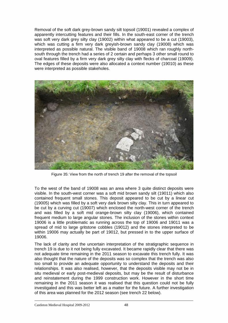
Castleton Medieval Hospital 2009-2012 48
Removal of the soft dark grey-brown sandy silt topsoil (19001) revealed a complex of apparently intercutting features and their fills. In the south-east corner of the trench was soft very dark grey silty clay (19002) within what appeared to be a cut (19003), which was cutting a firm very dark greyish-brown sandy clay (19008) which was interpreted as possible natural. The visible band of 19008 which ran roughly north-south through the trench had a series of 2 certain and perhaps 3 other small round to oval features filled by a firm very dark grey silty clay with flecks of charcoal (19009). The edges of these deposits were also allocated a context number (19010) as these were interpreted as possible stakeholes.
Figure 35: View from the north of trench 19 after the removal of the topsoil
To the west of the band of 19008 was an area where 3 quite distinct deposits were visible. In the south-west corner was a soft mid brown sandy silt (19011) which also contained frequent small stones. This deposit appeared to be cut by a linear cut (19005) which was filled by a soft very dark brown silty clay. This in turn appeared to be cut by a curving cut (19007) which enclosed the north-west corner of the trench and was filled by a soft mid orange-brown silty clay (19006), which contained frequent medium to large angular stones. The inclusion of the stones within context 19006 is a little problematic as running across the top of 19006 and 19011 was a spread of mid to large gritstone cobbles (19012) and the stones interpreted to be within 19006 may actually be part of 19012, but pressed in to the upper surface of 19006.
The lack of clarity and the uncertain interpretation of the stratigraphic sequence in trench 19 is due to it not being fully excavated. It became rapidly clear that there was not adequate time remaining in the 2011 season to excavate this trench fully. It was also thought that the nature of the deposits was so complex that the trench was also too small to provide an adequate opportunity to understand the deposits and their relationships. It was also realised, however, that the deposits visible may not be in situ medieval or early post-medieval deposits, but may be the result of disturbance and reinstatement during the 1999 construction work. However in the short time remaining in the 2011 season it was realised that this question could not be fully investigated and this was better left as a matter for the future. A further investigation of this area was planned for the 2012 season (see trench 22 below).

Castleton Medieval Hospital 2009-2012 49
7.2.20 Trench 20
Trench 20 measured 8 metres by 8 metres and overlapped with trench 12 (2011) and trench 10 (2010). This trench was excavated to further explore the wall, that had first been discovered in 2010, and any associated features and deposits, as well as any features or deposits which lay to the south of this wall (and east of trench 10). Removal of the dark brown silty clay topsoil (20001) revealed several spread of rubble. The largest was across the northern third of the trench (20005). In addition to this spread were three other fairly discrete spreads in the southern part of the trench (20006, 20007, 2008).
Figure 36: vertical view (from a camera mounted on a kite) of trench 20 and part of trench 21 (on the right side of the photograph). This is a working shot and shows the rubble spreads being revealed in trench 20. The large rubble spread on the right side of trench 20 is context 20005 (being planned). The rubble spread being cleaned in the lower left corner of trench 20 is 20008. The main line of excavators are working across the area of rubble spreads 20006 and 20007. Visible in trench 21 (on the right of the photograph) is wall 21004 and rubble spread 21007.
Removal of the rubble spreads revealed three main areas of interest. These were firstly the continuation of the east-west running wall first revealed in 2010 and some features associated with that wall. Secondly features in the area south of the east-west wall including a number of areas of burnt material. Thirdly the area towards the south-east corner of trench 20 under the rubble spread 20008.

Castleton Medieval Hospital 2009-2012 50
Figure 37: working shot from the east showing the east-west wall and associated features, the slot excavated in the centre of the trench and the rubble spread and (excavated) cut feature towards the south-east corner of the trench.
The east-west wall (20027/20028/20029) continued eastwards from the area of trenches 10 and 12 for approximately 2.5 metres. At the section 4 or 5 courses were surviving (see figure 38) but the number of courses diminished until a single course finally gave way to a visibly darker soft silty-clay deposit (20015) which probably marked the line of the wall as the fill of a very shallow robber trench. This line continued for another 2.5 to 3 metres with occasional stones which may have been remnant wall until it faded in to an area of apparently laid stones (20033/20039) with an edge on a different alignment to that of the wall. 20033/20039 may be the remnant of a badly disturbed structure or laid stone surface; however if so then it is a small fragment with no clearly distinguishable character. It is possible that this is the remnant of a dump of stone; however the stones are generally lying flat and so it seems more likely that this is the remnant of a stone surface which has been significantly disturbed. Whatever the origin of 20033/20039 it is not part of the same structure as the east-west wall and may represent an area of stones laid after the demolition and removal of the east-west wall. Unfortunately the line of the east-west wall had faded out before reaching the stone spread of 20033/20039 and so it is not certain whether the wall had ended and 20033/20039 lies to the east of the wall, or the wall originally continued through this area and had been removed prior to the arrival of the stones that make up 20033/20039.
The most significant point about the east-west wall revealed in trench 20 is that it had been demolished and partly removed. This is in keeping with the findings in trench 12 where the wall had clearly once extended further to the west. In trench 12, however, a north-south oriented wall had been built butting up against the south face of the east-west wall and the continuation of the east-west wall beyond this point had been demolished and removed. No corresponding north-south wall was identified within trench 20. There was a line of small stones running south from the east-west wall (see figure 37 running in front of the chalk board); however this line of stones offers

Castleton Medieval Hospital 2009-2012 51
no real prospect of representing any significant structural feature and certainly not one as substantial as the wall in trench 12 which abutted the main east-west wall. The east-west wall was just gradually reduced in its number of courses until it finally ended at a point where a shallow trench may have marked its alignment. Given the clear evidence that a wall was built up against the east-west wall (in the area of trench 12) and that this wall then had a doorway blocked and finally the ‘interior’ of the space created by these walls had been plastered or whitewashed, it was disappointing to not find any evidence of the other side of the ‘room’ created by the later wall construction and other alterations. The assumption has to be that the corresponding north-south wall to the east had been completely robbed out. It is possible that the wall lay beyond the eastern edge of trench 20; however as this would make the ‘room’ created by these walls in excess of 9 metres across this seems a less likely possibility.
Figure 38: View from south of the main east-west wall in trench 20. Visible in front of the wall is the ‘diagonal’ row of stone slabs (20022) and an excavated hearth area (20021/20060)

Castleton Medieval Hospital 2009-2012 52
Running from the western section of trench 20 towards the main east-west wall (but at a diagonal angle of alignment compared to the east-west wall) was a line of stone slabs (see figure 38). The westernmost of the stone slabs had been revealed previously in trench 10, where there it had been one of two adjacent stones. This line of stone slabs did not extend as far as the main east-west wall, but instead ended at the line of small stones that ran south from the east-west wall. It was originally assumed that this line of stones was the capping of a drain; however this proved not to be the case and it is clear that the stones are simply sitting on the underlying silty-clay subsoil which underlies the east-west wall and all the other structural features so far revealed during the excavations. There is no clear function for this line of stones given the surviving evidence revealed in trench 20.
To the north of the east-west walls were several small patches of rubble which probably represent dumping of stone post-demolition of the structure. However there was one substantial feature and this was a large stone block (20049). This had been placed in the base of a cut (20050) so that the top surface of the stone block was flat (see figure 49). It is not clear what the function of this isolated feature could have been; however it is perhaps consistent with the stone block being used as a post-base or stylobate. However there is no apparent reason why a large post sitting on a stone base might be located at this point. It cannot be a free standing pole as the stone is too near the ground surface (either in the past or currently) to be stable. If it was a post base then the post must have been part of a stable structure; however there is no other evidence for such a structure.
Figure 39: View from north of the large stone block (20049) located near the northern section of trench 20.
Perhaps the most informative set of features revealed in trench 20 were a series of patches of burnt material located to the south of the main east-west wall. In at least 3 cases excavation revealed these to be small hearths comprising a shallow hollow filled with burnt ash and charcoal and frequently also with irregular pieces of lead

Castleton Medieval Hospital 2009-2012 53
within the burnt material. There are two particularly clear examples of this. One was located to the south of the ‘diagonal’ line of stone slabs (20022). This hearth was a series of burnt deposits (20021, 20035 and 20036) contained within a shallow bowl-shaped cut (20060) approximately 40 centimetres in diameter. The second was a substantial deposit of burnt material (20024, 20051, 20052, 20053, 20056, 20057, 20058) within a shallow (12 centimetre deep) flat-bottomed bowl-shaped cut (20059) 48 centimetres (north-south) by 44 centimetres (east-west). The reason for the large number of context numbers was that the deposits in this feature were very variable with intense burning in the northern part of the cut and a substantial amount of irregular lead ribbons and pieces primarily towards the southern edge of the feature. The remains within this feature are consistent with a small hearth being used for lead melting and with some of the molten lead falling out of whatever container was being used to melt the lead in as it was lifted off the fire from the south side. The other areas of burning were less clearly defined; however they consistently included both burnt material and irregular ribbons and pieces of lead.
Figure 40: View from south-west of hearth 20059. Note the large piece of melted lead protruding from the left-centre part of the section
This evidence, combined with one piece of window lead came and one small strip of lead still with an iron nail through it, provide a very strong indication that these hearths were used to melt lead. It is very likely that this corresponds to the stripping of lead from the hospital buildings and ‘recycling’ it by melting (and presumably casting it in to blocks for removal from the site). It seems very unlikely that this lead could have come from any other source than the hospital buildings as it includes window lead. Even if the piece of lead came had not been found it is difficult to provide an alternative source this far from the village for any significant amount of lead other than the hospital buildings. It would seem unlikely that any nearby agricultural buildings would have contained significant amounts of lead. The most likely interpretation for these features is that they are the result of the reclamation of lead from nearby buildings, most likely the hospital buildings after they had gone out of use in the 16th century.
Castleton Medieval Hospital 2009-2012 54
While these hearths/burnt deposits are all close to the main east-west wall there were no direct stratigraphic relationships between these deposits and the structure of the wall. Both the hearths/burnt deposits and the wall lie beneath the rubble spreads and both sit on top of the underlying silty-clay subsoil which underlies all the structural features so far revealed. Consequently we cannot be certain the building now represented by the main east-west wall was standing when this lead processing occurred. Equally however there is no certain evidence that the structure was not there and the hearths were constructed close to this standing wall. It is clear from evidence at sites such as Rievaulx Abbey that lead recycling did sometimes take place within structures and was not always conducted on open ground (Quarrell, 2013).
The final area within trench 12 to be considered is the area towards the south-east corner of the trench. After removal of part of the rubble spread 20008 a rather more mixed deposit containing stone of various sizes was revealed. Due to the adverse weather conditions of 2012 less of this south-eastern area was excavated than would have been ideal. However it was possible to put a 1 metre wide box trench through the mixed stone layer, which as a result was revealed to actually be several deposits contained within a vertically sided cut. The cut (20045) had a vertical northern side and a flat base. The southern side was not clearly defined as it almost certainly was running in to a drain that lay mostly within the southern section of the trench. The northern side of this cut had an unusual narrow gully running along it. It is possible that this gully was a separate feature, but due to the small area excavated it was not possible to discriminate between the main flat-bottomed cut and this gully. This will need further investigation in the future.
The majority of the fill of cut 20045 was a compact mid orangey-brown silty-clay containing some small stones (20054). It is probably that the rubble spread 20008 was in a cut which cut in to the fill of this flat-bottomed cut. However 20054 was very distinct from the underlying undisturbed natural clay subsoil and from the larger deposit which underlies the structural deposits across the sits. The only area where the boundary was not clear was along the northern edge where the small gully ran. In the area of the small gully 4 human finger bones were found. In the southern part of cut 20045 the deposit changed to a compact yellow brown silty-clay which contained small pieces of plaster or degraded limestone and some small, angular limestone pieces (20055). This deposit filled a cut which sloped down in to the section and it is probably that this cut (given the number 20046) was the edge of an east-west running drain (or similar linear cut feature) which was mainly lying immediately south of trench 20. As the boundary of the flat-bottomed cut and the drain or ditch was running along the edge of trench 20 is was decided that further excavation in the limited time available was not advisable and that this area needed to have a more thorough investigation at some point in the future. It was clear, however, that there were features in this area that lay underneath the usual rubble spreads and which cut through the general layer which runs across the whole site and lies underneath the structural remains so far revealed. As a result of the stratigraphic relationships visible even in the limited area of this part of trench 20 it is clear that these cut features are likely to be relatively late (post-medieval). The source of the human bone is as usual not clear. In this case there were just a few small bones. However it is unlikely that human bones would have moved very far and so it remains possible that burials (most likely the cemetery for the hospital) are nearby. Had the weather in 2012 not been so difficult it may have been possible to excavate more extensively, particularly in the south-eastern quadrant of trench 20, and this may have provided more answers than were obtained this time. It is clear that further investigation of this part of the Scheduled Area is necessary in order to establish as complete an understanding of the deposits present as possible.
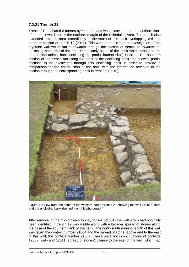
Castleton Medieval Hospital 2009-2012 55
7.2.21 Trench 21
Trench 21 measured 8 metres by 6 metres and was excavated on the southern flank of the bank which forms the northern margin of the Scheduled Area. The trench also extended onto the area immediately to the south of this bank overlapping with the northern section of trench 12 (2011). This was to enable further investigation of the drystone wall which ran northwards through the section of trench 12 towards the enclosing bank and of the area immediately south of the bank which produced the human and animal bone (including the partial human skull) in 2011. The southern section of the trench ran along the crest of the enclosing bank and allowed partial sections to be excavated through this enclosing bank in order to provide a comparison for the construction of the bank with the information revealed in the section through the corresponding bank in trench 9 (2010).
Figure 41: view from the south of the western part of trench 21 showing the wall 21004/21006 and the enclosing bank (behind it on this photograph)
After removal of the mid-brown silty clay topsoil (21001) the wall which had originally been identified in trench 12 was visible along with a broader spread of stones along the base of the southern flank of the bank. The north-south running length of this wall was given the context number 21004 and the spread of stone, above and to the east of this wall, the context number 21007. These were both continuations of contexts 12007 (wall) and 12011 (spread of stones/collapse to the east of the wall) which had
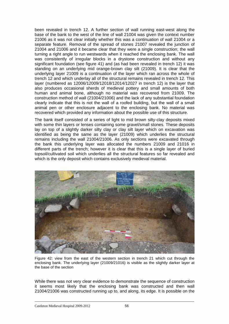
Castleton Medieval Hospital 2009-2012 56
been revealed in trench 12. A further section of wall running east-west along the base of the bank to the west of the line of wall 21004 was given the context number 21006 as it was not clear initially whether this was a continuation of wall 21004 or a separate feature. Removal of the spread of stones 21007 revealed the junction of 21004 and 21006 and it became clear that they were a single construction; the wall turning a right angle to run westwards when it reached the enclosing bank. The wall was consistently of irregular blocks in a drystone construction and without any significant foundation (see figure 41) and (as had been revealed in trench 12) it was standing on an underlying mid orange-brown clay silt (21009). It is clear that the underlying layer 21009 is a continuation of the layer which ran across the whole of trench 12 and which underlay all of the structural remains revealed in trench 12. This layer (numbered as 12006/12009/12018/12014/12027 in trench 12) is the layer that also produces occasional sherds of medieval pottery and small amounts of both human and animal bone, although no material was recovered from 21009. The construction method of wall (21004/21006) and the lack of any substantial foundation clearly indicate that this is not the wall of a roofed building, but the wall of a small animal pen or other enclosure adjacent to the enclosing bank. No material was recovered which provided any information about the possible use of this structure.
The bank itself consisted of a series of light to mid brown silty-clay deposits mixed with some thin layers or lenses containing some gravel/small stones. These deposits lay on top of a slightly darker silty clay or clay silt layer which on excavation was identified as being the same as the layer (21009) which underlies the structural remains including the wall 21004/21006. As only sections were excavated through the bank this underlying layer was allocated the numbers 21009 and 21016 in different parts of the trench; however it is clear that this is a single layer of buried topsoil/cultivated soil which underlies all the structural features so far revealed and which is the only deposit which contains exclusively medieval material.
Figure 42: view from the east of the western section in trench 21 which cut through the enclosing bank. The underlying layer (21009/21016) is visible as the slightly darker layer at the base of the section
While there was not very clear evidence to demonstrate the sequence of construction it seems most likely that the enclosing bank was constructed and then wall 21004/21006 was constructed running up to, and along, its edge. It is possible on the

Castleton Medieval Hospital 2009-2012 57
evidence from trench 21 that the wall and the enclosing bank may have been constructed at the same time. Whichever sequence was actually the case it is very likely that the two features, if not constructed at the same time, were constructed relatively close to each other chronologically. They both sit directly on the underlying layer and there is no visible build up of material between them. The lack of artefactual evidence continues to support the hypothesis that the structural features (including both the walls and the enclosing bank) are late constructions (post-medieval) and only in active use for a relatively short period of time.
The conditions in which trench 21 was excavated were often very difficult. The weather was wet and the clay-rich nature of the deposits resulted in the trench becoming frequently filled with water (see figure 43). Fortunately the relatively simple sequence of deposits in this trench ensured that the areas that were excavated were fully investigated down to undisturbed subsoil and it is unlikely to be productive to excavate further sections through the enclosing bank. There is an external ditch to this bank (between the bank and the modern road) and this has not yet been investigated.
Figure 43: view from the east of trench 21 after heavy rain. The trench was covered (as can be seen from the plastic sheeting on the right of the photograph); however this was not an effective measure in the extremely wet conditions of 2012.
7.2.22 Trench 22
Trench 22 was 2 metres by 2 metres and was excavated over the location of trench 19 from 2011, which had revealed a complex of several features immediately below the topsoil. Trench 22, while including the area covered by trench 19 in 2011, also extended the excavated area to the north and east of the area covered by trench 19.
After removal of the topsoil which was similar over the whole of the trench the surface revealed was cleaned. It was noticed immediately that the trench was significantly wetter than in 2011 and after the initial removal of topsoil and cleaning

Castleton Medieval Hospital 2009-2012 58
there was a period of very heavy rain. As has been discussed above significant further rain fell during the 2012 excavation season and trench 22 filled with water each day. Several attempts were made to remove the water and it was noticed that the trench was actually filling with ground water, it was not necessary for it to be raining for the trench to fill. It was also clear that now the underlying unexcavated deposits were extremely soft and could not take the weight of someone working on them. During the excavations season regular attempts were made during spells of drier weather to remove the water from the trench. At all times the trench rapidly re-filled with ground water. A view of the typical condition of trench 22 during the 2012 season is shown in figure 44. As a result of the higher water table in this part of the field during 2012 and the resulting waterlogging of trench 22 no further progress was made and the trench was eventually backfilled (with considerable difficulty due to the very soft nature of the deposits within the trench) at the end of the season without the deposits revealed in 2011 being investigated further.
Figure 44: a view from the west of the typical condition of trench 22 during the 2012 season

Castleton Medieval Hospital 2009-2012 59
7.2.23 Additional test pits
Two 2 metre by 1 metre test pits were excavated in 2012 next to the entrance to the Losehill Hall driveway. This area is due north of the Scheduled Area being on the other side of the Hope to Castleton road which runs along the northern boundary of the Spital Field. There is a narrow strip of grassland to the east of the driveway, between the tarmacadam of the driveway and the fence which forms the boundary of the caravan park and the test pits were located in this narrow strip of grassland.
Test pit 1 was excavated adjacent to and on to the sloping side of a low mound of uncertain origin. Removal of a soft dark brown silty clay topsoil (1001) revealed a friable mottled clay (1002) layer which formed the body of the mound and which overlay a soft dark brown silty clay soil (1003) which was similar to the existing topsoil. The clay layer varied in colour from a light yellow-brown clay to a mid brown clay or silty clay. It was clear that the lower deposit (1003) was topsoil which had become buried when the clay subsoil making up the mound had been deposited in this position. The buried topsoil overlay a firm light brown clay which was the natural subsoil. Contexts 1001 and 1002 produced modern artefactual and other material including pottery, clay tobacco pipe and small pieces of tarmacadam. Context 1003 produced similar clay pipe and pottery but no material that could have been connected with any recent resurfacing or other work relating to the driveway.
Figure 45: view from the west of test pit 1 in Losehill Hall grounds. The mottled clay deposit (1002) is visible most clearly in the northern section (to the left on this photograph)
The cattle grid within the gateway had been renewed just a few years before the Castleton Hospital Project began excavations within the Spital Field and it is highly probable that the mound of clay subsoil investigated within test pit 1 resulted from the disposal of material produced by the groundworks undertaken to renew the cattle grid. Other than the results of this very recent activity no archaeological deposits or material were revealed within test pit 1.

Castleton Medieval Hospital 2009-2012 60
Test pit 2 was excavated to the south of test pit 1. After removal of the loose dark brown silty clay topsoil (2001) a firm light yellowish brown clay subsoil (2002) was revealed. The topsoil (2001) produced some modern pottery and occasional small corroded iron fragments along with some clay tobacco pipe. No other archaeological deposits or material were produced by the excavation of test pit 2.
Figure 46: view of test pit 2 from the south.
The two test pits adjacent to the entrance to the driveway of Losehill Hall produced only modern material and evidence of very recent activity. These test pits were only approximately 20 metres from the northern boundary of the Spital Field; but they produced no evidence of medieval or early post-medieval activity. It is possible to see two alternative explanations for this. The first interpretation is that this area, although probably close to the site of the medieval hospital, was always pasture field and not in a location which received material from the hospital either through disposal or manuring. However it may also be possible that the area immediately around the gateway and entrance to the driveway of Losehill Hall (and just the other side of the driveway from two houses constructed by the owners of Losehill Hall) may have been levelled or had other significant landscaping/groundwork undertaken in the past which would have removed any archaeological features that were not deeply cut in to
Castleton Medieval Hospital 2009-2012 61
the underlying subsoil. There is very little available space for excavation in the narrow strip of land close to the gateway and consequently it is unlikely that any further information regarding this particular part of the area close to the Spital Field will be produced in the future.
8 DISCUSSION
Between 2007 and 2012 substantial archaeological investigations took place within and in the area around the Spital Field, to the west and north of the village of Castleton in Derbyshire. This work has included walkover and measured survey, geophysical survey and excavation. The primary objective of this work has to be to define the location and develop an understanding of the medieval hospital known to have existed between Castleton and Hope during the medieval period.
Survey work has taken place within the Spital Field, in the grounds of Losehill Hall and adjacent fields and to the north of the village in an area known as Howsitch Tongue. While substantial remains have been recorded relating to medieval and post-medieval agricultural and other activity (ridge and furrow, field boundaries, trackways and so on) none of these forms of survey have produced convincing evidence for buildings or other features that could clearly be associated with a medieval hospital. In the case of the Spital Field this was particularly surprising as the north-western part of this field is a Scheduled Area defined as the location of the medieval hospital. The lack of clearly identifiable features in the Spital Field prompted the project to extend its methods of investigation to include excavation.
Between 2009 and 2012 twenty two trenches were excavated within the Spital Field. In addition to this two test pits were excavated at the entrance to the Losehill Hall driveway, a location about 20 metres north of the Scheduled Area. The trenches excavated have varied in size from test pits as small as 1m2 up to trenches as large as 100m2. The first trenches were excavated to investigate features visible in the resistivity survey of the Spital Field. These features were shown to be primarily geological in origin and most surprisingly these initial trenches produced no medieval artefactual material in the vicinity of the Scheduled Area.
After the limited results from the excavations in 2009 further trenches explored the north-eastern part of the Spital Field and two areas within the Scheduled Area. The trenches in the north-eastern part of the field produced evidence of the ridge and furrow which is visible in this part of the field. However one did also produce a single sherd of abraded medieval pottery. The trenches within the Scheduled Area explored the eastern boundary of the area and the central part of the area. These trenches produced no medieval pottery, but did reveal one small section of a wall within the central part of the Scheduled Area.
In 2011 further excavations were conducted to explore the north-western part of the Spital Field (outside the Scheduled Area) and the area within the Scheduled Area around the location of the wall revealed in 2010. The trenches to the west and south-west of the Scheduled Area confirmed the disturbance caused by the construction of a water management pipeline in 1999. The trench within the Scheduled Area revealed more of the wall that had been discovered in 2010. This trench also revealed another wall abutting this wall and a further wall to the north running towards the bank which encloses much of the area now Scheduled. In relation to the

Castleton Medieval Hospital 2009-2012 62
two abutting walls clear phases of activity were visible. The second wall to be discovered had clearly been built up to the first wall and originally there was a doorway at the junction of the two walls. The first wall had originally extended further west; however at some time during or after the construction of the second wall the first wall had been demolished back to the junction with the second wall. At some later point the doorway had been blocked and then the interior walls of this structure had been plastered. It was not possible to define the function of this building or any reason why the visible changes had been made as there was only one corner of the building in the trench. What was also found in this part of the trench was a small, but significant amount of pottery. From most of the deposits overlying and adjacent to the two walls 18th century pottery was produced. However from one large mound of material large unabraded sherds of medieval pottery were produced. However this mound of soil overlay the top of the ruined first wall. These deposits were interpreted as suggesting that the building was probably post-medieval and that all the deposits overlaying the walls were brought to the site and dumped there also in the post-medieval period.
The other wall discovered in the 2011 excavations (the one running towards the bank on the northern boundary of the Scheduled Area) was of poor construction with no foundations. It was suggested that this may be an enclosure or boundary wall and not a wall belonging to a roofed building. Close to this wall, however, were found two areas with fragmentary human and animal bone including most of a human skull. These bones lay in a deposit which also produced occasional sherds of medieval pottery and which was a deposit which ran under all the walls revealed in the 2011 excavations.
In 2012 the area that had been excavated in 2011 was extended to the north (to reveal more of the northern wall and to investigate the enclosing bank) and to the south and east (to investigate more of the wall originally discovered in 2010. The northern trench confirmed the character of this wall and demonstrated that the wall ran up to the bank and then turned westwards and ran along the southern edge of the bank. Sections were excavated through the bank and this revealed its simple construction and produced occasional sherds of post-medieval pottery. What was also shown was that the layer which had produced the human bone and medieval pottery also ran under the enclosing bank. This layer seems most likely to have been a buried soil horizon, perhaps a cultivated soil. Whichever it is, it appears to represent a period when this area was open ground, before the walls revealed in the excavation were constructed.
The southern trench revealed more of the first wall to be discovered; however again this wall had been truncated by being demolished, in this case from the east. No comparable wall to match the second wall was found and so the structure remains one corner of a building. What was revealed in the 2012 excavations however were several areas of burning which on excavation proved to be small hearths. These hearths had frequent small irregular pieces of lead incorporated in to them and they appear clearly to be hearths used for the melting of lead (and that some of the lead had then spilled in to the hearth). Also found in this trench was a single piece of lead came (window lead) and a strip of lead with an iron nail still attached to it. It seems likely that these hearths represent post-medieval recycling of lead from one or more nearby buildings.
In the southern part of this trench there were cut features containing primarily large stones. On the very southern boundary of the trench there appeared to be a drain cut or similar cut feature. Out of these cut features four human finger bones were recovered. The source of the human remains is not clear. Throughout these trenches most deposits which produced any datable material produced post-medieval or a mix of medieval and post-medieval material. The only substantial deposit to produce only

Castleton Medieval Hospital 2009-2012 63
medieval material is the broad layer which appears to underlie the structural remains but is above the natural subsoil. This is also the layer or level which has produced human remains. However it should be noted that while some artefactual material has been recovered the amount is very small; inexplicably small if this was actually the site of a medieval hospital which had been active for nearly 400 years. Of course as no structural remains have been found which can be firmly assigned a medieval date then the case for the complex of hospital buildings being located within the Spital Field is steadily weakening. This case is perhaps further weakened by the two test pits excavated across the road by the entrance to Losehill Hall driveway. These produced only very modern material and certainly no evidence that could be linked to a medieval hospital.
9 CONCLUSIONS AND RECOMMENDATIONS
The excavations in the Spital Field area have produced remarkably little medieval material. All the structural remains investigated along with the visible earthwork features in the Scheduled Area appear to probably be post-medieval in origin. The very poor weather in the summer of 2012 did leave some aspects of the deposits uninvestigated, but certainly the general trend of evidence is increasingly supporting the interpretation that the structures, their associated deposits and the visible earthworks are post-medieval and not related to the hospital. However there is evidence of the melting of lead which seems most likely to have occurred during the stripping of buildings of a high enough status to have leaded windows and lead on the roof. It is very unlikely that the lead would have been carried far before melting and consequently the only reasonable candidate for the source of that lead is the hospital site. It seems very unlikely that any other building this far outside the village (i.e. agricultural) would have had significant amounts of lead used in its construction. Consequently it is reasonable to suggest that while the excavations have not revealed evidence for the hospital buildings they have revealed evidence for the demolition of those buildings and the recycling of lead from those buildings.
The excavations have revealed evidence for probable medieval activity in the form of the underlying layer which runs under the buildings and which does contain small amounts of medieval pottery and significant amounts of disarticulated human remains. These are not in situ burials and this does not constitute a cemetery; however it does seem unlikely that the human bones would not have travelled great distances and so the suggestion is that a source for these human remains lies very close to the excavated areas. There is nothing to suggest that this area could have any other candidate as a source for human remains other than a cemetery associated with the hospital. Consequently there remains the strong possibility that the hospital has a cemetery and that it is located somewhere in the vicinity of the Scheduled Area.
This leaves the location of the main complex of hospital buildings still unknown. All the documentary evidence points towards the hospital buildings being located in the Spital Field and more particularly that the Spital Field is the same as the field which is currently called the Spital Field and which lies between the river and the road from Hope to Castleton. The extensive investigation of the Spital Field has failed to produce evidence to support this interpretation. However there is one aspect of the documentary descriptions which may offer some possibility for expanding the possible area where the hospital is located. The current Hope to Castleton road is a turnpike road which was not constructed until around 1758. The descriptions of the hospital ruins which place it in the Spital Field all date from at least a century before

Castleton Medieval Hospital 2009-2012 64
the construction of the turnpike road. While all the documentary evidence supports the hypothesis that the turnpike road followed roughly the line of the earlier road there are suggestions that there may be small differences between the line of the modern road and its predecessor. The most substantial piece of evidence is the existence of a track on a significant embankment which runs to the north of the modern road as it leaves Hope. A further broad bank which could be a bank supporting a road runs through the field (Gaultern Thorn) to the east of the caravan park at Losehill Hall. In both of these cases the line of the road is only 10 to 20 metres north of the modern road. However if the road did follow a line to the north of the modern road and then took a more gentle turn to run over Spital Bridge than the modern road does then a strip of land incorporating the modern road plus anything up to 20 metres north of the modern road becomes available to include in the possible area where the hospital may be located. There is no suggestion that Castleton’s medieval hospital would ever have been a very large complex of buildings. While they are likely to have been reasonable quality stone buildings and would have included the chapel, main house and the infirmary (and possibly other small out buildings) these would not be large by modern standards and may have primarily been located alongside the road. Consequently there is plenty of space in a strip several hundred metres long and perhaps up to 30 metres or more wide to put a small medieval hospital in several times over. Unfortunately this means that perhaps much of this location lies under the modern road. However it may mean that more of the Spital Field close to the road (to the east of the Scheduled Area) and the strip of land on the north side of the road (in the caravan park) should be investigated.
While expanding the area of investigation is necessary to explore all the possibilities for the location of the hospital buildings, there remain several unanswered questions within the Scheduled Area. Of primary interest is investigating the source of the human bone and other material within the layer which lies under the structural remains. This layer has been investigated in the trenches in 2011 and 2012; however only on a relatively small scale. This was due to two reasons. In 2010 and 2011 there was an understandable focus on the structural remains that were revealed as these could have been parts of the medieval hospital buildings. We can be confident now that this is unlikely and in 2012 the opportunity was there to investigate this layer to the south of the main east-west wall. Unfortunately the weather in 2012 was very difficult and consequently much less was achieved during that season than had been intended. Further work is needed in the southern and eastern parts of the Scheduled Area (within the limitations caused by the presence of the oil pipeline) in order to explore all possible sources for the human remains and medieval material.
In addition to this further excavation between the Scheduled Area and the current entrance to the field (and as close as practicable to the northern boundary of the field) should also be considered as this may still be a primary candidate for the hospital location, but one which was masked by the focus on the visible earthworks that we now know are post-medieval in date.
It should be noted perhaps that one candidate for the cause of the activity which created the visible earthworks may be the turnpike road itself. The visible earthworks are mostly made up of either dumped material or they are an embankment which encloses the area containing that dumped material. Most commonly the material found in this area is 18th century (although later and earlier material is also present in places). It may be that this area was used to store and sort materials for the construction of the turnpike road and once that construction was completed the site was abandoned leaving the remnants of piles of soil and stone which gradually grassed over and were incorporated back in to the grazing land. It is unlikely that this hypothesis could ever be proven; however it is a more plausible origin for the visible earthworks at least than any relationship with the medieval hospital. There is of

Castleton Medieval Hospital 2009-2012 65
course one other major event which could be an alternative origin for these earthworks and that is the construction of Losehill Hall and its parkland. Losehill Hall was built in the 1880s and will have required considerable materials not only for the construction of the hall and driveway, but also for the landscaping of the parkland. Perhaps the area of visible earthworks was the location of where materials were stored and sorted for some of that construction or landscaping work.
The programme of archaeological work in and around the Spital Field at Castleton has provided significant new insights in to the site of the medieval hospital. However there remain many unanswered questions and it is clear that the status and management of the Scheduled Area cannot be fully clarified until as many of these questions as possible have been answered.
10 COPYRIGHT
The authors retain the right to be identified as authors of all project documentation and reports as defined in the Copyright, Designs and Patents Act 1988 (Chapter IV, section 79).
11 ARCHIVE
The archive and finds will be deposited at Castleton Heritage Centre. Copies of the report will also be deposited with The Peak District National Park Heritage Group, with the Castleton Historical Society and with English Heritage.
12 ACKNOWLEDGEMENTS
The authors would like to thank Sarah Whiteley of the Peak District National Park and Tim Allen of English Heritage for support, encouragement and help, both official and unofficial. The work would not have been possible without the permission and help of the people who own and farm the land where this work has taken place. In particular we are thankful to Mrs Josie Sidebottom, Mr John Connery and to Janet and Gary Glennerster for permission to work on the Spital and David Matthews for permission for the Bullock Field. We are also thankful to Jean Bowman who owns Howsitch Tongue, Mark Priestley who farms Gauditch Thorn and Alistair Boyd of the Youth Hostel Association for permission to work in the ground of Losehill Hall. The project was only possible with the support of the members of the Castleton Historical Society. Many other people have helped with supporting documentary work, recording, lottery applications and supervising field work. These include Dave Barrett, Gill Stroud, Ken Smith, Sarah Brown, Wendy Goodhind, Andy Reid, David Knight, Daryl Garton, Tom Sparrow, Roger Doonan, Eileen Parker, Alex Schmidt, Lee Eales and Jim Rylatt. In addition the real work has been undertaken by the school children and teachers from Castleton Primary School, students from the University of Sheffield and the many local volunteers who have included: Jean Adamson, Pauline Ashmore, Sarah Barber, John Belk, Jean Bowman, Jean Brierley, Val & Ian Burgess, Sally Cave, Lesley Chapman, Joan Clough, Kevin Cootes, Iain Crow, Di Curtis, Alan Darlington, Ken Dash, Margaret Davies, Robbi Dodd, Denise Drummond-Hill, Roger Elliott, Val Ferris, Andy Fillingham, David Fine, Russell French, Ann Hall, Tracey Halton, Tom Halton, Corrin Harris, Kay Harrison, Peter Harrison, Helen & Steve Hayes, Geoff Hill, Alec & Pippa Horn, Alison Jackson-Bass, Maria Kenyon, Richard Marsh, Heather Marshall, Jackie Marshall, Mick Mattia, Peter Milnes, Ian Mitchell,
Castleton Medieval Hospital 2009-2012 66
Brian & Rita Moorhouse, Joe Page, Glenys Parry, David Peach, Del Pickup, Ann & David Price, Ros Reid, Jack Riley, Angela Speakman, Kevin Spence, Eileen Spotswood, John & Val Stannard, Chris Thorpe, Maura Ward, Peter Ward, Roy Ward, Arthur Wilson and Brian Woodall. Our gratitude to all of them is immeasurable.
13 BIBLIOGRAPHY AND SOURCES
References
Brickley, M. and McKinley, J.I. (eds.) 2004. Guidelines to the Standards for Recording Human Remains. (Reading: Institute for Archaeologists)
Chatterton, R. 2006 Castleton Road, Castleton, Derbyshire. Watching Brief on an
electricity cable at Losehill Caravan Park (Unpublished report from Archaeological Research Services: Report 2006/7)
Clarke, L. 2011 Castleton through time (Stroud: Amberley) Connell, B. Compiling a dental inventory. In M. Brickley and J.I. McKinley (eds.)
2004. Guidelines to the Standards for Recording Human Remains. (Reading: Institute for Archaeologists. p.8)
Cumberpatch, C.G. 2003 The transformation of tradition; the origins of the post-
medieval ceramic tradition in Yorkshire. (Assemblage Issue 7: http://www.shef.ac.uk/assem/issue7/cumberpatch.html)
Cumberpatch, C.G. 2004a Medieval and post-medieval pottery production
in the Rotherham area (online catalogue available at: http://ads.ahds.ac.uk/catalogue/specColl/ceramics_eh_2003/)
Cumberpatch, C.G. 2004b Medieval pottery from Brackenfield, Derbyshire
(Unpublished report: LO72 – available at: http://ads.ahds.ac.uk/catalogue/adsdata/arch-384-/ahds/dissemination/ html/Brackenfield/)
Cumberpatch, C.G. 2004c Medieval pottery in Derbyshire: a review
(Derbyshire Archaeological Journal 124: 86-112) Cumberpatch, C.G. 2011 Pottery from excavations on the site of
Castleton Hospital (unpublished report for the University of Sheffield) Cumberpatch, C.G. 2012 Pottery from test pitting surveys in Hope and
Castleton, Hope Valley, Derbyshire (unpublished report for the Hope and Castleton Historical Societies)
Cumberpatch, C.G. in prep. Tradition and change: the production and consumption
of early modern and recent pottery in South and West Yorkshire (review article in preparation)
Cumberpatch, C.G. and Thorpe, R. 2002 The archaeology of Chesterfield
Castleton Medieval Hospital 2009-2012 67
(unpublished archive report for English Heritage) Ferembach, D., Schwidetsky, I., and Stloukal, M. 1980. Recommendations for age
and sex diagnoses of skeletons. (Journal of Human Evolution 9: 517-49) Institute for Archaeologists (IFA) 2008 By-laws: Code of Conduct (Reading:
Institute for Archaeologists) Malone, S. 2011 Severn Trent replacement sewer, Castleton, Derbyshire:
archaeological observation and recording (unpublished report from Trent and Peak Archaeology for Severn-Trent Water)
McKinley, J.I. Compiling a skeletal inventory: Disarticulated and commingled
remains. In M. Brickley and J.I. McKinley (eds.) 2004. Guidelines to the Standards for Recording Human Remains. (Reading: Institute for Archaeologists. pp.14-17)
Merrony, C. J. N. 2008 A geophysical survey on the Spital Field, Castleton,
Derbyshire (unpublished report for the Castleton Historical Society. Sheffield: University of Sheffield)
Miles, A.E.W. 1962. Assessment of the ages of a population of Anglo-Saxons from
their dentitions. (Proceedings of the Royal Society of Medicine 55: 881–886) Moorhouse, S and Roberts, I, 1992 Wrenthorpe Potteries (Yorkshire Archaeology
Monograph 2) (Ossett: West Yorkshire Archaeology Service) Quarrell, J. 2013 Lead recycling during the Dissolution of the Monasteries
(unpublished undergraduate dissertation, Department of Archaeology, University of Sheffield)
Roberts, C. and Connell, B. Guidance on recording palaeopathology. In M. Brickley
and J.I. McKinley (eds.) 2004. Guidelines to the Standards for Recording Human Remains. (Reading: Institute for Archaeologists. pp.34-39)
Schaefer, M.C. and Black, S.M. 2005. Comparison of ages of epiphyseal union in
North American and Bosnian skeletal material. (Journal of Forensic Sciences 50(4): 777-784)
Schwatz, J.H. 1995. Skeleton Keys. (Oxford: Oxford University Press) Smith, T.M. and Reed, D.J. 2009. Temporal nature of periradicular bands (‘striae
periradicales’) on mammalian tooth roots. (Frontiers of Oral Biology 13: 86-92)
Spavold, J. and Brown, S. 2005 Ticknall pots and potteries (Ashbourne:
Landmark Collectors Library) White, T.D. And Folkens, P.A. 2005. Human Osteology. (London: Academic Press)

Castleton Medieval Hospital 2009-2012 68
Appendices
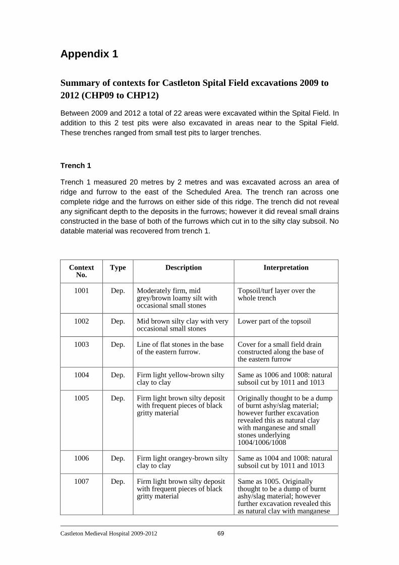
Castleton Medieval Hospital 2009-2012 69
Appendix 1
Summary of contexts for Castleton Spital Field excavations 2009 to
2012 (CHP09 to CHP12)
Between 2009 and 2012 a total of 22 areas were excavated within the Spital Field. In
addition to this 2 test pits were also excavated in areas near to the Spital Field.
These trenches ranged from small test pits to larger trenches.
Trench 1
Trench 1 measured 20 metres by 2 metres and was excavated across an area of
ridge and furrow to the east of the Scheduled Area. The trench ran across one
complete ridge and the furrows on either side of this ridge. The trench did not reveal
any significant depth to the deposits in the furrows; however it did reveal small drains
constructed in the base of both of the furrows which cut in to the silty clay subsoil. No
datable material was recovered from trench 1.
Context No.
Type Description Interpretation
1001 Dep. Moderately firm, mid grey/brown loamy silt with occasional small stones
Topsoil/turf layer over the whole trench
1002 Dep. Mid brown silty clay with very occasional small stones
Lower part of the topsoil
1003 Dep. Line of flat stones in the base of the eastern furrow.
Cover for a small field drain constructed along the base of the eastern furrow
1004 Dep. Firm light yellow-brown silty clay to clay
Same as 1006 and 1008: natural subsoil cut by 1011 and 1013
1005 Dep. Firm light brown silty deposit with frequent pieces of black gritty material
Originally thought to be a dump of burnt ashy/slag material; however further excavation revealed this as natural clay with manganese and small stones underlying 1004/1006/1008
1006 Dep. Firm light orangey-brown silty clay to clay
Same as 1004 and 1008: natural subsoil cut by 1011 and 1013
1007 Dep. Firm light brown silty deposit with frequent pieces of black gritty material
Same as 1005. Originally thought to be a dump of burnt ashy/slag material; however further excavation revealed this as natural clay with manganese

Castleton Medieval Hospital 2009-2012 70
and small stones underlying 1004/1006/1008
1008 Dep. Firm light orangey-brown silty clay to clay
Same as 1004 and 1006: natural subsoil cut by 1011 and 1013
1009 Dep. Line of flat stones in base of western furrow. These stones area a little larger than those in the eastern furrow
Cover for a small field drain constructed along the base of the western furrow
1010 Dep. Soft dark grey silty clay Fill of cut 1011 (underlying 1003)
1011 Cut Narrow vertically sided (U-shaped) cut
Cut filled by 1010 forming a small field drain underlying the stones of 1003 in the eastern furrow
1012 Dep. Soft dark grey silty clay Fill of cut 1013 (underlying 1009)
1013 Cut Narrow vertically sided (U-shaped) cut
Cut filled by 1012 forming a small field drain underlying the stones of 1009 in the western furrow
Preliminary Matrix showing the contexts from Trench 1

Castleton Medieval Hospital 2009-2012 71
Trench 2
Trench 2 was 4 metres by 2 metres and located on a feature that was defined in the
resistivity survey as a high resistance feature and was visible on the ground as a
broad, low bank running along the base of the terrace above the floodplain and then
turning up onto the terrace along the east side of the holloway that runs down from
the direction of the turnpike road. The excavation revealed friable silty deposits
overlying a firm silty clay subsoil. This confirms that the visible bank is an earthen
bank which may be a boundary of some kind. However the excavation revealed no
datable material and no other information which contributed to understanding the
function of this feature.
Context No.
Type Description Interpretation
2001 Dep. Friable dark grey silty clay Topsoil/turf layer over the whole trench
2002 Dep. Moderately compact mid-brown silty loam
The bulk of the material making up the bank
2003 Dep. Firm greyish brown silty clay Natural subsoil
Preliminary Matrix showing the contexts from Trench 2

Castleton Medieval Hospital 2009-2012 72
Trench 3
Trench 3 was a 4 metre square excavation located to investigate an area of high
resistance readings in the resistivity survey. These high resistance readings were
located on the edge of the terrace above the floodplain to the east of the holloway.
The excavation revealed a sandy-silt soil overlying a series of variable deposits
within the underlying shale which must have been the origin of the variation in the
resistivity results. No datable material was recovered from this trench and no clearly
archaeological deposits or structures revealed.
Context No.
Type Description Interpretation
3001 Dep. Loose dark brown sandy silt Topsoil/turf layer
3002 Dep. Friable light brown sandy silt with frequent small stones
Natural subsoil overlying the shale bedrock
3003 Dep. Friable dark brown silt with frequent medium to large stones. This deposit is stained with a tar-like substance
Weathered bedrock
3004 Dep. Friable yellow/light brown silt with frequent small stones
Weathered bedrock
3005 Dep. Friable silty sand of variable colour.
The underlying shale bedrock which is made up of bands of different colours; from light brown to dark red-brown and black. The darker colours being stained by a tar-like substance. 3003 and 3004 and the upper part of this variable shale bedrock
Preliminary Matrix showing the contexts from Trench 3
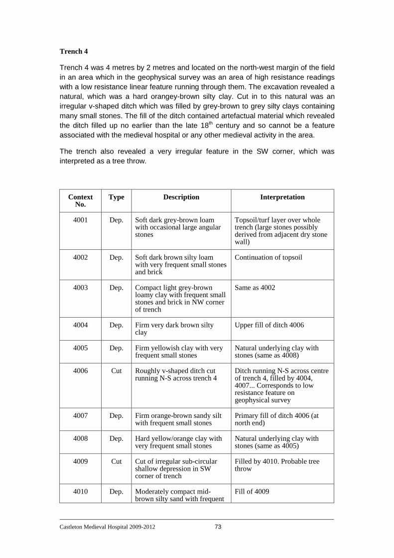
Castleton Medieval Hospital 2009-2012 73
Trench 4
Trench 4 was 4 metres by 2 metres and located on the north-west margin of the field
in an area which in the geophysical survey was an area of high resistance readings
with a low resistance linear feature running through them. The excavation revealed a
natural, which was a hard orangey-brown silty clay. Cut in to this natural was an
irregular v-shaped ditch which was filled by grey-brown to grey silty clays containing
many small stones. The fill of the ditch contained artefactual material which revealed
the ditch filled up no earlier than the late 18th century and so cannot be a feature
associated with the medieval hospital or any other medieval activity in the area.
The trench also revealed a very irregular feature in the SW corner, which was
interpreted as a tree throw.
Context No.
Type Description Interpretation
4001 Dep. Soft dark grey-brown loam with occasional large angular stones
Topsoil/turf layer over whole trench (large stones possibly derived from adjacent dry stone wall)
4002 Dep. Soft dark brown silty loam with very frequent small stones and brick
Continuation of topsoil
4003 Dep. Compact light grey-brown loamy clay with frequent small stones and brick in NW corner of trench
Same as 4002
4004 Dep. Firm very dark brown silty clay
Upper fill of ditch 4006
4005 Dep. Firm yellowish clay with very frequent small stones
Natural underlying clay with stones (same as 4008)
4006 Cut Roughly v-shaped ditch cut running N-S across trench 4
Ditch running N-S across centre of trench 4, filled by 4004, 4007... Corresponds to low resistance feature on geophysical survey
4007 Dep. Firm orange-brown sandy silt with frequent small stones
Primary fill of ditch 4006 (at north end)
4008 Dep. Hard yellow/orange clay with very frequent small stones
Natural underlying clay with stones (same as 4005)
4009 Cut Cut of irregular sub-circular shallow depression in SW corner of trench
Filled by 4010. Probable tree throw
4010 Dep. Moderately compact mid-brown silty sand with frequent
Fill of 4009
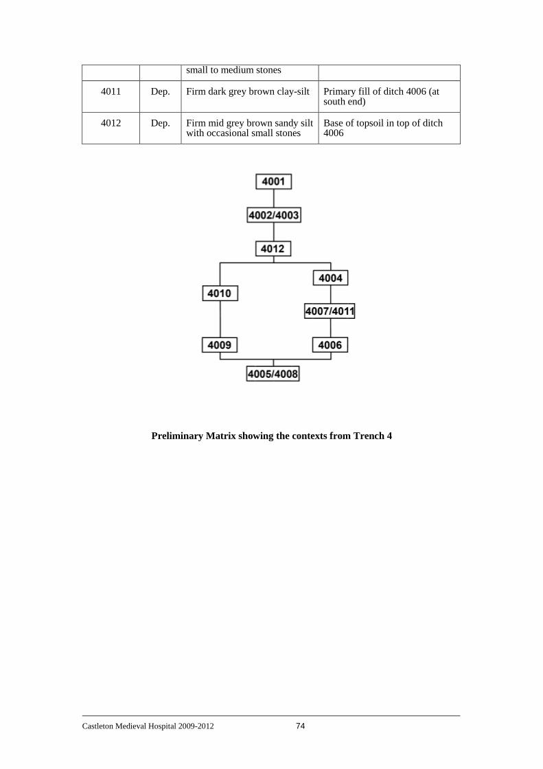
Castleton Medieval Hospital 2009-2012 74
small to medium stones
4011 Dep. Firm dark grey brown clay-silt Primary fill of ditch 4006 (at south end)
4012 Dep. Firm mid grey brown sandy silt with occasional small stones
Base of topsoil in top of ditch 4006
Preliminary Matrix showing the contexts from Trench 4
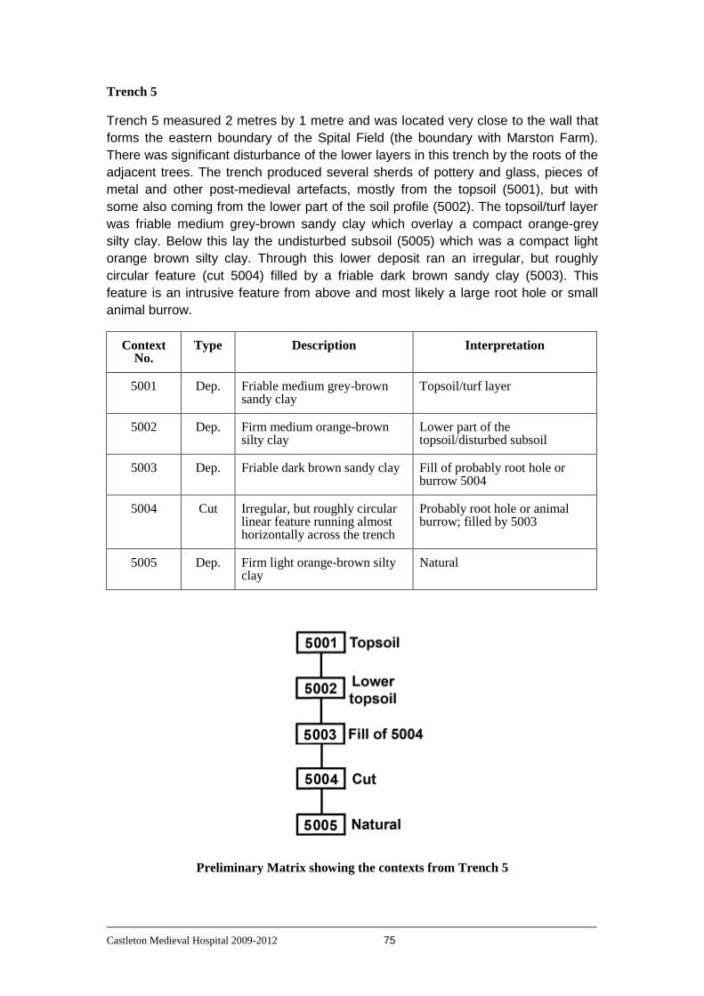
Castleton Medieval Hospital 2009-2012 75
Trench 5
Trench 5 measured 2 metres by 1 metre and was located very close to the wall that
forms the eastern boundary of the Spital Field (the boundary with Marston Farm).
There was significant disturbance of the lower layers in this trench by the roots of the
adjacent trees. The trench produced several sherds of pottery and glass, pieces of
metal and other post-medieval artefacts, mostly from the topsoil (5001), but with
some also coming from the lower part of the soil profile (5002). The topsoil/turf layer
was friable medium grey-brown sandy clay which overlay a compact orange-grey
silty clay. Below this lay the undisturbed subsoil (5005) which was a compact light
orange brown silty clay. Through this lower deposit ran an irregular, but roughly
circular feature (cut 5004) filled by a friable dark brown sandy clay (5003). This
feature is an intrusive feature from above and most likely a large root hole or small
animal burrow.
Context No.
Type Description Interpretation
5001 Dep. Friable medium grey-brown sandy clay
Topsoil/turf layer
5002 Dep. Firm medium orange-brown silty clay
Lower part of the topsoil/disturbed subsoil
5003 Dep. Friable dark brown sandy clay Fill of probably root hole or burrow 5004
5004 Cut Irregular, but roughly circular linear feature running almost horizontally across the trench
Probably root hole or animal burrow; filled by 5003
5005 Dep. Firm light orange-brown silty clay
Natural
Preliminary Matrix showing the contexts from Trench 5

Castleton Medieval Hospital 2009-2012 76
Trench 6
Trench 6 measured 2 metres by 1 metre and was excavated in the eastern part of
the Spital Field. This trench revealed evidence of the ridge and furrow that is visible
as a surface feature in this part of the field (as the boundary between 6002 and
6003). The topsoil/turf layer (6001) was a friable grey-brown sandy clay. This overlay
a compact light orange-brown layer (6002) which marked the base of the ridge and
furrow deposit. Below this lay an undisturbed subsoil (6003) which comprised a firm
light orange-brown silty clay.
Context No.
Type Description Interpretation
6001 Dep. Friable grey-brown sandy clay Topsoil/turf layer
6002 Dep. Compact light orange-brown silty clay
Lower part of the topsoil/ remnant ploughsoil from ridge and furrow
6003 Dep. Firm light orange-brown silty clay
Natural
Preliminary Matrix showing the contexts from Trench 6

Castleton Medieval Hospital 2009-2012 77
Trench 7
Trench 7 measured 2 metres by 1 metre and was excavated in the eastern part of
the Spital Field, west of trench 6. Similarly to trench 6 this trench revealed evidence
of the ridge and furrow that is visible as a surface feature in this part of the field (as
the boundary between 7002 and 7003). The topsoil/turf layer (7001) was a friable
dark grey-brown sandy clay. This overlay a firm mid orange-brown silty-clay layer
with occasional stones (7002) which marked the base of the ridge and furrow
deposit. Below this lay an undisturbed subsoil (7003) which comprised a firm light
orange-brown silty clay.
Context No.
Type Description Interpretation
7001 Dep. Friable dark grey-brown sandy clay
Topsoil/turf layer
7002 Dep. Firm medium orange-brown silty clay
Lower part of the topsoil/ remnant ploughsoil from ridge and furrow
7003 Dep. Friable dark brown sandy clay Natural
Preliminary Matrix showing the contexts from Trench 7

Castleton Medieval Hospital 2009-2012 78
Trench 8
Trench 8 measured 2 metres by 1 metre and was the western-most test pit
excavated in the eastern part of the Spital Field. Similarly to trenches 6 and 7 this
trench revealed evidence of the ridge and furrow that is visible as a surface feature in
this part of the field (as the boundary between 8002 and 8006). The topsoil/turf layer
(8001) was a friable dark grey-brown sandy clay. This overlay a firm mid orange-
brown silty-clay layer with occasional stones (8002) which marked the base of the
ridge and furrow deposit. Cut in to 8002 was a linear feature running N-S across the
trench. Excavation of this feature revealed that it was a U-shaped cut (8005) with a
layer of irregular overlapping stones (8003) at the base. Above these stones and
filling the rest of 8005 was a firm mid-brown sandy clay (8004). This feature ran
roughly along the base of the earlier furrow and was interpreted as a shallow field
drain. Below this lay an undisturbed subsoil (8006) which comprised a firm light
orange-brown silty clay.
Context No.
Type Description Interpretation
8001 Dep. Friable dark grey-brown sandy clay
Topsoil/turf layer
8002 Dep. Firm light orange-brown sandy clay
Lower part of the topsoil/ remnant ploughsoil from ridge and furrow
8003 Dep. Overlapping irregular flat stones at base of cut 8005
Base of probable shallow drain
8004 Dep. Firm mid-brown sandy clay Fill of probable shallow drain (8005)
8005 Cut U-shaped cut running N-S across trench and filled by 8003 and 8004
Cut filled by 8004, probably a shallow field drain
8006 Dep. Firm light orange-brown silty clay
Natural
Preliminary Matrix showing the contexts from Trench 8

Castleton Medieval Hospital 2009-2012 79
Trench 9
Trench 9 was 10 metres by 2 metres and placed across the line of the holloway and
the associated bank on its western side. The trench extended from the centre of the
holloway eastwards through the bank and into the interior of space ‘enclosed’ by the
bank. Upon removal of the turf and mid-brown silty clay topsoil (9001) several
deposits were revealed. In the ‘interior’ of the enclosed area (the western part of
trench 9) there was a friable orange-brown sandy clay with occasional small stones
(9003). Excavation of a section through 9003, in the ‘interior’ of the enclosed area,
revealed a gradual change to a compact light grey-brown silty clay which was
interpreted as the natural subsoil. There were no cut features or other deposits within
this (western) part of trench 9.
A 1 metre wide section of the holloway and bank was excavated. The holloway fill
(9009) was a compact dark orange-brown sandy clay with very occasional small
rounded pebbles. 9009 proved to continue down throughout the holloway and it was
disappointing that no visible stratigraphy survived within this context. The full depth of
the holloway fill was not excavated.
The upper part of the bank was a friable, light grey-brown sandy loam (9002) with
some angular stones. Excavation of the bank revealed a series of irregular layers
and lenses with variable proportions of stones and varying in colour from grey-brown
to orange-brown to a very light yellow-brown. The variability and shape of these
deposits are compatible with material being thrown up from the holloway side to form
the bank. The final interpretation being that the cut interpreted as a holloway is at
least partly in this area a deliberate construction as it is the source for the bank
material.
Context No.
Type Description Interpretation
9001 Dep. Friable mid-brown silty clay Topsoil/turf layer
9002 Dep. Friable light grey-brown sandy loam with frequent angular stones
Upper layer in the bank material
9003 Dep. Friable orange-brown sandy clay with occasional small stones
Base of the topsoil within the ‘enclosed area’ (western part of trench 9)
9004 Dep. Friable orange-brown sandy silt
Bank material
9005 Dep. Firm light red-brown sandy silt Bank material
9006 Dep. Friable orange-grey-brown sandy silt
Bank material

Castleton Medieval Hospital 2009-2012 80
9007 Dep. Compact light grey-brown silty clay
Natural
9008 Dep. Firm light grey-brown silty clay
Primary deposit making up the bank material (merges with 9007)
9009 Dep. Medium to firm dark orange-brown sandy clay
Fill of ‘holloway’ 9009
9010 Cut U-shaped cut containing 9009 Boundary defining edge of ‘holloway’
Preliminary Matrix showing the contexts from Trench 9
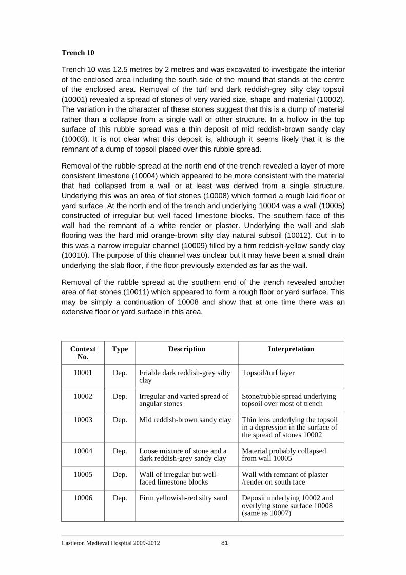
Castleton Medieval Hospital 2009-2012 81
Trench 10
Trench 10 was 12.5 metres by 2 metres and was excavated to investigate the interior
of the enclosed area including the south side of the mound that stands at the centre
of the enclosed area. Removal of the turf and dark reddish-grey silty clay topsoil
(10001) revealed a spread of stones of very varied size, shape and material (10002).
The variation in the character of these stones suggest that this is a dump of material
rather than a collapse from a single wall or other structure. In a hollow in the top
surface of this rubble spread was a thin deposit of mid reddish-brown sandy clay
(10003). It is not clear what this deposit is, although it seems likely that it is the
remnant of a dump of topsoil placed over this rubble spread.
Removal of the rubble spread at the north end of the trench revealed a layer of more
consistent limestone (10004) which appeared to be more consistent with the material
that had collapsed from a wall or at least was derived from a single structure.
Underlying this was an area of flat stones (10008) which formed a rough laid floor or
yard surface. At the north end of the trench and underlying 10004 was a wall (10005)
constructed of irregular but well faced limestone blocks. The southern face of this
wall had the remnant of a white render or plaster. Underlying the wall and slab
flooring was the hard mid orange-brown silty clay natural subsoil (10012). Cut in to
this was a narrow irregular channel (10009) filled by a firm reddish-yellow sandy clay
(10010). The purpose of this channel was unclear but it may have been a small drain
underlying the slab floor, if the floor previously extended as far as the wall.
Removal of the rubble spread at the southern end of the trench revealed another
area of flat stones (10011) which appeared to form a rough floor or yard surface. This
may be simply a continuation of 10008 and show that at one time there was an
extensive floor or yard surface in this area.
Context No.
Type Description Interpretation
10001 Dep. Friable dark reddish-grey silty clay
Topsoil/turf layer
10002 Dep. Irregular and varied spread of angular stones
Stone/rubble spread underlying topsoil over most of trench
10003 Dep. Mid reddish-brown sandy clay Thin lens underlying the topsoil in a depression in the surface of the spread of stones 10002
10004 Dep. Loose mixture of stone and a dark reddish-grey sandy clay
Material probably collapsed from wall 10005
10005 Dep. Wall of irregular but well-faced limestone blocks
Wall with remnant of plaster /render on south face
10006 Dep. Firm yellowish-red silty sand Deposit underlying 10002 and overlying stone surface 10008 (same as 10007)
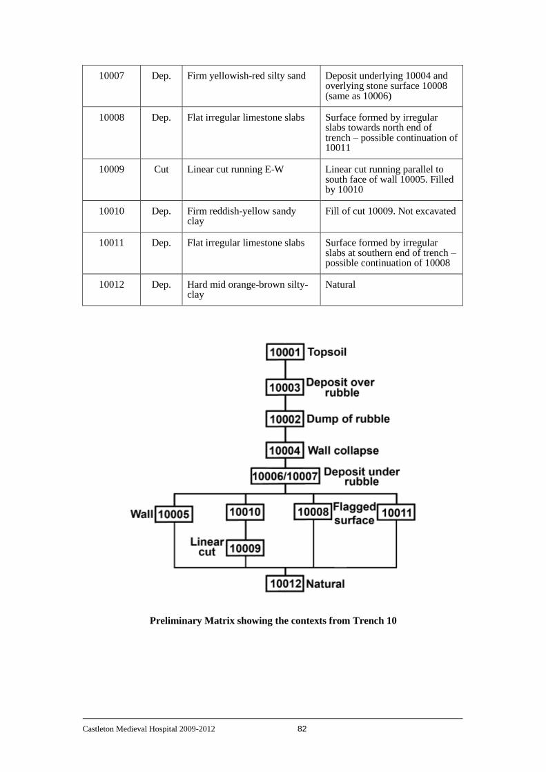
Castleton Medieval Hospital 2009-2012 82
10007 Dep. Firm yellowish-red silty sand Deposit underlying 10004 and overlying stone surface 10008 (same as 10006)
10008 Dep. Flat irregular limestone slabs Surface formed by irregular slabs towards north end of trench – possible continuation of 10011
10009 Cut Linear cut running E-W Linear cut running parallel to south face of wall 10005. Filled by 10010
10010 Dep. Firm reddish-yellow sandy clay
Fill of cut 10009. Not excavated
10011 Dep. Flat irregular limestone slabs Surface formed by irregular slabs at southern end of trench – possible continuation of 10008
10012 Dep. Hard mid orange-brown silty-clay
Natural
Preliminary Matrix showing the contexts from Trench 10

Castleton Medieval Hospital 2009-2012 83
Trench 11
Trench 11 measured 2 metres by 1 metre and was excavated on the sloping face of
the river terrace above the floodplain towards the western end of the Spital Field.
This test pit was excavated in order to investigate the area that may have been in the
vicinity of a structure revealed by excavations in 1999 by Trent and Peak
Archaeological Trust. Removal of the turf and friable light brown silty-clay topsoil
(11001) revealed a deposit which varied from light grey to black (11002) and was
very ‘ashy’ as if it contained a lot of burnt material (ash, cinders, charcoal). This
overlay a hard light orangey brown silty clay (11003) which was the natural
undisturbed subsoil. It is likely that 11002 represents a dump of material downslope
from the terrace above the floodplain. This happened at an unknown period in the
past as no artefactual material was recovered and this is not a significant enough
deposit to warrant absolute dating of the burnt material.
Context No.
Type Description Interpretation
11001 Dep. Friable light brown silty clay Topsoil/turf layer
11002 Dep. Variable light grey to black silty clay (with ash and cinders)
Dump of ash
11003 Dep. Hard light orange-brown silty clay
Natural
Preliminary Matrix showing the contexts from Trench 11

Castleton Medieval Hospital 2009-2012 84
Trench 12
Trench 12 further explored the structural remains that had been seen in trench 10.
Removal of the turf and topsoil revealed two spreads of mixed stone rubble. A large
spread across the central and southern part of the trench (12002) and a smaller
spread in the centre of the northern part of the trench (12003). Removal of parts the
central and western part of 12003 revealed a friable dark red-brown silty clay which
contained some small stones and which made up the body of the central mound.
This was clearly material that had been brought on to the site (as had the stone
spreads above it) and dumped here forming the central mound and was likely to have
been topsoil brought in from elsewhere. This deposit overlay the east-west wall
(12010) that had originally been seen in trench 10 in 2010.
Wall 12010 ran east-west and appears to have once run further west than it does
now. Abutting 12010 is a north-south wall (12004) that runs out of the south section
of the trench up to wall 12010. There appears to have been a gap, probably a
doorway, at the junction of 12004 and 12010. This doorway was later blocked by
irregular stone blocks (12015) and the eastern face of 12004/12015 and the southern
face of 12010 then plastered/rendered with a white material. At some point the
western part of wall 12010 was dismantled back to roughly the point where 12010
meets 12004/12015.
In the south-west corner of the trench were further layers of dumping similar to 12008
(12013, 12016 and 12017). These overlay a deposit of dark orange-brown clay
(12020) which was probably redeposited natural and a patch of soft degraded plaster
or mortar (12023). On the other (east) side of wall 12004/12015 (where trench 10
had been excavated in 2010) was another patch of soft degraded plaster/mortar
(12028) and the flagstones (12025) which had originally been seen in 2010. Cutting
the underlying deposit were two linear shallow east-west cuts (12022 filled by 12021
and 12026 filled by 12019). It is not clear what these shallow cuts function was;
however they have flat bases and may have held beams or other base materials for
something to stand against wall 12010.
In the northern part of the trench removal of 12002 revealed a wall (12007) and areas
of stone (12012 and 12011) which were likely to have resulted from the collapse of
that wall.
Underlying all these features and deposits was a generally mid to dark red-brown
sandy clay (12006, 12024, 12027 and probably also 12009 and 12018) which
contained some abraded medieval pottery and human and animal bones. This
deposit probably represents an old ground surface and may have been disturbed by
cultivation or similar activities. However some deliberate burial of material in this
layer must have also taken place as in one part, in the north-east quarter of the
trench, the top half of a human skull was excavated intact. There were other small
and fragmentary human and animal bones in this area and these could have become
incorporated in to the ground by other non-deliberate methods (cultivation or by being
pressed in to soft, wet ground); however such a large piece of a fragile material such
as a skull could not have become incorporated in the deposit as a unintended result
of this type of activity.
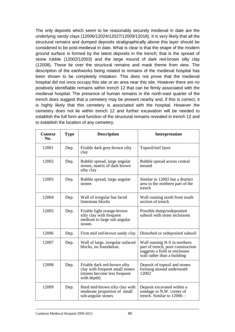
Castleton Medieval Hospital 2009-2012 85
The only deposits which seem to be reasonably securely medieval in date are the
underlying sandy clays (12006/12024/12027/12009/12018). It is very likely that all the
structural remains and dumped deposits stratigraphically above this layer should be
considered to be post-medieval in date. What is clear is that the shape of the modern
ground surface is formed by the latest deposits in the trench; that is the spread of
stone rubble (12002/12003) and the large mound of dark red-brown silty clay
(12008). These lie over the structural remains and mask theme from view. The
description of the earthworks being related to remains of the medieval hospital has
been shown to be completely mistaken. This does not prove that the medieval
hospital did not once occupy this site or an area near this site. However there are no
positively identifiable remains within trench 12 that can be firmly associated with the
medieval hospital. The presence of human remains in the north-east quarter of the
trench does suggest that a cemetery may be present nearby and, if this is correct, it
is highly likely that this cemetery is associated with the hospital. However the
cemetery does not lie within trench 12 and further excavation will be needed to
establish the full form and function of the structural remains revealed in trench 12 and
to establish the location of any cemetery.
Context No.
Type Description Interpretation
12001 Dep. Friable dark grey-brown silty clay
Topsoil/turf layer
12002 Dep. Rubble spread, large angular stones, matrix of dark brown silty clay
Rubble spread across central mound
12003 Dep. Rubble spread, large angular stones
Similar to 12002 but a distinct area in the northern part of the trench
12004 Dep. Wall of irregular but faced limestone blocks
Wall running north from south section of trench
12005 Dep. Friable light orange-brown silty clay with frequent medium to large sub angular stones
Possible dump/redeposited subsoil with stone inclusions
12006 Dep. Firm mid red-brown sandy clay Disturbed or redeposited subsoil
12007 Dep. Wall of large, irregular unfaced blocks, no foundation.
Wall running N-S in northern part of trench, poor construction suggests a field or enclosure wall rather than a building
12008 Dep. Friable dark red-brown silty clay with frequent small stones (stones become less frequent with depth)
Deposit of topsoil and stones forming mound underneath 12002
12009 Dep. Hard mid-brown silty clay with moderate proportion of small sub-angular stones
Deposit excavated within a sondage in N.W. corner of trench. Similar to 12006 –

Castleton Medieval Hospital 2009-2012 86
disturbed subsoil
12010 Dep. Wall running east-west of irregular but faced limestone blocks and remnant render/plaster
Wall originally revealed in trench10 in 2010 underlying the dump of material that makes up the central mound
12011 Dep. Rubble with a friable mid-brown sandy clay matrix
Rubble spread to east of wall 12007. This may be collapse from 12007. Boundary with 12003 not clearly discernible
12012 Dep. Rubble with a friable mid-brown sandy clay matrix
Rubble spread to west of wall 12007. Smaller stones than 12011, but may still be part of collapse of 12007
12013 Dep. Friable mid brown to black silty clay with frequent small stones and other inclusions such as plaster/mortar
Similar matrix to 20002 but the rubble has faded out. Possible base of dumped material, just in the SW corner of trench
12014 Dep. Hard reddish-yellow clay Natural
12015 Dep. Wall made of mixed stone blocks
Wall running north from 12004, abuts 12010, possible blocking of doorway between 12004 and 12010
12016 Dep. Friable dark red-brown silty clay with occasional small sub-angular stones
Deposit underlying 12013, but has fewer stones and other inclusions
12017 Dep. Friable dark brown silty clay with frequent small sub-rounded to sub-angular stones
Similar layer to 12013/12016. Another component of this dumped deposit
12018 Dep. Firm mid red-brown sandy clay with occasional small sub-angular stones
Continuation of 12006, but underlying the wall tumble 12011 and wall 12007
12019 Dep. Firm mid orange-brown clay Redeposited natural filling cut 12026 which runs under 12025 and 12004/12015
12020 Dep. Firm dark orange-brown clay Redeposited natural to west of wall 12004/12015 and underlying 12016, 12017
12021 Dep. Firm red-brown sandy clay Fill if cut 12022 which runs under wall 12004/12015
12022 Cut Linear cut running E-W (wedge-shaped in profile)
Linear E-W cut filled by 12021 and running under wall 12004/12015. Cuts 12019
12023 Dep. Loose layer of pieces of plaster/mortar
Patches of plaster/mortar adjacent to west side of wall 12004/12015. Underlies 12020

Castleton Medieval Hospital 2009-2012 87
12024 Dep. Firm dark red brown sandy clay
Probable redeposited natural underlying 12017 in SW corner of trench (west of wall 12004)
12025 Dep. Flagstone surface N-E to S-W oriented flagstones, probably the last 2 stones surviving from a paved area to east of wall 12004
12026 Cut Linear U-shaped cut running E-W
Linear feature running under wall 12004/12015. Filled by 12019
12027 Dep. Firm dark red-brown sandy clay
Probable redeposited natural underlying 12025 and cut by 12026
12028 Dep. Loose layer of pieces of plaster/mortar
Similar in character to 12023, but east of wall 12004/12015
Preliminary Matrix showing the contexts from Trench 12

Castleton Medieval Hospital 2009-2012 88
Trench 13
Trench 13 was a 2 metre by 1 metre test pit excavated at the edge of the floodplain
at the base of the slope up to the river terrace. Trenches 13 to 17 were excavated
around the area that had revealed the structure in the excavations in 1999, in order
to assess the area where disturbance had occurred as a result of the pipeline that
was constructed in 1999 and to define any areas where undisturbed archaeological
deposits may survive.
Removal of the turf and topsoil revealed a parallel sided feature running NW to SE
across the trench. This turned out to be a vertically-sided cut (13003) filled by a soft
dark olive brown loam with frequent small angular limestone inclusions (13002). This
is certainly a modern drain cut and the fill includes crushed limestone aggregate to
improve drainage in the upper fill of the cut. 13003 cut through some dark sandy-silt
deposits typical of natural alluvial deposits to be expected on a floodplain such as
this.
Context No.
Type Description Interpretation
13001 Dep. Firm dark greyish-brown silty clay with occasional small angular stones
Topsoil/turf layer
13002 Dep. Soft dark olive brown loam with frequent stones
Fill of 13003
13003 Cut Vertically sided cut running NW to SE across trench
Modern field drain
13004 Dep. Firm dark yellowish-brown sandy silt with occasional large stones
Alluvial deposit/natural
13005 Dep. Slightly more clay-rich, otherwise similar to 13004
Alluvial deposit/natural
Preliminary Matrix showing the contexts from Trench 13
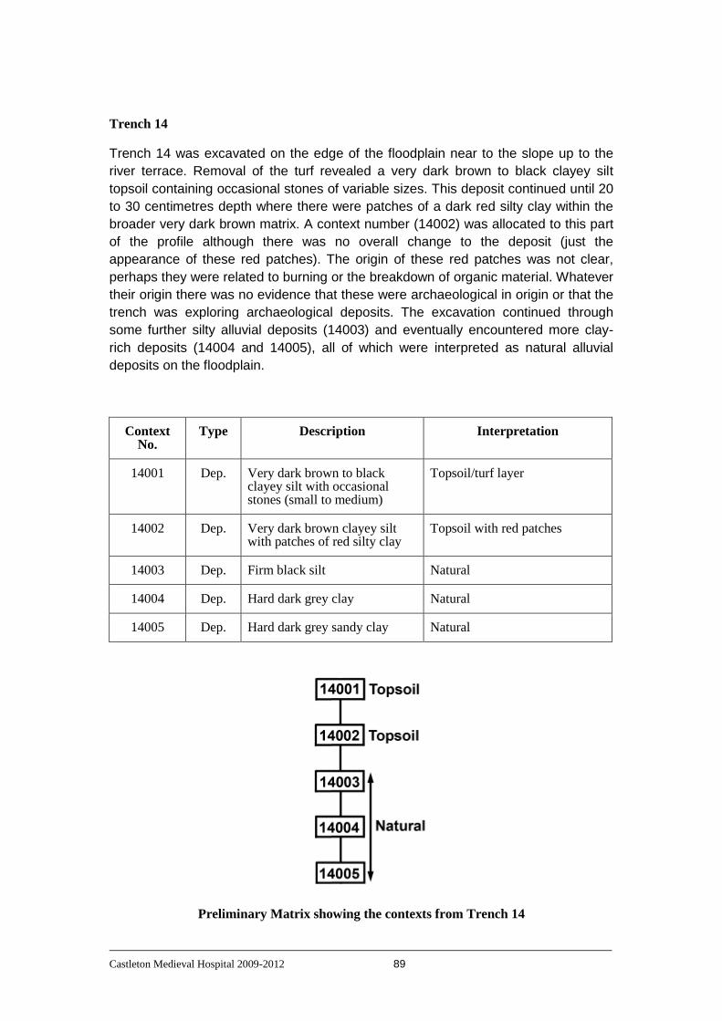
Castleton Medieval Hospital 2009-2012 89
Trench 14
Trench 14 was excavated on the edge of the floodplain near to the slope up to the
river terrace. Removal of the turf revealed a very dark brown to black clayey silt
topsoil containing occasional stones of variable sizes. This deposit continued until 20
to 30 centimetres depth where there were patches of a dark red silty clay within the
broader very dark brown matrix. A context number (14002) was allocated to this part
of the profile although there was no overall change to the deposit (just the
appearance of these red patches). The origin of these red patches was not clear,
perhaps they were related to burning or the breakdown of organic material. Whatever
their origin there was no evidence that these were archaeological in origin or that the
trench was exploring archaeological deposits. The excavation continued through
some further silty alluvial deposits (14003) and eventually encountered more clay-
rich deposits (14004 and 14005), all of which were interpreted as natural alluvial
deposits on the floodplain.
Context No.
Type Description Interpretation
14001 Dep. Very dark brown to black clayey silt with occasional stones (small to medium)
Topsoil/turf layer
14002 Dep. Very dark brown clayey silt with patches of red silty clay
Topsoil with red patches
14003 Dep. Firm black silt Natural
14004 Dep. Hard dark grey clay Natural
14005 Dep. Hard dark grey sandy clay Natural
Preliminary Matrix showing the contexts from Trench 14

Castleton Medieval Hospital 2009-2012 90
Trench 15
Trench 15 was a test pit which measured 2 metres by 1 metre and was excavated a
further 20 metres from trench 13 out on to the floodplain of the river. Removal of the
turf revealed a soft mid brown silty clay topsoil (15001) which overlay firm dark grey-
brown silt (15002) which was interpreted as the natural alluvial deposit on the
floodplain. No archaeological deposits or material were encountered in trench 15.
Context No.
Type Description Interpretation
15001 Dep. Soft mid brown silty clay Topsoil/turf layer
15002 Dep. Firm dark grey-brown silt Natural
Preliminary Matrix showing the contexts from Trench 15
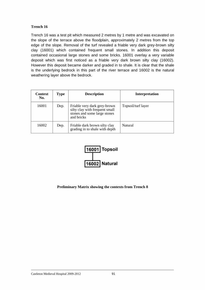
Castleton Medieval Hospital 2009-2012 91
Trench 16
Trench 16 was a test pit which measured 2 metres by 1 metre and was excavated on
the slope of the terrace above the floodplain, approximately 2 metres from the top
edge of the slope. Removal of the turf revealed a friable very dark grey-brown silty
clay (16001) which contained frequent small stones. In addition this deposit
contained occasional large stones and some bricks. 16001 overlay a very variable
deposit which was first noticed as a friable very dark brown silty clay (16002).
However this deposit became darker and graded in to shale. It is clear that the shale
is the underlying bedrock in this part of the river terrace and 16002 is the natural
weathering layer above the bedrock.
Context No.
Type Description Interpretation
16001 Dep. Friable very dark grey-brown silty clay with frequent small stones and some large stones and bricks
Topsoil/turf layer
16002 Dep. Friable dark brown silty clay grading in to shale with depth
Natural
Preliminary Matrix showing the contexts from Trench 8

Castleton Medieval Hospital 2009-2012 92
Trench 17
Trench 17 was a test pit which measured 2 metres by 1 metre and was excavated on
the flat area on the terrace above the floodplain (about 4 metres from the top of the
slope). The removal of the turf revealed a friable very dark grey-brown silty clay
(17001). This gradually changed to a compact dark yellow-brown silty clay (17002)
which was clearly undisturbed natural subsoil. No archaeological deposits or material
were encountered in trench 17.
Context No.
Type Description Interpretation
17001 Dep. Friable very dark grey-brown silty clay with occasional small stones
Topsoil/turf layer
17002 Dep. Firm dark yellow-brown silty clay
Natural
Preliminary Matrix showing the contexts from Trench 17

Castleton Medieval Hospital 2009-2012 93
Trench 18
Trench 18 was excavated to the south-east of trench 2, but on the same apparent
earthwork feature. Removal of the turf revealed a friable dark brown silty clay topsoil
(18001). Below this was a friable mid orange-brown silty clay (18002) which graded
in to a firm mid orange-grey clay (18003). This became harder and more shale-like in
character forming a hard mid orange-grey clay (18004). The boundaries between
18002, 18003 and 18004 were not clear and it is not possible to say positively that
any archaeological deposits were encountered below the topsoil in trench 18. It is
possible that the apparent earthwork feature is a natural feature of some kind.
Context No.
Type Description Interpretation
18001 Dep. Friable dark brown silty clay Topsoil/turf layer
18002 Dep. Friable mid orange-brown silty clay
Probable natural
18003 Dep. Firm mid orange-grey clay Natural
18004 Dep. Hard mid orange-grey clay Degraded shale/natural
Preliminary Matrix showing the contexts from Trench 18

Castleton Medieval Hospital 2009-2012 94
Trench 19
Trench 19 was a 2 metre by 1 metre test pit excavated in a hollow to the south-west
of trench 12. This hollow may have been a routeway down to the floodplain from the
terrace or it may be a natural drainage feature.
Removal of the soft dark grey-brown sandy silt topsoil (19001) revealed a complex of
apparently intercutting features and their fills. Once the topsoil was removed it was
realised that there were several different deposits already visible in what was actually
a small test pit. As a result of this discovery and because it was by this time the last
week of the excavation, it was decided that time did not permit an adequate
investigation of these deposits and their relationships. Consequently it was decided
to record the trench without further excavation and make the best interpretation
possible on the available evidence. After that the trench would then be backfilled and
the area re-examined with another, slightly larger, trench during the 2012 season.
Context No.
Type Description Interpretation
19001 Dep. Soft dark grey-brown sandy silt with occasional small stones
Topsoil/turf layer
19002 Dep. Friable very dark grey silty clay
Fill of 19003
19003 Cut Linear cut running SSW to NNE
Linear cut with curved corner on eastern side of trench, filled by 19002
19004 Dep. Friable very dark grey-brown silty clay
Fill of possible ditch 19005
19005 Cut Linear feature running S – N across trench
Cut of possible ditch/gully, filled by 19004
19006 Dep. Mid orange-brown silty clay with frequent medium to large angular stones
Fill of cut 19007. Stones within this deposit range from 5 to 20 cms. Diameter
19007 Cut Curved cut of feature in NW corner of trench
Curved edge of a feature in NW corner of trench (possible pit), filled by 19006
19008 Dep. Firm very dark greyish-brown sandy clay with some mottling
Possible natural
19009 Dep. Firm very dark grey silty clay with flecks of charcoal
Possible stakeholes, fill of 19010
19010 Cut Circular cut Circular cuts in to 19008, possible stakeholes, filled by 19009
19011 Dep. Soft mid brown sandy silt with Deposit at western end of trench

Castleton Medieval Hospital 2009-2012 95
frequent small stones overlain by 19012
19012 Dep. Mid to large gritstone cobbles Large gritstone pieces/cobbles overlying/on the surface of 19011
Preliminary Matrix showing the contexts from Trench 19

Castleton Medieval Hospital 2009-2012 96
Trench 20
Trench 20 was an 8 metre by 8 metres trench which extended the area investigated
in trenches 10 and 12 to the south and east. The majority of the trench was overlain
by spreads of rubble containing mostly small to medium sized stones (20005, 20006,
20007 and 20008).
Three main areas of interest were investigated. These were the continuation of the
east west wall previously seen in trenches 10 and 12; areas of burnt material to the
south of this wall and an area towards the south-east corner of the trench where
there were cut features underlying a spread of stone.
The main east-west wall (20027/20028/20029) continued east from the west section
of the trench for approximately 2.5 metres to a point where it had clearly been
demolished. The alignment of the wall continued for a further 2.5 to 3 metres and
was indicated by a darker soil (20015) until it became obscured/disturbed in an area
of laid stone cobbles (20033/20039) near the north-east corner of the trench. No
significant structural features were found associated with the east-west wall, so there
was no wall running south from the east-west wall which could have formed the
‘other side’ of the structure formed by the wall running south from the east-west wall
identified in trench 12.
To the south of the east-west wall were several areas of burnt material. There were
both clear hearths (20021/20035/20036/20060; 20024/20051/20052/20053/20056/
20057/20058/20059 and 20038) and less distinct spreads of burnt material (20017;
20030 and 20025). In many of these deposits were found frequent irregular pieces of
melted lead. In addition to this melted lead one piece of window came and one lead
strip with an iron nail were also found near these areas of burnt material. These
hearths are likely to have been used in order to melt the lead as it was stripped from
nearby buildings; buildings which are very likely to have been the buildings of the
hospital. While these hearths and other deposits were all south of the east-west wall
there were no direct stratigraphic relationships between any of them and the east-
west wall and so it is not possible to be certain whether the wall had not yet been
built when the hearths were in use or whether it was a standing structure by the time
they were in use.
The south-eastern part of the trench was covered by a stone spread (20008).
Underlying this were a series of deposits within at least two and possibly three cuts.
There was a vertically sided and flat bottomed cut (20045) partly filled by 20008 and
partly by a mid orangey-brown silty clay containing some small stones (20054). At
the northern end of this cut was a small gully which appeared to be part of the cut,
but the edges of which were difficult to define. This part of the feature produced 4
human finger bones (from a fill labelled 20026) and it is possible that this was a
separate feature to 20045. Due to the poor weather only a small part of this area was
excavated and so this will require further investigation. At the southern end of the cut
feature a further cut (20046) sloped down as it entered the southern section of the
trench and this was filled by a compact yellow-brown silty clay which contained a lot
of small limestone or plaster pieces (20055). This was probably the edge of a drain or
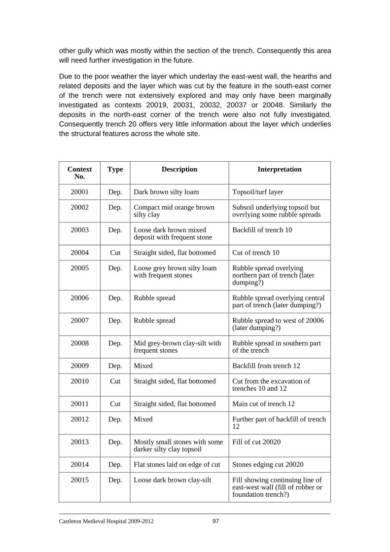
Castleton Medieval Hospital 2009-2012 97
other gully which was mostly within the section of the trench. Consequently this area
will need further investigation in the future.
Due to the poor weather the layer which underlay the east-west wall, the hearths and
related deposits and the layer which was cut by the feature in the south-east corner
of the trench were not extensively explored and may only have been marginally
investigated as contexts 20019, 20031, 20032, 20037 or 20048. Similarly the
deposits in the north-east corner of the trench were also not fully investigated.
Consequently trench 20 offers very little information about the layer which underlies
the structural features across the whole site.
Context No.
Type Description Interpretation
20001 Dep. Dark brown silty loam Topsoil/turf layer
20002 Dep. Compact mid orange brown silty clay
Subsoil underlying topsoil but overlying some rubble spreads
20003 Dep. Loose dark brown mixed deposit with frequent stone
Backfill of trench 10
20004 Cut Straight sided, flat bottomed Cut of trench 10
20005 Dep. Loose grey brown silty loam with frequent stones
Rubble spread overlying northern part of trench (later dumping?)
20006 Dep. Rubble spread Rubble spread overlying central part of trench (later dumping?)
20007 Dep. Rubble spread Rubble spread to west of 20006 (later dumping?)
20008 Dep. Mid grey-brown clay-silt with frequent stones
Rubble spread in southern part of the trench
20009 Dep. Mixed Backfill from trench 12
20010 Cut Straight sided, flat bottomed Cut from the excavation of trenches 10 and 12
20011 Cut Straight sided, flat bottomed Main cut of trench 12
20012 Dep. Mixed Further part of backfill of trench 12
20013 Dep. Mostly small stones with some darker silty clay topsoil
Fill of cut 20020
20014 Dep. Flat stones laid on edge of cut Stones edging cut 20020
20015 Dep. Loose dark brown clay-silt Fill showing continuing line of east-west wall (fill of robber or foundation trench?)

Castleton Medieval Hospital 2009-2012 98
20016 Dep. Mix of stones and a grey brown silty loam
Probably continuation of 20005
20017 Dep. Mid orange brown sandy clay with frequent small stones
Layer underlying 20042 in N.E. corner of trench
20018 Dep. Mid brown silty clay Layer underlying 20017 but above 20048
20019 Dep. Mid orange brown silty clay to clay
Layer underlying rubble 20006 in centre of trench
20020 Cut Elliptical cut with sloping sides near northern section of trench
Later cut through rubble spread 20005. Filled by 20013 and 20014
20021 Dep. Mottled grey ashy and red burnt deposit
Upper fill of hearth 20060
20022 Dep. Flat stone slabs Line of stone slabs running ’diagonally’ towards the south face of the main east-west wall
20023 Dep. Light yellow brown clay Layer underlying 20016 and above 20032 within the area between 20022 and the east-west wall
20024 Dep. Mixed burnt/ashy deposit Part of the fill of hearth 20059
20025 Dep. Mottled dark brown/dark orange clay silt
Spread of redeposited(?) burnt material in centre of trench
20026 Dep. Yellow-brown clay Fill within cut 20045
20027 Dep. Rubble Internal rubble core of east-west wall 20028/20029
20028 Dep. Stone wall South face of east-west wall
20029 Dep. Stone wall North face of east-west wall
20030 Dep. Burnt/ashy deposit Patch of burnt/ashy material immediately south of north end of 20022
20031 Dep. Friable mid grey brown clay silt to silt
Deposit underlying 20044 in south-west corner of trench
20032 Dep. Mid brown silty clay to sandy clay
Deposit underlying hearths and rubble spread in western part of the trench south of 20022
20033 Dep. Large stones slabs and cobbles Possible structure of floor surface (with 20039) in north-east corner of trench
20034 Dep. Friable dark grey silty clay with frequent stones
Deposit underlying rubble spread 20008 in SE corner of
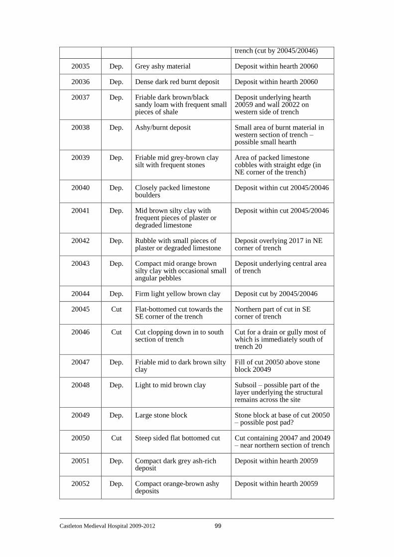
Castleton Medieval Hospital 2009-2012 99
trench (cut by 20045/20046)
20035 Dep. Grey ashy material Deposit within hearth 20060
20036 Dep. Dense dark red burnt deposit Deposit within hearth 20060
20037 Dep. Friable dark brown/black sandy loam with frequent small pieces of shale
Deposit underlying hearth 20059 and wall 20022 on western side of trench
20038 Dep. Ashy/burnt deposit Small area of burnt material in western section of trench – possible small hearth
20039 Dep. Friable mid grey-brown clay silt with frequent stones
Area of packed limestone cobbles with straight edge (in NE corner of the trench)
20040 Dep. Closely packed limestone boulders
Deposit within cut 20045/20046
20041 Dep. Mid brown silty clay with frequent pieces of plaster or degraded limestone
Deposit within cut 20045/20046
20042 Dep. Rubble with small pieces of plaster or degraded limestone
Deposit overlying 2017 in NE corner of trench
20043 Dep. Compact mid orange brown silty clay with occasional small angular pebbles
Deposit underlying central area of trench
20044 Dep. Firm light yellow brown clay Deposit cut by 20045/20046
20045 Cut Flat-bottomed cut towards the SE corner of the trench
Northern part of cut in SE corner of trench
20046 Cut Cut clopping down in to south section of trench
Cut for a drain or gully most of which is immediately south of trench 20
20047 Dep. Friable mid to dark brown silty clay
Fill of cut 20050 above stone block 20049
20048 Dep. Light to mid brown clay Subsoil – possible part of the layer underlying the structural remains across the site
20049 Dep. Large stone block Stone block at base of cut 20050 – possible post pad?
20050 Cut Steep sided flat bottomed cut Cut containing 20047 and 20049 – near northern section of trench
20051 Dep. Compact dark grey ash-rich deposit
Deposit within hearth 20059
20052 Dep. Compact orange-brown ashy deposits
Deposit within hearth 20059

Castleton Medieval Hospital 2009-2012 100
20053 Dep. Compact red to dark red ashy deposit with frequent melted lead pieces
Deposit within hearth 20059
20054 Dep. Compact mid orange-brown clay-silt
Deposit within cut 20045 towards SE corner of trench
20055 Dep. Compact yellow brown silty clay
Deposit within cut 20046 towards SE corner of trench
20056 Dep. Dark red ashy material Deposit within hearth 20059
20057 Dep. Compact ash-rich material almost purple in colour
Deposit within hearth 20059
20058 Dep. Mix of red burnt material and mid-brown clay
Deposit within hearth 20059
20059 Cut Rounded ‘bowl-shaped’ cut Hearth near south side of east-west wall
20060 Cut Rounded ‘bowl-shaped’ cut Hearth to the south of 20022
Preliminary Matrix showing the contexts from Trench 20
(note the uncertain relationships at the base of the sequence resulting from the poor
weather preventing the excavation of many deposits – it is very likely that some of these
relationships will need to be revised as further evidence is gathered)
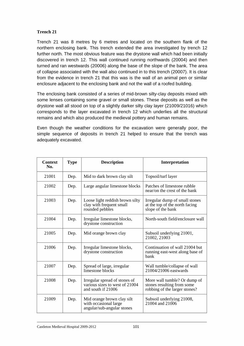
Castleton Medieval Hospital 2009-2012 101
Trench 21
Trench 21 was 8 metres by 6 metres and located on the southern flank of the
northern enclosing bank. This trench extended the area investigated by trench 12
further north. The most obvious feature was the drystone wall which had been initially
discovered in trench 12. This wall continued running northwards (20004) and then
turned and ran westwards (20006) along the base of the slope of the bank. The area
of collapse associated with the wall also continued in to this trench (20007). It is clear
from the evidence in trench 21 that this was is the wall of an animal pen or similar
enclosure adjacent to the enclosing bank and not the wall of a roofed building.
The enclosing bank consisted of a series of mid-brown silty-clay deposits mixed with
some lenses containing some gravel or small stones. These deposits as well as the
drystone wall all stood on top of a slightly darker silty clay layer (21009/21016) which
corresponds to the layer excavated in trench 12 which underlies all the structural
remains and which also produced the medieval pottery and human remains.
Even though the weather conditions for the excavation were generally poor, the
simple sequence of deposits in trench 21 helped to ensure that the trench was
adequately excavated.
Context No.
Type Description Interpretation
21001 Dep. Mid to dark brown clay silt Topsoil/turf layer
21002 Dep. Large angular limestone blocks Patches of limestone rubble near/on the crest of the bank
21003 Dep. Loose light reddish brown silty clay with frequent small rounded pebbles
Irregular dump of small stones at the top of the north facing slope of the bank
21004 Dep. Irregular limestone blocks, drystone construction
North-south field/enclosure wall
21005 Dep. Mid orange brown clay Subsoil underlying 21001, 21002, 21003
21006 Dep. Irregular limestone blocks, drystone construction
Continuation of wall 21004 but running east-west along base of bank
21007 Dep. Spread of large, irregular limestone blocks
Wall tumble/collapse of wall 21004/21006 eastwards
21008 Dep. Irregular spread of stones of various sizes to west of 21004 and south if 21006
More wall tumble? Or dump of stones resulting from some robbing of the larger stones?
21009 Dep. Mid orange brown clay silt with occasional large angular/sub-angular stones
Subsoil underlying 21008, 21004 and 21006

Castleton Medieval Hospital 2009-2012 102
21010 Dep. Soft mid brown silty clay with occasional angular stones
Bank material
21011 Dep. Light orange brown clay with flecks of black manganese
Bank material
21012 Dep. Soft mid brown clay with occasional small stones
Bank material
21013 Dep. Mid orange brown clay with manganese flecks
Natural
21014 Dep. Soft, mid orange brown silty clay
Bank material
21015 Dep. Soft light yellow brown silty clay with frequent small gravel pieces
Bank material
21016 Dep. Mid orange brown silty clay Underlying layer at base of bank
Preliminary Matrix showing the contexts from Trench 21
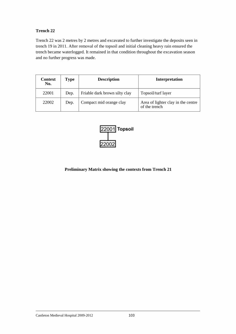
Castleton Medieval Hospital 2009-2012 103
Trench 22
Trench 22 was 2 metres by 2 metres and excavated to further investigate the deposits seen in
trench 19 in 2011. After removal of the topsoil and initial cleaning heavy rain ensured the
trench became waterlogged. It remained in that condition throughout the excavation season
and no further progress was made.
Context No.
Type Description Interpretation
22001 Dep. Friable dark brown silty clay Topsoil/turf layer
22002 Dep. Compact mid orange clay Area of lighter clay in the centre of the trench
Preliminary Matrix showing the contexts from Trench 21

Castleton Medieval Hospital 2009-2012 104
Appendix 2
Pottery reports

Castleton Medieval Hospital 2009-2012 105
Pottery from excavations on the site of Castleton Hospital 2011 (CHP11)
C.G. Cumberpatch BA PhD Introduction The pottery assemblage from the excavations carried out in 2011 on the site believed to be that of the medieval hospital in Castleton was examined by the author on July 26th 2011. The assemblage consisted of 101 sherds of pottery weighing 862 grams and represented a maximum of thirty-three vessels. The details are summarised in Table 1. A small number of pieces of stone, bone and ceramic building material were included with the pottery and are listed in Table 2. In addition a single sherd of pottery from the 2010 season was included in the group and is discussed separately. Discussion Medieval pottery (c.1066 – c.1450) Medieval pottery was identified in three contexts, 12006, 12011 and 12013. Only one sherd was identifiable as belonging to a known ware type (context 12013). This was the base of a jar, jug or cistern in the distinctive Coal Measures Whiteware fabric dating to the period between the late 13th and late 14th century. Such pottery was made in the Don Valley where two potteries are currently known to have existed and marketed extensively throughout Yorkshire and Derbyshire. A full account of the industry has been published elsewhere (Cumberpatch 2004a). Two sherds of medieval type were present in context 12011. The first, a sherd of Coarse Sandy ware was clearly of medieval date but the fabric is an unusual one and is unknown to the author. The distinctive range of inclusions included the ubiquitous quartz together with sub-angular, non-crystalline rock fragments of an unknown type. The badly decayed glaze survived only as brown friable fragments. In the absence of a positive identification, no definite date range can be suggested for this sherd although it seems unlikely to be later than the 14th century. The second sherd was also of an unidentified type and also undated. The bright orange fabric contained rounded quartz and rock fragments up to 1mm in size. No specific date range could be assigned to this sherd. The two sherds of pottery from context 12006 appeared to be of late medieval type (perhaps of the late 14th to 15th century) but could not be positively identified as examples of a known type and the dating rests of the general character of the fabric. Post-medieval pottery (c.1450 – c.1720) The post-medieval component of the assemblage consisted of sherds of Cistercian ware (contexts 12006 and 12009), sherds of Midlands Purple type ware (contexts 12008 and 12011) and a small fragment of Yellow ware (context 12006). All three types are all examples of fabric groups rather than fabric types in that the names relate to types of pottery produced at several potteries across a wide geographical area. In the case of Cistercian ware, the closest known potteries are those at Wrenthorpe near Wakefield (Moorhouse and Roberts 1992) and Ticknall in southern Derbyshire (Spavold and Brown 2005) although Cistercian ware was manufactured throughout the Midlands and northern England. At present there is no simple way of reliably distinguishing the products of different potteries and the origin of the sherds from Castleton is thus unclear. Much the same can be said of the Midlands Purple type ware (contexts 12003, 12008, 12011) although here the problems of dating and of attributing individual sherds to specific potteries is even more acute and, in addition, the date range is less well established than in the case of Cistercian ware. Claims of a 14th century date have been made by some writers but on balance this is probably incorrect and it seems more likely that Midlands

Castleton Medieval Hospital 2009-2012 106
Purple wares appeared at around the same time as, or slightly later than, Cistercian ware. The author has argued elsewhere (Cumberpatch 2003) that this general change in the character of pottery in the late medieval period is a reflection of a wider change in social attitudes and practices which sees the effective end of medieval material culture somewhat earlier than the conventional dates for the end of the medieval period (between 1485 and 1530). Midlands Purple ware is characterised by its hard, dense purple fabric, produced by firing clays of good quality to a very high temperature, at times approaching that of stoneware. The glaze, where present, is generally hard and does not flake or crack, unlike that on later utilitarian wares. The range of forms is wide and includes jars, cisterns, butter pots and storage vessels. Early modern pottery (c.1720 – c.1840) Individual sherds of early modern pottery were present in contexts 12001, 12003 while contexts 12001, 12006, 12013 and 12001/12013 produced numerous fragments of what appeared to be a single vessel. The Slipware sherd from context 12001 was decorated with trailed red slip on a hard, dense buff body. Slipwares were manufactured extensively across the country and although they are often claimed as a specifically Staffordshire or London product (Staffordshire and Metropolitan Slipwares respectively) were also produced widely in Yorkshire and elsewhere. To date no potteries are known from Derbyshire but this may be due simply to a lack of research. The date range in Yorkshire is somewhat later than Staffordshire where production was certainly underway by the middle of the 17th century although no Yorkshire potteries have been definitely attested as producing this type of slipware before the early 18th century. Further research may alter this picture. Yellow ware (context 12006) was manufactured alongside Cistercian ware and Blackware throughout the late 15th, 16th and 17th centuries although in smaller quantities and in a narrower range of forms. The sherd of Slip Coated ware from context 12003 represents a type of pottery closely related to Late Blackware and is distinguished by a thin coating of red slip on the buff body giving a dark red-brown or black finish closely resembling that of Late Blackware. The sherds of Late Blackware from contexts 12001, 12006, 12013 and 12001/12013 probably belong to a single vessel, probably a mug, porringer or small round tankard. A number of cross-context and intra-context joins were noted but the fact that the sherds were not marked precluded any attempt to reconstruct the vessel. Late Blackwares date to the 18th century and appear to be related to the earlier Cistercian wares and Blackwares although the fabrics and forms are somewhat different. The apparent completeness of the vessel and the lack of abrasion (in contrast with the rest of the pottery) would seem to suggest that it was broken while in use on the site. Recent pottery (c.1840 – c.1950) Pottery of recent date was recovered from context 12001 and consisted of sherds of Bone China and heavy duty porcelain. The latter appeared to be the rim of a vessel but was rather thick to be from a cup or mug although bone china and porcelain bodies were used to make robust utilitarian mugs and other teawares in the 20th century. The sherds of bone china from the same context have a similar character. A small number of water-worn sherds were collected from the bank of the river some distance from the site of the excavation. The group includes a range of typical late 19th or early 20th century types including Whiteware and utilitarian stoneware

Castleton Medieval Hospital 2009-2012 107
Other items With one exception few useful comments can be made on the small group of fragments of stone, bone and ceramic building material. The exception is the fragment of glazed stone from context 12001. This is typical of stone used in the construction of pottery kilns and glass furnaces which become coated with glass or glaze during the use of the kiln or furnace. Numerous such fragments are present on sites such as Sheffield Manor and Bolsterstone connected with the manufacture of pottery and glass. There is, to the best of the author’s knowledge, no indication of either pottery or glass production in Castleton but it is known that the waste from such industries was used in the construction of roads, including turnpike roads. It would be of considerable interest to examine the foundations of the nearby road to determine whether the early phases saw the use of such material. The records of the turnpike trust (if extant) would also be of interest in this respect as the waste was bought from the potters and glass makers and so might appear in the accounts. Context 12006 produced six fragments of a soft, black material that may be ceramic of some type although this is to some extent uncertain. Pottery from excavations in 2010 One sherd of pottery recovered from context 7001 during the 2010 season was included with the 2011 assemblage (Table 3). This was a sherd of a Coal Measures type with a fine white fabric and distinctive black and red iron-rich inclusions. Although of Coal Measures type it did not belong to the Don Valley group mentioned above and more closely resembled sherds from the Brackenfield kilns (Cumberpatch 2004) which are common in the assemblage of unstratified pottery from Peveril Castle. The Brackenfield pottery is poorly dated but is conventionally regarded as of 13th to 14th century date. Only the full analysis and publication of the archives from excavations in Chesterfield will resolve this matter (Cumberpatch and Thorpe 2002).

Castleton Medieval Hospital 2009-2012 108
Pottery from excavations on the site of Castleton Hospital 2012 (CHP12)
C.G. Cumberpatch BA PhD Introduction The pottery assemblage from the excavations on the site of the medieval hospital at Castleton in 2012 was examined by the author on 21st May 2103. It consisted of 144 sherds of pottery weighing 1131 grams representing a maximum of 130 vessels. The data are summarised in Table 1. A small quantity of ceramic building material and related items accompanied the pottery, as summarised in Table 2. The pottery Medieval pottery (c.1066 – c.1450) Medieval pottery was limited to a small number of sherds from Trenches 20 and 21. The earliest sherds were from contexts 20025 and 20043 each of which produced a single abraded sherd in an unidentified fine buff sandy ware with traces of splashed glaze externally. The fabric was not one familiar from other sites although in the wider context of Derbyshire this is not entirely unexpected (Cumberpatch 2004a). A pre-mid 13th century date is probably appropriate for these sherds although the use of splash glaze as a means of dating individual sherds is less than wholly reliable as the technique appears to have survived longer in some areas than in others.
Three sherds of Coal Measures Whiteware (contexts 20005, 20025 and 21001) can be more reliably dated to the period between the late 13th and late 14th century (Cumberpatch 2004b). The type that occurs regularly, if in small quantities, across northern Derbyshire and was also represented in the assemblage from the excavations in 2011 (Cumberpatch 2011) as well as in a number of the test pits excavated in Hope and Castleton in 2012 (Cumberpatch 2012).
Other sherds of medieval date were noted in context 20001 and 21001 although neither was identifiable to type or closely datable although the sherd from context 21001 was most probably of very late medieval date. Post-medieval pottery (c.1450 – c.1720) Post-medieval pottery was somewhat more abundant than medieval pottery and was also more widespread across the site (sherds were identified in contexts 2001, 20001, 20003, 20005, 21001 and 20018). The earliest elements were probably the sherds of Midlands Purple ware from contexts 20018, 21001, 20001 and 20005 all of which could be as early as the mid\late 15th century, broadly contemporary with Cistercian ware, a sherd of which was present in context 20005 with a possible sherd in context 21001. Four seventeenth century Blackware sherds were noted in contexts 2001, 20001 and 20003. All of these types are widespread across the north Midlands and examples of both Midlands Purple and Cistercian ware were recovered during earlier seasons work on the site (Cumberpatch 2011). Early modern pottery (c.1720 – c.1840) In contrast to limited quantities of medieval and post-medieval pottery, early modern wares were well represented, reflecting the more general picture obtained from the test pitting surveys in both Hope and Castleton (Cumberpatch 2012) and on the hospital site itself (Cumberpatch 2011). Examples of all three principal groups of pottery were represented; utilitarian ware, vernacular tableware and formal tableware.

Castleton Medieval Hospital 2009-2012 109
The utilitarian ware group consisted principally of Brown Glazed Coarseware (contexts 1003, 20001, 20013, 20018, 21010 and 21014) with a single sherd of Brown Glazed Fineware from context 20002. The Brown Glazed Coarseware from contexts 20001, 20013, 20018, 21010 and 21014 was of particular note as the two fabrics represented were both extremely unusual, being very soft, heavily abraded and bright orange in colour. To date no parallels for these sherds are known and the date range suggested (16th to early 18th century) should be regarded as indicative rather than definitive. Vernacular tablewares formed a significant proportion of the pottery recovered from the site. The types represented included Late Blackware, Mottled ware, Slip Coated ware and Slipware. All of these had parallels from elsewhere on the site and from the test pits in Hope and Castleton (Cumberpatch 2011, 2012). Such wares were manufactured widely during the 18th century and while evidence is currently lacking for potteries in northern Derbyshire, a number are well-known in Yorkshire (Cumberpatch, in prep) although whether the examples from Castleton are of Yorkshire origin is unclear at present. Formal tablewares were represented by White Salt Glazed Stoneware (context 1003) and Creamware (contexts 1001, 1003 and 2001) although unusually Pearlware was not present and the proportion of vernacular tableware was considerably higher than that of formal tableware. Recent pottery (c.1840 – c.1950) Pottery of recent date may have included some of the Brown Glazed Coarseware which is difficult to date precisely. Less ambiguous were the sherds of utilitarian stoneware (contexts 1007, 1016 and 20001) which included jam jars and a flagon. Sherds of Brown Salt Glazed Stoneware (contexts 1001, 1007, 2001 and 21002) were probably from kitchen wares and cooking pots. The remaining sherds were in varieties of refined earthenware including Cane Coloured ware, Blue Banded ware, Whiteware (plain and transfer printed) and slip banded ware with both plain and transfer printed Bone China. None of the printed designs were identifiable but none showed any variation from the standard range of Chinese style landscapes and floral motifs.
Sherds from flowerpots were noted in contexts 1005 and 1007 with a single cross-context join connecting the two contexts. Discussion Trench 1 The assemblage from Trench 1 consisted of forty-nine sherds of pottery weighing 334 grams representing a maximum of forty-six vessels. Two of the contexts, 1005 and 1007 were linked by a cross-context join involving the rim of a flowerpot. None of the sherds predated the early 18th century which appeared to constitute a domestic assemblage belonging to the 18th, 19th and 20th centuries. Trench 2 The assemblage from Trench 2 consisted of twenty-three sherds of pottery weighing 75 grams representing maximum of twenty vessels. The sherds spanned the 18th and 19th centuries (with a single small sherd of 17th century Blackware) although unlike the case of Trench 1, 20th century pottery was absent. Trench 20 The assemblage from Trench 20 consisted of thirty sherds of pottery weighing 75 grams representing maximum of twenty-six vessels. The assemblage was a very mixed one with some indication of differentiation by context. The pottery from contexts 20001 and 20002 was generally later than that from the other contexts

Castleton Medieval Hospital 2009-2012 110
although medieval pottery was represented, presumably as a residual element. Contexts 20025 and 20043 both produced assemblages of exclusively medieval date although the quantities of pottery were extremely low. Contexts 20003, 20005 and 20013 were more mixed in character and included late medieval and post-medieval wares. Trench 21 The assemblage from Trench 21 consisted of forty-two sherds of pottery weighing 345 grams representing maximum of thirty-eight vessels. The assemblage included medieval and post-medieval pottery but also included a small group of mid to late 19th century wares. Conclusion As in previous years, the evidence for medieval activity on the site was, although present in trenches 20 and 21, sparse. The four trenches all produced distinctive assemblages although given the generally limited quantities of pottery, it is difficult to draw reliable inferences from these results. Further work Although only one cross-context join was noted in the assemblage from 2012, it is possible that dealing with the material on an annual basis obscures the extent of connections between different parts of the site. At some stage it would be advantageous to consider the entire assemblage as a unit and to look for cross-context joins on a more systematic basis.
Castleton Medieval Hospital 2009-2012 111
Appendix 3
Geoarchaeological analyses
Samples have been taken from 2 locations for geoarchaeological analysis.
1) Topsoil samples were collected on a regular grid across the area within the enclosing bank. The sample spacing was 1 metre. The samples have been taken to complete magnetic susceptibility and soil chemistry analyses. These analyses are not yet complete and will be incorporated in to a future report.
2) A block sample was taken from trench 12 adjacent to the main east-west wall in order to investigate whether or not there were floor levels within the area enclosed by the main walls. The sample has been taken for soil micromorphology. This analysis is not yet complete and will be incorporated in to a future report.

Castleton Medieval Hospital 2009-2012 112
Appendix 4
Osteological analysis 2011/2012
Anna Bloxam
Abstract
The following report describes the human skeletal remains excavated during the 2011 and 2012 field seasons of the Heritage Lottery Funded project ’Finding Castleton’s Medieval Hospital’. The finds represent a minimum of two adult individuals, both of unknown age and sex. The remains were disarticulated and fragmentary, probably indicating that they had been disturbed and redeposited from burials elsewhere.
Introduction
’Finding Castleton’s Medieval Hospital’ is a Heritage Lottery Funded excavation project located in the village of Castleton, Derbyshire. Three finds of human bone were uncovered across the 2011 and 2012 field seasons and submitted for osteological analysis.
During the 2011 season, human cranial fragments (Sk003) were identified in context 12018, underlying most of the site features in the trench. The area around the remains was block-lifted for excavation in laboratory conditions; this was carried out by the author. Excavation revealed that only the calvarium (’skull cap’) and a single tooth were present, with the facial bones, mandible, most dentition, and all post-cranial remains being absent. The cranium had been bisected by a sharp tool, such as a shovel or plough, with the two halves lying adjacent to each other. The bone was extremely friable and poorly preserved.
In the 2012 season, context 20026 of the main Spital Field excavation site yielded a find of human hand phalanges (Sk002).
Methodology
All remains were photographed, inventoried, and assessed for completeness and preservation, pathology and trauma. Where possible, they were also assessed for age and sex. The data that could be obtained were limited due to the incomplete, fragmentary, and eroded state of the remains.
Castleton Medieval Hospital 2009-2012 113
Completeness and Preservation
Completeness of the individuals was assessed and recorded through inventorying the elements present. Where appropriate, this was done using Brickley and McKinley’s (2004) form; the individual represented by phalanges only was inventoried by listing the elements present. The remains from each context were checked for any duplication of elements present, as this would increase the minimum number of individuals (MNI) present for each. The remains were also photographed to provide an additional visual record of the material. Overall completeness of each individual is expressed as a percentage range, and the completeness of Sk003 was also described by weight due to the large quantity of fragmentary material. Where dentition was present, dentition present was recorded on a visual dental inventory form for ease of interpretation. Surface preservation and fragmentation were described according to the grades outlined by McKinley (2004), with Grade 0 indicating no cortical damage, and Grade 5 indicating erosion that has penetrated the bone and affected its basic morphology.
Pathology and Trauma
All bones were examined for signs of pathology and trauma, following Roberts and Connell (2004). The teeth were examined for caries, dental disease, and calculus. They were also examined for evidence of enamel hypoplasia, which can indicate episodes of physical stress during the individual’s development (White & Folkens, 2005: 329). Identified pathological changes to the teeth and bones were described and photographed.
Age Estimation
Observation of dental attrition (tooth wear) rates, using charts such as those developed by Miles (1962), can often indicate an accurate age for an individual. However, methods generally rely on the presence of molar teeth, preferably three adjacent mandibular molars. As the only tooth present was a single canine, the age could not be closely determined.
The stage of epiphyseal union was also observed where possible, to check for incomplete union of the epiphyses of bones, which could indicate the individual had not yet reached adulthood. The union of epiphyses occurs throughout childhood and adolescence as part of the process of skeletal maturation, and can be used to indicate a probable minimum or maximum age for the individual (White & Folkens, 2005: 373-4). However, rates of skeletal maturation can be highly variable between individuals and populations (more so than dental attrition) and should be used with caution (Schaefer & Black, 2005: 777).
Many other methods for ageing skeletal remains exist, but none were applicable to the current material, all of which is highly fragmentary with very small quantities of bone present for each individual; the age at death could not be determined with any accuracy in most cases, but all the remains recovered appeared to be from adults.
Sex Estimation
Aspects of cranial and pelvic morphology are ordinarily assessed in order to establish whether the morphology of each appears to be more masculine,

Castleton Medieval Hospital 2009-2012 114
more feminine, or indeterminate. Traits and their expression were assessed following Schwartz (1995) and Ferembach et al. (1980). The sex ascribed to an individual is usually that indicated by the majority of the observed features, but some preference is afforded to the sex indicated by the pelvic morphology, particularly along the midline, as this region of the body is the most sexually dimorphic (White & Folkens, 2005: 392). No diagnostic features were preserved for any of the individuals studied, meaning their sex could not be established.
Musculoskeletal Stress Markers (MSMs), Non-Metric Traits, and Living Stature
The expression of MSMs could not be assessed due to poor preservation. Living stature could not be calculated for any individual due to the absence of the necessary skeletal elements. As few skeletal elements were present for each individual, most non-metric traits could not be observed.

Castleton Medieval Hospital 2009-2012 115
Results
The results of the osteological analysis are presented separately for each context in which they found; each context is likely to represent a different individual, with the MNI for each context being 1.
Sk002
Inventory
Three proximal hand phalanges (one fragmentary) and one intermediate hand phalanx (Fig.1).
MNI
1
Completeness
<25%
Preservation
Grade 2 – “More extensive surface erosion than grade 1 with deeper surface penetration”
Age
Adult: The phalanges are adult in size and morphology.
Figure 1 - The human skeletal remains from context 20026, comprising one intermediate and three
proximal hand phalanges from an adult individual (Sk002).
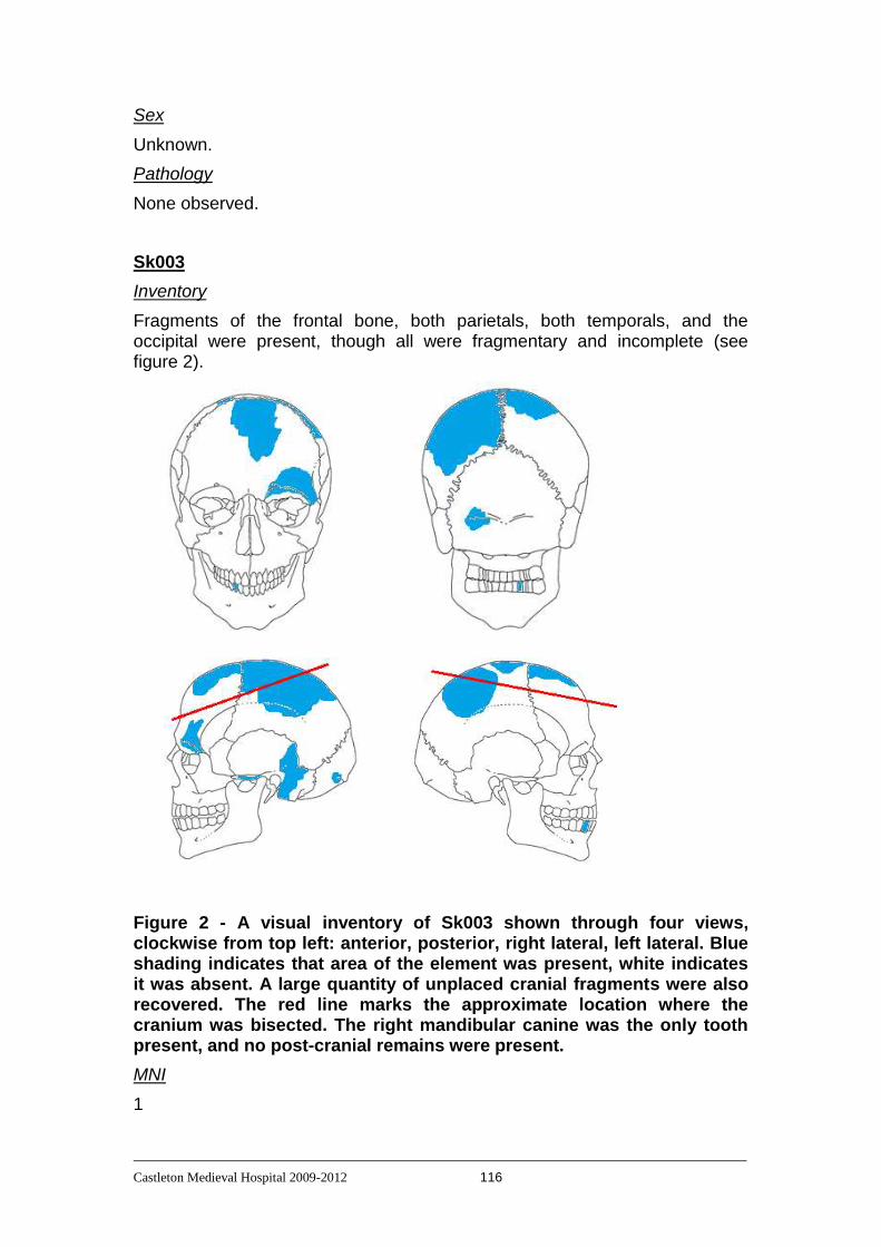
Castleton Medieval Hospital 2009-2012 116
Sex
Unknown.
Pathology
None observed.
Sk003
Inventory
Fragments of the frontal bone, both parietals, both temporals, and the occipital were present, though all were fragmentary and incomplete (see figure 2).
Figure 2 - A visual inventory of Sk003 shown through four views, clockwise from top left: anterior, posterior, right lateral, left lateral. Blue shading indicates that area of the element was present, white indicates it was absent. A large quantity of unplaced cranial fragments were also recovered. The red line marks the approximate location where the cranium was bisected. The right mandibular canine was the only tooth present, and no post-cranial remains were present.
MNI
1

Castleton Medieval Hospital 2009-2012 117
Completeness
<25%. The total weight of cranial fragments from this individual was 229.4g. A number of complete crania (excluding mandibles) were weighed for comparison, with weights ranging from 452g to 575g; this would indicate that less that half of the cranium is present.
Preservation
The bone was extremely poorly preserved, displaying preservation grades 3-5, with many bones crumbling on contact. Delamination had occurred across almost all cranial vault fragments, with the resulting separated layers being extremely delicate and prone to further breakage. The soil matrix surrounding the cranium contained a low volume of bone fragments smaller than 1mm dispersed throughout.
Age
Adult: The bones were adult in size and form, with the canine being an adult tooth. Wear to the canine was minimal and the cranial sutures were unfused, indicating that these remains are unlikely to represent an older individual, but the age could not be determined more accurately.
Sex
The surviving frontal morphology was masculine, the orbital rim being robust and ’blunt’ (see figure 3), but this alone is insufficient evidence for the basis of a sex estimate. No other diagnostic features survived, so sex remains unknown.
Figure 3 Left frontal bone fragment of Sk003, showing supraorbital rim with masculine morphology.
Pathology
No pathological changes were observed on the tooth or bones. However, the root of the surviving tooth was morphologically unusual, displaying particularly pronounced periradicular bands (Figure 4). Periradicular bands are lines circulating tooth roots that are indicative of the incremental growth pattern of teeth; these and other incremental growth lines have been shown to

Castleton Medieval Hospital 2009-2012 118
correspond closely to time, providing an internal ’clock’, similar to that of tree rings (Smith & Reed, 2009). The banding on this tooth also affects the enamel, here being termed ’perikymata’. Strongly marked banding such as this bears a visual similarity to linear enamel hypoplasia (LEH), lines that are sometimes present across the enamel, which can be indicative of periods of metabolic stress, through illness or poor nutrition. However, unlike LEH, the banding seen does not appear to be pathological in nature.
Figure 4 Medial (left) and labial (right) views of the right mandibular canine of individual Sk003, showing marked banding on the root and crown.
Summary
The results of the osteological analysis of the three finds of human skeletal material have been summarised in Table 1.
Table 1 – A summary of the findings of the osteological analysis of the human bone from CHP11-12
Skeleton Preservation Completeness Pathology Age Sex
002 Grade 2 <25% None observed Adult Unknown
003 Grade 3-5 <25% None observed Adult Unknown

Castleton Medieval Hospital 2009-2012 119
Appendix 5
Technical information: instrumentation
Magnetometer:- Geoscan FM256
Sampling Interval:- 0.25m.
The Geoscan FM256 is a Flux-gate Gradiometer that utilises two sensors to measure external magnetic fields. The upper sensor is positioned to detect the earth's magnetic field, while the lower sensor detects the earth's magnetic field plus any other magnetic field resulting from below ground features. The two measurements are compared so that the effect of the earth's magnetic field can be removed. The strength of any other magnetic field present is then recorded. The instrument is carried so that one sensor is positioned vertically above the other and measurements are taken at one metre intervals across a fixed grid.
There are two main mechanisms by which archaeological deposits become able to possess a magnetic field and therefore become detectable by magnetometer survey. The first of these is Thermoremanent Magnetisation. This results when a material containing iron oxide particles (i.e. virtually any soil or subsoil) is heated up to above the Curie point of the iron oxide particles it contains (650 degrees Centigrade or more). On heating the iron oxide particles demagnetise. When the material cools down again the iron oxide particles remagnetise as far as possible preferentially aligned with the earth's magnetic field. This alignment of the magnetic fields of the iron oxide particles produces an effectively fixed permanent magnetic field for the material as a whole. This magnetic field can be detected by a magnetometer survey. The second mechanism is that of Magnetic Susceptibility. This is the ability of a material to become magnetised when placed in a magnetic field. Iron oxides are highly Magnetically Susceptible, although the precise level of this depends on the form of the oxide. Consequently increasing the concentration of iron oxide or changing the form of the iron oxide particles will make a deposit more Magnetically Susceptible. If this deposit is placed within a magnetic field a greater magnetic field will result. Fortunately all archaeological deposits, along with everything else on the Earth, are within the Earth's Magnetic Field at all times and the resulting magnetic fields can be detected by a magnetometer survey.
Resistance Meter:- Geoscan RM15
Probe Array:- Twin-Probe (mobile probe 0.5m and 0.25m.)
Sampling Interval:- 1.0 metre
The Geoscan RM15 is an instrument that measures the electrical resistance of soils and sediments. Four electrodes are employed; two current probes (that pass the electric current) and two potential probes (that measure the resistance to the

Castleton Medieval Hospital 2009-2012 120
passage of that current). These four electrodes may be arranged in various ways. Depending on the arrangement, measurements of similar volumes of sediments can be obtained and the amount measured may be used to calculate a value of resistivity of the sediments. In the Twin-Probe arrangement the electrodes are 'paired' (a current probe with a potential probe), with one of the pairs remaining in a fixed position whilst the other pair is moved thereby measuring the resistivity variations across a fixed grid. The fixed grid is sampled at one metre intervals. With the spacing between the mobile probes set at 0.5 metre the resistance method has a depth penetration of approximately 0.75 metre, although the nature of the overburden, underlying geology and soil moisture levels will cause variations in this figure (with the mobile probes set at 0.25 m. the depth penetration is 0.35-0.40m).
The resistance to the passage of an electric current through a soil or sediment is primarily related to moisture content. Electric current passes more easily through moist deposits than dry. Consequently resistance survey is particularly suited to the definition of buried archaeological remains that are the result of past human actions that have altered the ability of the deposits to hold moisture. The foundations of a stone wall hold considerably less moisture than the organic-rich fill of a ditch or pit. Consequently the resistance values of a pit or ditch may be expected to be significantly lower than those of a stone wall. Complete waterlogging or desiccation of soils and sediments can cause these differences to become (temporarily) undetectable and so weather conditions and general soil moisture levels must be noted.
Data processing:-
The data used for this report was processed using GEOPLOT software (from Geoscan Research Ltd, Bradford. Graphic images were prepared in Adobe Photoshop (from Adobe Systems Inc., San Jose).
A1.2 Display Options
Below is a description of the display options used in this report. Unless specified in the text no filtering or smoothing will have been used to enhance the data. Any 'smoothing' on plots shown in this report is simply a process of interpolating a median measurement in between each pair of measurements across the plot, thus creating a smaller unit size.
Grey-scale: in this form of graphical display of the numerical data minimum and maximum cut-off levels are chosen (this is done before the data is processed for this display). Any value below the minimum cut-off level will appear blank (white), whilst any value above the maximum cut-off level will appear black. The values that lie between the two cut-off levels are each assigned a specific shade of grey depending on their relative position between the two cut-off levels. Consequently areas of anomalous readings are highlighted as light and dark areas on the plot.
Copyright © 2022 FDOKUMEN